Perception, Representation, Awareness: the EUMM's Experience
14
1 Perception, Representation, Awareness: the EUMM’s Experience Rossella Salerno, Camilla Casonato, Daniele Villa Rossella Salerno, Associate Professor in Techniques of Representation , DIAP, Politecnico di Milano, via Bonardi 9, Edificio Nave, 20133 Milano, email: [email protected] Camilla Casonato, PhD in Preservation of Architectural Heritage, Adjunct Professor,DIAP, Politecnico di Milano, via Bonardi 9, Edificio Nave, 20133 Milano, email: [email protected] Daniele Villa, PhD in Urban Planning, Research Fellow DIAP, Politecnico di Milano, via Bonardi 9, Edificio Nave, 20133 Milano, email: [email protected] Foreword: A Wide Frame This paper describes the experience is currently being carried on by the Urban Ecomuseum of Niguarda in Milan, the first urban ecomuseum in Lombardy, the second one in Italy: in order to catch it’s new feature, as regards the way of perceiving and living landscape, it’s necessary however to set the experiment of re-knowing and re-appropriating of this part of Milanese urban landscape in a wider framework, involving the relationship between the ideas of territory and landscape and a broader consideration of landscapes, from extraordinary to ordinary landscapes. From the point of view of who, in universities and other research centers, are occupied in observing and studying landscapes, the sciences of territory aim to improve life of people by economic and urban planning, with care towards sociological aspects, employing an expert knowledge. It’s well known, however, that in those processes participatory practices are frequently used. Which is the shift of sense introduced by the ELC? Among several researches, the question put by the SETLAND research, Who owns the landscape? seems suitable to tackle the issue 1 . In other words the starting point maybe the possibility of sharing landscape planning, facing the points of view of politicians, experts, stakeholders and, last but not least, of people. So the questions of the SETLAND research group are crucial: which relationship is there between people and landscape? Does a social demand of landscape exist? Who can express opinions and values? In such a perspective, landscape becomes a social construction, a place where converge different interests, needs and desires, because it is made both by reality and image of reality. That is the reason why landscape is a “medium” between people and territory, because images, like perceptions, involve values. So the role of different actors toward landscape is of pointing out interests and aspirations of people. The Article 1 of The European Landscape Convention states that “Landscape” means an area as perceived by people, whose character is the result of the action and interaction of natural and/or human factors. As Riccardo Priore reminds us, this definition is made by two different components: This text has been thought and discussed among Rossella Salerno, Camilla Casonato and Daniele Villa. About writing the paper, Rossella Salerno is responsible of the first paragraph and the conclusions, Camilla Casonato of the second and Daniele Villa of the the third one. 1 We refer to the SETLAND Research project (Sustainability Evaluation in Territory and Landscape) coordinated by University of Padua and to the publication Castiglioni B, De Marchi M (eds), 2009.
Transcript of Perception, Representation, Awareness: the EUMM's Experience

1
Perception, Representation, Awareness: the EUMM’s Experience
Rossella Salerno, Camilla Casonato, Daniele Villa
Rossella Salerno, Associate Professor in Techniques of Representation , DIAP, Politecnico di Milano,
via Bonardi 9, Edificio Nave, 20133 Milano, email: [email protected]
Camilla Casonato, PhD in Preservation of Architectural Heritage, Adjunct Professor,DIAP, Politecnico di Milano,
via Bonardi 9, Edificio Nave, 20133 Milano, email: [email protected]
Daniele Villa, PhD in Urban Planning, Research Fellow DIAP, Politecnico di Milano,
via Bonardi 9, Edificio Nave, 20133 Milano, email: [email protected]
Foreword: A Wide Frame
This paper describes the experience is currently being carried on by the Urban Ecomuseum of
Niguarda in Milan, the first urban ecomuseum in Lombardy, the second one in Italy: in order to
catch it’s new feature, as regards the way of perceiving and living landscape, it’s necessary however
to set the experiment of re-knowing and re-appropriating of this part of Milanese urban landscape in
a wider framework, involving the relationship between the ideas of territory and landscape and a
broader consideration of landscapes, from extraordinary to ordinary landscapes.
From the point of view of who, in universities and other research centers, are occupied in observing
and studying landscapes, the sciences of territory aim to improve life of people by economic and
urban planning, with care towards sociological aspects, employing an expert knowledge. It’s well
known, however, that in those processes participatory practices are frequently used.
Which is the shift of sense introduced by the ELC?
Among several researches, the question put by the SETLAND research, Who owns the landscape?
seems suitable to tackle the issue1. In other words the starting point maybe the possibility of sharing
landscape planning, facing the points of view of politicians, experts, stakeholders and, last but not
least, of people.
So the questions of the SETLAND research group are crucial: which relationship is there between
people and landscape? Does a social demand of landscape exist? Who can express opinions and
values?
In such a perspective, landscape becomes a social construction, a place where converge different
interests, needs and desires, because it is made both by reality and image of reality.
That is the reason why landscape is a “medium” between people and territory, because images, like
perceptions, involve values. So the role of different actors toward landscape is of pointing out
interests and aspirations of people.
The Article 1 of The European Landscape Convention states that “Landscape” means an area as
perceived by people, whose character is the result of the action and interaction of natural and/or
human factors. As Riccardo Priore reminds us, this definition is made by two different components:
This text has been thought and discussed among Rossella Salerno, Camilla Casonato and Daniele Villa. About writing
the paper, Rossella Salerno is responsible of the first paragraph and the conclusions, Camilla Casonato of the second
and Daniele Villa of the the third one. 1 We refer to the SETLAND Research project (Sustainability Evaluation in Territory and Landscape) coordinated by
University of Padua and to the publication Castiglioni B, De Marchi M (eds), 2009.

2
the first, the objective one is expressed by the phrase: area, portion of territory; the second, the
subjective one, instead by the words: as perceived by people. So “Landscape” is a result of the
relationship between the two aspects; such a relationship is allowed by perception that people have
of their territory2. This clarification helps to better precise the relationships between territory and
landscape.
Another crucial question is represented by the features of landscape: the characters expressing the
identity of a place, the possibility to recognize it through changes; but as everybody knows
transformations not always are positive; anyway the problem exists and it is very wide.
It is probably the main problem we have to face, because it is related to the urban spreading in
agricultural territory, in the country.
Two main scales help in describing this phenomenon: a large scale, for example in Italy, the Po
Valley is going to become a mega city region, a continuous city of houses, green spaces…, a vast
periphery, not ever country, nor city. The other scale is related to the inner changes of the
“traditional city”, that growing includes and transforms green spaces or villages and so on.
That’s the specific case of Niguarda, - the subject of the Ecomuseum - a town of Milan hinterland in
the past, and a now instead a quarter integrated in the same city.
So in a broader consideration, relating the increasing territory’s changes to the point of view
introduced from the ELC, the very news is represented by the possibility to consider “Landscape”
the whole territory without distinction between city and country, in other words each portion of
territory where people live and of which they care for.
It’s clear further that values of landscape can be material rather than immaterial and they can
involve the future of a territory, like at the same time, the past, not only from the heritage point of
view.
But how is it possible to realize all that? Which are the strategies, the policies, the regional and local
laws permitting groups of people to become aware of the potentialities of their landscape or to own
again them?
And more: which are the better practices and tools to realize the goal? Undoubtedly we think that
the ELC represents a way to follow, because it is an international juridical expression of a political
idea and it is founded on the thought that landscape signifies a crucial resource from an
environmental point of view, and also a social and economic purpose. It is an occasion to realize a
sustainable development that is considered, from the international community a necessary
compromise to allow life continue on our planet.
Referring to the general frame outlined by the ELC, Pio Baldi, in the proceedings of the first Italian
Conference about Landscape3, wrote that a landscape “in order” is now to be considered like a
necessity, the right to a “good” landscape as the right to a “good” health.
We have to remark that is not the whole landscape dimension of territory to be protected with the
same intensity and through the same ways; on the other hand, not all territories have same
landscape values and consequently public intervention have to be different.
It is important to remind further, that in respect of the article 4 of the ELC: “Each Party shall
implement this Convention, in particular Articles 5 and 6, according to its division of powers, in
conformity with its constitutional principles and administrative arrangements, and respecting the
principle of subsidiarity, taking into account the European Charter of Local Self-government.
Without derogating from the provisions of this Convention, each Party shall harmonize the
implementation of this convention with its own policies.”4
So the point relevant to focus is how the “general frame” of the ELC, the guidelines and the
measures are harmonizing with regional and local policies and obviously with national, regional and
local laws on matter.
2 Priore R, 2009, p 42. 3 Baldi P, 2006. 4 ELC, English official text, art. 4.
3
This is synthetically the background of each local experience of application of ELC, seen both in a
local context but, at the same time, aiming to a wider purpose to be built step by step.
So the question is how to catch the occasions being “Aware that the landscape contributes to the
formation of local cultures and that is a basic component of the European natural and cultural
heritage, contributing to human well-being and consolidation of the European identity”5. Or in other
words which are the forms to suggest, the experiences to support where the ELC is considered
nothing else that a paper full of “good intentions”.
The first European Conference on Local Implementation of the ELC, held in South Bohemia in
May 20096, helps our research group to focus the possibility to introduce the raising experience of
the Urban Ecomuseum of Niguarda in a wider context of debate and of problems. The aim of that
conference was to bring together people from non-profit organizations, local and regional
authorities, and ecomuseums and some scholars of the Uniscape net.
Among the objectives were: to share views about good practices in the implementation of the ELC;
to raise awareness among local and regional authorities of the opportunities provided by
ecomuseums and local non-profits to deliver the objectives of the ELC.
Many papers about local experiences, different criteria followed in organizing and managing
ecomuseums, the work of ONG especially in North Europe, were an interesting occasion to open
the local scale of the Ecomuseum of Niguarda to a regional and, at the same time, European
perspective.
The issues developed by the EUMM’s work group – first of all by the anthropologists’ team
Tramemetropolitane, after extended to a research group of Polytechnic of Milan linked to Uniscape
- were the sense of ownership of the Niguarda community through a huge change process, the aim
to protect memory to find their own place in the contemporary society looking at future and overall
to raise a sense of identity.
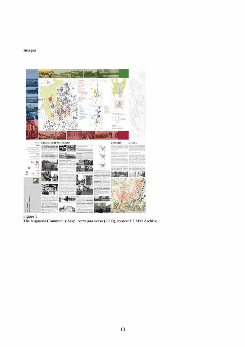
The starting point to a cohesive action was represented by realizing a community or cultural map
(Figure 1) ; like for every ecomuseum, this is a key tool in fact it makes up the features of a land
and of its history in order to focus the “character” of a place through a process of involving people.
It isn’t a geographical map or a list of monuments; it is a way to help a community in perceiving
more clearly their cultural heritage. For it is a “choral” telling, a community map contributes to
rebuilt collective histories aiming to preserve the memory to understand the present and to imagine
a future.
But building a community map means not only to realize a representation of places, but a device
where memory, skills and emotions of people may converge. In other words drawing a shared map,
brings people to take part directly in a process of appropriation (or re-appropriation) of their own
environment.
The next step of EUMM’s program is employing other devices useful to understand and share
values towards sustainable landscape transformation, like Internet surveys to work-sessions open to
“no experts”; in fact, as Joan Nogué noticed: “Innovative technologies applied to participatory
actions open a lot of new possibilities to improve the information’s’ exchange and so to promote a
participatory process. [...] Using interactive devices or virtual reality allows a deeper people’s
understanding compared with conventional cartographic representations, involving further young
people, usually not so attracted to traditional ways of communicating.”7
Practices towards Awareness: the Niguarda neighbourhood and the community map
The Urban Ecomuseum of Milan was created in 2007 by Tramemetropolitane, an anthropological
research organisation dedicated to the description and interpretation of cultural and social
5 Recommendation of the Committee of the Council of Europe to States Members, 6th February 2008. 6 1st European Conference on Local Implementation of the ELC, 27-30 May 2009, Nove Hrady, South Bohemia, Czech
Republic, Proceedings to press. 7 Nogué J, 2009, in: Castiglioni B, De Marchi M (eds.), 2009, cit., p.28.
4
transformation on territory. The birth of the Ecomuseum was supported by the city quarter council,
Consiglio di Zona Nove, and by a local cooperative society, Società Edificatrice Niguarda, that was
born at the end of XIX century to build houses for workers and to support the working class quality
of life.
Set up in response to society’s needs, through the proposal of a local non profit organisation, the
Ecomuseum starts his activities with a participative approach and builds day by day his identity on
the ground, in the line of a bottom-up strategy. In 2009 it is accredited by the local authority,
Regione Lombardia, and takes a more institutional position. It is called EUMM, Ecomuseo Urbano
Metropolitano Milano Nord (Urban Metropolitan Ecomuseum of North Milan), so its area of
responsibility becomes larger and is now extended to other municipalities in the north area of
Milan: Sesto San Giovanni, Cinisello Balsamo, Bresso, Cormano and Cusano Milanino. In this
context you can find old villages got swallowed up by the mega-city, urban sprawl but also an
important industrial heritage (Sesto S. Giovanni), an architectural heritage (XVII-XVIII century
Lombard architecture), a inter-municipal park (North Park of Milan).
In 2008 EUMM and Polytechnic of Milan begin to work together and in January 2010 an agreement
is concluded between ecomuseum and university. Institutions undertake to cooperate, in the
EUMM’s fields of interest, in research about technological innovation, sustainable development and
education of ecomuseum activities.
The anthropologists of Tramemetropolitane think that our towns, villages and land are crossed by
many hidden paths, something like warps (‘trame’ in Italian) or subtle textures that make up the
territory; these pathways are like roots of our culture and our memory and, to understand
contemporary urban transformations, we have to explore them. Therefore it is necessary to
investigate people memory, to listen their stories, to know their everyday life.8
As each ecomuseum, EUMM aims to preserve cultural heritage. Heritage includes tangibles and
also intangibles things, as history of inhabitants, their memories, their hopes and their wishes for the
future and also landscape and what community thinks about it.
If traditional museums focus on specific items and objects and then offer them to the public, the
ecomuseum helps local community to identify, interpret, and manage by herself the local heritage.9
For achieving this goal EUMM plans activities based on real actions based on local participation.
The goal is to give local people tools to read, interpret and communicate their ideas about places
and enable them to discuss with institution and stakeholders.
EUMM is therefore a dynamic system based on a community agreement. To make the process
successful you need both a general involvement and a close collaboration between specialists, local
actors and local community, all playing a vital role in an ecomuseum.
Niguarda was originally an autonomous municipality and the topographic plan still shows traces of
the ancient village. Today it is part of the mega city region and the urban expansion has almost
cancelled its rural heritage. Before the Second World War, a wide area in the south was occupied by
the fields, separating Niguarda from Milan, now this barrier corresponds to the huge hospital.
In the XX century the local economy turns from agricultural to industrial and Niguarda is converted
in a working class neighbourhood. Work is in fact the leitmotif of the inhabitants’ stories because it
determines social changes and urban transformation. Now there are no more factories in Niguarda
and the neighbourhood risks becoming a bedroom community. However, Niguarda preserves its
identity thanks to its memories and a vibrant community life, differently from the individualistic
society of contemporary mega cities.
8 See www.tramemetropolitane.it (accessed April 2010). 9 One of the most effective definition compares an ecomuseum with a classic museum: essentially a cultural process,
identified with a community (population), on a territory, using the common heritage as a resource for development, as
opposed to the more classical museum, an institution characterized by a collection, in a building, for a public of visitors.
See: Varine H de, 1991, and Varine H de, 2002.

5
In the first year of the project Tramemetropolitane collected several documents about the
neighbourhood’s history and its community: it consulted local historians, invited people to share
old pictures of main events, family history and everyday life in the past, studied history of the local
associations, collected many oral witnesses, recorded video and audio interviews, made surveys and
discovery walks in the neighbourhood with local people, went into schools to speak with children
about their life in the neighbourhood.
EUMM, during 2008-2009, organised round tables (Figure 2) to share the results of their studies
and formed a team including about twenty-five volunteers, composed by old inhabitants of the
place, representatives of the associations (the Cooperativa Edificatrice, the local theatre association,
cultural and social associations and cooperatives) and institutions (the local council, Consiglio di
Zona Nove) and all other citizens who wanted to participate in the project.
Participation meetings had some specific purposes:
- reconstruct the recent history of urban and industrial changes that have altered the perceived
and experienced urban landscape
- map the sites of social life
- trace the relationship between built space and urban park
- define the elements of quality of the urban landscape in relation to the results of public
participation
- propose methods of connection between the results of public participation and local policy
makers.
After one year the working group had collected a large quantity of documents, pictures and stories
and didn’t know how to organise it in a useful way: the anthropologists proposed to start creating a
community map. According to Common Ground – the United Kingdom charity that aims to
promote "local distinctiveness"10 – realising a community map “can help people to come together to
chart the things that they value locally, to make their voice heard amongst professionals and
developers, to inform and assert their need for nature and culture on their own terms, and to begin to
take action and some control in shaping the future of their place.”11
Then Polytechnic of Milan was involved in the project so that a group was created which included:
- Facilitators provided by Tramemetropolitane (anthropologists, but also researchers, experts
in cultural heritage preservation, a video maker, an ethnomusicologist, educators).
The first significant task of the facilitators has been to create a framework and a language for
the mapping process that motivates the public to participate and allows people to
comfortably share their knowledge, ideas and vision for the community.
- A specialist staff from Polytechnic of Milan who contributes technical skills and knowledge.
The architects provided expertise in map design and participatory process planning,
therefore facilitating the collection, storage, maintenance and analysis of data and facilitated
mapping the community’s feedback.
- Groups of residents providing their input: community history, local knowledge, cultural
values and understanding.
These types of expertise complement each other and result in richer, more comprehensive mapping
solutions. The methodological framework is interdisciplinary in its approach, combining the use of
social science participatory techniques with geomatics technology and participatory assessment
procedures. The highly interactive process taking place between those with design and planning
10 “Common Ground invented the words Local Distinctiveness in 1983 and continues to campaign and collaborate in
celebrating and promoting variegation in our surroundings. Local implies neighborhood or parish. Distinctiveness is
about particularity, it is rehearsed in the buildings and land shapes, the brooks and birds, trees and cheeses, places of
worship and pieces of literature. It is about continuing history and nature jostling with each other, layers and fragments
– old and new. The ephemeral and invisible are important too: customs, dialects, celebrations, names, recipes, spoken
history, myths, legends and symbols. All these things are folded into identity and need reinvigoration by the new”
(http://www.commonground.org.uk, accessed on March 2010). 11 http://www.commonground.org.uk, accessed on March 2010.

6
skills and those with knowledge of the neighbourhoods has determined the success of the project.
Working together on the field, utilising community expertise and local knowledge has helped to
bridge the gap between the vision of the resident community and the technical thinking and jargon
of the architects.12
As previous noticed, according to the European Landscape Convention “Landscape means an area,
as perceived by people, whose character is the result of the action and interaction of natural and/or
human factors”13. Just like museums are gradually becoming museums of ideas rather than
museums of objects, landscape is gradually shifting to indicate the idea of a place rather than a
physical territory. Place, in fact, does not simply refer to a surface but to multiple layers of cultural,
social, environmental values which define a unique local heritage.
But how can a landscape be represented according to this vision? Mapping techniques and
symbology are inadequate to map the qualitative aspects of neighbourhoods: features that make a
neighbourhood unique, such as cultural characteristics and architecture, as well as places that have
community value are not normally collected in maps; as a matter of fact, knowledge of the value of
neighbourhood features is something that can only derive from the neighbourhood itself. How to
draw a map that not only describes fields, buildings, streets, rivers etc, but that also indicates about
quality of life, memories, perceptions, feelings, smells, hopes?
An effective neighbourhood map would need to be more than a fixed package of data and be able to
pull the data together in new ways. Even though it has been remarked that a participatory map does
not have to be precise or cartographically correct, but has to illustrate locally distinctive activities
and features, specialists wanted to produce a map useful to talk with institutions so they decided to
use a technical cartography as starting point. They choose to forego the picturesque codes that often
characterise community maps14 and adopt a more technical code, accepting the challenge of
creating a rigorous and linear map but also a map able to describe the qualitative values that local
people have identified.
Map design presents therefore several issues:
- there are many landmarks to indicate, but the map has to be easy to handle (even walking
through the neighbourhood) and not too large;
- cultural heritage includes existing landmarks but also places and objects that no longer exist;
- the map should include actual places and objects, but also the elusive responses which
cannot be measured or counted and also the invisible stories, dialects, names and fragments
of everyone's history;
- the boundaries of the district are not clearly defined: there exist an administrative boundary
of the ancient municipality which does not correspond to the subjective boundary of the
aged inhabitants; on the other hand young people do not recognise the boundaries drawn by
their parents and grandparents because it is based on a memory of places they do not have
(Figure 3) ;
- even if the map should be modern, precise and linear, it has to contain some images that best
represent the values in the community, its idea of the neighbourhood and that will allow
everybody to recognise places;
- the working team has produced several different map legends so many thematic maps
should be drawn, instead of one single community map;
- it is not possible to declare a participatory process “closed”, since it is impossible to draw a
single map; finally we just can create several open maps.
The specialist team prepares some proposal and submits them to the working group in several round
tables till when a final solution is ready. These are the main solutions to the problems indicated:
12 About interdisciplinary approach and good practices in participatory mapping see Craig WJ, Harris TM and Weiner
D (eds.), 2002. 13 ELC, English official text, art. 1. 14 See the parish maps or, in Italy, the community map of Parabiago (eutelia.comune.parabiago.mi.it/ecomuseo).

7
- the map comprise three plans: a big plan of the quarter as it is today, with the most
important landmarks and two smaller thematic plans dedicated to the main themes emerged
by the participatory process (the social life, historical buildings, factories, rural life);
- object of the past and of today are both present, but it is possible to discern what is actual
and what is no more visible; so you can read the map following a thematic approach (you
can see for example the landscape in the perception of the working class, even if factories
are now disused) or distinguishing the past from the present.
It is important to realise that this map closes just the first phase of the participatory process and
begins a new starting point. The map, however, marks an important step in the path towards
awareness among the civil society of the values of landscapes, achieving one of the mains
objectives of the European Landscape Convention.15
Community Based Participatory Tools: Building Shared Landscape Values
The community map, as we have seen, represented an important result for EUMM, however the
working group knew that it was a limited device, a closed system, not dynamic and not easily or
continuously upgradable. So the process didn’t stop, it continued attending new specific goals:
- improved quality and variety of data available
- improved access to data
- better-informed decisions in planning and implementing data collection
- improved participation
- improved use of new media and technologies.
The research group of Polytechnic of Milan therefore proposed to develop new tools for urban
simulation and description using web oriented applications to create dynamic, open and
participatory mapping systems. The main purpose was to create tools that citizens can easily use to
interact with administrators and technicians.
Community mapping, in the experience of EUMM practices, has shown to be useful tools,
increasing the users capacity to plan, manage and monitor territorial and landscape–related issues
within the mapped area, also inside a specific planning process such as, for example the drafting of
the new local urban plan, the “Piano di Governo del Territorio” (PGT).
Often the ultimate aim of community mapping actions may not be the final drawings on a map so
much as developing the community interest to define shared methods for revitalizing collective
memory, build consensus around a common idea of landscape and sustainable development and
take collective action within the institutional processes of landscape and urban planning.
Certainly one of the major goals is to develop strategic partnerships between government and civil
society in an effort to make mapping outcomes binding on the executive planning application.
As mentioned above the European Landscape Convention gives great importance to the social
perception of landscape. This requires the introduction of perceptual and symbolic evaluation
criteria to take people directly involved, both locally and within a more extensive scope, especially
when operating within an urban context, where is more difficult to understand the “legibility” of
landscape.
The knowledge of how landscape is perceived, allows administrators and experts to identify
strength or weakness aspects that are not always obvious and easy to define, it is also a useful basis
to start the comparison between different local stakeholders and to build maps of memories and
15 “Each Party undertakes to increase awareness among the civil society, private organizations, and public authorities of
the value of landscapes, their role and changes to them” (ELC, English official text, art. 6).

8
“symbolic landscape” able to reflect the prevailing feelings of the community in relation to different
aspects of their territory.
The involvement of people, defining quality and main characteristics of an urban landscape requires
also the use of innovative and diversified tools, focusing on those who allow wide interaction and,
first of all, assessment of perceived quality of a shared landscape.
Firstly it is useful to define a hybrid method based on a democratic interactive process where
different groups of participants come to understand each other’s perspective: this may lead to the
construction of a landscape assessment of an area carried out by the people who live there.
-
To reach most of the goals set was essential to calibrate the main methods used to manage public
participation through extensive use of views, maps, and tools capable of making visible points of
interest identified by participants, facilitating forms of sharing, management and analysis of local
knowledge expressed by the populations.
The research group, after a detailed comparison of different methods, chooses to use a broad and
thorough participatory mapping and visualizing technique, an arrangement of levels as a necessity
of the large and complex environment. “Rather than a single comprehensive image, there seemed to
be sets of images, which more or less overlapped and interrelated. They were typically arranged in a
series of levels, roughly by the scale of area involved, so that the observer moved as necessary form
an image at street level to levels of neighborhood, a city, or a metropolitan area.”16
Participatory mapping, used in conjunction with various forms (physical and virtual) of urban
simulation is a relatively new communicative facilitation method used in innovation processes
related mainly to the validation of the technical possibilities offered by different simulation tools for
the assessment of the impact of urban transformations, in relation to the morphology of the urban
fabric and the environmental quality of the public open spaces. The method was designed to support
collaborative efforts to increase public participation in problem analysis and decision-making with
particular attention to the problems of perception and definition of “landscape quality”.
In this particular actions and advice, the research group uses participatory mapping with different
purposes:
- increase the capacity of people to recognize the value of its territory and landscape - promote community cohesion, self actualization and self-determination - allow a more correct assessment of the impacts of territorial transformations underway - manage and guide conflicts by facilitating cooperation in decision making - help relevant players to raise their motivation, coordinate a shared perception and formulate
a shared vision and strategy.
In order to work on this perspective, the use of tools and techniques of participation and simulation
intends to produce new descriptions of urban landscape, starting from the elaboration, use,
experimentation of new ways of telling and reading the landscape, but also new interpretative
images, seen as descriptions, not just spatial, but also metaphorical and symbolic, like frames,
scenarios, visions with a communicative role, in so far they are forms of interpretation of rules and
forms of interaction between actors in the framework of territorial policies.
This allows looking at the landscape assessment as a process of collective learning and sense
making, which has also a political dimension and can no more be seen as an external construction
but as an outcome of a wider participative approach focused to produce tools for interaction of
differences in order to build forms of collective/connective intelligence.
From a practical point of view, the reading experience of mapping the urban landscape turned from
EUMM shows the difficulty of “making visible” values that are often hidden and not tangible. It’s
difficult to synthesize clear and shared images of a complex landscape subject to extreme physical 16 Lynch K, 1960.

9
and social changes. From this point of view it seems very useful to apply a broad concept of
relational landscape. The relational landscape17 is a method that applies to situations where non-
structured knowledge needs to be collected systematically in order to map and visualize value
networks. In EUMM’s experience the use of different communication and representation tools
allowed:
- to develop a detail understanding of functional and symbolic interdependences perception of
citizens, urban landscapes and collective memories;
- to tie a quantitative approach (the physical relief of places and physical transformations)
with a qualitative one (the reading memories, desires, and personal use of urban spaces);
- to tie a synchronic representation with a diachronic one, in a dynamic system, to relate past,
present and future;
- to lay the foundations for further studies on the not-visible transformation of the “latent
landscape” , kind of “ landscape development on the quiet” due to interactions between local
cultures, new forms of citizenship, territorial transformation and new ways of understanding
the urban landscape.
To fix some of these issues it was decided to use hybrid and mixed techniques of participation and
visualization: Metaplan, geoblog, urban scenarios simulation and PGIS.
Regular meetings where citizens were invited to discuss the most relevant issues related to their
relationships with the places and urban memory: during meetings EUMM staff used a visualization
technique similar to Metaplan, an interactive approach using the direct drawing on different types of
map in a group interview setting to interrogate qualitative questions. The act of drawing on a map
allows the participant to focus attention on the selection of items, choice and exclusion, drawing
codes, boundaries and on primary and secondary elements to underline, it also provides the
interviewer with a record that can be interrogated as it is being drawn, during its crafting by the
participant, and when it is completed. The tangibility of the map allows people to return to features
of the map in the interview and subsequent interviews to unfold the process of description,
elaboration, analysis.
The process of building awareness of the landscape values must also assume responsibility to
broaden stakeholders and facilitate the return on policies and urban planning, for this reason it was
decided to develop, with the direct participation of citizens and the physical mapping, innovative
tools for e-participation like a Geoblog and Participatory GIS (PGIS).
The Geoblog (Figure 4) makes use of the social innovations of Web 2.0 to combine visual data with
geospatial data and to enable the general public to contribute their local knowledge through
effective communication tools; Geoblog is a communication and visualization platform on the
everyday landscape which brings together scientific information with feedback, sharing of local and
historical information, observations of ordinary people. It broadens the thematic spectrum of
landscape issue by integrating the possibility of geo-referenced data with social networking tools
allowing to catalog and overlay all types of multimedia content. The technology employed at this
stage will evolve into a virtual implementation of an early detection system using satellite data in
combination with in-situ data and helping to scale the information from global to local level.
In the last year EUMM’s staff has also experimented different kind of urban scenario simulation.
This tool allows creating different visualisations of the urban landscape with the collaboration of the
local community. During the round tables the technical staff proposes some images of strategic
places in the neighbourhood, for example places of significance to the community, or that have
17 Kruse C, 2008.
10
undergone major transformations or that will undergo major changes. People can modify the
scenario using some parameters (presence of trees, viability, traffic, shops, size or typology of
buildings, places to socialize, composition of society: most aged, most young, multiethnic etc.) and
choosing between three different degrees of intensity for each parameter. Combining this factors
stakeholders create hypothetical scenarios that are intended to facilitate and stimulate the discussion
and to support the path of confrontation. This tool has been tested in a student research project for
now, but it has had a very good feedback in the round tables: it brings a high level of involvement,
facilitates communication, allows an instant processing and stimulates the activation of a proactive
approach and not just of an analytical approach. So it deserves further development.
Some goals of direct interaction between citizens and public administration will be obtained
through the use of GIS mapping technology. The people themselves, through dedicated meetings,
with the help of architects-mediators, build GIS layers focused on shared issues perfectly integrated
with the official map managed by the municipalities and provinces.
More advanced technologies, such as those related to Geoblog and Web 2.0, permit a wider use of
vast amounts of geographical and spatial information but, sometimes, run the risk of increasing the
distance between actors making the maps and those providing the needed local knowledge.
Capacity building in the use of mapping technologies can represent an empowering experience for
local people, but this may happen at the expense of other community members. Training, including
the production of reference materials and the conductions special technical training sessions, is
important in improving the capacity of community members to understand and take part in all
stages of the process. This should prompt a lot of attention in the interaction between 'expert
knowledge' and 'citizens knowledge'. “Citizens know more about experiencing the city from their
position an perspective than any outside expert. This knoledge is validated by observation and by
sharing experiences with others. So expert groups, whether scientific goups or policy-making
teams, have their own ‘local knowledge’. This knowledge production becomes a social process of
making meanings, shaped by the situations, trajectories, activities and values of particular social
grouping”18
One important challenge, from this inclusive technological and cross-media point of view, is to
relate participatory meetings with the of on-line mapping community, avoiding the excessive,
ineffective, proliferation of the issues discussed, and, on the other side, encourage the use of
appropriate technologies for more fast sharing of results with the public administration and decision
makers. It deals with using an integrated approach.
First: the great size of spatial and social interrelations has to be illustrated to foster collective
understanding and insight.
Secondly: the abstract concepts of perceived and shared urban landscape have to be translated in to
concrete and tangible images, maps, scenarios, proposals for preservation and change.
It is a circular process, in constant growth and improvement, which must also allow developing
useful and different tools for direct communication between citizens and politicians in a
constructive approach and engaging the dialogue. All this kind of analysis and maps built together
and shared with local stakeholders should be followed by concrete and tangible impact on local
planning and, in particular, inside the institutional forms of popular consultation.
The "landscape-issue" in a participatory process, remains complex, very difficult to make visible
and full of gaps, non-trackable elements and actors, shifting perspectives but despite these
fundamental problems, it is evident the growing of social demand for landscape quality and
landscape-centered urban development that requires to develop innovative tools for the detection,
representation and sharing visions of urban landscape. “With the awareness that dealing with the
18 Healey P, 2007.
11
landscape, understood as the complex multidimensional phenomenon composed of material and
immaterial characteristics and subject to constant modification by natural and manmade factors, it is
unrealistic to define the “minimum quantity” of awareness that is capable of guaranteeing the
corrective governance of change”19.
Conclusions
The EUMM’s experience is a work in progress: it’s the result of cooperation between a working
group moving from a scholar approach about urban landscape, in the perspective of the ELC, the
ONG “Tramemetropolitane” and people living in the neighbourhood of Niguarda.
The change of point of view in considering landscape, not only from the point of view of experts or
scholars, but as outcome of memories and desires of changes from the people, represents a crucial
point in a democratic process to identify the idea that citizens have of their own urban landscape.
In this process, a fundamental way of communication, as well of re-appropriation and of planning
the site, is made up by representation tools using new interpretative images, not only spatial but also
metaphorical and symbolic, because landscape is at the same time “material and immaterial”.
So landscape perception is deeply related to means of communication and representation as device
to increase awareness of people about heritage and potentialities of their site. Further this way of
working makes up, in our opinion, the first step towards a correct and useful dialogue with experts
in landscape planning.
A field still difficult to explore concerns the relationship with politicians, not ready yet to catch the
new instances people are asking and so to let needs and projects become real.
References
Baldi P, 2006. Atti della prima Conferenza Nazionale per il Paesaggio, Ministero per i Beni e le Attività culturali (Ed.).
Gangemi, Roma. [Proceedings of the first National Conference for Landscape].
Cartei GF (ed), 2007. Convenzione Europea del paesaggio e governo del territorio, Il Mulino, Bologna [Landscape
European Convention and Territory Governance].
Casti E (ed), 2007. Cartografia e progettazione territoriale, UTET, Novara [Cartography and territorial planning].
Castiglioni B, De Marchi M (eds), 2009. Di chi è il paesaggio? La partecipazione degli attori nella individuazione,
valutazione e pianificazione. Cleup, Padua. [Who owns the landscape? Actor’s participation in characterization,
assessment and planning].
Craig WJ, Harris TM and Weiner D (eds.), 2002. Community Participation and Geographic Information System. Taylor
& Francis.
European Conference on Local Implementation of the ELC, 27-30 May 2009, Nove Hrady, South Bohemia, Czech
Republic, Proceedings to press.
Nogué J, 2009. L’Osservatorio del Paesaggio della Catalogna e i cataloghi di paesaggio: la partecipazione cittadina
nella pianificazione del paesaggio. [The Landscape Observatory of Catalonia and the landscape catalogs: citizens
participation in landscape planning]. In: Castiglioni B, De Marchi M (eds.), pp. 19-28.
Healey P, 2007. Urban Complexity and Spatial Strategies, Routledge, London
Lange E, 2008. Perceiving and Visualizing Changing Enviromnents, in Thierstein A, Forster A (eds), 2008, The Image
and the Region. Making Mega-City Regions Visible!, Lars Muller Publisher, Baden.
Lynch K, 1960. The image of the City. The M.I.T. Press, Cambridge.
19 Regione Lombardia, 2005.
12
Maggi M, Falletti V, 2001. Gli ecomusei: che cosa sono, che cosa possono diventare, Allemandi, Torino, [Ecomuseums
what they are what they can become].
Massarente A, Ronchetta C (eds), 2004. Ecomusei e paesaggi. Esperienze, progetti e ricerche per la cultura materiale,
Edizioni Lybra Immagine, Milano [Eco-museums and landscapes. Experiences, projects and research on material
culture].
Priore R, 2009. No People, No Landscape. La Convenzione europea del paesaggio: luci e ombre nel processo di
attuazione in Italia. Angeli, Milano. [No People, No Landscape. The European Landscape Convention: lights and
shadows in the process of implementation in Italy].
Recommendation of the Committee of the Council of Europe to States Members, 6th February 2008.
Kruse C, 2008. Mapping Hybrid Value-Added Landscapes. In Thierstein A, Forster A (eds), 2008, The Image and the
Region- Making Mega-City Regions Visible! Lars Muller Publisher, Baden.
Regione Lombardia, 2005. Landscape Management of Territorial Transformations, Good Practices and Existing
Knowledge. Gangemi, Rome.
Rossi M, Salonia P, 2003. Comunicazione multimediale per i beni culturali, Pearson Education Italia, Milano
[Multimedia Communication for Cultural Heritage].
Varine H de, 1991. L'initiative communautaire: recherche et expérimentation. Mâcon, Savigny-le-Temple. [The
Community Initiative: Research and Experimentation]
Varine H de, 2002. Les racines du futur: le patrimoine au service du développement local. ASDIC, Chalon-sur-Saône.
[The roots of the future: Heritage for the local development].
13
Images
Figure 1
The Niguarda Community Map, recto and verso (2009), source: EUMM Archive

14
Figure 2
Personal mapping using Metaplan approach during a participation meeting, source: EUMM Archive
Figure 3
Defining the Niguarda boundaries during a participation meeting, source: EUMM Archive
Figure 4
The first Beta-version of the EUMM Geoblog