
PDF - Redalyc
18
How to cite Complete issue More information about this article Journal's webpage in redalyc.org Scientific Information System Redalyc Network of Scientific Journals from Latin America and the Caribbean, Spain and Portugal Project academic non-profit, developed under the open access initiative urbe. Revista Brasileira de Gestão Urbana ISSN: 2175-3369 Pontifícia Universidade Católica do Paraná Kartal, Asiye Nisa Changes, Losses, and Challenges on Transformation of the Urban Place: A Narrative on Istiklal Street, Istanbul from the 1900s Until Today urbe. Revista Brasileira de Gestão Urbana, vol. 13, e20190335, 2021 Pontifícia Universidade Católica do Paraná DOI: https://doi.org/10.1590/2175-3369.013.e20190335 Available in: https://www.redalyc.org/articulo.oa?id=193165650037
-
Upload
khangminh22 -
Category
Documents
-
view
2 -
download
0
Transcript of PDF - Redalyc
How to cite
Complete issue
More information about this article
Journal's webpage in redalyc.org
Scientific Information System Redalyc
Network of Scientific Journals from Latin America and the Caribbean, Spain andPortugal
Project academic non-profit, developed under the open access initiative
urbe. Revista Brasileira de Gestão UrbanaISSN: 2175-3369
Pontifícia Universidade Católica do Paraná
Kartal, Asiye NisaChanges, Losses, and Challenges on Transformation of the Urban
Place: A Narrative on Istiklal Street, Istanbul from the 1900s Until Today
urbe. Revista Brasileira de Gestão Urbana, vol. 13, e20190335, 2021Pontifícia Universidade Católica do Paraná
DOI: https://doi.org/10.1590/2175-3369.013.e20190335
Available in: https://www.redalyc.org/articulo.oa?id=193165650037

Scientific Article doi: 10.1590/2175-3369.013.e20190335
ANK is architect, PhD Candidate, e-mail: [email protected]
urbe. Revista Brasileira de Gestão Urbana, 2021, 13, e20190335 1/17
Changes, Losses, and Challenges on
Transformation of the Urban Place: A
Narrative on Istiklal Street, Istanbul from
the 1900s Until Today
Mudanças, Perdas e Desafios na Transformação do Lugar
Urbano: Uma Narrativa na Rua Istiklal, Istambul, de 1900 até
hoje
ISSN
217
5-3
369
Lic
en
cia
do
so
b u
ma
Lic
en
ça
Cre
ative
Co
mm
on
s
Asiye Nisa Kartal [a]
[a] University of Nottingham, Nottingham, Nottinghamshire, United Kingdom
How to cite: Kartal, A. N. (2021). Changes, losses and challenges on transformation of the urban place: a narrative on
Istiklal Street, Istanbul from the 1900s until today. urbe. Revista Brasileira de Gestão Urbana, v.13, e20190335.
https://doi.org/10.1590/2175-3369.013.e20190335
Abstract
Over the years, the socio-cultural structures, architectural compositions of Istanbul have changed gradually.
Unavoidably, Istanbul's urban places have been affected as they have gained new faces through the wrong-
driven, top-down, controversial changing processes. Especially since the 1990s, the changes have gained
momentum, many controversial modifications have occurred in the heart of Istanbul. Istiklal Street has turned
into a symbol of the transformation that Istanbul has been going through. The process brought about the rapid
disintegration of the Street's unique, hybrid constitutions and distinctive qualifications. Nearly all the
characteristic landmarks that made Istiklal Street special have disappeared one by one and the area is
converting into a place that has lost its spirit. To understand how the Street has shaped historically and what
has lied at the behind stages, the study begins with a qualitative discussion on the formation of the area since
the 1900s. But the focus of the narrative is based on the period from 1990 until today with an explanatory
approach to criticise by which mechanisms and actions the area transformed and come today. The study
stresses that the potentials of the urban probabilities, socio-spatial compositions, tangible and intangible
features are responsible for the future of this place.
Keywords: Istiklal Street. Urban Place. Transformation actors and mechanisms.
Resumo
Ao longo dos anos, as estruturas socioculturais e as composições arquitetônicas de Istambul mudaram gradualmente.
Inevitavelmente, os lugares urbanos de Istambul foram afetados à medida que ganharam novas faces por meio dos
processos de mudança controversos, conduzidos de forma errada e de cima para baixo. Especialmente desde os anos
1990, as mudanças ganharam força, muitas modificações controversas ocorreram no coração de Istambul. A rua
Istiklal se tornou um símbolo da transformação pela qual Istambul está passando. O processo trouxe a rápida

Changes, Losses, and Challenges on Transformation of the Urban Place
urbe. Revista Brasileira de Gestão Urbana, 2021, 13, e20190335 2/17
desintegração das constituições híbridas e exclusivas de Street e das qualificações distintas. Quase todos os marcos
característicos que tornaram a Rua Istiklal especial desapareceram um a um, e a área se transformou em um lugar que
perdeu seu espírito. Para entender como a rua se configurou historicamente e o que ficou nos bastidores, o estudo parte
de uma discussão qualitativa sobre a formação do bairro desde os anos 1900. Mas o foco da narrativa se baseia no
período de 1990 até os dias atuais com uma abordagem explicativa para criticar por quais mecanismos e ações a área
se transformou e vem hoje. O estudo destaca que os potenciais das probabilidades urbanas, composições socioespaciais,
feições tangíveis e intangíveis são responsáveis pelo futuro deste local.
Palavras-chave: Rua Istiklal. Lugar urbano. Atores e mecanismos de transformação.
Introduction
For structuring the narrative of this article, a qualitative explanatory based research analysis has been
followed. Mainly, for the 'urban history' and 'intangible cultural heritage' literature of Istanbul, and the
Beyoglu neighbourhood, most of the latest documents have been searched in English and Turkish languages.
For dipping into the matters of the 'spatial, socio-cultural and economic modifications', and 'planning,
designing and transformation procedures' of Istiklal Street; multiple sources such as published documents
(books, journal articles, thesis, conference proceedings, newspaper' articles) have been analysed. Secondly,
the urban plans, reports, and administrative documents of the Beyoglu municipality give us an idea about
the latest transformation stages of the area used as the additional sources of the narrative. With the aim to
clearly understand the mechanisms and actors that have lied behind the transformation process of the area,
some papers on the law and regulation strategies and policies of the area have been examined. Moreover,
the discussions which have been put forward by expert and non-expert people on the internet and social
media channels have been reviewed. All these sources have been analysed to extract the information about
'how the area has transformed spatially and socio-culturally' and 'what has been changed and is still
changing, and what has been lost in the area'. It was expected to picture the story of the area in a
comprehensive way.
Istanbul of Turkey is a sophisticated urban fragment with an urban population of over 15 million today.
It is settled down more than sixty kilometres along the Marmara shores and has a Eurasian character due
to its position on two continents; the western side of Istanbul is in Europe, as the eastern side is in Asia. The
qualifications that make Istanbul specific among the world cities are its distinctive past and historical,
cultural, architectural diversities and core stations of international transmissions. Through the years,
different variables have impressed the changes in Istanbul's urban configurations; the multiple factors have
been interrelated, such as internal socio-economic and political movements, as well as the shifts originating
from external global elements. From government-driven, top-down, gigantic projects, Istanbul has
embodied the issues of neoliberal urbanisation in the most extreme ways possible, as the undeniable truth,
this process has generated highly problematic spatial dynamics within the area. The transformation of the
area has constituted a warning sign of being a playground for different factors (Ekmekci, 2012; Ekmekci,
2014). So, the area has been risked for missing its diversity and valuable components that link it to its
multicultural past, historic architectural and cultural heritage (Eder & Öz, 2014). The controversial side of
the latest developments have been related to their speeds and the overwhelming role of the governance in
the process, unavoidably, the area's transformation has been criticised mainly due to the excessive
centralisation of decision-making and the lack of consultation with citizens before projects surfaced. The
case of Istiklal Street has been indeed symbolic of the kind of transformation that Istanbul has been going
through since the 1990s.
The article discusses that Istiklal Street, which has been one of the important public places of Istanbul
due to its historical, and socio-cultural background, has witnessed many breaking points since its inception
over a century ago. As the main thoroughfare in the Beyoğlu area, it rose to prominence as the 'Grande Rue
de Pera' in the 1850s and became the central artery in Istanbul's heart by the turn of the century. At its

Changes, Losses, and Challenges on Transformation of the Urban Place
urbe. Revista Brasileira de Gestão Urbana, 2021, 13, e20190335 3/17
beginning, it housed European citizens and non-muslim Ottomans such as Greeks, Jews and Armenians.
However, when nationalist sentiments have gone through the country after the 1930s, an exodus of the
area's minorities has happened. Then, the demographics modified in the 1960s as the migrants from the
countryside of Turkey moved into the empty homes in the area. Later 1980s, the students and artists arrived
as well; the area tried to revive as the arts and culture events sparked (Cusack, 2018), such as national and
international film festivals. After the 1990s, diverse urban transformation projects have been implemented
in the Street; the integration with globalisation gained pace, the renovations, alterations have been
multiplied, all linked with Istanbul's race towards becoming a global city. All of them has caused changes in
terms of the spatial, socio-cultural, economic organisations of Istiklal Street, but the focus of the narrative
in this study is based on the process which started in the 1990s that gained momentum after the 2000s.
As this article problematises, due to the upsetting transformation of Istiklal Street after the 1990s, the
locals have stopped hanging around, most of the art, culture and entertainment places on the Street have
been closed, such as old taverns, bookstores, theatres, and especially movie theatres shut down. Many
important figures have left the area amid disruptive construction projects. Greed to earn more has caused
empty stores on the Street while the identical faces have been the victims of the process. The spatial patterns
have changed in the area, and the socio-spatial and sensorial diversity has started to dissolve due to the
urban policies pursued. Istiklal Street's cosmopolitan heritage turned into a trademark for Istanbul's global
city projects (Adanali, 2011a; Tekin & Akgün Gültekin, 2017). Most intellectuals, including artists,
columnists, and musicians, agree that the area has lost its soul, its glory, and its magic gradually; the area is
far from a rollicking street fair of shoppers, diners, protesters, street musicians, roughly a mile-long sea of
humanity, with an iconic tram rumbling down the middle. For years, the problems could not be solved,
although the Street has been redone numerous times; and, the Street converted into a street with no fun or
liveliness. The changes in the area indispensably injured the distinctive features of the region. Istiklal Street
hopes to bring back the good old days after suffering a series of setbacks; meanwhile, it tried to recover
from the problematic years (Kömürcüler, 2018).
From the beginning of the 1900s until the Nationalist Movements of the 1930s and
Turkification of the Street
Istiklal Street, which sits within Pera (Beyoglu) area, burgeoned in the 18th century as a part of Galata–
an autonomous Genoese and Venetian walled city across the historical peninsula before the conquest of
Istanbul (Kayra, 1990). It has been called 'Grand Rue de Pera' (big Street of Pera) by non-Muslims and
'Cadde-i Kebir' (big Street) by Turks (Üstdiken, 1994, p. 266). The 18th century has been the starting point
of the unification and association period of the Ottoman economy with the European economy, so the
foreign traders have supplied significant benefits (Dökmeci, 1990). As one of the major steps in terms of the
'Westernisation' process of Ottoman Empire, 'Tanzimat Fermanı' (Ottoman Reform Edict of 1856) caused
non-Muslim populations to gain more privileges (Batur, 2007), and European style buildings and new social
organisations have started to be built in the area (see Figure 1). Then, the construction of foreign embassies
and churches created a semi-European, Levantine, and minority rooted Ottoman bourgeoisie who have
started living around these embassies (Güney, 2015). Thus, Istiklal Street has evolved quickly into the
Ottoman Empire's non-Muslim focus of life and symbolised the most 'western' side of the Empire in terms
of architecture, demography, and lifestyle (Adanali, 2011a).

Changes, Losses, and Challenges on Transformation of the Urban Place
urbe. Revista Brasileira de Gestão Urbana, 2021, 13, e20190335 4/17
Figure 1 - Istiklal Street in the late 19th century (Placesbrands, 2015).
The district turned into a central area particularly from the second half of the 19th century. The urban
innovations have been exclusively intensified in the area (Akin, 2002) to be a sample of the urban planning
for the rest of the city. As a result of non-Muslim populations brought their traditions, customs, and cultures
(Üstdiken, 1994, p. 266), the theatre, concert, circus, carnival and various feast events have been organised
in the district. The dwellers of Istanbul started to meet in the theatres, cafes, clubs, confectionaries,
restaurants, bars, and hotels (Akin, 2002, p. 56). Since then, Pera has gained the statue of the 'entertainment
centre' within Istanbul with its shops, restaurants, patisseries, cafes, perfumeries, hairdressers, photograph
studios, and bookstores; it has also been the 'trade centre' of the city with its trading houses and bureaus as
the marks of contemporary urban life (Akin, 1994). The places that opened in the region altered not only
the physical environment but also daily life; they offered different socio-cultural organisations comparing
with other regions of the city (Güney, 2015). New social relations have occurred, and the European lifestyle
became prestigious among Ottoman intellectuals (Batur, 2007); the area has been a focal point where high
society met to spend time and wandered by looking at shop windows (Faroqhi, 2008). The spatial designs
that emerged in the area through the end of the 19th century affected the inhabitants' social behaviours
(Köse, 2011, p. 388-389). The elements of the ethnic dissimilarity and the multilingual and multicultural
composition of the area have been quite visible in this era (Tekin & Akgün Gültekin, 2017).
In the early years of the 20th century, the shopping arcades, theatres, music halls, fashion houses,
passages have been built in various styles such as Neo-Classical style, Art Nouveau and Neo-Ottoman style
and so on. These buildings have shaped the identical architectural composition, which has been one of the
important signs of the area's visual qualities. Istiklal Street's cosmopolite structure has been retained by the
end of the first quarter of the 20th century thanks to regulations in favour of non-Muslim Populations, such
as the declaration of Constitutionalism II in 1908 (see Figure 2; 1st and 2nd photos). In those years, the area
has been a place where many languages have been spoken, and a lot of different ethnical groups have shared
urban potentials for living, entertaining and shopping together.
Istanbul lost its position as the capital, and Ankara became the capital of new Turkey after the Turkish
Republic's proclamation in 1923 (see Figure 2; 3rd photo), and the embassies in Beyoglu moved to Ankara,
and the minorities also left the area. However, Istiklal Street could sustain its cosmopolite attributions in
the 1920s (Bartu, 1999). As one of the contributions of cosmopolitism of the area has been made by White
Russians who migrated to Istanbul due to the Russian Revolution in 1917, the arrival of Belarusians in the
aftermath of the First World War supported the Street to experience its heyday in this period (Adanali,
2011a). However, insufficient planning for the modernisation of Turkey and underestimating Istanbul as
the old capital of the previous state Ottoman Empire influenced the cosmopolite attributions of the area to
some degree. Istanbul and its some elements based on its cosmopolitanism have been approached as
somewhat shabby remnants of an outdated Ottoman past. Consequently, after the 1920s, a modification in

Changes, Losses, and Challenges on Transformation of the Urban Place
urbe. Revista Brasileira de Gestão Urbana, 2021, 13, e20190335 5/17
terms of the spatial and social structure of Beyoglu has happened, such as the widening of the streets,
demolishing of old structures, and construction of new buildings (Yada Akpinar, 2010).
The rise of nationalist movements in the world after the 1930s influenced Turkish nationalism
movements and the Turkification policy of the Republic; therefore, the decline of the cosmopolite lifestyle
for Istiklal Street began (see Figure 2; 4th photo). One of the indicators of this process has been the
alterations in the names of elements of the Street with Turkish ones, so the name of the Street (Grand Rue
de Pera) has been changed into Istiklal (Independence) (Batur, 2007). Also, the projects of the late 1930s,
such as Taksim Gezi Park and Park No II showed the physical infrastructure of the region has begun to be
altered (Unlu Yucesoy & Guvenc, 2010). As a socio-economic factor, the Wealth Tax enacted in 1942 resulted
in the bankruptcy of non-Muslims (Tekin & Akgün Gültekin, 2017). By the end of World War II (see Figure
2; 5th and 6th photos), Istiklal Street started to gradually lose its multi-dimensional entities and complex
socio-cultural composition after foreign residents lost their will to remain in Beyoglu.
(a) (b)
(c) (d)
(e) (f)
Figure 2 – (a) Istiklal Street after the declaration of Constitutionalism II in 1908 (left above) (Sargut Gelen, 2019); (b) Istiklal Street in
the 1910s (right above) (Eskiistanbul, 2019); (c) Istiklal Street after the foundation of the Turkish Republic in 1923 (left middle)
(Bellek.beyoglu.bel., 2012); (d) Istiklal Street in the 1930s (right middle) (Aristeia, 2021); (e) Istiklal Street in the 1940s (left below)
(Wowturkey, 2015); (f) Istiklal Street in the 1950s (right below) (Pinterest, 2019).

Changes, Losses, and Challenges on Transformation of the Urban Place
urbe. Revista Brasileira de Gestão Urbana, 2021, 13, e20190335 6/17
Istiklal Street turning into an area of decay: The 6-7 September 1955 Case and The
Migration, fleeing of merchant and non-Muslim families in 1960s
One of the major attempts against multicultural lifestyle has been 6-7 September events in 1955 (see
Figure 3; 1st photo) because of the attack of provoked people against non-Muslim minorities living around
Istiklal Street. The fake news about the bombardment of Mustafa Kemal Ataturk's house (the first president
of the Republic of Turkey) in Greece by Greek people has caused a suitable environment for provocation. As
a result, a mass exodus of the foreign population has happened, and lots of buildings in the area have been
left vacant (Batur, 2007). Therefore, the area's non-Muslim population has reduced quickly after the 6-7
September events (Dokmeci & Ciraci, 1988). This event caused trauma on Istiklal Street's cosmopolitan
composition (Adanali, 2011a), as an accelerated emigration of minorities from Istanbul has actualised. The
Government's cancellation of the residence permits of Greek people in Turkey (1964) reflected the
Turkification policies that have been applied since the 1930s; nearly 8600 Greeks of Turkish nationality had
to abandon Istanbul following 1964 (Cezar, 1991), the ancestor of them lived in Istanbul during the Ottoman
period.
With the fleeing of merchant and rich families from Beyoglu after 6-7 September Events, the region
began to answer the cheap residence need of Anatolian migrants who immigrated to Istanbul in the 1960s
(Dokmeci & Ciraci, 1988). As the abandoned houses in the area have been occupied by newly arriving
immigrants (Adanali, 2011a), Beyoglu's dwellers started to change, and the multi-ethnic and multilingual
composition of the region has been destroyed rapidly after the 1960s (Tekin & Akgün Gültekin, 2017).
In the 1960s (see Figure 3; 2nd photo), the migration to Istanbul from rural areas of Turkey for work
facilities changed not only the physical environment but also the social and cultural structure of Istiklal
Street and its surroundings. As the industrialisation of Istanbul has improved, the marginalised groups such
as sex workers, intersex people, and Roma gipsies and low-income factory workers and their family
members began to settle in the area because of the abundance of abandoned buildings. So, around the area,
brothels have been opened, drug pushers became visible; therefore, any remaining affluent residents moved
to other parts of the city (Üstdiken, 1994, p. 266).
(a) (b)
Figure 3 – (a) Istiklal Street after 6-7 September 1955 Events (left) (Haberturk, 2013); (b) Istiklal Street in the 1960s (right)
(Steemit, 2020).

Changes, Losses, and Challenges on Transformation of the Urban Place
urbe. Revista Brasileira de Gestão Urbana, 2021, 13, e20190335 7/17
Social, demographic transformation and physical disruption of the area in the 1970s,
the First wave of Globalization and Neoliberal Challenges, Demolitions impacts on
distinctive texture and Military Coup in 1980s
After the social, demographic transformation and physical disruption which triggered an increase in
the rates of crime and prostitution in this area (Tekin & Akgün Gültekin, 2017), in the 1970s, Beyoglu has
become associated with wretched gangland lifestyles and petty crime on the edges of Istanbul society (see
Figure 4; 1st photo). What was once the bourgeois and prestigious Pera has turned into a place that would
have been unrecognisable except for its architectural style that remained, rearing up with its imposing
facades from among the shabbiness (Placesbrands, 2015).
The 1980s was a period that the urban transformation processes based on neoliberal policies began to
take place in Turkey (Enlil, 1994; Yalçıntan et al., 2014). In the early 1980s, the January 24th decisions taken
by the Turkish Government has been the starting point of economic bonds with international capital (Öktem,
2011). In the period called as 'first neoliberal wave' (Boratav, 2008), the import substitution strategies have
been replaced by neoliberal policies based on free-market economy, and it downsized the public sector's
role in the economy to provide foreign traders and investors (Öncü & Weyland, 1997). Istanbul seemed to
have the capacity to be a global city with being at the centre of the capital flows that reach both the East and
the West, also an economic and political hub for both Turkey and the region. Therefore, the urban places of
Istanbul become the most important elements to relate with the global networks that came into the agenda
in the early 1980s. For this reason, local authorities put much effort into turning the areas of the city into
international trade, finance and culture focus in Europe and the Middle East (Isik, 2010).
In that context, the new urban renewal campaign has been created to advance Istanbul to a 'global city'
status, so the city's urban places have been acted as new arenas for the consumers of global lifestyles. There
have been built dozens of shopping malls, high-rise office buildings, and mass housing settlements (Keyder,
1999). Simultaneously, luxury hotels and world-class restaurants have been opened one after another to
attract tourists; international conferences, film festivals and biennales have been organised as important
cultural actions (Güney, 2015). Keyder defines Istanbul's preparations to anchor global networks as a
success story since it has been a business platform for the transnational corporate elite as well as a playing
field for the cosmopolitan consumers of global lifestyles (Keyder, 2009a, p. 1). However, most urban
regeneration and renewal projects have been made with being discussed in unclear conditions through
spontaneous decisions (Akpınar, 2014, p. 32). Therefore, the modifications of the city have become highly
arguable in the field of academia, social media, and the local communities in the Beyoglu neighbourhood.
In Beyoglu, the transformation experienced in the 1980s has been linked with the actions of the
Municipality. The series of urban renewal projects directed by the metropolitan Major Dalan fostered the
uncontrolled development of the region (Turan, 2011). Unavoidably Beyoglu has experienced a significant
transformation between the years of 1984 and 1989. The projects aimed to attract private entrepreneurs
of Istanbul, based on the perspective that Beyoglu has been a place that should be rehabilitated and partially
demolished; therefore, the area's architectural texture has been highly penetrated (Tekin & Akgün Gültekin,
2017). With the aim of converting Istanbul into a 'world-city' and advancing the attractiveness of the areas
of Beyoglu, new cafes, restaurants, hotels, cultural buildings, art galleries, bookstores and theatres have
been opened in the area (Ozus & Dokmeci, 2005). In this process, the Association of Beautification and
Preservation of Beyoglu was established in 1985 (Güney, 2015) while large-scale demolitions have been
carried out for new construction practices (Tekin & Akgün Gültekin, 2017). In 1988, Tarlabaşı Boulevard (a
long street sits near Istiklal Street) has opened after demolitions at Tarlabaşı area (see Figure 4; 4th photo);
it generated debates; also, the Chamber of Architects stated the destruction of the old texture meant the loss
of distinctive architectural framework of Beyoglu (Bartu, 1999, p. 38), unescapably the opening of the
boulevard influenced the patterns of the environment of Istiklal Street (Can, 2012).
Changes, Losses, and Challenges on Transformation of the Urban Place
urbe. Revista Brasileira de Gestão Urbana, 2021, 13, e20190335 8/17
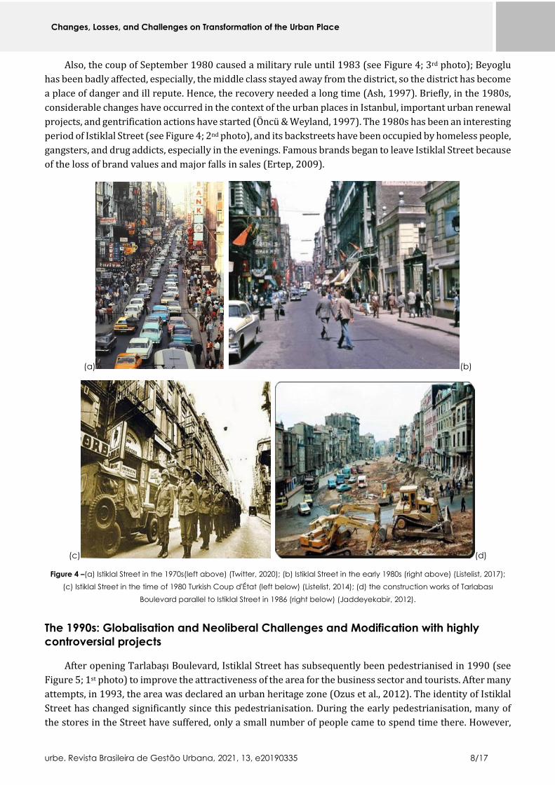
Also, the coup of September 1980 caused a military rule until 1983 (see Figure 4; 3rd photo); Beyoglu
has been badly affected, especially, the middle class stayed away from the district, so the district has become
a place of danger and ill repute. Hence, the recovery needed a long time (Ash, 1997). Briefly, in the 1980s,
considerable changes have occurred in the context of the urban places in Istanbul, important urban renewal
projects, and gentrification actions have started (Öncü & Weyland, 1997). The 1980s has been an interesting
period of Istiklal Street (see Figure 4; 2nd photo), and its backstreets have been occupied by homeless people,
gangsters, and drug addicts, especially in the evenings. Famous brands began to leave Istiklal Street because
of the loss of brand values and major falls in sales (Ertep, 2009).
(a) (b)
(c) (d)
Figure 4 –(a) Istiklal Street in the 1970s(left above) (Twitter, 2020); (b) Istiklal Street in the early 1980s (right above) (Listelist, 2017);
(c) Istiklal Street in the time of 1980 Turkish Coup d'État (left below) (Listelist, 2014); (d) the construction works of Tarlabası
Boulevard parallel to Istiklal Street in 1986 (right below) (Jaddeyekabir, 2012).
The 1990s: Globalisation and Neoliberal Challenges and Modification with highly
controversial projects
After opening Tarlabaşı Boulevard, Istiklal Street has subsequently been pedestrianised in 1990 (see
Figure 5; 1st photo) to improve the attractiveness of the area for the business sector and tourists. After many
attempts, in 1993, the area was declared an urban heritage zone (Ozus et al., 2012). The identity of Istiklal
Street has changed significantly since this pedestrianisation. During the early pedestrianisation, many of
the stores in the Street have suffered, only a small number of people came to spend time there. However,

Changes, Losses, and Challenges on Transformation of the Urban Place
urbe. Revista Brasileira de Gestão Urbana, 2021, 13, e20190335 9/17
after the tram started running along the Street after the pedestrianisation (Paramita et al., 2014), the Street
has been supported with the energy of festivals, art galleries and places of entertainment (see Figure 5; 2nd
photo). The Street's multicultural and multi-layered composition has resurfaced with the co-emergence of
different actors (Tekin & Akgün Gültekin, 2017).
In this process, conservative ideology has begun to rise after the local elections in 1994. The area's
cosmopolitan identity has been approached with symbolic importance in terms of reviving the 'Ottoman
model' (Bartu, 1999, p. 39) because Beyoglu was one of the most prominent public places and a sign mark
of the cosmopolitan structure of diverse communities under the Ottoman rule. One of the first actions of the
Beyoglu Municipality has been about the regulation of the tables and seats that sat on the pavements at
Nevizade Street (a small parallel street to Istiklal Street full of bars, pubs, and taverns) to make the Street
more accessible for the pedestrians (Güney, 2015).
Diverse urban transformation projects being implemented all over the neighbourhood of Beyoglu in
the 1990s; within the process, local voices have not been considered, resistances have been suppressed (Say,
2016). Except for the discussions that have been put forward by social scientists, urban planners and
architects, the huge amounts of discourses in social media showed that the multi-layered socio-cultural, and
architectural structure of Istiklal Street has changed dramatically in a controversial way.
(a) (b)
Figure 5 – (a) The pedestrianisation works of Istiklal Street in 1990 (left); (b) Istiklal Street in 1992 (right) (Wowturkey, 2006).
From the 2000s: The capital-oriented urbanisation comes to fore
Beyoglu Municipality has been one of the most important actors of the transformation of Istiklal Street
after the 2000s (Güney, 2015), as the area has been "(…) full of ambiguity and variety, can host different
social and economic relations, intertwines the formal and the informal, and is hard to contain and discipline",
as it has required radical intervention. Besides the municipality-led urban renewal projects, the real estate
investments of big local and foreign capital have had a considerable position in forming the transformation
of Istiklal Street, so sales and purchases directed by investors led to important changes speedily (Adanali,
2011a). Istiklal Street started to transform into a marketplace for national and international goods and
services to serve high-income groups with large-scale projects and interventions after the 2000s (Tekin &
Akgün Gültekin, 2017).

Changes, Losses, and Challenges on Transformation of the Urban Place
urbe. Revista Brasileira de Gestão Urbana, 2021, 13, e20190335 10/17
As lots of cultural activity places such as veteran cinemas on Istiklal Street have been closed (Güney,
2015), some concert halls, small theatres have transformed into more profitable ventures such as hotels
and shopping malls, the signposts of the place's cultural exuberance have disappeared, the area has lost its
'intellectual centre' of the city. However, with the rapid actions of real estate investments made by local and
foreign capital, some new art centres have been opened on the Street by sponsored major banks and
corporations, as well as prestigious stores owned by big brands. This situation may support the idea that
Istiklal Street has been shaped by the role of capital within a process which urban transformations and
cultural policies have been intertwined (Adanali, 2011a).
Many bookstores like Cumhuriyet, İstavrit, Adam, Can Bookstore, which have served before the 2000s,
have closed. As a garment sector chain firm MANGO, although it has already had a store on the Street,
purchased a building that included Istanbul Bookstore. Robinson Crusoe 389 Bookstore used to be one of
the oldest bookstores and one of the Street's most attractive places in terms of both interior and exterior
design, but it could not resist raising rents. Many bookstores have abandoned the Street to go back to
Cağaloğlu, where much of the publishing industry in Istanbul located (Güney, 2015; Tekin & Akgün Gültekin,
2017).
The sectors driving integration with global networks have raised in terms of space usage such as hotels,
apart-hotels. The presence of hotels on and around Istiklal Street has jumped after 2005, the catering and
entertainment facilities have turned into hotels and motels as hotel management is more profitable. Several
international real estate firms and foreign funds have bought some buildings (Taş, 2010; Adanali, 2011b)
such as Şark Aynalı Passage, and Nil Passage, but after the investors bought the buildings -which once had
various facilities-, the buildings have lost chiefly their public usage. Also, most boutique hotels have been
converted into hotels by big enterprises; for example, the Rumeli Han has been restored and merged with
the building groups situated in the same parcel for a hotel project. There have been also attempts to
transform some theatres into hotels, such as İkincikat Theater House and Beyoglu Terminal Theater
examples. These changes have related to the development plan drawn up for Istanbul in 2009; the Istanbul
Plan gave investors more initiative to determine the function of a building. The plan aimed to 'create
gentrified, cleaned out, and upgraded built environments to be attractive for tourists and moneyed classes';
in this direction, the area has been adjusted for a new class of users and dwellers. Istiklal Street's user profile
and entertainment sense have changed because of the efforts to turn it into a primarily tourism-oriented
street (Tekin & Akgün Gültekin, 2017). A new tourist profile of people coming from Gulf countries has
increased in the area, parallel to the new styles' cafes and shops such as narghile cafes have been
proliferated since many Syrian refugees lived in the city.
Istanbul has been the 2010 European Capital of Culture (Adanali, 2011a), this influenced both the
physical and cultural modification of the environment (Keyder, 2010). After this occasion, Istanbul
Shopping Fest (ISF) organised in Spring 2011 by a partnership between public and private enterprises and
supported by shopping malls and big brands to 'modify Istanbul’s high streets into the shopping, culture
and entertainment centre of the world', the fest went on for 40 days. The transfer of public energies and
resources to events such as Istanbul Shopping Fest resulted in problematic urban developments in the area,
such as Demirören Shopping Mall (Güney, 2015).
In the summer of 2011, the Municipality removed the tables outside of the cafes in the area. People,
especially the students, have started to go to other quarters like Beşiktaş, Karaköy and Kadıköy because of
declining outdoor places (Tekin & Akgün Gültekin, 2017). On the backstreets of Istiklal Street, such as
Asmalımescid, setting up tables has been more difficult for restaurants, and cafes due to new regulations, so
the loss of the outdoor facilities has sent people elsewhere where they can smoke, drink and eat with more
joy.
As one of the major symbols of globalisation in the district, Demirören Shopping Mall has been opened
in 2011 (Güney, 2015) after its original 1930s style structure has been demolished. Its facade rebuilt 10
meters taller than the original height of the former Deveaux Apartments, and the new interior design of the

Changes, Losses, and Challenges on Transformation of the Urban Place
urbe. Revista Brasileira de Gestão Urbana, 2021, 13, e20190335 11/17
building has got some spatial problems (Tekin & Akgün Gültekin, 2017). Therefore, the new form of the
building has received criticism coming from diverse segments of the society (Adanali, 2011a). The opening
of this shopping centre has proved that the socio-economical targeting profile of visitors has been turned
into high-income groups; subsequently, the number of people visiting the Street has been influenced, and
the visitors' profiles have changed, and unfortunately, the area converted into a place where serves no
enough space for students, people with lower incomes, or activists. This newly structured shopping centre
caused to quicken the penetration and elimination of places that characterised Istiklal Street.
Beyoglu Municipality's demands to make Istiklal Street a consumption cluster have led to the
converting the small businesses into national or international chain stores (Güney, 2015). Small-scale cafes
have come on the edge of shutting down their businesses; also, some special cafes and bars which have
attracted people in different income groups have been moving to other areas of Istanbul. In the example of
the patisserie İnci which has been served since 1944, it had moved in 2012. Ağa Restaurant, another veteran
restaurant in the area, has closed its doors after years of struggle (Adanali, 2011a). Simultaneously, the
chain stores of food sector such as Güllüoğlu, Mado and Kahve Dünyası have opened at least one shop on the
Street (Tekin & Akgün Gültekin, 2017).
The construction of Demirören Shopping Mall has immediately been pursued by changes in this area,
the historical Cercle D'Orient building (next to Demirören Shopping Mall) containing Emek Movie Theatre,
has been converted into another concentrated shopping area under the name of Grand Pera (Tekin & Akgün
Gültekin, 2017; Say, 2016). Some veteran stores at the Cercle d'Orient building entrance have been closed
with the conception of creating a new 'culture-arts-entertainment gastronomy and fashion centre' in the
area (Say, 2016). Other small theatres nearby have already closed their door; Emek, a veteran movie theatre
on Istiklal Street, got marked for closing in April 2013. Then some protesters gathered for a sit-in. The
protesters chanted the slogan, "Emek is Ours, Istanbul is Ours" by highlighting the importance of Emek in
terms of the city's memory (Cusack, 2018), but the local voices have not been considered enough. In 2013,
the Emek movie theatre was pulled down to reconstruct; it has been an emblematic example of the area's
transformation process (Özlü, 2016).
In 2013, as part of the urban renewal of the region, the reconstruction idea of the 19th-century barracks
in the Gezi Park area had been announced. At that time, 'Gezi Events' have been preceded by smaller-scale
reactions against the Demirören Shopping Mall's construction (the demolition or re-functioning of the
buildings such as the Emek Theater and Narmanlı Khan). Then, a civilian resistance happened in the Gezi
Park in the summer of 2013, intending to object the reconstruction decision of the Topçu Barracks, and
Istiklal Street has turned into a fighting scene concerning its spatial transformation (Tekin & Akgün Gültekin,
2017). Then, Gezi protest has spread across the country (Cusack, 2018). In 2014, the iconic Taksim Square
began to transform into a pedestrian area of 100,000 square meters, with the entire area paved by concrete.
Although the area has been needed more green space, fresh flowers and trees (Xinhua, 2020).
After the Gezi protest, a law has passed to allow the eviction of the tenants of over ten years in Beyoglu.
Due to this tenancy agreement, the Street's rooted stores have left the area as they could not afford the rising
rent. Kelebek Korse, which has been one of the remarkable shops of the Street, has closed because its
tenancy agreement has been terminated (Tekin & Akgün Gültekin, 2017). So, Istiklal Street has seen the
world's second-highest rent increases after San Francisco's Union Street in 2014 (Kömürcüler, 2018).
Istanbul Metropolitan Municipality had launched the work of changing the street floor in December
2016 due to ageing infrastructure and broken or removed granite pavement of the area. Therefore, the
water, sewer, gas, electricity, and communication network passing underneath the Street has been
completely renovated. In November 2017, the renovation and infrastructure work of Istiklal Street has come
to an end after a year it was launched, revamped Istiklal Street opened and received mixed reactions from
the users of the place. In the 650-meter section between Taksim Square and Galatasaray High School, green
plastic material has been laid on the ground beneath the tram rails to absorb the tram's vibration. However,
the street floor colour choice and the new look of the street floor have got mixed reactions in social media,

Changes, Losses, and Challenges on Transformation of the Urban Place
urbe. Revista Brasileira de Gestão Urbana, 2021, 13, e20190335 12/17
many users likening the pavement to synthetic football pitches; also, a few 'Green Mile' jokes have been
made (Daily Sabah, 2019). "What I see is a granite-covered river flowing in the middle of a concrete valley, you
can neither see a shade nor a tree nor a planter", Atkaya wrote in his daily column. Even the Street had
beautiful trees in the early 2000s (see Figure 6; 1st photo). In the view of another columnist Basturk, the
problem lies in "the endless renewal appetite although the same stones have been on the streets of some world
cities for a thousand years as a sign of respect and care" (Xinhua, 2020).
The Cushman & Wakefield report has revealed that the passenger traffic on Istiklal Street declined on
weekdays and weekends in 2017 compared to the previous years, amid ongoing renovation works on its
historic tramline (Cushmanwakefield, 2018). Several rental transactions have been made on the Street in
the same year (Kömürcüler, 2018). In 2017, a mosque construction began at the entrance of Istiklal Street,
the area has already had a small and masjid at the backstreet of Istiklal Street, but it was small and incapable
to serve people sufficiently. The Ataturk Cultural Center on the square has been demolished to rebuilt anew
under the new decision (Cusack, 2018), the plans of the building have been presented to the public.
Briefly, in the 2000s, the motto of 'beautifying and modifying the area by glorifying its past' has caused
the rapid accumulation of the actual urban renewal actions in the area. Several historic buildings have
passed through a change of both identity and function under the urban transformation and renovation
projects. The specific businesses have had the risk of losing their buildings because of the obligations and
regulations; also, they have been heavily affected by the distressed environment set by multiple matters.
We have witnessed the disappearance of music shops, second-hand dress shops, silversmiths, and antique
shops inside the famous arcades of Istiklal Street (Güney, 2015), especially bookstores have perished, the
publishing offices, which include periodical, book and newspaper printing houses, have started leaving the
Street. Istiklal Street, once shined out with its spatial and user diversity, begun to serve as one big shop
window for displaying consumer goods (Tekin & Akgün Gültekin, 2017). The 2000s have been the period
when Istiklal Street has been faded due to the neoliberal economic policies and global challenges and
capital-oriented urbanisation, so all the procedures damaged the distinctive composition of the area.
(a) (b)
Figure 6 - (a) Istiklal Street in 2000 (left) (Onedio, 2017); (b) Istiklal Street in 2015 (right) (Travelstart, 2015).
Conclusions
In Turkey, which immediately affiliated to world capitalism after 1980, the pioneer of globalisation is
Istanbul (Cavusoglu, 2010), and an attitude parallel to the global tendencies and liberal policies resulted in
socio-cultural, economic, and spatial modifications of Istanbul (Keyder, 2009b; Keyder, 1999). From the
1990s until now, the urban modifications influenced both the urban texture and structure of Istiklal Street.
Istiklal Street has staged remarkable changes in spatial organisations and zonal differentiation; the diversity
in spatial use has declined; due to the rapid construction, renovation, and restoration projects in almost

Changes, Losses, and Challenges on Transformation of the Urban Place
urbe. Revista Brasileira de Gestão Urbana, 2021, 13, e20190335 13/17
every section of Istiklal Street has transformed. With new urban policies, small scale trades and local brands
began to disappear gradually, particularly the tiny shops of the Street have faced serious challenges; the
number of stores of major brands has increased on the Street, and the rents have raised accordingly while
the Street has been transforming (Güney, 2015). The spirit of this Street has been penetrated by the Street's
long-standing symbolic enterprises closing one by one. Once a cosmopolitan place of old cinemas,
bookshops, outdoor cafes, and dive bars, the Street has evolved into a tacky urban space dominated by chain
stores and shopping malls (Arango, 2016). Istiklal Street's user profile has changed while the authentic
tangible character and intangible atmosphere of the Street began to disappear. Some social exclusion has
been carried due to the projects on the area. The restrictions concerning street musicians, activists, and
performer actors have influenced the colourful, and perhaps some minor unruly components of Istiklal
Street. So, Istiklal Street has standardised through looking like any main street located in anywhere of the
world (Adanali, 2011a) and lost its diversity, distinctiveness and sensory uniqueness in Istanbul.
By the way, we witnessed that the Beyoglu Municipality initiated some projects for raising the
awareness of the distinctive characteristics of the area -as they claimed. As one of the latest projects of the
Municipality, 'Beyoglu Memory Project' generally linked with the collective memory issues of the area. This
project aimed to establish a research centre concerning the historical, socio-cultural, and architectural
values of the Beyoglu neighbourhood and create a database about the area's socio-cultural, historical, and
architectural heritage. The other project 'Smart City Beyoglu,' aimed to collect information on this area's
architectural layout through a digital database. In the context of this project, nearly every building on Istiklal
street would have had a data matrix code to help for safeguarding the physical conditions and spatial
background of the area. These projects have proved us the demand that the unique spatial composition of
the area needs to be promoted with its distinctive qualities. This article thinks this kind of studies,
applications, and works that provoke and promote the tangible and intangible mosaic of the place would be
helpful. However, we could say that these projects have not been productive and sustainable enough.
As the final words, we stress that the latest changes and modifications, especially after the 1990s to
now, hurt the area's tangible and intangible dimensions and experiential features. Moreover, all of them
have caused a controversial shift in the way of distinctive qualities of Istiklal Street (see Figure 7), but it is
best to focus on the future, on defining the next century of the area. We need to look at the question of 'what
can we do now?' closely as the first step. This study firstly suggests that it needs to be avoided to propose
clear-cut urban solutions for the problems that Istiklal Street will face. Secondly, the historical, socio-spatial,
and intangible texture of the Street need to be investigated in different perspectives before implementing
the projects in the area. Thirdly, the planning and designing of the area need to include participants from all
parts of the society, including professional groups such as urban designers, architects, sociologists, as well
as civil activist groups, artists, and local people. We know the future of this multi-layered area is based on
the potentials of urban probabilities, socio-spatial compositions, and intangible dimensions of everyday life
on the Street; in the end, we hope 'Istiklal wins.'

Changes, Losses, and Challenges on Transformation of the Urban Place
urbe. Revista Brasileira de Gestão Urbana, 2021, 13, e20190335 14/17
Figure 7 – The graphic shows the main spots on the transformation process of Istiklal Street. Source: Author.
The
bre
ak
ing
po
ints
of th
e t
ran
sfo
rma
tio
n p
roc
ess
on
Is
tik
lal Str
ee
t
from the 1900s until 1940s (from Grand Rue de Pera to Istiklal
(Independence) Street)
The foundation of Turkish Republic in 1923 and Nationalist
Movements after 1930s and Turkification of the Street
between the 1950s and 1970s
the 6-7 September 1955 Case
Istiklal Street turning into an area of decay: The Migration, fleeing
of merchant and non-Muslim families in 1960s
the 1970sthe social, demographic transformation and physical disruption of the area
the 1980s
the first waves of Globalization and Neoliberal Challenges
the demolitions impacts on the distinctive texture of the street
Military Coup
the 1990s
the pedestrianisation of the street
the multi-layered compositionshas resurfaced and the creative
part of the area has revived
globalization and neoliberal challenges and modification
with highly controversial projects
from the 2000s until today
Beyoğlu Municipality (municipality-led urban renewal
projects)
capital-oriented urbanization (real estate investments of big
local and foreign capital) come to fore

Changes, Losses, and Challenges on Transformation of the Urban Place
urbe. Revista Brasileira de Gestão Urbana, 2021, 13, e20190335 15/17
Acknowledgements
The author would like to thank Professor Jonathan Hale and Dr Didem Ekici from the University of
Nottingham, who provided insight and expertise to the study.
References
Adanali, Y. (2011a). De-spatialised space as neo-liberal Utopia: Gentrified Istiklal Street and commercialised urban spaces.
Red Thread Magazine. 3. Retrieved on 5 February 2019 at https://red-thread.org/en/de-spatialized-space-as-neoliberal-
utopia-gentrified-Istiklal-street-and-commercialized-urban-spaces/
Adanali, Y. (2011b). Klonlanmış Bir Anacadde: Istiklal. Mutlu Kent. Retrieved on 3 February 2019 at
https://mutlukent.blog/2011/02/25/klonlanmis-bir-anacadde-Istiklal/amp/
Akin, N. (1994). Beyoglu, Dünden Bugüne Istanbul Ansiklopedisi. Istanbul: Kültür Vakfı ve Tarih Vakfı Ortak Yayını.
Akin, N. (2002). 19. Yüzyılın İkinci Yarısında Galata ve Pera. Istanbul: Literatür.
Akpınar, I. (2014). Remapping Istanbul: Taksim after Gezi. In Erkut, G. & Shirazi, M. R. (Eds.). Dimensions of urban re-
development, the case of Beyoglu (p. 31-39). Istanbul, Berlin: TU Berlin.
Arango, T. (2016). On Istiklal, Istanbul's Champs-Élysées, Symbols of a City's Malaise. Retrieved on 19 February 2019 at
https://www.nytimes.com/2016/09/21/world/europe/Istiklal-istanbul-turkey.html
Aristeia. (2021). Η Μεγάλη οδός Πέραν της Κωνσταντινούπολης. Retrieved on 12 February 2019 at
https://aristeia.site/archives/24136
Ash, J. (1997). Istanbul's Glitter Domes. Retrieved on 8 February 2019 at https://www.nytimes.com/1997/05/11/t-
magazine/istanbuls-glitter-domes.html
Bartu, A. (1999). Who Owns the Old Quarters? Rewriting Histories in a Global Era. In Keyder, Ç. (Ed.). Istanbul Between the
Global and the Local (p. 31–45). Lanham: Rowman and Littlefield.
Batur, A. (2007). Galata and Pera 1 A Short History, Urban Development Architecture and Today. ARI: The Bulletin of the
Istanbul Technical University. 55(1), 1–10. Retrieved on 6 February 2019 at
http://www.levantineheritage.com/pdf/Galata-Pera-Afife-Batur.pdf
Bellek.beyoglu.bel. (2012). Zaman Tünelinde Beyoğlu/ Kent Müzesi’ne Doğru, 6. Daire-i Belediye’den Beyoğlu Belediyesi’ne
155 Yıl. Retrieved on 7 September 2019 at http://bellek.beyoglu.bel.tr/download/Zaman_Tunelinde_Beyoglu_2012.pdf
Boratav, K. (2008). Türkiye İktisat Tarihi 1908-2007. Ankara: İmge Kitabevi.
Can, A. (2012). A Comparison on two Cities and their two Main Streets: Istiklal Caddesi and Kärtner Strasse. Online Journal
of Marmara University, 10(37), 139-150. http:// dx.doi.org/10.14783/od.v10i37.1012000194
Cavusoglu, E. (2010). İstanbul’da Planlama: Mekanın Yeniden Üretimi ve Sınıfsal Sonuçlar. In Keyder, Ç. (Der.). Küreselleşen
İstanbul’da Ekonomi (p. 36-52). Istanbul: Osmanlı Bankası Arşiv ve Araştırma Merkezi Yayınları.
Cezar, M. (1991). XIX. Yüzyıl Beyoğlusu. İstanbul: Akbank Ak Yayınları.
Cusack, B. (2018). Urban Policy Shapes The 'New Turkey'. Retrieved on 4 February 2019 at
https://www.forbes.com/sites/brennancusack/2018/06/30/urban-policy-shapes-the-new-turkey/#6364a01374ca
Cushmanwakefield. (2018). Istanbul High Streets. Retrieved on 5 September 2019 at
https://www.cushmanwakefield.com/en/turkey/insights/istanbul-ana-alisveris-caddeleri
Daily Sabah. (2019). Revamped Istiklal Street Partially Opens, Receives Mixed Reactions. Retrieved on 4 February 2019 at
https://www.dailysabah.com/istanbul/2017/11/16/revamped-Istiklal-street-partially-opens-receives-mixed-reactions
Dökmeci, V. (1990). Tarihsel gelişim sürecinde Beyoğlu. Istanbul: Turing.
Dokmeci, V., & Ciraci, H. (1988). Pera: A threatened historic European city within Istanbul. Ekistics, 333, November
December, 359-369.
Eder, M., & Öz, Ö. (2014). Neoliberalization of Istanbul's Nightlife: Beer or Champagne? International Journal of Urban and
Regional Research. 39, 284-304. https://doi.org/10.1111/1468-2427.12156
Changes, Losses, and Challenges on Transformation of the Urban Place
urbe. Revista Brasileira de Gestão Urbana, 2021, 13, e20190335 16/17
Ekmekci, O. (2012). Neoliberal Urbanisation in the case of Istanbul: Spatial Manifestations and Ways of Contesting It (Master
Thesis). School of Architecture and the Built Environment (ABE), Royal Institute of Technology, Stockholm.
Ekmekci, O. (2014). Contesting neo-liberal urbanism in Istanbul: the case of Taksim Square and beyond. In Moksnes, H. &
Melin, M. (Eds). Claiming the City: Civil Society Mobilisation by the Urban Poor (p. 139–147). Uppsala: Uppsala University.
Enlil, Z. M. (1994). Continuity and change in Istanbul's nineteenth century neighbourhoods: From traditional house to
apartment house (Ph.D. Thesis). University of Washington, Seattle, WA.
Ertep, H. (2009). Chaos or homogenisation? The role of shop signs in transforming urban fabric in Beyoglu, Istanbul. Visual
Communication, 8(3), 263-272. https://doi.org/10.1177/1470357209106468
Eskiistanbul. (2019). Eski İstanbul Fotoğrafları Arşivi. Retrieved on 22 February 2019 at
http://www.eskiistanbul.net/895/Istiklal-caddesi-1910
Faroqhi, S. (2008). Osmanlı Kültürü ve Gündelik Yaşam Ortaçağdan Yirminci Yüzyıla. Istanbul: Tarih Vakfı.
Güney, E. E. (2015). Big fish eats the small fish; Urban renewal in Istiklal Street and the closure of the small shops. In
Architectural Design Conference 2015 On Current Designs and Design Methodologies Proceedings (p. 151-167). Istanbul,
Turkey: Dakam.
Haberturk. (2013). 6-7 Eylül olayları. Retrieved on 15 February 2019 at
https://www.haberturk.com/haber/haber/987491-6-7-eylul-olaylari
Isik, B. I. (2010). Spatial Impacts of Globalization: Case Study Maslak İstanbul (Master Thesis). Middle East Technical
University, Ankara, Turkey.
Jaddeyekabir. (2012). Tarlabaşı I. Retrieved on 14 February 2019 at https://jaddeyekabir.com/2012/07/29/tarlabasi-i/
Kayra, C. (1990). İstanbul, Zamanlar ve Mekanlar. İstanbul: Akyayınları.
Keyder, C. (1999). Istanbul: Between the global and the local. Lanham, MD: Rowman & Littlefield.
Keyder, C. (2009a). Istanbul in a Global Context. Urban Age Istanbul Conference. London: London School of Economics and
Political Science.
Keyder, C. (2009b). Arka Plan. In Guvenc, M. (Ed.). Eski İstanbullular, Yeni İstanbullular (p. 9-40). İstanbul: Ofset.
Keyder, Ç. (Ed.) (2010). Küreselleşen İstanbul’da Ekonomi. İstanbul: Osmanlı Bankası Arşiv ve Araştırma Merkezi Yayınları.
Kömürcüler. G. (2018). Istanbul's busiest avenue Istiklal hopes to bring back good old days. Retrieved on 18 June 2019 at
https://www.hurriyetdailynews.com/istanbuls-busiest-avenue-iskital-hopes-to-bring-back-good-old-days-125393.
Köse, Y. (2011). İmparatorluk Başkentinden Megakente. İstanbul: Kitap.
Listelist. (2014). İstanbul’un Hiçbir Yerde Görmediğiniz 38 Kâbus Gibi Fotoğrafı. Retrieved on 12 February 2019 at
https://listelist.com/eski-istanbul-fotograflari/
Listelist. (2017). Istiklal Caddesi’nin Geçmişten Günümüze Nasıl Değiştiğini Gösteren 15 Fotoğraf. Retrieved on 11
February 2019 at https://listelist.com/Istiklal-caddesi/
Öktem, B. (2011). İstanbul’da Neoliberal Kentleşme Modelinin SosyoMekansal İzdüşümleri. İÜ Siyasal Bilgiler Fakültesi
Dergisi, 0(44), 25-30.
Öncü, A., & Weyland, P. (Eds.). (1997). Space, Culture and Power: New Identities in Globalising Cities. New York: Zed Books.
Onedio. (2017). Yeni Halinde 'Tek Bir Ağaç Yok' Eleştirisi ve Çağrı: 'Istiklal Caddesi Yeniden Ağaçlandırılsın'. Retrieved on 19
February 2019 at https://onedio.com/haber/yeni-halinde-tek-bir-agac-yok-elestirisi-ve-cagri-Istiklal-caddesi-yeniden-
agaclandirilsin-769854
Özlü, N. (2016). Dönüşen Beyoglu Üzerine Notlar: Cercle d’Orient ve Emek Sineması Örneği. Mimarist, 3(57), 24-29.
Ozus, E., & Dokmeci, V. (2005). Effects of Revitalisation in Historical City Center of Istanbul. Internatıonal Real Estate
Review, 8(1), 144-159.
Ozus, E., Akin, D., & Çiftçi, M. (2012). Hierarchical Cluster Analysis of Multicenter Development and Travel Patterns in
Istanbul. Journal of Urban Planning and Development, 138(4), 303-318. https://doi.org/10.1061/(ASCE)UP.1943-
5444.0000121

Changes, Losses, and Challenges on Transformation of the Urban Place
urbe. Revista Brasileira de Gestão Urbana, 2021, 13, e20190335 17/17
Paramita, S., Reyes, C., Duarte, D., Rojas, H., & Perez, A. (2014). Commuting dynamics in Istiklal Street. In Erkut, G. & Shirazi,
M. R. (Eds.). Dimensions of urban re-development, the case of Beyoglu (p. 197–223). Istanbul, Berlin: TU Berlin.
Pinterest. (2019). Istiklal caddesi - 1950 ler. Retrieved on 14 February 2019 at
https://www.pinterest.se/pin/387380005421332331/
Placesbrands. (2015). Privilege and poverty: how Beyoglu shaped Istanbul's city brand. Retrieved on 15 February 2019 at
http://placesbrands.com/privilege-and-poverty-how-beyoglu-shaped-istanbuls-city-brand
Sargut Gelen, S. (2019). Mekânsal Kimliğin Sürdürülmesinde Tarihî Kent Merkezlerinin Kamusal Gücünün Kentsel Tasarım
Bağlamında Değerlendirilmesi: Istiklal Caddesi Aksı ve Taksim Meydanı (İstanbul) Örneği. Retrieved on 5 September 2019
at https://e-skop.com/skopbulten/tezler-mek%C3%A2nsal-kimligin-surdurulmesinde-tarih%C3%AE-kent-
merkezlerinin-kamusal-gucunun-kentsel-tasarim-baglaminda-degerlendirilmesi-Istiklal-caddesi-aksi-ve-taksim-meydani-
istanbul-ornegi/5441.
Say, S. K. (2016). Serkldoryan-Emek Bloğundan Grand Pera’ya: Kazanılanlar-Kaybedilenler. Mimarist, 3(57), 30-41.
Steemit. (2020). Photos of Istanbul in 1960-70s (Golden Days). Retrieved on 11 February 2019 at
https://steemit.com/history/@onurjones/photos-of-istanbul-in-1960-70s-golden-days
Taş, D. (2010). Beyoglu Street. Retrieved on 10 January 2019 at
http://www.sabah.com.tr/ekonomi/2010/12/03/beyoglu_street
Tekin, İ., & Akgün Gültekin, A. (2017). Rebuilding of Beyoglu-Istiklal Street: A comparative analysis of urban transformation
through sections along the Street 2004-2014. METU Journal of the Faculty of Architecture, 34(2), 153-179.
https://doi.org/10.4305/metu.jfa.2017.2.12
Travelstart. (2015). Istanbul: Taking the City by Storm. Retrieved on 16 February 2019 at
http://www.travelstart.com.eg/blog/guide-to-istanbul/
Turan, N. (2011). Towards an Ecological Urbanism for Istanbul. In Sorensen, A., & Okata, J. (Eds.). Megacities: Urban Form,
Governance, and Sustainability (p. 223-244). London: Springer.
Twitter. (2020). Unutulmaz Fotoğraflar. Retrieved on 18 February 2019 at
https://twitter.com/unutulmazfoto/status/1241005038782296064?lang=tr
Unlu Yucesoy, E., & Guvenc, M. (2010). Istanbul’un Yeni Zamanları; 1990 Sonrası İktisadi Ve Sosyal Yapıda Değişme. In
Keyder, C. (Ed.). Küreselleşen İstanbul'da Ekonomi (p. 12-19). Istanbul: Osmanlı Bankası Arşiv ve Araştırma Merkezi
Yayınları.
Üstdiken, B. (1994). Istiklal Caddesi. In Tekeli et al., (Eds.) Dünden Bugüne Istanbul Ansiklopedisi (p. 265-271). Istanbul:
Ministry of Culture.
Wowturkey. (2006). İstanbul Taksim-Tünel Nostaljik Tramvay Hattı (T2). Retrieved on 21 February 2019 at
http://wowturkey.com/forum/viewtopic.php?t=3153&start=20
Wowturkey. (2015). İstanbul İETT Otobüsleri - Tarihçe, Nostalji ve Hatıralar (İETT Buses, History and Nostalgia). Retrieved
on 13 February 2019 at http://wowturkey.com/forum/viewtopic.php?p=4517492
Xinhua. (2020). Facelift of Istanbul's Famous Avenue Draws Fire – Xinhua. English.News.Cn. Retrieved on 1 September 2019
at http://www.xinhuanet.com/english/2017-05/13/c_136278072.htm.
Yada Akpinar, İ. (2010). Istanbul’da Modern Bir Pay-i Taht: Prost Planı Çerçevesinde Menderes’in İcraatı. In Bilsel, F. C., &
Pinon, P, İmparatorluk Başkentinden Cumhuriyet’in Modern Kentine: Henri Prost’un İstanbul Planlaması (1936-1951) (p. 167-
199). Istanbul: Istanbul Araştırmaları Enstitüsü.
Yalçintan, M. C., Çalişkan, Ç. O., Çilgin, K., & Dündar, U. (2014). İstanbul Dönüşüm Coğrafyası. In Candan, A. B., & Özbay, C.
(Eds.). Yeni İstanbul Çalışmaları: Sınırlar, Mücadeleler, Açılımlar (p. 47-70). İstanbul: Metis Yayınları.
Editor: Fábio Duarte
Received: Nov. 16, 2019
Approved: Dec. 20, 2020