pa-17-08 / ordinance no. 18-04
268
PA-17-08 / ORDINANCE NO. 18-04 PROCESS IMPROVEMENTS – COMPREHENSIVE PLAN AN ORDINANCE OF THE BOARD OF COUNTY COMMISSIONERS OF MANATEE COUNTY, FLORIDA, REGARDING COMPREHENSIVE PLANNING, AMENDING THE MANATEE COUNTY COMPREHENSIVE PLAN; PROVIDING FOR PURPOSE AND INTENT; PROVIDING FINDINGS; AMENDING INTRODUCTION CHAPTER TO REVISE SECTION C.2.3 PLAN AMENDMENTS, DELETING SECTION C.2.5 PLAN VARIANCE; ADDING SECTION C.3. PLAN MONITORING, EVALUATION AND APPRAISAL (MOVED FROM MONITORING ELEMENT AND REVISED), DELETING SECTION D.1 LOCAL GOVERNMENT DEVELOPMENT AGREEMENTS, RELOCATING SECTION D.2 NON-LOCAL STANDARDS AND REGULATIONS TO SECTION C.2.1.3.M., REVISING SECTION D – PUBLIC PARTICIPATION; AMENDING DEFINTIONS BY ADDING NEW DEFINITIONS, REVISING OR DELETING EXISTING DEFINITIONS; PROVIDING FOR THE FOLLOWING TEXT AMENDMENTS TO THE FUTURE LAND USE ELEMENT: AMENDING OBJECTIVE 2.1.2, POLICY 2.1.2.1, AND TABLE 2-1 – SUMMARY OF FUTURE LAND USE CLASSIFICATION SYSTEM, PART I: FUTURE LAND USE DISTRICTS, INCLUDING AMENDING THE PURPOSE, RANGE OF POTENTIAL USES; MAXIMUM GROSS POTENTIAL DENSITY (DU/GA), THE MAXIMUM NET DENSITY (DU/NA), THE MAXIMUM POTENTIAL INTENSITY (FAR) AND COMMERCIAL SIZE LIMITATIONS; AMENDING TABLE 2-1, PART II, FUTURE LAND USE OVERLAY DISTRICTS TO DELETE THE REGIONAL ACTIVITY CENTER (RAC) FUTURE LAND USE OVERLAY DISTRICT; AMENDING POLICIES IN THE FUTURE LAND USE ELEMENT TO IMPLEMENT THE AMENDMENTS TO TABLE 2-1; AMENDING CERTAIN GOALS, OBJECTIVES, AND POLICIES WITHIN APPLICABLE FUTURE LAND USE CATEGORIES; AMENDING CERTAIN GOALS, OBJECTIVES, AND POLICIES WITHIN APPLICABLE FUTURE LAND USE OVERLAY DISTRICTS; AMENDING GOAL 2.3 AND RELATED POLICIES REGARDING DENSITY TRANSFERS; AMENDING GOAL 2.5 AND RELATED POLICIES REGARDING SHORT TERM AGRICULTURE; AMENDING GOAL 2.6, DEVELOPMENT COMPATABILITY AND RELATED POLICIES; AMENDING GOAL 2.9, RESIDENTIAL COMMUNITIES AND RELATED POLICIES; AMENDING GOAL 2.10, COMMERCIAL DEVELOPMENT, TABLE 2-2, MAXIMUM COMMERCIAL PROJECT SQUARE FOOTAGES; AND RELATED POLICIES; AMENDING GOAL 2.14 TO AMEND SPECIFIC AREA POLICIES AND RELATED POLICIES; PROVIDING FOR THE FOLLOWING MAP AMENDMENT: AMENDING FUTURE LAND USE MAPS AND FUTURE LAND USE MAPS SERIES BY ADDING LAND USE CONCEPT – MAP M; AMENDING THE SPECIAL APPROVAL PROCESS; AMENDING CONSERVATION ELEMENT TO AMEND REFERENCE TO THE SPECIAL APPROVAL PROCESS AND BY UPDATING DEPARTMENT NAMES, IMPLEMENTATION MECHANISMS AND PROCESSES; AMENDING COASTAL ELEMENT, BY UPDATING TERMINOLOGY WITH REFERENCE TO THE “COASTAL STORM VULNERABILITY AREA” (CSVA) AND EMERGENCY PREPAREDNESS AND DISASTER RESPONSE, UPDATING DEPARTMENT NAMES, IMPLEMENTATION MECHANISMS AND PROCESSES; AMENDING THE TRANSPORTATION ELEMENT, TRAFFIC SUB-ELEMENT, POLICY 5.1.1.4 REGARDING THE PROCESS TO UPDATE THE EXISTING ROADWAY FUNCTIONAL CLASSIFICATION MAP; AMENDING THE REQUIREMENTS FOR SPECIAL APPROVAL IN VARIOUS POLICIES; AMENDING THE ADDENDUM TO TABLE 5-1, REGARDING COMMERCIAL NODE DESIGNATION; UPDATING DEPARTMENT NAMES, IMPLEMENTATION MECHANISMS AND PROCESSES; AMENDING HOUSING ELEMENT BY AMENDING POLICY 6.1.3.5 (DENSITY BONUS SYSTEM FOR AFFORDABLE HOUSING), ADDING POLICY 6.1.3.11 (VERTICAL MIX OF USES), UPDATING DEPARTMENT NAMES, IMPLEMENTATION MECHANISMS AND PROCESSES; AMENDING PUBLIC FACILITIES ELEMENT, WASTEWATER SUB-ELEMENT BY AMENDING POLICIES 9.2.1.2, 9.2.4.4, REGARDING SANITARY SEWER CONNECTIONS, BY UPDATING DEPARTMENT NAMES,
-
Upload
khangminh22 -
Category
Documents
-
view
0 -
download
0
Transcript of pa-17-08 / ordinance no. 18-04

PA-17-08 / ORDINANCE NO. 18-04 PROCESS IMPROVEMENTS – COMPREHENSIVE PLAN
AN ORDINANCE OF THE BOARD OF COUNTY COMMISSIONERS OF MANATEE COUNTY, FLORIDA, REGARDING COMPREHENSIVE PLANNING, AMENDING THE MANATEE COUNTY COMPREHENSIVE PLAN; PROVIDING FOR PURPOSE AND INTENT; PROVIDING FINDINGS; AMENDING INTRODUCTION CHAPTER TO REVISE SECTION C.2.3 PLAN AMENDMENTS, DELETING SECTION C.2.5 PLAN VARIANCE; ADDING SECTION C.3. PLAN MONITORING, EVALUATION AND APPRAISAL (MOVED FROM MONITORING ELEMENT AND REVISED), DELETING SECTION D.1 LOCAL GOVERNMENT DEVELOPMENT AGREEMENTS, RELOCATING SECTION D.2 NON-LOCAL STANDARDS AND REGULATIONS TO SECTION C.2.1.3.M., REVISING SECTION D – PUBLIC PARTICIPATION; AMENDING DEFINTIONS BY ADDING NEW DEFINITIONS, REVISING OR DELETING EXISTING DEFINITIONS; PROVIDING FOR THE FOLLOWING TEXT AMENDMENTS TO THE FUTURE LAND USE ELEMENT: AMENDING OBJECTIVE 2.1.2, POLICY 2.1.2.1, AND TABLE 2-1 – SUMMARY OF FUTURE LAND USE CLASSIFICATION SYSTEM, PART I: FUTURE LAND USE DISTRICTS, INCLUDING AMENDING THE PURPOSE, RANGE OF POTENTIAL USES; MAXIMUM GROSS POTENTIAL DENSITY (DU/GA), THE MAXIMUM NET DENSITY (DU/NA), THE MAXIMUM POTENTIAL INTENSITY (FAR) AND COMMERCIAL SIZE LIMITATIONS; AMENDING TABLE 2-1, PART II, FUTURE LAND USE OVERLAY DISTRICTS TO DELETE THE REGIONAL ACTIVITY CENTER (RAC) FUTURE LAND USE OVERLAY DISTRICT; AMENDING POLICIES IN THE FUTURE LAND USE ELEMENT TO IMPLEMENT THE AMENDMENTS TO TABLE 2-1; AMENDING CERTAIN GOALS, OBJECTIVES, AND POLICIES WITHIN APPLICABLE FUTURE LAND USE CATEGORIES; AMENDING CERTAIN GOALS, OBJECTIVES, AND POLICIES WITHIN APPLICABLE FUTURE LAND USE OVERLAY DISTRICTS; AMENDING GOAL 2.3 AND RELATED POLICIES REGARDING DENSITY TRANSFERS; AMENDING GOAL 2.5 AND RELATED POLICIES REGARDING SHORT TERM AGRICULTURE; AMENDING GOAL 2.6, DEVELOPMENT COMPATABILITY AND RELATED POLICIES; AMENDING GOAL 2.9, RESIDENTIAL COMMUNITIES AND RELATED POLICIES; AMENDING GOAL 2.10, COMMERCIAL DEVELOPMENT, TABLE 2-2, MAXIMUM COMMERCIAL PROJECT SQUARE FOOTAGES; AND RELATED POLICIES; AMENDING GOAL 2.14 TO AMEND SPECIFIC ARE A POLICIES AND RELATED POLICIES; PROVIDING FOR THE FOLLOWING MAP AMENDMENT: AMENDING FUTURE LAND USE MAPS AND FUTURE LAND USE MAPS SERIES BY ADDING LAND USE CONCEPT – MAP M; AMENDING THE SPECIAL APPROVAL PROCESS; AMENDING CONSERVATION ELEMENT TO AMEND REFERENCE TO THE SPECIAL APPROVAL PROCESS AND BY UPDATING DEPARTMENT NAMES, IMPLEMENTATION MECHANISMS AND PROCESSES; AMENDING COASTAL ELEMENT, BY UPDATING TERMINOLOGY WITH REFERENCE TO THE “COASTAL STORM VULNERABILITY AREA” (CSVA) AND EMERGENCY PREPAREDNESS AND DISASTER RESPONSE, UPDATING DEPARTMENT NAMES, IMPLEMENTATION MECHANISMS AND PROCESSES; AMENDING THE TRANSPORTATION ELEMENT, TRAFFIC SUB-ELEMENT, POLICY 5.1.1.4 REGARDING THE PROCESS TO UPDATE THE EXISTING ROADWAY FUNCTIONAL CLASSIFICATION MAP; AMENDING THE REQUIREMENTS FOR SPECIAL APPROVAL IN VARIOUS POLICIES; AMENDING THE ADDENDUM TO TABLE 5-1, REGARDING COMMERCIAL NODE DESIGNATION; UPDATING DEPARTMENT NAMES, IMPLEMENTATION MECHANISMS AND PROCESSES; AMENDING HOUSING ELEMENT BY AMENDING POLICY 6.1.3.5 (DENSITY BONUS SYSTEM FOR AFFORDABLE HOUSING), ADDING POLICY 6.1.3.11 (VERTICAL MIX OF USES), UPDATING DEPARTMENT NAMES, IMPLEMENTATION MECHANISMS AND PROCESSES; AMENDING PUBLIC FACILITIES ELEMENT, WASTEWATER SUB-ELEMENT BY AMENDING POLICIES 9.2.1.2, 9.2.4.4, REGARDING SANITARY SEWER CONNECTIONS, BY UPDATING DEPARTMENT NAMES,

Page 2 of 5 – PA-17-08/Ordinance 18-04 County Initiated Text and Map Amendment Process Improvements – Comprehensive Plan
IMPLEMENTATION MECHANISMS AND PROCESSES; AMENDING THE PUBLIC FACILITIES ELEMENT, DRAINAGE AND GROUNDW ATER SUB-ELEMENT BY AMENDING REFERENCES TO SPECIAL APPROVAL IN VARIOUS POLICIES; UPDATING DEPARTMENT NAMES, IMPLEMENTATION MECHANISMS AND PROCESSES; AMENDING CAPITAL IMPROVEMENTS ELEMENT, OBJECTIVE 10.1.9 AND POLICY 10.1.9.1 BY CHANGING THE TERMINOLOGY “COASTAL STORM VULNERABILITY AREA” TO COASTAL HIGH HAZARD; DELETING THE MONITORING ELEMENT IN ITS ENTIRETY; AMENDING PROVISIONS OF THE COMPREHENSIVE PLAN TO PRESERVE INTERNAL CONSISTENCY; PROVIDING FOR SEVERABILITY AND PROVIDING FOR AN EFFECTIVE DATE.
WHEREAS, Chapter 125, Florida Statutes empowers the Board of County Commissioners of the County of Manatee to prepare and enforce comprehensive plans for the development of the County; and,
WHEREAS, The Community Planning Act (the “Act”) is codified in the applicable portions of Chapter 163, Part II, Florida Statutes (2018) as amended, empowers and requires the County (a) to plan for the county’s f uture development and growth, and (b) to adopt and amend comprehensive plans, or elements or portions thereof, to guide the future growth and development of the County; and,
WHEREAS, Manatee County Ordinance No. 89-01, as amended, was adopted pursuant to general law for the purpose of providing a framework for land use and development in the unincorporated area of Manatee County, and established the Manatee County Comprehensive Plan; and,
WHEREAS, Application PA-17-08 has been initiated by the County to amend the Comprehensive Plan by amending the Introduction and Definitions, and applicable Goals, Objectives, and Policies within the following Elements: Future Land Use, Conservation, Coastal, Transportation, Housing, Wastewater Treatment Sub-Element, Drainage and Groundwater Sub- Element, and Capital Improvements; and
WHEREAS, Application LDCT 17-05 has been initiated by the County as an amendment to the Land Development Code to provide, among other matters, implementation of the amendments to the Comprehensive Plan described in Application PA-17-08 applicable to properties within Manatee County; and,
WHEREAS, at a duly noticed public hearing held on May 10, 2018, the Manatee County Planning Commission, as the County’s Local Planning Agency for purposes of t he Act, considered Application PA-17-08; and passed a motion to recommend transmittal of Plan Amendment 17-08 to the Board of County Commissioners; and,
WHEREAS, after due public notice, the Board of County Commissioners of Manatee County received and considered the recommendation of the Manatee County Planning Commission, and held a public hearing on June 7, 2018, to consider Plan Amendment 17-08 and the transmittal of the proposed amendment to the State Land Planning Agency in accordance with the Act; and,
WHEREAS, the State Land Planning Agency by letter dated July 12, 2018, identified no comments related to important State resources and facilities within the Department of Economic Opportunity’s (DEO) authorized scope of review that would be adversely impacted by Plan
Page 3 of 5 – PA-17-08/Ordinance 18-04 County Initiated Text and Map Amendment Process Improvements – Comprehensive Plan
Amendment 17-08, if adopted; and,
WHEREAS, the Florida Department of Transportation by letter dated July 16, 2018 transmitted its review comments on Plan Amendment 17-08 as to transportation resources and facilities of State importance; and,
WHEREAS, the Florida Fish and Wildlife Commission (FWC) by email dated June 22, 2018,identified no comments related to fish and wildlife or listed species and their habitat with r egard toPlan Amendment PA-17-08; and,
WHEREAS, the Florida Department of Environmental Protection, by correspondence dated July 10, 2018, transmitted its review comments for Plan Amendment PA-17-08 and determined no provision in the Plan Amendment, if adopted, would adversely impact important State resources, specifically air and water pollution, wetlands and other surface waters of the State, federal and State owned lands and interests in lands including state parks, greenways and trails, conservation easements, solid waste, and water and wastewater treatment; and,
WHEREAS, the Florida Department of Agriculture and Consumer Services by letter dated June 21, 2018, has no comments regarding any potential adverse impacts to important state resources or facilities related to agricultural, aquacultural, or forestry resources; and
WHEREAS, the Tampa Bay Regional Planning Council by an email dated August 17, 2018, has no comments or technical assistance comments; and
WHEREAS, pursuant to Section 163.3184, Florida Statutes (2018), on August 23, 2018, the Board of County Commissioners held an adoption public hearing, with due public notice having been provided, to consider said proposed amendment to the Comprehensive Plan; and,
WHEREAS, the Board of County Commissioners further considered all oral and written comments received during said public hearings, the recommendations of the Planning Commission, and the comments of the State Land Planning Agency and all applicable State or local review agencies; and,
WHEREAS, in exercise of said authority, the Board of County Commissioners has determined that the adoption of Plan Amendment PA-17-08 would be in the public interest; and,
WHEREAS, the Board of County Commissioners, based upon the foregoing findings, has
determined that the requirements for amending the Comprehensive Plan in Section C.2.3.3, Introduction of the Comprehensive Plan have been satisfied; and,
WHEREAS, all applicable requirements of general law and local law have been followed,
and the proceedings have been conducted pursuant to Chapter 163, Part II, Florida Statutes ( 2018), and the Plan Format and Administration Section of the Manatee County Comprehensive Plan.
NOW, THEREFORE, BE IT ORDAINED by the Board of County Commissioners of Manatee
County that:
Section 1. Purpose and Intent: This Ordinance is enacted to carry out the purpose and intent of, and exercise the authority set out in the Act, and Chapter 125, Florida Statutes, as amended.

Page 4 of 5 – PA-17-08/Ordinance 18-04 County Initiated Text and Map Amendment Process Improvements – Comprehensive Plan
Section 2. Findings: The recitals set forth in the “W hereas” clauses above are true and correctand are hereby adopted as findings by the Board for the adoption of this Ordinance.
Section 3. Map Amendment: The Manatee County Comprehensive Plan, “Future Land Use Maps and Future Land Use Maps Series” is hereby amended by adding Land Use Concept – Map M. Said Map is described in Exhibit “A”, attached hereto and made a part hereof by reference.
Section 4. Comprehensive Plan Introduction: The Manatee County Comprehensive Plan Introduction is hereby amended to revise Section C.2.3 Plan Amendments; to delete Section C.2.5 Plan Variance; to add Section C.3 Plan Monitoring, Evaluation and Appraisal (moved from Monitoring Element and revised); to delete Section D.1 Local Government Development Agreements; to relocate Section D.2 Non-Local Standards and Regulations to Section C.2.1.3.M. and to revise Section D Public Participation as described in Exhibit “B” attached hereto and made a part hereof by reference.
Section 5. Text Amendments to Definitions: The Manatee County Comprehensive Plan Definitions is hereby amended to add new definitions or amend or delete existing definitions as described in Exhibit “C” attached hereto and made a part hereof by reference.
Section 6. Text Amendment to Future Land Use Element: The Manatee County Comprehensive Plan Future Land Use Element is hereby amended to add new or amend or delete existing goals, objectives, and policies as described in Exhibit “D” attached hereto and made a part hereof by reference.
Section 7. Text Amendment to Conservation Element: The Manatee County Comprehensive Plan Conservation Element is hereby amended to add new or amend or delete existing goals, objectives, and policies as described in Exhibit “E” attached hereto and made a part hereof by reference.
Section 8. Text Amendment to Coastal Element: The Manatee County Comprehensive Plan Coastal Element is hereby amended to add new or amend or delete existing goals, objectives, and policies as described in Exhibit “F” attached hereto and made a part hereof by reference.
Section 9. Text Amendment to Transportation Element: The Manatee County Comprehensive Plan Transportation Element is hereby amended to add new or amend or delete existing goals, objectives, and policies as described in Exhibit “G” attached hereto and made a part hereof by reference.
Section 10. Text Amendment to Housing Element: The Manatee County Comprehensive Plan Housing Element is hereby amended to add new or amend or delete existing goals, objectives, and policies as described in Exhibit “H” attached hereto and made a part hereof by reference.
Section 11. Text Amendment to Wastewater Treatment Sub-Element: The Manatee County Comprehensive Plan Wastewater Treatment Sub-Element is hereby amended to add new or amend or delete existing goals, objectives, and policies as described in Exhibit “I” attached hereto and made a part hereof by reference.
Section 12. Text Amendment to Drainage and Groundwater Sub-Element: The ManateeCounty Comprehensive Plan Drainage and Groundwater Sub-Element is hereby amended to add new or amend or delete existing goals, objectives, and policies as described in Exhibit “J” attached

Page 5 of 5 – PA-17-08/Ordinance 18-04 County Initiated Text and Map Amendment Process Improvements – Comprehensive Plan
hereto and made a part hereof by reference.
Section 13. Text Amendment to Capital Improvements Element: The Manatee CountyComprehensive Plan Capital Improvements Element is hereby amended to add new or amend or delete existing goals, objectives, and policies as described in Exhibit “K” attached hereto and madea part hereof by reference.
Section 14. Text Amendment to Monitoring Element: The Manatee County Comprehensive Plan Monitoring Element is hereby deleted in its entirety and relocated to Comprehensive Plan Introduction as described in Exhibit “L” attached hereto and made a part hereof by reference.
Section 15. Severability: If any section, sentence, clause or other provision of this Ordinance shall be held invalid or unconstitutional by a court of competent jurisdiction, such invalidity or unconstitutionality shall not be construed so as to render invalid or unconstitutional the remaining sections, sentences, clauses or provisions of this Ordinance.
Section 16. Codification: The publisher of the County’s Comprehensive Plan, the Municipal Code Corporation, is directed to incorporate the Exhibits referenced in the following Sections 3, 4, 5, 6, 7, 8, 9, 10, 11, 12, and 13, of this Ordinance into the Comprehensive Plan.
Section 17. Effective Date: The effective date of this Plan Amendment PA-17-08, if theamendment is not timely challenged, shall be 31 days after the State Land Planning Agency notifies Manatee County that the adopted plan amendment package for Plan Amendment PA-17-08 is complete. If timely challenged, this amendment shall become effective on the date the State Land Planning Agency or the Administration Commission enters a final order determining this adopted Amendment PA-17-08 to be in compliance. No development orders, development permits, or land uses dependent on this Plan Amendment PA-17-08 may be issued or commenced before it has become effective. PASSED AND DULY ADOPTED with a quorum present and voting this 23rd day of August, 2018.
BOARD OF COUNTY COMMISSIONERS OF MANATEE COUNTY, FLORIDA
By: Priscilla Whisenant Trace, Chairman
ATTEST: ANGELINA COLONNESO CLERK OF THE CIRCUIT COURT AND COMPTROLLER
By: Deputy Clerk

PA-17-08 / Ordinance-18-04, Exhibit A Map Series Page 1
EXHIBIT A Map M – Land Use Concept:

PA-17-08 / ORDINANCE-18-04, Exhibit B Introduction Page 1
EXHIBIT B INTRODUCTION
[ * * * ]
A.2 MANATEE COUNTY BOARD OF COUNTY COMMISSIONER’S ORDINANCES AMENDING THIS COMPREHENSIVE PLAN.
RESOLUTION/ORD.
PA Number NAME
ADOPTEDDATE
EFFECTIVEDATE
[ * * * ] Ord 05-63 PA-05-18 Definitions Element- Environmental
Preserve 12/20/05 03/07/06
[ * * * ] [ * * * ]
SECTION C - PLAN FORMAT AND ADMINISTRATION
C.1 PLAN FORMAT C.1.1 Plan cChapters/Elements.
The General Introduction, and Definitions, and the Plan Monitoring and Evaluation - sections are unique as regard to format, and do not utilize thegoal/objective/policy format used in the Plan's elements. These portions of the Plan, however, shall be considered as being of equal importance as the Plan'selements, and are also part of this ordinance, containing requirements for plan administration and other mandatory provisions.
[ * * * ]
C.1.2.3 Consistency with the Comprehensive Plan The comprehensive plan is to be implemented, in part by the adoption and enforcement of land development regulations which are consistent with this comprehensive plan. Consistency with this plan shall be determined based upon the following:
* Land development regulations are consistent with the comprehensive plan if they are compatible with and further the objectives, policies, densities, intensities, and land uses in this comprehensive plan, and if they meet all other criteria enumerated by the County.

PA-17-08 / ORDINANCE-18-04, Exhibit B Introduction Page 2
* Such land development regulations may provide for appropriate variance procedures to permit exceptions from certain minimum dimensional standards (such as setbacks, buffers, minimum lot sizes, and minimum open space requirements), to avoid unique hardships running with the land that are not self-imposed, and to avoid the taking of private property without due process of law and just compensation, pursuant to 163.3194(4)(a) and (b), Florida Statutes. Such variances shall be the minimum variance necessary that will allow a reasonable use of the property and shall not allow the establishment or expansion of a use, density or intensity which is not allowed for the Future Land Use Element category for the subject property. Such variance procedures shall require public hearings and ensure that minimum due process requirements are met.
* This comprehensive plan is not to be interpreted in such a way as to result in taking of private property without just compensation and due process of law.
* Once land development regulations, developed pursuant to 163.3202, Florida Statutes, are adopted and made effective, alldevelopment orders shall be issued pursuant to those landdevelopment regulations. To the extent that a zoning category mayallow a higher density or intensity of use or a broader range of usesthan allowed under the Future Land Use Element for a property,development shall be limited to the uses and intensities and densities allowed under the Future Land Use Element of this comprehensive plan.
[ * * * ]
C.2 PLAN ADMINISTRATION C.2.1 Plan Interpretation.
C.2.1.1 Administrative and Final Interpretation. It shall be the responsibility of appropriate Manatee County departments to administer this Comprehensive Plan in a manner specified by the policies in the Comprehensive Planas designated by the County Administrator. During the course of administering this Comprehensive Plan it may be necessary for Manatee County personnel to interpret the policies of the Comprehensive Plan as those policies relate to specific application for development order approval, or as those policies relate to a proposed activity of the public sector.
Where Manatee County staff administration of this Comprehensive Plan includes the interpretation of a specific policy or policies, and where such interpretation is reasonably debatable after considering the language contained in the associated objective and goal, and after considering other goals, objectives, and policies in this

PA-17-08 / ORDINANCE-18-04, Exhibit B Introduction Page 3
Comprehensive Plan, an "aggrieved or adversely affected party" (as defined in § 163.3215(2), F.S.) may request a final interpretation of the appropriate policy or policies by the Board of County Commissioners, or other appropriate body assigned duties of final plan interpretation by the Board of County Commissioners. Any such final interpretation shall be limited to use of the applicable policy or policies as pertaining to the specific development order application or public sector activity. Any such final interpretation shall be rendered by the Board of County Commissioners (or other appropriate body) within thirty (30) days of the receipt of a written request for final interpretation by Manatee County. Any such final interpretation shall be subject to further action only as described in § 163.3215, F.S.
Other specific plan interpretation procedures, including procedures for interpretation of the Future Land Use Map, are contained in the Land Use Operative Provisions of the Future Land Use Element and the Land Development Code.
C.2.1.2 Conflicting Policies. Except as specified in the paragraph below, where two or more policies are conflicting when applied to a particular set of factual circumstances, such conflict shall be resolved first by administrative interpretation of the plan policies. The objective of any such interpretation shall be to obtain a result which maximizes the degree of consistency between the proposed development or public sector activity and this Comprehensive Plan, considered as a whole. Any such administrative interpretation shall be as described in subsection 1.1 above,. and may be subject to final interpretation (also described within that subsection).
Where one or more goals, objectives or policies in this Comprehensive Plan conflict with a provision in the Master Plan for Port Manatee, the goal, objective or policy not part of the Port Master Plan shall prevail over the provision in the Port Master Plan.
C.2.1.3 Other Rules of Plan Interpretation. In the interpretation of the provisions of this Comprehensive Plan, the following rules shall apply unless the context clearly indicates otherwise.
(a) Minimum Requirements In their interpretation and application, the prescriptive provisions of the Plan shall be held to be the minimum requirements necessary to accomplish the stated purpose and intent of the enacting ordinance for this Comprehensive Plan.
(b) Construction The Plan shall be construed broadly to accomplish said purpose and intent.
(c) Tense; Number Words used in the present tense can include the future; words in the masculine gender can include the feminine and neuter; words in

PA-17-08 / ORDINANCE-18-04, Exhibit B Introduction Page 4
the singular number can include the plural; and words in the plural can include the singular; unless the obvious construction of the wording indicates otherwise.
(d) Shall; Should; May; Includes The word "shall" is mandatory; the word "should" is discretionary and not mandatory; the word "may" is permissive. The word "includes" shall not limit a term to the specific examples, but is intended to extend its meaning to all other instances or circumstances of like kind or character.
(e) Measurement of Distances Unless otherwise specified, all distances shall be measured horizontally and at right angles to the line in relation to which the distance is specified.
(f) State; County The word "State" means the State of Florida, and its authorized agents. The word "County" means the County of Manatee, Florida, and its authorized agents.
(g) Board; Commissions; Officials The terms Board of County Commissioners, Planning Commission, County Administrator, and other similar offices shall mean the respective boards, commissions, and officers of the County of Manatee and their authorized agents. The use of the term County Commission or the abbreviation BOCC shall always mean the Board of County Commissioners; the use of the term "Building and Development Services Department" shall mean the Director of the Building and Development Services Department, and his authorized agents.
(h) Conflicts The particular shall control the general. In case of any difference of meaning or implication between the text of the Plan and any caption, illustration, summary table, or illustrative table, the text shall control.
(i) Interpretation of Undefined Terms Terms not otherwise defined herein shall be interpreted first by reference to the relevant provisions of the Local Government Comprehensive Planning and Land Development Regulation Act, if specifically defined therein, or other relevant and appropriate state statutes or rules; secondly according to the rules for interpretation of ambiguities in policies or definitions of the Plan; thirdly by reference to generally accepted engineering, planning, or otherwise professional terminology if technical; and otherwise according to common usage; unless the context clearly indicates otherwise.
(j) Headings

PA-17-08 / ORDINANCE-18-04, Exhibit B Introduction Page 5
All descriptive headings of goals, objectives or other sections in the Plan are inserted for convenience of reference only and shall not affect the construction or interpretation thereof.
(k) Due Dates All due dates referenced only by year, shall mean December 31st of the specified year.
(l) Federal and State Pre-emption In the event that federal or state law has specifically preempted regulation by a local government, then such federal or state law shall apply.
(m) D.2 Non-Local Standards And Regulations Several State, federal, or regional standards, criteria, or regulations are incorporated into this Comprehensive Plan by reference. These applicable non-local regulations, standards or criteria in effect at the time of Plan adoption, or at the time of adoption of any Planamendments, shall be utilized during Plan implementation unless specifically noted otherwise in the reference or changed by Plan Amendment.
(n) Areas with no Future Land Use Designation In areas whereReal property for which there is no future land use designation has been established, such areas shall be deemedconsidered to be in the Agricultural Rural future land usedesignation until such time an amendedamendment to the Comprehensive Plan is adopted by the Board of County Commissioners for such real property.
C.2.2 Status of Comprehensive Plan. C.2.2.1 Relationship to Thethe Manatee Plan (Ordinance No. 80-4).
This Comprehensive Plan supersedes, in total, all parts of The Manatee Plan (Ordinance No. 80-4, as amended) as of the effective date of this Comprehensive Plan.
C.2.2.2 Relationship to Thethe Manatee County Land Development Code (Ordinance No. 15-1790-01). The policies of this Comprehensive Plan supersede all conflicting provisions contained in the Manatee County Land Development Code (Ordinance No. 15-1790-01, as amended). Development applications shall be reviewed pursuant to the procedures and requirements contained in the Manatee County Land Development Code (Ordinance No. 15-1790-01), and this Comprehensive Plan.
C.2.3 Plan Amendments. Section 163.3184, Florida Statutes, contains the requirements for processing amendments to the Comprehensive Plan. Chapter 3 of the Manatee County Land Development Code provides for more detailed procedures. All proposed changes to the Plan shall meet the State and LDC requirements, in addition to the following:
C.2.3.1 Type of Amendments.

PA-17-08 / ORDINANCE-18-04, Exhibit B Introduction Page 6
As utilized throughout this section, "revision" of thea ComprehensivePlan amendment shall mean any amendments changes to the Comprehensive Plan proposed or adopted as a result of the periodic reevaluation of the entire Comprehensive Plan as required by § 163.3191, F.S. (see General Data Section of the Technical SupportDocument)., or "Amendment" of the Comprehensive Plan shall meanthose changes to the Comprehensive Plan which may be considered, or are proposed or adopted on a more regular basis, as specified under §163.3187, F.S.
There shall be four types of amendments which may be initiated by the Board of County Commissioners or requested by any person owning or having a substantial interest in property in Manatee County to change this Comprehensive Plan, as follows:
* a "policy amendment," amending the text of any chapter or element of this Comprehensive Plan, thereby impacting an area within Manatee County extending beyond the property owned or otherwise associated with the applicant. Any person owning, or having a substantial interest in property in Manatee County may submit a proposed policy amendment to the Local Planning Agency for formal consideration.
* an amendment to the Future Land Use Map contained in the Future Land Use Element, other than a small-scale map amendment (described below). These amendments shall be termed "map amendments," and may be submitted to the Local Planning Agency for formal consideration by any person owning or having substantial interest in property within the area proposed for change on the Future Land Use Map.
* "small scale map amendments" meeting the requirements of 163.3187 (1) (c) 1, Florida Statutes.
* An amendment to Part II of the Capital Improvements Element (Implementation). This type of amendment may only be initiated by the Board of County Commissioners.
[ * * * ]
C.2.3.3 Requirements for Amending the Comprehensive Plan. In addition to the requirements contained in § 163.3184, F.S. and Section §163.3187, F.S., the Board of County Commissioners shall amend this Comprehensive Plan only:
* after receiving a recommendation on the proposed amendment from the Local Planning Agency, pursuant to § 163.3174(1), F.S.
* upon finding that the goal, objective, policy, or map sought to be amended is no longer in the best interest of the public.

PA-17-08 / ORDINANCE-18-04, Exhibit B Introduction Page 7
* Upon finding that the map amendment sought is compatible with the development trends in the area of consideration and that the proposed change is compatible with surrounding uses and densities/intensities of development.
* Furthermore, all small-scale and other map amendments may beapproved by the Board of County Commissioners only where theordinance amending the Comprehensive Plan incorporateslanguage limiting the development of the subject area or propertyto that consistent with all other goals, objectives, and policiesincluding the requirements (objectives) for concurrent provision of adequate public facilities.
* Where a small-scale or other map amendment which would establish the potential for an increased public facility impact is requested in an area subject to one or more public facility deficiencies, and is requested on a site that may be reasonably expected to further impact the deficient public facility, irrespective of the protection established by the level of service review process contained in this Comprehensive Plan, the Board of County Commissioners may approve the requested amendment only if:
* the applicant enters into a local government development agreement with Manatee County to ensure the resolution of any current public facility deficiency, or
* the adopted Capital Improvements Element's capital project listing identifies improvements that are sufficient to address the current deficiency, and address any increased demand for public facilities associated with the proposed amendment.
This limitation is intended to avoid the authorization, through the map amendment process, of the potential for increased public facility impacts, when a means of addressing an adverse impact on public facilities is not available within the short-term planning time frame.
C.2.4 Corrections Where a designation on the Future Land Use Map has been erroneously labeled or located, or the text has been erroneously printed, and County records at the Building and Development Services Department, or Board Records can be produced to verify that such a mapping, labeling or printing error has been made, the Manatee County Board of County Commissioners shall correct the errors or omissions by resolution or ordinance.
All corrections described above may take place at any time during the calendar year, but shall be transmitted to the State Land Planning Agency at the submittal date of any adopted Comprehensive Plan amendments.
In areas where no future land use designation has been established, such areas shall be considered Agricultural Rural until amended by the Board of County Commissioners.
C.2.5 Plan Variance

PA-17-08 / ORDINANCE-18-04, Exhibit B Introduction Page 8
The Plan variance process is designed to provide relief from the setback, buffer, or other dimensional requirements of the Comprehensive Plan in those cases where strict application of these requirements could result in a constitutional taking or unnecessary hardship prohibiting the use of land in a manner otherwise allowed under this Plan. Upon request of a property owner, Plan variances only may be granted from certain dimensional requirements of the Comprehensive Plan, which are defined as:
* Required setbacks and buffers;
* Minimum open space requirements; and
* Maximum building heights.
Plan variances shall not be granted which will allow the expansion or establishment of a use, density or intensity which is not allowed for the future land use category for the subject property. In considering a Plan variance, the following standards must be met in order to grant the variance:
* The particular physical characteristics, shape, topographical condition, orother physical or environmental condition of the specific parcel in its naturalcondition involved would result in a particular hardship upon the owner, as distinguished from a mere inconvenience, if the strict letter of the regulations were carried out;
* The conditions upon which the request for a variance is based are exceptionaland unique to the parcel and would not be applicable, generally, to other property within the vicinity;
* The variance is not based on any conditions, including financial, occupational,or ability, which are personal to the applicant as applied to the propertyinvolved in the application, except that physical handicaps or disabilities may be considered where relevant to the request;
* The need for the variance is not the result of an intentional or grossly negligentact, mistake or error on the part of the owner or any of an owner's agent(s),including the dividing of property in such a manner to eliminate or severely reduce the amount of developable property within a parcel;
* The granting of the variance will not be detrimental to the public welfare or injurious to other property or improvements in the vicinity;
* The proposed variance will not endanger the public safety, or substantially diminish or impair property values within the vicinity;
* The variance granted is the minimum variance that will make possible the reasonable use of the property; and
* The property cannot be put to a reasonable use which fully complies with the requirements of this Plan unless the variance is granted.
In granting a Plan variance, restrictions and conditions may be imposed on the property as necessary to comply with the standards set out above contained in this section.

PA-17-08 / ORDINANCE-18-04, Exhibit B Introduction Page 9
C.3. PLAN MONITORING, EVALUATION AND APPRAISAL The provisions in this plan shall be monitored to determine progress toward achieving goals and objectives as frequently as Evaluation and Appraisal Reports are required by § 163.3191, F.S. Furthermore, upon evaluation of progress toward meeting, or compliance with, each objective, Manatee County may consider update of appropriate objectives. Objectives that have been attained shall be re-evaluated for change during the Evaluation and Appraisal Reporting process, or upon their attainment.
During the Evaluation and Appraisal Reporting (EAR) process (as required by § 163.3191, F.S.) Manatee County shall also identify any problems in plan implementation that have precluded or reduced progress toward achieving objectives in the Comprehensive Plan. The EAR process shall also be used to develop new or revised goals, objectives or policies to be adopted to better implement the Plan, in areas where problems have precluded effective implementation.
The data contained in the Technical Support Document (TSD) shall also be kept current to the maximum degree feasible, based on available resources. This is particularly important for projected public facility needs, so as to be able to properly assess future capital costs associated with each public facility, and to address these costs in the Capital Improvements Element.
SECTION D - SPECIAL PLAN INTERPRETATION PROVISIONS
D.1 LOCAL GOVERNMENT DEVELOPMENT AGREEMENTS
The Board of County Commissioners may adopt implementing ordinances to establish procedures and requirements in accordance with Chapter 163, Florida Statutes, to consider and enter into development agreements with persons owning real property in Manatee County, where appropriate, and where permitted under this Comprehensive Plan.
D.2 NON-LOCAL STANDARDS AND REGULATIONS Several State, federal, or regional standards, criteria, or regulations are incorporated into this Comprehensive Plan by reference. These applicable non-local regulations, standards or criteria in effect at the time of Plan adoption shall be utilized during Plan implementation unless specifically noted otherwise in the reference or changed by Plan Amendment.
SECTION DE - PUBLIC PARTICIPATION
In order to effectuate appropriate public participation during any major comprehensive plan revision amendment(periodic comprehensive changes to plan), and during recurrent plan amendments done on a regular schedule, Manatee County shall utilize the following adopted Public Participation Procedures consistent with the requirements of § 163.3181, Florida Statutes (F.S.)

PA-17-08 / ORDINANCE-18-04, Exhibit B Introduction Page 10
E.1 INTRODUCTION DE.1.1. PURPOSE OF PUBLIC PARTICIPATION PROCEDURES
These public participation procedures are developed to meet the requirements of §Section 163.3181, Florida Statutes (F.S.)., These sections of the state law and rules requires the adoption of a public participation program to provide effective public participation in the comprehensive planning processin order to facilitate adequate and continuing public input, to ensure consideration of public comments submitted, and to provide real property owners with notice of all official actions which will regulate the use of their property.
The purpose of these Public Participation Procedures (PPP) are to provide Manatee County and all interested parties with a description of the various mechanisms by which all functions required of this PPP (by state law and rules), and described above, will be achieved throughout the process of periodic revisions to, or the consideration of proposed amendments to, this Comprehensive Plan. As utilized throughout this section, "revision" of the Comprehensive Plan shall mean any changes to the Comprehensive Plan proposed or adopted as a result of the periodic reevaluation of the entire Comprehensive Plan as required by § 163.3191, F.S. (see General Data Section of the Technical Support Document). "Amendment" of the Comprehensive Plan shall mean those changes to the Comprehensive Plan which may be considered, or are proposed or adopted on a more regular basis, as specified under § 163.3184163.3187, F.S. These procedures do not, however, provide all details regarding opportunities for public comment and input and other public participation mechanisms. For example, the dates on which public hearings and workshops will be held are published only when revisions or amendments are being reviewed. To secure additional information on the dates of public events, and on other aspects of participation in the plan revision process, the staff of the Comprehensive Planning Section of the Manatee County Building and Development Services Department should be contacted at the following address or telephone number, or other address or telephone number listed in a current reference source (e.g., County website, phone book):
Manatee County Building and Development Services Department
1112 Manatee Avenue West - 4th Floor
Bradenton, Florida 34205 (941) 748-4501
www.mymanatee.org
E .1.2 Applicable State Law and Rules All of the public participation requirements contained in Ch. 163, Part II, F.S. are met by the provisions contained in these Public Participation Procedures for ensuring adequate and appropriate public participation in the revision or amendment of the Manatee County Comprehensive Plan, as follows:
E.1.2.1 To encourage and to provide for effective public participation in the comprehensive planning process. [Required by §163.3181(1), F.S.] E.1.2.2 To assure that real property owners are put on notice, through advertisement in a newspaper of general circulation in the area or other method adopted by the local government, of official actions that will regulate or affect the use of their property. [Required by 163.3181(1), F.S.]

PA-17-08 / ORDINANCE-18-04, Exhibit B Introduction Page 11
E.1.2.3 To provide for broad dissemination of the proposals and alternatives.[Required by §163.3181(2), F.S.] E.1.2.4 To assure opportunities for the public to provide written comments.[Required by §163.3181(2), F.S.] E .1.2.5 To assure that the required public hearings are held. [Required by § 163.3181(2), F.S.] E.1.2.6 To provide for open discussion on the proposed plan. [Required by § 163.3181(2), F.S.] E.1.2.7 To provide for communications programs for dissemination of information on proposals and alternatives, and on the proposed plan. [Required by § 163.3181(2), F.S.] E.1.2.8 To provide for information services. [Required by §163.3181(2), F.S.]
E.1.2.9 To assure the consideration of and response to public comments on proposals and alternatives, and on the proposed plan. [Required by § 163.3181(2), F.S.]
ED.2 PUBLIC INFORMATION AND COMMENT E D.2.1 Location of Documents and Maps on Proposed Revisions or
Amendments In keeping with the requirements of state law for the broad dissemination of proposals, to provide for communications programs, to provide for information services, and to release information at regular intervals during the planning process, documents will be published during any plan revision or amendment process and will be located, as follows, for viewing by the public.
(a) All draft and final Comprehensive Plan or support documents scheduled for discussion or presentation at public workshops or hearings will be provided for public examination at the Manatee County Administration Building and Development Services Departmentand on the County’s web page.
(b) During any plan revision process all draft and final Comprehensive Plan and support documents will also be available at the Manatee County Central Library for public examination.
(a)(c) Where products are not readily reproduced (e.g., certain maps), anotice shall be placed at the library to inform members of the public thata copy is available at the Manatee County Administration Building and Development Services Department for review by the public.
E D.2.2 Presentations and Responses ED.2.2.1 Meetings
Each individual or joint meeting of the Planning Commission (PC) and the Board of County Commissioners (BOCC) shall be conducted in a manner so as to constitute a presentation of the alternatives, recommendations, and proposals being considered in the plan revision or amendment process to the general public.

PA-17-08 / ORDINANCE-18-04, Exhibit B Introduction Page 12
Whereas the opportunity for public comment at any workshop of the Planning Commission and the Board of County Commissioners may be provided at the discretion of the Planning Commission and the Board of County Commissioners, the public shall be permitted to address the Planning Commission and the Board of County Commissioners at public hearings held by these bodies. However, whether or not the opportunity is provided for public comment at a meeting or workshop, County staff of the Manatee County Building and Development Services Department shall be available at all workshops/meetings to record and provide informal responses to public comments, inquiries or requests, including any proposals or objections. For any plan revision, an official record of public comments, inquiries, or requests may be made at the request of the party making such recommendation of comment, using forms provided by Manatee County for that purpose. An official response to each such public comment, request or inquiry may also be recorded on the form.
ED.2.2.2 Personal During the course of any plan revision or plan amendment process, any person representing him or herself, or representing a property owner or organization in Manatee County may present comments, requests, or inquiries through the County staff of the Comprehensive Planning Section of the Manatee County Building and Development Services Department. This opportunity for personal comment and requests from members of the public outside of scheduled workshops and hearings is provided to facilitate the receipt and consideration of written comments from the public, and to facilitate the County's response to such comments. During the plan revision process, comments, inquiries, and requests received from persons may also be recorded, at the request of the person making such recommendation or comment, on forms provided by Manatee County for this purpose. A response to each comment, inquiry, or request may also be recorded on each form.
E D.2.3 Format for Public Inquiries, Comments, and Requests ED.2.3.1 Methods
Any interested person may submit an inquiry, comment, or request by any one or more of the following means:
* By telephone conversation with a member of staff of the Comprehensive Planning Section of the Manatee County Building and Development Services Department at (941) 748-4501.
* By direct communication (in person) with any of the personnel at, or by written transmittal to:
Manatee County Building and Development Services Department P.O. Box 1000 1112 Manatee Avenue West Bradenton, Florida 34206

PA-17-08 / ORDINANCE-18-04, Exhibit B Introduction Page 13
(or other current address)
ED.2.3.2 Official Record In order to ensure that relevant public comments, requests, andinquiries concerning the comprehensive plan revision or amendmentare recorded, considered, and provided a response, a form may becompleted by the County staff of the Comprehensive Planning Section of the Manatee County Building and Development Services Department receiving each public comment, and such forms shall constitute an official public record of any such public comments received during the plan revision process. Comments, inquiries, and requests which are presented verbally during public workshops and hearings may also be transcribed onto such forms to constitute a formal record of public comment, and to assure that a response is made to each such comment. However, a person's written transmittal shall remain the principal instrument of public comment.
ED.2.3.3 Official Responses After due consideration of each relevant public comment, inquiry or request, an official response may be made on the form containing record of the comment, inquiry or request. This response would record the recommended disposition on a public comment or request, or record any action taken to answer a public inquiry. Responses may also be reflected in subsequent proposals, recommended alternatives, publications, verbal answers, or presentations at public meetings.
Whenever appropriate, a summary response may represent the consideration of several comments.
ED.3 WORKSHOPS AND HEARINGS E D.3.1 Requirements for Public Notice
Various workshops and public hearings are to be conducted during anyComprehensive Plan revision or amendment process, and the Manatee County Building and Development Services Department staff will provide appropriate public notice for each such workshop and hearing. For each public workshop or hearing of the Local Planning Agency (LPA) and the Board of County Commissioners (BOCC) on proposed amendments or revisions to theComprehensive Plan, the following procedures for public notice for the workshop or hearing will be followed. Additional public notice procedures may be followed where appropriate.
ED.3.1.1 Optional Public Notice -– Local Planning Agency LPA Public Workshops and Board of County Commissioners Public Workshop on Revisions To include if noticed:
* Newspaper Advertisements: Shall be published in one or more standard size newspapers of general circulation (see § 163.3164(3115), F.S.) in unincorporated Manatee County, of one or more advertisements.

PA-17-08 / ORDINANCE-18-04, Exhibit B Introduction Page 14
Furthermore, each of the newspaper advertisements shall contain, at a minimum, the following information:
* A statement indicating that the workshop is being held in connection with activities concerning the revision or amendment ofthe comprehensive plan for unincorporated Manatee County.
* A statement of the date, time and place of the public workshop,and the address and telephone number of the ComprehensivePlanning Section of the Manatee County Building and Development Services DepartmentCounty department to be contacted for additional information, or for submittal of comments for consideration.
* A statement indicating the Commission or Board conducting the public workshop.
Additional information may include a geographic location map indicating any subareas under consideration.
E.3.1.2 Public Notice - LPA Public Hearings on Plan Revisions to include: * Mailed Notices for General Purposes: Transmittal, by first class mail,
and by the Manatee County Building and Development Services Department, of a notice for the public hearing to all individuals, organizations, and businesses whose names and addresses appear on the "Comprehensive Plan Notification Mailing List" currently maintained by the Manatee County Building and Development Services Department. Such mailed notice will contain information on the date, time, and place of the hearing. The mailed notice will also indicate the Commission conducting the hearing, and will describe the general purpose of the hearing. The mailed notice shall also contain the address and telephone number of the Comprehensive Planning Section of the Manatee County Building and Development Services Department to be contacted for additional information, or for submittal of comments for consideration. Mailed notices will be transmitted at least five (5) days prior to the date of the hearing.
* Newspaper Advertisements: Shall be published in one or more newspapers of general circulation [see § 163.3164(15), F.S.] in unincorporated Manatee County. Advertisements shall be published according to the notice procedures described by § 125.66(4)(b), F.S.
The newspaper advertisements shall contain, at a minimum, the following information:
* A headline entitled "Official Actions Affecting or Regulating Use of Real Property in Unincorporated Manatee County," or a similar title.
* A statement indicating that the hearing is being held in connectionwith activities concerning the revision of the Comprehensive Plan for unincorporated Manatee County.

PA-17-08 / ORDINANCE-18-04, Exhibit B Introduction Page 15
* A listing of the address and telephone number of the appropriate section of the Building and Development Services Department to becontacted for additional information, or for submittal of comments for consideration.
* The following, or substantially similar, statement: "The Local PlanningAgency (Name) of Manatee County, Florida, acting as the LocalPlanning Agency, proposes to revise the Comprehensive Plan andto change the use of land within the unincorporated area ofManatee County. A public hearing will be held on (date and time)at (meeting place) for consideration and adoption of a recommendation on this proposed change by the LPA."
* Newspaper Advertisements for Small Scale Plan Amendments: Advertisements shall comply with F.S., as amended.
ED.3.1.23 Public Notice - LPA Public Hearings on Plan Amendments to include: * Mailed Notices to Property Owners: The mailing of notices, when
applicable, to all owners of real property located within any area proposed for change on the Future Land Use Map, excluding any property owner submitting the request for amendment of the Map. These notices shall be mailed no later than ten (10) days prior to the hearing date, to the owner identified by reference to the latest available ad valorem tax records. These notices shall include information describing the nature of the proposed change, identifying the public hearing as being conducted by the Local Planning Agency (Name) and that such hearing is required by state law, identifying the date and location of the public hearing, and containing an address and telephone number of the appropriate section of the Building and Development ServicesCounty Ddepartment to be contacted for additional information, or for submittal of comments for consideration. These notices may also serve as the notices required by 5.a) below.
* Newspaper Advertisements: Publication of two advertisements as described in E.3.1.2) above. Shall be published in one or more newspapers of general circulation [see § 163.3164(3115), F.S.] in unincorporated Manatee County. Advertisements shall be published according to the notice procedures described by § 125.66(4)(b), F.S. The newspaper advertisements shall contain, at a minimum, the following information:
* A headline entitled "Official Actions Affecting or Regulating Use of Real Property in Unincorporated Manatee County," or a similar title.
* A statement indicating that the hearing is being held in connection with activities concerning the amendment of the Comprehensive Plan for unincorporated Manatee County.

PA-17-08 / ORDINANCE-18-04, Exhibit B Introduction Page 16
* A listing of the address and telephone number of the appropriate County department to be contacted for additional information, or for submittal of comments for consideration.
* The following, or substantially similar, statement: "The Local Planning Agency (Name) of Manatee County, Florida, acting as the Local Planning Agency, proposes to amend the Comprehensive Plan and to change the use of land within the unincorporated area of Manatee County. A public hearing will be held on (date and time) at (meeting place) for consideration and adoption of a recommendation on this proposed change by the LPA."
* Newspaper Advertisements for Small Scale Plan Amendments:Advertisements shall comply with F.S., as amended.
ED.3.1.34 Public Notice - Board of County Commissioners Public Hearings on Plan RevisionsAmendments To include:
* Mailed Notices for General Purposes: Mailing of notices as described in ED.3.1.2) above.
* Newspaper Advertisements [see § 163.3184(3115), F.S.]: Publication, in a standard or tabloid size newspaper of general paid circulation in the county, which is published at least 5 days per week, and is of general interest and readership. Advertisements shall be a width of 2 columns and a length of 10 inches, with the following format, content, and schedule of publication:
* with a headline no smaller than 18 point entitled, "NOTICE OF LAND USE CHANGE."
* with a sub-title "Official Actions Will Affect and Regulate Use of Real Property in Unincorporated Manatee County - Notice to Real Property Owners and General Public", or similar title.
* indicating that interested parties may appear at the hearing and be heard regarding the processing of the proposed Comprehensive Plan or part thereof.
* the transmittal-stage advertisement shall be published at least 7 days prior to the transmittal-stage hearing; the adoption-stage advertisement shall be published at least 5 days prior to the adoption-stage hearing.
* Newspaper Advertisements for Small Scale Plan Amendments:Advertisements shall comply with F.S., as amended.
* Announcement, at the transmittal-stage hearing, of the intention to hold and advertise a second public hearing at the adoption stage.
E.3.1.5 Public Notice - Board of County Commissioners Public Hearings on Plan Amendments To include:

PA-17-08 / ORDINANCE-18-04, Exhibit B Introduction Page 17
* Mailed Notices to Property Owners: The mailing of notices, whenapplicable, as described in E.3.1.2) above. These notices may also serve as notices required by E.3.1.1 above.
* Newspaper Advertisements [see § 163.3184(15), F.S.]: Publication of newspaper advertisements as described in E.3.1.2) above.
* Announcement, at the transmittal-stage hearing, of the intention to hold and advertise a second public hearing at the adoption stage.
E D.3.2 Required and Optional Workshops and Hearings ED.3.2.1 Number of Workshops and Hearings
* Local Planning Agency.
The Local Planning Agency (LPA) shall hold workshops and hearings as follows:
* * The Local Planning Agency (LPA) may hold Aan optional workshop for the consideration of any plan amendment, the decision whether or not to hold such workshop being based on the size, impact and effect associated with the proposed amendment, and being made by the LPA following consideration of a summary of the proposed plan amendment presented to the LPA at a regularly scheduled meeting.
* The LPA shall hold Aat least one public hearing pursuant to § 163.3174, F.S. for any plan amendment or revision.
* Board of County Commissioners.
The Board of County Commissioners shall hold workshops and hearings as follows:
* At least one workshop for the consideration of any plan revision.
* The Board of County Commissioners may hold Aan optionalworkshop for the consideration of any plan amendment, the decision whether or not to hold such workshop being based on the size, impact, and effect associated with the proposed amendment, and being made by the Board of County Commissioners following consideration of a summary of the proposed plan amendment presented to the Board of CountyCommissioners at a regularly scheduled meeting.
* The Board of County Commissioners shall hold Aat least one transmittal public hearing for any plan revision or amendmentpursuant to the requirements of § 163.3184(1115)(b)2, F.S.
* The Board of County Commissioners shall hold Aat least one adoption public hearing for any plan revision or amendmentpursuant to the requirements of § 163.3184(1115)(b)2, F.S. or § 163.3187, F.S.
* Location of Workshops and Hearings.

PA-17-08 / ORDINANCE-18-04, Exhibit B Introduction Page 18
The Local Planning Agency and the Board of County Commissioners may elect to carry out required or optional workshops at a location that maximizes the degree of convenience for interested parties to attend and receive information on the proposed revision or amendment.
The Local Planning Agency and the Board of County Commissioners may elect to conduct required public hearings at locations best suited for maximizing the opportunity for public participation.

PA-17-08 / ORDINANCE-18-04, Exhibit C Definitions Page 1
EXHIBIT C DEFINITIONS [ * * * ] Activity Nodes – Commercial or mixed-use developments that meet the Commercial Locational Criteria (see Land Use Operative Provisions, Comprehensive Plan). [ * * * ] Airport, Primary Surface [Airport Runway] - An area located at each end of a runway which is longitudinally centered on each runway, extending two hundred (200) feet beyond each end of that specially prepared hard surface runway with the width specified for the most precise approach existing or planned for either end of that runway. The primary surface ends at each runway end for all runways without a specially prepared hard surface. The width of each primary surface is as follows:
(1) Precision Instrument Runways: 1,000 feet. (2) Non-Precision Instrument Runways: 500 feet. (3) Public Utility Visual Runways: 250 feet. (4) Private Utility Visual Runways: 100 feet.
[ * * * ] Arterial Road (Arterial) - A route providing service which is relatively continuous and of relatively high traffic volume, long average trip length, high operating speed, and high mobility importance. The primary purpose of arterials is to provide service to major traffic movements; access to abutting property is a subordinate purpose. An arterial street (or road) is also typically characterized by restricted parking, access control, signals at important intersections and stop signs on the side streets, and typically distributes traffic to and from collector streets or roadways. Existing roads classified as Arterial are indicated on the adopted Roadway Functional Classification Map. Roads which are built or proposed subsequent to the adoption of the Comprehensive Plan shall be initially classified as Arterial only by action of the Manatee County Department of Building and Development Services, following a recommendation from the Manatee County Department of Public Works. Any such classification shall occur prior to the road being indicated on the Roadway Functional Classification Map as an Arterial. Any such added Arterial shall be subject to final functional classification by the Florida Department of Transportation periodically, pursuant to procedures identified in Rule 14-12, Florida Administrative Code. [ * * * ] Available – Per Florida Statutes, and as applied to the required connection to the Manatee County public sewerage system, “available” means that the public sewerage system is capable of being connected to the plumbing of an establishment or residence, is not under a Department of Environmental Protection moratorium, and has adequate permitted capacity to accept the sewage to be generated by the establishment or residence; and: 1. For a residential subdivision lot, a single-family residence, or an establishment, any of which

PA-17-08 / ORDINANCE-18-04, Exhibit C Definitions Page 2
has an estimated sewage flow of 1,000 gallons per day or less, a gravity sewer line to maintain gravity flow from the property’s drain to the sewer line, or a low pressure or vacuum sewage collection line in those areas approved for low pressure or vacuum sewage collection, exists in a public easement or right-of-way that abuts the property line of the lot,residence, or establishment.
2. For an establishment with an estimated sewage flow exceeding 1,000 gallons per day, a sewer line, force main, or lift station exists in a public easement or right-of-way that abuts the property of the establishment or is within 50 feet of the property line of the establishment as accessed via existing rights-of-way or easements.
3. For proposed residential subdivisions with more than 50 lots, for proposed commercial subdivisions with more than 5 lots, and for areas zoned or used for an industrial or manufacturing purpose or its equivalent, a sewerage system exists within one-fourth mile of the development as measured and accessed via existing easements or rights-of-way.
4. For repairs or modifications within areas zoned or used for an industrial or manufacturing purpose or its equivalent, a sewerage system exists within 500 feet of an establishment’s or residence’s sewer stub-out as measured and accessed via existing rights-of-way or easements.
[ * * * ] Biohazardous Waste - Any solid waste or liquid waste which may present a threat of infection to humans. The term includes, but is not limited to, non-liquid human tissue and body parts; laboratory and veterinary waste which contain human-disease-causing agents; used disposable sharps, human blood, and human blood products and body fluids; and other materials which in the opinion of the County Department of Health and Rehabilitative Services represent a significant risk of infection to persons outside the generating facility. [ * * * ] Biological Waste - Biological Waste -Solid waste that cause or has the capability of causing disease or infection and includes but is not limited to biohazardous waste, diseased or dead animals, and other wastes capable of transmitting pathogens to humans or animals. The term does not include human remains. [ * * * ] Cluster Development or Clustering - is a development mechanism that offers alternative standards to permit the concentration of development on a portion of the site while keeping the overall density of the site within the maximum permitted.The practice of grouping residential or nonresidential uses close together rather than distributing them evenly throughout a project, while remaining below the appropriate gross density or intensity ceiling. That is, increasing net density or intensity on the developed portion(s) of a parcel to a value moderately or significantly greater than the gross density or intensity on the total parcel. [ * * * ] Collector Road (Collector) - A route providing service which is of relatively moderate average traffic volume, moderately average trip length, and moderately average operating speed. Traffic movement is a priority but there is a higher degree of land access than with an arterial

PA-17-08 / ORDINANCE-18-04, Exhibit C Definitions Page 3
road, allowing such a route to collect and distribute traffic between local roads or arterial roads and serve as a linkage between land access and mobility needs. A collector street (or road) is also one which typically collects traffic from local streets and which generally connects with Arterials, as defined herein. Collectors shall also be consistent with the definition of "Collector Road" contained in Rule 9J-5.003(15), Florida Administrative Code. Existing roadways classified as Collector are indicated on the adopted Roadway Functional Classification Map. Roads which are built or proposed subsequent to the adoption of the Comprehensive Plan shall beinitially classified as Collector only by action of the Manatee County Department of Planning, following a recommendation from the Manatee County Public Works Department. Any such classification shall occur prior to the road being indicated on the Roadway Functional Classification Map as a Collector. Any such added Collector shall be subject to final functional classification by the Florida Department of Transportation periodically, pursuant to procedures identified in Rule 14-12, Florida Administrative Code. Commercial - See:
- Commercial Use - Neighborhood Retail Serving Commercial Uses - Community-Servingice Commercial Retail Uses - Region Serving Commercial Retail Uses
- Commercial Use, Intensive - Commercial Uses related to Agriculture - Commercial Size Limitation
- Small - Medium - Large
Commercial Size Limitation
• Small - Commercial establishments, or groupings thereof, which constitute no greaterthan 30,000 square feet of gross building square footage, are limited to a maximum floorarea ratio of 0.23 and are generally limited to neighborhood commercial retail uses (as defined herein).
• Medium – Commercial establishments, or groupings thereof, which constitute no greater
than 150,000 square feet of gross building square footage, are limited to a maximum floor area ratio of 0.23 and are generally limited to neighborhood commercial retail uses (as defined herein).
• Large – Commercial establishment, or groupings thereof, which generally contain no
greater than 300,000 square feet of gross floor area except in high access situations as described in Policy 2.10.3.35 of the Future Land Use Element.
Commercial Use - An activity carried out for pecuniary gain, excluding the rental, lease of anyresidential, or equivalent residential, dwelling unit. This terms shall also specifically includecertain uses providing residential accommodation for individuals if providing nursing services as described in Ch. 464, F.S. Also including Recreational Vehicle Parks, retail, wholesale, personal and professional services, lodging, and office uses. CommercialRetail Uses-Community Serving - Commercial establishments, or groupings thereof,

PA-17-08 / ORDINANCE-18-04, Exhibit C Definitions Page 4
that in addition to serving day-to-day commercial needs of a community, also supply the more durable and permanent needs of a community (e.g., home improvement centers, furniture stores, movie theaters, bowling alleys, junior department stores, automobile sales). The uses mayalso include office uses for personal or professional services. Certain community-servingcommercial retail uses may also be considered as intensive commercial uses. CommercialRetail Uses-Neighborhood - Commercial establishments, or groupings thereof, that serve the commercial needs of the neighborhood (e.g. food stores, convenience stores, drug stores, restaurants). The uses may also include office uses for personal or professional services. CommercialRetail Uses- Region-Serving - Commercial establishments or groupings thereof which serve any or all commercial needs of a broadly distributed population and work force (e.g., regional malls, major recreational facilities) in addition to including community-serving and other commercial uses. Certain region-serving commercial retail uses may also be considered as intensive commercial uses. The uses may also include wholesale trade uses, all office uses, and office showroom uses or similar uses. However, region serving commercial retail uses shall not include bulk warehousing or uses for which distribution of goods to other than a residential end-user is a primary or major use. [ * * * ] Development Site - The property under consideration for a development, which may contain one or more lots, under single or multiple ownership, but processed under a single development application. but is under single ownership at the time of application. Disaster - Any natural, technological, or civil emergency that causes damage of sufficient severity and magnitude to result in a declaration of a state of emergency by a county, the Governor, or the President of the United States. [ * * * ] Elderly and Handicapped - Persons 65 years of age or older or having a public transportation disability, as defined herein. Emergency - Any occurrence, or threat thereof, whether natural, technological, or manmade, in war or in peace, which results or may result in substantial injury or harm to the population or substantial damage to or loss of property. [ * * * ] Exotic Species - A plant or animal species introduced into an area where they do not occur naturally. Also known as alien species, invasive species, and non-indigenous species. A non- native plant not limited to, but including the following:
Scientific Name Common Name Bauhimia variegata Orchid Tree Broussonetia papyrifera Paper Mulberry

PA-17-08 / ORDINANCE-18-04, Exhibit C Definitions Page 5
Scientific Name Common Name Casuarina spp. Australian Pine Citrus spp. Citrus Tree Dalbergia sissoo Indian Rosewood Enterolobium contortisiliguum Earpod Tree Eucalyptus spp. Eucalyptus Grevillea robusta Silk Oak Melaleuca quinquenervia Punk Tree Melia azedrach Chinaberry Schinus terebinthifolius Brazilian Pepper
[ * * * ] Floor Area Ratio (FAR) - Measure of intensity for nonresidential development. It is calculated by dividing the gross floor area of the non-residential buildings by the gross non-residential acreage (converted to square feet) of the development site. For vertical mixed-use developments in the County, and horizontal and mixed-use use developments along designated urban corridors (as defined herein), it shall be divided by the total gross acreage of the entire development site (including residential and non-residential).Gross nonresidential building floor area divided by gross land area related to such building area. Floor Area Ratio (FAR) is a measure of intensity for nonresidential development, and is calculated by determining the ratio of gross floor area of the sum of gross horizontal areas of all floors of an enclosed building measured from the exterior face of exterior walls, but not including interior parking, loading, or heights of less than six feet (in square feet), to the product of the total number of Gross Nonresidential Acres (as defined herein), or the total number of Gross Residential Acres plus the total number of Gross Nonresidential Acres in the case of Urban Corridors (as defined herein), contained in that lot or parcel times 43,560. Height of any floor within an existing or proposed building shall not be considered in determining FAR. of an existing building, nor considered in determining maximum allowable gross floor area by use of a maximum FAR. Where projects are proposed to contain more than one lot, FAR shall be calculated on a project-wide basis (see also definition of "Intensity"). [ * * * ] Gross Floor Area - The sum of the horizontal areas of the stories of all non-residential buildings or portions of buildings on a lot, measured from the exterior faces of exterior walls, and from the center line of walls separating two (2) or more buildings. The gross floor area shall include, but shall not be limited to: basements, wall-less structures where business is transacted (e.g., garden centers and open air eating areas), elevator shafts and stairwells at each story, floor space used for mechanical equipment with structural headroom of six feet six inches (6’-6”) or more, penthouses, attic space, whether or not a floor has actually been laid, providing structural headroom of six feet six inches (6’-6”) or more, interior balconies, and mezzanines with structural headroom of six feet six inches (6’-6”) or more. Gross floor area shall not include wall-less structures where business is not transacted, awnings, canopies, porte-cocheres, architectural buttresses, gazebos, roof overhangs, and interior parking garages and loading areas, as long as business is not transacted within. Gross Non-residential Acreage - The total acreage within a project, or part thereof, which is proposed for nonresidential lots of or parcels, and which is also:

PA-17-08 / ORDINANCE-18-04, Exhibit C Definitions Page 6
- exclusive of all areas considered to be part of a project's gross residential acreage, as
defined herein. - above the mean high water line or mean high tide of any naturally occurring water body. - occupied by any man-made water body. - wetland acreage subject to the jurisdiction of any local, State or Federal environmental
review agency, provided that the jurisdictional wetland area is less than or equal to 20% of total project acreage.
- within any required setbacks from such jurisdictional area as required by Policy 3.3.1.5. of this
Plan. - within any area reserved for protection of any threatened or endangered species, or species
of special concern, including any setback from such species' habitat. - part of any proposed public facility dedicated to, and accepted by, Manatee County, or
by the Manatee County School Board, or part of any private park or outdoor recreation area.
- inclusive of local streets or other streets internal to the project. - occupied by any easement for any public or private utility, including those easements shown
as P/SP (1) on the Future Land use Map of this Comprehensive Plan. - proposed as an open space area. - adjusted, where applicable, for any reductions in gross residential acreage described in
Policy 2.3.1.2 of the Future Land Use Element, regarding disturbance of wetlands which aredirectly connected with inflowing watercourses in the WO-M and WO-E Overlay Districts shown on the Future Land Use Map.
Gross Residential Acreage - The total acreage within a project, or part thereof, which is proposed for residential lots or parcels above the mean high water or mean high tide line of any naturally occurring water body, and exclusive of all areas considered to be part of a project'sgross nonresidential acreage, as defined herein. The total gross acreage shall include: - any man-made water body. - wetland acreage subject to the jurisdiction of any Local, State or Federal environmental
review agency, provided that the jurisdictional wetland area is less than or equal to 20% of total project acreage.
- acreage within any required setbacks from such jurisdictional area as required by Policy
3.3.1.5. of this Plan. - acreage within any area reserved for protection of any threatened or endangered species,

PA-17-08 / ORDINANCE-18-04, Exhibit C Definitions Page 7
or species of special concern, including any setback from such species' habitat. - acreage that is part of any proposed public facility dedicated to, and accepted by
Manatee County, or by the Manatee County School Board, or part of any private park or outdoor recreation area.
- local streets or other streets internal to the project. - any easement for any public or private utility, including those easements shown as P/SP (1)
on the Future Land Use Map of this Comprehensive Plan. - acreage proposed for any church, or religious place of worship. - proposed as an open space area or community center. Total acreage shall be adjusted, where applicable, for any reductions in gross residential acreage described in Policy 2.3.1.2 of the Future Land Use Element regarding disturbance of wetlands, which are directly connected with inflowing watercourses in the WO-M and WO-E Overlay Districts shown on the Future Land Use Map. [ * * * ] Hurricane Preparedness Plans - A document which specifies the safe and orderly evacuation of residents and employees when an evacuation order for a hurricane is issued, including the closing of all buildings for the duration of the hurricane evacuation order, prior identification of evacuation routes out of the area, appropriate on-site preparations, and coordination with the Division of Emergency ManagementManatee County staff for building closings, security and safety measures. [ * * * ] Local Peacetime Emergency Plan - The plans prepared by the county civil defense or county emergency management agency addressing weather-related natural hazards and man-made disasters except nuclear power plant accidents and war. The plan covers hazard mitigation, emergency preparedness, emergency response, emergency recovery and in coastal counties, hurricane evacuation. [ * * * ] Lots of Record -– For the purpose of this Plan, a lot of record is Eeither a lot or contiguous lots which existed, under single ownership at time of adoption of this Comprehensive Plan (May 15, 1989), and which are part of a subdivision, the plat of which has been recorded in the office of the Clerk of the Circuit Court of Manatee County; or any parcel of land not part of a subdivision, that has been officially recorded by deed in the office of the Clerk; provided such platted lot or parcel was of a size which met the minimum lot area requirement for the zoning district in which the lot or parcel was located at the time of recording, or provided that the deed for the lot or parcel was recorded prior to the effective date of zoning in the area where the lot islocated. Notwithstanding the above, all lots of record shall also be consistent with anysubstandard lot provisions contained in land development regulations developed pursuant to

PA-17-08 / ORDINANCE-18-04, Exhibit C Definitions Page 8
Section 163.3202, F.S. [ * * * ] Mobile Home – Shall have the meaning set forth in §723.003(8) [ * * * ] Natural Drainage Features - The naturally occurring features within the landscape of an area which accommodate the flow of stormwater, as well as, surface and subsurface water, such as streams, rivers, lakes and wetlands. [ * * * ] Paratransit - Transit service, including ridesharing, car or van pools, demand responsive buses, and other public transit services, which are characterized by their nonscheduled, non-fixed route nature. [ * * * ] Passenger Miles - The number of miles traveled by all passengers within a specified time frame; calculated by determining the product of number of passengers on the vehicles operating within the area or on the routes multiplied by the number of vehicle revenue miles. [ * * * ] Perennial Lake or Stream - A well-defined channel that contains water year-round during a year of normal rainfall with the aquatic bed located below the water table for most of the year. Groundwater is the primary source of water for a perennial stream, but it also carries stormwater runoff. A perennial stream exhibits the typical biological, hydrological, and physical characteristics commonly associated with the continuous conveyance of water. Any lake or stream shown as perennial on the most recent United States Geological Survey Topographical Quadrangle Maps, in the most recent Soil Survey of Manatee County published by the United States Department of Agriculture, or by a method accepted by the Manatee County Department of Planning, Natural Resources Division. [ * * * ] Public Transportation Disability - Persons who have difficulty in using, or find it impossible to use, public transportation as a result of a physical impairment. [ * * * ] Recreational Vehicle - A vehicular type unit primarily designed as temporary living quarters for recreational, camping or travel use, which either has its own motive power or is mounted on ordrawn by another vehicle pursuant to Section 320.01, F.S. The basic types of recreational vehicles are travel trailers, motor homes, camping trailers, campers and recreational vans. Recreational Vehicle Park - The provision for two or more recreational vehicles on a single parcel or project.A place set aside and offered by a person, for either direct or indirect remuneration

PA-17-08 / ORDINANCE-18-04, Exhibit C Definitions Page 9
of the owner, lessor, or operator of such place, for the parking, accommodation, or rental of five or more recreational vehicles or tents; and the term also includes buildings and sites set aside for group camping and similar recreational facilities pursuant to Section 513.01, F.S. [ * * * ] Retail Uses-Community Serving - Commercial establishments, or groupings thereof, that in addition to serving day-to-day commercial needs of a community, also supply the more durable and permanent needs of a community (e.g., home improvement centers, furniture stores, movie theaters, bowling alleys, junior department stores, automobile sales). The uses may also include office uses for personal or professional services. Certain community-serving retail uses may also be considered as intensive commercial uses. Retail Uses-Neighborhood - Commercial establishments, or groupings thereof, that serve the commercial needs of the neighborhood (e.g. food stores, convenience stores, drug stores, restaurants). The uses may also include office uses for personal or professional services. Retail Uses- Region-Serving - Commercial establishments or groupings thereof which serve any or all commercial needs of a broadly distributed population and work force (e.g., regional malls, major recreational facilities) in addition to including community-serving and other commercial uses. Certain region-serving retail uses may also be considered as intensive commercial uses. The uses may also include wholesale trade uses, all office uses, and office showroom uses or similar uses. However, region serving retail uses shall not include bulk warehousing or uses for which distribution of goods to other than a residential end-user is a primary or major use. [ * * * ] Short-Term Agricultural Uses - Agricultural uses located within non-agricultural future land use categories and zoning districts and projected to transition to urban/suburban development. New short-term agricultural uses which are subject to development order approval shall be reviewed, and conditioned when appropriate, to ensure that such uses do not have adverse impacts on adjacent existing or future residential uses. For the purpose of this code, the term Short-Term Agricultural Uses shall not include agriculture uses or operations that do not utilize generally accepted agricultural and management practices which may have objectionable characteristics such as noise and odor (e.g., confined feedlot operations, poultry farms and similar establishments used for the housing, exhibiting, displaying or keeping of Class I or II type wildlife as defined in Rule 68A-6.002, FAC). [ * * * ] Special Agricultural Use - High impact and intensive agriculture uses or operations which may have objectionable characteristics such as noise and odor (e.g., confined feedlot operations, poultry farms or certain establishments for the housing, exhibiting, displaying or keeping of Class I or II type wildlife pursuant to Subsection 372.86, 372.921 and 372.922, F.SRule 68A-6.002, FAC.). [ * * * ] Special Approval - A development order review and approval process entailing, at a minimum, project review and approval by the Manatee County Board of County Commissioner; or the

PA-17-08 / ORDINANCE-18-04, Exhibit C Definitions Page 10
specific delegation of any specific review and approval process, or part thereof, to one or more County departments with option for appeal to the BOCC. Certain special approval processes may require review and approval pursuant to a zoning district or zoning compliance review procedure which will facilitate the evaluation of the proposed site design concept for purposes of determining, in sufficient detail, potential impact on natural resources, on adjacent land uses and on public facilities. Compliance with the following Objectives and associated policies, 2.9.2 (for residential projects), and 2.10.2 (for commercial projects), and 2.11.1 (for industrial projects) are also required as conditions of granting special approval. Special Approval may also entail other requirements for review and approval of proposed projects, where such additional requirements are part of land development regulations developed pursuant to §163.3202, F.S. [ * * * ] Surface Water - Water upon the surface of the earth, such as in a river, lake, wetland, or ocean, whether contained in bounds created naturally or artificially or diffused. Water from natural springs shall be classified as surface water when it exits from the spring onto the earth’s surface. Transportation Disadvantaged - Those individuals who because of a physical or mental disability, income status or age are unable to transport themselves or to purchase transportation and are therefore dependent upon others to obtain access to health care, employment, education, shopping, social activities or other life-sustaining activities. [ * * * ] Watercourse - shall mean any natural or artificial channel, ditch, canal, stream, river, creek, waterway or wetland through which water flows in a definite direction, either continuously or intermittently, and which has a definite channel, bed, banks or other discernible boundary. Watercourse shall not include irrigation and drainage ditches constructed in the uplands which are not more than thirty-five (35) square feet in total cross section area and which normally has a water depth of no more than three (3) feet, provided they are not in and do not directly connect to Outstanding Florida Waters, Class I Waters and Class II Waters. [* * *] Wetland - Those areas that are inundated or saturated by surface water or ground water at a frequency and a duration sufficient to support, and under normal circumstances do support, a prevalence of vegetation typically adapted for life in saturated soils. Soils present in wetlands generally are classified as hydric or alluvial, or possess characteristics that are associated with reducing soil conditions. The prevalent vegetation in wetlands generally consists of facultative or obligate hydrophytic macrophytes that are typically adapted to areas having soil conditions described above. These species, due to morphological, physiological, or reproductive adaptations, have the ability to grow, reproduce, or persist in aquatic environments or anaerobic soil conditions. Florida wetlands generally include swamps, marshes, bayheads, bogs, cypress domes and strands, sloughs, wet prairies, riverine swamps and marshes, hydric seepage slopes, tidal marshes, mangrove swamps, and other similar areas. Florida wetlands generally do not include longleaf or slash pine flatwoods with an understory dominated by saw palmetto. (From 40D-4.021, F.A.C.) Wetland, Isolated - Wetlands with no apparent surface water connection to perennial rivers and streams, estuaries, or the ocean.

PA-17-08 / ORDINANCE-18-04, Exhibit C Definitions Page 11
[ * * * ]

PA-17-08 / ORDINANCE-18-04, Exhibit D Future Land Use Element Page 1
EXHIBIT D FUTURE LAND USE ELEMENT
[ * * * ]
Policy 2.1.1.1. Maintain the Future Land Use Map with reserve capacity to accommodate the projected population and employment base through 20252040.
[ * * * ]
Objective 2.1.2 Geographic Extent of Future Development: Limit urban sprawl byaccommodating future development through provision of locations for new residential and non-residential development consistent with the adopted Land Use Concept Map (Map M)., All development, unless exempted by Policy _2.1.2.2, shall be directed to that the area west of the FutureDevelopment Area Boundary (FDAB) thereby, preserving agriculture as theprimary land use east of the FDAB through 20252040.
Reference:
* FDAB, (see TSD, Land Use Element)
* Adopted Land Use Concept, (see TSD, Land Use Element, BOCC Resolutions 87-276 & 87-278)
* See also all policies under Goal 2.6
Policy 2.1.2.1 Provide opportunities for, and allow, new residential, and nonresidential development to occur at locations defined asappropriate in the Adopted Land Use Concept Resolutions Map and the established Mapping Methodology policies contained in this Element. (See TSD-Land Use).
Policy 2.1.2.2 Limit urban sprawl by prohibiting all future development in the areaeast of the established FDAB (see Map M and the PotableWater/Wastewater Service Areas Map in the Wastewater SubElement), except as follows:
a. Small commercial development providing for the needs of the agricultural community,
b. Agro-Industrial Agricultural and industrial development where associated with approved mining operations,

PA-17-08 / ORDINANCE-18-04, Exhibit D Future Land Use Element Page 2
c. Residential development in excess of 0.2 du/ga for the following:
1) farm worker housing;
2) residential within Myakka City;
3) legal lots of record prior to May 115, 1989;
4) redevelopment per policy 2.9.3.2; and
55) projects obtaining Special approval from the Board of County Commissioners which implement significant clustering provisions Cluster development intended for the protection of open space and/or agricultural operations. Such cluster development is subject to the site’s future land use category restrictions and the standards adopted in the Land Development Code.
d. Plan amendments resulting from a change in the Future Land Use Concept Map.
Such uses shall be allowed, only if developed consistent with all Goals, Objectives and Policies of this Comprehensive Plan.
Implementation Mechanism:
a) County review of all proposed plan amendments anddevelopment requests.
[ * * * ]
Policy 2.1.2.7 Review all proposed development for compatibility and appropriate timing of development. This analysis shall include the following:
- consideration of existing development patterns, - types of land uses, - transition between land uses, - density and intensity of land uses, - natural features, - approved development in the area, - availability of adequate roadways, - adequate centralized water and sewer facilities, - other necessary infrastructure and services. - limiting urban sprawl - applicable specific area plans - (See also policies under Objs. 2.6.1 - 2.6.3)
Implementation Mechanism(s):
a) County review of all plan amendments and development

PA-17-08 / ORDINANCE-18-04, Exhibit D Future Land Use Element Page 3
proposals for consistency with this policy.
b) Placement of stipulationsconditions, as necessary ondevelopment orders applications to ensure policy compliance.
c) Adoption of provisions in the LDC to ensure development compatibility and appropriate timing of development.
[ * * * ]
Policy 2.1.3.2 Continue using Consider the establishment of floor area ratiosdevelopment standards that would permit multi-story mixed-use development in the urban service area.
[ * * * ]
Policy 2.1.3.7 Continue to leverage funds from the Community Development Block Grant Program and the Southwest County Tax Increment Finance district to implement redevelopment plans.
[ * * * ]
Policy 2.1.3.12 Consider Continue offering the following incentives for development along the Urban Corridors in the unincorporated part of the Urban Core Area:
a. Expedited development review and permitting approvals through a process tailored for the designated areas
b. Density/intensity bonuses
c. Transit access provision
d. Targeted infrastructure
e. Public/private partnerships
f. Parcel assembly support
Implementation Mechanism:
Monitor the LDC to ensure continued implementation of this policy.Revise the Land Development Code as necessary to implement this policy.

PA-17-08 / ORDINANCE-18-04, Exhibit D Future Land Use Element Page 4
[ * * * ]
Policy 2.1.4.2 Continue enforcing Establish standards in the LDC provisions to mitigate the impact of light industrial uses on neighboring residential uses through the utilization of appropriate measures such as transition/landscape buffering, building design, setbacks, noise barriers, exterior lighting controls, operating hour limits, vibration limits, truck access/routing limits, binding agreements to benefit and protect the community, and other practices as necessary to protect and enhance neighborhoods and community character.
[ * * * ]

Ord. #18-04, Exhibit D Future Land Use Element Page 5
TABLE 2-1 SUMMARY OF FUTURE LAND USE CLASSIFICATION SYSTEM
PART I: FUTURE LAND USE DISTRICTS
Future LandUse Category
(FLUC) Map
Symbol Purpose
Examples of Range of Potential Uses
(See Policies for Additional Detail) Primary
Secondary
Maximum GrossPotential Density*
(DU/GA)1
Maximum NetDensity 2 (DU/NA) 1
MaximumPotentialIntensity*
(FAR)1
CommercialSize
Limitation(Policy
2.10.2.2) 1) Conservation
Lands CON Areas of major public or privately- held
lands reserved for the primary purposeof the preservation of natural resources.
Open space Passive Recreation Selected Agriculture Activities Schools Open Space or Passive NatureParks, Selected Agriculture Activities, Accessory Structures
0 0 0 See 2.2.1.7.3 NA
2) Agriculture/ Rural
AG/R Areas of agricultural or low density rural residential character primarily located east of the Future Development Area Boundary
Agriculture Low density residential Neighborhood commercial Mining Public/semi-public, recreation & schoolsFarms, ranches, agro-industrialuses, agricultural service establishments,agriculturally-compatible residential uses,farmworker housing, rural residentialuses, neighborhood retail uses, mining, mining-related uses, low intensityrecreational facilities, rural recreationalfacilities, public or semi-public uses,schools, and appropriate water- dependent uses
0.2 2 0.23 Small
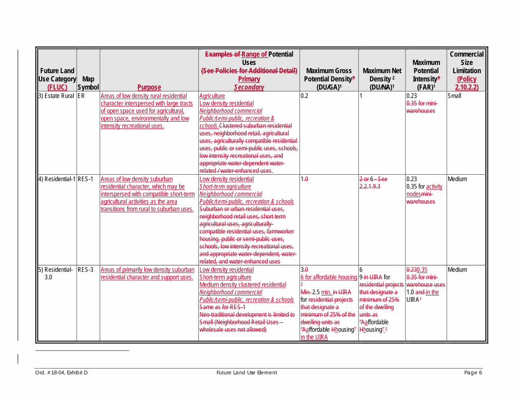
Ord. #18-04, Exhibit D Future Land Use Element Page 6
Future LandUse Category
(FLUC) Map
Symbol Purpose
Examples of Range of Potential Uses
(See Policies for Additional Detail) Primary
Secondary
Maximum GrossPotential Density*
(DU/GA)1
Maximum NetDensity 2 (DU/NA) 1
MaximumPotentialIntensity*
(FAR)1
CommercialSize
Limitation(Policy
2.10.2.2) 3) Estate Rural ER Areas of low density rural residential
character interspersed with large tractsof open space used for agricultural,open space, environmentally and lowintensity recreational uses.
Agriculture Low density residential Neighborhood commercial Public/semi-public, recreation &schools.Clustered suburban residentialuses, neighborhood retail, agriculturaluses, agriculturally compatible residentialuses, public or semi-public uses, schools,low intensity recreational uses, and appropriate water-dependent water- related / water-enhanced uses.
0.2 1 0.23 0.35 for mini- warehouses
Small
4) Residential-1 RES-1 Areas of low density suburbanresidential character, which may beinterspersed with compatible short-term agricultural activities as the areatransitions from rural to suburban uses.
Low density residential Short-term agriculture Neighborhood commercial Public/semi-public, recreation & schools Suburban or urban residential uses,neighborhood retail uses, short termagricultural uses, agriculturally-compatible residential uses, farmworkerhousing, public or semi-public uses,schools, low intensity recreational uses, and appropriate water-dependent, water- related, and water-enhanced uses
1.0 2 or 6 - See2.2.1.9.3
0.23 0.35 for activity nodesmini-warehouses
Medium
5) Residential- 3.0
RES-3 Areas of primarily low density suburban residential character and support uses.
Low density residential Short-term agriculture Medium density clustered residential Neighborhood commercial Public/semi-public, recreation & schools Same as for RES-1 Neo-traditional development is limited to Small (Neighborhood Retail Uses – wholesale uses not allowed)
3.0 6 for affordable housing 3 Min. 2.5 min. in UIRAfor residential projectsthat designate aminimum of 25% of the dwelling units as“Aaffordable Hhousing ” in the UIRA
6 9 in UIRA forresidential projects that designate aminimum of 25% of the dwellingunits as“AaffordableHhousing” 3
0.230.35 0.35 for mini- warehouse uses 1.0 and in theUIRA 1
Medium

Ord. #18-04, Exhibit D Future Land Use Element Page 7
Future LandUse Category
(FLUC) Map
Symbol Purpose
Examples of Range of Potential Uses
(See Policies for Additional Detail) Primary
Secondary
Maximum GrossPotential Density*
(DU/GA)1
Maximum NetDensity 2 (DU/NA) 1
MaximumPotentialIntensity*
(FAR)1
CommercialSize
Limitation(Policy
2.10.2.2) 6) Urban
Fringe-3 UF-3 Areas limited to the urban fringe within
which future low density residential and support uses are projected to developfollowing a logical expansion of theurban environment growing from west to east, consistent with the availability ofservices.
Low density residential Short-term agriculture Medium density clustered residential Neighborhood & community commercial Public/semi-public, recreation & schools Suburban or urban density plannedresidential development with integrated residential support uses, retail wholesaleor office commercial uses which functionin the marketplace as neighborhood orcommunity serving, short-termagricultural uses, agriculturally-compatible residential uses, farmworkerhousing, public or semi-public uses,schools, low intensity recreational uses, and appropriate water-dependent, water-related, and water-enhanced uses Neo-traditional development is limited to Small (Neighborhood Retail Uses – wholesale uses not allowed) Community –serving commercial
3.0 9 for affordable housing and/or mixed-use inactivity nodes 3
9 12 for affordablehousing and /ormixed-use inactivity nodes 3
0.230.35 0.35 for mini-warehouse uses0.5 atactivity nodes
Medium Large (undercertaincircumstancessee policy 2.2.1.11.4)

Ord. #18-04, Exhibit D Future Land Use Element Page 8
Future LandUse Category
(FLUC) Map
Symbol Purpose
Examples of Range of Potential Uses
(See Policies for Additional Detail) Primary
Secondary
Maximum GrossPotential Density*
(DU/GA)1
Maximum NetDensity 2 (DU/NA) 1
MaximumPotentialIntensity*
(FAR)1
CommercialSize
Limitation(Policy
2.10.2.2) 7) Residential-6 RES-6 Areas of primarily medium density urban
residential development and supportuses.
Medium density residential Medium density clustered residential Neighborhood commercial Public/semi-public, recreation & schools Suburban or urban residential uses,neighborhood retail uses, short-termagricultural uses other than specialagricultural uses, agriculturally-compatible residential uses, public or semi-public uses, schools, low intensityrecreational uses, and appropriate water- dependent/water-related/water-enhanceduses. Hotel uses may also be allowed within this designation but only alongUrban Corridors. Neo-traditional development is limited to Small (Neighborhood Retail Uses – wholesale uses not allowed)
6.0 12 for affordablehousing and/or mixed-use in activity nodes 3 Min. 5.0 min. in UIRAfor residential projects that designate aminimum of 25% of the dwelling units as“Aaffordable Hhousing ” in the UIRA
12 16 in UIRA forresidential projects that designate aminimum of 25%of the dwellingunits as“AaffordableHhousing” and/ormixed-use in activity nodes 3
0.23 0.35 0.35 for mini-warehouse uses 1.0 in UIRA, 1.0 alongdesignatedUrban Corridorsand activitynodesprovidedGoal 2.10 andassociated policies are met.
Medium
8) Residential- 9
RES-9 Areas of primarily medium density urban residential character and support uses.
Medium density residential High density clustered residential Neighborhood commercial Public/semi-public, recreation & schools Same as for RES-6. Neo-traditional development is limited to Small (Neighborhood Retail Uses – wholesale uses not allowed)
9.0 20 max. along Urban Corridors if a densitybonus is approved, for affordable housingand/or mixed-use in activity nodes 3 Min 7.0 min. in UIRA for residential projects that designate a minimum of 25% of the dwellingunits as “Aaffordable Hhousing” in the UIRA
16 2024 in UIRA forresidential projects that designate aminimum of 25%of the dwellingunits as “AaffordableHhousing” and/or mixed-use in activity nodes 3
0.23 0.35 0.35 for mini-warehouse uses 1.0 in UIRA, 1.0 alongdesignatedUrban Corridorsprovided Goal2.10 andassociatedpolicies are met. and activitynodes
Medium

Ord. #18-04, Exhibit D Future Land Use Element Page 9
Future LandUse Category
(FLUC) Map
Symbol Purpose
Examples of Range of Potential Uses
(See Policies for Additional Detail) Primary
Secondary
Maximum GrossPotential Density*
(DU/GA)1
Maximum NetDensity 2 (DU/NA) 1
MaximumPotentialIntensity*
(FAR)1
CommercialSize
Limitation(Policy
2.10.2.2) 9) Residential-
12 RES-12 Areas of primarily medium density urban
residential character and support uses. Medium density residential High density clustered residential Neighborhood commercial Public/semi-public, recreation & schools Same as for RES-9 Neo-traditional development is limited toSmall (Neighborhood Retail Uses – wholesale uses not allowed)
12.0 2024 max. along Urban Corridors, for affordable housing and/or mixed- use in activity nodes 3 Min 10.0 min. in UIRAfor residential projects that designate aminimum of 25% of the dwelling units as“Aaffordable Hhousing ” in the UIRA
16 24 28 in UIRA forresidential projects that designate aminimum of 25%of the dwellingunits as “AaffordableHhousing” and/or mixed-use in activity nodes 3
0.230.35 0.35 for mini- warehouse uses 1.0 in UIRA, 1.0 alongdesignatedUrban Corridors provided Goal2.10 andassociatedpolicies are met. and activity nodes
Medium
10)Residential-16 **
RES-16 Areas of primarily high density urbanresidential character and support uses.
High density residential Neighborhood commercial Public/semi-public, recreation & schools Same as for RES-9 Neo-traditional development is limited to Small (Neighborhood Retail Uses – wholesale uses not allowed)
16.0 2032 max. along Urban Corridors, for affordable housing and/or mixed-use in activity nodes 3 Min 13.0 min. in UIRAfor residential projects that designate aminimum of 25% of the dwelling units as“Aaffordable Hhousing ” in the UIRA
20 2836 in UIRA forresidential projects that designate aminimum of 25%of the dwellingunits as“AaffordableHhousing” and/ormixed-use in activity nodes 3
0.250.35 0.35 for mini-warehouse uses 1.0 in UIRA, 1.0 alongdesignatedUrbanCorridors, provided Goal 2.10 andassociated policies are met. and activity nodes
Medium (seePolicy2.2.1.15.3 forUurbanCcorridors)

Ord. #18-04, Exhibit D Future Land Use Element Page 10
Future LandUse Category
(FLUC) Map
Symbol Purpose
Examples of Range of Potential Uses
(See Policies for Additional Detail) Primary
Secondary
Maximum GrossPotential Density*
(DU/GA)1
Maximum NetDensity 2 (DU/NA) 1
MaximumPotentialIntensity*
(FAR)1
CommercialSize
Limitation(Policy
2.10.2.2) 11) Low
IntensityOffice
OL Areas of low intensity officedevelopment, sometimes mixed withmedium density urban residentialdevelopment. This category serves as a transition between commercial andresidential areas, and helps prevent the intrusion of commercial uses intoresidential or predominantly office areas.
Office Medium density residential Public/semi-public, recreation & schools Suburban or urban residential uses, office uses, public or semi-public uses, schools, low intensity recreational uses, andappropriate water-dependent, water-related, and water-enhanced uses
6.0 Min 5.0 min. in UIRA for residential projects that designate a minimum of 25% of the dwellingunits as “AaffordableHhousing” in the UIRA
12 16 in UIRA forresidential projectsthat designate aminimum of 25%of the dwellingunits as“Aaffordable Hhousing” in the UIRA
0.230.35 1.0 in UIRA.
Small (OfficeUses Only)NA
12) MediumIntensityOffice
OM Areas of low intensity officedevelopment and support uses.
Office Neighborhood commercial Public/semi-public, recreation & schools Office and research/corporate park usesare the primary non-residential uses,neighborhood retail uses (limited in size),public or semi-public uses, schools,medium intensity recreational uses and appropriate water-dependent, water-related, and water-enhanced uses can serve as appropriate secondary uses.
0 0 0.300.35 (Ooutside of the Urban CoreArea) 0.50 (Iinside the Urban CoreArea) 1.0 in UIRA
Max. 5,000 sf(Outside of the Urban CoreArea) Max. 10,000 sf(Inside theUrban CoreArea) SeePolicy2.2.1.27.5

Ord. #18-04, Exhibit D Future Land Use Element Page 11
Future LandUse Category
(FLUC) Map
Symbol Purpose
Examples of Range of Potential Uses
(See Policies for Additional Detail) Primary
Secondary
Maximum GrossPotential Density*
(DU/GA)1
Maximum NetDensity 2 (DU/NA) 1
MaximumPotentialIntensity*
(FAR)1
CommercialSize
Limitation(Policy
2.10.2.2) 13) Retail/
Office/Residential
ROR Areas exhibiting a broad range ofcommercial, office, and residential.Typically planned with an integratedapproach to mixed-use development,especially at major community or region- serving nodes resulting in horizontal orvertical integration of uses, internal tripcapture, and an overall high qualityenvironment for living, working, orvisiting.
Commercial (including lodging and office but not intensive commercial) Medium density residential High density clustered residential Public/semi-public, recreation & schools Neighborhood, community and regional serving commercial uses, mixed withresidential, lodging, office, public or semi- public, schools, and recreational uses,and appropriate water-dependent, water- related, and water-enhanced uses, and short-term agricultural uses.
16 (9.0 if located within the CEA and/or CHHA) 3032 max. along Urban Corridors (40 max. if adensity bonus isapproved), foraffordable housing,and/or mixed-usedevelopment 3 Min 7.0 min. in UIRA for residential projects that designate a minimum of25% of the dwellingunits as “AaffordableHhousing” in the UIRA
20.0] 24 36 in UIRA for residential projects that designate amin. of 25% of the dwelling units as“AaffordableHhousing” and/or mixed-usedevelopment 3
0.350.5 1.0 for Hotels,the 1.0 in UIRA,mixed-use, and 1.0 within alongdesignatedUrban Corridors(2.0 if an FARbonus is approved)
Large (see Policy2.2.1.17.3 forurbancorridors)NA
14) Industrial-Light
IL Areas with a range of light industrial and other employment-oriented uses.
Light industrial Office Commercial (including lodging, wholesale and neighborhood retail) Limited residential Public/semi-public, recreation & schools Light industrial uses, office s, research/corporate uses,warehouse/distribution uses, intensivecommercial uses, wholesale commercial uses, neighborhood retail uses, s erviceuses, selected residential uses, short-term agricultural uses, recreational uses,public or semi-public uses, schools,privately-operated airports, appropriate water-dependent, water-related, and water-enhanced uses, and hotels/motels.
1 1 0.75 1.0 in UIRA and within Urban Corridors 1.0 for Hotels
Small

Ord. #18-04, Exhibit D Future Land Use Element Page 12
Future LandUse Category
(FLUC) Map
Symbol Purpose
Examples of Range of Potential Uses
(See Policies for Additional Detail) Primary
Secondary
Maximum GrossPotential Density*
(DU/GA)1
Maximum NetDensity 2 (DU/NA) 1
MaximumPotentialIntensity*
(FAR)1
CommercialSize
Limitation(Policy
2.10.2.2) 15) Industrial-
Heavy IH Areas exhibiting a range of light and
heavy industrial, and other employment- oriented uses.
Light and heavy industrial Deepwater port and complementary uses Office Commercial (including wholesale and neighborhood retail) Public/semi-public, recreation & schools Heavy and light industrial uses,deepwater port and related orcomplementary uses, offices, research/corporate uses,warehouse/distribution uses, intensivecommercial uses, wholesale commercialuses, neighborhood retail uses only,service uses, short-term agricultural uses,recreational uses, public or semi- publicuses, privately-operated airports, and appropriate water-dependent, water- related, and water-enhanced uses.
0 0 0.50.75 1.0 in UIRA andwithin Urban Corridors
Small
16) UrbanIndustrial
IU Areas of established, developed light or heavy industrial uses where such usesare substantially or completely surrounded by urban uses, with limitedability for expansion.
Light and heavy industrial Neighborhood commercial Public/semi-public, recreation & schools. Light industrial uses, heavy industrialuses, neighborhood retail uses,recreational uses, and public or semi- public uses.
0 0 1.25 Small

Ord. #18-04, Exhibit D Future Land Use Element Page 13
Future LandUse Category
(FLUC) Map
Symbol Purpose
Examples of Range of Potential Uses
(See Policies for Additional Detail) Primary
Secondary
Maximum GrossPotential Density*
(DU/GA)1
Maximum NetDensity 2 (DU/NA) 1
MaximumPotentialIntensity*
(FAR)1
CommercialSize
Limitation(Policy
2.10.2.2) 17) Mixed Use MU Major centers of suburban or urban
activity in areas with a high level ofpublic facility availability, and intended to develop with a horizontal or vertical mix of residential and non-residential uses,achieving internal trip capture, and thedevelopment of a high qualityenvironment for living, working, andvisiting.
Commercial (including neighborhood,community and regional servingcommercial, wholesale and lodging) Office Light industrial High density residential Public/semi-public, recreation & schools Retail, wholesale, office uses, lightindustrial uses, research/corporate uses, warehouse/ distribution, suburban orurban residential uses, lodging places,recreational uses, public or semi- publicuses, schools, hospitals, short-termagricultural uses, other than specialagricultural uses, agriculturally-compatible residential uses, and water-dependent uses.
12 (9.0 if located within the CEA and/or CHHA) 30 max. along UrbanCorridors (40 max,. if a density bonus isapproved), for mixed-use, and/or affordablehousing 3 Min 7.0 min. in UIRA for residential projects that designate a minimum of 25% of the dwellingunits as “Aaffordable Hhousing,” in the UIRA
20.0 24 36 in UIRA forresidential projects that designate aminimum of 25% of the dwelling units as“AaffordableHhousing” and/ ormixed-use 3
1.0 (2.0 within along Urban Corridors if an FAR bonus is approved) 2.0 in UIRA
Large (seePolicy2.2.1.21.3 forurban corridors)
18) Mixed Use Community
MU-C The MU-C category is intended toaccommodate a mix of predominantlyresidential communities (MU-C/R and MU-C/RU) with centers of commercial activity at various levels of intensity (MU- C/AC-1, 2 and 3). The MU-C encourages horizontal and vertical mixed use to achieve internal trip capture, and the development of a high quality environment for living, working, and visiting.
See subcategories below See subcategoriesbelow
See subcategories below
Seesubcategoriesbelow
Seesubcategoriesbelow

Ord. #18-04, Exhibit D Future Land Use Element Page 14
Future LandUse Category
(FLUC) Map
Symbol Purpose
Examples of Range of Potential Uses
(See Policies for Additional Detail) Primary
Secondary
Maximum GrossPotential Density*
(DU/GA)1
Maximum NetDensity 2 (DU/NA) 1
MaximumPotentialIntensity*
(FAR)1
CommercialSize
Limitation(Policy
2.10.2.2) 22) Mixed Use
Community MU-C/R Intended to accommodate low density
residential in close proximity toneighborhood and community-serving commercial areas.
Low density residential Medium density clustered residential Neighborhood commercial Public/semi-public, recreation & schools Short-term agriculture Suburban or urbandensity planned residential developmentwith integrated residential support usesas part of such developments,neighborhood retail uses, short-termagricultural uses, interim farm worker housing, public or semi-public uses,schools, recreational uses, and appropriate water-dependent, water- related, and water-enhanced uses.
MU-C/R Maximum 3 du/ga
Maximum 9 du/net acre
0.23 Medium
22) Mixed Use Community
MU- C/RU
Intended to accommodate low densityresidential in close proximity toneighborhood and community-serving commercial areas.
Low density residential High density clustered residential Neighborhood commercial Public/semi-public, recreation & schools Short-term agriculture Suburban or urbandensity coordinated residentialdevelopment with integrated residentialsupport uses as part of suchdevelopments, neighborhood retail uses,short-term agricultural uses, interim farm worker housing, public or semi-publicuses, schools, recreational uses, and appropriate water-dependent/ water related/ water-enhanced uses
MU-C/RU Maximum 9 du/ga
Maximum 16 du/net acre
0.23 Medium

Ord. #18-04, Exhibit D Future Land Use Element Page 15
Future LandUse Category
(FLUC) Map
Symbol Purpose
Examples of Range of Potential Uses
(See Policies for Additional Detail) Primary
Secondary
Maximum GrossPotential Density*
(DU/GA)1
Maximum NetDensity 2 (DU/NA) 1
MaximumPotentialIntensity*
(FAR)1
CommercialSize
Limitation(Policy
2.10.2.2) 22) Mixed Use
Community MU-C/AC-1
Intended to accommodate a mix ofcommercial (neighborhood, communityor regional) and high density residential in nodes surrounded by lower density residential uses.
Commercial (neighborhood, communityor regional serving, including retail,wholesale and lodging) Office High density residential Light industrial Public/semi-public, recreation & schools Retail, wholesale or office commercialuses which function in the market placeas neighborhood, community or region-serving. Also light industrial uses, research/corporate uses,warehouse/distribution, suburban orurban residential uses, lodging places,recreational uses, public or semi- publicuses, schools, hospitals, short-termagricultural uses, and appropriate water- dependent/water-related/water enhanced uses.
MU-C/AC-1 Maximum 9 max.du/ga Minimum 6 min.du/ga
Maximum 20du/net acre
1.0 Large

Ord. #18-04, Exhibit D Future Land Use Element Page 16
Future LandUse Category
(FLUC) Map
Symbol Purpose
Examples of Range of Potential Uses
(See Policies for Additional Detail) Primary
Secondary
Maximum GrossPotential Density*
(DU/GA)1
Maximum NetDensity 2 (DU/NA) 1
MaximumPotentialIntensity*
(FAR)1
CommercialSize
Limitation(Policy
2.10.2.2) 22) Mixed Use
Community MU-C/AC-2
Intended to accommodate a mix ofneighborhood or community servingcommercial and medium densityresidential surrounded by lower density residential developments.
Commercial (neighborhood or community serving, including retail and lodging) Office Medium density residential Light industrial Public/semi-public, recreation & schools Retail, wholesale, or office commercialuses which function in the market placeas neighborhood, community, or region-serving. Also light industrial uses, research/corporate uses,warehouse/distribution, suburban orurban residential uses, lodging places,recreational uses, public or semi- publicuses, schools, short-term agricultural uses, and appropriate water-dependent, water-related, and water enhanced uses.
MU-C/AC-2 Maximum 9 max.du/ga Minimum 6 min.du/ga
Maximum 20du/net acre
0.35 Large
22) Mixed Use Community
MU-C/ AC-3
Intended to accommodateneighborhood-serving commercial mixed with medium density residential uses.
Neighborhood commercial Office Medium density residential Light industrial Public/semi-public, recreation & schools Neighborhood retail/office uses, also light industrial uses, research/corporate uses,warehouse/distribution, suburban orurban density planned residentialdevelopment with integrated residentialsupport uses as part of suchdevelopments, short-term agriculturaluses, interim farm worker housing, publicor semi-public uses, schools, recreational uses, and appropriate water-dependent, water-related, and water-enhanced uses.
MU-C/AC-3 Maximum 3 max.du/ga
Maximum 9 du/net acre
0.23 Medium

Ord. #18-04, Exhibit D Future Land Use Element Page 17
Future LandUse Category
(FLUC) Map
Symbol Purpose
Examples of Range of Potential Uses
(See Policies for Additional Detail) Primary
Secondary
Maximum GrossPotential Density*
(DU/GA)1
Maximum NetDensity 2 (DU/NA) 1
MaximumPotentialIntensity*
(FAR)1
CommercialSize
Limitation(Policy
2.10.2.2) 189) Public/
Semi-Public (1)
P/SP(1) This category is intended to recognizemajor existing and programmedpublic/quasi-public facilities, primarilythose facilities associated with public or private utilities, including electricaltransmission corridors, and other public or semi-public facilities which have adverse aesthetic or health, safety, orwelfare impacts on adjacent property or residents.
Public/semi-public, recreation & schools Utility uses (including sanitary landfills,permanent water and wastewatertreatment/ storage/disposal facilities,maintenance facilities, solid wastetransfer stations, major utilitytransmission corridors and other major public facilities. Public airports Recreational uses,sanitary landfills, permanent water andwastewater treatment/ storage/disposalfacilities and other major public facilitiesincluding, but not limited to, airportsowned or operated by a public entity,major maintenance facilities, solid waste transfer stations, major utility transmission corridors.
See Policies See Policies See Policies See 2.2.1.22.2and 2.2.1.23.2
1920) MajorPublic/ Semi-Public(2)
P/SP(2) This category is intended to recognizemajor existing and programmedpublic/quasi-public facilities, primarilythose associated with frequent or regular use by residents of the community,particularly major health care andeducational facilities.
Hospitals Colleges or universities, and other similarpublic or semi-public uses and schools Public or private hospitals, or health carecomplexes including a hospital, which aresubject to requirements by the State ofFlorida including the issuance of aCertificate of Need, public or privatecolleges or universities, and other similarpublic or semi-public uses and schools.
See Policies See Policies See Policies See 2.2.1.22.2and 2.2.1.23.2
201) MajorAttractors
AT This category is intended to recognizeand accommodate public and private facilities, which by virtue of their highly specialized function or their infrequentbut significant impact on public facilities and other land uses, are inconsistent with the definition or intent of other future land use categories.
Mass seating facilities, civic center,vehicular racing facilities, arenas, intensive recreational uses, and other major attractors. Schools
See PoliciesN/A See PoliciesN/A See PoliciesN/A N/A

Ord. #18-04, Exhibit D Future Land Use Element Page 18
Future LandUse Category
(FLUC) Map
Symbol Purpose
Examples of Range of Potential Uses
(See Policies for Additional Detail) Primary
Secondary
Maximum GrossPotential Density*
(DU/GA)1
Maximum NetDensity 2 (DU/NA) 1
MaximumPotentialIntensity*
(FAR)1
CommercialSize
Limitation(Policy
2.10.2.2) 212) Major
Recreation/Open Space
R/OS Areas of significant recreation andpermanent open space lands, historicsites, and other areas for thepreservation of cultural and recreational amenities.
State parks, historic sites, district orregional parks, significant recreationaland open spaces or public schools whenassociated with public parks.
0See Policies 0See Policies 0See Policies N/A
DU/GA = Gross Dwelling Units per Gross Acre; DU/NA = Dwelling Units per Net Acre; FAR = Floor Area Ratio; UIRA = Urban Infill Redevelopment Area; “Activity Nodes” refer to developments that meet the Commercial Locational Criteria (see Land Use Operative Provisions, Comprehensive Plan). Table Notes: 1 Refer to Policy 2.2.1.6 and to the more detailed description under each Future Land Use Category for limitations on the use of/or reliance on the information contained in this summary
table. “Density Bonus” and “FAR Bonus” are defined and described in further detail in the Land Development Code. 2 Developments along the designated Urban Corridors are not subject to the maximum “net” densities listed in this table. 3 Gross densities listed above the base density of the FLUC shall not be used within the Coastal Evacuation Area (CEA) or the Coastal High Hazard Area (CHHA).

Ord. #18-04, Exhibit D Future Land Use Element Page 19
TABLE 2-1 SUMMARY OF FUTURE LAND USE CLASSIFICATION SYSTEM
PART II: FUTURE LAND USE OVERLAY DISTRICTS
Future Land Use OverlayDistricts
MapSymbol Function
[ * * * ]
6) Regional Activity Center RAC Encourage Growth Into Suitable Areas Capable of Supporting AdditionalInfrastructure And Population, With Consideration Given To TransportationAccessibility, Infrastructure Service Capability, and Capital Improvements Programming.
7) Florida International Gateway Overlay
NCGFI G
Provide an area to meet the long term needs of Manatee County, nearPort Manatee, for industrial light development integrated with low density or clustered low-moderate density mixed use environment.
[ * * * ]
Policy 2.2.1.5.1 In no instance shall industrial uses be permitted to locate withinany future land use category permitting residentialdevelopment, except for those industrial uses permitted within the ROR and MU categories and in the FIG Overlay, or water-dependent industrial uses within residential designations at locations with existing and operating industrial facilities as of the adoption date of the Comprehensive Plan - May 115, 1989.
Policy 2.2.1.6 The land development regulations may restrict development potential to less than the maximum provided for in this Comprehensive Plan, to address land use compatibility, public facility and natural resource considerations as identified in this Comprehensive Plan. Furthermore, nothing in this Comprehensive Plan shall guarantee the achievement of maximum development potential noted in this element and the Future Land Use Map.
Implementation Mechanism(s):
a) Land development regulations developed pursuant to § 163.3202, F.S.
b) Review of proposed project densities or intensities for compliance with this Comprehensive Plan and otherapplicable development regulations.
Policy 2.2.1.7 CON: Establish the Conservation Lands future land use

Ord. #18-04, Exhibit D Future Land Use Element Page 20
category as follows:
[ * * * ]
Policy 2.2.1.7.2 Range of Potential Uses (see Policy 2.2.1.5): No development shall be permitted in the Conservation future land use category, except for Any uses which haves the primary purpose of protecting natural resources, and which may alsofacilitate the passive recreational use of land may be considered within this category. Public Schools may be considered a potential use in Conservation (CON) future land use category at the discretion of Manatee County Government.
[ * * * ]
Policy 2.2.1.8 Ag/R: Establish the Agricultureal/Rural future land usecategory as follows:
Policy 2.2.1.8.1 Intent: To identify, textually in the Comprehensive Plan's goals, objectives, and policies, or graphically on the Future Land Use Map, areas which have a long term Aagricultural or Rrural Rresidential character, such areas primarily located east of the"Future Development Area Boundary" (FDAB). Refer to thePotable Water/Wastewater Service Areas Map in the Water & Wastewater ElementTSD, Land Use Element for location of theFDAB.
Policy 2.2.1.8.2 Range of Potential Uses (see Policies 2.1.2.3 - 2.1.2.7, 2.2.1.5,and Obj. 9.2.4): AgricultureFarms, ranches, agro-industrial uses, agricultural service establishments, agriculturally-compatiblelow density residential uses, farmworker housing, rural residential uses, mining and mining-related uses, support neighborhood commercial, public/semi-public, recreationand school uses neighborhood retail uses, mining, mining-related uses, low intensity recreational facilities, ruralrecreational facilities, public or semi-public uses, schools, and appropriate water-dependent uses (see also Objectives 4.2.1,2.10.3 and 2.10.4).
Policy 2.2.1.8.3 Range of Potential Density/Intensity:

Ord. #18-04, Exhibit D Future Land Use Element Page 21
- Maximum gross residential density: 0.2 dwelling units per acre
- Maximum net residential density: 2 dwelling unit per acre (except within WO and CHHA Overlay Districts pursuant to Policies 2.3.1.5, and 4.3.1.5)
- Maximum floor area ratio: 0.23, except for Mmining-related uses, agro-industrial uses related to agriculture, and agricultural service establishments, which are exempt from the maximum FAR, but may be limited in intensity by the application of other goals, objectives, or policies in thisComprehensive Plan or by other applicable development regulations (see Policy 2.2.1.8.4).
- Maximum Square Footage for Neighborhood Retail Commercial Uses: Small (limited to 30,000 sf), subject to the commercial locational criteria (see Objective 2.10.4).
Policy 2.2.1.8.4 Other Information:
a) Mining-related uses, agro-industrial uses, and agricultural service establishments are exempt from the requirement for0.23 maximum Floor Area Ratio, but may be limited inintensity by the application of other goals, objectives, orpolicies in this Comprehensive Plan or by other applicabledevelopment regulations.
b) All mixed, multiple use and rural recreational use projects require special approval, as defined herein, and as furtherdefined in any land development regulations developed pursuant to § 163.3202, F.S.
ca) Where established in a manner consistent withapplicable land development regulations, farmworker housing may exceed densities specified in Policy 2.2.1.8.3.
db) Schools in the Ag/R future land use category may only be permitted in areas where residential development has created demand or is projected to create demand within a reasonable planning timeframe.
Policy 2.2.1.9 RES-1: Establish the Residential-1 future land use category as follows:
Policy 2.2.1.9.1 Intent: To identify, textually in the Comprehensive Plan's goals,objectives, and policies, or graphically on the Future Land UseMap, areas which are established for a comprised primarily of

Ord. #18-04, Exhibit D Future Land Use Element Page 22
low density suburban residential development, preferably clustered, where appropriate, to protect the environment, preserve open space, and/or to allow the continued operation of short-term agricultural activities as the area transitions from rural to suburban uses. environment, or a clustered low density urban residential environment where appropriate, and which may be utilized for compatible agricultural activities in the short-term, while recognizing that suburban or clustered urban uses are the preferred long-term land use for these areas. Also, to provide for a complement of support uses normally utilized during the daily activities of residents of these suburban or urban areas.
Policy 2.2.1.9.2 Range of Potential Uses (see Policies 2.1.2.3 - 2.1.2.7, 2.2.1.5):Primarily low density suburban residential and short-term agriculture with support neighborhood commercial,public/semi-public, recreation and school uses. Suburban orurban residential uses, neighborhood retail uses, short termagricultural uses, agriculturally-compatible residential uses,farmworker housing, public or semi-public uses, schools, lowintensity recreational uses, and appropriate water-dependent, water-related, and water-enhanced uses (see also Objectives 4.2.1 and 2.10.4).
Policy 2.2.1.9.3 Range of Potential Density/Intensity:
- Maximum gross residential density: 1 dwelling unit per acre
- Maximum net residential density: 2 dwelling units per acre or 6 dwelling units per acres (see 2.2.1.9.4(b) and (c) forexplanation); clustered development in the WO or CHHA Overlay Districts may exceed the maximum net density pursuant to Policies 2.3.1.5 and 4.3.1.5.
- Maximum floor area ratio: 0.23; (0.35 for developments atactivity nodes meeting the Commercial Locational Criteria (see Land Use Operative Provisions chaptermini-warehouse uses only)
- Maximum Square Footage for Neighborhood Retail Commercial Uses: Medium (150,000sf), subject to the Commercial Locational Criteria (see Objective 2.10.4 and Land Use Operative Provisions chapter).
Policy 2.2.1.9.4 RESERVED Other Information:
a) All mixed and multiple-use projects require special

Ord. #18-04, Exhibit D Future Land Use Element Page 23
approval, as defined herein, and as further defined in any land development regulations developed pursuant to § 163.3202, F.S.
b) Maximum net residential density within areas which are predominantly developed at a net residential density of 2 du/ga or less, or where existing development has not utilized "clustering" to achieve a net density which is significantly greater than gross density, shall be limited to a 2 dwelling units/acre on any part, or all, of a proposed project.
c) Maximum net residential density within areas which are generally undeveloped, or which have experienced development which has predominantly utilized "clustering" to achieve net densities which are significantly greater than gross densities of the same projects(s), shall be limited to 6 dwelling units per acre on any part, or all of any proposed project. Net densities greater than 6 dwelling units per net acre may be considered within the WO (Evers) or CHHA Overlay Districts, pursuant to policies 2.3.1.5 and 4.3.1.5, to maximize protection of natural resources and to maximize reserved open space.
d) Any project containing a net density in excess of 1 dwelling unit per acre shall require special approval.
e) Any nonresidential project exceeding 30,000 square feet of gross building area shall require special approval.
Policy 2.2.1.10 RES-3: Establish the Residential-3 future land use category as follows:
Policy 2.2.1.10.1 Intent: To identify, textually in the Comprehensive Plan's goals, objectives, and policies, or graphically on the Future Land Use Map, areas which are established for a primarily developedwith lowmoderate- density suburban uses, preferably clustered to protect the environment, preserve open space, and/or to allow the continued operation of short-term agricultural activities., or a clustered low density urban, residentialenvironment. Also, to provide a complement of residentialsupport uses normally utilized during the daily activities of residents of these moderate density suburban, or low density urban areas.
Policy 2.2.1.10.2 Range of Potential Uses (see Policies 2.2.1.5, 2.1.2.3 - 2.1.2.7):

Ord. #18-04, Exhibit D Future Land Use Element Page 24
Primarily low density suburban residential and short-term agriculture uses, with support neighborhood commercial, public/semi-public, recreation and school uses. Suburban or urban residential uses, neighborhood retail uses, short-term agricultural uses other than special agricultural uses, agriculturally-compatible residential uses, public or semi-public uses, schools, low-intensity recreational uses, and appropriate water-dependent, water-related, and water enhanced uses (see also Objectives 4.2.1 and 2.10.4).
Policy 2.2.1.10.3 Range of Potential Density/Intensity:
- Maximum gross residential density:
• 3 dwelling units per acre
• 6 dwelling units per acre for residential projects that designate a minimum of 25% of the total dwelling units as “Affordable Housing.” Properties within the CEA and CHHA are not eligible for this additional density.
- Minimum gross residential density: 2.5 only in UIRA for residential projects that designate a minimum of 25% of the dwelling units as “Affordable Housing.”
- Maximum net residential density:
- 6 dwelling units per acre
- 9 dwelling units per acre within the UIRA for residentialprojects that designate a minimum of 25% of the dwelling units as “Affordable Housing.”
- Maximum “net” densities shall not apply to projects within designated Urban Corridors.apply to clustered development in the WO or CHHA Overlay Districts (see Policies 2.3.1.5 and 4.3.1.5).
- See Policies 2.3.1.4 and 4.3.1.5 for density restrictions within the WO or CHHA Overlay Districts.
- Maximum floor area ratio:
- 0.350.23 (0.35 for mini-warehouse uses only)
- 1.00 inside the UIRA and within designated UrbanCorridors.
- Maximum Square Footage for Neighborhood Retail Commercial Uses: Medium (150,000 sf), subject to the

Ord. #18-04, Exhibit D Future Land Use Element Page 25
Commercial Locational Criteria (see Objective 2.10.4 and Land Use Operative Provisions chapter).
Policy 2.2.1.10.4 RESERVEDOther Information:
a) All mixed and multiple-use projects require special approval, as defined herein, and as further defined in any land development regulations developed pursuant to § 163.3202, F.S.
b) All projects for which gross density exceeds 2.0 dwelling units per acre, or in which any net residential density exceeds 3 dwelling units per acre, shall require special approval.
c) Any nonresidential project exceeding 30,000 square feet of gross building area shall require special approval.
d) The Special Approval requirements listed above (a through c) shall not apply to development along the designated Urban Corridors.
Policy 2.2.1.11 UF-3: Establish the Urban Fringe - 3 future land use category as follows:
Policy 2.2.1.11.1 Intent: To identify, textually, in the Comprehensive Plan's goals, objectives, and policies, or graphically on the Future Land Use Map, areas limited to the urban fringe within which future lowdensity residential and support uses growth (and growth beyond the long term planning period) is are projected tooccur develop at the appropriate time in a responsible manner. The development of these lands shall following a logical expansion of the urban environment, typically growingfrom the west to the east, consistent with the availability of services. At a minimum, tThe nature, extent, location ofdevelopment, and availability of services will shall be reviewed to ensure the transitioning development of these lands isconducted consistent with the intent of this policy. These UF-3land use category includes areas are those which areestablished for a of low density urban , or clustered low- moderate density urban, residential environmentdevelopment, generally developed through an integrated master plan approachthe planned unitdevelopment concept. Also, to The UF-3 category alsoprovides for a complement of residential support uses normally utilized during the daily activities of residents of these low or

Ord. #18-04, Exhibit D Future Land Use Element Page 26
low-moderate density urban environments, and in limited circumstances non-residential uses of a community serving nature to allow for a variety of uses within these areas which serve more than the day to day needs of the community. (See further policies under 2.2.1.11.45 for guidelines)
Policy 2.2.1.11.2 Range of Potential Uses (see Policies 2.1.2.3 - 2.1.2.7, 2.2.1.5):Low density residential and medium-density clustered residential uses, short-term agriculture, Suburban or urban density planned residential development with integrated residential support uses as part of such developments, neighborhood and community-serving retail commercial wholesale or and office commercial uses, which function in the marketplace as neighborhood or community serving, short-term agricultural uses, agriculturally-compatible residential uses, farmworker housing, and public/ or semi- public uses, recreation and schools, low intensity recreational uses, and appropriate water-dependent, water-related, and water-enhanced uses (sSee also Objectives 4.2.1 and 2.10.4).
Policy 2.2.1.11.3 Range of Potential Density/Intensity:
- Maximum gross residential density:
• 3 dwelling units per acre;
• 9 dwelling units per acre at activity nodes (see Policy 2.2.1.11.4).
• 9 dwelling units per acre for residential projects that designate a minimum of 25% of the total dwelling units as “Affordable Housing.”
• Properties within the CEA and CHHA are not eligible for the additional density offered for activity nodes and affordable housing.
- Maximum net residential density:
• 9 dwelling units per acre;
• 12 dwelling units per acre for mixed-use developments at activity nodes (see Policy 2.2.1.11.4).
• 12 dwelling units per acre for residential projects that designate a minimum of 25% of the total dwelling units as “Affordable Housing.”.
• Clustered developments in the (except within the WO

Ord. #18-04, Exhibit D Future Land Use Element Page 27
or CHHA Overlay Districts may exceed the maximum net density pursuant to Policies 2.3.1.5 and 4.3.1.5).
- Maximum floor area ratio:
• 0.350.23 (0.35 for mini-warehouse uses only);
• 0.5 at activity nodes (see Policy 2.2.1.11.4).
- Maximum Square Footage for Neighborhood Retail Commercial Uses:
• Medium (150,000 sf), subject to the Commercial Locational Criteria (see Policy 2.2.1.11.4).
• Large (300,000 sf)*, subject to the CommercialLocational Criteria (see Policy 2.2.1.11.4).
- *With Limitations (See Policy 2.2.1.11.5)
Policy 2.2.1.11.4 Other Information:
a) All mixed, multiple-use, and community serving non- residential projects require special approval, as defined herein, and as further defined in any land development regulations developed pursuant to § 163.3202, F.S.
b) All projects for which gross residential density exceeds 1 dwelling unit per acre, or in which any net residential density exceeds 3 dwelling units per acre, shall require special approval.
c) Any nonresidential project exceeding 30,000 square feet shall require special approval.
da) Schools in the UF-3 future land use category may only be permitted in areas where residential development has created demand or is projected to create demand within a reasonable planning timeframe.
b) In order to serve more than day to day needs within the UF- 3 suburban environment, activity nodes with neighborhood and community-serving commercial uses may be permitted if consistent with the Commercial Locational Criteria (see Objective 2.10.4 and Land Use Operative Provisions chapter). Residential uses may also be permitted at nodes, but the higher densities noted in Table 2-1 and Policy 2.2.1.11.3 are only allowed in conjunction with a mixed-use development that includes a commercial component.

Ord. #18-04, Exhibit D Future Land Use Element Page 28
c) Professional office uses within this category are exempt from compliance with any locational criteria specified under Policies 2.10.4.1 and 2.10.4.2, and detailed in the Land Use Operative Provisions provided such office is located on a roadway classified as a minor or principal arterial (not including interstates) and it meets all other commercial development standards and the goals, objectives, and policies in this Comprehensive Plan.
Policy 2.2.1.11.5 RESERVEDIn order to serve more than day to day needs withinthe low-moderate density urban environment, propertiesmeeting the following criteria may be developed with land uses which are defined as community serving non-residential uses:
a) Located at the intersection of an arterial and acollector roadway as defined in the Chapter 5 of this plan.
Policy 2.2.1.12 RES-6: Establish the Residential-6 future land use category as follows:
Policy 2.2.1.12.1 Intent: To identify, textually in the Comprehensive Plan's goals, objectives, and policies, or graphically on the Future Land UseMap, areas which are established for aof low medium density urban, or a clustered low-moderate density urban, residentialenvironmentdevelopment. with Also, to provide for acomplementary of support uses normally utilized during thedaily activities of residents of these low or low-moderate density urban areas.
Policy 2.2.1.12.2 Range of Potential Uses (see Policies 2.1.2.3 - 2.1.2.7, 2.2.1.5):Primarily medium density urban residential and clustered development, with support uses such as neighborhood commercial, office, public/semi-public, recreation and schooluses. Suburban or urban residential uses, neighborhood retailuses, short-term agricultural uses other than special agriculturaluses, agriculturally-compatible residential uses, public or semi- public uses, schools, low intensity recreational uses, andappropriate water-dependent/water-related/water-enhanced uses (sSee also Objectives 4.2.1 and 2.10.4). Hoteluses may also be allowed within this designation but only along Urban Corridors and subject to the locational criteria for commercial uses.
Policy 2.2.1.12.3 Range of Potential Density/Intensity:

Ord. #18-04, Exhibit D Future Land Use Element Page 29
- Maximum gross residential density:
• 6 dwelling units per acre.
• 12 dwelling units per acre for mixed-use developments at activity nodes (see Policy 2.2.1.12.4).
• 12 dwelling units per acre for residential projects that designate a minimum of 25% of the dwelling units as “Affordable Housing.”
• Properties within the CEA and CHHA are not eligible for the additional density offered for activity nodes and affordable housing.
- Minimum gross residential density: 5.0 only in UIRA for residential projects that designate a minimum of 25% of the dwelling units as “affordable housing.”.
- Maximum net residential density:
• 12 dwelling units per acre
• 16 dwelling units per acre within the UIRA for residential projects that designate a minimum of 25% of thedwelling units as “Affordable Housing.”.
• 16 dwelling units per acre for mixed-use developments at activity nodes (see Policy 2.2.1.12.4).
• Maximum “net” densities shall not apply to projectswithin designated Urban Corridors and may not apply to clustered development in the WO or CHHA Overlay Districts (see policies 2.3.1.5 and 4.3.1.5).
- See Policies 2.3.1.4 and 4.3.1.5 for density restrictions within the WO or CHHA Overlay Districts.
- Maximum floor area ratio:
• 0.23 (0.35 for mini-warehouse uses only).
• 1.00 inside the UIRA, and within designated Urban Corridors, and at activity nodes (see Policy 2.2.1.12.4).
- Maximum Square Footage for Neighborhood Retail Commercial Uses:
• Medium (150,000 sf), subject to the Commercial Locational Criteria (see Policy 2.2.1.12.4).
Policy 2.2.1.12.4 Other Information:

Ord. #18-04, Exhibit D Future Land Use Element Page 30
a) In order to serve the neighborhood commercial needs within the RES-6 future land use category, activity nodes with neighborhood-serving commercial uses may be allowed subject to the Commercial Locational Criteria (see Land Use Operative Provisions and Objective 2.10.1). Residential uses may also be permitted at nodes, but the higher densities noted in Table 2-1 and Policy 2.2.1.12.3 are only allowed in conjunction with a mixed-use development that includes a commercial component.
a) All mixed and multiple-use projects require special approval, as defined herein, and as further defined in any land development regulations developed pursuant to § 163.3202, F.S.
b) All projects for which gross residential density exceeds 4.5 dwelling units per acre, or in which any net residential density exceeds 6 dwelling units per acre shall require special approval.
c) Any nonresidential project exceeding 30,000 square feet of gross building area shall require special approval.
d) The Special Approval requirements listed above (a through c) shall not apply to development along the designated Urban Corridors.
eb) Professional office uses not exceeding 3,000 square feet in gross floor area within this category may beare exempted from compliance with any locational criteria specified under Policies 2.10.4.1 and 2.10.4.2, and detailed in the Land Use Operative Provisions provided such office is located on a roadway classified as a minor or principal arterial, however, (not including interstates) and shall still be consistent withit meets all other commercial development standards and with other the goals, objectives, and policies in this Comprehensive Plan (see also 2.10.4.2).
Policy 2.2.1.13 RES-9: Establish the Residential-9 future land use category as follows:
Policy 2.2.1.13.1 Intent: To identify, textually in the Comprehensive Plan's goals, objectives, and policies, or graphically on the Future Land UseMap, areas which are established for a of low-moderate urban, or clustered moderate medium density urban residential environmentdevelopment and . Also to provide for

Ord. #18-04, Exhibit D Future Land Use Element Page 31
a complementary of residential support uses normally utilizedduring the daily activities of residents of these urban areas.
Policy 2.2.1.13.2 Range of Potential Uses (see Policies 2.1.2.3 - 2.1.2.7, 2.2.1.5):Primarily medium density residential and high density clustered residential development, with support uses such as neighborhood commercial, office, public/semi-public,recreation and school uses. Suburban or urban residential uses,neighborhood retail uses, dormitories, short-term agriculturaluses other than special agricultural uses, agriculturally-compatible residential uses, public or semi-public uses, schools,low intensity recreational uses, and appropriate water- dependent/water-related/water-enhanced uses (sSee alsoObjectives 4.2.1 and 2.10.4). Hotel uses may also be allowedwithin this designation but only along Urban Corridors and subject to the locational criteria for commercial uses.
Policy 2.2.1.13.3 Range of Potential Density/Intensity:
- Maximum gross residential density:
• 9 dwelling units per acre;
• up to 20 dwelling units per acre along designated uUrban cCorridors if a density bonus is approved.
• 20 dwelling units per acre for residential projects that designate a minimum of 25% of the dwelling units as “Affordable Housing.”
• 20 dwelling units per acre for mixed-use developments at activity nodes (see Policy 2.2.1.13.4).
• Properties within the CEA and CHHA are not eligible for the additional density offered for urban corridors, activity nodes and affordable housing.
- Minimum gross residential density: 7.0 only in UIRA for residential projects that designate a minimum of 25% of the dwelling units as “affordable housing”.
- Maximum net residential density:
• 16 dwelling units per acre
• 2024 dwelling units per acre within the UIRA for residential projects that designate a minimum of 25% of the dwelling units as “Affordable Housing.”
• 24 dwelling units per acre for mixed-use developments

Ord. #18-04, Exhibit D Future Land Use Element Page 32
at activity nodes (see Policy 2.2.1.13.4).
• Maximum “net” densities shall not apply to projects within designated Urban Corridors. and may not apply to clustered development in the WO or CHHA Overlay Districts, pursuant to Policies 2.3.1.5 and 4.3.1.5.
- See Policies 2.3.1.4 and 4.3.1.5 for density restrictions within the WO or CHHA Overlay Districts.
- Maximum floor area ratio:
• 0.350.23 (0.35 for mini-warehouse uses);
• 1.00 inside the UIRA and within designated Urban Corridors.
• 1.00 at activity nodes (see Policy 2.2.1.13.4).
- Maximum Square Footage for Neighborhood Retail Commercial Uses:
• Medium (150,000 sf), subject to the Commercial Locational Criteria (see Policy 2.2.1.13.4).
Policy 2.2.1.13.4 Other Information:
a) Generally, limit the use of the RES-9 future land use category on vacant land to locations that are adjacent to the roadways shown on the Future Traffic Circulation:Functional Classification Map (Map 5B) as collector or higher.
a) All mixed and multiple-use projects shall require special approval, as defined herein, and as further defined in any land development regulations developed pursuant to §163.3202, F. S.
b) All projects for which gross residential density exceeds 6 dwelling units per acre, or in which any net residential density exceeds 9 dwelling units per acre shall require special approval.
b) In order to serve the neighborhood commercial needs within the RES-9 future land use category, activity nodes with neighborhood-serving commercial uses may be allowed subject to the Commercial Locational Criteria (see Land Use Operative Provisions and Objective 2.10.1). Residential uses may also be permitted at nodes, but the higher densities noted in Table 2-1 and Policy 2.2.1.13.3 are

Ord. #18-04, Exhibit D Future Land Use Element Page 33
only allowed in conjunction with a mixed-use development that includes a commercial component.
c) Any nonresidential project exceeding 30,000 square feet of gross building area shall require special approval.
d) The Special Approval requirements listed above (a through c) shall not apply to development along the designated Urban Corridors or within the UIRA.
ec) Professional office uses not exceeding 3,000 square feet in gross floor area within this category may beare exempted from compliance with any locational criteria specified under Policies 2.10.4.1 and 2.10.4.2, provided such office is located on a roadway classified as a minor or principal arterial, however, (not including interstates), and shall still be consistent with meets all other commercial development standards and with other the goals, objectives, and policies in this Comprehensive Plan (see also 2.10.4.2).
Policy 2.2.1.14 RES-12: Establish the Residential-12 future land use category as follows:
Policy 2.2.1.14.1 Intent: To identify, textually in the Comprehensive Plan's goals,objectives, and policies, or graphically on the Future Land Use Map, areas which are established for aof moderate mediumdensity urban residential environmentcharacter. Also to provide for a complement of support uses normally utilized during the daily activities of residents of these urban areas.
Policy 2.2.1.14.2 Range of Potential Uses (see Policies 2.1.2.3 - 2.1.2.7, 2.2.1.5):Primarily medium density urban residential and high density clustered development, with support uses such as neighborhood commercial, office, public/semi-public,recreation and school uses. Suburban or urban residential uses,neighborhood retail uses, dormitories, short-term agriculturaluses other than special agricultural uses, agriculturally-compatible residential uses, public or semi-public uses, schools,low intensity recreational uses, and appropriate water- dependent, water-related, and water-enhanced uses (sSeealso Objectives 4.2.1 and 2.10.4). Hotel uses may also beallowed within this designation but only along Urban Corridors and subject to the locational criteria for commercial uses.
Policy 2.2.1.14.3 Range of Potential Density/Intensity:

Ord. #18-04, Exhibit D Future Land Use Element Page 34
- Maximum gross residential density:
• 12 dwelling units per acre;
• up to 2024 dwelling units per acre along designatedUurban Ccorridors..
• 24 dwelling units per acre for residential projects that designate a minimum of 25% of the dwelling units as “Affordable Housing.”
• 24 dwelling units per acre for mixed-use developments at activity nodes (see Policy 2.2.1.14.4).
• Properties within the CEA and CHHA are not eligible for the additional density offered for urban corridors, activity nodes and affordable housing.
- Minimum gross residential density: 10.0 only in UIRA for residential projects that designate a minimum of 25% of the dwelling units as “affordable housing”
- Maximum net residential density:
• - 16 dwelling units per acre
• - 24 28 dwelling units per acre in UIRA for residential projects that designate a minimum of 25% of thedwelling units as “Affordable Housing.”.
• 28 dwelling units per acre for mixed-use developments at activity nodes (see Policy 2.2.1.14.4).
• - Maximum “net” densities shall not apply to projectswithin designated Uurban Ccorridors. and may not apply to clustered development in the WO or CHHA Overlay Districts, pursuant to Policies 2.3.1.5 and 4.3.1.5.
- See Policies 2.3.1.4 and 4.3.1.5 for density restrictions within the WO or CHHA Overlay Districts.
- Maximum floor area ratio:
• - 0.350.23 (0.35 for mini-warehouse uses).
• - 1.00 inside the UIRA, and along designated Urban Corridors.
• 1.00 at activity nodes (see Policy 2.2.1.14.4).
- Maximum Square Footage for Neighborhood Retail Commercial Uses:

Ord. #18-04, Exhibit D Future Land Use Element Page 35
• - Medium (150,000 sf), subject to the Commercial Locational Criteria (see Policy 2.2.1.14.4).
Policy 2.2.1.14.4 Other Information:
a) Generally, limit the use of the RES-12 future land use category on vacant land to locations that are adjacent to the roadways shown on the Future Traffic Circulation:Functional Classification Map (Map 5B) as collector or higher.
a) All mixed and multiple-use projects shall require special approval, as defined herein, and as further defined in any land development regulations developed pursuant to §163.3202, F. S.
b) All projects for which gross residential density exceeds 9 dwelling units per acre, or in which any net residential density exceeds 9 dwelling units per acre shall require special approval.
b) In order to serve the neighborhood commercial needs within the RES-12 future land use category, activity nodes with neighborhood-serving commercial uses may be allowed subject to the Commercial Locational Criteria (see Land Use Operative provisions and Objective 2.10.1). Residential uses may also be permitted at nodes, but the higher densities noted in Table 2-1 and Policy 2.2.1.14.3 are only allowed in conjunction with a mixed-use development that includes a commercial component.
c) Any nonresidential project exceeding 30,000 square feet of gross building area shall require special approval.
d) The Special Approval requirements listed above (a through c) shall not apply to development along the designated Urban Corridors or within the UIRA.
ec) Professional office uses not exceeding 3,000 square feet in gross floor area within this category may beare exempted from compliance with any locational criteria specified under Policies 2.10.4.1 and 2.10.4.2, provided such office is located on a roadway classified as a minor or principal arterial, however, (not including interstates), and shall still be consistent with meets all other commercial development standards and with other the goals, objectives, and policies in this Comprehensive Plan (see

Ord. #18-04, Exhibit D Future Land Use Element Page 36
also 2.10.4.2).
Policy 2.2.1.15 RES-16: Establish the Residential-16 future land use category as follows:
Policy 2.2.1.15.1 Intent: To identify, textually in the Comprehensive Plan's goals, objectives, and policies, or graphically on the Future Land Use Map, areas which are established for of high moderate densityurban residential usesdevelopment. Also, to provide for acomplement of support uses normally utilized during the daily activities residents of these highmoderate density urban areas. Lodging places may also be located within this future land use category.
Policy 2.2.1.15.2 Range of Potential Uses (see Policies 2.1.2.3 - 2.1.2.7, 2.2.1.5):Primarily high density urban residential with support uses such as neighborhood commercial, office, public/semi-public, recreation and school uses. Suburban or urban residential uses, neighborhood retail uses, short-term agricultural uses other than special agricultural uses, agriculturally-compatible residential uses, low intensity recreational facilities, public or semi-public uses, schools, lodging places, and appropriate water-dependent/water-related/water-enhanced uses (sSee also Objectives 4.2.1 and 2.10.4).
Policy 2.2.1.15.3 Range of Potential Density/Intensity:
- Maximum gross residential density:
• 16 dwelling units per acre;
• up to 2032 dwelling units per acre along designated uUrban cCorridors.
• 32 dwelling units per acre for residential projects that designate a minimum of 25% of the dwelling units as “Affordable Housing.”
• 32 dwelling units per acre for mixed-use developments at activity nodes (see Policy 2.2.1.15.4).
• Properties within the CEA and CHHA are not eligible for the additional density offered for urban corridors, activity nodes and affordable housing.
- Minimum gross residential density: 13.0 only in UIRA for residential projects that designate a minimum of 25% of the dwelling units as “affordable housing”.

Ord. #18-04, Exhibit D Future Land Use Element Page 37
- Maximum net residential density:
• 20 dwelling units per acre
• 28 36 dwelling units per acre in UIRA for residential projects that designate a minimum of 25% of thedwelling units as “Affordable Housing.”
• 36 dwelling units per acre for mixed-use developments at activity nodes (see Policy 2.2.1.15.4).
• Maximum “net” densities shall not apply to projectswithin designated Urban Corridors. and may not apply to clustered development in the WO or CHHA Overlay Districts, pursuant to Policies 2.3.1.5 and 4.3.1.5.
- See Policies 2.3.1.4 and 4.3.1.5 for density restrictions within the WO or CHHA Overlay Districts.
- Maximum floor area ratio:
• - 0.350.25 (0.35 for mini-warehouse uses only)
• - 1.00 inside the UIRA and along designated Urban Corridors and at activity nodes (see Policy 2.2.1.15.4).
- Maximum Square Footage for Neighborhood Retail Commercial Uses, except along Urban Corridors where thesize of development shall be limited by the FAR noted above:
• - Medium (150,000 sf), subject to the commerciallocational criteria (see Policy 2.2.1.15.4).
Policy 2.2.1.15.4 Other Information:
a) Generally, limit the use of the RES-16 future land use category on vacant land to locations that are adjacent to the roadways shown on the Future Traffic Circulation:Functional Classification Map (Map 5B) as collector or higher.
a) All mixed and multiple-use projects, or projects containing any lodging place not consistent with the locational criteria for medium commercial uses contained in this element, shall require special approval, as defined herein, and as further defined in any development regulations developed pursuant to § 163.3202, F.S.
b) All projects for which either gross residential density exceeds 9 dwelling units per acre, or for which any net

Ord. #18-04, Exhibit D Future Land Use Element Page 38
residential density exceeds 12 units per acre, shall require special approval.
b) In order to serve the neighborhood commercial needs within the RES-16 future land use category, activity nodes with neighborhood serving commercial uses may be allowed subject to the Commercial Locational Criteria (see Land Use Operative provisions and Objective 2.10.1). Residential uses may also be permitted at nodes, but the higher densities noted in Table 2-1 and Policy 2.2.1.15.3 are only allowed in conjunction with a mixed-use development that includes a commercial component.
c) Any nonresidential project exceeding 30,000 square feet of gross building area shall require special approval.
d) Development of densities greater than 9 du/ga in areas that are not substantially or completely developed with residential uses exceeding 9 du/ga at time of plan adoption shall require special approval.
e) The Special Approval requirements listed above (a through d) shall not apply to development along the designated Urban Corridors or within the UIRA.
fc) Professional office uses not exceeding 3,000 square feet in gross floor area within this category may be are exempted from compliance with any locational criteria specified under Policies 2.10.4.1 and 2.10.4.2, and detailed in the Land Use Operative Provisions provided such office is located on a roadway classified as a minor or principal arterial, however, (not including interstates), and shall still be consistent with meets all other commercial development standards and with other the goals, objectives, and policies in this Comprehensive Plan (see also 2.10.4.2).
Policy 2.2.1.16 OL: Establish the Low Intensity Office future land use category as follows:
Policy 2.2.1.16.1 Intent: To identify, textually in the Comprehensive Plan's goals, objectives, and policies, or graphically on the Future Land Use Map, areas which are established for of low intensity officedevelopment, sometimes or low intensity office developmentmixed, and compatible, with an existing low medium density

Ord. #18-04, Exhibit D Future Land Use Element Page 39
urban or clustered low moderate density urban, residentialenvironmentdevelopment. Also to provide for transitionalusesThis category serves as a transition between commercialand residential areas, and to simultaneouslyhelps prevent the intrusion of additional retail commercial uses into residential environments or into environments which consist of predominantly office usesareas.
Policy 2.2.1.16.2 Range of Potential Uses (see Policy 2.2.1.5): Office usescombined with medium density urban residential, in addition to public/semi-public, recreation and school uses. Suburban or urban residential uses, office uses, public or semi-public uses,schools, low intensity recreational uses, and appropriate water-dependent, water-related, and water-enhanced uses (sSee Objective 4.2.1).
Policy 2.2.1.16.3 Range of Potential Density/Intensity:
- Maximum gross residential density: 6 dwelling units per acre
- Minimum gross residential density: 5.0 only in UIRA for residential projects that designate a minimum of 25% of the dwelling units as “Affordable Housing”.
- Maximum net residential density:
- 12 dwelling units per acre
- 16 dwelling units per acre in UIRA for residential projects in the UIRA that designate a minimum of 25% of the dwelling units as “Affordable Housing.”
- Maximum net density may not apply to clustereddevelopment in the See Policies 2.3.1.4 and 4.3.1.5 for density restrictions within the WO or CHHA Overlay Districts, pursuant to Policies 2.3.1.5 and 4.3.1.5).
- Maximum floor area ratio:
- 0.350.23
- 1.00 inside the UIRA
- Maximum Square Footage for Office Uses: 30,000.
Policy 2.2.1.16.4 Other Information;
a) All mixed and multiple-use projects shall require special approval, as defined herein, and as further defined in the land development code.

Ord. #18-04, Exhibit D Future Land Use Element Page 40
ba) Small oOffice uses within this category may be areexempted from compliance with any locational criteria specified under Policies 2.10.4.1 and 2.10.4.2, and detailed in the Land Use Operative Provisions, but shall still be consistent with other commercial development standardsand with other goals, objectives, and policies in this Comprehensive Plan (see also 2.10.4.2).
c) All projects for which gross residential density exceeds 4.5 dwelling units per acre, or in which any net residentialdensity exceeds 6 dwelling units per acre shall requirespecial approval.
Policy 2.2.1.17 ROR: Establish the Retail/Office/Residential future land usecategory as follows:
Policy 2.2.1.17.1 Intent: To identify, textually in the Comprehensive Plan's goals, objectives, and policies, or graphically on the Future Land UseMap, areas which are established and developed areasexhibiting a broad range of commercial, office, and residential uses and, in certain cases, light industrial uses, and to recognizethe continued existence of such areas through the long range planning timeframe; to prohibit the intrusion of new industrialareas uses into these ROR areas, which typically fail to exhibit a planned or integrated approach to multiple usedevelopment.; ROR areas are especially found at to allow the development of major future community or region-serving nodes commercial multi-use nodes; to provide incentives for the and are encouraged to develop with horizontal or verticalintegration of uses, achieving internal trip capture,; and an and to encourage the development of a overall high qualityenvironment for living, working, or visiting.
Policy 2.2.1.17.2 Range of Potential Uses (see Policy 2.2.1.5): Neighborhood, community and regional serving commercial uses, mixed withmedium and high density residential, lodging, office, public/ orsemi-public, schools, and recreational uses, and appropriate water-dependent, water-related, and water-enhanced uses (see also Objective 4.2.1), and short-term agricultural uses.
Policy 2.2.1.17.3 Range of Potential Density/Intensity:
- Maximum gross residential density:
• - 9 dwelling units per acre for properties within the CHHA or CEA.

Ord. #18-04, Exhibit D Future Land Use Element Page 41
• 16 dwelling units per acre
• - 3032 dwelling units per acre along the designatedUrban Corridors; (40 dwelling units per acre if a densitybonus is approved).
• 32 dwelling units per acre for residential projects that designate a minimum of 25% of the dwelling units as “Affordable Housing.”
• 32 dwelling units per acre for mixed-use development that includes a commercial or office component.
• Properties within the CEA and CHHA are not eligible for the additional density offered for urban corridors, mixed-use development, and/or affordable housing.
- Minimum gross residential density: 7.0 only in UIRA for residential projects that designate a minimum of 25% of the dwelling units as “Affordable Housing”.
- Maximum net residential density:
• - 16 20 dwelling units per acre.
• - 2436 dwelling units per acre inside the UIRA for residential projects that designate a minimum of 25% of the dwelling units as “Affordable Housing.”
• 36 dwelling units per acre for mixed-use developments that include a commercial or office component.
• - Maximum “net” densities shall not apply toprojects within designated Urban Corridors., and may not apply to clustered development in the WO or CHHA Overlay Districts, pursuant to Policies 2.3.1.5 and 4.3.1.5.
- See Policies 2.3.1.4 and 4.3.1.5 for density restrictions within the WO or CHHA Overlay Districts.
- Maximum floor area ratio:
• - 0.350.5;
• - 1.0 inside the UIRA
• 1.0 for Hotels
• 1.0 for mixed-use
• 1.0and along designated Urban Corridors; 2.0 along Urban Corridors if an FAR bonus is approved.

Ord. #18-04, Exhibit D Future Land Use Element Page 42
• - 1.0 for Hotels:
- Maximum Square Footage for Neighborhood, Community, or Region-Serving Uses: Large 300,000 sf, except along Urban Corridors where the size of development shall be limited by the FAR noted above.
Policy 2.2.1.17.4 Other Information:
a) Generally, limit the use of the ROR future land use category on vacant land to locations adjacent to arterial or higher classification roadways (as shown on the Future Traffic Circulation: Functional Classification Map (Map 5B)), or adjacent to ROR designated lands that meet the criteria.
a) All mixed and multiple-use projects shall require special approval, as defined herein, and as further defined in any land development regulations developed pursuant to § 163.3202, F. S.
b) All projects for which either gross residential density exceeds 6 dwelling units per acre, or for which any net residential density exceeds 9 units per acre, shall require special approval.
c) All non-residential projects, or part thereof, exceeding 0.25 FAR shall require special approval, except mini-warehouse.
d) The Special Approval requirements listed above (a through c) shall not apply to development along the designated Urban Corridors or within the UIRA.
e) Non-residential projects exceeding 150,000 square feet gross building area may be considered only if consistent with the requirements for large commercial uses, as described in this element, except if located along an Urban Corridor.
fb) In Urban Corridors, or in areas where existing development is recognized utilizing the Retail/Office/Residential category, or where the spatial form of the Retail/Office/Residential designation on the Future Land Use map is accordingly inconsistent with the commercial locational criteria contained in this element; dDevelopment or redevelopment within the ROR area designated under this category shall not be required to achieve compliance with the Commercial Locational Criteria described in Sections 2.10.4.1 and 2.10.4.2 of this

Ord. #18-04, Exhibit D Future Land Use Element Page 43
element. However, any such development or redevelopment shall still be required to achieve compliance with other commercial development standards contained in this element, and be consistent with other goals, objectives, and policies in this Comprehensive Plan (see also 2.10.4.2).
g) In areas where the Retail/Office/Residential category is designated in a manner entirely consistent with the commercial locational criteria, all commercial development or redevelopment shall be conducted in a manner consistent with the commercial location criteria and development standards contained in this element. Urban Corridors within ROR are exempt from the commercial locational criteria.
hc) No industrial uses, or uses which have a primary purpose of wholesale distribution of goods from that site shall be permitted in the Retail/ Office/ Residential designation.
i) No new areas (a new area, for the purposes of this policy, shall be defined as property beyond those parcel configurations as of May 11, 1989 which had light industrial uses established upon them) engaging in the manufacturing, processing, and assembly of goods shall be permitted in the Retail/Office/ Residential designation except as provided in this section.
j) Legally established light industrial uses existing prior to the adoption of this Comprehensive Plan (May 11, 1989) shall be considered legally conforming uses, limited to their approved location.
kd) Expansion of legally established light industrial uses may be approved within the same parcel if there are no additional impacts to adjoining properties. The Land Development Code shall provide for a process to approve and the expansion obtains special approval.
l) If a legally established light industrial use ceases operation for over six months with no action to re-establish and/or continue such use, the use shall become prohibited.
Policy 2.2.1.18 IL: Establish the Industrial-Light future land use category as follows:
Policy 2.2.1.18.1 Intent: To identify, textually in the Comprehensive Plan's goals,

Ord. #18-04, Exhibit D Future Land Use Element Page 44
objectives, and policies, and graphically on the Future Land Use Map, areas which are established forwith a range of light industrial and other employment-oriented uses, in addition to intensive commercial development which would have significant adverse impacts if located adjacent to residential areas. Also, to prohibit new residential development other than individual single-family units on lots of record in areastransitioning from agriculture to urban uses. This prohibition is intended to avoid adverse impacts on such uses and minimize the intrusion of residential uses in an industrial area. Also, to prohibit the development or use of these areas for locating heavy industries which have objectionable impacts with regard to height of accessory or incidental structures (e.g., smokestacks), noise, smoke, dust, vibration, or glare (additional clarification on means of measuring and determining"objectionable impact" is found in Policy 2.6.3.1). Also, to establish areas for intensive commercial development whichwould have significant adverse impacts if located adjacent toexpansive residential use areas. Also, to provide for thedevelopment of support neighborhood retail uses which would provide for the needs of workers in, or visitors to, or residents nearby, any area designated under this category. Also, to provide for lodging places to accommodate visitors to IL areas and to nearby areas.
Policy 2.2.1.18.2 Range of Potential Uses (see Policies 2.1.2.3 - 2.1.2.7, 2.2.1.5):Light industrial uses that do not create objectionable impacts with regard to height of accessory or incidental structures (e.g., smokestacks), noise, smoke, dust, vibration, or glare (additional clarification on means of measuring and determining "objectionable impact" is found in Policy 2.6.3.1), and offices, research/corporate uses, warehouse/distribution uses, intensive or commercial uses, wholesale commercial uses, neighborhood retail uses, service uses, privately-operated airports, selected residential uses, short-term agricultural uses, and support uses such as neighborhood commercial, recreational uses, public or semi-public uses, and schools, privately-operated airports, appropriate water-dependent, water-related, and water-enhanced uses (see also Objectives 4.2.1 and 2.10.4), and hotels/motels.
Policy 2.2.1.18.3 Range of Potential Density/Intensity:
- Maximum gross residential density: 1 dwelling unit per acre

Ord. #18-04, Exhibit D Future Land Use Element Page 45
- Maximum net residential density: 1 dwelling unit per acre
- Maximum floor area ratio:
• - 0.75
• - 1.0 inside the UIRA
• 1.0 for hotels, and
• 1.0 along designated Urban Corridors.
• - Maximum floor area ratio for hotels: 1.0
- Maximum Square Footage for Neighborhood Retail Commercial Uses: Small (30,000 sf), subject to the commercial locational criteria (see Policy 2.2.1.18.4).
Policy 2.2.1.18.4 Other Information:
a) In order to serve the neighborhood commercial needs of employers in the IL future land use category, activity nodes with neighborhood serving commercial uses may be allowed subject to the Commercial Locational Criteria (see Land Use Operative provisions and Objective 2.10.1).
a) Any project exceeding a floor area ratio of 0.35 shall require special approval, except for projects within a designated Urban Corridor or the UIRA and projects which contain a single industrial user and for which use of the project site is primarily for a manufacturing, processing, or assembly use.
b) Wholesale commercial uses, intensive commercial uses, and those small commercial uses which are located or proposed within an office or industrial park which has received special approval, as defined herein, are exempt from any commercial locational criteria contained in this element.
c) Light industrial uses are differentiated from heavy industrial uses not permitted within this category by definition of "objectional impact,." as referenced and further defined in Policy 2.2.1.18.1 above. Additional cClarification on means of measuring and determining "objectionable impact" is found in Policy 2.6.3.1.
d) New residential uses in the IL land use category shall be limited to the following:
I. Individual single family dwelling units that are located

Ord. #18-04, Exhibit D Future Land Use Element Page 46
on a lot of record, and developed without generating a requirement for either subdivision review, or final site or development plan review, or equivalent development order review. Or,
II. Residential uses within a planned unit development containing both industrial and residential uses, and containing both industrial and residential land use categories. The residential uses may be permitted to locate on portions of the project site designated as IL (Industrial-Light).
Policy 2.2.1.19 IH: Establish the Industrial-Heavy future land use category as follows:
Policy 2.2.1.19.1 Intent: To identify, textually in the Comprehensive Plan's goals, objectives and policies, or graphically on the Future Land Map, areas which are established forexhibiting a range of heavyand light industrial and other employment-oriented uses, in addition to intensive commercial development which would have significant adverse impacts if located adjacent toresidential areas. Also, to prohibit residential development in these areas to avoid adverse impact on such uses andeliminate the intrusion of residential uses in an industrial area.Also, to provide suitable locations for heavy industries, thoseindustries which have objectionable impacts with regard to height of incidental structures, noise, smoke, dust, vibration, orglare. Also, to establish areas for intensive commercialdevelopment which would have significant adverse impact if located adjacent to residential uses. Also, to provide for the development of support small commercial uses which wouldprovide for the needs of workers in, or visitors to, or residents nearby, any area designated under this category.
Policy 2.2.1.19.2 Range of Potential Uses (see Policies 2.2.1.5): Heavy and lightindustrial uses, deepwater port and related or complementary uses, offices, research/corporate uses, warehouse/distributionuses, intensive commercial uses, wholesale commercial uses,privately-operated airports, neighborhood retail uses only, service uses, short-term agricultural uses, and support uses such as neighborhood retail, recreational uses, and public or semi-public uses, privately-operated airports, and appropriate water-dependent, water-related, and water-enhanced uses

Ord. #18-04, Exhibit D Future Land Use Element Page 47
(see also Objectives 4.2.1 and 2.10.4). Public Schools may be considered a potential use in the Industrial-Heavy (IH) future land use category at the discretion of Manatee County Government.
Policy 2.2.1.19.3 Range of Potential Intensity:
- Maximum floor area ratio:
- 0.50.75
- 1.0 inside the UIRA and
- 1.0 along designated Urban Corridors
- Maximum Square Footage for Neighborhood Retail Commercial Uses: Small (30,000 sf), subject to the commercial locational criteria (see Policy 2.2.1.19.4).
Policy 2.2.1.19.4 Other Information:
a) In order to serve the neighborhood commercial needs of employers in the IH future land use category, activity nodes with neighborhood serving commercial uses may be allowed subject to the Commercial Locational Criteria (see Land Use Operative provisions and Objective 2.10.1).
ab) Prohibit the designation of new IH land adjacent to any existing or proposed school site unless such adjacency is interrupted by significant natural or manmade buffers such as waterbodies, wetland systems, or major arterial roadways.
bc) Wholesale commercial uses, intensive commercial uses, and those neighborhood retail uses which are located or proposed within a planned office or industrial park are exempt from any commercial locational criteria containedwithin this element. However, any project utilizing thisexemption shall obtain approval of a site development plan, or similar approval, as part of obtaining suitablezoning for the project.
c) Heavy industrial uses are differentiated from light industrialuses by definition of "objectionable impact,." as referenced and further defined in Policy 2.2.1.18.1 above. Additional cClarification on means of measuring and determining "objectionable impact" is found in Policy 2.6.3.1.

Ord. #18-04, Exhibit D Future Land Use Element Page 48
Policy 2.2.1.20 IU: Establish the Industrial Urban future land use category as follows:
Policy 2.2.1.20.1 Intent: To identify, textually in the Comprehensive Plan's goals, objectives, and policies, or graphically on the Future LandMap, areas which contain of established, developed heavy orlight industrial uses at time of adoption of the ComprehensivePlan, and where such uses are substantially or completely surrounded by urban uses, with limited ability for expansion.Also, to provide for the development of neighborhood retailsupport uses which would provide for the needs of workers in, or visitors to, or residents nearby, any area designated under this category.
Policy 2.2.1.20.2 Range of Potential Uses (see Policies 2.1.2.3 - 2.1.2.7, 2.2.1.5):Light industrial uses, and heavy industrial uses, neighborhoodretail commercial uses, recreational uses, public schools, and public or semi-public uses.
Policy 2.2.1.20.3 Range of Potential Intensity:
- Maximum floor area ratio: 1.25
- Maximum Square Footage for Neighborhood Retail Commercial Uses: Small (30,000 sf), subject to the commercial locational criteria (see Policy 2.2.1.20.4).
Policy 2.2.1.20.4 Other Information:
a) This category shall not be utilized to recognize or establishpartially developed or new industrial areas, but may beexpanded through the Future Land Use Map amendmentprocessnor be utilized in any proposed amendment to the Future Land Use Map unless as described below.
b) In order to serve the neighborhood commercial needs of employers in the IU future land use category, activity nodes with neighborhood serving commercial uses may be allowed subject to the Commercial Locational Criteria (see Land Use Operative provisions and Objective 2.10.1).
b) Any expansion proposed to any area designated as IU on the Future Land Use Map may only be approved throughthe plan amendment process and shall require specialapproval at time of rezoning.
Policy 2.2.1.21 MU: Establish the Mixed-Use future land use category asfollows:

Ord. #18-04, Exhibit D Future Land Use Element Page 49
Policy 2.2.1.21.1 Intent: To identify, textually in the Comprehensive Plan's goals, objectives, and policies, or graphically on the Future Land Map, areas which are established as major centers of suburban/ or urban activity and are limited to in areas with a high level of public facility availability along functionally classified roadways., and intended (but not required) to develop Also, to provide incentives for, encourage, or require the with a horizontal or vertical mix integration of various residential and non-residential uses within these areas, achieving internal trip capture, and the development of a high quality environment for living, working, or visiting.
Policy 2.2.1.21.2 Range of Potential Uses (see Policies 2.1.2.3 - 2.1.2.7, 2.2.1.5):Retail, wholesaleCommercial, office uses, and light industrial uses, research/corporate uses, warehouse/distribution, mixed with suburban or urban residential uses, lodging places, and support uses such as recreational uses, public or semi-public uses, and schools. Hospitals are also appropriate in this future land use category., hospitals, short-term agricultural uses, other than special agricultural uses, agriculturally-compatible residential uses, and water-dependent uses.
Policy 2.2.1.21.3 Range of Potential Density/Intensity:
- Maximum gross residential density:
• 9 dwelling units per acre for properties located withinthe CHHA or CEA;
• 12 dwelling units per acre ;
• 30 dwelling units per acre along Urban Corridors (40dwelling units per acre if a density bonus is approved).
• 30 dwelling units per acre for residential projects that designate a minimum of 25% of the dwelling units as “Affordable Housing.”
• 30 dwelling units per acre for mixed-use development that includes a commercial or office component.
• Properties within the CEA and CHHA are not eligible for the additional density offered for urban corridors, affordable housing, and/or mixed-use.
- Minimum gross residential density: 7.0 only in UIRA for residential projects that designate a minimum of 25% of the dwelling units as “Affordable Housing”.

Ord. #18-04, Exhibit D Future Land Use Element Page 50
- Maximum net residential density:
- 20 dwelling units per acre;
- 24 36 dwelling units per acre within the UIRA forresidential projects that designate a minimum of 25% ofthe dwelling units as “Affordable Housing ..”
- 36 dwelling units per acre for mixed-use developments that include a commercial or office component.
- Net densities shall not apply along Urban Corridors and may not apply to clustered development in the WO or CHHA Overlay Districts, pursuant to Policies 2.3.1.5 and4.3.1.5.
- Maximum floor area ratio:
- 1.0 (2.0 along designated Urban Corridors if an FAR bonus is approved)
- 2.0 inside the UIRA.
- Maximum Square Footage for Neighborhood, Community,or Region-Serving Uses: Large (300,000sf), except alongUrban Corridors where the size of development shall be limited by the FAR noted above.
Policy 2.2.1.21.4 Other Information:
a) Generally, limit the use of the MU future land use category on vacant land to locations adjacent to arterial or higher classification roadways (as shown on the Future Traffic Circulation: Functional Classification Map (Map 5B)), or adjacent to MU designated lands that meet the criteria.
a) All projects require special approval, unless the project is located within a designated Urban Corridor or the UIRA.
b) All projects are subject to the following criteria, except for individual single family dwellings located on a lot of record and developed without generating a requirement for either subdivision review, or final site or development plan review, or equivalent development order review.
c1) Non-residential uses exceeding 150,000 square feet of gross building area (region-serving uses) may be considered only if consistent with the requirements forlarge commercial uses, as described in this element (see Table 2-2, and Policies 2.10.2.1 and 2.10.3.3).

Ord. #18-04, Exhibit D Future Land Use Element Page 51
12) Development in areas designated with the Mixed Use category shall contain the minimum percentage of at least three of the following general categories of landuses (measured in acres district-wide, not per development site);
- 10% Residential
- 10% Commercial/Professional
- 10% Light Industrial/Distribution
- 5% Recreation/Open Space
- 3% Public/Semi Public
23) Access between these uses shall be provided by roads other than those shown on the Major Thoroughfare Map Series of this Comprehensive Plan or alternative vehicular and pedestrian access methods acceptable to the County.
d) Development or redevelopment within the areadesignated under this category shall not be required to achieve compliance with the commercial locational criteria described in Objectives 2.10.4.1 and 2.10.4.2 of thiselement.
Policy 2.2.1.22 P/SP (1): Establish the Public/Semi-Public (1) future land use category as follows:
Policy 2.2.1.22.1 Intent: To recognize major existing and programmedpublic/quasi-public facilities, primarily those facilities associated with public or private utilities, including electricaltransmission corridors occupied by transmission lines of 240KVor more, and . Also, to recognize, and provide a uniquedesignation within the Future Land Use Element, for those other public or semi-public facilities which have adverse aesthetic or health, safety, or welfare impacts on adjacent property orresidents. Additional areas under this category may berecognized by amendments to the Future Land Use Map, if appropriate, and why such uses are programmed.
Policy 2.2.1.22.2 General Range of Potential Uses: Recreational uses, sanitary landfills, permanent water and wastewater treatment/ storage/disposal facilities and other major public facilities including, but not limited to, airports owned or operated by a public entity, major maintenance facilities, solid waste transfer

Ord. #18-04, Exhibit D Future Land Use Element Page 52
stations, major utility transmission corridors, and public schools. Also, when the P/SP (1) designation is an easement on privately-held property, other uses consistent with the adjacent future land use category or categories, where consistent with the purpose of the easement and consistent with all other goals, objectives, and policies of this Comprehensive Plan, may also be considered. (See also Policy 2.1.1.5)
Policy 2.2.1.22.3 Range of potential Density/Intensity:
- Maximum Net Gross Residential Density: 0 dwelling units per acre except where the area designated as P/SP (1) is utility easement on property owned by applicants for a proposed project. Under this exception, property designated as P/SP (1) shall, during the development review process, be counted toward gross residential acreage, as defined herein, and the limits on gross density associated with the category adjacent to the P/SP (1) designation shall be applied to the area shown as P/SP (1). When there are different future land use categories designated adjacent to the P/SP (1) category, the area shown on the Future Land Use Map as P/SP (1) shall be reviewed as being designated under both adjacent future land use categories, with the centerline of the easement utilized as the line separating both adjacent categories.
- Maximum net residential density: 0 dwelling units per acre
- Maximum floor area ratio: 0 FAR (except for structures reasonably related to the operation of the public or quasi- public facilities)
However, where P/SP (1) is an easement on privately-held property, the property designated as P/SP (1) shall be counted toward gross non-residential acreage, as defined herein, and the Maximum Floor Area Ratio associated with adjacent category or categories shall be applied to the area designated as P/SP (1), and included in the definition of Gross Non-residential Acreage.
Policy 2.2.1.22.4 Other Information:
a) Recognizing that the relocation of any utility transmission corridor may occur to the benefit of current and future Manatee County residents, or visitors, any such relocation within the boundaries of a proposed project site may be

Ord. #18-04, Exhibit D Future Land Use Element Page 53
considered without the approval of a plan amendment, as defined in § 163l.31.87, F.S., only if such relocation is determined, during the review of a proposed project through the special approval process, to reduce any the adverse impact of such corridor on adjacent existing andfuture land uses. Where such proposed relocation isdeemed to generates an increased have an adverse impact that cannot be mitigatedon adjacent land uses, a plan amendment would shall be required unless mitigation of such increase in adverse impact is successfully accomplished through the special approval process.
b) In all instances where the P/SP(1) future land use category is applied, except regarding utility easements as is provided in Policy 2.2.1.22.3 above, the following shall apply:
Ii) An applicant shall be required to declare a specific use or uses for a specific piece of property for which the applicant is proposing to amend the existing future land use category to P/SP(1).
IIii) At such time the applicant is proposing to amend the existing future land use category of a specific piece of property to P/SP(1), the applicant shall provide information and analysis on the compatibility of the proposed use or uses, as specified according to paragraph (ii) above, with surrounding development.
IIIiii) Property with the future land use category of P/SP(1), shall require Planned Development zoning to be developed.
Policy 2.2.1.23 P/SP (2): Establish the Public/Semi-Public (2) future land use category as follows:
[ * * * ]
Policy 2.2.1.23.2 General Range of Potential Uses (see Policies 2.1.2.3 - 2.1.2.7, 2.2.1.5): Public or private hospitals, or health care complexes including a hospital, which are subject to requirements by the State of Florida including the issuance of a Certificate of Need,; public or private colleges or universities,; and other similar public or semi-public uses and schools.

Ord. #18-04, Exhibit D Future Land Use Element Page 54
[ * * * ]
Policy 2.2.1.24 AT: Establish the Major Attractor future land use category as follows:
Policy 2.2.1.24.1 Intent: To recognize existing, or permit the development of programmed facilities, bothand accommodate public and private facilities, which by virtue of their highly specialized function or their infrequent but significant impact on public facilities and other land uses, are inconsistent with the definition or intent of other future land use categories.
[ * * * ]
Policy 2.2.1.24.4 Other Information:
a) All uses under this category shall require specialapproval.rezoning to Planned Development.
[ * * * ]
Policy 2.2.1.25 R/OS: Establish the Recreation/Open Space future land use category as follows:
Policy 2.2.1.25.1 Intent: To recognize areas with significant recreation andpermanent open space lands, historic sites, and other areas for the preservation of cultural and recreational amenities.
[ * * * ]
Policy 2.2.1.26 ER: Establish the Estate Rural future land use category asfollows:
Policy 2.2.1.26.1 Intent: To identify, textually in the Comprehensive Plan’s goals,objectives, and policies, or graphically on Future Land Use Map, areas which are established for aof clustered, low densitysuburban rural residential environment whichincludesdevelopment interspersed with large tracts of open

Ord. #18-04, Exhibit D Future Land Use Element Page 55
space which may be utilized for used for compatible agricultural activities, low intensity recreational use, environmental protection or other open space uses. The ER category which serves as a transitional buffers area between suburban development and rural/ agricultural development. Also, to provide for a complement of residential support uses normally utilized during the daily activities of the residents of these areas.
Policy 2.2.1.26.2 Range of potential uses: (See Policies 2.1.2.3 – 2.1.2.7, 2.2.1.5):Low density residentialClustered suburban residential uses, neighborhood retail, agricultural uses, agriculturally compatible residential uses, neighborhood retail, public or semi-public uses, schools, and low intensity recreational uses, and appropriate water-dependent/water-related/water- enhanced uses (see Objective 2.3.1 and 2.10.4).
Policy 2.2.1.26.3 Range of Potential Density / Intensity:
- Maximum gross residential density: 0.2 dwelling units per acre
- Maximum net residential density: 1 dwelling unit per acre (except for clustered developments in in the WO and CHHA Overlay Districts, pursuant to Policies 2.3.1.5 and 4.3.1.5)
- Maximum floor area ratio:
- 0.23
- 0.35 for mini-warehouse uses only
- Maximum Square Footage for Neighborhood Retails Commercial Uses Small (30,000 sf), subject to the commercial locational criteria (see Objective 2.10.4 and Land Use Operative Provisions chapter).
Policy 2.2.1.26.4 Other Information:
a) All mixed and multiple-use projects require special approval, as defined herein, and as further defined in any land development regulations developed pursuant to §163.3202 F. S.
b) Any non-residential project exceeding 3,000 square feet of gross building area shall require special approval.
Policy 2.2.1.27.1 OM: Establish the Medium Intensity Office future land use

Ord. #18-04, Exhibit D Future Land Use Element Page 56
category as follows:
Policy 2.2.1.27.2 Intent: To identify, textually in the Comprehensive Plan’s goals, objectives, and policies, or graphically on the Future Land Use Map, areas which are established for of medium low intensity office development and support uses or medium intensity office development mixed, and compatible with existing and proposed urban and suburban environments. This category may also provide for a transition between incompatible uses.
Policy 2.2.1.27.3 Range of Potential Uses (see Policies 2.1.2.3 – 2.1.2.7, 2.2.1.5):Primarily Ooffice and research/corporate park uses are the primary non-residential uses, and support commercial, public or semi-public uses, schools, and medium intensity recreational uses and appropriate water-dependent, water-related, and water-enhanced uses can serve as appropriate secondaryuses. Retail commercial uses may be appropriate only asincidental to the primary non-residential uses (seeSee also Objectives 4.2.1 and 2.10.4).
Policy 2.2.1.27.4 Range of Potential Density/Intensity:
- Maximum floor area ratio: 0.300.35 Outside Urban Core; 0.50 Inside Urban Core; and 1.0 Inside UIRA
- Maximum Square Footage for Neighborhood Commercial Retail Uses: See Policy 2.2.1.27.55,000 sf.
Policy 2.2.1.27.5 Other Information:
a) Generally, limit the use of the OM future land use category on vacant land to locations that are adjacent to the roadways shown on the Future Traffic Circulation:Functional Classification Map (Map 5B) as collector or higher.
a) All mixed and multiple-use projects shall require special approval, as defined herein, and as further defined in any land development regulations developed pursuant to §163.3202, F. S.
b) Development or redevelopment of commercial uses within the area designated under this category shall not be required to achieve compliance with the commercial locational criteria described in Objectives 2.10.4.1 and 2.10.4.2 of this element. However, any such development or redevelopment shall still be required to achieve compliance with other commercial development

Ord. #18-04, Exhibit D Future Land Use Element Page 57
standards contained in this element, and be consistent with other goals, objectives, and policies in this Comprehensive Plan.
c) A ratio of 1,000 square feet of neighborhood commercial (retail) per 30,000 square feet of office, with a maximum of 5,000 square feet for the entire site, will be established for all projects outside the urban core area and a ratio of 2,000 square feet of commercial (retail) per 30,000 square feet of office, with a maximum of 10,000 square feet for the entire site, will be established for all projects within the urban corearea. The ratio will shall be calculated established asfollows:
Office(square footage) Commercial Uses – Retail (square footage) Outside Urban Core Within Urban Core
0 - 30,000 1,000 2,000 30,001 - 60,000 2,000 4,000 60,001 - 90,000 3,000 6,000 90,001 - 120,000 4,000 8,000 120,001 - 150,000 5,000 10,000
d) Permitted retail commercial uses shall be incidental and
supportive in nature and located internal to the primary office uses.
Policy 2.2.1.28 Mixed Use – Community (MU-C): Establish the Mixed Use – Community future land use category as follows:
Policy 2.2.1.28.1 Intent: To identify, textually in the Comprehensive Plan’s goals, objectives, and policies, or graphically on the Future Land Map, areas which are established as major centers of suburban/urban activity through the identification of potential Activity Centers.
A graphic depiction of the potential Activity Center shall beadopted as a part of any FLUM amendment establishing a MU- C category and shall become a part of the Future Land UseMap Series. Also, to provide incentives for, encourage, orrequire the horizontal or vertical integration of various residential and non-residential uses within these areas, achieving internal trip capture, and the development of a high quality environment for living, working, or visiting. Subareas specifying the range of potential uses, range of potential density/intensity, and other information follow below.

Ord. #18-04, Exhibit D Future Land Use Element Page 58
Development or redevelopment within the MU-C designated area designated under this category shall be required to achieve compliance with the Guiding PrinciplesCommunity Design and Compatibility guiding principles outlined in Chapter 9 of the TSD for the Future Land Use ElementDevelopment Code.
For properties illustrated with a potential Activity cCenter, the requirements of Policy 2.2.1.28.5 (Mixed Use- Community/Residential) shall apply if an Activity Center is not planned.
Policy 2.2.1.28.2 Mixed Use – Community Center Level 1 (MU-C/AC-1): Establish the Activity Center Level 1 subareas as follows:
Purpose: The MU-C/AC-1 category is intended to accommodate regional-serving commercial uses, but may also include neighborhood and community-serving uses.
Range of Potential Uses: Retail, wholesale or Commercial andoffice commercial uses which function in the market place asneighborhood, community, or region-serving. Also lightindustrial uses, research/corporate uses, warehouse/distribution, suburban or urban density residential, uses, lodging places, recreational uses, public or semi-public uses, and schools, hospitals, short-term agricultural uses, and appropriate water-dependent/water related/water-enhanced uses.
Range of potential density/intensity:
- Maximum gross residential density: 9 dwelling units per acre
- Maximum net residential density: 20 dwelling units per acre, except for clustered development in the WO or CHHA Overlay Districts which may exceed the net density pursuant to Policies 2.3.1.5 and 4.3.1.5.
- Maximum floor area ratio: 1.0
Other Information:
a) All projects require special approval.
ba) All projects are subject to the following criteria, except for individual single family dwellings located on a lot of record and developed without generating a requirement for either subdivision review, or final site or development plan review, or equivalent development order review.

Ord. #18-04, Exhibit D Future Land Use Element Page 59
1) Non-Residential uses exceeding 150,000 square feet of gross building area (region-serving uses) may be considered only if consistent with the requirements for large commercial uses (see Table 2-2 and Policy 2.10.2.1), as described in this element provided,; however, to implement subsection e) below, such uses shall not be subject to Policyies 2.10.3.3 or 2.10.3.5.
2) Development within this Mixed Use AC-1 subarea shall contain the minimum percentage of at least three of the following general categories of land uses (measured in acres district-wide, not per development site). If two of the land uses include Recreation/Open Space and Public/Semi Public the required mix of uses increases to four land use types, one of which must be residential.
- 10% Residential.
- 20% Commercial / Professional.
- 15% Light Industrial / Distribution.
- 5% Recreation / Open Space.
- 3% Public / Semi Public.
3) For new development projects presented in a unified development plan containing multiple future land use designations including MU-C, all land uses may be considered towards the minimum mix of required uses.
cb) Access between these uses within this subarea shall be provided by roads other than those shown on the Major thoroughfare Map Series of this Comprehensive Plan or alternative vehicular and pedestrian access methods acceptable to the County.
dc) Development or developmentredevelopment within the area designated under this subarea category shall notbe required to achieve compliance with the commercial locational criteria described in Objectives 2.10.4.1 and2/10/4/22.10.4.2 of this element.
Policy 2.2.1.28.3 Mixed Use – Community/Activity Center Level 2 (MU-C/AC-2): Establish the Activity Center Level 2 subarea as follows:
Purpose: The AC-2 activity center is intended to accommodate community-serving commercial uses, but may

Ord. #18-04, Exhibit D Future Land Use Element Page 60
also include neighborhood-serving commercial uses.
Range of Potential Uses: Retail, wholesale, orCommercial and office commercial uses which function in the market place asneighborhood, or community , or region-serving. Also light industrial uses, research/corporate uses, warehouse/distribution, and suburban or urban densityresidential uses, lodging places, recreational uses, public orsemi-public uses, schools, short-term agriculture uses, and appropriate water-dependent, water-related, and water- enhanced uses.
Range of potential density/intensity:
- Maximum gross residential density: 9 dwelling units per acre
- Maximum net residential density: 20 dwelling units per acre, except for clustered development in the WO or CHHA Overlay Districts which may exceed the net density, pursuant to Policies 2.3.1.5 and 4.3.1.5.
- Minimum Maximum floor area ratio: 0.35
- Maximum Square Footage for Neighborhood, Community, or Region-Serving Commercial Uses: Large (300,000 square feet).
Other Information:
a) All mixed and multiple-use projects shall require special approval, as defined herein, and as further defined in any land development regulations developed pursuant to §163.3202, F.S.
b) All projects for which either gross residential density exceeds 6 dwelling units per acre, or for which any netresidential density exceeds 9 units per acre, shall requirespecial approval.
c) All non-residential projects, or part thereof, exceeding 0.25 FAR shall also require special approval.
d) The Special Approval requirements listed above (a through c) shall not apply to development along the designatedUrban Corridors or within the UIRA.
ea) Non-residential projects exceeding 150,000 square feetgross building area may be considered only if consistent with the requirements for large commercial uses (see Table

Ord. #18-04, Exhibit D Future Land Use Element Page 61
2-2 and Policy 2.10.2.1), as described in this element,; however, such uses shall not be subject to Policy 2.10.3.3.
fb) Development within this Mixed Use AC-2 subarea shall contain the minimum percentage of at least three of thefollowing general categories of land uses (measured in acres district-wide, not per development site). If two of the land uses include Recreation/Open Space and Public/Semi Public the required mix of uses increases to four land use types, one of which must be residential.
- 10% Residential.
- 20% Commercial / Professional.
- 15% Light Industrial / Distribution.
- 5% Recreation / Open Space.
- 3% Public / Semi Public.
Policy 2.2.1.28.4 Mixed Use – Community/Activity Center Level 3 (MU-C/AC-3): Establish the Activity Center Level 3 subareas as follows:
Purpose: The AC-3 activity center is intended to accommodate neighborhood-serving commercial uses.
Range of Potential Uses: Neighborhood retail/Commercialand office uses that serve the immediate neighborhoods., alsoAlso limited light industrial uses, research/corporate uses,warehouse/distribution, and suburban or urban density planned residential development. with integrated residentialsupport uses as part of such developments, short-term agricultural uses, interim farm worker housing, public or semi-public uses, schools, recreational uses, and appropriate water- dependent/water-related/water-enhanced uses.
Range of potential density/intensity:
- Maximum gross residential density: 3 dwelling units per acre
- Maximum net residential density: 9 dwelling units per acre, except for clustered development in the WO or CHHA Overlay Districts which may exceed the net density, pursuant to Policies 2.3.1.5 and 4.3.1.5.
- Maximum floor area ratio: 0.23
- Maximum square footage for nNeighborhood Commercial retail uses: Medium (150,000 sf)

Ord. #18-04, Exhibit D Future Land Use Element Page 62
Other Information:
a) All mixed and multiple-use projects require special approval, as defined herein, and as further defined in any land development regulations developed pursuant to § 163.3202, F.S.
b) All projects for which gross residential density exceeds 1 dwelling unit per acre, or in which any net residential density exceeds 3 dwelling units per acre, shall require special approval.
c) Any nonresidential project exceeding 30,000 square feet shall require special approval.
d) The Special Approval requirements listed above (a through c) shall not apply to development along the designated Urban Corridors or within the UIRA.
ea) Development sites in the The AC-3 subarea category shall contain a minimum of 50% non-residential development.
Policy 2.2.1.28.5 Mixed Use – Community/Residential (MU-C/R): Establish the Residential subareas as follows:
Purpose: The MU-C/R category is intended to accommodate low and medium density residential and support uses.
Range of Potential Uses: Suburban or urban density planned rResidential development uses with integrated residential support uses as part of such developments, serving the neighborhood retail uses, short-term agriculture uses, interim farm worker housing, public or semi-public uses, schools, recreational uses, and appropriate water-dependent, water related, and water-enhanced uses.
Range of potential density/intensity:
- Maximum gross residential density: 3 dwelling units per acre
- Maximum net residential density: 9 dwelling units per acre, except for clustered development in the WO or CHHA Overlay Districts which may exceed the net density, pursuant to Policies 2.3.1.5 and 4.3.1.5.
- Maximum floor area ratio: 0.23
Maximum square footage for nNeighborhood Commercial retail uses: Medium (150,000 sf as permitted in the Manatee

Ord. #18-04, Exhibit D Future Land Use Element Page 63
County Comprehensive Plan Policy 2.10.4.2. for DRI’s and Large Projects)
Other Information:
a) All mixed and multiple-use projects require special approval, as defined herein, and as further defined in any land development regulations developed pursuant to § 163.3202.F.S.
b) All projects for which gross residential density exceeds 1 dwelling unit per acre, or in which any net residential density exceeds 3 dwelling units per acre, shall require special approval.
c) Any nonresidential project exceeding 30,000 square feet shall require special approval.
d) The Special Approval requirements listed above (a through c) shall not apply to development along the designated Urban Corridors or within the UIRA.
Policy 2.2.1.28.6 Mixed Use – Community/Residential Urban (MU-C/RU): Establish the Residential Urban subarea as follows:
Purpose: The MU-C/RU category is intended to accommodate medium and high density residential and support uses.
Range of Potential Uses: Suburban or uUrban density coordinated residential development uses with integrated residential support uses or part of such as developments, neighborhood retail commercial uses, short-term agricultural uses, interim farm worker housing, public or semi-public uses, schools, and recreational uses, and appropriate water- dependent/water related/water enhanced uses.
Range of potential density/intensity:
- Maximum gross residential density: 9 dwelling units per acre
- Maximum net residential density: 16 dwelling units per acre, except for clustered development in the WO or CHHA Overlay Districts which may exceed the net density, pursuant to Policies 2.3.1.5 and 4.3.1.5.
- Maximum floor area ratio: 0.23
- Maximum Square Footage for Neighborhood Commercial Retail Uses: Medium (150,000 square feet as permitted in the Manatee County Comprehensive Plan Policy 2.10.4.2

Ord. #18-04, Exhibit D Future Land Use Element Page 64
for DRI’s and Large Projects)
Other Information:
a) All mixed and multiple-use projects require special approval, as defined herein, and as further defined in any land development regulations developed pursuant to § 163.3202, F.S.
b) All projects for which gross residential density exceeds 6 dwelling unit per acres, or in which any net residential density exceeds 9 dwelling units per acre, shall require special approval.
c) Any nonresidential project exceeding 30,000 square feet shall require special approval
d) The Special Approval requirements listed above (a through c) shall not apply to development along the designated Urban Corridors or within the UIRA.
[ * * * ]
Policy 2.2.2.2 WO: Establish the Watershed Overlay District as follows:
[ * * * ]
Policy 2.2.2.2.4 Effect of Mapping:
a) Any All projects which is are at least partially or fully within the Watershed Overlay District (WO) shall be submitted for approval under the special approval process. The area designated under the WO District on the Future Land Use Map shall also be subject to the WO policies in addition to all the goals, objectives and policies for any applicable to the underlying future land use category of the siteoverlaidby the WO District. The extent and coverage of thedesignated Watershed Overlay area designated is shown in greater detail on the official zoning atlas of Manatee County, but is, however, subject to adjustment pursuant to (c) below.
b) See also policies listed under Policy 2.2.2.2.3 above.

Ord. #18-04, Exhibit D Future Land Use Element Page 65
c) Manatee County will accept, and review on a case-by- case basis, submittal of appropriate hydrological studies by any owner or authorized representative of property shown on the official zoning atlas as being within the Watershed Overlay where the owner or agent thereof is seeking to demonstrate that property is not located within the Lake Manatee Watershed, the Evers Reservoir, or the Peace River Watershed. Where the review concludes that the subject property, or part thereof, is located outside the Watershed Overlay, adjustments to the zoning atlas should be processed pursuant to an administrative procedure established within any land development regulations developed pursuant to Sec. 163.3202, F.S.
Policy 2.2.2.2.5 Development Restriction / Conditions:
a) Prohibit the location of any general or commercial aviation facility within the Watershed Overlay District, except where a finding of overriding public interest has been reached by the BOCC Board for location of such a facility within the districts.
b) Prohibit the location of new confined feedlot operations for livestock within the Watershed Overlay District.
c) Prohibit all new mineral resource extraction and associated processing activities, other than sand, shell, and gravel extraction, within the Watershed Overlay District unless such uses are subject to special approval which mustspecifically approved in conjunction with the Master Mining and Reclamation Plan or specifically approved in conjunction with a major earthmoving site plan establish to demonstrate that such activities shall not cause a degradation of water quality and shall not cause adverse impact on water quality within the watersheds.
d) Prohibit new nonresidential/nonagricultural development in the Watershed Overlay District which if it requires an operating permit for industrial waste treatment, as referenced in Chapter 62-4 F.A.C., unless such developments are reviewed as special approvals and it can be established, through the special permit approval process or Planned Development, that such developments shall will not cause a degradation of the water quality of the watersheds of Lake Manatee, Evers Reservoir, or Peace

Ord. #18-04, Exhibit D Future Land Use Element Page 66
River, as appropriate, and shall will not cause any adverse impact on water quantity within these districts.
e) Prohibit the location of new sanitary landfills and wastewater treatment plants (interim or permanent) within the Watershed Overlay District unless such uses are permitted pursuant to a finding by the BOCC Board of overriding public interest.
f) Require that the preservation of indigenous vegetation within the Watershed Overlay District be accomplished through careful site planning and the use of native, naturalized or drought-hardy species for new or replacement plantings (see also policy 2.9.4.6)
g) Require minimum percentages of upland area on projects within the Watershed Overlay District be maintained, during the course of development, as undisturbed orlandscaped areas. These minimum percentages shallexceed those required outside the Overlay District (see alsopolicy 3.3.2.1 and 2.9.4.6).
Implementation Mechanism(s):
a) County review of all development proposed consistent with this policy.
b) Maintain development regulations appropriate forimplementation of watershed protection within the Lake Manatee, Evers Reservoir, and Peace River watershed areas.
Policy 2.2.2.4 CEA: Establish the Coastal Evacuation Area Overlay District as follows:
Policy 2.2.2.4.1 The purpose of the CEA Overlay District policies is to minimize the effect of development on the evacuation of population from Zone A during a category 1 hurricane, which is the first area subject to evacuation in an event of potential high stormsurge. Definition: The geographic area which lies within theevacuation area for a Category 1 hurricane as established bythe Manatee County Emergency Management Division of thePublic Safety Department in conjunction with the Tampa Bay Regional Planning Council, as updated on a periodic basis.
Policy 2.2.2.4.2 The County shall adopt rules and regulations toPurpose:
a) To lLimit population in the CEA Overlay DistrictCategory 1

Ord. #18-04, Exhibit D Future Land Use Element Page 67
hurricane evacuation area requiring evacuation during storm events.
b) To lLimit the amount of infrastructure, both private and public, within the CEA Overlay District and thereby limit magnitude of public loss and involvement in mitigating for loss of private infrastructure to Manatee County residents.
c) To, through exercise of the police power, iIncrease, through exercise of the police power, the degree of protection to public and private property, and to protect the lives of residents within the CEA, and reduce the risk of exposing lives or property to storm damage.
d) To aAccomplish shoreline stabilization along coastal areas by limiting development activity which may adversely impact shoreline stability.
e) To pProtect coastal water quality by reducing impervious surface along coastal areas, thereby reducing the risk of incomplete treatment of stormwater runoff before discharge into coastal waters.
f) To eEncourage, establish, and maintain vegetative and spatial buffer zones, in order to maintain the capacity of natural vegetative communities in mitigating the negative effects of storm surge and tidal velocity, and the erosive effect of wave action.
[ * * * ]
Policy 2.2.2.4.4 Effect of Mapping:
a) Any project which is at least partially within the CEA Overlay District shall be submitted for approval under the special approval process, except in the instance of any project on lands owned, leased or operated by the Manatee County Port Authority. The area designated under the CEA Overlay District on the Future Land Use Map shall also be subject to all goals, objectives and policies for any future land use category overlaid by the CEA District, except where policies associated with the CEA Overlay conflict with such goals, objectives and policies. In this event, policies associated with the CEA Overlay shall override other goals,

Ord. #18-04, Exhibit D Future Land Use Element Page 68
objectives and policies.
Policy 2.2.2.4.5 Development Restrictions/conditions
a) a) Prohibit any amendment to the Future Land Use Map which would result in an increase in allowable residentialdensity on sites within the Coastal Evacuation Area.
a)b) Limit the location of acute care medical facilities withinthe CEA overlay.
Policy 2.2.2.5 CHHA: Establish the Coastal High Hazard Area Overlay District as follows:
Policy 2.2.2.5.1 The purpose of the CHHA Overlay District policies is to direct population concentration away from known or predicted coastal high hazard areas and to limit public expenditures thatsubsidize development within these areas. Definition: TheCHHA is the geographic area below the Category 1 stormsurge line as established by a Sea, Lake, and Overland Surgesform Hurricanes (SLOSH) computerized storm surge model, pursuant to applicable law, as updated on a periodic basis.
Policy 2.2.2.5.2 PurposeThe County shall adopt rules and regulations to:
a) To lLimit population in the Coastal High Hazard Area Overlay District.
b) To lLimit the amount of infrastructure, both private and public, within the CHHA Overlay District and thereby limit magnitude of public loss and involvement in mitigating for loss of private infrastructure to Manatee County residents.
c) To, through exercise of the police power, iIncrease, through exercise of the police power, the degree of protection to public and private property, and to protect the lives of residents within the CHHA, and reduce the risk of exposing lives or property to storm damage.
d) To aAccomplish shoreline stabilization along coastal areas by limiting development activity which may adversely impact shoreline stability.
e) To pProtect coastal water quality by reducing impervious surface along coastal areas, thereby reducing the risk of incomplete treatment of stormwater runoff before discharge into coastal waters.
f) To eEncourage, establish, and maintain vegetative and

Ord. #18-04, Exhibit D Future Land Use Element Page 69
spatial buffer zones, in order to maintain the capacity of natural vegetative communities in mitigating the negative effects of storm surge and tidal velocity, and the erosive effect of wave action.
[ * * * ]
Policy 2.2.2.5.4 Effect of Mapping:
a) Any project which is at least partially within the CHHAOverlay District shall be submitted for approval under thespecial approval process, except in the instance of anyproject on lands owned, leased or operated by theManatee County Port Authority. The area designatedunder the CHHA Overlay District on the Future Land Use Map shall also be subject to all goals, objectives and policies for any future land use category overlaid by the CHHA District, except where policies associated with the CHHA Overlay conflict with such goals, objectives and policies. In this event, policies associated with the CHHA Overlay shall override other goals, objectives and policies. The extent and coverage of the area designated as CHHA is an approximation, and is subject to a more precise determination on any project within, or proximate to, that area shown on the Future land Use Map as CHHA. At the time of review of any such project for issuance of any development order establishing total or partial development potential, evaluation of a pre-development topographic survey of the site shall be utilized to determine the extent of the CHHA District Overlay.
b) See also objectives listed under Policy 2.2.2.5.3 above.
Policy 2.2.2.5.5 Development Restrictions/Conditions
a) Prohibit any amendment to the Future Land Use Map which would result in an increase in allowable residential densityon sites within the Coastal High Hazard Area OverlayDistrict.
b) Limit the location of acute care medical facilities within the CHHA overlay.

Ord. #18-04, Exhibit D Future Land Use Element Page 70
[ * * * ]
Policy 2.2.2.7 AI: Establish the Airport Impact Overlay District as follows:
[ * * * ]
Policy 2.2.2.7.2 Purpose:
a) To define geographic areas which will be subject to special review or regulation pursuant to the applicable Policies adopted as part of Objectives 5.13.1, 5.13.2, and 5.13.3.
Policy 2.2.2.7.3 Applicable Goals, Objectives, and Policies: Goals, objectives and policies pertaining to AI Overlay District are contained under Objectives 5.12.1, 5.13.1, 5.13.2, 5.13.3, and 5.13.4 of the Aviation Sub-element, and Policy 2.9.2.1 of the Future Land Use Element.
[ * * * ]
Policy 2.2.2.8 RAC: Establish the Regional Activity Center Overlay District as follows:
Policy 2.2.2.8.1 Definition: A specifically bounded geographic areadesignated by the Manatee County Board of CountyCommissioners for the purpose of encouraging growth insuitable areas where significant development orredevelopment would not occur without the designation. Thedesignation is to encourage development into areas suited for, or capable of, supporting the impacts attributed to the addedinfrastructure and population that growth incurs. Areas fordesignation should be located at points of highest transportation accessibility and infrastructure service capability.
Policy 2.2.2.8.2 Purpose:
a) To define specific geographic areas for promoting intense, concentrated growth or planned infrastructure concurrentwith development to support that growth.
b) To reduce fragmented or sprawl type urban development

Ord. #18-04, Exhibit D Future Land Use Element Page 71
patterns, protect critical regional facilities, increase opportunities for mass transit utilization, and utilize infrastructure more efficiently.
Policy 2.2.2.8.3 Applicable Goals, Objectives, and Policies: Goals, objectivesand policies pertaining to the RAC Overlay District arecontained under Objective 2.6.6 of the Future Land UseElement. Compliance with all goals, objectives, and policiesof this Manatee County Comprehensive Plan, and landdevelopment regulations prepared pursuant to § 163.3202 F.S. is required for all activity within the RAC Overlay District.
Policy 2.2.2.8.4 Effect of Mapping:
a) Any project, or portion of a project which is proposed for inclusion within a RAC Overlay District shall be subject to theapplicable requirements listed under Policies 2.2.2.8.1,2.2.2.8.2, and 2.2.2.8.3 above.
b) The area designated under the RAC Overlay District on the Future Land Use Map shall also be subject to all goals,objectives, and policies for any future land use categoryunderlying the RAC Overlay District.
b) Any incentives granted to development within a RAC Regional Activity Center Overlay District shall be fashionedso that only development within the regional activity centercan benefit from such incentives.
[ * * * ]
Policy 2.2.2.9 FIG: Establish the Florida International Gateway Overlay District as follows:
Policy 2.2.2.9.1 Definition: A specific geographic area designated on theFuture Land Use Map for the purpose of encouraging growth which is consistent, with the long term needs of Port Manateeand the economic health of Manatee County (see also Objective 2.1.4).
Policy 2.2.2.9.2 Purpose:
a) To define a specific geographic area where a range of light industrial, mixed use, other employment-oriented uses, may be considered in addition to those permitted in the

Ord. #18-04, Exhibit D Future Land Use Element Page 72
underlying Future land Use Designation when compatiblewith surrounding areas, and where planned infrastructurewill is planned to be built concurrent with the development to support that growth.
b) To provide for compatibility between light industrial, non- residential, and residential uses providing a high quality built and natural environment for living, working, or visiting.
c) To promote transportation choices, intermodalconnections, internal trip capture, and freight mobility.
[ * * * ]
Policy 2.2.2.9.4 Effect of Mapping:
a) Any project, or portion of a project which is included within the FIG Overlay District shall be subject to the applicablerequirement listed under Policies 2.2.2.9.1, 2.2.2.9.2, and2.2.2.9.3 above.
ba) The area designated under the FI G Overlay District on the Future Land Use Map may also be developed pursuantto the goals, objectives, and policies of the future land usecategory underlying the FI G Overlay or pursuant to the goals, objectives, and policies of the FIG Overlay.
cb) In addition to the range of uses, density and intensityprovided for in the underlying Future Land use Category, land within the FIG Overlay may also be considered for the range of uses, and intensity provided for under the IL future land use category upon a determination that:
(1) compatibility between residential and non-residential uses has been established, and
(2) provisions have been made for all required public facilities.
All such development shall require Special Approval pursuant to this Comprehensive Plan. Development located within the FIG utilizing the provisions of Policy 2.2.2.9 (1 through 4) shall rezone to Planned Development.
Objective 2.2.3 Map Series: Provide the Future Land Use Map Series in a manner and scale which will permit its use as an information planning resource, a

Ord. #18-04, Exhibit D Future Land Use Element Page 73
planning tool, and a regulatory device.
[ * * * ]
Policy 2.2.3.2 Provide the Future Land Use Map Series suitable for use as a regulatory tool, utilizing a scale which is suitable for determining location of even small parcels of property.
Implementation Mechanism:
a) One (1) inch: 1000 feet scale map series adopted, andavailable in reproducible form from the Manatee County Building and Development Services Department.
[ * * * ]
Objective 2.3.1 Clustering and Density/Intensity Transfers to Preserve Natural Resources: Promote the clustering of uses and the transfer ofdensity/intensity to:
- protect sensitive environments while preserving development potential;
- decrease impervious surface in important groundwater recharge areas;
- decrease runoff to potable water reservoirs;
- limit development in areas subject to natural disasters which may cause damage to life and/or property;
- preserve endangered and threatened species;
- preserve open areas to increase light, air, and quality of life;
- decrease development costs by limiting infrastructure; and
- decrease maintenance costs for new infrastructure. [See alsopolicy 5.2.1.5]
Policy 2.3.1.1 Permit the transfer of density or intensity from undisturbed jurisdictional wetlands and associated buffers to uplandportions of the same project site. Such transfer from pre-development jurisdictional wetlands shall be limited to wetland acreage less than or equal to 20% of total gross project acreage. .Also, limit the density or intensity credit which may

Ord. #18-04, Exhibit D Future Land Use Element Page 74
be transferred from any acreage of altered or relocatedwetlands to 50% of the maximum density or intensity associated with the future land use category on any suchwetland. Any such reduction in density or intensity credit shallbe in addition to any reduction (see Policy 2.3.1.1) caused by wetland acreage being in excess of 20% of gross project acreage. Such development potential transfer shall alsoThedevelopments will still be subject to:
- limitations on gross and net density and floor area ratio as established for each land use category., and
- limitations on maximum floor area ratio established for each future land use category.
- density limitations where adjacent to perennial lakes or streams as required in policy 2.3.1.2.
- compliance with other goals, objectives, and policies, and with applicable land development regulations.
Implementation Mechanism:
a) County review of all proposed development containingwetlands under the special approval processMaintainLand Development Code provisions to ensure compliance with this policy.
Policy 2.3.1.2 Minimize the alteration or relocation of any perennial lake orstream, or of adjacent jurisdictional wetlands by allowingpromoting the transfer clustering of density/intensity away from the water body and out of the floodplain onto upland portionsof the same site, except for improvements for public water supply sources, upon. Any alteration or relocation of a perennial lake or stream requires a finding of overriding publicinterest by the Board of County Commissioners. Also, limit thedensity or intensity credit which may be transferred from anyacreage of altered or relocated wetlands to 50% of themaximum density or intensity associated with the future landuse category on any such wetland. Any such reduction indensity or intensity credit shall be in addition to any reduction(see Policy 2.3.1.1) caused by wetland acreage being in excess of 20% of gross project acreage.
Implementation Mechanism:
a) County review any proposed site Establish minimum lot sizes and clustering development plans to ensure compliance

Ord. #18-04, Exhibit D Future Land Use Element Page 75
with this policystandards in the LDC.
b) Require Board approval of a site plan that proposes to alter or relocate a perennial lake or stream for compliance with this policy.
Policy 2.3.1.3 Promote the transfer of density or intensity from environmentally significant uplands, such as habitat for endangered and threatened species to other areas of thedevelopment site. Such transfers shall be limited to the net density/intensity limitations of the Future Land Use Category.
Implementation Mechanism:
a) County review of all proposed development containingwetlands under the special approval process to ensurecompliance with this policy Establish clusteringdevelopment standards in the LDC.
Policy 2.3.1.4 Prohibit the clustering of development through the transfer of density/intensity credits from property located outside of theWatershed Overlay District to property located within this district, unless a finding of overriding public interest is determined by the Board of County Commissioners.
Implementation Mechanism:
a) Board review of site plan for projects that propose to transfer density into the portion of the site located within the WO district County review of projects for compliance withthis policy.
Policy 2.3.1.5 Promote the clustering of uses by permitting increasedwaiving net densities within the WO District where such densitiesclustering effectively reduces the percentage of impervious surface within the WO District.
Implementation Mechanism:
a) Establish clustering development standards in the LDC. County review of projects for compliance with this policy.
Objective 2.3.2 Soil/Topography Constraints: Conserve soils, discourage erosion and maintain water quality through consideration of topographic conditions and natural soil constraints.
Policy 2.3.2.1 Require that all development or land use activities utilize soil stabilization procedures and construction best management practices to minimize soil erosion and transport during the
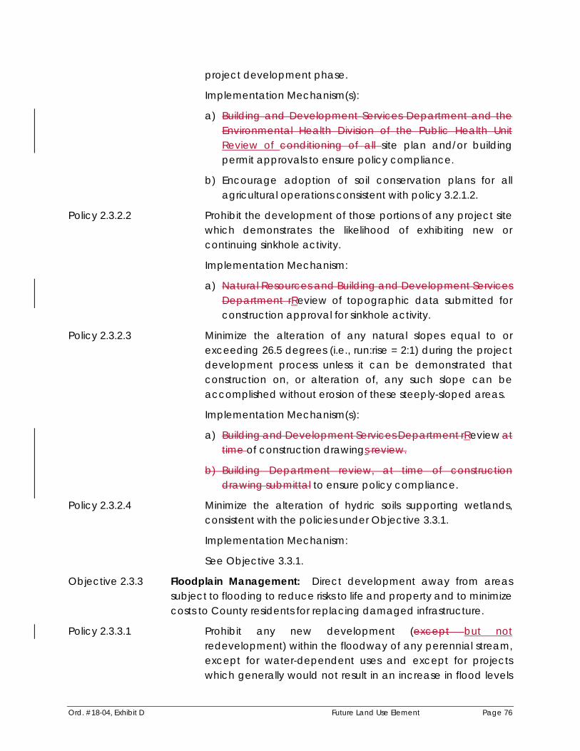
Ord. #18-04, Exhibit D Future Land Use Element Page 76
project development phase.
Implementation Mechanism(s):
a) Building and Development Services Department and theEnvironmental Health Division of the Public Health Unit Review of conditioning of all site plan and/or buildingpermit approvals to ensure policy compliance.
b) Encourage adoption of soil conservation plans for all agricultural operations consistent with policy 3.2.1.2.
Policy 2.3.2.2 Prohibit the development of those portions of any project site which demonstrates the likelihood of exhibiting new or continuing sinkhole activity.
Implementation Mechanism:
a) Natural Resources and Building and Development ServicesDepartment rReview of topographic data submitted for construction approval for sinkhole activity.
Policy 2.3.2.3 Minimize the alteration of any natural slopes equal to or exceeding 26.5 degrees (i.e., run:rise = 2:1) during the project development process unless it can be demonstrated that construction on, or alteration of, any such slope can be accomplished without erosion of these steeply-sloped areas.
Implementation Mechanism(s):
a) Building and Development Services Department rReview attime of construction drawings review.
b) Building Department review, at time of construction drawing submittal to ensure policy compliance.
Policy 2.3.2.4 Minimize the alteration of hydric soils supporting wetlands, consistent with the policies under Objective 3.3.1.
Implementation Mechanism:
See Objective 3.3.1.
Objective 2.3.3 Floodplain Management: Direct development away from areassubject to flooding to reduce risks to life and property and to minimizecosts to County residents for replacing damaged infrastructure.
Policy 2.3.3.1 Prohibit any new development (except but notredevelopment) within the floodway of any perennial stream, except for water-dependent uses and except for projects which generally would not result in an increase in flood levels

Ord. #18-04, Exhibit D Future Land Use Element Page 77
in the community during the occurrence of the base (100 years) flood discharge. [See policy 2.3.1.2]
Implementation Mechanism:
a) County review of development requests for compliance with this policy and the Floodplain Management Section of the Manatee County Land Development Code.
Policy 2.3.3.2 Require that all fill within the 100-year floodplain shall be compensated by creation of storage of an equal or greater volume, with such compensatory storage also located within the 100-year floodplain. Areas within the 100-year floodplain adjacent to a tidally-influenced water body shall not be subject to this level of service performance standard.
Policy 2.3.3.3 Require that all proposed residential buildings within the 100- year floodplain are constructed so that finished floor elevations are above the elevation of the 100-year flood.
Require that all proposed non-residential buildings or non- residential components of mixed use buildings within the 100- year floodplain are constructed to meet the finished floor elevation, or meet and/or exceed the performance standards established by the Federal Emergency Management Agency.
Policy 2.3.3.4 Prohibit habitable structures and major public and privateinvestment within the existing/pre-development 25-year flood plain except for projects which obtain a Special Approval,except where a finding of overriding public interest has been reached by the Board. This policy shall not preclude thedevelopment of water-dependent uses, water-related and water-enhanced uses, stormwater management structures, non-habitable structures, and passive recreational uses where appropriate. Any such development shall:
- minimize impervious surface in the 25-year floodplain;
- cluster structures and uses outside of the 25-year floodplain, whenever possible [see policy 2.3.1.2]; and
- protect perennial lakes and streams by encouraging thededication of conservation easements not subject to anyland alteration within the 25-year floodplain;. and
- provide mitigation for floodplain impacts and establish finish floor elevation for habitable structures in accordance with the Land Development Code and the floodplain

Ord. #18-04, Exhibit D Future Land Use Element Page 78
ordinance.
This policy applies only for the purposes of reviewing projects for which mapping of the 25-year floodplain has been accomplished, or where interpolation or use of an existing water surface profile for the watercourse(s) permits the identification of the 25-year flood elevation.
Implementation Mechanism(s):
a) Coordination between the Public Works (Stormwater Management Division) and Building and Development Services Departments when rReviewing development requests for compliance with this policy and the Floodplain Management Section of the Manatee County Land Development Code.
b) Coordination between the Manatee County Building and Development Services Department and the Manatee County Property Appraiser to ensure that conservation easements dedicated to Manatee County are deleted from private property assessments.
c) Require Board approval of site plans that propose to build habitable structures or major public and private investment within the existing/pre-development 25-year flood plain for compliance with this policy.
Policy 2.3.3.5 Limit density or intensity in a manner which will protect all groundwater resources from unacceptable contamination by septic tanks. (See also Objective 9.2.4 and associated policies)
Implementation Mechanism:
a) Review of proposed impacts by the Utilities, NaturalResources, and Building and Development ServicesDepartmentsCounty and the Florida HRS and conditioning of development orders as appropriate.
Policy 2.3.3.6 Prohibit mining below the 25-year floodplain elevation except for temporary crossings, as identified and approved in a Master Mining Plan.
Objective 2.3.4 Land Use Consistent with Watershed Protection: Limit land use in the Lake Manatee, Evers Reservoir, and Peace River WO Districts to maintain and improve water quality and the natural environment and resources within those watersheds which contribute to filtration.
Policy 2.3.4.1 Prohibit any new development which does not meet all

Ord. #18-04, Exhibit D Future Land Use Element Page 79
applicable requirements in policies 3.2.1.7, 3.2.1.8, and 3.2.1.9.
Implementation Mechanism:
a) Establish regulations in the Land Development Code Review by the Planning, Natural Resources, and Agriculture and Resource Conservation Departments to ensure implement this policy compliance.
Policy 2.3.4.2 Require that impervious surface within the Watershed Overlay District be minimized through the use of one or more of the following strategies:
- the appropriate use of pervious materials for pedestrian pathways and driveways,
- site design which utilizes the joint or shared use of parking areas or access roads where appropriate,
- clustering of uses within single instead of multiple structures,
- transfer of density/intensity out of watersheds and away from inflowing watercourses [see policies under objective 2.3.1],
- use of increased setbacks and buffers from reservoirs and inflowing watercourses and the use of native vegetation within such buffers and setbacks, and
- through the clustering of uses to maximize the preservation of vegetated open space areas in their natural state.
Implementation Mechanism(s):
a) Incorporate requirements in the Land Development CodeConditioning of development orders consistent withthis policy.
b) Consideration, and adoption by the BOCC Board where appropriate, of special allowances for reduced off-street parking requirements, use of shared parking, and modifications to roadway and sidewalk design criteria to promote limitations on impervious surface consistent with this policy.
Objective 2.3.5 Dredge Spoil Disposal: Spoil from dredging projects shall be placed in suitable upland areas.
Policy 2.3.5.1 Designate the Lena Road Landfill as a regional spoil disposal site for Manatee County except when alternate sites are designated pursuant to policy 2.3.5.2.

Ord. #18-04, Exhibit D Future Land Use Element Page 80
Policy 2.3.5.2 Approve alternative spoil disposal sites based on the following guidelines:
- the disposal area is vacant uplands with no habitat, historic, or archaeological value,
- the disposal area is of sufficient size to contain all of the spoil material and to prevent the escape of the spoil material and return water from the spoil site into wetlands or other surface waters,
- the site has appropriate vehicular access
- the site can be approved for disposal by the appropriate state or federal regulatory agency, and
- the owner of the spoil disposal site, if not County owned, shall enter into a binding agreement with the county for the use of the property as a spoil site.
Implementation Mechanism:
a) Review proposed sites by the Natural Resources and Public Works Departments to ensure policy compliance.
GOAL 2.4 Adequate and Available Public Facilities and Services Concurrent with New Development.
Objective 2.4.1 Level of Service and Concurrency: Require the issuance of aCertificate of Level of Service for all development to ensure thatrequired public facilities and services are available concurrent with development.
Policy 2.4.1.1 As may be permitted by the Land Development Code, the following development orders or approvals may have an option to obtain a Certificate of Level of Service for traffic, mass transit, drainage, solid waste and parks facilities:
1) Development of Regional Impact development order, Florida Quality Development, General Development Plans meeting Large Project standards of the Land Development Code or subsequent amendments thereto.
2) Preliminary subdivision plat approval, or equivalentdevelopment order.
3) Preliminary development plan, or equivalent development order.
43) Preliminary site plan, or equivalent development order.

Ord. #18-04, Exhibit D Future Land Use Element Page 81
The potable water, educational facility and sanitary sewer components of concurrency will be reserved according to Policy 2.4.1.2.
Any development order that is applied for and that may be issued prior to requesting one or more development orders for the activities listed above (1 through 34) may be approved (where consistent with the goals/objectives/policies of this Comprehensive Plan and where consistent with all other applicable development regulations) without the simultaneous issuance of a Certificate of Level of Service Compliance.
The educational facilities component of concurrency may be valid a maximum of five years unless an extended term is granted pursuant to a Development Agreement. In no instance shall the term of the educational facilities component exceed the Certificate of Level of Service Issued by affected local government.
Policy 2.4.1.2 When a project has not received a Certificate of Level of Service Compliance during any of items (1)-(34) as referenced above in Policy 2.4.1.1, then such review shall occur as listed below:
The following development orders or approvals shall obtain a Certificate of Level of Service for traffic, mass transit, drainage, sanitary sewer, solid waste, parks facilities, educational facility and potable water.
1) Earliest of the following (or equivalents thereof):
a) Construction drawing approval,
b) Final subdivision plat approval,
c) Final development plan,
cd) Final site plan,
de) Building permit, or
ef) Approval to commence development.
If a Certificate of Level of Service is obtained according to Policy 2.4.1.1, a subsequent CLOS for potable water and sanitary sewer shall have the same expiration date as theoriginal CLOS. Obtaining a CLOS for potable water andsanitary sewer at final development stage does not extend the

Ord. #18-04, Exhibit D Future Land Use Element Page 82
original expiration date of the CLOS.
[ * * * ]
Policy 2.4.1.5 A certificate for potable water level of service will only be issued if the long term population projections and the permitted potable water capacity indicate that sufficient supplies are available during the County’s water use permit period.
A certificate for sanitary sewer level of service will only be issued if the permitted sanitary sewer rated treatment capacities are available.
Implementation Mechanism:
a) MaintainAmend land development regulations developed pursuant to Section 163.3202 of the Florida Statutes, to beconsistent with this policy.
b) Continual monitoring / updating of the water and sanitary sewer reservations, average daily use, treatment and permitted capacities.
c) Continue to provide annual updates to the Board of County Commissioners during the CIP / Growth Management Workshop regarding water resources and sanitary sewer treatment, capacity, and reservations.
Policy 2.4.1.6 The issuance of a building permit for construction of a permanent structure shall require a determination that the proposed construction is consistent with a valid Certificate of Level of Service Compliance. A building permit for a single family dwelling unit on a lot of record created prior to May 15, 1989, shall be presumed to have satisfied this requirement.
Implementation Mechanism:
a) Building and Development Services Department rReview ofall applications for building permits to verify the existence of a valid Certificate of Level of Service Compliance for that project or project phase.
[ * * * ]

Ord. #18-04, Exhibit D Future Land Use Element Page 83
Objective 2.5.1 Economic Viability: Protect, enhance, and maintain, through20252040, the countywide economic value of Manatee County'sagriculture.
[ * * * ]
Policy 2.5.1.4 Maintain a Future Development Area on the Future Land Use Map of sufficient acreage and density/intensity which providesalternatives to the rapid conversion of short-term agriculturalland to urban/suburban land uses that would be precipitated by a tightly-constrained supply of lands designated for future urban/suburban growth.
Implementation Mechanism:
a) Review and maintain the Future Land Use Map consistent with this policy.
[ * * * ]
Policy 2.5.1.6 Manatee County shall pursue and promote the use of agricultural conservation easements or other innovative methods which support the continued viability and sustainability of agricultural practices in Manatee County.
Implementation Mechanism:
a) Natural Resources Department shall pPursue funding fromthe USDA Farm and Ranch Lands Protection Program and other funding sources for the acquisition of easements and other property interests.
b) Natural Resources Department shall pursue funding from the USDA Farm and Ranch Lands Protection Program andother funding sources.
Objective 2.5.2 Short-Term Agriculture: Maintain viable short-term or transitionalagricultural uses in areas that are transitioning to suburban or urban character.
Policy 2.5.2.1 Permit consideration of short-term agricultural uses, other than special agricultural uses with a significant adverse impact on

Ord. #18-04, Exhibit D Future Land Use Element Page 84
residential areas, to locate within areas designated for suburban or urban land uses of one dwelling unit per gross acre or more.
Policy 2.5.2.2 Permit the use of clustering of residential or nonresidential development on a project site to facilitate the continued use of any portion of the project site for short-term agricultural uses, once associated development potential has been transferred or clustered onto another portion of the project site.
Implementation Mechanism:
a) Approval, where appropriate, of agricultural uses on aportion of a project during the special approval process tofacilitate clustering pursuant to this policy Landdevelopment regulations developed pursuant to §163.3202. F. S., and consistent with this policy.
Policy 2.5.2.3 Protect the preferred tax status of agricultural lands, as required by § 163.3194(5), F. S., by ensuring, to the maximum extent practicable, that agricultural uses meeting the requirements of § 193.461, F. S. are assessed as agricultural lands, where either:
- the agricultural use is substantially surrounded by suburban/urban uses with increased property values;
- agricultural uses remain as interim uses on property approved for urban/suburban development, pursuant to policy 2.5.2.4 below; or
- agricultural uses are approved, utilizing the specialapproval process, as part of a project which has utilized theclustering option identified in Policy 2.5.2.2 above to transfer development potential from the area on the project approved for continued agriculture to other areas of the project site.
Implementation Mechanism:
a) Coordination between the Manatee County Administrator and the Manatee County Property Appraiser to implement this policy.
Policy 2.5.2.4 Permit continued or newly established short-term agricultural uses other than special agricultural uses, on all or part of aproject which has been the subject of a special approval, untilapproved development is started on the project site.

Ord. #18-04, Exhibit D Future Land Use Element Page 85
Land Development regulations developed pursuant to §163.3202. F. S., and consistent with this policy.
[ * * * ]
Objective 2.6.1 Compatibility through Screening, Buffering, Setbacks, and Other Mitigative Measures: Require suitable separation between adjacent incompatible land uses to reduce the possibility of adverse impacts to residents and visitors, to protect the public health, and to provide for strong communities.
Policy 2.6.1.1 An application for a development order that proposes a use, intensity, height, and/or density that could be foundincompatible with the use on the adjacent site shall proposeutilize techniques in the form of conditions of approval to mitigate potential incompatible characteristics of the proposed use. Such techniques shall include but not be limited to:
- use of undisturbed or undeveloped and landscaped buffers
- use of increased size and opacity of screening
- building setbacks
- innovative site design (which may include planned development review)
- appropriate building design
- operational restrictions on the proposed use
- noise attenuation techniques
- a density and/or intensity below the maximum allowed
Implementation Mechanism(s):
a) Maintain setback, screening, buffering, and otherappropriate mitigation techniquesrequirements in the landdevelopment regulations.
b) County review of development approvals to ensure policy compliance.
Policy 2.6.1.2 Developments that propose a use, intensity, height, and/or density that could be found incompatible with the use on the

Ord. #18-04, Exhibit D Future Land Use Element Page 86
adjacent site shall meet, at minimum, the buffer and screening standards requirements of the Land Development Code. Projects reviewed through the Planned Development or Special Permit approval processes may result in additional mitigation technique requirements Require the use of planned unit development, in conjunction with the mitigation techniques described in policy 2.6.1.1, for projects where project size requires the submittal of a site development plan in conjunction with the special approval process in order to achieve compatibility between these large projects and adjacent existing and futuretypically incompatible land uses. Projects in the UIRA and designated Urban Corridors that meet all the requirements of the Land Development Code, including the buffer and screening standards, shall not require planned development or Special Approval.
Implementation Mechanism:
a) Adopt or maintain Lland development regulationsconsistent with this policy as necessary.
[ * * * ]
Objective 2.6.2 Residential Compatibility/Transition: Residential uses compatible with adjacent residential and nonresidential uses.
[ * * * ]
Policy 2.6.2.2 Prohibit residential development in industrial future land usecategories except for single family homes on lots of record in the IL Future Land Use Categoryexcept as noted in Policy2.2.1.18.4.
Implementation Mechanism:
a) Maintain lLand development regulations consistent with this policy.
[ * * * ]

Ord. #18-04, Exhibit D Future Land Use Element Page 87
Policy 2.6.2.5 RESERVED Prohibit the development of attached dwelling unitswithin existing neighborhoods consisting of detached dwellingunits except upon a finding by the Board of CountyCommissioners that the development is consistent with thewelfare of the community. Welfare of the community shallinclude provision of low- and moderate- income housing, and appropriately priced housing for the employees of nearby businesses.
Implementation Mechanism(s):
a) County review of all proposed attached residential dwellings for compliance with this policy.
b) Implementation of policy 2.6.1.1 to mitigate any potential incompatibilities.
[ * * * ]
Policy 2.6.2.7 RequirePromote clustering, as appropriate, to limit impacts ofresidential development on adjacent agricultural, conservation, open space, or environmentally sensitive uses.
Implementation Mechanism:
a) Establish clustering development standards in theLDCCounty review and conditioning of development orders to ensure compliance with this policy.
[ * * * ]
Objective 2.6.3 Industrial Compatibility and Performance Measures: Industrialdevelopment compatible with adjacent uses. (See also Goals 3.2, 3.3, and 3.4)
[ * * * ]
Policy 2.6.3.3 RESERVED Prohibit the special approval of increased intensityfor any industrial use unless the Board of County Commissioners finds, at time of issuance of any development order granting

Ord. #18-04, Exhibit D Future Land Use Element Page 88
the increased intensity, that the proposed development is compatible with adjacent development and consistent with the policies under Objective 2.6.1.
[ * * * ]
Objective 2.6.5 Quality in Project Design: Promote appropriate diversity within and between existing and future development projects to achieve high quality, efficient functioning design.
Policy 2.6.5.1 Allow the use of the planned unit development procedure to achieve quality, highly functional, and well-integrated project designs.
Implementation Mechanism(s):
a) Density or intensity increments that require Special Approval per land use designation policies within Objective2.2.1 may be achieved through the planned unitdevelopment process only.
b) Limitations on scale of development unless planned unit development is utilized through the special approvalprocess.
ca) Land development regulations developed pursuant to §163.3202, F.S., providing for a planned unit development review process that minimizes the duration of reviews, and the number of discretionary approvals.
d) Available clustering options for planned unit development projects.
e) Require planned development zoning to grant special approval for all projects within the MU category, excludingsingle family homes and related accessory uses on lots ofrecord and development along designated UrbanCorridors.
Policy 2.6.5.2 Encourage, in locations which are suited to diverse uses, mixed and multiple use projects to provide for integration andsynergy between land uses. Nothing in this policy shallpreclude single use or homogenous projects if mixing of uses on a single project, or intrusion of a different use into a homogenous area, will create inappropriate diversity or

Ord. #18-04, Exhibit D Future Land Use Element Page 89
incompatibilities between adjacent land uses.
Implementation Mechanism(s):
a) Consideration of limited nonresidential land uses within residential designations pursuant to policy in this Element.
b) Consideration of commercial and residential uses within the ROR designation pursuant to policy in this Element.
c) Consideration of industrial, commercial and residential uses within the MU designation pursuant to policies in this Element.
d) Consideration of all residential dwelling unit types, or combinations thereof, within all future land use categories, where consistent with other policies in this Element.
[ * * * ]
Objective 2.6.6 RESERVED Regional Activity Centers: Jointly designate appropriate regional activity centers with the Tampa Bay Regional Planning Council.
Policy 2.6.6.1 If appropriate, after coordination with the Tampa Bay RegionalPlanning Council, designate areas in unincorporatedManatee County as Regional Activity Centers pursuant to theStrategic Regional Policy Plan of the Tampa Bay Regional Planning Council (TBRPC).
Implementation Mechanism(s):
a) Review of applications for designation of a Regional Activity Center by Manatee County for compliance with this policy, using the criteria for designation of Regional Activity Centers as established by the Tampa Bay Regional Planning Council.
b) Coordination between Manatee County and the Tampa Bay Regional Planning Council to ensure that proposed Regional Activity Centers comply with requirements and criteria for designation of Regional Activity Centers.
c) In accordance with Tampa Bay Regional Planning Council procedures, consideration of designation of a Regional Activity Center by the Manatee County Board of County Commissioners shall require a Comprehensive Plan

Ord. #18-04, Exhibit D Future Land Use Element Page 90
Amendment pursuant to Chapter 163, Florida Statutes.
[ * * * ]
Objective 2.7.1 Regulatory/Incentive Mechanisms: Maintain land developmentregulations which regulate and provide incentives for newdevelopment and redevelopment to achieve comprehensive plan objectives.
Policy 2.7.1.1 Permit, and encourage the use of, innovative or unconventional land development regulations in order to achieve adopted objectives in this Comprehensive Plan. Such regulation/incentives may include, but not be limited to, Transfer of Development Rights between sites; the use of performance or design standards in lieu of, or in combination with, lists of permitted uses, clustering;, and other mechanisms.
[ * * * ]
Objective 2.8.1 Incentives: Periodically review land development regulations and strategies to ensure incentives for reduction of inconsistent land usesand incentives for redevelopment and renewal of blighted areas are effective.
Policy 2.8.1.1 Maintain a fast-tracking project review process for anyredevelopment project located within the Southwest Improvement District (SWTIF) and/or the Urban Core, within aspecific area which proposes the change of a zoning districtor land use which is non-conforming to the Future Land UseMap, or to the commercial locational criteria. Also, maintainsimilar procedures for any redevelopment project that is part of any special area within which building code violations are more prevalent, or within is part of any area identified ashaving a concentrations of substandard housing this fast-tracking process shall be maintained in the County's land development regulations. (See also Obj. 6.1.4)
Implementation Mechanism:
a) Review and verification by Manatee County ofnonconforming status, or special area status, of any

Ord. #18-04, Exhibit D Future Land Use Element Page 91
proposed development seeking or fast-tracking pursuant to this policy.
b) The fast-tracking review process shall continue to be a part of the County's land development review process.
Policy 2.8.1.2 RESERVED Prohibit the issuance of any development order inconsistent with the Future Land Use Map.
[ * * * ]
Policy 2.9.1.3 Provide vehicular access between neighborhoods, particularly(but not exclusively) when part of a planned unit development containing more than one neighborhood.
Implementation Mechanism(s):
a) County review and comment on proposed site design and layout.
b) Appropriate revisions to the Land Development Code by the County.
[ * * * ]
Policies 2.9.1.9 Require where feasible, pedestrian and bicycle access to community spaces, schools, recreational facilities, adjacent neighborhoods, employment opportunities, professional and commercial uses. (See also Obj. 3.3.3)
Implementation Mechanism(s):
a) County review of site design and coordination with the School Board.
b) Maintain Aappropriate revisions to provisions in the Land Development Code by the Countyto implement this policy.
[ * * * ]
Policy 2.9.1.11 The County shall Establish Community Infrastructure Planning Program that will at a minimum address the cumulative

Ord. #18-04, Exhibit D Future Land Use Element Page 92
impacts of the inter-related issues between land use,infrastructure, and transportation. This program will anddetermine public / private funding mechanisms to supportcommunity needs.
Objective 2.9.2 Adverse Impact on Communities: Mitigate or where possible, prevent adverse impacts on residential uses. (See also Objective 2.6.2)
[ * * * ]
Policy 2.9.2.2 Regulate the appropriate location of wildlife, classified as Class I or II under Rules adopted to implement Section 372.922379.303, F.S., and poisonous and venomous reptiles as defined in Rules implementing Section 372.86379.372, F.S., to protect and preserve the residential neighborhoods of Manatee County.
Implementation Mechanism:
a) Maintain land development regulations containingrequirements for appropriate location, buffering, environmental protection and other land use related aspects of wildlife possession and handling, pursuant to Florida Fish and Wildlife Conservation Commission regulations.
[ * * * ]
Policy 2.9.3.2 RESERVEDAllow for the redevelopment of existing non-conforming sub-divisions within the Ag/R future land usecategory when consistent with all Comprehensive Planprovisions, except for density. Density shall not exceed themaximum allowed based upon provisions contained within the Land Development Code and this Comprehensive Plan.
Implementation Mechanism(s):
a) Revision of the Land Development Code consistent with this policy.
b) Special Approval required.
c) Vacation of the non-conforming plat required if non-

Ord. #18-04, Exhibit D Future Land Use Element Page 93
conforming to density requirements and proposing to redevelop the site.
Policy 2.9.3.3 RESERVED Consider reductions in street pavement and Right ofWay widths on local roads on an overall basis or with case by case review. (See also Objective 5.3.3 and associated policies.)
Implementation Mechanism(s):
a) County revision to the Land Development Code consistent with this policy.
b) Building and Development Services Departmentcoordination with the Public Works Department toimplement policy.
[ * * * ]
Objective 2.9.4 Community Image: Develop an aesthetically pleasing environment which enhances the image of Manatee County as a high quality community in which to live, work, and visit.
[ * * * ]
Policy 2.9.4.2 Develop Corridor Plans on primary travel routes into and through the urban area of Manatee County to create a positive sense of place.
Implementation Mechanism(s):
a) Adoption of Entranceway Corridor Plans.
b) County revisions to the land development regulations as appropriate to implement Entranceway Corridor Plans.
c) Capital improvement programming consistent withadopted Entranceway Corridor Plans.
Policy 2.9.4.3 Maintain appropriate sign regulations, landscaping requirements, special setbacks, building and site design criteria, and other appropriate limitations on the use of land, to create and maintain an aesthetically pleasing environment.
Implementation Mechanism:

Ord. #18-04, Exhibit D Future Land Use Element Page 94
a) Maintain Revision to the Land Development Code provisions to achieve compliance with implement this policy as appropriate.
Policy 2.9.4.4 Protect natural waterfront vistas as a defining characteristic of Manatee County. Protection measures may include, but not be limited to the following:
- increased waterfront setbacks and buffers,
- additional plantings of native vegetation,
- maintaining conservation areas in public or joint ownership arrangements,
- provisions for joint boat docking facilities,
- limitations on height and size of structures.
(Refer to Obj. 4.1.2 and associated policies)
Implementation Mechanism:
a) Maintain regulations in the Land Development Code toimplement this policy. Revision to the Land Development Code as appropriate.
Policy 2.9.4.5 Develop a program to plant and manage trees in public street right-of-ways and other public lands wherever practical, thereby adding to the aesthetic appeal of urbanizing areas and providing habitat for urban wildlife.
Implementation Mechanism(s):
a) Building and Development Services Department cCoordination with Public Works, Parks and Recreation, Natural Resources, Ag & Resources Conservation Departments, Keep Manatee Beautiful, Inc. and FDOT to implement this policy.
b) Expend funds from the Tree Trust Fund consistent with this policy.
[ * * * ]
Objective 2.10.1 Commercial Project Design/Location: Improved design and location of commercial development.

Ord. #18-04, Exhibit D Future Land Use Element Page 95
[ * * * ]
Policy 2.10.1.2 Promote the development of commercial uses in planned commercial centersnodes, and discourage scattered, incremental commercial development.
Implementation Mechanism:
a) County review of proposed commercial development for compliance with this policy.
Policy 2.10.1.3 Allow for neo-traditional Encourage development projects that functionally mix residential and commercial (retail/office)uses, either vertically or horizontally.
[ * * * ]
Objective 2.10.2 Diversity: Appropriate size, function, and required compatibility of new commercial development, following plan adoption.
Policy 2.10.2.1 Within residential future land use categories, Mmaintain limits, for future land use categories, on the range of commercial uses, intensity of commercial uses, and gross building square footage of commercial projects which may be considered for approval to ensure that "scale" of commercial development is generally consistent with surrounding residential character.
Intensity of commercial projects shall be defined as:
a) Small commercial projects limited to 30,000 square feet of gross building area.
b) Medium commercial projects limited to 150,000 square feet of gross building area.
c) Large commercial projects limited to 300,000 square feet of gross building area. Commercial projects in excess of the 300,000 square foot limit may be considered for projects which contain primarily office uses, or for other projects in high access locations as described in Policy 2.10.3.3.
These limits shall permit consideration of the type and amount of commercial uses necessary to provide for the needs of the resident, and other, population which can be reasonably expected to utilize the commercial uses. Table 2-1 lists the

Ord. #18-04, Exhibit D Future Land Use Element Page 96
category of commercial gross building square footage eligible for consideration in each future land use category. In using this table, where a particular category is eligible, all "lesser" categories shall also be considered as eligible.
Implementation Mechanism(s):
a) Definition of uses, consistent with the more general definitions of small, medium, and large commercial uses above, within land development regulations developed pursuant to § 163.3202, F.S. Such permitted uses may be required to achieve consistency with special criteria (see Policy 2.6.1.1) in order to meet the definition of either small or medium commercial uses.
b) County review of proposed development orders permitting commercial uses for compliance with this policy and for compliance with land development regulations developed pursuant to (a) above.
Policy 2.10.2.2 Maintain the following commercial project size thresholds,which may be exceeded only through the special approval process, to ensure that the increased impacts generallyassociated with larger commercial projects are adequately evaluated and mitigated. Table 2-23 below identifies thesemaximum gross building square footages, by category of commercial use, not requiring special approval. Developmentsites in the UIRA and sites along Urban Corridors shall be exempt from the requirements of this policy, but are subject to the commercial size limitations established in the Future Land Use Category policies.
TABLE 2-2 Maximum Commercial Project Square Footages Which May be Considered with Special Approval
and Without Special Approval
Category ofCommercial Use
Maximum Gross Building Square Footage Per Project Without Special Approval With Special Approval
Small 3,000 30,000
Medium 30,000 150,000
Large 50,000 300,000
Policy 2.10.2.3 RESERVED

Ord. #18-04, Exhibit D Future Land Use Element Page 97
Prohibit the issuance of any commercial development order providing for increased intensity through the special approval process unless a finding is made by the Board of County Commissioners of compliance with Objective 2.6.1 and with other locational criteria and development standards contained under Objective 2.10.4 below.
[ * * * ]
Objective 2.10.3 Required Access to Commercial Uses: Adequate, safe andappropriate access to new commercial uses approved followingplan adoption is required.
Policy 2.10.3.1 Require that access to commercial uses be established on atleast one roadway classified as a collector or higher and, operating at, or better than, the adopted level of service.Access through single family residential neighborhoods shallnot be allowedwhich is limited only to roadways that carrytraffic within residential neighborhoods shall be considered unacceptable for commercial uses. An exception shall be made for projects on roadways under the State jurisdiction not allowing access from such road, and for neo-traditional projects that are approved with have commercial useslocated internally to the project and whose main project access is located on a road designated as a collector orhigher. An exception shall be made for DRIs and Large Projectdevelopments that have mixed uses with a residentialcomponent and meet minimum development characteristicsto have commercial uses located internally to neighborhoodsif the main neighborhood access is located on a road designated as a collector or higher.
Implementation Mechanism:
a) Review of level of service and generalized roadway function for roadways from which access to a commercial project is proposed.
Policy 2.10.3.2 RESERVED Require that all proposed small and mediumcommercial uses can be directly accessed from at least oneroadway shown on the Roadway Functional ClassificationMap as collector or higher, at time of issuance of a development order. An exception shall be made for neo-

Ord. #18-04, Exhibit D Future Land Use Element Page 98
traditional projects that have commercial uses located internally to the project and whose main project access is located on a road designated as a collector or higher. An exception shall be made for DRI’s and Large Project developments that have mixed uses with a residential component and meet minimum development characteristics to have commercial uses located internally to neighborhoods if the main neighborhood access is located on a road designated as a collector or higher.
Policy 2.10.3.3 Require that all proposed large commercial uses exceeding 150,000 square feet be located within an area of high access and directly accessed from at least one roadway shown on the Existing Roadway Functional Classification Map (Map 5A) as arterial, at time of review for issuance of a development order. High access locations should provide numerous options for trip distribution, provide for multi-modal opportunities and be able to move large volume of traffic. Furthermore, require that all access points be limited to functionally classified roadways or frontage roads:
Implementation Mechanism(s):
a) Manatee County review of proposed development orders for commercial uses for compliance with this policy.
b) Maintain regulations in the Land Development Code to implement this policyPlacement of conditions, as necessary, on development orders when issued, so as to ensure compliance with this policy.
[ * * * ]
Objective 2.10.4 Locational Criteria and Development Standards: Consistency of all commercial uses approved with required locational criteria and development standards.
[ * * * ]
Policy 2.10.4.2 Prohibit the consideration of any development order establishing the potential for commercial development in the

Ord. #18-04, Exhibit D Future Land Use Element Page 99
residential future land use categories, where the proposed project site is inconsistent with commercial locational criteria. Consistency shall be determined through the application of the commercial location review process described in theoperative provisions contained in this Element. Permittedexceptions to these requirements are limited to:
- existing commercial uses that are were legally established prior to the adoption of the Commercial Locational Criteriain May 15, 1989 permitted, and that are in place at time of comprehensive plan adoptionshall be allowed to remain as originally approved. However, where such uses arenonconforming to other development regulations, nothing in this policy shall render those uses conforming to the subject regulations.
- redevelopment, but not expansion or intensification, of an legally established existing commercial use which does not meet the commercial locational criteria, subject to the finding by the Board of County Commissioners that the proposed project is consistent with the general welfare of Manatee County residents.
- locations designated as Retail/Office/Residential or Low Intensity Office (OL), Medium Intensity Office (OM) or Mixed Use (MU) or within the MU-C Mixed Use Community and its Sub Areas [see 2.2.1.16.4(b) and 2.2.1.17.4(ef)].
- recreational vehicle parks. However, compliance with Policy 2.10.5.2 shall be required.
- establishments providing nursing services as described in Chapter 464, F.S.
- sale of agricultural produce at roadside stands.
- small commercial uses associated with a permanentroadside agricultural stand. Maximum commercial squarefootage shall be 3,500 square feet of the project.Development must be located on functionally classifiedrural arterial or rural collector roadway. Planned development approval required.
- agricultural service establishments (e.g. farm equipment sales and service).
- low intensity commercial recreational facilities (e.g., driving range).

Ord. #18-04, Exhibit D Future Land Use Element Page 100
- rural recreational facilities located in the Ag/R future land use category meeting adverse impact standards as established within the Manatee County Land Development Code. All such uses must receive SpecialApproval.
- appropriate water-dependent, water -related, and water- enhanced commercial uses, as described under Objective4.2.1.
- commercial uses located within Port Manatee.
- professional office uses not exceeding 3,000 square feet ingross floor area within the Res-6, Res-9, RES-12, and Res-16future land use categories may be exempted fromcompliance with any locational criteria specified underPolicies 2.10.4.1 and detailed in the operative provisionsprovided such office is located on a roadway classified asa minor or principal arterial on the roadway functionalclassification map, however, not including interstates, andshall still be consistent with other commercial developmentstandards and with other goals, objectives, and policies in this Comprehensive Plan (see also 2.2.1.12.4, 2.2.1.13.4, 2.2.1.15.4).
- commercial uses located within the rural community of Myakka City which is designated as those lands on Sheet 29 of the Future Land Use Map shown as Res-3 or Res-1 onMay 115, 1989, provided that they are located along State Road 70 within 1,640 feet west from its intersection with Wauchula Road, and 1,500 feet east from its intersection with Wauchula Road and located within 1,000 feet along Wauchula Road from its intersection with State Road 70. Further, properties developed commercially, or having commercial zoning in place at the time of adoption of this Comprehensive Plan if they have frontage on State Road 70 and are within three-quarters mile of the State Road 70 and Wauchula Road intersection are also exceptions. Furthermore, all commercial uses allowable under this provision will be exempt from the one-half mile spacing requirement denoted in Policy 2.10.4.3(4).
- small commercial (professional) office uses which operateas an accessory use to a place of worship residential religious development. Such accessory office uses which

Ord. #18-04, Exhibit D Future Land Use Element Page 101
do not serve the general public but which serve the residential religious development may locate are permitted in RES-1 and RES-3 residential future land use categories (RES-1, RES-3, UF-3, RES-6, RES-9, RES-12 and RES- 16) and may be are exempted from compliance with any locational criteria specified under Policies 2.10.4.1 and detailed in the operative provisions (see also 2.2.1.9, 2.2.1.10, 2.2.1.11, 2.2.1.12.4, 2.2.1.13.4, 2.2.1.14.4 and 2.2.1.15.2).
- neo-traditional developments that have commercial and office developments located internal to the project and whose main project access is located on a road designated as a collector or higher.
- DRI’s and Large Project developments that have mixed uses with a residential component and meet minimum development characteristics (see Neo-Traditional Development definition for development characteristics), have commercial uses located internal to neighborhoods and whose main neighborhood access is located on a road designated as a collector or higher.
- commercial uses located within the Parrish area for properties fronting US 301, from Moccasin Wallow Road to the realigned Ft. Hamer Road. These commercial uses are limited to a building footprint of 5,000 square feet except at nodes.
No exception to commercial locational criteria provided for under this policy shall be used as a precedent for establishing other commercial development inconsistent with this Comprehensive Plan.
Nothing in this policy shall require the issuance of a development order solely on the basis of compliance withcommercial locational criteria. Compliance with othercommercial development standards contained in Policy 2.10.4.3 below, and with all other goals, objectives, and policies of this Comprehensive Plan is also required for issuanceof a development order approving commercial uses. Inparticular, compliance with the policies of Objectives 2.6.1 and 2.6.2 is mandatory for approval of any commercial use within a residential designation.
Policy 2.10.4.3 Require that all proposed commercial uses meet, in addition

Ord. #18-04, Exhibit D Future Land Use Element Page 102
to commercial locational criteria, the following commercialdevelopment standards. Office uses are exempt from thispolicy.
1) any proposed commercial site must be sized and configured to provide for adequate setbacks, and buffers from any adjacent existing or future residential uses.
2) any proposed commercial site must be configured and sized to allow for orientation of structures, site access points, parking areas, and loading areas on the site in a manner which minimizes any adverse impact on any adjacent residential use.
3) no proposed commercial site shall represent an intrusion into any residential area. As used in this standard, "intrusion" means located between two residential uses or sites which are not separated by the right-of-way of any roadway functionally classified as collector or higher, unless the proposed commercial use meets the definition of “mixed- use” or "infill commercial development," demonstrated through evaluation of existing land use patterns in this vicinity of the proposed use, and pursuant to guidelines contained in commercial locational criteria found in the operative provisions of this Element. Permitted exceptions listed in Policy 2.10.4.2 shall not be required to meet this development standard. No such intrusion shall be found in neo-traditional developments approved as such by the County, as a mixture of uses are encouraged within those projects. No such intrusion shall be found in DRI and Large Project developments where commercial uses are internal to neighborhoods, approved as such by the County, as a mixture of uses are encouraged within those neighborhoods.
4) Commercial Activity nodes meeting the requirements specified in the operative provisions of this Element shall, additionally, be spaced at least one-half mile apart, as measured between the centers of two nodes. However, where two activity commercial nodes have been established by the development of commercial uses prior to plan adoption, and are spaced less than the minimum required one-half mile, then a waiver of this commercial development standard may be considered. Preferentially,

Ord. #18-04, Exhibit D Future Land Use Element Page 103
in instances where previous development has not established a pattern of land uses inconsistent with commercial locational criteria or development standards, nodes shall be spaced no less than one mile apart. Neo- traditional projects shall be exempt from this requirement. DRI and Large Project developments that have mixed uses with a residential component that receive approval to locate commercial uses internal to neighborhoods shall be exempt from this requirement.
[ * * * ]
Objective 2.10.5 Recreational Vehicle Parks: Recreational vehicle parks which are located and planned to ensure maximum compatibility with other commercial, and with residential, land uses.
[ * * * ]
Policy 2.10.5.2 Maintain land development regulations which:
- establish appropriate setback and buffer requirements for recreational vehicle parks,
- Maintain locational standards or guidelines for new recreational vehicle parks which address required level of access, level of service, relative intensity and impact of such uses,
- provide for adequate sites on which recreational vehicle parks may be considered for approval,
- require that all new recreational vehicle parks be established pursuant to the special approval process,
- exempt recreational vehicle parks from maximum FloorArea Ratio requirements while establishing alternative maximum intensity standards, and,
- establish certain districts on the official zoning atlas within which recreational vehicle parks shall not be located.
[ * * * ]

Ord. #18-04, Exhibit D Future Land Use Element Page 104
GOAL 2.14 Establish specific area policies to minimize the impact of certain developments on the community.
Objective 2.14.1 Establish specific policies restricting the location and intensity of certain developments in order to preserve and protect neighborhoods from encroachment by incompatible uses and intensities, ensure adequate provision of infrastructure, and other reasons the Board of County Commissioners may decide warrant a specific area policy.
Policy 2.14.1.2 D.5.2/Ordinance 08-07(PA-08-05). The 740± acre property which includes:
(a) 732± acres which have been designated Mixed Use (MU) on the Future Land Use Map pursuant to Manatee county Ordinance No. 08-07 and Comprehensive Plan Amendment No. PA-08-05, and
(b) 8± acres located between U.S. 301 and the Seaboard Airline Railroad Right-of-way which have been designated Public/Semi-Public (P/SP-1) on the Future Land Use Map shall be subject to the following:
I. Trip Limitations. The project shall be limited to any combination of permitted uses which collectively generate cumulative transportation impacts on the Major Thoroughfare System no greater than those generated by a project comprised of 3,200 residential dwelling units (of varied types), 900,000 square feet of commercial retail uses, 375,000 square feet of office uses, and 300,000 square feet of light industrial and warehouse uses.
II. Land Use Requirements.
1. The light industrial and warehouse uses component of the project shall not be less than 300,000 square feet.
2. The residential use component of the project shall be limited to 2,300 residential dwelling units until 25% of the non-residential use component has commenced.
3. The residential use component of the project shall not exceed 3,200 residential dwelling units.

Ord. #18-04, Exhibit D Future Land Use Element Page 105
III. Five-Year Trip Cap. The foregoing subparagraphs (1) and (2) notwithstanding, until December 31, 2013, said property shall be further limited to any combination of permitted uses which collectively generate cumulative transportation impacts on the Major Thoroughfare System no greater than those generated by a project comprised of the maximum development identified by the Urban Fringe-3 (UF-3) Future Land Use Map category (the previous Future Land Use Map category for the property) (a total of 1,731 p.m. peak hour trips).
IV. Land Use Form.
1. The project shall consist of mixed use and neo- traditional development as such terms are defined in this Comprehensive Plan.
2. Phasing and mixing of land uses to achieve the above shall be addressed with project approval.
Policy 2.14.1.3 D.5.3/Ordinance 09-06 (PA-09-04). The 208.15± acre property located on the west side of County Route (CR) 39 at the mManatee-Hillsborough County line and designated as P/SP(1) Public/Semi Public (1) on the Future Land Use Map, pursuant to Manatee County Ordinance No. 09-06 and Comprehensive Plan Amendment No. PA-09-04, shall be limited to the declared use of a Class III, geosynthetically-lined landfill and recycling facility with accessory uses such as office, scale house, and equipment storage. This landfill shall accommodate only yard waste, construction and demolition debris, processed tires, asbestos, carpet, cardboard, paper, glass, plastic, furniture other than appliances, or other materials approved by the Florida Department of Environmental Protection that are not expected to produce leachate which poses a threat to public health or the environment. No putrescibles or household garbage shall be delivered to or deposited in the landfill at this site. This property shall be subject to the following:
1. Landfill Liner System Requirements. The landfill shall include a liner system that is consistent with applicable Florida Department of Environmental Protection rules in Chapter 62¬701, F.A.C., as may be amended by the agency from time to time.
2. Hydrology. The hydrology of downstream surface waters

Ord. #18-04, Exhibit D Future Land Use Element Page 106
shall be maintained by matching pre-development discharge flows.
3. Surface Water and Groundwater Monitoring. The landfill operator shall establish a surface and groundwater quality monitoring program performed in accordance with applicable Florida Department of Environmental protection rules in Chapter 62-701, F.A.C., as may be amended by the agency from time to time.
4. Stormwater Management. The landfill operator shall design and construct all necessary stormwater management facilities in compliance with applicable Florida Department of Environmental Protection and SWFWMD rules in Chapters 62¬701 and 40D-4, F.A.C., respectively, as may be amended by the agency from time to time to include consideration of water quality, habitat function, receiving waters, adjacent property(s), conservation of fish and wildlife, and wetlands.
5. Dust, Wind Blown Debris, Odor, and Bird Controls. The landfill operator shall design, construct, operate, and maintain all dust, wind-blown debris, odor, and bird controls required and in compliance with applicable Florida Department of Environmental Protection rules in Chapter 62-701, F.A.C., as may be amended by the agency from time to time.
6. Buffers, Setbacks, and Siting. The landfill operator shall design, construct, and maintain all required and established buffers, setbacks, and landfill siting requirement in compliance with applicable Florida Department of Environmental Protection rules in Chapter 62-701. F.A.C., as may be amended by the agency from time to time.
7. Notwithstanding, the specificity of the foregoing, the above specific property development conditions shall be considered as minimal requirements and there may be additional stipulations approved applicable to this property as part of rezoning to the Planned Development Public Interest (PDPI) Zone District and companion Preliminary Site Plan subject to the approval of the Board of County Commissioners.
[ * * * ]

Ord. #18-04, Exhibit D Future Land Use Element Page 107
Policy 2.14.1.7 D.5.7/Ordinance 10-01 (PA-10-01). The 1,420± acre property identified as the Crossroads at SW Manatee and designated MU-C on the Future Land Use Map pursuant to Manatee County Ordinance No. PA-10-01 shall be limited to the following maximum development totals:
º 8,600 Residential Units
º 3,839,814 square feet
Non-Residential Land Use Form
1. The project shall consist of mixed use and neo-traditional development as such terms are defined in this Comprehensive Plan.
2. Phasing and mixing of land uses to achieve the above shall be addressed with project approval.
3. Notwithstanding the maximum residential densitycontained in Policy 2.2.1.28.2 of this Plan, a maximum of 36 residential dwelling units per gross acre (maximum 40 residential dwelling units per net acre) may be allowed in the AC-1 subarea of the site, subject to Boardapprovalpursuant to special approval .. This density may bereduced at the discretion of the Board of County Commissioners due to site constraints, compatibility with surrounding uses and other factors. In no case shall the totalnumber of residential units exceed the density limitation of 8600 dwelling units for this property.
[ * * * ]
Policy 2.14.1.13 RESERVED. D.5.13/Ordinance 10-17 (City of Bradenton PA-10-17). The 157.1± acre property located on the west side of theEvers Reservoir, east of Lockwood Ridge Road, and north ofHonore Avenue, Bradenton, and designated as P/SP(1)Public/Semi Public(1) on the Future Land Use Map, pursuant to Manatee County Ordinance No 10-17 and Comprehensive Plan Amendment No. PA-10-17 shall be limited to an off-line water reservoir.

Ord. #18-04, Exhibit D Future Land Use Element Page 108
[ * * * ]

PA-17-08 / ORDINANCE-18-04, Exhibit E Conservation Element Page 1
EXHIBIT E
CONSERVATION ELEMENT
[ * * * ]
Policy: 3.1.1.1 Assess the quality of the County's ambient air for compliance with County, State, and National Ambient Air Quality Standards (NAAQS) through a complete air quality monitoring network and provide an air quality index to the general public.
Implementation Mechanism:
(a) Natural Resources Department in coordination Coordinate with theFlorida Department of Environmental Protection's Aerometric Information Retrieval System (FDEP-AIRS) to monitor ambient air quality. Also, the network shall continue to facilitate the measurement of all NAAQS parameters at least once a month, with monitoring conducted according to U.S. Environmental Protection Agency (EPA) standards.
[ * * * ]
Policy: 3.1.1.3 Evaluate the appropriateness of proposed location for all land development activities which are required by state regulations to obtain a Construction and Operating permit.
Implementation Mechanism:
(a) Review by the Natural Resources Department of all FDEPConstruction and Operating Permit applications (first-time andrenewal) regarding cumulative effects upon ambient air quality and by the Planning Department for potential land use conflicts.
Policy: 3.1.1.4 Implement, within six months of notification of FDEP nonattainment status for any NAAQS parameter, control strategies to achieve attainment status.
Implementation Mechanism:
(a) Natural Resources Department recommendation and subsequentaAdoption by the BOCC of mandatory control strategies such as best available control technology methods, and mandatory restrictions on applications for new operating permits for air

PA-17-08 / ORDINANCE-18-04, Exhibit E Conservation Element Page 2
pollution sources emitting pollutants for which Manatee County is classified as nonattainment.
Policy: 3.1.1.5 Reduce or stabilize vehicular emission levels through the use of traffic mitigation techniques which may include traffic flow improvements, use of transportation control measures such as Intelligent Transportation Systems (ITS), Transportation Demand Management (TDM) and buffer zones when seeking to mitigate potential adverse air quality impacts, discouragement of emission control tampering, encouraging the use of alternative fuel vehicles and encourage transit amenity provisions.
Implementation Mechanism:
Natural Resources Department rReview of development orders and traffic improvement plans to ensure consistency with this policy.
a) Planning and Public Works Departments cCoordination with the Manatee-Sarasota Metropolitan Planning Organization (MPO) to implement Intelligent Transportation System projects.
b) Planning and Public Works Departments coordinate to dDevelop a Transportation Demand Management program to include achievable goals and measurable results to address nonpoint air pollution sources.
c) Public WorksManatee County to review cost/benefit of participation in the Federal Clean Cities program.
Policy: 3.1.1.6 Require the control of erosion, fugitive dust, and air emissions related to the development construction.
Implementation Mechanism:
a) Erosion and Sediment Control Plan required in Land Development Regulations with Final Site Plan.
b) Natural Resources Department cCoordination with the StateDepartment of Agriculture, Division of Forestry to potentially modify open burning regulations in the County.
[ * * * ]
Objective 3.2.1 Potable Water Quality: Maintain or improve the water quality and quantity in Lake Manatee, Evers Reservoir, and Peace River Watershed Overlay (WO) Districts for the purpose of ensuring a continued supply of drinking water at lowest possible cost to the current and future residents of Manatee County

PA-17-08 / ORDINANCE-18-04, Exhibit E Conservation Element Page 3
and component jurisdictions.
Policy 3.2.1.1 Maintain a mesotrophic or better Trophic State Index (TSI) range forLake Manatee and implement watershed management as necessary to maintain water quality within the TSI ranges adopted.
Implementation Mechanism:
a) Natural Resources Department in conjunction with the UtilitiesDepartment will mMaintain the TSI range for Lake Manatee.
b) Natural Resources Department cContinued participation in theTampa Bay Nitrogen Management Consortium.
Policy: 3.2.1.2 Continue to maintain or reduce nutrient loads in the Evers Reservoir, Lake Manatee, and Peace River watersheds.
Implementation Mechanism(s):
a) Natural Resources, Utilities, and Planning DepartmentsdDevelopment of a reservoir watershed management plan for Evers Reservoir that recognizes the unique problems of an urbanizing watershed and which is consistent with the TBEP CCMP and the CWM (Comprehensive Watershed Management) plans of the SWFWMD.
b) Planning and Utilities Departments dDevelopment of a reservoirwatershed management plan for Lake Manatee consistent with the TBNEP CCMP and the CSWM plan of the SWFWMD.
c) Planning and Utilities Departments pParticipation in developmentof a watershed management plan for the Peace River watershed consistent with the CHEP, CCMP, and the CSWM plan of the SWFWMD.
Policy: 3.2.1.3 Continue current programs that encourage the use of Conservation Plans including Best Management Practices (BMPs) to promote economical agricultural production and improve water quality in the Lake Manatee, Evers Reservoir and Peace River watersheds.
Implementation Mechanism:
(a) Continue coordination between the Utilities Department, with theNatural Resources Conservation Service, the Manatee River Soil Conservation ServiceDistrict, and the Water Quality Division of the Natural Resources Department to increase the use of BMPs in the watersheds. Mechanisms to increase use of BMPs may include:
- focusing BMP awareness education to those agricultural operations within the watershed most likely to benefit from specific BMPs;

PA-17-08 / ORDINANCE-18-04, Exhibit E Conservation Element Page 4
- an agricultural best management practices task force advisory group and implementation of any recommendation of the group;
- development of a newsletter to keep agricultural concerns and water quality professionals informed of recent developments;
- continued coordination of grants, such as those from the Resource Conservation Development Council and SWFWMD to agricultural operations that use BMPs;
- Continue to explore possible use of tax incentives for consistent use of BMPs which improve water quality in the watersheds;
- develop a demonstration project for efficient agricultural operations utilizing BMPs which improve water quality.
[ * * * ]
Policy: 3.2.1.5 Maintain the current water quality monitoring program in the WO districts.
Implementation Mechanism:
(a) Coordination between the Natural Resources Department, UtilitiesDepartment, and other existingwith federal, state and localmonitoring agencies to maintain water quality monitoring and maintenance programs or requirements for the Watershed Overlay Districts.
[ * * * ]
Policy: 3.2.1.7 Require that new land development activities maintain or improve the water quality of Lake Manatee, Evers Reservoir, and Peace River through special requirements for land development applications located within the Watershed Overlay Districts. [See policy 9.4.1.4]
Implementation Mechanism:
(a) Adopt regulations in the Land Development Code to implement this policy.
(b) Planning Department rReview of proposed stormwater detention basins to ensure policy compliance.

PA-17-08 / ORDINANCE-18-04, Exhibit E Conservation Element Page 5
Policy: 3.2.1.8 Prohibit the disposal of treated effluent from any wastewater treatment plant or the disposal of any sludge within the WO Overlay District, provided, however, beneficial reuse of reclaimed water from any public wastewater treatment plant shall be allowed in the Evers Reservoir watershed as follows:
(a) Such beneficial reuse of reclaimed water shall be limited to public wastewater treatment plants that attain Advanced Wastewater Treatment (AWT) Standards as defined in Section 403.086 Florida Statues (or successor Statute) and that provide reclaimed water pursuant to Chapter 62610, Part III, Florida Administrative Code (or successor Rule); and
b) Such beneficial reuse of reclaimed water shall be limited to the portion of the Evers Reservoir watershed as generally depicted on Map entitled “Beneficial Reuse Area of the Evers Reservoir Watershed”; and
c) Such beneficial reuse of reclaimed water shall be accomplished pursuant to a surface water monitoring program approved pursuant to an interlocal agreement entered into between the County and the public entity proposing such beneficial reuse.
Implementation Mechanism:
a) Imposition of appropriate fines by the Natural ResourcesDepartment on sludge handling agricultural or other operations which violate this policy.
b) Monitoring program for the beneficial reuse of reclaimed water as provided above and approved pursuant to an appropriate interlocal agreement.
c) Amend the Land Development Code to achieve consistency with this policy.
[ * * * ]
Policy: 3.2.1.10 Continue to explore additional management strategies and techniques to improve water quality in the Evers and Lake Manatee Reservoirs, and the Peace River watershed.
Implementation Mechanism:
(a) Periodic evaluation of water quality improvement strategies by theUtilities Department in coordination with Natural Resources Department and other appropriate County departments and

PA-17-08 / ORDINANCE-18-04, Exhibit E Conservation Element Page 6
state and local agencies.
[ * * * ]
Policy: 3.2.2.1 Require all projects that are adjacent to any perennial lake or stream, as reflected in the Manatee County Soil Survey, to meet the requirements of the Land Development Code and, if applicable, Chapter 2-20 of the Code of Ordinances (The Manatee County Phosphate Mining Code) obtain special approval to ensure thatproject impacts on these waterbodies are identified and minimized.[See policy 2.3.1.2]
Implementation Mechanism:
(a) Planning Department’s review of all applicable developmentrequests for compliance with this policyMaintain regulations in theLand Development Code and the Manatee County Phosphate Mining Code to implement this policy.
Policy: 3.2.2.2 Continue to coordinate with appropriate regulatory agencies to share data on the quality of existing and future public groundwater supply resources and to develop appropriate management strategies to prevent violation of minimum potable water standards.
Implementation Mechanism(s):
(a) Require the location of all active and inactive groundwater wells to be shown on final development plans submitted to the CountyPlanning Department, and require that developmentorders contain a condition requiring the proper abandonment of unused water wells.
b) Natural Resources and the Planning Departments cCoordinationwith SWFWMD and the Florida Department of Health to ensure policy compliance.
Policy: 3.2.2.3 Prohibit new development for which groundwater well pumpage would induce further salt water intrusion or which will cause other adverse hydrological effects.
Implementation Mechanism(s):
a) Natural Resources Department, Utilities and Planning Department cContinued coordination with the SWFWMD to ensure policy compliance.
b) Implementation of the policies under objective 9.1.5 of the Public

PA-17-08 / ORDINANCE-18-04, Exhibit E Conservation Element Page 7
Facilities element.
Policy: 3.2.2.4 Encourage construction of water recharge wells, and water irrigation and circulation systems for mitigation of activities which cause a lowering of groundwater levels and to offset groundwater withdrawal impacts, except where such recharge causes the interchange of water between any two confined aquifers resulting in adverse impacts on groundwater quality.
Implementation Mechanism(s):
(a) Coordinated with the SWFWMD the review of all developmentrequests for activities which require the use of groundwater wells between the SWFWMD and Natural Resources Department whenever adverse groundwater withdrawal impacts have been identified through water quality monitoring activities or other acceptable data sources.
b) Implementation of reclaimed water lines as described in the Public Facilities element [See Obj. 9.1.5].
c) Use of stormwater retention areas as sources of water for irrigation as required in the Public Facilities element.
Policy: 3.2.2.5 Continue coordination with the Tampa Bay, Sarasota Bay, and Charlotte Harbor Estuary Programs to achieve acceptable water quality for in flowing watercourses and bay transparency. [See Objective 4.1.4]
Implementation Mechanism:
(a) Planning and Natural Resources Departments to cContinueparticipation in the implementation of Comprehensive Conservation Management Plans for Charlotte Harbor, Tampa Bay, and Sarasota Bay Estuary Programs.
[ * * * ]
Policy 3.2.2.7 Review all proposed development applications to assess projected water needs and sources, to ensure adequate supply for a 10-year planning period.
Implementation Mechanism:
(a) Utility Operations, Building and Development Services, and PublicWorks Departments to cCoordinate water supply facilities planning,considering the Southwest Florida Regional Water Supply Plan, and

PA-17-08 / ORDINANCE-18-04, Exhibit E Conservation Element Page 8
Manatee County Water Supply Facilities Work Plan.
Objective: 3.2.3 Water Conservation: Recognize inclusion in the Southwest Florida Water Management District (SWFWMD) Southern Water Use Caution Area (SWUCA) by maintaining community per capita usage of potable water at or below 110 gpcpd to ensure a continued supply of potable water for future County residents and visitors.
Policy: 3.2.3.1 Continue to encourage residents and businesses to maintain or improve water conserving habits.
Implementation Mechanism(s):
a) Agriculture and Resources Conservation and Utilities Department will cContinue offering water conservation education programs.
b) Coordinate local water conservation education efforts with the SWFWMD, the Tampa Bay, Sarasota Bay, and Charlotte Harbor Estuary Programs, and the Manatee County School Board.
c) Coordinate with the Water District in the development and implementation of programs addressing Southern Water Use Caution Area Issues.
Policy: 3.2.3.2 Require all water used for irrigation in new development to be the lowest quality of available water which adequately and safely meets their water use needs by requiring stormwater reuse, alternative irrigation sources, reclaimed water use, and gray water irrigation systems. Priority to receive reclaimed water shall be given to users who transfer groundwater withdrawal or other permitted quantities to Manatee County. Potable water from County utilities shall not be utilized for landscape irrigation. [See Policies 9.6.1.3, and policies under Objective 9.1.5]
Implementation Mechanism(s):
a) Utilities and Planning Department cCooperation among County departments during development review to ensure policy compliance.
b) Utilities cContinue to provide incentives such as the rebate program to replace the use of potable water for irrigation with alternative, non-potable irrigation sources.
Policy: 3.2.3.3 Require the use of native xeric plants in post-development landscaping. [See Policies 3.3.2.2 and 3.2.3.4]
Implementation Mechanism:
a) Planning Department cContinued coordination with the Florida

PA-17-08 / ORDINANCE-18-04, Exhibit E Conservation Element Page 9
Yards and Neighborhoods Master Gardener Program to ensure policy compliance.
b) Require landscaping consistent with the Florida Yards and Neighborhoods Program in new development.
Policy: 3.2.3.4 Develop incentives to promote the use of the Florida Yards and Neighborhoods Program when landscaping is required in development projects.
Implementation Mechanism:
(a) Planning Department cCoordination with the Agriculture and Resources ConservationDepartmentamong County departments duringrevision of the Land Development Code to achieve policy compliance.
Policy: 3.2.3.5 Ensure consistency with State building codes by requiring the use of
low volume plumbing fixtures in new development and redevelopment.
Implementation Mechanism:
(a) Building Department rReview of building permits to ensurecompliance with this policy.
[ * * * ]
Policy: 3.3.1.1 Prohibit removal, alteration, or encroachment within wetlands except in cases where no other practical alternatives exist that will permit a reasonable use of the land or where there is an overriding public benefit. Such determination will require completion of impact avoidance and minimization analyses which clearly demonstrate the necessity of the proposed impact. [See policy 4.1.2.2 of the Coastal Management Element for coastal wetlands.]
Implementation Mechanism:
(a) Review by the Planning Department to ensure that impacts bydevelopment are minimized.
Policy: 3.3.1.2 Require that the extent of wetland areas on any proposed development or redevelopment site be identified on a signed-and- sealed wetlands delineation at time of preliminary site plan,

PA-17-08 / ORDINANCE-18-04, Exhibit E Conservation Element Page 10
preliminary plat, or other preliminary development plan or similar approval. Manatee County may revoke any development orders where the difference between an estimate of wetland areas shown on a signed-and-sealed survey and actual wetlands on site is determined to be significant enough to warrant substantial project redesign.
Implementation Mechanism(s):
a) The Manatee County Planning Department will rRequire that any application for preliminary development plan approval be accompanied by a signed-and-sealed survey of any wetland areas, along with approvals of such survey or delineation by the SWFWMD, or certification of the delineation by a professional qualified for this purpose.
b) The Planning Department shall rReview all signed-and-sealed wetlands surveys for accuracy and consistency with the wetlands protection policies contained under objective 3.3.1 and all relevant policies contained in the Future Land Use and Coastal Management elements.
Policy: 3.3.1.3 When development related impacts are unavoidable (see policy 3.3.1.1), require that all development-related impacts to wetlands be mitigated.
1) When mitigation is required by the State, the type and quantity of mitigation shall be determined by the Uniform Wetland Mitigation Assessment Method (UMAM) as outlined in Chapter 62-345 F.A.C., as amended.
2) In those instances where wetland mitigation is not required by the State wetland mitigation shall be provided in accordance with Subparagraphs (a) through (d) below. The type of wetland mitigation or combination thereof as described in subparagraphs (a) through (d) below shall be determined by the County based on site conditions. The order of preference considered by the County shall be as follows:
a) Wetland Enhancement/Restoration: Five acres of enhanced or restored on site wetlands shall be provided for every one acre of wetland to be impacted.
b) Upland Preservation: In the event there is inability to create viable wetland enhancement/restoration on the site, five acres of native upland habitat shall be preserved for every one acre of wetland to be impacted. Preserved uplands utilized for

PA-17-08 / ORDINANCE-18-04, Exhibit E Conservation Element Page 11
wetland mitigation shall be on site of the proposed development and shall be in excess of the requirement of Policy 3.3.2.2
c) Payment in Lieu of Mitigation: In lieu of the mitigation requirements in subparagraphs (a) and (b) above, the County may collect a mitigation fee. The fee charged shall be based on the acreage of impact and shall be an amount sufficient to achieve full and complete compensation for the impact.
d) Wetland Creation: Two acres of herbaceous wetlands shallbe or created for every acre of herbaceous wetlands altered. Four acres of forested or mangrove wetlands shall be created for every acre of such wetlands altered, unless other requirements are enforced pursuant to (3) below.
(3) Wetland mitigation provided in accordance with Section (2) above shall also be subject to the following:
a) All approved mitigation shall be required to demonstrate, through appropriate monitoring and reporting by the project's developer, at least an 85% coverage of desirable wetland species for a period of at least two years for herbaceous wetland communities, and an 85% planting survival rate for at least five years for forested and mangrove communities.
b) All areas which are created, in accordance with this policy shall be protected.
Implementation Mechanism(s):
a) The County shall coordination coordinate with SWFWMD, DEP, and other jurisdictional agencies to ensure compliance with this policy.
b) Revision to land development regulations to establish required protection mechanisms for post-development mitigation areas.
c) The County shall revise the Land Development Code to be consistent with this Policy, including the establishment of an Environmental Improvement Fund.
d) A resolution adopted by the Board of County Commissioners shall set forth the amount of the mitigation fee referenced in Comprehensive Plan Policy 3.3.1.3 (2)(c). The resolution shall limit the use of the fund purchase, improve, create, restore, manage and replace wetlands and other natural habitats in order to increase the overall wetland functions in the County. The fee shall be sufficient to cover the County’s costs for wetland mitigation and shall consider the cost of land acquisition, earthwork, planting,

PA-17-08 / ORDINANCE-18-04, Exhibit E Conservation Element Page 12
monitoring and long term management. The fund may be supplemented with other funding sources for the purposes of implementing Goal 3.3
[ * * * ]
Policy: 3.3.1.5 Protect all wetlands and watercourses from land development activities by requiring the establishment of natural area buffersadjacent to all post-development wetlands, except upland cut ditches in non-hydric soils and watercourses within a watershed overlay. Land alteration or removal of vegetation shall be prohibited in any buffers established according to this policy except to allow the removal of nuisance plant species, small areas of impervious surface for stormwater outfalls, and to allow public access consistent with natural resource protection. Such buffers shall be established according to the following schedule except as provided in Policy 3.3.1.5:
1) Buffers a minimum fifty (50) feet in width shall be established adjacent to all non-isolated wetlands (hydrologically connected or US Army Corpsfederal and state Jjurisdictional wetlands), andalong all in -flowing watercourses located in the WO Overlay District and all Outstanding Florida Waters and Aquatic Preserves;
2) Buffers a minimum thirty (30) feet in width shall be established adjacent to all isolated wetlands and other wetlands not listed in (1) above.
3) Through the development review process, wider Wwetland buffers may be required increased for large areas of containingsignificant wetlands, for watershed protection, and to implement the goals, objectives, and policies of this Comprehensive Plan. (See 2.9.4.4, 3.3.2, 4.1.2, and 4.1.4)
Policy: 3.3.1.6 Under limited circumstances a variable width wetland buffer may be approved. These circumstances shall be:
(a) Where site specific conditions and physical constraints, which are not self-created, do not allow the application of a uniform-width wetland buffer.
To ensure protection of the wetland resources on the site:
1) the reduction in the buffer width shall be minimized to the greatest extent practicable, and

PA-17-08 / ORDINANCE-18-04, Exhibit E Conservation Element Page 13
2) wetland quality and function shall be maintained or enhanced, and
3) the variable width buffer shall not be narrower than the buffer required by the DEP and SWFWMD standards for Environmental Resource Permitting as outlined in Chapter 40D-4 and 62-330, F.A.C, and
4) total land area encompassed by the variable width buffer shall, at a minimum, equal in area and type that would otherwise have been encompassed by a uniform width buffer configured parallel to the wetland.
Implementation Mechanism(s):
a) Natural Resources Department and Planning Department rReview of all land development applications to ensure compliance with this policy.
b) Amend land development regulations consistent with the above provisions and the following examples to ensure wetland resource protection. Primary examples of when a variable width buffer may be utilized are when:
i) application of a uniform-width buffer would restrict vehicular access to an upland portion of the development site or,
ii) locations of driveways, rights-of-ways or private streets are mandated by FDOT or County requirements, or
(iii) minor encroachments into previously disturbed portions of a wetland buffer for short linear distances cannot be avoided.
Policy: 3.3.1.7 Cooperate with the Florida Department of Environmental Protection (DEP), Southwest Florida Water Management District (SWFWMD), and the U.S. Army Corps of Engineers (USACOE) to monitor compliance with dredge and fill permits.
Implementation Mechanism:
(a) Provision of County personnel, as available, from the PlanningDepartment to assist in monitoring State, regional, and Federal permits for development activities within wetlands.
Policy: 3.3.1.8 Utilize the land use and compatibility strategies under Objective 2.3.1 to protect wetlands from incompatible land uses and land alterations.
Policy: 3.3.1.9 Identify significant coastal and freshwater wetland systems, such as low-salinity tidal marshes, for possible jointly-funded restoration and/or enhancement projects with appropriate agencies and land owners.

PA-17-08 / ORDINANCE-18-04, Exhibit E Conservation Element Page 14
Implementation Mechanism(s):
a) Planning, Utilities and Natural Resources DepartmentscCoordination with the Environmental Lands Management and Acquisition Committee (ELMAC) to identify and review potential wetlands restoration projects.
b) Utilities, Natural Resources Department, and PlanningDepartments cCoordination with SWFWMD, the appropriate NEP, and other appropriate regulatory agencies to promote appropriate wetland restoration and enhancement.
c) Enactment of land use agreements, as necessary, between appropriate public and private participants.
Policy: 3.3.1.10 Develop educational programs to inform the public of the environmental benefits provided by wetlands.
Implementation Mechanism(s):
a) Continue current programs by the Planning Department on wetlands education.
b) Continue the allocation, where feasible, of annual funding to inform the public of wetland benefits.
Objective: 3.3.2 Wildlife and Upland Habitat Protection: Protect and preserve native wildlife, endangered, threatened and species of special concern, and native upland habitat through appropriate acquisition, restoration, and development controls to provide:
- areas for passive recreation and enhanced quality of life;
- large pervious areas for improved water quality and groundwater recharge;
- species biodiversity; and
- natural area greenways.
Policy: 3.3.2.1 Protect floral and faunal species which are threatened, endangered, or are species of special concern from incompatible development by requiring that all proposed development sites be examined for location of Listed Species (endangered, threatened or species of special concern). If found, such species’ habitat shall be identified and protected. Examination of proposed development sites shall be conducted as follows:
(1) Proposed developments shall conduct an evaluation of the

PA-17-08 / ORDINANCE-18-04, Exhibit E Conservation Element Page 15
proposed development site which shall contain:
- dates of field review
- name and qualifications of individual(s) conducting the review
- a brief statement of the methodology used to conduct the investigation
- a map indicating where listed species were observed on the site
- measures proposed by the applicant to ensure non- disturbance, relocation, or other acceptable mitigative measures.
Implementation Mechanism(s):
a) Planning Department cCoordination with appropriate state and federal agencies, such as the U.S. Fish and Wildlife Service and the Florida Fish and Wildlife Conservation Commission for review, comment and recommendation on specific species management strategies.
b) Planning Department rReview and appropriate conditioning of development requests requireing developments applicants to coordinate with appropriate state and federal agencies when protected species and/or critical habitat are found on-site.
c) Implement the Land Development Code consistent with this policy.
Policy: 3.3.2.2 Require the preservation of native upland habitat during land development activities through the following strategies:
(1) Maintenance of areas of non-exotic vegetation, or viable portions thereof, on any project site, especially when such area or viable portions of areas, are part of larger upland habitats which may extend beyond the boundaries of the development site;
(2) Encourage increased preservation of native upland habitat by providing incentives, including but not limited to:
a) Transfer Clustering of density/intensity out of preserved native upland habitat
b) reduced lot sizes and setbacks
c) consideration of increased building height when native upland preservation provides additional buffering and screening
(3) Removal of all nuisance exotic plant species from upland

PA-17-08 / ORDINANCE-18-04, Exhibit E Conservation Element Page 16
development sites during construction unless Special Approval is granted.
(4) Designation of upland preservation areas at time of general development plan, preliminary site plan, preliminary plat, or other preliminary development plan or similar approval.
(5) Manatee County shall consider habitat size, adjacency to other natural areas, and habitat value when reviewing site development plans for uplands preservation.
Implementation Mechanism(s):
a) Implement the land development regulations to provide standards for upland preservation.
b) Identification of native vegetative communities on sitedevelopment plans and landscape plans.
c) Planning Department’s rReview of all proposed site developmentplans to ensure consistency with this policy.
[ * * * ]
Policy: 3.3.2.6 Whenever feasible, restore non-exotic plant communities on public lands, by reforestation and other appropriate activities, to provide suitable wildlife habitat for endangered and threatened plant and animal species.
Implementation Mechanism(s):
a) Coordination among the Parks and Recreation Department, Utilities, Natural Resources Department,with the Florida Fish andWildlife Conservation Commission, the Florida Department of Agriculture, the United States Department of Agriculture, and other local, regional, State or Federal agencies to obtain assistance on restoration activities.
b) Coordination by the County departments listed in implementation mechanism (a) with the Florida Department of EnvironmentalProtection, Southwest Florida Water Management District, and the U.S. Fish and Wildlife Service to achieve policy compliance.
c) Coordination by the County departments listed in implementation mechanism a) with private, and/or non-profit natural resourceinterest groups to obtain assistance with restoration activities.
Policy: 3.3.2.7 Consider the use of suitable public lands as receiving lands for

PA-17-08 / ORDINANCE-18-04, Exhibit E Conservation Element Page 17
protected plant and animal species which are proposed for relocation under agency-approved mitigation actions. Any such relocation shall consider the impact of adjacent development or agricultural operations on these species, and shall be consistent with Goal 2.5.
Implementation Mechanism:
(a) Coordination between the Natural Resources Department,Utilities,with the Florida Fish and Wildlife Conservation Commission, the Florida Department of Environmental Protection, and the U.S. Fish and Wildlife Service to facilitate appropriate species relocation activities.
Policy: 3.3.2.8 Identify and protect major environmentally sensitive areas through designation as Conservation on the Future Land Use Map or other appropriate protection strategies.
Implementation Mechanism:
a) Environmental Lands Management and Acquisition Committee (ELMAC) identification and protection of environmentally sensitive lands, using the adopted ranking system and natural resource value maps for sensitive lands acquisition.
b) Natural Resources Department pPursuit of environmentallysensitive lands acquisition / protection.
[ * * * ]
Policy: 3.3.3.1 Participate in the development and preservation of natural area greenways which should include wildlife corridors, recreation areas, environmentally sensitive lands, and other cultural and historic resources which may serve the passive recreational needs of residents and visitors.
Implementation Mechanism(s):
a) County cCoordination with the Southwest Florida WaterManagement District, the Florida Department of Environmental Protection, and the Florida Fish and Wildlife Conservation Commission to achieve policy compliance.
b) Consider transfers of net density and other strategies to facilitate development of greenways consistent with this policy.
c) County coordination with adjacent jurisdictions and municipalities

PA-17-08 / ORDINANCE-18-04, Exhibit E Conservation Element Page 18
to facilitate development of interconnected greenways.
Policy: 3.3.3.2 Continue to identify areas in public ownership such as recreation areas, stormwater management areas, and other open space areas which can serve a dual purpose through possible inclusion in any greenways network.
Implementation Mechanism:
(a) Planning, Natural Resources and Utilities DepartmentscCooperation to identify suitable County owned lands to implement this policy.
Policy: 3.3.3.3 Continue to develop and utilize options for funding the development of a greenways network in Manatee County which may include identification of greenway projects in the Capital Improvements Program.
Implementation Mechanism(s):
a) Planning and Natural Resources Departments cCoordination ofresearch for greenway funding sources to be included in updates to the master greenways plan.
b) Utilities and Public Works Departments iIdentification of greenwaysimprovements in the Capital Improvements Program budget.
[ * * * ]
Policy 3.4.1.1 Prohibit the disposal, storage, or use of any hazardous substance or waste within the WO Overlay District subject to the following exceptions:
1) storage for and application on agricultural operations consistent with local, state, and federal regulations;
2) amounts less than 220 lbs. of hazardous substances or waste within any month;
3) amounts less than 2.20 lbs. of acutely hazardous substances or waste within any month.
4) Any operation storing hazardous substances or waste and exercising exemption # 2) and/or # 3) shall Submit an Emergency Response Plan to the Natural Resources and Public Safety Directors, the appropriate Fire District, and the Florida Department of Environmental Protection.
Implementation Mechanism(s):

PA-17-08 / ORDINANCE-18-04, Exhibit E Conservation Element Page 19
a) Review of land development activities by the Planning Department and conditioning, as necessary, of any development orders to ensure policy compliance.
b) Land development regulations requirement that any site plan submitted for approval show the location of any proposed secured storage area for any quantity of hazardous or acutely hazardous substance, material, or waste, irrespective of the duration of the proposed storage.
c) Land development regulations shall require that hazardous substances and wastes be stored in non-discharge storage facilities.
d) Public Safety, Natural Resources, and Fire Department’s rReviewof Emergency Response Plans to ensure policy compliance.
Policy: 3.4.1.2 Prohibit the location of any storage area for hazardous or acutely hazardous substances or waste within the 100 year floodplain of any in flowing watercourse within the WO Overlay District or within 200' of the wetlands associated with any in flowing watercourse, whichever is greater.
Implementation Mechanism:
(a) Planning Department rReview of all development applications toensure compliance with this policy.
Policy: 3.4.1.3 Continue the current hazardous material management process which is applicable to all hazardous substance facilities to address the proper storage, disposal and recycling of hazardous wastes and substances, and to provide direction to routing of hazardous materials on Manatee County roadways. Registration of all small and largegenerators of hazardous substances with the appropriate County Manatee County Department of Public Safety and the Natural Resources Ddepartments is required.
Implementation Mechanism:
(a) Continued monitoring by the Natural Resources, Public Safety, and Utilities Departments, in cooperation (where appropriate) with otherlocal governments and other affected parties.
Policy 3.4.1.4 Maintain the current biological waste procedures as required by state law for proper disposal of biological wastes.
Policy 3.4.1.5 Explore the possibility of establishing fees, licensing, or assessments for the inspection and enforcement of the local hazardous substance and hazardous waste management program to provide an

PA-17-08 / ORDINANCE-18-04, Exhibit E Conservation Element Page 20
opportunity for grant funding from the state.
Implementation Mechanism:
(a) Natural Resources Department iInvestigation and preparation ofrecommendations consistent with this policy.
Policy 3.4.1.6 Continue existing pollution prevention program for storage and disposal of hazardous or acutely hazardous substances or waste to deter unsafe practices and protect residents and visitors.
Implementation Mechanism:
(a) Natural Resources Department cContinue to makerecommendations to facility owners and operators regarding pollution prevention and waste minimization practices.
Policy 3.4.1.7 Continue to provide educational programs to inform citizens about appropriate methods of storage, disposal, and recycling of household and commercial hazardous substances and wastes.
Policy 3.4.1.8 Solicit private sector assistance for the proper disposal of household hazardous wastes to reduce the land filling of such wastes.
Implementation Mechanism:
(a) Utilities Department to wWork with the private sector toimplement this policy.
[ * * * ]
Policy 3.4.2.1 Prohibit adverse environmental or land use impacts caused by new mineral resource extraction operations.
Implementation Mechanism:
(a) Natural Resources and Planning Departments rReview of allproposed new or amended mineral resource extraction activitiesfor conformance with the Manatee County Phosphate Mining Ordinance, as amended, the Land Development Code, and any other applicable local, state, and federal programs.
Policy: 3.4.2.2 Require that all applications for new or expanded mineral resource extraction activities include a reclamation plan for the reestablishment of form and function of the appropriate land cover. Also, require the implementation of all approved reclamation plans.
Implementation Mechanism:
(a) Review of reclamation plans by the Natural Resources

PA-17-08 / ORDINANCE-18-04, Exhibit E Conservation Element Page 21
Department and appropriate State and federal agencies, as appropriate, to ensure policy compliance.
Policy: 3.4.2.3 Encourage efficient mineral resource extraction through water conserving extraction methods, use of reclaimed water, when available, and other cost effective and resource conserving techniques.
Implementation Mechanism:
(a) Coordination among the Planning, Public Works, Natural Resources Departments,with SWFWMD, and FDEP, to promote efficient resource extraction.

PA-17-08 / ORDINANCE-18-04, Exhibit F Coastal Management Element Page 1
EXHIBIT F
COASTAL ELEMENT
[ * * * ]
Policy 4.1.1.1 Require that all preliminary site plans, preliminary plats, or equivalent site plans, depict the location of any existing seagrass habitat contained within the proposed development site or within 50 feet of the development's boundary.
Implementation Mechanism:
a) Coordination between the Manatee County PlanningDepartment and the Natural Resources DepartmentCounty review to determine if the proposed development activities will adversely affect seagrass habitats.
Policy 4.1.1.2 Prohibit any non-water dependent development activities in submerged areas containing significant seagrass habitat, except as expressly permitted by other policies (e.g., policy 4.2.1.1), or in cases of overriding public interest, as determined by the Board of County Commissioners.
Implementation Mechanism:
a) Coordination between the Planning and Natural ResourcesDepartmentsReview proposed development to ensure policy compliance.
Policy 4.1.1.3 Prohibit the location of new boat ramps in areas characterized by insufficient depth, sensitive bottom or shoreline habitats, such as seagrass beds.
Implementation Mechanism:
a) Planning, Natural Resources, and Parks and RecreationDepartments coordinationReview development to ensure policy compliance.
Policy 4.1.14 Identify all areas of significant seagrass habitat and direct marine traffic to avoid these areas.
Implementation Mechanism:
a) Natural Resources Department coordinationCoordinate with theTampa Bay National Estuary Program to ensure policy compliance.

PA-17-08 / ORDINANCE-18-04, Exhibit F Coastal Management Element Page 2
Policy 4.1.1.5 Maximize opportunities for reestablishing and protecting seagrass habitat throughout Sarasota and Tampa Bays.
Implementation Mechanism(s):
a) Natural Resources Department coordinationCoordinate with theTampa Bay and Sarasota Bay Estuary Programs and the Agency For Bay Management to identify those areas best suited to the restoration or recovery of seagrasses.
b) Continued involvement in the Sarasota and Tampa Bay EPs including application for funding for appropriate seagrass restoration.
Policy 4.1.1.6 Develop techniques to orient boating activities to suitable areas away from sensitive habitats, to protect seagrass beds and reduce turbidity. [See policy 4.2.1.2]
Implementation Mechanism:
a) Review by the Natural Resources and Planning Departments of alldevelopment requests for marina-type uses to ensure that sensitive habitats will not be negatively affected.
Policy 4.1.1.7 Encourage seagrass growth through strategies which improve water transparency in Sarasota and Tampa Bays and Charlotte Harbor. [See policies under Objective 3.2.2.]
Objective 4.1.2 Coastal Planning Area Emergent Vegetation and Upland Habitat Protection:Maintain or increase the amount of native habitat in the Coastal Planning Area to:
- retain habitat for native species;
- provide natural areas for passive enjoyment by local residents and visitors;
- provide filtration of pollutants for runoff to coastal waters;
- preserve habitat for juvenile fish;
- preserve the unique natural character of the County's coastlines; and
- prevent the intrusion of invasive species which provide inferior habitat.
Policy 4.1.2.1 Require developments within the Coastal Planning Area to preserve representative tracts of native upland communities. [See policies under objective 3.3.2]
Implementation Mechanism(s):

PA-17-08 / ORDINANCE-18-04, Exhibit F Coastal Management Element Page 3
a) Maintain land development regulations Review by the Planning Department of all land development orders for to require projects encompassing native upland vegetative communities to specify the complete or partial preservation of such communities. The size of the development site and type of native upland community will be considered when recommending conditions on the degree of preservation.
b) Encourage preservation of native upland vegetative communities as part of any mitigation activities as required in policies 3.3.1.3 and 3.3.1.4.
Policy 4.1.2.2 Prohibit the alteration of coastal wetland habitat except for:
1) instances of proposed water-dependent uses;
2) cases of overriding public interest, such as natural resource restoration activities, the location of public access facilities for public recreational facilities, or deep water port facilities; or
3) when necessary to avoid the taking of private property.
Implementation Mechanism:
a) Planning Department rReview of any proposed alterations tocoastal wetlands for compliance with this policy and consistent with the policies under Objective 3.3.1.
Policy 4.1.2.3 [Reserved]
Policy 4.1.2.4 Review all proposed land developments for compatibility with, and determination of cumulative impacts on, adjacent natural marine resource areas.
Implementation Mechanism:
a) Natural Resources Department rReview of all land developmentapplications for cumulative effects on adjacent natural marine resource areas in the Coastal Planning Area.
Policy 4.1.2.5 Require bBuffers larger than 50 feet adjacent to environmentally sensitive coastal wetlands may be required during the development review process, as necessary to prevent degradation due to proposed development and to discourage trimming of mangrovesand loss of habitat.
Implementation Mechanism:
a) Natural Resources and Planning Departments rReview ofdevelopment proposals adjacent to coastal wetlands for compliance with this policy in coordination with policy 3.3.1.5.

PA-17-08 / ORDINANCE-18-04, Exhibit F Coastal Management Element Page 4
Policy 4.1.2.6 Protect natural beaches and dunes from the cumulative impacts of adjacent development. [See policies 4.4.2.5 and 4.4.2.6]
Implementation Mechanism:
a) Planning, Parks and Recreation, and Natural ResourcesDepartments coordination during project rReview projects toensure policy compliance.
Policy 4.1.2.7 Encourage the restoration and enhancement of disturbed or degraded natural coastal resources.
Implementation Mechanism:
a) Planning Department rReview of all proposed development in theCoastal Planning Area. (See policies under objectives 3.3.1 and 3.3.2).
b) County identification and pursuit of projects for which restoration and enhancement are feasible.
c) Support the conversion of nuisance exotic vegetation and/or hard surfaces along the shoreline to native coastal vegetation.
Objective 4.1.3 Water Quality, Fish, and Shellfish Harvesting: Improve coastal water quality such that all DEP shellfish harvesting prohibition areas are upgraded to "Approved" as feasible, and such that juvenile fish populations and a diversity of other living marine resources are restored and sustained.
Policy 4.1.3.1 Require all land development activities within the Coastal Planning Area which discharge into receiving coastal waters demonstrate non- degradation of water quality for all applicable parameters.
Implementation Mechanism(s):
a) Review by the Planning Department to eEnsure that alldevelopment approvals meet water stormwater treatment standards as described in policy 9.4.1.4 of the Stormwater Management sub-element of the Public Facilities Element.
ab) Review by the Natural Resources Department of all requests fordevelopment requiring a point source discharge permit in to receiving waters which flow into shellfish harvesting areas for compliance with this policy.
bc) Natural Resources Department to mMonitor compliance withNational Pollution Discharge and Elimination System (NPDES) Municipal Separate Suburban Sewer System (MS4) to improve coastal water quality.
cd) Natural Resources Department cContinued participation in

PA-17-08 / ORDINANCE-18-04, Exhibit F Coastal Management Element Page 5
the Tampa Bay EP Nitrogen Consortium.
Policy 4.1.3.2 Require that all proposed development adjacent to the boundaries of the Terra Ceia Aquatic Preserve ensure that no significant degradation of water quality, shoreline or estuarine habitat occurs either attributable to the development alone or in combination with other developments.
Implementation Mechanism:
a) Planning Department cCoordination with the Florida Departmentof Environmental Protection and the Natural Resources Department to review all proposed development applications adjacent to the Terra Ceia Aquatic Preserve for consistency with this policy.
Policy 4.1.3.3 Continue to support the Florida Department of Transportation in any efforts to redesign the Palma Sola Causeway to improve the flushing characteristics of Palma Sola Bay.
Objective 4.1.4 Coordination with Estuary Programs For Water Quality:Development/Implementation of strategies for a coordinated approach to achieving the goals of the Sarasota Bay and Tampa Bay Estuary Programs, and Charlotte Harbor by working with participating federal, state, and local agencies.
Policy 4.1.4.1 Actively participate in the Estuary Program's (EP's) Management Conferences on Charlotte Harbor, Sarasota and Tampa Bays, and continue to work to identify suitable actions available to Manatee County for the restoration and maintenance of the chemical, physical, and biological integrity of Charlotte Harbor, Sarasota and Tampa Bays.
Implementation Mechanism:
a) Manatee County Board of County Commissioners’ appointment of a Charlotte Harbor, Sarasota and Tampa Bay (County) Staff Liaison Group from appropriate departments to attend meetings, and to review and report on progress.
b) Planning Department to iImplement land developmentregulations for the Peace River Watershed Overlay on the Future Land Use Map.
c) Natural Resources Department cCoordinate with the Tampa BayEstuary Program to update 5 year action plans for the Tamp Bay watershed area in Manatee County.
Policy 4.1.4.2 Consider the restoration and maintenance of water quality,

PA-17-08 / ORDINANCE-18-04, Exhibit F Coastal Management Element Page 6
indigenous populations of shellfish, fish, and wildlife, and recreational activities in Sarasota and Tampa Bays, as an important County priority and implement all effective, equitable and affordable bay management strategies to implement this policy.
Implementation Mechanism(s):
a) Continued development and implementation of appropriate bay management strategies consistent with the national estuary program's management plan(s).
b) Expansion of integrated pest management and pollution prevention for public buildings and review of management plans for golf courses and vegetation in common areas to reduce the use of pesticides and fertilizers in the Coastal Planning Area.
c) Agriculture and Resources Conservation Departments pPromotionof the Florida Yards and Neighborhoods program through public education.
Policy 4.1.4.3 Continue appropriate intergovernmental agreements with local governments and with government agencies which formalize Manatee County's role in achieving and maintaining the environmental quality goals and pollution load reduction goals of the Sarasota Bay and Tampa Bay Comprehensive Conservation Management Plans.
Policy 4.1.4.4 Coordinate with the Charlotte Harbor NEP to develop a workable Comprehensive Conservation Management Plan.
Implementation Mechanism:
Planning and Natural Resources Departments pParticipation in CCMP development.
Objective 4.1.5 Dredge and Fill: Review dredge and fill activities and identify spoil sites to ensure that such activities do not degrade water quality and to ensure that spoil sites are compatible with the environment.
Policy 4.1.5.1 Coordinate with appropriate agencies to ensure review of all Environmental Resource permits for dredge and fill operations in coastal areas of Manatee County.
Implementation Mechanism:
a) Natural Resources DepartmentReview development to ensurepolicy compliance.
Policy 4.1.5.2 Restrict dredge and fill operations in the Coastal Planning Area to operations which facilitate the continueding use of existing channels,

PA-17-08 / ORDINANCE-18-04, Exhibit F Coastal Management Element Page 7
operations associated with appropriate water-dependent uses, or operations which correct environmental problems caused by limited tidal circulation or other deficiencies of the environmental system.
Implementation Mechanism:
a) Review by the Natural Resources and Planning Departments of allFederal and State dredge and fill applications for compliance with policy.
Policy 4.1.5.3 Limit construction of artificial waterways to necessary drainage improvements required to implement the goals of the Public Facilities element.
Implementation Mechanism:
a) Review by the Natural Resources and Planning Departments ofdredge and fill applications for compliance with this policy.
Policy 4.1.5.4 Require the approval of spoil sites for dredge and fill material consistent with identified sites as included in the Future Land Use Map Series of the Future Land Use Element to prevent further degradation of adjacent waters and to ensure placement of spoil material on suitable upland areas.
Implementation Mechanism(s):
a) Conditioning of appropriate Review development orders by theNatural Resources and Planning Departments to ensurecompliance.
b) Continued coordination between the Planning Department and with the West Coast Inland Navigation District (WCIND) to identify appropriate spoil sites.
Objective 4.1.6 Protection of the West Indian Manatee: Implement protection mechanisms to decrease the number of human-caused manatee deaths and increase manatee awareness among residents and visitors.
Policy 4.1.6.1 Protect the West Indian manatee by requiring all development within its range to adhere to Florida Department of Environmental Protection guidelines for this species.
Implementation Mechanism(s):
a) Planning and Natural Resources Department iImplementation ofthe following strategies:
- posting of idle speed zones in conjunction with the Marine Rescue Division of the Public Safety Department for all existing and new marina-type uses and multi-family docking facilities.

PA-17-08 / ORDINANCE-18-04, Exhibit F Coastal Management Element Page 8
- designation of slow speed zones for all access channels to marina-type uses and multi-family docking facilities.
- posting and maintenance of regulatory signs at marina-type uses and their access channels will be provided, funded, and maintained by the affected marina-type use.
- location of new or expanded boat ramps, multi-slip docking facilities away from sites of high manatee concentrations, such as those identified by state and federal agencies [see policy 4.2.1.2].
- large, eye catching educational displays at every boat ramp and marina to alert boaters to possible presence of manatees and apprise them of boating regulations in the area.
- permitting density of multi-family docking facilities and single- family docks not to exceed one power boat slip for every 100 feet of shoreline owned.
Policy 4.1.6.2 Designate all manatee protection areas identified by the Department of Environmental Protection as slow speed zones.
Implementation Mechanism(s):
a) Planning and Natural Resources Department rReview of all new and expanded developments where such development provides for water access to ensure that appropriate signage is posted.
b) Natural Resources Department coordination with the Marine Rescue Division of the Public Safety Department to pPost appropriate signage at Upper Terra Ceia Bay and in Anna Maria Sound near Perico Island.
GOAL 4.2 Compatibility of Land Development in The Coastal Planning Area With Natural Resource Protection.
Objective 4.2.1 Water-Dependent and Other Uses: Give priority to the siting and development of water-dependent uses within the Coastal Planning Area, as compared with other shoreline uses and provide for compatibility of water- dependent and other uses in the Coastal Planning Area to protect natural shorelines, habitat and water quality.
Policy 4.2.1.1 Shoreline uses shall be prioritized according to the following list. Uses are prioritized in descending order with most preferable uses listed first and least preferable uses listed last.
1) Water dependent conservation uses such as fish, shellfish, and marine resource production, natural coastal habitat protection,

PA-17-08 / ORDINANCE-18-04, Exhibit F Coastal Management Element Page 9
shoreline stabilization, compatible passive recreational facilities and projects that enhance public safety and water dependent industrial uses associated with port facilities;
2) Water-related uses such as certain utilities, commercial, and industrial uses;
3) Water-enhanced uses such as certain recreation and commercial uses;
4) Non-water dependent and non-water enhanced uses which result in an irretrievable commitment of coastal resources.
Implementation Mechanism:
a) Natural Resources and Planning Departments dDetermination ofpriority ranking for developments proposing to locate within the Coastal Planning Area.
Policy 4.2.1.2 Require that marina-type uses meet the following criteria, or are consistent with the following guidelines:
CRITERIA:
1) Shall prepare hurricane preparedness plans;
2) Shall prepare, if appropriate, a fuel management/spillcontingency plan which shall describe methods to be used indispensing fuel and all procedures, methods, and materials to be used in the event of a fuel spill;
3) Shall be encouraged to locate in areas which have been altered by man, particularly when such areas have historically been used for marine related activities;
4) Shall demonstrate sufficient upland area to accommodate all needed support facilities;
5) Shall not have significant adverse impact on established commercial fishing activities;
GUIDELINES:
1) Preferably should be located outside any Aquatic Preserve and any approved, or conditionally approved, shellfish harvesting area.
Implementation Mechanism:
a) Planning and Natural Resources Departments rReview of allrequests for marina-type development to ensure compliance with this policy.

PA-17-08 / ORDINANCE-18-04, Exhibit F Coastal Management Element Page 10
Policy 4.2.1.3 Prohibit the siting of new wastewater treatment plants within the Coastal Planning Area and ensure that expansion of existing facilities will not degrade water quality in coastal receiving waters.
Implementation Mechanism:
a) Natural Resources Department rReview of all applications forwastewater treatment plant expansions and any proposed outfall into coastal receiving waters for compliance with this policy.
Policy 4.2.1.4 Establish buffer zones from all state designated Aquatic Preserves and Outstanding Florida Waters.
Implementation Mechanism:
a) Development of land development regulations consistent with this policy.
Policy 4.2.1.5 Continue to coordinate with the Tampa Bay and Sarasota Bay National Estuary Programs to encourage all agricultural activities that are contiguous to, or that have runoff discharging directly into, Terra Ceia Aquatic Preserve, Tampa Bay, or Sarasota Bay, implement or continue a program of Best Management Practices to reduce nitrogen and phosphorous runoff.
Implementation Mechanism:
a) Natural Resources Department cCoordination with the NaturalResources Conservation Service, the Manatee River Soil and Water Conservation District, and the appropriate EPs.
Policy 4.2.1.6 Prohibit adverse impacts on coastal resources from industrial development except where such impact is unavoidable in the interest of an overriding public interest as determined by the Board of County Commissioners.
GOAL 4.3 Protection of the Residents and Property Within the Coastal Planning Area from the Physical and Economic Effects of Natural Disasters.
Objective 4.3.1 Development Type, Density and Intensity: Limit development type, density and intensity within the Coastal Planning Area and direct population and development to areas outside of the Coastal High Hazard Area to mitigate the potential negative impacts of natural hazards in this area.
Policy 4.3.1.1 Direct population concentrations away from the Coastal Evacuation Area (CEA).
Implementation Mechanism:
a) Update Maintain requirements in the Manatee County Land

PA-17-08 / ORDINANCE-18-04, Exhibit F Coastal Management Element Page 11
Development Code consistent with this policyComprehensivePlan element.
Policy 4.3.1.2 Limit the density of new residential development within the FEMA Velocity-Zone to a maximum of three dwelling units per gross acre or to the maximum density shown on the Future Land Use Map for the area within the V-Zone, whichever is less. Any reduction in residential development potential within the FEMA Velocity-Zone resulting from the limit of 3 du/ga within that area may be re-captured on the subject site in areas outside of the CHHA velocity zone where consistent with other provisions of this Comprehensive Plan.
Implementation Mechanism:
a) Planning Department review of projects within the CHHA to ensurecompliance with this policy Maintain regulations in the LandDevelopment Code to implement this policy.
Policy 4.3.1.3 Require that non-industrial redevelopment activities within the FEMAVelocity-Zone of the Coastal High Hazard Area to be limited to thedensity/intensity in existence for the development site prior to the effective date of the Comprehensive Plan; or be limited to three dwelling units per gross acre or the maximum Floor Area Ratio associated with the Future Land Use designation(s) on the project site,whichever is less. This provision shall only apply to those portions of the site within the Velocity Zone and not to the entire redevelopment site. All such redevelopment activities shall also be subject to compliance with other applicable goals, objectives, and policies of this comprehensive plan, and all applicable development regulations.
Implementation Mechanism:
a) Planning Department review of all proposed redevelopmentwithin the FEMA Velocity-Zone for compliance with thispolicyMaintain regulations in the Land Development Code to implement this policy.
Policy 4.3.1.4 Limit industrial development in the CHHA to the maximum intensity allowed under the Industrial-Light future land use category and prohibit any generation, storage, or disposal in excess of 45.4 lbs. of hazardous, or 0.45 lbs. of acutely hazardous, waste or substances per month for any use in the CHHA. Industrial development within and in close proximity to Port Manatee shall be exempt from this Policy so long as industry storing above the threshold quantities of hazardous, acutely hazardous, waste or substances take steps to minimize the potential for release of this material in a storm event.

PA-17-08 / ORDINANCE-18-04, Exhibit F Coastal Management Element Page 12
Implementation Mechanism:
a) Natural Resources Department rReview of all commercial andindustrial uses in the CHHA to ensure compliance with this policy.
Policy 4.3.1.5 Maximize the clustering of uses in the Coastal High Hazard Area.
1) Clustering shall be promoted to protect coastal resources from the impacts of dock accesses, runoff from impervious surface and to minimize infrastructure subject to potential storm damage.
2) Net dens i ty l imi t s may be wa iv ed fo r appropriate clustered projects.
3) For projects located partially within the CHHA, development shall be encouraged to transfer from areas within the CHHA to portions of the site outside of the CHHA. [See policies under objective 2.3.1 of the Future Land Use Element]
Implementation Mechanism:
a) Planning DepartmentMaintain provisions in the LandDevelopment Code to encourage clustering of density/intensity at time of pre-application meeting and at development review. [MEMO #10 ITEM 1.C]
Policy 4.3.1.6 Prohibit the development of new manufactured mobile homeprojects within the Coastal Planning Area.
Implementation Mechanism:
a) Maintain regulations in the Land Development Code to implement this policy. Planning Department r eview of all developmentrequ ests for compliance with this policy .
Policy 4.3.1.7 Prohibit the siting of new acute care medical facilities within theCoastal Evacuation Area and discourage existing medical facilitiesfrom locating new facilities or expanding existing facilities on sites within the Coastal Planning Area.
Implementation Mechanism:
a) Maintain regulations in the Land Development Code to implement this policy.Planning Department review of new acutecare medical facilities for consistency with this policy.
Policy 4.3.1.8 Maintain the minimum construction setback line for all areas of the Coastal Planning Area which have not been delineated for a CoastalControl Construction Control Line.
Implementation Mechanism:

PA-17-08 / ORDINANCE-18-04, Exhibit F Coastal Management Element Page 13
a) Manatee County Building Department eEnforcement of setbacksconsistent with this policy.
Objective 4.3.2 Public Infrastructure in the Coastal Planning Area: Minimize public expenditures on infrastructure for new development within the Coastal Planning Area to limit replacement costs in case of damage from natural hazards.
Policy 4.3.2.1 Limit the placement of County-funded infrastructure within the Coastal Planning Area which exceeds the demands generated by approved development except to provide for hurricane evacuation needs and as allowed in policy 4.3.2.2.
Implementation Mechanism:
a) All new development in the Coastal Planning Area which require infrastructure improvements shall meet applicable Level of Service standards.
Policy 4.3.2.2 Prohibit the construction of County-funded public facilities within the CHHA except for the following:
- public recreation consistent with natural resource preservation;
- maintenance of hurricane evacuation times;
- facilities which are necessary for public health, safety, or resource restoration;
- roadways shown on the Future Traffic Circulation Map or the Major Thoroughfare Map contained in the Traffic Circulation Element of the Comprehensive Plan;
- improvements required to maintain Level of Service standards;
- Port facilities consistent with the Port Manatee Master Plan and this Comprehensive Plan;
- projects which are of an overriding public interest as determined by the Board of County Commissioners.
Implementation Mechanism:
a) Public Works, Utilities, Public Safety, and Parks and RecreationDepartments dDevelopment of County department capitalimprovements budgets consistent with this policy.
b) CountyPlanning Department input to the Sarasota-ManateeMetropolitan Planning Organization to discourage the inclusion of transportation improvements within the CEA unless such improvements are consistent with policy 4.3.2.4.

PA-17-08 / ORDINANCE-18-04, Exhibit F Coastal Management Element Page 14
Policy 4.3.2.3 Prohibit Manatee County from accepting responsibility for maintaining new roadways within the CHHA except for those which are consistent with policies 4.4.2.1 and 4.3.2.4.
Implementation Mechanism:
a) Public Works, and Utilities Departments coordination with thePlanning Department Review proposed developments toimplement this policy.
Policy 4.3.2.4 Prohibit construction of new, or widening of existing, bridges linking the mainland to any island/key area within Manatee County unless such bridge or improvement is shown on the Future Traffic Circulation Map.
Implementation Mechanism:
a) Public Works and Utilities Department cC oordination with theFlorida Department of Transportation to review all applications for bridge construction to ensure compliance with this policy.
Policy 4.3.2.5 Establish a lower priority for the funding of public infrastructure within the CEA as compared to non-CEA areas, except where expenditures are necessary to:
- alleviate dangerously overcrowded or otherwise hazardous roads;
- replace or construct wastewater facilities to alleviate or prevent potential violations of potable water quality standards applicable to surface waters;
- construct provide recreational facilities unique to coastal sites.
Implementation Mechanisms:
a) Internal Ccoordination between the Public Works, Utilities, andPlanning Ddepartments during preparation of the Capital Improvements Projects budget to achieve policy compliance.
Policy 4. 3.2.6 Continue to provide assistance to identified neighborhoods in the Coastal Planning Area which require more resilient housing through financial or technical assistance to improve sub-standard housing. (See also Obj. 6.1.4)
Implementation Mechanism:
a) Neighborhood Services Department to c C oordinate with stateand local agencies to ensure policy compliance.
GOAL 4.4 Protection of Manatee County Residents from Natural Disasters Through Disaster Mitigation, Provision of Adequate Warning and Post Disaster Planning.

PA-17-08 / ORDINANCE-18-04, Exhibit F Coastal Management Element Page 15
Objective 4.4.1 Hurricane Evacuation: Maintain or reduce hurricane evacuation clearance times through mitigation, sheltering in place and response techniques to protect the health and safety of residents and visitors.
Policy 4.4.1.1 Develop and implement provisions for increasing the rate of evacuee mobilization, in coordination with other local governments within Manatee County and other adjacent counties.
Implementation Mechanism(s):
a) Coordination between the Emergency Management Division, Public Works Department,with the Tampa Bay Regional Planning Council (TBRPC) and other appropriate Emergency Support Functions (ESF) departments and agencies to:
- prepare and annually update the Comprehensive Emergency Management Plan (CEMP) in coordination with other local governments. The CEMP, in compliance with Florida Statutes and Florida Administrative Code, shallwill contain measures for hurricane preparedness, response, recovery and mitigation. Itshall evacuation decision and implementation, public shelter, recovery, damage assessment, staff training and hazard mitigation. include at minimum an evacuation component, a shelter component (risk and host events), and a post-disaster and recovery component. The county plan will assign lead and support responsibilities for county agencies and personnel that coordinate with the emergency support functions outlined in the State of Florida Comprehensive Emergency Management Plan.
- distribute bilingual annual disaster guides free of charge to the public which identify emergency preparedness procedures and evacuation shelters. Distribution should include the possibility of mailing disaster guides to all residents in the Hazard Vulnerability Area of the County.
- implement the Local Mitigation Strategy.
Policy 4.4.1.2 Maintain adequate capacity on all identified major evacuation routes.
Implementation Mechanism:
a) Coordination between the Division of Emergency Managementand with the Tampa Bay Regional Planning Council to ensure that major evacuation routes have adequate capacities, are adequately maintained and, when necessary, are improved to facilitate an efficient and safe evacuation. Roadway and traffic

PA-17-08 / ORDINANCE-18-04, Exhibit F Coastal Management Element Page 16
management-related improvements to all evacuation routes will be coordinated by the Public Works Department, Metropolitan Planning Organization, Manatee County Sheriff’s DepartmentOffice, and FDOT, with input from the Division of Emergency Management.
Policy 4.4.1.3 Cosponsor and participate in annual all-hazard preparedness activities, simulations, exercises and seminars to test the effectiveness of the CEMP.
Implementation Mechanism:
a) Coordination by the Division of Emergency Management withmembers of the Disaster Preparedness Planning Committee to stage all-hazard preparedness activities.
Policy 4.4.1.4 Coordinate all emergency management activities including evacuation orders with all state, regional, and local emergency response agencies to effect a safe and efficient evacuation and resettlement of County residents.
Implementation Mechanism:
a) Division of Emergency Management will be the lead countyagency to iImplement all emergency management operations and coordination activities with adjacent counties and the State.
b) Division of Emergency Management cCoordinate resourcesrequests to the State Division of Emergency Management or the Tampa Bay Regional Domestic Security Task Force.
Policy 4.4.1.5 Develop and implement provisions for decreasing the rate of evacuee mobilization by encouraging residents to shelter in place when and where appropriate in coordination with other local governments.
Objective 4.4.2 Hazard Mitigation: Create pre-disaster mitigation plans to reduce the risk to life and property from natural or man-made disasters.
Policy 4.4.2.1 Require that all project approvals within the Coastal Evacuation Area meet performance standards as described in detail in land development regulations and which may include:
- procedures for development and establishment of hurricane shelter capacity and evacuation time standards;
- mitigation measures such as fair share contribution to preserve sheltering capacity and maintain evacuation times, or reductions in project density;

PA-17-08 / ORDINANCE-18-04, Exhibit F Coastal Management Element Page 17
- special design standards for infrastructure construction;
- development of hurricane evacuation plans in coordination with the Manatee County Division of Emergency Management; and
- specific surcharges or fees to recoup public expenditures for infrastructure after a storm.
Policy 4.4.2.2 Require new development in the Coastal Planning Area to provide hurricane evacuation plans for the project prepared in coordination with the County's Emergency Management DivisionCounty staff, andrequire the implementation of such plans with funding for such planning and implementation provided by the developers of the project or their successors.
Implementation Mechanism(s):
a) Emergency Management Division participation in thedevelopment review process and rReview of all development in the Coastal Planning Area to ensure consistency with this policy.
b) Development Orders will stipulate that In conjunction with the siteplan approvalno later than one year after construction approval, development projects will submit an effective and complianthurricane evacuation plan to the Public SafetyDepartmentManatee County.
Policy 4.4.2.3 Minimize the location of development within areas of the CEA which have sustained recurring hurricane related damage.
Implementation Mechanism(s):
a) Development of possible strategies for the fee simple acquisitionBuilding Department identification of repetitive loss properties andcoordination with the County Administrator’s Office, PlanningDepartment, and Land Acquisition Division of the Public Works Department to implement fee simple acquisition.
b) Planning Department dDevelopment of zoning and othermitigative techniques to reduce the probability of future property loss due to a storm event.
c) Conservation Lands Management Department dDevelopment of possible acquisition strategies for suitable environmentally sensitive properties.
Policy 4.4.2.4 Implement policies and actions of the Local Hazard Mitigation Strategy.
Implementation Mechanism(s):

PA-17-08 / ORDINANCE-18-04, Exhibit F Coastal Management Element Page 18
a) Planning and Public Safety Departments cCoordination with othermember agencies to achieve policy compliance.
b) Interagency hazard reports review and inclusion duringdevelopment if the Local Mitigation Strategy.
Policy 4.4.2.5 Minimize the disturbance of natural shoreline resources that provide shoreline stabilization and protect landward areas from the effects of storm events.
Implementation Mechanism(s):
a) Implementation of the policies under Objective 4.1.2 and policies 4.4.2.5 and 4.4.2.6.
b) Planning and Natural Resources Department rRecommendationof conditions strategies for projects within the CEA to achieve this policy. Such conditions strategies may include, but are not limited to, conservation easements, lease agreements, land donations, deed restrictions or covenants. These provisions will be implemented to protect shoreline integrity through non- disturbance of coastal vegetation and soils.
Policy 4.4.2.6 Prohibit the construction of new seawalls and the repair and reconstruction of existing seawalls except as permitted by applicable federal and state regulations.
Implementation Mechanism:
a) Natural Resources Department rReview of proposed constructionand seawall repair or reconstruction activities for policy compliance.
Policy 4.4.2.7 Improve sheltering capacity through the development of more shelters, through increased public education regarding evacuation options, or through other techniques which reduce the number of persons needing shelter during a major storm.
Implementation Mechanism(s):
a) Planning Department coordination with the EmergencyManagement Division to iImprove sheltering capacity.Improvement techniques may include:
- procedures for evaluating the impact of the each proposed development on hurricane shelter capacity and evacuation clearance times.
- establishment of required standards for available hurricane shelter capacity and evacuation clearance times.

PA-17-08 / ORDINANCE-18-04, Exhibit F Coastal Management Element Page 19
- a requirement for mitigation techniques to ensure that new projects contribute fair share improvements or funding to maintain required shelter capacity. Such mitigation measures may include reduction in project densities to ensure compliance with the established standards.
- establishment of a Home Host program for selected areas of the County by providing educational programs that encourage a neighbor host sheltering initiative to help reduce the shelter deficit.
Policy 4.4.2.8 Expand the training of local Organizations Active in Disaster (COAD), Volunteer Organizations Active in Disaster (VOAD), Community Emergency Response Teams (CERT), the Medical Reserve Corps,Manatee County Search and Rescue, and other partner agencies to support first respondersas a first line of response in emergencies.
Implementation Mechanism:
1) Emergency Management Division to offer and coordinatecertification courses for local citizens. Manatee CountyGovernment will facilitate holistic and countywide emergency preparedness and disaster response training needs of residents, visitors, and business owners for all-hazards.
Objective 4.4.3 Post Disaster Recovery: Identify and prioritize cleanup and recovery in the event of a major storm event to provide for quick recovery in case of a natural disaster.
Policy 4.4.3.1 Prioritize immediate repair, cleanup actions and permitting activities following a natural disaster.
Implementation Mechanism(s):
a) County Damage Assessment Team established in the Manatee County Comprehensive Emergency Plan collection of initial storm damage data following a disaster, and presentation of this data to the Board of County Commissioners for prioritization of recovery activities.
b) Prioritization of building permit issuance by the BuildingDepartment after a disaster to ensure that those structures that can be quickly restored to use are issued permits first and that structures that require the most time and materials to restore areissued permits last.
c) Financial Management will aActivate their emergency debris clearance plan as soon as possible.

PA-17-08 / ORDINANCE-18-04, Exhibit F Coastal Management Element Page 20
d) Coordination with the Manatee County Port Authority and the Public Works, and Utilities Departments to prioritize essential infrastructure repair and reconstruction.
e) Coordinate activation of First-In Teams for emergency debris clearance of identified critical routes.
f) Emergency Management Division to tTrain Recovery Teams of Manatee County employees to assist in all areas of disaster recovery such as volunteer coordination, safety and other duties that will be needed post disaster.
Policy 4.4.3.2 Whenever feasible, relocate structures which have incurred damage from a natural disaster event, where damage is greater than 50% of their assessed value, to new locations that are outside of the CEA. Alternatively, utilize improved construction or site development practices during redevelopment in a manner consistent with Manatee County Land Development Regulations to minimize the risk of recurrent damage.
Implementation Mechanism:
a) Planning Department rReview of all building permits for property within the CEA for which the reconstruction of a structure is proposed to ensure application of this policy.

PA—17-08 / ORDINANCE-18-04, Exhibit G Traffic Element Page 1
EXHIBIT G TRAFFIC SUB-ELEMENT
[ * * * ]
Policy: 5.0.2.3 Provide for the protection and potential acquisition of existing and future rights-of-way to accommodate traffic, transit, bicycle, and pedestrians on major thoroughfares within the future transportation plan (see also Policies 5.1.1.1, 5.1.1.98, 5.2.1.5, 5.2.1.6, 5.2.1.7, 5.2.2.4, 5.4.1.1, 5.6.3.4).
[ * * * ]
Policy: 5.0.3.1 Coordination of implementation of this Transportation Element shall consider the transportation elements of: the Cities of Bradenton, Palmetto, Anna Maria, Holmes Beach, Bradenton Beach, Sarasota, and Town of Longboat Key, the Counties of Sarasota, DeSoto, Hardee, and Hillsborough; the long range plans of the Sarasota-Manatee MPO; the Strategic Regional Policy Plans of the Tampa Bay and Southwest Florida Regional Councils; the plans of the Florida Department of Transportation, and the State of Florida Comprehensive Plan, as appropriate (see also Policies 4.4.1.2, 5.1.1.65, 5.2.1.4, 5.2.3.2, 5.3.1.6, 5.3.2.1, 5.5.1.1, 5.5.1.4, 5.6.3.5, 5.12.2.2).
[ * * * ]
Objective: 5.1.1 Traffic Circulation Map Series: Maintain a Traffic Circulation Map series as the guiding document for development of an adequate network of major roadways to address the 2035 forecasted Vehicular Travel Demand in Manatee County.
Policy: 5.1.1.1 Maintain a Major Thoroughfare Map Series in this Comprehensive Plan which:
- establishes the Existing Roadway Functional Classification Map as the official listing of existing arterial and collector roadways for Manatee County. (Map 5A.)
- includes Future Traffic Circulation: Functional Classification Map indicating all arterial and collector roadways which will provide for adequate traffic

PA—17-08 / ORDINANCE-18-04, Exhibit G Traffic Element Page 2
circulation within Manatee County over a 20 year planning period. (Map 5B)
- includes Future Traffic Circulation: Right-of-Way Needs Map identifying the right-of-way widths for each roadway in a manner consistent with the inventory of right-of-way already owned by Manatee County, other local governments, or the State of Florida. (Map 5C)
- includes Future Traffic Circulation: Number of Lanes Map indicating the number of lanes for all future arterial and collector roadways within Manatee County over a 20 year planning period. (Map 5D)
- includes Future Traffic Circulation: Manatee County Designated Controlled Access Map indicating County designated controlled access facilities. (Map 5E)
- includes Florida’s Strategic Intermodal System (SIS) designated SIS facilities and emerging SIS facilities within Manatee County. (Map 5F)
Implementation Mechanism:
a) Manatee County Building and Development Services and Public Works Departments mMaintenance of the Future Traffic Circulation Map Series pursuant to this policy and implementation of the map series requirements through adoption and implementation of land development regulations consistent with this policy.
[ * * * ]
Policy: 5.1.1.3 Utilize the definitions of "arterial" and "collector" road contained in this Comprehensive Plan to evaluate proposed changes to the Existing Roadway Functional Classification Map, and evaluate any such proposed changes to Map 5A through the use of the procedure identified in the referenced definitions.
Implementation Mechanism:
a) Coordination between Manatee County Building andDevelopment Services and Public WorksCounty Ddepartments to effectuate this policy.
Policy: 5.1.1.4 Permit the update of Allow for administrative updates to theExisting Roadway Functional Classification Map, whenappropriate, through an administrative procedure established by, and administered by authorized personnel

PA—17-08 / ORDINANCE-18-04, Exhibit G Traffic Element Page 3
within the Manatee County Building and DevelopmentServices Department. The administrative procedure shallinclude the notification of, and approval by, the Board of County Commissioners of the updated functional classification of a roadway to the Board of County Commissioners to depict the following.:
Updates shall occur only:
a) with thea change in number of lanes on a roadway,
b) with the construction of a new roadway shown on the Major Thoroughfare Map, or
c) with the extension of an existing roadway which changes the function of that roadway with change from the "rural" to an "urban" classification or change from a "minor" to a "major" classification of a roadway,. or,
d) with the adoption of special access limitations on a roadway which significantly impact the functioning of the roadway.
A proposed change in the functional classification of a roadway not caused by a change listed abovein the previous paragraph shall be considered processed as an Plan aAmendment, not update, and shall be adopted only through a plan amendment approved by the Board of County Commissioners.
Implementation Mechanism(s):
a) Manatee County Building and Development Services DepartmentThe County shall establish review procedures consistent with this policy.
b) Manatee County Public Works Departmentparticipation in any administrative procedure established under this policy. The County shall periodically process Plan amendments to adopt changes to the Existing Roadway Functional Classification Map consistent with this policy.
Policy: 5.1.1.5 RESERVEDRequire that any proposed project for which the applicant is initiating an amendment to the Existing Roadway Functional Classification Map be reviewed under the special approval process.
Implementation Mechanism:
(a) Manatee County Building and Development Services Department review of proposed projects for compliance with this policy.
[ * * * ]
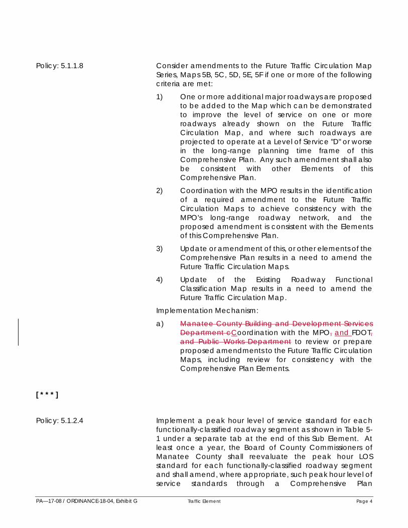
PA—17-08 / ORDINANCE-18-04, Exhibit G Traffic Element Page 4
Policy: 5.1.1.8 Consider amendments to the Future Traffic Circulation Map Series, Maps 5B, 5C, 5D, 5E, 5F if one or more of the following criteria are met:
1) One or more additional major roadways are proposed to be added to the Map which can be demonstrated to improve the level of service on one or more roadways already shown on the Future Traffic Circulation Map, and where such roadways are projected to operate at a Level of Service "D" or worse in the long-range planning time frame of this Comprehensive Plan. Any such amendment shall also be consistent with other Elements of this Comprehensive Plan.
2) Coordination with the MPO results in the identification of a required amendment to the Future Traffic Circulation Maps to achieve consistency with the MPO's long-range roadway network, and the proposed amendment is consistent with the Elements of this Comprehensive Plan.
3) Update or amendment of this, or other elements of the Comprehensive Plan results in a need to amend the Future Traffic Circulation Maps.
4) Update of the Existing Roadway Functional Classification Map results in a need to amend the Future Traffic Circulation Map.
Implementation Mechanism:
a) Manatee County Building and Development Services Department cCoordination with the MPO, and FDOT, and Public Works Department to review or prepare proposed amendments to the Future Traffic Circulation Maps, including review for consistency with the Comprehensive Plan Elements.
[ * * * ]
Policy: 5.1.2.4 Implement a peak hour level of service standard for each functionally-classified roadway segment as shown in Table 5- 1 under a separate tab at the end of this Sub Element. At least once a year, the Board of County Commissioners of Manatee County shall reevaluate the peak hour LOS standard for each functionally-classified roadway segment and shall amend, where appropriate, such peak hour level of service standards through a Comprehensive Plan

PA—17-08 / ORDINANCE-18-04, Exhibit G Traffic Element Page 5
Amendment. This evaluation may include revisions to Table 5-1 of the Traffic Circulation Sub Element. Changes to roadway functional classification also shall be reflected in the form of appropriate changes to Table 5-1 of the Traffic Circulation Sub-Element. Level of Service Compliance review conducted using service volumes developed pursuant to this policy shall not substitute for a more detailed traffic analysis, where such analysis is required by Manatee County. Detailed traffic analysis may also be required or provided to determine project impacts on intersections, using appropriate standards from the "Highway Capacity Manual".
Implementation Mechanism(s):
a) Concurrency review shall utilize Table 5-1 of the Traffic Circulation Sub-Element.
b) Manatee County Building and Development Services and Public Works Departments uUse of Florida Department of Transportation Level of Service software and/or tables to derive peak hour maximum service traffic volumes for maintaining adopted level of service.
c) Review of proposed developments pursuant to the Operative Provision within the Future Land Use Element, and for compliance with goals, objectives and policies of the comprehensive plan, to ensure that no development orders are issued which either causes a violation of an adopted Level of Service standard, or would otherwise not be eligible for issuance of a Certificate of Level of Service Compliance (e.g., for reasons of non-compliance with Objective 5.2.2).
[ * * * ]
Policy: 5.2.1.2 Develop a framework of collector roadways that are located approximately one-half mile apart from other collector roadways or arterial roadways to facilitate inter- neighborhood movement and reduce circuitous travel and congestion.
Implementation Mechanism:
a) Building and Development Services and Public Works Departments sStudy and proposeal of amendments to the Traffic Circulation Map Series consistent with this policy.
b) Establish standards in the LDC to implement this policy.

PA—17-08 / ORDINANCE-18-04, Exhibit G Traffic Element Page 6
[ * * * ] Policy 5.2.1.4. Utilize the Future Traffic Circulation Map Series for:
1) Review of all proposed development orders for consistency with Map 5-C (see also Policies 5.2.1.5 and 5.2.1.6: Rights-of- Way Protection and Preservation).
2) Establishing the long-range (2040 2035) level of service standards on major existing or future roadways by determining the resultant level of service on each roadway located on Maps 5-B, 5-C, 5-D, 5-E, 5-F when impacted by projected travel demand, as determined using the Sarasota-Manatee 2040 2035 Long Range Transportation Plan and/or other travel demand forecasting models.
3) Review of all proposed capital projects proposed to widen existing, or develop new, major roadways. All capital projects shall be consistent with Maps 5-B, 5-C, 5-D, 5-E, 5-F.
4) Achieving consistency of this Comprehensive Plan, where appropriate, with the long-range transportation plans of all local governments adjacent to Manatee County, and with the Florida Department of Transportation's 2060 2025 Florida Transportation Plan (FTP), the Short Range Strategic Plan, Strategic Intermodal system, and approved Five-Year Work Program.
[ * * * ]
Policy: 5.2.1.5 Implement, through this Comprehensive Plan and land use regulations, standards which shall limit or prohibit development of structures, parking areas, or drainage facilities within the location of future transportation corridors and rights-of-way as generally configured and indicated on the Future Traffic Circulation: Right of Way Needs Map, (Map 5C) and specified on Table 5.1. Other thoroughfare uses may be allowed within designated Future Transportation Corridors, including temporary uses.
Future transportation corridors and rights-of-way to be protected shall be established during the review of each individual proposed project in proximity to the future transportation corridors generally located on the Future Traffic Circulation Map Series. These transportation corridors shall be designed so as to provide for a continuous travel corridor of sufficient width to accommodate an appropriate cross-section as required for facility types specified on the Major Thoroughfare Map Series. Protected future

PA—17-08 / ORDINANCE-18-04, Exhibit G Traffic Element Page 7
transportation corridors rights-of-way shall be identified during project review for development order approval. Dedication, where required, shall occur on or before issuance of a Certificate of Level of Service Compliance unless a development order specifies a later dedication date.
Mitigation measure shall be utilized to preclude the taking of private property without compensation. These measures shall address properties which are located in a manner, or exhibit characteristics, which preclude the reasonable use of such property if the protected right-of-way is dedicated or maintained free of structures, drainage facilities, or parking areas during development of the property. These measures also shall consider the transportation impacts of the specific development being proposed on the roadway. Mitigation measures may include, but not be limited to:
- granting of impact fee credits in accordance with land development regulations;
- repositioning the roadway through the land to maximize development potential
- transferring of development rights which may be considered pursuant to the Future Land Use Map from the area within the protected right-of-way to an area outside the protected right-of-way on the project site;
- granting alternative and more valuable land uses;
- offering development opportunities for clustering the increasing densities at key nodes and parcels within the project site off the protected transportation corridors;
- altering or changing the road pattern; and
- reduce the building setbacks, required buffers, and other requirements otherwise contained in this Comprehensive Plan or contained in other local land development regulations, if such requirement is considered on a case-by-case basis.
Implementation Mechanism(s):
a) Update, as needed, by the Manatee County Building and Development Services and Public Works Departments, of the Future Traffic Circulation: Rights of Way Needs Map (Map 5C), a the Rights-of Way Needs Table (Table 5.1), the Existing Roadway Functional Classification Map (Map 5A), and applicable land development regulations consistent with this policy.
b) Maintenance of land development regulations consistent with § 163.3202, F.S., and consistent with this

PA—17-08 / ORDINANCE-18-04, Exhibit G Traffic Element Page 8
policy.
Policy: 5.2.1.6 Implement rights of way reservation requirements through the Future Traffic Circulation: Right of Way Needs Map (Map 5C) and Right of Way Needs Table (Table 5.1) in this Comprehensive Plan and the land development regulations. All development of drainage facilities, parking, or structures shall be prohibited within the reserved right-of-way consistentwith law. Dedications of reserved right-of-way shall be inaccordance with Policy 5.2.1.5 above. Appropriate access through reserved right-of-way, as determined by Manatee County, will be permitted.
Implementation Mechanism:
a) Manatee County Building and Development Services and Public Works Departments maintenance ofMaintain land development regulations consistent with this policy.
Policy: 5.2.1.7 Periodically evaluate the desirability of establishing a right-of-way acquisition fund, utilizing one or more appropriaterevenue sources, which may be used to provide discretionary funding for purchase, and for offsetting other acquisition costs, of for rights-of-way identified on the Major Thoroughfare Map, but not yet subject to right-of-way reservation pursuant to Policy 5.2.1.6 above, nor protected pursuant to Policy5.2.1.5 above. Purchase of any such right-of-way may beexercised through eminent domain proceedings or throughnegotiated purchase. Also establish such fund if deemed appropriate by the Board of County Commissioners.
Implementation Mechanism:
a) During annual preparation of the update to the Five Year Schedule of Capital Improvements, Manatee County Financial Management Department coordination with the Manatee County Public Works Departments to the County shall determine whether it is fiscally feasible to establish or maintain an advanced right-of-way acquisition fundestablishment of a discretionary fund should be recommended as part of the Capital Improvements Program to the Board of County Commissioners.
Objective: 5.2.2 Performance Standards: Utilize adopted design standards for the review of proposed development orders and for ensuring the proper functioning of publicly-provided transportation facilities.
Policy: 5.2.2.1 Utilize the Future Traffic Circulation Right-of-Way Needs Map (Map 5C):
1) as a long range planning tool that outlines general

PA—17-08 / ORDINANCE-18-04, Exhibit G Traffic Element Page 9
corridors for future roadway, rail or other transportation facility construction;
2) to protect identified transportation corridors from encroachment by other land use activities; and
3) to put property owners on notice as to the necessity and location of future roadways (see also Table 5-1 for right-of-way widths), and allow owners adequate time to plan and integrate their developments with proper transportation facility coordination requirements.
No Development Order shall be issued for any project unless such project is consistent with requirements developed pursuant to this policy.
Implementation Mechanism:
a) Manatee County Building and Development Services and Public Works Departments rReview of all proposed projects for compliance with the location and right-of- way requirements referenced in this policy, where applicable.
Policy: 5.2.2.2 Maintain adopted minimum standards for the spacing and location of local streets and driveways onto County and State roadways, and minimum standards for the spacing and location of median cuts on County and State roadways.These standards shall be used to ensure safe access to proposed developments, and to limit impedances to trafficflow on County and State roadways. These minimumstandards shall be consistent with Florida Department of Transportation Rule Chapter 14-97 FAC State Highway System Access Management Classification System and Standards, December, 1990, as amended, or with other appropriate State policy. No Development Order shall be issued for any project unless such project is consistent with requirements developed pursuant to this policy.
Implementation Mechanism(s):
a) Land development regulations developed pursuant to § 163.3202, F.S., and containing these standards.
b) Coordination between Manatee County Public Works Department andwith the Florida Department of Transportation to maintain minimum standards on State roads (for inclusion within Manatee County standards), so as to ensure that project review by Manatee County incorporates an informal review of the project for compliance with State requirements. Formal review by the State would still be described as a requirement not met by County review.

PA—17-08 / ORDINANCE-18-04, Exhibit G Traffic Element Page 10
Policy: 5.2.2.3 Designate where determined to be necessary by the Board of County Commissioners, any roadway shown on the Future Traffic Circulation Map (Map 5E) as a "controlled access facility," as defined herein. This designation should not be confused with the category of roadway used for functional classification purposes called "limited access facility". Also, for any controlled access facility, limit the rights of abutting landsto direct or indirect access to the facility in a manner specificto that facility. Furthermore, to prohibit the issuance of aCertificate of Level of Service Compliance on any project unless project design meets all criteria adopted for adjacent controlled access facilities. A list of approved intersections may also be developed for each controlled access facility to identify permitted access points to the facility.
All "entranceways," as described in Policies 2.9.4.1 & 2.9.4.2, shall also be designated as controlled access facilities, with access limitations specified at time of defining the extent of these facilities pursuant to Policies 2.9.4.1 & 2.9.4.2.
At a minimum, the following roadways shall be considered as Manatee County Designated "Controlled Access Facilities".
1) University Parkway between U.S. 301 and SR70.
2) State Route 70 between I -75 and Verna Bethany Road.
3) State Route 64 between I -75 and Verna Bethany Road.
4) U.S. 301 between I-75 and North Manatee County line.
5) U.S. 41 between 49th Street East (Experimental FarmRoad) and north Manatee County Line.
All Manatee County "Controlled Access Facilities" shall be shown on the Future Traffic Circulation Map (Map 5E) via the plan amendment process, and a description of access limitations shall be contained in land development regulations developed pursuant to Section 163.3202, F.S.
Implementation Mechanism(s):
a) Coordination between the Manatee County Public Works Department, Building and Development Services andwith the Florida Department of Transportation to recommend, as necessary, proposed controlled access facilities and related limitations on direct or indirect access.
b) Inclusion in any land development regulations developed pursuant to Section 163.3202, F.S., descriptions of access intersections and adjacent land access limitations for controlled access facilities.

PA—17-08 / ORDINANCE-18-04, Exhibit G Traffic Element Page 11
[ * * * ]
Policy: 5.2.2.5 Generally, encourage the use of project access points which provide project entrances onto from collectors and not rather than arterials., and which If project access has to be providedfrom an access to arterials, it shall be designed as at improved a controlled intersections, instead of and not via an uncontrolled driveways. However, "right-turn-in/out only" ingress/egress points on arterials may be considered where appropriate.
Implementation Mechanism:
a) Coordination between the Building and DevelopmentServices and Public Works Departments torecommendCounty review of development orderapplications conditions addressing access to ensure compliance with this policy.
Policy: 5.2.2.6 RESERVEDRequire the use of the special approval processwhen alternative scenarios for project access yieldsubstantially different impacts on number and magnitude ofimpedances to traffic flow on any functionally classifiedroadways, or on any roadways shown on the Future Traffic Circulation Map.
Implementation Mechanism(s):
a) Counseling of project applicants to utilize the specialapproval process to achieve policy compliance.
b) Issuance of negative recommendations by the Building and Development Services Department or Building Departmentfor either:
- inappropriate access points requested by project applicants during the special approval process, or
- development order applications not utilizing the specialapproval process for which alternative, and qualitatively different, project access scenarios are possible.
[ * * * ]
Policy: 5.2.2.8 Utilize the Manual on Uniform Traffic Control Devices as the guideline for determining the need or requirement for traffic control devices on roadways within Manatee County. No Certificate of Level of Service Compliance shall be issued for any project phase unless signalization required by the guidelines is accomplished, or is required by appropriate conditions on the Certificate of Level of Service Compliance

PA—17-08 / ORDINANCE-18-04, Exhibit G Traffic Element Page 12
and related development order(s).
Implementation Mechanism:
a) Review applications for Certificates of Level of Service Compliance and related development order(s) by the Manatee County Public Works and the Building and Development Services Departments to ensure consistency with this policy, and recommendations to the Board of County Commissioners, as required by this policy.
[ * * * ]
Policy: 5.2.2.11 Discourage the disruption of neighborhood functions fromexternal traffic to ensure Ensure that local streets are not situated so as to provide preferred travel paths for vehicularmovements between home and work/shopping locations.This policy shall not be interpreted to prevent, discourage, eliminate, or prohibit the requirement for, or development of, and to promote inter-neighborhood ties (continuation) oflocal streets between neighborhoods.
Implementation Mechanism:
a) Review by the Building and Development Services and Public Works Departments of the proposed circulation patterns.
Policy: 5.2.2.12 Create greater transportation mobility through therequirement for cross -access between adjacent properties impacting thoroughfare roadways during development.
Allow exceptions to this policy by Special Approval where:
- no logical connection(s) can be established which would improve system mobility or
- compatibility concerns are created due to creation of undesirable travel routes.
See also Policies 5.2.2.5 / 5.2.2.6 / 5.2.2.11
Implementation Mechanisms:
a) Maintain standards and criteria in the LDC to implement this policy.Coordinated review of development proposals by the Building and Development Services and Public Works Departments.
b) Amendment to the Land Development Code to implement policy.
Objective: 5.2.3 Concurrency: To guarantee that transportation facilities are

PA—17-08 / ORDINANCE-18-04, Exhibit G Traffic Element Page 13
available concurrent with the impacts of development approved by Manatee County and requiring the issuance of a Certificate of Level of Service Compliance, in a manner consistent with adopted level of service standards.
Policy: 5.2.3.1 Prohibit the issuance of certain development orders unless compliance of the particular project is established, at time of review of development orders listed under 2.4.1.1.(1)-(4), with regard to adopted infrastructure and performance (level ofservice) standards. Compliance shall be established onlywhen the development order is issued at the same time, or following, the issuance of a Certificate of Level of Service Compliance for that project, as described in policies under Objective 2.4.1. Adopted level of service standards are listed in policies under Objective 5.1.2 above.
Implementation Mechanism:
a) Level of Service Compliance review, and issuance ofa Certificate of Level of Service Compliance by the Public Works Department, where appropriate.
[ * * * ]
Policy: 5.2.3.3 Establish a proportional fair share mitigation ordinance.
Implementation Mechanism:
a) Building and Development Services, FinancialManagement and Public Works Internal coordinationbetween Ddepartments coordination to developordinance.
Policy: 5.2.3.4 Consider the establishment of multi-modal concurrency and/or long term concurrency management strategies for discreet specific areas within the county, consistent with stateregulations. Special approval by the Board of CountyCommissioners is required.
GOAL: 5.3 A Traffic Circulation System Coordinated with Future Land Uses, Other Public Facilities, And Natural Resource Constraints.
Objective: 5.3.1 Coordinated Land Use/Transportation: Coordination of Future Land Uses with Traffic Circulation Systems.
Policy: 5.3.1.1 Generally limit the location of land uses which serve as central destinations, or major trip attractors, to points of convergence (intersections) on the roadway network, or to areas characterized by and containing major points of convergence of roadways.
Implementation Mechanism(s):

PA—17-08 / ORDINANCE-18-04, Exhibit G Traffic Element Page 14
a) Implementation of Objectives 2.10.2 and 2.10.3.
b) Review by the Manatee County Planning Department,of proposed trip attractors for compliance with this policy.
[ * * * ]
Policy: 5.3.1.3 Generally limit the use of the RES-9, RES-12, RES-16, and OM future land use categories on vacant land to locations that are adjacent to the roadways shown on the Future Traffic Circulation: Functional Classification Map (Map 5B) as collector or higher.
Implementation Mechanism(s):
a) Future Land Use Map.
b) Review by the Manatee County Planning Department, of all proposed amendments to the Future Land Use Map for compliance with this policy.
Policy: 5.3.1.4 Limit the use of the ROR and MU future land use categories on vacant land to locations which are adjacent to roadways shown on the Future Traffic Circulation: Functional Classification Map (Map 5B) as arterial or higher or are adjacent to lands already designated the same ROR or MU future land use category which are adjacent to roadwaysshown as arterial or higher. Nothing in this policy shall prohibit compliance with Policy 2.4.5.2.
Policy: 5.3.1.5 RESERVED Generally limit the locations of projects whichachieve any increased density and intensity reserved forprojects accomplished under the special approval process tosites which have direct access to roadways shown on theExisting Roadway Functional Classification Map (Map 5A) ascollector or higher.
Implementation Mechanism:
a) Manatee County Planning Department review of projects for compliance with this policy.
Policy: 5.3.1.6 Ensure that land uses and project designs are consistent with the proper functioning of the FDOT State highway system by requiring FDOT comment on all development order applications requesting access onto the State highway system, and by requiring appropriate limitations on project access.
Implementation Mechanism:
a) Manatee County Planning Department cCoordination

PA—17-08 / ORDINANCE-18-04, Exhibit G Traffic Element Page 15
with FDOT to ensure policy compliance.
Policy: 5.3.1.7 Fund, where expenditures are approved by the Board of County Commissioners, the improvement of State roadways shown on the Capital Projects List, (Table 10-1). This funding may address part of or all costs associated with required improvements.
Objective: 5.3.2 Natural Resource Considerations: Ensure that all transportation improvements are conducted in a mannerwhich minimizes adverse impact on important naturalresources.
Policy: 5.3.2.1 Coordinate with FDOT to ensure that the alignment of any new expressway located within Manatee County during implementation of the FDOT Short Range Strategic Transportation Plan, or subsequent update of part or all thereof, is located (to the maximum extent practicable) outside of the Watershed Overlay District shown on the Future Land Use Map. Furthermore, to encourage FDOT's consideration of access limitations and other design factors to ensure minimal impact on those watershed areas, if alignment within the watersheds is being pursued over Manatee County's objections.
Implementation Mechanism:
a) Manatee County Planning Department and PublicWorks Department cCoordination with FDOT and theSarasota-Manatee MPO to implement this policy.
Policy: 5.3.2.2 Require that all roadway improvements for which design will discharge stormwater directly to the Lake Evers or Lake Manatee Reservoirs, or to the Peace River, or discharge into any inflowing watercourse, in the Watershed Overlay District include an additional level of stormwater treatment equal to 50 percent of the treatment criteria specified in Rule 62- 25.035(1)(b), F.A.C. (i.e., treatment pursuant to Outstanding Florida Water Criteria is required).
Implementation Mechanism:
a) Manatee County Public Works DepartmentcCoordination with FDOT and the Sarasota-Manatee MPO to implement this policy.
Policy: 5.3.2.3 Locate and design roadway and mass transit rights-of-way, and improvements therein, to reduce the acreage of adversely altered jurisdictional wetland areas, minimize direct and indirect impacts on rivers, lakes, and streams, and minimize adverse impact on endangered and threatened species, and on species of special concern.
Implementation Mechanism:

PA—17-08 / ORDINANCE-18-04, Exhibit G Traffic Element Page 16
a) Manatee County Public Works Department rReview of proposed public and private roadway projects for compliance with this policy, and coordination with state and federal jurisdictional agencies as necessary.
Policy: 5.3.2.4 Limit the number, and generalized location of arterials and expressways within the Watershed Overlay District to those shown on the Future Traffic Circulation: Functional Classification Map, (Map 5B) and consider the location of additional collectors only, limiting any additional collectors to those which reduce the number of lane miles of local and other streets necessary to maintain adopted levels of service and access to developable property.
Implementation Mechanism:
a) Review by the Public Works Department and Planning Department of proposed public and private roadway projects for compliance with this policy.
[ * * * ]
Policy: 5.3.3.1 Continue to implement the approved Traffic Calming Plan that identifies acceptable traffic calming measures for neighborhoods requesting such measures. Implementation shall include neighborhood citizen participation to incorporate preferences of traffic calming measures for each neighborhood.
Implementation Mechanism(s):
a) Manatee County Public Works Department,Community Services Department (Transit Division), and Building and Development Services Department cCoordination between departments to implementthis policy.
[ * * * ]
GOAL: 5.4 A Safe and Convenient Bikeway and Pedestrian Circulation System.
Objective: 5.4.1 Bicycle Facilities: Provision of a safe and convenientbikeways system and adequate bicycle facilities. (See alsoObjective 5.3.3 and associated policies)
[ * * * ]

PA—17-08 / ORDINANCE-18-04, Exhibit G Traffic Element Page 17
Policy: 5.4.1.2 Coordinate provision of bikeways and bicycle facilities with the provision of recreational bike trails within the Manatee County park system, subject to the availability of appropriate revenues, to encourage development and continuity of a safe and convenient bicycle circulation system. (seeRecreation and Open Space Element for performancestandards)
Implementation Mechanism:
a) Coordination of capital improvements projects andfacilities improvement projects by the Manatee County Public Works, Planning, and Parks and Recreationamong County Ddepartments to achieve compliance with this policy.
Policy: 5.4.1.3 Require, where feasible, the inclusion of either:
1) A minimum of 5-foot paved shoulders on both sides of rural section roadways, or
2) A minimum of 4-foot wide bicycle lanes on both sides of urban section roadways in all roadway improvement projects involving major widening or new construction of roadways shown on the Major Thoroughfare Map required by Policy 5.1.1.1 for use by bicycles, or
3) Wherever bicycle lanes are not feasible, alternative routes shall be provided in accordance with the American Association of State Highway and Transportation Officials (AASHTO) guide for the development of bicycle facilities, and the Florida Department of Transportation (FDOT) bicycle facilities planning and design handbook.
Implementation Mechanism:
a) Inclusion, by Manatee County Public WorksDepartment, of alternative roadway sections implementing this policy in typical roadway sections required by Policy 5.2.2.1.
Policy: 5.4.1.4 Coordinate bicycle facilities with transit route locations and transit stops to encourage bicycle and transit as an alternate mode of travel.
Implementation Mechanism:
a) Manatee County Planning Department, Community Services Department (Transit Division), Public Works Department, and Sarasota-Manatee MPO cCoordination among departments to implement this policy.

PA—17-08 / ORDINANCE-18-04, Exhibit G Traffic Element Page 18
Objective: 5.4.2 Pedestrian Facilities: Provide a safe and convenientpedestrian circulation system. (See also Objective 5.3.3 andassociated policies)
Policy: 5.4.2.1 Require the inclusion of pedestrian ways in all typical urban roadway sections developed pursuant to Policy 5.2.2.1above. Particular attention shall be given to achievingpedestrian/transit intermodal travel.
Implementation Mechanism:
a) Inclusion, by the Manatee County Public WorksDepartment, of pedestrian ways in all typical urban roadway sections.
[ * * * ]
Policy: 5.4.2.3 Update by 2011 2020 the pedestrian ways plan which gives priority to the development of pedestrian ways near schools, and is also consistent with transit route locations and transit stops to improve pedestrian access to transit, to encouragepedestrian and transit intermodal travel. Priorityconsideration of pedestrian way development shall be within a 1,500 foot radius of transit stops, existing and proposed school locations.
Implementation Mechanism:
a) Manatee County Planning Department, CommunityServices Department (Transit Division), Public Works Department, andCoordination with the Sarasota- Manatee MPO coordination to implement this policy.
Policy: 5.4.2.4 Coordinate Manatee County School District’s safe route(s) to school sidewalk plan(s) for each of its new elementary and middle schools and, elimination-of-hazardous-walking- conditions sidewalk plans for existing schools.
Implementation Mechanism:
a) Coordination between the Manatee County Planning Department, Public Works Department, andwith the Manatee County School District concerning sidewalks per the interlocal agreement to ensure policy compliance.
GOAL: 5.5 A Coordinated Intergovernmental and Interagency Transportation Planning Process.
Objective: 5.5.1 Interagency Coordination: Coordinated transportation planning with local, state, regional, and federal agencies.

PA—17-08 / ORDINANCE-18-04, Exhibit G Traffic Element Page 19
Policy: 5.5.1.1 Develop and maintain a Future Traffic Circulation Map Series which is highly consistent with the MPO's long-range transportation plan, and provide input to the MPO to encourage the recognition of Manatee County's needs on the MPO's plan.
Implementation Mechanism:
a) Coordination between the Manatee County Planning Department, the Public Works Department andwith the Sarasota-Manatee MPO to ensure policy compliance.
Policy: 5.5.1.2 Coordinate Manatee County's five-year capital improvement program for transportation projects with the Florida Department of Transportation's five-year transportation improvement program.
Implementation Mechanism:
a) Manatee County Planning Department and PublicWorks Department's cCoordination with the Sarasota-Manatee MPO.
Policy: 5.5.1.3 On an annual basis, provide to the Florida Department of Transportation a listing of those state roadways for which level of service has, or is projected to decline in the next 5 years below adopted Level of Service standards. Also, to coordinate with the Sarasota-Manatee MPO and FDOT so as to establish increased priorities for construction of improvements to such roadways based on reduced right-of- way costs facilitated by Manatee County's right-of-way protection or reservation ordinances.
Implementation Mechanism:
a) Manatee County Planning Department and PublicWorks Department cCoordination with FDOT and theMPO consistent with this policy.
Policy: 5.5.1.4 Utilize the prioritization criteria (level of service criteria) contained in the Capital Improvements Element of this Comprehensive Plan to assist in the ranking of necessary transportation improvements to be accomplished by Manatee County, other adjacent local governments, FDOT, and federal agencies, and provide these agencies with input and background analysis (where appropriate), on Manatee County's priorities for improvements within the County on state or federal facilities. Nothing in this policy shall preclude the implementation of other prioritization criteria in association with criteria referred to in this policy.
Implementation Mechanism:
a) Manatee County Planning Department and Public

PA—17-08 / ORDINANCE-18-04, Exhibit G Traffic Element Page 20
Works Department coordination and nNotification of applicable local, state, and federal agencies of priorities for transportation improvements each fiscal year.
[ * * * ]
GOAL: 5.6 Encourage and promote the Complete Streets concept throughout the county.
Objective 5.6.1 Integrate Complete Streets. Complete Streets are roadways designed to accommodate all users, including, but not limited to motorists, cyclists, pedestrians, transit and school bus riders, delivery and service personnel, freight haulers, and emergency responders.
[ * * * ]
Policy 5.6.1.4 Promote complete streets that contribute to the slowing down of traffic, reduce pollution and emissions, improve environmental quality and provides for local economic opportunities, where applicable.
Implementation Mechanism(s):
a. Maintain Ccriteria and performance standards forComplete Streets shall be established by Manatee County Public Works Department.
b. Applicable revisions to the Land Development Code by the Building and Development Services Department.
Table 5- 1 (PA- 14- 02)
MANATEE COUNTY PEAK HOUR LEVEL OF SERVICE STANDARDS
TWENTY YEAR ROADWAY REQUIREMENTS/RIGHT-OF - WAY NEEDS [ ]
[ * * * ]
See Attached Addendum for thoroughfares that shall not have an entitlement for commercial node designation without Special Approval by the BOCC.
ADDENDUM
The following thoroughfares shall not have an entitlement for commercial node designation:

PA—17-08 / ORDINANCE-18-04, Exhibit G Traffic Element Page 21
Ft. Hamer Road Extension at US 301, Erie Rd; Moccasin Wallow Rd; Spencer Parrish Rd and Buckeye Rd.
Gateway Blvd Extension at Piney Point Road.
Golf Course Road at Spencer Parrish Road.
Harrison Ranch Road at Old Tampa Road.
The Masters Avenue at Bourneside Blvd and Lorraine Road.
M & J Road at Clay Gully Road and SR 70.
Mulholland Road at Rye Road and CR 675.
Piney Point Road Extension at Gateway Blvd Extension; I-75 and east of I-75.
Rye Road at SR 62.
Sawgrass Road at Erie Rd; Moccasin Wallow Rd; and Buckeye Rd.
Spencer Parrish Road at Golf Course Road.
FF Road at Ft. Hamer Road Extension and Sawgrass Road.
Upper Manatee River Road at CR 675 and Rye Road.
Upper Manatee River Road at south side of river (bridge connection).
Ft. Hamer Road at north side of river (bridge connection).
Ft Hamer Road at Mulholland Road; Golf Course Road and US 301 and Ft. Hamer Road Extension.
For commercial node designation, Special Approval of the Board of County Commissioners shall be required.
(Ord. No. 16-23, § 8(Exh. F), 9-19-16)

PA-17-08 / ORDINANCE-18-04, Exhibit H Housing Element Page 1
EXHIBIT H HOUSING ELEMENT GOAL 6.1 A County with a Variety of Housing Opportunities for All Manatee County Residents,
Recognizing that Affordable Living Requires Affordable Housing, Near Employment, Shopping, Services and Alternative Transportation, with an Emphasis on the Needs of the Financially Disadvantaged, and the Special Needs Populations.
Objective 6.1.1 Private Sector Delivery: Maintain a Flexible Regulatory Process Which Assists the Private Sector in the Delivery of a Variety of Housing Products.
[ * * * ] Policy 6.1.1.2 Permit consideration of manufactured homes (mobile homes) in all
future land use categories allowing residential development on a variety of lot sizes, if compatible with surrounding development unless prohibited by (See also Policy 4.3.1.6).
[ * * * ] Policy 6.1.1.4 Provide for the development of vacant prope rty and
redevelopment of existing properties within the urban core area.
Implementation Mechanism:
a) Planning Department iIncorporation of urban development criteria in the LDC.
[ * * * ]
Objective 6.1.2 Special Needs Populations: Increase housing opportunities for Group Homes, Transitional Living Facilities, and Foster Care Facilities to address the Special Needs Populations which include; elderly, rural farmworkers, homeless, and the physically, and Mentally intellectually disabled.
Policy 6.1.2.1 Continue data collection to properly understand the housing market and obstacles to housing for special needs populations.
Implementation Mechanism(s):
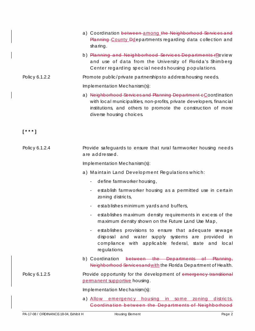
PA-17-08 / ORDINANCE-18-04, Exhibit H Housing Element Page 2
a) Coordination between among the Neighborhood Services andPlanning County Ddepartments regarding data collection and sharing.
b) Planning and Neighborhood Services Departments r R eview and use of data from the University of Florida's Shimberg Center regarding special needs housing populations.
Policy 6.1.2.2 Promote public/private partnerships to address housing needs.
Implementation Mechanism(s):
a) Neighborhood Services and Planning Department cCoordination with local municipalities, non-profits, private developers, financial institutions, and others to promote the construction of more diverse housing choices.
[ * * * ] Policy 6.1.2.4 Provide safeguards to ensure that rural farmworker housing needs
are addressed.
Implementation Mechanism(s):
a) Maintain Land Development Regulations which:
- define farmworker housing,
- establish farmworker housing as a permitted use in certain zoning districts,
- establishes minimum yards and buffers,
- establishes maximum density requirements in excess of the maximum density shown on the Future Land Use Map,
- establishes provisions to ensure that adequate sewage disposal and water supply systems are provided in compliance with applicable federal, state and local regulations.
b) Coordination between the Departments of Planning,Neighborhood Services andwith the Florida Department of Health.
Policy 6.1.2.5 Provide opportunity for the development of emergency transitional permanent supportive housing.
Implementation Mechanism(s):
a) Allow emergency housing in some zoning districts. Coordination between the Departments of Neighborhood

PA-17-08 / ORDINANCE-18-04, Exhibit H Housing Element Page 3
Services , and Planning .
b) Planning Department review of Land Development Regulations for unnecessary, burdensome regulations.
Policy 6.1.2.6 Continue to address the needs of the chronically homeless in Manatee County by implementing the goals of the 10 Year Plan to End Chronic Homelessness.
Implementation Mechanism:
a) Neighborhood Services and Planning Departments tocCoordinate with non-profits, jurisdictions and other public andprivate agencies to address this issue.
[ * * * ]
Objective: 6.1.3 Affordable Housing: Continue to Develop and Implement Programs to Meet Affordable Housing Needs
Policy 6.1.3.1 Continue data collection to properly understand the housing needs of the County’s population. housing market.
Implementation Mechanism(s):
a) Coordination between the Neighborhood Services and Planning among Ddepartments regarding data collection and sharing.
b) Planning and Community Affairs Departments rReview and use of data from the University of Florida's Shimberg Center regarding affordable housing populations.
[ * * * ] Policy 6.1.3.3 Provide government incentives, contributions and technical
assistance to the private sector and community based nonprofit organizations to aid in the development of affordable housing.
Implementation Mechanism(s):
a) Use or transfer of government owned property to encourage affordable housing development.
b) Planning Department e Establishment of an impact feewaiver/reimbursement program credit banking system.
c) Transfer of development rights.

PA-17-08 / ORDINANCE-18-04, Exhibit H Housing Element Page 4
d) Neighborhood Services and Planning Departmentsc C oordination with developers, financial institutions, non - profits and others to ensure the provision of housing that isaffordable to workers and other residents in the County.
e) Fast-tracking through necessary permitting procedures.
Policy 6.1.3.4 Encourage the development of a variety of dwelling units of varying cost or rent within a single development.
Implementation Mechanism(s):
a) Planning Department revision to the Land Development Regulations to include definition of very low income household per state requirements.
ab) Neighborhood Services Department Use of incentives and available funding sources to encourage allocation of funding tomixed income developments.
bc) Enact land use restriction agreements to ensure policy compliance.
Policy 6.1.3.5 Maintain a density bonus system for affordable housing which allows density bonuses for affordable housingup to the maximum density of the next most intense residential future land use.
Implementation Mechanism:
a) The Future Land Use Element shall establish the maximum densities and the Land Development Code shall maintain review mechanisms to implement this policy.This policy shall be implemented through a special approval process which may include enactment of land use development agreements.
Policy 6.1.3.6 Adopt performance standards for affordable / workforce housing which include consideration of the following design standards:
a) Transit-oriented design principals principles applicable toaffordable living, where appropriate.
b) Highest allowable density.
c) Location within 1/ 4 mile of a MCAT bus route.
d) Location of nearby employment centers, shopping and services.
e) Utilization of reduced vehicle parking spaces and ratios.
f) Quality public open space.
g) Utilization of Crime Prevention Thru Through Environmental Design (CPTED) site design techniques.

PA-17-08 / ORDINANCE-18-04, Exhibit H Housing Element Page 5
Implementation Mechanism:
a) Planning Department development of r R evisions to the Land Development Regulations to implement performancestandards for affordab le / workforce housing.
b) Planning and Neighborhood Services Departments c C onsider the development of an architectural pattern book to guidequality, affordable / workforce housing design.
Policy 6.1.3.7 Maintain the Affordable Housing Trust Fund for receipt of non-ad valorem revenues to encourage the continuation of affordable housing programs.
Implementation Mechanism:
a) The Neighborhood Services Department shall sSeek, where feasible, new revenue sources.
Policy 6.1.3.8 Require public and private development which eliminates affordable housing stock to replace such units with equivalent units or providesupport to local affordable housing initiatives. [See also Policy 6.1.3.6 the Land Development Code]
Implementation Mechanism:
a) Execution of land use development agreements by the BOCC or their designee.
[ * * * ] Policy 6.1.3.10 Continue to develop educational programs designed to increase
public awareness and understanding of affordable and workforcehousing.
Policy 6.1.3.11 Encourage a vertical mix of uses by providing incentives for developments that include affordable housing along designated urban corridors, subject to compliance with other goals, objectives, and policies of this Comprehensive Plan.
Objective 6.1.4 Substandard Housing: Continue to reduce the number of sub-standard housing units.
Policy 6.1.4.1 Develop specific improvement plans for targeted neighborhoods within the urban core which include measurable goals.
Implementation Mechanism(s):
a) Development and implementation of neighborhood plans

PA-17-08 / ORDINANCE-18-04, Exhibit H Housing Element Page 6
by the Neighborhood Services and Planning Departments .
b) Encourage neighborhood improvement programs through public/private partnerships.
c) Concentrate available Federal, State, and/or local public funds to assist in upgrading housing units which violate building codes.
d) Implementation of neighborhood plans by Quality Communities Team.
[ * * * ] Policy 6.1.4.4 Increase Encourage increased code enforcement activities in
CDBG eligible areas areas with concentrations of substandard housing units.
Implementation Mechanism:
a) Coordination between among County departments. theDepartments of Neighborhood Services, Planning, Building and Public Safety via the Quality Communities Team.
[ * * * ]
Manatee County Residential
Distribution Map Located in :
www.mymanatee.org Planning
Comprehensive Plan Maps (at top)
Comprehensive Plan Maps

PA-17-08 / ORDINANCE-18-04, Exhibit I Wastewater Sub-Element Page 1
EXHIBIT I WASTEWATER TREATMENT SUB-ELEMENT
[ * * * ]
Policy 9.1.2.3 Require that wastewater collection systems which are to be operated and maintained by Manatee County be designed to minimize the capital and operating costs of the County collection system.
Implementation Mechanism:
(a) Department Director rReview of any proposed capitalimprovement, and review of any proposed development order on any project not having special exception status under this Comprehensive Plan, for compliance with sanitary sewer Level of Service Standards.
(b) Manatee County Wastewater Collection System Master Plans.
[ * * * ]
Policy 9.1.4.3 Seek funds to assist in the extension of Manatee County's central sanitary sewer system to existing developed areas within the existing urban core, and the developing urban core, currently not served.(See also, policies 3.2.1.7, 3.2.2.5, 6.1.4.1, 6.1.4.2, Residential Infill Map - Housing Element)
[ * * * ]
Policy 9.1.5.3 Pursue a regional approach, whenever feasible, to the use of reclaimed water through development of interlocal agreements with local governments and surrounding jurisdictions.
Implementation Mechanism:
(a) Department Director planning and cCoordination with other jurisdictions to ensure compliance with this policy.
[ * * * ]
Objective 9.2.1 Concurrency: Require the issuance of a Certificate of Level of Service for

PA-17-08 / ORDINANCE-18-04, Exhibit I Wastewater Sub-Element Page 2
wastewater disposal concurrent with the impacts of new development and consistent with adopted level of service standards.
Policy 9.2.1.1 Allow the issuance of a Certificate of Level of Service Compliance only for projects which comply with the sanitary sewer level of service standards listed in Objective 9.1.1. or the standards for on-site treatment listed in Objective 9.2.4
Implementation Mechanism:
(a) Level of Service Compliance review and coordination of theissuance of a Certificate if Level of Service Compliance by the Department Director.
Policy 9.2.1.2 Require all wastewater from any project located within the wastewater treatment collection area as shown on Potable Water/Waste Water Service Area map, to be collected and treated through Manatee County's public sanitary sewer system. Exceptionsshall be , except as allowed by special approval which mustdemonstrate a hardship. Special approval under this policy shall include analysis of based on the following factors and as detailed in the Land Development Code;
• Proposed development size and wastewater impacts,
• Accessibility of the central system,The central wastewater system is not “available” as defined in section 381.0065(2)(a), Florida Statutes.
• Proposed infrastructure improvements,
• Environmental sensitivity,
• Development trends and timing,
• Compatibility of development, and
• Proposed mitigation measures.
Implementation Mechanism(s):
(a) Implementation and revision of the Manatee County Sewer Collection Ordinance, consistent with this policy.
(ab) Revision of the Maintain Land Development Code provisions to implement and other appropriate ordinances consistent with this policy.
(c) Coordination between Department Directors andwith the Florida Department of Health-- Manatee County.

PA-17-08 / ORDINANCE-18-04, Exhibit I Wastewater Sub-Element Page 3
[ * * * ]
Objective 9.2.3 Growth-Induced Capital Costs: Assess new growth a fair share of capital costs associated with the County's wastewater system.
Policy 9.2.3.1 Continue to require that new growth pay its full share of needed capital facilities, through payment of facilities investment fees (or other such fees) to fund necessary expansion of wastewater disposal, treatment, and major collection systems associated with this growth. This requirement will also apply to any increase in wholesale customer commitments.
Implementation Mechanism:
(a) Wholesale and retail facility investment fees, or other fees, assessed by the Department of Utilities County in a mannerconsistent with this policy for application directly to cost of expansion or for coverage of associated debt service.
[ * * * ]
Policy 9.2.4.2 Require that all new septic tanks and associated drain fields located within the Watershed Overlay (WO) District shall be located no closer than 200 feet to any jurisdictional wetland (including in flowing watercourses).
Implementation Mechanism(s):
(a) Review of agency approved wetland survey, or other appropriatedelineation, and preliminary site plan by the Manatee County Department Director prior to issuance of septic tank permit by theFlorida Department of Health - Manatee County and conditioningof any development order approval to ensure compliance with this policy.
(b) Coordination with between the Florida Department of Health - Manatee County, and Manatee County Department Directors.
[ * * * ]
Policy 9.2.4.4 Prohibit the development of any interim wastewater treatmentplants for any project located within the wastewater treatmentcollection areas as shown on Potable Water/Waste Water Service

PA-17-08 / ORDINANCE-18-04, Exhibit I Wastewater Sub-Element Page 4
Area map, unless Special Approval is grantedthe project is allowed to not to connect to the public sanitary sewer system (seeunder Policy 9.2.1.2) and approved by the Board of County Commissioners.Analysis of the following factors shall be included in the approval of any interim wastewater treatment plants:
- Development is not required to connect (see policy 9.2.1.2),
- Analysis of impacts from individual on site systems, versus an interim treatment plant,
- Level of treatment proposed,
- Possible connection to other municipal wastewater treatment systems,
- Location within or adjacent to environmentally sensitive areas,
- Location within areas subject to flooding, and
- Consideration of the appropriate timing and type of proposed development.
See also policies under Objective 2.1.2
Implementation Mechanism(s):
(a) Review of development proposals by Department Directors, andthe Florida Department of Health - Manatee County to implementthis policy.
(b) MaintainRevisions to the Land Development Code provisions toand other regulatory documents as appropriate to implement this policy.
Policy 9.2.4.5 Require, wWhere connection to the Manatee County public wastewater system is not required under Policy 9.2.1.2, that anyproject within the Wastewater Treatment Collection Areas utilizing septic tanks or an interim wastewater treatment plant shall be constructed with dry-lines so as to readily permit connection to the public sanitary sewer system for all residential development of 1 du/gca and higher, and all non-residential development.
Dry-lines shall be extended to the appropriate project boundary or boundaries. The interim wastewater treatment plant and associated collection system shall be installed so as to readily provide for a connection to the Manatee County sanitary sewer system.
Developed portions of a project shall connect within two years of the reasonable availability of a central system sanitary sewer line which has adequate capacity to accommodate wastewater flows.

PA-17-08 / ORDINANCE-18-04, Exhibit I Wastewater Sub-Element Page 5
When the requirement for dry lines are not appropriate due to unforeseeable engineering conditions, special administrative approval is required to ensure compliance with the intent of this policy.
Implementation Mechanism(s):
(a) Coordination between Department Directors Countydepartments to ensure policy compliance.
(b) Revision of the Land Development Code and other regulatory documents as appropriate to implement this policy.
[ * * * ]
Policy 9.2.4.7 Continue review and analysis of the wastewater treatment policies and procedures for effectiveness.
Implementation Mechanism(s):
(a) Department Directors cContinue modernization of data collection and mapping.
(b) Coordination between Department Directors, and with the Florida Department of Health – Manatee County in conducting review.
Potable Water / Wastewater Service Areas Map
Located in:
www.mymanatee.org Planning
Comprehensive Plan Maps Page (at top)
Comprehensive Plan Maps

PA-17-08 / ORDINANCE-18-04, Exhibit J Drainage & Groundwater Sub-Element Page 1
EXHIBIT J DRAINAGE & GROUNDWATER SUB-ELEMENT
[ * * * ]
Policy 9.4.1.4 Require that all projects discharging into the WO District on the Future Land Use Map meet or exceed the design standards of Chapters 62- 3, 62-4, and 62-25, F.A.C. and local design standards for discharge into Outstanding Florida Waters. The Board of County Commissioners may waive this policy if the proposed stormwater management system provides equivalent levels of stormwater treatment, ensuring that groundwater hydrology characteristics are not altered, impacted, or changed from the existing pre-development condition.
Implementation Mechanism:
a) Equivalent stormwater treatment methods which ensure that construction, alteration, or operation of stormwater systems do not discharge, emit, or cause violation of applicable Outstanding Florida Water quality standards shall be included in the Land Development Code.
[ * * * ]
Policy 9.4.2.3 Improve the appearance of major drainage facilities by adequate mowing and landscaping in highly visible locations.
Implementation Mechanism:
a) Capital and operating expenditures by the Manatee CountyPublic Works Department subject to the availability of fundingfrom a Stormwater Management Fee, or from other sources, to achieve compliance with this policy.
Policy 9.4.2.4 Improve wildlife habitat and supplement natural systems by including, where appropriate, and where feasible, the development of artificial wetland systems within the design of public stormwater siltation/ detention basins.
Implementation Mechanism:
a) Manatee County Public Works Department cCompliancewith this policy during project design, where appropriate.

PA-17-08 / ORDINANCE-18-04, Exhibit J Drainage & Groundwater Sub-Element Page 2
[ * * * ]
Policy 9.4.2.8 Continue the Watershed Management Programs in those basins listed in the Basin Prioritization Study in order to establish basin specific review criteria for stormwater systems. Elements of these criteria shall include, but not be limited to, stormwater hydrology, surface water hydrology, groundwater hydrology, stormwater management systems, stormwater reuse, groundwater recharge, Basin Management Action Plans, water quality and pollutant removal which shall be considered in review and approval of any stormwater management plan as appropriate based on the size and nature of the project.
Implementation Mechanism:
a) Public Works Department to iImplement individual basin studies to identify improvements and land acquisitions, as needed, to implement this objective.
b) The Public Works Department will work with the Environmental Management Department to iIdentify appropriate pollutant reduction goals for each basin.
c) The Public Works Department, Natural Resources Department, andPlanning Department will meet at least annually to rRe-evaluate,at least annually, current stormwater policies, goals andobjectives to comply with changes in regulations and standards.
[ * * * ]
Policy 9.4.3.3 Allocate funds for public capital improvement drainage projects only to implement the recommendations from a detailed stormwater study. Drainage studies shall define the flooding and/or water quality problems in a specific area, provide a prioritized list of solutions to the problems, and estimate the cost of the necessary improvements.
Implementation Mechanism:
a) Expenditure of revenues from any adopted stormwatermanagement funding mechanisms by the Public WorksDepartment to achieve compliance with Policies 9.4.3.1 through 9.4.3.3.
[ * * * ]

PA-17-08 / ORDINANCE-18-04, Exhibit J Drainage & Groundwater Sub-Element Page 3
Objective 9.4.4 Stormwater Design Standards: Require new development to meet stormwater retention/detention system standards to:
• protect natural features and prevent flooding;
• maintain or improve water quality in surface waterbodies and in groundwater; and
• ensure that the cost of constructing and maintaining new development does not fall to County taxpayers.
Policy 9.4.4.1 Issue a Certificate of Level of Service Compliance for new development only where compliance with all policies under Objective 9.4.1 has been demonstrated in project design.
Implementation Mechanism:
a) Planning Department rReview of all proposed development orderswhich require the issuance of a Certificate of Level of Service Compliance, and review of all proposed capital improvements.
Policy 9.4.4.2 Require that new development provides on-site detention and filtration of stormwater runoff to remove oils, floatables, silt, sediment, nutrients, and heavy metals at levels required by applicable federal, state, regional and local regulations and any coastal management plans prepared according to general or special law.
Implementation Mechanism:
a) Planning Department to aApprove the issuance of a Certificateof Level of Service only when the rate of stormwater discharge from new development is equal to, or less than, the rate of discharge that existed prior to development, based on a 25- year frequency – 24-hour duration storm event and that retains the same post development discharge points that existed pre- development. The discharge is to include any discharge to an existing or proposed watercourse, swale, ditch, storm sewer system that connects to a receiving watercourse in the WO district.
b) Public Works and Planning Departments coordinate in therReview of development applications for consistency with this policy.
Policy 9.4.4.3 Permit retention, infiltration, and evapotranspiration of stormwater in natural water storage areas consistent with other applicable local, state, and federal regulations.
Policy 9.4.4.4 Protect natural drainage features such as streams, lakes, wetlands, wetland systems, and estuaries and preserve the function of thesenatural features by allowing the utilization of isolated wetlands prohibiting the alteration of these natural watercourses and floodways except in cases of overriding public interest as

PA-17-08 / ORDINANCE-18-04, Exhibit J Drainage & Groundwater Sub-Element Page 4
determined by the Board of County Commissioners.
Implementation Mechanism: a) Maintain natural resource protection requirements in the Land
Development Code to ensure compliance with this policy and allow alterations only in cases where the Board makes a finding of overriding public interest. Review for developmentsproposing alteration of natural watercourses and floodwaysthrough the Special Approval process
Policy 9.4.4.5 Encourage the use of biological treatment within man- made
stormwater detention facilities and permit the utilization of small, low quality isolated wetlands in appropriate areas in the County as a part of an approved stormwater management plan.
Implementation Mechanism:
a) Parks and Natural Resources, Planning, and Public WorksDepartments cCoordination with the Southwest Florida WaterManagement District to ensure that all stormwater management systems discharging into surface waters are designed and maintained in a manner consistent with this policy.
Policy 9.4.4.6 Require new development to provide irrigation from non- potable sources whenever possible, which may include water from stormwater retention/detention areas or other natural storage areas consistent with Policy 9.4.4.4.
Implementation Mechanism:
a) Planning Department rReview of development for consistencywith this policy.
Policy: 9.4.4.8 Prohibit any retention/detention basin from being excavated to a depth which causes the direct exposure of the Floridan aquifer to stormwater retained/detained in any such basin.
Implementation Mechanism:
a) Planning Department rReview, of all stormwater plans forcompliance with this policy.
[ * * * ]
Objective 9.4.5 Private Drainage Systems: Ensure that maintenance and operation of private stormwater systems is funded by private sources.
Policy 9.4.5.1 Require that all private stormwater management systems be maintained in a manner which ensures the continuing operation of such private system consistent with these level of service, and other

PA-17-08 / ORDINANCE-18-04, Exhibit J Drainage & Groundwater Sub-Element Page 5
local, state, and federal standards. Furthermore, consider and implement appropriate action to ensure compliance with this policy, if violated. Such action may include injunctive relief.
Implementation Mechanism:
a) Require the identification and recording of an owner/ operator for any private stormwater management system prior to issuance of a Certificate of Level of Service Compliance by the Planning Department.
b) Manatee County Ordinance 00-02 allows the County to enforce private stormwater system maintenance and operational standards in situations where the private system is attached to the County’s municipal separate stormwater system.
[ * * * ]
Policy 9.4.5.3 Allow County implementation of needed improvements to poorly maintained or poorly functioning private stormwater management systems where required private maintenance is not carried out. Recover the costs to Manatee County of any such improvements through the levy of special assessments on the private party or parties legally responsible for maintenance and operation of the stormwater management system.
Implementation Mechanism:
a) Public Works Department nNotification to parties responsible for stormwater management systems which are poorly maintained or are operating in an unsafe or unsound manner. Also, levy of special assessments to correct system deficiencies not addressed by the private owner/operator within a reasonable timeframe after notification by the County.

PA-17-08 / ORDINANCE-18-04, Exhibit K Capital Improvements Element Page 1
EXHIBIT K
CAPITAL IMPROVEMENTS ELEMENT The Capital Improvements Element (CIE) functions as an executive summary of the short range public facility needs identified in the other elements of the Comprehensive Plan. It serves as the public sector's development plan by scheduling the construction of major capital projects. The CIE also tabulates the estimated cost of major capital projects and analyzes the capability of Manatee County to finance and construct these improvements. Therefore, the CIE con tains important financial policies which will be used to guide the funding of capital improvements. The intent of the CIE is to ensure the public sector's implementation of the Comprehensive Plan, just as the entire development review process, described in the Future Land Use Element and in other plan elements, is intended to guide private sector development in a manner consistent with Manatee County's Comprehensive Plan. The public sector's implementation of the Comprehensive Plan via the Capital Improvements Element ensures compliance with adopted Level of Service standards for major public facilities addressed in other Comprehensive Plan elements, while meeting other projected needs for facilities and services not addressed in this Comprehensive Plan, and while meeting project operating costs and debt service.
Because the Manatee County Financial Management Department is responsible for the budgetary process necessary to balance revenues and expenditures, this Department will have a lead role in developing the CIE and ensuring the Comprehensive Plan is economicallyfeasible. The Building and Development Services Department Planning Department will maintain up- to- date information on development activity within Manatee County as needed to update population and employment projections. Also, the development review process will help monitor current Level of Service conditions throughout the unincor porated area. The other County Departments directly involved in providing capital improvements will continue their roles in setting priorities for specific projects and then making sure they are carried out as scheduled.
[ * * * ]
Policy 10.1.5.1 Utilize a Growth Management Public Meeting process as an integral part of the annual budgeting process. The Growth Management meeting process shall be conducted by the Board of County Commissioners, and shall, at a minimum, include:
a) evaluation of current and short-range needs for infrastructure (including needs associated with Level of Service standards referenced in Policy 10.1.2.7 and preservation of future rights-of- way consistent with Policy 5.2.1.7);
b) evaluation of, and necessary adjustments to, adopted Level of

PA-17-08 / ORDINANCE-18-04, Exhibit K Capital Improvements Element Page 2
Service standards;
c) identification of changes to the Capital Improvements Element regarding funding and expenditures consistent with adopted or newly adjusted Level of Service standards;
d) identification of necessary amendments to other elements of this Comprehensive Plan; and
e) establishment of policy direction for the final operating and capital budgets.
Policy 10.1.5.2 Provide incentives and otherwise direct the land development process in a way that maximizes the use of existing public facilities, particularly those facilities that have capacity to maintain adopted Level of Service standards.
[ * * * ]
Objective 10.1.9 Coastal Infrastructure: Limiting public investments in the Coastal Storm VulnerabilityHigh Hazard Area to those necessary or those designed to minimize loss of public investment.
Policy 10.1.9.1 Limit expenditures of public funds in the Coastal Storm
VulnerabilityHigh Hazard Area, using Objective 4.3.2 and related policies to guide decision-making on public investment within the Coastal High Hazard Storm Vulnerability Area.
[ * * * ]
Objective 10.1.10 Funding of Needs Related to New Growth: Utilize funding derived directly from growth to offset costs for provision of public facilities to serve this new growth where a nexus between both is established.
Policy 10.1.10.1 Establish or facilitate, and re-evaluate needs as necessary, for impact fees, user fees, special assessments, community development districts or other revenue sources designed to recapture the costs of providing facilities and services to new growth. The Board of County Commissioners shall, at least once annually in the annual Growth Management meeting or at other public hearings, determine which revenue sources of this kind are appropriate and may adjust existing fees.

PA-17-08 / ORDINANCE-18-04, Exhibit K Capital Improvements Element Page 3
A. Schedule of Capital Improvement Element Projects. Manatee County has fiscal responsibility for the capital improvements contained in this element. The capital projects summarized in Table 10-1 will remain abreast of replacements, reduce existing deficiencies, and meet future demand for public facilities. Table 10-1 contains a brief description of each project, the Construction Districts in which projects are located (seeManatee County Land Development Code Ordinance No. 15-1790-01, Chapter 8, Impact Fees for a description of Construction Districts, shown in Figure 10-1), the funding source for the project, and the annual capital expenditure.
[ * * * ]
Policy 10.2.1.3 Manatee County adopts by reference the School District of Manatee County 2017-2021 School Capacity Program, which is consistent withthe Educational Facilities Work Plan adopted by the School Board on December 13, 2016September 26, 2017.
Policy 10.2.1.4 The five-year schedule of improvements ensures the level of service standards for public schools are achieved and maintained within the period covered by the five-year schedule. Annual updates to the schedule shall ensure levels of service standards are achieved and maintained within the period covered by subsequent five year schedule of capital improvements.

PA-17-08 / ORDINANCE-18-04, Exhibit L Monitoring Element Page 1
EXHIBIT L Element 13 - MONITORING [DELETE ENTIRE ELEMENT]
MONITORING - FUTURE LAND USE
Obj. 2.1.1. - Mapping Methodology for the Future Land Use Map.
Follow a mapping methodology limiting urban sprawl which recognizes; existing development, projected growth areas, projected population and employment growth, and a possible development density and intensity less than the maximum specified on the Future Land Use Map.
Monitoring Measures:
(1) Consistency if all Plan amendments with the mapping methodology established.
Obj. 2.1.2. - Geographic Extent of Future Development.
Limit urban sprawl through provision of locations for new residential and nonresidential development consistent with the adopted Land Use Concept, to that area west of the Future Development Area Boundary (FDAB) thereby, preserving agriculture as the primary land use east of the FDAB through 2030.
Reference:
• FDAB, see Future Land Use Map Series.
• Adopted Land Use Concept, see BOCC Resolutions 87-276 and 87-278 (TSD).
Monitoring Measures:
(1) All Plan amendments or development orders for residential development east of the FDAB will be issued at densities of 0.2 du/ac or less.
Obj. 2.2.1. - Future Land Use Categories.
Establish and define a suitable number, and range, of future land use categories to be shown on the Future Land Use Map to guide the location of land uses, limit the general range of uses, and to provide limits on densities and intensities.
Monitoring Measures:
(1) Maintenance of existing future land use categories on the Future Land Use Map.
(2) Consistency of all rezones and land use approvals with the density and/or intensity of the Future Land Use Category within which it is located.
Obj. 2.2.2. - Future Land Use Overlay Districts.
Establish and define a suitable number of overlay districts for use on the Future Land Use Map to establish targeted geographic areas, within which the application of highly specialized policies can be implemented.
Monitoring Measure:
(1) Maintenance and periodic update of overlay districts on the Future Land Use Map.
Obj. 2.2.3. - Map Series.
Provide the Future Land Use Map Series in a manner and scale which will permit its use as an information planning resource, a planning tool, and a regulatory device.

PA-17-08 / ORDINANCE-18-04, Exhibit L Monitoring Element Page 2
Monitoring Measure:
(1) Maintain one (1) inch: One thousand (1,000) feet scale, as adopted.
Obj. 2.3.1. - Clustering and Density/Intensity Transfers to Preserve Natural Resources.
Promote the clustering of uses and the transfer of density/intensity to:
• Protect sensitive environments while preserving development potential;
• Decrease impervious surface in important groundwater recharge areas;
• Decrease runoff to potable water reservoirs;
• Limit development in areas subject to natural disasters which may cause damage to life and/or property;
• Preserve endangered and threatened species;
• Preserve open areas to increase light, air, and quality of life;
• Decrease development costs by limiting infrastructure; and
• Decrease maintenance costs for new infrastructure.
[See also policy 5.2.1.5]
Monitoring Measure:
(1) Increase in clustered development approvals.
Obj. 2.3.2. - Soil Topography Constraints.
Conserve soils, discourage erosion, and maintain water quality through consideration of topographic conditions and natural soil constraints.
Monitoring Measure:
(1) Soil stabilization practices required for all new construction.
Obj. 2.3.3 - Floodplain Management.
Direct development away from areas subject to flooding to reduce risks to life and property and to minimize costs to County residents for replacing damaged infrastructure.
Monitoring Measure:
(1) No new development approvals in the 25- year floodplain.
(2) All new development in the 100- year floodplain finished floor elevation above the 100- year flood.
Obj. 2.3.4. - Land Use Consistent with Watershed Protection.
Limit land use in the Lake Manatee and Evers Reservoir WO Districts to maintain and improve water quality and the natural environment, and resources within those watersheds which contribute to filtration.
Monitoring Measure:
(1) Demonstration that impervious surface for new development within the watershed is less than that for new development outside of the WOs.
Obj. 2.3.5. - Dredge Spoil Disposal.

PA-17-08 / ORDINANCE-18-04, Exhibit L Monitoring Element Page 3
Spoil from dredging projects shall be placed in suitable upland areas.
Monitoring Measure:
(1) Spoil placement in the Lena Road landfill or other approved site for all dredging projects.
Obj. 2.4.1. - Level of Service and Concurrency.
Require the issuance of a Certificate of Level of Service for all development to ensure that public facilities and services are available concurrent with development.
Monitoring Measure:
(1) Certificate of Level of Service issued for all development approvals.
Obj. 2.5.1. - Economic Viability.
Protect, enhance, and maintain, through 2020, the county- wide economic value of Manatee County's agriculture.
Monitoring Measure:
(1) Maintain agriculture as the predominant use of lands east of the FDAB.
Obj. 2.5.2. - Short-Term Agriculture.
Maintain viable short-term or transitional agricultural uses.
Monitoring Measure:
(1) Maintain land development regulations that allow short term agricultural uses in all compatible Future Land Use and zoning categories.
Obj. 2.6.1. - Compatibility Through Screening, Buffering, Setbacks, and Other Mitigative Measures.
Require suitable separation between adjacent land uses to reduce the possibility of adverse impacts to residents and visitors, to protect the public health, and to provide for strong communities.
Monitoring Measure:
(1) Maintenance of land development regulations requiring screening, setbacks, buffering, and other measures between uses that differ in height, intensity, density, and use.
Obj. 2.6.2. - Residential Compatibility/Transition.
Residential uses compatible with adjacent residential and nonresidential uses.
Monitoring Measures:
(1) Approval of all new development in the AI overlay only when noise attenuation is addressed.
(2) No new residential adjacent to intense agriculture.
(3) No complaints to Code Enforcement about incompatible uses from residents.
Obj. 2.6.3. - Industrial Compatibility and Performance Measures.
Industrial development compatible with adjacent uses. (See also Goals 3.2, 3.3, and 3.4)
Monitoring Measures:
(1) Establishment and use of mitigation measures during the development review process.

PA-17-08 / ORDINANCE-18-04, Exhibit L Monitoring Element Page 4
(2) Number of complaints reported to Code Enforcement Division of the Public Safety Department from residential neighbors regarding adverse effects of adjacent industrial development.
Obj. 2.6.4. - Wellhead Protection.
Protect all public supply wells from incompatible uses.
Monitoring Measure:
(1) No adverse impacts on public supply wells from new adjacent development.
Obj. 2.6.5. - Quality in Project Design.
Promote appropriate diversity within and between existing and future development projects to achieve high quality, efficient functioning design.
Monitoring Measure:
(1) Increased number of mixed use projects.
(2) Increased number of new development projects utilizing vertical integration.
Obj. 2.6.6. - Regional Activity Centers.
Jointly designate appropriate regional activity centers with the Tampa Bay Regional Planning Council.
Monitoring Measure:
(1) Designation of a RAC.
Obj. 2.7.1. - Regulatory/Incentive Mechanisms.
Maintain land development regulations which regulate and provide incentives for new development and redevelopment to achieve comprehensive plan objectives.
Monitoring Measure:
(1) Periodic review of the effectiveness of the LDC in achieving comprehensive plan objectives.
Obj. 2.8.1. - Incentives.
Periodically review land development regulations and strategies to ensure, incentives for reduction of inconsistent land uses and incentives for redevelopment and renewal of blighted areas are effective.
Monitoring Measure:
(1) Periodic review of the effectiveness of the LDC in achieving redevelopment and renewal of blighted areas.
Obj. 2.8.2. - Inappropriate Precedents.
Discount inappropriate, precedent-setting land uses as the basis for future land use decision-making, following plan adoption.
Monitoring Measures:
(1) New development uniformly consistent with the Comprehensive Plan.
Obj. 2.9.1. - Strong Communities.
Create and maintain communities which are characterized by their:
• Connection, integration, and compatibility with surrounding land uses;

PA-17-08 / ORDINANCE-18-04, Exhibit L Monitoring Element Page 5
• Community spaces and focal points;
• Protection of the natural environment;
• Connection and integration of pedestrian, bicycle, and vehicular systems;
• Usable open spaces, and public access to water features;
• Unifying design elements and features;
• Variety of housing stock;
• Pedestrian oriented structures, and pedestrian friendly design; and
• Connection to recreational facilities, schools, adjacent neighborhoods, employment opportunities and commercial uses.
Monitoring Measures:
(1) Increase the number of inter-neighborhood ties.
(2) Increased number of bicycle and pedestrian paths and ways in residential and commercialdevelopment.
(3) Increased amount of usable community open space in new developments.
Obj. 2.9.2. - Adverse Impact on Housing.
Mitigate or where possible, prevent adverse impacts on residential uses. (See also Objective 2.6.2)
Monitoring Measure:
(1) Number of complaints reported to the Code Enforcement Division of the Public Safety Department due to adverse impacts on residential uses by surrounding nonresidential development.
Obj. 2.9.3. - Innovative Community Planning.
Establish innovative community planning efforts.
Monitoring Measure:
(1) Maintenance of a community planning program.
Obj. 2.9.4 - Community Image.
Develop an aesthetically pleasing environment which enhances the image of Manatee County as a high quality community in which to live, work, and visit.
Monitoring Measure:
(1) Development consistent with adopted entranceway standards.
(2) Numbers of corridor plans completed and adopted.
(3) Number of waterfront developments approved with conditions which protect the natural waterfrontvista.
(4) Miles of waterfront that is protected in a natural state.
(5) Number of trees planted and landscaping projects completed in public spaces.
(6) Adoption of requirements to use native plant species and drought tolerant species.
Obj. 2.10.1. - Commercial Project Design/Location.

PA-17-08 / ORDINANCE-18-04, Exhibit L Monitoring Element Page 6
Improved design and location of commercial development.
Monitoring Measure:
(1) No expansion of existing non-conforming commercial areas.
Obj. 2.10.2. - Diversity.
Appropriate size, function, and required compatibility of new commercial development, following plan adoption.
Monitoring Measure:
(1) Number of complaints reported to the Code Enforcement Division of the Public Safety Department from residents and businesses close to new commercial development due to adverse impacts.
Obj. 2.10.3. - Required Access.
Adequate, safe and appropriate access to new commercial uses approved following plan adoption.
Monitoring Measure:
(1) Number of traffic accidents at the access points to new development.
Obj. 2.10.4. - Locational Criteria and Development Standards.
Consistency of all commercial uses approved with required locational criteria and development standards.
Monitoring Measure:
(1) No new approvals for development which does not meet commercial locational criteria.
Obj. 2.10.5. - Recreational Vehicle Parks.
Recreational vehicle parks which are located and planned to ensure maximum compatibility with other commercial, and with residential, land uses.
Monitoring Measure:
(1) Maintenance of land development regulations for screening, buffering, and setbacks for Recreational Vehicle parks.
Obj. 2.11.1. - Diversity.
Provide land suitable for development of a diverse industrial and employment base.
Monitoring Measure:
(1) Monitor the Future Land Use acreage committed to nonresidential development.
Obj. 2.11.2. - Port.
Continued viability of Port Manatee.
Monitoring Measure:
(1) Maintenance of and consistency with the PDPM zoning district.
(2) Economic viability of the Port.
Obj. 2.13.1. - Compatibility Requirements.
Provide for Compatibility of Adjacent Uses With Existing and Proposed Schools.
Monitoring Measure:

PA-17-08 / ORDINANCE-18-04, Exhibit L Monitoring Element Page 7
(1) No new schools adjacent to industrial Future Land Use Categories.
Obj. 2.13.2. - School Locational Criteria.
Locate schools concurrent with development and the provision of public facilities. (Refer to Objective 11.1.5 and associated policies.)
Monitoring Measure:
(1) All new schools located in areas of increased residential development.
MONITORING - CONSERVATION
Obj. 3.1.1. - Air Quality.
Achieve a level of Ambient Air Quality within Manatee County which meets or exceeds State and Federal National Ambient Air Quality Standards (NAAQS).
Monitoring Measures:
(1) Air quality continue to meet NAAQS.
(2) Air emissions reduced.
Obj. 3.2.1. - Potable Water Quality.
Maintain or improve the water quality and quantity in Lake Manatee and the Evers Reservoir Watershed Overlay (WO) Districts for the purpose of ensuring a continued supply of drinking water at lowest possible cost to the current and future residents of Manatee County and component jurisdictions.
Monitoring Measures:
(1) Maintenance of the TSI range for Lake Manatee.
(2) Show no increase in nutrient loadings in the Lake Manatee Watershed.
(3) Show no decrease in water quantity flowing into Lake Manatee or Evers Reservoir.
(4) Continuation of incentive to encourage the use of Conservation Plans including water quality BMPs by agricultural operations in the Lake Manatee and Evers Reservoir watersheds.
Obj. 3.2.2. - Surface and Ground Water.
Maintain or enhance the quality and transparency of surface waters and protect groundwater quality through natural resource and land use programs.
Monitoring Measures:
(1) Continued coordination with regulatory agencies to share data on surface and groundwater supplies.
(2) Increased number of water recharge wells.
Obj. 3.2.3. - Water Conservation.
Maintain community per capita usage of potable water supplies at one hundred ten (110) gpcpd as required by the Southwest Florida Water Management District (SWFWMD).
Monitoring Measures:
(1) Maintain per capita water usage of one hundred ten (110) gpcpd.
(2) New development to utilize reclaimed water or stormwater or other non-potable source for irrigation.

PA-17-08 / ORDINANCE-18-04, Exhibit L Monitoring Element Page 8
(3) All new development to utilize xeric landscaping.
(4) Maintain the use of low volume plumbing fixtures in new development.
Obj. 3.3.1. - Wetlands Protection.
Preserve and protect existing, viable wetland systems to:
• Maintain control of flooding and erosion through storage of agricultural and urban runoff in wetland areas;
• Achieve biological filtration if pollutants associated with urban and agricultural runoff by wetlands;
• Maintain protection of coastal areas from tidal storm surges through maintaining wetlands as a natural buffer;
• Achieve water recharge of surficial aquifers through wetland areas;
• Maintain unique habitat functions of wetland areas as homes and critical breeding areas for many animal and plant species;
• Maintain essential chemical and energy cycles facilitated by wetlands; and
• Maintain educational and recreational opportunities provided by wetlands.
Monitoring Measures:
(1) All new development orders to comply with state UMAM wetlands requirements for mitigation, replacement and/or enhancement.
(2) Wetlands that are not regulated under UMAM standards to provide no loss of wetlands function.
Obj. 3.3.2. - Wildlife and Upland Habitat Protection.
Protect and preserve native wildlife and native upland habitat through appropriate acquisition, restoration, and development controls.
Monitoring Measures:
(1) Continued acquisition of environmentally sensitive lands by the County.
(2) Maintenance or increase in the numbers of bald eagle, brown pelican and wood stork nests and anyother annually monitored threatened or endangered species normally affected by development.
(3) Increased number of post-development native uplands acres preserved.
(4) Increased number of acres of uplands replanted/restored by the County.
Obj. 3.3.3. - Greenways Development and Protection.
Coordinate with other state and local agencies to identify and protect a multi- modal, multi-use greenways system for Manatee County, including connections to greenway systems in other local jurisdictions, whenever feasible.
Monitoring Measures:
(1) Implementation of the Manatee County Greenways and Trails plan for the County.
(2) Number of greenways trails, nodes and links established.
(3) Continue utilizing existing and explore new funding options for greenways.
Obj. 3.4.1. - Hazardous Substances and Waste Management.
Ensure that all hazardous substances and wastes are properly managed and disposed.
Monitoring Measures:

PA-17-08 / ORDINANCE-18-04, Exhibit L Monitoring Element Page 9
(1) Continuance of household hazardous waste clean-up to collect hazardous wastes from residentsand small commercial and industrial generators.
(2) Continue existing pollution program, including monitoring, for hazardous substances and waste.
(3) Exploration of County licensing for hazardous materials handling and storage.
Obj. 3.4.2. - Mineral Resource Extraction.
Promote efficient, environmentally sound, utilization and extraction of mineral resources to conserve natural resources and to ensuring that the natural environment is protected from adverse impacts.
Monitoring Measure:
(1) Reclamation plans required as part of development approvals.
(2) Number and effectiveness of water conservation techniques implemented.
MONITORING - COASTAL
Obj. 4.1.1. - Seagrass Protection.
Increase the number of acres of seagrass in local waters in cooperation with the Tampa Bay and Sarasota Bay NEPs through programs which protect, restore, and enhance significant habitat to provide:
• An indication of overall bay health;
• Habitat for juvenile fish and shellfish;
• Forage for the West Indian Manatee; and
• Other benefits associated with seagrasses.
Monitoring Measures:
(1) Increased acreage of seagrass in waters adjacent to the County.
Obj. 4.1.2. - Coastal Planning Area Non-Aquatic Habitat Protection.
Maintain or increase the amount of native habitat in the Coastal Planning Area to:
• Retain habitat for native species;
• Provide natural areas for passive enjoyment of local residents and visitors;
• Provide filtration of pollutants for runoff to coastal waters;
• Preserve habitat for juvenile fish;
• Preserve the unique natural character of the County's coastlines; and
• Prevent the intrusion of invasive species which provide inferior habitat.
Monitoring Measures:
(1) Increased acreage of post-development upland habitat preservation.
(2) All coastal wetlands protected with minimum fifty (50) feet wide buffers post-development, except in places where flexible buffers have been approved due to unusual circumstances.
Obj. 4.1.3. - Water Quality, Fish, and Shellfish Harvesting.

PA-17-08 / ORDINANCE-18-04, Exhibit L Monitoring Element Page 10
Improve coastal water quality such that all DEP shellfish harvesting prohibition areas are upgraded to "Approved" by 2010 and such that juvenile fish populations are restored and sustained as are a diversity of other living marine resources.
Monitoring Measures:
(1) All shellfish harvesting areas "approved" by 2010.
(2) Monitoring of fish populations show increased populations.
Obj. 4.1.4. - Coordination with National Estuary Programs for Water Quality.
Development/Implementation of strategies for a coordinated approach to achieving the goals of the Sarasota Bay, Tampa Bay, and Charlotte Harbor NEPs by working with participating federal, state, and local agencies.
Monitoring Measures:
(1) Continued participation in the Tampa Bay, Sarasota Bay, and Charlotte Harbor NEPs.
(2) Continue to implement interlocal agreements for Tampa Bay and Sarasota Bay EPs to implementCCMPs.
(3) Continued participation in the Tampa Bay Nitrogen Consortium.
(4) Develop regulations for the Peace River Watershed Overlay.
Obj. 4.1.5. - Dredge and Fill.
Review dredge and fill activities and identify spoil sites to ensure that such activities do not degrade water quality and to ensure that spoil sites are compatible with the environment.
Monitoring Measures:
(1) No dredge and fill operations except those which facilitate the use of existing channels, those associated with appropriate water-dependent uses, and those which correct environmental problems.
Obj. 4.1.6. - Protection of The West Indian Manatee.
Implement protection mechanisms to decrease the number of boating-related deaths to the West Indian Manatee.
Monitoring Measures:
(1) All development adjacent to areas where Manatees range adhere to DEP guidelines.
Obj. 4.2.1. - Water-Dependent Uses.
Give priority to the siting and development of water-dependent uses within the Coastal Planning Area, as compared with other shoreline uses and provide for compatibility of water-dependent and other uses in the Coastal Planning Area to protect natural shorelines, habitat and water quality.
Monitoring Measures:
(1) Over fifty (50) percent of new development adjacent to coastal waters fits the definition of water-dependent.
(2) No new wastewater treatment plants approved in the Coastal Planning Area.
(3) Continued maintenance of buffer zones from all Special Waters.
Obj. 4.3.1. - Development Type, Density and Intensity.

PA-17-08 / ORDINANCE-18-04, Exhibit L Monitoring Element Page 11
Limit development type, density and intensity within the Coastal Planning Area and direct development to areas outside of the Coastal High Hazard Area to mitigate the potential negative impacts of natural hazards in this area.
Monitoring Measures:
(1) No new development approved in the velocity zone of the Coastal High Hazard Area Overlay Districtover three (3) du/ac.
(2) No new industrial development approved over the intensity allowed in the IL future land usecategory.
(3) Increased number of joint docks and clustered development in the CSVA.
(4) No new manufactured home parks in the Coastal Planning Area.
Obj. 4.3.2. - Public Infrastructure in the Coastal Planning Area.
Minimize public expenditures on infrastructure for new development within the Coastal Planning Area to limit replacement costs in case of damage from natural hazards.
Monitoring Measures:
(1) No new public-funded infrastructure in the CSVA except to improve hurricane evacuation times,provide public recreation, or maintain LOS.
(2) No new County maintained infrastructure to support new development seaward of the 5' topographic contour.
Obj. 4.4.1. - Hurricane Evacuation.
Maintain or reduce hurricane evacuation clearance times through mitigation, sheltering in place, and response techniques to protect the health and safety of residents and visitors.
Monitoring Measures:
(1) Increase the rate of evacuee mobilization.
(2) Increase in shelter-in- place and hurricane preparedness education programs.
Obj. 4.4.2. - Hazard Mitigation.
Create pre-disaster mitigation plans to reduce the risk to life and property from natural or manmade disasters.
Monitoring Measures:
(1) Submittal of compliant hurricane evacuation plans for all new development in the Coastal PlanningArea.
(2) Maintenance of natural shoreline resources which protect landward areas from the effects of storms.
(3) No new seawalls.
(4) Increase in sheltering capacity.
(5) Establish training for Civilian Emergency Response Teams.
Obj. 4.4.3. - Post Disaster Recovery.
Identify and prioritize cleanup and recovery in the event of a major storm event to provide for quick recovery in case of a natural disaster.
Monitoring Measures:
(1) Maintenance and regular update of the Post Disaster Redevelopment Plan by 2008.
(2) Number of structures relocated from high hazard areas after a storm event.
PA-17-08 / ORDINANCE-18-04, Exhibit L Monitoring Element Page 12
MONITORING - TRANSPORTATION
Obj. 5.0.1. - Consistency of Thoroughfare System.
Development of a thoroughfare system consistent with the adopted Future Thoroughfare Plan and Maps, and based upon a Future Land Use Plan describing proposed population densities, residential and employment patterns, and other land uses.
Monitoring Measures:
(1) Review development orders for land development to ensure that transportation levels of service arenot degraded and levels of service are maintained.
(2) Provide for parking facilities, cross access easements, and interneighborhood ties that promote traffic movement and expand transportation intermodality, with focus on inter-neighborhood ties inthe Traditional Core.
(3) Maintain access control plans and designate controlled access facilities to control connections andaccess points to thoroughfare roadways.
(4) Consider existing and potential residential neighborhoods in transportation planning and roadwayimprovement projects.
(5) Locate high intensity nonresidential land uses adjacent or at intersections of major roadways.
(6) Locate and construct roadway, transit, and port facilities in a manner to ensure minimum adverse impacts on natural areas and resources.
Obj. 5.0.2. - Multi-Modal Transportation System.
A safe, convenient, and energy efficient multi-modal transportation system shall be provided.
Monitoring Measures:
(1) Coordinate roadway, transit, and railway improvements with Port Manatee and Sarasota BradentonInternational Airport.
(2) Encourage bicycle and pedestrian transportation improvements to create networks coordinated withtransit and traffic improvements.
(3) Provide protection for and potential acquisition of adequate right-of-way to accommodate traffic,transit, bicycle, and pedestrians on major thoroughfares within the transportation plan.
(4) Implement the adopted Congestion Management System Plan to eliminate transportation congestion.
Obj. 5.0.3. - Intergovernmental Coordination.
All traffic, transit, port, airport, bicycle, and rail plans and programs shall be coordinated with the plans and programs of other local jurisdictions, the MPO, and regional, state, and federal agencies.
Monitoring Measures:
(1) Implement the Transportation Element of the Comprehensive Plan in coordination with the transportation elements of other local jurisdictions, the MPO, and regional, state, and federalagencies.
(2) Consider the transportation programs of other jurisdictions within Manatee County, adjacent cities,towns, and counties, and the FDOT five- year work program in implementation of the future transportation system.

PA-17-08 / ORDINANCE-18-04, Exhibit L Monitoring Element Page 13
(3) Coordinate with the MPO in the development and updating of the MPO Long Range Transportation Needs Plan, and with the FDOT in development and updating of the annual Transportation Improvements Program.
MONITORING - TRAFFIC SUB-ELEMENT
Obj. 5.1.1. - Traffic Circulation Map Series.
Maintain a Traffic Circulation Map series as the guiding document for development of an adequate network of major roadways to address the 2020 forecasted Vehicular Travel Demand in Manatee County.
Monitoring Measures:
(1) Maintain a Future Traffic Circulation Map series identifying the following features of arterial and collector roadway facilities.
• Existing Roadway Functional Classification Map.
• Future Roadway Functional Classification Map.
• Future Roadway Right-of-way Needs Map.
• Future Number of Lanes Map.
• Future Designated Controlled Access Map.
(2) Amendments to the Existing Functional Classification Map as necessary consistent with Policies5.1.1.2, 5.1.1.3, 5.1.1.4, and 5.1.1.5.
(3) Use of the Sarasota-Manatee 2020 Long Range Transportation Plan and other travel demand forecasting models to derive the Manatee County 2020 traffic network and projected lanearrangements.
(4) Amendments to the Future Traffic Circulation Map series based on criteria cited in Policies 5.1.1.8 and 5.1.1.9.
Obj. 5.1.2. - Level of Service Standards.
Implement adopted roadway level of service (infrastructure) standards for review of proposed development orders, for use in capital improvements programming, and for quantifying the long-range goals for operation of major roadways.
Monitoring Measures:
(1) Use of roadway levels-of-service for quantifying long-range (2020) major roadway goals.
(2) Review of roadway levels-of-service for use in capital improvements programming.
(3) Concurrency review of proposed development applying adopted levels-of-service, and including the implementation of a peak hour level-of-service standard.
Obj. 5.2.1. - Use of Maps.
Utilize the Traffic Circulation Map series to review proposed development orders, determine level of service for roadways, achieve consistency with the MPO and FDOT Long Range Transportation Plans, identify and review capital improvement projects, and ensure rights-of-way protection and reservation to implement an adequate major road system throughout Manatee County.
Monitoring Measures:

PA-17-08 / ORDINANCE-18-04, Exhibit L Monitoring Element Page 14
(1) Utilization of the Existing Roadway Functional Classification Map to review proposed developmentorders for compliance with locational criteria and access criteria.
(2) Develop a framework of collector roadways that are located about one-half (½) mile apart forinterneighborhood movement.
(3) Develop an adequate road network of arterials and collectors parallel to I-75 and I-275.
(4) Utilization of the Future Traffic Circulation Map series for:
(a) Review of all proposed development orders,
(b) Establishing long range (2020) level-of-service standards on major roadways when impactedby travel demand,
(c) Review of all proposed major roadway capital improvements projects, and,
(d) Maintaining consistency of the local plan with other governments' transportation plans.
(5) Maintain requirements in the Land Development Code to protect rights-of-way identified on theRight-of-Way Needs Map and specified in Table 5.1.
(6) Utilization of the Right-of-Way Needs Map and Table 5-1 in the development review process toeffectuate right-of- way dedications and reservations.
(7) Evaluate the desirability of establishing a right- of-way acquisition fund utilizing one (1) or more appropriate revenue sources.
Obj. 5.2.2. - Performance Standards.
Utilize adopted design standards for the review of proposed development orders and for ensuring the proper functioning of publicly-provided transportation facilities.
Monitoring Measures:
(1) Utilization of the Future Traffic Circulation Right-of-Way Needs map to review proposed projects forcompliance with location and right-of-way requirements of Policy 5.2.2.1.
(2) Maintain adopted standards for the spacing of local streets and driveways, and spacing and locationof median cuts.
(3) Adoption of controlled access facility designation and standards for State Route 70, State Route 64,US 301, and US 41.
(4) Maintain the provision of adequate off street parking for all uses to preserve the capacity ofroadways.
(5) Maintain the Manual on Uniform Traffic Control Devices as the guideline for determining need or requirement for traffic control devices.
Obj. 5.2.3. - Concurrency.
To guarantee that transportation facilities are available concurrent with the impacts of development approved by Manatee County and requiring the issuance of a Certificate of Level of Service Compliance, in a manner consistent with adopted level of service standards.
Monitoring Measures:
(1) No Certificate of Level of Service Compliance issued in violation of level of service standards.
(2) Number of Local Development Agreements entered into by Manatee County.
Obj. 5.3.1. - Coordinated Land Use/Transportation.
Coordination of Future Land Uses with Traffic Circulation Systems.
Monitoring Measures:

PA-17-08 / ORDINANCE-18-04, Exhibit L Monitoring Element Page 15
(1) Location of major trip attractors at intersections.
(2) Location of industrial land uses adjacent to major transportation facilities.
(3) Limitation of Res-12 and Res-9 future land use categories to collector roadways.
(4) Limitation of ROR and MU future land use categories adjacent to arterials.
Obj. 5.3.2. - Natural Resource Considerations.
Ensure that all transportation improvements are conducted in a manner which minimizes adverse impact on important natural resources.
Monitoring Measures:
(1) Any planned new expressway alignments to be located outside potable water watersheds.
(2) All roadway improvements for which design will discharge directly into the reservoirs or into anyinflowing watercourse in the potable watersheds will treat stormwater to OFW standards.
(3) Locate and design roadways and improvements to minimize adverse impacts on wetland areas,rivers, lakes, streams, and on endangered, threatened, and special concern species.
(4) Limit the number of new arterials and expressways in the potable water watersheds, allow collector facilities only under certain conditions, and design all roadways to have minimal impacts on natural resources.
Obj. 5.3.3. - Traffic Calming.
Establish a combination of primarily physical measures for local streets that alter vehicle driver behavior to reduce the negative effects of motor vehicle use. These measures are intended to increase safety, improve conditions for pedestrian and bicycle use, promote increased transit use, and provide additional street greenery and landscaping.
Monitoring Measures:
(1) Develop a traffic calming plan identifying traffic calming measures and targeted neighborhoods.
(2) Include accepted and approved traffic calming devices in the Land Development Code a part of improvements within proposed residential projects.
Obj. 5.4.1. - Bicycle Facilities.
Provision of a safe and convenient bikeways system and adequate bicycle facilities.
Monitoring Measures:
(1) Land development regulations encouraging bicycle facilities in all new large scale multi-use, mixeduse, and planned developments.
(2) Increase the number of miles of bicycle trails and bicycle lanes.
(3) Coordinate provision of bicycle facilities with transit route locations and transit stops.
Obj. 5.4.2. - Pedestrian Facilities.
Provide a safe and convenient pedestrian circulation system.
Monitoring Measures:
(1) Design urban roadway sections to include pedestrianways.
(2) Encourage pedestrianways within the design of residential, recreational, and nonresidential developments to facilitate pedestrian m ovement.
(3) Develop a pedestrianways plan that is consistent with transit route locations and transit stops.

PA-17-08 / ORDINANCE-18-04, Exhibit L Monitoring Element Page 16
Obj. 5.5.1. - Interagency Coordination.
Coordinated transportation planning with local, state, regional, and federal agencies.
Monitoring Measures:
(1) Maintain a future traffic circulation map series that is highly consistent with the MPO's long rangetransportation plan.
(2) Coordination of the local five- year capital improvements program and FDOT five- year transportationimprovements program for transportation projects.
(3) Provide FDOT a list of State roadways for which level of service will decline or is projected to fallbelow adopted level of service, and coordinate with the MPO and FDOT to establish priorities forconstruction of improvements.
(4) Use of prioritization criteria to assist in ranking of transportation improvements to be accomplishedby Manatee County and other governments.
(5) Consider toll facilities where non- local funding can be obtained and where at least one-half (½) of the cost can be financed from net toll revenues.
MONITORING - TRANSIT SUB-ELEMENT
Obj. 5.6.1. - Level of Service Standards for Line Haul (Fixed Route) Transit.
Establish and use the following infrastructure and performance standards to m aintain or improve current levels of service through appropriate capital and operating expenditures on the line haul transit system.
Monitoring Measures:
(1) Provide and fund a transit system providing service at a level of 9.81 annual passenger miles per capita based on resident population of the county.
(2) Address increased demand for line haul transit service concurrent with the increase in resident population by budgeting and expending funds to address projected annual operating and capitalcosts.
(3) Meet the following performance standards, where financially feasible, for design and operation of the fixed route transit system:
• An average of one (1) bus stop every one- quarter (¼) route mile.
• An average of one (1) bus shelter every one and one-half (1½) route mile.
(4) Develop strategies to reduce transit vehicle headways during peak hour periods.
Obj. 5.6.2. - Level of Service Standards for Paratransit.
Establish and use the following infrastructure standard to maintain current levels of service through appropriate capital and operating expenditures on the paratransit (demand-response) bus system.
Monitoring Measures:
(1) Continue to fund a demand-response paratransit system which provides service at a level of 16.03 annualpassenger miles per elderly and handicapped person, estimated at 32.2 percent of the resident andseasonal population.
(2) Address increased demand for demand-response paratransit service concurrent with increase in totalelderly and handicapped populations by budgeting and expending funds to address projected annual operating and capital costs.

PA-17-08 / ORDINANCE-18-04, Exhibit L Monitoring Element Page 17
(3) Meet the following performance measures to evaluate the quality of paratransit service and to review the effect of capital expenditures on maintenance of paratransit service:
• Make paratransit service available in all of the Mass Transit Service Area and any other area west of I-75;
• Provide door-to- door service;
• Allow for minimum notice of pick -up to one (1) day in advance;
• Schedule pick -up within sixty (60) minutes of requested pick -up time;
• Comply with the Americans with Disabilities Act service standards.
Obj. - 5.6.3 Coordinated Transit Planning.
Achieve an efficient, coordinated transit system.
Monitoring Measures:
(1) Consolidate transportation services throughout the County to eliminate duplication.
(2) Maintain designation of Community Transportation Coordinator as described by the Commission forTransportation Disadvantaged.
(3) Area transit and transportation plans and planning requirements for transit of other federal, state,regional, or local agencies.
(4) Transit corridor protection and reservation by inclusion of such corridors on appropriate FutureTraffic Circulation Right-Way maps.
(5) Coordinate with transit systems of adjacent counties to provide intercounty transit services whenfeasible.
(6) Maintain coordinated transit service with Sarasota County.
Obj. 5.6.4. - Elderly and Handicapped (E&H) and Transportation Disadvantaged (TD).
An adequate transit system for the E&H and TD.
Monitoring Measures:
(1) Provide and maintain line haul and paratransit services based implementation of the following services:
• Use of wheelchair and kneeler-equipped line haul coaches and paratransit wheelchair lift equipped paratransit.
• Provision of information on transit services to visually- and hearing-impaired persons.
• Offer transportation services at the most reasonable possible fares.
• Provide sensitivity training for all transit personnel.
• Coordinate pickups of sponsored and non-sponsored transit users.
• Comply with regulations issued by the Federal Transit Administration, Americans with Disabilities Act, and other federally imposed regulations.
Obj. 5.6.5. - Coordination of Land Use and Transit Planning.
A pattern of land uses conducive to an efficient and cost effective transit system.
Monitoring Measures:

PA-17-08 / ORDINANCE-18-04, Exhibit L Monitoring Element Page 18
(1) Use Comprehensive Plan database to conduct long range transit planning.
(2) Expansion of existing routes, or establishment of additional new routes, based on major trip generators and/or attractors, to provide transit service to areas where it is efficient and economicallyfeasible.
(3) Implement the PTSA study to develop alternative transportation options to the single occupancy automobile.
Obj. 5.6.6. - Transit as an Attractive, Convenient Alternative to Single Occupancy Vehicles.
Reduce traffic congestion along constrained transportation corridors, intersections and downtown, promote economic development through provision of convenient and accessible transit linking employees with employment centers, and reduce pollution through support of walking, bicycling and transit.
Monitoring Measures:
(1) By 2008, explore methods to improve transit availability through various strategies.
(2) Explore funding mechanisms to implement the BRT recommendations of the PTSA.
(3) Increase the number of attractive, safe, pedestrian-friendly transit stops.
MONITORING - PORT SUB-ELEMENT
Obj. 5.7.1. - Port and Economic Development.
Increase the significance of Port Manatee in diversifying the economic base of Manatee County and the region where consistent with other provisions of this Comprehensive Plan.
Monitoring Measures:
(1) Increase in number of customers, tonnage, types of cargo, and number of ships using port facilities.
(2) Maintaining the port's designation as a Foreign Trade Zone.
(3) Port development that provides employment opportunities, and encourages private industries toutilize port facilities.
(4) Development of a strategic five- year marketing plan.
Obj. 5.7.2. - Development and Expansion Regulation.
Maintain and implement the Planned Development Port Manatee zoning district as part of the Manatee County Land Development Code. (See also Policy 2.11.2.3.)
Monitoring Measures:
(1) Maintenance of adopted land development regulations to protect and regulate port-related development.
Obj. 5.7.3. - Future Port Expansion.
Investigate the feasibility of acquiring additional land for future expansion.
Monitoring Measures:
(1) Port expansion consistent with the Port Master Plan and the Comprehensive Plan.
(2) Port to have a current General Development Plan approved by the Board following any amendments to the Port Master Plan generating changes to the approve d General Development Plan for the Port.

PA-17-08 / ORDINANCE-18-04, Exhibit L Monitoring Element Page 19
Obj. 5.7.4. - Transportation Access.
Maintain and improve intermodal highway and rail transportation access to Port Manatee.
Monitoring Measures:
(1) Coordination of port-related transportation needs with highway development agencies.
(2) Coordination of rail transportation to achieve maximum rail service to the port.
Obj. 5.8.1. - Environmental Impact.
Minimize environmental impacts caused by Port operations, tenants, or expansion.
Monitoring Measures:
(1) Develop, adopt, and implement a Port Master Drainage Plan and amend it following each revisionor modification of the Port General Development Plan.
(2) Coordinate with local, regional and other regulatory agencies on environmental planning issues.
(3) Maintain a current emergency evacuation plan that includes encouragement of all persons withinthe Port area to be familiar with Port evacuation requirements.
(4) Maintain the Port Environmental Director as the authority to ensure safe storage and transfer of hazardous materials
Obj. 5.8.2. - Natural Habitat.
Protect and support existing and restored natural habitat.
Monitoring Measures:
(1) Implement the environmental policies and statements in the Port Master Plan to the extent that thePort Master Plan is consistent with the Comprehensive Plan.
(2) Inventory and mapping of unique terrestrial and aquatic habitats in the Port vicinity.
(3) Participation in mitigation or restoration projects undertaken near the port, including continuedparticipation in the Little Red Fish Creek project.
(4) Maintain an adopted environmental plan addressing measures to be taken should Port facilities adversely affect productive terrestrial and aquatic habitats existing in the port's vicinity.
Obj. 5.9.1. - Coordination.
Operate and expand Port activities in a manner resulting in minimum adverse impact on facilities operated and maintained by other government agencies.
Monitoring Measures:
(1) Marketing strategies that minimize adverse impacts on, and cargo movements to and from the Port that do not overload, county public facilities utilized by the Port.
Obj. 5.9.2. - Surrounding Influences.
Protect Port Manatee from all surrounding activities that may negatively influence the flow of cargo through thePort.
Monitoring Measures:
(1) Review flight patterns for Airport Manatee to ensure that such patterns do not adversely affect the airspace of Port Manatee.

PA-17-08 / ORDINANCE-18-04, Exhibit L Monitoring Element Page 20
MONITORING - AVIATION SUB-ELEMENT
Obj. 5.10.1. - General Aviation Facilities.
Determine the need for a new or expanded general aviation facility by the Year 2015 in coordination with the West Central Florida Metropolitan Area Aviation System Plan.
Monitoring Measures:
(1) The Sarasota Manatee Airport Authority continue to monitor capacity to determine the need forexpansion or relocation in the future.
(2) The Sarasota Manatee Airport Authority to initiate acquisition or lease of a suitable site for a general aviation airport should a study identify the need for a general aviation airport.
Obj. 5.11.1. - Noise Impact of Sarasota Bradenton International Airport.
Require expanded strategies, in cooperation with the Sarasota Manatee Airport Authority, for minimizing any increase in, and for reducing (where feasible), noise impacts associated with the daily operation of Sarasota Bradenton International Airport (see also Policy 2.2.2.7).
Monitoring Measures:
(1) Coordination with the Sarasota Manatee Airport Authority to maintain a noise abatement and landuse compatibility program for the Sarasota Bradenton International Airport.
(2) Maintain an Airport Impact Overlay District on the Future Land Use Map to regulate land uses andminimize development of land uses that would be severely impacted by noise.
(3) Maintain adopted land development regulations that: require the Planned Development reviewprocess be used for approval of new projects, reference Federal Aviation Administration approvednoise exposure maps and recommended compatible land uses within specified noise contours, andprovide for a review of compatibility of a proposed use or density with existing noise exposure levels.
(4) Prohibit any airport activity or expansion which would adversely alter the noise impact of the Sarasota Bradenton International Airport by generating expansion or adverse alteration of the approved noise contours shown on the Airport Impact Overlay District Map.
Obj. 5.11.2. - Airport Compatibility.
Airports located and operated in a manner consistent and compatible with current and future surrounding land uses, including protection of land uses from adverse airport noise impacts.
Monitoring Measures:
(1) Maintain airport siting criteria and performance standards within land development regulations toprevent or minimize conflicts or incompatibilities between new or expanded aviation facilities andexisting or future land use or natural resources.
(2) Maintain a development review process that requires noise reduction levels to forty-five (45) Ldn asa condition for issuance of a building permit for noise sensitive uses.
(3) Involve the Sarasota Manatee Airport Authority in the review of appropriate development orders requested within the 65+ Ldn noise impact area of all airports under the Authority's jurisdiction
Obj. 5.11.3. - Airspace Protection.
Limit obstructions by objects (as defined by FAR Part 77.5) that violate any general aviation or commercial airport's, clear zones, approach surfaces, transition surfaces, horizontal surfaces, and conical surfaces, and to protect against land uses that are incompatible with airport facilities and operations. Also, to establish airspace

PA-17-08 / ORDINANCE-18-04, Exhibit L Monitoring Element Page 21
protection identical to that authorized for public use airports under Ch. 333, F.S., to private use airports, by local policy under this objective.
Monitoring Measures:
(1) Maintain land development regulations that restrict heights of structures within airport hazard areas,and, prohibit the development of any structure violating any maximum height limitation imaginarysurface pursuant to Ch. 333, F.S.
(2) Encourage, where local authority to do so is not precluded by federal law, the use of areas mapped as preferred locations for antenna towers/clusters for locating all such new or relocated tall structures.
Obj. 5.11.4. - Compatibility with Natural Resources.
Improvement and expansion of the Sarasota Bradenton International Airport in a manner that minimizes adverse impacts to water quality and other natural resources.
Monitoring Measures:
(1) Maintain and apply airport siting criteria for siting of new airports or enlargement of existing facilitiesto minimize disruption of environmentally sensitive land or natural resources.
(2) Maintain and apply airport performance standards for determination of the impacts of any expansion or new airport development on environmentally sensitive areas or natural resources.
Obj. 5.12.1. - Airport Improvements Coordination.
Improvements to Sarasota Bradenton International Airport coordinated with improvements to roads and other public facilities impacted by the airport.
Monitoring Measures:
(1) Consistency and coordination of airport-related public facilities needs in the airport master plan andthe Capital Improvements Element of the Comprehensive Plan.
(2) Participation as representatives on metropolitan and regional steering organizatio ns and committeesto ensure that airport expansion or siting plans are coordinated with established planning processes.
(3) Roadway and mass transit improvements made concurrently with any airport expansion to maintain adopted roadway and transit level of service standards on transportation network.
Obj. 5.12.2. - Interagency Coordination.
Construction and operation of existing and future aviation facilities in close cooperation with the appropriate federal, state, regional and local agencies, and in co nformance with other related elements of the Comprehensive Plan.
Monitoring Measures:
(1) Review of plans for airport improvement or expansion for consistency with the Comprehensive Plan.
(2) Participation in the Continuing Florida Aviation System Pla nning Process (CFASPP) by Manatee County staff.
Obj. 5.12.3. - Sarasota Manatee Airport Authority.
A Sarasota Manatee Airport Authority that is responsive to coordination of community development and community aviation needs and concerns.
Monitoring Measures:

PA-17-08 / ORDINANCE-18-04, Exhibit L Monitoring Element Page 22
(1) Coordination with the Sarasota Manatee Airport Authority to ensure land use and environmental issues, and, applicable public health, safety, and welfare issues associated with airport improvements or siting are resolved.
Obj. 5.12.4. - Future Aviation Facilities.
Commercial and General aviation facilities appropriate for meeting future aviation needs in a manner compatible with other existing and future land uses and transportation activities.
Monitoring Measures:
(1) Coordination with Sarasota Manatee Airport Authority on establishing additional aviation capacity.
(2) Maintain a Future Aviation Facilities Map within the Comprehensive Plan for coordination with future development proposals.
MONITORING - HOUSING
Obj. 6.1.1. - Private Sector Delivery.
Maintain a Flexible Regulatory Process Which Assist the Private Sector in the Delivery of a Variety of Housing Products.
Monitoring Measures:
(1) Provision of a mix of housing types (unit size, lot size, price of hom e).
(2) Development and redevelopment of vacant property in the Urban Core.
Obj. 6.1.2. - Special Needs Populations.
Increase Housing Opportunities for Group Homes, Transitional Living Facilities and Foster Care Facilities to address the Special Needs Populations which include; Elderly, Rural Farmworkers, Homeless, and the Physically, and Mentally Disabled.
Monitoring Measures:
(1) Increased number of facilities for special needs population.
(2) Develop number of facilities for special needs population.
Obj. 6.1.3. - Fair and Affordable Housing.
Continue to Develop and Implement Programs to Meet Affordable Housing Needs.
Monitoring Measures:
(1) Increased number of affordable housing pro grams established.
(2) Improved data collection on the affordable housing market.
(3) Adoption of performance measures for affordable housing by 2007 which include transit orienteddesign considerations.
(4) Maintenance of the affordable housing trust fund.
(5) Replacement of affordable housing eliminated by development with equivalent units.
(6) Need for affordable rental units determined by 2007.
(7) Continued implementation of UIRA and other neighborhood plans.
(8) Fair Housing Ordinance revised to remove impediments by 2007.

PA-17-08 / ORDINANCE-18-04, Exhibit L Monitoring Element Page 23
Obj. 6.1.4. - Substandard Housing.
Continue to reduce the Number of Sub-Standard Housing Units.
Monitoring Measures:
(1) Continued reduction of the total number of substandard dwelling units since 1997.
(2) Development of specific improvement goals including measurable targets within specific neighborhoods.
Obj. 6.1.5. - Relocation Housing.
Provide Alternative Housing for Households displaced by Development Activity.
Monitoring Measures:
(1) Housing availability for all persons relocated through public action.
MONITORING - HISTORICAL AND CULTURAL
Obj. 7.1.1. - Historically Significant Neighborhoods.
Identify, preserve, and protect historically significant neighborhoods to:
• Preserve the special character of existing residential uses;
• Promote preservation of local neighborhood heritage;
• Provide historical continuity for future residents and visitors;
• Protect or improve property values; and
• Promote pride in significant local neighborhoods.
Monitoring Measures:
(1) Protection of any National Register listed neighborhoods through addition of the HR Overlay District and/or HA zoning overlay.
(2) No demolition of historic structures in historic districts.
(3) Implementation of the Cortez Vision Plan.
Obj. 7.1.2. - Historical Landmarks.
Identify and protect local historically significant landmarks to:
• Preserve Manatee County history;
• Recognize individual historic preservation efforts; and
• Provide assistance to owners of historical properties.
Monitoring Measures:
(1) Preparation and updating of a County historical landmarks map by 2008.
(2) Designation of historical landmark s.
(3) Adoption of historic tax ordinance by 2008.

PA-17-08 / ORDINANCE-18-04, Exhibit L Monitoring Element Page 24
Obj. 7.1.3. - Archaeological Sites.
Preserve and protect significant archaeological sites from incompatible development to increase understanding of the settlement of the County.
Monitoring Measures:
(1) All land development applications address the occurrence or potential occurrence of archaeologicalresources.
(2) By 2010, update the Archaeological Site Predictive map.
Obj. 7.1.4. - Historical Sites Educational, Cultural and Recreational Value.
Increase utilization of state and locally designated historic neighborhoods, landmarks, and archaeological sites for historic and cultural education while providing passive recreational needs.
Monitoring Measures:
(1) Continued protection of the Madeir a Bickle Mound, DeSoto National Memorial, Gamble Mansion, and other significant sites.
(2) Completion of interpretive displays and educational facilities at Emerson Point.
Obj. 7.2.1. - Inventory Performance Measures.
Purchase books and other library m aterials annually to approach a system -wide collection meeting national standards for quantity and diversity, as promulgated by the American Library Association or other recognized authority.
Monitoring Measures:
(1) Maintenance or excedence of library service of two (2) volumes per capita.
Obj. 7.2.2. - Facilities Performance Measures.
Progress toward meeting national standards for adequate library facilities to serve all citizens of Manatee County.
Monitoring Measures:
(1) Success in providing 0.6 square feet of library space per capita of resident population.
Obj. 7.2.3. - Broader Service.
Make progress toward improved service to all citizens of Manatee County.
Monitoring Measures:
(1) Increased number of special services to juveniles, the business community, and government services.
Obj. 7.3.1. - Cultural Diversity and Accessibility.
Increase the diversity, accessibility and variety of cultural facilities and opportunities available to Manatee County residents and tourists.
Monitoring Measures:
(1) Provision of increased cultural possibilities for residents and visitors.
Obj. 7.3.2. - Coordinate Cultural Activities.

PA-17-08 / ORDINANCE-18-04, Exhibit L Monitoring Element Page 25
Increase coordination between the County and cultural organizations to meet the County's cultural needs and to improve the efficiency with which the County's cultural resources are utilized.
Monitoring Measures:
(1) Addition of at least one (1) new program, gallery, or event per year to the cultural resources of the County.
Obj. 7.3.3. - Promotion of Cultural Resources.
Improve awareness of the County's cultural resources.
Monitoring Measures:
(1) Increased visits to local cultural and passive recreational facilities.
MONITORING - RECREATIONAL AND OPEN SPACE
Obj. 8.1.1. - Level of Service.
Maintain a park and recreation system consistent with the following level of service standards and with the performance measures contained in Table 8-1 (located at the end of this element).
Monitoring Measures:
(1) Maintenance of the adopted LOS as follows:
Local Parks 10,000
District Parks 1/100,000
Regional Parks 1/500,000
Obj. 8.1.2. - Provision of Public Parks.
Ensure funding and coordination with appropriate agencies for adequate parks provision.
Monitoring Measures:
(1) Performance of a needs assessment for parks facilities and programs by 12/31/99.
(2) Inclusion of parks in planning greenway corridors.
Obj. 8.1.3. - New Development.
Ensure sufficient park facilities are available to support new residential development.
Monitoring Measures:
(1) All residential development will meet LOS.
(2) Maintain or exceed all recreation LOS standards.
Obj. 8.2.1. - Public Access.
Provide appropriate public access for residents of all ages and physical abilities and ensuring compatibility with natural resource protection.
Monitoring Measures:
(1) Maintain public access to all facilities.

PA-17-08 / ORDINANCE-18-04, Exhibit L Monitoring Element Page 26
(2) Increased shoreline access points.
Obj. 8.2.2. - Multi-Modal Access.
Provide opportunities for a variet y of access methods including connections to other recreational facilities, destinations, or points of interest.
Monitoring Measures:
(1) Increased opportunities for access to parks other than by motorized vehicle.
(2) Number of parks and other recreation facilities included as trailheads nodes or linear corridors in a greenway network.
Obj. 8.3.1. - Conservation and Open Space.
Protect Conservation and open space lands from incompatible uses to maintain the function and value of open space lands as habitat for wildlife, promote unique communities, and for passive recreation.
Monitoring Measures:
(1) Increased acres of open space/conservation lands.
Obj. 8.3.2. - Recreational Use of Public Lands.
Increase the utilization of public lands within the WO and CSVA districts and in other areas for compatible recreation, education, and open space activities.
Monitoring Measures:
(1) Increased number of acres of public watershed lands acquired, opened or planned for public recreation.
Obj. 8.4.1. - Greenways Map.
Maintain a Greenways Map in the Greenways and Trails Master Plan, as amended, as the guiding document for development of a multi- use trails network.
Monitoring Measures:
(1) Continued maintenance of the Greenways Map.
(2) Increased number of muli-modal interneighborhood ties between neighborhoods and betweenneighborhoods and schools.
(3) Increased multi-modal connections to conservation lands, parks, and historic and cultural sites.
Obj. 8.4.2. - Greenways Map.
Maintain a Greenways Map in the Greenways and Trails Master Plan, as amended, as the guiding document for development of a multi- use trails network.
MONITORING - PUBLIC FACILITIES
MONITORING - WASTEWATER SUB-ELEMENT
Obj. 9.1.1. - Level of Service Standards.
Maintain the following sanitary sewer Level of Service Standards to minimize urban sprawl, maximize the use of existing facilities, plan capital improvements, and to review development applications.

PA-17-08 / ORDINANCE-18-04, Exhibit L Monitoring Element Page 27
Monitoring Measures:
(1) Maintain an infrastructure standard providing not less than one hundred fifteen (115) gallons ofwastewater treatment and disposal per day (average daily flow) per capita.
(2) Provide advanced secondary treatment of wastewater, or a higher treatment level where required, at all regional wastewater treatment plants.
Obj. 9.1.2. - Mandatory Sanitary Sewer Collection.
Prioritize the extension of trunk mains, interceptors, and pump stations to collect wastewater from environmentally sensitive areas, existing high density areas, existing neighborhoods which are currently not connected to the Manatee County sanitary sewer system and all areas within the RES-6, RES-9, RES-12, RES-16, OL, ROR, MU, IL, IH, and IU Future Land Use Categories.
Monitoring Measures:
(1) Develop location plans and design plans for trunk mains, interceptors, and pump stations for areaswithin the future land use categories identified within the above objective.
(2) Participate in upsizing agreements with developers for construction of sewer collection systems that are to be oversized to meet the design for the sewer collection system beyond the needs of the proposed development.
Obj. 9.1.3. - Additional Treatment Capacity.
Develop, by 2005, sufficient wastewater treatment capacity t o accommodate projected 2015 wastewater flows by each of three (3) wastewater service areas.
Monitoring Measures:
(1) Utilize a peak factor of 1.31 times average daily flow standard to determine required future treatmentcapacity.
(2) Complete the des ign, prior to 2010, of additional wastewater treatment facilities for all three (3) regional wastewater treatment plants.
Obj. 9.1.4. - Capital and Recurrent Costs.
Recapture the costs of establishing wastewater service to existing developed areas from users benefitting from such retrofit projects and recover all operating, maintenance, and other recurring costs from wastewater system users.
Monitoring Measures:
(1) Fund the extension of local wastewater collection lines into existing developed areas through specialassessments, or other approved funding methods, on properties benefitting from such capitalimprovements and expenditures.
(2) An annual review of user rates and charges to determine that the recurrent user charges cover operating, maintenance, renewal, and replacement costs for wastewater services provided.
Obj. 9.1.5. - Reclaimed Water Use.
Expand the practice of using reclaimed water for irrigation of agricultural, recreational, and urban land uses and establish a multi-modal, regional approach to ensure that changes in climactic, or other, conditions not limit Manatee County's ability to meet current disposal needs and to reduce the use of potable water sources and groundwater for irrigation purposes.
Monitoring Measures:
(1) Number of long term agreements provide reclaimed water for irrigation use.

PA-17-08 / ORDINANCE-18-04, Exhibit L Monitoring Element Page 28
(2) Land use regulations requiring the use of reclaimed water to irrigate agricultural land, rec reationalland, and landscaping in current and future urban areas.
(3) Number of interlocal agreements with local governments for use of reclaimed water.
(4) Land development regulations requiring the construction of on-site reclaimed water distributionsystems outside of the WO (Watershed Overlay District), and where Manatee County has installed or programmed the installation of such a system.
Obj. 9.2.1. - Concurrency.
Require the issuance of a Certificate of Level of Service for wastewater disposal concurrent with the impacts of new development and consistent with adopted level of service standards.
Monitoring Measures:
(1) No development orders issued unless the proposed development complies with adopted wastewater disposal level of service standards.
(2) Land development regulations that:
• Require wastewater from new projects within high density/intensity future land use categories (see Policy 9.2.1.2) to be collected and treated through the Manatee County wastewater treatment system.
• Require wastewater from industrial or commercial uses to be pretreated pursuant to county regulations to be in compliance with local standards for discharge.
• Require all wastewater from new projects within the Ag/R Future Land Use Category within the Evers Reservoir portion of the WO Watershed Overlay District use the Manatee County public wastewater system.
Obj. 9.2.2. - Evers Reservoir Watershed Protection.
Connect all new development producing wastewater in the urban portion of the Evers Reservoir Watershed Overlay (WO) District on the Future Land Use Map to Manatee County's sanitary sewer collection system.
Monitoring Measures:
(1) All new development within the Evers Reservoir watershed will be connected to sanitary sewer except for single fam ily lots of record without access to sanitary sewer.
Obj. 9.2.3. - Growth-Induced Capital Costs.
Assess new growth a fair share of capital costs associated with the County's wastewater system.
Monitoring Measures:
(1) Annual review of Facility Investm ent Fees by the Public Services Department to ensure that newgrowth is paying a fair share to fund the necessary expansion of wastewater disposal, treatment, andmajor collection systems associated with this growth.
(2) No capital outlay by the County for the cost of installation of wastewater system components which are needed by new development to meet adopted level of service standards.
Obj. 9.2.4. - Onsite Wastewater Treatment Systems.
Provide for the use of septic tanks and interim wastewater treatment plants only in areas outside of the Future Development Area Boundary or in areas where sanitary sewer extension is not feasible.
Monitoring Measures:

PA-17-08 / ORDINANCE-18-04, Exhibit L Monitoring Element Page 29
(1) Review all development approvals within the Development Area Boundary for hookup to sanitarysewer unless exempted by Ch. 10D-6, F.S.
(2) No approval of interim wastewater treatment plants.
MONITORING - SOLID WASTE SUB-ELEMENT
Obj. 9.3.1. - Level of Service Standards.
Maintain the following level of service standards for planning capital improvements and reviewing applications for development approval.
Monitoring Measures:
(1) No new development approved that does not have a CLOS for solid waste.
Obj. 9.3.2. - Solid Waste Collection and Disposal.
Provide efficient collection, disposal and recycling of solid wastes in a cost effective and environmentally sound manner.
Monitoring Measures:
(1) Continuance of contractual agreements between the County and private waste haulers.
(2) Continuance of public education programs on recycling.
(3) Periodic review of resource recovery methods as an alternative to landfilling.
Obj. 9.3.3. - Hazardous Material Management.
Ensure proper management of all types of hazardous waste or material at County facilities.
Monitoring Measures:
(1) Continued operation of the hazardous waste transfer facility at the Lena Road landfill.
(2) Continued inspection of haulers for, and refusal of, hazardous wastes at the Lena Road Landfill.
MONITORING - DRAINAGE AND GROUNDWATER RECHARGE SUB-ELEMENT
Obj. 9.4.1. - Level of Service Standards.
Maintain the following stormwater management level of service standards for planning capital improvements and reviewing development applications.
Monitoring Measures:
(1) Maintain standard for the rate of stormwater discharge from new development to be equal to, or lessthan, the rate of discharge that existed prior to development, based on a 25- year frequency—24-hour duration storm event. Also, maintain the design of trunk sewers and major drainage channelsto accommodate stormwater runoff based on the same frequency- duration storm event.
(2) Maintain standard for the rate of stormwater discharge from internal, or on site, drainage facilities ofany project to accomm odate stormwater runoff resulting from a ten- year frequency—critical duration based on the project site time of concentration.

PA-17-08 / ORDINANCE-18-04, Exhibit L Monitoring Element Page 30
(3) Land development regulations that require all projects discharging stormwater into the WO District on the future land use m ap meet state and local design standards for discharge into OutstandingFlorida Waters.
(4) Land development regulations with standards for design and construction to detain and permit filtration of stormwater runoff for all projects not within the WO District.
Obj. 9.4.2. - Major Public Facilities Design and Maintenance.
Establish criteria with which to identify, construct or reconstruct major drainage facilities which will be maintained by Manatee County according to a regular schedule.
Monitoring Measures:
(1) Require that stormwater management planning and construction of capital improvements coincidewith stormwater drainage requirements to adequately address growth and development.
(2) Modify existing steeply sloped drainage ways, and construct all new public drainage ways as swaledfacilities, where right-of-way acquisition is financially feasible.
(3) Improve appearance of major drainage facilities by adequate mowing and landscaping. Also,improve wildlife habitat and supplement natural sys tems by the development of wetland systemswithin public stormwater basins, where appropriate and feasible.
(4) Coordinate local stormwater programs with Southwest Florida Water Management District programsand permit requirements.
(5) Continue to fund implementation of the Watershed Management Programs completed for those basins for which studies have been completed as they are completed.
Obj. 9.4.3. - Funding for Public Drainage Facilities.
Continue the county- wide stormwater management funding mechanisms used to resolve water quantity and quality problems from stormwater runoff, monitor stormwater quality, and maintain public stormwater management systems ensuring that the treatment and retention of stormwater is consistent with standards contained under Objective 9.4.1.
Monitoring Measures:
(1) Utilization of funds generated from adopted ordinances creating county- wide stormwatermanagement funding sources to correct existing deficiencies in major public drainage facilities.
(2) Utilization of funds for monitoring and for public capital improvement drainage projects only in areas that have had a detailed stormwater study prepared, using revenues to perform and implement such studies.
Obj. 9.4.4. - Stormwater Design Standards.
Require new development to meet stormwater retention/detention system standards to:
• Protect natural features and prevent flooding;
• Maintain or improve water quality in surficial aquifers and in groundwater; and
• Ensure that the cost of constructing and maintaining new development does not fall to County taxpayers.
Monitoring Measures:
(1) Maintain level of service standards as identified under Objective 9.4.1.
(2) Protect natural drainage features and preserve the function of these features by prohibiting alteration unless deemed within the public interest.
(3) Development consistent with FEMA regulations.

PA-17-08 / ORDINANCE-18-04, Exhibit L Monitoring Element Page 31
Obj. 9.4.5. - Private Drainage Systems.
Ensure the maintenance and operation of private stormwater systems is funded by private sources.
Monitoring Measures:
(1) Require all private stormwater management systems be maintained by an identified responsibleparty in a manner consistent with local, state, and federal standards.
(2) Recover costs of public maintenance, repair, and improvements to private stormwater facilities through the levy of special assessments on the parties legally responsible for the operation and maintenance of the stormwater system.
MONITORING - WATER SUPPLY SUB-ELEMENT
Obj. 9.5.1. - Level of Service Standards.
Maintain the following level of service standards to minimize urban sprawl, maximize the use of existing facilities, plan capital improvements, and to review development applications.
Monitoring Measures:
(1) Maintenance of an infrastructure standard providing for an average daily flow of one hundred ten(110) gpcpd.
(2) Maintenance of treatment capacity at the Lake Manatee treatment plant of eighty-four (84) mgd.
Obj. 9.5.2. - Potable Water Reservoir.
Preserve the Manatee River Reservoir as a long-term source of potable water.
Monitoring Measures:
(1) Continued acquisition of sensitive lands within the Lake Manatee watershed.
(2) Continued development of water conservation techniques consistent with Objective 3.2.1.
Obj. 9.5.3. - Wellfields and Alternative Emergency Sources.
Maintain self-sufficiency and redundancy in potable water supplies and water treatment capacity.
Monitoring Measures:
(1) Maintenance of emergency water alternatives to meet at least seventy-five (75) percent of currentwater supply needs.
(2) Protection of public supply wells from incompatible uses consistent with Objective 2.6.4.
Obj. 9.5.4. - Potable Water Distribution.
Construct a potable water distribution system based on the potable water distribution plan to meet projected need for water storage tanks and distribution mains, capable of meeting fire flow performance standards in areas where potable water is used for fire protection, and capable of providing back up distribution systems to address failure of major system components.
Monitoring Measures:
(1) Maintenance of a computerized distribution system based on population projections.
(2) Additional major water distribution mains with sixteen (16) inches or greater diameter and storage facilities to balance fluctuations in water demand and maintain fire flow.

PA-17-08 / ORDINANCE-18-04, Exhibit L Monitoring Element Page 32
Obj. 9.5.5. - Recurrent and Retrofit Capital Costs.
Establish fair and equitable cost recovery methods for capital and operating expenditures associated with the public potable water system.
Monitoring Measures:
(1) All existing development which benefits from extension of water distribution lines to pay for thebenefit by line extension service charges or special assessments.
(2) Assessment of a fair share of recurrent operating, maintenance, and renewal and replacement costs associated with the potable water supply, treatment, and distribution system through recurrent user charges.
Obj. 9.6.1. - Development Requirements.
Require that new development provide adequate potable water and fire flow capacity and that potable water conservation is practiced to conserve water supplies for future residents.
Monitoring Measures:
(1) All new development will provide infrastructure to tie into potable water.
(2) All proposed development to obtained a CLOS prior to final development approval.
(3) All new development to receive appropriate fire department approval for minimum fire flows.
Obj. 9.6.2. - Growth-Induced Capital Costs.
New growth assessed a fair share of capital costs associated with the County's potable water system.
Monitoring Measures:
(1) All new development to pay its full share of needed capital facilities, through payment of facility investment fees.
MONITORING - CAPITAL IMPROVEMENTS
Obj. 10.1.1. - Debt Obligations.
Cautious use of long-term financing to implement certain major capital projects.
Monitoring Measures:
(1) Average annual debt service from non-ad valorem revenues limited to 50 percent of gross non-advalorem revenues of preceding year.
(2) Average annual debt service of all indebtedness payable from non-ad valorem revenues shall not exceed ninety (90) percent of net non-ad valorem revenue from the preceding year.
Obj. 10.1.2. - Capital Improvements Prioritization Criteria.
Prioritization of capital improvement projects in a manner that achieves and maintains adopted Level of Service standards within the shortest time frame possible, while maintaining and protecting the County's investment in existing capital facilities.
Monitoring Measures:
(1) Establishment of concurrency management system that warns of early deficiencies and annual review of LOS compliance.

PA-17-08 / ORDINANCE-18-04, Exhibit L Monitoring Element Page 33
(2) County expenditures for rehabilitation and reuse as a percent of total ex penditures in CIP.
(3) Efficient provision of capital improvements by minimizing public expenditures that subsidize development in high hazard coastal area.
(4) Expenditure of funds on projects designed to maintain level of service standards.
Obj. 10.1.3. - Non-Ad Valorem Funding Sources.
Maximum utilization of user fees, intergovernmental transfers, and other funding sources to limit reliance on local ad valorem revenues for funding capital improvements.
Monitoring Measures:
(1) Percent of level of service improvements paid for by impact fees and user fees.
(2) Percent of total Capital Improvement Program expenditures that are non-ad valorem funded.
Obj. 10.1.4. - Level of Service Standards.
Maintenance of adopted Level of Service standards, and meeting existing and future facility needs by coordinating land use decisions with a schedule of capital improvements.
Monitoring Measures:
(1) Policies and procedures that require public facilities constructed in unincorporated county to beconsistent with capital improvements element.
(2) Maintenance of a process that requires public facilities and services to be available concurrent with impacts of development and require a Certificate of Level of Service Compliance.
(3) Funding source(s) dedicated for stormwater treatment and conveyance.
Obj. 10.1.5. - Growth Management.
Management of the land development and capital improvements programming processes so that public facility needs do not exceed Manatee County's ability to fund and provide needed capital improvements.
Monitoring Measures:
(1) Maintain a growth management public meeting process as a part of the annual budgeting process.
(2) Direct the land development process in a way that maximizes use of existing public facilities.
(3) Maximize the use of joint venture solutions using local government development agreements.
Obj. 10.1.6. - Capital Improvements Program and Funding.
Programming and funding of capital projects consistent with the goals, objectives, and policies of the comprehensive plan and the future land use map, to maintain adopted level of service standards, and to meet other public facility needs not dictated by level of service standards.
Monitoring Measures:
(1) Maintain an annual capital improvements element review process with appropriate citizenparticipation.
(2) Fund completion of all identified capital improvements within time frames specified in the Scheduleof Capital Improvements Projects (Table 10-1).
(3) Establish appropriate Capital Project Funds (CPFs) for funding capital improvements.
(4) Ad valorem millage as a revenue source of last resort to fund capital improvements.
(5) Provide funding for public facilities needs not related to maintaining adopted level of service standards.

PA-17-08 / ORDINANCE-18-04, Exhibit L Monitoring Element Page 34
Obj. 10.1.7. - Infrastructure Connections.
Maintenance and appropriate improvement of infrastructure which connects Manatee County to the Tampa Bay Region, the entire State of Florida, other states, and international markets.
Monitoring Measures:
(1) Participation in regional cooperation efforts to improve connective infrastructure.
Obj. 10.1.8. - Development Orders.
Maintain adopted Level of Service Standards by ensuring that the impacts of previously issued development orders can be accommodated.
Monitoring Measures:
(1) Issuance of Certificate of Level of Service Compliance with approval of development order.
(2) Prohibit issuance of a building permit for any structure that does not have an approved Certificate of Level of Service Compliance.
Obj. 10.1.9. - Coastal Infrastructure.
Limiting public investments in the Coastal High Hazard Area to those necessary or those designed to minimize loss of public investment.
Monitoring Measures:
(1) Limited expenditure of public funds in the coastal high hazard area based on policies guidin g public investment in this area.
Obj. 10.1.10. - Funding of Needs Related to New Growth.
Utilize funding derived directly from growth to offset costs for provision of public facilities to serve this new growth where a nexus between both is established.
Monitoring Measures:
(1) Establish, facilitate, and re-evaluate needs for funding sources that recapture the cost of facilities and services to new growth.
MONITORING - INTERGOVERNMENTAL COORDINATION
Obj. 11.1.1. - Open Communication.
Establish effective formal and informal communication mechanisms with other local governments regarding planning issues to ensure effective and efficient implementation of this Comprehensive Plan.
Monitoring Measures:
(1) Board of County Commissioner meetings with other local governmental entities, (School Board,Sarasota County, other municipalities) to discuss areas of mutual concern and notification oncomprehensive planning issues.
(2) Increase programmed time on MGA television.
(3) Act as a depository for comprehensive plans for local municipalities. (11.1.1.2)
(4) Establish a mechanism to resolve potential conflicts with local municipalities. (11.1.1.3)

PA-17-08 / ORDINANCE-18-04, Exhibit L Monitoring Element Page 35
(5) Representation on the Manasota Council of Planning Directors.
Obj. 11.1.2. - Coordination of Annexations.
Allow annexations which maintain consistency with this Comprehensive Plan to promote efficient extension of government services and identity.
Monitoring Measures:
(1) Number of interlocal agreements with municipalities regarding annexation. (11.1.2.1)
(2) Take appropriate actions to raise objections to and preclude proposed annexations that are inconsistent with the Comprehensive Plan. (11.1.2.2)
Obj. 11.1.3. - Implementation Framework.
Provide an effective framework for Comprehensive Plan implementation which identifies the inter- and intra- governmental impacts and responsibilities of planning policies to ensure Comprehensive Plan compliance.
Monitoring Measures:
(1) Identification of primary and secondary coordination responsibilities for plan implementation.(11.1.3.1)
(2) Formalize Development Review Committee membership and procedures in the Land DevelopmentCode.
(3) Identify and execute Manatee County's responsibilities regarding intergovernmental coordination to implement the plan. (11.1.3.2)
Obj. 11.1.4. - Efficiency in Service Delivery.
Maintain a government environment conducive to the efficient and effective provision of services to County citizens.
Monitoring Measures:
(1) Studies of consolidation of government functions with adjacent jurisdictions. (11.1.4.3)
(2) Maintain or decrease the ratio of county employees per capita.
(3) Development of a systematic approach to departmental audits to determine efficiency and completion of assigned tasks.
Obj. 11.1.5. - Coordination.
Promote consistency between this Comprehensive Plan and the plans of the School Board and other units of government which affect or provide services within the County, which have no regulatory authority over the use of land to further plan implementation.
Monitoring Measures:
(1) Formalized coordination mechanisms to ensure that the planning activities and services areconsistent with the Comprehensive Plan. (11.1.5.1)
(2) Review and comment on the Comprehensive Plans and plan amendments of adjacent jurisdictions. (11.1.5.2)
Obj. 11.1.6. - Cross-Jurisdictional Impacts of Development.
Evaluate any significant impacts of development proposed in the Comprehensive Plan upon development in adjacent municipalities, adjacent counties, the region and in the state to advance the growth management goals of the county, region, and state.

PA-17-08 / ORDINANCE-18-04, Exhibit L Monitoring Element Page 36
Monitoring Measures:
(1) Established procedures for County review of development proposa ls within Manatee County that may impact the Comprehensive Plans of adjacent jurisdictions. (11.1.6.1)
Obj. 11.1.7. - Level of Service Coordination.
Adopt and maintain level of service standards for public facilities that are compatible across jurisdictional lines, and which are coordinated with the affected jurisdiction.
Monitoring Measures:
(1) Coordination with other local governments to achieve consistency in level of service standards forpublic facilities which cross jurisdictions. (11.1.7.1)
(2) Level of Service standards on state roads within Manatee County consistent with FDOTrequirements. (11.1.7.2)
(3) Coordination with surrounding local governments which share roadways to ensure Level of Servicestandards are consistent with planned improvements. (11.1.7.3)
(4) Cooperation with the School Board in efforts to provide revenues and sites needed to accommodate their infrastructure. (11.1.7.4)
Obj. 11.1.8. - Local/State Plan Consistency.
Maintain consistency between this Comprehensive Plan and both the regional and state Comprehensive Plans.
Monitoring Measures:
(1) Maintenance of the "in-compliance" status of the Comprehensive Plan. (11.1.8.1)
Obj. 11.1.9. - Effective Interlocal Coordination.
Provide coordination mechanisms that are effective in achieving Comprehensive Plan policy compliance.
Monitoring Measures:
(1) Periodically evaluate the effectiveness of the implementation mechanisms in the plan. (11.1.9.1)
(2) Adoption of appropriate interlocal agreements to ensure implementation of the plan. (11.1.9.2)
(3) Coordination to improve the management of local water bodies. (11.1.6.5)
Obj. 3.1.1. - Air Quality.
Achieve a level of Ambient Air Quality within Manatee County which meets or exceeds State and Federal National Ambient Air Quality Standards (NAAQS).
Monitoring Measures:
(1) Air quality continue to meet NAAQS.
(2) Air emissions reduced.
Obj. 3.2.1. - Potable Water Quality.
Maintain or improve the water quality and quantity in Lake Manatee and the Evers Reservoir Watershed Overlay (WO) Districts for the purpose of ensuring a continued supply of drinking water at lowest possible cost to the current and future residents of Manatee County and component jurisdictions.
Monitoring Measures:
(1) Maintenance of the TSI range for Lake Manatee.

PA-17-08 / ORDINANCE-18-04, Exhibit L Monitoring Element Page 37
(2) Show no increase in nutrient loadings in the Lake Manatee Watershed.
(3) Show no decrease in water quantity flowing into Lake Manatee or Evers Reservoir.
(4) Continuation of incentive to encourage the use of Conservation Plans including water quality BMPs by agricultural operations in the Lake Manatee and Evers Reservoir watersheds.
Obj. 3.2.2. - Surface and Ground Water.
Maintain or enhance the quality and transparency of surface waters and protect groundwater quality through natural resource and land use programs.
Monitoring Measures:
(1) Continued coordination with regulatory agencies to share data on surface and groundwater supplies.
(2) Increased number of water recharge wells.
Obj. 3.2.3. - Water Conservation.
Maintain community per capita usage of potable water supplies at one hundred ten (110) gpcpd as required by the Southwest Florida Water Management District (SWFWMD).
Monitoring Measures:
(1) Maintain per capita water usage of one hundred ten (110) gpcpd.
(2) New development to utilize reclaimed water or stormwater or other non-potable source for irrigation.
(3) All new development to utilize xeric landscaping.
(4) Maintain the use of low volume plumbing fixtures in new development.
Obj. 3.3.1. - Wetlands Protection.
Preserve and protect existing, viable wetland systems to:
• Maintain control of flooding and erosion through storage of agricultural and urban runoff in wetland areas;
• Achieve biological filtration if pollutants associated with urban and agricultural runoff by wetlands;
• Maintain protection of coastal areas from tidal storm surges through maintaining wetlands as a natural buffer;
• Achieve water recharge of surficial aquifers through wetland areas;
• Maintain unique habitat functions of wetland areas as homes and critical breeding areas for many animal and plant species;
• Maintain essential chemical and energy cycles facilitated by wetlands; and
• Maintain educational and recreational opportunities provided by wetlands.
Monitoring Measures:
(1) All new development orders to comply with state UMAM wetlands requirements for mitigation, replacement and/or enhancement.
(2) Wetlands that are not regulated under UMAM standards to provide no loss of wetlands function.
Obj. 3.3.2. - Wildlife and Upland Habitat Protection.
Protect and preserve native wildlife and native upland habitat through appropriate acquisition, restoration, and development controls.
Monitoring Measures:

PA-17-08 / ORDINANCE-18-04, Exhibit L Monitoring Element Page 38
(1) Continued acquisition of environmentally sensitive lands by the County.
(2) Maintenance or increase in the numbers of bald eagle, brown pelican and wood stork nests and anyother annually monitored threatened or endangered species normally affected by development.
(3) Increased number of post-development native uplands acres preserved.
(4) Increased number of acres of uplands replanted/restored by the County.
Obj. 3.3.3. - Greenways Development and Protection.
Coordinate with other state and local agencies to identify and protect a multi- modal, multi-use greenways system for Manatee County, including connections to greenway systems in other local jurisdictions, whenever feasible.
Monitoring Measures:
(1) Implementation of the Manatee County Greenways and Trails plan for the County.
(2) Number of greenways trails, nodes and links established.
(3) Continue utilizing existing and explore new funding options for greenways.
Obj. 3.4.1. - Hazardous Substances and Waste Management.
Ensure that all hazardous substances and wastes are properly managed and disposed.
Monitoring Measures:
(1) Continuance of household hazardous waste clean-up to collect hazardous wastes from residentsand small commercial and industrial generators.
(2) Continue existing pollution program, including monitoring, for hazardous substances and waste.
(3) Exploration of County licensing for hazardous materials handling and storage.
Obj. 3.4.2. - Mineral Resource Extraction.
Promote efficient, environmentally sound, utilization and extraction of mineral resources to conserve natural resources and to ensuring that the natural environment is protected from adverse impacts.
Monitoring Measure:
(1) Reclamation plans required as part of development approvals.
(2) Number and effectiveness of water conservation techniques implemented.
MONITORING - COASTAL
Obj. 4.1.1. - Seagrass Protection.
Increase the number of acres of seagrass in local waters in cooperation with the Tampa Bay and Sarasota Bay NEPs through programs which protect, restore, and enhance significant habitat to provide:
• An indication of overall bay health;
• Habitat for juvenile fish and shellfish;
• Forage for the West Indian Manatee; and
• Other benefits associated with seagrasses.

PA-17-08 / ORDINANCE-18-04, Exhibit L Monitoring Element Page 39
Monitoring Measures:
(1) Increased acreage of seagrass in waters adjacent to the County.
Obj. 4.1.2. - Coastal Planning Area Non-Aquatic Habitat Protection.
Maintain or increase the amount of native habitat in the Coastal Planning Area to:
• Retain habitat for native species;
• Provide natural areas for passive enjoyment of local residents and visitors;
• Provide filtration of pollutants for runoff to coastal waters;
• Preserve habitat for juvenile fish;
• Preserve the unique natural character of the County's coastlines; and
• Prevent the intrusion of invasive species which provide inferior habitat.
Monitoring Measures:
(1) Increased acreage of post-development upland habitat preservation.
(2) All coastal wetlands protected with minimum fifty (50) feet wide buffers post-development, except in places where flexible buffers have been approved due to unusual circumstances.
Obj. 4.1.3. - Water Quality, Fish, and Shellfish Harvesting.
Improve coastal water quality such that all DEP shellfish harvesting prohibition areas are upgraded to "Approved" by 2010 and such that juvenile fish populations are restored and sustained as are a diversity of other living marine resources.
Monitoring Measures:
(1) All shellfish harvesting areas "approved" by 2010.
(2) Monitoring of fish populations show increased populations.
Obj. 4.1.4. - Coordination with National Estuary Programs for Water Quality.
Development/Implementation of strategies for a coordinated approach to achieving the goals of the Sarasota Bay, Tampa Bay, and Charlotte Harbor NEPs by working with participating federal, state, and local agencies.
Monitoring Measures:
(1) Continued participation in the Tampa Bay, Sarasota Bay, and Charlotte Harbor NEPs.
(2) Continue to implement interlocal agreements for Tampa Bay and Sarasota Bay EPs to implementCCMPs.
(3) Continued participation in the Tampa Bay Nitrogen Consortium.
(4) Develop regulations for the Peace River Watershed Overlay.
Obj. 4.1.5. - Dredge and Fill.
Review dredge and fill activities and identify spoil sites to ensure that such activities do not degrade water quality and to ensure that spoil sites are compatible with the environment.
Monitoring Measures:

PA-17-08 / ORDINANCE-18-04, Exhibit L Monitoring Element Page 40
(1) No dredge and fill operations except those which facilitate the use of existing channels, those associated with appropriate water-dependent uses, and those which correct environmental problems.
Obj. 4.1.6. - Protection of The West Indian Manatee.
Implement protection mechanisms to decrease the number of boating-related deaths to the West Indian Manatee.
Monitoring Measures:
(1) All development adjacent to areas where Manatees range adhere to DEP guidelines.
Obj. 4.2.1. - Water-Dependent Uses.
Give priority to the siting and development of water-dependent uses within the Coastal Planning Area, as compared with other shoreline uses and provide for compatibility of water-dependent and other uses in the Coastal Planning Area to protect natural shorelines, habitat and water quality.
Monitoring Measures:
(1) Over fifty (50) percent of new development adjacent to coastal waters fits the definition of water-dependent.
(2) No new wastewater treatment plants approved in the Coastal Planning Area.
(3) Continued maintenance of buffer zones from all Special Waters.
Obj. 4.3.1. - Development Type, Density and Intensity.
Limit development type, density and intensity within the Coastal Planning Area and direct development to areas outside of the Coastal High Hazard Area to mitigate the potential negative impacts of natural hazards in this area.
Monitoring Measures:
(1) No new development approved in the velocity zone of the Coastal High Hazard Area Overlay Districtover three (3) du/ac.
(2) No new industrial development approved over the intensity allowed in the IL future land usecategory.
(3) Increased number of joint docks and clustered development in the CSVA.
(4) No new manufactured home parks in the Coastal Planning Area.
Obj. 4.3.2. - Public Infrastructure in the Coastal Planning Area.
Minimize public expenditures on infrastructure for new development within the Coastal Planning Area to limit replacement costs in case of damage from natural hazards.
Monitoring Measures:
(1) No new public-funded infrastructure in the CSVA except to improve hurricane evacuation times,provide public recreation, or maintain LOS.
(2) No new County maintained infrastructure to support new development seaward of the 5' topographic contour.
Obj. 4.4.1. - Hurricane Evacuation.
Maintain or reduce hurricane evacuation clearance times through mitigation, sheltering in place, and response techniques to protect the health and safety of residents and visitors.
Monitoring Measures:

PA-17-08 / ORDINANCE-18-04, Exhibit L Monitoring Element Page 41
(1) Increase the rate of evacuee mobilization.
(2) Increase in shelter-in- place and hurricane preparedness education programs.
Obj. 4.4.2. - Hazard Mitigation.
Create pre-disaster mitigation plans to reduce the risk to life and property from natural or manmade disas ters.
Monitoring Measures:
(1) Submittal of compliant hurricane evacuation plans for all new development in the Coastal PlanningArea.
(2) Maintenance of natural shoreline resources which protect landward areas from the effects of storms.
(3) No new seawalls.
(4) Increase in sheltering capacity.
(5) Establish training for Civilian Emergency Response Teams.
Obj. 4.4.3. - Post Disaster Recovery.
Identify and prioritize cleanup and recovery in the event of a major storm event to provide for quick recovery in case of a natural disaster.
Monitoring Measures:
(1) Maintenance and regular update of the Post Disaster Redevelopment Plan by 2008.
(2) Number of structures relocated from high hazard areas after a storm event.
Obj. 4.1.1. - Seagrass Protection.
Increase the number of acres of seagrass in local waters in cooperation with the Tampa Bay and Sarasota Bay NEPs through programs which protect, restore, and enhance significant habitat to provide:
• An indication of overall bay health;
• Habitat for juvenile fish and shellfish;
• Forage for the West Indian Manatee; and
• Other benefits associated with seagrasses.
Monitoring Measures:
(1) Increased acreage of seagrass in waters adjacent to the County.
Obj. 4.1.2. - Coastal Planning Area Non-Aquatic Habitat Protection.
Maintain or increase the amount of native habitat in the Coastal Planning Area to:
• Retain habitat for native species;
• Provide natural areas for passive enjoyment of local residents and visitors;
• Provide filtration of pollutants for runoff to coastal waters;
• Preserve habitat for juvenile fish;
• Preserve the unique natural character of the County's coastlines; and
• Prevent the intrusion of invasive species which provide inferior habitat.

PA-17-08 / ORDINANCE-18-04, Exhibit L Monitoring Element Page 42
Monitoring Measures:
(1) Increased acreage of post-development upland habitat preservation.
(2) All coastal wetlands protected with minimum fifty (50) feet wide buffers post-development, except in places where flexible buffers have been approved due to unusual circumstances.
Obj. 4.1.3. - Water Quality, Fish, and Shellfish Harvesting.
Improve coastal water quality such that all DEP shellfish harvesting prohibition areas are upgraded to "Approved" by 2010 and such that juvenile fish populations are restored and sustained as are a diversity of other living marine resources.
Monitoring Measures:
(1) All shellfish harvesting areas "approved" by 2010.
(2) Monitoring of fish populations show increased populations.
Obj. 4.1.4. - Coordination with National Estuary Programs for Water Quality.
Development/Implementation of strategies for a coordinated approach to achieving the goals of the Sarasota Bay, Tampa Bay, and Charlotte Harbor NEPs by working with participating federal, state, and local agencies.
Monitoring Measures:
(1) Continued participation in the Tampa Bay, Sarasota Bay, and Charlotte Harbor NEPs.
(2) Continue to implement interlocal agreements for Tampa Bay and Sarasota Bay EPs to implementCCMPs.
(3) Continued participation in the Tampa Bay Nitrogen Consortium.
(4) Develop regulations for the Peace River Watershed Overlay.
Obj. 4.1.5. - Dredge and Fill.
Review dredge and fill activities and identify spoil sites to ensure that such activities do not degrade water quality and to ensure that spoil sites are compatible with the environment.
Monitoring Measures:
(1) No dredge and fill operations except those which facilitate the use of existing channels, those associated with appropriate water-dependent uses, and those which correct environmental problems.
Obj. 4.1.6. - Protection of The West Indian Manatee.
Implement protection mechanisms to decrease the number of boating-related deaths to the West Indian Manatee.
Monitoring Measures:
(1) All development adjacent to areas where Manatees range adhere to DEP guidelines.
Obj. 4.2.1. - Water-Dependent Uses.
Give priority to the siting and development of water-dependent uses within the Coastal Planning Area, as compared with other shoreline uses and provide for compatibility of water-dependent and other uses in the Coastal Planning Area to protect natural shorelines, habitat and water quality.
Monitoring Measures:

PA-17-08 / ORDINANCE-18-04, Exhibit L Monitoring Element Page 43
(1) Over fifty (50) percent of new development adjacent to coastal waters fits the definition of water-dependent.
(2) No new wastewater treatment plants approved in the Coastal Planning Area.
(3) Continued maintenance of buffer zones from all Special Waters.
Obj. 4.3.1. - Development Type, Density and Intensity.
Limit development type, density and intensity within the Coastal Planning Area and direct develo pment to areas outside of the Coastal High Hazard Area to mitigate the potential negative impacts of natural hazards in this area.
Monitoring Measures:
(1) No new development approved in the velocity zone of the Coastal High Hazard Area Overlay District over three (3) du/ac.
(2) No new industrial development approved over the intensity allowed in the IL future land usecategory.
(3) Increased number of joint docks and clustered development in the CSVA.
(4) No new manufactured home parks in the Coastal Planning Area.
Obj. 4.3.2. - Public Infrastructure in the Coastal Planning Area.
Minimize public expenditures on infrastructure for new development within the Coastal Planning Area to limit replacement costs in case of damage from natural hazards.
Monitoring Measures:
(1) No new public-funded infrastructure in the CSVA except to improve hurricane evacuation times,provide public recreation, or maintain LOS.
(2) No new County maintained infrastructure to support new development seaward of the 5' topographic contour.
Obj. 4.4.1. - Hurricane Evacuation.
Maintain or reduce hurricane evacuation clearance times through mitigation, sheltering in place, and response techniques to protect the health and safety of residents and visitors.
Monitoring Measures:
(1) Increase the rate of evacuee mobilization.
(2) Increase in shelter-in- place and hurricane preparedness education programs.
Obj. 4.4.2. - Hazard Mitigation.
Create pre-disaster mitigation plans to reduce the risk to life and property from natural or manmade disasters.
Monitoring Measures:
(1) Submittal of compliant hurricane evacuation plans for all new development in the Coastal PlanningArea.
(2) Maintenance of natural shoreline resources which protect landward areas from the effects of storms.
(3) No new seawalls.
(4) Increase in sheltering capacity.
(5) Establish training for Civilian Emergency Response Teams.
Obj. 4.4.3. - Post Disaster Recovery.

PA-17-08 / ORDINANCE-18-04, Exhibit L Monitoring Element Page 44
Identify and prioritize cleanup and recovery in the event of a major storm event to provide for quick recovery in case of a natural disaster.
Monitoring Measures:
(1) Maintenance and regular update of the Post Disaster Redevelopment Plan by 2008.
(2) Number of structures relocated from high hazard areas after a storm event.