Olof Brandt, Cristian Aiello, Federico Caruso, Chiara Cecalupo, Elie Essa Kas Hanna, Photomodelling...
35
RACr 90 (2014), pp. 259-293. PHOTOMODELLING AS AN INSTRUMENT FOR STRATIGRAPHIC ANALYSIS OF STANDING BUILDINGS: THE BAPTISTERY OF ALBENGA Three-dimensional documentation, with laser scanner or photo- modelling, is now commonly used in archaeology and in the study of ancient buildings, but so far there has been little discussion of how this technique can be of help for the archaeological analy- sis. This question is now receiving more attention since the latest methods can be used in the field by the archeologists themselves. This paper presents some experiences of how 3D technology used by archaeologists in the field can help the stratigraphic analysis, together with some examples of how the stratigraphic analysis is helped by the consultation of photos of earlier periods. During the last ten years, the chair of Early Christian Architec- ture at the Pontifical Institute of Christian Archaeology (PIAC) has dedicated research projects and seminars to the practical applica- tion of the latest methods for archaeological analysis of standing structures. The first steps of this work were taken in 2005 with the study of the traces of reconstructions on the ancient walls of the Lateran baptistery in Rome, a 20 m broad, octagonal building founded by the Emperor Constantine in the early fourth century but the object of several reconstructions in the fifth century and later 1 . That project began as a low-tech application of modern stratigraphic analysis and continued in the following years with the application of different methods for three-dimensional docu- mentation 2 . The Lateran project was initially inspired by the first application of stratigraphic analysis to an early Christian building published in 1996 by Aurora Cagnana and dedicated to the bap- tistery of Albenga (fig. 1), also octagonal but somewhat smaller 1 From the beginning, the project has been co-directed by Federico Guido- baldi, chair of Early Christian Architecture at PIAC until 2012, and myself. Some of the scientific results of this still on-going project can be found in BRANDT, GUIDOBALDI 2008. 2 This step of the project was a collaboration between PIAC, the Swedish Institute of Classical Studies in Rome, the Vatican Museums, Swedish National Heritage Board (Riksantikvarieämbetet), Lund University and Kulturen, under the project title “The Lateran baptistery in three dimensions”. Several reports in pdf can be found on the web site of Riksantikvarieämbetet, for example APPE- TECCHIA et alii 2013.
Transcript of Olof Brandt, Cristian Aiello, Federico Caruso, Chiara Cecalupo, Elie Essa Kas Hanna, Photomodelling...

RACr 90 (2014), pp. 259-293.
PHOTOMODELLING AS AN INSTRUMENTFOR STRATIGRAPHIC ANALYSIS
OF STANDING BUILDINGS: THE BAPTISTERY OF ALBENGA
Three-dimensional documentation, with laser scanner or photo-modelling, is now commonly used in archaeology and in the study of ancient buildings, but so far there has been little discussion of how this technique can be of help for the archaeological analy-sis. This question is now receiving more attention since the latest methods can be used in the field by the archeologists themselves. This paper presents some experiences of how 3D technology used by archaeologists in the field can help the stratigraphic analysis, together with some examples of how the stratigraphic analysis is helped by the consultation of photos of earlier periods.
During the last ten years, the chair of Early Christian Architec-ture at the Pontifical Institute of Christian Archaeology (PIAC) has dedicated research projects and seminars to the practical applica-tion of the latest methods for archaeological analysis of standing structures. The first steps of this work were taken in 2005 with the study of the traces of reconstructions on the ancient walls of the Lateran baptistery in Rome, a 20 m broad, octagonal building founded by the Emperor Constantine in the early fourth century but the object of several reconstructions in the fifth century and later1. That project began as a low-tech application of modern stratigraphic analysis and continued in the following years with the application of different methods for three-dimensional docu-mentation2. The Lateran project was initially inspired by the first application of stratigraphic analysis to an early Christian building published in 1996 by Aurora Cagnana and dedicated to the bap-tistery of Albenga (fig. 1), also octagonal but somewhat smaller
1 From the beginning, the project has been co-directed by Federico Guido-baldi, chair of Early Christian Architecture at PIAC until 2012, and myself. Some of the scientific results of this still on-going project can be found in BRANDT, GUIDOBALDI 2008.
2 This step of the project was a collaboration between PIAC, the Swedish Institute of Classical Studies in Rome, the Vatican Museums, Swedish National Heritage Board (Riksantikvarieämbetet), Lund University and Kulturen, under the project title “The Lateran baptistery in three dimensions”. Several reports in pdf can be found on the web site of Riksantikvarieämbetet, for example APPE-TECCHIA et alii 2013.

260 OLOF BRANDT ET ALII PHOTOMODELLING AS AN INSTRUMENT FOR STRATIGRAPHIC ANALYSIS 261
Fig. 1 – The baptistery from north-west (photo by Elie Essa Kas Hanna).
260 OLOF BRANDT ET ALII PHOTOMODELLING AS AN INSTRUMENT FOR STRATIGRAPHIC ANALYSIS 261
than that at the Lateran, and dated to the early sixth century3. It seemed natural to extend the experience acquired in the Lateran project to a follow-up of Cagnana’s analysis of the Albenga bap-tistery. After some initial observations4, this took the shape of a seminar in September and October 2014, of which this short paper presents some results.
This paper aims at sharing some experiences of how modern method and technology can be of use for archaeologists working on analysis of standing buildings, and is thus directed also to col-leagues outside the narrow field of early Christian architecture. The experiences concern both modern 3D documentation and the wider problem of stratigraphic analysis of standing structures.
The research on churches and other Christian buildings is a natural space for reflection on the methods of historical analysis of standing ancient buildings. Most late Roman buildings which are still standing are or have been churches, either built as such or non-Christian buildings transformed in churches. Their preser-vation is explained by their unique continuity of use, which has motivated the cost of maintenance. Medieval churches in different European countries were the object of historical analysis in the context of important restorations carried out in the 19th century. An important basis for this research was the effort to make a cor-rect reading of the traces of reconstructions visible on the walls of these churches. In the particular field of early Christian churches, an important early example in the 19th century is the research on the Trier Cathedral by Nikolaus von Wilmowsky5. This historical analysis of standing church buildings was practiced by architects in charge of restoration. Drawings which presented what we today would define a stratigraphic analysis of the walls of early Christian churches were executed in the 1930-ies by architects collaborating with Richard Krautheimer in his Corpus Basilicarum Christianarum Romae6. But it is only during the last thirty years that also ar-chaeologists have discussed methods for archaeological analysis of standing structures, as part of the reflexion on the “matrix” and the stratigraphical method as formulated by Edward E. Harris7.
3 CAGNANA 1996.4 BRANDT 2011; BRANDT 2012, pp. 272-317.5 VON WILMOWSKY 1874.6 A good example is the analytical drawing of the south wall of the church
of Santi Giovanni e Paolo in Rome, in KRAUTHEIMER 1937, tav. XXXVIII.7 Few years after the publication of Harris’ method in HARRIS 1979, its applica-
tion to standing structures was discussed both in English (DAVIES 1987) and Italian (PARENTI 1985). In Italy, this discussion has been particularly connected to the discipline of Medieval Archaeology and to the journal Archeologia dell’architettura, published since 1996. For further bibliography, see BRANDT 2012, pp. 17-31.

262 OLOF BRANDT ET ALII PHOTOMODELLING AS AN INSTRUMENT FOR STRATIGRAPHIC ANALYSIS 263
These discussions have aimed at creating a method with an ob-jectivity similar to that obtained by natural sciences in laboratory experiments. I have discussed elsewhere why this is not possible8, and this has recently been stressed also by others9; the most im-portant reason being that an ancient wall is not demolished during the analysis, which is why it is almost impossible to know what is contained between its two surfaces. But this recent discussion does not change the fundamental mechanisms of the old discipline of archaeological analysis of a standing building. Rather, modern method and the discussion around it may provide useful “tricks” to obtain what this tradition of studies always has aimed at: finding convincing arguments for attributing a certain part of a building, what we today may call a stratigraphic unit, to a certain period, and other parts or units to other phases. In this paper, I will briefly illustrate this recent experience of how modern methods can be useful for the archaeologist in his research for arguments.
THE SEMINAR ON THE BAPTISTERY OF ALBENGA
The multidisciplinary seminar on the analysis of the wall struc-tures of the baptistery of Albenga is part of an agreement (“Con-venzione”) between the diocese of Albenga and the PIAC signed in 2011. Its first step could be carried out 29 September - 4 October 201410. The work was done under my scientific direction11 in the context of a wider PIAC research project on Albenga coordinated by Philippe Pergola, dedicated mostly to the continuation of the excavation of the early Christian site of San Calocero, under the scientific direction of Philippe Pergola and the field direction of Stefano Roascio12.
8 BRANDT 2012, pp. 17-31.9 GALLINA 2012.10 We wish to thank the Bishop of Albenga Mario Oliveri for permitting our
work, and Msgr. Fiorenzo Gerini and his collaborators, especially Alma Oleari, for all their help.
11 Federico Caruso and Elie Essa Kas Hanna participated in the seminar for its entire duration, which saw the partecipation also of Cristian Aiello, Axel Alt, Chiara Cecalupo, Adriana Farina, Alessia Poggiani, Lorena Randazzo, Pasqua Scardigno and Riccardo Valente. Caruso, Essa Kas Hanna, Aiello and Cecalupo have also participated in the scientific and graphic elaboration of the results during the following months.
12 For the excavation at San Calocero, see PERGOLA 2011 and SPADEA NOVIERO, PERGOLA, ROASCIO 2010. The campaign of 2014 of the research project on Albenga was realized thanks to a contribution from the Fondazione Nino Lamboglia.

262 OLOF BRANDT ET ALII PHOTOMODELLING AS AN INSTRUMENT FOR STRATIGRAPHIC ANALYSIS 263
The baptistery of Albenga13 can be described as an octagonal room with the inner walls articulated in two arcades, one above the other, and originally covered by a dome (figs. 1-2). In the lower arcade with one arch on each of the eight walls, each arch opens in a niche, semicircular or rectangular in plan, in the thick, lower part of the walls. Two of the niches, to the south-west and the south-east, have doors connecting the octagonal room with the outside. In the upper arcade with sixteen arches, one arch at the centre of each wall opens in a window in the thinner, upper wall, with a closed arch between the eight windows. Narrower windows illuminate also the niches. The architectural complexity is enhanced by the fact that the arches of the niches are surrounded by an inner, slightly bigger arcade carried by columns in the eight corners of the room. The wall which continues in the upper part of the room is that of the inner arcade.
13 Among the many publications concerning this important monument, some particularly important are the following: the monograph by Mario MARCENARO (1993) with a rich documentation of earlier photos and drawings, document-ing the restorations during the 20th century; his edition of the proceedings of a conference in 2006 (MARCENARO 2007); and my own chapter on the baptistery in BRANDT 2012, pp. 272-317. For further bibliography on the baptistery, see BRANDT 2012, p. 272, note 522.
Fig. 2 – Fisheye photo of the inside of the baptistery of Albenga (photo by Olof Brandt).

264 OLOF BRANDT ET ALII PHOTOMODELLING AS AN INSTRUMENT FOR STRATIGRAPHIC ANALYSIS 265
While the octagonal shape dominates the inside of the building and also the outside of the upper part, the thicker, lower part has an irregular, decagonal outer shape, probably in order to adapt to surrounding buildings of which little is known. This probable pres-ence of surrounding buildings indicates that the decagonal shape was not visible and should not be considered part of the architec-tural project but only the solution of a practical problem.
Not only the complex, octagonal shape but also the thickness of the lower part of the walls and the fragments of a floor of big marble slabs show that the building is the result of an ambitious project, realized through important economic and architectural efforts.
The present shape of the building goes back to the restoration carried out by Alfredo d’Andrade in 1900-1901 after a flood in 1886 and an earthquake the following year14. He also liberated the baptistery on almost all sides, where the ground had been raised circa 2,20 meters above the ancient ground level, and removed the plaster which covered the inner walls of the building. The last buildings which covered parts of the lower part of the baptistery, towards south, were demolished in the 1950s. D’Andrade also de-cided to demolish the dome, because he believed to have found traces of an original wooden roof, although today the dome is believed to have been original.
Octagonal baptisteries of different shapes are known in all the late antique Mediterranean world with a particular concentration in Italy, from Rome to Ravenna and Aquileia in the north-east and Albenga in the north-west and in southern France. The architec-ture of this baptistery shows that it belongs to a specific group, where the octagonal room is surrounded by an arcade which opens in niches in thick walls. The most famous example is the fourth-century baptistery of the cathedral of Milan, although it is preserved only up to a height of a couple of meters and the shape of the upper part is unknown. But the Albenga baptistery has an almost identical copy in the baptistery of Fréjus in France, 175 km further west along the Mediterranean coast and the Via Aurelia15. Particularly striking are the two arcades: the upper arcade with windows and blind arches, and the lower arcade on columns which opens in the eight niches, although in Fréjus the lower arcade is not double as in Albenga. This difference would seem to indicate
14 The history of this restoration has been reconstructed by Mario Marcenaro (MARCENARO 1987a, 1987b, 1993, 2007a and other studies by the same author mentioned in MARCENARO 2007a).
15 For the baptistery of Fréjus, see FIXOT 2012.
264 OLOF BRANDT ET ALII PHOTOMODELLING AS AN INSTRUMENT FOR STRATIGRAPHIC ANALYSIS 265
that the baptistery of Albenga is the most complex project of the two. Another difference can be found in the plan of the lower part, which is decagonal in Albenga but square in Fréjus, but again, this shape should only be considered a practical solution which was not part of the architectural project.
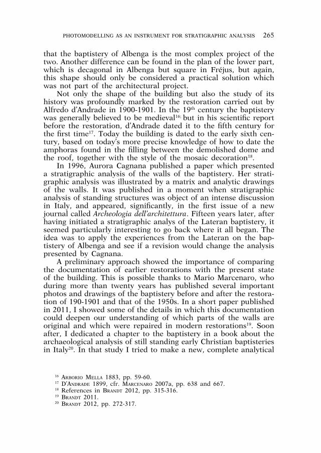
Not only the shape of the building but also the study of its history was profoundly marked by the restoration carried out by Alfredo d’Andrade in 1900-1901. In the 19th century the baptistery was generally believed to be medieval16; but in his scientific report before the restoration, d’Andrade dated it to the fifth century for the first time17. Today the building is dated to the early sixth cen-tury, based on today’s more precise knowledge of how to date the amphoras found in the filling between the demolished dome and the roof, together with the style of the mosaic decoration18.
In 1996, Aurora Cagnana published a paper which presented a stratigraphic analysis of the walls of the baptistery. Her strati-graphic analysis was illustrated by a matrix and analytic drawings of the walls. It was published in a moment when stratigraphic analysis of standing structures was object of an intense discussion in Italy, and appeared, significantly, in the first issue of a new journal called Archeologia dell’architettura. Fifteen years later, after having initiated a stratigraphic analys of the Lateran baptistery, it seemed particularly interesting to go back where it all began. The idea was to apply the experiences from the Lateran on the bap-tistery of Albenga and see if a revision would change the analysis presented by Cagnana.
A preliminary approach showed the importance of comparing the documentation of earlier restorations with the present state of the building. This is possible thanks to Mario Marcenaro, who during more than twenty years has published several important photos and drawings of the baptistery before and after the restora-tion of 190-1901 and that of the 1950s. In a short paper published in 2011, I showed some of the details in which this documentation could deepen our understanding of which parts of the walls are original and which were repaired in modern restorations19. Soon after, I dedicated a chapter to the baptistery in a book about the archaeological analysis of still standing early Christian baptisteries in Italy20. In that study I tried to make a new, complete analytical
16 ARBORIO MELLA 1883, pp. 59-60. 17 D’ANDRADE 1899, cfr. MARCENARO 2007a, pp. 638 and 667.18 References in BRANDT 2012, pp. 315-316.19 BRANDT 2011.20 BRANDT 2012, pp. 272-317.

266 OLOF BRANDT ET ALII PHOTOMODELLING AS AN INSTRUMENT FOR STRATIGRAPHIC ANALYSIS 267
drawing of the walls of the baptistery. But that experiment showed that earlier drawings, plans and sections of the building were not exact enough to provide the necessary basis for detailed analytical drawings. The diffusion of new technologies for 3D documentation made it meaningful to try to create a new, more exact basis for analytical drawings, and also to see whether the 3D documentation in itself could in some way help the stratigraphic analysis. This was the aim of the seminar on the baptistery in Albenga which took place in September and October 2014.
FIELD EXPERIENCES OF CREATING 3D MODELS
The choice of method for 3D documentation depends not only on the quality of the method in itself but on what you want to do. This aim can be a result, an output, a graphical elaboration, often in 2D (plans, sections, shapshots of 3D models, measures), but also something you want to do: a 3D instrument to use in front of the monument, or the possibility to decide later what you want to elaborate. What follows are some field experiences of using 3D photomodelling, also known as “Structure from mo-tion” or “Image-based 3D modelling”, a technology which permits to create 3D models by processing normal digital photos21. The choice of this method instead of laser scanner depended not so much on a technical comparison between photomodelling and laser scanner, but rather on the fact that image-based 3D modelling is easy to use in the field for archaeologists, and, most important of all, some of the elaboration can be done already in the field by the archaeologists themselves, permitting them to use some 3D elaborations in the field as an instrument for analysis. The 3D models were created using Agisoft Photoscan, while Meshlab was used for visualization and further elaboration.
Beginning with the photomodelling, the creation of the 3D models, this field experience showed the importance of covering the entire surface of the object with the photos. Working with buildings, a common problem is that it is necessary to photograph the roof from above, otherwise the model will have a hole where the roof should have been. In this case, we had the opportunity to photograph the baptistery from above from the windows of the upper floors of two surrounding buildings belonging to the diocese (figs. 3, 4). Other possibilities include placing the camera on a
21 Photomodelling has been treated in many publications especially by F. Remondino and S. El-Hakim, for example REMONDINO, EL-HAKIM 2006.

266 OLOF BRANDT ET ALII PHOTOMODELLING AS AN INSTRUMENT FOR STRATIGRAPHIC ANALYSIS 267
Fig. 3 – The upper parts of the baptistery are photographed from north by Federico Caruso from the Archives of the
Diocese of Albenga.
Fig. 4 – The upper parts of the baptistery are photographed from east by Elie Essa Kas Hanna from the Episcopal Palace of Albenga.
268 OLOF BRANDT ET ALII PHOTOMODELLING AS AN INSTRUMENT FOR STRATIGRAPHIC ANALYSIS 269
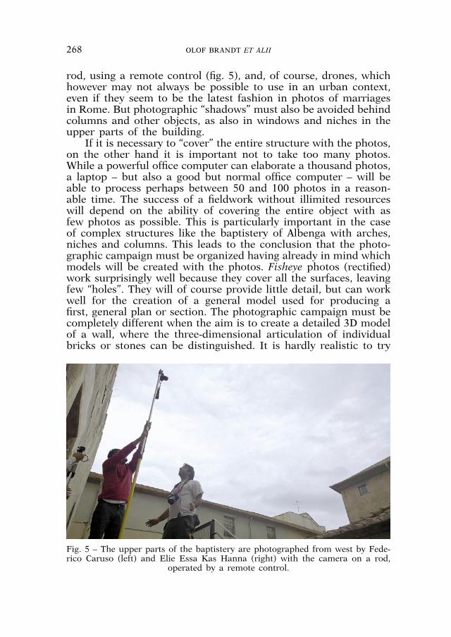
rod, using a remote control (fig. 5), and, of course, drones, which however may not always be possible to use in an urban context, even if they seem to be the latest fashion in photos of marriages in Rome. But photographic “shadows” must also be avoided behind columns and other objects, as also in windows and niches in the upper parts of the building.
If it is necessary to “cover” the entire structure with the photos, on the other hand it is important not to take too many photos. While a powerful office computer can elaborate a thousand photos, a laptop – but also a good but normal office computer – will be able to process perhaps between 50 and 100 photos in a reason-able time. The success of a fieldwork without illimited resources will depend on the ability of covering the entire object with as few photos as possible. This is particularly important in the case of complex structures like the baptistery of Albenga with arches, niches and columns. This leads to the conclusion that the photo-graphic campaign must be organized having already in mind which models will be created with the photos. Fisheye photos (rectified) work surprisingly well because they cover all the surfaces, leaving few “holes”. They will of course provide little detail, but can work well for the creation of a general model used for producing a first, general plan or section. The photographic campaign must be completely different when the aim is to create a detailed 3D model of a wall, where the three-dimensional articulation of individual bricks or stones can be distinguished. It is hardly realistic to try
Fig. 5 – The upper parts of the baptistery are photographed from west by Fede-rico Caruso (left) and Elie Essa Kas Hanna (right) with the camera on a rod,
operated by a remote control.
268 OLOF BRANDT ET ALII PHOTOMODELLING AS AN INSTRUMENT FOR STRATIGRAPHIC ANALYSIS 269
to create one single model of an entire building with that kind of high resolution. Where that kind of detail is needed, it is better to produce separate models of individual walls or parts of the building.
A particular challenge concerns surfaces with little or too re-petitive structure. Anyone who has tried photomodelling knows that the software works well when there is a structure on the surfaces. It is almost impossible to create a good 3D model of a room with white walls. An originally flat surface can become ir-regular like melted ice cream, or, even whorse, the software may be unable to position the photos, leaving holes in the model even in parts which have been covered by the photos. Fortunately, archaeological remains usually provide enough irregularities to provide the necessary structure. But the same problem concerns also brick walls, where the repeated pattern makes it difficult for the software to identify the position of a close-up photo. In this case it can be useful to combine global photos of an entire wall with detailed close-ups.
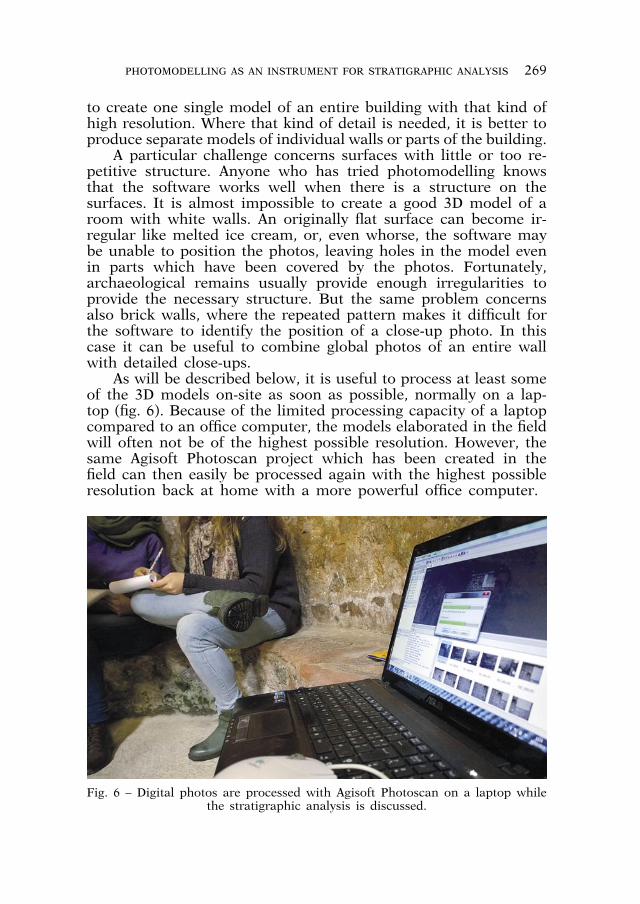
As will be described below, it is useful to process at least some of the 3D models on-site as soon as possible, normally on a lap-top (fig. 6). Because of the limited processing capacity of a laptop compared to an office computer, the models elaborated in the field will often not be of the highest possible resolution. However, the same Agisoft Photoscan project which has been created in the field can then easily be processed again with the highest possible resolution back at home with a more powerful office computer.
Fig. 6 – Digital photos are processed with Agisoft Photoscan on a laptop while the stratigraphic analysis is discussed.

270 OLOF BRANDT ET ALII PHOTOMODELLING AS AN INSTRUMENT FOR STRATIGRAPHIC ANALYSIS 271
It may be more important to elaborate immediately on-site these partial models aimed at stratigraphical analysis, than the general model which is aimed at producing a plan or sections. That model can be processed later because it does not have to be compared to the monument.
FIELD EXPERIENCES OF USING 3D MODELS FOR STRATIGRAPHIC ANALYSIS
A 3D model elaborated in the field can be useful for a pre-liminary on-site stratigraphic analysis. The fundamental challenge of stratigraphic analysis is to distinguish correctly between struc-tures belonging to different periods. It can be surprisingly useful to observe the original walls together with a 3D model of good resolution where it is possible to change the illumination and move the shadows. Differences between different parts of a wall may appear clearer when the shadows created by direct sunlight move in different hours of the day. The same effect can be cre-ated on the 3D model, where the illumination can be moved with the help of a software for visualization like MeshLab (fig. 7). The photographic image and the 3D model may contain different and contradictory information. The wall may show lines which have no three-dimensional reality but are created by water, weathering or variations in the material itself. For this reason it is particularly useful to “turn off” the photographic image of the 3D model, the so-called “texture”, in order to observe only the three-dimensional articulation of the wall without being distracted by features with no three-dimensional articulation. This will be useful only if the three-dimensional model itself, the so-called “mesh”, is detailed enough. It is evident that a 3D model for stratigraphic analysis usually must cover only a limited part of the building, otherwise it will become so heavy that it would be impossible to create, visualize and elaborate with computers existing today.
Observing the 3D model together with the original structure, it will also be possible to understand which further 3D models could be of particular importance for documentation and visualization of particularly complex or important stratigraphic situations, and if it is necessary to take extra photos before leaving the site.
Modern softwares make it possible to abandon completely the two-dimensional step of the creation of a drawing of stratigraphic analysis. When the line which separates different stratigraphic units has been identified on the 3D model, this analysis can easily be drawn directly on the model, while working in front of the build-ing. A practical solution can be to colour the different units with different, transparent colours (fig. 8). This will avoid one of the

270 OLOF BRANDT ET ALII PHOTOMODELLING AS AN INSTRUMENT FOR STRATIGRAPHIC ANALYSIS 271
Fig. 7 – Use of light/shadow in Meshlab to show the three-dimensional articula-tion of a detailed mesh of side L. Elaboration by Federico Caruso.
Fig. 8 – The stratigraphic analysis is expressed already in the field through co-louring the 3D model in Meshlab. Elaboration by Federico Caruso.

272 OLOF BRANDT ET ALII PHOTOMODELLING AS AN INSTRUMENT FOR STRATIGRAPHIC ANALYSIS 273
greatest difficulties when presenting a stratigraphic analysis of a wall: to show exactly where – between which stones or bricks – the separating line has been identified.
The detailed mesh created for stratigraphic analysis will of course be an important instrument also in the later elaboration and analysis, also considering that often it will be possible to elaborate a model of even higher resolution on a stronger office computer. After the fieldwork, problematic areas can be analyzed further comparing high-resolution photos of the walls with the 3D model, visualizing the mesh without the photographic texture. One possibility is to use simultaneously three computers to visualize the mesh without texture on one, detailed photos on another, and, on a third computer, the 3D model with the stratigraphic analy-sis, which can be zoomed in and out in order to understand the position and function of each part of the building in the bigger structural and architectural context.
THE IMPORTANCE OF OLDER PHOTOS FOR THE STRATIGRAPHIC ANALYSIS
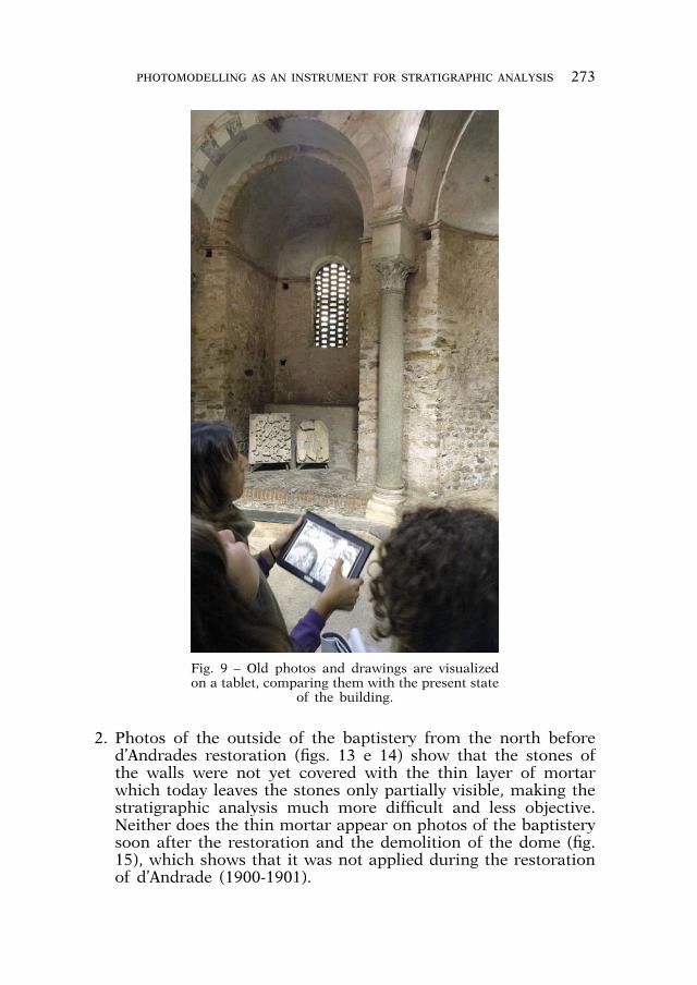
The experience accumulated both in the project on the Lat-eran baptistery and in this more recent work on the baptistery of Albenga shows that the stratigraphic analysis will be much helped by the study of older photos and drawings of the building in dif-ferent periods. Before the field work begins, it is of fundamental importance to make a collection of dated drawings and photos to consult on-site, on paper or on a tablet, where the digital images can be zoomed in and out. Observing this documentation in front of the building will be particularly helpful in order to understand which parts were added or changed in restorations of the last centuries (fig. 9). This helps to establish an initial sequence of termini post/ante quem which helps to avoid unhappy misreadings of the ancient structures.
This can be illustrated by some examples: 1. On the inside of the baptistery, photos of the demolition of the
dome (figs. 10, 11 e 12) help to establish exactly the contour of the reconstructed upper part of the wall. The part which does not exist on the photos must of course have been added later. This had not been taken into account in earlier stratigraphic analyses, based only on the observation of the present state of the building22.
22 CAGNANA 1996, fig. 17; BRANDT 2012, fig. 118.
272 OLOF BRANDT ET ALII PHOTOMODELLING AS AN INSTRUMENT FOR STRATIGRAPHIC ANALYSIS 273
Fig. 9 – Old photos and drawings are visualized on a tablet, comparing them with the present state
of the building.
2. Photos of the outside of the baptistery from the north before d’Andrades restoration (figs. 13 e 14) show that the stones of the walls were not yet covered with the thin layer of mortar which today leaves the stones only partially visible, making the stratigraphic analysis much more difficult and less objective. Neither does the thin mortar appear on photos of the baptistery soon after the restoration and the demolition of the dome (fig. 15), which shows that it was not applied during the restoration of d’Andrade (1900-1901).

274 OLOF BRANDT ET ALII PHOTOMODELLING AS AN INSTRUMENT FOR STRATIGRAPHIC ANALYSIS 275
Fig. 11 – Detail of the inside of the upper part of the drum after the demolition of the
dome (MARCENARO 1993, fig. 276).
Fig. 12 – Part of the inside of the drum after the demolition of the dome (MARCENARO 1993, fig. 274).
Fig. 13 – Photo by Ottavio Germano of the baptistery during the restora-tion in 1900 (MARCENARO 1993, fig.
57).
Fig. 10 – The upper part of the drum after the demolition of the dome (MARCENARO 1993, fig. 275).

274 OLOF BRANDT ET ALII PHOTOMODELLING AS AN INSTRUMENT FOR STRATIGRAPHIC ANALYSIS 275
Fig. 15 – The baptistery from north-east after the demolition of the dome (MAR-CENARO 1993, fig. 277).
Fig. 14 – Photo by Ottavio Germano of the baptistery during the restora-tion in 1900 (MARCENARO 1993, fig.
58).

276 OLOF BRANDT ET ALII PHOTOMODELLING AS AN INSTRUMENT FOR STRATIGRAPHIC ANALYSIS 277
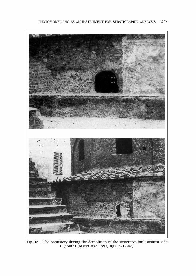
3. On the other hand, a similar layer of mortar was discovered in the 1950s on the south side of the baptistery when later structures built against that wall were demolished (fig. 16). This side is called L in Cagnana’s analysis; we will refer to the sides of the building using the same letters, beginning with A at the side with the modern entrance, and continuing to the left/counterclockwise from A to L. That mortar layer must of course be older than those structures. Perhaps for this reason, 20th century restorers believed that the early Christian baptistery was originally covered on all sides by a similar mortar layer, and re-created it.
The examples 2 and 3 show that the thin mortar layer to the south must have been created several centuries ago, while that to the north was added some time in the 20th century.
Interestingly, a comparison of the photos mentioned in example 2 with the present state of the building shows that some scaffold-ing holes have disappeared in the restoration. This is particularly evident on side C (towards north-west) of the drum (figs. 13, 14, 15, 17) which is easy to identify from the couple of scaffolding holes close to each other in the lower, right part of the wall. In the space contained by the arch above the window, three scaffold-ing holes seem to have been eliminated, two to the left and one to the right of the window. The observation that the structure of the system of scaffolding holes has been modified by 20th century restorations must be taken into account when using scaffolding holes to check the integrity of the ancient wall structure, which I recently have stressed can be a useful help where it is difficult to distinguish the contours of a stratigraphic unit23.
OLOF BRANDT
SOME PRELIMINARY RESULTS ON THE BAPTISTERY OF ALBENGA
Ligurian restoration traditions in Albenga
The history of the restorations of Ligurian monuments between the end of the 19th and the second half of the 20th century is strictly linked to French approaches and ideas. It is very important to remember the importance of the influence of the “stylistic restora-tion” of Eugène Viollet-le-Duc, who believed that only the original parts of the monuments were significant. Consequently, all masonry
23 BRANDT 2011 and 2012.
276 OLOF BRANDT ET ALII PHOTOMODELLING AS AN INSTRUMENT FOR STRATIGRAPHIC ANALYSIS 277
Fig. 16 – The baptistery during the demolition of the structures built against side L (south) (MARCENARO 1993, figs. 341-342).

278 OLOF BRANDT ET ALII PHOTOMODELLING AS AN INSTRUMENT FOR STRATIGRAPHIC ANALYSIS 279
later than the original phase must be removed during the restora-tion (scrostamento)24 in order to bring the monument back to its origin. This approach was the origin of d’Andrade’s works, as he was much closer to the French school than to the Italian one. In the 1880s Camillo Boito, who represented the Italian restoration school, proposed a more cautious vision of the utility of integra-tive restoration, stating that reinforcing, repairing and respecting of the original materials are more important than re-building25. D’Andrade followed the line of the French reconstruction school and demolished the dome of the baptistery, because he dated it to the medieval period; he removed the plasters and changed the closing plates for the windows and entrance. Furthermore, in his work there was a clear tendency to isolate the building, demolish-ing every structure which had been built against it through the centuries, the diradamento postulated by Gustavo Giovannoni26.
The baptistery of Albenga was partially hidden by many sur-rounding buildings (figs. 14, 16). These structures were removed during the restoration in 1900-1901, and the baptistery was iso-lated by a gap around all its sides (except the side H and the
Fig. 17 – Side C (north-west) of the dome in 2014 (photo by Olof Brandt).
24 VLAD BORRELLI 2010, pp. 162-168.25 MANIERI ELIA 2010, pp. 27-28.26 VLAD BORRELLI 2010, pp. 191-193.
278 OLOF BRANDT ET ALII PHOTOMODELLING AS AN INSTRUMENT FOR STRATIGRAPHIC ANALYSIS 279
sides A, L, I at that time still incorporated in the Palazzo della Sottoprefettura).
The history of the conservation of the baptistery at Albenga in the 20th century, after the impressive work of d’Andrade and before that of Nino Lamboglia, is difficult to reconstruct. It is well known that between 1908 and 1933 more works had been projected27, so it is reasonable to think that some other small alterations of the walls occurred, although they are difficult to reconstruct.
The second big event of the 20th century at the baptistery of Albenga was the restorations by Nino Lamboglia between 1948 and 1950. Due to his formation he embraced the same ideals concerning the isolation of the building and the recovery of its original phases.
Lamboglia had closely followed the big restorations of Genoese buildings, where only the Romanic and Gothic phases were pre-ferred, while all other later phases were removed28. In this way, the city gained a new face29. The Superintendence of Genoa used the method of Viollet-le-Duc and d’Andrade to discover the original aspect of every monument.
In addition, we also have to remember how much attention Lamboglia paid to the medieval phases30, which he considered much more important to preserve than all the following antirestauri31. This happened to the Cathedral of Ventimiglia, where he removed the 19th century plasters from the inside and the outside. In the same way, he removed the internal plasters of the Cathedral of Albenga and all its Baroque furniture, in order to reach the original medieval walls with squared stones32.
On the one hand, some of Lamboglia’s actions remain linked to the French restoration experience; on the other hand, he ap-pears to be somehow close to the new theories formulated in Italy towards the middle of the 20th century, in particular concerning the integration of missing parts (“lacunae”). The aim is to recreate a visual continuity through a moderate intervention which however will be easily identifiable. This technique is called sottotono: the
27 MARCENARO 1993, pp. 335-34428 ROTONDI TERMINIELLO 1997-1998, pp. 121-133.29 PITTARELLO 1997-1998, pp. 135-143.30 Lamboglia thought that it was necessary to «far riemergere all’interno la
parte più valida e più integra del monumento, quella romano-gotica del secolo XIII». LAMBOGLIA 1970, p. 90.
31 Antirestauri is the significant title of his column about architectural resto-ration in the Rivista Ingauna e Intemelia.
32 Lamboglia describes his restorations in details in many articles in the Rivista Ingauna e Intemelia.

280 OLOF BRANDT ET ALII PHOTOMODELLING AS AN INSTRUMENT FOR STRATIGRAPHIC ANALYSIS 281
lacuna is filled by new material, which is different but similar in color to the original masonry. In addition, this new filling is slightly shifted back, in order to create a little step between the original wall and the added material.
CHIARA CECALUPO
From 3D model to plan
The application of the photogrammetric method (photomodel-ling) made it possible to produce plans and sections of the baptis-tery of Albenga with immediacy and in a simpler way compared to traditional techniques.
The new plan, which is presented in this paper (fig. 18), is the result of the horizontal section of a 3D scale model produced with Agisoft PhotoScan.
The 3D model was exported as a .ply file for further elabora-tion with the open source software MeshLab. In order to include as much architectural detail as possible, a horizontal section was made at the height of the windows of the monument. The result-ing section was exported as a .dxf file in order to complete the drawing with the software AutoCad.
The plan was georeferenced through the freeware QGis and exported in .pdf and .jpeg formats for maximum readability and usability. The final result shows all its scientific value and gives us detailed information referred to geographical coordinates and measurements, which have essential importance also for further studies of the baptistery.
FEDERICO CARUSO
Considerations on the new plan in the light of the 3D model
The careful analysis of the final plan (fig. 18) made it possible to observe numerous distinctive and characterizing features, which are summarized in the table below. To relate the new plan to pre-vious studies, we have compared it with the plans of De Angelis d’Ossat33 and Gandolfi-Frondoni34 (figs. 19a, 19b). The following measures indicate the distance between opposite façades compared with those documented by the earlier plans.
33 DE ANGELIS D’OSSAT 1936, tav. 1.34 GANDOLFI, FRONDONI 2007, p. 590.

280 OLOF BRANDT ET ALII PHOTOMODELLING AS AN INSTRUMENT FOR STRATIGRAPHIC ANALYSIS 281
Fig
. 18
– N
ew p
lan
of
the
bap
tist
ery
of A
lben
ga p
rod
uce
d b
y M
esh
Lab
.

282 OLOF BRANDT ET ALII PHOTOMODELLING AS AN INSTRUMENT FOR STRATIGRAPHIC ANALYSIS 283
The comparison shows some important variations. It is also possible to observe the perfect correspondence between the distance between the façades A-F and that between C-I. Both couples of façades are separated by 13,38 m. This indicates high precision in the planning of the building.
The georeferenced plan was positioned on a fixed surface over-lapping the two previous plans. The first inconsistency concerns the orientation of the plan of De Angelis d’Ossat which seems incorrect. It was decided, therefore, to correct the error and to place it in such a way as to have the best possible alignment with the new plan. On the other hand, the plan developed by Gandolfi and Frondoni is more similar to the one presented here. Some important differences can be identified in the east portion of the baptistery, where the plans’ overlap reveals a substantial discrep-ancy between 40 cm and 10 cm at the points of maximum and minimum variation. The west side of the monument, however, is characterized by a lesser degree of difference with variations of
Fig. 19a – Overlap between the previous plans and the new one in red (by Cris-tian Aiello).
New Editing Gandolfi-Frondoni De Angelis d’Ossat
A-F 13,38 m. 13,10 m. 13,52 m.
C-I 13,38 m. 13,20 m. 13,50 m.
D\E - L 11,60 m. 11,60 m. 11,20 m.
Fig. 19b – Comparison of the distance between opposite sides of the baptistery on previous plans and on the new plan.
282 OLOF BRANDT ET ALII PHOTOMODELLING AS AN INSTRUMENT FOR STRATIGRAPHIC ANALYSIS 283
less than 10 cm. Another novelty appears from the analysis of the sector of the central niche, the one with the early Christian mosaic. Unlike previous plans, which presented the niche with orthogonal walls, in the new plan the west wall is characterized by a rotation of about 30°.
In conclusion, the new map is more symmetrical and with a more harmonious distribution of space compared to the previous works.
The same technique used in the study of the plan can be used also for the wall stratigraphic analysis, and in particular it was used for the study of the façade towards south called L.
Particular attention was paid to the construction of the mesh, in ultra high definition, to ensure a greater visibility of the discrep-ancies in the different masonry compositions. It proved particu-larly useful for the stratigraphic analysis to use the mesh as an instrument already during the autoptic analysis directly conducted in situ.
Comparing the stratigraphic analysis made by Aurora Cagnana35 with our hypothesis, the most relevant difference concerns the lower part of the façade L, which shows a building technique de-fined by Cagnana as “muratura A”. In her study, she identifies two different stratigraphic units (US) in this lower part of the wall L. The masonry of the lower, right part of the wall, where Cagnana identifies a separate stratigraphic unit, was analyzed specifically with MeshLab with different side lightening, which revealed that the two units identified by Cagnana in the lower, right part, prob-ably should be interpreted as one single unit.
CRISTIAN AIELLO
Façade L
Side L was discovered when Nino Lamboglia demolished those rooms of the Palazzo della Sottoprefettura that leant against the sides A, L and I. Later, he removed the entire Renaissance plaster, which somehow had preserved the ancient masonry (fig. 16).
The following analysis of the masonry of façade L takes into account not only the previous publications, but also a limited number of historical photos that were taken during the restora-tion seasons starting from the beginning of the last century. The identifications of the USM (Masonry Stratigraphic Units) are the fruit of direct observation in the field, touching by hands both the
35 CAGNANA 2001, p. 876, fig. 2 e p. 877, fig. 3.

284 OLOF BRANDT ET ALII PHOTOMODELLING AS AN INSTRUMENT FOR STRATIGRAPHIC ANALYSIS 285
mortar and the stone materials used in the façade. Moreover, the identifications have been confirmed through comparison with the mesh data produced by MeshLab and Agisoft Photoscan.
The analysis has identified the following six different masonries (distinguished by different colours on fig. 20):1. Masonry A in dark red color (opus certum): masonry with a
facing of split blocks with rounded corners, without traces of any kind of working. The stones have a regular size and lay-out, following a horizontal course; 26 courses can easily be distinguished. The entire masonry is made of re-used building materials and is intact. The original binder cannot be identified, because a thick layer of light gray mortar, based on lime and sand, which appears also in the masonry B, covers the greatest part of the courses today. The maximum length of the stones is 20 cm, and the maximum height is 8 cm, while the thickness of the mortar is between 2 and 3 cm. The presence of putlog holes is an indication that this masonry, as masonry B, is the oldest stonework in the baptistery, attributable to the earliest construction phase.
2. Masonry B in yellow: masonry with a facing of cobblestones and ashlars with a flattened surface and slightly elaborated corners. The stones are of varying size and are arranged in a regular manner according to horizontal courses. The entire masonry is made of re-used building materials. The rows are recognizable and 18 rows can be counted. The original binder isn’t identifi-able, because a thick layer of light gray mortar, based on lime and sand, which it appears also on the masonry A., covers the
Fig. 20 – 3D model of façade L (by Federico Caruso).

284 OLOF BRANDT ET ALII PHOTOMODELLING AS AN INSTRUMENT FOR STRATIGRAPHIC ANALYSIS 285
greatest part of the courses today. The maximum length of the stones is 22 cm, and the maximum height is 11 cm, while the thickness of the mortar is between 2 and 4 cm. The presence of putlog holes between masonry A e B is an indication, that these masonries both belong to the oldest stonework in the baptistery, attributable to the first construction phase (late fifth-early sixth century). At the level of the window, putlog holes are absent, while they are visible next to the windows of the other façades. These putlog holes may have been filled in order to prepare a smooth surface for the frescos of the room of the Palazzo della Sottoprefettura.
3. In orange: masonry with a facing of cobblestones, ashlars, marble and well-cut bricks with slightly elaborated corners. The stones have a variable size and are arranged in a regular manner in oblique courses. The entire masonry is made of re-used building materials. The binder appears thin and gray, and is not found on the other walls of this facade. The maximum length of the courses is about 240 cm, while the maximum height is 103 cm. The masonry is attributable to the phase when a sarcophagus was placed at the access of the baptistery, since it appears in the south jamb of the entrance and continues in the adjacent wall (probably eighth century).
4. In violet: polygonal masonry with a facing of ashlars, which present a flattened surface and sharp edges. There are three rows easily recognizable, with horizontal and regular courses. Every single course with its laying surface measures approxi-mately 13 cm. The binder has a dark brown color; it is thicker than that in masonry 3. We couldn’t find this binder in other masonries of the façade L. This masonry looks like masonry 6 of the restoration made by Lamboglia. The maximum length of courses is 150 cm, while the maximum height is 51 cm. It is possible that this was made by Lamboglia as well, consider-ing its position close to the roof, where, as some photos show us, the structure had suffered considerable damages during the demolition of the Palazzo della Sottoprefettura (fig. 21).
5. In green: a filling made of pebbles, bricks and big lithic pieces; some of them show signs of visible roughing. The rows, about 17, are easily identifiable especially in the central part and have a vertical course. The entire masonry is intact; it is made of re-used building materials. The minimum height of each row with its laying surface is 5 cm and the maximum is 22 cm. The original mortar is not visible, because the masonry is covered by a thin mortar layer, probably due to the preparation of the Renaissance fresco, as seen above discussing the masonry B.

286 OLOF BRANDT ET ALII PHOTOMODELLING AS AN INSTRUMENT FOR STRATIGRAPHIC ANALYSIS 287
This filling fills the lower part of the opening of the current window, which was longer than it is nowadays. During the elimination of the Renaissance accretions by Lamboglia, be-tween 1948 and 1950, the situation was found as it is today. Therefore, we can deduce that the intervention of filling is dat-able to an earlier phase than the creation of the Palazzo della Sottoprefettura (15th century). The opening necessarily existed before the fifteenth century. The same filling was found beneath the window of the side E; in this case the filling is covered by the medieval fresco.
6. In violet: a filling made of squared blocks, which show sign of visible roughing and with rounded corners. The rows are 11, in good condition of conservation; they have a regular and vertical course. Each row with its plan of laying measures 11 cm. The maximum length of the courses is 130 cm, while the maximum of height is 118 cm. Two photos taken soon after the removal of the plaster from side L, published by Marcenaro36 (fig. 22), show that Lamboglia found a rather big lacuna under the so-called masonry 5. Therefore, the filling is interpretable as
Fig. 21 – Damages to the lower roof of the baptistery during the demolition of the Palazzo della Sottoprefettura (MARCENARO 1993, fig. 332).
36 MARCENARO 1993, p. 351, nn. 345 e 346.

286 OLOF BRANDT ET ALII PHOTOMODELLING AS AN INSTRUMENT FOR STRATIGRAPHIC ANALYSIS 287
an intervention of the 1950s. The binder is of dark gray color, and is cement-based; it was not found in other parts of the façade.
ELIE ESSA KAS HANNA
Conclusions
To conclude, these are the most important results of our analysis of the history of the reconstructions of the baptistery, specially on façade L:
Lamboglia’s restorations in the 1950s were made with square or polygonal stones with a lighter color tone37 than that of the original stones. Furthermore, the restoration masonries are slightly shifted back to create a little gap. Both are clear examples of what is called a “sottotono” restoration.
37 Federico Caruso noticed that the stones of this filling are similar to those used for the restoration of the inside of the close Cathedral of San Michele.
Fig. 22 – The lacuna of side L filled by Lamboglia in sottotono (MARCENARO 1993, fig. 337).

288 OLOF BRANDT ET ALII PHOTOMODELLING AS AN INSTRUMENT FOR STRATIGRAPHIC ANALYSIS 289
This report stresses the importance of consulting earlier pho-tographic documentation for a correct stratigraphic analysis of standing buildings.
The new stratigraphic analysis of façade L is presented as an analytical drawing made with the software Meshlab on the 3D model (fig. 20).
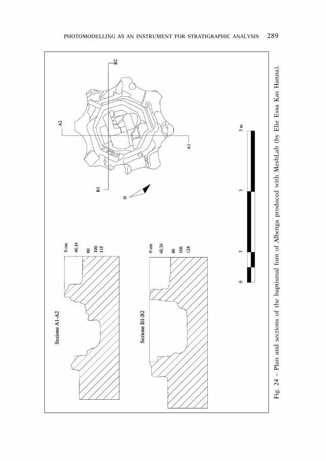
The 3D model of the building was used to produce two sec-tions of the baptismal font of the baptistery of Albenga (figs. 23-24). These are the first sections of the font published after the recent discovery of the original, lower early Christian bottom38. The sections represent the two floors: the oldest lies 34 cm below the most recent one.
In future campaigns, it would be useful to try to identify ex-actly when all putlog holes of the upper part of the building were closed, as some of those clearly present in a photograph of 1900 (fig. 14)39 are no longer visible.
In the lower part of the baptistery, the reconstructions of the windows have been studied by Aurora Cagnana40. A closer analysis
Fig. 23 – Plan and Mesh models of the baptismal font of Albenga produced with MeshLab (by Elie Essa Kas Hanna).
38 GANDOLFI, MARCENARO 2008.39 MARCENARO 1993, p. 110, foto n. 58.40 CAGNANA 1996, pp. 91-99.
288 OLOF BRANDT ET ALII PHOTOMODELLING AS AN INSTRUMENT FOR STRATIGRAPHIC ANALYSIS 289
Fig
. 24
– P
lan
an
d s
ecti
ons
of t
he
bap
tism
al f
ont
of A
lben
ga p
rod
uce
d w
ith
Mes
hL
ab (
by
Eli
e E
ssa
Kas
Han
na)
.

290 OLOF BRANDT ET ALII PHOTOMODELLING AS AN INSTRUMENT FOR STRATIGRAPHIC ANALYSIS 291
of the windows of the drum in the upper part of the building could lead to some progress. Its wall surfaces are covered by an invasive white mortar that does not allow to distinguish the differences between the various blocks. This makes it difficult to understand if there are parts of the masonry made in the 20th century related to the new roof made by D’Andrade. It is particularly essential to investigate the fact that the windows of the drum on the north-ern sides are longer in the photo mentioned above (fig. 14)41. The windows of the drum must have been partially reduced at a date which is still uncertain.
ELIE ESSA KAS HANNA
CHIARA CECALUPO
41 MARCENARO 1993, p. 110; this was noticed also in CAGNANA 1996, p. 93, note 24.

290 OLOF BRANDT ET ALII PHOTOMODELLING AS AN INSTRUMENT FOR STRATIGRAPHIC ANALYSIS 291
BIBLIOGRAPHY
APPETECCHIA et alii 2013 = A. APPETECCHIA, O. BRANDT, G. GARDELIN, H. MENANDER, H. THORÉN, Archaeological Building Documentation. New Methods for Building Archaeological Documentation and Analysis Process. Report of Work 2012. UV rapport 2013:106 (pdf report on the web site of Riksantikvarieämbetet).
ARBORIO MELLA 1883 = E. ARBORIO MELLA, Battisteri di Agrate-Conturbia e di Al-benga, in Atti della Società di Archeologia e Belle Arti per la Provincia di To-rino, 4 (1883), pp. 53-60.
BRANDT 2011= O. BRANDT, L’enigmatica muratura “B” del battistero di Albenga, in Marmoribus vestita. Miscellanea in onore di Federico Guidobaldi, Città del Vaticano 2011, pp. 263-286.
BRANDT 2012 = O. BRANDT, Battisteri oltre la pianta. Gli alzati di nove battisteri pa-leocristiani in Italia, Città del Vaticano 2012.
BRANDT, GUIDOBALDI 2008= O. BRANDT, F. GUIDOBALDI, Il Battistero Lateranense. Nuo-ve interpretazioni delle fasi strutturali, in RACr, 84 (2008), pp. 189-282.
CAGNANA 1996 = A. CAGNANA, Il battistero di Albenga nella storia degli studi: I pro-blemi ancora aperti, in T. MANNONI, A. CAGNANA, Archeologia dei monumenti. L’analisi stratigrafica del battistero paleocristiano di Albenga (SV), in Archeo-logia dell’Architettura, 1 (1996), pp. 83-100, part. pp. 85-100.
CAGNANA 2001 = A. CAGNANA, Lettura stratigrafica e analisi delle tecniche mura-rie del battistero paleocristiano di Albenga, in L’edificio battesimale in Italia. Aspetti e problemi. Atti dell’VIII Congresso Nazionale di Archeologia Cristiana. Genova, Sarzana, Albenga, Finale Ligure, Ventimiglia 21-26 settembre 1998, Bordighera 2001, pp. 875-886.
D’ANDRADE 1899 = A. D’ANDRADE, Relazione dell’Ufficio regionale per la Conservazio-ne dei Monumenti del Piemonte e della Liguria, Torino 1899.
DAVIES 1987 = Martin DAVIES, The archaeology of standing structures, in Austra-lian Journal of Historical Archaeology, 5 (1987), pp. 54-64.
DE ANGELIS D’OSSAT 1936 = G. DE ANGELIS D’OSSAT, I Battisteri di Albenga e Venti-miglia, in Bollettino della R. Deputazione di Storia Patria per la Liguria - Se-zione Ingauna e Intemelia, II, 2, 28 gennaio 1936, pp. 206-250.
FIXOT 2012 = M. FIXOT (ed.), Le groupe épiscopal de Fréjus, Turnhout 2012.
GALLINA 2012 = D. GALLINA, Sillogismo deduttivo o abduzione? Alcune proposte per l’abbandono/superamento del matrix di Harris nell’analisi dell’architettura, in F. REDI, A. FORGIONE (ed.), VI Congresso Nazionale di Archeologia Medievale, L’Aquila, 12-15 settembre 2012, Firenze 2012, pp. 75-81.
GANDOLFI, FRONDONI 2007 = D. GANDOLFI, A. FRONDONI, Recenti indagini archeolo-giche nel battistero “monumentale” di Albenga. Note di scavo, in M. MARCE-NARO (ed.), Albenga città episcopale. Tempi e dinamiche della cristianizzazio-ne tra Liguria di ponente e Provenza. Convegno internazionale e Tavola Ro-tonda. Albenga, Palazzo Vescovile: Sala degli Stemmi e Sala degli Arazzi 21-23 settembre 2006), Genova-Albenga 2007, pp. 555-598.
GANDOLFI, MARCENARO 2008 = D. GANDOLFI, M. MARCENARO, Albenga, battistero “mo-numentale”: una nuova scoperta, in Temporis signa, 3 (2008), pp. 199-202.

292 OLOF BRANDT ET ALII PHOTOMODELLING AS AN INSTRUMENT FOR STRATIGRAPHIC ANALYSIS 293
HARRIS 1979 = E. HARRIS, Principles of Archaeological Stratigraphy, London 1979.
KRAUTHEIMER 1937 = R. KRAUTHEIMER, Corpus basilicarum christianarum Romae. Le basiliche paleocristiane di Roma (IV-IX sec.) vol. 1, Città del Vaticano 1937.
LAMBOGLIA 1970 = N. LAMBOGLIA, I monumenti medievali della Liguria di Ponente, Torino 1970.
MANIERI ELIA 2010 = G. MANIERI ELIA, Metodo e tecniche del restauro architettonico, Roma 2010.
MARCENARO 1987a = M. MARCENARO, Battistero di Albenga: storia di un restauro, in RStLig, 53 (1987), pp. 1-4, pp. 179-242.
MARCENARO 1987b = M. MARCENARO, Alfredo d’Andrade e il mosaico del battistero di Albenga: un restauro scientifico del primo Novecento, in RACr, 63 (1987), pp. 203-243.
MARCENARO 1993 = M. MARCENARO, Il battistero paleocristiano di Albenga. Le origini del cristianesimo nella Liguria marittima, Genova 1993.
MARCENARO 2007a = M. MARCENARO, Il battistero di Albenga: tutela, ricerca e restauro tra Otto e Novecento, in MARCENARO 2007, pp. 637-674.
MARCENARO 2007 = M. MARCENARO (ed.), Albenga città episcopale. Tempi e dinami-che della cristianizzazione tra Liguria di Ponente e Provenza. Atti del convegno internazionale (Alberga 21-23 settembre 2006), Genova-Albenga 2007.
PARENTI 1985 = R. PARENTI, La lettura stratigrafica delle murature in contesti ar-cheologici e di restauro architettonico, in Restauro e Città, 1, 2 (1985), pp. 55-68.
PERGOLA 2011 = Ph. PERGOLA, Aux origines d’un sanctuaire de martyr de de deux monastères entre réalités archéologiques et échafaudages théoriques. La cas de saint Calocerus à Albenga (Ligurie) et à Civate (Lombardie, in O. BRANDT, Ph. PERGOLA (ed.), Marmoribus vestita. Miscellanea in onore di Federico Guidobal-di, Città del Vaticano 2011, pp. 1089-1131.
PITTARELLO 1997-1998 = L. PITTARELLO, Nino Lamboglia restauratore: appunti ed in-dirizzi di ricerca, in RStLig, 63-64 (1997-1998), pp. 135-143.
REMONDINO, EL-HAKIM 2006 = F. REMONDINO, S. EL-HAKIM, Image-based 3D model-ling; a review, in Photogrammetric Record, 21 (115) (September 2006), pp. 269-291.
ROTONDI TERMINIELLO 1997-1998 = G. ROTONDI TERMINIELLO, Lamboglia e i beni ar-tistici: risultati di una “cura sistematica”, in RStLig, 63-64 (1997-1998), pp. 121-134.
SPADEA NOVIERO, PERGOLA, ROASCIO 2010 = G. SPADEA NOVIERO, Ph. PERGOLA, S. ROASCIO (ed.), Albenga - Un antico spazio cristiano. Chiesa e monastero di San Calocero al Monte - Un complesso archeologico dal I d.C. al XVI secolo, Genova 2010.
VLAD BORRELLI 2010 = L. VLAD BORRELLI, Conservazione e restauro delle antichità, Roma 2010.
VON WILMOWSKY 1874 = N. VON WILMOWSKY, Der Dom zu Trier in seinen drei Haupt-perioden: der römischen, der frankischen, der romanischen, Trier 1874.

292 OLOF BRANDT ET ALII PHOTOMODELLING AS AN INSTRUMENT FOR STRATIGRAPHIC ANALYSIS 293
Riassunto
L’uso del metodo di fotomodellazione (“structure from motion” ecc.) per il rilievo del battistero paleocristiano di Albenga ha, da una parte, dimostrato l’uti-lità per l’analisi stratigrafica di un alzato di poter produrre, consultare e riela-borare il rilievo 3D direttamente sul sito da parte degli archeologi senza dover affidare il lavoro di rilievo a tecnici esterni. D’altra parte, il rilievo ha permesso di evidenziare errori piuttosto importanti nelle piante del battistero pubblicate precedentemente. Il riesame dell’analisi stratigrafica ha permesso di fare molte precisazioni soprattutto riguardo agli interventi di restauro nel XX secolo, e ha evidenziato l’importanza delle foto d’epoca per una corretta analisi stratigrafica dell’alzato di un edificio.
Abstract
The use of photomodelling (“Structure from Motion” etc) for documenta-tion of the early Christian baptistery of Albenga has, on the one hand, shown how useful it is for the stratigraphic analysis of a standing building when the archaeologists themselves can produce, consult and elaborate the 3D documen-tation already on the site without having to leave that task to others. On the other hand, the 3D documentation reveals important errors in previously pub-lished plans of the baptistery. The new examination of the stratigraphic analy-sis has made it possible to understand better the restoration works in the 20th century. It has also demonstrated the importance of older photos for a correct stratigraphic analysis of a standing building.