Metal Water Contamination Sources And Drilling Artesian In Common And Zagnanado And Zogbodomey...
15
Gilbert T. LALEYE Int. J. Biol. Sci. RESEARCH PAPER Metal Water Con Artesian In Commo Gilbert Tite. LALÈYÊ 1* ; Patrick EDO 1 École Doctorale Pluridisciplinaire "E Sciences Humaines/Université d’Abom Courriel : [email protected] 2 Laboratoire de recherche en Biochimie Biologie Cellulaire, Faculté de Science e Courriel: [email protected] 3 Laboratoire Pierre Pagney – Climat Lettres, Arts et Sciences Humaines/ Courriel : [email protected] 4 Institut National de l’Eau- Labor Agronomiques, Université d’Abomey- Ca Dynamic Network for Research Works DNetRW © 2015 http://www.dnetrw.com International Journal of Biological Sci ISSN: 2313-37 http://www.d Vol. 02, No. 03, P. OPEN ntamination Sources And Dril on And Zagnanado And Zogbo Center Of Benin ORH 2 ; Christophe S. HOUSSOU 3 ; Euloge K. I. AGBO Espaces, Cultures et Développement", Faculté des Lettre mey-Calavi (UAC) 04 BP 848 Cotonou-Benin : cell 229 9 e et en Toxicologie de l’Environnement, Département de et Technique, Université d’Abomey- Calavi, 03 BP 0994 C t-Eau-Ecosystèmes-Développement Durable (LACEED /Université d’Abomey-Calavi(UAC) / BP 1338 Abom ratoire d’Hydraulique et de Maîtrise de l’Eau Facu alavi-Bénin Page | 1 2015 iences (IJBS) 740 (Online) dnetrw.com . 01-15, 2015 N ACCESS lling odomey OSSOU 4 es, Arts et 97 53 00 04 Biochimie et de Cotonou - Bénin DE) Faculté des mey-Calavi-Benin. ulté des Sciences
-
Upload
independent -
Category
Documents
-
view
5 -
download
0
Transcript of Metal Water Contamination Sources And Drilling Artesian In Common And Zagnanado And Zogbodomey...
Gilbert T. LALEYE
Int. J. Biol. Sci.
RESEARCH PAPER
Metal Water Contamination Sources And Drilling Artesian In Common And Zagnanado
Gilbert Tite. LALÈYÊ1*; Patrick EDORH
1 École Doctorale Pluridisciplinaire "Espaces, Cultures et Développement", Faculté des Lettres, Arts et Sciences Humaines/Université d’AbomeyCourriel : [email protected]
2 Laboratoire de recherche en Biochimie et en Toxicologie de l’Environnement, Département de Biochimie et de
Biologie Cellulaire, Faculté de Science et Technique, Université d’Abomey
Courriel: [email protected]
3 Laboratoire Pierre Pagney – ClimatLettres, Arts et Sciences Humaines/Université d’AbomeyCourriel : [email protected]
4 Institut National de l’Eau- Laboratoire Agronomiques, Université d’Abomey- Calavi
Dynamic Network for Research Works
DNetRW © 2015 http://www.dnetrw.com
International Journal of Biological Sciences (IJBS)
ISSN: 2313-3740 http://www.dnetrw.com
Vol. 02, No. 03, P.
OPEN ACCESS
Metal Water Contamination Sources And Drilling tesian In Common And Zagnanado And Zogbodomey
Center Of Benin
Patrick EDORH2; Christophe S. HOUSSOU3 ; Euloge K. I. AGBOSSOU
École Doctorale Pluridisciplinaire "Espaces, Cultures et Développement", Faculté des Lettres, Arts et d’Abomey-Calavi (UAC) 04 BP 848 Cotonou-Benin : cell 229 97 53 00 04
Laboratoire de recherche en Biochimie et en Toxicologie de l’Environnement, Département de Biochimie et de
Biologie Cellulaire, Faculté de Science et Technique, Université d’Abomey- Calavi, 03 BP 0994 Cotonou
Climat-Eau-Ecosystèmes-Développement Durable (LACEEDE)Lettres, Arts et Sciences Humaines/Université d’Abomey-Calavi(UAC) / BP 1338 Abomey
Laboratoire d’Hydraulique et de Maîtrise de l’Eau Faculté des Sciences
Calavi-Bénin
P a g e | 1
2015
International Journal of Biological Sciences (IJBS)
3740 (Online) http://www.dnetrw.com
. 01-15, 2015
OPEN ACCESS
Metal Water Contamination Sources And Drilling Zogbodomey
; Euloge K. I. AGBOSSOU4
École Doctorale Pluridisciplinaire "Espaces, Cultures et Développement", Faculté des Lettres, Arts et Benin : cell 229 97 53 00 04
Laboratoire de recherche en Biochimie et en Toxicologie de l’Environnement, Département de Biochimie et de
Calavi, 03 BP 0994 Cotonou - Bénin
Durable (LACEEDE) Faculté des BP 1338 Abomey-Calavi-Benin.
Faculté des Sciences
Gilbert T. LALEYE P a g e | 2
Int. J. Biol. Sci. 2015
DNetRW © 2015 http://www.dnetrw.com
Abstract In natural aquatic ecosystems, the metals are found in low concentrations, usually in the nanogram or
microgram per liter. The decision to review the data on water sources and artesian wells comes from the
need to adopt a holistic approach that can draw future strategies of struggle. To analyze the determinants
of this metal pollution three heavy metals were analyzed in overburden drilling artesian springs and then
in cotton fields in areas where the water points are located. The levels of three heavy metals found in the
lands of sources and boreholes blankets are above the values obtained in the cotton fields. The objective of
this study was to evaluate metal contamination of water sources and artesian wells in the Commons
Zagnanado Zogbodomey and related craft activities, agricultural and domestic developed in the region.
Three heavy metals Cd, Hg, and Pb - were assayed in the waters (07) and artesian springs (05) artesian
wells. Only the mercury levels among the three heavy metals is high in the rainy season in the waters (02)
holes. The presence of heavy metal contaminants at concentrations above natural fillers, has become an
issue of increasing concern. It must attribute the rapid population growth, increased urbanization, the
expansion of industrial activities, exploration and exploitation of natural resources, expansion of irrigation
and the spread of other modern farming practices and that the absence of environmental regulations. The
openings created by the tectonic and mechanical stresses (fractures, cracks and faults) are specifically
conducive to the charging process, particularly when it comes flush structures. While highlighting
lineaments in the study area by fracturing card, allows us to interpret the presence of mercury in the rainy
season in the waters of these wells by infiltration of stormwater.
Corresponding Author’s Email: [email protected]
Gilbert T. LALEYE P a g e | 3
Int. J. Biol. Sci. 2015
DNetRW © 2015 http://www.dnetrw.com
INTRODUCTION Inherent in the development of human activities, potential sources of groundwater pollution have increased during the last century (Danielpol et al., 2003; Datry, 2003). Heavy metals, especially Lead, Zinc and Copper, are part of pollution incidents representing a major environmental problem. They can migrate into groundwater, accumulate in the food chain and pose risks to human health (Jourdan et al., 2005). Anthropogenic sources of metallic substances emissions are multiple, and are mainly due to the intensification of urban, agricultural or industrial. These intensive activities generate high concentrations of heavy metals (Cu, Zn, Pb, Cd) and organic pollutants in the soil which may then be accumulated by the plant (Gremion 2003). In urban areas, waste generation and disposal mode is one of the activities which also produce large amounts of metal pollutants. Most components of municipal waste containing heavy metals such as batteries (Hg, Zn, Pb, Cd), paints (Cr, Cd, Pb), plastics (Cd, Ni), cardboard paper (Pb) etc. . (De Miguel, 2001; Aloueimine, 2006). Urban development activities of cities and road networks are also a potential source of heavy metals, especially cadmium, chromium, copper, nickel, lead and zinc (Pagotto, 1999). The generated pollution is found either in the road pavement runoff (Mikkelsen et al., 1996; Colandini, 1997; Barbosa and Hvitved-Jacobsen, 1999) or in the form of airborne dust (Lagerwerff and Specht, 1970; Angelone et al., 1999; February, 2001). Generally, the majority of metal contaminants which may reach the groundwater passing through the soil. In this passage, they can undergo bio-physical-chemical transformations, that have the effect either to immobilize or delay, or promote their solubilization and transport by seepage (February 2001). This study aims to evaluate the metal contamination of groundwater in the region and Zagnanado Zogbodomey in relation to domestic and
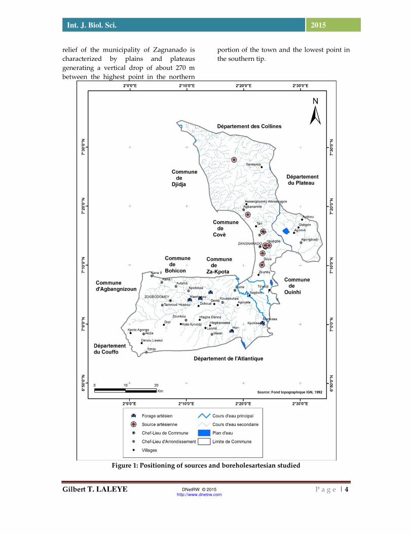
craft activities well developed in the region. Three heavy metals, Cd, Hg, and Pb were measured in waters (07) and artesian springs (05) artesian wells. To analyze the determinants of this metal pollution these three heavy metals were also analyzed in the overburden of these sources and artesian wells and in the cotton fields in the locality where the water points are located. The monitoring was conducted during two sampling campaigns (dry season and rainy season). The levels of heavy metals analyzed revealed the existence of a causal relationship between human activities at the sites studied and degrees of contamination recorded. The openings created by the tectonic and mechanical stresses (fractures, cracks and faults) are specifically conducive to the charging process, particularly when it comes flush structures. In this study, we use satellite images to map the outlines area and Zogbodomey Zagnanado. The methodology developed in this part will increase and extract the structural lineaments identical from satellite images. While highlighting lineaments in the study area by fracturing card, allows us to interpret the presence of mercury in the rainy season in the waters of these wells by infiltration of stormwater. I - THE STUDY FRAMEWORK As part of the study consists of Commons Zagnanado and Zogbodomey BENIN is between 6 ° 56 '30' 7 ° North latitude and 2 ° 05 'and 2 ° East longitude and 25'de covers an area of 1575 km² (IGN, 1992). (Figure 1). Le relief de la commune de Zogbodomey est caractérisé par une plaine et un plateau qui couvre les 3/5 de la superficie de la commune, avec un dénivelé d’environ 137 m entre le point le plus haut situé dans la portion nord de la commune et le point le plus bas sur la pointe Sud-est (PAGEFCOM, 2012). This plateau is situated north of the Lama depression whose average altitude is 50 m and width ranging from 5 km west 25 km to the east (BEARD L.1993). Thus, the slopes are generally are less than 5%. The
Gilbert T. LALEYE P a g e | 4
Int. J. Biol. Sci. 2015
DNetRW © 2015 http://www.dnetrw.com
relief of the municipality of Zagnanado is characterized by plains and plateaus generating a vertical drop of about 270 m between the highest point in the northern
portion of the town and the lowest point in the southern tip.
Figure 1: Positioning of sources and boreholesartesian studied
Gilbert T. LALEYE P a g e | 5
Int. J. Biol. Sci. 2015
DNetRW © 2015 http://www.dnetrw.com
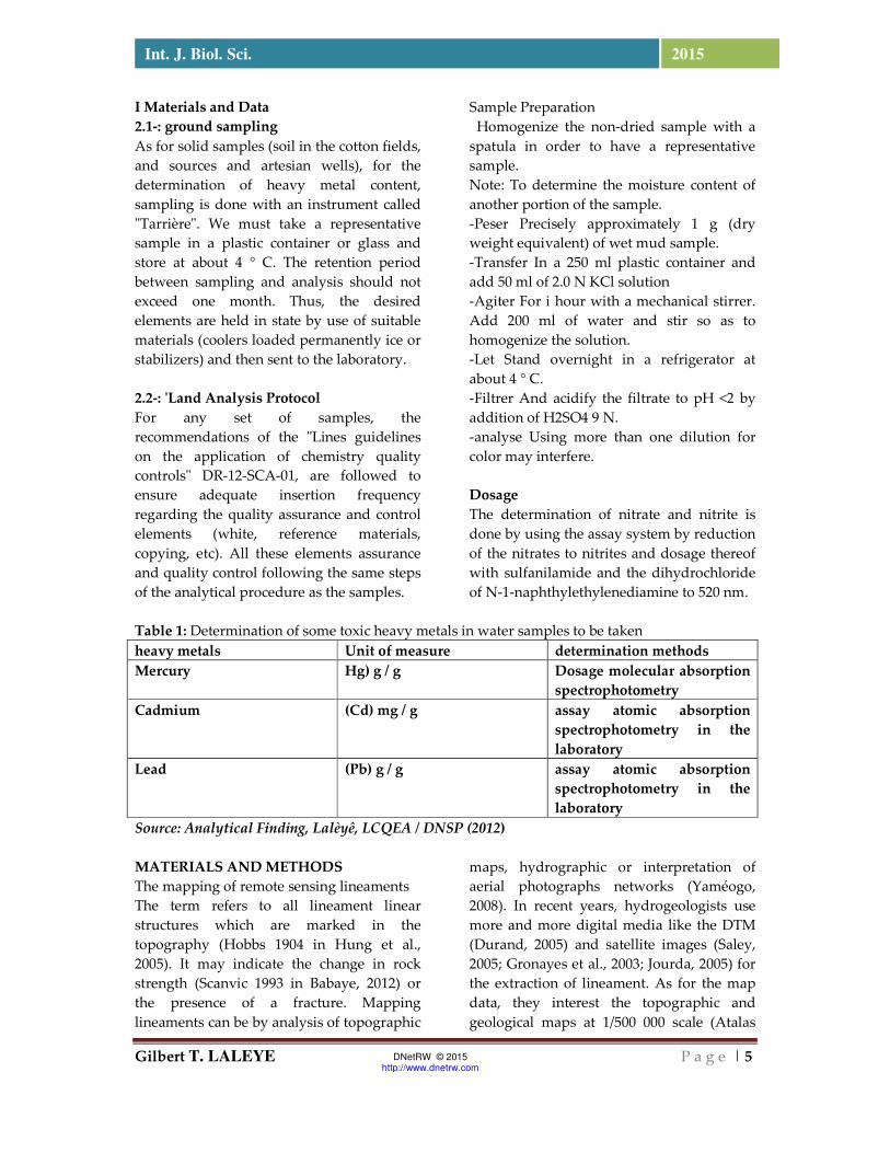
I Materials and Data 2.1-: ground sampling As for solid samples (soil in the cotton fields, and sources and artesian wells), for the determination of heavy metal content, sampling is done with an instrument called "Tarrière". We must take a representative sample in a plastic container or glass and store at about 4 ° C. The retention period between sampling and analysis should not exceed one month. Thus, the desired elements are held in state by use of suitable materials (coolers loaded permanently ice or stabilizers) and then sent to the laboratory. 2.2-: 'Land Analysis Protocol For any set of samples, the recommendations of the "Lines guidelines on the application of chemistry quality controls" DR-12-SCA-01, are followed to ensure adequate insertion frequency regarding the quality assurance and control elements (white, reference materials, copying, etc). All these elements assurance and quality control following the same steps of the analytical procedure as the samples.
Sample Preparation Homogenize the non-dried sample with a spatula in order to have a representative sample. Note: To determine the moisture content of another portion of the sample. -Peser Precisely approximately 1 g (dry weight equivalent) of wet mud sample. -Transfer In a 250 ml plastic container and add 50 ml of 2.0 N KCl solution -Agiter For i hour with a mechanical stirrer. Add 200 ml of water and stir so as to homogenize the solution. -Let Stand overnight in a refrigerator at about 4 ° C. -Filtrer And acidify the filtrate to pH <2 by addition of H2SO4 9 N. -analyse Using more than one dilution for color may interfere. Dosage The determination of nitrate and nitrite is done by using the assay system by reduction of the nitrates to nitrites and dosage thereof with sulfanilamide and the dihydrochloride of N-1-naphthylethylenediamine to 520 nm.
Table 1: Determination of some toxic heavy metals in water samples to be taken heavy metals Unit of measure determination methods Mercury Hg) g / g Dosage molecular absorption
spectrophotometry Cadmium (Cd) mg / g assay atomic absorption
spectrophotometry in the laboratory
Lead (Pb) g / g assay atomic absorption spectrophotometry in the laboratory
Source: Analytical Finding, Lalèyê, LCQEA / DNSP (2012) MATERIALS AND METHODS The mapping of remote sensing lineaments The term refers to all lineament linear structures which are marked in the topography (Hobbs 1904 in Hung et al., 2005). It may indicate the change in rock strength (Scanvic 1993 in Babaye, 2012) or the presence of a fracture. Mapping lineaments can be by analysis of topographic
maps, hydrographic or interpretation of aerial photographs networks (Yaméogo, 2008). In recent years, hydrogeologists use more and more digital media like the DTM (Durand, 2005) and satellite images (Saley, 2005; Gronayes et al., 2003; Jourda, 2005) for the extraction of lineament. As for the map data, they interest the topographic and geological maps at 1/500 000 scale (Atalas
Gilbert T. LALEYE P a g e | 6
Int. J. Biol. Sci. 2015
DNetRW © 2015 http://www.dnetrw.com
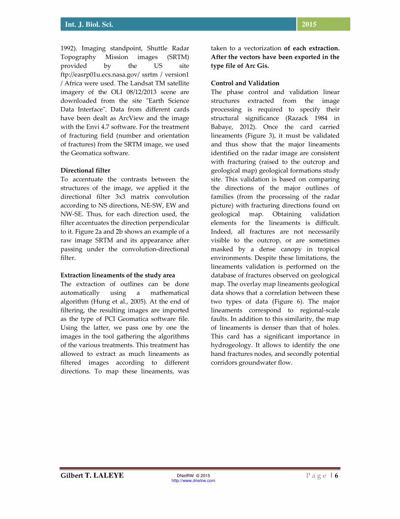
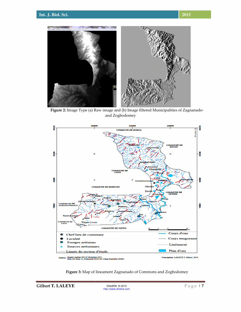
1992). Imaging standpoint, Shuttle Radar Topography Mission images (SRTM) provided by the US site ftp://easrp01u.ecs.nasa.gov/ ssrtm / version1 / Africa were used. The Landsat TM satellite imagery of the OLI 08/12/2013 scene are downloaded from the site "Earth Science Data Interface". Data from different cards have been dealt as ArcView and the image with the Envi 4.7 software. For the treatment of fracturing field (number and orientation of fractures) from the SRTM image, we used the Geomatica software. Directional filter To accentuate the contrasts between the structures of the image, we applied it the directional filter 3x3 matrix convolution according to NS directions, NE-SW, EW and NW-SE. Thus, for each direction used, the filter accentuates the direction perpendicular to it. Figure 2a and 2b shows an example of a raw image SRTM and its appearance after passing under the convolution-directional filter. Extraction lineaments of the study area The extraction of outlines can be done automatically using a mathematical algorithm (Hung et al., 2005). At the end of filtering, the resulting images are imported as the type of PCI Geomatica software file. Using the latter, we pass one by one the images in the tool gathering the algorithms of the various treatments. This treatment has allowed to extract as much lineaments as filtered images according to different directions. To map these lineaments, was
taken to a vectorization of each extraction. After the vectors have been exported in the type file of Arc Gis. Control and Validation The phase control and validation linear structures extracted from the image processing is required to specify their structural significance (Razack 1984 in Babaye, 2012). Once the card carried lineaments (Figure 3), it must be validated and thus show that the major lineaments identified on the radar image are consistent with fracturing (raised to the outcrop and geological map) geological formations study site. This validation is based on comparing the directions of the major outlines of families (from the processing of the radar picture) with fracturing directions found on geological map. Obtaining validation elements for the lineaments is difficult. Indeed, all fractures are not necessarily visible to the outcrop, or are sometimes masked by a dense canopy in tropical environments. Despite these limitations, the lineaments validation is performed on the database of fractures observed on geological map. The overlay map lineaments geological data shows that a correlation between these two types of data (Figure 6). The major lineaments correspond to regional-scale faults. In addition to this similarity, the map of lineaments is denser than that of holes. This card has a significant importance in hydrogeology. It allows to identify the one hand fractures nodes, and secondly potential corridors groundwater flow.
Gilbert T. LALEYE
Int. J. Biol. Sci.
Figure 2: Image Type (a) Raw image and (b) Image filtered Municipalities of Zagnanado
Figure 3: Map of lineament Zagnanado of Commons and Zogbodomey
DNetRW © 2015 http://www.dnetrw.com
Image Type (a) Raw image and (b) Image filtered Municipalities of Zagnanado
and Zogbodomey
Map of lineament Zagnanado of Commons and Zogbodomey
P a g e | 7
2015
Image Type (a) Raw image and (b) Image filtered Municipalities of Zagnanado-
Map of lineament Zagnanado of Commons and Zogbodomey
Gilbert T. LALEYE P a g e | 8
Int. J. Biol. Sci. 2015
DNetRW © 2015 http://www.dnetrw.com
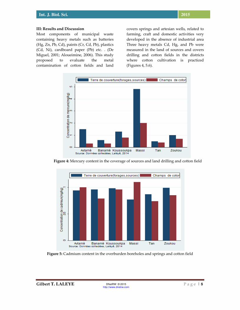
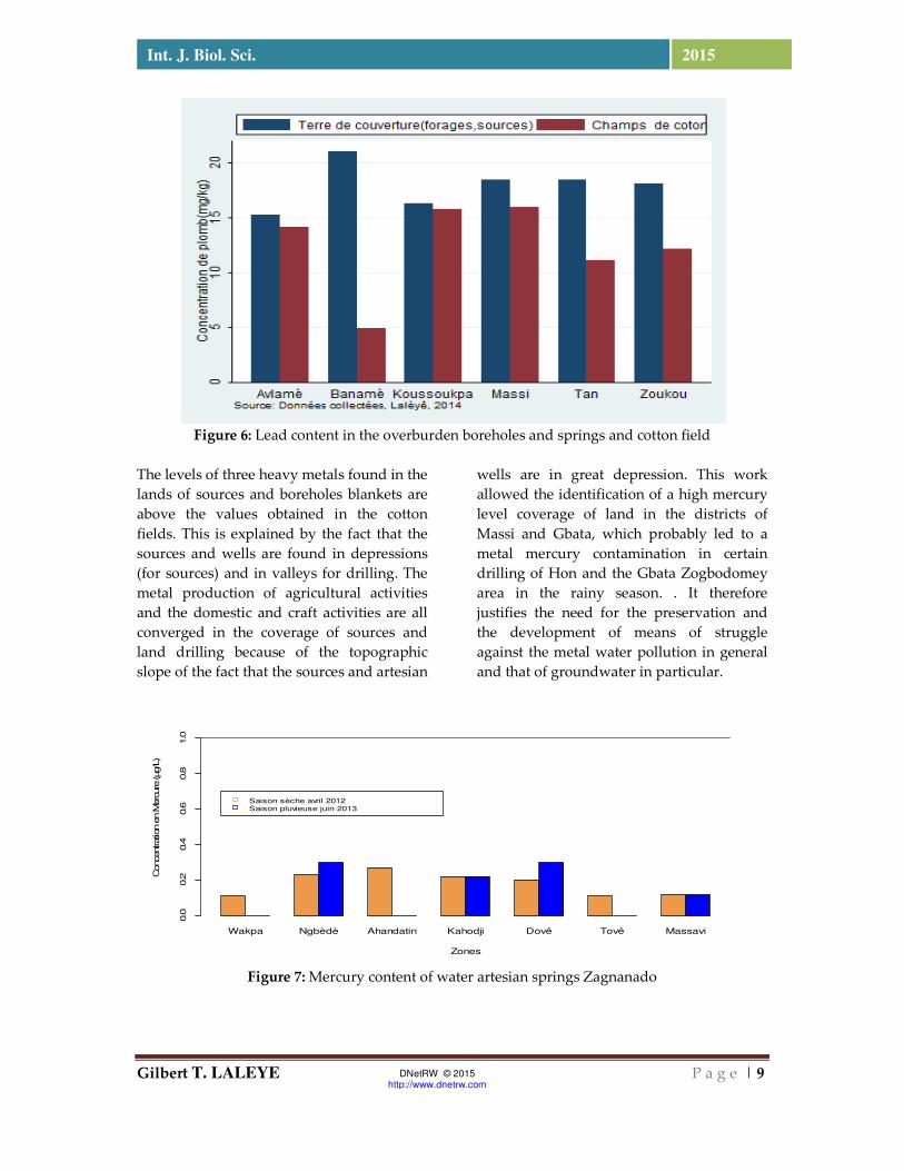
III: Results and Discussion Most components of municipal waste containing heavy metals such as batteries (Hg, Zn, Pb, Cd), paints (Cr, Cd, Pb), plastics (Cd, Ni), cardboard paper (Pb) etc. . (De Miguel, 2001; Aloueimine, 2006). This study proposed to evaluate the metal contamination of cotton fields and land
covers springs and artesian wells, related to farming, craft and domestic activities very developed in the absence of industrial area Three heavy metals Cd, Hg, and Pb were measured in the land of sources and covers drilling and cotton fields in the districts where cotton cultivation is practiced (Figures 4, 5.6).
Figure 4: Mercury content in the coverage of sources and land drilling and cotton field
Figure 5: Cadmium content in the overburden boreholes and springs and cotton field
Gilbert T. LALEYE P a g e | 9
Int. J. Biol. Sci. 2015
DNetRW © 2015 http://www.dnetrw.com
Figure 6: Lead content in the overburden boreholes and springs and cotton field
The levels of three heavy metals found in the lands of sources and boreholes blankets are above the values obtained in the cotton fields. This is explained by the fact that the sources and wells are found in depressions (for sources) and in valleys for drilling. The metal production of agricultural activities and the domestic and craft activities are all converged in the coverage of sources and land drilling because of the topographic slope of the fact that the sources and artesian
wells are in great depression. This work allowed the identification of a high mercury level coverage of land in the districts of Massi and Gbata, which probably led to a metal mercury contamination in certain drilling of Hon and the Gbata Zogbodomey area in the rainy season. . It therefore justifies the need for the preservation and the development of means of struggle against the metal water pollution in general and that of groundwater in particular.
Figure 7: Mercury content of water artesian springs Zagnanado
Wakpa Ngbèdè Ahandatin Kahodji Dovê Tovê Massavi
Zones
Concentration e
n M
erc
ure
(µg/L
)
0.0
0.2
0.4
0.6
0.8
1.0
Saison sèche avril 2012Saison pluvieuse juin 2013
Gilbert T. LALEYE P a g e | 10
Int. J. Biol. Sci. 2015
DNetRW © 2015 http://www.dnetrw.com
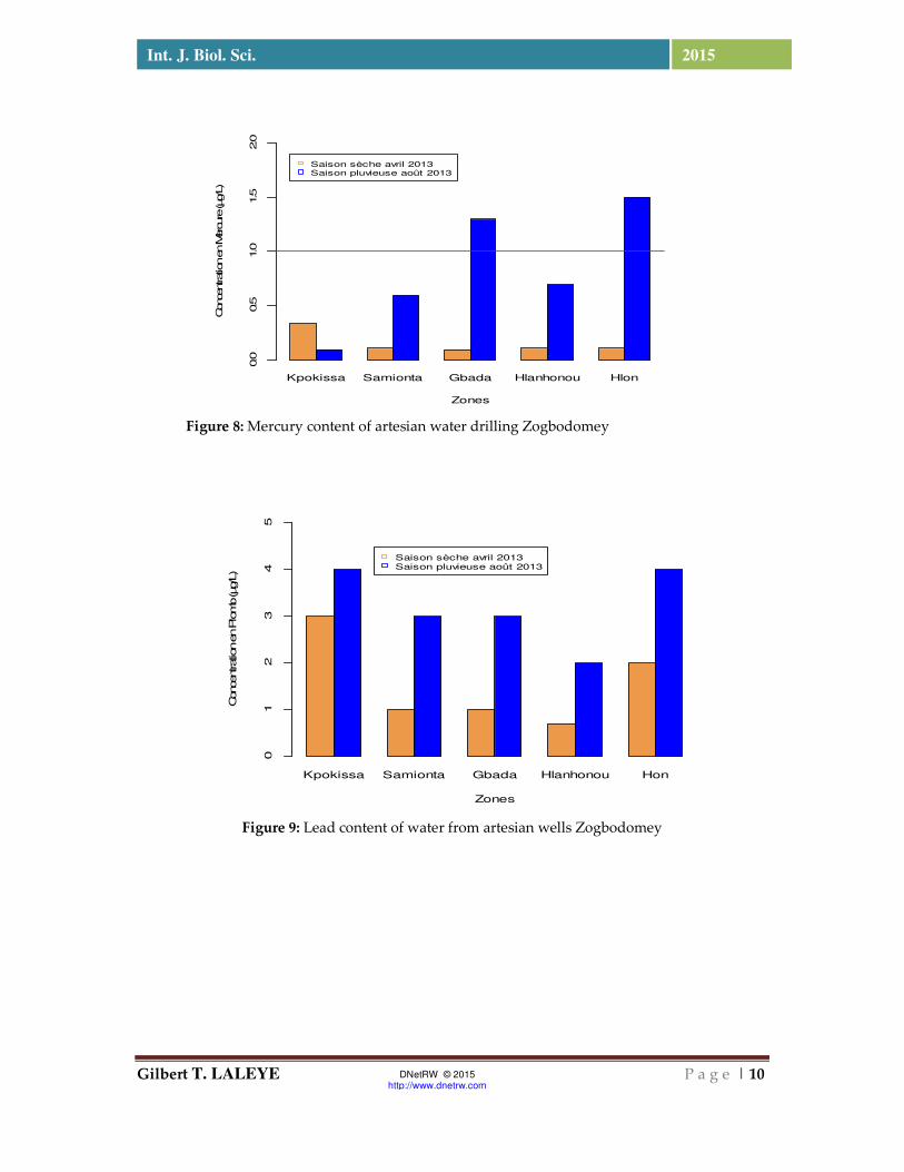
Figure 8: Mercury content of artesian water drilling Zogbodomey
Figure 9: Lead content of water from artesian wells Zogbodomey
Kpokissa Samionta Gbada Hlanhonou Hlon
Zones
Concentration en M
ercure
(µg/L)
0.0
0.5
1.0
1.5
2.0
Saison sèche avril 2013Saison pluvieuse août 2013
Kpokissa Samionta Gbada Hlanhonou Hon
Zones
Concentration en P
lomb (µg/L)
01
23
45
Saison sèche avril 2013Saison pluvieuse août 2013
Gilbert T. LALEYE P a g e | 11
Int. J. Biol. Sci. 2015
DNetRW © 2015 http://www.dnetrw.com
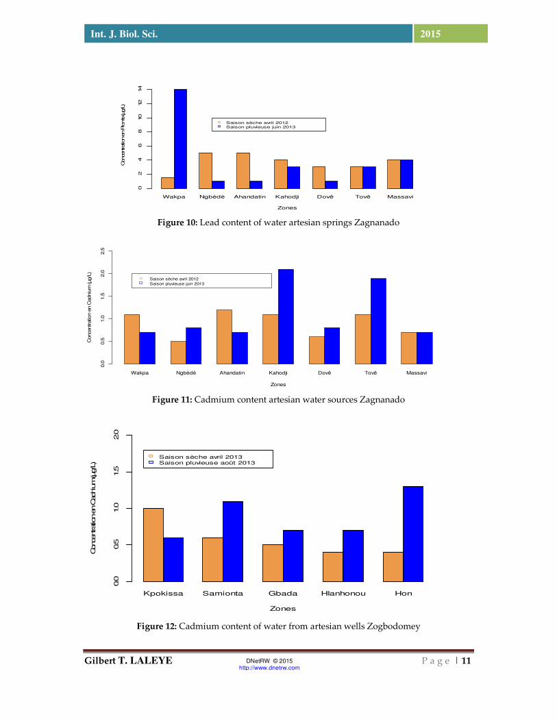
Figure 10: Lead content of water artesian springs Zagnanado
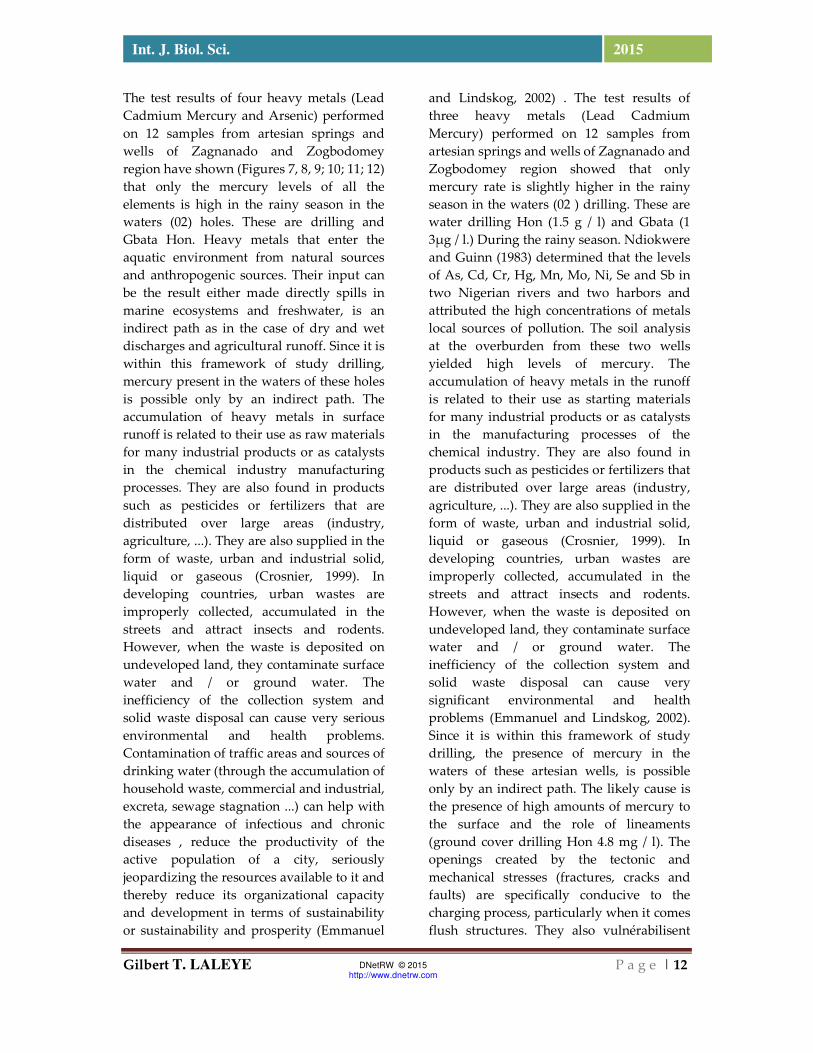
Figure 11: Cadmium content artesian water sources Zagnanado
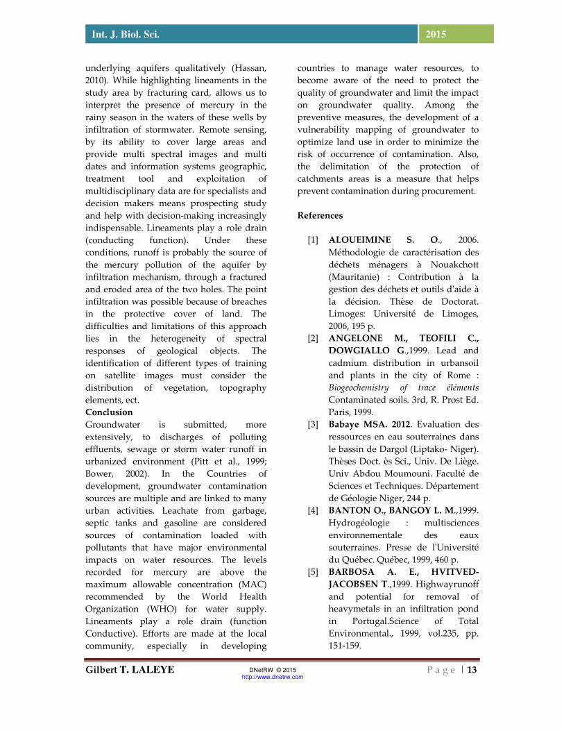
Figure 12: Cadmium content of water from artesian wells Zogbodomey
Wakpa Ngbèdè Ahandatin Kahodji Dovê Tovê Massavi
Zones
Concentration en P
lomb (µg/L)
02
46
810
12
14
Saison sèche avril 2012Saison pluvieuse juin 2013
Wakpa Ngbèdè Ahandatin Kahodji Dovê Tovê Massavi
Zones
Concentration e
n C
adniu
m (µg/L
)
0.0
0.5
1.0
1.5
2.0
2.5
Saison sèche avril 2012
Saison pluvieuse juin 2013
Kpokissa Samionta Gbada Hlanhonou Hon
Zones
Concentration en C
adnium (µg/L)
0.0
0.5
1.0
1.5
2.0
Saison sèche avril 2013Saison pluvieuse août 2013
Gilbert T. LALEYE P a g e | 12
Int. J. Biol. Sci. 2015
DNetRW © 2015 http://www.dnetrw.com
The test results of four heavy metals (Lead Cadmium Mercury and Arsenic) performed on 12 samples from artesian springs and wells of Zagnanado and Zogbodomey region have shown (Figures 7, 8, 9; 10; 11; 12) that only the mercury levels of all the elements is high in the rainy season in the waters (02) holes. These are drilling and Gbata Hon. Heavy metals that enter the aquatic environment from natural sources and anthropogenic sources. Their input can be the result either made directly spills in marine ecosystems and freshwater, is an indirect path as in the case of dry and wet discharges and agricultural runoff. Since it is within this framework of study drilling, mercury present in the waters of these holes is possible only by an indirect path. The accumulation of heavy metals in surface runoff is related to their use as raw materials for many industrial products or as catalysts in the chemical industry manufacturing processes. They are also found in products such as pesticides or fertilizers that are distributed over large areas (industry, agriculture, ...). They are also supplied in the form of waste, urban and industrial solid, liquid or gaseous (Crosnier, 1999). In developing countries, urban wastes are improperly collected, accumulated in the streets and attract insects and rodents. However, when the waste is deposited on undeveloped land, they contaminate surface water and / or ground water. The inefficiency of the collection system and solid waste disposal can cause very serious environmental and health problems. Contamination of traffic areas and sources of drinking water (through the accumulation of household waste, commercial and industrial, excreta, sewage stagnation ...) can help with the appearance of infectious and chronic diseases , reduce the productivity of the active population of a city, seriously jeopardizing the resources available to it and thereby reduce its organizational capacity and development in terms of sustainability or sustainability and prosperity (Emmanuel
and Lindskog, 2002) . The test results of three heavy metals (Lead Cadmium Mercury) performed on 12 samples from artesian springs and wells of Zagnanado and Zogbodomey region showed that only mercury rate is slightly higher in the rainy season in the waters (02 ) drilling. These are water drilling Hon (1.5 g / l) and Gbata (1 3μg / l.) During the rainy season. Ndiokwere and Guinn (1983) determined that the levels of As, Cd, Cr, Hg, Mn, Mo, Ni, Se and Sb in two Nigerian rivers and two harbors and attributed the high concentrations of metals local sources of pollution. The soil analysis at the overburden from these two wells yielded high levels of mercury. The accumulation of heavy metals in the runoff is related to their use as starting materials for many industrial products or as catalysts in the manufacturing processes of the chemical industry. They are also found in products such as pesticides or fertilizers that are distributed over large areas (industry, agriculture, ...). They are also supplied in the form of waste, urban and industrial solid, liquid or gaseous (Crosnier, 1999). In developing countries, urban wastes are improperly collected, accumulated in the streets and attract insects and rodents. However, when the waste is deposited on undeveloped land, they contaminate surface water and / or ground water. The inefficiency of the collection system and solid waste disposal can cause very significant environmental and health problems (Emmanuel and Lindskog, 2002). Since it is within this framework of study drilling, the presence of mercury in the waters of these artesian wells, is possible only by an indirect path. The likely cause is the presence of high amounts of mercury to the surface and the role of lineaments (ground cover drilling Hon 4.8 mg / l). The openings created by the tectonic and mechanical stresses (fractures, cracks and faults) are specifically conducive to the charging process, particularly when it comes flush structures. They also vulnérabilisent
Gilbert T. LALEYE P a g e | 13
Int. J. Biol. Sci. 2015
DNetRW © 2015 http://www.dnetrw.com
underlying aquifers qualitatively (Hassan, 2010). While highlighting lineaments in the study area by fracturing card, allows us to interpret the presence of mercury in the rainy season in the waters of these wells by infiltration of stormwater. Remote sensing, by its ability to cover large areas and provide multi spectral images and multi dates and information systems geographic, treatment tool and exploitation of multidisciplinary data are for specialists and decision makers means prospecting study and help with decision-making increasingly indispensable. Lineaments play a role drain (conducting function). Under these conditions, runoff is probably the source of the mercury pollution of the aquifer by infiltration mechanism, through a fractured and eroded area of the two holes. The point infiltration was possible because of breaches in the protective cover of land. The difficulties and limitations of this approach lies in the heterogeneity of spectral responses of geological objects. The identification of different types of training on satellite images must consider the distribution of vegetation, topography elements, ect. Conclusion Groundwater is submitted, more extensively, to discharges of polluting effluents, sewage or storm water runoff in urbanized environment (Pitt et al., 1999; Bower, 2002). In the Countries of development, groundwater contamination sources are multiple and are linked to many urban activities. Leachate from garbage, septic tanks and gasoline are considered sources of contamination loaded with pollutants that have major environmental impacts on water resources. The levels recorded for mercury are above the maximum allowable concentration (MAC) recommended by the World Health Organization (WHO) for water supply. Lineaments play a role drain (function Conductive). Efforts are made at the local community, especially in developing
countries to manage water resources, to become aware of the need to protect the quality of groundwater and limit the impact on groundwater quality. Among the preventive measures, the development of a vulnerability mapping of groundwater to optimize land use in order to minimize the risk of occurrence of contamination. Also, the delimitation of the protection of catchments areas is a measure that helps prevent contamination during procurement. References
[1] ALOUEIMINE S. O., 2006. Méthodologie de caractérisation des déchets ménagers à Nouakchott (Mauritanie) : Contribution à la gestion des déchets et outils d'aide à la décision. Thèse de Doctorat. Limoges: Université de Limoges, 2006, 195 p.
[2] ANGELONE M., TEOFILI C., DOWGIALLO G.,1999. Lead and cadmium distribution in urbansoil and plants in the city of Rome : Biogeochemistry of trace éléments
Contaminated soils. 3rd, R. Prost Ed. Paris, 1999.
[3] Babaye MSA. 2012. Evaluation des ressources en eau souterraines dans le bassin de Dargol (Liptako- Niger). Thèses Doct. ès Sci., Univ. De Liège. Univ Abdou Moumouni. Faculté de Sciences et Techniques. Département de Géologie Niger, 244 p.
[4] BANTON O., BANGOY L. M.,1999. Hydrogéologie : multisciences environnementale des eaux souterraines. Presse de l'Université du Québec. Québec, 1999, 460 p.
[5] BARBOSA A. E., HVITVED-JACOBSEN T.,1999. Highwayrunoff and potential for removal of heavymetals in an infiltration pond in Portugal.Science of Total Environmental., 1999, vol.235, pp. 151-159.
Gilbert T. LALEYE P a g e | 14
Int. J. Biol. Sci. 2015
DNetRW © 2015 http://www.dnetrw.com
[6] BOWER H., 2002. Artificial recharge of groundwater : Hydrogeology and engineering. Hydrogeology Journal, 2002, vol.10, pp. 121-142.
[7] CROSNIER J.,1999. Devenir de la pollution métallique drainée par les eaux pluviales Influence du compartiment microbien et des alternances de dessiccation/ réhumectation sur le transfert du zinc dans la zone non saturée du sol. Thèse de Doctorat. Lyon: Université Claude Bernard, 1999, 282 p.
[8] DANIELPOL D., GRIEBLER C., GUNATILAKA A., NOTENBOOM J.,2003 Present state and future prospect for groundwaterecosystems.Environnemental Conservation, 2003, vol.30, n° 2, pp. 0-27.
[9] DATRY T., 2003. Urbanisation et qualité des nappes phréatiques - Réponses des écosystèmes aquatiques souterrains aux pratiques d'infiltration d'eau pluviale. Thèse de Doctorat. Lyon: Université Claude Bernard - Lyon I, 2003, 221 p.
[10] DE MIQUEL G., 2001. Rapport sur les métaux lourds et leurs effets sur l'environnement et la santé. Paris: Sénat, 2001, 365 p.
[11] Durand., 2005. Recherche multidisciplinaire pour caractériser deux aquifères fracturés : les eaux minérales de Plancoët en contexte métamorphique, et de Quezac en milieu carbonaté : Thèse Univ. Université Paris- Pierre et Marie Curie,255p.
[12] FÉVRIER L., 2001. Transfert d'un
mélange Zn-Cd-Pb dans un dépôt fluvio-glaciaire carbonaté. Approche en colonnes de Laboratoire. Thèse de Doctorat. Lyon: INSA de Lyon, 2001, 312 p.
[13] GREMION F., 2003. Analysis of microbialcommunity structures and
functions in heavymetal-contaminedsoilsusingmolecularmethods. Thèse de Doctorat. Lausanne: Ecole Polytechnique Fédérale de Lausanne, 2003, 122 p.
[14] Gronayes CC, Koffi BP, Kouamé FK, Brou BK. 2003. Identification de couloirs de cisaillement à partir de l’imagerie tm de landsat : Application à l’Archéen de Blolequi (ouest de la Côte d’Ivoire).Télédétection, 3(2-3-4):217-226.
[15] Hung LQ, Batelaan O, De Smedt F.
2005. Lineament extraction and analysis, comparision of LANDSAT ETM and ASTER imagerry. Case Study ; suoimuoi tropical Karst catchment, Vietnam. Proc. of SPIE, 5983: 1-12.
[16] JOURDAN B., PIANTONE P., LEROUGE C., GUYONNET D., 2005. Atténuation des métaux à l'aval de sites de stockage de déchets - Synthèse bibliographique. BRGM, 2005, 110 p.
[17] Jourda JPP. 2005. Méthodologie d’application des techniques de télédétection et des systèmes d’information géographique à l’étude des aquifères fissurés d’Afrique de l’ouest. Concept de l’hydrotechnique spatiale : cas des zones tests de la Côte d’Ivoire. Thèse de Doctorat d’état, Univ, Cocody, 403 p.
[18] LAGERWERFF J. V., SPECHT A. W., 1970. Contamination of roadsidesoil and vegetationwith cadmium, nickel, lead and zinc.Environmental Science and Technology, 1970, vol.4, n° 7, pp. 583-586.
[19] MIKKELSEN P. S., HÄFLIGER M., OCHS M., TJELL J. C., JACOBSEN P., BOLLER M. 1996.Experimentalassessment of soil
Gilbert T. LALEYE P a g e | 15
Int. J. Biol. Sci. 2015
DNetRW © 2015 http://www.dnetrw.com
and groundwater contamination fromtwoold infiltration systems for road run-off in Switzerland. Science of the total environment, 1996, vol.189/190, pp. 341-347.
[20] Ministère de l’Environnement, de l’Habitat et de l’Urbanisme., 2012. Projet d’Appui à la Gestion des Forêts Communales (PAGEFCOM) Commune de Zagnanado,Tecsult International Limitée ,49p.
[21] PAGOTTO C., 1999. Etude sur l'émission et le transfert dans les eaux et les sols les éléments traces métalliques et des hydrocarbures en domaine routier. Thèse de Doctorat. Poitier: Université de Poitier, 1999, 252 p.
[22] PITT R., CLARK S., FIELD R., 1999. Groundwater contamination potentialfromstormwater infiltration practices. Urban Water, 1999, vol.1, n° 3, pp. 217-236.
[23] Saley MB, Kouamé FK, Penven MJ, Biémi J, Boyossoro KH. 2005. Cartographie des zones à risque d’inondation dans la région semi- montagneuse à l’ouest de la Côte d’Ivoire : apports des MNA et del’imagerie satellitaire. Télédétection, 5(1- 2-3):53-67.
[24] Scanvic JY. 1993. Utilisation de la
télédétection dans les sciences de la terre. Manuels et méthodes, BRGM, Orléans, 284 p.
[25] Razack M. 1984. Application de méthodes numériques et statistiques à l’identification des réservoirs fissurés carbonatés en hydrogéologie. Thèses Doct. ès Sci., Univ. Languedoc, 384 p.
[26] Yaméogo OS. 2008. Ressources en eau souterraine du centre urbain de Ouagadougou au Burkina Faso, qualité et vulnérabilité ; Univ. Avignon et pays de Vaucluse, Univ. Ouagadougou, 245 p.