Mapping Israel/Palestine: Constructing National Territories across Different Online International...
22
Bulletin du Centre de recherche français à Jérusalem 23 (2012) ................................................................................................................................................................................................................................................................................................ Christine Leuenberger Mapping Israel/Palestine Constructing National Territories across Different Online International Newspapers ................................................................................................................................................................................................................................................................................................ Avertissement Le contenu de ce site relève de la législation française sur la propriété intellectuelle et est la propriété exclusive de l'éditeur. Les œuvres figurant sur ce site peuvent être consultées et reproduites sur un support papier ou numérique sous réserve qu'elles soient strictement réservées à un usage soit personnel, soit scientifique ou pédagogique excluant toute exploitation commerciale. La reproduction devra obligatoirement mentionner l'éditeur, le nom de la revue, l'auteur et la référence du document. Toute autre reproduction est interdite sauf accord préalable de l'éditeur, en dehors des cas prévus par la législation en vigueur en France. Revues.org est un portail de revues en sciences humaines et sociales développé par le Cléo, Centre pour l'édition électronique ouverte (CNRS, EHESS, UP, UAPV). ................................................................................................................................................................................................................................................................................................ Référence électronique Christine Leuenberger, « Mapping Israel/Palestine », Bulletin du Centre de recherche français à Jérusalem [En ligne], 23 | 2012, mis en ligne le 20 janvier 2013, Consulté le 15 avril 2013. URL : http://bcrfj.revues.org/6859 Éditeur : Centre de recherche français à Jérusalem http://bcrfj.revues.org http://www.revues.org Document accessible en ligne sur : http://bcrfj.revues.org/6859 Document généré automatiquement le 15 avril 2013. © Bulletin du Centre de recherche français à Jérusalem
Transcript of Mapping Israel/Palestine: Constructing National Territories across Different Online International...
Bulletin du Centre derecherche français àJérusalem23 (2012)
................................................................................................................................................................................................................................................................................................
Christine Leuenberger
Mapping Israel/PalestineConstructing National Territories across DifferentOnline International Newspapers................................................................................................................................................................................................................................................................................................
AvertissementLe contenu de ce site relève de la législation française sur la propriété intellectuelle et est la propriété exclusive del'éditeur.Les œuvres figurant sur ce site peuvent être consultées et reproduites sur un support papier ou numérique sousréserve qu'elles soient strictement réservées à un usage soit personnel, soit scientifique ou pédagogique excluanttoute exploitation commerciale. La reproduction devra obligatoirement mentionner l'éditeur, le nom de la revue,l'auteur et la référence du document.Toute autre reproduction est interdite sauf accord préalable de l'éditeur, en dehors des cas prévus par la législationen vigueur en France.
Revues.org est un portail de revues en sciences humaines et sociales développé par le Cléo, Centre pour l'éditionélectronique ouverte (CNRS, EHESS, UP, UAPV).
................................................................................................................................................................................................................................................................................................
Référence électroniqueChristine Leuenberger, « Mapping Israel/Palestine », Bulletin du Centre de recherche français à Jérusalem [En ligne],23 | 2012, mis en ligne le 20 janvier 2013, Consulté le 15 avril 2013. URL : http://bcrfj.revues.org/6859
Éditeur : Centre de recherche français à Jérusalemhttp://bcrfj.revues.orghttp://www.revues.org
Document accessible en ligne sur :http://bcrfj.revues.org/6859Document généré automatiquement le 15 avril 2013.© Bulletin du Centre de recherche français à Jérusalem
Mapping Israel/Palestine 2
Bulletin du Centre de recherche français à Jérusalem, 23 | 2012
Christine Leuenberger
Mapping Israel/PalestineConstructing National Territories across Different Online InternationalNewspapersAcknowledgments: I am grateful to the Fulbright Scholar Program for the Middle East, NorthAfrica, Central and South Asia Regional Research Program (grantee number G48413539)and the National Science Foundation (award number 1152322) for research support. I amparticularly thankful to Jérôme Bourdon for his encouragement to write this paper. I amalso grateful to Simone Tosoni, Trevor Pinch, George Lowery, and Eitan Alimi for helpfulcomments and suggestions.
Mapping Israel/Palestine1 Since the Iraq war in 2003, we are more aware than ever of the role the media can play in
conflict situations. Journalists embedded with American troops advancing on Baghdad wereaccused of bias, propaganda, and for taking on the invaders’/liberators’ perspective. At thesame time, Iraqi victims dematerialized on American TV screens as they were neither seen norheard. They had become enemy targets envisioned only through high-tech lenses (Gusterson1991; Warburg 2003).
2 One of the most polarizing debates is how the media covers the Israeli-Palestinian conflict.Palestinian as well as Israeli protagonists maintain that the media is explicitly either pro-Israelor pro-Palestinian. Pro-Palestinian sources argue that news stories tend to be explicitly pro-Israeli as they eliminate Palestinian accounts, rationales, and concerns. Pro-Israeli groups andlobbyists, on the other hand, complain about anti-Israeli and anti-Semitic views expressed inthe media1. With the increasing use of graphics and maps in newspapers, protagonists have alsosuggested that certain news outlets chose certain maps and map layers deliberately in orderto further particular political positions. For these critics, there is a direct and pre-determinedlink between map-choice and politics2.
3 Underlying these critiques is the assumption that journalists are like scientists followingscientific methods. Their stories are to be objective, value-free, verifiable, and the product ofdisinterested observers. They also should embody what neoclassical economics call ‘homoeconomicus’, people acting independently and rationally, based on a maximum level ofinformation available. Science Studies has long dispelled the myth of the rule-followingand disinterested scientist, and even economists have largely buried ‘homo economicus’ soas to better understand economic action in the social world. Why then do we still expectjournalists to provide that impossible birds-eye view of contentious political events? Thephilosopher Jacques Derrida pointed out that one cannot stand on higher, more neutral groundand gaze objectively at the social world. On the contrary, we are always on the inside andthus “reporting from no perspective at all” is untenable (Zelizer, 2002). ‘Bias’ therefore isinevitably part of all reporting. This is not due to a reporters’ deliberate distortion of news,but rather stories are always selective. They omit as much as they include. Indeed, accordingto constructivist approaches in Media Studies, news stories are selective as they unavoidablyprovide an interpretative frame by which to understand events. Stories are thus framed andpackaged in ways that are tied to broader cultural developments and they are sustained bysets of institutions, networks, resources and power politics (Alimi 2006; Gamson et. al. 1989;Ryan et. al. 2006; Wolfsfeeld et. al. 2008).
4 Arguably such a constructivist approach to Media Studies in conjunction with insights from theSociology of Knowledge, Science Studies, Critical Cartography and Cultural Studies provideuseful conceptual tools to think about map-making as news making within its context ofproduction (Black 1997; Crampton et. al. 2006; Crampton 2009; Gamson et. al. 1989; Hall1997; Jasanoff 2004; Leuenberger et. al. 2010; Monmonier 1989; Monmonier 2006; VanLeeuwen 2001; Wood et. al. 2008). Accordingly, map-making, like the scientific endeavor,
Mapping Israel/Palestine 3
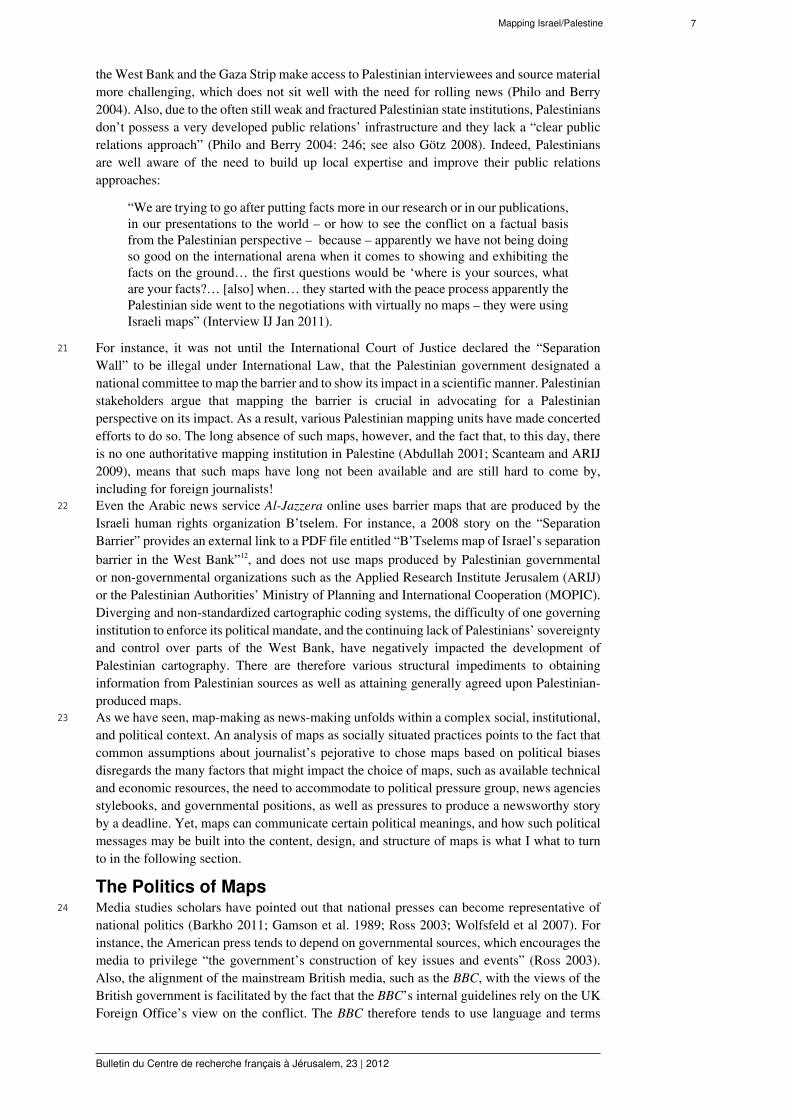
Bulletin du Centre de recherche français à Jérusalem, 23 | 2012
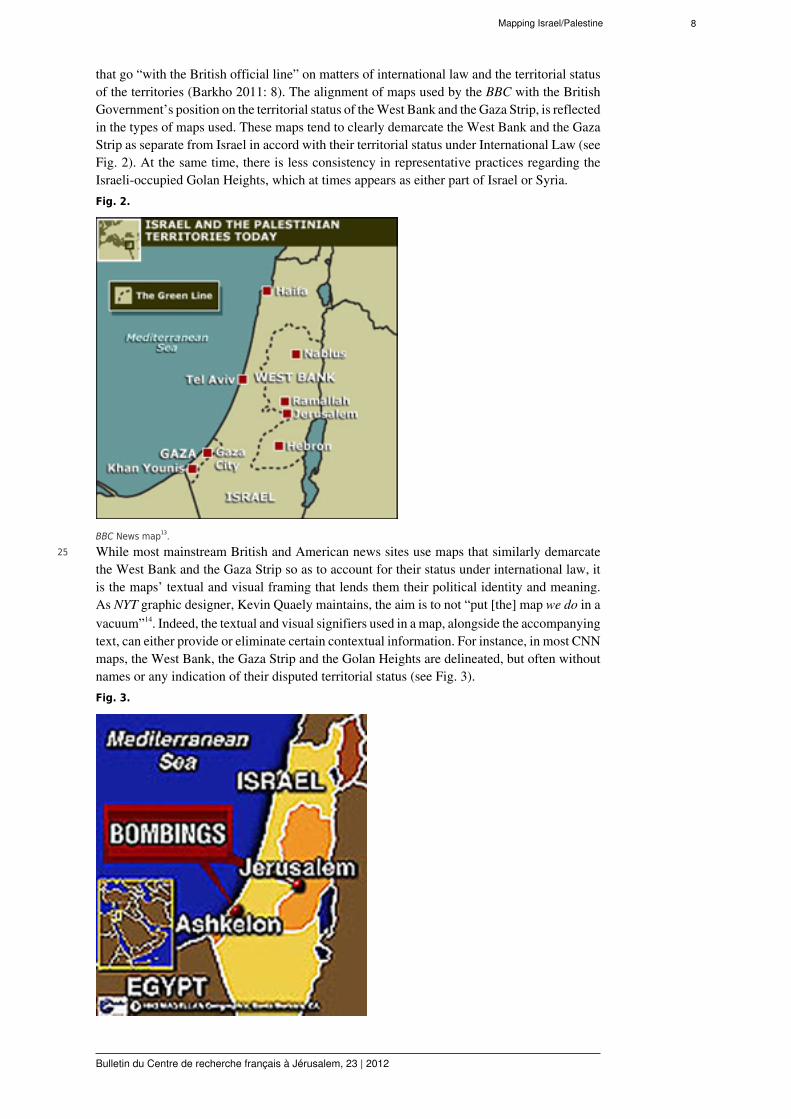
can be understood as ‘situated’ practices (Suchman et. al. 1999; see also Perrin 2011). In otherwords, the newsroom brings together various actors, materials, technologies, and resourcesthat enable and constrain certain activities. It is therefore the peculiarity of local cultures, socialand interactional contingencies, as well as various institutional and political circumstances thatimpact map-making as news making. It is such diverse conditions that can explain how andwhy maps may converge or diverge with ideologies and politics at any given time and place.
5 In order to understand the visual rhetoric of maps I also draw on a methodological frameworkdeveloped elsewhere (Leuenberger and Schnell 2010). The analytic focus is thus on thefollowing four aspects of map-making: visual signifiers (that includes features such as amap’s projections and scale, levels of cartographic detail, and choice of colors), textualsignifiers (such as the naming of places and other signifiers that load an image and revealsits target audience), and the demarcation of the space (which creates a spatial hierarchy asonly certain geographical or infrastructural features are included) (Pickles, 1991; Harley,1991). Furthermore, the analysis of a map’s context of production, circulation, and use,can illuminate the choice of particular visual and textual information, the map’s intendedmeanings and target audiences, as well as how the map’s meanings are interpreted by users(see Van Leeuwen 2001). Critical cartographers have also increasingly shifted their focusfrom investigating the design and content of maps to analyzing them as a social practice(Kitchin and Dodge 2007). Therefore the study of maps should not only include their analysisas meaningful objects, but also how particular meanings become embedded in their making.Relevant questions then become: how are maps produced, designed, and contested in practiceand how do they come to incorporate certain forms of knowledge and certain forms of politics(Crampton 2009)? How do locally available resources, materials, and technologies impactmap-making? And how do the visual and textual devices integrated into maps communicatepolitical meanings? In order to address some of these concerns, I draw on a data corpus thatcontains ethnographic fieldnotes on cartographic practices and qualitative (face-to-face andonline) interviews conducted between 2008-2012. The maps discussed here are drawn froma collection of maps used in various European, British, American, Arab and Israeli onlinenewspapers. I will specifically focus on the British online news produced by The Guardian andthe British Broadcasting Corporation (BBC), the American online news produced by The NewYork Times and the Chicago Tribune, as well as the Arabic news service, Al-Jazzera online,in order to exemplify generic mapping practices that were present across the data corpus.
Why look at maps?6 Journalistic maps have become ever more widespread since the 1970s. Maps used in
news media constitute a distinctive “cartographic genre” (Monmonier 1989: 14). They tendto be visually simple in terms of content and symbolization; they tend to be narrowlyfocused and present a very selective view of the globe; and they usually can be understoodwithout specialized training. They are also designed to communicate a message instantly andunambiguously (Gilmartin 1985; Monmonier 1989). They need to be – more than other maps– rhetorically effective so as to remain newsworthy and hold the readers’ attention and interest.As one journalist pointed out: “we choose maps for readability and clarity” (Journalist G 2011).A journalist at The New York Times also maintained that: “We generally err on the side ofclarity... The simplicity we try to achieve is an aesthetic in itself”3.
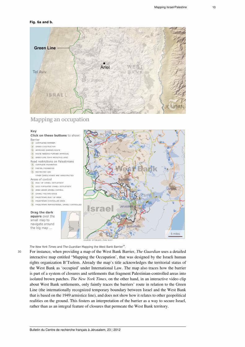
7 Traditionally, the most common maps used in newspapers are ‘locator-maps’ and ‘explanatorymaps’: they focus on where an event has taken place and why. Such maps often are an extensionof a textual essay, but can also present an “independent graphic essay” (Monmonier 1989,23). The rise of online news, mobile devices, cartographic software, and interactive graphicsare, however, increasingly transforming how maps in the news are used. Interactive graphicsprovide new possibilities and constraints for how maps are designed and contextualized withinnews stories, and new software provides large geographic databases that can be used to designmaps in new ways4.
8 Critical cartographers also point out that map-making has ever more been transformed froma disciplinary expertise to a ‘people’s cartography (Crampton and Krygier 2006; Monmonier
Mapping Israel/Palestine 4
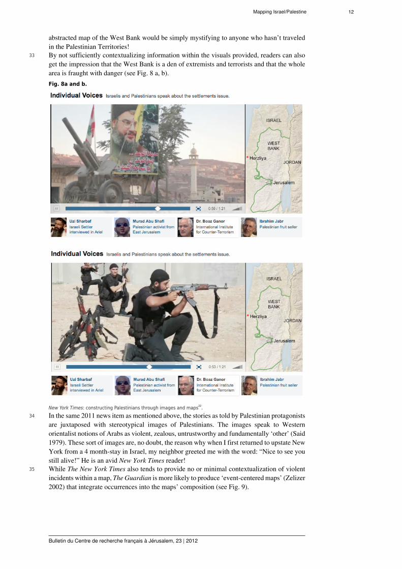
Bulletin du Centre de recherche français à Jérusalem, 23 | 2012
2006). New web-based software, open source mapping applications and the Internet providefor a more and more user-defined mapping environment5. Therefore maps have exponentiallyincreased in the public sphere – from the news media to the blogosphere. Journalistic maps areparticularly important because they, unlike scientific or navigational maps, are the maps mostencountered by the public at large (Crampton 2009). They can influence public perception offoreign, domestic, and local problems. Thus “the news media are society’s most significantcartographic gatekeeper and its most influential geographic educator” (Monmonier 1989, 19).
9 Despite their potential impact on the public imagination, journalistic maps, and how they areproduced, circulated, and interpreted, have been understudied (Crampton 2009; Monmonier1989). Given their increasing importance in the public sphere, however, it is ever moreimportant to investigate how maps can become rhetorical resources to make various social,cultural and political claims (Leuenberger and Schnell 2010). Critical cartographers have longpointed out that maps are not objective representations of the world ‘out there’, but rathermapmakers inevitably choose certain themes, scales, and relations. They hereby affirm theexistence and significance of some features, signaling that “some things, some people, someplaces are worthy of our notice, and others are not” (Perrin 2011: 301; see also Alimi 2006).In this paper I therefore trace how various online news sites include or eliminate certaingeographical features when depicting Israel and the Palestinian Territories, and how suchchoices become politics by other means. In the following I will first sketch out the socialcontext of map-making as news-making and how certain structural issues, such as access toeither Israeli or Palestinian news sources, impact not only news stories, but also map-making.I will then discuss how the visual and textual grammar of maps can be interpreted as politicallymeaningful.
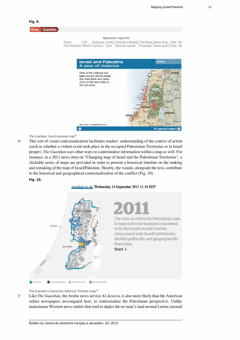
Making Maps as ‘Situated’ Practice10 Mapping in practice is always messier and more unpredictable than we would commonly
assume. Graphic artists and journalists encounter a range of constraints and possibilities whenchoosing, designing, or buying a map. This can include a news agency’s resources, ability toaccess information, internal guidelines, and staff, as well as the need to produce a newsworthystory by a deadline and accommodate to certain political pressures. There are, for instance,always a range of technical and economic resources and constraints. Depending on the sizeof the news agency, cartographic material may come from public, commercial, private, or in-house sources. In-house graphics departments may have access to various maps, which canbe retrieved from previous stories, the software available, or reference libraries. The materialat hand can determine the maps reproduced in the story, such as the base map (that eitherdelineates or eliminates the border markings between the West Bank, the Gaza Strip, andIsrael). One journalist pointed out that he buys all maps online:
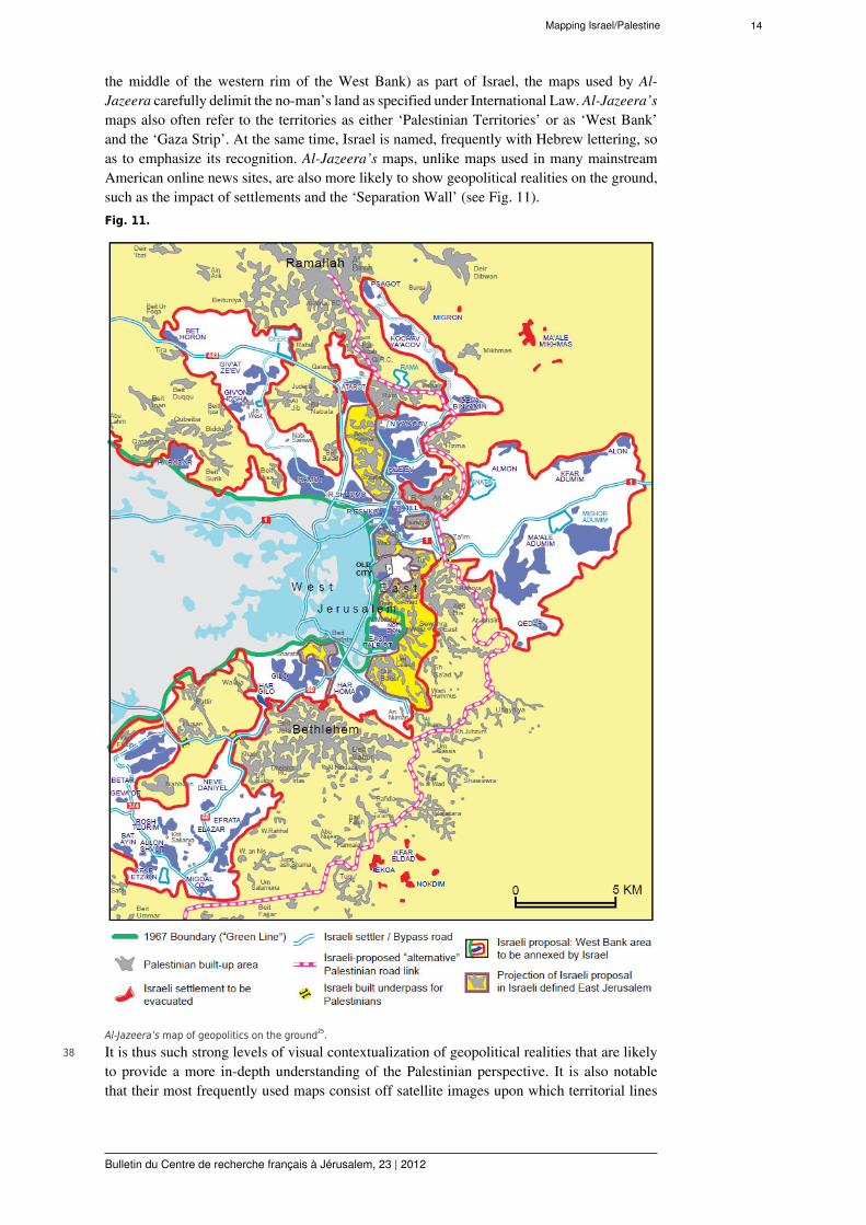
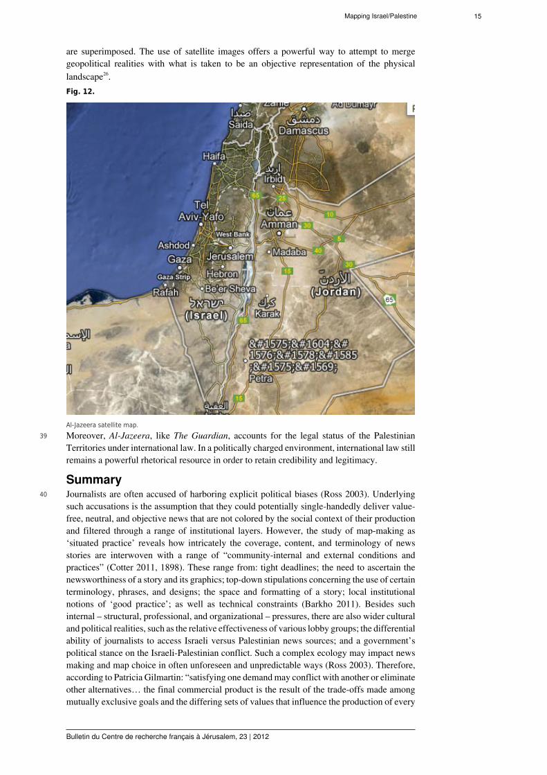
“On the matter of maps and graphics, I know that we buy “stock art” maps fromIstock and Getty… As you will note, editors and photo editors have lots and lotsof choices” (Journalist G 2011).
11 Such online stores include maps with varied scales, designs and content. Some maps representthe whole of Israel and eliminate the West Bank and the Gaza Strip; others delineate theterritory according to internationally recognized treatises6. Which map is chosen can dependon various factors such as the available space and formatting of the story, the knowledge andexperience of the graphic designer, or the visual appeal of the map. The political preferencesof the graphic designer or the editor may also impact the choice of map. As one journalistpointed out: “it would be easy to distort representations of territory, for example, if one weretrying to reinforce a bias” (Journalist G 2011).
12 It may not only be individual biases that can impact the choice of map, but also editorialpolicies and guidelines that are often specified in news agencies’ stylebooks. These areused for reference, training and as a template for ‘redesign’ (Monmonier 1989: 143) Theyare especially pertinent when it comes to contentious political issues, such as the Israeli-Palestinian conflict, as they provide guidelines as to the lexicon to be used for politically

Mapping Israel/Palestine 5
Bulletin du Centre de recherche français à Jérusalem, 23 | 2012
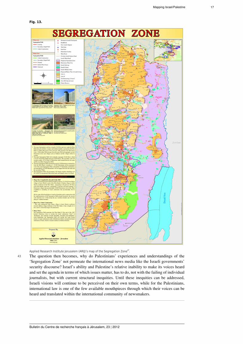
sensitive topics and cover historical, religious, diplomatic and legal issues pertaining tothe Middle East conflict. For instance, the BBC’s style guide suggests certain terms andphrases to describe politically contentious issues such as settlements, the occupation, or theTemple Mount. Al-Jazeera also specifies the use of certain terms and phrases. For instance,settlements are to be described as colonies and the ‘security fence’ as the ‘wall’ (Barkho 2011).While some scholars argue that these guidelines promote a hegemonic culture within newsagencies (Barkho 2011), ethnomethodologists have emphasized the complexities involved ininterpreting and applying rules and guidelines in particular settings (Garfinkel 1967; Heritage1984). Indeed, news agencies’ guidelines are often tempered by interactional contingenciesand institutional cultures. For instance, according to a New York Times journalist, what iscommonly considered ‘good practice’ matters more than a stylebook:
“the sort of principles that we sort of follow are fluid, and they depend onthe situation and the kind of material you have, and we don’t really try to setboundaries or rules for ourselves… There’s a visual language at the Times, butthere’s no law that governs what that visual language is. It’s just sort of anagreement, I think, among the designers here about what works well and is clear”7.
13 Rule following can therefore be superceded by tacit knowledge, consensually agreed upongood practices, and situated improvisation.
14 At times, external political pressures may also contribute to certain editorial directives beingestablished. For example, various governmental and non-governmental organizations, rangingfrom Israeli embassies to right-wing Israeli and Christian interest groups, watchdogs, andlobby groups, have a range of tools at their disposal in order to put forth certain ideologicalpositions, influence media coverage, or draw attention to what they deem to be biased newscoverage (see also Götz 2008). Consequently, as a result of political pressure from right-wing pro-Israeli lobby groups, CNN headquarters in Atlanta instructed its journalists to stopreferring to Gilo as a “Jewish settlement”. The order stated: “We refer to Gilo as ’a Jewishneighborhood on the outskirts of Jerusalem, built on land occupied by Israel in 1967’… Wedon’t refer to it as a settlement”8. However, such top-down directives do not necessarilydictate practice. Instead, CNN new stories use a range of terms that accommodate, yet deviatefrom the directive. In a news story in 2011, Gilo was referred to as a “Jewish settlementneighborhood”, a “disputed neighborhood in Jerusalem”, a “contested area of Jerusalem”, andas also potentially categorizable as a “West Bank settlement”9. Therefore, policies, whetherthey are organizational directives, interventions to stipulate certain politically motivatedcoverage, or professional guidelines, always become adapted, transformed and amended inpractice. Indeed, according to Daniel Perrin:
“policies, norms, and practices are not simply postulated and followed or not,they are reconstructed in everyday life and are thereby subject to variation andchange” (Perrin 2011: 1874).
15 The production process is thus a ‘situated activity’ (Perrin 2011: 1866) in which social settingsintersect with individual, organizational, and political resources and constraints.
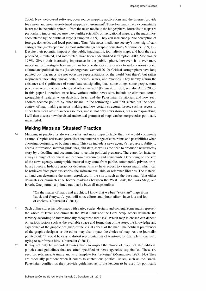
16 Whether or not top-down directives are implemented also depends on the staff in charge.Scholars point out, that maps in newspapers are often designed by staff untrained incartographic principles and thus reflect their ignorance in cartographic projection andconventions (Monmonier 1989). Also a journalist maintained: “in many U.S. organizations,selecting and manipulating (sizing) graphics and maps often falls to badly paid, very youngpeople, just out of school…” (Journalist G 2011). Consequently, “cartographically unskilledpersonnel are primarily responsible for poor quality maps in American newspapers” (Gimartin(1985: 7). When combined with Americans’ well-documented tendency to be ‘geographicallychallenged’ the end product becomes less a politically motivated act, than an expression ofignorance, oversight, and haste in design. When the news broke in 2009 that the right-wingAmerican News Channel Fox has a rather “shaky grasp of Mideast geography”, Americandemocrats rejoiced (see Fig. 1). There is, after all, nothing much better than ‘Schadenfreude’!
Mapping Israel/Palestine 6
Bulletin du Centre de recherche français à Jérusalem, 23 | 2012
Fig. 1.
Fox Channel’s challenge to locate Egypt10.17 Besides the fact that professional experiences and cartographic skills may impact the choice
of maps in newspapers, the need to produce a newsworthy story by a certain deadline canalso affect the story, its content, as well as the maps included. As one journalist pointed out:“Well, bloody hell, I’ve only three minutes to do this piece in and I’m going to spend a minutegoing through the arguments” (Philo and Berry, 2004: 245). Journalists are often told not to do“explainers” (Philo and Berry 2004: 215). After all, news stories are to capture attention witheye-catching headlines, powerful graphics, hot live action, and up-to-date news. Thereforethere is generally: “a dearth of in-depth, analytic and explanatory material included in newsreports” (Philo and Berry, 2004: 244, see also Götz 2008).
18 Also, as every fact concerning the Israeli-Palestinian conflict is disputed, journalists wouldbe hard pressed to provide enough contextual information to explain the complexities of theconflict. Therefore, news services may provide no or minimal contextual information withinnews stories and journalistic maps. As a result, viewers without specialist knowledge oftenneither understand the significance of current events nor the rationale for certain politicalactions (Philo and Berry 2004). Indeed, studies have shown that more than 80% of an audiencedoes neither comprehend the news nor the significance of the lexicon used (such as militaryoccupation or settlements) (Götz 2008). Alternatively, news services may also make sense ofthe conflict in terms of perpetrators and victims, as “it would… be quite confusing to havetwo sets of victims” (Ross 2003). In other words, they tend to explain and contextualize theactions and perspectives of only one of the sides in the conflict.
19 There is, however, a well-documented “structural imbalance” (Philo and Berry 2004: 138)between Israel and Palestine, which is reflected in both parties’ ability to disseminate news(Barkho 2011: 6). Media scholars have pointed out that: “it is the Israeli explanation… whichis most frequently referenced” and it is most often “Israel’s voice that came across through themouths of the reporters” (Philo and Berry 2004: 150; 246-7). Across many US news outlets,Israeli actions are contextualized more frequently than those of Palestinians. Also Israelis’views and rationales for actions were more likely to set the news agenda, and Palestinianperspectives were frequently absent and their motives, actions, and concerns reminded oftenhard to grasp (see also Ross 2003; Zelizer 2002)11.
20 There are various institutional reasons for why the Israeli perspective tends to dominateover the Palestinian perspective in the Western mainstream media. These include: Israel’ssophisticated public relations infrastructure as well as the fact that foreign journalists tend toreside in West Jerusalem where they have easy access to Israeli sources, documents, and maps(see Götz 2008; Zelizer 2002). On the other hand, restrictions on the freedom of movement in
Mapping Israel/Palestine 7
Bulletin du Centre de recherche français à Jérusalem, 23 | 2012
the West Bank and the Gaza Strip make access to Palestinian interviewees and source materialmore challenging, which does not sit well with the need for rolling news (Philo and Berry2004). Also, due to the often still weak and fractured Palestinian state institutions, Palestiniansdon’t possess a very developed public relations’ infrastructure and they lack a “clear publicrelations approach” (Philo and Berry 2004: 246; see also Götz 2008). Indeed, Palestiniansare well aware of the need to build up local expertise and improve their public relationsapproaches:
“We are trying to go after putting facts more in our research or in our publications,in our presentations to the world – or how to see the conflict on a factual basisfrom the Palestinian perspective – because – apparently we have not being doingso good on the international arena when it comes to showing and exhibiting thefacts on the ground… the first questions would be ‘where is your sources, whatare your facts?… [also] when… they started with the peace process apparently thePalestinian side went to the negotiations with virtually no maps – they were usingIsraeli maps” (Interview IJ Jan 2011).
21 For instance, it was not until the International Court of Justice declared the “SeparationWall” to be illegal under International Law, that the Palestinian government designated anational committee to map the barrier and to show its impact in a scientific manner. Palestinianstakeholders argue that mapping the barrier is crucial in advocating for a Palestinianperspective on its impact. As a result, various Palestinian mapping units have made concertedefforts to do so. The long absence of such maps, however, and the fact that, to this day, thereis no one authoritative mapping institution in Palestine (Abdullah 2001; Scanteam and ARIJ2009), means that such maps have long not been available and are still hard to come by,including for foreign journalists!
22 Even the Arabic news service Al-Jazzera online uses barrier maps that are produced by theIsraeli human rights organization B’tselem. For instance, a 2008 story on the “SeparationBarrier” provides an external link to a PDF file entitled “B’Tselems map of Israel’s separationbarrier in the West Bank”12, and does not use maps produced by Palestinian governmentalor non-governmental organizations such as the Applied Research Institute Jerusalem (ARIJ)or the Palestinian Authorities’ Ministry of Planning and International Cooperation (MOPIC).Diverging and non-standardized cartographic coding systems, the difficulty of one governinginstitution to enforce its political mandate, and the continuing lack of Palestinians’ sovereigntyand control over parts of the West Bank, have negatively impacted the development ofPalestinian cartography. There are therefore various structural impediments to obtaininginformation from Palestinian sources as well as attaining generally agreed upon Palestinian-produced maps.
23 As we have seen, map-making as news-making unfolds within a complex social, institutional,and political context. An analysis of maps as socially situated practices points to the fact thatcommon assumptions about journalist’s pejorative to chose maps based on political biasesdisregards the many factors that might impact the choice of maps, such as available technicaland economic resources, the need to accommodate to political pressure group, news agenciesstylebooks, and governmental positions, as well as pressures to produce a newsworthy storyby a deadline. Yet, maps can communicate certain political meanings, and how such politicalmessages may be built into the content, design, and structure of maps is what I what to turnto in the following section.
The Politics of Maps24 Media studies scholars have pointed out that national presses can become representative of
national politics (Barkho 2011; Gamson et al. 1989; Ross 2003; Wolfsfeld et al 2007). Forinstance, the American press tends to depend on governmental sources, which encourages themedia to privilege “the government’s construction of key issues and events” (Ross 2003).Also, the alignment of the mainstream British media, such as the BBC, with the views of theBritish government is facilitated by the fact that the BBC’s internal guidelines rely on the UKForeign Office’s view on the conflict. The BBC therefore tends to use language and terms
Mapping Israel/Palestine 8
Bulletin du Centre de recherche français à Jérusalem, 23 | 2012
that go “with the British official line” on matters of international law and the territorial statusof the territories (Barkho 2011: 8). The alignment of maps used by the BBC with the BritishGovernment’s position on the territorial status of the West Bank and the Gaza Strip, is reflectedin the types of maps used. These maps tend to clearly demarcate the West Bank and the GazaStrip as separate from Israel in accord with their territorial status under International Law (seeFig. 2). At the same time, there is less consistency in representative practices regarding theIsraeli-occupied Golan Heights, which at times appears as either part of Israel or Syria.Fig. 2.
BBC News map13.25 While most mainstream British and American news sites use maps that similarly demarcate
the West Bank and the Gaza Strip so as to account for their status under international law, itis the maps’ textual and visual framing that lends them their political identity and meaning.As NYT graphic designer, Kevin Quaely maintains, the aim is to not “put [the] map we do in avacuum”14. Indeed, the textual and visual signifiers used in a map, alongside the accompanyingtext, can either provide or eliminate certain contextual information. For instance, in most CNNmaps, the West Bank, the Gaza Strip and the Golan Heights are delineated, but often withoutnames or any indication of their disputed territorial status (see Fig. 3).Fig. 3.

Mapping Israel/Palestine 9
Bulletin du Centre de recherche français à Jérusalem, 23 | 2012
CNN map15.26 Most of the ‘locator-maps’ in The New York Times delineate the territories similarly, yet
without naming them or indicating their legal status (see Fig. 4). Putting maps ‘in a vacuum’can thus have a political function.Fig. 4.
New York Times map16.27 Also in maps from the Chicago Tribune, the West Bank and the Gaza Strip are delineated,
yet are nameless (see Fig. 5).Fig. 5.
Chicago Tribune map17.28 As these territories are not named, it is unclear whether they are part of Israel or not. While the
mapmakers’ concerns may only have been with clarity and visual appeal, the map neverthelesscan have a political effect, as it passes “the buck onto the readers”18. Consequently, onlypeople with specialized knowledge will know how to interpret the lines. It is thus the choiceof discursive ‘frames’, that are either built into the structure of the map or appear alongside it,that construct and transmit its meanings (Ross 2003; Zelizer 2002).
29 While The Guardian (which tends to be accused of a pro-Palestinian bias) and The New YorkTimes (which tends to be accused of a pro-Israeli bias) may use the same base map (thatdelineates Israel, the West Bank, and the Gaza Strip), the focus of the story and the level ofvisual and textual detail and context differ (see Fig. 6a, b).
Mapping Israel/Palestine 10
Bulletin du Centre de recherche français à Jérusalem, 23 | 2012
Fig. 6a and b.
The New York Times and The Guardian Mapping the West Bank Barrier19.30 For instance, when providing a map of the West Bank Barrier, The Guardian uses a detailed
interactive map entitled “Mapping the Occupation’, that was designed by the Israeli humanrights organization B’Tselem. Already the map’s title acknowledges the territorial status ofthe West Bank as ‘occupied’ under International Law. The map also traces how the barrieris part of a system of closures and settlements that fragment Palestinian-controlled areas intoisolated brown patches. The New York Times, on the other hand, in an interactive video clipabout West Bank settlements, only faintly traces the barriers’ route in relation to the GreenLine (the internationally recognized temporary boundary between Israel and the West Bankthat is based on the 1949 armistice line), and does not show how it relates to other geopoliticalrealities on the ground. This fosters an interpretation of the barrier as a way to secure Israel,rather than as an integral feature of closures that permeate the West Bank territory.

Mapping Israel/Palestine 11
Bulletin du Centre de recherche français à Jérusalem, 23 | 2012
31 The maps used in The New York Times exemplify how maps do political work thatseemingly favors the Israeli, rather than the Palestinian perspective. Their maps also often usegeographical maps without inserting editorial comments, and they offer no or minimal visualtranslation of current events into the maps themselves. In other words, they provide ‘weakvisual contextualization’ of information within and alongside the map provided.Fig. 7a and b.
New York Times maps exemplifying ‘weak visual contextualization’ of information20.32 For instance, a news item in 2011 on “Challenges in defining an Israeli-Palestinian border”
makes available clickable interviews with Palestinians and Israelis on these challenges (seeFig. 7a, b). While the interviewees tell their stories, various images appear next to a ‘locator-map’ of the West Bank that is delineated by the Green Line. Depictions of the West BankBarrier (also known as the ‘security fence’) come into view, yet the barrier is not integrated intothe map itself, but appears as a ‘fence’ to the left-hand side of the map. By only juxtaposing the‘fence’ and the map, but not superimposing the ‘fence’ onto the map, nor providing any textualclues as to whether the ‘fence’ converges or diverges from the Green Line, a lay audiencewould be hard pressed to understand how the ‘fence’ relates to the Green Line and establishescertain facts on the ground. Moreover, the appearance of a red street sign indicating entry intothe Palestinian-controlled Area A (which are located along the edges of ‘Area A’)21 besides an
Mapping Israel/Palestine 12
Bulletin du Centre de recherche français à Jérusalem, 23 | 2012
abstracted map of the West Bank would be simply mystifying to anyone who hasn’t traveledin the Palestinian Territories!
33 By not sufficiently contextualizing information within the visuals provided, readers can alsoget the impression that the West Bank is a den of extremists and terrorists and that the wholearea is fraught with danger (see Fig. 8 a, b).Fig. 8a and b.
New York Times: constructing Palestinians through images and maps22.34 In the same 2011 news item as mentioned above, the stories as told by Palestinian protagonists
are juxtaposed with stereotypical images of Palestinians. The images speak to Westernorientalist notions of Arabs as violent, zealous, untrustworthy and fundamentally ‘other’ (Said1979). These sort of images are, no doubt, the reason why when I first returned to upstate NewYork from a 4 month-stay in Israel, my neighbor greeted me with the word: “Nice to see youstill alive!” He is an avid New York Times reader!
35 While The New York Times also tends to provide no or minimal contextualization of violentincidents within a map, The Guardian is more likely to produce ‘event-centered maps’ (Zelizer2002) that integrate occurrences into the maps’ composition (see Fig. 9).
Mapping Israel/Palestine 13
Bulletin du Centre de recherche français à Jérusalem, 23 | 2012
Fig. 9.
The Guardian: Event-centered map23.36 This sort of visual contextualization facilitates readers’ understanding of the context of action
(such as whether a violent event took place in the occupied Palestinian Territories or in Israelproper). The Guardian uses other ways to contextualize information within a map as well. Forinstance, in a 2011 news item on “Changing map of Israel and the Palestinian Territories”, aclickable series of maps are provided in order to present a historical timeline on the makingand remaking of the map of Israel/Palestine. Hereby, the visuals, alongside the text, contributeto the historical and geographical contextualization of the conflict (Fig. 10).Fig. 10.
The Guardian’s Interactive Historical Timeline maps24.37 Like The Guardian, the Arabic news service Al-Jazeera, is also more likely than the American
online newspapers investigated here, to contextualize the Palestinian perspective. Unlikemainstream Western news outlets that tend to depict the no-man’s land around Latrun (around
Mapping Israel/Palestine 14
Bulletin du Centre de recherche français à Jérusalem, 23 | 2012
the middle of the western rim of the West Bank) as part of Israel, the maps used by Al-Jazeera carefully delimit the no-man’s land as specified under International Law. Al-Jazeera’smaps also often refer to the territories as either ‘Palestinian Territories’ or as ‘West Bank’and the ‘Gaza Strip’. At the same time, Israel is named, frequently with Hebrew lettering, soas to emphasize its recognition. Al-Jazeera’s maps, unlike maps used in many mainstreamAmerican online news sites, are also more likely to show geopolitical realities on the ground,such as the impact of settlements and the ‘Separation Wall’ (see Fig. 11).Fig. 11.
Al-Jazeera’s map of geopolitics on the ground25.38 It is thus such strong levels of visual contextualization of geopolitical realities that are likely
to provide a more in-depth understanding of the Palestinian perspective. It is also notablethat their most frequently used maps consist off satellite images upon which territorial lines
Mapping Israel/Palestine 15
Bulletin du Centre de recherche français à Jérusalem, 23 | 2012
are superimposed. The use of satellite images offers a powerful way to attempt to mergegeopolitical realities with what is taken to be an objective representation of the physicallandscape26.Fig. 12.
Al-Jazeera satellite map.39 Moreover, Al-Jazeera, like The Guardian, accounts for the legal status of the Palestinian
Territories under international law. In a politically charged environment, international law stillremains a powerful rhetorical resource in order to retain credibility and legitimacy.
Summary40 Journalists are often accused of harboring explicit political biases (Ross 2003). Underlying
such accusations is the assumption that they could potentially single-handedly deliver value-free, neutral, and objective news that are not colored by the social context of their productionand filtered through a range of institutional layers. However, the study of map-making as‘situated practice’ reveals how intricately the coverage, content, and terminology of newsstories are interwoven with a range of “community-internal and external conditions andpractices” (Cotter 2011, 1898). These range from: tight deadlines; the need to ascertain thenewsworthiness of a story and its graphics; top-down stipulations concerning the use of certainterminology, phrases, and designs; the space and formatting of a story; local institutionalnotions of ‘good practice’; as well as technical constraints (Barkho 2011). Besides suchinternal – structural, professional, and organizational – pressures, there are also wider culturaland political realities, such as the relative effectiveness of various lobby groups; the differentialability of journalists to access Israeli versus Palestinian news sources; and a government’spolitical stance on the Israeli-Palestinian conflict. Such a complex ecology may impact newsmaking and map choice in often unforeseen and unpredictable ways (Ross 2003). Therefore,according to Patricia Gilmartin: “satisfying one demand may conflict with another or eliminateother alternatives… the final commercial product is the result of the trade-offs made amongmutually exclusive goals and the differing sets of values that influence the production of every
Mapping Israel/Palestine 16
Bulletin du Centre de recherche français à Jérusalem, 23 | 2012
map” (Gilmartin 1985: 8). The newsroom thus brings together various human and non-humanactors, materials, technologies, and resources that provide spaces of practice that provide thematerial and conceptual tool kit from which news stories and maps are made (see also Swidler1986; Gamson and Modigliani 1989; Ryan and Gamson 2006).
41 Besides the messiness of practice that can account for often varied and, at times, contradictorymapping practices on online news sites, the choice of certain maps in terms of theirfocus, content, design and detail, is inevitably selective and can hereby become politicallymeaningful. Mapping, just like reporting “from no perspective at all” (Zelizer 2002) isuntenable. The online newspapers examined here provide some preliminary conclusion asto how maps are chosen for online news stories and how political messages may becomeembedded within the design of various maps. Arguably, politics can become embedded inonline news maps in various ways. Firstly, the depiction of territories in journalistic mapsused by the mainstream media tends to be aligned with a national government’s position onthe territorial status of Israel-Palestine. Secondly, the demarcation of space and the use ofparticular textual and visual signifiers can either provide or omit contextual information. Forinstance, whether mapmakers visually integrate events into a map can profoundly impact theability of an audience to comprehend and contextualize the information provided; likewise,integrating a historical timeline may also increase contextual understanding. On the otherhand, weak visual and textual contextualization will not only hinder an audiences’ ability tounderstand the news, but can also lead to misconceptions, stereotyping, and misinformation.As we have seen, pairing abstracted maps of the West Bank with commonly held nationalstereotypes of Palestinians may encourage, maintain, and enforce the process of ‘othering’of a whole population. Thirdly, a map’s content and detail is informed by its underlyingassumptions. In other words, international law, Israel‘s security discourse, or its occupationpolicies can all inform and shape the content and design of a map in different ways. Forinstance, while The Guardian tends to contextualize the Palestinian perspective textuallyand cartographically in terms of international law, The New York Times is more likely tocontextualize the Israeli perspective through Israel’s own security discourse. Lastly, the typesand sources of maps can become a form of politics. For instance, in a politically-chargedenvironment, the use of satellite images, upon which territorial lines are superimposed, canbecome a useful rhetorical tool in order to evoke the objectivity of a map. There also continuesto be an absence of Palestinian-produced maps in the mainstream news media. This reflectsthe still persistent infrastructural inequities, which produce an information and credibility gapbetween Israel and the Palestinians.
42 While newspapers, like The Guardian, can represent the Palestinian perspective through thelens of international law, Palestinians still struggle to disseminate more widely their owndefinitions and visions of their territories. Palestinian cartographers have, at times, critiquedUN-produced maps for not representing the ‘Separation Wall’ (also known as the ‘WestBank barrier’ or the ‘security fence’) as part of a ‘Segregation Zone’, that is much widerand more extensive than the UN-produced maps suggest (see Fig. 13). Indeed, in somePalestinian-produced maps, the ‘Segregation Zone’ is clearly defined and named. Accordingto an interviewee, “we use the term Segregation Zone because it is not only wall, because250 meters from the Palestinian side no construction is allowed – so it is a zone” (InterviewJI 2011).
Mapping Israel/Palestine 17
Bulletin du Centre de recherche français à Jérusalem, 23 | 2012
Fig. 13.
Applied Research Institute Jerusalem (ARIJ)’s map of the Segregation Zone27.43 The question then becomes, why do Palestinians’ experiences and understandings of the
‘Segregation Zone’ not permeate the international news media like the Israeli governments’security discourse? Israel’s ability and Palestine’s relative inability to make its voices heardand set the agenda in terms of which issues matter, has to do, not with the failing of individualjournalists, but with current structural inequities. Until these inequities can be addressed,Israeli visions will continue to be perceived on their own terms, while for the Palestinians,international law is one of the few available mouthpieces through which their voices can beheard and translated within the international community of newsmakers.

Mapping Israel/Palestine 18
Bulletin du Centre de recherche français à Jérusalem, 23 | 2012
Bibliographie
Abdullah, S. A.2001 An Approach Towards The Development of National Geographic Information Strategy inPalestine, dissertation submitted to partial fulfill requirements for the Master of Science degree ingeographical information sciences, School of Geography, University of Nottingham. The Lower JordanRiver Basin Programme Publications.
Alimi, E. Y.2006 Israeli Politics and the Palestinian Intifada: Political Opprtunities, Framing Processes, andContencious Politics, London and New York: Routledge.
Anderson, B.1983 Imagined Communities, London, Verso.
Barkho, L.2011 “The role of internal guidelines in shaping news narratives: ethnographic insights into thediscursive rhetoric of Middle East reporting by the BBC and Al-Jazeera English,” Critical DiscourseStudies, vol. 8, n° 4, pp. 1-13.
Batuman, B.2010 “The Shape of the Nation: Visual production of Nationalism through maps in Turkey,” PoliticalGeography, vol. 29, n° 4, pp. 220-234.
Black, J.1997 Maps and Politics, Chicago, The University of Chicago Press.
Cotter, C.2011 “Diversity awareness and the role of language in cultural representations in news stories,” Journalof Pragmatics, vol. 43, n° 7, pp. 1890-1899.
Crampton, J. W. and Krygier, J.2006 “An Introduction to Critical Cartography,” ACME: An International E-Journal for CriticalGeographies, vol. 4, n° 1, pp. 11-33.
Crampton, J.2009 “Cartography: performative, participatory, political,” Progress in Human Geography, vol. 33,n° 6, pp. 840-848.
Culcasi, K.2006 “Cartographically Constructing Kurdistan within Geopolitical and Orientalist Discourses,”Political Geography, vol. 25, n° 6, pp. 680-706.
Gamson, W. A. and Modigliani, A.1989 “Media Discourse and Pubic Opinion on Nuclear Power: A Constructivist Approch,” AmericanJournal of Sociology, n° 1, pp. 1-37.
Gasher, M.2007 “The View From Here” A news-flow study of the on-line editions of Canada’s nationalnewspapers,” Journalism Studies, vol. 8, n° 2, pp. 299-319.
Garfinkel, H.1967 Studies in Ethnomethodology, New Jersey, Prentice-Hall.
Gerovitch, S.2002 From Newspeak to Cyberspeak: A History of Society Cybernetics, Cambridge, Mass, MIT Press.
Gilmartin, P.1985 “The Design of Journalistic Maps/Purposes, Parameters and Prospects,” Cartographica, vol. 22,n° 4, pp. 1-18.
Götz, U.2008 “Israel und die palästinensischen Gebiet”, in Oliver Hahn, Julia Lönnendonker andRoland Schröder (eds). Deutsche Auslandskorrespondenten: Ein Handbuch, Konstanz, UVKVerlagsgesellschaft mbH, pp. 412-428
Gusterson, H.1991 “Nuclear War, the Gulf War, and the Disappearing Body,” Journal of Urban and Cultural Studies,vol. 2, n° 1, pp. 28-39.
Harley, J. B.1991 “Deconstructing the Map”, in Barnes Trevor and James S. Duncan (eds.) Writing Worlds:Discourse, Text and Metaphor in the Representation of Landscape, London, Routledge, pp. 231-247.
Hall, S. (ed.)
Mapping Israel/Palestine 19
Bulletin du Centre de recherche français à Jérusalem, 23 | 2012
1997 Representation: Cultural Representations and Signifying Practices, London, Sage.
Heritage, J.1984 Garfinkel and Ethnomethodology, Cambridge, Polity Press.
Jasanoff, S.2004 States of Knowledge: The co-production of science and social order. London, Routledge.
Kitchin, R. and Dodge, M.2007 “Rethinking Maps, Progress in Human Geography, vol. 31, n° 3, pp. 331-344.
Lams, L.2011 “Newspapers’ narratives based on wire stories: Facsimiles of input,” Journal of Pragmatics,vol. 43, n° 7, pp. 1853-1864.
Leuenberger, C.2007 “Cultures of Categories: Psychological Diagnoses as Institutional and Political Projects before andafter the transition from State Socialism in 1989 in East Germany,” Osiris, Chicago, Chicago UniversityPress, vol. 22, pp. 180-204.
Leuenberger, C. and Schnell, I.2010 “The Politics of Maps: Constructing National Territories in Israel,” Social Studies of Science,vol. 40, n° 6, pp. 803–842.
Monmonier, M.1989 Maps with the News: The Development of American Journalistic Cartography, Chicago,University of Chicago Press.2006 “Cartography: Uncertainty, Interventions, and Dynamic Display,” Progress in HumanGeography, vol. 30, n° 3, pp. 373-381.
Perrin, D.2011 “There are two different stories to tell” – Collaborative text-picture production strategies of TVjournalists,” Journal of Pragmatics, vol. 43, pp. 1865-1875.
Philo, G. and Berry, M.2004 Bad News from Israel, London, Pluto Press.
Pickles, J.1991 “Texts, Hermeneutics and Propaganda Maps,” in Trevor J. Barnes and James S. Duncan,J. S. (eds.) Writing Worlds: Discourse, text and metaphor in the representation of landscape, London,Routledge, pp. 193-230
Ryan C. and Gamson W .A.2006 “The Art of Reframing Political Debates,” Contexts, vol. 5, n° 1, pp. 13-18.
Ross, S. D.2003 “Framing of the Palestinian-Israeli conflict in thirteen months of New York Times editorialssurrounding the attack of September 11, 2001,” Conflict & Communication Online, vol. 2, n° 2. http://www.cco.regener-online.de
Said, E.1979 Orientalism, New York, Vintage Books.
Scanteam and Applied Research Institute Jerusalem (ARIJ)2009 Draft Report: End Review of the Physical Planning and Institution Building (PPIB) Project,Palestinian Territory, commissioned by the Norwegian Representative Office, Scanteam and ARJI,SCANTEAM Project No: 927, Draft Version Oslo, Ramallah and Bethlehem. Bethlehem: ARIJ.
Stallings, R. A.1990 “Media Discourse and the Social Construction of Risk,” Social Problems, vol. 37, pp. 80-95.
Suchman, L., Blomberg, J., Orr, J. E. and Trigg, R.1999 “Reconstructing technologies as Social Practice,” American Behavioral Scientist, vol. 433,pp. 392-408.
Swidler, A.1986 “Culture in Action: Symbols and Strategies”, American Sociological Review, vol. 51, n° 2,pp. 273-286.
Van Leeuwen, T. and Jewitt, C.2001 Handbook of Visual Analysis, London, Sage.
Warburg, J. P.
Mapping Israel/Palestine 20
Bulletin du Centre de recherche français à Jérusalem, 23 | 2012
2003 “The age of meta-war: the distancing effects of techno-weaponry and a sanitized globalmedia are altering the structural basis of modern warfare” Arena Magazine (April 1st) http://www.arena.org.au/2003/04/the-age-of-meta-war/ (retrieved 4/30/2010).
Wolfsfeld G., Alimi E. Y, and Kailani W.2008 “News Media and Peace Building in Asymmetrical Conflicts: The Flow of News between Jordanand Israel,” Political Studies, vol. 56, pp. 374-398.
Wood, D. and Fels, J.2008 “The Natures of Maps; Cartographic Constructions of the Natural World,” Cartographica, vol. 43,n° 3, pp. 189-202.
Zelizer, B.2002 “How bias shapes the news: Challenging The New York Times’ status as a newspaper of recordon the Middle East,” Journalism, vol. 3, n° 3, pp. 283-308.
Notes
1 Media Education Foundation, Peace propaganda and the Promised Land: US Media and the Israeli-Palestinian Conflict. Available at: http://groups.yahoo.com/group/CNN-Watch/message/2639; SwissMedia Watch. Available at: http://www.swissmediawatch.org/report_tagblatt.asp.2 For scholarly work on how maps may encourage national sentiments as well as constructions of‘otherness’ across national boundaries see e.g. Anderson 1983; Batuman 2010; Culcasi 2006.3 Creating Graphics for Online News, http://mindgatemedia.com/lesson/creating-graphics-for-online-news/4 See Kevin Quealy, New York Times Graphics Department, http://www.youtube.com/watch?v=hFpIE8xY_w8.5 See e.g. “Maps, Maps” 2006 http://english.aljazeera.net/cartoons/2006/11/2008525183553214362.html.6 iStockphoto. Available at: http://www.istockphoto.com/search/text/israel%20map/filetype/photos/source/basic#149ce931; gettyimages. Available at: http://www.gettyimages.com/Search/Search.aspx?contractUrl=2&language=en-US&family=creative&p=israel+map&assetType=image.7 Creating Graphics for Online News. Available at: http://mindgatemedia.com/lesson/creating-graphics-for-online-news/8 Rachel Coen 2002 “Euphemisms for Israeli Settlements Confuse Coverage”. Available at: http://www.fair.org/index.php?page=2645.9 See CCN World, Shira Medding, “Controversial Israeli construction approved as Obamameets with Peres”, April 05, 2011. Available at: http://articles.cnn.com/2011-04-05/world/israel.construction_1_east-jerusalem-jerusalem-municipality-arab-neighborhoods?_s=PM:WORLD.10 Fox News graphics department has shaky grasp of Mideast geography, July 27, 2009 http://mediamatters.org/mmtv/200907270040.11 It is important to note that media discourses and predominant interpretative frames change in responseto wider social, political, and institutional developments and power politics. For instance, Alimi (2006)points out, that Palestinians’ media strategies were relatively effective during the first Intifada in termsof garnering international support and sympathy for the Palestinian drive towards self-determination.Such international support, however, diminished with ever increasing violence in conjunction with theability of the Israeli Public Relations infrastructure to re-frame the Israeli-Palestinian conflict as a threatto Israel’s security (see also Wolfsfeld et. al. 2007).12 “Background: The Separation Barrier” 2008. Available at http://english.aljazeera.net/news/middleeast/2008/07/200876142132497191.html.13 BBC News “Israel & the Palestinians, Key Maps”. Available at: http://news.bbc.co.uk/hi/english/static/in_depth/world/2001/israel_and_palestinians/key_maps/; see also BBC News “Middle East Crisis,Key Maps”, 2006. Available at: http://news.bbc.co.uk/2/hi/5184828.stm.14 Kevin Quealy, NYT graphics dept http://www.youtube.com/watch?v=hFpIE8xY_w8.15 Edition.cnn.com. Available at: http://edition.cnn.com/WORLD/meast/9807/16/israel.treason/israel.tel.aviv.jpg; CNN “Hamas admits to fatal Israeli bus bombing” 1996. Available at: http://www.cnn.com/WORLD/9602/israel_explosion/02-25/pm/16 See e.g. The New York Times. Available at: http://www.nytimes.com/2010/12/14/world/middleeast/14israel.html; http://www.nytimes.com/2011/08/15/world/middleast/15israel.html?_r=1; http://www.nytimes.com/2010/08/26/world/middleeast/26israel.html.
Mapping Israel/Palestine 21
Bulletin du Centre de recherche français à Jérusalem, 23 | 2012
17 Chicago Tribune. Available at: http://www.chicagotribune.com/topic/politics/government/knesset/ORGOV0000053.topic.18 Kevin Quealy, NYT graphics dept http://www.youtube.com/watch?v=hFpIE8xY_w8.19 The Guardian, 2008, “Mapping the Occupation”. Available at: http://www.guardian.co.uk/world/interactive/2008/sep/11/israelandthepalestinians?INTCMP=SRCH; The New York Times, 2011,“Challenges in defining an Israeli-Palestinian Border, Part 3: The Settlement Issue”. Available at: http://www.nytimes.com/interactive/2011/09/16/world/middleeast/the-settlement-issue.html?ref=middleeast.20 The New York Times, 2011, “Challenges in defining an Israeli-Palestinian Border, Part 3:The Settlement Issue”. Available at: http://www.nytimes.com/interactive/2011/09/16/world/middleeast/the-settlement-issue.html?ref=middleeast; The New York Times, 2011, “Challenges in defining anIsraeli-Palestinian Border, Part 2: the Battle of the Barrier. Available at: http://www.nytimes.com/interactive/2011/09/14/world/middleeast/the-battle-of-the-barrier.html.21 In line with the 1993 Oslo Accords the Palestinian Territories have been divided into Area A (underfull Palestinian control), Area B (under Palestinian civil control and Israeli military control), and AreaC (under full Israeli military control).22 The New York Times, 2011, “Challenges in defining an Israeli-Palestinian Border, Part 3: TheSettlement Issue”. Available at: http://www.nytimes.com/interactive/2011/09/16/world/middleeast/the-settlement-issue.html?ref=middleeast.23 The Guardian, “Israel and Palestine, A year of violence”, http://www.guardian.co.uk/wto/flash/0,6189,382165,00.html.24 The Guardian, “Changing map of Israel and the Palestinian Territories” 2011. Availableat: http://www.guardian.co.uk/world/interactive/2011/sep/14/map-israel-palestinian-territories; seealso http://www.guardain.co.uk/israel/graphic/0,5543,523588,00.html; http://www.guardain.co.uk/world/2001/,ay/24/israel2.25 Al-Jazeera. “The Palestine Papers: The Napkin map Revealed” 2011. Available at: http://www.aljazeera.com/palestinepapers/2011/01/2011122114239940577.html.26 Al-Jazeera, “Map: Nato attacks on Libyan cities – Interactive” 2011. Available at:http://www.aljazeera.com/indepth/interactive/2011/06/2011625448137941.html; Al-Jazeera, “Map:Weekly West Bank Protests” 2011. Available at: http://www.aljazeera.com/indepth/interactive/2011/07/20117155510250892.html.27 See the Applied Research Institute Jerusalem (ARIJ) http://www.arij.org/eye-on-palestine/maps.html.
Pour citer cet article
Référence électronique
Christine Leuenberger, « Mapping Israel/Palestine », Bulletin du Centre de recherche français àJérusalem [En ligne], 23 | 2012, mis en ligne le 20 janvier 2013, Consulté le 15 avril 2013. URL :http://bcrfj.revues.org/6859
À propos de l'auteur
Christine LeuenbergerChristine Leuenberger is Senior Lecturer in the Department of Science & Technology Studies atCornell University. She received her PhD in Sociology/Social Sciences in 1995 from the Universityof Konstanz (Germany) and an MA in Sociology of Contemporary Culture from the University ofYork (England). She was a Fulbright Scholar in Israel and the Palestinian Territories in 2008 anda Fulbright Specialist at Tel Aviv University in 2011-12. She is a current recipient of an NationalScience Foundation Scholar’s award to investigate the history and sociology of mapping practicesin Israel and the Palestinian Territories. She is also working on the social impact of the West BankBarrier and on the social history of psychology in the Middle East.
Droits d’auteur
© Bulletin du Centre de recherche français à Jérusalem

Mapping Israel/Palestine 22
Bulletin du Centre de recherche français à Jérusalem, 23 | 2012
Résumés
Cette présentation s’appuie sur la cartographie critique, les science studies, les cultural studieset la sociologie de la connaissance pour analyser le contenu, la structure des cartes et le contextesocial de leur réalisation, en se focalisant sur le comment et le pourquoi de la descriptionsouvent variée et incohérente de la terre contestée d’Israël et des territoires palestiniens dansles médias en ligne britanniques, américains et arabes. Certains ont été accusés de biaispolitique dans la couverture du conflit, ce qui est censé se traduire dans la façon dont lescartes sont conçues et sont incorporées dans les reportages. Plutôt que d’y voir un lien directentre un choix de carte et une orientation politique, je soutiens que la production de cartepeut être comprise comme une forme de pratique “située”. La salle de rédaction est un lieuoù se rassemblent des acteurs, des matériels, des technologies et des ressources qui rendentpossibles certaines activités mais aussi leur donnent des limites. Par conséquent, ce sontdes contingences culturelles, sociales, interactionnelles, institutionnelles et des circonstancespolitiques qui affectent la production de cartes et expliquent pourquoi les cartes peuventconverger ou diverger avec des positions politiques à des lieux et des moments donnés. Enmême temps, le choix de certaines cartes et niveaux de cartes en termes de focalisation, decontenu, de design et de détail, implique une sélection qui peut être politiquement significative.De plus, les types et sources des reportages et des cartes qui les accompagnent sont aussicodéterminés par la politique du pouvoir et les inégalités structurelles entre l’État d’Israëlet l’État palestinien en formation, et leur respective facilité d’accès aux infrastructures derelations publiques qui permettent d’atteindre le grand public. This paper draws on critical cartography, science studies, cultural studies and the sociology ofknowledge in order to analyze the social context of map-making and the content and structureof maps. The focus is on how and why British, American, and Arab online news outlets depictthe contested territories of Israel and the Palestinian Territories in often varied and inconsistentways. Certain online news sources have been accused of political biases concerning the Israeli-Palestinian conflict, which arguably translates into particular maps and map layers beingincluded in news stories. Rather than they are being a direct and pre-determined link betweenmap-choice and politics, however, I argue that map-making can be understood as a form of‘situated’ practice. In other words, the newsroom brings together various actors, materials,technologies and resources that enable and constrain certain activities. It is therefore localcultures, social and interactional contingencies, and institutional and political circumstancesthat impact map-making and explain how and why maps may converge with or diverge frompolitics at any given time and place. At the same time, the choice of certain maps and maplayers in terms of their focus, content, design, and detail is inevitably selective and can herebybecome politically meaningful. It is thus the various textual and visual signifiers and thecontextual information included in a map that can become politics by other means. Moreover,the types and sources of news stories and their maps are also co-determined by power politics,the structural inequities between the state of Israel and a Palestinian state-in-the-making, andtheir respective ease of access to public relations infrastructures that can reach the public atlarge.
Index
Mots clés : Maps, journalism, online newspapers, Israel, Palestine, politics, visualrhetoric, situated practice