Jailers fighting drug problem - Madison County Public Library
Upload
khangminh22Category
view
0download
0
Central New York Regional Planning and Development Board
MADISON COUNTY
MA 5: Harbor Lights Business Park MA 6: Canastota Business Park MA 7: Oneida-Curtin Site-Development Area MA 8: Trush Business Park MA 9: Hamilton Airpark MA 10: Madison County ARE Park
1
Site Profile Characteristics
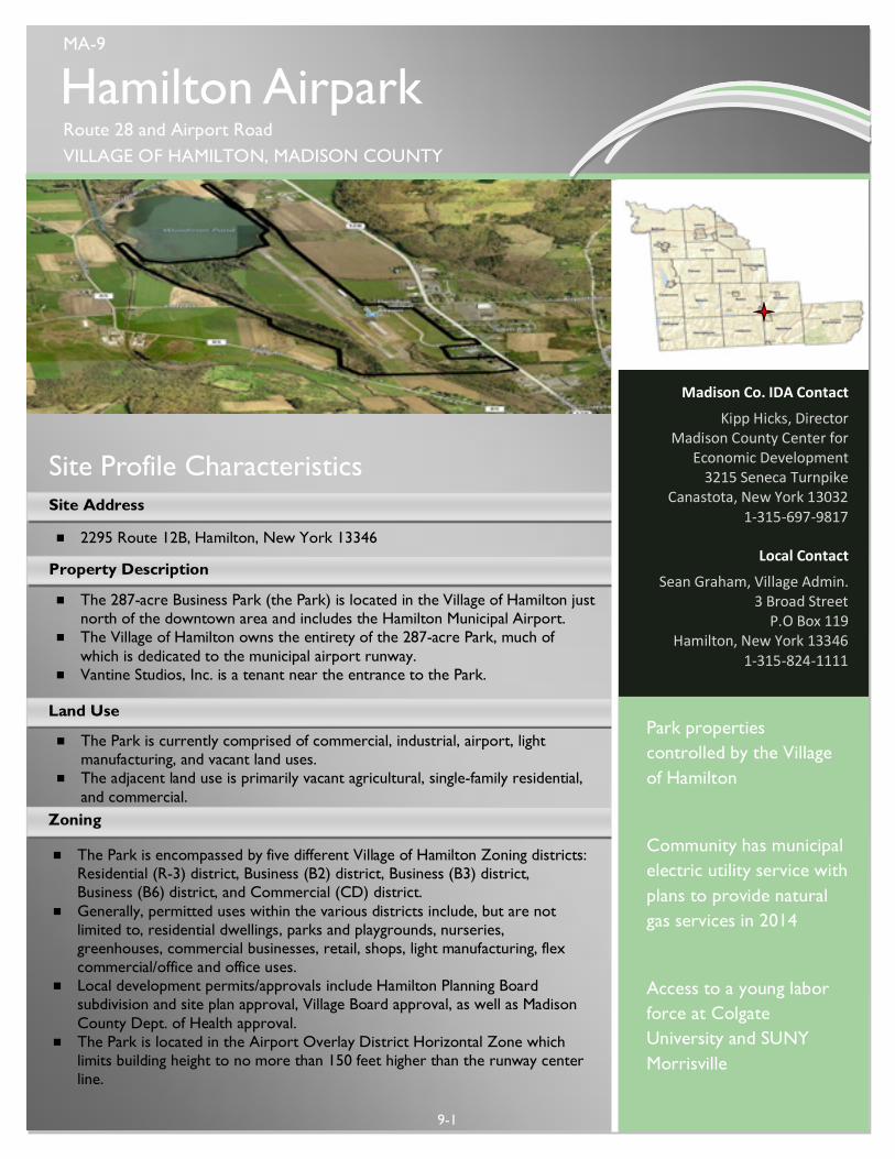
Hamilton Airpark Route 28 and Airport Road VILLAGE OF HAMILTON, MADISON COUNTY
9-1
Local Contact
Sean Graham, Village Admin. 3 Broad Street
P.O Box 119 Hamilton, New York 13346
1-315-824-1111
Park properties controlled by the Village of Hamilton
Community has municipal electric utility service with plans to provide natural gas services in 2014
Access to a young labor force at Colgate University and SUNY Morrisville
Property Description
¾ 2295 Route 12B, Hamilton, New York 13346
¾ The 287-acre Business Park (the Park) is located in the Village of Hamilton just north of the downtown area and includes the Hamilton Municipal Airport.
¾ The Village of Hamilton owns the entirety of the 287-acre Park, much of which is dedicated to the municipal airport runway.
¾ Vantine Studios, Inc. is a tenant near the entrance to the Park.
Site Address
Land Use
Zoning
¾ The Park is currently comprised of commercial, industrial, airport, light manufacturing, and vacant land uses.
¾ The adjacent land use is primarily vacant agricultural, single-family residential, and commercial.
MA-9
Madison Co. IDA Contact
Kipp Hicks, Director Madison County Center for
Economic Development 3215 Seneca Turnpike
Canastota, New York 13032 1-315-697-9817
¾ The Park is encompassed by five different Village of Hamilton Zoning districts: Residential (R-3) district, Business (B2) district, Business (B3) district, Business (B6) district, and Commercial (CD) district.
¾ Generally, permitted uses within the various districts include, but are not limited to, residential dwellings, parks and playgrounds, nurseries, greenhouses, commercial businesses, retail, shops, light manufacturing, flex commercial/office and office uses.
¾ Local development permits/approvals include Hamilton Planning Board subdivision and site plan approval, Village Board approval, as well as Madison County Dept. of Health approval.
¾ The Park is located in the Airport Overlay District Horizontal Zone which limits building height to no more than 150 feet higher than the runway center line.

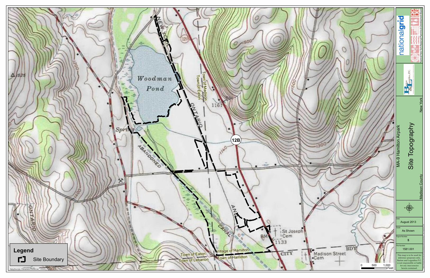
¾ The Park exhibits minimal topographic variation as the entire Park is at approximately 1140 feet in elevation.
¾ The Park is generally located down-gradient of adjacent properties. ¾ No topographic restrictions are present at the site.
Topography
9-2
Hydrologic Characteristics
¾ Three streams are present in the Park; one that is tributary to Woodman Pond, and two that are tributary to Payne Brook.
¾ Woodman Pond, a freshwater lake, is located immediately north of the Park.
¾ No other significant water resources are present in or near the Park. ¾ The depth to groundwater in the Park ranges from 0.25 to 6.5 feet. ¾ Onsite soils fall within hydrologic group A. ¾ Depth to bedrock in the Park is greater than 6 feet. ¾ Approximately 68% of the Park has well drained soils. The remaining
soils in the Park have poorly drained soils.
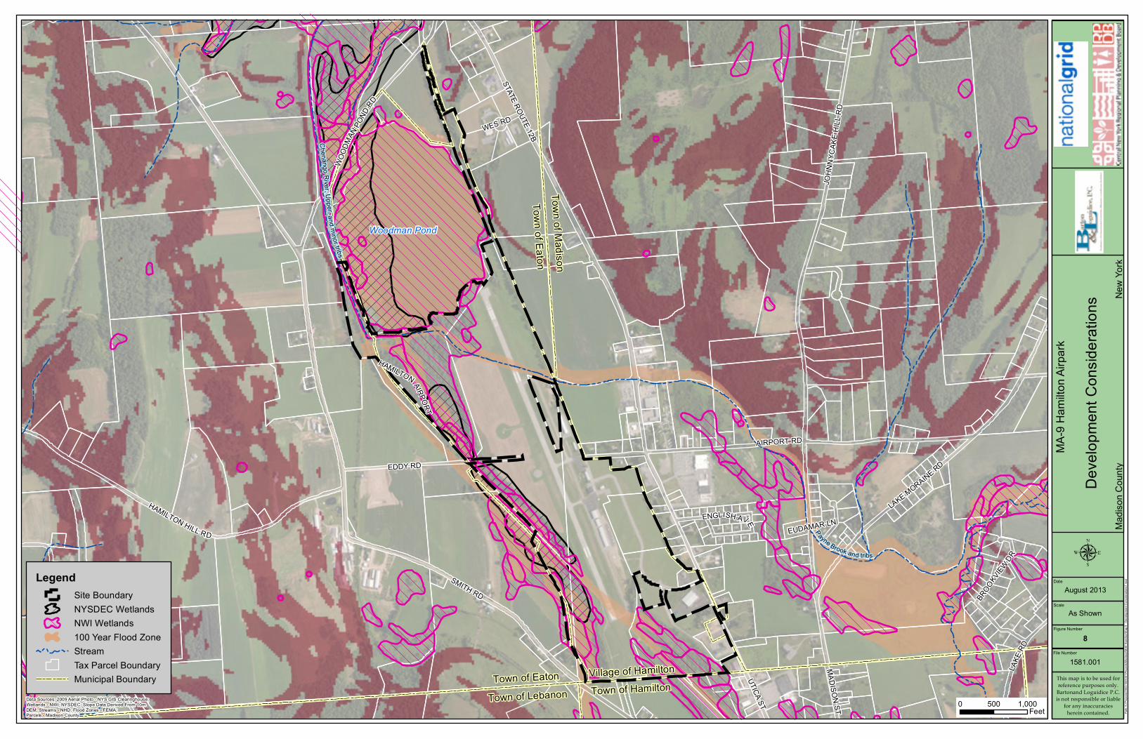
¾ There are approximately 30.5 acres of State-regulated wetlands along
the western boundary of the Park. These wetlands were field verified as part of a wetland delineation in the Park.
¾ Approximately 90 acres of NWI wetlands (Federal and/or State) are mapped within the Park. These wetlands have not been field verified.
¾ The western and northern portion of the Park is located within a 100-year floodplain.
¾ The Park is not located within a Significant Coastal Fish and Wildlife Habitat.
¾ The Park is not located within a designated critical environmental area.
¾ Federally protected species with potential to be located in the Park include: Chittenango Ovate Amber Snail, Indiana bat, and American hart’s-tongue fern.
¾ An Archeological Sensitive Area has been identified in the southern portion of the Park.
¾ The Park is not located within a State certified agricultural district.
Environmental Site Assessment Summary
Hamilton Airpark Route 28 and Airport Road VILLAGE OF HAMILTON, MADISON COUNTY
MA-9
Property Tax Assessments
¾ Undeveloped parcels in the Park range from 3 to 69.5 acres in size with assessed values that range from $23,000 to $500,000.

Municipal Water Supply ¾ Public water supply is provided directly to the Park via a 10” water
main. ¾ The Village of Hamilton’s water system has an available capacity of
400,000 gallons per day. Municipal Sewer ¾ Public sewer service is provided directly to the Park via a 8” sewer
main. Sewage is treated at the Village of Hamilton Wastewater Treatment Plant (WWTP).
¾ Permit requirements for the WWTP’s total maximum daily load currently do not permit the plant to accept additional sewage. The Village of Hamilton is working with regulators on this issue.
¾ Stone ditches are currently used for storm water management. Electric Service ¾ The Village of Hamilton purchases electrical services from the New
York Power Authority which is transmitted by NYSEG via a 46kV transmission line to the Park along Airport Road.
Natural Gas ¾ The Village of Hamilton has plans to provide natural gas services to
the community in 2014. Telecommunications ¾ Verizon provide telephone and internet services directly to the Park
via underground lines along Airport Road.
Utilities
9-3
¾ Existing roadway access into the Park is primarily from State Route 12B and Airport Road.
¾ Interstate access to NYS I-90 Exit 32 (Westmoreland/Rome) is 23 miles north of the Park.
¾ I-81 Exit 15 (LaFayette) is 34 miles west of the Park. ¾ NYS&W operates a north-south short line rail 7 miles east of the
Park. ¾ The Syracuse Rail Yard and Intermodal Terminal is located 37 miles
northwest of the Park in Syracuse, New York. North-south rail is available through the Intermodal Terminal.
¾ Port of Oswego is approximately 74 miles northwest of the Park along the southern shore of Lake Ontario in the City of Oswego.
¾ Syracuse Hancock International Airport is approximately 32 miles northwest of the Park centrally located in Onondaga County.
Transportation and Site Access
Hamilton Airpark Route 28 and Airport Road VILLAGE OF HAMILTON, MADISON COUNTY
MA-9

Site MA-9: Hamilton Airpark Site Layout Plan
¨ Total acreage of site is 287.8 acres
¨ Available lands and parcels range from 3.0 to
69.5 acres
¨ Advantage of being located adjacent to municipal airport; access to NYS Route 12B
¨ Four different zoning districts allow variety of
potential uses; restrictions or special permits may be required depending on which district available parcel is located within
¨ Available land located within established business park
¨ Hamilton Municipal Airport may influence future target sectors or potential development
considerations
¨ Height restrictions vary and based on zoning district; heights range from 35 to 65 feet
¨ Developers shall be aware of Horizontal Zone
of the Airport Overlay; limits all structures to
height of 150 feet
¨ Existing wetlands shall be avoided; portions
are remnants of Chenango Canal
287.8 Acres SMALL BUSINESS/LIGHT
INDUSTRY/PUBLIC SERVICE/COMMERCIAL
Existing Access
Existing Roadway
Existing Wetlands
Site Layout Features
STATE ROUTE 12B
LegendSite Boundary
MA-9
Hami
lton A
irpark
Area
Loca
tion M
apMa
dison
Cou
nty
New
York
This map is to be used forreference purposes only.
Barton and Loguidice P.C.is not responsible or liable
for any inaccuraciesherein contained.
File Number
1581.001
Figure Number
1
Scale
DateAugust 2013
µAs Shown
Data Sources: Topographic Basemap - USGS 0 4,0002,000
Feet Path:
K:\P
rojec
ts\15
00\15
8100
1\Proj
ects\
Madis
on\M
A9 H
amilto
n\Map
1 - A
rea L
ocati
on M
ap.m
xd
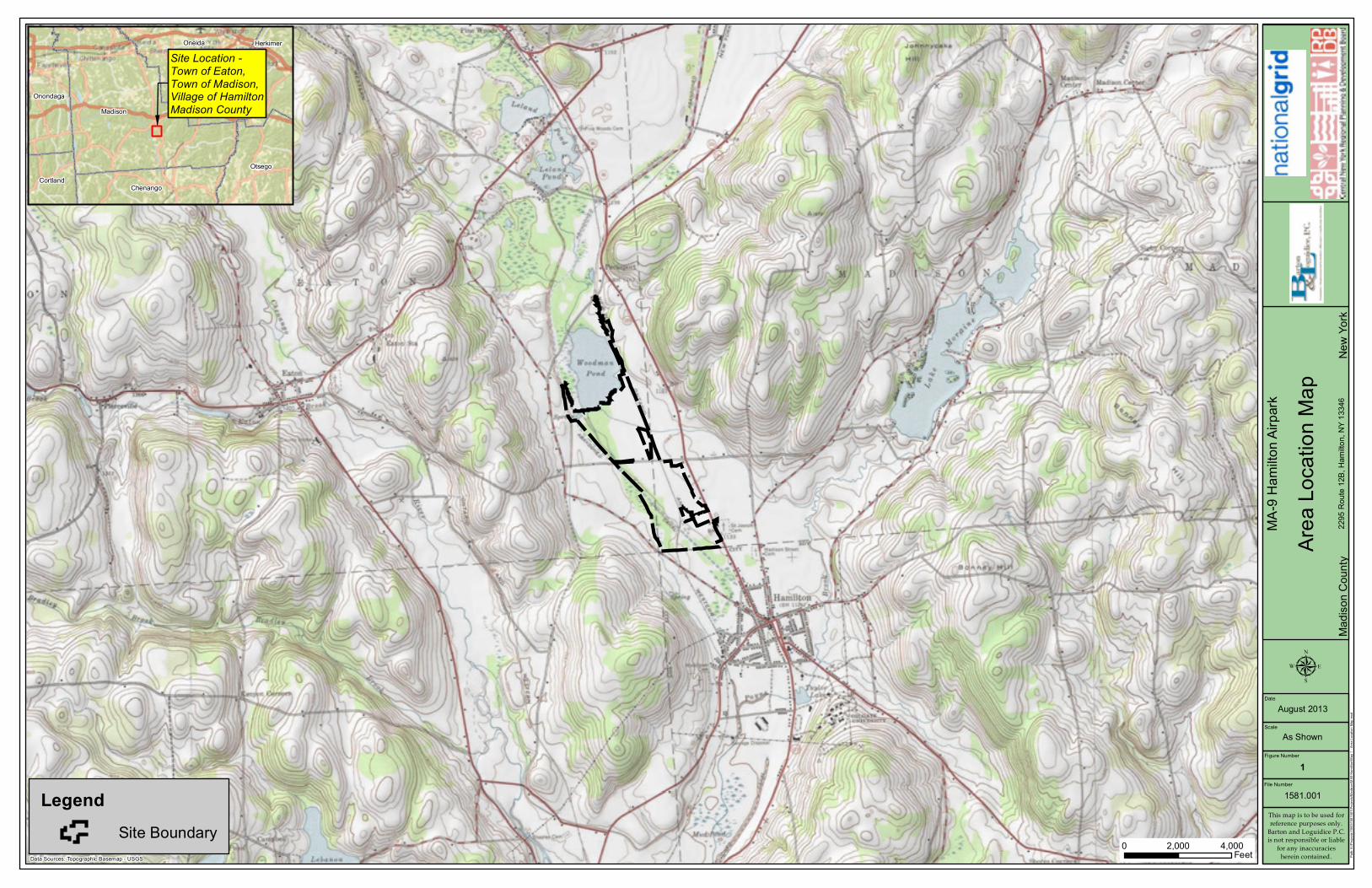
Site Location - Town of Eaton,Town of Madison,Village of HamiltonMadison CountyMadison
Oneida
Otsego
Chenango
Onondaga
Cortland
Herkimer
2295
Rou
te 12
B, H
amilto
n, NY
1334
6

¬«12B
Village of Hamilton153.-3-3
94.96Village of Hamilton
153.-3-148.05
Village of Hamilton153.-4-2
68.25
Village of Hamilton137.1-1-3
8.47
Village of Hamilton153.-3-4
5.36
Village of Hamilton153.-3-6
7.23
Village of Hamilton153.-4-4
12.93
Parry-Eisenhut LLC,153.-4-7.12
1.51Hillman D & Sons LLC,
153.-4-5.1123.00 Wendt, Wesley E. Sr.
153.-2-151.59
Hamilton Motel LLC,153.-4-5.12
3.06Village of Hamilton153.-4-7.11
48.05
Town of EatonTown of Madison
Town of Lebanon Town of HamiltonVillage of Hamilton
Town of Eaton
Woodman Pond
SMITH RDSTATE ROUTE 12B
AIRPORT RD
JOHN
NYCA
KE H
ILL R
D
EDDY RD
LAKE MORAINE RD
CHURCH RD
HAMILTON HILL RD
LAKE
RD
WOOD
MAN P
OND R
D
HAMILTON AIRPORT
BROOKVIEW DR
ENGLISH AVE
EUDAMAR LN
LegendSite BoundaryTax Parcel Boundary
MA-9
Hami
lton A
irpark
Site L
ocati
on M
apMa
dison
Cou
nty
New
York
This map is to be used forreference purposes only.
Barton and Loguidice P.C.is not responsible or liable
for any inaccuraciesherein contained.
File Number
1581.001
Figure Number
2
Scale
DateAugust 2013
µ
As Shown
Data Sources: 2009 Aerial Photo - NYS GIS Clearinghouse;Parcels - Madison County
0 1,000500Feet Pa
th: K
:\Proj
ects\
1500
\1581
001\P
rojec
ts\Ma
dison
\MA9
Ham
ilton\M
ap 2
- Site
Loca
tion M
ap.m
xd

Jy
Jy
Jy
Jy
Jy
Jy
Jy
Jy
Syracuse InternationalAirport
City of Syracuse
§̈¦90§̈¦90
§̈¦90
Site Boundary
§̈¦81
§̈¦481
§̈¦481
§̈¦81
§̈¦81
§̈¦690
§̈¦481
¬«31
k
Syracuse Intermodal Facility
£¤20
¬«12B
£¤20
¬«12
¬«46
¬«46
Madison CountyOnondaga County
Onondaga CountyCortland County
Madison CountyChenango County
Madison CountyOneida County
Oneida County
MA-9
Hami
lton A
irpark
Trans
porta
tion
Madis
on C
ounty
Ne
w Yo
rk
This map is to be used forreference purposes only.
Barton and Loguidice P.C.is not responsible or liable
for any inaccuraciesherein contained.
File Number
1581.001
Figure Number
3
Scale
DateAugust 2013
µ
As Shown
Data Sources: Basemap - ESRI Map Service0 42
Miles Path:
K:\P
rojec
ts\15
00\15
8100
1\Proj
ects\
Madis
on\M
A9 H
amilto
n\Map
3 - T
ransp
ortati
on.m
xd
LegendSite BoundaryRailroad
Jy NYS Thruway ExitJy Interstate Exit

Woodman Pond
Chenango Canal
Town of EatonTown of Madison
Town of Lebanon Town of HamiltonVillage of Hamilton
Town of Eaton
¬«12B
B6
B6
CD
B2
B5
CD
R3
B6
B6
B6
CD
B2
B5SMITH RD
STATE ROUTE 12B
AIRPORT RD
JOHN
NYCA
KE H
ILL R
D
EDDY RD
HAMILTON HILL RD
LAKE MORAINE RD
CHURCH RD
WOOD
MAN P
OND R
D
LAKE
RD
WES RD
UTICA ST
HAMILTON AIRPORT
BROOK
VIEW DR
MADISON ST
ENGLISH AVE
EUDAMAR LN
LegendSite Boundary
Village of Hamilton ZoningR3B2B5B6CDTax Parcel Boundary
MA-9
Hami
lton A
irpark
Zonin
gMa
dison
Cou
nty
New
York
This map is to be used forreference purposes only.
Barton and Loguidice P.C.is not responsible or liable
for any inaccuraciesherein contained.
File Number
1581.001
Figure Number
4
Scale
DateAugust 2013
µ
As Shown
Data Sources: Zoning - Village of Hamilton;Parcels - Madison County
0 1,000500Feet Pa
th: K:
\Proj
ects\
1500
\1581
001\P
rojec
ts\Ma
dison
\MA9
Ham
ilton\M
ap 4
- Zon
ing.m
xd
NOTE: Mapping information related to the"Horizontal Zone of the Airport Overlay" isnot available.
¬«12B
Town of EatonTown of Madison
Town of Lebanon Town of HamiltonVillage of Hamilton
Town of EatonLegendSite Boundary
MA-9
Hami
lton A
irpark
Site T
opog
raphy
Madis
on C
ounty
Ne
w Yo
rk
This map is to be used forreference purposes only.
Barton and Loguidice P.C.is not responsible or liable
for any inaccuraciesherein contained.
File Number
1581.001
Figure Number
5
Scale
DateAugust 2013
µ
As Shown
Data Sources: Topographic Basemap - USGS0 1,000500
Feet Path:
K:\P
rojec
ts\15
00\15
8100
1\Proj
ects\
Madis
on\M
A9 H
amilto
n\Map
5 - S
ite To
pogra
phy.m
xd

Town of EatonTown of Madison
Town of Lebanon Town of HamiltonVillage of Hamilton
Town of Eaton
PgA
Ha
PgB
Ha
WnHa
FrPgB
PgB
W
PgB
HxA
HxB
HxA
PgB
HxB
PgB
PpA
HxD
HxD
W
W
W
HxD
W
HxAHxA
SMITH RD
STATE ROUTE 12B
AIRPORT RD
JOHN
NYCA
KE H
ILL R
D
EDDY RD
HAMILTON HILL RD
LAKE MORAINE RD
CHURCH RD
WOOD
MAN P
OND RD
LAKE
RD
WES RD
UTICA ST
HAMILTON AIRPORT
BROOK
VIEW DR
MADISON ST
ENGLISH AVE
EUDAMAR LN
LegendSite Boundary
Soil ClassificationsFr, Fredon silt loamHa, Halsey silt loamHxA, Howard gravelly silt loam; 0 to 3 percent slopesHxB, Howard gravelly silt loam; undulatingHxD, Howard gravelly silt loam; hillyPgA, Palmyra gravelly loam; 0 to 3 percent slopesPgB, Palmyra gravelly loam; undulatingPpA, Phelps gravelly silt loam; 0 to 3 percent slopesW, WaterWn, Wayland silt loamTax Parcel BoundaryMunicipal Boundary
MA-9
Hami
lton A
irpark
Soil C
lassif
icatio
nsMa
dison
Cou
nty
New
York
This map is to be used forreference purposes only.
Barton and Loguidice P.C.is not responsible or liable
for any inaccuraciesherein contained.
File Number
1581.001
Figure Number
6
Scale
DateAugust 2013
µ
As Shown
Data Sources: Aerial Photo - ESRI Map Service (Bing Maps)Parcels - Madison County; Soils - NRCS
0 1,000500Feet Pa
th: K
:\Proj
ects\
1500
\1581
001\P
rojec
ts\Ma
dison
\MA9
Ham
ilton\M
ap 6
- Soil
Clas
sifica
tions
.mxd

Town
of E
aton
Town
of M
adiso
n
Town of Eaton
Town of Lebanon
Village of Hamilton
Town of Hamilton
SMITH RD
STATE ROUTE 12B
AIRPORT RD
JOHN
NYCA
KE H
ILL R
D
EDDY RD
LAKE MORAINE RD
HAMILTON HILL RD
CHURCH RD
WOOD
MAN P
OND R
D
LAKE
RD
EATON ST
WES RD
UTICA STHAMILTON AIRPORT
BROOK
VIEW DR
MADISON ST
ENGLISH AVE
EUDAMAR LN
LegendSite Boundary
Utilities Locations (approx.)Overhead ElectricTax Parcel BoundaryMunicipal Boundary
MA-9
Hami
lton A
irpark
Utilit
y Loc
ation
sMa
dison
Cou
nty
New
York
This map is to be used forreference purposes only.
Barton and Loguidice P.C.is not responsible or liable
for any inaccuraciesherein contained.
File Number
1581.001
Figure Number
7
Scale
DateAugust 2013
µ
As Shown
Data Sources: Aerial Photo - ESRI Map Service (Bing Maps)Parcels - Madison County
0 1,000500Feet Pa
th: K
:\Proj
ects\
1500
\1581
001\P
rojec
ts\Ma
dison
\MA9
Ham
ilton\M
ap 7
- Utili
ties.m
xd
Woodman Pond
Town of EatonTown of Madison
Town of Lebanon Town of HamiltonVillage of Hamilton
Town of Eaton
SMITH RD
STATE ROUTE 12B
AIRPORT RD
JOHN
NYCA
KE H
ILL R
D
EDDY RD
HAMILTON HILL RD
CHURCH RD
LAKE MORAINE RD
WOOD
MAN PO
NDRD
LAKE
RD
WES RD
UTICA ST
HAMILTON AIRPORT
BROOK
VIEWDR
MADISON ST
ENGLISH AVE
EUDAMAR LN
Payne Brook and tribs
Chenango Ri ver, Upper,a nd minor tribs
LegendSite BoundaryNYSDEC WetlandsNWI Wetlands100 Year Flood ZoneStreamTax Parcel BoundaryMunicipal Boundary
MA-9
Hami
lton A
irpark
Deve
lopme
nt Co
nside
ration
sMa
dison
Cou
nty
New
York
This map is to be used forreference purposes only.
Bartonand Loguidice P.C.is not responsible or liable
for any inaccuraciesherein contained.
File Number
1581.001
Figure Number
8
Scale
DateAugust 2013
As Shown
Data Sources: 2009 Aerial Photo - NYS GIS Clearinghouse;Wetlands - NWI; NYSDEC; Slope Data Derived From 10mDEM; Streams - NHD; Flood Zones - FEMA; Parcels - Madison County
0 1,000500Feet Pa
th: K
:\Proj
ects\
1500
\1581
001\P
rojec
ts\Ma
dison
\MA9
Ham
ilton\M
ap 8
- Dev
elopm
ent C
onsid
eratio
ns1.m
xd

Hamilton Airpark
Zoning and Land UseMA-9
LAND USE
Hamilton Municipal Airport, residential properties, commercial along NYS Route 12B
Some land is cleared while some land is forested (vegetated) or low-lying. Some of these parcels cover former stretches of the Chenango Canal. Immediate access to Hamilton Municipal Airport may influence future land uses.
Vacant commercial/industrial land, airport, commercial uses, wetlands
650 feet on NY-12B; 50 feet on Eaton Rd; internal access on Wings Way
Land Use
Road Frontage Comments
Adjacent Properties
Assessed values range from $23,000 to $500,000 and 3 acres to 69.5 acres.
287.8 Total Size (acres) Assessed Value
ZONING
The Hamilton Airpark site is covered by 5 different Village of Hamilton zoning districts. The parcel furthest south is zoned R-3, residential zoning in an area where land conservation issues are prominent. Existing three-or-four-family dwellings; accessory buildings; church, convent, rectory, parish house; public park/playground; cemetery; existing farm, nursery, greenhouse, riding stable; bed-and-breakfast facility and tourist home; and off-street parking are permitted by right in this district. B2 accommodates highway commercial development and is located primarily along NY-12B. Accessory building; church, convent, rectory, parish house; club, lodge, social recreational center; public park/playground; funeral parlor; existing farm, nursery, greenhouse, riding stable; commercial nursery; career planning, social and similar support services; public or private museum, art gallery, performing arts center; studio; hobby and craft shop; home garden center; bank or other monetary institution; retail store; barbershop and beauty shop, shoe repair, optician, tailor, dressmaker, milliner, and similar personal service; photocopy, photography, and related retail services; antiques, interior decorating; furniture or appliance sales; clothes laundromat; confectionery, bakery, or similar wholesale business; retail outlet for laundry, dry cleaning, pressing, dyeing, and similar activity; bed-and-breakfast facility and tourist home; newspaper office; and off-street parking are permitted uses in B2. B5 accommodates flexible commercial and light industrial development in the vicinity of the airport. Permitted uses by right include accessory buildings; public park/playground; existing farm, nursery, greenhouse, riding stable; career planning, social and similar support services; and off-street parking. The B6 District is meant to provide space for light industrial, business and administrative use appropriate to the airport. Permitted uses include existing farm, nursery, greenhouse, riding stable and off-street parking. A small portion of the site just south of the air strip falls under the Conservation Overlay (CO) regulations. The only uses permitted within the CO District are public park or recreation, nature trails, as well as Village structures and storage. The Park is also in the Airport Overlay District. Areas within 5000 feet of the runway center line are in the Horizontal Zone which limits building height to no more than 150 feet higher than the
Uses Permitted
Hamilton Airpark Page 1 of 211/20/2013 8:57:01 AM

Hamilton Airpark
Zoning and Land UseMA-9
runway center line. The Airport Overlay District Zones are not shown on zoning maps but are described in the Village of Hamilton Zoning Code.
Off-street parking requirements in the Village of Hamilton are tied to specific uses. Use as a factory requires 1 space per 400 sq. ft. of floor area. Use as a hotel or motel requires 1 space per guest room plus 1 space per 50 square feet of assembly area. Use as an office requires 1 space per 200 square feet of floor area over 1,000 square feet. Use as a warehouse requires 1 space per 1,200 square feet of floor area.
The R3 District requires a 35-foot front, 15-foot side (35-foot total side), and a 50-foot rear minimum setback. The B2 District a 25-foot front, 5-foot side, and a 10-foot rear minimum setback are required. Districts B5 and B6 have the same bulk zoning regulations. They require a 50-foot front, 25-foot side, and 25-foot rear minimum setback.
80.00%
The Village of Hamilton Code bars unnecessarily loud noise from vehicles or vehicle repair as well as the unnecessary amplification of voice or music without a permit from the Mayor's office. Also Section 174.14 of the Zoning Code states that in all districts, uses are prohibited which would be injurious to the safety or welfare of the neighborhood because of health, noise, vibration, glare, dirt, odor, smoke, toxicity or danger of fire or explosion.
The maximum height in the R3 District is 35 feet while it is 45 feet in B2 and 65 feet in B5 and B6. The Airport Overlay District Horizontal Zone limits building height to no more than 150 feet above the surface at the runway center line.
Off Street Parking
Set-backs
Percent of Site that may be utilized
Height Restrictions
Control of Nuisances
DEVELOPMENT IMPLICATIONS SUMMARY
The site is covered by four different zoning districts that permit a wide array of uses. Prospective developers must be mindful of how their parcel of the site is zoned in order to avoid special use permit and variance applications and requests for a zoning change. The Airport Overlay District regulations which limit building height to 150 feet above the runway center line must be taken into account as well.
Hamilton Airpark Page 2 of 211/20/2013 8:57:01 AM

Hamilton Airpark
EnvironmentalMA-9
TOPOGRAPHIC INFORMATION
This site is located down-gradient of adjacent properties; no potential aesthetic concerns exist for this site.
No topographic restrictions were identified for the site.
Topography
Potential Aesthetic Problems
Restrictions
The site exhibits minimal topographic relief; the elevation of the entire site is approximately 1140 feet above mean sea level.
WETLANDS
SOILS
The soil types mapped for the site include: PgB-Palmyra gravelly loam, undulating (38% of site); PgA-Palmyra gravelly loam, 0 to 3% slopes (30% of site); Ha-Halsey silt loam (26.4% of site); Fr-Fredon silt loam (5.6% of site).
Greater than 68% of the site is well drained. The remaining portions of the site are predominantly mapped with somewhat poorly drained or poorly drained soils.
Greater than 68% of the site fits hydrologic soil group A.
Upwards of 32% of site has limited permeability.
The bearing strength of the site is low, 1500 pounds per square foot (psf) (32% of site) and 2000 pounds psf (68% of site) per NYS Building Code based on class of materials.
No dominant soil units recognized to have the potential for hydric inclusions were documented within the site limits.
The depth to bedrock is noted as greater than 6.6 feet.
Mapping Units
Drainage Class
Hydrologic Soil Groups
Permeability
Bearing Strength
Hydric Soils Present?
Hydric Inclusions in Soils?
Seasonal wetness is documented for the site.
Groundwater Variation
Depth to Bedrock
The depth to groundwater ranges from 0.25 feet to greater than 6.6 feet.Depth to Groundwater
Hydric soils were identified on the site. The Halsey silt loam, Fredon silt loam, and Wayland silt loam soil mapping units are identified as hydric soils. These units comprise approximately 35% of the site area.
Hamilton Airpark Page 1 of 411/20/2013 8:57:15 AM
Hamilton Airpark
EnvironmentalMA-9
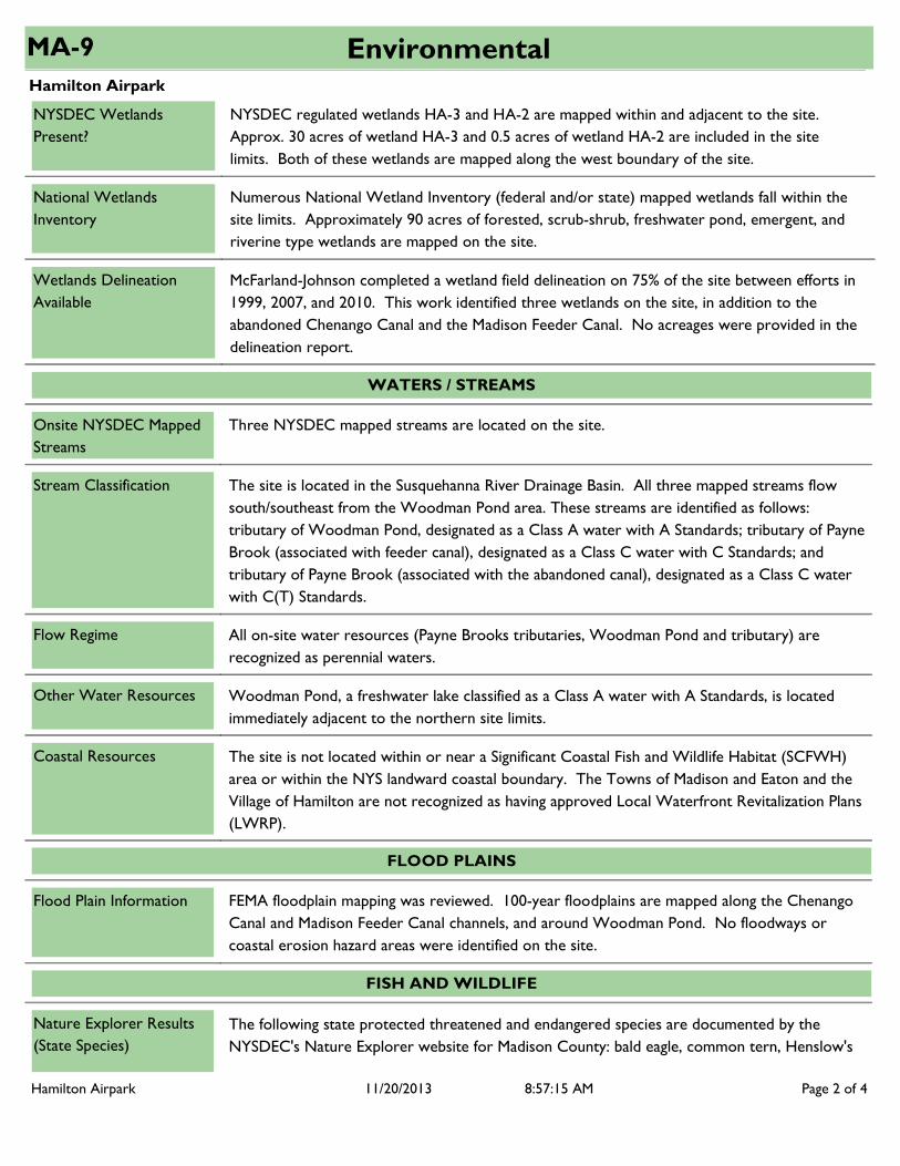
NYSDEC regulated wetlands HA-3 and HA-2 are mapped within and adjacent to the site. Approx. 30 acres of wetland HA-3 and 0.5 acres of wetland HA-2 are included in the site limits. Both of these wetlands are mapped along the west boundary of the site.
NYSDEC Wetlands Present?
National Wetlands Inventory
Numerous National Wetland Inventory (federal and/or state) mapped wetlands fall within the site limits. Approximately 90 acres of forested, scrub-shrub, freshwater pond, emergent, and riverine type wetlands are mapped on the site.
McFarland-Johnson completed a wetland field delineation on 75% of the site between efforts in 1999, 2007, and 2010. This work identified three wetlands on the site, in addition to the abandoned Chenango Canal and the Madison Feeder Canal. No acreages were provided in the delineation report.
Wetlands Delineation Available
Three NYSDEC mapped streams are located on the site.
WATERS / STREAMS
Onsite NYSDEC Mapped Streams
The site is located in the Susquehanna River Drainage Basin. All three mapped streams flow south/southeast from the Woodman Pond area. These streams are identified as follows: tributary of Woodman Pond, designated as a Class A water with A Standards; tributary of Payne Brook (associated with feeder canal), designated as a Class C water with C Standards; and tributary of Payne Brook (associated with the abandoned canal), designated as a Class C water with C(T) Standards.
Stream Classification
All on-site water resources (Payne Brooks tributaries, Woodman Pond and tributary) are recognized as perennial waters.
Woodman Pond, a freshwater lake classified as a Class A water with A Standards, is located immediately adjacent to the northern site limits.
Flow Regime
Other Water Resources
Coastal Resources The site is not located within or near a Significant Coastal Fish and Wildlife Habitat (SCFWH) area or within the NYS landward coastal boundary. The Towns of Madison and Eaton and the Village of Hamilton are not recognized as having approved Local Waterfront Revitalization Plans (LWRP).
FLOOD PLAINS
Flood Plain Information FEMA floodplain mapping was reviewed. 100-year floodplains are mapped along the Chenango Canal and Madison Feeder Canal channels, and around Woodman Pond. No floodways or coastal erosion hazard areas were identified on the site.
FISH AND WILDLIFE
Nature Explorer Results (State Species)
The following state protected threatened and endangered species are documented by the NYSDEC's Nature Explorer website for Madison County: bald eagle, common tern, Henslow's
Hamilton Airpark Page 2 of 411/20/2013 8:57:15 AM

Hamilton Airpark
EnvironmentalMA-9
CRITICAL ENVIRONMENTAL AREA
Site within or near Critical Environmental Area
The site is not located within a designated critical environmental area.
US Fish and Wildlife Service (Federal Species)
sparrow, least bittern, northern harrier, pied-billed grebe, sedge wren, short-eared owl, upland sandpiper, timber rattlesnake, lake sturgeon, brook floater, Chittenango ovate amber snail, bent sedge, big shellbark hickory, blue-eyed Mary, Blue-hearts, Carey's sedge, Cloud sedge, cork elm, dragon's mouth orchid, dwarf bulrush, Frank's sedge, golden-seal, gypsy-wort, lake-cress, little-leaf tick-trefoil, livid sedge, marsh arrow-grass, marsh valerian, mountain death camas, northern bog aster, northern bog violet, northern wild comfrey, ovate spikerush, pink wintergreen, purple cress, puttyroot, ram's-head ladyslipper, roseroot, rough avens, Sartwell's sedge, scarlet Indian-paintbrush, Schweinitz's sedge, sheathed pondweed, slender pondweed, small yellow ladyslipper, Small's knotweed, southern twayblade, sparse-flowered sedge, straight-leaf pondweed, striped coralroot, swamp lousewort, swamp smartweed, sweet coltsfoot, tall white aster, wild sweet-william, Wright's spikerush, yellow wild flax, creeping juniper, blunt-lobe grape fern, Hart's tongue fern, marsh horsetail, and rugulose grape fern.
Federally protected species that are reported by the U.S. Fish and Wildlife Service with the potential to be located on the site include: Chittenango ovate amber snail, Indiana bat, American hart's-tongue fern.
CULTURAL AND HISTORIC RESOURCES
An Archaeological Sensitive Area is mapped over the southern portion of the site.Archaeologically Sensitive Area?
Previous cultural resource surveys related to airport facility projects have been completed on limited portions of the site. These investigations identified one National Register listed location and two National Register Eligible locations within the project limits. These locations are as follows: 1) The Chenango Canal is listed on the National Register (a portion of this location eclipses the northwest corner of the site - additional canal locations that are not currently mapped are assumed to be eligible); 2) The Madison Feeder Canal, which cuts through the northern portion of the site, is recognized as being National Register Eligible; 3) The J. Russell Site, a historic farmstead location, was also recognized as being National Register Eligible. The J. Russell farmstead is located in the southeast corner of the site along Route 12B.
Nationally Registered or Eligible Historic Site?
A couple other locations with historic significance were identified within 2 miles from the site, but they are not located on adjoining properties and therefore are not detailed here.
Adjoining a Nationally Registered or Eligible Historic Site?
AGRICULTURAL
Hamilton Airpark Page 3 of 411/20/2013 8:57:15 AM
Hamilton Airpark
EnvironmentalMA-9
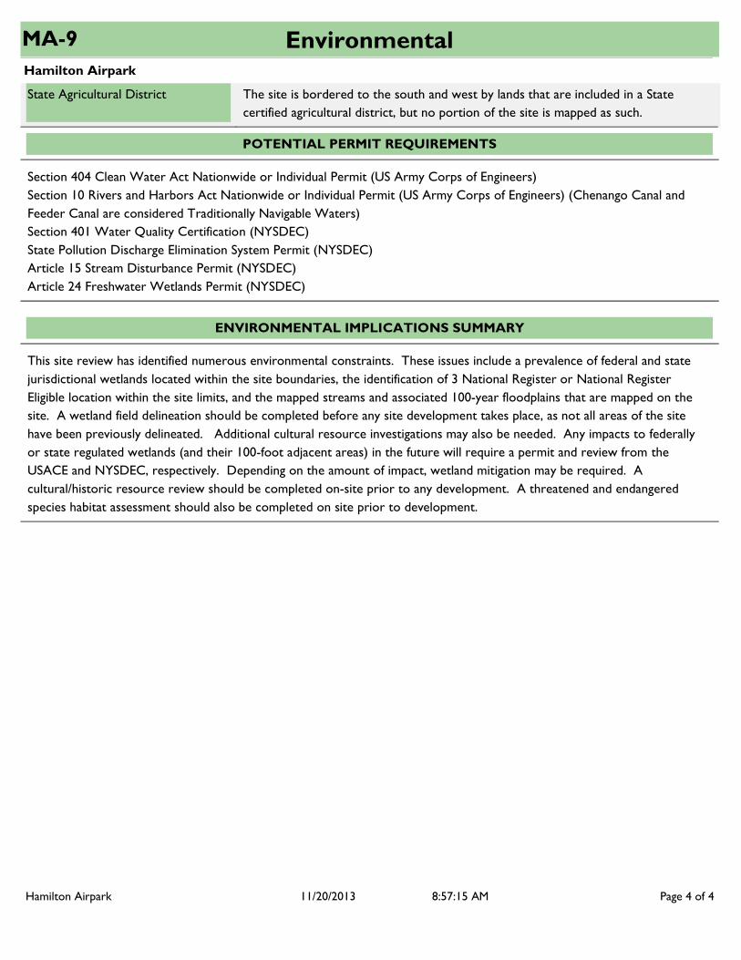
State Agricultural District The site is bordered to the south and west by lands that are included in a State certified agricultural district, but no portion of the site is mapped as such.
POTENTIAL PERMIT REQUIREMENTS
Section 404 Clean Water Act Nationwide or Individual Permit (US Army Corps of Engineers)Section 10 Rivers and Harbors Act Nationwide or Individual Permit (US Army Corps of Engineers) (Chenango Canal and Feeder Canal are considered Traditionally Navigable Waters)Section 401 Water Quality Certification (NYSDEC)State Pollution Discharge Elimination System Permit (NYSDEC)Article 15 Stream Disturbance Permit (NYSDEC)Article 24 Freshwater Wetlands Permit (NYSDEC)
ENVIRONMENTAL IMPLICATIONS SUMMARY
This site review has identified numerous environmental constraints. These issues include a prevalence of federal and state jurisdictional wetlands located within the site boundaries, the identification of 3 National Register or National Register Eligible location within the site limits, and the mapped streams and associated 100-year floodplains that are mapped on the site. A wetland field delineation should be completed before any site development takes place, as not all areas of the site have been previously delineated. Additional cultural resource investigations may also be needed. Any impacts to federally or state regulated wetlands (and their 100-foot adjacent areas) in the future will require a permit and review from the USACE and NYSDEC, respectively. Depending on the amount of impact, wetland mitigation may be required. A cultural/historic resource review should be completed on-site prior to any development. A threatened and endangered species habitat assessment should also be completed on site prior to development.
Hamilton Airpark Page 4 of 411/20/2013 8:57:15 AM

Hamilton Airpark
TransportationMA-9
ROADWAY
There is no public transit currently serving the project area.
The Hamilton Business Park is located within the Village of Hamilton on NY State Route 12B and Airport Road about 1 mile north of the village center. Route 12B falls under the jurisdiction of the NYS Department of Transportation and is classified as a Minor Arterial. The junction with US Route 20, a significant east-west route, is 4 miles north of the Business Park.
The Average Annual Daily Traffic (AADT) counts as measured in vehicles per day (vpd) from the NYS Department of Transportation are as follows:On NYS Route 12-B between Route 46 and the northern Hamilton Town Line the AADT was 7,206 vpd (April 2009).
Adjacent Roadway Network
Traffic Count Data
Public Transit Stop Near Site
Distance to Interstate Highway Network
For eastbound or westbound travel, the NY Thruway (I-90), Exit 32 (Westmoreland-Rome-NY Route 233) is approximately 23 miles north of the site. To travel northbound or southbound, I-81 can be accessed in LaFayette, NY, approximately 34 miles to the west.
The primary truck access route to the site is via NY State Route 12B.Truck Routes
RAIL
NYS&W operates a north/south short line regional connector rail line 7 miles to the east which links the Park to a CSXT east/west mainline rail 24 miles to the north . The Park currently is not served by or adjacent to rail siding. The Syracuse Rail Yard and Intermodal Terminal is located 37 miles northwest from the Park in Syracuse, NY. North/South mainline rail is available through the Intermodal Terminal at the Syracuse Rail Yard.
Freight Rail Service Summary
Distance to Rail Siding
CSX Transportation (CSXT) operates a Class 1 freight railroad network in the Central New York region. Specifically, the Chicago Main Line provides east/west rail services that link Central New York with New York City, Boston and Chicago through the Syracuse Rail Yard. The St. Lawrence Subdivision of the CSXT network provides north/south rail services linking Syracuse to Massena, and ultimately Montreal from the Syracuse Rail Yard. The St. Lawrence Subdivision junctions with the Fulton Subdivision which provides rail services to the Fulton and Oswego areas. CSXT maintains rail yards in Selkirk and Syracuse, intermodal terminals in Syracuse and Buffalo, and TRANSFLOW terminals in Albany, Syracuse, and Buffalo, NY.
CNY is also served by the NYS&W rail line, a regional network that provides rail freight service from the Syracuse area along a main line south to Binghamton and the NYC metropolitan area, as well as the Finger Lakes Railway Corporation, a short line rail network that provides freight rail service from the Syracuse area to Western New York and Pennsylvania.
Hamilton Airpark Page 1 of 211/20/2013 8:57:26 AM

Hamilton Airpark
TransportationMA-9
AVIATION
The Village operates a full service general aviation airport adjacent to the Hamilton Business Park. The airport is the only public use airport in Madison County. The 5300 foot long runway with a full taxiway allows a variety of jet aircraft to land in Hamilton. Syracuse Hancock International Airport is located approximately 32 miles to the west of the site. Syracuse Hancock International Airport is recognized as a primary commercial service airport and is part of the New York State Airport System.
Nearest Commercial Airport
MARINE
The closest Deepwater Port is located is the Port of Oswego, located in Oswego, NY, which is approximately 74 miles northwest of the site.
Nearest Deepwater Port
The closest access for commercial barge shipping via the NYS Canal System is currently available from the terminal wall located at Lock E21 (West Rome) in New London, NY, approximately 26 miles north of the site.
NYS Canal System
PERMITTING
NYS Department of Transportation highway work permits will be required for any roadway/utility improvements proposed within the respective ROW of State Route 12B. In addition, any additional access proposed to either NYS or Village of Hamilton roadways will require a commercial driveway permit approved by the NYSDOT and the Village.
Permits
The Hamilton Business Park is supported by a multimodal transportation network with access to roadway, aviation, water, and rail infrastructure all located within 75 miles of the site.
DEVELOPMENT IMPLICATIONS SUMMARY
Hamilton Airpark Page 2 of 211/20/2013 8:57:26 AM

Hamilton Airpark
UtilitiesMA-9
WATER SUPPLY
10
Village of Hamilton
Groundwater via two drilled wells 83 and 77 feet deep
Owner
Source of Supply
Size of water main at site (in)
Public Water Supply Available at Site?
Available Capacity at site (gpd) Data not available
Yes
None
None reportedCapacity “Bottlenecks”
799,000
1,200,000
80
Sodium hypochlorite is used for chlorine disinfection.
Village of Hamilton
$3.02 per 100 cubic feet, with a $5.00 minimum charge.
There are two water storage tanks in the system with capacities of 806,000 and 500,000 gallons.
System Capacity (gpd)
System Average Daily Demand (gpd)
Pressure at site (psi)
Method of Treatment
Storage
Treatment General Comments
Have any flow tests been performed near site recently?
Is Site in Existing Water District
User charges and water rates
Chlorination, fluoridation
Yes
No
System Information
System Capacity
Site Specific Details
Other Details
835,000System Peak Daily Demand (gpd)
Distance From Site (mi.) N/A
401,000Available System Capacity (gpd)
Hamilton Airpark Page 1 of 511/20/2013 8:56:28 AM
Hamilton Airpark
UtilitiesMA-9
None
None reported
None reported
Public water is available at the site via a 10 inch water main.
General Comments
Future upgrades planned
Summary
Future demands known at this time
Sean Graham - Village of Hamilton Administrator (315-824-1111)Contact Notes
SEWER COLLECTION SYSTEM
Village of Hamilton
8
Data not available
Owner
Size of sewer main at site (in)
Available capacity of sewer main at site (gpd)
Public Sewer Available at Site? Yes
NoMoratorium on New Users Currently there is no moratorium on new users.
NoStorm sewers available at site Stone ditches are used for storm water management.
YesSite in existing sewer district Village of Hamilton
None ReportedCollection System “Bottlenecks”
Moderate wet-weather issues for this system were reported.Collection System Wet-Weather Issues
$4.72 per 100 cubic feetSewer User Charges
Storm Sewers
System Capacity
Site Specific Details
Other Details
None reportedFuture Demands Known at this Time
None reportedFuture Upgrades Planned
System Information
Combination of clay tile and newer SDR 35 pipe and two pump stations. There are no combined sewers for this system.
Collection System Description and Capacities
N/ADistance from site (mi.)
Hamilton Airpark Page 2 of 511/20/2013 8:56:28 AM

Hamilton Airpark
UtilitiesMA-9
The sewer collection system at this site was recently installed.Collection System Comments
NoSite within MS4 Area
Public sewer is available at the site via an 8-inch gravity sewer main.Sewer Summary
Summary
RECEIVING WASTEWATER TREATMENT PLANT (WWTP)
Village of Hamilton / Wastewater Treatment PlantOwner / WWTP Name
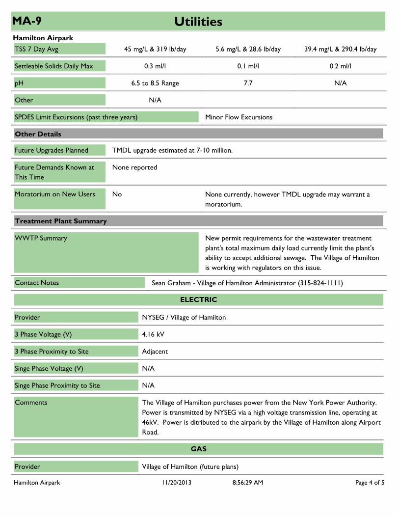
0.21
0.85
NH3 - 64 lb/day (Nov to May), 21 lb/day (Jun to Oct)
None
WWTP Average Available Flow Capacity (mgd)(Average Daily Design - Average 'Wet' Months)
WWTP SPDES Limits Current 3-Year Average Available Capacity
Phosphorous
Nitrogen
Flow (mgd)
0.52
TKN - 1.24 mg/L; NH3 - .37 mg/L & 1.68 lb/day; Nitrate -
28.51 mg/L & 117.4 lb/day
3.1 mg/L
0.33
NH3 - 62.32 (Nov. to May), 19.32 (Jun to Oct)
N/A
0.37WWTP Current Avg Monthly Flow 'Dry' (June-August)
0.64WWTP Current Avg Monthly Flow 'Wet' (March-May)
0.85WWTP Average Daily Design Flow (mgd)
Description of Treatment Processes
0.52WWTP Current Avg Daily Flow, Annual (mgd)
1.02WWTP Max Average Monthly Flow (past three years) (mgd)
Treatment Plant Capacity Details
SPDES Permit Constraints
NoneBOD Monthly Avg 3.7 mg/L N/A
NoneBOD 7 Day Avg 4.7 mg/L N/A
30 mg/L & 213 lb/dayTSS Monthly Avg 4.5 mg/L & 21.6 lb/day 25.5 mg/L & 191.4 lb/day
Activated sludge process with a secondary treatment sand filter.
Hamilton Airpark Page 3 of 511/20/2013 8:56:28 AM
Hamilton Airpark
UtilitiesMA-9
TMDL upgrade estimated at 7-10 million.
None reported
N/A
Future Demands Known at This Time
Future Upgrades Planned
Other
Minor Flow ExcursionsSPDES Limit Excursions (past three years)
New permit requirements for the wastewater treatment plant's total maximum daily load currently limit the plant's ability to accept additional sewage. The Village of Hamilton is working with regulators on this issue.
WWTP Summary
Other Details
NoMoratorium on New Users None currently, however TMDL upgrade may warrant a moratorium.
Treatment Plant Summary
45 mg/L & 319 lb/dayTSS 7 Day Avg 5.6 mg/L & 28.6 lb/day 39.4 mg/L & 290.4 lb/day
0.3 ml/lSettleable Solids Daily Max 0.1 ml/l 0.2 ml/l
6.5 to 8.5 RangepH 7.7 N/A
Sean Graham - Village of Hamilton Administrator (315-824-1111)Contact Notes
The Village of Hamilton purchases power from the New York Power Authority. Power is transmitted by NYSEG via a high voltage transmission line, operating at 46kV. Power is ditributed to the airpark by the Village of Hamilton along Airport Road.
Comments
Singe Phase Proximity to Site N/A
Singe Phase Voltage (V) N/A
3 Phase Voltage (V)
3 Phase Proximity to Site Adjacent
4.16 kV
Provider
ELECTRIC
NYSEG / Village of Hamilton
GAS
Village of Hamilton (future plans)Provider
Hamilton Airpark Page 4 of 511/20/2013 8:56:29 AM

Hamilton Airpark
UtilitiesMA-9
The Village of Hamilton has plans to extend gas utilities to the site. The plan is to pressurize the system towards the end of summer 2014.
Comments
Proximity to Site Not currently in close proximity to the site
Type
N/APressure (psi)
N/APipe Size (in)
Comments
Proximity to Site Adjacent
VerizonProvider
TELECOMMUNICATIONS
INTERNET
Provider Verizon
Comments
Proximity to Site Adjacent
DEVELOPMENT IMPLICATIONS SUMMARY
Sewer - New permit requirements for the Village of Hamilton WWTP's total maximum daily load currently limit the plant's ability to accept additional sewage.
Hamilton Airpark Page 5 of 511/20/2013 8:56:29 AM
Copyright © 2022 FDOKUMEN