Lsthmus world
46
Isthmus in the World. Elements for an Environmental History of Panama Guillermo Castro Herrera The City of Knowledge Foundation, Panama Behold, your Majesty, what a marvelous thing and grand disposition there is toward what is said, that into this Chagre river, born two leagues from the South sea, comes the North sea. This river runs strong, and is very broad and powerful and deep, and is so right for what is said, that one could not say nor imagine nor wish for a similar thing so close to the purpose of what I have said. Gonzalo Fernández de Oviedo, 1526 The Republic of Panama has entered the 21 st Century with serious environmental problems, from the destruction of forest resources and the erosion of biodiversity; and the deterioration and erosion of the lands destined for agriculture and livestock farming; the pollution of inland and coastal waters; to the chaotic urban growth that prevails mostly in the Metropolitan Region 1 . This situation –even when set within a wider scope 2 –, is here linked to the disintegration of the structures that used to govern Panamanian society’s relationships to its natural environment, structures which were shaped from the organization of interoceanic transit as an industrial activity by the United States between 1904 and 1977. Today, the inner coordination of this group of landscapes is in crisis, due to the exhaustion of the links between production and social structuring techniques that held it up until the last quarter of the 20 th Century 3 . A situation of such complexity requires an approach that, from past experiences, sheds new light on perspectives about relationships between human beings and the natural environment 1 For more information on the subject: Autoridad Nacional del Ambiente, 1999: 9 –32. 2 For more information on the subject: United Nations Environment Programme (UNEP), 2000: 9. 3 Gourou, 1984: Chapter I. Social structuring techniques deal with components of symbolic, cultural, and religious production, and their corresponding infrastructures, on everything going from the re-appropriation by successive cultural systems of the same group of sites that have religious value – a very long process –, to “modern” elements such as school networks.
-
Upload
ciudaddelsaber -
Category
Documents
-
view
1 -
download
0
Transcript of Lsthmus world

Isthmus in the World. Elements for an Environmental History of Panama
Guillermo Castro HerreraThe City of Knowledge Foundation, Panama
Behold, your Majesty, what a marvelous thing and grand disposition there is toward what is said,that into this Chagre river, born two leagues from the South sea,comes the North sea. This river runs strong,and is very broad and powerful and deep, and is so right for what is said,that one could not say nor imagine nor wish for a similar thingso close to the purpose of what I have said.Gonzalo Fernández de Oviedo, 1526
The Republic of Panama has entered the 21st Century with seriousenvironmental problems, from the destruction of forest resources and the erosion of biodiversity; and the deterioration and erosion of the lands destined for agricultureand livestock farming; the pollution of inland and coastal waters; to the chaotic urban growth that prevails mostly in theMetropolitan Region1. This situation –even when set within a wider scope2–, is here linked to the disintegration of the structures that used to govern Panamanian society’s relationships to its natural environment, structures which wereshaped from the organization of interoceanic transit as an industrial activity by the United States between 1904 and 1977.
Today, the inner coordination of this group of landscapes is in crisis, due to the exhaustion of the links between production and social structuring techniques that held it up until the last quarter of the 20th Century3. A situation of such complexity requires an approach that, from past experiences, sheds new light on perspectives about relationships between human beings and the natural environment
1 For more information on the subject: Autoridad Nacional del Ambiente, 1999: 9 –32.2 For more information on the subject: United Nations Environment Programme (UNEP), 2000: 9.3 Gourou, 1984: Chapter I. Social structuring techniques deal with components of symbolic, cultural, and religious production, and their corresponding infrastructures, on everything going from the re-appropriation by successive cultural systems of the same group of sites that have religious value – a very long process –, to “modern” elements such as school networks.
in Panama. This is precisely what environmental history is about.
This perspective has complexities that require special attention. Environmental history links the times of human action with those of natural history, projecting towards the past –which in our species’ case spans some four million years–as well as glimpsing into future options that far exceed the “long term” horizons usually employed by social sciences. And as far as spaces go, if environmental history, in its broadest sense, refers to the expansion of our species over the planet, up close it is taken down to the scale of an economy and a social and political relationship that work as a global market and system, constructed over the last 500 years, within which the environment has become a global phenomenon.4 The best thingto do, in any case, is to being with the basics: the biogeophysical environment where the historical process that weseek to comprehend takes place.
The Biogeophysical Environment5
The Isthmus of Panama’s formation –which joined the North and South American land masses and begun processes of contact and migration of animal and vegetable species that had so far evolved in complete isolation were– took place about four million years ago.6 Therefore, the ecosystems that sustain lifeon Panamanian territory are part of the larger group that linksthe Mesoamerican-Caribbean space and the corresponding large Amazonian-Pacific-Darién ecosystem7.
4 On the subjet for instance: “Historia tropical: a reconsiderar las nociones de espacio, tiempo y ciencia”, in Palacio, Germán, and Ulloa, Astrid, 2002: 68. In Panama’s case, the path towards this task has already been opened up by pioneering texts of great value, such as La Población del Istmo de Panamá (Population of the Isthmus of Panama), by geographer Omar Jaén Suárez; The Originsof Agriculture in the Lowland Neotropics, by Dolores Piperno and Deborah Pearsall, and the studies on thecountry’s prehistory undertaken by Richard Cooke. To these it is fitting to add a growing interest for environmental matters shown by historians such as Alfredo Castillero Calvo. All this enriches the possibilities of an environmentally oriented reading of a wide variety of chronicles, testimonies, and studies of the Isthmus’ geography and nature, accumulated from the16th Century on, and multiplied in number from mid 19th Century on, in the midst of French and North-American initiatives for the construction of an interoceanic Canal in Panama. 5 Except when indicated otherwise, this section adheres to what is proposed in Herrera, Ligia: 1970.6 Coates, 2001: 23,247 Burkart, R.; Marchetti, B. and Morello, J., 1995: 42, 43, 104.
2
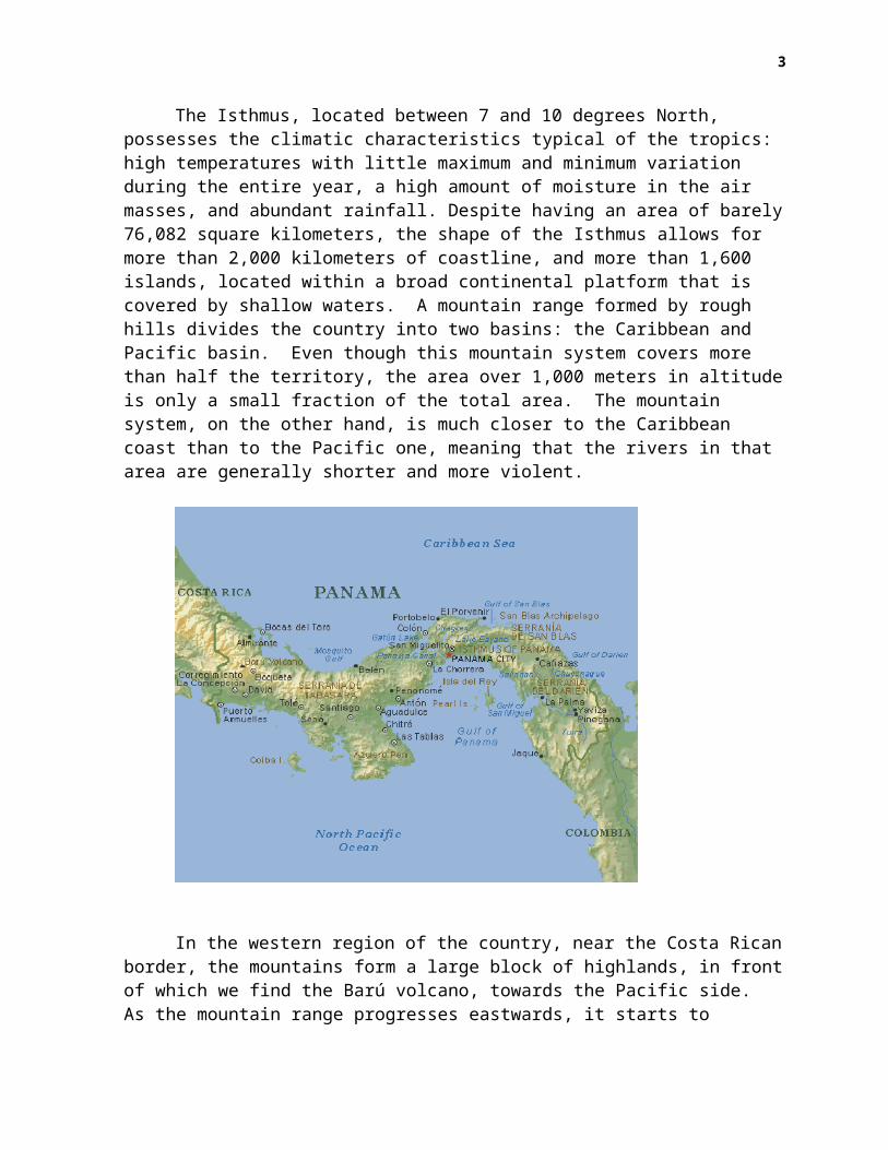
The Isthmus, located between 7 and 10 degrees North, possesses the climatic characteristics typical of the tropics: high temperatures with little maximum and minimum variation during the entire year, a high amount of moisture in the air masses, and abundant rainfall. Despite having an area of barely76,082 square kilometers, the shape of the Isthmus allows for more than 2,000 kilometers of coastline, and more than 1,600 islands, located within a broad continental platform that is covered by shallow waters. A mountain range formed by rough hills divides the country into two basins: the Caribbean and Pacific basin. Even though this mountain system covers more than half the territory, the area over 1,000 meters in altitudeis only a small fraction of the total area. The mountain system, on the other hand, is much closer to the Caribbean coast than to the Pacific one, meaning that the rivers in that area are generally shorter and more violent.
In the western region of the country, near the Costa Ricanborder, the mountains form a large block of highlands, in frontof which we find the Barú volcano, towards the Pacific side. As the mountain range progresses eastwards, it starts to
3
decrease in altitude, until it becomes a group of low hills by the time it reaches the central part of the Isthmus, which is also the narrowest part. From here further eastward, the rangemoves closer to the Caribbean coastline, and starts to gain altitude once again, reaching the highest points in the region upon the Colombian border.
On both sides of the main mountain system, between the range and the sea, we find a strip of lowlands, formed by smooth or scarcely undulated plains, over which appear areas ofsmall hills and slopes. On the southern coast, the plains reach their widest point in Chiriquí, and practically disappearnear Veraguas, reappearing and continuing until near the Central Isthmus. Additionally, on the Southeastern part of the country, another interior plain appears, formed by the Chepo and Chucunaque rivers’ watersheds, which have their sources very near one another and are separated by very low hills. Thus, the different conditions of altitude and exposure to the moisture ridden Northeast winds originate three main climatic strips:
The hot lowlands strip, located between sea level and 600 meters on the Caribbean basin, and 700 meters on the Pacificone, spans over 76% of Panama’s surface, and in it, an undulating and sometimes dissected surface predominates.
The mild lands strip –also known as subtropical–, which occurs between 600 and 700 meters, depending on which basin it is, and 1,500 meters in altitude, occupies about 18% of the surface.
The cold lands strip of over 1,500 meters in altitude, occupying a little over 5% of the country’s territory.
Vegetable associations in the lowlands range from savannahs and dry tropical forests, located within specific areas of the Pacific basin, to tropical rainforests, which are distributed mainly along the Caribbean basin and on well-determined areas in the Pacific that are exposed to the winds from the Southwest. On the highlands, associations also vary
4
between subtropical rainforests, on altitudes between 600-700 to 1,500 meters, and very humid mountain rainforests, with gradations between one and another that depend especially on the prevailing degree of moisture originated by greater or lesser local rainfall. Finally, on alluvial soils subject to the influence of tides or to periodic flooding, located along low coasts and river estuaries, there are abundant mangrove forests, particularly in the coastal sectors of the Bocas del Toro, Chiriquí, Veraguas, the Gulf of Parita, and in the Panamaand Darién provinces.
The most arid areas, such as the Gulf of Parita, in the Southwestern region –with mild climate, a mostly even topography, less dense vegetation, easier to farm, and with a lesser variety of insects and plagues that make life difficult and alter human health– received human settlements early on. There, and from there, interacting with the rest of the territory, the history of interactions between humans and the natural environment in Panama was mainly carried out, until theend of the 19th Century.
Before Europe
The Initial LandscapeIn a strict sense, Panama’s environmental history goes back to the moment when the first humans entered the Isthmus, about 11 thousand years ago. The ecosystems encountered by those first immigrants were then the result of a complex and prolonged formation process, which would further include the gradually accumulated impact of the new species’ activity within that environment. That species’ presence became linked, in turn, to other natural processes corresponding to the final period of the last glaciation.
Even though the formation of the climatologic conditions and ecosystems very similar to the current ones was already well advanced, there were circumstances different from those ofthe present. The sea level was about 50 meters below the current one, and a considerable portion of what today are the
5

Gulfs of Panama and Chiriquí were then coastal plains8. Average temperature was about 5 and 6 degrees cooler than today’s. The lower limit of the mountain forest was below 800 meters. And even though the dry seasons were longer then, they tended to get shorter and stabilize, all of which indicates a climate that tended to be similar to our own. In that original landscape, the tropical forest “occupied much of the lowlands, but was penetrated by new communities of plants coming from broad mid and high slopes, which included less dense groves andprobably brushes”, through which large herbivores could make their way9.
Regarding animal life, after the initial exchange of species between North and South America, the tropical forest’s advance into the lowlands, initiated about 800 thousand years ago, had blocked the passage of large mammals from prairie habitats –large-horned deer, mammoths, bison, which had enteredNorth America from Asia through the Behring land bridge10. Thus,during the period when humans were arriving, large herbivores don’t seem to have existed in the Isthmus; however, smaller mammals were abundant, such as the white-tailed deer and the collared peccary, and carnivores such as the jaguar. On the other hand, the rise in the sea level over the coastal plains between 9350 and 6550 B.C., due to the end of the last glaciation favored the formation of broad mangroves and, with them, of coastlines rich in marine life. Thus, the conditions that were to play an important role in the following environmental history were given.
First Human ImpactsThe first humans who entered the Isthmus were members of a human species that had already evolved, who had at their disposal not only basic technology, which included primarily the ability to produce and use fire, but the ability to use anddevelop such technology to modify their surroundings according to their needs, even in conditions of isolation with regards to
8 Jaén Suárez, 1981: 14. 9 Colinvaux, 1997: 127 – 136.10 Webb, 1997: 121
6
the other large focal points of cultural change created by humans in Eurasia and Africa. This way, they acted as the forefront of their species in what much later would be known asthe New World, traveling alongside the rest of their kind –without knowing it– through important stages of the same evolutionary path, during the enormous time period previous to the European conquest.
The first clear signs of slash agriculture appear in Panama’s central Pacific area, around the year 7,000 b.o.e. At that time, the region had considerable areas of seasonal tropical forests on fertile grounds, and a broad and productiveestuarine zone, which seen to indicate that all the necessary factors for it to become a “central area for the birth and development of food production”11 were there.
The general timeline for this development can be established starting on the year 11,000 b.o.e., when the paleoindians were already “exploiting and modifying at the sametime the tropical forest”, which was part of a mosaic of vegetation that was “probably very open in some places”. This allowed the Isthmus’ first inhabitants to move through these habitats, “from above the line of trees to sea level”, organized in widely scattered groups that were constantly moving. Their descendants produced hunting tools and methods that were each time better adapted to the environment on which their existence depended upon, and used them to hunt “white-tailed deer, peccaries, and other small and fast mammals that had avoided extinction at the end of the Pleistocene, as well as a variety of water animals, much wider than what is consumedthese days”12. Additionally, as a part of the same process, they must have developed significant control over the Isthmus’ flora, selecting an ever-increasing number of useful plants, and learning to manipulate their habitats directly and indirectly, with the purpose of stimultating their reproduction, as seems to have been the case with the palm treethat produces pixbae, a fruit rich in fats and proteins, and
11 Piperno and Pearsall, 1998: 316. 12 Cooke 1997: 142. On the subject, also, Cooke: 2001.
7
widely consumed by the country’s inhabitants up until present day13.
Towards the year 9,000 b.o.e., a new situation arises.The population, living in individual dwellings and/or smallgroups of houses located on the banks of rivers and secondarystreams, had begun to grow squash, pumpkins, and tubers such asleren and sagu on small domestic gardens14. Between the years7,000 and 5,000 b.o.e. during a climactic interval which wasdrier than today’s, slash agriculture and the use of marine-coastal resources linked to the mangroves (mollusks, crabs,fish) are intensified given the growing difficulties inobtaining adequate amounts proteins from land animals, while asubstantial increment in the number and size of humansettlements takes place.
This turn of events becomes more dramatic between 5,000 and 3,000 b.o.e., in the first stages of the ceramic period. Cultivated plants that had not been registered before begin to appear, such as corn, and sweet potato. Coastal settlements become larger and more abundant, and the increasing intensification of agriculture seems to be associated to the permanent shortage of primary trees, to the decline of secondary forests, and to the rise in herbal vegetation. From 3,000 to 2,000 b.o.e., corn, tapioca, a sort of yam, and probably pumpkins of the Calathea species begin to be cultivatedpermanently on alluvial soils by important rivers and coastal streams. The main settlements in the region become villages inhabited by hundreds of individuals, and the technological base shows a greater emphasis on food production: a technology consisting of polished stone is used to clear forests on river banks appears, while hands and grinding stones replace simpler 13 Even so, the population must have been scarce, and subject to frequent fluctuations, sincethe growth process must have undergone “alternations between periods of demographic crisis withtimes of relative booming”. In the case of hunter-gatherer groups, for instance, Omar JaénSuarez proposes that such feeding regime could not have sustained very numerous populations,and, starting form a density of 1 inhabitant per every 4 to 10 square kilometers, estimates apopulation of around 4000 to 8000 humans in the Isthmus. Jaén Suarez, 1981: 16. 14 Sagú and lerén seem to belong to what was probably a long list of plants, rich on starchesand fats, which were among the first to be grown or, someway, intensely manipulated; however,their importance as providers of calories declined because of the availability and increasingimportance given to corn, tapioca, and other crops that are more familiar to us nowadays. Inpresent day Panama, many peasants do not grow Sagú nor lerén, but they speak of sagú assomething that had major importance in the recent past. Piperno and Pearsall, 1998: 217.
8

grinding stones used on earlier periods, and ceramic crafts improve on quality and diversity of shapes.
Towards the early stages of the Christian era, the centralPacific basin came to be “the central area in food productionand cultural development in Panama”. All this lead to anentirely new situation, characterized by more numerouspopulations saturating inscribed areas of good soils forgrowing crops, permanent and more heavily populatedsettlements, and the increasing possibility of growingirregular crops from a smaller number of high yielding plants.With it, as well, “processes leading to competition, socialconflicts, and the achievement of status by relatively fewindividuals –the preludes of “cultural complexity”– were set inmotion”. This motion and its consequences define the next Sub-stage on the Isthmus of Panama’s environmental history15.
On the Formation and Development of Agricultural-GathererSocieties in the Eve of the European Conquest (5,000 B.C – 1510A.D.)In the Eve of the European Conquest, states Omar Jaén, theIsthmus had come to be “a world of sedentary concentrations, oflarge rural villages, important cemeteries, of centersdedicated to the trade of objects and, why not, of men?” inwhich there was “a positive correlation between the triumph ofagriculture and demographic growth”. In this context, multipleevidences suggest that on the Pacific basin two differentpatterns of spatial organization may have coexisted. Onecentral, characterized by “greater concentrations, such as theones at Chirú, Peris, and specially Natá, where Gaspar deEspinosa counts nearly 1,500 inhabitants, occupying between 45and 50 dwellings”, and another one in Darién, with a populationscattered along various water courses16. Behind those visible
15 On their conclusions, the authors emphasize that evidence provided by the transition processfrom food gathering to food production “clearly indicates that slash crops can be sustained forthousands of years within seasonal tropical forests that grow on fertile soils, and can withstand substantial population increases through time”. And they add: “even so, growing populations seem to have finally surpassed productive potential on inter-fluvial lands subjected to slash, and to have moved to alluvial lands in the lowest parts of valleys”. Piperno and Pearsall, 1998: 290 - 297.16 Jaén Suárez, 1981 b: 26, 44.
9

patterns, as occurs in so many other areas in America beforethe Conquest, there was a complex structure of relationshipswith the natural environment, in which exchanges betweendifferent ecological zones –“steps” in the Andean world,“strips” in the tropical one–, played an important role in thelife of aboriginal populations.
Thus, differences on the resource base between the Atlantic and Pacific basins of the Isthmus –and even between the Western and Eastern regions in the latter one–, fostered different adaptation and production strategies, which in turn encouraged constant trade of complementary products, such as the salt and salted fish that inhabitants of the Parita seaboard provided to farmers in the interior, or stone tools produced from high quality sites located in the Atlantic basin of the central mountain range, or prestigious articles, such asgold, which, according to Richard Cooke, became “the most attractive good for Southern chiefs who wished to demonstrate their might and wealth”, to the point where the trading of goldjewelry “became perhaps the main commercial activity of the chiefdoms in Panama and Costa Rica”17. Additionally, the Isthmus’ own geographic configuration added to this interaction, particularly on those places in which relatively easy mountain passes were combined with rivers of heavy flow that flowed northwards and southwards, respectively, as in the Zaratí and Toabré-Coclé del Norte system watersheds, in the valleys of Caño Sucio, Indio, and Chagres rivers, linked to theregions of Capira and Panama, as well as the land routes that Vasco Núñez de Balboa and his companions would eventually travel, which linked present day Comarca Kuna Yala to the Bayano and Chucunaque-Tuira valleys18. In any case, the most 17 Cooke, Richard, 1997: 166.18 Pearsall and Piperno, on their part, indicate that in the former Chagres river valley, slashagriculture practices for growing corn were begun around 5,000 b.o.e., and around 3,200 b.o.e.,the trees’ pollen had practically disappeared from the area’s records. On the other hand, eventhough in that segment of the Atlantic, within the pre-Hispanic space complex, human settlements in the form of individual households and dispersed groups of houses on the high parts of secondary river banks were predominant, archaeological evidence and Spanish testimonies from the first moment of contact suggest the existence of larger settlements, such as La Peguera, on the Coclé del Norte river’s watershed, and Uracillo, on the Indio river’s watershed, that seem to fit the category of villages, with articulating functions around them, on which are also evident soil modification works in dimensions that suggest a social organization of a certain complexity in the moment of their construction.
10
important aspect is that both basins were part of the same socio-cultural mesh within the Isthmus’ environmental structure prior to the European Conquest, which furthermore was linked with trade between the Central and South American worlds.
At the early 16th Century, this structure was manifest on the landscape and on the conducts that Pascual de Andagoya described on the Pacific basin of the Isthmus, where –he states– “… there were no large towns, but every important center had three, four, or more houses on its lands, according to its numbers, all nearby and at close sight of one another: each one made their house where they grew their crops…” On this environment, “deer and pigs different from the ones in Spain, which move in large packs”, were abundant, so that “the sires”
… had their properties where, in the summer, they would hunt deer, and set fire to the wind, and since the grasses were high, the fire was much, and the indians would set themselves where the fire was to stop; and the deer would flee blindly from the fire and would end up where the indians awaited with their hard stone shooters, and among those that fled the fire few escaped. There is no other hunting on those Provinces other than birds, where there are many turkeys and pheasants and turtledoves, and many other forms of birds: there are lions and tigers that would hurt people, and because of that they would have houses with fences and closed at night. In the rivers there are large fisheries with very good fish: the groves are green all year long and very few trees have fruit, and with what they have they do”.
“All these lands”, concluded Andagoya, “are fine and flat and very beautiful, with many places where corn and peppers and melons different from the ones here are maintained, and grapes and yucca and many fisheries in the rivers and in the sea, and the hunting of deer, and in this matter the ones in Coyba and Cueva have the same”19.
On this space, however, violent factors were also at work.One was slash agriculture, which, after increasing demographic pressure was put on the seasonal forest for some centuries, would give way to the formation of savannah ecosystems, and of 19 “Relación del Darién, Provincias Centrales y Chiriquí (1514–1541)”, in Jaén Suárez, Omar, 1981 a: 6–9.
11

hillsides that were useless for food production, subject to erosion and wear. The other one, more evident, was manifest inthe increasing use of violence as a resource for social organization, and for relating with rival groups. Thus, in these regions of the central Pacific, chiefdoms were formed whose sires, according to Andagoya, had “great differences and killed each other a lot”, since they were “bellicose people, they always made war, some sires over others, on the terms”. 20 From these activities would emerge, additionally, increasingly stratified societies, which allowed –for example– for the existence of different burial grounds for those who occupied the highest positions within the structure, and for the development of activities of worship to ancestors.
And so, on the eve of the European Conquest, the Isthmus’ landscapes were the result of a process of human development that lead to a population organized “in about 79 tribes, with an average of 1500 to 3000 members each”, who related with their natural surroundings through a mixed system of polyculture agriculture and gathering, and which “covered, no doubt, the best lands in the country”. Within this framework of relationships,
No higher power seemed to link these chiefdoms and tribes to anorganization that could overcome their own autonomy and that wouldcover all, or even a considerable portion, of the isthmus… Only thecentral savannah region seemed to hint the beginnings of a more solidpolitical coordination, broad and complex, with territorial andpolitical hierarchies organized by important sires or vassals which,nevertheless, did not exceed the regions of Chirú, at the East, andEscoria, at the West. The chiefdoms of Natá and Parita, the mostimportant ones, seemed to control, through about ten vassals each, asmany other zones with diverse and complementary naturalenvironments21.
IV. The European and African Incursion into the Isthmus’ Ecosystems (1510-1600 A.D.)Information available indicates that, at the time of the European’s arrival, the Isthmus was undergoing “a sort of
20 Piperno and Pearsall, 1998: 311. 21 Jaén Suárez, 1981 b: 43.
12
demographic boom, just as the rest of the American continent”, and had a population of about 250,000 to 500,000 inhabitants22, which the conquest’s impact reduced to about 15,000 indigenous peoples by the end of the 16th Century23. Three factors seem evident in this disaster.
The first one, of course, was the violence exerted by the Europeans, especially significant in Panama, where between 1520and 1540, the conquest took the shape of looting expeditions and enslavement of the inhabitants in the Southwestern Pacific region, the richest and most populated in the country. To thiswe can add the disruption of social structures, the breakdown of cultural patterns, and the dislocation of the regional trading systems on which food production and social reproduction systems depended24. This combination of circumstances led to a health crisis that lead to a real demographic collapse in the whole continent.
In view of the shortage of “exploitable” labor, created inthis manner, the importing of slaves from other regions in America, as well as from Africa, defined from early on a tendency, witnessed during most of the new historic cycle, of turning the Isthmus into a “land of immigrants”25. Additionally,such immigration included the addition of various species into the Isthmus’ ecosystems, some of which have become typical of Panama’s subsequent landscapes. Some were brought in by the Europeans, such as cattle and pigs, fowl, rice, citrus fruits, and sugar cane. Others have African origins, such as yam,
22 Jaén Suárez, 1981 b: 29. These numbers are obviously subject to debate, as the author sodoes on his subsequent classic work, La Población del Istmo de Panamá. Estudio de Geohistoria, on which,after discussing several proposals, concludes that “Steward, under the approval ofzoogeographer Bennett, claims that around 225,000 natives populated the Isthmus toward 1500”,and indicates that such appreciation, “although arguable”, seems more reasonable than others.Jaén Suárez, 1998: 44. Benneth (1976), on his part, believed that “this population was enoughto cause the alterations in the natural environment that many of the period’s raconteurs spokeabout”.23 Jaén Suárez, Omar, 1998: 45. 24 On the subject, for instance, Alfredo Castillero points out that the conquest altereddramatically “two fundamental aspects in the organization of the natives’ lifestyle”: polygamy,on one hand; and on the other, “the existence of a logic of space”, which when altered “…forever interrupted the natives’ traditional trade patterns, or slowed down, and in many casesmutilated once and for all, the possibility of allowing the very existence of their culture, byimpeding war, seasonal movements, hunting or fishing, and the acquisition of goods throughtrade with neighboring villages. Castillero, 1994: 29.25 Jaén Suárez, 1981 b: 47.
13
banana, coconut, and coffee, and to these, others coming in from Asia would later be added, such as mango, as part of a process that is going on to this day. This also included undesirable species, such as the microorganisms that caused thefirst large epidemics, and others that would appear later, suchas the malaria falciparum parasite, and the yellow fever and its vector, coming into the New World through the trade of African slaves.
On the other hand, after the initial bloodshed and chaos, the Isthmus became object of a dramatic territorial reordering,which moved the main population axis to the Panama-Portobelo complex, endpoints of the interoceanic corridor organized within the Chagres Valley. At the same time, this transisthmian corridor, began having its own hinterland along astrip which extended from Chepo, at the East of Panama City, toNatá at the West, with subsequent extensions towards Veraguas, and Chiriqui, reaching the Spanish Central America, while Darién and the entire Atlantic basin went on to become a hostile periphery surrounding the new colonial core, towards East and North. From here, and especially after the addition ofPeru into the new worldwide trade network that takes shape frommid 16th Century on, the rest of the territory is ordered –by inclusion or exclusion– towards the transit economy; this wouldbecome, up until present day, the most powerful factor in the long process of organization of the Panamanian space.
Two innovations brought into the picture by the Conquest played a decisive role in this process: bovine and horse cattle, and an economic and social regime structured around themassive import of African slaves. Extensive cattle breeding, particularly, went on to become the core of the food productionsystems, displacing agriculture to a more complementary role, relegating exploitation of marine-coastal resources to a marginal situation, and exerting a cultural influx that rapidlytranscended the historic scope, to be introduced into a societythat depended on it with the unmoving inertia of natural occurrences. This was made possible, in great part, because bovine cattle found, and consolidated through the rapid multiplication of its herds, an exceptionally favorable niche
14
for its rapid multiplication in the savannahs that were createdin the previous 2,000 years by the aboriginal population, mainly on the Central and Western plains of the Isthmus’ Pacific basin. The multiplication of cattle along these savannahs, in turn, helped to avoid a new expansion of the tropical forest, as happened on the Tuira, Chucunaque, and Bayano valleys, to the East, and to begin the process of over shepherding, compacting, and ecological erosion and damage thatcharacterized these savannahs in the following centuries.
In its origin, that process of cattle expansion goes back at least to 1521, when the Spanish crown accepted the request made by Pedrarias Dávila, founder of Panama City and Isthmian conqueror, of importing 50 heads of cattle from the estates it maintained in Jamaica. This first herd became the initial corefrom which others that latter populated the fields in Nicaraguaand Peru came. Towards the end of that decade, bovine cattle was already abundant on the savannahs near the cities of Panamaand Natá, to the West, where cattle farming had found a market for its products in the mining exploitations of the Northwestern Atlantic, and production was able to fulfill the needs of the small colony.
Towards the 1540’s, after the discovery and conquest of Peru, cattle production went into a period of remarkable growth. Cattle became so abundant that, even with all the exports to Peru, meat became a household food product for the entire population. Leather –which at the time played a very similar role in the economy to the one plastic plays nowadays–,and fat, had a better price, and found a good market in Peru. In this manner, by mid 17th Century, extensive cattle farming became an organized economic activity run by landlords of greatwealth and influence, such as Diego de Almagro and Alonso de Luque, among others. This tendency would persist.26.
The degree and forms of such development, its role in the creation of new food production systems, and its consequences on the Isthmus’ human environment, are matters of great 26 Between 1690 and 1710, for instance, Rodrigo de Betancour, Royal Commissioner and prominentfigure in Isthmian society, came to own about 30,000 hectares on areas located in the presentday Panama and Coclé Provinces, while Antonio de Echevers y Subiza, probably the richest andmost influential man in colonial Panama, was considered the most conspicuous of the Isthmus’landlords. Castillero, 1994: 257.
15
interest for an environmental history of Panama. For example, the “Notes on agriculture and cattle farming” written by Juan Franco towards 1790, describe a food production system that, using extremely low technology, was dependant on the use and abuse of finite ecological advantages. Also, by then, the accumulated impact of extensive cattle farming on the anthropicsavannah is expressed in the following description of the effects of the dry season:
Its entire surface, especially on the plains, in little time reaches a state of aridity and dryness, particularly around the months of February and March. The grass disappears almost completely, and one can only see deep continuous cracks that render horse transit, without the risk of breaking the horses’ legs, difficult. Of streamsand gullies, only traces of their currents remain, leaving only the large ones and the main rivers, which are usually inaccessible to thecattle, which is a bit far away.
In view of this circumstance, the most was made of the fact that “Providence has planted the great trees that populate these mountains, and do not wholly shed their green due to their thickness”, and the cattle was moved towards the foothills for it to feed on the branches’ tips until the rains returned.
The description of agricultural activities is quite similar. “Plantain, corn, and rice”, he states, “are the fruits that generally provide sustenance to all the populationsin this Kingdom”. All of them, he adds, “are grown easily and in great abundance, because, being the farmers the owners of almost all the land they can see, they choose the ones that seem more fitting for their crops”. Corn, once again, figures here as a main crop, since its harvest “ensures the daily meal,and because with it they can support other domestic animals that they later consume”.
Free access to the land, on the other hand, would stimulate the continuous application of the old indigenous technology of slash agriculture, now strengthened through the use of metallic tools: the undergrowth was cut in January usingthe machete, not touching the “stout trees, found on those woods, usually virgin”, in order to cut them down using axe and
16
machete in February, and then waited for all of it to be completely dry before setting fire, on March, “to all the treesthat had been cut down”,
… their price would be, without question, much higher if the value ofthe cedars, mahoganies, and other precious woods, was considered; being left at the flames’ mercy, only their ashes were used, which worked very well as manure for the soil. Around this time, the heat is felt a lot more in throughout the Kingdom, and the atmosphere can be seen constantly loaded with smoke.
Sowing followed the indigenous method, which employed “a woodenpole about [1.5 meters] long, with a piece of iron much like a two and a half inch cross-cut chisel embedded in one end”, to open holes in the ground, deposit three or four grains inside each one, an close the hole again in a single motion, “making sure that a measure of at least [1.05 meters] of clear soil wasleft between each one, because if closer, the sun would burn itdue to lack of air circulating around it when it has grown”27.
In social terms, this process of environmentaltransformation was manifested in a very noticeable mannerthrough the emergence of slavery as the dominant form oforganizing work in the Isthmus between the 16th and 18th
Centuries. So, already in 1575, Alonso Criado de Castillawould note that “people of work and service were all black,because among the white people there was none who served, norwas given to work, and this is why the amount of blacks in thiskingdom is many”. And many they were, in fact: 8,639 blacks,of which 5,839 were slaves, and the rest had either acquiredtheir freedom or become fugitive slaves, compared to 3,748Spaniards and 950 indians. On them depended domestic servicein Panama City; work in the fields; driving of “the mule trainsthat travel the Cruces and Nombre de Dios roads”; the cowherds; pearl fishing; works in the quarries, and on “themountains and sawmills where wood is obtained”; the “twentyfive boats that carry clothes to the river of Chagre”; work inthe mines; and, in Villa Nueva de Los Santos, the slash work
27 Franco, Juan: “Notas sobre agricultura y ganadería (1792)” in Jaén Suárez, Omar, 1981 a: 154, 155, 156.
17

“where corn is picked”28. Three hundred, yes, were freedslaves, and it would be hardly surprising if fugitive slaveswere more than “two thousand five hundred”.
V. The Isthmus in the World System (1600 – 1850)Towards the first third of the 18th Century, the colonial control of the Isthmus’ territory was clear along a strip thatwent “from the eastern coasts of the Azuero peninsula, between Las Tablas and even lower, and going up the coast towards Panama, passing through Los Santos, Parita, Santa María, Natá, Antón, Penonomé, Chame, Capira, Arraiján, and after reaching the capital, continuing on to Chepo”, including, besides, “the transisthmian route to Portobelo”, on which the population, of about 32,000 inhabitants, was “deeply hispanized”. On the opposite end, between Santiago, provincial capital of the Veraguas province, and Alanje, “district capital and a true colonial finis terrae, hispanization was fragmentary and virtually limited to the few Spanish settlements that had managed to survive the Conquest”. Outside this strip, one entered an “inhospitable and virtually unknown” 29 world.
Along the strip, additionally, “no settlements with port or fishing activities are established…; none of the towns and villages on the savannah would be found at less than two kilometers from the sea, and most often, they would be located at more than ten kilometers inland” 30. And so, the settlementsof Spanish settlers and their slaves, freed slaves, and indians
28 Criado de Castilla, Alonso: “Sumaria descripción del Reyno de Tierra Firme”, 1575, in Jaén Suárez, 1981 a: 25.29 Castillero, 1994: 311 – 315. And so, from the second half of the 18th Century and on, the Bourbon monarchy establishes a frontier policy in the Isthmus expressed in three well-differentiated operating models: “the darienite, essentially military, colonizing through European immigrants and local settlers; the veraguan, oriented towards withstanding mosquitoes,populating and assimilating territories through local mestizo settlers, with an appendix conformed by settlers of African origin; and finally, the chiricano, eminently missionary, but contemplating the dynamic participation of settlers, who place themselves in the recently created indigenous reserves, triggering crossbreeding and accelerating the indians’ integrationand the territories’ homogenization”. (Castillero, 1994: 324)30 Until early 20th Century, on the other hand, this strip was further interrupted by “thickgallery forests several hundred meters deep”, near the numerous water courses that crossed it,as well as by “tropical forests in the area of Arraiján, Chorrera, and Chame, where the centralrange rounds off almost directly into the mangrove, and by the thick tropophilous vegetationaround the hills and small mountains that make up the spine of the Las Palmas peninsula, whichseparates central Veraguas from the Chiriquí province”. Jaén Suárez, 1998: 140.
18
were located “in the transition zone between the shepherding activities of the rainy season and of the dry season, in other words, on the line of technical and geographic meeting of the cattles’ biannual spatial rotation between the two main parts of the settled lands”, on which, besides, the “optimal conditions for growing corn”31 existed.
Finally, towards the new central core, Southwards of the Portobelo-Panama axis, other changes in the landscape had occurred. Along with wood-clearings and cattle pastures in themid course of the Chagres made to satisfy the food demand for beasts of burden used to carry goods, there was, from early on,a broad ring of deforestation around Panama City, originated bythe insatiable need of wood to build houses and ships, and for fuel, and by the need of pastures for the cattle. So, already in 1631 –much prior to the destruction of Panama La Vieja and the moving of the capital to the foot of Ancon hill in 1673–, Diego Ruiz de Campos could refer to that elevation as “a hill clean and clear of trees”32.
In this fashion, at the eve of the 19th Century, more than 90% of the Isthmus’ territory was covered by forests, and populated by about 87,000 inhabitants, of which about 20,000 resided on the transisthmian axis. The country’s rural nature is evident, and can be appreciated in the production techniquesalready described, as well as in a deeply divided society, 31 Jaén Suárez, 1998: 62. On this grounds, he further adds (1998: 168), was based thecreation, within the original strip, and responding in each case to specific factors on thelocal scale, of “four regions with sort of autonomous inner workings: Alanje and then Davidwould organize the most prominent rural region west of Chiriquí; Santiago as well, althoughwith less vigor, would link the Veraguan plains with the valleys in the Las Palmas peninsulaand in the highlands of the central range on that part of the country; Los Santos and thenChitré would have the responsibility of organizing space within the Azuero peninsula; Natá andthen Penonomé would link together the savannahs in Coclé”.32 About Cabra hill, at the West, he said that “from it has been drawn plenty and good wood, oak and guachapalí, used to build many good mid-sized frigates, ships, and chinchos, and today they have much wood, although it is a little difficult to obtain because near it there is no river or estuary to put it and carry it, but even so, when it is necessary they obtain it”. Ruiz de Campos, Diego (1631), in Jaén Suárez, 1981 a: 52, 61. Towards the East, by 1875, Armand Reclus used to say that the right banks of the Bayano and Mamoní were formed by “extensive deserted savannahs, with an exasperating monotony… which extended to Panama itself, where one could see “large herds, some of which have three or four thousand heads, which have aprimary use not for meat, which has hardly any value at all, given the scarce population, but for leather, which is one of the main sources of wealth, since it is the article that sustains trade the most, and in exchange for it many other essential products are imported”. Beyond, yes, “the virgin forest, with its dense and abundant vegetation”, covered plains and mountains.1958: 200.
19

divided as much between its center and interior, as well as between those who dominated and those who were dominated withinit. It would take some fifty years for that society to abolishslavery –although its importance started to decline during the 18th Century–, but it had already acquired the classist and racist dimension that would mark its future development.
Inner tensions pertaining to the culture of nature existing within that society were already evident. While the indigenous remnants and the poor peasants viewed the natural environment as a way of life –and from that vision they createdan animist folklore of increasing richness and complexity–, thelandlords and merchants perceived it from a viewpoint of interest and profit, and often tended to view it as stingy. There was a permanent disposition and ability of the poor inhabitants of the interior to establish themselves on the mountains in search of a life free from tributes, hierarchies, and taxes, which constituted a constant nightmare for landlordsand other civil and ecclesiastical authorities. A family provided with metal tools could survive an agricultural and gathering regime just as well as its predecessors from the Neolithic could33.
Such control over marginal spaces, on the other hand, reveals the presence of an underlying territorial organization in which transisthmian trade routes that were being used since periods prior to the Conquest, never ceased to function, and are still being used in the present day. About this, a study in oral history of the coclesano [from Coclé] peasant world in the first half of the 20th Century, by Marcela Camargo, offers abundant testimonies about trade along well-defined routes, which linked Penonomé to distant places as Coclé del Norte and Río Indio, through journeys that could go from several hours toseveral days. Regarding this, the author states, that
33 This culture of nature also included knowledge about the flora and fauna, product of aprolonged interaction with the tropical forest. And so, for instance, although comments fromforeigners passing through the country often made emphasis on what they perceived as thehostile character of nature in the tropics, John Lloyd, on his “Notes on the Isthmus ofPanama”, written between 1827 and 1829, gathers from inhabitants of the peasant world thenames, general characteristics and uses of 97 trees –from the Amarillo and fruit Amarillo, tothe Mountain Ubero and the Yalla armadillo–, just in the Chagres valley Lloyd, John, in JaénSuárez, 1981 a: 178 a 187.
20
what today is known as Costa Abajo de Colón, was under the jurisdiction of Natá during colonial times, and until 1880 it was partof the territory belonging to the Department of Coclé; as such, placessuch as Paguá, Calabazo, Potrellano, Picacho, Piedras Gordas, Cascajal, La Encantada, Río de Indios, Miguel de la Borda, and Coclé del Norte were inhabited by the naturals; on the other hand, it was through these lands that the route of contraband with the English in the 18th Century passed. Likewise, there are others who have providedme with information on routes that were taken especially to go to obtain temporary work on some settlements around Lake Gatún, such as Cirí and Ciricito de los Sotos, during the years comprehended between 1930 and 1950… What I want to indicate with this is that, communication to and from the lands beyond the mountains was common, for reasons of kinship, to grow and obtain food, to find temporary work, or to conduct trade34.
Thus, all this suggests that, on this initial balance, thenatural world’s ability to force humans’ adaptation to the limitations it imposes has proved greater than their ability tosubmit nature to their will. This situation would still persist on most parts of the Isthmus’ territory until well intothe 20th Century, when the then marginal spaces in Darién and the Western Atlantic were finally opened to agropecuarian colonization. The drive for this next transformation would come once again from the transit sector, now driven by a technology, a culture, and a form of relationship with the natural world that had no precedents in the history of the Isthmus.
Pro Mundi BeneficioFernández de Oviedo’s description could not have been more precise, nor his foresight more accurate. The valley of the great river, in fact, was used between the 16th and 19th Centuries as a “Chagres route” for the transit of people and goods, and it was plagued by the inconveniences of a difficult 34 The list of products that went into Penonomé through these routes might seem surprisinglylong: it included, according to Camargo, from grains, fruits, vegetables, construction wood,hats, bellota, pouches, jabas, ropes, and household medicines such as “chirri-chirri”, comingfrom nearby areas, to “rice, coffee, rubber, pixbae, caraña hedionda, chutrá, manteca de mono,hats and pigs”, transported from distant areas with inhabitants that only went into Penonomé“on occasion, during the celebration of some religious holidays such as Easter Friday in Marchor April, Habeas Christi in May or June, the Holy Rose on August 30, and the Immaculate onDecember 15”. Camargo, Marcela, 2002: 131, 133.
21
topography covered by a dense tropical rainforest, which comprehended
“… a stretch of land from Panama to Cruces, which used to be traveled on a mule’s back in eight hours; another one, the longest and more time-consuming, was traveled by river, until reaching the sea by the Chagres’ mouth, and then traveling on the sea for the remainder of thejourney to Portobelo, all of which took about 14 to 16 hours. So, it was a river, maritime, and land route. Each part had different technologies, and separate freight, packing, storage, and tax costs. At the same time, the duration of the journey varied considerably according to the season, and if one was traveling with or against the current, on a bongo or on a raft, with freight or without it”35.
The transportation technologies employed on the route wereextremely simple, and the route had barely received benefits from infrastructure investments36. So, towards 1827, the more visible evidence of human impact on the Chagres valley that John Lloyd mentions was the existence of “savannahs [which] stretched to the river bank itself, covered by a very fine grass”, and were intertwined with a gallery forest.
Lloyd’s vision, however, foretold the great novelty that the 19th Century would bring into the route: the application oftechnologies created by the industrial revolution in Western Europe and North America to the organization of transit throughthe Isthmus. So, it proves far-sighted when pointing out the need for “a new line, different from all others” going from “a beautiful bay called Limón or Navy Bay, at five leagues from the Chagres” to Panama, the capital, where the main center of commerce lies”, using the railway as a means of transportation37. In this fashion, Panama’s modern environmental history is inaugurated with the transition between the adaptation of interoceanic transport activities to the natural environment’s restrictions, and the growing adaptability of this environment to the needs of such activity.
35 Castillero, Alfredo, 2001 b:. 352-353.36 So, on the roads from Panama to Cruces and Portobelo “there were only some paved segments, and not a single bridge could be found…, except the one built by engineer Nicolás Rodriguez, perhaps a single arch, over Hondo River, on the road from Cruces to the outskirts of New Panama”. Castillero, Alfredo, 2001 b:. 352-353. 37 1827 – 1829, in Jaén Suárez, 1981 b: 190, 193.
22

This new period, which had long-lasting consequences that are still seen today, begins in 1850 with the cutting-down of the mangroves and the filling of the marshes in Manzanillo island, in order to create the Atlantic railway terminal, and the further clearing, flattening, and compacting of the lands along the way; the cutting of the mountainous terrain, and the construction of embankments, bridges, docks, stations, ports, industrial, and urban facilities, all modify the environment faster and much more permanently than any other works to the date38. These transformations in the physical world, in turn, went together with others occurring in the social scope. This way, boat drivers, animal handlers, and peasants related to theold transit activities disappeared, as the human settlements that had been sustained by the land route to Portobelo disappeared, while the experience of organizing and running a wage-earning work force was began in the Isthmus, using to its advantage many of the worst legacies inherited from slavery. So, a report from those days indicated that
Not infrequently have 1,500 passengers been transported, the … mail and freight from three steamers… in just half a day… Arrangements for the loading and unloading of goods are exceptionally perfect… and… frequently, less than two hours go by between the arrival of the larger ships,loaded with two or three tons of goods, plus luggage from four to eight hundred passengers, and the departure of trains towards Panama…39.
In this fashion, the railway became an act of cultural disconnection, which made way in Panama for new forms of perception of the tropic, which were already emerging in the North-Atlantic world, and were summarized by strains between images of an almost paradise-like natural landscape, on one 38 Even after the crossing of the first train from coast to coast on January 28, 1855, the railway “was far from being complete”. During the next four years, “the embankments were reinforced, the wooden bridges were replaced by iron ones, the ballast was made thicker, the damaged sleepers were replaced, the grade crossings were reduced, curves were straightened, intermediate stations were established, and a telegraphic line was installed across the Isthmus. An iron dock replaced the wooden one in Panama, and in the Atlantic terminal, a new 60-foot iron lighthouse replaced the old wooden tower”. Mack, 1978: 145, 14639 Fossenden N. Otis, 1867: History of the Panama Railroad. New York, Harper & Row Brothers, p. 54, inMack, 1978: 148. On the other hand, the old Chagres route, with a technology of transportationthat was limited, in its best days, to 1500 to 2000 mules, and from 25 to 40 rafts and bongos, allowed for a maximum carrying capacity of 500 to 1200 tons, while the journey from Panama to Portobelo could take as long as the one from Guayaquil to Panama. Castillero, 2001a: 110, 84.
23

hand, and “a constant feeling of danger, alienation, and repugnance”, on the other40. Panama, particularly, played an important role in the conception of “tropical” as a category inNorth-American culture. According to geographer Stephen Frenkel, this process was begun between late 19th Century and early 20th Century, when “North-American statesmen, businessmen,missionaries, and bureaucrats” started to transform the Central-American Isthmus by building railways, conducting military invasions, establishing banana and coffee plantations,all of which coincided with the wide-spreading of tales and artistic representations of the region that, supported by “other more generalized, archetypical ideas, that were presented through art, history, literature, and photography about the tropics all over the world”, ended up giving shape toa discourse where two opposing narratives converged –“some positive, about Eden-like paradises, fertile grounds, and exotic beauty; and others negative, about moral laxity, dangerous landscapes, sickness, and the threatening abundance of the jungle”41.
In Panama, the North-American experience reached unprecedented heights regarding one of the central issues in
40 On the subject, historian David Arnold states that, from mid 18th Century, the construction of the tropics as a cultural category had gone on to become, “in a western way of defining, regarding Europe (and especially northern Europe and other parts of the temperate zone), something culturally alien and environmentally different. The tropics existed only in mental juxtaposition to something else – the normality perceived in temperate lands. Tropicality was an experience of northern whites coming into an alien world – alien regarding climate, vegetation, people, and diseases”. In this experience an important role was played by the historical background of a plantation economy maintained, until early 19th Century, by the massive import of African slaves. So, “dependence on non-white labor was also an important part in the way the western world perceived, and reacted to, the tropics… With such a bountiful nature, only a surplus of people, who were “lazy by nature” and capable of satisfying their needs with minimum effort through some sort of coercion, could be generated”. Arnold, 2000: 131 - 146.41 Frenkel, 1996: 317. And so, it is remarkable how clearly the tropics of tropicality already take final form in works like El Istmo de Panamá y lo que vi en él [The Isthmus of Panama and what I saw in it], published in 1852 by North-American doctor C.D. Griswold, after spending a few months in the country employed by the railway company. On it, when referring to “the profound and solemn beauty” of the Isthmus’ jungles, he immediately adds that “Until very recently… nature, in all its greatness, untouched and undisturbed by the hands of man, reigned as sovereign in all its area. But thanks to North-American progress, which is destined not to leave any part of this continent without its steel footprint, the feller’s axe has already thundered through its wild savannahs and deep valleys, held by the strong arm of permanent enterprise; and it is to be expected that its sound will not cease until the sunlight falls on the land, for so long under the shade provided by these dense forests, and the light of intelligence and civilization breakthe moral darkness that has so far prevailed over its population, keeping it under profound ignorance and superstition”. 1852 (1974): 37.
24
19th Century liberal culture: the triumph of progress through man’s control over nature. And so, by the early 20th Century, Panama would become for the North-American people the “quintessence of what was tropical”. So, the industrializationof transit helped create a culture of nature in which, according to Paul Sutter, the tropics were seen “as places thatresisted the expansion of civilization”, and tropicality was constructed as “a problem to be solved”42. That culture, in turn, penetrated into the Creole elites that were more in contact with the eventualities of the global market, and who were, within their own circumstance, answering the call to takepart in civilization’s struggle against savagery, made by Domingo Faustino Sarmiento on his work Facundo, that great manifest on Latin-American liberalism published in 1845, just five years before construction of the railway began43.
Chagres TamedAll in all, the railway would have a relatively limited environmental impact. Its path followed essentially the old Chagres route, and although its infrastructure adapted the terrain to the railway’s needs, it did not create an entirely new landscape. Matters would be different, though, in the caseof the interoceanic Canal, where construction was conceived, from the start, with the intention of transforming the great river from an unruly allied into a docile creature at the service of interoceanic transit.
The Frenchs’ failure in the attempt to build a sea-level canal is known in detail, and it is associated to the grave limitations in organizing and financing the project, as well asto underestimating the difficulties presented by the Isthmus’ climate and topography. Less mentioned, however, is its impacton the natural environment, which came –already in May of 1880–from the clearing of trees and undergrowth on “a strip of land 42 Sutter, 1997: 24, 25.43 And this problem had, additionally, a clearly utilitarian nature: North-American investors who supported imperial expansion “viewed the ‘unexplored’ natural landscape as something equivalent to profit”, to the point when, even after the development of a clear awareness of the limitations in the tropical soils’ fertility, “the land kept being portrayed as an extraordinary resource, if only temporary. The profits made by the plantations would ‘greatly justify using up the land”. Frenkel, 1996: 324.
25
that ran along the line of the canal, from ocean to ocean, and varying in width from 30 to 60 feet”; the filling of swamps; the massive use of explosives; the dredging of rivers and wetlands; the removal of more than 55 million cubic meters of soil and rock from the Galliard Cut –where the North-Americans would later extract 250 million additional cubic meters–, and the disorderly disposition of the excavated material44. To these were added the grave health consequences arising from themassive import of workers and technicians into an environment that was severely disturbed by construction works, and lacking basic public health conditions, such as a supply of drinking water and an adequate disposition of waste45.
These and other problems would be faced in a radically different manner by the North-American initiative of 1904–1914.In order to build, operate, and defend the new interoceanic route, the United States government demanded, and got, in 1903,the young Republic of Panama to grant it control of a 16 kilometer wide by 80 kilometer long “Canal Zone”, which ran along the edge of the excavations, which organization would become a model of reference for administrators of imperial possessions, both public and private, “from Puerto Rico to The Philippines” 46. The Zone, in fact, allowed for the establishment of “a modern industrial community within and equatorial jungle that was three thousand kilometers away from its supply base”47, integrated by North-American colony officials, managers, technicians and military personnel. All the natural resources located at the Zone would those be used for the operation and defense of the Canal, in an unprecedentedand unparalleled frameset in the history of Latin America: the creation and operation, for almost an entire Century, of a 44 Mack, 1978: 306 to 308.45 The North’s viewpoint assumed that these consequences were something inherent to tropicality, thus creating around Panama the legend of a “white man’s grave”, based on a much more thorough registry kept on the number, and causes, of deaths sustained by the French than on the one kept on colored workers. So, the perception of the so-called “tropical diseases” – particularly malaria and yellow fever – as a fundamental health problem in the Isthmus would bestrengthened, although – just as had happened during the construction of the railway, and as would happen during the construction of the North-American canal –, respiratory illnesses were still the main cause of death among native workers. Sutter, 1997: 71. 46 Frenkel, 1996: 321; 1992: 88.47 McCullough, 1979: 515.
26

monopolistic capital enclave belonging to the United States government, outside that country’s territory.
Transformations in the Land 1: The Original LandscapeBefore the North-Americans’ arrival, the territory that was to become the Canal Zone was already affected by prolonged human activity. Within the jungles that covered the most uneven terrain, for instance, many of the hard-wood trees had already been “practically exterminated”48, while to the Northeast of Panama City there was “a considerable mass of land without gently undulating trees, known as “Savannahs” “, and where shepherding was still conducted. There were also lands dedicated to the production of bananas for export “near Bohío and Gamboa”; a sugar plantation near Gorgona; small plantationsof cocoa, coffee, and rubber “near Emperador”; and horticultural activities carried out by Chinese immigrants49.
A practice of peasant polyculture agro-forestry was added to this, carried out on scattered plots, which utilized methodsand tools very similar to those described by Juan Franco towardthe end of the 18th Century. The tools were limited to the machete and the hoe, and the soil was prepared by slashing, which was only escaped by “some of the hardest palms, due to the considerable work and the strong tools needed to bring themdown”50.
48 Bennett, 1912: 20. Among the trees mentioned there are “2 varieties of Ceiba, about 15 species of palm trees, and, by their local names, anona, bocare, algarroba, mammecillo (sic), Santa María, hucar, acacia, almendro, roble.” William Taylor, a colleague of Bennett’s and co-author on the report on the Zone’s agricultural potential, would state on his part that “man’s footprint in the country, except in the immediate vicinity of the Panama Railway… and of the canal’s route… becomes quite clear, mainly due to the destruction of virtually every tree that could provide valuable wood in the original forest”. (Taylor, 1912: 39).49 These horticulturists employed very efficient cultural methods, and sold their products “in considerable quantities in the markets on all the important towns within the Canal Zone”, although the North-Americans were opposed to what they viewed as “unhealthy methods of fertilization and handling” – as the use of human feces as fertilizer –, and rarely ate those vegetables. Bennett, 1912: 12 - 1950 Bennett, 1912: 11, 12. William Taylor, a soil specialist for whom erosion had special importance as a risk factor, for agriculture as well as for the Canal’s future operation, observed that such agriculture – by not destroying the stumps and roots of permanent vegetation, and planting crops “without generally plowing, scratching, or removing the soil”, reduced the soil’s erosion “to a minimum that is compatible with the production of agriculturalcrops”. And adds: “it might turn out to be practical in the development of a method of soil management through the growing of similar plants, which would allow to continuously maintain fertility and productivity while cultivating many of the easily accessible lands that otherwise
27
This agro-forestry practice maintained the family economy of self-subsistence, organized in small farms linked to the outside by “narrow winding paths, totally impassable for vehicles, and almost impassable for horses”51. There, the farmerand his family lived “inside a ranch with a roof made out of palms… usually amidst an orchard that would be wonderfully abundant with mixed fruit trees, vegetables and decorative plants”. The farmer in charge of these farms, states Bennett, was “an independent person not always willing to work, even forthe best wages, because of the satisfaction he finds in his small slash practice amidst enough fruits and vegetables to cover his families feeding needs, with a small surplus to provide for the few additional needs. He works little and worries even less, because he knows there is little chance thatfood will be scarce”52.
Transformations in the Land 2: The Physical ImpactAfter nearly a Century, the landscapes created by the Canal’s construction appear deceptively natural, and may lead one to underestimate the size and the difficulty of the transformations of the natural environment that shaped them. Regarding the cut on Culebra [Galliard] hill, for instance, engineer John Stevens, appointed by President Theodore Roosevelt in 1905 to organize and manage constructions works, would come to say that “even with the support, will, and financing of the most powerful nation in the world, we are faced against the forces of nature”. In view of a challenge ofsuch magnitude, he added, only “tenacious determination and constant, persistent, and intelligent work will get the job done”, since “when speaking of one hundred million cubic meterson a cut that is no more than fourteen kilometers long, we
would seem incapable of sustaining permanent production with a reasonable expenditure of money and labor”. Taylor, 1912: 42, 43. 51 In fact, the only good roads existing in the area were those built by the Isthmian Canal Commission, “which connect most of the North-American settlements along the canal route, stretching along several miles from Panama city, and the one that goes from Empire to the Las Cascadas plantation”. Bennett, 1912: 1852 Bennett, 1912: 19 – 20.
28

speak of the largest enterprise ever undertaken in the history of engineering worldwide”53.
Stevens is credited with comprehending that the most difficult aspect of the excavation would be the disposal of theexcavated material. To deal with this, he organized a railway system that could transport enormous amounts of earth and rock to sites appointed for that purpose, which in turn were transformed until every relation to their original landscapes was hidden. Such was the case with the landfills located in Tabernilla, 22 1/2 kilometers North of the Galliard Cut; in theGatún dike, on Miraflores, and in La Boca, the largest landfill, re-baptized with the name Balboa54. Other types of waste, such as “the gigantic trees that grew on what was to become the main canal through lake Gatún”, had to be destroyed by arduous and dangerous work in charge of Afro-Antillean laborwho, after cutting-down the trees, went on to dynamite the trunks, and then pile and burn the pieces of wood throughout months to come55.
This way, in only a decade, the land connection between Central and South America was interrupted for the first time infour million years.56 The magnitude of the impact of this and other transformations included, for example, the transformationof the Chagres valley into an artificial lake 268 of square kilometers, which submerged all of the settlements that were located between Gatún and Matachín, most of the camps made by the North-Americans to house the workers who built the Canal,
53 McCullough, 1979: 51554 Some of these landfills “spanned thousands of acres, and in the rainy season they became great seas of mud in which the tracks would sink almost one meter. In Tabernilla, more than 16,000,000 cubic meters of gravel were dumped into the jungle. More than 22,000,000 cubic meters were deposited in Balboa, resulting in more than 676 acres of surface rescued from the sea, on which a new settlement was built”. McCullough, 1979: 52555 McCullough, 1979: 60956 Even so, by the end of the 1960’s, Charles Bennett estimated that “The narrow part of the Canal, south of the Chagres’ entrance in Gamboa (Gaillard Cut), and the presence of a certain tree coverage on both sides of the Canal, probably results in little or no interference for thecrossing of most birds, nor is it a particular barrier for mammals that can swim or fly, such as bats… The Canal, therefore, seems to be a partial barrier or an impediment for the dispersion of only certain mammals, but most likely it is not a completely effective barrier.” On the other hand, he would state, it was likely that, within a decade, the transisthmian corridor created by deforestation along the Zone’s boundaries would probably end up separating,“quite effectively, the fauna in the Central-American lush groves from that in the South American ones.” 1976: 99, 100.
29

and the original course of the Panama Railway, which in turn required that a “new railway be constructed at higher ground togo around the eastern shore of the lake”57.
To this we must add the construction, between 1932 and 1935, of a new dam on the high course of the Chagres, “near thevillage of Alhajuela, almost 10 miles Northeast of Gamboa”, built with the purpose of guaranteeing the accumulation of water during the rainy season and keeping lake Gatún “at a constant level all year long”58. The creation of this new reservoir was followed, between 1940 and 1942, by the construction of the first transisthmian road in the history of the Isthmus, between the cities of Panama and Colón, which created, in turn, a front of agropecuarian colonization, first,and then an urban-industrial one, which contributed to the rapid deforestation of the mid-Chagres watershed, in a process that only encountered some sort of restrain with the creation of the Chagres, Camino de Cruces, and Soberanía national parks in the 1980s.
Transformations in the Land 3: The Socio-cultural ConflictAmong the social and cultural alterations associated with the construction of the Canal, we must mention the disappearance ofthe landscapes that had played an important role in the forgingof our historical identity; the reconstruction of this historical identity, from technical documents and literary works, is one of the great pending tasks of an environmental history of Panama. And so, to the flooding of the great Chagres valley, with its jungles, settlements, pastures, and banana crops –described by Gil Blas Tejeira in his 1962 novel Pueblos Perdidos–, was added the devastation of the Río Grande watershed, – on which mouth the La Boca landfill was established–, dredged and seized to direct the Chagres’ water towards the Pacific59.57 Mc Cullough, 1979: 525.58 With this purpose, the United States government annexed a 25 square mile area to the Canal Zone, which included the lands comprised within the new lake and its outskirts.59 Such landscape also included estuaries and rivers with names such as Cárdenas, Caymito, Farfán, and Cocolí, which today give name to urban areas within what used to be the Canal Zone.In this fashion, under the enormous landfills and the reservoirs created during the Canal’s construction, lies the lost memory of “the farms, cane mills, and plantain grounds”, where
30
The conflict between production and social structuring techniques that had given way to those landscapes, and those techniques linked to the new landscapes that resulted from the industrialization of transit by the North-American State on full imperial expansion, was established from early on as a typical issue of the environmental culture linked to the Canal’s construction. About this, McCullough states that, to the “average American”, Panama “was a land of dark, ignorant, and short people, who were obviously disgusting… It was said that the entire country had a ‘chronic case of resentment’”, and that “Panamanians were very ungrateful for everything that had been done for them”60.
Such hostility expresses a phenomenon of greater complexity and scope: the construction of ethnic groups as partof the process of organization and control of the workforce –“those anonymous men whose daily struggle was the true point of confrontation between society and Nature”, to whom Richard Tucker61 refers– by the colonial power. The responsibilities bestowed on that workforce were enormous. “Official visitors”,states McCullough,
could not help being surprised…, when realizing that the entire system and not only the construction, depended on the black workers. Not only where there thousands of Afro-Antilleans within the
people “… which are plenty in this part of the Grande river, plant seeds every year, and make corn slashes and pick for their sustenance, and to bring to Panama to sell more than six-hundred fanegas [1.58 bushels] altogether, and they also grow sweet cane which they turn into honey on two mills by this river, and they bring it to Panama to sell it. And so they grow large plantains, yucca, auyama, potatoes, and many other genders of legumes, and it all produces and provides fruit which sustains them all year long”. 1631 Diego Ruiz, 1631, en Jaén Suárez, 1981a: 52, 53.60 Not surprising, therefore, is the anecdote told by the author about the only initiative known to deal with relations between the Canal Zone’s native population and its rulers in different terms: “Rufus Lane, a long-time sailor from Massachussets, arrived looking for work during the Stevens regime. He did not possess technical skills, but had a letter of introduction from Henry Cabot Lodge, and spoke Spanish fluently, so he decided to put him in charge of “Canal Zone’s municipalities in the jungle”, a job that had no purpose at all, but that he undertook with total seriousness. The ‘jungle Panamanians’ – West Indians – started immediately to do what he told them to do. ‘They cleared the jungle around their huts’, informed diplomat William Sands. ‘They linked the houses through small paths… they learned to dispose of the garbage that caused diseases and learned how to establish simple first aid and health centers […] Lane’s work seemed to me as one of the best things North-Americans were doing in Panama. But he and his workings were abolished by a visiting committee from the Congress; one of its members told Sands: ‘These people do not have greater use than mosquitoes of vultures; they have to be exterminated along with them’”. McCullough, 1979: 615 - 61761 Tucker, 2000: 135.
31
multitude that worked on the Tajo de La Culebra [sic], or on places where the locks were being built, but there were also black waiters in the hotels, black loaders in the docks, colored employees in the train stations and wagons, indigenous employees in the hospitals, cooks, laundrymen, service women, doormen, messengers, drivers, icemen, garbage collectors, gardeners, mailmen, policemen, plumbers, building workers, and undertakers.
In this manner, a situation was created where “the color line, about which almost no one spoke on print letter”, worked as an important criterion of organization in all the aspects ofordinary life in every sector of the Isthmus, to the point where the North-American employees themselves could attribute “those practices to the Panamanian high class, which was extremely racist [c: gch]”62. In fact, both parts shared slavery as a common past, and in their values they were mutually comforted, although there was a substantial difference between them. This, in turn,wound up giving a renewed aura of legitimacy to creole racism, renewing its condition of long-lasting historical occurrence that extends to these days.
Transformations in the land 4: The Landscape of DestinyTransformations in the land associated to the construction of the Canal culminated in the organization of the Zone as a permanent enclave for the operation and defense of the interoceanic route, starting in 1912. In such process, the appreciation of the forests within the Zone as jungle played an important role, a notion that –while “might have a precise botanical meaning”–, on a cultural scale synthesizes, that which was perceived as dangerous and hostile in the region, andwhich the North-American residents “should fear and avoid”63. Adopting such appreciation, North-American administrators optedto respond with four closely related measures –the marking of boundaries of the areas that were sanitized, the domestication of the jungle, racial segregation, and the separation of the Zone from Panamanians and their cities64–, each of which had relevant impacts on the natural environment and its original 62 McCullough, 1979: 603, 604. 63 Frenkel, 1996: 326, 32764 Frenkel, 1992: 90.
32
inhabitants, and on the relations between the enclave and the rest of the Isthmus.
The sanitized areas to which Frenkel refers spanned some 12.6 square kilometers, on the outskirts of the cities of Panama and Colón. The remaining 1,280 square kilometers in theZone were depopulated, in 1912, when all the inhabitants that were not related to the Canal’s operation were expelled by force, alluding, in the first place, to health reasons which were intimately linked to the culture of tropicality: being “naturally” resistant to tropical diseases, the natives were “reservoirs” of germs and parasites of every kind, and should be kept at bay to protect immigrants coming from mild climates from the risk of infection65.
So, domestication of the Canal Zone’s landscape worked on two levels: keeping the jungle away from the residential areas through the creation of a sort of English meadow on the edge ofthe forest, and the investment of an enormous amount of resources in its preservation; and recreating it, now purged from all its dangers, within those same areas66. Finally, this enclave of civilization was isolated from the cities of Panama and Colón through “roads, hills, forests, and railways”, toppedwith abundant wire fences and a policy of deliberate hostility toward their native neighbors. In this fashion, the double character –Eden-like and hideous– of the tropics’ representations in North-American culture, at once defined the
65 So, according to a health official in 1912, de-population “removed an enormous number of infectious focal points from our environment – malaria, intestinal parasites, and other diseases – turning the health problem into something relative to the settlements where the population lived and worked.” Furthermore, the image “of a fortress that was under siege evoked a sense of danger and uncertainty that lasted for generations. […] Segregation from the strange jungle landscape implied security and meant more than being safe from disease. It alsomeant being safe from unknown cultures, the weather, and harassment from the threatening forests”.66 In this fashion, “as the North-Americans eliminated the jungle near their houses, they imposed engineering-like control upon that same landscape that they rhetorically feared. Formal gardens, which included many native plants from the surrounding jungle, allowed the North-Americans to create a safe and manicured landscape. The jungle became ‘civilized’ withinthe Canal Zone… Once ordered and set in a controlled fashion, the jungle’s plants were redefined as safe”. Frenkel, 1996: 329, 330. In this process, important functions were carried out by state institutions such as the Department of Agriculture, which towards 1923 established on Summit a Garden for the Introduction of Plants into the Canal Zone, which carried out the “introduction of new and improved varieties of fruit, velvet beans, and other crops better adapted to the region’s soils, climate, and other conditions.” (Bennett, 1912:10).
33
Canal Zone’s landscape as an enclave of civilization, and the country’s image as the barbaric environment that surrounded it.
The military-industrial nature of the Canal enclave was also felt in other spaces, and through other time periods. So,for example, the fact that an important part of the lands of what was the Canal Zone is now covered by woods is owed to General George Goethals –Chief Engineer of the Canal’s construction from 1907 to 1914, and first North-American governor of the enclave until 1916–, and his decision to allow the jungle to cover once again, “wherever possible, all the places that had been cleared”, making it “the safest defense against an attack by land”67. But above all, and at a much broader scale, Panama served as a deep rearguard to the United States’ global military activity, which, between 1914 and 1999,included two world wars, local wars in Korea and Vietnam, low intensity conflicts and direct interventions in many places in Latin America, and some brief but highly intense conflicts, such as the first Persian Gulf War.
The most notorious manifestations of the environmental legacy left by those military activities are located within thenearly 8,000 hectares of land that were used for decades as shooting ranges and bombing areas along the eastern bank of theCanal. To them we can add others, among the more than 134 sites used for military purposes by the North-American armed forces everywhere in the country, between 1941 and 1947, such as the island on San José, on the Las Perlas archipelago, used as a chemical weapons’ testing ground; and Isla Iguana, on the Bay of Parita, which was used for bombing practice68.
The Other EnclaveAnother novelty added by the 20th Century to the formation of Panama’s modern environmental structure was the inclusion of the low wetlands bordering Costa Rica to the banana growing macro-enclave created by the United Fruit Company on the Caribbean Watershed between 1899 and the 1930’s. Already in 1904, plantations had been established in Bocas del Toro, and 67 McCullough, 1979: 647. 68 John Lindsay Poland (2003), offers a broad description of the nature and consequences of theNorth-American military presence in Panama.
34
by 1914, the Company controlled about 40,000 hectares –of whichabout 16,000 were used for banana production–, employed nearly 7,000 workers, and had built 250 miles of railways “through thepreviously existing jungles”, which in turn made the entire region open up to a general process of colonization and deforestation69.
Towards the 1920’s, the spreading of diseases associated to the intensive monoculture of banana, led the company to moveits activities in Costa Rica and Panama to new lands located onthe Pacific basin. By 1938, when the move had been completed in Costa Rica, the Company bought about 7,000 hectares of jungle in the District of Barú, in the Chiriquí province, whereit was also granted “thirty-year concessions on two large plotsfrom the Panamanian government”, and a year later
abandoned its operations in Bocas del Toro and, acting through its subsidiary, the Chiriquí Land Company, moved to the small town of Puerto Armuelles […]. The Panamanian government paid for a thirty four mile extension of its national railway towards the coast, passingthrough the Company’s new region. United paid for the dock’s new facilities, and this turned Puerto Armuelles into an operational deep-water port70.
Activities of the banana growing enclaves carried terribleenvironmental consequences to the entire region, which were associated to the transformation of jungle ecosystems, with incredibly rich biodiversity, into “rational and orderly bio-factories”, specializing in the production of one particular variety of the same vegetable species. In every country affected by this, it also meant the destruction of peasant economies on small coastal and river towns, to replace them with “a well-arranged industrial hierarchy with a semi-proletarian work force”, which often had to be imported from distant regions, and the creation of complete camp systems,
69 Tucker, 2000: 133, 134, offers an ample description of the characteristics and consequences of the military presence in Panama. 70 Tucker, 2000: 150, 151. The Company would resume their operations once banana varieties resistant to Panama’s condition were developed, and by early 21st Century, it would opt to put an end to its operations in the Pacific. But that belongs to the first episodes of the environmental crisis that is currently taking place in the country.
35
towns, and services, structured around the criteria of the culture of tropicality71.
Such consequences were at work during the entire Century. So, after the massive initial deforestation, and beginning in the 1920’s, the first plantations “started to revert to subsistence agriculture and secondary forests began to form”, in turn, the 1950’s “contributed an era of intensive and stablebanana production, based on agrochemicals”. Throughout the process
corporate agro-capitalism was the driving force behind ecological change, as much on plantations as on adjacent lands from which corporations obtained working labor and resources. […] Export crops grew at the expense of food production meant to satisfy local needs, which displaced peasants towards marginal lands, mostly hilly jungles,or towards the cities, destabilizing ecosystems and societies. A sub-product of the corporate agro-system was colonization and deforestation all along the lowlands, a process that has since accelerated beyond the immediate reach of corporate economy72.
Even so, there were important differences between the banana and the Canal enclaves. The first one regarding its nature: private, in the first case; and state-owned, in the second. The second one regarding its size: the banana enclave was part of a productive system that, towards 1930, covered some 150,000 square kilometers all throughout the Caribbean andits shores; while the Canal Zone covered merely 1,280. And while the Canal enclave fulfilled a central function in the North-American commercial and power-projecting system, the banana enclave in Panama occupied a barely marginal position within the United Fruit Company’s empire.
Nevertheless, some similarities do stand out. Both of them, for example, were conceived and forged as a means to add value to a specific resource with a specific purpose: the land,71 “In corporate banana operations, the entire workforce was controlled and managed as in a large factory. The companies built houses for the administrators and workers under a strictly hierarchical system. The companies also provided schools, hospitals, recreational facilities and shops that would sell only goods controlled by the company. These shops were virtually theonly source of food for many of the plantation’s workers, since the companies destined the fertile alluvial terraces exclusively for commercial crops or pastures.” Tucker, 2000: 130, 13172 Tucker, 2000: 177, 178.
36
in the Company’s case, for the monoculture of banana; and the water, in the Zone’s case, for the transit of ships through theIsthmus. In this sense, the typical landscapes of both enclaves manifest a link between production techniques and social structuring based on the purpose of maximizing monopolistic control over the work force, as well as over the spaces and processes on which such a force was to work. Furthermore, these similarities extend to the rationalization of the differences in perception of the natural environment, viewed from the culture of nature that both enclaves shared: and so, that shared utilitarian slant allows us to comprehend that the Canal enclave viewed the jungle as an environmental and military resource, while the banana enclave viewed it as a rival to destroy.
In this manner, Panama’s environmental structure took shape from the convergence in the country, throughout the 20th Century, of societies with opposing culture and character. While the United States fully entered a process that would turnthem, by mid 20th Century, into a world power, in Panama, the North-American industrial culture operated within a society where, beyond the interoceanic region, a culture of nature, where relations with the water were defined by the succession of dry and rainy seasons, was predominant.
It is of greater interest to compare the overall environmental impact of both forms of relation with the naturalworld along the 20th Century. When it comes to extensive cattlefarming, the anthropic savannahs in the Southwestern Pacific were enough to sustain its presence in the Isthmus between the 16th and 19th Century. Nevertheless, during the 20th Century, theincrease in the demand of agropecuarian products, associated tothe construction and operation of the Canal enclave and to the development of its urban surroundings, stimulated the demand for land for shepherding, and contributed to a widespread and severe damage of the natural and social environment of the Isthmus’ rural areas, which were affected by deforestation, wear and erosion of the soil, pollution and sedimentation of rivers and seaboards, a growing concentration of land properties and wealth, massive impoverishment of the rural
37
population, and a constantly renewed pressure against the country’s forest coverage.
So, for instance, the country’s cattle heads barely doubled in number between 1609 and 1896, going from 110,000 animals to 203,086, respectively. By 1914, and after the devastating effects of a civil war that took place in the Isthmus between 1899 and 1902, it had descended to 187,292, butby 1950 it had reached 727,794, and, by 1970, 1,403,280 animals. Human population, in turn, had gone from 12,000 people in the early 16th Century, to 311,054 in 1896, and to 1,472,280 in 1970. From 1936 on, particularly, this increase in the cattle population can be associated to some significant changes in the relationship between the Panamanian and Canal Zone economies. On that year, and then in 1955, the governments of the United States and the Republic of Panama signed treaties that modified the Hay-Bunau Varilla treaty of 1903, broadening the access of Panamanian production and commerce into the Canal Zone73. In the process, as Ligia Herrera points out, forest coverage, estimated at almost 93% ofthe territory around 1800, descended to 70% toward 1947, and toward 1980 it was estimated at about 38 to 45%, with an annualloss of coverage estimated at 50,000 hectares, mainly attributed to the expansion of the agropecuarian frontier carried out by poor rural migrants, coming as much from zones long-time occupied, as from zones on which the development of modern agro-businesses tended to concentrate property and reduce productive employment opportunities for the peasant class74.
Contrasting with the environmental impact of cattle farming, the Canal’s construction implied a relatively brief process of enormous physical alterations within a small part ofthe national territory, which led to the prolonged stability of73 The 1936 treaty, particularly, opened up the market within the canal enclave – until then limited to the consumption of North-American products – to Panama’s agropecuarian and industrial production. The 1955 treaty, in turn, forbid Panamanian armed forces and Canal Company employees from shopping in the stores within the canal enclave that were subsidized by the US government, thus forcing them to spend their salaries on Panamanian commerce and services. Since the enclave was operated by the United States’ government, all its workers were federal employees, and received considerably higher wages than those paid in Panamanian economy. 74 Herrera, 1990: 26.
38
the new reorganized environment. Even so, such reorganization gave way to new long-lasting structures, given that, in turn, it helped to “disrupt the geographic space, to alter a sort of ecologic balance, and to hinder the emergence of a stronger national personality, forced to manifest itself more as a defense mechanism against the strange, than as an accumulation of shared creative experiences”75.
In this fashion, along the 20th Century, the culture of tropicality –further empowered by the hydraulic nature of the enclave– would come to enhance the complexity of the unresolvedconflict between the visions of the natural world as a source of exchange value and of use value, corresponding to the dominant sector, and to the indigenous and peasant sector. With this in mind, on one hand, the advocacy for utilitarianism, authoritarianism, and racism shared by the mercantile-pillage culture dominating Panamanian society and the culture of tropicality dominating the enclave would constitute a point of complicity between both, and on the otherhand, the viewing of the forest as a valued source of environmental services, element of military use, and reservoir of biodiversity would introduce a point of contradiction between them. Essentially, however, the culture of nature conceived towards the values of tropicality would be the culture manifested in North-American colonialism, and it would come into conflict with that form of presence of a foreign State in our territory.
VII. Cattle and Galleons, Past and Future
The TransitionThe signing of the Torrijos-Carter Treaties in 1977 –which eliminated the territorial enclave, re-established the sovereignty of a Panamanian Panama over all its territory, led to the closing of the last 14 military bases operated by the United States in the country, and transferred the administration of the Canal to the Panamanian State– also points to the start of the crisis process and the
75 Jaén Suárez, 1990: 13.
39
disintegration of the culture of nature organized around the values of tropicality in our country. The process finds one ofits most clear manifestations, for instance, in the conflicts related to the incorporation of the Canal into the life and development of the country.
It was not until the mid 1990’s, in fact, that the Panamanian State began to adopt a group of legislative measuresaimed at providing a legal framework for the fulfillment of itsnew functions. So, in the year 1994, a Panama Canal Authority (ACP) was created through a Constitutional reform that also made it responsible for the management of the water resources in the Watershed, complemented in 1997 by the ACP’s Organic Law, and by another one that established a land-use plan for the watershed, conceived to guarantee water availability through the controlled use of the land. In 1999, furthermore, Law 44 set the boundaries of the so-called Canal Hydrographic Watershed, including within it –aside from the Chagres watershed– a substantial part of the Indio, Caño Sucio, and Coclé del Norte rivers, which flow independently towards the Atlantic, Northwest of the Canal, and that went on to constitute the so-called “Western Region” of the Watershed.
The creation of this legal framework was carried out through procedures that are typical of the democratic despotismprevailing in Latin America during the 1990’s, which limited public consultation to the country’s socio-economic and political elite, and to a formal parliamentary processes. So it is not surprising that the ACP would face, from very early on, the conflicts stemming from an institutional culture with along technocratic tradition, and from the State’s –and Panamanian society’s– inability to develop a national project that takes into consideration the Canal as a resource for the country’s integral development.
A first sign of these difficulties appeared in December 1999, when the Bishop of Colón, Monsignor Carlos María Ariz, sent a letter to the President of the Republic stating that, according to the opinion of the Diocese’s peasants and missionaries, Law 44 of 1999 set the foundation for the expropriation of the lands of the Watershed’s Western Region’s
40
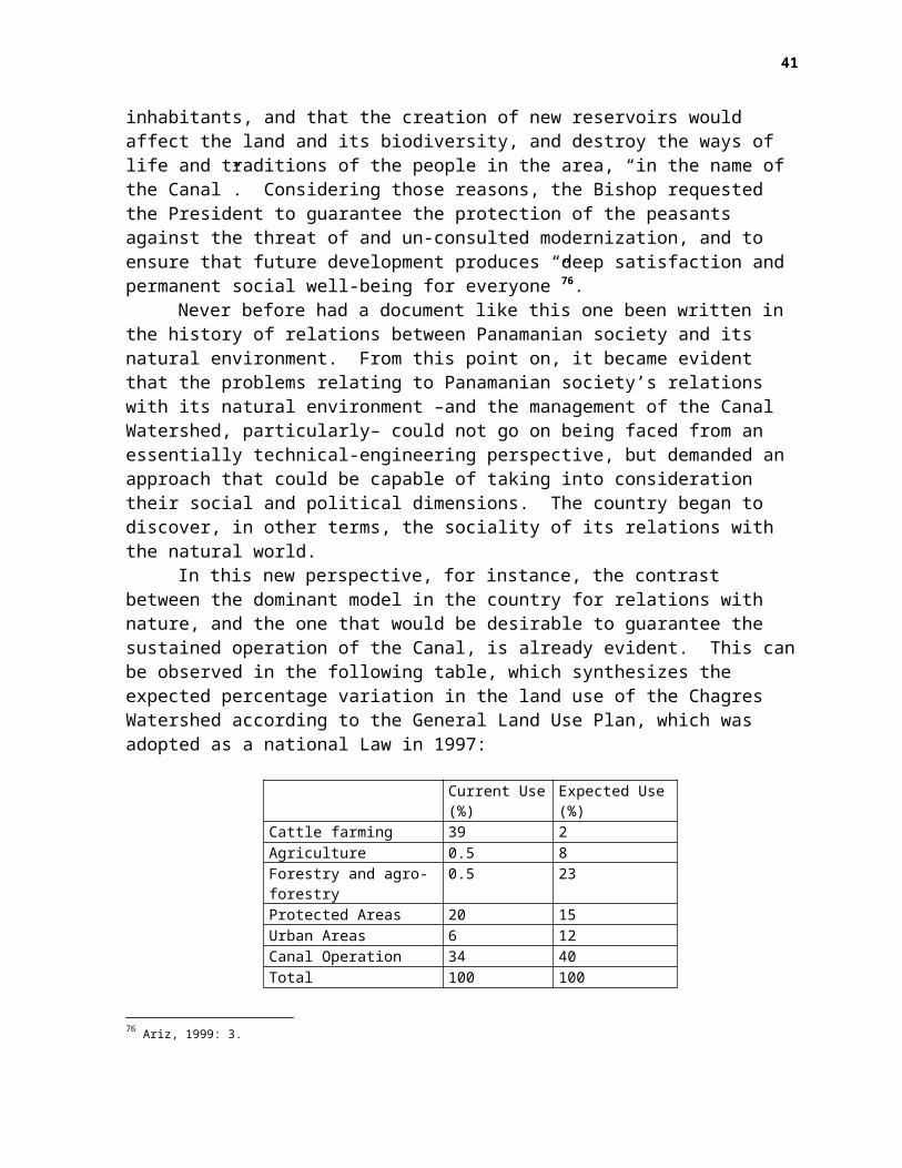
inhabitants, and that the creation of new reservoirs would affect the land and its biodiversity, and destroy the ways of life and traditions of the people in the area, “in the name of the Canal”. Considering those reasons, the Bishop requested the President to guarantee the protection of the peasants against the threat of and un-consulted modernization, and to ensure that future development produces “deep satisfaction and permanent social well-being for everyone”76.
Never before had a document like this one been written in the history of relations between Panamanian society and its natural environment. From this point on, it became evident that the problems relating to Panamanian society’s relations with its natural environment –and the management of the Canal Watershed, particularly– could not go on being faced from an essentially technical-engineering perspective, but demanded an approach that could be capable of taking into consideration their social and political dimensions. The country began to discover, in other terms, the sociality of its relations with the natural world.
In this new perspective, for instance, the contrast between the dominant model in the country for relations with nature, and the one that would be desirable to guarantee the sustained operation of the Canal, is already evident. This canbe observed in the following table, which synthesizes the expected percentage variation in the land use of the Chagres Watershed according to the General Land Use Plan, which was adopted as a national Law in 1997:
Current Use(%)
Expected Use(%)
Cattle farming 39 2Agriculture 0.5 8Forestry and agro-forestry
0.5 23
Protected Areas 20 15Urban Areas 6 12Canal Operation 34 40Total 100 100
76 Ariz, 1999: 3.
41
The current use of the land, in fact, also characterizes the situation that prevails in the entire country, as the expected one would imply a situation where relations between Panamanian society and its natural environment were much more sustainable. And so we are faced with two opposing models of relationship with the land and the water: pluviculture, which views water as an element provided by rain, and hydraulic culture, which views it as a resource that has to be produced and managed by techno-economic organizations of a similar complexity to that of the ecosystems that produce it. The conclusion should be evident: the Canal will only be sustainable in the same measure as Panamanian society’s overalldevelopment is.
From this perspective, the Canal’s transference to the Panamanian State, as well as the need for such State to promotenew ways of relating with the natural world nationwide, pose a new type of problem in the country’s environmental history. While, on one hand, it would be impossible to “reproduce” at a national scale the logic of a hydraulic tropicality that guidedthe use of natural resources within the old Canal enclave, on the other, it is not possible to leave the Canal and its Watershed in the hands of the old agro-cattle mercantile culture, since that would lead to the destruction of the resources that are essential in order to face the serious social, environmental, and economic problems that Panama carries into the 21st Century.
Here, the culture of nature in Panama is faced with an unprecedented challenge: to demand the creation of a national State capable of representing the social majority’s needs in a way that allows for a politically sustainable future development in our country. Because in fact, sustainability poses, above all, a political problem –meaning, taking culture into action–, that is to be solved through technological means,and not the other way around.
Within this scope, the first experiences gathered from theCanal enclave’s integration process into its social and environmental context can already give us a lesson of particular importance. We are, in fact, faced with a local
42
problem that is closely related to processes of a global scale,since the integrated management of water resources –in Panama, as well as in any other place in the world– represents an important component within the much broader and long term purpose of creating the essential conditions for sustainable development on a global scale, and of generating synergic coordination capabilities between local, national, regional, and global scales. This is why Panama requires a sort of development that is sustainable due to its capability to generate a righteous cycle where economic growth sustains conditions of social well-being, political participation, and national self-determination, without which it is impossible to maintain a responsible relationship with the natural environment. And this will only be made possible within the framework of a renewed society that, overcoming the consequences of North-American colonialism and oligarchical transitism, allows us to finally grow with the world, in order to help it grow.
The City of Knowledge, Panama, September 2004
Bibliography
Andagoya, Pascual de, 1514–1541: “Relación del Darién, Provincias Centrales y Chiriquí”, 1514 –1541 (excerpt), in Jaén Suárez, Omar, 1981 a.
Ariz, Carlos María, cmf, 1999: “Carta abierta a la Excma. Señora Mireya Moscoso, Presidenta de la República, del Obispo de Colón y Kuna Yala”. Panorama Católico, December 12, p. 3.
Armelagos, George J.; Barnes, Kathleen C., and Lin, James, 1996: “Disease in human evolution:the re-emergence of infectious disease in the third epidemiological transition”.AnthroNotes, National Museum of Natural History, Smithsonian Institution, Vol. 18, No.3, Fall.
Arnold, David, 2000: La Naturaleza como Problema Histórico. El medio, la cultura y la expansión de Europa. Fondo deCultura Económica, Mexico.
Audiencia de Panamá: “Descripción de Panamá y su Provincia”,1607, in Jaén Suárez, Omar, 1881a.Austin Alchon, Suzanne, 1997: “The Great Killers in Precolumbian America: a Hemispheric
Perspective”, Latin American Population History Bulletin, No. 27, Fall 1997, Department ofHistory, University of Minnesota.
Autoridad Nacional del Ambiente, 1999: Panamá. Informe Ambiental 1999.Benneth, Charles, 1976 (1968): Influencias Humanas en la Zoogeografía de Panamá. Editorial
Universitaria, Panamá (University of California Press, 1968).Bennett, Hugh H., 1912: “Reconnoissance soil survey”, en The Agricultural Possibilities of the Canal Zone.
U.S. Department of Agriculture. Office of the Secretary. (Bureau of Soils and Bureau of Plant Industry, cooperating). Report No. 95. Washington. Government Printing Office.
-- 1929: Soil Reconnaissance of the Panama Canal Zone and Contiguous Territory. United States Department of Agriculture, Technical Bulletin No. 94, January, 1929. Washington, D.C.
43
Bovalius, Carl, 1972: Viaje al Istmo, 1881 – 1883. Biblioteca Nuevo Panamá, Ministerio de Educación, Panama.
Burkart, R.; Marchetti, B. and Morello, J., 1995: “Grandes ecosistemas de México y Centroamérica”, in Gallopin, G. C. (Editor): El Futuro Ecológico de un Continente. Una visión prospectiva de la América Latina. Editorial de la Universidad de las Naciones Unidas, El Trimestre Económico / Fondo de Cultura Económica, México. Tomo I.
Camargo, Marcela, 2002: Producción y Comercio en la Sociedad Rural de Penonomé Durante los Primeros Cincuenta Añosde la República. Universidad de Panamá, Colección del Centenario.
Castillero C., Alfredo, 2001 a: “La carrera, el monopolio y las ferias del trópico”, in HistoriaGeneral de América Latina. Volume III: “Consolidación del Orden Colonial”, Tomo 1. AlfredoCastillero Calvo, Volume Director, and Allan Kuethe, Co Director. Ediciones UNESCO/Editorial Trotta.-- 2001 b: “Los transportes y las vías de comunicación en Hispanoamérica”, in HistoriaGeneral de América Latina. Volume III: “Consolidación del Orden Colonial”, Tomo 1. AlfredoCastillero Calvo, Volume Director, and Allan Kuethe, Co Director. Ediciones UNESCO /Editorial Trotta.-- 1994: Conquista, Evangelización y Resistencia. ¿Triunfo o fracaso de la política indigenista? InstitutoNacional de Cultura, Panama.
Coates, Anthony, 2001: “En la historia geológica, Panamá ha cambiado al mundo”, in HeckadonMoreno, Stanley (Editor): Panamá: Puente Biológico. Instituto Smithsonian deInvestigaciones Tropicales, Panama.-- 1997: “The forging of Central America”, in Coates, Anthony G., editor: Central America.A natural and cultural history. Yale University Press.
Cohen, Mark Nathan and Armelagos, George, 1984: “Paleopathology at the Origins of Agriculture:Editor’s Summation”. Armelagos, George y Cohen, Mark Nathan (editors): Paleopathology atthe Origins of Agriculture. Academic Press.
Colinvaux, Paul, 1997: “The history of forests on the Isthmus from the Ice Age to the presente”, en Coates, Anthony G., editor: Central America. A natural and cultural history. Yale University Press.
Cooke, Richard, 2001 a: “La pesca en estuarios panameños: una visión histórica y cultural desdela Bahía de Parita”, in Heckadon – Moreno, Stanley (Editor): Panamá: Puente Biológico. Instituto Smithsonian de Investigaciones Tropicales, Panama.-- 2001 b: “Cuidando a los ancestros: rasgos mortuorios precolombinos en cerro Juan Díaz, Los Santos”, en Heckadon – Moreno, Stanley (Editor): Panamá: Puente Biológico. Instituto Smithsonian de Investigaciones Tropicales, Panama.-- 1997: “The native peoples of Central America during Precolumbian and Colonial times”, in Coates, Anthony G., editor: Central America. A natural and cultural history. Yale University Press.
Criado de Castilla, Alonso: “Sumaria descripción del Reyno de Tierra Firme” , 1575, in JaénSuárez, Omar, 1981a.
Fernández de Oviedo, Gonzalo: “Descripciones del Darién y la ruta de Panamá” , 1526 (excerpt),in Jaén Suárez, Omar, 1981a.
Franco, Juan: “Notas sobre agricultura y ganadería”, 1792, in Jaén Suárez, Omar, 1981a.Frenkel, Stephen, 1996: “Jungle stories: North American representations of tropical Panama”.
The Geographical Review. Volume 86, Number 3, July 1996.-- 1992: “Geography, empire, and environmental determinism”. Geographical Review, 82, 2.
Gourou, Pierre, 1984 : Introducción a la Geografía Humana. Alianza Universidad, Madrid.Griswold, C.D., 1974 (1852): El Istmo de Panamá y lo que vi en él. Prologue by María J. De Meléndez.
Editorial Universitaria, Panama.Harris, Marvin, 2002: Nuestra Especie. Alianza Editorial, Madrid, 2002.Herrera, Ligia, 2003 (1970): “Panamá: panorama geográfico-ecológico”, in El País que Somos. 30 años
de geografía humana en Panamá. Universidad de Panamá, Instituto de Estudios Nacionales.-- 2003: Regiones de Desarrollo Socioeconómico de Panamá, 1970 – 2000. Transformaciones ocurridas en las últimas tres décadas. Universidad de Panamá, Instituto de Estudios Nacionales.-- 1990: “El impacto ambiental de las actividades ganaderas en Panamá”, en Medio Ambiente y Desarrollo en Panamá, Instituto de Estudios Nacionales de la Universidad de Panamá, Cuadernos Nacionales, No. 4, May.
Hours, Francis, 1985 : Las Civilizaciones del Paleolítico. Fondo de Cultura Económica, Mexico.
44
Iturralde, Juan Domingo de: “Noticias relativas al Istmo de Panamá”, 1812, in Jaén Suárez,Omar, 1981a.
Jaén Suárez, Omar, 1998: La Población del Istmo de Panamá. Desde el siglo XVI hasta el siglo XX. Estudio de Geohistoria.Agencia Española de Cooperación Internacional, Madrid.-- 1990: "El Canal de Panamá: los efectos sobre el medio ambiente de su construcción y operación hasta el presente", in Medio Ambiente y Desarrollo en Panamá, Universidad de Panamá,Instituto de Estudios Nacionales, Cuadernos Nacionales, No.4., Mayo.-- 1981a: Geografía de Panamá, (Estudio Introductorio y Antología), Universidad de Panamá,Biblioteca de la Cultura Panameña.-- 1981b: Hombres y Ecología en Panamá, Editorial Universitaria, Smithsonian TropicalResearch Institute, Panama.
Lentz, David, 2000 a: “Introduction: definitions and conceptual underpinnings”, in Lentz, DavidL. (Editor): Imperfect Balance. Landscape transformations in the Precolumbian Americas. ColumbiaUniversity Press.-- 2000 b: “Anthropocentric food webs in the Precolumbian Americas”, in Lentz, DavidL. (Editor): Imperfect Balance. Landscape transformations in the Precolumbian Americas. ColumbiaUniversity Press.
Lindsay Poland, John, 2003: Emperors in the Jungle. The hidden history of the U.S. in Panama. Duke University Press.
Lloyd, John: “Notas referentes al Istmo de Panamá”, 1827 – 1829, in Jaén Suárez, Omar, 1981a.Mack, Gerstle, 1978: La Tierra Dividida. Historia del Canal de Panamá y otros proyectos del canal ístmico. Prologue
by Carlos Manuel Gasteazoro. II Edición Conmemorativa al Septuagésimoquinto Aniversariode la Fundación de la República. Editorial Universitaria, Panama.
McCullough , David, 1979: El Cruce entre los Mares. La creación del Canal de Panamá (1870 – 1914). Lasser Press Mexicana, S.A.
Noriega, Rodrigo, 1998: “Ciencia imperial: la investigación científica en los trópicos como un discurso de poder”, in Universidad de Panamá; Universidad Tecnológica de Panamá; Universidad Santa María La Antigua; Ciudad del Saber; Centro de Estudios y Acción Social Panameño; Centro de Estudios Latinoamericanos “Justo Arosemena”: El Canal de Panamáen el Siglo XXI. Encuentro académico internacional sobre el Canal de Panamá. 4 y 5 de septiembre de 1997. Panama.
Norr, Lynette, 1984: “Prehistoric subsistence and health status of coastal peoples from thePanamanian Isthmus of Lower Central America”. Armelagos, George y Cohen, Mark Nathan(editors): Paleopathology at the Origins of Agriculture. Academic Press.
Palacio, Germán, 2002: “Historia tropical: a reconsiderar las nociones de espacio, tiempo yciencia”, in Palacio, Germán y Ulloa, Astrid, editors: Repensando la naturaleza. Encuentros ydesencuentros disciplinarios en torno a lo ambiental. Universidad Nacional de Colombia – SedeLeticia. Instituto Amazónico de Investigaciones. Instituto Colombiano de Antropología eHistoria. Colciencias.
Piperno, Dolores, and Pearsall, Deborah, 1998: The Origins of Agriculture in the Lowland Neotropics.Academic Press.
Programa de las Naciones Unidas para el Medio Ambiente (PNUMA), 2000: GEO 2000. América Latina y el Caribe. Perspectivas del medio ambiente. San José, Costa Rica.
Reclus, Armando: “El Istmo de Panamá”, 1876-1878, in Jaén Suárez, Omar, 1981a.-- 1958: Exploraciones a los Istmos de Panamá y Darién en 1876, 1877 y 1878. Publications in RevistaLotería, No. 1, Panama.
Ruiz de Campos, Diego: “Relación sobre la costa panameña en el mar del Sur” (excerpt) , 1631, in Jaén Suárez, Omar, 1981a.
Sarmiento, Domingo F., 1989 (1845): Facundo. Civilización y Barbarie. Editorial Porrúa, S.A., México.Sauer, Carl, 1938: “La explotación destructiva en la expansión colonial moderna”, in Memorias
del Congreso Geográfico Internacional”, Vol. II, Secc. IIIc., pp. 494 – 499. Translation by Guillermo Castro H.-- 1940: “Foreword to historical geography”. www.colorado.ed/geography. Translation by Guillermo Castro H.-- 1981(1974): “The Fourth Dimension of Geography”, in Selected Essays, 1963-1975. Turtle Island Foundation, Berkeley, California. Translation by Guillermo Castro H.
Sutter, Paul: 1997: “’Arrancarle los dientes al trópico’: ambiente, enfermedad, y el Programa Sanitario de los Estados Unidos en Panamá, 1904-1914”. Papeles de Población, Nueva Época,
45
Añ0 6, No. 24, April – June. Centro de Investigación y Estudios Avanzados de la Población, Universidad Autónoma del Estado de México.
Taylor, WM. A., 1912: “The outlook for agriculture”, en The Agricultural Possibilities of the Canal Zone. U.S. Department of Agriculture. Office of the Secretary. (Bureau of Soils and Bureau ofPlant Industry, cooperating). Report No. 95. Washington. Government Printing Office.
Tucker, Richard P., 2000: Insatiable Appetite. The United States and the ecological degradation of the tropical world. University of California Press.
Wittfogel, Karl, 1999: “Las civilizaciones hidráulicas”. Revista Tareas, No. 103, September – December. Centro de Estudios Latinoamericanos “Justo Arosemena”, Panama.
Uribe, María Victoria, 1999: “Las sociedades del Norte de los Andes”, in Historia General de AméricaLatina, Volumen I: Las Sociedades Originarias. Teresa Rojas Rabiela, Directora delVolumen, y John V. Murra, Co Director, Ediciones UNESCO / Editorial Trotta.
Webb, S. David, 1997: “The great American faunal interchange”, in Coates, Anthony G., editor: Central America. A natural and cultural history. Yale University Press.
Worster, Donald, 2001: Transformaciones de la Tierra. Universidad de Panamá, Ciudad del Saber, IICA,Panamá. --1992: Rivers of Empire. Water, aridity and the growth of the American West. Oxford
University Press, New York, Oxford.
46