LIGHT LIST - navcen.uscg.gov
409
U.S. Department of Homeland Security United States Coast Guard LIGHT LIST Volume I ATLANTIC COAST St. Croix River, Maine to Shrewsbury River, New Jersey This Light List contains a list of lights, sound signals, buoys, daybeacons, and other aids to navigation. IMPORTANT THIS LIGHT LIST SHOULD BE CORRECTED EACH WEEK FROM THE LOCAL NOTICES TO MARINERS OR NOTICES TO MARINERS AS APPROPRIATE. 2022 COMDTPUB P16502.1
-
Upload
khangminh22 -
Category
Documents
-
view
0 -
download
0
Transcript of LIGHT LIST - navcen.uscg.gov
U.S. Department of Homeland Security
United States Coast Guard
LIGHT LIST
Volume I
ATLANTIC COAST
St. Croix River, Maine to Shrewsbury River, New Jersey
This Light List contains a list of lights, sound signals, buoys, daybeacons, and other aids to navigation.
IMPORTANT THIS LIGHT LIST SHOULD BE CORRECTED
EACH WEEK FROM THE LOCAL NOTICES TO MARINERS OR NOTICES TO MARINERS AS APPROPRIATE.
2022
COMDTPUB P16502.1
LIMITS OF LIGHT LISTS PUBLISHED BY
U.S. COAST GUARD 180O 160O 140O 120O 100O 80O 60O
60O 60O
50O
VOL. VII GREAT LAKES
50O
40O
MIDWAY ISLANDS
VOL. VI PACIFIC COAST
AND PACIFIC ISLANDS
VOL. V MISSISSIPPI
RIVER SYSTEM
VOL. I ATLANTIC COAST
(St. Croix River, ME to Shrewsbury River, NJ)
VOL. II ATLANTIC COAST
(Shrewsbury River, NJ to Little River, SC)
40O
20O
HAWAIIAN ISLANDS
AIDSTO NAVIGATIONMAINTAINED BY UNITEDSTATES AT OTHER
PACIFIC ISLANDS ARE INCLUDED ON THE PACIFIC LIST
VOL. IV GULF COAST
(Econfina River, FL to Rio Grande, TX)
VOL. III ATLANTIC COAST
(Little River, SC to Econfina River, FL)
Aids maintained at
PuertoRico, VirginIslands,
and Guantanamo Bay
included in Volume III.
20O
180O 160O 140O 120O 100O 80O 60O
SLOW
NO WAKE
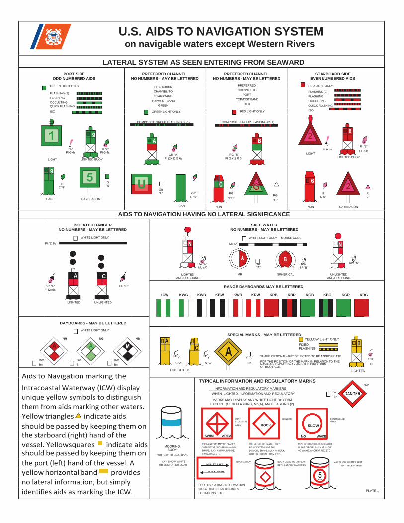
U.S. AIDS TO NAVIGATION SYSTEM on navigable waters except Western Rivers
LATERAL SYSTEM AS SEEN ENTERING FROM SEAWARD
PORT SIDE
ODD NUMBERED AIDS
GREEN LIGHT ONLY
FLASHING (2)
FLASHING
OCCULTING
QUICK FLASHING
ISO
PREFERRED CHANNEL
NO NUMBERS - MAY BE LETTERED
PREFERRED
CHANNEL TO
STARBOARD
TOPMOST BAND
GREEN
GREEN LIGHT ONLY
COMPOSITE GROUP FLASHING (2+1)
PREFERRED CHANNEL
NO NUMBERS - MAY BE LETTERED
PREFERRED
CHANNEL TO
PORT
TOPMOST BAND
RED
RED LIGHT ONLY
COMPOSITE GROUP FLASHING (2+1)
STARBOARD SIDE
EVEN NUMBERED AIDS
RED LIGHT ONLY
FLASHING (2)
FLASHING
OCCULTING
QUICK FLASHING
ISO
LIGHT
"1"
FI G 6s
9
G "9"
FI G 4s
LIGHTED BUOY
GR "A"
FI (2+1) G 6s
RG "B"
FI (2+1) R 6s
LIGHT
"2"
FI R 6s R "8"
FI R 4s
LIGHTED BUOY
9
CAN
G C "9"
DAYBEACON
G "5"
GR
"U"
CAN
GR
C "S"
NUN
RG
N "C" RG
"G"
NUN
R N "6"
DAYBEACON
R "2"
AIDS TO NAVIGATION HAVING NO LATERAL SIGNIFICANCE
ISOLATED DANGER
NO NUMBERS - MAY BE LETTERED
SAFE WATER
NO NUMBERS - MAY BE LETTERED
FI (2) 5s
WHITE LIGHT ONLY
Mo (A)
WHITE LIGHT ONLY MORSE CODE
C LIGHTED
RW "N" Mo (A)
RW "A"
MR
RW SP "B"
SPHERICAL UNLIGHTED
RW "N"
AND/OR SOUND AND/OR SOUND
BR "A"
FI (2) 5s
BR "C" RANGE DAYBOARDS MAY BE LETTERED
KGW KWG KWB KBW KWR KRW KRB KBR KGB KBG KGR KRG
LIGHTED UNLIGHTED
DAYBOARDS - MAY BE LETTERED
WHITE LIGHT ONLY
NR NG NB
SPECIAL MARKS - MAY BE LETTERED
YELLOW LIGHT ONLY
RW GW BW
Bn Bn Bn
Y
C "A"
UNLIGHTED
Y
N "C"
Y "A"
Bn
FIXED FLASHING
SHAPE OPTIONAL--BUT SELECTED TO BE APPROPRIATE
FOR THE POSITION OF THE MARK IN RELATION TO THE NAVIGABLE WATERWAY AND THE DIRECTION OF BUOYAGE.
LIGHTED
Y "B"
FI
Aids to Navigation marking the
Intracoastal Waterway (ICW) display unique yellow symbols to distinguish them from aids marking other waters.
TYPICAL INFORMATION AND REGULATORY MARKS NW
INFORMATION AND REGULATORY MARKERS
WHEN LIGHTED, INFORMATION AND REGULATORY W
Bn MARKS MAY DISPLAY ANY WHITE LIGHT RHYTHM
EXCEPT QUICK FLASHING, Mo(A), AND FLASHING (2)
Yellow triangles indicate aids BOAT
EXCLUSION
DANGER CONTROLLED
AREA
should be passed by keeping them on the starboard (right) hand of the
AREA
vessel. Yellowsquares indicate aids should be passed by keeping them on
MOORING BUOY
WHITE WITH BLUE BAND
EXPLAINATION MAY BE PLACED
OUTSIDE THE CROSSED DIAMOND
SHAPE, SUCH AS DAM, RAPIDS,
SWIMAREA,ETC.
THE NATURE OF DANGER MAY
BE INDICATEDINSIDE THE
DIAMOND SHAPE, SUCH AS ROCK,
WRECK, SHOAL, DAM, ETC.
TYPE OF CONTROL IS INDICATED
IN THE CIRCLE, SUCH AS SLOW,
NO WAKE, ANCHORING, ETC.
the port (left) hand of the vessel. A MAY SHOW WHITE
REFLECTOR OR LIGHT
INFORMATION BUOY USED TO DISPLAY
REGULATORY MARKERS
MAY SHOW WHITE LIGHT
MAY BELETTERED
yellow horizontal band provides
no lateral information, but simply
identifies aids as marking the ICW. FOR DISPLAYING INFORMATION
SUCHAS DIRECTIONS, DISTANCES,
LOCATIONS, ETC. PLATE 1
MULLET LAKE
BLACK RIVER
ROCK
SWIM AREA
G
5
1 2 2
7 8 2
2 1
3
3 6
4
3
2 3
1
2
VISUAL BUOYAGE GUIDE 2
REGION B - by day
Preferred Channel 3
Secondary Channel
REGION-B - by night
Preferred Channel
Secondary Channel
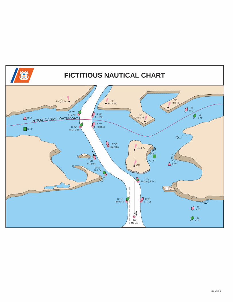
FICTITIOUS NAUTICAL CHART
R "2"
"1"
FI (2) G 6s
G "7" FI G 4s
AY
R "8" FI R 4s
"2"
Iso R 6s
"1"
Iso G 4s
"2" FI R 4s
R N "2"
G C "3"
G "3" G "5"
FI (2) G 6s
R "6"
FI (2) R 6s
R "4"
Oc R 6s Iso R 6s
BR
FI (2) 5s
G "3" FI G 6s
G "3"
QR R "2"
RG
FI (2+1) R 6s
RW Bn
G "1"
Iso G 4s R "2"
FI R 6s
R N "2"
RW Mo (A)
G C "3"
PLATE 3
SL OW
NO WAK E
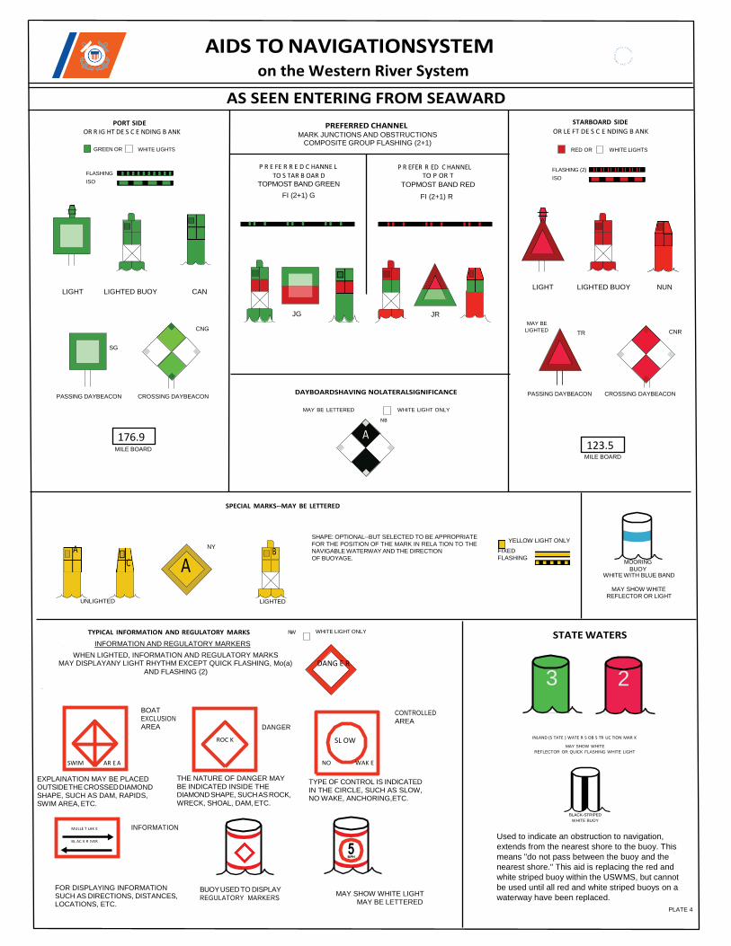
AIDS TO NAVIGATIONSYSTEM on the Western River System
AS SEEN ENTERING FROM SEAWARD
PORT SIDE OR R IG HT DE S C E NDING B ANK
PREFERRED CHANNEL MARK JUNCTIONS AND OBSTRUCTIONS
COMPOSITE GROUP FLASHING (2+1)
STARBOARD SIDE
OR LE FT DE S C E NDING B ANK
GREEN OR
FLASHING
ISO
WHITE LIGHTS
P R E FE R R E D C HANNE L TO S TAR B OAR D
TOPMOST BAND GREEN
FI (2+1) G
P R EFER R ED C HANNEL TO P OR T
TOPMOST BAND RED
FI (2+1) R
RED OR
FLASHING (2)
ISO
WHITE LIGHTS
LIGHT LIGHTED BUOY CAN LIGHT LIGHTED BUOY NUN
JG
CNG
JR
MAY BE
LIGHTED TR CNR
SG
PASSING DAYBEACON CROSSING DAYBEACON DAYBOARDSHAVING NOLATERALSIGNIFICANCE PASSING DAYBEACON CROSSING DAYBEACON
MILE BOARD
MAY BE LETTERED
A
WHITE LIGHT ONLY
NB
MILE BOARD
SPECIAL MARKS--MAY BE LETTERED
A
C
UNLIGHTED
NY
A
LIGHTED
SHAPE: OPTIONAL--BUT SELECTED TO BE APPROPRIATE
FOR THE POSITION OF THE MARK IN RELA TION TO THE NAVIGABLE WATERWAY AND THE DIRECTION
OF BUOYAGE.
YELLOW LIGHT ONLY
FIXED
FLASHING MOORING
BUOY WHITE WITH BLUE BAND
MAY SHOW WHITE REFLECTOR OR LIGHT
TYPICAL INFORMATION AND REGULATORY MARKS NW
INFORMATION AND REGULATORY MARKERS
WHEN LIGHTED, INFORMATION AND REGULATORY MARKS MAY DISPLAYANY LIGHT RHYTHM EXCEPT QUICK FLASHING, Mo(a)
AND FLASHING (2)
WHITE LIGHT ONLY
DANG E R
STATE WATERS
3 2
BOAT EXCLUSION AREA DANGER
CONTROLLED AREA
INLAND (S TATE ) WATE R S OB S TR UC TION MAR K
MAY SHOW WHITE
REFLECTOR OR QUICK FLASHING WHITE LIGHT
EXPLAINATION MAY BE PLACED OUTSIDE THE CROSSED DIAMOND SHAPE, SUCH AS DAM, RAPIDS, SWIM AREA, ETC.
THE NATURE OF DANGER MAY BE INDICATED INSIDE THE DIAMOND SHAPE, SUCH AS ROCK, WRECK, SHOAL, DAM, ETC.
TYPE OF CONTROL IS INDICATED IN THE CIRCLE, SUCH AS SLOW, NO WAKE, ANCHORING,ETC.
INFORMATION
FOR DISPLAYING INFORMATION SUCH AS DIRECTIONS, DISTANCES, LOCATIONS, ETC.
BUOY USED TO DISPLAY REGULATORY MARKERS
MAY SHOW WHITE LIGHT MAY BE LETTERED
BLACK-STRIPED
WHITE BUOY
Used to indicate an obstruction to navigation,
extends from the nearest shore to the buoy. This
means "do not pass between the buoy and the
nearest shore." This aid is replacing the red and
white striped buoy within the USWMS, but cannot
be used until all red and white striped buoys on a
waterway have been replaced.
PLATE 4
176.9 123.5
B
MULLE T LAK E
BL AC K R IVER
ROC K
SWIM AR E A
G
9
8
7
6
5
4
3
2
1
METEORLOGICAL VISIBILITY (From International Visibility Code)
0
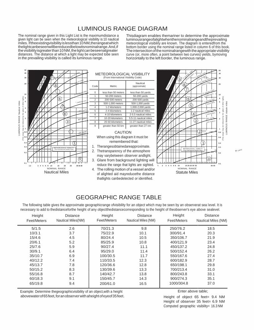
LUMINOUS RANGE DIAGRAM The nominal range given in this Light List is the maximumdistance a given light can be seen when the meteorological visibility is 10 nautical miles. If theexistingvisibility is lessthan 10 NM,therangeat which thelightcanbeseenwillbereducedbelowitsnominalrange.And,if the visibility isgreater than 10 NM, the light can beseenatgreater distances. The distance at which a light may be expected tobe seen in the prevailing visibility is called its luminous range.
Thisdiagram enables themariner to determine the approximate luminousrangeofalightwhenthenominalrangeandtheprevailing meteorological visibility are known. The diagram is enteredfrom the bottom border using the nominal range listed in column 6 of this book. The intersection of the nominalrangewith the appropriate visibility curve (or, more often, a point between two curves) yields, bymoving horizontally to the left border, the luminous range.
50 50
40 METEOROLOGICAL VISIBILITY 40
30 (From International Visibility Code) 30
20 20
10 10
8 8
6 6
4 4
3 3
2 2
1
0.8
0.6
0.4
0.3
0.2
0.1
1 2 3 4 5 6 8 10 15 20 25 30 35 40
NOMINAL RANGE
Nautical Miles
CAUTION
When using this diagram it must be
remembered that:
1. Therangesobtainedareapproximate.
2. Thetransparency of the atmosphere
may varybetween observer andlight.
3. Glare from background lighting will
reduce the range that lights are sighted.
4. The rolling motion of a vessel and/or
of alighted aid mayreducethe distance
thatlights canbedetected or identified.
1 2 3 4 5 6 8 10 15 20 25 30 35
NOMINAL RANGE
Statute Miles
40 45
1
0.8
0.6
0.4
0.3
0.2
0.1
GEOGRAPHIC RANGE TABLE The following table gives the approximate geographicrange ofvisibility for an object which may be seen by an observerat sea level. It is
necessary to add to thedistanceforthe height of any objectthedistancecorresponding to the height of theobserver's eye above sealevel.
Height
Feet/Meters
Distance
Nautical Miles(NM)
Height
Feet/Meters
Distance
Nautical Miles (NM)
Height
Feet/Meters
Distance
Nautical Miles (NM)
5/1.5 2.6 70/21.3 9.8 250/76.2 18.5
10/3.1 3.7 75/22.9 10.1 300/91.4 20.3
15/4.6 4.5 80/24.4 10.5 350/106.7 21.9
20/6.1 5.2 85/25.9 10.8 400/121.9 23.4
25/7.6 5.9 90/27.4 11.1 450/137.2 24.8
30/9.1 6.4 95/29.0 11.4 500/152.4 26.2
35/10.7 6.9 100/30.5 11.7 550/167.6 27.4
40/12.2 7.4 110/33.5 12.3 600/182.9 28.7
45/13.7 7.8 120/36.6 12.8 650/198.1 29.8
50/15.2 8.3 130/39.6 13.3 700/213.4 31.0
55/16.8 8.7 140/42.7 13.8 800/243.8 33.1
60/18.3 9.1 150/45.7 14.3 900/274.3 35.1
65/19.8 9.4 200/61.0 16.5 1000/304.8 37.0
Example: Determine thegeographicvisibility of an object,with a height
abovewater of 65 feet, for an observer with aheight of eyeof 35 feet.
Enter above table;
Height of object 65 feet= 9.4 NM
Height of observer 35 feet= 6.9 NM
Computed geographic visibility= 16.3 NM
LU
MIN
OU
S R
AN
GE
Na
utica
l m
ile
s
(Th
is r
an
ge
ma
y b
e r
ed
uce
d b
y t
he
gla
re o
f o
the
r lig
hts
)
(Th
is r
an
ge
ma
y b
e r
ed
uce
d b
y t
he
gla
re o
f o
the
r lig
hts
)
LU
MIN
OU
S R
AN
GE
sta
tute
mile
s
9
8
6
5
4
3
1 METEORLOGICAL VISIBILITY (From International Visibility Code)
0
Code Metric Nautical
(approximate)
0 less than 50 meters less than 50 yards
1 50-200 meters 50-200 yards
2 200-500 meters 200-500 yards
3 500-1,000 meters 500-1,000 yards
4 1-2 kilometers 1,000-2,000 yards
5 2-4 kilometers 1-2 nautical miles
6 4-10 kilometers 2-5.5 nautical miles
7 10-20 kilometers 5.5-11 nautical miles
8 20-50 kilometers 11-27 nautical miles
9 greater than 50 km greater than 27 nm
This Page Intentionally Left Blank
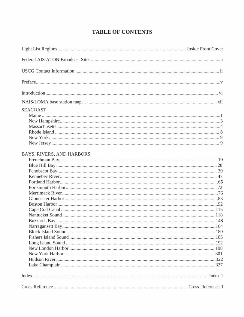
TABLE OF CONTENTS
Light List Regions ......................................................................................................... .. Inside Front Cover
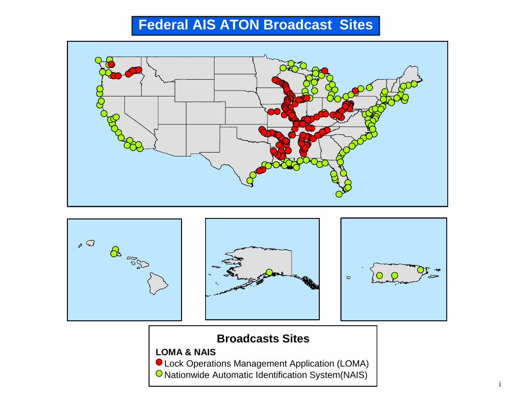
Federal AIS ATON Broadcast Sites .............................................................................................................i
USCG Contact Information ........................................................................................................................ ii
Preface..........................................................................................................................................................v
Introduction ................................................................................................................................................ vi
NAIS/LOMA base station map… ............................................................................................................ xli
SEACOAST
Maine .....................................................................................................................................................1
New Hampshire ......................................................................................................................................3
Massachusetts ........................................................................................................................................4
Rhode Island ......................................................................................................................................... 8
New York .............................................................................................................................................. 9
New Jersey ............................................................................................................................................ 9
BAYS, RIVERS, AND HARBORS
Frenchman Bay .................................................................................................................................... 19
Blue Hill Bay ...................................................................................................................................... 28
Penobscot Bay ..................................................................................................................................... 30
Kennebec River ................................................................................................................................... 47
Portland Harbor .................................................................................................................................... 65
Portsmouth Harbor .............................................................................................................................. 72
Merrimack River .................................................................................................................................. 76
Gloucester Harbor ................................................................................................................................ 83
Boston Harbor ......................................................................................................................................92 Cape Cod Canal .................................................................................................................................115
Nantucket Sound ............................................................................................................................... 118
Buzzards Bay ..................................................................................................................................... 148
Narragansett Bay ................................................................................................................................164
Block Island Sound ............................................................................................................................ 180
Fishers Island Sound ..........................................................................................................................185
Long Island Sound ............................................................................................................................. 192
New London Harbor ......................................................................................................................... 198
New York Harbor .............................................................................................................................. 301
Hudson River. .................................................................................................................................... 322
Lake Champlain ................................................................................................................................ 337
Index .................................................................................................................................................. Index 1
Cross Reference ............................................................................................................ …Cross Reference 1
This Page Intentionally Left Blank
i
Broadcasts Sites LOMA & NAIS
Lock Operations Management Application (LOMA)
Nationwide Automatic Identification System(NAIS)
Federal AIS ATON Broadcast Sites
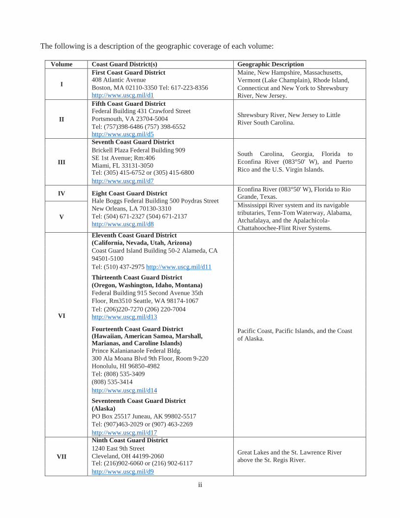
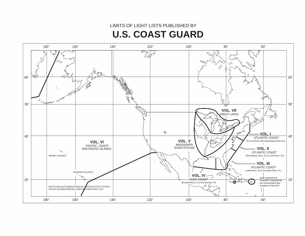
The following is a description of the geographic coverage of each volume:
Volume Coast Guard District(s) Geographic Description
I
First Coast Guard District
408 Atlantic Avenue
Boston, MA 02110-3350 Tel: 617-223-8356
http://www.uscg.mil/d1
Maine, New Hampshire, Massachusetts,
Vermont (Lake Champlain), Rhode Island,
Connecticut and New York to Shrewsbury
River, New Jersey.
II
Fifth Coast Guard District
Federal Building 431 Crawford Street
Portsmouth, VA 23704-5004
Tel: (757)398-6486 (757) 398-6552
http://www.uscg.mil/d5
Shrewsbury River, New Jersey to Little
River South Carolina.
III
Seventh Coast Guard District
South Carolina, Georgia, Florida to
Econfina River (083°50' W), and Puerto
Rico and the U.S. Virgin Islands.
Brickell Plaza Federal Building 909
SE 1st Avenue; Rm:406
Miami, FL 33131-3050 Tel: (305) 415-6752 or (305) 415-6800
http://www.uscg.mil/d7
IV Eight Coast Guard District
Hale Boggs Federal Building 500 Poydras Street
New Orleans, LA 70130-3310
Tel: (504) 671-2327 (504) 671-2137
http://www.uscg.mil/d8
Econfina River (083°50' W), Florida to Rio Grande, Texas.
V
Mississippi River system and its navigable
tributaries, Tenn-Tom Waterway, Alabama,
Atchafalaya, and the Apalachicola-
Chattahoochee-Flint River Systems.
VI
Eleventh Coast Guard District
Pacific Coast, Pacific Islands, and the Coast
of Alaska.
(California, Nevada, Utah, Arizona)
Coast Guard Island Building 50-2 Alameda, CA
94501-5100
Tel: (510) 437-2975 http://www.uscg.mil/d11
Thirteenth Coast Guard District
(Oregon, Washington, Idaho, Montana)
Federal Building 915 Second Avenue 35th
Floor, Rm3510 Seattle, WA 98174-1067
Tel: (206)220-7270 (206) 220-7004
http://www.uscg.mil/d13
Fourteenth Coast Guard District (Hawaiian, American Samoa, Marshall, Marianas, and Caroline Islands)
Prince Kalanianaole Federal Bldg.
300 Ala Moana Blvd 9th Floor, Room 9-220
Honolulu, HI 96850-4982
Tel: (808) 535-3409
(808) 535-3414
http://www.uscg.mil/d14
Seventeenth Coast Guard District
(Alaska)
PO Box 25517 Juneau, AK 99802-5517
Tel: (907)463-2029 or (907) 463-2269
http://www.uscg.mil/d17
VII
Ninth Coast Guard District
Great Lakes and the St. Lawrence River
above the St. Regis River.
1240 East 9th Street
Cleveland, OH 44199-2060 Tel: (216)902-6060 or (216) 902-6117
http://www.uscg.mil/d9
ii
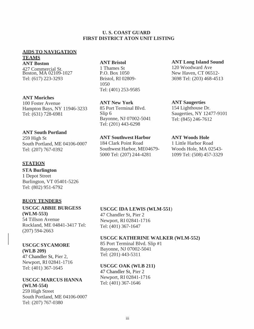
U. S. COAST GUARD
FIRST DISTRICT ATON UNIT LISTING
AIDS TO NAVIGATION
TEAMS
ANT Boston
427 Commercial St.
ANT Bristol
1 Thames St
ANT Long Island Sound 120 Woodward Ave
ANT Moriches 100 Foster Avenue Hampton Bays, NY 11946-3233 Tel: (631) 728-6981
ANT South Portland
259 High St South Portland, ME 04106-0007
Tel: (207) 767-0392
STATION
STA Burlington
1 Depot Street
Burlington, VT 05401-5226
Tel: (802) 951-6792
ANT New York 85 Port Terminal Blvd. Slip 6 Bayonne, NJ 07002-5041 Tel: (201) 443-6298
ANT Southwest Harbor
184 Clark Point Road
Southwest Harbor, ME04679-
5000 Tel: (207) 244-4281
ANT Saugerties 154 Lighthouse Dr. Saugerties, NY 12477-9101
Tel: (845) 246-7612
ANT Woods Hole
1 Little Harbor Road
Woods Hole, MA 02543-
1099 Tel: (508) 457-3329
BUOY TENDERS
USCGC ABBIE BURGESS
(WLM-553)
54 Tillson Avenue Rockland, ME 04841-3417 Tel:
(207) 594-2663
USCGC SYCAMORE
(WLB 209)
47 Chandler St, Pier 2,
Newport, RI 02841-1716
Tel: (401) 367-1645
USCGC MARCUS HANNA
(WLM-554)
259 High Street South Portland, ME 04106-0007
Tel: (207) 767-0380
USCGC IDA LEWIS (WLM-551)
47 Chandler St, Pier 2
Newport, RI 02841-1716
Tel: (401) 367-1647
USCGC KATHERINE WALKER (WLM-552)
85 Port Terminal Blvd. Slip #1 Bayonne, NJ 07002-5041 Tel: (201) 443-5311
USCGC OAK (WLB 211)
47 Chandler St, Pier 2 Newport, RI 02841-1716
Tel: (401) 367-1646
iii
Boston, MA 02109-1027 P.O. Box 1050 New Haven, CT 06512- Tel: (617) 223-3293 Bristol, RI 02809- 3698 Tel: (203) 468-4513
1050 Tel: (401) 253-9585
iv
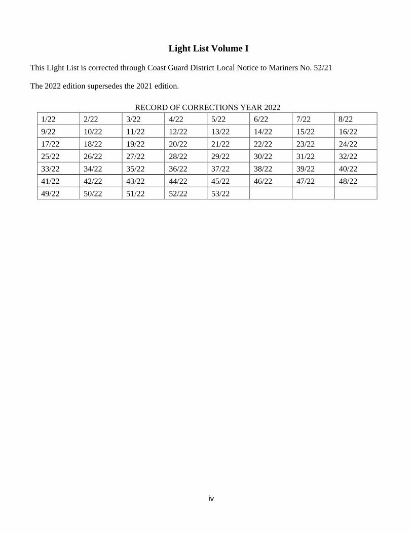
Light List Volume I
This Light List is corrected through Coast Guard District Local Notice to Mariners No. 52/21
The 2022 edition supersedes the 2021 edition.
RECORD OF CORRECTIONS YEAR 2022
1/22 2/22 3/22 4/22 5/22 6/22 7/22 8/22
9/22 10/22 11/22 12/22 13/22 14/22 15/22 16/22
17/22 18/22 19/22 20/22 21/22 22/22 23/22 24/22
25/22 26/22 27/22 28/22 29/22 30/22 31/22 32/22
33/22 34/22 35/22 36/22 37/22 38/22 39/22 40/22
41/22 42/22 43/22 44/22 45/22 46/22 47/22 48/22
49/22 50/22 51/22 52/22 53/22
v
PREFACE
Lights and other marine aids to navigation maintained by or under authority of the U.S. Coast Guard
and located on waters used by general navigation are described in the 7 volumes of the U.S. Light List.
The Light List describes many aids to navigation owned or maintained by private entities; however, not
all such aids are described.
CAUTION: Mariners attempting to pass a buoy close aboard risk collision with a yawing buoy or
with the obstruction that the buoy marks. Mariners must not rely on buoys alone for determining
their positions due to factors limiting buoy reliability.
PRIVATE AIDS TO NAVIGATION
Class I aids to navigation: These are aids located on marine structures or other works that the
owners are legally obligated to establish, maintain, and operate as prescribed by the Coast Guard.
These are included in the Light List.
Class II aids to navigation: These are aids, exclusive of Class I, that are located in waters used by general
navigation. These are included in the Light List.
Class III aids to navigation: These are aids, exclusive of Class I and Class II that are located in
waters not ordinarily used by general navigation. These are not included in the Light List.
LIGHT LIST AVAILABILITY
This Light List is annually published in electronic format and is intended to furnish more information
concerning aids to navigation than can be conveniently shown on charts (U.S. Coast Guard Light List
volumes can be found US Coast Guard Navigation Center website (USCG Light Lists). This Light List
is not intended to be used in place of charts or the United States Coast Pilot®. Charts should be
consulted for the location of all aids to navigation. It may be dangerous to use aids to navigation without
reference to charts.
Note: NOAA has announced the phased shutdown of its traditional paper and raster chart production
system. Cancellation of traditional NOAA paper nautical charts, RNCs, and other associated raster chart
products will begin in 2021 and will be completed by January 2025. Use NOAA ENCs for the most up-
to-date information.
This list is corrected to the date of the notices to mariners shown on the title page. Changes to aids to
navigation during the year are advertised in U.S. Coast Guard Local Notices to Mariners and an updated
list is posted every week on the USCG and National Geospatial-Intelligence Agency (NGA) Maritime
Safety Office’s Websites. Important changes to aids to navigation may also be broadcast through Coast
Guard or Naval radio stations and NAVTEX. Mariners should keep their Light Lists corrected from these
notices and should consult all notices issued after the date of publication of this Light List. Additionally,
the U.S. Coast Guard maintains weekly updated Light Lists corrected through the current LNM week and
are available in XML and PDF on the Weekly Light List Page of the U.S. Coast Guard Navigation
Center (NAVCEN) website.
vi
IMPORTANT: A summary of corrections for this publication, which includes corrections from the
dates shown on the title page to the date of availability, is advertised in the Local Notice to Mariners.
These corrections must be applied to bring the Light List up to date. Additionally, this publication
should be corrected weekly from the Local Notices to Mariners.
Mariners and others are requested to bring any apparent errors or omissions in these lists to the attention
of the cognizant U.S. Coast Guard District or NAVCEN at [email protected]
vii
INTRODUCTION
How the Light List is Arranged
Aids to navigation on the Coastal United States are listed in geographic order clockwise from north to
south along the Atlantic coast, east to west along the Gulf of Mexico, and south to north along the Pacific
coast. On the Great Lakes, aids to navigation are listed from east to west and from south to north, except
on Lake Michigan, which is listed from north to south. Seacoast aids to navigation are listed first,
followed by entrance and harbor aids to navigation, which are listed in the order proceeding towards
the head ofnavigation from seaward.
Names of aids to navigation are printed as follows to help distinguish immediately the type of aid to
navigation.
Seacoast/Lake coast Lights
Secondary Lights, RACONS
Sound Signals
RIVER, HARBOR, OTHER LIGHTS, VIRTUAL AIS Lighted Buoys
Daybeacons, Unlighted Buoys, Virtual Automatic Identification System (V-AIS) ATON
Light List numbers are assigned to all Federal and Private aids to navigation for reference in the Light
List. Aids to navigation are generally numbered by fives in accordance with their order of appearance
in each volume of the Light List. Other numbers and decimal fractions are assigned where newly
established aids to navigation are listed between previously numbered aids to navigation. The Light
Lists are renumbered periodically to assign whole numbers to all aids to navigation.
International numbers are assigned to certain aids to navigation in cooperation with the International
Hydrographic Organization. They consist of an alphabetic character followed by three or four numeric
characters. A cross reference listing appears after the index.
Description of Columns
Column (1): Light List Number.
Column (2): Name and location of the aid to navigation.
Bearings are in degrees true, read clockwise from 000° through 359°.
Bearings on range lines are given in degrees and tenths where applicable.
(C) indicates Canadian aid to navigation.
Note: A dash (-) is used to indicate the bold heading is part of the name of the aid to navigation.
When reporting discrepancies or making references to such an aid to navigation in
correspondence, the full name of the aid including the geographic heading, should be given.
viii
Column (3): Geographic position (WGS-84) of the aid to navigation in latitude and longitude.
Column (4): Light characteristic for lighted aids to navigation.
Column (5): Height above water from the focal plane of the fixed light to mean high water, listed
in feet. -For Volume 5 (Western Rivers), height above water is not indicated for aids
to navigation. Clearances for bridges, etc. are contained in the remarks column and
indicate water level for each instance.
For Volume 7 (Great Lakes), height above water from the focal plane of the fixed light
to low water datum, listed in feet and meters.
Column (6): Nominal range of lighted aids to navigation, in nautical miles, listed by color for sector
and passing lights. Nominal Range is not listed for ranges, directional lights, or private
aids to navigation.
For Volume 7 (Great Lakes), nominal range is expressed in statute miles.
Column (7): The structural characteristic of the aid to navigation, including: dayboard (if any),
description of fixed structure, color and type of buoy, height of structure above ground
for major lights.
Column (8): Aid remarks, sound signal characteristics, including: VHF-FM channel if remotely
activated, RACON characteristic, light sector arc of visibility, radar reflector,
emergency lights, seasonal remarks, and private aid to navigation identification. AIS
specific information may include its unique Maritime Mobile Service Identity
(MMSI), the MMSI(s) of its source AIS transmission, and the application identifier of
any Application Specific Messages (ASM) it may also be transmitting.
U.S. Coast Guard Light List Distribution
U.S. Regulations require that most commercial vessels maintain on board a currently corrected copy or
pertinent extract of the U.S. Coast Guard Light Lists, which are available for free and are updated
weekly on the Coast Guard Navigation Center’s website at USCG NAVCEN. For our policy on the use
of electronic publications and charts, see Navigation and Vessel Inspection Circular (NVIC) 01-16 CH-
2 which can be found here: https://www.dco.uscg.mil/Our-Organization/NVIC/Year/2010/ .
Nautical Charts & Publications
Nautical charts covering the coastal waters of the United States and its territories are produced by the
National Oceanic and Atmospheric Administration (NOAA). These chart products include the NOAA
electronic navigational chart (NOAA ENC®), NOAA raster navigational chart (NOAA RNC®), and
traditional paper nautical charts. Information about ENCs may be found here:
https://nauticalcharts.noaa.gov/charts/noaa-enc.html. Information about paper nautical charts and
associated raster chart products may be found here: https://nauticalcharts.noaa.gov/charts/noaa-raster-
charts.html.
ix
ENCs, RNCs, and traditional chart images may be downloaded from the NOAA Chart Locator
at: https://www.charts.noaa.gov/InteractiveCatalog/nrnc.shtml. Paper copies of traditional nautical
charts may be purchased from any of the NOAA certified chart agents
listed at: https://www.nauticalcharts.noaa.gov/publications/print-agents.html#paper-charts.
Note: NOAA has announced the phased shutdown of its traditional paper and raster chart production
system. Cancellation of traditional NOAA paper nautical charts, RNCs, and other associated raster
chart products will begin in 2021 and will be completed by January 2025. Use NOAA ENCs for the
most up-to-date information.
Inland Electronic Navigational Charts (IENC) and chart books are published by the U.S. Army Corps
of Engineers (USACE) and are available online at https://www.agc.army.mil/echarts
Tide Tables and Tidal Current Tables are no longer printed or distributed by NOAA. NOAA Tide and
Current predictions are available online at NOAA Tides & Currents. Commercially printed versions
that use NOAA data are also available.
Notices to Mariners
Several maritime information products produced by the U. S. Government use some version of
the name “Notice to” or “Notice to Mariners”. This section will describe each and explain how they
can be obtained or accessed.
U.S. Notice to Mariners, published weekly by the National Geospatial Intelligence Agency (NGA),
is prepared jointly by the NGA, the U. S. Coast Guard, and the National Ocean Service. Its purpose is
to provide corrections to U. S. nautical charts used by ocean-going vessels. Visit NGA at
https://msi.nga.mil/NTM to obtain the latest and previous U. S. Notice to Mariners. The weekly NGA
Notice to Mariners no longer provides corrections for publications, including the U. S. Coast Pilot,
NGA List of Lights, and the USCG Light List. To access updated PDFs of these publications,
visit the NGA Maritime Safety Information (MSI) website at https://msi.nga.mil. Broadcast
Warning messages, including NAVAREA Warnings, HYDROLANTS, HYDROPACS, and
HYDROARCS are also available on NGA’s MSI website. For more information about such
information is distributed worldwide through the Global Maritime Distress and Safety System
(GMDSS), refer to NGA Publication 117: https://msi.nga.mil/Publications/RNA.
Local Notice to Mariners are published weekly by each of the nine U. S. Coast Guard Districts, and
provide the following information for the waters within the District: the status of federal and private
aids to navigation (such as discrepancies or temporary or proposed changes); special notices about
maritime events, operations, and hazards; information about bridges; and, chart corrections for all
National Ocean Service Charts in the District. Current and previous Local Notice to Mariners for each CG
District can be found at the Coast Guard Navigation Center Website: https://www.navcen.uscg.gov/?
pageName=lnmMain.
U.S. Army Corps of Engineers (USACE) Notice to Navigation Interests (NTNI Notices) website
contains navigation notices and policies issued by USACE Districts with a waterway
navigation mission. These documents are disseminated to inform mariners of information describing
events that affect waterway navigation such as maintenance projects, hazards to navigation, and
other pertinent information. The notices are removed from the page seven days past the end
date on the latest amendment. The site also has Policy Notices that remain in place until superseded.
This site does not contain all notices such as those published by other agencies.
x
Broadcast Notices to Mariners (BNM) are transmitted using voice over VHF radio (channel 22) by
each Coast Guard District to communicate local information about hazards, emergent situations, and
the status of federal aids to navigation. Broadcasts occur at scheduled times, or as needed, and are
normally announced first on VHF channel 16, before transmission on channel 22. BNMs provide in
near real-time much of the same information that will later be published in the Local Notice to
Mariners. The Coast Guard has begun to also distribute BNMs via internet, for more timely and
convenient delivery - including through email or internet available to wireless mobile devices. To see
how this service is being utilized in the First, Fifth, Seventh, Eighths, and Thirteenth Coast Guard
Districts, visit https://www.navcen.gov/?pageName=feeds for the most up-to-date list of Districts
enrolled in this novel distribution service.
Urgent broadcasts applicable to situations or locations beyond the range of VHF land stations and out
to approximately 100 miles have also been broadcast via the medium frequency NAVTEX system.
Discrepancies to Aids to Navigation
The U.S. Aids to Navigation System is a publicly monitored system that relies on mariners to inform
U.S. Coast Guard units of observed discrepancies or outages. Therefore, for the safety of all mariners,
anyone who observes an aid to navigation that is either off station or exhibiting characteristics other
than those listed in the Light Lists should promptly notify the nearest Coast Guard unit. Radio
messages should be prefixed “COAST GUARD” and transmitted on VHF-FM channel 16. In
addition to notifying the nearest Coast Guard unit by radio, a discrepant aid to navigation
can be reported online at http://www.navcen.uscg.gov/?pageName=atonOutageReport, or by
calling (703) 313-5900, or emailing the Navigation Information Service (NIS) watch at TIS- SMB-
GENERAL
U.S. AIDS TO NAVIGATION SYSTEM
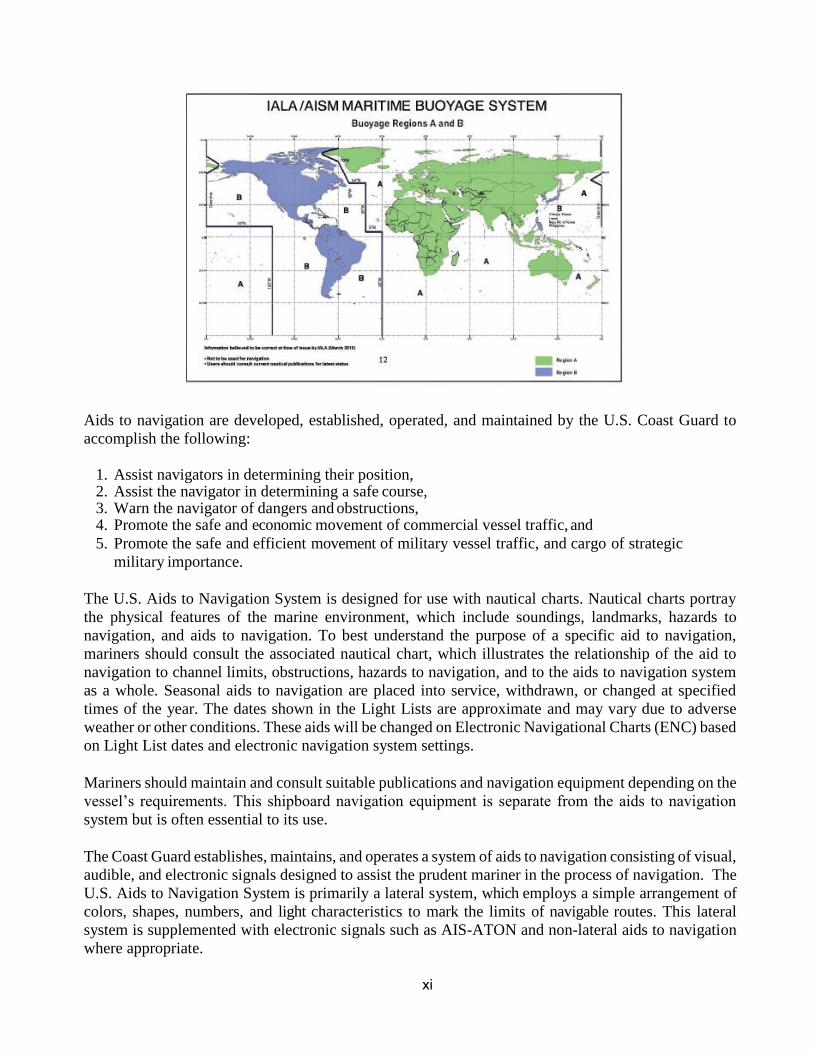
The navigable waters of the United States are marked to assist navigation using the U.S. Aids
to Navigation System, a system consistent with the International Association of Marine Aids to
Navigation and Lighthouse Authorities (IALA) Maritime Buoyage System. The IALA Maritime
Buoyage System is followed by most of the world’s maritime nations and improves maritime
safety by encouraging conformity in buoyage systems worldwide. IALA buoyage is divided into
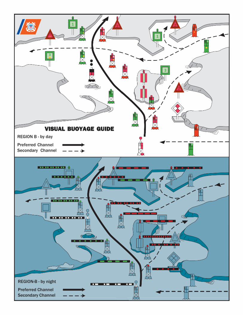
two regions made up of Region A and Region B. All navigable waters of the United States follow
IALA Region B, except U.S. possessions west of the International Date Line and south of 10° north
latitude, which follow Region A. Lateral aids to navigation in Region A vary from those located
within Region B. Non-lateral aids to navigation in Region A are the same as those used in
Region B. Appropriate nautical charts and publications should be consulted to determine whether
the Region A or Region B marking schemes are in effect for a given area.
xi
Aids to navigation are developed, established, operated, and maintained by the U.S. Coast Guard to
accomplish the following:
1. Assist navigators in determining their position,2. Assist the navigator in determining a safe course,3. Warn the navigator of dangers and obstructions,4. Promote the safe and economic movement of commercial vessel traffic, and
5. Promote the safe and efficient movement of military vessel traffic, and cargo of strategic
military importance.
The U.S. Aids to Navigation System is designed for use with nautical charts. Nautical charts portray
the physical features of the marine environment, which include soundings, landmarks, hazards to
navigation, and aids to navigation. To best understand the purpose of a specific aid to navigation,
mariners should consult the associated nautical chart, which illustrates the relationship of the aid to
navigation to channel limits, obstructions, hazards to navigation, and to the aids to navigation system
as a whole. Seasonal aids to navigation are placed into service, withdrawn, or changed at specified
times of the year. The dates shown in the Light Lists are approximate and may vary due to adverse
weather or other conditions. These aids will be changed on Electronic Navigational Charts (ENC) based
on Light List dates and electronic navigation system settings.
Mariners should maintain and consult suitable publications and navigation equipment depending on the
vessel’s requirements. This shipboard navigation equipment is separate from the aids to navigation
system but is often essential to its use.
The Coast Guard establishes, maintains, and operates a system of aids to navigation consisting of visual,
audible, and electronic signals designed to assist the prudent mariner in the process of navigation. The
U.S. Aids to Navigation System is primarily a lateral system, which employs a simple arrangement of
colors, shapes, numbers, and light characteristics to mark the limits of navigable routes. This lateral
system is supplemented with electronic signals such as AIS-ATON and non-lateral aids to navigation
where appropriate.
xii
The U.S. Aids to Navigation System contains the following subsystems:
1. Intracoastal Waterway: The aids to navigation marking the Intracoastal Waterway are arranged
geographically from north to south on the Atlantic Coast and generally east to west on the coast of
the Gulf of Mexico. Red lights (if so equipped), even numbers, and red buoys or triangle shaped
daymarks are located on the southbound/westbound starboard waterway boundary. Green lights (if
so equipped), odd numbers, and green buoys or square shaped daymarks are on the
southbound/westbound port waterway boundary.
2. Western Rivers: The Western Rivers System is employed on the Mississippi River System, in
addition to the Tennessee-Tombigbee Waterway and the Alabama, Atchafalaya, and Apalachicola-
Chattahoochee-Flint River Systems. The Western Rivers System consists of the following
characteristics:
a. Buoys are not numbered.
b. Numbers on beacons do not have lateral significance, but rather indicate mileage from a fixed point
(normally the river mouth).
c. Diamond shaped non-lateral dayboards, red and white or green and white as appropriate, are used
to indicate where the river channel crosses from one bank to the other.
d. Lights on green aids to navigation show a single-flash characteristic, which may be green or
white.
e. Lights on red aids to navigation show a group-flash characteristic, which may be red or white.
f. Isolated danger marks are not used.
3. Bridge Markings: Bridges across navigable waters are marked with red, green and/or white lights
for nighttime navigation. Red lights mark piers and other parts of the bridge. Red lights are also
placed on drawbridges to show when they are in the closed position. Green lights are placed on
drawbridges to show when they are in the open position. The location of these lights will vary
according to the bridge structure. Green lights are also used to mark the centerline of navigable
channels through fixed bridges. If there are two or more channels through the bridge, the preferred
channel is also marked by three white lights in a vertical line above the green light.
Red and green retro-reflective panels may be used to mark bridge piers and may also be used on
bridges not required to display lights. Lateral red and green lights and dayboards may mark main
channels through bridges. Adjacent piers are marked with fixed yellow lights when the main
channel is marked with lateral aids to navigation. Centerlines of channels through fixed bridges
may be marked with a safe water mark and an occulting white light when lateral marks are used to
mark main channels.
The centerline of the navigable channel through the draw span of floating bridges may be marked
with a special mark. The mark will be a yellow diamond with yellow retro-reflective panels and
may exhibit a yellow light that displays a Morse code “B” (a long flash followed by three short
flashes). AIS-ATON and RACONs may be placed on the bridge structure to mark the centerline
of the navigable channel through the bridge.
xiii
Vertical clearance gauges may be installed to enhance navigation safety. The gauges are located
on the right channel pier or pier protective structure facing approaching vessels. Clearance gauges
indicate the vertical distance between “low steel” of the bridge channel span (in the closed to
navigation position for drawbridges) and the level of the water, measured to the bottom of the foot
marks, read from top to bottom.
Drawbridges equipped with radiotelephones display a blue and white sign which indicates what
VHF radiotelephone channels should be used to request bridge openings.
4. Private aids to navigation include aids to navigation that are either operated by private persons
and organizations, or that are operated by states. Private aids to navigation are classified into three
categories:
a. Class I: Aids to navigation on marine structures or other works that the owners are legally
obligated to establish, maintain, and operate as prescribed by the U.S. Coast Guard.
b. Class II: Aids to navigation that, exclusive of Class I aids, are in waters used by general
navigation.
c. Class III: Aids to navigation that, exclusive of Class I and Class II aids, are in waters not
ordinarily used by general navigation.
Authorization for the establishment of a Class II or Class III private aid to navigation by the U.S. Coast
Guard imposes no legal obligation that the aid be established and operated. It only specifies the
location and operational characteristics of the aid for which the authorization was requested. Once the
aid is established, however, the owner is legally obligated to maintain it in good working order and
properly painted.
5. Lights and sound signals on oil wells or other offshore structures in navigable waters are
private aids to navigation and are generally not listed in the Light List unless they are equipped
with a RACON. Where space allows, the structures are shown on the appropriate nautical charts.
Information concerning the location and characteristics of those structures which display lights and
sound signals not located in obstruction areas are published in Local and/or weekly Notices to
Mariners. In general, during the nighttime, a series of white lights are displayed extending from
the platform to the top of the derrick when drilling operations are in progress. At other times,
structures are usually marked with one or more quick flashing white, red, or yellow lights, visible
for at least one nautical mile during clear weather. Obstructions, which are a part of the
appurtenances to the main structure, such as mooring piles, anchors, and mooring buoys, etc., are
not normally lighted. In addition, some structures are equipped with a sound signal that produces
a single two-second blast every 20 seconds.
xiv
BUOYS, BEACONS, AND AIS-ATON
The primary components of the U.S. Aids to Navigation System are buoys, beacons, and AIS-ATON.
Buoys are floating aids to navigation used extensively throughout U.S. waters. They are moored to
sinkers by varying lengths of chain and may shift due to sea conditions and other causes. Buoys may
also be carried away, capsized, or sunk. Prudent mariners will not rely solely on any single aid to
navigation, particularly floating aids.
Buoy positions represented on nautical charts are approximate position only, due to the practical
limitations of positioning and maintaining buoys and their sinkers in precise geographical locations.
Positions of Federal buoys are verified during periodic maintenance visits. Between visits,
environmental conditions such as atmospheric and sea conditions or seabed slope and composition may
shift buoys off their charted positions. Buoys may also be dragged off station, sunk, or capsized by a
collision with a vessel.
Beacons are aids to navigation which are permanently fixed to the earth’s surface. They range from
large lighthouses to small single-pile structures and may be located on land or in the water. Lighted
beacons are called lights; unlighted beacons are called daybeacons. Lighthouses are placed on shore or
on marine sites and most often do not indicate lateral significance. Lighthouses with no lateral
significance exhibit a white light.
Beacons exhibit a daymark. For small structures, these are colored geometric shapes that make an aid
to navigation readily visible and easily identifiable against background conditions. Generally, the
daymark conveys to the mariner during daylight hours the same significance as the aid’s light or reflector
does at night. The daymark of towers, however, consists of the structure itself. As a result, these
daymarks do not imply lateral significance.
Ranges (Leading Lights) are non-lateral aids to navigation composed of two beacons, which when
sighted in line with one another, define a particular bearing or course. The appropriate nautical chart
must be consulted when using ranges to determine whether the range marks the centerline of the
navigable channel and what section of the range may be safely traversed. Ranges typically display
rectangular dayboards of various colors and are generally, but not always lighted. Ranges may display
lights during daylight and at night. When lighted, ranges may display lights of any color.
Caution: Vessels should not pass beacons close aboard due to the danger of collision with riprap or
structure foundations, or with the obstruction or danger being marked.
xv
Automatic Identification System (AIS) is a maritime navigation safety communications
protocol defined by the International Telecommunication Union and adopted by the International
Maritime Organization for the autonomous and continuous exchange of pertinent navigation
information between seagoing ships and other mandated vessels, such as identity, call-sign,
position, dimensions, type, and navigation status. In addition to ship-to-ship broadcasts, AIS may
communicate between ship and shore stations and be used for other navigation safety purpose,
such as augmenting the presence (on radar) and/or providing the status of an existing ATON.
Automatic Identification System-ATON (AIS-ATON) ATON may be enhanced using AIS
communications protocol. AIS-ATON can be used to autonomously and at fixed intervals
broadcast the name, position, dimensions, type, characteristics, and status from or concerning an
aid to navigation. AIS-ATON information can only be “seen” on AIS capable navigation display
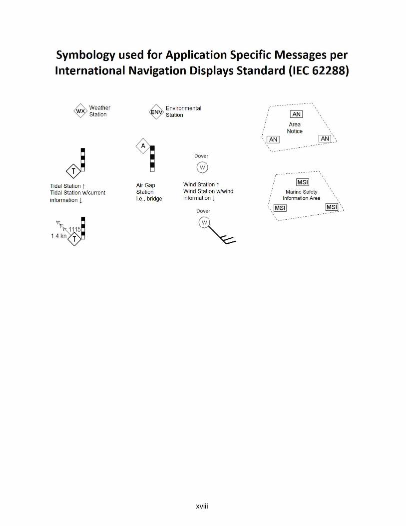
systems, such as those that meet IEC 62288 Navigation Presentation standards or are supported
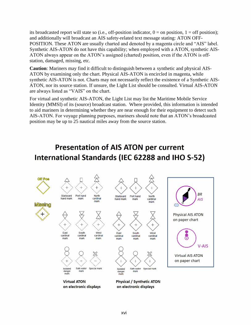
by other proprietary means used by non-IEC compliant manufacturers. The figures below show
how some are represented on AIS compliant navigation displays. AIS-ATON reports may have
lateral significance and thus are charted to mimic a physical buoy or beacon. They may also be
used to provide other marine safety information, such as when a charted restricted area is open or
closed, or to highlight a temporary condition that may not be charted, e.g., rocket launch areas.
AIS, as provided by the U.S. Army Corp of Engineers, can also provide reports on
environmental conditions, wind speed and direction, current data, lock status, etc.
AIS-ATON reports are characterized in one of three ways: physical (meaning the AIS
transmitter is physically located on the aid to navigation it is associated with, such as a ATON),
synthetic (meaning the AIS message or symbol associated with a particular ATON or beacon is
being broadcast from a different physical location, such as from an AIS antenna on shore), or
virtual (meaning no physical ATON or beacon exists, but that an AIS message or symbol is
being broadcast in order to be portrayed in a particular location). In the Light List, physical and
virtual aids will be listed as such in column (8), the remarks section. If an AIS-ATON listed in
the Light List does not have the words “physical” or “virtual” in the remarks section, it should be
presumed by the mariner to be a synthetic AIS-ATON.
Column (8) will also identify the source Maritime Mobile Service Identity (MMSI) of the
broadcast station(s). For example:
(8)
Remarks
[Physical/Virtual] AIS
AIS: 993666 X1X2X3X4
SOURCE AIS: 00366X1X2X3X4,
ASM:
8/67:33v3 [If more than 1 source
station] 00366 X1X2X3X4
Caution: When encountering an AIS-ATON, especially one associated with an ATON, mariners
should consult the Light List carefully to understand whether the AIS transmitter is located on
the aid or not. This is critical information necessary for interpreting the situation. For example,
if the AIS transmitter is located on the ATON it is associated with (physical AIS-ATON), the
location of the AIS signal will always correspond to the ATON’s actual position. If off-station,
xvi
its broadcasted report will state so (i.e., off-position indicator, 0 = on position, 1 = off position);
and additionally will broadcast an AIS safety-related text message stating: ATON OFF-
POSITION. These ATON are usually charted and denoted by a magenta circle and “AIS” label.
Synthetic AIS-ATON do not have this capability; when employed with a ATON, synthetic AIS-
ATON always appear on the ATON’s assigned (charted) position, even if the ATON is off-
station, damaged, missing, etc.
Caution: Mariners may find it difficult to distinguish between a synthetic and physical AIS-
ATON by examining only the chart. Physical AIS-ATON is encircled in magenta, while
synthetic AIS-ATON is not. Charts may not necessarily reflect the existence of a Synthetic AIS-
ATON, nor its source station. If unsure, the Light List should be consulted. Virtual AIS-ATON
are always listed as “VAIS” on the chart.
For virtual and synthetic AIS-ATON, the Light List may list the Maritime Mobile Service
Identity (MMSI) of its (source) broadcast station. Where provided, this information is intended
to aid mariners in determining whether they are near enough for their equipment to detect such
AIS-ATON. For voyage planning purposes, mariners should note that an ATON’s broadcasted
position may be up to 25 nautical miles away from the source station.
xvii
The technology associated with AIS-ATON allows for other types of information to be broadcast
to the mariner. Examples could include information about the health or status of AIS-ATON,
environmental or other safety information, navigation warnings, or information about the status
of bridges. Mariners should look for updates to the Light List to understand how the Coast Guard
is implementing this technology. Although all existing AIS mobile devices can receive AIS
ATON Reports and Application Specific Messages (ASM), they may not readily appear on an
AIS Minimal Keyboard Display or other shipboard navigational display systems (Radar), which
would require software updates to make these systems compliant with international navigation
presentation standards (i.e., IEC 62288 (series), IHO S-52 (series)). The data content of AIS
Application Specific Messages can found at https://www.iala-aism.org/asm.
They are identified by their: AIS message number (i.e. 6, 8, 25 or 26), Designated Area Code
(DAC), Function Identifier (FI), and Version Number.
Application Specific Message
ASM:X/YYY.ZZ.V, where:
X identifies the AIS message number (i.e. 6, 8, 25 or 26),
YYY its Designated Area Code (DAC),
ZZ its Function Identifier (FI), and V its Version Number,
e.g. ASM:8/367.22.2 denotes U.S. Geographic Notice, Application Specific Message 8, DAC
= 367, FI = 22, Version = 2.
xviii
xix
Nationwide Automatic Identification System (NAIS) consists of approximately 200 VHF receiver
sites located throughout the coastal continental United States, inland rivers, Alaska, Hawaii, Puerto Rico,
and Guam. NAIS couples AIS technology with a comprehensive network infrastructure to achieve ship-
to-shore and shore-to-ship data transmission throughout the navigable waters of the United States. The
system enables AIS-equipped vessels to receive important marine information such as safety and
security messages, weather alerts, and electronic aids to navigation. A list of NAIS Base Stations and
their corresponding MMSI numbers can be found in the table at the end of this section.
NAIS is designed to collect safety and security data from AIS-equipped vessels in navigable waters of
the United States and share that data with Coast Guard operators and other government and port partners.
The primary goal of NAIS is to increase situational awareness through data dissemination via a network
infrastructure, particularly focusing on improving maritime security, marine and navigational safety,
search and rescue, and environmental protection services. Collected AIS data improves the safety of
vessels and ports through collision avoidance and the safety of the nation through detection,
identification, and classification of vessels. NAIS broadcasts navigation enhancing safety related
messages such as Synthetic AIS ATON Reports and Application Specific Messages.
For more information about AIS see:
• AIS messages at: NAVCEN AIS Messages
• IMO Safety of Navigation Circular 289 and 290 regarding Application Specific Messages (ASM) at:NAVCEN AIS References
• IALA AIS ASM Catalog at: www.e-navigation.nl/asm, and
• USCG Special Notice 14-02 regarding AIS Aids to Navigation at: NAVCEN AIS FAQ #21
The U.S. Army Corps of Engineers (USACE) operates AIS-ATONs extensively throughout the Western Rivers, Columbia River and at the Sault Ste Marie lock and dam. USACE AIS Stations broadcast a variety
of information including ATON, Environmental, and Geographic Notices in support of navigation safety and efficient movement of vessels though U.S. inland waterways through their Lock Operations and
Management Application (LOMA).
The Marine Exchange of Alaska (MXAK) is a nonprofit maritime organization based in Juneau, Alaska. The organization was established to broker information, that aids safe, secure, efficient, and environmentally
sound maritime operations in Alaska. MXAK operates a network of Automatic Identification System (AIS) Stations to broadcast a variety of information including ATON, Environmental, and Geographic Notices in
support of navigation safety and efficient movement of vessels throughout Alaska.
The U.S. Coast Guard and some other approved entities (i.e., U.S. Army Corps of Engineers, National Oceanic and Atmospheric Administration, Marine Exchange of Alaska, etc.) have been transmitting AIS
ATON Reports and marine safety information via AIS since 2014 (see our Special Notice 01-2014). The exact content, location, and times of these transmissions are announced in the Coast Guard Local Notices to
Mariners (LNM) and denoted in Coast Guard Light List.
Note, AIS ATON stations operated in the U.S., other than by the U.S. Coast Guard, require Federal
Communications Commission (FCC) or National Telecommunication Information Agency (NTIA) radio determination service licensing/authorization; which they will not grant without prior approval from the U.S.
Coast Guard. Requests for such approvals may be sent to [email protected] via a USCG Private Aid to Navigation (PATON) application (either CG Form 2554 or 4143) and this Addendum. For further
information on AIS ATON see our AIS Frequently Asked Question 21 and the International Association of Marine Aid to Navigation and Lighthouse Authorities’ (IALA) publications on the subject.
xx
For further information on AIS ATON, please refer to the various IALA Guidelines and
Recommendations and their uses. The U.S. Coast Guard and some other approved entities (i.e., U.S. Army
Corps of Engineers, National Oceanic and Atmospheric Administration, Marine Exchange of Alaska, etc.)
have been transmitting AIS ATON Reports and marine safety information via AIS since 2014 (see our
Special Notice 01-2014). The exact content, location, and times of these transmissions are announced in the
Coast Guard Local Notices to Mariners (LNM) and denoted in Coast Guard Light List.
TYPES OF SIGNALS
Lighted aids to navigation are, for the most part, equipped with daylight controls which automatically
cause the light to operate during darkness and to be extinguished during daylight. These devices are not
of equal sensitivity; therefore, all lights do not come on or go off at the same time. Mariners should
ensure correct identification of aids to navigation during twilight periods when some lighted aids to
navigation are lit while others are not. The lighting apparatus is serviced at periodic intervals to assure
reliable operation, but there is always possibility of a light being extinguished or operating improperly.
Only aids to navigation with green or red lights have lateral significance and exhibit either flashing,
quick flashing, group flashing, occulting, or isophase light rhythms. When proceeding in the
conventional direction of buoyage, the mariner in IALA Region B, may see the following lighted aids
to navigation:
Green lights on aids to navigation mark port sides of channels and locations of wrecks or obstructions
that must be passed by keeping these lighted aids to navigation on the port hand of a vessel. Green
lights are also used on preferred channel marks where the preferred channel is to starboard (i.e., aid to
navigation left to port when proceeding in the conventional direction of buoyage). Red lights on aids
to navigation mark starboard sides of channels and locations of wrecks or obstructions that must be
passed by keeping these lighted aids to navigation on the starboard hand of a vessel. Red lights are also
used on preferred channel marks where the preferred channel is to port (i.e., aid to navigation left to
starboard when proceeding in the conventional direction of buoyage).
White and yellow lights have no lateral significance. The shapes, colors, letters, and light rhythms may
determine the purpose of aids to navigation exhibiting white or yellow lights.
Different colored light emitting diode (LED) lights used in conjunction or sectors of colored glass are
placed in the lanterns of some lights to produce a system of light sectors of different colors. In general,
red sectors are used to mark shoals or to warn the mariner of other obstructions to navigation or of
nearby land. Such lights provide approximate bearing information since observers may note the change
of color as they cross the boundary between sectors. These boundaries are indicated in the Light List
(Col. 8) and by dotted lines on charts. These bearings, as all bearings referring to lights, are given in
true degrees from 000° to 359°, as observed from a vessel toward the light.
When navigating, mariners should not rely on a line of bearing defined by the boundary between light
sectors. These sectors are not designed to define an accurate observed line of bearing. Using a compass
bearing to the light is recommend as more accurate. Be guided instead by the correct compass bearing
to the light and do not rely on being able to accurately observe the point at which the color changes.
This is difficult to determine because the edges of a colored sector cannot be cut off sharply. On either
side of the line of demarcation between white, red, or green sectors, there is always a small arc of
uncertain color. Moreover, when haze or smoke is present in the intervening atmosphere, a white sector
might have a reddish hue.
xxi
The arc drawn on charts around a light is not intended to give information as to the distance at which it
can be seen. The arc indicates the bearings between which the variation of visibility or obstruction of
the light occurs.
Most aids to navigation are fitted with retro reflective material to increase their visibility in darkness.
Colored reflective material is used on aids to navigation that, if lighted, will display lights of the same
color.
Preferred channel marks exhibit a composite group-flashing light rhythm of two flashes followed by a
single flash.
Safe water marks exhibit a white Morse code “A” rhythm (a short flash followed by a long flash).
Isolated danger marks exhibit a white flashing (2) rhythm (two flashes repeated regularly).
Special marks exhibit yellow lights and exhibit a flashing or fixed rhythm.
Information and regulatory marks exhibit a white light with any light rhythm except quick flashing,
flashing (2) and Morse code “A.”
For situations where lights require a distinct cautionary significance, as at sharp turns, sudden channel
constrictions, wrecks, or obstructions, a quick flashing light rhythm will be used.
Conditions which may affect a Light
The condition of the atmosphere has a considerable effect upon the distance at which lights can be seen.
Sometimes lights are obscured by fog, haze, dust, smoke, or precipitation which may be present at the
light, or between the light and the observer, and which is possibly unknown by the observer.
Atmospheric refraction may cause a light to be seen farther than under ordinary circumstances.
A light of low intensity will be easily obscured by unfavorable conditions in the atmosphere and little
dependence can be placed on it being seen. For this reason, the intensity of a light should always be
considered when expecting to sight it in reduced visibility. Haze and distance may reduce the apparent
duration of the flash of a light. In some atmospheric conditions, white lights may have a reddish hue.
Lights placed at high elevations are more frequently obscured by clouds, mist, and fog than those lights
located at or near sea level.
In regions where ice conditions prevail in the winter, the lantern panes of lights may become covered
with ice or snow, which will greatly reduce the visibility of the lights and may also cause colored lights
to appear white.
The increasing use of brilliant shore lights for advertising, illuminating bridges, and other purposes,
may cause marine navigational lights, particularly those in densely inhabited areas, to be outshone and
difficult to distinguish from the background lighting. Mariners are requested to report such cases in
order that steps may be taken to improve the conditions.
The “loom” (glow) of a powerful light is often seen beyond the limit of visibility of the actual rays of
the light. The loom may sometimes appear sufficiently sharp enough to obtain a bearing. At short
distances, some flashing lights may show a faint continuous light between flashes.
xxii
The distance of an observer from a light cannot be estimated by its apparent intensity. Mariners should
always check the characteristics of lights to avoid mistaking powerful lights, visible in the distance, for
nearby lights (such as those on lighted buoys) showing similar characteristics of low intensity. If lights
are not sighted within a reasonable time after prediction, a dangerous situation may exist, requiring
prompt resolution or action to ensure the safety of the vessel.
The characteristic of a lights can appear to change based on the observer’s distance from it. Consider
the case of a light with a rather complex characteristic: Fixed white with an alternating red and white.
From a distance the light might appear to only be a flashing white. At a shorter distance it may look
like an alternating red and white. Only up close might an observer be able to see the true characteristic.
Fixed white with an alternating red and white.
If a vessel has considerable vertical motion due to pitching in heavy seas, a light sighted on the horizon
may alternatively appear and disappear. This may lead the unwary to assign a false characteristic and
hence, to error in its identification. The true characteristic will be evident after the distance has been
sufficiently decreased or by increasing the height of eye of the observer.
Similarly, the effect of wave motion on lighted buoys may produce the appearance of incorrect light
phase characteristics when certain flashes occur but are not viewed by the mariner. In addition, buoy
motion can reduce the distance at which buoy lights are detected.
Shapes are used to provide easy identification on certain unlighted buoys and dayboards on beacons.
These shapes are laterally significant only when associated with laterally significant colors. In IALA
Region B, cylindrical buoys (referred to as “can buoys”) and square dayboards mark the port side of a
channel when proceeding in the conventional direction of buoyage. These aids to navigation are
associated with solid green or green and red-banded marks where the topmost band is green. Conical
buoys (referred to as “nun buoys”) and triangular dayboards mark the starboard side of the channel
when proceeding from seaward. These aids to navigation are associated with solid red or red and green-
banded marks where the topmost band is red.
Unless fitted with topmarks; lighted, sound, pillar, and spar buoys have no shape significance. Their
numbers, colors, and light characteristics convey their meanings.
xxiii
Dayboards throughout the U.S. Aids to Navigation System are described using standard designations
that describe the appearance of each dayboard. A brief explanation of the designations and of the
purpose of each type of dayboard in the system is given below, followed by a verbal description of the
appearance of each dayboard type.
Designations:
1. First Letter – Shape or Purpose
C: Crossing (Western Rivers only) diamond-shaped, used to indicate the points at which
the channel crosses the river.
J: Junction (square or triangle) used to mark (preferred channel) junctions or bifurcations
in the channel, or wrecks or obstructions which may be passed on either side; color of
top band has lateral significance for the preferred channel.
K: Range (rectangular) when both the front and rear range dayboards are aligned on the
same bearing, the observer is on the azimuth of the range, usually used to mark the
center of the channel.
M: Safe Water (octagonal) used to mark the fairway or middle of the channel.
N: No lateral significance (diamond or rectangular) used for special purpose, warning,
distance, or location markers.
S: Square used to mark the port side of channels when proceeding from seaward.
T: Triangle used to mark the starboard side of channels when proceeding from seaward.
2. Second Letter – Key Color
B – Black G – Green R – Red W – White Y – Yellow
3. Third Letter – Color of Center Stripe (Range DayboardsOnly)
4. Additional Information after a (-)
-I: Intracoastal Waterway; a yellow reflective horizontal band on a dayboard; indicates the
aid to navigation marks the Intracoastal Waterway.
-SY: Intracoastal Waterway; a yellow reflective square on a dayboard; indicates the aid to
navigation is a port hand mark for vessels traversing the Intracoastal Waterway. May
appear on a triangular daymark where the Intracoastal Waterway coincides with a
waterway having opposite conventional direction of buoyage.
-TY: Intracoastal Waterway; a yellow reflective triangle on a dayboard; indicates the aid to
navigation is a starboard hand mark for vessels traversing the Intracoastal Waterway. May
appear on a square daymark where the Intracoastal Waterway coincides with a waterway
having opposite conventional direction of buoyage.
xxiv
Descriptions:
CNG: Diamond-shaped dayboard divided into four diamond-shaped colored sectors with the
sectors at the side corners white and the sectors at the top and bottom corners green,
with green reflective diamonds at the top and bottom corners and white reflective
diamonds in the side corners (Western Rivers only).
CNR: Diamond-shaped dayboard divided into four diamond-shaped colored sectors with the
sectors at the side corners white and the sectors at the top and bottom corners red,
with red reflective diamonds at the top and bottom corners and white reflective
diamonds in the side corners (Western Rivers only).
JG: Dayboard bearing horizontal bands of green and red, green band topmost, with
corresponding reflective borders.
JG-I: Square dayboard bearing horizontal bands of green and red, green band topmost, with
corresponding reflective borders and a yellow reflective horizontal band.
JG-SY: Square dayboard bearing horizontal bands of green and red, green band topmost, with
corresponding reflective borders and a yellow reflective square.
JG-TY: Square dayboard bearing horizontal bands of green and red, green band topmost, with
corresponding reflective borders and a yellow reflective triangle.
JR: Dayboard bearing horizontal bands of red and green, red band topmost, with
corresponding reflective borders.
JR-I: Triangular dayboard bearing horizontal bands of red and green, red band topmost, with
corresponding reflective borders and a yellow reflective horizontal band.
JR-SY: Triangular dayboard bearing horizontal bands of red and green, red band topmost,
with corresponding reflective borders and a yellow reflective square.
JR-TY: Triangular dayboard bearing horizontal bands of red and green, red band topmost,
with corresponding reflective borders and a yellow reflective triangle.
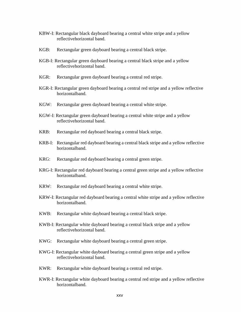
KBG: Rectangular black dayboard bearing a central green stripe.
KBG-I: Rectangular black dayboard bearing a central green stripe and a yellow reflective
horizontal band.
KBR: Rectangular black dayboard bearing a central red stripe.
KBR-I: Rectangular black dayboard bearing a central red stripe and a yellow
reflective horizontal band.
KBW: Rectangular black dayboard bearing a central white stripe.
xxv
KBW-I: Rectangular black dayboard bearing a central white stripe and a yellow
reflective horizontal band.
KGB: Rectangular green dayboard bearing a central black stripe.
KGB-I: Rectangular green dayboard bearing a central black stripe and a yellow
reflective horizontal band.
KGR: Rectangular green dayboard bearing a central red stripe.
KGR-I: Rectangular green dayboard bearing a central red stripe and a yellow reflective
horizontal band.
KGW: Rectangular green dayboard bearing a central white stripe.
KGW-I: Rectangular green dayboard bearing a central white stripe and a yellow
reflective horizontal band.
KRB: Rectangular red dayboard bearing a central black stripe.
KRB-I: Rectangular red dayboard bearing a central black stripe and a yellow reflective
horizontal band.
KRG: Rectangular red dayboard bearing a central green stripe.
KRG-I: Rectangular red dayboard bearing a central green stripe and a yellow reflective
horizontal band.
KRW: Rectangular red dayboard bearing a central white stripe.
KRW-I: Rectangular red dayboard bearing a central white stripe and a yellow reflective
horizontal band.
KWB: Rectangular white dayboard bearing a central black stripe.
KWB-I: Rectangular white dayboard bearing a central black stripe and a yellow
reflective horizontal band.
KWG: Rectangular white dayboard bearing a central green stripe.
KWG-I: Rectangular white dayboard bearing a central green stripe and a yellow
reflective horizontal band.
KWR: Rectangular white dayboard bearing a central red stripe.
KWR-I: Rectangular white dayboard bearing a central red stripe and a yellow reflective
horizontal band.
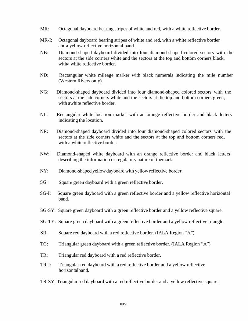
xxvi
MR: Octagonal dayboard bearing stripes of white and red, with a white reflective border.
MR-I: Octagonal dayboard bearing stripes of white and red, with a white reflective border
and a yellow reflective horizontal band.
NB: Diamond-shaped dayboard divided into four diamond-shaped colored sectors with the
sectors at the side corners white and the sectors at the top and bottom corners black,
with a white reflective border.
ND: Rectangular white mileage marker with black numerals indicating the mile number
(Western Rivers only).
NG: Diamond-shaped dayboard divided into four diamond-shaped colored sectors with the
sectors at the side corners white and the sectors at the top and bottom corners green,
with a white reflective border.
NL: Rectangular white location marker with an orange reflective border and black letters
indicating the location.
NR: Diamond-shaped dayboard divided into four diamond-shaped colored sectors with the
sectors at the side corners white and the sectors at the top and bottom corners red,
with a white reflective border.
NW: Diamond-shaped white dayboard with an orange reflective border and black letters
describing the information or regulatory nature of themark.
NY: Diamond-shaped yellow dayboard with yellow reflective border.
SG: Square green dayboard with a green reflective border.
SG-I: Square green dayboard with a green reflective border and a yellow reflective horizontal
band.
SG-SY: Square green dayboard with a green reflective border and a yellow reflective square.
SG-TY: Square green dayboard with a green reflective border and a yellow reflective triangle.
SR: Square red dayboard with a red reflective border. (IALA Region “A”)
TG: Triangular green dayboard with a green reflective border. (IALA Region “A”)
TR: Triangular red dayboard with a red reflective border.
TR-I: Triangular red dayboard with a red reflective border and a yellow reflective
horizontal band.
TR-SY: Triangular red dayboard with a red reflective border and a yellow reflective square.
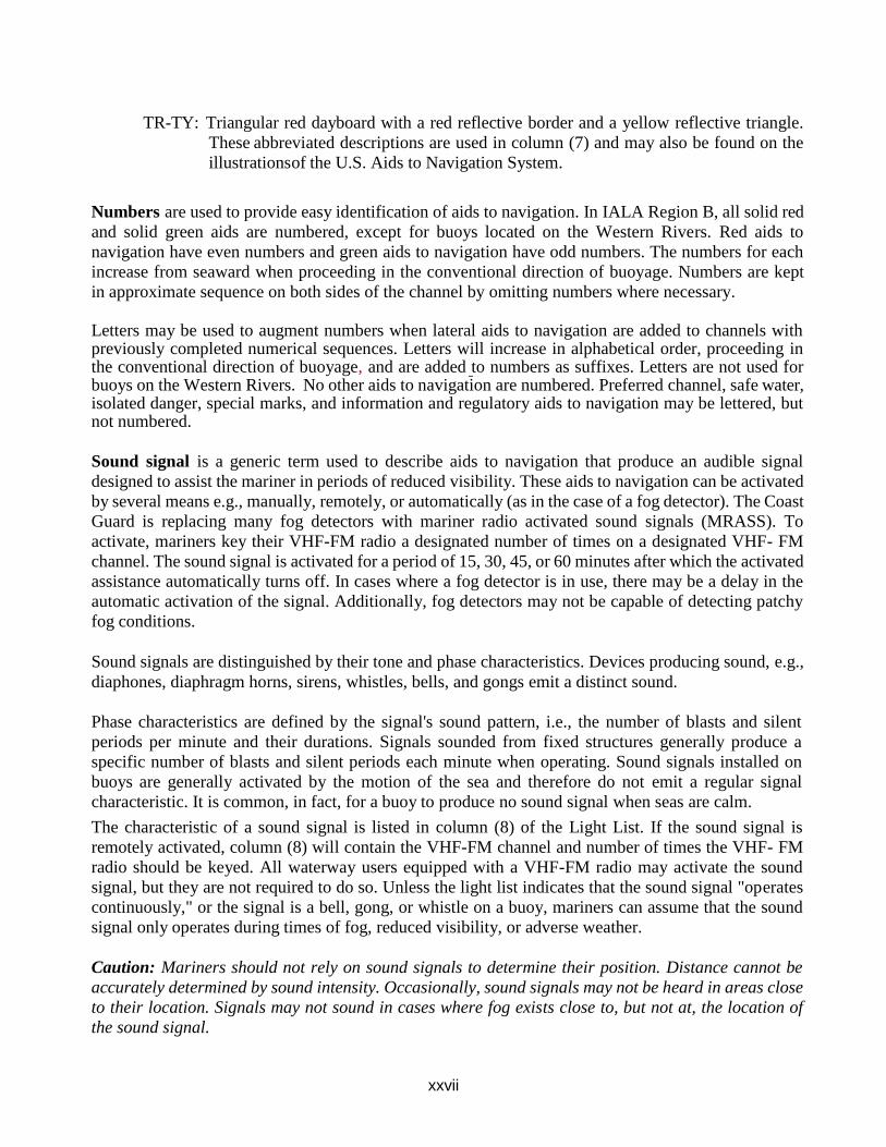
xxvii
TR-TY: Triangular red dayboard with a red reflective border and a yellow reflective triangle.
These abbreviated descriptions are used in column (7) and may also be found on the
illustrations of the U.S. Aids to Navigation System.
Numbers are used to provide easy identification of aids to navigation. In IALA Region B, all solid red
and solid green aids are numbered, except for buoys located on the Western Rivers. Red aids to
navigation have even numbers and green aids to navigation have odd numbers. The numbers for each
increase from seaward when proceeding in the conventional direction of buoyage. Numbers are kept
in approximate sequence on both sides of the channel by omitting numbers where necessary.
Letters may be used to augment numbers when lateral aids to navigation are added to channels with previously completed numerical sequences. Letters will increase in alphabetical order, proceeding in the conventional direction of buoyage, and are added to numbers as suffixes. Letters are not used for buoys on the Western Rivers. No other aids to navigation are numbered. Preferred channel, safe water, isolated danger, special marks, and information and regulatory aids to navigation may be lettered, but not numbered.
Sound signal is a generic term used to describe aids to navigation that produce an audible signal
designed to assist the mariner in periods of reduced visibility. These aids to navigation can be activated
by several means e.g., manually, remotely, or automatically (as in the case of a fog detector). The Coast
Guard is replacing many fog detectors with mariner radio activated sound signals (MRASS). To
activate, mariners key their VHF-FM radio a designated number of times on a designated VHF- FM
channel. The sound signal is activated for a period of 15, 30, 45, or 60 minutes after which the activated
assistance automatically turns off. In cases where a fog detector is in use, there may be a delay in the
automatic activation of the signal. Additionally, fog detectors may not be capable of detecting patchy
fog conditions.
Sound signals are distinguished by their tone and phase characteristics. Devices producing sound, e.g.,
diaphones, diaphragm horns, sirens, whistles, bells, and gongs emit a distinct sound.
Phase characteristics are defined by the signal's sound pattern, i.e., the number of blasts and silent
periods per minute and their durations. Signals sounded from fixed structures generally produce a
specific number of blasts and silent periods each minute when operating. Sound signals installed on
buoys are generally activated by the motion of the sea and therefore do not emit a regular signal
characteristic. It is common, in fact, for a buoy to produce no sound signal when seas are calm.
The characteristic of a sound signal is listed in column (8) of the Light List. If the sound signal is
remotely activated, column (8) will contain the VHF-FM channel and number of times the VHF- FM
radio should be keyed. All waterway users equipped with a VHF-FM radio may activate the sound
signal, but they are not required to do so. Unless the light list indicates that the sound signal "operates
continuously," or the signal is a bell, gong, or whistle on a buoy, mariners can assume that the sound
signal only operates during times of fog, reduced visibility, or adverse weather.
Caution: Mariners should not rely on sound signals to determine their position. Distance cannot be
accurately determined by sound intensity. Occasionally, sound signals may not be heard in areas close
to their location. Signals may not sound in cases where fog exists close to, but not at, the location of
the sound signal.
xxviii
Radar Beacons (RACONS) are radar transponders that when triggered by an X-band radar produce a coded response from its location, which is portrayed radially as a series of dots and dashes on the triggering radar. Although RACONS may be used on both laterally significant and non-laterally significant aids to navigation, their signal should just be used for identification purposes only.
RACONS have a typical output of 600 milliwatts and are considered a short-range aid to navigation. Reception varies from a nominal range of 6 to 8 nautical miles (when mounted on a buoy) to as much as 17 nautical miles for a RACON mounted on a fixed structure. It must be understood that these nominal ranges are dependent upon many factors.
The beginning of the RACON presentation occurs about 50 yards beyond the RACON’s actual position and will persist for a number of revolutions of the radar antenna (depending on its rotation rate).
Radar operators may notice some broadening or spoking of the RACON presentation when their vessel approaches closely to the source of the RACON. This effect can be minimized by adjusting the IF gain or sweep gain control of the radar. If desired, the RACON presentation can be virtually eliminated by operation of the FTC (fast time constant) controls of the radar.
Radar Reflectors are special fixtures, incorporated into both lighted and unlighted aids to navigation, to enhance the reflection of radar energy. These fixtures make equipped ATON more detectable. However, they do not positively identify a radar target as an ATON.
GPS and Navigation – Related Services Operated by the US Coast Guard
Global Positioning System (GPS): GPS is a satellite-based navigation system, operated and controlled by the Department of Defense (DOD) under U.S. Air Force management, which provides precise, worldwide, three- dimensional navigation capabilities. The system was originally designed for military application; however, it is now available to all and used almost ubiquitously. The United States is committed to maintaining the availability of at least 24 operational GPS satellites, in six precise orbital planes, each of which complete a circular 10,900 nautical mile orbit of the earth once every 12 hours. At least three satellites are required for a two-dimensional solution. However, GPS does not provide integrity information and mariners should exercise extreme caution when using GPS in restricted waterways. Ideally, a minimum of four satellites will be visible from any position on the earth and will provide positions with a global horizontal accuracy within 3 meters, 95% percent of the time. Whenever possible, advance notice of when GPS satellites should not be used will be provided by the DOD and made available by the US Coast Guard through GPS status messages.
Navigation Information Service (NIS): The U.S. Coast Guard Navigation Center (NAVCEN) is the official government source of information for civil users of the Global Positioning System (GPS). The Navigation Information Service (NIS) is available 24 hours a day, seven days a week, for all Radio Navigation and maritime related needs via phone, fax or e-mail. The NIS provides users the ability to access real time or archived GPS, and LNM information at www.navcen.uscg.gov, as well as subscribe to an automated list service which enables users to receive GPS status messages and Notice to NAVSTAR User (NANU) messages via direct Internet e-mail. The NAVCEN also disseminates GPS safety advisory broadcast messages through USCG broadcast stations utilizing VHF-FM voice, HF-SSB voice, and NAVTEX broadcasts. The broadcasts provide the GPS user in the marine environment with the status of the navigation systems, as well as any planned/unplanned system
xxix
outages that could affect GPS navigational accuracy.
To comment on any of these services or ask questions about the service offered, contact the NAVCEN at:
Commanding Officer U.S. Coast Guard NAVCEN (NIS) MS
7310 7323 Telegraph Road Alexandria, VA 20598-7310
Phone: (703) 313-5900 FAX: (703) 313-5920 http://www.navcen.uscg.gov
USCG Navigation Center Website: The USCG Navigation Center (NAVCEN) operates a website that provides the maritime public with marine safety information (MSI) dissemination and reporting services. The NAVCEN website is www.navcen.uscg.gov. NAVCEN MSI dissemination services include GPS status messages, Notice Advisory to NAVSTAR Users (NANU) messages, Local Notice to Mariners, Broadcast Local Notice to Mariners, and the USCG Light List. Methods of MSI dissemination include VHF, NAVTEX, MF/HF SSB broadcasts, RSS feeds, and email subscription services. NAVCEN reporting services include web-based form discrepancy reporting for aids to navigation (ATON), global positioning system (GPS), automatic identification system (AIS), and Long Range Identification System (LRIT).
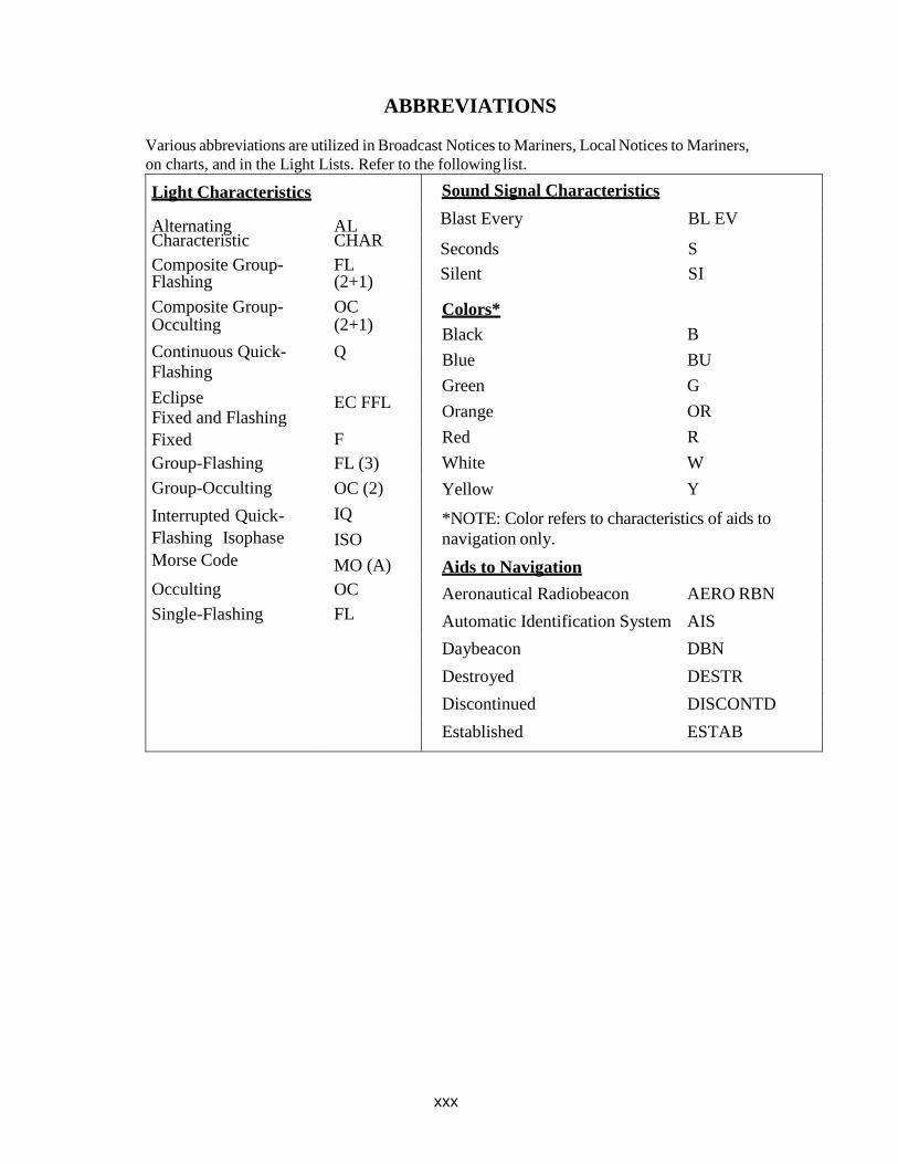
xxx
ABBREVIATIONS
Various abbreviations are utilized in Broadcast Notices to Mariners, Local Notices to Mariners,
on charts, and in the Light Lists. Refer to the following list.
Light Characteristics
Alternating Characteristic
Composite Group- Flashing
Composite Group- Occulting
Continuous Quick-
Flashing
Eclipse Fixed and Flashing
Fixed
Group-Flashing
Group-Occulting
Interrupted Quick-
Flashing Isophase
Morse Code
Occulting
Single-Flashing
AL CHAR
FL (2+1)
OC (2+1)
Q
EC FFL
F
FL (3)
OC (2)
IQ
ISO
MO (A)
OC
FL
Sound Signal Characteristics
Blast Every BL EV
Seconds S
Silent SI
Colors*
Black B
Blue BU
Green G
Orange OR
Red R
White W
Yellow Y
*NOTE: Color refers to characteristics of aids to
navigation only.
Aids to Navigation
Aeronautical Radiobeacon AERO RBN
Automatic Identification System AIS
Daybeacon DBN
Destroyed DESTR
Discontinued DISCONTD
Established ESTAB
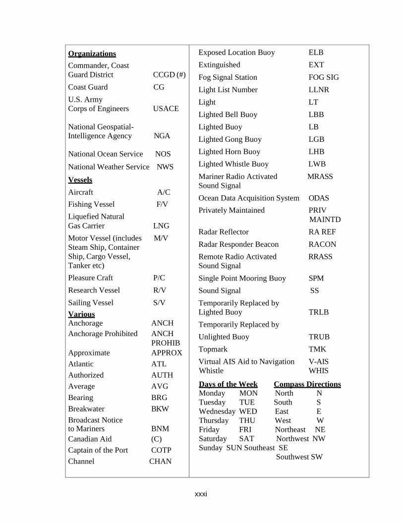
xxxi
Organizations
Commander, Coast
Guard District CCGD (#)
Coast Guard CG
U.S. Army
Corps of Engineers USACE
National Geospatial-
Intelligence Agency NGA
National Ocean Service NOS
National Weather Service NWS
Vessels
Aircraft A/C
Fishing Vessel F/V
Liquefied Natural
Gas Carrier LNG
Motor Vessel (includes M/V
Steam Ship, Container
Ship, Cargo Vessel,
Tanker etc)
Pleasure Craft P/C
Research Vessel R/V
Sailing Vessel S/V
Various
Anchorage ANCH
Anchorage Prohibited ANCH
PROHIB
Approximate APPROX
Atlantic ATL
Authorized AUTH
Average AVG
Bearing BRG
Breakwater BKW
Broadcast Notice to Mariners BNM
Canadian Aid (C)
Captain of the Port COTP
Channel CHAN
Exposed Location Buoy ELB
Extinguished EXT
Fog Signal Station FOG SIG
Light List Number LLNR
Light LT
Lighted Bell Buoy LBB
Lighted Buoy LB
Lighted Gong Buoy LGB
Lighted Horn Buoy LHB
Lighted Whistle Buoy LWB
Mariner Radio Activated MRASS
Sound Signal
Ocean Data Acquisition System ODAS
Privately Maintained PRIV
MAINTD
Radar Reflector RA REF
Radar Responder Beacon RACON
Remote Radio Activated RRASS
Sound Signal
Single Point Mooring Buoy SPM
Sound Signal SS
Temporarily Replaced by
Lighted Buoy TRLB
Temporarily Replaced by
Unlighted Buoy TRUB
Topmark TMK
Virtual AIS Aid to Navigation V-AIS
Whistle WHIS
Days of the Week Compass Directions
Monday MON North N
Tuesday TUE South S
Wednesday WED East E
Thursday THU West W
Friday FRI Northeast NE
Saturday SAT Northwest NW
Sunday SUN Southeast SE
Southwest SW
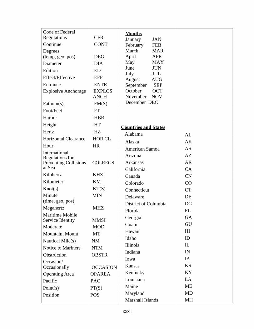
xxxii
Code of Federal Regulations CFR
Months
January JAN
February FEB
March MAR
April APR
May MAY
June JUN
July JUL
August AUG
September SEP
October OCT
November NOV
December DEC
Countries and States
Alabama
Alaska
American Samoa
Arizona
Arkansas
California
Canada
Colorado
Connecticut
Delaware
District of Columbia
Florida
Georgia
Guam
Hawaii
Idaho
Illinois
Indiana
Iowa
Kansas
Kentucky
Louisiana
Maine
Maryland
Marshall Islands
AL
AK
AS
AZ
AR
CA
CN
CO
CT
DE
DC
FL
GA
GU
HI
ID
IL
IN
IA
KS
KY
LA
ME
MD
MH
Continue CONT
Degrees (temp, geo, pos) DEG
Diameter DIA
Edition ED
Effect/Effective EFF
Entrance ENTR
Explosive Anchorage EXPLOS ANCH
Fathom(s) FM(S)
Foot/Feet FT
Harbor HBR
Height HT
Hertz HZ
Horizontal Clearance HOR CL
Hour HR
International Regulations for Preventing Collisions COLREGS at Sea
Kilohertz KHZ
Kilometer KM
Knot(s) KT(S)
Minute (time, geo, pos)
MIN
Megahertz MHZ
Maritime Mobile Service Identity MMSI
Moderate MOD
Mountain, Mount MT
Nautical Mile(s) NM
Notice to Mariners NTM
Obstruction OBSTR
Occasion/ Occasionally OCCASION
Operating Area OPAREA
Pacific PAC
Point(s) PT(S)
Position POS
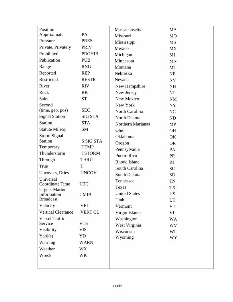
xxxiii
Position Approximate PA
Massachusetts
Missouri
Mississippi
Mexico
Michigan
Minnesota
Montana
Nebraska
Nevada
New Hampshire
New Jersey
New Mexico
New York
North Carolina
North Dakota
Northern Marianas
Ohio
Oklahoma
Oregon
Pennsylvania
Puerto Rico
Rhode Island
South Carolina
South Dakota
Tennessee
Texas
United States
Utah
Vermont
Virgin Islands
Washington
West Virginia
Wisconsin
Wyoming
MA
MO
MS
MX
MI
MN
MT
NE
NV
NH
NJ
NM
NY
NC
ND
MP
OH
OK
OR
PA
PR
RI
SC
SD
TN
TX
US
UT
VT
VI
WA
WV
WI
WY
Pressure PRES
Private, Privately PRIV
Prohibited PROHIB
Publication PUB
Range RNG
Reported REP
Restricted RESTR
River RIV
Rock RK
Saint ST
Second (time, geo, pos) SEC
Signal Station SIG STA
Station STA
Statute Mile(s) SM
Storm Signal
Station S SIG STA
Temporary TEMP
Thunderstorm TSTORM
Through THRU
True T
Uncovers, Dries UNCOV
Universal Coordinate Time UTC
Urgent Marine Information Broadcast
UMIB
Velocity VEL
Vertical Clearance VERT CL
Vessel Traffic Service VTS
Visibility VIS
Yard(s) YD
Warning WARN
Weather WX
Wreck WK

xxxiv
GLOSSARY OF AIDS TO NAVIGATION TERMS
Adrift: Afloat and unattached in any
way to the shore or seabed.
Aid to Navigation: Any device external
to a vessel or aircraft specifically
intended to assist navigators in
determining their position or safe course,
or to warn them of dangers or
obstructions to navigation.
Automatic Identification System Aid
to Navigation (AIS-ATON): An aid to
navigation signal that is broadcast
through AIS. They can be physical,
synthetic, or virtual.
Alternating Lights: A rhythmic light
showing light of alternating colors.
Arc of Visibility: The portion of the
horizon over which a lighted aid to
navigation is visible from seaward.
Articulated Beacon: A beacon-like
buoyant structure, tethered directly to the
seabed and having no watch circle.
Called articulated light or articulated
daybeacon, as appropriate.
Assigned Position: The latitude and
longitude position for an aid to
navigation.
Beacon: A lighted or unlighted fixed aid
to navigation attached directly to the
earth’s surface. (Lights and Daybeacons
both constitute beacons.
Bearing: The horizontal direction of a
line of sight between two objects on the
surface of the earth.
Bell: A sound signal producing bell
tones by means of a hammer actuated by
electricity on fixed aids and by sea
motion on buoys.
Bifurcation: The point where a channel
divides when proceeding from seaward.
The place where two tributaries meet.
Broadcast Notice to Mariners: A radio
broadcast designed to provide important
marine information.
Buoy: A floating object of defined shape
and color, which is anchored at a given
position and serves as an aid to
navigation.
Characteristic: The audible, visual, or
electronic signal displayed by an aid to
navigation to assist in the identification
of an aid to navigation. Characteristic
refers to lights, sound signals, RACONS,
and Daybeacons.
Commissioned: The action of placing a
previously discontinued aid to navigation
back in service.
Composite Group Flashing Light: A
group flashing light in which the flashes
are combined in successive groups of
different numbers of flashes.
Composite Group-Occulting Light: A
light like a group occulting light except
that the successive groups in a period
have different numbers of eclipses.
Conventional Direction of Buoyage:
The general direction taken by the
mariner when approaching a harbor,
river, estuary, or other waterway from
seaward, or proceeding upstream or in a
direction of the main stream of flood
tide, or in the direction indicated in
appropriate nautical documents
(normally, following a clockwise
direction around land masses).
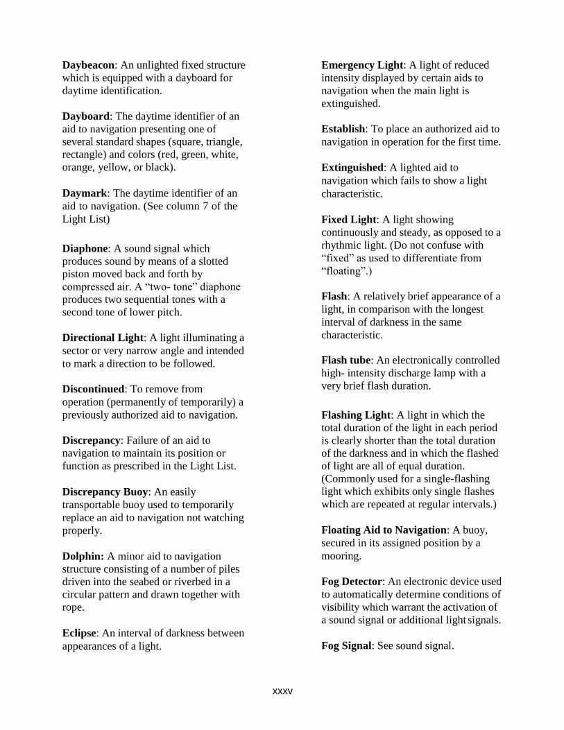
xxxv
Daybeacon: An unlighted fixed structure
which is equipped with a dayboard for
daytime identification.
Dayboard: The daytime identifier of an
aid to navigation presenting one of
several standard shapes (square, triangle,
rectangle) and colors (red, green, white,
orange, yellow, or black).
Daymark: The daytime identifier of an
aid to navigation. (See column 7 of the
Light List)
Diaphone: A sound signal which
produces sound by means of a slotted
piston moved back and forth by
compressed air. A “two- tone” diaphone
produces two sequential tones with a
second tone of lower pitch.
Directional Light: A light illuminating a
sector or very narrow angle and intended
to mark a direction to be followed.
Discontinued: To remove from
operation (permanently of temporarily) a
previously authorized aid to navigation.
Discrepancy: Failure of an aid to
navigation to maintain its position or
function as prescribed in the Light List.
Discrepancy Buoy: An easily
transportable buoy used to temporarily
replace an aid to navigation not watching
properly.
Dolphin: A minor aid to navigation
structure consisting of a number of piles
driven into the seabed or riverbed in a
circular pattern and drawn together with
rope.
Eclipse: An interval of darkness between
appearances of a light.
Emergency Light: A light of reduced
intensity displayed by certain aids to
navigation when the main light is
extinguished.
Establish: To place an authorized aid to
navigation in operation for the first time.
Extinguished: A lighted aid to
navigation which fails to show a light
characteristic.
Fixed Light: A light showing
continuously and steady, as opposed to a
rhythmic light. (Do not confuse with
“fixed” as used to differentiate from
“floating”.)
Flash: A relatively brief appearance of a
light, in comparison with the longest
interval of darkness in the same
characteristic.
Flash tube: An electronically controlled
high- intensity discharge lamp with a
very brief flash duration.
Flashing Light: A light in which the
total duration of the light in each period
is clearly shorter than the total duration
of the darkness and in which the flashed
of light are all of equal duration.
(Commonly used for a single-flashing
light which exhibits only single flashes
which are repeated at regular intervals.)
Floating Aid to Navigation: A buoy,
secured in its assigned position by a
mooring.
Fog Detector: An electronic device used
to automatically determine conditions of
visibility which warrant the activation of
a sound signal or additional light signals.
Fog Signal: See sound signal.
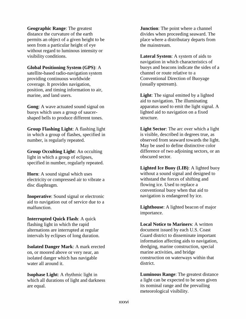
xxxvi
Geographic Range: The greatest
distance the curvature of the earth
permits an object of a given height to be
seen from a particular height of eye
without regard to luminous intensity or
visibility conditions.
Global Positioning System (GPS): A
satellite-based radio-navigation system
providing continuous worldwide
coverage. It provides navigation,
position, and timing information to air,
marine, and land users.
Gong: A wave actuated sound signal on
buoys which uses a group of saucer-
shaped bells to produce different tones.
Group Flashing Light: A flashing light
in which a group of flashes, specified in
number, is regularly repeated.
Group Occulting Light: An occulting
light in which a group of eclipses,
specified in number, regularly repeated.
Horn: A sound signal which uses
electricity or compressed air to vibrate a
disc diaphragm.
Inoperative: Sound signal or electronic
aid to navigation out of service due to a
malfunction.
Interrupted Quick Flash: A quick
flashing light in which the rapid
alternations are interrupted at regular
intervals by eclipses of long duration.
Isolated Danger Mark: A mark erected
on, or moored above or very near, an
isolated danger which has navigable
water all around it.
Isophase Light: A rhythmic light in
which all durations of light and darkness
are equal.
Junction: The point where a channel
divides when proceeding seaward. The
place where a distributary departs from
the mainstream.
Lateral System: A system of aids to
navigation in which characteristics of
buoys and beacons indicate the sides of a
channel or route relative to a
Conventional Direction of Buoyage
(usually upstream).
Light: The signal emitted by a lighted
aid to navigation. The illuminating
apparatus used to emit the light signal. A
lighted aid to navigation on a fixed
structure.
Light Sector: The arc over which a light
is visible, described in degrees true, as
observed from seaward towards the light.
May be used to define distinctive color
difference of two adjoining sectors, or an
obscured sector.
Lighted Ice Buoy (LIB): A lighted buoy
without a sound signal and designed to
withstand the forces of shifting and
flowing ice. Used to replace a
conventional buoy when that aid to
navigation is endangered by ice.
Lighthouse: A lighted beacon of major
importance.
Local Notice to Mariners: A written
document issued by each U.S. Coast
Guard district to disseminate important
information affecting aids to navigation,
dredging, marine construction, special
marine activities, and bridge
construction on waterways within that
district.
Luminous Range: The greatest distance
a light can be expected to be seen given
its nominal range and the prevailing
meteorological visibility.
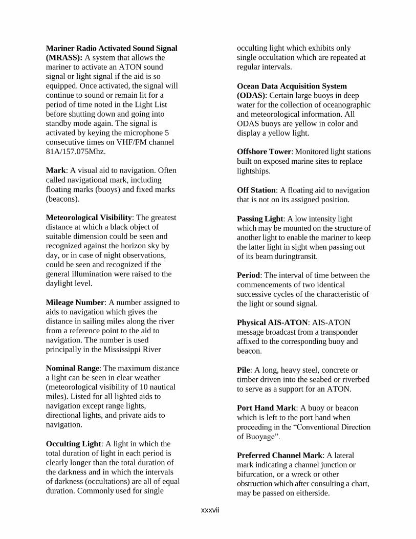
xxxvii
Mariner Radio Activated Sound Signal
(MRASS): A system that allows the
mariner to activate an ATON sound
signal or light signal if the aid is so
equipped. Once activated, the signal will
continue to sound or remain lit for a
period of time noted in the Light List
before shutting down and going into
standby mode again. The signal is
activated by keying the microphone 5
consecutive times on VHF/FM channel
81A/157.075Mhz.
Mark: A visual aid to navigation. Often
called navigational mark, including
floating marks (buoys) and fixed marks
(beacons).
Meteorological Visibility: The greatest
distance at which a black object of
suitable dimension could be seen and
recognized against the horizon sky by
day, or in case of night observations,
could be seen and recognized if the
general illumination were raised to the
daylight level.
Mileage Number: A number assigned to
aids to navigation which gives the
distance in sailing miles along the river
from a reference point to the aid to
navigation. The number is used
principally in the Mississippi River
Nominal Range: The maximum distance
a light can be seen in clear weather
(meteorological visibility of 10 nautical
miles). Listed for all lighted aids to
navigation except range lights,
directional lights, and private aids to
navigation.
Occulting Light: A light in which the
total duration of light in each period is
clearly longer than the total duration of
the darkness and in which the intervals
of darkness (occultations) are all of equal
duration. Commonly used for single
occulting light which exhibits only
single occultation which are repeated at
regular intervals.
Ocean Data Acquisition System
(ODAS): Certain large buoys in deep
water for the collection of oceanographic
and meteorological information. All
ODAS buoys are yellow in color and
display a yellow light.
Offshore Tower: Monitored light stations
built on exposed marine sites to replace
lightships.
Off Station: A floating aid to navigation
that is not on its assigned position.
Passing Light: A low intensity light
which may be mounted on the structure of
another light to enable the mariner to keep
the latter light in sight when passing out
of its beam duringtransit.
Period: The interval of time between the
commencements of two identical
successive cycles of the characteristic of
the light or sound signal.
Physical AIS-ATON: AIS-ATON
message broadcast from a transponder
affixed to the corresponding buoy and
beacon.
Pile: A long, heavy steel, concrete or
timber driven into the seabed or riverbed
to serve as a support for an ATON.
Port Hand Mark: A buoy or beacon
which is left to the port hand when
proceeding in the “Conventional Direction
of Buoyage”.
Preferred Channel Mark: A lateral
mark indicating a channel junction or
bifurcation, or a wreck or other
obstruction which after consulting a chart,
may be passed on eitherside.
xxxviii
Primary Aid to Navigation: An aid to
navigation established for the purpose of
making landfalls and coastwise passages
from headland to headland.
Quick Light: A light exhibiting very
rapid regular alternations of light and
darkness, normally 60 flashes per
minute.
RACON: A radar beacon which
produces a coded response or radar paint,
when triggered by a radar signal.
Radar: An electronic system designed to
transmit radio signals and receive
reflected images of those signals from a
“target” in order to determine the bearing
and distance to the “target”.
Radar Reflector: A special fixture fitted
to or incorporated into the design of
certain aids to navigation to enhance their
ability to reflect radar energy. In general,
these fixtures will materially improve the
aid to navigation for use by vessels with
radar.
Range: A line formed by the extension
of a line connecting two charted points.
Range lights: Two lights associated to
form a range which often, but not
necessarily, indicates the channel
centerline. The front range light is the
lower of the two, and nearer to the
mariner using the range. The rear light is
higher and further from the mariner.
Rebuilt: A fixed aid to navigation,
previously destroyed, which has been
restored as an aid to navigation.
Regulatory Marks: A white and orange
aid to navigation with no lateral
significance. Used to indicate a special
meaning to the mariner, such as danger,
restricted operations, or exclusion area.
Relighted: An extinguished aid to
navigation returned to its advertised light
characteristics.
Replaced: An aid to navigation
previously off station, adrift, or missing,
restored by another aid to navigation of
the same type and characteristics.
Replaced (temporarily): An aid to
navigation previously off station, adrift, or
missing restored by another aid to
navigation of a different type and/or
characteristic.
Reset: A floating aid to navigation
previously off station, adrift or missing,
returned to its assigned position (station).
Rhythmic Light: A light showing
intermittently with a regular periodicity.
Sector: See light sector.
Setting a Buoy: The act of placing a
buoy on assigned position in the water.
Siren: A sound signal which uses
electricity or compressed air to actuate
either a disc or a cup shaped rotor.
Skeleton Tower: A tower, usually of
steel, constructed of heavy corner
members and various horizontal and
diagonal bracing members.
Sound Signal: A device which transmits
sound, intended to provide information
to mariners during periods of restricted
visibility and foul weather.
Starboard Hand Mark: A buoy or
beacon which is right to the starboard
hand when proceeding in the
Conventional Direction of Buoyage.
xxxix
Synthetic AIS-ATON: AIS ATON
message broadcast (typically from shore)
to an assigned position with a
corresponding buoy or beacon.
Top mark: One or more relatively small
objects of characteristic shape and color
placed on aid to identify its purpose.
Traffic Separation Scheme: Shipping
corridors marked by buoys which
separate incoming from outgoing
vessels. Improperly called SEA LANES.
Virtual AIS-ATON: AIS ATON
message broadcast (typically from shore)
to an assigned position with no
corresponding buoy or beacon.
Watching Properly: An aid to navigation
on its assigned position exhibiting the
advertised characteristics in all respects.
Whistle: A wave actuated sound signal
on buoys which produces sound by
emitting compressed air through a
circumferential slot into a cylindrical
bell chamber.
Winter Marker: An unlighted buoy
without a sound signal, used to replace a
conventional buoy when an aid to
navigation is endangered by ice.
Winter Light: A light which is
maintained during those winter months
when the regular light is extinguished. It
is of lower candlepower than the regular
light, but usually the same characteristic.
Withdrawn: The discontinuance of an
aid to navigation or equipment on an aid
to navigation during severe ice
conditions or for the winter season.
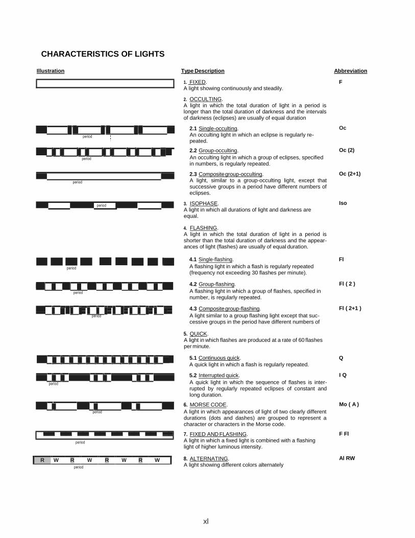
CHARACTERISTICS OF LIGHTS
Illustration Type Description Abbreviation
1. FIXED. F
A light showing continuously and steadily.
2. OCCULTING. A light in which the total duration of light in a period islonger than the total duration of darkness and the intervalsof darkness (eclipses) are usually of equal duration
period
period
2.1 Single-occulting. An occulting light in which an eclipse is regularly re- peated.
2.2 Group-occulting.
An occulting light in which a group of eclipses, specified in numbers, is regularly repeated.
2.3 Composite group-occulting. A light, similar to a group-occulting light, except that successive groups in a period have different numbers of eclipses.
3. ISOPHASE. A light in which all durations of light and darkness areequal.
4. FLASHING. A light in which the total duration of light in a period isshorter than the total duration of darkness and the appear- ances of light (flashes) are usually of equal duration.
Oc
Oc (2)
Oc (2+1)
Iso
period
4.1 Single-flashing. Fl
A flashing light in which a flash is regularly repeated (frequency not exceeding 30 flashes per minute).
period
period
4.2 Group-flashing.
A flashing light in which a group of flashes, specified in number, is regularly repeated.
4.3 Composite group-flashing.
A light similar to a group flashing light except that suc- cessive groups in the period have different numbers of
5. QUICK.A light in which flashes are produced at a rate of 60 flashesper minute.
Fl ( 2 )
Fl ( 2+1 )
5.1 Continuous quick. Q
A quick light in which a flash is regularly repeated.
period
period
period
period
5.2 Interrupted quick.
A quick light in which the sequence of flashes is inter- rupted by regularly repeated eclipses of constant and long duration.
6. MORSE CODE.
A light in which appearances of light of two clearly differentdurations (dots and dashes) are grouped to represent acharacter or characters in the Morse code.
7. FIXED AND FLASHING.A light in which a fixed light is combined with a flashinglight of higher luminous intensity.
8. ALTERNATING.A light showing different colors alternately
xl
I Q
Mo ( A )
F Fl
Al RW
period
period
R W R W R W R W
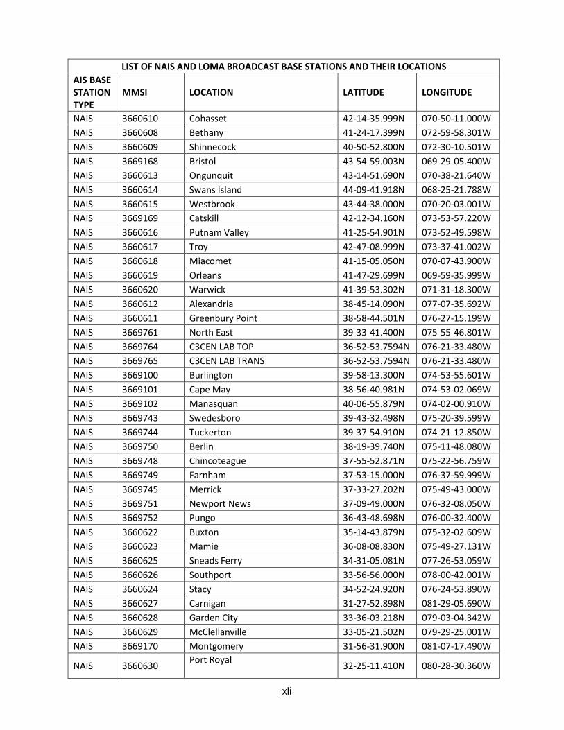
xli
LIST OF NAIS AND LOMA BROADCAST BASE STATIONS AND THEIR LOCATIONS
AIS BASE STATION TYPE
MMSI LOCATION LATITUDE LONGITUDE
NAIS 3660610 Cohasset 42-14-35.999N 070-50-11.000W
NAIS 3660608 Bethany 41-24-17.399N 072-59-58.301W
NAIS 3660609 Shinnecock 40-50-52.800N 072-30-10.501W
NAIS 3669168 Bristol 43-54-59.003N 069-29-05.400W
NAIS 3660613 Ongunquit 43-14-51.690N 070-38-21.640W
NAIS 3660614 Swans Island 44-09-41.918N 068-25-21.788W
NAIS 3660615 Westbrook 43-44-38.000N 070-20-03.001W
NAIS 3669169 Catskill 42-12-34.160N 073-53-57.220W
NAIS 3660616 Putnam Valley 41-25-54.901N 073-52-49.598W
NAIS 3660617 Troy 42-47-08.999N 073-37-41.002W
NAIS 3660618 Miacomet 41-15-05.050N 070-07-43.900W
NAIS 3660619 Orleans 41-47-29.699N 069-59-35.999W
NAIS 3660620 Warwick 41-39-53.302N 071-31-18.300W
NAIS 3660612 Alexandria 38-45-14.090N 077-07-35.692W
NAIS 3660611 Greenbury Point 38-58-44.501N 076-27-15.199W
NAIS 3669761 North East 39-33-41.400N 075-55-46.801W
NAIS 3669764 C3CEN LAB TOP 36-52-53.7594N 076-21-33.480W
NAIS 3669765 C3CEN LAB TRANS 36-52-53.7594N 076-21-33.480W
NAIS 3669100 Burlington 39-58-13.300N 074-53-55.601W
NAIS 3669101 Cape May 38-56-40.981N 074-53-02.069W
NAIS 3669102 Manasquan 40-06-55.879N 074-02-00.910W
NAIS 3669743 Swedesboro 39-43-32.498N 075-20-39.599W
NAIS 3669744 Tuckerton 39-37-54.910N 074-21-12.850W
NAIS 3669750 Berlin 38-19-39.740N 075-11-48.080W
NAIS 3669748 Chincoteague 37-55-52.871N 075-22-56.759W
NAIS 3669749 Farnham 37-53-15.000N 076-37-59.999W
NAIS 3669745 Merrick 37-33-27.202N 075-49-43.000W
NAIS 3669751 Newport News 37-09-49.000N 076-32-08.050W
NAIS 3669752 Pungo 36-43-48.698N 076-00-32.400W
NAIS 3660622 Buxton 35-14-43.879N 075-32-02.609W
NAIS 3660623 Mamie 36-08-08.830N 075-49-27.131W
NAIS 3660625 Sneads Ferry 34-31-05.081N 077-26-53.059W
NAIS 3660626 Southport 33-56-56.000N 078-00-42.001W
NAIS 3660624 Stacy 34-52-24.920N 076-24-53.890W
NAIS 3660627 Carnigan 31-27-52.898N 081-29-05.690W
NAIS 3660628 Garden City 33-36-03.218N 079-03-04.342W
NAIS 3660629 McClellanville 33-05-21.502N 079-29-25.001W
NAIS 3669170 Montgomery 31-56-31.900N 081-07-17.490W
NAIS 3660630 Port Royal
32-25-11.410N 080-28-30.360W
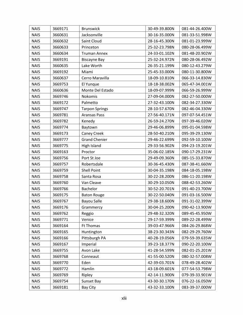
xlii
NAIS 3669171 Brunswick 30-49-39.800N 081-44-26.400W
NAIS 3660631 Jacksonville 30-16-35.000N 081-33-51.998W
NAIS 3660632 Saint Cloud 28-16-45.300N 081-01-23.999W
NAIS 3660633 Princeton 25-32-23.798N 080-28-06.499W
NAIS 3660634 Truman Annex 24-33-01.102N 081-48-20.902W
NAIS 3669191 Biscayne Bay 25-32-24.972N 080-28-06.492W
NAIS 3660635 Lake Worth 26-35-21.199N 080-12-43.279W
NAIS 3669192 Miami 25-45-33.000N 080-11-30.800W
NAIS 3660637 Cerro Maravilla 18-09-10.810N 066-33-14.830W
NAIS 3669753 El Yunque 18-18-38.002N 065-47-34.001W
NAIS 3660636 Monte Del Estado 18-09-07.999N 066-59-26.999W
NAIS 3669746 Nokomis 27-09-04.000N 082-27-50.000W
NAIS 3669172 Palmetto 27-32-43.100N 082-34-27.330W
NAIS 3669747 Tarpon Springs 28-10-57.670N 082-46-04.330W
NAIS 3669781 Aransas Pass 27-56-40.171N 097-07-54.451W
NAIS 3669782 Kenedy 26-59-24.270N 097-39-46.020W
NAIS 3669774 Baytown 29-46-06.899N 095-01-04.598W
NAIS 3669173 Caney Creek 28-50-40.210N 095-39-29.130W
NAIS 3669777 Grand Chenier 29-46-22.699N 092-59-10.100W
NAIS 3669775 High Island 29-33-56.902N 094-23-19.201W
NAIS 3669163 Proctor 35-06-02.185N 090-17-29.231W
NAIS 3669756 Port St Joe 29-49-09.360N 085-15-33.870W
NAIS 3669757 Robertsdale 30-36-45.430N 087-38-41.660W
NAIS 3669759 Shell Point 30-04-35.198N 084-18-05.198W
NAIS 3669758 Santa Rosa 30-22-28.200N 086-11-20.198W
NAIS 3669760 Van Cleave 30-29-10.050N 088-42-53.260W
NAIS 3669766 Bachelor 30-52-20.701N 091-40-23.700W
NAIS 3669175 Baton Rouge 30-22-50.040N 091-03-16.500W
NAIS 3669767 Bayou Salle 29-38-18.600N 091-31-02.399W
NAIS 3669176 Grammercy 30-04-25.200N 090-42-13.900W
NAIS 3669762 Reggio 29-48-32.320N 089-45-45.950W
NAIS 3669771 Venice 29-17-59.399N 089-22-28.499W
NAIS 3669164 Ft Thomas 39-03-47.966N 084-26-29.868W
NAIS 3669165 Huntington 38-23-30.343N 082-29-29.760W
NAIS 3669166 Pittsburgh PA 40-28-19.056N 079-59-39.635W
NAIS 3669167 Imperial 39-23-18.377N 090-22-20.100W
NAIS 3669755 Avon Lake 41-28-54.599N 082-01-25.201W
NAIS 3669768 Conneaut 41-55-00.520N 080-32-57.008W
NAIS 3669770 Eden 42-39-03.701N 078-49-28.402W
NAIS 3669772 Hamlin 43-18-09.601N 077-54-53.798W
NAIS 3669769 Ripley 42-14-11.900N 079-39-33.901W
NAIS 3669754 Sunset Bay 43-30-30.170N 076-22-16.050W
NAIS 3669181 Bay City 43-32-33.100N 083-39-37.000W
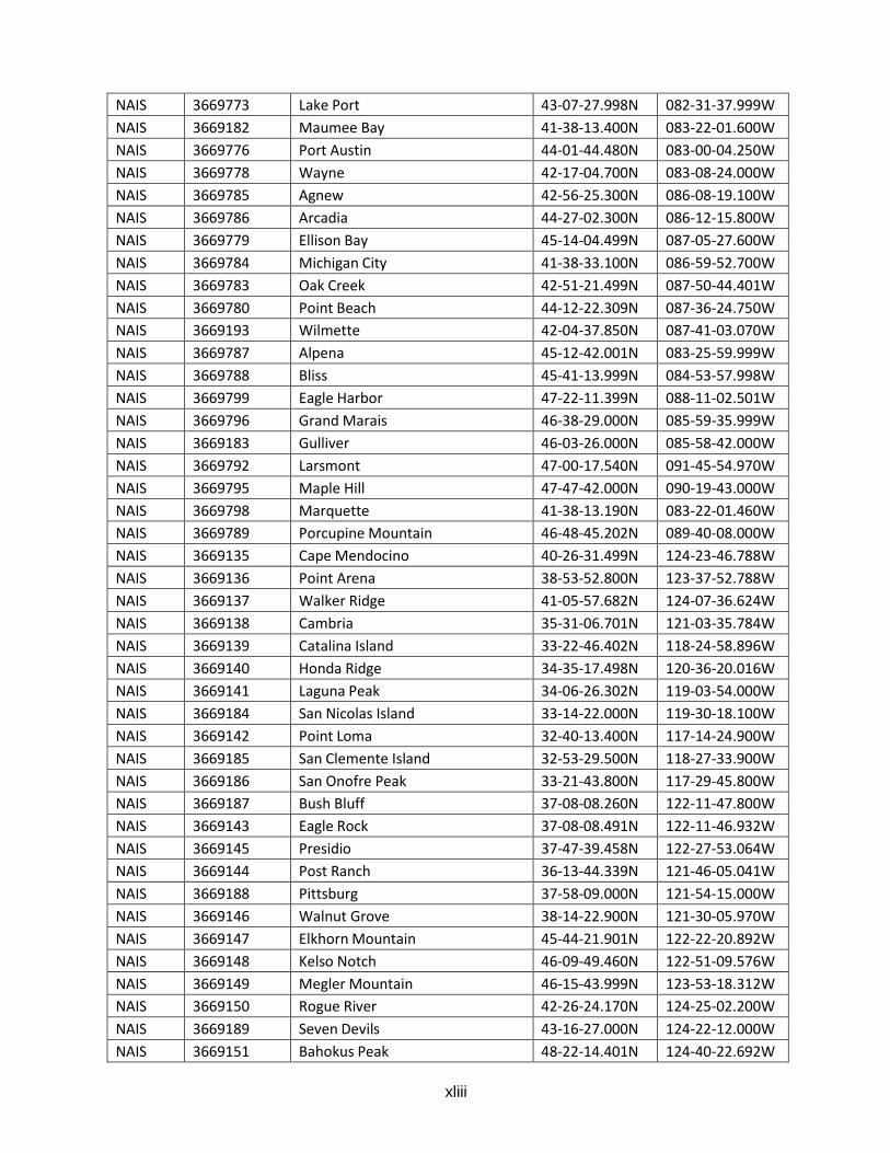
xliii
NAIS 3669773 Lake Port 43-07-27.998N 082-31-37.999W
NAIS 3669182 Maumee Bay 41-38-13.400N 083-22-01.600W
NAIS 3669776 Port Austin 44-01-44.480N 083-00-04.250W
NAIS 3669778 Wayne 42-17-04.700N 083-08-24.000W
NAIS 3669785 Agnew 42-56-25.300N 086-08-19.100W
NAIS 3669786 Arcadia 44-27-02.300N 086-12-15.800W
NAIS 3669779 Ellison Bay 45-14-04.499N 087-05-27.600W
NAIS 3669784 Michigan City 41-38-33.100N 086-59-52.700W
NAIS 3669783 Oak Creek 42-51-21.499N 087-50-44.401W
NAIS 3669780 Point Beach 44-12-22.309N 087-36-24.750W
NAIS 3669193 Wilmette 42-04-37.850N 087-41-03.070W
NAIS 3669787 Alpena 45-12-42.001N 083-25-59.999W
NAIS 3669788 Bliss 45-41-13.999N 084-53-57.998W
NAIS 3669799 Eagle Harbor 47-22-11.399N 088-11-02.501W
NAIS 3669796 Grand Marais 46-38-29.000N 085-59-35.999W
NAIS 3669183 Gulliver 46-03-26.000N 085-58-42.000W
NAIS 3669792 Larsmont 47-00-17.540N 091-45-54.970W
NAIS 3669795 Maple Hill 47-47-42.000N 090-19-43.000W
NAIS 3669798 Marquette 41-38-13.190N 083-22-01.460W
NAIS 3669789 Porcupine Mountain 46-48-45.202N 089-40-08.000W
NAIS 3669135 Cape Mendocino 40-26-31.499N 124-23-46.788W
NAIS 3669136 Point Arena 38-53-52.800N 123-37-52.788W
NAIS 3669137 Walker Ridge 41-05-57.682N 124-07-36.624W
NAIS 3669138 Cambria 35-31-06.701N 121-03-35.784W
NAIS 3669139 Catalina Island 33-22-46.402N 118-24-58.896W
NAIS 3669140 Honda Ridge 34-35-17.498N 120-36-20.016W
NAIS 3669141 Laguna Peak 34-06-26.302N 119-03-54.000W
NAIS 3669184 San Nicolas Island 33-14-22.000N 119-30-18.100W
NAIS 3669142 Point Loma 32-40-13.400N 117-14-24.900W
NAIS 3669185 San Clemente Island 32-53-29.500N 118-27-33.900W
NAIS 3669186 San Onofre Peak 33-21-43.800N 117-29-45.800W
NAIS 3669187 Bush Bluff 37-08-08.260N 122-11-47.800W
NAIS 3669143 Eagle Rock 37-08-08.491N 122-11-46.932W
NAIS 3669145 Presidio 37-47-39.458N 122-27-53.064W
NAIS 3669144 Post Ranch 36-13-44.339N 121-46-05.041W
NAIS 3669188 Pittsburg 37-58-09.000N 121-54-15.000W
NAIS 3669146 Walnut Grove 38-14-22.900N 121-30-05.970W
NAIS 3669147 Elkhorn Mountain 45-44-21.901N 122-22-20.892W
NAIS 3669148 Kelso Notch 46-09-49.460N 122-51-09.576W
NAIS 3669149 Megler Mountain 46-15-43.999N 123-53-18.312W
NAIS 3669150 Rogue River 42-26-24.170N 124-25-02.200W
NAIS 3669189 Seven Devils 43-16-27.000N 124-22-12.000W
NAIS 3669151 Bahokus Peak 48-22-14.401N 124-40-22.692W
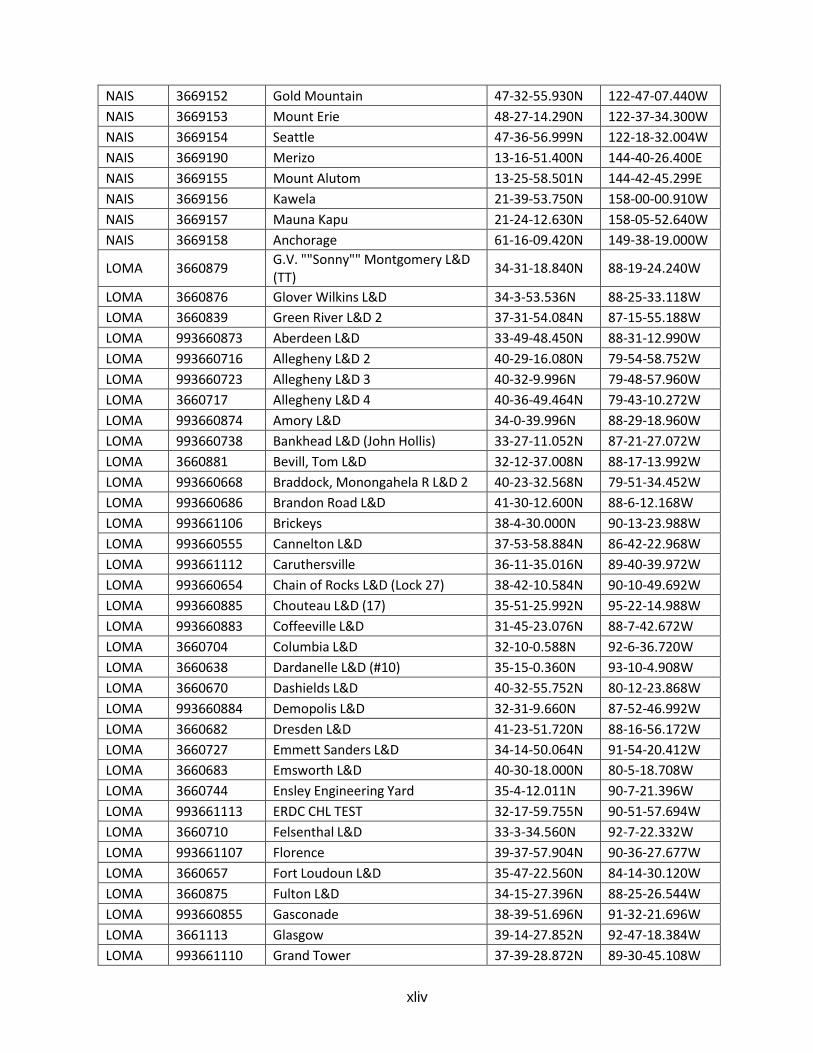
xliv
NAIS 3669152 Gold Mountain 47-32-55.930N 122-47-07.440W
NAIS 3669153 Mount Erie 48-27-14.290N 122-37-34.300W
NAIS 3669154 Seattle 47-36-56.999N 122-18-32.004W
NAIS 3669190 Merizo 13-16-51.400N 144-40-26.400E
NAIS 3669155 Mount Alutom 13-25-58.501N 144-42-45.299E
NAIS 3669156 Kawela 21-39-53.750N 158-00-00.910W
NAIS 3669157 Mauna Kapu 21-24-12.630N 158-05-52.640W
NAIS 3669158 Anchorage 61-16-09.420N 149-38-19.000W
LOMA 3660879 G.V. ""Sonny"" Montgomery L&D(TT)
34-31-18.840N 88-19-24.240W
LOMA 3660876 Glover Wilkins L&D 34-3-53.536N 88-25-33.118W
LOMA 3660839 Green River L&D 2 37-31-54.084N 87-15-55.188W
LOMA 993660873 Aberdeen L&D 33-49-48.450N 88-31-12.990W
LOMA 993660716 Allegheny L&D 2 40-29-16.080N 79-54-58.752W
LOMA 993660723 Allegheny L&D 3 40-32-9.996N 79-48-57.960W
LOMA 3660717 Allegheny L&D 4 40-36-49.464N 79-43-10.272W
LOMA 993660874 Amory L&D 34-0-39.996N 88-29-18.960W
LOMA 993660738 Bankhead L&D (John Hollis) 33-27-11.052N 87-21-27.072W
LOMA 3660881 Bevill, Tom L&D 32-12-37.008N 88-17-13.992W
LOMA 993660668 Braddock, Monongahela R L&D 2 40-23-32.568N 79-51-34.452W
LOMA 993660686 Brandon Road L&D 41-30-12.600N 88-6-12.168W
LOMA 993661106 Brickeys 38-4-30.000N 90-13-23.988W
LOMA 993660555 Cannelton L&D 37-53-58.884N 86-42-22.968W
LOMA 993661112 Caruthersville 36-11-35.016N 89-40-39.972W
LOMA 993660654 Chain of Rocks L&D (Lock 27) 38-42-10.584N 90-10-49.692W
LOMA 993660885 Chouteau L&D (17) 35-51-25.992N 95-22-14.988W
LOMA 993660883 Coffeeville L&D 31-45-23.076N 88-7-42.672W
LOMA 3660704 Columbia L&D 32-10-0.588N 92-6-36.720W
LOMA 3660638 Dardanelle L&D (#10) 35-15-0.360N 93-10-4.908W
LOMA 3660670 Dashields L&D 40-32-55.752N 80-12-23.868W
LOMA 993660884 Demopolis L&D 32-31-9.660N 87-52-46.992W
LOMA 3660682 Dresden L&D 41-23-51.720N 88-16-56.172W
LOMA 3660727 Emmett Sanders L&D 34-14-50.064N 91-54-20.412W
LOMA 3660683 Emsworth L&D 40-30-18.000N 80-5-18.708W
LOMA 3660744 Ensley Engineering Yard 35-4-12.011N 90-7-21.396W
LOMA 993661113 ERDC CHL TEST 32-17-59.755N 90-51-57.694W
LOMA 3660710 Felsenthal L&D 33-3-34.560N 92-7-22.332W
LOMA 993661107 Florence 39-37-57.904N 90-36-27.677W
LOMA 3660657 Fort Loudoun L&D 35-47-22.560N 84-14-30.120W
LOMA 3660875 Fulton L&D 34-15-27.396N 88-25-26.544W
LOMA 993660855 Gasconade 38-39-51.696N 91-32-21.696W
LOMA 3661113 Glasgow 39-14-27.852N 92-47-18.384W
LOMA 993661110 Grand Tower 37-39-28.872N 89-30-45.108W
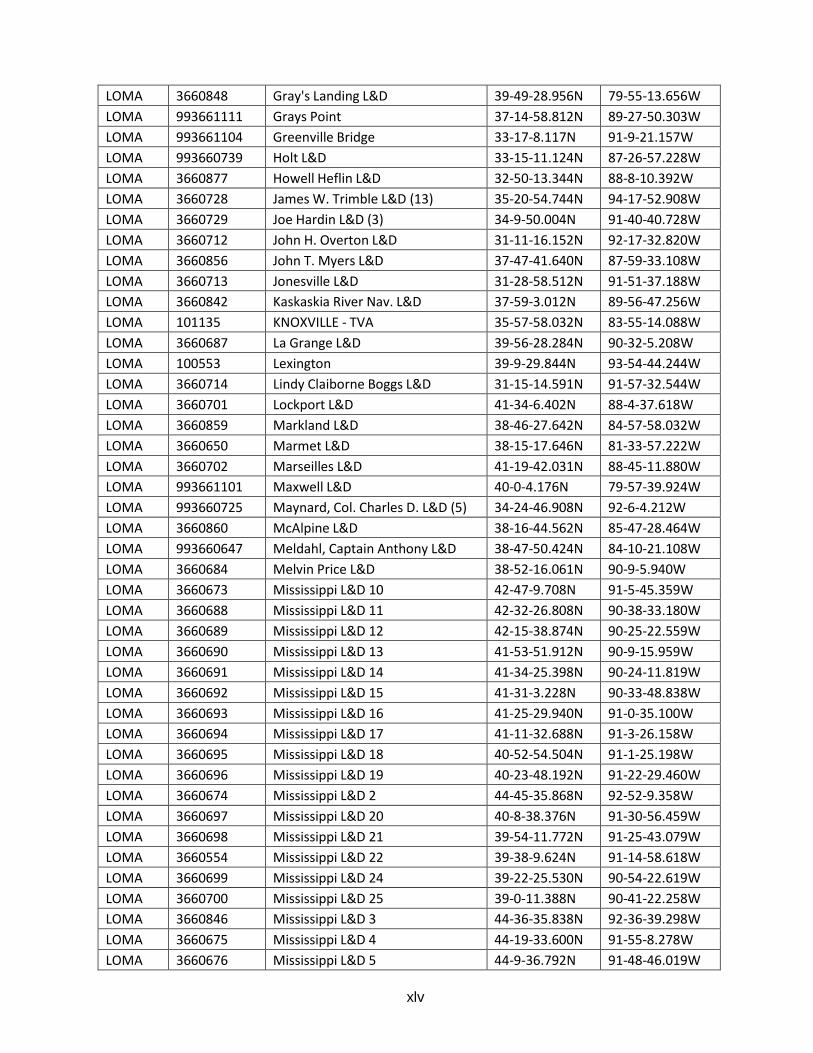
xlv
LOMA 3660848 Gray's Landing L&D 39-49-28.956N 79-55-13.656W
LOMA 993661111 Grays Point 37-14-58.812N 89-27-50.303W
LOMA 993661104 Greenville Bridge 33-17-8.117N 91-9-21.157W
LOMA 993660739 Holt L&D 33-15-11.124N 87-26-57.228W
LOMA 3660877 Howell Heflin L&D 32-50-13.344N 88-8-10.392W
LOMA 3660728 James W. Trimble L&D (13) 35-20-54.744N 94-17-52.908W
LOMA 3660729 Joe Hardin L&D (3) 34-9-50.004N 91-40-40.728W
LOMA 3660712 John H. Overton L&D 31-11-16.152N 92-17-32.820W
LOMA 3660856 John T. Myers L&D 37-47-41.640N 87-59-33.108W
LOMA 3660713 Jonesville L&D 31-28-58.512N 91-51-37.188W
LOMA 3660842 Kaskaskia River Nav. L&D 37-59-3.012N 89-56-47.256W
LOMA 101135 KNOXVILLE - TVA 35-57-58.032N 83-55-14.088W
LOMA 3660687 La Grange L&D 39-56-28.284N 90-32-5.208W
LOMA 100553 Lexington 39-9-29.844N 93-54-44.244W
LOMA 3660714 Lindy Claiborne Boggs L&D 31-15-14.591N 91-57-32.544W
LOMA 3660701 Lockport L&D 41-34-6.402N 88-4-37.618W
LOMA 3660859 Markland L&D 38-46-27.642N 84-57-58.032W
LOMA 3660650 Marmet L&D 38-15-17.646N 81-33-57.222W
LOMA 3660702 Marseilles L&D 41-19-42.031N 88-45-11.880W
LOMA 993661101 Maxwell L&D 40-0-4.176N 79-57-39.924W
LOMA 993660725 Maynard, Col. Charles D. L&D (5) 34-24-46.908N 92-6-4.212W
LOMA 3660860 McAlpine L&D 38-16-44.562N 85-47-28.464W
LOMA 993660647 Meldahl, Captain Anthony L&D 38-47-50.424N 84-10-21.108W
LOMA 3660684 Melvin Price L&D 38-52-16.061N 90-9-5.940W
LOMA 3660673 Mississippi L&D 10 42-47-9.708N 91-5-45.359W
LOMA 3660688 Mississippi L&D 11 42-32-26.808N 90-38-33.180W
LOMA 3660689 Mississippi L&D 12 42-15-38.874N 90-25-22.559W
LOMA 3660690 Mississippi L&D 13 41-53-51.912N 90-9-15.959W
LOMA 3660691 Mississippi L&D 14 41-34-25.398N 90-24-11.819W
LOMA 3660692 Mississippi L&D 15 41-31-3.228N 90-33-48.838W
LOMA 3660693 Mississippi L&D 16 41-25-29.940N 91-0-35.100W
LOMA 3660694 Mississippi L&D 17 41-11-32.688N 91-3-26.158W
LOMA 3660695 Mississippi L&D 18 40-52-54.504N 91-1-25.198W
LOMA 3660696 Mississippi L&D 19 40-23-48.192N 91-22-29.460W
LOMA 3660674 Mississippi L&D 2 44-45-35.868N 92-52-9.358W
LOMA 3660697 Mississippi L&D 20 40-8-38.376N 91-30-56.459W
LOMA 3660698 Mississippi L&D 21 39-54-11.772N 91-25-43.079W
LOMA 3660554 Mississippi L&D 22 39-38-9.624N 91-14-58.618W
LOMA 3660699 Mississippi L&D 24 39-22-25.530N 90-54-22.619W
LOMA 3660700 Mississippi L&D 25 39-0-11.388N 90-41-22.258W
LOMA 3660846 Mississippi L&D 3 44-36-35.838N 92-36-39.298W
LOMA 3660675 Mississippi L&D 4 44-19-33.600N 91-55-8.278W
LOMA 3660676 Mississippi L&D 5 44-9-36.792N 91-48-46.019W
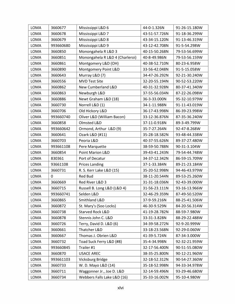
xlvi
LOMA 3660677 Mississippi L&D 6 44-0-1.326N 91-26-15.180W
LOMA 3660678 Mississippi L&D 7 43-51-57.726N 91-18-36.299W
LOMA 3660679 Mississippi L&D 8 43-34-15.120N 91-13-46.319W
LOMA 993660680 Mississippi L&D 9 43-12-42.708N 91-5-54.298W
LOMA 3660850 Monongahela R L&D 3 40-15-50.268N 79-53-56.699W
LOMA 3660851 Monongahela R L&D 4 (Charleroi) 40-8-49.986N 79-53-56.159W
LOMA 3660861 Montgomery L&D (OH) 40-38-52.710N 80-23-6.958W
LOMA 3660890 Montgomery Point L&D 33-56-42.048N 91-5-15.058W
LOMA 3660643 Murray L&D (7) 34-47-26.292N 92-21-30.240W
LOMA 3660556 MVD Test Site 32-20-55.194N 90-52-53.220W
LOMA 3660862 New Cumberland L&D 40-31-32.928N 80-37-41.340W
LOMA 3660863 Newburgh L&D 37-55-56.034N 87-22-26.098W
LOMA 3660886 Newt Graham L&D (18) 36-3-33.000N 95-32-10.979W
LOMA 3660730 Norrell L&D (1) 34-1-11.988N 91-11-43.019W
LOMA 3660706 Old Hickory L&D 36-17-43.998N 86-39-23.998W
LOMA 993660740 Oliver L&D (William Bacon) 33-12-36.876N 87-35-36.240W
LOMA 3660858 Olmsted L&D 37-11-0.918N 89-3-49.799W
LOMA 993660642 Ormond, Arthur L&D (9) 35-7-27.264N 92-47-8.268W
LOMA 3660641 Ozark L&D (#11) 35-28-18.582N 93-48-44.338W
LOMA 3660703 Peoria L&D 40-37-55.626N 89-37-27.480W
LOMA 993661108 Pere Marquette 38-59-50.788N 90-31-3.104W
LOMA 3660854 Point Marion L&D 39-43-41.243N 79-54-44.748W
LOMA 830361 Port of Decatur 34-37-12.342N 86-59-15.709W
LOMA 93661108 Prices Landing 37-1-33.384N 89-21-23.184W
LOMA 3660731 R. S. Kerr Lake L&D (15) 35-20-52.998N 94-46-43.979W
LOMA 0 Red Bud 38-11-20.544N 89-53-25.260W
LOMA 3660669 Red River L&D 3 31-31-18.036N 92-43-39.000W
LOMA 3660715 Russell B. Long L&D (L&D 4) 31-56-23.111N 93-16-13.966W
LOMA 993660741 Selden L&D 32-46-29.359N 87-49-50.520W
LOMA 3660865 Smithland L&D 37-9-59.216N 88-25-41.506W
LOMA 3660872 St. Mary's (Soo Locks) 46-30-9.529N 84-20-56.314W
LOMA 3660738 Starved Rock L&D 41-19-28.782N 88-59-7.980W
LOMA 3660878 Stennis John C. L&D 33-31-3.828N 88-29-22.488W
LOMA 3660726 Terry, David D. L&D (6) 34-39-58.272N 92-9-20.999W
LOMA 3660661 Thatcher L&D 33-18-23.568N 92-29-0.060W
LOMA 3660667 Thomas J. Obrien L&D 41-39-5.724N 87-34-3.000W
LOMA 3660732 Toad Suck Ferry L&D (#8) 35-4-34.998N 92-32-21.959W
LOMA 993660845 Trailer #1 32-17-56.400N 90-51-55.080W
LOMA 3660870 USACE AREC 38-35-25.800N 90-12-21.960W
LOMA 993661103 Vicksburg Bridge 32-18-52.312N 90-54-27.360W
LOMA 3660733 W. D. Mayo L&D (14) 35-18-52.998N 94-33-34.978W
LOMA 3660711 Waggonner Jr., Joe D. L&D 32-14-59.496N 93-29-46.680W
LOMA 3660734 Webbers Falls Lake L&D (16) 35-33-16.002N 95-10-4.980W
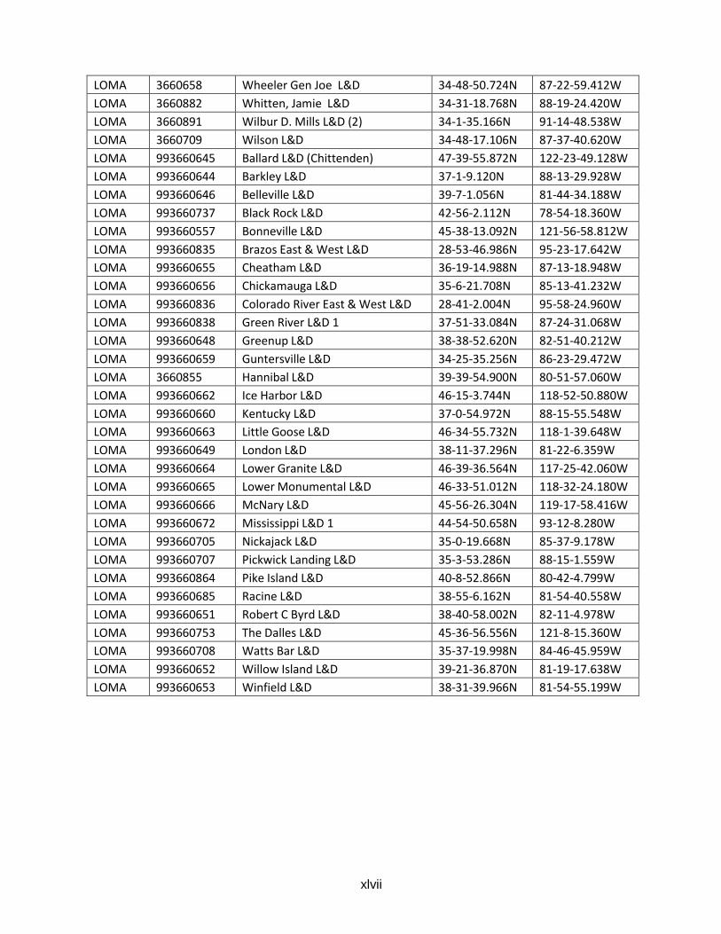
xlvii
LOMA 3660658 Wheeler Gen Joe L&D 34-48-50.724N 87-22-59.412W
LOMA 3660882 Whitten, Jamie L&D 34-31-18.768N 88-19-24.420W
LOMA 3660891 Wilbur D. Mills L&D (2) 34-1-35.166N 91-14-48.538W
LOMA 3660709 Wilson L&D 34-48-17.106N 87-37-40.620W
LOMA 993660645 Ballard L&D (Chittenden) 47-39-55.872N 122-23-49.128W
LOMA 993660644 Barkley L&D 37-1-9.120N 88-13-29.928W
LOMA 993660646 Belleville L&D 39-7-1.056N 81-44-34.188W
LOMA 993660737 Black Rock L&D 42-56-2.112N 78-54-18.360W
LOMA 993660557 Bonneville L&D 45-38-13.092N 121-56-58.812W
LOMA 993660835 Brazos East & West L&D 28-53-46.986N 95-23-17.642W
LOMA 993660655 Cheatham L&D 36-19-14.988N 87-13-18.948W
LOMA 993660656 Chickamauga L&D 35-6-21.708N 85-13-41.232W
LOMA 993660836 Colorado River East & West L&D 28-41-2.004N 95-58-24.960W
LOMA 993660838 Green River L&D 1 37-51-33.084N 87-24-31.068W
LOMA 993660648 Greenup L&D 38-38-52.620N 82-51-40.212W
LOMA 993660659 Guntersville L&D 34-25-35.256N 86-23-29.472W
LOMA 3660855 Hannibal L&D 39-39-54.900N 80-51-57.060W
LOMA 993660662 Ice Harbor L&D 46-15-3.744N 118-52-50.880W
LOMA 993660660 Kentucky L&D 37-0-54.972N 88-15-55.548W
LOMA 993660663 Little Goose L&D 46-34-55.732N 118-1-39.648W
LOMA 993660649 London L&D 38-11-37.296N 81-22-6.359W
LOMA 993660664 Lower Granite L&D 46-39-36.564N 117-25-42.060W
LOMA 993660665 Lower Monumental L&D 46-33-51.012N 118-32-24.180W
LOMA 993660666 McNary L&D 45-56-26.304N 119-17-58.416W
LOMA 993660672 Mississippi L&D 1 44-54-50.658N 93-12-8.280W
LOMA 993660705 Nickajack L&D 35-0-19.668N 85-37-9.178W
LOMA 993660707 Pickwick Landing L&D 35-3-53.286N 88-15-1.559W
LOMA 993660864 Pike Island L&D 40-8-52.866N 80-42-4.799W
LOMA 993660685 Racine L&D 38-55-6.162N 81-54-40.558W
LOMA 993660651 Robert C Byrd L&D 38-40-58.002N 82-11-4.978W
LOMA 993660753 The Dalles L&D 45-36-56.556N 121-8-15.360W
LOMA 993660708 Watts Bar L&D 35-37-19.998N 84-46-45.959W
LOMA 993660652 Willow Island L&D 39-21-36.870N 81-19-17.638W
LOMA 993660653 Winfield L&D 38-31-39.966N 81-54-55.199W
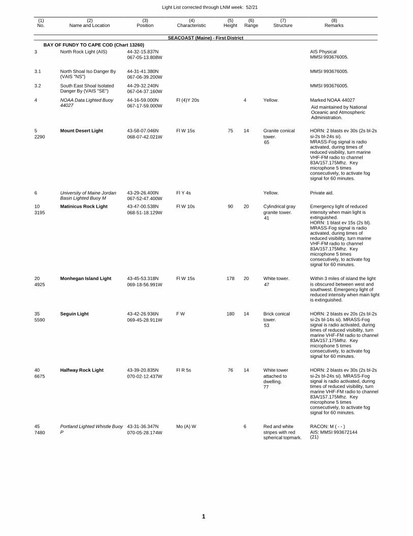
Light List corrected through LNM week: 52/21
1
(1) (2) (3) (4) (5) (6) (7) (8) No. Name and Location Position Characteristic Height Range Structure Remarks
SEACOAST (Maine) - First District
BAY OF FUNDY TO CAPE COD (Chart 13260)
3 North Rock Light (AIS) 44-32-15.837N
067-05-13.808W
AIS Physical MMSI 993676005.
3.1 North Shoal Iso Danger By (VAIS "NS")
44-31-41.380N
067-06-39.200W
MMSI 993676005.
3.2 South East Shoal Isolated Danger By (VAIS "SE")
44-29-32.240N
067-04-37.160W
MMSI 993676005.
4 NOAA Data Lighted Buoy 44027
44-16-59.000N
067-17-59.000W
Fl (4)Y 20s 4 Yellow. Marked NOAA 44027
Aid maintained by National Oceanic and Atmospheric Administration.
5 Mount Desert Light 43-58-07.046N Fl W 15s 75 14 Granite conical HORN: 2 blasts ev 30s (2s bl-2s
2290 068-07-42.021W tower.
65
si-2s bl-24s si). MRASS-Fog signal is radio activated, during times of reduced visibility, turn marine VHF-FM radio to channel 83A/157.175Mhz. Key microphone 5 times consecutively, to activate fog signal for 60 minutes.
6 University of Maine Jordan Basin Lighted Buoy M
43-29-26.400N
067-52-47.400W
Fl Y 4s Yellow. Private aid.
10 Matinicus Rock Light 43-47-00.538N Fl W 10s 90 20 Cylindrical gray Emergency light of reduced
3195 068-51-18.129W granite tower.
41
intensity when main light is extinguished. HORN: 1 blast ev 15s (2s bl). MRASS-Fog signal is radio activated, during times of reduced visibility, turn marine VHF-FM radio to channel 83A/157.175Mhz. Key microphone 5 times consecutively, to activate fog signal for 60 minutes.
20 Monhegan Island Light 43-45-53.318N Fl W 15s 178 20 White tower. Within 3 miles of island the light
4925 069-18-56.991W 47 is obscured between west and southwest. Emergency light of reduced intensity when main light is extinguished.
35 Seguin Light 43-42-26.936N F W 180 14 Brick conical HORN: 2 blasts ev 20s (2s bl-2s
5590 069-45-28.911W tower.
53
si-2s bl-14s si). MRASS-Fog signal is radio activated, during times of reduced visibility, turn marine VHF-FM radio to channel 83A/157.175Mhz. Key microphone 5 times consecutively, to activate fog signal for 60 minutes.
40 Halfway Rock Light 43-39-20.835N Fl R 5s 76 14 White tower HORN: 2 blasts ev 30s (2s bl-2s
6675 070-02-12.437W attached to dwelling. 77
si-2s bl-24s si). MRASS-Fog signal is radio activated, during times of reduced visibility, turn marine VHF-FM radio to channel 83A/157.175Mhz. Key microphone 5 times consecutively, to activate fog signal for 60 minutes.
45 Portland Lighted Whistle Buoy 43-31-36.347N Mo (A) W 6 Red and white RACON: M ( - - )
7480 P 070-05-28.174W stripes with red spherical topmark.
AIS: MMSI 993672144 (21)
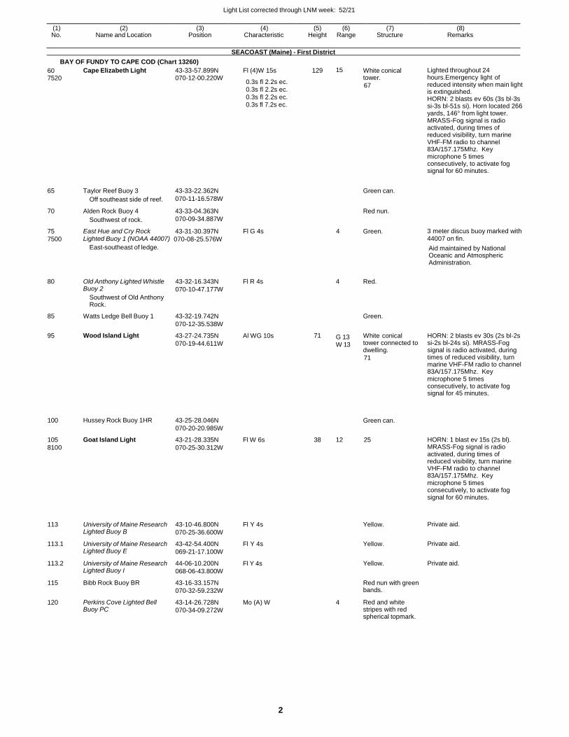
Light List corrected through LNM week: 52/21
2
(1) (2) (3) (4) (5) (6) (7) (8) No. Name and Location Position Characteristic Height Range Structure Remarks
SEACOAST (Maine) - First District
BAY OF FUNDY TO CAPE COD (Chart 13260)
60 7520
65
70
75
Cape Elizabeth Light
Taylor Reef Buoy 3
Off southeast side of reef.
Alden Rock Buoy 4
Southwest of rock.
East Hue and Cry Rock
43-33-57.899N 070-12-00.220W
43-33-22.362N
070-11-16.578W
43-33-04.363N
070-09-34.887W
43-31-30.397N
Fl (4)W 15s
0.3s fl 2.2s ec. 0.3s fl 2.2s ec. 0.3s fl 2.2s ec. 0.3s fl 7.2s ec.
Fl G 4s
129 15
4
White conical tower.
67
Green can.
Red nun.
Green.
Lighted throughout 24 hours.Emergency light of reduced intensity when main light is extinguished. HORN: 2 blasts ev 60s (3s bl-3s si-3s bl-51s si). Horn located 266 yards, 146° from light tower. MRASS-Fog signal is radio activated, during times of reduced visibility, turn marine VHF-FM radio to channel 83A/157.175Mhz. Key microphone 5 times consecutively, to activate fog signal for 60 minutes.
3 meter discus buoy marked with
7500 Lighted Buoy 1 (NOAA 44007) 070-08-25.576W
East-southeast of ledge.
44007 on fin.
Aid maintained by National Oceanic and Atmospheric Administration.
80
85
95
100
105
8100
113
113.1
113.2
115
120
Old Anthony Lighted Whistle Buoy 2
Southwest of Old Anthony Rock.
Watts Ledge Bell Buoy 1
Wood Island Light
Hussey Rock Buoy 1HR
Goat Island Light
University of Maine Research Lighted Buoy B
University of Maine Research Lighted Buoy E
University of Maine Research Lighted Buoy I
Bibb Rock Buoy BR
Perkins Cove Lighted Bell Buoy PC
43-32-16.343N
070-10-47.177W
43-32-19.742N
070-12-35.538W
43-27-24.735N
070-19-44.611W
43-25-28.046N
070-20-20.985W
43-21-28.335N
070-25-30.312W
43-10-46.800N
070-25-36.600W
43-42-54.400N
069-21-17.100W
44-06-10.200N
068-06-43.800W
43-16-33.157N
070-32-59.232W
43-14-26.728N
070-34-09.272W
Fl R 4s
Al WG 10s
Fl W 6s
Fl Y 4s
Fl Y 4s
Fl Y 4s
Mo (A) W
4
71 G 13
W 13
38 12
4
Red.
Green.
White conical tower connected to dwelling.
71
Green can.
25
Yellow.
Yellow.
Yellow.
Red nun with green bands.
Red and white stripes with red spherical topmark.
HORN: 2 blasts ev 30s (2s bl-2s si-2s bl-24s si). MRASS-Fog signal is radio activated, during times of reduced visibility, turn marine VHF-FM radio to channel 83A/157.175Mhz. Key microphone 5 times consecutively, to activate fog signal for 45 minutes.
HORN: 1 blast ev 15s (2s bl). MRASS-Fog signal is radio activated, during times of reduced visibility, turn marine VHF-FM radio to channel 83A/157.175Mhz. Key microphone 5 times consecutively, to activate fog signal for 60 minutes.
Private aid.
Private aid.
Private aid.
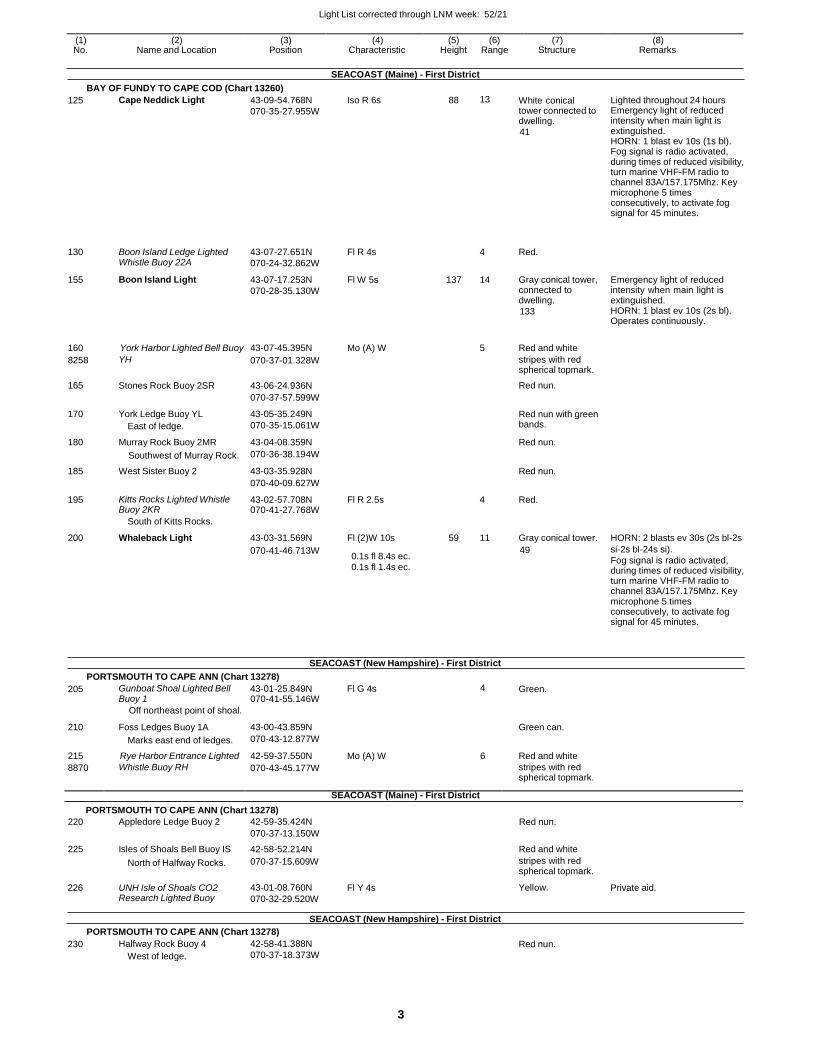
Light List corrected through LNM week: 52/21
3
(1) (2) (3) (4) (5) (6) (7) (8) No. Name and Location Position Characteristic Height Range Structure Remarks
SEACOAST (Maine) - First District
BAY OF FUNDY TO CAPE COD (Chart 13260)
125 Cape Neddick Light 43-09-54.768N
070-35-27.955W
Iso R 6s 88 13 White conical tower connected to dwelling.
41
Lighted throughout 24 hours Emergency light of reduced intensity when main light is extinguished. HORN: 1 blast ev 10s (1s bl). Fog signal is radio activated, during times of reduced visibility, turn marine VHF-FM radio to channel 83A/157.175Mhz. Key microphone 5 times consecutively, to activate fog signal for 45 minutes.
130
Boon Island Ledge Lighted Whistle Buoy 22A
43-07-27.651N
070-24-32.862W
Fl R 4s
4
Red.
155 Boon Island Light 43-07-17.253N
070-28-35.130W
Fl W 5s 137 14 Gray conical tower, connected to dwelling.
133
Emergency light of reduced intensity when main light is extinguished. HORN: 1 blast ev 10s (2s bl). Operates continuously.
160 York Harbor Lighted Bell Buoy 43-07-45.395N Mo (A) W
5 Red and white
8258 YH 070-37-01.328W stripes with red spherical topmark.
165 Stones Rock Buoy 2SR 43-06-24.936N Red nun.
070-37-57.599W
170 York Ledge Buoy YL
East of ledge.
43-05-35.249N
070-35-15.061W
Red nun with green bands.
180 Murray Rock Buoy 2MR 43-04-08.359N Red nun.
Southwest of Murray Rock. 070-36-38.194W
185 West Sister Buoy 2 43-03-35.928N Red nun.
070-40-09.627W
195 Kitts Rocks Lighted Whistle Buoy 2KR
43-02-57.708N 070-41-27.768W
Fl R 2.5s 4 Red.
South of Kitts Rocks.
200 Whaleback Light 43-03-31.569N Fl (2)W 10s 59 11 Gray conical tower. HORN: 2 blasts ev 30s (2s bl-2s
070-41-46.713W 0.1s fl 8.4s ec. 0.1s fl 1.4s ec.
49 si-2s bl-24s si).
Fog signal is radio activated, during times of reduced visibility, turn marine VHF-FM radio to channel 83A/157.175Mhz. Key microphone 5 times consecutively, to activate fog signal for 45 minutes.
SEACOAST (New Hampshire) - First District
PORTSMOUTH TO CAPE ANN (Chart 13278)
205 Gunboat Shoal Lighted Bell Buoy 1
43-01-25.849N 070-41-55.146W
Fl G 4s 4 Green.
Off northeast point of shoal.
210 Foss Ledges Buoy 1A 43-00-43.859N
Green can.
Marks east end of ledges. 070-43-12.877W
215 Rye Harbor Entrance Lighted 42-59-37.550N Mo (A) W 6 Red and white
8870 Whistle Buoy RH 070-43-45.177W stripes with red spherical topmark.
SEACOAST (Maine) - First District
PORTSMOUTH TO CAPE ANN (Chart 13278)
220 Appledore Ledge Buoy 2 42-59-35.424N Red nun.
070-37-13.150W
225 Isles of Shoals Bell Buoy IS 42-58-52.214N Red and white
226
North of Halfway Rocks.
UNH Isle of Shoals CO2 Research Lighted Buoy
070-37-15.609W
43-01-08.760N
070-32-29.520W
Fl Y 4s
stripes with red spherical topmark.
Yellow.
Private aid.
SEACOAST (New Hampshire) - First District
PORTSMOUTH TO CAPE ANN (Chart 13278)
230 Halfway Rock Buoy 4
West of ledge.
42-58-41.388N
070-37-18.373W Red nun.
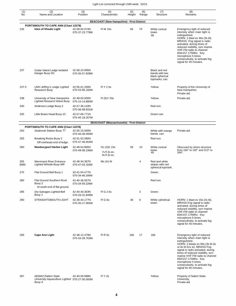
Light List corrected through LNM week: 52/21
4
(1) (2) (3) (4) (5) (6) (7) (8) No. Name and Location Position Characteristic Height Range Structure Remarks
SEACOAST (New Hampshire) - First District
PORTSMOUTH TO CAPE ANN (Chart 13278)
235 Isles of Shoals Light 42-58-02.074N
070-37-23.778W
Fl W 15s 82 14 White conical tower.
58
Emergency light of reduced intensity when main light is extinguished. HORN: 1 blast ev 30s (3s bl). MRASS -Fog signal is radio activated, during times of reduced visibility, turn marine VHF-FM radio to channel 83A/157.175Mhz. Key microphone 5 times consecutively, to activate fog signal for 45 minutes.
237 Cedar Island Ledge Isolated Danger Buoy DC
42-58-24.995N
070-35-57.828W
Black and red bands with two black spherical topmarks; can.
237.5 UNH Jeffrey's Ledge Lighted Research Buoy
42-55-01.200N 070-03-56.160W
Fl Y 2.5s
Yellow. Property of the University of New Hampshire.
Private aid.
238 University of New Hampshire Lighted Research Wave Buoy
42-48-00.000N
070-10-14.880W
Fl (5)Y 20s Yellow. Private aid.
240 Anderson Ledge Buoy 2 42-57-36.143N Red nun.
070-36-08.931W
245 Little Boars Head Buoy 1C 42-57-06.771N Green can.
070-45-18.267W
SEACOAST (Massachusetts) - First District
PORTSMOUTH TO CAPE ANN (Chart 13278)
250 Seabrook Station Buoy T7 42-55-15.000N
070-46-46.000W
White with orange bands, can.
Private aid.
255 Breaking Rocks Buoy 2 42-51-52.080N Red nun.
Off northeast end of ledge. 070-47-46.654W
260 Newburyport Harbor Light 42-48-54.865N
070-49-08.196W
Oc (2)G 15s
7s fl 2s ec.
50 10 White conical tower. 45
Obscured by shore structure from 165° to 192° and 313° to 344°.
4s fl 2s ec.
265
8990
275
280
Merrimack River Entrance Lighted Whistle Buoy MR
Flat Ground Bell Buoy 1
Flat Ground Southern Rock Buoy 2
At south end of flat ground.
42-48-34.367N
070-47-03.193W
42-41-04.477N
070-34-48.166W
42-40-36.557N
070-34-59.226W
Mo (A) W 4 Red and white stripes with red spherical topmark.
Green.
Red nun.
285 Dry Salvages Lighted Bell Buoy 1
42-40-40.353N
070-33-31.849W
Fl G 2.5s 3 Green.
290 STRAIGHTSMOUTH LIGHT 42-39-44.177N
070-35-17.065W
Fl G 6s 46 6 White cylindrical tower.
HORN: 1 blast ev 15s (2s bl). MRASS-Fog signal is radio activated, during times of reduced visibility, turn marine VHF-FM radio to channel 83A/157.175Mhz. Key microphone 5 times consecutively, to activate fog signal for 45 minutes.
295
Cape Ann Light
42-38-12.479N
070-34-29.763W
Fl R 5s
166
17
166
Emergency light of reduced intensity when main light is extinguished. HORN: 2 blasts ev 60s (3s bl-3s si-3s bl-51s si). MRASS-Fog signal is radio activated, during times of reduced visibility, turn marine VHF-FM radio to channel 83A/157.175Mhz. Key microphone 5 times consecutively, to activate fog signal for 60 minutes.
297 NEMAC/Salem State University Aquaculture Lighted Buoy A
42-40-59.998N
070-27-00.000W
Fl Y 2s
Yellow. Property of Salem State University. Private aid.
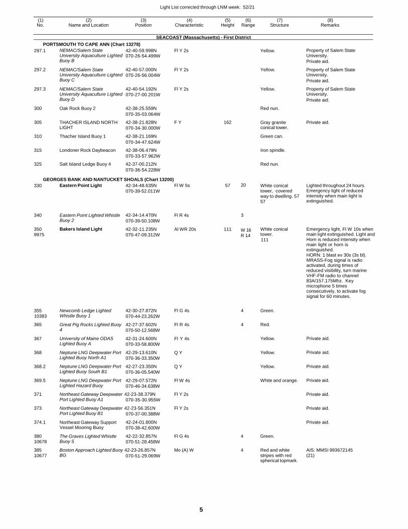
Light List corrected through LNM week: 52/21
5
(1) (2) (3) (4) (5) (6) (7) (8) No. Name and Location Position Characteristic Height Range Structure Remarks
SEACOAST (Massachusetts) - First District
PORTSMOUTH TO CAPE ANN (Chart 13278)
297.1 NEMAC/Salem State University Aquaculture Lighted Buoy B
42-40-59.998N 070-26-54.499W
Fl Y 2s Yellow. Property of Salem State University.
Private aid.
297.2 NEMAC/Salem State University Aquaculture Lighted Buoy C
42-40-57.000N
070-26-56.004W
Fl Y 2s Yellow. Property of Salem State University.
Private aid.
297.3 NEMAC/Salem State University Aquaculture Lighted Buoy D
42-40-54.192N
070-27-00.201W
Fl Y 2s Yellow. Property of Salem State University.
Private aid.
300 Oak Rock Buoy 2 42-38-25.559N Red nun.
070-35-03.064W
305 THACHER ISLAND NORTH LIGHT
42-38-21.828N
070-34-30.000W
F Y 162 Gray granite conical tower.
Private aid.
310 Thacher Island Buoy 1 42-38-21.169N Green can.
070-34-47.624W
315 Londoner Rock Daybeacon 42-38-06.479N Iron spindle.
070-33-57.962W
325 Salt Island Ledge Buoy 4 42-37-00.212N Red nun.
070-36-54.228W
GEORGES BANK AND NANTUCKET SHOALS (Chart 13200)
330
340
350 9975
355 10383
365
367
368
368.2
369.5
Eastern Point Light
Eastern Point Lighted Whistle Buoy 2
Bakers Island Light
Newcomb Ledge Lighted Whistle Buoy 1
Great Pig Rocks Lighted Buoy 4
University of Maine ODAS Lighted Buoy A
Neptune LNG Deepwater Port Lighted Buoy North A1
Neptune LNG Deepwater Port Lighted Buoy South B1
Neptune LNG Deepwater Port Lighted Hazard Buoy
42-34-48.635N
070-39-52.011W
42-34-14.470N
070-39-50.108W
42-32-11.235N
070-47-09.312W
42-30-27.872N
070-44-23.262W
42-27-37.602N
070-50-12.568W
42-31-24.600N
070-33-58.800W
42-29-13.610N
070-36-33.350W
42-27-23.350N
070-36-05.540W
42-29-07.572N
070-46-34.638W
Fl W 5s
Fl R 4s
Al WR 20s
Fl G 4s
Fl R 4s
Fl Y 4s
Q Y
Q Y
Fl W 4s
57
111
20
3
W 16 R 14
4
4
White conical tower, covered way to dwelling. 57 57
White conical tower.
111
Green.
Red.
Yellow.
Yellow.
Yellow.
White and orange.
Lighted throughout 24 hours. Emergency light of reduced intensity when main light is extinguished.
Emergency light, Fl W 10s when main light extinguished. Light and Horn is reduced intensity when main light or horn is extinguished. HORN: 1 blast ev 30s (3s bl). MRASS-Fog signal is radio activated, during times of reduced visibility, turn marine VHF-FM radio to channel 83A/157.175Mhz. Key microphone 5 times consecutively, to activate fog signal for 60 minutes.
Private aid.
Private aid.
Private aid.
Private aid.
371 Northeast Gateway Deepwater 42-23-38.379N Fl Y 2s Private aid. Port Lighted Buoy A1 070-35-30.955W
373 Northeast Gateway Deepwater 42-23-56.351N Fl Y 2s Private aid.
374.1
380 10678
Port Lighted Buoy B1
Northeast Gateway Support Vessel Mooring Buoy
The Graves Lighted Whistle Buoy 5
070-37-00.388W
42-24-01.800N
070-38-42.600W
42-22-32.857N
070-51-28.458W
Fl G 4s
4 Green.
Private aid.
385 Boston Approach Lighted Buoy 42-23-26.857N Mo (A) W 4 Red and white AIS: MMSI 993672145
10677 BG 070-51-29.069W stripes with red spherical topmark.
(21)
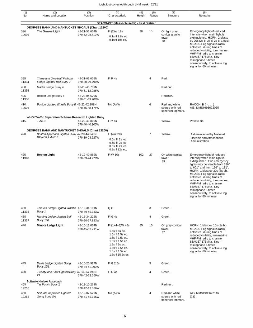
Light List corrected through LNM week: 52/21
6
(1) (2) (3) (4) (5) (6) (7) (8) No. Name and Location Position Characteristic Height Range Structure Remarks
SEACOAST (Massachusetts) - First District
GEORGES BANK AND NANTUCKET SHOALS (Chart 13200)
390 10679
395
11334
400
11335
405
11336
The Graves Light
Three and One-Half Fathom Ledge Lighted Bell Buoy 2
Martin Ledge Buoy 4
Boston Ledge Buoy 6
42-21-53.634N 070-52-08.712W
42-21-05.009N
070-50-29.796W
42-20-45.739N
070-51-12.086W
42-20-04.679N
070-51-49.706W
Fl (2)W 12s
0.1s fl 1.8s ec. 0.1s fl 10s ec.
Fl R 4s
98 15
4
On light gray conical granite tower.
98
Red.
Red nun.
Red nun.
Emergency light of reduced intensity when main light is extinguished. HORN: 2 blasts ev 20s (2s bl-2s si-2s bl-14s si). MRASS-Fog signal is radio activated, during times of reduced visibility, turn marine VHF-FM radio to channel 83A/157.175Mhz. Key microphone 5 times consecutively, to activate fog signal for 60 minutes.
410
10676
Boston Lighted Whistle Buoy B 42-22-42.189N
070-46-58.171W
Mo (A) W 6 Red and white stripes with red spherical topmark.
RACON: B ( - . . . ) AIS: MMSI 993672065
WHOI Traffic Separation Scheme Research Lighted Buoy
415 - AB-1 42-20-49.800N
070-40-40.800W
Fl Y 4s Yellow. Private aid.
GEORGES BANK AND NANTUCKET SHOALS (Chart 13200)
420 Boston Approach Lighted Buoy 42-20-44.048N Fl (4)Y 20s 7 Yellow. Aid maintained by National
425
11340
BF NOAA 44013
Boston Light
070-39-03.927W
42-19-40.889N
070-53-24.278W
0.5s fl 2s ec. 0.5s fl 2s ec. 0.5s fl 2s ec. 0.5s fl 12s ec.
Fl W 10s
102 27
On white conical tower.
89
Oceanic and Atmospheric Administration.
Emergency light of reduced intensity when main light is extinguished. Two emergency lights may be visable from 336° to 001° and from 156° to 181°. HORN: 1 blast ev 30s (3s bl). MRASS-Fog signal is radio activated, during times of reduced visibility, turn marine VHF-FM radio to channel 83A/157.175Mhz. Key microphone 5 times consecutively, to activate fog signal for 60 minutes.
430 Thieves Ledge Lighted Whistle 42-19-34.101N Q G 3 Green.
11333 Buoy 1 070-49-49.343W
435 Harding Ledge Lighted Bell 42-18-34.222N Fl G 4s 4 Green.
11337 Buoy 1HL 070-50-37.883W
440 Minots Ledge Light 42-16-11.034N Fl (1+4+3)W 45s 85 10 On gray conical HORN: 1 blast ev 10s (1s bl).
070-45-32.711W 1.5s fl 5s ec. 1.5s fl 1.5s ec. 1.5s fl 1.5s ec. 1.5s fl 1.5s ec. 1.5s fl 5s ec.
1.5s fl 1.5s ec.
1.5s fl 1.5s ec. 1.5s fl 15.5s ec.
tower.
87
MRASS-Fog signal is radio activated, during times of reduced visibility, turn marine VHF-FM radio to channel 83A/157.175Mhz. Key microphone 5 times consecutively, to activate fog signal for 60 minutes.
445 Davis Ledge Lighted Gong Buoy 1DL
42-16-20.927N
070-44-51.293W
Fl G 2.5s 3 Green.
450 Twenty-one Foot Lighted Buoy 42-16-34.796N Fl G 4s 4 Green. 21
Scituate Harbor Approach
070-42-22.069W
455 Tar Pouch Buoy 2 42-13-10.269N Red nun.
12256 070-42-13.386W
460 Scituate Approach Lighted 42-12-07.579N Mo (A) W 4 Red and white AIS: MMSI 993672146
12258 Gong Buoy SA 070-41-49.355W stripes with red spherical topmark.
(21)
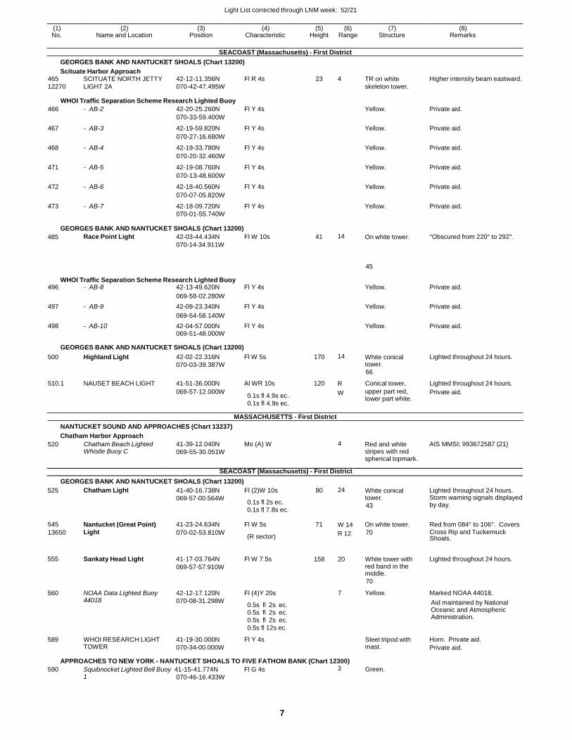
Light List corrected through LNM week: 52/21
7
(1) (2) (3) (4) (5) (6) (7) (8) No. Name and Location Position Characteristic Height Range Structure Remarks
SEACOAST (Massachusetts) - First District
GEORGES BANK AND NANTUCKET SHOALS (Chart 13200)
Scituate Harbor Approach 465 SCITUATE NORTH JETTY 42-12-11.356N Fl R 4s 23 4 TR on white Higher intensity beam eastward.
12270 LIGHT 2A 070-42-47.495W skeleton tower.
WHOI Traffic Separation Scheme Research Lighted Buoy
466 - AB-2 42-20-25.260N Fl Y 4s Yellow. Private aid.
070-33-59.400W
467 - AB-3 42-19-59.820N Fl Y 4s Yellow. Private aid.
070-27-16.680W
468 - AB-4 42-19-33.780N Fl Y 4s Yellow. Private aid.
070-20-32.460W
471 - AB-5 42-19-08.760N Fl Y 4s Yellow. Private aid.
070-13-48.600W
472 - AB-6 42-18-40.560N Fl Y 4s Yellow. Private aid.
070-07-05.820W
473 - AB-7 42-18-09.720N Fl Y 4s Yellow. Private aid. 070-01-55.740W
GEORGES BANK AND NANTUCKET SHOALS (Chart 13200)
485 Race Point Light 42-03-44.434N
070-14-34.911W
Fl W 10s 41 14 On white tower. "Obscured from 220° to 292°.
45
WHOI Traffic Separation Scheme Research Lighted Buoy 496 - AB-8 42-13-49.620N Fl Y 4s Yellow. Private aid.
069-58-02.280W
497 - AB-9 42-09-23.340N Fl Y 4s Yellow. Private aid.
069-54-58.140W
498 - AB-10 42-04-57.000N Fl Y 4s Yellow. Private aid. 069-51-48.000W
GEORGES BANK AND NANTUCKET SHOALS (Chart 13200)
500 Highland Light 42-02-22.316N
070-03-39.387W
Fl W 5s 170 14 White conical tower.
66
Lighted throughout 24 hours.
510.1 NAUSET BEACH LIGHT 41-51-36.000N Al WR 10s 120 R Conical tower, Lighted throughout 24 hours.
069-57-12.000W 0.1s fl 4.9s ec. W
0.1s fl 4.9s ec.
MASSACHUSETTS - First District
upper part red, lower part white.
Private aid.
NANTUCKET SOUND AND APPROACHES (Chart 13237)
Chatham Harbor Approach
520 Chatham Beach Lighted Whistle Buoy C
41-39-12.040N
069-55-30.051W
Mo (A) W 4 Red and white stripes with red spherical topmark.
AIS MMSI; 993672587 (21)
SEACOAST (Massachusetts) - First District
GEORGES BANK AND NANTUCKET SHOALS (Chart 13200)
525
555
560
589
Chatham Light
Sankaty Head Light
NOAA Data Lighted Buoy 44018
WHOI RESEARCH LIGHT TOWER
41-40-16.738N
069-57-00.564W
41-17-03.764N
069-57-57.910W
42-12-17.120N
070-08-31.298W
41-19-30.000N
070-34-00.000W
Fl (2)W 10s
0.1s fl 2s ec.
Fl W 7.5s
Fl (4)Y 20s
0.5s fl 2s ec. 0.5s fl 2s ec. 0.5s fl 2s ec.
0.5s fl 12s ec.
Fl Y 4s
80 24
158 20
7
White conical tower.
43
White tower with red band in the middle.
70
Yellow.
Steel tripod with mast.
Lighted throughout 24 hours. Storm warning signals displayed by day.
Lighted throughout 24 hours.
Marked NOAA 44018.
Aid maintained by National Oceanic and Atmospheric Administration.
Horn. Private aid.
Private aid.
APPROACHES TO NEW YORK - NANTUCKET SHOALS TO FIVE FATHOM BANK (Chart 12300)
590 Squibnocket Lighted Bell Buoy 41-15-41.774N Fl G 4s 3 Green. 1 070-46-16.433W
0.1s fl 7.8s ec.
545 Nantucket (Great Point) 41-23-24.634N Fl W 5s 71 W 14 On white tower. Red from 084° to 106°. Covers
13650 Light 070-02-53.810W (R sector)
R 12 70 Cross Rip and Tuckernuck Shoals.
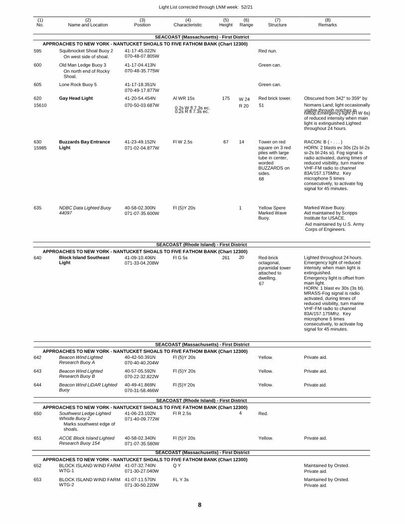
Light List corrected through LNM week: 52/21
8
(1) (2) (3) (4) (5) (6) (7) (8) No. Name and Location Position Characteristic Height Range Structure Remarks
SEACOAST (Massachusetts) - First District
APPROACHES TO NEW YORK - NANTUCKET SHOALS TO FIVE FATHOM BANK (Chart 12300)
0.2s R fl 7.3s ec. hilltop.Emergency light (Fl W 6s) of reduced intensity when main light is extinguished.Lighted throughout 24 hours.
630 Buzzards Bay Entrance 41-23-49.152N Fl W 2.5s 67 14 Tower on red RACON: B ( - . . . )
15985 Light 071-02-04.877W square on 3 red piles with large tube in center, worded BUZZARDS on sides.
68
HORN: 2 blasts ev 30s (2s bl-2s si-2s bl-24s si). Fog signal is radio activated, during times of reduced visibility, turn marine VHF-FM radio to channel 83A/157.175Mhz. Key microphone 5 times consecutively, to activate fog signal for 45 minutes.
635
NDBC Data Lighted Buoy 44097
40-58-02.300N
071-07-35.600W
Fl (5)Y 20s
1
Yellow Spere Marked Wave Buoy.
Marked Wave Buoy. Aid maintained by Scripps Institute for USACE.
Aid maintained by U.S. Army Corps of Engineers.
SEACOAST (Rhode Island) - First District
APPROACHES TO NEW YORK - NANTUCKET SHOALS TO FIVE FATHOM BANK (Chart 12300)
640 Block Island Southeast Light
41-09-10.406N 071-33-04.208W
Fl G 5s 261 20 Red-brick octagonal, pyramidal tower attached to dwelling.
67
Lighted throughout 24 hours. Emergency light of reduced intensity when main light is extinguished. Emergency light is offset from main light. HORN: 1 blast ev 30s (3s bl). MRASS-Fog signal is radio activated, during times of reduced visibility, turn marine VHF-FM radio to channel 83A/157.175Mhz. Key microphone 5 times consecutively, to activate fog signal for 45 minutes.
SEACOAST (Massachusetts) - First District
APPROACHES TO NEW YORK - NANTUCKET SHOALS TO FIVE FATHOM BANK (Chart 12300)
642
643
644
Beacon Wind Lighted Research Buoy A
Beacon Wind Lighted Research Buoy B
Beacon Wind LiDAR Lighted Buoy
40-42-50.391N
070-40-40.204W
40-57-05.592N
070-22-32.822W
40-49-41.869N
070-31-58.466W
Fl (5)Y 20s
Fl (5)Y 20s
Fl (5)Y 20s
Yellow.
Yellow.
Yellow.
Private aid.
Private aid.
Private aid.
SEACOAST (Rhode Island) - First District
APPROACHES TO NEW YORK - NANTUCKET SHOALS TO FIVE FATHOM BANK (Chart 12300)
APPROACHES TO NEW YORK - NANTUCKET SHOALS TO FIVE FATHOM BANK (Chart 12300)
652
653
BLOCK ISLAND WIND FARM WTG-1
BLOCK ISLAND WIND FARM WTG-2
41-07-32.740N
071-30-27.040W
41-07-11.570N
071-30-50.220W
Q Y
FL Y 3s
Maintained by Orsted.
Private aid.
Maintained by Orsted.
Private aid.
595 Squibnocket Shoal Buoy 2
On west side of shoal.
41-17-45.022N 070-48-07.805W
Red nun.
600 Old Man Ledge Buoy 3 41-17-04.413N Green can.
On north end of Rocky 070-48-35.775W
Shoal.
605 Lone Rock Buoy 5 41-17-18.351N Green can.
070-49-17.877W
620 Gay Head Light 41-20-54.454N Al WR 15s 175 W 24 Red brick tower. Obscured from 342° to 359° by
15610 070-50-03.687W 0.2s W fl 7.3s ec. R 20 51 Nomans Land; light occasionally
visible through notches in
650 Southwest Ledge Lighted Whistle Buoy 2
Marks southwest edge of shoals.
41-06-23.102N
071-40-09.772W
Fl R 2.5s 4 Red.
651 ACOE Block Island Lighted Research Buoy 154
40-58-02.340N
071-07-35.580W
Fl (5)Y 20s Yellow. Private aid.
SEACOAST (Massachusetts) - First District
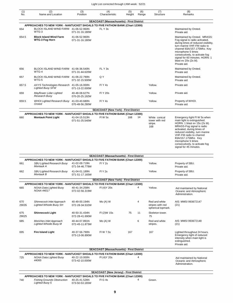
Light List corrected through LNM week: 52/21
9
(1) (2) (3) (4) (5) (6) (7) (8) No. Name and Location Position Characteristic Height Range Structure Remarks
SEACOAST (Massachusetts) - First District
APPROACHES TO NEW YORK - NANTUCKET SHOALS TO FIVE FATHOM BANK (Chart 12300)
654
654.5
656
657
657.5
659
659.5
BLOCK ISLAND WIND FARM WTG-3
Block Island Wind Farm WTG-3 Fog Horn
BLOCK ISLAND WIND FARM WTG-4
BLOCK ISLAND WIND FARM WTG-5
AXYS Technologies Research Lighted Buoy SFW
Mayflower Lidar Lighted Research Buoy
WHOI Lighted Research Buoy Orsted
41-06-52.960N 071-31-16.180W
41-06-52.960N
071-31-16.180W
41-06-36.540N
071-31-44.620W
41-06-22.790N
071-32-15.500W
41-05-16.000N
071-13-22.000W
40-48-08.627N
070-20-25.192W
41-03-40.680N
070-49-56.280W
FL Y 3s
FL Y 3s
Q Y
Fl Y 4s
Fl Y 20s
Fl Y 4s
SEACOAST (New York) - First District
Yellow.
Yellow.
Yellow.
Maintained by Orsted.
Private aid.
Maintained by Orsted. MRASS: Fog signal is radio activated, during times of reduced visibility, turn marine VHF-FM radio to channel 83A/157.175Mhz. Key microphone 5 times consecutively, to activate fog signal for 60 minutes. HORN: 1 blast ev 20s (2s bl).
Private aid.
Maintained by Orsted.
Private aid.
Maintained by Orsted.
Private aid.
Private aid.
Private aid.
Property of WHOI.
Private aid.
APPROACHES TO NEW YORK - NANTUCKET SHOALS TO FIVE FATHOM BANK (Chart 12300)
660 Montauk Point Light 41-04-15.513N
071-51-25.540W
Fl W 5s 168 14 White conical tower with red stripe.
168
Emergency light Fl W 5s when main light is extinguished. HORN: 1 blast ev 15s (2s bl). MRASS-Fog signal is radio activated, during times of reduced visibility, turn marine VHF-FM radio to channel 83A/157.175Mhz. Key microphone 5 times consecutively, to activate fog signal for 45 minutes.
SEACOAST (Massachusetts) - First District
APPROACHES TO NEW YORK - NANTUCKET SHOALS TO FIVE FATHOM BANK (Chart 12300)
661 SBU Lighted Research Buoy Montauk A
662 SBU Lighted Research Buoy Montauk B
41-02-09.719N
071-54-46.778W
41-04-01.189N
071-51-17.165W
Fl Y 2s
Fl Y 2s
Yellow.
Yellow.
Property of SBU.
Private aid.
Property of SBU.
Private aid.
SEACOAST (New York) - First District
APPROACHES TO NEW YORK - NANTUCKET SHOALS TO FIVE FATHOM BANK (Chart 12300)
665 NOAA Data Lighted Buoy NOAA 44017
40-41-34.258N
072-02-56.319W
Fl (4)Y 20s 4 Yellow. Aid maintained by National Oceanic and Atmospheric Administration.
670 Shinnecock Inlet Approach 40-49-00.194N Mo (A) W
4 Red and white AIS: MMSI 993672147
29035 Lighted Whistle Buoy SH 072-28-34.532W stripes with red spherical topmark.
(21)
675 Shinnecock Light 40-50-31.434N Fl (2)W 15s 75 11 Skeleton tower.
29025 072-28-41.690W 75
685 Moriches Inlet Approach Lighted Whistle Buoy M
40-44-07.891N
072-45-11.873W
Mo (A) W 6 Red and white stripes.
AIS: MMSI 993672148 (21)
695 Fire Island Light 40-37-56.790N
073-13-06.890W
Fl W 7.5s 167
167 Lighted throughout 24 hours. Emergency light of reduced intensity when main light is extinguished.
Private aid.
SEACOAST (Massachusetts) - First District
APPROACHES TO NEW YORK - NANTUCKET SHOALS TO FIVE FATHOM BANK (Chart 12300)
725 NOAA Data Lighted Buoy 44065
40-22-10.000N
073-42-10.000W
Fl (4)Y 20s 4 Aid maintained by National Oceanic and Atmospheric Administration.
SEACOAST (New Jersey) - First District
APPROACHES TO NEW YORK - NANTUCKET SHOALS TO FIVE FATHOM BANK (Chart 12300)
740 Fishing Grounds Obstruction Lighted Buoy 5
40-25-41.526N 073-50-53.165W
Fl G 4s 4 Green.
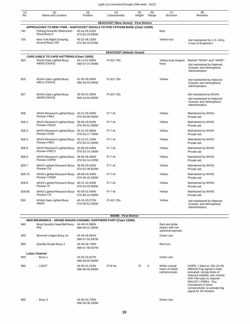
Light List corrected through LNM week: 52/21
10
SEACOAST (New Jersey) - First District
APPROACHES TO NEW YORK - NANTUCKET SHOALS TO FIVE FATHOM BANK (Chart 12300)
742
755
Fishing Grounds Obstruction Shoal Buoy 6
New York Bight Dumping Ground Buoy OM
40-25-25.522N
073-52-19.935W
40-22-06.232N
073-50-20.875W
Red.
Yellow nun.
Aid maintained by U.S. Army Corps of Engineers.
SEACOAST (Atlantic Ocean)
CAPE SABLE TO CAPE HATTERAS (Chart 13003)
820 NOAA Data Lighted Buoy 44005 (ODAS)
43-12-02.000N
069-07-37.000W
Fl (4)Y 20s Yellow boat-shaped buoy.
Marked "NOAA" and "44005".
Aid maintained by National Oceanic and Atmospheric Administration.
825 NOAA Data Lighted Buoy 44011 (ODAS)
41-05-35.000N
066-33-43.000W
Fl (4)Y 20s Yellow.
Aid maintained by National Oceanic and Atmospheric Administration.
827 NOAA Data Lighted Buoy 44008 (ODAS)
40-29-51.000N
069-15-04.000W
Fl (4)Y 20s
Aid maintained by NOAA.
Aid maintained by National Oceanic and Atmospheric Administration.
828 WHOI Research Lighted Buoy Pioneer PMUI
40-21-55.500N
070-46-59.460W
Fl Y 4s Yellow. Maintained by WHOI.
Private aid.
828.2 WHOI Research Lighted Buoy Pioneer PMUO
39-56-29.520N
070-46-51.060W
Fl Y 4s Yellow. Maintained by WHOI.
Private aid.
828.3 WHOI Research Lighted Buoy Pioneer ISSM
40-21-52.560N
070-53-17.700W
Fl Y 4s Yellow. Maintained by WHOI.
Private aid.
828.4 WHOI Research Lighted Buoy Pioneer PMCI
40-13-37.140N
070-52-41.460W
Fl Y 4s Yellow. Maintained by WHOI.
Private aid.
828.5 WHOI Research Lighted Buoy Pioneer PMCO
40-06-03.540N
070-53-14.160W
Fl Y 4s Yellow. Maintained by WHOI.
Private aid.
828.6 WHOI Research Lighted Buoy Pioneer OSPM
39-56-36.060N
070-53-14.220W
Fl Y 4s Yellow. Maintained by WHOI.
Private aid.
828.7 WHOI Lighted Research Buoy Pioneer OS
39-56-25.620N
070-52-38.820W
Fl Y 4s Yellow. Maintained by WHOI.
Private aid.
828.75 WHOI Lighted Research Buoy Pioneer CNSM
40-08-23.340N
070-46-16.200W
Fl Y 4s Yellow. Maintained by WHOI.
Private aid.
828.8 WHOI Lighted Research Buoy Pioneer IS
40-21-43.200N
070-52-42.600W
Fl Y 4s Yellow. Maintained by WHOI.
Private aid.
828.85 WHOI Lighted Research Buoy Pioneer CN
40-08-02.040N
070-46-13.560W
Fl Y 4s Yellow. Maintianed by WHOI.
Private aid.
830 NOAA Data Lighted Buoy 44025
40-15-03.072N
073-09-51.592W
Fl (4)Y 20s Yellow. Aid maintained by National Oceanic and Atmospheric Administration.
MAINE - First District
NEW BRUNSWICK - GRAND MANAN CHANNEL NORTHERN PART (Chart 13394)
840 West Quoddy Head Bell Buoy WQ
44-49-24.984N
066-56-41.382W
Red and white stripes with red spherical topmark.
845 Wormell Ledges Buoy 1A 44-49-26.681N Green can.
066-57-53.597W
850 Quoddy Roads Buoy 2 44-49-38.745N Red nun.
066-57-48.007W
Lubec Channel
855 - Buoy 1 44-50-15.627N Green can.
066-58-25.563W
860 - LIGHT 44-50-31.424N
066-58-35.830W
Fl W 6s 53 6 White conical tower on black cylindrical pier.
HORN: 1 blast ev 15s (2s bl). MRASS-Fog signal is radio activated, during times of reduced visibility, turn marine VHF-FM radio to channel 83A/157.175Mhz. Key microphone 5 times consecutively, to activate fog signal for 45 minutes.
865 - Buoy 3 44-50-34.705N
Green can.
066-58-36.160W
(1) (2) (3) (4) (5) (6) (7) (8) No. Name and Location Position Characteristic Height Range Structure Remarks
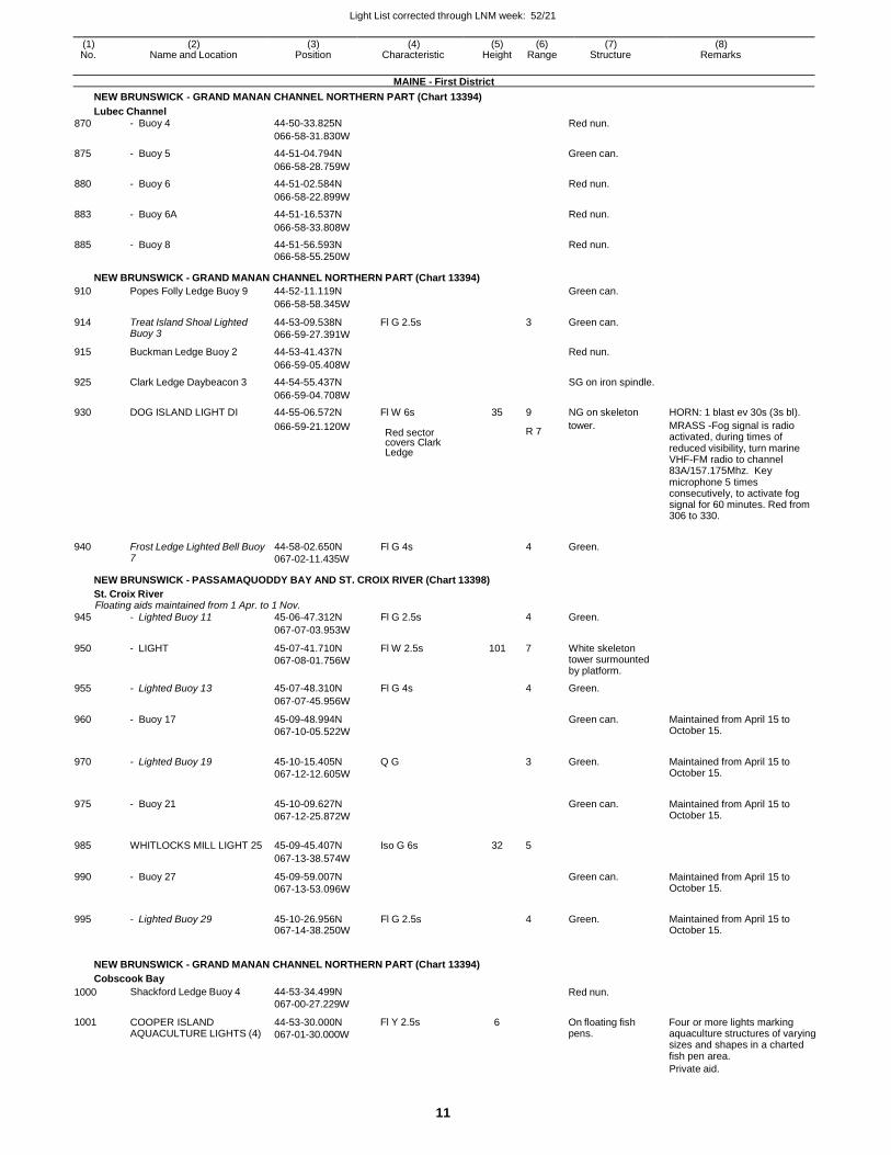
Light List corrected through LNM week: 52/21
11
(1) (2) (3) (4) (5) (6) (7) (8) No. Name and Location Position Characteristic Height Range Structure Remarks
MAINE - First District
NEW BRUNSWICK - GRAND MANAN CHANNEL NORTHERN PART (Chart 13394)
Lubec Channel
870 - Buoy 4 44-50-33.825N Red nun.
066-58-31.830W
875 - Buoy 5 44-51-04.794N Green can.
066-58-28.759W
880 - Buoy 6 44-51-02.584N Red nun.
066-58-22.899W
883 - Buoy 6A 44-51-16.537N Red nun.
066-58-33.808W
885 - Buoy 8 44-51-56.593N Red nun. 066-58-55.250W
NEW BRUNSWICK - GRAND MANAN CHANNEL NORTHERN PART (Chart 13394)
910 Popes Folly Ledge Buoy 9 44-52-11.119N Green can.
066-58-58.345W
914 Treat Island Shoal Lighted Buoy 3
44-53-09.538N
066-59-27.391W
Fl G 2.5s 3 Green can.
915 Buckman Ledge Buoy 2 44-53-41.437N Red nun.
066-59-05.408W
925 Clark Ledge Daybeacon 3 44-54-55.437N SG on iron spindle.
066-59-04.708W
930 DOG ISLAND LIGHT DI 44-55-06.572N Fl W 6s 35 9 NG on skeleton HORN: 1 blast ev 30s (3s bl).
066-59-21.120W Red sector covers Clark Ledge
R 7 tower. MRASS -Fog signal is radio
activated, during times of reduced visibility, turn marine VHF-FM radio to channel 83A/157.175Mhz. Key microphone 5 times consecutively, to activate fog signal for 60 minutes. Red from 306 to 330.
940 Frost Ledge Lighted Bell Buoy 7
44-58-02.650N
067-02-11.435W
Fl G 4s 4 Green.
NEW BRUNSWICK - PASSAMAQUODDY BAY AND ST. CROIX RIVER (Chart 13398)
St. Croix River Floating aids maintained from 1 Apr. to 1 Nov.
945 - Lighted Buoy 11 45-06-47.312N Fl G 2.5s 4 Green.
067-07-03.953W
950 - LIGHT 45-07-41.710N
067-08-01.756W
Fl W 2.5s 101 7 White skeleton tower surmounted by platform.
955 - Lighted Buoy 13 45-07-48.310N Fl G 4s 4 Green.
067-07-45.956W
960 - Buoy 17 45-09-48.994N
067-10-05.522W
Green can. Maintained from April 15 to October 15.
970 - Lighted Buoy 19 45-10-15.405N
067-12-12.605W
Q G
3 Green. Maintained from April 15 to October 15.
975 - Buoy 21 45-10-09.627N
067-12-25.872W
Green can. Maintained from April 15 to
October 15.
985 WHITLOCKS MILL LIGHT 25 45-09-45.407N Iso G 6s 32 5
067-13-38.574W
990 - Buoy 27 45-09-59.007N
067-13-53.096W
Green can. Maintained from April 15 to October 15.
995 - Lighted Buoy 29 45-10-26.956N 067-14-38.250W
Fl G 2.5s
4 Green. Maintained from April 15 to October 15.
NEW BRUNSWICK - GRAND MANAN CHANNEL NORTHERN PART (Chart 13394)
Cobscook Bay
1000
1001
Shackford Ledge Buoy 4
COOPER ISLAND AQUACULTURE LIGHTS (4)
44-53-34.499N
067-00-27.229W
44-53-30.000N
067-01-30.000W
Fl Y 2.5s
Red nun.
6 On floating fish
pens.
Four or more lights marking aquaculture structures of varying sizes and shapes in a charted fish pen area.
Private aid.
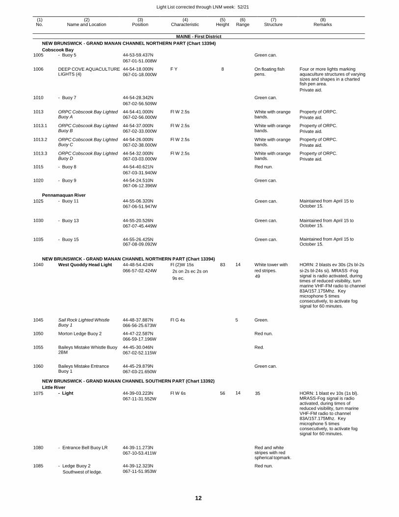
Light List corrected through LNM week: 52/21
12
(1) (2) (3) (4) (5) (6) (7) (8) No. Name and Location Position Characteristic Height Range Structure Remarks
MAINE - First District
NEW BRUNSWICK - GRAND MANAN CHANNEL NORTHERN PART (Chart 13394)
Cobscook Bay 1005 - Buoy 5 44-53-59.437N Green can.
067-01-51.008W
1006 DEEP COVE AQUACULTURE LIGHTS (4)
44-54-18.000N
067-01-18.000W
F Y 8 On floating fish pens.
Four or more lights marking aquaculture structures of varying sizes and shapes in a charted fish pen area.
Private aid.
1010 - Buoy 7 44-54-28.342N Green can.
067-02-56.509W
1013 ORPC Cobscook Bay Lighted Buoy A
44-54-41.000N
067-02-56.000W
Fl W 2.5s White with orange bands.
Property of ORPC.
Private aid.
1013.1 ORPC Cobscook Bay Lighted Buoy B
44-54-37.000N
067-02-33.000W
Fl W 2.5s White with orange bands.
Property of ORPC.
Private aid.
1013.2 ORPC Cobscook Bay Lighted Buoy C
44-54-26.000N
067-02-38.000W
Fl W 2.5s White with orange bands.
Property of ORPC.
Private aid.
1013.3 ORPC Cobscook Bay Lighted Buoy D
44-54-32.000N
067-03-03.000W
Fl W 2.5s White with orange bands.
Property of ORPC.
Private aid.
1015 - Buoy 8 44-54-40.621N Red nun.
067-03-31.940W
1020 - Buoy 9 44-54-24.510N Green can.
067-06-12.396W
Pennamaquan River
1025 - Buoy 11 44-55-06.320N
067-06-51.947W Green can. Maintained from April 15 to
October 15.
1030 - Buoy 13 44-55-20.526N
067-07-45.449W
Green can. Maintained from April 15 to October 15.
1035 - Buoy 15 44-55-26.425N 067-08-09.092W
Green can. Maintained from April 15 to October 15.
NEW BRUNSWICK - GRAND MANAN CHANNEL NORTHERN PART (Chart 13394)
1040 West Quoddy Head Light 44-48-54.424N Fl (2)W 15s 83 14 White tower with HORN: 2 blasts ev 30s (2s bl-2s
066-57-02.424W 2s on 2s ec 2s on red stripes. si-2s bl-24s si). MRASS -Fog
9s ec. 49 signal is radio activated, during times of reduced visibility, turn marine VHF-FM radio to channel 83A/157.175Mhz. Key microphone 5 times consecutively, to activate fog signal for 60 minutes.
1045
1050
1055
1060
Sail Rock Lighted Whistle Buoy 1
Morton Ledge Buoy 2
Baileys Mistake Whistle Buoy 2BM
Baileys Mistake Entrance Buoy 1
44-48-37.887N
066-56-25.673W
44-47-22.587N
066-59-17.196W
44-45-30.046N
067-02-52.115W
44-45-29.879N
067-03-21.650W
Fl G 4s
5 Green.
Red nun.
Red.
Green can.
NEW BRUNSWICK - GRAND MANAN CHANNEL SOUTHERN PART (Chart 13392)
Little River
1075
1080
1085
- Light
- Entrance Bell Buoy LR
- Ledge Buoy 2
Southwest of ledge.
44-39-03.223N
067-11-31.552W
44-39-11.273N
067-10-53.411W
44-39-12.323N
067-11-51.953W
Fl W 6s 56 14 35
Red and white stripes with red spherical topmark.
Red nun.
HORN: 1 blast ev 10s (1s bl). MRASS-Fog signal is radio activated, during times of reduced visibility, turn marine VHF-FM radio to channel 83A/157.175Mhz. Key microphone 5 times consecutively, to activate fog signal for 60 minutes.
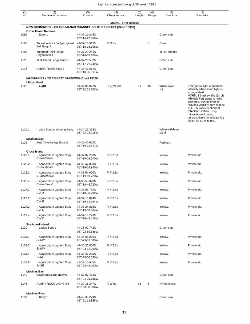
Light List corrected through LNM week: 52/21
13
(1) (2) (3) (4) (5) (6) (7) (8) No. Name and Location Position Characteristic Height Range Structure Remarks
MAINE - First District
NEW BRUNSWICK - GRAND MANAN CHANNEL SOUTHERN PART (Chart 13392)
Cross Island Narrows
1095 - Buoy 1 44-37-10.245N Green can.
067-15-22.856W
1100 Thornton Point Ledge Lighted Bell Buoy 3
44-37-16.912N
067-16-16.108W
Fl G 4s 5 Green.
1105 Thornton Point Ledge Daybeacon 4
44-37-20.254N
067-16-33.109W
TR on spindle.
1110 Mink Island Ledge Buoy 5 44-37-20.552N Green can.
067-17-07.289W
1115 Dogfish Rocks Buoy 7 44-37-47.861N Green can. 067-18-06.011W
MACHIAS BAY TO TIBBETT NARROWS (Chart 13326)
Libby Island
1120 - Light 44-34-06.022N
067-22-02.563W
Fl (2)W 20s 91 18 White tower.
42
Emergency light of reduced intensity when main light is extinguished. HORN: 1 blast ev 15s (2s bl). MRASS-Fog signal is radio activated, during times of reduced visibility, turn marine VHF-FM radio to channel 83A/157.175Mhz. Key microphone 5 times consecutively, to activate fog signal for 60 minutes.
1120.1 - Light Station Mooring Buoy 44-34-22.375N 067-22-02.018W
White with blue band.
Machias Bay
1125 Seal Cove Ledge Buoy 2 44-35-40.972N 067-19-22.541W
Red nun.
Cross Island
1126.1 - Aquaculture Lighted Buoy CI-Northwest
44-37-07.260N
067-19-03.840W
Fl Y 2.5s Yellow. Private aid.
1126.2 - Aquaculture Lighted Buoy CI-Southeast
44-36-47.880N
067-19-02.940W
Fl Y 2.5s Yellow. Private aid.
1126.3 - Aquaculture Lighted Buoy CI-Southwest
44-36-54.600N
067-19-19.720W
Fl Y 2.5s Yellow. Private aid.
1126.4 - Aquaculture Lighted Buoy CI-Northeast
44-36-58.320N
067-18-48.720W
Fl Y 2.5s Yellow. Private aid.
1127.1 - Aquaculture Lighted Buoy CIN A
44-37-05.790N
067-18-58.782W
Fl Y 2.5s Yellow. Private aid.
1127.2 - Aquaculture Lighted Buoy CIN B
44-37-13.824N
067-19-14.364W
Fl Y 2.5s Yellow. Private aid.
1127.3 - Aquaculture Lighted Buoy CIN C
44-37-24.852N
067-19-03.504W
Fl Y 2.5s Yellow. Private aid.
1127.4 - Aquaculture Lighted Buoy CIN D
44-37-18.246N 067-18-49.476W
Fl Y 2.5s Yellow. Private aid.
Starboard Island 1130 - Ledge Buoy 1 44-35-07.742N Green can.
067-22-50.686W
1131.1 - Aquaculture Lighted Buoy SI-SW
44-36-06.000N
067-23-01.000W
Fl Y 2.5s Yellow. Private aid.
1131.3 - Aquaculture Lighted Buoy SI-NW
44-36-23.000N
067-23-12.000W
Fl Y 2.5s Yellow. Private aid.
1131.4 - Aquaculture Lighted Buoy SI-NE
44-36-27.250N
067-23-00.530W
Fl Y 2.5s Yellow. Private aid.
1131.5 - Aquaculture Lighted Buoy SI-SE
44-36-10.940N 067-22-49.000W
Fl Y 2.5s Yellow. Private aid.
Machias Bay 1140 Seashore Ledge Buoy 5 44-37-07.451N Green can.
067-21-39.786W
1145 AVERY ROCK LIGHT AR 44-39-15.347N Fl W 6s 16 6 NR on tower. 067-20-38.806W
Machias River
1150 - Buoy 1 44-40-36.278N
067-21-13.358W
Green can.
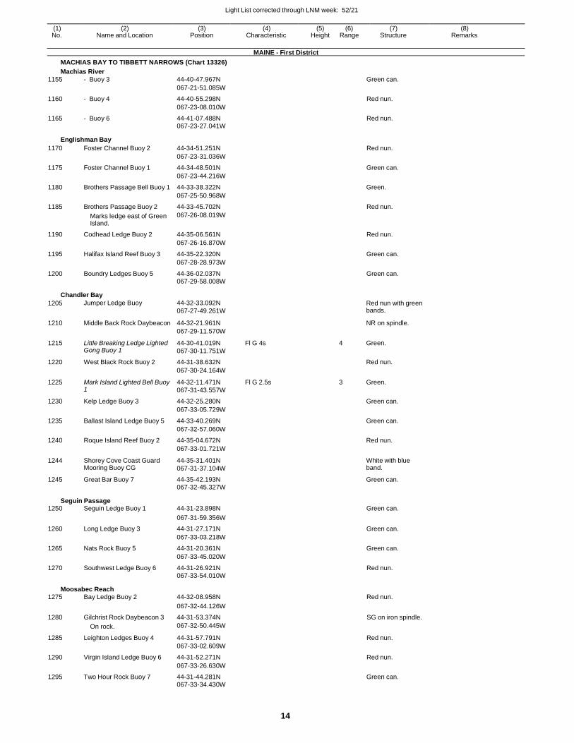
Light List corrected through LNM week: 52/21
14
(1) (2) (3) (4) (5) (6) (7) (8) No. Name and Location Position Characteristic Height Range Structure Remarks
MAINE - First District
MACHIAS BAY TO TIBBETT NARROWS (Chart 13326)
Machias River
1155 - Buoy 3 44-40-47.967N Green can.
067-21-51.085W
1160 - Buoy 4 44-40-55.298N Red nun.
067-23-08.010W
1165 - Buoy 6 44-41-07.488N Red nun. 067-23-27.041W
Englishman Bay
1170 Foster Channel Buoy 2 44-34-51.251N Red nun.
067-23-31.036W
1175 Foster Channel Buoy 1 44-34-48.501N Green can.
067-23-44.216W
1180 Brothers Passage Bell Buoy 1 44-33-38.322N Green.
067-25-50.968W
1185 Brothers Passage Buoy 2 44-33-45.702N Red nun.
Marks ledge east of Green Island.
067-26-08.019W
1190 Codhead Ledge Buoy 2 44-35-06.561N Red nun.
067-26-16.870W
1195 Halifax Island Reef Buoy 3 44-35-22.320N Green can.
067-28-28.973W
1200 Boundry Ledges Buoy 5 44-36-02.037N Green can. 067-29-58.008W
Chandler Bay
1205 Jumper Ledge Buoy 44-32-33.092N
067-27-49.261W
Red nun with green bands.
1210 Middle Back Rock Daybeacon 44-32-21.961N NR on spindle.
067-29-11.570W
1215 Little Breaking Ledge Lighted Gong Buoy 1
44-30-41.019N
067-30-11.751W
Fl G 4s 4 Green.
1220 West Black Rock Buoy 2 44-31-38.632N Red nun.
067-30-24.164W
1225 Mark Island Lighted Bell Buoy 1
44-32-11.471N
067-31-43.557W
Fl G 2.5s 3 Green.
1230 Kelp Ledge Buoy 3 44-32-25.280N Green can.
067-33-05.729W
1235 Ballast Island Ledge Buoy 5 44-33-40.269N Green can.
067-32-57.060W
1240 Roque Island Reef Buoy 2 44-35-04.672N Red nun.
067-33-01.721W
1244 Shorey Cove Coast Guard Mooring Buoy CG
44-35-31.401N
067-31-37.104W
White with blue band.
1245 Great Bar Buoy 7 44-35-42.193N Green can. 067-32-45.327W
Seguin Passage 1250 Seguin Ledge Buoy 1 44-31-23.898N Green can.
067-31-59.356W
1260 Long Ledge Buoy 3 44-31-27.171N Green can.
067-33-03.218W
1265 Nats Rock Buoy 5 44-31-20.361N Green can.
067-33-45.020W
1270 Southwest Ledge Buoy 6 44-31-26.921N Red nun. 067-33-54.010W
Moosabec Reach 1275 Bay Ledge Buoy 2 44-32-08.958N Red nun.
067-32-44.126W
1280 Gilchrist Rock Daybeacon 3 44-31-53.374N SG on iron spindle.
On rock. 067-32-50.445W
1285 Leighton Ledges Buoy 4 44-31-57.791N Red nun.
067-33-02.609W
1290 Virgin Island Ledge Buoy 6 44-31-52.271N Red nun.
067-33-26.630W
1295 Two Hour Rock Buoy 7 44-31-44.281N Green can. 067-33-34.430W
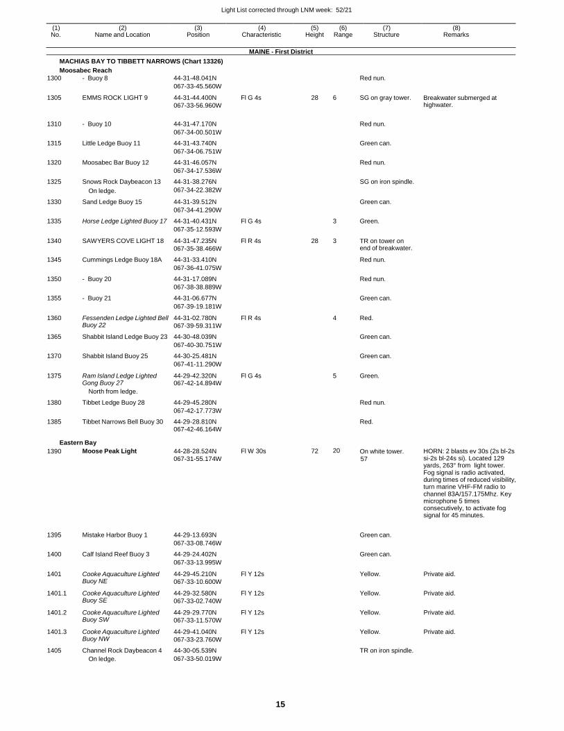
Light List corrected through LNM week: 52/21
15
(1) (2) (3) (4) (5) (6) (7) (8) No. Name and Location Position Characteristic Height Range Structure Remarks
MAINE - First District
MACHIAS BAY TO TIBBETT NARROWS (Chart 13326)
Moosabec Reach
1300 - Buoy 8 44-31-48.041N Red nun.
067-33-45.560W
1305 EMMS ROCK LIGHT 9 44-31-44.400N
067-33-56.960W
Fl G 4s 28 6 SG on gray tower. Breakwater submerged at highwater.
1310 - Buoy 10 44-31-47.170N
Red nun.
067-34-00.501W
1315 Little Ledge Buoy 11 44-31-43.740N Green can.
067-34-06.751W
1320 Moosabec Bar Buoy 12 44-31-46.057N Red nun.
067-34-17.536W
1325 Snows Rock Daybeacon 13 44-31-38.276N SG on iron spindle.
On ledge. 067-34-22.382W
1330 Sand Ledge Buoy 15 44-31-39.512N Green can.
067-34-41.290W
1335 Horse Ledge Lighted Buoy 17 44-31-40.431N Fl G 4s 3 Green.
067-35-12.593W
1340 SAWYERS COVE LIGHT 18 44-31-47.235N
067-35-38.466W
Fl R 4s 28 3 TR on tower on end of breakwater.
1345 Cummings Ledge Buoy 18A 44-31-33.410N Red nun.
067-36-41.075W
1350 - Buoy 20 44-31-17.089N Red nun.
067-38-38.889W
1355 - Buoy 21 44-31-06.677N Green can.
067-39-19.181W
1360 Fessenden Ledge Lighted Bell Buoy 22
44-31-02.780N
067-39-59.311W
Fl R 4s 4 Red.
1365 Shabbit Island Ledge Buoy 23 44-30-48.039N Green can.
067-40-30.751W
1370 Shabbit Island Buoy 25 44-30-25.481N Green can.
067-41-11.290W
1375 Ram Island Ledge Lighted Gong Buoy 27
44-29-42.320N 067-42-14.894W
Fl G 4s 5 Green.
North from ledge.
1380 Tibbet Ledge Buoy 28 44-29-45.280N Red nun.
067-42-17.773W
1385 Tibbet Narrows Bell Buoy 30 44-29-28.810N Red.
067-42-46.164W
Eastern Bay
1390 Moose Peak Light 44-28-28.524N
067-31-55.174W
Fl W 30s 72 20 On white tower. 57
HORN: 2 blasts ev 30s (2s bl-2s si-2s bl-24s si). Located 129 yards, 263° from light tower. Fog signal is radio activated, during times of reduced visibility, turn marine VHF-FM radio to channel 83A/157.175Mhz. Key microphone 5 times consecutively, to activate fog signal for 45 minutes.
1395 Mistake Harbor Buoy 1 44-29-13.693N
Green can.
067-33-08.746W
1400 Calf Island Reef Buoy 3 44-29-24.402N Green can.
067-33-13.995W
1401 Cooke Aquaculture Lighted Buoy NE
44-29-45.210N
067-33-10.600W
Fl Y 12s Yellow. Private aid.
1401.1 Cooke Aquaculture Lighted Buoy SE
44-29-32.580N
067-33-02.740W
Fl Y 12s Yellow. Private aid.
1401.2 Cooke Aquaculture Lighted Buoy SW
44-29-29.770N
067-33-11.570W
Fl Y 12s Yellow. Private aid.
1401.3 Cooke Aquaculture Lighted Buoy NW
44-29-41.040N
067-33-23.760W
Fl Y 12s Yellow. Private aid.
1405 Channel Rock Daybeacon 4 44-30-05.539N TR on iron spindle.
On ledge. 067-33-50.019W
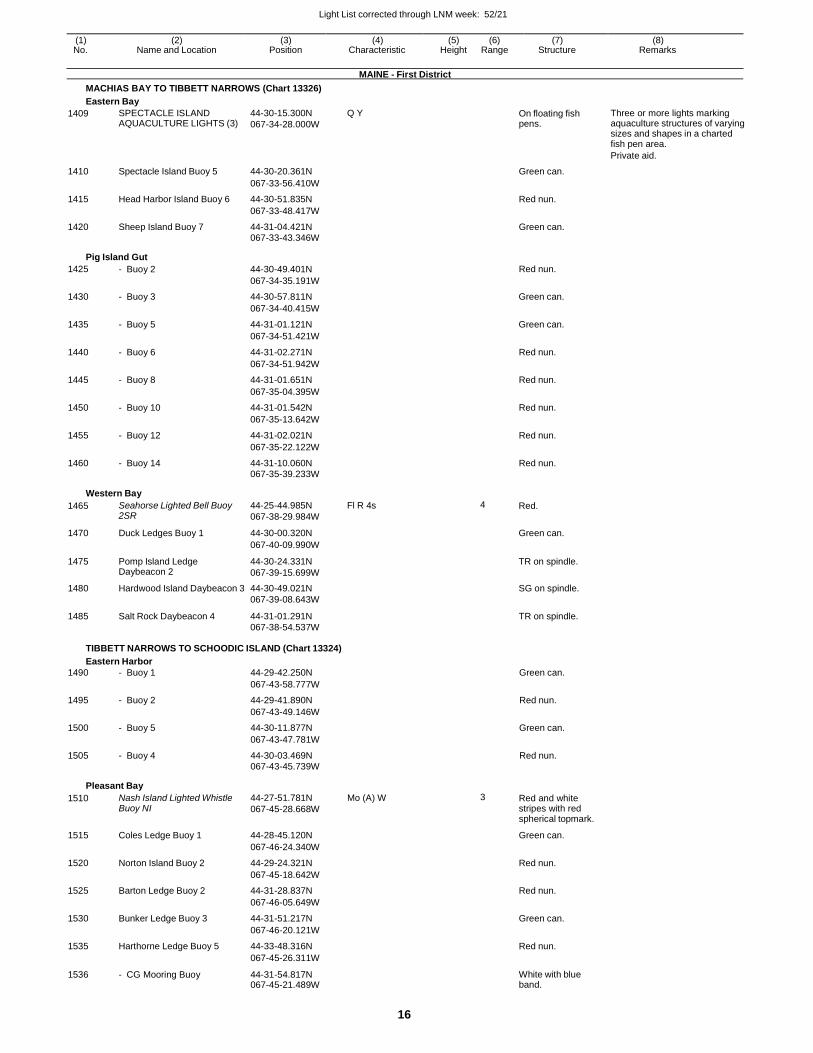
Light List corrected through LNM week: 52/21
16
(1) (2) (3) (4) (5) (6) (7) (8) No. Name and Location Position Characteristic Height Range Structure Remarks
MAINE - First District
MACHIAS BAY TO TIBBETT NARROWS (Chart 13326)
Eastern Bay
1409 SPECTACLE ISLAND AQUACULTURE LIGHTS (3)
44-30-15.300N
067-34-28.000W
Q Y On floating fish pens.
Three or more lights marking aquaculture structures of varying sizes and shapes in a charted fish pen area.
Private aid.
1410 Spectacle Island Buoy 5 44-30-20.361N Green can.
067-33-56.410W
1415 Head Harbor Island Buoy 6 44-30-51.835N Red nun.
067-33-48.417W
1420 Sheep Island Buoy 7 44-31-04.421N Green can.
067-33-43.346W
Pig Island Gut
1425 - Buoy 2 44-30-49.401N Red nun.
067-34-35.191W
1430 - Buoy 3 44-30-57.811N Green can.
067-34-40.415W
1435 - Buoy 5 44-31-01.121N Green can.
067-34-51.421W
1440 - Buoy 6 44-31-02.271N Red nun.
067-34-51.942W
1445 - Buoy 8 44-31-01.651N Red nun.
067-35-04.395W
1450 - Buoy 10 44-31-01.542N Red nun.
067-35-13.642W
1455 - Buoy 12 44-31-02.021N Red nun.
067-35-22.122W
1460 - Buoy 14 44-31-10.060N Red nun. 067-35-39.233W
Western Bay
1465 Seahorse Lighted Bell Buoy 2SR
44-25-44.985N
067-38-29.984W
Fl R 4s 4 Red.
1470 Duck Ledges Buoy 1 44-30-00.320N Green can.
067-40-09.990W
1475 Pomp Island Ledge Daybeacon 2
44-30-24.331N
067-39-15.699W
TR on spindle.
1480 Hardwood Island Daybeacon 3 44-30-49.021N SG on spindle. 067-39-08.643W
1485 Salt Rock Daybeacon 4 44-31-01.291N TR on spindle. 067-38-54.537W
TIBBETT NARROWS TO SCHOODIC ISLAND (Chart 13324)
Eastern Harbor
1490 - Buoy 1 44-29-42.250N Green can.
067-43-58.777W
1495 - Buoy 2 44-29-41.890N Red nun.
067-43-49.146W
1500 - Buoy 5 44-30-11.877N Green can.
067-43-47.781W
1505 - Buoy 4 44-30-03.469N Red nun. 067-43-45.739W
Pleasant Bay
1510 Nash Island Lighted Whistle Buoy NI
44-27-51.781N
067-45-28.668W
Mo (A) W 3 Red and white stripes with red spherical topmark.
1515 Coles Ledge Buoy 1 44-28-45.120N Green can.
067-46-24.340W
1520 Norton Island Buoy 2 44-29-24.321N Red nun.
067-45-18.642W
1525 Barton Ledge Buoy 2 44-31-28.837N Red nun.
067-46-05.649W
1530 Bunker Ledge Buoy 3 44-31-51.217N Green can.
067-46-20.121W
1535 Harthorne Ledge Buoy 5 44-33-48.316N Red nun.
067-45-26.311W
1536 - CG Mooring Buoy 44-31-54.817N 067-45-21.489W
White with blue band.
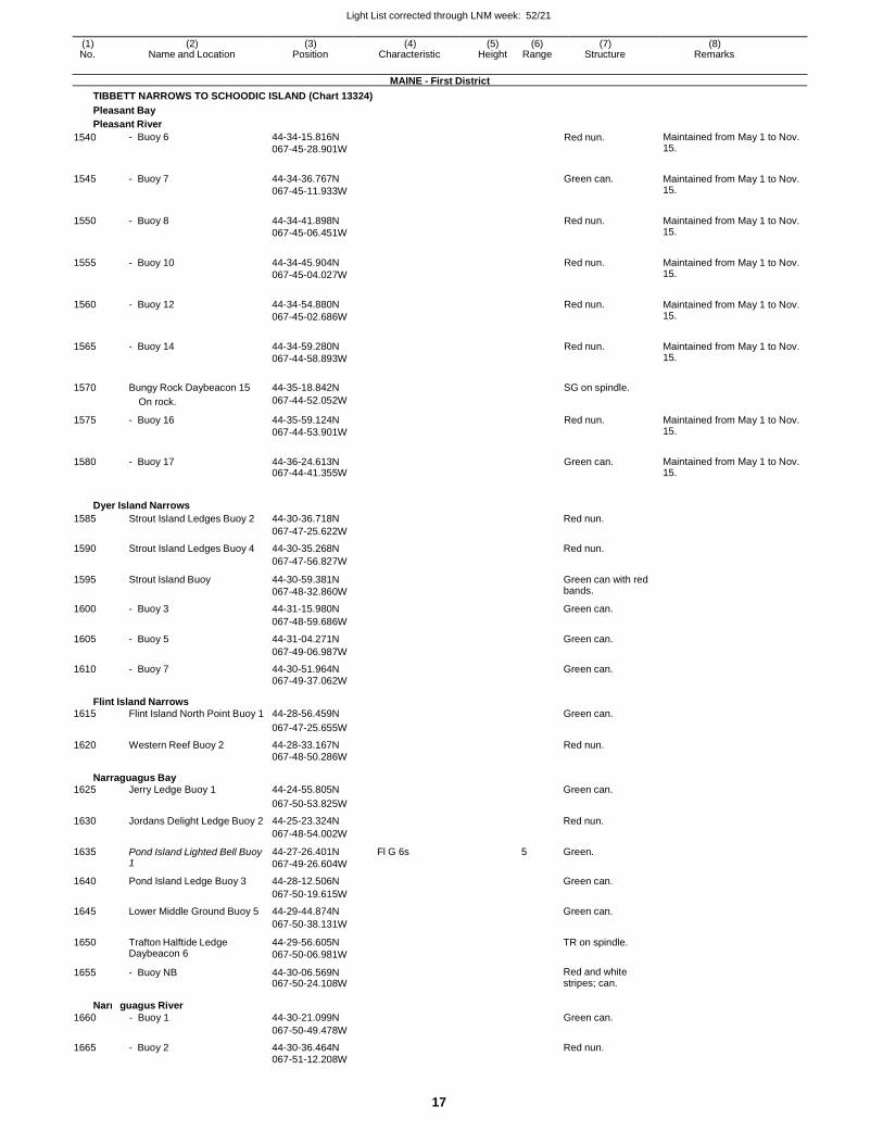
Light List corrected through LNM week: 52/21
17
(1) (2) (3) (4) (5) (6) (7) (8) No. Name and Location Position Characteristic Height Range Structure Remarks
MAINE - First District
TIBBETT NARROWS TO SCHOODIC ISLAND (Chart 13324)
Pleasant Bay
Pleasant River
1540 - Buoy 6 44-34-15.816N
067-45-28.901W Red nun. Maintained from May 1 to Nov.
15.
1545 - Buoy 7 44-34-36.767N
067-45-11.933W
Green can. Maintained from May 1 to Nov. 15.
1550 - Buoy 8 44-34-41.898N
067-45-06.451W
Red nun. Maintained from May 1 to Nov. 15.
1555 - Buoy 10 44-34-45.904N
067-45-04.027W
Red nun. Maintained from May 1 to Nov. 15.
1560 - Buoy 12 44-34-54.880N
067-45-02.686W
Red nun. Maintained from May 1 to Nov. 15.
1565 - Buoy 14 44-34-59.280N
067-44-58.893W
Red nun. Maintained from May 1 to Nov. 15.
1570 Bungy Rock Daybeacon 15 44-35-18.842N SG on spindle.
On rock. 067-44-52.052W
1575 - Buoy 16 44-35-59.124N
067-44-53.901W
Red nun. Maintained from May 1 to Nov. 15.
1580 - Buoy 17 44-36-24.613N 067-44-41.355W
Green can. Maintained from May 1 to Nov. 15.
Dyer Island Narrows
1585 Strout Island Ledges Buoy 2 44-30-36.718N Red nun.
067-47-25.622W
1590 Strout Island Ledges Buoy 4 44-30-35.268N Red nun.
067-47-56.827W
1595 Strout Island Buoy 44-30-59.381N
067-48-32.860W
Green can with red bands.
1600 - Buoy 3 44-31-15.980N Green can.
067-48-59.686W
1605 - Buoy 5 44-31-04.271N Green can.
067-49-06.987W
1610 - Buoy 7 44-30-51.964N Green can. 067-49-37.062W
Flint Island Narrows 1615 Flint Island North Point Buoy 1 44-28-56.459N Green can.
067-47-25.655W
1620 Western Reef Buoy 2 44-28-33.167N Red nun. 067-48-50.286W
Narraguagus Bay 1625 Jerry Ledge Buoy 1 44-24-55.805N Green can.
067-50-53.825W
1630 Jordans Delight Ledge Buoy 2 44-25-23.324N Red nun.
067-48-54.002W
1635 Pond Island Lighted Bell Buoy 1
44-27-26.401N
067-49-26.604W
Fl G 6s 5 Green.
1640 Pond Island Ledge Buoy 3 44-28-12.506N Green can.
067-50-19.615W
1645 Lower Middle Ground Buoy 5 44-29-44.874N Green can.
067-50-38.131W
1650 Trafton Halftide Ledge Daybeacon 6
44-29-56.605N
067-50-06.981W
TR on spindle.
1655 - Buoy NB 44-30-06.569N 067-50-24.108W
Red and white stripes; can.
Narra
1660
guagus River
- Buoy 1
44-30-21.099N
Green can.
067-50-49.478W
1665 - Buoy 2 44-30-36.464N Red nun. 067-51-12.208W
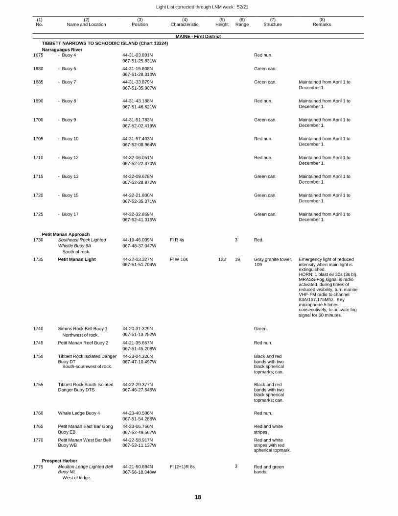
Light List corrected through LNM week: 52/21
18
(1) (2) (3) (4) (5) (6) (7) (8) No. Name and Location Position Characteristic Height Range Structure Remarks
MAINE - First District
TIBBETT NARROWS TO SCHOODIC ISLAND (Chart 13324)
Narraguagus River
1675 - Buoy 4 44-31-03.891N Red nun.
067-51-25.831W
1680 - Buoy 5 44-31-15.608N Green can.
067-51-28.310W
1685 - Buoy 7 44-31-33.879N Green can. Maintained from April 1 to
067-51-35.907W December 1.
1690 - Buoy 8 44-31-43.188N Red nun. Maintained from April 1 to
067-51-46.621W December 1.
1700 - Buoy 9 44-31-51.783N Green can. Maintained from April 1 to
067-52-02.419W December 1.
1705 - Buoy 10 44-31-57.403N Red nun. Maintained from April 1 to
067-52-08.964W December 1.
1710 - Buoy 12 44-32-06.051N Red nun. Maintained from April 1 to
067-52-22.370W December 1.
1715 - Buoy 13 44-32-09.678N Green can. Maintained from April 1 to
067-52-28.872W December 1.
1720 - Buoy 15 44-32-21.800N Green can. Maintained from April 1 to
067-52-35.371W December 1.
1725 - Buoy 17 44-32-32.869N Green can. Maintained from April 1 to 067-52-41.315W December 1.
Petit Manan Approach
1730 Southeast Rock Lighted 44-19-46.009N Fl R 4s 3 Red.
Whistle Buoy 6A 067-48-37.047W
South of rock.
1735 Petit Manan Light 44-22-03.327N Fl W 10s 123 19 Gray granite tower. Emergency light of reduced 067-51-51.704W 109 intensity when main light is extinguished. HORN: 1 blast ev 30s (3s bl). MRASS-Fog signal is radio activated, during times of reduced visibility, turn marine VHF-FM radio to channel 83A/157.175Mhz. Key microphone 5 times consecutively, to activate fog
signal for 60 minutes.
1740 Simms Rock Bell Buoy 1 44-20-31.329N
Green.
Northwest of rock. 067-51-13.252W
1745 Petit Manan Reef Buoy 2 44-21-35.667N Red nun.
067-51-45.208W
1750 Tibbett Rock Isolated Danger 44-23-04.326N Black and red
Buoy DT 067-47-10.497W bands with two
South-southwest of rock. black spherical
topmarks; can.
1755 Tibbett Rock South Isolated 44-22-29.377N Black and red Danger Buoy DTS 067-46-27.545W bands with two black spherical
topmarks; can.
1760 Whale Ledge Buoy 4 44-23-40.506N Red nun.
067-51-54.286W
1765 Petit Manan East Bar Gong 44-23-06.766N Red and white
Buoy EB 067-52-49.567W stripes.
1770 Petit Manan West Bar Bell 44-22-58.917N Red and white Buoy WB 067-53-11.137W stripes with red spherical topmark.
Prospect Harbor
1775 Moulton Ledge Lighted Bell Buoy ML
West of ledge.
44-21-50.694N
067-56-18.348W
Fl (2+1)R 6s 3 Red and green bands.
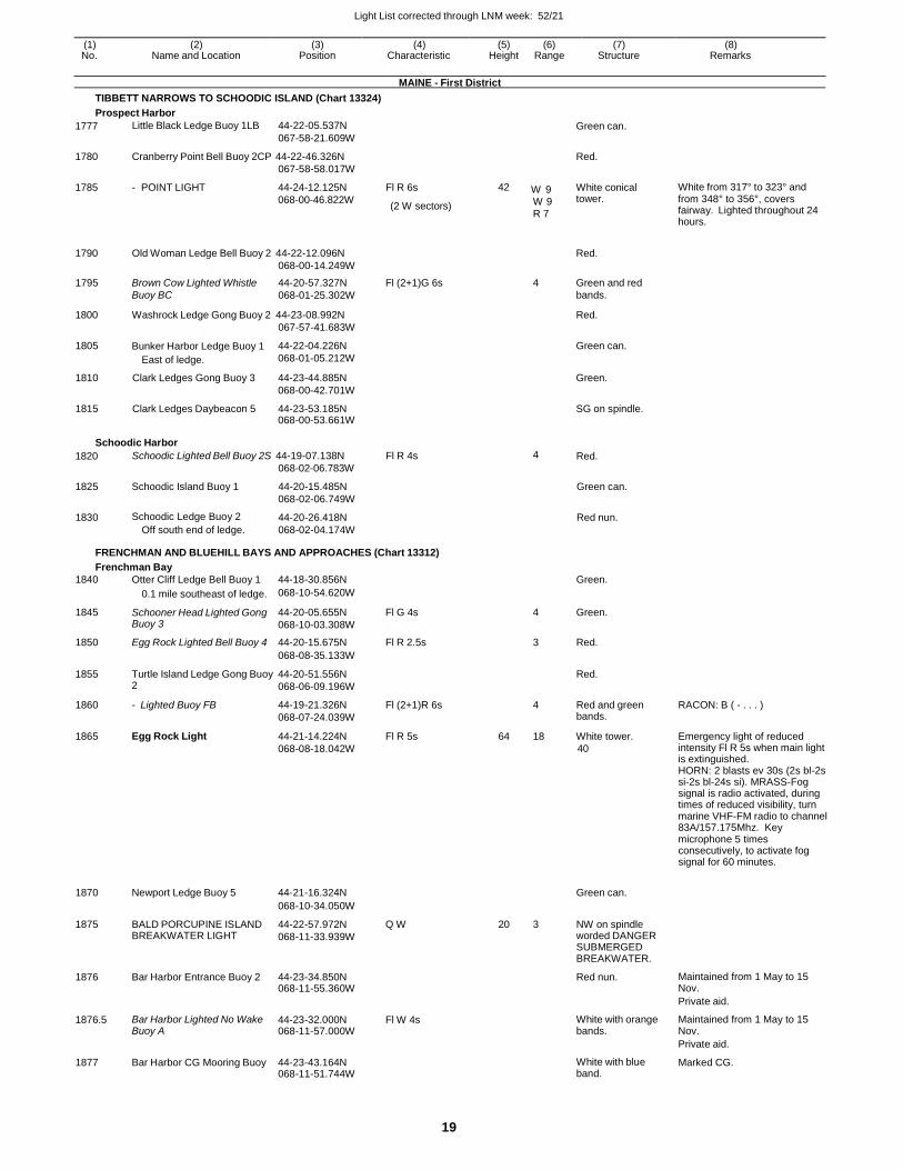
Light List corrected through LNM week: 52/21
19
(1) (2) (3) (4) (5) (6) (7) (8) No. Name and Location Position Characteristic Height Range Structure Remarks
MAINE - First District
TIBBETT NARROWS TO SCHOODIC ISLAND (Chart 13324)
Prospect Harbor
1777 Little Black Ledge Buoy 1LB 44-22-05.537N
067-58-21.609WGreen can.
1780 Cranberry Point Bell Buoy 2CP 44-22-46.326N
067-58-58.017W
Red.
1785 - POINT LIGHT 44-24-12.125N
068-00-46.822W
Fl R 6s
(2 W sectors)
42 W 9 W 9 R 7
White conical tower.
White from 317° to 323° and from 348° to 356°, covers fairway. Lighted throughout 24 hours.
1790 Old Woman Ledge Bell Buoy 2 44-22-12.096N
068-00-14.249W
Red.
1795 Brown Cow Lighted Whistle 44-20-57.327N Fl (2+1)G 6s 4 Green and red
Buoy BC 068-01-25.302W bands.
1800 Washrock Ledge Gong Buoy 2 44-23-08.992N
067-57-41.683W
Red.
1805 Bunker Harbor Ledge Buoy 1
East of ledge.
44-22-04.226N
068-01-05.212W
Green can.
1810 Clark Ledges Gong Buoy 3 44-23-44.885N
068-00-42.701W
Green.
1815 Clark Ledges Daybeacon 5 44-23-53.185N068-00-53.661W
SG on spindle.
Schoodic Harbor
1820 Schoodic Lighted Bell Buoy 2S 44-19-07.138N
068-02-06.783W
Fl R 4s 4 Red.
1825 Schoodic Island Buoy 1 44-20-15.485N
068-02-06.749W
Green can.
1830 Schoodic Ledge Buoy 2
Off south end of ledge.
44-20-26.418N
068-02-04.174W
Red nun.
FRENCHMAN AND BLUEHILL BAYS AND APPROACHES (Chart 13312)
Frenchman Bay
1840 Otter Cliff Ledge Bell Buoy 1 44-18-30.856N Green.
0.1 mile southeast of ledge. 068-10-54.620W
1845 Schooner Head Lighted Gong Buoy 3
44-20-05.655N
068-10-03.308W
Fl G 4s 4 Green.
1850 Egg Rock Lighted Bell Buoy 4 44-20-15.675N Fl R 2.5s 3 Red.
068-08-35.133W
1855 Turtle Island Ledge Gong Buoy 2
44-20-51.556N
068-06-09.196W
Red.
1860 - Lighted Buoy FB 44-19-21.326N
068-07-24.039W
Fl (2+1)R 6s 4 Red and green bands.
RACON: B ( - . . . )
1865 Egg Rock Light 44-21-14.224N
068-08-18.042W
Fl R 5s 64 18 White tower.
40
Emergency light of reduced intensity Fl R 5s when main light is extinguished. HORN: 2 blasts ev 30s (2s bl-2s si-2s bl-24s si). MRASS-Fog signal is radio activated, during times of reduced visibility, turn marine VHF-FM radio to channel 83A/157.175Mhz. Key microphone 5 times consecutively, to activate fog signal for 60 minutes.
1870 Newport Ledge Buoy 5 44-21-16.324N Green can.
068-10-34.050W
1875 BALD PORCUPINE ISLAND BREAKWATER LIGHT
44-22-57.972N
068-11-33.939W
Q W 20 3 NW on spindle worded DANGER SUBMERGED BREAKWATER.
1876 Bar Harbor Entrance Buoy 2 44-23-34.850N068-11-55.360W
Red nun. Maintained from 1 May to 15 Nov.
Private aid.
1876.5 Bar Harbor Lighted No Wake Buoy A
44-23-32.000N068-11-57.000W
Fl W 4s White with orange bands.
Maintained from 1 May to 15 Nov.
Private aid.
1877 Bar Harbor CG Mooring Buoy 44-23-43.164N 068-11-51.744W
White with blue band.
Marked CG.
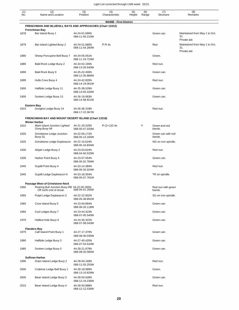
Light List corrected through LNM week: 52/21
20
(1) (2) (3) (4) (5) (6) (7) (8) No. Name and Location Position Characteristic Height Range Structure Remarks
MAINE - First District
FRENCHMAN AND BLUEHILL BAYS AND APPROACHES (Chart 13312)
Frenchman Bay
1878 Bar Island Buoy 1 44-24-01.690N
068-11-56.210W
Green can. Maintained from May 1 to Oct. 31.
Private aid.
1879 Bar Island Lighted Buoy 2 44-24-01.680N 068-11-54.260W
Fl R 4s Red Maintained from May 1 to Oct. 31.
Private aid.
1880 Sheep Porcupine Bell Buoy 7 44-24-05.051N Green.
068-11-24.723W
1885 Bald Rock Ledge Buoy 2 44-24-52.165N Red nun.
068-13-26.540W
1890 Bald Rock Buoy 9 44-25-22.400N Green can.
068-12-35.866W
1895 Hulls Cove Buoy 4 44-24-42.820N Red nun.
068-14-19.061W
1900 Halftide Ledge Buoy 11 44-25-39.029N Green can.
068-13-55.420W
1905 Sunken Ledge Buoy 13 44-26-19.063N Green can.
068-14-58.921W
Eastern Bay 1910 Googins Ledge Buoy 14 44-26-36.318N Red nun.
068-17-22.067W
FRENCHMAN BAY AND MOUNT DESERT ISLAND (Chart 13318)
Winter Harbor
1915 Mark Island Junction Lighted Gong Buoy MI
44-21-29.325N
068-05-07.033W
Fl (2+1)G 6s 4 Green and red bands.
1920 Grindstone Ledge Junction Buoy GL
44-22-06.172N
068-05-13.165W
Green can with red bands.
1925 Grindstone Ledge Daybeacon 44-22-10.624N NG on iron spindle.
068-05-16.834W
1930 Abijah Ledge Buoy 2 44-23-03.624N Red nun.
068-04-50.533W
1935 Harbor Point Buoy 3 44-23-07.054N Green can.
068-05-02.784W
1940 Guptill Point Buoy 4 44-23-14.384N Red nun.
068-05-03.024W
1945 Guptill Ledge Daybeacon 6 44-23-18.354N TR on spindle. 068-05-07.791W
Passage West of Grindstone Neck
1950 Roaring Bull Junction Buoy RB 44-22-05.265N Red nun with green Off north end of shoal. 068-05-41.205W bands.
1955 Pulpit Ledge Daybeacon 3 44-22-22.902N SG on iron spindle.
068-05-48.891W
1960 Crow Island Buoy 5 44-23-00.894N Green can.
068-06-26.118W
1965 Cod Ledges Buoy 7 44-23-44.323N Green can.
068-07-05.540W
1970 Halibut Hole Buoy 9 44-24-30.322N Green can. 068-07-58.043W
Flanders Bay 1975 Calf Island Point Buoy 1 44-27-17.370N Green can.
068-08-30.035W
1980 Halftide Ledge Buoy 3 44-27-40.420N Green can.
068-07-53.543W
1985 Sunken Ledge Buoy 5 44-28-21.879N Green can. 068-08-20.585W
Sullivan Harbor
1995 Dram Island Ledge Buoy 2 44-28-04.169N Red nun.
068-11-55.255W
2000 Crabtree Ledge Bell Buoy 1 44-28-18.589N Green.
068-13-10.829W
2005 Bean Island Ledge Buoy 3 44-28-50.628N Green can.
068-12-19.236W
2010 Bean Island Ledge Buoy 4 44-28-50.888N Red nun. 068-12-12.536W
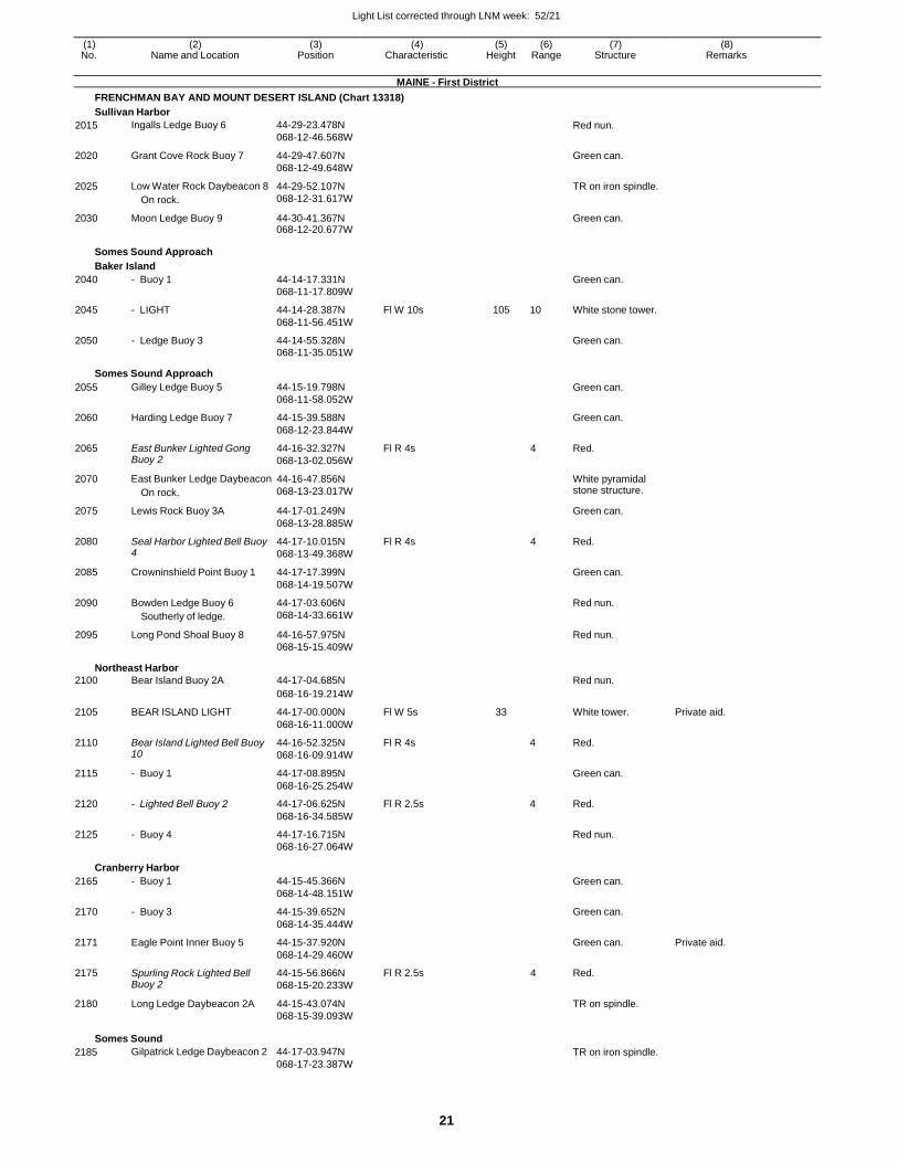
Light List corrected through LNM week: 52/21
21
(1) (2) (3) (4) (5) (6) (7) (8) No. Name and Location Position Characteristic Height Range Structure Remarks
MAINE - First District
FRENCHMAN BAY AND MOUNT DESERT ISLAND (Chart 13318)
Sullivan Harbor
2015 Ingalls Ledge Buoy 6 44-29-23.478N
068-12-46.568W Red nun.
2020 Grant Cove Rock Buoy 7 44-29-47.607N
068-12-49.648W
Green can.
2025 Low Water Rock Daybeacon 8
On rock.
44-29-52.107N
068-12-31.617W
TR on iron spindle.
2030 Moon Ledge Buoy 9 44-30-41.367N 068-12-20.677W
Green can.
Somes Sound Approach
Baker Island
2040 - Buoy 1 44-14-17.331N Green can.
068-11-17.809W
2045 - LIGHT 44-14-28.387N Fl W 10s 105 10 White stone tower.
068-11-56.451W
2050 - Ledge Buoy 3 44-14-55.328N Green can. 068-11-35.051W
Somes Sound Approach
2055 Gilley Ledge Buoy 5 44-15-19.798N Green can.
068-11-58.052W
2060 Harding Ledge Buoy 7 44-15-39.588N Green can.
068-12-23.844W
2065 East Bunker Lighted Gong Buoy 2
44-16-32.327N
068-13-02.056W
Fl R 4s 4 Red.
2070 East Bunker Ledge Daybeacon
On rock.
44-16-47.856N
068-13-23.017W
White pyramidal stone structure.
2075 Lewis Rock Buoy 3A 44-17-01.249N Green can.
068-13-28.885W
2080 Seal Harbor Lighted Bell Buoy 4
44-17-10.015N
068-13-49.368W
Fl R 4s 4 Red.
2085 Crowninshield Point Buoy 1 44-17-17.399N Green can.
068-14-19.507W
2090 Bowden Ledge Buoy 6 44-17-03.606N Red nun.
Southerly of ledge. 068-14-33.661W
2095 Long Pond Shoal Buoy 8 44-16-57.975N Red nun. 068-15-15.409W
Northeast Harbor
2100 Bear Island Buoy 2A 44-17-04.685N Red nun.
068-16-19.214W
2105 BEAR ISLAND LIGHT 44-17-00.000N Fl W 5s 33 White tower. Private aid.
068-16-11.000W
2110 Bear Island Lighted Bell Buoy 10
44-16-52.325N
068-16-09.914W
Fl R 4s 4 Red.
2115 - Buoy 1 44-17-08.895N Green can.
068-16-25.254W
2120 - Lighted Bell Buoy 2 44-17-06.625N Fl R 2.5s 4 Red.
068-16-34.585W
2125 - Buoy 4 44-17-16.715N Red nun.
068-16-27.064W
Cranberry Harbor
2165 - Buoy 1 44-15-45.366N Green can.
068-14-48.151W
2170 - Buoy 3 44-15-39.652N Green can.
068-14-35.444W
2171 Eagle Point Inner Buoy 5 44-15-37.920N Green can. Private aid.
068-14-29.460W
2175 Spurling Rock Lighted Bell Buoy 2
44-15-56.866N
068-15-20.233W
Fl R 2.5s 4 Red.
2180 Long Ledge Daybeacon 2A 44-15-43.074N TR on spindle.
068-15-39.093W
Somes Sound
2185 Gilpatrick Ledge Daybeacon 2 44-17-03.947N
068-17-23.387W
TR on iron spindle.
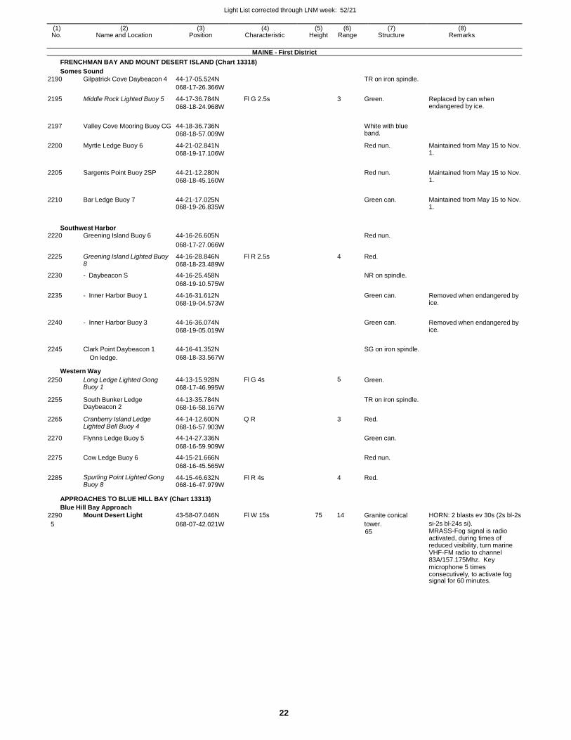
Light List corrected through LNM week: 52/21
22
(1) (2) (3) (4) (5) (6) (7) (8) No. Name and Location Position Characteristic Height Range Structure Remarks
MAINE - First District
FRENCHMAN BAY AND MOUNT DESERT ISLAND (Chart 13318)
Somes Sound
2190 Gilpatrick Cove Daybeacon 4 44-17-05.524N TR on iron spindle.
068-17-26.366W
2195 Middle Rock Lighted Buoy 5 44-17-36.784N
068-18-24.968W
Fl G 2.5s 3 Green. Replaced by can when endangered by ice.
2197 Valley Cove Mooring Buoy CG 44-18-36.736N
068-18-57.009W
White with blue band.
2200 Myrtle Ledge Buoy 6 44-21-02.841N
068-19-17.106W
Red nun. Maintained from May 15 to Nov. 1.
2205 Sargents Point Buoy 2SP 44-21-12.280N
068-18-45.160W
Red nun. Maintained from May 15 to Nov.
1.
2210 Bar Ledge Buoy 7 44-21-17.025N 068-19-26.835W
Green can. Maintained from May 15 to Nov.
1.
Southwest Harbor 2220 Greening Island Buoy 6 44-16-26.605N Red nun.
068-17-27.066W
2225 Greening Island Lighted Buoy 8
44-16-28.846N
068-18-23.489W
Fl R 2.5s 4 Red.
2230 - Daybeacon S 44-16-25.458N NR on spindle.
068-19-10.575W
2235 - Inner Harbor Buoy 1 44-16-31.612N
068-19-04.573W
Green can. Removed when endangered by ice.
2240 - Inner Harbor Buoy 3 44-16-36.074N
068-19-05.019W
Green can. Removed when endangered by
ice.
2245 Clark Point Daybeacon 1 44-16-41.352N
SG on iron spindle.
On ledge. 068-18-33.567W
Western Way
2250 Long Ledge Lighted Gong Buoy 1
44-13-15.928N
068-17-46.995W
Fl G 4s 5 Green.
2255 South Bunker Ledge Daybeacon 2
44-13-35.784N
068-16-58.167W
TR on iron spindle.
2265 Cranberry Island Ledge Lighted Bell Buoy 4
44-14-12.600N
068-16-57.903W
Q R 3 Red.
2270 Flynns Ledge Buoy 5 44-14-27.336N Green can.
068-16-59.909W
2275 Cow Ledge Buoy 6 44-15-21.666N Red nun.
068-16-45.565W
2285 Spurling Point Lighted Gong Buoy 8
44-15-46.632N 068-16-47.979W
Fl R 4s 4 Red.
APPROACHES TO BLUE HILL BAY (Chart 13313)
Blue Hill Bay Approach
2290 Mount Desert Light 43-58-07.046N Fl W 15s 75 14 Granite conical HORN: 2 blasts ev 30s (2s bl-2s
5 068-07-42.021W tower.
65
si-2s bl-24s si). MRASS-Fog signal is radio activated, during times of reduced visibility, turn marine VHF-FM radio to channel 83A/157.175Mhz. Key microphone 5 times consecutively, to activate fog signal for 60 minutes.
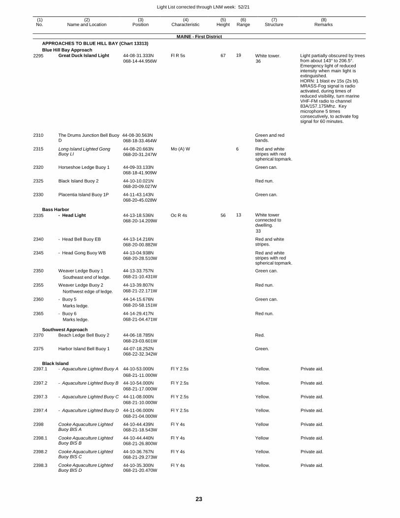
Light List corrected through LNM week: 52/21
23
(1) (2) (3) (4) (5) (6) (7) (8) No. Name and Location Position Characteristic Height Range Structure Remarks
MAINE - First District
APPROACHES TO BLUE HILL BAY (Chart 13313)
Blue Hill Bay Approach
2295 Great Duck Island Light 44-08-31.333N
068-14-44.956W
Fl R 5s 67 19 White tower.
36
Light partially obscured by trees from about 143° to 206.5°. Emergency light of reduced intensity when main light is extinguished. HORN: 1 blast ev 15s (2s bl). MRASS-Fog signal is radio activated, during times of reduced visibility, turn marine VHF-FM radio to channel 83A/157.175Mhz. Key microphone 5 times consecutively, to activate fog signal for 60 minutes.
2310 The Drums Junction Bell Buoy 44-08-30.563N Green and red
2315
2320
2325
2330
D
Long Island Lighted Gong Buoy LI
Horseshoe Ledge Buoy 1
Black Island Buoy 2
Placentia Island Buoy 1P
068-18-33.464W
44-08-20.663N
068-20-31.247W
44-09-33.133N
068-18-41.909W
44-10-10.021N
068-20-09.027W
44-11-43.143N
068-20-45.028W
Mo (A) W
bands.
6 Red and white stripes with red spherical topmark.
Green can.
Red nun.
Green can.
Bass Harbor
2335 - Head Light 44-13-18.536N
068-20-14.209W
Oc R 4s 56 13 White tower connected to dwelling.
33
2340 - Head Bell Buoy EB 44-13-14.216N
068-20-00.882W
Red and white stripes.
2345 - Head Gong Buoy WB 44-13-04.938N
068-20-28.510W
Red and white stripes with red spherical topmark.
2350 Weaver Ledge Buoy 1 44-13-33.757N Green can.
Southeast end of ledge. 068-21-10.431W
2355 Weaver Ledge Buoy 2 44-13-39.807N Red nun.
Northwest edge of ledge. 068-21-22.171W
2360 - Buoy 5 44-14-15.676N Green can.
Marks ledge. 068-20-58.151W
2365 - Buoy 6 44-14-29.417N Red nun. Marks ledge. 068-21-04.471W
Southwest Approach
2370 Beach Ledge Bell Buoy 2 44-06-18.785N Red.
068-23-03.601W
2375 Harbor Island Bell Buoy 1 44-07-18.252N Green. 068-22-32.342W
Black Island 2397.1 - Aquaculture Lighted Buoy A 44-10-53.000N Fl Y 2.5s Yellow. Private aid.
068-21-11.000W
2397.2 - Aquaculture Lighted Buoy B 44-10-54.000N Fl Y 2.5s Yellow. Private aid.
068-21-17.000W
2397.3 - Aquaculture Lighted Buoy C 44-11-08.000N Fl Y 2.5s Yellow. Private aid.
068-21-10.000W
2397.4 - Aquaculture Lighted Buoy D 44-11-06.000N Fl Y 2.5s Yellow. Private aid.
068-21-04.000W
2398 Cooke Aquaculture Lighted Buoy BIS A
44-10-44.439N
068-21-18.543W
Fl Y 4s Yellow Private aid.
2398.1 Cooke Aquaculture Lighted Buoy BIS B
44-10-44.440N
068-21-26.800W
Fl Y 4s Yellow Private aid.
2398.2 Cooke Aquaculture Lighted Buoy BIS C
44-10-36.767N
068-21-29.273W
Fl Y 4s Yellow. Private aid.
2398.3 Cooke Aquaculture Lighted Buoy BIS D
44-10-35.300N 068-21-20.470W
Fl Y 4s Yellow. Private aid.
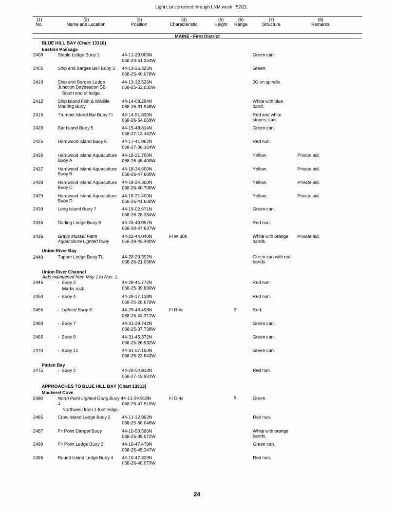
Light List corrected through LNM week: 52/21
24
(1) (2) (3) (4) (5) (6) (7) (8) No. Name and Location Position Characteristic Height Range Structure Remarks
MAINE - First District
BLUE HILL BAY (Chart 13316)
Eastern Passage
2400 Staple Ledge Buoy 1 44-11-20.009N Green can.
068-23-51.354W
2405 Ship and Barges Bell Buoy 3 44-13-36.326N Green.
068-25-40.078W
2410 Ship and Barges Ledge Junction Daybeacon SB
44-13-32.526N 068-25-52.035W
JG on spindle.
South end of ledge.
2412 Ship Island Fish & Wildlife Mooring Buoy
44-14-08.294N
068-26-31.948W
White with blue band.
2415 Trumpet Island Bar Buoy TI 44-14-51.830N
068-26-54.069W
Red and white stripes; can.
2420 Bar Island Buoy 5 44-15-48.614N Green can.
068-27-13.442W
2425 Hardwood Island Buoy 6 44-17-41.962N Red nun.
068-27-36.164W
2426 Hardwood Island Aquaculture Buoy A
44-18-21.700N
068-26-48.400W
Yellow. Private aid.
2427 Hardwood Island Aquaculture Buoy B
44-18-34.600N
068-26-47.600W
Yellow. Private aid.
2428 Hardwood Island Aquaculture Buoy C
44-18-34.300N
068-26-40.700W
Yellow. Private aid.
2429 Hardwood Island Aquaculture Buoy D
44-18-21.400N
068-26-41.600W
Yellow. Private aid.
2430 Long Island Buoy 7 44-19-02.671N Green can.
068-28-28.334W
2435 Darling Ledge Buoy 8 44-23-40.057N Red nun.
068-30-47.837W
2436 Grays Mussel Farm Aquaculture Lighted Buoy
44-22-44.040N 068-29-45.480W
Fl W 30s White with orange bands.
Private aid.
Union River Bay
2440 Tupper Ledge Buoy TL 44-28-20.392N 068-26-21.056W
Green can with red bands.
Union River Channel Aids maintained from May 1 to Nov. 1.
2445 - Buoy 2 44-28-41.772N Red nun.
Marks rock. 068-25-39.880W
2450 - Buoy 4 44-29-17.118N Red nun.
068-25-28.678W
2455 - Lighted Buoy 6 44-29-48.498N Fl R 4s 3 Red.
068-25-43.312W
2460 - Buoy 7 44-31-29.742N Green can.
068-25-37.738W
2465 - Buoy 9 44-31-45.372N Green can.
068-25-26.932W
2470 - Buoy 11 44-31-57.150N Green can. 068-25-23.842W
Patten Bay 2475 - Buoy 2 44-28-54.913N Red nun.
068-27-19.981W
APPROACHES TO BLUE HILL BAY (Chart 13313)
Mackerel Cove
2480 North Point Lighted Gong Buoy 44-11-34.918N Fl G 4s 5 Green. 1
Northwest from 1-foot ledge.
068-25-47.518W
2485 Crow Island Ledge Buoy 2 44-11-12.992N Red nun.
068-25-58.046W
2487 Fir Point Danger Buoy 44-10-50.596N
068-25-35.072W
White with orange bands.
2490 Fir Point Ledge Buoy 3 44-10-47.479N Green can.
068-25-45.347W
2495 Round Island Ledge Buoy 4 44-10-47.329N Red nun. 068-26-48.079W
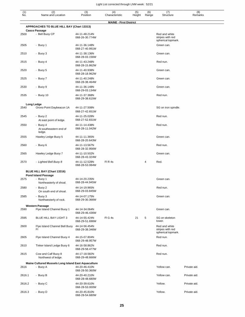
Light List corrected through LNM week: 52/21
25
(1) (2) (3) (4) (5) (6) (7) (8) No. Name and Location Position Characteristic Height Range Structure Remarks
MAINE - First District
APPROACHES TO BLUE HILL BAY (Chart 13313)
Casco Passage
2500 - Bell Buoy CP 44-11-48.214N
068-26-30.774W Red and white stripes with red spherical topmark.
2505 - Buoy 1 44-11-36.148N Green can.
068-27-40.991W
2510 - Buoy 3 44-11-38.136N Green can.
068-28-03.156W
2515 - Buoy 4 44-11-43.248N Red nun.
068-28-15.862W
2520 - Buoy 5 44-11-40.938N Green can.
068-28-18.962W
2525 - Buoy 7 44-11-40.248N Green can.
068-28-38.464W
2530 - Buoy 9 44-11-36.148N Green can.
068-29-03.134W
2535 - Buoy 10 44-11-37.368N Red nun. 068-29-38.615W
Long Ledge 2540 Orono Point Daybeacon 1A 44-11-27.508N SG on iron spindle.
068-27-42.651W
2545 - Buoy 2 44-11-25.028N Red nun.
At east point of ledge. 068-27-52.831W
2550 - Buoy 4 44-11-14.438N Red nun.
At southeastern end of ledge.
068-28-11.042W
2555 Hawley Ledge Buoy 5 44-11-11.365N Green can.
068-28-20.643W
2560 - Buoy 6 44-11-13.567N Red nun.
068-28-32.956W
2565 Hawley Ledge Buoy 7 44-11-10.502N Green can.
068-28-43.324W
2570 - Lighted Bell Buoy 8 44-11-12.528N Fl R 4s 4 Red. 068-28-53.084W
BLUE HILL BAY (Chart 13316)
Pond Island Passage
2575 - Buoy 1
Northeasterly of shoal.
44-14-20.235N
068-28-44.945W Green can.
2580 - Buoy 2
On south end of shoal.
44-14-19.965N
068-29-03.845W
Red nun.
2585 - Buoy 3
Northwesterly of rock.
44-14-07.175N
068-29-30.366W
Green can.
Western Passage
2590 Flye Island Channel Buoy 1 44-14-34.064N Green can.
068-29-46.436W
2595 BLUE HILL BAY LIGHT 3 44-14-55.424N
068-29-51.696W
Fl G 4s 21 5 SG on skeleton tower.
2600 Flye Island Channel Bell Buoy FI
44-14-56.454N
068-29-38.346W
Red and white stripes with red spherical topmark.
2605 Flye Island Channel Buoy 4 44-15-07.804N Red nun.
068-29-48.957W
2610 Tinker Island Ledge Buoy 6 44-16-58.862N Red nun.
068-29-58.477W
2615 Cow and Calf Buoy 8 44-17-18.582N Red nun. Northwest of ledge. 068-29-48.666W
Maine Cultured Mussels Long Island East Aquaculture
2616 - Buoy A 44-20-46.410N Yellow can. Private aid.
068-28-50.360W
2616.1 - Buoy B 44-20-40.210N Yellow can. Private aid.
068-28-48.680W
2616.2 - Buoy C 44-20-39.610N Yellow. Private aid.
068-28-53.000W
2616.3 - Buoy D 44-20-45.810N Yellow. Private aid. 068-28-54.680W
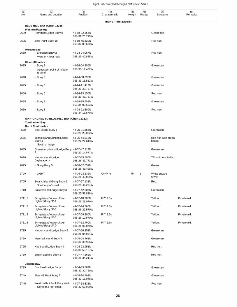
Light List corrected through LNM week: 52/21
26
(1) (2) (3) (4) (5) (6) (7) (8) No. Name and Location Position Characteristic Height Range Structure Remarks
MAINE - First District
BLUE HILL BAY (Chart 13316)
Western Passage
2620 Harriman Ledge Buoy 9 44-18-02.155N Green can.
068-31-20.719W
2625 Jims Point Buoy 10 44-19-45.839N Red nun. 068-32-08.690W
Morgan Bay 2630 - Entrance Buoy 2 44-24-04.067N Red nun.
West of 4-foot rock. 068-29-40.835W
Blue Hill Harbor 2635 - Buoy 1 44-24-04.806N Green can
At eastern point of middle ground.
068-33-17.452W
2640 - Buoy 3 44-24-08.635N Green can.
068-33-18.512W
2645 - Buoy 5 44-24-11.412N Green can.
068-33-39.727W
2650 - Buoy 6 44-24-13.150N Red nun.
068-33-43.767W
2655 - Buoy 7 44-24-25.503N Green can.
068-34-05.593W
2660 - Buoy 8 44-24-22.509N Red nun. 068-34-15.670W
APPROACHES TO BLUE HILL BAY (Chart 13313)
Toothacher Bay
Burnt Coat Harbor
2670
2675
Seal Ledge Buoy 1
Johns Island Sunken Ledge Buoy J
South of ledge.
44-05-01.565N
068-28-28.022W
44-05-44.515N
068-24-27.643W
Green can.
Red nun with green bands.
2685 Gooseberry Island Ledge Buoy 3
44-07-47.114N
068-27-14.577W
Green can.
2690 Harbor Island Ledge Daybeacon 4
44-07-55.590N
068-26-43.773W
TR on iron spindle.
2695 - Gong Buoy 5 44-08-02.052N Green.
068-26-43.428W
2700 - LIGHT 44-08-02.836N
068-26-49.809W
Oc W 4s 75 9 White square tower.
2705 Swans Island Gong Buoy 2 44-07-27.133N Red.
Southerly of shoal. 068-24-46.274W
2710 Baker Island Ledge Buoy 3 44-07-42.507N Green can.
068-25-52.828W
2711.1 Scrag Island Aquaculture Lighted Buoy SI-A
44-07-18.300N
068-26-28.070W
Fl Y 2.5s Yellow. Private aid.
2711.2 Scrag Island Aquaculture Lighted Buoy SI-B
44-07-14.700N
068-26-29.570W
Fl Y 2.5s Yellow. Private aid.
2711.3 Scrag Island Aquaculture Lighted Buoy SI-C
44-07-09.800N
068-26-10.570W
Fl Y 2.5s Yellow. Private aid.
2711.4 Scrag Island Aquaculture Lighted Buoy SI-D
44-07-12.790N
068-26-07.870W
Fl Y 2.5s Yellow. Private aid.
2715 Harbor Island Ledge Buoy 5 44-07-56.251N Green can.
068-26-04.964W
2720 Marshall Island Buoy 3 44-08-04.461N Green can.
068-30-39.926W
2725 Hat Island Ledge Buoy 4 44-08-23.951N Red nun.
068-30-53.157W
2730 Sheriff Ledges Buoy 2 44-07-47.262N Red nun.
068-28-34.211W
Jericho Bay
2735 Drunkard Ledge Buoy 1 44-04-39.884N
068-32-30.729W Green can.
2740 Blue Hill Rock Buoy 3 44-05-30.793N
068-32-11.088W
Green can.
2745 West Halibut Rock Buoy 4WH
North of 2 foot shoal.
44-07-58.331N
068-32-59.090W
Red nun.
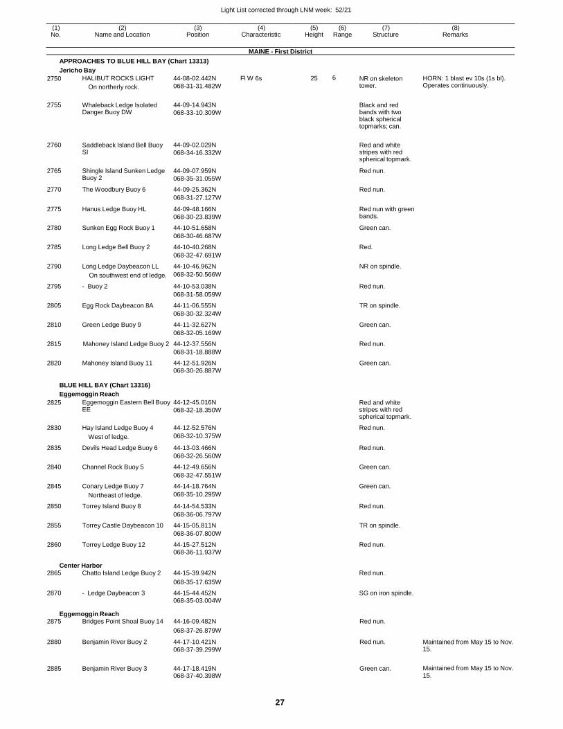
Light List corrected through LNM week: 52/21
27
(1) (2) (3) (4) (5) (6) (7) (8) No. Name and Location Position Characteristic Height Range Structure Remarks
MAINE - First District
APPROACHES TO BLUE HILL BAY (Chart 13313)
Jericho Bay
2750 HALIBUT ROCKS LIGHT
On northerly rock.
44-08-02.442N
068-31-31.482W
Fl W 6s 25 6 NR on skeleton tower.
HORN: 1 blast ev 10s (1s bl). Operates continuously.
2755 Whaleback Ledge Isolated Danger Buoy DW
44-09-14.943N
068-33-10.309W
Black and red bands with two black spherical topmarks; can.
2760 Saddleback Island Bell Buoy SI
44-09-02.029N
068-34-16.332W
Red and white stripes with red spherical topmark.
2765 Shingle Island Sunken Ledge Buoy 2
44-09-07.959N
068-35-31.055W
Red nun.
2770 The Woodbury Buoy 6 44-09-25.362N Red nun.
068-31-27.127W
2775 Hanus Ledge Buoy HL 44-09-48.166N
068-30-23.839W
Red nun with green bands.
2780 Sunken Egg Rock Buoy 1 44-10-51.658N Green can.
068-30-46.687W
2785 Long Ledge Bell Buoy 2 44-10-40.268N Red.
068-32-47.691W
2790 Long Ledge Daybeacon LL 44-10-46.962N NR on spindle.
On southwest end of ledge. 068-32-50.566W
2795 - Buoy 2 44-10-53.038N Red nun.
068-31-58.059W
2805 Egg Rock Daybeacon 8A 44-11-06.555N TR on spindle.
068-30-32.324W
2810 Green Ledge Buoy 9 44-11-32.627N Green can.
068-32-05.169W
2815 Mahoney Island Ledge Buoy 2 44-12-37.556N Red nun.
068-31-18.888W
2820 Mahoney Island Buoy 11 44-12-51.926N Green can.
068-30-26.887W
BLUE HILL BAY (Chart 13316)
Eggemoggin Reach
2825 Eggemoggin Eastern Bell Buoy EE
44-12-45.016N
068-32-18.350W Red and white stripes with red spherical topmark.
2830 Hay Island Ledge Buoy 4 44-12-52.576N Red nun.
West of ledge. 068-32-10.375W
2835 Devils Head Ledge Buoy 6 44-13-03.466N Red nun.
068-32-26.560W
2840 Channel Rock Buoy 5 44-12-49.656N Green can.
068-32-47.551W
2845 Conary Ledge Buoy 7 44-14-18.764N Green can.
Northeast of ledge. 068-35-10.295W
2850 Torrey Island Buoy 8 44-14-54.533N Red nun.
068-36-06.797W
2855 Torrey Castle Daybeacon 10 44-15-05.811N TR on spindle.
068-36-07.800W
2860 Torrey Ledge Buoy 12 44-15-27.512N Red nun. 068-36-11.937W
Center Harbor 2865 Chatto Island Ledge Buoy 2 44-15-39.942N Red nun.
068-35-17.635W
2870 - Ledge Daybeacon 3 44-15-44.452N SG on iron spindle. 068-35-03.004W
Eggemoggin Reach 2875 Bridges Point Shoal Buoy 14 44-16-09.482N Red nun.
068-37-26.879W
2880 Benjamin River Buoy 2 44-17-10.421N
068-37-39.299W
Red nun. Maintained from May 15 to Nov. 15.
2885 Benjamin River Buoy 3 44-17-18.419N 068-37-40.398W
Green can. Maintained from May 15 to Nov. 15.
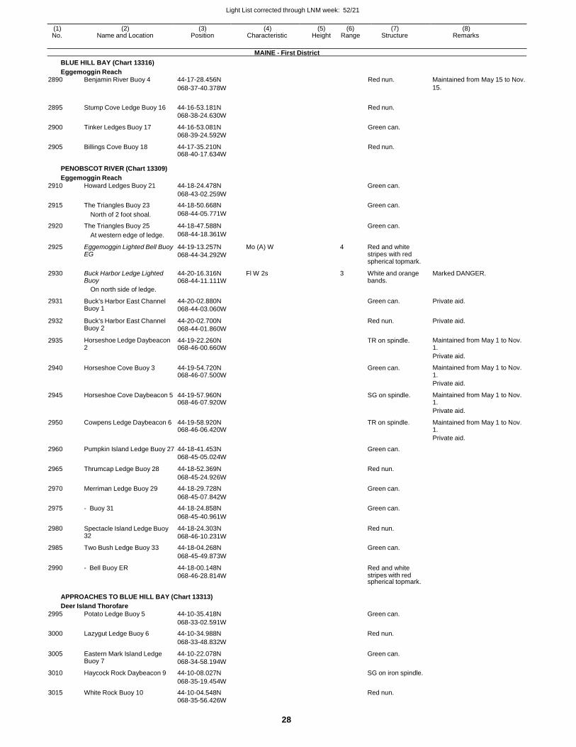
Light List corrected through LNM week: 52/21
28
(1) (2) (3) (4) (5) (6) (7) (8) No. Name and Location Position Characteristic Height Range Structure Remarks
MAINE - First District
BLUE HILL BAY (Chart 13316)
Eggemoggin Reach 2890 Benjamin River Buoy 4 44-17-28.456N Red nun. Maintained from May 15 to Nov.
068-37-40.378W 15.
2895 Stump Cove Ledge Buoy 16 44-16-53.181N
068-38-24.630W
Red nun.
2900 Tinker Ledges Buoy 17 44-16-53.081N
068-39-24.592W
Green can.
2905 Billings Cove Buoy 18 44-17-35.210N 068-40-17.634W
Red nun.
PENOBSCOT RIVER (Chart 13309)
Eggemoggin Reach
2910 Howard Ledges Buoy 21 44-18-24.478N Green can.
068-43-02.259W
2915 The Triangles Buoy 23 44-18-50.668N Green can.
North of 2 foot shoal. 068-44-05.771W
2920 The Triangles Buoy 25 44-18-47.588N Green can.
At western edge of ledge. 068-44-18.361W
2925 Eggemoggin Lighted Bell Buoy EG
44-19-13.257N
068-44-34.292W
Mo (A) W 4 Red and white stripes with red spherical topmark.
2930 Buck Harbor Ledge Lighted Buoy
44-20-16.316N 068-44-11.111W
Fl W 2s 3 White and orange bands.
Marked DANGER.
On north side of ledge.
2931 Buck's Harbor East Channel Buoy 1
44-20-02.880N
068-44-03.060W
Green can. Private aid.
2932 Buck's Harbor East Channel Buoy 2
44-20-02.700N
068-44-01.860W
Red nun. Private aid.
2935 Horseshoe Ledge Daybeacon 2
44-19-22.260N 068-46-00.660W
TR on spindle. Maintained from May 1 to Nov. 1.
Private aid.
2940 Horseshoe Cove Buoy 3 44-19-54.720N 068-46-07.500W
Green can. Maintained from May 1 to Nov. 1.
Private aid.
2945 Horseshoe Cove Daybeacon 5 44-19-57.960N 068-46-07.920W
SG on spindle. Maintained from May 1 to Nov. 1.
Private aid.
2950 Cowpens Ledge Daybeacon 6 44-19-58.920N 068-46-06.420W
TR on spindle. Maintained from May 1 to Nov. 1.
Private aid.
2960 Pumpkin Island Ledge Buoy 27 44-18-41.453N Green can.
068-45-05.024W
2965 Thrumcap Ledge Buoy 28 44-18-52.369N Red nun.
068-45-24.926W
2970 Merriman Ledge Buoy 29 44-18-29.728N Green can.
068-45-07.842W
2975 - Buoy 31 44-18-24.858N Green can.
068-45-40.961W
2980 Spectacle Island Ledge Buoy 32
44-18-24.303N
068-46-10.231W
Red nun.
2985 Two Bush Ledge Buoy 33 44-18-04.268N Green can.
068-45-49.873W
2990 - Bell Buoy ER 44-18-00.148N
068-46-28.814W
Red and white stripes with red spherical topmark.
APPROACHES TO BLUE HILL BAY (Chart 13313)
Deer Island Thorofare
2995 Potato Ledge Buoy 5 44-10-35.418N Green can.
068-33-02.591W
3000 Lazygut Ledge Buoy 6 44-10-34.988N Red nun.
068-33-48.832W
3005 Eastern Mark Island Ledge Buoy 7
44-10-22.078N
068-34-58.194W
Green can.
3010 Haycock Rock Daybeacon 9 44-10-08.027N SG on iron spindle.
068-35-19.454W
3015 White Rock Buoy 10 44-10-04.548N Red nun. 068-35-56.426W
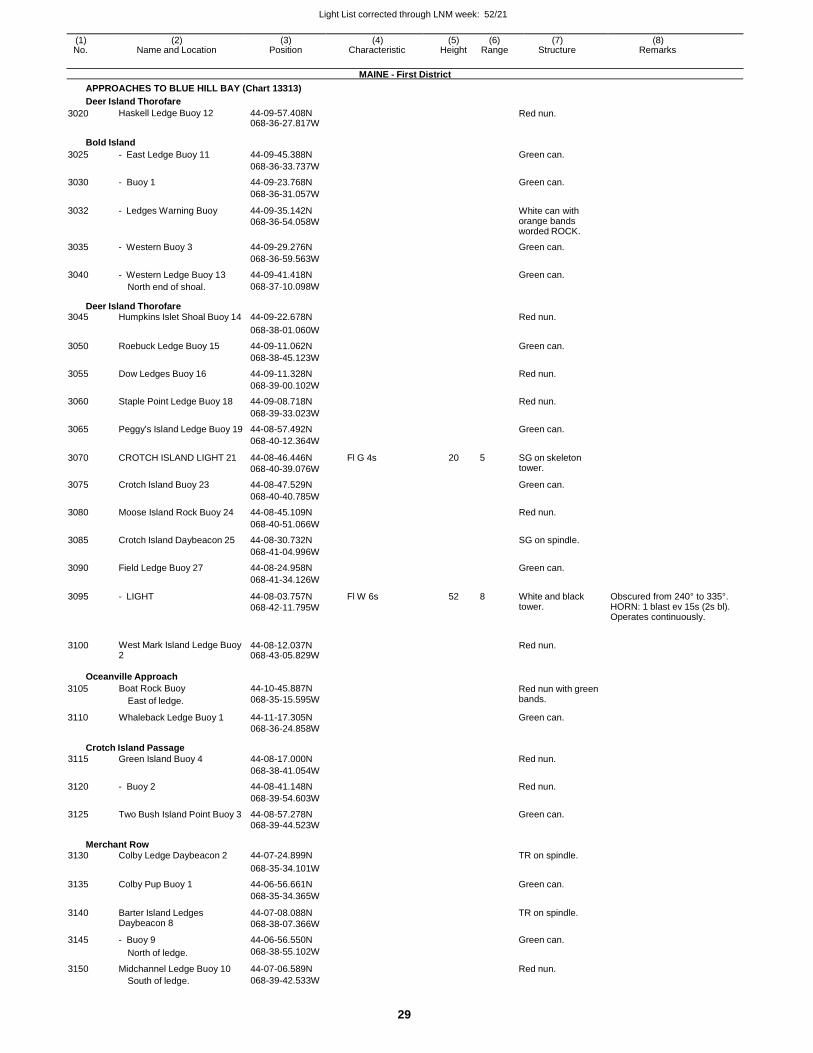
Light List corrected through LNM week: 52/21
29
(1) (2) (3) (4) (5) (6) (7) (8) No. Name and Location Position Characteristic Height Range Structure Remarks
MAINE - First District
APPROACHES TO BLUE HILL BAY (Chart 13313)
Deer Island Thorofare
3020 Haskell Ledge Buoy 12 44-09-57.408N 068-36-27.817W
Red nun.
Bold Island
3025 - East Ledge Buoy 11 44-09-45.388N Green can.
068-36-33.737W
3030 - Buoy 1 44-09-23.768N Green can.
068-36-31.057W
3032 - Ledges Warning Buoy 44-09-35.142N
068-36-54.058W
White can with orange bands worded ROCK.
3035 - Western Buoy 3 44-09-29.276N Green can.
068-36-59.563W
3040 - Western Ledge Buoy 13 44-09-41.418N Green can. North end of shoal. 068-37-10.098W
Deer Island Thorofare 3045 Humpkins Islet Shoal Buoy 14 44-09-22.678N Red nun.
068-38-01.060W
3050 Roebuck Ledge Buoy 15 44-09-11.062N Green can.
068-38-45.123W
3055 Dow Ledges Buoy 16 44-09-11.328N Red nun.
068-39-00.102W
3060 Staple Point Ledge Buoy 18 44-09-08.718N Red nun.
068-39-33.023W
3065 Peggy's Island Ledge Buoy 19 44-08-57.492N Green can.
068-40-12.364W
3070 CROTCH ISLAND LIGHT 21 44-08-46.446N
068-40-39.076W
Fl G 4s 20 5 SG on skeleton tower.
3075 Crotch Island Buoy 23 44-08-47.529N Green can.
068-40-40.785W
3080 Moose Island Rock Buoy 24 44-08-45.109N Red nun.
068-40-51.066W
3085 Crotch Island Daybeacon 25 44-08-30.732N SG on spindle.
068-41-04.996W
3090 Field Ledge Buoy 27 44-08-24.958N Green can.
068-41-34.126W
3095 - LIGHT 44-08-03.757N
068-42-11.795W
Fl W 6s 52 8 White and black tower.
Obscured from 240° to 335°. HORN: 1 blast ev 15s (2s bl). Operates continuously.
3100 West Mark Island Ledge Buoy 2
44-08-12.037N 068-43-05.829W
Red nun.
Oceanville Approach
3105
3110
Boat Rock Buoy
East of ledge.
Whaleback Ledge Buoy 1
44-10-45.887N
068-35-15.595W
44-11-17.305N
068-36-24.858W
Red nun with green bands.
Green can.
Crotch Island Passage
3115 Green Island Buoy 4 44-08-17.000N Red nun.
068-38-41.054W
3120 - Buoy 2 44-08-41.148N Red nun.
068-39-54.603W
3125 Two Bush Island Point Buoy 3 44-08-57.278N Green can. 068-39-44.523W
Merchant Row 3130 Colby Ledge Daybeacon 2 44-07-24.899N TR on spindle.
068-35-34.101W
3135 Colby Pup Buoy 1 44-06-56.661N Green can.
068-35-34.365W
3140 Barter Island Ledges Daybeacon 8
44-07-08.088N
068-38-07.366W
TR on spindle.
3145 - Buoy 9 44-06-56.550N Green can.
North of ledge. 068-38-55.102W
3150 Midchannel Ledge Buoy 10 44-07-06.589N Red nun. South of ledge. 068-39-42.533W
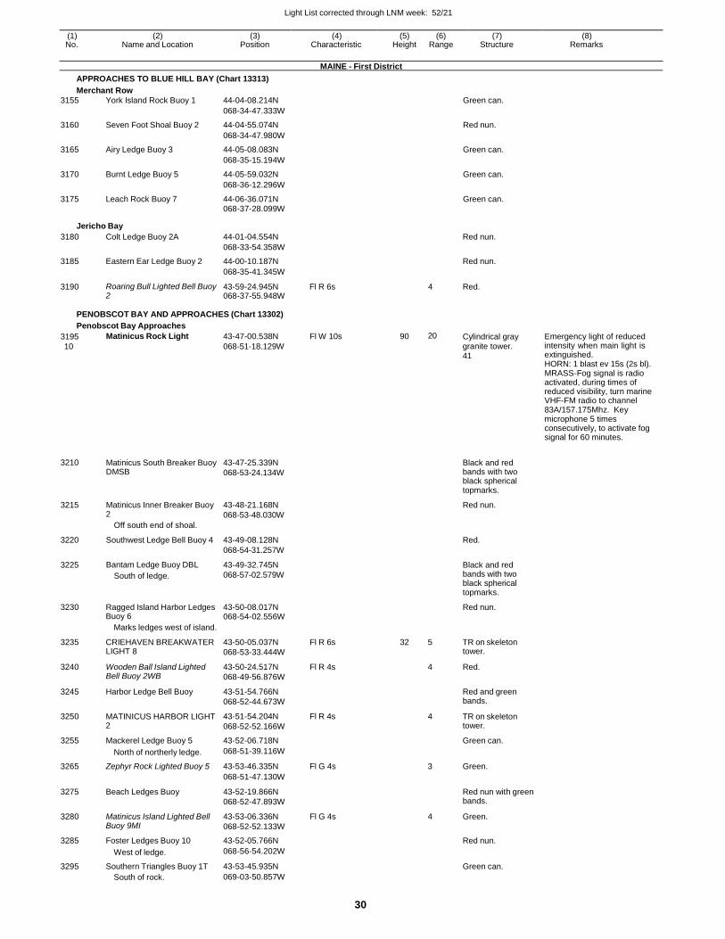
Light List corrected through LNM week: 52/21
30
(1) (2) (3) (4) (5) (6) (7) (8) No. Name and Location Position Characteristic Height Range Structure Remarks
MAINE - First District
APPROACHES TO BLUE HILL BAY (Chart 13313)
Merchant Row
3155 York Island Rock Buoy 1 44-04-08.214N Green can.
068-34-47.333W
3160 Seven Foot Shoal Buoy 2 44-04-55.074N Red nun.
068-34-47.980W
3165 Airy Ledge Buoy 3 44-05-08.083N Green can.
068-35-15.194W
3170 Burnt Ledge Buoy 5 44-05-59.032N Green can.
068-36-12.296W
3175 Leach Rock Buoy 7 44-06-36.071N Green can. 068-37-28.099W
Jericho Bay
3180 Colt Ledge Buoy 2A 44-01-04.554N Red nun.
068-33-54.358W
3185 Eastern Ear Ledge Buoy 2 44-00-10.187N Red nun.
068-35-41.345W
3190 Roaring Bull Lighted Bell Buoy 2
43-59-24.945N 068-37-55.948W
Fl R 6s 4 Red.
PENOBSCOT BAY AND APPROACHES (Chart 13302)
Penobscot Bay Approaches
3195
10
3210
3215
3220
3225
Matinicus Rock Light
Matinicus South Breaker Buoy DMSB
Matinicus Inner Breaker Buoy 2
Off south end of shoal.
Southwest Ledge Bell Buoy 4
Bantam Ledge Buoy DBL
South of ledge.
43-47-00.538N
068-51-18.129W
43-47-25.339N
068-53-24.134W
43-48-21.168N
068-53-48.030W
43-49-08.128N
068-54-31.257W
43-49-32.745N
068-57-02.579W
Fl W 10s 90 20 Cylindrical gray granite tower. 41
Black and red bands with two black spherical topmarks.
Red nun.
Red.
Black and red bands with two
Emergency light of reduced intensity when main light is extinguished. HORN: 1 blast ev 15s (2s bl). MRASS-Fog signal is radio activated, during times of reduced visibility, turn marine VHF-FM radio to channel 83A/157.175Mhz. Key microphone 5 times consecutively, to activate fog signal for 60 minutes.
black spherical topmarks.
3230 Ragged Island Harbor Ledges Buoy 6
43-50-08.017N 068-54-02.556W
Red nun.
Marks ledges west of island.
3235 CRIEHAVEN BREAKWATER LIGHT 8
43-50-05.037N
068-53-33.444W
Fl R 6s 32 5 TR on skeleton tower.
3240 Wooden Ball Island Lighted Bell Buoy 2WB
43-50-24.517N
068-49-56.876W
Fl R 4s 4 Red.
3245 Harbor Ledge Bell Buoy 43-51-54.766N
068-52-44.673W
Red and green bands.
3250 MATINICUS HARBOR LIGHT 2
43-51-54.204N
068-52-52.166W
Fl R 4s 4 TR on skeleton tower.
3255 Mackerel Ledge Buoy 5 43-52-06.718N Green can.
North of northerly ledge. 068-51-39.116W
3265 Zephyr Rock Lighted Buoy 5 43-53-46.335N Fl G 4s 3 Green.
068-51-47.130W
3275 Beach Ledges Buoy 43-52-19.866N
068-52-47.893W
Red nun with green bands.
3280 Matinicus Island Lighted Bell Buoy 9MI
43-53-06.336N
068-52-52.133W
Fl G 4s 4 Green.
3285 Foster Ledges Buoy 10 43-52-05.766N Red nun.
West of ledge. 068-56-54.202W
3295 Southern Triangles Buoy 1T 43-53-45.935N Green can. South of rock. 069-03-50.857W
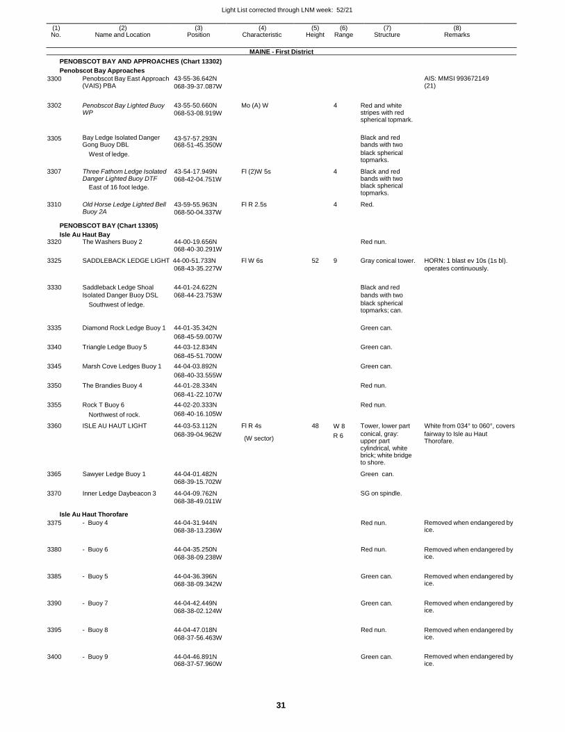
Light List corrected through LNM week: 52/21
31
(1) (2) (3) (4) (5) (6) (7) (8) No. Name and Location Position Characteristic Height Range Structure Remarks
MAINE - First District
PENOBSCOT BAY AND APPROACHES (Chart 13302)
Penobscot Bay Approaches
3300 Penobscot Bay East Approach (VAIS) PBA
43-55-36.642N
068-39-37.087W
AIS: MMSI 993672149 (21)
3302 Penobscot Bay Lighted Buoy WP
43-55-50.660N
068-53-08.919W
Mo (A) W 4 Red and white stripes with red spherical topmark.
3305 Bay Ledge Isolated Danger Gong Buoy DBL
43-57-57.293N 068-51-45.350W
Black and red bands with two
3307
3310
West of ledge.
Three Fathom Ledge Isolated Danger Lighted Buoy DTF
East of 16 foot ledge.
Old Horse Ledge Lighted Bell Buoy 2A
43-54-17.949N
068-42-04.751W
43-59-55.963N
068-50-04.337W
Fl (2)W 5s
Fl R 2.5s
black spherical topmarks.
4 Black and red bands with two black spherical topmarks.
4 Red.
PENOBSCOT BAY (Chart 13305)
Isle Au Haut Bay 3320 The Washers Buoy 2 44-00-19.656N Red nun.
068-40-30.291W
3325 SADDLEBACK LEDGE LIGHT 44-00-51.733N Fl W 6s 52 9 Gray conical tower. HORN: 1 blast ev 10s (1s bl). 068-43-35.227W operates continuously.
3330
Saddleback Ledge Shoal
44-01-24.622N
Black and red
Isolated Danger Buoy DSL 068-44-23.753W bands with two
Southwest of ledge. black spherical topmarks; can.
3335 Diamond Rock Ledge Buoy 1 44-01-35.342N
Green can.
068-45-59.007W
3340 Triangle Ledge Buoy 5 44-03-12.834N Green can.
068-45-51.700W
3345 Marsh Cove Ledges Buoy 1 44-04-03.892N Green can.
068-40-33.555W
3350 The Brandies Buoy 4 44-01-28.334N Red nun.
068-41-22.107W
3355 Rock T Buoy 6 44-02-20.333N Red nun.
Northwest of rock. 068-40-16.105W
3360 ISLE AU HAUT LIGHT 44-03-53.112N Fl R 4s 48 W 8 Tower, lower part White from 034° to 060°, covers
3365
3370
Sawyer Ledge Buoy 1
Inner Ledge Daybeacon 3
068-39-04.962W
44-04-01.482N
068-39-15.702W
44-04-09.762N
068-38-49.011W
(W sector) R 6 conical, gray: upper part cylindrical, white brick; white bridge to shore.
Green can.
SG on spindle.
fairway to Isle au Haut Thorofare.
Isle Au Haut Thorofare
3375 - Buoy 4 44-04-31.944N
068-38-13.236W Red nun. Removed when endangered by
ice.
3380 - Buoy 6 44-04-35.250N
068-38-09.238W
Red nun. Removed when endangered by ice.
3385 - Buoy 5 44-04-36.396N
068-38-09.342W
Green can. Removed when endangered by ice.
3390 - Buoy 7 44-04-42.449N
068-38-02.124W
Green can. Removed when endangered by ice.
3395 - Buoy 8 44-04-47.018N
068-37-56.463W
Red nun. Removed when endangered by ice.
3400 - Buoy 9 44-04-46.891N 068-37-57.960W
Green can. Removed when endangered by ice.
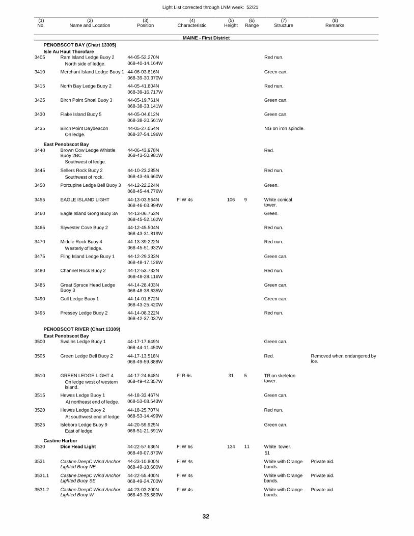
Light List corrected through LNM week: 52/21
32
(1) (2) (3) (4) (5) (6) (7) (8) No. Name and Location Position Characteristic Height Range Structure Remarks
MAINE - First District
PENOBSCOT BAY (Chart 13305)
Isle Au Haut Thorofare
3405 Ram Island Ledge Buoy 2 44-05-52.270N Red nun.
North side of ledge. 068-40-14.164W
3410 Merchant Island Ledge Buoy 1 44-06-03.816N Green can.
068-39-30.370W
3415 North Bay Ledge Buoy 2 44-05-41.804N Red nun.
068-39-16.717W
3425 Birch Point Shoal Buoy 3 44-05-19.761N Green can.
068-38-33.141W
3430 Flake Island Buoy 5 44-05-04.612N Green can.
068-38-20.561W
3435 Birch Point Daybeacon 44-05-27.054N NG on iron spindle. On ledge. 068-37-54.196W
East Penobscot Bay
3440 Brown Cow Ledge Whistle Buoy 2BC
44-06-43.978N 068-43-50.981W
Red.
Southwest of ledge.
3445 Sellers Rock Buoy 2 44-10-23.285N
Red nun.
Southwest of rock. 068-43-46.660W
3450 Porcupine Ledge Bell Buoy 3 44-12-22.224N Green.
068-45-44.776W
3455 EAGLE ISLAND LIGHT 44-13-03.564N
068-46-03.994W
Fl W 4s 106 9 White conical tower.
3460 Eagle Island Gong Buoy 3A 44-13-06.753N Green.
068-45-52.162W
3465 Slyvester Cove Buoy 2 44-12-45.504N Red nun.
068-43-31.819W
3470 Middle Rock Buoy 4 44-13-39.222N Red nun.
Westerly of ledge. 068-45-51.932W
3475 Fling Island Ledge Buoy 1 44-12-29.333N Green can.
068-48-17.126W
3480 Channel Rock Buoy 2 44-12-53.732N Red nun.
068-48-28.116W
3485 Great Spruce Head Ledge Buoy 3
44-14-28.403N
068-48-38.635W
Green can.
3490 Gull Ledge Buoy 1 44-14-01.872N Green can.
068-43-25.420W
3495 Pressey Ledge Buoy 2 44-14-08.322N Red nun. 068-42-37.037W
PENOBSCOT RIVER (Chart 13309)
East Penobscot Bay
3500 Swains Ledge Buoy 1 44-17-17.649N Green can.
068-44-11.450W
3505 Green Ledge Bell Buoy 2 44-17-13.518N
068-49-59.888W
Red. Removed when endangered by ice.
3510 GREEN LEDGE LIGHT 4
On ledge west of western island.
44-17-24.648N
068-49-42.357W
Fl R 6s 31 5 TR on skeleton tower.
3515 Hewes Ledge Buoy 1 44-18-33.467N Green can.
At northeast end of ledge. 068-53-08.543W
3520 Hewes Ledge Buoy 2 44-18-25.707N Red nun.
At southwest end of ledge 068-53-14.499W
3525 Isleboro Ledge Buoy 9 44-20-59.925N Green can.
East of ledge. 068-51-21.591W
Castine Harbor
3530 Dice Head Light 44-22-57.636N Fl W 6s 134 11 White tower.
068-49-07.870W 51
3531 Castine DeepC Wind Anchor Lighted Buoy NE
44-23-10.800N
068-49-18.600W
Fl W 4s White with Orange bands.
Private aid.
3531.1 Castine DeepC Wind Anchor Lighted Buoy SE
44-22-55.400N
068-49-24.700W
Fl W 4s White with Orange bands.
Private aid.
3531.2 Castine DeepC Wind Anchor Lighted Buoy W
44-23-03.200N 068-49-35.580W
Fl W 4s White with Orange bands.
Private aid.
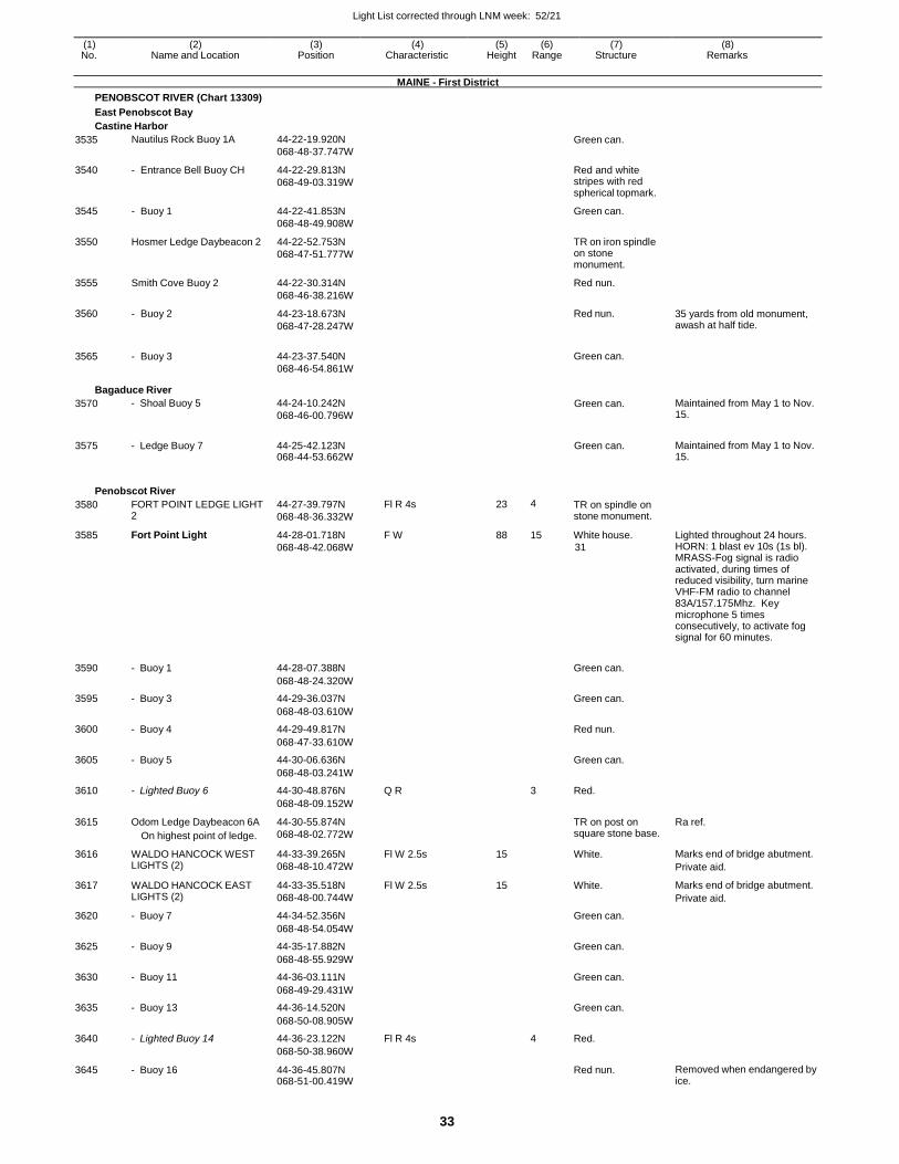
Light List corrected through LNM week: 52/21
33
(1) (2) (3) (4) (5) (6) (7) (8) No. Name and Location Position Characteristic Height Range Structure Remarks
MAINE - First District
PENOBSCOT RIVER (Chart 13309)
East Penobscot Bay
Castine Harbor
3535
3540
3545
3550
3555
3560
3565
Nautilus Rock Buoy 1A
- Entrance Bell Buoy CH
- Buoy 1
Hosmer Ledge Daybeacon 2
Smith Cove Buoy 2
- Buoy 2
- Buoy 3
44-22-19.920N
068-48-37.747W
44-22-29.813N
068-49-03.319W
44-22-41.853N
068-48-49.908W
44-22-52.753N
068-47-51.777W
44-22-30.314N
068-46-38.216W
44-23-18.673N
068-47-28.247W
44-23-37.540N
068-46-54.861W
Green can.
Red and white stripes with red spherical topmark.
Green can.
TR on iron spindle on stone monument.
Red nun.
Red nun.
Green can.
35 yards from old monument, awash at half tide.
Bagaduce River
3570 - Shoal Buoy 5 44-24-10.242N
068-46-00.796W Green can. Maintained from May 1 to Nov.
15.
3575 - Ledge Buoy 7 44-25-42.123N 068-44-53.662W
Green can. Maintained from May 1 to Nov. 15.
Penobscot River
3580 FORT POINT LEDGE LIGHT 2
44-27-39.797N
068-48-36.332W
Fl R 4s 23 4 TR on spindle on stone monument.
3585 Fort Point Light 44-28-01.718N
068-48-42.068W
F W 88 15 White house.
31
Lighted throughout 24 hours. HORN: 1 blast ev 10s (1s bl). MRASS-Fog signal is radio activated, during times of reduced visibility, turn marine VHF-FM radio to channel 83A/157.175Mhz. Key microphone 5 times consecutively, to activate fog signal for 60 minutes.
3590 - Buoy 1 44-28-07.388N
Green can.
068-48-24.320W
3595 - Buoy 3 44-29-36.037N Green can.
068-48-03.610W
3600 - Buoy 4 44-29-49.817N Red nun.
068-47-33.610W
3605 - Buoy 5 44-30-06.636N Green can.
068-48-03.241W
3610 - Lighted Buoy 6 44-30-48.876N Q R 3 Red.
068-48-09.152W
3615 Odom Ledge Daybeacon 6A
On highest point of ledge.
44-30-55.874N
068-48-02.772W
TR on post on square stone base.
Ra ref.
3616 WALDO HANCOCK WEST LIGHTS (2)
44-33-39.265N
068-48-10.472W
Fl W 2.5s 15 White. Marks end of bridge abutment.
Private aid.
3617 WALDO HANCOCK EAST LIGHTS (2)
44-33-35.518N
068-48-00.744W
Fl W 2.5s 15 White. Marks end of bridge abutment.
Private aid.
3620 - Buoy 7 44-34-52.356N Green can.
068-48-54.054W
3625 - Buoy 9 44-35-17.882N Green can.
068-48-55.929W
3630 - Buoy 11 44-36-03.111N Green can.
068-49-29.431W
3635 - Buoy 13 44-36-14.520N Green can.
068-50-08.905W
3640 - Lighted Buoy 14 44-36-23.122N Fl R 4s 4 Red.
068-50-38.960W
3645 - Buoy 16 44-36-45.807N 068-51-00.419W
Red nun. Removed when endangered by ice.
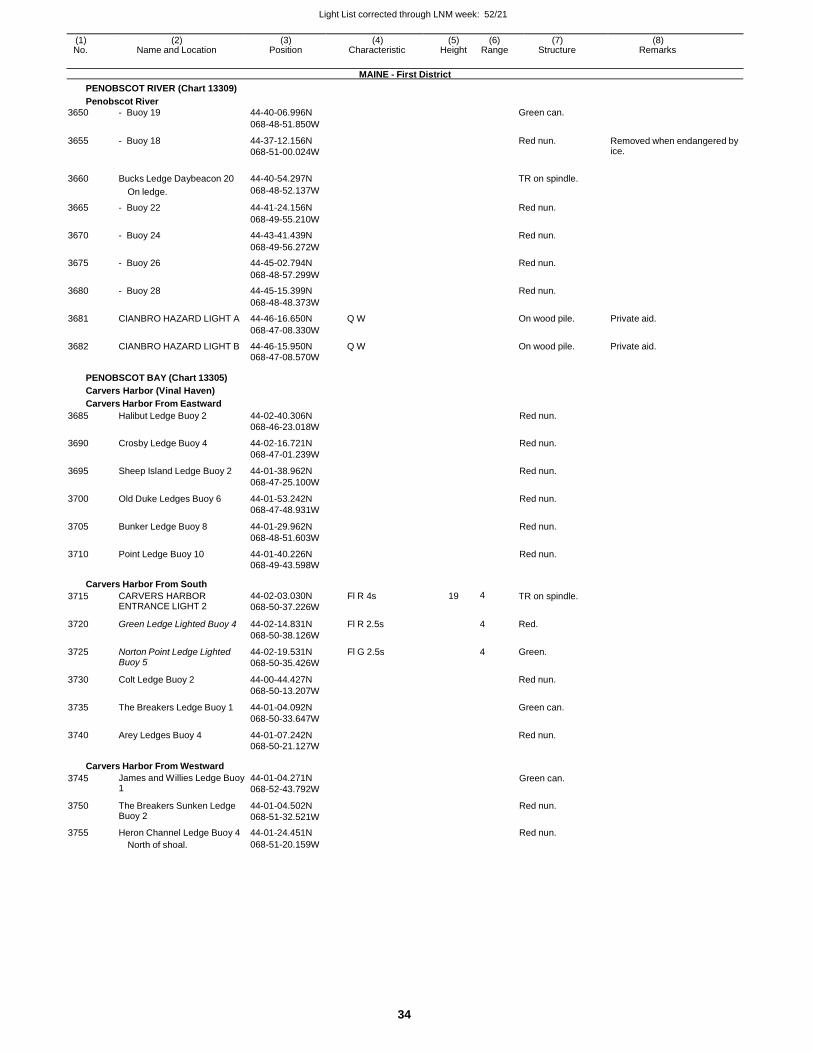
Light List corrected through LNM week: 52/21
34
(1) (2) (3) (4) (5) (6) (7) (8) No. Name and Location Position Characteristic Height Range Structure Remarks
MAINE - First District
PENOBSCOT RIVER (Chart 13309)
Penobscot River
3650 - Buoy 19 44-40-06.996N Green can.
068-48-51.850W
3655 - Buoy 18 44-37-12.156N
068-51-00.024W
Red nun. Removed when endangered by ice.
3660 Bucks Ledge Daybeacon 20 44-40-54.297N
TR on spindle.
On ledge. 068-48-52.137W
3665 - Buoy 22 44-41-24.156N Red nun.
068-49-55.210W
3670 - Buoy 24 44-43-41.439N Red nun.
068-49-56.272W
3675 - Buoy 26 44-45-02.794N Red nun.
068-48-57.299W
3680 - Buoy 28 44-45-15.399N Red nun.
068-48-48.373W
3681 CIANBRO HAZARD LIGHT A 44-46-16.650N Q W On wood pile. Private aid.
068-47-08.330W
3682 CIANBRO HAZARD LIGHT B 44-46-15.950N Q W On wood pile. Private aid. 068-47-08.570W
PENOBSCOT BAY (Chart 13305)
Carvers Harbor (Vinal Haven)
Carvers Harbor From Eastward
3685 Halibut Ledge Buoy 2 44-02-40.306N Red nun.
068-46-23.018W
3690 Crosby Ledge Buoy 4 44-02-16.721N Red nun.
068-47-01.239W
3695 Sheep Island Ledge Buoy 2 44-01-38.962N Red nun.
068-47-25.100W
3700 Old Duke Ledges Buoy 6 44-01-53.242N Red nun.
068-47-48.931W
3705 Bunker Ledge Buoy 8 44-01-29.962N Red nun.
068-48-51.603W
3710 Point Ledge Buoy 10 44-01-40.226N Red nun. 068-49-43.598W
Carvers Harbor From South
3715 CARVERS HARBOR ENTRANCE LIGHT 2
44-02-03.030N
068-50-37.226W
Fl R 4s 19 4 TR on spindle.
3720 Green Ledge Lighted Buoy 4 44-02-14.831N Fl R 2.5s 4 Red.
068-50-38.126W
3725 Norton Point Ledge Lighted Buoy 5
44-02-19.531N
068-50-35.426W
Fl G 2.5s 4 Green.
3730 Colt Ledge Buoy 2 44-00-44.427N Red nun.
068-50-13.207W
3735 The Breakers Ledge Buoy 1 44-01-04.092N Green can.
068-50-33.647W
3740 Arey Ledges Buoy 4 44-01-07.242N Red nun. 068-50-21.127W
Carvers Harbor From Westward
3745 James and Willies Ledge Buoy 1
44-01-04.271N
068-52-43.792W Green can.
3750 The Breakers Sunken Ledge Buoy 2
44-01-04.502N
068-51-32.521W
Red nun.
3755 Heron Channel Ledge Buoy 4 44-01-24.451N Red nun. North of shoal. 068-51-20.159W
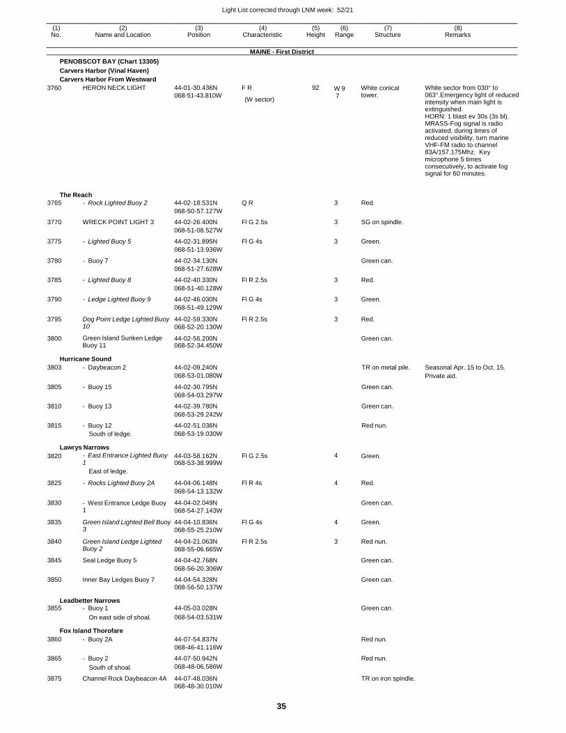
Light List corrected through LNM week: 52/21
35
(1) (2) (3) (4) (5) (6) (7) (8) No. Name and Location Position Characteristic Height Range Structure Remarks
MAINE - First District
PENOBSCOT BAY (Chart 13305)
Carvers Harbor (Vinal Haven)
Carvers Harbor From Westward
3760 HERON NECK LIGHT 44-01-30.436N
068-51-43.810W
F R
(W sector)
92 W 9 7
White conical tower.
White sector from 030° to 063°.Emergency light of reduced intensity when main light is extinguished. HORN: 1 blast ev 30s (3s bl). MRASS-Fog signal is radio activated, during times of reduced visibility, turn marine VHF-FM radio to channel 83A/157.175Mhz. Key microphone 5 times consecutively, to activate fog signal for 60 minutes.
The Reach
3765 - Rock Lighted Buoy 2 44-02-18.531N Q R 3 Red.
068-50-57.127W
3770 WRECK POINT LIGHT 3 44-02-26.400N Fl G 2.5s 3 SG on spindle.
068-51-08.527W
3775 - Lighted Buoy 5 44-02-31.895N Fl G 4s 3 Green.
068-51-13.936W
3780 - Buoy 7 44-02-34.130N Green can.
068-51-27.628W
3785 - Lighted Buoy 8 44-02-40.330N Fl R 2.5s 3 Red.
068-51-40.128W
3790 - Ledge Lighted Buoy 9 44-02-46.030N Fl G 4s 3 Green.
068-51-49.129W
3795 Dog Point Ledge Lighted Buoy 10
44-02-59.330N
068-52-20.130W
Fl R 2.5s 3 Red.
3800 Green Island Sunken Ledge Buoy 11
44-02-56.200N 068-52-34.450W
Green can.
Hurricane Sound
3803 - Daybeacon 2 44-02-09.240N TR on metal pile. Seasonal Apr. 15 to Oct. 15.
068-53-01.080W Private aid.
3805 - Buoy 15 44-02-30.795N Green can.
068-54-03.297W
3810 - Buoy 13 44-02-39.780N Green can.
068-53-29.242W
3815 - Buoy 12 44-02-51.036N Red nun.
South of ledge. 068-53-19.030W
Lawrys Narrows
3820 - East Entrance Lighted Buoy 1
44-03-58.162N 068-53-38.999W
Fl G 2.5s 4 Green.
East of ledge.
3825 - Rocks Lighted Buoy 2A 44-04-06.148N Fl R 4s 4 Red.
068-54-13.132W
3830 - West Entrance Ledge Buoy 1
44-04-02.049N
068-54-27.143W
Green can.
3835 Green Island Lighted Bell Buoy 3
44-04-10.836N
068-55-25.210W
Fl G 4s 4 Green.
3840 Green Island Ledge Lighted Buoy 2
44-04-21.063N
068-55-06.665W
Fl R 2.5s 3 Red nun.
3845 Seal Ledge Buoy 5 44-04-42.768N Green can.
068-56-20.306W
3850 Inner Bay Ledges Buoy 7 44-04-54.328N Green can. 068-56-50.137W
Leadbetter Narrows 3855 - Buoy 1 44-05-03.028N Green can.
On east side of shoal. 068-54-03.531W
Fox Island Thorofare
3860 - Buoy 2A 44-07-54.837N Red nun.
068-46-41.116W
3865 - Buoy 2 44-07-50.942N Red nun.
South of shoal. 068-48-06.586W
3875 Channel Rock Daybeacon 4A 44-07-48.036N TR on iron spindle. 068-48-30.010W
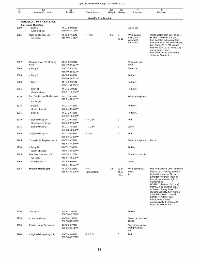
Light List corrected through LNM week: 52/21
36
(1) (2) (3) (4) (5) (6) (7) (8) No. Name and Location Position Characteristic Height Range Structure Remarks
MAINE - First District
PENOBSCOT BAY (Chart 13305)
Fox Island Thorofare
3880
3885
- Buoy 5
East of shoal.
GOOSE ROCKS LIGHT
On ledge.
44-07-52.937N
068-49-27.155W
44-08-07.536N
068-49-50.410W
Fl R 6s
51 7
W 12
Green can.
White conical tower, black cylindrical foundation.
White sector from 301° to 304°. HORN: 1 blast ev 10s (1s bl). Fog signal is radio activated, during times of reduced visibility, turn marine VHF-FM radio to channel 83A/157.175Mhz. Key microphone 5 times consecutively, to activate fog signal for 60 minutes.
3887 Carvers Cove CG Mooring
Buoy 44-07-27.027N
068-49-37.857W
White with blue band.
3890 - Buoy 7 44-07-59.306N Green can.
068-50-26.692W
3895 - Buoy 6 44-08-03.446N Red nun.
068-50-43.602W
3900 - Buoy 8 44-07-52.026N Red nun.
068-51-09.334W
3905 - Buoy 10 44-07-35.046N Red nun.
East of shoal. 068-51-19.584W
3910 Iron Point Ledge Daybeacon 11
44-07-29.366N 068-51-21.594W
SG on iron spindle.
On ledge.
3915 - Buoy 12 44-07-26.436N
Red nun.
South of shoal. 068-51-37.330W
3925 - Buoy 14 44-07-28.706N Red nun.
068-52-11.906W
3930 - Lighted Buoy 16 44-07-29.496N Fl R 2.5s 3 Red.
Southwest of ledge 068-52-27.430W
3935 - Lighted Buoy 17 44-07-34.503N Fl G 2.5s 3 Green.
068-53-11.425W
3940 - Lighted Buoy 18 44-07-30.886N Fl R 4s 3 Red.
068-53-59.489W
3945 Young Point Daybeacon 19 44-07-26.746N SG on iron spindle. Ra ref.
068-53-54.249W
3950 - Buoy 20 44-07-17.346N Red nun.
South of shoal. 068-54-29.160W
3955 Fox Ears Daybeacon 22 44-07-02.106N TR on iron spindle.
On ledge. 068-54-46.206W
3960 - Gong Buoy 23 44-06-49.926N Green.
068-54-38.601W
3965 Browns Head Light 44-06-42.388N F W 39 W 14 White cylindrical Red from 001° to 050°, and from
068-54-34.196W (2R sectors) R 11 tower. 061° to 091°, fairway between.
R 11 24 Lighted throughout 24 hours. Emergency light of reduced intensity when main light is extinguished. HORN: 1 blast ev 10s (1s bl). MRASS-Fog signal is radio activated, during times of reduced visibility, turn marine VHF-FM radio to channel 83A/157.175Mhz. Key microphone 5 times consecutively, to activate fog signal for 60 minutes.
3970
3975
3985
3990
- Buoy 24
- Junction Buoy
Fiddler Ledge Daybeacon
- Lighted Gong Buoy 26
44-06-31.007N
068-55-45.273W
44-06-02.516N
068-55-39.593W
44-06-05.772N
068-56-22.114W
44-05-48.497N
068-56-48.786W
Fl R 2.5s
Red nun.
Green can with red bands.
Gray stone square shaft pyramidal top.
3 Red.
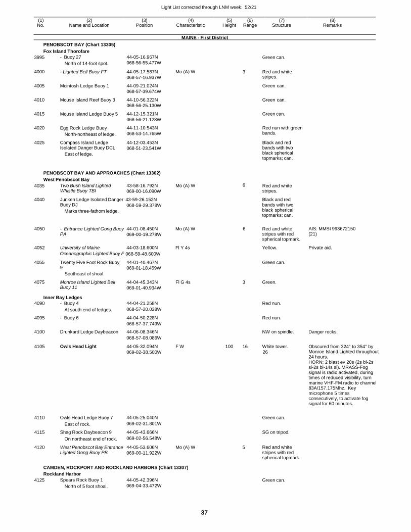
Light List corrected through LNM week: 52/21
37
(1) (2) (3) (4) (5) (6) (7) (8) No. Name and Location Position Characteristic Height Range Structure Remarks
MAINE - First District
PENOBSCOT BAY (Chart 13305)
Fox Island Thorofare
3995
4000
4005
4010
4015
4020
4025
- Buoy 27
North of 14-foot spot.
- Lighted Bell Buoy FT
Mcintosh Ledge Buoy 1
Mouse Island Reef Buoy 3
Mouse Island Ledge Buoy 5
Egg Rock Ledge Buoy
North-northeast of ledge.
Compass Island Ledge Isolated Danger Buoy DCL
East of ledge.
44-05-16.967N
068-56-55.477W
44-05-17.587N
068-57-16.937W
44-09-21.024N
068-57-39.674W
44-10-56.322N
068-56-25.130W
44-12-15.321N
068-56-21.128W
44-11-10.543N
068-53-14.765W
44-12-03.453N
068-51-23.541W
Mo (A) W
Green can.
3 Red and white stripes.
Green can.
Green can.
Green can.
Red nun with green bands.
Black and red bands with two black spherical topmarks; can.
PENOBSCOT BAY AND APPROACHES (Chart 13302)
West Penobscot Bay
4035 Two Bush Island Lighted Whistle Buoy TBI
43-58-16.792N
069-00-16.090W
Mo (A) W 6 Red and white stripes.
4040 Junken Ledge Isolated Danger 43-59-26.152N Black and red Buoy DJ
Marks three-fathom ledge.
068-59-29.378W bands with two black spherical topmarks; can.
4050 - Entrance Lighted Gong Buoy
PA 44-01-08.450N
069-00-19.278W
Mo (A) W 6 Red and white stripes with red spherical topmark.
AIS: MMSI 993672150 (21)
4052 University of Maine 44-03-18.600N Fl Y 4s Yellow. Private aid.
Oceanographic Lighted Buoy F 068-59-48.600W
4055
4075
Twenty Five Foot Rock Buoy 9
Southeast of shoal.
Monroe Island Lighted Bell Buoy 11
44-01-40.467N
069-01-18.459W
44-04-45.343N
069-01-40.934W
Fl G 4s
Green can.
3 Green.
Inner Bay Ledges
4090 - Buoy 4 44-04-21.258N Red nun.
At south end of ledges. 068-57-20.038W
4095 - Buoy 6 44-04-50.228N Red nun.
068-57-37.749W
4100 Drunkard Ledge Daybeacon 44-06-08.346N NW on spindle. Danger rocks.
068-57-08.086W
4105 Owls Head Light 44-05-32.094N
069-02-38.500W
F W 100 16 White tower.
26 Obscured from 324° to 354° by Monroe Island.Lighted throughout 24 hours. HORN: 2 blast ev 20s (2s bl-2s si-2s bl-14s si). MRASS-Fog signal is radio activated, during times of reduced visibility, turn marine VHF-FM radio to channel 83A/157.175Mhz. Key microphone 5 times consecutively, to activate fog signal for 60 minutes.
4110 Owls Head Ledge Buoy 7 44-05-25.040N
Green can.
East of rock. 069-02-31.801W
4115 Shag Rock Daybeacon 9 44-05-43.666N SG on tripod.
On northeast end of rock. 069-02-56.548W
4120 West Penobscot Bay Entrance Lighted Gong Buoy PB
44-05-53.606N
069-00-11.922W
Mo (A) W 5 Red and white stripes with red spherical topmark.
CAMDEN, ROCKPORT AND ROCKLAND HARBORS (Chart 13307)
Rockland Harbor
4125 Spears Rock Buoy 1
North of 5 foot shoal.
44-05-42.396N
069-04-33.472W
Green can.
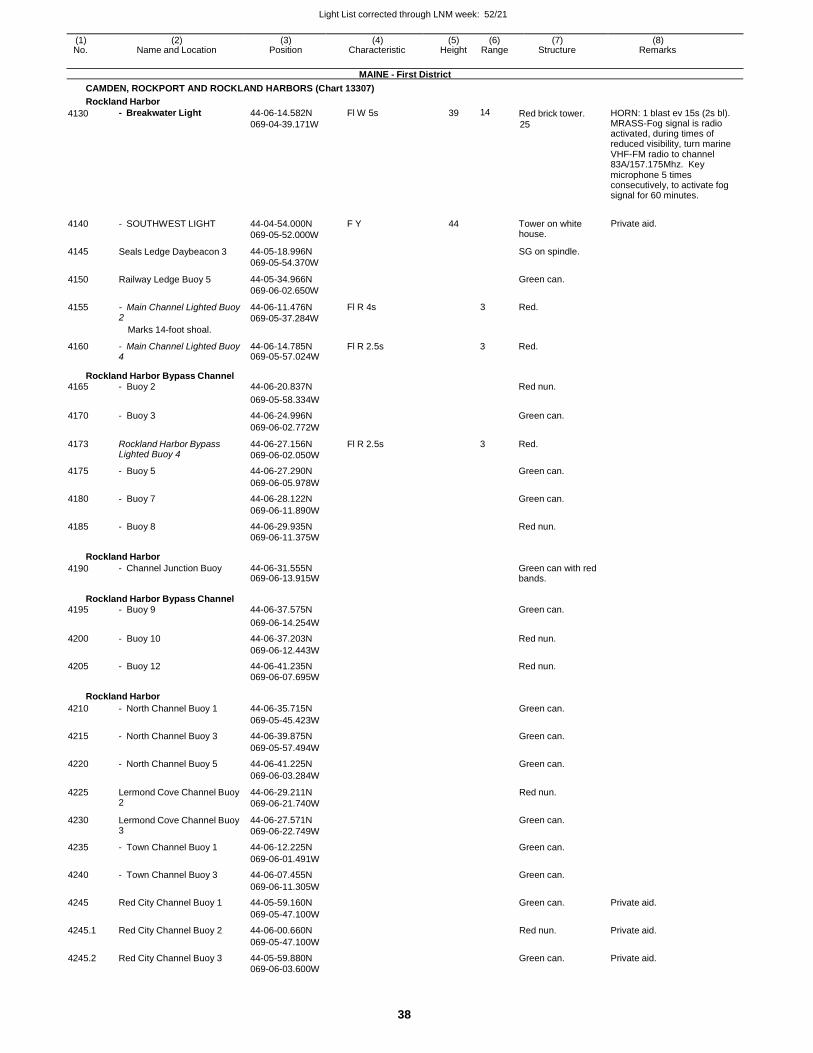
Light List corrected through LNM week: 52/21
38
(1) (2) (3) (4) (5) (6) (7) (8) No. Name and Location Position Characteristic Height Range Structure Remarks
MAINE - First District
CAMDEN, ROCKPORT AND ROCKLAND HARBORS (Chart 13307)
Rockland Harbor
4130
4140
4145
4150
4155
- Breakwater Light
- SOUTHWEST LIGHT
Seals Ledge Daybeacon 3
Railway Ledge Buoy 5
- Main Channel Lighted Buoy2
Marks 14-foot shoal.
44-06-14.582N
069-04-39.171W
44-04-54.000N
069-05-52.000W
44-05-18.996N
069-05-54.370W
44-05-34.966N
069-06-02.650W
44-06-11.476N
069-05-37.284W
Fl W 5s
F Y
Fl R 4s
39 14
44
3
Red brick tower.
25
Tower on white house.
SG on spindle.
Green can.
Red.
HORN: 1 blast ev 15s (2s bl). MRASS-Fog signal is radio activated, during times of reduced visibility, turn marine VHF-FM radio to channel 83A/157.175Mhz. Key microphone 5 times consecutively, to activate fog signal for 60 minutes.
Private aid.
4160 - Main Channel Lighted Buoy4
44-06-14.785N069-05-57.024W
Fl R 2.5s 3 Red.
Rockland Harbor Bypass Channel 4165 - Buoy 2 44-06-20.837N Red nun.
069-05-58.334W
4170 - Buoy 3 44-06-24.996N Green can.
069-06-02.772W
4173 Rockland Harbor Bypass Lighted Buoy 4
44-06-27.156N
069-06-02.050W
Fl R 2.5s 3 Red.
4175 - Buoy 5 44-06-27.290N Green can.
069-06-05.978W
4180 - Buoy 7 44-06-28.122N Green can.
069-06-11.890W
4185 - Buoy 8 44-06-29.935N Red nun. 069-06-11.375W
Rockland Harbor
4190 - Channel Junction Buoy 44-06-31.555N069-06-13.915W
Green can with red bands.
Rockland Harbor Bypass Channel 4195 - Buoy 9 44-06-37.575N Green can.
069-06-14.254W
4200 - Buoy 10 44-06-37.203N Red nun.
069-06-12.443W
4205 - Buoy 12 44-06-41.235N Red nun. 069-06-07.695W
Rockland Harbor
4210 - North Channel Buoy 1 44-06-35.715N Green can.
069-05-45.423W
4215 - North Channel Buoy 3 44-06-39.875N Green can.
069-05-57.494W
4220 - North Channel Buoy 5 44-06-41.225N Green can.
069-06-03.284W
4225 Lermond Cove Channel Buoy 2
44-06-29.211N
069-06-21.740W
Red nun.
4230 Lermond Cove Channel Buoy 3
44-06-27.571N
069-06-22.749W
Green can.
4235 - Town Channel Buoy 1 44-06-12.225N Green can.
069-06-01.491W
4240 - Town Channel Buoy 3 44-06-07.455N Green can.
069-06-11.305W
4245 Red City Channel Buoy 1 44-05-59.160N Green can. Private aid.
069-05-47.100W
4245.1 Red City Channel Buoy 2 44-06-00.660N Red nun. Private aid.
069-05-47.100W
4245.2 Red City Channel Buoy 3 44-05-59.880N Green can. Private aid. 069-06-03.600W
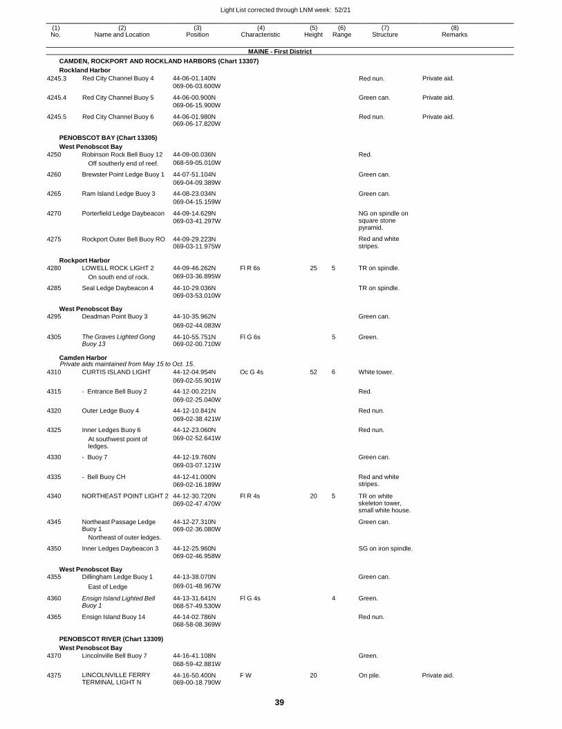
Light List corrected through LNM week: 52/21
39
(1) (2) (3) (4) (5) (6) (7) (8) No. Name and Location Position Characteristic Height Range Structure Remarks
MAINE - First District
CAMDEN, ROCKPORT AND ROCKLAND HARBORS (Chart 13307)
Rockland Harbor
4245.3 Red City Channel Buoy 4 44-06-01.140N
069-06-03.600W Red nun. Private aid.
4245.4 Red City Channel Buoy 5 44-06-00.900N
069-06-15.900W
Green can. Private aid.
4245.5 Red City Channel Buoy 6 44-06-01.980N 069-06-17.820W
Red nun. Private aid.
PENOBSCOT BAY (Chart 13305)
West Penobscot Bay
4250 Robinson Rock Bell Buoy 12 44-09-00.036N Red.
Off southerly end of reef. 068-59-05.010W
4260 Brewster Point Ledge Buoy 1 44-07-51.104N Green can.
069-04-09.389W
4265 Ram Island Ledge Buoy 3 44-08-23.034N Green can.
069-04-15.159W
4270 Porterfield Ledge Daybeacon 44-09-14.629N
069-03-41.297W
NG on spindle on square stone pyramid.
4275 Rockport Outer Bell Buoy RO 44-09-29.223N 069-03-11.975W
Red and white stripes.
Rockport Harbor
4280 LOWELL ROCK LIGHT 2 44-09-46.262N Fl R 6s 25 5 TR on spindle.
On south end of rock. 069-03-36.895W
4285 Seal Ledge Daybeacon 4 44-10-29.036N TR on spindle. 069-03-53.010W
West Penobscot Bay 4295 Deadman Point Buoy 3 44-10-35.962N Green can.
069-02-44.083W
4305 The Graves Lighted Gong Buoy 13
44-10-55.751N 069-02-00.710W
Fl G 6s 5 Green.
Camden Harbor Private aids maintained from May 15 to Oct. 15.
4310 CURTIS ISLAND LIGHT 44-12-04.954N Oc G 4s 52 6 White tower.
069-02-55.901W
4315 - Entrance Bell Buoy 2 44-12-00.221N Red.
069-02-25.040W
4320 Outer Ledge Buoy 4 44-12-10.841N Red nun.
069-02-38.421W
4325 Inner Ledges Buoy 6 44-12-23.060N Red nun.
At southwest point of ledges.
069-02-52.641W
4330 - Buoy 7 44-12-19.760N Green can.
069-03-07.121W
4335 - Bell Buoy CH 44-12-41.000N
069-02-16.189W
Red and white stripes.
4340 NORTHEAST POINT LIGHT 2 44-12-30.720N
069-02-47.470W
Fl R 4s 20 5 TR on white skeleton tower, small white house.
4345 Northeast Passage Ledge Buoy 1
44-12-27.310N 069-02-36.080W
Green can.
Northeast of outer ledges.
4350 Inner Ledges Daybeacon 3 44-12-25.960N SG on iron spindle. 069-02-46.958W
West Penobscot Bay 4355 Dillingham Ledge Buoy 1 44-13-38.070N Green can.
East of Ledge 069-01-48.967W
4360 Ensign Island Lighted Bell Buoy 1
44-13-31.641N
068-57-49.530W
Fl G 4s 4 Green.
4365 Ensign Island Buoy 14 44-14-02.786N Red nun. 068-58-08.369W
PENOBSCOT RIVER (Chart 13309)
West Penobscot Bay
4370 Lincolnville Bell Buoy 7 44-16-41.108N Green.
068-59-42.881W
4375 LINCOLNVILLE FERRY TERMINAL LIGHT N
44-16-50.400N 069-00-18.790W
F W 20 On pile. Private aid.
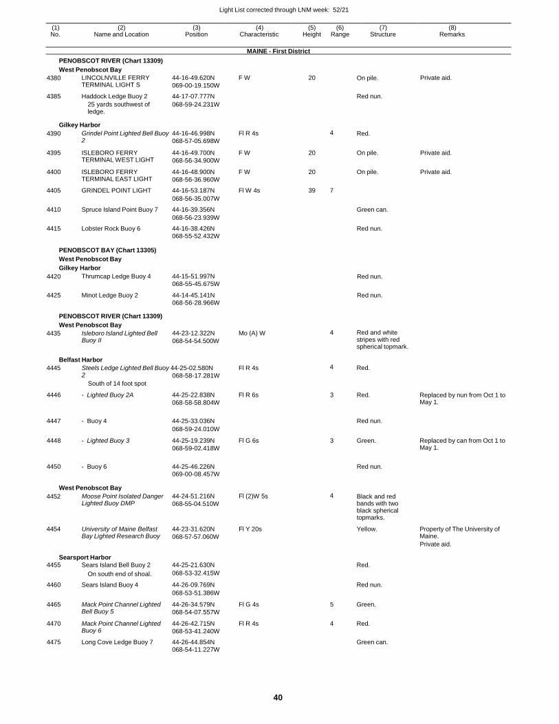
Light List corrected through LNM week: 52/21
40
(1) (2) (3) (4) (5) (6) (7) (8) No. Name and Location Position Characteristic Height Range Structure Remarks
MAINE - First District
PENOBSCOT RIVER (Chart 13309)
West Penobscot Bay
4380 LINCOLNVILLE FERRY TERMINAL LIGHT S
44-16-49.620N
069-00-19.150W
F W 20 On pile. Private aid.
4385 Haddock Ledge Buoy 2 44-17-07.777N Red nun.
25 yards southwest of ledge.
068-59-24.231W
Gilkey Harbor
4390 Grindel Point Lighted Bell Buoy 2
44-16-46.998N
068-57-05.698W
Fl R 4s 4 Red.
4395 ISLEBORO FERRY TERMINAL WEST LIGHT
44-16-49.700N
068-56-34.900W
F W 20 On pile. Private aid.
4400 ISLEBORO FERRY TERMINAL EAST LIGHT
44-16-48.900N
068-56-36.960W
F W 20 On pile. Private aid.
4405 GRINDEL POINT LIGHT 44-16-53.187N Fl W 4s 39 7
068-56-35.007W
4410 Spruce Island Point Buoy 7 44-16-39.356N Green can.
068-56-23.939W
4415 Lobster Rock Buoy 6 44-16-38.426N Red nun.
068-55-52.432W
PENOBSCOT BAY (Chart 13305)
West Penobscot Bay
Gilkey Harbor
4420 Thrumcap Ledge Buoy 4 44-15-51.997N
068-55-45.675W Red nun.
4425 Minot Ledge Buoy 2 44-14-45.141N 068-56-28.966W
Red nun.
PENOBSCOT RIVER (Chart 13309)
West Penobscot Bay
4435 Isleboro Island Lighted Bell Buoy II
44-23-12.322N
068-54-54.500W
Mo (A) W 4 Red and white stripes with red spherical topmark.
Belfast Harbor
4445 Steels Ledge Lighted Bell Buoy 44-25-02.580N Fl R 4s 4 Red. 2
South of 14 foot spot
068-58-17.281W
4446 - Lighted Buoy 2A 44-25-22.838N
068-58-58.804W
Fl R 6s 3 Red. Replaced by nun from Oct 1 to May 1.
4447 - Buoy 4 44-25-33.036N
Red nun.
068-59-24.010W
4448 - Lighted Buoy 3 44-25-19.239N
068-59-02.418W
Fl G 6s 3 Green. Replaced by can from Oct 1 to May 1.
4450 - Buoy 6 44-25-46.226N
Red nun.
069-00-08.457W
West Penobscot Bay
4452
4454
Moose Point Isolated Danger Lighted Buoy DMP
University of Maine Belfast Bay Lighted Research Buoy
44-24-51.216N
068-55-04.510W
44-23-31.620N
068-57-57.060W
Fl (2)W 5s
Fl Y 20s
4 Black and red bands with two black spherical topmarks.
Yellow.
Property of The University of Maine.
Private aid.
Searsport Harbor
4455 Sears Island Bell Buoy 2 44-25-21.630N Red.
On south end of shoal. 068-53-32.415W
4460 Sears Island Buoy 4 44-26-09.769N Red nun.
068-53-51.386W
4465 Mack Point Channel Lighted Bell Buoy 5
44-26-34.579N
068-54-07.557W
Fl G 4s 5 Green.
4470 Mack Point Channel Lighted Buoy 6
44-26-42.715N
068-53-41.240W
Fl R 4s 4 Red.
4475 Long Cove Ledge Buoy 7 44-26-44.854N Green can. 068-54-11.227W
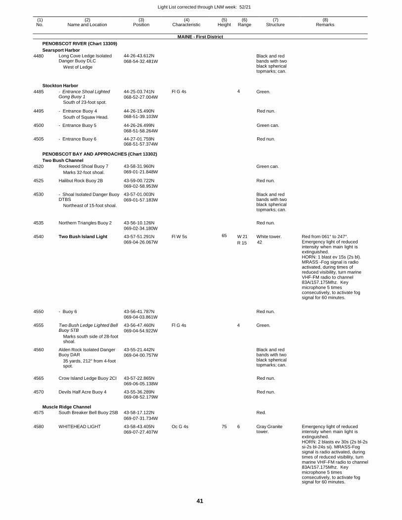
Light List corrected through LNM week: 52/21
41
(1) (2) (3) (4) (5) (6) (7) (8) No. Name and Location Position Characteristic Height Range Structure Remarks
MAINE - First District
PENOBSCOT RIVER (Chart 13309)
Searsport Harbor
4480 Long Cove Ledge Isolated Danger Buoy DLC
West of Ledge
44-26-43.612N
068-54-32.481W Black and red bands with two black spherical topmarks; can.
Stockton Harbor
4485 - Entrance Shoal Lighted Gong Buoy 1
South of 23-foot spot.
44-25-03.741N
068-52-27.004W
Fl G 4s 4 Green.
4495 - Entrance Buoy 4
South of Squaw Head.
44-26-15.490N
068-51-39.103W
Red nun.
4500 - Entrance Buoy 5 44-26-26.499N
068-51-58.264W
Green can.
4505 - Entrance Buoy 6 44-27-01.759N 068-51-57.374W
Red nun.
PENOBSCOT BAY AND APPROACHES (Chart 13302)
Two Bush Channel
4520
4525
4530
Rockweed Shoal Buoy 7
Marks 32-foot shoal.
Halibut Rock Buoy 2B
- Shoal Isolated Danger Buoy DTBS
Northeast of 15-foot shoal.
43-58-31.960N
069-01-21.848W
43-59-00.722N
069-02-58.953W
43-57-01.003N
069-01-57.183W
Green can.
Red nun.
Black and red bands with two black spherical topmarks; can.
4535
4540
Northern Triangles Buoy 2
Two Bush Island Light
43-56-10.126N
069-02-34.180W
43-57-51.291N
Fl W 5s
65 W 21
Red nun.
White tower.
Red from 061° to 247°.
069-04-26.067W R 15 42 Emergency light of reduced intensity when main light is extinguished. HORN: 1 blast ev 15s (2s bl). MRASS -Fog signal is radio activated, during times of reduced visibility, turn marine VHF-FM radio to channel 83A/157.175Mhz. Key microphone 5 times consecutively, to activate fog signal for 60 minutes.
4550
4555
- Buoy 6
Two Bush Ledge Lighted Bell Buoy 5TB
Marks south side of 28-foot shoal.
43-56-41.787N
069-04-03.861W
43-56-47.460N
069-04-54.922W
Fl G 4s
Red nun.
4 Green.
4560 Alden Rock Isolated Danger Buoy DAR
35 yards, 212° from 4-foot spot.
43-55-21.442N
069-04-00.757W
Black and red bands with two black spherical topmarks; can.
4565 Crow Island Ledge Buoy 2CI 43-57-22.865N
069-06-05.138W
Red nun.
4570 Devils Half Acre Buoy 4 43-55-36.289N 069-08-52.179W
Red nun.
Muscle Ridge Channel
4575 South Breaker Bell Buoy 2SB 43-58-17.122N Red.
069-07-31.734W
4580 WHITEHEAD LIGHT 43-58-43.405N
069-07-27.407W
Oc G 4s 75 6 Gray Granite tower.
Emergency light of reduced intensity when main light is extinguished. HORN: 2 blasts ev 30s (2s bl-2s si-2s bl-24s si). MRASS-Fog signal is radio activated, during times of reduced visibility, turn marine VHF-FM radio to channel 83A/157.175Mhz. Key microphone 5 times consecutively, to activate fog signal for 60 minutes.
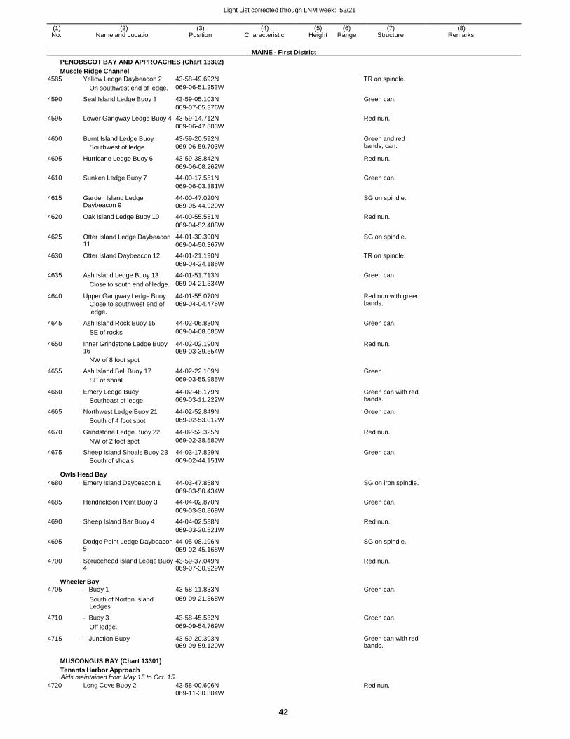
Light List corrected through LNM week: 52/21
42
(1) (2) (3) (4) (5) (6) (7) (8) No. Name and Location Position Characteristic Height Range Structure Remarks
MAINE - First District
PENOBSCOT BAY AND APPROACHES (Chart 13302)
Muscle Ridge Channel
4585 Yellow Ledge Daybeacon 2 43-58-49.692N TR on spindle.
On southwest end of ledge. 069-06-51.253W
4590 Seal Island Ledge Buoy 3 43-59-05.103N Green can.
069-07-05.376W
4595 Lower Gangway Ledge Buoy 4 43-59-14.712N Red nun. 069-06-47.803W
4600 Burnt Island Ledge Buoy
Southwest of ledge.
43-59-20.592N
069-06-59.703W
Green and red bands; can.
4605 Hurricane Ledge Buoy 6 43-59-38.842N Red nun.
069-06-08.262W
4610 Sunken Ledge Buoy 7 44-00-17.551N Green can.
069-06-03.381W
4615 Garden Island Ledge Daybeacon 9
44-00-47.020N
069-05-44.920W
SG on spindle.
4620 Oak Island Ledge Buoy 10 44-00-55.581N Red nun.
069-04-52.488W
4625 Otter Island Ledge Daybeacon 11
44-01-30.390N
069-04-50.367W
SG on spindle.
4630 Otter Island Daybeacon 12 44-01-21.190N TR on spindle.
069-04-24.186W
4635 Ash Island Ledge Buoy 13 44-01-51.713N Green can.
Close to south end of ledge. 069-04-21.334W
4640 Upper Gangway Ledge Buoy
Close to southwest end of
ledge.
44-01-55.070N
069-04-04.475W
Red nun with green bands.
4645 Ash Island Rock Buoy 15 44-02-06.830N Green can.
SE of rocks 069-04-08.685W
4650 Inner Grindstone Ledge Buoy 16
44-02-02.190N 069-03-39.554W
Red nun.
NW of 8 foot spot
4655 Ash Island Bell Buoy 17 44-02-22.109N Green.
SE of shoal 069-03-55.985W
4660 Emery Ledge Buoy
Southeast of ledge.
44-02-48.179N
069-03-11.222W
Green can with red bands.
4665 Northwest Ledge Buoy 21 44-02-52.849N Green can.
South of 4 foot spot 069-02-53.012W
4670 Grindstone Ledge Buoy 22 44-02-52.325N Red nun.
NW of 2 foot spot 069-02-38.580W
4675 Sheep Island Shoals Buoy 23 44-03-17.829N Green can. South of shoals 069-02-44.151W
Owls Head Bay
4680 Emery Island Daybeacon 1 44-03-47.858N SG on iron spindle.
069-03-50.434W
4685 Hendrickson Point Buoy 3 44-04-02.870N Green can.
069-03-30.869W
4690 Sheep Island Bar Buoy 4 44-04-02.538N Red nun.
069-03-20.521W
4695 Dodge Point Ledge Daybeacon 5
44-05-08.196N
069-02-45.168W
SG on spindle.
4700 Sprucehead Island Ledge Buoy 4
43-59-37.049N 069-07-30.929W
Red nun.
Wheeler Bay 4705 - Buoy 1 43-58-11.833N Green can.
South of Norton Island Ledges
069-09-21.368W
4710 - Buoy 3 43-58-45.532N Green can.
Off ledge. 069-09-54.769W
4715 - Junction Buoy 43-59-20.393N 069-09-59.120W
Green can with red bands.
MUSCONGUS BAY (Chart 13301)
Tenants Harbor Approach Aids maintained from May 15 to Oct. 15.
4720 Long Cove Buoy 2 43-58-00.606N
069-11-30.304W
Red nun.
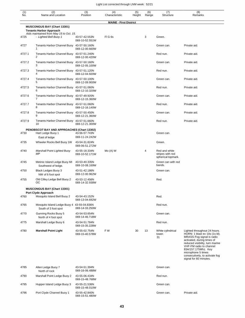
Light List corrected through LNM week: 52/21
43
(1) (2) (3) (4) (5) (6) (7) (8) No. Name and Location Position Characteristic Height Range Structure Remarks
MAINE - First District
MUSCONGUS BAY (Chart 13301)
Tenants Harbor Approach Aids maintained from May 15 to Oct. 15.
4725 - Lighted Bell Buoy 1 43-57-42.553N Fl G 6s 3 Green.
069-10-52.551W
4727 Tenants Harbor Channel Buoy 1
43-57-50.160N
069-12-00.660W
Green can. Private aid.
4727.1 Tenants Harbor Channel Buoy 2
43-57-51.240N
069-12-00.420W
Red nun. Private aid.
4727.2 Tenants Harbor Channel Buoy 3
43-57-50.160N
069-12-05.100W
Green can. Private aid.
4727.3 Tenants Harbor Channel Buoy 4
43-57-51.120N
069-12-04.920W
Red nun. Private aid.
4727.4 Tenants Harbor Channel Buoy 5
43-57-50.100N
069-12-09.900W
Green can. Private aid.
4727.5 Tenants Harbor Channel Buoy 6
43-57-51.060N
069-12-10.320W
Red nun. Private aid.
4727.6 Tenants Harbor Channel Buoy 7
43-57-49.920N
069-12-15.360W
Green can. Private aid.
4727.7 Tenants Harbor Channel Buoy 8
43-57-51.060N
069-12-16.140W
Red nun. Private aid.
4727.8 Tenants Harbor Channel Buoy 9
43-57-50.450N
069-12-21.360W
Green can. Private aid.
4727.9 Tenants Harbor Channel Buoy 10
43-57-51.660N 069-12-21.300W
Red nun. Private aid.
PENOBSCOT BAY AND APPROACHES (Chart 13302) 4730 Hart Ledge Buoy 1 43-56-57.743N Green can.
East of ledge 069-11-24.242W
4735 Wheeler Rocks Bell Buoy 1W 43-54-31.824N Green.
069-06-51.272W
4740 Marshall Point Lighted Buoy MP
43-55-18.334N
069-10-52.171W
Mo (A) W 4 Red and white stripes with red spherical topmark.
4745 Metinic Island Ledge Buoy MI
Southwest of ledge.
43-53-40.335N
069-10-08.169W
Green can with red bands.
4750 Black Ledges Buoy 3 43-51-42.186N Green can.
NW of 6 foot spot 069-12-00.962W
4755 Old Cilley Ledge Bell Buoy 2 OC
43-53-12.456N 069-14-32.938W
Red.
MUSCONGUS BAY (Chart 13301)
Port Clyde Approach
4760 Mosquito Island Bell Buoy 2 43-54-43.152N
069-13-04.692W Red.
4765 Mosquito Island Ledge Buoy 4 43-55-04.836N Red nun.
4770
4775
4780
South of 3 foot spot
Gunning Rocks Buoy 5
North of 4 foot spot
Marshall Ledge Buoy 6
Marshall Point Light
069-14-33.250W
43-54-53.654N
069-14-46.718W
43-54-51.784N
069-15-35.228W
43-55-02.754N
069-15-40.578W
F W 30 13
Green can.
Red nun.
White cylindrical tower.
31
Lighted throughout 24 hours. HORN: 1 blast ev 10s (1s bl). MRASS-Fog signal is radio activated, during times of reduced visibility, turn marine VHF-FM radio to channel 83A/157.175Mhz. Key microphone 5 times consecutively, to activate fog signal for 60 minutes.
4785 Allen Ledge Buoy 7
North of rock
43-54-51.394N
069-16-06.488W
Green can.
4790 Marshall Point Ledge Buoy 2 43-55-06.434N
069-15-48.768W
Red nun.
4795 Hupper Island Ledge Buoy 3 43-55-21.536N
069-15-48.010W
Green can.
4796 Port Clyde Channel Buoy 1 43-55-42.840N 069-15-51.480W
Green can. Private aid.
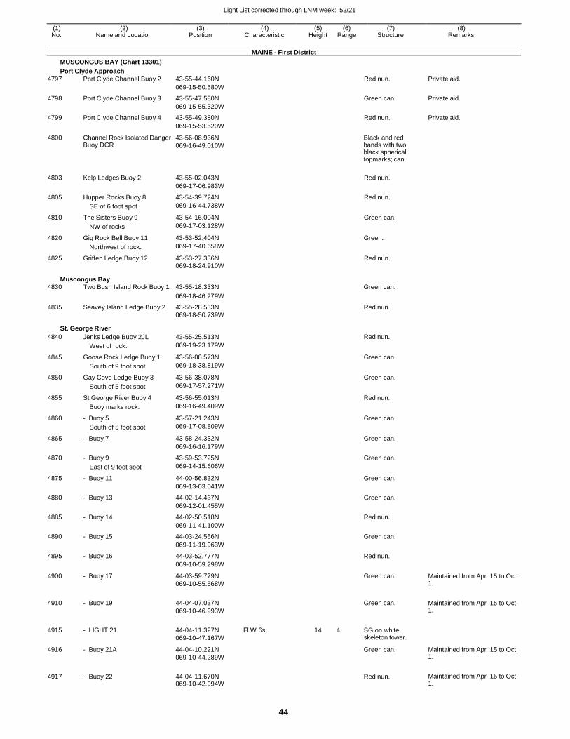
Light List corrected through LNM week: 52/21
44
(1) (2) (3) (4) (5) (6) (7) (8) No. Name and Location Position Characteristic Height Range Structure Remarks
MAINE - First District
MUSCONGUS BAY (Chart 13301)
Port Clyde Approach
4797 Port Clyde Channel Buoy 2 43-55-44.160N Red nun. Private aid.
069-15-50.580W
4798 Port Clyde Channel Buoy 3 43-55-47.580N Green can. Private aid.
069-15-55.320W
4799 Port Clyde Channel Buoy 4 43-55-49.380N Red nun. Private aid.
069-15-53.520W
4800 Channel Rock Isolated Danger Buoy DCR
43-56-08.936N
069-16-49.010W
Black and red bands with two black spherical topmarks; can.
4803 Kelp Ledges Buoy 2 43-55-02.043N Red nun.
069-17-06.983W
4805 Hupper Rocks Buoy 8 43-54-39.724N Red nun.
SE of 6 foot spot 069-16-44.738W
4810 The Sisters Buoy 9 43-54-16.004N Green can.
NW of rocks 069-17-03.128W
4820 Gig Rock Bell Buoy 11 43-53-52.404N Green.
Northwest of rock. 069-17-40.658W
4825 Griffen Ledge Buoy 12 43-53-27.336N Red nun.
069-18-24.910W
Muscongus Bay 4830 Two Bush Island Rock Buoy 1 43-55-18.333N Green can.
069-18-46.279W
4835 Seavey Island Ledge Buoy 2 43-55-28.533N Red nun. 069-18-50.739W
St. George River
4840 Jenks Ledge Buoy 2JL 43-55-25.513N Red nun.
West of rock. 069-19-23.179W
4845 Goose Rock Ledge Buoy 1 43-56-08.573N Green can.
South of 9 foot spot 069-18-38.819W
4850 Gay Cove Ledge Buoy 3 43-56-38.078N Green can.
South of 5 foot spot 069-17-57.271W
4855 St.George River Buoy 4 43-56-55.013N Red nun.
Buoy marks rock. 069-16-49.409W
4860 - Buoy 5 43-57-21.243N Green can.
South of 5 foot spot 069-17-08.809W
4865 - Buoy 7 43-58-24.332N Green can.
069-16-16.179W
4870 - Buoy 9 43-59-53.725N Green can.
East of 9 foot spot 069-14-15.606W
4875 - Buoy 11 44-00-56.832N Green can.
069-13-03.041W
4880 - Buoy 13 44-02-14.437N Green can.
069-12-01.455W
4885 - Buoy 14 44-02-50.518N Red nun.
069-11-41.100W
4890 - Buoy 15 44-03-24.566N Green can.
069-11-19.963W
4895 - Buoy 16 44-03-52.777N Red nun.
069-10-59.298W
4900 - Buoy 17 44-03-59.779N
069-10-55.568W
Green can. Maintained from Apr .15 to Oct. 1.
4910 - Buoy 19 44-04-07.037N
069-10-46.993W
Green can. Maintained from Apr .15 to Oct.
1.
4915 - LIGHT 21 44-04-11.327N
069-10-47.167W
Fl W 6s 14 4 SG on white skeleton tower.
4916 - Buoy 21A 44-04-10.221N
069-10-44.289W
Green can. Maintained from Apr .15 to Oct. 1.
4917 - Buoy 22 44-04-11.670N 069-10-42.994W
Red nun. Maintained from Apr .15 to Oct.
1.
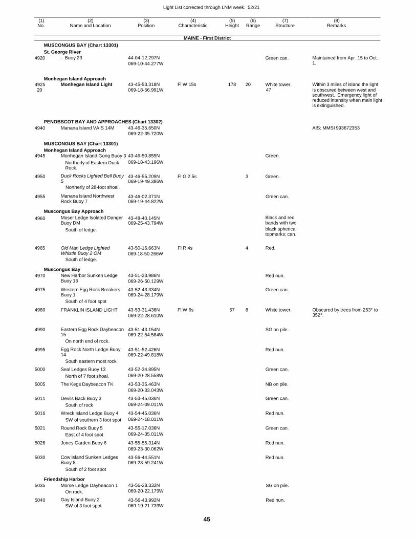
Light List corrected through LNM week: 52/21
45
(1) (2) (3) (4) (5) (6) (7) (8) No. Name and Location Position Characteristic Height Range Structure Remarks
MAINE - First District
MUSCONGUS BAY (Chart 13301)
St. George River
4920 - Buoy 23 44-04-12.297N
069-10-44.277W Green can. Maintained from Apr .15 to Oct.
1.
Monhegan Island Approach
4925 Monhegan Island Light 43-45-53.318N Fl W 15s 178 20 White tower. Within 3 miles of island the light 20 069-18-56.991W 47 is obscured between west and
southwest. Emergency light of reduced intensity when main light is extinguished.
PENOBSCOT BAY AND APPROACHES (Chart 13302)
4940 Manana Island VAIS 14M 43-46-35.650N
069-22-35.720W
AIS: MMSI 993672353
MUSCONGUS BAY (Chart 13301)
Monhegan Island Approach 4945 Monhegan Island Gong Buoy 3 43-46-50.859N Green.
Northerly of Eastern Duck Rock.
069-18-43.196W
4950 Duck Rocks Lighted Bell Buoy 5
43-46-55.209N 069-19-49.386W
Fl G 2.5s 3 Green.
Northerly of 28-foot shoal.
4955 Manana Island Northwest Rock Buoy 7
43-46-02.371N 069-19-44.822W
Green can.
Muscongus Bay Approach
4960 Moser Ledge Isolated Danger Buoy DM
43-48-40.145N 069-25-43.794W
Black and red bands with two
South of ledge. black spherical topmarks; can.
4965 Old Man Ledge Lighted Whistle Buoy 2 OM
South of ledge.
43-50-16.663N
069-18-50.266W
Fl R 4s 4 Red.
Muscongus Bay
4970 New Harbor Sunken Ledge Buoy 16
43-51-23.986N
069-26-50.129W Red nun.
4975 Western Egg Rock Breakers Buoy 1
43-52-43.334N 069-24-28.179W
Green can.
4980
South of 4 foot spot
FRANKLIN ISLAND LIGHT
43-53-31.436N
069-22-28.610W
Fl W 6s
57
8
White tower.
Obscured by trees from 253° to 352°.
4990 Eastern Egg Rock Daybeacon 15
43-51-43.154N 069-22-54.584W
SG on pile.
4995
On north end of rock.
Egg Rock North Ledge Buoy 14
43-51-52.426N 069-22-49.818W
Red nun.
5000
South eastern most rock
Seal Ledges Buoy 13
43-52-34.895N
Green can.
North of 7 foot shoal. 069-20-28.558W
5005 The Kegs Daybeacon TK 43-53-35.463N NB on pile.
069-20-33.043W
5011 Devils Back Buoy 3 43-53-45.036N Green can.
South of rock 069-24-09.011W
5016 Wreck Island Ledge Buoy 4 43-54-45.036N Red nun.
SW of southern 3 foot spot 069-24-18.011W
5021 Round Rock Buoy 5 43-55-17.036N Green can.
East of 4 foot spot 069-24-35.011W
5026 Jones Garden Buoy 6 43-55-55.314N Red nun.
069-23-30.062W
5030 Cow Island Sunken Ledges Buoy 8
43-56-44.551N 069-23-59.241W
Red nun.
South of 2 foot spot
Friendship Harbor
5035 Morse Ledge Daybeacon 1
On rock.
43-56-28.332N
069-20-22.179W SG on pile.
5040 Gay Island Buoy 2
SW of 3 foot spot
43-56-43.992N
069-19-21.739W
Red nun.
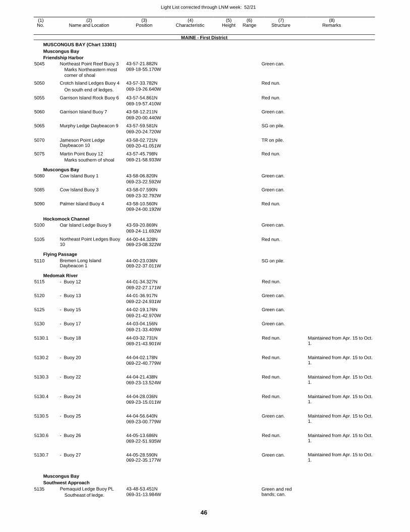
Light List corrected through LNM week: 52/21
46
(1) (2) (3) (4) (5) (6) (7) (8) No. Name and Location Position Characteristic Height Range Structure Remarks
MAINE - First District
MUSCONGUS BAY (Chart 13301)
Muscongus Bay
Friendship Harbor
5045 Northeast Point Reef Buoy 3
Marks Northeastern most
corner of shoal
43-57-21.882N
069-18-55.170W Green can.
5050 Crotch Island Ledges Buoy 4 43-57-33.782N Red nun.
On south end of ledges. 069-19-26.640W
5055 Garrison Island Rock Buoy 6 43-57-54.861N Red nun.
069-19-57.410W
5060 Garrison Island Buoy 7 43-58-12.211N Green can.
069-20-00.440W
5065 Murphy Ledge Daybeacon 9 43-57-59.581N SG on pile.
069-20-24.720W
5070 Jameson Point Ledge Daybeacon 10
43-58-02.721N
069-20-41.051W
TR on pile.
5075 Martin Point Buoy 12 43-57-45.798N Red nun. Marks southern of shoal 069-21-58.933W
Muscongus Bay
5080 Cow Island Buoy 1 43-58-06.820N Green can.
069-23-22.592W
5085 Cow Island Buoy 3 43-58-07.590N Green can.
069-23-32.792W
5090 Palmer Island Buoy 4 43-58-10.560N Red nun. 069-24-00.192W
Hockomock Channel
5100 Oar Island Ledge Buoy 9 43-59-20.869N Green can.
069-24-11.692W
5105 Northeast Point Ledges Buoy 10
44-00-44.328N 069-23-08.322W
Red nun.
Flying Passage
5110 Bremen Long Island Daybeacon 1
44-00-23.036N 069-22-37.011W
SG on pile.
Medomak River
5115 - Buoy 12 44-01-34.327N Red nun.
069-22-27.171W
5120 - Buoy 13 44-01-36.917N Green can.
069-22-24.931W
5125 - Buoy 15 44-02-19.176N Green can.
069-21-42.970W
5130 - Buoy 17 44-03-04.156N Green can.
069-21-33.409W
5130.1 - Buoy 18 44-03-32.731N
069-21-43.901W
Red nun. Maintained from Apr. 15 to Oct. 1.
5130.2 - Buoy 20 44-04-02.178N
069-22-40.779W
Red nun. Maintained from Apr. 15 to Oct. 1.
5130.3 - Buoy 22 44-04-21.438N
069-23-13.524W
Red nun. Maintained from Apr. 15 to Oct. 1.
5130.4 - Buoy 24 44-04-28.036N
069-23-15.011W
Red nun. Maintained from Apr. 15 to Oct. 1.
5130.5 - Buoy 25 44-04-56.640N
069-23-00.779W
Green can. Maintained from Apr. 15 to Oct. 1.
5130.6 - Buoy 26 44-05-13.686N
069-22-51.935W
Red nun. Maintained from Apr. 15 to Oct. 1.
5130.7 - Buoy 27 44-05-28.590N 069-22-35.177W
Green can. Maintained from Apr. 15 to Oct. 1.
Muscongus Bay
Southwest Approach
5135 Pemaquid Ledge Buoy PL
Southeast of ledge.
43-48-53.451N
069-31-13.984W Green and red bands; can.
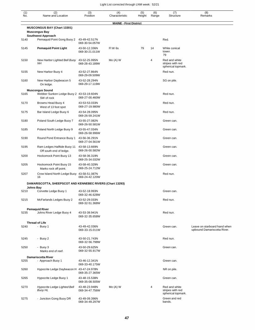
Light List corrected through LNM week: 52/21
47
(1) (2) (3) (4) (5) (6) (7) (8) No. Name and Location Position Characteristic Height Range Structure Remarks
MAINE - First District
MUSCONGUS BAY (Chart 13301)
Muscongus Bay
Southwest Approach
5140
5145
5150
5155
5160
Pemaquid Point Gong Buoy 2
Pemaquid Point Light
New Harbor Lighted Bell Buoy NH
New Harbor Buoy 4
New Harbor Daybeacon 5
On ledge.
43-49-42.517N
069-30-54.057W
43-50-12.336N
069-30-21.011W
43-52-25.995N
069-28-43.189W
43-52-27.864N
069-29-09.509W
43-52-28.294N
069-29-17.119W
Fl W 6s
Mo (A) W
79 14
4
Red.
White conical tower.
79
Red and white stripes with red spherical topmark.
Red nun.
SG on pile.
Muscongus Sound
5165 Webber Sunken Ledge Buoy 2 43-53-19.604N Red nun.
SW of rock 069-27-00.460W
5170 Browns Head Buoy 4 43-53-53.033N Red nun.
West of 13 foot spot 069-27-19.980W
5175 Bar Island Ledge Buoy 6 43-54-28.095N Red nun.
069-26-59.241W
5180 Poland South Ledge Buoy 7 43-55-27.082N Green can.
069-26-50.581W
5185 Poland North Ledge Buoy 9 43-55-47.034N Green can.
069-26-58.996W
5190 Round Pond Entrance Buoy 1 43-56-36.291N Green can.
069-27-04.561W
5195 Ram Ledges Halftide Buoy 11 43-58-13.669N Green can.
Off south end of ledge. 069-26-00.582W
5200 Hockomock Point Buoy 13 43-58-36.319N Green can.
069-25-34.032W
5205 Hockomock Point Buoy 15 43-58-40.329N Green can.
Marks rock off point. 069-25-24.712W
5207 Crow Island North Ledge Buoy 16
43-58-51.087N 069-24-42.120W
Red nun.
DAMARISCOTTA, SHEEPSCOT AND KENNEBEC RIVERS (Chart 13293)
Johns Bay
5210 Corvette Ledge Buoy 1 43-52-18.993N Green can.
069-32-46.628W
5215 McFarlands Ledges Buoy 2 43-52-29.033N Red nun. 069-32-51.368W
Pemaquid River 5235 Johns River Ledge Buoy 4 43-53-39.941N Red nun.
069-32-35.658W
Thread of Life
5240
5245
5250
- Buoy 1
- Buoy 2
- Buoy 3
Marks end of reef.
43-49-42.036N
069-33-15.011W
43-50-21.743N
069-32-56.798W
43-50-29.625N
069-32-55.917W
Green can.
Red nun.
Green can.
Leave on starboard hand when upbound Damariscotta River.
Damariscotta River
5255 - Approach Buoy 1 43-46-12.341N Green can.
069-33-40.175W
5260 Hypocrite Ledge Daybeacon H 43-47-24.978N NR on pile. 069-35-27.365W
5265 Hypocrite Ledge Buoy 1 43-48-15.538N
Green can.
069-35-08.505W
5270 Hypocrite Ledge Lighted Bell Buoy HL
43-48-23.948N
069-34-47.756W
Mo (A) W 4 Red and white stripes with red spherical topmark.
5275 - Junction Gong Buoy DR 43-49-09.396N 069-34-49.297W
Green and red bands.
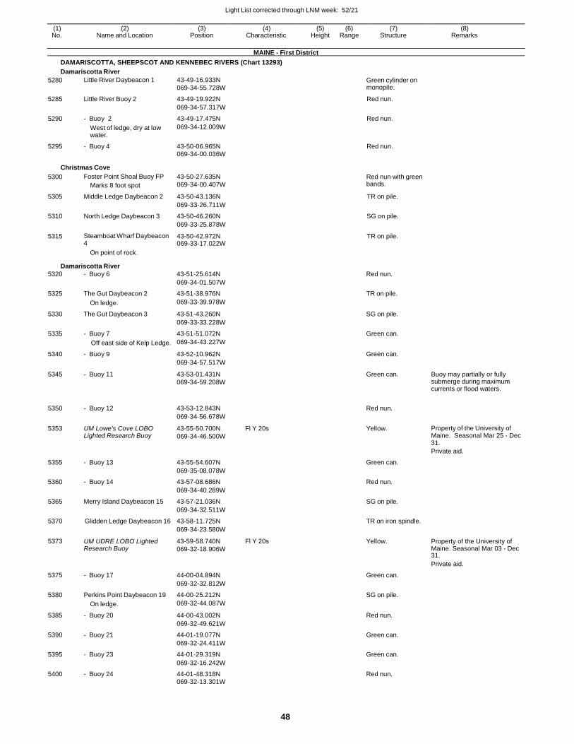
Light List corrected through LNM week: 52/21
48
(1) (2) (3) (4) (5) (6) (7) (8) No. Name and Location Position Characteristic Height Range Structure Remarks
MAINE - First District
DAMARISCOTTA, SHEEPSCOT AND KENNEBEC RIVERS (Chart 13293)
Damariscotta River
5280 Little River Daybeacon 1 43-49-16.933N
069-34-55.728W Green cylinder on monopile.
5285 Little River Buoy 2 43-49-19.922N Red nun.
069-34-57.317W
5290 - Buoy 2 43-49-17.475N Red nun.
West of ledge, dry at low water.
069-34-12.009W
5295 - Buoy 4 43-50-06.965N Red nun. 069-34-00.036W
Christmas Cove
5300 Foster Point Shoal Buoy FP
Marks 8 foot spot
43-50-27.635N
069-34-00.407W
Red nun with green bands.
5305 Middle Ledge Daybeacon 2 43-50-43.136N TR on pile.
069-33-26.711W
5310 North Ledge Daybeacon 3 43-50-46.260N SG on pile.
069-33-25.878W
5315 Steamboat Wharf Daybeacon 4
43-50-42.972N 069-33-17.022W
TR on pile.
On point of rock.
Damariscotta River
5320 - Buoy 6 43-51-25.614N Red nun.
069-34-01.507W
5325 The Gut Daybeacon 2 43-51-38.976N TR on pile.
On ledge. 069-33-39.978W
5330 The Gut Daybeacon 3 43-51-43.260N SG on pile.
069-33-33.228W
5335 - Buoy 7 43-51-51.072N Green can.
Off east side of Kelp Ledge. 069-34-43.227W
5340 - Buoy 9 43-52-10.962N Green can.
069-34-57.517W
5345 - Buoy 11 43-53-01.431N
069-34-59.208W
Green can. Buoy may partially or fully submerge during maximum currents or flood waters.
5350 - Buoy 12 43-53-12.843N
Red nun.
069-34-56.678W
5353 UM Lowe's Cove LOBO Lighted Research Buoy
43-55-50.700N
069-34-46.500W
Fl Y 20s Yellow. Property of the University of Maine. Seasonal Mar 25 - Dec 31.
Private aid.
5355 - Buoy 13 43-55-54.607N Green can.
069-35-08.078W
5360 - Buoy 14 43-57-08.686N Red nun.
069-34-40.289W
5365 Merry Island Daybeacon 15 43-57-21.036N SG on pile.
069-34-32.511W
5370 Glidden Ledge Daybeacon 16 43-58-11.725N TR on iron spindle.
069-34-23.580W
5373 UM UDRE LOBO Lighted Research Buoy
43-59-58.740N
069-32-18.906W
Fl Y 20s Yellow. Property of the University of Maine. Seasonal Mar 03 - Dec 31.
Private aid.
5375 - Buoy 17 44-00-04.894N Green can.
069-32-32.812W
5380 Perkins Point Daybeacon 19 44-00-25.212N SG on pile.
On ledge. 069-32-44.087W
5385 - Buoy 20 44-00-43.002N Red nun.
069-32-49.621W
5390 - Buoy 21 44-01-19.077N Green can.
069-32-24.411W
5395 - Buoy 23 44-01-29.319N Green can.
069-32-16.242W
5400 - Buoy 24 44-01-48.318N Red nun.
069-32-13.301W
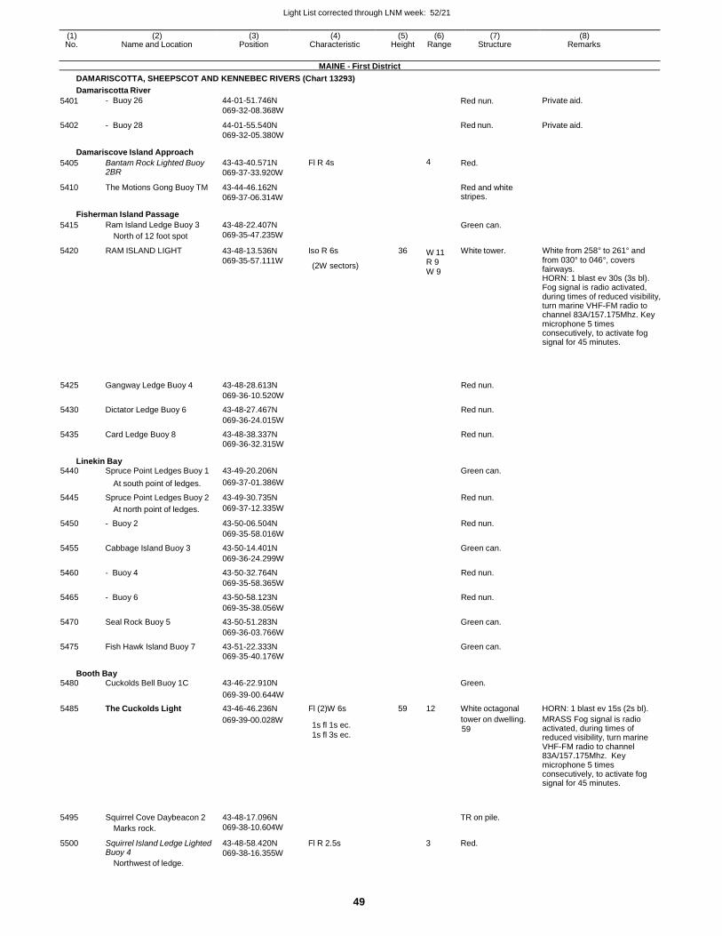
Light List corrected through LNM week: 52/21
49
(1) (2) (3) (4) (5) (6) (7) (8) No. Name and Location Position Characteristic Height Range Structure Remarks
MAINE - First District
DAMARISCOTTA, SHEEPSCOT AND KENNEBEC RIVERS (Chart 13293)
Damariscotta River
5401
5402
- Buoy 26
- Buoy 28
44-01-51.746N
069-32-08.368W
44-01-55.540N
069-32-05.380W
Red nun.
Red nun.
Private aid.
Private aid.
Damariscove Island Approach
5405
5410
Bantam Rock Lighted Buoy 2BR
The Motions Gong Buoy TM
43-43-40.571N
069-37-33.920W
43-44-46.162N
069-37-06.314W
Fl R 4s 4 Red.
Red and white stripes.
Fisherman Island Passage
5415
5420
Ram Island Ledge Buoy 3
North of 12 foot spot
RAM ISLAND LIGHT
43-48-22.407N
069-35-47.235W
43-48-13.536N
069-35-57.111W
069-39-00.028W
Iso R 6s
(2W sectors)
1s fl 1s ec.
1s fl 3s ec.
36 W 11
R 9 W 9
Green can.
White tower.
tower on dwelling. 59
White from 258° to 261° and from 030° to 046°, covers fairways. HORN: 1 blast ev 30s (3s bl). Fog signal is radio activated, during times of reduced visibility, turn marine VHF-FM radio to channel 83A/157.175Mhz. Key microphone 5 times consecutively, to activate fog signal for 45 minutes.
MRASS Fog signal is radio activated, during times of reduced visibility, turn marine VHF-FM radio to channel 83A/157.175Mhz. Key microphone 5 times consecutively, to activate fog signal for 45 minutes.
5495
5500
Squirrel Cove Daybeacon 2
Marks rock.
Squirrel Island Ledge Lighted Buoy 4
Northwest of ledge.
43-48-17.096N
069-38-10.604W
43-48-58.420N
069-38-16.355W
Fl R 2.5s
TR on pile.
3 Red.
5425 Gangway Ledge Buoy 4 43-48-28.613N Red nun.
069-36-10.520W
5430 Dictator Ledge Buoy 6 43-48-27.467N Red nun.
069-36-24.015W
5435 Card Ledge Buoy 8 43-48-38.337N Red nun. 069-36-32.315W
Linekin Bay 5440 Spruce Point Ledges Buoy 1 43-49-20.206N Green can.
At south point of ledges. 069-37-01.386W
5445 Spruce Point Ledges Buoy 2 43-49-30.735N Red nun.
At north point of ledges. 069-37-12.335W
5450 - Buoy 2 43-50-06.504N Red nun.
069-35-58.016W
5455 Cabbage Island Buoy 3 43-50-14.401N Green can.
069-36-24.299W
5460 - Buoy 4 43-50-32.764N Red nun.
069-35-58.365W
5465 - Buoy 6 43-50-58.123N Red nun.
069-35-38.056W
5470 Seal Rock Buoy 5 43-50-51.283N Green can.
069-36-03.766W
5475 Fish Hawk Island Buoy 7 43-51-22.333N Green can. 069-35-40.176W
Booth Bay 5480 Cuckolds Bell Buoy 1C 43-46-22.910N Green.
069-39-00.644W
5485 The Cuckolds Light 43-46-46.236N Fl (2)W 6s 59 12 White octagonal HORN: 1 blast ev 15s (2s bl).
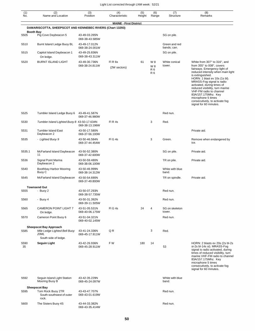
Light List corrected through LNM week: 52/21
50
(1) (2) (3) (4) (5) (6) (7) (8) No. Name and Location Position Characteristic Height Range Structure Remarks
MAINE - First District
DAMARISCOTTA, SHEEPSCOT AND KENNEBEC RIVERS (Chart 13293)
Booth Bay 5505 Pig Cove Daybeacon 5 43-49-03.265N SG on pile.
069-38-43.585W
5510 Burnt Island Ledge Buoy BL 43-49-17.012N
069-38-24.001W
Green and red bands; can.
5515 Capitol Island Daybeacon 1 43-49-25.836N SG on pile.
On ledge. 069-38-43.311W
5520 BURNT ISLAND LIGHT 43-49-30.736N Fl R 6s 61 W 8 White conical White from 307° to 316°, and
5525
Tumbler Island Ledge Buoy 6
069-38-24.811W
43-49-41.587N
069-37-46.980W
(2W sectors) W 8 tower.
R 6 R 6
Red nun.
from 355° to 008°, covers fairways. Emergency light of reduced intensity when main light is extinguished. HORN: 1 blast ev 10s (1s bl). MRASS-Fog signal is radio activated, during times of reduced visibility, turn marine VHF-FM radio to channel 83A/157.175Mhz. Key microphone 5 times consecutively, to activate fog signal for 60 minutes.
5530 Tumbler Island Lighted Buoy 8 43-50-17.634N
069-38-13.196W
Fl R 4s 3 Red.
5531
5535
5535.1
5536
5540
5545
Tumbler Island East Daybeacon 2
- Lighted Buoy 9
McFarland Island Daybeacon 11
Signal Point Marina Daybeacon 2
Boothbay Harbor Mooring Buoy C
McFarland Island Daybeacon
43-50-17.580N
069-37-56.100W
43-50-46.584N
069-37-44.454W
43-50-52.380N
069-37-42.600W
43-50-59.480N
069-38-06.100W
43-50-46.999N
069-38-14.312W
43-50-54.690N
069-37-49.800W
Fl G 4s
3 Green.
SG on pile.
TR on pile.
White with blue band.
TR on spindle.
Private aid.
Remove when endangered by ice.
Private aid.
Private aid.
Private aid.
Townsend Gut
5555 - Buoy 2 43-50-07.293N Red nun.
069-38-57.735W
5560 - Buoy 4 43-50-31.392N Red nun.
069-39-11.505W
5565 CAMERON POINT LIGHT 7
On ledge.
43-51-05.531N
069-40-06.175W
Fl G 4s 24 4 SG on skeleton tower.
5570 Cameron Point Buoy 6 43-51-04.321N Red nun. 069-40-02.145W
Sheepscot Bay Approach
5585
5590
35
5592
Mile Ledge Lighted Bell Buoy 20ML
South side of ledge.
Seguin Light
Seguin Island Light Station Mooring Buoy B
43-41-24.336N Q R
069-45-17.911W
43-42-26.936N F W
069-45-28.911W
43-42-35.229N
069-45-24.097W
3
180 14
Red.
53
White with blue band.
HORN: 2 blasts ev 20s (2s bl-2s si-2s bl-14s si). MRASS-Fog signal is radio activated, during times of reduced visibility, turn marine VHF-FM radio to channel 83A/157.175Mhz. Key microphone 5 times consecutively, to activate fog signal for 60 minutes.
Sheepscot Bay
5595
5600
Tom Rock Buoy 2TR
South-southwest of outer
rock.
The Sisters Buoy 4S
43-43-47.707N
069-43-01.619W
43-44-33.382N
069-43-35.414W
Red nun.
Red nun.
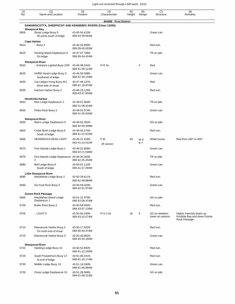
Light List corrected through LNM week: 52/21
51
(1) (2) (3) (4) (5) (6) (7) (8) No. Name and Location Position Characteristic Height Range Structure Remarks
MAINE - First District
DAMARISCOTTA, SHEEPSCOT AND KENNEBEC RIVERS (Chart 13293)
Sheepscot Bay
5605 Sloop Ledge Buoy 5 43-45-54.410N Green can.
35 yards south of ledge. 069-43-39.564W
Cape Harbor
5610 - Buoy 2 43-46-53.859N Red nun.
069-39-50.003W
5615 Hunting Island Daybeacon 4 43-47-07.708N TR on pile. On ledge. 069-39-34.424W
Sheepscot River
5620 - Entrance Lighted Buoy 2SR 43-45-38.241N Fl R 4s 4 Red.
069-41-09.114W
5625 Griffith Head Ledge Buoy 3 43-46-55.008N Green can.
Southeast of ledge. 069-42-30.134W
5630 Cat Ledges Gong Buoy 4CL 43-47-48.137N Red.
West side of shoal. 069-41-19.874W
5635 Harmon Harbor Buoy 2 43-48-23.125N Red nun. 069-43-07.834W
Hendricks Harbor 5640 Nick Ledge Daybeacon 2 43-49-01.564N TR on pile.
069-41-08.914W
5645 Petes Rock Buoy 3 43-49-01.574N Green can. 069-41-05.540W
Sheepscot River 5650 Marrs Ledge Daybeacon 5 43-49-02.302N SG on pile.
069-40-59.939W
5655 Cedar Bush Ledge Buoy 6 43-49-05.275N Red nun.
South of ledge. 069-41-22.615W
5665 HENDRICKS HEAD LIGHT 43-49-21.318N F W 43 W 9 White house. Red from 180° to 000°.
069-41-23.022W (R sector) R 7
5670 Five Islands Ledge Buoy 1 43-49-22.856N Green can.
069-42-21.546W
5675 Five Islands Ledge Daybeacon 2
43-49-36.303N
069-42-25.254W
TR on pile.
5680 Bull Ledge Buoy 9 43-50-01.112N Green can.
South of ledge. 069-41-57.494W
Little Sheepscot River 5685 MacMahan Ledge Buoy 2 43-50-28.611N Red nun.
069-42-48.884W
5690 Six Foot Rock Buoy 3 43-50-59.020N Green can. 069-42-51.974W
Goose Rock Passage
5695 MacMahan Island Ledge Daybeacon 1
43-51-12.970N
069-42-08.474W
SG on pile.
5700 Boiler Rock Buoy 4 43-50-59.655N Red nun.
069-43-07.129W
5705 - LIGHT 5 43-50-56.230N
069-43-15.074W
Fl G 2.5s 16 5 SG on skeleton tower on caisson.
Higher intensity beam up Knubble Bay and down Goose Rock Passage.
5710 Ebenecook Harbor Buoy 2 43-50-17.602N
Red nun.
On north end of shoal. 069-40-43.474W
5715 Ebenecook Harbor Buoy 3 43-50-40.882N Green can.
069-40-32.155W
Sheepscot River
5720 Harding Ledge Buoy 10
43-50-52.892N
Red nun.
069-41-12.155W
5725 South Powderhorn Buoy 12 43-51-06.341N Red nun.
At end of ledge. 069-41-10.174W
5730 Middle Ledge Buoy 13 43-51-16.040N Green can.
069-41-46.894W
5735 Clous Ledge Daybeacon 15 43-51-28.066N SG on pile. 069-41-48.313W
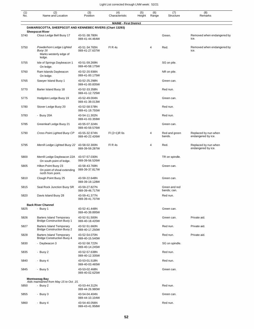
Light List corrected through LNM week: 52/21
52
(1) (2) (3) (4) (5) (6) (7) (8) No. Name and Location Position Characteristic Height Range Structure Remarks
MAINE - First District
DAMARISCOTTA, SHEEPSCOT AND KENNEBEC RIVERS (Chart 13293)
Sheepscot River
5740 Clous Ledge Bell Buoy 17 43-51-38.780N
069-41-44.464W
Green. Removed when endangered by ice.
5750 Powderhorn Ledge Lighted Buoy 16
43-51-34.765N 069-41-27.637W
Fl R 4s 4 Red. Removed when endangered by ice.
Marks westerly edge of ledge.
5755 Isle of Springs Daybeacon 1 43-51-59.269N
SG on pile.
On ledge. 069-40-58.175W
5760 Ram Islands Daybeacon 43-52-20.936N NR on pile.
On ledge. 069-41-00.175W
5765 Sawyer Island Buoy 1 43-52-25.298N Green can.
069-41-00.835W
5770 Barter Island Buoy 18 43-52-33.358N Red nun.
069-41-12.725W
5775 Hodgdon Ledge Buoy 19 43-52-49.004N Green can.
069-41-39.013W
5780 Stover Ledge Buoy 20 43-52-58.578N Red nun.
069-41-19.755W
5783 - Buoy 20A 43-54-11.302N Red nun.
069-41-03.359W
5785 Greenleaf Ledge Buoy 21 43-55-07.324N Green can.
069-40-59.576W
5790 Cross Point Lighted Buoy CP 43-55-32.974N
069-40-22.426W
Fl (2+1)R 6s 4 Red and green bands.
Replaced by nun when endangered by ice.
5795 Merrill Ledge Lighted Buoy 22 43-58-02.300N
069-39-59.287W
Fl R 4s 4 Red. Replaced by nun when endangered by ice.
5800 Merrill Ledge Daybeacon 22A 43-57-57.030N
TR on spindle.
On south point of ledge. 069-39-56.526W
5805 Hilton Point Buoy 23 43-58-43.769N Green can.
On point of shoal extending north from point.
069-39-37.817W
5810 Clough Point Buoy 25 43-59-22.648N Green can.
069-39-19.128W
5815 Seal Rock Junction Buoy SR 43-59-27.827N
069-39-46.717W
Green and red bands; can.
5820 Davis Island Buoy 28 43-59-41.377N Red nun.
069-39-41.707W
Back River Channel
5825 - Buoy 1 43-52-41.448N Green can.
069-40-39.895W
5826 Barters Island Temporary Bridge Construction Buoy 1
43-52-51.500N
069-40-18.420W
Green can. Private aid.
5827 Barters Island Temporary Bridge Construction Buoy 2
43-52-51.660N
069-40-17.250W
Red nun. Private aid.
5828 Barters Island Temporary Bridge Construction Buoy 4
43-52-54.070N
069-40-15.540W
Red nun. Private aid.
5830 - Daybeacon 3 43-52-58.722N SG on spindle.
069-40-14.245W
5835 - Buoy 2 43-52-57.638N Red nun.
069-40-12.335W
5840 - Buoy 4 43-53-01.518N Red nun.
069-40-03.465W
5845 - Buoy 5 43-53-02.468N Green can.
069-40-02.625W
Montsweag Bay Aids maintained from May 15 to Oct. 15.
5850 - Buoy 2 43-53-44.312N Red nun.
069-44-26.980W
5855 - Buoy 3 43-54-04.404N Green can.
069-44-10.104W
5860 - Buoy 4 43-54-40.056N Red nun. 069-43-41.958W
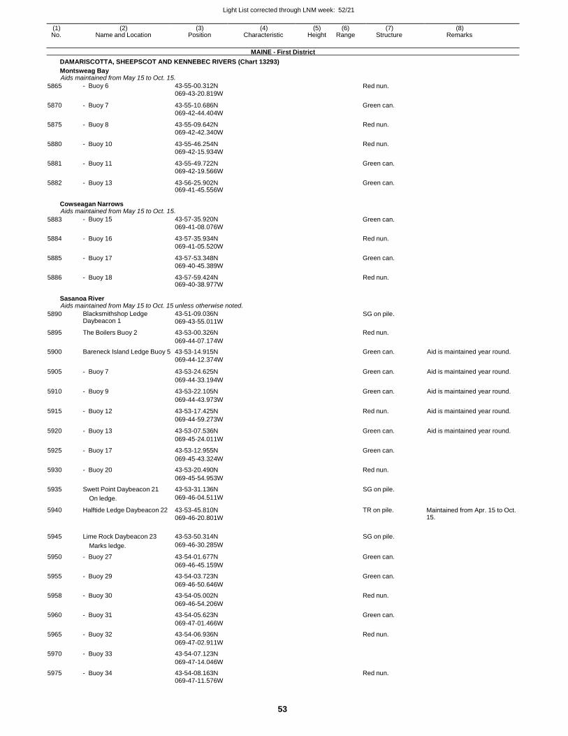
Light List corrected through LNM week: 52/21
53
(1) (2) (3) (4) (5) (6) (7) (8) No. Name and Location Position Characteristic Height Range Structure Remarks
MAINE - First District
DAMARISCOTTA, SHEEPSCOT AND KENNEBEC RIVERS (Chart 13293)
Montsweag Bay Aids maintained from May 15 to Oct. 15.
5865 - Buoy 6 43-55-00.312N
069-43-20.819W Red nun.
5870 - Buoy 7 43-55-10.686N
069-42-44.404W
Green can.
5875 - Buoy 8 43-55-09.642N
069-42-42.340W
Red nun.
5880 - Buoy 10 43-55-46.254N
069-42-15.934W
Red nun.
5881 - Buoy 11 43-55-49.722N
069-42-19.566W
Green can.
5882 - Buoy 13 43-56-25.902N 069-41-45.556W
Green can.
Cowseagan Narrows Aids maintained from May 15 to Oct. 15.
5883 - Buoy 15 43-57-35.920N
069-41-08.076W Green can.
5884 - Buoy 16 43-57-35.934N
069-41-05.520W
Red nun.
5885 - Buoy 17 43-57-53.348N
069-40-45.389W
Green can.
5886 - Buoy 18 43-57-59.424N 069-40-38.977W
Red nun.
Sasanoa River Aids maintained from May 15 to Oct. 15 unless otherwise noted.
5890 Blacksmithshop Ledge Daybeacon 1
43-51-09.036N
069-43-55.011W SG on pile.
5895 The Boilers Buoy 2 43-53-00.326N Red nun.
069-44-07.174W
5900 Bareneck Island Ledge Buoy 5 43-53-14.915N Green can. Aid is maintained year round. 069-44-12.374W
5905 - Buoy 7 43-53-24.625N Green can. Aid is maintained year round.
069-44-33.194W
5910 - Buoy 9 43-53-22.105N Green can. Aid is maintained year round.
069-44-43.973W
5915 - Buoy 12 43-53-17.425N Red nun. Aid is maintained year round.
069-44-59.273W
5920 - Buoy 13 43-53-07.536N Green can. Aid is maintained year round.
069-45-24.011W
5925 - Buoy 17 43-53-12.955N Green can.
069-45-43.324W
5930 - Buoy 20 43-53-20.490N Red nun.
069-45-54.953W
5935 Swett Point Daybeacon 21 43-53-31.136N SG on pile.
On ledge. 069-46-04.511W
5940 Halftide Ledge Daybeacon 22 43-53-45.810N
069-46-20.801W
TR on pile. Maintained from Apr. 15 to Oct. 15.
5945 Lime Rock Daybeacon 23 43-53-50.314N SG on pile.
Marks ledge. 069-46-30.285W
5950 - Buoy 27 43-54-01.677N Green can.
069-46-45.159W
5955 - Buoy 29 43-54-03.723N Green can.
069-46-50.646W
5958 - Buoy 30 43-54-05.002N Red nun.
069-46-54.206W
5960 - Buoy 31 43-54-05.623N Green can.
069-47-01.466W
5965 - Buoy 32 43-54-06.936N Red nun.
069-47-02.911W
5970 - Buoy 33 43-54-07.123N
069-47-14.046W
5975 - Buoy 34 43-54-08.163N Red nun.
069-47-11.576W
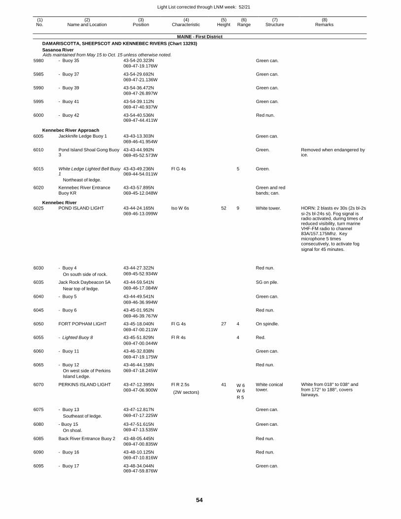
Light List corrected through LNM week: 52/21
54
(1) (2) (3) (4) (5) (6) (7) (8) No. Name and Location Position Characteristic Height Range Structure Remarks
MAINE - First District
DAMARISCOTTA, SHEEPSCOT AND KENNEBEC RIVERS (Chart 13293)
Sasanoa River Aids maintained from May 15 to Oct. 15 unless otherwise noted.
5980 - Buoy 35 43-54-20.323N
069-47-19.176W Green can.
5985 - Buoy 37 43-54-29.692N
069-47-21.136W
Green can.
5990 - Buoy 39 43-54-36.472N
069-47-26.897W
Green can.
5995 - Buoy 41 43-54-39.112N
069-47-40.937W
Green can.
6000 - Buoy 42 43-54-40.536N 069-47-44.411W
Red nun.
Kennebec River Approach
6005
6010
Jackknife Ledge Buoy 1
Pond Island Shoal Gong Buoy 3
43-43-13.303N
069-46-41.954W
43-43-44.992N
069-45-52.573W
Green can.
Green.
Removed when endangered by ice.
6015 White Ledge Lighted Bell Buoy
1 43-43-49.236N 069-44-54.011W
Fl G 4s 5 Green.
Northeast of ledge.
6020 Kennebec River Entrance 43-43-57.895N Green and red Buoy KR 069-45-12.048W bands; can.
Kennebec River
6025 POND ISLAND LIGHT 43-44-24.165N Iso W 6s 52 9 White tower. HORN: 2 blasts ev 30s (2s bl-2s 069-46-13.099W si-2s bl-24s si). Fog signal is radio activated, during times of reduced visibility, turn marine VHF-FM radio to channel 83A/157.175Mhz. Key microphone 5 times consecutively, to activate fog
signal for 45 minutes.
6030
- Buoy 4
43-44-27.322N
Red nun.
On south side of rock. 069-45-52.934W
6035 Jack Rock Daybeacon 5A 43-44-59.541N SG on pile.
Near top of ledge. 069-46-17.084W
6040 - Buoy 5 43-44-49.541N Green can.
069-46-36.994W
6045 - Buoy 6 43-45-01.952N Red nun.
069-46-39.767W
6050 FORT POPHAM LIGHT 43-45-18.040N Fl G 4s 27 4 On spindle.
069-47-00.211W
6055 - Lighted Buoy 8 43-45-51.829N Fl R 4s 4 Red.
069-47-00.044W
6060 - Buoy 11 43-46-32.838N Green can.
069-47-19.175W
6065 - Buoy 12 43-46-44.158N Red nun.
On west side of Perkins 069-47-18.245W
Island Ledge.
6070 PERKINS ISLAND LIGHT 43-47-12.395N
069-47-06.900W
Fl R 2.5s
(2W sectors)
41 W 6 W 6
White conical tower.
White from 018° to 038° and from 172° to 188°, covers fairways.
6075
- Buoy 13
43-47-12.817N
R 5
Green can.
Southeast of ledge. 069-47-17.225W
6080 - Buoy 15
On shoal.
43-47-51.615N
069-47-13.535W
Green can.
6085 Back River Entrance Buoy 2 43-48-05.445N
069-47-00.835W
Red nun.
6090 - Buoy 16 43-48-10.125N
069-47-10.816W
Red nun.
6095 - Buoy 17 43-48-34.044N 069-47-59.876W
Green can.
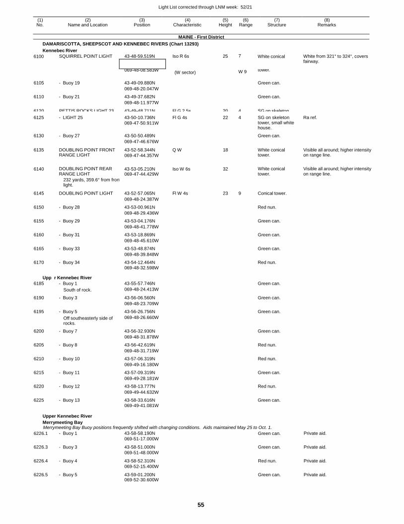
Light List corrected through LNM week: 52/21
55
(1) (2) (3) (4) (5) (6) (7) (8) No. Name and Location Position Characteristic Height Range Structure Remarks
MAINE - First District
DAMARISCOTTA, SHEEPSCOT AND KENNEBEC RIVERS (Chart 13293)
Kennebec River
6100 SQUIRREL POINT LIGHT 43-48-59.519N Iso R 6s 25 7 White conical White from 321° to 324°, covers fairway.
6125 - LIGHT 25 43-50-10.736N
069-47-50.911W
Fl G 4s 22 4 SG on skeleton tower, small white house.
Ra ref.
6130 - Buoy 27 43-50-50.489N Green can.
069-47-46.676W
6135 DOUBLING POINT FRONT RANGE LIGHT
43-52-58.344N
069-47-44.357W
Q W 18 White conical tower.
Visible all around; higher intensity on range line.
6140 DOUBLING POINT REAR RANGE LIGHT
43-53-05.210N 069-47-44.429W
Iso W 6s 32
White conical tower.
Visible all around; higher intensity on range line.
232 yards, 359.6° from front light.
6145 DOUBLING POINT LIGHT 43-52-57.065N Fl W 4s 23 9 Conical tower.
069-48-24.387W
6150 - Buoy 28 43-53-00.961N Red nun.
069-48-29.436W
6155 - Buoy 29 43-53-04.176N Green can.
069-48-41.778W
6160 - Buoy 31 43-53-18.869N Green can.
069-48-45.610W
6165 - Buoy 33 43-53-48.874N Green can.
069-48-39.848W
6170 - Buoy 34 43-54-12.464N Red nun. 069-48-32.598W
Uppe
6185
r Kennebec River
- Buoy 1
43-55-57.746N
Green can.
South of rock. 069-48-24.413W
6190 - Buoy 3 43-56-06.560N Green can.
069-48-23.709W
6195 - Buoy 5 43-56-26.756N Green can.
Off southeasterly side of rocks.
069-48-26.660W
6200 - Buoy 7 43-56-32.930N Green can.
069-48-31.878W
6205 - Buoy 8 43-56-42.619N Red nun.
069-48-31.719W
6210 - Buoy 10 43-57-06.319N Red nun.
069-49-16.180W
6215 - Buoy 11 43-57-09.319N Green can.
069-49-28.181W
6220 - Buoy 12 43-58-13.777N Red nun.
069-49-44.632W
6225 - Buoy 13 43-58-33.616N Green can. 069-49-41.081W
Upper Kennebec River
Merrymeeting Bay Merrymeeting Bay Buoy positions frequently shifted with changing conditions. Aids maintained May 25 to Oct. 1.
6226.1 - Buoy 1 43-58-58.190N
069-51-17.000W Green can. Private aid.
6226.3 - Buoy 3 43-58-51.000N
069-51-48.000W
Green can. Private aid.
6226.4 - Buoy 4 43-58-52.310N
069-52-15.400W
Red nun. Private aid.
6226.5 - Buoy 5 43-59-01.200N 069-52-30.600W
Green can. Private aid.
069-48-08.583W (W sector) W 9 tower.
6105 - Buoy 19 43-49-09.880N
Green can.
069-48-20.047W
6110 - Buoy 21 43-49-37.682N Green can.
069-48-11.977W
6120 PETTIS ROCKS LIGHT 23
Off south end of rocks.
43-49-48.711N
069-47-56.676W
Fl G 2.5s 20 4 SG on skeleton tower.
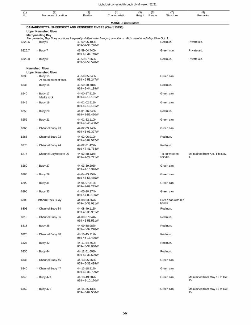
Light List corrected through LNM week: 52/21
56
(1) (2) (3) (4) (5) (6) (7) (8) No. Name and Location Position Characteristic Height Range Structure Remarks
MAINE - First District
DAMARISCOTTA, SHEEPSCOT AND KENNEBEC RIVERS (Chart 13293)
Upper Kennebec River
Merrymeeting Bay Merrymeeting Bay Buoy positions frequently shifted with changing conditions. Aids maintained May 25 to Oct. 1.
6226.6 - Buoy 6 43-59-05.400N
069-52-33.720W Red nun. Private aid.
6226.7 - Buoy 7 43-59-04.740N
069-52-31.740W
Green nun. Private aid.
6226.8 - Buoy 8 43-59-07.260N 069-52-59.520W
Red nun. Private aid.
Kennebec River
Upper Kennebec River
6230 - Buoy 15 43-59-05.648N Green can.
At south point of flats. 069-49-53.247W
6235 - Buoy 16 43-59-20.781N Red nun.
069-49-44.189W
6240 - Buoy 17 44-00-27.512N Green can.
Marks rock. 069-49-16.181W
6245 - Buoy 19 44-01-02.511N Green can.
069-49-13.181W
6250 - Buoy 20 44-01-16.346N Red nun.
069-48-55.450W
6255 - Buoy 21 44-01-32.110N Green can.
069-48-46.480W
6260 - Channel Buoy 23 44-02-09.143N Green can.
069-48-03.327W
6265 - Channel Buoy 22 44-02-06.919N Red nun.
069-48-02.512W
6270 - Channel Buoy 24 44-02-31.422N Red nun.
069-47-41.754W
6275 - Channel Daybeacon 26 44-02-50.136N
069-47-29.711W
TR on wooden spindle.
Maintained from Apr. 1 to Nov. 1.
6280 - Buoy 27 44-03-39.206N Green can.
069-47-16.376W
6285 - Buoy 29 44-04-13.154N Green can.
069-46-58.465W
6290 - Buoy 31 44-05-07.313N Green can.
069-47-09.215W
6295 - Buoy 33 44-05-20.274N Green can.
069-47-09.136W
6300 Hathorn Rock Buoy 44-08-03.367N
069-45-33.921W
Green can with red bands.
6305 - Channel Buoy 34 44-08-49.116N Red nun.
069-45-36.991W
6310 - Channel Buoy 36 44-09-37.844N Red nun.
069-45-53.551W
6315 - Buoy 38 44-09-58.983N Red nun.
069-45-37.240W
6320 - Channel Buoy 40 44-10-45.112N Red nun.
069-45-13.429W
6325 - Buoy 42 44-11-54.750N Red nun.
069-45-34.030W
6330 - Buoy 44 44-12-51.608N Red nun.
069-45-36.639W
6335 - Channel Buoy 45 44-13-05.668N Green can.
069-45-33.499W
6340 - Channel Buoy 47 44-13-18.517N Green can.
069-45-36.799W
6345 - Buoy 47A 44-13-49.287N
069-46-10.170W
Green can. Maintained from May 15 to Oct. 15.
6350 - Buoy 47B 44-14-35.433N 069-46-02.506W
Green can. Maintained from May 15 to Oct. 15.
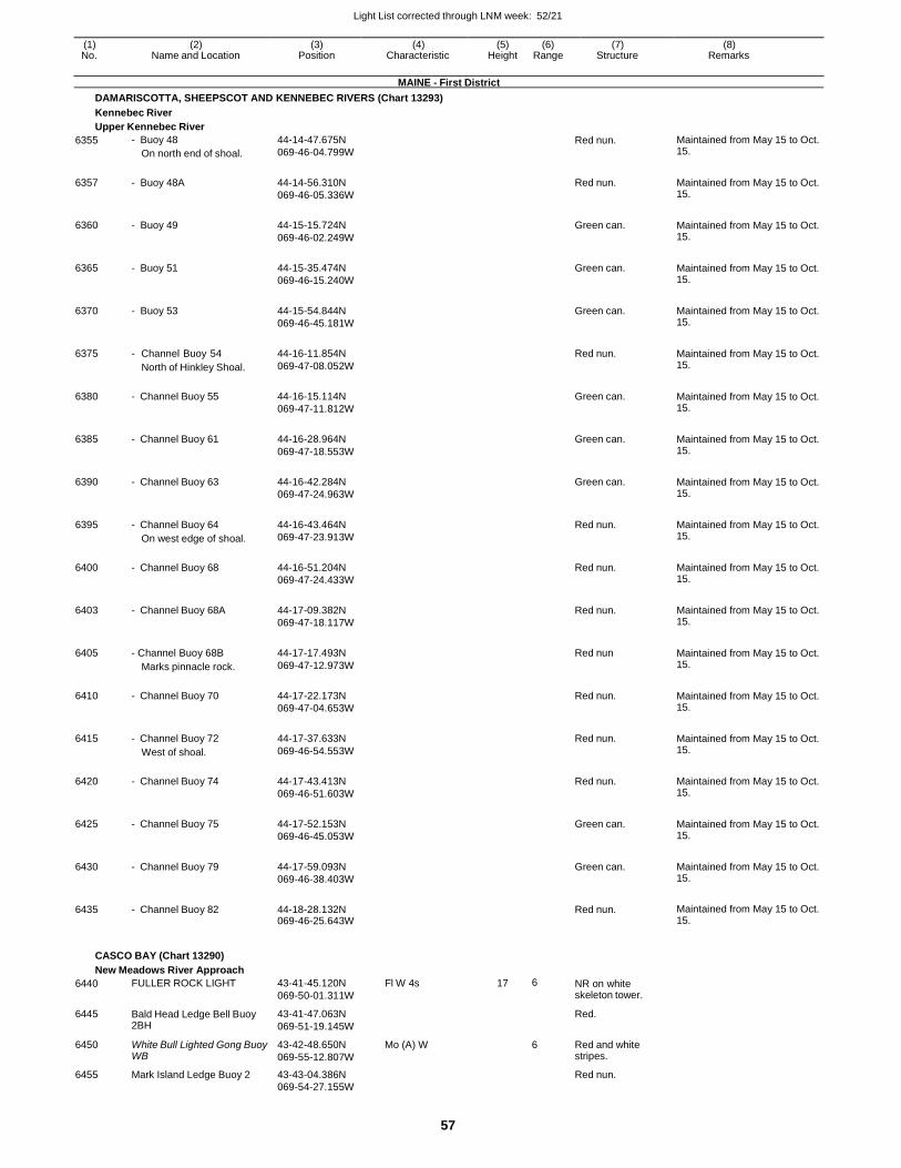
Light List corrected through LNM week: 52/21
57
(1) (2) (3) (4) (5) (6) (7) (8) No. Name and Location Position Characteristic Height Range Structure Remarks
MAINE - First District
DAMARISCOTTA, SHEEPSCOT AND KENNEBEC RIVERS (Chart 13293)
Kennebec River
Upper Kennebec River
6355 - Buoy 48
On north end of shoal.
44-14-47.675N
069-46-04.799W Red nun. Maintained from May 15 to Oct.
15.
6357 - Buoy 48A 44-14-56.310N
069-46-05.336W
Red nun. Maintained from May 15 to Oct. 15.
6360 - Buoy 49 44-15-15.724N
069-46-02.249W
Green can. Maintained from May 15 to Oct. 15.
6365 - Buoy 51 44-15-35.474N
069-46-15.240W
Green can. Maintained from May 15 to Oct. 15.
6370 - Buoy 53 44-15-54.844N
069-46-45.181W
Green can. Maintained from May 15 to Oct. 15.
6375 - Channel Buoy 54
North of Hinkley Shoal.
44-16-11.854N
069-47-08.052W
Red nun. Maintained from May 15 to Oct. 15.
6380 - Channel Buoy 55 44-16-15.114N
069-47-11.812W
Green can. Maintained from May 15 to Oct. 15.
6385 - Channel Buoy 61 44-16-28.964N
069-47-18.553W
Green can. Maintained from May 15 to Oct. 15.
6390 - Channel Buoy 63 44-16-42.284N
069-47-24.963W
Green can. Maintained from May 15 to Oct. 15.
6395 - Channel Buoy 64
On west edge of shoal.
44-16-43.464N
069-47-23.913W
Red nun. Maintained from May 15 to Oct. 15.
6400 - Channel Buoy 68 44-16-51.204N
069-47-24.433W
Red nun. Maintained from May 15 to Oct. 15.
6403 - Channel Buoy 68A 44-17-09.382N
069-47-18.117W
Red nun. Maintained from May 15 to Oct. 15.
6405 - Channel Buoy 68B
Marks pinnacle rock.
44-17-17.493N
069-47-12.973W
Red nun Maintained from May 15 to Oct. 15.
6410 - Channel Buoy 70 44-17-22.173N
069-47-04.653W
Red nun. Maintained from May 15 to Oct. 15.
6415 - Channel Buoy 72
West of shoal.
44-17-37.633N
069-46-54.553W
Red nun. Maintained from May 15 to Oct. 15.
6420 - Channel Buoy 74 44-17-43.413N
069-46-51.603W
Red nun. Maintained from May 15 to Oct. 15.
6425 - Channel Buoy 75 44-17-52.153N
069-46-45.053W
Green can. Maintained from May 15 to Oct. 15.
6430 - Channel Buoy 79 44-17-59.093N
069-46-38.403W
Green can. Maintained from May 15 to Oct. 15.
6435 - Channel Buoy 82 44-18-28.132N 069-46-25.643W
Red nun. Maintained from May 15 to Oct. 15.
CASCO BAY (Chart 13290)
New Meadows River Approach
6440 FULLER ROCK LIGHT 43-41-45.120N
069-50-01.311W
Fl W 4s 17 6 NR on white skeleton tower.
6445 Bald Head Ledge Bell Buoy 2BH
43-41-47.063N
069-51-19.145W
Red.
6450 White Bull Lighted Gong Buoy WB
43-42-48.650N
069-55-12.807W
Mo (A) W 6 Red and white stripes.
6455 Mark Island Ledge Buoy 2 43-43-04.386N Red nun. 069-54-27.155W
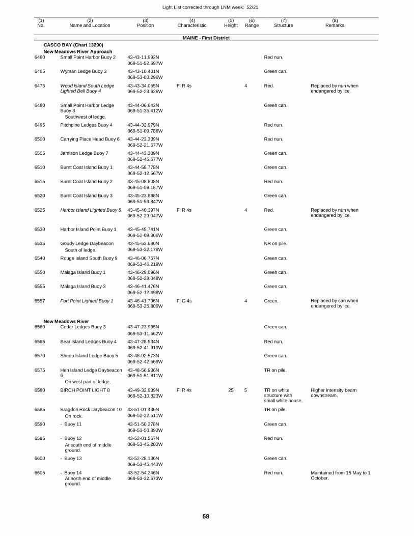
Light List corrected through LNM week: 52/21
58
(1) (2) (3) (4) (5) (6) (7) (8) No. Name and Location Position Characteristic Height Range Structure Remarks
MAINE - First District
CASCO BAY (Chart 13290)
New Meadows River Approach
6460 Small Point Harbor Buoy 2 43-43-11.992N Red nun.
069-51-52.597W
6465 Wyman Ledge Buoy 3 43-43-10.401N Green can.
069-53-03.296W
6475 Wood Island South Ledge Lighted Bell Buoy 4
43-43-34.065N
069-52-23.626W
Fl R 4s 4 Red. Replaced by nun when endangered by ice.
6480 Small Point Harbor Ledge Buoy 3
43-44-06.642N 069-51-35.412W
Green can.
Southwest of ledge.
6495 Pitchpine Ledges Buoy 4 43-44-32.979N Red nun.
069-51-09.786W
6500 Carrying Place Head Buoy 6 43-44-23.339N Red nun.
069-52-21.677W
6505 Jamison Ledge Buoy 7 43-44-43.339N Green can.
069-52-46.677W
6510 Burnt Coat Island Buoy 1 43-44-58.778N Green can.
069-52-12.567W
6515 Burnt Coat Island Buoy 2 43-45-08.808N Red nun.
069-51-59.187W
6520 Burnt Coat Island Buoy 3 43-45-23.888N Green can.
069-51-59.847W
6525 Harbor Island Lighted Buoy 8 43-45-40.397N
069-52-29.047W
Fl R 4s 4 Red. Replaced by nun when endangered by ice.
6530 Harbor Island Point Buoy 1 43-45-45.741N
Green can.
069-52-09.306W
6535 Goudy Ledge Daybeacon 43-45-53.680N NR on pile.
South of ledge. 069-53-32.178W
6540 Rouge Island South Buoy 9 43-46-06.767N Green can.
069-53-46.219W
6550 Malaga Island Buoy 1 43-46-29.096N Green can.
069-52-29.048W
6555 Malaga Island Buoy 3 43-46-41.476N Green can.
069-52-12.498W
6557 Fort Point Lighted Buoy 1 43-46-41.796N 069-53-25.809W
Fl G 4s 4 Green. Replaced by can when endangered by ice.
New Meadows River 6560 Cedar Ledges Buoy 3 43-47-23.935N Green can.
069-53-11.562W
6565 Bear Island Ledges Buoy 4 43-47-28.534N Red nun.
069-52-41.919W
6570 Sheep Island Ledge Buoy 5 43-48-02.573N Green can.
069-52-42.669W
6575 Hen Island Ledge Daybeacon 6
43-48-56.936N 069-51-51.811W
TR on pile.
On west part of ledge.
6580 BIRCH POINT LIGHT 8 43-49-32.939N
069-52-10.823W
Fl R 4s 25 5 TR on white structure with small white house.
Higher intensity beam downstream.
6585 Bragdon Rock Daybeacon 10 43-51-01.436N TR on pile.
On rock. 069-52-22.511W
6590 - Buoy 11 43-51-50.278N Green can.
069-53-50.393W
6595 - Buoy 12 43-52-01.567N Red nun.
At south end of middle ground.
069-53-45.203W
6600 - Buoy 13 43-52-28.136N Green can.
069-53-45.443W
6605 - Buoy 14
At north end of middle ground.
43-52-54.246N
069-53-32.673W
Red nun. Maintained from 15 May to 1 October.
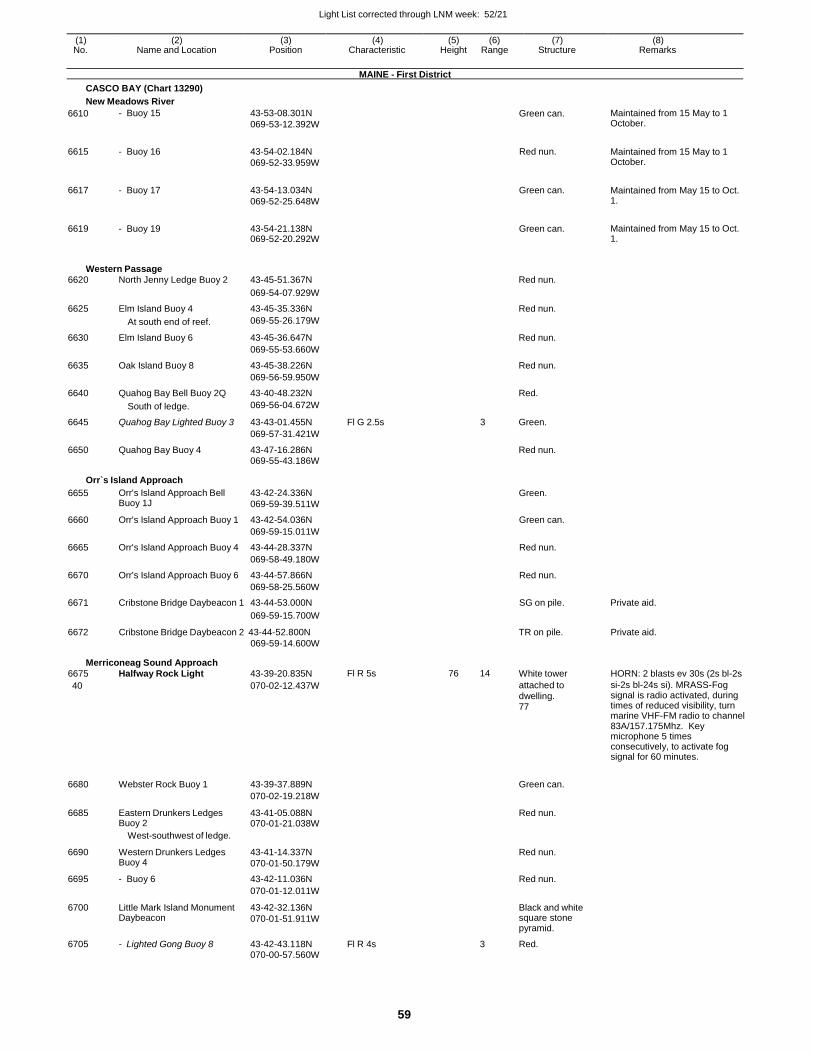
Light List corrected through LNM week: 52/21
59
(1) (2) (3) (4) (5) (6) (7) (8) No. Name and Location Position Characteristic Height Range Structure Remarks
MAINE - First District
CASCO BAY (Chart 13290)
New Meadows River
6610 - Buoy 15 43-53-08.301N
069-53-12.392W Green can. Maintained from 15 May to 1
October.
6615 - Buoy 16 43-54-02.184N
069-52-33.959W
Red nun. Maintained from 15 May to 1 October.
6617 - Buoy 17 43-54-13.034N
069-52-25.648W
Green can. Maintained from May 15 to Oct. 1.
6619 - Buoy 19 43-54-21.138N 069-52-20.292W
Green can. Maintained from May 15 to Oct. 1.
Western Passage 6620 North Jenny Ledge Buoy 2 43-45-51.367N Red nun.
069-54-07.929W
6625 Elm Island Buoy 4 43-45-35.336N Red nun.
At south end of reef. 069-55-26.179W
6630 Elm Island Buoy 6 43-45-36.647N Red nun.
069-55-53.660W
6635 Oak Island Buoy 8 43-45-38.226N Red nun.
069-56-59.950W
6640 Quahog Bay Bell Buoy 2Q 43-40-48.232N Red.
South of ledge. 069-56-04.672W
6645 Quahog Bay Lighted Buoy 3 43-43-01.455N Fl G 2.5s 3 Green.
069-57-31.421W
6650 Quahog Bay Buoy 4 43-47-16.286N Red nun. 069-55-43.186W
Orr`s Island Approach
6655 Orr's Island Approach Bell Buoy 1J
43-42-24.336N
069-59-39.511W
Green.
6660 Orr's Island Approach Buoy 1 43-42-54.036N Green can.
069-59-15.011W
6665 Orr's Island Approach Buoy 4 43-44-28.337N Red nun.
069-58-49.180W
6670 Orr's Island Approach Buoy 6 43-44-57.866N Red nun.
069-58-25.560W
6671 Cribstone Bridge Daybeacon 1 43-44-53.000N SG on pile. Private aid.
6672
069-59-15.700W
Cribstone Bridge Daybeacon 2 43-44-52.800N
069-59-14.600W
TR on pile.
Private aid.
Merriconeag Sound Approach 6675 Halfway Rock Light 43-39-20.835N Fl R 5s 76 14 White tower HORN: 2 blasts ev 30s (2s bl-2s
40 070-02-12.437W attached to dwelling. 77
si-2s bl-24s si). MRASS-Fog signal is radio activated, during times of reduced visibility, turn marine VHF-FM radio to channel 83A/157.175Mhz. Key microphone 5 times consecutively, to activate fog signal for 60 minutes.
6680 Webster Rock Buoy 1 43-39-37.889N
Green can.
070-02-19.218W
6685 Eastern Drunkers Ledges Buoy 2
43-41-05.088N 070-01-21.038W
Red nun.
West-southwest of ledge.
6690 Western Drunkers Ledges Buoy 4
43-41-14.337N
070-01-50.179W
Red nun.
6695 - Buoy 6 43-42-11.036N Red nun.
070-01-12.011W
6700 Little Mark Island Monument Daybeacon
43-42-32.136N
070-01-51.911W
Black and white square stone pyramid.
6705 - Lighted Gong Buoy 8 43-42-43.118N Fl R 4s 3 Red.
070-00-57.560W
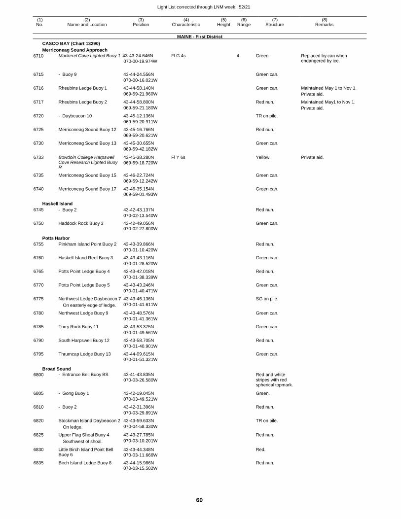
Light List corrected through LNM week: 52/21
60
(1) (2) (3) (4) (5) (6) (7) (8) No. Name and Location Position Characteristic Height Range Structure Remarks
MAINE - First District
CASCO BAY (Chart 13290)
Merriconeag Sound Approach
6710 Mackerel Cove Lighted Buoy 1 43-43-24.646N
070-00-19.974W
Fl G 4s 4 Green. Replaced by can when endangered by ice.
6715 - Buoy 9 43-44-24.556N Green can.
070-00-16.021W
6716 Rheubins Ledge Buoy 1 43-44-58.140N Green can. Maintained May 1 to Nov 1.
069-59-21.960W Private aid.
6717 Rheubins Ledge Buoy 2 43-44-58.800N Red nun. Maintained May1 to Nov 1.
069-59-21.180W Private aid.
6720 - Daybeacon 10 43-45-12.136N TR on pile.
069-59-20.911W
6725 Merriconeag Sound Buoy 12 43-45-16.766N Red nun.
069-59-20.621W
6730 Merriconeag Sound Buoy 13 43-45-30.655N Green can.
069-59-42.182W
6733 Bowdoin College Harpswell Cove Research Lighted Buoy R
43-45-38.280N
069-59-18.720W
Fl Y 6s Yellow. Private aid.
6735 Merriconeag Sound Buoy 15 43-46-22.724N Green can.
069-59-12.242W
6740 Merriconeag Sound Buoy 17 43-46-35.154N Green can.
069-59-01.493W
Haskell Island
6745 - Buoy 2 43-42-43.137N Red nun.
070-02-13.540W
6750 Haddock Rock Buoy 3 43-42-49.056N Green can. 070-02-27.800W
Potts Harbor
6755 Pinkham Island Point Buoy 2 43-43-39.866N Red nun.
070-01-10.420W
6760 Haskell Island Reef Buoy 3 43-43-43.116N Green can.
070-01-28.520W
6765 Potts Point Ledge Buoy 4 43-43-42.018N Red nun.
070-01-38.339W
6770 Potts Point Ledge Buoy 5 43-43-43.246N Green can.
070-01-40.471W
6775 Northwest Ledge Daybeacon 7 43-43-46.136N SG on pile.
On easterly edge of ledge. 070-01-41.611W
6780 Northwest Ledge Buoy 9 43-43-48.576N Green can.
070-01-41.361W
6785 Torry Rock Buoy 11 43-43-53.375N Green can.
070-01-49.561W
6790 South Harpswell Buoy 12 43-43-58.705N Red nun.
070-01-40.901W
6795 Thrumcap Ledge Buoy 13 43-44-09.615N Green can. 070-01-51.321W
Broad Sound
6800 - Entrance Bell Buoy BS 43-41-43.835N
070-03-26.580W Red and white stripes with red spherical topmark.
6805 - Gong Buoy 1 43-42-19.045N Green.
070-03-49.521W
6810 - Buoy 2 43-42-31.396N Red nun.
070-03-29.891W
6820 Stockman Island Daybeacon 2 43-43-59.633N TR on pile.
On ledge. 070-04-58.330W
6825 Upper Flag Shoal Buoy 4 43-43-27.785N Red nun.
Southwest of shoal. 070-03-10.201W
6830 Little Birch Island Point Bell Buoy 6
43-43-44.348N
070-03-11.666W
Red.
6835 Birch Island Ledge Buoy 8 43-44-15.986N Red nun. 070-03-15.502W
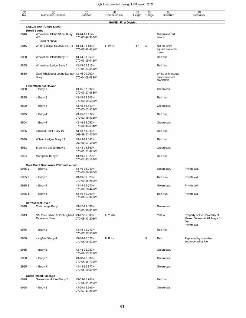
Light List corrected through LNM week: 52/21
61
(1) (2) (3) (4) (5) (6) (7) (8) No. Name and Location Position Characteristic Height Range Structure Remarks
MAINE - First District
CASCO BAY (Chart 13290)
Broad Sound
6840 Whaleboat Island Shoal Buoy WS
43-44-16.114N 070-03-44.392W
Green and red bands.
6845
South of shoal.
WHALEBOAT ISLAND LIGHT
43-44-31.136N
070-03-40.411W
Fl W 6s
47
4
NR on white square skeleton tower.
6850 Whaleboat Island Buoy 10 43-44-33.253N Red nun.
070-03-19.042W
6855 Whaleboat Ledge Buoy 6 43-45-02.812N Red nun.
070-04-23.653W
6860 Little Whaleboat Ledge Danger 43-45-20.252N White with orange
Buoy
Little Whaleboat Island
070-04-09.083W bands worded DANGER.
6880 - Buoy 1 43-45-37.992N Green can.
070-03-17.663W
6885 - Buoy 2 43-45-33.902N Red nun.
070-03-05.532W
6890 - Buoy 3 43-45-56.512N Green can.
070-03-03.453W
6895 - Buoy 4 43-45-55.872N Red nun.
070-02-48.013W
6904 - Buoy 5 43-46-36.052N Green can.
070-02-45.634W
6925 Lookout Point Buoy 10 43-48-41.041N Red nun.
069-59-47.475W
6930 Wilson Ledges Buoy 12 43-49-14.041N Red nun.
069-59-07.196W
6933 Branning Ledge Buoy 1 43-48-08.860N Green can.
070-01-31.475W
6934 Merepoint Buoy 2 43-49-20.329N Red nun. 070-01-43.187W
Mere Point Brunswick PD Boat Launch
6935.1 - Buoy 1 43-49-38.040N Green can. Private aid.
070-00-56.880W
6935.2 - Buoy 2 43-49-38.820N Red nun. Private aid.
070-00-55.980W
6935.3 - Buoy 3 43-49-39.540N Green can. Private aid.
070-00-58.440W
6935.4 - Buoy 4 43-49-40.200N Red nun. Private aid. 070-00-57.840W
Harraseeket River 6940 Crab Ledge Buoy 1 43-47-29.036N Green can.
070-05-10.011W
6943 UM Crab Island LOBO Lighted Research Buoy
43-47-36.380N
070-05-43.206W
Fl Y 20s Yellow. Property of the University of Maine. Seasonal 01 May - 31 Dec.
Private aid.
6945 - Buoy 2 43-48-02.243N Red nun.
070-05-17.639W
6950 - Lighted Buoy 4 43-48-20.028N
070-06-08.531W
Fl R 4s 3 Red. Replaced by nun when endangered by ice
6955 - Buoy 5 43-48-22.297N
Green can.
070-06-13.282W
6960 - Buoy 7 43-48-26.889N Green can.
070-06-18.719W
6965 - Buoy 9 43-48-36.377N Green can.
070-06-20.597W
Green Island Passage
6990 Green Island Reef Buoy 2
43-39-16.287N
Red nun.
070-06-54.240W
6995 - Buoy 3 43-39-15.566N Green can. 070-07-11.260W
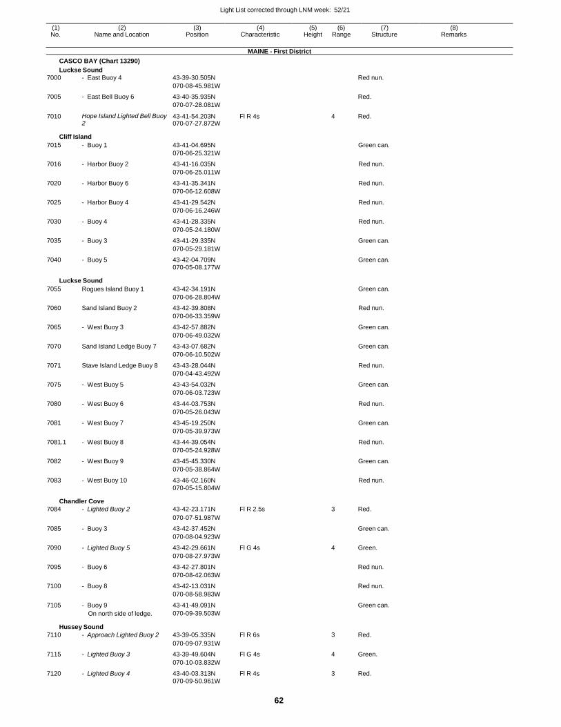
Light List corrected through LNM week: 52/21
62
(1) (2) (3) (4) (5) (6) (7) (8) No. Name and Location Position Characteristic Height Range Structure Remarks
MAINE - First District
CASCO BAY (Chart 13290)
Luckse Sound
7000 - East Buoy 4 43-39-30.505N Red nun.
070-08-45.981W
7005 - East Bell Buoy 6 43-40-35.935N Red.
070-07-28.081W
7010 Hope Island Lighted Bell Buoy 2
43-41-54.203N 070-07-27.872W
Fl R 4s 4 Red.
Cliff Island
7015 - Buoy 1 43-41-04.695N Green can.
070-06-25.321W
7016 - Harbor Buoy 2 43-41-16.035N Red nun.
070-06-25.011W
7020 - Harbor Buoy 6 43-41-35.341N Red nun.
070-06-12.608W
7025 - Harbor Buoy 4 43-41-29.542N Red nun.
070-06-16.246W
7030 - Buoy 4 43-41-28.335N Red nun.
070-05-24.180W
7035 - Buoy 3 43-41-29.335N Green can.
070-05-29.181W
7040 - Buoy 5 43-42-04.709N Green can. 070-05-08.177W
Luckse Sound
7055 Rogues Island Buoy 1 43-42-34.191N Green can.
070-06-28.804W
7060 Sand Island Buoy 2 43-42-39.808N Red nun.
070-06-33.359W
7065 - West Buoy 3 43-42-57.882N Green can.
070-06-49.032W
7070 Sand Island Ledge Buoy 7 43-43-07.682N Green can.
070-06-10.502W
7071 Stave Island Ledge Buoy 8 43-43-28.044N Red nun.
070-04-43.492W
7075 - West Buoy 5 43-43-54.032N Green can.
070-06-03.723W
7080 - West Buoy 6 43-44-03.753N Red nun.
070-05-26.043W
7081 - West Buoy 7 43-45-19.250N Green can.
070-05-39.973W
7081.1 - West Buoy 8 43-44-39.054N Red nun.
070-05-24.928W
7082 - West Buoy 9 43-45-45.330N Green can.
070-05-38.864W
7083 - West Buoy 10 43-46-02.160N Red nun. 070-05-15.804W
Chandler Cove
7084 - Lighted Buoy 2 43-42-23.171N Fl R 2.5s 3 Red.
070-07-51.987W
7085 - Buoy 3 43-42-37.452N Green can.
070-08-04.923W
7090 - Lighted Buoy 5 43-42-29.661N Fl G 4s 4 Green.
070-08-27.973W
7095 - Buoy 6 43-42-27.801N Red nun.
070-08-42.063W
7100 - Buoy 8 43-42-13.031N Red nun.
070-08-58.983W
7105 - Buoy 9 43-41-49.091N Green can. On north side of ledge. 070-09-39.503W
Hussey Sound
7110 - Approach Lighted Buoy 2 43-39-05.335N Fl R 6s 3 Red.
070-09-07.931W
7115 - Lighted Buoy 3 43-39-49.604N Fl G 4s 4 Green.
070-10-03.832W
7120 - Lighted Buoy 4 43-40-03.313N Fl R 4s 3 Red. 070-09-50.961W
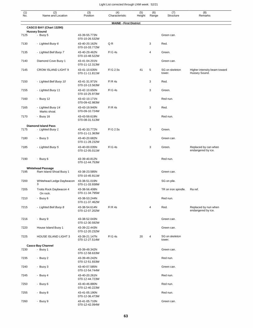
Light List corrected through LNM week: 52/21
63
(1) (2) (3) (4) (5) (6) (7) (8) No. Name and Location Position Characteristic Height Range Structure Remarks
MAINE - First District
CASCO BAY (Chart 13290)
Hussey Sound
7125 - Buoy 5 43-39-55.773N Green can.
070-10-26.532W
7130 - Lighted Buoy 6 43-40-20.162N Q R 3 Red.
070-10-33.772W
7135 - Lighted Bell Buoy 7 43-40-29.462N Fl G 4s 4 Green.
070-10-48.522W
7140 Diamond Cove Buoy 1 43-41-04.201N Green can.
070-11-12.313W
7145 CROW ISLAND LIGHT 9 43-41-10.635N
070-11-11.811W
Fl G 2.5s 41 5 SG on skeleton tower.
Higher intensity beam toward Hussey Sound.
7150 - Lighted Bell Buoy 10 43-41-31.971N Fl R 4s
3 Red.
070-10-13.563W
7155 - Lighted Buoy 11 43-42-10.650N Fl G 4s 3 Green.
070-10-25.973W
7160 - Buoy 12 43-42-10.171N Red nun.
070-09-42.983W
7165 - Lighted Buoy 14 43-43-19.940N Fl R 4s 3 Red.
Marks shoal. 070-09-10.724W
7170 - Buoy 16 43-43-59.619N Red nun.
070-08-31.513W
Diamond Island Pass
7175 - Lighted Buoy 1 43-40-33.772N Fl G 2.5s 3 Green.
070-11-11.363W
7180 - Buoy 3 43-40-20.682N Green can.
070-11-28.232W
7185 - Lighted Buoy 5 43-40-00.035N
070-12-05.011W
Fl G 4s 3 Green. Replaced by can when endangered by ice.
7190 - Buoy 6 43-39-40.812N
Red nun.
070-12-44.753W
Whitehead Passage 7195 Ram Island Shoal Buoy 1 43-38-23.585N Green can.
070-10-45.911W
7200 Whitehead Ledge Daybeacon 3
43-38-51.019N
070-11-33.938W
SG on pile.
7205 Trotts Rock Daybeacon 4 43-38-56.408N TR on iron spindle. Ra ref.
On rock. 070-11-34.795W
7210 - Buoy 6 43-38-53.244N Red nun.
070-11-37.462W
7215 - Lighted Bell Buoy 8 43-38-54.614N
070-12-07.202W
Fl R 4s 4 Red. Replaced by nun when endangered by ice.
7216 - Buoy 9 43-38-52.043N
Green can.
070-12-30.592W
7220 House Island Buoy 1 43-39-22.443N Green can.
070-12-20.232W
7225 HOUSE ISLAND LIGHT 3 43-39-21.147N 070-12-27.514W
Fl G 4s 20 4 SG on skeleton tower.
Casco Bay Channel
7230 - Buoy 1 43-39-49.342N Green can.
070-12-58.633W
7235 - Buoy 2 43-39-49.242N Red nun.
070-12-51.933W
7240 - Buoy 3 43-40-07.585N Green can.
070-12-54.744W
7245 - Buoy 4 43-40-20.261N Red nun.
070-12-44.723W
7250 - Buoy 6 43-40-46.880N Red nun.
070-12-40.223W
7255 - Buoy 8 43-41-05.190N Red nun.
070-12-36.473W
7260 - Buoy 9 43-41-05.710N Green can. 070-12-42.094W
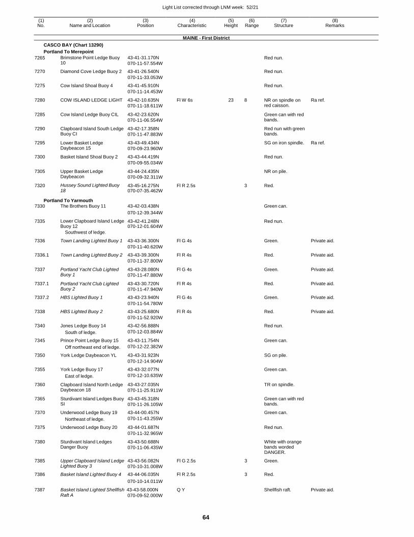
Light List corrected through LNM week: 52/21
64
(1) (2) (3) (4) (5) (6) (7) (8) No. Name and Location Position Characteristic Height Range Structure Remarks
MAINE - First District
CASCO BAY (Chart 13290)
Portland To Merepoint
7265 Brimstone Point Ledge Buoy 10
43-41-31.170N
070-11-57.554W
Red nun.
7270 Diamond Cove Ledge Buoy 2 43-41-26.540N Red nun.
070-11-33.053W
7275 Cow Island Shoal Buoy 4 43-41-45.910N Red nun.
070-11-14.453W
7280 COW ISLAND LEDGE LIGHT 43-42-10.635N
070-11-18.611W
Fl W 6s 23 8 NR on spindle on red caisson.
Ra ref.
7285 Cow Island Ledge Buoy CIL 43-42-23.620N
070-11-06.554W
Green can with red bands.
7290 Clapboard Island South Ledge Buoy CI
43-42-17.358N
070-11-47.883W
Red nun with green bands.
7295 Lower Basket Ledge Daybeacon 15
43-43-49.434N
070-09-23.960W
SG on iron spindle. Ra ref.
7300 Basket Island Shoal Buoy 2 43-43-44.419N Red nun.
070-09-55.034W
7305 Upper Basket Ledge Daybeacon
43-44-24.435N
070-09-32.311W
NR on pile.
7320 Hussey Sound Lighted Buoy 18
43-45-16.275N 070-07-35.462W
Fl R 2.5s 3 Red.
Portland To Yarmouth 7330 The Brothers Buoy 11 43-42-03.438N Green can.
070-12-39.344W
7335 Lower Clapboard Island Ledge Buoy 12
43-42-41.248N 070-12-01.604W
Red nun.
Southwest of ledge.
7336 Town Landing Lighted Buoy 1 43-43-36.300N Fl G 4s
Green. Private aid.
070-11-40.620W
7336.1 Town Landing Lighted Buoy 2 43-43-39.300N Fl R 4s Red. Private aid.
070-11-37.800W
7337 Portland Yacht Club Lighted Buoy 1
43-43-28.080N
070-11-47.880W
Fl G 4s Green. Private aid.
7337.1 Portland Yacht Club Lighted Buoy 2
43-43-30.720N
070-11-47.940W
Fl R 4s Red. Private aid.
7337.2 HBS Lighted Buoy 1 43-43-23.940N Fl G 4s Green. Private aid.
070-11-54.780W
7338 HBS Lighted Buoy 2 43-43-25.680N Fl R 4s Red. Private aid.
070-11-52.920W
7340 Jones Ledge Buoy 14 43-42-56.888N Red nun.
South of ledge. 070-12-03.884W
7345 Prince Point Ledge Buoy 15 43-43-11.754N Green can.
Off northeast end of ledge. 070-12-22.382W
7350 York Ledge Daybeacon YL 43-43-31.923N SG on pile.
070-12-14.904W
7355 York Ledge Buoy 17 43-43-32.077N Green can.
East of ledge. 070-12-10.635W
7360 Clapboard Island North Ledge Daybeacon 18
43-43-27.035N
070-11-25.911W
TR on spindle.
7365 Sturdivant Island Ledges Buoy SI
43-43-45.318N
070-11-26.105W
Green can with red bands.
7370 Underwood Ledge Buoy 19 43-44-00.457N Green can.
Northeast of ledge. 070-11-43.255W
7375 Underwood Ledge Buoy 20 43-44-01.687N Red nun.
070-11-32.965W
7380 Sturdivant Island Ledges Danger Buoy
43-43-50.688N
070-11-06.435W
White with orange bands worded DANGER.
7385 Upper Clapboard Island Ledge Lighted Buoy 3
43-43-56.082N
070-10-31.008W
Fl G 2.5s 3 Green.
7386 Basket Island Lighted Buoy 4 43-44-06.035N Fl R 2.5s 3 Red.
7387
070-10-14.011W
Basket Island Lighted Shellfish 43-43-58.000N Q Y
Shellfish raft.
Private aid. Raft A 070-09-52.000W
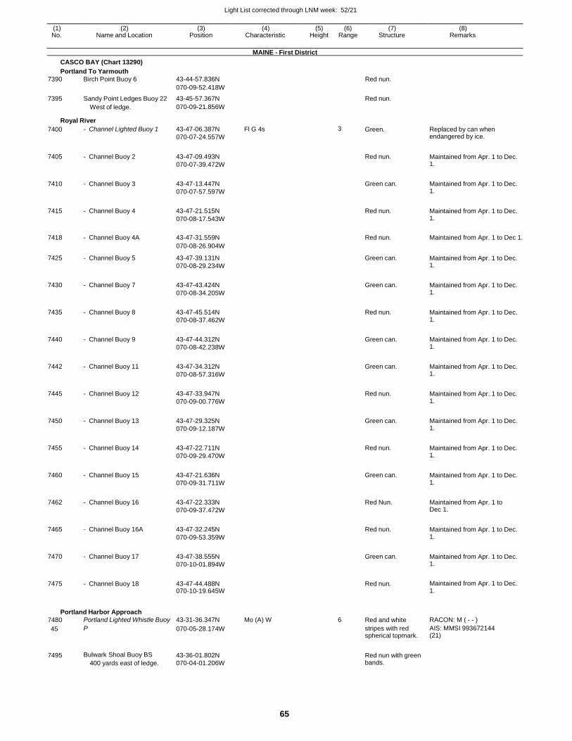
Light List corrected through LNM week: 52/21
65
(1) (2) (3) (4) (5) (6) (7) (8) No. Name and Location Position Characteristic Height Range Structure Remarks
MAINE - First District
CASCO BAY (Chart 13290)
Portland To Yarmouth
7390 Birch Point Buoy 6 43-44-57.836N Red nun.
070-09-52.418W
7395 Sandy Point Ledges Buoy 22 43-45-57.367N Red nun. West of ledge. 070-09-21.856W
Royal River
7400 - Channel Lighted Buoy 1 43-47-06.387N
070-07-24.557W
Fl G 4s 3 Green. Replaced by can when endangered by ice.
7405 - Channel Buoy 2 43-47-09.493N
070-07-39.472W
Red nun. Maintained from Apr. 1 to Dec.
1.
7410 - Channel Buoy 3 43-47-13.447N
070-07-57.597W
Green can. Maintained from Apr. 1 to Dec.
1.
7415 - Channel Buoy 4 43-47-21.515N
070-08-17.543W
Red nun. Maintained from Apr. 1 to Dec.
1.
7418 - Channel Buoy 4A 43-47-31.559N
Red nun. Maintained from Apr. 1 to Dec 1.
070-08-26.904W
7425 - Channel Buoy 5 43-47-39.131N
070-08-29.234W
Green can. Maintained from Apr. 1 to Dec. 1.
7430 - Channel Buoy 7 43-47-43.424N
070-08-34.205W
Green can. Maintained from Apr. 1 to Dec.
1.
7435 - Channel Buoy 8 43-47-45.514N
070-08-37.462W
Red nun. Maintained from Apr. 1 to Dec.
1.
7440 - Channel Buoy 9 43-47-44.312N
070-08-42.238W
Green can. Maintained from Apr. 1 to Dec.
1.
7442 - Channel Buoy 11 43-47-34.312N
070-08-57.316W
Green can. Maintained from Apr. 1 to Dec.
1.
7445 - Channel Buoy 12 43-47-33.947N
070-09-00.776W
Red nun. Maintained from Apr. 1 to Dec.
1.
7450 - Channel Buoy 13 43-47-29.325N
070-09-12.187W
Green can. Maintained from Apr. 1 to Dec.
1.
7455 - Channel Buoy 14 43-47-22.711N
070-09-29.470W
Red nun. Maintained from Apr. 1 to Dec.
1.
7460 - Channel Buoy 15 43-47-21.636N
070-09-31.711W
Green can. Maintained from Apr. 1 to Dec.
1.
7462 - Channel Buoy 16 43-47-22.333N
070-09-37.472W
Red Nun. Maintained from Apr. 1 to
Dec 1.
7465 - Channel Buoy 16A 43-47-32.245N
070-09-53.359W
Red nun. Maintained from Apr. 1 to Dec.
1.
7470 - Channel Buoy 17 43-47-38.555N
070-10-01.894W
Green can. Maintained from Apr. 1 to Dec.
1.
7475 - Channel Buoy 18 43-47-44.488N 070-10-19.645W
Red nun. Maintained from Apr. 1 to Dec.
1.
Portland Harbor Approach
7480 Portland Lighted Whistle Buoy 43-31-36.347N Mo (A) W 6 Red and white RACON: M ( - - )
45 P 070-05-28.174W stripes with red spherical topmark.
AIS: MMSI 993672144 (21)
7495 Bulwark Shoal Buoy BS
400 yards east of ledge.
43-36-01.802N
070-04-01.206W
Red nun with green bands.
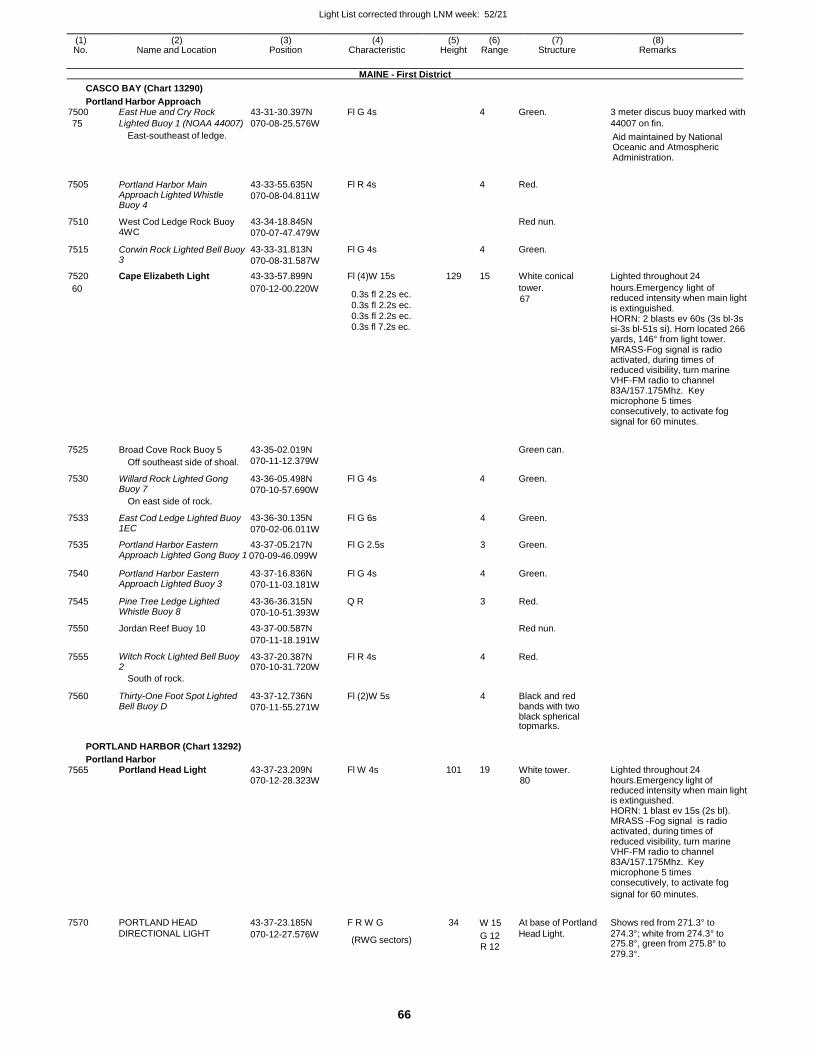
Light List corrected through LNM week: 52/21
66
(1) (2) (3) (4) (5) (6) (7) (8) No. Name and Location Position Characteristic Height Range Structure Remarks
MAINE - First District
CASCO BAY (Chart 13290)
Portland Harbor Approach 7500 East Hue and Cry Rock 43-31-30.397N Fl G 4s 4 Green. 3 meter discus buoy marked with
75 Lighted Buoy 1 (NOAA 44007) 070-08-25.576W 44007 on fin.
East-southeast of ledge. Aid maintained by National Oceanic and Atmospheric Administration.
7505 Portland Harbor Main Approach Lighted Whistle Buoy 4
43-33-55.635N
070-08-04.811W
Fl R 4s
4 Red.
7510 West Cod Ledge Rock Buoy 4WC
43-34-18.845N
070-07-47.479W
Red nun.
7515 Corwin Rock Lighted Bell Buoy 3
43-33-31.813N
070-08-31.587W
Fl G 4s 4 Green.
7520 Cape Elizabeth Light 43-33-57.899N Fl (4)W 15s 129 15 White conical Lighted throughout 24
60 070-12-00.220W 0.3s fl 2.2s ec. 0.3s fl 2.2s ec. 0.3s fl 2.2s ec. 0.3s fl 7.2s ec.
tower.
67
hours.Emergency light of reduced intensity when main light is extinguished. HORN: 2 blasts ev 60s (3s bl-3s si-3s bl-51s si). Horn located 266 yards, 146° from light tower. MRASS-Fog signal is radio activated, during times of reduced visibility, turn marine VHF-FM radio to channel 83A/157.175Mhz. Key microphone 5 times consecutively, to activate fog signal for 60 minutes.
7525
7530
Broad Cove Rock Buoy 5
Off southeast side of shoal.
Willard Rock Lighted Gong Buoy 7
On east side of rock.
43-35-02.019N
070-11-12.379W
43-36-05.498N
070-10-57.690W
Fl G 4s
Green can.
4 Green.
7533 East Cod Ledge Lighted Buoy 1EC
43-36-30.135N
070-02-06.011W
Fl G 6s 4 Green.
7535 Portland Harbor Eastern 43-37-05.217N Fl G 2.5s 3 Green. Approach Lighted Gong Buoy 1 070-09-46.099W
7540 Portland Harbor Eastern Approach Lighted Buoy 3
43-37-16.836N
070-11-03.181W
Fl G 4s 4 Green.
7545 Pine Tree Ledge Lighted Whistle Buoy 8
43-36-36.315N
070-10-51.393W
Q R 3 Red.
7550 Jordan Reef Buoy 10 43-37-00.587N Red nun.
070-11-18.191W
7555 Witch Rock Lighted Bell Buoy 2
43-37-20.387N 070-10-31.720W
Fl R 4s 4 Red.
South of rock.
7560 Thirty-One Foot Spot Lighted Bell Buoy D
43-37-12.736N
070-11-55.271W
Fl (2)W 5s 4 Black and red bands with two black spherical topmarks.
PORTLAND HARBOR (Chart 13292)
Portland Harbor 7565 Portland Head Light 43-37-23.209N Fl W 4s 101 19 White tower. Lighted throughout 24
070-12-28.323W 80 hours.Emergency light of reduced intensity when main light is extinguished. HORN: 1 blast ev 15s (2s bl). MRASS -Fog signal is radio activated, during times of reduced visibility, turn marine VHF-FM radio to channel 83A/157.175Mhz. Key microphone 5 times consecutively, to activate fog
7570
PORTLAND HEAD
43-37-23.185N
F R W G
34
W 15
At base of Portland
signal for 60 minutes.
Shows red from 271.3° to
DIRECTIONAL LIGHT 070-12-27.576W (RWG sectors) G 12
R 12
Head Light. 274.3°; white from 274.3° to 275.8°, green from 275.8° to 279.3°.
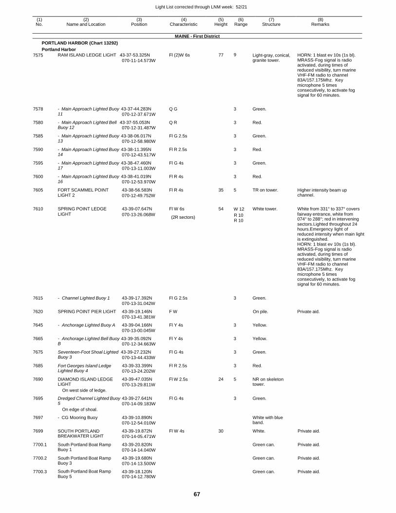
Light List corrected through LNM week: 52/21
67
(1) (2) (3) (4) (5) (6) (7) (8) No. Name and Location Position Characteristic Height Range Structure Remarks
MAINE - First District
PORTLAND HARBOR (Chart 13292)
Portland Harbor
7575 RAM ISLAND LEDGE LIGHT 43-37-53.325N
070-11-14.573W
Fl (2)W 6s 77 9 Light-gray, conical, granite tower.
HORN: 1 blast ev 10s (1s bl). MRASS-Fog signal is radio activated, during times of reduced visibility, turn marine VHF-FM radio to channel 83A/157.175Mhz. Key microphone 5 times consecutively, to activate fog signal for 60 minutes.
7578 - Main Approach Lighted Buoy 43-37-44.283N 11 070-12-37.671W
Q G
3 Green.
7580 - Main Approach Lighted Bell 43-37-55.053N Buoy 12 070-12-31.487W
Q R 3 Red.
7585 - Main Approach Lighted Buoy 43-38-06.017N 13 070-12-58.980W
Fl G 2.5s 3 Green.
7590 - Main Approach Lighted Buoy 43-38-11.395N 14 070-12-43.517W
Fl R 2.5s 3 Red.
7595 - Main Approach Lighted Buoy 43-38-47.460N 17 070-13-11.003W
Fl G 4s 3 Green.
7600 - Main Approach Lighted Buoy 43-38-41.019N 16 070-12-53.970W
Fl R 4s 3 Red.
7605 FORT SCAMMEL POINT 43-38-56.583N LIGHT 2 070-12-49.752W
Fl R 4s 35 5 TR on tower. Higher intensity beam up channel.
7610 SPRING POINT LEDGE 43-39-07.647N Fl W 6s 54
W 12 White tower. White from 331° to 337° covers
LIGHT 070-13-26.068W (2R sectors) R 10
R 10
fairway entrance, white from 074° to 288°; red in intervening sectors.Lighted throughout 24 hours.Emergency light of reduced intensity when main light is extinguished. HORN: 1 blast ev 10s (1s bl). MRASS-Fog signal is radio activated, during times of reduced visibility, turn marine VHF-FM radio to channel 83A/157.175Mhz. Key microphone 5 times consecutively, to activate fog signal for 60 minutes.
7615
7620
7645
- Channel Lighted Buoy 1
SPRING POINT PIER LIGHT
- Anchorage Lighted Buoy A
43-39-17.392N
070-13-31.042W
43-39-19.146N
070-13-41.381W
43-39-04.166N
070-13-00.045W
Fl G 2.5s
F W
Fl Y 4s
3 Green.
On pile.
3 Yellow.
Private aid.
7665 - Anchorage Lighted Bell Buoy 43-39-35.092N Fl Y 4s 3 Yellow. B 070-12-34.663W
7675 Seventeen-Foot Shoal Lighted 43-39-27.232N Fl G 4s 3 Green.
7685
7690
Buoy 3
Fort Georges Island Ledge Lighted Buoy 4
DIAMOND ISLAND LEDGE LIGHT
On west side of ledge.
070-13-44.433W
43-39-33.399N
070-13-24.202W
43-39-47.035N
070-13-29.811W
Fl R 2.5s
Fl W 2.5s
3
24 5
Red.
NR on skeleton tower.
7695 Dredged Channel Lighted Buoy 5
On edge of shoal.
43-39-27.641N
070-14-09.183W
Fl G 4s 3 Green.
7697 - CG Mooring Buoy 43-39-10.890N
070-12-54.010W
White with blue band.
7699 SOUTH PORTLAND BREAKWATER LIGHT
43-39-19.872N
070-14-05.471W
Fl W 4s 30 White. Private aid.
7700.1 South Portland Boat Ramp Buoy 1
43-39-20.820N
070-14-14.040W
Green can. Private aid.
7700.2 South Portland Boat Ramp Buoy 3
43-39-19.680N
070-14-13.500W
Green can. Private aid.
7700.3 South Portland Boat Ramp Buoy 5
43-39-18.120N 070-14-12.780W
Green can. Private aid.
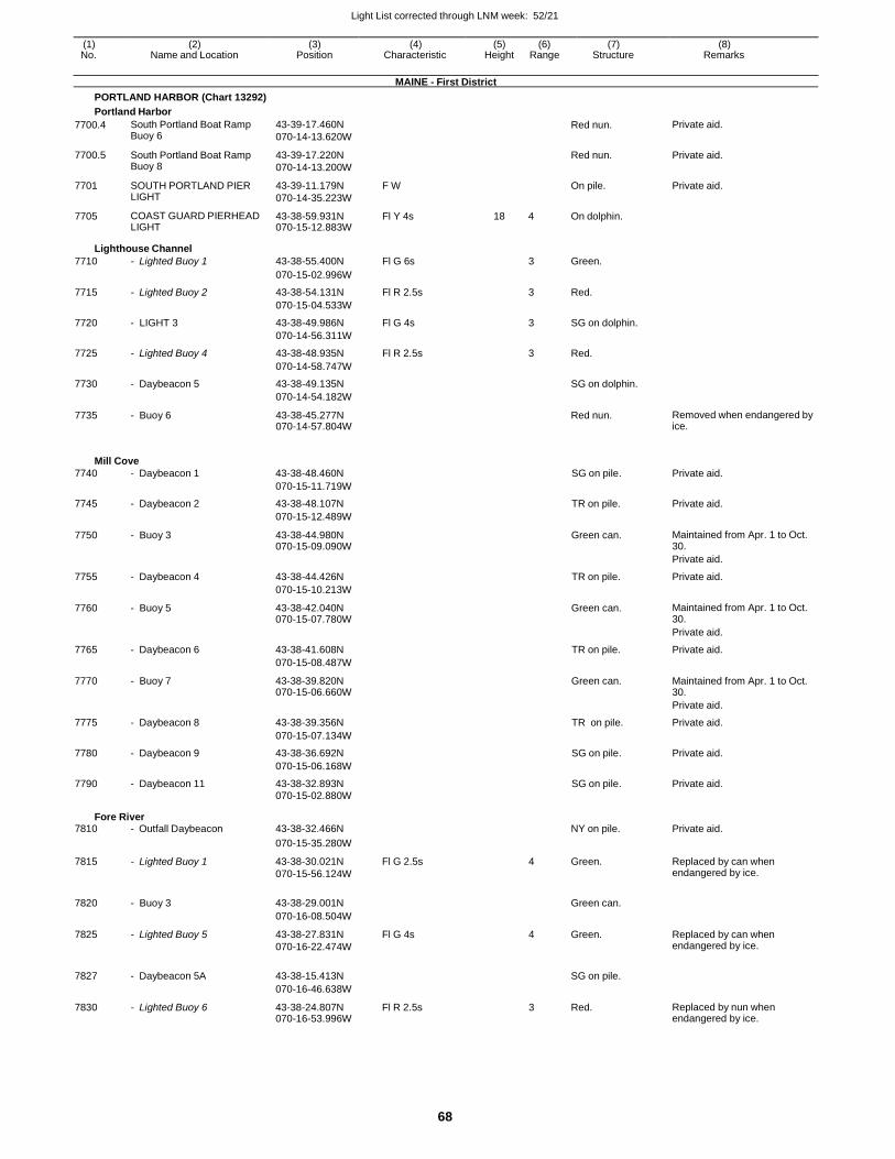
Light List corrected through LNM week: 52/21
68
(1) (2) (3) (4) (5) (6) (7) (8) No. Name and Location Position Characteristic Height Range Structure Remarks
MAINE - First District
PORTLAND HARBOR (Chart 13292)
Portland Harbor
7700.4 South Portland Boat Ramp Buoy 6
43-39-17.460N
070-14-13.620W
Red nun. Private aid.
7700.5 South Portland Boat Ramp Buoy 8
43-39-17.220N
070-14-13.200W
Red nun. Private aid.
7701 SOUTH PORTLAND PIER LIGHT
43-39-11.179N
070-14-35.223W
F W On pile. Private aid.
7705 COAST GUARD PIERHEAD LIGHT
43-38-59.931N 070-15-12.883W
Fl Y 4s 18 4 On dolphin.
Lighthouse Channel
7710 - Lighted Buoy 1 43-38-55.400N Fl G 6s 3 Green.
070-15-02.996W
7715 - Lighted Buoy 2 43-38-54.131N Fl R 2.5s 3 Red.
070-15-04.533W
7720 - LIGHT 3 43-38-49.986N Fl G 4s 3 SG on dolphin.
070-14-56.311W
7725 - Lighted Buoy 4 43-38-48.935N Fl R 2.5s 3 Red.
070-14-58.747W
7730 - Daybeacon 5 43-38-49.135N SG on dolphin.
070-14-54.182W
7735 - Buoy 6 43-38-45.277N 070-14-57.804W
Red nun. Removed when endangered by ice.
Mill Cove
7740 - Daybeacon 1 43-38-48.460N SG on pile. Private aid.
070-15-11.719W
7745 - Daybeacon 2 43-38-48.107N TR on pile. Private aid.
070-15-12.489W
7750 - Buoy 3 43-38-44.980N 070-15-09.090W
Green can. Maintained from Apr. 1 to Oct. 30.
Private aid.
7755 - Daybeacon 4 43-38-44.426N TR on pile. Private aid.
070-15-10.213W
7760 - Buoy 5 43-38-42.040N 070-15-07.780W
Green can. Maintained from Apr. 1 to Oct. 30.
Private aid.
7765 - Daybeacon 6 43-38-41.608N TR on pile. Private aid.
070-15-08.487W
7770 - Buoy 7 43-38-39.820N 070-15-06.660W
Green can. Maintained from Apr. 1 to Oct. 30.
Private aid.
7775 - Daybeacon 8 43-38-39.356N TR on pile. Private aid.
070-15-07.134W
7780 - Daybeacon 9 43-38-36.692N SG on pile. Private aid.
070-15-06.168W
7790 - Daybeacon 11 43-38-32.893N SG on pile. Private aid. 070-15-02.880W
Fore River 7810 - Outfall Daybeacon 43-38-32.466N NY on pile. Private aid.
070-15-35.280W
7815 - Lighted Buoy 1 43-38-30.021N
070-15-56.124W
Fl G 2.5s 4 Green. Replaced by can when endangered by ice.
7820 - Buoy 3 43-38-29.001N
Green can.
070-16-08.504W
7825 - Lighted Buoy 5 43-38-27.831N
070-16-22.474W
Fl G 4s 4 Green. Replaced by can when endangered by ice.
7827 - Daybeacon 5A 43-38-15.413N
SG on pile.
070-16-46.638W
7830 - Lighted Buoy 6 43-38-24.807N 070-16-53.996W
Fl R 2.5s 3 Red. Replaced by nun when endangered by ice.
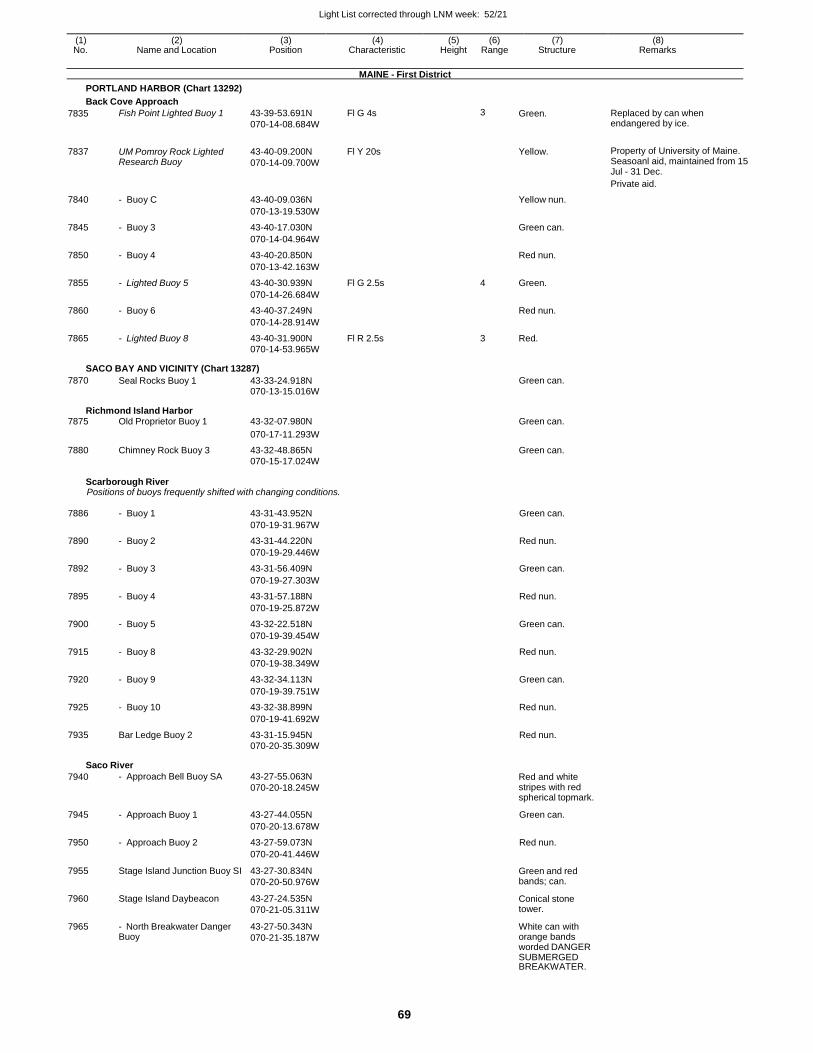
Light List corrected through LNM week: 52/21
69
(1) (2) (3) (4) (5) (6) (7) (8) No. Name and Location Position Characteristic Height Range Structure Remarks
MAINE - First District
PORTLAND HARBOR (Chart 13292)
Back Cove Approach
7835 Fish Point Lighted Buoy 1 43-39-53.691N
070-14-08.684W
Fl G 4s 3 Green. Replaced by can when endangered by ice.
7837 UM Pomroy Rock Lighted Research Buoy
43-40-09.200N
070-14-09.700W
Fl Y 20s
Yellow. Property of University of Maine. Seasoanl aid, maintained from 15 Jul - 31 Dec.
Private aid.
7840 - Buoy C 43-40-09.036N Yellow nun.
070-13-19.530W
7845 - Buoy 3 43-40-17.030N Green can.
070-14-04.964W
7850 - Buoy 4 43-40-20.850N Red nun.
070-13-42.163W
7855 - Lighted Buoy 5 43-40-30.939N Fl G 2.5s 4 Green.
070-14-26.684W
7860 - Buoy 6 43-40-37.249N Red nun.
070-14-28.914W
7865 - Lighted Buoy 8 43-40-31.900N Fl R 2.5s 3 Red.
070-14-53.965W
SACO BAY AND VICINITY (Chart 13287)
7870 Seal Rocks Buoy 1 43-33-24.918N Green can. 070-13-15.016W
Richmond Island Harbor 7875 Old Proprietor Buoy 1 43-32-07.980N Green can.
070-17-11.293W
7880 Chimney Rock Buoy 3 43-32-48.865N Green can. 070-15-17.024W
Scarborough River Positions of buoys frequently shifted with changing conditions.
7886 - Buoy 1 43-31-43.952N Green can.
070-19-31.967W
7890 - Buoy 2 43-31-44.220N Red nun.
070-19-29.446W
7892 - Buoy 3 43-31-56.409N Green can.
070-19-27.303W
7895 - Buoy 4 43-31-57.188N Red nun.
070-19-25.872W
7900 - Buoy 5 43-32-22.518N Green can.
070-19-39.454W
7915 - Buoy 8 43-32-29.902N Red nun.
070-19-38.349W
7920 - Buoy 9 43-32-34.113N Green can.
070-19-39.751W
7925 - Buoy 10 43-32-38.899N Red nun.
070-19-41.692W
7935 Bar Ledge Buoy 2 43-31-15.945N Red nun. 070-20-35.309W
Saco River
7940 - Approach Bell Buoy SA 43-27-55.063N
070-20-18.245W Red and white stripes with red spherical topmark.
7945 - Approach Buoy 1 43-27-44.055N Green can.
070-20-13.678W
7950 - Approach Buoy 2 43-27-59.073N Red nun.
070-20-41.446W
7955 Stage Island Junction Buoy SI 43-27-30.834N
070-20-50.976W
Green and red bands; can.
7960 Stage Island Daybeacon 43-27-24.535N
070-21-05.311W
Conical stone tower.
7965 - North Breakwater Danger Buoy
43-27-50.343N
070-21-35.187W
White can with orange bands worded DANGER SUBMERGED BREAKWATER.
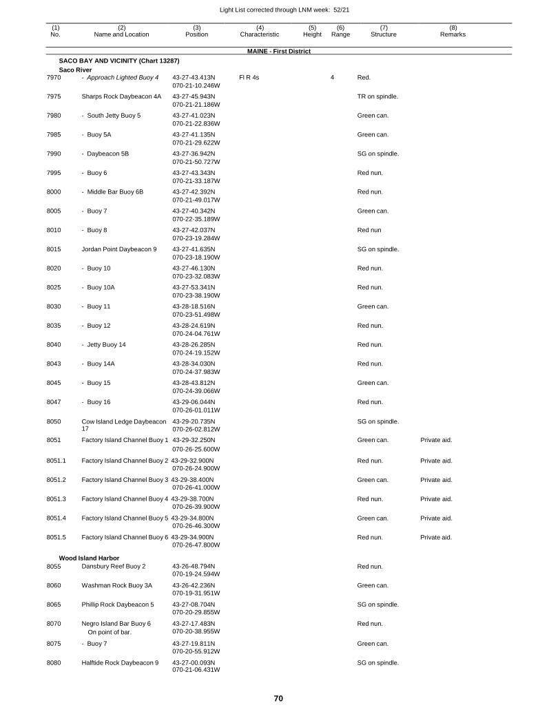
Light List corrected through LNM week: 52/21
70
(1) (2) (3) (4) (5) (6) (7) (8) No. Name and Location Position Characteristic Height Range Structure Remarks
MAINE - First District
SACO BAY AND VICINITY (Chart 13287)
Saco River
7970 - Approach Lighted Buoy 4 43-27-43.413N Fl R 4s 4 Red.
070-21-10.246W
7975 Sharps Rock Daybeacon 4A 43-27-45.943N TR on spindle.
070-21-21.186W
7980 - South Jetty Buoy 5 43-27-41.023N Green can.
070-21-22.836W
7985 - Buoy 5A 43-27-41.135N Green can.
070-21-29.622W
7990 - Daybeacon 5B 43-27-36.942N SG on spindle.
070-21-50.727W
7995 - Buoy 6 43-27-43.343N Red nun.
070-21-33.187W
8000 - Middle Bar Buoy 6B 43-27-42.392N Red nun.
070-21-49.017W
8005 - Buoy 7 43-27-40.342N Green can.
070-22-35.189W
8010 - Buoy 8 43-27-42.037N Red nun
070-23-19.284W
8015 Jordan Point Daybeacon 9 43-27-41.635N SG on spindle.
070-23-18.190W
8020 - Buoy 10 43-27-46.130N Red nun.
070-23-32.083W
8025 - Buoy 10A 43-27-53.341N Red nun.
070-23-38.190W
8030 - Buoy 11 43-28-18.516N Green can.
070-23-51.498W
8035 - Buoy 12 43-28-24.619N Red nun.
070-24-04.761W
8040 - Jetty Buoy 14 43-28-26.285N Red nun.
070-24-19.152W
8043 - Buoy 14A 43-28-34.030N Red nun.
070-24-37.983W
8045 - Buoy 15 43-28-43.812N Green can.
070-24-39.066W
8047 - Buoy 16 43-29-06.044N Red nun.
070-26-01.011W
8050 Cow Island Ledge Daybeacon 17
43-29-20.735N
070-26-02.812W
SG on spindle.
8051 Factory Island Channel Buoy 1 43-29-32.250N Green can. Private aid.
8051.1
8051.2
8051.3
8051.4
8051.5
070-26-25.600W
Factory Island Channel Buoy 2 43-29-32.900N
070-26-24.900W
Factory Island Channel Buoy 3 43-29-38.400N
070-26-41.000W
Factory Island Channel Buoy 4 43-29-38.700N
070-26-39.900W
Factory Island Channel Buoy 5 43-29-34.800N
070-26-46.300W
Factory Island Channel Buoy 6 43-29-34.900N
070-26-47.800W
Red nun.
Green can.
Red nun.
Green can.
Red nun.
Private aid.
Private aid.
Private aid.
Private aid.
Private aid.
Wood Island Harbor
8055 Dansbury Reef Buoy 2 43-26-48.794N
070-19-24.594W Red nun.
8060 Washman Rock Buoy 3A 43-26-42.236N
070-19-31.951W
Green can.
8065 Phillip Rock Daybeacon 5 43-27-08.704N
070-20-29.855W
SG on spindle.
8070 Negro Island Bar Buoy 6
On point of bar.
43-27-17.483N
070-20-38.955W
Red nun.
8075 - Buoy 7 43-27-19.811N
070-20-55.912W
Green can.
8080 Halftide Rock Daybeacon 9 43-27-00.093N 070-21-06.431W
SG on spindle.
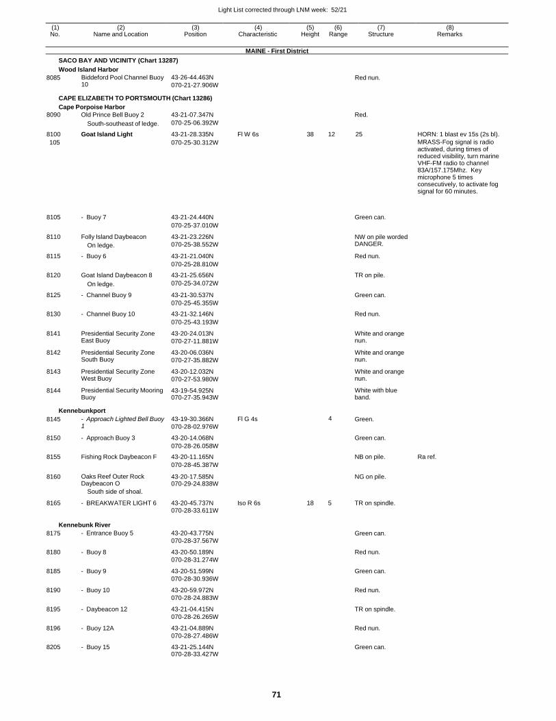
Light List corrected through LNM week: 52/21
71
(1) (2) (3) (4) (5) (6) (7) (8) No. Name and Location Position Characteristic Height Range Structure Remarks
MAINE - First District
SACO BAY AND VICINITY (Chart 13287)
Wood Island Harbor
8085 Biddeford Pool Channel Buoy 10
43-26-44.463N
070-21-27.906W Red nun.
CAPE ELIZABETH TO PORTSMOUTH (Chart 13286)
Cape Porpoise Harbor
8090 Old Prince Bell Buoy 2 43-21-07.347N Red.
South-southeast of ledge. 070-25-06.392W
8100 Goat Island Light 43-21-28.335N Fl W 6s 38 12 25 HORN: 1 blast ev 15s (2s bl).
105 070-25-30.312W MRASS-Fog signal is radio activated, during times of reduced visibility, turn marine VHF-FM radio to channel 83A/157.175Mhz. Key microphone 5 times consecutively, to activate fog signal for 60 minutes.
8105
- Buoy 7
43-21-24.440N
Green can.
070-25-37.010W
8110 Folly Island Daybeacon
On ledge.
43-21-23.226N
070-25-38.552W
NW on pile worded DANGER.
8115 - Buoy 6 43-21-21.040N Red nun.
070-25-28.810W
8120 Goat Island Daybeacon 8 43-21-25.656N TR on pile.
On ledge. 070-25-34.072W
8125 - Channel Buoy 9 43-21-30.537N Green can.
070-25-45.355W
8130 - Channel Buoy 10 43-21-32.146N Red nun.
070-25-43.193W
8141 Presidential Security Zone East Buoy
43-20-24.013N
070-27-11.881W
White and orange nun.
8142 Presidential Security Zone South Buoy
43-20-06.036N
070-27-35.882W
White and orange nun.
8143 Presidential Security Zone West Buoy
43-20-12.032N
070-27-53.980W
White and orange nun.
8144 Presidential Security Mooring Buoy
43-19-54.925N 070-27-35.943W
White with blue band.
Kennebunkport
8145 - Approach Lighted Bell Buoy 1
43-19-30.366N
070-28-02.976W
Fl G 4s 4 Green.
8150 - Approach Buoy 3 43-20-14.068N Green can.
070-28-26.058W
8155 Fishing Rock Daybeacon F 43-20-11.165N NB on pile. Ra ref.
070-28-45.387W
8160 Oaks Reef Outer Rock Daybeacon O
43-20-17.585N 070-29-24.838W
NG on pile.
South side of shoal.
8165 - BREAKWATER LIGHT 6 43-20-45.737N Iso R 6s 18 5 TR on spindle. 070-28-33.611W
Kennebunk River
8175 - Entrance Buoy 5 43-20-43.775N
070-28-37.567W Green can.
8180 - Buoy 8 43-20-50.189N
070-28-31.274W
Red nun.
8185 - Buoy 9 43-20-51.599N
070-28-30.936W
Green can.
8190 - Buoy 10 43-20-59.972N
070-28-24.883W
Red nun.
8195 - Daybeacon 12 43-21-04.415N
070-28-26.265W
TR on spindle.
8196 - Buoy 12A 43-21-04.889N
070-28-27.486W
Red nun.
8205 - Buoy 15 43-21-25.144N 070-28-33.427W
Green can.
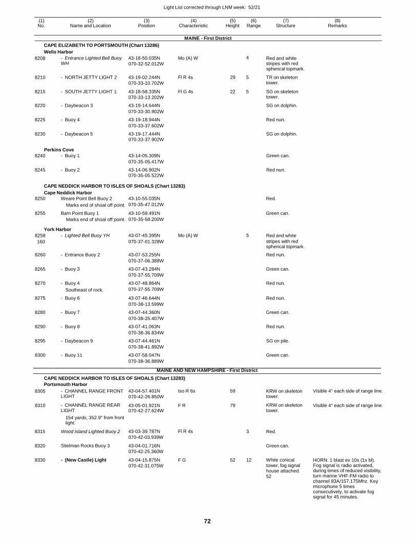
Light List corrected through LNM week: 52/21
72
(1) (2) (3) (4) (5) (6) (7) (8) No. Name and Location Position Characteristic Height Range Structure Remarks
MAINE - First District
CAPE ELIZABETH TO PORTSMOUTH (Chart 13286)
Wells Harbor
8208 - Entrance Lighted Bell Buoy WH
43-18-50.035N
070-32-52.012W
Mo (A) W 4 Red and white stripes with red spherical topmark.
8210 - NORTH JETTY LIGHT 2 43-19-02.244N
070-33-10.702W
Fl R 4s 29 5 TR on skeleton tower.
8215 - SOUTH JETTY LIGHT 1 43-18-58.335N
070-33-13.202W
Fl G 4s 22 5 SG on skeleton tower.
8220 - Daybeacon 3 43-19-14.644N SG on dolphin.
070-33-30.902W
8225 - Buoy 4 43-19-18.944N Red nun.
070-33-37.602W
8230 - Daybeacon 5 43-19-17.444N SG on dolphin. 070-33-37.902W
Perkins Cove
8240 - Buoy 1 43-14-05.309N Green can.
070-35-05.417W
8245 - Buoy 2 43-14-06.902N Red nun. 070-35-05.522W
CAPE NEDDICK HARBOR TO ISLES OF SHOALS (Chart 13283)
Cape Neddick Harbor
8250 Weare Point Bell Buoy 2 43-10-55.035N Red.
Marks end of shoal off point. 070-35-47.012W
8255 Barn Point Buoy 1 43-10-59.491N Green can. Marks end of shoal off point. 070-35-58.200W
York Harbor
8258 - Lighted Bell Buoy YH 43-07-45.395N Mo (A) W 5 Red and white
160 070-37-01.328W stripes with red spherical topmark.
8260 - Entrance Buoy 2 43-07-53.255N Red nun.
070-37-06.388W
8265 - Buoy 3 43-07-43.284N Green can.
070-37-55.709W
8270 - Buoy 4 43-07-48.864N Red nun.
Southeast of rock. 070-37-55.709W
8275 - Buoy 6 43-07-46.644N Red nun.
070-38-13.599W
8280 - Buoy 7 43-07-44.360N Green can.
070-38-25.407W
8290 - Buoy 8 43-07-41.063N Red nun.
070-38-36.834W
8295 - Daybeacon 9 43-07-44.461N SG on pile.
070-38-41.892W
8300 - Buoy 11 43-07-58.047N Green can.
070-38-36.889W
MAINE AND NEW HAMPSHIRE - First District
CAPE NEDDICK HARBOR TO ISLES OF SHOALS (Chart 13283)
Portsmouth Harbor
8305 - CHANNEL RANGE FRONT LIGHT
43-04-57.401N
070-42-26.850W
Iso R 6s 59 KRW on skeleton tower.
Visible 4° each side of range line.
8310 - CHANNEL RANGE REAR LIGHT
43-05-01.921N 070-42-27.624W
F R 79 KRW on skeleton tower.
Visible 4° each side of range line.
8315
8320
8330
154 yards, 352.9° from front light.
Wood Island Lighted Buoy 2
Stielman Rocks Buoy 3
- (New Castle) Light
43-03-39.787N
070-42-03.939W
43-04-01.716N
070-42-25.360W
43-04-15.875N
070-42-31.075W
Fl R 4s
F G
3
52 12
Red.
Green can.
White conical tower, fog signal house attached. 52
HORN: 1 blast ev 10s (1s bl). Fog signal is radio activated, during times of reduced visibility, turn marine VHF-FM radio to channel 83A/157.175Mhz. Key microphone 5 times consecutively, to activate fog signal for 45 minutes.
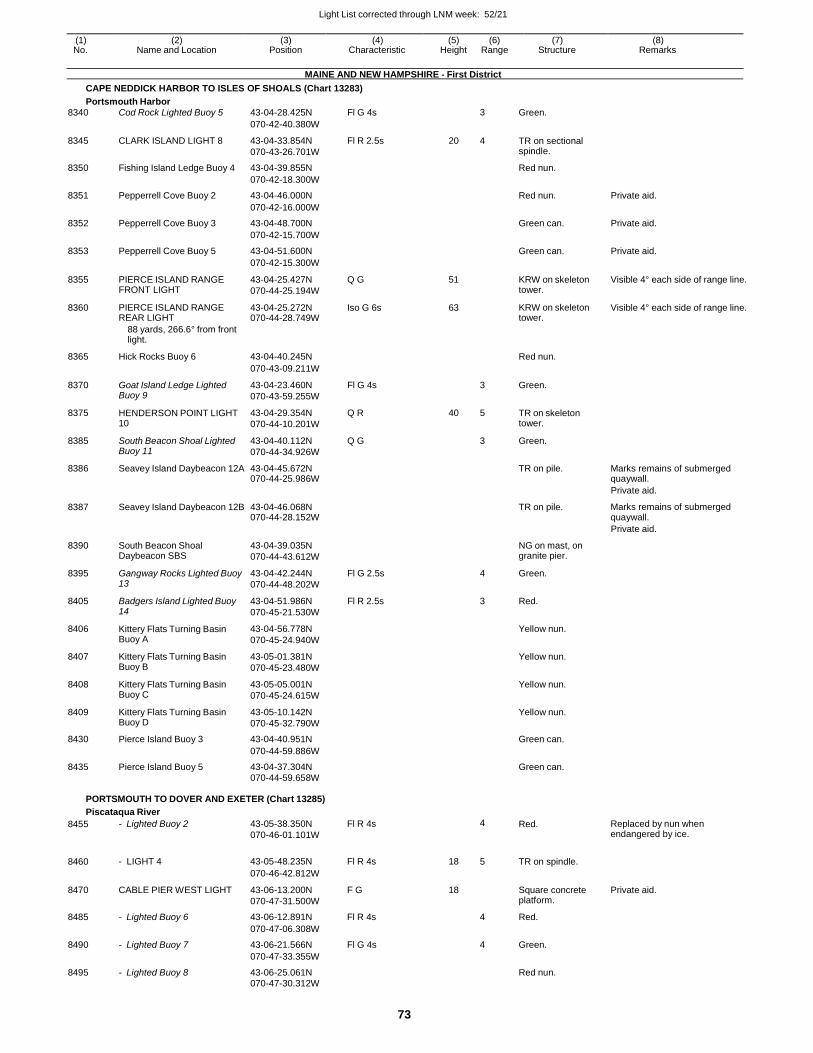
Light List corrected through LNM week: 52/21
73
(1) (2) (3) (4) (5) (6) (7) (8) No. Name and Location Position Characteristic Height Range Structure Remarks
MAINE AND NEW HAMPSHIRE - First District
CAPE NEDDICK HARBOR TO ISLES OF SHOALS (Chart 13283)
Portsmouth Harbor
8340 Cod Rock Lighted Buoy 5 43-04-28.425N Fl G 4s 3 Green.
070-42-40.380W
8345 CLARK ISLAND LIGHT 8 43-04-33.854N
070-43-26.701W
Fl R 2.5s 20 4 TR on sectional spindle.
8350 Fishing Island Ledge Buoy 4 43-04-39.855N Red nun.
070-42-18.300W
8351 Pepperrell Cove Buoy 2 43-04-46.000N Red nun. Private aid.
070-42-16.000W
8352 Pepperrell Cove Buoy 3 43-04-48.700N Green can. Private aid.
070-42-15.700W
8353 Pepperrell Cove Buoy 5 43-04-51.600N Green can. Private aid.
070-42-15.300W
8355 PIERCE ISLAND RANGE FRONT LIGHT
43-04-25.427N
070-44-25.194W
Q G 51 KRW on skeleton tower.
Visible 4° each side of range line.
8360 PIERCE ISLAND RANGE REAR LIGHT
43-04-25.272N 070-44-28.749W
Iso G 6s 63 KRW on skeleton tower.
Visible 4° each side of range line.
88 yards, 266.6° from front light.
8365 Hick Rocks Buoy 6 43-04-40.245N
Red nun.
070-43-09.211W
8370 Goat Island Ledge Lighted Buoy 9
43-04-23.460N
070-43-59.255W
Fl G 4s 3 Green.
8375 HENDERSON POINT LIGHT 10
43-04-29.354N
070-44-10.201W
Q R 40 5 TR on skeleton tower.
8385 South Beacon Shoal Lighted Buoy 11
43-04-40.112N
070-44-34.926W
Q G 3 Green.
8386 Seavey Island Daybeacon 12A 43-04-45.672N 070-44-25.986W
TR on pile. Marks remains of submerged quaywall.
Private aid.
8387 Seavey Island Daybeacon 12B 43-04-46.068N 070-44-28.152W
TR on pile. Marks remains of submerged quaywall.
Private aid.
8390 South Beacon Shoal Daybeacon SBS
43-04-39.035N
070-44-43.612W
NG on mast, on granite pier.
8395 Gangway Rocks Lighted Buoy 13
43-04-42.244N
070-44-48.202W
Fl G 2.5s 4 Green.
8405 Badgers Island Lighted Buoy 14
43-04-51.986N
070-45-21.530W
Fl R 2.5s 3 Red.
8406 Kittery Flats Turning Basin Buoy A
43-04-56.778N
070-45-24.940W
Yellow nun.
8407 Kittery Flats Turning Basin Buoy B
43-05-01.381N
070-45-23.480W
Yellow nun.
8408 Kittery Flats Turning Basin Buoy C
43-05-05.001N
070-45-24.615W
Yellow nun.
8409 Kittery Flats Turning Basin Buoy D
43-05-10.142N
070-45-32.790W
Yellow nun.
8430 Pierce Island Buoy 3 43-04-40.951N Green can.
070-44-59.886W
8435 Pierce Island Buoy 5 43-04-37.304N Green can.
070-44-59.658W
PORTSMOUTH TO DOVER AND EXETER (Chart 13285)
Piscataqua River
8455 - Lighted Buoy 2 43-05-38.350N
070-46-01.101W
Fl R 4s 4 Red. Replaced by nun when endangered by ice.
8460 - LIGHT 4 43-05-48.235N Fl R 4s 18 5 TR on spindle.
070-46-42.812W
8470 CABLE PIER WEST LIGHT 43-06-13.200N
070-47-31.500W
F G 18 Square concrete platform.
Private aid.
8485 - Lighted Buoy 6 43-06-12.891N Fl R 4s 4 Red.
070-47-06.308W
8490 - Lighted Buoy 7 43-06-21.566N Fl G 4s 4 Green.
070-47-33.355W
8495 - Lighted Buoy 8 43-06-25.061N Red nun.
070-47-30.312W
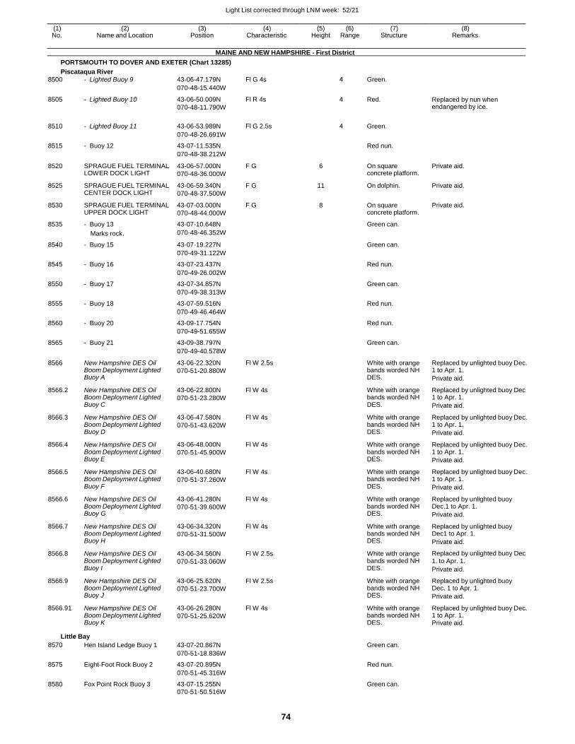
Light List corrected through LNM week: 52/21
74
(1) (2) (3) (4) (5) (6) (7) (8) No. Name and Location Position Characteristic Height Range Structure Remarks
MAINE AND NEW HAMPSHIRE - First District
PORTSMOUTH TO DOVER AND EXETER (Chart 13285)
Piscataqua River
8500 - Lighted Buoy 9 43-06-47.179N Fl G 4s 4 Green.
070-48-15.440W
8505 - Lighted Buoy 10 43-06-50.009N
070-48-11.790W
Fl R 4s 4 Red. Replaced by nun when endangered by ice.
8510 - Lighted Buoy 11 43-06-53.989N Fl G 2.5s
4 Green.
070-48-26.691W
8515 - Buoy 12 43-07-11.535N Red nun.
070-48-38.212W
8520 SPRAGUE FUEL TERMINAL LOWER DOCK LIGHT
43-06-57.000N
070-48-36.000W
F G 6 On square concrete platform.
Private aid.
8525 SPRAGUE FUEL TERMINAL CENTER DOCK LIGHT
43-06-59.340N
070-48-37.500W
F G 11 On dolphin. Private aid.
8530 SPRAGUE FUEL TERMINAL UPPER DOCK LIGHT
43-07-03.000N
070-48-44.000W
F G 8 On square concrete platform.
Private aid.
8535 - Buoy 13 43-07-10.648N Green can.
Marks rock. 070-48-46.352W
8540 - Buoy 15 43-07-19.227N Green can.
070-49-31.122W
8545 - Buoy 16 43-07-23.437N Red nun.
070-49-26.002W
8550 - Buoy 17 43-07-34.857N Green can.
070-49-38.313W
8555 - Buoy 18 43-07-59.516N Red nun.
070-49-46.464W
8560 - Buoy 20 43-09-17.754N Red nun.
070-49-51.655W
8565 - Buoy 21 43-09-38.797N Green can.
070-49-40.578W
8566 New Hampshire DES Oil Boom Deployment Lighted Buoy A
43-06-22.320N
070-51-20.880W
Fl W 2.5s White with orange bands worded NH DES.
Replaced by unlighted buoy Dec. 1 to Apr. 1.
Private aid.
8566.2 New Hampshire DES Oil Boom Deployment Lighted Buoy C
43-06-22.800N
070-51-23.280W
Fl W 4s White with orange bands worded NH DES.
Replaced by unlighted buoy Dec 1 to Apr. 1.
Private aid.
8566.3 New Hampshire DES Oil Boom Deployment Lighted Buoy D
43-06-47.580N
070-51-43.620W
Fl W 4s White with orange bands worded NH DES.
Replaced by unlighted buoy Dec. 1 to Apr. 1.
Private aid.
8566.4 New Hampshire DES Oil Boom Deployment Lighted Buoy E
43-06-48.000N
070-51-45.900W
Fl W 4s White with orange bands worded NH DES.
Replaced by unlighted buoy Dec. 1 to Apr. 1.
Private aid.
8566.5 New Hampshire DES Oil Boom Deployment Lighted Buoy F
43-06-40.680N
070-51-37.260W
Fl W 4s White with orange bands worded NH DES.
Replaced by unlighted buoy Dec. 1 to Apr. 1.
Private aid.
8566.6 New Hampshire DES Oil Boom Deployment Lighted Buoy G
43-06-41.280N
070-51-39.600W
Fl W 4s White with orange bands worded NH DES.
Replaced by unlighted buoy Dec.1 to Apr. 1.
Private aid.
8566.7 New Hampshire DES Oil Boom Deployment Lighted Buoy H
43-06-34.320N
070-51-31.500W
Fl W 4s White with orange bands worded NH DES.
Replaced by unlighted buoy Dec1 to Apr. 1.
Private aid.
8566.8 New Hampshire DES Oil Boom Deployment Lighted Buoy I
43-06-34.560N
070-51-33.060W
Fl W 2.5s White with orange bands worded NH DES.
Replaced by unlighted buoy Dec 1. to Apr. 1.
Private aid.
8566.9 New Hampshire DES Oil Boom Deployment Lighted Buoy J
43-06-25.620N
070-51-23.700W
Fl W 2.5s White with orange bands worded NH DES.
Replaced by unlighted buoy Dec. 1 to Apr. 1.
Private aid.
8566.91 New Hampshire DES Oil Boom Deployment Lighted Buoy K
43-06-26.280N
070-51-25.620W
Fl W 4s White with orange bands worded NH DES.
Replaced by unlighted buoy Dec. 1 to Apr. 1. Private aid.
Little Bay
8570 Hen Island Ledge Buoy 1 43-07-20.867N Green can.
070-51-18.836W
8575 Eight-Foot Rock Buoy 2 43-07-20.895N Red nun.
070-51-45.316W
8580 Fox Point Rock Buoy 3 43-07-15.255N Green can. 070-51-50.516W
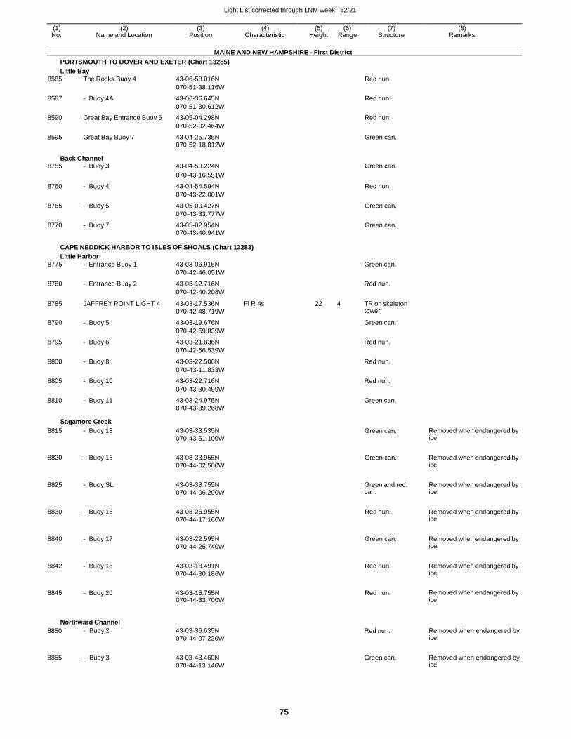
Light List corrected through LNM week: 52/21
75
(1) (2) (3) (4) (5) (6) (7) (8) No. Name and Location Position Characteristic Height Range Structure Remarks
MAINE AND NEW HAMPSHIRE - First District
PORTSMOUTH TO DOVER AND EXETER (Chart 13285)
Little Bay
8585 The Rocks Buoy 4 43-06-58.016N Red nun.
070-51-38.116W
8587 - Buoy 4A 43-06-36.645N Red nun.
070-51-30.612W
8590 Great Bay Entrance Buoy 6 43-05-04.298N Red nun.
070-52-02.464W
8595 Great Bay Buoy 7 43-04-25.735N Green can. 070-52-18.812W
Back Channel 8755 - Buoy 3 43-04-50.224N Green can.
070-43-16.551W
8760 - Buoy 4 43-04-54.594N Red nun.
070-43-22.001W
8765 - Buoy 5 43-05-00.427N Green can.
070-43-33.777W
8770 - Buoy 7 43-05-02.954N Green can. 070-43-40.941W
CAPE NEDDICK HARBOR TO ISLES OF SHOALS (Chart 13283)
Little Harbor
8775 - Entrance Buoy 1 43-03-06.915N Green can.
070-42-46.051W
8780 - Entrance Buoy 2 43-03-12.716N Red nun.
070-42-40.208W
8785 JAFFREY POINT LIGHT 4 43-03-17.536N
070-42-48.719W
Fl R 4s 22 4 TR on skeleton tower.
8790 - Buoy 5 43-03-19.676N Green can.
070-42-59.839W
8795 - Buoy 6 43-03-21.836N Red nun.
070-42-56.539W
8800 - Buoy 8 43-03-22.506N Red nun.
070-43-11.833W
8805 - Buoy 10 43-03-22.716N Red nun.
070-43-30.499W
8810 - Buoy 11 43-03-24.975N Green can. 070-43-39.268W
Sagamore Creek
8815 - Buoy 13 43-03-33.535N
070-43-51.100W
Green can. Removed when endangered by ice.
8820 - Buoy 15 43-03-33.955N
070-44-02.500W
Green can. Removed when endangered by ice.
8825 - Buoy SL 43-03-33.755N
070-44-06.200W
Green and red; can.
Removed when endangered by ice.
8830 - Buoy 16 43-03-26.955N
070-44-17.160W
Red nun. Removed when endangered by ice.
8840 - Buoy 17 43-03-22.595N
070-44-25.740W
Green can. Removed when endangered by ice.
8842 - Buoy 18 43-03-18.491N
070-44-30.186W
Red nun. Removed when endangered by ice.
8845 - Buoy 20 43-03-15.755N 070-44-33.700W
Red nun. Removed when endangered by ice.
Northward Channel
8850
8855
- Buoy 2
- Buoy 3
43-03-36.635N
070-44-07.220W
43-03-43.460N
070-44-13.146W
Red nun.
Green can.
Removed when endangered by ice.
Removed when endangered by ice.
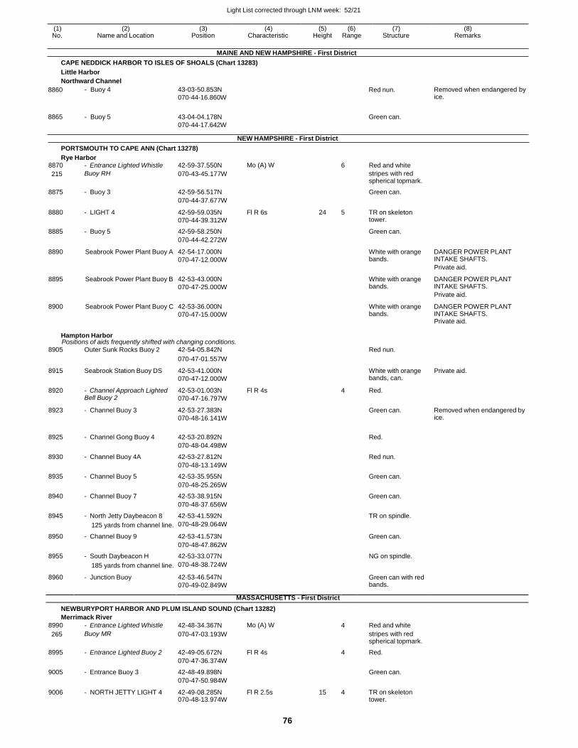
Light List corrected through LNM week: 52/21
76
(1) (2) (3) (4) (5) (6) (7) (8) No. Name and Location Position Characteristic Height Range Structure Remarks
MAINE AND NEW HAMPSHIRE - First District
CAPE NEDDICK HARBOR TO ISLES OF SHOALS (Chart 13283)
Little Harbor
Northward Channel
8860
8865
- Buoy 4
- Buoy 5
43-03-50.853N
070-44-16.860W
43-04-04.178N
070-44-17.642W
NEW HAMPSHIRE - First District
Red nun.
Green can.
Removed when endangered by ice.
PORTSMOUTH TO CAPE ANN (Chart 13278)
Rye Harbor 8870 - Entrance Lighted Whistle 42-59-37.550N Mo (A) W 6 Red and white
215 Buoy RH 070-43-45.177W stripes with red spherical topmark.
8875 - Buoy 3 42-59-56.517N Green can.
070-44-37.677W
8880 - LIGHT 4 42-59-59.035N
070-44-39.312W
Fl R 6s 24 5 TR on skeleton tower.
8885 - Buoy 5 42-59-58.250N Green can.
070-44-42.272W
8890 Seabrook Power Plant Buoy A 42-54-17.000N
070-47-12.000W
White with orange bands.
DANGER POWER PLANT INTAKE SHAFTS.
Private aid.
8895 Seabrook Power Plant Buoy B 42-53-43.000N
070-47-25.000W
White with orange bands.
DANGER POWER PLANT INTAKE SHAFTS.
Private aid.
8900 Seabrook Power Plant Buoy C 42-53-36.000N
070-47-15.000W
White with orange bands.
DANGER POWER PLANT INTAKE SHAFTS. Private aid.
Hampton Harbor Positions of aids frequently shifted with changing conditions.
8905 Outer Sunk Rocks Buoy 2 42-54-05.842N Red nun.
070-47-01.557W
8915 Seabrook Station Buoy DS 42-53-41.000N
070-47-12.000W
White with orange bands, can.
Private aid.
8920 - Channel Approach Lighted Bell Buoy 2
42-53-01.003N
070-47-16.797W
Fl R 4s 4 Red.
8923 - Channel Buoy 3 42-53-27.383N
070-48-16.141W
Green can. Removed when endangered by ice.
8925 - Channel Gong Buoy 4 42-53-20.892N
Red.
070-48-04.498W
8930 - Channel Buoy 4A 42-53-27.812N Red nun.
070-48-13.149W
8935 - Channel Buoy 5 42-53-35.955N Green can.
070-48-25.265W
8940 - Channel Buoy 7 42-53-38.915N Green can.
070-48-37.656W
8945 - North Jetty Daybeacon 8 42-53-41.592N TR on spindle.
125 yards from channel line. 070-48-29.064W
8950 - Channel Buoy 9 42-53-41.573N Green can.
070-48-47.862W
8955 - South Daybeacon H 42-53-33.077N NG on spindle.
185 yards from channel line. 070-48-38.724W
8960 - Junction Buoy 42-53-46.547N
070-49-02.849W
Green can with red bands.
MASSACHUSETTS - First District
NEWBURYPORT HARBOR AND PLUM ISLAND SOUND (Chart 13282)
Merrimack River
8990 - Entrance Lighted Whistle 42-48-34.367N Mo (A) W 4 Red and white
265 Buoy MR 070-47-03.193W stripes with red spherical topmark.
8995 - Entrance Lighted Buoy 2 42-49-05.672N Fl R 4s 4 Red.
070-47-36.374W
9005 - Entrance Buoy 3 42-48-49.898N Green can.
070-47-50.984W
9006 - NORTH JETTY LIGHT 4 42-49-08.285N 070-48-13.974W
Fl R 2.5s 15 4 TR on skeleton tower.
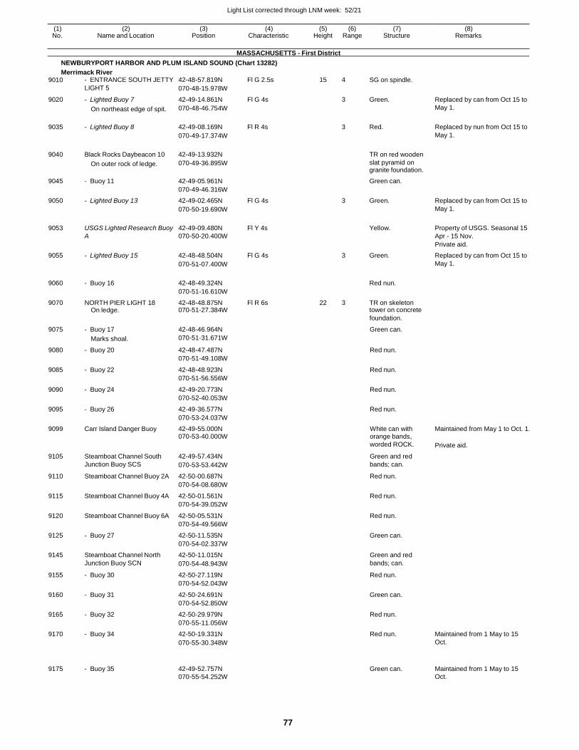
Light List corrected through LNM week: 52/21
77
(1) (2) (3) (4) (5) (6) (7) (8) No. Name and Location Position Characteristic Height Range Structure Remarks
MASSACHUSETTS - First District
NEWBURYPORT HARBOR AND PLUM ISLAND SOUND (Chart 13282)
Merrimack River 9010 - ENTRANCE SOUTH JETTY 42-48-57.819N Fl G 2.5s 15 4 SG on spindle.
LIGHT 5 070-48-15.978W
9020 - Lighted Buoy 7 42-49-14.861N Fl G 4s 3 Green. Replaced by can from Oct 15 to
On northeast edge of spit. 070-48-46.754W May 1.
9035 - Lighted Buoy 8 42-49-08.169N Fl R 4s
3 Red. Replaced by nun from Oct 15 to
070-49-17.374W May 1.
9040 Black Rocks Daybeacon 10 42-49-13.932N
TR on red wooden
On outer rock of ledge. 070-49-36.895W slat pyramid on granite foundation.
9045 - Buoy 11 42-49-05.961N Green can.
070-49-46.316W
9050 - Lighted Buoy 13 42-49-02.465N Fl G 4s 3 Green. Replaced by can from Oct 15 to
070-50-19.690W May 1.
9053 USGS Lighted Research Buoy 42-49-09.480N Fl Y 4s
Yellow. Property of USGS. Seasonal 15 A 070-50-20.400W Apr - 15 Nov.
Private aid.
9055 - Lighted Buoy 15 42-48-48.504N Fl G 4s 3 Green. Replaced by can from Oct 15 to
070-51-07.400W May 1.
9060 - Buoy 16 42-48-49.324N
Red nun.
070-51-16.610W
9070 NORTH PIER LIGHT 18 42-48-48.875N Fl R 6s 22 3 TR on skeleton On ledge. 070-51-27.384W tower on concrete
foundation.
9075 - Buoy 17 42-48-46.964N Green can.
Marks shoal. 070-51-31.671W
9080 - Buoy 20 42-48-47.487N Red nun.
070-51-49.108W
9085 - Buoy 22 42-48-48.923N Red nun.
070-51-56.556W
9090 - Buoy 24 42-49-20.773N Red nun.
070-52-40.053W
9095 - Buoy 26 42-49-36.577N Red nun.
070-53-24.037W
9099 Carr Island Danger Buoy 42-49-55.000N White can with Maintained from May 1 to Oct. 1. 070-53-40.000W orange bands,
worded ROCK. Private aid.
9105 Steamboat Channel South 42-49-57.434N Green and red
Junction Buoy SCS 070-53-53.442W bands; can.
9110 Steamboat Channel Buoy 2A 42-50-00.687N Red nun.
070-54-08.680W
9115 Steamboat Channel Buoy 4A 42-50-01.561N Red nun.
070-54-39.052W
9120 Steamboat Channel Buoy 6A 42-50-05.531N Red nun.
070-54-49.566W
9125 - Buoy 27 42-50-11.535N Green can.
070-54-02.337W
9145 Steamboat Channel North 42-50-11.015N Green and red
Junction Buoy SCN 070-54-48.943W bands; can.
9155 - Buoy 30 42-50-27.119N Red nun.
070-54-52.043W
9160 - Buoy 31 42-50-24.691N Green can.
070-54-52.850W
9165 - Buoy 32 42-50-29.979N Red nun.
070-55-11.056W
9170 - Buoy 34 42-50-19.331N Red nun. Maintained from 1 May to 15
070-55-30.348W Oct.
9175
- Buoy 35
42-49-52.757N
Green can.
Maintained from 1 May to 15
070-55-54.252W Oct.
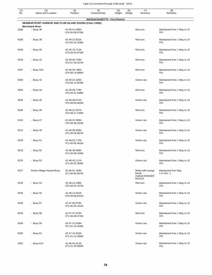
Light List corrected through LNM week: 52/21
78
(1) (2) (3) (4) (5) (6) (7) (8) No. Name and Location Position Characteristic Height Range Structure Remarks
MASSACHUSETTS - First District
NEWBURYPORT HARBOR AND PLUM ISLAND SOUND (Chart 13282)
Merrimack River
9180 - Buoy 36 42-49-41.508N
070-55-58.973W Red nun. Maintained from 1 May to 15
Oct.
9185 - Buoy 38 42-49-22.831N
070-56-16.328W
Red nun. Maintained from 1 May to 15 Oct.
9190 - Buoy 40 42-49-10.711N
070-56-43.975W
Red nun. Maintained from 1 May to 15 Oct.
9195 - Buoy 42 42-49-09.730N
070-57-33.437W
Red nun. Maintained from 1 May to 15 Oct.
9197 - Buoy 42A 42-49-26.785N
070-58-14.686W
Red nun. Maintained from 1 May to 15 Oct.
9200 - Buoy 43 42-49-24.226N
070-58-14.503W
Green can. Maintained from 1 May to 15 Oct.
9204 - Buoy 44 42-49-28.779N
070-58-42.038W
Red nun. Maintained from 1 May to 15 Oct.
9205 - Buoy 45 42-49-28.071N
070-58-59.402W
Green can. Maintained from 1 May to 15 Oct.
9206 - Buoy 46 42-49-21.507N
070-59-27.234W
Red nun. Maintained from 1 May to 15 Oct.
9210 - Buoy 47 42-49-22.399N
070-59-38.332W
Green can. Maintained from 1 May to 15 Oct.
9215 - Buoy 49 42-49-08.509N
071-00-05.887W
Green can. Maintained from 1 May to 15 Oct.
9220 - Buoy 51 42-48-53.772N
071-00-05.461W
Green can. Maintained from 1 May to 15 Oct.
9223 - Buoy 52 42-48-48.468N
071-00-05.233W
Red nun. Maintained from 1 May to 15 Oct.
9225 - Buoy 53 42-48-43.111N
071-00-02.394W
Green can. Maintained from 1 May to 15 Oct.
9227 Rocks Village Hazard Buoy 42-48-51.783N
071-00-05.947W
White with orange bands marked DANGER ROCKS.
Maintained from May 1 to Nov. 1.
9230 - Buoy 54 42-48-22.248N
070-59-54.797W
Red nun. Maintained from 1 May to 15 Oct.
9235 - Buoy 55 42-48-12.051N
070-59-58.631W
Green can. Maintained from 1 May to 15 Oct.
9240 - Buoy 57 42-47-56.070N
071-00-35.191W
Green can. Maintained from 1 May to 15 Oct.
9243 - Buoy 58 42-47-47.675N
071-00-48.372W
Red nun. Maintained from 1 May to 15 Oct.
9245 - Buoy 59 42-47-31.618N
071-01-10.454W
Green can. Maintained from 1 May to 15 Oct.
9250 - Buoy 61 42-47-16.916N
071-01-14.396W
Green can. Maintained from 1 May to 15 Oct.
9252 - Buoy 61A 42-46-54.311N 071-01-19.560W
Green can. Maintained from 1 May to 15 Oct.
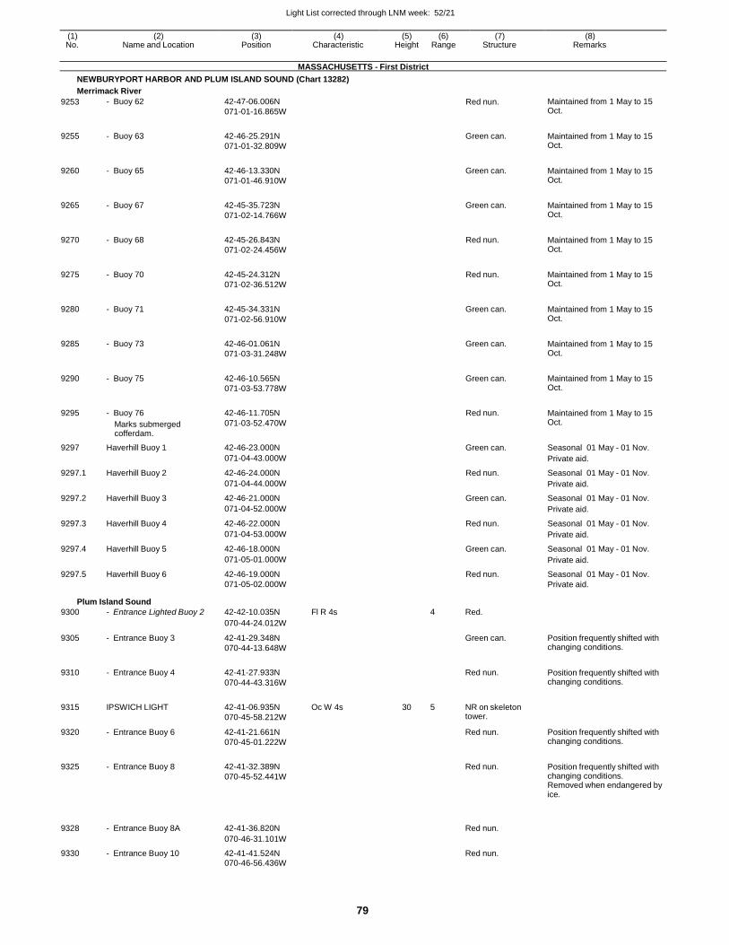
Light List corrected through LNM week: 52/21
79
(1) (2) (3) (4) (5) (6) (7) (8) No. Name and Location Position Characteristic Height Range Structure Remarks
MASSACHUSETTS - First District
NEWBURYPORT HARBOR AND PLUM ISLAND SOUND (Chart 13282)
Merrimack River
9253 - Buoy 62 42-47-06.006N
071-01-16.865W Red nun. Maintained from 1 May to 15
Oct.
9255 - Buoy 63 42-46-25.291N
071-01-32.809W
Green can. Maintained from 1 May to 15 Oct.
9260 - Buoy 65 42-46-13.330N
071-01-46.910W
Green can. Maintained from 1 May to 15 Oct.
9265 - Buoy 67 42-45-35.723N
071-02-14.766W
Green can. Maintained from 1 May to 15 Oct.
9270 - Buoy 68 42-45-26.843N
071-02-24.456W
Red nun. Maintained from 1 May to 15 Oct.
9275 - Buoy 70 42-45-24.312N
071-02-36.512W
Red nun. Maintained from 1 May to 15 Oct.
9280 - Buoy 71 42-45-34.331N
071-02-56.910W
Green can. Maintained from 1 May to 15 Oct.
9285 - Buoy 73 42-46-01.061N
071-03-31.248W
Green can. Maintained from 1 May to 15 Oct.
9290 - Buoy 75 42-46-10.565N
071-03-53.778W
Green can. Maintained from 1 May to 15 Oct.
9295 - Buoy 76
Marks submerged cofferdam.
42-46-11.705N
071-03-52.470W
Red nun. Maintained from 1 May to 15 Oct.
9297 Haverhill Buoy 1 42-46-23.000N Green can. Seasonal 01 May - 01 Nov.
071-04-43.000W Private aid.
9297.1 Haverhill Buoy 2 42-46-24.000N Red nun. Seasonal 01 May - 01 Nov.
071-04-44.000W Private aid.
9297.2 Haverhill Buoy 3 42-46-21.000N Green can. Seasonal 01 May - 01 Nov.
071-04-52.000W Private aid.
9297.3 Haverhill Buoy 4 42-46-22.000N Red nun. Seasonal 01 May - 01 Nov.
071-04-53.000W Private aid.
9297.4 Haverhill Buoy 5 42-46-18.000N Green can. Seasonal 01 May - 01 Nov.
071-05-01.000W Private aid.
9297.5 Haverhill Buoy 6 42-46-19.000N Red nun. Seasonal 01 May - 01 Nov. 071-05-02.000W Private aid.
Plum Island Sound
9300 - Entrance Lighted Buoy 2 42-42-10.035N Fl R 4s 4 Red.
070-44-24.012W
9305 - Entrance Buoy 3 42-41-29.348N
070-44-13.648W
Green can. Position frequently shifted with changing conditions.
9310 - Entrance Buoy 4 42-41-27.933N
070-44-43.316W
Red nun. Position frequently shifted with
changing conditions.
9315 IPSWICH LIGHT 42-41-06.935N
070-45-58.212W
Oc W 4s 30 5 NR on skeleton tower.
9320 - Entrance Buoy 6 42-41-21.661N
070-45-01.222W
Red nun. Position frequently shifted with changing conditions.
9325 - Entrance Buoy 8 42-41-32.389N
070-45-52.441W
Red nun. Position frequently shifted with
changing conditions. Removed when endangered by ice.
9328
- Entrance Buoy 8A
42-41-36.820N
Red nun.
070-46-31.101W
9330 - Entrance Buoy 10 42-41-41.524N Red nun.
070-46-56.436W

Light List corrected through LNM week: 52/21
80
(1) (2) (3) (4) (5) (6) (7) (8) No. Name and Location Position Characteristic Height Range Structure Remarks
MASSACHUSETTS - First District
NEWBURYPORT HARBOR AND PLUM ISLAND SOUND (Chart 13282)
Plum Island Sound
9335 - Entrance Buoy 11 42-41-43.198N
070-47-07.836W Green can. Maintained from Apr. 15 to Oct.
15.
9336 - Buoy 11A 42-42-07.866N
070-47-21.467W
Green can. Maintained from Apr. 15 to Oct. 15.
9340 Bass Rock Daybeacon BR 42-41-52.283N NR on iron spindle.
On ledge. 070-47-00.834W
9345 - Buoy 12 42-42-21.338N
070-47-28.599W
Red nun. Maintained from Apr 15. to Oct. 15.
9350 - Buoy 13 42-42-40.084N
070-47-45.282W
Green can. Maintained from Apr 15. to Oct. 15.
9375 - Buoy 14 42-42-42.139N
070-48-34.399W
Red nun. Maintained from Apr 15. to Oct. 15.
9380 - Buoy 16 42-42-49.268N
070-48-51.261W
Red nun. Maintained from Apr 15. to Oct. 15.
9385 - Buoy 18 42-42-59.358N
070-48-48.993W
Red nun. Maintained from Apr 15. to Oct. 15.
9390 - Buoy 19 42-43-13.888N
070-48-46.672W
Green can. Maintained from Apr 15. to Oct. 15.
9392 - Buoy 21 42-43-31.548N
070-48-47.331W
Green can. Maintained from Apr 15. to Oct. 15.
9395 - Buoy 22 42-43-36.628N
070-48-39.201W
Red nun. Maintained from Apr 15. to Oct. 15.
9397 - Buoy 23 42-43-38.088N
070-48-26.577W
Green can. Maintained from Apr 15. to Oct. 15.
9400 - Buoy 23A 42-43-43.975N
070-48-06.661W
Green can. Maintained from Apr 15. to Oct. 15.
9405 - Buoy 25 42-44-02.025N
070-48-03.645W
Green can. Maintained from Apr 15. to Oct. 15.
9410 - Buoy 27 42-44-12.814N
070-48-10.731W
Green can. Maintained from Apr 15. to Oct. 15.
9413 - Buoy 29 42-44-23.721N
070-48-39.537W
Green can. Maintained from Apr 15. to Oct. 15.
9415 - Buoy 30 42-44-31.961N 070-49-02.062W
Red nun. Maintained from Apr 15. to Oct. 15.
Ipswich River Maintained from May 1 to Sept. 30.
9416 - Buoy 1 42-41-34.440N
070-47-34.800W
Green can. Private aid.
9416.1 - Buoy 2 42-41-38.220N
070-47-42.360W
Red nun. Private aid.
9416.2 - Buoy 3 42-41-42.900N
070-47-47.520W
Green can. Private aid.
9416.3 - Buoy 5 42-41-47.400N
070-48-06.840W
Green can. Private aid.
9416.4 - Buoy 6 42-41-46.140N
070-47-48.960W
Red nun. Private aid.
9416.5 - Buoy 7 42-41-38.160N
070-48-17.280W
Green can. Private aid.
9416.6 - Buoy 8 42-41-35.580N
070-48-18.060W
Red nun. Private aid.
9416.7 - Buoy 10 42-41-29.580N 070-48-22.800W
Red nun. Private aid.
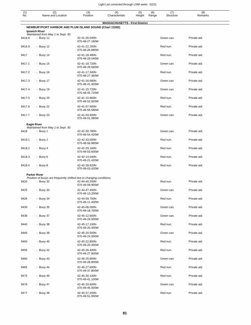
Light List corrected through LNM week: 52/21
81
(1) (2) (3) (4) (5) (6) (7) (8) No. Name and Location Position Characteristic Height Range Structure Remarks
MASSACHUSETTS - First District
NEWBURYPORT HARBOR AND PLUM ISLAND SOUND (Chart 13282)
Ipswich River Maintained from May 1 to Sept. 30.
9416.8 - Buoy 11 42-41-26.040N
070-48-27.180W Green can. Private aid.
9416.9 - Buoy 12 42-41-22.200N
070-48-26.880W
Red nun. Private aid.
9417 - Buoy 14 42-41-18.480N
070-48-29.040W
Red nun. Private aid.
9417.1 - Buoy 15 42-41-18.720N
070-48-28.660W
Green can. Private aid.
9417.2 - Buoy 16 42-41-17.340N
070-48-27.360W
Red nun. Private aid.
9417.3 - Buoy 17 42-41-16.680N
070-48-41.400W
Green can. Private aid.
9417.4 - Buoy 19 42-41-15.720N
070-48-45.720W
Green can. Private aid.
9417.5 - Buoy 20 42-41-10.860N
070-48-52.920W
Red nun. Private aid.
9417.6 - Buoy 22 42-41-07.560N
070-48-56.580W
Red nun. Private aid.
9417.7 - Buoy 23 42-41-03.900N 070-49-01.080W
Green can. Private aid.
Eagle River Maintained from May 1 to Sept. 30.
9418 - Buoy 1 42-42-30.780N
070-48-54.420W Green can. Private aid.
9418.1 - Buoy 2 42-42-33.000N
070-48-56.880W
Red nun. Private aid.
9418.2 - Buoy 4 42-42-29.160N
070-49-03.600W
Red nun. Private aid.
9418.3 - Buoy 6 42-42-14.040N
070-49-21.420W
Red nun. Private aid.
9418.4 - Buoy 8 42-42-28.920N 070-49-03.420W
Red nun. Private aid.
Parker River Position of buoys are frequently shifted due to changing conditions.
9420 - Buoy 32 42-44-40.200N
070-49-09.900W Red nun. Private aid.
9425 - Buoy 33 42-44-47.400N
070-49-13.200W
Green can. Private aid.
9426 - Buoy 34 42-44-59.700N
070-49-11.400W
Red nun. Private aid.
9430 - Buoy 35 42-45-06.000N
070-49-18.700W
Green can. Private aid.
9436 - Buoy 37 42-45-12.600N
070-49-24.000W
Green can. Private aid.
9440 - Buoy 38 42-45-17.100N
070-49-20.400W
Red nun. Private aid.
9445 - Buoy 39 42-45-20.500N
070-49-24.000W
Green can. Private aid.
9450 - Buoy 40 42-45-22.800N
070-49-20.400W
Red nun. Private aid.
9455 - Buoy 42 42-45-26.400N
070-49-27.900W
Red nun. Private aid.
9460 - Buoy 43 42-45-25.800N
070-49-28.800W
Green can. Private aid.
9465 - Buoy 44 42-45-27.600N
070-49-37.800W
Red nun. Private aid.
9475 - Buoy 46 42-45-30.100N
070-49-41.100W
Red nun. Private aid.
9476 - Buoy 47 42-45-33.600N
070-49-45.000W
Green can. Private aid.
9477 - Buoy 48 42-45-37.200N 070-49-51.000W
Red nun. Private aid.
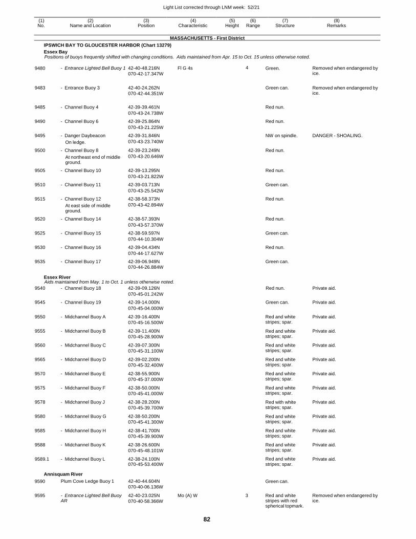
Light List corrected through LNM week: 52/21
82
(1) (2) (3) (4) (5) (6) (7) (8) No. Name and Location Position Characteristic Height Range Structure Remarks
MASSACHUSETTS - First District
IPSWICH BAY TO GLOUCESTER HARBOR (Chart 13279)
Essex Bay Positions of buoys frequently shifted with changing conditions. Aids maintained from Apr. 15 to Oct. 15 unless otherwise noted.
9480 - Entrance Lighted Bell Buoy 1 42-40-48.216N
070-42-17.347W
Fl G 4s 4 Green. Removed when endangered by ice.
9483 - Entrance Buoy 3 42-40-24.262N
070-42-44.351W
Green can. Removed when endangered by
ice.
9485 - Channel Buoy 4 42-39-39.461N
Red nun.
070-43-24.738W
9490 - Channel Buoy 6 42-39-25.864N Red nun.
070-43-21.225W
9495 - Danger Daybeacon 42-39-31.846N NW on spindle. DANGER - SHOALING.
On ledge. 070-43-23.740W
9500 - Channel Buoy 8 42-39-23.249N Red nun.
At northeast end of middle ground.
070-43-20.646W
9505 - Channel Buoy 10 42-39-13.295N Red nun.
070-43-21.822W
9510 - Channel Buoy 11 42-39-03.713N Green can.
070-43-25.542W
9515 - Channel Buoy 12 42-38-58.373N Red nun.
At east side of middle ground.
070-43-42.894W
9520 - Channel Buoy 14 42-38-57.393N Red nun.
070-43-57.370W
9525 - Channel Buoy 15 42-38-59.597N Green can.
070-44-10.304W
9530 - Channel Buoy 16 42-39-04.434N Red nun.
070-44-17.627W
9535 - Channel Buoy 17 42-39-06.949N Green can.
070-44-26.884W
Essex River Aids maintained from May. 1 to Oct. 1 unless otherwise noted.
9540 - Channel Buoy 18 42-39-09.126N Red nun. Private aid.
070-45-01.242W
9545 - Channel Buoy 19 42-39-14.000N Green can. Private aid.
070-45-04.000W
9550 - Midchannel Buoy A 42-39-16.400N
070-45-16.500W
Red and white stripes; spar.
Private aid.
9555 - Midchannel Buoy B 42-39-11.400N
070-45-28.900W
Red and white stripes; spar.
Private aid.
9560 - Midchannel Buoy C 42-39-07.300N
070-45-31.100W
Red and white stripes; spar.
Private aid.
9565 - Midchannel Buoy D 42-39-02.200N
070-45-32.400W
Red and white stripes; spar.
Private aid.
9570 - Midchannel Buoy E 42-38-55.900N
070-45-37.000W
Red and white stripes; spar.
Private aid.
9575 - Midchannel Buoy F 42-38-50.000N
070-45-41.000W
Red and white stripes; spar.
Private aid.
9578 - Midchannel Buoy J 42-38-28.200N
070-45-39.700W
Red with white stripes; spar.
Private aid.
9580 - Midchannel Buoy G 42-38-50.200N
070-45-41.300W
Red and white stripes; spar.
Private aid.
9585 - Midchannel Buoy H 42-38-41.700N
070-45-39.900W
Red and white stripes; spar.
Private aid.
9588 - Midchannel Buoy K 42-38-26.600N
070-45-48.101W
Red and white stripes; spar.
Private aid.
9589.1 - Midchannel Buoy L 42-38-24.100N 070-45-53.400W
Red and white stripes; spar.
Private aid.
Annisquam River
9590
9595
Plum Cove Ledge Buoy 1
- Entrance Lighted Bell Buoy AR
42-40-44.604N
070-40-06.136W
42-40-23.025N
070-40-58.366W
Mo (A) W
Green can.
3 Red and white
stripes with red spherical topmark.
Removed when endangered by ice.
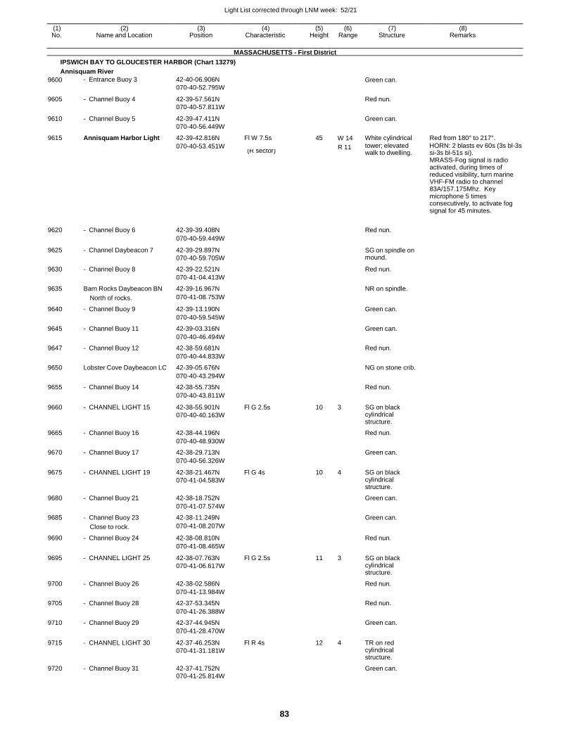
Light List corrected through LNM week: 52/21
83
(1) (2) (3) (4) (5) (6) (7) (8) No. Name and Location Position Characteristic Height Range Structure Remarks
MASSACHUSETTS - First District
IPSWICH BAY TO GLOUCESTER HARBOR (Chart 13279)
Annisquam River
9600 - Entrance Buoy 3 42-40-06.906N
070-40-52.795W
Green can.
9605 - Channel Buoy 4 42-39-57.561N
070-40-57.811W
Red nun.
9610 - Channel Buoy 5 42-39-47.411N
070-40-56.449W
Green can.
9615 Annisquam Harbor Light 42-39-42.816N Fl W 7.5s 45 W 14 White cylindrical Red from 180° to 217°.
070-40-53.451W R 11 tower; elevated HORN: 2 blasts ev 60s (3s bl-3s (R sector) walk to dwelling. si-3s bl-51s si).
MRASS-Fog signal is radio activated, during times of reduced visibility, turn marine VHF-FM radio to channel 83A/157.175Mhz. Key microphone 5 times consecutively, to activate fog signal for 45 minutes.
9620 - Channel Buoy 6 42-39-39.408N
Red nun.
070-40-59.449W
9625 - Channel Daybeacon 7 42-39-29.897N
070-40-59.705W
SG on spindle on mound.
9630 - Channel Buoy 8 42-39-22.521N Red nun.
070-41-04.413W
9635 Barn Rocks Daybeacon BN 42-39-16.967N NR on spindle.
North of rocks. 070-41-08.753W
9640 - Channel Buoy 9 42-39-13.190N Green can.
070-40-59.545W
9645 - Channel Buoy 11 42-39-03.316N Green can.
070-40-46.494W
9647 - Channel Buoy 12 42-38-59.681N Red nun.
070-40-44.833W
9650 Lobster Cove Daybeacon LC 42-39-05.676N NG on stone crib.
070-40-43.294W
9655 - Channel Buoy 14 42-38-55.735N Red nun.
070-40-43.811W
9660 - CHANNEL LIGHT 15 42-38-55.901N
070-40-40.163W
Fl G 2.5s 10 3 SG on black cylindrical structure.
9665 - Channel Buoy 16 42-38-44.196N Red nun.
070-40-48.930W
9670 - Channel Buoy 17 42-38-29.713N Green can.
070-40-56.326W
9675 - CHANNEL LIGHT 19 42-38-21.467N
070-41-04.583W
Fl G 4s 10 4 SG on black cylindrical structure.
9680 - Channel Buoy 21 42-38-18.752N Green can.
070-41-07.574W
9685 - Channel Buoy 23 42-38-11.249N Green can.
Close to rock. 070-41-08.207W
9690 - Channel Buoy 24 42-38-08.810N Red nun.
070-41-08.465W
9695 - CHANNEL LIGHT 25 42-38-07.763N
070-41-06.617W
Fl G 2.5s 11 3 SG on black cylindrical structure.
9700 - Channel Buoy 26 42-38-02.586N Red nun.
070-41-13.984W
9705 - Channel Buoy 28 42-37-53.345N Red nun.
070-41-26.388W
9710 - Channel Buoy 29 42-37-44.945N Green can.
070-41-28.470W
9715 - CHANNEL LIGHT 30 42-37-46.253N
070-41-31.181W
Fl R 4s 12 4 TR on red cylindrical structure.
9720 - Channel Buoy 31 42-37-41.752N Green can.
070-41-25.814W
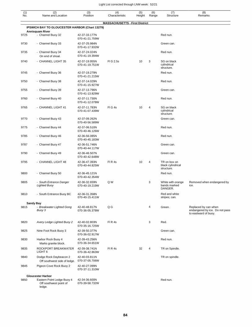
Light List corrected through LNM week: 52/21
84
(1) (2) (3) (4) (5) (6) (7) (8) No. Name and Location Position Characteristic Height Range Structure Remarks
MASSACHUSETTS - First District
IPSWICH BAY TO GLOUCESTER HARBOR (Chart 13279)
Annisquam River
9725 - Channel Buoy 32 42-37-33.177N Red nun.
070-41-21.759W
9730 - Channel Buoy 33 42-37-25.984N Green can.
070-41-17.932W
9735 - Channel Buoy 34 42-37-24.024N Red nun.
On end of shoal. 070-41-19.394W
9740 - CHANNEL LIGHT 35 42-37-19.955N
070-41-19.751W
Fl G 2.5s 10 3 SG on black cylindrical structure.
9745 - Channel Buoy 36 42-37-19.279N Red nun.
070-41-21.215W
9750 - Channel Buoy 38 42-37-14.029N Red nun.
070-41-15.927W
9755 - Channel Buoy 39 42-37-13.796N Green can.
070-41-13.829W
9760 - Channel Buoy 40 42-37-11.730N Red nun.
070-41-12.078W
9765 - CHANNEL LIGHT 41 42-37-11.783N
070-41-07.439W
Fl G 4s 10 4 SG on black cylindrical structure.
9770 - Channel Buoy 43 42-37-09.262N Green can.
070-40-56.589W
9775 - Channel Buoy 44 42-37-06.510N Red nun.
070-40-46.126W
9785 - Channel Buoy 46 42-36-56.085N Red nun.
070-40-45.183W
9787 - Channel Buoy 47 42-36-51.746N Green can.
070-40-44.117W
9790 - Channel Buoy 49 42-36-46.507N Green can.
070-40-42.648W
9795 - CHANNEL LIGHT 48 42-36-47.393N
070-40-44.825W
Fl R 4s 10 4 TR on box on black cylindrical structure.
9800 - Channel Buoy 50 42-36-45.121N Red nun.
070-40-42.354W
9805 - South Entrance Danger Lighted Buoy
42-36-32.659N
070-40-19.219W
Q W 3 White with orange bands marked DANGER.
Removed when endangered by ice.
9810 - South Entrance Buoy BC 42-36-31.358N 070-40-15.411W
Red and white stripes; can.
Sandy Bay
9815 - Breakwater Lighted Gong Buoy 3
42-40-48.817N
070-36-05.378W
Q G 4 Green. Replaced by can when endangered by ice. Do not pass to eastward of buoy.
9820 Avery Ledge Lighted Buoy 2 42-40-02.803N Fl R 4s
3 Red.
070-35-16.725W
9825 Nine Foot Rock Buoy 3 42-39-50.377N Green can.
070-36-02.917W
9830 Harbor Rock Buoy 4 42-39-43.256N Red nun.
Marks granite block. 070-36-34.651W
9835 ROCKPORT BREAKWATER LIGHT 6
42-39-38.741N
070-36-42.863W
Fl R 4s 32 4 TR on Spindle.
9840 Dodge Rock Daybeacon 2 42-40-03.811N TR on spindle.
Off southwest side of ledge. 070-37-05.706W
9845 Pigeon Cove Rock Buoy 2 42-40-27.099N
070-37-11.310W
Gloucester Harbor
9850 Eastern Point Ledge Buoy 4
Off southwest point of
ledge.
42-34-36.600N
070-39-58.732W Red nun.
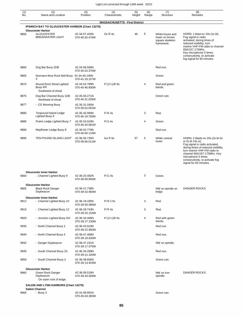
Light List corrected through LNM week: 52/21
85
(1) (2) (3) (4) (5) (6) (7) (8) No. Name and Location Position Characteristic Height Range Structure Remarks
MASSACHUSETTS - First District
IPSWICH BAY TO GLOUCESTER HARBOR (Chart 13279)
Gloucester Harbor
9855
9860
GLOUCESTER BREAKWATER LIGHT
Dog Bar Buoy 2DB
42-34-57.420N
070-40-20.475W
42-34-58.569N
070-40-24.370W
Oc R 4s 45 6 White house and tower on brown square skeleton framework.
Red nun.
HORN: 1 blast ev 10s (1s bl). Fog signal is radio activated, during times of reduced visibility, turn marine VHF-FM radio to channel 83A/157.175Mhz. Key microphone 5 times consecutively, to activate fog signal for 60 minutes.
9865 Normans Woe Rock Bell Buoy 42-34-40.100N Green.
9870
9875
9877
9880
9885
9890
9895
3
Round Rock Shoal Lighted Buoy RR
Southwest of shoal.
Dog Bar Channel Buoy 1DB
Northeast of shoal.
- CG Mooring Buoy
Tenpound Island Ledge Lighted Buoy 6
Praire Ledge Lighted Buoy 7
Mayflower Ledge Buoy 8
TEN POUND ISLAND LIGHT
070-41-19.157W
42-34-53.789N
070-40-46.900W
42-35-00.271N
070-40-31.025W
42-35-31.595N
070-39-52.091W
42-35-45.969N
070-40-19.760W
42-35-53.919N
070-40-34.581W
42-36-02.779N
070-40-06.110W
42-36-06.735N
070-39-56.011W
Fl (2+1)R 6s
Fl R 4s
Fl G 4s
Iso R 6s
4
3
4
57 5
Red and green bands.
Green can.
Red.
Green.
Red nun.
White conical tower.
HORN: 2 blasts ev 20s (2s bl-2s si-2s bl-14s si). Fog signal is radio activated, during times of reduced visibility, turn marine VHF-FM radio to channel 83A/157.175Mhz. Key microphone 5 times consecutively, to activate fog signal for 60 minutes.
Gloucester Inner Harbor
9900 - Channel Lighted Buoy 9 42-36-20.482N
070-39-59.955W
Fl G 4s 3 Green.
Gloucester Harbor
9905 Black Rock Danger Daybeacon
42-36-21.738N
070-39-42.960W NW on spindle on ledge.
DANGER ROCKS
Gloucester Inner Harbor
9912 - Channel Lighted Buoy 10 42-36-18.335N Fl R 2.5s 3 Red.
070-39-50.080W
9915 - Channel Lighted Buoy 12 42-36-28.743N Fl R 4s 3 Red.
070-39-32.154W
9920 - Junction Lighted Buoy GH 42-36-34.469N
070-39-27.230W
Fl (2+1)R 6s 4 Red with green bands.
9935 - North Channel Buoy 2 42-36-43.919N Red nun.
070-39-22.850W
9940 - North Channel Buoy 4 42-36-47.468N Red nun.
070-39-19.630W
9942 - Danger Daybeacon 42-36-47.231N NW on spindle.
070-39-17.075W
9945 - South Channel Buoy 2S 42-36-34.289N Red nun.
070-39-21.320W
9950 - South Channel Buoy 3 42-36-38.830N Green can. 070-39-14.925W
Gloucester Harbor
9960 Green Rock Danger Daybeacon
On outer rock of ledge.
42-36-09.518N
070-39-43.569W NW on iron spindle.
DANGER ROCKS.
SALEM AND LYNN HARBORS (Chart 13275)
Salem Channel
9965 - Buoy 3 42-31-08.891N
070-45-04.383W
Green can.
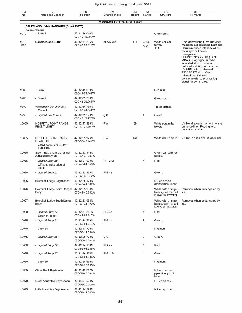
Light List corrected through LNM week: 52/21
86
(1) (2) (3) (4) (5) (6) (7) (8) No. Name and Location Position Characteristic Height Range Structure Remarks
MASSACHUSETTS - First District
SALEM AND LYNN HARBORS (Chart 13275)
Salem Channel
9970
9975
350
9980
9985
9990
9995
10000
10005
- Buoy 5
Bakers Island Light
- Buoy 6
- Buoy 7
Whaleback Daybeacon 8
On rock.
- Lighted Bell Buoy 9
HOSPITAL POINT RANGE FRONT LIGHT
HOSPITAL POINT RANGE REAR LIGHT
2,032 yards, 276.3° from front light.
42-31-46.040N
070-45-43.095W
42-32-11.235N
070-47-09.312W
42-32-49.699N
070-45-53.467W
42-32-05.750N
070-46-29.068W
42-32-54.760N
070-47-04.641W
42-32-23.599N
070-47-17.379W
42-32-47.396N
070-51-21.490W
42-32-53.976N
070-52-42.444W
Al WR 20s
Q G
F W
F W
111
69
161
W 16 R 14
4
Green can.
White conical tower.
111
Red nun.
Green can.
TR on spindle.
Green.
White pyramidal tower.
White church spire.
Emergency light, Fl W 10s when main light extinguished. Light and Horn is reduced intensity when main light or horn is extinguished. HORN: 1 blast ev 30s (3s bl). MRASS-Fog signal is radio activated, during times of reduced visibility, turn marine VHF-FM radio to channel 83A/157.175Mhz. Key microphone 5 times consecutively, to activate fog signal for 60 minutes.
Visible all around; higher intensity on range line. Floodlighted sunset to sunrise.
Visible 2° each side of range line.
10010 Salem-Eagle Island Channel Junction Buoy SE
42-32-21.446N
070-47-45.247W
Green can with red bands.
10015 - Lighted Buoy 10 42-32-34.689N Fl R 2.5s 4 Red.
Off southwest edge of shoal.
070-48-01.850W
10020 - Lighted Buoy 11 42-32-32.935N Fl G 4s 4 Green.
070-48-33.312W
10025 Bowditch Ledge Daybeacon 42-32-25.179N
070-48-41.382W
NR on conical granite monument.
10026 Bowditch Ledge North Danger Buoy
42-32-25.908N
070-48-40.581W
White with orange bands, can marked DANGER ROCKS
Removed when endangered by ice.
10027 Bowditch Ledge South Danger Buoy
42-32-23.934N
070-48-41.022W
White with orange bands, can marked DANGER ROCKS.
Removed when endangered by ice.
10030 - Lighted Buoy 12 42-32-37.861N Fl R 4s 4 Red.
South of ledge. 070-48-52.917W
10035 - Lighted Buoy 13 42-32-34.719N Fl G 4s 3 Green.
070-50-21.214W
10040 - Buoy 14 42-32-43.798N Red nun
070-50-11.964W
10045 - Lighted Buoy 15 42-32-28.779N Q G 3 Green.
070-50-44.004W
10050 - Lighted Buoy 16 42-32-14.158N Fl R 4s 4 Red.
070-51-08.185W
10055 - Lighted Buoy 17 42-31-56.278N Fl G 2.5s 4 Green.
070-51-21.285W
10060 - Buoy 18 42-31-58.658N Red nun.
070-51-26.135W
10065 Abbot Rock Daybeacon 42-31-49.312N
070-51-44.634W
NR on staff on pyramidal granite base.
10070 Great Aquavitae Daybeacon 42-31-34.594N NR on spindle.
070-51-26.016W
10075 Little Aquavitae Daybeacon 42-31-34.596N NR on spindle.
070-51-11.303W

Light List corrected through LNM week: 52/21
87
(1) (2) (3) (4) (5) (6) (7) (8) No. Name and Location Position Characteristic Height Range Structure Remarks
MASSACHUSETTS - First District
SALEM AND LYNN HARBORS (Chart 13275)
Salem Channel
10080 - Buoy 20 42-31-48.394N Red nun.
070-51-36.012W
10085 - Lighted Buoy 21 42-31-18.794N
070-52-01.092W
Fl G 4s 3 Green. Replaced by can when endangered by ice.
10090 FORT PICKERING LIGHT 42-31-35.200N
070-51-59.000W
Fl W 4s 28
Atop of white conical tower on concrete base.
Private aid.
10095 - Lighted Buoy 22 42-31-28.319N
070-51-56.523W
Q R 3 Red Replaced by nun when endangered by ice.
10100 SALEM LIGHT 23 42-31-13.252N
070-52-22.878W
Q G 20 4 SG on gray skeleton tower on pile structure.
10105 - Buoy 24 42-31-18.378N Red nun.
070-52-21.586W
10110 - Buoy 25 42-31-15.018N Green can.
070-52-30.706W
Derby Channel 10115 - Daybeacon 2 42-30-54.434N TR on pile.
070-52-28.312W
10120 - Daybeacon 3 42-30-49.546N
070-52-41.166W
SG on pile structure.
10125 - Lighted Buoy 4 42-30-55.808N Fl R 2.5s 4 Red.
070-52-55.056W
10129 DERBY WHARF LIGHT 42-30-59.548N
070-53-00.768W
Fl R 6s 25 4 White square tower.
Maintained by the U.S.Park Service.
10130 - Daybeacon 5 42-30-57.234N
SG on spindle.
070-53-02.112W
Palmer Cove Channel Maintained from May 1 to Dec. 1.
10131 - Buoy 1 42-30-52.020N Green can. Private aid.
070-52-57.362W
10131.5 - Buoy 2PC 42-30-52.800N Red nun. Private aid.
070-52-57.800W
10131.6 - Buoy 3 42-30-50.940N Green can. Private aid.
070-53-00.360W
10132 - Buoy 4 42-30-52.380N Red nun. Private aid.
070-53-00.300W
10132.5 - Buoy 5 42-30-50.040N Green can. Private aid.
070-53-03.660W
10133 - Buoy 6 42-30-51.700N Red nun. Private aid.
070-53-03.000W
10133.5 - Buoy 7 42-30-49.560N Green can. Private aid.
070-53-08.220W
10134 - Buoy 8 42-30-51.000N Red nun. Private aid.
070-53-06.100W
10134.1 - Daybeacon 9 42-30-48.900N SG on pile. Private aid.
070-53-09.200W
10134.2 - Daybeacon 10 42-30-49.980N TR on pile. Private aid. 070-53-09.120W
Dion Yacht Yard 10135 - Channel Daybeacon 1 42-30-45.900N SG on pile. Private aid.
070-52-45.700W
10135.1 - Channel Daybeacon 2 42-30-47.200N TR on pile. Private aid.
070-52-46.300W
10136 - Channel Daybeacon 3 42-30-43.600N SG on pile. Private aid.
070-52-50.000W
10136.1 - Channel Daybeacon 4 42-30-44.400N TR on pile. Private aid.
070-52-51.500W
10137 - Channel Daybeacon 5 42-30-41.500N SG on pile. Private aid.
070-52-54.600W
10137.1 - Channel Daybeacon 6 42-30-42.500N TR on pile. Private aid. 070-52-55.700W
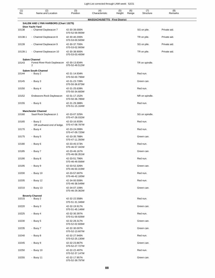
Light List corrected through LNM week: 52/21
88
(1) (2) (3) (4) (5) (6) (7) (8) No. Name and Location Position Characteristic Height Range Structure Remarks
MASSACHUSETTS - First District
SALEM AND LYNN HARBORS (Chart 13275)
Dion Yacht Yard
10138 - Channel Daybeacon 7 42-30-39.000N SG on pile. Private aid.
070-52-59.900W
10138.1 - Channel Daybeacon 8 42-30-40.200N TR on pile. Private aid.
070-53-00.500W
10139 - Channel Daybeacon 9 42-30-37.700N SG on pile. Private aid.
070-53-02.900W
10139.1 - Channel Daybeacon 10 42-30-38.900N TR on pile. Private aid. 070-53-03.400W
Salem Channel
10143 Forest River Rock Daybeacon 2
42-30-13.834N 070-52-49.512W
TR on spindle.
Salem South Channel 10144 - Buoy 2 42-31-14.934N Red nun.
070-50-00.796W
10145 - Buoy 3 42-31-23.739N Green can.
070-50-36.873W
10150 - Buoy 4 42-31-25.639N Red nun.
070-50-34.683W
10152 Endeavors Rock Daybeacon 42-31-17.152N NR on spindle.
070-50-36.786W
10155 - Buoy 6 42-31-29.388N Red nun. 070-51-15.164W
Manchester Channel
10160 Sauli Rock Daybeacon 1 42-33-07.325N SG on spindle.
070-47-28.032W
10165 - Buoy 2 42-33-16.933N Red nun.
Off southwest end of ledge. 070-47-08.787W
10170 - Buoy 4 42-33-24.099N Red nun.
070-47-09.720W
10175 - Buoy 5 42-33-35.788N Green can.
070-47-11.350W
10180 - Buoy 6 42-33-45.573N Red nun.
070-46-57.342W
10185 - Buoy 7 42-33-46.167N Green can.
070-46-58.351W
10190 - Buoy 8 42-33-51.796N Red nun.
070-46-49.556W
10195 - Buoy 9 42-33-52.326N Green can.
070-46-50.319W
10200 - Buoy 10 42-33-57.697N Red nun.
070-46-42.183W
10205 - Buoy 12 42-34-00.509N Red nun.
070-46-38.549W
10210 - Buoy 13 42-34-07.109N Green can. 070-46-29.362W
Beverly Channel 10215 - Buoy 2 42-32-22.558N Red nun.
070-51-31.346W
10220 - Buoy 3 42-32-19.917N Green can.
070-51-45.146W
10225 - Buoy 4 42-32-30.397N Red nun.
070-51-59.926W
10230 - Buoy 5 42-32-28.317N Green can.
070-52-02.606W
10235 - Buoy 7 42-32-30.007N Green can.
070-52-13.607W
10240 - Buoy 8 42-32-27.940N Red nun.
070-52-25.130W
10245 - Buoy 9 42-32-23.867N Green can.
070-52-27.727W
10250 - Buoy 10 42-32-22.497N Red nun.
070-52-37.147W
10255 - Buoy 11 42-32-17.957N Green can. 070-52-39.797W
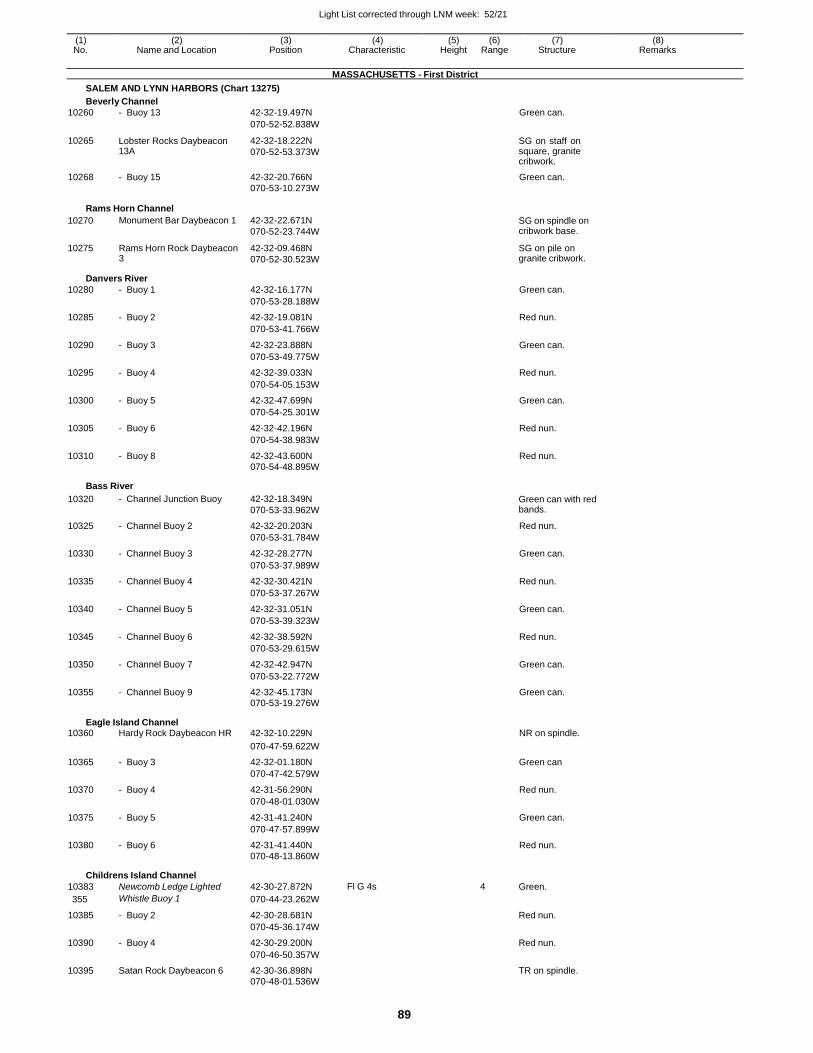
Light List corrected through LNM week: 52/21
89
(1) (2) (3) (4) (5) (6) (7) (8) No. Name and Location Position Characteristic Height Range Structure Remarks
MASSACHUSETTS - First District
SALEM AND LYNN HARBORS (Chart 13275)
Beverly Channel
10260 - Buoy 13 42-32-19.497N Green can.
070-52-52.838W
10265 Lobster Rocks Daybeacon 13A
42-32-18.222N
070-52-53.373W
SG on staff on square, granite cribwork.
10268 - Buoy 15 42-32-20.766N Green can. 070-53-10.273W
Rams Horn Channel
10270
10275
Monument Bar Daybeacon 1
Rams Horn Rock Daybeacon 3
42-32-22.671N
070-52-23.744W
42-32-09.468N
070-52-30.523W
SG on spindle on cribwork base.
SG on pile on granite cribwork.
Danvers River
10280 - Buoy 1 42-32-16.177N Green can.
070-53-28.188W
10285 - Buoy 2 42-32-19.081N Red nun.
070-53-41.766W
10290 - Buoy 3 42-32-23.888N Green can.
070-53-49.775W
10295 - Buoy 4 42-32-39.033N Red nun.
070-54-05.153W
10300 - Buoy 5 42-32-47.699N Green can.
070-54-25.301W
10305 - Buoy 6 42-32-42.196N Red nun.
070-54-38.983W
10310 - Buoy 8 42-32-43.600N Red nun. 070-54-48.895W
Bass River
10320 - Channel Junction Buoy 42-32-18.349N
070-53-33.962W Green can with red bands.
10325 - Channel Buoy 2 42-32-20.203N Red nun.
070-53-31.784W
10330 - Channel Buoy 3 42-32-28.277N Green can.
070-53-37.989W
10335 - Channel Buoy 4 42-32-30.421N Red nun.
070-53-37.267W
10340 - Channel Buoy 5 42-32-31.051N Green can.
070-53-39.323W
10345 - Channel Buoy 6 42-32-38.592N Red nun.
070-53-29.615W
10350 - Channel Buoy 7 42-32-42.947N Green can.
070-53-22.772W
10355 - Channel Buoy 9 42-32-45.173N Green can. 070-53-19.276W
Eagle Island Channel 10360 Hardy Rock Daybeacon HR 42-32-10.229N NR on spindle.
070-47-59.622W
10365 - Buoy 3 42-32-01.180N Green can
070-47-42.579W
10370 - Buoy 4 42-31-56.290N Red nun.
070-48-01.030W
10375 - Buoy 5 42-31-41.240N Green can.
070-47-57.899W
10380 - Buoy 6 42-31-41.440N Red nun. 070-48-13.860W
Childrens Island Channel
10383 Newcomb Ledge Lighted 42-30-27.872N Fl G 4s 4 Green.
355 Whistle Buoy 1 070-44-23.262W
10385 - Buoy 2 42-30-28.681N Red nun.
070-45-36.174W
10390 - Buoy 4 42-30-29.200N Red nun.
070-46-50.357W
10395 Satan Rock Daybeacon 6 42-30-36.898N TR on spindle. 070-48-01.536W
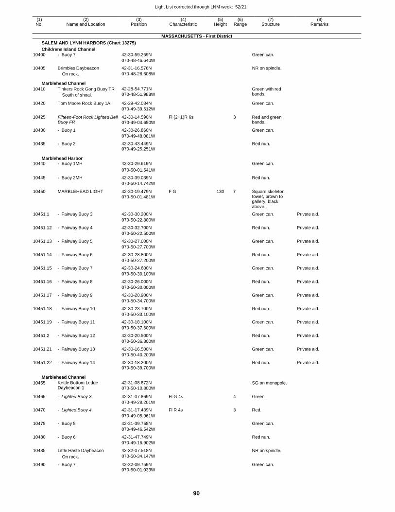
Light List corrected through LNM week: 52/21
90
(1) (2) (3) (4) (5) (6) (7) (8) No. Name and Location Position Characteristic Height Range Structure Remarks
MASSACHUSETTS - First District
SALEM AND LYNN HARBORS (Chart 13275)
Childrens Island Channel
10400 - Buoy 7 42-30-59.269N Green can.
070-48-46.640W
10405 Brimbles Daybeacon 42-31-16.576N NR on spindle. On rock. 070-48-28.608W
Marblehead Channel
10410 Tinkers Rock Gong Buoy TR
South of shoal.
42-28-54.771N
070-48-51.988W
Green with red bands.
10420 Tom Moore Rock Buoy 1A 42-29-42.034N Green can.
070-49-39.512W
10425 Fifteen-Foot Rock Lighted Bell Buoy FR
42-30-14.590N
070-49-04.650W
Fl (2+1)R 6s 3 Red and green bands.
10430 - Buoy 1 42-30-26.860N Green can.
070-49-48.081W
10435 - Buoy 2 42-30-43.449N Red nun. 070-49-25.251W
Marblehead Harbor 10440 - Buoy 1MH 42-30-29.619N Green can.
070-50-01.541W
10445 - Buoy 2MH 42-30-39.039N Red nun.
070-50-14.742W
10450 MARBLEHEAD LIGHT 42-30-19.479N
070-50-01.481W
F G 130 7 Square skeleton tower, brown to gallery, black above..
10451.1 - Fairway Buoy 3 42-30-30.200N Green can. Private aid.
070-50-22.800W
10451.12 - Fairway Buoy 4 42-30-32.700N Red nun. Private aid.
070-50-22.500W
10451.13 - Fairway Buoy 5 42-30-27.000N Green can. Private aid.
070-50-27.700W
10451.14 - Fairway Buoy 6 42-30-28.800N Red nun. Private aid.
070-50-27.200W
10451.15 - Fairway Buoy 7 42-30-24.600N Green can. Private aid.
070-50-30.100W
10451.16 - Fairway Buoy 8 42-30-26.000N Red nun. Private aid.
070-50-30.000W
10451.17 - Fairway Buoy 9 42-30-20.900N Green can. Private aid.
070-50-34.700W
10451.18 - Fairway Buoy 10 42-30-23.700N Red nun. Private aid.
070-50-33.100W
10451.19 - Fairway Buoy 11 42-30-18.100N Green can. Private aid.
070-50-37.600W
10451.2 - Fairway Buoy 12 42-30-20.500N Red nun. Private aid.
070-50-36.800W
10451.21 - Fairway Buoy 13 42-30-16.500N Green can. Private aid.
070-50-40.200W
10451.22 - Fairway Buoy 14 42-30-18.200N Red nun. Private aid. 070-50-39.700W
Marblehead Channel
10455 Kettle Bottom Ledge Daybeacon 1
42-31-08.872N
070-50-10.800W
SG on monopole.
10465 - Lighted Buoy 3 42-31-07.869N Fl G 4s 4 Green.
070-49-28.201W
10470 - Lighted Buoy 4 42-31-17.439N Fl R 4s 3 Red.
070-49-05.961W
10475 - Buoy 5 42-31-39.758N Green can.
070-49-46.542W
10480 - Buoy 6 42-31-47.749N Red nun.
070-49-16.902W
10485 Little Haste Daybeacon 42-32-07.518N NR on spindle.
On rock. 070-50-34.147W
10490 - Buoy 7 42-32-09.759N Green can. 070-50-01.033W
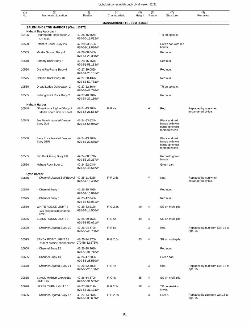
Light List corrected through LNM week: 52/21
91
(1) (2) (3) (4) (5) (6) (7) (8) No. Name and Location Position Characteristic Height Range Structure Remarks
MASSACHUSETTS - First District
SALEM AND LYNN HARBORS (Chart 13275)
Nahant Bay Approach
10495 Roaring Bull Daybeacon 2 42-28-46.654N TR on spindle.
On rock. 070-50-12.822W
10500 Pitchers Shoal Buoy PS 42-28-03.615N
070-51-19.886W
Green can with red bands.
10505 Middle Ground Buoy 4 42-28-08.048N Red nun.
070-51-26.368W
10510 Sammy Rock Buoy 6 42-28-16.161N Red nun.
070-51-58.183W
10520 Great Pig Rocks Buoy 6 42-27-29.082N Red nun.
070-51-28.181W
10525 Dolphin Rock Buoy 10 42-27-58.432N Red nun.
070-51-59.783W
10530 Dread Ledge Daybeacon 2 42-27-22.864N TR on spindle.
070-53-41.776W
10535 Fishing Point Rock Buoy 2 42-27-40.381N Red nun. 070-54-27.186W
Nahant Harbor
10540 Shag Rocks Lighted Buoy 2
Marks south side of shoal.
42-24-43.284N
070-54-21.564W
Fl R 4s 4 Red. Replaced by nun when endangered by ice.
10545 Joe Beach Isolated Danger Buoy DJB
42-24-53.624N
070-54-54.945W
Black and red bands with two black spherical topmarks; can.
10550 Bass Rock Isolated Danger Buoy DBR
42-24-43.384N
070-55-22.685W
Black and red bands with two black spherical topmarks; can. .
10555 Flip Rock Gong Buoy FR 42-24-08.571N
070-55-27.257W
Red with green bands.
10560 Nahant Rock Buoy 1 42-24-22.034N Green can.
070-56-46.512W
Lynn Harbor
10565 - Channel Lighted Bell Buoy 2 42-25-11.633N
070-57-10.488W
Fl R 2.5s 4 Red. Replaced by nun when endangered by ice.
10570 - Channel Buoy 4 42-25-30.709N
Red nun.
070-57-10.876W
10575 - Channel Buoy 6 42-25-47.843N Red nun.
070-56-56.081W
10580 WHITE ROCKS LIGHT 7 42-25-33.613N Fl G 2.5s 49 4 SG on multi-pile.
125 feet outside channel limit.
070-57-14.500W
10585 BLACK ROCKS LIGHT 9 42-25-59.162N Fl G 6s 49 4 SG on multi-pile.
070-56-52.621W
10590 - Channel Lighted Buoy 10 42-26-04.472N
070-56-43.758W
Fl R 6s 3 Red. Replaced by nun from Oct. 15 to Apr. 15.
10595 SANDY POINT LIGHT 11 42-26-34.276N Fl G 2.5s 45 4 SG on multi-pile.
75 feet outside channel limit. 070-56-32.673W
10600 - Channel Buoy 12 42-26-28.961N
Red nun.
070-56-31.742W
10605 - Channel Buoy 13 42-26-47.206N Green can.
070-56-28.530W
10610 - Channel Lighted Buoy 14 42-26-52.382N
070-56-26.188W
Fl R 4s 3 Red. Replaced by nun from Oct. 15 to Apr. 15.
10615 BLACK MARSH CHANNEL LIGHT 15
42-26-54.370N
070-56-31.509W
Fl G 4s 35 4 SG on multi-pile.
10620 UPPER TURN LIGHT 16 42-27-10.819N
070-56-31.123W
Fl R 2.5s 28 4 TR on skeleton tower.
10625 - Channel Lighted Buoy 17 42-27-14.261N 070-56-38.689W
Fl G 2.5s 3 Green. Replaced by can from Oct.15 to Apr. 15.
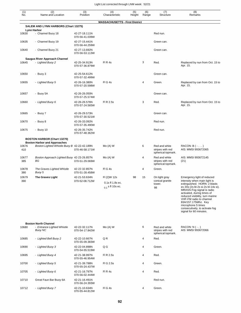
Light List corrected through LNM week: 52/21
92
(1) (2) (3) (4) (5) (6) (7) (8) No. Name and Location Position Characteristic Height Range Structure Remarks
MASSACHUSETTS - First District
SALEM AND LYNN HARBORS (Chart 13275)
Lynn Harbor
10630 - Channel Buoy 18 42-27-18.111N Red nun.
070-56-41.039W
10635 - Channel Buoy 19 42-27-15.441N Green can.
070-56-44.259W
10640 - Channel Buoy 21 42-27-13.692N Green can. 070-56-53.113W
Saugus River Approach Channel
10645 - Lighted Buoy 2 42-25-34.913N
070-57-36.879W
Fl R 4s 3 Red. Replaced by nun from Oct. 15 to Apr. 15.
10650 - Buoy 3 42-25-54.612N
Green can.
070-57-32.499W
10655 - Lighted Buoy 5 42-26-16.380N
070-57-20.598W
Fl G 4s 4 Green. Replaced by can from Oct. 15 to Apr. 15.
10657 - Buoy 5A 42-26-26.050N
Green can.
070-57-25.574W
10660 - Lighted Buoy 6 42-26-26.576N
070-57-24.565W
Fl R 2.5s 3 Red. Replaced by nun from Oct. 15 to Apr. 15.
10665 - Buoy 7 42-26-29.573N
Green can.
070-57-30.521W
10670 - Buoy 8 42-26-33.092N Red nun.
070-57-35.490W
10675 - Buoy 10 42-26-35.742N Red nun.
070-57-48.362W
BOSTON HARBOR (Chart 13270)
Boston Harbor and Approaches
10676 Boston Lighted Whistle Buoy B 42-22-42.189N Mo (A) W 6 Red and white RACON: B ( - . . . )
410 070-46-58.171W stripes with red spherical topmark.
AIS: MMSI 993672065
10677 Boston Approach Lighted Buoy 42-23-26.857N Mo (A) W 4 Red and white AIS: MMSI 993672145
385 BG 070-51-29.069W stripes with red spherical topmark.
(21)
10678 The Graves Lighted Whistle 42-22-32.857N Fl G 4s 4 Green.
380 Buoy 5 070-51-28.458W
10679 The Graves Light 42-21-53.634N Fl (2)W 12s 98 15 On light gray Emergency light of reduced
390 070-52-08.712W 0.1s fl 1.8s ec.
conical granite tower.
intensity when main light is extinguished. HORN: 2 blasts
0.1 s fl 10s ec. 98 ev 20s (2s bl-2s si-2s bl-14s si).
MRASS-Fog signal is radio activated, during times of reduced visibility, turn marine VHF-FM radio to channel 83A/157.175Mhz. Key microphone 5 times consecutively, to activate fog signal for 60 minutes.
Boston North Channel
10680 - Entrance Lighted Whistle Buoy NC
42-22-32.117N
070-54-17.842W
Mo (A) W 6 Red and white stripes with red spherical topmark.
RACON: N ( - . ) AIS: MMSI 993672066
10685 - Lighted Bell Buoy 2 42-22-10.667N
070-55-09.383W
Q R 4 Red.
10690 - Lighted Buoy 3 42-22-04.898N
070-54-55.519W
Q G 4 Green.
10695 - Lighted Buoy 4 42-21-38.997N
070-55-46.954W
Fl R 2.5s 4 Red.
10700 - Lighted Buoy 5 42-21-39.788N
070-55-24.437W
Fl G 2.5s 4 Green.
10705 - Lighted Buoy 6 42-21-16.797N
070-56-02.444W
Fl R 4s 4 Red.
10710 Great Faun Bar Buoy 6A 42-21-16.491N
070-56-24.393W
Red nun.
10712 - Lighted Buoy 7 42-21-10.634N 070-55-44.812W
Fl G 4s 4 Green.
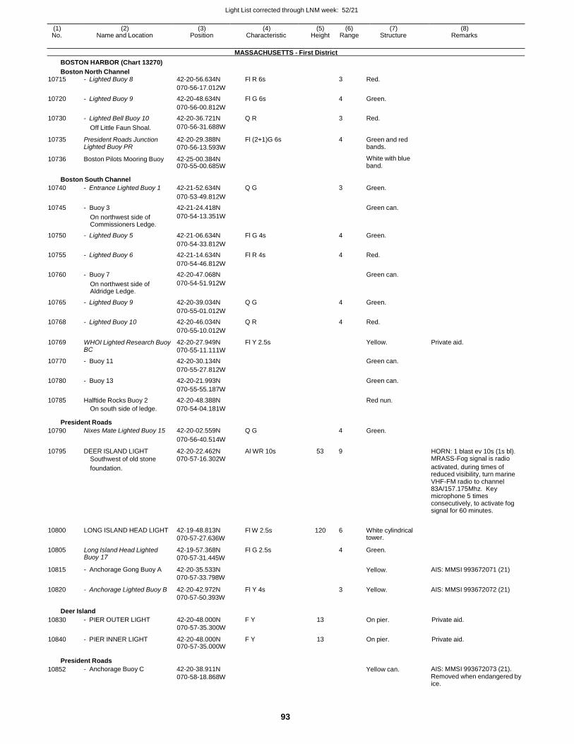
Light List corrected through LNM week: 52/21
93
(1) (2) (3) (4) (5) (6) (7) (8) No. Name and Location Position Characteristic Height Range Structure Remarks
MASSACHUSETTS - First District
BOSTON HARBOR (Chart 13270)
Boston North Channel 10715 - Lighted Buoy 8 42-20-56.634N Fl R 6s 3 Red.
070-56-17.012W
10720 - Lighted Buoy 9 42-20-48.634N Fl G 6s 4 Green.
070-56-00.812W
10730 - Lighted Bell Buoy 10 42-20-36.721N Q R 3 Red.
Off Little Faun Shoal. 070-56-31.688W
10735 President Roads Junction Lighted Buoy PR
42-20-29.388N
070-56-13.593W
Fl (2+1)G 6s 4 Green and red bands.
10736 Boston Pilots Mooring Buoy 42-25-00.384N 070-55-00.685W
White with blue band.
Boston South Channel
10740 - Entrance Lighted Buoy 1 42-21-52.634N Q G 3 Green.
070-53-49.812W
10745 - Buoy 3 42-21-24.418N Green can.
On northwest side of Commissioners Ledge.
070-54-13.351W
10750 - Lighted Buoy 5 42-21-06.634N Fl G 4s 4 Green.
070-54-33.812W
10755 - Lighted Buoy 6 42-21-14.634N Fl R 4s 4 Red.
070-54-46.812W
10760 - Buoy 7 42-20-47.068N Green can.
On northwest side of Aldridge Ledge.
070-54-51.912W
10765 - Lighted Buoy 9 42-20-39.034N Q G 4 Green.
070-55-01.012W
10768 - Lighted Buoy 10 42-20-46.034N Q R 4 Red.
070-55-10.012W
10769 WHOI Lighted Research Buoy BC
42-20-27.949N
070-55-11.111W
Fl Y 2.5s Yellow. Private aid.
10770 - Buoy 11 42-20-30.134N Green can.
070-55-27.812W
10780 - Buoy 13 42-20-21.993N Green can.
070-55-55.187W
10785 Halftide Rocks Buoy 2 42-20-48.388N Red nun.
On south side of ledge. 070-54-04.181W
President Roads
10790 Nixes Mate Lighted Buoy 15 42-20-02.559N Q G 4 Green.
070-56-40.514W
10795 DEER ISLAND LIGHT
Southwest of old stone
42-20-22.462N 070-57-16.302W
Al WR 10s 53 9 HORN: 1 blast ev 10s (1s bl). MRASS-Fog signal is radio
foundation. activated, during times of reduced visibility, turn marine VHF-FM radio to channel 83A/157.175Mhz. Key microphone 5 times consecutively, to activate fog signal for 60 minutes.
10800
10805
10815
10820
LONG ISLAND HEAD LIGHT
Long Island Head Lighted Buoy 17
- Anchorage Gong Buoy A
- Anchorage Lighted Buoy B
42-19-48.813N
070-57-27.636W
42-19-57.368N
070-57-31.445W
42-20-35.533N
070-57-33.798W
42-20-42.972N
070-57-50.393W
Fl W 2.5s
Fl G 2.5s
Fl Y 4s
120 6
4
3
White cylindrical tower.
Green.
Yellow.
Yellow.
AIS: MMSI 993672071 (21)
AIS: MMSI 993672072 (21)
Deer Island
10830 - PIER OUTER LIGHT 42-20-48.000N
070-57-35.300W
F Y 13 On pier. Private aid.
10840 - PIER INNER LIGHT 42-20-48.000N 070-57-35.000W
F Y 13 On pier. Private aid.
President Roads
10852 - Anchorage Buoy C 42-20-38.911N
070-58-18.868W Yellow can. AIS: MMSI 993672073 (21).
Removed when endangered by ice.
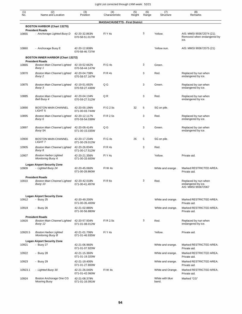
Light List corrected through LNM week: 52/21
94
(1) (2) (3) (4) (5) (6) (7) (8) No. Name and Location Position Characteristic Height Range Structure Remarks
MASSACHUSETTS - First District
BOSTON HARBOR (Chart 13270)
President Roads
10855
10860
- Anchorage Lighted Buoy D
- Anchorage Buoy E
42-20-32.863N
070-58-51.017W
42-20-12.808N
070-58-46.737W
Fl Y 4s 3 Yellow.
Yellow nun.
AIS: MMSI 993672074 (21). Removed when endangered by ice.
AIS: MMSI 993672075 (21)
BOSTON INNER HARBOR (Chart 13272)
President Roads
10865 Boston Main Channel Lighted Buoy 1
42-19-52.662N
070-58-44.147W
Fl G 4s 3 Green.
10870 Boston Main Channel Lighted Buoy 2
42-20-04.738N
070-58-57.167W
Fl R 4s 3 Red. Replaced by nun when endangered by ice.
10875 Boston Main Channel Lighted Buoy 3
42-19-51.692N
070-59-27.436W
Q G
3 Green. Replaced by can when endangered by ice.
10885 Boston Main Channel Lighted Bell Buoy 4
42-20-04.134N
070-59-27.512W
Q R
3 Red. Replaced by nun when endangered by ice.
10890 BOSTON MAIN CHANNEL LIGHT 5
42-20-00.196N
071-00-03.744W
Fl G 2.5s 32 5 SG on pile.
10895 Boston Main Channel Lighted Buoy 6
42-20-12.117N
070-59-54.038W
Fl R 2.5s 3 Red. Replaced by nun when endangered by ice.
10897 Boston Main Channel Lighted Buoy 5A
42-20-09.414N
071-00-15.035W
Q G
3 Green. Replaced by can when endangered by ice.
10900 BOSTON MAIN CHANNEL LIGHT 7
42-20-17.234N
071-00-29.012W
Fl G 4s 26 5 SG on pile.
10905 Boston Main Channel Lighted Buoy 8
42-20-26.834N
071-00-17.512W
Fl R 4s 3 Red.
10907 Boston Harbor Lighted Monitoring Buoy A
42-20-21.356N 071-00-33.600W
Fl Y 4s Yellow. Private aid.
Logan Airport Security Zone
10909 - Lighted Buoy 24 42-20-45.060N
071-00-28.860W
Fl W 4s White and orange . Marked RESTRICTED AREA.
Private aid.
President Roads
10910 Boston Main Channel Lighted Buoy 10
42-20-42.018N
071-00-41.497W
Fl R 6s 3 Red. Replaced by nun when endangered by ice. AIS: MMSI 993672067
Logan Airport Security Zone
10912 - Buoy 25 42-20-49.200N White and orange. Marked RESTRICTED AREA.
071-00-35.400W Private aid.
10919 - Buoy 26 42-21-02.880N White and orange. Marked RESTRICTED AREA. 071-00-56.880W Private aid.
President Roads
10920 Boston Main Channel Lighted Buoy 12
42-20-57.934N
071-01-08.012W
Fl R 2.5s 3 Red. Replaced by nun when endangered by ice.
10920.5 Boston Harbor Lighted Monitoring Buoy B
42-21-01.706N 071-01-46.935W
Fl Y 4s
Yellow. Private aid.
Logan Airport Security Zone
10921 - Buoy 27 42-21-06.960N White and orange. Marked RESTRICTED AREA.
071-01-07.920W Private aid.
10922 - Buoy 28 42-21-15.360N White and orange. Marked RESTRICTED AREA.
071-01-19.320W Private aid.
10923 - Buoy 29 42-21-19.400N White and orange. Marked RESTRICTED AREA.
071-01-27.800W Private aid.
10923.1 - Lighted Buoy 30 42-21-26.040N Fl W 4s White and Orange. Marked RESTRICTED AREA.
071-01-42.060W Private aid.
10924 Boston Anchorage One CG Mooring Buoy
42-21-08.379N 071-01-16.091W
White with blue band.
Marked "CG"
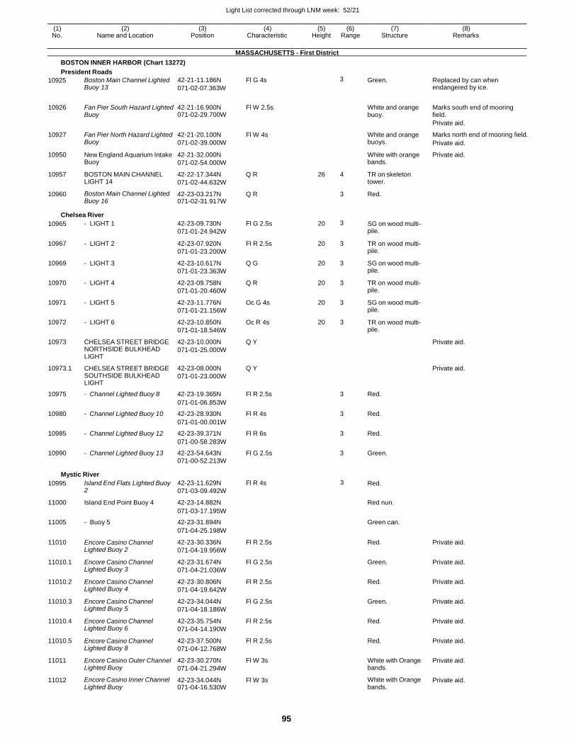
Light List corrected through LNM week: 52/21
95
(1) (2) (3) (4) (5) (6) (7) (8) No. Name and Location Position Characteristic Height Range Structure Remarks
MASSACHUSETTS - First District
BOSTON INNER HARBOR (Chart 13272)
President Roads
10925 Boston Main Channel Lighted Buoy 13
42-21-11.186N
071-02-07.363W
Fl G 4s 3 Green. Replaced by can when endangered by ice.
10926 Fan Pier South Hazard Lighted
Buoy 42-21-16.900N 071-02-29.700W
Fl W 2.5s White and orange buoy.
Marks south end of mooring field.
Private aid.
10927 Fan Pier North Hazard Lighted Buoy
42-21-20.100N
071-02-39.000W
Fl W 4s White and orange buoys.
Marks north end of mooring field.
Private aid.
10950 New England Aquarium Intake Buoy
42-21-32.000N
071-02-54.000W
White with orange bands.
Private aid.
10957 BOSTON MAIN CHANNEL LIGHT 14
42-22-17.344N
071-02-44.632W
Q R 26 4 TR on skeleton tower.
10960 Boston Main Channel Lighted Buoy 16
42-23-03.217N 071-02-31.917W
Q R 3 Red.
Chelsea River
10965 - LIGHT 1 42-23-09.730N
071-01-24.942W
Fl G 2.5s 20 3 SG on wood multi- pile.
10967 - LIGHT 2 42-23-07.920N
071-01-23.200W
Fl R 2.5s 20 3 TR on wood multi- pile.
10969 - LIGHT 3 42-23-10.617N
071-01-23.363W
Q G 20 3 SG on wood multi- pile.
10970 - LIGHT 4 42-23-09.758N
071-01-20.460W
Q R 20 3 TR on wood multi- pile.
10971 - LIGHT 5 42-23-11.776N
071-01-21.156W
Oc G 4s 20 3 SG on wood multi- pile.
10972 - LIGHT 6 42-23-10.850N
071-01-18.546W
Oc R 4s 20 3 TR on wood multi- pile.
10973 CHELSEA STREET BRIDGE NORTHSIDE BULKHEAD LIGHT
42-23-10.000N
071-01-25.000W
Q Y Private aid.
10973.1 CHELSEA STREET BRIDGE SOUTHSIDE BULKHEAD LIGHT
42-23-08.000N
071-01-23.000W
Q Y Private aid.
10975 - Channel Lighted Buoy 8 42-23-19.365N Fl R 2.5s 3 Red.
071-01-06.853W
10980 - Channel Lighted Buoy 10 42-23-28.930N Fl R 4s 3 Red.
071-01-00.001W
10985 - Channel Lighted Buoy 12 42-23-39.371N Fl R 6s 3 Red.
071-00-58.283W
10990 - Channel Lighted Buoy 13 42-23-54.643N Fl G 2.5s 3 Green.
071-00-52.213W
Mystic River
10995 Island End Flats Lighted Buoy 2
42-23-11.629N
071-03-09.492W
Fl R 4s 3 Red.
11000 Island End Point Buoy 4 42-23-14.882N Red nun.
071-03-17.195W
11005 - Buoy 5 42-23-31.894N Green can.
071-04-25.198W
11010 Encore Casino Channel Lighted Buoy 2
42-23-30.336N
071-04-19.956W
Fl R 2.5s Red. Private aid.
11010.1 Encore Casino Channel Lighted Buoy 3
42-23-31.674N
071-04-21.036W
Fl G 2.5s Green. Private aid.
11010.2 Encore Casino Channel Lighted Buoy 4
42-23-30.806N
071-04-19.642W
Fl R 2.5s Red. Private aid.
11010.3 Encore Casino Channel Lighted Buoy 5
42-23-34.044N
071-04-18.186W
Fl G 2.5s Green. Private aid.
11010.4 Encore Casino Channel Lighted Buoy 6
42-23-35.754N
071-04-14.190W
Fl R 2.5s Red. Private aid.
11010.5 Encore Casino Channel Lighted Buoy 8
42-23-37.500N
071-04-12.768W
Fl R 2.5s Red. Private aid.
11011 Encore Casino Outer Channel Lighted Buoy
42-23-30.270N
071-04-21.294W
Fl W 3s White with Orange bands.
Private aid.
11012 Encore Casino Inner Channel Lighted Buoy
42-23-34.044N 071-04-16.530W
Fl W 3s White with Orange bands.
Private aid.
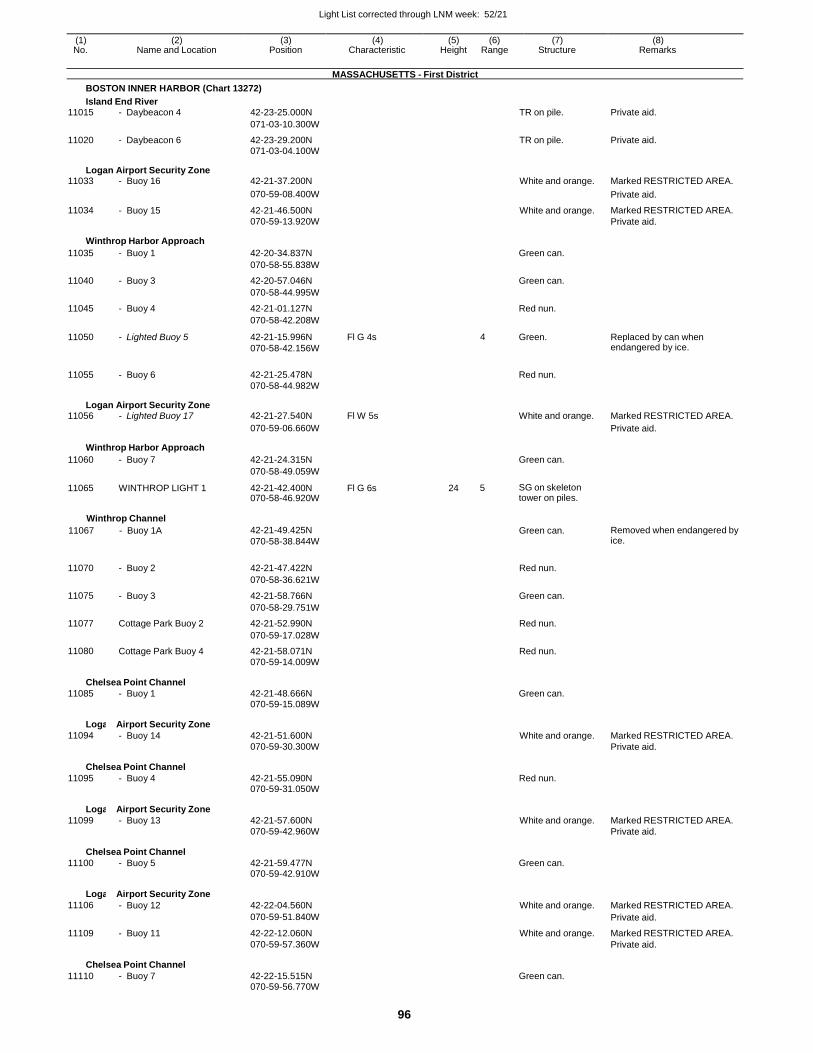
Light List corrected through LNM week: 52/21
96
(1) (2) (3) (4) (5) (6) (7) (8) No. Name and Location Position Characteristic Height Range Structure Remarks
MASSACHUSETTS - First District
BOSTON INNER HARBOR (Chart 13272)
Island End River 11015 - Daybeacon 4 42-23-25.000N TR on pile. Private aid.
071-03-10.300W
11020 - Daybeacon 6 42-23-29.200N TR on pile. Private aid. 071-03-04.100W
Logan Airport Security Zone 11033 - Buoy 16 42-21-37.200N White and orange. Marked RESTRICTED AREA.
070-59-08.400W Private aid.
11034 - Buoy 15 42-21-46.500N White and orange. Marked RESTRICTED AREA. 070-59-13.920W Private aid.
Winthrop Harbor Approach
11035 - Buoy 1 42-20-34.837N Green can.
070-58-55.838W
11040 - Buoy 3 42-20-57.046N Green can.
070-58-44.995W
11045 - Buoy 4 42-21-01.127N Red nun.
070-58-42.208W
11050 - Lighted Buoy 5 42-21-15.996N
070-58-42.156W
Fl G 4s 4 Green. Replaced by can when endangered by ice.
11055 - Buoy 6 42-21-25.478N
Red nun.
070-58-44.982W
Logan Airport Security Zone 11056 - Lighted Buoy 17 42-21-27.540N Fl W 5s White and orange. Marked RESTRICTED AREA.
070-59-06.660W Private aid.
Winthrop Harbor Approach
11060 - Buoy 7 42-21-24.315N Green can.
070-58-49.059W
11065 WINTHROP LIGHT 1 42-21-42.400N 070-58-46.920W
Fl G 6s 24 5 SG on skeleton tower on piles.
Winthrop Channel
11067 - Buoy 1A
42-21-49.425N
070-58-38.844W
Green can.
Removed when endangered by ice.
11070 - Buoy 2 42-21-47.422N Red nun.
070-58-36.621W
11075 - Buoy 3 42-21-58.766N Green can.
070-58-29.751W
11077 Cottage Park Buoy 2 42-21-52.990N Red nun.
070-59-17.028W
11080 Cottage Park Buoy 4 42-21-58.071N Red nun.
070-59-14.009W
Chelsea Point Channel
11085 - Buoy 1
42-21-48.666N
Green can. 070-59-15.089W
Logan
11094
Airport Security Zone
- Buoy 14
42-21-51.600N
White and orange.
Marked RESTRICTED AREA. 070-59-30.300W Private aid.
Chelsea Point Channel
11095 - Buoy 4
42-21-55.090N
Red nun. 070-59-31.050W
Logan
11099
Airport Security Zone
- Buoy 13
42-21-57.600N
White and orange.
Marked RESTRICTED AREA. 070-59-42.960W Private aid.
Chelsea Point Channel
11100 - Buoy 5
42-21-59.477N
Green can. 070-59-42.910W
Logan
11106
Airport Security Zone
- Buoy 12
42-22-04.560N
White and orange.
Marked RESTRICTED AREA.
070-59-51.840W Private aid.
11109 - Buoy 11 42-22-12.060N White and orange. Marked RESTRICTED AREA. 070-59-57.360W Private aid.
Chelsea Point Channel
11110 - Buoy 7
42-22-15.515N
Green can. 070-59-56.770W
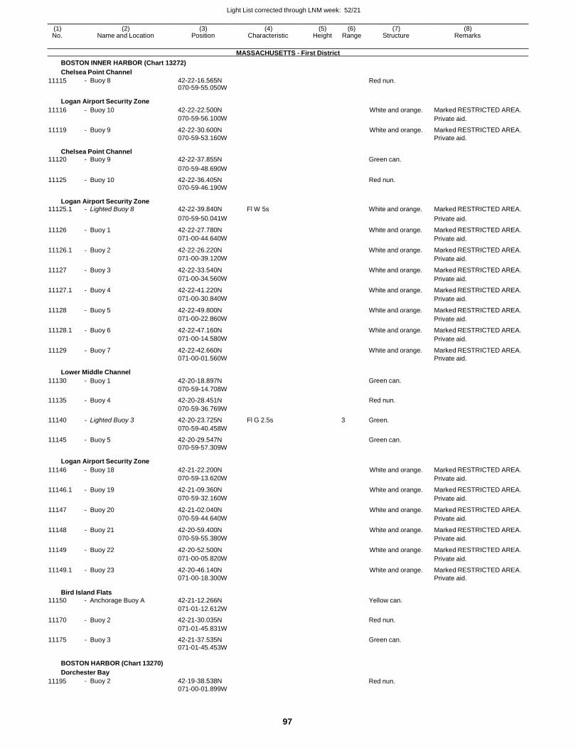
Light List corrected through LNM week: 52/21
97
(1) (2) (3) (4) (5) (6) (7) (8) No. Name and Location Position Characteristic Height Range Structure Remarks
MASSACHUSETTS - First District
BOSTON INNER HARBOR (Chart 13272)
Chelsea Point Channel
11115 - Buoy 8 42-22-16.565N 070-59-55.050W
Red nun.
Logan Airport Security Zone
11116 - Buoy 10 42-22-22.500N White and orange. Marked RESTRICTED AREA.
070-59-56.100W Private aid.
11119 - Buoy 9 42-22-30.600N White and orange. Marked RESTRICTED AREA. 070-59-53.160W Private aid.
Chelsea Point Channel 11120 - Buoy 9 42-22-37.855N Green can.
070-59-48.690W
11125 - Buoy 10 42-22-36.405N Red nun. 070-59-46.190W
Logan Airport Security Zone 11125.1 - Lighted Buoy 8 42-22-39.840N Fl W 5s White and orange. Marked RESTRICTED AREA.
070-59-50.041W Private aid.
11126 - Buoy 1 42-22-27.780N White and orange. Marked RESTRICTED AREA.
071-00-44.640W Private aid.
11126.1 - Buoy 2 42-22-26.220N White and orange. Marked RESTRICTED AREA.
071-00-39.120W Private aid.
11127 - Buoy 3 42-22-33.540N White and orange. Marked RESTRICTED AREA.
071-00-34.560W Private aid.
11127.1 - Buoy 4 42-22-41.220N White and orange. Marked RESTRICTED AREA.
071-00-30.840W Private aid.
11128 - Buoy 5 42-22-49.800N White and orange. Marked RESTRICTED AREA.
071-00-22.860W Private aid.
11128.1 - Buoy 6 42-22-47.160N White and orange. Marked RESTRICTED AREA.
071-00-14.580W Private aid.
11129 - Buoy 7 42-22-42.660N White and orange. Marked RESTRICTED AREA. 071-00-01.560W Private aid.
Lower Middle Channel
11130 - Buoy 1 42-20-18.897N Green can.
070-59-14.708W
11135 - Buoy 4 42-20-28.451N Red nun.
070-59-36.769W
11140 - Lighted Buoy 3 42-20-23.725N Fl G 2.5s 3 Green.
070-59-40.458W
11145 - Buoy 5 42-20-29.547N Green can. 070-59-57.309W
Logan Airport Security Zone
11146 - Buoy 18 42-21-22.200N White and orange. Marked RESTRICTED AREA.
070-59-13.620W Private aid.
11146.1 - Buoy 19 42-21-09.360N White and orange. Marked RESTRICTED AREA.
070-59-32.160W Private aid.
11147 - Buoy 20 42-21-02.040N White and orange. Marked RESTRICTED AREA.
070-59-44.640W Private aid.
11148 - Buoy 21 42-20-59.400N White and orange. Marked RESTRICTED AREA.
070-59-55.380W Private aid.
11149 - Buoy 22 42-20-52.500N White and orange. Marked RESTRICTED AREA.
071-00-05.820W Private aid.
11149.1 - Buoy 23 42-20-46.140N White and orange. Marked RESTRICTED AREA. 071-00-18.300W Private aid.
Bird Island Flats
11150 - Anchorage Buoy A
42-21-12.266N
Yellow can.
071-01-12.612W
11170 - Buoy 2 42-21-30.035N Red nun.
071-01-45.831W
11175 - Buoy 3 42-21-37.535N Green can. 071-01-45.453W
BOSTON HARBOR (Chart 13270)
Dorchester Bay
11195 - Buoy 2 42-19-38.538N
071-00-01.899W Red nun.
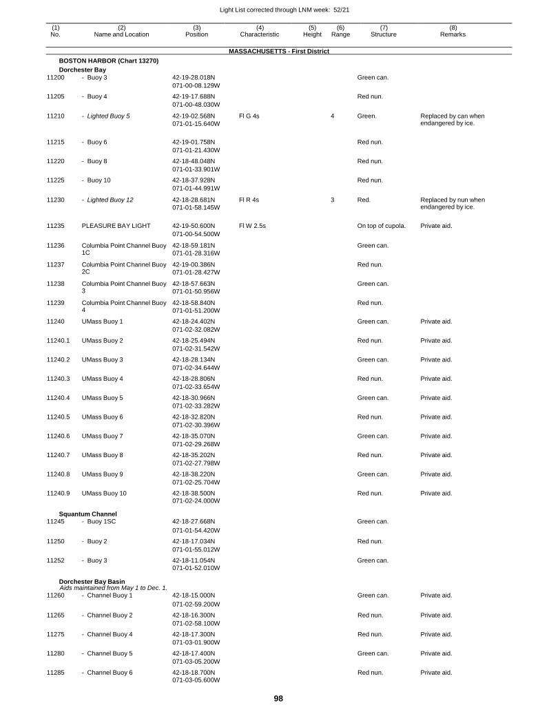
Light List corrected through LNM week: 52/21
98
(1) (2) (3) (4) (5) (6) (7) (8) No. Name and Location Position Characteristic Height Range Structure Remarks
MASSACHUSETTS - First District
BOSTON HARBOR (Chart 13270)
Dorchester Bay
11200 - Buoy 3 42-19-28.018N Green can.
071-00-08.129W
11205 - Buoy 4 42-19-17.688N Red nun.
071-00-48.030W
11210 - Lighted Buoy 5 42-19-02.568N
071-01-15.640W
Fl G 4s 4 Green. Replaced by can when endangered by ice.
11215 - Buoy 6 42-19-01.758N
Red nun.
071-01-21.430W
11220 - Buoy 8 42-18-48.048N Red nun.
071-01-33.901W
11225 - Buoy 10 42-18-37.928N Red nun.
071-01-44.991W
11230 - Lighted Buoy 12 42-18-28.681N
071-01-58.145W
Fl R 4s 3 Red. Replaced by nun when endangered by ice.
11235 PLEASURE BAY LIGHT 42-19-50.600N Fl W 2.5s
On top of cupola. Private aid.
071-00-54.500W
11236 Columbia Point Channel Buoy 1C
42-18-59.181N
071-01-28.316W
Green can.
11237 Columbia Point Channel Buoy 2C
42-19-00.386N
071-01-28.427W
Red nun.
11238 Columbia Point Channel Buoy 3
42-18-57.663N
071-01-50.956W
Green can.
11239 Columbia Point Channel Buoy 4
42-18-58.840N
071-01-51.200W
Red nun.
11240 UMass Buoy 1 42-18-24.402N Green can. Private aid.
071-02-32.082W
11240.1 UMass Buoy 2 42-18-25.494N Red nun. Private aid.
071-02-31.542W
11240.2 UMass Buoy 3 42-18-28.134N Green can. Private aid.
071-02-34.644W
11240.3 UMass Buoy 4 42-18-28.806N Red nun. Private aid.
071-02-33.654W
11240.4 UMass Buoy 5 42-18-30.966N Green can. Private aid.
071-02-33.282W
11240.5 UMass Buoy 6 42-18-32.820N Red nun. Private aid.
071-02-30.396W
11240.6 UMass Buoy 7 42-18-35.070N Green can. Private aid.
071-02-29.268W
11240.7 UMass Buoy 8 42-18-35.202N Red nun. Private aid.
071-02-27.798W
11240.8 UMass Buoy 9 42-18-38.220N Green can. Private aid.
071-02-25.704W
11240.9 UMass Buoy 10 42-18-38.500N Red nun. Private aid. 071-02-24.000W
Squantum Channel 11245 - Buoy 1SC 42-18-27.668N Green can.
071-01-54.420W
11250 - Buoy 2 42-18-17.034N Red nun.
071-01-55.012W
11252 - Buoy 3 42-18-11.054N Green can. 071-01-52.010W
Dorchester Bay Basin Aids maintained from May 1 to Dec. 1.
11260 - Channel Buoy 1 42-18-15.000N Green can. Private aid.
071-02-59.200W
11265 - Channel Buoy 2 42-18-16.300N Red nun. Private aid.
071-02-58.100W
11275 - Channel Buoy 4 42-18-17.300N Red nun. Private aid.
071-03-01.900W
11280 - Channel Buoy 5 42-18-17.400N Green can. Private aid.
071-03-05.200W
11285 - Channel Buoy 6 42-18-18.700N Red nun. Private aid. 071-03-05.600W
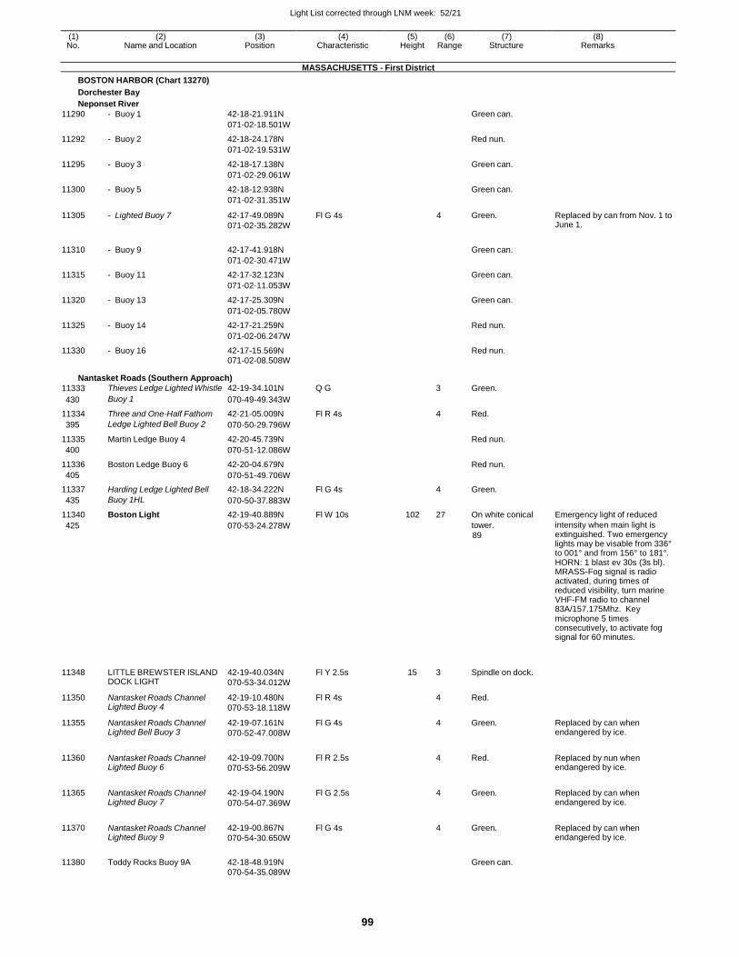
Light List corrected through LNM week: 52/21
99
(1) (2) (3) (4) (5) (6) (7) (8) No. Name and Location Position Characteristic Height Range Structure Remarks
MASSACHUSETTS - First District
BOSTON HARBOR (Chart 13270)
Dorchester Bay
Neponset River
11290 - Buoy 1 42-18-21.911N Green can.
071-02-18.501W
11292 - Buoy 2 42-18-24.178N Red nun.
071-02-19.531W
11295 - Buoy 3 42-18-17.138N Green can.
071-02-29.061W
11300 - Buoy 5 42-18-12.938N Green can.
071-02-31.351W
11305 - Lighted Buoy 7 42-17-49.089N
071-02-35.282W
Fl G 4s 4 Green. Replaced by can from Nov. 1 to June 1.
11310 - Buoy 9 42-17-41.918N
Green can.
071-02-30.471W
11315 - Buoy 11 42-17-32.123N Green can.
071-02-11.053W
11320 - Buoy 13 42-17-25.309N Green can.
071-02-05.780W
11325 - Buoy 14 42-17-21.259N Red nun.
071-02-06.247W
11330 - Buoy 16 42-17-15.569N Red nun.
071-02-08.508W
Nantasket Roads (Southern Approach)
11333 Thieves Ledge Lighted Whistle 42-19-34.101N Q G 3 Green.
430 Buoy 1 070-49-49.343W
11334 Three and One-Half Fathom 42-21-05.009N Fl R 4s 4 Red.
395 Ledge Lighted Bell Buoy 2 070-50-29.796W
11335 Martin Ledge Buoy 4 42-20-45.739N Red nun.
400 070-51-12.086W
11336 Boston Ledge Buoy 6 42-20-04.679N Red nun.
405 070-51-49.706W
11337 Harding Ledge Lighted Bell 42-18-34.222N Fl G 4s 4 Green.
435 Buoy 1HL 070-50-37.883W
11340 Boston Light 42-19-40.889N Fl W 10s 102 27 On white conical Emergency light of reduced
425 070-53-24.278W tower.
89
intensity when main light is extinguished. Two emergency lights may be visable from 336° to 001° and from 156° to 181°. HORN: 1 blast ev 30s (3s bl). MRASS-Fog signal is radio activated, during times of reduced visibility, turn marine VHF-FM radio to channel 83A/157.175Mhz. Key microphone 5 times consecutively, to activate fog signal for 60 minutes.
11348
LITTLE BREWSTER ISLAND DOCK LIGHT
42-19-40.034N
070-53-34.012W
Fl Y 2.5s
15
3
Spindle on dock.
11350 Nantasket Roads Channel Lighted Buoy 4
42-19-10.480N
070-53-18.118W
Fl R 4s 4 Red.
11355 Nantasket Roads Channel Lighted Bell Buoy 3
42-19-07.161N
070-52-47.008W
Fl G 4s 4 Green. Replaced by can when endangered by ice.
11360 Nantasket Roads Channel Lighted Buoy 6
42-19-09.700N
070-53-56.209W
Fl R 2.5s
4 Red. Replaced by nun when endangered by ice.
11365 Nantasket Roads Channel Lighted Buoy 7
42-19-04.190N
070-54-07.369W
Fl G 2.5s
4 Green. Replaced by can when endangered by ice.
11370 Nantasket Roads Channel Lighted Buoy 9
42-19-00.867N
070-54-30.650W
Fl G 4s
4 Green. Replaced by can when endangered by ice.
11380 Toddy Rocks Buoy 9A 42-18-48.919N
Green can.
070-54-35.089W
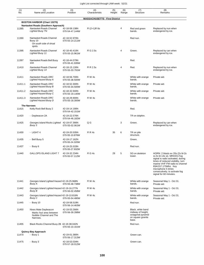
Light List corrected through LNM week: 52/21
100
(1) (2) (3) (4) (5) (6) (7) (8) No. Name and Location Position Characteristic Height Range Structure Remarks
MASSACHUSETTS - First District
BOSTON HARBOR (Chart 13270)
Nantasket Roads (Southern Approach)
11385 Nantasket Roads Channel Lighted Buoy TN
42-18-59.138N
070-54-47.144W
Fl (2+1)R 6s 4 Red and green bands.
Replaced by nun when endangered by ice.
11390 Nantasket Roads Channel Buoy 10
42-18-52.970N 070-55-14.211W
Red nun.
On south side of shoal spots.
11395 Nantasket Roads Channel Lighted Buoy 11
42-18-40.410N
070-55-15.961W
Fl G 2.5s 4 Green. Replaced by can when endangered by ice.
11397 Nantasket Roads Bell Buoy 10A
42-18-44.079N
070-55-41.935W
Red.
11410 Nantasket Roads Channel Lighted Buoy 14
42-18-15.130N
070-55-33.791W
Fl R 2.5s 4 Red. Replaced by nun when endangered by ice.
11411 Nantasket Roads DRC Lighted Hazard Buoy A
42-18-56.700N
070-55-38.500W
Fl W 4s
White with orange bands.
Private aid.
11411.1 Nantasket Roads DRC Lighted Hazard Buoy B
42-18-52.300N
070-55-34.500W
Fl W 4s White with orange bands.
Private aid.
11411.2 Nantasket Roads DRC Lighted Hazard Buoy C
42-18-32.940N
070-55-19.140W
Fl W 4s White with orange bands.
Private aid.
11411.3 Nantasket Roads DRC Lighted Hazard Buoy D
42-18-29.900N 070-55-18.300W
Fl W 4s White with orange bands.
Private aid.
The Narrows
11415
11420
11425
Kelly Rock Bell Buoy 2
- Daybeacon 2A
Georges Island Rocks Lighted Buoy 3
42-19-14.190N
070-54-42.151W
42-19-22.576N
070-54-46.182W
42-19-07.390N Q G
070-55-02.061W
Red.
TR on dolphin.
3 Green.
Replaced by can when endangered by ice.
11430
11435
11437
11440
- LIGHT 4
- Bell Buoy 5
- Buoy 6
GALLOPS ISLAND LIGHT 7
42-19-20.535N
070-55-10.876W
42-19-17.162N
070-55-24.320W
42-19-25.533N
070-55-27.932W
42-19-32.234N
070-55-57.112W
Fl R 4s
Fl G 4s
35 6
29 5
TR on pile structure.
Green.
Red nun.
SG on skeleton tower.
HORN: 2 blasts ev 20s (2s bl-2s si-2s bl-14s si). MRASS-Fog signal is radio activated, during times of reduced visibility, turn marine VHF-FM radio to channel 83A/157.175Mhz. Key microphone 5 times consecutively, to activate fog signal for 60 minutes.
11441 Georges Island Lighted Hazard 42-19-25.968N Fl W 4s White with orange Seasonal May 1 - Oct 31. Buoy A 070-55-48.738W bands. Private aid.
11442 Georges Island Lighted Hazard 42-19-16.277N Fl W 4s White with orange Seasonal May 1 - Oct 31. Buoy B 070-56-02.458W bands. Private aid.
11443 Georges Island Lighted Hazard 42-19-10.816N Fl W 4s White with orange Seasonal May 1 - Oct 31.
11445
11450
Buoy C
- Buoy 10
Nixes Mate Daybeacon
Marks foul area between Nubble Channel and The Narrows.
070-55-54.480W
42-19-58.519N
070-56-14.463W
42-19-53.266N
070-56-39.288W
bands.
Red nun.
Black, white band midway of height; octagonal pyramid on square granite base.
Private aid.
11455 Black Rocks Channel Buoy 2B 42-19-38.042N
070-55-10.161W
Red nun.
Quincy Bay Approach
11470 - Buoy 1 42-19-01.380N
070-56-17.313W Green can.
11475 - Buoy 3 42-18-53.034N 070-57-18.012W
Green can.
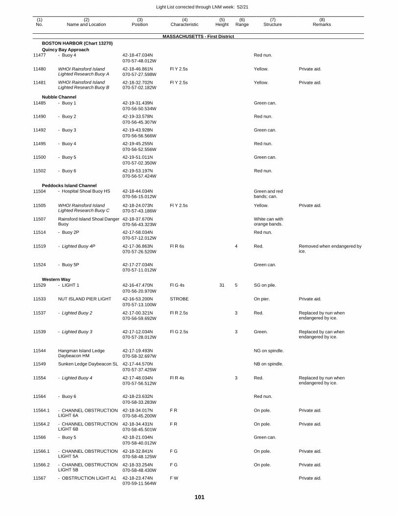
Light List corrected through LNM week: 52/21
101
(1) (2) (3) (4) (5) (6) (7) (8) No. Name and Location Position Characteristic Height Range Structure Remarks
MASSACHUSETTS - First District
BOSTON HARBOR (Chart 13270)
Quincy Bay Approach
11477 - Buoy 4 42-18-47.034N Red nun.
070-57-48.012W
11480 WHOI Rainsford Island Lighted Research Buoy A
42-18-46.861N
070-57-27.598W
Fl Y 2.5s Yellow. Private aid.
11481 WHOI Rainsford Island Lighted Research Buoy B
42-18-32.702N 070-57-02.182W
Fl Y 2.5s Yellow. Private aid.
Nubble Channel
11485 - Buoy 1 42-19-31.439N Green can.
070-56-50.534W
11490 - Buoy 2 42-19-33.578N Red nun.
070-56-45.307W
11492 - Buoy 3 42-19-43.928N Green can.
070-56-56.566W
11495 - Buoy 4 42-19-45.255N Red nun.
070-56-52.556W
11500 - Buoy 5 42-19-51.011N Green can.
070-57-02.350W
11502 - Buoy 6 42-19-53.197N Red nun. 070-56-57.424W
Peddocks Island Channel
11504 - Hospital Shoal Buoy HS 42-18-44.034N
070-56-15.012W
Green and red bands; can.
11505 WHOI Rainsford Island Lighted Research Buoy C
42-18-24.073N
070-57-43.186W
Fl Y 2.5s Yellow. Private aid.
11507 Rainsford Island Shoal Danger Buoy
42-18-37.670N
070-56-43.323W
White can with orange bands.
11514 - Buoy 2P 42-17-58.034N Red nun.
070-57-12.012W
11519 - Lighted Buoy 4P 42-17-36.863N
070-57-26.520W
Fl R 6s 4 Red. Removed when endangered by ice.
11524 - Buoy 5P 42-17-27.034N
Green can.
070-57-11.012W
Western Way
11529 - LIGHT 1 42-16-47.470N Fl G 4s 31 5 SG on pile.
070-56-20.970W
11533 NUT ISLAND PIER LIGHT 42-16-53.200N STROBE On pier. Private aid.
070-57-13.100W
11537 - Lighted Buoy 2 42-17-00.321N
070-56-59.692W
Fl R 2.5s 3 Red. Replaced by nun when endangered by ice.
11539 - Lighted Buoy 3 42-17-12.034N
070-57-28.012W
Fl G 2.5s
3 Green. Replaced by can when endangered by ice.
11544 Hangman Island Ledge Daybeacon HM
42-17-19.493N
070-58-32.697W
NG on spindle.
11549 Sunken Ledge Daybeacon SL 42-17-44.570N NB on spindle.
070-57-37.425W
11554 - Lighted Buoy 4 42-17-48.034N
070-57-56.512W
Fl R 4s 3 Red. Replaced by nun when endangered by ice.
11564 - Buoy 6 42-18-23.632N
Red nun.
070-58-33.283W
11564.1 - CHANNEL OBSTRUCTION LIGHT 6A
42-18-34.017N
070-58-45.200W
F R On pole. Private aid.
11564.2 - CHANNEL OBSTRUCTION LIGHT 6B
42-18-34.431N
070-58-45.501W
F R On pole. Private aid.
11566 - Buoy 5 42-18-21.034N Green can.
070-58-40.012W
11566.1 - CHANNEL OBSTRUCTION LIGHT 5A
42-18-32.841N
070-58-48.125W
F G On pole. Private aid.
11566.2 - CHANNEL OBSTRUCTION LIGHT 5B
42-18-33.254N
070-58-48.430W
F G On pole. Private aid.
11567 - OBSTRUCTION LIGHT A1 42-18-23.474N F W Private aid. 070-59-11.564W
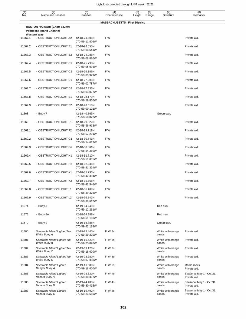
Light List corrected through LNM week: 52/21
102
(1) (2) (3) (4) (5) (6) (7) (8) No. Name and Location Position Characteristic Height Range Structure Remarks
MASSACHUSETTS - First District
BOSTON HARBOR (Chart 13270)
Peddocks Island Channel
Western Way
11567.1 - OBSTRUCTION LIGHT A2 42-18-23.808N F W Private aid.
070-59-11.806W
11567.2 - OBSTRUCTION LIGHT B1 42-18-24.650N F W Private aid.
070-59-08.641W
11567.3 - OBSTRUCTION LIGHT B2 42-18-24.985N F W Private aid.
070-59-08.880W
11567.4 - OBSTRUCTION LIGHT C1 42-18-25.796N F W Private aid.
070-59-05.691W
11567.5 - OBSTRUCTION LIGHT C2 42-18-26.189N F W Private aid.
070-59-05.979W
11567.6 - OBSTRUCTION LIGHT D1 42-18-27.003N F W Private aid.
070-59-02.787W
11567.7 - OBSTRUCTION LIGHT D2 42-18-27.335N F W Private aid.
070-59-03.027W
11567.8 - OBSTRUCTION LIGHT E1 42-18-28.179N F W Private aid.
070-58-59.860W
11567.9 - OBSTRUCTION LIGHT E2 42-18-28.510N F W Private aid.
070-59-00.101W
11568 - Buoy 7 42-18-40.563N Green can.
070-58-58.872W
11569 - OBSTRUCTION LIGHT F1 42-18-29.322N F W Private aid.
070-58-56.913W
11569.1 - OBSTRUCTION LIGHT F2 42-18-29.719N F W Private aid.
070-58-57.201W
11569.2 - OBSTRUCTION LIGHT G1 42-18-30.541N F W Private aid.
070-58-54.017W
11569.3 - OBSTRUCTION LIGHT G2 42-18-30.861N F W Private aid.
070-58-54.250W
11569.4 - OBSTRUCTION LIGHT H1 42-18-31.710N F W Private aid.
070-58-51.085W
11569.5 - OBSTRUCTION LIGHT H2 42-18-32.038N F W Private aid.
070-58-51.324W
11569.6 - OBSTRUCTION LIGHT K1 42-18-35.235N F W Private aid.
070-58-42.304W
11569.7 - OBSTRUCTION LIGHT K2 42-18-35.566N F W Private aid.
070-58-42.546W
11569.8 - OBSTRUCTION LIGHT L1 42-18-36.409N F W Private aid.
070-58-39.375W
11569.9 - OBSTRUCTION LIGHT L2 42-18-36.747N F W Private aid.
070-58-39.612W
11574 - Buoy 8 42-19-04.249N Red nun.
070-59-12.261W
11575 - Buoy 8A 42-18-54.389N Red nun.
070-58-51.186W
11579 - Buoy 9 42-19-15.388N Green can.
070-59-42.188W
11580 Spectacle Island Lighted No Wake Buoy A
42-19-25.440N
070-59-29.220W
Fl W 5s White with orange bands.
Private aid.
11581 Spectacle Island Lighted No Wake Buoy B
42-19-16.620N
070-59-25.020W
Fl W 5s White with orange bands.
Private aid.
11582 Spectacle Island Lighted No Wake Buoy C
42-19-09.120N
070-59-18.600W
Fl W 5s White with orange bands.
Private aid.
11583 Spectacle Island Lighted No Wake Buoy D
42-19-03.780N
070-59-07.380W
Fl W 5s White with orange bands.
Private aid.
11584 Spectacle Island Lighted Danger Buoy A
42-19-11.580N
070-59-18.600W
Fl W 5s White with orange bands.
Marks rocks.
Private aid.
11585 Spectacle Island Lighted Hazard Buoy A
42-19-28.520N
070-59-30.397W
Fl W 4s White with orange bands.
Seasonal May 1 - Oct 31.
Private aid.
11586 Spectacle Island Lighted Hazard Buoy B
42-19-24.488N
070-59-30.415W
Fl W 4s White with orange bands.
Seasonal May 1 - Oct 31.
Private aid.
11587 Spectacle Island Lighted Hazard Buoy C
42-19-19.492N 070-59-23.586W
Fl W 4s White with orange bands.
Seasonal May 1 - Oct 31.
Private aid.
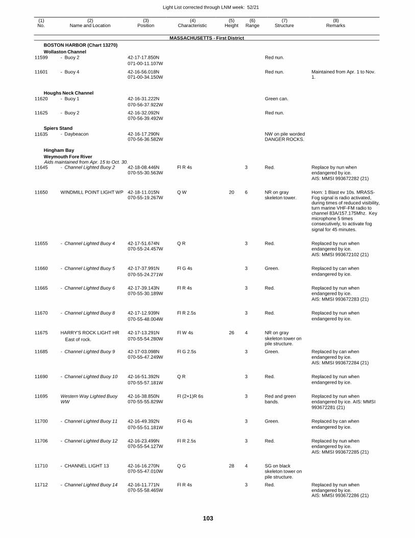
Light List corrected through LNM week: 52/21
103
(1) (2) (3) (4) (5) (6) (7) (8) No. Name and Location Position Characteristic Height Range Structure Remarks
MASSACHUSETTS - First District
BOSTON HARBOR (Chart 13270)
Wollaston Channel
11599 - Buoy 2 42-17-17.850N Red nun.
071-00-11.107W
11601 - Buoy 4 42-16-56.018N 071-00-34.150W
Red nun. Maintained from Apr. 1 to Nov. 1.
Houghs Neck Channel
11620 - Buoy 1 42-16-31.222N Green can.
070-56-37.922W
11625 - Buoy 2 42-16-32.092N Red nun. 070-56-39.492W
Spiers Stand
11635 - Daybeacon 42-16-17.290N 070-56-36.582W
NW on pile worded DANGER ROCKS.
Hingham Bay
Weymouth Fore River Aids maintained from Apr. 15 to Oct. 30.
11645 - Channel Lighted Buoy 2 42-18-08.446N Fl R 4s 3 Red. Replace by nun when 070-55-30.563W endangered by ice.
AIS: MMSI 993672282 (21)
11650 WINDMILL POINT LIGHT WP 42-18-11.015N Q W 20 6 NR on gray Horn: 1 Blast ev 10s. MRASS- 070-55-19.267W skeleton tower. Fog signal is radio activated, during times of reduced visibility, turn marine VHF-FM radio to channel 83A/157.175Mhz. Key microphone 5 times consecutively, to activate fog
signal for 45 minutes.
11655 - Channel Lighted Buoy 4 42-17-51.674N Q R
3 Red. Replaced by nun when 070-55-24.457W endangered by ice.
AIS: MMSI 993672102 (21)
11660 - Channel Lighted Buoy 5 42-17-37.991N Fl G 4s
3 Green. Replaced by can when
070-55-24.271W endangered by ice.
11665 - Channel Lighted Buoy 6 42-17-39.143N Fl R 4s
3 Red. Replaced by nun when 070-55-30.189W endangered by ice.
AIS: MMSI 993672283 (21)
11670 - Channel Lighted Buoy 8 42-17-12.939N Fl R 2.5s
3 Red. Replaced by nun when
070-55-48.004W endangered by ice.
11675 HARRY'S ROCK LIGHT HR 42-17-13.291N Fl W 4s 26 4 NR on gray
East of rock. 070-55-54.280W skeleton tower on pile structure.
11685 - Channel Lighted Buoy 9 42-17-03.098N Fl G 2.5s 3 Green. Replaced by can when 070-55-47.249W endangered by ice.
AIS: MMSI 993672284 (21)
11690 - Channel Lighted Buoy 10 42-16-51.392N Q R
3 Red. Replaced by nun when
070-55-57.181W endangered by ice.
11695 Western Way Lighted Buoy 42-16-38.850N Fl (2+1)R 6s
3 Red and green Replaced by nun when WW 070-55-55.829W bands. endangered by ice. AIS: MMSI
993672281 (21)
11700 - Channel Lighted Buoy 11 42-16-49.392N Fl G 4s
3 Green. Replaced by can when
070-55-51.181W endangered by ice.
11706 - Channel Lighted Buoy 12 42-16-23.499N Fl R 2.5s
3 Red. Replaced by nun when 070-55-54.127W endangered by ice.
AIS: MMSI 993672285 (21)
11710 - CHANNEL LIGHT 13 42-16-16.270N Q G 28 4 SG on black
070-55-47.010W skeleton tower on
pile structure.
11712 - Channel Lighted Buoy 14 42-16-11.771N Fl R 4s 3 Red. Replaced by nun when 070-55-58.465W endangered by ice. AIS: MMSI 993672286 (21)
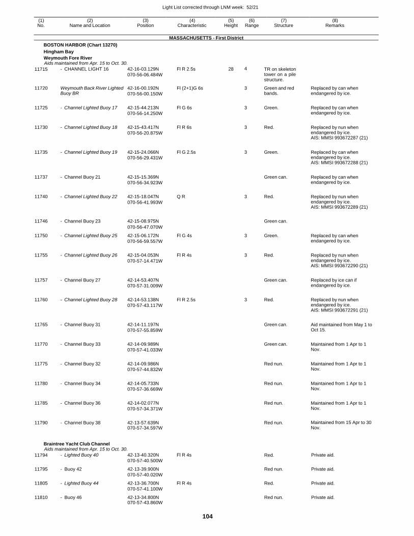
Light List corrected through LNM week: 52/21
104
(1) (2) (3) (4) (5) (6) (7) (8) No. Name and Location Position Characteristic Height Range Structure Remarks
MASSACHUSETTS - First District
BOSTON HARBOR (Chart 13270)
Hingham Bay
Weymouth Fore River Aids maintained from Apr. 15 to Oct. 30.
11715 - CHANNEL LIGHT 16 42-16-03.129N
070-56-06.484W
Fl R 2.5s 28 4 TR on skeleton tower on a pile structure.
11720 Weymouth Back River Lighted Buoy BR
42-16-00.192N
070-56-00.150W
Fl (2+1)G 6s 3 Green and red bands.
Replaced by can when endangered by ice.
11725 - Channel Lighted Buoy 17 42-15-44.213N
070-56-14.250W
Fl G 6s
3 Green. Replaced by can when endangered by ice.
11730 - Channel Lighted Buoy 18 42-15-43.417N
070-56-20.875W
Fl R 6s
3 Red. Replaced by nun when endangered by ice. AIS: MMSI 993672287 (21)
11735 - Channel Lighted Buoy 19 42-15-24.066N
070-56-29.431W
Fl G 2.5s
3 Green. Replaced by can when endangered by ice. AIS: MMSI 993672288 (21)
11737 - Channel Buoy 21 42-15-15.369N
070-56-34.923W
Green can. Replaced by can when
endangered by ice.
11740 - Channel Lighted Buoy 22 42-15-18.047N
070-56-41.993W
Q R
3 Red. Replaced by nun when endangered by ice. AIS: MMSI 993672289 (21)
11746 - Channel Buoy 23 42-15-08.975N
Green can.
070-56-47.070W
11750 - Channel Lighted Buoy 25 42-15-06.172N
070-56-59.557W
Fl G 4s 3 Green. Replaced by can when endangered by ice.
11755 - Channel Lighted Buoy 26 42-15-04.053N
070-57-14.471W
Fl R 4s
3 Red. Replaced by nun when endangered by ice. AIS: MMSI 993672290 (21)
11757 - Channel Buoy 27 42-14-53.407N
070-57-31.009W
Green can. Replaced by ice can if
endangered by ice.
11760 - Channel Lighted Buoy 28 42-14-53.138N
070-57-43.117W
Fl R 2.5s
3 Red. Replaced by nun when endangered by ice. AIS: MMSI 993672291 (21)
11765 - Channel Buoy 31 42-14-11.197N
070-57-55.859W
Green can. Aid maintained from May 1 to
Oct 15.
11770 - Channel Buoy 33 42-14-09.989N
070-57-41.033W
Green can. Maintained from 1 Apr to 1
Nov.
11775 - Channel Buoy 32 42-14-09.986N
070-57-44.832W
Red nun. Maintained from 1 Apr to 1
Nov.
11780 - Channel Buoy 34 42-14-05.733N
070-57-36.669W
Red nun. Maintained from 1 Apr to 1
Nov.
11785 - Channel Buoy 36 42-14-02.077N
070-57-34.371W
Red nun. Maintained from 1 Apr to 1
Nov.
11790 - Channel Buoy 38 42-13-57.639N 070-57-34.597W
Red nun. Maintained from 15 Apr to 30
Nov.
Braintree Yacht Club Channel Aids maintained from Apr. 15 to Oct. 30.
11794 - Lighted Buoy 40 42-13-40.320N
070-57-40.500W
Fl R 4s Red. Private aid.
11795 - Buoy 42 42-13-39.900N
070-57-40.020W
Red nun. Private aid.
11805 - Lighted Buoy 44 42-13-36.700N
070-57-41.100W
Fl R 4s Red. Private aid.
11810 - Buoy 46 42-13-34.800N 070-57-43.860W
Red nun. Private aid.
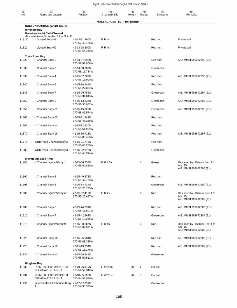
Light List corrected through LNM week: 52/21
105
(1) (2) (3) (4) (5) (6) (7) (8) No. Name and Location Position Characteristic Height Range Structure Remarks
MASSACHUSETTS - First District
BOSTON HARBOR (Chart 13270)
Hingham Bay
Braintree Yacht Club Channel Aids maintained from Apr. 15 to Oct. 30.
11815 - Lighted Buoy 48 42-13-31.860N Fl R 4s Red nun. Private aid.
070-57-48.180W
11820 - Lighted Buoy 50 42-13-28.200N Fl R 4s Red nun. Private aid. 070-57-54.360W
Town River Bay
11825 - Channel Buoy 2 42-14-57.098N Red nun. AIS: MMSI 993672292 (21)
070-57-59.906W
11830 - Channel Buoy 3 42-14-58.367N Green can.
070-58-15.784W
11835 - Channel Buoy 4 42-15-02.289N Red nun. AIS: MMSI 993672293 (21)
070-58-16.909W
11840 - Channel Buoy 6 42-15-10.904N Red nun.
070-58-27.052W
11845 - Channel Buoy 7 42-15-09.785N Green can. AIS: MMSI 993672294 (21)
070-58-31.843W
11850 - Channel Buoy 9 42-15-13.836N Green can. AIS: MMSI 993672295 (21)
070-58-35.962W
11855 - Channel Buoy 11 42-15-15.829N Green can. AIS: MMSI 993672296 (21)
070-58-42.574W
11860 - Channel Buoy 12 42-15-21.342N Red nun.
070-58-44.340W
11865 - Channel Buoy 14 42-15-22.220N Red nun.
070-58-54.909W
11870 - Channel Buoy 16 42-15-16.713N Red nun. AIS: MMSI 993672297 (21)
070-59-03.450W
11875 Yacht Yard Channel Buoy 2 42-15-21.772N Red nun.
070-58-40.260W
11880 Yacht Yard Channel Buoy 3 42-15-22.918N Green can.
070-58-40.914W
Weymouth Back River
11885 - Channel Lighted Buoy 1 42-15-56.253N
070-55-50.850W
Fl G 2.5s 3 Green. Replaced by LIB from Dec. 1 to Apr. 15. AIS: MMSI 993672298 (21)
11890 - Channel Buoy 2 42-15-49.273N
Red nun.
070-55-42.770W
11895 - Channel Buoy 3 42-15-54.724N Green can. AIS: MMSI 993672299 (21)
070-55-28.775W
11900 - Channel Lighted Buoy 4 42-15-52.415N
070-55-25.697W
Fl R 4s 3 Red. Replaced by LIB from Dec. 1 to Apr. 15. AIS: MMSI 993672302 (21)
11905 - Channel Buoy 6 42-15-44.331N
Red nun. AIS: MMSI 993672303 (21)
070-55-16.507W
11910 - Channel Buoy 7 42-15-42.263N Green can. AIS: MMSI 993672304 (21)
070-55-12.249W
11915 - Channel Lighted Buoy 8 42-15-30.587N
070-55-07.091W
Fl R 4s 3 Red. Replaced by LIB from Dec. 1 to Apr. 15. AIS: MMSI 993672305 (21)
11920 - Channel Buoy 10 42-15-25.084N
Red nun. AIS: MMSI 993672306 (21)
070-55-08.329W
11925 - Channel Buoy 12 42-15-19.334N Red nun. AIS: MMSI 993672307 (21)
070-55-11.179W
11930 - Channel Buoy 13 42-15-06.845N Green can.
070-55-57.512W
Hingham Bay
11933 POINT ALLERTON NORTH BREAKWATER LIGHT
42-18-06.879N
070-54-59.340W
Fl W 2.5s 20 3 On pile.
11934 POINT ALLERTON SOUTH BREAKWATER LIGHT
42-18-05.728N
070-54-56.940W
Fl W 2.5s 20 3 On pile.
11935 Inner Seal Rock Channel Buoy 1
42-17-52.831N 070-54-33.399W
Green can.
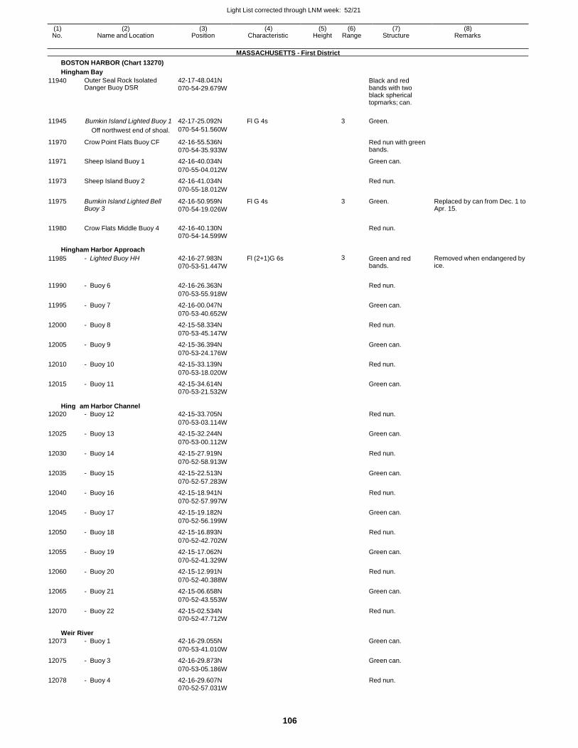
Light List corrected through LNM week: 52/21
106
(1) (2) (3) (4) (5) (6) (7) (8) No. Name and Location Position Characteristic Height Range Structure Remarks
MASSACHUSETTS - First District
BOSTON HARBOR (Chart 13270)
Hingham Bay
11940 Outer Seal Rock Isolated Danger Buoy DSR
42-17-48.041N
070-54-29.679W
Black and red bands with two black spherical topmarks; can.
11945 Bumkin Island Lighted Buoy 1 42-17-25.092N Fl G 4s 3 Green.
Off northwest end of shoal. 070-54-51.560W
11970 Crow Point Flats Buoy CF 42-16-55.536N
070-54-35.933W
Red nun with green bands.
11971 Sheep Island Buoy 1 42-16-40.034N Green can.
070-55-04.012W
11973 Sheep Island Buoy 2 42-16-41.034N Red nun.
070-55-18.012W
11975 Bumkin Island Lighted Bell Buoy 3
42-16-50.959N
070-54-19.026W
Fl G 4s 3 Green. Replaced by can from Dec. 1 to Apr. 15.
11980 Crow Flats Middle Buoy 4 42-16-40.130N
Red nun.
070-54-14.599W
Hingham Harbor Approach
11985 - Lighted Buoy HH 42-16-27.983N
070-53-51.447W
Fl (2+1)G 6s 3 Green and red bands.
Removed when endangered by ice.
11990 - Buoy 6 42-16-26.363N
Red nun.
070-53-55.918W
11995 - Buoy 7 42-16-00.047N Green can.
070-53-40.652W
12000 - Buoy 8 42-15-58.334N Red nun.
070-53-45.147W
12005 - Buoy 9 42-15-36.394N Green can.
070-53-24.176W
12010 - Buoy 10 42-15-33.139N Red nun.
070-53-18.020W
12015 - Buoy 11 42-15-34.614N Green can.
070-53-21.532W
Hingh
12020
am Harbor Channel
- Buoy 12
42-15-33.705N
Red nun.
070-53-03.114W
12025 - Buoy 13 42-15-32.244N Green can.
070-53-00.112W
12030 - Buoy 14 42-15-27.919N Red nun.
070-52-58.913W
12035 - Buoy 15 42-15-22.513N Green can.
070-52-57.283W
12040 - Buoy 16 42-15-18.941N Red nun.
070-52-57.997W
12045 - Buoy 17 42-15-19.182N Green can.
070-52-56.199W
12050 - Buoy 18 42-15-16.893N Red nun.
070-52-42.702W
12055 - Buoy 19 42-15-17.062N Green can.
070-52-41.329W
12060 - Buoy 20 42-15-12.991N Red nun.
070-52-40.388W
12065 - Buoy 21 42-15-06.658N Green can.
070-52-43.553W
12070 - Buoy 22 42-15-02.534N Red nun. 070-52-47.712W
Weir
12073
River
- Buoy 1
42-16-29.055N
Green can.
070-53-41.010W
12075 - Buoy 3 42-16-29.873N Green can.
070-53-05.186W
12078 - Buoy 4 42-16-29.607N Red nun. 070-52-57.031W
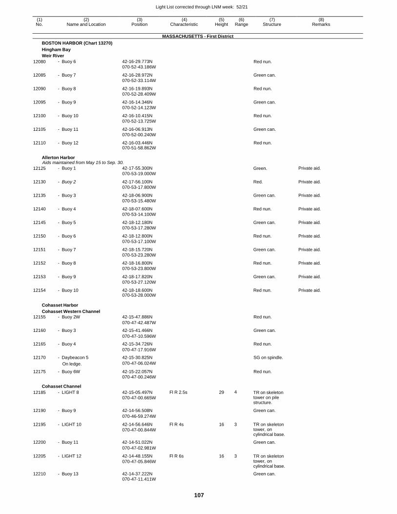
Light List corrected through LNM week: 52/21
107
(1) (2) (3) (4) (5) (6) (7) (8) No. Name and Location Position Characteristic Height Range Structure Remarks
MASSACHUSETTS - First District
BOSTON HARBOR (Chart 13270)
Hingham Bay
Weir River
12080 - Buoy 6 42-16-29.773N
070-52-43.186W Red nun.
12085 - Buoy 7 42-16-28.972N
070-52-33.114W
Green can.
12090 - Buoy 8 42-16-19.893N
070-52-28.409W
Red nun.
12095 - Buoy 9 42-16-14.346N
070-52-14.123W
Green can.
12100 - Buoy 10 42-16-10.415N
070-52-13.725W
Red nun.
12105 - Buoy 11 42-16-06.913N
070-52-00.240W
Green can.
12110 - Buoy 12 42-16-03.446N 070-51-58.862W
Red nun.
Allerton Harbor Aids maintained from May 15 to Sep. 30.
12125 - Buoy 1 42-17-55.300N
070-53-19.000W Green. Private aid.
12130 - Buoy 2 42-17-56.100N
070-53-17.800W
Red. Private aid.
12135 - Buoy 3 42-18-06.900N
070-53-15.480W
Green can. Private aid.
12140 - Buoy 4 42-18-07.600N
070-53-14.100W
Red nun. Private aid.
12145 - Buoy 5 42-18-12.180N
070-53-17.280W
Green can. Private aid.
12150 - Buoy 6 42-18-12.800N
070-53-17.100W
Red nun. Private aid.
12151 - Buoy 7 42-18-15.720N
070-53-23.280W
Green can. Private aid.
12152 - Buoy 8 42-18-16.800N
070-53-23.800W
Red nun. Private aid.
12153 - Buoy 9 42-18-17.820N
070-53-27.120W
Green can. Private aid.
12154 - Buoy 10 42-18-18.600N 070-53-28.000W
Red nun. Private aid.
Cohasset Harbor
Cohasset Western Channel
12155 - Buoy 2W 42-15-47.886N Red nun.
070-47-42.487W
12160 - Buoy 3 42-15-41.466N Green can.
070-47-10.596W
12165 - Buoy 4 42-15-34.726N Red nun.
070-47-17.916W
12170 - Daybeacon 5 42-15-30.825N SG on spindle.
On ledge. 070-47-06.024W
12175 - Buoy 6W 42-15-22.057N Red nun. 070-47-00.246W
Cohasset Channel
12185 - LIGHT 8 42-15-05.497N
070-47-00.665W
Fl R 2.5s 29 4 TR on skeleton tower on pile structure.
12190 - Buoy 9 42-14-56.508N Green can.
070-46-59.274W
12195 - LIGHT 10 42-14-56.646N
070-47-00.844W
Fl R 4s 16 3 TR on skeleton tower, on cylindrical base.
12200 - Buoy 11 42-14-51.022N Green can.
070-47-02.981W
12205 - LIGHT 12 42-14-48.155N
070-47-05.846W
Fl R 6s 16 3 TR on skeleton tower, on cylindrical base.
12210 - Buoy 13 42-14-37.222N Green can. 070-47-11.411W
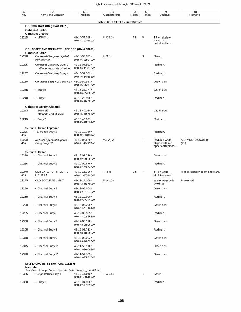
Light List corrected through LNM week: 52/21
108
(1) (2) (3) (4) (5) (6) (7) (8) No. Name and Location Position Characteristic Height Range Structure Remarks
MASSACHUSETTS - First District
BOSTON HARBOR (Chart 13270)
Cohasset Harbor
Cohasset Channel
12215 - LIGHT 14 42-14-34.538N
070-47-13.861W
Fl R 2.5s 16 3 TR on skeleton tower, on cylindrical base.
COHASSET AND SCITUATE HARBORS (Chart 13269)
Cohasset Harbor
12220 Cohasset Gangway Lighted 42-16-08.081N Fl G 6s 3 Green.
Bell Buoy 1G 070-46-22.646W
12225 Cohasset Gangway Buoy 2
Off northeast side of ledge.
42-16-04.851N
070-46-41.879W
Red nun.
12227 Cohasset Gangway Buoy 4 42-15-54.562N
070-46-34.586W
Red nun.
12230 Cohasset Shag Rock Buoy 1S 42-15-50.547N
070-46-05.615W
Green can.
12235 - Buoy 5 42-15-31.177N
070-46-25.065W
Green can.
12240 - Buoy 6 42-15-22.596N 070-46-46.785W
Red nun.
Cohasset Eastern Channel
12243 - Buoy 1E
Off north end of shoal.
42-15-40.164N
070-45-39.763W
Green can.
12245 - Buoy 2 42-15-48.307N 070-45-48.224W
Red nun.
Scituate Harbor Approach
12256
455
12258
460
Tar Pouch Buoy 2
Scituate Approach Lighted Gong Buoy SA
42-13-10.269N
070-42-13.386W
42-12-07.579N
070-41-49.355W
Mo (A) W
Red nun.
4 Red and white
stripes with red spherical topmark.
AIS: MMSI 993672146 (21)
Scituate Harbor
12260 - Channel Buoy 1 42-12-07.789N Green can.
070-42-39.656W
12265 - Channel Buoy 2 42-12-09.579N Red nun.
070-42-39.546W
12270 SCITUATE NORTH JETTY 42-12-11.356N Fl R 4s 23 4 TR on white Higher intensity beam eastward.
465 LIGHT 2A 070-42-47.495W skeleton tower.
12275 OLD SCITUATE LIGHT 42-12-17.200N
070-42-56.700W
Fl W 15s White tower with dwelling.
Private aid.
12280 - Channel Buoy 3 42-12-08.069N Green can.
070-42-51.276W
12285 - Channel Buoy 4 42-12-10.000N Red nun.
070-42-55.219W
12290 - Channel Buoy 5 42-12-08.299N Green can.
070-43-01.397W
12295 - Channel Buoy 6 42-12-09.985N Red nun.
070-43-02.355W
12300 - Channel Buoy 7 42-12-06.128N Green can.
070-43-08.960W
12305 - Channel Buoy 8 42-12-02.733N Red nun.
070-43-18.099W
12310 - Channel Buoy 9 42-12-02.002N Green can.
070-43-16.025W
12315 - Channel Buoy 11 42-11-53.910N Green can.
070-43-26.009W
12320 - Channel Buoy 13 42-11-51.709N Green can.
070-43-25.815W
MASSACHUSETTS BAY (Chart 13267)
New Inlet Positions of buoys frequently shifted with changing conditions.
12325 - Lighted Bell Buoy 1 42-10-13.660N
070-41-58.407W
Fl G 2.5s 3 Green.
12330 - Buoy 2 42-10-04.806N 070-42-17.357W
Red nun.
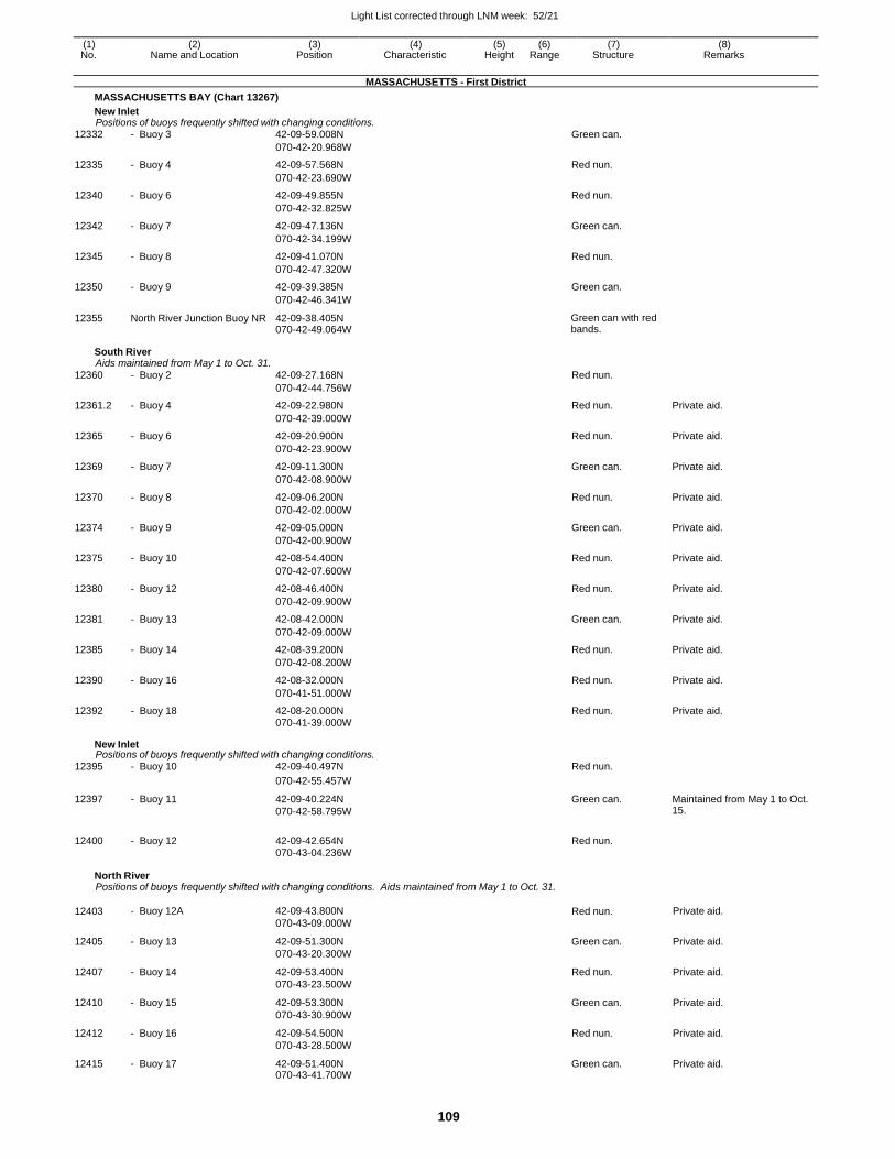
Light List corrected through LNM week: 52/21
109
(1) (2) (3) (4) (5) (6) (7) (8) No. Name and Location Position Characteristic Height Range Structure Remarks
MASSACHUSETTS - First District
MASSACHUSETTS BAY (Chart 13267)
New Inlet Positions of buoys frequently shifted with changing conditions.
12332 - Buoy 3 42-09-59.008N Green can.
070-42-20.968W
12335 - Buoy 4 42-09-57.568N Red nun.
070-42-23.690W
12340 - Buoy 6 42-09-49.855N Red nun.
070-42-32.825W
12342 - Buoy 7 42-09-47.136N Green can.
070-42-34.199W
12345 - Buoy 8 42-09-41.070N Red nun.
070-42-47.320W
12350 - Buoy 9 42-09-39.385N Green can.
070-42-46.341W
12355 North River Junction Buoy NR 42-09-38.405N 070-42-49.064W
Green can with red bands.
South River Aids maintained from May 1 to Oct. 31.
12360 - Buoy 2 42-09-27.168N Red nun.
070-42-44.756W
12361.2 - Buoy 4 42-09-22.980N Red nun. Private aid.
070-42-39.000W
12365 - Buoy 6 42-09-20.900N Red nun. Private aid.
070-42-23.900W
12369 - Buoy 7 42-09-11.300N Green can. Private aid.
070-42-08.900W
12370 - Buoy 8 42-09-06.200N Red nun. Private aid.
070-42-02.000W
12374 - Buoy 9 42-09-05.000N Green can. Private aid.
070-42-00.900W
12375 - Buoy 10 42-08-54.400N Red nun. Private aid.
070-42-07.600W
12380 - Buoy 12 42-08-46.400N Red nun. Private aid.
070-42-09.900W
12381 - Buoy 13 42-08-42.000N Green can. Private aid.
070-42-09.000W
12385 - Buoy 14 42-08-39.200N Red nun. Private aid.
070-42-08.200W
12390 - Buoy 16 42-08-32.000N Red nun. Private aid.
070-41-51.000W
12392 - Buoy 18 42-08-20.000N Red nun. Private aid. 070-41-39.000W
New Inlet Positions of buoys frequently shifted with changing conditions.
12395 - Buoy 10 42-09-40.497N Red nun.
070-42-55.457W
12397 - Buoy 11 42-09-40.224N
070-42-58.795W
Green can. Maintained from May 1 to Oct. 15.
12400 - Buoy 12 42-09-42.654N Red nun.
070-43-04.236W
North River Positions of buoys frequently shifted with changing conditions. Aids maintained from May 1 to Oct. 31.
12403 - Buoy 12A 42-09-43.800N
070-43-09.000W Red nun. Private aid.
12405 - Buoy 13 42-09-51.300N
070-43-20.300W
Green can. Private aid.
12407 - Buoy 14 42-09-53.400N
070-43-23.500W
Red nun. Private aid.
12410 - Buoy 15 42-09-53.300N
070-43-30.900W
Green can. Private aid.
12412 - Buoy 16 42-09-54.500N
070-43-28.500W
Red nun. Private aid.
12415 - Buoy 17 42-09-51.400N 070-43-41.700W
Green can. Private aid.
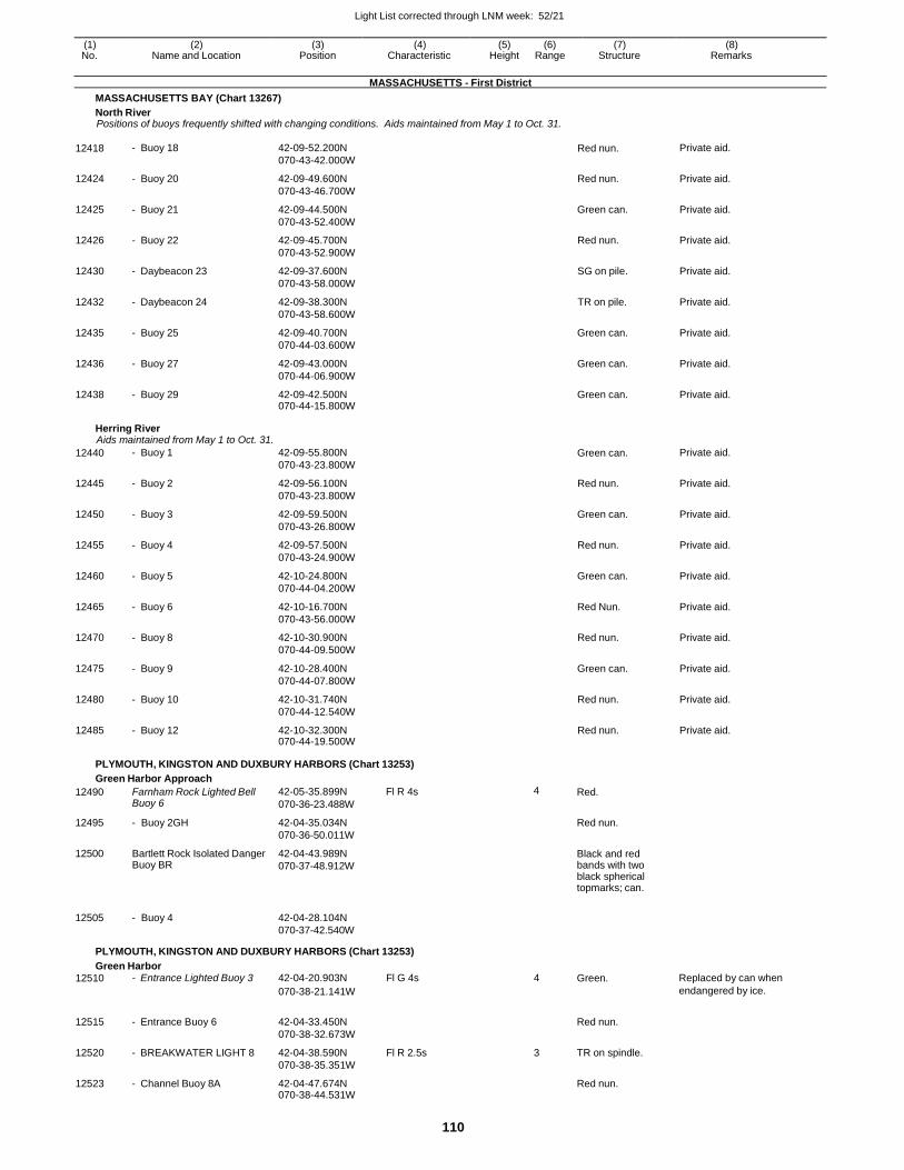
Light List corrected through LNM week: 52/21
110
(1) (2) (3) (4) (5) (6) (7) (8) No. Name and Location Position Characteristic Height Range Structure Remarks
MASSACHUSETTS - First District
MASSACHUSETTS BAY (Chart 13267)
North River Positions of buoys frequently shifted with changing conditions. Aids maintained from May 1 to Oct. 31.
12418 - Buoy 18 42-09-52.200N
070-43-42.000W Red nun. Private aid.
12424 - Buoy 20 42-09-49.600N
070-43-46.700W
Red nun. Private aid.
12425 - Buoy 21 42-09-44.500N
070-43-52.400W
Green can. Private aid.
12426 - Buoy 22 42-09-45.700N
070-43-52.900W
Red nun. Private aid.
12430 - Daybeacon 23 42-09-37.600N
070-43-58.000W
SG on pile. Private aid.
12432 - Daybeacon 24 42-09-38.300N
070-43-58.600W
TR on pile. Private aid.
12435 - Buoy 25 42-09-40.700N
070-44-03.600W
Green can. Private aid.
12436 - Buoy 27 42-09-43.000N
070-44-06.900W
Green can. Private aid.
12438 - Buoy 29 42-09-42.500N 070-44-15.800W
Green can. Private aid.
Herring River Aids maintained from May 1 to Oct. 31.
12440 - Buoy 1 42-09-55.800N
070-43-23.800W Green can. Private aid.
12445 - Buoy 2 42-09-56.100N
070-43-23.800W
Red nun. Private aid.
12450 - Buoy 3 42-09-59.500N
070-43-26.800W
Green can. Private aid.
12455 - Buoy 4 42-09-57.500N
070-43-24.900W
Red nun. Private aid.
12460 - Buoy 5 42-10-24.800N
070-44-04.200W
Green can. Private aid.
12465 - Buoy 6 42-10-16.700N
070-43-56.000W
Red Nun. Private aid.
12470 - Buoy 8 42-10-30.900N
070-44-09.500W
Red nun. Private aid.
12475 - Buoy 9 42-10-28.400N
070-44-07.800W
Green can. Private aid.
12480 - Buoy 10 42-10-31.740N
070-44-12.540W
Red nun. Private aid.
12485 - Buoy 12 42-10-32.300N 070-44-19.500W
Red nun. Private aid.
PLYMOUTH, KINGSTON AND DUXBURY HARBORS (Chart 13253)
Green Harbor Approach
12490
12495
12500
12505
Farnham Rock Lighted Bell Buoy 6
- Buoy 2GH
Bartlett Rock Isolated Danger Buoy BR
- Buoy 4
42-05-35.899N
070-36-23.488W
42-04-35.034N
070-36-50.011W
42-04-43.989N
070-37-48.912W
42-04-28.104N
070-37-42.540W
Fl R 4s 4 Red.
Red nun.
Black and red bands with two black spherical topmarks; can.
PLYMOUTH, KINGSTON AND DUXBURY HARBORS (Chart 13253)
Green Harbor 12510 - Entrance Lighted Buoy 3 42-04-20.903N Fl G 4s 4 Green. Replaced by can when
070-38-21.141W endangered by ice.
12515 - Entrance Buoy 6 42-04-33.450N
070-38-32.673W
Red nun.
12520 - BREAKWATER LIGHT 8 42-04-38.590N
070-38-35.351W
Fl R 2.5s 3 TR on spindle.
12523 - Channel Buoy 8A 42-04-47.674N 070-38-44.531W
Red nun.
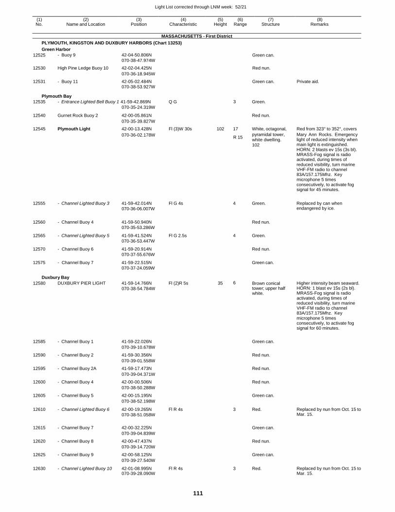
Light List corrected through LNM week: 52/21
111
(1) (2) (3) (4) (5) (6) (7) (8) No. Name and Location Position Characteristic Height Range Structure Remarks
MASSACHUSETTS - First District
PLYMOUTH, KINGSTON AND DUXBURY HARBORS (Chart 13253)
Green Harbor
12525 - Buoy 9 42-04-50.806N
070-38-47.974W Green can.
12530 High Pine Ledge Buoy 10 42-02-04.425N Red nun.
070-36-18.945W
12531 - Buoy 11 42-05-02.484N Green can. Private aid. 070-38-53.927W
Plymouth Bay
12535 - Entrance Lighted Bell Buoy 1 41-59-42.869N Q G 3 Green. 070-35-24.319W
12540 Gurnet Rock Buoy 2 42-00-05.861N
Red nun.
070-35-39.827W
12545 Plymouth Light 42-00-13.428N Fl (3)W 30s 102 17 White, octagonal, Red from 323° to 352°, covers
070-36-02.178W R 15
pyramidal tower, white dwelling. 102
Mary Ann Rocks. Emergency light of reduced intensity when main light is extinguished. HORN: 2 blasts ev 15s (3s bl). MRASS-Fog signal is radio activated, during times of reduced visibility, turn marine VHF-FM radio to channel 83A/157.175Mhz. Key microphone 5 times consecutively, to activate fog signal for 45 minutes.
12555
12560
12565
12570
12575
- Channel Lighted Buoy 3
- Channel Buoy 4
- Channel Lighted Buoy 5
- Channel Buoy 6
- Channel Buoy 7
41-59-42.014N
070-36-06.007W
41-59-50.940N
070-35-53.286W
41-59-41.524N
070-36-53.447W
41-59-20.914N
070-37-55.676W
41-59-22.515N
070-37-24.059W
Fl G 4s
Fl G 2.5s
4 Green.
Red nun.
4 Green.
Red nun.
Green can.
Replaced by can when endangered by ice.
Duxbury Bay
12580 DUXBURY PIER LIGHT 41-59-14.766N
070-38-54.784W
Fl (2)R 5s 35 6 Brown conical tower; upper half white.
Higher intensity beam seaward. HORN: 1 blast ev 15s (2s bl). MRASS-Fog signal is radio activated, during times of reduced visibility, turn marine VHF-FM radio to channel 83A/157.175Mhz. Key microphone 5 times consecutively, to activate fog signal for 60 minutes.
12585 - Channel Buoy 1 41-59-22.026N
Green can.
070-39-10.678W
12590 - Channel Buoy 2 41-59-30.356N Red nun.
070-39-01.558W
12595 - Channel Buoy 2A 41-59-17.473N Red nun.
070-39-04.371W
12600 - Channel Buoy 4 42-00-00.506N Red nun.
070-38-50.288W
12605 - Channel Buoy 5 42-00-15.195N Green can.
070-38-52.198W
12610 - Channel Lighted Buoy 6 42-00-19.265N
070-38-51.058W
Fl R 4s 3 Red. Replaced by nun from Oct. 15 to Mar. 15.
12615 - Channel Buoy 7 42-00-32.225N
Green can.
070-39-04.839W
12620 - Channel Buoy 8 42-00-47.437N Red nun.
070-39-14.720W
12625 - Channel Buoy 9 42-00-58.125N Green can.
070-39-27.540W
12630 - Channel Lighted Buoy 10 42-01-08.995N 070-39-28.090W
Fl R 4s 3 Red. Replaced by nun from Oct. 15 to Mar. 15.
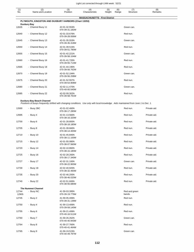
Light List corrected through LNM week: 52/21
112
(1) (2) (3) (4) (5) (6) (7) (8) No. Name and Location Position Characteristic Height Range Structure Remarks
MASSACHUSETTS - First District
PLYMOUTH, KINGSTON AND DUXBURY HARBORS (Chart 13253)
Duxbury Bay
12635 - Channel Buoy 11 42-01-32.553N
070-39-31.182W Green can.
12640 - Channel Buoy 12 42-01-33.676N
070-39-28.936W
Red nun.
12645 - Channel Buoy 13 42-01-35.553N
070-39-35.318W
Green can.
12650 - Channel Buoy 14 42-01-39.515N
070-39-51.780W
Red nun.
12655 - Channel Buoy 15 42-01-42.221N
070-39-58.104W
Green can.
12660 - Channel Buoy 16 42-01-41.720N
070-39-55.713W
Red nun.
12665 - Channel Buoy 18 42-01-44.190N
070-39-56.762W
Red nun.
12670 - Channel Buoy 19 42-01-52.194N
070-39-56.208W
Green can.
12675 - Channel Buoy 20 42-01-52.557N
070-39-54.908W
Red nun.
12680 - Channel Buoy 21 42-02-11.470N
070-40-00.540W
Green can.
12685 - Channel Buoy 22 42-02-09.302N 070-39-58.791W
Red nun.
Duxbury Bay Beach Channel Positions of buoys frequently shifted with changing conditions. Use only with local knowledge. Aids maintained from June 1 to Dec. 1.
12690 - Buoy 2BC 42-01-02.460N Red nun. Private aid.
070-38-17.280W
12695 - Buoy 4 42-01-13.560N Red nun. Private aid.
070-38-16.320W
12700 - Buoy 6 42-01-28.800N Red nun. Private aid.
070-38-18.180W
12705 - Buoy 8 42-01-39.660N Red nun. Private aid.
070-38-14.400W
12710 - Buoy 10 42-01-45.840N Red nun. Private aid.
070-38-11.100W
12715 - Buoy 12 42-01-55.080N Red nun. Private aid.
070-38-07.560W
12720 - Buoy 14 42-02-10.860N Red nun. Private aid.
070-38-15.180W
12725 - Buoy 16 42-02-28.260N Red nun. Private aid.
070-38-17.340W
12727 - Buoy 17 42-02-31.100N Green can. Private aid.
070-38-22.900W
12730 - Buoy 18 42-02-40.920N Red nun. Private aid.
070-38-32.460W
12735 - Buoy 20 42-02-46.200N Red nun. Private aid.
070-38-46.020W
12740 - Buoy 22 42-02-51.600N Red nun. Private aid. 070-38-55.680W
The Nummet Channel
12744 - Buoy NC 41-59-03.395N Red and green
12905 070-39-19.779W bands.
12745 - Buoy 2 41-59-05.406N Red nun.
070-39-31.139W
12750 - Buoy 4 41-59-13.406N Red nun.
070-39-59.140W
12755 - Buoy 6 41-59-21.406N Red nun.
070-40-16.511W
12760 - Buoy 7 41-59-26.262N Green can.
070-40-40.943W
12764 - Buoy 8 41-59-27.760N Red nun.
070-40-41.464W
12765 - Buoy 9 41-59-19.515N Green can. 070-40-49.797W
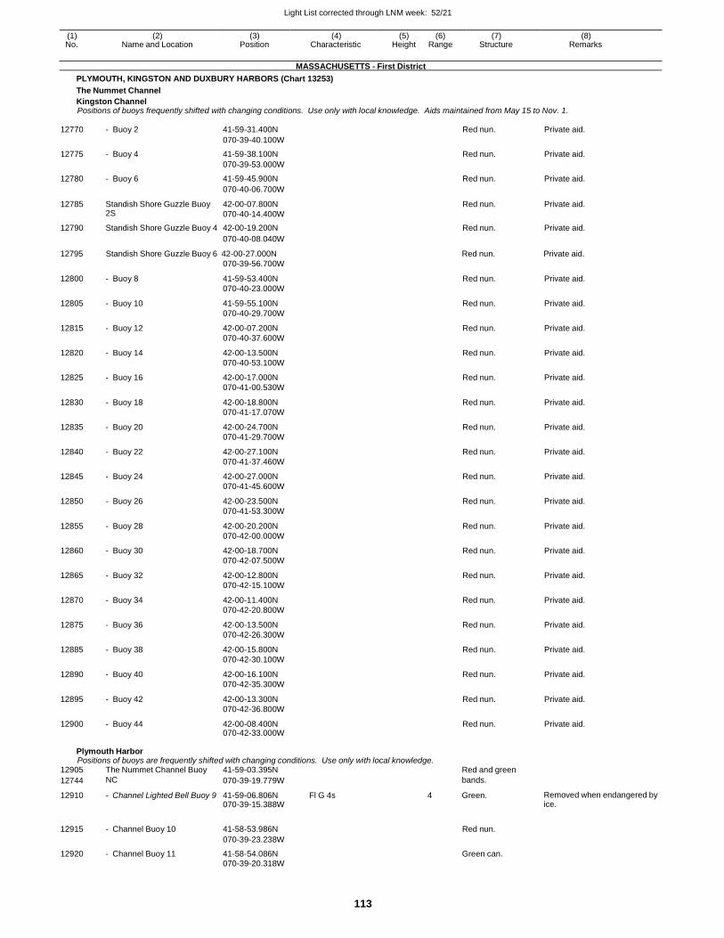
Light List corrected through LNM week: 52/21
113
(1) (2) (3) (4) (5) (6) (7) (8) No. Name and Location Position Characteristic Height Range Structure Remarks
MASSACHUSETTS - First District
PLYMOUTH, KINGSTON AND DUXBURY HARBORS (Chart 13253)
The Nummet Channel
Kingston Channel Positions of buoys frequently shifted with changing conditions. Use only with local knowledge. Aids maintained from May 15 to Nov. 1.
12770 - Buoy 2 41-59-31.400N Red nun. Private aid.
070-39-40.100W
12775 - Buoy 4 41-59-38.100N Red nun. Private aid.
070-39-53.000W
12780 - Buoy 6 41-59-45.900N Red nun. Private aid.
070-40-06.700W
12785 Standish Shore Guzzle Buoy 2S
42-00-07.800N
070-40-14.400W
Red nun. Private aid.
12790 Standish Shore Guzzle Buoy 4 42-00-19.200N Red nun. Private aid.
12795
070-40-08.040W
Standish Shore Guzzle Buoy 6 42-00-27.000N
070-39-56.700W
Red nun.
Private aid.
12800 - Buoy 8 41-59-53.400N
070-40-23.000W
Red nun. Private aid.
12805 - Buoy 10 41-59-55.100N
070-40-29.700W
Red nun. Private aid.
12815 - Buoy 12 42-00-07.200N
070-40-37.600W
Red nun. Private aid.
12820 - Buoy 14 42-00-13.500N
070-40-53.100W
Red nun. Private aid.
12825 - Buoy 16 42-00-17.000N
070-41-00.530W
Red nun. Private aid.
12830 - Buoy 18 42-00-18.800N
070-41-17.070W
Red nun. Private aid.
12835 - Buoy 20 42-00-24.700N
070-41-29.700W
Red nun. Private aid.
12840 - Buoy 22 42-00-27.100N
070-41-37.460W
Red nun. Private aid.
12845 - Buoy 24 42-00-27.000N
070-41-45.600W
Red nun. Private aid.
12850 - Buoy 26 42-00-23.500N
070-41-53.300W
Red nun. Private aid.
12855 - Buoy 28 42-00-20.200N
070-42-00.000W
Red nun. Private aid.
12860 - Buoy 30 42-00-18.700N
070-42-07.500W
Red nun. Private aid.
12865 - Buoy 32 42-00-12.800N
070-42-15.100W
Red nun. Private aid.
12870 - Buoy 34 42-00-11.400N
070-42-20.800W
Red nun. Private aid.
12875 - Buoy 36 42-00-13.500N
070-42-26.300W
Red nun. Private aid.
12885 - Buoy 38 42-00-15.800N
070-42-30.100W
Red nun. Private aid.
12890 - Buoy 40 42-00-16.100N
070-42-35.300W
Red nun. Private aid.
12895 - Buoy 42 42-00-13.300N
070-42-36.800W
Red nun. Private aid.
12900 - Buoy 44 42-00-08.400N 070-42-33.000W
Red nun. Private aid.
Plymouth Harbor Positions of buoys are frequently shifted with changing conditions. Use only with local knowledge.
12905 The Nummet Channel Buoy 41-59-03.395N Red and green
12744 NC 070-39-19.779W bands.
12910 - Channel Lighted Bell Buoy 9 41-59-06.806N 070-39-15.388W
Fl G 4s 4 Green. Removed when endangered by ice.
12915
- Channel Buoy 10
41-58-53.986N
Red nun.
070-39-23.238W
12920 - Channel Buoy 11 41-58-54.086N Green can. 070-39-20.318W
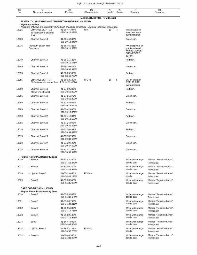
Light List corrected through LNM week: 52/21
114
(1) (2) (3) (4) (5) (6) (7) (8) No. Name and Location Position Characteristic Height Range Structure Remarks
MASSACHUSETTS - First District
PLYMOUTH, KINGSTON AND DUXBURY HARBORS (Chart 13253)
Plymouth Harbor Positions of buoys are frequently shifted with changing conditions. Use only with local knowledge.
12925 - CHANNEL LIGHT 12
50 feet west of channel limit.
41-58-47.304N
070-39-24.426W
Q R 16 3 TR on skeleton tower on black cylindrical pier.
12930 - Channel Buoy 13 41-58-44.536N Green can.
070-39-18.948W
12935 Plymouth Beach Jetty 41-58-46.325N NW on spindle on Daybeacon 070-39-11.597W granite cribwork worded DANGER SUBMERGED
JETTY.
12940 - Channel Buoy 14 41-58-31.136N Red nun.
070-39-10.448W
12945 - Channel Buoy 15 41-58-20.677N Green can.
070-38-56.518W
12950 - Channel Buoy 16 41-58-05.986N Red nun.
070-38-46.767W
12955 - CHANNEL LIGHT 17 41-58-03.130N Fl G 4s 16 5 SG on skeleton 50 feet east of channel limit. 070-38-41.723W tower on black
cylindrical pier.
12960 - Channel Buoy 18 41-57-59.306N Red nun.
Marks end of shoal. 070-38-50.007W
12965 - Channel Buoy 19 41-57-55.376N Green can.
070-38-50.897W
12980 - Channel Buoy 20 41-57-44.926N Red nun.
070-39-12.057W
12985 - Channel Buoy 21 41-57-42.846N Green can.
070-39-10.807W
12990 - Channel Buoy 22 41-57-41.984N Red nun.
070-39-19.587W
13005 - Channel Buoy 23 41-57-34.046N Green can.
070-39-31.298W
13010 - Channel Buoy 24 41-57-36.468N Red nun.
070-39-34.849W
13015 - Channel Buoy 25 41-57-35.756N Green can.
070-39-38.666W
13020 - Channel Buoy 27 41-57-39.120N Green can.
070-39-47.421W
13025 - Channel Buoy 29 41-57-41.296N Green can. 070-39-53.319W
Pilgrim Power Plant Security Zone 13026 - Buoy A 41-57-02.700N White with orange Marked "Restricted Area".
070-34-51.840W bands, can. Private aid.
13027 - Buoy B 41-57-06.240N White with orange Marked "Restricted Area".
070-34-48.924W bands, can. Private aid.
13028 - Lighted Buoy C 41-57-13.056N Fl W 4s White with orange Marked "Restricted Area".
070-34-43.122W bands. Private aid.
13029 - Buoy D 41-57-08.346N White with orange Marked "Restricted Area". 070-34-35.928W bands, can. Private aid.
CAPE COD BAY (Chart 13246)
Pilgrim Power Plant Security Zone
13030 - Buoy E 41-57-03.942N
070-34-31.686W
White with orange bands, can.
Marked "Restricted Area".
Private aid.
13031 - Buoy F 41-57-00.792N
070-34-24.216W
White with orange bands, can.
Marked "Restricted Area".
Private aid.
13032 - Buoy G 41-56-55.332N
070-34-17.766W
White with orange bands, can.
Marked "Restricted Area".
Private aid.
13033 - Buoy H 41-56-52.188N
070-34-12.948W
White with orange bands, can.
Marked "Restricted Area".
Private aid.
13034 - Buoy I 41-56-47.802N
070-34-05.664W
White with orange bands, can.
Marked "Restricted Area".
Private aid.
13034.1 - Lighted Buoy J 41-56-42.732N
070-33-57.750W
Fl W 4s White with orange bands.
Marked "Restricted Area".
Private aid.
13034.2 - Buoy K 41-56-40.536N 070-34-03.264W
White with orange bands, can.
Marked "Restricted Area".
Private aid.
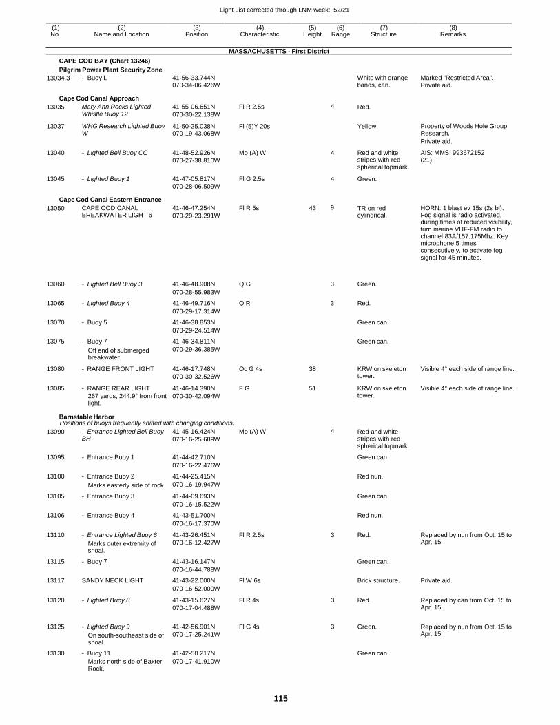
Light List corrected through LNM week: 52/21
115
(1) (2) (3) (4) (5) (6) (7) (8) No. Name and Location Position Characteristic Height Range Structure Remarks
MASSACHUSETTS - First District
CAPE COD BAY (Chart 13246)
Pilgrim Power Plant Security Zone
13034.3 - Buoy L 41-56-33.744N 070-34-06.426W
White with orange bands, can.
Marked "Restricted Area". Private aid.
Cape Cod Canal Approach
13035 Mary Ann Rocks Lighted Whistle Buoy 12
41-55-06.651N
070-30-22.138W
Fl R 2.5s 4 Red.
13037 WHG Research Lighted Buoy W
41-50-25.038N 070-19-43.068W
Fl (5)Y 20s Yellow. Property of Woods Hole Group Research.
Private aid.
13040 - Lighted Bell Buoy CC 41-48-52.926N
070-27-38.810W
Mo (A) W 4 Red and white stripes with red spherical topmark.
AIS: MMSI 993672152 (21)
13045 - Lighted Buoy 1 41-47-05.817N Fl G 2.5s 4 Green.
070-28-06.509W
Cape Cod Canal Eastern Entrance
13050 CAPE COD CANAL BREAKWATER LIGHT 6
41-46-47.254N
070-29-23.291W
Fl R 5s 43 9 TR on red cylindrical.
HORN: 1 blast ev 15s (2s bl). Fog signal is radio activated, during times of reduced visibility, turn marine VHF-FM radio to channel 83A/157.175Mhz. Key microphone 5 times consecutively, to activate fog signal for 45 minutes.
13060
- Lighted Bell Buoy 3
41-46-48.908N
Q G
3
Green.
070-28-55.983W
13065 - Lighted Buoy 4 41-46-49.716N Q R 3 Red.
070-29-17.314W
13070 - Buoy 5 41-46-38.853N Green can.
070-29-24.514W
13075 - Buoy 7 41-46-34.811N Green can.
Off end of submerged breakwater.
070-29-36.385W
13080 - RANGE FRONT LIGHT 41-46-17.748N
070-30-32.526W
Oc G 4s 38 KRW on skeleton tower.
Visible 4° each side of range line.
13085 - RANGE REAR LIGHT
267 yards, 244.9° from front light.
41-46-14.390N
070-30-42.094W
F G 51 KRW on skeleton tower.
Visible 4° each side of range line.
Barnstable Harbor Positions of buoys frequently shifted with changing conditions.
13090 - Entrance Lighted Bell Buoy BH
41-45-16.424N
070-16-25.689W
Mo (A) W 4 Red and white stripes with red spherical topmark.
13095 - Entrance Buoy 1 41-44-42.710N Green can.
070-16-22.476W
13100 - Entrance Buoy 2 41-44-25.415N Red nun.
Marks easterly side of rock. 070-16-19.947W
13105 - Entrance Buoy 3 41-44-09.693N Green can
070-16-15.522W
13106 - Entrance Buoy 4 41-43-51.700N Red nun.
070-16-17.370W
13110 - Entrance Lighted Buoy 6
Marks outer extremity of shoal.
41-43-26.451N
070-16-12.427W
Fl R 2.5s 3 Red. Replaced by nun from Oct. 15 to Apr. 15.
13115 - Buoy 7 41-43-16.147N Green can.
070-16-44.788W
13117 SANDY NECK LIGHT 41-43-22.000N Fl W 6s Brick structure. Private aid.
070-16-52.000W
13120 - Lighted Buoy 8 41-43-15.627N
070-17-04.488W
Fl R 4s 3 Red. Replaced by can from Oct. 15 to Apr. 15.
13125 - Lighted Buoy 9
On south-southeast side of shoal.
41-42-56.901N
070-17-25.241W
Fl G 4s 3 Green. Replaced by nun from Oct. 15 to Apr. 15.
13130 - Buoy 11 41-42-50.217N Green can.
Marks north side of Baxter Rock.
070-17-41.910W
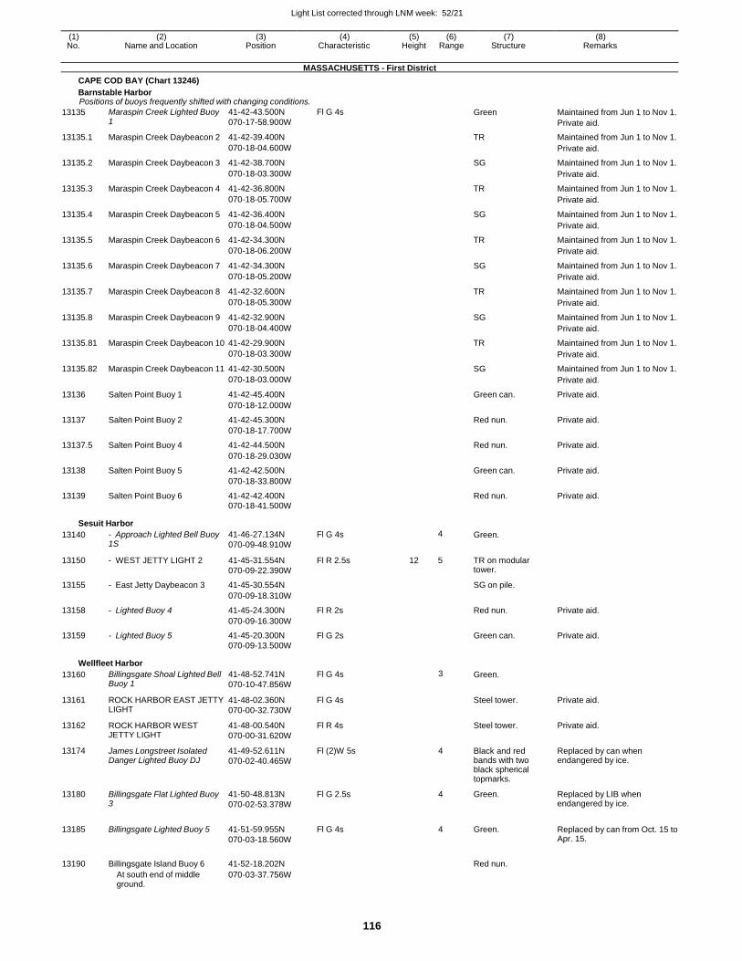
Light List corrected through LNM week: 52/21
116
(1) (2) (3) (4) (5) (6) (7) (8) No. Name and Location Position Characteristic Height Range Structure Remarks
MASSACHUSETTS - First District
CAPE COD BAY (Chart 13246)
Barnstable Harbor Positions of buoys frequently shifted with changing conditions.
13135 Maraspin Creek Lighted Buoy 1
41-42-43.500N
070-17-58.900W
Fl G 4s Green Maintained from Jun 1 to Nov 1.
Private aid.
13135.1 Maraspin Creek Daybeacon 2 41-42-39.400N TR Maintained from Jun 1 to Nov 1.
070-18-04.600W Private aid.
13135.2 Maraspin Creek Daybeacon 3 41-42-38.700N SG Maintained from Jun 1 to Nov 1.
070-18-03.300W Private aid.
13135.3 Maraspin Creek Daybeacon 4 41-42-36.800N TR Maintained from Jun 1 to Nov 1.
070-18-05.700W Private aid.
13135.4 Maraspin Creek Daybeacon 5 41-42-36.400N SG Maintained from Jun 1 to Nov 1.
070-18-04.500W Private aid.
13135.5 Maraspin Creek Daybeacon 6 41-42-34.300N TR Maintained from Jun 1 to Nov 1.
070-18-06.200W Private aid.
13135.6 Maraspin Creek Daybeacon 7 41-42-34.300N SG Maintained from Jun 1 to Nov 1.
070-18-05.200W Private aid.
13135.7 Maraspin Creek Daybeacon 8 41-42-32.600N TR Maintained from Jun 1 to Nov 1.
070-18-05.300W Private aid.
13135.8 Maraspin Creek Daybeacon 9 41-42-32.900N SG Maintained from Jun 1 to Nov 1.
070-18-04.400W Private aid.
13135.81 Maraspin Creek Daybeacon 10 41-42-29.900N TR Maintained from Jun 1 to Nov 1.
070-18-03.300W Private aid.
13135.82 Maraspin Creek Daybeacon 11 41-42-30.500N SG Maintained from Jun 1 to Nov 1.
070-18-03.000W Private aid.
13136 Salten Point Buoy 1 41-42-45.400N Green can. Private aid.
070-18-12.000W
13137 Salten Point Buoy 2 41-42-45.300N Red nun. Private aid.
070-18-17.700W
13137.5 Salten Point Buoy 4 41-42-44.500N Red nun. Private aid.
070-18-29.030W
13138 Salten Point Buoy 5 41-42-42.500N Green can. Private aid.
070-18-33.800W
13139 Salten Point Buoy 6 41-42-42.400N Red nun. Private aid. 070-18-41.500W
Sesuit Harbor
13140 - Approach Lighted Bell Buoy 1S
41-46-27.134N
070-09-48.910W
Fl G 4s 4 Green.
13150 - WEST JETTY LIGHT 2 41-45-31.554N
070-09-22.390W
Fl R 2.5s 12 5 TR on modular tower.
13155 - East Jetty Daybeacon 3 41-45-30.554N SG on pile.
070-09-18.310W
13158 - Lighted Buoy 4 41-45-24.300N Fl R 2s Red nun. Private aid.
070-09-16.300W
13159 - Lighted Buoy 5 41-45-20.300N Fl G 2s Green can. Private aid. 070-09-13.500W
Wellfleet Harbor
13160 Billingsgate Shoal Lighted Bell Buoy 1
41-48-52.741N
070-10-47.856W
Fl G 4s 3 Green.
13161 ROCK HARBOR EAST JETTY LIGHT
41-48-02.360N
070-00-32.730W
Fl G 4s Steel tower. Private aid.
13162 ROCK HARBOR WEST JETTY LIGHT
41-48-00.540N
070-00-31.620W
Fl R 4s Steel tower. Private aid.
13174 James Longstreet Isolated Danger Lighted Buoy DJ
41-49-52.611N
070-02-40.465W
Fl (2)W 5s 4 Black and red bands with two black spherical topmarks.
Replaced by can when endangered by ice.
13180 Billingsgate Flat Lighted Buoy 3
41-50-48.813N
070-02-53.378W
Fl G 2.5s 4 Green. Replaced by LIB when endangered by ice.
13185 Billingsgate Lighted Buoy 5 41-51-59.955N
070-03-18.560W
Fl G 4s 4 Green. Replaced by can from Oct. 15 to Apr. 15.
13190 Billingsgate Island Buoy 6 41-52-18.202N
Red nun.
At south end of middle ground.
070-03-37.756W
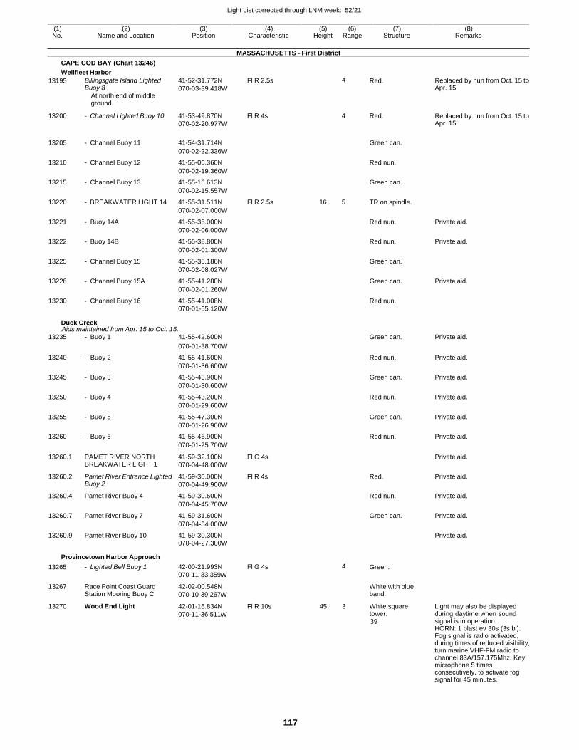
Light List corrected through LNM week: 52/21
117
(1) (2) (3) (4) (5) (6) (7) (8) No. Name and Location Position Characteristic Height Range Structure Remarks
MASSACHUSETTS - First District
CAPE COD BAY (Chart 13246)
Wellfleet Harbor
13195 Billingsgate Island Lighted Buoy 8
At north end of middle ground.
41-52-31.772N
070-03-39.418W
Fl R 2.5s 4 Red. Replaced by nun from Oct. 15 to Apr. 15.
13200 - Channel Lighted Buoy 10 41-53-49.870N
070-02-20.977W
Fl R 4s
4 Red. Replaced by nun from Oct. 15 to Apr. 15.
13205 - Channel Buoy 11 41-54-31.714N
Green can.
070-02-22.336W
13210 - Channel Buoy 12 41-55-06.360N Red nun.
070-02-19.360W
13215 - Channel Buoy 13 41-55-16.613N Green can.
070-02-15.557W
13220 - BREAKWATER LIGHT 14 41-55-31.511N Fl R 2.5s 16 5 TR on spindle.
070-02-07.000W
13221 - Buoy 14A 41-55-35.000N Red nun. Private aid.
070-02-06.000W
13222 - Buoy 14B 41-55-38.800N Red nun. Private aid.
070-02-01.300W
13225 - Channel Buoy 15 41-55-36.186N Green can.
070-02-08.027W
13226 - Channel Buoy 15A 41-55-41.280N Green can. Private aid.
070-02-01.260W
13230 - Channel Buoy 16 41-55-41.008N Red nun.
070-01-55.120W
Duck Creek Aids maintained from Apr. 15 to Oct. 15.
13235 - Buoy 1 41-55-42.600N Green can. Private aid.
070-01-38.700W
13240 - Buoy 2 41-55-41.600N Red nun. Private aid.
070-01-36.600W
13245 - Buoy 3 41-55-43.900N Green can. Private aid.
070-01-30.600W
13250 - Buoy 4 41-55-43.200N Red nun. Private aid.
070-01-29.600W
13255 - Buoy 5 41-55-47.300N Green can. Private aid.
070-01-26.900W
13260 - Buoy 6 41-55-46.900N Red nun. Private aid.
070-01-25.700W
13260.1 PAMET RIVER NORTH BREAKWATER LIGHT 1
41-59-32.100N
070-04-48.000W
Fl G 4s Private aid.
13260.2 Pamet River Entrance Lighted Buoy 2
41-59-30.000N
070-04-49.900W
Fl R 4s Red. Private aid.
13260.4 Pamet River Buoy 4 41-59-30.600N Red nun. Private aid.
070-04-45.700W
13260.7 Pamet River Buoy 7 41-59-31.600N Green can. Private aid.
070-04-34.000W
13260.9 Pamet River Buoy 10 41-59-30.300N Private aid. 070-04-27.300W
Provincetown Harbor Approach
13265
13267
13270
- Lighted Bell Buoy 1
Race Point Coast Guard Station Mooring Buoy C
Wood End Light
42-00-21.993N
070-11-33.359W
42-02-00.548N
070-10-39.267W
42-01-16.834N
070-11-36.511W
Fl G 4s
Fl R 10s
4
45 3
Green.
White with blue band.
White square tower.
39
Light may also be displayed during daytime when sound signal is in operation. HORN: 1 blast ev 30s (3s bl). Fog signal is radio activated, during times of reduced visibility, turn marine VHF-FM radio to channel 83A/157.175Mhz. Key microphone 5 times consecutively, to activate fog signal for 45 minutes.
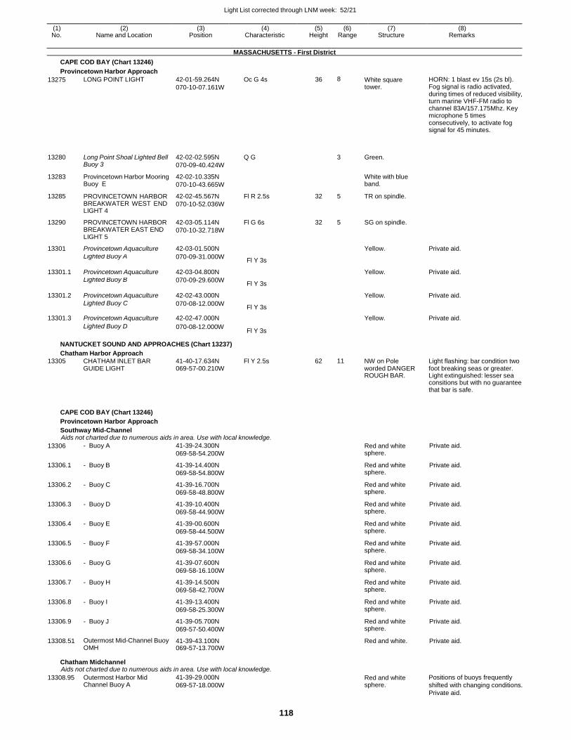
Light List corrected through LNM week: 52/21
118
(1) (2) (3) (4) (5) (6) (7) (8) No. Name and Location Position Characteristic Height Range Structure Remarks
MASSACHUSETTS - First District
CAPE COD BAY (Chart 13246)
Provincetown Harbor Approach
13275 LONG POINT LIGHT 42-01-59.264N
070-10-07.161W
Oc G 4s 36 8 White square tower.
HORN: 1 blast ev 15s (2s bl). Fog signal is radio activated, during times of reduced visibility, turn marine VHF-FM radio to channel 83A/157.175Mhz. Key microphone 5 times consecutively, to activate fog signal for 45 minutes.
13280
Long Point Shoal Lighted Bell Buoy 3
42-02-02.595N
070-09-40.424W
Q G
3
Green.
13283 Provincetown Harbor Mooring Buoy E
42-02-10.335N
070-10-43.665W
White with blue band.
13285 PROVINCETOWN HARBOR BREAKWATER WEST END LIGHT 4
42-02-45.567N
070-10-52.036W
Fl R 2.5s 32 5 TR on spindle.
13290 PROVINCETOWN HARBOR BREAKWATER EAST END LIGHT 5
42-03-05.114N
070-10-32.718W
Fl G 6s 32 5 SG on spindle.
13301 Provincetown Aquaculture 42-03-01.500N Yellow. Private aid.
Lighted Buoy A 070-09-31.000W Fl Y 3s
13301.1 Provincetown Aquaculture 42-03-04.800N Yellow. Private aid.
Lighted Buoy B 070-09-29.600W Fl Y 3s
13301.2 Provincetown Aquaculture 42-02-43.000N Yellow. Private aid.
Lighted Buoy C 070-08-12.000W Fl Y 3s
13301.3 Provincetown Aquaculture 42-02-47.000N Yellow. Private aid.
Lighted Buoy D 070-08-12.000W Fl Y 3s
NANTUCKET SOUND AND APPROACHES (Chart 13237)
Chatham Harbor Approach
13305 CHATHAM INLET BAR 41-40-17.634N Fl Y 2.5s 62 11 NW on Pole Light flashing: bar condition two GUIDE LIGHT 069-57-00.210W worded DANGER foot breaking seas or greater.
ROUGH BAR. Light extinguished: lesser sea consitions but with no guarantee that bar is safe.
CAPE COD BAY (Chart 13246)
Provincetown Harbor Approach
Southway Mid-Channel Aids not charted due to numerous aids in area. Use with local knowledge.
13306 - Buoy A 41-39-24.300N
069-58-54.200W Red and white sphere.
Private aid.
13306.1 - Buoy B 41-39-14.400N
069-58-54.800W
Red and white sphere.
Private aid.
13306.2 - Buoy C 41-39-16.700N
069-58-48.800W
Red and white sphere.
Private aid.
13306.3 - Buoy D 41-39-10.400N
069-58-44.900W
Red and white sphere.
Private aid.
13306.4 - Buoy E 41-39-00.600N
069-58-44.500W
Red and white sphere.
Private aid.
13306.5 - Buoy F 41-39-57.000N
069-58-34.100W
Red and white sphere.
Private aid.
13306.6 - Buoy G 41-39-07.600N
069-58-16.100W
Red and white sphere.
Private aid.
13306.7 - Buoy H 41-39-14.500N
069-58-42.700W
Red and white sphere.
Private aid.
13306.8 - Buoy I 41-39-13.400N
069-58-25.300W
Red and white sphere.
Private aid.
13306.9 - Buoy J 41-39-05.700N
069-57-50.400W
Red and white sphere.
Private aid.
13308.51 Outermost Mid-Channel Buoy OMH
41-39-43.100N 069-57-13.700W
Red and white. Private aid.
Chatham Midchannel Aids not charted due to numerous aids in area. Use with local knowledge.
13308.95 Outermost Harbor Mid Channel Buoy A
41-39-29.000N
069-57-18.000W Red and white sphere.
Positions of buoys frequently
shifted with changing conditions.
Private aid.
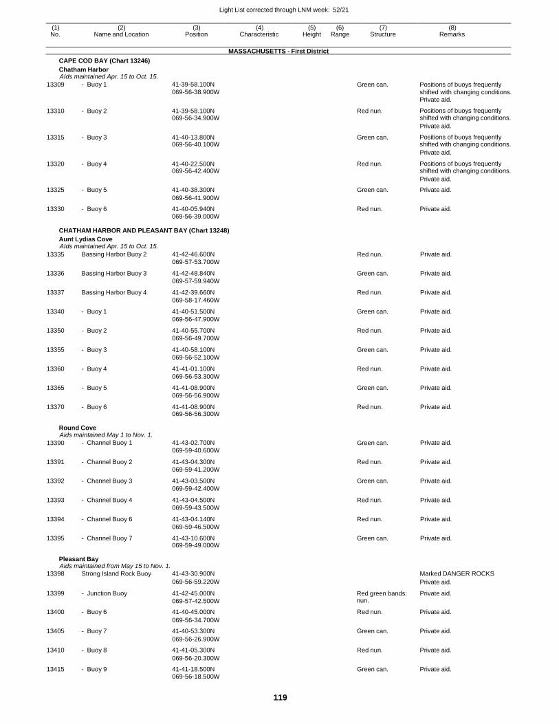
Light List corrected through LNM week: 52/21
119
(1) (2) (3) (4) (5) (6) (7) (8) No. Name and Location Position Characteristic Height Range Structure Remarks
MASSACHUSETTS - First District
CAPE COD BAY (Chart 13246)
Chatham Harbor AIds maintained Apr. 15 to Oct. 15.
13309 - Buoy 1 41-39-58.100N
069-56-38.900W Green can. Positions of buoys frequently
shifted with changing conditions. Private aid.
13310 - Buoy 2 41-39-58.100N 069-56-34.900W
Red nun. Positions of buoys frequently shifted with changing conditions.
Private aid.
13315 - Buoy 3 41-40-13.800N 069-56-40.100W
Green can. Positions of buoys frequently shifted with changing conditions.
Private aid.
13320 - Buoy 4 41-40-22.500N 069-56-42.400W
Red nun. Positions of buoys frequently shifted with changing conditions.
Private aid.
13325 - Buoy 5 41-40-38.300N Green can. Private aid.
069-56-41.900W
13330 - Buoy 6 41-40-05.940N Red nun. Private aid. 069-56-39.000W
CHATHAM HARBOR AND PLEASANT BAY (Chart 13248)
Aunt Lydias Cove AIds maintained Apr. 15 to Oct. 15.
13335 Bassing Harbor Buoy 2 41-42-46.600N
069-57-53.700W Red nun. Private aid.
13336 Bassing Harbor Buoy 3 41-42-48.840N
069-57-59.940W
Green can. Private aid.
13337 Bassing Harbor Buoy 4 41-42-39.660N
069-58-17.460W
Red nun. Private aid.
13340 - Buoy 1 41-40-51.500N
069-56-47.900W
Green can. Private aid.
13350 - Buoy 2 41-40-55.700N
069-56-49.700W
Red nun. Private aid.
13355 - Buoy 3 41-40-58.100N
069-56-52.100W
Green can. Private aid.
13360 - Buoy 4 41-41-01.100N
069-56-53.300W
Red nun. Private aid.
13365 - Buoy 5 41-41-08.900N
069-56-56.900W
Green can. Private aid.
13370 - Buoy 6 41-41-08.900N 069-56-56.300W
Red nun. Private aid.
Round Cove Aids maintained May 1 to Nov. 1.
13390 - Channel Buoy 1 41-43-02.700N
069-59-40.600W Green can. Private aid.
13391 - Channel Buoy 2 41-43-04.300N
069-59-41.200W
Red nun. Private aid.
13392 - Channel Buoy 3 41-43-03.500N
069-59-42.400W
Green can. Private aid.
13393 - Channel Buoy 4 41-43-04.500N
069-59-43.500W
Red nun. Private aid.
13394 - Channel Buoy 6 41-43-04.140N
069-59-46.500W
Red nun. Private aid.
13395 - Channel Buoy 7 41-43-10.600N 069-59-49.000W
Green can. Private aid.
Pleasant Bay Aids maintained from May 15 to Nov. 1.
13398 Strong Island Rock Buoy 41-43-30.900N Marked DANGER ROCKS
069-56-59.220W Private aid.
13399 - Junction Buoy 41-42-45.000N
069-57-42.500W
Red green bands: nun.
Private aid.
13400 - Buoy 6 41-40-45.000N Red nun. Private aid.
069-56-34.700W
13405 - Buoy 7 41-40-53.300N Green can. Private aid.
069-56-26.900W
13410 - Buoy 8 41-41-05.300N Red nun. Private aid.
069-56-20.300W
13415 - Buoy 9 41-41-18.500N Green can. Private aid. 069-56-18.500W
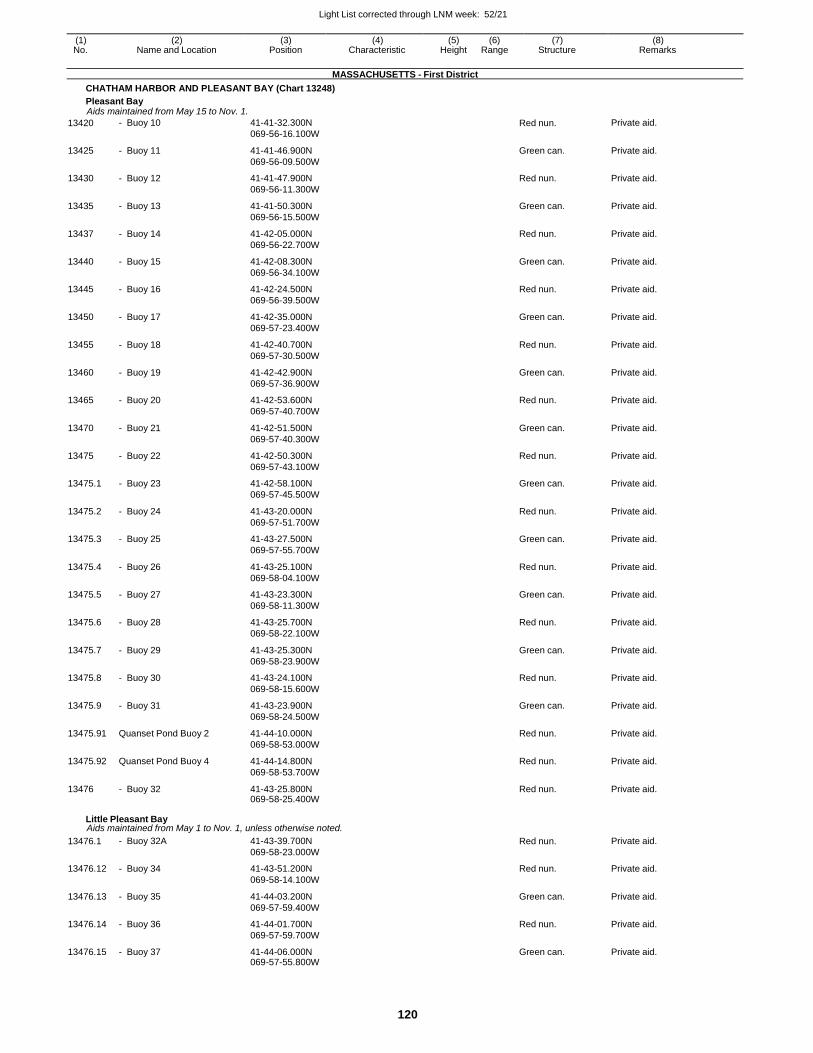
Light List corrected through LNM week: 52/21
120
(1) (2) (3) (4) (5) (6) (7) (8) No. Name and Location Position Characteristic Height Range Structure Remarks
MASSACHUSETTS - First District
CHATHAM HARBOR AND PLEASANT BAY (Chart 13248)
Pleasant Bay Aids maintained from May 15 to Nov. 1.
13420 - Buoy 10 41-41-32.300N
069-56-16.100W Red nun. Private aid.
13425 - Buoy 11 41-41-46.900N
069-56-09.500W
Green can. Private aid.
13430 - Buoy 12 41-41-47.900N
069-56-11.300W
Red nun. Private aid.
13435 - Buoy 13 41-41-50.300N
069-56-15.500W
Green can. Private aid.
13437 - Buoy 14 41-42-05.000N
069-56-22.700W
Red nun. Private aid.
13440 - Buoy 15 41-42-08.300N
069-56-34.100W
Green can. Private aid.
13445 - Buoy 16 41-42-24.500N
069-56-39.500W
Red nun. Private aid.
13450 - Buoy 17 41-42-35.000N
069-57-23.400W
Green can. Private aid.
13455 - Buoy 18 41-42-40.700N
069-57-30.500W
Red nun. Private aid.
13460 - Buoy 19 41-42-42.900N
069-57-36.900W
Green can. Private aid.
13465 - Buoy 20 41-42-53.600N
069-57-40.700W
Red nun. Private aid.
13470 - Buoy 21 41-42-51.500N
069-57-40.300W
Green can. Private aid.
13475 - Buoy 22 41-42-50.300N
069-57-43.100W
Red nun. Private aid.
13475.1 - Buoy 23 41-42-58.100N
069-57-45.500W
Green can. Private aid.
13475.2 - Buoy 24 41-43-20.000N
069-57-51.700W
Red nun. Private aid.
13475.3 - Buoy 25 41-43-27.500N
069-57-55.700W
Green can. Private aid.
13475.4 - Buoy 26 41-43-25.100N
069-58-04.100W
Red nun. Private aid.
13475.5 - Buoy 27 41-43-23.300N
069-58-11.300W
Green can. Private aid.
13475.6 - Buoy 28 41-43-25.700N
069-58-22.100W
Red nun. Private aid.
13475.7 - Buoy 29 41-43-25.300N
069-58-23.900W
Green can. Private aid.
13475.8 - Buoy 30 41-43-24.100N
069-58-15.600W
Red nun. Private aid.
13475.9 - Buoy 31 41-43-23.900N
069-58-24.500W
Green can. Private aid.
13475.91 Quanset Pond Buoy 2 41-44-10.000N
069-58-53.000W
Red nun. Private aid.
13475.92 Quanset Pond Buoy 4 41-44-14.800N
069-58-53.700W
Red nun. Private aid.
13476 - Buoy 32 41-43-25.800N 069-58-25.400W
Red nun. Private aid.
Little Pleasant Bay Aids maintained from May 1 to Nov. 1, unless otherwise noted.
13476.1 - Buoy 32A 41-43-39.700N
069-58-23.000W
Red nun. Private aid.
13476.12 - Buoy 34 41-43-51.200N
069-58-14.100W
Red nun. Private aid.
13476.13 - Buoy 35 41-44-03.200N
069-57-59.400W
Green can. Private aid.
13476.14 - Buoy 36 41-44-01.700N
069-57-59.700W
Red nun. Private aid.
13476.15 - Buoy 37 41-44-06.000N 069-57-55.800W
Green can. Private aid.
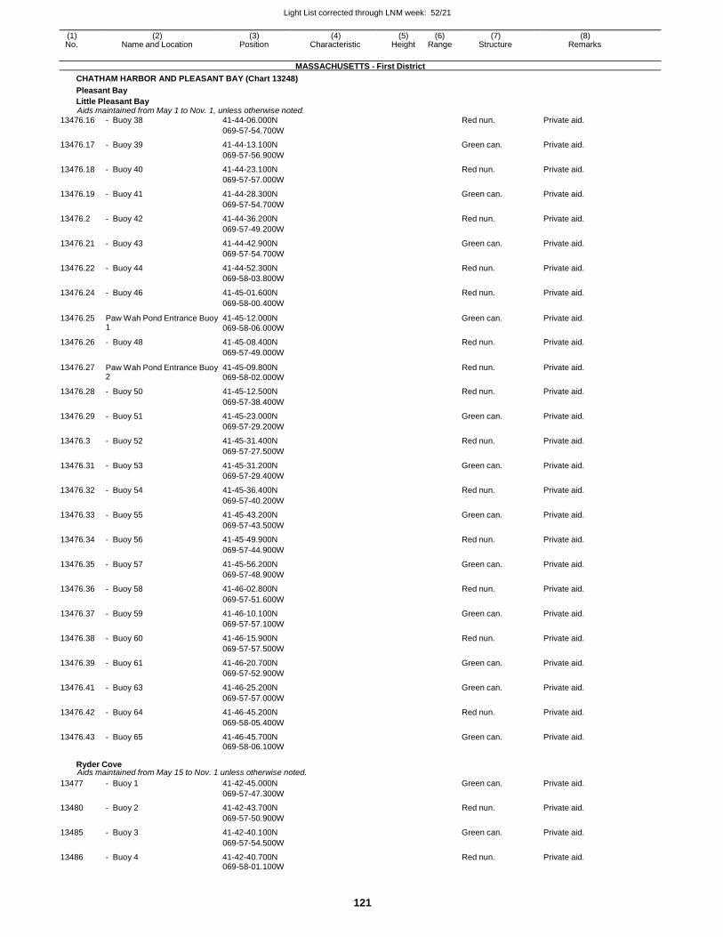
Light List corrected through LNM week: 52/21
121
(1) (2) (3) (4) (5) (6) (7) (8) No. Name and Location Position Characteristic Height Range Structure Remarks
MASSACHUSETTS - First District
CHATHAM HARBOR AND PLEASANT BAY (Chart 13248)
Pleasant Bay
Little Pleasant Bay Aids maintained from May 1 to Nov. 1, unless otherwise noted.
13476.16 - Buoy 38 41-44-06.000N Red nun. Private aid.
069-57-54.700W
13476.17 - Buoy 39 41-44-13.100N Green can. Private aid.
069-57-56.900W
13476.18 - Buoy 40 41-44-23.100N Red nun. Private aid.
069-57-57.000W
13476.19 - Buoy 41 41-44-28.300N Green can. Private aid.
069-57-54.700W
13476.2 - Buoy 42 41-44-36.200N Red nun. Private aid.
069-57-49.200W
13476.21 - Buoy 43 41-44-42.900N Green can. Private aid.
069-57-54.700W
13476.22 - Buoy 44 41-44-52.300N Red nun. Private aid.
069-58-03.800W
13476.24 - Buoy 46 41-45-01.600N Red nun. Private aid.
069-58-00.400W
13476.25 Paw Wah Pond Entrance Buoy 1
41-45-12.000N
069-58-06.000W
Green can. Private aid.
13476.26 - Buoy 48 41-45-08.400N Red nun. Private aid.
069-57-49.000W
13476.27 Paw Wah Pond Entrance Buoy 2
41-45-09.800N
069-58-02.000W
Red nun. Private aid.
13476.28 - Buoy 50 41-45-12.500N Red nun. Private aid.
069-57-38.400W
13476.29 - Buoy 51 41-45-23.000N Green can. Private aid.
069-57-29.200W
13476.3 - Buoy 52 41-45-31.400N Red nun. Private aid.
069-57-27.500W
13476.31 - Buoy 53 41-45-31.200N Green can. Private aid.
069-57-29.400W
13476.32 - Buoy 54 41-45-36.400N Red nun. Private aid.
069-57-40.200W
13476.33 - Buoy 55 41-45-43.200N Green can. Private aid.
069-57-43.500W
13476.34 - Buoy 56 41-45-49.900N Red nun. Private aid.
069-57-44.900W
13476.35 - Buoy 57 41-45-56.200N Green can. Private aid.
069-57-48.900W
13476.36 - Buoy 58 41-46-02.800N Red nun. Private aid.
069-57-51.600W
13476.37 - Buoy 59 41-46-10.100N Green can. Private aid.
069-57-57.100W
13476.38 - Buoy 60 41-46-15.900N Red nun. Private aid.
069-57-57.500W
13476.39 - Buoy 61 41-46-20.700N Green can. Private aid.
069-57-52.900W
13476.41 - Buoy 63 41-46-25.200N Green can. Private aid.
069-57-57.000W
13476.42 - Buoy 64 41-46-45.200N Red nun. Private aid.
069-58-05.400W
13476.43 - Buoy 65 41-46-45.700N Green can. Private aid. 069-58-06.100W
Ryder Cove Aids maintained from May 15 to Nov. 1 unless otherwise noted.
13477 - Buoy 1 41-42-45.000N Green can. Private aid.
069-57-47.300W
13480 - Buoy 2 41-42-43.700N Red nun. Private aid.
069-57-50.900W
13485 - Buoy 3 41-42-40.100N Green can. Private aid.
069-57-54.500W
13486 - Buoy 4 41-42-40.700N Red nun. Private aid. 069-58-01.100W
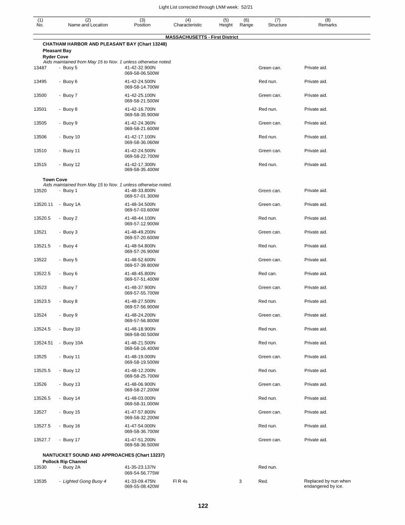
Light List corrected through LNM week: 52/21
122
(1) (2) (3) (4) (5) (6) (7) (8) No. Name and Location Position Characteristic Height Range Structure Remarks
MASSACHUSETTS - First District
CHATHAM HARBOR AND PLEASANT BAY (Chart 13248)
Pleasant Bay
Ryder Cove Aids maintained from May 15 to Nov. 1 unless otherwise noted.
13487 - Buoy 5 41-42-32.900N
069-58-06.500W Green can. Private aid.
13495 - Buoy 6 41-42-24.500N
069-58-14.700W
Red nun. Private aid.
13500 - Buoy 7 41-42-25.100N
069-58-21.500W
Green can. Private aid.
13501 - Buoy 8 41-42-16.700N
069-58-35.900W
Red nun. Private aid.
13505 - Buoy 9 41-42-24.360N
069-58-21.600W
Green can. Private aid.
13506 - Buoy 10 41-42-17.100N
069-58-36.060W
Red nun. Private aid.
13510 - Buoy 11 41-42-24.500N
069-58-22.700W
Green can. Private aid.
13515 - Buoy 12 41-42-17.300N 069-58-35.400W
Red nun. Private aid.
Town Cove Aids maintained from May 15 to Nov. 1 unless otherwise noted.
13520 - Buoy 1 41-48-33.800N
069-57-01.300W Green can. Private aid.
13520.11 - Buoy 1A 41-48-34.500N
069-57-03.600W
Green can. Private aid.
13520.5 - Buoy 2 41-48-44.100N
069-57-12.900W
Red nun. Private aid.
13521 - Buoy 3 41-48-49.200N
069-57-20.600W
Green can. Private aid.
13521.5 - Buoy 4 41-48-54.800N
069-57-26.900W
Red nun. Private aid.
13522 - Buoy 5 41-48-52.600N
069-57-39.800W
Green can. Private aid.
13522.5 - Buoy 6 41-48-45.800N
069-57-51.400W
Red can. Private aid.
13523 - Buoy 7 41-48-37.900N
069-57-55.700W
Green can. Private aid.
13523.5 - Buoy 8 41-48-27.500N
069-57-56.900W
Red nun. Private aid.
13524 - Buoy 9 41-48-24.200N
069-57-56.800W
Green can. Private aid.
13524.5 - Buoy 10 41-48-18.900N
069-58-00.500W
Red nun. Private aid.
13524.51 - Buoy 10A 41-48-21.500N
069-58-16.400W
Red nun. Private aid.
13525 - Buoy 11 41-48-19.000N
069-58-19.500W
Green can. Private aid.
13525.5 - Buoy 12 41-48-12.200N
069-58-25.700W
Red nun. Private aid.
13526 - Buoy 13 41-48-06.900N
069-58-27.200W
Green can. Private aid.
13526.5 - Buoy 14 41-48-03.000N
069-58-31.000W
Red nun. Private aid.
13527 - Buoy 15 41-47-57.800N
069-58-32.200W
Green can. Private aid.
13527.5 - Buoy 16 41-47-54.000N
069-58-36.700W
Red nun. Private aid.
13527.7 - Buoy 17 41-47-51.200N 069-58-36.500W
Green can. Private aid.
NANTUCKET SOUND AND APPROACHES (Chart 13237)
Pollock Rip Channel
13530 - Buoy 2A 41-35-23.137N Red nun.
069-54-56.775W
13535 - Lighted Gong Buoy 4 41-33-09.475N 069-55-08.420W
Fl R 4s 3 Red. Replaced by nun when endangered by ice.
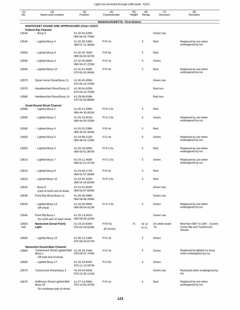
Light List corrected through LNM week: 52/21
123
(1) (2) (3) (4) (5) (6) (7) (8) No. Name and Location Position Characteristic Height Range Structure Remarks
MASSACHUSETTS - First District
NANTUCKET SOUND AND APPROACHES (Chart 13237)
Pollock Rip Channel
13540 - Buoy 5 41-32-54.520N Green can.
069-56-02.700W
13545 - Lighted Buoy 6 41-32-59.246N
069-57-11.364W
Fl R 4s 3 Red. Replaced by nun when endangered by ice.
13550 - Lighted Buoy 8 41-32-42.763N Fl R 6s 3 Red.
069-58-55.557W
13555 - Lighted Buoy 9 41-32-06.568N Fl G 4s 3 Green.
069-59-27.223W
13565 - Lighted Buoy 10 41-31-51.450N
070-00-31.064W
Fl R 4s 3 Red. Replaced by nun when endangered by ice.
13570 Stone Horse Shoal Buoy 11 41-30-40.455N
Green can.
070-00-10.376W
13575 Handkerchief Shoal Buoy 12 41-30-04.620N Red nun.
070-03-14.702W
13580 Handkerchief Shoal Buoy 14 41-29-06.919N Red nun.
070-05-04.885W
Great Round Shoal Channel
13586 - Lighted Buoy 2 41-26-11.039N Fl R 2.5s 3 Red.
069-44-33.001W
13590 - Lighted Buoy 3 41-25-34.501N
069-44-55.432W
Fl G 2.5s 4 Green. Replaced by can when endangered by ice.
13595 - Lighted Buoy 4 41-25-52.538N Fl R 4s
3 Red.
069-46-02.400W
13600 - Lighted Buoy 5 41-24-58.212N
069-48-26.120W
Fl G 4s 3 Green. Replaced by can when endangered by ice.
13605 - Lighted Buoy 6 41-25-16.085N
069-50-51.997W
Fl R 2.5s
3 Red. Replaced by nun when endangered by ice.
13610 - Lighted Buoy 7 41-24-11.463N
069-52-21.471W
Fl G 2.5s
3 Green. Replaced by can when endangered by ice.
13615 - Lighted Buoy 8 41-24-49.171N Fl R 4s
3 Red.
069-52-57.084W
13620 - Lighted Buoy 10 41-24-50.102N Fl R 2.5s 3 Red.
069-54-26.624W
13625 - Buoy 9 41-23-51.803N Green can.
East of north end of shoal. 069-54-57.825W
13635 Point Rip Shoal Buoy 11 41-25-06.098N Green can.
069-58-08.269W
13640 - Lighted Buoy 13
Off shoal.
41-25-55.360N
069-58-54.411W
Fl G 2.5s 3 Green. Replaced by can when endangered by ice.
13645 Point Rip Buoy 1 41-25-13.041N
Green can.
On north part of outer shoal. 069-59-49.102W
13650 Nantucket (Great Point) 41-23-24.634N Fl W 5s 71 W 14 On white tower. Red from 084° to 106°. Covers
545 Light 070-02-53.810W (R sector)
R 12 70 Cross Rip and Tuckernuck Shoals.
13655 - Lighted Buoy 15 41-26-12.139N Fl G 4s
3 Green.
070-05-04.617W
Nantucket Sound Main Channel
13660 Tuckernuck Shoal Lighted Bell Buoy 1
41-24-18.744N 070-09-47.744W
Fl G 4s 4 Green. Replaced by lighted ice buoy when endangered by ice.
Off east end of shoal.
13665 - Lighted Buoy 17 41-26-34.842N Fl G 6s 4 Green.
070-11-13.597W
13670 Tuckernuck Shoal Buoy 3 41-24-54.592N
070-12-55.141W
Green can. Removed when endangered by ice.
13675 Halfmoon Shoal Lighted Bell Buoy 18
41-27-14.406N 070-14-04.207W
Fl R 4s 4 Red. Replaced by nun when endangered by ice.
On southeast part of shoal.
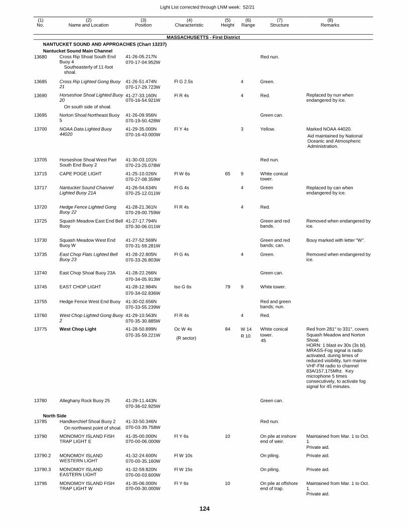
Light List corrected through LNM week: 52/21
124
(1) (2) (3) (4) (5) (6) (7) (8) No. Name and Location Position Characteristic Height Range Structure Remarks
MASSACHUSETTS - First District
NANTUCKET SOUND AND APPROACHES (Chart 13237)
Nantucket Sound Main Channel
13680 Cross Rip Shoal South End Buoy 4
Southeasterly of 11-foot shoal.
41-26-05.217N
070-17-04.952W Red nun.
13685 Cross Rip Lighted Gong Buoy 21
41-26-51.474N
070-17-29.723W
Fl G 2.5s
4 Green.
13690 Horseshoe Shoal Lighted Buoy 20
41-27-33.160N 070-16-54.921W
Fl R 4s 4 Red. Replaced by nun when endangered by ice.
On south side of shoal.
13695 Norton Shoal Northeast Buoy 5
41-26-09.956N
070-19-50.428W
Green can.
13700 NOAA Data Lighted Buoy 44020
41-29-35.000N
070-16-43.000W
Fl Y 4s 3 Yellow. Marked NOAA 44020.
Aid maintained by National Oceanic and Atmospheric Administration.
13705 Horseshoe Shoal West Part South End Buoy 2
41-30-03.101N
070-23-25.078W
Red nun.
13715 CAPE POGE LIGHT 41-25-10.026N
070-27-08.359W
Fl W 6s 65 9 White conical tower.
13717 Nantucket Sound Channel Lighted Buoy 21A
41-26-54.634N
070-25-12.011W
Fl G 4s 4 Green Replaced by can when endangered by ice.
13720
Hedge Fence Lighted Gong Buoy 22
41-28-21.361N
070-29-00.759W
Fl R 4s
4 Red.
13725 Squash Meadow East End Bell Buoy
41-27-17.794N
070-30-06.011W
Green and red bands.
Removed when endangered by ice.
13730
Squash Meadow West End Buoy W
41-27-52.569N
070-31-59.281W
Green and red bands; can.
Bouy marked with letter "W".
13735 East Chop Flats Lighted Bell Buoy 23
41-28-22.805N
070-33-26.803W
Fl G 4s
4 Green. Removed when endangered by ice.
13740 East Chop Shoal Buoy 23A 41-28-22.266N
Green can.
070-34-05.913W
13745 EAST CHOP LIGHT 41-28-12.984N Iso G 6s 79 9 White tower.
070-34-02.836W
13755 Hedge Fence West End Buoy 41-30-02.656N
070-33-55.239W
Red and green bands; nun.
13760 West Chop Lighted Gong Buoy 2
41-29-10.563N
070-35-30.885W
Fl R 4s 4 Red.
13775 West Chop Light 41-28-50.899N Oc W 4s 84 W 14 White conical Red from 281° to 331°, covers
070-35-59.221W (R sector) R 10 tower.
45
Squash Meadow and Norton Shoal. HORN: 1 blast ev 30s (3s bl). MRASS-Fog signal is radio activated, during times of reduced visibility, turn marine VHF-FM radio to channel 83A/157.175Mhz. Key microphone 5 times consecutively, to activate fog signal for 45 minutes.
13780 Alleghany Rock Buoy 25 41-29-11.443N
070-36-02.925W
Green can.
North Side
13785 Handkerchief Shoal Buoy 2 41-33-50.346N Red nun.
On northwest point of shoal. 070-03-39.758W
13790 MONOMOY ISLAND FISH TRAP LIGHT E
41-35-00.000N 070-00-06.000W
Fl Y 6s 10 On pile at inshore end of weir.
Maintained from Mar. 1 to Oct. 1.
Private aid.
13790.2 MONOMOY ISLAND WESTERN LIGHT
41-32-24.600N
070-00-35.160W
Fl W 10s On piling. Private aid.
13790.3 MONOMOY ISLAND EASTERN LIGHT
41-32-59.820N
070-00-03.600W
Fl W 15s On piling. Private aid.
13795 MONOMOY ISLAND FISH TRAP LIGHT W
41-35-06.000N 070-00-30.000W
Fl Y 6s 10 On pile at offshore end of trap.
Maintained from Mar. 1 to Oct. 1.
Private aid.
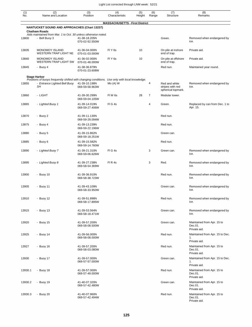
Light List corrected through LNM week: 52/21
125
(1) (2) (3) (4) (5) (6) (7) (8) No. Name and Location Position Characteristic Height Range Structure Remarks
MASSACHUSETTS - First District
NANTUCKET SOUND AND APPROACHES (Chart 13237)
Chatham Roads Aids maintained from Mar. 1 to Oct. 30 unless otherwise noted.
13800 - Bell Buoy 3 41-38-18.205N
070-02-52.550W
Green. Removed when endangered by ice.
13835 MONOMOY ISLAND WESTERN TRAP LIGHT NE
41-36-04.000N
070-01-03.000W
Fl Y 6s 10 On pile at inshore end of trap.
Private aid.
13840 MONOMOY ISLAND WESTERN TRAP LIGHT SW
41-36-02.000N
070-01-48.000W
Fl Y 6s 10 On pile at offshore end of trap.
Private aid.
13845 - Buoy 4 41-38-36.879N Red nun. Maintained year round. 070-01-23.608W
Stage Harbor Positions of buoys frequently shifted with changing conditions. Use only with local knowledge.
13855 - Entrance Lighted Bell Buoy SH
41-39-10.198N
069-59-58.963W
Mo (A) W 4 Red and white stripes with red spherical topmark.
Removed when endangered by ice.
13860 - LIGHT 41-39-30.299N Fl W 6s 28 7 Modular tower.
069-59-04.105W
13865 - Lighted Buoy 1 41-39-14.019N
069-59-27.406W
Fl G 4s 4 Green. Replaced by can from Dec. 1 to Apr. 15.
13870 - Buoy 2 41-39-11.130N
Red nun.
069-59-29.094W
13875 - Buoy 4 41-39-13.239N Red nun.
069-59-22.196W
13880 - Buoy 5 41-39-15.862N Green can.
069-59-18.251W
13885 - Buoy 6 41-39-15.582N Red nun.
069-59-14.760W
13890 - Lighted Buoy 7 41-39-21.310N
069-59-06.626W
Fl G 4s 3 Green can. Removed when endangered by ice.
13895 - Lighted Buoy 8 41-39-27.238N
069-58-54.369W
Fl R 4s
3 Red. Removed when endangered by ice.
13900 - Buoy 10 41-39-36.910N
069-58-38.723W
Red nun. Removed when endangered by
ice.
13905 - Buoy 11 41-39-43.109N
069-58-33.950W
Green can. Removed when endangered by
ice.
13910 - Buoy 12 41-39-51.898N
069-58-17.895W
Red nun. Removed when endangered by
ice.
13915 - Buoy 13 41-39-53.564N
069-58-18.471W
Green can. Removed when endangered by
ice.
13920 - Buoy 15 41-39-57.200N 069-58-08.500W
Green can. Maintained from Apr. 15 to
Dec.01.
Private aid.
13925 - Buoy 14 41-39-56.000N 069-58-08.000W
Red nun. Maintained from Apr. 15 to Dec. 1.
Private aid.
13927 - Buoy 16 41-39-57.200N 069-58-03.080W
Red nun. Maintained from Apr. 15 to Dec.01.
Private aid.
13930 - Buoy 17 41-39-57.000N 069-57-57.000W
Green can. Maintained from Apr. 15 to Dec. 1.
Private aid.
13930.1 - Buoy 18 41-39-57.000N 069-57-49.000W
Red nun. Maintained from Apr. 15 to Dec.01.
Private aid.
13930.2 - Buoy 19 41-40-07.320N 069-57-42.480W
Green can. Maintained from Apr. 15 to Dec.01.
Private aid.
13930.3 - Buoy 20 41-40-07.960N 069-57-42.494W
Red nun. Maintained from Apr. 15 to Dec.01.
Private aid.
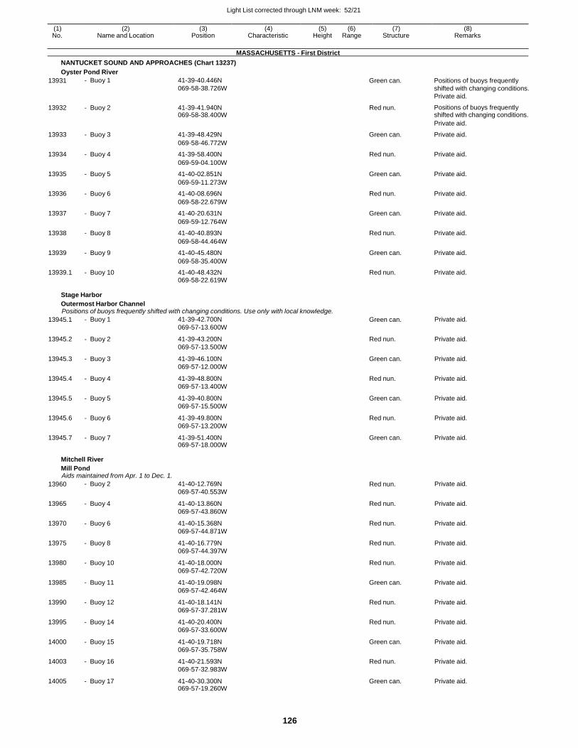
Light List corrected through LNM week: 52/21
126
(1) (2) (3) (4) (5) (6) (7) (8) No. Name and Location Position Characteristic Height Range Structure Remarks
MASSACHUSETTS - First District
NANTUCKET SOUND AND APPROACHES (Chart 13237)
Oyster Pond River
13931 - Buoy 1 41-39-40.446N
069-58-38.726W Green can. Positions of buoys frequently
shifted with changing conditions.
Private aid.
13932 - Buoy 2 41-39-41.940N 069-58-38.400W
Red nun. Positions of buoys frequently shifted with changing conditions.
Private aid.
13933 - Buoy 3 41-39-48.429N Green can. Private aid.
069-58-46.772W
13934 - Buoy 4 41-39-58.400N Red nun. Private aid.
069-59-04.100W
13935 - Buoy 5 41-40-02.851N Green can. Private aid.
069-59-11.273W
13936 - Buoy 6 41-40-08.696N Red nun. Private aid.
069-58-22.679W
13937 - Buoy 7 41-40-20.631N Green can. Private aid.
069-59-12.764W
13938 - Buoy 8 41-40-40.893N Red nun. Private aid.
069-58-44.464W
13939 - Buoy 9 41-40-45.480N Green can. Private aid.
069-58-35.400W
13939.1 - Buoy 10 41-40-48.432N Red nun. Private aid. 069-58-22.619W
Stage Harbor
Outermost Harbor Channel Positions of buoys frequently shifted with changing conditions. Use only with local knowledge.
13945.1 - Buoy 1 41-39-42.700N
069-57-13.600W Green can. Private aid.
13945.2 - Buoy 2 41-39-43.200N
069-57-13.500W
Red nun. Private aid.
13945.3 - Buoy 3 41-39-46.100N
069-57-12.000W
Green can. Private aid.
13945.4 - Buoy 4 41-39-48.800N
069-57-13.400W
Red nun. Private aid.
13945.5 - Buoy 5 41-39-40.800N
069-57-15.500W
Green can. Private aid.
13945.6 - Buoy 6 41-39-49.800N
069-57-13.200W
Red nun. Private aid.
13945.7 - Buoy 7 41-39-51.400N 069-57-18.000W
Green can. Private aid.
Mitchell River
Mill Pond Aids maintained from Apr. 1 to Dec. 1.
13960 - Buoy 2 41-40-12.769N
069-57-40.553W Red nun. Private aid.
13965 - Buoy 4 41-40-13.860N
069-57-43.860W
Red nun. Private aid.
13970 - Buoy 6 41-40-15.368N
069-57-44.871W
Red nun. Private aid.
13975 - Buoy 8 41-40-16.779N
069-57-44.397W
Red nun. Private aid.
13980 - Buoy 10 41-40-18.000N
069-57-42.720W
Red nun. Private aid.
13985 - Buoy 11 41-40-19.098N
069-57-42.464W
Green can. Private aid.
13990 - Buoy 12 41-40-18.141N
069-57-37.281W
Red nun. Private aid.
13995 - Buoy 14 41-40-20.400N
069-57-33.600W
Red nun. Private aid.
14000 - Buoy 15 41-40-19.718N
069-57-35.758W
Green can. Private aid.
14003 - Buoy 16 41-40-21.593N
069-57-32.983W
Red nun. Private aid.
14005 - Buoy 17 41-40-30.300N 069-57-19.260W
Green can. Private aid.
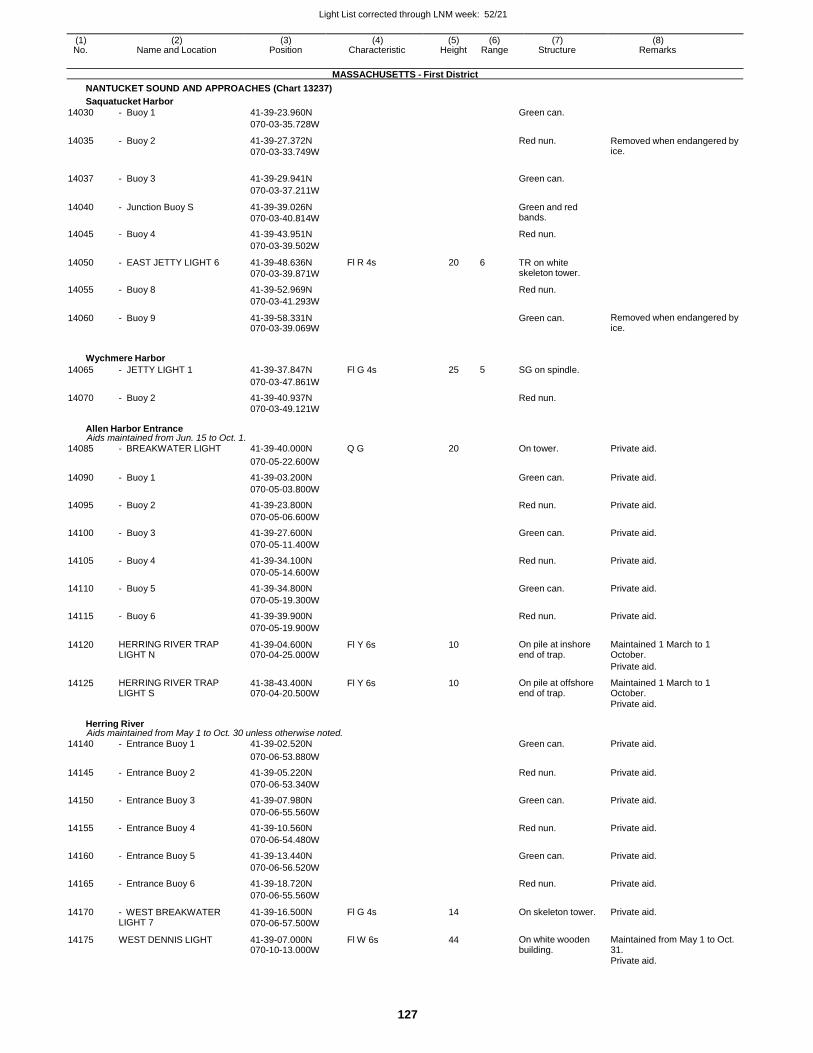
Light List corrected through LNM week: 52/21
127
(1) (2) (3) (4) (5) (6) (7) (8) No. Name and Location Position Characteristic Height Range Structure Remarks
MASSACHUSETTS - First District
NANTUCKET SOUND AND APPROACHES (Chart 13237)
Saquatucket Harbor
14030 - Buoy 1 41-39-23.960N Green can.
070-03-35.728W
14035 - Buoy 2 41-39-27.372N
070-03-33.749W
Red nun. Removed when endangered by ice.
14037 - Buoy 3 41-39-29.941N
Green can.
070-03-37.211W
14040 - Junction Buoy S 41-39-39.026N
070-03-40.814W
Green and red bands.
14045 - Buoy 4 41-39-43.951N Red nun.
070-03-39.502W
14050 - EAST JETTY LIGHT 6 41-39-48.636N
070-03-39.871W
Fl R 4s 20 6 TR on white skeleton tower.
14055 - Buoy 8 41-39-52.969N Red nun.
070-03-41.293W
14060 - Buoy 9 41-39-58.331N 070-03-39.069W
Green can. Removed when endangered by ice.
Wychmere Harbor
14065 - JETTY LIGHT 1 41-39-37.847N Fl G 4s 25 5 SG on spindle.
070-03-47.861W
14070 - Buoy 2 41-39-40.937N Red nun. 070-03-49.121W
Allen Harbor Entrance Aids maintained from Jun. 15 to Oct. 1.
14085 - BREAKWATER LIGHT 41-39-40.000N Q G 20 On tower. Private aid.
070-05-22.600W
14090 - Buoy 1 41-39-03.200N Green can. Private aid.
070-05-03.800W
14095 - Buoy 2 41-39-23.800N Red nun. Private aid.
070-05-06.600W
14100 - Buoy 3 41-39-27.600N Green can. Private aid.
070-05-11.400W
14105 - Buoy 4 41-39-34.100N Red nun. Private aid.
070-05-14.600W
14110 - Buoy 5 41-39-34.800N Green can. Private aid.
070-05-19.300W
14115 - Buoy 6 41-39-39.900N Red nun. Private aid.
070-05-19.900W
14120 HERRING RIVER TRAP LIGHT N
41-39-04.600N 070-04-25.000W
Fl Y 6s 10 On pile at inshore end of trap.
Maintained 1 March to 1 October.
Private aid.
14125 HERRING RIVER TRAP LIGHT S
41-38-43.400N 070-04-20.500W
Fl Y 6s 10 On pile at offshore end of trap.
Maintained 1 March to 1 October.
Private aid.
Herring River Aids maintained from May 1 to Oct. 30 unless otherwise noted.
14140 - Entrance Buoy 1 41-39-02.520N Green can. Private aid.
070-06-53.880W
14145 - Entrance Buoy 2 41-39-05.220N Red nun. Private aid.
070-06-53.340W
14150 - Entrance Buoy 3 41-39-07.980N Green can. Private aid.
070-06-55.560W
14155 - Entrance Buoy 4 41-39-10.560N Red nun. Private aid.
070-06-54.480W
14160 - Entrance Buoy 5 41-39-13.440N Green can. Private aid.
070-06-56.520W
14165 - Entrance Buoy 6 41-39-18.720N Red nun. Private aid.
070-06-55.560W
14170 - WEST BREAKWATER LIGHT 7
41-39-16.500N
070-06-57.500W
Fl G 4s 14 On skeleton tower. Private aid.
14175 WEST DENNIS LIGHT 41-39-07.000N 070-10-13.000W
Fl W 6s 44 On white wooden building.
Maintained from May 1 to Oct. 31.
Private aid.

Light List corrected through LNM week: 52/21
128
(1) (2) (3) (4) (5) (6) (7) (8) No. Name and Location Position Characteristic Height Range Structure Remarks
MASSACHUSETTS - First District
NANTUCKET SOUND AND APPROACHES (Chart 13237)
Herring River Aids maintained from May 1 to Oct. 30 unless otherwise noted.
14180
14190
Kill Pond Bar Lighted Whistle Buoy KP
Off southeast end of shoal.
KILL POND BAR FISH TRAP LIGHT S
41-37-26.418N
070-06-29.216W
41-37-00.000N
070-07-38.000W
Fl (2+1)R 6s
Fl Y 6s
4 Red and green bands.
10 On pile at offshore end of weir.
Replaced by nun when endangered by ice.
Maintained from Mar. 1 to Oct. 1.
Private aid.
Bass River Aids maintained from May 15 to Nov. 15 unless otherwise noted.
14205 - Entrance Lighted Buoy 2 41-37-35.118N Fl R 2.5s 3 Red. Replaced by nun when
070-11-30.308W endangered by ice.
14215 - Entrance Buoy 4 41-38-09.300N
070-11-44.400W
Red nun. Private aid.
14220 - Entrance Buoy 5 41-38-12.900N
070-11-45.700W
Green can. Private aid.
14225 - Entrance Buoy 6 41-38-13.100N
070-11-41.800W
Red nun. Private aid.
14230 - Entrance Buoy 7 41-38-19.700N
070-11-46.300W
Green can. Private aid.
14235 - Entrance Buoy 8 41-38-23.500N
070-11-44.600W
Red nun. Private aid.
14240 - Entrance Buoy 9 41-38-31.900N
070-11-46.100W
Green can. Private aid.
14245 - Entrance Buoy 10 41-38-32.300N
070-11-44.900W
Red nun. Private aid.
14250 - Buoy 12 41-38-54.600N
070-11-49.600W
Red nun. Private aid.
14255 - Buoy 14 41-39-02.700N
070-11-49.300W
Red nun. Private aid.
14256 - Buoy 14A 41-39-14.100N
070-11-46.300W
Red nun. Private aid.
14260 - Buoy 16 41-39-18.400N
070-11-41.000W
Red nun. Private aid.
14265 - Buoy 16A 41-39-22.100N
070-11-32.200W
Red nun. Private aid.
14270 - Buoy 18 41-39-26.600N
070-11-23.800W
Red nun. Private aid.
14275 - Buoy 20 41-39-36.300N
070-11-16.900W
Red nun. Private aid.
14280 - Buoy 22 41-39-41.100N
070-11-12.600W
Red nun. Private aid.
14281 - Buoy 22A 41-39-45.400N
070-11-02.900W
Red nun. Private aid.
14285 - Buoy 24 41-40-02.200N
070-10-51.300W
Red nun. Private aid.
14290 - Buoy 25 41-40-08.200N
070-10-46.700W
Green can. Private aid.
14295 - Buoy 26 41-40-11.700N
070-10-30.500W
Red nun. Private aid.
14300 - Buoy 28 41-40-21.400N
070-10-19.100W
Red nun. Private aid.
14301 - Buoy 28A 41-40-27.600N
070-10-15.800W
Red nun. Private aid.
14305 - Buoy 30 41-40-33.300N
070-10-09.600W
Red nun. Private aid.
14310 - Buoy 32 41-40-49.700N
070-09-44.300W
Red nun. Private aid.
14315 - Buoy 33 41-40-59.300N
070-09-41.900W
Green can. Private aid.
14320 - Buoy 34 41-40-57.500N
070-09-43.300W
Red nun. Private aid.
14325 - Buoy 35 41-41-03.800N 070-09-33.800W
Green can. Private aid.
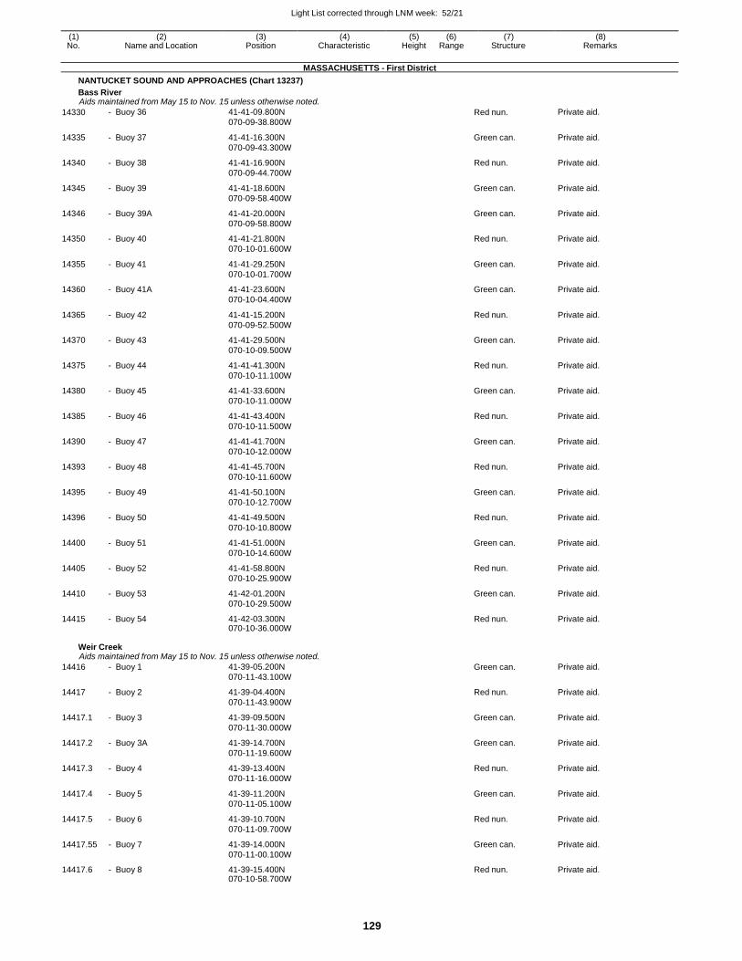
Light List corrected through LNM week: 52/21
129
(1) (2) (3) (4) (5) (6) (7) (8) No. Name and Location Position Characteristic Height Range Structure Remarks
MASSACHUSETTS - First District
NANTUCKET SOUND AND APPROACHES (Chart 13237)
Bass River Aids maintained from May 15 to Nov. 15 unless otherwise noted.
14330 - Buoy 36 41-41-09.800N
070-09-38.800W Red nun. Private aid.
14335 - Buoy 37 41-41-16.300N
070-09-43.300W
Green can. Private aid.
14340 - Buoy 38 41-41-16.900N
070-09-44.700W
Red nun. Private aid.
14345 - Buoy 39 41-41-18.600N
070-09-58.400W
Green can. Private aid.
14346 - Buoy 39A 41-41-20.000N
070-09-58.800W
Green can. Private aid.
14350 - Buoy 40 41-41-21.800N
070-10-01.600W
Red nun. Private aid.
14355 - Buoy 41 41-41-29.250N
070-10-01.700W
Green can. Private aid.
14360 - Buoy 41A 41-41-23.600N
070-10-04.400W
Green can. Private aid.
14365 - Buoy 42 41-41-15.200N
070-09-52.500W
Red nun. Private aid.
14370 - Buoy 43 41-41-29.500N
070-10-09.500W
Green can. Private aid.
14375 - Buoy 44 41-41-41.300N
070-10-11.100W
Red nun. Private aid.
14380 - Buoy 45 41-41-33.600N
070-10-11.000W
Green can. Private aid.
14385 - Buoy 46 41-41-43.400N
070-10-11.500W
Red nun. Private aid.
14390 - Buoy 47 41-41-41.700N
070-10-12.000W
Green can. Private aid.
14393 - Buoy 48 41-41-45.700N
070-10-11.600W
Red nun. Private aid.
14395 - Buoy 49 41-41-50.100N
070-10-12.700W
Green can. Private aid.
14396 - Buoy 50 41-41-49.500N
070-10-10.800W
Red nun. Private aid.
14400 - Buoy 51 41-41-51.000N
070-10-14.600W
Green can. Private aid.
14405 - Buoy 52 41-41-58.800N
070-10-25.900W
Red nun. Private aid.
14410 - Buoy 53 41-42-01.200N
070-10-29.500W
Green can. Private aid.
14415 - Buoy 54 41-42-03.300N 070-10-36.000W
Red nun. Private aid.
Weir Creek Aids maintained from May 15 to Nov. 15 unless otherwise noted.
14416 - Buoy 1 41-39-05.200N
070-11-43.100W
Green can. Private aid.
14417 - Buoy 2 41-39-04.400N
070-11-43.900W
Red nun. Private aid.
14417.1 - Buoy 3 41-39-09.500N
070-11-30.000W
Green can. Private aid.
14417.2 - Buoy 3A 41-39-14.700N
070-11-19.600W
Green can. Private aid.
14417.3 - Buoy 4 41-39-13.400N
070-11-16.000W
Red nun. Private aid.
14417.4 - Buoy 5 41-39-11.200N
070-11-05.100W
Green can. Private aid.
14417.5 - Buoy 6 41-39-10.700N
070-11-09.700W
Red nun. Private aid.
14417.55 - Buoy 7 41-39-14.000N
070-11-00.100W
Green can. Private aid.
14417.6 - Buoy 8 41-39-15.400N 070-10-58.700W
Red nun. Private aid.
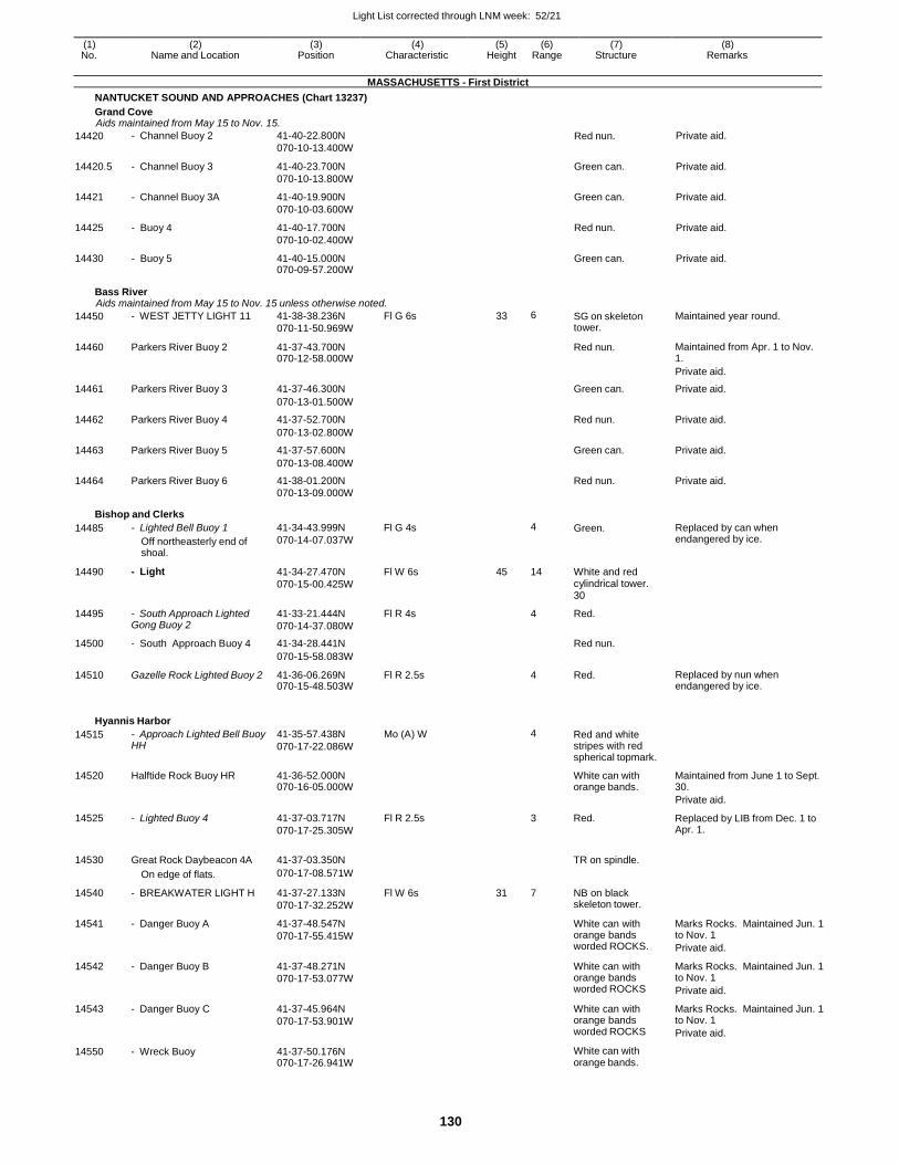
Light List corrected through LNM week: 52/21
130
(1) (2) (3) (4) (5) (6) (7) (8) No. Name and Location Position Characteristic Height Range Structure Remarks
MASSACHUSETTS - First District
NANTUCKET SOUND AND APPROACHES (Chart 13237)
Grand Cove Aids maintained from May 15 to Nov. 15.
14420 - Channel Buoy 2 41-40-22.800N
070-10-13.400W Red nun. Private aid.
14420.5 - Channel Buoy 3 41-40-23.700N
070-10-13.800W
Green can. Private aid.
14421 - Channel Buoy 3A 41-40-19.900N
070-10-03.600W
Green can. Private aid.
14425 - Buoy 4 41-40-17.700N
070-10-02.400W
Red nun. Private aid.
14430 - Buoy 5 41-40-15.000N 070-09-57.200W
Green can. Private aid.
Bass River Aids maintained from May 15 to Nov. 15 unless otherwise noted.
14450 - WEST JETTY LIGHT 11 41-38-38.236N
070-11-50.969W
Fl G 6s 33 6 SG on skeleton tower.
Maintained year round.
14460 Parkers River Buoy 2 41-37-43.700N 070-12-58.000W
Red nun. Maintained from Apr. 1 to Nov. 1.
Private aid.
14461 Parkers River Buoy 3 41-37-46.300N Green can. Private aid.
070-13-01.500W
14462 Parkers River Buoy 4 41-37-52.700N Red nun. Private aid.
070-13-02.800W
14463 Parkers River Buoy 5 41-37-57.600N Green can. Private aid.
070-13-08.400W
14464 Parkers River Buoy 6 41-38-01.200N Red nun. Private aid. 070-13-09.000W
Bishop and Clerks
14485 - Lighted Bell Buoy 1
Off northeasterly end of shoal.
41-34-43.999N
070-14-07.037W
Fl G 4s 4 Green. Replaced by can when endangered by ice.
14490 - Light 41-34-27.470N
070-15-00.425W
Fl W 6s 45 14 White and red cylindrical tower. 30
14495 - South Approach Lighted Gong Buoy 2
41-33-21.444N
070-14-37.080W
Fl R 4s 4 Red.
14500 - South Approach Buoy 4 41-34-28.441N Red nun.
070-15-58.083W
14510 Gazelle Rock Lighted Buoy 2 41-36-06.269N 070-15-48.503W
Fl R 2.5s 4 Red. Replaced by nun when endangered by ice.
Hyannis Harbor
14515 - Approach Lighted Bell Buoy HH
41-35-57.438N
070-17-22.086W
Mo (A) W 4 Red and white stripes with red spherical topmark.
14520 Halftide Rock Buoy HR 41-36-52.000N 070-16-05.000W
White can with orange bands.
Maintained from June 1 to Sept. 30.
Private aid.
14525 - Lighted Buoy 4 41-37-03.717N
070-17-25.305W
Fl R 2.5s 3 Red. Replaced by LIB from Dec. 1 to Apr. 1.
14530 Great Rock Daybeacon 4A 41-37-03.350N
TR on spindle.
On edge of flats. 070-17-08.571W
14540 - BREAKWATER LIGHT H 41-37-27.133N
070-17-32.252W
Fl W 6s 31 7 NB on black skeleton tower.
14541 - Danger Buoy A 41-37-48.547N
070-17-55.415W
White can with orange bands worded ROCKS.
Marks Rocks. Maintained Jun. 1 to Nov. 1
Private aid.
14542 - Danger Buoy B 41-37-48.271N
070-17-53.077W
White can with orange bands worded ROCKS
Marks Rocks. Maintained Jun. 1 to Nov. 1
Private aid.
14543 - Danger Buoy C 41-37-45.964N
070-17-53.901W
White can with orange bands worded ROCKS
Marks Rocks. Maintained Jun. 1 to Nov. 1
Private aid.
14550 - Wreck Buoy 41-37-50.176N 070-17-26.941W
White can with orange bands.
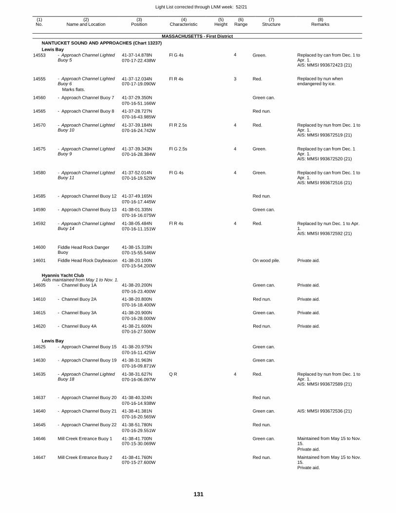
Light List corrected through LNM week: 52/21
131
(1) (2) (3) (4) (5) (6) (7) (8) No. Name and Location Position Characteristic Height Range Structure Remarks
MASSACHUSETTS - First District
NANTUCKET SOUND AND APPROACHES (Chart 13237)
Lewis Bay
14553 - Approach Channel Lighted Buoy 5
41-37-14.878N
070-17-22.438W
Fl G 4s 4 Green. Replaced by can from Dec. 1 to Apr. 1. AIS: MMSI 993672423 (21)
14555 - Approach Channel Lighted Buoy 6
41-37-12.034N 070-17-19.090W
Fl R 4s 3 Red. Replaced by nun when endangered by ice.
Marks flats.
14560 - Approach Channel Buoy 7 41-37-29.350N
Green can.
070-16-51.166W
14565 - Approach Channel Buoy 8 41-37-28.727N Red nun.
070-16-43.985W
14570 - Approach Channel Lighted Buoy 10
41-37-39.184N
070-16-24.742W
Fl R 2.5s 4 Red. Replaced by nun from Dec. 1 to Apr. 1. AIS: MMSI 993672519 (21)
14575 - Approach Channel Lighted Buoy 9
41-37-39.343N
070-16-28.384W
Fl G 2.5s 4 Green. Replaced by can from Dec. 1 Apr. 1. AIS: MMSI 993672520 (21)
14580 - Approach Channel Lighted Buoy 11
41-37-52.014N
070-16-19.520W
Fl G 4s 4 Green. Replaced by can from Dec. 1 to Apr. 1. AIS: MMSI 993672516 (21)
14585 - Approach Channel Buoy 12 41-37-49.165N
Red nun.
070-16-17.445W
14590 - Approach Channel Buoy 13 41-38-01.335N Green can.
070-16-16.075W
14592 - Approach Channel Lighted Buoy 14
41-38-05.484N
070-16-11.151W
Fl R 4s 4 Red. Replaced by nun Dec. 1 to Apr. 1. AIS: MMSI 993672592 (21)
14600 Fiddle Head Rock Danger Buoy
41-38-15.318N
070-15-55.546W
14601 Fiddle Head Rock Daybeacon 41-38-20.100N On wood pile. Private aid. 070-15-54.200W
Hyannis Yacht Club Aids maintained from May 1 to Nov. 1.
14605 - Channel Buoy 1A 41-38-20.200N Green can. Private aid.
070-16-23.400W
14610 - Channel Buoy 2A 41-38-20.800N Red nun. Private aid.
070-16-18.400W
14615 - Channel Buoy 3A 41-38-20.900N Green can. Private aid.
070-16-28.000W
14620 - Channel Buoy 4A 41-38-21.600N Red nun. Private aid. 070-16-27.500W
Lewis Bay
14625 - Approach Channel Buoy 15 41-38-20.975N Green can.
070-16-11.425W
14630 - Approach Channel Buoy 19 41-38-31.963N Green can.
070-16-09.871W
14635 - Approach Channel Lighted Buoy 18
41-38-31.627N
070-16-06.097W
Q R 4 Red. Replaced by nun from Dec. 1 to Apr. 1. AIS: MMSI 993672589 (21)
14637 - Approach Channel Buoy 20 41-38-40.324N
Red nun.
070-16-14.938W
14640 - Approach Channel Buoy 21 41-38-41.381N Green can. AIS: MMSI 993672536 (21)
070-16-20.565W
14645 - Approach Channel Buoy 22 41-38-51.780N Red nun.
070-16-29.551W
14646 Mill Creek Entrance Buoy 1 41-38-41.700N 070-15-30.069W
Green can. Maintained from May 15 to Nov. 15.
Private aid.
14647 Mill Creek Entrance Buoy 2 41-38-41.760N 070-15-27.600W
Red nun. Maintained from May 15 to Nov. 15.
Private aid.
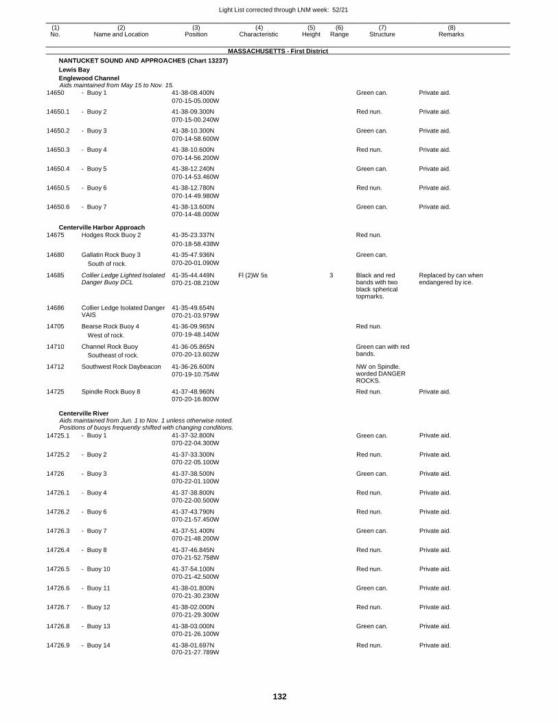
Light List corrected through LNM week: 52/21
132
(1) (2) (3) (4) (5) (6) (7) (8) No. Name and Location Position Characteristic Height Range Structure Remarks
MASSACHUSETTS - First District
NANTUCKET SOUND AND APPROACHES (Chart 13237)
Lewis Bay
Englewood Channel Aids maintained from May 15 to Nov. 15.
14650 - Buoy 1 41-38-08.400N Green can. Private aid.
070-15-05.000W
14650.1 - Buoy 2 41-38-09.300N Red nun. Private aid.
070-15-00.240W
14650.2 - Buoy 3 41-38-10.300N Green can. Private aid.
070-14-58.600W
14650.3 - Buoy 4 41-38-10.600N Red nun. Private aid.
070-14-56.200W
14650.4 - Buoy 5 41-38-12.240N Green can. Private aid.
070-14-53.460W
14650.5 - Buoy 6 41-38-12.780N Red nun. Private aid.
070-14-49.980W
14650.6 - Buoy 7 41-38-13.600N Green can. Private aid. 070-14-48.000W
Centerville Harbor Approach
14675 Hodges Rock Buoy 2 41-35-23.337N Red nun.
070-18-58.438W
14680 Gallatin Rock Buoy 3 41-35-47.936N Green can.
South of rock. 070-20-01.090W
14685 Collier Ledge Lighted Isolated Danger Buoy DCL
41-35-44.449N
070-21-08.210W
Fl (2)W 5s 3 Black and red bands with two black spherical topmarks.
Replaced by can when endangered by ice.
14686 Collier Ledge Isolated Danger VAIS
41-35-49.654N
070-21-03.979W
14705 Bearse Rock Buoy 4 41-36-09.965N Red nun.
West of rock. 070-19-48.140W
14710 Channel Rock Buoy
Southeast of rock.
41-36-05.865N
070-20-13.602W
Green can with red bands.
14712 Southwest Rock Daybeacon 41-36-26.600N
070-19-10.754W
NW on Spindle. worded DANGER ROCKS.
14725 Spindle Rock Buoy 8 41-37-48.960N Red nun. Private aid. 070-20-16.800W
Centerville River Aids maintained from Jun. 1 to Nov. 1 unless otherwise noted. Positions of buoys frequently shifted with changing conditions.
14725.1 - Buoy 1 41-37-32.800N
070-22-04.300W Green can. Private aid.
14725.2 - Buoy 2 41-37-33.300N
070-22-05.100W
Red nun. Private aid.
14726 - Buoy 3 41-37-38.500N
070-22-01.100W
Green can. Private aid.
14726.1 - Buoy 4 41-37-38.800N
070-22-00.500W
Red nun. Private aid.
14726.2 - Buoy 6 41-37-43.790N
070-21-57.450W
Red nun. Private aid.
14726.3 - Buoy 7 41-37-51.400N
070-21-48.200W
Green can. Private aid.
14726.4 - Buoy 8 41-37-46.845N
070-21-52.758W
Red nun. Private aid.
14726.5 - Buoy 10 41-37-54.100N
070-21-42.500W
Red nun. Private aid.
14726.6 - Buoy 11 41-38-01.800N
070-21-30.230W
Green can. Private aid.
14726.7 - Buoy 12 41-38-02.000N
070-21-29.300W
Red nun. Private aid.
14726.8 - Buoy 13 41-38-03.000N
070-21-26.100W
Green can. Private aid.
14726.9 - Buoy 14 41-38-01.697N 070-21-27.789W
Red nun. Private aid.
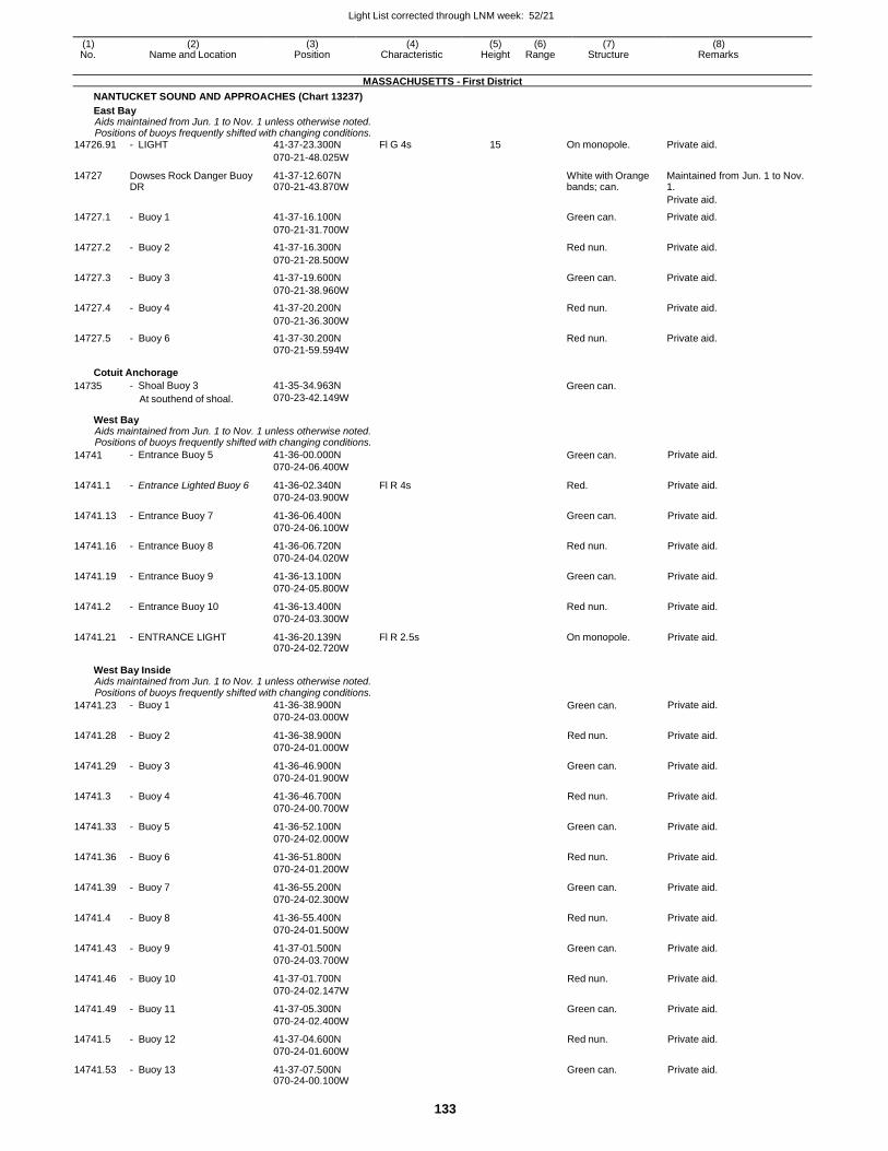
Light List corrected through LNM week: 52/21
133
(1) (2) (3) (4) (5) (6) (7) (8) No. Name and Location Position Characteristic Height Range Structure Remarks
MASSACHUSETTS - First District
NANTUCKET SOUND AND APPROACHES (Chart 13237)
East Bay Aids maintained from Jun. 1 to Nov. 1 unless otherwise noted. Positions of buoys frequently shifted with changing conditions.
14726.91 - LIGHT 41-37-23.300N Fl G 4s 15 On monopole. Private aid.
070-21-48.025W
14727 Dowses Rock Danger Buoy DR
41-37-12.607N 070-21-43.870W
White with Orange bands; can.
Maintained from Jun. 1 to Nov. 1.
Private aid.
14727.1 - Buoy 1 41-37-16.100N Green can. Private aid.
070-21-31.700W
14727.2 - Buoy 2 41-37-16.300N Red nun. Private aid.
070-21-28.500W
14727.3 - Buoy 3 41-37-19.600N Green can. Private aid.
070-21-38.960W
14727.4 - Buoy 4 41-37-20.200N Red nun. Private aid.
070-21-36.300W
14727.5 - Buoy 6 41-37-30.200N Red nun. Private aid. 070-21-59.594W
Cotuit Anchorage
14735 - Shoal Buoy 3
At southend of shoal.
41-35-34.963N
070-23-42.149W Green can.
West Bay Aids maintained from Jun. 1 to Nov. 1 unless otherwise noted. Positions of buoys frequently shifted with changing conditions.
14741 - Entrance Buoy 5 41-36-00.000N
070-24-06.400W
Green can. Private aid.
14741.1 - Entrance Lighted Buoy 6 41-36-02.340N
070-24-03.900W
Fl R 4s Red. Private aid.
14741.13 - Entrance Buoy 7 41-36-06.400N
070-24-06.100W
Green can. Private aid.
14741.16 - Entrance Buoy 8 41-36-06.720N
070-24-04.020W
Red nun. Private aid.
14741.19 - Entrance Buoy 9 41-36-13.100N
070-24-05.800W
Green can. Private aid.
14741.2 - Entrance Buoy 10 41-36-13.400N
070-24-03.300W
Red nun. Private aid.
14741.21 - ENTRANCE LIGHT 41-36-20.139N 070-24-02.720W
Fl R 2.5s On monopole. Private aid.
West Bay Inside Aids maintained from Jun. 1 to Nov. 1 unless otherwise noted. Positions of buoys frequently shifted with changing conditions.
14741.23 - Buoy 1 41-36-38.900N
070-24-03.000W Green can. Private aid.
14741.28 - Buoy 2 41-36-38.900N
070-24-01.000W
Red nun. Private aid.
14741.29 - Buoy 3 41-36-46.900N
070-24-01.900W
Green can. Private aid.
14741.3 - Buoy 4 41-36-46.700N
070-24-00.700W
Red nun. Private aid.
14741.33 - Buoy 5 41-36-52.100N
070-24-02.000W
Green can. Private aid.
14741.36 - Buoy 6 41-36-51.800N
070-24-01.200W
Red nun. Private aid.
14741.39 - Buoy 7 41-36-55.200N
070-24-02.300W
Green can. Private aid.
14741.4 - Buoy 8 41-36-55.400N
070-24-01.500W
Red nun. Private aid.
14741.43 - Buoy 9 41-37-01.500N
070-24-03.700W
Green can. Private aid.
14741.46 - Buoy 10 41-37-01.700N
070-24-02.147W
Red nun. Private aid.
14741.49 - Buoy 11 41-37-05.300N
070-24-02.400W
Green can. Private aid.
14741.5 - Buoy 12 41-37-04.600N
070-24-01.600W
Red nun. Private aid.
14741.53 - Buoy 13 41-37-07.500N 070-24-00.100W
Green can. Private aid.
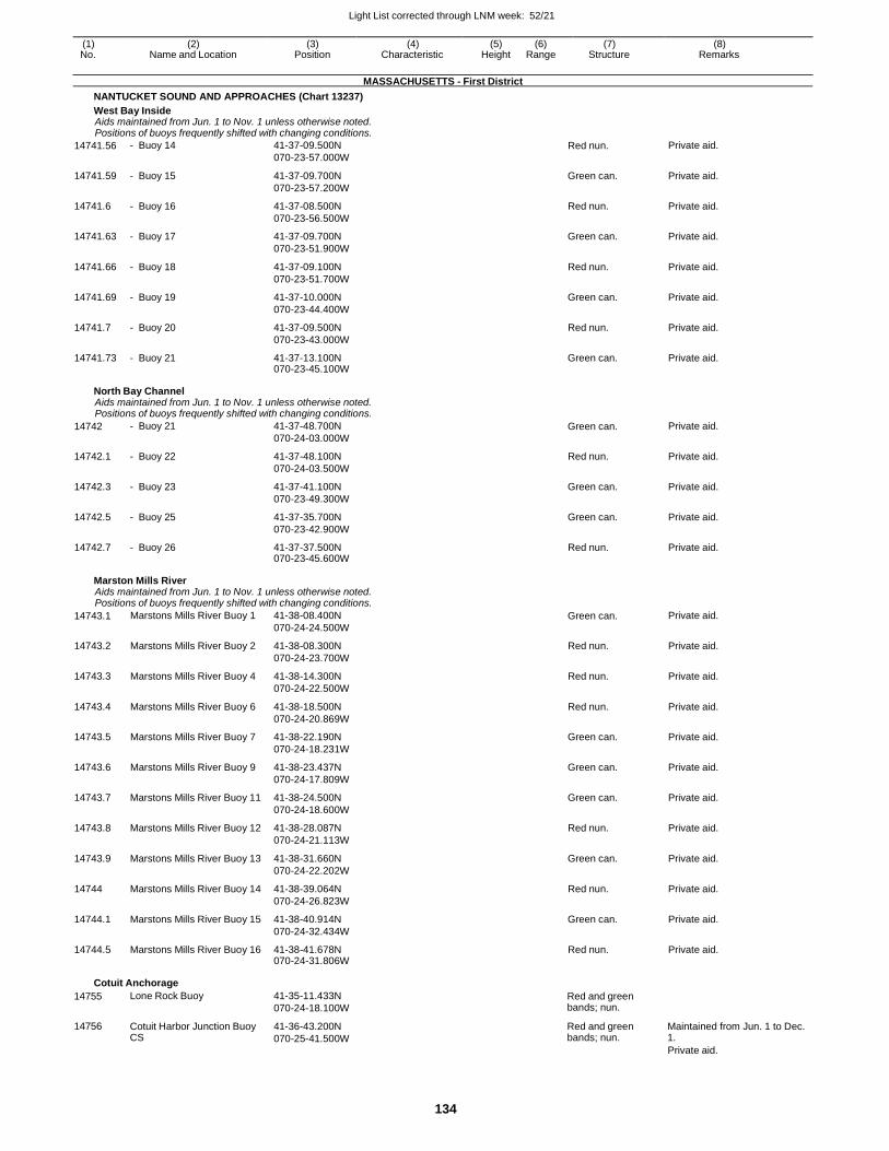
Light List corrected through LNM week: 52/21
134
(1) (2) (3) (4) (5) (6) (7) (8) No. Name and Location Position Characteristic Height Range Structure Remarks
MASSACHUSETTS - First District
NANTUCKET SOUND AND APPROACHES (Chart 13237)
West Bay Inside Aids maintained from Jun. 1 to Nov. 1 unless otherwise noted. Positions of buoys frequently shifted with changing conditions.
14741.56 - Buoy 14 41-37-09.500N
070-23-57.000W Red nun. Private aid.
14741.59 - Buoy 15 41-37-09.700N
070-23-57.200W
Green can. Private aid.
14741.6 - Buoy 16 41-37-08.500N
070-23-56.500W
Red nun. Private aid.
14741.63 - Buoy 17 41-37-09.700N
070-23-51.900W
Green can. Private aid.
14741.66 - Buoy 18 41-37-09.100N
070-23-51.700W
Red nun. Private aid.
14741.69 - Buoy 19 41-37-10.000N
070-23-44.400W
Green can. Private aid.
14741.7 - Buoy 20 41-37-09.500N
070-23-43.000W
Red nun. Private aid.
14741.73 - Buoy 21 41-37-13.100N 070-23-45.100W
Green can. Private aid.
North Bay Channel Aids maintained from Jun. 1 to Nov. 1 unless otherwise noted. Positions of buoys frequently shifted with changing conditions.
14742 - Buoy 21 41-37-48.700N
070-24-03.000W Green can. Private aid.
14742.1 - Buoy 22 41-37-48.100N
070-24-03.500W
Red nun. Private aid.
14742.3 - Buoy 23 41-37-41.100N
070-23-49.300W
Green can. Private aid.
14742.5 - Buoy 25 41-37-35.700N
070-23-42.900W
Green can. Private aid.
14742.7 - Buoy 26 41-37-37.500N 070-23-45.600W
Red nun. Private aid.
Marston Mills River Aids maintained from Jun. 1 to Nov. 1 unless otherwise noted. Positions of buoys frequently shifted with changing conditions.
14743.1 Marstons Mills River Buoy 1 41-38-08.400N
070-24-24.500W
Green can. Private aid.
14743.2 Marstons Mills River Buoy 2 41-38-08.300N
070-24-23.700W
Red nun. Private aid.
14743.3 Marstons Mills River Buoy 4 41-38-14.300N
070-24-22.500W
Red nun. Private aid.
14743.4 Marstons Mills River Buoy 6 41-38-18.500N
070-24-20.869W
Red nun. Private aid.
14743.5 Marstons Mills River Buoy 7 41-38-22.190N
070-24-18.231W
Green can. Private aid.
14743.6 Marstons Mills River Buoy 9 41-38-23.437N
070-24-17.809W
Green can. Private aid.
14743.7 Marstons Mills River Buoy 11 41-38-24.500N
070-24-18.600W
Green can. Private aid.
14743.8 Marstons Mills River Buoy 12 41-38-28.087N
070-24-21.113W
Red nun. Private aid.
14743.9 Marstons Mills River Buoy 13 41-38-31.660N
070-24-22.202W
Green can. Private aid.
14744 Marstons Mills River Buoy 14 41-38-39.064N
070-24-26.823W
Red nun. Private aid.
14744.1 Marstons Mills River Buoy 15 41-38-40.914N
070-24-32.434W
Green can. Private aid.
14744.5 Marstons Mills River Buoy 16 41-38-41.678N 070-24-31.806W
Red nun. Private aid.
Cotuit Anchorage
14755
14756
Lone Rock Buoy
Cotuit Harbor Junction Buoy CS
41-35-11.433N
070-24-18.100W
41-36-43.200N
070-25-41.500W
Red and green bands; nun.
Red and green bands; nun.
Maintained from Jun. 1 to Dec. 1.
Private aid.
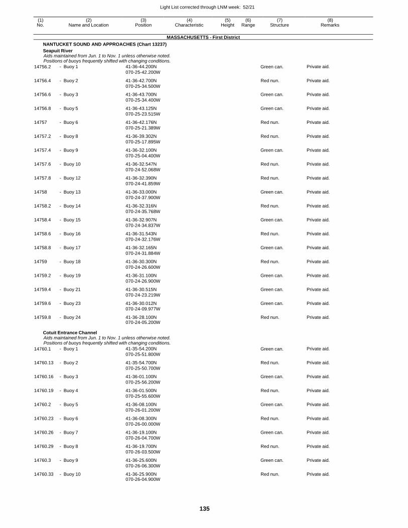
Light List corrected through LNM week: 52/21
135
(1) (2) (3) (4) (5) (6) (7) (8) No. Name and Location Position Characteristic Height Range Structure Remarks
MASSACHUSETTS - First District
NANTUCKET SOUND AND APPROACHES (Chart 13237)
Seapuit River Aids maintained from Jun. 1 to Nov. 1 unless otherwise noted. Positions of buoys frequently shifted with changing conditions.
14756.2 - Buoy 1 41-36-44.200N
070-25-42.200W Green can. Private aid.
14756.4 - Buoy 2 41-36-42.700N
070-25-34.500W
Red nun. Private aid.
14756.6 - Buoy 3 41-36-43.700N
070-25-34.400W
Green can. Private aid.
14756.8 - Buoy 5 41-36-43.125N
070-25-23.515W
Green can. Private aid.
14757 - Buoy 6 41-36-42.176N
070-25-21.389W
Red nun. Private aid.
14757.2 - Buoy 8 41-36-39.302N
070-25-17.895W
Red nun. Private aid.
14757.4 - Buoy 9 41-36-32.100N
070-25-04.400W
Green can. Private aid.
14757.6 - Buoy 10 41-36-32.547N
070-24-52.068W
Red nun. Private aid.
14757.8 - Buoy 12 41-36-32.390N
070-24-41.859W
Red nun. Private aid.
14758 - Buoy 13 41-36-33.000N
070-24-37.900W
Green can. Private aid.
14758.2 - Buoy 14 41-36-32.316N
070-24-35.768W
Red nun. Private aid.
14758.4 - Buoy 15 41-36-32.907N
070-24-34.837W
Green can. Private aid.
14758.6 - Buoy 16 41-36-31.543N
070-24-32.176W
Red nun. Private aid.
14758.8 - Buoy 17 41-36-32.165N
070-24-31.884W
Green can. Private aid.
14759 - Buoy 18 41-36-30.300N
070-24-26.600W
Red nun. Private aid.
14759.2 - Buoy 19 41-36-31.100N
070-24-26.900W
Green can. Private aid.
14759.4 - Buoy 21 41-36-30.515N
070-24-23.219W
Green can. Private aid.
14759.6 - Buoy 23 41-36-30.012N
070-24-09.977W
Green can. Private aid.
14759.8 - Buoy 24 41-36-28.100N 070-24-05.200W
Red nun. Private aid.
Cotuit Entrance Channel Aids maintained from Jun. 1 to Nov. 1 unless otherwise noted. Positions of buoys frequently shifted with changing conditions.
14760.1 - Buoy 1 41-35-54.200N
070-25-51.800W Green can. Private aid.
14760.13 - Buoy 2 41-35-54.700N
070-25-50.700W
Red nun. Private aid.
14760.16 - Buoy 3 41-36-01.100N
070-25-56.200W
Green can. Private aid.
14760.19 - Buoy 4 41-36-01.500N
070-25-55.600W
Red nun. Private aid.
14760.2 - Buoy 5 41-36-08.100N
070-26-01.200W
Green can. Private aid.
14760.23 - Buoy 6 41-36-08.300N
070-26-00.000W
Red nun. Private aid.
14760.26 - Buoy 7 41-36-19.100N
070-26-04.700W
Green can. Private aid.
14760.29 - Buoy 8 41-36-19.700N
070-26-03.500W
Red nun. Private aid.
14760.3 - Buoy 9 41-36-25.600N
070-26-06.300W
Green can. Private aid.
14760.33 - Buoy 10 41-36-25.900N 070-26-04.900W
Red nun. Private aid.
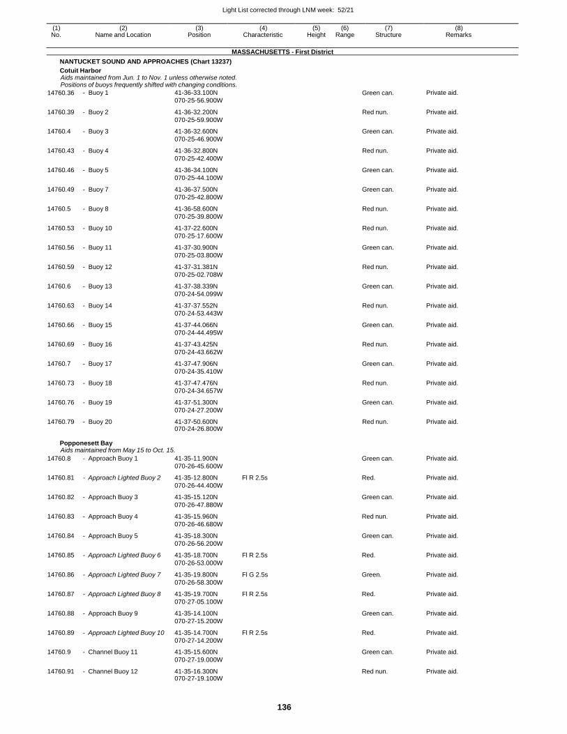
Light List corrected through LNM week: 52/21
136
(1) (2) (3) (4) (5) (6) (7) (8) No. Name and Location Position Characteristic Height Range Structure Remarks
MASSACHUSETTS - First District
NANTUCKET SOUND AND APPROACHES (Chart 13237)
Cotuit Harbor Aids maintained from Jun. 1 to Nov. 1 unless otherwise noted. Positions of buoys frequently shifted with changing conditions.
14760.36 - Buoy 1 41-36-33.100N
070-25-56.900W Green can. Private aid.
14760.39 - Buoy 2 41-36-32.200N
070-25-59.900W
Red nun. Private aid.
14760.4 - Buoy 3 41-36-32.600N
070-25-46.900W
Green can. Private aid.
14760.43 - Buoy 4 41-36-32.800N
070-25-42.400W
Red nun. Private aid.
14760.46 - Buoy 5 41-36-34.100N
070-25-44.100W
Green can. Private aid.
14760.49 - Buoy 7 41-36-37.500N
070-25-42.800W
Green can. Private aid.
14760.5 - Buoy 8 41-36-58.600N
070-25-39.800W
Red nun. Private aid.
14760.53 - Buoy 10 41-37-22.600N
070-25-17.600W
Red nun. Private aid.
14760.56 - Buoy 11 41-37-30.900N
070-25-03.800W
Green can. Private aid.
14760.59 - Buoy 12 41-37-31.381N
070-25-02.708W
Red nun. Private aid.
14760.6 - Buoy 13 41-37-38.339N
070-24-54.099W
Green can. Private aid.
14760.63 - Buoy 14 41-37-37.552N
070-24-53.443W
Red nun. Private aid.
14760.66 - Buoy 15 41-37-44.066N
070-24-44.495W
Green can. Private aid.
14760.69 - Buoy 16 41-37-43.425N
070-24-43.662W
Red nun. Private aid.
14760.7 - Buoy 17 41-37-47.906N
070-24-35.410W
Green can. Private aid.
14760.73 - Buoy 18 41-37-47.476N
070-24-34.657W
Red nun. Private aid.
14760.76 - Buoy 19 41-37-51.300N
070-24-27.200W
Green can. Private aid.
14760.79 - Buoy 20 41-37-50.600N 070-24-26.800W
Red nun. Private aid.
Popponesett Bay Aids maintained from May 15 to Oct. 15.
14760.8 - Approach Buoy 1 41-35-11.900N
070-26-45.600W
Green can. Private aid.
14760.81 - Approach Lighted Buoy 2 41-35-12.800N
070-26-44.400W
Fl R 2.5s Red. Private aid.
14760.82 - Approach Buoy 3 41-35-15.120N
070-26-47.880W
Green can. Private aid.
14760.83 - Approach Buoy 4 41-35-15.960N
070-26-46.680W
Red nun. Private aid.
14760.84 - Approach Buoy 5 41-35-18.300N
070-26-56.200W
Green can. Private aid.
14760.85 - Approach Lighted Buoy 6 41-35-18.700N
070-26-53.000W
Fl R 2.5s Red. Private aid.
14760.86 - Approach Lighted Buoy 7 41-35-19.800N
070-26-58.300W
Fl G 2.5s Green. Private aid.
14760.87 - Approach Lighted Buoy 8 41-35-19.700N
070-27-05.100W
Fl R 2.5s Red. Private aid.
14760.88 - Approach Buoy 9 41-35-14.100N
070-27-15.200W
Green can. Private aid.
14760.89 - Approach Lighted Buoy 10 41-35-14.700N
070-27-14.200W
Fl R 2.5s Red. Private aid.
14760.9 - Channel Buoy 11 41-35-15.600N
070-27-19.000W
Green can. Private aid.
14760.91 - Channel Buoy 12 41-35-16.300N 070-27-19.100W
Red nun. Private aid.
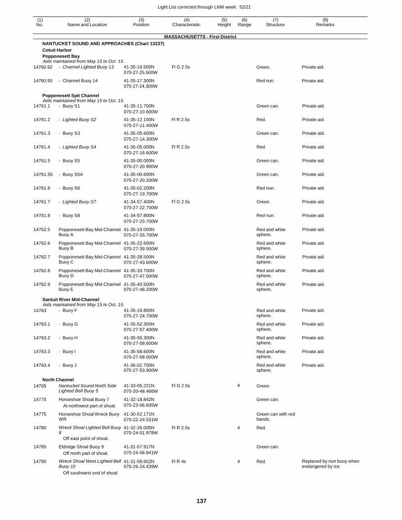
Light List corrected through LNM week: 52/21
137
(1) (2) (3) (4) (5) (6) (7) (8) No. Name and Location Position Characteristic Height Range Structure Remarks
MASSACHUSETTS - First District
NANTUCKET SOUND AND APPROACHES (Chart 13237)
Cotuit Harbor
Popponesett Bay Aids maintained from May 15 to Oct. 15.
14760.92
14760.93
- Channel Lighted Buoy 13
- Channel Buoy 14
41-35-16.500N
070-27-25.500W
41-35-17.300N
070-27-24.300W
Fl G 2.5s Green.
Red nun.
Private aid.
Private aid.
Popponesett Spit Channel Aids maintained from May 15 to Oct. 15.
14761.1 - Buoy S1 41-35-11.700N Green can. Private aid.
070-27-10.600W
14761.2 - Lighted Buoy S2 41-35-12.100N Fl R 2.5s Red. Private aid.
070-27-11.400W
14761.3 - Buoy S3 41-35-05.600N Green can. Private aid.
070-27-14.300W
14761.4 - Lighted Buoy S4 41-35-05.000N Fl R 2.5s Red. Private aid.
070-27-16.600W
14761.5 - Buoy S5 41-35-00.000N Green can. Private aid.
070-27-20.900W
14761.55 - Buoy S5A 41-35-00.600N Green can. Private aid.
070-27-20.200W
14761.6 - Buoy S6 41-35-02.200N Red nun. Private aid.
070-27-19.700W
14761.7 - Lighted Buoy S7 41-34-57.400N Fl G 2.5s Green. Private aid.
070-27-22.700W
14761.8 - Buoy S8 41-34-57.800N Red nun. Private aid.
070-27-23.700W
14762.5 Popponesett Bay Mid-Channel Buoy A
41-35-19.000N
070-27-33.700W
Red and white sphere.
Private aid.
14762.6 Popponesett Bay Mid-Channel Buoy B
41-35-22.600N
070-27-39.500W
Red and white sphere.
Private aid.
14762.7 Popponesett Bay Mid-Channel Buoy C
41-35-28.500N
070-27-43.600W
Red and white sphere.
Private aid.
14762.8 Popponesett Bay Mid-Channel Buoy D
41-35-33.700N
070-27-47.000W
Red and white sphere.
Private aid.
14762.9 Popponesett Bay Mid-Channel Buoy E
41-35-40.500N 070-27-48.200W
Red and white sphere.
Private aid.
Santuit River Mid-Channel Aids maintained from May 15 to Oct. 15.
14763 - Buoy F 41-35-16.800N
070-27-24.700W Red and white sphere.
Private aid.
14763.1 - Buoy G 41-35-52.300N
070-27-57.400W
Red and white sphere.
Private aid.
14763.2 - Buoy H 41-35-55.300N
070-27-58.600W
Red and white sphere.
Private aid.
14763.3 - Buoy I 41-35-58.600N
070-27-58.000W
Red and white sphere.
Private aid.
14763.4 - Buoy J 41-36-02.700N 070-27-53.900W
Red and white sphere.
Private aid.
North Channel
14765 Nantucket Sound North Side Lighted Bell Buoy 5
41-33-05.221N
070-20-48.466W
Fl G 2.5s 4 Green.
14770 Horseshoe Shoal Buoy 7 41-32-18.842N Green can.
At northwest part of shoal. 070-23-06.835W
14775 Horseshoe Shoal Wreck Buoy WR
41-30-52.171N
070-22-24.531W
Green can with red bands.
14780 Wreck Shoal Lighted Bell Buoy 8
41-32-26.005N 070-24-01.978W
Fl R 2.5s 4 Red.
Off east point of shoal.
14785 Eldridge Shoal Buoy 9 41-31-57.917N
Green can.
Off north part of shoal. 070-24-58.841W
14790 Wreck Shoal West Lighted Bell Buoy 10
41-31-58.652N 070-26-24.439W
Fl R 4s 4 Red. Replaced by nun buoy when endangered by ice.
Off southwest end of shoal.
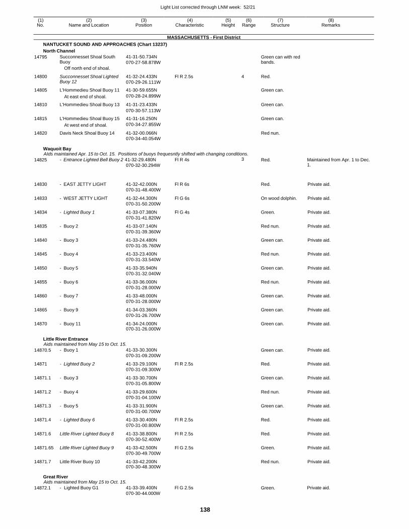
Light List corrected through LNM week: 52/21
138
(1) (2) (3) (4) (5) (6) (7) (8) No. Name and Location Position Characteristic Height Range Structure Remarks
MASSACHUSETTS - First District
NANTUCKET SOUND AND APPROACHES (Chart 13237)
North Channel
14795 Succonnesset Shoal South Buoy
Off north end of shoal.
41-31-50.734N
070-27-58.878W
Green can with red bands.
14800 Succonnesset Shoal Lighted Buoy 12
41-32-24.433N
070-29-26.111W
Fl R 2.5s 4 Red.
14805 L'Hommedieu Shoal Buoy 11 41-30-59.655N Green can.
At east end of shoal. 070-28-24.899W
14810 L'Hommedieu Shoal Buoy 13 41-31-23.433N Green can.
070-30-57.113W
14815 L'Hommedieu Shoal Buoy 15 41-31-16.250N Green can.
At west end of shoal. 070-34-27.855W
14820 Davis Neck Shoal Buoy 14 41-32-00.066N Red nun. 070-34-40.054W
Waquoit Bay AIds maintained Apr. 15 to Oct. 15. Positions of buoys frequesntly shifted with changing conditions.
14825 - Entrance Lighted Bell Buoy 2 41-32-29.480N
070-32-30.294W
Fl R 4s 3 Red. Maintained from Apr. 1 to Dec. 1.
14830 - EAST JETTY LIGHT 41-32-42.000N
070-31-48.400W
Fl R 6s Red. Private aid.
14833 - WEST JETTY LIGHT 41-32-44.300N
070-31-50.200W
Fl G 6s On wood dolphin. Private aid.
14834 - Lighted Buoy 1 41-33-07.380N
070-31-41.820W
Fl G 4s Green. Private aid.
14835 - Buoy 2 41-33-07.140N
070-31-39.360W
Red nun. Private aid.
14840 - Buoy 3 41-33-24.480N
070-31-35.760W
Green can. Private aid.
14845 - Buoy 4 41-33-23.400N
070-31-33.540W
Red nun. Private aid.
14850 - Buoy 5 41-33-35.940N
070-31-32.040W
Green can. Private aid.
14855 - Buoy 6 41-33-36.000N
070-31-28.000W
Red nun. Private aid.
14860 - Buoy 7 41-33-48.000N
070-31-28.000W
Green can. Private aid.
14865 - Buoy 9 41-34-03.360N
070-31-26.700W
Green can. Private aid.
14870 - Buoy 11 41-34-24.000N 070-31-26.000W
Green can. Private aid.
Little River Entrance Aids maintained from May 15 to Oct. 15.
14870.5 - Buoy 1 41-33-30.300N
070-31-09.200W
Green can. Private aid.
14871 - Lighted Buoy 2 41-33-29.100N
070-31-09.300W
Fl R 2.5s Red. Private aid.
14871.1 - Buoy 3 41-33-30.700N
070-31-05.800W
Green can. Private aid.
14871.2 - Buoy 4 41-33-29.600N
070-31-04.100W
Red nun. Private aid.
14871.3 - Buoy 5 41-33-31.900N
070-31-00.700W
Green can. Private aid.
14871.4 - Lighted Buoy 6 41-33-30.400N
070-31-00.800W
Fl R 2.5s Red. Private aid.
14871.6 Little River Lighted Buoy 8 41-33-38.800N
070-30-52.400W
Fl R 2.5s Red. Private aid.
14871.65 Little River Lighted Buoy 9 41-33-42.500N
070-30-49.700W
Fl G 2.5s Green. Private aid.
14871.7 Little River Buoy 10 41-33-42.200N 070-30-48.300W
Red nun. Private aid.
Great River Aids maintained from May 15 to Oct. 15.
14872.1 - Lighted Buoy G1 41-33-39.400N
070-30-44.000W
Fl G 2.5s Green. Private aid.
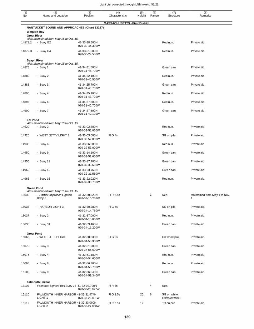
Light List corrected through LNM week: 52/21
139
(1) (2) (3) (4) (5) (6) (7) (8) No. Name and Location Position Characteristic Height Range Structure Remarks
MASSACHUSETTS - First District
NANTUCKET SOUND AND APPROACHES (Chart 13237)
Waquoit Bay
Great River Aids maintained from May 15 to Oct. 15.
14872.2 - Buoy G2 41-33-38.500N
070-30-44.300W Red nun. Private aid.
14872.3 - Buoy G4 41-33-51.500N 070-30-24.500W
Red nun. Private aid.
Seapit River Aids Maintained from May 15 to Oct. 15.
14875 - Buoy 1 41-34-21.500N
070-31-46.700W Green can. Private aid.
14880 - Buoy 2 41-34-22.100N
070-31-45.500W
Red nun. Private aid.
14885 - Buoy 3 41-34-25.700N
070-31-43.700W
Green can. Private aid.
14890 - Buoy 4 41-34-25.100N
070-31-43.700W
Red nun. Private aid.
14895 - Buoy 6 41-34-27.800N
070-31-40.700W
Red nun. Private aid.
14900 - Buoy 7 41-34-27.500N 070-31-40.100W
Green can. Private aid.
Eel Pond Aids maintained from May 15 to Oct. 15.
14920 - Buoy 2 41-33-02.580N Red nun. Private aid.
070-32-51.060W
14925 - WEST JETTY LIGHT 3 41-33-03.000N Fl G 4s SG on pile. Private aid.
070-32-52.000W
14935 - Buoy 6 41-33-06.000N Red nun. Private aid.
070-32-53.000W
14950 - Buoy 9 41-33-14.100N Green can. Private aid.
070-32-52.600W
14955 - Buoy 11 41-33-17.700N Green can. Private aid.
070-32-36.600W
14965 - Buoy 15 41-33-23.760N Green can. Private aid.
070-32-31.560W
14966 - Buoy 16 41-33-22.920N Red nun. Private aid. 070-32-30.780W
Green Pond Aids maintained from May 15 to Oct. 15.
15030 - Harbor Approach Lighted Buoy 2
41-32-38.523N
070-34-10.258W
Fl R 2.5s 3 Red. Maintained from May 1 to Nov. 1.
15035 - HARBOR LIGHT 3 41-32-50.280N Fl G 4s
SG on pile. Private aid.
070-34-14.760W
15037 - Buoy 2 41-32-57.000N Red nun. Private aid.
070-34-15.000W
15038 - Buoy 3A 41-32-59.460N Green can. Private aid. 070-34-16.200W
Great Pond 15065 - WEST JETTY LIGHT 41-32-38.530N Fl G 3s On wood pile. Private aid.
070-34-50.350W
15070 - Buoy 3 41-32-51.200N Green can. Private aid.
070-34-55.600W
15075 - Buoy 4 41-32-51.180N Red nun. Private aid.
070-34-54.600W
15095 - Buoy 8 41-32-56.300N Red nun. Private aid.
070-34-58.700W
15100 - Buoy 9 41-32-56.040N Green can. Private aid. 070-34-59.340W
Falmouth Harbor
15105 Falmouth Lighted Bell Buoy 16 41-32-02.798N
070-36-28.997W
Fl R 6s 4 Red.
15110 FALMOUTH INNER HARBOR 41-32-31.474N LIGHT 1 070-36-29.831W
Fl G 2.5s 25 6 SG on white skeleton tower.
15112 FALMOUTH INNER HARBOR 41-32-33.000N LIGHT 2 070-36-27.000W
Fl R 2.5s 12 TR on pile. Private aid.
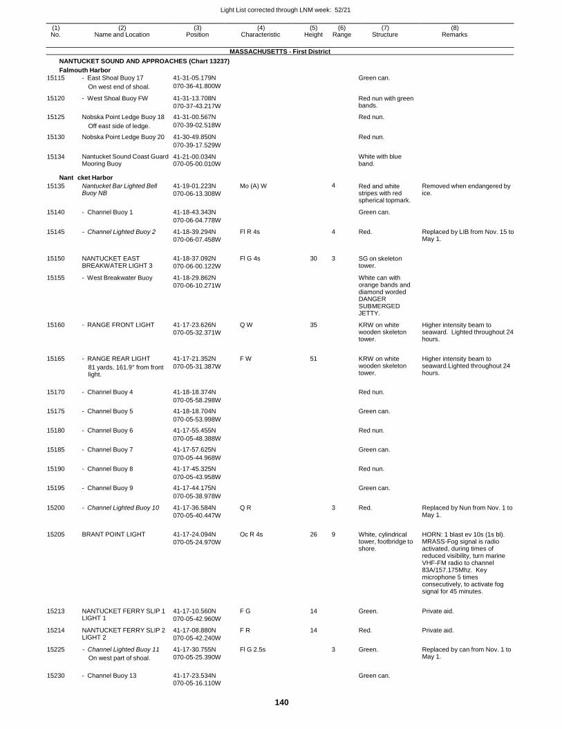
Light List corrected through LNM week: 52/21
140
(1) (2) (3) (4) (5) (6) (7) (8) No. Name and Location Position Characteristic Height Range Structure Remarks
MASSACHUSETTS - First District
NANTUCKET SOUND AND APPROACHES (Chart 13237)
Falmouth Harbor
15115 - East Shoal Buoy 17 41-31-05.179N Green can.
On west end of shoal. 070-36-41.800W
15120 - West Shoal Buoy FW 41-31-13.708N
070-37-43.217W
Red nun with green bands.
15125 Nobska Point Ledge Buoy 18 41-31-00.567N Red nun.
Off east side of ledge. 070-39-02.518W
15130 Nobska Point Ledge Buoy 20 41-30-49.850N Red nun.
070-39-17.529W
15134 Nantucket Sound Coast Guard Mooring Buoy
41-21-00.034N 070-05-00.010W
White with blue band.
Nantu
15135
cket Harbor
Nantucket Bar Lighted Bell Buoy NB
41-19-01.223N
070-06-13.308W
Mo (A) W
4
Red and white stripes with red spherical topmark.
Removed when endangered by ice.
15140 - Channel Buoy 1 41-18-43.343N Green can.
070-06-04.778W
15145 - Channel Lighted Buoy 2 41-18-39.294N
070-06-07.458W
Fl R 4s 4 Red. Replaced by LIB from Nov. 15 to May 1.
15150 NANTUCKET EAST BREAKWATER LIGHT 3
41-18-37.092N
070-06-00.122W
Fl G 4s 30 3 SG on skeleton tower.
15155 - West Breakwater Buoy 41-18-29.862N
070-06-10.271W
White can with orange bands and diamond worded DANGER SUBMERGED JETTY.
15160 - RANGE FRONT LIGHT 41-17-23.626N
070-05-32.371W
Q W 35 KRW on white wooden skeleton tower.
Higher intensity beam to seaward. Lighted throughout 24 hours.
15165 - RANGE REAR LIGHT
81 yards, 161.9° from front light.
41-17-21.352N
070-05-31.387W
F W 51
KRW on white wooden skeleton tower.
Higher intensity beam to seaward.Lighted throughout 24 hours.
15170 - Channel Buoy 4 41-18-18.374N
Red nun.
070-05-58.298W
15175 - Channel Buoy 5 41-18-18.704N Green can.
070-05-53.998W
15180 - Channel Buoy 6 41-17-55.455N Red nun.
070-05-48.388W
15185 - Channel Buoy 7 41-17-57.625N Green can.
070-05-44.968W
15190 - Channel Buoy 8 41-17-45.325N Red nun.
070-05-43.958W
15195 - Channel Buoy 9 41-17-44.175N Green can.
070-05-38.978W
15200 - Channel Lighted Buoy 10 41-17-36.584N
070-05-40.447W
Q R 3 Red. Replaced by Nun from Nov. 1 to May 1.
15205 BRANT POINT LIGHT 41-17-24.094N
070-05-24.970W
Oc R 4s 26 9 White, cylindrical tower, footbridge to shore.
HORN: 1 blast ev 10s (1s bl). MRASS-Fog signal is radio activated, during times of reduced visibility, turn marine VHF-FM radio to channel 83A/157.175Mhz. Key microphone 5 times consecutively, to activate fog signal for 45 minutes.
15213 NANTUCKET FERRY SLIP 1 LIGHT 1
41-17-10.560N
070-05-42.960W
F G 14
Green. Private aid.
15214 NANTUCKET FERRY SLIP 2 LIGHT 2
41-17-08.880N
070-05-42.240W
F R 14 Red. Private aid.
15225 - Channel Lighted Buoy 11
On west part of shoal.
41-17-30.755N
070-05-25.390W
Fl G 2.5s 3 Green. Replaced by can from Nov. 1 to May 1.
15230 - Channel Buoy 13 41-17-23.534N
Green can.
070-05-16.110W
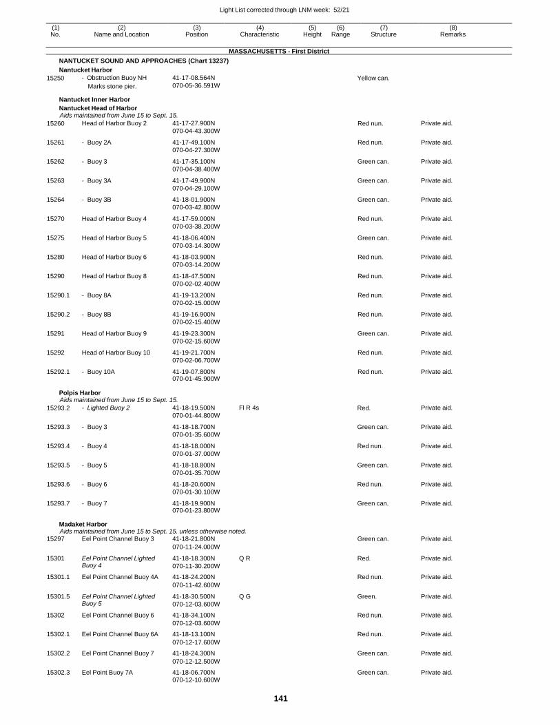
Light List corrected through LNM week: 52/21
141
(1) (2) (3) (4) (5) (6) (7) (8) No. Name and Location Position Characteristic Height Range Structure Remarks
MASSACHUSETTS - First District
NANTUCKET SOUND AND APPROACHES (Chart 13237)
Nantucket Harbor
15250 - Obstruction Buoy NH
Marks stone pier.
41-17-08.564N
070-05-36.591W Yellow can.
Nantucket Inner Harbor
Nantucket Head of Harbor Aids maintained from June 15 to Sept. 15.
15260 Head of Harbor Buoy 2 41-17-27.900N
070-04-43.300W Red nun. Private aid.
15261 - Buoy 2A 41-17-49.100N
070-04-27.300W
Red nun. Private aid.
15262 - Buoy 3 41-17-35.100N
070-04-38.400W
Green can. Private aid.
15263 - Buoy 3A 41-17-49.900N
070-04-29.100W
Green can. Private aid.
15264 - Buoy 3B 41-18-01.900N
070-03-42.800W
Green can. Private aid.
15270 Head of Harbor Buoy 4 41-17-59.000N
070-03-38.200W
Red nun. Private aid.
15275 Head of Harbor Buoy 5 41-18-06.400N
070-03-14.300W
Green can. Private aid.
15280 Head of Harbor Buoy 6 41-18-03.900N
070-03-14.200W
Red nun. Private aid.
15290 Head of Harbor Buoy 8 41-18-47.500N
070-02-02.400W
Red nun. Private aid.
15290.1 - Buoy 8A 41-19-13.200N
070-02-15.000W
Red nun. Private aid.
15290.2 - Buoy 8B 41-19-16.900N
070-02-15.400W
Red nun. Private aid.
15291 Head of Harbor Buoy 9 41-19-23.300N
070-02-15.600W
Green can. Private aid.
15292 Head of Harbor Buoy 10 41-19-21.700N
070-02-06.700W
Red nun. Private aid.
15292.1 - Buoy 10A 41-19-07.800N 070-01-45.900W
Red nun. Private aid.
Polpis Harbor Aids maintained from June 15 to Sept. 15.
15293.2 - Lighted Buoy 2 41-18-19.500N
070-01-44.800W
Fl R 4s Red. Private aid.
15293.3 - Buoy 3 41-18-18.700N
070-01-35.600W
Green can. Private aid.
15293.4 - Buoy 4 41-18-18.000N
070-01-37.000W
Red nun. Private aid.
15293.5 - Buoy 5 41-18-18.800N
070-01-35.700W
Green can. Private aid.
15293.6 - Buoy 6 41-18-20.600N
070-01-30.100W
Red nun. Private aid.
15293.7 - Buoy 7 41-18-19.900N 070-01-23.800W
Green can. Private aid.
Madaket Harbor Aids maintained from June 15 to Sept. 15. unless otherwise noted.
15297 Eel Point Channel Buoy 3 41-18-21.800N Green can. Private aid.
070-11-24.000W
15301 Eel Point Channel Lighted Buoy 4
41-18-18.300N
070-11-30.200W
Q R Red. Private aid.
15301.1 Eel Point Channel Buoy 4A 41-18-24.200N Red nun. Private aid.
070-11-42.600W
15301.5 Eel Point Channel Lighted Buoy 5
41-18-30.500N
070-12-03.600W
Q G Green. Private aid.
15302 Eel Point Channel Buoy 6 41-18-34.100N Red nun. Private aid.
070-12-03.600W
15302.1 Eel Point Channel Buoy 6A 41-18-13.100N Red nun. Private aid.
070-12-17.600W
15302.2 Eel Point Channel Buoy 7 41-18-24.300N Green can. Private aid.
070-12-12.500W
15302.3 Eel Point Buoy 7A 41-18-06.700N Green can. Private aid. 070-12-10.600W
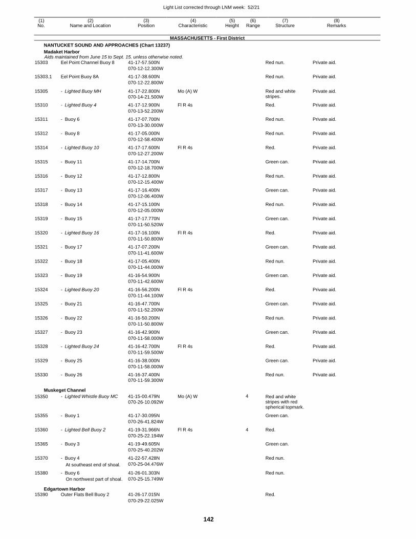
Light List corrected through LNM week: 52/21
142
(1) (2) (3) (4) (5) (6) (7) (8) No. Name and Location Position Characteristic Height Range Structure Remarks
MASSACHUSETTS - First District
NANTUCKET SOUND AND APPROACHES (Chart 13237)
Madaket Harbor Aids maintained from June 15 to Sept. 15. unless otherwise noted.
15303 Eel Point Channel Buoy 8 41-17-57.500N Red nun. Private aid.
070-12-12.300W
15303.1 Eel Point Buoy 8A 41-17-38.600N Red nun. Private aid.
070-12-22.800W
15305 - Lighted Buoy MH 41-17-22.800N
070-14-21.500W
Mo (A) W Red and white stripes.
Private aid.
15310 - Lighted Buoy 4 41-17-12.900N Fl R 4s Red. Private aid.
070-13-52.200W
15311 - Buoy 6 41-17-07.700N Red nun. Private aid.
070-13-30.000W
15312 - Buoy 8 41-17-05.000N Red nun. Private aid.
070-12-58.400W
15314 - Lighted Buoy 10 41-17-17.600N Fl R 4s Red. Private aid.
070-12-27.200W
15315 - Buoy 11 41-17-14.700N Green can. Private aid.
070-12-18.700W
15316 - Buoy 12 41-17-12.800N Red nun. Private aid.
070-12-15.400W
15317 - Buoy 13 41-17-16.400N Green can. Private aid.
070-12-06.400W
15318 - Buoy 14 41-17-15.100N Red nun. Private aid.
070-12-05.000W
15319 - Buoy 15 41-17-17.770N Green can. Private aid.
070-11-50.520W
15320 - Lighted Buoy 16 41-17-16.100N Fl R 4s Red. Private aid.
070-11-50.800W
15321 - Buoy 17 41-17-07.200N Green can. Private aid.
070-11-41.600W
15322 - Buoy 18 41-17-05.400N Red nun. Private aid.
070-11-44.000W
15323 - Buoy 19 41-16-54.900N Green can. Private aid.
070-11-42.600W
15324 - Lighted Buoy 20 41-16-56.200N Fl R 4s Red. Private aid.
070-11-44.100W
15325 - Buoy 21 41-16-47.700N Green can. Private aid.
070-11-52.200W
15326 - Buoy 22 41-16-50.200N Red nun. Private aid.
070-11-50.800W
15327 - Buoy 23 41-16-42.900N Green can. Private aid.
070-11-58.000W
15328 - Lighted Buoy 24 41-16-42.700N Fl R 4s Red. Private aid.
070-11-59.500W
15329 - Buoy 25 41-16-38.000N Green can. Private aid.
070-11-58.000W
15330 - Buoy 26 41-16-37.400N Red nun. Private aid. 070-11-59.300W
Muskeget Channel
15350 - Lighted Whistle Buoy MC 41-15-00.479N
070-26-10.092W
Mo (A) W 4 Red and white stripes with red spherical topmark.
15355 - Buoy 1 41-17-30.095N Green can.
070-26-41.824W
15360 - Lighted Bell Buoy 2 41-19-31.966N Fl R 4s 4 Red.
070-25-22.194W
15365 - Buoy 3 41-19-49.605N Green can.
070-25-40.202W
15370 - Buoy 4 41-22-57.428N Red nun.
At southeast end of shoal. 070-25-04.476W
15380 - Buoy 6 41-26-01.303N Red nun. On northwest part of shoal. 070-25-15.749W
Edgartown Harbor 15390 Outer Flats Bell Buoy 2 41-26-17.015N Red.
070-29-22.025W
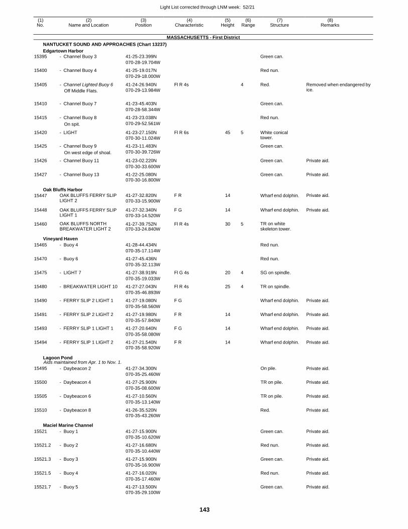
Light List corrected through LNM week: 52/21
143
(1) (2) (3) (4) (5) (6) (7) (8) No. Name and Location Position Characteristic Height Range Structure Remarks
MASSACHUSETTS - First District
NANTUCKET SOUND AND APPROACHES (Chart 13237)
Edgartown Harbor
15395 - Channel Buoy 3 41-25-23.399N Green can.
070-28-19.704W
15400 - Channel Buoy 4 41-25-19.017N Red nun.
070-29-18.000W
15405 - Channel Lighted Buoy 6
Off Middle Flats.
41-24-26.940N
070-29-13.984W
Fl R 4s 4 Red. Removed when endangered by ice.
15410 - Channel Buoy 7 41-23-45.403N
Green can.
070-28-58.344W
15415 - Channel Buoy 8 41-23-23.038N Red nun.
On spit. 070-29-52.561W
15420 - LIGHT 41-23-27.150N
070-30-11.024W
Fl R 6s 45 5 White conical tower.
15425 - Channel Buoy 9 41-23-11.483N Green can.
On west edge of shoal. 070-30-39.726W
15426 - Channel Buoy 11 41-23-02.220N Green can. Private aid.
070-30-33.600W
15427 - Channel Buoy 13 41-22-25.080N Green can. Private aid. 070-30-16.800W
Oak Bluffs Harbor
15447 OAK BLUFFS FERRY SLIP LIGHT 2
41-27-32.820N
070-33-15.900W
F R 14 Wharf end dolphin. Private aid.
15448 OAK BLUFFS FERRY SLIP LIGHT 1
41-27-32.340N
070-33-14.520W
F G 14 Wharf end dolphin. Private aid.
15460 OAK BLUFFS NORTH BREAKWATER LIGHT 2
41-27-39.752N 070-33-24.840W
Fl R 4s 30 5 TR on white skeleton tower.
Vineyard Haven
15465 - Buoy 4 41-28-44.434N Red nun.
070-35-17.114W
15470 - Buoy 6 41-27-45.436N Red nun.
070-35-32.113W
15475 - LIGHT 7 41-27-38.919N Fl G 4s 20 4 SG on spindle.
070-35-19.033W
15480 - BREAKWATER LIGHT 10 41-27-27.043N Fl R 4s 25 4 TR on spindle.
070-35-46.893W
15490 - FERRY SLIP 2 LIGHT 1 41-27-19.080N F G Wharf end dolphin. Private aid.
070-35-58.560W
15491 - FERRY SLIP 2 LIGHT 2 41-27-19.980N F R 14 Wharf end dolphin. Private aid.
070-35-57.840W
15493 - FERRY SLIP 1 LIGHT 1 41-27-20.640N F G 14 Wharf end dolphin. Private aid.
070-35-58.080W
15494 - FERRY SLIP 1 LIGHT 2 41-27-21.540N F R 14 Wharf end dolphin. Private aid. 070-35-58.920W
Lagoon Pond Aids maintained from Apr. 1 to Nov. 1.
15495 - Daybeacon 2 41-27-34.300N On pile. Private aid.
070-35-25.460W
15500 - Daybeacon 4 41-27-25.900N TR on pile. Private aid.
070-35-08.600W
15505 - Daybeacon 6 41-27-10.560N TR on pile. Private aid.
070-35-13.140W
15510 - Daybeacon 8 41-26-35.520N Red. Private aid. 070-35-43.260W
Maciel Marine Channel
15521 - Buoy 1 41-27-15.900N Green can. Private aid.
070-35-10.620W
15521.2 - Buoy 2 41-27-16.680N Red nun. Private aid.
070-35-10.440W
15521.3 - Buoy 3 41-27-15.900N Green can. Private aid.
070-35-16.900W
15521.5 - Buoy 4 41-27-16.020N Red nun. Private aid.
070-35-17.460W
15521.7 - Buoy 5 41-27-13.500N Green can. Private aid. 070-35-29.100W
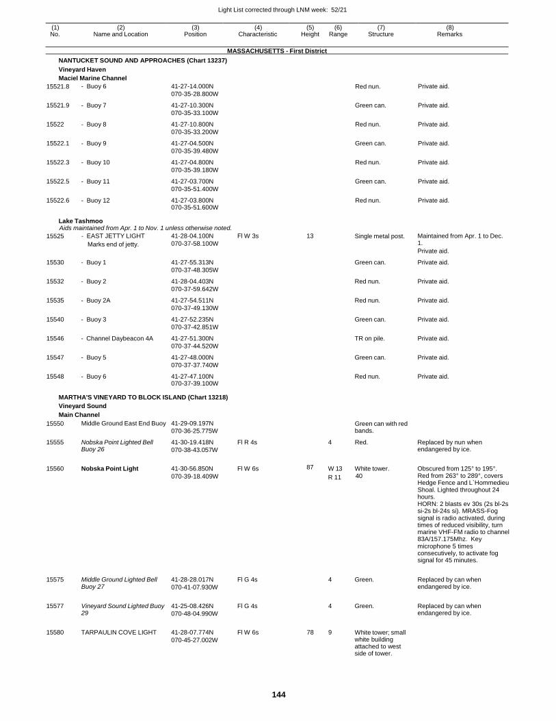
Light List corrected through LNM week: 52/21
144
(1) (2) (3) (4) (5) (6) (7) (8) No. Name and Location Position Characteristic Height Range Structure Remarks
MASSACHUSETTS - First District
NANTUCKET SOUND AND APPROACHES (Chart 13237)
Vineyard Haven
Maciel Marine Channel
15521.8 - Buoy 6 41-27-14.000N
070-35-28.800W Red nun. Private aid.
15521.9 - Buoy 7 41-27-10.300N
070-35-33.100W
Green can. Private aid.
15522 - Buoy 8 41-27-10.800N
070-35-33.200W
Red nun. Private aid.
15522.1 - Buoy 9 41-27-04.500N
070-35-39.480W
Green can. Private aid.
15522.3 - Buoy 10 41-27-04.800N
070-35-39.180W
Red nun. Private aid.
15522.5 - Buoy 11 41-27-03.700N
070-35-51.400W
Green can. Private aid.
15522.6 - Buoy 12 41-27-03.800N 070-35-51.600W
Red nun. Private aid.
Lake Tashmoo Aids maintained from Apr. 1 to Nov. 1 unless otherwise noted.
15525 - EAST JETTY LIGHT
Marks end of jetty.
41-28-04.100N
070-37-58.100W
Fl W 3s 13 Single metal post. Maintained from Apr. 1 to Dec. 1.
Private aid.
15530 - Buoy 1 41-27-55.313N
070-37-48.305W
Green can. Private aid.
15532 - Buoy 2 41-28-04.403N
070-37-59.642W
Red nun. Private aid.
15535 - Buoy 2A 41-27-54.511N
070-37-49.130W
Red nun. Private aid.
15540 - Buoy 3 41-27-52.235N
070-37-42.851W
Green can. Private aid.
15546 - Channel Daybeacon 4A 41-27-51.300N
070-37-44.520W
TR on pile. Private aid.
15547 - Buoy 5 41-27-48.000N
070-37-37.740W
Green can. Private aid.
15548 - Buoy 6 41-27-47.100N 070-37-39.100W
Red nun. Private aid.
MARTHA'S VINEYARD TO BLOCK ISLAND (Chart 13218)
Vineyard Sound
Main Channel
15550
15555
Middle Ground East End Buoy
Nobska Point Lighted Bell Buoy 26
41-29-09.197N
070-36-25.775W
41-30-19.418N
070-38-43.057W
Fl R 4s
Green can with red bands.
4 Red.
Replaced by nun when endangered by ice.
15560 Nobska Point Light 41-30-56.850N Fl W 6s 87 W 13 White tower. Obscured from 125° to 195°.
070-39-18.409W R 11 40 Red from 263° to 289°, covers Hedge Fence and L`Hommedieu Shoal. Lighted throughout 24 hours. HORN: 2 blasts ev 30s (2s bl-2s si-2s bl-24s si). MRASS-Fog signal is radio activated, during times of reduced visibility, turn marine VHF-FM radio to channel 83A/157.175Mhz. Key microphone 5 times consecutively, to activate fog signal for 45 minutes.
15575
15577
15580
Middle Ground Lighted Bell Buoy 27
Vineyard Sound Lighted Buoy 29
TARPAULIN COVE LIGHT
41-28-28.017N
070-41-07.930W
41-25-08.426N
070-48-04.990W
41-28-07.774N
070-45-27.002W
Fl G 4s
Fl G 4s
Fl W 6s
4
4
78 9
Green.
Green.
White tower; small white building attached to west side of tower.
Replaced by can when endangered by ice.
Replaced by can when endangered by ice.
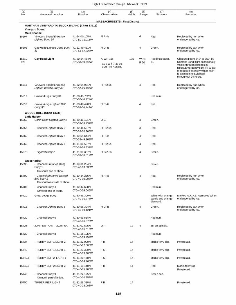
Light List corrected through LNM week: 52/21
145
(1) (2) (3) (4) (5) (6) (7) (8) No. Name and Location Position Characteristic Height Range Structure Remarks
MASSACHUSETTS - First District
MARTHA'S VINEYARD TO BLOCK ISLAND (Chart 13218)
Vineyard Sound
Main Channel
15597 Vineyard Sound Entrance Lighted Buoy 30
41-24-00.105N
070-50-11.015W
Fl R 4s 4 Red. Replaced by nun when endangered by ice.
15605 Gay Head Lighted Gong Buoy 31
41-21-49.431N
070-51-47.626W
Fl G 4s
4 Green. Replaced by can when endangered by ice.
15610 Gay Head Light 41-20-54.454N Al WR 15s 175
W 24 Red brick tower. Obscured from 342° to 359° by
620 070-50-03.687W 0.2 s W fl 7.3s ec. 0.2s R fl 7.3s ec.
R 20 51 Nomans Land; light occasionally visible through notches in hilltop.Emergency light (Fl W 6s) of reduced intensity when main is extinguished.Lighted throughout 24 hours.
15613
15617
15618
Vineyard Sound Entrance Lighted Whistle Buoy 32
Sow and Pigs Buoy 34
Sow and Pigs Lighted Bell Buoy 36
41-22-04.951N
070-57-25.102W
41-23-45.762N
070-57-46.371W
41-23-48.420N
070-59-04.143W
Fl R 2.5s
Fl R 4s
4 Red.
Red nun.
4 Red.
Replaced by nun when endangered by ice.
WOODS HOLE (Chart 13235)
Little Harbor
15650 Coffin Rock Lighted Buoy 1 41-30-41.401N Q G 3 Green.
070-39-38.437W
15655 - Channel Lighted Buoy 2 41-30-46.537N Fl R 2.5s 3 Red.
070-39-30.965W
15660 - Channel Lighted Buoy 4 41-30-54.644N Fl R 4s 4 Red.
070-39-49.263W
15665 - Channel Lighted Buoy 6 41-31-00.567N Fl R 2.5s 4 Red.
070-39-54.339W
15670 - Lighted Buoy 7 41-31-00.357N Fl G 2.5s 4 Green. 070-39-56.819W
Great Harbor
15695 - Channel Entrance Gong Buoy 1
41-30-31.234N 070-40-13.835W
Green.
On south end of shoal.
15700 - Channel Entrance Lighted Bell Buoy 2
41-30-34.236N 070-40-05.903W
Fl R 4s 4 Red. Replaced by nun when endangered by ice.
On southwest side of shoal.
15705 - Channel Buoy 4 41-30-42.628N
Red nun
Off west end of ledge. 070-40-09.045W
15710 Great Ledge Buoy 41-30-49.309N
070-40-01.376W
White with orange bands and orange diamond.
Marked ROCKS. Removed when endangered by ice.
15715 - Channel Lighted Buoy 5 41-30-56.394N
070-40-19.421W
Fl G 4s 4 Green. Replaced by can when endangered by ice.
15720 - Channel Buoy 6 41-30-59.514N
Red nun.
070-40-06.573W
15725 JUNIPER POINT LIGHT 6A 41-31-02.626N Q R 12 4 TR on spindle.
070-40-05.618W
15730 - Channel Buoy 8 41-31-15.105N Red nun.
070-40-19.759W
15737 - FERRY SLIP 1 LIGHT 2 41-31-22.000N F R 14 Marks ferry slip. Private aid.
070-40-17.000W
15740 - FERRY SLIP 1 LIGHT 1 41-31-23.300N F G 14 Marks ferry slip. Private aid.
070-40-15.900W
15740.8 - FERRY SLIP 2 LIGHT 1 41-31-20.460N F G 14 Marks ferry slip. Private aid.
070-40-14.760W
15740.9 - FERRY SLIP 2 LIGHT 2 41-31-19.140N F R 14 Red Marks ferry slip.
070-40-15.480W Private aid.
15745 - Channel Buoy 9 41-31-22.125N Green can.
On north part of ledge. 070-40-30.959W
15750 TIMBER PIER LIGHT 41-31-28.398N F R 14 Private aid. 070-40-23.008W
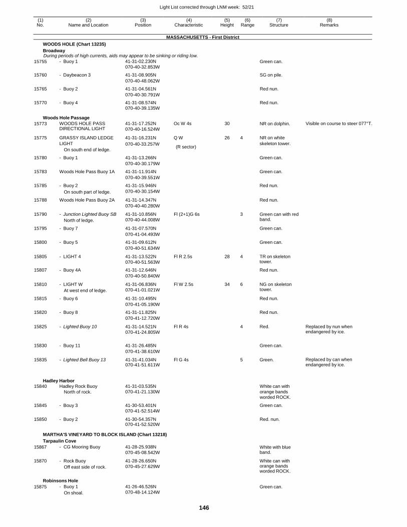
Light List corrected through LNM week: 52/21
146
(1) (2) (3) (4) (5) (6) (7) (8) No. Name and Location Position Characteristic Height Range Structure Remarks
MASSACHUSETTS - First District
WOODS HOLE (Chart 13235)
Broadway During periods of high currents, aids may appear to be sinking or riding low.
15755 - Buoy 1 41-31-02.230N
070-40-32.853W Green can.
15760 - Daybeacon 3 41-31-08.905N SG on pile.
070-40-48.062W
15765 - Buoy 2 41-31-04.561N Red nun.
070-40-30.791W
15770 - Buoy 4 41-31-08.574N Red nun. 070-40-39.135W
Woods Hole Passage
15773 WOODS HOLE PASS DIRECTIONAL LIGHT
41-31-17.252N
070-40-16.524W
Oc W 4s 30 NR on dolphin. Visible on course to steer 077°T.
15775 GRASSY ISLAND LEDGE 41-31-16.231N Q W 26 4 NR on white
LIGHT
On south end of ledge.
070-40-33.257W (R sector)
skeleton tower.
15780 - Buoy 1 41-31-13.266N Green can.
070-40-30.179W
15783 Woods Hole Pass Buoy 1A 41-31-11.914N Green can.
070-40-39.551W
15785 - Buoy 2 41-31-15.946N Red nun.
On south part of ledge. 070-40-30.154W
15788 Woods Hole Pass Buoy 2A 41-31-14.347N Red nun.
070-40-40.280W
15790 - Junction Lighted Buoy SB
North of ledge.
41-31-10.856N
070-40-44.008W
Fl (2+1)G 6s 3 Green can with red band.
15795 - Buoy 7 41-31-07.570N Green can.
070-41-04.493W
15800 - Buoy 5 41-31-09.612N Green can.
070-40-51.634W
15805 - LIGHT 4 41-31-13.522N
070-40-51.563W
Fl R 2.5s 28 4 TR on skeleton tower.
15807 - Buoy 4A 41-31-12.646N Red nun.
070-40-50.840W
15810 - LIGHT W
At west end of ledge.
41-31-06.836N
070-41-01.021W
Fl W 2.5s 34 6 NG on skeleton tower.
15815 - Buoy 6 41-31-10.495N Red nun.
070-41-05.190W
15820 - Buoy 8 41-31-11.825N Red nun.
070-41-12.720W
15825 - Lighted Buoy 10 41-31-14.521N
070-41-24.805W
Fl R 4s 4 Red. Replaced by nun when endangered by ice.
15830 - Buoy 11 41-31-26.485N
Green can.
070-41-38.610W
15835 - Lighted Bell Buoy 13 41-31-41.034N 070-41-51.611W
Fl G 4s 5 Green. Replaced by can when endangered by ice.
Hadley Harbor
15840 Hadley Rock Buoy 41-31-03.535N White can with North of rock. 070-41-21.130W orange bands worded ROCK.
15845 - Bouy 3 41-30-53.401N
070-41-52.514W
Green can.
15850 - Buoy 2 41-30-54.357N 070-41-52.520W
Red. nun.
MARTHA'S VINEYARD TO BLOCK ISLAND (Chart 13218)
Tarpaulin Cove
15867
15870
- CG Mooring Buoy
- Rock Buoy
Off east side of rock.
41-28-25.938N
070-45-08.542W
41-28-26.650N
070-45-27.629W
White with blue band.
White can with orange bands worded ROCK.
Robinsons Hole
15875 - Buoy 1
On shoal.
41-26-46.526N
070-48-14.124W Green can.
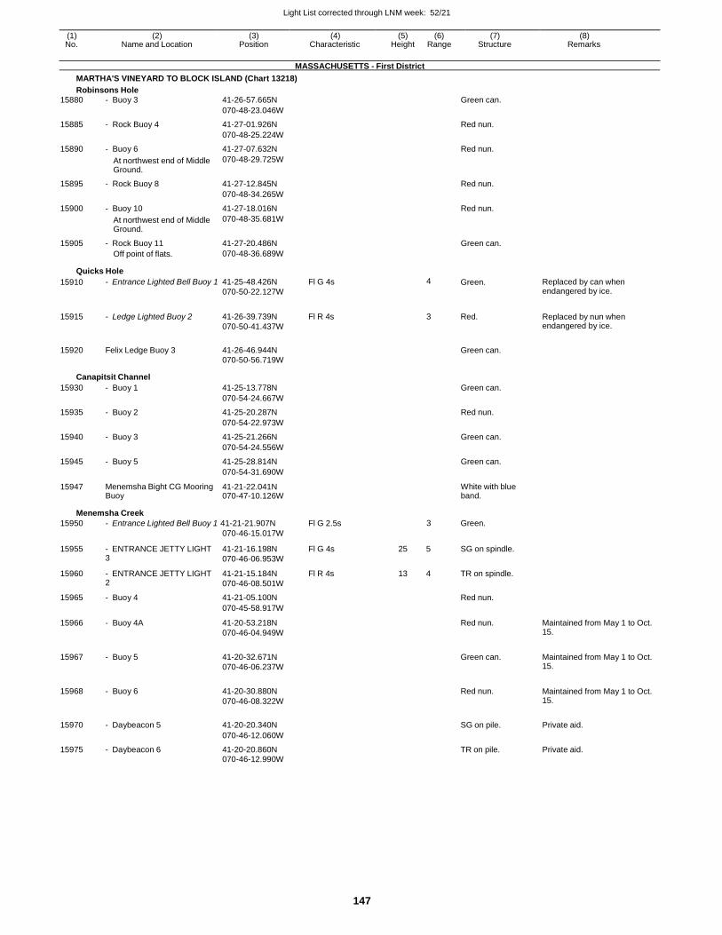
Light List corrected through LNM week: 52/21
147
(1) (2) (3) (4) (5) (6) (7) (8) No. Name and Location Position Characteristic Height Range Structure Remarks
MASSACHUSETTS - First District
MARTHA'S VINEYARD TO BLOCK ISLAND (Chart 13218)
Robinsons Hole
15880 - Buoy 3 41-26-57.665N Green can.
070-48-23.046W
15885 - Rock Buoy 4 41-27-01.926N Red nun.
070-48-25.224W
15890 - Buoy 6 41-27-07.632N Red nun.
At northwest end of Middle Ground.
070-48-29.725W
15895 - Rock Buoy 8 41-27-12.845N Red nun.
070-48-34.265W
15900 - Buoy 10 41-27-18.016N Red nun.
At northwest end of Middle Ground.
070-48-35.681W
15905 - Rock Buoy 11 41-27-20.486N Green can. Off point of flats. 070-48-36.689W
Quicks Hole
15910 - Entrance Lighted Bell Buoy 1 41-25-48.426N
070-50-22.127W
Fl G 4s 4 Green. Replaced by can when endangered by ice.
15915 - Ledge Lighted Buoy 2 41-26-39.739N
070-50-41.437W
Fl R 4s 3 Red. Replaced by nun when endangered by ice.
15920 Felix Ledge Buoy 3 41-26-46.944N
Green can.
070-50-56.719W
Canapitsit Channel
15930 - Buoy 1 41-25-13.778N Green can.
070-54-24.667W
15935 - Buoy 2 41-25-20.287N Red nun.
070-54-22.973W
15940 - Buoy 3 41-25-21.266N Green can.
070-54-24.556W
15945 - Buoy 5 41-25-28.814N Green can.
070-54-31.690W
15947 Menemsha Bight CG Mooring Buoy
41-21-22.041N 070-47-10.126W
White with blue band.
Menemsha Creek
15950 - Entrance Lighted Bell Buoy 1 41-21-21.907N Fl G 2.5s 3 Green. 070-46-15.017W
15955 - ENTRANCE JETTY LIGHT 3
41-21-16.198N
070-46-06.953W
Fl G 4s 25 5 SG on spindle.
15960 - ENTRANCE JETTY LIGHT 2
41-21-15.184N
070-46-08.501W
Fl R 4s 13 4 TR on spindle.
15965 - Buoy 4 41-21-05.100N Red nun.
070-45-58.917W
15966 - Buoy 4A 41-20-53.218N
070-46-04.949W
Red nun. Maintained from May 1 to Oct. 15.
15967 - Buoy 5 41-20-32.671N
070-46-06.237W
Green can. Maintained from May 1 to Oct.
15.
15968 - Buoy 6 41-20-30.880N
070-46-08.322W
Red nun. Maintained from May 1 to Oct.
15.
15970 - Daybeacon 5 41-20-20.340N
SG on pile. Private aid.
070-46-12.060W
15975 - Daybeacon 6 41-20-20.860N TR on pile. Private aid. 070-46-12.990W
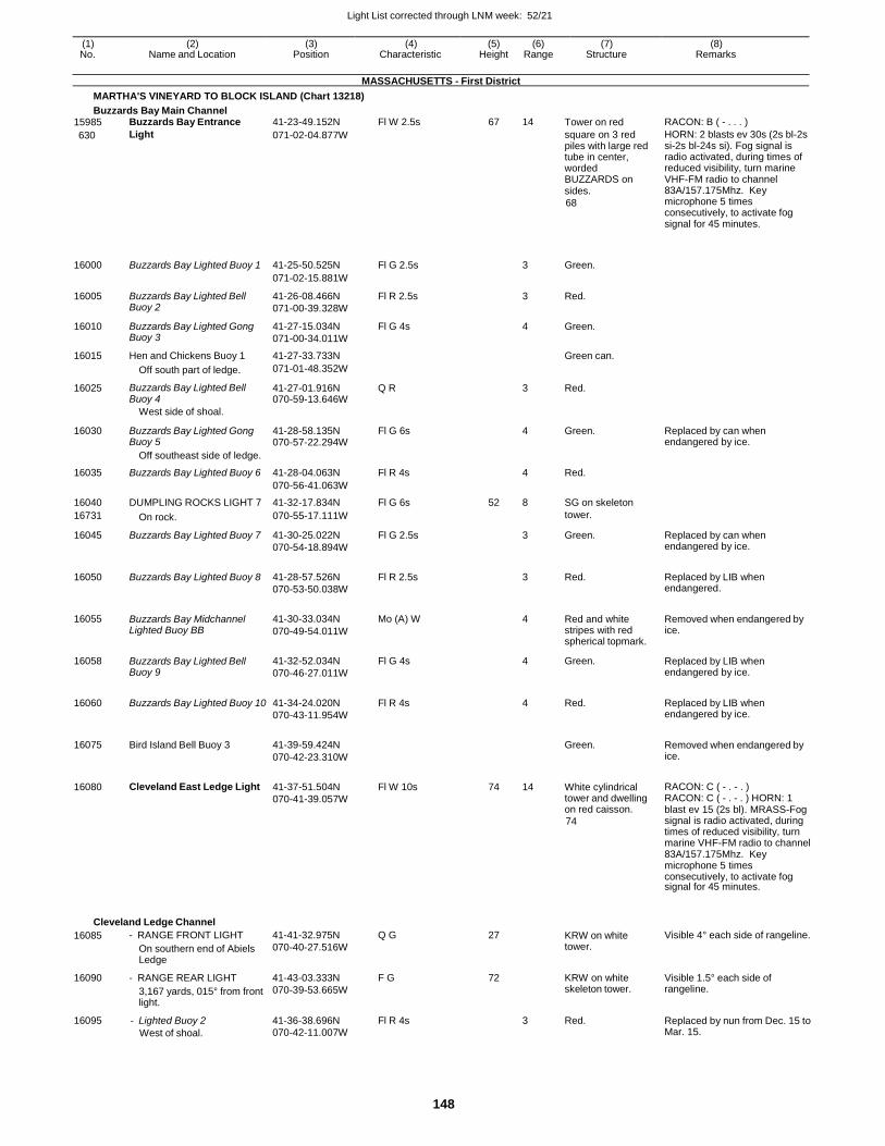
Light List corrected through LNM week: 52/21
148
(1) (2) (3) (4) (5) (6) (7) (8) No. Name and Location Position Characteristic Height Range Structure Remarks
MASSACHUSETTS - First District
MARTHA'S VINEYARD TO BLOCK ISLAND (Chart 13218)
Buzzards Bay Main Channel 15985 Buzzards Bay Entrance 41-23-49.152N Fl W 2.5s 67 14 Tower on red RACON: B ( - . . . )
630 Light 071-02-04.877W square on 3 red piles with large red tube in center, worded BUZZARDS on sides.
68
HORN: 2 blasts ev 30s (2s bl-2s si-2s bl-24s si). Fog signal is radio activated, during times of reduced visibility, turn marine VHF-FM radio to channel 83A/157.175Mhz. Key microphone 5 times consecutively, to activate fog signal for 45 minutes.
16000
Buzzards Bay Lighted Buoy 1
41-25-50.525N
Fl G 2.5s
3
Green.
071-02-15.881W
16005 Buzzards Bay Lighted Bell Buoy 2
41-26-08.466N
071-00-39.328W
Fl R 2.5s 3 Red.
16010 Buzzards Bay Lighted Gong Buoy 3
41-27-15.034N
071-00-34.011W
Fl G 4s 4 Green.
16015 Hen and Chickens Buoy 1 41-27-33.733N Green can.
Off south part of ledge. 071-01-48.352W
16025 Buzzards Bay Lighted Bell Buoy 4
41-27-01.916N 070-59-13.646W
Q R 3 Red.
West side of shoal.
16030 Buzzards Bay Lighted Gong Buoy 5
41-28-58.135N 070-57-22.294W
Fl G 6s
4 Green. Replaced by can when endangered by ice.
Off southeast side of ledge.
16035 Buzzards Bay Lighted Buoy 6 41-28-04.063N Fl R 4s 4 Red.
070-56-41.063W
16040 DUMPLING ROCKS LIGHT 7 41-32-17.834N Fl G 6s 52 8 SG on skeleton
16731 On rock. 070-55-17.111W tower.
16045 Buzzards Bay Lighted Buoy 7 41-30-25.022N
070-54-18.894W
Fl G 2.5s 3 Green. Replaced by can when endangered by ice.
16050 Buzzards Bay Lighted Buoy 8 41-28-57.526N
070-53-50.038W
Fl R 2.5s
3 Red. Replaced by LIB when endangered.
16055 Buzzards Bay Midchannel Lighted Buoy BB
41-30-33.034N
070-49-54.011W
Mo (A) W
4 Red and white stripes with red spherical topmark.
Removed when endangered by ice.
16058 Buzzards Bay Lighted Bell Buoy 9
41-32-52.034N
070-46-27.011W
Fl G 4s 4 Green. Replaced by LIB when endangered by ice.
16060 Buzzards Bay Lighted Buoy 10 41-34-24.020N
070-43-11.954W
Fl R 4s
4 Red. Replaced by LIB when endangered by ice.
16075 Bird Island Bell Buoy 3 41-39-59.424N
070-42-23.310W
Green. Removed when endangered by
ice.
16080 Cleveland East Ledge Light 41-37-51.504N
070-41-39.057W
Fl W 10s 74 14 White cylindrical tower and dwelling on red caisson.
74
RACON: C ( - . - . ) RACON: C ( - . - . ) HORN: 1 blast ev 15 (2s bl). MRASS-Fog signal is radio activated, during times of reduced visibility, turn marine VHF-FM radio to channel 83A/157.175Mhz. Key microphone 5 times consecutively, to activate fog signal for 45 minutes.
Cleveland Ledge Channel
16085 - RANGE FRONT LIGHT
On southern end of Abiels Ledge
41-41-32.975N
070-40-27.516W
Q G 27 KRW on white tower.
Visible 4° each side of rangeline.
16090 - RANGE REAR LIGHT
3,167 yards, 015° from front light.
41-43-03.333N
070-39-53.665W
F G 72 KRW on white skeleton tower.
Visible 1.5° each side of rangeline.
16095 - Lighted Buoy 2
West of shoal.
41-36-38.696N
070-42-11.007W
Fl R 4s 3 Red. Replaced by nun from Dec. 15 to Mar. 15.
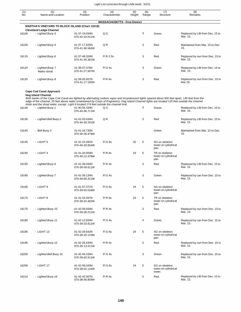
Light List corrected through LNM week: 52/21
149
(1) (2) (3) (4) (5) (6) (7) (8) No. Name and Location Position Characteristic Height Range Structure Remarks
MASSACHUSETTS - First District
MARTHA'S VINEYARD TO BLOCK ISLAND (Chart 13218)
Cleveland Ledge Channel
16100 - Lighted Buoy 3 41-37-19.034N
070-42-10.011W
Q G 3 Green. Replaced by LIB from Dec. 15 to Mar. 15.
16105 - Lighted Buoy 4 41-37-17.625N
070-41-56.564W
Q R 3 Red. Maintained from Mar. 15 to Dec. 15.
16115 - Lighted Buoy 6 41-37-48.324N
070-41-45.361W
Fl R 2.5s 3 Red. Replaced by nun from Dec. 15 to Mar. 15.
16120 - Lighted Buoy 7
Marks shoal.
41-39-07.076N
070-41-27.507W
Fl G 4s 3 Green. Replaced by LIB from Dec. 15 to Mar. 15.
16125 - Lighted Buoy 8 41-39-05.657N 070-41-17.192W
Fl R 4s 3 Red. Replaced by nun from Dec. 15 to Mar.15.
Cape Cod Canal Approach
Hog Island Channel Both banks of the Cape Cod Canal are lighted by alternating sodium vapor and incandescent lights spaced about 500 feet apart, 140 feet from the edge of the channel, 25 feet above water (maintained by Corps of Engineers). Hog Island Channel lights are located 125 feet outside the channel limits and the shoal water, except Light 6 located 174 feet outside the channel limit.
16130 - Lighted Buoy 1 41-40-55.434N
070-40-46.711W
Q G 3 Green. Replaced by LIB from Dec. 15 to Mar. 15.
16135 - Lighted Bell Buoy 2 41-41-03.634N
070-40-30.251W
Q R
3 Red. Replaced by LIB from Dec. 15 to Mar. 15.
16140 - Bell Buoy 3 41-41-16.730N
070-40-26.479W
Green. Maintained from Mar. 15 to Dec.
15.
16145 - LIGHT 5 41-41-24.491N
070-40-20.654W
Fl G 6s 32 5 SG on skeleton tower on cylindrical pier.
16150 - LIGHT 4 41-41-20.503N
070-40-12.478W
Fl R 6s 24 5 TR on skeleton tower on cylindrical pier.
16155 - Lighted Buoy 6 41-41-36.034N
070-39-59.611W
Fl R 4s 3 Red. Replaced by LIB from Dec. 15 to Mar. 15.
16160 - Lighted Buoy 7 41-41-39.134N
070-40-05.411W
Fl G 4s
3 Green. Replaced by can from Dec. 15 to Mar. 15.
16165 - LIGHT 9 41-41-57.071N
070-39-50.518W
Fl G 6s 24 5 SG on skeleton tower on cylindrical pier.
16170 - LIGHT 8 41-41-53.097N
070-39-42.462W
Fl R 6s 24 5 TR on skeleton tower on cylindrical pier.
16175 - Lighted Buoy 10 41-42-09.934N
070-39-28.211W
Fl R 4s 3 Red. Replaced by nun from Dec. 15 to Mar. 15.
16180 - Lighted Buoy 11 41-42-12.834N
070-39-33.811W
Fl G 4s
4 Green. Replaced by can from Dec. 15 to Mar. 15.
16185 - LIGHT 13 41-42-29.542N
070-39-20.123W
Fl G 6s 24 5 SG on skeleton tower on cylindrical pier.
16195 - Lighted Buoy 12 41-42-26.534N
070-39-13.011W
Fl R 4s 3 Red. Replaced by nun from Dec. 15 to Mar. 15.
16200 - Lighted Bell Buoy 15 41-42-46.434N
070-39-02.511W
Fl G 4s
3 Green. Replaced by can from Dec. 15 to Mar. 15.
16205 - LIGHT 17 41-42-59.343N
070-38-52.116W
Fl G 6s 24 5 SG on skeleton tower on cylindrical tower.
16210 - Lighted Buoy 16 41-42-43.507N 070-38-56.859W
Fl R 4s 3 Red. Replaced by LIB from Dec. 15 to Mar. 15.
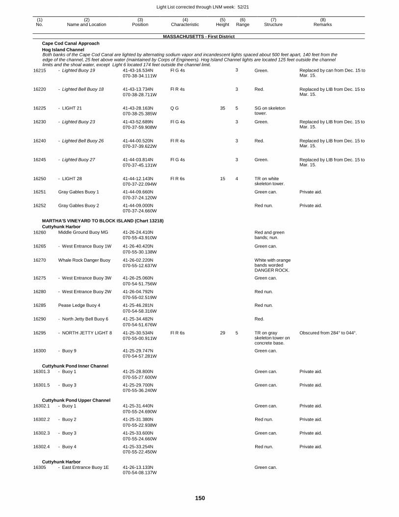
Light List corrected through LNM week: 52/21
150
(1) (2) (3) (4) (5) (6) (7) (8) No. Name and Location Position Characteristic Height Range Structure Remarks
MASSACHUSETTS - First District
Cape Cod Canal Approach
Hog Island Channel Both banks of the Cape Cod Canal are lighted by alternating sodium vapor and incandescent lights spaced about 500 feet apart, 140 feet from the edge of the channel, 25 feet above water (maintained by Corps of Engineers). Hog Island Channel lights are located 125 feet outside the channel limits and the shoal water, except Light 6 located 174 feet outside the channel limit.
16215 - Lighted Buoy 19 41-43-16.534N
070-38-34.111W
Fl G 4s 3 Green. Replaced by can from Dec. 15 to Mar. 15.
16220 - Lighted Bell Buoy 18 41-43-13.734N
070-38-28.711W
Fl R 4s
3 Red. Replaced by LIB from Dec. 15 to Mar. 15.
16225 - LIGHT 21 41-43-28.163N
070-38-25.385W
Q G 35 5 SG on skeleton tower.
16230 - Lighted Buoy 23 41-43-52.689N
070-37-59.908W
Fl G 4s 3 Green. Replaced by LIB from Dec. 15 to Mar. 15.
16240 - Lighted Bell Buoy 26 41-44-00.520N
070-37-39.622W
Fl R 4s
3 Red. Replaced by LIB from Dec. 15 to Mar. 15.
16245 - Lighted Buoy 27 41-44-03.814N
070-37-45.131W
Fl G 4s
3 Green. Replaced by LIB from Dec. 15 to Mar. 15.
16250 - LIGHT 28 41-44-12.143N
070-37-22.094W
Fl R 6s 15 4 TR on white skeleton tower.
16251 Gray Gables Buoy 1 41-44-09.660N Green can. Private aid.
070-37-24.120W
16252 Gray Gables Buoy 2 41-44-09.000N Red nun. Private aid. 070-37-24.660W
MARTHA'S VINEYARD TO BLOCK ISLAND (Chart 13218)
Cuttyhunk Harbor
16260 Middle Ground Buoy MG 41-26-24.410N
070-55-43.910W
Red and green bands; nun.
16265 - West Entrance Buoy 1W 41-26-40.420N Green can.
070-55-30.138W
16270 Whale Rock Danger Buoy 41-26-02.220N
070-55-12.637W
White with orange bands worded DANGER ROCK.
16275 - West Entrance Buoy 3W 41-26-25.060N Green can.
070-54-51.756W
16280 - West Entrance Buoy 2W 41-26-04.792N Red nun.
070-55-02.519W
16285 Pease Ledge Buoy 4 41-25-46.281N Red nun.
070-54-58.316W
16290 - North Jetty Bell Buoy 6 41-25-34.482N Red.
070-54-51.676W
16295 - NORTH JETTY LIGHT 8 41-25-30.534N
070-55-00.911W
Fl R 6s 29 5 TR on gray skeleton tower on concrete base.
Obscured from 284° to 044°.
16300 - Buoy 9 41-25-29.747N Green can.
070-54-57.281W
Cuttyhunk Pond Inner Channel
16301.3 - Buoy 1
41-25-28.800N
Green can.
Private aid.
070-55-27.600W
16301.5 - Buoy 3 41-25-29.700N Green can. Private aid. 070-55-36.240W
Cuttyhunk Pond Upper Channel
16302.1 - Buoy 1
41-25-31.440N
Green can.
Private aid.
070-55-24.690W
16302.2 - Buoy 2 41-25-31.380N Red nun. Private aid.
070-55-22.938W
16302.3 - Buoy 3 41-25-33.600N Green can. Private aid.
070-55-24.660W
16302.4 - Buoy 4 41-25-33.254N Red nun. Private aid. 070-55-22.450W
Cuttyhunk Harbor
16305 - East Entrance Buoy 1E
41-26-13.133N
Green can. 070-54-08.137W
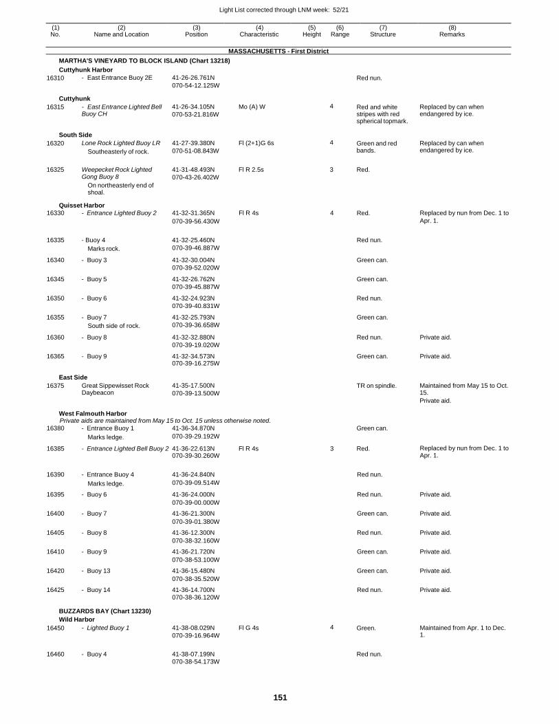
Light List corrected through LNM week: 52/21
151
(1) (2) (3) (4) (5) (6) (7) (8) No. Name and Location Position Characteristic Height Range Structure Remarks
MASSACHUSETTS - First District
MARTHA'S VINEYARD TO BLOCK ISLAND (Chart 13218)
Cuttyhunk Harbor
16310 - East Entrance Buoy 2E 41-26-26.761N
070-54-12.125W Red nun.
Cuttyhunk
16315 - East Entrance Lighted Bell Buoy CH
41-26-34.105N
070-53-21.816W
Mo (A) W 4 Red and white stripes with red spherical topmark.
Replaced by can when endangered by ice.
South Side
16320
16325
Lone Rock Lighted Buoy LR
Southeasterly of rock.
Weepecket Rock Lighted Gong Buoy 8
On northeasterly end of shoal.
41-27-39.380N
070-51-08.843W
41-31-48.493N
070-43-26.402W
Fl (2+1)G 6s
Fl R 2.5s
4 Green and red bands.
3 Red.
Replaced by can when endangered by ice.
Quisset Harbor
16330 - Entrance Lighted Buoy 2 41-32-31.365N Fl R 4s 4 Red. Replaced by nun from Dec. 1 to
070-39-56.430W Apr. 1.
16335 - Buoy 4
Marks rock.
41-32-25.460N
070-39-46.887W
Red nun.
16340 - Buoy 3 41-32-30.004N
070-39-52.020W
Green can.
16345 - Buoy 5 41-32-26.762N
070-39-45.887W
Green can.
16350 - Buoy 6 41-32-24.923N
070-39-40.831W
Red nun.
16355 - Buoy 7
South side of rock.
41-32-25.793N
070-39-36.658W
Green can.
16360 - Buoy 8 41-32-32.880N
070-39-19.020W
Red nun. Private aid.
16365 - Buoy 9 41-32-34.573N 070-39-16.275W
Green can. Private aid.
East Side
16375 Great Sippewisset Rock Daybeacon
41-35-17.500N
070-39-13.500W
TR on spindle. Maintained from May 15 to Oct. 15.
Private aid.
West Falmouth Harbor Private aids are maintained from May 15 to Oct. 15 unless otherwise noted.
16380 - Entrance Buoy 1 41-36-34.870N Green can.
Marks ledge. 070-39-29.192W
16385 - Entrance Lighted Bell Buoy 2 41-36-22.613N 070-39-30.260W
Fl R 4s 3 Red. Replaced by nun from Dec. 1 to Apr. 1.
16390
- Entrance Buoy 4
41-36-24.840N
Red nun.
Marks ledge. 070-39-09.514W
16395 - Buoy 6 41-36-24.000N Red nun. Private aid.
070-39-00.000W
16400 - Buoy 7 41-36-21.300N Green can. Private aid.
070-39-01.380W
16405 - Buoy 8 41-36-12.300N Red nun. Private aid.
070-38-32.160W
16410 - Buoy 9 41-36-21.720N Green can. Private aid.
070-38-53.100W
16420 - Buoy 13 41-36-15.480N Green can. Private aid.
070-38-35.520W
16425 - Buoy 14 41-36-14.700N Red nun. Private aid. 070-38-36.120W
BUZZARDS BAY (Chart 13230)
Wild Harbor
16450 - Lighted Buoy 1 41-38-08.029N
070-39-16.964W
Fl G 4s 4 Green. Maintained from Apr. 1 to Dec. 1.
16460 - Buoy 4 41-38-07.199N
Red nun.
070-38-54.173W
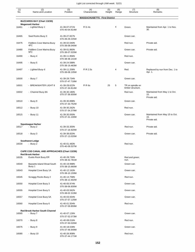
Light List corrected through LNM week: 52/21
152
(1) (2) (3) (4) (5) (6) (7) (8) No. Name and Location Position Characteristic Height Range Structure Remarks
MASSACHUSETTS - First District
BUZZARDS BAY (Chart 13230)
Megansett Harbor
16461 - Lighted Buoy 1 41-39-07.071N
070-40-04.914W
Fl G 4s 4 Green. Maintained from Apr. 1 to Nov. 30.
16465 Seal Rocks Buoy 3 41-39-27.657N
Green can.
070-39-29.225W
16475 Fiddlers Cove Marina Buoy 4FC
41-39-02.040N
070-38-08.040W
Red nun. Private aid.
16480 Fiddlers Cove Marina Buoy 5FC
41-39-01.860N
070-38-07.020W
Green can. Private aid.
16490 - Buoy 4 41-39-11.856N Red nun.
070-38-48.141W
16495 - Buoy 5 41-39-24.588N Green can.
070-38-19.463W
16497 - Lighted Buoy 6 41-39-11.206N
070-38-08.105W
Fl R 2.5s 4 Red. Replaced by nun from Dec. 1 to Apr. 1.
16500 - Buoy 7 41-39-29.734N
Green can.
070-37-47.718W
16501 - BREAKWATER LIGHT 8 41-39-28.622N
070-37-34.814W
Fl R 6s 25 5 TR on spindle on timber structure.
16502 - Channel Buoy 8A 41-39-30.180N 070-37-36.600W
Red nun. Maintained from May 1 to Oct. 15.
Private aid.
16510 - Buoy 9 41-39-30.898N Green can.
070-37-33.752W
16512 - Buoy 10 41-39-30.262N Red nun.
070-37-34.379W
16515 - Buoy 11 41-39-30.000N 070-37-31.100W
Green can. Maintained from May 15 to Oct. 15.
Private aid.
Squeteague Harbor 16517 - Buoy 2 41-39-33.300N Red nun. Private aid.
070-37-16.920W
16518 - Buoy 3 41-39-38.820N Green can. Private aid. 070-37-13.020W
Southwest Ledge
16530 - Buoy 2 41-40-01.483N Red nun. 070-40-09.537W
CAPE COD CANAL AND APPROACHES (Chart 13236)
Red Brook Harbor
16535 Eustis Rock Buoy ER 41-40-28.730N
070-38-42.781W Red and green; nun.
16540 Bassetts Island Shoal South Buoy 1
41-40-19.998N
070-38-15.660W
Green can.
16543 Hospital Cove Buoy 1A 41-40-12.163N Green can.
070-38-10.159W
16545 Scraggy Rocks Buoy 2 41-40-14.758N Red nun.
070-38-12.402W
16550 Hospital Cove Buoy 3 41-40-05.974N Green can.
070-38-06.830W
16555 Hospital Cove Buoy 5 41-40-03.562N Green can.
070-38-02.319W
16557 Hospital Cove Buoy 5A 41-40-03.934N Green can.
070-37-57.125W
16560 Hospital Cove Buoy 6 41-40-01.504N Red nun. 070-37-59.859W
Red Brook Harbor South Channel 16565 - Buoy 7 41-40-07.126N Green can.
070-37-52.073W
16570 - Buoy 8 41-40-08.016N Red nun.
070-37-50.026W
16575 - Buoy 9 41-40-18.028N Green can.
070-37-46.949W
16580 - Buoy 10 41-40-26.908N Red nun. 070-37-44.171W
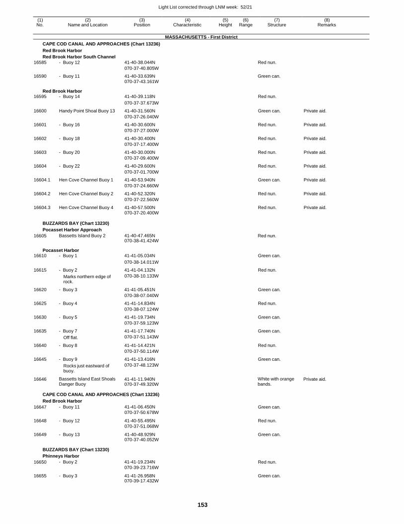
Light List corrected through LNM week: 52/21
153
(1) (2) (3) (4) (5) (6) (7) (8) No. Name and Location Position Characteristic Height Range Structure Remarks
MASSACHUSETTS - First District
CAPE COD CANAL AND APPROACHES (Chart 13236)
Red Brook Harbor
Red Brook Harbor South Channel
16585 - Buoy 12 41-40-38.044N Red nun.
070-37-40.805W
16590 - Buoy 11 41-40-33.639N Green can. 070-37-43.161W
Red Brook Harbor 16595 - Buoy 14 41-40-39.118N Red nun.
070-37-37.673W
16600 Handy Point Shoal Buoy 13 41-40-31.560N Green can. Private aid.
070-37-26.040W
16601 - Buoy 16 41-40-30.600N Red nun. Private aid.
070-37-27.000W
16602 - Buoy 18 41-40-30.400N Red nun. Private aid.
070-37-17.400W
16603 - Buoy 20 41-40-30.000N Red nun. Private aid.
070-37-09.400W
16604 - Buoy 22 41-40-29.600N Red nun. Private aid.
070-37-01.700W
16604.1 Hen Cove Channel Buoy 1 41-40-53.940N Green can. Private aid.
070-37-24.660W
16604.2 Hen Cove Channel Buoy 2 41-40-52.320N Red nun. Private aid.
070-37-22.560W
16604.3 Hen Cove Channel Buoy 4 41-40-57.500N Red nun. Private aid. 070-37-20.400W
BUZZARDS BAY (Chart 13230)
Pocasset Harbor Approach
16605 Bassetts Island Buoy 2 41-40-47.465N 070-38-41.424W
Red nun.
Pocasset Harbor 16610 - Buoy 1 41-41-05.034N Green can.
070-38-14.011W
16615 - Buoy 2 41-41-04.132N Red nun.
Marks northern edge of rock.
070-38-10.133W
16620 - Buoy 3 41-41-05.451N Green can.
070-38-07.040W
16625 - Buoy 4 41-41-14.834N Red nun.
070-38-07.124W
16630 - Buoy 5 41-41-19.734N Green can.
070-37-59.123W
16635 - Buoy 7 41-41-17.740N Green can.
Off flat. 070-37-51.143W
16640 - Buoy 8 41-41-14.421N Red nun.
070-37-50.114W
16645 - Buoy 9 41-41-13.416N Green can.
Rocks just eastward of buoy.
070-37-48.123W
16646 Bassetts Island East Shoals Danger Buoy
41-41-11.940N 070-37-49.320W
White with orange bands.
Private aid.
CAPE COD CANAL AND APPROACHES (Chart 13236)
Red Brook Harbor
16647 - Buoy 11 41-41-06.450N
070-37-50.678W Green can.
16648 - Buoy 12 41-40-55.495N
070-37-51.068W
Red nun.
16649 - Buoy 13 41-40-48.929N 070-37-40.052W
Green can.
BUZZARDS BAY (Chart 13230)
Phinneys Harbor
16650 - Buoy 2 41-41-19.234N
070-39-23.716W Red nun.
16655 - Buoy 3 41-41-26.958N 070-39-17.432W
Green can.
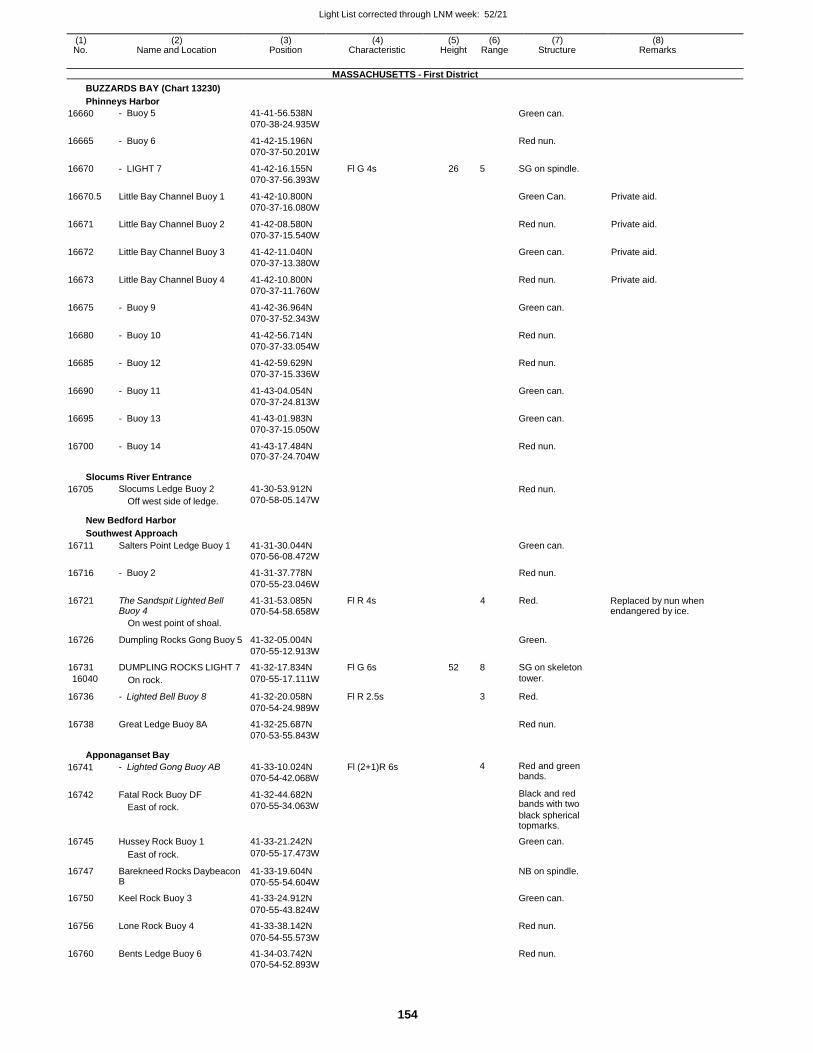
Light List corrected through LNM week: 52/21
154
(1) (2) (3) (4) (5) (6) (7) (8) No. Name and Location Position Characteristic Height Range Structure Remarks
MASSACHUSETTS - First District
BUZZARDS BAY (Chart 13230)
Phinneys Harbor
16660 - Buoy 5 41-41-56.538N
070-38-24.935W
Green can.
16665 - Buoy 6 41-42-15.196N
070-37-50.201W
Red nun.
16670 - LIGHT 7 41-42-16.155N
070-37-56.393W
Fl G 4s 26 5 SG on spindle.
16670.5 Little Bay Channel Buoy 1 41-42-10.800N
070-37-16.080W
Green Can. Private aid.
16671 Little Bay Channel Buoy 2 41-42-08.580N
070-37-15.540W
Red nun. Private aid.
16672 Little Bay Channel Buoy 3 41-42-11.040N
070-37-13.380W
Green can. Private aid.
16673 Little Bay Channel Buoy 4 41-42-10.800N
070-37-11.760W
Red nun. Private aid.
16675 - Buoy 9 41-42-36.964N
070-37-52.343W
Green can.
16680 - Buoy 10 41-42-56.714N
070-37-33.054W
Red nun.
16685 - Buoy 12 41-42-59.629N
070-37-15.336W
Red nun.
16690 - Buoy 11 41-43-04.054N
070-37-24.813W
Green can.
16695 - Buoy 13 41-43-01.983N
070-37-15.050W
Green can.
16700 - Buoy 14 41-43-17.484N 070-37-24.704W
Red nun.
Slocums River Entrance
16705 Slocums Ledge Buoy 2
Off west side of ledge.
41-30-53.912N
070-58-05.147W Red nun.
New Bedford Harbor
Southwest Approach
16711 Salters Point Ledge Buoy 1 41-31-30.044N Green can.
070-56-08.472W
16716 - Buoy 2 41-31-37.778N Red nun.
070-55-23.046W
16721 The Sandspit Lighted Bell Buoy 4
41-31-53.085N 070-54-58.658W
Fl R 4s 4 Red. Replaced by nun when endangered by ice.
On west point of shoal.
16726 Dumpling Rocks Gong Buoy 5 41-32-05.004N
Green.
070-55-12.913W
16731 DUMPLING ROCKS LIGHT 7 41-32-17.834N Fl G 6s 52 8 SG on skeleton
16040 On rock. 070-55-17.111W tower.
16736 - Lighted Bell Buoy 8 41-32-20.058N Fl R 2.5s 3 Red.
070-54-24.989W
16738 Great Ledge Buoy 8A 41-32-25.687N Red nun. 070-53-55.843W
Apponaganset Bay
16741
16742
- Lighted Gong Buoy AB
Fatal Rock Buoy DF
East of rock.
41-33-10.024N
070-54-42.068W
41-32-44.682N
070-55-34.063W
Fl (2+1)R 6s 4 Red and green bands.
Black and red bands with two
black spherical topmarks.
16745 Hussey Rock Buoy 1 41-33-21.242N Green can.
East of rock. 070-55-17.473W
16747 Barekneed Rocks Daybeacon B
41-33-19.604N
070-55-54.604W
NB on spindle.
16750 Keel Rock Buoy 3 41-33-24.912N Green can.
070-55-43.824W
16756 Lone Rock Buoy 4 41-33-38.142N Red nun.
070-54-55.573W
16760 Bents Ledge Buoy 6 41-34-03.742N Red nun. 070-54-52.893W
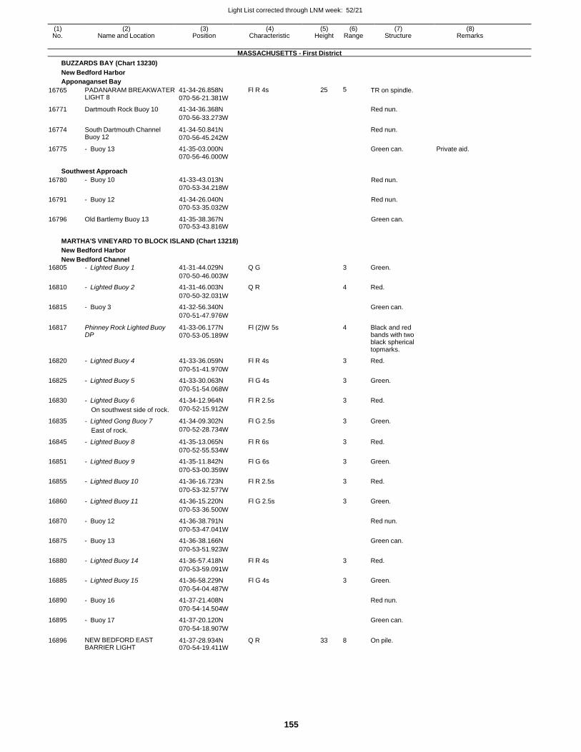
Light List corrected through LNM week: 52/21
155
(1) (2) (3) (4) (5) (6) (7) (8) No. Name and Location Position Characteristic Height Range Structure Remarks
MASSACHUSETTS - First District
BUZZARDS BAY (Chart 13230)
New Bedford Harbor
Apponaganset Bay
16765 PADANARAM BREAKWATER LIGHT 8
41-34-26.858N
070-56-21.381W
Fl R 4s 25 5 TR on spindle.
16771 Dartmouth Rock Buoy 10 41-34-36.368N Red nun.
070-56-33.273W
16774 South Dartmouth Channel Buoy 12
41-34-50.841N
070-56-45.242W
Red nun.
16775 - Buoy 13 41-35-03.000N Green can. Private aid. 070-56-46.000W
Southwest Approach
16780 - Buoy 10 41-33-43.013N
070-53-34.218W Red nun.
16791 - Buoy 12 41-34-26.040N
070-53-35.032W
Red nun.
16796 Old Bartlemy Buoy 13 41-35-38.367N 070-53-43.816W
Green can.
MARTHA'S VINEYARD TO BLOCK ISLAND (Chart 13218)
New Bedford Harbor
New Bedford Channel
16805 - Lighted Buoy 1 41-31-44.029N Q G 3 Green.
070-50-46.003W
16810 - Lighted Buoy 2 41-31-46.003N Q R 4 Red.
070-50-32.031W
16815 - Buoy 3 41-32-56.340N Green can.
070-51-47.976W
16817 Phinney Rock Lighted Buoy DP
41-33-06.177N
070-53-05.189W
Fl (2)W 5s 4 Black and red bands with two black spherical topmarks.
16820 - Lighted Buoy 4 41-33-36.059N Fl R 4s 3 Red.
070-51-41.970W
16825 - Lighted Buoy 5 41-33-30.063N Fl G 4s 3 Green.
070-51-54.068W
16830 - Lighted Buoy 6 41-34-12.964N Fl R 2.5s 3 Red.
On southwest side of rock. 070-52-15.912W
16835 - Lighted Gong Buoy 7 41-34-09.302N Fl G 2.5s 3 Green.
East of rock. 070-52-28.734W
16845 - Lighted Buoy 8 41-35-13.065N Fl R 6s 3 Red.
070-52-55.534W
16851 - Lighted Buoy 9 41-35-11.842N Fl G 6s 3 Green.
070-53-00.359W
16855 - Lighted Buoy 10 41-36-16.723N Fl R 2.5s 3 Red.
070-53-32.577W
16860 - Lighted Buoy 11 41-36-15.220N Fl G 2.5s 3 Green.
070-53-36.500W
16870 - Buoy 12 41-36-38.791N Red nun.
070-53-47.041W
16875 - Buoy 13 41-36-38.166N Green can.
070-53-51.923W
16880 - Lighted Buoy 14 41-36-57.418N Fl R 4s 3 Red.
070-53-59.091W
16885 - Lighted Buoy 15 41-36-58.229N Fl G 4s 3 Green.
070-54-04.487W
16890 - Buoy 16 41-37-21.408N Red nun.
070-54-14.504W
16895 - Buoy 17 41-37-20.120N Green can.
070-54-18.907W
16896 NEW BEDFORD EAST BARRIER LIGHT
41-37-28.934N 070-54-19.411W
Q R 33 8 On pile.
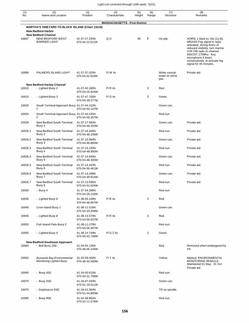
Light List corrected through LNM week: 52/21
156
(1) (2) (3) (4) (5) (6) (7) (8) No. Name and Location Position Characteristic Height Range Structure Remarks
MASSACHUSETTS - First District
MARTHA'S VINEYARD TO BLOCK ISLAND (Chart 13218)
New Bedford Harbor
New Bedford Channel
16897
16898
NEW BEDFORD WEST BARRIER LIGHT
PALMERS ISLAND LIGHT
41-37-27.234N
070-54-22.011W
41-37-37.020N
070-54-32.910W
Q G
Fl W 4s
48 8 On pile.
White conical tower on stone pier.
HORN: 1 blast ev 10s (1s bl). MRASS-Fog signal is radio activated, during times of reduced visibility, turn marine VHF-FM radio to channel 83A/157.175Mhz. Key microphone 5 times consecutively, to activate fog signal for 45 minutes.
Private aid.
New Bedford Harbor Channel
16910 - Lighted Buoy 2 41-37-40.180N Fl R 4s 3 Red.
070-54-26.816W
16915 - Lighted Buoy 3 41-37-47.700N Fl G 4s 3 Green.
070-54-39.277W
16920 South Terminal Approach Buoy 1
41-37-44.410N
070-54-50.147W
Green can.
16925 South Terminal Approach Buoy 2
41-37-44.535N
070-54-59.307W
Red nun.
16926 New Bedford South Terminal Buoy 1
41-37-17.580N
070-54-46.020W
Green can. Private aid.
16926.1 New Bedford South Terminal Buoy 2
41-37-16.405N
070-54-48.106W
Red nun. Private aid.
16926.2 New Bedford South Terminal Buoy 3
41-37-15.960N
070-54-46.860W
Green can. Private aid.
16926.3 New Bedford South Terminal Buoy 4
41-37-15.240N
070-54-48.900W
Red nun. Private aid.
16926.4 New Bedford South Terminal Buoy 5
41-37-14.940N
070-54-48.300W
Green can. Private aid.
16926.5 New Bedford South Terminal Buoy 6
41-37-14.203N
070-54-50.461W
Red nun. Private aid.
16926.6 New Bedford South Terminal Buoy 7
41-37-13.188N
070-54-49.914W
Green can. Private aid.
16926.7 New Bedford South Terminal Buoy 8
41-37-13.590N
070-54-51.624W
Red nun. Private aid.
16930 - Buoy 4 41-37-54.390N Red nun.
070-54-26.216W
16935 - Lighted Buoy 6 41-38-05.109N Fl R 4s 3 Red.
070-54-48.857W
16940 Crow Island Buoy 1 41-38-11.016N Green can.
070-54-33.208W
16945 - Lighted Buoy 8 41-38-14.579N Fl R 4s 3 Red.
070-54-56.837W
16950 Fish Island Flats Buoy 2 41-38-11.079N Red nun.
070-55-06.947W
16955 - Lighted Buoy 9 41-38-14.749N Fl G 2.5s 3 Green.
070-55-02.748W
New Bedford Southeast Approach
16960 - Bell Buoy 2SE 41-34-04.135N
070-48-45.226W
Red. Removed when endangered by ice.
16963 Buzzards Bay Environmental Monitoring Lighted Buoy
41-33-59.400N
070-49-32.500W
Fl Y 4s Yellow. Marked: ENVIRONMENTAL MONITORING MODULE. Maintained 01 May - 31 Oct.
Private aid.
16965 - Buoy 4SE 41-34-00.615N Red nun.
070-50-31.796W
16970 - Buoy 5SE 41-34-07.034N Green can.
070-51-19.011W
16975 - Daybeacon 6SE 41-34-41.364N TR on spindle.
070-51-44.805W
16980 - Buoy 8SE 41-34-38.863N Red nun.
070-52-11.579W
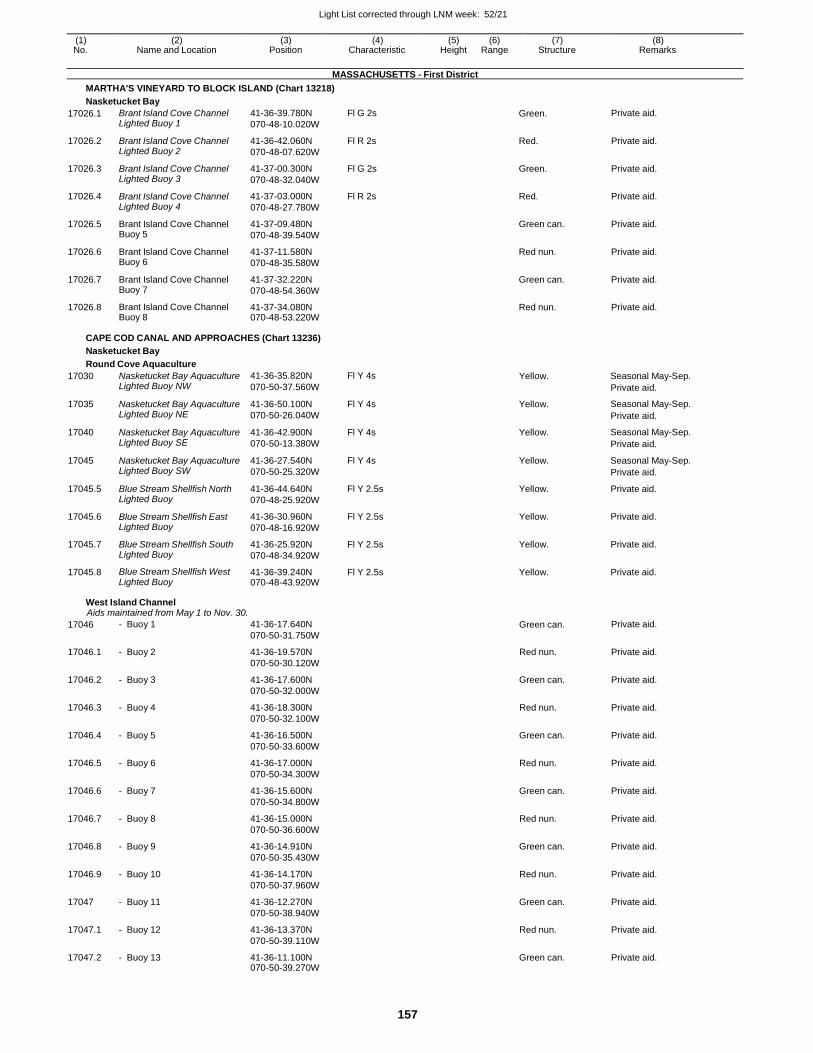
Light List corrected through LNM week: 52/21
157
(1) (2) (3) (4) (5) (6) (7) (8) No. Name and Location Position Characteristic Height Range Structure Remarks
MASSACHUSETTS - First District
MARTHA'S VINEYARD TO BLOCK ISLAND (Chart 13218)
Nasketucket Bay
17026.1 Brant Island Cove Channel Lighted Buoy 1
41-36-39.780N
070-48-10.020W
Fl G 2s Green. Private aid.
17026.2 Brant Island Cove Channel Lighted Buoy 2
41-36-42.060N
070-48-07.620W
Fl R 2s Red. Private aid.
17026.3 Brant Island Cove Channel Lighted Buoy 3
41-37-00.300N
070-48-32.040W
Fl G 2s Green. Private aid.
17026.4 Brant Island Cove Channel Lighted Buoy 4
41-37-03.000N
070-48-27.780W
Fl R 2s Red. Private aid.
17026.5 Brant Island Cove Channel Buoy 5
41-37-09.480N
070-48-39.540W
Green can. Private aid.
17026.6 Brant Island Cove Channel Buoy 6
41-37-11.580N
070-48-35.580W
Red nun. Private aid.
17026.7 Brant Island Cove Channel Buoy 7
41-37-32.220N
070-48-54.360W
Green can. Private aid.
17026.8 Brant Island Cove Channel Buoy 8
41-37-34.080N 070-48-53.220W
Red nun. Private aid.
CAPE COD CANAL AND APPROACHES (Chart 13236)
Nasketucket Bay
Round Cove Aquaculture
17030 Nasketucket Bay Aquaculture Lighted Buoy NW
41-36-35.820N
070-50-37.560W
Fl Y 4s Yellow. Seasonal May-Sep.
Private aid.
17035 Nasketucket Bay Aquaculture Lighted Buoy NE
41-36-50.100N
070-50-26.040W
Fl Y 4s Yellow. Seasonal May-Sep.
Private aid.
17040 Nasketucket Bay Aquaculture Lighted Buoy SE
41-36-42.900N
070-50-13.380W
Fl Y 4s Yellow. Seasonal May-Sep.
Private aid.
17045 Nasketucket Bay Aquaculture Lighted Buoy SW
41-36-27.540N
070-50-25.320W
Fl Y 4s Yellow. Seasonal May-Sep.
Private aid.
17045.5 Blue Stream Shellfish North Lighted Buoy
41-36-44.640N
070-48-25.920W
Fl Y 2.5s Yellow. Private aid.
17045.6 Blue Stream Shellfish East Lighted Buoy
41-36-30.960N
070-48-16.920W
Fl Y 2.5s Yellow. Private aid.
17045.7 Blue Stream Shellfish South Lighted Buoy
41-36-25.920N
070-48-34.920W
Fl Y 2.5s Yellow. Private aid.
17045.8 Blue Stream Shellfish West Lighted Buoy
41-36-39.240N 070-48-43.920W
Fl Y 2.5s Yellow. Private aid.
West Island Channel Aids maintained from May 1 to Nov. 30.
17046 - Buoy 1 41-36-17.640N
070-50-31.750W Green can. Private aid.
17046.1 - Buoy 2 41-36-19.570N
070-50-30.120W
Red nun. Private aid.
17046.2 - Buoy 3 41-36-17.600N
070-50-32.000W
Green can. Private aid.
17046.3 - Buoy 4 41-36-18.300N
070-50-32.100W
Red nun. Private aid.
17046.4 - Buoy 5 41-36-16.500N
070-50-33.600W
Green can. Private aid.
17046.5 - Buoy 6 41-36-17.000N
070-50-34.300W
Red nun. Private aid.
17046.6 - Buoy 7 41-36-15.600N
070-50-34.800W
Green can. Private aid.
17046.7 - Buoy 8 41-36-15.000N
070-50-36.600W
Red nun. Private aid.
17046.8 - Buoy 9 41-36-14.910N
070-50-35.430W
Green can. Private aid.
17046.9 - Buoy 10 41-36-14.170N
070-50-37.960W
Red nun. Private aid.
17047 - Buoy 11 41-36-12.270N
070-50-38.940W
Green can. Private aid.
17047.1 - Buoy 12 41-36-13.370N
070-50-39.110W
Red nun. Private aid.
17047.2 - Buoy 13 41-36-11.100N 070-50-39.270W
Green can. Private aid.
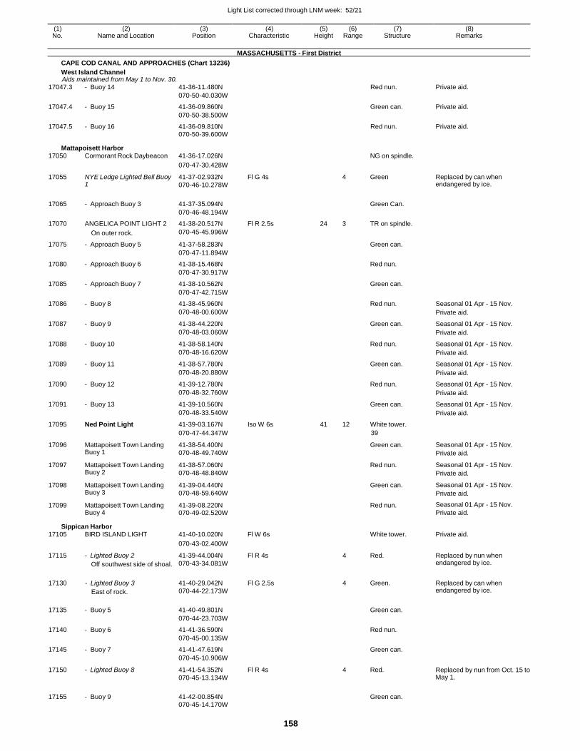
Light List corrected through LNM week: 52/21
158
(1) (2) (3) (4) (5) (6) (7) (8) No. Name and Location Position Characteristic Height Range Structure Remarks
MASSACHUSETTS - First District
CAPE COD CANAL AND APPROACHES (Chart 13236)
West Island Channel Aids maintained from May 1 to Nov. 30.
17047.3 - Buoy 14 41-36-11.480N Red nun. Private aid.
070-50-40.030W
17047.4 - Buoy 15 41-36-09.860N Green can. Private aid.
070-50-38.500W
17047.5 - Buoy 16 41-36-09.810N Red nun. Private aid. 070-50-39.600W
Mattapoisett Harbor 17050 Cormorant Rock Daybeacon 41-36-17.026N NG on spindle.
070-47-30.428W
17055 NYE Ledge Lighted Bell Buoy 1
41-37-02.932N
070-46-10.278W
Fl G 4s 4 Green Replaced by can when endangered by ice.
17065 - Approach Buoy 3 41-37-35.094N
Green Can.
070-46-48.194W
17070 ANGELICA POINT LIGHT 2 41-38-20.517N Fl R 2.5s 24 3 TR on spindle.
On outer rock. 070-45-45.996W
17075 - Approach Buoy 5 41-37-58.283N Green can.
070-47-11.894W
17080 - Approach Buoy 6 41-38-15.468N Red nun.
070-47-30.917W
17085 - Approach Buoy 7 41-38-10.562N Green can.
070-47-42.715W
17086 - Buoy 8 41-38-45.960N Red nun. Seasonal 01 Apr - 15 Nov.
070-48-00.600W Private aid.
17087 - Buoy 9 41-38-44.220N Green can. Seasonal 01 Apr - 15 Nov.
070-48-03.060W Private aid.
17088 - Buoy 10 41-38-58.140N Red nun. Seasonal 01 Apr - 15 Nov.
070-48-16.620W Private aid.
17089 - Buoy 11 41-38-57.780N Green can. Seasonal 01 Apr - 15 Nov.
070-48-20.880W Private aid.
17090 - Buoy 12 41-39-12.780N Red nun. Seasonal 01 Apr - 15 Nov.
070-48-32.760W Private aid.
17091 - Buoy 13 41-39-10.560N Green can. Seasonal 01 Apr - 15 Nov.
070-48-33.540W Private aid.
17095 Ned Point Light 41-39-03.167N Iso W 6s 41 12 White tower.
070-47-44.347W 39
17096 Mattapoisett Town Landing Buoy 1
41-38-54.400N
070-48-49.740W
Green can. Seasonal 01 Apr - 15 Nov.
Private aid.
17097 Mattapoisett Town Landing Buoy 2
41-38-57.060N
070-48-48.840W
Red nun. Seasonal 01 Apr - 15 Nov.
Private aid.
17098 Mattapoisett Town Landing Buoy 3
41-39-04.440N
070-48-59.640W
Green can. Seasonal 01 Apr - 15 Nov.
Private aid.
17099 Mattapoisett Town Landing Buoy 4
41-39-08.220N 070-49-02.520W
Red nun. Seasonal 01 Apr - 15 Nov.
Private aid.
Sippican Harbor 17105 BIRD ISLAND LIGHT 41-40-10.020N Fl W 6s White tower. Private aid.
070-43-02.400W
17115 - Lighted Buoy 2
Off southwest side of shoal.
41-39-44.004N
070-43-34.081W
Fl R 4s 4 Red. Replaced by nun when endangered by ice.
17130 - Lighted Buoy 3
East of rock.
41-40-29.042N
070-44-22.173W
Fl G 2.5s 4 Green. Replaced by can when endangered by ice.
17135 - Buoy 5 41-40-49.801N
Green can.
070-44-23.703W
17140 - Buoy 6 41-41-36.590N Red nun.
070-45-00.135W
17145 - Buoy 7 41-41-47.619N Green can.
070-45-10.906W
17150 - Lighted Buoy 8 41-41-54.352N
070-45-13.134W
Fl R 4s 4 Red. Replaced by nun from Oct. 15 to May 1.
17155 - Buoy 9 41-42-00.854N
Green can.
070-45-14.170W
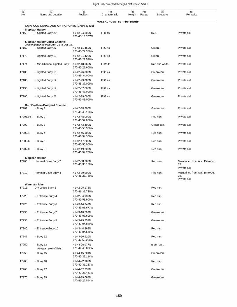
Light List corrected through LNM week: 52/21
159
(1) (2) (3) (4) (5) (6) (7) (8) No. Name and Location Position Characteristic Height Range Structure Remarks
MASSACHUSETTS - First District
CAPE COD CANAL AND APPROACHES (Chart 13236)
Sippican Harbor
17156 - Lighted Buoy 10 41-42-04.300N
070-45-13.320W
Fl R 4s Red. Private aid.
Sippican Harbor Upper Channel Aids maintained from Apr. 15 to Oct. 15.
17169 - Lighted Buoy 11 41-42-11.460N Fl G 4s Green. Private aid.
070-45-22.380W
17170 - Lighted Buoy 13 41-42-21.420N Fl G 4s Green. Private aid.
070-45-29.520W
17174 - Mid-Channel Lighted Buoy 41-42-18.060N Fl W 4s Red and white. Private aid.
070-45-27.600W
17180 - Lighted Buoy 15 41-42-26.000N Fl G 4s Green can. Private aid.
070-45-34.000W
17185 - Lighted Buoy 17 41-42-29.000N Fl G 4s Green can. Private aid.
070-45-37.000W
17195 - Lighted Buoy 19 41-42-37.000N Fl G 4s Green can. Private aid.
070-45-47.000W
17200 - Lighted Buoy 21 41-42-39.000N Fl G 4s Green can. Private aid. 070-45-49.000W
Burr Brothers Boatyard Channel 17201 - Buoy 1 41-42-38.300N Green can. Private aid.
070-45-48.100W
17201.05 - Buoy 2 41-42-48.000N Red nun. Private aid.
070-45-54.000W
17202 - Buoy 3 41-42-43.400N Green can. Private aid.
070-45-53.300W
17202.4 - Buoy 4 41-42-45.100N Red nun. Private aid.
070-45-54.300W
17202.6 - Buoy 6 41-42-47.200N Red nun. Private aid.
070-45-55.000W
17202.8 - Buoy 8 41-42-49.200N Red nun. Private aid. 070-45-54.700W
Sippican Harbor
17205 Hammet Cove Buoy 2 41-42-38.760N 070-45-30.120W
Red nun. Maintained from Apr. 15 to Oct. 15.
Private aid.
17210 Hammet Cove Buoy 4 41-42-39.900N 070-45-27.780W
Red nun. Maintained from Apr. 15 to Oct. 15.
Private aid.
Wareham River 17215 Dry Ledge Buoy 2 41-42-05.172N Red nun.
070-41-37.730W
17220 - Entrance Buoy 4 41-42-54.939N Red nun.
070-42-58.900W
17225 - Entrance Buoy 6 41-43-14.947N Red nun.
070-43-06.677W
17230 - Entrance Buoy 7 41-43-18.593N Green can.
070-43-07.609W
17235 - Entrance Buoy 9 41-43-29.359N Green can.
070-43-04.849W
17240 - Entrance Buoy 10 41-43-44.868N Red nun.
070-43-04.659W
17247 - Buoy 12 41-43-56.510N Red nun.
070-42-59.298W
17250 - Buoy 13 41-44-06.977N green can.
At upper part of flats 070-42-43.032W
17255 - Buoy 15 41-44-15.201N Green can.
070-42-36.114W
17260 - Buoy 16 41-44-22.967N Red nun.
070-42-31.283W
17265 - Buoy 17 41-44-32.337N Green can.
070-42-27.453W
17270 - Buoy 19 41-44-39.668N Green can. 070-42-26.554W
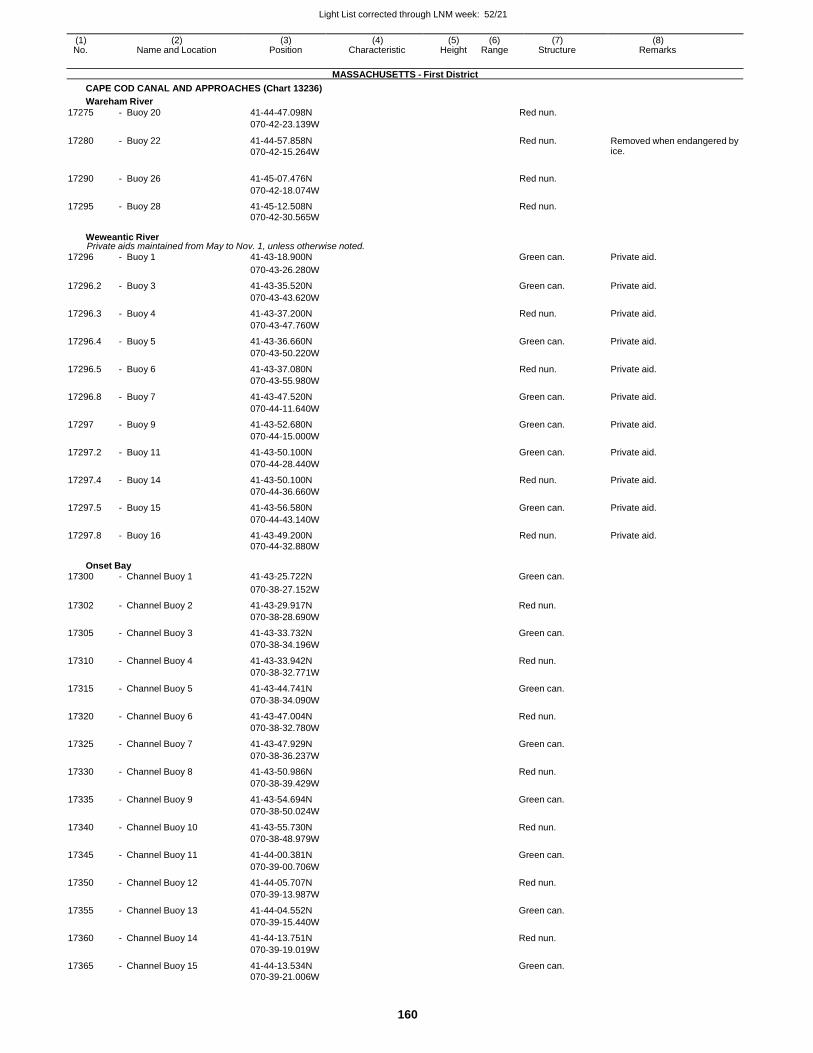
Light List corrected through LNM week: 52/21
160
(1) (2) (3) (4) (5) (6) (7) (8) No. Name and Location Position Characteristic Height Range Structure Remarks
MASSACHUSETTS - First District
CAPE COD CANAL AND APPROACHES (Chart 13236)
Wareham River
17275 - Buoy 20 41-44-47.098N Red nun.
070-42-23.139W
17280 - Buoy 22 41-44-57.858N
070-42-15.264W
Red nun. Removed when endangered by ice.
17290 - Buoy 26 41-45-07.476N Red nun.
070-42-18.074W
17295 - Buoy 28 41-45-12.508N Red nun.
070-42-30.565W
Weweantic River Private aids maintained from May to Nov. 1, unless otherwise noted.
17296 - Buoy 1 41-43-18.900N Green can. Private aid.
070-43-26.280W
17296.2 - Buoy 3 41-43-35.520N Green can. Private aid.
070-43-43.620W
17296.3 - Buoy 4 41-43-37.200N Red nun. Private aid.
070-43-47.760W
17296.4 - Buoy 5 41-43-36.660N Green can. Private aid.
070-43-50.220W
17296.5 - Buoy 6 41-43-37.080N Red nun. Private aid.
070-43-55.980W
17296.8 - Buoy 7 41-43-47.520N Green can. Private aid.
070-44-11.640W
17297 - Buoy 9 41-43-52.680N Green can. Private aid.
070-44-15.000W
17297.2 - Buoy 11 41-43-50.100N Green can. Private aid.
070-44-28.440W
17297.4 - Buoy 14 41-43-50.100N Red nun. Private aid.
070-44-36.660W
17297.5 - Buoy 15 41-43-56.580N Green can. Private aid.
070-44-43.140W
17297.8 - Buoy 16 41-43-49.200N Red nun. Private aid. 070-44-32.880W
Onset Bay 17300 - Channel Buoy 1 41-43-25.722N Green can.
070-38-27.152W
17302 - Channel Buoy 2 41-43-29.917N Red nun.
070-38-28.690W
17305 - Channel Buoy 3 41-43-33.732N Green can.
070-38-34.196W
17310 - Channel Buoy 4 41-43-33.942N Red nun.
070-38-32.771W
17315 - Channel Buoy 5 41-43-44.741N Green can.
070-38-34.090W
17320 - Channel Buoy 6 41-43-47.004N Red nun.
070-38-32.780W
17325 - Channel Buoy 7 41-43-47.929N Green can.
070-38-36.237W
17330 - Channel Buoy 8 41-43-50.986N Red nun.
070-38-39.429W
17335 - Channel Buoy 9 41-43-54.694N Green can.
070-38-50.024W
17340 - Channel Buoy 10 41-43-55.730N Red nun.
070-38-48.979W
17345 - Channel Buoy 11 41-44-00.381N Green can.
070-39-00.706W
17350 - Channel Buoy 12 41-44-05.707N Red nun.
070-39-13.987W
17355 - Channel Buoy 13 41-44-04.552N Green can.
070-39-15.440W
17360 - Channel Buoy 14 41-44-13.751N Red nun.
070-39-19.019W
17365 - Channel Buoy 15 41-44-13.534N Green can. 070-39-21.006W
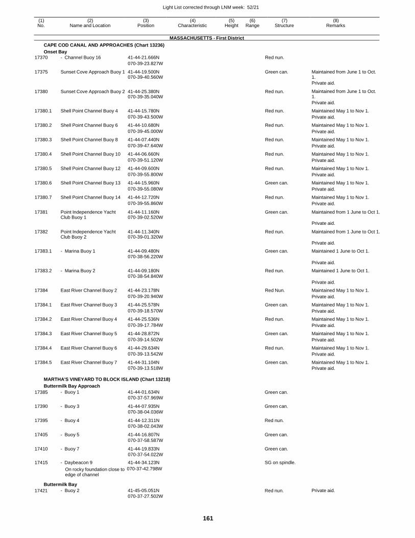
Light List corrected through LNM week: 52/21
161
(1) (2) (3) (4) (5) (6) (7) (8) No. Name and Location Position Characteristic Height Range Structure Remarks
MASSACHUSETTS - First District
CAPE COD CANAL AND APPROACHES (Chart 13236)
Onset Bay
17370 - Channel Buoy 16 41-44-21.666N Red nun.
070-39-23.827W
17375 Sunset Cove Approach Buoy 1 41-44-19.500N 070-39-40.560W
Green can. Maintained from June 1 to Oct. 1.
Private aid.
17380 Sunset Cove Approach Buoy 2 41-44-25.380N 070-39-35.040W
Red nun. Maintained from June 1 to Oct. 1.
Private aid.
17380.1 Shell Point Channel Buoy 4 41-44-15.780N Red nun. Maintained May 1 to Nov 1.
070-39-43.500W Private aid.
17380.2 Shell Point Channel Buoy 6 41-44-10.680N Red nun. Maintained May 1 to Nov 1.
070-39-45.000W Private aid.
17380.3 Shell Point Channel Buoy 8 41-44-07.440N Red nun. Maintained May 1 to Nov 1.
070-39-47.640W Private aid.
17380.4 Shell Point Channel Buoy 10 41-44-06.660N Red nun. Maintained May 1 to Nov 1.
070-39-51.120W Private aid.
17380.5 Shell Point Channel Buoy 12 41-44-09.600N Red nun. Maintained May 1 to Nov 1.
070-39-55.800W Private aid.
17380.6 Shell Point Channel Buoy 13 41-44-15.960N Green can. Maintained May 1 to Nov 1.
070-39-55.080W Private aid.
17380.7 Shell Point Channel Buoy 14 41-44-12.720N Red nun. Maintained May 1 to Nov 1.
070-39-55.860W Private aid.
17381 Point Independence Yacht Club Buoy 1
41-44-11.160N 070-39-02.520W
Green can. Maintained from 1 June to Oct 1.
Private aid.
17382 Point Independence Yacht Club Buoy 2
41-44-11.340N 070-39-01.320W
Red nun. Maintained from 1 June to Oct 1.
Private aid.
17383.1 - Marina Buoy 1 41-44-09.480N Green can. Maintained 1 June to Oct 1. 070-38-56.220W
Private aid.
17383.2 - Marina Buoy 2 41-44-09.180N Red nun. Maintained 1 June to Oct 1. 070-38-54.840W
Private aid.
17384 East River Channel Buoy 2 41-44-23.178N Red Nun. Maintained May 1 to Nov 1.
070-39-20.940W Private aid.
17384.1 East River Channel Buoy 3 41-44-25.578N Green can. Maintained May 1 to Nov 1.
070-39-18.570W Private aid.
17384.2 East River Channel Buoy 4 41-44-25.536N Red nun. Maintained May 1 to Nov 1.
070-39-17.784W Private aid.
17384.3 East River Channel Buoy 5 41-44-28.872N Green can. Maintained May 1 to Nov 1.
070-39-14.502W Private aid.
17384.4 East River Channel Buoy 6 41-44-29.634N Red nun. Maintained May 1 to Nov 1.
070-39-13.542W Private aid.
17384.5 East River Channel Buoy 7 41-44-31.104N Green can. Maintained May 1 to Nov 1. 070-39-13.518W Private aid.
MARTHA'S VINEYARD TO BLOCK ISLAND (Chart 13218)
Buttermilk Bay Approach
17385 - Buoy 1 41-44-01.634N
070-37-57.969W Green can.
17390 - Buoy 3 41-44-07.935N
070-38-04.036W
Green can.
17395 - Buoy 4 41-44-12.311N
070-38-02.043W
Red nun.
17405 - Buoy 5 41-44-16.807N
070-37-58.587W
Green can.
17410 - Buoy 7 41-44-19.833N
070-37-54.022W
Green can.
17415 - Daybeacon 9 41-44-34.123N SG on spindle.
On rocky foundation close to 070-37-42.798W
edge of channel
Buttermilk Bay
17421 - Buoy 2 41-45-05.051N
070-37-27.502W Red nun. Private aid.
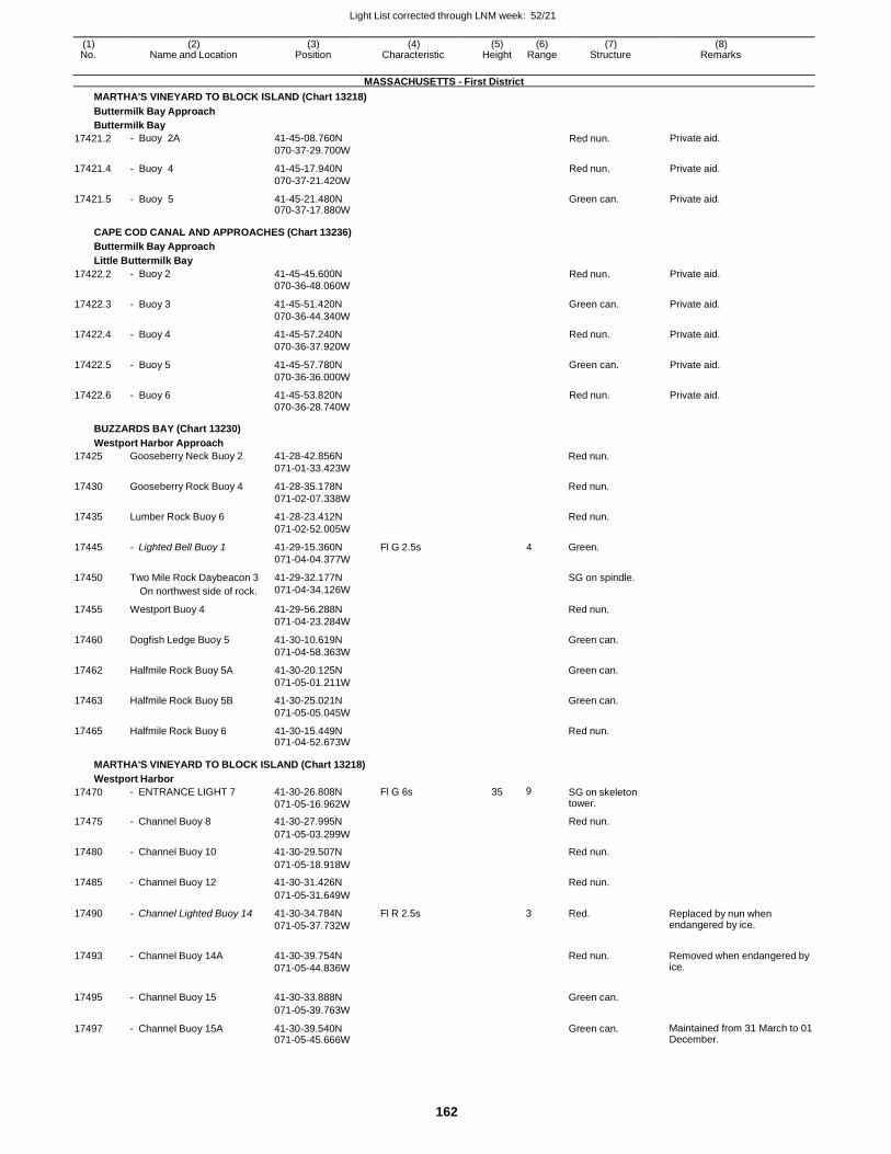
Light List corrected through LNM week: 52/21
162
(1) (2) (3) (4) (5) (6) (7) (8) No. Name and Location Position Characteristic Height Range Structure Remarks
MASSACHUSETTS - First District
MARTHA'S VINEYARD TO BLOCK ISLAND (Chart 13218)
Buttermilk Bay Approach
Buttermilk Bay
17421.2 - Buoy 2A 41-45-08.760N
070-37-29.700W Red nun. Private aid.
17421.4 - Buoy 4 41-45-17.940N
070-37-21.420W
Red nun. Private aid.
17421.5 - Buoy 5 41-45-21.480N 070-37-17.880W
Green can. Private aid.
CAPE COD CANAL AND APPROACHES (Chart 13236)
Buttermilk Bay Approach
Little Buttermilk Bay
17422.2 - Buoy 2 41-45-45.600N 070-36-48.060W
Red nun. Private aid.
17422.3 - Buoy 3 41-45-51.420N
070-36-44.340W
Green can. Private aid.
17422.4 - Buoy 4 41-45-57.240N
070-36-37.920W
Red nun. Private aid.
17422.5 - Buoy 5 41-45-57.780N
070-36-36.000W
Green can. Private aid.
17422.6 - Buoy 6 41-45-53.820N 070-36-28.740W
Red nun. Private aid.
BUZZARDS BAY (Chart 13230)
Westport Harbor Approach
17425 Gooseberry Neck Buoy 2 41-28-42.856N
071-01-33.423W
Red nun.
17430 Gooseberry Rock Buoy 4 41-28-35.178N
071-02-07.338W
Red nun.
17435 Lumber Rock Buoy 6 41-28-23.412N
071-02-52.005W
Red nun.
17445 - Lighted Bell Buoy 1 41-29-15.360N
071-04-04.377W
Fl G 2.5s 4 Green.
17450 Two Mile Rock Daybeacon 3
On northwest side of rock.
41-29-32.177N
071-04-34.126W
SG on spindle.
17455 Westport Buoy 4 41-29-56.288N
071-04-23.284W
Red nun.
17460 Dogfish Ledge Buoy 5 41-30-10.619N
071-04-58.363W
Green can.
17462 Halfmile Rock Buoy 5A 41-30-20.125N
071-05-01.211W
Green can.
17463 Halfmile Rock Buoy 5B 41-30-25.021N
071-05-05.045W
Green can.
17465 Halfmile Rock Buoy 6 41-30-15.449N 071-04-52.673W
Red nun.
MARTHA'S VINEYARD TO BLOCK ISLAND (Chart 13218)
Westport Harbor
17470 - ENTRANCE LIGHT 7 41-30-26.808N
071-05-16.962W
Fl G 6s 35 9 SG on skeleton tower.
17475 - Channel Buoy 8 41-30-27.995N Red nun.
071-05-03.299W
17480 - Channel Buoy 10 41-30-29.507N Red nun.
071-05-18.918W
17485 - Channel Buoy 12 41-30-31.426N Red nun.
071-05-31.649W
17490 - Channel Lighted Buoy 14 41-30-34.784N
071-05-37.732W
Fl R 2.5s 3 Red. Replaced by nun when endangered by ice.
17493 - Channel Buoy 14A 41-30-39.754N
071-05-44.836W
Red nun. Removed when endangered by
ice.
17495 - Channel Buoy 15 41-30-33.888N
Green can.
071-05-39.763W
17497 - Channel Buoy 15A 41-30-39.540N 071-05-45.666W
Green can. Maintained from 31 March to 01 December.
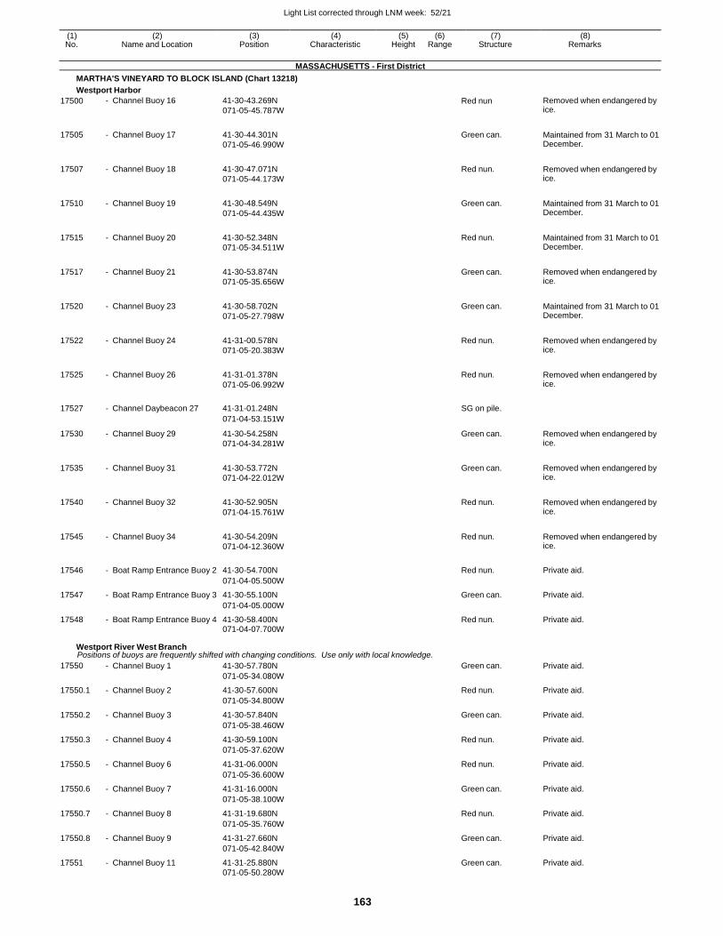
Light List corrected through LNM week: 52/21
163
(1) (2) (3) (4) (5) (6) (7) (8) No. Name and Location Position Characteristic Height Range Structure Remarks
MASSACHUSETTS - First District
MARTHA'S VINEYARD TO BLOCK ISLAND (Chart 13218)
Westport Harbor
17500 - Channel Buoy 16 41-30-43.269N
071-05-45.787W Red nun Removed when endangered by
ice.
17505 - Channel Buoy 17 41-30-44.301N
071-05-46.990W
Green can. Maintained from 31 March to 01 December.
17507 - Channel Buoy 18 41-30-47.071N
071-05-44.173W
Red nun. Removed when endangered by ice.
17510 - Channel Buoy 19 41-30-48.549N
071-05-44.435W
Green can. Maintained from 31 March to 01 December.
17515 - Channel Buoy 20 41-30-52.348N
071-05-34.511W
Red nun. Maintained from 31 March to 01 December.
17517 - Channel Buoy 21 41-30-53.874N
071-05-35.656W
Green can. Removed when endangered by ice.
17520 - Channel Buoy 23 41-30-58.702N
071-05-27.798W
Green can. Maintained from 31 March to 01 December.
17522 - Channel Buoy 24 41-31-00.578N
071-05-20.383W
Red nun. Removed when endangered by ice.
17525 - Channel Buoy 26 41-31-01.378N
071-05-06.992W
Red nun. Removed when endangered by ice.
17527 - Channel Daybeacon 27 41-31-01.248N SG on pile.
071-04-53.151W
17530 - Channel Buoy 29 41-30-54.258N
071-04-34.281W
Green can. Removed when endangered by ice.
17535 - Channel Buoy 31 41-30-53.772N
071-04-22.012W
Green can. Removed when endangered by ice.
17540 - Channel Buoy 32 41-30-52.905N
071-04-15.761W
Red nun. Removed when endangered by ice.
17545 - Channel Buoy 34 41-30-54.209N
071-04-12.360W
Red nun. Removed when endangered by ice.
17546 - Boat Ramp Entrance Buoy 2 41-30-54.700N Red nun. Private aid.
071-04-05.500W
17547 - Boat Ramp Entrance Buoy 3 41-30-55.100N Green can. Private aid.
071-04-05.000W
17548 - Boat Ramp Entrance Buoy 4 41-30-58.400N Red nun. Private aid. 071-04-07.700W
Westport River West Branch Positions of buoys are frequently shifted with changing conditions. Use only with local knowledge.
17550 - Channel Buoy 1 41-30-57.780N Green can. Private aid.
071-05-34.080W
17550.1 - Channel Buoy 2 41-30-57.600N Red nun. Private aid.
071-05-34.800W
17550.2 - Channel Buoy 3 41-30-57.840N Green can. Private aid.
071-05-38.460W
17550.3 - Channel Buoy 4 41-30-59.100N Red nun. Private aid.
071-05-37.620W
17550.5 - Channel Buoy 6 41-31-06.000N Red nun. Private aid.
071-05-36.600W
17550.6 - Channel Buoy 7 41-31-16.000N Green can. Private aid.
071-05-38.100W
17550.7 - Channel Buoy 8 41-31-19.680N Red nun. Private aid.
071-05-35.760W
17550.8 - Channel Buoy 9 41-31-27.660N Green can. Private aid.
071-05-42.840W
17551 - Channel Buoy 11 41-31-25.880N Green can. Private aid. 071-05-50.280W
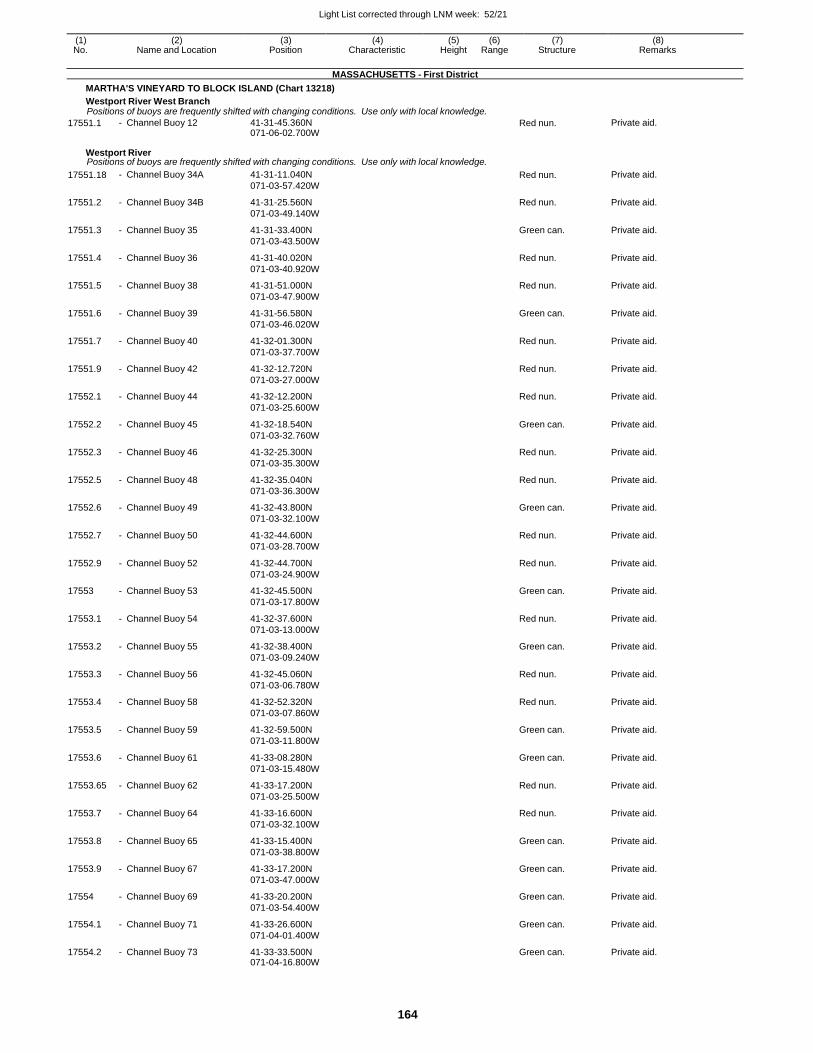
Light List corrected through LNM week: 52/21
164
(1) (2) (3) (4) (5) (6) (7) (8) No. Name and Location Position Characteristic Height Range Structure Remarks
MASSACHUSETTS - First District
MARTHA'S VINEYARD TO BLOCK ISLAND (Chart 13218)
Westport River West Branch Positions of buoys are frequently shifted with changing conditions. Use only with local knowledge.
17551.1 - Channel Buoy 12 41-31-45.360N 071-06-02.700W
Red nun. Private aid.
Westport River Positions of buoys are frequently shifted with changing conditions. Use only with local knowledge.
17551.18 - Channel Buoy 34A 41-31-11.040N
071-03-57.420W Red nun. Private aid.
17551.2 - Channel Buoy 34B 41-31-25.560N
071-03-49.140W
Red nun. Private aid.
17551.3 - Channel Buoy 35 41-31-33.400N
071-03-43.500W
Green can. Private aid.
17551.4 - Channel Buoy 36 41-31-40.020N
071-03-40.920W
Red nun. Private aid.
17551.5 - Channel Buoy 38 41-31-51.000N
071-03-47.900W
Red nun. Private aid.
17551.6 - Channel Buoy 39 41-31-56.580N
071-03-46.020W
Green can. Private aid.
17551.7 - Channel Buoy 40 41-32-01.300N
071-03-37.700W
Red nun. Private aid.
17551.9 - Channel Buoy 42 41-32-12.720N
071-03-27.000W
Red nun. Private aid.
17552.1 - Channel Buoy 44 41-32-12.200N
071-03-25.600W
Red nun. Private aid.
17552.2 - Channel Buoy 45 41-32-18.540N
071-03-32.760W
Green can. Private aid.
17552.3 - Channel Buoy 46 41-32-25.300N
071-03-35.300W
Red nun. Private aid.
17552.5 - Channel Buoy 48 41-32-35.040N
071-03-36.300W
Red nun. Private aid.
17552.6 - Channel Buoy 49 41-32-43.800N
071-03-32.100W
Green can. Private aid.
17552.7 - Channel Buoy 50 41-32-44.600N
071-03-28.700W
Red nun. Private aid.
17552.9 - Channel Buoy 52 41-32-44.700N
071-03-24.900W
Red nun. Private aid.
17553 - Channel Buoy 53 41-32-45.500N
071-03-17.800W
Green can. Private aid.
17553.1 - Channel Buoy 54 41-32-37.600N
071-03-13.000W
Red nun. Private aid.
17553.2 - Channel Buoy 55 41-32-38.400N
071-03-09.240W
Green can. Private aid.
17553.3 - Channel Buoy 56 41-32-45.060N
071-03-06.780W
Red nun. Private aid.
17553.4 - Channel Buoy 58 41-32-52.320N
071-03-07.860W
Red nun. Private aid.
17553.5 - Channel Buoy 59 41-32-59.500N
071-03-11.800W
Green can. Private aid.
17553.6 - Channel Buoy 61 41-33-08.280N
071-03-15.480W
Green can. Private aid.
17553.65 - Channel Buoy 62 41-33-17.200N
071-03-25.500W
Red nun. Private aid.
17553.7 - Channel Buoy 64 41-33-16.600N
071-03-32.100W
Red nun. Private aid.
17553.8 - Channel Buoy 65 41-33-15.400N
071-03-38.800W
Green can. Private aid.
17553.9 - Channel Buoy 67 41-33-17.200N
071-03-47.000W
Green can. Private aid.
17554 - Channel Buoy 69 41-33-20.200N
071-03-54.400W
Green can. Private aid.
17554.1 - Channel Buoy 71 41-33-26.600N
071-04-01.400W
Green can. Private aid.
17554.2 - Channel Buoy 73 41-33-33.500N 071-04-16.800W
Green can. Private aid.
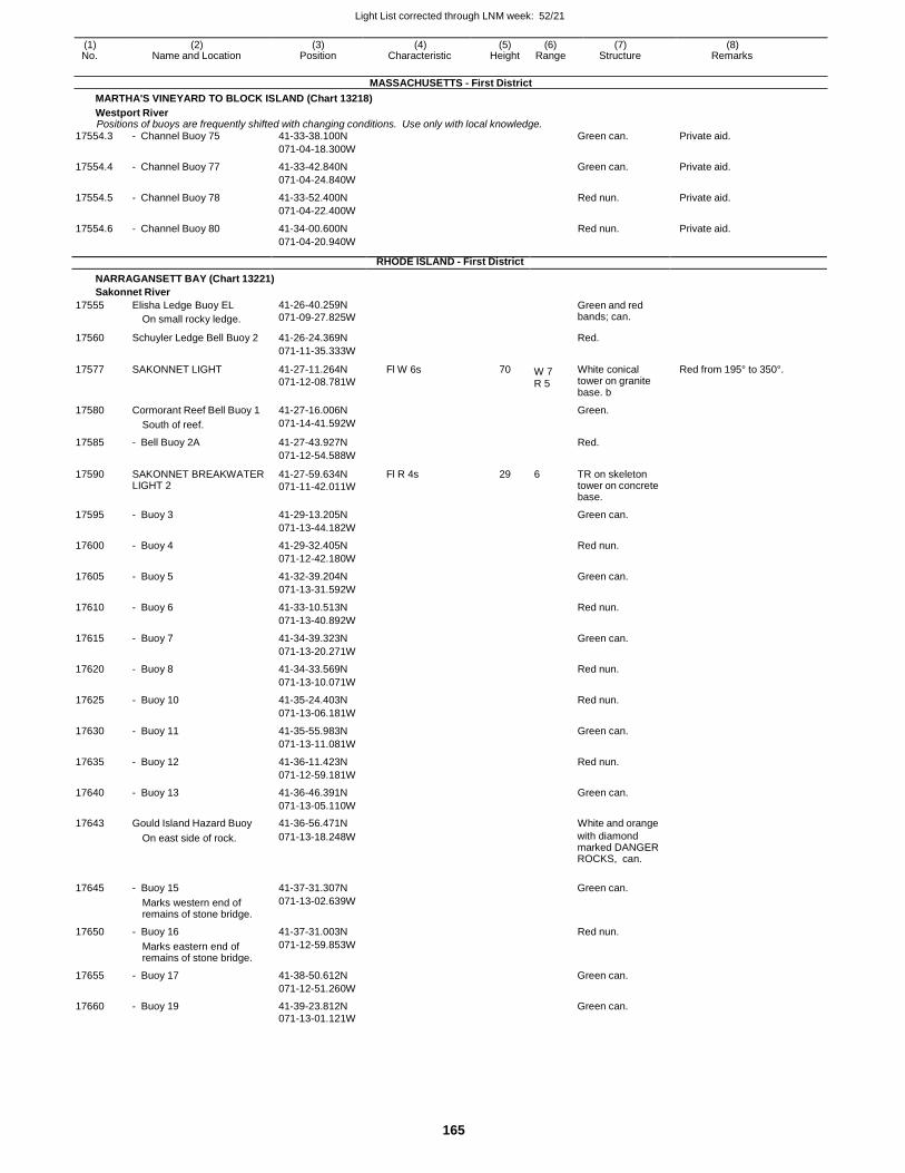
Light List corrected through LNM week: 52/21
165
(1) (2) (3) (4) (5) (6) (7) (8) No. Name and Location Position Characteristic Height Range Structure Remarks
MASSACHUSETTS - First District
MARTHA'S VINEYARD TO BLOCK ISLAND (Chart 13218)
Westport River Positions of buoys are frequently shifted with changing conditions. Use only with local knowledge.
17554.3 - Channel Buoy 75 41-33-38.100N Green can. Private aid.
071-04-18.300W
17554.4 - Channel Buoy 77 41-33-42.840N Green can. Private aid.
071-04-24.840W
17554.5 - Channel Buoy 78 41-33-52.400N Red nun. Private aid.
071-04-22.400W
17554.6 - Channel Buoy 80 41-34-00.600N Red nun. Private aid.
071-04-20.940W
RHODE ISLAND - First District
NARRAGANSETT BAY (Chart 13221)
Sakonnet River
17555 Elisha Ledge Buoy EL
On small rocky ledge.
41-26-40.259N
071-09-27.825W
Green and red bands; can.
17560 Schuyler Ledge Bell Buoy 2 41-26-24.369N Red.
071-11-35.333W
17577 SAKONNET LIGHT 41-27-11.264N
071-12-08.781W
Fl W 6s 70 W 7 R 5
White conical tower on granite base. b
Red from 195° to 350°.
17580 Cormorant Reef Bell Buoy 1 41-27-16.006N Green.
South of reef. 071-14-41.592W
17585 - Bell Buoy 2A 41-27-43.927N Red.
071-12-54.588W
17590 SAKONNET BREAKWATER LIGHT 2
41-27-59.634N
071-11-42.011W
Fl R 4s 29 6 TR on skeleton tower on concrete base.
17595 - Buoy 3 41-29-13.205N Green can.
071-13-44.182W
17600 - Buoy 4 41-29-32.405N Red nun.
071-12-42.180W
17605 - Buoy 5 41-32-39.204N Green can.
071-13-31.592W
17610 - Buoy 6 41-33-10.513N Red nun.
071-13-40.892W
17615 - Buoy 7 41-34-39.323N Green can.
071-13-20.271W
17620 - Buoy 8 41-34-33.569N Red nun.
071-13-10.071W
17625 - Buoy 10 41-35-24.403N Red nun.
071-13-06.181W
17630 - Buoy 11 41-35-55.983N Green can.
071-13-11.081W
17635 - Buoy 12 41-36-11.423N Red nun.
071-12-59.181W
17640 - Buoy 13 41-36-46.391N Green can.
071-13-05.110W
17643 Gould Island Hazard Buoy 41-36-56.471N White and orange
On east side of rock. 071-13-18.248W with diamond marked DANGER ROCKS, can.
17645 - Buoy 15 41-37-31.307N Green can.
Marks western end of remains of stone bridge.
071-13-02.639W
17650 - Buoy 16 41-37-31.003N Red nun.
Marks eastern end of remains of stone bridge.
071-12-59.853W
17655 - Buoy 17 41-38-50.612N Green can.
071-12-51.260W
17660 - Buoy 19 41-39-23.812N Green can. 071-13-01.121W
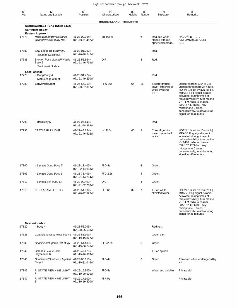
Light List corrected through LNM week: 52/21
166
(1) (2) (3) (4) (5) (6) (7) (8) No. Name and Location Position Characteristic Height Range Structure Remarks
RHODE ISLAND - First District
NARRAGANSETT BAY (Chart 13221)
Narragansett Bay
Eastern Approach
17675 Narragansett Bay Entrance Lighted Whistle Buoy NB
41-23-00.034N
071-23-21.482W
Mo (A) W 6 Red and white stripes with red spherical topmark.
RACON: B ( - . . . ) AIS: MMSI 993672153 (21)
17680 Seal Ledge Bell Buoy 2A 41-26-01.732N
Red.
South of Seal Rock. 071-20-48.247W
17685 Brenton Point Lighted Whistle Buoy 2
41-25-56.664N 071-21-46.739W
Q R 3 Red.
Southwest of shoal.
East Passage
17775 - Gong Buoy 4 41-26-34.724N Red.
Marks edge of reef. 071-21-49.290W
17780 Beavertail Light 41-26-57.750N
071-23-57.897W
Fl W 10s 64 15 Square granite tower, attached to white dwelling.
70
Obscured from 175° to 215°. Lighted throughout 24 hours. HORN: 1 blast ev 30s (3s bl). MRASS-Fog signal is radio activated, during times of reduced visibility, turn marine VHF-FM radio to channel 83A/157.175Mhz. Key microphone 5 times consecutively, to activate fog signal for 45 minutes.
17790 - Bell Buoy 6 41-27-27.149N
Red.
071-21-58.989W
17795 CASTLE HILL LIGHT 41-27-43.834N
071-21-46.512W
Iso R 6s 40 9 Conical granite tower, upper half white.
HORN: 1 blast ev 10s (1s bl). MRASS Fog signal is radio activated, during times of reduced visibility, turn marine VHF-FM radio to channel 83A/157.175Mhz. Key microphone 5 times consecutively, to activate fog signal for 45 minutes.
17800
- Lighted Gong Buoy 7
41-28-18.402N
Fl G 4s
4
Green.
071-22-14.903W
17805 - Lighted Gong Buoy 9 41-28-38.403N Fl G 2.5s 4 Green.
071-21-14.204W
17810 - Lighted Bell Buoy 11 41-29-00.402N Q G 4 Green.
071-21-02.700W
17815 FORT ADAMS LIGHT 2 41-28-54.302N
071-20-12.397W
Fl R 6s 32 7 TR on white skeleton tower.
HORN: 1 blast ev 15s (2s bl). MRASS-Fog signal is radio activated, during times of reduced visibility, turn marine VHF-FM radio to channel 83A/157.175Mhz. Key microphone 5 times consecutively, to activate fog signal for 45 minutes.
Newport Harbor
17820 - Buoy 4 41-28-52.003N Red nun.
071-20-05.538W
17825 Goat Island Southwest Buoy 1 41-28-56.903N Green can.
071-19-45.877W
17830 Goat Island Lighted Bell Buoy 3
41-28-54.133N
071-19-36.746W
Fl G 2.5s 3 Green.
17840 Little Ida Lewis Rock Daybeacon 6
41-28-47.473N
071-19-10.865W
TR on spindle.
17845 Goat Island Southeast Lighted Buoy 7
41-29-00.913N
071-19-31.046W
Fl G 4s 3 Green. Removed when endangered by ice.
17846 RI STATE PIER NINE LIGHT 1
41-29-16.900N
071-19-20.500W
Fl G 5s
Wharf end dolphin. Private aid.
17847 RI STATE PIER NINE LIGHT 2
41-29-17.100N 071-19-19.300W
Fl R 5s Private aid.
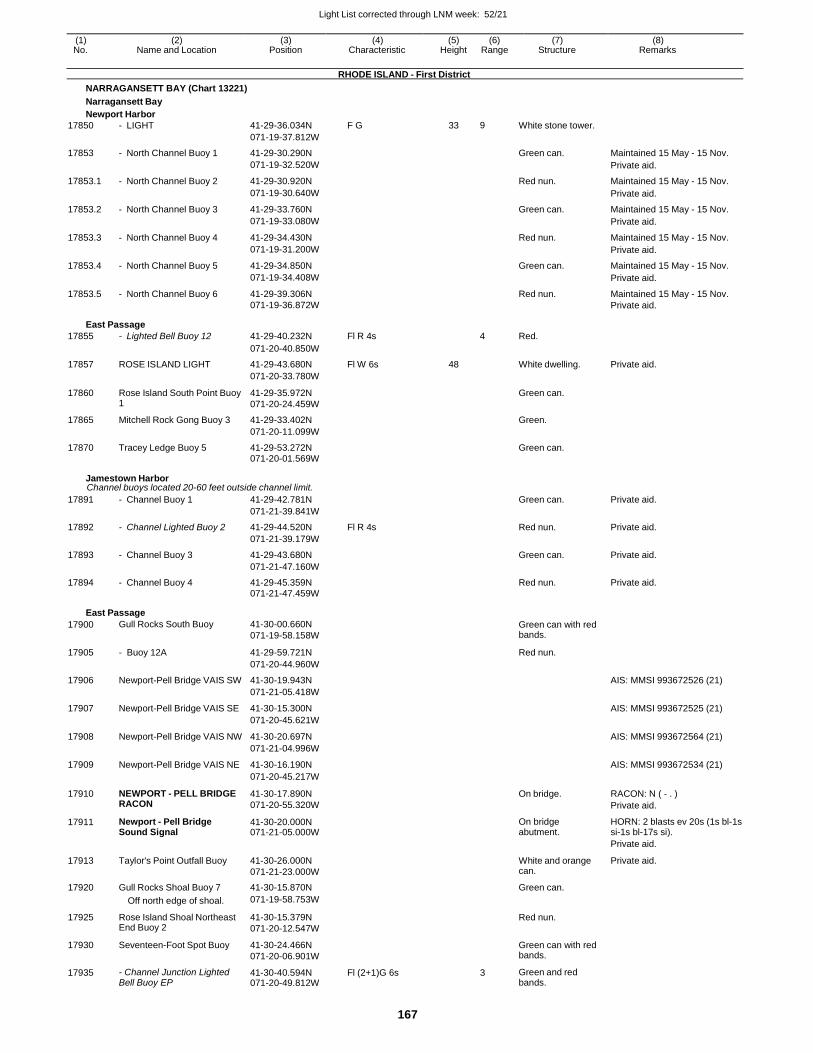
Light List corrected through LNM week: 52/21
167
(1) (2) (3) (4) (5) (6) (7) (8) No. Name and Location Position Characteristic Height Range Structure Remarks
RHODE ISLAND - First District
NARRAGANSETT BAY (Chart 13221)
Narragansett Bay
Newport Harbor
17850 - LIGHT 41-29-36.034N F G 33 9 White stone tower.
071-19-37.812W
17853 - North Channel Buoy 1 41-29-30.290N Green can. Maintained 15 May - 15 Nov.
071-19-32.520W Private aid.
17853.1 - North Channel Buoy 2 41-29-30.920N Red nun. Maintained 15 May - 15 Nov.
071-19-30.640W Private aid.
17853.2 - North Channel Buoy 3 41-29-33.760N Green can. Maintained 15 May - 15 Nov.
071-19-33.080W Private aid.
17853.3 - North Channel Buoy 4 41-29-34.430N Red nun. Maintained 15 May - 15 Nov.
071-19-31.200W Private aid.
17853.4 - North Channel Buoy 5 41-29-34.850N Green can. Maintained 15 May - 15 Nov.
071-19-34.408W Private aid.
17853.5 - North Channel Buoy 6 41-29-39.306N Red nun. Maintained 15 May - 15 Nov. 071-19-36.872W Private aid.
East Passage
17855 - Lighted Bell Buoy 12 41-29-40.232N Fl R 4s 4 Red.
071-20-40.850W
17857 ROSE ISLAND LIGHT 41-29-43.680N Fl W 6s 48 White dwelling. Private aid.
071-20-33.780W
17860 Rose Island South Point Buoy 1
41-29-35.972N
071-20-24.459W
Green can.
17865 Mitchell Rock Gong Buoy 3 41-29-33.402N Green.
071-20-11.099W
17870 Tracey Ledge Buoy 5 41-29-53.272N Green can.
071-20-01.569W
Jamestown Harbor Channel buoys located 20-60 feet outside channel limit.
17891 - Channel Buoy 1 41-29-42.781N Green can. Private aid.
071-21-39.841W
17892 - Channel Lighted Buoy 2 41-29-44.520N Fl R 4s Red nun. Private aid.
071-21-39.179W
17893 - Channel Buoy 3 41-29-43.680N Green can. Private aid.
071-21-47.160W
17894 - Channel Buoy 4 41-29-45.359N Red nun. Private aid. 071-21-47.459W
East Passage
17900 Gull Rocks South Buoy 41-30-00.660N
071-19-58.158W
Green can with red bands.
17905 - Buoy 12A 41-29-59.721N Red nun.
071-20-44.960W
17906 Newport-Pell Bridge VAIS SW 41-30-19.943N AIS: MMSI 993672526 (21)
071-21-05.418W
17907 Newport-Pell Bridge VAIS SE 41-30-15.300N AIS: MMSI 993672525 (21)
071-20-45.621W
17908 Newport-Pell Bridge VAIS NW 41-30-20.697N AIS: MMSI 993672564 (21)
071-21-04.996W
17909 Newport-Pell Bridge VAIS NE 41-30-16.190N AIS: MMSI 993672534 (21)
071-20-45.217W
17910 NEWPORT - PELL BRIDGE RACON
41-30-17.890N
071-20-55.320W
On bridge. RACON: N ( - . )
Private aid.
17911 Newport - Pell Bridge Sound Signal
41-30-20.000N 071-21-05.000W
On bridge abutment.
HORN: 2 blasts ev 20s (1s bl-1s si-1s bl-17s si).
Private aid.
17913 Taylor's Point Outfall Buoy 41-30-26.000N
071-21-23.000W
White and orange can.
Private aid.
17920 Gull Rocks Shoal Buoy 7 41-30-15.870N Green can.
Off north edge of shoal. 071-19-58.753W
17925 Rose Island Shoal Northeast End Buoy 2
41-30-15.379N
071-20-12.547W
Red nun.
17930 Seventeen-Foot Spot Buoy 41-30-24.466N
071-20-06.901W
Green can with red bands.
17935 - Channel Junction Lighted Bell Buoy EP
41-30-40.594N 071-20-49.812W
Fl (2+1)G 6s 3 Green and red bands.
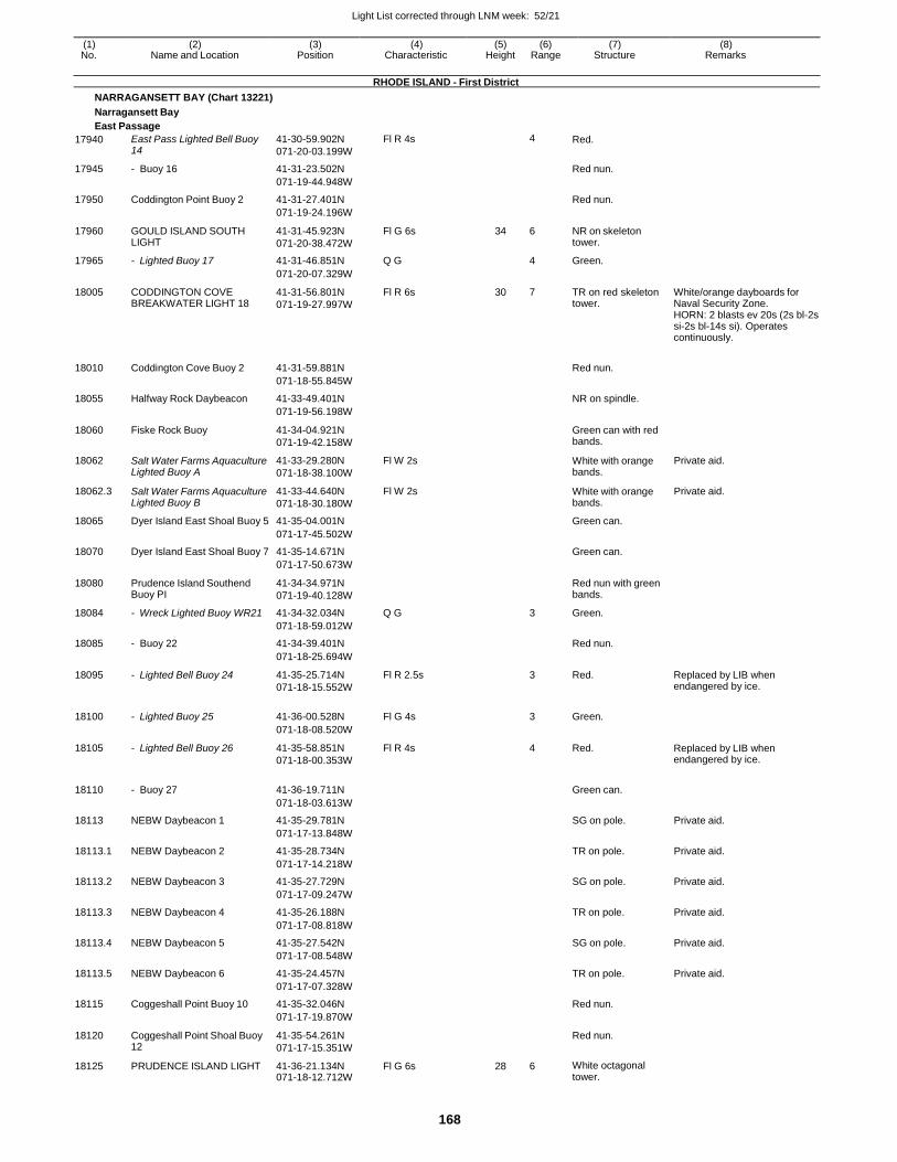
Light List corrected through LNM week: 52/21
168
(1) (2) (3) (4) (5) (6) (7) (8) No. Name and Location Position Characteristic Height Range Structure Remarks
RHODE ISLAND - First District
NARRAGANSETT BAY (Chart 13221)
Narragansett Bay
East Passage
17940 East Pass Lighted Bell Buoy 14
41-30-59.902N
071-20-03.199W
Fl R 4s 4 Red.
17945 - Buoy 16 41-31-23.502N Red nun.
071-19-44.948W
17950 Coddington Point Buoy 2 41-31-27.401N Red nun.
071-19-24.196W
17960 GOULD ISLAND SOUTH LIGHT
41-31-45.923N
071-20-38.472W
Fl G 6s 34 6 NR on skeleton tower.
17965 - Lighted Buoy 17 41-31-46.851N Q G 4 Green.
071-20-07.329W
18005 CODDINGTON COVE BREAKWATER LIGHT 18
41-31-56.801N
071-19-27.997W
Fl R 6s 30 7 TR on red skeleton tower.
White/orange dayboards for Naval Security Zone. HORN: 2 blasts ev 20s (2s bl-2s si-2s bl-14s si). Operates continuously.
18010 Coddington Cove Buoy 2 41-31-59.881N
Red nun.
071-18-55.845W
18055 Halfway Rock Daybeacon 41-33-49.401N NR on spindle.
071-19-56.198W
18060 Fiske Rock Buoy 41-34-04.921N
071-19-42.158W
Green can with red bands.
18062 Salt Water Farms Aquaculture Lighted Buoy A
41-33-29.280N
071-18-38.100W
Fl W 2s White with orange bands.
Private aid.
18062.3 Salt Water Farms Aquaculture Lighted Buoy B
41-33-44.640N
071-18-30.180W
Fl W 2s White with orange bands.
Private aid.
18065 Dyer Island East Shoal Buoy 5 41-35-04.001N Green can.
071-17-45.502W
18070 Dyer Island East Shoal Buoy 7 41-35-14.671N Green can.
071-17-50.673W
18080 Prudence Island Southend Buoy PI
41-34-34.971N
071-19-40.128W
Red nun with green bands.
18084 - Wreck Lighted Buoy WR21 41-34-32.034N Q G 3 Green.
071-18-59.012W
18085 - Buoy 22 41-34-39.401N Red nun.
071-18-25.694W
18095 - Lighted Bell Buoy 24 41-35-25.714N
071-18-15.552W
Fl R 2.5s 3 Red. Replaced by LIB when endangered by ice.
18100 - Lighted Buoy 25 41-36-00.528N Fl G 4s
3 Green.
071-18-08.520W
18105 - Lighted Bell Buoy 26 41-35-58.851N
071-18-00.353W
Fl R 4s 4 Red. Replaced by LIB when endangered by ice.
18110 - Buoy 27 41-36-19.711N
Green can.
071-18-03.613W
18113 NEBW Daybeacon 1 41-35-29.781N SG on pole. Private aid.
071-17-13.848W
18113.1 NEBW Daybeacon 2 41-35-28.734N TR on pole. Private aid.
071-17-14.218W
18113.2 NEBW Daybeacon 3 41-35-27.729N SG on pole. Private aid.
071-17-09.247W
18113.3 NEBW Daybeacon 4 41-35-26.188N TR on pole. Private aid.
071-17-08.818W
18113.4 NEBW Daybeacon 5 41-35-27.542N SG on pole. Private aid.
071-17-08.548W
18113.5 NEBW Daybeacon 6 41-35-24.457N TR on pole. Private aid.
071-17-07.328W
18115 Coggeshall Point Buoy 10 41-35-32.046N Red nun.
071-17-19.870W
18120 Coggeshall Point Shoal Buoy 12
41-35-54.261N
071-17-15.351W
Red nun.
18125 PRUDENCE ISLAND LIGHT 41-36-21.134N 071-18-12.712W
Fl G 6s 28 6 White octagonal tower.
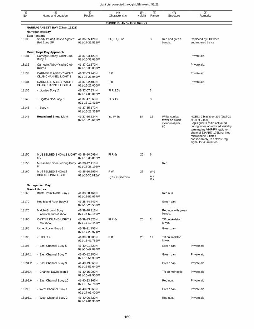
Light List corrected through LNM week: 52/21
169
(1) (2) (3) (4) (5) (6) (7) (8) No. Name and Location Position Characteristic Height Range Structure Remarks
RHODE ISLAND - First District
NARRAGANSETT BAY (Chart 13221)
Narragansett Bay
East Passage 18130 Sandy Point Junction Lighted 41-36-55.421N Fl (2+1)R 6s 3 Red and green Replaced by LIB when
Bell Buoy SP 071-17-35.552W bands. endangered by ice.
Mount Hope Bay Approach
18131 Carnegie Abbey Yacht Club Buoy 1
41-37-03.420N
071-16-33.080W
Private aid.
18132 Carnegie Abbey Yacht Club Buoy 2
41-37-02.570N
071-16-33.050W
Private aid.
18133 CARNEGIE ABBEY YACHT CLUB CHANNEL LIGHT 3
41-37-03.240N
071-16-26.040W
F G Private aid.
18134 CARNEGIE ABBEY YACHT CLUB CHANNEL LIGHT 4
41-37-02.400N
071-16-26.000W
F R Private aid.
18135 - Lighted Buoy 2 41-37-07.834N Fl R 2.5s 3
071-17-00.012W
18140 - Lighted Bell Buoy 3 41-37-47.565N Fl G 4s 3
071-16-17.416W
18143 - Buoy 4 41-37-35.172N
071-16-25.363W
18145 Hog Island Shoal Light 41-37-56.334N
071-16-23.612W
Iso W 6s 54 12 White conical tower on black cylindrical pier. 60
HORN: 2 blasts ev 30s (2sbl-2s si-2s bl-24s si) Fog signal is radio activated, during times of reduced visibility, turn marine VHF-FM radio to channel 83A/157.175Mhz. Key microphone 5 times consecutively, to activate fog signal for 45 minutes.
18150 MUSSELBED SHOALS LIGHT 6A
41-38-10.699N
071-15-35.812W
Fl R 6s 26 6
18155 Musselbed Shoals Gong Buoy 6
41-38-12.411N
071-15-38.196W
Red.
18160 MUSSELBED SHOALS 41-38-10.699N F W 26 W 9
DIRECTIONAL LIGHT
Narragansett Bay
Bristol Harbor
071-15-35.812W (R & G sectors) G 7
R 7
18165 Bristol Point Rock Buoy 2 41-38-28.161N Red nun.
071-15-57.097W
18170 Hog Island Rock Buoy 3 41-38-44.741N Green can.
071-16-25.538W
18175 Middle Ground Buoy
At north end of shoal.
41-39-40.211N
071-16-52.150W
Red nun with green bands.
18180 CASTLE ISLAND LIGHT 2
On shoal.
41-39-13.826N
071-17-10.442W
Fl R 6s 26 3 TR on skeleton tower.
18185 Usher Rocks Buoy 3 41-39-31.751N Green can.
071-17-20.971W
18190 - LIGHT 4 41-39-58.200N
071-16-41.789W
F R 25 11 TR on skeleton tower.
18194 - East Channel Buoy 5 41-40-01.320N Green can. Private aid.
071-16-49.020W
18194.1 - East Channel Buoy 7 41-40-12.280N Green can. Private aid.
071-16-51.900W
18194.2 - East Channel Buoy 9 41-40-19.860N Green can. Private aid.
071-16-53.640W
18195.4 - Channel Daybeacon 8 41-40-15.900N TR on monopile. Private aid.
071-16-49.500W
18195.6 - East Channel Buoy 10 41-40-23.367N Red nun. Private aid.
071-16-52.718W
18196 - West Channel Buoy 1 41-40-09.960N Green can. Private aid.
071-17-05.400W
18196.1 - West Channel Buoy 2 41-40-06.720N Red nun. Private aid. 071-17-01.380W
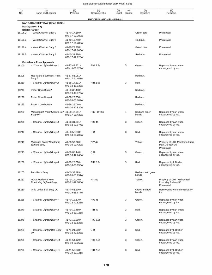
Light List corrected through LNM week: 52/21
170
(1) (2) (3) (4) (5) (6) (7) (8) No. Name and Location Position Characteristic Height Range Structure Remarks
RHODE ISLAND - First District
NARRAGANSETT BAY (Chart 13221)
Narragansett Bay
Bristol Harbor
18196.2 - West Channel Buoy 3 41-40-17.160N Green can. Private aid.
071-17-07.200W
18196.3 - West Channel Buoy 4 41-40-19.740N Red nun. Private aid.
071-17-06.480W
18196.4 - West Channel Buoy 5 41-40-27.900N Green can. Private aid.
071-17-12.600W
18196.5 - West Channel Buoy 6 41-40-31.380N Red nun. Private aid. 071-17-12.720W
Providence River Approach
18200 - Channel Lighted Buoy 1 41-37-42.571N
071-18-05.073W
Fl G 2.5s 3 Green. Replaced by can when endangered by ice.
18205 Hog Island Southwest Point Buoy 2
41-37-51.081N
071-17-21.451W
Red nun.
18210 - Channel Lighted Buoy 2 41-38-14.331N Fl R 2.5s 3 Red.
071-18-11.133W
18215 Potter Cove Buoy 2 41-38-32.480N Red nun.
071-19-49.378W
18220 Potter Cove Buoy 4 41-38-25.750N Red nun.
071-20-05.709W
18225 Potter Cove Buoy 6 41-38-28.060N Red nun.
071-20-17.820W
18230 Popasquash Point Lighted Bell Buoy PP
41-38-47.951N
071-17-58.433W
Fl (2+1)R 6s 4 Red and green bands.
Replaced by nun when endangered by ice.
18235 - Channel Lighted Buoy 3 41-38-31.801N
071-18-27.074W
Fl G 4s 3 Green. Replaced by can when endangered by ice.
18240 - Channel Lighted Buoy 4 41-38-52.333N
071-18-28.202W
Q R 3 Red. Replaced by nun when endangered by ice.
18241 Prudence Island Monitoring Lighted Buoy
41-38-53.020N 071-19-09.420W
Fl Y 4s
Yellow. Property of URI. Maintained from May 1 to Nov 30.
Private aid.
18245 - Channel Lighted Buoy 5 41-39-05.440N
071-18-42.745W
Q G 3 Green. Replaced by can when endangered by ice.
18250 - Channel Lighted Buoy 6 41-39-20.570N
071-18-35.955W
Fl R 2.5s 3 Red. Replaced by LIB when endangered by ice.
18255 Fork Rock Buoy 41-40-33.199N
071-20-51.251W
Red nun with green bands.
18257 North Prudence Point Monitoring Lighted Buoy
41-40-14.040N 071-21-19.080W
Fl Y 5s Yellow. Property of URI. Maintained from May 1 - Nov 30.
Private aid.
18260 Ohio Ledge Bell Buoy OL 41-40-56.200N
071-19-18.677W
Green and red bands.
Removed when endangered by ice.
18265 - Channel Lighted Buoy 7 41-40-19.370N
071-18-47.825W
Fl G 4s 3 Green. Replaced by can when endangered by ice.
18270 - Channel Lighted Buoy 8 41-40-19.480N
071-18-39.725W
Fl R 4s 3 Red. Replaced by nun when endangered by ice.
18275 - Channel Lighted Buoy 9 41-41-19.250N
071-18-53.825W
Fl G 2.5s 3 Green. Replaced by can when endangered by ice.
18280 - Channel Lighted Bell Buoy 10
41-41-21.080N
071-18-43.525W
Q R 3 Red. Replaced by LIB when endangered by ice.
18285 - Channel Lighted Buoy 11 41-41-54.129N
071-19-28.969W
Fl G 2.5s 3 Green. Replaced by can when endangered by ice.
18290 - Channel Lighted Buoy 12 41-41-58.328N 071-19-21.721W
Fl R 2.5s 3 Red. Replaced by LIB when endangered by ice.
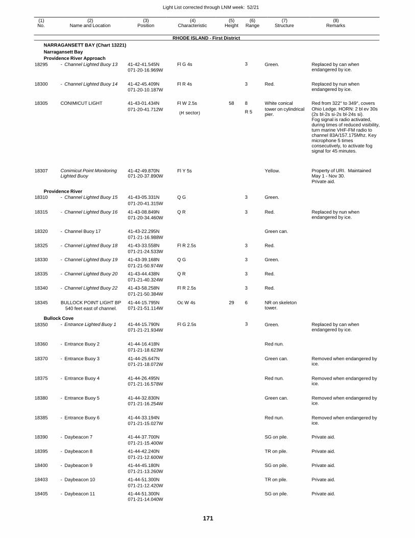
Light List corrected through LNM week: 52/21
171
(1) (2) (3) (4) (5) (6) (7) (8) No. Name and Location Position Characteristic Height Range Structure Remarks
RHODE ISLAND - First District
NARRAGANSETT BAY (Chart 13221)
Narragansett Bay
Providence River Approach
18295 - Channel Lighted Buoy 13 41-42-41.545N
071-20-16.969W
Fl G 4s 3 Green. Replaced by can when endangered by ice.
18300 - Channel Lighted Buoy 14 41-42-45.409N
071-20-10.187W
Fl R 4s
3 Red. Replaced by nun when endangered by ice.
18305 CONIMICUT LIGHT 41-43-01.434N Fl W 2.5s 58 8 White conical Red from 322° to 349°, covers
071-20-41.712W R 5
tower on cylindrical Ohio Ledge. HORN: 2 bl ev 30s (R sector) pier. (2s bl-2s si-2s bl-24s si).
Fog signal is radio activated, during times of reduced visibility, turn marine VHF-FM radio to channel 83A/157.175Mhz. Key microphone 5 times consecutively, to activate fog signal for 45 minutes.
18307
Conimicut Point Monitoring Lighted Buoy
41-42-49.870N 071-20-37.890W
Fl Y 5s
Yellow.
Property of URI. Maintained May 1 - Nov 30.
Private aid.
Providence River
18310 - Channel Lighted Buoy 15 41-43-05.331N Q G 3 Green.
071-20-41.315W
18315 - Channel Lighted Buoy 16 41-43-08.849N
071-20-34.460W
Q R 3 Red. Replaced by nun when endangered by ice.
18320 - Channel Buoy 17 41-43-22.295N
Green can.
071-21-16.988W
18325 - Channel Lighted Buoy 18 41-43-33.558N Fl R 2.5s 3 Red.
071-21-24.533W
18330 - Channel Lighted Buoy 19 41-43-39.168N Q G 3 Green.
071-21-50.974W
18335 - Channel Lighted Buoy 20 41-43-44.438N Q R 3 Red.
071-21-40.324W
18340 - Channel Lighted Buoy 22 41-43-58.258N Fl R 2.5s 3 Red.
071-21-50.384W
18345 BULLOCK POINT LIGHT BP
540 feet east of channel.
41-44-15.795N
071-21-51.114W
Oc W 4s 29 6 NR on skeleton tower.
Bullock Cove
18350 - Entrance Lighted Buoy 1 41-44-15.790N
071-21-21.934W
Fl G 2.5s 3 Green. Replaced by can when endangered by ice.
18360 - Entrance Buoy 2 41-44-16.418N
Red nun.
071-21-18.623W
18370 - Entrance Buoy 3 41-44-25.647N
071-21-18.072W
Green can. Removed when endangered by ice.
18375 - Entrance Buoy 4 41-44-26.495N
071-21-16.578W
Red nun. Removed when endangered by
ice.
18380 - Entrance Buoy 5 41-44-32.830N
071-21-16.254W
Green can. Removed when endangered by
ice.
18385 - Entrance Buoy 6 41-44-33.194N
071-21-15.027W
Red nun. Removed when endangered by
ice.
18390 - Daybeacon 7 41-44-37.700N
SG on pile. Private aid.
071-21-15.400W
18395 - Daybeacon 8 41-44-42.240N TR on pile. Private aid.
071-21-12.600W
18400 - Daybeacon 9 41-44-45.180N SG on pile. Private aid.
071-21-13.260W
18403 - Daybeacon 10 41-44-51.300N TR on pile. Private aid.
071-21-12.420W
18405 - Daybeacon 11 41-44-51.300N SG on pile. Private aid. 071-21-14.040W
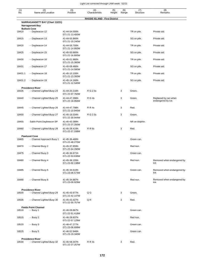
Light List corrected through LNM week: 52/21
172
(1) (2) (3) (4) (5) (6) (7) (8) No. Name and Location Position Characteristic Height Range Structure Remarks
RHODE ISLAND - First District
NARRAGANSETT BAY (Chart 13221)
Narragansett Bay
Bullock Cove
18410 - Daybeacon 12 41-44-54.000N TR on pile. Private aid.
071-21-13.400W
18415 - Daybeacon 13 41-44-55.860N SG on pile. Private aid.
071-21-15.240W
18420 - Daybeacon 14 41-44-59.700N TR on pile. Private aid.
071-21-14.900W
18425 - Daybeacon 15 41-45-00.660N SG on pile. Private aid.
071-21-16.800W
18430 - Daybeacon 16 41-45-01.980N TR on pile. Private aid.
071-21-15.360W
18431 - Daybeacon 17 41-45-09.480N SG on pile. Private aid.
071-21-14.580W
18431.1 - Daybeacon 18 41-45-10.100N TR on pile. Private aid.
071-21-13.300W
18431.2 - Daybeacon 19 41-45-14.160N SG on pile. Private aid. 071-21-12.540W
Providence River
18435 - Channel Lighted Buoy 23 41-44-20.216N Fl G 2.5s 3 Green.
071-22-07.760W
18440 - Channel Lighted Buoy 25 41-44-47.396N
071-22-18.956W
Fl G 4s 3 Green. Replaced by can when endangered by ice.
18445 - Channel Lighted Buoy 26 41-44-47.798N Fl R 4s 3 Red.
071-22-10.945W
18450 - Channel Lighted Buoy 27 41-45-16.034N Fl G 2.5s 3 Green.
071-22-30.944W
18455 Sabin Point Daybeacon SP 41-45-43.389N NR on dolphin.
071-22-27.250W
18460 - Channel Lighted Buoy 28 41-45-28.410N Fl R 6s 3 Red.
071-22-27.338W
Pawtuxet Cove
18465 - Channel Approach Buoy 1 41-45-36.480N Green can.
071-22-48.270W
18470 - Channel Buoy 2 41-45-37.859N Red nun.
071-22-54.290W
18475 - Channel Buoy 3 41-45-36.671N Green can.
071-22-53.636W
18480 - Channel Buoy 4 41-45-36.155N
071-23-02.138W
Red nun. Removed when endangered by ice.
18485 - Channel Buoy 5 41-45-34.610N
071-23-06.573W
Green can. Removed when endangered by ice.
18490 - Channel Buoy 6 41-45-34.887N 071-23-09.929W
Red nun. Removed when endangered by ice.
Providence River
18500 - Channel Lighted Buoy 29 41-45-43.977N Q G 3 Green.
071-22-42.147W
18505 - Channel Lighted Buoy 30 41-45-43.427N Q R 3 Red. 071-22-30.757W
Fields Point Channel 18510 - Buoy 1 41-46-09.867N Green can.
071-22-51.418W
18515 - Buoy 2 41-46-28.837N Red nun.
071-22-57.129W
18520 - Buoy 3 41-46-47.277N Green can.
071-23-06.699W
18525 - Buoy 5 41-46-52.946N Green can. 071-23-19.340W
Providence River
18530 - Channel Lighted Buoy 32 41-45-58.347N Fl R 4s 3 Red. 071-22-27.257W
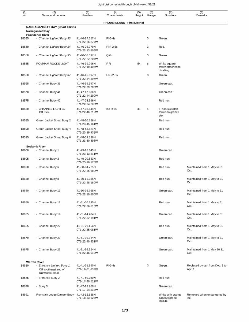
Light List corrected through LNM week: 52/21
173
(1) (2) (3) (4) (5) (6) (7) (8) No. Name and Location Position Characteristic Height Range Structure Remarks
RHODE ISLAND - First District
NARRAGANSETT BAY (Chart 13221)
Narragansett Bay
Providence River
18535 - Channel Lighted Buoy 33 41-46-17.657N Fl G 4s 3 Green.
071-22-26.277W
18540 - Channel Lighted Buoy 34 41-46-26.079N Fl R 2.5s 3 Red.
071-22-13.805W
18550 - Channel Lighted Buoy 35 41-46-30.397N Q G 3 Green.
071-22-22.207W
18555 POMHAM ROCKS LIGHT 41-46-39.096N F R 54 6 White square 071-22-10.406W tower.attached to dwelling.
18560 - Channel Lighted Buoy 37 41-46-45.897N Fl G 2.5s 3 Green.
071-22-24.207W
18565 - Channel Buoy 39 41-46-56.397N Green can.
071-22-29.708W
18570 - Channel Buoy 41 41-47-17.086N Green can.
071-22-44.299W
18575 - Channel Buoy 40 41-47-23.396N Red nun.
071-22-34.208W
18580 - CHANNEL LIGHT 42 41-47-38.844N Iso R 6s 31 4 TR on skeleton Off rock. 071-22-46.712W tower on granite
pier.
18585 Green Jacket Shoal Buoy 2 41-48-50.656N Red nun.
071-23-45.161W
18590 Green Jacket Shoal Buoy 4 41-48-55.821N Red nun.
071-23-39.938W
18595 Green Jacket Shoal Buoy 6 41-48-59.336N Red nun. 071-23-30.896W
Seekonk River
18600 - Channel Buoy 1 41-49-16.645N Green can.
071-23-13.811W
18605 - Channel Buoy 2 41-49-20.833N Red nun.
071-23-10.170W
18620 - Channel Buoy 6 41-50-04.775N Red nun. Maintained from 1 May to 31
071-22-35.680W Oct.
18630 - Channel Buoy 8 41-50-16.385N Red nun. Maintained from 1 May to 31
071-22-28.180W Oct.
18640 - Channel Buoy 13 41-50-36.765N Green can. Maintained from 1 May to 31
071-22-19.800W Oct.
18650 - Channel Buoy 18 41-51-00.695N Red nun. Maintained from 1 May to 31
071-22-26.610W Oct.
18655 - Channel Buoy 19 41-51-14.204N Green can. Maintained from 1 May to 31
071-22-32.191W Oct.
18665 - Channel Buoy 22 41-51-29.454N Red nun. Maintained from 1 May to 31
071-22-35.081W Oct.
18670 - Channel Buoy 23 41-51-39.944N Green can. Maintained from 1 May to 31
071-22-40.931W Oct.
18675 - Channel Buoy 27 41-51-56.324N Green can. Maintained from 1 May 50 31 071-22-46.612W Oct.
Warren River
18680 - Entrance Lighted Buoy 1 41-41-51.850N Fl G 4s 3 Green. Replaced by can from Dec. 1 to
Off southeast end of 071-18-01.633W Apr. 1.
Rumstick Shoal.
18685 - Entrance Buoy 2 41-41-50.750N Red nun.
071-17-40.512W
18690 - Buoy 3 41-42-13.960N Green can.
071-17-54.813W
18691 Rumstick Ledge Danger Buoy 41-42-12.138N White with orange Removed when endangered by 071-18-33.625W bands worded ice. ROCK.
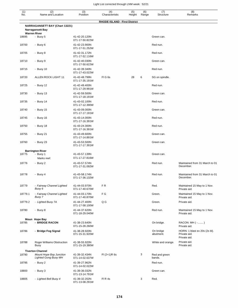
Light List corrected through LNM week: 52/21
174
(1) (2) (3) (4) (5) (6) (7) (8) No. Name and Location Position Characteristic Height Range Structure Remarks
RHODE ISLAND - First District
NARRAGANSETT BAY (Chart 13221)
Narragansett Bay
Warren River
18695 - Buoy 5 41-42-20.120N Green can.
071-17-50.822W
18700 - Buoy 6 41-42-23.900N Red nun.
071-17-51.252W
18705 - Buoy 8 41-42-31.172N Red nun.
071-17-52.116W
18710 - Buoy 9 41-42-40.030N Green can.
071-17-50.622W
18715 - Buoy 10 41-42-39.340N Red nun.
071-17-43.022W
18720 ALLEN ROCK LIGHT 11 41-42-48.799N Fl G 6s 28 6 SG on spindle.
071-17-35.191W
18725 - Buoy 12 41-42-49.400N Red nun.
071-17-29.991W
18730 - Buoy 13 41-42-59.500N Green can.
071-17-18.191W
18735 - Buoy 14 41-43-02.100N Red nun.
071-17-12.390W
18740 - Buoy 15 41-43-09.000N Green can.
071-17-17.191W
18745 - Buoy 16 41-43-14.000N Red nun.
071-17-16.391W
18750 - Buoy 18 41-43-24.300N Red nun.
071-17-16.391W
18755 - Buoy 21 41-43-49.600N Green can.
071-17-14.891W
18760 - Buoy 23 41-43-53.500N Green can. 071-17-17.391W
Barrington River 18775 - Buoy 1 41-43-57.139N Green can.
Marks reef. 071-17-27.816W
18776 - Buoy 2 41-43-57.574N
071-17-31.092W
Red nun. Maintained from 31 March to 01 December.
18778 - Buoy 4 41-43-58.174N
071-17-36.132W
Red nun. Maintained from 31 March to 01
December.
18779 - Fairway Channel Lighted Buoy 6
41-44-03.970N
071-17-40.670W
F R Red. Maintained 15 May to 1 Nov.
Private aid.
18779.1 - Fairway Channel Lighted Buoy 7
41-44-03.170N
071-17-40.870W
F G Green. Maintained 15 May to 1 Nov.
Private aid.
18779.2 - Lighted Buoy 7A 41-44-27.400N Q G Green. Private aid.
071-17-58.100W
18780 - Buoy 8 41-44-37.620N Red nun. Maintained 15 May to 1 Nov. 071-18-29.040W Private aid.
Mount
18785
Hope Bay
- BRIDGE RACON
41-38-23.640N
On bridge.
RACON: MH ( - ........ )
071-15-28.260W Private aid.
18786 - Bridge Fog Signal 41-38-28.920N 071-15-31.920W
On bridge abutment.
HORN: 1 blast ev 20s (2s bl). Private aid.
Private aid.
18788 Roger Williams Obstruction Buoy
41-38-55.920N 071-15-19.380W
White and orange. Private aid.
Private aid.
Tiverton Channel
18790 Mount Hope Bay Junction Lighted Gong Buoy MH
41-39-32.434N
071-14-02.637W
Fl (2+1)R 6s 3 Red and green bands.
18795 - Buoy 2 41-39-27.962N Red nun.
071-14-02.022W
18800 - Buoy 3 41-39-36.032N Green can.
071-13-14.791W
18805 - Lighted Bell Buoy 4 41-39-32.202N Fl R 4s 3 Red. 071-13-08.291W
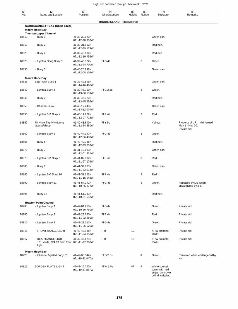
Light List corrected through LNM week: 52/21
175
(1) (2) (3) (4) (5) (6) (7) (8) No. Name and Location Position Characteristic Height Range Structure Remarks
RHODE ISLAND - First District
NARRAGANSETT BAY (Chart 13221)
Mount Hope Bay
Tiverton Upper Channel
18810 - Buoy 1 41-39-39.042N Green can.
071-12-38.330W
18815 - Buoy 2 41-39-31.902N Red nun.
071-12-39.179W
18820 - Buoy 4 41-39-43.002N Red nun.
071-12-19.459W
18825 - Lighted Gong Buoy 3 41-39-48.322N Fl G 4s 3 Green.
071-12-24.700W
18830 - Buoy 5 41-40-25.992N Green can. 071-12-08.109W
Mount Hope Bay
18835 Seal Rock Buoy 1 41-39-42.545N Green can.
071-14-46.486W
18840 - Lighted Buoy 1 41-39-48.769N Fl G 2.5s 3 Green.
071-13-50.539W
18845 - Buoy 2 41-39-45.322N Red nun.
071-13-45.256W
18850 - Channel Buoy 3 41-40-17.243N Green can.
071-13-12.007W
18855 - Lighted Bell Buoy 4 41-40-14.222N Fl R 4s 3 Red.
071-13-07.728W
18857 Mt Hope Bay Monitoring Lighted Buoy
41-40-48.840N 071-12-54.360W
Fl Y 5s Yellow. Property of URI. Maintained May 1 - Nov 30.
Private aid.
18860 - Lighted Buoy 5 41-40-44.197N Fl G 4s 3 Green.
071-12-36.433W
18865 - Buoy 6 41-40-40.755N Red nun.
071-12-33.057W
18870 - Buoy 7 41-41-10.693N Green can.
071-12-01.321W
18875 - Lighted Bell Buoy 8 41-41-07.902N Fl R 4s 3 Red.
071-11-57.179W
18880 - Buoy 9 41-41-32.601N Green can.
071-11-32.078W
18885 - Lighted Bell Buoy 10 41-41-39.262N Fl R 4s 3 Red.
071-11-15.648W
18890 - Lighted Buoy 11 41-41-54.242N
071-10-55.177W
Fl G 4s 3 Green. Replaced by LIB when endangered by ice.
18895 - Buoy 12 41-41-51.232N
Red nun.
071-10-51.537W
Brayton Point Channel
18900 - Lighted Buoy 1 41-42-04.260N Fl G 4s Green. Private aid.
071-10-50.760W
18905 - Lighted Buoy 2 41-42-23.280N Fl R 4s Red. Private aid.
071-11-02.280W
18910 - Lighted Buoy 3 41-42-21.017N Fl G 4s Green. Private aid.
071-11-06.526W
18915 - FRONT RANGE LIGHT 41-42-43.036N
071-11-24.856W
F R 12 KRW on metal tower.
Private aid.
18917 - REAR RANGE LIGHT
131 yards, 324.6T from front light.
41-42-46.121N
071-11-27.760W
F R 18 KRW on metal tower.
Private aid.
Mount Hope Bay
18920
18925
- Channel Lighted Buoy 13
BORDEN FLATS LIGHT
41-42-00.542N
071-10-42.847W
41-42-16.020N
071-10-27.837W
Fl G 2.5s
Fl W 2.5s
3
47 9
Green.
White conical tower with red stripe, on brown cylindrical pier.
Removed when endangered by ice.
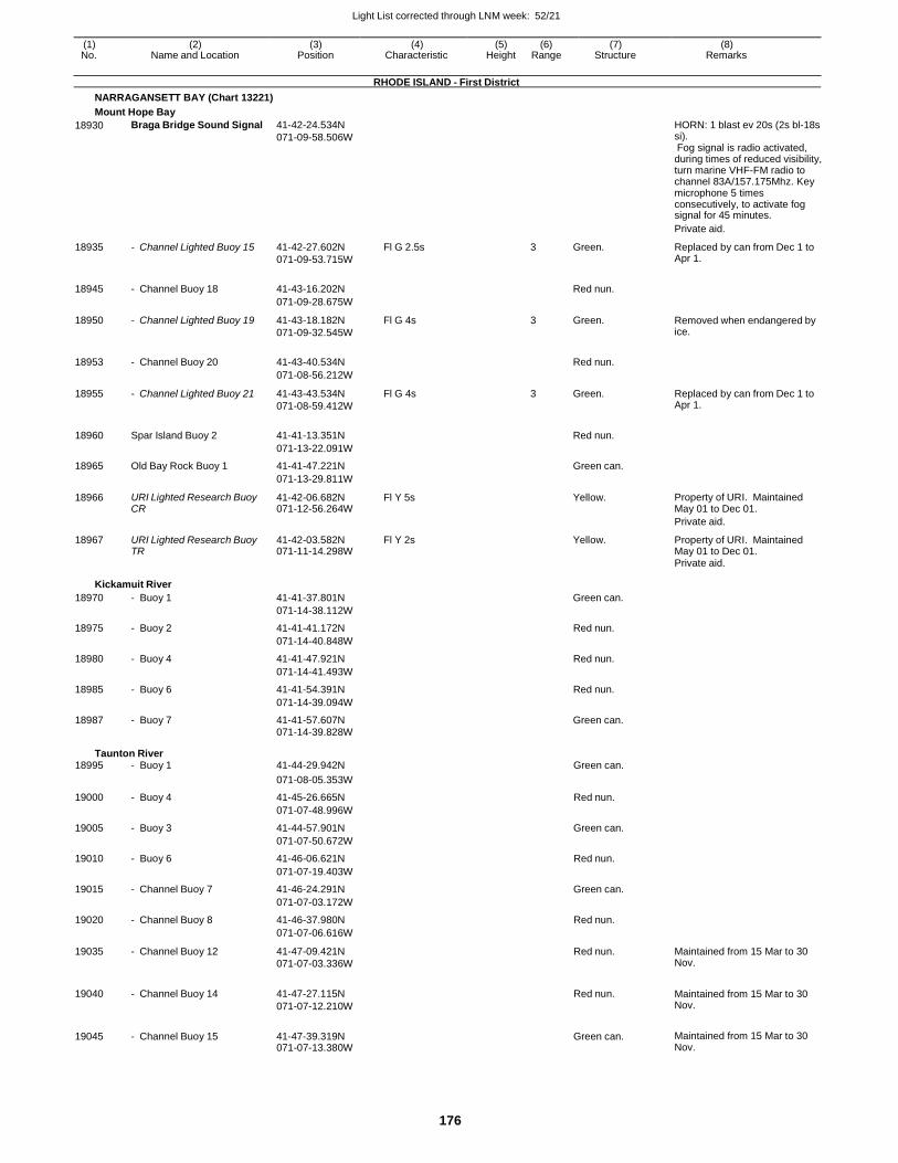
Light List corrected through LNM week: 52/21
176
(1) (2) (3) (4) (5) (6) (7) (8) No. Name and Location Position Characteristic Height Range Structure Remarks
RHODE ISLAND - First District
NARRAGANSETT BAY (Chart 13221)
Mount Hope Bay
18930 Braga Bridge Sound Signal 41-42-24.534N
071-09-58.506W
HORN: 1 blast ev 20s (2s bl-18s si). Fog signal is radio activated, during times of reduced visibility, turn marine VHF-FM radio to channel 83A/157.175Mhz. Key microphone 5 times consecutively, to activate fog signal for 45 minutes.
Private aid.
18935 - Channel Lighted Buoy 15 41-42-27.602N
071-09-53.715W
Fl G 2.5s 3 Green. Replaced by can from Dec 1 to Apr 1.
18945 - Channel Buoy 18 41-43-16.202N
Red nun.
071-09-28.675W
18950 - Channel Lighted Buoy 19 41-43-18.182N
071-09-32.545W
Fl G 4s 3 Green. Removed when endangered by ice.
18953 - Channel Buoy 20 41-43-40.534N
Red nun.
071-08-56.212W
18955 - Channel Lighted Buoy 21 41-43-43.534N
071-08-59.412W
Fl G 4s 3 Green. Replaced by can from Dec 1 to Apr 1.
18960 Spar Island Buoy 2 41-41-13.351N
Red nun.
071-13-22.091W
18965 Old Bay Rock Buoy 1 41-41-47.221N Green can.
071-13-29.811W
18966 URI Lighted Research Buoy CR
41-42-06.682N 071-12-56.264W
Fl Y 5s Yellow. Property of URI. Maintained May 01 to Dec 01.
Private aid.
18967 URI Lighted Research Buoy TR
41-42-03.582N 071-11-14.298W
Fl Y 2s Yellow. Property of URI. Maintained May 01 to Dec 01.
Private aid.
Kickamuit River
18970 - Buoy 1 41-41-37.801N Green can.
071-14-38.112W
18975 - Buoy 2 41-41-41.172N Red nun.
071-14-40.848W
18980 - Buoy 4 41-41-47.921N Red nun.
071-14-41.493W
18985 - Buoy 6 41-41-54.391N Red nun.
071-14-39.094W
18987 - Buoy 7 41-41-57.607N Green can. 071-14-39.828W
Taunton River 18995 - Buoy 1 41-44-29.942N Green can.
071-08-05.353W
19000 - Buoy 4 41-45-26.665N Red nun.
071-07-48.996W
19005 - Buoy 3 41-44-57.901N Green can.
071-07-50.672W
19010 - Buoy 6 41-46-06.621N Red nun.
071-07-19.403W
19015 - Channel Buoy 7 41-46-24.291N Green can.
071-07-03.172W
19020 - Channel Buoy 8 41-46-37.980N Red nun.
071-07-06.616W
19035 - Channel Buoy 12 41-47-09.421N
071-07-03.336W
Red nun. Maintained from 15 Mar to 30 Nov.
19040 - Channel Buoy 14 41-47-27.115N
071-07-12.210W
Red nun. Maintained from 15 Mar to 30 Nov.
19045 - Channel Buoy 15 41-47-39.319N 071-07-13.380W
Green can. Maintained from 15 Mar to 30 Nov.
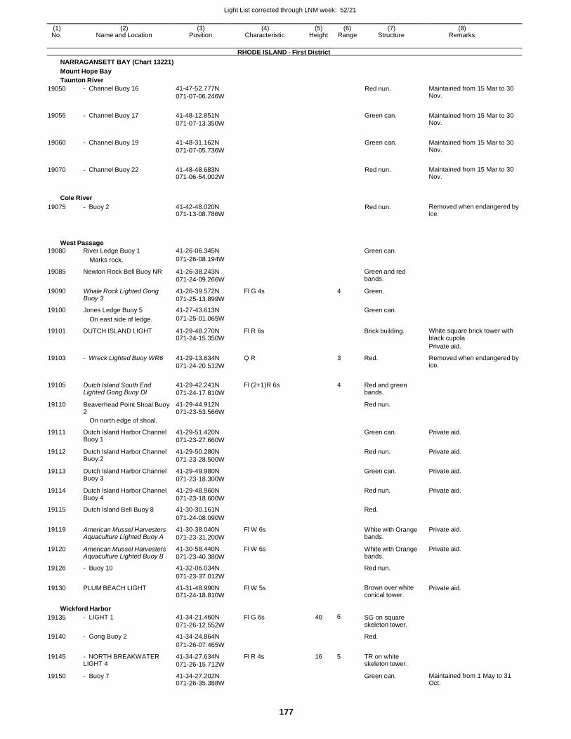
Light List corrected through LNM week: 52/21
177
(1) (2) (3) (4) (5) (6) (7) (8) No. Name and Location Position Characteristic Height Range Structure Remarks
RHODE ISLAND - First District
NARRAGANSETT BAY (Chart 13221)
Mount Hope Bay
Taunton River
19050 - Channel Buoy 16 41-47-52.777N
071-07-06.246W Red nun. Maintained from 15 Mar to 30
Nov.
19055 - Channel Buoy 17 41-48-12.851N
071-07-13.350W
Green can. Maintained from 15 Mar to 30 Nov.
19060 - Channel Buoy 19 41-48-31.162N
071-07-05.736W
Green can. Maintained from 15 Mar to 30 Nov.
19070 - Channel Buoy 22 41-48-48.683N 071-06-54.002W
Red nun. Maintained from 15 Mar to 30 Nov.
Cole River
19075 - Buoy 2 41-42-48.020N 071-13-08.786W
Red nun. Removed when endangered by ice.
West Passage
19080 River Ledge Buoy 1 41-26-06.345N Green can.
Marks rock. 071-26-08.194W
19085 Newton Rock Bell Buoy NR 41-26-38.243N
071-24-09.266W
Green and red bands.
19090 Whale Rock Lighted Gong Buoy 3
41-26-39.572N
071-25-13.899W
Fl G 4s 4 Green.
19100 Jones Ledge Buoy 5 41-27-43.613N Green can.
On east side of ledge. 071-25-01.065W
19101 DUTCH ISLAND LIGHT 41-29-48.270N 071-24-15.350W
Fl R 6s Brick building. White square brick tower with black cupola
Private aid.
19103 - Wreck Lighted Buoy WR6 41-29-13.634N
071-24-20.512W
Q R 3 Red. Removed when endangered by ice.
19105 Dutch Island South End Lighted Gong Buoy DI
41-29-42.241N
071-24-17.810W
Fl (2+1)R 6s 4 Red and green bands.
19110 Beaverhead Point Shoal Buoy 2
41-29-44.912N 071-23-53.566W
Red nun.
On north edge of shoal.
19111 Dutch Island Harbor Channel Buoy 1
41-29-51.420N
071-23-27.660W
Green can. Private aid.
19112 Dutch Island Harbor Channel Buoy 2
41-29-50.280N
071-23-28.500W
Red nun. Private aid.
19113 Dutch Island Harbor Channel Buoy 3
41-29-49.980N
071-23-18.300W
Green can. Private aid.
19114 Dutch Island Harbor Channel Buoy 4
41-29-48.960N
071-23-18.600W
Red nun. Private aid.
19115 Dutch Island Bell Buoy 8 41-30-30.161N Red.
071-24-08.090W
19119 American Mussel Harvesters Aquaculture Lighted Buoy A
41-30-38.040N
071-23-31.200W
Fl W 6s White with Orange bands.
Private aid.
19120 American Mussel Harvesters Aquaculture Lighted Buoy B
41-30-58.440N
071-23-40.380W
Fl W 6s White with Orange bands.
Private aid.
19126 - Buoy 10 41-32-06.034N Red nun.
071-23-37.012W
19130 PLUM BEACH LIGHT 41-31-48.990N 071-24-18.810W
Fl W 5s Brown over white conical tower.
Private aid.
Wickford Harbor
19135 - LIGHT 1 41-34-21.460N
071-26-12.552W
Fl G 6s 40 6 SG on square skeleton tower.
19140 - Gong Buoy 2 41-34-24.864N Red.
071-26-07.465W
19145 - NORTH BREAKWATER LIGHT 4
41-34-27.634N
071-26-15.712W
Fl R 4s 16 5 TR on white skeleton tower.
19150 - Buoy 7 41-34-27.202N 071-26-35.388W
Green can. Maintained from 1 May to 31 Oct.
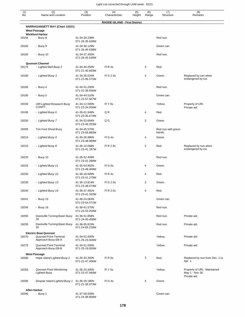
Light List corrected through LNM week: 52/21
178
(1) (2) (3) (4) (5) (6) (7) (8) No. Name and Location Position Characteristic Height Range Structure Remarks
RHODE ISLAND - First District
NARRAGANSETT BAY (Chart 13221)
West Passage
Wickford Harbor
19155 - Buoy 8 41-34-30.238N Red nun.
071-26-35.628W
19160 - Buoy 9 41-34-36.129N Green can.
071-26-45.538W
19165 - Buoy 10 41-34-37.450N Red nun. 071-26-45.540W
Quonset Channel
19175 - Lighted Bell Buoy 2 41-34-40.250N Fl R 4s 3 Red.
071-21-40.603W
19180 - Lighted Buoy 3 41-34-35.020N
071-22-06.575W
Fl G 2.5s 3 Green. Replaced by can when endangered by ice.
19185 - Buoy 4 41-34-51.200N
Red nun.
071-22-39.556W
19190 - Buoy 5 41-34-44.510N Green can.
071-22-57.947W
19193 URI Lighted Research Buoy CONPT
41-34-12.000N
071-23-24.000W
Fl Y 6s Yellow. Property of URI.
Private aid.
19195 - Lighted Buoy 6 41-35-01.949N Q R 4 Red.
071-23-35.074W
19200 - Lighted Buoy 7 41-34-53.694N Q G 3 Green.
071-23-49.253W
19205 Ten-Foot Shoal Buoy 41-34-45.570N
071-23-55.880W
Red nun with green bands.
19210 - Lighted Buoy 9 41-35-26.980N Fl G 4s 4 Green.
071-23-48.969W
19215 - Lighted Buoy 8 41-35-10.068N
071-23-41.187W
Fl R 2.5s 3 Red. Replaced by nun when endangered by ice.
19220 - Buoy 10 41-35-52.409N
Red nun.
071-23-41.289W
19225 - Lighted Buoy 11 41-35-54.902N Fl G 6s 4 Green.
071-23-48.469W
19230 - Lighted Buoy 12 41-36-18.599N Fl R 4s 4 Red.
071-23-41.279W
19235 - Lighted Buoy 13 41-36-13.814N Fl G 2.5s 3 Green.
071-23-48.074W
19240 - Lighted Buoy 14 41-36-37.491N Fl R 2.5s 4 Red.
071-23-41.332W
19241 - Buoy 15 41-36-24.063N Green can.
071-23-54.371W
19245 - Buoy 16 41-36-41.570N Red nun.
071-23-53.259W
19250 Davisville Turning Basin Buoy 18
41-36-51.858N
071-24-00.458W
Red nun. Private aid.
19255 Davisville Turning Basin Buoy 20
41-36-55.923N 071-24-05.218W
Red nun. Private aid.
Electric Boat Quonset
19270 Quonset Point Terminal Approach Buoy EB-A
41-34-51.000N
071-25-23.000W
Yellow. Private aid.
19275 Quonset Point Terminal Approach Buoy EB-B
41-34-51.000N 071-25-19.000W
Yellow. Private aid.
West Passage
19280 Hope Island Lighted Buoy 2 41-35-33.300N
071-22-47.406W
Fl R 6s 3 Red. Replaced by nun from Dec. 1 to Apr. 1.
19283 Quonset Point Monitoring Lighted Buoy
41-35-20.300N 071-22-47.940W
Fl Y 5s
Yellow. Property of URI. Maintained May 1 - Nov 30.
Private aid.
19285 Despair Island Lighted Buoy 1 41-36-29.180N Fl G 4s 4 Green.
071-21-36.073W
Allen Harbor
19290 - Buoy 1 41-37-09.559N Green can. 071-24-08.800W
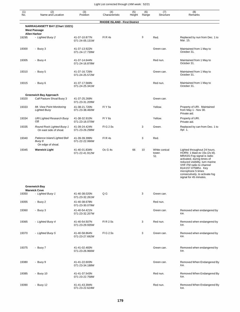
Light List corrected through LNM week: 52/21
179
(1) (2) (3) (4) (5) (6) (7) (8) No. Name and Location Position Characteristic Height Range Structure Remarks
RHODE ISLAND - First District
NARRAGANSETT BAY (Chart 13221)
West Passage
Allen Harbor
19295 - Lighted Buoy 2 41-37-10.877N
071-24-05.131W
Fl R 4s 3 Red. Replaced by nun from Dec. 1 to Mar. 15.
19300 - Buoy 3 41-37-13.922N
071-24-17.739W
Green can. Maintained from 1 May to
October 31.
19305 - Buoy 4 41-37-14.644N
071-24-16.878W
Red nun. Maintained from 1 May to
October 31.
19310 - Buoy 5 41-37-16.726N
071-24-25.572W
Green can. Maintained from 1 May to
October 31.
19315 - Buoy 6 41-37-17.569N 071-24-25.341W
Red nun. Maintained from 1 May to
October 31.
Greenwich Bay Approach
19320 Calf Pasture Shoal Buoy 3 41-37-25.269N Green can.
071-23-31.209W
19333 Mt. View Point Monitoring Lighted Buoy
41-38-21.720N 071-23-38.460W
Fl Y 5s Yellow. Property of URI. Maintained from May 1 - Nov 30.
Private aid.
19334 URI Lighted Research Buoy GB
41-38-32.910N
071-23-16.070W
Fl Y 6s Yellow. Property of URI.
Private aid.
19335 Round Rock Lighted Buoy 1
On east side of shoal.
41-39-24.424N
071-23-26.298W
Fl G 2.5s 3 Green. Replaced by can from Dec. 1 to Apr. 1.
19340
Patience Island Lighted Bell Buoy 8
41-39-39.399N 071-22-22.066W
Fl R 4s
3
Red.
On edge of shoal.
19345 Warwick Light 41-40-01.834N
071-22-41.912W
Oc G 4s 66 10 White conical tower. 51
Lighted throughout 24 hours. HORN: 1 blast ev 15s (2s bl). MRASS-Fog signal is radio activated, during times of reduced visibility, turn marine VHF-FM radio to channel 81A/157.075Mhz. Key microphone 5 times consecutively, to activate fog signal for 45 minutes.
Greenwich Bay
Warwick Cove
19350 - Lighted Buoy 1 41-40-38.020N Q G 3 Green can.
071-23-32.261W
19355 - Buoy 2 41-40-38.678N Red nun.
071-23-30.079W
19360 - Buoy 3 41-40-54.421N
071-23-32.207W
Green can. Removed when endangered by ice.
19365 - Lighted Buoy 4 41-40-54.507N
071-23-29.935W
Fl R 2.5s 3 Red nun. Removed when endangered by ice.
19370 - Lighted Buoy 5 41-40-58.864N
071-23-27.692W
Fl G 2.5s 3 Green can. Removed when endangered by ice.
19375
- Buoy 7
41-41-02.483N
071-23-26.966W
Green can.
Removed when endangered by ice.
19380
- Buoy 9
41-41-22.603N
071-23-34.188W
Green can.
Removed When Endangered By Ice.
19385 - Buoy 10 41-41-37.543N
071-23-22.758W
Red nun. Removed When Endangered By
Ice.
19390 - Buoy 12 41-41-43.394N 071-23-22.624W
Red nun. Removed When Endangered By
Ice.
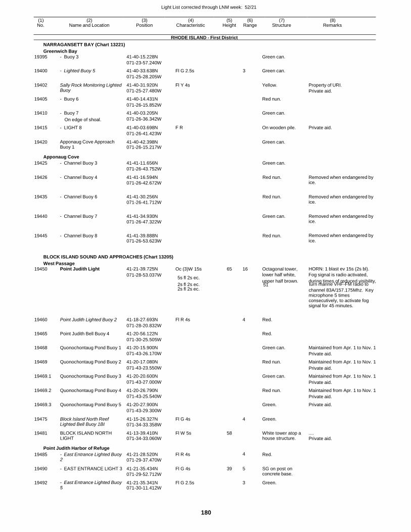
Light List corrected through LNM week: 52/21
180
(1) (2) (3) (4) (5) (6) (7) (8) No. Name and Location Position Characteristic Height Range Structure Remarks
RHODE ISLAND - First District
NARRAGANSETT BAY (Chart 13221)
Greenwich Bay
19395 - Buoy 3 41-40-15.228N Green can.
071-23-57.240W
19400 - Lighted Buoy 5 41-40-33.638N Fl G 2.5s 3 Green can.
071-25-28.205W
19402 Sally Rock Monitoring Lighted Buoy
41-40-31.920N
071-25-27.480W
Fl Y 4s Yellow. Property of URI.
Private aid.
19405 - Buoy 6 41-40-14.431N Red nun.
071-26-15.852W
19410 - Buoy 7 41-40-03.205N Green can.
On edge of shoal. 071-26-36.342W
19415 - LIGHT 8 41-40-03.698N F R On wooden pile. Private aid.
071-26-41.423W
19420 Apponaug Cove Approach Buoy 1
41-40-42.398N 071-26-15.217W
Green can.
Apponaug Cove
19425 - Channel Buoy 3 41-41-11.656N Green can.
071-26-43.752W
19426 - Channel Buoy 4 41-41-16.594N
071-26-42.672W
Red nun. Removed when endangered by ice.
19435 - Channel Buoy 6 41-41-30.256N
071-26-41.712W
Red nun. Removed when endangered by ice.
19440 - Channel Buoy 7 41-41-34.930N
071-26-47.322W
Green can. Removed when endangered by ice.
19445 - Channel Buoy 8 41-41-39.888N 071-26-53.623W
Red nun. Removed when endangered by ice.
BLOCK ISLAND SOUND AND APPROACHES (Chart 13205)
West Passage 19450 Point Judith Light 41-21-39.725N Oc (3)W 15s 65 16 Octagonal tower, HORN: 1 blast ev 15s (2s bl).
071-28-53.037W 5s fl 2s ec.
lower half white, Fog signal is radio activated,
2s fl 2s ec. upper half brown. during times of reduced visibility, 51 turn marine VHF-FM radio to
2s fl 2s ec. channel 83A/157.175Mhz. Key microphone 5 times consecutively, to activate fog signal for 45 minutes.
19460 Point Judith Lighted Buoy 2 41-18-27.693N Fl R 4s
4 Red.
071-28-20.832W
19465 Point Judith Bell Buoy 4 41-20-56.122N Red.
071-30-25.505W
19468 Quonochontaug Pond Buoy 1 41-20-15.900N Green can. Maintained from Apr. 1 to Nov. 1
071-43-26.170W Private aid.
19469 Quonochontaug Pond Buoy 2 41-20-17.080N Red nun. Maintained from Apr. 1 to Nov. 1
071-43-23.550W Private aid.
19469.1 Quonochontaug Pond Buoy 3 41-20-20.600N Green can. Maintained from Apr. 1 to Nov. 1
071-43-27.000W Private aid.
19469.2 Quonochontaug Pond Buoy 4 41-20-26.790N Red nun. Maintained from Apr. 1 to Nov. 1
071-43-25.540W Private aid.
19469.3 Quonochontaug Pond Buoy 5 41-20-27.900N Green. Private aid.
071-43-29.300W
19475 Block Island North Reef Lighted Bell Buoy 1BI
41-15-26.327N
071-34-33.358W
Fl G 4s 4 Green.
19481 BLOCK ISLAND NORTH LIGHT
41-13-39.410N 071-34-33.060W
Fl W 5s 58 White tower atop a house structure.
.... Private aid.
Point Judith Harbor of Refuge
19485 - East Entrance Lighted Buoy 2
41-21-28.520N
071-29-37.470W
Fl R 4s 4 Red.
19490 - EAST ENTRANCE LIGHT 3 41-21-35.434N
071-29-52.712W
Fl G 4s 39 5 SG on post on concrete base.
19492 - East Entrance Lighted Buoy 5
41-21-35.341N 071-30-11.412W
Fl G 2.5s 3 Green.
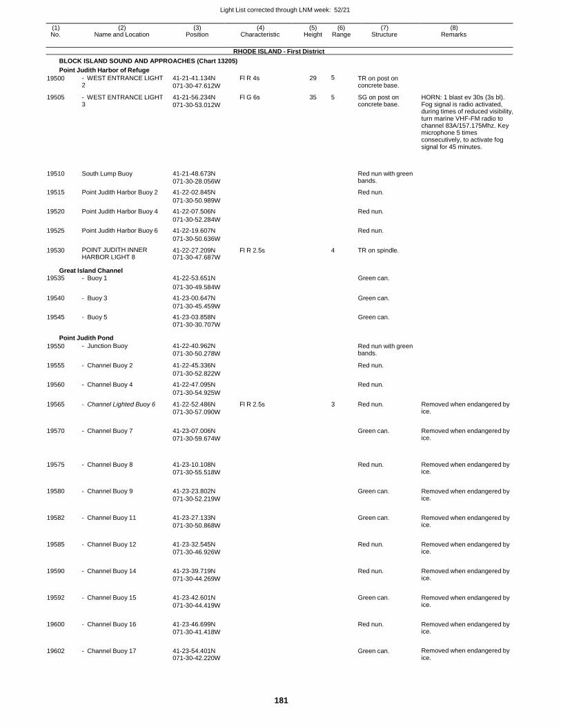
Light List corrected through LNM week: 52/21
181
(1) (2) (3) (4) (5) (6) (7) (8) No. Name and Location Position Characteristic Height Range Structure Remarks
RHODE ISLAND - First District
BLOCK ISLAND SOUND AND APPROACHES (Chart 13205)
Point Judith Harbor of Refuge
19500 - WEST ENTRANCE LIGHT 2
41-21-41.134N
071-30-47.612W
Fl R 4s 29 5 TR on post on concrete base.
19505 - WEST ENTRANCE LIGHT 3
41-21-56.234N
071-30-53.012W
Fl G 6s 35 5 SG on post on concrete base.
HORN: 1 blast ev 30s (3s bl). Fog signal is radio activated, during times of reduced visibility, turn marine VHF-FM radio to channel 83A/157.175Mhz. Key microphone 5 times consecutively, to activate fog signal for 45 minutes.
19510
South Lump Buoy
41-21-48.673N
071-30-28.056W
Red nun with green bands.
19515 Point Judith Harbor Buoy 2 41-22-02.845N Red nun.
071-30-50.989W
19520 Point Judith Harbor Buoy 4 41-22-07.506N Red nun.
071-30-52.284W
19525 Point Judith Harbor Buoy 6 41-22-19.607N Red nun.
071-30-50.636W
19530 POINT JUDITH INNER HARBOR LIGHT 8
41-22-27.209N 071-30-47.687W
Fl R 2.5s 4 TR on spindle.
Great Island Channel 19535 - Buoy 1 41-22-53.651N Green can.
071-30-49.584W
19540 - Buoy 3 41-23-00.647N Green can.
071-30-45.459W
19545 - Buoy 5 41-23-03.858N Green can. 071-30-30.707W
Point Judith Pond
19550 - Junction Buoy 41-22-40.962N
071-30-50.278W
Red nun with green bands.
19555 - Channel Buoy 2 41-22-45.336N Red nun.
071-30-52.822W
19560 - Channel Buoy 4 41-22-47.095N Red nun.
071-30-54.925W
19565 - Channel Lighted Buoy 6 41-22-52.486N
071-30-57.090W
Fl R 2.5s 3 Red nun. Removed when endangered by ice.
19570 - Channel Buoy 7 41-23-07.006N
071-30-59.674W
Green can. Removed when endangered by
ice.
19575
- Channel Buoy 8
41-23-10.108N
071-30-55.518W
Red nun.
Removed when endangered by ice.
19580 - Channel Buoy 9 41-23-23.802N
071-30-52.219W
Green can. Removed when endangered by
ice.
19582 - Channel Buoy 11 41-23-27.133N
071-30-50.868W
Green can. Removed when endangered by
ice.
19585 - Channel Buoy 12 41-23-32.545N
071-30-46.926W
Red nun. Removed when endangered by
ice.
19590 - Channel Buoy 14 41-23-39.719N
071-30-44.269W
Red nun. Removed when endangered by
ice.
19592 - Channel Buoy 15 41-23-42.601N
071-30-44.419W
Green can. Removed when endangered by
ice.
19600 - Channel Buoy 16 41-23-46.699N
071-30-41.418W
Red nun. Removed when endangered by
ice.
19602 - Channel Buoy 17 41-23-54.401N 071-30-42.220W
Green can. Removed when endangered by
ice.
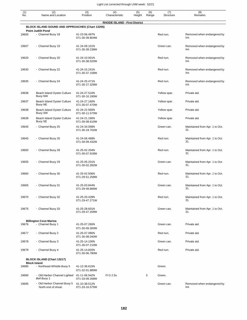
Light List corrected through LNM week: 52/21
182
(1) (2) (3) (4) (5) (6) (7) (8) No. Name and Location Position Characteristic Height Range Structure Remarks
RHODE ISLAND - First District
BLOCK ISLAND SOUND AND APPROACHES (Chart 13205)
Point Judith Pond
19605 - Channel Buoy 18 41-23-56.497N
071-30-39.804W Red nun. Removed when endangered by
ice.
19607 - Channel Buoy 19 41-24-09.101N
071-30-39.238W
Green can. Removed when endangered by ice.
19620 - Channel Buoy 20 41-24-10.001N
071-30-38.020W
Red nun. Removed when endangered by ice.
19630 - Channel Buoy 22 41-24-15.241N
071-30-37.158W
Red nun. Removed when endangered by ice.
19635 - Channel Buoy 24 41-24-25.471N
071-30-27.328W
Red nun. Removed when endangered by ice.
19636 Beach Island Oyster Culture Buoy NW
41-24-27.510N
071-30-10.190W
Yellow spar. Private aid.
19637 Beach Island Oyster Culture Buoy NE
41-24-27.160N
071-30-07.470W
Yellow spar. Private aid.
19638 Beach Island Oyster Culture Buoy SW
41-24-22.550N
071-30-11.570W
Yellow spar. Private aid.
19639 Beach Island Oyster Culture Buoy SE
41-24-21.190N
071-30-08.610W
Yellow spar. Private aid.
19640 - Channel Buoy 25 41-24-34.058N
071-30-19.702W
Green can. Maintained from Apr. 1 to Oct. 31.
19645 - Channel Buoy 26 41-24-56.468N
071-30-09.432W
Red nun. Maintained from Apr. 1 to Oct. 31.
19650 - Channel Buoy 28 41-25-02.204N
071-30-07.918W
Red nun. Maintained from Apr. 1 to Oct. 31.
19655 - Channel Buoy 29 41-25-05.201N
071-30-02.282W
Green can. Maintained from Apr. 1 to Oct. 31.
19660 - Channel Buoy 30 41-25-02.506N
071-29-51.258W
Red nun. Maintained from Apr. 1 to Oct. 31.
19665 - Channel Buoy 31 41-25-03.844N
071-29-49.866W
Green can. Maintained from Apr. 1 to Oct. 31.
19670 - Channel Buoy 32 41-25-20.428N
071-29-47.271W
Red nun. Maintained from Apr. 1 to Oct. 31.
19675 - Channel Buoy 33 41-25-28.601N 071-29-47.209W
Green can. Maintained from Apr. 1 to Oct. 31.
Billington Cove Marina 19676 - Channel Buoy 1 41-25-07.260N Green can. Private aid.
071-30-09.300W
19677 - Channel Buoy 2 41-25-07.080N Red nun. Private aid.
071-30-08.040W
19678 - Channel Buoy 3 41-25-14.100N Green can. Private aid.
071-30-07.210W
19679 - Channel Buoy 4 41-25-14.820N Red nun. Private aid. 071-30-06.780W
BLOCK ISLAND (Chart 13217)
Block Island 19685 - Northeast Whistle Buoy 5 41-12-36.615N Green.
071-32-01.889W
19690 - Old Harbor Channel Lighted Bell Buoy 1
41-11-06.542N
071-33-09.268W
Fl G 2.5s 3 Green.
19695 - Old Harbor Channel Buoy 5
North end of shoal.
41-10-38.512N
071-33-16.575W
Green can. Removed when endangered by ice.
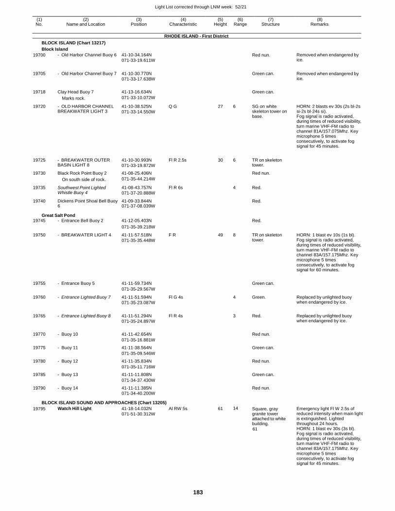
Light List corrected through LNM week: 52/21
183
(1) (2) (3) (4) (5) (6) (7) (8) No. Name and Location Position Characteristic Height Range Structure Remarks
RHODE ISLAND - First District
BLOCK ISLAND (Chart 13217)
Block Island
19700 - Old Harbor Channel Buoy 6 41-10-34.164N
071-33-19.611W
Red nun. Removed when endangered by ice.
19705 - Old Harbor Channel Buoy 7 41-10-30.770N
071-33-17.638W
Green can. Removed when endangered by
ice.
19718 Clay Head Buoy 7 41-13-16.634N
Green can.
Marks rock. 071-33-10.072W
19720 - OLD HARBOR CHANNEL BREAKWATER LIGHT 3
41-10-38.525N
071-33-14.550W
Q G 27 6 SG on white skeleton tower on base.
HORN: 2 blasts ev 30s (2s bl-2s si-2s bl-24s si). Fog signal is radio activated, during times of reduced visibility, turn marine VHF-FM radio to channel 81A/157.075Mhz. Key microphone 5 times consecutively, to activate fog signal for 45 minutes.
19725 - BREAKWATER OUTER BASIN LIGHT 8
41-10-30.993N
071-33-19.872W
Fl R 2.5s 30 6 TR on skeleton tower.
19730 Black Rock Point Buoy 2 41-08-25.406N Red nun.
On south side of rock. 071-35-44.214W
19735 Southwest Point Lighted Whistle Buoy 4
41-08-43.757N
071-37-20.888W
Fl R 6s 4 Red.
19740 Dickens Point Shoal Bell Buoy 6
41-09-33.844N 071-37-08.039W
Red.
Great Salt Pond 19745 - Entrance Bell Buoy 2 41-12-05.403N Red.
071-35-39.218W
19750 - BREAKWATER LIGHT 4 41-11-57.518N
071-35-35.448W
F R 49 8 TR on skeleton tower.
HORN: 1 blast ev 10s (1s bl). Fog signal is radio activated, during times of reduced visibility, turn marine VHF-FM radio to channel 83A/157.175Mhz. Key microphone 5 times consecutively, to activate fog signal for 60 minutes.
19755 - Entrance Buoy 5 41-11-59.734N
Green can.
071-35-29.567W
19760 - Entrance Lighted Buoy 7 41-11-51.594N
071-35-23.087W
Fl G 4s 4 Green. Replaced by unlighted buoy when endangered by ice.
19765 - Entrance Lighted Buoy 8 41-11-51.294N
071-35-24.897W
Fl R 4s
3 Red. Replaced by unlighted buoy when endangered by ice.
19770 - Buoy 10 41-11-42.654N
Red nun.
071-35-16.881W
19775 - Buoy 11 41-11-38.564N Green can.
071-35-09.546W
19780 - Buoy 12 41-11-35.834N Red nun.
071-35-11.716W
19785 - Buoy 13 41-11-11.808N Green can.
071-34-37.430W
19790 - Buoy 14 41-11-11.385N Red nun.
071-34-40.200W
BLOCK ISLAND SOUND AND APPROACHES (Chart 13205)
19795 Watch Hill Light 41-18-14.032N
071-51-30.312W
Al RW 5s 61 14 Square, gray granite tower attached to white building.
61
Emergency light Fl W 2.5s of reduced intensity when main light is extinguished. Lighted throughout 24 hours. HORN: 1 blast ev 30s (3s bl). Fog signal is radio activated, during times of reduced visibility, turn marine VHF-FM radio to channel 83A/157.175Mhz. Key microphone 5 times consecutively, to activate fog signal for 45 minutes.

Light List corrected through LNM week: 52/21
184
(1) (2) (3) (4) (5) (6) (7) (8) No. Name and Location Position Characteristic Height Range Structure Remarks
RHODE ISLAND - First District
BLOCK ISLAND SOUND AND APPROACHES (Chart 13205)
19800 URI Coastal Monitoring Lighted Research Buoy
41-20-40.200N 071-40-00.840W
Fl Y 2.5s
NEW YORK - First District
Yellow. Property of URI
Private aid.
BLOCK ISLAND SOUND AND GARDINERS BAY (Chart 13209)
19810 Cerberus Shoal Lighted Gong Buoy 9
41-10-27.512N
071-57-03.965W
Fl G 4s 4
19815 Race Rock Light 41-14-36.542N
072-02-49.688W
Fl R 10s 67 14 Granite tower attached to dwelling, on granite pier.
45
Horn points southeast. HORN: 2 blasts ev 30s (2s bl-2s si-2s-bl- 24s si). MRASS-Fog signal is radio activated, during times of reduced visibility, turn marine VHF-FM radio to channel 83A/157.175Mhz. Key microphone 5 times consecutively, to activate fog signal for 45 minutes.
19820 Race Point Buoy 2 41-14-45.709N
072-02-27.298W
19825 Valiant Rock Lighted Whistle Buoy 11
41-13-46.388N
072-03-59.980W
Q G 3 RACON: B ( - . . . )
19830 Little Gull Island Light 41-12-22.933N
072-06-24.712W
Fl (2)W 15s 91 14 81 HORN: 1 blast ev 15s (2s bl). Operates continuously.
19840 Little Gull Island Reef Buoy 1 41-12-29.695N
072-06-08.694W
19845 Block Island Sound South Entrance Obstruction Lighted Buoy BIS
41-06-57.032N
071-43-06.330W
Fl (2+1)G 6s 3 Green and red bands.
19850 Endeavor Shoals Lighted Gong Buoy 1
41-06-05.900N
071-46-21.711W
Fl G 4s 4 Green.
19855 Blackfish Rock Buoy 3 41-04-56.010N Green can.
071-52-57.124W
Montauk Harbor Approach
19860 Shagwong Rock Lighted Buoy SR
41-05-30.399N
071-53-43.256W
Fl (2+1)G 6s 3 Green and red bands.
19865 Shagwong Reef Lighted Bell Buoy 7SR
41-07-02.256N
071-54-49.552W
Fl G 2.5s 4 Green.
19870 Montauk Harbor Entrance Lighted Bell Buoy M
41-05-06.548N
071-56-23.223W
Mo (A) W 4 Red and white stripes with red spherical topmark.
19875 MONTAUK EAST JETTY LIGHT 1
41-04-46.128N
071-56-14.180W
Fl G 4s 33 4 SG on skeleton tower.
19880 MONTAUK WEST JETTY LIGHT 2
41-04-44.243N 071-56-20.320W
Fl R 2.5s 36 5 TR on skeleton tower.
Montauk Harbor Aids replaced by spar buoys during winter months.
19895 - Buoy 1 41-04-23.220N
071-56-09.420W Green can. Private aid.
19900 - Buoy 3 41-04-20.280N
071-56-12.060W
Green can. Private aid.
19905 - Buoy 4 41-04-13.080N
071-56-15.000W
Red nun. Private aid.
19910 - Buoy 5 41-04-11.580N
071-56-13.080W
Green can. Private aid.
19915 - Buoy 6 41-04-09.060N
071-56-14.580W
Red nun. Private aid.
19920 - Buoy 8 41-04-05.640N 071-56-13.440W
Red nun. Private aid.
Lake Montauk Aids replaced by spar buoys during winter months.
19925 - Buoy 1 41-04-20.040N
071-55-50.580W Green can. Private aid.
19930 - Buoy 3 41-04-13.980N
071-55-40.260W
Green can. Private aid.
19940 - Buoy 5 41-04-08.460N 071-55-44.500W
Green can. Private aid.
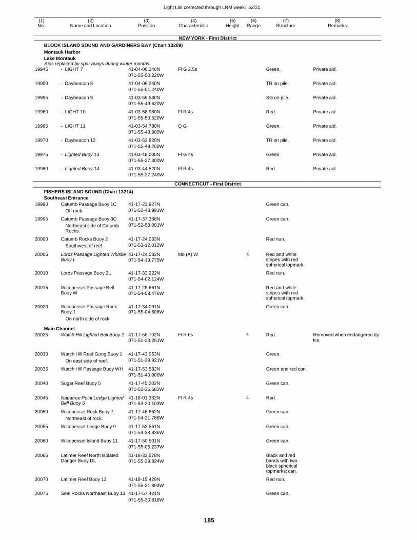
Light List corrected through LNM week: 52/21
185
(1) (2) (3) (4) (5) (6) (7) (8) No. Name and Location Position Characteristic Height Range Structure Remarks
NEW YORK - First District
BLOCK ISLAND SOUND AND GARDINERS BAY (Chart 13209)
Montauk Harbor
Lake Montauk Aids replaced by spar buoys during winter months.
19945 - LIGHT 7 41-04-06.240N Fl G 2.5s Green. Private aid.
071-55-50.220W
19950 - Daybeacon 8 41-04-06.240N TR on pile. Private aid.
071-55-51.240W
19955 - Daybeacon 9 41-03-59.580N SG on pile. Private aid.
071-55-49.620W
19960 - LIGHT 10 41-03-58.980N Fl R 4s Red. Private aid.
071-55-50.520W
19965 - LIGHT 11 41-03-54.780N Q G Green. Private aid.
071-55-48.900W
19970 - Daybeacon 12 41-03-53.820N TR on pile. Private aid.
071-55-49.200W
19975 - Lighted Buoy 13 41-03-48.000N Fl G 4s Green. Private aid.
071-55-27.300W
19980 - Lighted Buoy 14 41-03-44.520N Fl R 4s Red. Private aid.
071-55-27.240W
CONNECTICUT - First District
FISHERS ISLAND SOUND (Chart 13214)
Southeast Entrance
19990 Catumb Passage Buoy 1C 41-17-23.927N Green can.
Off rock. 071-52-48.991W
19995 Catumb Passage Buoy 3C 41-17-37.366N Green can.
Northeast side of Catumb Rocks.
071-52-58.001W
20000 Catumb Rocks Buoy 2 41-17-24.033N Red nun.
Southwest of reef. 071-53-12.012W
20005 Lords Passage Lighted Whistle Buoy L
41-17-24.082N
071-54-19.775W
Mo (A) W 4 Red and white stripes with red spherical topmark.
20010 Lords Passage Buoy 2L 41-17-32.222N Red nun.
071-54-02.124W
20015 Wicopesset Passage Bell Buoy W
41-17-28.661N
071-54-58.476W
Red and white stripes with red spherical topmark.
20020 Wicopesset Passage Rock Buoy 1
41-17-34.091N 071-55-04.606W
Green can.
On north side of rock.
Main Channel
20025 Watch Hill Lighted Bell Buoy 2 41-17-58.702N
071-51-33.251W
Fl R 6s 4 Red. Removed when endangered by ice.
20030 Watch Hill Reef Gong Buoy 1 41-17-43.953N
Green.
On east side of reef. 071-51-39.921W
20035 Watch Hill Passage Buoy WH 41-17-53.582N Green and red can.
071-51-40.000W
20040 Sugar Reef Buoy 5 41-17-45.202N Green can.
071-52-36.682W
20045 Napatree Point Ledge Lighted Bell Buoy 6
41-18-01.332N
071-53-20.103W
Fl R 4s 4 Red.
20050 Wicopesset Rock Buoy 7 41-17-46.662N Green can.
Northeast of rock. 071-54-21.788W
20055 Wicopesset Ledge Buoy 9 41-17-52.561N Green can.
071-54-38.836W
20060 Wicopesset Island Buoy 11 41-17-50.501N Green can.
071-55-05.237W
20065 Latimer Reef North Isolated Danger Buoy DL
41-18-33.578N
071-55-39.824W
Black and red bands with two black spherical topmarks; can.
20070 Latimer Reef Buoy 12 41-18-15.429N Red nun.
071-55-31.893W
20075 Seal Rocks Northeast Buoy 13 41-17-57.421N Green can.
071-55-30.818W
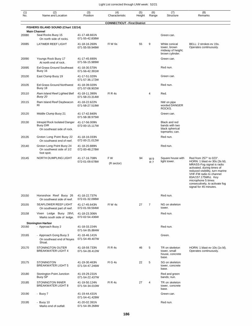
Light List corrected through LNM week: 52/21
186
(1) (2) (3) (4) (5) (6) (7) (8) No. Name and Location Position Characteristic Height Range Structure Remarks
CONNECTICUT - First District
FISHERS ISLAND SOUND (Chart 13214)
Main Channel
20080
20085
20090
20095
20100
20105
20110
20115
20120
20130
20135
20140
20145
20150
20155
20158
Seal Rocks Buoy 15
On north side of rocks.
LATIMER REEF LIGHT
Youngs Rock Buoy 17
At north end of rock.
Eel Grass Ground Southeast Buoy 16
East Clump Buoy 19
Eel Grass Ground Northwest Buoy 18
Ram Island Reef Lighted Bell Buoy 20
Ram Island Reef Daybeacon RI
Middle Clump Buoy 21
Intrepid Rock Isolated Danger Buoy DIR
On southeast side of rock.
Groton Long Point Buoy 22
On southwest end of reef.
Groton Long Point Buoy 24
On southwest side of 1/2
foot spot.
NORTH DUMPLING LIGHT
Horseshoe Reef Buoy 26
On southwest side of reef.
SEAFLOWER REEF LIGHT
On southwest part of reef.
Vixen Ledge Buoy 28VL
Marks south side of ledge.
41-17-48.661N
071-55-42.838W
41-18-16.260N
071-55-59.949W
41-17-45.690N
071-56-15.989W
41-18-30.570N
071-56-42.391W
41-17-51.020N
071-57-36.172W
41-18-39.020N
071-57-08.902W
41-18-11.390N
071-58-23.314W
41-18-22.622N
071-58-27.519W
41-17-42.840N
071-58-38.975W
41-17-56.009N
072-00-15.117W
41-18-16.033N
072-00-21.012W
41-18-20.889N
072-00-48.278W
41-17-16.708N
072-01-09.678W
41-18-22.737N
072-01-32.098W
41-17-45.643N
072-01-59.594W
41-18-23.306N
072-02-54.436W
Fl W 6s
Fl R 4s
F W
(R sector)
Fl W 4s
55 9
4
94 W 9
R 7
27 7
Green can.
White conical tower, brown midway of height; brown cylinder.
Green can.
Red nun.
Green can.
Red nun.
Red.
NW on pipe worded DANGER ROCKS.
Green can.
Black and red bands with two black spherical topmarks; can.
Red nun.
Red nun.
Square house with light tower.
Red nun.
NG on skeleton tower.
Red nun.
BELL: 2 strokes ev 15s. Operates continuously.
Red from 257° to 023°. HORN: 1 blast ev 30s (3s bl). MRASS-Fog signal is radio activated, during times of reduced visibility, turn marine VHF-FM radio to channel 83A/157.175Mhz. Key microphone 5 times consecutively, to activate fog signal for 45 minutes.
Stonington Harbor
20160 - Approach Buoy 2 41-18-33.224N Red nun.
071-54-35.884W
20165 - Approach Gong Buoy 3 41-18-46.141N Green.
On southeast end of Noyes Shoal.
071-54-49.407W
20170 STONINGTON OUTER BREAKWATER LIGHT 4
41-18-59.733N
071-54-28.412W
Fl R 4s 46 5 TR on skeleton tower, small house, concrete base.
HORN: 1 blast ev 10s (1s bl). Operates continuously.
20175 STONINGTON BREAKWATER LIGHT 5
41-19-30.463N
071-54-47.246W
Fl G 4s 22 5 SG on skeleton tower, concrete base.
20180 Stonington Point Junction Buoy SP
41-19-29.231N
071-54-22.437W
Red and green bands; nun.
20185 STONINGTON INNER BREAKWATER LIGHT 8
41-19-50.124N
071-54-34.010W
Fl R 4s 27 4 TR on skeleton tower, concrete base.
20190 - Buoy 7 41-19-44.431N Green can.
071-54-41.428W
20195 - Buoy 10 41-20-02.391N Red nun.
Marks end of outfall. 071-54-39.268W
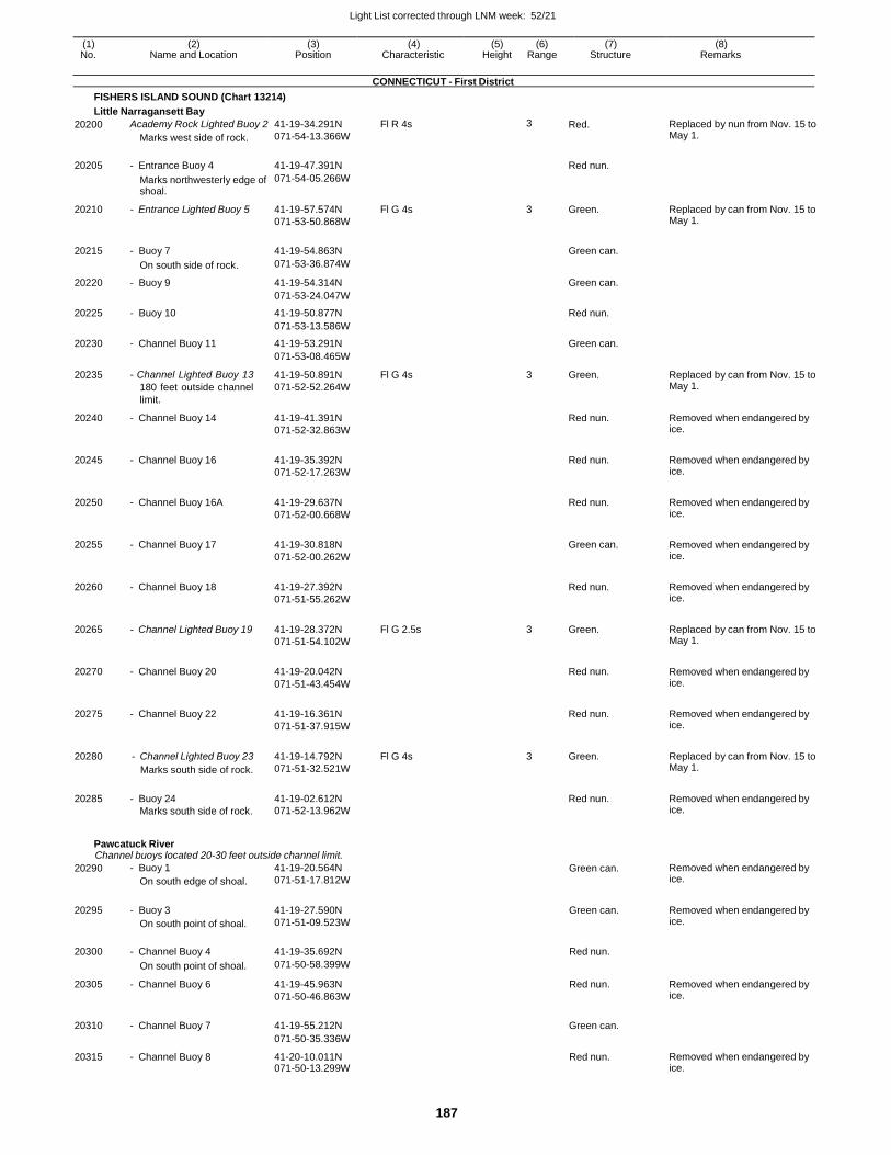
Light List corrected through LNM week: 52/21
187
(1) (2) (3) (4) (5) (6) (7) (8) No. Name and Location Position Characteristic Height Range Structure Remarks
CONNECTICUT - First District
FISHERS ISLAND SOUND (Chart 13214)
Little Narragansett Bay
20200 Academy Rock Lighted Buoy 2
Marks west side of rock.
41-19-34.291N
071-54-13.366W
Fl R 4s 3 Red. Replaced by nun from Nov. 15 to May 1.
20205 - Entrance Buoy 4 41-19-47.391N
Red nun.
Marks northwesterly edge of shoal.
071-54-05.266W
20210 - Entrance Lighted Buoy 5 41-19-57.574N
071-53-50.868W
Fl G 4s 3 Green. Replaced by can from Nov. 15 to May 1.
20215 - Buoy 7 41-19-54.863N
Green can.
On south side of rock. 071-53-36.874W
20220 - Buoy 9 41-19-54.314N Green can.
071-53-24.047W
20225 - Buoy 10 41-19-50.877N Red nun.
071-53-13.586W
20230 - Channel Buoy 11 41-19-53.291N Green can.
071-53-08.465W
20235 - Channel Lighted Buoy 13
180 feet outside channel
limit.
41-19-50.891N
071-52-52.264W
Fl G 4s 3 Green. Replaced by can from Nov. 15 to May 1.
20240 - Channel Buoy 14 41-19-41.391N
071-52-32.863W
Red nun. Removed when endangered by ice.
20245 - Channel Buoy 16 41-19-35.392N
071-52-17.263W
Red nun. Removed when endangered by
ice.
20250 - Channel Buoy 16A 41-19-29.637N
071-52-00.668W
Red nun. Removed when endangered by
ice.
20255 - Channel Buoy 17 41-19-30.818N
071-52-00.262W
Green can. Removed when endangered by
ice.
20260 - Channel Buoy 18 41-19-27.392N
071-51-55.262W
Red nun. Removed when endangered by
ice.
20265 - Channel Lighted Buoy 19 41-19-28.372N
071-51-54.102W
Fl G 2.5s 3 Green. Replaced by can from Nov. 15 to May 1.
20270 - Channel Buoy 20 41-19-20.042N
071-51-43.454W
Red nun. Removed when endangered by
ice.
20275 - Channel Buoy 22 41-19-16.361N
071-51-37.915W
Red nun. Removed when endangered by
ice.
20280 - Channel Lighted Buoy 23
Marks south side of rock.
41-19-14.792N
071-51-32.521W
Fl G 4s 3 Green. Replaced by can from Nov. 15 to May 1.
20285 - Buoy 24
Marks south side of rock.
41-19-02.612N
071-52-13.962W
Red nun. Removed when endangered by
ice.
Pawcatuck River Channel buoys located 20-30 feet outside channel limit.
20290 - Buoy 1
On south edge of shoal.
41-19-20.564N
071-51-17.812W
Green can. Removed when endangered by ice.
20295 - Buoy 3
On south point of shoal.
41-19-27.590N
071-51-09.523W
Green can. Removed when endangered by ice.
20300 - Channel Buoy 4 41-19-35.692N Red nun.
On south point of shoal. 071-50-58.399W
20305 - Channel Buoy 6 41-19-45.963N
071-50-46.863W
Red nun. Removed when endangered by ice.
20310 - Channel Buoy 7 41-19-55.212N Green can.
071-50-35.336W
20315 - Channel Buoy 8 41-20-10.011N 071-50-13.299W
Red nun. Removed when endangered by ice.
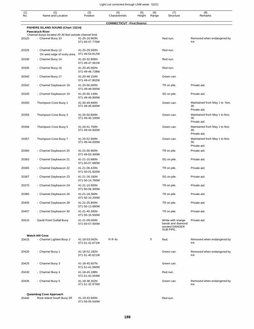
Light List corrected through LNM week: 52/21
188
(1) (2) (3) (4) (5) (6) (7) (8) No. Name and Location Position Characteristic Height Range Structure Remarks
CONNECTICUT - First District
FISHERS ISLAND SOUND (Chart 13214)
Pawcatuck River Channel buoys located 20-30 feet outside channel limit.
20320 - Channel Buoy 10 41-20-16.963N
071-50-07.775W Red nun. Removed when endangered by
ice.
20325 - Channel Buoy 12 41-20-29.500N Red nun.
On west edge of rocky area. 071-49-54.812W
20330 - Channel Buoy 14 41-20-32.806N Red nun.
071-49-47.561W
20335 - Channel Buoy 16 41-20-45.582N Red nun.
071-49-46.728W
20340 - Channel Buoy 17 41-20-48.154N Green can.
071-49-47.802W
20342 - Channel Daybeacon 18 41-20-56.000N TR on pile. Private aid.
071-49-49.000W
20345 - Channel Daybeacon 19 41-20-55.140N SG on pile. Private aid.
071-49-49.800W
20350 Thompson Cove Buoy 1 41-20-49.900N 071-49-45.600W
Green can. Maintained from May 1 to Nov. 30.
Private aid.
20355 Thompson Cove Buoy 3 41-20-50.800N 071-49-45.100W
Green can. Maintained from May 1 to Nov. 30.
Private aid.
20356 Thompson Cove Buoy 5 41-20-51.700N 071-49-44.500W
Green can. Maintained from May 1 to Nov. 30.
Private aid.
20357 Thompson Cove Buoy 7 41-20-52.900N 071-49-44.000W
Green can. Maintained from May 1 to Nov. 30.
Private aid.
20360 - Channel Daybeacon 20 41-21-00.900N TR on pile. Private aid.
071-49-53.400W
20363 - Channel Daybeacon 21 41-21-10.980N SG on pile. Private aid.
071-50-07.680W
20365 - Channel Daybeacon 22 41-21-06.420N TR on pile. Private aid.
071-50-01.920W
20367 - Channel Daybeacon 23 41-21-26.160N SG on pile. Private aid.
071-50-14.760W
20370 - Channel Daybeacon 24 41-21-10.900N TR on pile. Private aid.
071-50-06.300W
20385 - Channel Daybeacon 26 41-21-18.360N TR on pile. Private aid.
071-50-10.200W
20405 - Channel Daybeacon 28 41-21-25.800N TR on pile. Private aid.
071-50-13.680W
20407 - Channel Daybeacon 30 41-21-40.300N TR on pile. Private aid.
071-50-16.500W
20410 Gavitt Point Outfall Buoy 41-21-09.000N
071-50-07.000W
White with orange bands and diamond worded DANGER SUB PIPE.
Private aid.
Watch Hill Cove
20415 - Channel Lighted Buoy 2 41-18-53.042N
071-51-42.671W
Fl R 4s 3 Red. Removed when endangered by ice.
20420 - Channel Buoy 1 41-18-52.182N
071-51-40.621W
Green can. Removed when endangered by
ice.
20425 - Channel Buoy 3 41-18-45.507N
Green can.
071-51-41.060W
20430 - Channel Buoy 4 41-18-45.188N Red nun.
071-51-42.004W
20435 - Channel Buoy 5 41-18-38.302N 071-51-32.970W
Green can. Removed when endangered by ice.
Quiambog Cove Approach
20440 Rock Island South Buoy 2R 41-19-43.940N
071-56-00.540W
Red nun.
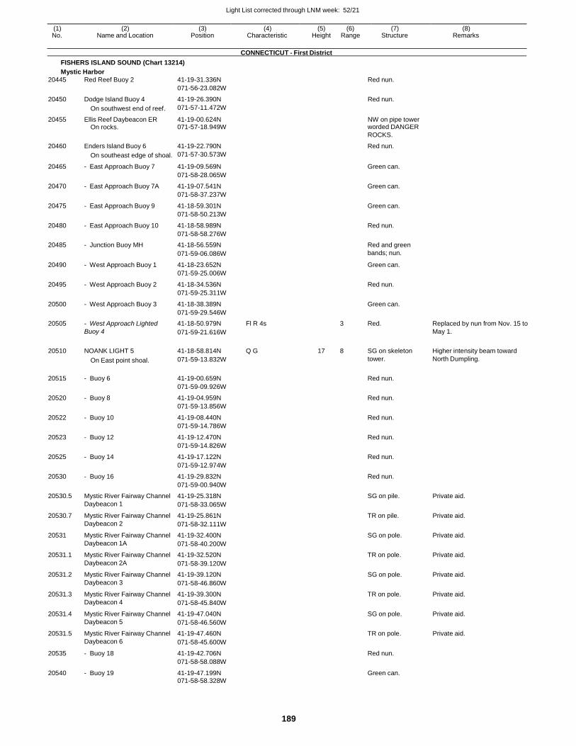
Light List corrected through LNM week: 52/21
189
(1) (2) (3) (4) (5) (6) (7) (8) No. Name and Location Position Characteristic Height Range Structure Remarks
CONNECTICUT - First District
FISHERS ISLAND SOUND (Chart 13214)
Mystic Harbor
20445 Red Reef Buoy 2 41-19-31.336N Red nun.
071-56-23.082W
20450 Dodge Island Buoy 4 41-19-26.390N Red nun.
On southwest end of reef. 071-57-11.472W
20455 Ellis Reef Daybeacon ER 41-19-00.624N NW on pipe tower On rocks. 071-57-18.949W worded DANGER
ROCKS.
20460 Enders Island Buoy 6 41-19-22.790N Red nun.
On southeast edge of shoal. 071-57-30.573W
20465 - East Approach Buoy 7 41-19-09.569N Green can.
071-58-28.065W
20470 - East Approach Buoy 7A 41-19-07.541N Green can.
071-58-37.237W
20475 - East Approach Buoy 9 41-18-59.301N Green can.
071-58-50.213W
20480 - East Approach Buoy 10 41-18-58.989N Red nun.
071-58-58.276W
20485 - Junction Buoy MH 41-18-56.559N Red and green
071-59-06.086W bands; nun.
20490 - West Approach Buoy 1 41-18-23.652N Green can.
071-59-25.006W
20495 - West Approach Buoy 2 41-18-34.536N Red nun.
071-59-25.311W
20500 - West Approach Buoy 3 41-18-38.389N Green can.
071-59-29.546W
20505 - West Approach Lighted 41-18-50.979N Fl R 4s 3 Red. Replaced by nun from Nov. 15 to
Buoy 4 071-59-21.616W May 1.
20510 NOANK LIGHT 5 41-18-58.814N Q G 17 8 SG on skeleton Higher intensity beam toward
On East point shoal. 071-59-13.832W tower. North Dumpling.
20515 - Buoy 6 41-19-00.659N
Red nun.
071-59-09.926W
20520 - Buoy 8 41-19-04.959N Red nun.
071-59-13.856W
20522 - Buoy 10 41-19-08.440N Red nun.
071-59-14.786W
20523 - Buoy 12 41-19-12.470N Red nun.
071-59-14.826W
20525 - Buoy 14 41-19-17.122N Red nun.
071-59-12.974W
20530 - Buoy 16 41-19-29.832N Red nun.
071-59-00.940W
20530.5 Mystic River Fairway Channel 41-19-25.318N SG on pile. Private aid.
Daybeacon 1 071-58-33.065W
20530.7 Mystic River Fairway Channel 41-19-25.861N TR on pile. Private aid.
Daybeacon 2 071-58-32.111W
20531 Mystic River Fairway Channel 41-19-32.400N SG on pole. Private aid.
Daybeacon 1A 071-58-40.200W
20531.1 Mystic River Fairway Channel 41-19-32.520N TR on pole. Private aid.
Daybeacon 2A 071-58-39.120W
20531.2 Mystic River Fairway Channel 41-19-39.120N SG on pole. Private aid.
Daybeacon 3 071-58-46.860W
20531.3 Mystic River Fairway Channel 41-19-39.300N TR on pole. Private aid.
Daybeacon 4 071-58-45.840W
20531.4 Mystic River Fairway Channel 41-19-47.040N SG on pole. Private aid.
Daybeacon 5 071-58-46.560W
20531.5 Mystic River Fairway Channel 41-19-47.460N TR on pole. Private aid.
Daybeacon 6 071-58-45.600W
20535 - Buoy 18 41-19-42.706N Red nun.
071-58-58.088W
20540 - Buoy 19 41-19-47.199N Green can.
071-58-58.328W
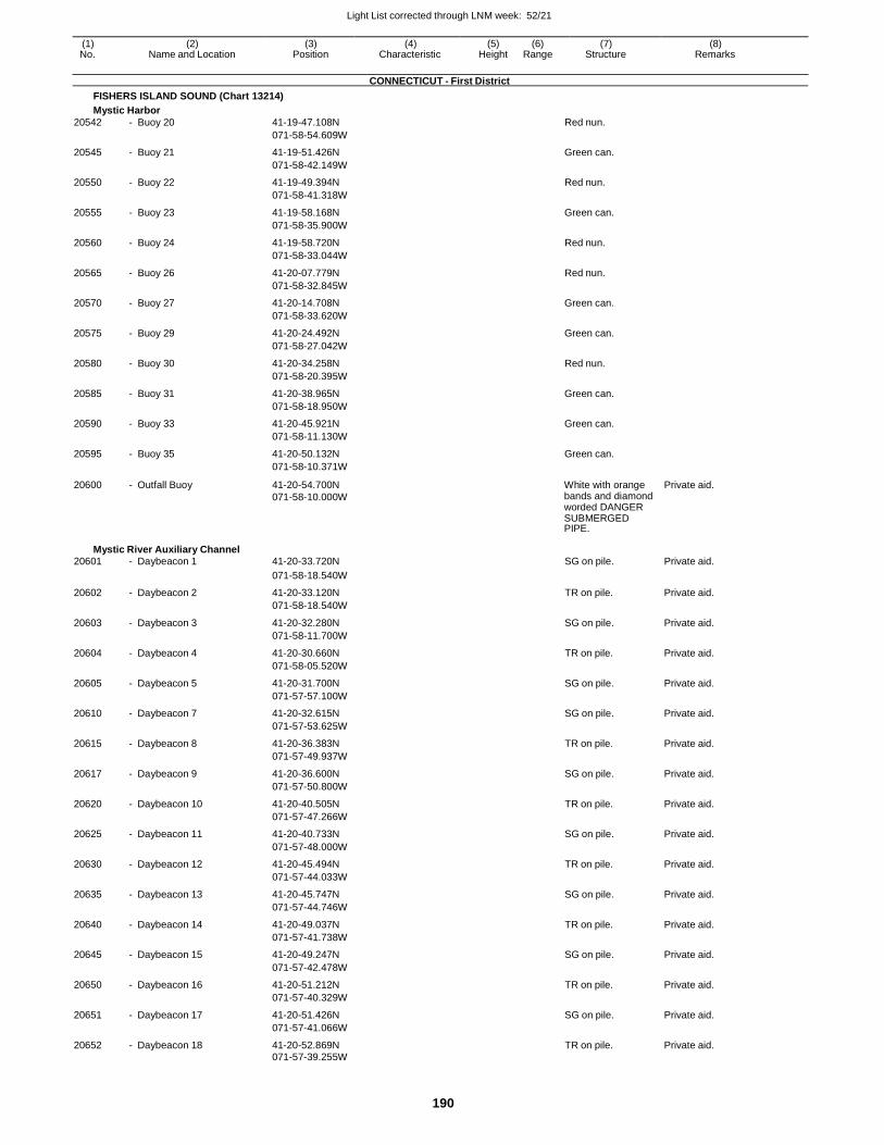
Light List corrected through LNM week: 52/21
190
(1) (2) (3) (4) (5) (6) (7) (8) No. Name and Location Position Characteristic Height Range Structure Remarks
CONNECTICUT - First District
FISHERS ISLAND SOUND (Chart 13214)
Mystic Harbor
20542 - Buoy 20 41-19-47.108N Red nun.
071-58-54.609W
20545 - Buoy 21 41-19-51.426N Green can.
071-58-42.149W
20550 - Buoy 22 41-19-49.394N Red nun.
071-58-41.318W
20555 - Buoy 23 41-19-58.168N Green can.
071-58-35.900W
20560 - Buoy 24 41-19-58.720N Red nun.
071-58-33.044W
20565 - Buoy 26 41-20-07.779N Red nun.
071-58-32.845W
20570 - Buoy 27 41-20-14.708N Green can.
071-58-33.620W
20575 - Buoy 29 41-20-24.492N Green can.
071-58-27.042W
20580 - Buoy 30 41-20-34.258N Red nun.
071-58-20.395W
20585 - Buoy 31 41-20-38.965N Green can.
071-58-18.950W
20590 - Buoy 33 41-20-45.921N Green can.
071-58-11.130W
20595 - Buoy 35 41-20-50.132N Green can.
071-58-10.371W
20600 - Outfall Buoy 41-20-54.700N
071-58-10.000W
White with orange bands and diamond worded DANGER SUBMERGED PIPE.
Private aid.
Mystic River Auxiliary Channel 20601 - Daybeacon 1 41-20-33.720N SG on pile. Private aid.
071-58-18.540W
20602 - Daybeacon 2 41-20-33.120N TR on pile. Private aid.
071-58-18.540W
20603 - Daybeacon 3 41-20-32.280N SG on pile. Private aid.
071-58-11.700W
20604 - Daybeacon 4 41-20-30.660N TR on pile. Private aid.
071-58-05.520W
20605 - Daybeacon 5 41-20-31.700N SG on pile. Private aid.
071-57-57.100W
20610 - Daybeacon 7 41-20-32.615N SG on pile. Private aid.
071-57-53.625W
20615 - Daybeacon 8 41-20-36.383N TR on pile. Private aid.
071-57-49.937W
20617 - Daybeacon 9 41-20-36.600N SG on pile. Private aid.
071-57-50.800W
20620 - Daybeacon 10 41-20-40.505N TR on pile. Private aid.
071-57-47.266W
20625 - Daybeacon 11 41-20-40.733N SG on pile. Private aid.
071-57-48.000W
20630 - Daybeacon 12 41-20-45.494N TR on pile. Private aid.
071-57-44.033W
20635 - Daybeacon 13 41-20-45.747N SG on pile. Private aid.
071-57-44.746W
20640 - Daybeacon 14 41-20-49.037N TR on pile. Private aid.
071-57-41.738W
20645 - Daybeacon 15 41-20-49.247N SG on pile. Private aid.
071-57-42.478W
20650 - Daybeacon 16 41-20-51.212N TR on pile. Private aid.
071-57-40.329W
20651 - Daybeacon 17 41-20-51.426N SG on pile. Private aid.
071-57-41.066W
20652 - Daybeacon 18 41-20-52.869N TR on pile. Private aid. 071-57-39.255W
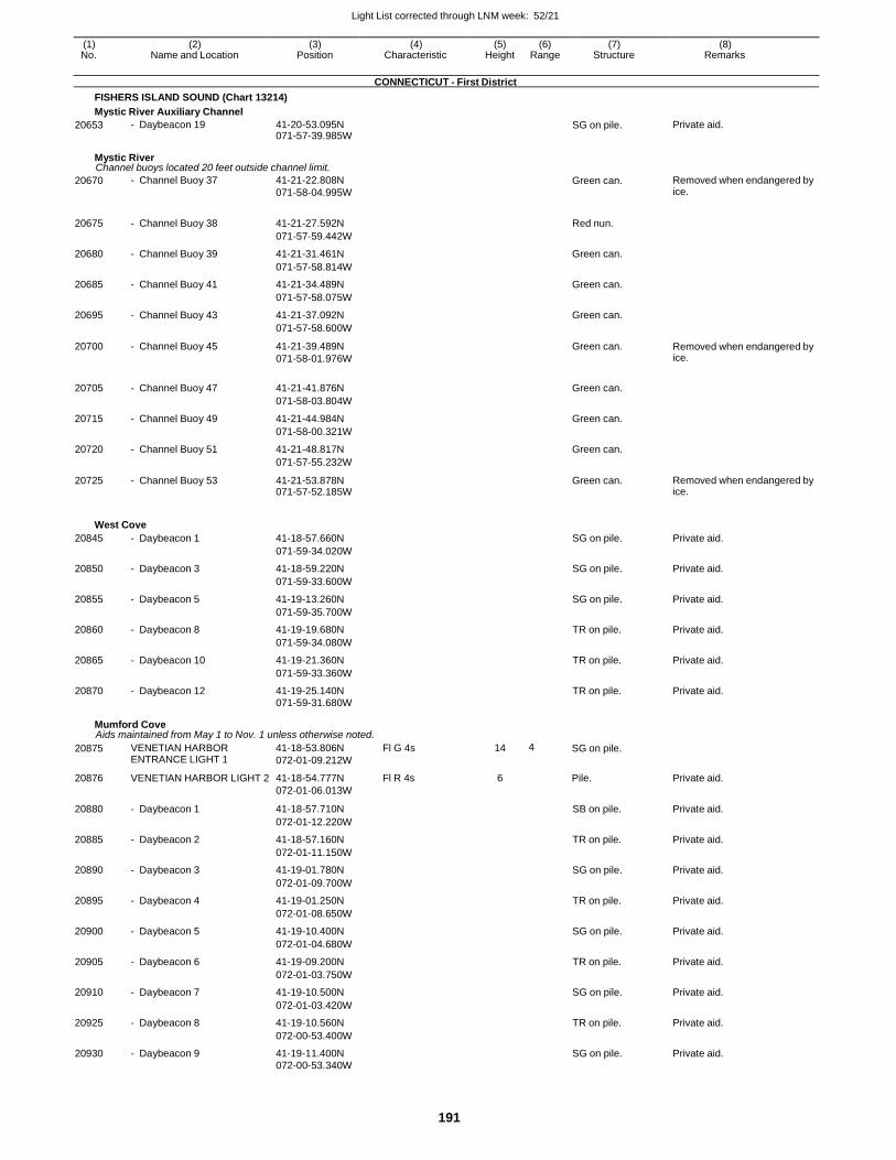
Light List corrected through LNM week: 52/21
191
(1) (2) (3) (4) (5) (6) (7) (8) No. Name and Location Position Characteristic Height Range Structure Remarks
CONNECTICUT - First District
FISHERS ISLAND SOUND (Chart 13214)
Mystic River Auxiliary Channel
20653 - Daybeacon 19 41-20-53.095N 071-57-39.985W
SG on pile. Private aid.
Mystic River Channel buoys located 20 feet outside channel limit.
20670 - Channel Buoy 37 41-21-22.808N
071-58-04.995W Green can. Removed when endangered by
ice.
20675 - Channel Buoy 38 41-21-27.592N Red nun.
071-57-59.442W
20680 - Channel Buoy 39 41-21-31.461N Green can.
071-57-58.814W
20685 - Channel Buoy 41 41-21-34.489N Green can.
071-57-58.075W
20695 - Channel Buoy 43 41-21-37.092N Green can.
071-57-58.600W
20700 - Channel Buoy 45 41-21-39.489N
071-58-01.976W
Green can. Removed when endangered by ice.
20705 - Channel Buoy 47 41-21-41.876N Green can.
071-58-03.804W
20715 - Channel Buoy 49 41-21-44.984N Green can.
071-58-00.321W
20720 - Channel Buoy 51 41-21-48.817N Green can.
071-57-55.232W
20725 - Channel Buoy 53 41-21-53.878N 071-57-52.185W
Green can. Removed when endangered by ice.
West Cove
20845 - Daybeacon 1 41-18-57.660N SG on pile. Private aid.
071-59-34.020W
20850 - Daybeacon 3 41-18-59.220N SG on pile. Private aid.
071-59-33.600W
20855 - Daybeacon 5 41-19-13.260N SG on pile. Private aid.
071-59-35.700W
20860 - Daybeacon 8 41-19-19.680N TR on pile. Private aid.
071-59-34.080W
20865 - Daybeacon 10 41-19-21.360N TR on pile. Private aid.
071-59-33.360W
20870 - Daybeacon 12 41-19-25.140N TR on pile. Private aid. 071-59-31.680W
Mumford Cove Aids maintained from May 1 to Nov. 1 unless otherwise noted.
20875 VENETIAN HARBOR ENTRANCE LIGHT 1
41-18-53.806N
072-01-09.212W
Fl G 4s 14 4 SG on pile.
20876 VENETIAN HARBOR LIGHT 2 41-18-54.777N Fl R 4s 6 Pile. Private aid. 072-01-06.013W
20880 - Daybeacon 1 41-18-57.710N SB on pile. Private aid.
072-01-12.220W
20885 - Daybeacon 2 41-18-57.160N TR on pile. Private aid.
072-01-11.150W
20890 - Daybeacon 3 41-19-01.780N SG on pile. Private aid.
072-01-09.700W
20895 - Daybeacon 4 41-19-01.250N TR on pile. Private aid.
072-01-08.650W
20900 - Daybeacon 5 41-19-10.400N SG on pile. Private aid.
072-01-04.680W
20905 - Daybeacon 6 41-19-09.200N TR on pile. Private aid.
072-01-03.750W
20910 - Daybeacon 7 41-19-10.500N SG on pile. Private aid.
072-01-03.420W
20925 - Daybeacon 8 41-19-10.560N TR on pile. Private aid.
072-00-53.400W
20930 - Daybeacon 9 41-19-11.400N SG on pile. Private aid. 072-00-53.340W
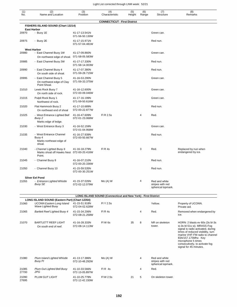
Light List corrected through LNM week: 52/21
192
(1) (2) (3) (4) (5) (6) (7) (8) No. Name and Location Position Characteristic Height Range Structure Remarks
CONNECTICUT - First District
FISHERS ISLAND SOUND (Chart 13214)
East Harbor
20970 - Buoy 1E 41-17-13.541N Green can.
071-56-50.130W
20975 - Buoy 2E 41-17-15.971N Red nun. 071-57-04.481W
West Harbor 20980 - East Channel Buoy 1W 41-17-09.860N Green can.
On northwest edge of shoal. 071-58-05.583W
20985 - East Channel Buoy 2W 41-17-17.330N Red nun.
071-58-14.003W
20990 - East Channel Buoy 4 41-17-07.380N Red nun.
On south side of shoal. 071-59-28.715W
20995 - East Channel Buoy 5 41-16-53.290N Green can.
On northwest edge of Clay Point Shoal.
071-59-33.375W
21010 Lewis Rock Buoy 7 41-16-12.600N Green can.
On north side of rock. 072-00-09.046W
21015 Pulpit Rock Buoy 1 41-17-16.199N Green can.
Northwest of rock. 071-59-50.616W
21020 Flat Hammock Buoy 2 41-17-10.689N Red nun.
On northeast end of shoal 072-00-22.877W
21025 - West Entrance Lighted Bell Buoy 2
41-16-47.609N 072-01-23.068W
Fl R 2.5s 4 Red.
Marks edge of ledge.
21030 - West Entrance Buoy 3 41-16-52.159N Green can.
072-01-04.958W
21035 - West Entrance Channel Buoy 4
41-16-27.939N 072-00-50.667W
Red nun.
Marks northeast edge of shoal.
21040 - Channel Lighted Buoy 6
Marks shoal off Hawks Nest
Point.
41-16-18.279N
072-00-20.416W
Fl R 4s 3 Red. Replaced by nun when endangered by ice.
21045 - Channel Buoy 8 41-16-07.210N Red nun.
072-00-20.336W
21050 - Channel Buoy 10 41-15-59.535N Red nun.
072-00-30.251W
Silver Eel Pond
21055 - Entrance Lighted Whistle Buoy SE
41-15-37.026N
072-02-12.079W
Mo (A) W 4 Red and white stripes with red spherical topmark.
LONG ISLAND SOUND (Connecticut and New York) - First District
LONG ISLAND SOUND (Eastern Part) (Chart 12354)
21060 UCONN Eastern Long Island Wave Lighted Buoy
41-15-51.918N
072-04-02.628W
Fl Y 2.5s Yellow. Property of UCONN.
Private aid.
21065 Bartlett Reef Lighted Buoy 4 41-15-34.206N
072-08-21.258W
Fl R 4s 4 Red. Removed when endangered by ice.
21070 BARTLETT REEF LIGHT 41-16-28.333N Fl W 6s 35 8 NR on skeleton HORN: 2 blasts ev 60s (3s bl-3s
On south end of reef. 072-08-14.113W tower. si-3s bl-51s si). MRASS-Fog signal is radio activated, during times of reduced visibility, turn marine VHF-FM radio to channel 83A/157.175Mhz. Key microphone 5 times consecutively, to activate fog signal for 45 minutes.
21080
21085 27700
21090
27695
Plum Island Lighted Whistle Buoy PI
Plum Gut Lighted Bell Buoy 2PG
PLUM GUT LIGHT
41-13-17.386N
072-10-48.292W
41-10-33.566N
072-13-05.897W
41-10-25.778N
072-12-42.150W
Mo (A) W
Fl R 4s
Fl W 2.5s
4
4
21 5
Red and white stripes with red spherical topmark.
Red.
On skeleton tower.
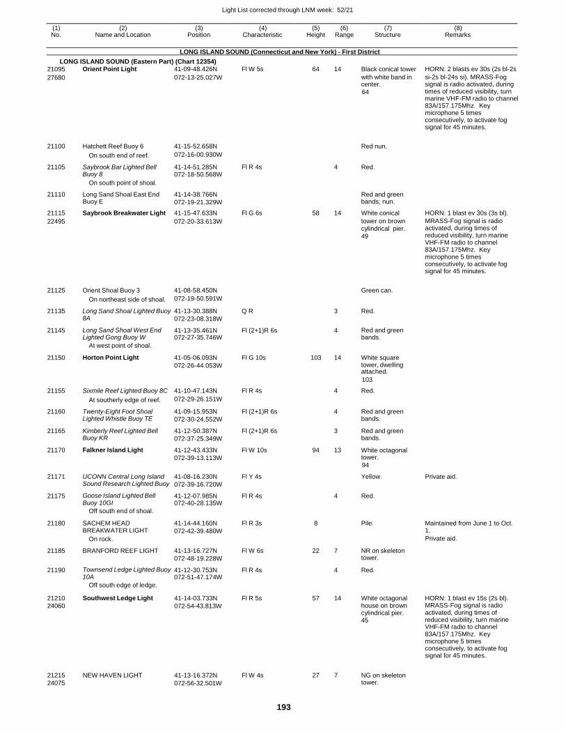
Light List corrected through LNM week: 52/21
193
(1) (2) (3) (4) (5) (6) (7) (8) No. Name and Location Position Characteristic Height Range Structure Remarks
LONG ISLAND SOUND (Connecticut and New York) - First District
LONG ISLAND SOUND (Eastern Part) (Chart 12354)
21210
24060
21215
24075
Southwest Ledge Light
NEW HAVEN LIGHT
41-14-03.733N
072-54-43.813W
41-13-16.372N
072-56-32.501W
Fl R 5s
Fl W 4s
57 14
27 7
White octagonal house on brown cylindrical pier. 45
NG on skeleton tower.
HORN: 1 blast ev 15s (2s bl). MRASS-Fog signal is radio activated, during times of reduced visibility, turn marine VHF-FM radio to channel 83A/157.175Mhz. Key microphone 5 times consecutively, to activate fog signal for 45 minutes.
21095 Orient Point Light 41-09-48.426N Fl W 5s 64 14 Black conical tower HORN: 2 blasts ev 30s (2s bl-2s
27680 072-13-25.027W with white band in center.
64
si-2s bl-24s si). MRASS-Fog signal is radio activated, during times of reduced visibility, turn marine VHF-FM radio to channel 83A/157.175Mhz. Key microphone 5 times consecutively, to activate fog signal for 45 minutes.
21100 Hatchett Reef Buoy 6 41-15-52.658N
Red nun.
On south end of reef. 072-16-00.930W
21105 Saybrook Bar Lighted Bell Buoy 8
41-14-51.285N 072-18-50.568W
Fl R 4s 4 Red.
On south point of shoal.
21110 Long Sand Shoal East End Buoy E
41-14-38.766N
072-19-21.329W
Red and green bands; nun.
21115 Saybrook Breakwater Light 41-15-47.633N Fl G 6s 58 14 White conical HORN: 1 blast ev 30s (3s bl).
22495 072-20-33.613W tower on brown cylindrical pier. 49
MRASS-Fog signal is radio activated, during times of reduced visibility, turn marine VHF-FM radio to channel 83A/157.175Mhz. Key microphone 5 times consecutively, to activate fog signal for 45 minutes.
21125 Orient Shoal Buoy 3 41-08-58.450N
Green can.
On northeast side of shoal. 072-19-50.591W
21135 Long Sand Shoal Lighted Buoy 8A
41-13-30.388N
072-23-08.318W
Q R 3 Red.
21145 Long Sand Shoal West End Lighted Gong Buoy W
41-13-35.461N 072-27-35.746W
Fl (2+1)R 6s 4 Red and green bands.
At west point of shoal.
21150 Horton Point Light 41-05-06.093N
072-26-44.053W
Fl G 10s 103 14 White square tower, dwelling attached.
103
21155 Sixmile Reef Lighted Buoy 8C 41-10-47.143N Fl R 4s 4 Red.
At southerly edge of reef. 072-29-26.151W
21160 Twenty-Eight Foot Shoal Lighted Whistle Buoy TE
41-09-15.953N
072-30-24.552W
Fl (2+1)R 6s 4 Red and green bands.
21165 Kimberly Reef Lighted Bell Buoy KR
41-12-50.387N
072-37-25.349W
Fl (2+1)R 6s 3 Red and green bands.
21170 Falkner Island Light 41-12-43.433N
072-39-13.113W
Fl W 10s 94 13 White octagonal tower.
94
21171 UCONN Central Long Island Sound Research Lighted Buoy
41-08-16.230N
072-39-16.720W
Fl Y 4s Yellow. Private aid.
21175 Goose Island Lighted Bell Buoy 10GI
41-12-07.985N 072-40-28.135W
Fl R 4s 4 Red.
Off south end of shoal.
21180 SACHEM HEAD BREAKWATER LIGHT
On rock.
41-14-44.160N
072-42-39.480W
Fl R 3s 8
Pile. Maintained from June 1 to Oct. 1.
Private aid.
21185 BRANFORD REEF LIGHT 41-13-16.727N
072-48-19.228W
Fl W 6s 22 7 NR on skeleton tower.
21190 Townsend Ledge Lighted Buoy 10A
41-12-30.753N 072-51-47.174W
Fl R 4s 4 Red.
Off south edge of ledge.
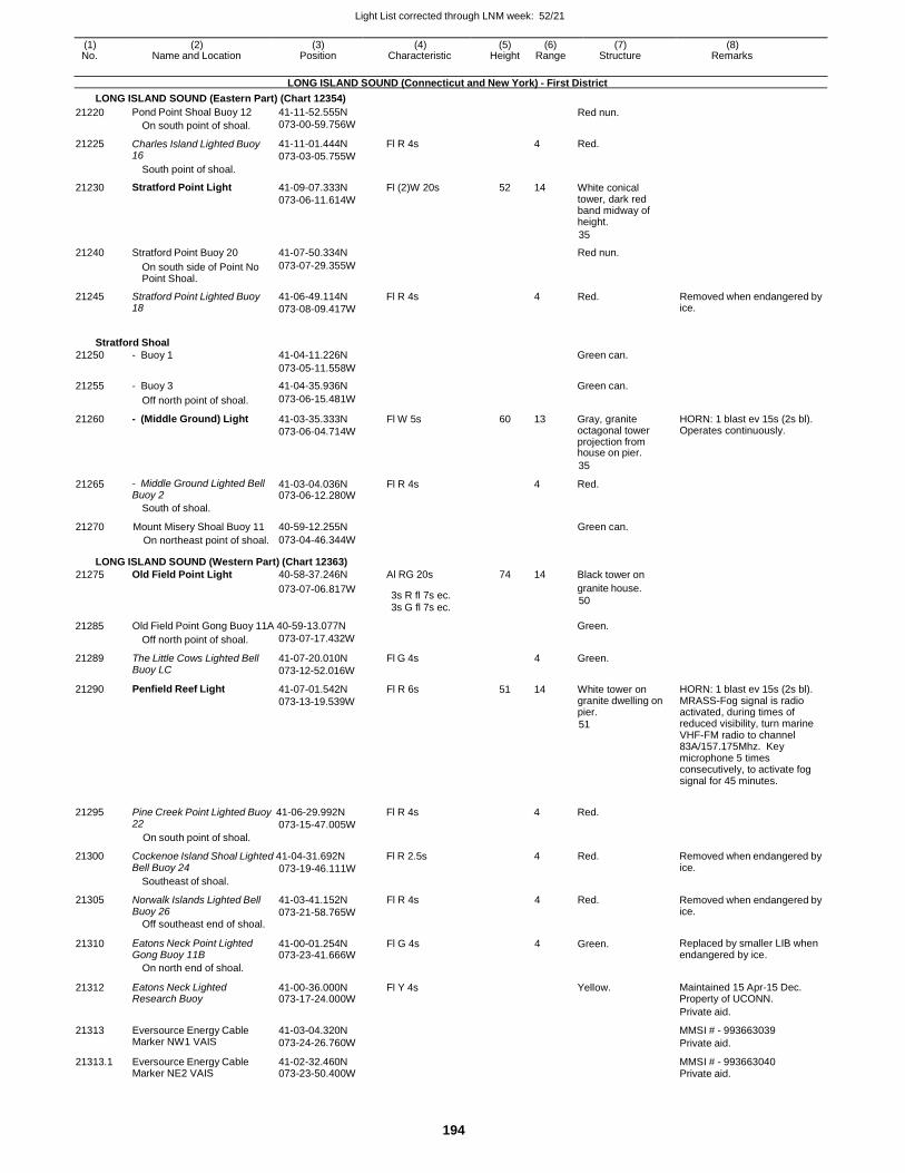
Light List corrected through LNM week: 52/21
194
(1) (2) (3) (4) (5) (6) (7) (8) No. Name and Location Position Characteristic Height Range Structure Remarks
LONG ISLAND SOUND (Connecticut and New York) - First District
LONG ISLAND SOUND (Eastern Part) (Chart 12354)
21220 Pond Point Shoal Buoy 12 41-11-52.555N Red nun.
On south point of shoal. 073-00-59.756W
21225 Charles Island Lighted Buoy 16
41-11-01.444N
073-03-05.755W
Fl R 4s 4 Red.
South point of shoal.
21230 Stratford Point Light 41-09-07.333N
073-06-11.614W
Fl (2)W 20s 52 14 White conical tower, dark red band midway of height.
35
21240 Stratford Point Buoy 20 41-07-50.334N Red nun.
On south side of Point No Point Shoal.
073-07-29.355W
21245 Stratford Point Lighted Buoy 18
41-06-49.114N
073-08-09.417W
Fl R 4s 4 Red. Removed when endangered by ice.
Stratford Shoal
21250 - Buoy 1 41-04-11.226N Green can.
073-05-11.558W
21255 - Buoy 3 41-04-35.936N Green can.
Off north point of shoal. 073-06-15.481W
21260 - (Middle Ground) Light 41-03-35.333N
073-06-04.714W
Fl W 5s 60 13 Gray, granite octagonal tower projection from house on pier.
HORN: 1 blast ev 15s (2s bl). Operates continuously.
35
21265 - Middle Ground Lighted Bell Buoy 2
41-03-04.036N 073-06-12.280W
Fl R 4s 4 Red.
South of shoal.
21270 Mount Misery Shoal Buoy 11 40-59-12.255N Green can. On northeast point of shoal. 073-04-46.344W
LONG ISLAND SOUND (Western Part) (Chart 12363)
21275 Old Field Point Light 40-58-37.246N Al RG 20s 74 14 Black tower on
21285
073-07-06.817W
Old Field Point Gong Buoy 11A 40-59-13.077N
3s R fl 7s ec. 3s G fl 7s ec.
granite house.
50
Green.
21289
21290
Off north point of shoal.
The Little Cows Lighted Bell Buoy LC
Penfield Reef Light
073-07-17.432W
41-07-20.010N
073-12-52.016W
41-07-01.542N
073-13-19.539W
Fl G 4s
Fl R 6s
4
51 14
Green.
White tower on granite dwelling on pier.
51
HORN: 1 blast ev 15s (2s bl). MRASS-Fog signal is radio activated, during times of reduced visibility, turn marine VHF-FM radio to channel 83A/157.175Mhz. Key microphone 5 times consecutively, to activate fog signal for 45 minutes.
21295 Pine Creek Point Lighted Buoy 41-06-29.992N Fl R 4s 4 Red. 22
On south point of shoal.
073-15-47.005W
21300 Cockenoe Island Shoal Lighted 41-04-31.692N Fl R 2.5s 4 Red. Removed when endangered by Bell Buoy 24
Southeast of shoal.
073-19-46.111W ice.
21305 Norwalk Islands Lighted Bell Buoy 26
Off southeast end of shoal.
41-03-41.152N
073-21-58.765W
Fl R 4s 4 Red. Removed when endangered by ice.
21310 Eatons Neck Point Lighted Gong Buoy 11B
41-00-01.254N 073-23-41.666W
Fl G 4s 4 Green. Replaced by smaller LIB when endangered by ice.
On north end of shoal.
21312 Eatons Neck Lighted Research Buoy
41-00-36.000N 073-17-24.000W
Fl Y 4s Yellow. Maintained 15 Apr-15 Dec. Property of UCONN.
Private aid.
21313 Eversource Energy Cable Marker NW1 VAIS
41-03-04.320N
073-24-26.760W
MMSI # - 993663039
Private aid.
21313.1 Eversource Energy Cable Marker NE2 VAIS
41-02-32.460N 073-23-50.400W
MMSI # - 993663040 Private aid.
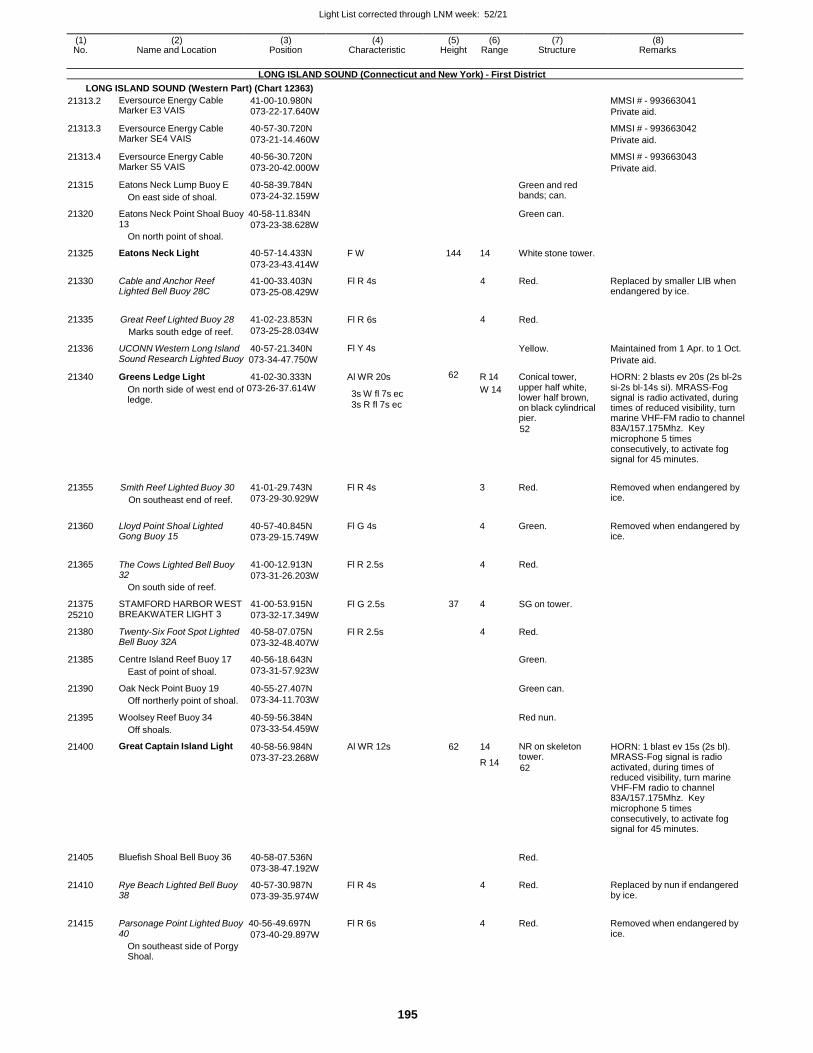
Light List corrected through LNM week: 52/21
195
(1) (2) (3) (4) (5) (6) (7) (8) No. Name and Location Position Characteristic Height Range Structure Remarks
LONG ISLAND SOUND (Connecticut and New York) - First District
LONG ISLAND SOUND (Western Part) (Chart 12363)
21313.2
21313.3
21313.4
21315
Eversource Energy Cable Marker E3 VAIS
Eversource Energy Cable Marker SE4 VAIS
Eversource Energy Cable Marker S5 VAIS
Eatons Neck Lump Buoy E
On east side of shoal.
41-00-10.980N 073-22-17.640W
40-57-30.720N
073-21-14.460W
40-56-30.720N
073-20-42.000W
40-58-39.784N
073-24-32.159W
Green and red bands; can.
MMSI # - 993663041
Private aid.
MMSI # - 993663042
Private aid.
MMSI # - 993663043
Private aid.
21320 Eatons Neck Point Shoal Buoy 40-58-11.834N Green can.
21325
21330
21335
21336
13
On north point of shoal.
Eatons Neck Light
Cable and Anchor Reef Lighted Bell Buoy 28C
Great Reef Lighted Buoy 28
Marks south edge of reef.
UCONN Western Long Island
073-23-38.628W
40-57-14.433N
073-23-43.414W
41-00-33.403N
073-25-08.429W
41-02-23.853N
073-25-28.034W
40-57-21.340N
F W
Fl R 4s
Fl R 6s
Fl Y 4s
144 14
4
4
White stone tower.
Red.
Red.
Yellow.
Replaced by smaller LIB when endangered by ice.
Maintained from 1 Apr. to 1 Oct. Sound Research Lighted Buoy 073-34-47.750W Private aid.
21340 Greens Ledge Light 41-02-30.333N Al WR 20s 62 R 14 Conical tower, HORN: 2 blasts ev 20s (2s bl-2s
On north side of west end of 073-26-37.614W
ledge. 3s W fl 7s ec 3s R fl 7s ec
W 14 upper half white, lower half brown, on black cylindrical pier.
52
si-2s bl-14s si). MRASS-Fog signal is radio activated, during times of reduced visibility, turn marine VHF-FM radio to channel 83A/157.175Mhz. Key microphone 5 times consecutively, to activate fog signal for 45 minutes.
21355
21360
Smith Reef Lighted Buoy 30
On southeast end of reef.
Lloyd Point Shoal Lighted Gong Buoy 15
41-01-29.743N
073-29-30.929W
40-57-40.845N
073-29-15.749W
Fl R 4s
Fl G 4s
3 Red.
4 Green.
Removed when endangered by ice.
Removed when endangered by ice.
21365
21375
25210
21380
21385
21390
21395
21400
21405
21410
The Cows Lighted Bell Buoy 32
On south side of reef.
STAMFORD HARBOR WEST BREAKWATER LIGHT 3
Twenty-Six Foot Spot Lighted Bell Buoy 32A
Centre Island Reef Buoy 17
East of point of shoal.
Oak Neck Point Buoy 19
Off northerly point of shoal.
Woolsey Reef Buoy 34
Off shoals.
Great Captain Island Light
Bluefish Shoal Bell Buoy 36
Rye Beach Lighted Bell Buoy 38
41-00-12.913N
073-31-26.203W
41-00-53.915N
073-32-17.349W
40-58-07.075N
073-32-48.407W
40-56-18.643N
073-31-57.923W
40-55-27.407N
073-34-11.703W
40-59-56.384N
073-33-54.459W
40-58-56.984N
073-37-23.268W
40-58-07.536N
073-38-47.192W
40-57-30.987N
073-39-35.974W
Fl R 2.5s
Fl G 2.5s
Fl R 2.5s
Al WR 12s
Fl R 4s
4
37 4
4
62 14
R 14
4
Red.
SG on tower.
Red.
Green.
Green can.
Red nun.
NR on skeleton tower.
62
Red.
Red.
HORN: 1 blast ev 15s (2s bl). MRASS-Fog signal is radio activated, during times of reduced visibility, turn marine VHF-FM radio to channel 83A/157.175Mhz. Key microphone 5 times consecutively, to activate fog signal for 45 minutes.
Replaced by nun if endangered by ice.
21415
Parsonage Point Lighted Buoy 40-56-49.697N
Fl R 6s
4 Red.
Removed when endangered by
40
On southeast side of Porgy Shoal.
073-40-29.897W ice.
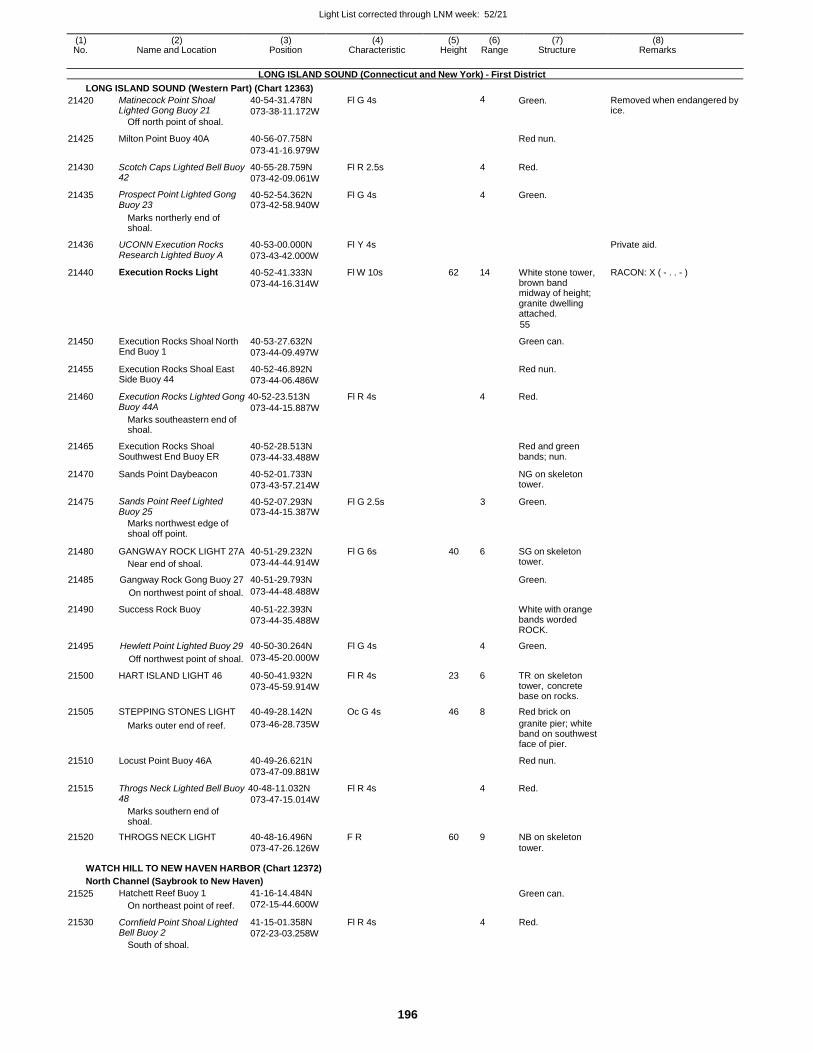
Light List corrected through LNM week: 52/21
196
(1) (2) (3) (4) (5) (6) (7) (8) No. Name and Location Position Characteristic Height Range Structure Remarks
LONG ISLAND SOUND (Connecticut and New York) - First District
LONG ISLAND SOUND (Western Part) (Chart 12363)
21436
21440
21450
21455
Marks northerly end of shoal.
UCONN Execution Rocks Research Lighted Buoy A
Execution Rocks Light
Execution Rocks Shoal North End Buoy 1
Execution Rocks Shoal East Side Buoy 44
40-53-00.000N
073-43-42.000W
40-52-41.333N
073-44-16.314W
40-53-27.632N
073-44-09.497W
40-52-46.892N
073-44-06.486W
Fl Y 4s
Fl W 10s
62 14
White stone tower, brown band midway of height; granite dwelling attached.
55
Green can.
Red nun.
Private aid.
RACON: X ( - . . - )
21460 Execution Rocks Lighted Gong 40-52-23.513N Fl R 4s 4 Red. Buoy 44A
Marks southeastern end of shoal.
073-44-15.887W
21465 Execution Rocks Shoal Southwest End Buoy ER
40-52-28.513N
073-44-33.488W
Red and green bands; nun.
21470 Sands Point Daybeacon 40-52-01.733N
073-43-57.214W
NG on skeleton tower.
21475 Sands Point Reef Lighted Buoy 25
40-52-07.293N 073-44-15.387W
Fl G 2.5s 3 Green.
Marks northwest edge of shoal off point.
21480 GANGWAY ROCK LIGHT 27A
Near end of shoal.
40-51-29.232N
073-44-44.914W
Fl G 6s 40 6 SG on skeleton tower.
21485 Gangway Rock Gong Buoy 27 40-51-29.793N Green.
On northwest point of shoal. 073-44-48.488W
21490 Success Rock Buoy 40-51-22.393N
073-44-35.488W
White with orange bands worded ROCK.
21495 Hewlett Point Lighted Buoy 29 40-50-30.264N Fl G 4s 4 Green.
Off northwest point of shoal. 073-45-20.000W
21500 HART ISLAND LIGHT 46 40-50-41.932N
073-45-59.914W
Fl R 4s 23 6 TR on skeleton tower, concrete base on rocks.
21505 STEPPING STONES LIGHT 40-49-28.142N Oc G 4s 46 8 Red brick on
21510
Marks outer end of reef.
Locust Point Buoy 46A
073-46-28.735W
40-49-26.621N
073-47-09.881W
granite pier; white band on southwest face of pier.
Red nun.
21515 Throgs Neck Lighted Bell Buoy 40-48-11.032N Fl R 4s 4 Red. 48
Marks southern end of shoal.
073-47-15.014W
21520 THROGS NECK LIGHT 40-48-16.496N F R 60 9 NB on skeleton 073-47-26.126W tower.
WATCH HILL TO NEW HAVEN HARBOR (Chart 12372)
North Channel (Saybrook to New Haven)
21525
21530
Hatchett Reef Buoy 1
On northeast point of reef.
Cornfield Point Shoal Lighted Bell Buoy 2
South of shoal.
41-16-14.484N
072-15-44.600W
41-15-01.358N
072-23-03.258W
Fl R 4s
Green can.
4 Red.
21420 Matinecock Point Shoal Lighted Gong Buoy 21
Off north point of shoal.
40-54-31.478N
073-38-11.172W
Fl G 4s 4 Green. Removed when endangered by ice.
21425 Milton Point Buoy 40A 40-56-07.758N
Red nun.
073-41-16.979W
21430 Scotch Caps Lighted Bell Buoy 42
40-55-28.759N
073-42-09.061W
Fl R 2.5s 4 Red.
21435 Prospect Point Lighted Gong Buoy 23
40-52-54.362N 073-42-58.940W
Fl G 4s 4 Green.
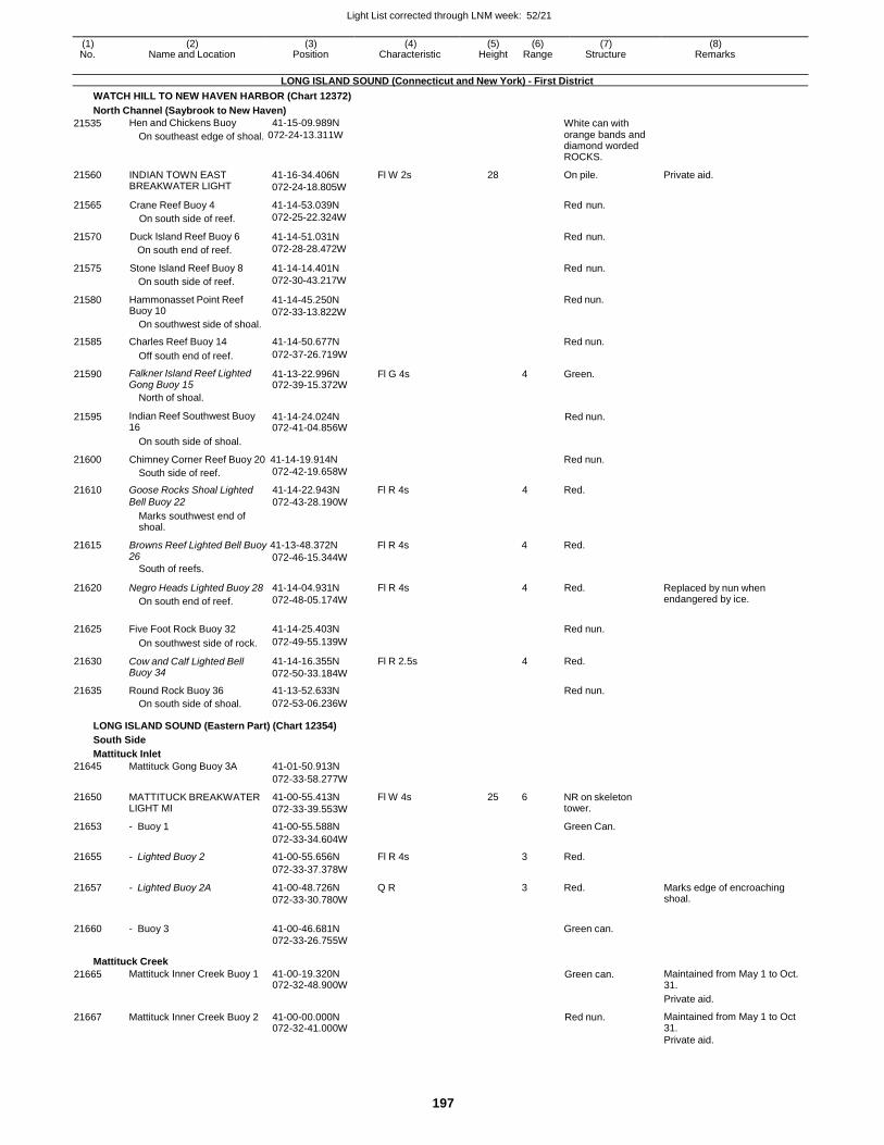
Light List corrected through LNM week: 52/21
197
(1) (2) (3) (4) (5) (6) (7) (8) No. Name and Location Position Characteristic Height Range Structure Remarks
LONG ISLAND SOUND (Connecticut and New York) - First District
WATCH HILL TO NEW HAVEN HARBOR (Chart 12372)
North Channel (Saybrook to New Haven)
21535 Hen and Chickens Buoy 41-15-09.989N White can with
On southeast edge of shoal. 072-24-13.311W orange bands and diamond worded ROCKS.
21560
21565
21570
21575
21580
INDIAN TOWN EAST BREAKWATER LIGHT
Crane Reef Buoy 4
On south side of reef.
Duck Island Reef Buoy 6
On south end of reef.
Stone Island Reef Buoy 8
On south side of reef.
Hammonasset Point Reef Buoy 10
On southwest side of shoal.
41-16-34.406N
072-24-18.805W
41-14-53.039N
072-25-22.324W
41-14-51.031N
072-28-28.472W
41-14-14.401N
072-30-43.217W
41-14-45.250N
072-33-13.822W
Fl W 2s 28 On pile.
Red nun.
Red nun.
Red nun.
Red nun.
Private aid.
21585 Charles Reef Buoy 14 41-14-50.677N Red nun.
Off south end of reef. 072-37-26.719W
21590 Falkner Island Reef Lighted Gong Buoy 15
41-13-22.996N 072-39-15.372W
Fl G 4s 4 Green.
North of shoal.
21595 Indian Reef Southwest Buoy 16
41-14-24.024N 072-41-04.856W
Red nun.
21600
On south side of shoal.
Chimney Corner Reef Buoy 20 41-14-19.914N
Red nun.
South side of reef. 072-42-19.658W
21610 Goose Rocks Shoal Lighted 41-14-22.943N Fl R 4s 4 Red. Bell Buoy 22 072-43-28.190W
21615
Marks southwest end of shoal.
Browns Reef Lighted Bell Buoy 41-13-48.372N
Fl R 4s
4 Red.
26
South of reefs. 072-46-15.344W
21620 Negro Heads Lighted Buoy 28
On south end of reef.
41-14-04.931N
072-48-05.174W
Fl R 4s 4 Red. Replaced by nun when endangered by ice.
21625 Five Foot Rock Buoy 32 41-14-25.403N
Red nun.
On southwest side of rock. 072-49-55.139W
21630 Cow and Calf Lighted Bell Buoy 34
41-14-16.355N
072-50-33.184W
Fl R 2.5s 4 Red.
21635 Round Rock Buoy 36 41-13-52.633N Red nun.
On south side of shoal. 072-53-06.236W
LONG ISLAND SOUND (Eastern Part) (Chart 12354)
South Side
Mattituck Inlet
21645 Mattituck Gong Buoy 3A 41-01-50.913N
072-33-58.277W
21650 MATTITUCK BREAKWATER LIGHT MI
41-00-55.413N
072-33-39.553W
Fl W 4s 25 6 NR on skeleton tower.
21653 - Buoy 1 41-00-55.588N Green Can.
072-33-34.604W
21655 - Lighted Buoy 2 41-00-55.656N Fl R 4s 3 Red.
072-33-37.378W
21657 - Lighted Buoy 2A 41-00-48.726N
072-33-30.780W
Q R 3 Red. Marks edge of encroaching shoal.
21660 - Buoy 3 41-00-46.681N
Green can.
072-33-26.755W
Mattituck Creek
21665 Mattituck Inner Creek Buoy 1 41-00-19.320N 072-32-48.900W
Green can. Maintained from May 1 to Oct. 31.
Private aid.
21667 Mattituck Inner Creek Buoy 2 41-00-00.000N 072-32-41.000W
Red nun. Maintained from May 1 to Oct 31.
Private aid.
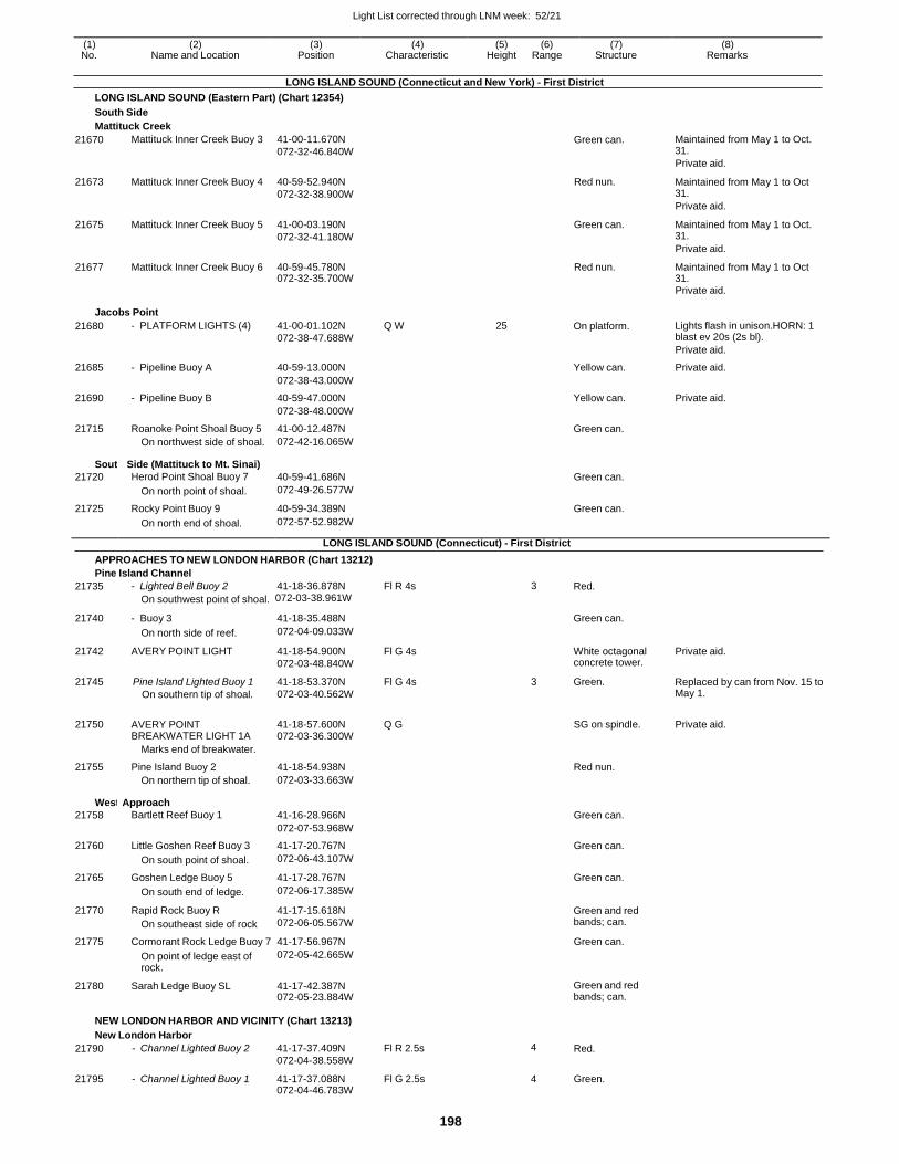
Light List corrected through LNM week: 52/21
198
(1) (2) (3) (4) (5) (6) (7) (8) No. Name and Location Position Characteristic Height Range Structure Remarks
LONG ISLAND SOUND (Connecticut and New York) - First District
LONG ISLAND SOUND (Eastern Part) (Chart 12354)
South Side
Mattituck Creek
21670 Mattituck Inner Creek Buoy 3 41-00-11.670N
072-32-46.840W Green can. Maintained from May 1 to Oct.
31.
Private aid.
21673 Mattituck Inner Creek Buoy 4 40-59-52.940N
072-32-38.900W
Red nun. Maintained from May 1 to Oct 31.
Private aid.
21675 Mattituck Inner Creek Buoy 5 41-00-03.190N
072-32-41.180W
Green can. Maintained from May 1 to Oct. 31.
Private aid.
21677 Mattituck Inner Creek Buoy 6 40-59-45.780N 072-32-35.700W
Red nun. Maintained from May 1 to Oct 31.
Private aid.
Jacobs Point
21680 - PLATFORM LIGHTS (4) 41-00-01.102N
072-38-47.688W
Q W 25 On platform. Lights flash in unison.HORN: 1 blast ev 20s (2s bl).
Private aid.
21685 - Pipeline Buoy A 40-59-13.000N Yellow can. Private aid.
072-38-43.000W
21690 - Pipeline Buoy B 40-59-47.000N Yellow can. Private aid.
072-38-48.000W
21715 Roanoke Point Shoal Buoy 5 41-00-12.487N Green can.
On northwest side of shoal. 072-42-16.065W
South
21720
Side (Mattituck to Mt. Sinai)
Herod Point Shoal Buoy 7
40-59-41.686N
Green can.
On north point of shoal. 072-49-26.577W
21725 Rocky Point Buoy 9 40-59-34.389N Green can.
On north end of shoal. 072-57-52.982W
LONG ISLAND SOUND (Connecticut) - First District
APPROACHES TO NEW LONDON HARBOR (Chart 13212)
Pine Island Channel
21735 - Lighted Bell Buoy 2 41-18-36.878N Fl R 4s 3 Red.
On southwest point of shoal. 072-03-38.961W
21740 - Buoy 3 41-18-35.488N
Green can.
On north side of reef. 072-04-09.033W
21742 AVERY POINT LIGHT 41-18-54.900N
072-03-48.840W
Fl G 4s White octagonal concrete tower.
Private aid.
21745 Pine Island Lighted Buoy 1
On southern tip of shoal.
41-18-53.370N
072-03-40.562W
Fl G 4s 3 Green. Replaced by can from Nov. 15 to May 1.
21750
AVERY POINT BREAKWATER LIGHT 1A
41-18-57.600N 072-03-36.300W
Q G
SG on spindle.
Private aid.
Marks end of breakwater.
21755 Pine Island Buoy 2 41-18-54.938N Red nun.
On northern tip of shoal. 072-03-33.663W
West
21758
Approach
Bartlett Reef Buoy 1
41-16-28.966N
Green can.
072-07-53.968W
21760 Little Goshen Reef Buoy 3 41-17-20.767N Green can.
On south point of shoal. 072-06-43.107W
21765 Goshen Ledge Buoy 5 41-17-28.767N Green can.
On south end of ledge. 072-06-17.385W
21770 Rapid Rock Buoy R
On southeast side of rock
41-17-15.618N
072-06-05.567W
Green and red bands; can.
21775 Cormorant Rock Ledge Buoy 7 41-17-56.967N Green can.
On point of ledge east of rock.
072-05-42.665W
21780 Sarah Ledge Buoy SL 41-17-42.387N 072-05-23.884W
Green and red bands; can.
NEW LONDON HARBOR AND VICINITY (Chart 13213)
New London Harbor
21790 - Channel Lighted Buoy 2 41-17-37.409N
072-04-38.558W
Fl R 2.5s 4 Red.
21795 - Channel Lighted Buoy 1 41-17-37.088N 072-04-46.783W
Fl G 2.5s 4 Green.
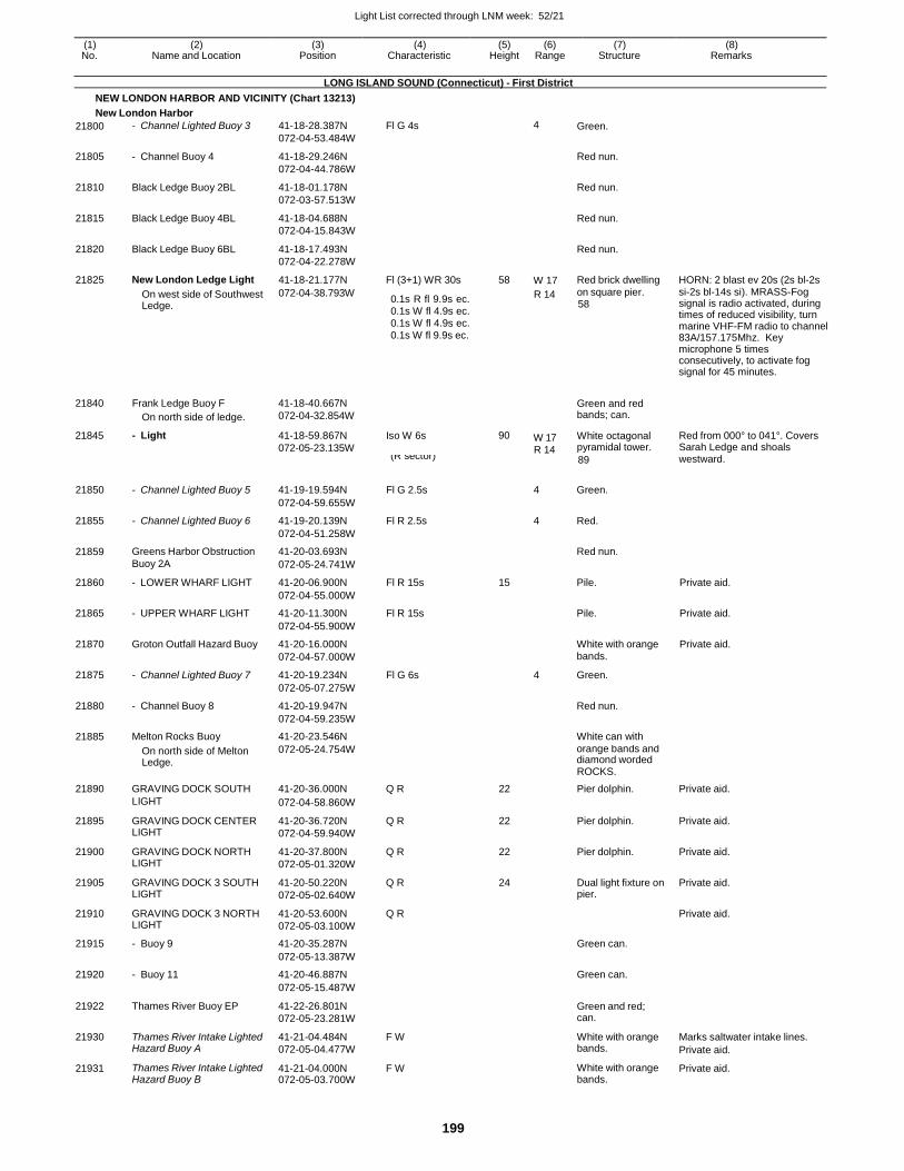
Light List corrected through LNM week: 52/21
199
(1) (2) (3) (4) (5) (6) (7) (8) No. Name and Location Position Characteristic Height Range Structure Remarks
LONG ISLAND SOUND (Connecticut) - First District
NEW LONDON HARBOR AND VICINITY (Chart 13213)
New London Harbor
21800 - Channel Lighted Buoy 3 41-18-28.387N
072-04-53.484W
Fl G 4s 4 Green.
21805 - Channel Buoy 4 41-18-29.246N
072-04-44.786W
Red nun.
21810 Black Ledge Buoy 2BL 41-18-01.178N
072-03-57.513W
Red nun.
21815 Black Ledge Buoy 4BL 41-18-04.688N
072-04-15.843W
Red nun.
21820 Black Ledge Buoy 6BL 41-18-17.493N
072-04-22.278W
Red nun.
21825 New London Ledge Light 41-18-21.177N Fl (3+1) WR 30s 58 W 17 Red brick dwelling HORN: 2 blast ev 20s (2s bl-2s
On west side of Southwest Ledge.
072-04-38.793W 0.1s R fl 9.9s ec. 0.1s W fl 4.9s ec. 0.1s W fl 4.9s ec. 0.1s W fl 9.9s ec.
R 14 on square pier. 58
si-2s bl-14s si). MRASS-Fog signal is radio activated, during times of reduced visibility, turn marine VHF-FM radio to channel 83A/157.175Mhz. Key microphone 5 times consecutively, to activate fog signal for 45 minutes.
21840
21845
Frank Ledge Buoy F
On north side of ledge.
- Light
41-18-40.667N
072-04-32.854W
41-18-59.867N
072-05-23.135W
Iso W 6s
90 W 17 R 14
Green and red bands; can.
White octagonal pyramidal tower.
Red from 000° to 041°. Covers Sarah Ledge and shoals
21890
GRAVING DOCK SOUTH
41-20-36.000N
Q R
22
ROCKS.
Pier dolphin.
Private aid.
LIGHT 072-04-58.860W
21895 GRAVING DOCK CENTER LIGHT
41-20-36.720N
072-04-59.940W
Q R 22 Pier dolphin. Private aid.
21900 GRAVING DOCK NORTH LIGHT
41-20-37.800N
072-05-01.320W
Q R 22 Pier dolphin. Private aid.
21905 GRAVING DOCK 3 SOUTH LIGHT
41-20-50.220N
072-05-02.640W
Q R 24 Dual light fixture on pier.
Private aid.
21910 GRAVING DOCK 3 NORTH LIGHT
41-20-53.600N
072-05-03.100W
Q R Private aid.
21915 - Buoy 9 41-20-35.287N Green can.
072-05-13.387W
21920 - Buoy 11 41-20-46.887N Green can.
072-05-15.487W
21922 Thames River Buoy EP 41-22-26.801N
072-05-23.281W
Green and red; can.
21930 Thames River Intake Lighted Hazard Buoy A
41-21-04.484N
072-05-04.477W
F W White with orange bands.
Marks saltwater intake lines.
Private aid.
21931 Thames River Intake Lighted Hazard Buoy B
41-21-04.000N 072-05-03.700W
F W White with orange bands.
Private aid.
21850
- Channel Lighted Buoy 5
41-19-19.594N
(R sector)
Fl G 2.5s
4
89
Green.
westward.
072-04-59.655W
21855 - Channel Lighted Buoy 6 41-19-20.139N Fl R 2.5s 4 Red.
072-04-51.258W
21859 Greens Harbor Obstruction 41-20-03.693N Red nun.
Buoy 2A 072-05-24.741W
21860 - LOWER WHARF LIGHT 41-20-06.900N Fl R 15s 15 Pile. Private aid.
072-04-55.000W
21865 - UPPER WHARF LIGHT 41-20-11.300N Fl R 15s Pile. Private aid.
072-04-55.900W
21870 Groton Outfall Hazard Buoy 41-20-16.000N White with orange Private aid.
072-04-57.000W bands.
21875 - Channel Lighted Buoy 7 41-20-19.234N Fl G 6s 4 Green.
072-05-07.275W
21880 - Channel Buoy 8 41-20-19.947N Red nun.
072-04-59.235W
21885 Melton Rocks Buoy 41-20-23.546N White can with
On north side of Melton Ledge.
072-05-24.754W orange bands and diamond worded
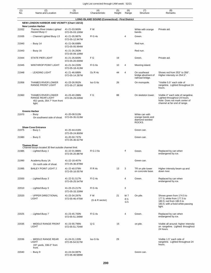
Light List corrected through LNM week: 52/21
200
(1) (2) (3) (4) (5) (6) (7) (8) No. Name and Location Position Characteristic Height Range Structure Remarks
LONG ISLAND SOUND (Connecticut) - First District
NEW LONDON HARBOR AND VICINITY (Chart 13213)
New London Harbor
21932 Thames River Intake Lighted Hazard Buoy C
41-21-03.900N
072-05-03.100W
F W White with orange bands.
Private aid.
21935 - Channel Lighted Buoy 13 41-21-05.987N Fl G 4s 4 Green.
072-05-12.947W
21940 - Buoy 14 41-21-06.698N Red nun.
072-05-05.994W
21943 - Buoy 16 41-21-26.283N Red nun.
072-05-09.109W
21944 STATE PIER LIGHT 41-21-26.600N F G 19 Green. Private aid.
072-05-20.000W
21945 WINTHROP POINT LIGHT 41-21-34.233N Fl G 6s 10 4 Mooring island.
072-05-18.413W
21948 - LEADING LIGHT 41-21-46.686N
072-05-14.287W
Oc R 4s 44 4 On southeast bridge abutment of railroad bridge.
Shows red from 353° to 356°. Higher intensity on 354.5°.
21956 THAMES RIVER LOWER RANGE FRONT LIGHT
41-23-26.952N
072-05-27.383W
Iso G 6s 26 On monopole. "Visible 5.5° each side of rangeline. Lighted throughout 24 hours.
21960 THAMES RIVER LOWER RANGE REAR LIGHT
452 yards, 354.7° from front light.
41-23-40.288N
072-05-29.035W
F G 88
On skeleton tower. Visible 4° each side of rangeline. Lighted throughout 24 hours. Note: Does not mark center of channel at far end of range.
Greens Harbor
21970 - Buoy
On southwest side of shoal.
41-20-08.513N
072-05-35.013W White can with orange bands and diamond worded ROCKS.
Shaw Cove Entrance 21975 - Buoy 1 41-20-44.416N Green can.
072-05-24.800W
21980 - Buoy 3 41-20-50.737N Green can. 072-05-36.627W
Thames River Channel buoys located 30 feet outside channel limit.
21985 - Lighted Buoy 1 41-22-01.886N
072-05-20.887W
Fl G 2.5s 4 Green. Replaced by can when endangered by ice.
21990 Academy Buoy 1A 41-22-18.407N
Green can.
On north side of shoal. 072-05-36.878W
21995 BAILEY POINT LIGHT 2 41-22-40.076N
072-05-16.057W
Fl R 4s 13 3 TR on pile tower on concrete base.
Higher intensity beam up and down river.
22000 - Lighted Buoy 3 41-22-51.517N
072-05-25.547W
Fl G 4s
4 Green.
Replaced by can when endangered by ice.
22010 - Lighted Buoy 5 41-23-15.217N Fl G 4s
3
072-05-33.339W
22020 - UPPER DIRECTIONAL 41-23-34.297N F W 21 W 7 On pile. Shows green from 174.5 to
LIGHT 072-05-46.475W (G & R sector) R 5
G 5
177.5; white from 177.5 to 180.5; red from 180.5 to 183.5; with a fixed white passing light.
22025
22035
22036
22040
- Lighted Buoy 7
- MIDDLE RANGE FRONT LIGHT
- MIDDLE RANGE REAR LIGHT
197 yards, 336.0° from front.
- Buoy 9
41-23-45.700N
072-05-51.349W
41-23-55.795N
072-05-51.754W
41-24-01.133N
072-05-54.917W
41-24-04.087N
072-05-48.589W
Fl G 4s
Q G
Iso G 6s
4 Green.
15 on pile.
29
Grenn can.
Replaced by can when endangered by ice.
Visible all around; higher intensity on rangeline. Lighted throughout 24 hours.
Visible 1.5° each side of rangeline. Lighted throughout 24 hours.
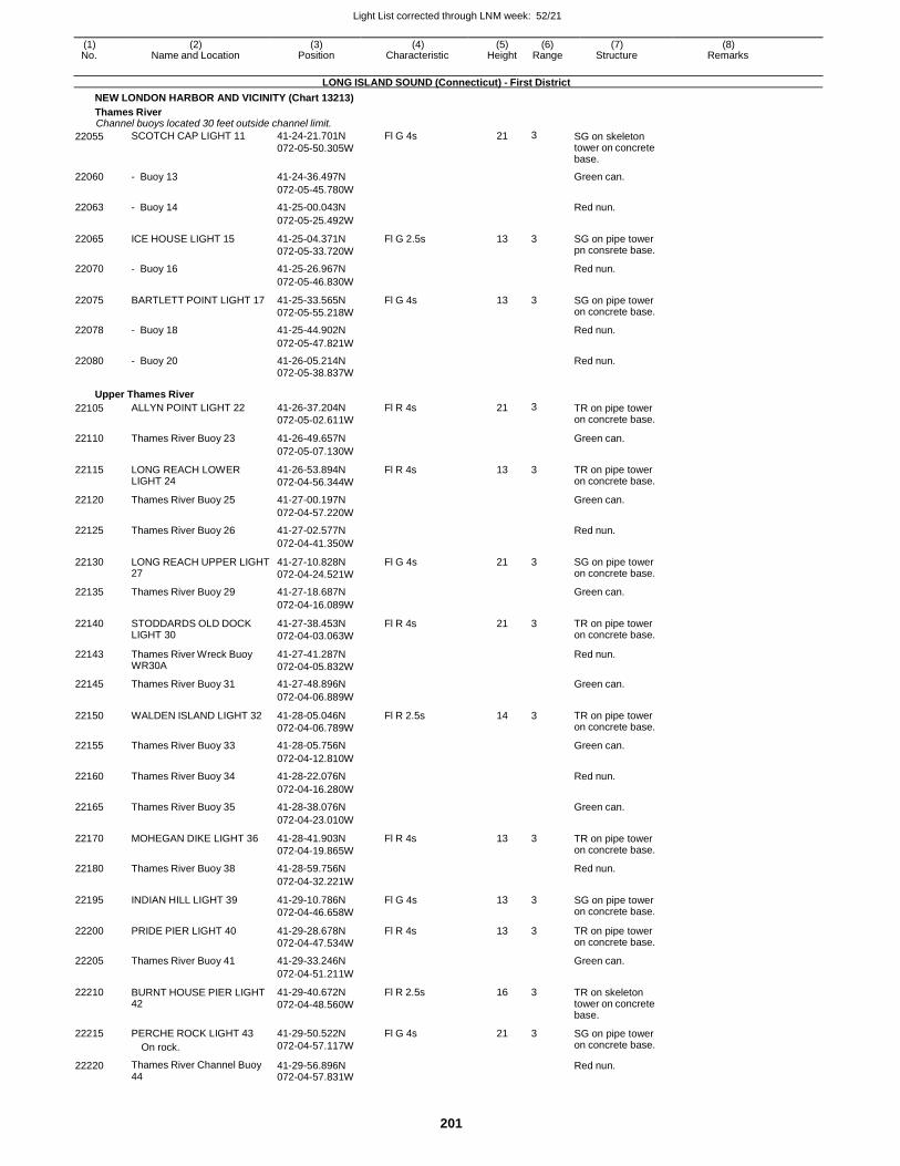
Light List corrected through LNM week: 52/21
201
(1) (2) (3) (4) (5) (6) (7) (8) No. Name and Location Position Characteristic Height Range Structure Remarks
LONG ISLAND SOUND (Connecticut) - First District
NEW LONDON HARBOR AND VICINITY (Chart 13213)
Thames River Channel buoys located 30 feet outside channel limit.
22055 SCOTCH CAP LIGHT 11 41-24-21.701N
072-05-50.305W
Fl G 4s 21 3 SG on skeleton tower on concrete base.
22060 - Buoy 13 41-24-36.497N Green can.
072-05-45.780W
22063 - Buoy 14 41-25-00.043N Red nun.
072-05-25.492W
22065 ICE HOUSE LIGHT 15 41-25-04.371N
072-05-33.720W
Fl G 2.5s 13 3 SG on pipe tower pn consrete base.
22070 - Buoy 16 41-25-26.967N Red nun.
072-05-46.830W
22075 BARTLETT POINT LIGHT 17 41-25-33.565N
072-05-55.218W
Fl G 4s 13 3 SG on pipe tower on concrete base.
22078 - Buoy 18 41-25-44.902N Red nun.
072-05-47.821W
22080 - Buoy 20 41-26-05.214N Red nun. 072-05-38.837W
Upper Thames River
22105 ALLYN POINT LIGHT 22 41-26-37.204N
072-05-02.611W
Fl R 4s 21 3 TR on pipe tower on concrete base.
22110 Thames River Buoy 23 41-26-49.657N Green can.
072-05-07.130W
22115 LONG REACH LOWER LIGHT 24
41-26-53.894N
072-04-56.344W
Fl R 4s 13 3 TR on pipe tower on concrete base.
22120 Thames River Buoy 25 41-27-00.197N Green can.
072-04-57.220W
22125 Thames River Buoy 26 41-27-02.577N Red nun.
072-04-41.350W
22130 LONG REACH UPPER LIGHT 27
41-27-10.828N
072-04-24.521W
Fl G 4s 21 3 SG on pipe tower on concrete base.
22135 Thames River Buoy 29 41-27-18.687N Green can.
072-04-16.089W
22140 STODDARDS OLD DOCK LIGHT 30
41-27-38.453N
072-04-03.063W
Fl R 4s 21 3 TR on pipe tower on concrete base.
22143 Thames River Wreck Buoy WR30A
41-27-41.287N
072-04-05.832W
Red nun.
22145 Thames River Buoy 31 41-27-48.896N Green can.
072-04-06.889W
22150 WALDEN ISLAND LIGHT 32 41-28-05.046N
072-04-06.789W
Fl R 2.5s 14 3 TR on pipe tower on concrete base.
22155 Thames River Buoy 33 41-28-05.756N Green can.
072-04-12.810W
22160 Thames River Buoy 34 41-28-22.076N Red nun.
072-04-16.280W
22165 Thames River Buoy 35 41-28-38.076N Green can.
072-04-23.010W
22170 MOHEGAN DIKE LIGHT 36 41-28-41.903N
072-04-19.865W
Fl R 4s 13 3 TR on pipe tower on concrete base.
22180 Thames River Buoy 38 41-28-59.756N Red nun.
072-04-32.221W
22195 INDIAN HILL LIGHT 39 41-29-10.786N
072-04-46.658W
Fl G 4s 13 3 SG on pipe tower on concrete base.
22200 PRIDE PIER LIGHT 40 41-29-28.678N
072-04-47.534W
Fl R 4s 13 3 TR on pipe tower on concrete base.
22205 Thames River Buoy 41 41-29-33.246N Green can.
072-04-51.211W
22210 BURNT HOUSE PIER LIGHT 42
41-29-40.672N
072-04-48.560W
Fl R 2.5s 16 3 TR on skeleton tower on concrete base.
22215 PERCHE ROCK LIGHT 43
On rock.
41-29-50.522N
072-04-57.117W
Fl G 4s 21 3 SG on pipe tower on concrete base.
22220 Thames River Channel Buoy 44
41-29-56.896N 072-04-57.831W
Red nun.
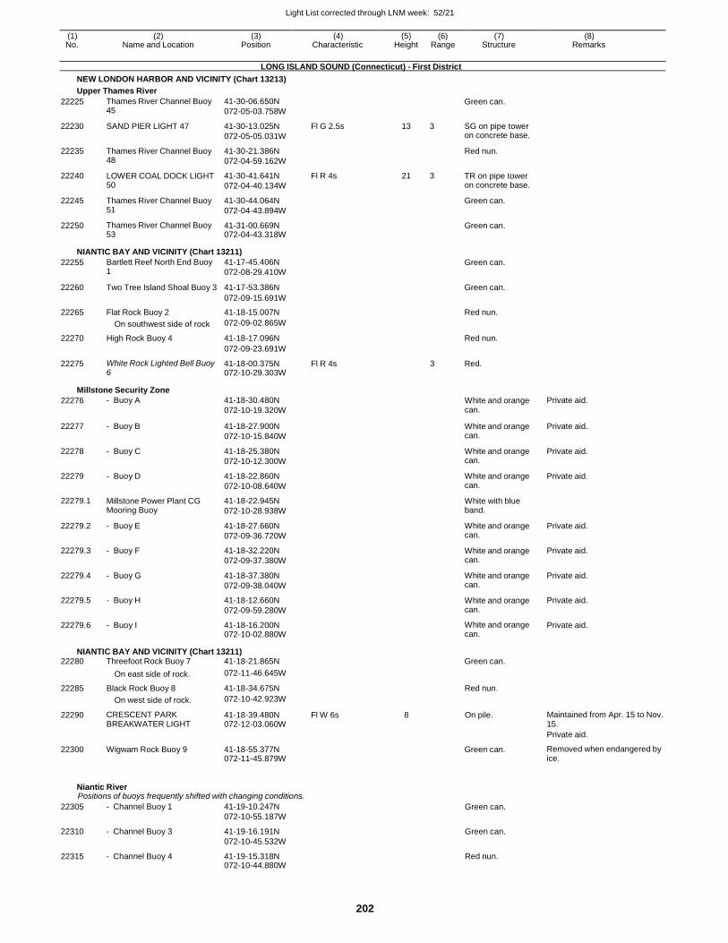
Light List corrected through LNM week: 52/21
202
(1) (2) (3) (4) (5) (6) (7) (8) No. Name and Location Position Characteristic Height Range Structure Remarks
LONG ISLAND SOUND (Connecticut) - First District
NEW LONDON HARBOR AND VICINITY (Chart 13213)
Upper Thames River
22225 Thames River Channel Buoy 45
41-30-06.650N
072-05-03.758W
Green can.
22230 SAND PIER LIGHT 47 41-30-13.025N
072-05-05.031W
Fl G 2.5s 13 3 SG on pipe tower on concrete base.
22235 Thames River Channel Buoy 48
41-30-21.386N
072-04-59.162W
Red nun.
22240 LOWER COAL DOCK LIGHT 50
41-30-41.641N
072-04-40.134W
Fl R 4s 21 3 TR on pipe tower on concrete base.
22245 Thames River Channel Buoy 51
41-30-44.064N
072-04-43.894W
Green can.
22250 Thames River Channel Buoy 53
41-31-00.669N 072-04-43.318W
Green can.
NIANTIC BAY AND VICINITY (Chart 13211)
22255 Bartlett Reef North End Buoy 1
41-17-45.406N
072-08-29.410W
Green can.
22260 Two Tree Island Shoal Buoy 3 41-17-53.386N Green can.
072-09-15.691W
22265 Flat Rock Buoy 2 41-18-15.007N Red nun.
On southwest side of rock 072-09-02.865W
22270 High Rock Buoy 4 41-18-17.096N Red nun.
072-09-23.691W
22275 White Rock Lighted Bell Buoy 6
41-18-00.375N 072-10-29.303W
Fl R 4s 3 Red.
Millstone Security Zone
22276 - Buoy A 41-18-30.480N
072-10-19.320W White and orange can.
Private aid.
22277 - Buoy B 41-18-27.900N
072-10-15.840W
White and orange can.
Private aid.
22278 - Buoy C 41-18-25.380N
072-10-12.300W
White and orange can.
Private aid.
22279 - Buoy D 41-18-22.860N
072-10-08.640W
White and orange can.
Private aid.
22279.1 Millstone Power Plant CG Mooring Buoy
41-18-22.945N
072-10-28.938W
White with blue band.
22279.2 - Buoy E 41-18-27.660N
072-09-36.720W
White and orange can.
Private aid.
22279.3 - Buoy F 41-18-32.220N
072-09-37.380W
White and orange can.
Private aid.
22279.4 - Buoy G 41-18-37.380N
072-09-38.040W
White and orange can.
Private aid.
22279.5 - Buoy H 41-18-12.660N
072-09-59.280W
White and orange can.
Private aid.
22279.6 - Buoy I 41-18-16.200N 072-10-02.880W
White and orange can.
Private aid.
NIANTIC BAY AND VICINITY (Chart 13211) 22280 Threefoot Rock Buoy 7 41-18-21.865N Green can.
On east side of rock. 072-11-46.645W
22285 Black Rock Buoy 8 41-18-34.675N Red nun.
On west side of rock. 072-10-42.923W
22290 CRESCENT PARK BREAKWATER LIGHT
41-18-39.480N 072-12-03.060W
Fl W 6s 8 On pile. Maintained from Apr. 15 to Nov. 15.
Private aid.
22300 Wigwam Rock Buoy 9 41-18-55.377N 072-11-45.879W
Green can. Removed when endangered by ice.
Niantic River Positions of buoys frequently shifted with changing conditions.
22305 - Channel Buoy 1 41-19-10.247N
072-10-55.187W
Green can.
22310 - Channel Buoy 3 41-19-16.191N
072-10-45.532W
Green can.
22315 - Channel Buoy 4 41-19-15.318N 072-10-44.880W
Red nun.
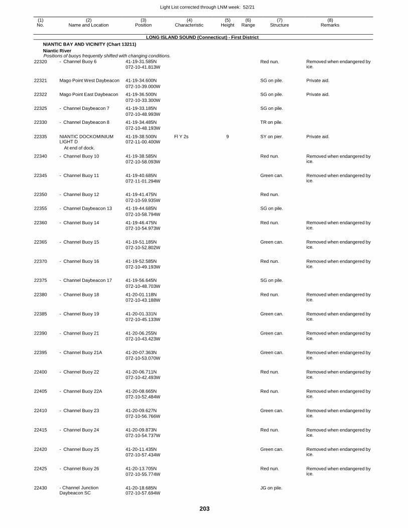
Light List corrected through LNM week: 52/21
203
(1) (2) (3) (4) (5) (6) (7) (8) No. Name and Location Position Characteristic Height Range Structure Remarks
LONG ISLAND SOUND (Connecticut) - First District
NIANTIC BAY AND VICINITY (Chart 13211)
Niantic River Positions of buoys frequently shifted with changing conditions.
22320 - Channel Buoy 6 41-19-31.585N
072-10-41.813W
Red nun. Removed when endangered by ice.
22321 Mago Point West Daybeacon 41-19-34.600N
SG on pile. Private aid.
072-10-39.000W
22322 Mago Point East Daybeacon 41-19-36.500N SG on pile. Private aid.
072-10-33.300W
22325 - Channel Daybeacon 7 41-19-33.185N SG on pile.
072-10-48.993W
22330 - Channel Daybeacon 8 41-19-34.485N TR on pile.
072-10-48.193W
22335 NIANTIC DOCKOMINIUM LIGHT D
41-19-38.500N 072-11-00.400W
Fl Y 2s 9 SY on pier. Private aid.
At end of dock.
22340 - Channel Buoy 10 41-19-38.585N
072-10-58.093W
Red nun. Removed when endangered by ice.
22345 - Channel Buoy 11 41-19-40.685N
072-11-01.294W
Green can. Removed when endangered by
ice.
22350 - Channel Buoy 12 41-19-41.475N
Red nun.
072-10-59.935W
22355 - Channel Daybeacon 13 41-19-44.685N SG on pile.
072-10-58.794W
22360 - Channel Buoy 14 41-19-46.475N
072-10-54.973W
Red nun. Removed when endangered by ice.
22365 - Channel Buoy 15 41-19-51.185N
072-10-52.802W
Green can. Removed when endangered by
ice.
22370 - Channel Buoy 16 41-19-52.585N
072-10-49.193W
Red nun. Removed when endangered by
ice.
22375 - Channel Daybeacon 17 41-19-56.645N
SG on pile.
072-10-48.703W
22380 - Channel Buoy 18 41-20-01.118N
072-10-43.188W
Red nun. Removed when endangered by ice.
22385 - Channel Buoy 19 41-20-01.331N
072-10-45.133W
Green can. Removed when endangered by
ice.
22390 - Channel Buoy 21 41-20-06.255N
072-10-43.423W
Green can. Removed when endangered by
ice.
22395 - Channel Buoy 21A 41-20-07.363N
072-10-53.070W
Green can. Removed when endangered by
ice.
22400 - Channel Buoy 22 41-20-06.711N
072-10-42.493W
Red nun. Removed when endangered by
ice.
22405 - Channel Buoy 22A 41-20-08.665N
072-10-52.484W
Red nun. Removed when endangered by
ice.
22410 - Channel Buoy 23 41-20-09.627N
072-10-56.766W
Green can. Removed when endangered by
ice.
22415 - Channel Buoy 24 41-20-09.873N
072-10-54.737W
Red nun. Removed when endangered by
ice.
22420 - Channel Buoy 25 41-20-11.435N
072-10-57.434W
Green can. Removed when endangered by
ice.
22425 - Channel Buoy 26 41-20-13.705N
072-10-55.774W
Red nun. Removed when endangered by
ice.
22430 - Channel Junction Daybeacon SC
41-20-18.685N 072-10-57.694W
JG on pile.
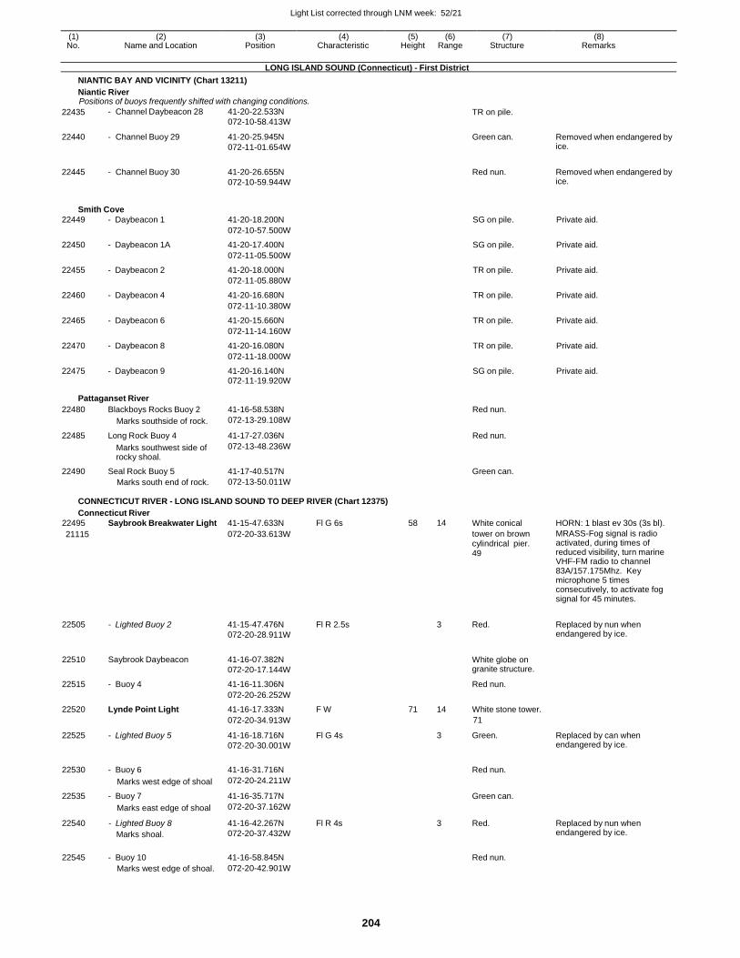
Light List corrected through LNM week: 52/21
204
(1) (2) (3) (4) (5) (6) (7) (8) No. Name and Location Position Characteristic Height Range Structure Remarks
LONG ISLAND SOUND (Connecticut) - First District
NIANTIC BAY AND VICINITY (Chart 13211)
Niantic River Positions of buoys frequently shifted with changing conditions.
22435
22440
22445
- Channel Daybeacon 28
- Channel Buoy 29
- Channel Buoy 30
41-20-22.533N
072-10-58.413W
41-20-25.945N
072-11-01.654W
41-20-26.655N
072-10-59.944W
TR on pile.
Green can.
Red nun.
Removed when endangered by ice.
Removed when endangered by ice.
Smith Cove
22449 - Daybeacon 1 41-20-18.200N SG on pile. Private aid.
072-10-57.500W
22450 - Daybeacon 1A 41-20-17.400N SG on pile. Private aid.
072-11-05.500W
22455 - Daybeacon 2 41-20-18.000N TR on pile. Private aid.
072-11-05.880W
22460 - Daybeacon 4 41-20-16.680N TR on pile. Private aid.
072-11-10.380W
22465 - Daybeacon 6 41-20-15.660N TR on pile. Private aid.
072-11-14.160W
22470 - Daybeacon 8 41-20-16.080N TR on pile. Private aid.
072-11-18.000W
22475 - Daybeacon 9 41-20-16.140N SG on pile. Private aid. 072-11-19.920W
Pattaganset River
22480 Blackboys Rocks Buoy 2 41-16-58.538N Red nun.
Marks southside of rock. 072-13-29.108W
22485 Long Rock Buoy 4 41-17-27.036N Red nun.
Marks southwest side of rocky shoal.
072-13-48.236W
22490 Seal Rock Buoy 5 41-17-40.517N Green can. Marks south end of rock. 072-13-50.011W
CONNECTICUT RIVER - LONG ISLAND SOUND TO DEEP RIVER (Chart 12375)
Connecticut River
22495 Saybrook Breakwater Light 41-15-47.633N Fl G 6s 58 14 White conical HORN: 1 blast ev 30s (3s bl).
21115 072-20-33.613W tower on brown cylindrical pier. 49
MRASS-Fog signal is radio activated, during times of reduced visibility, turn marine VHF-FM radio to channel 83A/157.175Mhz. Key microphone 5 times consecutively, to activate fog signal for 45 minutes.
22505 - Lighted Buoy 2 41-15-47.476N
072-20-28.911W
Fl R 2.5s
3 Red. Replaced by nun when endangered by ice.
22510 Saybrook Daybeacon 41-16-07.382N
072-20-17.144W
White globe on granite structure.
22515 - Buoy 4 41-16-11.306N Red nun.
072-20-26.252W
22520 Lynde Point Light 41-16-17.333N F W 71 14 White stone tower.
072-20-34.913W 71
22525 - Lighted Buoy 5 41-16-18.716N
072-20-30.001W
Fl G 4s 3 Green. Replaced by can when endangered by ice.
22530 - Buoy 6 41-16-31.716N
Red nun.
Marks west edge of shoal 072-20-24.211W
22535 - Buoy 7 41-16-35.717N Green can.
Marks east edge of shoal 072-20-37.162W
22540 - Lighted Buoy 8
Marks shoal.
41-16-42.267N
072-20-37.432W
Fl R 4s 3 Red. Replaced by nun when endangered by ice.
22545 - Buoy 10 41-16-58.845N
Red nun.
Marks west edge of shoal. 072-20-42.901W
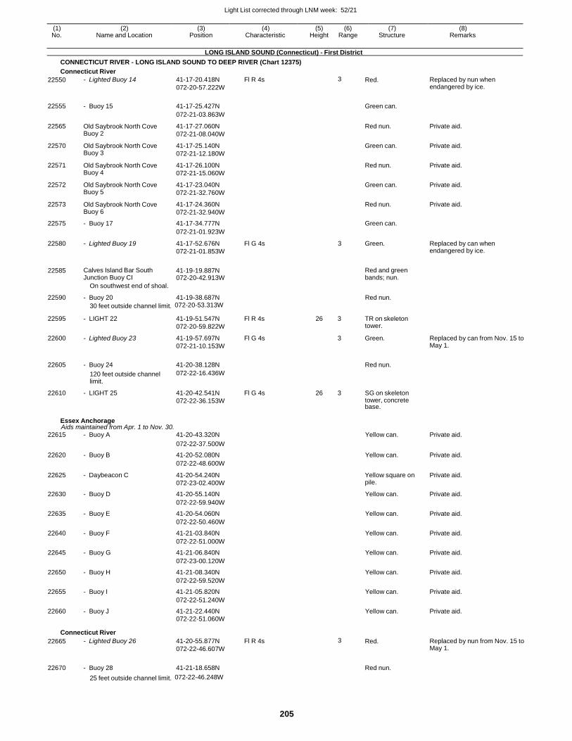
Light List corrected through LNM week: 52/21
205
(1) (2) (3) (4) (5) (6) (7) (8) No. Name and Location Position Characteristic Height Range Structure Remarks
LONG ISLAND SOUND (Connecticut) - First District
CONNECTICUT RIVER - LONG ISLAND SOUND TO DEEP RIVER (Chart 12375)
Connecticut River
22550 - Lighted Buoy 14 41-17-20.418N
072-20-57.222W
Fl R 4s 3 Red. Replaced by nun when endangered by ice.
22555 - Buoy 15 41-17-25.427N
Green can.
072-21-03.863W
22565 Old Saybrook North Cove Buoy 2
41-17-27.060N
072-21-08.040W
Red nun. Private aid.
22570 Old Saybrook North Cove Buoy 3
41-17-25.140N
072-21-12.180W
Green can. Private aid.
22571 Old Saybrook North Cove Buoy 4
41-17-26.100N
072-21-15.060W
Red nun. Private aid.
22572 Old Saybrook North Cove Buoy 5
41-17-23.040N
072-21-32.760W
Green can. Private aid.
22573 Old Saybrook North Cove Buoy 6
41-17-24.360N
072-21-32.940W
Red nun. Private aid.
22575 - Buoy 17 41-17-34.777N Green can.
072-21-01.923W
22580 - Lighted Buoy 19 41-17-52.676N
072-21-01.853W
Fl G 4s 3 Green. Replaced by can when endangered by ice.
22585 Calves Island Bar South Junction Buoy CI
41-19-19.887N 072-20-42.913W
Red and green bands; nun.
On southwest end of shoal.
22590 - Buoy 20 41-19-38.687N Red nun.
30 feet outside channel limit. 072-20-53.313W
22595 - LIGHT 22 41-19-51.547N
072-20-59.822W
Fl R 4s 26 3 TR on skeleton tower.
22600 - Lighted Buoy 23 41-19-57.697N
072-21-10.153W
Fl G 4s 3 Green. Replaced by can from Nov. 15 to May 1.
22605 - Buoy 24 41-20-38.128N
Red nun.
120 feet outside channel limit.
072-22-16.436W
22610 - LIGHT 25 41-20-42.541N
072-22-36.153W
Fl G 4s 26 3 SG on skeleton tower, concrete base.
Essex Anchorage Aids maintained from Apr. 1 to Nov. 30.
22615 - Buoy A 41-20-43.320N Yellow can. Private aid.
072-22-37.500W
22620 - Buoy B 41-20-52.080N Yellow can. Private aid.
072-22-48.600W
22625 - Daybeacon C 41-20-54.240N
072-23-02.400W
Yellow square on pile.
Private aid.
22630 - Buoy D 41-20-55.140N Yellow can. Private aid.
072-22-59.940W
22635 - Buoy E 41-20-54.060N Yellow can. Private aid.
072-22-50.460W
22640 - Buoy F 41-21-03.840N Yellow can. Private aid.
072-22-51.000W
22645 - Buoy G 41-21-06.840N Yellow can. Private aid.
072-23-00.120W
22650 - Buoy H 41-21-08.340N Yellow can. Private aid.
072-22-59.520W
22655 - Buoy I 41-21-05.820N Yellow can. Private aid.
072-22-51.240W
22660 - Buoy J 41-21-22.440N Yellow can. Private aid. 072-22-51.060W
Connecticut River
22665 - Lighted Buoy 26 41-20-55.877N
072-22-46.607W
Fl R 4s 3 Red. Replaced by nun from Nov. 15 to May 1.
22670 - Buoy 28 41-21-18.658N
Red nun.
25 feet outside channel limit. 072-22-46.248W
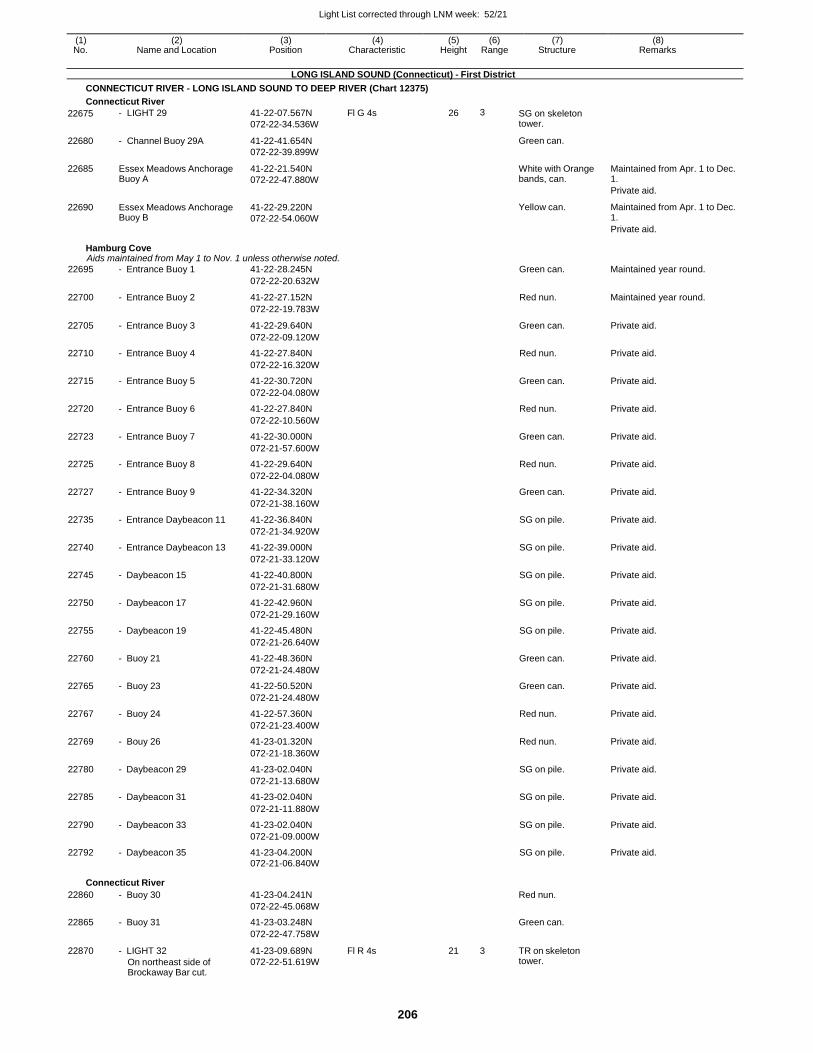
Light List corrected through LNM week: 52/21
206
(1) (2) (3) (4) (5) (6) (7) (8) No. Name and Location Position Characteristic Height Range Structure Remarks
LONG ISLAND SOUND (Connecticut) - First District
CONNECTICUT RIVER - LONG ISLAND SOUND TO DEEP RIVER (Chart 12375)
Connecticut River
22675
22680
22685
22690
- LIGHT 29
- Channel Buoy 29A
Essex Meadows Anchorage Buoy A
Essex Meadows Anchorage Buoy B
41-22-07.567N
072-22-34.536W
41-22-41.654N
072-22-39.899W
41-22-21.540N
072-22-47.880W
41-22-29.220N
072-22-54.060W
Fl G 4s 26 3 SG on skeleton tower.
Green can.
White with Orange bands, can.
Yellow can.
Maintained from Apr. 1 to Dec. 1.
Private aid.
Maintained from Apr. 1 to Dec. 1.
Private aid.
Hamburg Cove Aids maintained from May 1 to Nov. 1 unless otherwise noted.
22695 - Entrance Buoy 1 41-22-28.245N Green can. Maintained year round.
072-22-20.632W
22700 - Entrance Buoy 2 41-22-27.152N Red nun. Maintained year round.
072-22-19.783W
22705 - Entrance Buoy 3 41-22-29.640N Green can. Private aid.
072-22-09.120W
22710 - Entrance Buoy 4 41-22-27.840N Red nun. Private aid.
072-22-16.320W
22715 - Entrance Buoy 5 41-22-30.720N Green can. Private aid.
072-22-04.080W
22720 - Entrance Buoy 6 41-22-27.840N Red nun. Private aid.
072-22-10.560W
22723 - Entrance Buoy 7 41-22-30.000N Green can. Private aid.
072-21-57.600W
22725 - Entrance Buoy 8 41-22-29.640N Red nun. Private aid.
072-22-04.080W
22727 - Entrance Buoy 9 41-22-34.320N Green can. Private aid.
072-21-38.160W
22735 - Entrance Daybeacon 11 41-22-36.840N SG on pile. Private aid.
072-21-34.920W
22740 - Entrance Daybeacon 13 41-22-39.000N SG on pile. Private aid.
072-21-33.120W
22745 - Daybeacon 15 41-22-40.800N SG on pile. Private aid.
072-21-31.680W
22750 - Daybeacon 17 41-22-42.960N SG on pile. Private aid.
072-21-29.160W
22755 - Daybeacon 19 41-22-45.480N SG on pile. Private aid.
072-21-26.640W
22760 - Buoy 21 41-22-48.360N Green can. Private aid.
072-21-24.480W
22765 - Buoy 23 41-22-50.520N Green can. Private aid.
072-21-24.480W
22767 - Buoy 24 41-22-57.360N Red nun. Private aid.
072-21-23.400W
22769 - Bouy 26 41-23-01.320N Red nun. Private aid.
072-21-18.360W
22780 - Daybeacon 29 41-23-02.040N SG on pile. Private aid.
072-21-13.680W
22785 - Daybeacon 31 41-23-02.040N SG on pile. Private aid.
072-21-11.880W
22790 - Daybeacon 33 41-23-02.040N SG on pile. Private aid.
072-21-09.000W
22792 - Daybeacon 35 41-23-04.200N SG on pile. Private aid. 072-21-06.840W
Connecticut River
22860 - Buoy 30 41-23-04.241N Red nun.
072-22-45.068W
22865 - Buoy 31 41-23-03.248N Green can.
072-22-47.758W
22870 - LIGHT 32
On northeast side of Brockaway Bar cut.
41-23-09.689N
072-22-51.619W
Fl R 4s 21 3 TR on skeleton tower.
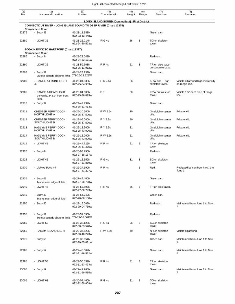
Light List corrected through LNM week: 52/21
207
(1) (2) (3) (4) (5) (6) (7) (8) No. Name and Location Position Characteristic Height Range Structure Remarks
LONG ISLAND SOUND (Connecticut) - First District
CONNECTICUT RIVER - LONG ISLAND SOUND TO DEEP RIVER (Chart 12375)
Connecticut River
22875 - Buoy 33 41-23-11.388N Green can.
072-23-13.448W
22880 - LIGHT 35 41-23-22.214N 072-24-50.523W
Fl G 4s 26 3 SG on skeleton tower.
BODKIN ROCK TO HARTFORD (Chart 12377)
Connecticut River
22885 - Buoy 34 41-23-23.049N Red nun.
072-24-33.171W
22890 - LIGHT 36 41-23-59.608N
072-25-11.912W
Fl R 4s 21 3 TR on pipe tower on concrete base.
22895 - Buoy 37 41-24-28.239N Green can.
25 feet outside channel limit. 072-25-23.123W
22900 - RANGE A FRONT LIGHT 40
41-25-01.838N
072-25-34.959W
Fl R 2.5s 36
KRW and TR on skeleton tower.
Visible all around higher intensity on range line.
22905 - RANGE A REAR LIGHT
94 yards, 343.2° from front light.
41-25-04.506N
072-25-36.029W
F R 50
KRW on skeleton tower.
Visible 1.5° each side of range line.
22910 - Buoy 39 41-24-42.939N Green can.
072-25-31.463W
22911 CHESTER FERRY DOCK NORTH LIGHT A
41-25-10.500N
072-25-57.500W
Fl W 2.5s 19 On dolphin center pile.
Private aid.
22912 CHESTER FERRY DOCK SOUTH LIGHT B
41-25-09.000N
072-25-57.500W
Fl Y 2.5s 20 On dolphin center pile.
Private aid.
22913 HADLYME FERRY DOCK NORTH LIGHT A
41-25-12.500N
072-25-43.000W
Fl Y 2.5s 21 On dolphin center pile.
Private aid.
22914 HADLYME FERRY DOCK SOUTH LIGHT B
41-25-12.000N
072-25-43.000W
Fl W 2.5s 21 On dolphin center pile.
Private aid.
22915 - LIGHT 42 41-25-44.823N
072-26-11.375W
Fl R 4s 31 3 TR on skeleton tower.
22920 - Buoy 44 41-26-08.290N Red nun.
072-27-18.137W
22925 - LIGHT 45 41-26-12.552N
072-27-31.869W
Fl G 4s 31 3 SG on skeleton tower.
22930 - Lighted Buoy 46 41-26-24.390N
072-27-41.327W
Fl R 4s 3 Red. Replaced by nun from Nov. 1 to June 1.
22935 - Buoy 47 41-27-44.400N
Green can.
Marks east edge of flats. 072-27-58.788W
22940 - LIGHT 48 41-27-53.893N Fl R 4s 36 3 TR on pipe tower.
072-27-58.743W
22945 - Buoy 49 41-27-54.240N Green can.
Marks east edge of flats. 072-28-08.158W
22950 - Buoy 50 41-28-19.009N
072-29-04.769W
Red nun. Maintained from June 1 to Nov. 1.
22955 - Buoy 52 41-28-31.590N
Red nun.
50 feet outside channel limit. 072-29-55.061W
22960 - LIGHT 53 41-28-33.128N
072-30-03.548W
Fl G 4s 26 3 SG on skeleton tower.
22965 - HADAM ISLAND LIGHT 41-29-36.623N
072-30-48.273W
Fl W 2.5s 40 NR on skeleton tower.
Visible all around.
22975 - Buoy 55 41-29-36.654N
072-30-55.081W
Green can. Maintained from June 1 to Nov. 1.
22980 - Buoy 57 41-29-43.509N
072-31-16.562W
Green can. Maintained from June 1 to Nov.
1.
22985 - LIGHT 58 41-29-50.039N
072-31-23.463W
Fl R 4s 31 3 TR on skeleton tower.
23000 - Buoy 59 41-29-49.968N
072-31-29.585W
Green can. Maintained from June 1 to Nov. 1.
23005 - LIGHT 61 41-30-04.460N 072-32-59.609W
Fl G 4s 31 3 SG on skeleton tower.
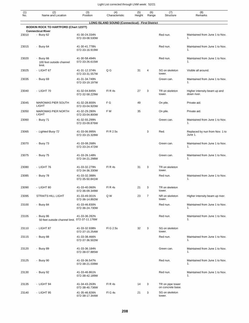
Light List corrected through LNM week: 52/21
208
(1) (2) (3) (4) (5) (6) (7) (8) No. Name and Location Position Characteristic Height Range Structure Remarks
LONG ISLAND SOUND (Connecticut) - First District
BODKIN ROCK TO HARTFORD (Chart 12377)
Connecticut River
23010 - Buoy 62 41-30-24.334N
072-33-08.530W
Red nun. Maintained from June 1 to Nov. 1.
23015 - Buoy 64 41-30-41.778N
072-33-16.919W
Red nun. Maintained from June 1 to Nov.
1.
23020 - Buoy 66
100 feet outside channel limit.
41-30-58.494N
072-33-26.615W
Red nun. Maintained from June 1 to Nov.
1.
23025 - LIGHT 67 41-31-12.374N
072-33-31.557W
Q G 31 4 SG on skeleton tower.
Visible all around.
23035 - Buoy 69 41-31-34.749N
072-33-19.197W
Green can. Maintained from June 1 to Nov. 1.
23040 - LIGHT 70 41-32-04.845N
072-32-58.229W
Fl R 4s 27 3 TR on skeleton tower.
Higher intensity beam up and down river.
23045 MAROMAS PIER SOUTH LIGHT
41-32-28.800N
072-33-04.920W
F G 49
On pile. Private aid.
23050 MAROMAS PIER NORTH LIGHT
41-32-29.280N
072-33-04.800W
F W 35 On pile. Private aid.
23060 - Buoy 71 41-32-55.299N
072-33-09.876W
Green can. Maintained from June 1 to Nov. 1.
23065 - Lighted Buoy 72 41-33-06.995N
072-33-15.328W
Fl R 2.5s
3 Red. Replaced by nun from Nov. 1 to June 1.
23070 - Buoy 73 41-33-08.268N
072-33-24.472W
Green can. Maintained from June 1 to Nov.
1.
23075 - Buoy 75 41-33-26.148N
072-34-21.298W
Green can. Maintained from June 1 to Nov.
1.
23080 - LIGHT 76 41-33-32.279N
072-34-36.330W
Fl R 4s 31 3 TR on skeleton tower.
23085 - Buoy 78 41-33-32.388N
072-35-50.841W
Red nun. Maintained from June 1 to Nov. 1.
23090 - LIGHT 80 41-33-40.060N
072-36-09.349W
Fl R 4s 21 3 TR on skeleton tower.
23095 STRAITS HILL LIGHT 41-33-49.001N
072-36-14.892W
Q W 23 7 NR on skeleton tower.
Higher intensity beam up river.
23100 - Buoy 84 41-33-46.830N
072-36-24.730W
Red nun. Maintained from June 1 to Nov. 1.
23105 - Buoy 86 41-33-36.282N
Red nun. Maintained from June 1 to Nov.
50 feet outside channel limit. 072-37-11.176W 1.
23110
- LIGHT 87
41-33-32.938N
072-37-15.254W
Fl G 2.5s
32
3
SG on skeleton tower.
23115 - Buoy 88 41-33-38.466N
072-37-36.502W
Red nun. Maintained from June 1 to Nov. 1.
23120 - Buoy 89 41-33-36.184N
072-38-07.885W
Green can. Maintained from June 1 to Nov.
1.
23125 - Buoy 90 41-33-36.547N
072-38-21.039W
Red nun. Maintained from June 1 to Nov.
1.
23130 - Buoy 92 41-33-46.861N
072-38-42.189W
Red nun. Maintained from June 1 to Nov.
1.
23135 - LIGHT 94 41-34-43.263N
072-38-40.736W
Fl R 4s 14 3 TR on pipe tower on concrete base.
23140 - LIGHT 95 41-35-46.826N 072-38-17.344W
Fl G 4s 21 3 SG on skeleton tower.
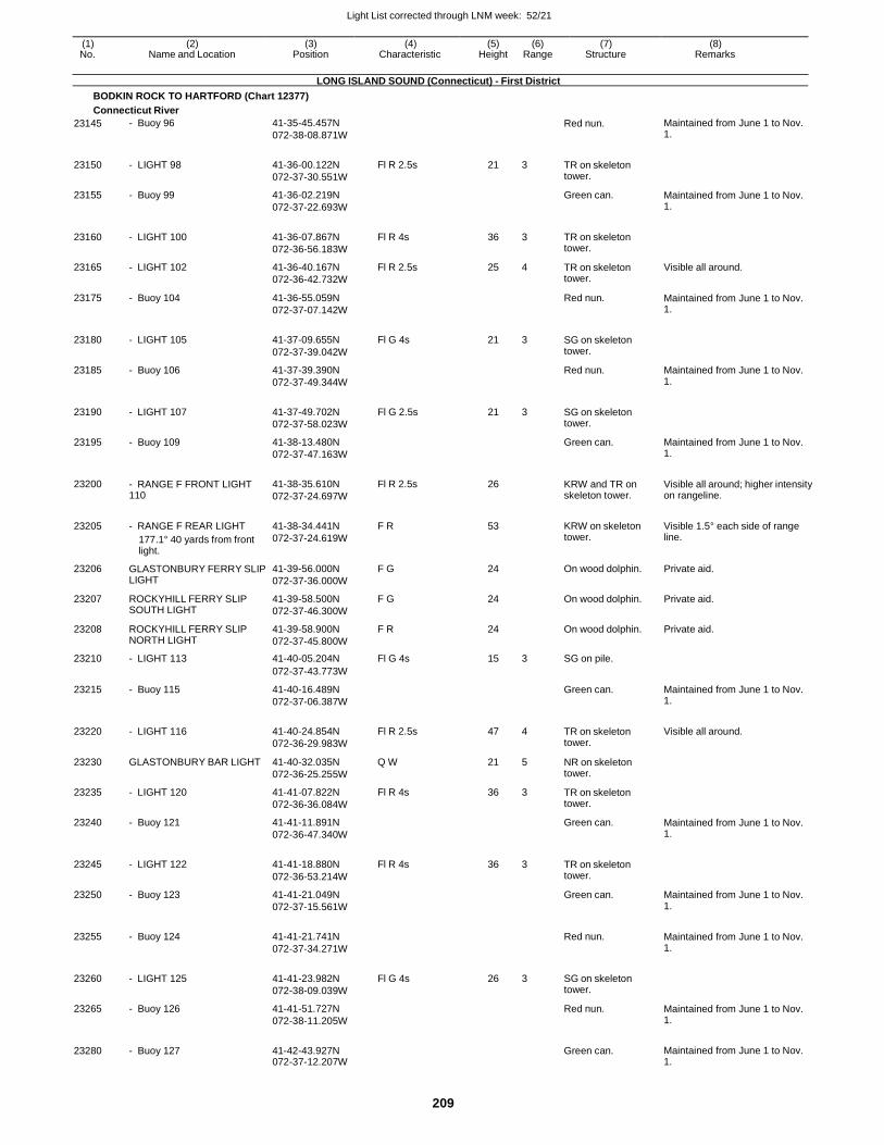
Light List corrected through LNM week: 52/21
209
(1) (2) (3) (4) (5) (6) (7) (8) No. Name and Location Position Characteristic Height Range Structure Remarks
LONG ISLAND SOUND (Connecticut) - First District
BODKIN ROCK TO HARTFORD (Chart 12377)
Connecticut River
23145 - Buoy 96 41-35-45.457N
072-38-08.871W
Red nun. Maintained from June 1 to Nov. 1.
23150 - LIGHT 98 41-36-00.122N
072-37-30.551W
Fl R 2.5s 21 3 TR on skeleton tower.
23155 - Buoy 99 41-36-02.219N
072-37-22.693W
Green can. Maintained from June 1 to Nov. 1.
23160 - LIGHT 100 41-36-07.867N
072-36-56.183W
Fl R 4s 36 3 TR on skeleton tower.
23165 - LIGHT 102 41-36-40.167N
072-36-42.732W
Fl R 2.5s 25 4 TR on skeleton tower.
Visible all around.
23175 - Buoy 104 41-36-55.059N
072-37-07.142W
Red nun. Maintained from June 1 to Nov. 1.
23180 - LIGHT 105 41-37-09.655N
072-37-39.042W
Fl G 4s 21 3 SG on skeleton tower.
23185 - Buoy 106 41-37-39.390N
072-37-49.344W
Red nun. Maintained from June 1 to Nov. 1.
23190 - LIGHT 107 41-37-49.702N
072-37-58.023W
Fl G 2.5s 21 3 SG on skeleton tower.
23195 - Buoy 109 41-38-13.480N
072-37-47.163W
Green can. Maintained from June 1 to Nov. 1.
23200 - RANGE F FRONT LIGHT 110
41-38-35.610N
072-37-24.697W
Fl R 2.5s 26
KRW and TR on skeleton tower.
Visible all around; higher intensity on rangeline.
23205 - RANGE F REAR LIGHT
177.1° 40 yards from front light.
41-38-34.441N
072-37-24.619W
F R 53
KRW on skeleton tower.
Visible 1.5° each side of range line.
23206 GLASTONBURY FERRY SLIP LIGHT
41-39-56.000N
072-37-36.000W
F G 24 On wood dolphin. Private aid.
23207 ROCKYHILL FERRY SLIP SOUTH LIGHT
41-39-58.500N
072-37-46.300W
F G 24 On wood dolphin. Private aid.
23208 ROCKYHILL FERRY SLIP NORTH LIGHT
41-39-58.900N
072-37-45.800W
F R 24 On wood dolphin. Private aid.
23210 - LIGHT 113 41-40-05.204N Fl G 4s 15 3 SG on pile.
072-37-43.773W
23215 - Buoy 115 41-40-16.489N
072-37-06.387W
Green can. Maintained from June 1 to Nov. 1.
23220 - LIGHT 116 41-40-24.854N
072-36-29.983W
Fl R 2.5s 47 4 TR on skeleton tower.
Visible all around.
23230 GLASTONBURY BAR LIGHT 41-40-32.035N
072-36-25.255W
Q W 21 5 NR on skeleton tower.
23235 - LIGHT 120 41-41-07.822N
072-36-36.084W
Fl R 4s 36 3 TR on skeleton tower.
23240 - Buoy 121 41-41-11.891N
072-36-47.340W
Green can. Maintained from June 1 to Nov. 1.
23245 - LIGHT 122 41-41-18.880N
072-36-53.214W
Fl R 4s 36 3 TR on skeleton tower.
23250 - Buoy 123 41-41-21.049N
072-37-15.561W
Green can. Maintained from June 1 to Nov. 1.
23255 - Buoy 124 41-41-21.741N
072-37-34.271W
Red nun. Maintained from June 1 to Nov.
1.
23260 - LIGHT 125 41-41-23.982N
072-38-09.039W
Fl G 4s 26 3 SG on skeleton tower.
23265 - Buoy 126 41-41-51.727N
072-38-11.205W
Red nun. Maintained from June 1 to Nov. 1.
23280 - Buoy 127 41-42-43.927N 072-37-12.207W
Green can. Maintained from June 1 to Nov.
1.
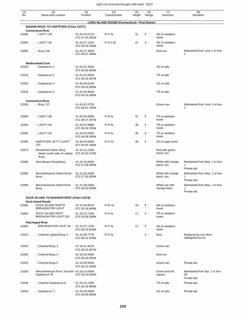
Light List corrected through LNM week: 52/21
210
(1) (2) (3) (4) (5) (6) (7) (8) No. Name and Location Position Characteristic Height Range Structure Remarks
LONG ISLAND SOUND (Connecticut) - First District
BODKIN ROCK TO HARTFORD (Chart 12377)
Connecticut River
23285 - LIGHT 129 41-42-43.011N
072-37-53.281W
Fl G 4s 31 3 SG on skeleton tower.
23300 - LIGHT 135 41-43-27.142N
072-39-03.290W
Fl G 2.5s 21 3 SG on skeleton tower.
23305 - Buoy 136 41-43-27.392N 072-38-57.344W
Red nun. Maintained from June 1 to Nov. 1.
Wethersfield Cove
23310 - Daybeacon 1 41-43-31.364N SG on pile.
072-39-03.663W
23315 - Daybeacon 2 41-43-31.855N TR on pile.
072-39-03.297W
23320 - Daybeacon 3 41-43-30.614N SG on pile.
072-39-20.509W
23325 - Daybeacon 4 41-43-30.964N TR on pile. 072-39-23.280W
Connecticut River
23335 - Buoy 137 41-43-41.572N
072-38-51.783W
Green can. Maintained from June 1 to Nov. 1.
23340 - LIGHT 138 41-43-49.905N
072-38-37.397W
Fl R 4s 31 3 TR on skeleton tower.
23345 - LIGHT 140 41-44-02.998N
072-38-26.700W
Fl R 4s 36 3 TR on skeleton tower.
23360 - LIGHT 142 41-44-53.645N
072-38-39.365W
Fl R 4s 26 3 TR on skeleton tower.
23365 HARTFORD JETTY LIGHT 143
41-45-03.690N
072-39-02.765W
Fl G 4s 26 3 SG on pipe tower.
23375 Westbrook Harbor Buoy
Marks south side of Lobster
Rock.
41-16-11.216N
072-26-50.370W
Red with green band; nun.
23380 West Beach Shoal Buoy 41-16-16.000N 072-27-08.000W
White with orange band; can.
Maintained from May. 1 to Nov. 1.
Private aid.
23385 Menunketesuck Island Shoal Buoy
41-15-32.000N 072-27-35.000W
White with orange band; can.
Maintained from May. 1 to Nov. 1.
Private aid.
23390 Menunketesuck Island Rock Buoy
41-15-39.000N 072-28-02.000W
White can with orange band.
Maintained from May. 1 to Nov. 1.
Private aid.
DUCK ISLAND TO MADISON REEF (Chart 12374)
Duck Island Roads
23395 DUCK ISLAND NORTH BREAKWATER LIGHT
41-15-36.851N
072-28-29.849W
Fl W 4s 16 6 NR on skeleton tower.
23400 DUCK ISLAND WEST BREAKWATER LIGHT 2DI
41-15-22.719N 072-29-06.569W
Fl R 4s 17 4 TR on skeleton tower.
Patchogue River
23405 - BREAKWATER LIGHT 3A 41-16-07.114N
072-28-22.816W
Fl G 4s 21 4 SG on skeleton tower.
23410 - Channel Lighted Buoy 2 41-15-58.777N
072-28-21.978W
Fl R 4s 3 Red. Replaced by nun when edangered by ice.
23415 - Channel Buoy 3 41-16-01.451N
Green can.
072-28-22.807W
23420 - Channel Buoy 4 41-16-05.056N Red nun.
072-28-20.355W
23425 - Channel Buoy 5 41-16-00.000N Green can. Private aid.
072-28-21.000W
23430 Menunketesuck River Junction Daybeacon M
41-16-14.000N 072-28-20.000W
Green and red square.
Maintained from Apr. 1 to Nov. 30.
Private aid.
23435 - Channel Daybeacon 6 41-16-15.120N TR on pile. Private aid.
072-28-16.860W
23440 - Daybeacon 7 41-16-25.000N SG on pile. Private aid. 072-28-00.000W
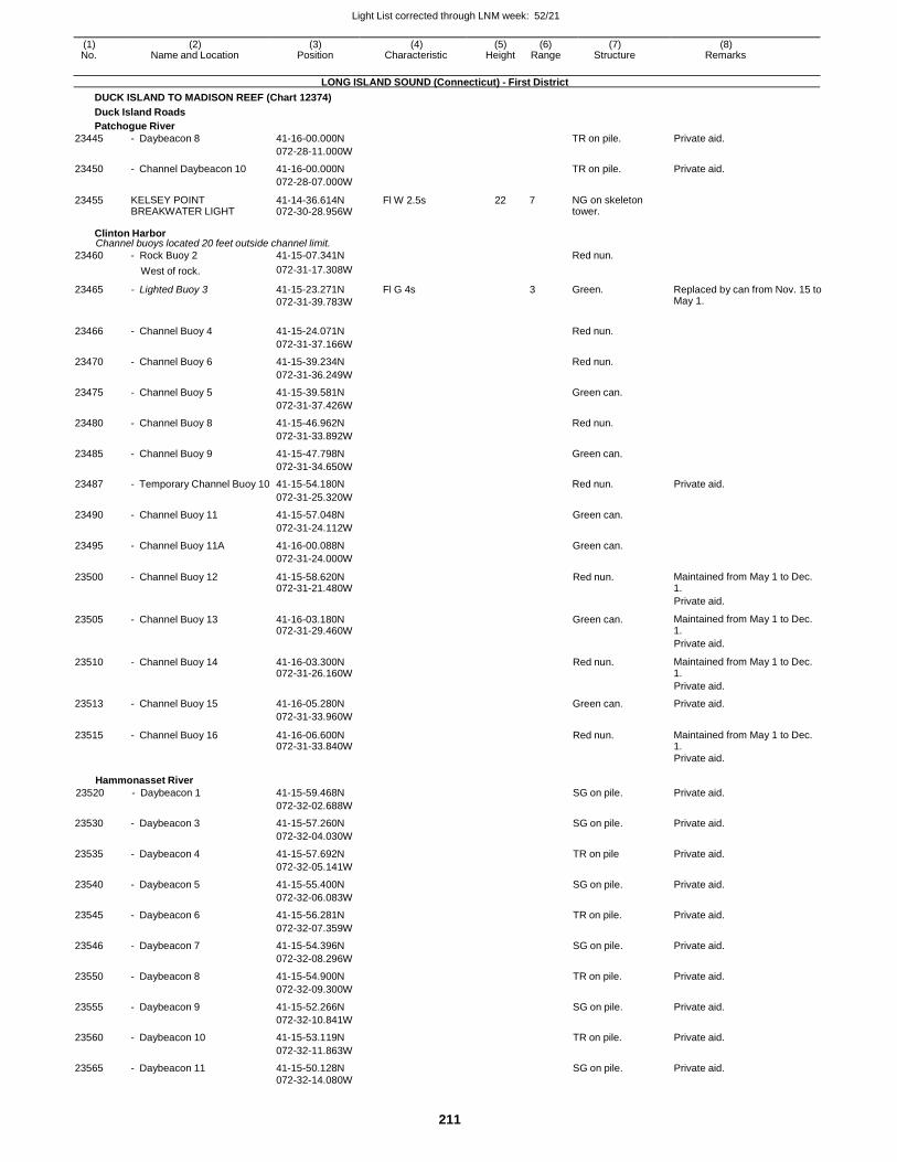
Light List corrected through LNM week: 52/21
211
(1) (2) (3) (4) (5) (6) (7) (8) No. Name and Location Position Characteristic Height Range Structure Remarks
LONG ISLAND SOUND (Connecticut) - First District
DUCK ISLAND TO MADISON REEF (Chart 12374)
Duck Island Roads
Patchogue River
23445 - Daybeacon 8 41-16-00.000N TR on pile. Private aid.
072-28-11.000W
23450 - Channel Daybeacon 10 41-16-00.000N TR on pile. Private aid.
072-28-07.000W
23455 KELSEY POINT BREAKWATER LIGHT
41-14-36.614N 072-30-28.956W
Fl W 2.5s 22 7 NG on skeleton tower.
Clinton Harbor Channel buoys located 20 feet outside channel limit.
23460 - Rock Buoy 2 41-15-07.341N Red nun.
West of rock. 072-31-17.308W
23465 - Lighted Buoy 3 41-15-23.271N
072-31-39.783W
Fl G 4s 3 Green. Replaced by can from Nov. 15 to May 1.
23466 - Channel Buoy 4 41-15-24.071N
Red nun.
072-31-37.166W
23470 - Channel Buoy 6 41-15-39.234N Red nun.
072-31-36.249W
23475 - Channel Buoy 5 41-15-39.581N Green can.
072-31-37.426W
23480 - Channel Buoy 8 41-15-46.962N Red nun.
072-31-33.892W
23485 - Channel Buoy 9 41-15-47.798N Green can.
072-31-34.650W
23487 - Temporary Channel Buoy 10 41-15-54.180N Red nun. Private aid.
23490
- Channel Buoy 11
072-31-25.320W
41-15-57.048N
Green can.
072-31-24.112W
23495 - Channel Buoy 11A 41-16-00.088N Green can.
072-31-24.000W
23500 - Channel Buoy 12 41-15-58.620N 072-31-21.480W
Red nun. Maintained from May 1 to Dec. 1.
Private aid.
23505 - Channel Buoy 13 41-16-03.180N 072-31-29.460W
Green can. Maintained from May 1 to Dec. 1.
Private aid.
23510 - Channel Buoy 14 41-16-03.300N 072-31-26.160W
Red nun. Maintained from May 1 to Dec. 1.
Private aid.
23513 - Channel Buoy 15 41-16-05.280N Green can. Private aid.
072-31-33.960W
23515 - Channel Buoy 16 41-16-06.600N 072-31-33.840W
Red nun. Maintained from May 1 to Dec. 1.
Private aid.
Hammonasset River
23520 - Daybeacon 1
41-15-59.468N
SG on pile.
Private aid.
072-32-02.688W
23530 - Daybeacon 3 41-15-57.260N SG on pile. Private aid.
072-32-04.030W
23535 - Daybeacon 4 41-15-57.692N TR on pile Private aid.
072-32-05.141W
23540 - Daybeacon 5 41-15-55.400N SG on pile. Private aid.
072-32-06.083W
23545 - Daybeacon 6 41-15-56.281N TR on pile. Private aid.
072-32-07.359W
23546 - Daybeacon 7 41-15-54.396N SG on pile. Private aid.
072-32-08.296W
23550 - Daybeacon 8 41-15-54.900N TR on pile. Private aid.
072-32-09.300W
23555 - Daybeacon 9 41-15-52.266N SG on pile. Private aid.
072-32-10.841W
23560 - Daybeacon 10 41-15-53.119N TR on pile. Private aid.
072-32-11.863W
23565 - Daybeacon 11 41-15-50.128N SG on pile. Private aid. 072-32-14.080W
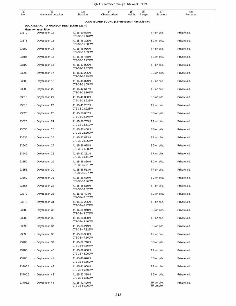
Light List corrected through LNM week: 52/21
212
(1) (2) (3) (4) (5) (6) (7) (8) No. Name and Location Position Characteristic Height Range Structure Remarks
LONG ISLAND SOUND (Connecticut) - First District
DUCK ISLAND TO MADISON REEF (Chart 12374)
Hammonasset River
23570 - Daybeacon 12 41-15-50.828N TR on pile. Private aid.
072-32-15.164W
23575 - Daybeacon 13 41-15-48.305N SG on pile. Private aid.
072-32-15.508W
23580 - Daybeacon 14 41-15-48.936N TR on pile. Private aid.
072-32-17.035W
23585 - Daybeacon 15 41-15-46.458N SG on pile. Private aid.
072-32-17.472W
23590 - Daybeacon 16 41-15-47.006N TR on pile. Private aid.
072-32-18.379W
23595 - Daybeacon 17 41-15-43.285N SG on pile. Private aid.
072-32-20.994W
23600 - Daybeacon 18 41-15-44.079N TR on pile. Private aid.
072-32-21.654W
23606 - Daybeacon 20 41-15-42.647N TR on pile. Private aid.
072-32-22.963W
23610 - Daybeacon 21 41-15-40.880N SG on pile. Private aid.
072-32-23.238W
23615 - Daybeacon 22 41-15-41.287N TR on pile. Private aid.
072-32-24.223W
23620 - Daybeacon 23 41-15-38.087N SG on pile. Private aid.
072-32-26.307W
23625 - Daybeacon 24 41-15-38.755N TR on pile. Private aid.
072-32-26.612W
23630 - Daybeacon 25 41-15-37.400N SG on pile. Private aid.
072-32-28.500W
23635 - Daybeacon 26 41-15-37.893N TR on pile. Private aid.
072-32-28.866W
23640 - Daybeacon 27 41-15-36.678N SG on pile. Private aid.
072-32-31.382W
23645 - Daybeacon 28 41-15-37.291N TR on pile. Private aid.
072-32-31.419W
23650 - Daybeacon 29 41-15-35.830N SG on pile. Private aid.
072-32-35.213W
23655 - Daybeacon 30 41-15-36.513N TR on pile. Private aid.
072-32-35.275W
23660 - Daybeacon 31 41-15-35.630N SG on pile. Private aid.
072-32-37.968W
23665 - Daybeacon 32 41-15-36.510N TR on pile. Private aid.
072-32-38.025W
23670 - Daybeacon 33 41-15-36.424N SG on pile. Private aid.
072-32-40.576W
23675 - Daybeacon 34 41-15-37.205N TR on pile. Private aid.
072-32-40.472W
23680 - Daybeacon 35 41-15-36.940N SG on pile. Private aid.
072-32-43.578W
23685 - Daybeacon 36 41-15-38.000N TR on pile. Private aid.
072-32-43.460W
23690 - Daybeacon 37 41-15-38.249N SG on pile. Private aid.
072-32-47.325W
23695 - Daybeacon 38 41-15-38.900N TR on pile. Private aid.
072-32-47.100W
23700 - Daybeacon 39 41-15-39.710N SG on pile. Private aid.
072-32-50.157W
23705 - Daybeacon 40 41-15-39.600N TR on pile. Private aid.
072-32-48.900W
23706 - Daybeacon 41 41-15-40.690N SG on pile. Private aid.
072-32-50.850W
23706.1 - Daybeacon 42 41-15-41.000N TR on pile. Private aid.
072-32-50.500W
23706.2 - Daybeacon 43 41-15-42.319N SG on pile. Private aid.
072-32-51.557W
23706.3 - Daybeacon 44 41-15-42.400N 072-32-50.900W
TR on pile. TR on pile.
Private aid.
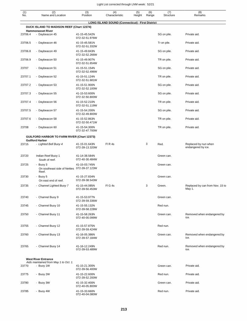
Light List corrected through LNM week: 52/21
213
(1) (2) (3) (4) (5) (6) (7) (8) No. Name and Location Position Characteristic Height Range Structure Remarks
LONG ISLAND SOUND (Connecticut) - First District
DUCK ISLAND TO MADISON REEF (Chart 12374)
Hammonasset River
23706.4 - Daybeacon 45 41-15-45.542N SG on pile. Private aid.
072-32-51.976W
23706.5 - Daybeacon 46 41-15-45.581N Tr on pile. Private aid.
072-32-51.332W
23706.8 - Daybeacon 49 41-15-49.843N SG on pile. Private aid.
072-32-52.266W
23706.9 - Daybeacon 50 41-15-49.907N TR on pile. Private aid.
072-32-51.654W
23707 - Daybeacon 51 41-15-51.154N SG on pile. Private aid.
072-32-52.496W
23707.1 - Daybeacon 52 41-15-51.124N TR on pile. Private aid.
072-32-51.681W
23707.2 - Daybeacon 53 41-15-51.900N SG on pile. Private aid.
072-32-52.100W
23707.3 - Daybeacon 55 41-15-53.600N SG on pile. Private aid.
072-32-50.800W
23707.4 - Daybeacon 56 41-15-52.210N TR on pile. Private aid.
072-32-51.119W
23707.5 - Daybeacon 57 41-15-54.200N SG on pile. Private aid.
072-32-49.800W
23707.6 - Daybeacon 58 41-15-52.863N TR on pile. Private aid.
072-32-50.471W
23708 - Daybeacon 60 41-15-54.300N TR on pile. Private aid. 072-32-47.700W
GUILFORD HARBOR TO FARM RIVER (Chart 12373)
Guilford Harbor
23715 - Lighted Bell Buoy 4 41-15-01.643N
072-39-13.320W
Fl R 4s 3 Red. Replaced by nun when endangered by ice.
23720 Indian Reef Buoy 1 41-14-38.584N
Green can.
South of reef. 072-40-30.484W
23725 - Buoy 3 41-15-03.745N Green can.
On southeast side of Netties Reef.
072-39-37.123W
23730 - Buoy 5 41-15-27.834N Green can.
On east end of reef. 072-39-38.543W
23735 - Channel Lighted Buoy 7 41-15-44.085N
072-39-50.453W
Fl G 4s 3 Green. Replaced by can from Nov. 15 to May 1.
23740 - Channel Buoy 9 41-15-53.977N
Green can.
072-39-59.336W
23745 - Channel Buoy 10 41-15-55.132N Red nun.
072-39-58.228W
23750 - Channel Buoy 11 41-15-58.263N
072-40-00.099W
Green can. Removed when endangered by ice.
23755 - Channel Buoy 12 41-15-57.875N
Red nun.
072-39-59.424W
23760 - Channel Buoy 13 41-16-05.386N
072-39-57.184W
Green can. Removed when endangered by ice.
23765 - Channel Buoy 14 41-16-12.249N 072-39-53.489W
Red nun. Removed when endangered by
ice.
West River Entrance Aids maintained from May 1 to Oct. 1.
23770 - Buoy 1W 41-15-21.300N
072-39-56.400W Green can. Private aid.
23775 - Buoy 2W 41-15-22.600N
072-39-52.200W
Red nun. Private aid.
23780 - Buoy 3W 41-15-32.400N
072-40-05.800W
Green can. Private aid.
23785 - Buoy 4W 41-15-33.660N 072-40-04.080W
Red nun. Private aid.
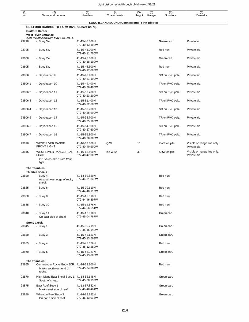
Light List corrected through LNM week: 52/21
214
(1) (2) (3) (4) (5) (6) (7) (8) No. Name and Location Position Characteristic Height Range Structure Remarks
LONG ISLAND SOUND (Connecticut) - First District
GUILFORD HARBOR TO FARM RIVER (Chart 12373)
Guilford Harbor
West River Entrance Aids maintained from May 1 to Oct. 1.
23790 - Buoy 5W 41-15-40.600N Green can. Private aid.
072-40-13.100W
23795 - Buoy 6W 41-15-41.200N Red nun. Private aid.
072-40-11.700W
23800 - Buoy 7W 41-15-45.800N Green can. Private aid.
072-40-18.100W
23805 - Buoy 8W 41-15-46.300N Red nun. Private aid.
072-40-17.000W
23806 - Daybeacon 9 41-15-48.400N SG on PVC pole. Private aid.
072-40-21.100W
23806.1 - Daybeacon 10 41-15-49.400N TR on PVC pole. Private aid.
072-40-20.400W
23806.2 - Daybeacon 11 41-15-50.700N SG on PVC pole. Private aid.
072-40-23.200W
23806.3 - Daybeacon 12 41-15-51.400N TR on PVC pole. Private aid.
072-40-22.600W
23806.4 - Daybeacon 13 41-15-53.200N SG on PVC pole. Private aid.
072-40-25.900W
23806.5 - Daybeacon 14 41-15-53.700N TR on PVC pole. Private aid.
072-40-25.100W
23806.6 - Daybeacon 15 41-15-54.900N SG on PVC pole. Private aid.
072-40-27.600W
23806.7 - Daybeacon 16 41-15-56.800N TR on PVC pole. Private aid.
072-40-28.300W
23810 WEST RIVER RANGE FRONT LIGHT
41-16-07.600N
072-40-40.600W
Q W 16 KWR on pile. Visible on range line only.
Private aid.
23815 WEST RIVER RANGE REAR LIGHT
41-16-13.600N 072-40-47.000W
Iso W 6s 30 KRW on pile. Visible on range line only.
Private aid.
261 yards, 321° from front light.
The Thimbles
Thimble Shoals
23820 - Buoy 4
At southwest edge of rocky shoal.
41-14-59.820N 072-44-31.340W
Red nun.
23825 - Buoy 6 41-15-09.110N Red nun.
072-44-40.113W
23830 - Buoy 8 41-15-15.518N Red nun.
072-44-46.897W
23835 - Buoy 10 41-15-12.576N Red nun.
072-44-56.551W
23840 - Buoy 11 41-15-12.018N Green can. On east side of shoal. 072-45-04.787W
Stony Creek
23845 - Buoy 1 41-15-35.219N Green can.
072-45-15.140W
23850 - Buoy 3 41-15-46.181N Green can.
072-45-13.563W
23855 - Buoy 4 41-15-45.376N Red nun.
072-45-12.280W
23860 - Buoy 5 41-15-53.281N Green can. 072-45-13.080W
The Thimbles
23865 Commander Rocks Buoy 2CR 41-14-33.200N Red nun.
Marks southwest end of rocks.
072-45-04.389W
23870 High Island East Shoal Buoy 1 41-14-52.148N Green can.
South of shoal. 072-45-28.199W
23875 East Reef Buoy 1 41-13-57.852N Green can.
Marks east side of reef. 072-45-48.464W
23880 Wheaton Reef Buoy 3 41-14-12.282N Green can. On north side of reef. 072-46-13.015W
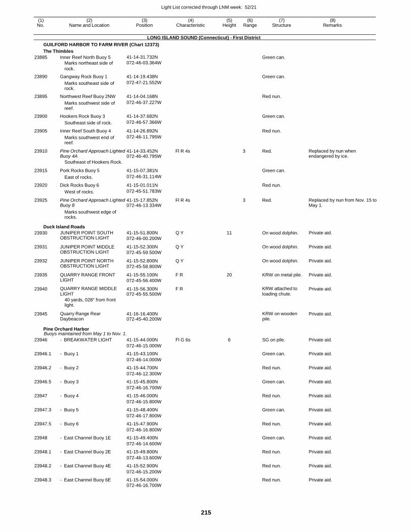
Light List corrected through LNM week: 52/21
215
(1) (2) (3) (4) (5) (6) (7) (8) No. Name and Location Position Characteristic Height Range Structure Remarks
LONG ISLAND SOUND (Connecticut) - First District
GUILFORD HARBOR TO FARM RIVER (Chart 12373)
The Thimbles
23885 Inner Reef North Buoy 5
Marks northeast side of
rock.
41-14-31.732N
072-46-03.364W
Green can.
23890 Gangway Rock Buoy 1 41-14-19.438N Green can.
Marks southeast side of rock.
072-47-21.552W
23895 Northwest Reef Buoy 2NW 41-14-04.168N Red nun.
Marks southwest side of reef.
072-46-37.227W
23900 Hookers Rock Buoy 3 41-14-37.682N Green can.
Southeast side of rock. 072-46-57.366W
23905 Inner Reef South Buoy 4 41-14-26.892N Red nun.
Marks southwest end of reef.
072-46-11.795W
23910 Pine Orchard Approach Lighted Buoy 4A
41-14-33.452N 072-46-40.795W
Fl R 4s 3 Red. Replaced by nun when endangered by ice.
Southeast of Hookers Rock.
23915 Pork Rocks Buoy 5 41-15-07.381N
Green can.
East of rocks. 072-46-31.114W
23920 Dick Rocks Buoy 6 41-15-01.011N Red nun.
West of rocks. 072-45-51.783W
23925 Pine Orchard Approach Lighted Buoy 8
41-15-17.852N 072-46-13.334W
Fl R 4s 3 Red. Replaced by nun from Nov. 15 to May 1.
Marks southwest edge of rocks.
Duck Island Roads
23930 JUNIPER POINT SOUTH OBSTRUCTION LIGHT
41-15-51.800N
072-46-00.200W
Q Y 11 On wood dolphin. Private aid.
23931 JUNIPER POINT MIDDLE OBSTRUCTION LIGHT
41-15-52.300N
072-45-59.500W
Q Y On wood dolphin. Private aid.
23932 JUNIPER POINT NORTH OBSTRUCTION LIGHT
41-15-52.800N
072-45-58.800W
Q Y On wood dolphin. Private aid.
23935 QUARRY RANGE FRONT LIGHT
41-15-55.100N
072-45-56.400W
F R 20 KRW on metal pile. Private aid.
23940 QUARRY RANGE MIDDLE LIGHT
41-15-56.300N 072-45-55.500W
F R KRW attached to loading chute.
Private aid.
40 yards, 028° from front light.
23945 Quarry Range Rear Daybeacon
41-16-16.400N 072-45-40.200W
KRW on wooden pile.
Private aid.
Pine Orchard Harbor Buoys maintained from May 1 to Nov. 1.
23946 - BREAKWATER LIGHT 41-15-44.000N Fl G 6s 6 SG on pile. Private aid.
072-46-15.000W
23946.1 - Buoy 1 41-15-43.100N Green can. Private aid.
072-46-14.000W
23946.2 - Buoy 2 41-15-44.700N Red nun. Private aid.
072-46-12.300W
23946.5 - Buoy 3 41-15-45.800N Green can. Private aid.
072-46-16.700W
23947 - Buoy 4 41-15-46.000N Red nun. Private aid.
072-46-15.800W
23947.3 - Buoy 5 41-15-48.400N Green can. Private aid.
072-46-17.800W
23947.5 - Buoy 6 41-15-47.900N Red nun. Private aid.
072-46-16.800W
23948 - East Channel Buoy 1E 41-15-49.400N Green can. Private aid.
072-46-14.600W
23948.1 - East Channel Buoy 2E 41-15-49.800N Red nun. Private aid.
072-46-13.600W
23948.2 - East Channel Buoy 4E 41-15-52.900N Red nun. Private aid.
072-46-15.200W
23948.3 - East Channel Buoy 6E 41-15-54.000N Red nun. Private aid. 072-46-16.700W
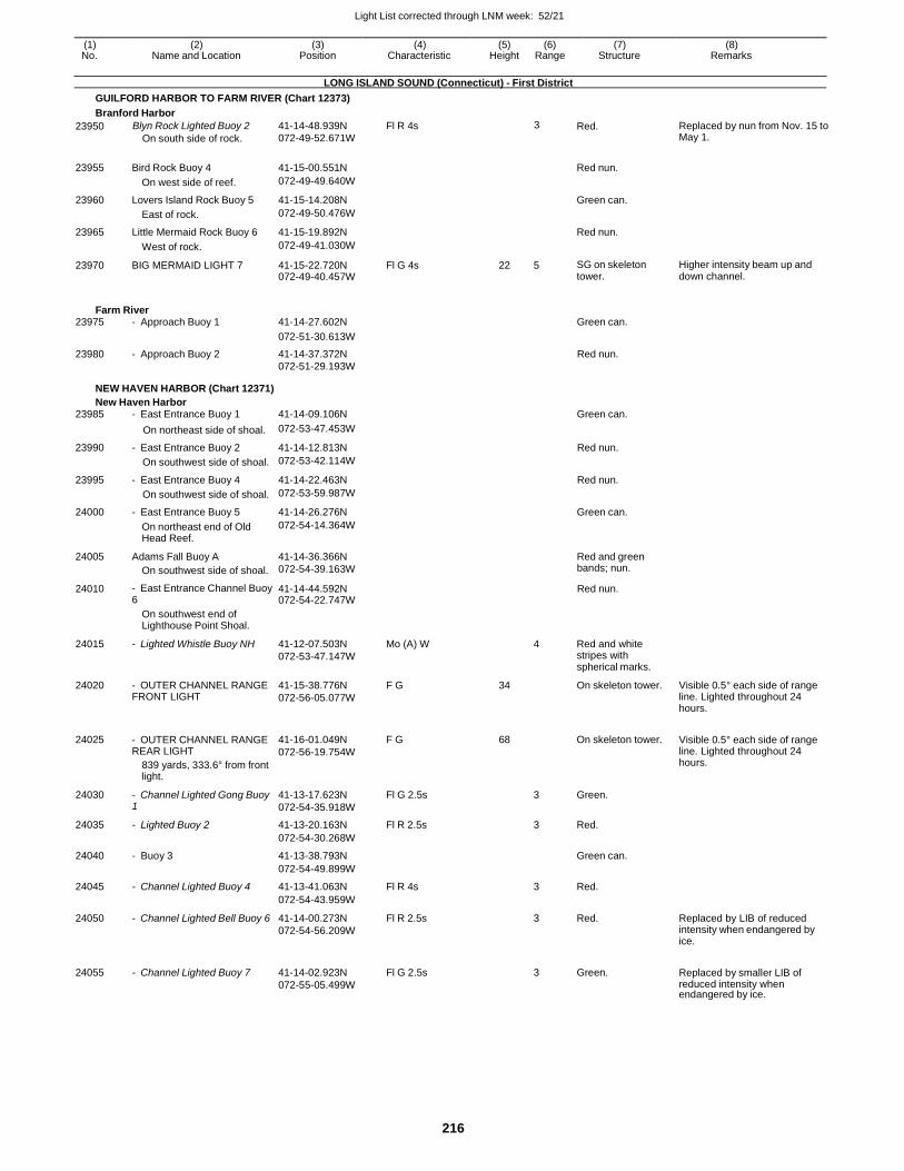
Light List corrected through LNM week: 52/21
216
(1) (2) (3) (4) (5) (6) (7) (8) No. Name and Location Position Characteristic Height Range Structure Remarks
LONG ISLAND SOUND (Connecticut) - First District
GUILFORD HARBOR TO FARM RIVER (Chart 12373)
Branford Harbor
23950 Blyn Rock Lighted Buoy 2
On south side of rock.
41-14-48.939N
072-49-52.671W
Fl R 4s 3 Red. Replaced by nun from Nov. 15 to May 1.
23955
Bird Rock Buoy 4
41-15-00.551N
Red nun.
On west side of reef. 072-49-49.640W
23960 Lovers Island Rock Buoy 5 41-15-14.208N Green can.
East of rock. 072-49-50.476W
23965 Little Mermaid Rock Buoy 6 41-15-19.892N Red nun.
West of rock. 072-49-41.030W
23970 BIG MERMAID LIGHT 7 41-15-22.720N 072-49-40.457W
Fl G 4s 22 5 SG on skeleton tower.
Higher intensity beam up and down channel.
Farm River 23975 - Approach Buoy 1 41-14-27.602N Green can.
072-51-30.613W
23980 - Approach Buoy 2 41-14-37.372N Red nun. 072-51-29.193W
NEW HAVEN HARBOR (Chart 12371)
New Haven Harbor 23985 - East Entrance Buoy 1 41-14-09.106N Green can.
On northeast side of shoal. 072-53-47.453W
23990 - East Entrance Buoy 2 41-14-12.813N Red nun.
On southwest side of shoal. 072-53-42.114W
23995 - East Entrance Buoy 4 41-14-22.463N Red nun.
On southwest side of shoal. 072-53-59.987W
24000 - East Entrance Buoy 5 41-14-26.276N Green can.
On northeast end of Old Head Reef.
072-54-14.364W
24005 Adams Fall Buoy A
On southwest side of shoal.
41-14-36.366N
072-54-39.163W
Red and green bands; nun.
24010 - East Entrance Channel Buoy 6
41-14-44.592N 072-54-22.747W
Red nun.
On southwest end of Lighthouse Point Shoal.
24015 - Lighted Whistle Buoy NH 41-12-07.503N
072-53-47.147W
Mo (A) W 4 Red and white stripes with spherical marks.
24020 - OUTER CHANNEL RANGE FRONT LIGHT
41-15-38.776N
072-56-05.077W
F G 34 On skeleton tower. Visible 0.5° each side of range line. Lighted throughout 24 hours.
24025 - OUTER CHANNEL RANGE REAR LIGHT
839 yards, 333.6° from front light.
41-16-01.049N
072-56-19.754W
F G 68
On skeleton tower. Visible 0.5° each side of range line. Lighted throughout 24 hours.
24030 - Channel Lighted Gong Buoy 1
41-13-17.623N
072-54-35.918W
Fl G 2.5s 3 Green.
24035 - Lighted Buoy 2 41-13-20.163N Fl R 2.5s 3 Red.
072-54-30.268W
24040 - Buoy 3 41-13-38.793N Green can.
072-54-49.899W
24045 - Channel Lighted Buoy 4 41-13-41.063N Fl R 4s 3 Red.
072-54-43.959W
24050 - Channel Lighted Bell Buoy 6 41-14-00.273N
072-54-56.209W
Fl R 2.5s 3 Red. Replaced by LIB of reduced intensity when endangered by ice.
24055 - Channel Lighted Buoy 7 41-14-02.923N
072-55-05.499W
Fl G 2.5s
3 Green. Replaced by smaller LIB of reduced intensity when endangered by ice.
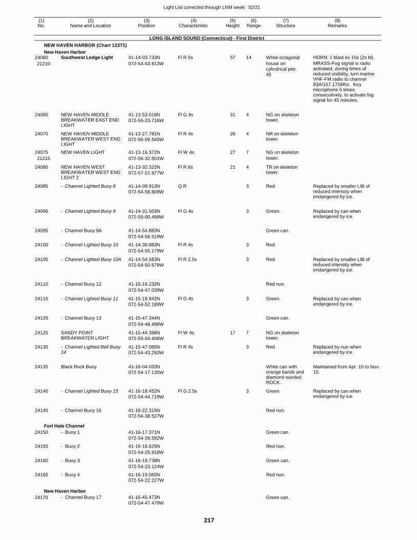
Light List corrected through LNM week: 52/21
217
(1) (2) (3) (4) (5) (6) (7) (8) No. Name and Location Position Characteristic Height Range Structure Remarks
LONG ISLAND SOUND (Connecticut) - First District
NEW HAVEN HARBOR (Chart 12371)
New Haven Harbor 24060 Southwest Ledge Light 41-14-03.733N Fl R 5s 57 14 White octagonal HORN: 1 blast ev 15s (2s bl).
21210 072-54-43.813W house on cylindrical pier. 45
MRASS-Fog signal is radio activated, during times of reduced visibility, turn marine VHF-FM radio to channel 83A/157.175Mhz. Key microphone 5 times consecutively, to activate fog signal for 45 minutes.
24065 NEW HAVEN MIDDLE BREAKWATER EAST END LIGHT
41-13-53.018N
072-55-23.716W
Fl G 4s 31 4 NG on skeleton tower.
24070 NEW HAVEN MIDDLE BREAKWATER WEST END LIGHT
41-13-27.781N
072-56-09.545W
Fl R 4s 26 4 NR on skeleton tower.
24075 NEW HAVEN LIGHT 41-13-16.372N Fl W 4s 27 7 NG on skeleton
21215 072-56-32.501W tower.
24080 NEW HAVEN WEST BREAKWATER WEST END LIGHT 2
41-13-32.322N
072-57-21.977W
Fl R 6s 21 4 TR on skeleton tower.
24085 - Channel Lighted Buoy 8 41-14-09.913N
072-54-58.809W
Q R 3 Red. Replaced by smaller LIB of reduced intensity when endangered by ice.
24090 - Channel Lighted Buoy 9 41-14-31.503N
072-55-00.499W
Fl G 4s
3 Green. Replaced by can when endangered by ice.
24095 - Channel Buoy 9A 41-14-54.883N
Green can.
072-54-56.519W
24100 - Channel Lighted Buoy 10 41-14-30.883N Fl R 4s 3 Red.
072-54-55.179W
24105 - Channel Lighted Buoy 10A 41-14-54.583N
072-54-50.579W
Fl R 2.5s 3 Red. Replaced by smaller LIB of reduced intensity when endangered by ice.
24110 - Channel Buoy 12 41-15-16.232N
Red nun.
072-54-47.039W
24115 - Channel Lighted Buoy 11 41-15-16.942N
072-54-52.189W
Fl G 4s 3 Green. Replaced by can when endangered by ice.
24120 - Channel Buoy 13 41-15-47.344N
Green can.
072-54-48.498W
24125 SANDY POINT BREAKWATER LIGHT
41-15-44.398N
072-55-04.406W
Fl W 4s 17 7 NG on skeleton tower.
24130 - Channel Lighted Bell Buoy 14
41-15-47.085N
072-54-43.293W
Fl R 4s 3 Red. Replaced by nun when endangered by ice.
24135 Black Rock Buoy 41-16-04.033N
072-54-17.135W
White can with orange bands and diamond worded ROCK.
Maintained from Apr. 15 to Nov. 15.
24140 - Channel Lighted Buoy 15 41-16-18.452N
072-54-44.719W
Fl G 2.5s 3 Green. Replaced by can when endangered by ice.
24145 - Channel Buoy 16 41-16-22.315N
Red nun.
072-54-38.527W
Fort Hale Channel
24150 - Buoy 1 41-16-17.371N Green can.
072-54-26.592W
24155 - Buoy 2 41-16-16.625N Red nun.
072-54-25.918W
24160 - Buoy 3 41-16-19.738N Green can.
072-54-23.124W
24165 - Buoy 4 41-16-19.065N Red nun. 072-54-22.227W
New Haven Harbor
24170 - Channel Buoy 17 41-16-45.473N
072-54-47.479W Green can.
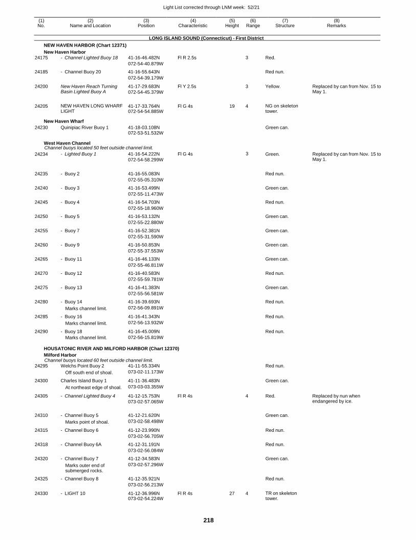
Light List corrected through LNM week: 52/21
218
(1) (2) (3) (4) (5) (6) (7) (8) No. Name and Location Position Characteristic Height Range Structure Remarks
LONG ISLAND SOUND (Connecticut) - First District
NEW HAVEN HARBOR (Chart 12371)
New Haven Harbor
24175 - Channel Lighted Buoy 18 41-16-46.482N Fl R 2.5s 3 Red.
072-54-40.879W
24185 - Channel Buoy 20 41-16-55.643N Red nun.
072-54-39.179W
24200 New Haven Reach Turning Basin Lighted Buoy A
41-17-29.683N
072-54-45.379W
Fl Y 2.5s 3 Yellow. Replaced by can from Nov. 15 to May 1.
24205 NEW HAVEN LONG WHARF LIGHT
41-17-33.764N 072-54-54.885W
Fl G 4s 19 4 NG on skeleton tower.
New Haven Wharf
24230 Quinipiac River Buoy 1 41-18-03.108N Green can. 072-53-51.532W
West Haven Channel Channel buoys located 50 feet outside channel limit.
24234 - Lighted Buoy 1 41-16-54.222N
072-54-58.299W
Fl G 4s 3 Green. Replaced by can from Nov. 15 to May 1.
24235 - Buoy 2 41-16-55.083N
Red nun.
072-55-05.310W
24240 - Buoy 3 41-16-53.499N Green can.
072-55-11.473W
24245 - Buoy 4 41-16-54.703N Red nun.
072-55-18.960W
24250 - Buoy 5 41-16-53.132N Green can.
072-55-22.880W
24255 - Buoy 7 41-16-52.381N Green can.
072-55-31.590W
24260 - Buoy 9 41-16-50.853N Green can.
072-55-37.553W
24265 - Buoy 11 41-16-46.133N Green can.
072-55-46.811W
24270 - Buoy 12 41-16-40.583N Red nun.
072-55-59.781W
24275 - Buoy 13 41-16-41.383N Green can.
072-55-56.581W
24280 - Buoy 14 41-16-39.693N Red nun.
Marks channel limit. 072-56-09.891W
24285 - Buoy 16 41-16-41.343N Red nun.
Marks channel limit. 072-56-13.932W
24290 - Buoy 18 41-16-45.009N Red nun.
Marks channel limit. 072-56-15.819W
HOUSATONIC RIVER AND MILFORD HARBOR (Chart 12370)
Milford Harbor Channel buoys located 60 feet outside channel limit.
24295 Welchs Point Buoy 2 41-11-55.334N Red nun.
Off south end of shoal. 073-02-11.173W
24300 Charles Island Buoy 1 41-11-36.483N Green can.
At northeast edge of shoal. 073-03-03.355W
24305 - Channel Lighted Buoy 4 41-12-15.753N
073-02-57.065W
Fl R 4s 4 Red. Replaced by nun when endangered by ice.
24310 - Channel Buoy 5 41-12-21.620N
Green can.
Marks point of shoal. 073-02-58.498W
24315 - Channel Buoy 6 41-12-23.990N Red nun.
073-02-56.705W
24318 - Channel Buoy 6A 41-12-31.191N Red nun.
073-02-56.084W
24320 - Channel Buoy 7 41-12-34.583N Green can.
Marks outer end of submerged rocks.
073-02-57.296W
24325 - Channel Buoy 8 41-12-35.921N Red nun.
073-02-56.213W
24330 - LIGHT 10 41-12-36.996N 073-02-54.224W
Fl R 4s 27 4 TR on skeleton tower.
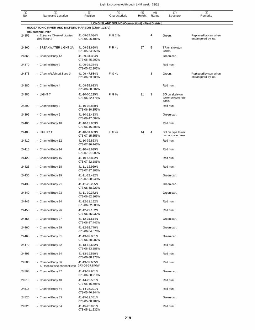
Light List corrected through LNM week: 52/21
219
(1) (2) (3) (4) (5) (6) (7) (8) No. Name and Location Position Characteristic Height Range Structure Remarks
LONG ISLAND SOUND (Connecticut) - First District
HOUSATONIC RIVER AND MILFORD HARBOR (Chart 12370)
Housatonic River
24355 - Entrance Channel Lighted Bell Buoy 1
41-09-24.084N
073-05-26.401W
Fl G 2.5s 4 Green. Replaced by can when endangered by ice.
24360 - BREAKWATER LIGHT 2A 41-09-38.690N
073-05-34.953W
Fl R 4s 27 5 TR on skeleton tower.
24365 - Channel Buoy 1A 41-09-34.384N Green can.
073-05-45.202W
24370 - Channel Buoy 2 41-09-36.384N Red nun.
073-05-42.202W
24375 - Channel Lighted Buoy 3 41-09-47.584N
073-06-03.903W
Fl G 4s 3 Green. Replaced by can when endangered by ice.
24380 - Channel Buoy 4 41-09-52.683N
Red nun.
073-06-08.602W
24385 - LIGHT 7 41-10-06.225N
073-06-32.476W
Fl G 6s 21 3 SG on skeleton tower on concrete base.
24390 - Channel Buoy 8 41-10-08.888N Red nun.
073-06-30.355W
24395 - Channel Buoy 9 41-10-18.483N Green can.
073-06-47.604W
24400 - Channel Buoy 10 41-10-19.863N Red nun.
073-06-45.805W
24405 - LIGHT 11 41-10-31.633N
073-07-15.555W
Fl G 4s 14 4 SG on pipe tower on concrete base.
24410 - Channel Buoy 12 41-10-36.853N Red nun.
073-07-16.446W
24415 - Channel Buoy 14 41-10-42.629N Red nun.
073-07-21.909W
24420 - Channel Buoy 16 41-10-57.832N Red nun.
073-07-22.186W
24425 - Channel Buoy 18 41-11-12.969N Red nun.
073-07-17.106W
24430 - Channel Buoy 19 41-11-22.412N Green can.
073-07-08.948W
24435 - Channel Buoy 21 41-11-25.205N Green can.
073-06-58.223W
24440 - Channel Buoy 23 41-11-30.372N Green can.
073-06-52.165W
24445 - Channel Buoy 24 41-12-11.152N Red nun.
073-06-32.005W
24450 - Channel Buoy 26 41-12-27.162N Red nun.
073-06-35.030W
24455 - Channel Buoy 27 41-12-31.614N Green can.
073-06-37.442W
24460 - Channel Buoy 29 41-12-52.770N Green can.
073-06-34.576W
24465 - Channel Buoy 31 41-13-02.081N Green can.
073-06-30.087W
24470 - Channel Buoy 32 41-13-13.632N Red nun.
073-06-33.188W
24495 - Channel Buoy 34 41-13-19.560N Red nun.
073-06-38.178W
24500 - Channel Buoy 36 41-13-32.665N Red nun.
50 feet outside channel limit. 073-06-37.840W
24505 - Channel Buoy 37 41-13-37.801N Green can.
073-06-38.916W
24510 - Channel Buoy 40 41-14-20.531N Red nun.
073-06-15.405W
24515 - Channel Buoy 44 41-14-35.391N Red nun.
073-05-46.944W
24520 - Channel Buoy 53 41-15-12.361N Green can.
073-05-08.982W
24525 - Channel Buoy 54 41-15-20.991N Red nun. 073-05-11.232W
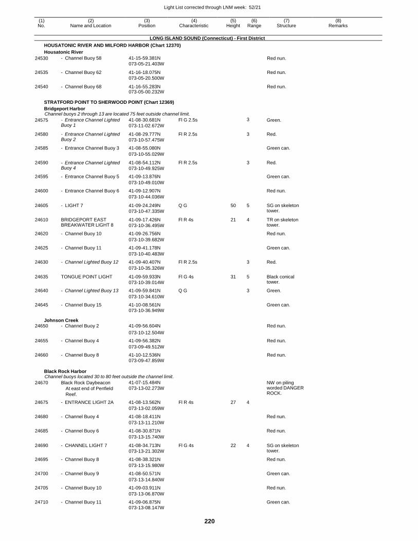
Light List corrected through LNM week: 52/21
220
(1) (2) (3) (4) (5) (6) (7) (8) No. Name and Location Position Characteristic Height Range Structure Remarks
LONG ISLAND SOUND (Connecticut) - First District
HOUSATONIC RIVER AND MILFORD HARBOR (Chart 12370)
Housatonic River
24530 - Channel Buoy 58 41-15-59.381N
073-05-21.403W Red nun.
24535 - Channel Buoy 62 41-16-18.075N
073-05-20.500W
Red nun.
24540 - Channel Buoy 68 41-16-55.283N 073-05-00.232W
Red nun.
STRATFORD POINT TO SHERWOOD POINT (Chart 12369)
Bridgeport Harbor Channel buoys 2 through 13 are located 75 feet outside channel limit.
24575 - Entrance Channel Lighted Buoy 1
41-08-30.681N
073-11-02.672W
Fl G 2.5s 3 Green.
24580 - Entrance Channel Lighted Buoy 2
41-08-29.777N
073-10-57.475W
Fl R 2.5s 3 Red.
24585 - Entrance Channel Buoy 3 41-08-55.080N Green can.
073-10-55.029W
24590 - Entrance Channel Lighted Buoy 4
41-08-54.112N
073-10-49.925W
Fl R 2.5s 3 Red.
24595 - Entrance Channel Buoy 5 41-09-13.876N Green can.
073-10-49.010W
24600 - Entrance Channel Buoy 6 41-09-12.907N Red nun.
073-10-44.036W
24605 - LIGHT 7 41-09-24.249N
073-10-47.335W
Q G 50 5 SG on skeleton tower.
24610 BRIDGEPORT EAST BREAKWATER LIGHT 8
41-09-17.426N
073-10-36.495W
Fl R 4s 21 4 TR on skeleton tower.
24620 - Channel Buoy 10 41-09-26.756N Red nun.
073-10-39.682W
24625 - Channel Buoy 11 41-09-41.178N Green can.
073-10-40.483W
24630 - Channel Lighted Buoy 12 41-09-40.407N Fl R 2.5s 3 Red.
073-10-35.326W
24635 TONGUE POINT LIGHT 41-09-59.933N
073-10-39.014W
Fl G 4s 31 5 Black conical tower.
24640 - Channel Lighted Buoy 13 41-09-59.841N Q G 3 Green.
073-10-34.610W
24645 - Channel Buoy 15 41-10-08.561N Green can. 073-10-36.949W
Johnson Creek 24650 - Channel Buoy 2 41-09-56.604N Red nun.
073-10-12.504W
24655 - Channel Buoy 4 41-09-56.382N Red nun.
073-09-49.512W
24660 - Channel Buoy 8 41-10-12.536N Red nun. 073-09-47.859W
Black Rock Harbor Channel buoys located 30 to 80 feet outside the channel limit.
24670 Black Rock Daybeacon
At east end of Penfield
Reef.
41-07-15.484N
073-13-02.273W
NW on piling worded DANGER ROCK.
24675 - ENTRANCE LIGHT 2A 41-08-13.562N Fl R 4s 27 4
073-13-02.059W
24680 - Channel Buoy 4 41-08-18.411N Red nun.
073-13-11.210W
24685 - Channel Buoy 6 41-08-30.871N Red nun.
073-13-15.740W
24690 - CHANNEL LIGHT 7 41-08-34.713N
073-13-21.302W
Fl G 4s 22 4 SG on skeleton tower.
24695 - Channel Buoy 8 41-08-38.321N Red nun.
073-13-15.980W
24700 - Channel Buoy 9 41-08-50.571N Green can.
073-13-14.840W
24705 - Channel Buoy 10 41-09-03.911N Red nun.
073-13-06.870W
24710 - Channel Buoy 11 41-09-06.875N Green can. 073-13-08.147W
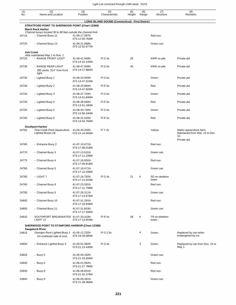
Light List corrected through LNM week: 52/21
221
(1) (2) (3) (4) (5) (6) (7) (8) No. Name and Location Position Characteristic Height Range Structure Remarks
LONG ISLAND SOUND (Connecticut) - First District
STRATFORD POINT TO SHERWOOD POINT (Chart 12369)
Black Rock Harbor Channel buoys located 30 to 80 feet outside the channel limit.
24715 - Channel Buoy 12 41-09-17.097N
073-12-55.760W Red nun.
24720 - Channel Buoy 13 41-09-21.668N 073-12-52.677W
Green can.
Ash Creek Aids maintained May 1 to Nov. 1
24725 - RANGE FRONT LIGHT 41-08-41.940N Fl G 3s 25 KWR on pile. Private aid.
073-14-10.140W
24730 - RANGE REAR LIGHT 41-08-47.940N Fl G 6s 45 KRW on pile. Private aid.
285 yards, 314° from front light.
073-14-17.880W
24735 - Lighted Buoy 1 41-08-23.940N Fl G 6s Green Private aid.
073-13-47.510W
24740 - Lighted Buoy 2 41-08-25.860N Fl R 3s Red Private aid.
073-13-47.820W
24745 - Lighted Buoy 3 41-08-27.720N Fl G 6s Green Private aid.
073-13-51.840W
24750 - Lighted Buoy 4 41-08-28.560N Fl R 3s Red Private aid.
073-13-51.180W
24755 - Lighted Buoy 5 41-08-30.730N Fl G 6s Green Private aid.
073-13-56.240W
24760 - Lighted Buoy 6 41-08-31.520N Fl R 3s Red Private aid. 073-13-54.760W
Southport Harbor
24762 Pine Creek Point Aquaculture Lighted Buoys (4)
41-06-49.200N
073-15-14.000W
Fl Y 4s Yellow. Marks aquaculture farm. Maintained from Mar. 15 to Dec. 15.
Private aid.
24765 - Entrance Buoy 2 41-07-10.671N Red nun.
073-17-08.018W
24770 - Channel Buoy 3 41-07-13.631N Green can.
073-17-11.238W
24775 - Channel Buoy 4 41-07-16.691N Red nun.
073-17-09.818W
24780 - Channel Buoy 5 41-07-16.471N Green can.
073-17-12.048W
24785 - LIGHT 7 41-07-18.792N
073-17-14.203W
Fl G 4s 21 4 SG on skeleton tower.
24790 - Channel Buoy 8 41-07-23.281N Red nun.
073-17-11.798W
24795 - Channel Buoy 9 41-07-26.311N Green can.
073-17-14.678W
24800 - Channel Buoy 10 41-07-31.291N Red nun.
073-17-15.948W
24805 - Channel Buoy 11 41-07-31.653N Green can.
073-17-17.335W
24810 SOUTHPORT BREAKWATER LIGHT 12
41-07-33.410N 073-17-13.944W
Fl R 4s 28 4 TR on skeleton tower.
SHERWOOD POINT TO STAMFORD HARBOR (Chart 12368)
Saugatuck River
24815 Georges Rock Lighted Buoy 1
On northeast side of rock.
41-05-12.232N
073-19-28.685W
Fl G 2.5s 4 Green. Replaced by can when endangered by ice.
24820 - Entrance Lighted Buoy 3 41-05-52.382N
073-21-13.435W
Fl G 4s 3 Green. Replaced by can from Nov. 15 to May 1.
24825 - Buoy 5 41-05-55.332N
Green can.
073-21-33.606W
24830 - Buoy 6 41-06-01.992N Red nun.
073-21-27.786W
24835 - Buoy 8 41-06-06.831N Red nun.
073-21-32.376W
24840 - Buoy 9 41-06-09.481N Green can.
073-21-39.366W
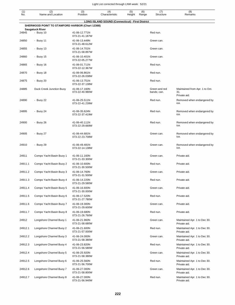
Light List corrected through LNM week: 52/21
222
(1) (2) (3) (4) (5) (6) (7) (8) No. Name and Location Position Characteristic Height Range Structure Remarks
LONG ISLAND SOUND (Connecticut) - First District
SHERWOOD POINT TO STAMFORD HARBOR (Chart 12368)
Saugatuck River
24845 - Buoy 10 41-06-12.771N Red nun.
073-21-41.187W
24850 - Buoy 11 41-06-13.449N Green can.
073-21-48.612W
24855 - Buoy 13 41-06-14.701N Green can.
073-21-58.897W
24860 - Buoy 15 41-06-10.401N Green can.
073-22-05.277W
24865 - Buoy 16 41-06-01.711N Red nun.
073-22-12.367W
24870 - Buoy 18 41-06-06.861N Red nun.
073-22-26.038W
24875 - Buoy 20 41-06-13.751N Red nun.
073-22-37.138W
24885 Duck Creek Junction Buoy 41-06-17.160N 073-22-40.980W
Green and red bands; can.
Maintained from Apr. 1 to Oct. 31.
Private aid.
24890 - Buoy 22 41-06-25.511N
073-22-41.239W
Red nun. Removed when endangered by ice.
24895 - Buoy 24 41-06-35.624N
073-22-37.419W
Red nun. Removed when endangered by ice.
24900 - Buoy 26 41-06-40.111N
073-22-29.669W
Red nun. Removed when endangered by ice.
24905 - Buoy 27 41-06-44.681N
073-22-23.708W
Green can. Removed when endangered by ice.
24910 - Buoy 29 41-06-49.481N
073-22-14.138W
Green can. Removed when endangered by ice.
24911 Compo Yacht Basin Buoy 1 41-06-11.160N Green can. Private aid.
073-21-33.300W
24911.1 Compo Yacht Basin Buoy 2 41-06-10.600N Red nun. Private aid.
073-21-30.500W
24911.2 Compo Yacht Basin Buoy 3 41-06-14.760N Green can. Private aid.
073-21-31.500W
24911.3 Compo Yacht Basin Buoy 4 41-06-14.220N Red nun. Private aid.
073-21-29.580W
24911.4 Compo Yacht Basin Buoy 5 41-06-16.600N Green can. Private aid.
073-21-30.000W
24911.5 Compo Yacht Basin Buoy 6 41-06-17.520N Red nun. Private aid.
073-21-27.780W
24911.6 Compo Yacht Basin Buoy 7 41-06-19.300N Green can. Private aid.
073-21-29.600W
24911.7 Compo Yacht Basin Buoy 8 41-06-19.680N Red nun. Private aid.
073-21-26.760W
24912 Longshore Channel Buoy 1 41-06-21.960N Green can. Maintained Apr. 1 to Dec 30.
073-21-58.680W Private aid.
24912.1 Longshore Channel Buoy 2 41-06-21.600N Red nun. Maintained Apr. 1 to Dec 30.
073-21-57.000W Private aid.
24912.2 Longshore Channel Buoy 3 41-06-24.000N Green can. Maintained Apr. 1 to Dec 30.
073-21-58.380W Private aid.
24912.3 Longshore Channel Buoy 4 41-06-23.820N Red nun. Maintained Apr. 1 to Dec 30.
073-21-56.580W Private aid.
24912.4 Longshore Channel Buoy 5 41-06-25.920N Green can. Maintained Apr. 1 to Dec 30.
073-21-58.380W Private aid.
24912.5 Longshore Channel Buoy 6 41-06-25.560N Red nun. Maintained Apr. 1 to Dec 30.
073-21-56.700W Private aid.
24912.6 Longshore Channel Buoy 7 41-06-27.000N Green can. Maintained Apr. 1 to Dec 30.
073-21-58.800W Private aid.
24912.7 Longshore Channel Buoy 8 41-06-27.000N Red nun. Maintained Apr. 1 to Dec 30. 073-21-56.940W Private aid.
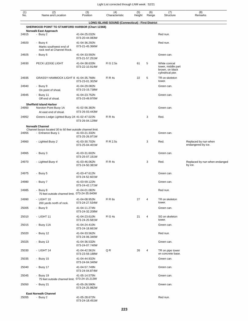
Light List corrected through LNM week: 52/21
223
(1) (2) (3) (4) (5) (6) (7) (8) No. Name and Location Position Characteristic Height Range Structure Remarks
LONG ISLAND SOUND (Connecticut) - First District
SHERWOOD POINT TO STAMFORD HARBOR (Chart 12368)
Norwalk East Approach
24915 - Buoy 2 41-04-25.032N Red nun.
073-20-44.083W
24920 - Buoy 4 41-04-36.292N Red nun.
Marks southwest end of rock reef at Channel Rock.
073-21-45.366W
24925 - Buoy 5 41-04-33.592N Green can.
073-21-57.251W
24930 PECK LEDGE LIGHT 41-04-38.633N
073-22-10.914W
Fl G 2.5s 61 5 White conical tower, middle part brown, on black cylindrical pier.
24935 GRASSY HAMMOCK LIGHT 8 41-04-35.766N
073-23-01.302W
Fl R 4s 22 5 TR on skeleton tower.
24940 - Buoy 9 41-04-29.082N Green can.
On point of shoal. 073-23-15.738W
24945 - Buoy 11 41-04-23.752N Green can. Off end of shoal. 073-23-49.970W
Sheffield Island Harbor 24950 Noroton Point Buoy 1A 41-02-56.382N Green can.
At east end of shoal. 073-26-03.443W
24952 Greens Ledge Lighted Buoy 2A 41-02-47.022N Fl R 4s 3 Red.
073-26-04.129W
Norwalk Channel Channel buoys located 30 to 50 feet outside channel limit.
24955 - Entrance Buoy 1 41-03-21.332N Green can.
073-25-26.971W
24960 - Lighted Buoy 2 41-03-30.702N
073-25-04.401W
Fl R 2.5s 3 Red. Replaced by nun when endangered by ice.
24965 - Buoy 3 41-03-31.602N
Green can.
073-25-07.151W
24970 - Lighted Buoy 4 41-03-46.062N
073-24-50.381W
Fl R 4s 3 Red. Replaced by nun when endanged by ice.
24975 - Buoy 5 41-03-47.612N
Green can.
073-24-52.601W
24980 - Buoy 7 41-03-59.122N Green can.
073-24-42.171W
24985 - Buoy 8 41-04-01.082N Red nun.
75 feet outside channel limit. 073-24-35.640W
24990 - LIGHT 10
200 yards north of rock.
41-04-08.953N
073-24-27.534W
Fl R 6s 27 4 TR on skeleton tower.
25005 - Buoy 9 41-04-11.274N Green can.
073-24-32.208W
25010 - LIGHT 11 41-04-23.610N
073-24-20.581W
Fl G 4s 21 4 SG on skeleton tower.
25015 - Buoy 11A 41-04-24.410N Green can.
073-24-18.661W
25020 - Buoy 12 41-04-33.562N Red nun.
073-24-06.340W
25025 - Buoy 13 41-04-36.532N Green can.
073-24-07.740W
25030 - LIGHT 14 41-04-42.561N
073-23-59.188W
Q R 26 4 TR on pipe tower on concrete base.
25035 - Buoy 15 41-04-44.932N Green can.
073-24-04.340W
25040 - Buoy 17 41-04-57.749N Green can.
073-24-04.874W
25045 - Buoy 19 41-05-14.575N Green can.
75 feet outside channel limit. 073-24-15.213W
25050 - Buoy 21 41-05-26.590N Green can. 073-24-25.982W
East Norwalk Channel
25055 - Buoy 2 41-05-28.672N Red nun. 073-24-18.451W
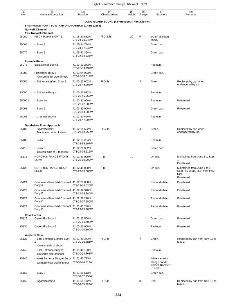
Light List corrected through LNM week: 52/21
224
(1) (2) (3) (4) (5) (6) (7) (8) No. Name and Location Position Characteristic Height Range Structure Remarks
LONG ISLAND SOUND (Connecticut) - First District
SHERWOOD POINT TO STAMFORD HARBOR (Chart 12368)
Norwalk Channel
East Norwalk Channel
25060 FITCH POINT LIGHT 1 41-05-30.832N
073-24-20.047W
Fl G 2.5s 29 4 SG on skeleton tower.
25065 - Buoy 3 41-05-34.714N Green can.
073-24-17.646W
25070 - Buoy 5 41-05-40.364N Green can. 073-24-15.925W
Fivemile River
25075 Ballast Reef Buoy 2 41-03-13.243N Red nun.
073-26-33.132W
25080 Fish Island Buoy 1 41-03-04.033N Green can.
On southeast side of reef. 073-26-58.014W
25085 - Entrance Lighted Buoy 3 41-03-21.902N
073-26-48.995W
Fl G 4s 3 Green. Replaced by can when endangered by ice.
25090 - Entrance Buoy 4 41-03-22.892N
Red nun.
073-26-46.255W
25090.1 - Buoy 4A 41-03-31.000N Red nun. Private aid.
073-26-47.000W
25091 - Buoy 5 41-03-30.000N Green can. Private aid.
073-26-49.000W
25095 - Channel Buoy 6 41-03-40.620N Red nun.
073-26-47.204W
Goodwives River Approach
25100 - Lighted Buoy 1
Marks east side of shoal.
41-02-14.592N 073-29-00.758W
Fl G 4s 3 Green. Replaced by can when endangered by ice.
25105
- Buoy 2
41-02-19.204N
Red nun.
073-28-56.397W
25110 - Buoy 3 41-02-21.932N Green can.
On east side of 3-foot spot. 073-29-05.215W
25115 NOROTON RANGE FRONT LIGHT
41-02-39.000N 073-29-10.000W
F R 12 On pile. Maintained from June 1 to Sept. 1.
Private aid.
25120 NOROTON RANGE REAR LIGHT
41-02-41.000N
073-29-10.500W
F R On pile. Maintained from June 1 to 1 Sept. 65 yards, 352° from front light.
Private aid.
25121 Goodwives River Mid-Channel Buoy A
41-02-28.080N
073-29-04.020W
Red and white. Private aid.
25122 Goodwives River Mid-Channel Buoy B
41-02-32.340N
073-29-05.880W
Red and white. Private aid.
25123 Goodwives River Mid-Channel Buoy C
41-02-39.240N
073-29-07.980W
Red and white. Private aid.
25124 Goodwives River Mid-Channel Buoy D
41-02-45.240N 073-29-05.100W
Red and white. Private aid.
Cove
25125
Harbor
Cove Mills Buoy 1
41-02-22.500N
Green can.
Private aid.
073-30-11.500W
25130 Cove Mills Buoy 2 41-02-25.000N Red nun. Private aid. 073-30-10.500W
Westcott Cove
25135 - East Entrance Lighted Buoy 1
41-01-40.243N 073-30-36.381W
Fl G 4s 3 Green. Replaced by can from Nov. 15 to May 1.
On east side of shoal.
25140 - East Entrance Buoy 2 41-01-46.193N Red nun.
On south side of shoal. 073-30-24.861W
25145 - West Entrance Danger Buoy 41-01-40.723N White can with
25150
25155
On northwest side of shoal.
- Buoy 3
- Lighted Buoy 4
073-30-44.012W
41-01-51.513N
073-30-57.158W
41-01-55.172N
073-30-55.692W
Fl R 4s
orange bands worded DANGER ROCKS.
Green can.
3 Red.
Replaced by nun from Nov. 15 to May 1.
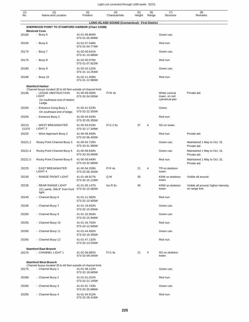
Light List corrected through LNM week: 52/21
225
(1) (2) (3) (4) (5) (6) (7) (8) No. Name and Location Position Characteristic Height Range Structure Remarks
LONG ISLAND SOUND (Connecticut) - First District
SHERWOOD POINT TO STAMFORD HARBOR (Chart 12368)
Westcott Cove
25160 - Buoy 5 41-01-56.804N
073-31-05.699W Green can.
25165 - Buoy 6 41-01-57.546N
073-31-04.774W
Red nun.
25170 - Buoy 7 41-02-00.641N
073-31-10.686W
Green can.
25175 - Buoy 8 41-02-00.975N
073-31-07.922W
Red nun.
25180 - Buoy 9 41-02-10.122N
073-31-14.253W
Green can.
25185 - Buoy 10 41-02-11.409N 073-31-12.980W
Red nun.
Stamford Harbor Channel buoys located 30 to 60 feet outside of channel limit.
25195 - LEDGE OBSTRUCTION LIGHT
On southwest end of Harbor Ledge.
41-00-49.000N
073-32-34.000W
Fl W 4s White conical tower, on red cylindrical pier.
Private aid.
25200 - Entrance Gong Buoy 1 41-00-41.523N Green.
On southeast end of ledge. 073-32-22.555W
25205 - Entrance Buoy 2 41-00-44.633N Red nun.
073-32-05.355W
25210 - WEST BREAKWATER 41-00-53.915N Fl G 2.5s 37 4 SG on tower.
21375 LIGHT 3 073-32-17.349W
25220 - West Approach Buoy 2 41-00-59.400N Red nun. Private aid.
073-32-56.400W
25221.2 Rocky Point Channel Buoy 3 41-00-54.720N Green can. Maintained 1 May to Oct. 31.
073-33-31.980W Private aid.
25221.4 Rocky Point Channel Buoy 5 41-00-59.640N Green can. Maintained 1 May to Oct. 31.
073-33-33.060W Private aid.
25221.5 Rocky Point Channel Buoy 6 41-00-59.640N Red nun. Maintained 1 May to Oct. 31.
073-33-32.580W Private aid.
25225 - EAST BREAKWATER LIGHT 4
41-00-54.209N
073-32-06.332W
Fl R 4s 21 4 TR on skeleton tower.
25230 - RANGE FRONT LIGHT 41-01-48.917N
073-32-15.119W
Q W 26 KRW on skeleton tower.
Visible all around.
25235 - REAR RANGE LIGHT
211 yards, 356.8° from front light.
41-01-55.147N
073-32-15.582W
Iso R 6s 45 KRW on skeleton tower.
Visible all around; higher intensity on range line.
25240 - Channel Buoy 6 41-01-11.582N Red nun.
073-32-10.905W
25245 - Channel Buoy 7 41-01-19.932N Green can.
073-32-15.005W
25250 - Channel Buoy 9 41-01-32.563N Green can.
073-32-15.946W
25255 - Channel Buoy 10 41-01-34.702N Red nun.
073-32-12.695W
25260 - Channel Buoy 11 41-01-44.492N Green can.
073-32-16.305W
25265 - Channel Buoy 12 41-01-47.132N Red nun.
073-32-13.545W
Stamford East Branch
25270 - CHANNEL LIGHT 1 41-02-06.882N 073-32-09.545W
Fl G 4s 21 4 SG on skeleton tower.
Stamford West Branch Channel buoys located 30 to 60 feet outside of channel limit.
25275 - Channel Buoy 1 41-01-48.122N
073-32-18.665W Green can.
25280 - Channel Buoy 2 41-01-51.022N
073-32-21.145W
Red nun.
25290 - Channel Buoy 3 41-01-51.743N
073-32-25.686W
Green can.
25295 - Channel Buoy 4 41-01-54.912N 073-32-28.416W
Red nun.
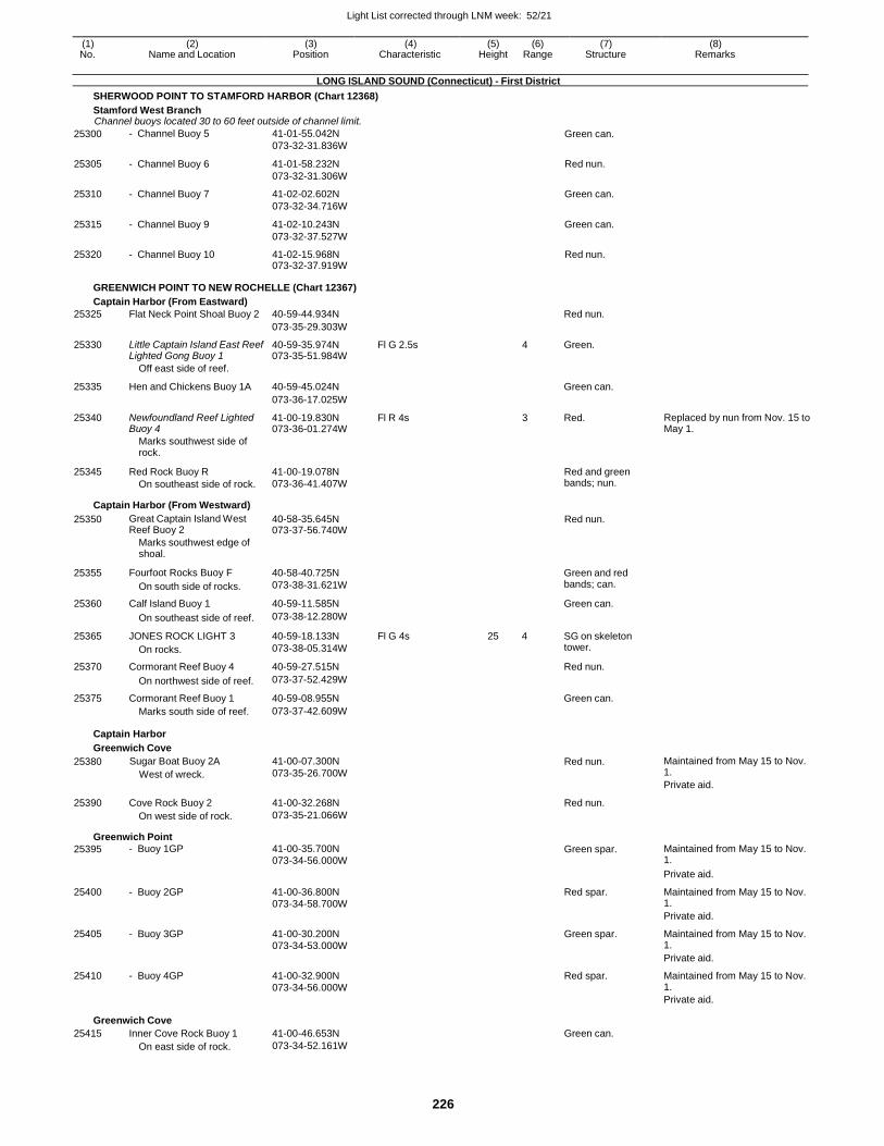
Light List corrected through LNM week: 52/21
226
(1) (2) (3) (4) (5) (6) (7) (8) No. Name and Location Position Characteristic Height Range Structure Remarks
LONG ISLAND SOUND (Connecticut) - First District
SHERWOOD POINT TO STAMFORD HARBOR (Chart 12368)
Stamford West Branch Channel buoys located 30 to 60 feet outside of channel limit.
25300 - Channel Buoy 5 41-01-55.042N
073-32-31.836W Green can.
25305 - Channel Buoy 6 41-01-58.232N
073-32-31.306W
Red nun.
25310 - Channel Buoy 7 41-02-02.602N
073-32-34.716W
Green can.
25315 - Channel Buoy 9 41-02-10.243N
073-32-37.527W
Green can.
25320 - Channel Buoy 10 41-02-15.968N 073-32-37.919W
Red nun.
GREENWICH POINT TO NEW ROCHELLE (Chart 12367)
Captain Harbor (From Eastward)
25325 Flat Neck Point Shoal Buoy 2 40-59-44.934N Red nun.
073-35-29.303W
25330 Little Captain Island East Reef Lighted Gong Buoy 1
40-59-35.974N 073-35-51.984W
Fl G 2.5s 4 Green.
Off east side of reef.
25335 Hen and Chickens Buoy 1A 40-59-45.024N
Green can.
073-36-17.025W
25340 Newfoundland Reef Lighted Buoy 4
41-00-19.830N 073-36-01.274W
Fl R 4s 3 Red. Replaced by nun from Nov. 15 to May 1.
Marks southwest side of rock.
25345 Red Rock Buoy R
On southeast side of rock.
41-00-19.078N
073-36-41.407W
Red and green bands; nun.
Captain Harbor (From Westward)
25350 Great Captain Island West Reef Buoy 2
40-58-35.645N 073-37-56.740W
Red nun.
Marks southwest edge of shoal.
25355 Fourfoot Rocks Buoy F
On south side of rocks.
40-58-40.725N
073-38-31.621W
Green and red bands; can.
25360 Calf Island Buoy 1 40-59-11.585N Green can.
On southeast side of reef. 073-38-12.280W
25365 JONES ROCK LIGHT 3
On rocks.
40-59-18.133N
073-38-05.314W
Fl G 4s 25 4 SG on skeleton tower.
25370 Cormorant Reef Buoy 4 40-59-27.515N Red nun.
On northwest side of reef. 073-37-52.429W
25375 Cormorant Reef Buoy 1 40-59-08.955N Green can. Marks south side of reef. 073-37-42.609W
Captain Harbor
Greenwich Cove
25380 Sugar Boat Buoy 2A
West of wreck.
41-00-07.300N
073-35-26.700W Red nun. Maintained from May 15 to Nov.
1.
Private aid.
25390 Cove Rock Buoy 2 41-00-32.268N Red nun.
On west side of rock. 073-35-21.066W
Greenwich Point
25395 - Buoy 1GP 41-00-35.700N 073-34-56.000W
Green spar. Maintained from May 15 to Nov. 1.
Private aid.
25400 - Buoy 2GP 41-00-36.800N 073-34-58.700W
Red spar. Maintained from May 15 to Nov. 1.
Private aid.
25405 - Buoy 3GP 41-00-30.200N 073-34-53.000W
Green spar. Maintained from May 15 to Nov. 1.
Private aid.
25410 - Buoy 4GP 41-00-32.900N 073-34-56.000W
Red spar. Maintained from May 15 to Nov. 1.
Private aid.
Greenwich Cove
25415 Inner Cove Rock Buoy 1 41-00-46.653N Green can. On east side of rock. 073-34-52.161W
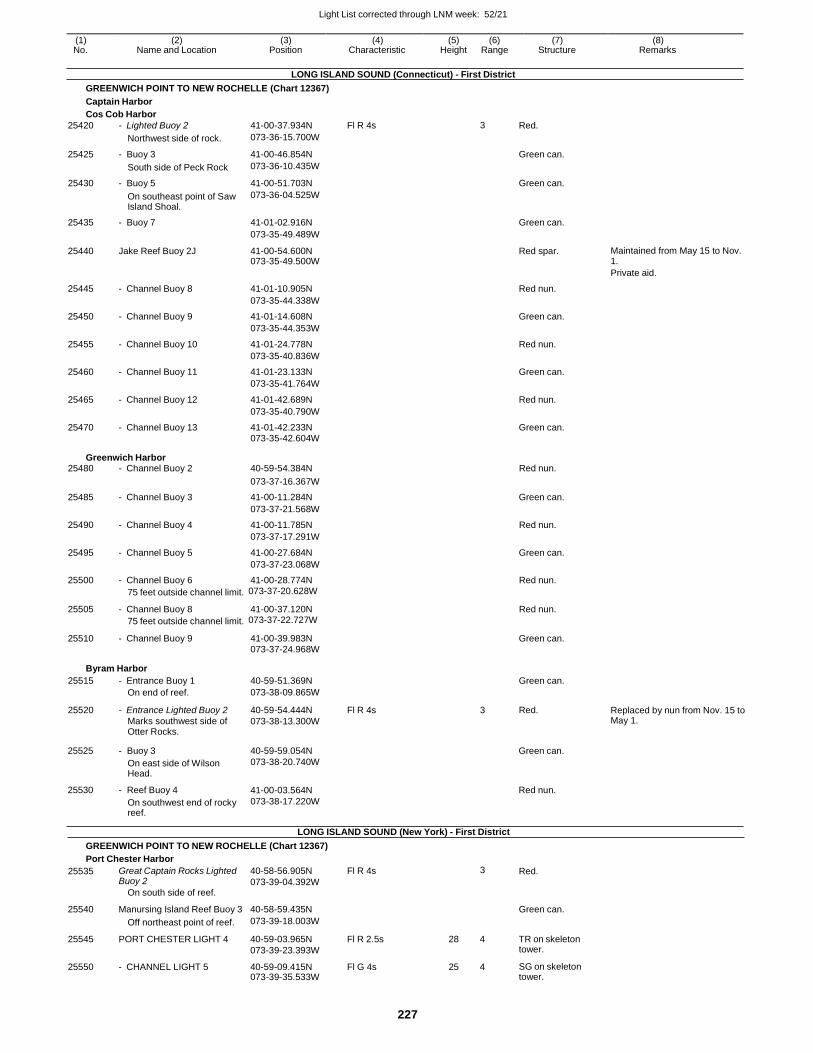
Light List corrected through LNM week: 52/21
227
(1) (2) (3) (4) (5) (6) (7) (8) No. Name and Location Position Characteristic Height Range Structure Remarks
LONG ISLAND SOUND (Connecticut) - First District
GREENWICH POINT TO NEW ROCHELLE (Chart 12367)
Captain Harbor
Cos Cob Harbor
25420 - Lighted Buoy 2 41-00-37.934N Fl R 4s 3 Red.
Northwest side of rock. 073-36-15.700W
25425 - Buoy 3 41-00-46.854N Green can.
South side of Peck Rock 073-36-10.435W
25430 - Buoy 5 41-00-51.703N Green can.
On southeast point of Saw Island Shoal.
073-36-04.525W
25435 - Buoy 7 41-01-02.916N Green can.
073-35-49.489W
25440 Jake Reef Buoy 2J 41-00-54.600N 073-35-49.500W
Red spar. Maintained from May 15 to Nov. 1.
Private aid.
25445 - Channel Buoy 8 41-01-10.905N Red nun.
073-35-44.338W
25450 - Channel Buoy 9 41-01-14.608N Green can.
073-35-44.353W
25455 - Channel Buoy 10 41-01-24.778N Red nun.
073-35-40.836W
25460 - Channel Buoy 11 41-01-23.133N Green can.
073-35-41.764W
25465 - Channel Buoy 12 41-01-42.689N Red nun.
073-35-40.790W
25470 - Channel Buoy 13 41-01-42.233N Green can.
073-35-42.604W
Greenwich Harbor 25480 - Channel Buoy 2 40-59-54.384N Red nun.
073-37-16.367W
25485 - Channel Buoy 3 41-00-11.284N Green can.
073-37-21.568W
25490 - Channel Buoy 4 41-00-11.785N Red nun.
073-37-17.291W
25495 - Channel Buoy 5 41-00-27.684N Green can.
073-37-23.068W
25500 - Channel Buoy 6 41-00-28.774N Red nun.
75 feet outside channel limit. 073-37-20.628W
25505 - Channel Buoy 8 41-00-37.120N Red nun.
75 feet outside channel limit. 073-37-22.727W
25510 - Channel Buoy 9 41-00-39.983N Green can. 073-37-24.968W
Byram Harbor
25515 - Entrance Buoy 1 40-59-51.369N Green can. On end of reef. 073-38-09.865W
25520 - Entrance Lighted Buoy 2
Marks southwest side of Otter Rocks.
40-59-54.444N
073-38-13.300W
Fl R 4s 3 Red. Replaced by nun from Nov. 15 to May 1.
25525
25530
- Buoy 3
On east side of Wilson Head.
- Reef Buoy 4
On southwest end of rocky reef.
40-59-59.054N
073-38-20.740W
41-00-03.564N
073-38-17.220W
LONG ISLAND SOUND (New York) - First District
Green can.
Red nun.
GREENWICH POINT TO NEW ROCHELLE (Chart 12367)
Port Chester Harbor
25535 Great Captain Rocks Lighted Buoy 2
On south side of reef.
40-58-56.905N
073-39-04.392W
Fl R 4s 3 Red.
25540 Manursing Island Reef Buoy 3 40-58-59.435N
Green can.
Off northeast point of reef. 073-39-18.003W
25545 PORT CHESTER LIGHT 4 40-59-03.965N
073-39-23.393W
Fl R 2.5s 28 4 TR on skeleton tower.
25550 - CHANNEL LIGHT 5 40-59-09.415N 073-39-35.533W
Fl G 4s 25 4 SG on skeleton tower.
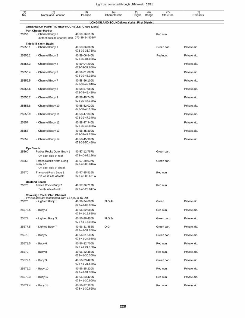
Light List corrected through LNM week: 52/21
228
(1) (2) (3) (4) (5) (6) (7) (8) No. Name and Location Position Characteristic Height Range Structure Remarks
LONG ISLAND SOUND (New York) - First District
GREENWICH POINT TO NEW ROCHELLE (Chart 12367)
Port Chester Harbor
25555 - Channel Buoy 6 40-59-16.515N Red nun.
30 feet outside channel limit. 073-39-34.503W
Tide Mill Yacht Basin
25556.1 - Channel Buoy 1 40-59-06.060N Green can. Private aid.
073-39-33.780W
25556.2 - Channel Buoy 2 40-59-06.840N Red nun. Private aid.
073-39-34.020W
25556.3 - Channel Buoy 4 40-59-04.200N Private aid.
073-39-39.600W
25556.4 - Channel Buoy 6 40-59-01.080N Private aid.
073-39-43.320W
25556.5 - Channel Buoy 7 40-58-56.100N Private aid.
073-39-47.040W
25556.6 - Channel Buoy 8 40-58-57.060N Private aid.
073-39-48.420W
25556.7 - Channel Buoy 9 40-58-49.740N Private aid.
073-39-47.160W
25556.8 - Channel Buoy 10 40-58-52.020N Private aid.
073-39-48.180W
25556.9 - Channel Buoy 11 40-58-47.340N Private aid.
073-39-47.340W
25557 - Channel Buoy 12 40-58-47.940N Private aid.
073-39-47.880W
25558 - Channel Buoy 13 40-58-45.300N Private aid.
073-39-49.260W
25559 - Channel Buoy 14 40-58-45.900N Private aid. 073-39-50.460W
Rye Beach 25560 Forbes Rocks Outer Buoy 1 40-57-12.797N Green can.
On east side of reef. 073-40-08.156W
25565 Forbes Rocks North Gong Buoy 1A
40-57-30.037N 073-40-08.046W
Green can.
On east side of shoal.
25570 Transport Rock Buoy 2 40-57-35.516N Red nun. Off west side of rock. 073-40-05.631W
Oakland Beach 25575 Forlies Rocks Buoy 2 40-57-26.717N Red nun.
South side of rock. 073-40-29.847W
Coveleigh Yacht Club Channel Private aids are maintained from 15 Apr. to 15 Oct.
25576 - Lighted Buoy 1 40-56-24.600N Fl G 4s Green. Private aid.
073-41-09.000W
25576.5 - Buoy 4 40-56-32.580N Red nun. Private aid.
073-41-16.620W
25577 - Lighted Buoy 3 40-56-30.420N Fl G 2s Green can. Private aid.
073-41-16.020W
25577.5 - Lighted Buoy 7 40-56-31.458N Q G Green can. Private aid.
073-41-31.200W
25578 - Buoy 5 40-56-31.500N Green can. Private aid.
073-41-24.960W
25578.5 - Buoy 6 40-56-32.700N Red nun. Private aid.
073-41-24.120W
25579 - Buoy 8 40-56-32.460N Red nun. Private aid.
073-41-30.300W
25579.1 - Buoy 9 40-56-33.420N Green can. Private aid.
073-41-31.680W
25579.2 - Buoy 10 40-56-35.220N Red nun. Private aid.
073-41-31.320W
25579.3 - Buoy 12 40-56-33.420N Red nun. Private aid.
073-41-30.900W
25579.4 - Buoy 14 40-56-37.320N Red nun. Private aid. 073-41-30.660W
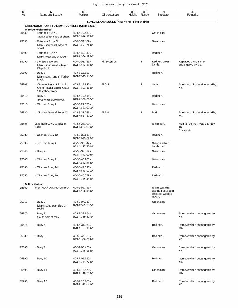
Light List corrected through LNM week: 52/21
229
(1) (2) (3) (4) (5) (6) (7) (8) No. Name and Location Position Characteristic Height Range Structure Remarks
LONG ISLAND SOUND (New York) - First District
GREENWICH POINT TO NEW ROCHELLE (Chart 12367)
Mamaroneck Harbor
25580 - Entrance Buoy 1 40-55-19.659N Green can.
Marks south edge of shoal. 073-43-16.174W
25585 - Entrance Buoy 3 40-55-34.469N Green can.
Marks southeast edge of shoal.
073-43-07.753W
25590 - Entrance Buoy 2 40-55-49.340N Red nun.
Marks west end of rocks 073-42-24.123W
25595 - Lighted Buoy MM
Marks southwest side of Ship Rock.
40-55-52.433N
073-42-32.114W
Fl (2+1)R 6s 4 Red and green bands.
Replaced by nun when endangered by ice.
25600 - Buoy 6 40-56-16.668N Red nun.
Marks south end of Turkey Rock.
073-42-45.182W
25605 - Channel Lighted Buoy 5
On northeast side of Outer
Steamboat Rock.
40-56-14.139N
073-43-01.133W
Fl G 4s 4 Green. Removed when endangered by ice.
25610 - Buoy 8 40-56-19.448N Red nun.
Southwest side of rock. 073-42-53.582W
25615 - Channel Buoy 7 40-56-24.678N Green can.
073-43-21.091W
25620 - Channel Lighted Buoy 10 40-56-25.263N
073-43-17.126W
Fl R 4s 4 Red. Removed when endangered by ice.
25625 Little Nanhook Obstruction Buoy
40-56-24.000N 073-43-24.000W
White nun. Maintained from May 1 to Nov.
15.
Private aid.
25630 - Channel Buoy 12 40-56-30.119N Red nun.
073-43-35.620W
25635 - Junction Buoy A 40-56-30.342N
073-43-37.700W
Green and red bands; can.
25640 - Buoy 9 40-56-37.822N Green can.
073-43-42.005W
25645 - Channel Buoy 11 40-56-40.188N Green can.
073-43-43.583W
25650 - Channel Buoy 14 40-56-43.596N Red nun.
073-43-43.635W
25655 - Channel Buoy 16 40-56-46.079N Red nun.
073-43-46.248W
Milton Harbor
25660 West Rock Obstruction Buoy 40-55-55.497N
073-42-08.454W White can with orange bands and diamond worded ROCK.
25665 - Buoy 3 40-56-07.518N Green can.
Marks southeast side of rocks.
073-42-22.302W
25670 - Buoy 5
South side of rock.
40-56-32.194N
073-41-59.827W
Green can. Remove when endangered by ice.
25675 - Buoy 6 40-56-31.263N
073-41-57.194W
Red nun. Remove when endangered by ice.
25680 - Buoy 8 40-56-47.355N
073-41-50.653W
Red nun. Remove when endangered by ice.
25685 - Buoy 9 40-57-02.458N
073-41-45.934W
Green can. Remove when endangered by ice.
25690 - Buoy 10 40-57-02.729N
073-41-44.774W
Red nun. Remove when endangered by ice.
25695 - Buoy 11 40-57-13.670N
073-41-43.708W
Green can. Remove when endangered by ice.
25700 - Buoy 12 40-57-13.280N 073-41-42.896W
Red nun. Remove when endangered by ice.
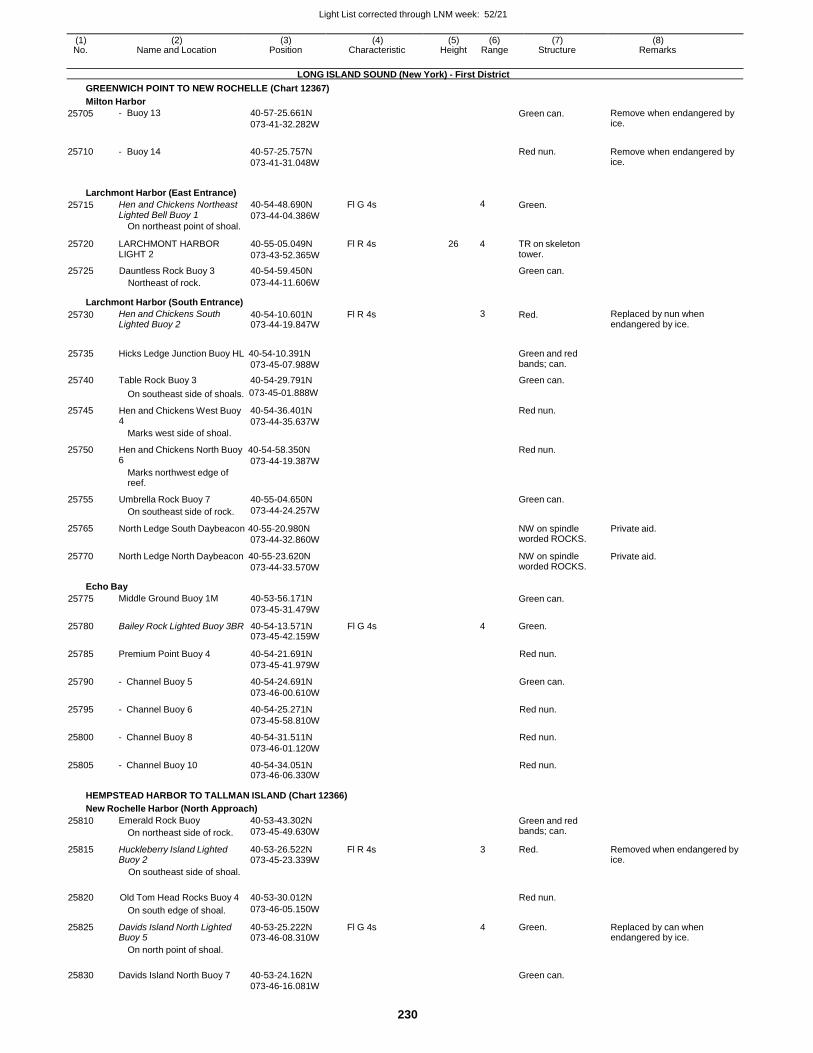
Light List corrected through LNM week: 52/21
230
(1) (2) (3) (4) (5) (6) (7) (8) No. Name and Location Position Characteristic Height Range Structure Remarks
LONG ISLAND SOUND (New York) - First District
GREENWICH POINT TO NEW ROCHELLE (Chart 12367)
Milton Harbor
25705
25710
- Buoy 13
- Buoy 14
40-57-25.661N
073-41-32.282W
40-57-25.757N
073-41-31.048W
Green can.
Red nun.
Remove when endangered by ice.
Remove when endangered by ice.
Larchmont Harbor (East Entrance)
25715 Hen and Chickens Northeast Lighted Bell Buoy 1
On northeast point of shoal.
40-54-48.690N
073-44-04.386W
Fl G 4s 4 Green.
25720 LARCHMONT HARBOR LIGHT 2
40-55-05.049N
073-43-52.365W
Fl R 4s 26 4 TR on skeleton tower.
25725 Dauntless Rock Buoy 3 40-54-59.450N Green can. Northeast of rock. 073-44-11.606W
Larchmont Harbor (South Entrance)
25730 Hen and Chickens South Lighted Buoy 2
40-54-10.601N 073-44-19.847W
Fl R 4s 3 Red. Replaced by nun when endangered by ice.
25735
Hicks Ledge Junction Buoy HL 40-54-10.391N
073-45-07.988W
Green and red bands; can.
25740 Table Rock Buoy 3 40-54-29.791N Green can.
On southeast side of shoals. 073-45-01.888W
25745 Hen and Chickens West Buoy 4
Marks west side of shoal.
40-54-36.401N
073-44-35.637W
Red nun.
25750 Hen and Chickens North Buoy 40-54-58.350N Red nun. 6
Marks northwest edge of reef.
073-44-19.387W
25755 Umbrella Rock Buoy 7
On southeast side of rock.
40-55-04.650N
073-44-24.257W
Green can.
25765
25770
North Ledge South Daybeacon 40-55-20.980N
073-44-32.860W
North Ledge North Daybeacon 40-55-23.620N
073-44-33.570W
NW on spindle worded ROCKS.
NW on spindle worded ROCKS.
Private aid.
Private aid.
Echo Bay
25775 Middle Ground Buoy 1M 40-53-56.171N
073-45-31.479W
Green can.
25780 Bailey Rock Lighted Buoy 3BR 40-54-13.571N 073-45-42.159W
Fl G 4s 4 Green.
25785 Premium Point Buoy 4 40-54-21.691N
073-45-41.979W
Red nun.
25790 - Channel Buoy 5 40-54-24.691N
073-46-00.610W
Green can.
25795 - Channel Buoy 6 40-54-25.271N
073-45-58.810W
Red nun.
25800 - Channel Buoy 8 40-54-31.511N
073-46-01.120W
Red nun.
25805 - Channel Buoy 10 40-54-34.051N 073-46-06.330W
Red nun.
HEMPSTEAD HARBOR TO TALLMAN ISLAND (Chart 12366)
New Rochelle Harbor (North Approach)
25810 Emerald Rock Buoy
On northeast side of rock.
40-53-43.302N
073-45-49.630W
Green and red bands; can.
25815 Huckleberry Island Lighted Buoy 2
40-53-26.522N 073-45-23.339W
Fl R 4s 3 Red. Removed when endangered by ice.
On southeast side of shoal.
25820 Old Tom Head Rocks Buoy 4 40-53-30.012N
Red nun.
On south edge of shoal. 073-46-05.150W
25825 Davids Island North Lighted Buoy 5
40-53-25.222N 073-46-08.310W
Fl G 4s 4 Green. Replaced by can when endangered by ice.
On north point of shoal.
25830 Davids Island North Buoy 7 40-53-24.162N
Green can.
073-46-16.081W
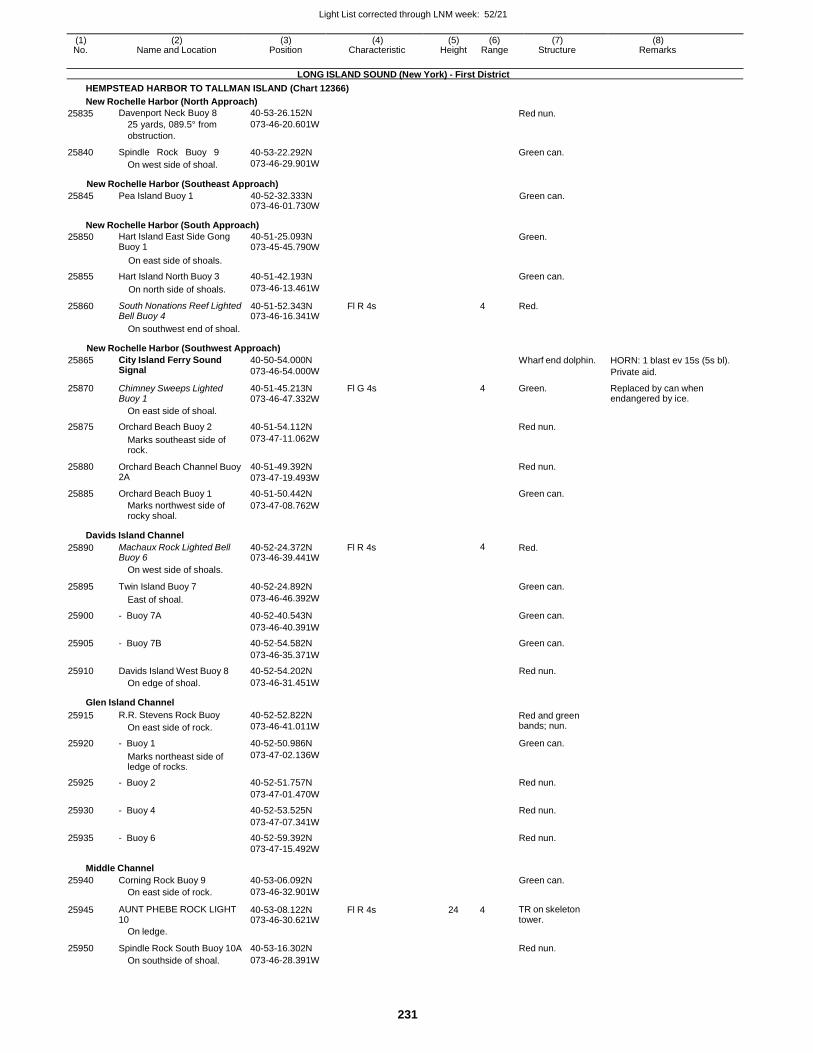
Light List corrected through LNM week: 52/21
231
(1) (2) (3) (4) (5) (6) (7) (8) No. Name and Location Position Characteristic Height Range Structure Remarks
LONG ISLAND SOUND (New York) - First District
HEMPSTEAD HARBOR TO TALLMAN ISLAND (Chart 12366)
New Rochelle Harbor (North Approach)
25835
25840
Davenport Neck Buoy 8
25 yards, 089.5° from
obstruction.
Spindle Rock Buoy 9
On west side of shoal.
40-53-26.152N
073-46-20.601W
40-53-22.292N
073-46-29.901W
Red nun.
Green can.
New Rochelle Harbor (Southeast Approach)
25845 Pea Island Buoy 1 40-52-32.333N 073-46-01.730W
Green can.
New Rochelle Harbor (South Approach)
25850 Hart Island East Side Gong Buoy 1
40-51-25.093N 073-45-45.790W
Green.
On east side of shoals.
25855 Hart Island North Buoy 3 40-51-42.193N Green can.
On north side of shoals. 073-46-13.461W
25860 South Nonations Reef Lighted Bell Buoy 4
40-51-52.343N 073-46-16.341W
Fl R 4s 4 Red.
On southwest end of shoal.
New Rochelle Harbor (Southwest Approach)
25865 City Island Ferry Sound Signal
40-50-54.000N
073-46-54.000W
Wharf end dolphin. HORN: 1 blast ev 15s (5s bl).
Private aid.
25870 Chimney Sweeps Lighted Buoy 1
40-51-45.213N 073-46-47.332W
Fl G 4s 4 Green. Replaced by can when endangered by ice.
On east side of shoal.
25875 Orchard Beach Buoy 2 40-51-54.112N Red nun.
Marks southeast side of rock.
073-47-11.062W
25880 Orchard Beach Channel Buoy 2A
40-51-49.392N
073-47-19.493W
Red nun.
25885 Orchard Beach Buoy 1 40-51-50.442N Green can.
Marks northwest side of rocky shoal.
073-47-08.762W
Davids Island Channel
25890 Machaux Rock Lighted Bell Buoy 6
40-52-24.372N 073-46-39.441W
Fl R 4s 4 Red.
On west side of shoals.
25895 Twin Island Buoy 7 40-52-24.892N Green can.
East of shoal. 073-46-46.392W
25900 - Buoy 7A 40-52-40.543N Green can.
073-46-40.391W
25905 - Buoy 7B 40-52-54.582N Green can.
073-46-35.371W
25910 Davids Island West Buoy 8 40-52-54.202N Red nun. On edge of shoal. 073-46-31.451W
Glen Island Channel
25915 R.R. Stevens Rock Buoy
On east side of rock.
40-52-52.822N
073-46-41.011W Red and green bands; nun.
25920 - Buoy 1 40-52-50.986N Green can.
Marks northeast side of ledge of rocks.
073-47-02.136W
25925 - Buoy 2 40-52-51.757N Red nun.
073-47-01.470W
25930 - Buoy 4 40-52-53.525N Red nun.
073-47-07.341W
25935 - Buoy 6 40-52-59.392N Red nun. 073-47-15.492W
Middle Channel
25940 Corning Rock Buoy 9 40-53-06.092N Green can. On east side of rock. 073-46-32.901W
25945 AUNT PHEBE ROCK LIGHT 10
40-53-08.122N 073-46-30.621W
Fl R 4s 24 4 TR on skeleton tower.
On ledge.
25950 Spindle Rock South Buoy 10A 40-53-16.302N Red nun. On southside of shoal. 073-46-28.391W
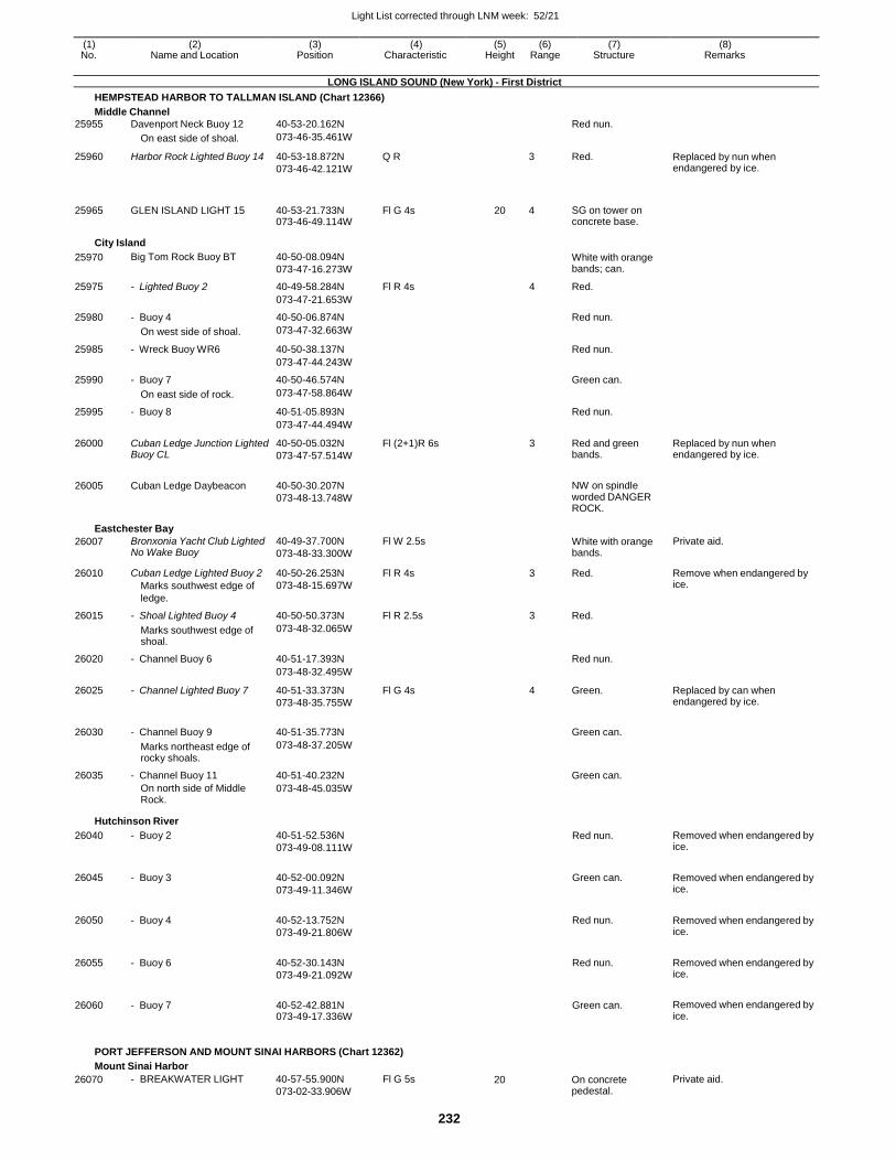
Light List corrected through LNM week: 52/21
232
(1) (2) (3) (4) (5) (6) (7) (8) No. Name and Location Position Characteristic Height Range Structure Remarks
LONG ISLAND SOUND (New York) - First District
HEMPSTEAD HARBOR TO TALLMAN ISLAND (Chart 12366)
Middle Channel
25955 Davenport Neck Buoy 12 40-53-20.162N Red nun.
On east side of shoal. 073-46-35.461W
25960 Harbor Rock Lighted Buoy 14 40-53-18.872N
073-46-42.121W
Q R 3 Red. Replaced by nun when endangered by ice.
25965
GLEN ISLAND LIGHT 15
40-53-21.733N 073-46-49.114W
Fl G 4s
20
4
SG on tower on concrete base.
City Island
25970 Big Tom Rock Buoy BT 40-50-08.094N
073-47-16.273W
White with orange bands; can.
25975 - Lighted Buoy 2 40-49-58.284N Fl R 4s 4 Red.
073-47-21.653W
25980 - Buoy 4 40-50-06.874N Red nun.
On west side of shoal. 073-47-32.663W
25985 - Wreck Buoy WR6 40-50-38.137N Red nun.
073-47-44.243W
25990 - Buoy 7 40-50-46.574N Green can.
On east side of rock. 073-47-58.864W
25995 - Buoy 8 40-51-05.893N Red nun.
073-47-44.494W
26000 Cuban Ledge Junction Lighted Buoy CL
40-50-05.032N
073-47-57.514W
Fl (2+1)R 6s 3 Red and green bands.
Replaced by nun when endangered by ice.
26005 Cuban Ledge Daybeacon 40-50-30.207N
073-48-13.748W
NW on spindle worded DANGER ROCK.
Eastchester Bay
26007 Bronxonia Yacht Club Lighted No Wake Buoy
40-49-37.700N
073-48-33.300W
Fl W 2.5s White with orange bands.
Private aid.
26010 Cuban Ledge Lighted Buoy 2
Marks southwest edge of
ledge.
40-50-26.253N
073-48-15.697W
Fl R 4s 3 Red. Remove when endangered by ice.
26015 - Shoal Lighted Buoy 4 40-50-50.373N Fl R 2.5s 3 Red.
Marks southwest edge of shoal.
073-48-32.065W
26020 - Channel Buoy 6 40-51-17.393N Red nun.
073-48-32.495W
26025 - Channel Lighted Buoy 7 40-51-33.373N
073-48-35.755W
Fl G 4s 4 Green. Replaced by can when endangered by ice.
26030 - Channel Buoy 9 40-51-35.773N
Green can.
Marks northeast edge of rocky shoals.
073-48-37.205W
26035 - Channel Buoy 11 40-51-40.232N Green can.
On north side of Middle Rock.
073-48-45.035W
Hutchinson River
26040 - Buoy 2 40-51-52.536N
073-49-08.111W
Red nun. Removed when endangered by ice.
26045 - Buoy 3 40-52-00.092N
073-49-11.346W
Green can. Removed when endangered by ice.
26050 - Buoy 4 40-52-13.752N
073-49-21.806W
Red nun. Removed when endangered by ice.
26055 - Buoy 6 40-52-30.143N
073-49-21.092W
Red nun. Removed when endangered by ice.
26060 - Buoy 7 40-52-42.881N 073-49-17.336W
Green can. Removed when endangered by ice.
PORT JEFFERSON AND MOUNT SINAI HARBORS (Chart 12362)
Mount Sinai Harbor
26070 - BREAKWATER LIGHT 40-57-55.900N
073-02-33.906W
Fl G 5s 20 On concrete pedestal.
Private aid.
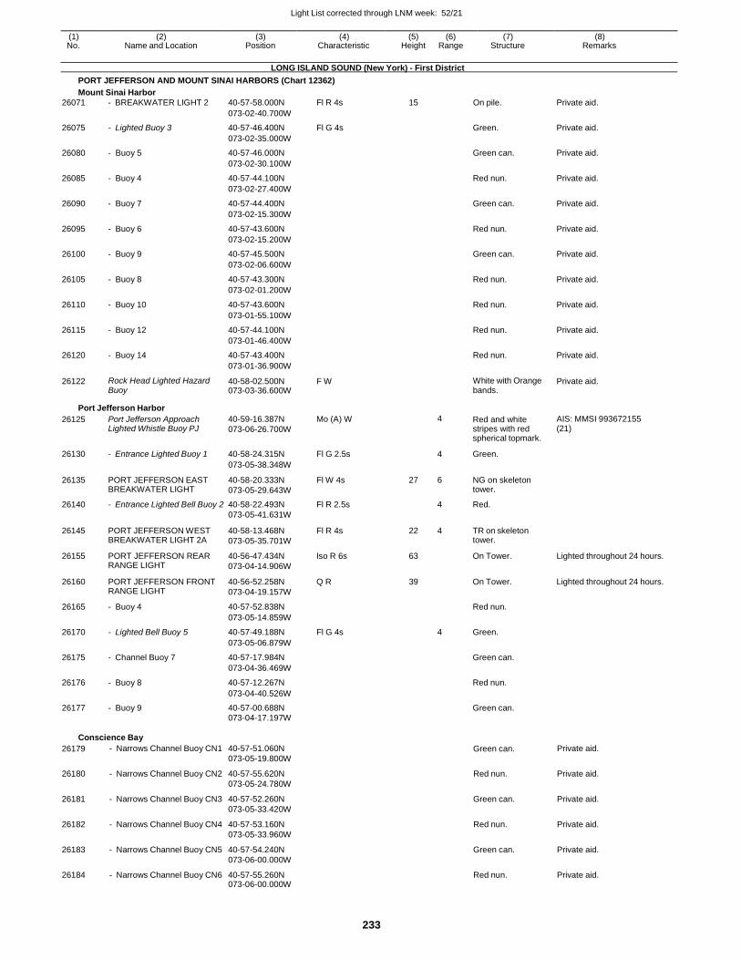
Light List corrected through LNM week: 52/21
233
(1) (2) (3) (4) (5) (6) (7) (8) No. Name and Location Position Characteristic Height Range Structure Remarks
LONG ISLAND SOUND (New York) - First District
PORT JEFFERSON AND MOUNT SINAI HARBORS (Chart 12362)
Mount Sinai Harbor
26071 - BREAKWATER LIGHT 2 40-57-58.000N Fl R 4s 15 On pile. Private aid.
073-02-40.700W
26075 - Lighted Buoy 3 40-57-46.400N Fl G 4s Green. Private aid.
073-02-35.000W
26080 - Buoy 5 40-57-46.000N Green can. Private aid.
073-02-30.100W
26085 - Buoy 4 40-57-44.100N Red nun. Private aid.
073-02-27.400W
26090 - Buoy 7 40-57-44.400N Green can. Private aid.
073-02-15.300W
26095 - Buoy 6 40-57-43.600N Red nun. Private aid.
073-02-15.200W
26100 - Buoy 9 40-57-45.500N Green can. Private aid.
073-02-06.600W
26105 - Buoy 8 40-57-43.300N Red nun. Private aid.
073-02-01.200W
26110 - Buoy 10 40-57-43.600N Red nun. Private aid.
073-01-55.100W
26115 - Buoy 12 40-57-44.100N Red nun. Private aid.
073-01-46.400W
26120 - Buoy 14 40-57-43.400N Red nun. Private aid.
073-01-36.900W
26122 Rock Head Lighted Hazard Buoy
40-58-02.500N 073-03-36.600W
F W White with Orange bands.
Private aid.
Port Jefferson Harbor
26125 Port Jefferson Approach Lighted Whistle Buoy PJ
40-59-16.387N
073-06-26.700W
Mo (A) W 4 Red and white stripes with red spherical topmark.
AIS: MMSI 993672155 (21)
26130 - Entrance Lighted Buoy 1 40-58-24.315N Fl G 2.5s 4 Green.
073-05-38.348W
26135 PORT JEFFERSON EAST BREAKWATER LIGHT
40-58-20.333N
073-05-29.643W
Fl W 4s 27 6 NG on skeleton tower.
26140 - Entrance Lighted Bell Buoy 2 40-58-22.493N Fl R 2.5s 4 Red.
073-05-41.631W
26145 PORT JEFFERSON WEST BREAKWATER LIGHT 2A
40-58-13.468N
073-05-35.701W
Fl R 4s 22 4 TR on skeleton tower.
26155 PORT JEFFERSON REAR RANGE LIGHT
40-56-47.434N
073-04-14.906W
Iso R 6s 63 On Tower. Lighted throughout 24 hours.
26160 PORT JEFFERSON FRONT RANGE LIGHT
40-56-52.258N
073-04-19.157W
Q R 39 On Tower. Lighted throughout 24 hours.
26165 - Buoy 4 40-57-52.838N Red nun.
073-05-14.859W
26170 - Lighted Bell Buoy 5 40-57-49.188N Fl G 4s 4 Green.
073-05-06.879W
26175 - Channel Buoy 7 40-57-17.984N Green can.
073-04-36.469W
26176 - Buoy 8 40-57-12.267N Red nun.
073-04-40.526W
26177 - Buoy 9 40-57-00.688N Green can.
073-04-17.197W
Conscience Bay
26179 - Narrows Channel Buoy CN1 40-57-51.060N
073-05-19.800W Green can. Private aid.
26180 - Narrows Channel Buoy CN2 40-57-55.620N
073-05-24.780W
Red nun. Private aid.
26181 - Narrows Channel Buoy CN3 40-57-52.260N
073-05-33.420W
Green can. Private aid.
26182 - Narrows Channel Buoy CN4 40-57-53.160N
073-05-33.960W
Red nun. Private aid.
26183 - Narrows Channel Buoy CN5 40-57-54.240N
073-06-00.000W
Green can. Private aid.
26184 - Narrows Channel Buoy CN6 40-57-55.260N 073-06-00.000W
Red nun. Private aid.
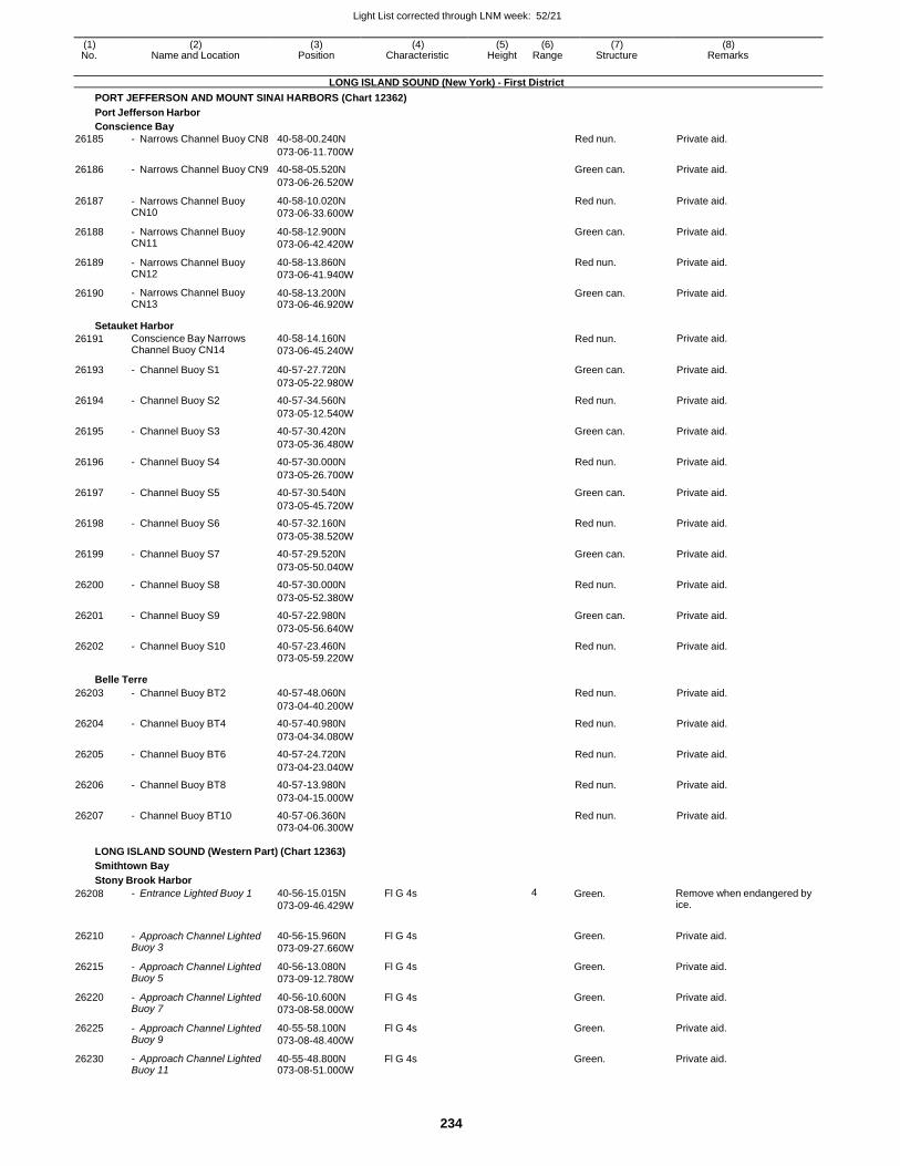
Light List corrected through LNM week: 52/21
234
(1) (2) (3) (4) (5) (6) (7) (8) No. Name and Location Position Characteristic Height Range Structure Remarks
LONG ISLAND SOUND (New York) - First District
PORT JEFFERSON AND MOUNT SINAI HARBORS (Chart 12362)
Port Jefferson Harbor
Conscience Bay
26185 - Narrows Channel Buoy CN8 40-58-00.240N Red nun. Private aid.
073-06-11.700W
26186 - Narrows Channel Buoy CN9 40-58-05.520N Green can. Private aid.
073-06-26.520W
26187 - Narrows Channel Buoy CN10
40-58-10.020N
073-06-33.600W
Red nun. Private aid.
26188 - Narrows Channel Buoy CN11
40-58-12.900N
073-06-42.420W
Green can. Private aid.
26189 - Narrows Channel Buoy CN12
40-58-13.860N
073-06-41.940W
Red nun. Private aid.
26190 - Narrows Channel Buoy CN13
40-58-13.200N 073-06-46.920W
Green can. Private aid.
Setauket Harbor
26191 Conscience Bay Narrows Channel Buoy CN14
40-58-14.160N
073-06-45.240W Red nun. Private aid.
26193 - Channel Buoy S1 40-57-27.720N Green can. Private aid.
073-05-22.980W
26194 - Channel Buoy S2 40-57-34.560N Red nun. Private aid.
073-05-12.540W
26195 - Channel Buoy S3 40-57-30.420N Green can. Private aid.
073-05-36.480W
26196 - Channel Buoy S4 40-57-30.000N Red nun. Private aid.
073-05-26.700W
26197 - Channel Buoy S5 40-57-30.540N Green can. Private aid.
073-05-45.720W
26198 - Channel Buoy S6 40-57-32.160N Red nun. Private aid.
073-05-38.520W
26199 - Channel Buoy S7 40-57-29.520N Green can. Private aid.
073-05-50.040W
26200 - Channel Buoy S8 40-57-30.000N Red nun. Private aid.
073-05-52.380W
26201 - Channel Buoy S9 40-57-22.980N Green can. Private aid.
073-05-56.640W
26202 - Channel Buoy S10 40-57-23.460N Red nun. Private aid. 073-05-59.220W
Belle Terre
26203 - Channel Buoy BT2 40-57-48.060N Red nun. Private aid.
073-04-40.200W
26204 - Channel Buoy BT4 40-57-40.980N Red nun. Private aid.
073-04-34.080W
26205 - Channel Buoy BT6 40-57-24.720N Red nun. Private aid.
073-04-23.040W
26206 - Channel Buoy BT8 40-57-13.980N Red nun. Private aid.
073-04-15.000W
26207 - Channel Buoy BT10 40-57-06.360N Red nun. Private aid. 073-04-06.300W
LONG ISLAND SOUND (Western Part) (Chart 12363)
Smithtown Bay
Stony Brook Harbor
26208 - Entrance Lighted Buoy 1 40-56-15.015N
073-09-46.429W
Fl G 4s 4 Green. Remove when endangered by ice.
26210 - Approach Channel Lighted Buoy 3
40-56-15.960N
073-09-27.660W
Fl G 4s
Green. Private aid.
26215 - Approach Channel Lighted Buoy 5
40-56-13.080N
073-09-12.780W
Fl G 4s Green. Private aid.
26220 - Approach Channel Lighted Buoy 7
40-56-10.600N
073-08-58.000W
Fl G 4s Green. Private aid.
26225 - Approach Channel Lighted Buoy 9
40-55-58.100N
073-08-48.400W
Fl G 4s Green. Private aid.
26230 - Approach Channel Lighted Buoy 11
40-55-48.800N 073-08-51.000W
Fl G 4s Green. Private aid.
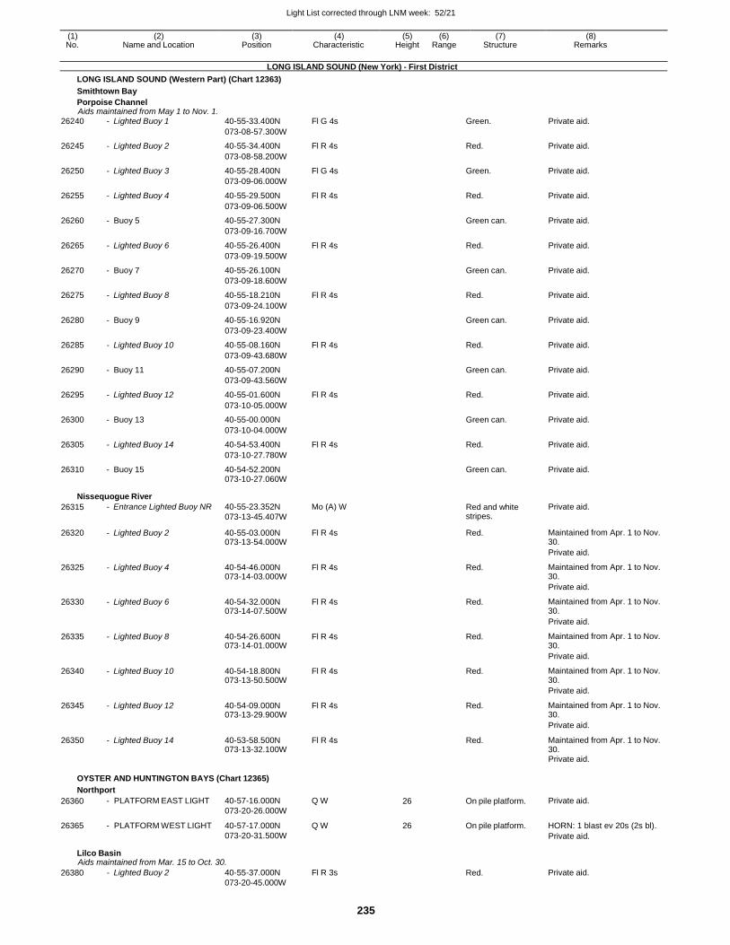
Light List corrected through LNM week: 52/21
235
(1) (2) (3) (4) (5) (6) (7) (8) No. Name and Location Position Characteristic Height Range Structure Remarks
LONG ISLAND SOUND (New York) - First District
LONG ISLAND SOUND (Western Part) (Chart 12363)
Smithtown Bay
Porpoise Channel Aids maintained from May 1 to Nov. 1.
26240 - Lighted Buoy 1 40-55-33.400N Fl G 4s Green. Private aid.
073-08-57.300W
26245 - Lighted Buoy 2 40-55-34.400N Fl R 4s Red. Private aid.
073-08-58.200W
26250 - Lighted Buoy 3 40-55-28.400N Fl G 4s Green. Private aid.
073-09-06.000W
26255 - Lighted Buoy 4 40-55-29.500N Fl R 4s Red. Private aid.
073-09-06.500W
26260 - Buoy 5 40-55-27.300N Green can. Private aid.
073-09-16.700W
26265 - Lighted Buoy 6 40-55-26.400N Fl R 4s Red. Private aid.
073-09-19.500W
26270 - Buoy 7 40-55-26.100N Green can. Private aid.
073-09-18.600W
26275 - Lighted Buoy 8 40-55-18.210N Fl R 4s Red. Private aid.
073-09-24.100W
26280 - Buoy 9 40-55-16.920N Green can. Private aid.
073-09-23.400W
26285 - Lighted Buoy 10 40-55-08.160N Fl R 4s Red. Private aid.
073-09-43.680W
26290 - Buoy 11 40-55-07.200N Green can. Private aid.
073-09-43.560W
26295 - Lighted Buoy 12 40-55-01.600N Fl R 4s Red. Private aid.
073-10-05.000W
26300 - Buoy 13 40-55-00.000N Green can. Private aid.
073-10-04.000W
26305 - Lighted Buoy 14 40-54-53.400N Fl R 4s Red. Private aid.
073-10-27.780W
26310 - Buoy 15 40-54-52.200N Green can. Private aid. 073-10-27.060W
Nissequogue River
26315 - Entrance Lighted Buoy NR 40-55-23.352N
073-13-45.407W
Mo (A) W Red and white stripes.
Private aid.
26320 - Lighted Buoy 2 40-55-03.000N 073-13-54.000W
Fl R 4s Red. Maintained from Apr. 1 to Nov. 30.
Private aid.
26325 - Lighted Buoy 4 40-54-46.000N 073-14-03.000W
Fl R 4s Red. Maintained from Apr. 1 to Nov. 30.
Private aid.
26330 - Lighted Buoy 6 40-54-32.000N 073-14-07.500W
Fl R 4s Red. Maintained from Apr. 1 to Nov. 30.
Private aid.
26335 - Lighted Buoy 8 40-54-26.600N 073-14-01.000W
Fl R 4s Red. Maintained from Apr. 1 to Nov. 30.
Private aid.
26340 - Lighted Buoy 10 40-54-18.800N 073-13-50.500W
Fl R 4s Red. Maintained from Apr. 1 to Nov. 30.
Private aid.
26345 - Lighted Buoy 12 40-54-09.000N 073-13-29.900W
Fl R 4s Red. Maintained from Apr. 1 to Nov. 30.
Private aid.
26350 - Lighted Buoy 14 40-53-58.500N 073-13-32.100W
Fl R 4s Red. Maintained from Apr. 1 to Nov. 30.
Private aid.
OYSTER AND HUNTINGTON BAYS (Chart 12365)
Northport
26360
26365
- PLATFORM EAST LIGHT
- PLATFORM WEST LIGHT
40-57-16.000N Q W
073-20-26.000W
40-57-17.000N Q W
073-20-31.500W
26 On pile platform.
26 On pile platform.
Private aid.
HORN: 1 blast ev 20s (2s bl).
Private aid.
Lilco Basin Aids maintained from Mar. 15 to Oct. 30.
26380 - Lighted Buoy 2 40-55-37.000N
073-20-45.000W
Fl R 3s Red. Private aid.
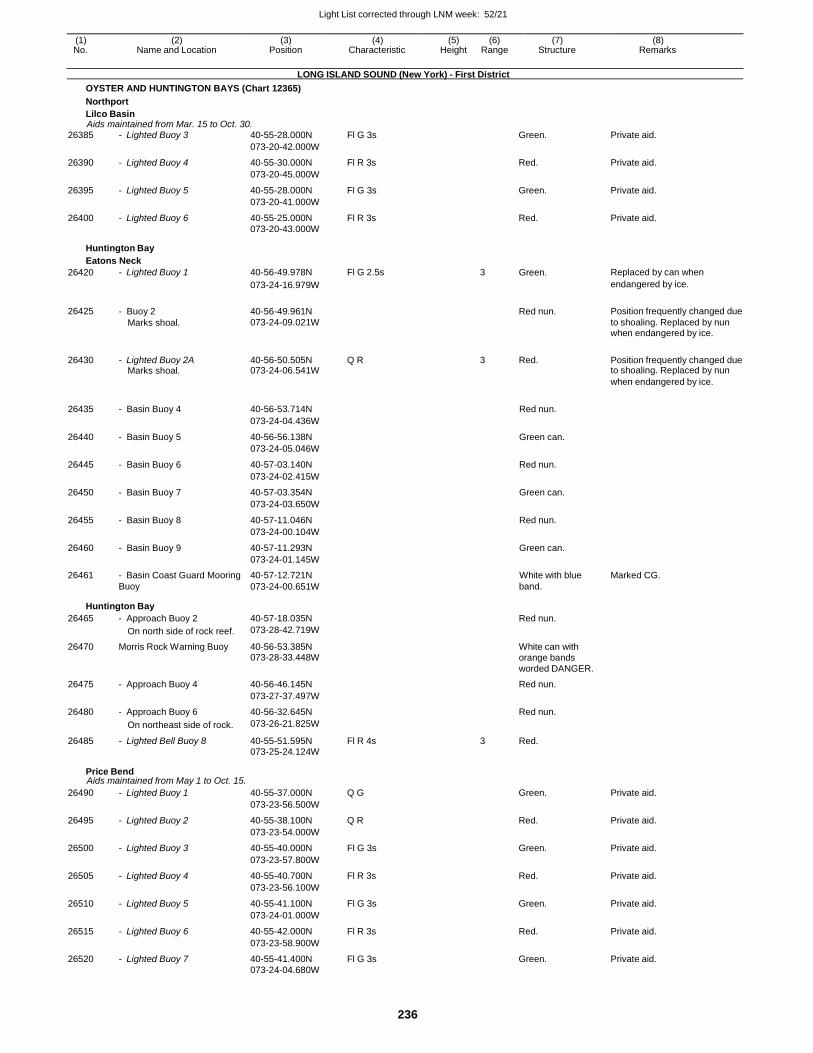
Light List corrected through LNM week: 52/21
236
(1) (2) (3) (4) (5) (6) (7) (8) No. Name and Location Position Characteristic Height Range Structure Remarks
LONG ISLAND SOUND (New York) - First District
OYSTER AND HUNTINGTON BAYS (Chart 12365)
Northport
Lilco Basin Aids maintained from Mar. 15 to Oct. 30.
26385 - Lighted Buoy 3 40-55-28.000N Fl G 3s Green. Private aid.
073-20-42.000W
26390 - Lighted Buoy 4 40-55-30.000N Fl R 3s Red. Private aid.
073-20-45.000W
26395 - Lighted Buoy 5 40-55-28.000N Fl G 3s Green. Private aid.
073-20-41.000W
26400 - Lighted Buoy 6 40-55-25.000N Fl R 3s Red. Private aid. 073-20-43.000W
Huntington Bay
Eatons Neck
26420 - Lighted Buoy 1 40-56-49.978N Fl G 2.5s 3 Green. Replaced by can when
073-24-16.979W endangered by ice.
26425 - Buoy 2 40-56-49.961N
Red nun. Position frequently changed due Marks shoal. 073-24-09.021W to shoaling. Replaced by nun
when endangered by ice.
26430 - Lighted Buoy 2A 40-56-50.505N Q R 3 Red. Position frequently changed due Marks shoal. 073-24-06.541W to shoaling. Replaced by nun
when endangered by ice.
26435 - Basin Buoy 4 40-56-53.714N Red nun.
073-24-04.436W
26440 - Basin Buoy 5 40-56-56.138N Green can.
073-24-05.046W
26445 - Basin Buoy 6 40-57-03.140N Red nun.
073-24-02.415W
26450 - Basin Buoy 7 40-57-03.354N Green can.
073-24-03.650W
26455 - Basin Buoy 8 40-57-11.046N Red nun.
073-24-00.104W
26460 - Basin Buoy 9 40-57-11.293N Green can.
073-24-01.145W
26461 - Basin Coast Guard Mooring 40-57-12.721N White with blue Marked CG. Buoy 073-24-00.651W band.
Huntington Bay
26465 - Approach Buoy 2 40-57-18.035N Red nun.
On north side of rock reef. 073-28-42.719W
26470 Morris Rock Warning Buoy 40-56-53.385N White can with 073-28-33.448W orange bands worded DANGER.
26475 - Approach Buoy 4 40-56-46.145N Red nun.
073-27-37.497W
26480 - Approach Buoy 6 40-56-32.645N Red nun.
On northeast side of rock. 073-26-21.825W
26485 - Lighted Bell Buoy 8 40-55-51.595N Fl R 4s 3 Red. 073-25-24.124W
Price Bend Aids maintained from May 1 to Oct. 15.
26490 - Lighted Buoy 1 40-55-37.000N Q G Green. Private aid.
073-23-56.500W
26495 - Lighted Buoy 2 40-55-38.100N Q R Red. Private aid.
073-23-54.000W
26500 - Lighted Buoy 3 40-55-40.000N Fl G 3s Green. Private aid.
073-23-57.800W
26505 - Lighted Buoy 4 40-55-40.700N Fl R 3s Red. Private aid.
073-23-56.100W
26510 - Lighted Buoy 5 40-55-41.100N Fl G 3s Green. Private aid.
073-24-01.000W
26515 - Lighted Buoy 6 40-55-42.000N Fl R 3s Red. Private aid.
073-23-58.900W
26520 - Lighted Buoy 7 40-55-41.400N Fl G 3s Green. Private aid. 073-24-04.680W
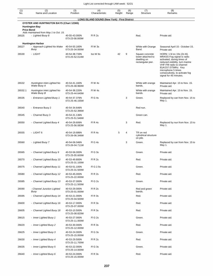
Light List corrected through LNM week: 52/21
237
(1) (2) (3) (4) (5) (6) (7) (8) No. Name and Location Position Characteristic Height Range Structure Remarks
LONG ISLAND SOUND (New York) - First District
OYSTER AND HUNTINGTON BAYS (Chart 12365)
Huntington Bay
Price Bend Aids maintained from May 1 to Oct. 15.
26525 - Lighted Buoy 8 40-55-43.000N
073-23-58.000W
Fl R 2s Red. Private aid.
Huntington Harbor
26527 - Approach Lighted No Wake Buoy
40-54-50.160N
073-25-34.000W
Fl W 3s White with Orange Band.
Seasonal April 15 - October 15.
Private aid.
26530 - LIGHT 40-54-38.733N
073-25-52.014W
Iso W 6s 42 9 Square concrete tower attached to dwelling on rectangular pier.
HORN: 1 bl ev 15s (2s bl). MRASS-Fog signal is radio activated, during times of reduced visibility, turn marine VHF-FM radio to channel 81A/157.075Mhz. Key microphone 5 times consecutively, to activate fog signal for 45 minutes.
26532 Huntington Inlet Lighted No Wake Buoy A
40-54-41.160N
073-25-48.960W
Fl W 4s
White with orange bands.
Maintained Apr. 15 to Nov. 15.
Private aid.
26532.1 Huntington Inlet Lighted No Wake Buoy B
40-54-38.220N
073-25-44.640W
Fl W 4s White with orange bands.
Maintained Apr. 15 to Nov. 15.
Private aid.
26535 - Entrance Lighted Buoy 1 40-54-37.376N
073-25-46.155W
Fl G 4s 3 Green. Replaced by can from Nov. 15 to May 1.
26540 - Entrance Buoy 2 40-54-34.646N
Red nun.
073-25-52.396W
26545 - Channel Buoy 3 40-54-31.136N Green can.
073-25-51.546W
26550 - Channel Lighted Buoy 4 40-54-29.606N
073-25-56.083W
Fl R 4s 3 Red. Replaced by nun from Nov. 15 to May 1.
26555 - LIGHT 6 40-54-19.686N
073-26-06.346W
Fl R 4s 5 4 TR on red cylindrical structure on pile.
26560 - Lighted Buoy 7 40-54-06.046N
073-26-04.711W
Fl G 4s 3 Green. Replaced by can from Nov. 15 to May 1.
26565 - Channel Lighted Buoy 9 40-53-56.000N Fl G 3s
Green. Private aid.
073-25-55.600W
26570 - Channel Lighted Buoy 10 40-53-49.800N Fl R 2s Red. Private aid.
073-25-31.100W
26575 - Channel Lighted Buoy 11 40-53-51.100N Fl G 2.5s Green. Private aid.
073-25-31.500W
26580 - Channel Lighted Buoy 12 40-53-45.000N Fl R 2s Red. Private aid.
073-25-22.000W
26585 - Channel Lighted Buoy 13 40-53-37.000N Fl G 2s Green. Private aid.
073-25-11.500W
26590 - Channel Junction Lighted Buoy
40-53-29.000N
073-25-01.000W
Fl R 2s Red and green bands.
Private aid.
26595 - Channel Lighted Buoy 14 40-53-21.000N Fl R 3s Red. Private aid.
073-25-04.500W
26600 - Channel Lighted Buoy 16 40-53-17.000N Fl R 3s Red. Private aid.
073-25-07.000W
26605 - Channel Lighted Buoy 18 40-53-10.500N Fl R 3s Red. Private aid.
073-25-08.820W
26615 - Inner Lighted Buoy 1 40-53-27.000N Fl G 2s Green. Private aid.
073-25-11.000W
26620 - Inner Lighted Buoy 2 40-53-30.000N Fl R 3s Red. Private aid.
073-25-12.000W
26625 - Inner Lighted Buoy 3 40-53-24.000N Fl G 3s Green. Private aid.
073-25-15.000W
26630 - Inner Lighted Buoy 4 40-53-29.500N Fl R 2s Red. Private aid.
073-25-11.700W
26635 - Inner Lighted Buoy 5 40-53-22.000N Fl G 3s Green. Private aid.
073-25-14.000W
26640 - Inner Lighted Buoy 6 40-53-24.000N Fl R 3s Red. Private aid. 073-25-15.000W
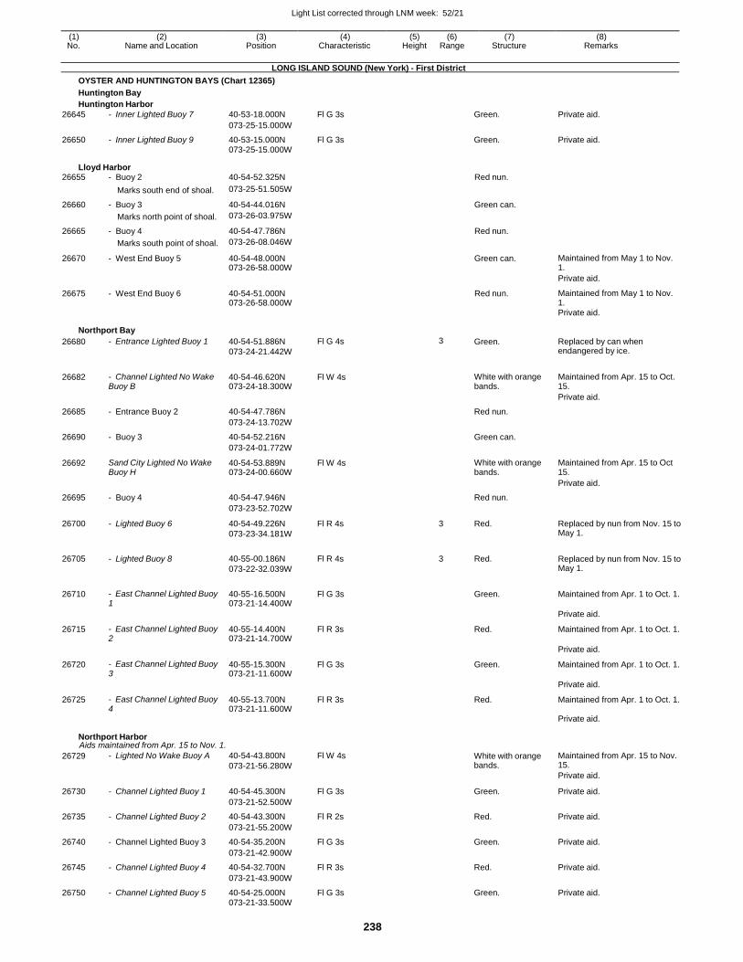
Light List corrected through LNM week: 52/21
238
(1) (2) (3) (4) (5) (6) (7) (8) No. Name and Location Position Characteristic Height Range Structure Remarks
LONG ISLAND SOUND (New York) - First District
OYSTER AND HUNTINGTON BAYS (Chart 12365)
Huntington Bay
Huntington Harbor
26645 - Inner Lighted Buoy 7 40-53-18.000N Fl G 3s Green. Private aid.
073-25-15.000W
26650 - Inner Lighted Buoy 9 40-53-15.000N Fl G 3s Green. Private aid. 073-25-15.000W
Lloyd Harbor 26655 - Buoy 2 40-54-52.325N Red nun.
Marks south end of shoal. 073-25-51.505W
26660 - Buoy 3 40-54-44.016N Green can.
Marks north point of shoal. 073-26-03.975W
26665 - Buoy 4 40-54-47.786N Red nun.
Marks south point of shoal. 073-26-08.046W
26670 - West End Buoy 5 40-54-48.000N 073-26-58.000W
Green can. Maintained from May 1 to Nov. 1.
Private aid.
26675 - West End Buoy 6 40-54-51.000N 073-26-58.000W
Red nun. Maintained from May 1 to Nov. 1.
Private aid.
Northport Bay
26680 - Entrance Lighted Buoy 1 40-54-51.886N
073-24-21.442W
Fl G 4s 3 Green. Replaced by can when endangered by ice.
26682 - Channel Lighted No Wake Buoy B
40-54-46.620N 073-24-18.300W
Fl W 4s
White with orange bands.
Maintained from Apr. 15 to Oct. 15.
Private aid.
26685 - Entrance Buoy 2 40-54-47.786N Red nun.
073-24-13.702W
26690 - Buoy 3 40-54-52.216N Green can.
073-24-01.772W
26692 Sand City Lighted No Wake Buoy H
40-54-53.889N 073-24-00.660W
Fl W 4s White with orange bands.
Maintained from Apr. 15 to Oct 15.
Private aid.
26695 - Buoy 4 40-54-47.946N Red nun.
073-23-52.702W
26700 - Lighted Buoy 6 40-54-49.226N
073-23-34.181W
Fl R 4s 3 Red. Replaced by nun from Nov. 15 to May 1.
26705 - Lighted Buoy 8 40-55-00.186N
073-22-32.039W
Fl R 4s 3 Red. Replaced by nun from Nov. 15 to May 1.
26710 - East Channel Lighted Buoy 1
40-55-16.500N 073-21-14.400W
Fl G 3s
Green. Maintained from Apr. 1 to Oct. 1.
Private aid.
26715 - East Channel Lighted Buoy 2
40-55-14.400N 073-21-14.700W
Fl R 3s Red. Maintained from Apr. 1 to Oct. 1.
Private aid.
26720 - East Channel Lighted Buoy 3
40-55-15.300N 073-21-11.600W
Fl G 3s Green. Maintained from Apr. 1 to Oct. 1.
Private aid.
26725 - East Channel Lighted Buoy 4
40-55-13.700N 073-21-11.600W
Fl R 3s Red. Maintained from Apr. 1 to Oct. 1.
Private aid.
Northport Harbor Aids maintained from Apr. 15 to Nov. 1.
26729 - Lighted No Wake Buoy A 40-54-43.800N
073-21-56.280W
Fl W 4s White with orange bands.
Maintained from Apr. 15 to Nov. 15.
Private aid.
26730 - Channel Lighted Buoy 1 40-54-45.300N Fl G 3s Green. Private aid.
073-21-52.500W
26735 - Channel Lighted Buoy 2 40-54-43.300N Fl R 2s Red. Private aid.
073-21-55.200W
26740 - Channel Lighted Buoy 3 40-54-35.200N Fl G 3s Green. Private aid.
073-21-42.900W
26745 - Channel Lighted Buoy 4 40-54-32.700N Fl R 3s Red. Private aid.
073-21-43.900W
26750 - Channel Lighted Buoy 5 40-54-25.000N Fl G 3s Green. Private aid. 073-21-33.500W
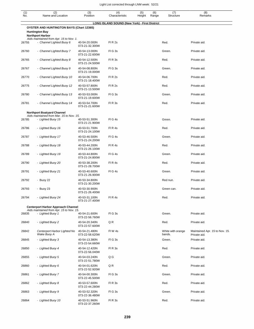
Light List corrected through LNM week: 52/21
239
(1) (2) (3) (4) (5) (6) (7) (8) No. Name and Location Position Characteristic Height Range Structure Remarks
LONG ISLAND SOUND (New York) - First District
OYSTER AND HUNTINGTON BAYS (Chart 12365)
Huntington Bay
Northport Harbor Aids maintained from Apr. 15 to Nov. 1.
26755 - Channel Lighted Buoy 6 40-54-20.000N
073-21-32.300W
Fl R 2s Red. Private aid.
26760 - Channel Lighted Buoy 7 40-54-13.000N
073-21-22.600W
Fl G 3s Green. Private aid.
26765 - Channel Lighted Buoy 8 40-54-12.500N
073-21-24.500W
Fl R 3s Red. Private aid.
26767 - Channel Lighted Buoy 9 40-54-08.800N
073-21-19.000W
Fl G 3s Green. Private aid.
26770 - Channel Lighted Buoy 10 40-54-06.700N
073-21-18.400W
Fl R 2s Red. Private aid.
26775 - Channel Lighted Buoy 12 40-53-57.800N
073-21-13.500W
Fl R 2s Red. Private aid.
26780 - Channel Lighted Buoy 13 40-53-53.000N
073-21-19.600W
Fl G 3s Green. Private aid.
26781 - Channel Lighted Buoy 14 40-53-54.700N 073-21-21.600W
Fl R 3s Red. Private aid.
Northport Boatyard Channel Aids maintained from Mar. 15 to Nov. 15.
26785 - Lighted Buoy 15 40-53-51.300N
073-21-21.900W
Fl G 4s Green. Private aid.
26786 - Lighted Buoy 16 40-53-51.700N
073-21-24.100W
Fl R 4s Red. Private aid.
26787 - Lighted Buoy 17 40-53-46.500N
073-21-24.200W
Fl G 4s Green. Private aid.
26788 - Lighted Buoy 18 40-53-44.200N
073-21-26.100W
Fl R 4s Red. Private aid.
26789 - Lighted Buoy 19 40-53-44.800N
073-21-24.800W
Fl G 4s Green. Private aid.
26790 - Lighted Buoy 20 40-53-38.200N
073-21-28.700W
Fl R 4s Red. Private aid.
26791 - Lighted Buoy 21 40-53-40.600N
073-21-26.900W
Fl G 4s Green. Private aid.
26792 - Buoy 22 40-53-34.800N
073-21-30.200W
Red nun. Private aid.
26793 - Buoy 23 40-53-30.900N
073-21-26.400W
Green can. Private aid.
26794 - Lighted Buoy 24 40-53-31.100N 073-21-27.400W
Fl R 4s Red. Private aid.
Centerport Harbor Approach Channel Aids maintained from Apr. 15 to Nov. 15.
26835 - Lighted Buoy 1 40-54-21.600N Fl G 3s Green. Private aid.
073-22-56.760W
26840 - Lighted Buoy 2 40-54-20.340N Q R Red. Private aid.
073-22-57.600W
26842 Centerport Harbor Lighted No Wake Buoy A
40-54-21.480N
073-22-58.620W
Fl W 4s White with orange bands.
Maintained Apr. 15 to Nov. 15.
Private aid.
26845 - Lighted Buoy 3 40-54-13.380N Fl G 3s Green. Private aid.
073-22-54.660W
26850 - Lighted Buoy 4 40-54-12.420N Fl R 3s Red. Private aid.
073-22-56.040W
26855 - Lighted Buoy 5 40-54-03.240N Q G Green. Private aid.
073-22-51.780W
26860 - Lighted Buoy 6 40-54-01.620N Q R Red. Private aid.
073-22-52.920W
26861 - Lighted Buoy 7 40-54-00.300N Fl G 3s Green. Private aid.
073-22-45.500W
26862 - Lighted Buoy 8 40-53-57.600N Fl R 3s Red. Private aid.
073-22-44.280W
26863 - Lighted Buoy 9 40-53-52.320N Fl G 3s Green. Private aid.
073-22-36.480W
26864 - Lighted Buoy 10 40-53-51.960N Fl R 3s Red. Private aid. 073-22-37.260W
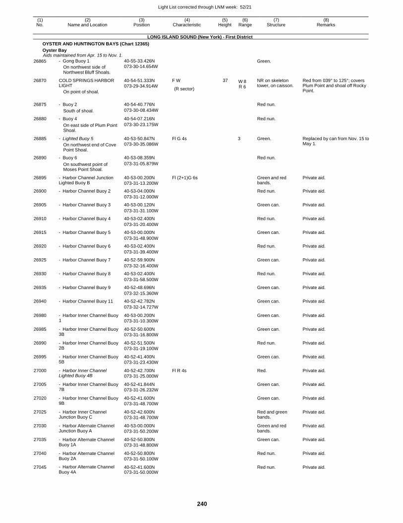
Light List corrected through LNM week: 52/21
240
(1) (2) (3) (4) (5) (6) (7) (8) No. Name and Location Position Characteristic Height Range Structure Remarks
LONG ISLAND SOUND (New York) - First District
OYSTER AND HUNTINGTON BAYS (Chart 12365)
Oyster Bay Aids maintained from Apr. 15 to Nov. 1.
26865
26870
- Gong Buoy 1
On northwest side of Northwest Bluff Shoals.
COLD SPRINGS HARBOR LIGHT
On point of shoal.
40-55-33.426N
073-30-14.654W
40-54-51.333N
073-29-34.914W
F W
(R sector)
37 W 8
R 6
Green.
NR on skeleton tower, on caisson.
Red from 039° to 125°; covers Plum Point and shoal off Rocky Point.
26875 - Buoy 2 40-54-40.776N Red nun.
South of shoal. 073-30-08.434W
26880 - Buoy 4 40-54-07.216N Red nun.
On east side of Plum Point Shoal.
073-30-23.175W
26885 - Lighted Buoy 5
On northwest end of Cove Point Shoal.
40-53-50.847N
073-30-35.086W
Fl G 4s 3 Green. Replaced by can from Nov. 15 to May 1.
26890 - Buoy 6 40-53-08.359N Red nun.
On southwest point of Moses Point Shoal.
073-31-05.879W
26895 - Harbor Channel Junction Lighted Buoy B
40-53-00.200N
073-31-13.200W
Fl (2+1)G 6s Green and red bands.
Private aid.
26900 - Harbor Channel Buoy 2 40-53-04.000N Red nun. Private aid.
073-31-12.000W
26905 - Harbor Channel Buoy 3 40-53-00.120N Green can. Private aid.
073-31-31.100W
26910 - Harbor Channel Buoy 4 40-53-02.400N Red nun. Private aid.
073-31-20.400W
26915 - Harbor Channel Buoy 5 40-53-00.000N Green can. Private aid.
073-31-48.900W
26920 - Harbor Channel Buoy 6 40-53-02.400N Red nun. Private aid.
073-31-39.400W
26925 - Harbor Channel Buoy 7 40-52-59.900N Green can. Private aid.
073-32-16.400W
26930 - Harbor Channel Buoy 8 40-53-02.400N Red nun. Private aid.
073-31-58.500W
26935 - Harbor Channel Buoy 9 40-52-48.696N Green can. Private aid.
073-32-15.360W
26940 - Harbor Channel Buoy 11 40-52-42.782N Green can. Private aid.
073-32-14.727W
26980 - Harbor Inner Channel Buoy 1
40-53-00.200N
073-31-10.300W
Green can. Private aid.
26985 - Harbor Inner Channel Buoy 3B
40-52-50.600N
073-31-16.800W
Green can. Private aid.
26990 - Harbor Inner Channel Buoy 2B
40-52-51.500N
073-31-19.100W
Red nun. Private aid.
26995 - Harbor Inner Channel Buoy 5B
40-52-41.400N
073-31-23.430W
Green can. Private aid.
27000 - Harbor Inner Channel Lighted Buoy 4B
40-52-42.700N
073-31-25.000W
Fl R 4s Red. Private aid.
27005 - Harbor Inner Channel Buoy 7B
40-52-41.844N
073-31-26.232W
Green can. Private aid.
27020 - Harbor Inner Channel Buoy 9B
40-52-41.600N
073-31-48.700W
Green can. Private aid.
27025 - Harbor Inner Channel Junction Buoy C
40-52-42.600N
073-31-48.700W
Red and green bands.
Private aid.
27030 - Harbor Alternate Channel Junction Buoy A
40-53-00.000N
073-31-50.200W
Green and red bands.
Private aid.
27035 - Harbor Alternate Channel Buoy 1A
40-52-50.800N
073-31-48.800W
Green can. Private aid.
27040 - Harbor Alternate Channel Buoy 2A
40-52-50.800N
073-31-50.100W
Red nun. Private aid.
27045 - Harbor Alternate Channel Buoy 4A
40-52-41.600N 073-31-50.000W
Red nun. Private aid.
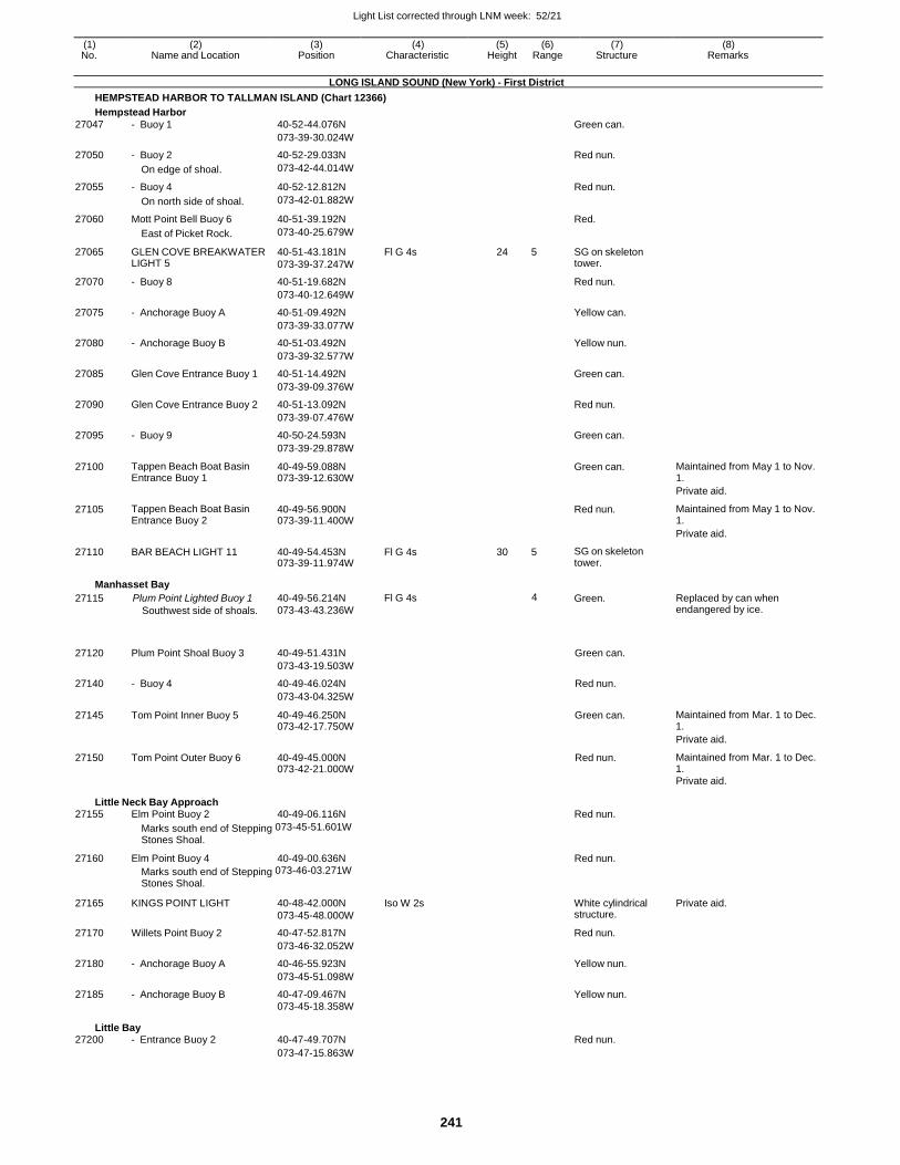
Light List corrected through LNM week: 52/21
241
(1) (2) (3) (4) (5) (6) (7) (8) No. Name and Location Position Characteristic Height Range Structure Remarks
LONG ISLAND SOUND (New York) - First District
HEMPSTEAD HARBOR TO TALLMAN ISLAND (Chart 12366)
Hempstead Harbor
27047 - Buoy 1 40-52-44.076N Green can.
073-39-30.024W
27050 - Buoy 2 40-52-29.033N Red nun.
On edge of shoal. 073-42-44.014W
27055 - Buoy 4 40-52-12.812N Red nun.
On north side of shoal. 073-42-01.882W
27060 Mott Point Bell Buoy 6 40-51-39.192N Red.
East of Picket Rock. 073-40-25.679W
27065 GLEN COVE BREAKWATER LIGHT 5
40-51-43.181N
073-39-37.247W
Fl G 4s 24 5 SG on skeleton tower.
27070 - Buoy 8 40-51-19.682N Red nun.
073-40-12.649W
27075 - Anchorage Buoy A 40-51-09.492N Yellow can.
073-39-33.077W
27080 - Anchorage Buoy B 40-51-03.492N Yellow nun.
073-39-32.577W
27085 Glen Cove Entrance Buoy 1 40-51-14.492N Green can.
073-39-09.376W
27090 Glen Cove Entrance Buoy 2 40-51-13.092N Red nun.
073-39-07.476W
27095 - Buoy 9 40-50-24.593N Green can.
073-39-29.878W
27100 Tappen Beach Boat Basin Entrance Buoy 1
40-49-59.088N 073-39-12.630W
Green can. Maintained from May 1 to Nov. 1.
Private aid.
27105 Tappen Beach Boat Basin Entrance Buoy 2
40-49-56.900N 073-39-11.400W
Red nun. Maintained from May 1 to Nov. 1.
Private aid.
27110 BAR BEACH LIGHT 11 40-49-54.453N 073-39-11.974W
Fl G 4s 30 5 SG on skeleton tower.
Manhasset Bay
27115 Plum Point Lighted Buoy 1
Southwest side of shoals.
40-49-56.214N
073-43-43.236W
Fl G 4s 4 Green. Replaced by can when endangered by ice.
27120 Plum Point Shoal Buoy 3 40-49-51.431N Green can.
073-43-19.503W
27140 - Buoy 4 40-49-46.024N Red nun.
073-43-04.325W
27145 Tom Point Inner Buoy 5 40-49-46.250N 073-42-17.750W
Green can. Maintained from Mar. 1 to Dec. 1.
Private aid.
27150 Tom Point Outer Buoy 6 40-49-45.000N 073-42-21.000W
Red nun. Maintained from Mar. 1 to Dec. 1.
Private aid.
Little Neck Bay Approach 27155 Elm Point Buoy 2 40-49-06.116N Red nun.
Marks south end of Stepping 073-45-51.601W
Stones Shoal.
27160 Elm Point Buoy 4 40-49-00.636N Red nun.
Marks south end of Stepping 073-46-03.271W
Stones Shoal.
27165 KINGS POINT LIGHT 40-48-42.000N
073-45-48.000W
Iso W 2s White cylindrical structure.
Private aid.
27170 Willets Point Buoy 2 40-47-52.817N Red nun.
073-46-32.052W
27180 - Anchorage Buoy A 40-46-55.923N Yellow nun.
073-45-51.098W
27185 - Anchorage Buoy B 40-47-09.467N Yellow nun.
073-45-18.358W
Little Bay 27200 - Entrance Buoy 2 40-47-49.707N Red nun.
073-47-15.863W
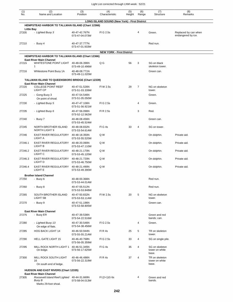
Light List corrected through LNM week: 52/21
242
(1) (2) (3) (4) (5) (6) (7) (8) No. Name and Location Position Characteristic Height Range Structure Remarks
LONG ISLAND SOUND (New York) - First District
HEMPSTEAD HARBOR TO TALLMAN ISLAND (Chart 12366)
Little Bay
27205
27210
- Lighted Buoy 3
- Buoy 4
40-47-42.767N
073-47-04.073W
40-47-37.777N
073-47-01.933W
Fl G 2.5s 4
NEW YORK - First District
Green.
Red nun.
Replaced by can when endangered by ice.
HEMPSTEAD HARBOR TO TALLMAN ISLAND (Chart 12366)
East River Main Channel
27215 WHITESTONE POINT LIGHT 40-48-06.396N Q G 56 3 SG on black
1 073-49-10.496W skeleton tower.
27216 Whitestone Point Buoy 1A 40-48-08.771N 073-49-11.020W
Green can.
TALLMAN ISLAND TO QUEENSBORO BRIDGE (Chart 12339)
East River Main Channel 27220 COLLEGE POINT REEF 40-47-51.526N Fl W 2.5s 29 7 NG on skeleton
LIGHT CP 073-51-03.339W tower.
27225 - Gong Buoy 3 40-47-54.546N Green.
On point of shoal. 073-51-05.050W
27230 - Lighted Buoy 5 40-47-47.106N Fl G 2.5s 4 Green.
073-51-56.921W
27235 - Lighted Buoy 6 40-47-56.096N Fl R 2.5s 3 Red.
073-52-12.562W
27240 - Buoy 7 40-48-08.456N Green can.
073-53-45.524W
27245 NORTH BROTHER ISLAND 40-48-08.832N Fl G 4s 33 4 SG on tower.
NORTH LIGHT 9 073-53-54.614W
27246 EAST RIVER REGULATORY 40-48-18.350N Q W On dolphin. Private aid.
LIGHT A 073-53-55.520W
27246.1 EAST RIVER REGULATORY 40-48-20.090N Q W On dolphin. Private aid.
LIGHT B 073-53-47.110W
27246.2 EAST RIVER REGULATORY 40-48-21.170N Q W On dolphin. Private aid.
LIGHT C 073-53-45.120W
27246.3 EAST RIVER REGULATORY 40-48-21.720N Q W On dolphin. Private aid.
LIGHT D 073-53-46.750W
27246.4 EAST RIVER REGULATORY 40-48-21.490N Q W On dolphin. Private aid. LIGHT E 073-53-49.390W
Brother Island Channel
27250 - Buoy 6 40-48-00.366N Red nun.
073-53-44.014W
27260 - Buoy 8 40-47-55.512N Red nun.
073-53-53.848W
27265 SOUTH BROTHER ISLAND 40-47-50.832N Fl W 2.5s 20 5 NG on skeleton
LIGHT SB 073-53-53.114W tower.
27270 - Buoy 9 40-47-51.196N Green can. 073-53-58.805W
East River Main Channel
27275 - Buoy ER 40-47-39.536N Green and red
073-54-22.516W bands; can.
27280 - Lighted Buoy 13 40-47-30.546N Fl G 2.5s 4 Green.
On edge of flats. 073-54-38.456W
27285 HOG BACK LIGHT 14 40-46-50.944N Fl R 4s 25 5 TR on skeleton
073-55-55.214W tower.
27290 HELL GATE LIGHT 15 40-46-40.768N Fl G 2.5s 33 4 SG on single pile.
073-56-05.359W
27295 MILL ROCK NORTH LIGHT 1 40-46-51.345N Fl G 4s 35 4 SG on skeleton On ledge. 073-56-17.625W tower on white
base.
27300 MILL ROCK SOUTH LIGHT 40-46-46.486N Fl R 4s 37 4 TR on skeleton 16 073-56-22.319W tower on white On south end of ledge. base.
HUDSON AND EAST RIVERS (Chart 12335)
East River Main Channel
27305 Roosevelt Island Reef Lighted Buoy B
Marks 29-foot shoal.
40-44-31.669N
073-58-04.013W
Fl (2+1)G 6s 4 Green and red bands.
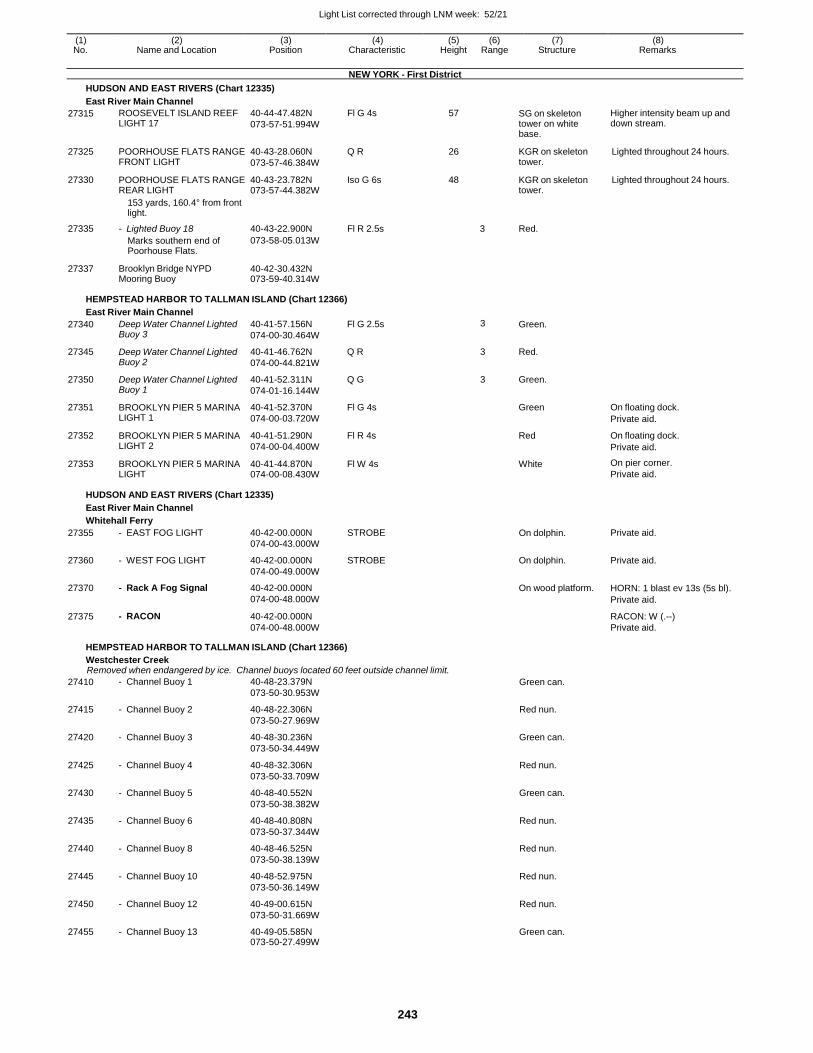
Light List corrected through LNM week: 52/21
243
(1) (2) (3) (4) (5) (6) (7) (8) No. Name and Location Position Characteristic Height Range Structure Remarks
NEW YORK - First District
HUDSON AND EAST RIVERS (Chart 12335)
East River Main Channel
27315 ROOSEVELT ISLAND REEF LIGHT 17
40-44-47.482N
073-57-51.994W
Fl G 4s 57 SG on skeleton tower on white base.
Higher intensity beam up and down stream.
27325 POORHOUSE FLATS RANGE FRONT LIGHT
40-43-28.060N
073-57-46.384W
Q R 26 KGR on skeleton tower.
Lighted throughout 24 hours.
27330 POORHOUSE FLATS RANGE REAR LIGHT
40-43-23.782N 073-57-44.382W
Iso G 6s 48 KGR on skeleton tower.
Lighted throughout 24 hours.
153 yards, 160.4° from front light.
27335 - Lighted Buoy 18 40-43-22.900N Fl R 2.5s 3 Red.
Marks southern end of Poorhouse Flats.
073-58-05.013W
27337 Brooklyn Bridge NYPD Mooring Buoy
40-42-30.432N 073-59-40.314W
HEMPSTEAD HARBOR TO TALLMAN ISLAND (Chart 12366)
East River Main Channel
27340 Deep Water Channel Lighted Buoy 3
40-41-57.156N
074-00-30.464W
Fl G 2.5s 3 Green.
27345 Deep Water Channel Lighted Buoy 2
40-41-46.762N
074-00-44.821W
Q R 3 Red.
27350 Deep Water Channel Lighted Buoy 1
40-41-52.311N
074-01-16.144W
Q G 3 Green.
27351 BROOKLYN PIER 5 MARINA LIGHT 1
40-41-52.370N
074-00-03.720W
Fl G 4s Green On floating dock.
Private aid.
27352 BROOKLYN PIER 5 MARINA LIGHT 2
40-41-51.290N
074-00-04.400W
Fl R 4s Red On floating dock.
Private aid.
27353 BROOKLYN PIER 5 MARINA LIGHT
40-41-44.870N 074-00-08.430W
Fl W 4s White On pier corner.
Private aid.
HUDSON AND EAST RIVERS (Chart 12335)
East River Main Channel
Whitehall Ferry
27355 - EAST FOG LIGHT 40-42-00.000N
074-00-43.000W
STROBE On dolphin. Private aid.
27360 - WEST FOG LIGHT 40-42-00.000N
074-00-49.000W
STROBE On dolphin. Private aid.
27370 - Rack A Fog Signal 40-42-00.000N
074-00-48.000W
On wood platform. HORN: 1 blast ev 13s (5s bl).
Private aid.
27375 - RACON 40-42-00.000N
074-00-48.000W
RACON: W (.--)
Private aid.
HEMPSTEAD HARBOR TO TALLMAN ISLAND (Chart 12366)
Westchester Creek Removed when endangered by ice. Channel buoys located 60 feet outside channel limit.
27410 - Channel Buoy 1 40-48-23.379N
073-50-30.953W Green can.
27415 - Channel Buoy 2 40-48-22.306N
073-50-27.969W
Red nun.
27420 - Channel Buoy 3 40-48-30.236N
073-50-34.449W
Green can.
27425 - Channel Buoy 4 40-48-32.306N
073-50-33.709W
Red nun.
27430 - Channel Buoy 5 40-48-40.552N
073-50-38.382W
Green can.
27435 - Channel Buoy 6 40-48-40.808N
073-50-37.344W
Red nun.
27440 - Channel Buoy 8 40-48-46.525N
073-50-38.139W
Red nun.
27445 - Channel Buoy 10 40-48-52.975N
073-50-36.149W
Red nun.
27450 - Channel Buoy 12 40-49-00.615N
073-50-31.669W
Red nun.
27455 - Channel Buoy 13 40-49-05.585N 073-50-27.499W
Green can.
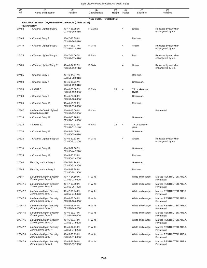
Light List corrected through LNM week: 52/21
244
(1) (2) (3) (4) (5) (6) (7) (8) No. Name and Location Position Characteristic Height Range Structure Remarks
NEW YORK - First District
TALLMAN ISLAND TO QUEENSBORO BRIDGE (Chart 12339)
Flushing Bay
27460 - Channel Lighted Buoy 1 40-47-35.396N
073-51-25.501W
Fl G 2.5s 4 Green. Replaced by can when endangered by ice.
27465 - Channel Buoy 2 40-47-36.396N
Red nun.
073-51-36.501W
27470 - Channel Lighted Buoy 3 40-47-18.277N
073-51-42.831W
Fl G 4s 4 Green. Replaced by can when endangered by ice.
27475 - Channel Lighted Buoy 4 40-47-01.067N
073-51-37.461W
Fl R 4s
4 Red. Replaced by nun when endangered by ice.
27480 - Channel Lighted Buoy 5 40-46-54.127N
073-51-29.211W
Fl G 4s
4 Green. Replaced by can when endangered by ice.
27485 - Channel Buoy 6 40-46-44.847N
Red nun.
073-51-28.091W
27490 - Channel Buoy 7 40-46-38.217N Green can.
073-51-19.941W
27495 - LIGHT 8 40-46-28.607N
073-51-19.900W
Fl R 4s 23 4 TR on skeleton tower.
27500 - Channel Buoy 9 40-46-22.208N Green can.
073-51-10.630W
27505 - Channel Buoy 10 40-46-13.028N Red nun.
073-51-09.860W
27507 La Guardia Outfall Lighted Hazard Buoy 013
40-46-13.000N
073-51-15.300W
Fl Y 4s Private aid.
27510 - Channel Buoy 11 40-46-05.968N Green can.
073-51-01.060W
27515 - LIGHT 12 40-45-57.932N
073-51-01.314W
Fl R 4s 13 4 TR on tower on piles.
27520 - Channel Buoy 13 40-45-54.695N Green can.
073-50-55.062W
27525 - Channel Lighted Buoy 15 40-45-52.338N
073-50-51.210W
Fl G 4s 4 Green. Replaced by can when endangered by ice.
27530 - Channel Buoy 17 40-45-52.387N
Green can.
073-50-44.727W
27535 - Channel Buoy 18 40-45-50.838N Red nun.
073-50-42.420W
27540 Flushing Harbor Buoy 1 40-45-44.948N Green can.
073-50-52.400W
27545 Flushing Harbor Buoy 2 40-45-48.388N Red nun.
073-50-58.160W
27547 La Guardia Airport Security Zone Lighted Buoy A
40-47-14.500N
073-52-03.050W
Fl W 4s White and orange. Marked RESTRICTED AREA.
Private aid.
27547.1 La Guardia Airport Security Zone Lighted Buoy B
40-47-10.600N
073-52-06.700W
Fl W 4s White and orange. Marked RESTRICTED AREA.
Private aid.
27547.2 La Guardia Airport Security Zone Lighted Buoy C
40-47-06.240N
073-52-04.540W
Fl W 4s White and orange. Marked RESTRICTED AREA.
Private aid.
27547.3 La Guardia Airport Security Zone Lighted Buoy D
40-46-23.540N
073-51-16.680W
Fl W 4s White and orange. Marked RESTRICTED AREA.
Private aid.
27547.4 La Guardia Airport Security Zone Lighted Buoy E
40-46-18.740N
073-51-14.020W
Fl W 4s White and orange. Marked RESTRICTED AREA.
Private aid.
27547.5 La Guardia Airport Security Zone Lighted Buoy F
40-46-13.270N
073-51-10.940W
Fl W 4s White and orange. Marked RESTRICTED AREA.
Private aid.
27547.6 La Guardia Airport Security Zone Lighted Buoy G
40-46-07.840N
073-51-07.920W
Fl W 4s White and orange Marked RESTRICTED AREA.
Private aid.
27547.7 La Guardia Airport Security Zone Lighted Buoy H
40-46-02.410N
073-51-04.820W
Fl W 4s White and orange Marked RESTRICTED AREA.
Private aid.
27547.8 La Guardia Airport Security Zone Lighted Buoy I
40-45-56.930N
073-51-01.800W
Fl W 4s White and orange Marked RESTRICTED AREA.
Private aid.
27547.9 La Guardia Airport Security Zone Lighted Buoy J
40-45-51.200N 073-50-59.700W
Fl W 4s White and orange Marked RESTRICTED AREA. Private aid.
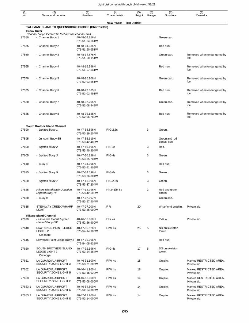
Light List corrected through LNM week: 52/21
245
(1) (2) (3) (4) (5) (6) (7) (8) No. Name and Location Position Characteristic Height Range Structure Remarks
NEW YORK - First District
TALLMAN ISLAND TO QUEENSBORO BRIDGE (Chart 12339)
Bronx River Channel buoys located 60 feet outside channel limit.
27550 - Channel Buoy 1 40-48-04.256N Green can.
073-51-54.661W
27555 - Channel Buoy 2 40-48-04.936N Red nun.
073-51-50.651W
27560 - Channel Buoy 3 40-48-14.676N
073-51-58.151W
Green can. Removed when endangered by ice.
27565 - Channel Buoy 4 40-48-16.396N
073-51-57.341W
Red nun. Removed when endangered by ice.
27570 - Channel Buoy 5 40-48-26.106N
073-52-03.551W
Green can. Removed when endangered by ice.
27575 - Channel Buoy 6 40-48-27.085N
073-52-02.491W
Red nun. Removed when endangered by ice.
27580 - Channel Buoy 7 40-48-37.205N
073-52-08.842W
Green can. Removed when endangered by ice.
27585 - Channel Buoy 8 40-48-36.135N 073-52-06.782W
Red nun. Removed when endangered by ice.
South Brother Island Channel
27590 - Lighted Buoy 1 40-47-58.896N Fl G 2.5s 3 Green.
073-53-29.504W
27595 - Junction Buoy SB 40-47-56.119N
073-53-42.485W
Green and red bands; can.
27600 - Lighted Buoy 2 40-47-50.696N Fl R 4s 3 Red.
073-53-40.904W
27605 - Lighted Buoy 3 40-47-50.396N Fl G 4s 3 Green.
073-53-35.704W
27610 - Buoy 4 40-47-34.096N Red nun.
073-53-41.805W
27615 - Lighted Buoy 5 40-47-34.096N Fl G 6s 3 Green.
073-53-36.304W
27620 - Lighted Buoy 7 40-47-18.996N Fl G 2.5s 3 Green.
073-53-37.204W
27625 Rikers Island Basin Junction Lighted Buoy RI
40-47-18.796N
073-53-42.605W
Fl (2+1)R 6s 3 Red and green bands.
27630 - Buoy 9 40-47-07.097N Green can.
073-53-27.904W
27635 STEINWAY CREEK WHARF LIGHT
40-47-07.000N 073-53-45.000W
F R 20 Wharf end dolphin. Private aid.
Rikers Island Channel
27639 La Guardia Outfall Lighted Hazard Buoy 006
40-46-52.600N
073-52-56.900W
Fl Y 4s Yellow. Private aid.
27640 LAWRENCE POINT LEDGE LIGHT LP
40-47-35.526N 073-54-14.305W
Fl W 4s 25 5 NR on skeleton tower.
On ledge.
27645 Lawrence Point Ledge Buoy 2 40-47-36.096N
Red nun.
073-54-05.635W
27650 SOUTH BROTHER ISLAND LEDGE LIGHT 3
40-47-32.196N 073-53-54.864W
Fl G 4s 17 5 SG on skeleton tower.
On ledge.
27651 LA GUARDIA AIRPORT SECURITY ZONE LIGHT A
40-46-31.100N
073-53-21.000W
Fl W 4s 18 On pile. Marked RESTRICTED AREA.
Private aid.
27652 LA GUARDIA AIRPORT SECURITY ZONE LIGHT B
40-46-41.960N
073-53-15.920W
Fl W 4s 18 On pile. Marked RESTRICTED AREA.
Private aid.
27653 LA GUARDIA AIRPORT SECURITY ZONE LIGHT C
40-46-52.000N
073-53-08.000W
Fl W 4s 14 On pile. Marked RESTRICTED AREA.
Private aid.
27653.1 LA GUARDIA AIRPORT SECURITY ZONE LIGHT D
40-46-54.800N
073-52-54.300W
Fl W 4s 14 On pile. Marked RESTRICTED AREA.
Private aid.
27653.2 LA GUARDIA AIRPORT SECURITY ZONE LIGHT E
40-47-13.200N 073-52-14.000W
Fl W 4s 14 On pile Marked RESTRICTED AREA. Private aid.
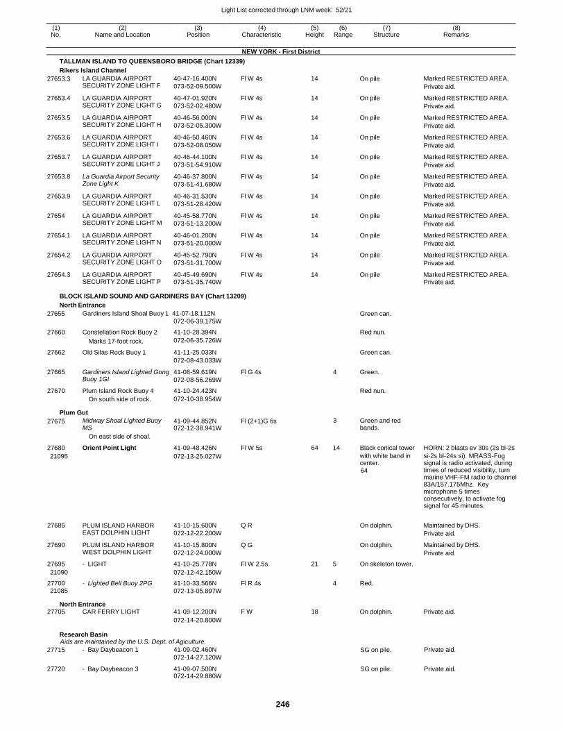
Light List corrected through LNM week: 52/21
246
(1) (2) (3) (4) (5) (6) (7) (8) No. Name and Location Position Characteristic Height Range Structure Remarks
NEW YORK - First District
TALLMAN ISLAND TO QUEENSBORO BRIDGE (Chart 12339)
Rikers Island Channel
27653.3 LA GUARDIA AIRPORT SECURITY ZONE LIGHT F
40-47-16.400N
073-52-09.500W
Fl W 4s 14 On pile Marked RESTRICTED AREA.
Private aid.
27653.4 LA GUARDIA AIRPORT SECURITY ZONE LIGHT G
40-47-01.920N
073-52-02.480W
Fl W 4s 14 On pile Marked RESTRICTED AREA.
Private aid.
27653.5 LA GUARDIA AIRPORT SECURITY ZONE LIGHT H
40-46-56.000N
073-52-05.300W
Fl W 4s 14 On pile Marked RESTRICTED AREA.
Private aid.
27653.6 LA GUARDIA AIRPORT SECURITY ZONE LIGHT I
40-46-50.460N
073-52-08.050W
Fl W 4s 14 On pile Marked RESTRICTED AREA.
Private aid.
27653.7 LA GUARDIA AIRPORT SECURITY ZONE LIGHT J
40-46-44.100N
073-51-54.910W
Fl W 4s 14 On pile Marked RESTRICTED AREA.
Private aid.
27653.8 La Guardia Airport Security Zone Light K
40-46-37.800N
073-51-41.680W
Fl W 4s 14 On pile Marked RESTRICTED AREA.
Private aid.
27653.9 LA GUARDIA AIRPORT SECURITY ZONE LIGHT L
40-46-31.530N
073-51-28.420W
Fl W 4s 14 On pile Marked RESTRICTED AREA.
Private aid.
27654 LA GUARDIA AIRPORT SECURITY ZONE LIGHT M
40-45-58.770N
073-51-13.200W
Fl W 4s 14 On pile Marked RESTRICTED AREA.
Private aid.
27654.1 LA GUARDIA AIRPORT SECURITY ZONE LIGHT N
40-46-01.200N
073-51-20.000W
Fl W 4s 14 On pile Marked RESTRICTED AREA.
Private aid.
27654.2 LA GUARDIA AIRPORT SECURITY ZONE LIGHT O
40-45-52.790N
073-51-31.700W
Fl W 4s 14 On pile Marked RESTRICTED AREA.
Private aid.
27654.3 LA GUARDIA AIRPORT SECURITY ZONE LIGHT P
40-45-49.690N 073-51-35.740W
Fl W 4s 14 On pile Marked RESTRICTED AREA. Private aid.
BLOCK ISLAND SOUND AND GARDINERS BAY (Chart 13209)
North Entrance
27655 Gardiners Island Shoal Buoy 1 41-07-18.112N
072-06-39.175W Green can.
27660 Constellation Rock Buoy 2 41-10-28.394N Red nun.
Marks 17-foot rock. 072-06-35.726W
27662 Old Silas Rock Buoy 1 41-11-25.033N Green can.
072-08-43.033W
27665 Gardiners Island Lighted Gong Buoy 1GI
41-08-59.619N
072-08-56.269W
Fl G 4s 4 Green.
27670 Plum Island Rock Buoy 4 41-10-24.423N Red nun. On south side of rock. 072-10-38.954W
Plum Gut
27675 Midway Shoal Lighted Buoy MS
41-09-44.852N 072-12-38.941W
Fl (2+1)G 6s 3 Green and red bands.
On east side of shoal.
27680 Orient Point Light 41-09-48.426N Fl W 5s 64 14 Black conical tower HORN: 2 blasts ev 30s (2s bl-2s
21095 072-13-25.027W with white band in center.
64
si-2s bl-24s si). MRASS-Fog signal is radio activated, during times of reduced visibility, turn marine VHF-FM radio to channel 83A/157.175Mhz. Key microphone 5 times consecutively, to activate fog signal for 45 minutes.
27685 PLUM ISLAND HARBOR EAST DOLPHIN LIGHT
41-10-15.600N
072-12-22.200W
Q R
On dolphin. Maintained by DHS.
Private aid.
27690 PLUM ISLAND HARBOR WEST DOLPHIN LIGHT
41-10-15.800N
072-12-24.000W
Q G On dolphin. Maintained by DHS.
Private aid.
27695 - LIGHT 41-10-25.778N Fl W 2.5s 21 5 On skeleton tower.
21090 072-12-42.150W
27700 - Lighted Bell Buoy 2PG 41-10-33.566N Fl R 4s 4 Red.
21085 072-13-05.897W
North Entrance 27705 CAR FERRY LIGHT 41-09-12.200N F W 18 On dolphin. Private aid.
072-14-20.800W
Research Basin Aids are maintained by the U.S. Dept. of Agiculture.
27715 - Bay Daybeacon 1 41-09-02.460N
072-14-27.120W SG on pile. Private aid.
27720 - Bay Daybeacon 3 41-09-07.500N 072-14-29.880W
SG on pile. Private aid.
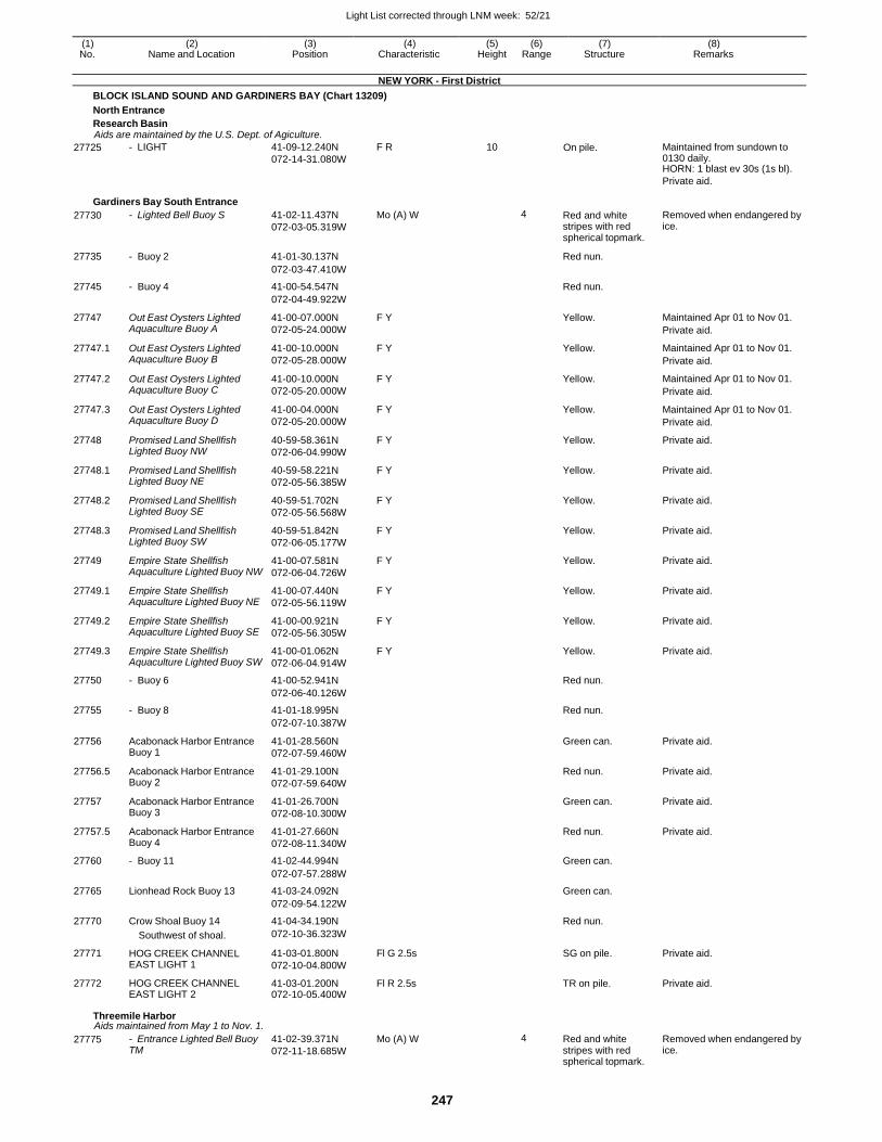
Light List corrected through LNM week: 52/21
247
(1) (2) (3) (4) (5) (6) (7) (8) No. Name and Location Position Characteristic Height Range Structure Remarks
NEW YORK - First District
BLOCK ISLAND SOUND AND GARDINERS BAY (Chart 13209)
North Entrance
Research Basin Aids are maintained by the U.S. Dept. of Agiculture.
27725 - LIGHT 41-09-12.240N
072-14-31.080W
F R 10 On pile. Maintained from sundown to 0130 daily. HORN: 1 blast ev 30s (1s bl).
Private aid.
Gardiners Bay South Entrance
27730 - Lighted Bell Buoy S 41-02-11.437N
072-03-05.319W
Mo (A) W 4 Red and white stripes with red spherical topmark.
Removed when endangered by ice.
27735 - Buoy 2 41-01-30.137N Red nun.
072-03-47.410W
27745 - Buoy 4 41-00-54.547N Red nun.
072-04-49.922W
27747 Out East Oysters Lighted Aquaculture Buoy A
41-00-07.000N
072-05-24.000W
F Y Yellow. Maintained Apr 01 to Nov 01.
Private aid.
27747.1 Out East Oysters Lighted Aquaculture Buoy B
41-00-10.000N
072-05-28.000W
F Y Yellow. Maintained Apr 01 to Nov 01.
Private aid.
27747.2 Out East Oysters Lighted Aquaculture Buoy C
41-00-10.000N
072-05-20.000W
F Y Yellow. Maintained Apr 01 to Nov 01.
Private aid.
27747.3 Out East Oysters Lighted Aquaculture Buoy D
41-00-04.000N
072-05-20.000W
F Y Yellow. Maintained Apr 01 to Nov 01.
Private aid.
27748 Promised Land Shellfish Lighted Buoy NW
40-59-58.361N
072-06-04.990W
F Y Yellow. Private aid.
27748.1 Promised Land Shellfish Lighted Buoy NE
40-59-58.221N
072-05-56.385W
F Y Yellow. Private aid.
27748.2 Promised Land Shellfish Lighted Buoy SE
40-59-51.702N
072-05-56.568W
F Y Yellow. Private aid.
27748.3 Promised Land Shellfish Lighted Buoy SW
40-59-51.842N
072-06-05.177W
F Y Yellow. Private aid.
27749 Empire State Shellfish Aquaculture Lighted Buoy NW
41-00-07.581N
072-06-04.726W
F Y Yellow. Private aid.
27749.1 Empire State Shellfish Aquaculture Lighted Buoy NE
41-00-07.440N
072-05-56.119W
F Y Yellow. Private aid.
27749.2 Empire State Shellfish Aquaculture Lighted Buoy SE
41-00-00.921N
072-05-56.305W
F Y Yellow. Private aid.
27749.3 Empire State Shellfish Aquaculture Lighted Buoy SW
41-00-01.062N
072-06-04.914W
F Y Yellow. Private aid.
27750 - Buoy 6 41-00-52.941N Red nun.
072-06-40.126W
27755 - Buoy 8 41-01-18.995N Red nun.
072-07-10.387W
27756 Acabonack Harbor Entrance Buoy 1
41-01-28.560N
072-07-59.460W
Green can. Private aid.
27756.5 Acabonack Harbor Entrance Buoy 2
41-01-29.100N
072-07-59.640W
Red nun. Private aid.
27757 Acabonack Harbor Entrance Buoy 3
41-01-26.700N
072-08-10.300W
Green can. Private aid.
27757.5 Acabonack Harbor Entrance Buoy 4
41-01-27.660N
072-08-11.340W
Red nun. Private aid.
27760 - Buoy 11 41-02-44.994N Green can.
072-07-57.288W
27765 Lionhead Rock Buoy 13 41-03-24.092N Green can.
072-09-54.122W
27770 Crow Shoal Buoy 14 41-04-34.190N Red nun.
Southwest of shoal. 072-10-36.323W
27771 HOG CREEK CHANNEL EAST LIGHT 1
41-03-01.800N
072-10-04.800W
Fl G 2.5s SG on pile. Private aid.
27772 HOG CREEK CHANNEL EAST LIGHT 2
41-03-01.200N 072-10-05.400W
Fl R 2.5s TR on pile. Private aid.
Threemile Harbor Aids maintained from May 1 to Nov. 1.
27775 - Entrance Lighted Bell Buoy TM
41-02-39.371N
072-11-18.685W
Mo (A) W 4 Red and white stripes with red spherical topmark.
Removed when endangered by ice.
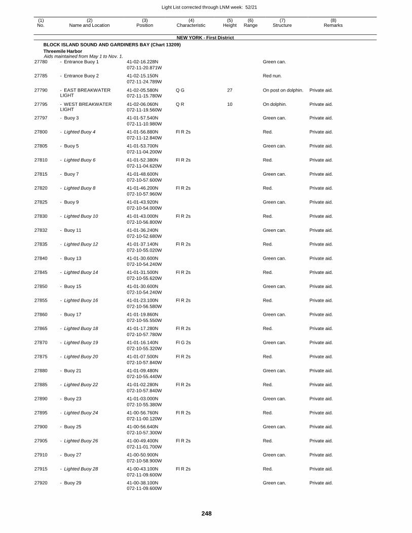
Light List corrected through LNM week: 52/21
248
(1) (2) (3) (4) (5) (6) (7) (8) No. Name and Location Position Characteristic Height Range Structure Remarks
NEW YORK - First District
BLOCK ISLAND SOUND AND GARDINERS BAY (Chart 13209)
Threemile Harbor Aids maintained from May 1 to Nov. 1.
27780 - Entrance Buoy 1 41-02-16.228N Green can.
072-11-20.871W
27785 - Entrance Buoy 2 41-02-15.150N Red nun.
072-11-24.789W
27790 - EAST BREAKWATER LIGHT
41-02-05.580N
072-11-15.780W
Q G 27 On post on dolphin. Private aid.
27795 - WEST BREAKWATER LIGHT
41-02-06.060N
072-11-19.560W
Q R 10 On dolphin. Private aid.
27797 - Buoy 3 41-01-57.540N Green can. Private aid.
072-11-10.980W
27800 - Lighted Buoy 4 41-01-56.880N Fl R 2s Red. Private aid.
072-11-12.840W
27805 - Buoy 5 41-01-53.700N Green can. Private aid.
072-11-04.200W
27810 - Lighted Buoy 6 41-01-52.380N Fl R 2s Red. Private aid.
072-11-04.620W
27815 - Buoy 7 41-01-48.600N Green can. Private aid.
072-10-57.600W
27820 - Lighted Buoy 8 41-01-46.200N Fl R 2s Red. Private aid.
072-10-57.960W
27825 - Buoy 9 41-01-43.920N Green can. Private aid.
072-10-54.000W
27830 - Lighted Buoy 10 41-01-43.000N Fl R 2s Red. Private aid.
072-10-56.800W
27832 - Buoy 11 41-01-36.240N Green can. Private aid.
072-10-52.680W
27835 - Lighted Buoy 12 41-01-37.140N Fl R 2s Red. Private aid.
072-10-55.020W
27840 - Buoy 13 41-01-30.600N Green can. Private aid.
072-10-54.240W
27845 - Lighted Buoy 14 41-01-31.500N Fl R 2s Red. Private aid.
072-10-55.620W
27850 - Buoy 15 41-01-30.600N Green can. Private aid.
072-10-54.240W
27855 - Lighted Buoy 16 41-01-23.100N Fl R 2s Red. Private aid.
072-10-56.580W
27860 - Buoy 17 41-01-19.860N Green can. Private aid.
072-10-55.550W
27865 - Lighted Buoy 18 41-01-17.280N Fl R 2s Red. Private aid.
072-10-57.780W
27870 - Lighted Buoy 19 41-01-16.140N Fl G 2s Green can. Private aid.
072-10-55.320W
27875 - Lighted Buoy 20 41-01-07.500N Fl R 2s Red. Private aid.
072-10-57.840W
27880 - Buoy 21 41-01-09.480N Green can. Private aid.
072-10-55.440W
27885 - Lighted Buoy 22 41-01-02.280N Fl R 2s Red. Private aid.
072-10-57.840W
27890 - Buoy 23 41-01-03.000N Green can. Private aid.
072-10-55.380W
27895 - Lighted Buoy 24 41-00-56.760N Fl R 2s Red. Private aid.
072-11-00.120W
27900 - Buoy 25 41-00-56.640N Green can. Private aid.
072-10-57.300W
27905 - Lighted Buoy 26 41-00-49.400N Fl R 2s Red. Private aid.
072-11-01.700W
27910 - Buoy 27 41-00-50.900N Green can. Private aid.
072-10-58.900W
27915 - Lighted Buoy 28 41-00-43.100N Fl R 2s Red. Private aid.
072-11-09.600W
27920 - Buoy 29 41-00-38.100N Green can. Private aid. 072-11-09.600W
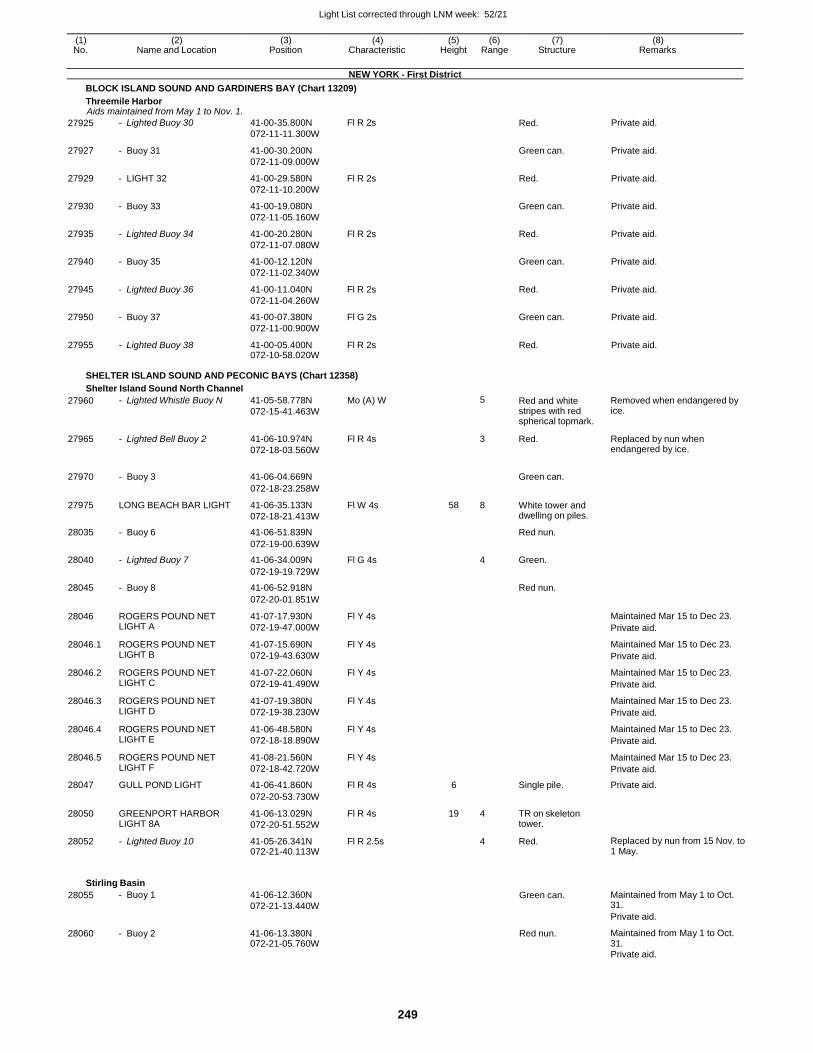
Light List corrected through LNM week: 52/21
249
(1) (2) (3) (4) (5) (6) (7) (8) No. Name and Location Position Characteristic Height Range Structure Remarks
NEW YORK - First District
BLOCK ISLAND SOUND AND GARDINERS BAY (Chart 13209)
Threemile Harbor Aids maintained from May 1 to Nov. 1.
27925 - Lighted Buoy 30 41-00-35.800N
072-11-11.300W
Fl R 2s Red. Private aid.
27927 - Buoy 31 41-00-30.200N
072-11-09.000W
Green can. Private aid.
27929 - LIGHT 32 41-00-29.580N
072-11-10.200W
Fl R 2s Red. Private aid.
27930 - Buoy 33 41-00-19.080N
072-11-05.160W
Green can. Private aid.
27935 - Lighted Buoy 34 41-00-20.280N
072-11-07.080W
Fl R 2s Red. Private aid.
27940 - Buoy 35 41-00-12.120N
072-11-02.340W
Green can. Private aid.
27945 - Lighted Buoy 36 41-00-11.040N
072-11-04.260W
Fl R 2s Red. Private aid.
27950 - Buoy 37 41-00-07.380N
072-11-00.900W
Fl G 2s Green can. Private aid.
27955 - Lighted Buoy 38 41-00-05.400N 072-10-58.020W
Fl R 2s Red. Private aid.
SHELTER ISLAND SOUND AND PECONIC BAYS (Chart 12358)
Shelter Island Sound North Channel
27960 - Lighted Whistle Buoy N 41-05-58.778N
072-15-41.463W
Mo (A) W 5 Red and white stripes with red spherical topmark.
Removed when endangered by ice.
27965 - Lighted Bell Buoy 2 41-06-10.974N
072-18-03.560W
Fl R 4s 3 Red. Replaced by nun when endangered by ice.
27970 - Buoy 3 41-06-04.669N
Green can.
072-18-23.258W
27975 LONG BEACH BAR LIGHT 41-06-35.133N
072-18-21.413W
Fl W 4s 58 8 White tower and dwelling on piles.
28035 - Buoy 6 41-06-51.839N Red nun.
072-19-00.639W
28040 - Lighted Buoy 7 41-06-34.009N Fl G 4s 4 Green.
072-19-19.729W
28045 - Buoy 8 41-06-52.918N Red nun.
072-20-01.851W
28046 ROGERS POUND NET LIGHT A
41-07-17.930N
072-19-47.000W
Fl Y 4s Maintained Mar 15 to Dec 23.
Private aid.
28046.1 ROGERS POUND NET LIGHT B
41-07-15.690N
072-19-43.630W
Fl Y 4s Maintained Mar 15 to Dec 23.
Private aid.
28046.2 ROGERS POUND NET LIGHT C
41-07-22.060N
072-19-41.490W
Fl Y 4s Maintained Mar 15 to Dec 23.
Private aid.
28046.3 ROGERS POUND NET LIGHT D
41-07-19.380N
072-19-38.230W
Fl Y 4s Maintained Mar 15 to Dec 23.
Private aid.
28046.4 ROGERS POUND NET LIGHT E
41-06-48.580N
072-18-18.890W
Fl Y 4s Maintained Mar 15 to Dec 23.
Private aid.
28046.5 ROGERS POUND NET LIGHT F
41-08-21.560N
072-18-42.720W
Fl Y 4s Maintained Mar 15 to Dec 23.
Private aid.
28047 GULL POND LIGHT 41-06-41.860N Fl R 4s 6 Single pile. Private aid.
072-20-53.730W
28050 GREENPORT HARBOR LIGHT 8A
41-06-13.029N
072-20-51.552W
Fl R 4s 19 4 TR on skeleton tower.
28052 - Lighted Buoy 10 41-05-26.341N 072-21-40.113W
Fl R 2.5s 4 Red. Replaced by nun from 15 Nov. to 1 May.
Stirling Basin
28055 - Buoy 1 41-06-12.360N
072-21-13.440W Green can. Maintained from May 1 to Oct.
31.
Private aid.
28060 - Buoy 2 41-06-13.380N 072-21-05.760W
Red nun. Maintained from May 1 to Oct. 31.
Private aid.
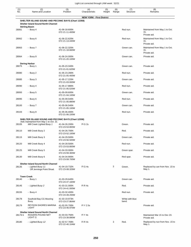
Light List corrected through LNM week: 52/21
250
(1) (2) (3) (4) (5) (6) (7) (8) No. Name and Location Position Characteristic Height Range Structure Remarks
NEW YORK - First District
SHELTER ISLAND SOUND AND PECONIC BAYS (Chart 12358)
Shelter Island Sound North Channel
Stirling Basin
28061 - Buoy 4 41-06-18.600N
072-21-11.400W Red nun. Maintained from May 1 to Oct.
31.
Private aid.
28062 - Buoy 6 41-06-22.620N 072-21-13.440W
Red nun. Maintained from May 1 to Oct. 31.
Private aid.
28063 - Buoy 7 41-06-22.320N 072-21-18.660W
Green can. Maintained from May 1 to Oct. 31.
Private aid.
28064 - Buoy 9 41-06-24.000N Green can. Private aid. 072-21-20.100W
Dering Harbor 28075 - Buoy 1 41-05-23.340N Green can. Private aid.
072-21-01.620W
28080 - Buoy 2 41-05-23.280N Red nun. Private aid.
072-21-05.400W
28085 - Buoy 3 41-05-17.220N Green can. Private aid.
072-21-03.000W
28090 - Buoy 4 41-05-17.880N Red nun. Private aid.
072-21-05.520W
28093 - Buoy 5 41-05-09.600N Green can. Private aid.
072-21-04.100W
28095 - Buoy 6 41-05-09.540N Red nun. Private aid.
072-21-05.880W
28100 - Buoy 7 41-05-06.540N Green can. Private aid.
072-21-05.100W
28103 - Buoy 8 41-05-06.400N Red nun. Private aid. 072-21-06.100W
SHELTER ISLAND SOUND AND PECONIC BAYS (Chart 12358) Aids maintained from May 1 to Oct. 31.
28105 Mill Creek Lighted Buoy 1 41-04-26.200N Fl G 2s Green. Private aid.
072-23-53.800W
28110 Mill Creek Buoy 2 41-04-26.700N Red. Private aid.
072-23-52.100W
28115 Mill Creek Buoy 3 41-04-29.500N Green can. Private aid.
072-23-56.500W
28120 Mill Creek Buoy 4 41-04-28.500N Red nun. Private aid.
072-23-53.800W
28125 Mill Creek Buoy 5 41-04-33.000N Green spar. Private aid.
072-23-59.300W
28130 Mill Creek Buoy 6 41-04-34.900N Red spar. Private aid. 072-23-59.700W
Shelter Island Sound North Channel
28135 - Lighted Buoy 11
Off Jennings Point Shoal.
41-04-19.732N
072-23-08.326W
Fl G 4s 3 Green. Replaced by can from Nov. 15 to May 1.
Town Creek
28140 - Buoy 1 41-03-29.640N Green can. Private aid.
072-24-47.160W
28145 - Lighted Buoy 2 41-03-31.000N Fl R 4s Red. Private aid.
072-24-41.000W
28155 - Buoy 4 41-03-32.400N Red nun. Private aid.
072-24-49.200W
28178 Southold Bay CG Mooring Buoy
41-03-19.973N
072-23-27.864W
White with blue band.
28179 REYDON SHORES MARINA LIGHT
41-02-55.700N 072-23-46.970W
Fl Y 2.5s Private aid.
Shelter Island Sound North Channel
28179.5 ROGERS POUND NET LIGHT G
41-03-03.750N
072-23-39.890W
Fl Y 4s Maintained Mar 15 to Dec 23.
Private aid.
28180 - Lighted Buoy 12 41-02-57.769N 072-22-40.104W
Fl R 4s 3 Red. Replaced by nun from Nov. 15 to May 1.
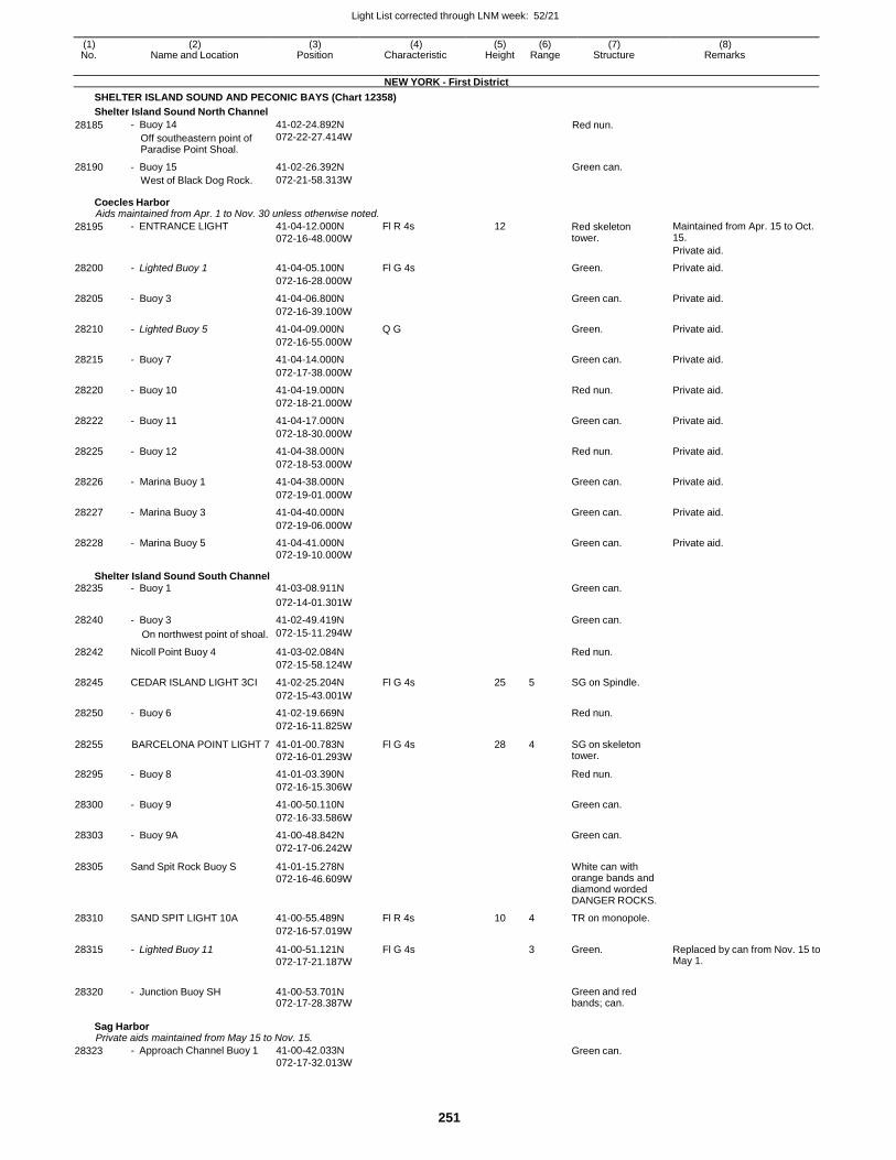
Light List corrected through LNM week: 52/21
251
(1) (2) (3) (4) (5) (6) (7) (8) No. Name and Location Position Characteristic Height Range Structure Remarks
NEW YORK - First District
SHELTER ISLAND SOUND AND PECONIC BAYS (Chart 12358)
Shelter Island Sound North Channel
28185 - Buoy 14
Off southeastern point of Paradise Point Shoal.
41-02-24.892N
072-22-27.414W Red nun.
28190 - Buoy 15 41-02-26.392N Green can. West of Black Dog Rock. 072-21-58.313W
Coecles Harbor Aids maintained from Apr. 1 to Nov. 30 unless otherwise noted.
28195 - ENTRANCE LIGHT 41-04-12.000N
072-16-48.000W
Fl R 4s 12 Red skeleton tower.
Maintained from Apr. 15 to Oct. 15.
Private aid.
28200 - Lighted Buoy 1 41-04-05.100N Fl G 4s Green. Private aid.
072-16-28.000W
28205 - Buoy 3 41-04-06.800N Green can. Private aid.
072-16-39.100W
28210 - Lighted Buoy 5 41-04-09.000N Q G Green. Private aid.
072-16-55.000W
28215 - Buoy 7 41-04-14.000N Green can. Private aid.
072-17-38.000W
28220 - Buoy 10 41-04-19.000N Red nun. Private aid.
072-18-21.000W
28222 - Buoy 11 41-04-17.000N Green can. Private aid.
072-18-30.000W
28225 - Buoy 12 41-04-38.000N Red nun. Private aid.
072-18-53.000W
28226 - Marina Buoy 1 41-04-38.000N Green can. Private aid.
072-19-01.000W
28227 - Marina Buoy 3 41-04-40.000N Green can. Private aid.
072-19-06.000W
28228 - Marina Buoy 5 41-04-41.000N Green can. Private aid. 072-19-10.000W
Shelter Island Sound South Channel 28235 - Buoy 1 41-03-08.911N Green can.
072-14-01.301W
28240 - Buoy 3 41-02-49.419N Green can.
On northwest point of shoal. 072-15-11.294W
28242 Nicoll Point Buoy 4 41-03-02.084N Red nun.
072-15-58.124W
28245 CEDAR ISLAND LIGHT 3CI 41-02-25.204N Fl G 4s 25 5 SG on Spindle.
072-15-43.001W
28250 - Buoy 6 41-02-19.669N Red nun.
072-16-11.825W
28255 BARCELONA POINT LIGHT 7 41-01-00.783N
072-16-01.293W
Fl G 4s 28 4 SG on skeleton tower.
28295 - Buoy 8 41-01-03.390N Red nun.
072-16-15.306W
28300 - Buoy 9 41-00-50.110N Green can.
072-16-33.586W
28303 - Buoy 9A 41-00-48.842N Green can.
072-17-06.242W
28305 Sand Spit Rock Buoy S 41-01-15.278N
072-16-46.609W
White can with orange bands and diamond worded DANGER ROCKS.
28310 SAND SPIT LIGHT 10A 41-00-55.489N Fl R 4s 10 4 TR on monopole.
072-16-57.019W
28315 - Lighted Buoy 11 41-00-51.121N
072-17-21.187W
Fl G 4s 3 Green. Replaced by can from Nov. 15 to May 1.
28320 - Junction Buoy SH 41-00-53.701N 072-17-28.387W
Green and red bands; can.
Sag Harbor Private aids maintained from May 15 to Nov. 15.
28323 - Approach Channel Buoy 1 41-00-42.033N
072-17-32.013W Green can.
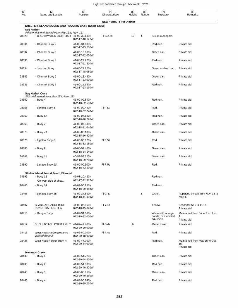
Light List corrected through LNM week: 52/21
252
(1) (2) (3) (4) (5) (6) (7) (8) No. Name and Location Position Characteristic Height Range Structure Remarks
NEW YORK - First District
SHELTER ISLAND SOUND AND PECONIC BAYS (Chart 12358)
Sag Harbor Private aids maintained from May 15 to Nov. 15.
28325 - BREAKWATER LIGHT 3SH 41-00-32.140N
072-17-40.177W
Fl G 2.5s 12 4 SG on monopole.
28331 - Channel Buoy 2 41-00-34.680N
072-17-43.200W
Red nun. Private aid.
28332 - Channel Buoy 3 41-00-18.000N
072-17-42.000W
Green can. Private aid.
28333 - Channel Buoy 4 41-00-22.920N
072-17-51.300W
Red nun. Private aid.
28334 - Junction Buoy 41-00-21.120N
072-17-48.060W
Green and red can. Private aid.
28335 - Channel Buoy 5 41-00-12.480N
072-17-33.000W
Green can. Private aid.
28336 - Channel Buoy 6 41-00-16.980N 072-17-53.160W
Red nun. Private aid.
Sag Harbor Cove Aids maintained from May 15 to Nov. 15.
28350 - Buoy 4 41-00-09.840N Red nun. Private aid.
072-18-02.580W
28355 - Lighted Buoy 6 41-00-09.420N Fl R 5s Red. Private aid.
072-18-07.740W
28360 - Buoy 6A 41-00-07.620N Red nun. Private aid.
072-18-18.720W
28365 - Buoy 7 41-00-07.380N Green can. Private aid.
072-18-11.040W
28370 - Buoy 7A 41-00-06.180N Green can. Private aid.
072-18-16.920W
28375 - Lighted Buoy 8 41-00-05.820N Fl R 5s Red. Private aid.
072-18-33.180W
28380 - Buoy 9 41-00-02.460N Green can. Private aid.
072-18-34.140W
28385 - Buoy 11 40-59-59.220N Green can. Private aid.
072-18-39.780W
28390 - Lighted Buoy 12 41-00-00.900N Fl R 5s Red. Private aid. 072-18-43.200W
Shelter Island Sound South Channel 28395 - Buoy 12 41-01-10.421N Red nun.
On west side of shoal. 072-17-32.517W
28400 - Buoy 14 41-02-00.950N Red nun.
072-18-00.688W
28405 - Lighted Buoy 15 41-02-34.890N
072-18-41.309W
Fl G 4s 3 Green. Replaced by can from Nov. 15 to May 1.
28407 CLARK AQUACULTURE POND TRAP LIGHT A
41-03-06.950N
072-18-45.020W
Fl Y 4s
Yellow. Seasonal 4/15 to 11/15.
Private aid.
28410 - Danger Buoy 41-02-34.000N
072-19-32.000W
White with orange bands; can worded DANGER.
Maintained from June 1 to Nov. 1.
Private aid.
28412 SHELL BEACH POINT LIGHT 41-02-49.400N Fl G 4s 6 Medal tower. Private aid.
072-20-20.000W
28415 West Neck Harbor Entrance Lighted Buoy 2
41-02-50.000N
072-20-18.000W
Fl R 4s Red. Private aid.
28425 West Neck Harbor Buoy 4 41-02-47.000N 072-20-34.000W
Red nun. Maintained from May 15 to Oct. 15.
Private aid.
Menantic Creek
28430 - Buoy 1 41-02-54.720N Green can. Private aid.
072-20-44.400W
28435 - Buoy 2 41-02-54.300N Red nun. Private aid.
072-20-40.920W
28440 - Buoy 3 41-03-06.660N Green can. Private aid.
072-20-40.860W
28445 - Buoy 4 41-03-06.240N Red nun. Private aid. 072-20-39.720W
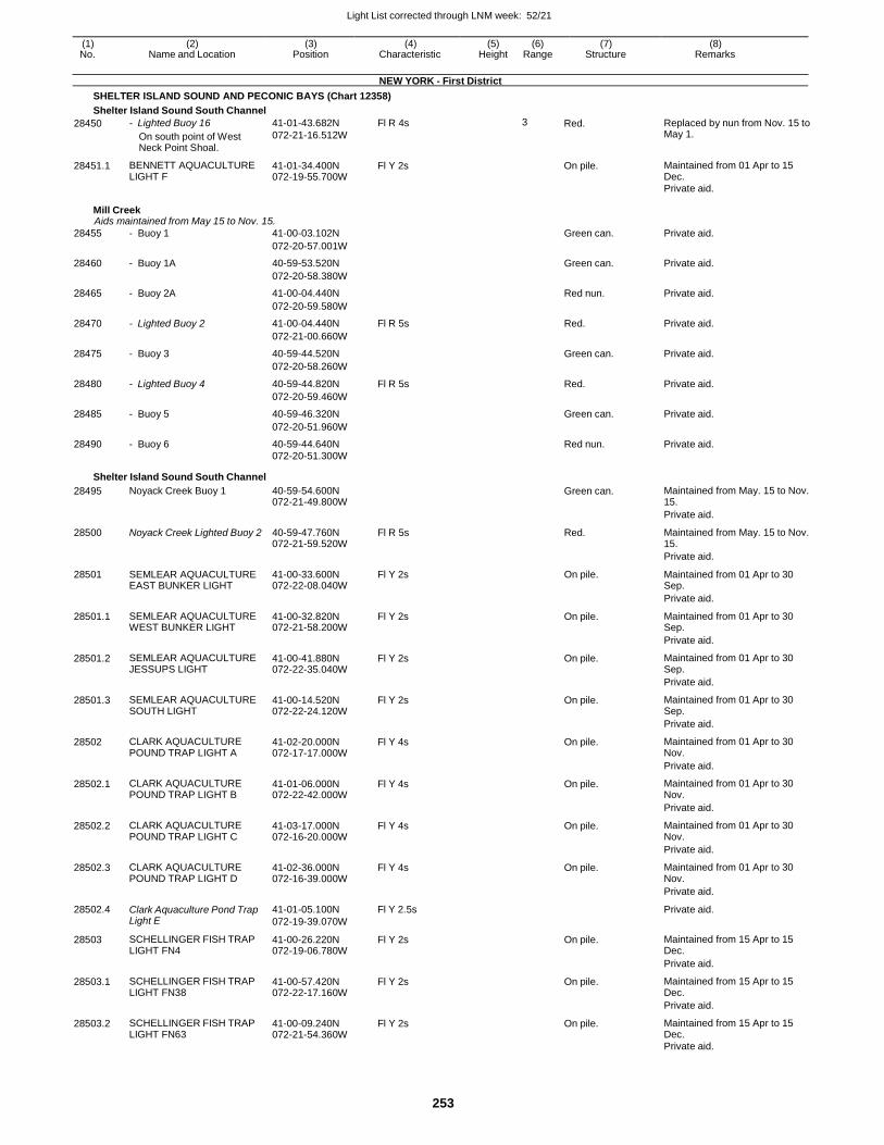
Light List corrected through LNM week: 52/21
253
(1) (2) (3) (4) (5) (6) (7) (8) No. Name and Location Position Characteristic Height Range Structure Remarks
NEW YORK - First District
SHELTER ISLAND SOUND AND PECONIC BAYS (Chart 12358)
Shelter Island Sound South Channel
28450 - Lighted Buoy 16
On south point of West Neck Point Shoal.
41-01-43.682N
072-21-16.512W
Fl R 4s 3 Red. Replaced by nun from Nov. 15 to May 1.
28451.1 BENNETT AQUACULTURE LIGHT F
41-01-34.400N 072-19-55.700W
Fl Y 2s On pile. Maintained from 01 Apr to 15 Dec.
Private aid.
Mill Creek Aids maintained from May 15 to Nov. 15.
28455 - Buoy 1 41-00-03.102N Green can. Private aid.
072-20-57.001W
28460 - Buoy 1A 40-59-53.520N Green can. Private aid.
072-20-58.380W
28465 - Buoy 2A 41-00-04.440N Red nun. Private aid.
072-20-59.580W
28470 - Lighted Buoy 2 41-00-04.440N Fl R 5s Red. Private aid.
072-21-00.660W
28475 - Buoy 3 40-59-44.520N Green can. Private aid.
072-20-58.260W
28480 - Lighted Buoy 4 40-59-44.820N Fl R 5s Red. Private aid.
072-20-59.460W
28485 - Buoy 5 40-59-46.320N Green can. Private aid.
072-20-51.960W
28490 - Buoy 6 40-59-44.640N Red nun. Private aid. 072-20-51.300W
Shelter Island Sound South Channel
28495 Noyack Creek Buoy 1 40-59-54.600N 072-21-49.800W
Green can. Maintained from May. 15 to Nov. 15.
Private aid.
28500 Noyack Creek Lighted Buoy 2 40-59-47.760N 072-21-59.520W
Fl R 5s Red. Maintained from May. 15 to Nov. 15.
Private aid.
28501 SEMLEAR AQUACULTURE EAST BUNKER LIGHT
41-00-33.600N 072-22-08.040W
Fl Y 2s On pile. Maintained from 01 Apr to 30 Sep.
Private aid.
28501.1 SEMLEAR AQUACULTURE WEST BUNKER LIGHT
41-00-32.820N 072-21-58.200W
Fl Y 2s On pile. Maintained from 01 Apr to 30 Sep.
Private aid.
28501.2 SEMLEAR AQUACULTURE JESSUPS LIGHT
41-00-41.880N 072-22-35.040W
Fl Y 2s On pile. Maintained from 01 Apr to 30 Sep.
Private aid.
28501.3 SEMLEAR AQUACULTURE SOUTH LIGHT
41-00-14.520N 072-22-24.120W
Fl Y 2s On pile. Maintained from 01 Apr to 30 Sep.
Private aid.
28502 CLARK AQUACULTURE POUND TRAP LIGHT A
41-02-20.000N 072-17-17.000W
Fl Y 4s On pile. Maintained from 01 Apr to 30 Nov.
Private aid.
28502.1 CLARK AQUACULTURE POUND TRAP LIGHT B
41-01-06.000N 072-22-42.000W
Fl Y 4s On pile. Maintained from 01 Apr to 30 Nov.
Private aid.
28502.2 CLARK AQUACULTURE POUND TRAP LIGHT C
41-03-17.000N 072-16-20.000W
Fl Y 4s On pile. Maintained from 01 Apr to 30 Nov.
Private aid.
28502.3 CLARK AQUACULTURE POUND TRAP LIGHT D
41-02-36.000N 072-16-39.000W
Fl Y 4s On pile. Maintained from 01 Apr to 30 Nov.
Private aid.
28502.4 Clark Aquaculture Pond Trap Light E
41-01-05.100N
072-19-39.070W
Fl Y 2.5s Private aid.
28503 SCHELLINGER FISH TRAP LIGHT FN4
41-00-26.220N 072-19-06.780W
Fl Y 2s On pile. Maintained from 15 Apr to 15 Dec.
Private aid.
28503.1 SCHELLINGER FISH TRAP LIGHT FN38
41-00-57.420N 072-22-17.160W
Fl Y 2s On pile. Maintained from 15 Apr to 15 Dec.
Private aid.
28503.2 SCHELLINGER FISH TRAP LIGHT FN63
41-00-09.240N 072-21-54.360W
Fl Y 2s On pile. Maintained from 15 Apr to 15 Dec.
Private aid.
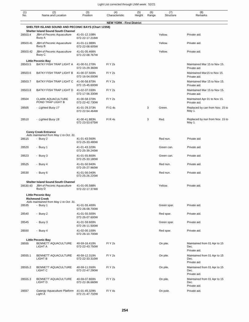
Light List corrected through LNM week: 52/21
254
(1) (2) (3) (4) (5) (6) (7) (8) No. Name and Location Position Characteristic Height Range Structure Remarks
NEW YORK - First District
SHELTER ISLAND SOUND AND PECONIC BAYS (Chart 12358)
Shelter Island Sound South Channel
28503.4
28503.41
28503.42
JBH of Peconic Aquaculture Buoy A
JBH of Peconic Aquaculture Buoy B
JBH of Peconic Aquaculture Buoy C
41-01-12.108N
072-22-17.216W
41-01-11.989N
072-22-08.605W
41-01-05.466N
072-22-08.767W
Yellow.
Yellow.
Yellow.
Private aid.
Private aid.
Private aid.
Little Peconic Bay
28503.5 BATKY FISH TRAP LIGHT A 41-00-51.270N Fl Y 2s Maintained Mar 15 to Nov 15.
072-15-29.360W Private aid.
28503.6 BATKY FISH TRAP LIGHT B 41-00-37.500N Fl Y 2s Maintained Mar15 to Nov 15.
072-16-04.000W Private aid.
28503.7 BATKY FISH TRAP LIGHT C 41-00-58.870N Fl Y 2s Maintained Mar 15 to Nov 15.
072-15-45.600W Private aid.
28503.8 BATKY FISH TRAP LIGHT D 41-02-37.030N Fl Y 2s Maintained Mar 15 to Nov 15.
072-17-56.330W Private aid.
28504 CLARK AQUACULTURE POND TRAP LIGHT B
41-00-58.370N
072-22-42.730W
Fl Y 2s Maintained Apr 01 to Nov 15.
Private aid.
28505 - Lighted Buoy 17 41-01-29.373N
072-22-54.464W
Fl G 4s 3 Green. Replaced by can from Nov. 15 to May 1.
28510 - Lighted Buoy 18 41-00-41.883N 072-23-53.675W
Fl R 4s 3 Red. Replaced by nun from Nov. 15 to May 1.
Corey Creek Entrance Aids maintained from May 1 to Oct. 31.
28515 - Buoy 2 41-01-43.560N
072-25-33.480W
Red nun. Private aid.
28520 - Buoy 1 41-01-43.320N
072-25-39.240W
Green can. Private aid.
28523 - Buoy 3 41-01-55.800N
072-25-33.180W
Green can. Private aid.
28525 - Buoy 4 41-01-50.940N
072-25-27.960W
Red nun. Private aid.
28530 - Buoy 6 41-01-56.040N 072-25-26.220W
Red nun. Private aid.
Shelter Island Sound South Channel
28530.43 JBH of Peconic Aquaculture Buoy D
41-01-05.588N
072-22-17.374W
Yellow. Private aid.
Little Peconic Bay
Richmond Creek Aids maintained from May 1 to Oct. 31.
28535 - Buoy 1 41-01-55.400N Green spar. Private aid.
072-26-08.700W
28540 - Buoy 2 41-01-55.500N Red spar. Private aid.
072-26-07.600W
28545 - Buoy 3 41-01-59.600N Green spar. Private aid.
072-26-11.500W
28550 - Buoy 4 41-02-00.100N Red spar. Private aid. 072-26-10.700W
Little Peconic Bay
28555 BENNETT AQUACULTURE LIGHT A
40-59-16.410N 072-22-43.750W
Fl Y 2s On pile. Maintained from 01 Apr to 15 Dec.
Private aid.
28555.1 BENNETT AQUACULTURE LIGHT B
40-59-12.310N 072-22-33.310W
Fl Y 2s On pile. Maintained from 01 Apr to 15 Dec.
Private aid.
28555.2 BENNETT AQUACULTURE LIGHT C
40-59-11.550N 072-22-47.290W
Fl Y 2s On pile. Maintained from 01 Apr to 15 Dec.
Private aid.
28555.3 BENNETT AQUACULTURE LIGHT D
40-59-07.800N 072-22-36.660W
Fl Y 2s On pile. Maintained from 01 Apr to 15 Dec.
Private aid.
28557 Gaiergy Aquaculture Platform Light A
41-01-45.329N 072-21-47.732W
Fl Y 4s On pole. Private aid.
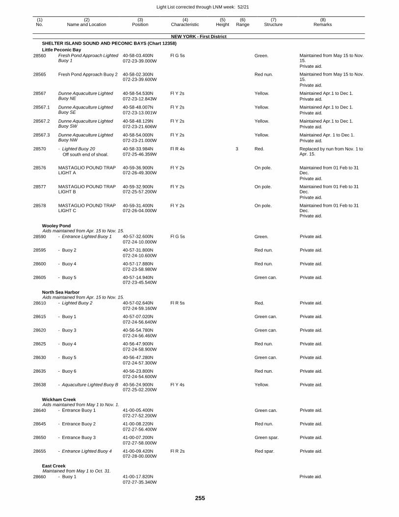
Light List corrected through LNM week: 52/21
255
(1) (2) (3) (4) (5) (6) (7) (8) No. Name and Location Position Characteristic Height Range Structure Remarks
NEW YORK - First District
SHELTER ISLAND SOUND AND PECONIC BAYS (Chart 12358)
Little Peconic Bay
28560 Fresh Pond Approach Lighted Buoy 1
40-58-03.400N
072-23-39.000W
Fl G 5s Green. Maintained from May 15 to Nov. 15.
Private aid.
28565 Fresh Pond Approach Buoy 2 40-58-02.300N 072-23-39.600W
Red nun. Maintained from May 15 to Nov. 15.
Private aid.
28567 Dunne Aquaculture Lighted Buoy NE
40-58-54.530N
072-23-12.843W
Fl Y 2s Yellow. Maintained Apr.1 to Dec 1.
Private aid.
28567.1 Dunne Aquaculture Lighted Buoy SE
40-58-48.007N
072-23-13.001W
Fl Y 2s Yellow. Maintained Apr.1 to Dec 1.
Private aid.
28567.2 Dunne Aquaculture Lighted Buoy SW
40-58-48.129N
072-23-21.606W
Fl Y 2s Yellow. Maintained Apr.1 to Dec 1.
Private aid.
28567.3 Dunne Aquaculture Lighted Buoy NW
40-58-54.000N
072-23-21.000W
Fl Y 2s Yellow. Maintained Apr. 1 to Dec 1.
Private aid.
28570 - Lighted Buoy 20
Off south end of shoal.
40-58-33.984N
072-25-46.359W
Fl R 4s 3 Red. Replaced by nun from Nov. 1 to Apr. 15.
28576
MASTAGLIO POUND TRAP LIGHT A
40-59-36.900N 072-26-49.300W
Fl Y 2s
On pole.
Maintained from 01 Feb to 31 Dec.
Private aid.
28577 MASTAGLIO POUND TRAP LIGHT B
40-59-32.900N 072-25-57.200W
Fl Y 2s On pole. Maintained from 01 Feb to 31 Dec.
Private aid.
28578 MASTAGLIO POUND TRAP LIGHT C
40-59-31.400N 072-26-04.000W
Fl Y 2s On pole. Maintained from 01 Feb to 31 Dec.
Private aid.
Wooley Pond Aids maintained from Apr. 15 to Nov. 15.
28590 - Entrance Lighted Buoy 1 40-57-32.600N
072-24-10.000W
Fl G 5s Green. Private aid.
28595 - Buoy 2 40-57-31.800N
072-24-10.600W
Red nun. Private aid.
28600 - Buoy 4 40-57-17.880N
072-23-58.980W
Red nun. Private aid.
28605 - Buoy 5 40-57-14.940N 072-23-45.540W
Green can. Private aid.
North Sea Harbor Aids maintained from Apr. 15 to Nov. 15.
28610 - Lighted Buoy 2 40-57-02.640N
072-24-59.160W
Fl R 5s Red. Private aid.
28615 - Buoy 1 40-57-07.020N
072-24-56.640W
Green can. Private aid.
28620 - Buoy 3 40-56-54.780N
072-24-56.460W
Green can. Private aid.
28625 - Buoy 4 40-56-47.900N
072-24-58.900W
Red nun. Private aid.
28630 - Buoy 5 40-56-47.280N
072-24-57.300W
Green can. Private aid.
28635 - Buoy 6 40-56-23.800N
072-24-54.600W
Red nun. Private aid.
28638 - Aquaculture Lighted Buoy B 40-56-24.900N 072-25-02.200W
Fl Y 4s Yellow. Private aid.
Wickham Creek Aids maintained from May 1 to Nov. 1.
28640 - Entrance Buoy 1 41-00-05.400N
072-27-52.200W
Green can. Private aid.
28645 - Entrance Buoy 2 41-00-08.220N
072-27-56.400W
Red nun. Private aid.
28650 - Entrance Buoy 3 41-00-07.200N
072-27-58.000W
Green spar. Private aid.
28655 - Entrance Lighted Buoy 4 41-00-09.420N 072-28-00.000W
Fl R 2s Red spar. Private aid.
East Creek Maintained from May 1 to Oct. 31.
28660 - Buoy 1 41-00-17.820N
072-27-35.340W
Private aid.
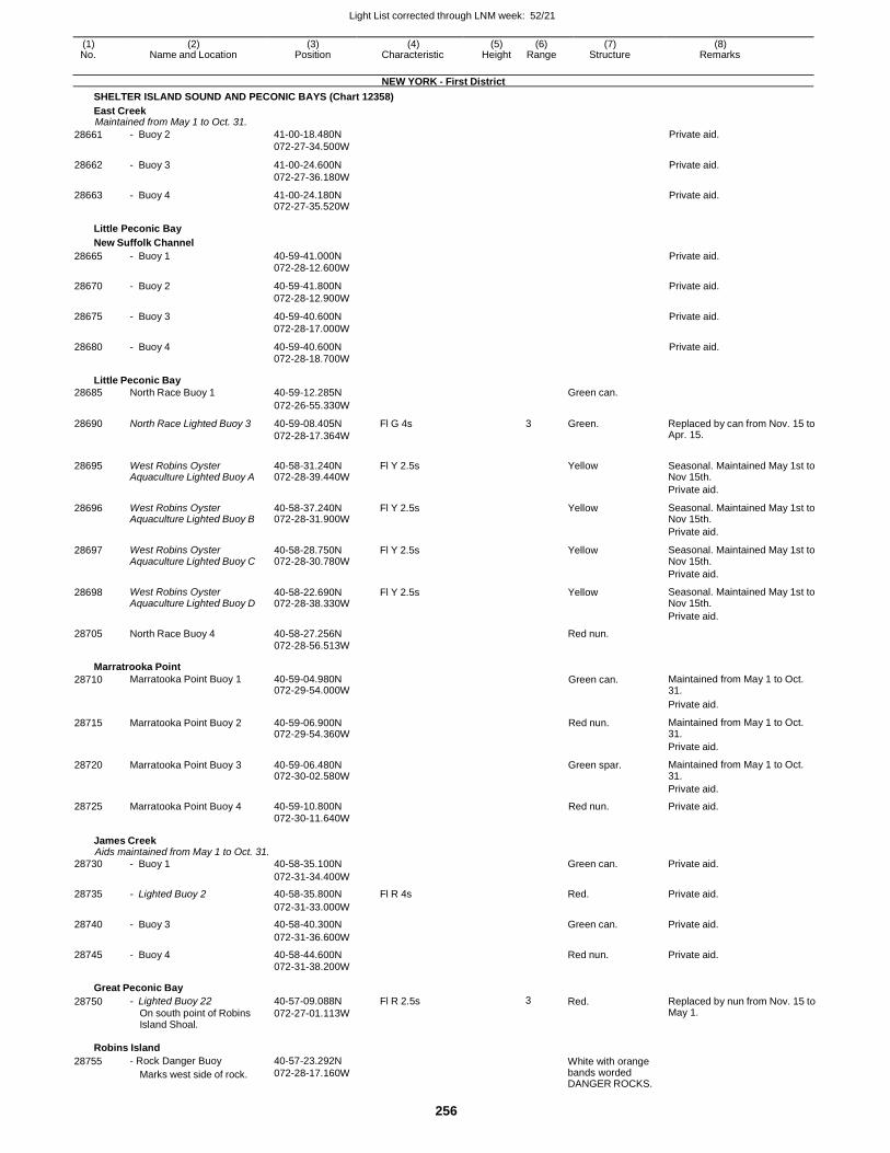
Light List corrected through LNM week: 52/21
256
(1) (2) (3) (4) (5) (6) (7) (8) No. Name and Location Position Characteristic Height Range Structure Remarks
NEW YORK - First District
SHELTER ISLAND SOUND AND PECONIC BAYS (Chart 12358)
East Creek Maintained from May 1 to Oct. 31.
28661 - Buoy 2 41-00-18.480N
072-27-34.500W
Private aid.
28662 - Buoy 3 41-00-24.600N
072-27-36.180W
Private aid.
28663 - Buoy 4 41-00-24.180N 072-27-35.520W
Private aid.
Little Peconic Bay
New Suffolk Channel
28665 - Buoy 1 40-59-41.000N 072-28-12.600W
Private aid.
28670 - Buoy 2 40-59-41.800N
072-28-12.900W
Private aid.
28675 - Buoy 3 40-59-40.600N
072-28-17.000W
Private aid.
28680 - Buoy 4 40-59-40.600N 072-28-18.700W
Private aid.
Little Peconic Bay
28685 North Race Buoy 1 40-59-12.285N Green can.
072-26-55.330W
28690 North Race Lighted Buoy 3 40-59-08.405N
072-28-17.364W
Fl G 4s 3 Green. Replaced by can from Nov. 15 to Apr. 15.
28695 West Robins Oyster Aquaculture Lighted Buoy A
40-58-31.240N 072-28-39.440W
Fl Y 2.5s
Yellow Seasonal. Maintained May 1st to Nov 15th.
Private aid.
28696 West Robins Oyster Aquaculture Lighted Buoy B
40-58-37.240N 072-28-31.900W
Fl Y 2.5s Yellow Seasonal. Maintained May 1st to Nov 15th.
Private aid.
28697 West Robins Oyster Aquaculture Lighted Buoy C
40-58-28.750N 072-28-30.780W
Fl Y 2.5s Yellow Seasonal. Maintained May 1st to Nov 15th.
Private aid.
28698 West Robins Oyster Aquaculture Lighted Buoy D
40-58-22.690N 072-28-38.330W
Fl Y 2.5s Yellow Seasonal. Maintained May 1st to Nov 15th.
Private aid.
28705 North Race Buoy 4 40-58-27.256N Red nun.
072-28-56.513W
Marratrooka Point
28710 Marratooka Point Buoy 1 40-59-04.980N 072-29-54.000W
Green can. Maintained from May 1 to Oct. 31.
Private aid.
28715 Marratooka Point Buoy 2 40-59-06.900N 072-29-54.360W
Red nun. Maintained from May 1 to Oct. 31.
Private aid.
28720 Marratooka Point Buoy 3 40-59-06.480N 072-30-02.580W
Green spar. Maintained from May 1 to Oct. 31.
Private aid.
28725 Marratooka Point Buoy 4 40-59-10.800N Red nun. Private aid. 072-30-11.640W
James Creek Aids maintained from May 1 to Oct. 31.
28730 - Buoy 1 40-58-35.100N Green can. Private aid.
072-31-34.400W
28735 - Lighted Buoy 2 40-58-35.800N Fl R 4s Red. Private aid.
072-31-33.000W
28740 - Buoy 3 40-58-40.300N Green can. Private aid.
072-31-36.600W
28745 - Buoy 4 40-58-44.600N Red nun. Private aid. 072-31-38.200W
Great Peconic Bay
28750 - Lighted Buoy 22
On south point of Robins Island Shoal.
40-57-09.088N
072-27-01.113W
Fl R 2.5s 3 Red. Replaced by nun from Nov. 15 to May 1.
Robins Island
28755 - Rock Danger Buoy
Marks west side of rock.
40-57-23.292N
072-28-17.160W White with orange bands worded DANGER ROCKS.
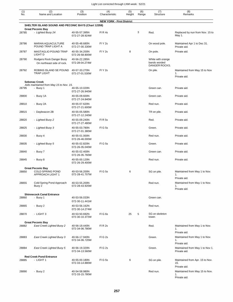
Light List corrected through LNM week: 52/21
257
(1) (2) (3) (4) (5) (6) (7) (8) No. Name and Location Position Characteristic Height Range Structure Remarks
NEW YORK - First District
SHELTER ISLAND SOUND AND PECONIC BAYS (Chart 12358)
Great Peconic Bay
28785 - Lighted Buoy 24 40-55-57.395N
072-27-28.924W
Fl R 4s 3 Red. Replaced by nun from Nov. 15 to May 1.
28786 MARAN AQUACULTURE POUND TRAP LIGHT A
40-55-48.680N
072-27-00.330W
Fl Y 2s
On wood pole. Maintained Apr 1 to Dec 31.
Private aid.
28787 MASTAGLIO POUND TRAP LIGHT D
40-55-34.200N
072-26-58.800W
Fl Y 2s 8 On pole. Private aid.
28790 Rodgers Rock Danger Buoy 40-56-22.285N White with orange
28792
On northeast side of rock.
ROBINS ISLAND SE POUND TRAP LIGHT
072-28-04.274W
40-57-33.270N
072-27-01.530W
Fl Y 2s
bands worded DANGER ROCKS.
On pile.
Maintained from May 15 to Nov 1.
Private aid.
Sebonac Creek Aids maintained from May 15 to Nov. 15.
28795 - Buoy 1 40-55-10.020N Green can. Private aid.
072-27-26.940W
28800 - Buoy 1A 40-55-09.600N Green can. Private aid.
072-27-24.840W
28810 - Buoy 2A 40-55-07.620N Red nun. Private aid.
072-27-21.600W
28815 - Daybeacon 2B 40-55-05.580N TR on pile. Private aid.
072-27-12.240W
28820 - Lighted Buoy 2 40-55-09.240N Fl R 5s Red. Private aid.
072-27-27.480W
28825 - Lighted Buoy 3 40-55-03.780N Fl G 5s Green. Private aid.
072-27-01.380W
28830 - Buoy 4 40-55-01.000N Red nun. Private aid.
072-26-46.000W
28835 - Lighted Buoy 5 40-55-02.820N Fl G 5s Green. Private aid.
072-26-35.040W
28840 - Buoy 7 40-55-02.400N Green can. Private aid.
072-26-35.760W
28845 - Buoy 8 40-55-00.120N Red nun. Private aid. 072-26-29.400W
Great Peconic Bay
28850 COLD SPRING POND APPROACH LIGHT 1
40-53-56.200N 072-28-41.707W
Fl G 5s 6 SG on pile. Maintained from May 1 to Nov. 1.
Private aid.
28855 Cold Spring Pond Approach Buoy 2
40-53-55.200N 072-28-43.920W
Red nun. Maintained from May 1 to Nov. 1.
Private aid.
Shinnecock Canal Entrance 28860 - Buoy 1 40-53-56.033N Green can.
072-30-11.441W
28865 - Buoy 2 40-53-56.162N Red nun.
072-30-14.274W
28870 - LIGHT 3 40-53-50.692N 072-30-10.372W
Fl G 6s 25 5 SG on skeleton tower.
Great Peconic Bay
28882 East Creek Lighted Buoy 2 40-56-19.440N 072-34-06.780W
Fl R 2s Red. Maintained from May 1 to Nov. 1.
Private aid.
28883 East Creek Lighted Buoy 3 40-56-17.940N 072-34-06.720W
Fl G 2s Green. Maintained from May 1 to Nov. 1.
Private aid.
28884 East Creek Lighted Buoy 5 40-56-19.320N Fl G 2s Green. Maintained from May 1 to Nov 1. 072-34-13.560W Private aid.
Red Creek Pond Entrance
28885 - LIGHT 1 40-55-00.180N 072-33-14.880W
Fl G 5s 6 SG on pile. Maintained from Apr. 15 to Nov. 15.
Private aid.
28890 - Buoy 2 40-54-58.980N 072-33-15.780W
Red nun. Maintained from May 15 to Nov. 1.
Private aid.
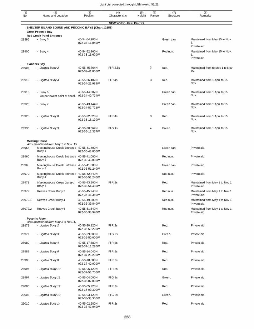
Light List corrected through LNM week: 52/21
258
(1) (2) (3) (4) (5) (6) (7) (8) No. Name and Location Position Characteristic Height Range Structure Remarks
NEW YORK - First District
SHELTER ISLAND SOUND AND PECONIC BAYS (Chart 12358)
Great Peconic Bay
Red Creek Pond Entrance
28895 - Buoy 3 40-54-54.900N
072-33-11.040W Green can. Maintained from May 15 to Nov.
1.
Private aid.
28900 - Buoy 4 40-54-52.860N 072-33-13.620W
Red nun. Maintained from May 15 to Nov. 1.
Private aid.
Flanders Bay
28905 - Lighted Buoy 2 40-55-45.764N
072-32-41.066W
Fl R 2.5s 3 Red. Maintained from to May 1 to Nov 15.
28910 - Lighted Buoy 4 40-55-36.482N
072-34-21.988W
Fl R 4s 3 Red. Maintained from 1 April to 15 Nov.
28915 - Buoy 5
On northwest point of shoal.
40-55-44.307N
072-34-40.774W
Green can. Maintained from 1 April to 15
Nov.
28920 - Buoy 7 40-55-43.144N
072-34-57.721W
Green can. Maintained from 1 April to 15
Nov.
28925 - Lighted Buoy 8 40-55-22.626N
072-35-15.170W
Fl R 4s 3 Red. Maintained from 1 April to 15 Nov.
28930 - Lighted Buoy 9 40-55-38.567N 072-36-11.357W
Fl G 4s 4 Green. Maintained from 1 April to 15 Nov.
Meeting House Aids maintained from May 1 to Nov. 15.
28955 Meetinghouse Creek Entrance Buoy 1
40-55-41.400N
072-36-48.000W
Green can. Private aid.
28960 Meetinghouse Creek Entrance Buoy 2
40-55-41.000N
072-36-46.000W
Red nun. Private aid.
28965 Meetinghouse Creek Entrance Buoy 3
40-55-41.880N
072-36-51.240W
Green can. Private aid.
28970 Meetinghouse Creek Entrance Buoy 4
40-55-42.840N
072-36-51.240W
Red nun. Private aid.
28971 Meetinghouse Creek Lighted Bouy 6
40-55-43.200N
072-36-54.480W
Fl R 2s Red. Maintained from May 1 to Nov 1.
Private aid.
28972 Reeves Creek Buoy 2 40-55-45.240N Red nun. Maintained from May 1 to Nov 1.
072-36-41.350W Private aid.
28972.1 Reeves Creek Buoy 4 40-55-49.200N Red nun. Maintained from May 1 to Nov 1.
072-36-39.840W Private aid.
28972.2 Reeves Creek Buoy 6 40-55-51.540N Red nun. Maintained from May 1 to Nov 1. 072-36-38.940W Private aid.
Peconic River Aids maintained from May 1 to Nov. 1.
28975 - Lighted Buoy 2 40-55-30.120N
072-36-50.220W
Fl R 2s Red. Private aid.
28977 - Lighted Buoy 3 40-55-29.000N
072-36-50.000W
Fl G 2s Green. Private aid.
28980 - Lighted Buoy 4 40-55-17.580N
072-37-11.220W
Fl R 2s Red. Private aid.
28985 - Lighted Buoy 6 40-55-14.040N
072-37-25.200W
Fl R 2s Red. Private aid.
28990 - Lighted Buoy 8 40-55-10.680N
072-37-40.020W
Fl R 2s Red. Private aid.
28995 - Lighted Buoy 10 40-55-06.120N
072-37-53.700W
Fl R 2s Red. Private aid.
28997 - Lighted Buoy 11 40-55-04.000N
072-38-02.000W
Fl G 2s Green. Private aid.
29000 - Lighted Buoy 12 40-55-05.220N
072-38-09.300W
Fl R 2s Red. Private aid.
29005 - Lighted Buoy 13 40-55-03.120N
072-38-33.300W
Fl G 2s Green. Private aid.
29010 - Lighted Buoy 14 40-55-02.280N 072-38-47.040W
Fl R 2s Red. Private aid.
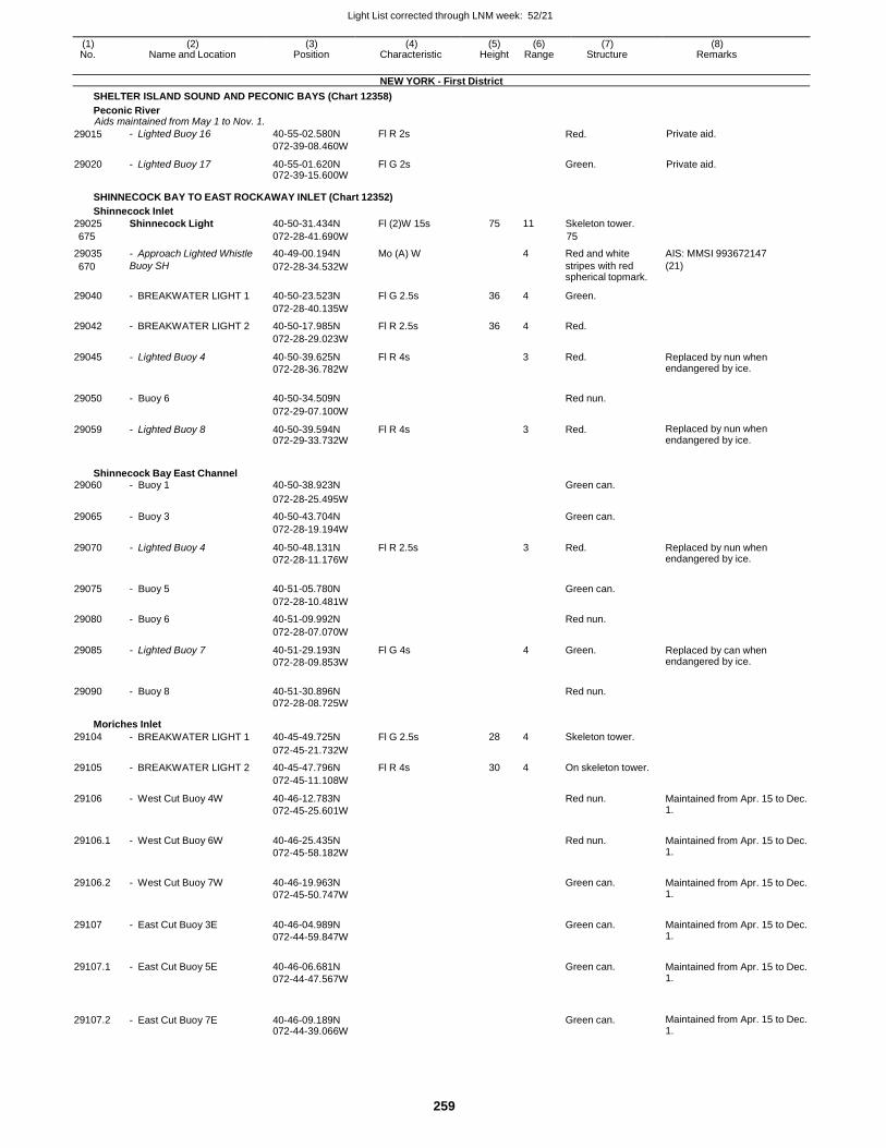
Light List corrected through LNM week: 52/21
259
(1) (2) (3) (4) (5) (6) (7) (8) No. Name and Location Position Characteristic Height Range Structure Remarks
NEW YORK - First District
SHELTER ISLAND SOUND AND PECONIC BAYS (Chart 12358)
Peconic River Aids maintained from May 1 to Nov. 1.
29015 - Lighted Buoy 16 40-55-02.580N
072-39-08.460W
Fl R 2s Red. Private aid.
29020 - Lighted Buoy 17 40-55-01.620N 072-39-15.600W
Fl G 2s Green. Private aid.
SHINNECOCK BAY TO EAST ROCKAWAY INLET (Chart 12352)
Shinnecock Inlet
29025 Shinnecock Light 40-50-31.434N Fl (2)W 15s 75 11 Skeleton tower.
675 072-28-41.690W 75
29035 - Approach Lighted Whistle 40-49-00.194N Mo (A) W 4 Red and white AIS: MMSI 993672147
670 Buoy SH 072-28-34.532W stripes with red spherical topmark.
(21)
29040 - BREAKWATER LIGHT 1 40-50-23.523N Fl G 2.5s 36 4 Green.
072-28-40.135W
29042 - BREAKWATER LIGHT 2 40-50-17.985N Fl R 2.5s 36 4 Red.
072-28-29.023W
29045 - Lighted Buoy 4 40-50-39.625N
072-28-36.782W
Fl R 4s 3 Red. Replaced by nun when endangered by ice.
29050 - Buoy 6 40-50-34.509N
Red nun.
072-29-07.100W
29059 - Lighted Buoy 8 40-50-39.594N 072-29-33.732W
Fl R 4s 3 Red. Replaced by nun when endangered by ice.
Shinnecock Bay East Channel 29060 - Buoy 1 40-50-38.923N Green can.
072-28-25.495W
29065 - Buoy 3 40-50-43.704N Green can.
072-28-19.194W
29070 - Lighted Buoy 4 40-50-48.131N
072-28-11.176W
Fl R 2.5s 3 Red. Replaced by nun when endangered by ice.
29075 - Buoy 5 40-51-05.780N
Green can.
072-28-10.481W
29080 - Buoy 6 40-51-09.992N Red nun.
072-28-07.070W
29085 - Lighted Buoy 7 40-51-29.193N
072-28-09.853W
Fl G 4s 4 Green. Replaced by can when endangered by ice.
29090 - Buoy 8 40-51-30.896N
Red nun.
072-28-08.725W
Moriches Inlet
29104 - BREAKWATER LIGHT 1 40-45-49.725N Fl G 2.5s 28 4 Skeleton tower.
072-45-21.732W
29105 - BREAKWATER LIGHT 2 40-45-47.796N Fl R 4s 30 4 On skeleton tower.
072-45-11.108W
29106 - West Cut Buoy 4W 40-46-12.783N
072-45-25.601W
Red nun. Maintained from Apr. 15 to Dec. 1.
29106.1 - West Cut Buoy 6W 40-46-25.435N
072-45-58.182W
Red nun. Maintained from Apr. 15 to Dec.
1.
29106.2 - West Cut Buoy 7W 40-46-19.963N
072-45-50.747W
Green can. Maintained from Apr. 15 to Dec.
1.
29107 - East Cut Buoy 3E 40-46-04.989N
072-44-59.847W
Green can. Maintained from Apr. 15 to Dec.
1.
29107.1 - East Cut Buoy 5E 40-46-06.681N
072-44-47.567W
Green can. Maintained from Apr. 15 to Dec.
1.
29107.2
- East Cut Buoy 7E
40-46-09.189N 072-44-39.066W
Green can.
Maintained from Apr. 15 to Dec. 1.
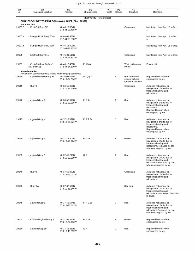
Light List corrected through LNM week: 52/21
260
(1) (2) (3) (4) (5) (6) (7) (8) No. Name and Location Position Characteristic Height Range Structure Remarks
NEW YORK - First District
SHINNECOCK BAY TO EAST ROCKAWAY INLET (Chart 12352)
Moriches Inlet
29107.3 - East Cut Buoy 9E 40-46-19.304N
072-44-25.406W
Green can. Maintained from Apr. 15 to Dec. 1.
29107.4 - Danger Rock Buoy West 40-46-09.453N
072-44-38.053W
Maintained from Apr. 15 to Dec. 1.
29107.5 - Danger Rock Buoy East 40-46-11.493N
072-44-31.933W
Maintained from Apr. 15 to Dec. 1.
29108 - East Cut Buoy 11E 40-46-31.516N
072-44-24.601W
Green can. Maintained from Apr. 15 to Dec.
1.
29109 - East Cut Rock Lighted Hazard Buoy
40-46-10.400N 072-44-34.100W
Fl W 4s White with orange bands.
Private aid.
Fire Island Inlet Positions of buoys frequently shifted with changing conditions.
29110 - Lighted Whistle Buoy FI 40-36-08.065N
073-19-04.016W
Mo (A) W 4 Red and white stripes with red spherical topmark.
Replaced by can when endangered by ice.
29115 - Buoy 1 40-36-55.066N
073-19-11.219W
Green can. Aid does not appear on navigational charts due to frequent shoaling and relocations.
29120 - Lighted Buoy 2 40-36-56.016N
073-19-03.396W
Fl R 4s 3 Red. Aid does not appear on navigational charts due to frequent shoaling and relocations. Replaced by nun when endangered by ice.
29125 - Lighted Buoy 4 40-37-17.892N
073-19-06.971W
Fl R 2.5s 3 Red . Aid does not appear on navigational charts due to frequent shoaling and relocations. Replaced by nun when endangered by ice.
29130 - Lighted Buoy 3 40-37-12.301N
073-19-11.774W
Fl G 4s 4 Green. Aid does not appear on navigational charts due to frequent shoaling and relocations.Replaced by can when endangered by ice.
29135 - Lighted Buoy 6 40-37-49.240N
073-19-22.659W
Q R 3 Red. Aid does not appear on navigational charts due to frequent shoaling and relocations.Replaced by nun when endangered by ice.
29140 - Buoy 5 40-37-56.977N
073-18-56.001W
Green can. Aid does not appear on
navigational charts due to frequent shoaling and relocations.
29143 - Buoy 6A 40-37-37.696N
073-19-16.546W
Red nun. Aid does not appear on
navigational charts due to frequent shoaling and relocations. Maintained from 4/15 to 11/15.
29145 - Lighted Buoy 8 40-37-46.574N
073-18-25.562W
Fl R 2.5s 3 Red. Aid does not appear on navigational charts due to frequent shoaling and relocations.Replaced by nun when endangered by ice.
29155 - Channel Lighted Buoy 7 40-37-54.871N
073-18-24.706W
Fl G 4s 4 Green. Replaced by can when endangered by ice.
29160 - Lighted Buoy 10 40-37-45.311N 073-17-43.969W
Q R 3 Red. Replaced by nun when endangered by ice.
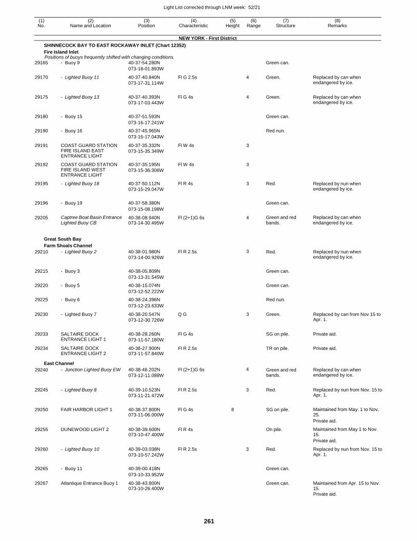
Light List corrected through LNM week: 52/21
261
(1) (2) (3) (4) (5) (6) (7) (8) No. Name and Location Position Characteristic Height Range Structure Remarks
NEW YORK - First District
SHINNECOCK BAY TO EAST ROCKAWAY INLET (Chart 12352)
Fire Island Inlet Positions of buoys frequently shifted with changing conditions.
29165 - Buoy 9 40-37-54.280N Green can.
073-18-01.893W
29170 - Lighted Buoy 11 40-37-40.840N
073-17-31.114W
Fl G 2.5s 4 Green. Replaced by can when endangered by ice.
29175 - Lighted Buoy 13 40-37-40.393N
073-17-03.443W
Fl G 4s 4 Green. Replaced by can when endangered by ice.
29180 - Buoy 15 40-37-51.593N
Green can.
073-16-17.241W
29190 - Buoy 16 40-37-45.965N Red nun.
073-16-17.043W
29191 COAST GUARD STATION FIRE ISLAND EAST ENTRANCE LIGHT
40-37-35.332N
073-15-35.349W
Fl W 4s 3
29192 COAST GUARD STATION FIRE ISLAND WEST ENTRANCE LIGHT
40-37-35.195N
073-15-36.306W
Fl W 4s 3
29195 - Lighted Buoy 18 40-37-50.112N
073-15-29.047W
Fl R 4s 3 Red. Replaced by nun when endangered by ice.
29196 - Buoy 19 40-37-58.380N
Green can.
073-15-08.198W
29205 Captree Boat Basin Entrance Lighted Buoy CB
40-38-08.940N 073-14-30.495W
Fl (2+1)G 6s 4 Green and red bands.
Replaced by can when endangered by ice.
Great South Bay
Farm Shoals Channel
29210 - Lighted Buoy 2 40-38-01.980N
073-14-00.926W
Fl R 2.5s 3 Red. Replaced by nun when endangered by ice.
29215 - Buoy 3 40-38-05.809N
Green can.
073-13-31.545W
29220 - Buoy 5 40-38-15.074N Green can.
073-12-52.222W
29225 - Buoy 6 40-38-24.396N Red nun.
073-12-23.633W
29230 - Lighted Buoy 7 40-38-20.547N
073-12-30.726W
Q G 3 Green. Replaced by can from Nov 15 to Apr. 1.
29233 SALTAIRE DOCK ENTRANCE LIGHT 1
40-38-28.260N
073-11-57.180W
Fl G 4s
SG on pile. Private aid.
29234 SALTAIRE DOCK ENTRANCE LIGHT 2
40-38-27.900N 073-11-57.840W
Fl R 2.5s TR on pile. Private aid.
East Channel
29240 - Junction Lighted Buoy EW 40-38-46.202N
073-12-11.088W
Fl (2+1)G 6s 4 Green and red bands.
Replaced by can when endangered by ice.
29245 - Lighted Buoy 8 40-39-10.523N
073-11-21.472W
Fl R 2.5s
3 Red. Replaced by nun from Nov. 15 to Apr. 1.
29250 FAIR HARBOR LIGHT 1 40-38-37.800N 073-11-06.000W
Fl G 4s 8
SG on pile. Maintained from May. 1 to Nov. 25.
Private aid.
29255 DUNEWOOD LIGHT 2 40-38-39.600N 073-10-47.400W
Fl R 4s On pile. Maintained from May 1 to Nov. 15.
Private aid.
29260 - Lighted Buoy 10 40-39-03.038N
073-10-57.242W
Fl R 2.5s 3 Red. Replaced by nun from Nov. 15 to Apr. 1.
29265 - Buoy 11 40-39-00.418N
Green can.
073-10-33.952W
29267 Atlantique Entrance Buoy 1 40-38-43.800N 073-10-26.400W
Green can. Maintained from Apr. 15 to Nov. 15.
Private aid.
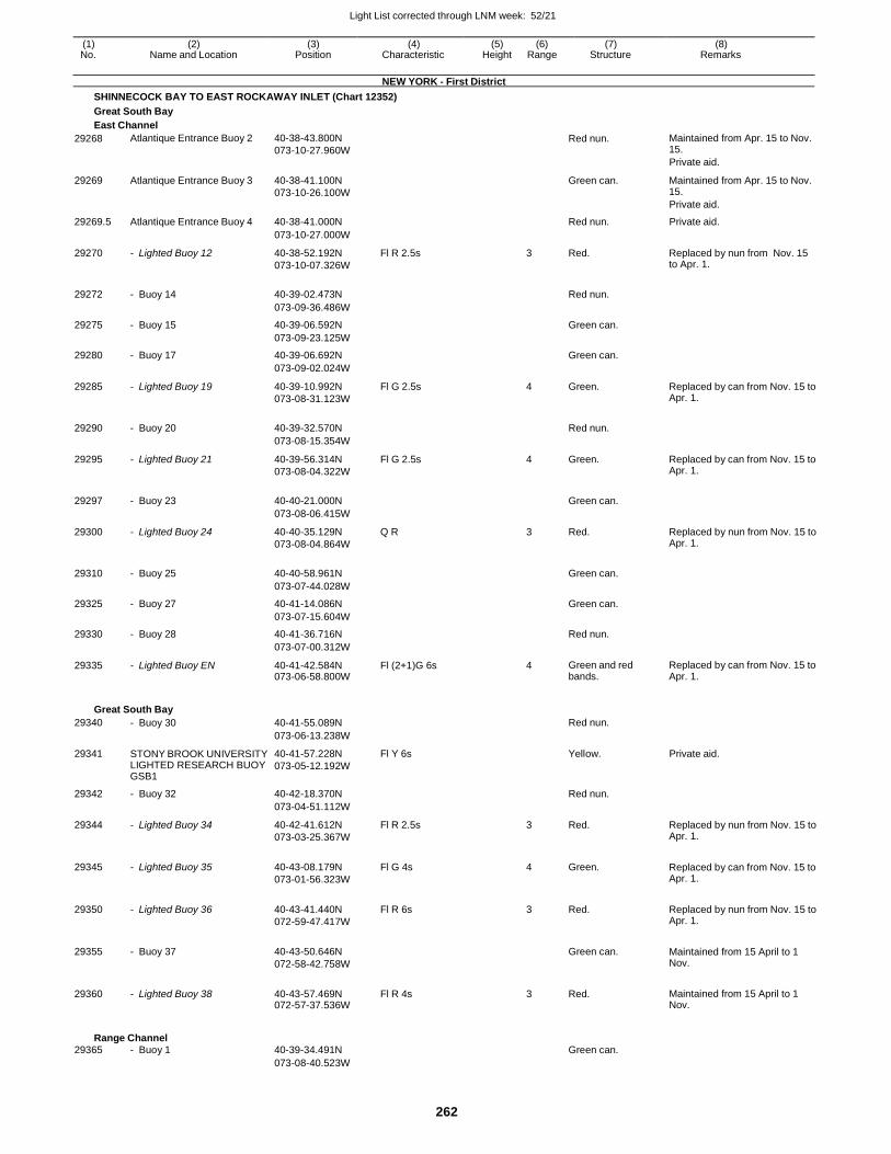
Light List corrected through LNM week: 52/21
262
(1) (2) (3) (4) (5) (6) (7) (8) No. Name and Location Position Characteristic Height Range Structure Remarks
NEW YORK - First District
SHINNECOCK BAY TO EAST ROCKAWAY INLET (Chart 12352)
Great South Bay
East Channel
29268 Atlantique Entrance Buoy 2 40-38-43.800N
073-10-27.960W
Red nun. Maintained from Apr. 15 to Nov. 15.
Private aid.
29269 Atlantique Entrance Buoy 3 40-38-41.100N
073-10-26.100W
Green can. Maintained from Apr. 15 to Nov. 15.
Private aid.
29269.5 Atlantique Entrance Buoy 4 40-38-41.000N Red nun. Private aid.
073-10-27.000W
29270 - Lighted Buoy 12 40-38-52.192N
073-10-07.326W
Fl R 2.5s 3 Red. Replaced by nun from Nov. 15 to Apr. 1.
29272 - Buoy 14 40-39-02.473N
Red nun.
073-09-36.486W
29275 - Buoy 15 40-39-06.592N Green can.
073-09-23.125W
29280 - Buoy 17 40-39-06.692N Green can.
073-09-02.024W
29285 - Lighted Buoy 19 40-39-10.992N
073-08-31.123W
Fl G 2.5s 4 Green. Replaced by can from Nov. 15 to Apr. 1.
29290 - Buoy 20 40-39-32.570N
Red nun.
073-08-15.354W
29295 - Lighted Buoy 21 40-39-56.314N
073-08-04.322W
Fl G 2.5s 4 Green. Replaced by can from Nov. 15 to Apr. 1.
29297 - Buoy 23 40-40-21.000N
Green can.
073-08-06.415W
29300 - Lighted Buoy 24 40-40-35.129N
073-08-04.864W
Q R 3 Red. Replaced by nun from Nov. 15 to Apr. 1.
29310 - Buoy 25 40-40-58.961N
Green can.
073-07-44.028W
29325 - Buoy 27 40-41-14.086N Green can.
073-07-15.604W
29330 - Buoy 28 40-41-36.716N Red nun.
073-07-00.312W
29335 - Lighted Buoy EN 40-41-42.584N 073-06-58.800W
Fl (2+1)G 6s 4 Green and red bands.
Replaced by can from Nov. 15 to Apr. 1.
Great South Bay
29340 - Buoy 30 40-41-55.089N Red nun.
073-06-13.238W
29341 STONY BROOK UNIVERSITY LIGHTED RESEARCH BUOY GSB1
40-41-57.228N
073-05-12.192W
Fl Y 6s Yellow. Private aid.
29342 - Buoy 32 40-42-18.370N Red nun.
073-04-51.112W
29344 - Lighted Buoy 34 40-42-41.612N
073-03-25.367W
Fl R 2.5s 3 Red. Replaced by nun from Nov. 15 to Apr. 1.
29345 - Lighted Buoy 35 40-43-08.179N
073-01-56.323W
Fl G 4s 4 Green. Replaced by can from Nov. 15 to Apr. 1.
29350 - Lighted Buoy 36 40-43-41.440N
072-59-47.417W
Fl R 6s 3 Red. Replaced by nun from Nov. 15 to Apr. 1.
29355 - Buoy 37 40-43-50.646N
072-58-42.758W
Green can. Maintained from 15 April to 1
Nov.
29360 - Lighted Buoy 38 40-43-57.469N 072-57-37.536W
Fl R 4s 3 Red. Maintained from 15 April to 1 Nov.
Range Channel 29365 - Buoy 1 40-39-34.491N Green can.
073-08-40.523W
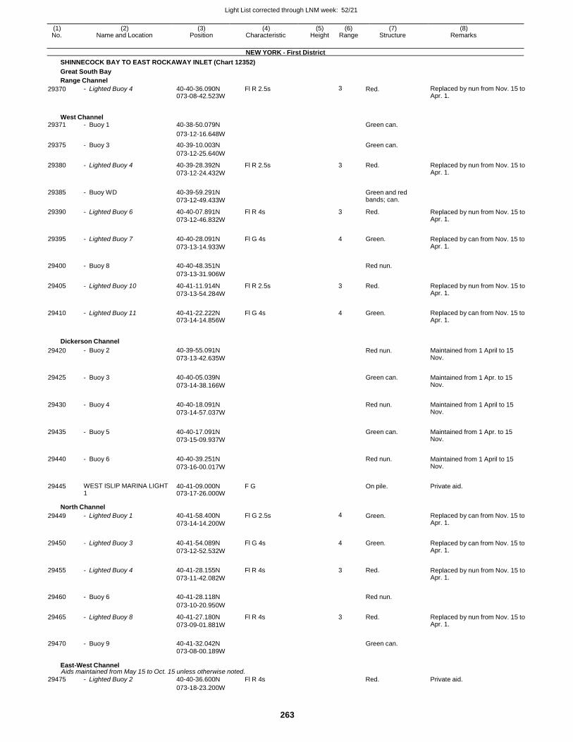
Light List corrected through LNM week: 52/21
263
(1) (2) (3) (4) (5) (6) (7) (8) No. Name and Location Position Characteristic Height Range Structure Remarks
NEW YORK - First District
SHINNECOCK BAY TO EAST ROCKAWAY INLET (Chart 12352)
Great South Bay
Range Channel
29370 - Lighted Buoy 4 40-40-36.090N 073-08-42.523W
Fl R 2.5s 3 Red. Replaced by nun from Nov. 15 to Apr. 1.
West Channel 29371 - Buoy 1 40-38-50.079N Green can.
073-12-16.648W
29375 - Buoy 3 40-39-10.003N Green can.
073-12-25.640W
29380 - Lighted Buoy 4 40-39-28.392N
073-12-24.432W
Fl R 2.5s 3 Red. Replaced by nun from Nov. 15 to Apr. 1.
29385 - Buoy WD 40-39-59.291N
073-12-49.433W
Green and red bands; can.
29390 - Lighted Buoy 6 40-40-07.891N
073-12-46.832W
Fl R 4s 3 Red. Replaced by nun from Nov. 15 to Apr. 1.
29395 - Lighted Buoy 7 40-40-28.091N
073-13-14.933W
Fl G 4s 4 Green. Replaced by can from Nov. 15 to Apr. 1.
29400 - Buoy 8 40-40-48.351N
Red nun.
073-13-31.906W
29405 - Lighted Buoy 10 40-41-11.914N
073-13-54.284W
Fl R 2.5s 3 Red. Replaced by nun from Nov. 15 to Apr. 1.
29410 - Lighted Buoy 11 40-41-22.222N 073-14-14.856W
Fl G 4s 4 Green. Replaced by can from Nov. 15 to Apr. 1.
Dickerson Channel
29420 - Buoy 2 40-39-55.091N
073-13-42.635W
Red nun. Maintained from 1 April to 15 Nov.
29425 - Buoy 3 40-40-05.039N
073-14-38.166W
Green can. Maintained from 1 Apr. to 15
Nov.
29430 - Buoy 4 40-40-18.091N
073-14-57.037W
Red nun. Maintained from 1 April to 15
Nov.
29435 - Buoy 5 40-40-17.091N
073-15-09.937W
Green can. Maintained from 1 Apr. to 15
Nov.
29440 - Buoy 6 40-40-39.251N
073-16-00.017W
Red nun. Maintained from 1 April to 15
Nov.
29445 WEST ISLIP MARINA LIGHT 1
40-41-09.000N 073-17-26.000W
F G On pile. Private aid.
North Channel
29449 - Lighted Buoy 1 40-41-58.400N
073-14-14.200W
Fl G 2.5s 4 Green. Replaced by can from Nov. 15 to Apr. 1.
29450 - Lighted Buoy 3 40-41-54.089N
073-12-52.532W
Fl G 4s 4 Green. Replaced by can from Nov. 15 to Apr. 1.
29455 - Lighted Buoy 4 40-41-28.155N
073-11-42.082W
Fl R 4s 3 Red. Replaced by nun from Nov. 15 to Apr. 1.
29460 - Buoy 6 40-41-28.118N
Red nun.
073-10-20.950W
29465 - Lighted Buoy 8 40-41-27.180N
073-09-01.881W
Fl R 4s 3 Red. Replaced by nun from Nov. 15 to Apr. 1.
29470 - Buoy 9 40-41-32.042N
Green can.
073-08-00.189W
East-West Channel Aids maintained from May 15 to Oct. 15 unless otherwise noted.
29475 - Lighted Buoy 2 40-40-36.600N Fl R 4s Red. Private aid. 073-18-23.200W
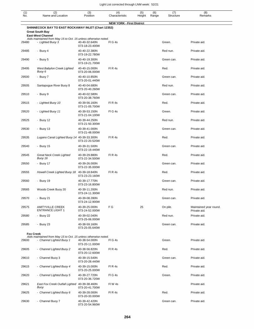
Light List corrected through LNM week: 52/21
264
(1) (2) (3) (4) (5) (6) (7) (8) No. Name and Location Position Characteristic Height Range Structure Remarks
NEW YORK - First District
SHINNECOCK BAY TO EAST ROCKAWAY INLET (Chart 12352)
Great South Bay
East-West Channel Aids maintained from May 15 to Oct. 15 unless otherwise noted.
29480 - Lighted Buoy 3 40-40-32.640N Fl G 4s Green. Private aid.
073-18-23.400W
29485 - Buoy 4 40-40-22.380N Red nun. Private aid.
073-19-22.780W
29490 - Buoy 5 40-40-19.300N Green can. Private aid.
073-19-21.700W
29495 West Babylon Creek Lighted Buoy 6
40-40-15.000N
073-20-06.000W
Fl R 4s Red. Private aid.
29500 - Buoy 7 40-40-10.850N Green can. Private aid.
073-20-01.440W
29505 Santapogue River Buoy 8 40-40-04.680N Red nun. Private aid.
073-20-40.260W
29510 - Buoy 9 40-40-02.580N Green can. Private aid.
073-20-38.760W
29515 - Lighted Buoy 10 40-39-56.160N Fl R 4s Red. Private aid.
073-21-05.700W
29520 - Lighted Buoy 11 40-39-53.150N Fl G 4s Green. Private aid.
073-21-04.100W
29525 - Buoy 12 40-39-44.250N Red nun. Private aid.
073-21-50.300W
29530 - Buoy 13 40-39-41.000N Green can. Private aid.
073-21-48.000W
29535 Lugano Canal Lighted Buoy 14 40-39-33.300N Fl R 4s Red. Private aid. 073-22-20.520W
29540 - Buoy 15 40-39-31.500N
Green can. Private aid.
073-22-19.440W
29545 Great Neck Creek Lighted Buoy 16
40-39-29.880N
073-22-34.500W
Fl R 4s Red. Private aid.
29550 - Buoy 17 40-39-26.000N Green can. Private aid.
073-22-35.000W
29555 Howell Creek Lighted Buoy 18 40-39-18.840N Fl R 4s Red. Private aid.
073-23-23.160W
29560 - Buoy 19 40-39-17.770N Green can. Private aid.
073-23-16.800W
29565 Woods Creek Buoy 20 40-39-11.200N Red nun. Private aid.
073-24-11.300W
29570 - Buoy 21 40-39-08.280N Green can. Private aid.
073-24-12.900W
29575 AMITYVILLE CREEK ENTRANCE LIGHT 1
40-39-25.000N
073-24-52.000W
F G 25 On pile. Maintained year round.
Private aid.
29580 - Buoy 22 40-39-02.040N Red nun. Private aid.
073-25-06.000W
29585 - Buoy 23 40-38-59.160N Green can. Private aid. 073-25-05.640W
Fox Creek Aids maintained from May 15 to Oct. 15 unless otherwise noted.
29600 - Channel Lighted Buoy 1 40-38-54.000N Fl G 4s Green. Private aid.
073-20-11.000W
29605 - Channel Lighted Buoy 2 40-38-56.820N Fl R 4s Red. Private aid.
073-20-12.600W
29610 - Channel Buoy 3 40-39-15.540N Green can. Private aid.
073-20-28.440W
29615 - Channel Lighted Buoy 4 40-39-15.000N Fl R 4s Red. Private aid.
073-20-25.000W
29620 - Channel Lighted Buoy 5 40-39-27.720N Fl G 4s Green. Private aid.
073-20-36.720W
29621 East Fox Creek Outfall Lighted Buoy
40-39-38.460N
073-20-41.700W
Fl W 4s Private aid.
29625 - Channel Lighted Buoy 6 40-39-28.000N Fl R 4s Red. Private aid.
073-20-33.000W
29630 - Channel Buoy 7 40-39-42.420N Green can. Private aid. 073-20-54.960W
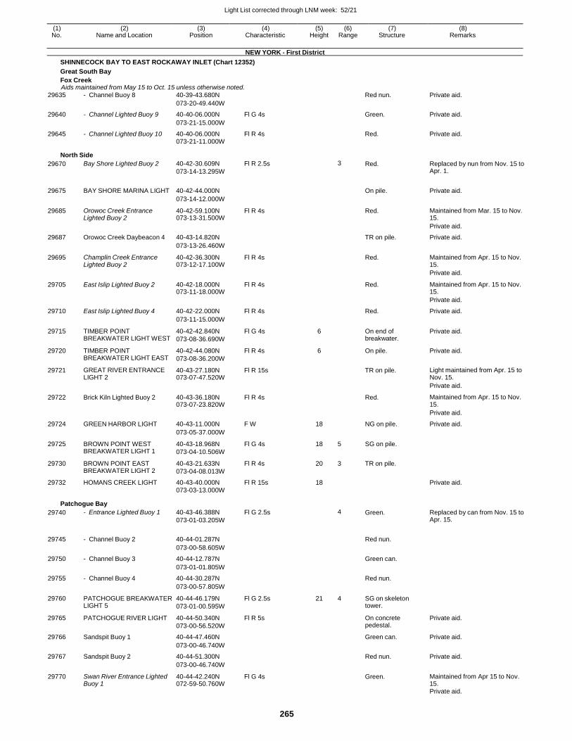
Light List corrected through LNM week: 52/21
265
(1) (2) (3) (4) (5) (6) (7) (8) No. Name and Location Position Characteristic Height Range Structure Remarks
NEW YORK - First District
SHINNECOCK BAY TO EAST ROCKAWAY INLET (Chart 12352)
Great South Bay
Fox Creek Aids maintained from May 15 to Oct. 15 unless otherwise noted.
29635 - Channel Buoy 8 40-39-43.680N Red nun. Private aid.
073-20-49.440W
29640 - Channel Lighted Buoy 9 40-40-06.000N Fl G 4s Green. Private aid.
073-21-15.000W
29645 - Channel Lighted Buoy 10 40-40-06.000N Fl R 4s Red. Private aid. 073-21-11.000W
North Side
29670 Bay Shore Lighted Buoy 2 40-42-30.609N
073-14-13.295W
Fl R 2.5s 3 Red. Replaced by nun from Nov. 15 to Apr. 1.
29675 BAY SHORE MARINA LIGHT 40-42-44.000N
On pile. Private aid.
073-14-12.000W
29685 Orowoc Creek Entrance Lighted Buoy 2
40-42-59.100N 073-13-31.500W
Fl R 4s Red. Maintained from Mar. 15 to Nov. 15.
Private aid.
29687 Orowoc Creek Daybeacon 4 40-43-14.820N TR on pile. Private aid.
073-13-26.460W
29695 Champlin Creek Entrance Lighted Buoy 2
40-42-36.300N 073-12-17.100W
Fl R 4s Red. Maintained from Apr. 15 to Nov. 15.
Private aid.
29705 East Islip Lighted Buoy 2 40-42-18.000N 073-11-18.000W
Fl R 4s Red. Maintained from Apr. 15 to Nov. 15.
Private aid.
29710 East Islip Lighted Buoy 4 40-42-22.000N Fl R 4s Red. Private aid.
073-11-15.000W
29715 TIMBER POINT BREAKWATER LIGHT WEST
40-42-42.840N
073-08-36.690W
Fl G 4s 6 On end of breakwater.
Private aid.
29720 TIMBER POINT BREAKWATER LIGHT EAST
40-42-44.080N
073-08-36.200W
Fl R 4s 6 On pile. Private aid.
29721 GREAT RIVER ENTRANCE LIGHT 2
40-43-27.180N 073-07-47.520W
Fl R 15s TR on pile. Light maintained from Apr. 15 to Nov. 15.
Private aid.
29722 Brick Kiln Lighted Buoy 2 40-43-36.180N 073-07-23.820W
Fl R 4s Red. Maintained from Apr. 15 to Nov. 15.
Private aid.
29724 GREEN HARBOR LIGHT 40-43-11.000N F W 18 NG on pile. Private aid.
073-05-37.000W
29725 BROWN POINT WEST BREAKWATER LIGHT 1
40-43-18.968N
073-04-10.506W
Fl G 4s 18 5 SG on pile.
29730 BROWN POINT EAST BREAKWATER LIGHT 2
40-43-21.633N
073-04-08.013W
Fl R 4s 20 3 TR on pile.
29732 HOMANS CREEK LIGHT 40-43-40.000N Fl R 15s 18 Private aid. 073-03-13.000W
Patchogue Bay
29740 - Entrance Lighted Buoy 1 40-43-46.388N
073-01-03.205W
Fl G 2.5s 4 Green. Replaced by can from Nov. 15 to Apr. 15.
29745 - Channel Buoy 2 40-44-01.287N
Red nun.
073-00-58.605W
29750 - Channel Buoy 3 40-44-12.787N Green can.
073-01-01.805W
29755 - Channel Buoy 4 40-44-30.287N Red nun.
073-00-57.805W
29760 PATCHOGUE BREAKWATER LIGHT 5
40-44-46.179N
073-01-00.595W
Fl G 2.5s 21 4 SG on skeleton tower.
29765 PATCHOGUE RIVER LIGHT 40-44-50.340N
073-00-56.520W
Fl R 5s On concrete pedestal.
Private aid.
29766 Sandspit Buoy 1 40-44-47.460N Green can. Private aid.
073-00-46.740W
29767 Sandspit Buoy 2 40-44-51.300N Red nun. Private aid.
073-00-46.740W
29770 Swan River Entrance Lighted Buoy 1
40-44-42.240N 072-59-50.760W
Fl G 4s Green. Maintained from Apr 15 to Nov. 15.
Private aid.
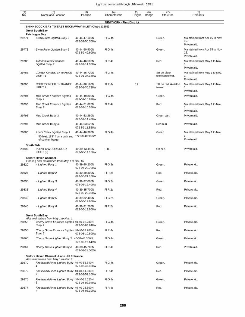
Light List corrected through LNM week: 52/21
266
(1) (2) (3) (4) (5) (6) (7) (8) No. Name and Location Position Characteristic Height Range Structure Remarks
NEW YORK - First District
SHINNECOCK BAY TO EAST ROCKAWAY INLET (Chart 12352)
Great South Bay
Patchogue Bay
29771 Swan River Lighted Buoy 3 40-44-47.100N
072-59-50.300W
Fl G 4s Green. Maintained from Apr 15 to Nov 15.
Private aid.
29772 Swan River Lighted Buoy 5 40-44-50.900N 072-59-49.600W
Fl G 4s Green. Maintained from Apr 15 to Nov 15.
Private aid.
29780 Tuthills Creek Entrance Lighted Buoy 2
40-44-46.500N 073-01-14.900W
Fl R 4s Red. Maintained from May 1 to Nov. 1.
Private aid.
29785 COREY CREEK ENTRANCE LIGHT 1
40-44-36.720N 073-01-37.140W
Fl G 4s SB on black skeleton tower.
Maintained from May 1 to Nov. 1.
Private aid.
29790 COREY CREEK ENTRANCE LIGHT 2
40-44-38.160N 073-01-36.720W
Fl R 4s 12 TR on red skeleton tower.
Maintained from May 1 to Nov. 1.
Private aid.
29794 Mud Creek Entrance Lighted Buoy 1
40-44-49.800N
072-59-16.820W
Fl G 4s Green. Private aid.
29795 Mud Creek Entrance Lighted Buoy 2
40-44-51.870N 072-59-10.560W
Fl R 4s Red. Maintained from May 1 to Nov. 1.
Private aid.
29796 Mud Creek Buoy 3 40-44-53.280N Green can. Private aid.
072-59-14.480W
29797 Mud Creek Buoy 4 40-44-53.520N Red nun. Private aid.
072-59-11.520W
29800 Abets Creek Lighted Buoy 1 40-44-46.380N Fl G 4s Green. Maintained from May 1 to Nov.
50 feet, 183° from south end 072-58-40.980W
of sunken barge.
South Side
1.
Private aid.
29805 POINT O'WOODS DOCK LIGHT (2)
40-39-13.440N F R
073-08-14.100W
On pile. Private aid.
Sailors Haven Channel Floating aids maintained from May 1 to Oct. 15.
29820 - Lighted Buoy 1 40-39-40.200N
073-06-20.700W
Fl G 2s Green. Private aid.
29825 - Lighted Buoy 2 40-39-39.300N
073-06-24.100W
Fl R 2s Red. Private aid.
29830 - Lighted Buoy 3 40-39-37.000N
073-06-19.400W
Fl G 2s Green. Private aid.
29835 - Lighted Buoy 4 40-39-35.700N
073-06-22.300W
Fl R 2s Red. Private aid.
29840 - Lighted Buoy 5 40-39-32.400N
073-06-17.900W
Fl G 2s Green. Private aid.
29845 - Lighted Buoy 6 40-39-31.200N 073-06-19.900W
Fl R 2s Red. Private aid.
Great South Bay Aids maintained from May 1 to Nov. 1.
29855 Cherry Grove Entrance Lighted 40-40-02.280N Buoy 1 073-05-08.640W
Fl G 4s Green. Private aid.
29856 Cherry Grove Entrance Lighted 40-40-02.700N Buoy 2 073-05-10.800W
Fl R 4s Red. Private aid.
29860 Cherry Grove Lighted Buoy 3 40-39-45.300N Fl G 4s Green. Private aid.
29861
Cherry Grove Lighted Buoy 4
073-05-19.140W
40-39-45.700N
073-05-21.000W
Fl R 4s
Red.
Private aid.
Sailors Haven Channel - Lone Hill Entrance Aids maintained from May 1 to Nov. 1.
29870 Fire Island Pines Lighted Buoy 40-40-53.640N 1 073-03-47.400W
Fl G 4s Green. Private aid.
29872 Fire Island Pines Lighted Buoy 40-40-51.500N 2 073-03-52.100W
Fl R 4s Red. Private aid.
29875 Fire Island Pines Lighted Buoy 40-40-25.020N 3 073-04-02.040W
Fl G 4s Green. Private aid.
29877 Fire Island Pines Lighted Buoy 40-40-23.800N 4 073-04-06.100W
Fl R 4s Red. Private aid.
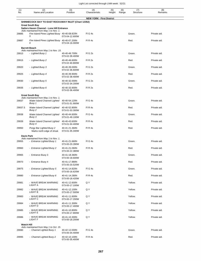
Light List corrected through LNM week: 52/21
267
(1) (2) (3) (4) (5) (6) (7) (8) No. Name and Location Position Characteristic Height Range Structure Remarks
NEW YORK - First District
SHINNECOCK BAY TO EAST ROCKAWAY INLET (Chart 12352)
Great South Bay
Sailors Haven Channel - Lone Hill Entrance Aids maintained from May 1 to Nov. 1.
29885 Fire Island Pines Lighted Buoy 5
40-40-08.820N
073-04-12.600W
Fl G 4s Green. Private aid.
29887 Fire Island Pines Lighted Buoy 6
40-40-07.200N 073-04-16.000W
Fl R 4s Red. Private aid.
Barrett Beach Aids maintained from May 1 to Nov. 15.
29910 - Lighted Buoy 1 40-40-46.700N
073-02-39.400W
Fl G 2s Green. Private aid.
29915 - Lighted Buoy 2 40-40-46.600N
073-02-40.800W
Fl R 2s Red. Private aid.
29920 - Lighted Buoy 3 40-40-39.000N
073-02-36.600W
Fl G 2s Green. Private aid.
29925 - Lighted Buoy 4 40-40-39.900N
073-02-38.400W
Fl R 2s Red. Private aid.
29930 - Lighted Buoy 5 40-40-32.000N
073-02-34.200W
Fl G 2s Green. Private aid.
29935 - Lighted Buoy 6 40-40-33.900N 073-02-36.400W
Fl R 2s Red. Private aid.
Great South Bay Aids maintained from May 1 to Nov. 1.
29937 Water Island Channel Lighted Buoy 1
40-40-54.120N
073-01-51.900W
Fl G 4s Green. Private aid.
29937.5 Water Island Channel Lighted Buoy 2
40-40-52.800N
073-01-53.300W
Fl R 4s Red. Private aid.
29938 Water Island Channel Lighted Buoy 3
40-40-44.600N
073-01-49.100W
Fl G 4s Green. Private aid.
29939 Water Island Channel Lighted Buoy 4
40-40-43.600N
073-01-50.400W
Fl R 4s Red. Private aid.
29950 Porgy Bar Lighted Buoy 2 40-41-21.360N Fl R 4s Red. Private aid. Marks north edge of shoal. 073-01-35.340W
Davis Park Aids maintained from May 1 to Nov. 1.
29955 - Entrance Lighted Buoy 1 40-41-21.660N Fl G 4s Green. Private aid.
073-00-20.280W
29960 - Entrance Lighted Buoy 2 40-41-21.060N Fl R 4s Red. Private aid.
073-00-22.380W
29965 - Entrance Buoy 3 40-41-18.360N Green. Private aid.
073-00-18.600W
29970 - Entrance Buoy 4 40-41-17.880N Red. Private aid.
073-00-20.520W
29975 - Entrance Lighted Buoy 5 40-41-14.820N Fl G 4s Green. Private aid.
073-00-16.620W
29980 - Entrance Lighted Buoy 6 40-41-14.280N Fl R 4s Red. Private aid.
073-00-18.420W
29981 - WAVE BREAK WARNING LIGHT A
40-41-12.600N
073-00-17.100W
Q Y Yellow. Private aid.
29982 - WAVE BREAK WARNING LIGHT B
40-41-12.100N
073-00-17.500W
Q Y Yellow. Private aid.
29983 - WAVE BREAK WARNING LIGHT C
40-41-11.600N
073-00-17.200W
Q Y Yellow. Private aid.
29984 - WAVE BREAK WARNING LIGHT D
40-41-11.300N
073-00-17.400W
Q Y Yellow. Private aid.
29985 - WAVE BREAK WARNING LIGHT E
40-41-10.800N
073-00-17.800W
Q Y Yellow. Private aid.
29986 - WAVE BREAK WARNING LIGHT F
40-41-10.300N 073-00-18.200W
Q Y Yellow. Private aid.
Watch Hill Aids maintained from May 1 to Oct. 15.
29990 - Channel Lighted Buoy 1 40-42-12.000N
073-00-34.400W
Fl G 4s Green. Private aid.
29995 - Channel Lighted Buoy 2 40-42-10.100N 073-00-35.400W
Fl R 4s Red. Private aid.
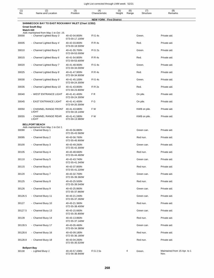
Light List corrected through LNM week: 52/21
268
(1) (2) (3) (4) (5) (6) (7) (8) No. Name and Location Position Characteristic Height Range Structure Remarks
NEW YORK - First District
SHINNECOCK BAY TO EAST ROCKAWAY INLET (Chart 12352)
Great South Bay
Watch Hill Aids maintained from May 1 to Oct. 15.
30000 - Channel Lighted Buoy 3 40-42-04.800N Fl G 4s Green. Private aid.
073-00-17.100W
30005 - Channel Lighted Buoy 4 40-42-03.800N Fl R 4s Red. Private aid.
073-00-18.500W
30010 - Channel Lighted Buoy 5 40-41-55.700N Fl G 2s Green. Private aid.
072-59-53.000W
30015 - Channel Lighted Buoy 6 40-41-54.800N Fl R 4s Red. Private aid.
072-59-53.600W
30020 - Channel Lighted Buoy 7 40-41-48.900N Fl G 4s Green. Private aid.
072-59-34.000W
30025 - Channel Lighted Buoy 8 40-41-47.900N Fl R 4s Red. Private aid.
072-59-34.900W
30030 - Channel Lighted Buoy 9 40-41-45.100N Fl G 4s Green. Private aid.
072-59-24.300W
30035 - Channel Lighted Buoy 10 40-41-43.800N Fl R 2s Red. Private aid.
072-59-23.800W
30040 - WEST ENTRANCE LIGHT 40-41-41.400N F R On pile. Private aid.
072-59-24.300W
30045 - EAST ENTRANCE LIGHT 40-41-41.400N F G On pile. Private aid.
072-59-20.300W
30050 - CHANNEL RANGE FRONT LIGHT
40-41-43.680N
072-59-19.140W
F W KWB on pile. Private aid.
30055 - CHANNEL RANGE REAR LIGHT
40-41-41.580N 072-59-13.980W
F W KWB on pile. Private aid.
BELLPORT BEACH Aids maintained from May 1 to Oct 1.
30090 - Channel Buoy 1 40-43-56.880N Green can. Private aid.
072-55-43.560W
30095 - Channel Buoy 2 40-43-56.760N Red nun. Private aid.
072-55-45.900W
30100 - Channel Buoy 3 40-43-49.260N Green can. Private aid.
072-55-42.300W
30105 - Channel Buoy 4 40-43-48.660N Red nun. Private aid.
072-55-44.460W
30110 - Channel Buoy 5 40-43-43.740N Green can. Private aid.
072-55-41.340W
30115 - Channel Buoy 6 40-43-37.800N Red nun. Private aid.
072-55-41.220W
30120 - Channel Buoy 7 40-43-32.700N Green can. Private aid.
072-55-39.360W
30125 - Channel Buoy 8 40-43-25.500N Red nun. Private aid.
072-55-39.540W
30126 - Channel Buoy 9 40-43-25.860N Green can. Private aid.
072-55-37.860W
30126.5 - Channel Buoy 11 40-43-21.240N Green can. Private aid.
072-55-37.260W
30127 - Channel Buoy 10 40-43-21.360N Red nun. Private aid.
072-55-38.400W
30127.5 - Channel Buoy 13 40-43-15.660N Green can. Private aid.
072-55-35.800W
30128 - Channel Buoy 14 40-43-13.860N Red nun. Private aid.
072-55-37.140W
30128.5 - Channel Buoy 17 40-43-05.460N Green can. Private aid.
072-55-34.380W
30128.6 - Channel Buoy 16 40-43-09.180N Red nun. Private aid.
072-55-36.180W
30128.8 - Channel Buoy 18 40-43-04.260N Red nun. Private aid. 072-55-35.520W
Bellport Bay
30130 - Lighted Buoy 1 40-43-57.436N 072-56-38.940W
Fl G 2.5s 4 Green. Maintained from 15 Apr. to 1 Nov.
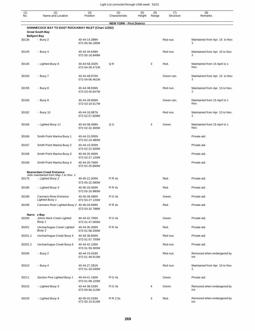
Light List corrected through LNM week: 52/21
269
(1) (2) (3) (4) (5) (6) (7) (8) No. Name and Location Position Characteristic Height Range Structure Remarks
NEW YORK - First District
SHINNECOCK BAY TO EAST ROCKAWAY INLET (Chart 12352)
Great South Bay
Bellport Bay
30135 - Buoy 2 40-44-14.288N
072-55-56.195W
Red nun. Maintained from Apr. 15 to Nov. 1.
30140 - Buoy 4 40-44-34.648N
072-55-16.849W
Red nun. Maintained from Apr. 15 to Nov.
1.
30145 - Lighted Buoy 6 40-44-58.202N
072-54-30.471W
Q R 3 Red. Maintained from 15 April to 1 Nov.
30150 - Buoy 7 40-44-48.870N
072-54-06.461W
Green can. Maintained from Apr. 15 to Nov.
1.
30155 - Buoy 8 40-44-38.836N
072-53-45.647W
Red nun. Maintained from Apr. 15 to Nov.
1.
30160 - Buoy 9 40-44-28.656N
072-53-19.517W
Green can. Maintained from 15 April to 1
Nov.
30162 - Buoy 10 40-44-18.987N
072-52-57.828W
Red nun. Maintained from Apr. 15 to Nov.
1.
30165 - Lighted Buoy 11 40-44-08.499N
072-52-32.365W
Q G 3 Green. Maintained from 15 April to 1 Nov.
30166 Smith Point Marina Buoy 1 40-44-15.000N
Private aid.
072-52-24.480W
30167 Smith Point Marina Buoy 2 40-44-15.000N Private aid.
072-52-22.500W
30168 Smith Point Marina Buoy 3 40-44-20.460N Private aid.
072-52-27.120W
30169 Smith Point Marina Buoy 4 40-44-20.760N Private aid. 072-52-25.860W
Beaverdam Creek Entrance Aids maintained from May 1 to Nov. 1.
30175 - Lighted Buoy 2 40-45-21.000N Fl R 4s Red. Private aid.
072-55-22.080W
30180 - Lighted Buoy 4 40-45-33.060N Fl R 4s Red. Private aid.
072-55-16.980W
30190 Carmans River Entrance Lighted Buoy 1
40-45-39.480N
072-53-27.120W
Fl G 4s Green. Private aid.
30195 Carmans River Lighted Buoy 2 40-46-04.699N Fl R 4s Red. Private aid.
Narrow
30200
s Bay Johns Neck Creek Lighted
072-53-32.788W
40-44-42.700N
Fl G 4s
Green.
Private aid.
Buoy 1 072-51-47.000W
30201 Unchachogue Creek Lighted Buoy 2
40-44-30.300N
072-51-58.200W
Fl R 4s Red. Private aid.
30201.1 Unchachogue Creek Buoy 4 40-44-36.800N Red nun. Private aid.
072-51-57.700W
30201.2 Unchachogue Creek Buoy 6 40-44-42.100N Red nun. Private aid.
072-51-59.300W
30205 - Buoy 2 40-44-23.433N
072-51-49.913W
Red nun. Removed when endangered by ice.
30210 - Buoy 4 40-44-27.281N
072-51-33.040W
Red nun. Maintained from Apr. 15 to Nov.
1.
30211 Section Five Lighted Buoy 1 40-44-41.160N Fl G 4s
Green. Private aid.
072-51-09.120W
30215 - Lighted Buoy 5 40-44-36.533N
072-50-56.213W
Fl G 4s 4 Green. Removed when endangered by ice.
30220 - Lighted Buoy 6 40-45-03.333N 072-50-10.613W
Fl R 2.5s 3 Red. Removed when endangered by ice.
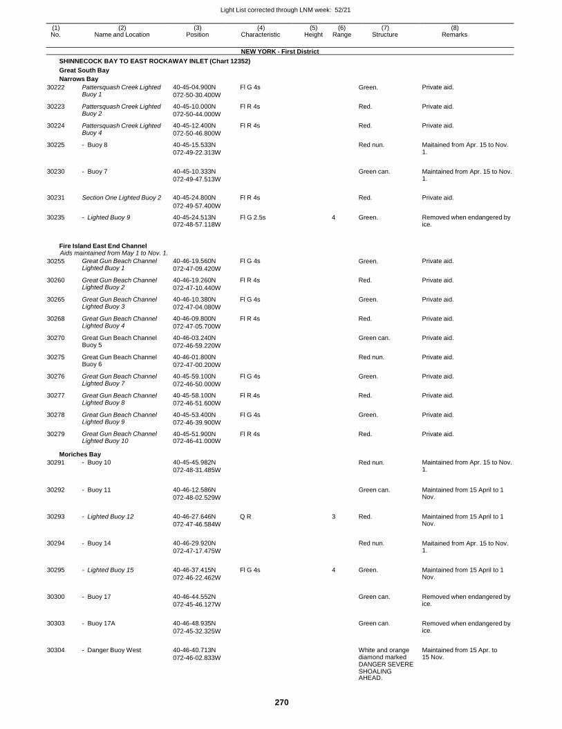
Light List corrected through LNM week: 52/21
270
(1) (2) (3) (4) (5) (6) (7) (8) No. Name and Location Position Characteristic Height Range Structure Remarks
NEW YORK - First District
SHINNECOCK BAY TO EAST ROCKAWAY INLET (Chart 12352)
Great South Bay
Narrows Bay
30222 Pattersquash Creek Lighted Buoy 1
40-45-04.900N
072-50-30.400W
Fl G 4s Green. Private aid.
30223 Pattersquash Creek Lighted Buoy 2
40-45-10.000N
072-50-44.000W
Fl R 4s Red. Private aid.
30224 Pattersquash Creek Lighted Buoy 4
40-45-12.400N
072-50-46.800W
Fl R 4s Red. Private aid.
30225 - Buoy 8 40-45-15.533N
072-49-22.313W
Red nun. Maitained from Apr. 15 to Nov. 1.
30230 - Buoy 7 40-45-10.333N
072-49-47.513W
Green can. Maintained from Apr. 15 to Nov.
1.
30231 Section One Lighted Buoy 2 40-45-24.800N Fl R 4s
Red. Private aid.
072-49-57.400W
30235 - Lighted Buoy 9 40-45-24.513N 072-48-57.118W
Fl G 2.5s 4 Green. Removed when endangered by ice.
Fire Island East End Channel Aids maintained from May 1 to Nov. 1.
30255 Great Gun Beach Channel Lighted Buoy 1
40-46-19.560N
072-47-09.420W
Fl G 4s Green. Private aid.
30260 Great Gun Beach Channel Lighted Buoy 2
40-46-19.260N
072-47-10.440W
Fl R 4s Red. Private aid.
30265 Great Gun Beach Channel Lighted Buoy 3
40-46-10.380N
072-47-04.080W
Fl G 4s Green. Private aid.
30268 Great Gun Beach Channel Lighted Buoy 4
40-46-09.800N
072-47-05.700W
Fl R 4s Red. Private aid.
30270 Great Gun Beach Channel Buoy 5
40-46-03.240N
072-46-59.220W
Green can. Private aid.
30275 Great Gun Beach Channel Buoy 6
40-46-01.800N
072-47-00.200W
Red nun. Private aid.
30276 Great Gun Beach Channel Lighted Buoy 7
40-45-59.100N
072-46-50.000W
Fl G 4s Green. Private aid.
30277 Great Gun Beach Channel Lighted Buoy 8
40-45-58.100N
072-46-51.600W
Fl R 4s Red. Private aid.
30278 Great Gun Beach Channel Lighted Buoy 9
40-45-53.400N
072-46-39.900W
Fl G 4s Green. Private aid.
30279 Great Gun Beach Channel Lighted Buoy 10
40-45-51.900N 072-46-41.000W
Fl R 4s Red. Private aid.
Moriches Bay
30291 - Buoy 10 40-45-45.982N
072-48-31.485W
Red nun. Maintained from Apr. 15 to Nov. 1.
30292 - Buoy 11 40-46-12.586N
072-48-02.529W
Green can. Maintained from 15 April to 1
Nov.
30293 - Lighted Buoy 12 40-46-27.646N
072-47-46.584W
Q R 3 Red. Maintained from 15 April to 1 Nov.
30294 - Buoy 14 40-46-29.920N
072-47-17.475W
Red nun. Maitained from Apr. 15 to Nov.
1.
30295 - Lighted Buoy 15 40-46-37.415N
072-46-22.462W
Fl G 4s 4 Green. Maintained from 15 April to 1 Nov.
30300 - Buoy 17 40-46-44.552N
072-45-46.127W
Green can. Removed when endangered by
ice.
30303 - Buoy 17A 40-46-48.935N
072-45-32.325W
Green can. Removed when endangered by
ice.
30304 - Danger Buoy West 40-46-40.713N
072-46-02.833W
White and orange diamond marked DANGER SEVERE SHOALING AHEAD.
Maintained from 15 Apr. to 15 Nov.
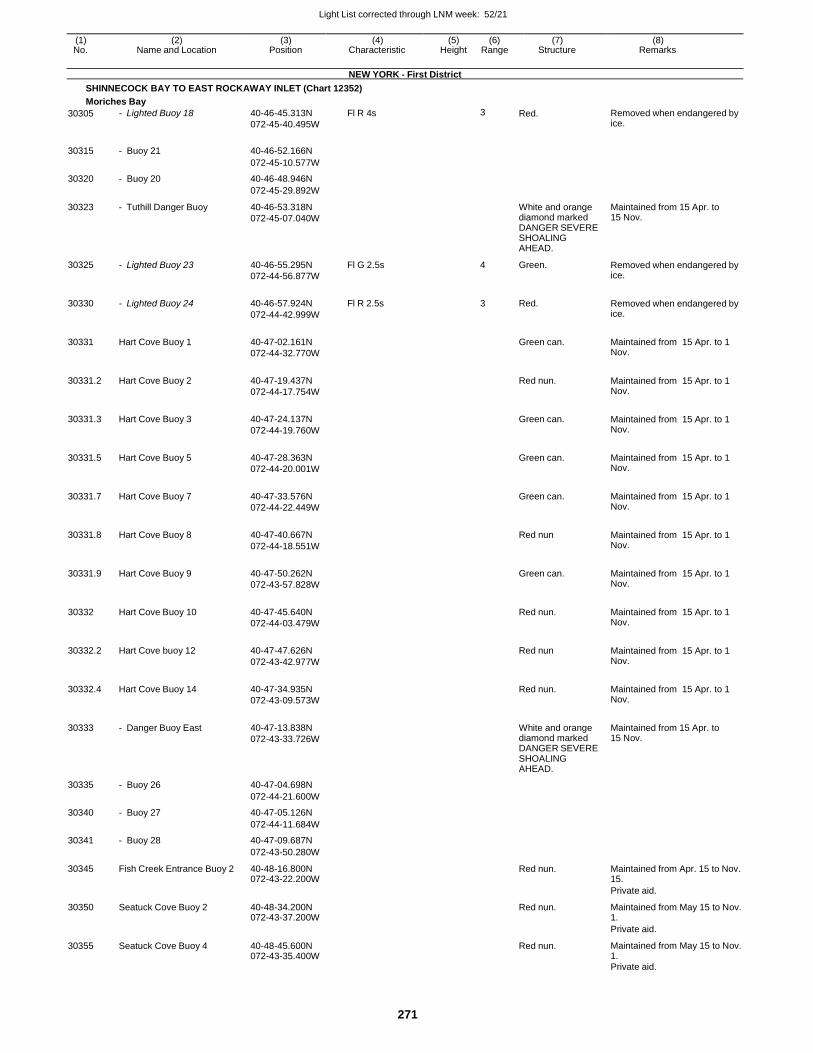
Light List corrected through LNM week: 52/21
271
(1) (2) (3) (4) (5) (6) (7) (8) No. Name and Location Position Characteristic Height Range Structure Remarks
NEW YORK - First District
SHINNECOCK BAY TO EAST ROCKAWAY INLET (Chart 12352)
Moriches Bay
30305 - Lighted Buoy 18 40-46-45.313N
072-45-40.495W
Fl R 4s 3 Red. Removed when endangered by ice.
30315 - Buoy 21 40-46-52.166N
072-45-10.577W
30320 - Buoy 20 40-46-48.946N
072-45-29.892W
30323 - Tuthill Danger Buoy 40-46-53.318N
072-45-07.040W
White and orange diamond marked DANGER SEVERE SHOALING AHEAD.
Maintained from 15 Apr. to 15 Nov.
30325 - Lighted Buoy 23 40-46-55.295N
072-44-56.877W
Fl G 2.5s 4 Green. Removed when endangered by ice.
30330 - Lighted Buoy 24 40-46-57.924N
072-44-42.999W
Fl R 2.5s 3 Red. Removed when endangered by ice.
30331 Hart Cove Buoy 1 40-47-02.161N
072-44-32.770W
Green can. Maintained from 15 Apr. to 1
Nov.
30331.2 Hart Cove Buoy 2 40-47-19.437N
072-44-17.754W
Red nun. Maintained from 15 Apr. to 1
Nov.
30331.3 Hart Cove Buoy 3 40-47-24.137N
072-44-19.760W
Green can. Maintained from 15 Apr. to 1
Nov.
30331.5 Hart Cove Buoy 5 40-47-28.363N
072-44-20.001W
Green can. Maintained from 15 Apr. to 1
Nov.
30331.7 Hart Cove Buoy 7 40-47-33.576N
072-44-22.449W
Green can. Maintained from 15 Apr. to 1
Nov.
30331.8 Hart Cove Buoy 8 40-47-40.667N
072-44-18.551W
Red nun Maintained from 15 Apr. to 1
Nov.
30331.9 Hart Cove Buoy 9 40-47-50.262N
072-43-57.828W
Green can. Maintained from 15 Apr. to 1
Nov.
30332 Hart Cove Buoy 10 40-47-45.640N
072-44-03.479W
Red nun. Maintained from 15 Apr. to 1
Nov.
30332.2 Hart Cove buoy 12 40-47-47.626N
072-43-42.977W
Red nun Maintained from 15 Apr. to 1
Nov.
30332.4 Hart Cove Buoy 14 40-47-34.935N
072-43-09.573W
Red nun. Maintained from 15 Apr. to 1
Nov.
30333 - Danger Buoy East 40-47-13.838N
072-43-33.726W
White and orange diamond marked DANGER SEVERE SHOALING AHEAD.
Maintained from 15 Apr. to 15 Nov.
30335 - Buoy 26 40-47-04.698N
072-44-21.600W
30340 - Buoy 27 40-47-05.126N
072-44-11.684W
30341 - Buoy 28 40-47-09.687N
072-43-50.280W
30345 Fish Creek Entrance Buoy 2 40-48-16.800N 072-43-22.200W
Red nun. Maintained from Apr. 15 to Nov. 15.
Private aid.
30350 Seatuck Cove Buoy 2 40-48-34.200N 072-43-37.200W
Red nun. Maintained from May 15 to Nov. 1.
Private aid.
30355 Seatuck Cove Buoy 4 40-48-45.600N 072-43-35.400W
Red nun. Maintained from May 15 to Nov. 1.
Private aid.
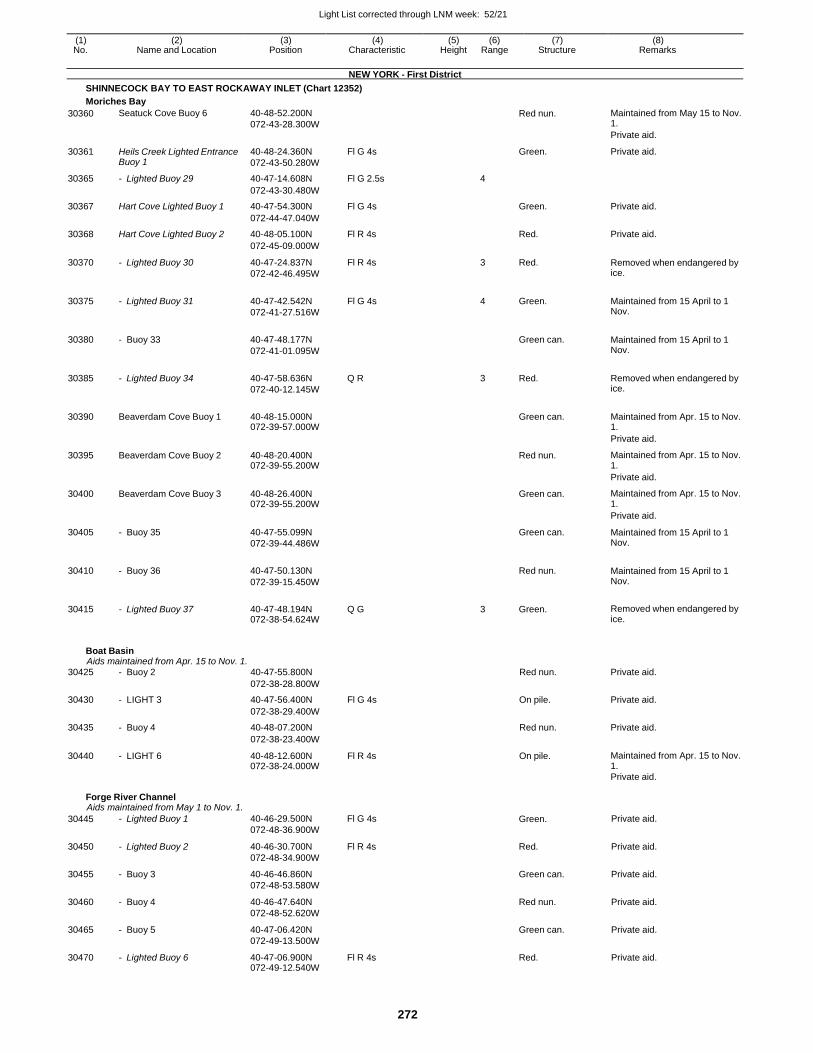
Light List corrected through LNM week: 52/21
272
(1) (2) (3) (4) (5) (6) (7) (8) No. Name and Location Position Characteristic Height Range Structure Remarks
NEW YORK - First District
SHINNECOCK BAY TO EAST ROCKAWAY INLET (Chart 12352)
Moriches Bay
30360 Seatuck Cove Buoy 6 40-48-52.200N
072-43-28.300W
Red nun. Maintained from May 15 to Nov. 1.
Private aid.
30361 Heils Creek Lighted Entrance Buoy 1
40-48-24.360N
072-43-50.280W
Fl G 4s Green. Private aid.
30365 - Lighted Buoy 29 40-47-14.608N Fl G 2.5s 4
072-43-30.480W
30367 Hart Cove Lighted Buoy 1 40-47-54.300N Fl G 4s Green. Private aid.
072-44-47.040W
30368 Hart Cove Lighted Buoy 2 40-48-05.100N Fl R 4s Red. Private aid.
072-45-09.000W
30370 - Lighted Buoy 30 40-47-24.837N
072-42-46.495W
Fl R 4s 3 Red. Removed when endangered by ice.
30375 - Lighted Buoy 31 40-47-42.542N
072-41-27.516W
Fl G 4s 4 Green. Maintained from 15 April to 1 Nov.
30380 - Buoy 33 40-47-48.177N
072-41-01.095W
Green can. Maintained from 15 April to 1
Nov.
30385 - Lighted Buoy 34 40-47-58.636N
072-40-12.145W
Q R 3 Red. Removed when endangered by ice.
30390 Beaverdam Cove Buoy 1 40-48-15.000N 072-39-57.000W
Green can. Maintained from Apr. 15 to Nov.
1.
Private aid.
30395 Beaverdam Cove Buoy 2 40-48-20.400N 072-39-55.200W
Red nun. Maintained from Apr. 15 to Nov. 1.
Private aid.
30400 Beaverdam Cove Buoy 3 40-48-26.400N 072-39-55.200W
Green can. Maintained from Apr. 15 to Nov. 1.
Private aid.
30405 - Buoy 35 40-47-55.099N
072-39-44.486W
Green can. Maintained from 15 April to 1 Nov.
30410 - Buoy 36 40-47-50.130N
072-39-15.450W
Red nun. Maintained from 15 April to 1
Nov.
30415 - Lighted Buoy 37 40-47-48.194N 072-38-54.624W
Q G 3 Green. Removed when endangered by ice.
Boat Basin Aids maintained from Apr. 15 to Nov. 1.
30425 - Buoy 2 40-47-55.800N Red nun. Private aid.
072-38-28.800W
30430 - LIGHT 3 40-47-56.400N Fl G 4s On pile. Private aid.
072-38-29.400W
30435 - Buoy 4 40-48-07.200N Red nun. Private aid.
072-38-23.400W
30440 - LIGHT 6 40-48-12.600N 072-38-24.000W
Fl R 4s On pile. Maintained from Apr. 15 to Nov. 1.
Private aid.
Forge River Channel Aids maintained from May 1 to Nov. 1.
30445 - Lighted Buoy 1 40-46-29.500N
072-48-36.900W
Fl G 4s Green. Private aid.
30450 - Lighted Buoy 2 40-46-30.700N
072-48-34.900W
Fl R 4s Red. Private aid.
30455 - Buoy 3 40-46-46.860N
072-48-53.580W
Green can. Private aid.
30460 - Buoy 4 40-46-47.640N
072-48-52.620W
Red nun. Private aid.
30465 - Buoy 5 40-47-06.420N
072-49-13.500W
Green can. Private aid.
30470 - Lighted Buoy 6 40-47-06.900N 072-49-12.540W
Fl R 4s Red. Private aid.
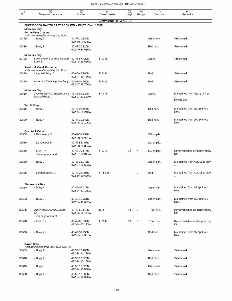
Light List corrected through LNM week: 52/21
273
(1) (2) (3) (4) (5) (6) (7) (8) No. Name and Location Position Characteristic Height Range Structure Remarks
NEW YORK - First District
SHINNECOCK BAY TO EAST ROCKAWAY INLET (Chart 12352)
Moriches Bay
Forge River Channel Aids maintained from May 1 to Nov. 1.
30475 - Buoy 7 40-47-29.580N Green can. Private aid.
072-49-35.520W
30480 - Buoy 8 40-47-30.120N Red nun. Private aid. 072-49-34.680W
Moriches Bay
30485 Senix Creek Entrance Lighted Buoy 1
40-46-57.420N 072-48-10.560W
Fl G 4s Green. Private aid.
Areskonk Creek Entrance Aids maintained from May 1 to Nov. 1.
30490 - Lighted Buoy 2 40-46-49.200N Fl R 4s Red. Private aid.
072-47-50.760W
30495 Areskonk Creek Lighted Buoy 4
40-47-04.200N 072-47-48.700W
Fl R 4s Red. Private aid.
Moriches Bay
30510 Orchard Neck Creek Entrance Lighted Buoy 1
40-46-55.920N
072-47-23.580W
Fl G 4s Green. Maintained from May 1 to Nov. 1.
Private aid.
Tuthill Cove
30515 - Buoy 2 40-47-02.568N
072-44-59.210W
Red nun. Maintained from 15 April to 1 Nov.
30520 - Buoy 4 40-47-10.540N 072-45-03.196W
Red nun. Maintained from 15 April to 1 Nov.
Quantuck Canal 30559 - Daybeacon 3 40-47-52.952N SG on pile.
072-38-22.931W
30560 - Daybeacon 5 40-47-55.407N SG on pile.
072-38-08.034W
30565 - LIGHT 7
On edge of marsh.
40-48-10.177N
072-37-30.014W
Fl G 4s 14 4 SG on pile. Removed when Endangered by ice.
30570 - Buoy 9 40-48-18.975N
072-37-08.533W
Green can. Maintained from Apr. 15 to Nov.
1.
30575 - Lighted Buoy 10 40-48-23.801N 072-36-50.509W
Fl R 2.5s
3 Red. Maintained from Apr. 15 to Nov. 1.
Shinnecock Bay
30580 - Buoy 1 40-49-07.028N
072-34-57.185W
Green can. Maintained from 15 April to 1 Nov.
30583 - Buoy 3 40-49-19.761N
072-34-41.662W
Green can. Maintained from 15 April to 1
Nov.
30585 QUANTUCK CANAL LIGHT 12
40-48-50.113N 072-35-05.454W
Q R 14 3 TR on pile. Removed when Endangered by ice.
On edge of marsh.
30590 - LIGHT 2 40-49-06.897N
072-34-55.195W
Fl R 4s 16 3 TR on pile. Removed when endangered by ice.
30600 - Buoy 4 40-49-31.259N 072-34-27.337W
Red nun. Maintained from 15 April to 1
Nov.
Daves Creek Aids maintained from Apr. 15 to Nov. 15.
30605 - Buoy 1 40-50-12.780N
072-34-11.280W Green can. Private aid.
30610 - Buoy 2 40-50-13.620N
072-34-11.160W
Red nun. Private aid.
30615 - Buoy 3 40-50-11.520N
072-34-16.800W
Green can. Private aid.
30620 - Buoy 4 40-50-12.060N 072-34-16.800W
Red nun. Private aid.
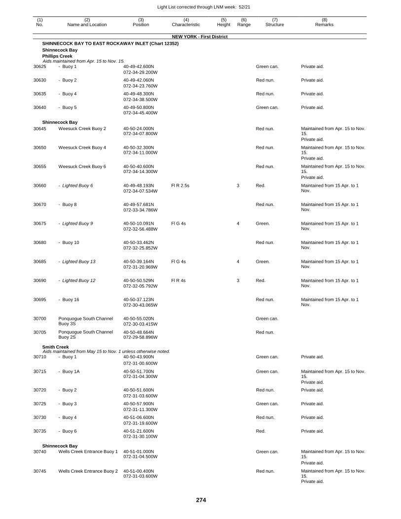
Light List corrected through LNM week: 52/21
274
(1) (2) (3) (4) (5) (6) (7) (8) No. Name and Location Position Characteristic Height Range Structure Remarks
NEW YORK - First District
SHINNECOCK BAY TO EAST ROCKAWAY INLET (Chart 12352)
Shinnecock Bay
Phillips Creek Aids maintained from Apr. 15 to Nov. 15.
30625 - Buoy 1 40-49-42.600N Green can. Private aid.
072-34-29.200W
30630 - Buoy 2 40-49-42.060N Red nun. Private aid.
072-34-23.760W
30635 - Buoy 4 40-49-48.300N Red nun. Private aid.
072-34-38.500W
30640 - Buoy 5 40-49-50.800N Green can. Private aid. 072-34-45.400W
Shinnecock Bay
30645 Weesuck Creek Buoy 2 40-50-24.000N 072-34-07.800W
Red nun. Maintained from Apr. 15 to Nov. 15.
Private aid.
30650 Weesuck Creek Buoy 4 40-50-32.300N 072-34-11.000W
Red nun. Maintained from Apr. 15 to Nov. 15.
Private aid.
30655 Weesuck Creek Buoy 6 40-50-40.600N 072-34-14.300W
Red nun. Maintained from Apr. 15 to Nov. 15.
Private aid.
30660 - Lighted Buoy 6 40-49-48.193N
072-34-07.534W
Fl R 2.5s 3 Red. Maintained from 15 Apr. to 1 Nov.
30670 - Buoy 8 40-49-57.681N
072-33-34.786W
Red nun. Maintained from 15 Apr. to 1
Nov.
30675 - Lighted Buoy 9 40-50-10.091N
072-32-56.488W
Fl G 4s 4 Green. Maintained from 15 Apr. to 1 Nov.
30680 - Buoy 10 40-50-33.462N
072-32-25.852W
Red nun. Maintained from 15 Apr. to 1
Nov.
30685 - Lighted Buoy 13 40-50-39.164N
072-31-20.969W
Fl G 4s 4 Green. Maintained from 15 Apr. to 1 Nov.
30690 - Lighted Buoy 12 40-50-50.529N
072-32-05.792W
Fl R 4s 3 Red. Maintained from 15 Apr. to 1 Nov.
30695 - Buoy 16 40-50-37.123N
072-30-43.065W
Red nun. Maintained from 15 Apr. to 1
Nov.
30700 Ponquogue South Channel Buoy 3S
40-50-55.020N
072-30-03.415W
Green can.
30705 Ponquogue South Channel Buoy 2S
40-50-48.664N 072-29-58.896W
Red nun.
Smith Creek Aids maintained from May 15 to Nov. 1 unless otherwise noted.
30710 - Buoy 1 40-50-43.900N Green can. Private aid.
072-31-00.600W
30715 - Buoy 1A 40-50-51.700N 072-31-04.300W
Green can. Maintained from Apr. 15 to Nov. 15.
Private aid.
30720 - Buoy 2 40-50-51.600N Red nun. Private aid.
072-31-03.600W
30725 - Buoy 3 40-50-57.900N Green can. Private aid.
072-31-11.300W
30730 - Buoy 4 40-51-06.600N Red nun. Private aid.
072-31-19.600W
30735 - Buoy 6 40-51-21.600N Red. Private aid. 072-31-30.100W
Shinnecock Bay
30740 Wells Creek Entrance Buoy 1 40-51-01.000N 072-31-04.500W
Green can. Maintained from Apr. 15 to Nov. 15.
Private aid.
30745 Wells Creek Entrance Buoy 2 40-51-00.400N 072-31-03.600W
Red nun. Maintained from Apr. 15 to Nov. 15.
Private aid.
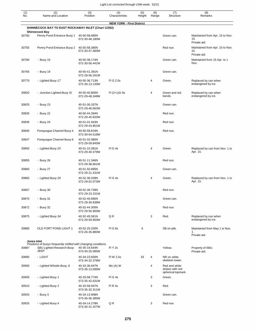
Light List corrected through LNM week: 52/21
275
(1) (2) (3) (4) (5) (6) (7) (8) No. Name and Location Position Characteristic Height Range Structure Remarks
NEW YORK - First District
SHINNECOCK BAY TO EAST ROCKAWAY INLET (Chart 12352)
Shinnecock Bay
30750 Penny Pond Entrance Buoy 1 40-50-58.680N
072-30-48.180W
Green can. Maintained from Apr. 15 to Nov. 15.
Private aid.
30755 Penny Pond Entrance Buoy 2 40-50-58.380N 072-30-47.460W
Red nun. Maintained from Apr. 15 to Nov. 15.
Private aid.
30760 - Buoy 15 40-50-38.174N
072-30-56.441W
Green can. Maintained from 15 Apr. to 1 Nov.
30765 - Buoy 19 40-50-41.391N
Green can.
072-29-56.291W
30770 - Lighted Buoy 17 40-50-36.713N
072-30-13.135W
Fl G 2.5s 4 Green. Replaced by can when endangered by ice.
30820 - Junction Lighted Buoy SI 40-50-40.800N
072-29-48.349W
Fl (2+1)G 6s
4 Green and red bands.
Replaced by can when endangered by ice.
30825 - Buoy 23 40-51-00.337N
Green can.
072-29-46.562W
30830 - Buoy 22 40-50-44.394N Red nun.
072-29-45.833W
30835 - Buoy 24 40-51-01.943N Red nun.
072-29-43.851W
30845 Ponquogue Channel Buoy 4 40-50-59.819N Red nun.
072-30-04.516W
30847 Ponquogue Channel Buoy 6 40-51-02.985N
072-29-59.845W
30850 - Lighted Buoy 25 40-51-10.391N
072-29-40.379W
Fl G 4s 4 Green. Replaced by can from Nov. 1 to Apr. 15.
30855 - Buoy 26 40-51-11.346N
Red nun.
072-29-38.661W
30860 - Buoy 27 40-51-50.895N Green can.
072-29-21.431W
30865 - Lighted Buoy 29 40-52-36.028N
072-29-02.073W
Fl G 4s 4 Green. Replaced by can from Nov. 1 to Apr. 15.
30867 - Buoy 30 40-52-39.739N
Red nun.
072-29-23.231W
30870 - Buoy 31 40-52-40.680N Green can.
072-29-30.838W
30872 - Buoy 32 40-52-44.300N Red nun.
072-29-50.950W
30875 - Lighted Buoy 34 40-52-45.581N
072-29-59.950W
Q R 3 Red. Replaced by nun when endangered by ice.
30885 OLD FORT POND LIGHT 1 40-52-25.200N
072-26-35.880W
Fl G 6s 6
SB on pile. Maintained from May 1 to Nov. 1. Private aid.
Jones Inlet Positions of buoys frequently shifted with changing conditions.
30887 SBU Lighted Research Buoy JBSP
40-35-19.644N
073-30-25.085W
Fl Y 2s Yellow. Property of SBU.
Private aid.
30890 - LIGHT 40-34-23.600N
073-34-32.378W
Fl W 2.5s 33 4 NR on white skeleton tower.
30900 - Lighted Whistle Buoy JI 40-33-36.947N
073-35-13.095W
Mo (A) W 4 Red and white stripes with red spherical topmark.
30905 - Lighted Buoy 1 40-33-58.774N Fl G 4s 3 Green.
073-35-42.631W
30910 - Lighted Buoy 2 40-33-58.947N Fl R 4s 3 Red.
073-35-32.311W
30920 - Buoy 3 40-34-13.908N Green can.
073-35-36.385W
30925 - Lighted Buoy 4 40-34-14.278N Q R 3 Red nun.
073-35-31.427W
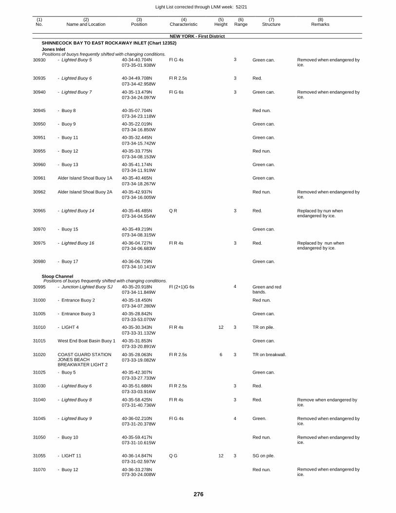
Light List corrected through LNM week: 52/21
276
(1) (2) (3) (4) (5) (6) (7) (8) No. Name and Location Position Characteristic Height Range Structure Remarks
NEW YORK - First District
SHINNECOCK BAY TO EAST ROCKAWAY INLET (Chart 12352)
Jones Inlet Positions of buoys frequently shifted with changing conditions.
30930 - Lighted Buoy 5 40-34-40.704N
073-35-01.938W
Fl G 4s 3 Green can. Removed when endangered by ice.
30935 - Lighted Buoy 6 40-34-49.708N Fl R 2.5s 3 Red.
073-34-42.958W
30940 - Lighted Buoy 7 40-35-13.479N
073-34-24.097W
Fl G 6s 3 Green can. Removed when endangered by ice.
30945 - Buoy 8 40-35-07.704N
Red nun.
073-34-23.118W
30950 - Buoy 9 40-35-22.019N Green can.
073-34-16.850W
30951 - Buoy 11 40-35-32.445N Green can.
073-34-15.742W
30955 - Buoy 12 40-35-33.775N Red nun.
073-34-08.153W
30960 - Buoy 13 40-35-41.174N Green can.
073-34-11.919W
30961 Alder Island Shoal Buoy 1A 40-35-40.465N Green can.
073-34-18.267W
30962 Alder Island Shoal Buoy 2A 40-35-42.937N
073-34-16.005W
Red nun. Removed when endangered by ice.
30965 - Lighted Buoy 14 40-35-46.485N
073-34-04.554W
Q R 3 Red. Replaced by nun when endangered by ice.
30970 - Buoy 15 40-35-49.219N
Green can.
073-34-08.315W
30975 - Lighted Buoy 16 40-36-04.727N
073-34-06.683W
Fl R 4s 3 Red. Replaced by nun when endangered by ice.
30980 - Buoy 17 40-36-06.729N
Green can.
073-34-10.141W
Sloop Channel Positions of buoys frequently shifted with changing conditions.
30995 - Junction Lighted Buoy SJ 40-35-20.918N
073-34-11.849W
Fl (2+1)G 6s 4 Green and red bands.
31000 - Entrance Buoy 2 40-35-18.450N Red nun.
073-34-07.280W
31005 - Entrance Buoy 3 40-35-28.842N Green can.
073-33-53.070W
31010 - LIGHT 4 40-35-30.343N Fl R 4s 12 3 TR on pile.
073-33-31.132W
31015 West End Boat Basin Buoy 1 40-35-31.853N Green can.
073-33-20.891W
31020 COAST GUARD STATION JONES BEACH BREAKWATER LIGHT 2
40-35-28.063N
073-33-19.082W
Fl R 2.5s 6 3 TR on breakwall.
31025 - Buoy 5 40-35-42.307N Green can.
073-33-27.733W
31030 - Lighted Buoy 6 40-35-51.686N Fl R 2.5s 3 Red.
073-33-03.916W
31040 - Lighted Buoy 8 40-35-58.425N
073-31-40.736W
Fl R 4s 3 Red. Remove when endangered by ice.
31045 - Lighted Buoy 9 40-36-02.210N
073-31-20.378W
Fl G 4s
4 Green. Removed when endangered by ice.
31050 - Buoy 10 40-35-59.417N
073-31-10.615W
Red nun. Removed when endangered by
ice.
31055 - LIGHT 11 40-36-14.847N Q G 12 3 SG on pile.
073-31-02.597W
31070 - Buoy 12 40-36-33.278N 073-30-24.008W
Red nun. Removed when endangered by ice.
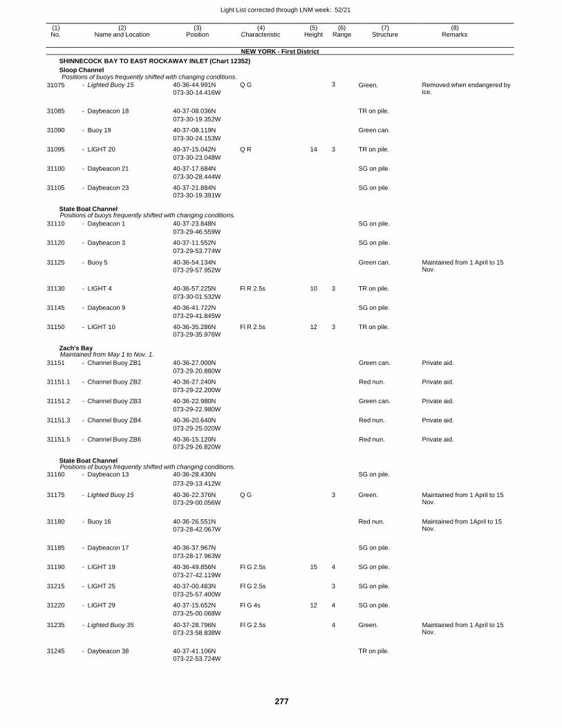
Light List corrected through LNM week: 52/21
277
(1) (2) (3) (4) (5) (6) (7) (8) No. Name and Location Position Characteristic Height Range Structure Remarks
NEW YORK - First District
SHINNECOCK BAY TO EAST ROCKAWAY INLET (Chart 12352)
Sloop Channel Positions of buoys frequently shifted with changing conditions.
31075 - Lighted Buoy 15 40-36-44.991N
073-30-14.416W
Q G 3 Green. Removed when endangered by ice.
31085 - Daybeacon 18 40-37-08.036N
TR on pile.
073-30-19.352W
31090 - Buoy 19 40-37-08.119N Green can.
073-30-24.153W
31095 - LIGHT 20 40-37-15.042N Q R 14 3 TR on pile.
073-30-23.048W
31100 - Daybeacon 21 40-37-17.684N SG on pile.
073-30-28.444W
31105 - Daybeacon 23 40-37-21.884N SG on pile.
073-30-19.391W
State Boat Channel Positions of buoys frequently shifted with changing conditions.
31110 - Daybeacon 1 40-37-23.848N SG on pile.
073-29-46.559W
31120 - Daybeacon 3 40-37-11.552N SG on pile.
073-29-53.774W
31125 - Buoy 5 40-36-54.134N
073-29-57.952W
Green can. Maintained from 1 April to 15 Nov.
31130 - LIGHT 4 40-36-57.225N Fl R 2.5s 10 3 TR on pile.
073-30-01.532W
31145 - Daybeacon 9 40-36-41.722N SG on pile.
073-29-41.845W
31150 - LIGHT 10 40-36-35.286N Fl R 2.5s 12 3 TR on pile.
073-29-35.976W
Zach's Bay Maintained from May 1 to Nov. 1.
31151 - Channel Buoy ZB1 40-36-27.000N Green can. Private aid.
073-29-20.880W
31151.1 - Channel Buoy ZB2 40-36-27.240N Red nun. Private aid.
073-29-22.200W
31151.2 - Channel Buoy ZB3 40-36-22.980N Green can. Private aid.
073-29-22.980W
31151.3 - Channel Buoy ZB4 40-36-20.640N Red nun. Private aid.
073-29-25.020W
31151.5 - Channel Buoy ZB6 40-36-15.120N Red nun. Private aid. 073-29-26.820W
State Boat Channel Positions of buoys frequently shifted with changing conditions.
31160 - Daybeacon 13 40-36-28.430N SG on pile.
073-29-13.412W
31175 - Lighted Buoy 15 40-36-22.376N
073-29-00.056W
Q G 3 Green. Maintained from 1 April to 15 Nov.
31180 - Buoy 16 40-36-26.551N
073-28-42.067W
Red nun. Maintained from 1April to 15
Nov.
31185 - Daybeacon 17 40-36-37.967N
SG on pile.
073-28-17.963W
31190 - LIGHT 19 40-36-49.856N Fl G 2.5s 15 4 SG on pile.
073-27-42.119W
31215 - LIGHT 25 40-37-00.483N Fl G 2.5s 3 SG on pile.
073-25-57.400W
31220 - LIGHT 29 40-37-15.652N Fl G 4s 12 4 SG on pile.
073-25-00.068W
31235 - Lighted Buoy 35 40-37-28.796N
073-23-58.838W
Fl G 2.5s 4 Green. Maintained from 1 April to 15 Nov.
31245 - Daybeacon 38 40-37-41.106N
TR on pile.
073-22-53.724W
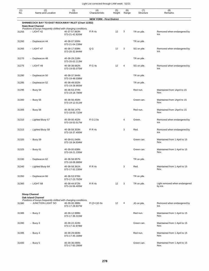
Light List corrected through LNM week: 52/21
278
(1) (2) (3) (4) (5) (6) (7) (8) No. Name and Location Position Characteristic Height Range Structure Remarks
NEW YORK - First District
SHINNECOCK BAY TO EAST ROCKAWAY INLET (Chart 12352)
State Boat Channel Positions of buoys frequently shifted with changing conditions.
31255 - LIGHT 42 40-37-57.863N
073-21-42.820W
Fl R 4s 12 3 TR on pile. Removed when endangered by ice.
31260 - Daybeacon 44 40-38-07.500N
TR on pile.
073-21-04.239W
31265 - LIGHT 47 40-38-17.839N
073-20-32.844W
Q G 12 3 SG on pile. Removed when endangered by ice.
31270 - Daybeacon 48 40-38-29.218N
TR on pile.
073-20-02.213W
31275 - LIGHT 49 40-38-38.662N
073-19-55.075W
Fl G 4s 12 4 SG on pile. Removed when endangered by ice.
31280 - Daybeacon 50 40-38-37.944N
TR on pile.
073-19-48.038W
31285 - Daybeacon 52 40-38-48.002N TR on pile.
073-19-28.955W
31295 - Buoy 54 40-38-53.374N
073-19-18.790W
Red nun. Maintained from 1April to 15 Nov.
31300 - Buoy 55 40-38-56.450N
073-19-12.011W
Green can. Maintained from 1April to 15
Nov.
31305 - Buoy 56 40-38-58.147N
073-18-55.732W
Red nun. Maintained from 1April to 15
Nov.
31310 - Lighted Buoy 57 40-39-00.402N
073-18-53.517W
Fl G 2.5s
4 Green. Removed when endangered by ice.
31315 - Lighted Buoy 58 40-38-59.303N
073-18-37.400W
Fl R 4s
3 Red. Removed when endangered by ice.
31320 - Buoy 59 40-39-01.040N
073-18-34.934W
Green can. Maintained from 1 April to 15
Nov.
31325 - Buoy 61 40-39-00.638N
073-18-21.235W
Green can. Maintained from 1 April to 15
Nov.
31330 - Daybeacon 62 40-38-58.957N
TR on pile.
073-18-08.686W
31340 - Lighted Buoy 64 40-38-58.361N
073-17-52.235W
Fl R 4s 3 Red. Maintained from 1 April to 15 Nov.
31350 - Daybeacon 66 40-38-53.976N
TR on pile.
073-17-23.792W
31360 - LIGHT 68 40-38-44.872N 073-16-56.405W
Fl R 4s 12 3 TR on pile. Light removed when endangered by ice.
Sloop Channel
Oak Island Channel Positions of buoys frequently shifted with changing conditions.
31380 - JUNCTION LIGHT SO 40-39-00.388N
073-17-28.837W
Fl (2+1)G 6s 12 4 JG on pile. Removed when endangered by ice.
31385 - Buoy 2 40-39-12.999N
073-17-36.315W
Red nun. Maintained from 1 April to 15
Nov.
31390 - Buoy 3 40-39-22.424N
073-17-42.878W
Green can. Maintained from 1 April to 15
Nov.
31395 - Buoy 4 40-39-29.683N
073-17-45.169W
Red nun. Maintained from 1 April to 15
Nov.
31400 - Buoy 5 40-39-36.090N 073-17-50.295W
Green can. Maintained from 1 April to 15
Nov.
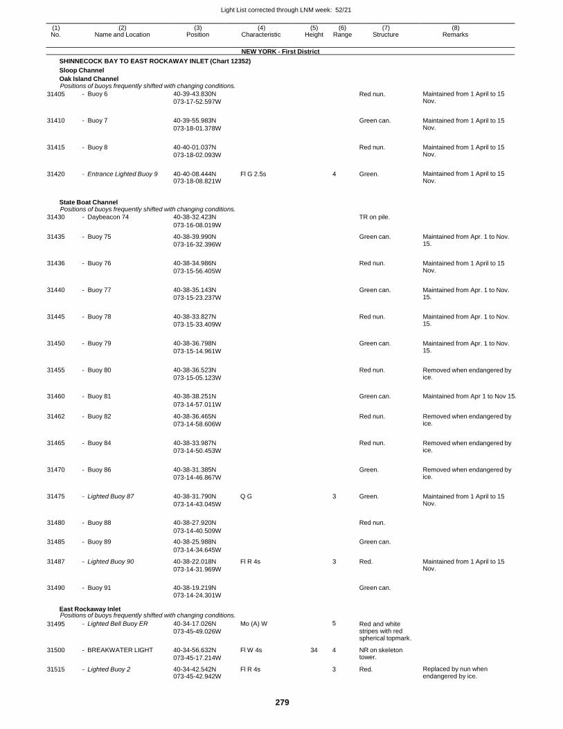
Light List corrected through LNM week: 52/21
279
(1) (2) (3) (4) (5) (6) (7) (8) No. Name and Location Position Characteristic Height Range Structure Remarks
NEW YORK - First District
SHINNECOCK BAY TO EAST ROCKAWAY INLET (Chart 12352)
Sloop Channel
Oak Island Channel Positions of buoys frequently shifted with changing conditions.
31405 - Buoy 6 40-39-43.830N
073-17-52.597W
Red nun. Maintained from 1 April to 15 Nov.
31410 - Buoy 7 40-39-55.983N
073-18-01.378W
Green can. Maintained from 1 April to 15
Nov.
31415 - Buoy 8 40-40-01.037N
073-18-02.093W
Red nun. Maintained from 1 April to 15
Nov.
31420 - Entrance Lighted Buoy 9 40-40-08.444N 073-18-08.821W
Fl G 2.5s 4 Green. Maintained from 1 April to 15 Nov.
State Boat Channel Positions of buoys frequently shifted with changing conditions.
31430 - Daybeacon 74 40-38-32.423N TR on pile.
073-16-08.019W
31435 - Buoy 75 40-38-39.990N
073-16-32.396W
Green can. Maintained from Apr. 1 to Nov. 15.
31436 - Buoy 76 40-38-34.986N
073-15-56.405W
Red nun. Maintained from 1 April to 15
Nov.
31440 - Buoy 77 40-38-35.143N
073-15-23.237W
Green can. Maintained from Apr. 1 to Nov.
15.
31445 - Buoy 78 40-38-33.827N
073-15-33.409W
Red nun. Maintained from Apr. 1 to Nov.
15.
31450 - Buoy 79 40-38-36.798N
073-15-14.961W
Green can. Maintained from Apr. 1 to Nov.
15.
31455 - Buoy 80 40-38-36.523N
073-15-05.123W
Red nun. Removed when endangered by
ice.
31460 - Buoy 81 40-38-38.251N
Green can. Maintained from Apr 1 to Nov 15.
073-14-57.011W
31462 - Buoy 82 40-38-36.465N
073-14-58.606W
Red nun. Removed when endangered by ice.
31465 - Buoy 84 40-38-33.987N
073-14-50.453W
Red nun. Removed when endangered by
ice.
31470 - Buoy 86 40-38-31.385N
073-14-46.867W
Green. Removed when endangered by
ice.
31475 - Lighted Buoy 87 40-38-31.790N
073-14-43.045W
Q G 3 Green. Maintained from 1 April to 15 Nov.
31480 - Buoy 88 40-38-27.920N
Red nun.
073-14-40.509W
31485 - Buoy 89 40-38-25.988N Green can.
073-14-34.645W
31487 - Lighted Buoy 90 40-38-22.018N
073-14-31.969W
Fl R 4s 3 Red. Maintained from 1 April to 15 Nov.
31490 - Buoy 91 40-38-19.219N
Green can.
073-14-24.301W
East Rockaway Inlet Positions of buoys frequently shifted with changing conditions.
31495 - Lighted Bell Buoy ER 40-34-17.026N
073-45-49.026W
Mo (A) W 5 Red and white stripes with red spherical topmark.
31500 - BREAKWATER LIGHT 40-34-56.632N
073-45-17.214W
Fl W 4s 34 4 NR on skeleton tower.
31515 - Lighted Buoy 2 40-34-42.542N 073-45-42.942W
Fl R 4s 3 Red. Replaced by nun when endangered by ice.
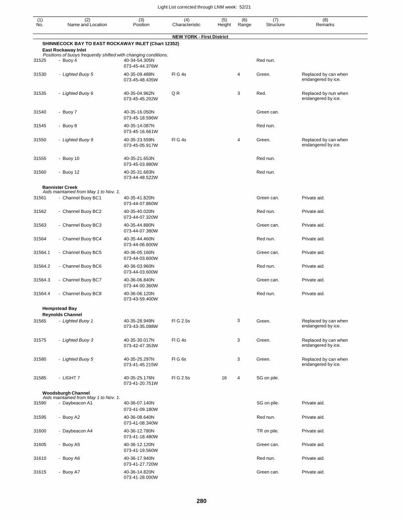
Light List corrected through LNM week: 52/21
280
(1) (2) (3) (4) (5) (6) (7) (8) No. Name and Location Position Characteristic Height Range Structure Remarks
NEW YORK - First District
SHINNECOCK BAY TO EAST ROCKAWAY INLET (Chart 12352)
East Rockaway Inlet Positions of buoys frequently shifted with changing conditions.
31525 - Buoy 4 40-34-54.305N Red nun.
073-45-44.376W
31530 - Lighted Buoy 5 40-35-09.488N
073-45-48.435W
Fl G 4s 4 Green. Replaced by can when endangered by ice.
31535 - Lighted Buoy 6 40-35-04.962N
073-45-45.202W
Q R 3 Red. Replaced by nun when endangered by ice.
31540 - Buoy 7 40-35-16.050N
Green can.
073-45-18.596W
31545 - Buoy 8 40-35-14.087N Red nun.
073-45-16.661W
31550 - Lighted Buoy 9 40-35-23.559N
073-45-05.917W
Fl G 4s 4 Green. Replaced by can when endangered by ice.
31555 - Buoy 10 40-35-21.653N
Red nun.
073-45-03.880W
31560 - Buoy 12 40-35-31.683N Red nun.
073-44-48.522W
Bannister Creek Aids maintained from May 1 to Nov. 1.
31561 - Channel Buoy BC1 40-35-41.820N Green can. Private aid.
073-44-07.860W
31562 - Channel Buoy BC2 40-35-40.020N Red nun. Private aid.
073-44-07.320W
31563 - Channel Buoy BC3 40-35-44.880N Green can. Private aid.
073-44-07.380W
31564 - Channel Buoy BC4 40-35-44.460N Red nun. Private aid.
073-44-06.600W
31564.1 - Channel Buoy BC5 40-36-05.160N Green can. Private aid.
073-44-03.600W
31564.2 - Channel Buoy BC6 40-36-03.960N Red nun. Private aid.
073-44-03.600W
31564.3 - Channel Buoy BC7 40-36-06.840N Green can. Private aid.
073-44-00.360W
31564.4 - Channel Buoy BC8 40-36-06.120N Red nun. Private aid. 073-43-59.400W
Hempstead Bay
Reynolds Channel
31565 - Lighted Buoy 1 40-35-28.949N
073-43-35.098W
Fl G 2.5s 3 Green. Replaced by can when endangered by ice.
31575 - Lighted Buoy 3 40-35-30.017N
073-42-47.353W
Fl G 4s
3 Green. Replaced by can when endangered by ice.
31580 - Lighted Buoy 5 40-35-25.297N
073-41-45.215W
Fl G 6s
3 Green. Replaced by can when endangered by ice.
31585 - LIGHT 7 40-35-25.176N Fl G 2.5s 16 4 SG on pile.
073-41-20.751W
Woodsburgh Channel Aids maintained from May 1 to Nov. 1.
31590 - Daybeacon A1 40-36-07.140N SG on pile. Private aid.
073-41-09.180W
31595 - Buoy A2 40-36-08.640N Red nun. Private aid.
073-41-08.340W
31600 - Daybeacon A4 40-36-12.780N TR on pile. Private aid.
073-41-18.480W
31605 - Buoy A5 40-36-12.120N Green can. Private aid.
073-41-19.560W
31610 - Buoy A6 40-36-17.940N Red nun. Private aid.
073-41-27.720W
31615 - Buoy A7 40-36-14.820N Green can. Private aid. 073-41-28.000W
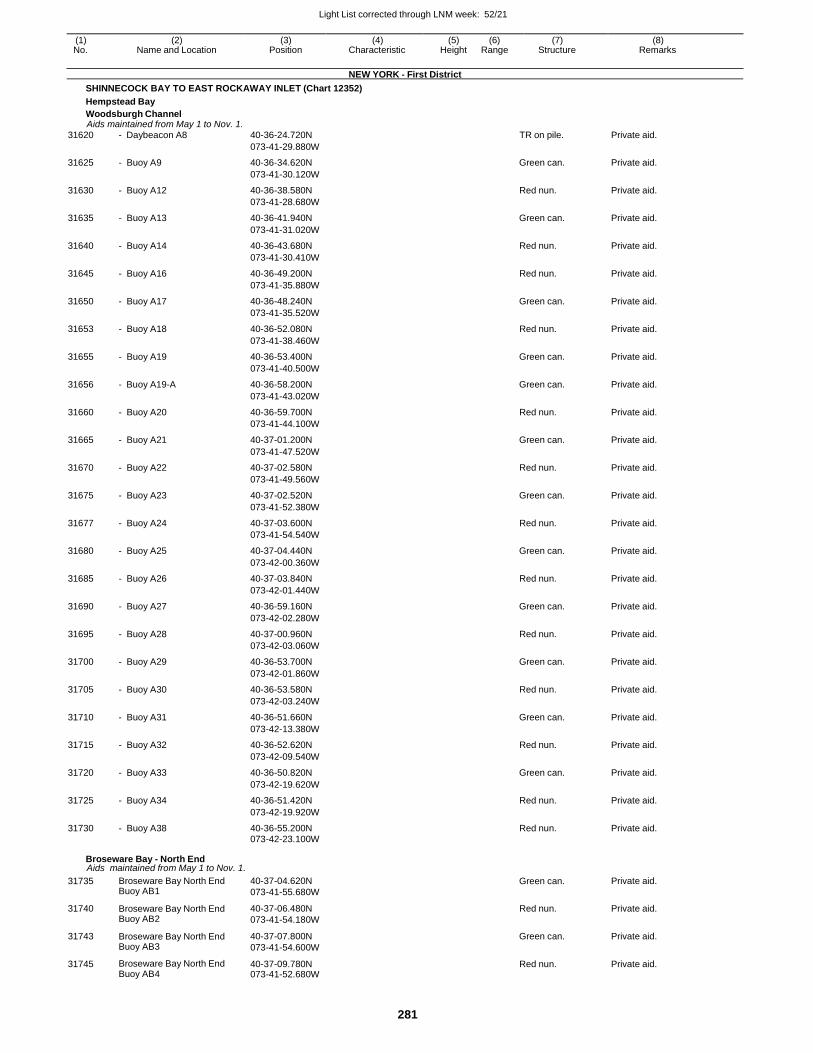
Light List corrected through LNM week: 52/21
281
(1) (2) (3) (4) (5) (6) (7) (8) No. Name and Location Position Characteristic Height Range Structure Remarks
NEW YORK - First District
SHINNECOCK BAY TO EAST ROCKAWAY INLET (Chart 12352)
Hempstead Bay
Woodsburgh Channel Aids maintained from May 1 to Nov. 1.
31620 - Daybeacon A8 40-36-24.720N TR on pile. Private aid.
073-41-29.880W
31625 - Buoy A9 40-36-34.620N Green can. Private aid.
073-41-30.120W
31630 - Buoy A12 40-36-38.580N Red nun. Private aid.
073-41-28.680W
31635 - Buoy A13 40-36-41.940N Green can. Private aid.
073-41-31.020W
31640 - Buoy A14 40-36-43.680N Red nun. Private aid.
073-41-30.410W
31645 - Buoy A16 40-36-49.200N Red nun. Private aid.
073-41-35.880W
31650 - Buoy A17 40-36-48.240N Green can. Private aid.
073-41-35.520W
31653 - Buoy A18 40-36-52.080N Red nun. Private aid.
073-41-38.460W
31655 - Buoy A19 40-36-53.400N Green can. Private aid.
073-41-40.500W
31656 - Buoy A19-A 40-36-58.200N Green can. Private aid.
073-41-43.020W
31660 - Buoy A20 40-36-59.700N Red nun. Private aid.
073-41-44.100W
31665 - Buoy A21 40-37-01.200N Green can. Private aid.
073-41-47.520W
31670 - Buoy A22 40-37-02.580N Red nun. Private aid.
073-41-49.560W
31675 - Buoy A23 40-37-02.520N Green can. Private aid.
073-41-52.380W
31677 - Buoy A24 40-37-03.600N Red nun. Private aid.
073-41-54.540W
31680 - Buoy A25 40-37-04.440N Green can. Private aid.
073-42-00.360W
31685 - Buoy A26 40-37-03.840N Red nun. Private aid.
073-42-01.440W
31690 - Buoy A27 40-36-59.160N Green can. Private aid.
073-42-02.280W
31695 - Buoy A28 40-37-00.960N Red nun. Private aid.
073-42-03.060W
31700 - Buoy A29 40-36-53.700N Green can. Private aid.
073-42-01.860W
31705 - Buoy A30 40-36-53.580N Red nun. Private aid.
073-42-03.240W
31710 - Buoy A31 40-36-51.660N Green can. Private aid.
073-42-13.380W
31715 - Buoy A32 40-36-52.620N Red nun. Private aid.
073-42-09.540W
31720 - Buoy A33 40-36-50.820N Green can. Private aid.
073-42-19.620W
31725 - Buoy A34 40-36-51.420N Red nun. Private aid.
073-42-19.920W
31730 - Buoy A38 40-36-55.200N Red nun. Private aid. 073-42-23.100W
Broseware Bay - North End Aids maintained from May 1 to Nov. 1.
31735 Broseware Bay North End Buoy AB1
40-37-04.620N
073-41-55.680W
Green can. Private aid.
31740 Broseware Bay North End Buoy AB2
40-37-06.480N
073-41-54.180W
Red nun. Private aid.
31743 Broseware Bay North End Buoy AB3
40-37-07.800N
073-41-54.600W
Green can. Private aid.
31745 Broseware Bay North End Buoy AB4
40-37-09.780N 073-41-52.680W
Red nun. Private aid.
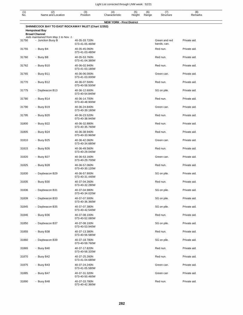
Light List corrected through LNM week: 52/21
282
(1) (2) (3) (4) (5) (6) (7) (8) No. Name and Location Position Characteristic Height Range Structure Remarks
NEW YORK - First District
SHINNECOCK BAY TO EAST ROCKAWAY INLET (Chart 12352)
Hempstead Bay
Broad Channel Aids maintained from May 1 to Nov. 1.
31750 - Junction Buoy B 40-35-33.720N Green and red Private aid.
073-41-05.460W bands; can.
31755 - Buoy B4 40-35-45.060N
073-41-03.480W
Red nun. Private aid.
31760 - Buoy B8 40-35-53.760N
073-41-04.380W
Red nun. Private aid.
31762 - Buoy B10 40-36-02.940N
073-41-03.180W
Red nun. Private aid.
31765 - Buoy B11 40-36-06.000N
073-41-03.000W
Green can. Private aid.
31770 - Buoy B12 40-36-07.500N
073-40-58.500W
Red nun. Private aid.
31775 - Daybeacon B13 40-36-12.600N
073-40-54.840W
SG on pile. Private aid.
31780 - Buoy B14 40-36-14.700N
073-40-48.900W
Red nun. Private aid.
31790 - Buoy B19 40-36-24.840N
073-40-39.180W
Green can. Private aid.
31795 - Buoy B20 40-36-23.520N
073-40-38.940W
Red nun. Private aid.
31800 - Buoy B22 40-36-32.880N
073-40-35.760W
Red nun. Private aid.
31805 - Buoy B24 40-36-38.940N
073-40-33.960W
Red nun. Private aid.
31810 - Buoy B25 40-36-42.060N
073-40-34.680W
Green can. Private aid.
31815 - Buoy B26 40-36-49.560N
073-40-29.040W
Red nun. Private aid.
31820 - Buoy B27 40-36-53.160N
073-40-29.700W
Green can. Private aid.
31825 - Buoy B28 40-36-57.060N
073-40-30.120W
Red nun. Private aid.
31830 - Daybeacon B29 40-36-57.900N
073-40-31.440W
SG on pile. Private aid.
31835 - Buoy B30 40-37-04.260N
073-40-32.280W
Red nun. Private aid.
31836 - Daybeacon B31 40-37-04.980N
073-40-34.020W
SG on pile. Private aid.
31839 - Daybeacon B33 40-37-07.500N
073-40-36.360W
SG on pile. Private aid.
31845 - Daybeacon B35 40-37-07.380N
073-40-42.540W
SG on pile. Private aid.
31846 - Buoy B36 40-37-08.100N
073-40-52.080W
Red nun. Private aid.
31850 - Daybeacon B37 40-37-08.100N
073-40-53.940W
SG on pile. Private aid.
31855 - Buoy B38 40-37-13.380N
073-40-56.580W
Red nun. Private aid.
31860 - Daybeacon B39 40-37-18.780N
073-40-59.760W
SG on pile. Private aid.
31865 - Buoy B40 40-37-17.820N
073-40-58.320W
Red nun. Private aid.
31870 - Buoy B42 40-37-25.260N
073-41-04.680W
Red nun. Private aid.
31875 - Buoy B43 40-37-24.240N
073-41-05.580W
Green can. Private aid.
31885 - Buoy B47 40-37-31.320N
073-40-50.460W
Green can Private aid.
31890 - Buoy B48 40-37-33.780N 073-40-42.360W
Red nun. Private aid.
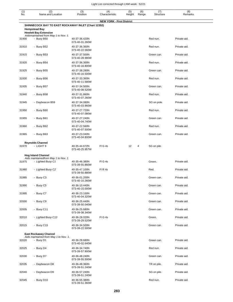
Light List corrected through LNM week: 52/21
283
(1) (2) (3) (4) (5) (6) (7) (8) No. Name and Location Position Characteristic Height Range Structure Remarks
NEW YORK - First District
SHINNECOCK BAY TO EAST ROCKAWAY INLET (Chart 12352)
Hempstead Bay
Hewlett Bay Extension AIdsmaintained from May 1 to Nov. 1.
31900 - Buoy B50 40-37-36.420N Red nun. Private aid.
073-40-31.260W
31910 - Buoy B52 40-37-36.360N Red nun. Private aid.
073-40-22.560W
31915 - Buoy B53 40-37-37.500N Green can. Private aid.
073-40-28.980W
31920 - Buoy B54 40-37-36.300N Red nun. Private aid.
073-40-16.800W
31925 - Buoy B55 40-37-38.280N Green can. Private aid.
073-40-16.500W
31930 - Buoy B56 40-37-33.360N Red nun. Private aid.
073-40-11.580W
31935 - Buoy B57 40-37-34.500N Green can. Private aid.
073-40-08.520W
31940 - Buoy B58 40-37-31.860N Red nun. Private aid.
073-40-07.260W
31945 - Daybeacon B59 40-37-34.080N SG on pole. Private aid.
073-40-03.960W
31950 - Buoy B60 40-37-27.720N Red nun. Private aid.
073-40-07.080W
31955 - Buoy B61 40-37-27.240N Green can. Private aid.
073-40-04.740W
31960 - Buoy B62 40-37-22.560N Red nun. Private aid.
073-40-07.500W
31965 - Buoy B63 40-37-23.040N Green can. Private aid. 073-40-04.800W
Reynolds Channel
31970 - LIGHT 9 40-35-44.672N Fl G 4s 12 4 SG on pile. 073-40-25.957W
Hog Island Channel Aids maintainedfrom May 1 to Nov. 1.
31975 - Lighted Buoy C1 40-35-46.380N
073-39-55.860W
Fl G 4s Green. Private aid.
31980 - Lighted Buoy C2 40-35-47.100N
073-39-50.880W
Fl R 4s Red. Private aid.
31985 - Buoy C3 40-36-01.200N
073-40-10.260W
Green can. Private aid.
31990 - Buoy C5 40-36-10.440N
073-40-15.000W
Green can. Private aid.
31995 - Buoy C7 40-36-23.100N
073-40-04.320W
Green can. Private aid.
32000 - Buoy C9 40-36-25.440N
073-39-50.040W
Green can. Private aid.
32005 - Buoy C11 40-36-25.680N
073-39-38.340W
Green can. Private aid.
32010 - Lighted Buoy C13 40-36-28.020N
073-39-29.520W
Fl G 4s Green. Private aid.
32015 - Buoy C15 40-36-34.500N 073-39-22.500W
Green can. Private aid.
East Rockaway Channel Aids maintained from May 1 to Nov. 1.
32020 - Buoy D1 40-36-28.680N
073-40-02.640W Green can. Private aid.
32025 - Buoy D4 40-36-34.740N
073-39-57.900W
Red nun. Private aid.
32030 - Buoy D7 40-36-48.240N
073-39-55.500W
Green can. Private aid.
32035 - Daybeacon D8 40-36-48.360N
073-39-51.240W
TR on pile. Private aid.
32040 - Daybeacon D9 40-36-57.240N
073-39-51.240W
SG on pile. Private aid.
32045 - Buoy D10 40-36-55.380N 073-39-51.360W
Red nun. Private aid.
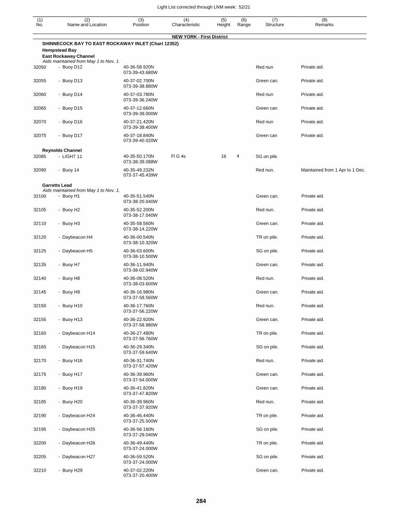
Light List corrected through LNM week: 52/21
284
(1) (2) (3) (4) (5) (6) (7) (8) No. Name and Location Position Characteristic Height Range Structure Remarks
NEW YORK - First District
SHINNECOCK BAY TO EAST ROCKAWAY INLET (Chart 12352)
Hempstead Bay
East Rockaway Channel Aids maintained from May 1 to Nov. 1.
32050 - Buoy D12 40-36-58.920N
073-39-43.680W Red nun Private aid.
32055 - Buoy D13 40-37-02.700N
073-39-38.880W
Green can. Private aid.
32060 - Buoy D14 40-37-03.780N
073-39-36.240W
Red nun Private aid.
32065 - Buoy D15 40-37-12.660N
073-39-39.000W
Green can Private aid.
32070 - Buoy D16 40-37-21.420N
073-39-38.400W
Red nun Private aid.
32075 - Buoy D17 40-37-18.840N 073-39-40.020W
Green can Private aid.
Reynolds Channel
32085 - LIGHT 11
40-35-50.170N
073-38-39.088W
Fl G 4s
16
4
SG on pile.
32090 - Buoy 14 40-35-49.232N 073-37-45.439W
Red nun. Maintained from 1 Apr to 1 Dec.
Garretts Lead Aids maintained from May 1 to Nov. 1.
32100 - Buoy H1 40-35-51.540N
073-38-20.040W Green can. Private aid.
32105 - Buoy H2 40-35-52.200N
073-38-17.040W
Red nun. Private aid.
32110 - Buoy H3 40-35-58.560N
073-38-14.220W
Green can. Private aid.
32120 - Daybeacon H4 40-36-00.540N
073-38-10.320W
TR on pile. Private aid.
32125 - Daybeacon H5 40-36-03.600N
073-38-10.500W
SG on pile. Private aid.
32135 - Buoy H7 40-36-11.940N
073-38-02.940W
Green can. Private aid.
32140 - Buoy H8 40-36-08.520N
073-38-03.600W
Red nun. Private aid.
32145 - Buoy H9 40-36-16.980N
073-37-58.560W
Green can. Private aid.
32150 - Buoy H10 40-36-17.760N
073-37-56.220W
Red nun. Private aid.
32155 - Buoy H13 40-36-22.920N
073-37-58.980W
Green can. Private aid.
32160 - Daybeacon H14 40-36-27.480N
073-37-56.760W
TR on pile. Private aid.
32165 - Daybeacon H15 40-36-29.340N
073-37-59.640W
SG on pile. Private aid.
32170 - Buoy H16 40-36-31.740N
073-37-57.420W
Red nun. Private aid.
32175 - Buoy H17 40-36-39.960N
073-37-54.000W
Green can. Private aid.
32180 - Buoy H19 40-36-41.820N
073-37-47.820W
Green can. Private aid.
32185 - Buoy H20 40-36-39.960N
073-37-37.920W
Red nun. Private aid.
32190 - Daybeacon H24 40-36-46.440N
073-37-25.500W
TR on pile. Private aid.
32195 - Daybeacon H25 40-36-56.160N
073-37-29.040W
SG on pile. Private aid.
32200 - Daybeacon H26 40-36-49.440N
073-37-24.000W
TR on pile. Private aid.
32205 - Daybeacon H27 40-36-59.520N
073-37-24.000W
SG on pile. Private aid.
32210 - Buoy H29 40-37-02.220N 073-37-20.400W
Green can. Private aid.
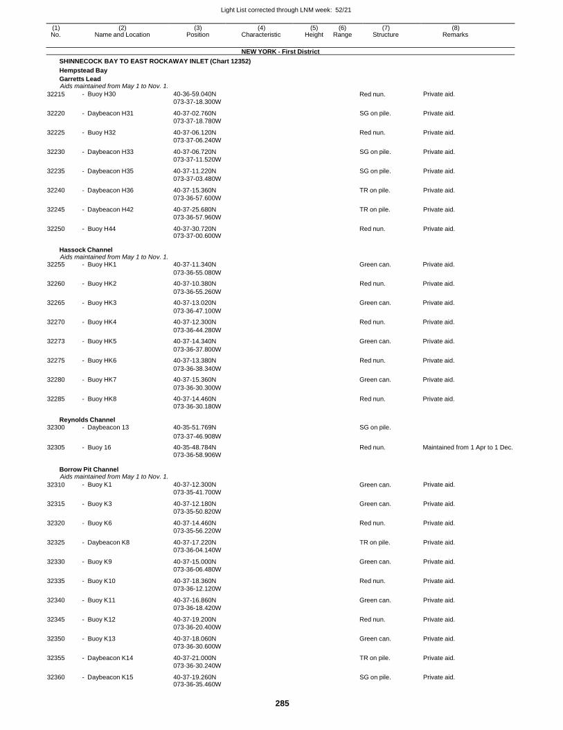
Light List corrected through LNM week: 52/21
285
(1) (2) (3) (4) (5) (6) (7) (8) No. Name and Location Position Characteristic Height Range Structure Remarks
NEW YORK - First District
SHINNECOCK BAY TO EAST ROCKAWAY INLET (Chart 12352)
Hempstead Bay
Garretts Lead Aids maintained from May 1 to Nov. 1.
32215 - Buoy H30 40-36-59.040N
073-37-18.300W Red nun. Private aid.
32220 - Daybeacon H31 40-37-02.760N
073-37-18.780W
SG on pile. Private aid.
32225 - Buoy H32 40-37-06.120N
073-37-06.240W
Red nun. Private aid.
32230 - Daybeacon H33 40-37-06.720N
073-37-11.520W
SG on pile. Private aid.
32235 - Daybeacon H35 40-37-11.220N
073-37-03.480W
SG on pile. Private aid.
32240 - Daybeacon H36 40-37-15.360N
073-36-57.600W
TR on pile. Private aid.
32245 - Daybeacon H42 40-37-25.680N
073-36-57.960W
TR on pile. Private aid.
32250 - Buoy H44 40-37-30.720N 073-37-00.600W
Red nun. Private aid.
Hassock Channel Aids maintained from May 1 to Nov. 1.
32255 - Buoy HK1 40-37-11.340N Green can. Private aid.
073-36-55.080W
32260 - Buoy HK2 40-37-10.380N Red nun. Private aid.
073-36-55.260W
32265 - Buoy HK3 40-37-13.020N Green can. Private aid.
073-36-47.100W
32270 - Buoy HK4 40-37-12.300N Red nun. Private aid.
073-36-44.280W
32273 - Buoy HK5 40-37-14.340N Green can. Private aid.
073-36-37.800W
32275 - Buoy HK6 40-37-13.380N Red nun. Private aid.
073-36-38.340W
32280 - Buoy HK7 40-37-15.360N Green can. Private aid.
073-36-30.300W
32285 - Buoy HK8 40-37-14.460N Red nun. Private aid. 073-36-30.180W
Reynolds Channel 32300 - Daybeacon 13 40-35-51.769N SG on pile.
073-37-46.908W
32305 - Buoy 16 40-35-48.784N Red nun. Maintained from 1 Apr to 1 Dec. 073-36-58.906W
Borrow Pit Channel Aids maintained from May 1 to Nov. 1.
32310 - Buoy K1 40-37-12.300N
073-35-41.700W Green can. Private aid.
32315 - Buoy K3 40-37-12.180N
073-35-50.820W
Green can. Private aid.
32320 - Buoy K6 40-37-14.460N
073-35-56.220W
Red nun. Private aid.
32325 - Daybeacon K8 40-37-17.220N
073-36-04.140W
TR on pile. Private aid.
32330 - Buoy K9 40-37-15.000N
073-36-06.480W
Green can. Private aid.
32335 - Buoy K10 40-37-18.360N
073-36-12.120W
Red nun. Private aid.
32340 - Buoy K11 40-37-16.860N
073-36-18.420W
Green can. Private aid.
32345 - Buoy K12 40-37-19.200N
073-36-20.400W
Red nun. Private aid.
32350 - Buoy K13 40-37-18.060N
073-36-30.600W
Green can. Private aid.
32355 - Daybeacon K14 40-37-21.000N
073-36-30.240W
TR on pile. Private aid.
32360 - Daybeacon K15 40-37-19.260N 073-36-35.460W
SG on pile. Private aid.
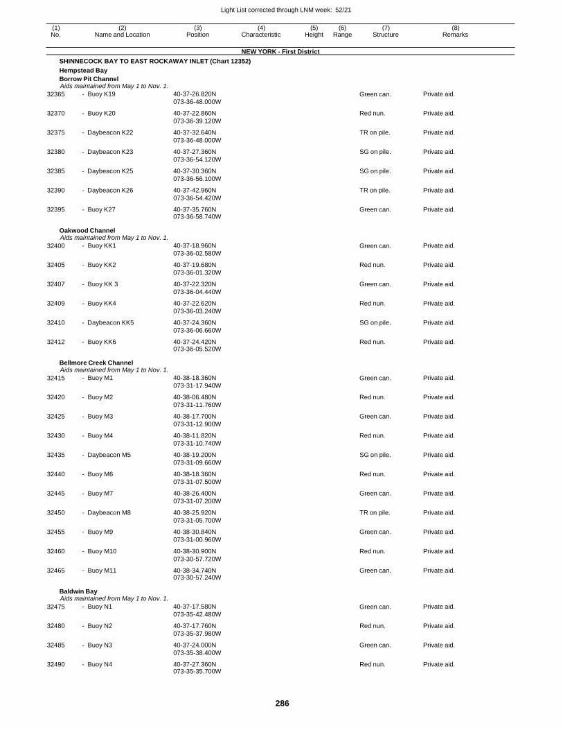
Light List corrected through LNM week: 52/21
286
(1) (2) (3) (4) (5) (6) (7) (8) No. Name and Location Position Characteristic Height Range Structure Remarks
NEW YORK - First District
SHINNECOCK BAY TO EAST ROCKAWAY INLET (Chart 12352)
Hempstead Bay
Borrow Pit Channel Aids maintained from May 1 to Nov. 1.
32365 - Buoy K19 40-37-26.820N
073-36-48.000W Green can. Private aid.
32370 - Buoy K20 40-37-22.860N
073-36-39.120W
Red nun. Private aid.
32375 - Daybeacon K22 40-37-32.640N
073-36-48.000W
TR on pile. Private aid.
32380 - Daybeacon K23 40-37-27.360N
073-36-54.120W
SG on pile. Private aid.
32385 - Daybeacon K25 40-37-30.360N
073-36-56.100W
SG on pile. Private aid.
32390 - Daybeacon K26 40-37-42.960N
073-36-54.420W
TR on pile. Private aid.
32395 - Buoy K27 40-37-35.760N 073-36-58.740W
Green can. Private aid.
Oakwood Channel Aids maintained from May 1 to Nov. 1.
32400 - Buoy KK1 40-37-18.960N
073-36-02.580W Green can. Private aid.
32405 - Buoy KK2 40-37-19.680N
073-36-01.320W
Red nun. Private aid.
32407 - Buoy KK 3 40-37-22.320N
073-36-04.440W
Green can. Private aid.
32409 - Buoy KK4 40-37-22.620N
073-36-03.240W
Red nun. Private aid.
32410 - Daybeacon KK5 40-37-24.360N
073-36-06.660W
SG on pile. Private aid.
32412 - Buoy KK6 40-37-24.420N 073-36-05.520W
Red nun. Private aid.
Bellmore Creek Channel Aids maintained from May 1 to Nov. 1.
32415 - Buoy M1 40-38-18.360N
073-31-17.940W Green can. Private aid.
32420 - Buoy M2 40-38-06.480N
073-31-11.760W
Red nun. Private aid.
32425 - Buoy M3 40-38-17.700N
073-31-12.900W
Green can. Private aid.
32430 - Buoy M4 40-38-11.820N
073-31-10.740W
Red nun. Private aid.
32435 - Daybeacon M5 40-38-19.200N
073-31-09.660W
SG on pile. Private aid.
32440 - Buoy M6 40-38-18.360N
073-31-07.500W
Red nun. Private aid.
32445 - Buoy M7 40-38-26.400N
073-31-07.200W
Green can. Private aid.
32450 - Daybeacon M8 40-38-25.920N
073-31-05.700W
TR on pile. Private aid.
32455 - Buoy M9 40-38-30.840N
073-31-00.960W
Green can. Private aid.
32460 - Buoy M10 40-38-30.900N
073-30-57.720W
Red nun. Private aid.
32465 - Buoy M11 40-38-34.740N 073-30-57.240W
Green can. Private aid.
Baldwin Bay Aids maintained from May 1 to Nov. 1.
32475 - Buoy N1 40-37-17.580N
073-35-42.480W Green can. Private aid.
32480 - Buoy N2 40-37-17.760N
073-35-37.980W
Red nun. Private aid.
32485 - Buoy N3 40-37-24.000N
073-35-38.400W
Green can. Private aid.
32490 - Buoy N4 40-37-27.360N 073-35-35.700W
Red nun. Private aid.
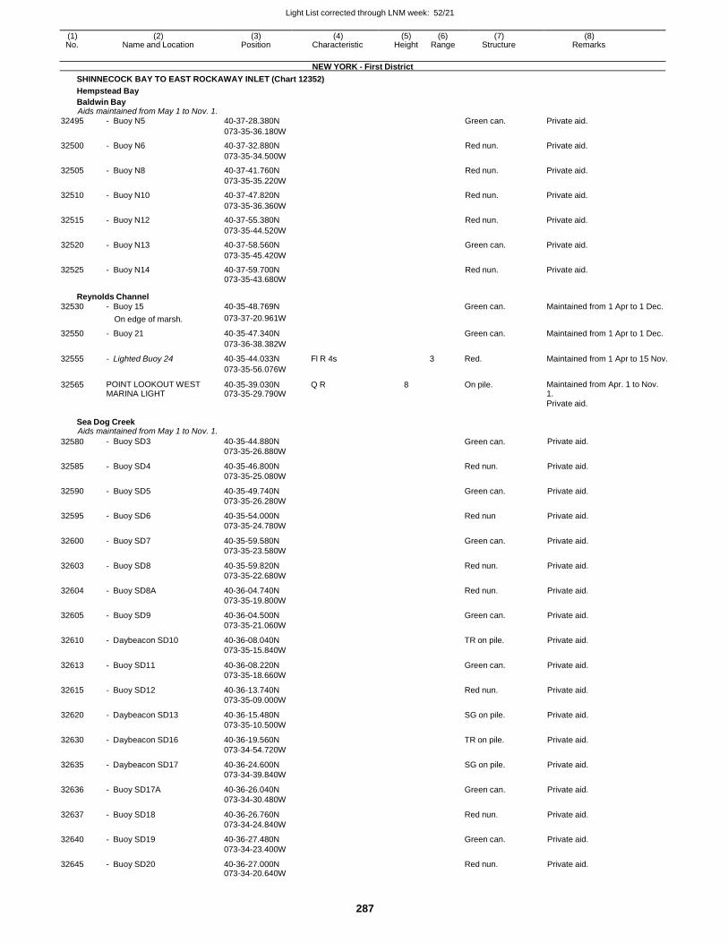
Light List corrected through LNM week: 52/21
287
(1) (2) (3) (4) (5) (6) (7) (8) No. Name and Location Position Characteristic Height Range Structure Remarks
NEW YORK - First District
SHINNECOCK BAY TO EAST ROCKAWAY INLET (Chart 12352)
Hempstead Bay
Baldwin Bay Aids maintained from May 1 to Nov. 1.
32495 - Buoy N5 40-37-28.380N Green can. Private aid.
073-35-36.180W
32500 - Buoy N6 40-37-32.880N Red nun. Private aid.
073-35-34.500W
32505 - Buoy N8 40-37-41.760N Red nun. Private aid.
073-35-35.220W
32510 - Buoy N10 40-37-47.820N Red nun. Private aid.
073-35-36.360W
32515 - Buoy N12 40-37-55.380N Red nun. Private aid.
073-35-44.520W
32520 - Buoy N13 40-37-58.560N Green can. Private aid.
073-35-45.420W
32525 - Buoy N14 40-37-59.700N Red nun. Private aid. 073-35-43.680W
Reynolds Channel
32530 - Buoy 15 40-35-48.769N Green can. Maintained from 1 Apr to 1 Dec.
On edge of marsh. 073-37-20.961W
32550 - Buoy 21 40-35-47.340N Green can. Maintained from 1 Apr to 1 Dec.
073-36-38.382W
32555 - Lighted Buoy 24 40-35-44.033N Fl R 4s 3 Red. Maintained from 1 Apr to 15 Nov.
073-35-56.076W
32565 POINT LOOKOUT WEST MARINA LIGHT
40-35-39.030N 073-35-29.790W
Q R 8 On pile. Maintained from Apr. 1 to Nov. 1.
Private aid.
Sea Dog Creek Aids maintained from May 1 to Nov. 1.
32580 - Buoy SD3 40-35-44.880N
073-35-26.880W Green can. Private aid.
32585 - Buoy SD4 40-35-46.800N
073-35-25.080W
Red nun. Private aid.
32590 - Buoy SD5 40-35-49.740N
073-35-26.280W
Green can. Private aid.
32595 - Buoy SD6 40-35-54.000N
073-35-24.780W
Red nun Private aid.
32600 - Buoy SD7 40-35-59.580N
073-35-23.580W
Green can. Private aid.
32603 - Buoy SD8 40-35-59.820N
073-35-22.680W
Red nun. Private aid.
32604 - Buoy SD8A 40-36-04.740N
073-35-19.800W
Red nun. Private aid.
32605 - Buoy SD9 40-36-04.500N
073-35-21.060W
Green can. Private aid.
32610 - Daybeacon SD10 40-36-08.040N
073-35-15.840W
TR on pile. Private aid.
32613 - Buoy SD11 40-36-08.220N
073-35-18.660W
Green can. Private aid.
32615 - Buoy SD12 40-36-13.740N
073-35-09.000W
Red nun. Private aid.
32620 - Daybeacon SD13 40-36-15.480N
073-35-10.500W
SG on pile. Private aid.
32630 - Daybeacon SD16 40-36-19.560N
073-34-54.720W
TR on pile. Private aid.
32635 - Daybeacon SD17 40-36-24.600N
073-34-39.840W
SG on pile. Private aid.
32636 - Buoy SD17A 40-36-26.040N
073-34-30.480W
Green can. Private aid.
32637 - Buoy SD18 40-36-26.760N
073-34-24.840W
Red nun. Private aid.
32640 - Buoy SD19 40-36-27.480N
073-34-23.400W
Green can. Private aid.
32645 - Buoy SD20 40-36-27.000N 073-34-20.640W
Red nun. Private aid.
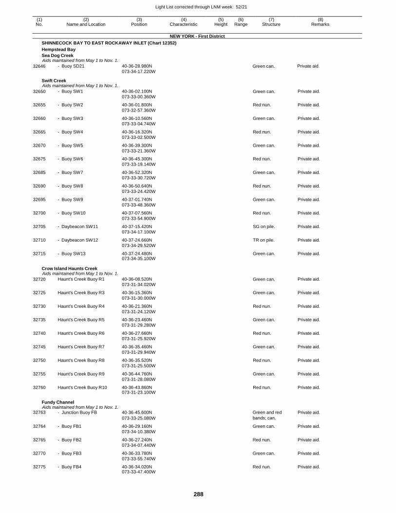
Light List corrected through LNM week: 52/21
288
(1) (2) (3) (4) (5) (6) (7) (8) No. Name and Location Position Characteristic Height Range Structure Remarks
NEW YORK - First District
SHINNECOCK BAY TO EAST ROCKAWAY INLET (Chart 12352)
Hempstead Bay
Sea Dog Creek Aids maintained from May 1 to Nov. 1.
32646 - Buoy SD21 40-36-28.980N
073-34-17.220W Green can. Private aid.
Swift Creek Aids maintained from May 1 to Nov. 1.
32650 - Buoy SW1 40-36-02.100N
073-33-00.360W Green can. Private aid.
32655 - Buoy SW2 40-36-01.800N
073-32-57.360W
Red nun. Private aid.
32660 - Buoy SW3 40-36-10.560N
073-33-04.740W
Green can. Private aid.
32665 - Buoy SW4 40-36-16.320N
073-33-02.500W
Red nun. Private aid.
32670 - Buoy SW5 40-36-39.300N
073-33-21.360W
Green can. Private aid.
32675 - Buoy SW6 40-36-45.300N
073-33-19.140W
Red nun. Private aid.
32685 - Buoy SW7 40-36-52.320N
073-33-30.720W
Green can. Private aid.
32690 - Buoy SW8 40-36-50.640N
073-33-24.420W
Red nun. Private aid.
32695 - Buoy SW9 40-37-01.740N
073-33-48.360W
Green can. Private aid.
32700 - Buoy SW10 40-37-07.560N
073-33-54.900W
Red nun. Private aid.
32705 - Daybeacon SW11 40-37-15.420N
073-34-17.100W
SG on pile. Private aid.
32710 - Daybeacon SW12 40-37-24.660N
073-34-29.520W
TR on pile. Private aid.
32715 - Buoy SW13 40-37-24.480N 073-34-35.100W
Green can. Private aid.
Crow Island Haunts Creek Aids maintained from May 1 to Nov. 1.
32720 Haunt's Creek Buoy R1 40-36-08.520N
073-31-34.020W Green can. Private aid.
32725 Haunt's Creek Buoy R3 40-36-15.360N
073-31-30.000W
Green can. Private aid.
32730 Haunt's Creek Buoy R4 40-36-21.360N
073-31-24.120W
Red nun. Private aid.
32735 Haunt's Creek Buoy R5 40-36-23.460N
073-31-29.280W
Green can. Private aid.
32740 Haunt's Creek Buoy R6 40-36-27.660N
073-31-25.920W
Red nun. Private aid.
32745 Haunt's Creek Buoy R7 40-36-35.460N
073-31-29.940W
Green can. Private aid.
32750 Haunt's Creek Buoy R8 40-36-35.520N
073-31-25.500W
Red nun. Private aid.
32755 Haunt's Creek Buoy R9 40-36-44.760N
073-31-28.080W
Green can. Private aid.
32760 Haunt's Creek Buoy R10 40-36-43.860N 073-31-23.100W
Red nun. Private aid.
Fundy Channel Aids maintained from May 1 to Nov. 1.
32763 - Junction Buoy FB 40-36-45.600N Green and red Private aid.
073-33-25.080W bands; can.
32764 - Buoy FB1 40-36-29.160N
073-34-10.380W
Green can. Private aid.
32765 - Buoy FB2 40-36-27.240N
073-34-07.440W
Red nun. Private aid.
32770 - Buoy FB3 40-36-33.780N
073-33-55.740W
Green can. Private aid.
32775 - Buoy FB4 40-36-34.020N 073-33-47.400W
Red nun. Private aid.
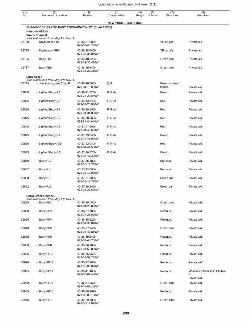
Light List corrected through LNM week: 52/21
289
(1) (2) (3) (4) (5) (6) (7) (8) No. Name and Location Position Characteristic Height Range Structure Remarks
NEW YORK - First District
SHINNECOCK BAY TO EAST ROCKAWAY INLET (Chart 12352)
Hempstead Bay
Fundy Channel Aids maintained from May 1 to Nov. 1.
32780 - Daybeacon FB5 40-36-37.500N
073-33-45.720W SG on pile. Private aid.
32785 - Daybeacon FB6 40-36-38.640N
073-33-35.040W
TR on pile. Private aid.
32786 - Buoy FB7 40-36-40.920N
073-33-36.420W
Green can. Private aid.
32787 - Buoy FB9 40-36-45.840N 073-33-29.160W
Green can. Private aid.
Long Creek Aids maintained from May 1 to Nov. 1.
32795 - Junction Lighted Buoy P 40-36-36.660N Q G Green and red .
073-34-19.080W bands. Private aid.
32800 - Lighted Buoy P1 40-36-41.820N
073-34-29.640W
Fl G 4s Green. Private aid.
32805 - Lighted Buoy P2 40-36-43.740N
073-34-25.080W
Fl R 4s Red. Private aid.
32810 - Lighted Buoy P4 40-36-50.100N
073-34-34.800W
Fl R 4s Red. Private aid.
32815 - Lighted Buoy P6 40-36-58.260N
073-34-44.640W
Fl R 4s Red. Private aid.
32820 - Lighted Buoy P8 40-37-07.800N
073-34-46.680W
Fl R 4s Red. Private aid.
32825 - Lighted Buoy P9 40-37-29.040N
073-34-41.940W
Fl G 4s Green. Private aid.
32830 - Lighted Buoy P10 40-37-23.040N
073-34-41.580W
Fl R 4s Red. Private aid.
32835 - Lighted Buoy P11 40-37-36.720N
073-34-45.300W
Fl G 4s Green. Private aid.
32840 - Buoy P12 40-37-36.180N
073-35-11.700W
Red nun. Private aid.
32847 - Buoy P14 40-37-42.000N
073-35-12.000W
Red nun. Private aid.
32850 - Buoy P15 40-37-51.600N
073-35-12.720W
Green can. Private aid.
32852 - Buoy P17 40-37-56.340N 073-35-27.600W
Green can Private aid.
Scow Creek Channel Aids maintained from May 1 to Nov. 1.
32855 - Buoy PP1 40-36-36.000N Green can. Private aid.
073-34-25.800W
32860 - Buoy PP2 40-36-37.380N Red nun. Private aid.
073-34-28.620W
32865 - Buoy PP4 40-36-38.820N Red nun. Private aid.
073-34-36.840W
32870 - Buoy PP5 40-36-37.740N Green can. Private aid.
073-34-43.860W
32875 - Buoy PP6 40-36-39.240N Red nun. Private aid.
073-34-44.700W
32880 - Buoy PP8 40-36-36.780N Red nun. Private aid.
073-34-50.880W
32885 - Buoy PP10 40-36-36.960N Red nun. Private aid.
073-34-59.700W
32890 - Buoy PP12 40-36-37.980N Red nun. Private aid.
073-35-05.820W
32895 - Buoy PP14 40-36-41.460N 073-35-09.480W
Red nun. Maintained from Apr. 1 to Nov. 1.
Private aid.
32900 - Buoy PP17 40-36-54.060N Green can. Private aid.
073-35-09.180W
32905 - Buoy PP18 40-36-56.309N Red nun. Private aid.
073-35-09.180W
32910 - Buoy PP19 40-36-59.700N Green can. Private aid. 073-35-14.820W
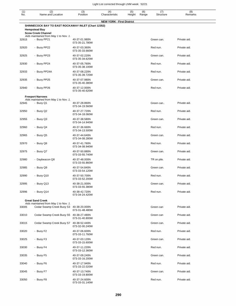
Light List corrected through LNM week: 52/21
290
(1) (2) (3) (4) (5) (6) (7) (8) No. Name and Location Position Characteristic Height Range Structure Remarks
NEW YORK - First District
SHINNECOCK BAY TO EAST ROCKAWAY INLET (Chart 12352)
Hempstead Bay
Scow Creek Channel Aids maintained from May 1 to Nov. 1.
32915 - Buoy PP21 40-37-01.980N
073-35-21.780W Green can. Private aid.
32920 - Buoy PP22 40-37-03.360N
073-35-33.660W
Red nun. Private aid.
32925 - Buoy PP23 40-37-02.220N
073-35-34.620W
Green can. Private aid.
32930 - Buoy PP24 40-37-05.760N
073-35-38.100W
Red nun. Private aid.
32933 - Buoy PP24A 40-37-08.220N
073-35-39.720W
Red nun. Private aid.
32935 - Buoy PP25 40-37-07.980N
073-35-40.380W
Green can. Private aid.
32940 - Buoy PP26 40-37-12.000N 073-35-40.620W
Red nun. Private aid.
Freeport Narrows Aids maintained from May 1 to Nov. 1.
32945 - Buoy Q1 40-37-28.860N
073-34-19.560W Green can.. Private aid.
32950 - Buoy Q2 40-37-27.720N
073-34-18.060W
Red nun. Private aid.
32955 - Buoy Q3 40-37-38.580N
073-34-14.940W
Green can. Private aid.
32960 - Buoy Q4 40-37-36.660N
073-34-13.500W
Red nun. Private aid.
32965 - Buoy Q5 40-37-44.640N
073-34-08.280W
Green can. Private aid.
32970 - Buoy Q6 40-37-41.760N
073-34-08.940W
Red nun. Private aid.
32975 - Buoy Q7 40-37-50.880N
073-33-55.740W
Green can. Private aid.
32980 - Daybeacon Q8 40-37-48.000N
073-33-55.860W
TR on pile. Private aid.
32985 - Buoy Q9 40-37-54.840N
073-33-54.120W
Green can. Private aid.
32990 - Buoy Q10 40-37-50.700N
073-33-52.200W
Red nun. Private aid.
32995 - Buoy Q13 40-38-21.000N
073-33-55.380W
Green can. Private aid.
32996 - Buoy Q14 40-38-42.720N 073-34-24.420W
Red nun. Private aid.
Great Sand Creek Aids maintained from May 1 to Nov. 1.
33005 Cedar Swamp Creek Buoy S3 40-38-20.000N
073-31-48.480W Green can Private aid.
33010 Cedar Swamp Creek Buoy S5 40-38-27.480N
073-31-40.800W
Green can Private aid.
33015 Cedar Swamp Creek Buoy S7 40-38-52.440N
073-32-00.240W
Green can. Private aid.
33020 - Buoy F2 40-37-06.600N
073-33-11.760W
Red nun. Private aid.
33025 - Buoy F3 40-37-03.120N
073-33-15.600W
Green can. Private aid.
33030 - Buoy F4 40-37-11.220N
073-33-12.360W
Red nun. Private aid.
33035 - Buoy F5 40-37-09.240N
073-33-16.200W
Green can. Private aid.
33040 - Buoy F6 40-37-17.940N
073-33-22.020W
Red nun. Private aid.
33045 - Buoy F7 40-37-13.740N
073-33-19.800W
Green can. Private aid.
33050 - Buoy F8 40-37-24.600N 073-33-31.140W
Red nun. Private aid.
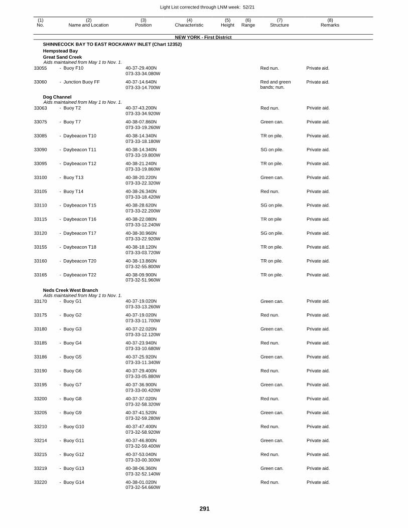
Light List corrected through LNM week: 52/21
291
(1) (2) (3) (4) (5) (6) (7) (8) No. Name and Location Position Characteristic Height Range Structure Remarks
NEW YORK - First District
SHINNECOCK BAY TO EAST ROCKAWAY INLET (Chart 12352)
Hempstead Bay
Great Sand Creek Aids maintained from May 1 to Nov. 1.
33055
33060
- Buoy F10
- Junction Buoy FF
40-37-29.400N
073-33-34.080W
40-37-14.640N
073-33-14.700W
Red nun.
Red and green bands; nun.
Private aid.
Private aid.
Dog Channel Aids maintained from May 1 to Nov. 1.
33063 - Buoy T2 40-37-43.200N
073-33-34.920W Red nun. Private aid.
33075 - Buoy T7 40-38-07.860N
073-33-19.260W
Green can. Private aid.
33085 - Daybeacon T10 40-38-14.340N
073-33-18.180W
TR on pile. Private aid.
33090 - Daybeacon T11 40-38-14.340N
073-33-19.800W
SG on pile. Private aid.
33095 - Daybeacon T12 40-38-21.240N
073-33-19.860W
TR on pile. Private aid.
33100 - Buoy T13 40-38-20.220N
073-33-22.320W
Green can. Private aid.
33105 - Buoy T14 40-38-26.340N
073-33-18.420W
Red nun. Private aid.
33110 - Daybeacon T15 40-38-28.620N
073-33-22.200W
SG on pile. Private aid.
33115 - Daybeacon T16 40-38-22.080N
073-33-12.240W
TR on pile Private aid.
33120 - Daybeacon T17 40-38-30.960N
073-33-22.920W
SG on pile. Private aid.
33155 - Daybeacon T18 40-38-18.120N
073-33-03.720W
TR on pile. Private aid.
33160 - Daybeacon T20 40-38-13.860N
073-32-55.800W
TR on pile. Private aid.
33165 - Daybeacon T22 40-38-09.900N 073-32-51.960W
TR on pile. Private aid.
Neds Creek West Branch Aids maintained from May 1 to Nov. 1.
33170 - Buoy G1 40-37-19.020N
073-33-13.260W Green can. Private aid.
33175 - Buoy G2 40-37-19.020N
073-33-11.700W
Red nun. Private aid.
33180 - Buoy G3 40-37-22.020N
073-33-12.120W
Green can. Private aid.
33185 - Buoy G4 40-37-23.940N
073-33-10.680W
Red nun. Private aid.
33186 - Buoy G5 40-37-25.920N
073-33-11.340W
Green can. Private aid.
33190 - Buoy G6 40-37-29.400N
073-33-05.880W
Red nun. Private aid.
33195 - Buoy G7 40-37-36.900N
073-33-00.420W
Green can. Private aid.
33200 - Buoy G8 40-37-37.020N
073-32-58.320W
Red nun. Private aid.
33205 - Buoy G9 40-37-41.520N
073-32-59.280W
Green can. Private aid.
33210 - Buoy G10 40-37-47.400N
073-32-58.920W
Red nun. Private aid.
33214 - Buoy G11 40-37-46.800N
073-32-59.400W
Green can. Private aid.
33215 - Buoy G12 40-37-53.040N
073-33-00.300W
Red nun. Private aid.
33219 - Buoy G13 40-38-06.360N
073-32-52.140W
Green can. Private aid.
33220 - Buoy G14 40-38-01.020N 073-32-54.660W
Red nun. Private aid.
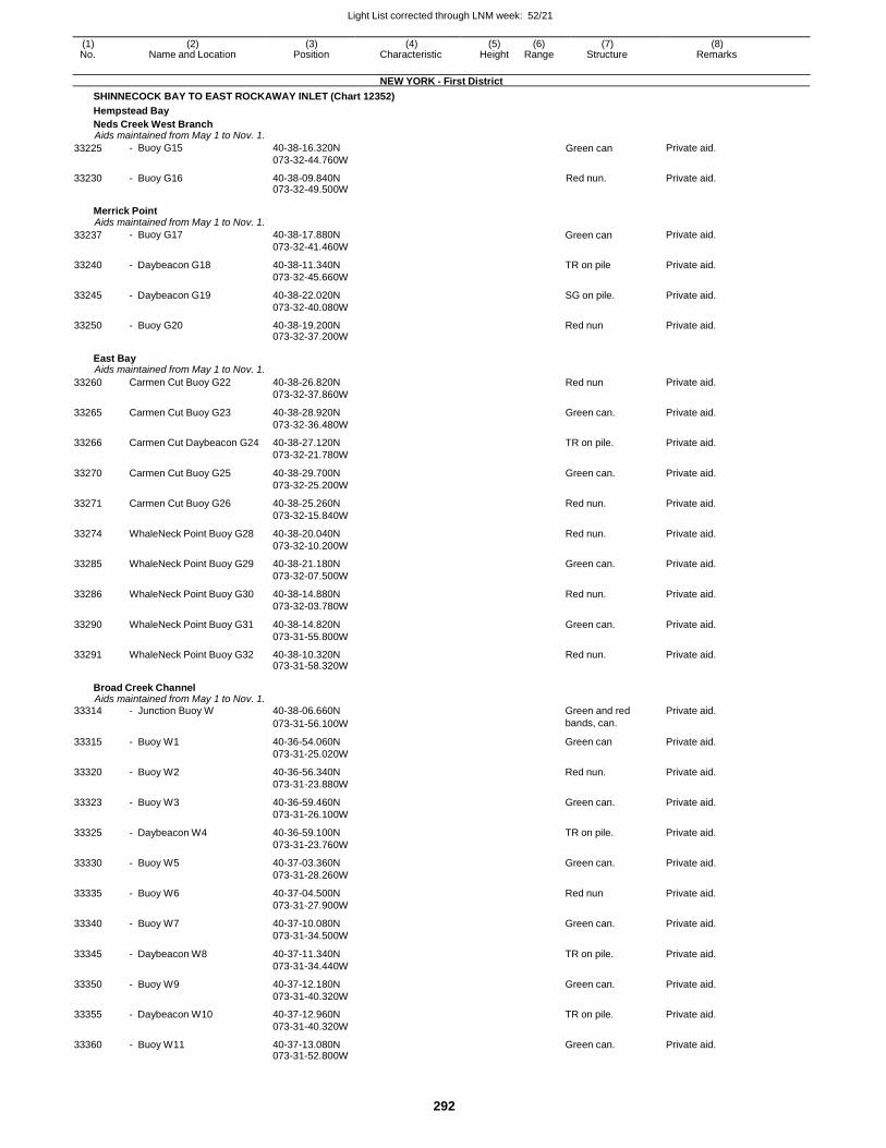
Light List corrected through LNM week: 52/21
292
(1) (2) (3) (4) (5) (6) (7) (8) No. Name and Location Position Characteristic Height Range Structure Remarks
NEW YORK - First District
SHINNECOCK BAY TO EAST ROCKAWAY INLET (Chart 12352)
Hempstead Bay
Neds Creek West Branch Aids maintained from May 1 to Nov. 1.
33225 - Buoy G15 40-38-16.320N
073-32-44.760W Green can Private aid.
33230 - Buoy G16 40-38-09.840N 073-32-49.500W
Red nun. Private aid.
Merrick Point Aids maintained from May 1 to Nov. 1.
33237 - Buoy G17 40-38-17.880N
073-32-41.460W Green can Private aid.
33240 - Daybeacon G18 40-38-11.340N
073-32-45.660W
TR on pile Private aid.
33245 - Daybeacon G19 40-38-22.020N
073-32-40.080W
SG on pile. Private aid.
33250 - Buoy G20 40-38-19.200N 073-32-37.200W
Red nun Private aid.
East Bay Aids maintained from May 1 to Nov. 1.
33260 Carmen Cut Buoy G22 40-38-26.820N
073-32-37.860W
Red nun Private aid.
33265 Carmen Cut Buoy G23 40-38-28.920N
073-32-36.480W
Green can. Private aid.
33266 Carmen Cut Daybeacon G24 40-38-27.120N
073-32-21.780W
TR on pile. Private aid.
33270 Carmen Cut Buoy G25 40-38-29.700N
073-32-25.200W
Green can. Private aid.
33271 Carmen Cut Buoy G26 40-38-25.260N
073-32-15.840W
Red nun. Private aid.
33274 WhaleNeck Point Buoy G28 40-38-20.040N
073-32-10.200W
Red nun. Private aid.
33285 WhaleNeck Point Buoy G29 40-38-21.180N
073-32-07.500W
Green can. Private aid.
33286 WhaleNeck Point Buoy G30 40-38-14.880N
073-32-03.780W
Red nun. Private aid.
33290 WhaleNeck Point Buoy G31 40-38-14.820N
073-31-55.800W
Green can. Private aid.
33291 WhaleNeck Point Buoy G32 40-38-10.320N 073-31-58.320W
Red nun. Private aid.
Broad Creek Channel Aids maintained from May 1 to Nov. 1.
33314 - Junction Buoy W 40-38-06.660N Green and red Private aid.
073-31-56.100W bands, can.
33315 - Buoy W1 40-36-54.060N
073-31-25.020W
Green can Private aid.
33320 - Buoy W2 40-36-56.340N
073-31-23.880W
Red nun. Private aid.
33323 - Buoy W3 40-36-59.460N
073-31-26.100W
Green can. Private aid.
33325 - Daybeacon W4 40-36-59.100N
073-31-23.760W
TR on pile. Private aid.
33330 - Buoy W5 40-37-03.360N
073-31-28.260W
Green can. Private aid.
33335 - Buoy W6 40-37-04.500N
073-31-27.900W
Red nun Private aid.
33340 - Buoy W7 40-37-10.080N
073-31-34.500W
Green can. Private aid.
33345 - Daybeacon W8 40-37-11.340N
073-31-34.440W
TR on pile. Private aid.
33350 - Buoy W9 40-37-12.180N
073-31-40.320W
Green can. Private aid.
33355 - Daybeacon W10 40-37-12.960N
073-31-40.320W
TR on pile. Private aid.
33360 - Buoy W11 40-37-13.080N 073-31-52.800W
Green can. Private aid.
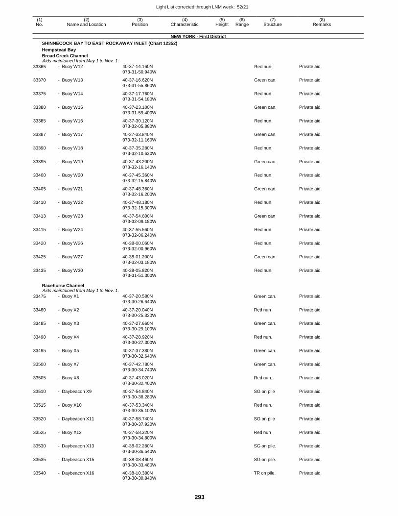
Light List corrected through LNM week: 52/21
293
(1) (2) (3) (4) (5) (6) (7) (8) No. Name and Location Position Characteristic Height Range Structure Remarks
NEW YORK - First District
SHINNECOCK BAY TO EAST ROCKAWAY INLET (Chart 12352)
Hempstead Bay
Broad Creek Channel Aids maintained from May 1 to Nov. 1.
33365 - Buoy W12 40-37-14.160N
073-31-50.940W Red nun. Private aid.
33370 - Buoy W13 40-37-16.620N
073-31-55.860W
Green can. Private aid.
33375 - Buoy W14 40-37-17.760N
073-31-54.180W
Red nun. Private aid.
33380 - Buoy W15 40-37-23.100N
073-31-59.400W
Green can. Private aid.
33385 - Buoy W16 40-37-30.120N
073-32-05.880W
Red nun. Private aid.
33387 - Buoy W17 40-37-33.840N
073-32-11.160W
Green can. Private aid.
33390 - Buoy W18 40-37-35.280N
073-32-10.620W
Red nun. Private aid.
33395 - Buoy W19 40-37-43.200N
073-32-16.140W
Green can. Private aid.
33400 - Buoy W20 40-37-45.360N
073-32-15.840W
Red nun. Private aid.
33405 - Buoy W21 40-37-48.360N
073-32-16.200W
Green can. Private aid.
33410 - Buoy W22 40-37-48.180N
073-32-15.300W
Red nun. Private aid.
33413 - Buoy W23 40-37-54.600N
073-32-09.180W
Green can Private aid.
33415 - Buoy W24 40-37-55.560N
073-32-06.240W
Red nun. Private aid.
33420 - Buoy W26 40-38-00.060N
073-32-00.960W
Red nun. Private aid.
33425 - Buoy W27 40-38-01.200N
073-32-03.180W
Green can. Private aid.
33435 - Buoy W30 40-38-05.820N 073-31-51.300W
Red nun. Private aid.
Racehorse Channel Aids maintained from May 1 to Nov. 1.
33475 - Buoy X1 40-37-20.580N
073-30-26.640W Green can. Private aid.
33480 - Buoy X2 40-37-20.040N
073-30-25.320W
Red nun Private aid.
33485 - Buoy X3 40-37-27.660N
073-30-29.100W
Green can. Private aid.
33490 - Buoy X4 40-37-28.920N
073-30-27.300W
Red nun. Private aid.
33495 - Buoy X5 40-37-37.380N
073-30-32.640W
Green can. Private aid.
33500 - Buoy X7 40-37-42.780N
073-30-34.740W
Green can. Private aid.
33505 - Buoy X8 40-37-43.020N
073-30-32.400W
Red nun. Private aid.
33510 - Daybeacon X9 40-37-54.840N
073-30-38.280W
SG on pile Private aid.
33515 - Buoy X10 40-37-53.340N
073-30-35.100W
Red nun. Private aid.
33520 - Daybeacon X11 40-37-58.740N
073-30-37.920W
SG on pile Private aid.
33525 - Buoy X12 40-37-58.320N
073-30-34.800W
Red nun Private aid.
33530 - Daybeacon X13 40-38-02.280N
073-30-36.540W
SG on pile. Private aid.
33535 - Daybeacon X15 40-38-08.460N
073-30-33.480W
SG on pile. Private aid.
33540 - Daybeacon X16 40-38-10.380N 073-30-30.840W
TR on pile. Private aid.
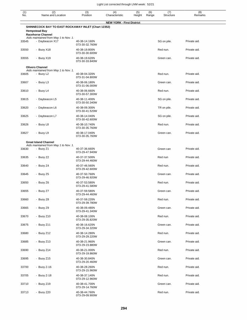
Light List corrected through LNM week: 52/21
294
(1) (2) (3) (4) (5) (6) (7) (8) No. Name and Location Position Characteristic Height Range Structure Remarks
NEW YORK - First District
SHINNECOCK BAY TO EAST ROCKAWAY INLET (Chart 12352)
Hempstead Bay
Racehorse Channel Aids maintained from May 1 to Nov. 1.
33545 - Daybeacon X17 40-38-14.160N
073-30-32.760W SG on pile. Private aid.
33550 - Buoy X18 40-38-19.800N
073-30-30.600W
Red nun. Private aid.
33555 - Buoy X19 40-38-19.620N 073-30-33.840W
Green can. Private aid.
Olivers Channel Aids maintained from May 1 to Nov. 1.
33605 - Buoy L2 40-38-04.320N
073-31-04.800W Red nun. Private aid.
33607 - Buoy L3 40-38-06.180N
073-31-06.000W
Green can. Private aid.
33610 - Buoy L4 40-38-06.660N
073-30-57.300W
Red nun. Private aid.
33615 - Daybeacon L5 40-38-11.400N
073-30-50.340W
SG on pile. Private aid.
33620 - Daybeacon L6 40-38-09.300N
073-30-41.520W
TR on pile. Private aid.
33625 - Daybeacon L7 40-38-14.040N
073-30-42.600W
SG on pile. Private aid.
33626 - Buoy L8 40-38-10.740N
073-30-35.760W
Red nun. Private aid.
33627 - Buoy L9 40-38-17.040N 073-30-35.760W
Green can. Private aid.
Great Island Channel Aids maintained from May 1 to Nov. 1.
33630 - Buoy Z1 40-37-36.660N
073-29-47.940W Green can Private aid.
33635 - Buoy Z2 40-37-37.500N
073-29-44.460W
Red nun Private aid.
33640 - Buoy Z4 40-37-46.560N
073-29-42.600W
Red nun. Private aid.
33645 - Buoy Z5 40-37-50.760N
073-29-46.920W
Green can. Private aid.
33650 - Buoy Z6 40-37-53.580N
073-29-41.580W
Red nun. Private aid.
33655 - Buoy Z7 40-37-59.580N
073-29-44.460W
Green can. Private aid.
33660 - Buoy Z8 40-37-59.220N
073-29-39.780W
Red nun. Private aid.
33665 - Buoy Z9 40-38-09.480N
073-29-41.340W
Green can. Private aid.
33670 - Buoy Z10 40-38-08.100N
073-29-35.820W
Red nun. Private aid.
33675 - Buoy Z11 40-38-16.620N
073-29-34.320W
Green can. Private aid.
33680 - Buoy Z12 40-38-14.280N
073-29-29.220W
Red nun. Private aid.
33685 - Buoy Z13 40-38-21.960N
073-29-23.880W
Green can. Private aid.
33690 - Buoy Z14 40-38-21.000N
073-29-19.860W
Red nun. Private aid.
33695 - Buoy Z15 40-38-30.840N
073-29-20.460W
Green can. Private aid.
33700 - Buoy Z-16 40-38-28.260N
073-29-15.960W
Red nun. Private aid.
33705 - Buoy Z-18 40-38-37.140N
073-29-12.960W
Red nun. Private aid.
33710 - Buoy Z19 40-38-41.700N
073-29-14.760W
Green can. Private aid.
33713 - Buoy Z20 40-38-44.760N 073-29-09.900W
Red nun. Private aid.
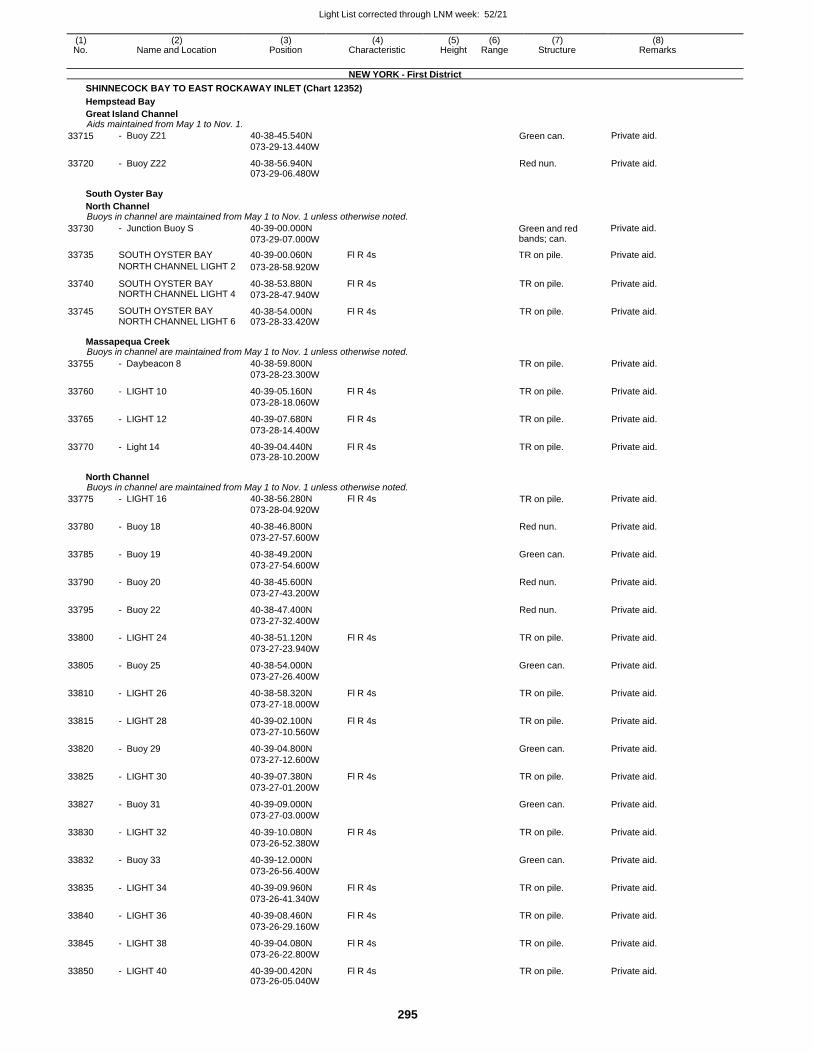
Light List corrected through LNM week: 52/21
295
(1) (2) (3) (4) (5) (6) (7) (8) No. Name and Location Position Characteristic Height Range Structure Remarks
NEW YORK - First District
SHINNECOCK BAY TO EAST ROCKAWAY INLET (Chart 12352)
Hempstead Bay
Great Island Channel Aids maintained from May 1 to Nov. 1.
33715 - Buoy Z21 40-38-45.540N
073-29-13.440W Green can. Private aid.
33720 - Buoy Z22 40-38-56.940N 073-29-06.480W
Red nun. Private aid.
South Oyster Bay
North Channel Buoys in channel are maintained from May 1 to Nov. 1 unless otherwise noted.
33730
33735
- Junction Buoy S
SOUTH OYSTER BAY
40-39-00.000N
073-29-07.000W
40-39-00.060N
Fl R 4s
Green and red bands; can.
TR on pile.
Private aid.
Private aid.
NORTH CHANNEL LIGHT 2 073-28-58.920W
33740 SOUTH OYSTER BAY NORTH CHANNEL LIGHT 4
40-38-53.880N
073-28-47.940W
Fl R 4s TR on pile. Private aid.
33745 SOUTH OYSTER BAY NORTH CHANNEL LIGHT 6
40-38-54.000N 073-28-33.420W
Fl R 4s TR on pile. Private aid.
Massapequa Creek Buoys in channel are maintained from May 1 to Nov. 1 unless otherwise noted.
33755 - Daybeacon 8 40-38-59.800N
073-28-23.300W
TR on pile. Private aid.
33760 - LIGHT 10 40-39-05.160N
073-28-18.060W
Fl R 4s TR on pile. Private aid.
33765 - LIGHT 12 40-39-07.680N
073-28-14.400W
Fl R 4s TR on pile. Private aid.
33770 - Light 14 40-39-04.440N 073-28-10.200W
Fl R 4s TR on pile. Private aid.
North Channel Buoys in channel are maintained from May 1 to Nov. 1 unless otherwise noted.
33775 - LIGHT 16 40-38-56.280N
073-28-04.920W
Fl R 4s TR on pile. Private aid.
33780 - Buoy 18 40-38-46.800N
073-27-57.600W
Red nun. Private aid.
33785 - Buoy 19 40-38-49.200N
073-27-54.600W
Green can. Private aid.
33790 - Buoy 20 40-38-45.600N
073-27-43.200W
Red nun. Private aid.
33795 - Buoy 22 40-38-47.400N
073-27-32.400W
Red nun. Private aid.
33800 - LIGHT 24 40-38-51.120N
073-27-23.940W
Fl R 4s TR on pile. Private aid.
33805 - Buoy 25 40-38-54.000N
073-27-26.400W
Green can. Private aid.
33810 - LIGHT 26 40-38-58.320N
073-27-18.000W
Fl R 4s TR on pile. Private aid.
33815 - LIGHT 28 40-39-02.100N
073-27-10.560W
Fl R 4s TR on pile. Private aid.
33820 - Buoy 29 40-39-04.800N
073-27-12.600W
Green can. Private aid.
33825 - LIGHT 30 40-39-07.380N
073-27-01.200W
Fl R 4s TR on pile. Private aid.
33827 - Buoy 31 40-39-09.000N
073-27-03.000W
Green can. Private aid.
33830 - LIGHT 32 40-39-10.080N
073-26-52.380W
Fl R 4s TR on pile. Private aid.
33832 - Buoy 33 40-39-12.000N
073-26-56.400W
Green can. Private aid.
33835 - LIGHT 34 40-39-09.960N
073-26-41.340W
Fl R 4s TR on pile. Private aid.
33840 - LIGHT 36 40-39-08.460N
073-26-29.160W
Fl R 4s TR on pile. Private aid.
33845 - LIGHT 38 40-39-04.080N
073-26-22.800W
Fl R 4s TR on pile. Private aid.
33850 - LIGHT 40 40-39-00.420N 073-26-05.040W
Fl R 4s TR on pile. Private aid.
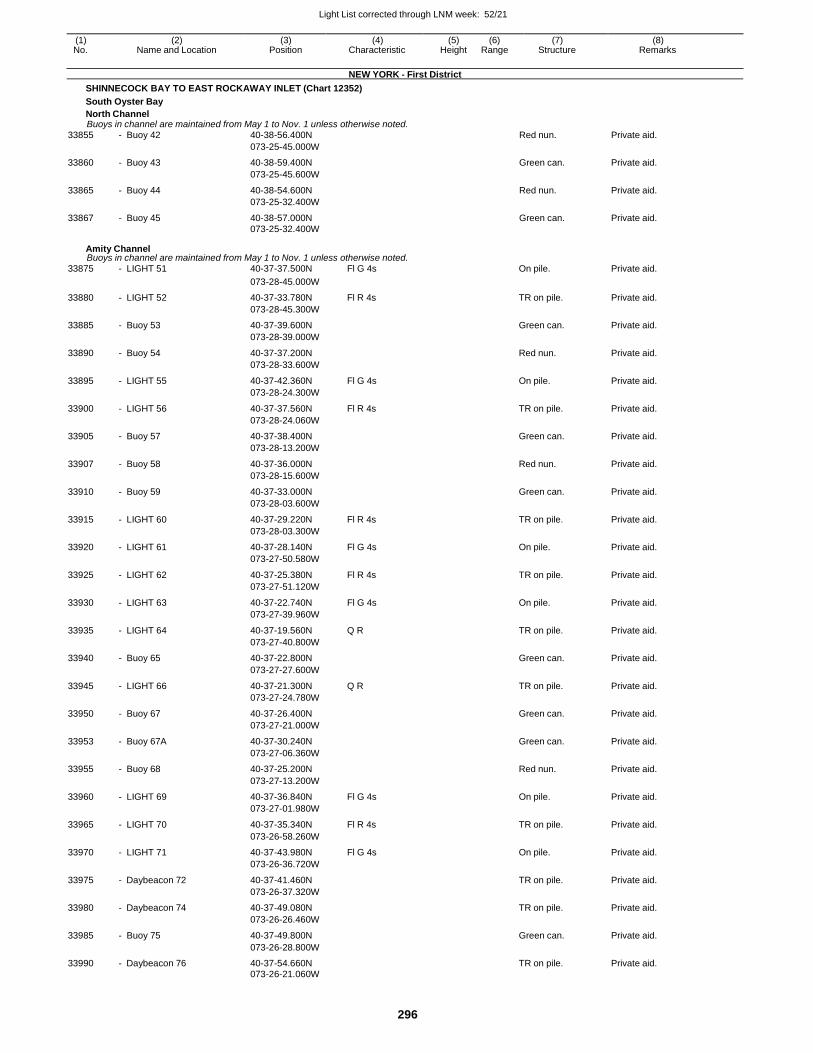
Light List corrected through LNM week: 52/21
296
(1) (2) (3) (4) (5) (6) (7) (8) No. Name and Location Position Characteristic Height Range Structure Remarks
NEW YORK - First District
SHINNECOCK BAY TO EAST ROCKAWAY INLET (Chart 12352)
South Oyster Bay
North Channel Buoys in channel are maintained from May 1 to Nov. 1 unless otherwise noted.
33855 - Buoy 42 40-38-56.400N Red nun. Private aid.
073-25-45.000W
33860 - Buoy 43 40-38-59.400N Green can. Private aid.
073-25-45.600W
33865 - Buoy 44 40-38-54.600N Red nun. Private aid.
073-25-32.400W
33867 - Buoy 45 40-38-57.000N Green can. Private aid. 073-25-32.400W
Amity Channel Buoys in channel are maintained from May 1 to Nov. 1 unless otherwise noted.
33875 - LIGHT 51 40-37-37.500N Fl G 4s On pile. Private aid.
073-28-45.000W
33880 - LIGHT 52 40-37-33.780N Fl R 4s TR on pile. Private aid.
073-28-45.300W
33885 - Buoy 53 40-37-39.600N Green can. Private aid.
073-28-39.000W
33890 - Buoy 54 40-37-37.200N Red nun. Private aid.
073-28-33.600W
33895 - LIGHT 55 40-37-42.360N Fl G 4s On pile. Private aid.
073-28-24.300W
33900 - LIGHT 56 40-37-37.560N Fl R 4s TR on pile. Private aid.
073-28-24.060W
33905 - Buoy 57 40-37-38.400N Green can. Private aid.
073-28-13.200W
33907 - Buoy 58 40-37-36.000N Red nun. Private aid.
073-28-15.600W
33910 - Buoy 59 40-37-33.000N Green can. Private aid.
073-28-03.600W
33915 - LIGHT 60 40-37-29.220N Fl R 4s TR on pile. Private aid.
073-28-03.300W
33920 - LIGHT 61 40-37-28.140N Fl G 4s On pile. Private aid.
073-27-50.580W
33925 - LIGHT 62 40-37-25.380N Fl R 4s TR on pile. Private aid.
073-27-51.120W
33930 - LIGHT 63 40-37-22.740N Fl G 4s On pile. Private aid.
073-27-39.960W
33935 - LIGHT 64 40-37-19.560N Q R TR on pile. Private aid.
073-27-40.800W
33940 - Buoy 65 40-37-22.800N Green can. Private aid.
073-27-27.600W
33945 - LIGHT 66 40-37-21.300N Q R TR on pile. Private aid.
073-27-24.780W
33950 - Buoy 67 40-37-26.400N Green can. Private aid.
073-27-21.000W
33953 - Buoy 67A 40-37-30.240N Green can. Private aid.
073-27-06.360W
33955 - Buoy 68 40-37-25.200N Red nun. Private aid.
073-27-13.200W
33960 - LIGHT 69 40-37-36.840N Fl G 4s On pile. Private aid.
073-27-01.980W
33965 - LIGHT 70 40-37-35.340N Fl R 4s TR on pile. Private aid.
073-26-58.260W
33970 - LIGHT 71 40-37-43.980N Fl G 4s On pile. Private aid.
073-26-36.720W
33975 - Daybeacon 72 40-37-41.460N TR on pile. Private aid.
073-26-37.320W
33980 - Daybeacon 74 40-37-49.080N TR on pile. Private aid.
073-26-26.460W
33985 - Buoy 75 40-37-49.800N Green can. Private aid.
073-26-28.800W
33990 - Daybeacon 76 40-37-54.660N TR on pile. Private aid. 073-26-21.060W
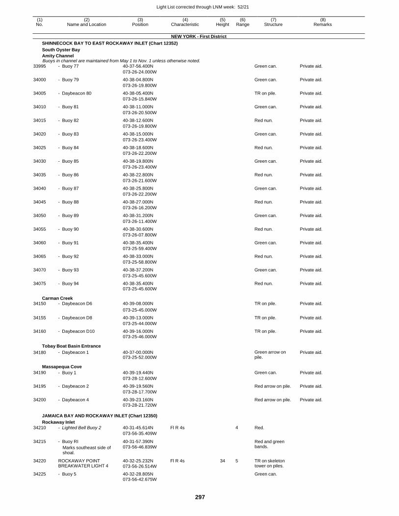
Light List corrected through LNM week: 52/21
297
(1) (2) (3) (4) (5) (6) (7) (8) No. Name and Location Position Characteristic Height Range Structure Remarks
NEW YORK - First District
SHINNECOCK BAY TO EAST ROCKAWAY INLET (Chart 12352)
South Oyster Bay
Amity Channel Buoys in channel are maintained from May 1 to Nov. 1 unless otherwise noted.
33995 - Buoy 77 40-37-56.400N Green can. Private aid.
073-26-24.000W
34000 - Buoy 79 40-38-04.800N Green can. Private aid.
073-26-19.800W
34005 - Daybeacon 80 40-38-05.400N TR on pile. Private aid.
073-26-15.840W
34010 - Buoy 81 40-38-11.000N Green can. Private aid.
073-26-20.500W
34015 - Buoy 82 40-38-12.600N Red nun. Private aid.
073-26-19.800W
34020 - Buoy 83 40-38-15.000N Green can. Private aid.
073-26-23.400W
34025 - Buoy 84 40-38-18.600N Red nun. Private aid.
073-26-22.200W
34030 - Buoy 85 40-38-19.800N Green can. Private aid.
073-26-23.400W
34035 - Buoy 86 40-38-22.800N Red nun. Private aid.
073-26-21.600W
34040 - Buoy 87 40-38-25.800N Green can. Private aid.
073-26-22.200W
34045 - Buoy 88 40-38-27.000N Red nun. Private aid.
073-26-16.200W
34050 - Buoy 89 40-38-31.200N Green can. Private aid.
073-26-11.400W
34055 - Buoy 90 40-38-30.600N Red nun. Private aid.
073-26-07.800W
34060 - Buoy 91 40-38-35.400N Green can. Private aid.
073-25-59.400W
34065 - Buoy 92 40-38-33.000N Red nun. Private aid.
073-25-58.800W
34070 - Buoy 93 40-38-37.200N Green can. Private aid.
073-25-45.600W
34075 - Buoy 94 40-38-35.400N Red nun. Private aid. 073-25-45.600W
Carman Creek 34150 - Daybeacon D6 40-39-08.000N TR on pile. Private aid.
073-25-45.000W
34155 - Daybeacon D8 40-39-13.000N TR on pile. Private aid.
073-25-44.000W
34160 - Daybeacon D10 40-39-16.000N TR on pile. Private aid. 073-25-46.000W
Tobay Boat Basin Entrance
34180 - Daybeacon 1 40-37-00.000N 073-25-52.000W
Green arrow on pile.
Private aid.
Massapequa Cove
34190 - Buoy 1 40-39-19.440N Green can. Private aid.
073-28-12.600W
34195 - Daybeacon 2 40-39-19.560N Red arrow on pile. Private aid.
073-28-17.700W
34200 - Daybeacon 4 40-39-23.160N Red arrow on pile. Private aid. 073-28-21.720W
JAMAICA BAY AND ROCKAWAY INLET (Chart 12350)
Rockaway Inlet
34210 - Lighted Bell Buoy 2 40-31-45.614N Fl R 4s 4 Red.
073-56-35.409W
34215 - Buoy RI
Marks southeast side of shoal.
40-31-57.390N
073-56-46.839W
Red and green bands.
34220 ROCKAWAY POINT BREAKWATER LIGHT 4
40-32-25.232N
073-56-26.514W
Fl R 4s 34 5 TR on skeleton tower on piles.
34225 - Buoy 5 40-32-28.805N Green can. 073-56-42.675W
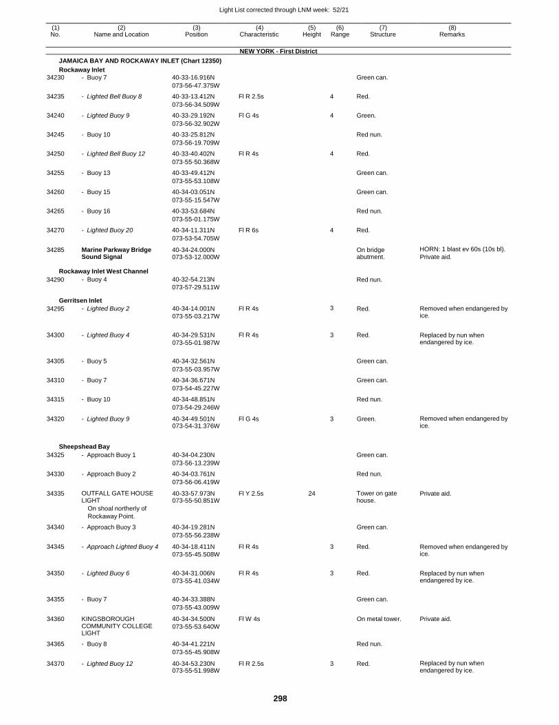
Light List corrected through LNM week: 52/21
298
(1) (2) (3) (4) (5) (6) (7) (8) No. Name and Location Position Characteristic Height Range Structure Remarks
NEW YORK - First District
JAMAICA BAY AND ROCKAWAY INLET (Chart 12350)
Rockaway Inlet
34230 - Buoy 7 40-33-16.916N Green can.
073-56-47.375W
34235 - Lighted Bell Buoy 8 40-33-13.412N Fl R 2.5s 4 Red.
073-56-34.509W
34240 - Lighted Buoy 9 40-33-29.192N Fl G 4s 4 Green.
073-56-32.902W
34245 - Buoy 10 40-33-25.812N Red nun.
073-56-19.709W
34250 - Lighted Bell Buoy 12 40-33-40.402N Fl R 4s 4 Red.
073-55-50.368W
34255 - Buoy 13 40-33-49.412N Green can.
073-55-53.108W
34260 - Buoy 15 40-34-03.051N Green can.
073-55-15.547W
34265 - Buoy 16 40-33-53.684N Red nun.
073-55-01.175W
34270 - Lighted Buoy 20 40-34-11.311N Fl R 6s 4 Red.
073-53-54.705W
34285 Marine Parkway Bridge Sound Signal
40-34-24.000N 073-53-12.000W
On bridge abutment.
HORN: 1 blast ev 60s (10s bl).
Private aid.
Rockaway Inlet West Channel
34290 - Buoy 4 40-32-54.213N
073-57-29.511W
Red nun.
Gerritsen Inlet
34295 - Lighted Buoy 2 40-34-14.001N
073-55-03.217W
Fl R 4s 3 Red. Removed when endangered by ice.
34300 - Lighted Buoy 4 40-34-29.531N
073-55-01.987W
Fl R 4s 3 Red. Replaced by nun when endangered by ice.
34305 - Buoy 5 40-34-32.561N
Green can.
073-55-03.957W
34310 - Buoy 7 40-34-36.671N Green can.
073-54-45.227W
34315 - Buoy 10 40-34-48.851N Red nun.
073-54-29.246W
34320 - Lighted Buoy 9 40-34-49.501N 073-54-31.376W
Fl G 4s 3 Green. Removed when endangered by ice.
Sheepshead Bay
34325 - Approach Buoy 1 40-34-04.230N Green can.
073-56-13.239W
34330 - Approach Buoy 2 40-34-03.761N Red nun.
073-56-06.419W
34335 OUTFALL GATE HOUSE LIGHT
40-33-57.973N 073-55-50.851W
Fl Y 2.5s 24 Tower on gate house.
Private aid.
On shoal northerly of
Rockaway Point.
34340 - Approach Buoy 3 40-34-19.281N Green can.
073-55-56.238W
34345 - Approach Lighted Buoy 4 40-34-18.411N
073-55-45.508W
Fl R 4s 3 Red. Removed when endangered by ice.
34350 - Lighted Buoy 6 40-34-31.006N
073-55-41.034W
Fl R 4s 3 Red. Replaced by nun when endangered by ice.
34355 - Buoy 7 40-34-33.388N
Green can.
073-55-43.009W
34360 KINGSBOROUGH COMMUNITY COLLEGE LIGHT
40-34-34.500N
073-55-53.640W
Fl W 4s On metal tower. Private aid.
34365 - Buoy 8 40-34-41.221N Red nun.
073-55-45.908W
34370 - Lighted Buoy 12 40-34-53.230N 073-55-51.998W
Fl R 2.5s 3 Red. Replaced by nun when endangered by ice.
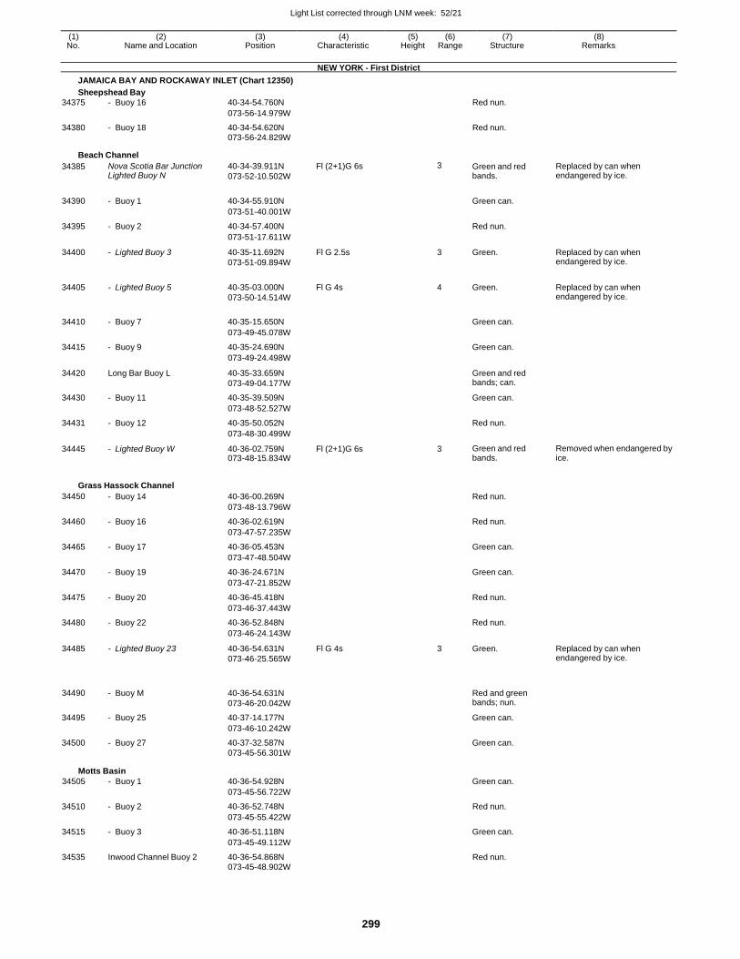
Light List corrected through LNM week: 52/21
299
(1) (2) (3) (4) (5) (6) (7) (8) No. Name and Location Position Characteristic Height Range Structure Remarks
NEW YORK - First District
JAMAICA BAY AND ROCKAWAY INLET (Chart 12350)
Sheepshead Bay
34375 - Buoy 16 40-34-54.760N Red nun.
073-56-14.979W
34380 - Buoy 18 40-34-54.620N Red nun. 073-56-24.829W
Beach Channel
34385 Nova Scotia Bar Junction Lighted Buoy N
40-34-39.911N
073-52-10.502W
Fl (2+1)G 6s 3 Green and red bands.
Replaced by can when endangered by ice.
34390 - Buoy 1 40-34-55.910N
Green can.
073-51-40.001W
34395 - Buoy 2 40-34-57.400N Red nun.
073-51-17.611W
34400 - Lighted Buoy 3 40-35-11.692N
073-51-09.894W
Fl G 2.5s 3 Green. Replaced by can when endangered by ice.
34405 - Lighted Buoy 5 40-35-03.000N
073-50-14.514W
Fl G 4s 4 Green. Replaced by can when endangered by ice.
34410 - Buoy 7 40-35-15.650N
Green can.
073-49-45.078W
34415 - Buoy 9 40-35-24.690N Green can.
073-49-24.498W
34420 Long Bar Buoy L 40-35-33.659N
073-49-04.177W
Green and red bands; can.
34430 - Buoy 11 40-35-39.509N Green can.
073-48-52.527W
34431 - Buoy 12 40-35-50.052N Red nun.
073-48-30.499W
34445 - Lighted Buoy W 40-36-02.759N 073-48-15.834W
Fl (2+1)G 6s 3 Green and red bands.
Removed when endangered by ice.
Grass Hassock Channel
34450 - Buoy 14 40-36-00.269N Red nun.
073-48-13.796W
34460 - Buoy 16 40-36-02.619N Red nun.
073-47-57.235W
34465 - Buoy 17 40-36-05.453N Green can.
073-47-48.504W
34470 - Buoy 19 40-36-24.671N Green can.
073-47-21.852W
34475 - Buoy 20 40-36-45.418N Red nun.
073-46-37.443W
34480 - Buoy 22 40-36-52.848N Red nun.
073-46-24.143W
34485 - Lighted Buoy 23 40-36-54.631N
073-46-25.565W
Fl G 4s 3 Green. Replaced by can when endangered by ice.
34490
- Buoy M
40-36-54.631N
073-46-20.042W
Red and green bands; nun.
34495 - Buoy 25 40-37-14.177N Green can.
073-46-10.242W
34500 - Buoy 27 40-37-32.587N Green can.
073-45-56.301W
Motts Basin
34505 - Buoy 1
40-36-54.928N
Green can.
073-45-56.722W
34510 - Buoy 2 40-36-52.748N Red nun.
073-45-55.422W
34515 - Buoy 3 40-36-51.118N Green can.
073-45-49.112W
34535 Inwood Channel Buoy 2 40-36-54.868N Red nun. 073-45-48.902W
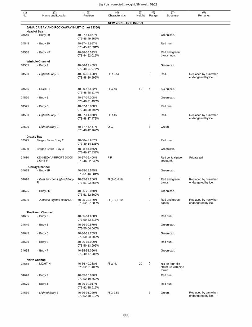
Light List corrected through LNM week: 52/21
300
(1) (2) (3) (4) (5) (6) (7) (8) No. Name and Location Position Characteristic Height Range Structure Remarks
NEW YORK - First District
JAMAICA BAY AND ROCKAWAY INLET (Chart 12350)
Head of Bay
34540 - Buoy 29 40-37-41.877N Green can.
073-45-49.862W
34545 - Buoy 30 40-37-49.667N Red nun.
073-45-17.631W
34550 - Buoy NP 40-38-05.523N 073-44-52.016W
Red and green bands; nun.
Winhole Channel
34555 - Buoy 1 40-36-19.469N Green can.
073-48-21.976W
34560 - Lighted Buoy 2 40-36-35.408N
073-48-20.996W
Fl R 2.5s 3 Red. Replaced by nun when endangered by ice.
34565
- LIGHT 3
40-36-46.132N
Fl G 4s
12
4
SG on pile.
073-48-28.114W
34570 - Buoy 5 40-37-04.208N Green can.
073-48-31.496W
34575 - Buoy 6 40-37-15.808N Red nun.
073-48-30.696W
34580 - Lighted Buoy 8 40-37-41.878N
073-48-37.472W
Fl R 4s 3 Red. Replaced by nun when endangered by ice.
34590 - Lighted Buoy 9 40-37-48.457N Q G
3 Green.
073-48-42.167W
Grassy Bay
34595
34600
34610
Bergen Basin Buoy 2
Bergen Basin Buoy 3
KENNEDY AIRPORT DOCK LIGHT F
40-38-43.987N
073-49-14.131W
40-38-44.076N
073-49-17.538W
40-37-05.400N F R
073-46-32.640W
Red nun.
Green can.
Red conical pipe structure.
Private aid.
Runway Channel
34615 - Buoy 1R 40-35-19.545N Green can.
073-51-16.081W
34620 - East Junction Lighted Buoy R
40-35-27.256N
073-51-03.458W
Fl (2+1)R 6s 3 Red and green bands.
Replaced by nun when endangered by ice.
34625 - Buoy 3R 40-35-28.070N
Green can.
073-51-52.362W
34630 - Junction Lighted Buoy RC 40-35-39.139N 073-52-27.583W
Fl (2+1)R 6s 3 Red and green bands.
Replaced by nun when endangered by ice.
The Raunt Channel
34635 - Buoy 2 40-35-54.668N Red nun.
073-50-53.615W
34640 - Buoy 3 40-36-00.579N Green can.
073-50-54.040W
34645 - Buoy 5 40-36-12.709N Green can.
073-50-33.500W
34650 - Buoy 6 40-36-04.009N Red nun.
073-50-13.999W
34655 - Buoy 7 40-35-58.066N Green can. 073-49-47.988W
North Channel
34665 - LIGHT N 40-36-40.288N
073-52-51.403W
Fl W 4s 20 5 NR on four pile structure with pipe tower.
34670 - Buoy 2 40-35-10.090N Red nun.
073-52-19.753W
34675 - Buoy 4 40-36-02.017N Red nun.
073-52-35.919W
34680 - Lighted Buoy 5 40-36-01.229N 073-52-48.013W
Fl G 2.5s 3 Green. Replaced by can when endangered by ice.
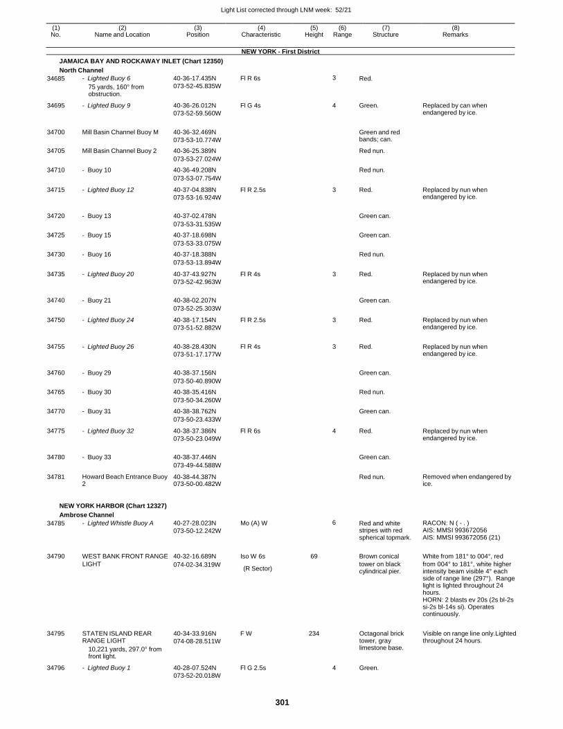
Light List corrected through LNM week: 52/21
301
(1) (2) (3) (4) (5) (6) (7) (8) No. Name and Location Position Characteristic Height Range Structure Remarks
NEW YORK - First District
JAMAICA BAY AND ROCKAWAY INLET (Chart 12350)
North Channel
34685 - Lighted Buoy 6
75 yards, 160° from obstruction.
40-36-17.435N
073-52-45.835W
Fl R 6s 3 Red.
34695 - Lighted Buoy 9 40-36-26.012N
073-52-59.560W
Fl G 4s 4 Green. Replaced by can when endangered by ice.
34700 Mill Basin Channel Buoy M 40-36-32.469N
073-53-10.774W
Green and red bands; can.
34705 Mill Basin Channel Buoy 2 40-36-25.389N Red nun.
073-53-27.024W
34710 - Buoy 10 40-36-49.208N Red nun.
073-53-07.754W
34715 - Lighted Buoy 12 40-37-04.838N
073-53-16.924W
Fl R 2.5s 3 Red. Replaced by nun when endangered by ice.
34720 - Buoy 13 40-37-02.478N
Green can.
073-53-31.535W
34725 - Buoy 15 40-37-18.698N Green can.
073-53-33.075W
34730 - Buoy 16 40-37-18.388N Red nun.
073-53-13.894W
34735 - Lighted Buoy 20 40-37-43.927N
073-52-42.963W
Fl R 4s 3 Red. Replaced by nun when endangered by ice.
34740 - Buoy 21 40-38-02.207N
Green can.
073-52-25.303W
34750 - Lighted Buoy 24 40-38-17.154N
073-51-52.882W
Fl R 2.5s 3 Red. Replaced by nun when endangered by ice.
34755 - Lighted Buoy 26 40-38-28.430N
073-51-17.177W
Fl R 4s 3 Red. Replaced by nun when endangered by ice.
34760 - Buoy 29 40-38-37.156N
Green can.
073-50-40.890W
34765 - Buoy 30 40-38-35.416N Red nun.
073-50-34.260W
34770 - Buoy 31 40-38-38.762N Green can.
073-50-23.433W
34775 - Lighted Buoy 32 40-38-37.386N
073-50-23.049W
Fl R 6s 4 Red. Replaced by nun when endangered by ice.
34780 - Buoy 33 40-38-37.446N
Green can.
073-49-44.588W
34781 Howard Beach Entrance Buoy 2
40-38-44.387N 073-50-00.482W
Red nun. Removed when endangered by ice.
NEW YORK HARBOR (Chart 12327)
Ambrose Channel
34785 - Lighted Whistle Buoy A 40-27-28.023N
073-50-12.242W
Mo (A) W 6 Red and white stripes with red spherical topmark.
RACON: N ( - . ) AIS: MMSI 993672056 AIS: MMSI 993672056 (21)
34790 WEST BANK FRONT RANGE 40-32-16.689N Iso W 6s 69
Brown conical White from 181° to 004°, red
LIGHT 074-02-34.319W (R Sector)
tower on black cylindrical pier.
from 004° to 181°, white higher intensity beam visible 4° each side of range line (297°). Range light is lighted throughout 24 hours. HORN: 2 blasts ev 20s (2s bl-2s si-2s bl-14s si). Operates continuously.
34795
34796
STATEN ISLAND REAR RANGE LIGHT
10,221 yards, 297.0° from front light.
- Lighted Buoy 1
40-34-33.916N
074-08-28.511W
40-28-07.524N
073-52-20.018W
F W
Fl G 2.5s
234
4
Octagonal brick tower, gray limestone base.
Green.
Visible on range line only.Lighted throughout 24 hours.
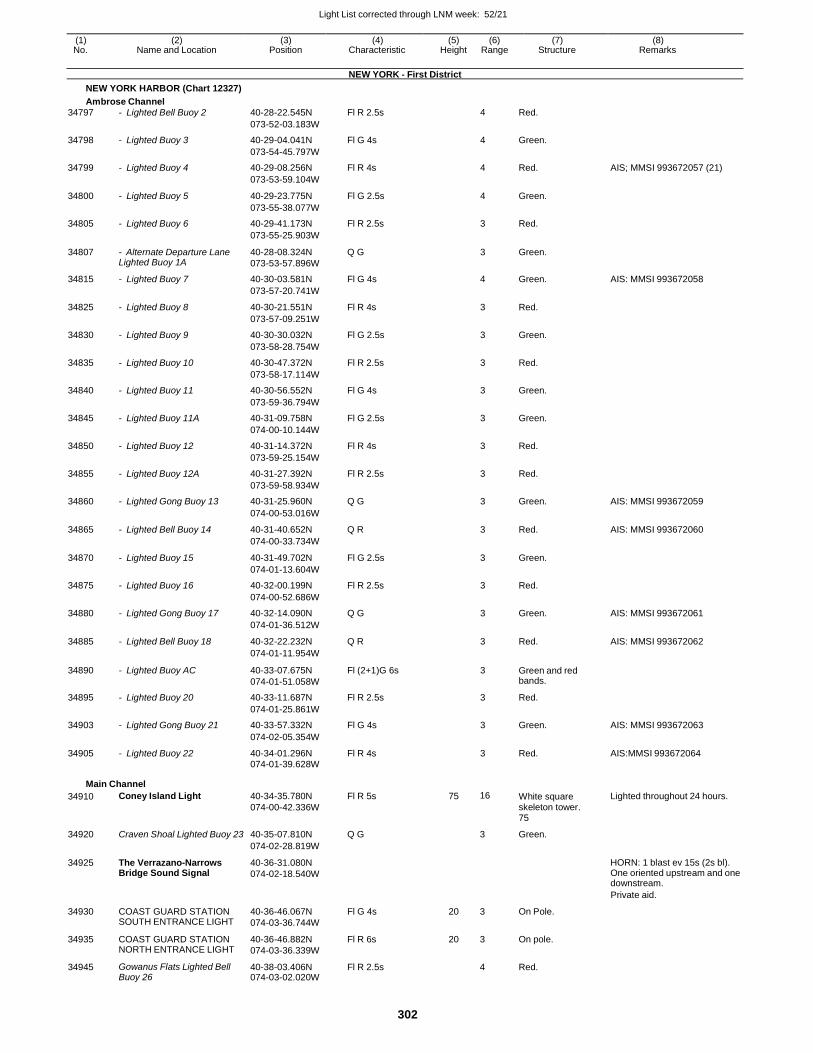
Light List corrected through LNM week: 52/21
302
(1) (2) (3) (4) (5) (6) (7) (8) No. Name and Location Position Characteristic Height Range Structure Remarks
NEW YORK - First District
NEW YORK HARBOR (Chart 12327)
Ambrose Channel
34797 - Lighted Bell Buoy 2 40-28-22.545N Fl R 2.5s 4 Red.
073-52-03.183W
34798 - Lighted Buoy 3 40-29-04.041N Fl G 4s 4 Green.
073-54-45.797W
34799 - Lighted Buoy 4 40-29-08.256N Fl R 4s 4 Red. AIS; MMSI 993672057 (21)
073-53-59.104W
34800 - Lighted Buoy 5 40-29-23.775N Fl G 2.5s 4 Green.
073-55-38.077W
34805 - Lighted Buoy 6 40-29-41.173N Fl R 2.5s 3 Red.
073-55-25.903W
34807 - Alternate Departure Lane Lighted Buoy 1A
40-28-08.324N
073-53-57.896W
Q G 3 Green.
34815 - Lighted Buoy 7 40-30-03.581N Fl G 4s 4 Green. AIS: MMSI 993672058
073-57-20.741W
34825 - Lighted Buoy 8 40-30-21.551N Fl R 4s 3 Red.
073-57-09.251W
34830 - Lighted Buoy 9 40-30-30.032N Fl G 2.5s 3 Green.
073-58-28.754W
34835 - Lighted Buoy 10 40-30-47.372N Fl R 2.5s 3 Red.
073-58-17.114W
34840 - Lighted Buoy 11 40-30-56.552N Fl G 4s 3 Green.
073-59-36.794W
34845 - Lighted Buoy 11A 40-31-09.758N Fl G 2.5s 3 Green.
074-00-10.144W
34850 - Lighted Buoy 12 40-31-14.372N Fl R 4s 3 Red.
073-59-25.154W
34855 - Lighted Buoy 12A 40-31-27.392N Fl R 2.5s 3 Red.
073-59-58.934W
34860 - Lighted Gong Buoy 13 40-31-25.960N Q G 3 Green. AIS: MMSI 993672059
074-00-53.016W
34865 - Lighted Bell Buoy 14 40-31-40.652N Q R 3 Red. AIS: MMSI 993672060
074-00-33.734W
34870 - Lighted Buoy 15 40-31-49.702N Fl G 2.5s 3 Green.
074-01-13.604W
34875 - Lighted Buoy 16 40-32-00.199N Fl R 2.5s 3 Red.
074-00-52.686W
34880 - Lighted Gong Buoy 17 40-32-14.090N Q G 3 Green. AIS: MMSI 993672061
074-01-36.512W
34885 - Lighted Bell Buoy 18 40-32-22.232N Q R 3 Red. AIS: MMSI 993672062
074-01-11.954W
34890 - Lighted Buoy AC 40-33-07.675N
074-01-51.058W
Fl (2+1)G 6s 3 Green and red bands.
34895 - Lighted Buoy 20 40-33-11.687N Fl R 2.5s 3 Red.
074-01-25.861W
34903 - Lighted Gong Buoy 21 40-33-57.332N Fl G 4s 3 Green. AIS: MMSI 993672063
074-02-05.354W
34905 - Lighted Buoy 22 40-34-01.296N Fl R 4s 3 Red. AIS:MMSI 993672064 074-01-39.628W
Main Channel
34910 Coney Island Light 40-34-35.780N
074-00-42.336W
Fl R 5s 75 16 White square skeleton tower. 75
Lighted throughout 24 hours.
34920 Craven Shoal Lighted Buoy 23 40-35-07.810N Q G 3 Green.
074-02-28.819W
34925 The Verrazano-Narrows Bridge Sound Signal
40-36-31.080N
074-02-18.540W
HORN: 1 blast ev 15s (2s bl). One oriented upstream and one downstream.
Private aid.
34930 COAST GUARD STATION SOUTH ENTRANCE LIGHT
40-36-46.067N
074-03-36.744W
Fl G 4s 20 3 On Pole.
34935 COAST GUARD STATION NORTH ENTRANCE LIGHT
40-36-46.882N
074-03-36.339W
Fl R 6s 20 3 On pole.
34945 Gowanus Flats Lighted Bell Buoy 26
40-38-03.406N 074-03-02.020W
Fl R 2.5s 4 Red.
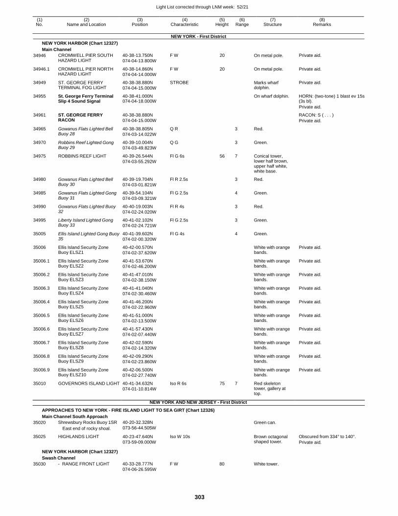
Light List corrected through LNM week: 52/21
303
(1) (2) (3) (4) (5) (6) (7) (8) No. Name and Location Position Characteristic Height Range Structure Remarks
NEW YORK - First District
NEW YORK HARBOR (Chart 12327)
Main Channel
34946 CROMWELL PIER SOUTH HAZARD LIGHT
40-38-13.750N
074-04-13.800W
F W 20 On metal pole. Private aid.
34946.1 CROMWELL PIER NORTH HAZARD LIGHT
40-38-14.860N
074-04-14.000W
F W 20 On metal pole. Private aid.
34949 ST. GEORGE FERRY TERMINAL FOG LIGHT
40-38-38.880N
074-04-15.000W
STROBE Marks wharf dolphin.
Private aid.
34955 St. George Ferry Terminal Slip 4 Sound Signal
40-38-41.000N 074-04-18.000W
On wharf dolphin. HORN: (two-tone) 1 blast ev 15s (3s bl).
Private aid.
34961 ST. GEORGE FERRY RACON
40-38-38.880N
074-04-15.000W
RACON: S ( . . . )
Private aid.
34965 Gowanus Flats Lighted Bell Buoy 28
40-38-38.805N
074-03-14.022W
Q R 3 Red.
34970 Robbins Reef Lighted Gong Buoy 29
40-39-10.004N
074-03-49.823W
Q G 3 Green.
34975 ROBBINS REEF LIGHT 40-39-26.544N
074-03-55.292W
Fl G 6s 56 7 Conical tower, lower half brown, upper half white, white base.
34980 Gowanus Flats Lighted Bell Buoy 30
40-39-19.704N
074-03-01.821W
Fl R 2.5s 3 Red.
34985 Gowanus Flats Lighted Gong Buoy 31
40-39-54.104N
074-03-09.321W
Fl G 2.5s 4 Green.
34990 Gowanus Flats Lighted Buoy 32
40-40-19.003N
074-02-24.020W
Fl R 4s 3 Red.
34995 Liberty Island Lighted Gong Buoy 33
40-41-02.102N
074-02-24.721W
Fl G 2.5s 3 Green.
35005 Ellis Island Lighted Gong Buoy 35
40-41-39.602N
074-02-00.320W
Fl G 4s 4 Green.
35006 Ellis Island Security Zone Buoy ELSZ1
40-42-00.570N
074-02-37.620W
White with orange bands.
Private aid.
35006.1 Ellis Island Security Zone Buoy ELSZ2
40-41-53.670N
074-02-46.200W
White with orange bands.
Private aid.
35006.2 Ellis Island Security Zone Buoy ELSZ3
40-41-47.010N
074-02-38.150W
White with orange bands.
Private aid.
35006.3 Ellis Island Security Zone Buoy ELSZ4
40-41-41.040N
074-02-30.460W
White with orange bands.
Private aid.
35006.4 Ellis Island Security Zone Buoy ELSZ5
40-41-46.200N
074-02-22.960W
White with orange bands.
Private aid.
35006.5 Ellis Island Security Zone Buoy ELSZ6
40-41-51.000N
074-02-13.500W
White with orange bands.
Private aid.
35006.6 Ellis Island Security Zone Buoy ELSZ7
40-41-57.430N
074-02-07.440W
White with orange bands.
Private aid.
35006.7 Ellis Island Security Zone Buoy ELSZ8
40-42-02.590N
074-02-14.320W
White with orange bands.
Private aid.
35006.8 Ellis Island Security Zone Buoy ELSZ9
40-42-09.290N
074-02-23.860W
White with orange bands.
Private aid.
35006.9 Ellis Island Security Zone Buoy ELSZ10
40-42-06.500N
074-02-27.740W
White with orange bands.
Private aid.
35010 GOVERNORS ISLAND LIGHT 40-41-34.632N
074-01-10.814W
Iso R 6s 75 7 Red skeleton tower, gallery at top.
NEW YORK AND NEW JERSEY - First District
APPROACHES TO NEW YORK - FIRE ISLAND LIGHT TO SEA GIRT (Chart 12326)
Main Channel South Approach
35020
35025
Shrewsbury Rocks Buoy 1SR
East end of rocky shoal.
HIGHLANDS LIGHT
40-20-32.328N
073-56-44.505W
40-23-47.640N
073-59-09.000W
Iso W 10s
Green can.
Brown octagonal shaped tower.
Obscured from 334° to 140°.
Private aid.
NEW YORK HARBOR (Chart 12327)
Swash Channel
35030 - RANGE FRONT LIGHT 40-33-28.777N F W
074-06-26.595W
80 White tower.
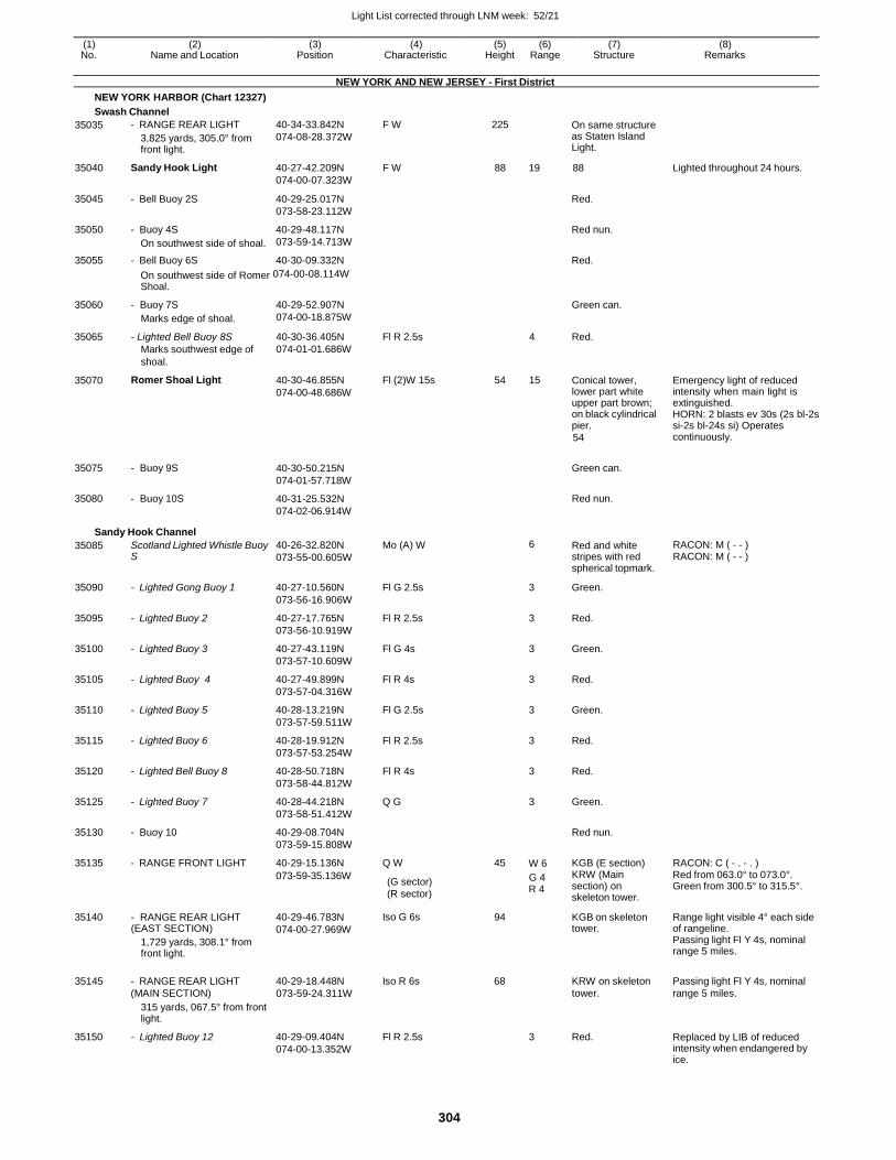
Light List corrected through LNM week: 52/21
304
(1) (2) (3) (4) (5) (6) (7) (8) No. Name and Location Position Characteristic Height Range Structure Remarks
NEW YORK AND NEW JERSEY - First District
NEW YORK HARBOR (Chart 12327)
Swash Channel
35035 - RANGE REAR LIGHT
3,825 yards, 305.0° from front light.
40-34-33.842N
074-08-28.372W
F W 225 On same structure as Staten Island Light.
35040 Sandy Hook Light 40-27-42.209N
074-00-07.323W
F W 88 19 88 Lighted throughout 24 hours.
35045 - Bell Buoy 2S 40-29-25.017N
073-58-23.112W
Red.
35050 - Buoy 4S
On southwest side of shoal.
40-29-48.117N
073-59-14.713W
Red nun.
35055 - Bell Buoy 6S 40-30-09.332N Red.
On southwest side of Romer 074-00-08.114W
Shoal.
35060
35065
35070
35075
35080
- Buoy 7S
Marks edge of shoal.
- Lighted Bell Buoy 8S
Marks southwest edge of
shoal.
Romer Shoal Light
- Buoy 9S
- Buoy 10S
40-29-52.907N
074-00-18.875W
40-30-36.405N
074-01-01.686W
40-30-46.855N
074-00-48.686W
40-30-50.215N
074-01-57.718W
40-31-25.532N
074-02-06.914W
Fl R 2.5s
Fl (2)W 15s
4
54 15
Green can.
Red.
Conical tower, lower part white upper part brown; on black cylindrical pier.
54
Green can.
Red nun.
Emergency light of reduced intensity when main light is extinguished. HORN: 2 blasts ev 30s (2s bl-2s si-2s bl-24s si) Operates continuously.
Sandy Hook Channel
35085 Scotland Lighted Whistle Buoy S
40-26-32.820N
073-55-00.605W
Mo (A) W 6 Red and white stripes with red spherical topmark.
RACON: M ( - - ) RACON: M ( - - )
35090 - Lighted Gong Buoy 1 40-27-10.560N
073-56-16.906W
Fl G 2.5s 3 Green.
35095 - Lighted Buoy 2 40-27-17.765N
073-56-10.919W
Fl R 2.5s 3 Red.
35100 - Lighted Buoy 3 40-27-43.119N
073-57-10.609W
Fl G 4s 3 Green.
35105 - Lighted Buoy 4 40-27-49.899N
073-57-04.316W
Fl R 4s 3 Red.
35110 - Lighted Buoy 5 40-28-13.219N
073-57-59.511W
Fl G 2.5s 3 Green.
35115 - Lighted Buoy 6 40-28-19.912N
073-57-53.254W
Fl R 2.5s 3 Red.
35120 - Lighted Bell Buoy 8 40-28-50.718N
073-58-44.812W
Fl R 4s 3 Red.
35125 - Lighted Buoy 7 40-28-44.218N
073-58-51.412W
Q G 3 Green.
35130 - Buoy 10 40-29-08.704N
073-59-15.808W
Red nun.
35135 - RANGE FRONT LIGHT 40-29-15.136N Q W 45 W 6 KGB (E section) RACON: C ( - . - . )
35140
35150
- RANGE REAR LIGHT (EAST SECTION)
1,729 yards, 308.1° from front light.
315 yards, 067.5° from front light.
- Lighted Buoy 12
073-59-35.136W
40-29-46.783N
074-00-27.969W
40-29-09.404N
074-00-13.352W
(G sector)
(R sector)
Iso G 6s
Fl R 2.5s
G 4 KRW (Main
R 4 section) on skeleton tower.
94 KGB on skeleton tower.
3 Red.
Red from 063.0° to 073.0°. Green from 300.5° to 315.5°.
Range light visible 4° each side of rangeline. Passing light Fl Y 4s, nominal range 5 miles.
Replaced by LIB of reduced intensity when endangered by ice.
35145 - RANGE REAR LIGHT 40-29-18.448N Iso R 6s 68 KRW on skeleton Passing light Fl Y 4s, nominal (MAIN SECTION) 073-59-24.311W tower. range 5 miles.
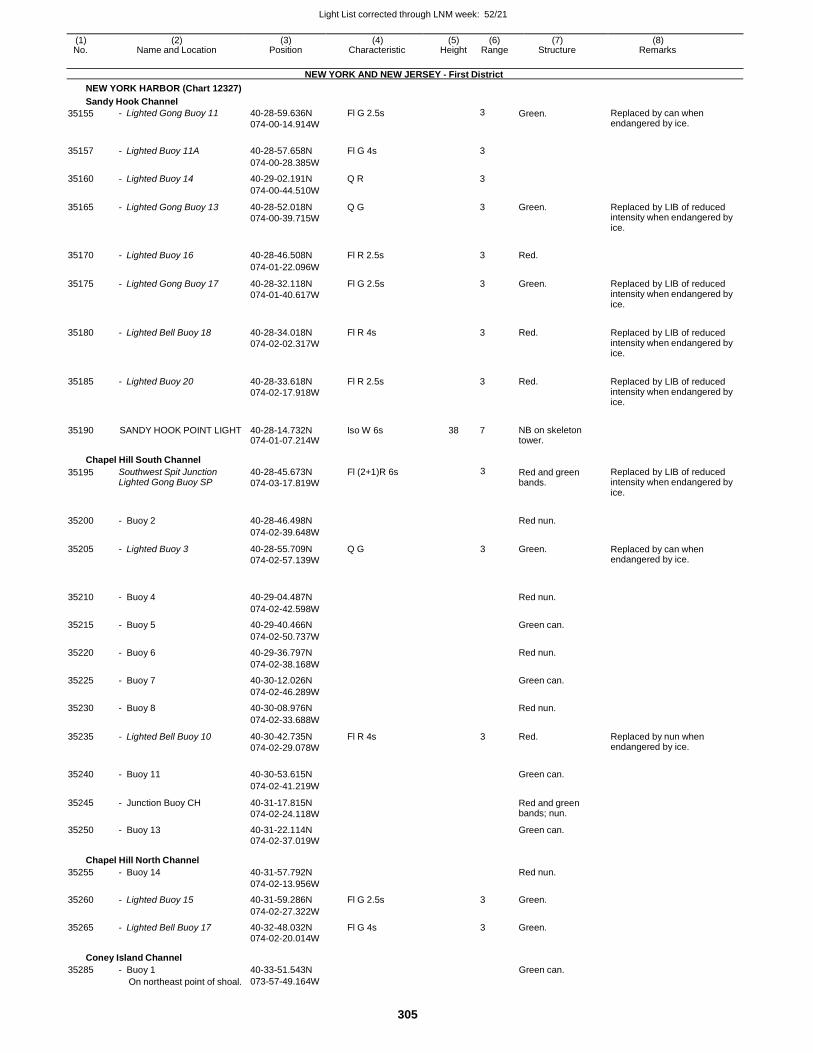
Light List corrected through LNM week: 52/21
305
(1) (2) (3) (4) (5) (6) (7) (8) No. Name and Location Position Characteristic Height Range Structure Remarks
NEW YORK AND NEW JERSEY - First District
NEW YORK HARBOR (Chart 12327)
Sandy Hook Channel
35155 - Lighted Gong Buoy 11 40-28-59.636N
074-00-14.914W
Fl G 2.5s 3 Green. Replaced by can when endangered by ice.
35157 - Lighted Buoy 11A 40-28-57.658N Fl G 4s
3
074-00-28.385W
35160 - Lighted Buoy 14 40-29-02.191N Q R 3
074-00-44.510W
35165 - Lighted Gong Buoy 13 40-28-52.018N
074-00-39.715W
Q G 3 Green. Replaced by LIB of reduced intensity when endangered by ice.
35170 - Lighted Buoy 16 40-28-46.508N Fl R 2.5s
3 Red.
074-01-22.096W
35175 - Lighted Gong Buoy 17 40-28-32.118N
074-01-40.617W
Fl G 2.5s 3 Green. Replaced by LIB of reduced intensity when endangered by ice.
35180 - Lighted Bell Buoy 18 40-28-34.018N
074-02-02.317W
Fl R 4s
3 Red. Replaced by LIB of reduced intensity when endangered by ice.
35185 - Lighted Buoy 20 40-28-33.618N
074-02-17.918W
Fl R 2.5s
3 Red. Replaced by LIB of reduced intensity when endangered by ice.
35190 SANDY HOOK POINT LIGHT 40-28-14.732N 074-01-07.214W
Iso W 6s 38 7 NB on skeleton tower.
Chapel Hill South Channel
35195 Southwest Spit Junction Lighted Gong Buoy SP
40-28-45.673N
074-03-17.819W
Fl (2+1)R 6s 3 Red and green bands.
Replaced by LIB of reduced intensity when endangered by ice.
35200 - Buoy 2 40-28-46.498N
Red nun.
074-02-39.648W
35205 - Lighted Buoy 3 40-28-55.709N
074-02-57.139W
Q G 3 Green. Replaced by can when endangered by ice.
35210
- Buoy 4
40-29-04.487N
Red nun.
074-02-42.598W
35215 - Buoy 5 40-29-40.466N Green can.
074-02-50.737W
35220 - Buoy 6 40-29-36.797N Red nun.
074-02-38.168W
35225 - Buoy 7 40-30-12.026N Green can.
074-02-46.289W
35230 - Buoy 8 40-30-08.976N Red nun.
074-02-33.688W
35235 - Lighted Bell Buoy 10 40-30-42.735N
074-02-29.078W
Fl R 4s 3 Red. Replaced by nun when endangered by ice.
35240 - Buoy 11 40-30-53.615N
Green can.
074-02-41.219W
35245 - Junction Buoy CH 40-31-17.815N
074-02-24.118W
Red and green bands; nun.
35250 - Buoy 13 40-31-22.114N Green can.
074-02-37.019W
Chapel Hill North Channel
35255 - Buoy 14 40-31-57.792N Red nun.
074-02-13.956W
35260 - Lighted Buoy 15 40-31-59.286N Fl G 2.5s 3 Green.
074-02-27.322W
35265 - Lighted Bell Buoy 17 40-32-48.032N Fl G 4s 3 Green. 074-02-20.014W
Coney Island Channel
35285 - Buoy 1 40-33-51.543N Green can. On northeast point of shoal. 073-57-49.164W
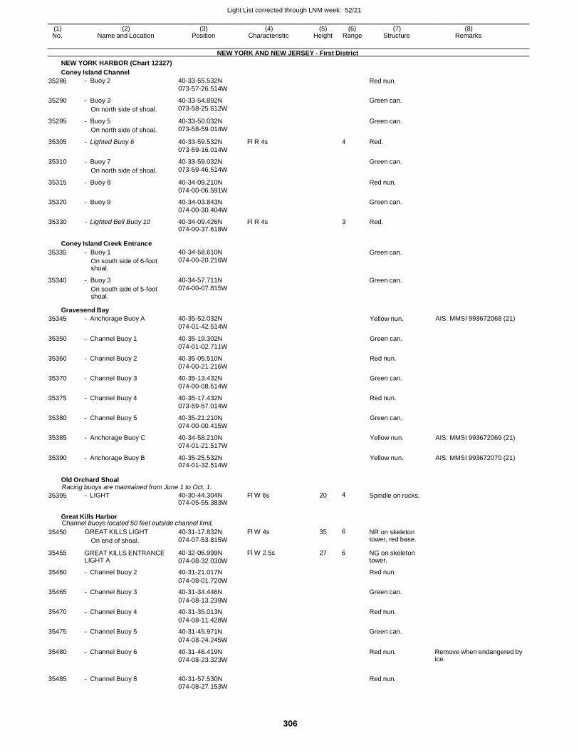
Light List corrected through LNM week: 52/21
306
(1) (2) (3) (4) (5) (6) (7) (8) No. Name and Location Position Characteristic Height Range Structure Remarks
NEW YORK AND NEW JERSEY - First District
NEW YORK HARBOR (Chart 12327)
Coney Island Channel
35286 - Buoy 2 40-33-55.532N
073-57-26.514W
Red nun.
35290 - Buoy 3
On north side of shoal.
40-33-54.892N
073-58-25.612W
Green can.
35295 - Buoy 5
On north side of shoal.
40-33-50.032N
073-58-59.014W
Green can.
35305 - Lighted Buoy 6 40-33-59.532N
073-59-16.014W
Fl R 4s 4 Red.
35310 - Buoy 7
On north side of shoal.
40-33-59.032N
073-59-46.514W
Green can.
35315 - Buoy 8 40-34-09.210N
074-00-06.591W
Red nun.
35320 - Buoy 9 40-34-03.843N
074-00-30.404W
Green can.
35330 - Lighted Bell Buoy 10 40-34-09.426N 074-00-37.618W
Fl R 4s 3 Red.
Coney Island Creek Entrance
35335
35340
- Buoy 1
On south side of 6-foot shoal.
- Buoy 3
On south side of 5-foot shoal.
40-34-58.610N
074-00-20.216W
40-34-57.711N
074-00-07.815W
Green can.
Green can.
Gravesend Bay
35345 - Anchorage Buoy A 40-35-52.032N
074-01-42.514W Yellow nun. AIS: MMSI 993672068 (21)
35350 - Channel Buoy 1 40-35-19.302N
074-01-02.711W
Green can.
35360 - Channel Buoy 2 40-35-05.510N
074-00-21.216W
Red nun.
35370 - Channel Buoy 3 40-35-13.432N
074-00-08.514W
Green can.
35375 - Channel Buoy 4 40-35-17.432N
073-59-57.014W
Red nun.
35380 - Channel Buoy 5 40-35-21.210N
074-00-00.415W
Green can.
35385 - Anchorage Buoy C 40-34-58.210N
074-01-21.517W
Yellow nun. AIS: MMSI 993672069 (21)
35390 - Anchorage Buoy B 40-35-25.532N 074-01-32.514W
Yellow nun. AIS: MMSI 993672070 (21)
Old Orchard Shoal Racing buoys are maintained from June 1 to Oct. 1.
35395 - LIGHT 40-30-44.304N 074-05-55.383W
Fl W 6s 20 4 Spindle on rocks.
Great Kills Harbor Channel buoys located 50 feet outside channel limit.
35450 GREAT KILLS LIGHT
On end of shoal.
40-31-17.832N
074-07-53.815W
Fl W 4s 35 6 NR on skeleton tower, red base.
35455 GREAT KILLS ENTRANCE LIGHT A
40-32-06.999N
074-08-32.030W
Fl W 2.5s 27 6 NG on skeleton tower.
35460 - Channel Buoy 2 40-31-21.017N Red nun.
074-08-01.720W
35465 - Channel Buoy 3 40-31-34.446N Green can.
074-08-13.239W
35470 - Channel Buoy 4 40-31-35.013N Red nun.
074-08-11.428W
35475 - Channel Buoy 5 40-31-45.971N Green can.
074-08-24.245W
35480 - Channel Buoy 6 40-31-46.419N
074-08-23.323W
Red nun. Remove when endangered by ice.
35485 - Channel Buoy 8 40-31-57.530N
Red nun.
074-08-27.153W
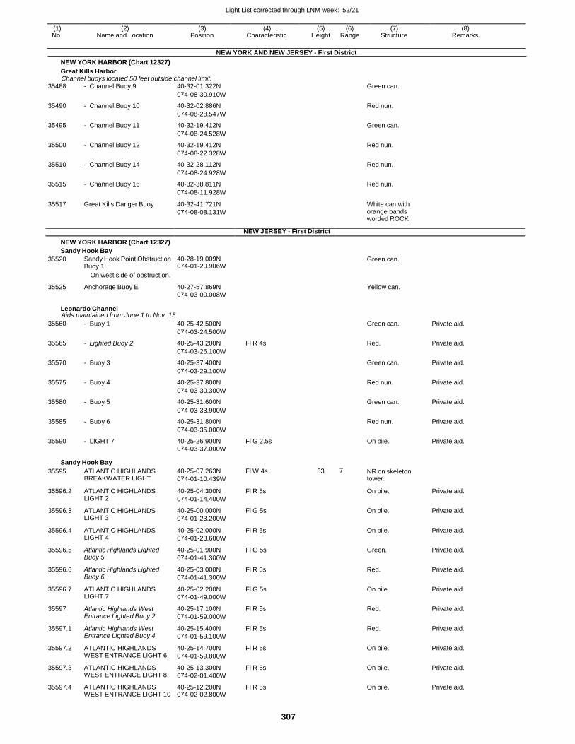
Light List corrected through LNM week: 52/21
307
(1) (2) (3) (4) (5) (6) (7) (8) No. Name and Location Position Characteristic Height Range Structure Remarks
NEW YORK AND NEW JERSEY - First District
NEW YORK HARBOR (Chart 12327)
Great Kills Harbor Channel buoys located 50 feet outside channel limit.
35488 - Channel Buoy 9 40-32-01.322N Green can.
074-08-30.910W
35490 - Channel Buoy 10 40-32-02.886N Red nun.
074-08-28.547W
35495 - Channel Buoy 11 40-32-19.412N Green can.
074-08-24.528W
35500 - Channel Buoy 12 40-32-19.412N Red nun.
074-08-22.328W
35510 - Channel Buoy 14 40-32-28.112N Red nun.
074-08-24.928W
35515 - Channel Buoy 16 40-32-38.811N Red nun.
074-08-11.928W
35517 Great Kills Danger Buoy 40-32-41.721N
074-08-08.131W
White can with orange bands worded ROCK.
NEW JERSEY - First District
NEW YORK HARBOR (Chart 12327)
Sandy Hook Bay
35520 Sandy Hook Point Obstruction Buoy 1
40-28-19.009N 074-01-20.906W
Green can.
On west side of obstruction.
35525 Anchorage Buoy E 40-27-57.869N Yellow can. 074-03-00.008W
Leonardo Channel Aids maintained from June 1 to Nov. 15.
35560 - Buoy 1 40-25-42.500N Green can. Private aid.
074-03-24.500W
35565 - Lighted Buoy 2 40-25-43.200N Fl R 4s Red. Private aid.
074-03-26.100W
35570 - Buoy 3 40-25-37.400N Green can. Private aid.
074-03-29.100W
35575 - Buoy 4 40-25-37.800N Red nun. Private aid.
074-03-30.300W
35580 - Buoy 5 40-25-31.600N Green can. Private aid.
074-03-33.900W
35585 - Buoy 6 40-25-31.800N Red nun. Private aid.
074-03-35.000W
35590 - LIGHT 7 40-25-26.900N Fl G 2.5s On pile. Private aid. 074-03-37.000W
Sandy Hook Bay
35595 ATLANTIC HIGHLANDS BREAKWATER LIGHT
40-25-07.263N
074-01-10.439W
Fl W 4s 33 7 NR on skeleton tower.
35596.2 ATLANTIC HIGHLANDS LIGHT 2
40-25-04.300N
074-01-14.400W
Fl R 5s On pile. Private aid.
35596.3 ATLANTIC HIGHLANDS LIGHT 3
40-25-00.000N
074-01-23.200W
Fl G 5s On pile. Private aid.
35596.4 ATLANTIC HIGHLANDS LIGHT 4
40-25-02.000N
074-01-23.600W
Fl R 5s On pile. Private aid.
35596.5 Atlantic Highlands Lighted Buoy 5
40-25-01.900N
074-01-41.300W
Fl G 5s Green. Private aid.
35596.6 Atlantic Highlands Lighted Buoy 6
40-25-03.000N
074-01-41.300W
Fl R 5s Red. Private aid.
35596.7 ATLANTIC HIGHLANDS LIGHT 7
40-25-02.200N
074-01-49.000W
Fl G 5s On pile. Private aid.
35597 Atlantic Highlands West Entrance Lighted Buoy 2
40-25-17.100N
074-01-59.000W
Fl R 5s Red. Private aid.
35597.1 Atlantic Highlands West Entrance Lighted Buoy 4
40-25-15.400N
074-01-59.100W
Fl R 5s Red. Private aid.
35597.2 ATLANTIC HIGHLANDS WEST ENTRANCE LIGHT 6
40-25-14.700N
074-01-59.800W
Fl R 5s On pile. Private aid.
35597.3 ATLANTIC HIGHLANDS WEST ENTRANCE LIGHT 8.
40-25-13.300N
074-02-01.400W
Fl R 5s On pile. Private aid.
35597.4 ATLANTIC HIGHLANDS WEST ENTRANCE LIGHT 10
40-25-12.200N 074-02-02.800W
Fl R 5s On pile. Private aid.
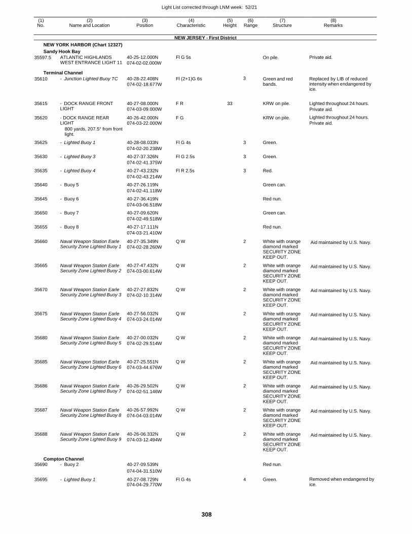
Light List corrected through LNM week: 52/21
308
(1) (2) (3) (4) (5) (6) (7) (8) No. Name and Location Position Characteristic Height Range Structure Remarks
NEW JERSEY - First District
NEW YORK HARBOR (Chart 12327)
Sandy Hook Bay
35597.5 ATLANTIC HIGHLANDS WEST ENTRANCE LIGHT 11
40-25-12.000N
074-02-02.000W
Fl G 5s On pile. Private aid.
Terminal Channel
35610 - Junction Lighted Buoy TC 40-28-22.408N
074-02-18.677W
Fl (2+1)G 6s 3 Green and red bands.
Replaced by LIB of reduced intensity when endangered by ice.
35615 - DOCK RANGE FRONT LIGHT
40-27-08.000N
074-03-09.000W
F R 33
KRW on pile. Lighted throughout 24 hours.
Private aid.
35620 - DOCK RANGE REAR LIGHT
40-26-42.000N 074-03-22.000W
F G KRW on pile. Lighted throughout 24 hours.
Private aid.
800 yards, 207.5° from front light.
35625 - Lighted Buoy 1 40-28-08.033N Fl G 4s 3 Green.
074-02-20.238W
35630 - Lighted Buoy 3 40-27-37.326N Fl G 2.5s 3 Green.
074-02-41.375W
35635 - Lighted Buoy 4 40-27-43.232N Fl R 2.5s 3 Red.
074-02-43.214W
35640 - Buoy 5 40-27-26.119N Green can.
074-02-41.118W
35645 - Buoy 6 40-27-36.419N Red nun.
074-03-06.518W
35650 - Buoy 7 40-27-09.620N Green can.
074-02-49.518W
35655 - Buoy 8 40-27-17.111N Red nun.
074-03-21.410W
35660 Naval Weapon Station Earle Security Zone Lighted Buoy 1
40-27-35.349N
074-02-28.260W
Q W 2 White with orange diamond marked SECURITY ZONE KEEP OUT.
Aid maintained by U.S. Navy.
35665 Naval Weapon Station Earle Security Zone Lighted Buoy 2
40-27-47.432N
074-03-00.614W
Q W 2 White with orange diamond marked SECURITY ZONE KEEP OUT.
Aid maintained by U.S. Navy.
35670 Naval Weapon Station Earle Security Zone Lighted Buoy 3
40-27-27.832N
074-02-10.314W
Q W 2 White with orange diamond marked SECURITY ZONE KEEP OUT.
Aid maintained by U.S. Navy.
35675 Naval Weapon Station Earle Security Zone Lighted Buoy 4
40-27-56.032N
074-03-24.014W
Q W 2 White with orange diamond marked SECURITY ZONE KEEP OUT.
Aid maintained by U.S. Navy.
35680 Naval Weapon Station Earle Security Zone Lighted Buoy 5
40-27-00.032N
074-02-29.514W
Q W 2 White with orange diamond marked SECURITY ZONE KEEP OUT.
Aid maintained by U.S. Navy.
35685 Naval Weapon Station Earle Security Zone Lighted Buoy 6
40-27-25.551N
074-03-44.676W
Q W 2 White with orange diamond marked SECURITY ZONE KEEP OUT.
Aid maintained by U.S. Navy.
35686 Naval Weapon Station Earle Security Zone Lighted Buoy 7
40-26-29.502N
074-02-51.146W
Q W 2 White with orange diamond marked SECURITY ZONE KEEP OUT.
Aid maintained by U.S. Navy.
35687 Naval Weapon Station Earle Security Zone Lighted Buoy 8
40-26-57.992N
074-04-03.014W
Q W 2 White with orange diamond marked SECURITY ZONE KEEP OUT.
Aid maintained by U.S. Navy.
35688 Naval Weapon Station Earle Security Zone Lighted Buoy 9
40-26-06.332N
074-03-12.494W
Q W 2 White with orange diamond marked SECURITY ZONE KEEP OUT.
Aid maintained by U.S. Navy.
Compton Channel 35690 - Buoy 2 40-27-09.539N Red nun.
074-04-31.510W
35695 - Lighted Buoy 1 40-27-08.729N 074-04-29.770W
Fl G 4s 4 Green. Removed when endangered by ice.
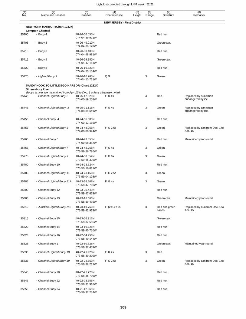
Light List corrected through LNM week: 52/21
309
(1) (2) (3) (4) (5) (6) (7) (8) No. Name and Location Position Characteristic Height Range Structure Remarks
NEW JERSEY - First District
NEW YORK HARBOR (Chart 12327)
Compton Channel
35700 - Buoy 4 40-26-50.650N
074-04-39.921W
Red nun.
35705 - Buoy 3 40-26-49.910N
074-04-38.170W
Green can.
35710 - Buoy 6 40-26-30.400N
074-04-48.981W
Red nun.
35715 - Buoy 5 40-26-29.980N
074-04-47.111W
Green can.
35720 - Buoy 8 40-26-19.629N
074-04-53.134W
Red nun.
35725 - Lighted Buoy 9 40-26-10.900N 074-04-55.711W
Q G 3 Green.
SANDY HOOK TO LITTLE EGG HARBOR (Chart 12324)
Shrewsbury River Buoys in river are maintained from Apr. 15 to Dec. 1 unless otherwise noted.
35740 - Channel Lighted Buoy 2 40-25-12.920N
074-00-19.258W
Fl R 4s 3 Red. Replaced by nun when endangered by ice.
35745 - Channel Lighted Buoy 3 40-25-01.115N
074-00-09.619W
Fl G 4s 3 Green. Replaced by can when endangered by ice.
35750 - Channel Buoy 4 40-24-56.685N
Red nun.
074-00-12.139W
35755 - Channel Lighted Buoy 5 40-24-48.955N
074-00-06.924W
Fl G 2.5s 3 Green. Replaced by can from Dec. 1 to Apr. 15.
35760 - Channel Buoy 6 40-24-43.855N
Red nun. Maintained year round.
074-00-06.382W
35765 - Channel Lighted Buoy 7 40-24-42.258N Fl G 4s 3 Green.
073-59-56.780W
35775 - Channel Lighted Buoy 9 40-24-38.052N Fl G 6s 3 Green.
073-59-45.329W
35780 - Channel Buoy 10 40-24-23.824N Red nun.
073-59-16.011W
35785 - Channel Lighted Buoy 11 40-24-23.166N Fl G 2.5s 3 Green.
073-59-04.175W
35786 - Channel Lighted Buoy 11A 40-23-56.508N Fl G 4s 3 Green.
073-58-47.796W
35800 - Channel Buoy 12 40-23-25.440N Red nun.
073-58-47.679W
35805 - Channel Buoy 13 40-23-16.060N Green can. Maintained year round.
073-58-39.439W
35810 - Junction Lighted Buoy NS 40-23-13.760N
073-58-42.979W
Fl (2+1)R 6s 3 Red and green bands.
Replaced by nun from Dec. 1 to Apr. 15.
35815 - Channel Buoy 15 40-23-06.917N
Green can.
073-58-37.585W
35820 - Channel Buoy 14 40-23-10.325N Red nun.
073-58-40.710W
35823 - Channel Buoy 16 40-22-54.256N Red nun.
073-58-40.144W
35825 - Channel Buoy 17 40-22-50.826N Green can. Maintained year round.
073-58-37.409W
35830 - Channel Lighted Buoy 18 40-22-41.926N Fl R 4s 3 Red.
073-58-39.209W
35835 - Channel Lighted Buoy 19 40-22-24.659N
073-58-32.211W
Fl G 2.5s 3 Green. Replaced by can from Dec. 1 to Apr. 15.
35840 - Channel Buoy 20 40-22-21.726N
Red nun.
073-58-35.709W
35845 - Channel Buoy 22 40-22-03.355N Red nun.
073-58-31.916W
35850 - Channel Buoy 24 40-21-42.369N Red nun.
073-58-37.284W
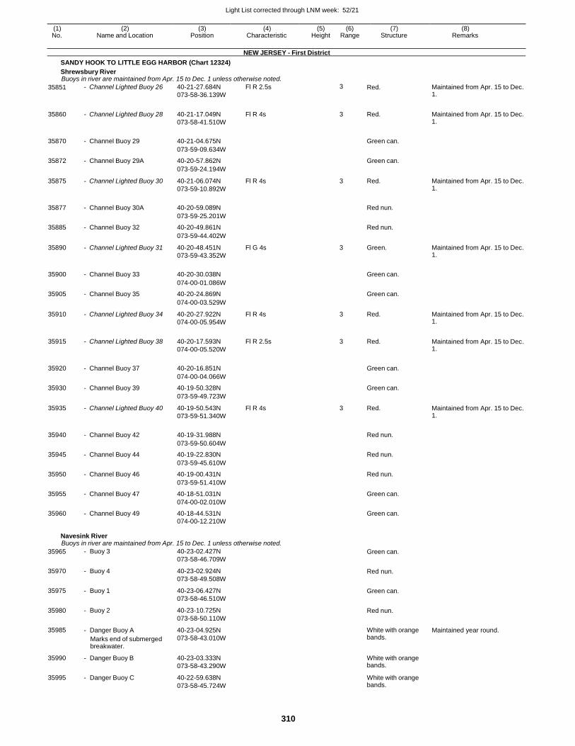
Light List corrected through LNM week: 52/21
310
(1) (2) (3) (4) (5) (6) (7) (8) No. Name and Location Position Characteristic Height Range Structure Remarks
NEW JERSEY - First District
SANDY HOOK TO LITTLE EGG HARBOR (Chart 12324)
Shrewsbury River Buoys in river are maintained from Apr. 15 to Dec. 1 unless otherwise noted.
35851 - Channel Lighted Buoy 26 40-21-27.684N
073-58-36.139W
Fl R 2.5s 3 Red. Maintained from Apr. 15 to Dec. 1.
35860 - Channel Lighted Buoy 28 40-21-17.049N
073-58-41.510W
Fl R 4s 3 Red. Maintained from Apr. 15 to Dec. 1.
35870 - Channel Buoy 29 40-21-04.675N
Green can.
073-59-09.634W
35872 - Channel Buoy 29A 40-20-57.862N Green can.
073-59-24.194W
35875 - Channel Lighted Buoy 30 40-21-06.074N
073-59-10.892W
Fl R 4s 3 Red. Maintained from Apr. 15 to Dec. 1.
35877 - Channel Buoy 30A 40-20-59.089N
Red nun.
073-59-25.201W
35885 - Channel Buoy 32 40-20-49.861N Red nun.
073-59-44.402W
35890 - Channel Lighted Buoy 31 40-20-48.451N
073-59-43.352W
Fl G 4s 3 Green. Maintained from Apr. 15 to Dec. 1.
35900 - Channel Buoy 33 40-20-30.038N
Green can.
074-00-01.086W
35905 - Channel Buoy 35 40-20-24.869N Green can.
074-00-03.529W
35910 - Channel Lighted Buoy 34 40-20-27.922N
074-00-05.954W
Fl R 4s 3 Red. Maintained from Apr. 15 to Dec. 1.
35915 - Channel Lighted Buoy 38 40-20-17.593N
074-00-05.520W
Fl R 2.5s 3 Red. Maintained from Apr. 15 to Dec. 1.
35920 - Channel Buoy 37 40-20-16.851N
Green can.
074-00-04.066W
35930 - Channel Buoy 39 40-19-50.328N Green can.
073-59-49.723W
35935 - Channel Lighted Buoy 40 40-19-50.543N
073-59-51.340W
Fl R 4s 3 Red. Maintained from Apr. 15 to Dec. 1.
35940 - Channel Buoy 42 40-19-31.988N
Red nun.
073-59-50.604W
35945 - Channel Buoy 44 40-19-22.830N Red nun.
073-59-45.610W
35950 - Channel Buoy 46 40-19-00.431N Red nun.
073-59-51.410W
35955 - Channel Buoy 47 40-18-51.031N Green can.
074-00-02.010W
35960 - Channel Buoy 49 40-18-44.531N Green can.
074-00-12.210W
Navesink River Buoys in river are maintained from Apr. 15 to Dec. 1 unless otherwise noted.
35965
35970
35975
35980
35985
35990
35995
- Buoy 3
- Buoy 4
- Buoy 1
- Buoy 2
- Danger Buoy A
Marks end of submerged breakwater.
- Danger Buoy B
- Danger Buoy C
40-23-02.427N
073-58-46.709W
40-23-02.924N
073-58-49.508W
40-23-06.427N
073-58-46.510W
40-23-10.725N
073-58-50.110W
40-23-04.925N
073-58-43.010W
40-23-03.333N
073-58-43.290W
40-22-59.638N
073-58-45.724W
Green can.
Red nun.
Green can.
Red nun.
White with orange bands.
White with orange bands.
White with orange bands.
Maintained year round.
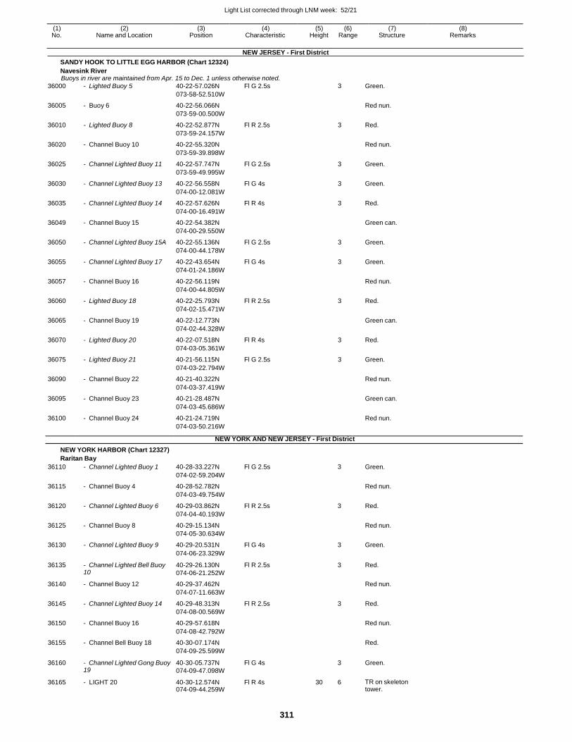
Light List corrected through LNM week: 52/21
311
(1) (2) (3) (4) (5) (6) (7) (8) No. Name and Location Position Characteristic Height Range Structure Remarks
NEW JERSEY - First District
SANDY HOOK TO LITTLE EGG HARBOR (Chart 12324)
Navesink River Buoys in river are maintained from Apr. 15 to Dec. 1 unless otherwise noted.
36000 - Lighted Buoy 5 40-22-57.026N Fl G 2.5s 3 Green.
073-58-52.510W
36005 - Buoy 6 40-22-56.066N Red nun.
073-59-00.500W
36010 - Lighted Buoy 8 40-22-52.877N Fl R 2.5s 3 Red.
073-59-24.157W
36020 - Channel Buoy 10 40-22-55.320N Red nun.
073-59-39.898W
36025 - Channel Lighted Buoy 11 40-22-57.747N Fl G 2.5s 3 Green.
073-59-49.995W
36030 - Channel Lighted Buoy 13 40-22-56.558N Fl G 4s 3 Green.
074-00-12.081W
36035 - Channel Lighted Buoy 14 40-22-57.626N Fl R 4s 3 Red.
074-00-16.491W
36049 - Channel Buoy 15 40-22-54.382N Green can.
074-00-29.550W
36050 - Channel Lighted Buoy 15A 40-22-55.136N Fl G 2.5s 3 Green.
074-00-44.178W
36055 - Channel Lighted Buoy 17 40-22-43.654N Fl G 4s 3 Green.
074-01-24.186W
36057 - Channel Buoy 16 40-22-56.119N Red nun.
074-00-44.805W
36060 - Lighted Buoy 18 40-22-25.793N Fl R 2.5s 3 Red.
074-02-15.471W
36065 - Channel Buoy 19 40-22-12.773N Green can.
074-02-44.328W
36070 - Lighted Buoy 20 40-22-07.518N Fl R 4s 3 Red.
074-03-05.361W
36075 - Lighted Buoy 21 40-21-56.115N Fl G 2.5s 3 Green.
074-03-22.794W
36090 - Channel Buoy 22 40-21-40.322N Red nun.
074-03-37.419W
36095 - Channel Buoy 23 40-21-28.487N Green can.
074-03-45.686W
36100 - Channel Buoy 24 40-21-24.719N Red nun.
074-03-50.216W
NEW YORK AND NEW JERSEY - First District
NEW YORK HARBOR (Chart 12327)
Raritan Bay
36110 - Channel Lighted Buoy 1 40-28-33.227N Fl G 2.5s 3 Green.
074-02-59.204W
36115 - Channel Buoy 4 40-28-52.782N Red nun.
074-03-49.754W
36120 - Channel Lighted Buoy 6 40-29-03.862N Fl R 2.5s 3 Red.
074-04-40.193W
36125 - Channel Buoy 8 40-29-15.134N Red nun.
074-05-30.634W
36130 - Channel Lighted Buoy 9 40-29-20.531N Fl G 4s 3 Green.
074-06-23.329W
36135 - Channel Lighted Bell Buoy 10
40-29-26.130N
074-06-21.252W
Fl R 2.5s 3 Red.
36140 - Channel Buoy 12 40-29-37.462N Red nun.
074-07-11.663W
36145 - Channel Lighted Buoy 14 40-29-48.313N Fl R 2.5s 3 Red.
074-08-00.569W
36150 - Channel Buoy 16 40-29-57.618N Red nun.
074-08-42.792W
36155 - Channel Bell Buoy 18 40-30-07.174N Red.
074-09-25.599W
36160 - Channel Lighted Gong Buoy 19
40-30-05.737N
074-09-47.098W
Fl G 4s 3 Green.
36165 - LIGHT 20 40-30-12.574N 074-09-44.259W
Fl R 4s 30 6 TR on skeleton tower.
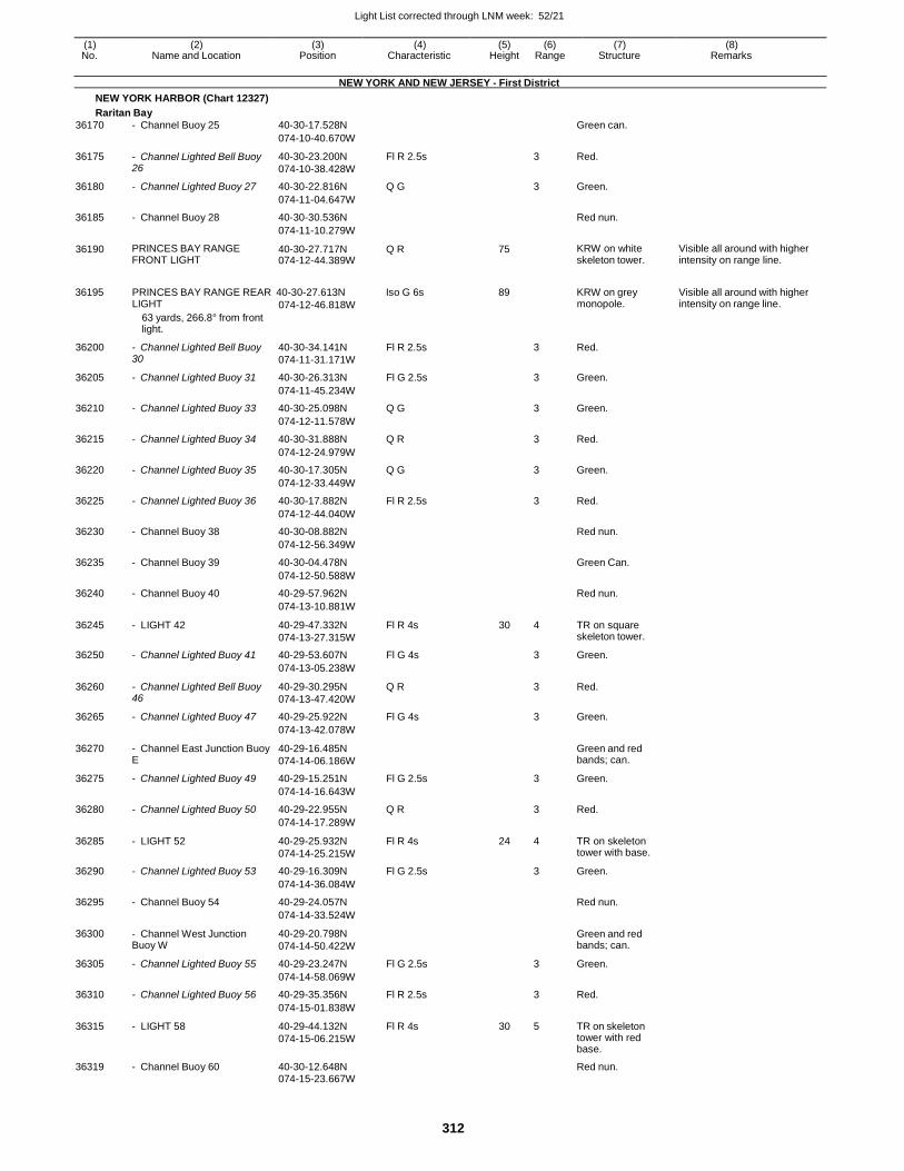
Light List corrected through LNM week: 52/21
312
(1) (2) (3) (4) (5) (6) (7) (8) No. Name and Location Position Characteristic Height Range Structure Remarks
NEW YORK AND NEW JERSEY - First District
NEW YORK HARBOR (Chart 12327)
Raritan Bay
36170 - Channel Buoy 25 40-30-17.528N Green can.
074-10-40.670W
36175 - Channel Lighted Bell Buoy 26
40-30-23.200N
074-10-38.428W
Fl R 2.5s 3 Red.
36180 - Channel Lighted Buoy 27 40-30-22.816N Q G 3 Green.
074-11-04.647W
36185 - Channel Buoy 28 40-30-30.536N Red nun.
074-11-10.279W
36190 PRINCES BAY RANGE FRONT LIGHT
40-30-27.717N 074-12-44.389W
Q R 75 KRW on white skeleton tower.
Visible all around with higher intensity on range line.
36195 PRINCES BAY RANGE REAR 40-30-27.613N Iso G 6s 89 KRW on grey Visible all around with higher LIGHT
63 yards, 266.8° from front light.
074-12-46.818W monopole. intensity on range line.
36200 - Channel Lighted Bell Buoy 30
40-30-34.141N
074-11-31.171W
Fl R 2.5s 3 Red.
36205 - Channel Lighted Buoy 31 40-30-26.313N Fl G 2.5s 3 Green.
074-11-45.234W
36210 - Channel Lighted Buoy 33 40-30-25.098N Q G 3 Green.
074-12-11.578W
36215 - Channel Lighted Buoy 34 40-30-31.888N Q R 3 Red.
074-12-24.979W
36220 - Channel Lighted Buoy 35 40-30-17.305N Q G 3 Green.
074-12-33.449W
36225 - Channel Lighted Buoy 36 40-30-17.882N Fl R 2.5s 3 Red.
074-12-44.040W
36230 - Channel Buoy 38 40-30-08.882N Red nun.
074-12-56.349W
36235 - Channel Buoy 39 40-30-04.478N Green Can.
074-12-50.588W
36240 - Channel Buoy 40 40-29-57.962N Red nun.
074-13-10.881W
36245 - LIGHT 42 40-29-47.332N
074-13-27.315W
Fl R 4s 30 4 TR on square skeleton tower.
36250 - Channel Lighted Buoy 41 40-29-53.607N Fl G 4s 3 Green.
074-13-05.238W
36260 - Channel Lighted Bell Buoy 46
40-29-30.295N
074-13-47.420W
Q R 3 Red.
36265 - Channel Lighted Buoy 47 40-29-25.922N Fl G 4s 3 Green.
074-13-42.078W
36270 - Channel East Junction Buoy E
40-29-16.485N
074-14-06.186W
Green and red bands; can.
36275 - Channel Lighted Buoy 49 40-29-15.251N Fl G 2.5s 3 Green.
074-14-16.643W
36280 - Channel Lighted Buoy 50 40-29-22.955N Q R 3 Red.
074-14-17.289W
36285 - LIGHT 52 40-29-25.932N
074-14-25.215W
Fl R 4s 24 4 TR on skeleton tower with base.
36290 - Channel Lighted Buoy 53 40-29-16.309N Fl G 2.5s 3 Green.
074-14-36.084W
36295 - Channel Buoy 54 40-29-24.057N Red nun.
074-14-33.524W
36300 - Channel West Junction Buoy W
40-29-20.798N
074-14-50.422W
Green and red bands; can.
36305 - Channel Lighted Buoy 55 40-29-23.247N Fl G 2.5s 3 Green.
074-14-58.069W
36310 - Channel Lighted Buoy 56 40-29-35.356N Fl R 2.5s 3 Red.
074-15-01.838W
36315 - LIGHT 58 40-29-44.132N
074-15-06.215W
Fl R 4s 30 5 TR on skeleton tower with red base.
36319 - Channel Buoy 60 40-30-12.648N Red nun. 074-15-23.667W

Light List corrected through LNM week: 52/21
313
(1) (2) (3) (4) (5) (6) (7) (8) No. Name and Location Position Characteristic Height Range Structure Remarks
NEW YORK AND NEW JERSEY - First District
NEW YORK HARBOR (Chart 12327)
Raritan Bay
Ward Point Secondary Channel
36320 - Buoy 1 40-29-13.014N Green can.
074-14-02.836W
36325 - Buoy 4 40-29-06.014N Red nun.
074-14-20.436W
36330 - Buoy 3 40-29-02.014N Green can.
074-14-19.636W
36335 - LIGHT W 40-29-07.632N Fl W 4s 30 5 NR on spindle.
074-14-27.615W
36340 - Buoy 5 40-29-04.014N Green can.
Marks 12-foot spot. 074-14-43.137W
36345 - Buoy 6 40-29-09.014N Red nun.
074-14-43.037W
36350 Ward Point Anchorage Buoy A 40-29-14.514N Yellow can.
074-15-24.038W
36355 Ward Point Anchorage Buoy B 40-29-22.014N Yellow can. 074-15-28.538W
Raritan Bay
36360 Point Comfort Shoal Lighted Buoy 11A
40-29-01.416N 074-07-32.726W
Fl G 4s 4 Green. Replaced by can when endangered by ice.
On north edge of shoal.
Keyport Harbor
36370 - Entrance Lighted Buoy 1 40-28-27.216N
074-11-00.531W
Fl G 2.5s 3 Green. Replaced by can when endangered by ice.
36375 - Channel Lighted Buoy 3 40-27-07.618N
074-11-49.633W
Fl G 4s 3 Green. Replaced by can when endangered by ice.
36380
- Channel Buoy 5
40-26-52.418N
Green can.
074-11-53.033W
36385 - Channel Lighted Buoy 8 40-26-37.418N
074-11-59.633W
Fl R 4s 3 Red. Replaced by nun when endangered by ice.
36390 - Channel Buoy 7 40-26-36.618N
Green can.
074-11-57.233W
36395 - Channel Buoy 9 40-26-29.018N Green can.
074-12-02.533W
36400 - Channel Buoy 10 40-26-28.818N Red nun.
074-12-05.433W
36405 - Channel Buoy 12 40-26-22.218N
074-12-14.033W
Red nun. Replaced by nun when endangered by ice. .
Cheesequake Creek
36415 - LIGHT 1 40-27-54.805N
074-15-23.338W
Fl G 4s 26 4 SG on skeleton tower.
36420 - LIGHT 2 40-27-56.325N 074-15-25.988W
Fl R 4s 28 5 TR on skeleton tower.
Higher intensity beam toward Red Bank Reach.
NEW JERSEY - First District
RARITAN RIVER (Chart 12332)
Raritan River Private aids maintained from 05/01 to 10/31.
36425 - Channel Bell Buoy 2 40-29-06.514N Red.
074-14-56.337W
36430 GREAT BEDS LIGHT 40-29-11.993N
074-15-10.937W
Fl R 6s 61 6 White conical tower on black conical pier.
36435 - Channel Buoy 3 40-29-03.600N Green can.
074-15-38.494W
36440 - LIGHT 4 40-29-08.083N
074-15-35.658W
Fl R 4s 22 3 TR on skeleton tower.
36445 - Channel Lighted Buoy 6 40-29-54.012N 074-16-58.241W
Fl R 4s 3 Red. Replaced by nun when endangered by ice.
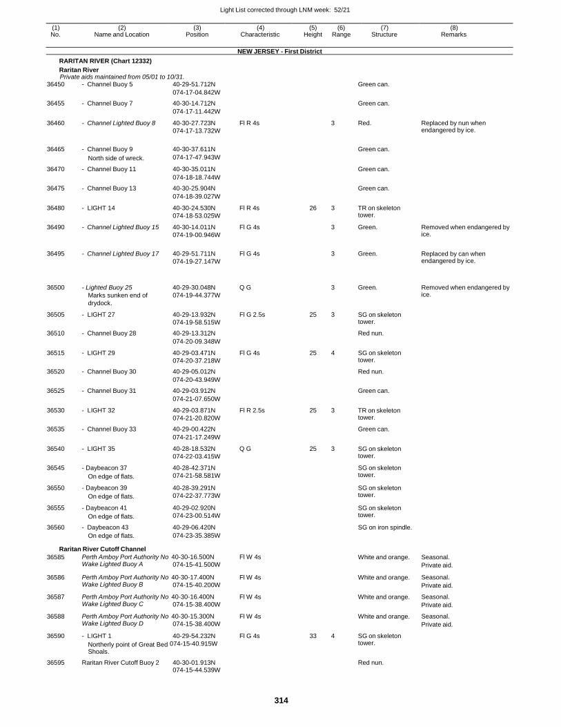
Light List corrected through LNM week: 52/21
314
(1) (2) (3) (4) (5) (6) (7) (8) No. Name and Location Position Characteristic Height Range Structure Remarks
NEW JERSEY - First District
RARITAN RIVER (Chart 12332)
Raritan River Private aids maintained from 05/01 to 10/31.
36450 - Channel Buoy 5 40-29-51.712N Green can.
074-17-04.842W
36455 - Channel Buoy 7 40-30-14.712N Green can.
074-17-11.442W
36460 - Channel Lighted Buoy 8 40-30-27.723N
074-17-13.732W
Fl R 4s 3 Red. Replaced by nun when endangered by ice.
36465 - Channel Buoy 9 40-30-37.611N
Green can.
North side of wreck. 074-17-47.943W
36470 - Channel Buoy 11 40-30-35.011N Green can.
074-18-18.744W
36475 - Channel Buoy 13 40-30-25.904N Green can.
074-18-39.027W
36480 - LIGHT 14 40-30-24.530N
074-18-53.025W
Fl R 4s 26 3 TR on skeleton tower.
36490 - Channel Lighted Buoy 15 40-30-14.011N
074-19-00.946W
Fl G 4s 3 Green. Removed when endangered by ice.
36495 - Channel Lighted Buoy 17 40-29-51.711N
074-19-27.147W
Fl G 4s
3 Green. Replaced by can when endangered by ice.
36500
- Lighted Buoy 25
Marks sunken end of
drydock.
40-29-30.048N
074-19-44.377W
Q G
3
Green.
Removed when endangered by ice.
36505 - LIGHT 27 40-29-13.932N
074-19-58.515W
Fl G 2.5s 25 3 SG on skeleton tower.
36510 - Channel Buoy 28 40-29-13.312N Red nun.
074-20-09.348W
36515 - LIGHT 29 40-29-03.471N
074-20-37.218W
Fl G 4s 25 4 SG on skeleton tower.
36520 - Channel Buoy 30 40-29-05.012N Red nun.
074-20-43.949W
36525 - Channel Buoy 31 40-29-03.912N Green can.
074-21-07.650W
36530 - LIGHT 32 40-29-03.871N
074-21-20.820W
Fl R 2.5s 25 3 TR on skeleton tower.
36535 - Channel Buoy 33 40-29-00.422N Green can.
074-21-17.249W
36540 - LIGHT 35 40-28-18.532N
074-22-03.415W
Q G 25 3 SG on skeleton tower.
36545 - Daybeacon 37
On edge of flats.
40-28-42.371N
074-21-58.581W
SG on skeleton tower.
36550 - Daybeacon 39
On edge of flats.
40-28-39.291N
074-22-37.773W
SG on skeleton tower.
36555 - Daybeacon 41
On edge of flats.
40-29-02.920N
074-23-00.514W
SG on skeleton tower.
36560 - Daybeacon 43 40-29-06.420N SG on iron spindle.
On edge of flats. 074-23-35.385W
Raritan River Cutoff Channel
36585 Perth Amboy Port Authority No 40-30-16.500N Wake Lighted Buoy A 074-15-41.500W
Fl W 4s White and orange. Seasonal.
Private aid.
36586 Perth Amboy Port Authority No 40-30-17.400N Wake Lighted Buoy B 074-15-40.200W
Fl W 4s White and orange. Seasonal.
Private aid.
36587 Perth Amboy Port Authority No 40-30-16.400N Wake Lighted Buoy C 074-15-38.400W
Fl W 4s White and orange. Seasonal.
Private aid.
36588 Perth Amboy Port Authority No 40-30-15.300N Wake Lighted Buoy D 074-15-38.400W
Fl W 4s White and orange. Seasonal.
Private aid.
36590 - LIGHT 1 40-29-54.232N
Northerly point of Great Bed 074-15-40.915W
Shoals.
Fl G 4s 33 4 SG on skeleton tower.
36595 Raritan River Cutoff Buoy 2 40-30-01.913N Red nun.
074-15-44.539W
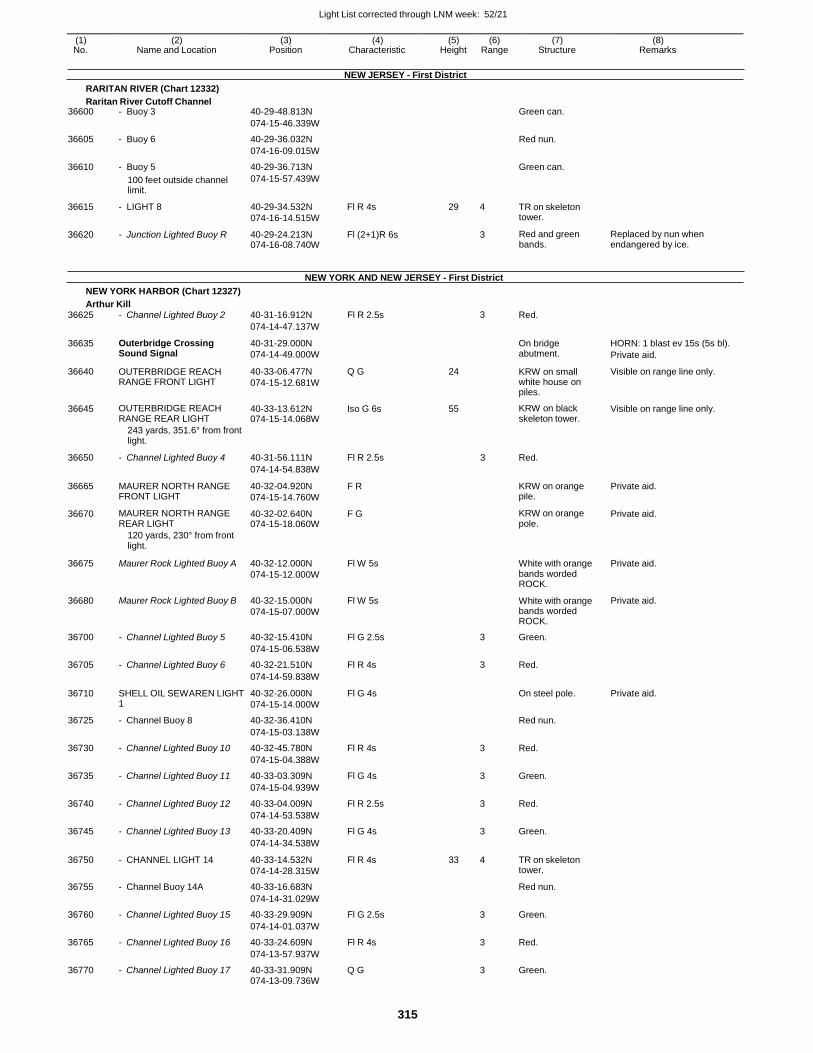
Light List corrected through LNM week: 52/21
315
(1) (2) (3) (4) (5) (6) (7) (8) No. Name and Location Position Characteristic Height Range Structure Remarks
RARITAN RIVER (Chart 12332)
Raritan River Cutoff Channel
NEW JERSEY - First District
36600 - Buoy 3 40-29-48.813N Green can.
074-15-46.339W
36605 - Buoy 6 40-29-36.032N Red nun.
074-16-09.015W
36610 - Buoy 5 40-29-36.713N Green can.
100 feet outside channel limit.
074-15-57.439W
36615 - LIGHT 8 40-29-34.532N
074-16-14.515W
Fl R 4s 29 4 TR on skeleton tower.
36620 - Junction Lighted Buoy R 40-29-24.213N 074-16-08.740W
Fl (2+1)R 6s 3 Red and green bands.
Replaced by nun when endangered by ice.
NEW YORK HARBOR (Chart 12327)
Arthur Kill
NEW YORK AND NEW JERSEY - First District
36625 - Channel Lighted Buoy 2 40-31-16.912N Fl R 2.5s 3 Red.
074-14-47.137W
36635 Outerbridge Crossing Sound Signal
40-31-29.000N
074-14-49.000W
On bridge abutment.
HORN: 1 blast ev 15s (5s bl).
Private aid.
36640 OUTERBRIDGE REACH RANGE FRONT LIGHT
40-33-06.477N
074-15-12.681W
Q G 24 KRW on small white house on piles.
Visible on range line only.
36645 OUTERBRIDGE REACH RANGE REAR LIGHT
40-33-13.612N 074-15-14.068W
Iso G 6s 55 KRW on black skeleton tower.
Visible on range line only.
243 yards, 351.6° from front light.
36650 - Channel Lighted Buoy 4 40-31-56.111N Fl R 2.5s 3 Red.
074-14-54.838W
36665 MAURER NORTH RANGE FRONT LIGHT
40-32-04.920N
074-15-14.760W
F R KRW on orange pile.
Private aid.
36670 MAURER NORTH RANGE REAR LIGHT
40-32-02.640N 074-15-18.060W
F G KRW on orange pole.
Private aid.
120 yards, 230° from front light.
36675 Maurer Rock Lighted Buoy A 40-32-12.000N
074-15-12.000W
Fl W 5s
White with orange bands worded ROCK.
Private aid.
36680 Maurer Rock Lighted Buoy B 40-32-15.000N
074-15-07.000W
Fl W 5s White with orange bands worded ROCK.
Private aid.
36700 - Channel Lighted Buoy 5 40-32-15.410N Fl G 2.5s 3 Green.
074-15-06.538W
36705 - Channel Lighted Buoy 6 40-32-21.510N Fl R 4s 3 Red.
074-14-59.838W
36710 SHELL OIL SEWAREN LIGHT 1
40-32-26.000N
074-15-14.000W
Fl G 4s On steel pole. Private aid.
36725 - Channel Buoy 8 40-32-36.410N Red nun.
074-15-03.138W
36730 - Channel Lighted Buoy 10 40-32-45.780N Fl R 4s 3 Red.
074-15-04.388W
36735 - Channel Lighted Buoy 11 40-33-03.309N Fl G 4s 3 Green.
074-15-04.939W
36740 - Channel Lighted Buoy 12 40-33-04.009N Fl R 2.5s 3 Red.
074-14-53.538W
36745 - Channel Lighted Buoy 13 40-33-20.409N Fl G 4s 3 Green.
074-14-34.538W
36750 - CHANNEL LIGHT 14 40-33-14.532N
074-14-28.315W
Fl R 4s 33 4 TR on skeleton tower.
36755 - Channel Buoy 14A 40-33-16.683N Red nun.
074-14-31.029W
36760 - Channel Lighted Buoy 15 40-33-29.909N Fl G 2.5s 3 Green.
074-14-01.037W
36765 - Channel Lighted Buoy 16 40-33-24.609N Fl R 4s 3 Red.
074-13-57.937W
36770 - Channel Lighted Buoy 17 40-33-31.909N Q G 3 Green.
074-13-09.736W
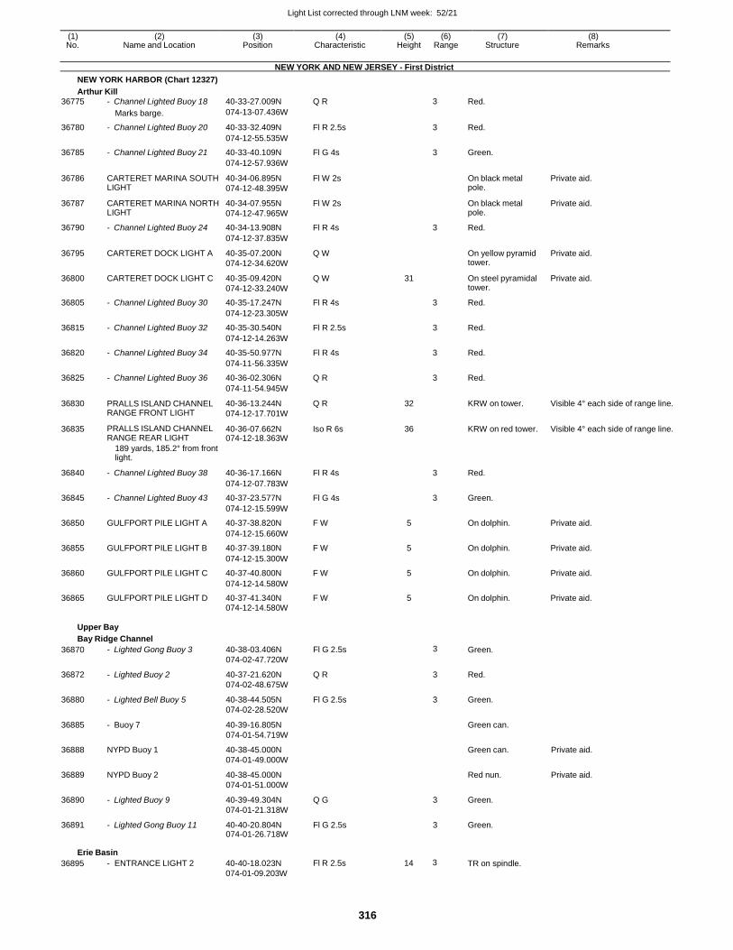
Light List corrected through LNM week: 52/21
316
(1) (2) (3) (4) (5) (6) (7) (8) No. Name and Location Position Characteristic Height Range Structure Remarks
NEW YORK AND NEW JERSEY - First District
NEW YORK HARBOR (Chart 12327)
Arthur Kill
36775 - Channel Lighted Buoy 18 40-33-27.009N Q R 3 Red.
Marks barge. 074-13-07.436W
36780 - Channel Lighted Buoy 20 40-33-32.409N Fl R 2.5s 3 Red.
074-12-55.535W
36785 - Channel Lighted Buoy 21 40-33-40.109N Fl G 4s 3 Green.
074-12-57.936W
36786 CARTERET MARINA SOUTH LIGHT
40-34-06.895N
074-12-48.395W
Fl W 2s On black metal pole.
Private aid.
36787 CARTERET MARINA NORTH LIGHT
40-34-07.955N
074-12-47.965W
Fl W 2s On black metal pole.
Private aid.
36790 - Channel Lighted Buoy 24 40-34-13.908N Fl R 4s 3 Red.
074-12-37.835W
36795 CARTERET DOCK LIGHT A 40-35-07.200N
074-12-34.620W
Q W On yellow pyramid tower.
Private aid.
36800 CARTERET DOCK LIGHT C 40-35-09.420N
074-12-33.240W
Q W 31 On steel pyramidal tower.
Private aid.
36805 - Channel Lighted Buoy 30 40-35-17.247N Fl R 4s 3 Red.
074-12-23.305W
36815 - Channel Lighted Buoy 32 40-35-30.540N Fl R 2.5s 3 Red.
074-12-14.263W
36820 - Channel Lighted Buoy 34 40-35-50.977N Fl R 4s 3 Red.
074-11-56.335W
36825 - Channel Lighted Buoy 36 40-36-02.306N Q R 3 Red.
074-11-54.945W
36830 PRALLS ISLAND CHANNEL RANGE FRONT LIGHT
40-36-13.244N
074-12-17.701W
Q R 32 KRW on tower. Visible 4° each side of range line.
36835 PRALLS ISLAND CHANNEL RANGE REAR LIGHT
40-36-07.662N 074-12-18.363W
Iso R 6s 36 KRW on red tower. Visible 4° each side of range line.
189 yards, 185.2° from front light.
36840 - Channel Lighted Buoy 38 40-36-17.166N Fl R 4s
3 Red.
074-12-07.783W
36845 - Channel Lighted Buoy 43 40-37-23.577N Fl G 4s 3 Green.
074-12-15.599W
36850 GULFPORT PILE LIGHT A 40-37-38.820N F W 5 On dolphin. Private aid.
074-12-15.660W
36855 GULFPORT PILE LIGHT B 40-37-39.180N F W 5 On dolphin. Private aid.
074-12-15.300W
36860 GULFPORT PILE LIGHT C 40-37-40.800N F W 5 On dolphin. Private aid.
074-12-14.580W
36865 GULFPORT PILE LIGHT D 40-37-41.340N F W 5 On dolphin. Private aid. 074-12-14.580W
Upper Bay
Bay Ridge Channel
36870 - Lighted Gong Buoy 3 40-38-03.406N
074-02-47.720W
Fl G 2.5s 3 Green.
36872 - Lighted Buoy 2 40-37-21.620N
074-02-48.675W
Q R 3 Red.
36880 - Lighted Bell Buoy 5 40-38-44.505N
074-02-28.520W
Fl G 2.5s 3 Green.
36885 - Buoy 7 40-39-16.805N
074-01-54.719W
Green can.
36888 NYPD Buoy 1 40-38-45.000N
074-01-49.000W
Green can. Private aid.
36889 NYPD Buoy 2 40-38-45.000N
074-01-51.000W
Red nun. Private aid.
36890 - Lighted Buoy 9 40-39-49.304N
074-01-21.318W
Q G 3 Green.
36891 - Lighted Gong Buoy 11 40-40-20.804N 074-01-26.718W
Fl G 2.5s 3 Green.
Erie Basin
36895 - ENTRANCE LIGHT 2 40-40-18.023N
074-01-09.203W
Fl R 2.5s 14 3 TR on spindle.
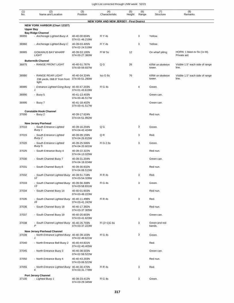
Light List corrected through LNM week: 52/21
317
(1) (2) (3) (4) (5) (6) (7) (8) No. Name and Location Position Characteristic Height Range Structure Remarks
NEW YORK AND NEW JERSEY - First District
NEW YORK HARBOR (Chart 12327)
Upper Bay
Bay Ridge Channel
36955 - Anchorage Lighted Buoy A 40-40-00.604N Fl Y 4s 3 Yellow.
074-01-46.219W
36960 - Anchorage Lighted Buoy C 40-39-03.405N Fl Y 4s 3 Yellow.
074-02-24.519W
36965 GOWANUS BAY WHARF LIGHT
40-39-53.100N 074-00-27.360W
Fl W 5s 12 On wharf piling. HORN: 1 blast ev 5s (1s bl).
Private aid.
Buttermilk Channel
36975 - RANGE FRONT LIGHT 40-40-51.787N
074-00-59.937W
Q G 26 KRW on skeleton tower.
Visible 1.5° each side of range line.
36980 - RANGE REAR LIGHT
238 yards, 068.9° from front light.
40-40-54.324N
074-00-51.290W
Iso G 6s 76
KRW on skeleton tower.
Visible 1.5° each side of range line.
36985 - Entrance Lighted Gong Buoy 1
40-40-47.203N
074-01-43.619W
Fl G 4s 4 Green.
36990 - Buoy 5 40-41-13.403N Green can.
074-00-46.517W
36995 - Buoy 7 40-41-18.402N Green can.
074-00-41.517W
Constable Hook Channel 37000 - Buoy 2 40-39-17.624N Red nun.
074-04-51.992W
New Jersey Pierhead
37010 - South Entrance Lighted Buoy 1
40-39-16.204N
074-04-42.424W
Q G 3 Green.
37015 - South Entrance Lighted Buoy 2
40-39-09.159N
074-04-26.815W
Q R 3 Red.
37020 - South Entrance Lighted Buoy 5
40-39-25.506N
074-04-20.601W
Fl G 2.5s 3 Green.
37025 - South Entrance Buoy 4 40-39-22.322N Red nun.
074-04-13.025W
37030 - South Channel Buoy 7 40-39-31.204N Green can.
074-04-18.024W
37031 - South Channel Buoy 8 40-39-30.832N Red nun.
074-04-06.515W
37032 - South Channel Lighted Buoy 12
40-39-51.718N
074-03-54.328W
Fl R 4s 3 Red.
37033 - South Channel Lighted Buoy 13
40-39-56.308N
074-03-58.831W
Fl G 4s 3 Green.
37034 - South Channel Buoy 14 40-40-01.603N Red nun.
074-03-48.223W
37035 - South Channel Lighted Buoy 16
40-40-11.498N
074-03-41.242W
Fl R 4s 3 Red.
37036 - South Channel Buoy 18 40-40-17.392N Red nun.
074-03-37.305W
37037 - South Channel Buoy 19 40-40-20.603N Green can.
074-03-41.623W
37038 - South Channel Lighted Buoy P
40-40-26.703N 074-03-37.223W
Fl (2+1)G 6s 3 Green and red bands.
New Jersey Pierhead Channel
37039 - North Entrance Lighted Buoy 1
40-40-39.103N
074-02-49.621W
Fl G 4s 3 Green.
37040 - North Entrance Bell Buoy 2 40-40-44.831N Red.
074-02-40.405W
37045 - North Entrance Buoy 3 40-40-38.503N Green can.
074-02-58.522W
37050 - North Entrance Buoy 4 40-40-43.203N Red nun.
074-03-06.522W
37055 - North Entrance Lighted Buoy 6
40-40-30.470N 074-03-31.778W
Fl R 4s 3 Red.
Port Jersey Channel
37100 - Lighted Buoy 1 40-39-23.412N Fl G 4s 3 Green. 074-03-29.345W
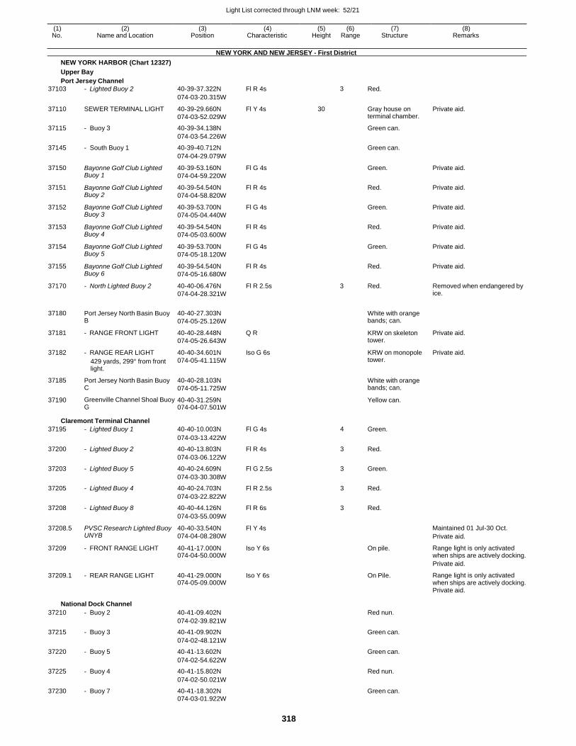
Light List corrected through LNM week: 52/21
318
(1) (2) (3) (4) (5) (6) (7) (8) No. Name and Location Position Characteristic Height Range Structure Remarks
NEW YORK AND NEW JERSEY - First District
NEW YORK HARBOR (Chart 12327)
Upper Bay
Port Jersey Channel
37103 - Lighted Buoy 2 40-39-37.322N Fl R 4s 3 Red.
074-03-20.315W
37110 SEWER TERMINAL LIGHT 40-39-29.660N
074-03-52.029W
Fl Y 4s 30 Gray house on terminal chamber.
Private aid.
37115 - Buoy 3 40-39-34.138N Green can.
074-03-54.226W
37145 - South Buoy 1 40-39-40.712N Green can.
074-04-29.079W
37150 Bayonne Golf Club Lighted Buoy 1
40-39-53.160N
074-04-59.220W
Fl G 4s Green. Private aid.
37151 Bayonne Golf Club Lighted Buoy 2
40-39-54.540N
074-04-58.820W
Fl R 4s Red. Private aid.
37152 Bayonne Golf Club Lighted Buoy 3
40-39-53.700N
074-05-04.440W
Fl G 4s Green. Private aid.
37153 Bayonne Golf Club Lighted Buoy 4
40-39-54.540N
074-05-03.600W
Fl R 4s Red. Private aid.
37154 Bayonne Golf Club Lighted Buoy 5
40-39-53.700N
074-05-18.120W
Fl G 4s Green. Private aid.
37155 Bayonne Golf Club Lighted Buoy 6
40-39-54.540N
074-05-16.680W
Fl R 4s Red. Private aid.
37170 - North Lighted Buoy 2 40-40-06.476N
074-04-28.321W
Fl R 2.5s 3 Red. Removed when endangered by ice.
37180 Port Jersey North Basin Buoy B
40-40-27.303N
074-05-25.126W
White with orange bands; can.
37181 - RANGE FRONT LIGHT 40-40-28.448N
074-05-26.643W
Q R KRW on skeleton tower.
Private aid.
37182 - RANGE REAR LIGHT
429 yards, 299° from front light.
40-40-34.601N
074-05-41.115W
Iso G 6s KRW on monopole tower.
Private aid.
37185 Port Jersey North Basin Buoy C
40-40-28.103N
074-05-11.725W
White with orange bands; can.
37190 Greenville Channel Shoal Buoy G
40-40-31.259N 074-04-07.501W
Yellow can.
Claremont Terminal Channel
37195 - Lighted Buoy 1 40-40-10.003N Fl G 4s 4 Green.
074-03-13.422W
37200 - Lighted Buoy 2 40-40-13.803N Fl R 4s 3 Red.
074-03-06.122W
37203 - Lighted Buoy 5 40-40-24.609N Fl G 2.5s 3 Green.
074-03-30.308W
37205 - Lighted Buoy 4 40-40-24.703N Fl R 2.5s 3 Red.
074-03-22.822W
37208 - Lighted Buoy 8 40-40-44.126N Fl R 6s 3 Red.
074-03-55.009W
37208.5 PVSC Research Lighted Buoy UNYB
40-40-33.540N
074-04-08.280W
Fl Y 4s Maintained 01 Jul-30 Oct.
Private aid.
37209 - FRONT RANGE LIGHT 40-41-17.000N 074-04-50.000W
Iso Y 6s On pile. Range light is only activated when ships are actively docking.
Private aid.
37209.1 - REAR RANGE LIGHT 40-41-29.000N 074-05-09.000W
Iso Y 6s On Pile. Range light is only activated when ships are actively docking.
Private aid.
National Dock Channel
37210 - Buoy 2 40-41-09.402N Red nun.
074-02-39.821W
37215 - Buoy 3 40-41-09.902N Green can.
074-02-48.121W
37220 - Buoy 5 40-41-13.602N Green can.
074-02-54.622W
37225 - Buoy 4 40-41-15.802N Red nun.
074-02-50.021W
37230 - Buoy 7 40-41-18.302N Green can. 074-03-01.922W
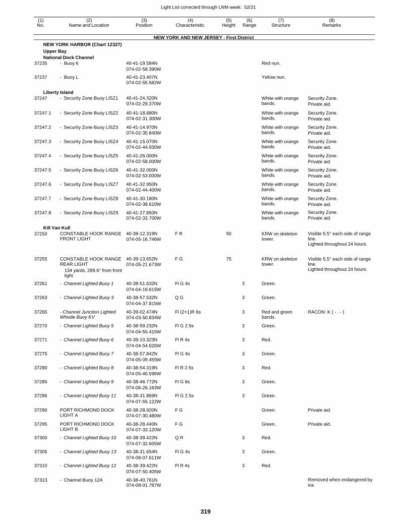
Light List corrected through LNM week: 52/21
319
(1) (2) (3) (4) (5) (6) (7) (8) No. Name and Location Position Characteristic Height Range Structure Remarks
NEW YORK AND NEW JERSEY - First District
NEW YORK HARBOR (Chart 12327)
Upper Bay
National Dock Channel
37235 - Buoy 6 40-41-19.584N Red nun.
074-02-58.390W
37237 - Buoy L 40-41-23.407N Yellow nun. 074-02-55.582W
Liberty Island
37247 - Security Zone Buoy LISZ1 40-41-24.320N
074-02-29.370W White with orange bands.
Security Zone.
Private aid.
37247.1 - Security Zone Buoy LISZ2 40-41-18.880N
074-02-31.300W
White with orange bands.
Security Zone.
Private aid.
37247.2 - Security Zone Buoy LISZ3 40-41-14.970N
074-02-35.840W
White with orange bands.
Security Zone.
Private aid.
37247.3 - Security Zone Buoy LISZ4 40-41-15.070N
074-02-44.930W
White with orange bands.
Security Zone.
Private aid.
37247.4 - Security Zone Buoy LISZ5 40-41-26.000N
074-02-58.000W
White with orange bands.
Security Zone.
Private aid.
37247.5 - Security Zone Buoy LISZ6 40-41-32.000N
074-02-53.000W
White with orange bands.
Security Zone.
Private aid.
37247.6 - Security Zone Buoy LISZ7 40-41-32.950N
074-02-44.400W
White with orange bands.
Security Zone.
Private aid.
37247.7 - Security Zone Buoy LISZ8 40-41-30.180N
074-02-38.610W
White with orange bands.
Security Zone.
Private aid.
37247.8 - Security Zone Buoy LISZ9 40-41-27.850N 074-02-33.700W
White with orange bands.
Security Zone.
Private aid.
Kill Van Kull
37250 CONSTABLE HOOK RANGE FRONT LIGHT
40-39-12.319N
074-05-16.746W
F R 50 KRW on skeleton tower.
Visible 5.5° each side of range line. Lighted throughout 24 hours.
37255 CONSTABLE HOOK RANGE REAR LIGHT
134 yards, 289.6° from front light.
40-39-13.652N
074-05-21.673W
F G 75
KRW on skeleton tower.
Visible 5.5° each side of range line. Lighted throughout 24 hours.
37261 - Channel Lighted Buoy 1 40-38-51.632N Fl G 4s 3 Green.
074-04-19.615W
37263 - Channel Lighted Buoy 3 40-38-57.532N Q G 3 Green.
074-04-37.815W
37265 - Channel Junction Lighted Whistle Buoy KV
40-39-02.474N
074-03-50.834W
Fl (2+1)R 6s 3 Red and green bands.
RACON: K ( - . - )
37270 - Channel Lighted Buoy 5 40-38-59.232N Fl G 2.5s 3 Green.
074-04-55.415W
37271 - Channel Lighted Buoy 6 40-39-10.323N Fl R 4s 3 Red.
074-04-54.626W
37275 - Channel Lighted Buoy 7 40-38-57.842N Fl G 4s 3 Green.
074-05-09.455W
37280 - Channel Lighted Buoy 8 40-38-54.319N Fl R 2.5s 3 Red.
074-05-40.596W
37285 - Channel Lighted Buoy 9 40-38-46.772N Fl G 6s 3 Green.
074-06-26.163W
37286 - Channel Lighted Buoy 11 40-38-31.869N Fl G 2.5s 3 Green.
074-07-55.122W
37290 PORT RICHMOND DOCK LIGHT A
40-38-28.920N
074-07-30.480W
F G Green. Private aid.
37295 PORT RICHMOND DOCK LIGHT B
40-38-28.440N
074-07-33.120W
F G Green. Private aid.
37300 - Channel Lighted Buoy 10 40-38-39.422N Q R 3 Red.
074-07-32.605W
37305 - Channel Lighted Buoy 13 40-38-31.654N Fl G 4s 3 Green.
074-08-07.611W
37310 - Channel Lighted Buoy 12 40-38-39.422N Fl R 4s 3 Red.
074-07-50.405W
37313 - Channel Buoy 12A 40-38-40.761N 074-08-01.787W
Removed when endangered by ice.
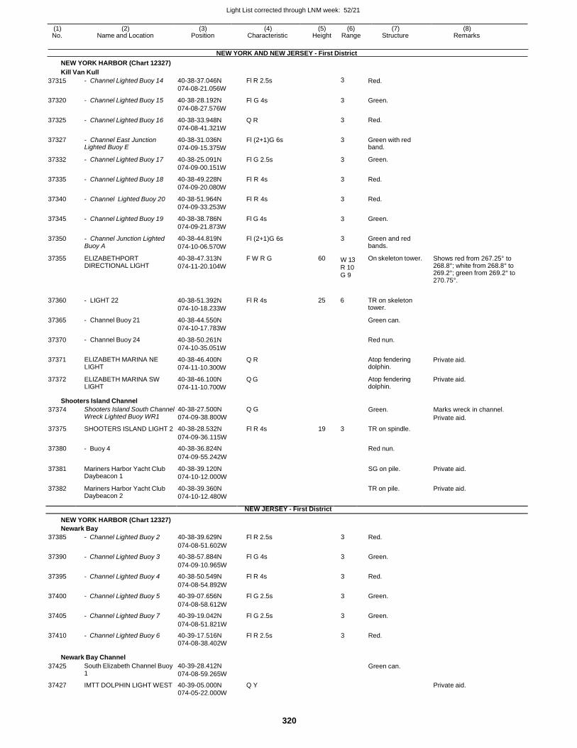
Light List corrected through LNM week: 52/21
320
(1) (2) (3) (4) (5) (6) (7) (8) No. Name and Location Position Characteristic Height Range Structure Remarks
NEW YORK HARBOR (Chart 12327)
Kill Van Kull
NEW YORK AND NEW JERSEY - First District
37315
37320
37325
37327
37332
37335
37340
37345
37350
37355
37360
37365
37370
37371
37372
- Channel Lighted Buoy 14
- Channel Lighted Buoy 15
- Channel Lighted Buoy 16
- Channel East Junction Lighted Buoy E
- Channel Lighted Buoy 17
- Channel Lighted Buoy 18
- Channel Lighted Buoy 20
- Channel Lighted Buoy 19
- Channel Junction Lighted Buoy A
ELIZABETHPORT DIRECTIONAL LIGHT
- LIGHT 22
- Channel Buoy 21
- Channel Buoy 24
ELIZABETH MARINA NE LIGHT
ELIZABETH MARINA SW LIGHT
40-38-37.046N
074-08-21.056W
40-38-28.192N
074-08-27.576W
40-38-33.948N
074-08-41.321W
40-38-31.036N
074-09-15.375W
40-38-25.091N
074-09-00.151W
40-38-49.228N
074-09-20.080W
40-38-51.964N
074-09-33.253W
40-38-38.786N
074-09-21.873W
40-38-44.819N
074-10-06.570W
40-38-47.313N
074-11-20.104W
40-38-51.392N
074-10-18.233W
40-38-44.550N
074-10-17.783W
40-38-50.261N
074-10-35.051W
40-38-46.400N
074-11-10.300W
40-38-46.100N
074-11-10.700W
Fl R 2.5s
Fl G 4s
Q R
Fl (2+1)G 6s
Fl G 2.5s
Fl R 4s
Fl R 4s
Fl G 4s
Fl (2+1)G 6s
F W R G
Fl R 4s
Q R
Q G
3
3
3
3
3
3
3
3
3
60 W 13
R 10 G 9
25 6
Red.
Green.
Red.
Green with red band.
Green.
Red.
Red.
Green.
Green and red bands.
On skeleton tower.
TR on skeleton tower.
Green can.
Red nun.
Atop fendering dolphin.
Atop fendering dolphin.
Shows red from 267.25° to 268.8°; white from 268.8° to 269.2°; green from 269.2° to 270.75°.
Private aid.
Private aid.
Shooters Island Channel
37374 Shooters Island South Channel Wreck Lighted Buoy WR1
40-38-27.500N
074-09-38.800W
Q G Green. Marks wreck in channel.
Private aid.
37375 SHOOTERS ISLAND LIGHT 2 40-38-28.532N Fl R 4s 19 3 TR on spindle.
074-09-36.115W
37380 - Buoy 4 40-38-36.824N Red nun.
074-09-55.242W
37381 Mariners Harbor Yacht Club Daybeacon 1
40-38-39.120N
074-10-12.000W
SG on pile. Private aid.
37382 Mariners Harbor Yacht Club Daybeacon 2
40-38-39.360N
074-10-12.480W
TR on pile. Private aid.
NEW JERSEY - First District
NEW YORK HARBOR (Chart 12327)
Newark Bay
37385 - Channel Lighted Buoy 2 40-38-39.629N Fl R 2.5s 3 Red.
074-08-51.602W
37390 - Channel Lighted Buoy 3 40-38-57.884N Fl G 4s 3 Green.
074-09-10.965W
37395 - Channel Lighted Buoy 4 40-38-50.549N Fl R 4s 3 Red.
074-08-54.892W
37400 - Channel Lighted Buoy 5 40-39-07.656N Fl G 2.5s 3 Green.
074-08-58.612W
37405 - Channel Lighted Buoy 7 40-39-19.042N Fl G 2.5s 3 Green.
074-08-51.821W
37410 - Channel Lighted Buoy 6 40-39-17.516N Fl R 2.5s 3 Red. 074-08-38.402W
Newark Bay Channel
37425 South Elizabeth Channel Buoy 1
40-39-28.412N
074-08-59.265W
Green can.
37427 IMTT DOLPHIN LIGHT WEST 40-39-05.000N Q Y Private aid. 074-05-22.000W
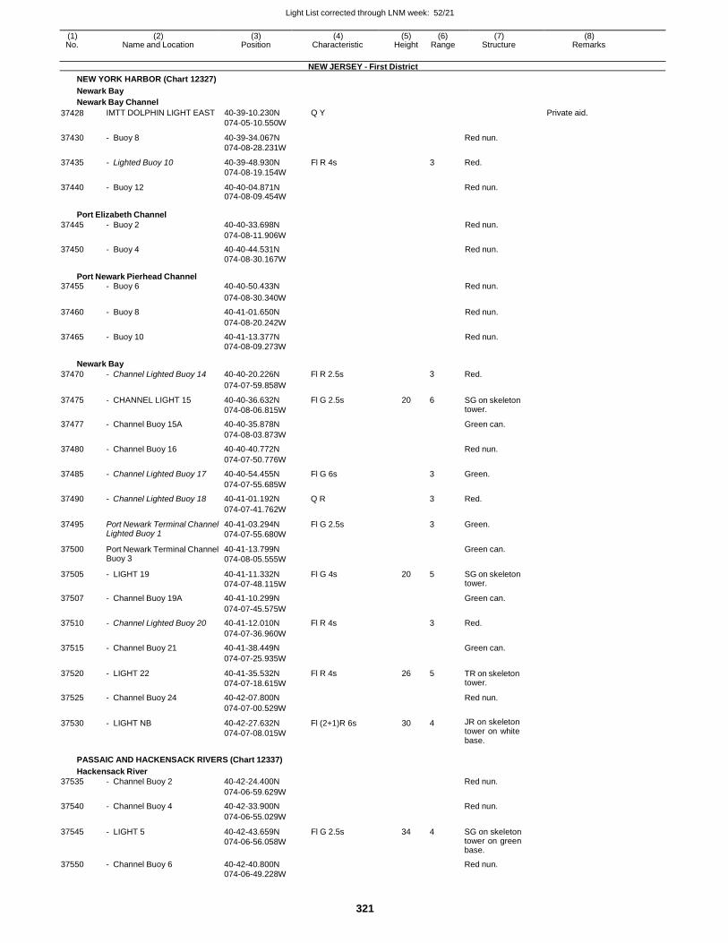
Light List corrected through LNM week: 52/21
321
(1) (2) (3) (4) (5) (6) (7) (8) No. Name and Location Position Characteristic Height Range Structure Remarks
NEW JERSEY - First District
NEW YORK HARBOR (Chart 12327)
Newark Bay
Newark Bay Channel
37428 IMTT DOLPHIN LIGHT EAST 40-39-10.230N
074-05-10.550W
Q Y Private aid.
37430 - Buoy 8 40-39-34.067N
074-08-28.231W
Red nun.
37435 - Lighted Buoy 10 40-39-48.930N
074-08-19.154W
Fl R 4s 3 Red.
37440 - Buoy 12 40-40-04.871N 074-08-09.454W
Red nun.
Port Elizabeth Channel
37445 - Buoy 2 40-40-33.698N Red nun.
074-08-11.906W
37450 - Buoy 4 40-40-44.531N Red nun. 074-08-30.167W
Port Newark Pierhead Channel 37455 - Buoy 6 40-40-50.433N Red nun.
074-08-30.340W
37460 - Buoy 8 40-41-01.650N Red nun.
074-08-20.242W
37465 - Buoy 10 40-41-13.377N Red nun. 074-08-09.273W
Newark Bay
37470 - Channel Lighted Buoy 14 40-40-20.226N Fl R 2.5s 3 Red.
074-07-59.858W
37475 - CHANNEL LIGHT 15 40-40-36.632N
074-08-06.815W
Fl G 2.5s 20 6 SG on skeleton tower.
37477 - Channel Buoy 15A 40-40-35.878N Green can.
074-08-03.873W
37480 - Channel Buoy 16 40-40-40.772N Red nun.
074-07-50.776W
37485 - Channel Lighted Buoy 17 40-40-54.455N Fl G 6s 3 Green.
074-07-55.685W
37490 - Channel Lighted Buoy 18 40-41-01.192N Q R 3 Red.
074-07-41.762W
37495 Port Newark Terminal Channel Lighted Buoy 1
40-41-03.294N
074-07-55.680W
Fl G 2.5s 3 Green.
37500 Port Newark Terminal Channel Buoy 3
40-41-13.799N
074-08-05.555W
Green can.
37505 - LIGHT 19 40-41-11.332N
074-07-48.115W
Fl G 4s 20 5 SG on skeleton tower.
37507 - Channel Buoy 19A 40-41-10.299N Green can.
074-07-45.575W
37510 - Channel Lighted Buoy 20 40-41-12.010N Fl R 4s 3 Red.
074-07-36.960W
37515 - Channel Buoy 21 40-41-38.449N Green can.
074-07-25.935W
37520 - LIGHT 22 40-41-35.532N
074-07-18.615W
Fl R 4s 26 5 TR on skeleton tower.
37525 - Channel Buoy 24 40-42-07.800N Red nun.
074-07-00.529W
37530 - LIGHT NB 40-42-27.632N
074-07-08.015W
Fl (2+1)R 6s 30 4 JR on skeleton tower on white base.
PASSAIC AND HACKENSACK RIVERS (Chart 12337)
Hackensack River
37535 - Channel Buoy 2 40-42-24.400N Red nun.
074-06-59.629W
37540 - Channel Buoy 4 40-42-33.900N Red nun.
074-06-55.029W
37545 - LIGHT 5 40-42-43.659N
074-06-56.058W
Fl G 2.5s 34 4 SG on skeleton tower on green base.
37550 - Channel Buoy 6 40-42-40.800N Red nun. 074-06-49.228W
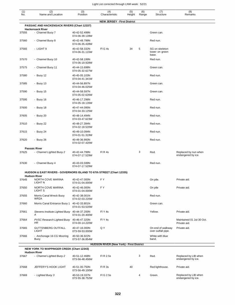
Light List corrected through LNM week: 52/21
322
(1) (2) (3) (4) (5) (6) (7) (8) No. Name and Location Position Characteristic Height Range Structure Remarks
NEW JERSEY - First District
PASSAIC AND HACKENSACK RIVERS (Chart 12337)
Hackensack River
37555 - Channel Buoy 7 40-42-52.499N Green can.
074-06-39.128W
37560 - Channel Buoy 8 40-42-48.799N Red nun.
074-06-35.428W
37565 - LIGHT 9 40-42-58.332N
074-06-31.115W
Fl G 4s 34 5 SG on skeleton tower on green base.
37570 - Channel Buoy 10 40-42-58.199N Red nun.
074-06-19.928W
37575 - Channel Buoy 11 40-44-15.698N Green can.
074-05-32.627W
37580 - Buoy 12 40-45-05.103N Red nun.
074-04-41.341W
37585 - Buoy 13 40-44-56.897N Green can.
074-04-46.025W
37590 - Buoy 15 40-44-58.597N Green can.
074-05-02.626W
37595 - Buoy 16 40-46-17.296N Red nun.
074-05-18.126W
37600 - Buoy 18 40-47-44.095N Red nun.
074-04-33.125W
37605 - Buoy 20 40-48-14.494N Red nun.
074-03-47.623W
37610 - Buoy 22 40-48-27.394N Red nun.
074-02-18.520W
37615 - Buoy 24 40-49-10.094N Red nun.
074-01-51.319W
37620 - Buoy 26 40-49-36.993N Red nun. 074-02-07.420W
Passaic River
37625 - Channel Lighted Buoy 2 40-42-44.799N
074-07-17.529W
Fl R 4s 3 Red. Replaced by nun when endangered by ice.
37630 - Channel Buoy 4 40-43-03.599N
Red nun.
074-07-17.529W
HUDSON & EAST RIVERS - GOVERNORS ISLAND TO 67th STREET (Chart 12335)
Hudson River
37645 NORTH COVE MARINA LIGHT N
40-42-47.000N
074-01-04.000W
F Y On pile. Private aid.
37650 NORTH COVE MARINA LIGHT S
40-42-46.000N
074-01-04.000W
F Y On pile Private aid.
37655 Morris Canal Wreck Buoy WR2A
40-42-38.001N
074-02-03.220W
Red nun.
37660 Morris Canal Entrance Buoy 1 40-42-33.801N Green can.
074-01-53.520W
37661 Stevens Institute Lighted Buoy A
40-44-37.200N
074-01-20.400W
Fl Y 4s Yellow. Private aid.
37664 PVSC Research Lighted Buoy HR
40-46-47.320N
074-00-14.220W
Fl Y 4s Maintained 01 Jul-30 Oct.
Private aid.
37665 GUTTENBERG OUTFALL LIGHT
40-47-16.000N
073-59-53.000W
Q Y On end of walkway over outfall pipe.
Private aid.
37666 - Anchorage 16 CG Mooring Buoy
40-50-36.922N
073-57-36.854W
White with blue band.
HUDSON RIVER (New York) - First District
NEW YORK TO WAPPINGER CREEK (Chart 12343)
Hudson River
37667 - Channel Lighted Buoy 2 40-51-12.468N
073-56-48.456W
Fl R 2.5s 3 Red. Replaced by LIB when endangered by ice.
37668 JEFFERY'S HOOK LIGHT 40-51-00.750N Fl R 3s 40
Red lighthouse. Private aid.
073-56-49.100W
37669 - Lighted Buoy 3 40-53-19.337N 073-55-38.752W
Fl G 2.5s 4 Green. Replaced by LIB when endangered by ice.
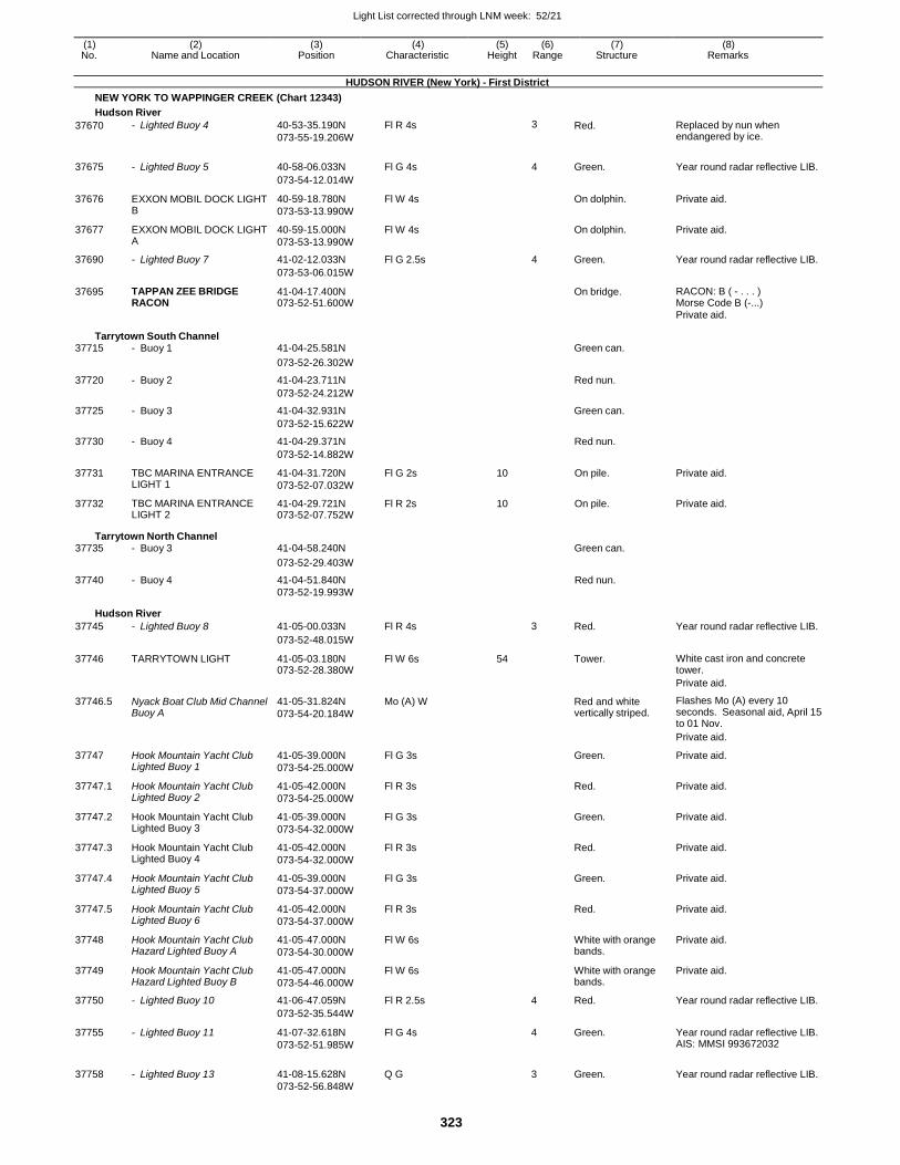
Light List corrected through LNM week: 52/21
323
(1) (2) (3) (4) (5) (6) (7) (8) No. Name and Location Position Characteristic Height Range Structure Remarks
HUDSON RIVER (New York) - First District
NEW YORK TO WAPPINGER CREEK (Chart 12343)
Hudson River
37670 - Lighted Buoy 4 40-53-35.190N
073-55-19.206W
Fl R 4s 3 Red. Replaced by nun when endangered by ice.
37675 - Lighted Buoy 5 40-58-06.033N Fl G 4s 4 Green. Year round radar reflective LIB.
073-54-12.014W
37676 EXXON MOBIL DOCK LIGHT B
40-59-18.780N
073-53-13.990W
Fl W 4s On dolphin. Private aid.
37677 EXXON MOBIL DOCK LIGHT A
40-59-15.000N
073-53-13.990W
Fl W 4s On dolphin. Private aid.
37690 - Lighted Buoy 7 41-02-12.033N Fl G 2.5s 4 Green. Year round radar reflective LIB.
073-53-06.015W
37695 TAPPAN ZEE BRIDGE RACON
41-04-17.400N 073-52-51.600W
On bridge. RACON: B ( - . . . ) Morse Code B (-...)
Private aid.
Tarrytown South Channel 37715 - Buoy 1 41-04-25.581N Green can.
073-52-26.302W
37720 - Buoy 2 41-04-23.711N Red nun.
073-52-24.212W
37725 - Buoy 3 41-04-32.931N Green can.
073-52-15.622W
37730 - Buoy 4 41-04-29.371N Red nun.
073-52-14.882W
37731 TBC MARINA ENTRANCE LIGHT 1
41-04-31.720N
073-52-07.032W
Fl G 2s 10 On pile. Private aid.
37732 TBC MARINA ENTRANCE LIGHT 2
41-04-29.721N 073-52-07.752W
Fl R 2s 10 On pile. Private aid.
Tarrytown North Channel 37735 - Buoy 3 41-04-58.240N Green can.
073-52-29.403W
37740 - Buoy 4 41-04-51.840N Red nun. 073-52-19.993W
Hudson River
37745 - Lighted Buoy 8 41-05-00.033N Fl R 4s 3 Red. Year round radar reflective LIB.
073-52-48.015W
37746 TARRYTOWN LIGHT 41-05-03.180N 073-52-28.380W
Fl W 6s 54 Tower. White cast iron and concrete tower.
Private aid.
37746.5 Nyack Boat Club Mid Channel Buoy A
41-05-31.824N
073-54-20.184W
Mo (A) W Red and white vertically striped.
Flashes Mo (A) every 10 seconds. Seasonal aid, April 15 to 01 Nov.
Private aid.
37747 Hook Mountain Yacht Club Lighted Buoy 1
41-05-39.000N
073-54-25.000W
Fl G 3s Green. Private aid.
37747.1 Hook Mountain Yacht Club Lighted Buoy 2
41-05-42.000N
073-54-25.000W
Fl R 3s Red. Private aid.
37747.2 Hook Mountain Yacht Club Lighted Buoy 3
41-05-39.000N
073-54-32.000W
Fl G 3s Green. Private aid.
37747.3 Hook Mountain Yacht Club Lighted Buoy 4
41-05-42.000N
073-54-32.000W
Fl R 3s Red. Private aid.
37747.4 Hook Mountain Yacht Club Lighted Buoy 5
41-05-39.000N
073-54-37.000W
Fl G 3s Green. Private aid.
37747.5 Hook Mountain Yacht Club Lighted Buoy 6
41-05-42.000N
073-54-37.000W
Fl R 3s Red. Private aid.
37748 Hook Mountain Yacht Club Hazard Lighted Buoy A
41-05-47.000N
073-54-30.000W
Fl W 6s White with orange bands.
Private aid.
37749 Hook Mountain Yacht Club Hazard Lighted Buoy B
41-05-47.000N
073-54-46.000W
Fl W 6s White with orange bands.
Private aid.
37750 - Lighted Buoy 10 41-06-47.059N Fl R 2.5s 4 Red. Year round radar reflective LIB.
073-52-35.544W
37755 - Lighted Buoy 11 41-07-32.618N
073-52-51.985W
Fl G 4s 4 Green. Year round radar reflective LIB. AIS: MMSI 993672032
37758 - Lighted Buoy 13 41-08-15.628N Q G
3 Green. Year round radar reflective LIB. 073-52-56.848W
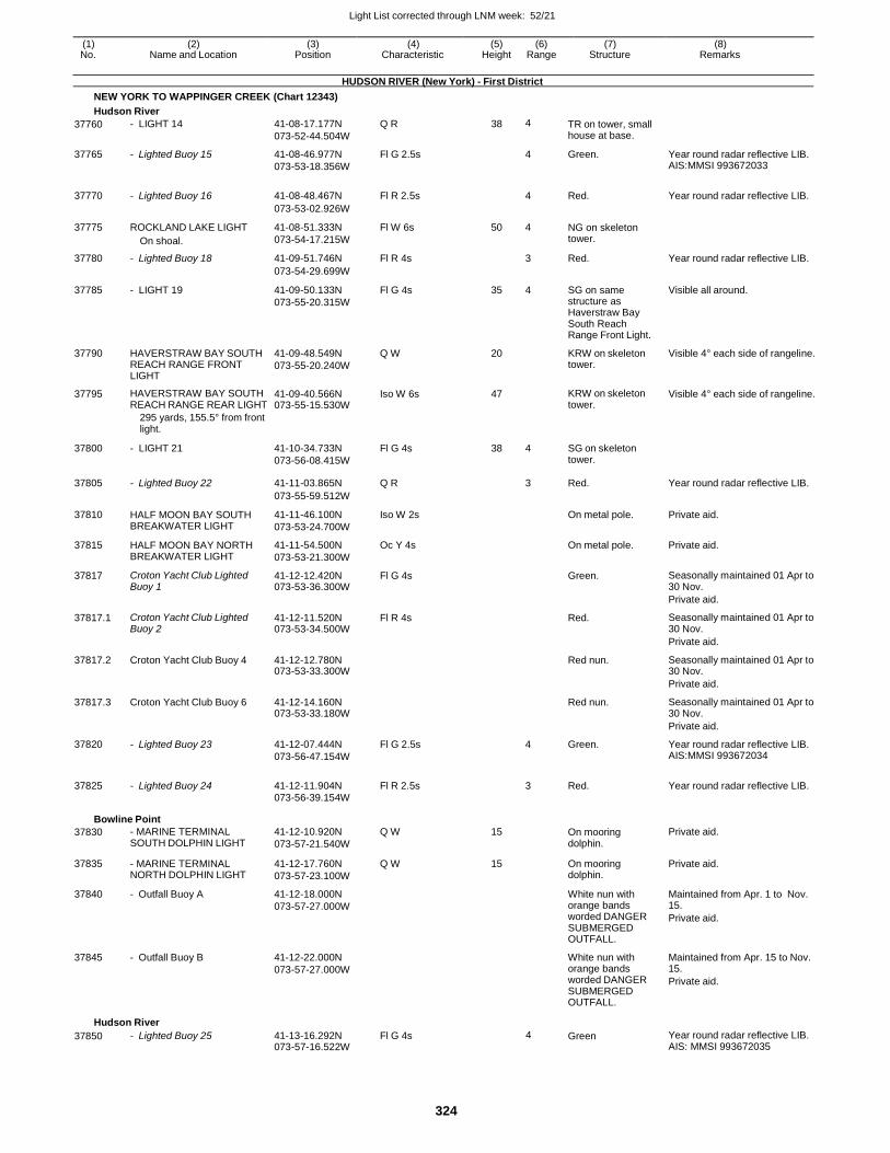
Light List corrected through LNM week: 52/21
324
(1) (2) (3) (4) (5) (6) (7) (8) No. Name and Location Position Characteristic Height Range Structure Remarks
HUDSON RIVER (New York) - First District
NEW YORK TO WAPPINGER CREEK (Chart 12343)
Hudson River
37760 - LIGHT 14 41-08-17.177N
073-52-44.504W
Q R 38 4 TR on tower, small house at base.
37765 - Lighted Buoy 15 41-08-46.977N
073-53-18.356W
Fl G 2.5s 4 Green. Year round radar reflective LIB. AIS:MMSI 993672033
37770 - Lighted Buoy 16 41-08-48.467N Fl R 2.5s
4 Red. Year round radar reflective LIB.
073-53-02.926W
37775 ROCKLAND LAKE LIGHT
On shoal.
41-08-51.333N
073-54-17.215W
Fl W 6s 50 4 NG on skeleton tower.
37780 - Lighted Buoy 18 41-09-51.746N Fl R 4s 3 Red. Year round radar reflective LIB.
073-54-29.699W
37785 - LIGHT 19 41-09-50.133N
073-55-20.315W
Fl G 4s 35 4 SG on same structure as Haverstraw Bay South Reach Range Front Light.
Visible all around.
37790 HAVERSTRAW BAY SOUTH REACH RANGE FRONT LIGHT
41-09-48.549N
073-55-20.240W
Q W 20 KRW on skeleton tower.
Visible 4° each side of rangeline.
37795 HAVERSTRAW BAY SOUTH REACH RANGE REAR LIGHT
41-09-40.566N 073-55-15.530W
Iso W 6s 47 KRW on skeleton tower.
Visible 4° each side of rangeline.
295 yards, 155.5° from front light.
37800 - LIGHT 21 41-10-34.733N
073-56-08.415W
Fl G 4s 38 4 SG on skeleton tower.
37805 - Lighted Buoy 22 41-11-03.865N Q R
3 Red. Year round radar reflective LIB.
073-55-59.512W
37810 HALF MOON BAY SOUTH BREAKWATER LIGHT
41-11-46.100N
073-53-24.700W
Iso W 2s On metal pole. Private aid.
37815 HALF MOON BAY NORTH BREAKWATER LIGHT
41-11-54.500N
073-53-21.300W
Oc Y 4s On metal pole. Private aid.
37817 Croton Yacht Club Lighted Buoy 1
41-12-12.420N 073-53-36.300W
Fl G 4s Green. Seasonally maintained 01 Apr to 30 Nov.
Private aid.
37817.1 Croton Yacht Club Lighted Buoy 2
41-12-11.520N 073-53-34.500W
Fl R 4s Red. Seasonally maintained 01 Apr to 30 Nov.
Private aid.
37817.2 Croton Yacht Club Buoy 4 41-12-12.780N 073-53-33.300W
Red nun. Seasonally maintained 01 Apr to 30 Nov.
Private aid.
37817.3 Croton Yacht Club Buoy 6 41-12-14.160N 073-53-33.180W
Red nun. Seasonally maintained 01 Apr to 30 Nov.
Private aid.
37820 - Lighted Buoy 23 41-12-07.444N
073-56-47.154W
Fl G 2.5s 4 Green. Year round radar reflective LIB. AIS:MMSI 993672034
37825 - Lighted Buoy 24 41-12-11.904N Fl R 2.5s
3 Red. Year round radar reflective LIB. 073-56-39.154W
Bowline Point
37830 - MARINE TERMINAL SOUTH DOLPHIN LIGHT
41-12-10.920N
073-57-21.540W
Q W 15 On mooring dolphin.
Private aid.
37835 - MARINE TERMINAL NORTH DOLPHIN LIGHT
41-12-17.760N
073-57-23.100W
Q W 15 On mooring dolphin.
Private aid.
37840 - Outfall Buoy A 41-12-18.000N
073-57-27.000W
White nun with orange bands worded DANGER SUBMERGED OUTFALL.
Maintained from Apr. 1 to Nov. 15.
Private aid.
37845 - Outfall Buoy B 41-12-22.000N
073-57-27.000W
White nun with orange bands worded DANGER SUBMERGED OUTFALL.
Maintained from Apr. 15 to Nov. 15.
Private aid.
Hudson River
37850 - Lighted Buoy 25 41-13-16.292N 073-57-16.522W
Fl G 4s 4 Green Year round radar reflective LIB. AIS: MMSI 993672035
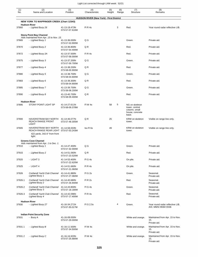
Light List corrected through LNM week: 52/21
325
(1) (2) (3) (4) (5) (6) (7) (8) No. Name and Location Position Characteristic Height Range Structure Remarks
HUDSON RIVER (New York) - First District
NEW YORK TO WAPPINGER CREEK (Chart 12343)
Hudson River
37860 - Lighted Buoy 26 41-13-18.473N Fl R 4s 3 Red. Year round radar reflective LIB. 073-57-07.616W
Stony Point Bay Channel Aids maintained from Apr. 15 to Nov. 15.
37865 - Lighted Buoy 1 41-13-36.000N Q G Green. Private aid.
073-57-53.900W
37870 - Lighted Buoy 2 41-13-36.800N Q R Red. Private aid.
073-57-54.400W
37872 - Lighted Buoy 2A 41-13-37.500N Fl R 4s Red. Private aid.
073-57-58.000W
37875 - Lighted Buoy 3 41-13-37.200N Q G Green. Private aid.
073-57-59.700W
37877 - Lighted Buoy 4 41-13-38.200N Q R Red. Private aid.
073-58-00.900W
37880 - Lighted Buoy 5 41-13-38.700N Q G Green. Private aid.
073-58-04.600W
37883 - Lighted Buoy 6 41-13-39.300N Q R Red. Private aid.
073-58-04.900W
37885 - Lighted Buoy 7 41-13-39.700N Q G Green. Private aid.
073-58-08.200W
37890 - Lighted Buoy 8 41-13-40.700N Q R Red. Private aid. 073-58-09.400W
Hudson River
37895 STONY POINT LIGHT SP 41-14-27.611N
073-58-09.378W
Fl W 4s 58 5 NG on skeleton tower, central column, small house, concrete base.
37900 HAVERSTRAW BAY NORTH REACH RANGE FRONT LIGHT
41-14-46.077N
073-57-48.305W
Q R 25 KRW on skeleton tower.
Visible on range line only.
37905 HAVERSTRAW BAY NORTH REACH RANGE REAR LIGHT
41-14-58.003N 073-57-53.243W
Iso R 6s 49 KRW on skeleton tower.
Visible on range line only.
422 yards, 342.6° from front light.
Greens Cove Channel Aids maintained from Apr. 1 to Dec. 1.
37910 - Lighted Buoy 1 41-14-47.400N Q G Green. Private aid.
073-57-32.000W
37915 - Lighted Buoy 2 41-14-51.060N Q R Red. Private aid.
073-57-23.520W
37920 - LIGHT 3 41-14-53.400N Fl G 4s On pile. Private aid.
073-57-22.620W
37925 - LIGHT 4 41-14-51.660N Fl R 4s On pile. Private aid.
073-57-21.060W
37926 Cortlandt Yacht Club Channel Lighted Buoy 1
41-14-41.880N
073-57-27.060W
Fl G 2s Green. Seasonal.
Private aid.
37926.1 Cortlandt Yacht Club Channel Lighted Buoy 2
41-14-40.680N
073-57-26.940W
Fl R 2s Red. Seasonal.
Private aid.
37926.2 Cortlandt Yacht Club Channel Lighted Buoy 3
41-14-43.800N
073-57-18.180W
Fl G 4s Green. Seasonal.
Private aid.
37926.3 Cortlandt Yacht Club Channel Lighted Buoy 4
41-14-42.096N 073-57-17.400W
Fl R 4s Red. Seasonal.
Private aid.
Hudson River
37930 - Lighted Buoy 27 41-16-34.271N
073-57-35.017W
Fl G 2.5s 4 Green. Year round radar reflective LIB. AIS: MMSI 993672036
Indian Point Security Zone
37931 - Buoy A 41-16-08.000N
073-57-29.000W
White and orange. Maintained from Apr. 15 to Nov. 15.
Private aid.
37931.1 - Lighted Buoy B 41-16-11.500N 073-57-34.500W
Fl W 4s White and orange. Maintained from Apr. 15 to Nov. 15.
Private aid.
37931.2 - Lighted Buoy C 41-16-16.920N 073-57-25.680W
Fl W 4s White and orange. Maintained from Apr. 15 to Nov. 15.
Private aid.
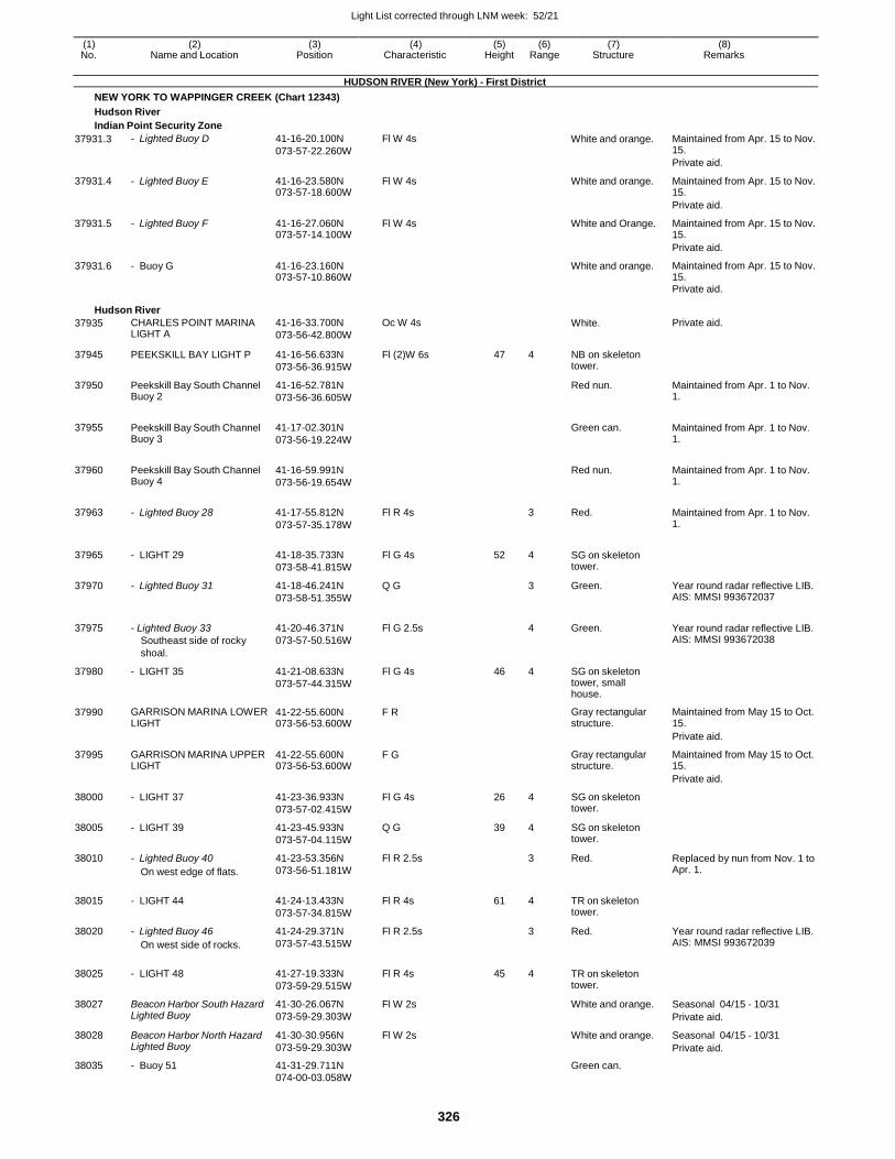
Light List corrected through LNM week: 52/21
326
(1) (2) (3) (4) (5) (6) (7) (8) No. Name and Location Position Characteristic Height Range Structure Remarks
HUDSON RIVER (New York) - First District
NEW YORK TO WAPPINGER CREEK (Chart 12343)
Hudson River
Indian Point Security Zone
37931.3 - Lighted Buoy D 41-16-20.100N
073-57-22.260W
Fl W 4s White and orange. Maintained from Apr. 15 to Nov. 15.
Private aid.
37931.4 - Lighted Buoy E 41-16-23.580N 073-57-18.600W
Fl W 4s White and orange. Maintained from Apr. 15 to Nov. 15.
Private aid.
37931.5 - Lighted Buoy F 41-16-27.060N 073-57-14.100W
Fl W 4s White and Orange. Maintained from Apr. 15 to Nov. 15.
Private aid.
37931.6 - Buoy G 41-16-23.160N 073-57-10.860W
White and orange. Maintained from Apr. 15 to Nov. 15.
Private aid.
Hudson River
37935 CHARLES POINT MARINA LIGHT A
41-16-33.700N
073-56-42.800W
Oc W 4s White. Private aid.
37945 PEEKSKILL BAY LIGHT P 41-16-56.633N
073-56-36.915W
Fl (2)W 6s 47 4 NB on skeleton tower.
37950 Peekskill Bay South Channel Buoy 2
41-16-52.781N
073-56-36.605W
Red nun. Maintained from Apr. 1 to Nov. 1.
37955 Peekskill Bay South Channel Buoy 3
41-17-02.301N
073-56-19.224W
Green can. Maintained from Apr. 1 to Nov.
1.
37960 Peekskill Bay South Channel Buoy 4
41-16-59.991N
073-56-19.654W
Red nun. Maintained from Apr. 1 to Nov.
1.
37963 - Lighted Buoy 28 41-17-55.812N
073-57-35.178W
Fl R 4s
3 Red. Maintained from Apr. 1 to Nov. 1.
37965 - LIGHT 29 41-18-35.733N
073-58-41.815W
Fl G 4s 52 4 SG on skeleton tower.
37970 - Lighted Buoy 31 41-18-46.241N
073-58-51.355W
Q G 3 Green. Year round radar reflective LIB. AIS: MMSI 993672037
37975 - Lighted Buoy 33
Southeast side of rocky
shoal.
41-20-46.371N
073-57-50.516W
Fl G 2.5s
4 Green. Year round radar reflective LIB. AIS: MMSI 993672038
37980 - LIGHT 35 41-21-08.633N
073-57-44.315W
Fl G 4s 46 4 SG on skeleton tower, small house.
37990 GARRISON MARINA LOWER LIGHT
41-22-55.600N 073-56-53.600W
F R Gray rectangular structure.
Maintained from May 15 to Oct. 15.
Private aid.
37995 GARRISON MARINA UPPER LIGHT
41-22-55.600N 073-56-53.600W
F G Gray rectangular structure.
Maintained from May 15 to Oct. 15.
Private aid.
38000 - LIGHT 37 41-23-36.933N
073-57-02.415W
Fl G 4s 26 4 SG on skeleton tower.
38005 - LIGHT 39 41-23-45.933N
073-57-04.115W
Q G 39 4 SG on skeleton tower.
38010 - Lighted Buoy 40
On west edge of flats.
41-23-53.356N
073-56-51.181W
Fl R 2.5s 3 Red. Replaced by nun from Nov. 1 to Apr. 1.
38015 - LIGHT 44 41-24-13.433N
073-57-34.815W
Fl R 4s 61 4 TR on skeleton tower.
38020 - Lighted Buoy 46
On west side of rocks.
41-24-29.371N
073-57-43.515W
Fl R 2.5s 3 Red. Year round radar reflective LIB. AIS: MMSI 993672039
38025 - LIGHT 48 41-27-19.333N
073-59-29.515W
Fl R 4s 45 4 TR on skeleton tower.
38027 Beacon Harbor South Hazard Lighted Buoy
41-30-26.067N
073-59-29.303W
Fl W 2s White and orange. Seasonal 04/15 - 10/31
Private aid.
38028 Beacon Harbor North Hazard Lighted Buoy
41-30-30.956N
073-59-29.303W
Fl W 2s White and orange. Seasonal 04/15 - 10/31
Private aid.
38035 - Buoy 51 41-31-29.711N Green can.
074-00-03.058W
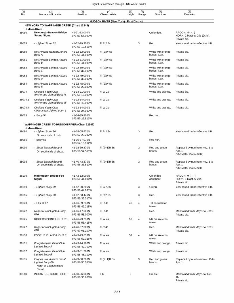
Light List corrected through LNM week: 52/21
327
(1) (2) (3) (4) (5) (6) (7) (8) No. Name and Location Position Characteristic Height Range Structure Remarks
HUDSON RIVER (New York) - First District
NEW YORK TO WAPPINGER CREEK (Chart 12343)
Hudson River
38050 Newburgh-Beacon Bridge Sound Signal
41-31-12.000N
073-59-58.000W
On bridge. RACON: N ( - . ) HORN: 1 blast ev 20s (2s bl).
Private aid.
38055 - Lighted Buoy 52 41-32-19.370N Fl R 2.5s 3 Red. Year round radar reflective LIB.
073-59-12.516W
38060 HMM Intake Hazard Lighted Buoy A
41-32-52.000N
073-58-44.000W
Fl (2)W 5s White with orange bands. Can.
Private aid.
38061 HMM Intake Lighted Hazard Buoy B
41-32-51.000N
073-58-41.000W
Fl (2)W 5s White with orange bands. Can.
Private aid.
38062 HMM Intake Lighted Hazard Buoy C
41-32-50.000N
073-58-37.000W
Fl (2)W 5s White with orange bands. Can.
Private aid.
38063 HMM Intake Lighted Hazard Buoy D
41-32-49.000N
073-58-33.000W
Fl (2)W 5s White with orange bands. Can.
Private aid.
38064 HMM Intake Lighted Hazard Buoy E
41-32-48.000N
073-58-29.000W
Fl (2)W 5s White with orange bands. Can.
Private aid.
38074 Chelsea Yacht Club Anchorage Lighted Buoy N
41-33-21.000N
073-58-16.000W
Fl W 2s White and orange. Private aid.
38074.3 Chelsea Yatch Club Anchorage Lighted Buoy W
41-32-54.000N
073-58-40.000W
Fl W 2s White and orange. Private aid.
38074.4 Chelsea Yacht Club Obstruction Lighted Buoy S
41-33-14.000N
073-58-24.000W
Fl W 2s White and orange. Private aid.
38075 - Buoy 54 41-34-35.870N Red nun.
073-57-22.513W
WAPPINGER CREEK TO HUDSON RIVER (Chart 12347)
Hudson River
38080 - Lighted Buoy 56 41-35-05.670N Fl R 2.5s 3 Red. Year round radar reflective LIB.
On west side of rock. 073-57-20.212W
38085 - Buoy 58 41-35-37.070N Red nun.
073-57-16.912W
38090 - Shoal Lighted Buoy A 41-38-39.370N Fl (2+1)R 6s 3 Red and green Replaced by nun from Nov. 1 to
On south side of shoal. 073-56-54.511W bands. Apr. 1. AIS: MMSI 993672040
38095 - Shoal Lighted Buoy B 41-40-43.370N Fl (2+1)R 6s 3 Red and green Replaced by nun from Nov. 1 to On south side of shoal. 073-56-36.510W bands. Apr. 1.
AIS: MMSI 993672041
38100 Mid Hudson Bridge Fog 41-42-12.000N
On bridge RACON: M ( - - ) Signal 073-56-44.000W abutment. HORN: 1 blast ev 20s.
Private aid.
38110 - Lighted Buoy 59 41-42-30.205N Fl G 2.5s 3 Green. Year round radar reflective LIB.
073-56-44.981W
38115 - Lighted Buoy 60 41-42-53.476N Fl R 2.5s 3 Red. Year round radar reflective LIB.
073-56-36.317W
38120 - LIGHT 62 41-46-09.233N Fl R 4s 46 4 TR on skeleton
073-56-49.215W tower.
38122 Rogers Point Lighted Buoy 41-46-17.000N Fl R 4s Red. Maintained from May 1 to Oct 1.
62A 073-56-58.000W Private aid.
38125 ROGERS POINT LIGHT RP 41-46-23.733N Fl W 4s 50 4 NR on skeleton
073-56-53.415W tower.
38127 Rogers Point Lighted Buoy 41-46-37.000N Fl R 4s Red. Maintained from May 1 to Oct 1.
62B 073-57-01.100W Private aid.
38130 ESOPUS ISLAND LIGHT EI 41-49-23.633N Fl W 4s 57 4 NR on skeleton
073-56-52.315W tower.
38131 Poughkeepsie Yacht Club 41-49-24.100N Fl W 4s White and orange. Private aid.
Lighted Buoy A 073-56-42.700W
38132 Poughkeepsie Yacht Club 41-49-01.200N Fl W 4s White and orange. Private aid.
Lighted Buoy B 073-56-45.100W
38135 Esopus Island North Shoal 41-49-50.798N Fl (2+1)R 6s 3 Red and green Replaced by nun from Nov. 15 to Lighted Buoy EN 073-56-50.560W bands. Apr. 1. North of Esopus Island
38140
Shoal.
INDIAN KILL SOUTH LIGHT
41-50-06.000N F R
073-56-36.000W
6 On pile.
Maintained from May 1 to Oct. 15.
Private aid.
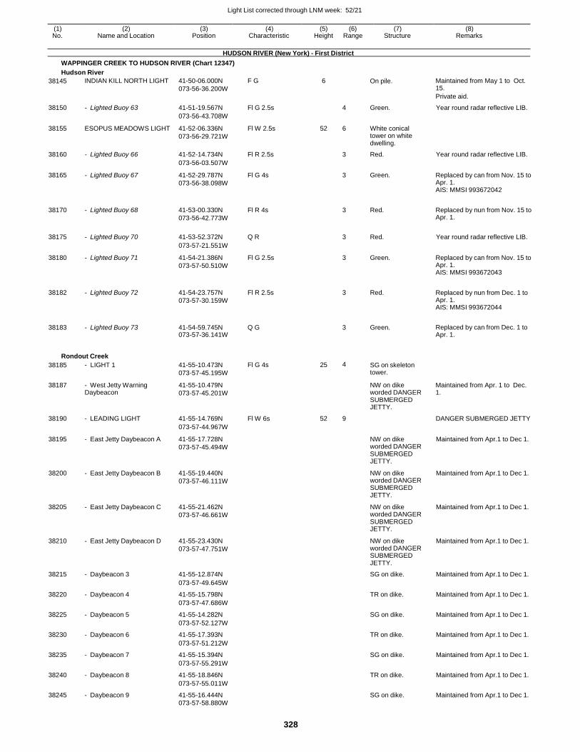
Light List corrected through LNM week: 52/21
328
(1) (2) (3) (4) (5) (6) (7) (8) No. Name and Location Position Characteristic Height Range Structure Remarks
HUDSON RIVER (New York) - First District
WAPPINGER CREEK TO HUDSON RIVER (Chart 12347)
Hudson River
38145 INDIAN KILL NORTH LIGHT 41-50-06.000N
073-56-36.200W
F G 6 On pile. Maintained from May 1 to Oct. 15.
Private aid.
38150 - Lighted Buoy 63 41-51-19.567N Fl G 2.5s 4 Green. Year round radar reflective LIB.
073-56-43.708W
38155 ESOPUS MEADOWS LIGHT 41-52-06.336N
073-56-29.721W
Fl W 2.5s 52 6 White conical tower on white dwelling.
38160 - Lighted Buoy 66 41-52-14.734N Fl R 2.5s 3 Red. Year round radar reflective LIB.
073-56-03.507W
38165 - Lighted Buoy 67 41-52-29.787N
073-56-38.098W
Fl G 4s 3 Green. Replaced by can from Nov. 15 to Apr. 1. AIS: MMSI 993672042
38170 - Lighted Buoy 68 41-53-00.330N
073-56-42.773W
Fl R 4s
3 Red. Replaced by nun from Nov. 15 to Apr. 1.
38175 - Lighted Buoy 70 41-53-52.372N Q R
3 Red. Year round radar reflective LIB.
073-57-21.551W
38180 - Lighted Buoy 71 41-54-21.386N
073-57-50.510W
Fl G 2.5s 3 Green. Replaced by can from Nov. 15 to Apr. 1. AIS: MMSI 993672043
38182 - Lighted Buoy 72 41-54-23.757N
073-57-30.159W
Fl R 2.5s
3 Red. Replaced by nun from Dec. 1 to Apr. 1. AIS: MMSI 993672044
38183 - Lighted Buoy 73 41-54-59.745N 073-57-36.141W
Q G
3 Green. Replaced by can from Dec. 1 to Apr. 1.
Rondout Creek
38185 - LIGHT 1 41-55-10.473N
073-57-45.195W
Fl G 4s 25 4 SG on skeleton tower.
38187 - West Jetty Warning Daybeacon
41-55-10.479N
073-57-45.201W
NW on dike worded DANGER SUBMERGED JETTY.
Maintained from Apr. 1 to Dec. 1.
38190 - LEADING LIGHT 41-55-14.769N Fl W 6s 52 9 DANGER SUBMERGED JETTY
073-57-44.967W
38195 - East Jetty Daybeacon A 41-55-17.728N
073-57-45.494W
NW on dike worded DANGER SUBMERGED JETTY.
Maintained from Apr.1 to Dec 1.
38200 - East Jetty Daybeacon B 41-55-19.440N
073-57-46.111W
NW on dike worded DANGER SUBMERGED JETTY.
Maintained from Apr.1 to Dec 1.
38205 - East Jetty Daybeacon C 41-55-21.462N
073-57-46.661W
NW on dike worded DANGER SUBMERGED JETTY.
Maintained from Apr.1 to Dec 1.
38210 - East Jetty Daybeacon D 41-55-23.430N
073-57-47.751W
NW on dike worded DANGER SUBMERGED JETTY.
Maintained from Apr.1 to Dec 1.
38215 - Daybeacon 3 41-55-12.874N SG on dike. Maintained from Apr.1 to Dec 1.
073-57-49.645W
38220 - Daybeacon 4 41-55-15.798N TR on dike. Maintained from Apr.1 to Dec 1.
073-57-47.686W
38225 - Daybeacon 5 41-55-14.282N SG on dike. Maintained from Apr.1 to Dec 1.
073-57-52.127W
38230 - Daybeacon 6 41-55-17.393N TR on dike. Maintained from Apr.1 to Dec 1.
073-57-51.212W
38235 - Daybeacon 7 41-55-15.394N SG on dike. Maintained from Apr.1 to Dec 1.
073-57-55.291W
38240 - Daybeacon 8 41-55-18.846N TR on dike. Maintained from Apr.1 to Dec 1.
073-57-55.011W
38245 - Daybeacon 9 41-55-16.444N SG on dike. Maintained from Apr.1 to Dec 1. 073-57-58.880W
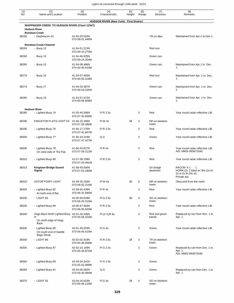
Light List corrected through LNM week: 52/21
329
(1) (2) (3) (4) (5) (6) (7) (8) No. Name and Location Position Characteristic Height Range Structure Remarks
HUDSON RIVER (New York) - First District
WAPPINGER CREEK TO HUDSON RIVER (Chart 12347)
Hudson River
Rondout Creek
38250 - Daybeacon 10 41-55-20.520N 073-58-01.446W
TR on dike. Maintained from Apr.1 to Dec 1.
Rondout Creek Channel
38255 - Buoy 12 41-54-51.213N Red nun.
073-59-10.270W
38260 - Buoy 13 41-54-46.925N Green can.
073-59-14.254W
38265 - Buoy 15 41-54-08.466N
074-00-45.410W
Green can. Maintained from Apr.1 to Dec. 1.
38270 - Buoy 16 41-54-07.465N
074-00-50.318W
Red nun. Maintained from Apr. 1 to Dec. 1.
38275 - Buoy 17 41-54-04.387N
074-00-53.325W
Green can. Maintained from Apr. 1 to Dec. 1.
38280 - Buoy 19 41-53-57.672N 074-00-59.828W
Green can. Maintained from Apr. 1 to Dec. 1.
Hudson River
38285 - Lighted Buoy 74 41-55-45.596N Fl R 2.5s 3 Red. Year round radar reflective LIB.
073-57-33.930W
38290 KINGSTON FLATS LIGHT KF 41-56-15.356N
073-57-28.486W
Fl W 4s 38 4 NR on skeleton tower.
38295 - Lighted Buoy 76 41-56-17.270N Fl R 2.5s 3 Red. Year round radar reflective LIB.
073-57-41.847W
38300 - Lighted Buoy 77 41-56-33.319N Q G 3 Green. Year round radar reflective LIB.
073-57-47.427W
38305 - Lighted Buoy 78
On west side of The Flat.
41-56-43.817N
073-57-39.311W
Fl R 4s
4 Red. Year round radar reflective LIB. AIS: MMSI 993672045
38310 - Lighted Buoy 80 41-57-39.199N Fl R 2.5s
3 Red. Year round radar reflective LIB.
073-57-20.491W
38315 Kingston Bridge Sound Signal
41-58-45.000N
073-57-03.180W
On bridge abutment.
RACON: K ( - . - ) HORN (2): 2 blast ev 30s (2s bl- 2s si-2s bl-24s si).
Private aid.
38320 ASTOR POINT LIGHT 41-59-25.233N
073-56-02.215W
Fl W 4s 40 5 NR on skeleton tower.
Obscured from the north.
38325 - Lighted Buoy 82 41-59-55.439N Fl R 4s 3 Red. Year round radar reflective LIB.
At north end of flat. 073-56-32.585W
38330 - LIGHT 83 42-00-50.633N
073-56-20.315W
Fl G 2.5s 38 4 SG on skeleton tower.
38335 - Lighted Buoy 84 42-00-47.363N Fl R 2.5s 3 Red. Year round radar reflective LIB.
073-56-05.503W
38340 Hogs Back North Lighted Buoy N
42-01-20.435N 073-55-56.222W
Fl (2+1)R 6s 3 Red and green bands.
Replaced by nun from Nov. 1 to Apr. 1.
On north edge of Hogs Back.
38345 - Lighted Buoy 85 42-01-46.203N Fl G 4s
3 Green. Year round radar reflective LIB.
On south end of Saddle Bags Shoal.
073-56-06.410W
38350 - LIGHT 86 42-02-02.919N
073-55-46.059W
Fl R 2.5s 28 4 TR on skeleton tower.
38355 - Lighted Buoy 87 42-02-15.169N
073-55-56.872W
Fl G 2.5s 3 Green. Replaced by can from Dec. 1 to Apr. 1. AIS: MMSI 993672046
38360 - Lighted Buoy 89 42-03-04.341N Fl G 2.5s
3 Green.
073-55-42.489W
38365 - Lighted Buoy 91 42-04-05.082N
073-55-40.484W
Q G 3 Green. Replaced by can from Dec. 1 to Apr. 1.
38370 - LIGHT 93 42-04-16.633N 073-55-46.115W
Fl G 4s 28 4 SG on skeleton tower.
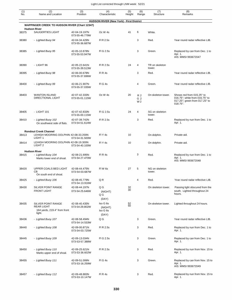
Light List corrected through LNM week: 52/21
330
(1) (2) (3) (4) (5) (6) (7) (8) No. Name and Location Position Characteristic Height Range Structure Remarks
HUDSON RIVER (New York) - First District
WAPPINGER CREEK TO HUDSON RIVER (Chart 12347)
Hudson River
38375
38380
38385
38390
38395
38400
38403
38405
38410
SAUGERTIES LIGHT
- Lighted Buoy 94
- Lighted Buoy 95
- LIGHT 96
- Lighted Buoy 98
- Lighted Buoy 99
WANTON ISLAND DIRECTIONAL LIGHT
- LIGHT 101
- Lighted Buoy 102
On southwest side of flats.
42-04-19.197N
073-55-46.779W
42-04-34.429N
073-55-36.687W
42-05-10.878N
073-55-53.947W
42-05-22.641N
073-55-39.513W
42-06-00.678N
073-55-37.696W
42-06-21.907N
073-55-37.035W
42-07-42.333N
073-55-01.115W
42-07-42.833N
073-55-00.115W
42-07-39.742N
073-54-51.614W
Oc W 4s
Fl R 2.5s
Fl G 2.5s
Fl R 2.5s
Fl R 4s
Fl G 4s
Oc W 4s
Fl G 2.5s
Fl R 2.5s
41 6
3
3
24 4
3
4
20 R 2
G 2 W 2
24 4
3
White.
Red.
Green.
TR on skeleton tower.
Red.
Green.
On skeleton tower.
SG on skeleton tower.
Red.
Year round radar reflective LIB.
Replaced by can from Dec. 1 to Apr. 1. AIS: MMSI 993672047
Year round radar reflective LIB.
Year round radar reflective LIB.
Shows red from 015.25° to 016.75°; white from 016.75° to 017.25°; green from 017.25° to 018.75°.
Replaced by nun from Dec. 1 to Apr. 1.
Rondout Creek Channel
38413 LEHIGH MOORING DOLPHIN 42-08-33.200N LIGHT 1 073-54-31.500W
Fl Y 4s 10 On dolphin. Private aid.
38414 LEHIGH MOORING DOLPHIN 42-08-19.300N LIGHT 2 073-54-40.100W
Fl Y 4s 10 On dolphin. Private aid.
Hudson River
38415 - Lighted Buoy 104
Marks lower end of shoal.
42-08-21.695N
073-54-27.470W
Fl R 4s 3 Red. Replaced by nun from Dec. 1 to Apr. 1. AIS: MMSI 993672048
38420 UPPER COALS BED LIGHT
CB On south end of shoal.
42-08-44.475N
073-54-03.687W
Fl W 6s 27 5 NG on skeleton tower.
38425 - Lighted Buoy 106 42-08-45.779N
073-54-13.916W
Q R
4 Red. Year round radar reflective LIB.
38430 SILVER POINT RANGE 42-08-44.197N Q G 32 On skeleton tower. Passing light obscured from the
38435
FRONT LIGHT
SILVER POINT RANGE REAR LIGHT
164 yards, 219.4° from front light.
073-54-25.646W
42-08-40.435N
073-54-29.802W
(NIGHT) 30
Q G
(DAY)
Iso G 6s 52
(NIGHT) 50
Iso G 6s
(DAY)
On skeleton tower.
south. Lighted throughout 24 hours.
Lighted throughout 24 hours.
38436 - Lighted Buoy 107 42-08-58.494N Q G 3 Green. Year round radar reflective LIB.
073-54-14.533W
38440 - Lighted Buoy 108 42-09-00.871N
073-54-03.725W
Fl R 2.5s 3 Red. Replaced by nun from Dec. 1 to Apr. 1.
38445 - Lighted Buoy 109 42-09-13.034N
073-53-57.388W
Fl G 2.5s 3 Green. Replaced by can from Dec. 1 to Apr. 1.
38450 - Lighted Buoy 110
Marks upper end of shoal.
42-09-25.621N
073-53-36.602W
Fl R 2.5s 3 Red. Replaced by nun from Nov. 15 to Apr. 1.
38455 - Lighted Buoy 111 42-09-51.006N
073-53-16.259W
Fl G 4s 3 Green. Replaced by can from Nov. 15 to Apr. 1. AIS: MMSI 993672049
38457 - Lighted Buoy 112 42-09-48.883N 073-53-10.147W
Fl R 4s 3 Red. Replaced by nun from Nov. 15 to Apr. 1.
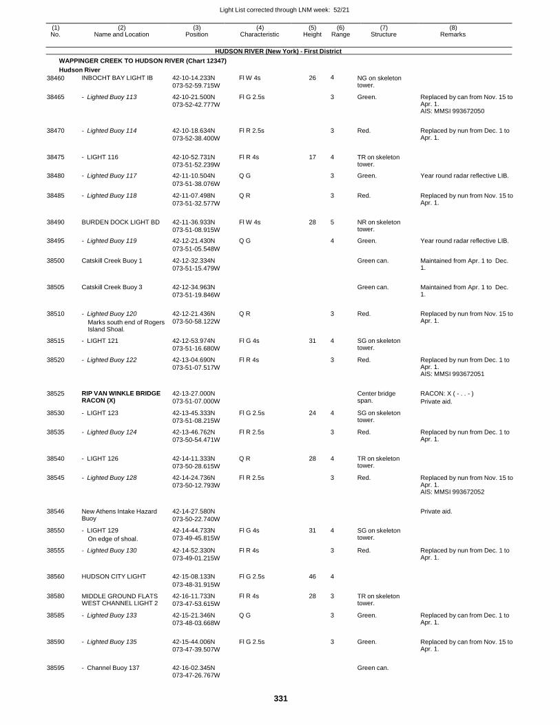
Light List corrected through LNM week: 52/21
331
(1) (2) (3) (4) (5) (6) (7) (8) No. Name and Location Position Characteristic Height Range Structure Remarks
HUDSON RIVER (New York) - First District
WAPPINGER CREEK TO HUDSON RIVER (Chart 12347)
Hudson River
38460 INBOCHT BAY LIGHT IB 42-10-14.233N
073-52-59.715W
Fl W 4s 26 4 NG on skeleton tower.
38465 - Lighted Buoy 113 42-10-21.500N
073-52-42.777W
Fl G 2.5s 3 Green. Replaced by can from Nov. 15 to Apr. 1. AIS: MMSI 993672050
38470 - Lighted Buoy 114 42-10-18.634N
073-52-38.400W
Fl R 2.5s
3 Red. Replaced by nun from Dec. 1 to Apr. 1.
38475 - LIGHT 116 42-10-52.731N
073-51-52.239W
Fl R 4s 17 4 TR on skeleton tower.
38480 - Lighted Buoy 117 42-11-10.504N Q G 3 Green. Year round radar reflective LIB.
073-51-38.076W
38485 - Lighted Buoy 118 42-11-07.498N
073-51-32.577W
Q R 3 Red. Replaced by nun from Nov. 15 to Apr. 1.
38490 BURDEN DOCK LIGHT BD 42-11-36.933N
073-51-08.915W
Fl W 4s 28 5 NR on skeleton tower.
38495 - Lighted Buoy 119 42-12-21.430N Q G 4 Green. Year round radar reflective LIB.
073-51-05.548W
38500 Catskill Creek Buoy 1 42-12-32.334N
073-51-15.479W
Green can. Maintained from Apr. 1 to Dec. 1.
38505 Catskill Creek Buoy 3 42-12-34.963N
073-51-19.846W
Green can. Maintained from Apr. 1 to Dec.
1.
38510 - Lighted Buoy 120
Marks south end of Rogers Island Shoal.
42-12-21.436N
073-50-58.122W
Q R
3 Red. Replaced by nun from Nov. 15 to Apr. 1.
38515 - LIGHT 121 42-12-53.974N
073-51-16.680W
Fl G 4s 31 4 SG on skeleton tower.
38520 - Lighted Buoy 122 42-13-04.690N
073-51-07.517W
Fl R 4s 3 Red. Replaced by nun from Dec. 1 to Apr. 1. AIS: MMSI 993672051
38525 RIP VAN WINKLE BRIDGE RACON (X)
42-13-27.000N
073-51-07.000W
Center bridge span.
RACON: X ( - . . - )
Private aid.
38530 - LIGHT 123 42-13-45.333N
073-51-08.215W
Fl G 2.5s 24 4 SG on skeleton tower.
38535 - Lighted Buoy 124 42-13-46.762N
073-50-54.471W
Fl R 2.5s 3 Red. Replaced by nun from Dec. 1 to Apr. 1.
38540 - LIGHT 126 42-14-11.333N
073-50-28.615W
Q R 28 4 TR on skeleton tower.
38545 - Lighted Buoy 128 42-14-24.736N
073-50-12.793W
Fl R 2.5s 3 Red. Replaced by nun from Nov. 15 to Apr. 1. AIS: MMSI 993672052
38546 New Athens Intake Hazard Buoy
42-14-27.580N
073-50-22.740W
Private aid.
38550 - LIGHT 129
On edge of shoal.
42-14-44.733N
073-49-45.815W
Fl G 4s 31 4 SG on skeleton tower.
38555 - Lighted Buoy 130 42-14-52.330N
073-49-01.215W
Fl R 4s 3 Red. Replaced by nun from Dec. 1 to Apr. 1.
38560 HUDSON CITY LIGHT 42-15-08.133N Fl G 2.5s 46 4
073-48-31.915W
38580 MIDDLE GROUND FLATS WEST CHANNEL LIGHT 2
42-16-11.733N
073-47-53.615W
Fl R 4s 28 3 TR on skeleton tower.
38585 - Lighted Buoy 133 42-15-21.346N
073-48-03.668W
Q G 3 Green. Replaced by can from Dec. 1 to Apr. 1.
38590 - Lighted Buoy 135 42-15-44.006N
073-47-39.507W
Fl G 2.5s
3 Green. Replaced by can from Nov. 15 to Apr. 1.
38595 - Channel Buoy 137 42-16-02.345N
Green can.
073-47-26.767W
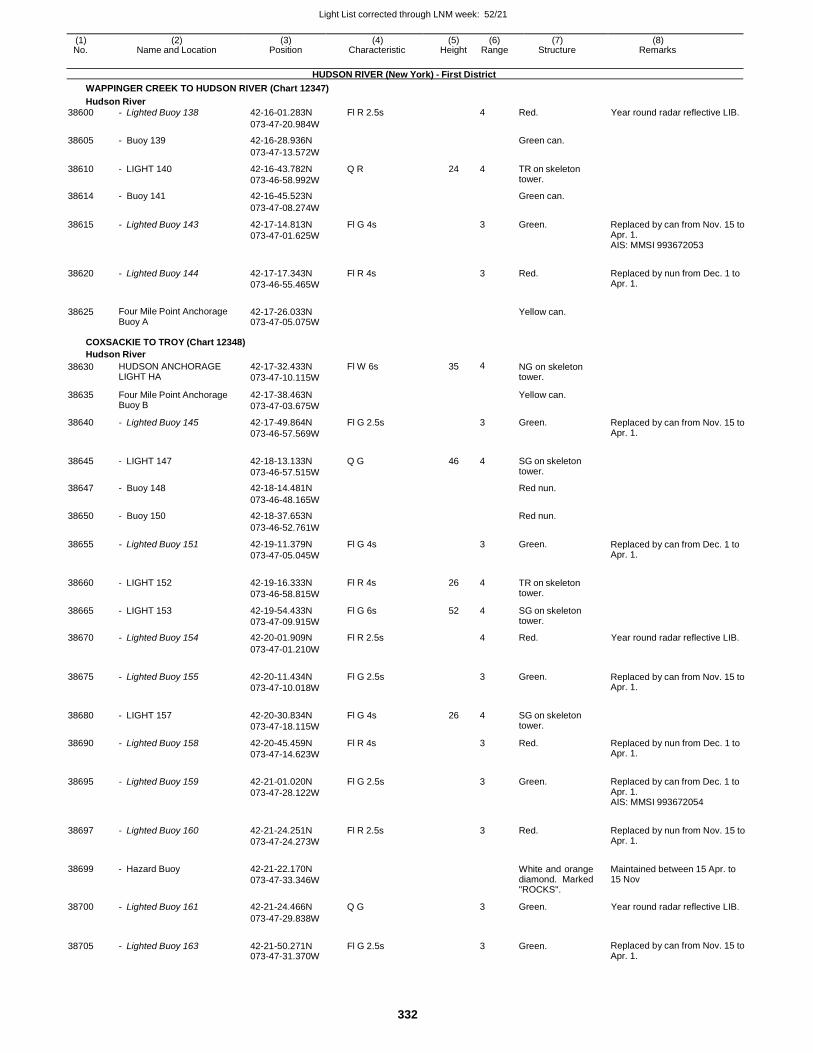
Light List corrected through LNM week: 52/21
332
(1) (2) (3) (4) (5) (6) (7) (8) No. Name and Location Position Characteristic Height Range Structure Remarks
HUDSON RIVER (New York) - First District
WAPPINGER CREEK TO HUDSON RIVER (Chart 12347)
Hudson River
38600 - Lighted Buoy 138 42-16-01.283N Fl R 2.5s 4 Red. Year round radar reflective LIB.
073-47-20.984W
38605 - Buoy 139 42-16-28.936N Green can.
073-47-13.572W
38610 - LIGHT 140 42-16-43.782N
073-46-58.992W
Q R 24 4 TR on skeleton tower.
38614 - Buoy 141 42-16-45.523N Green can.
073-47-08.274W
38615 - Lighted Buoy 143 42-17-14.813N
073-47-01.625W
Fl G 4s 3 Green. Replaced by can from Nov. 15 to Apr. 1. AIS: MMSI 993672053
38620 - Lighted Buoy 144 42-17-17.343N
073-46-55.465W
Fl R 4s
3 Red. Replaced by nun from Dec. 1 to Apr. 1.
38625 Four Mile Point Anchorage Buoy A
42-17-26.033N 073-47-05.075W
Yellow can.
COXSACKIE TO TROY (Chart 12348)
Hudson River
38630 HUDSON ANCHORAGE LIGHT HA
42-17-32.433N
073-47-10.115W
Fl W 6s 35 4 NG on skeleton tower.
38635 Four Mile Point Anchorage Buoy B
42-17-38.463N
073-47-03.675W
Yellow can.
38640 - Lighted Buoy 145 42-17-49.864N
073-46-57.569W
Fl G 2.5s 3 Green. Replaced by can from Nov. 15 to Apr. 1.
38645 - LIGHT 147 42-18-13.133N
073-46-57.515W
Q G 46 4 SG on skeleton tower.
38647 - Buoy 148 42-18-14.481N Red nun.
073-46-48.165W
38650 - Buoy 150 42-18-37.653N Red nun.
073-46-52.761W
38655 - Lighted Buoy 151 42-19-11.379N
073-47-05.045W
Fl G 4s 3 Green. Replaced by can from Dec. 1 to Apr. 1.
38660 - LIGHT 152 42-19-16.333N
073-46-58.815W
Fl R 4s 26 4 TR on skeleton tower.
38665 - LIGHT 153 42-19-54.433N
073-47-09.915W
Fl G 6s 52 4 SG on skeleton tower.
38670 - Lighted Buoy 154 42-20-01.909N Fl R 2.5s 4 Red. Year round radar reflective LIB.
073-47-01.210W
38675 - Lighted Buoy 155 42-20-11.434N
073-47-10.018W
Fl G 2.5s
3 Green. Replaced by can from Nov. 15 to Apr. 1.
38680 - LIGHT 157 42-20-30.834N
073-47-18.115W
Fl G 4s 26 4 SG on skeleton tower.
38690 - Lighted Buoy 158 42-20-45.459N
073-47-14.623W
Fl R 4s 3 Red. Replaced by nun from Dec. 1 to Apr. 1.
38695 - Lighted Buoy 159 42-21-01.020N
073-47-28.122W
Fl G 2.5s
3 Green. Replaced by can from Dec. 1 to Apr. 1. AIS: MMSI 993672054
38697 - Lighted Buoy 160 42-21-24.251N
073-47-24.273W
Fl R 2.5s
3 Red. Replaced by nun from Nov. 15 to Apr. 1.
38699 - Hazard Buoy 42-21-22.170N
073-47-33.346W
White and orange diamond. Marked "ROCKS".
Maintained between 15 Apr. to 15 Nov
38700 - Lighted Buoy 161 42-21-24.466N Q G 3 Green. Year round radar reflective LIB.
073-47-29.838W
38705 - Lighted Buoy 163 42-21-50.271N 073-47-31.370W
Fl G 2.5s
3 Green. Replaced by can from Nov. 15 to Apr. 1.
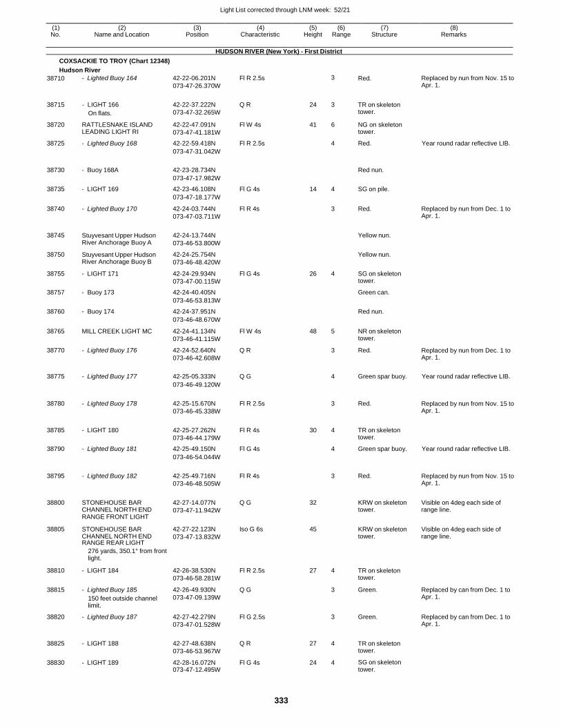
Light List corrected through LNM week: 52/21
333
(1) (2) (3) (4) (5) (6) (7) (8) No. Name and Location Position Characteristic Height Range Structure Remarks
HUDSON RIVER (New York) - First District
COXSACKIE TO TROY (Chart 12348)
Hudson River
38710 - Lighted Buoy 164 42-22-06.201N
073-47-26.370W
Fl R 2.5s 3 Red. Replaced by nun from Nov. 15 to Apr. 1.
38715 - LIGHT 166
On flats.
42-22-37.222N
073-47-32.265W
Q R 24 3 TR on skeleton tower.
38720 RATTLESNAKE ISLAND LEADING LIGHT RI
42-22-47.091N
073-47-41.181W
Fl W 4s 41 6 NG on skeleton tower.
38725 - Lighted Buoy 168 42-22-59.418N Fl R 2.5s 4 Red. Year round radar reflective LIB.
073-47-31.042W
38730 - Buoy 168A 42-23-28.734N
Red nun.
073-47-17.982W
38735 - LIGHT 169 42-23-46.108N Fl G 4s 14 4 SG on pile.
073-47-18.177W
38740 - Lighted Buoy 170 42-24-03.744N
073-47-03.711W
Fl R 4s 3 Red. Replaced by nun from Dec. 1 to Apr. 1.
38745 Stuyvesant Upper Hudson River Anchorage Buoy A
42-24-13.744N
073-46-53.800W
Yellow nun.
38750 Stuyvesant Upper Hudson River Anchorage Buoy B
42-24-25.754N
073-46-48.420W
Yellow nun.
38755 - LIGHT 171 42-24-29.934N
073-47-00.115W
Fl G 4s 26 4 SG on skeleton tower.
38757 - Buoy 173 42-24-40.405N Green can.
073-46-53.813W
38760 - Buoy 174 42-24-37.951N Red nun.
073-46-48.670W
38765 MILL CREEK LIGHT MC 42-24-41.134N
073-46-41.115W
Fl W 4s 48 5 NR on skeleton tower.
38770 - Lighted Buoy 176 42-24-52.640N
073-46-42.608W
Q R 3 Red. Replaced by nun from Dec. 1 to Apr. 1.
38775 - Lighted Buoy 177 42-25-05.333N Q G
4 Green spar buoy. Year round radar reflective LIB.
073-46-49.120W
38780 - Lighted Buoy 178 42-25-15.670N
073-46-45.338W
Fl R 2.5s
3 Red. Replaced by nun from Nov. 15 to Apr. 1.
38785 - LIGHT 180 42-25-27.262N
073-46-44.179W
Fl R 4s 30 4 TR on skeleton tower.
38790 - Lighted Buoy 181 42-25-49.150N Fl G 4s 4 Green spar buoy. Year round radar reflective LIB.
073-46-54.044W
38795 - Lighted Buoy 182 42-25-49.716N
073-46-48.505W
Fl R 4s
3 Red. Replaced by nun from Nov. 15 to Apr. 1.
38800 STONEHOUSE BAR CHANNEL NORTH END RANGE FRONT LIGHT
42-27-14.077N
073-47-11.942W
Q G 32
KRW on skeleton tower.
Visible on 4deg each side of range line.
38805 STONEHOUSE BAR CHANNEL NORTH END RANGE REAR LIGHT
42-27-22.123N
073-47-13.832W
Iso G 6s 45 KRW on skeleton tower.
Visible on 4deg each side of range line.
276 yards, 350.1° from front light.
38810 - LIGHT 184 42-26-38.530N
073-46-58.281W
Fl R 2.5s 27 4 TR on skeleton tower.
38815 - Lighted Buoy 185
150 feet outside channel limit.
42-26-49.930N
073-47-09.139W
Q G 3 Green. Replaced by can from Dec. 1 to Apr. 1.
38820 - Lighted Buoy 187 42-27-42.279N
073-47-01.528W
Fl G 2.5s 3 Green. Replaced by can from Dec. 1 to Apr. 1.
38825 - LIGHT 188 42-27-48.638N
073-46-53.967W
Q R 27 4 TR on skeleton tower.
38830 - LIGHT 189 42-28-16.072N 073-47-12.495W
Fl G 4s 24 4 SG on skeleton tower.
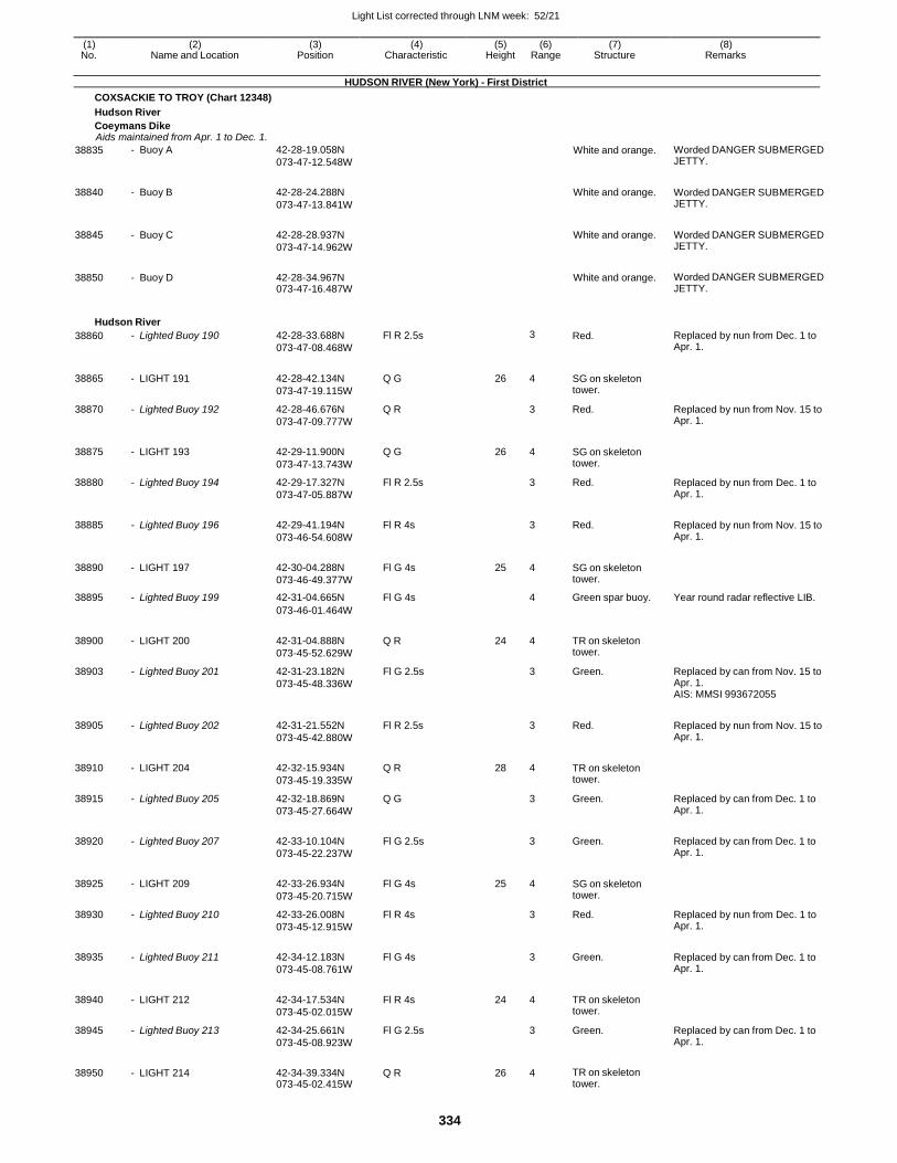
Light List corrected through LNM week: 52/21
334
(1) (2) (3) (4) (5) (6) (7) (8) No. Name and Location Position Characteristic Height Range Structure Remarks
HUDSON RIVER (New York) - First District
COXSACKIE TO TROY (Chart 12348)
Hudson River
Coeymans Dike Aids maintained from Apr. 1 to Dec. 1.
38835 - Buoy A 42-28-19.058N
073-47-12.548W White and orange. Worded DANGER SUBMERGED
JETTY.
38840 - Buoy B 42-28-24.288N
073-47-13.841W
White and orange. Worded DANGER SUBMERGED JETTY.
38845 - Buoy C 42-28-28.937N
073-47-14.962W
White and orange. Worded DANGER SUBMERGED JETTY.
38850 - Buoy D 42-28-34.967N 073-47-16.487W
White and orange. Worded DANGER SUBMERGED JETTY.
Hudson River
38860 - Lighted Buoy 190 42-28-33.688N
073-47-08.468W
Fl R 2.5s 3 Red. Replaced by nun from Dec. 1 to Apr. 1.
38865 - LIGHT 191 42-28-42.134N
073-47-19.115W
Q G 26 4 SG on skeleton tower.
38870 - Lighted Buoy 192 42-28-46.676N
073-47-09.777W
Q R 3 Red. Replaced by nun from Nov. 15 to Apr. 1.
38875 - LIGHT 193 42-29-11.900N
073-47-13.743W
Q G 26 4 SG on skeleton tower.
38880 - Lighted Buoy 194 42-29-17.327N
073-47-05.887W
Fl R 2.5s 3 Red. Replaced by nun from Dec. 1 to Apr. 1.
38885 - Lighted Buoy 196 42-29-41.194N
073-46-54.608W
Fl R 4s
3 Red. Replaced by nun from Nov. 15 to Apr. 1.
38890 - LIGHT 197 42-30-04.288N
073-46-49.377W
Fl G 4s 25 4 SG on skeleton tower.
38895 - Lighted Buoy 199 42-31-04.665N Fl G 4s 4 Green spar buoy. Year round radar reflective LIB.
073-46-01.464W
38900 - LIGHT 200 42-31-04.888N
073-45-52.629W
Q R 24 4 TR on skeleton tower.
38903 - Lighted Buoy 201 42-31-23.182N
073-45-48.336W
Fl G 2.5s 3 Green. Replaced by can from Nov. 15 to Apr. 1. AIS: MMSI 993672055
38905 - Lighted Buoy 202 42-31-21.552N
073-45-42.880W
Fl R 2.5s
3 Red. Replaced by nun from Nov. 15 to Apr. 1.
38910 - LIGHT 204 42-32-15.934N
073-45-19.335W
Q R 28 4 TR on skeleton tower.
38915 - Lighted Buoy 205 42-32-18.869N
073-45-27.664W
Q G 3 Green. Replaced by can from Dec. 1 to Apr. 1.
38920 - Lighted Buoy 207 42-33-10.104N
073-45-22.237W
Fl G 2.5s
3 Green. Replaced by can from Dec. 1 to Apr. 1.
38925 - LIGHT 209 42-33-26.934N
073-45-20.715W
Fl G 4s 25 4 SG on skeleton tower.
38930 - Lighted Buoy 210 42-33-26.008N
073-45-12.915W
Fl R 4s 3 Red. Replaced by nun from Dec. 1 to Apr. 1.
38935 - Lighted Buoy 211 42-34-12.183N
073-45-08.761W
Fl G 4s
3 Green. Replaced by can from Dec. 1 to Apr. 1.
38940 - LIGHT 212 42-34-17.534N
073-45-02.015W
Fl R 4s 24 4 TR on skeleton tower.
38945 - Lighted Buoy 213 42-34-25.661N
073-45-08.923W
Fl G 2.5s 3 Green. Replaced by can from Dec. 1 to Apr. 1.
38950 - LIGHT 214 42-34-39.334N 073-45-02.415W
Q R 26 4 TR on skeleton tower.
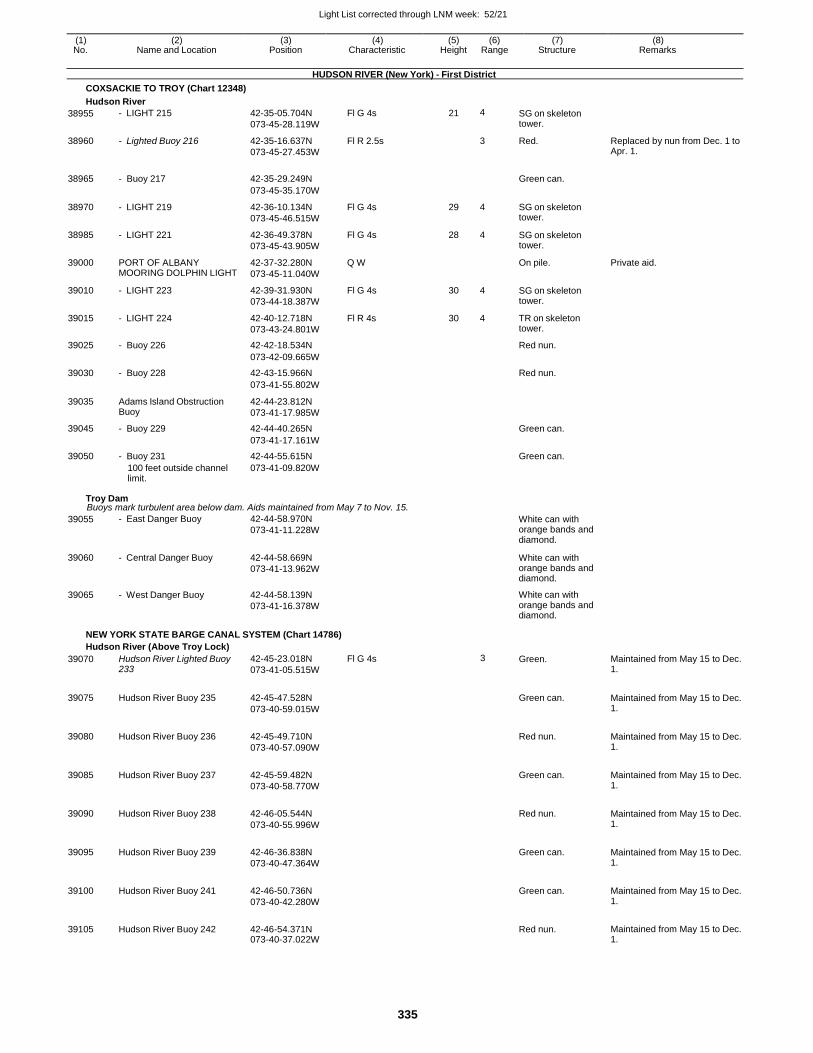
Light List corrected through LNM week: 52/21
335
(1) (2) (3) (4) (5) (6) (7) (8) No. Name and Location Position Characteristic Height Range Structure Remarks
HUDSON RIVER (New York) - First District
COXSACKIE TO TROY (Chart 12348)
Hudson River
38955 - LIGHT 215 42-35-05.704N
073-45-28.119W
Fl G 4s 21 4 SG on skeleton tower.
38960 - Lighted Buoy 216 42-35-16.637N
073-45-27.453W
Fl R 2.5s 3 Red. Replaced by nun from Dec. 1 to Apr. 1.
38965 - Buoy 217 42-35-29.249N
Green can.
073-45-35.170W
38970 - LIGHT 219 42-36-10.134N
073-45-46.515W
Fl G 4s 29 4 SG on skeleton tower.
38985 - LIGHT 221 42-36-49.378N
073-45-43.905W
Fl G 4s 28 4 SG on skeleton tower.
39000 PORT OF ALBANY MOORING DOLPHIN LIGHT
42-37-32.280N
073-45-11.040W
Q W On pile. Private aid.
39010 - LIGHT 223 42-39-31.930N
073-44-18.387W
Fl G 4s 30 4 SG on skeleton tower.
39015 - LIGHT 224 42-40-12.718N
073-43-24.801W
Fl R 4s 30 4 TR on skeleton tower.
39025 - Buoy 226 42-42-18.534N Red nun.
073-42-09.665W
39030 - Buoy 228 42-43-15.966N Red nun.
073-41-55.802W
39035 Adams Island Obstruction Buoy
42-44-23.812N
073-41-17.985W
39045 - Buoy 229 42-44-40.265N Green can.
073-41-17.161W
39050 - Buoy 231 42-44-55.615N Green can.
100 feet outside channel limit.
073-41-09.820W
Troy Dam Buoys mark turbulent area below dam. Aids maintained from May 7 to Nov. 15.
39055 - East Danger Buoy 42-44-58.970N
073-41-11.228W White can with orange bands and diamond.
39060 - Central Danger Buoy 42-44-58.669N
073-41-13.962W
White can with orange bands and diamond.
39065 - West Danger Buoy 42-44-58.139N
073-41-16.378W
White can with orange bands and diamond.
NEW YORK STATE BARGE CANAL SYSTEM (Chart 14786)
Hudson River (Above Troy Lock)
39070 Hudson River Lighted Buoy 233
42-45-23.018N
073-41-05.515W
Fl G 4s 3 Green. Maintained from May 15 to Dec. 1.
39075 Hudson River Buoy 235 42-45-47.528N
073-40-59.015W
Green can. Maintained from May 15 to Dec.
1.
39080 Hudson River Buoy 236 42-45-49.710N
073-40-57.090W
Red nun. Maintained from May 15 to Dec.
1.
39085 Hudson River Buoy 237 42-45-59.482N
073-40-58.770W
Green can. Maintained from May 15 to Dec.
1.
39090 Hudson River Buoy 238 42-46-05.544N
073-40-55.996W
Red nun. Maintained from May 15 to Dec.
1.
39095 Hudson River Buoy 239 42-46-36.838N
073-40-47.364W
Green can. Maintained from May 15 to Dec.
1.
39100 Hudson River Buoy 241 42-46-50.736N
073-40-42.280W
Green can. Maintained from May 15 to Dec.
1.
39105 Hudson River Buoy 242 42-46-54.371N 073-40-37.022W
Red nun. Maintained from May 15 to Dec.
1.
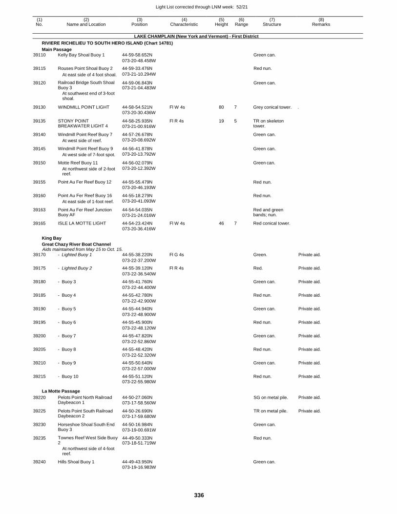
Light List corrected through LNM week: 52/21
336
(1) (2) (3) (4) (5) (6) (7) (8) No. Name and Location Position Characteristic Height Range Structure Remarks
LAKE CHAMPLAIN (New York and Vermont) - First District
RIVIERE RICHELIEU TO SOUTH HERO ISLAND (Chart 14781)
Main Passage
39110 Kelly Bay Shoal Buoy 1 44-59-58.652N Green can.
073-20-48.458W
39115 Rouses Point Shoal Buoy 2 44-59-33.476N Red nun.
At east side of 4 foot shoal. 073-21-10.294W
39120 Railroad Bridge South Shoal Buoy 3
44-59-06.843N 073-21-04.483W
Green can.
At southwest end of 3-foot shoal.
39130
39135
39140
39145
39150
39155
39160
39163
39165
WINDMILL POINT LIGHT
STONY POINT BREAKWATER LIGHT 4
Windmill Point Reef Buoy 7
At west side of reef.
Windmill Point Reef Buoy 9
At west side of 7-foot spot.
Motte Reef Buoy 11
At northwest side of 2-foot reef.
Point Au Fer Reef Buoy 12
Point Au Fer Reef Buoy 16
At east side of 1-foot reef.
Point Au Fer Reef Junction Buoy AF
ISLE LA MOTTE LIGHT
44-58-54.521N
073-20-30.436W
44-58-25.935N
073-21-00.916W
44-57-26.678N
073-20-08.692W
44-56-41.878N
073-20-13.792W
44-56-02.079N
073-20-12.392W
44-55-55.479N
073-20-46.193W
44-55-18.279N
073-20-41.093W
44-54-54.035N
073-21-24.016W
44-54-23.424N
073-20-36.416W
Fl W 4s
Fl R 4s
Fl W 4s
80 7
19 5
46 7
Grey conical tower. .
TR on skeleton tower.
Green can.
Green can.
Green can.
Red nun.
Red nun.
Red and green bands; nun.
Red conical tower.
King Bay
Great Chazy River Boat Channel Aids maintained from May 15 to Oct. 15.
39170 - Lighted Buoy 1 44-55-38.220N Fl G 4s Green. Private aid.
073-22-37.200W
39175 - Lighted Buoy 2 44-55-39.120N Fl R 4s Red. Private aid.
073-22-36.540W
39180 - Buoy 3 44-55-41.760N Green can. Private aid.
073-22-44.400W
39185 - Buoy 4 44-55-42.780N Red nun. Private aid.
073-22-42.900W
39190 - Buoy 5 44-55-44.940N Green can. Private aid.
073-22-48.900W
39195 - Buoy 6 44-55-45.900N Red nun. Private aid.
073-22-48.120W
39200 - Buoy 7 44-55-47.820N Green can. Private aid.
073-22-52.860W
39205 - Buoy 8 44-55-48.420N Red nun. Private aid.
073-22-52.320W
39210 - Buoy 9 44-55-50.640N Green can. Private aid.
073-22-57.000W
39215 - Buoy 10 44-55-51.120N Red nun. Private aid. 073-22-55.980W
La Motte Passage
39220 Pelots Point North Railroad Daybeacon 1
44-50-27.060N
073-17-58.560W
SG on metal pile. Private aid.
39225 Pelots Point South Railroad Daybeacon 2
44-50-26.690N
073-17-59.680W
TR on metal pile. Private aid.
39230 Horseshoe Shoal South End Buoy 3
44-50-16.984N
073-19-00.691W
Green can.
39235 Townes Reef West Side Buoy 2
44-49-50.333N 073-18-51.719W
Red nun.
At northwest side of 4-foot reef.
39240 Hills Shoal Buoy 1 44-49-43.950N Green can. 073-19-16.983W
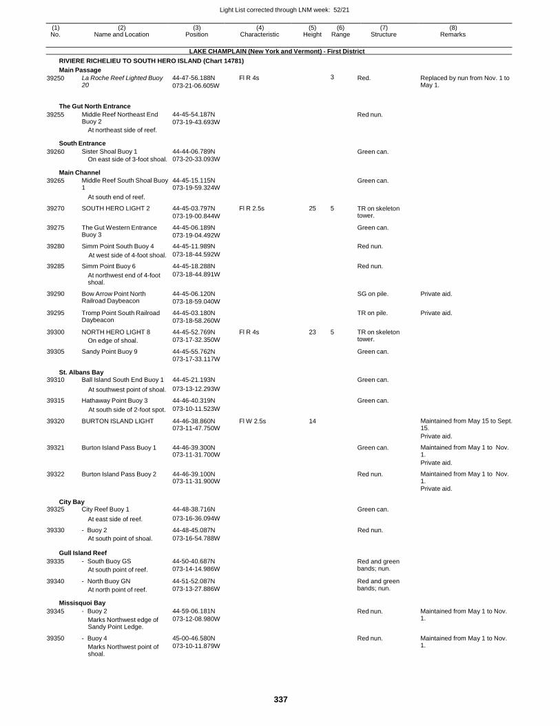
Light List corrected through LNM week: 52/21
337
(1) (2) (3) (4) (5) (6) (7) (8) No. Name and Location Position Characteristic Height Range Structure Remarks
LAKE CHAMPLAIN (New York and Vermont) - First District
RIVIERE RICHELIEU TO SOUTH HERO ISLAND (Chart 14781)
Main Passage
39250 La Roche Reef Lighted Buoy 20
44-47-56.188N
073-21-06.605W
Fl R 4s 3 Red. Replaced by nun from Nov. 1 to May 1.
The Gut North Entrance
39255 Middle Reef Northeast End Buoy 2
At northeast side of reef.
44-45-54.187N
073-19-43.693W Red nun.
South Entrance
39260 Sister Shoal Buoy 1
On east side of 3-foot shoal.
44-44-06.789N
073-20-33.093W Green can.
Main Channel
39265 Middle Reef South Shoal Buoy 1
44-45-15.115N 073-19-59.324W
Green can.
At south end of reef.
39270 SOUTH HERO LIGHT 2 44-45-03.797N
073-19-00.844W
Fl R 2.5s 25 5 TR on skeleton tower.
39275 The Gut Western Entrance Buoy 3
44-45-06.189N
073-19-04.492W
Green can.
39280 Simm Point South Buoy 4 44-45-11.989N Red nun.
At west side of 4-foot shoal. 073-18-44.592W
39285 Simm Point Buoy 6 44-45-18.288N Red nun.
At northwest end of 4-foot shoal.
073-18-44.891W
39290 Bow Arrow Point North Railroad Daybeacon
44-45-06.120N
073-18-59.040W
SG on pile. Private aid.
39295 Tromp Point South Railroad Daybeacon
44-45-03.180N
073-18-58.260W
TR on pile. Private aid.
39300 NORTH HERO LIGHT 8
On edge of shoal.
44-45-52.769N
073-17-32.350W
Fl R 4s 23 5 TR on skeleton tower.
39305 Sandy Point Buoy 9 44-45-55.762N Green can.
073-17-33.117W
St. Albans Bay 39310 Ball Island South End Buoy 1 44-45-21.193N Green can.
At southwest point of shoal. 073-13-12.293W
39315 Hathaway Point Buoy 3 44-46-40.319N Green can.
At south side of 2-foot spot. 073-10-11.523W
39320 BURTON ISLAND LIGHT 44-46-38.860N 073-11-47.750W
Fl W 2.5s 14 Maintained from May 15 to Sept. 15.
Private aid.
39321 Burton Island Pass Buoy 1 44-46-39.300N 073-11-31.700W
Green can. Maintained from May 1 to Nov. 1.
Private aid.
39322 Burton Island Pass Buoy 2 44-46-39.100N 073-11-31.900W
Red nun. Maintained from May 1 to Nov. 1.
Private aid.
City Bay 39325 City Reef Buoy 1 44-48-38.716N Green can.
At east side of reef. 073-16-36.094W
39330 - Buoy 2 44-48-45.087N Red nun. At south point of shoal. 073-16-54.788W
Gull Island Reef
39335
39340
- South Buoy GS
At south point of reef.
- North Buoy GN
At north point of reef.
44-50-40.687N
073-14-14.986W
44-51-52.087N
073-13-27.886W
Red and green bands; nun.
Red and green bands; nun.
Missisquoi Bay
39345
39350
- Buoy 2
Marks Northwest edge of Sandy Point Ledge.
- Buoy 4
Marks Northwest point of shoal.
44-59-06.181N
073-12-08.980W
45-00-46.580N
073-10-11.879W
Red nun.
Red nun.
Maintained from May 1 to Nov. 1.
Maintained from May 1 to Nov. 1.
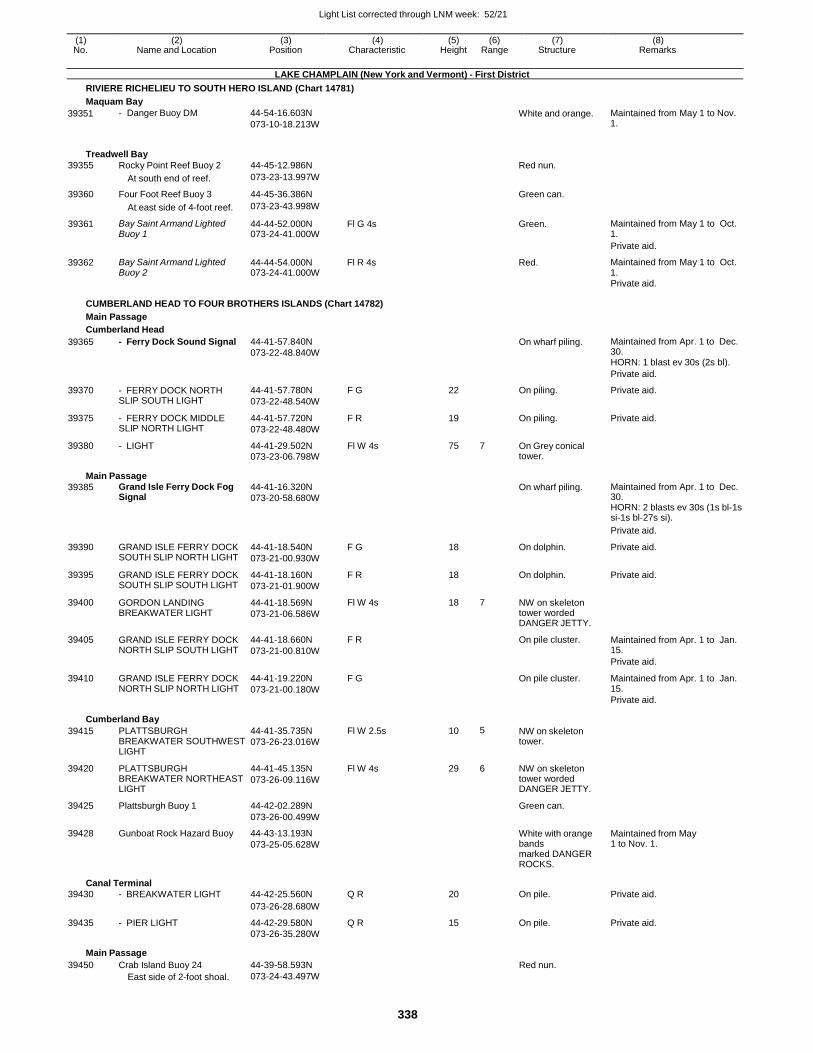
Light List corrected through LNM week: 52/21
338
(1) (2) (3) (4) (5) (6) (7) (8) No. Name and Location Position Characteristic Height Range Structure Remarks
LAKE CHAMPLAIN (New York and Vermont) - First District
RIVIERE RICHELIEU TO SOUTH HERO ISLAND (Chart 14781)
Maquam Bay
39351 - Danger Buoy DM 44-54-16.603N
073-10-18.213W White and orange. Maintained from May 1 to Nov.
1.
Treadwell Bay
39355 Rocky Point Reef Buoy 2 44-45-12.986N Red nun.
At south end of reef. 073-23-13.997W
39360 Four Foot Reef Buoy 3 44-45-36.386N Green can.
At east side of 4-foot reef. 073-23-43.998W
39361 Bay Saint Armand Lighted Buoy 1
44-44-52.000N 073-24-41.000W
Fl G 4s Green. Maintained from May 1 to Oct. 1.
Private aid.
39362 Bay Saint Armand Lighted Buoy 2
44-44-54.000N 073-24-41.000W
Fl R 4s Red. Maintained from May 1 to Oct. 1.
Private aid.
CUMBERLAND HEAD TO FOUR BROTHERS ISLANDS (Chart 14782)
Main Passage
Cumberland Head
39365 - Ferry Dock Sound Signal 44-41-57.840N
073-22-48.840W On wharf piling. Maintained from Apr. 1 to Dec.
30. HORN: 1 blast ev 30s (2s bl).
Private aid.
39370 - FERRY DOCK NORTH SLIP SOUTH LIGHT
44-41-57.780N
073-22-48.540W
F G 22 On piling. Private aid.
39375 - FERRY DOCK MIDDLE SLIP NORTH LIGHT
44-41-57.720N
073-22-48.480W
F R 19 On piling. Private aid.
39380 - LIGHT 44-41-29.502N 073-23-06.798W
Fl W 4s 75 7 On Grey conical tower.
Main Passage
39385 Grand Isle Ferry Dock Fog Signal
44-41-16.320N
073-20-58.680W On wharf piling. Maintained from Apr. 1 to Dec.
30. HORN: 2 blasts ev 30s (1s bl-1s si-1s bl-27s si).
Private aid.
39390 GRAND ISLE FERRY DOCK SOUTH SLIP NORTH LIGHT
44-41-18.540N
073-21-00.930W
F G 18 On dolphin. Private aid.
39395 GRAND ISLE FERRY DOCK SOUTH SLIP SOUTH LIGHT
44-41-18.160N
073-21-01.900W
F R 18 On dolphin. Private aid.
39400 GORDON LANDING BREAKWATER LIGHT
44-41-18.569N
073-21-06.586W
Fl W 4s 18 7 NW on skeleton tower worded DANGER JETTY.
39405 GRAND ISLE FERRY DOCK NORTH SLIP SOUTH LIGHT
44-41-18.660N
073-21-00.810W
F R On pile cluster. Maintained from Apr. 1 to Jan. 15.
Private aid.
39410 GRAND ISLE FERRY DOCK NORTH SLIP NORTH LIGHT
44-41-19.220N
073-21-00.180W
F G On pile cluster. Maintained from Apr. 1 to Jan. 15.
Private aid.
Cumberland Bay
39415 PLATTSBURGH BREAKWATER SOUTHWEST LIGHT
44-41-35.735N
073-26-23.016W
Fl W 2.5s 10 5 NW on skeleton tower.
39420 PLATTSBURGH BREAKWATER NORTHEAST LIGHT
44-41-45.135N
073-26-09.116W
Fl W 4s 29 6 NW on skeleton tower worded DANGER JETTY.
39425 Plattsburgh Buoy 1 44-42-02.289N Green can.
073-26-00.499W
39428 Gunboat Rock Hazard Buoy 44-43-13.193N
073-25-05.628W
White with orange bands marked DANGER ROCKS.
Maintained from May 1 to Nov. 1.
Canal Terminal
39430 - BREAKWATER LIGHT 44-42-25.560N Q R 20 On pile. Private aid.
073-26-28.680W
39435 - PIER LIGHT 44-42-29.580N Q R 15 On pile. Private aid. 073-26-35.280W
Main Passage
39450 Crab Island Buoy 24 44-39-58.593N Red nun. East side of 2-foot shoal. 073-24-43.497W
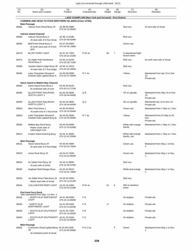
Light List corrected through LNM week: 52/21
339
(1) (2) (3) (4) (5) (6) (7) (8) No. Name and Location Position Characteristic Height Range Structure Remarks
LAKE CHAMPLAIN (New York and Vermont) - First District
CUMBERLAND HEAD TO FOUR BROTHERS ISLANDS (Chart 14782)
Main Passage
39455 Valcour East Shoal Buoy 26 44-38-00.598N 073-24-12.806W
Red nun. At east side of shoal.
Valcour Island Channel
39460 Valcour Shoal Buoy 2 44-38-12.818N Red nun.
At east side of 5-foot shoal. 073-25-49.929W
39465 Bluff Point Shoal Buoy 3 44-37-39.596N Green can.
At north west side of 5-foot spot.
073-25-56.198W
39470 BLUFF POINT LIGHT 44-37-24.735N
073-25-52.316W
Fl W 4s 95 7 In abandoned light house tower.
39475 Au Sable Point Northwest Shoal Buoy 4
44-35-14.624N
073-25-29.715W
Red nun. At north east side of shoal.
39480 Garden Island Ledge Buoy 28 44-36-12.281N Red nun.
At east side of 7-foot ledge. 073-24-15.495W
39482 Lake Champlain Research Institute Data Lighted Buoy A
44-36-09.000N 073-23-37.000W
Fl Y 4s Yellow. Maintained from Apr 15 to Dec 15.
Private aid.
Stave Island to Mallets Bay Channel
39485 Stave Island Rock Buoy 2 44-35-55.841N Red nun.
At northeast side of rock. 073-20-13.722W
39490 ALLEN POINT RAILROAD SOUTH LIGHT 2
44-35-28.580N 073-18-44.940W
Q R TR on spindle. Maintained from May 15 to Nov. 15.
Private aid.
39495 ALLEN POINT RAILROAD NORTH LIGHT 1
44-35-30.280N
073-18-44.400W
Q G SG on spindle. Maintained Apr 15 to Nov 15.
Private aid.
39500 Allen Point Buoy 1 44-35-29.991N Green can. Maintained from 1 May to 1 Nov.
At south end of 1-foot shoal. 073-18-20.834W
39503 Lake Champlain Research Institute Data Lighted Buoy B
44-34-55.000N 073-16-53.000W
Fl Y 4s Yellow. Maintained from 01 May to 30 Nov.
Private aid.
39505 Mallets Bay Rock Buoy
Marks south side of submerged rock.
44-34-26.909N
073-12-23.626W
White with orange bands.
Maintained from 1 May to 1 Nov.
39510 Coates Island Warning Buoy 44-33-31.855N 073-13-41.295W
White with orange bands; can.
Maintained from 1 May to 1 Nov.
Main Passage
39515 Stave Island Buoy 29
At west side of 4-foot ledge.
44-35-00.408N
073-20-24.792W
Green can. Maintained from May 1 to Nov. 1.
39520 Jones Rock Buoy 31 44-34-42.784N
073-20-24.955W
Green can. Maintained from May 1 to Nov.
1.
39525 Au Sable Point Buoy 32 44-34-12.869N
Red nun.
At east side of shoal. 073-24-46.576W
39530 Hogback Reef Danger Buoy 44-33-32.961N
073-19-31.768W
White and orange. Maintained from May 1 to Nov. 1.
39535 Au Sable River Flats Buoy 34 44-33-02.945N
Red nun.
Marks east side of shoal. 073-24-13.012W
39540 COLCHESTER REEF LIGHT 44-33-18.435N 073-19-44.316W
Fl W 4s 51 6 NW on skeleton tower.
Port Kent Ferry Dock Aids maintained from May 1 to Nov. 1.
39545 - NORTH SLIP NORTHEAST LIGHT
44-31-38.400N
073-24-13.060W
F G On dolphin. Private aid.
39550 - NORTH SLIP NORTHWEST LIGHT
44-31-39.540N
073-24-13.920W
F R 17 On dolphin. Private aid.
39555 - SOUTH SLIP SOUTHEAST LIGHT
44-31-34.740N
073-24-10.920W
F R On dolphin. Private aid.
39560 - SOUTH SLIP SOUTHWEST LIGHT
44-31-33.540N 073-24-10.800W
F G On dolphin. Private aid.
Main Passage
39565 Colchester Shoal Lighted Buoy 44-32-58.105N Fl G 2.5s 3 Green. Maintained from May 1 to Nov. 35
At northwest point of shoal.
073-20-05.588W 1.
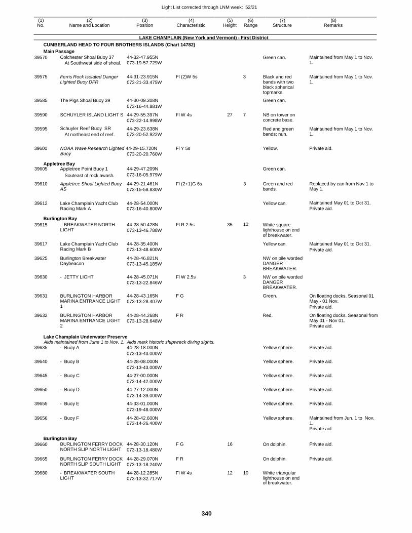
Light List corrected through LNM week: 52/21
340
(1) (2) (3) (4) (5) (6) (7) (8) No. Name and Location Position Characteristic Height Range Structure Remarks
LAKE CHAMPLAIN (New York and Vermont) - First District
CUMBERLAND HEAD TO FOUR BROTHERS ISLANDS (Chart 14782)
Main Passage
39570 Colchester Shoal Buoy 37
At Southwest side of shoal.
44-32-47.955N
073-19-57.729W Green can. Maintained from May 1 to Nov.
1.
39575
Ferris Rock Isolated Danger Lighted Buoy DFR
44-31-23.915N
073-21-33.475W
Fl (2)W 5s
3
Black and red bands with two black spherical topmarks.
Maintained from May 1 to Nov. 1.
39585 The Pigs Shoal Buoy 39 44-30-09.308N Green can.
073-16-44.881W
39590 SCHUYLER ISLAND LIGHT S 44-29-55.397N
073-22-14.998W
Fl W 4s 27 7 NB on tower on concrete base.
39595 Schuyler Reef Buoy SR
At northeast end of reef.
44-29-23.638N
073-20-52.922W
Red and green bands; nun.
Maintained from May 1 to Nov. 1.
39600 NOAA Wave Research Lighted 44-29-15.720N Fl Y 5s Yellow. Private aid. Buoy
Appletree Bay
073-20-20.760W
39605 Appletree Point Buoy 1 44-29-47.209N Green can.
Souteast of rock awash. 073-16-05.979W
39610 Appletree Shoal Lighted Buoy AS
44-29-21.461N
073-15-58.830W
Fl (2+1)G 6s 3 Green and red bands.
Replaced by can from Nov 1 to May 1.
39612 Lake Champlain Yacht Club Racing Mark A
44-28-54.000N 073-16-40.800W
Yellow can. Maintained May 01 to Oct 31.
Private aid.
Burlington Bay
39615 - BREAKWATER NORTH LIGHT
44-28-50.428N
073-13-46.788W
Fl R 2.5s 35 12 White square lighthouse on end of breakwater.
39617 Lake Champlain Yacht Club Racing Mark B
44-28-35.400N
073-13-48.600W
Yellow can. Maintained May 01 to Oct 31.
Private aid.
39625 Burlington Breakwater Daybeacon
44-28-46.821N
073-13-45.185W
NW on pile worded DANGER BREAKWATER.
39630 - JETTY LIGHT 44-28-45.071N
073-13-22.846W
Fl W 2.5s 3 NW on pile worded DANGER BREAKWATER.
39631 BURLINGTON HARBOR MARINA ENTRANCE LIGHT 1
44-28-43.165N
073-13-28.407W
F G Green. On floating docks. Seasonal 01 May - 01 Nov.
Private aid.
39632 BURLINGTON HARBOR MARINA ENTRANCE LIGHT 2
44-28-44.268N
073-13-28.648W
F R Red. On floating docks. Seasonal from May 01 - Nov 01. Private aid.
Lake Champlain Underwater Preserve Aids maintained from June 1 to Nov. 1. Aids mark historic shipwreck diving sights.
39635 - Buoy A 44-28-18.000N Yellow sphere. Private aid.
073-13-43.000W
39640 - Buoy B 44-28-08.000N Yellow sphere. Private aid.
073-13-43.000W
39645 - Buoy C 44-27-00.000N Yellow sphere. Private aid.
073-14-42.000W
39650 - Buoy D 44-27-12.000N Yellow sphere. Private aid.
073-14-39.000W
39655 - Buoy E 44-33-01.000N Yellow sphere. Private aid.
073-19-48.000W
39656 - Buoy F 44-28-42.600N 073-14-26.400W
Yellow sphere. Maintained from Jun. 1 to Nov. 1.
Private aid.
Burlington Bay
39660 BURLINGTON FERRY DOCK NORTH SLIP NORTH LIGHT
44-28-30.120N
073-13-18.480W
F G 16 On dolphin. Private aid.
39665 BURLINGTON FERRY DOCK NORTH SLIP SOUTH LIGHT
44-28-29.070N
073-13-18.240W
F R On dolphin. Private aid.
39680 - BREAKWATER SOUTH LIGHT
44-28-12.285N
073-13-32.717W
Fl W 4s 12 10 White triangular lighthouse on end of breakwater.
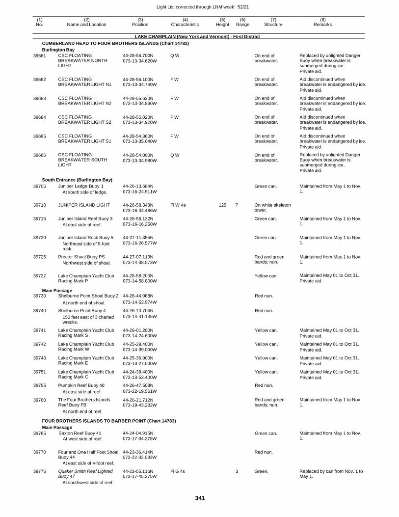
Light List corrected through LNM week: 52/21
341
(1) (2) (3) (4) (5) (6) (7) (8) No. Name and Location Position Characteristic Height Range Structure Remarks
LAKE CHAMPLAIN (New York and Vermont) - First District
CUMBERLAND HEAD TO FOUR BROTHERS ISLANDS (Chart 14782)
Burlington Bay
39681 CSC FLOATING BREAKWATER NORTH LIGHT
44-28-56.700N
073-13-34.620W
Q W On end of breakwater.
Replaced by unlighted Danger Buoy when breakwater is submerged during ice.
Private aid.
39682 CSC FLOATING BREAKWATER LIGHT N1
44-28-56.100N 073-13-34.740W
F W On end of breakwater.
Aid discontinued when breakwater is endangered by ice.
Private aid.
39683 CSC FLOATING BREAKWATER LIGHT N2
44-28-55.620N 073-13-34.860W
F W On end of breakwater.
Aid discontinued when breakwater is endangered by ice.
Private aid.
39684 CSC FLOATING BREAKWATER LIGHT S2
44-28-55.020N 073-13-34.920W
F W On end of breakwater.
Aid discontinued when breakwater is endangered by ice.
Private aid.
39685 CSC FLOATING BREAKWATER LIGHT S1
44-28-54.360N 073-13-35.040W
F W On end of breakwater.
Aid discontinued when breakwater is endangered by ice.
Private aid.
39686 CSC FLOATING BREAKWATER SOUTH LIGHT
44-28-54.000N
073-13-34.980W
Q W On end of breakwater.
Replaced by unlighted Danger Buoy when breakwater is submerged during ice.
Private aid.
South Entrance (Burlington Bay)
39705 Juniper Ledge Buoy 1
At south side of ledge.
44-26-13.684N
073-16-24.911W
Green can. Maintained from May 1 to Nov. 1.
39710 JUNIPER ISLAND LIGHT 44-26-58.343N
073-16-34.486W
Fl W 4s 125 7 On white skeleton tower.
39715 Juniper Island Reef Buoy 3
At east side of reef.
44-26-56.132N
073-16-16.250W
Green can. Maintained from May 1 to Nov. 1.
39720 Juniper Island Rock Buoy 5
Northeast side of 5-foot rock.
44-27-11.355N
073-16-26.577W
Green can. Maintained from May 1 to Nov.
1.
39725 Proctor Shoal Buoy PS
Northwest side of shoal.
44-27-07.113N
073-14-38.573W
Red and green bands; nun.
Maintained from May 1 to Nov. 1.
39727 Lake Champlain Yacht Club Racing Mark P
44-26-58.200N 073-14-58.800W
Yellow can. Maintained May 01 to Oct 31.
Private aid.
Main Passage 39730 Shelburne Point Shoal Buoy 2 44-26-44.088N Red nun.
At north end of shoal. 073-14-53.974W
39740 Shelburne Point Buoy 4 44-26-10.704N Red nun.
150 feet east of 3 charted wrecks.
073-14-41.135W
39741 Lake Champlain Yacht Club Racing Mark S
44-26-01.200N
073-14-24.600W
Yellow can. Maintained May 01 to Oct 31.
Private aid.
39742 Lake Champlain Yacht Club Racing Mark W
44-25-29.400N
073-14-39.000W
Yellow can. Maintained May 01 to Oct 31.
Private aid.
39743 Lake Champlain Yacht Club Racing Mark E
44-25-36.000N
073-13-27.000W
Yellow can. Maintained May 01 to Oct 31.
Private aid.
39751 Lake Champlain Yacht Club Racing Mark C
44-24-38.400N
073-13-53.400W
Yellow can. Maintained May 01 to Oct 31.
Private aid.
39755 Pumpkin Reef Buoy 40 44-26-47.508N Red nun.
At east side of reef. 073-22-19.561W
39760 The Four Brothers Islands Reef Buoy FB
44-26-21.712N 073-19-43.282W
Red and green bands; nun.
Maintained from May 1 to Nov. 1.
At north end of reef.
FOUR BROTHERS ISLANDS TO BARBER POINT (Chart 14783)
Main Passage
39765 Saxton Reef Buoy 41
At west side of reef.
44-24-04.915N
073-17-04.275W Green can. Maintained from May 1 to Nov.
1.
39770
Four and One Half Foot Shoal Buoy 44
44-23-36.414N 073-22-02.083W
Red nun.
At east side of 4-foot reef.
39775 Quaker Smith Reef Lighted Buoy 47
44-23-05.116N 073-17-45.275W
Fl G 4s 3 Green. Replaced by can from Nov. 1 to May 1.
At southwest side of reef.
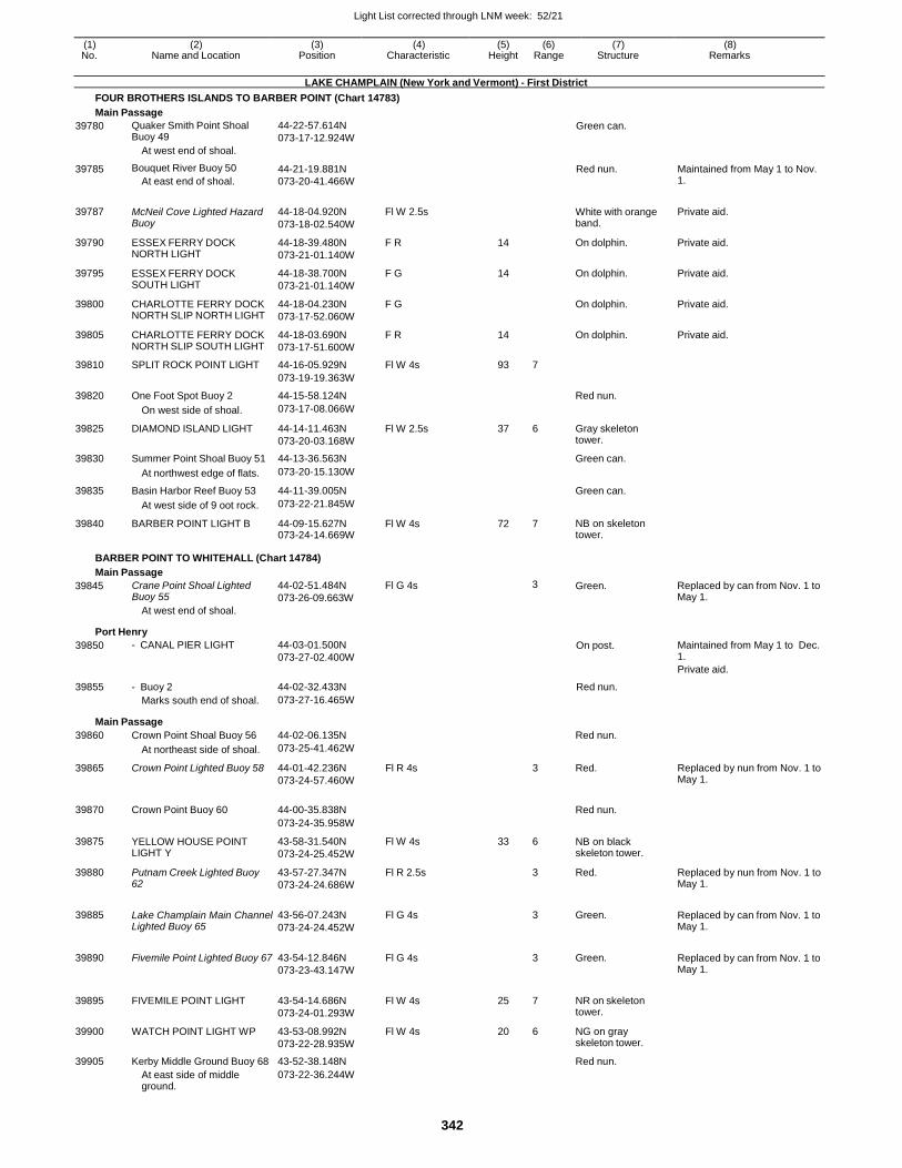
Light List corrected through LNM week: 52/21
342
(1) (2) (3) (4) (5) (6) (7) (8) No. Name and Location Position Characteristic Height Range Structure Remarks
LAKE CHAMPLAIN (New York and Vermont) - First District
FOUR BROTHERS ISLANDS TO BARBER POINT (Chart 14783)
Main Passage
39780 Quaker Smith Point Shoal Buoy 49
At west end of shoal.
44-22-57.614N
073-17-12.924W Green can.
39785 Bouquet River Buoy 50
At east end of shoal.
44-21-19.881N
073-20-41.466W
Red nun. Maintained from May 1 to Nov. 1.
39787
McNeil Cove Lighted Hazard Buoy
44-18-04.920N
073-18-02.540W
Fl W 2.5s
White with orange band.
Private aid.
39790 ESSEX FERRY DOCK NORTH LIGHT
44-18-39.480N
073-21-01.140W
F R 14 On dolphin. Private aid.
39795 ESSEX FERRY DOCK SOUTH LIGHT
44-18-38.700N
073-21-01.140W
F G 14 On dolphin. Private aid.
39800 CHARLOTTE FERRY DOCK NORTH SLIP NORTH LIGHT
44-18-04.230N
073-17-52.060W
F G On dolphin. Private aid.
39805 CHARLOTTE FERRY DOCK NORTH SLIP SOUTH LIGHT
44-18-03.690N
073-17-51.600W
F R 14 On dolphin. Private aid.
39810 SPLIT ROCK POINT LIGHT 44-16-05.929N Fl W 4s 93 7
073-19-19.363W
39820 One Foot Spot Buoy 2 44-15-58.124N Red nun.
On west side of shoal. 073-17-08.066W
39825 DIAMOND ISLAND LIGHT 44-14-11.463N
073-20-03.168W
Fl W 2.5s 37 6 Gray skeleton tower.
39830 Summer Point Shoal Buoy 51 44-13-36.563N Green can.
At northwest edge of flats. 073-20-15.130W
39835 Basin Harbor Reef Buoy 53 44-11-39.005N Green can.
At west side of 9 oot rock. 073-22-21.845W
39840 BARBER POINT LIGHT B 44-09-15.627N 073-24-14.669W
Fl W 4s 72 7 NB on skeleton tower.
BARBER POINT TO WHITEHALL (Chart 14784)
Main Passage
39845 Crane Point Shoal Lighted Buoy 55
At west end of shoal.
44-02-51.484N
073-26-09.663W
Fl G 4s 3 Green. Replaced by can from Nov. 1 to May 1.
Port Henry
39850 - CANAL PIER LIGHT 44-03-01.500N
073-27-02.400W On post. Maintained from May 1 to Dec.
1.
Private aid.
39855 - Buoy 2 44-02-32.433N Red nun.
Marks south end of shoal. 073-27-16.465W
Main Passage
39860 Crown Point Shoal Buoy 56 44-02-06.135N Red nun.
At northeast side of shoal. 073-25-41.462W
39865 Crown Point Lighted Buoy 58 44-01-42.236N
073-24-57.460W
Fl R 4s 3 Red. Replaced by nun from Nov. 1 to May 1.
39870 Crown Point Buoy 60 44-00-35.838N
Red nun.
073-24-35.958W
39875 YELLOW HOUSE POINT LIGHT Y
43-58-31.540N
073-24-25.452W
Fl W 4s 33 6 NB on black skeleton tower.
39880 Putnam Creek Lighted Buoy 62
43-57-27.347N
073-24-24.686W
Fl R 2.5s 3 Red. Replaced by nun from Nov. 1 to May 1.
39885 Lake Champlain Main Channel Lighted Buoy 65
43-56-07.243N
073-24-24.452W
Fl G 4s
3 Green. Replaced by can from Nov. 1 to May 1.
39890 Fivemile Point Lighted Buoy 67 43-54-12.846N
073-23-43.147W
Fl G 4s
3 Green. Replaced by can from Nov. 1 to May 1.
39895 FIVEMILE POINT LIGHT 43-54-14.686N
073-24-01.293W
Fl W 4s 25 7 NR on skeleton tower.
39900 WATCH POINT LIGHT WP 43-53-08.992N
073-22-28.935W
Fl W 4s 20 6 NG on gray skeleton tower.
39905 Kerby Middle Ground Buoy 68 43-52-38.148N Red nun.
At east side of middle ground.
073-22-36.244W
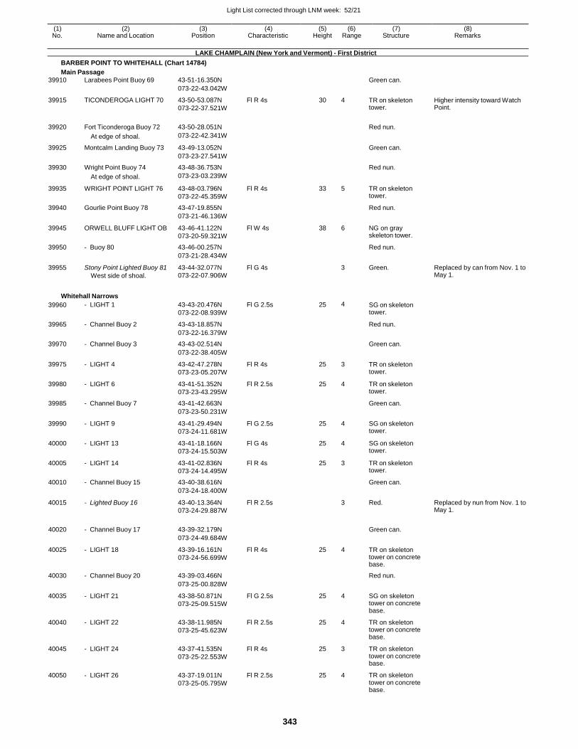
Light List corrected through LNM week: 52/21
343
(1) (2) (3) (4) (5) (6) (7) (8) No. Name and Location Position Characteristic Height Range Structure Remarks
LAKE CHAMPLAIN (New York and Vermont) - First District
BARBER POINT TO WHITEHALL (Chart 14784)
Main Passage
39910 Larabees Point Buoy 69 43-51-16.350N Green can.
073-22-43.042W
39915 TICONDEROGA LIGHT 70 43-50-53.087N
073-22-37.521W
Fl R 4s 30 4 TR on skeleton tower.
Higher intensity toward Watch Point.
39920 Fort Ticonderoga Buoy 72 43-50-28.051N
Red nun.
At edge of shoal. 073-22-42.341W
39925 Montcalm Landing Buoy 73 43-49-13.052N Green can.
073-23-27.541W
39930 Wright Point Buoy 74 43-48-36.753N Red nun.
At edge of shoal. 073-23-03.239W
39935 WRIGHT POINT LIGHT 76 43-48-03.796N
073-22-45.359W
Fl R 4s 33 5 TR on skeleton tower.
39940 Gourlie Point Buoy 78 43-47-19.855N Red nun.
073-21-46.136W
39945 ORWELL BLUFF LIGHT OB 43-46-41.122N
073-20-59.321W
Fl W 4s 38 6 NG on gray skeleton tower.
39950 - Buoy 80 43-46-00.257N Red nun.
073-21-28.434W
39955 Stony Point Lighted Buoy 81
West side of shoal.
43-44-32.077N
073-22-07.906W
Fl G 4s 3 Green. Replaced by can from Nov. 1 to May 1.
Whitehall Narrows
39960 - LIGHT 1 43-43-20.476N
073-22-08.939W
Fl G 2.5s 25 4 SG on skeleton tower.
39965 - Channel Buoy 2 43-43-18.857N Red nun.
073-22-16.379W
39970 - Channel Buoy 3 43-43-02.514N Green can.
073-22-38.405W
39975 - LIGHT 4 43-42-47.278N
073-23-05.207W
Fl R 4s 25 3 TR on skeleton tower.
39980 - LIGHT 6 43-41-51.352N
073-23-43.295W
Fl R 2.5s 25 4 TR on skeleton tower.
39985 - Channel Buoy 7 43-41-42.663N Green can.
073-23-50.231W
39990 - LIGHT 9 43-41-29.494N
073-24-11.681W
Fl G 2.5s 25 4 SG on skeleton tower.
40000 - LIGHT 13 43-41-18.166N
073-24-15.503W
Fl G 4s 25 4 SG on skeleton tower.
40005 - LIGHT 14 43-41-02.836N
073-24-14.495W
Fl R 4s 25 3 TR on skeleton tower.
40010 - Channel Buoy 15 43-40-38.616N Green can.
073-24-18.400W
40015 - Lighted Buoy 16 43-40-13.364N
073-24-29.887W
Fl R 2.5s 3 Red. Replaced by nun from Nov. 1 to May 1.
40020 - Channel Buoy 17 43-39-32.179N
Green can.
073-24-49.684W
40025 - LIGHT 18 43-39-16.161N
073-24-56.699W
Fl R 4s 25 4 TR on skeleton tower on concrete base.
40030 - Channel Buoy 20 43-39-03.466N Red nun.
073-25-00.828W
40035 - LIGHT 21 43-38-50.871N
073-25-09.515W
Fl G 2.5s 25 4 SG on skeleton tower on concrete base.
40040 - LIGHT 22 43-38-11.985N
073-25-45.623W
Fl R 2.5s 25 4 TR on skeleton tower on concrete base.
40045 - LIGHT 24 43-37-41.535N
073-25-22.553W
Fl R 4s 25 3 TR on skeleton tower on concrete base.
40050 - LIGHT 26 43-37-19.011N
073-25-05.795W
Fl R 2.5s 25 4 TR on skeleton tower on concrete base.
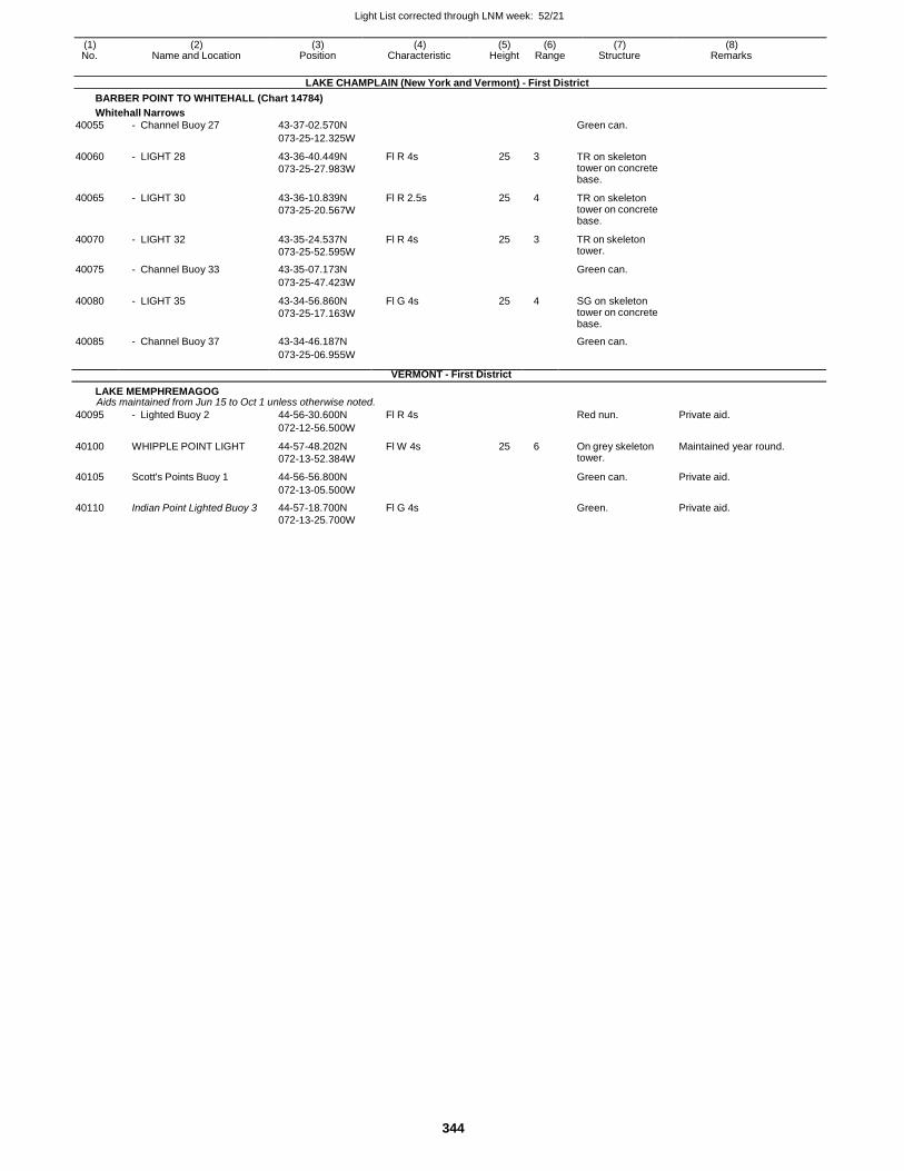
Light List corrected through LNM week: 52/21
344
(1) (2) (3) (4) (5) (6) (7) (8) No. Name and Location Position Characteristic Height Range Structure Remarks
LAKE CHAMPLAIN (New York and Vermont) - First District
BARBER POINT TO WHITEHALL (Chart 14784)
Whitehall Narrows
40055 - Channel Buoy 27 43-37-02.570N Green can.
073-25-12.325W
40060 - LIGHT 28 43-36-40.449N
073-25-27.983W
Fl R 4s 25 3 TR on skeleton tower on concrete base.
40065 - LIGHT 30 43-36-10.839N
073-25-20.567W
Fl R 2.5s 25 4 TR on skeleton tower on concrete base.
40070 - LIGHT 32 43-35-24.537N
073-25-52.595W
Fl R 4s 25 3 TR on skeleton tower.
40075 - Channel Buoy 33 43-35-07.173N Green can.
073-25-47.423W
40080 - LIGHT 35 43-34-56.860N
073-25-17.163W
Fl G 4s 25 4 SG on skeleton tower on concrete base.
40085 - Channel Buoy 37 43-34-46.187N Green can.
073-25-06.955W
VERMONT - First District
LAKE MEMPHREMAGOG Aids maintained from Jun 15 to Oct 1 unless otherwise noted.
40095 - Lighted Buoy 2 44-56-30.600N Fl R 4s Red nun. Private aid.
072-12-56.500W
40100 WHIPPLE POINT LIGHT 44-57-48.202N
072-13-52.384W
Fl W 4s 25 6 On grey skeleton tower.
Maintained year round.
40105 Scott's Points Buoy 1 44-56-56.800N Green can. Private aid.
072-13-05.500W
40110 Indian Point Lighted Buoy 3 44-57-18.700N Fl G 4s Green. Private aid. 072-13-25.700W
INDEX
Index - 1
Allen Harbor . . . . . . . . . . . .Allen Harbor Entrance . . . . . .Allerton Harbor . . . . . . . . . . .Ambrose Channel . . . . . . . . .Amity Channel . . . . . . . . . . .Annisquam Harbor Light . . . . .Annisquam River . . . . . . . . .Appletree Bay . . . . . . . . . . .Apponaganset Bay . . . . . . . . .Apponaug Cove . . . . . . . . . .Areskonk Creek Entrance . . . . .Arthur Kill . . . . . . . . . . . . . .Ash Creek . . . . . . . . . . . . .Aunt Lydias Cove . . . . . . . . .
BELLPORT BEACH . . . . . . . .Back Channel . . . . . . . . . . . .Back Cove Approach . . . . . . .Back River Channel . . . . . . .Bagaduce River . . . . . . . . . .Baker Island . . . . . . . . . . . .Bakers Island Light . . . . . . . .Baldwin Bay . . . . . . . . . . . .Bannister Creek . . . . . . . . . .Barnstable Harbor . . . . . . . . .Barrett Beach . . . . . . . . . . . .Barrington River . . . . . . . . . .Bass Harbor . . . . . . . . . . . .Bass Harbor Head Light . . . . .Bass River . . . . . . . . . . . . .Bass River . . . . . . . . . . . . .Bay Ridge Channel . . . . . . .Beach Channel . . . . . . . . . . .Beaverdam Creek Entrance . . .Beavertail Light . . . . . . . . . .Belfast Harbor . . . . . . . . . . .Belle Terre . . . . . . . . . . . . .Bellmore Creek Channel . . . .Bellport Bay . . . . . . . . . . . .Beverly Channel . . . . . . . . . .Bird Island Flats . . . . . . . . . .Bishop And Clerks Light . . . .Bishop and Clerks . . . . . . . .Black Island . . . . . . . . . . . . .Black Rock Harbor . . . . . . . . .Block Island . . . . . . . . . . . . .Block Island Southeast Light . .Blue Hill Bay Approach . . . . .Blue Hill Harbor . . . . . . . . .Boat Basin . . . . . . . . . . . . .Bold Island . . . . . . . . . . . . .Boon Island Light . . . . . . . . .Booth Bay . . . . . . . . . . . . . .Borrow Pit Channel . . . . . . . .Boston Light . . . . . . . . . . . . .Boston North Channel . . . . . .Boston South Channel . . . . . .Bowline Point . . . . . . . . . . .Branford Harbor . . . . . . . . . . .Brayton Point Channel . . . . . .Bridgeport Harbor . . . . . . . . .Bristol Harbor . . . . . . . . . . . .Broad Channel . . . . . . . . . . .Broad Creek Channel . . . . . .Broad Sound . . . . . . . . . . . .Broadway . . . . . . . . . . . . . . .
Bronx River . . . . . . . . . . . . .Brother Island Channel . . . . . .Browns Head Light . . . . . . . .Bullock Cove . . . . . . . . . . . .Burlington Bay . . . . . . . . . . .Burnt Coat Harbor . . . . . . . . .Buttermilk Bay Approach . . . . .Buttermilk Channel . . . . . . . .Buzzards Bay Entrance Light . .Buzzards Bay Main Channel . .Byram Harbor . . . . . . . . . . . .
Camden Harbor . . . . . . . . . .Canal Terminal . . . . . . . . . .Canapitsit Channel . . . . . . . .Cape Ann Light . . . . . . . . . .Cape Cod Canal Approach . . .Cape Cod Canal Eastern Entrance . . . . . . . . . . . . .Cape Elizabeth Light . . . . . . .Cape Harbor . . . . . . . . . . . .Cape Neddick Harbor . . . . . . .Cape Neddick Light . . . . . . . .Cape Porpoise Harbor . . . . . .Captain Harbor (From Westward) . . . . . . . . . . . .Captain Harbor (From Eastward)Carman Creek . . . . . . . . . . .Carvers Harbor From Eastward .Carvers Harbor From South . . .Carvers Harbor From WestwardCasco Bay Channel . . . . . . .Casco Passage . . . . . . . . . . .Castine Harbor . . . . . . . . . . .Center Harbor . . . . . . . . . . .Centerport Harbor Approach Channel . . . . . . . . . . . . .Centerville Harbor Approach . .Centerville River . . . . . . . . .Chandler Bay . . . . . . . . . . . .Chandler Cove . . . . . . . . . . .Chapel Hill North Channel . . .Chapel Hill South Channel . . .Chatham Harbor . . . . . . . . . .Chatham Light . . . . . . . . . . .Chatham Midchannel . . . . . . .Chatham Roads . . . . . . . . . .Cheesequake Creek . . . . . . .Chelsea Point Channel . . . . .Chelsea River . . . . . . . . . . .Childrens Island Channel . . . .Christmas Cove . . . . . . . . . .City Bay . . . . . . . . . . . . . . .City Island . . . . . . . . . . . . .Claremont Terminal Channel . .Cleveland East Ledge Light . .Cleveland Ledge Channel . . .Cliff Island . . . . . . . . . . . . .Clinton Harbor . . . . . . . . . . .Cobscook Bay . . . . . . . . . . . .Coecles Harbor . . . . . . . . . .Coeymans Dike . . . . . . . . . .Cohasset Channel . . . . . . . . .Cohasset Eastern Channel . . .Cohasset Harbor . . . . . . . . . .Cohasset Western Channel . . .Cole River . . . . . . . . . . . . .
Compton Channel . . . . . . . . .Coney Island Channel . . . . . .Coney Island Creek Entrance .Coney Island Light . . . . . . . .Connecticut River . . . . . . . . .Conscience Bay . . . . . . . . . .Constable Hook Channel . . . .Corey Creek Entrance . . . . . .Cos Cob Harbor . . . . . . . . . .Cotuit Anchorage . . . . . . . . . .Cotuit Entrance Channel . . . . .Cotuit Harbor . . . . . . . . . . . .Cove Harbor . . . . . . . . . . . .Coveleigh Yacht Club ChannelCranberry Harbor . . . . . . . . . .Cross Island Narrows . . . . . . .Crotch Island Passage . . . . . .Crow Island Haunts Creek . . .Cumberland Bay . . . . . . . . . .Cumberland Head . . . . . . . . .Cuttyhunk . . . . . . . . . . . . . . .Cuttyhunk Harbor . . . . . . . . . .
Damariscotta River . . . . . . . .Damariscove Island Approach . .Danvers River . . . . . . . . . . .Daves Creek . . . . . . . . . . . .Davids Island Channel . . . . . .Davis Park . . . . . . . . . . . . .Deer Island . . . . . . . . . . . . .Deer Island Thorofare . . . . . .Derby Channel . . . . . . . . . . .Dering Harbor . . . . . . . . . . .Diamond Island Pass . . . . . . .Dice Head Light . . . . . . . . . .Dickerson Channel . . . . . . . .Dog Channel . . . . . . . . . . . .Dorchester Bay . . . . . . . . . . .Dorchester Bay Basin . . . . . .Duck Creek . . . . . . . . . . . . .Duck Island Roads . . . . . . . .Duxbury Bay . . . . . . . . . . . .Duxbury Bay Beach Channel . .Dyer Island Narrows . . . . . . .
Eagle Island Channel . . . . . .East Bay . . . . . . . . . . . . . .East Bay . . . . . . . . . . . . . .East Channel . . . . . . . . . . . .East Harbor . . . . . . . . . . . . .East Norwalk Channel . . . . . .East Passage . . . . . . . . . . . .East Penobscot Bay . . . . . . . .East River Main Channel . . . .East Rockaway Channel . . . . .East Rockaway Inlet . . . . . . .East Side . . . . . . . . . . . . . .East-West Channel . . . . . . . . .Eastchester Bay . . . . . . . . . .Eastern Approach . . . . . . . . . .Eastern Bay . . . . . . . . . . . . .Eastern Bay . . . . . . . . . . . . .
19290140851212534785338759615959039605167411942530490366252472513335
3009087557835582535702040350, 99753247531561130902991018775233523351032014205368703438530175177804445262033241530130102151115014490144852397.1246701968564022952635304253025155548032310425, 11340106801074037830239501890024575181653175033314680015755
27550272503965183503961526701738536975630, 159851600025515
4310394301593029513035
1305060, 7520561082501258090
2535025325341503685371537457230250035302865
268351467514725.11205708435255351951330952513308.95138003641511085109651038553003932525970371951608016085701523460100028195388351218512243122201215519075
3569035285353353491022505261793700028515254201473514760.114760.3625125255762165109531153272039415393651631516260
525554051028030605258902995510830299510115280757175353029420330631119511260132352339512580126901585
103603326014726.912924020970250551777534402721532020314951637529475260071767513901910
A
B
C
D
E
INDEX
Index - 2
Eastern Harbor . . . . . . . . . . .Eastern Passage . . . . . . . . . .Eastern Point Light . . . . . . . .Eatons Neck . . . . . . . . . . . .Eatons Neck Light . . . . . . . . .Echo Bay . . . . . . . . . . . . . .Edgartown Harbor . . . . . . . . .Eel Pond . . . . . . . . . . . . . .Egg Rock Light . . . . . . . . . . .Eggemoggin Reach . . . . . . . .Englewood Channel . . . . . . . .Englishman Bay . . . . . . . . . .Erie Basin . . . . . . . . . . . . .Essex Anchorage . . . . . . . . .Essex Bay . . . . . . . . . . . . .Essex River . . . . . . . . . . . .Execution Rocks Light . . . . . .
Falkner Island Light . . . . . . . .Falmouth Harbor . . . . . . . . . .Farm River . . . . . . . . . . . . .Farm Shoals Channel . . . . . .Fields Point Channel . . . . . . .Fire Island East End Channel .Fire Island Inlet . . . . . . . . . .Fire Island Light . . . . . . . . . .Fisherman Island Passage . . . .Fivemile River . . . . . . . . . .Flanders Bay . . . . . . . . . . . .Flint Island Narrows . . . . . . .Flushing Bay . . . . . . . . . . . .Flying Passage . . . . . . . . . . .Fore River . . . . . . . . . . . . .Forge River Channel . . . . . . .Fort Hale Channel . . . . . . . .Fort Point Light . . . . . . . . . . .Fox Creek . . . . . . . . . . . . . .Fox Island Thorofare . . . . . . .Freeport Narrows . . . . . . . . . .Frenchman Bay . . . . . . . . . . .Friendship Harbor . . . . . . . . .Fundy Channel . . . . . . . . . . .
Gardiners Bay South Entrance .Garretts Lead . . . . . . . . . . . .Gay Head Light . . . . . . . . . .Gerritsen Inlet . . . . . . . . . . .Gilkey Harbor . . . . . . . . . . .Glen Island Channel . . . . . . .Gloucester Harbor . . . . . . . . .Gloucester Inner Harbor . . . . .Goat Island Light . . . . . . . . .Goodwives River Approach . . .Goose Rock Passage . . . . . . .Grand Cove . . . . . . . . . . . . .Grass Hassock Channel . . . . .Grassy Bay . . . . . . . . . . . . .Gravesend Bay . . . . . . . . . . .Great Captain Island Light . . . .Great Chazy River Boat Channel . . . . . . . . . . . . .Great Duck Island Light . . . . .
Great Harbor . . . . . . . . . . . .Great Island Channel . . . . . . .Great Island Channel . . . . . . .Great Kills Harbor . . . . . . . .Great Peconic Bay . . . . . . . .Great Pond . . . . . . . . . . . . .Great River . . . . . . . . . . . . .Great Round Shoal Channel . .Great Salt Pond . . . . . . . . . .Great Sand Creek . . . . . . . . .Great South Bay . . . . . . . . . .Green Harbor . . . . . . . . . . . .Green Harbor Approach . . . . .Green Island Passage . . . . . .Green Pond . . . . . . . . . . . . .Greens Cove Channel . . . . . .Greens Harbor . . . . . . . . . . .Greens Ledge Light . . . . . . .Greenwich Bay . . . . . . . . . . .Greenwich Bay Approach . . . .Greenwich Cove . . . . . . . . . .Greenwich Harbor . . . . . . . . .Greenwich Point . . . . . . . . . .Guilford Harbor . . . . . . . . . . .Gull Island Reef . . . . . . . . .
Hackensack River . . . . . . . . .Hadley Harbor . . . . . . . . . . .Halfway Rock Light . . . . . . . .Hamburg Cove . . . . . . . . . . .Hammonasset River . . . . . . . .Hampton Harbor . . . . . . . . . .Harraseeket River . . . . . . . . .Haskell Island . . . . . . . . . . .Hassock Channel . . . . . . . . .Head of Bay . . . . . . . . . . . .Hempstead Harbor . . . . . . . . .Hendricks Harbor . . . . . . . . . .Herring River . . . . . . . . . . .Hewlett Bay Extension . . . . . .Highland Light . . . . . . . . . . .Hingham Bay . . . . . . . . . . . .Hingham Harbor Approach . . . .Hingham Harbor Channel . . . .Hockomock Channel . . . . . . . .Hog Island Channel . . . . . . .Hog Island Channel . . . . . . .Hog Island Shoal Light . . . . .Horton Point Light . . . . . . . . .Houghs Neck Channel . . . . . .Housatonic River . . . . . . . . . .Hudson River (Above Troy Lock) . . . . . . . . . . . . . . .Hudson River . . . . . . . . . . .Huntington Bay . . . . . . . . . . .Huntington Harbor . . . . . . . . .Hurricane Sound . . . . . . . . . .Hussey Sound . . . . . . . . . . .Hutchinson River . . . . . . . . . .Hyannis Harbor . . . . . . . . . . .Hyannis Yacht Club . . . . . . . .
Indian Point Security Zone . . .Inner Bay Ledges . . . . . . . . .Island End River . . . . . . . . .Isle Au Haut Bay . . . . . . . . .Isle Au Haut Thorofare . . . . .Isles of Shoals Light . . . . . . .
Jacobs Point . . . . . . . . . . . .James Creek . . . . . . . . . . . .Jericho Bay . . . . . . . . . . . . .Johns Bay . . . . . . . . . . . . . .Johnson Creek . . . . . . . . . . .Jones Inlet . . . . . . . . . . . . .
Kennebec River . . . . . . . . . .Kennebec River Approach . . . .Kennebunk River . . . . . . . . .Kennebunkport . . . . . . . . . . . .Keyport Harbor . . . . . . . . . . .Kickamuit River . . . . . . . . . .Kill Van Kull . . . . . . . . . . .Kingston Channel . . . . . . . . .
La Motte Passage . . . . . . . . .Lagoon Pond . . . . . . . . . . . .Lake Champlain Underwater Preserve . . . . . . . . . . . .Lake Montauk . . . . . . . . . . . .Lake Tashmoo . . . . . . . . . . .Larchmont Harbor (East Entrance) . . . . . . . . . . . .Larchmont Harbor (South Entrance) . . . . . . . . . . . .Lawrys Narrows . . . . . . . . . .Leadbetter Narrows . . . . . . . .Leonardo Channel . . . . . . . . .Lewis Bay . . . . . . . . . . . . .Libby Island Light . . . . . . . . .Liberty Island . . . . . . . . . . . .Lighthouse Channel . . . . . . . .Lilco Basin . . . . . . . . . . . . .Linekin Bay . . . . . . . . . . . . .Little Bay . . . . . . . . . . . . . .Little Bay . . . . . . . . . . . . . .Little Gull Island Light . . . . . .Little Harbor . . . . . . . . . . . .Little Harbor . . . . . . . . . . . .Little Narragansett Bay . . . . . .Little Neck Bay Approach . . . .Little Peconic Bay . . . . . . . .Little Pleasant Bay . . . . . . . .Little River . . . . . . . . . . . . .Little River Entrance . . . . . . .Little River Light . . . . . . . . .Little Sheepscot River . . . . . .Little Whaleboat Island . . . . . .Lloyd Harbor . . . . . . . . . . . .
1490240033026420213252577515390149201865282514650117036895226159480954021440
2117015105239752921018510302552911069554152507519751615274605110781030445241503585296003860329451840503532763
2773032100620, 156103429543902591598509900105, 81002510056951442034450345953534521400
391702295
15695195353363035450287501506514872.113586197453300529340125101249069901503037910219702134019395193202538025480253952371539335
375351584040, 66752269523520890569406745322553454027047564014140319005001193311985120205100161303197518145211501162024355
3907037645264652652738037110260401451514605
3793140901101533203375235
2168028730273552102465030887
602560058175814536370189703725012770
3922015495
396351992515525
25715
25730382038553556014553112037247771026380544085702720019830877515650202002715528503.513476.1107514870.510755685688026655
F
G
H
I
J
K
L
INDEX
Index - 3
Logan Airport Security Zone . .Long Creek . . . . . . . . . . . . .Long Ledge . . . . . . . . . . . . .Lower Middle Channel . . . . . .Lubec Channel . . . . . . . . . . .Luckse Sound . . . . . . . . . . . .Lynde Point Light . . . . . . . . .Lynn Harbor . . . . . . . . . . . . .
Machias Bay . . . . . . . . . . . .Machias River . . . . . . . . . . .Mackerel Cove . . . . . . . . . . .Madaket Harbor . . . . . . . . . . .Main Channel . . . . . . . . . . .Main Channel . . . . . . . . . . .Main Channel . . . . . . . . . . .Main Channel . . . . . . . . . . .Main Channel South Approach .Main Passage . . . . . . . . . . .Mamaroneck Harbor . . . . . . . .Manchester Channel . . . . . . . .Manhasset Bay . . . . . . . . . . .Marblehead Channel . . . . . . .Marblehead Harbor . . . . . . . .Marratrooka Point . . . . . . . . . .Marshall Point Light . . . . . . . .Marston Mills River . . . . . . .Massapequa Cove . . . . . . . . .Massapequa Creek . . . . . . . .Matinicus Rock Light . . . . . . .Mattapoisett Harbor . . . . . . . . .Mattituck Creek . . . . . . . . . . .Mattituck Inlet . . . . . . . . . . . .Medomak River . . . . . . . . . .Meeting House . . . . . . . . . . .Megansett Harbor . . . . . . . . .Menantic Creek . . . . . . . . . .Menemsha Creek . . . . . . . . .Merchant Row . . . . . . . . . . .Merrick Point . . . . . . . . . . . .Merriconeag Sound Approach . .Merrimack River . . . . . . . . . .Middle Channel . . . . . . . . . .Milford Harbor . . . . . . . . . . .Mill Cove . . . . . . . . . . . . . .Mill Creek . . . . . . . . . . . . .Mill Pond . . . . . . . . . . . . . .Milton Harbor . . . . . . . . . . . .Minots Ledge Light . . . . . . . .Missisquoi Bay . . . . . . . . . .Monhegan Island Approach . . . .Monhegan Island Light . . . . . .Montauk Harbor . . . . . . . . . . .Montauk Point Light . . . . . . . .Montsweag Bay . . . . . . . . . .Moosabec Reach . . . . . . . . . .Moose Peak Light . . . . . . . . .Morgan Bay . . . . . . . . . . . . .Moriches Bay . . . . . . . . . . . .Moriches Inlet . . . . . . . . . . .Motts Basin . . . . . . . . . . . . .Mount Desert Light . . . . . . . .Mount Hope Bay . . . . . . . . .Mount Sinai Harbor . . . . . . . .Mumford Cove . . . . . . . . . . .Muscle Ridge Channel . . . . .
Muscongus Bay . . . . . . . . . . .Muscongus Bay Approach . . . .Muscongus Sound . . . . . . . . .Muskeget Channel . . . . . . . . .Mystic Harbor . . . . . . . . . . . .Mystic River . . . . . . . . . . . .Mystic River . . . . . . . . . . . .Mystic River Auxiliary Channel . . . . . . . . . . . . .
Nahant Bay Approach . . . . . . .Nahant Harbor . . . . . . . . . . .Nantasket Roads (Southern Approach) . . . . . . . . . . . .Nantucket (Great Point) Light . .Nantucket Harbor . . . . . . . . . .Nantucket Sound Main ChannelNarraguagus Bay . . . . . . . . . .Narraguagus River . . . . . . . . .Narrows Bay . . . . . . . . . . . .Nasketucket Bay . . . . . . . . . .National Dock Channel . . . . . .Navesink River . . . . . . . . . .Ned Point Light . . . . . . . . . .Neds Creek West Branch . . . .Neponset River . . . . . . . . . .New Bedford Channel . . . . . .New Bedford Harbor Channel .New Bedford Southeast Approach . . . . . . . . . . . . .New Haven Harbor . . . . . . . .New Haven Wharf . . . . . . . .New Inlet . . . . . . . . . . . . . .New Jersey Pierhead . . . . . .New Jersey Pierhead ChannelNew London Harbor . . . . . . .New London Harbor Light . . . .New London Ledge Light . . . .New Meadows River . . . . . . .New Meadows River ApproachNew Rochelle Harbor (Southeast Approach) . . . . .New Rochelle Harbor (Southwest Approach) . . . . .New Rochelle Harbor (North Approach) . . . . . . . . . . . .New Rochelle Harbor (South Approach) . . . . . . . . . . . .New Suffolk Channel . . . . . . .Newark Bay . . . . . . . . . . . . .Newark Bay Channel . . . . . . .Newburyport Harbor Light . . . .Newport Harbor . . . . . . . . . . .Niantic River . . . . . . . . . . . .Nissequogue River . . . . . . . .Nobska Point Light . . . . . . . .North Bay Channel . . . . . . . .North Channel (Saybrook to New Haven) . . . . . . . . . .North Channel . . . . . . . . . . .North Channel . . . . . . . . . . .North Channel . . . . . . . . . . .North Entrance . . . . . . . . . . .North River . . . . . . . . . . . . .North Sea Harbor . . . . . . . . .North Side . . . . . . . . . . . . .North Side . . . . . . . . . . . . .Northeast Harbor . . . . . . . . . .
Northport . . . . . . . . . . . . . . .Northport Bay . . . . . . . . . . . .Northport Boatyard Channel . . .Northport Harbor . . . . . . . . . .Northward Channel . . . . . . . . .Norwalk Channel . . . . . . . . . .Norwalk East Approach . . . . . .Nubble Channel . . . . . . . . . .
Oak Bluffs Harbor . . . . . . . . .Oak Island Channel . . . . . . . .Oakland Beach . . . . . . . . . . .Oakwood Channel . . . . . . . . .Oceanville Approach . . . . . . . .Old Field Point Light . . . . . .Old Orchard Shoal . . . . . . . .Olivers Channel . . . . . . . . . .Onset Bay . . . . . . . . . . . . . .Orient Point Light . . . . . . . . .Orr`s Island Approach . . . . . . .Owls Head Bay . . . . . . . . . .Owls Head Light . . . . . . . . .Oyster Bay . . . . . . . . . . . . .
Palmer Cove Channel . . . . . .Parker River . . . . . . . . . . . .Passage West of Grindstone Neck . . . . . . . . . . . . . . .Passaic River . . . . . . . . . . .Patchogue Bay . . . . . . . . . . .Patchogue River . . . . . . . . . .Pattaganset River . . . . . . . . .Patten Bay . . . . . . . . . . . . .Pawcatuck River . . . . . . . . . .Pawtuxet Cove . . . . . . . . . . .Peconic River . . . . . . . . . . .Peddocks Island Channel . . . .Pemaquid Point Light . . . . . . .Pemaquid River . . . . . . . . . .Penfield Reef Light . . . . . . . .Pennamaquan River . . . . . . . .Penobscot Bay Approaches . . .Penobscot River . . . . . . . . . .Perkins Cove . . . . . . . . . . . .Petit Manan Approach . . . . . . .Petit Manan Light . . . . . . . . .Phillips Creek . . . . . . . . . . .Phinneys Harbor . . . . . . . . . .Pig Island Gut . . . . . . . . . . .Pine Island Channel . . . . . . .Pine Orchard Harbor . . . . . . .Piscataqua River . . . . . . . . . .Pleasant Bay . . . . . . . . . . . .Pleasant Bay . . . . . . . . . . . .Pleasant River . . . . . . . . . . .Plum Gut . . . . . . . . . . . . . .Plum Island Sound . . . . . . . .Plymouth Bay . . . . . . . . . . . .Plymouth Harbor . . . . . . . . . .Plymouth Light . . . . . . . . . . .Pocasset Harbor . . . . . . . . . .Pocasset Harbor Approach . . . .
109093279525401113085570002252010565
11251150248015297349101555020025392653502039110255801016027115104101044028710478014743.1341903375510, 3195170502166521645511528955164612843015950313033237668089952594024295774028455139602566044039345494520, 49251989566058501275139026303029129104345055, 22901878526070208754575
48304960516515350204452067010995
20601
1049510540
11348545, 136501513513660162516603020017026.137210359651709533170112901680516910
16960239852423012325370103703921790218452182565606440
25845
25865
25810
258502866537385374252601782022305263151556014742
2152514765294493466527655124032861029670137852100
263602668026785267298850249552491511485
1544731380255753240031052127535395336051730021095, 2768066554680410526865
101319420
1950376252974023405224802475202901846528975115045145523521290102532103580824017301735306251665014252173523946845515101339815402767593001253512744, 12905125451661016605
MN
O
P
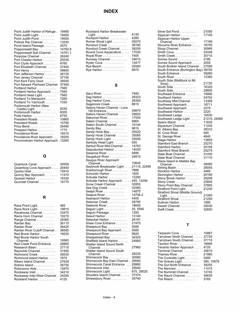
INDEX
Index - 4
Point Judith Harbor of Refuge .Point Judith Light . . . . . . . . .Point Judith Pond . . . . . . . . .Pollock Rip Channel . . . . . . .Pond Island Passage . . . . . . .Popponesett Bay . . . . . . . . . .Popponesett Spit Channel . . . .Porpoise Channel . . . . . . . . .Port Chester Harbor . . . . . . .Port Clyde Approach . . . . . . .Port Elizabeth Channel . . . . . .Port Henry . . . . . . . . . . . . .Port Jefferson Harbor . . . . . . .Port Jersey Channel . . . . . . .Port Kent Ferry Dock . . . . . . .Port Newark Pierhead ChannelPortland Harbor . . . . . . . . . . .Portland Harbor Approach . . . .Portland Head Light . . . . . . . .Portland To Merepoint . . . . . .Portland To Yarmouth . . . . . . .Portsmouth Harbor (New Castle) Light . . . . . . . . . .Portsmouth Harbor . . . . . . . . .Potts Harbor . . . . . . . . . . . . .President Roads . . . . . . . . . .President Roads . . . . . . . . . .Price Bend . . . . . . . . . . . . .Prospect Harbor . . . . . . . . . .Providence River . . . . . . . . .Providence River Approach . . .Provincetown Harbor Approach . .
Quantuck Canal . . . . . . . . . . .Quiambog Cove Approach . . . .Quicks Hole . . . . . . . . . . . .Quincy Bay Approach . . . . . . .Quisset Harbor . . . . . . . . . . .Quonset Channel . . . . . . . . .
Race Point Light . . . . . . . . . .Race Rock Light . . . . . . . . . .Racehorse Channel . . . . . . . .Rams Horn Channel . . . . . . .Range Channel . . . . . . . . . .Raritan Bay . . . . . . . . . . . . .Raritan River . . . . . . . . . . . .Raritan River Cutoff Channel . .Red Brook Harbor . . . . . . . . .Red Brook Harbor South Channel . . . . . . . . . . . . .Red Creek Pond Entrance . . .Research Basin . . . . . . . . . .Reynolds Channel . . . . . . . . .Richmond Creek . . . . . . . . . .Richmond Island Harbor . . . . .Rikers Island Channel . . . . . .Robins Island . . . . . . . . . . . .Robinsons Hole . . . . . . . . . .Rockaway Inlet . . . . . . . . . . .Rockaway Inlet West Channel .Rockland Harbor . . . . . . . . . .
Rockland Harbor Breakwater Light . . . . . . . . . . . . . . .Rockport Harbor . . . . . . . . . . .Romer Shoal Light . . . . . . . .Rondout Creek . . . . . . . . . . .Rondout Creek Channel . . . . .Round Cove Aquaculture . . . . .Royal River . . . . . . . . . . . .Runway Channel . . . . . . . . . .Ryder Cove . . . . . . . . . . . .Rye Beach . . . . . . . . . . . . .Rye Harbor . . . . . . . . . . . . .
Saco River . . . . . . . . . . . . .Sag Harbor . . . . . . . . . . . . .Sag Harbor Cove . . . . . . . . .Sagamore Creek . . . . . . . . . .Sailors Haven Channel - Lone Hill Entrance . . . . . . . . . .Sailors Haven Channel . . . . .Sakonnet River . . . . . . . . . . .Salem Channel . . . . . . . . . .Salem South Channel . . . . . .Sandy Bay . . . . . . . . . . . . .Sandy Hook Bay . . . . . . . . . .Sandy Hook Channel . . . . . . .Sandy Hook Light . . . . . . . . .Sankaty Head Light . . . . . . . .Santuit River Mid-Channel . . . .Saquatucket Harbor . . . . . . . . .Sasanoa River . . . . . . . . . . .Saugatuck River . . . . . . . . . .Saugus River Approach Channel . . . . . . . . . . . . .Saybrook Breakwater Light . . . .Scarborough River . . . . . . . . .Schoodic Harbor . . . . . . . . . .Scituate Harbor . . . . . . . . . . .Scituate Harbor Approach . . . . .Scow Creek Channel . . . . . . .Sea Dog Creek . . . . . . . . . .Seapit River . . . . . . . . . . . .Seapuit River . . . . . . . . . . .Searsport Harbor . . . . . . . . . .Sebonac Creek . . . . . . . . . . .Seekonk River . . . . . . . . . . .Seguin Light . . . . . . . . . . . .Seguin Passage . . . . . . . . . .Sesuit Harbor . . . . . . . . . . . .Setauket Harbor . . . . . . . . . .Shaw Cove Entrance . . . . . . .Sheepscot Bay . . . . . . . . . . .Sheepscot Bay Approach . . . . .Sheepscot River . . . . . . . . . .Sheepshead Bay . . . . . . . . . .Sheffield Island Harbor . . . . . .Shelter Island Sound North Channel . . . . . . . . . . . . .Shelter Island Sound South Channel . . . . . . . . . . . . .Shinnecock Bay . . . . . . . . . . .Shinnecock Bay East Channel .Shinnecock Canal Entrance . . .Shinnecock Inlet . . . . . . . . . .Shinnecock Light . . . . . . . . . .Shooters Island Channel . . . . .Shrewsbury River . . . . . . . . .
Silver Eel Pond . . . . . . . . . .Sippican Harbor . . . . . . . . . .Sippican Harbor Upper Channel . . . . . . . . . . . . .Slocums River Entrance . . . . .Sloop Channel . . . . . . . . . . .Smith Cove . . . . . . . . . . . . .Smith Creek . . . . . . . . . . . .Somes Sound . . . . . . . . . . . .Somes Sound Approach . . . . .South Brother Island Channel . .South Entrance (Burlington Bay)South Entrance . . . . . . . . . . .South River . . . . . . . . . . . . .South Side (Mattituck to Mt. Sinai) . . . . . . . . . . . . . .South Side . . . . . . . . . . . . .South Side . . . . . . . . . . . . .Southeast Entrance . . . . . . . . .Southport Harbor . . . . . . . . . .Southway Mid-Channel . . . . . .Southwest Approach . . . . . . . .Southwest Approach . . . . . . . .Southwest Harbor . . . . . . . . .Southwest Ledge . . . . . . . . . .Southwest Ledge Light . . . . . .Spiers Stand . . . . . . . . . . . .Squantum Channel . . . . . . . . .St. Albans Bay . . . . . . . . . .St. Croix River . . . . . . . . . .St. George River . . . . . . . .Stage Harbor . . . . . . . . . . . .Stamford East Branch . . . . . . .Stamford Harbor . . . . . . . . . .Stamford West Branch . . . . . .State Boat Channel . . . . . . . .State Boat Channel . . . . . . . .Stave Island to Mallets Bay Channel . . . . . . . . . . . . .Stirling Basin . . . . . . . . . . . .Stockton Harbor . . . . . . . . . . .Stonington Harbor . . . . . . . . .Stony Brook Harbor . . . . . . . .Stony Creek . . . . . . . . . . . .Stony Point Bay Channel . . . .Stratford Point Light . . . . . . . .Stratford Shoal (Middle Ground) Light . . . . . . . . . . . . . . .Stratford Shoal . . . . . . . . . . .Sullivan Harbor . . . . . . . . . .Swash Channel . . . . . . . . . .Swift Creek . . . . . . . . . . . . .
Tarpaulin Cove . . . . . . . . . . .Tarrytown North Channel . . . . .Tarrytown South Channel . . . . .Taunton River . . . . . . . . . . .Tenants Harbor Approach . . . . .Terminal Channel . . . . . . . . .Thames River . . . . . . . . . . .The Cuckolds Light . . . . . . . .The Graves Light . . . . . . . . .The Gut North Entrance . . . . .The Narrows . . . . . . . . . . . .The Nummet Channel . . . . . .The Raunt Channel . . . . . . . .The Reach . . . . . . . . . . . . .
19485194501955013530257514760.814761.12624025535476037445398502612537100395453745575657495756572657330
8330830567551086510790264901775183101820013265
305592044015910114701633019175
4851981533475102702936536110364253658516535
1656528885277153156528535787527639287551587534210342904125
413042803507038185382551703074003461513477255608875
794028323283508815
29870298201755599651014498153552035085350405551476314030589024815
1064521115, 224957886182012260455, 1225632855325801487514756.24455287951860035, 559012501314026191219755595558556203432524950
27960
2823530580290602886029040675, 290253737435740
2105517105
17169167053099522449307102185205527590397053926012360
21720163202980519990247621330616711237022201653021210, 240601163511245393109454840138552527025195252753143031110
394852805544852016026208238453786521230
212602125019953503032650
15867377353771518995472035610219855485390, 10679392551141512745346353765
Q
R
S
T
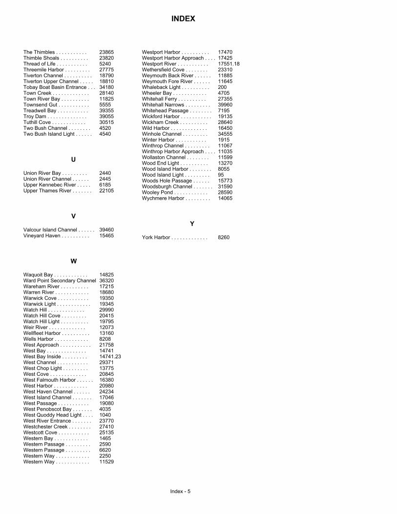
INDEX
Index - 5
The Thimbles . . . . . . . . . . .Thimble Shoals . . . . . . . . . .Thread of Life . . . . . . . . . . .Threemile Harbor . . . . . . . . .Tiverton Channel . . . . . . . . . .Tiverton Upper Channel . . . . .Tobay Boat Basin Entrance . . .Town Creek . . . . . . . . . . . . .Town River Bay . . . . . . . . . .Townsend Gut . . . . . . . . . . .Treadwell Bay . . . . . . . . . . .Troy Dam . . . . . . . . . . . . . .Tuthill Cove . . . . . . . . . . . .Two Bush Channel . . . . . . . .Two Bush Island Light . . . . . .
Union River Bay . . . . . . . . .Union River Channel . . . . . .Upper Kennebec River . . . . .Upper Thames River . . . . . . .
Valcour Island Channel . . . . . .Vineyard Haven . . . . . . . . . .
Waquoit Bay . . . . . . . . . . . .Ward Point Secondary ChannelWareham River . . . . . . . . . .Warren River . . . . . . . . . . . .Warwick Cove . . . . . . . . . . .Warwick Light . . . . . . . . . . . .Watch Hill . . . . . . . . . . . . .Watch Hill Cove . . . . . . . . .Watch Hill Light . . . . . . . . . .Weir River . . . . . . . . . . . . .Wellfleet Harbor . . . . . . . . . .Wells Harbor . . . . . . . . . . . .West Approach . . . . . . . . . . .West Bay . . . . . . . . . . . . . .West Bay Inside . . . . . . . . .West Channel . . . . . . . . . . .West Chop Light . . . . . . . . .West Cove . . . . . . . . . . . . .West Falmouth Harbor . . . . . .West Harbor . . . . . . . . . . . .West Haven Channel . . . . . .West Island Channel . . . . . . .West Passage . . . . . . . . . . .West Penobscot Bay . . . . . . .West Quoddy Head Light . . . .West River Entrance . . . . . . .Westchester Creek . . . . . . . .Westcott Cove . . . . . . . . . . .Western Bay . . . . . . . . . . . .Western Passage . . . . . . . . .Western Passage . . . . . . . . .Western Way . . . . . . . . . . . .Western Way . . . . . . . . . . . .
Westport Harbor . . . . . . . . . .Westport Harbor Approach . . . .Westport River . . . . . . . . . . .Wethersfield Cove . . . . . . . .Weymouth Back River . . . . . .Weymouth Fore River . . . . . .Whaleback Light . . . . . . . . . .Wheeler Bay . . . . . . . . . . . .Whitehall Ferry . . . . . . . . . .Whitehall Narrows . . . . . . . . .Whitehead Passage . . . . . . . .Wickford Harbor . . . . . . . . . . .Wickham Creek . . . . . . . . . .Wild Harbor . . . . . . . . . . . . .Winhole Channel . . . . . . . . .Winter Harbor . . . . . . . . . . .Winthrop Channel . . . . . . . . .Winthrop Harbor Approach . . . .Wollaston Channel . . . . . . . .Wood End Light . . . . . . . . . .Wood Island Harbor . . . . . . . .Wood Island Light . . . . . . . . .Woods Hole Passage . . . . . .Woodsburgh Channel . . . . . . .Wooley Pond . . . . . . . . . . . .Wychmere Harbor . . . . . . . . .
York Harbor . . . . . . . . . . . . .
23865238205240277751879018810341802814011825555539355390553051545204540
24402445618522105
3946015465
14825363201721518680193501934529990204151979512073131608208217581474114741.23293711377520845163802098024234170461908040351040237702741025135146525906620225011529
174701742517551.182331011885116452004705273553996071951913528640164503455519151106711035115991327080559515773315902859014065
8260
U
V
W
Y
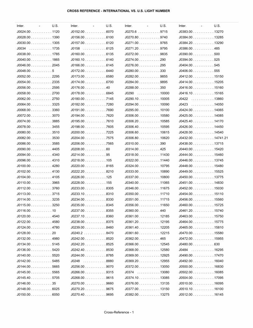
CROSS REFERENCE - INTERNATIONAL VS. U.S. LIGHT NUMBER
Inter. - U.S. Inter. - U.S. Inter. - U.S.Inter. - U.S.
Cross-Reference - 1
J0024.00 . . . . . . . . . . . .
J0028.00 . . . . . . . . . . . .
J0030.00 . . . . . . . . . . . .
J0034 . . . . . . . . . . . . .
J0038.00 . . . . . . . . . . . .
J0040.00 . . . . . . . . . . . .
J0046.00 . . . . . . . . . . . .
J0048.00 . . . . . . . . . . . .
J0052.00 . . . . . . . . . . . .
J0054.00 . . . . . . . . . . . .
J0056.00 . . . . . . . . . . . .
J0058.00 . . . . . . . . . . . .
J0062.00 . . . . . . . . . . . .
J0064.00 . . . . . . . . . . . .
J0068.00 . . . . . . . . . . . .
J0072.00 . . . . . . . . . . . .
J0074.00 . . . . . . . . . . . .
J0078.00 . . . . . . . . . . . .
J0080.00 . . . . . . . . . . . .
J0082.00 . . . . . . . . . . . .
J0086.00 . . . . . . . . . . . .
J0090.00 . . . . . . . . . . . .
J0094.00 . . . . . . . . . . . .
J0096.00 . . . . . . . . . . . .
J0100.00 . . . . . . . . . . . .
J0102.00 . . . . . . . . . . . .
J0104.00 . . . . . . . . . . . .
J0110.00 . . . . . . . . . . . .
J0112.00 . . . . . . . . . . . .
J0113.00 . . . . . . . . . . . .
J0114.00 . . . . . . . . . . . .
J0115.00 . . . . . . . . . . . .
J0116.00 . . . . . . . . . . . .
J0120.00 . . . . . . . . . . . .
J0122.00 . . . . . . . . . . . .
J0124.00 . . . . . . . . . . . .
J0128.00 . . . . . . . . . . . .
J0132.00 . . . . . . . . . . . .
J0134.00 . . . . . . . . . . . .
J0136.00 . . . . . . . . . . . .
J0140.00 . . . . . . . . . . . .
J0142.00 . . . . . . . . . . . .
J0144.00 . . . . . . . . . . . .
J0145.00 . . . . . . . . . . . .
J0145.40 . . . . . . . . . . . .
J0146.00 . . . . . . . . . . . .
J0148.00 . . . . . . . . . . . .
J0150.00 . . . . . . . . . . . .
J0152.00 . . . . . . . . . . . .
J0156.00 . . . . . . . . . . . .
J0157.00 . . . . . . . . . . . .
J0158 . . . . . . . . . . . . .
J0160.00 . . . . . . . . . . . .
J0160.10 . . . . . . . . . . . .
J0166.00 . . . . . . . . . . . .
J0172.00 . . . . . . . . . . . .
J0173.00 . . . . . . . . . . . .
J0174.00 . . . . . . . . . . . .
J0176.00 . . . . . . . . . . . .
J0178.00 . . . . . . . . . . . .
J0180.00 . . . . . . . . . . . .
J0182.00 . . . . . . . . . . . .
J0191.00 . . . . . . . . . . . .
J0194.00 . . . . . . . . . . . .
J0195.00 . . . . . . . . . . . .
J0198.00 . . . . . . . . . . . .
J0200.00 . . . . . . . . . . . .
J0204.00 . . . . . . . . . . . .
J0206.00 . . . . . . . . . . . .
J0208.00 . . . . . . . . . . . .
J0214.00 . . . . . . . . . . . .
J0218.00 . . . . . . . . . . . .
J0220.00 . . . . . . . . . . . .
J0222.20 . . . . . . . . . . . .
J0226.00 . . . . . . . . . . . .
J0228.00 . . . . . . . . . . . .
J0233.00 . . . . . . . . . . . .
J0233.10 . . . . . . . . . . . .
J0234.00 . . . . . . . . . . . .
J0235.00 . . . . . . . . . . . .
J0237.00 . . . . . . . . . . . .
J0237.10 . . . . . . . . . . . .
J0238.00 . . . . . . . . . . . .
J0239.00 . . . . . . . . . . . .
J0240.2 . . . . . . . . . . . .
J0242.00 . . . . . . . . . . . .
J0242.20 . . . . . . . . . . . .
J0242.40 . . . . . . . . . . . .
J0244.00 . . . . . . . . . . . .
J0248 . . . . . . . . . . . . .
J0256.00 . . . . . . . . . . . .
J0266.00 . . . . . . . . . . . .
J0268.00 . . . . . . . . . . . .
J0270.00 . . . . . . . . . . . .
J0270.20 . . . . . . . . . . . .
J0270.40 . . . . . . . . . . . .
J0270.6 . . . . . . . . . . . .
J0270.80 . . . . . . . . . . . .
J0271.00 . . . . . . . . . . . .
J0271.20 . . . . . . . . . . . .
J0272.00 . . . . . . . . . . . .
J0274.00 . . . . . . . . . . . .
J0276.00 . . . . . . . . . . . .
J0280.00 . . . . . . . . . . . .
J0282.00 . . . . . . . . . . . .
J0284.00 . . . . . . . . . . . .
J0288.00 . . . . . . . . . . . .
J0290 . . . . . . . . . . . . .
J0290.10 . . . . . . . . . . . .
J0294.00 . . . . . . . . . . . .
J0295.00 . . . . . . . . . . . .
J0306.00 . . . . . . . . . . . .
J0306.20 . . . . . . . . . . . .
J0306.40 . . . . . . . . . . . .
J0306.60 . . . . . . . . . . . .
J0306.80 . . . . . . . . . . . .
J0310.00 . . . . . . . . . . . .
J0314.00 . . . . . . . . . . . .
J0318.00 . . . . . . . . . . . .
J0322.00 . . . . . . . . . . . .
J0324.00 . . . . . . . . . . . .
J0333.00 . . . . . . . . . . . .
J0337.00 . . . . . . . . . . . .
J0340.00 . . . . . . . . . . . .
J0346.00 . . . . . . . . . . . .
J0350.00 . . . . . . . . . . . .
J0351.00 . . . . . . . . . . . .
J0356.00 . . . . . . . . . . . .
J0360.00 . . . . . . . . . . . .
J0361.00 . . . . . . . . . . . .
J0361.20 . . . . . . . . . . . .
J0361.40 . . . . . . . . . . . .
J0361.60 . . . . . . . . . . . .
J0362.00 . . . . . . . . . . . .
J0366.00 . . . . . . . . . . . .
J0368.00 . . . . . . . . . . . .
J0369.00 . . . . . . . . . . . .
J0369.20 . . . . . . . . . . . .
J0372.00 . . . . . . . . . . . .
J0374 . . . . . . . . . . . . .
J0374.10 . . . . . . . . . . . .
J0376.00 . . . . . . . . . . . .
J0377.00 . . . . . . . . . . . .
J0382.00 . . . . . . . . . . . .
J0383.00 . . . . . . . . . . . .
J0384.00 . . . . . . . . . . . .
J0384.20 . . . . . . . . . . . .
J0386.00 . . . . . . . . . . . .
J0390.00 . . . . . . . . . . . .
J0394.00 . . . . . . . . . . . .
J0404.00 . . . . . . . . . . . .
J0406.00 . . . . . . . . . . . .
J0412.00 . . . . . . . . . . . .
J0414.00 . . . . . . . . . . . .
J0416.00 . . . . . . . . . . . .
J0416.10 . . . . . . . . . . . .
J0422 . . . . . . . . . . . . .
J0423 . . . . . . . . . . . . .
J0424.00 . . . . . . . . . . . .
J0425.00 . . . . . . . . . . . .
J0425.40 . . . . . . . . . . . .
J0426.00 . . . . . . . . . . . .
J0428.00 . . . . . . . . . . . .
J0432.00 . . . . . . . . . . . .
J0438.00 . . . . . . . . . . . .
J0440.00 . . . . . . . . . . . .
J0444.00 . . . . . . . . . . . .
J0446.00 . . . . . . . . . . . .
J0448.00 . . . . . . . . . . . .
J0449.00 . . . . . . . . . . . .
J0450.00 . . . . . . . . . . . .
J0451.00 . . . . . . . . . . . .
J0452.00 . . . . . . . . . . . .
J0454.00 . . . . . . . . . . . .
J0456.00 . . . . . . . . . . . .
J0460.00 . . . . . . . . . . . .
J0461.20 . . . . . . . . . . . .
J0463.00 . . . . . . . . . . . .
J0464.00 . . . . . . . . . . . .
J0465.00 . . . . . . . . . . . .
J0470.00 . . . . . . . . . . . .
J0472.00 . . . . . . . . . . . .
J0480.00 . . . . . . . . . . . .
J0484 . . . . . . . . . . . . .
J0490.00 . . . . . . . . . . . .
J0492.00 . . . . . . . . . . . .
J0500.00 . . . . . . . . . . . .
J0502.00 . . . . . . . . . . . .
J0504.00 . . . . . . . . . . . .
J0510.00 . . . . . . . . . . . .
J0510.10 . . . . . . . . . . . .
J0512.00 . . . . . . . . . . . .
1120
1390
1305
1735
1785
1865
2045
5
2295
2335
2595
2700
2750
3325
3360
3070
3885
3455
3510
3530
3585
4405
4340
4310
4280
4130
4105
3965
3760
3715
3235
3250
10
4540
4580
4780
20
4980
5145
5420
5520
5485
5665
5565
5705
35
6025
6050
6070
6100
6120
6125
6135
6140
6145
6440
6580
6700
40
6845
7145
7280
7690
7620
7610
7605
7225
7575
7565
60
95
105
8165
8210
125
155
8305
8310
8330
8345
8355
8360
8375
8460
8470
8520
8525
8530
8785
8880
9070
9315
9615
9660
9675
9695
9715
9740
9765
9795
9835
290
295
330
9855
9895
350
10000
10005
10090
10100
10580
10585
10595
10615
10620
390
425
11430
11440
10795
10890
10800
11065
11675
11710
11715
11650
440
12185
12195
12205
12215
465
12545
12580
12925
12955
13050
13080
13085
13135
13150
13275
13270
13285
13290
485
500
525
545
555
15150
15205
15160
15165
13860
14050
14065
14085
14170
14450
14540
14741.21
13715
15420
15460
13745
15480
15525
13775
14830
15030
15110
15560
15725
15740
15750
15775
15810
15580
15955
630
16295
17470
16040
16830
16085
17095
16095
16100
16145
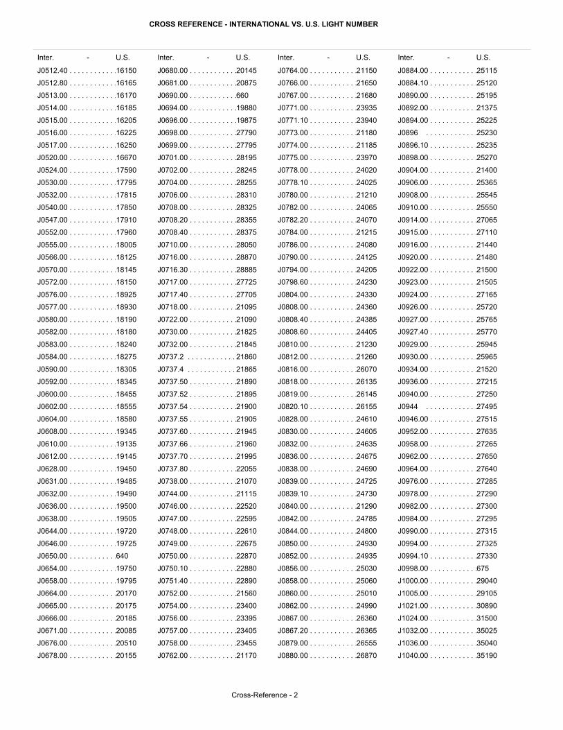
CROSS REFERENCE - INTERNATIONAL VS. U.S. LIGHT NUMBER
Inter. - U.S. Inter. - U.S. Inter. - U.S.Inter. - U.S.
Cross-Reference - 2
J0512.40 . . . . . . . . . . . .
J0512.80 . . . . . . . . . . . .
J0513.00 . . . . . . . . . . . .
J0514.00 . . . . . . . . . . . .
J0515.00 . . . . . . . . . . . .
J0516.00 . . . . . . . . . . . .
J0517.00 . . . . . . . . . . . .
J0520.00 . . . . . . . . . . . .
J0524.00 . . . . . . . . . . . .
J0530.00 . . . . . . . . . . . .
J0532.00 . . . . . . . . . . . .
J0540.00 . . . . . . . . . . . .
J0547.00 . . . . . . . . . . . .
J0552.00 . . . . . . . . . . . .
J0555.00 . . . . . . . . . . . .
J0566.00 . . . . . . . . . . . .
J0570.00 . . . . . . . . . . . .
J0572.00 . . . . . . . . . . . .
J0576.00 . . . . . . . . . . . .
J0577.00 . . . . . . . . . . . .
J0580.00 . . . . . . . . . . . .
J0582.00 . . . . . . . . . . . .
J0583.00 . . . . . . . . . . . .
J0584.00 . . . . . . . . . . . .
J0590.00 . . . . . . . . . . . .
J0592.00 . . . . . . . . . . . .
J0600.00 . . . . . . . . . . . .
J0602.00 . . . . . . . . . . . .
J0604.00 . . . . . . . . . . . .
J0608.00 . . . . . . . . . . . .
J0610.00 . . . . . . . . . . . .
J0612.00 . . . . . . . . . . . .
J0628.00 . . . . . . . . . . . .
J0631.00 . . . . . . . . . . . .
J0632.00 . . . . . . . . . . . .
J0636.00 . . . . . . . . . . . .
J0638.00 . . . . . . . . . . . .
J0644.00 . . . . . . . . . . . .
J0646.00 . . . . . . . . . . . .
J0650.00 . . . . . . . . . . . .
J0654.00 . . . . . . . . . . . .
J0658.00 . . . . . . . . . . . .
J0664.00 . . . . . . . . . . . .
J0665.00 . . . . . . . . . . . .
J0666.00 . . . . . . . . . . . .
J0671.00 . . . . . . . . . . . .
J0676.00 . . . . . . . . . . . .
J0678.00 . . . . . . . . . . . .
J0680.00 . . . . . . . . . . . .
J0681.00 . . . . . . . . . . . .
J0690.00 . . . . . . . . . . . .
J0694.00 . . . . . . . . . . . .
J0696.00 . . . . . . . . . . . .
J0698.00 . . . . . . . . . . . .
J0699.00 . . . . . . . . . . . .
J0701.00 . . . . . . . . . . . .
J0702.00 . . . . . . . . . . . .
J0704.00 . . . . . . . . . . . .
J0706.00 . . . . . . . . . . . .
J0708.00 . . . . . . . . . . . .
J0708.20 . . . . . . . . . . . .
J0708.40 . . . . . . . . . . . .
J0710.00 . . . . . . . . . . . .
J0716.00 . . . . . . . . . . . .
J0716.30 . . . . . . . . . . . .
J0717.00 . . . . . . . . . . . .
J0717.40 . . . . . . . . . . . .
J0718.00 . . . . . . . . . . . .
J0722.00 . . . . . . . . . . . .
J0730.00 . . . . . . . . . . . .
J0732.00 . . . . . . . . . . . .
J0737.2 . . . . . . . . . . . .
J0737.4 . . . . . . . . . . . .
J0737.50 . . . . . . . . . . . .
J0737.52 . . . . . . . . . . . .
J0737.54 . . . . . . . . . . . .
J0737.55 . . . . . . . . . . . .
J0737.60 . . . . . . . . . . . .
J0737.66 . . . . . . . . . . . .
J0737.70 . . . . . . . . . . . .
J0737.80 . . . . . . . . . . . .
J0738.00 . . . . . . . . . . . .
J0744.00 . . . . . . . . . . . .
J0746.00 . . . . . . . . . . . .
J0747.00 . . . . . . . . . . . .
J0748.00 . . . . . . . . . . . .
J0749.00 . . . . . . . . . . . .
J0750.00 . . . . . . . . . . . .
J0750.10 . . . . . . . . . . . .
J0751.40 . . . . . . . . . . . .
J0752.00 . . . . . . . . . . . .
J0754.00 . . . . . . . . . . . .
J0756.00 . . . . . . . . . . . .
J0757.00 . . . . . . . . . . . .
J0758.00 . . . . . . . . . . . .
J0762.00 . . . . . . . . . . . .
J0764.00 . . . . . . . . . . . .
J0766.00 . . . . . . . . . . . .
J0767.00 . . . . . . . . . . . .
J0771.00 . . . . . . . . . . . .
J0771.10 . . . . . . . . . . . .
J0773.00 . . . . . . . . . . . .
J0774.00 . . . . . . . . . . . .
J0775.00 . . . . . . . . . . . .
J0778.00 . . . . . . . . . . . .
J0778.10 . . . . . . . . . . . .
J0780.00 . . . . . . . . . . . .
J0782.00 . . . . . . . . . . . .
J0782.20 . . . . . . . . . . . .
J0784.00 . . . . . . . . . . . .
J0786.00 . . . . . . . . . . . .
J0790.00 . . . . . . . . . . . .
J0794.00 . . . . . . . . . . . .
J0798.60 . . . . . . . . . . . .
J0804.00 . . . . . . . . . . . .
J0808.00 . . . . . . . . . . . .
J0808.40 . . . . . . . . . . . .
J0808.60 . . . . . . . . . . . .
J0810.00 . . . . . . . . . . . .
J0812.00 . . . . . . . . . . . .
J0816.00 . . . . . . . . . . . .
J0818.00 . . . . . . . . . . . .
J0819.00 . . . . . . . . . . . .
J0820.10 . . . . . . . . . . . .
J0828.00 . . . . . . . . . . . .
J0830.00 . . . . . . . . . . . .
J0832.00 . . . . . . . . . . . .
J0836.00 . . . . . . . . . . . .
J0838.00 . . . . . . . . . . . .
J0839.00 . . . . . . . . . . . .
J0839.10 . . . . . . . . . . . .
J0840.00 . . . . . . . . . . . .
J0842.00 . . . . . . . . . . . .
J0844.00 . . . . . . . . . . . .
J0850.00 . . . . . . . . . . . .
J0852.00 . . . . . . . . . . . .
J0856.00 . . . . . . . . . . . .
J0858.00 . . . . . . . . . . . .
J0860.00 . . . . . . . . . . . .
J0862.00 . . . . . . . . . . . .
J0867.00 . . . . . . . . . . . .
J0867.20 . . . . . . . . . . . .
J0879.00 . . . . . . . . . . . .
J0880.00 . . . . . . . . . . . .
J0884.00 . . . . . . . . . . . .
J0884.10 . . . . . . . . . . . .
J0890.00 . . . . . . . . . . . .
J0892.00 . . . . . . . . . . . .
J0894.00 . . . . . . . . . . . .
J0896 . . . . . . . . . . . . .
J0896.10 . . . . . . . . . . . .
J0898.00 . . . . . . . . . . . .
J0904.00 . . . . . . . . . . . .
J0906.00 . . . . . . . . . . . .
J0908.00 . . . . . . . . . . . .
J0910.00 . . . . . . . . . . . .
J0914.00 . . . . . . . . . . . .
J0915.00 . . . . . . . . . . . .
J0916.00 . . . . . . . . . . . .
J0920.00 . . . . . . . . . . . .
J0922.00 . . . . . . . . . . . .
J0923.00 . . . . . . . . . . . .
J0924.00 . . . . . . . . . . . .
J0926.00 . . . . . . . . . . . .
J0927.00 . . . . . . . . . . . .
J0927.40 . . . . . . . . . . . .
J0929.00 . . . . . . . . . . . .
J0930.00 . . . . . . . . . . . .
J0934.00 . . . . . . . . . . . .
J0936.00 . . . . . . . . . . . .
J0940.00 . . . . . . . . . . . .
J0944 . . . . . . . . . . . . .
J0946.00 . . . . . . . . . . . .
J0952.00 . . . . . . . . . . . .
J0958.00 . . . . . . . . . . . .
J0962.00 . . . . . . . . . . . .
J0964.00 . . . . . . . . . . . .
J0976.00 . . . . . . . . . . . .
J0978.00 . . . . . . . . . . . .
J0982.00 . . . . . . . . . . . .
J0984.00 . . . . . . . . . . . .
J0990.00 . . . . . . . . . . . .
J0994.00 . . . . . . . . . . . .
J0994.10 . . . . . . . . . . . .
J0998.00 . . . . . . . . . . . .
J1000.00 . . . . . . . . . . . .
J1005.00 . . . . . . . . . . . .
J1021.00 . . . . . . . . . . . .
J1024.00 . . . . . . . . . . . .
J1032.00 . . . . . . . . . . . .
J1036.00 . . . . . . . . . . . .
J1040.00 . . . . . . . . . . . .
16150
16165
16170
16185
16205
16225
16250
16670
17590
17795
17815
17850
17910
17960
18005
18125
18145
18150
18925
18930
18190
18180
18240
18275
18305
18345
18455
18555
18580
19345
19135
19145
19450
19485
19490
19500
19505
19720
19725
640
19750
19795
20170
20175
20185
20085
20510
20155
20145
20875
660
19880
19875
27790
27795
28195
28245
28255
28310
28325
28355
28375
28050
28870
28885
27725
27705
21095
21090
21825
21845
21860
21865
21890
21895
21900
21905
21945
21960
21995
22055
21070
21115
22520
22595
22610
22675
22870
22880
22890
21560
23400
23395
23405
23455
21170
21150
21650
21680
23935
23940
21180
21185
23970
24020
24025
21210
24065
24070
21215
24080
24125
24205
24230
24330
24360
24385
24405
21230
21260
26070
26135
26145
26155
24610
24605
24635
24675
24690
24725
24730
21290
24785
24800
24930
24935
25030
25060
25010
24990
26360
26365
26555
26870
25115
25120
25195
21375
25225
25230
25235
25270
21400
25365
25545
25550
27065
27110
21440
21480
21500
21505
27165
25720
25765
25770
25945
25965
21520
27215
27250
27495
27515
27635
27265
27650
27640
27285
27290
27300
27295
27315
27325
27330
675
29040
29105
30890
31500
35025
35040
35190
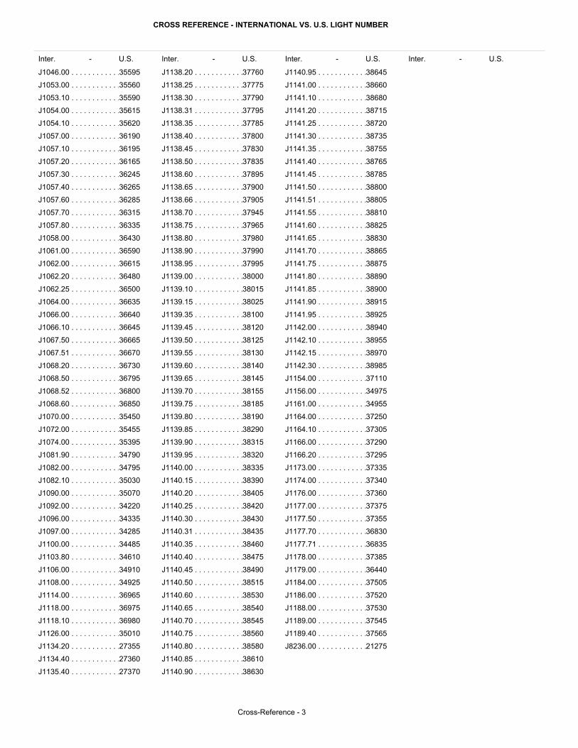
CROSS REFERENCE - INTERNATIONAL VS. U.S. LIGHT NUMBER
Inter. - U.S. Inter. - U.S. Inter. - U.S.Inter. - U.S.
Cross-Reference - 3
J1046.00 . . . . . . . . . . . .
J1053.00 . . . . . . . . . . . .
J1053.10 . . . . . . . . . . . .
J1054.00 . . . . . . . . . . . .
J1054.10 . . . . . . . . . . . .
J1057.00 . . . . . . . . . . . .
J1057.10 . . . . . . . . . . . .
J1057.20 . . . . . . . . . . . .
J1057.30 . . . . . . . . . . . .
J1057.40 . . . . . . . . . . . .
J1057.60 . . . . . . . . . . . .
J1057.70 . . . . . . . . . . . .
J1057.80 . . . . . . . . . . . .
J1058.00 . . . . . . . . . . . .
J1061.00 . . . . . . . . . . . .
J1062.00 . . . . . . . . . . . .
J1062.20 . . . . . . . . . . . .
J1062.25 . . . . . . . . . . . .
J1064.00 . . . . . . . . . . . .
J1066.00 . . . . . . . . . . . .
J1066.10 . . . . . . . . . . . .
J1067.50 . . . . . . . . . . . .
J1067.51 . . . . . . . . . . . .
J1068.20 . . . . . . . . . . . .
J1068.50 . . . . . . . . . . . .
J1068.52 . . . . . . . . . . . .
J1068.60 . . . . . . . . . . . .
J1070.00 . . . . . . . . . . . .
J1072.00 . . . . . . . . . . . .
J1074.00 . . . . . . . . . . . .
J1081.90 . . . . . . . . . . . .
J1082.00 . . . . . . . . . . . .
J1082.10 . . . . . . . . . . . .
J1090.00 . . . . . . . . . . . .
J1092.00 . . . . . . . . . . . .
J1096.00 . . . . . . . . . . . .
J1097.00 . . . . . . . . . . . .
J1100.00 . . . . . . . . . . . .
J1103.80 . . . . . . . . . . . .
J1106.00 . . . . . . . . . . . .
J1108.00 . . . . . . . . . . . .
J1114.00 . . . . . . . . . . . .
J1118.00 . . . . . . . . . . . .
J1118.10 . . . . . . . . . . . .
J1126.00 . . . . . . . . . . . .
J1134.20 . . . . . . . . . . . .
J1134.40 . . . . . . . . . . . .
J1135.40 . . . . . . . . . . . .
J1138.20 . . . . . . . . . . . .
J1138.25 . . . . . . . . . . . .
J1138.30 . . . . . . . . . . . .
J1138.31 . . . . . . . . . . . .
J1138.35 . . . . . . . . . . . .
J1138.40 . . . . . . . . . . . .
J1138.45 . . . . . . . . . . . .
J1138.50 . . . . . . . . . . . .
J1138.60 . . . . . . . . . . . .
J1138.65 . . . . . . . . . . . .
J1138.66 . . . . . . . . . . . .
J1138.70 . . . . . . . . . . . .
J1138.75 . . . . . . . . . . . .
J1138.80 . . . . . . . . . . . .
J1138.90 . . . . . . . . . . . .
J1138.95 . . . . . . . . . . . .
J1139.00 . . . . . . . . . . . .
J1139.10 . . . . . . . . . . . .
J1139.15 . . . . . . . . . . . .
J1139.35 . . . . . . . . . . . .
J1139.45 . . . . . . . . . . . .
J1139.50 . . . . . . . . . . . .
J1139.55 . . . . . . . . . . . .
J1139.60 . . . . . . . . . . . .
J1139.65 . . . . . . . . . . . .
J1139.70 . . . . . . . . . . . .
J1139.75 . . . . . . . . . . . .
J1139.80 . . . . . . . . . . . .
J1139.85 . . . . . . . . . . . .
J1139.90 . . . . . . . . . . . .
J1139.95 . . . . . . . . . . . .
J1140.00 . . . . . . . . . . . .
J1140.15 . . . . . . . . . . . .
J1140.20 . . . . . . . . . . . .
J1140.25 . . . . . . . . . . . .
J1140.30 . . . . . . . . . . . .
J1140.31 . . . . . . . . . . . .
J1140.35 . . . . . . . . . . . .
J1140.40 . . . . . . . . . . . .
J1140.45 . . . . . . . . . . . .
J1140.50 . . . . . . . . . . . .
J1140.60 . . . . . . . . . . . .
J1140.65 . . . . . . . . . . . .
J1140.70 . . . . . . . . . . . .
J1140.75 . . . . . . . . . . . .
J1140.80 . . . . . . . . . . . .
J1140.85 . . . . . . . . . . . .
J1140.90 . . . . . . . . . . . .
J1140.95 . . . . . . . . . . . .
J1141.00 . . . . . . . . . . . .
J1141.10 . . . . . . . . . . . .
J1141.20 . . . . . . . . . . . .
J1141.25 . . . . . . . . . . . .
J1141.30 . . . . . . . . . . . .
J1141.35 . . . . . . . . . . . .
J1141.40 . . . . . . . . . . . .
J1141.45 . . . . . . . . . . . .
J1141.50 . . . . . . . . . . . .
J1141.51 . . . . . . . . . . . .
J1141.55 . . . . . . . . . . . .
J1141.60 . . . . . . . . . . . .
J1141.65 . . . . . . . . . . . .
J1141.70 . . . . . . . . . . . .
J1141.75 . . . . . . . . . . . .
J1141.80 . . . . . . . . . . . .
J1141.85 . . . . . . . . . . . .
J1141.90 . . . . . . . . . . . .
J1141.95 . . . . . . . . . . . .
J1142.00 . . . . . . . . . . . .
J1142.10 . . . . . . . . . . . .
J1142.15 . . . . . . . . . . . .
J1142.30 . . . . . . . . . . . .
J1154.00 . . . . . . . . . . . .
J1156.00 . . . . . . . . . . . .
J1161.00 . . . . . . . . . . . .
J1164.00 . . . . . . . . . . . .
J1164.10 . . . . . . . . . . . .
J1166.00 . . . . . . . . . . . .
J1166.20 . . . . . . . . . . . .
J1173.00 . . . . . . . . . . . .
J1174.00 . . . . . . . . . . . .
J1176.00 . . . . . . . . . . . .
J1177.00 . . . . . . . . . . . .
J1177.50 . . . . . . . . . . . .
J1177.70 . . . . . . . . . . . .
J1177.71 . . . . . . . . . . . .
J1178.00 . . . . . . . . . . . .
J1179.00 . . . . . . . . . . . .
J1184.00 . . . . . . . . . . . .
J1186.00 . . . . . . . . . . . .
J1188.00 . . . . . . . . . . . .
J1189.00 . . . . . . . . . . . .
J1189.40 . . . . . . . . . . . .
J8236.00 . . . . . . . . . . . .
35595
35560
35590
35615
35620
36190
36195
36165
36245
36265
36285
36315
36335
36430
36590
36615
36480
36500
36635
36640
36645
36665
36670
36730
36795
36800
36850
35450
35455
35395
34790
34795
35030
35070
34220
34335
34285
34485
34610
34910
34925
36965
36975
36980
35010
27355
27360
27370
37760
37775
37790
37795
37785
37800
37830
37835
37895
37900
37905
37945
37965
37980
37990
37995
38000
38015
38025
38100
38120
38125
38130
38140
38145
38155
38185
38190
38290
38315
38320
38335
38390
38405
38420
38430
38435
38460
38475
38490
38515
38530
38540
38545
38560
38580
38610
38630
38645
38660
38680
38715
38720
38735
38755
38765
38785
38800
38805
38810
38825
38830
38865
38875
38890
38900
38915
38925
38940
38955
38970
38985
37110
34975
34955
37250
37305
37290
37295
37335
37340
37360
37375
37355
36830
36835
37385
36440
37505
37520
37530
37545
37565
21275