Knowing Places - UAlberta Press
319
-
Upload
khangminh22 -
Category
Documents
-
view
0 -
download
0
Transcript of Knowing Places - UAlberta Press

Knowing Places: The Inuinnait, Landscapes
and the Environment
by Béatrice Collignon
adapted from the translation of Les Inuit. Ce qu’ils savent du territoire by Béatrice Collignon (L’Harmattan 1996)
(translation and scientific editing by Linna Weber Müller-Wille)
Circumpolar Research Series No. 10 Canadian Circumpolar Institute
(CCI) Press
March 2006

Library and Archives Canada Cataloguing in Publication
Collignon, Béatrice Knowing Places: The Inuinnait, Landscapes, and the Environment / Béatrice Collignon; translator Linna Weber Müller-Willie. (Circumpolar Research Series, ISSN 0838-133X; no. 10)Translation of Les inuit, ce qu’ils savent du territoire. Includes bibliographical references.Includes summary in Inuktitut. ISBN 1-896445-33-0
1. Inuit—Canada. 2. Inuit—Canada—Social life and customs. 3. Inuit—Canada—Folklore. 4. Human geography—Canada. I. Weber Müller-Wille, Linna. II. Title. III. Series.
E99.E7C66613 2006 971'.004971 C2006-901327-6
*Authorized translation of the original French (Les Inuit, ce qu’ils savent du ter-ritoire, by Beatrice Collignon. Paris and Montreal: L’Harmattan 1996) © Linna Weber Müller-Wille 2003, Myriad Pursuits, St. Lambert (Québec) Canada
Scientific editing by Linna Weber Müller-Wille
**English adaptation of the translation of the French text © Béatrice Collignon, edited by Mick Mallon and final review by Janine Debanné
Illustrations © Ulukhaktok Eskimo Co-Op (used with permission of the artists)
Cartography © Béatrice Collignon [with the assistance of Alban Rideau (and Delphine Digout for maps 17, 18, 21 and 24)]
Cover illustration courtesy the author.
Cover design by Art Design Printing, Inc.
Printed in Canada by Art Design Printing, Inc.
ISBN 1-896445-33-0 © 2006 CCI Press
ISSN 0838-133X Circumpolar Research Series No. 10
All rights reserved.
Translation of the original French text was made possible with funding from the International Council for Canadian Studies (ICCS)
‘Ouvrage publié avec le concours du ministère de la Culture – Centre national du livre’ [This publication was made possible with funding from the Ministry of Culture – National Book Centre (Paris)]
Cover Photo: Barbara Memogana, Ulukhaktok (Ulukhaqtuuq), on a quiet evening in August 2004. Photo credit Béatrice Collignon

For Susia Kablusiak Memogana:
To the lively little girl I first met in the early 90s, whose laughter accompanied
me my main year of fieldwork and still resonates in my ears.
To the growing child and teenager I have enjoyed finding anew on each of my
trips to Ulukhaktok since.
To the wise adult she’ll soon be.
And to all the Inuinnait children, of yesterday, today and tomorrow.

Table of Contents
Acknowledgements . . . . . . . . . . . . . . . . . . . . . . . . . . . . . . . vii Author’s Note . . . . . . . . . . . . . . . . . . . . . . . . . . . . . . . . . . . xi Translator’s Note . . . . . . . . . . . . . . . . . . . . . . . . . . . . . . . . xii Introduction . . . . . . . . . . . . . . . . . . . . . . . . . . . . . . . . . . . . . 1
Vignette : Tatiik – Chronicle of a Fall Camp. . . . . . . . . . . . . . . . . 9
Chapter One: Setting the Stage: The Inuinnait and Their Land. . . 19
Chapter Two: Geographic Information: Learning Through Practices and Oral Tradition . . . . . . . . . . . . . . . . . . . . . 63
Chapter Three: Toponyms: What’s in a Place Name?. . . . . . . . 101
Chapter Four: Enacted Knowledge: How Inuinnait Live their Geography . . . . . . . . . . . . . . . . . . . . . . . . . . . . . . . . . . . . . . . 149
Chapter Five: Inuinnait geographic knowledge and Cultural Change . . . . . . . . . . . . . . . . . . . . . . . . . . . . . . 183
Epilogue . . . . . . . . . . . . . . . . . . . . . . . . . . . . . . . . . . . . . . 209 Bibliography . . . . . . . . . . . . . . . . . . . . . . . . . . . . . . . . . . . 215Appendices. . . . . . . . . . . . . . . . . . . . . . . . . . . . . . . . . . . . 231 Appendix A : Toponymic inventory and place name translations 231Appendix B : The scientific context: methods and sources . . . . . . . 259
Extended Table of Contents . . . . . . . . . . . . . . . . . . . . . . . 289 List of Figures. . . . . . . . . . . . . . . . . . . . . . . . . . . . . . . . . . 295 List of Insets. . . . . . . . . . . . . . . . . . . . . . . . . . . . . . . . . . . 297 Inuinnaqtun Summary . . . . . . . . . . . . . . . . . . . . . . . . . 299


vii
Acknowledgements
As the results of this research are about to be published in this English version, my thoughts first go out to the Inuinnait. I want to express all my gratitude to them. Without the trust they gave me, this research would not have been possible. I am particularly indebted to the elders, who took time to patiently teach me their geography. I wish to thank all of them here, notably Aime Ahegona, Simon Kadlun, Moses Koihok, Jimmy Memogana, Agnes Nerigyok, Mona Ohovilok, Sam Oliktoak and Nicholas Oloakiuk. Unfortunately, some of them are no longer with us.
I wish to give particular thanks to the whole community of Ulukhaktok, where the arctic side of my life began 26 years ago, when it was still called Holman. The teenager that I was then, later the young adult, and the person that I am today has been greatly influenced by our enduring relationship. I owe to the Ulukhaqtuurmiut not only a part of my professional achievements, but also, and more importantly, who I am as a person today. Indeed, koana to all of you.
I specially acknowledge the invaluable support of the whole Memogana family: Jimmy and Hayulak of course, and particularly Beverly and Wilma; Simon Kataoyak and his children, specifically Jack and Linda; Roger; Wilma’s children Kevin, Justin and Bryann; Barbara and Mathew Kuptana and their daughters Susie and Sandy; Roberta; and Buddy Alikamik. But above all, I am indebted to Mary Uyarartek. Her many comments, observations and explanations during the course of all my surveys contributed greatly to this research and others that followed. She also put her mark on the person I am today.
In the other settlements I also received a warm welcome and support, and especially thank, in Kugluktuk, Susie-Marie Tigiktok, as well as Martha Atigikyoak and her daughter Mavis, Donald Havioyak, Rosemarie Meeyok and Josie Tuktoo; and Agnes Allan, who very effect-ively and good-naturedly translated for me during the place name survey. In Umingmaktok, Amy Kaomayok and her family, Philip and Agy Kadlun, Nancy Kadlun, Joseph and Gwen Tikhak readily opened their homes to me. In Cambridge Bay, Betty-Ann Kaiyogana and Beatrice Bernardt were very helpful, as well as the Roman Catholic Mission and Rose Eider.
I am indebted to organizations that graciously made space avail-able to me locally for the duration of my surveys: Cambridge Bay Arctic Coast Tourist Association, Ulukhaktok Hamlet Office, Kugluktuk Hunters and Trappers Association, and all the Umingmaktuurmiut, who let me spread my maps on their floors.
Carrying a project to completion is always a joy. This, though does not erase the memory of those who, for reasons that we will never fully

Knowing Places
viii
understand, chose one day to leave forever. Among them I particularly think of David Akhiatak, Christa Kitekudlak and Amos Ekpakohak.
I extend sincere thanks to Professor Ludger Müller-Wille (McGill University), who hosted me at the Geography department of McGill University (Montréal), and his wife Linna Weber, first for their very valu-able guidance in the research methodology, then for their most helpful comments on my work while it was in progress and, last but not least, for their accessibility. In 1991, Linna gave me an adapted version of the database program that she had been developing and marketing for place names surveys, the Nuna-Top Program. In 2001 she agreed to under-take the translation of this work, adjusting the price of her services to the budget at our disposal. While we worked together on the manuscript, she also gave me valuable lessons on the nuances of the English language. Her work went beyond translating: she was an attentive reader, providing the work of a true editor and greatly improving the original manuscript.
One part of the analysis would not have been possible if, first, Mick Mallon (Arctic College, Iqaluit) in February 1992 in Cambridge Bay, then Michèle Therrien (Institut des Langues Orientales, Paris), and later Alexina Kublu (Arctic College, Iqaluit) had not taken the time to help me grasp the beautiful logic and the thousand subtleties of the Inuit language. Alexina Kublu also lent me her expertise during the delicate transcription of the Inuinnait toponyms in the standard orthography defined by the Inuit language commission and enhanced by the Inuit Cultural Institute (ICI). I would like to express my gratitude to all three. The final edition of this translation was another opportunity to work with Mick, and appreci-ate again his sense of humor and his receptiveness, and I know Kublu often got involved.
I also thank the Canadian Circumpolar Institute (University of Alberta, Edmonton) and its former Director Professor Cliff Hickey. He received me in 1991 and in 2000 agreed to take on the project of publish-ing the translation, which is now seeing the light of day. I extend my grati-tude to Elaine Maloney, who followed the project, assisting with fundrais-ing and seeing through the final editing and layout of the manuscript. In the last months, she took her place as a working partner.
Professors Philippe Pinchemel and Denise Pumain, both of the Panthéon-Sorbonne University (Paris 1) originated this research and al-ways kept a watchful and interested eye on its progress. My meeting with late Professor Joël Bonnemaison (Paris-Sorbonne University, Paris IV) and the many subsequent discussions we enjoyed played an important role in the preparation of this text. His unexpected disappearance left a large void. From the day he sat in my PhD. jury, Professor Paul Claval (Paris-Sorbonne University, Paris IV) has been an attentive reader of my work and has repeatedly provided support for its recognition. I am also indebted to Professors Anne Buttimer, Frédéric Laugrand, François

Acknowledgements
ix
Trudel and again to Ludger Müller-Wille for recommending the transla-tion project for funding.
The translation of a book is a tremendous endeavour that relies on important input along the way. I wish to thank geographer Ilima Pi’ianaia for her insights on chapter four, shared during lengthy discus-sions in 2003. Furthermore, I gratefully acknowledge Professor Janine Debanné (Carleton University, Ottawa) for the ongoing dialogue about my research, and for kindly reading through the final manuscript, offer-ing meaningful comments and proposing insightful clarifications at this crucial stage of the project.
My thoughts also go to Jean-François and Maryke Le Mouël, who invited me to join their archaeological team at Nauyat (30 miles East of Ulukhaktok) back in 1980. Without their trust in the teenager I then was, everything that followed would never have unfolded.
I wish to extend thanks to the Canadian institutions that hosted me at various stages of my research: the Department of Geography of McGill University (Montréal), the Groupe d’etudes inuit et circumpolaire (GETIC) [now the Centre interdisciplinaire d’études et recherches autochtones (CIERA)] of Laval University (Québec), the Canadian Circumpolar Institute of the University of Alberta (Edmonton), the Arctic Institute of North America at the University of Calgary, and the Territorial Toponymy Program of the Prince of Wales Northern Heritage Centre (Yellowknife).
I do not forget those who contributed from afar to make possible my long sojourn in the Arctic and my fieldwork in 1991-92. First of all was Jacques Sirois (Yellowknife), but as well the whole Debanné family (Edmonton, Ottawa, Montreal), most particularly Janine, and Kathleen Knötsch (Montreal). In Paris, Stéphane Audeguy and Jean-François Staszak, with their careful listening and criticisms, contributed greatly to the final out-come of this work as a respected PhD. But above all I thank my husband, Alban Rideau.
Finally, I would like to mention the organizations that gave financial support to this research and its publication: The French Department of Research (research grant, 1990-1993); the Club des explorateurs—Minister Alice Saunié-Séïté presiding—associated with the journal Express (Express-Exploration Award, 1991); Count Jean de Beaumont (Exploration Award, 1991); the Commission on Geographical Names of the Department of Natural Resources (which, through the Territorial Toponymy Program of the Government of the Northwest Territories, supplied the 530 maps I needed); the cultural section of the Canadian Embassy in Paris, (research grant for an Inuktitut course in Iqaluit, 1996). In addition, the research

Knowing Places
x
group on History and Epistemology of Geography (CNRS) provided ex-tensive travel support, along with the GDR ‘Arctique’ (CNRS) since 1993, while the research group Espaces et Cultures (Paris-Sorbonne University) covered the cost of the French publication of this research. First Air also contributed immeasurably, with discounted airfares and open ticket op-tions in 1991-92.
The translation and the publication in English were financed by the International Council for Canadian Studies (ICCS), Canadian Heritage; the Canadian Circumpolar Institute (CCI), University of Alberta; and the French Ministère de la Culture as well as the Institut Universitaire de France.

xi
Author’s Note
This book is an adaptation of the English translation of Les Inuit, ce qu’ils savent du territoire published in French in 1996, which was a mildly re-vised version of a PhD dissertation in geography completed in 1994.
If I were to write this text today, there is no doubt I would approach it differently, because since then I have acquired a deeper understanding of certain notions, and because the geographical and anthropological literature concerning Inuit and their knowledge has been greatly enriched during the intervening nine years. However, that would be another pro-ject and another book. For that reason this volume is an adaptation of the translation of the text published in 1996. The introduction has been completely rewritten, and the conclusion considerably reworked. There are minimal changes to the main body of the text, motivated by three considerations. First, the need to cite major works relating to my topic that have appeared since 1996; second, the need to adapt the text for a North American public, as well as for Inuit readers not familiar with scientific writing conventions; and finally, the improvement of the original text, made possible through both a revision by the author of an already somewhat dated text and, especially, through attentive reading by the translator. Linna Weber Müller-Wille played an invaluable role as editor, for which I am grateful.
In 1993, after a long sojourn in the field (ten months and later two months, separated by a return to France for four months), I had to set about writing my dissertation. That meant writing in French about mat-ters I had been learning about, and which I had thought about, in an-other language: English. Changing to another language required me to reformulate and even revise certain analyses. Writing in French, I had no choice but to immerse myself, at least in part, in the mental images that are conjured up by the language itself. Throughout this experience, therefore, I was constantly and keenly aware of something we know in the abstract: that whatever we write about the Inuit, in English or in French, can only give a very imperfect account of their culture, their values, and their thoughts. Ten years after this preliminary exercise, I found myself in the reverse situation—the analyses I had developed in French were not fit for the English language and I had to adapt my work to the structure of that language, in other words, modify it slightly.
Consequently, although I only made few changes to the French text, this English version is a different volume, with a different internal

Knowing Places
xii
logic, having been constructed in a different language. It thus opens up new interpretive opportunities.
Discussing survey methods and interpretation of data has always been part of a researcher’s responsibility. Curiously, however, returning the data to its rightful owners was, until fairly recently (1980s), not considered an obvious necessity. Today, within a framework of more equal relation-ships, the researcher’s role is becoming first of all that of a vehicle by which information can be transmitted between generations that can no longer communicate directly with one another because death, language, or simply a new way of life has separated them. This book should be read as a contribution to this circulation of knowledge.
Béatrice Collignon, Bologna May 2002 / Edmonton February 2005
xiii
Translator’s Note
In translating Les Inuit, ce qu’ils savent du territoire, I had a unique op-portunity to draw on my own experiences living among the Inuit and learning about their culture and perspectives, combining them with the task of capturing the author’s perspectives and conveying them to read-ers with varied backgrounds—scientists on the one hand, and lay people on the other hand. Prospective Inuit readers would be lay people as far as the western scientific approach of the book, but they would pos-sibly know more about the topic than the author herself, from their own perspective.
I tried to accomplish the author’s wish to address these diverse audiences by the choice of vocabulary and sentence structure, where possible. This was an aspect that was new to the book. The book was originally written for a French academic readership. French readers of the original book have historical information, perceptions, and backgrounds that are quite different from potential English readers, and again from potential Inuit readers. Some things had to be expressed very differently in the English version; I could assume most readers would have at least a general back-ground about Inuit. The challenge was to keep the scientific quality while adjusting the more general segments for a wider public, interweaving very specialized terminology of geography and anthropology with more familiar vernacular or daily language.
My own experience—first as an outsider to Inuit and Inuit culture, then later living among them and becoming knowledgeable and comfortable with their culture, still later conducting place names surveys and mak-ing maps, collaborating with them to record and preserve their rich oral geographic tradition—enabled me to evaluate, during translation, which parts needed explanation, revision or special emphasis to convey the in-side perspective the author wished for. The challenge was to bridge the different thought patterns and imagery inherent in the three cultures and languages involved—Inuit and Inuktitut, French, English.
Another concern was to try to match the author’s writing style—at least its feel—while still keeping to an appropriate style for the genre in English. I feel it is also important for a scientific text to maintain a degree of beauty in the writing. I hope that these goals have been achieved, at least in some degree.

Knowing Places
xiv
The author and I evolved a close, smooth working collaboration of mutual trust and interest in each other’s point of view looking at the material to be translated through the eyes of our respective cultural back-grounds. Many fruitful discussions ensued, ranging from the problems of finding the precise words to convey the meaning and ambience of an item or concept that did not really exist in either of our cultures, to philo-sophical discussions on scientific ethics, methodology, and specific details of our own place name studies. Both our lives have been greatly affected by our experiences with Inuit, and it was a special pleasure to work so intimately with Béatrice Collignon on this project. I thank her for giving me this opportunity.
Linna Weber Müller-Wille
St. Lambert (Québec) Canada, July 2002

�
Introduction
veryone, by nature, is a geographer. Every day, every one of us has to deal with places, spaces and the environment. We have to make decisions about how to behave in our world—a world that we have
inherited from our ancestors and hope to pass on to our descendants. The choices that we make depend on a global understanding of our uni-verse—an understanding that we inherit from our own specific culture. The choices we make may, in turn, affect that cultural understanding.
My aim in writing this book was to bring to the reader what I have learned about the way one group of Inuit, the Inuinnait of the Central Arctic look upon their land. What is their perspective, their attitude, their vision regarding the land? Using a case study, my intent is to give an account of the common geographic knowledge of a non-western oral culture, and to make it accessible, and I hope appealing, to the general public. More importantly, in return for having shared their knowledge with me, I wish here to relate to the Inuinnait my understanding of their geographic knowledge. I feel it is important to bring back the conclusions, along with explanations about my process and the reasons behind it, as a means of deepening the dialogue we began together so many years ago.
What will the future be like for the Inuit? That is today’s greatest ques-tion in the Canadian Arctic; and it also was the starting point for my research into their geography. From the Bering Strait to Greenland, all Inuit have been experiencing profound cultural change since the �950s. The changes affect every aspect of Inuit life—the most material as well as the most intellectual and abstract. As a result of these changes, many Inuit have begun a process of self-reflection, a search to understand what Inuit identity really is.
Like so many other outsiders to the North-American Arctic, I have been struck by the challenges facing a people ‘caught between two worlds,’ as they are often described and as they often describe themselves. As a geographer, I feel that an important element of Inuit identity lies in the way they understand the land in which they live. Geographic knowledge is not simply a collection of facts, it is also a cultural construct. It expresses how the environment is thought of, and how the relationships between it and human beings are developed. Geographic knowledge encompasses core cultural values, especially for people as closely connected to the land as the Inuit. I felt that if I could explore their knowledge of geography,

Knowing Places
�
then I would better understand how the Inuit are responding to the chal-lenges that face them at the dawn of the ��st century.
This book is thus more than ‘geography.’ It is about the cultural identity of the Inuit of yesterday and today, and of tomorrow. I have tried to identify the essence of the centuries-old geography of the Inuit because it is only with this background that we will be able to explore it in the present. In tackling the theme of indigenous knowledge my goal is to contribute to a better understanding of how modern Canadian Inuit are redefining their identity.
People who live outside the Arctic think of it as a vast, monotonous chunk of ice and frozen land. They also think Inuit are all the same, from the Bering Strait to Greenland. Yet, those who live in the Arctic or are familiar with it know that it is as diverse as any environment, and that the people who inhabit it cannot be seen as a single group. The Inuit culture does in-deed spread across all the North-American Arctic, but there are quite im-portant regional differences. To conduct in-depth research on my chosen subject, I needed to concentrate on one Inuit group, and therefore on one region. I chose the Inuinnait, who live in the Canadian Central Arctic (Fig. �), and scarcely numbered 3,300 people in �99� (in �005, all Inuit of the world together numbered approximately �30,000).
In the �950s and �960s the Inuinnait settled in five communities: Cambridge Bay and Ulukhaktok (formerly Holman) on Victoria Island, and Umingmaktok, Bathurst and Kugluktuk (formerly Coppermine) on the tip of the North American mainland. These settlements were always of very unequal size; in �99�, they ranged from �0 to �,500 inhabit-ants. I conducted most of the fieldwork for this particular research from September �99� to December �99�. However, I had made my acquaint-ance with the community of Ulukhaktok in the summer of �980, and visited Kugluktuk and/or Ulukhaktok several times after �99�. In �996, �003, �004, and �005 I visited as a friend; in �998 and �000, I con-ducted a project on Inuinnait domestic spaces.
When I began my research into the geographic knowledge of the Inuinnait in the early �990s, even the word ‘knowledge’ was problematic when used to describe anything that was not produced by Western science. Anthropologist Julie Cruikshank was one of the first strong academic voices to advocate that aboriginal knowledge is as valid as any other kind of knowledge. As early as �984, she wrote;
The very language we use (‘our knowledge, their values’) is problem-atic. Knowledge implies certain absolutes; values suggest relativity (Cruikshank �984: �9).

Introduction
3
The validity of Inuit knowledge is no longer contested today. The �990s saw a major shift in attitude and the issue of knowledge took centre stage in Arctic Studies and politics. In the Canadian territory of Nunavut, for example, Inuit knowledge (Inuit qaujimajatuqangit – IQ) in its broad-est sense must now be integrated at all levels of the administrative frame-work. It has to be taken into consideration in every political and bureau-cratic decision, as well as in all programs in education, health, land and wildlife management and, of course, research of any kind.
Although, or maybe because, the concept of ‘knowledge’ has be-come very popular, I should explain how I use it in this study. Knowledge is usually defined as ‘that which gives meaning to a situation, an event, a phenomenon or a process.’ We construct this meaning by pulling togeth-er a number of small units of information—these ‘units of information’ are the foundation of knowledge. As we assemble and process these units in our mind, a broader understanding gradually unfolds. This broader understanding is more than the sum of all its parts, because our mind also makes connections between and among the units, and as it does so, it creates new information. This interlacing of units increases the value of the whole set, constantly re-generating the knowledge. So knowledge ac-
Figure 1: Circumpolar view of the land of the Inuinnait
Knowing Places
4
quisition is a dynamic process rather than a static result. Western science is one form of knowledge, and Inuit knowledge is another.
Since the early �990s, indigenous knowledges in general have usu-ally been called Traditional Ecological Knowledge (TEK) by social scien-tists. Despite its popularity, I find this expression unsatisfactory and am reluctant to use it for several reasons that I discuss in Appendix B. I prefer the expression ‘vernacular knowledge,’ which does not convey a nostal-gic approach, nor does it limit indigenous knowledge to the ecological realm. ‘Vernacular’ suggests ‘that which is related to insiders, that belongs to a particular community.’
In geography, a ‘vernacular knowledge’ is first and foremost the knowledge that derives from a direct and subjective experience of one’s space, and environment. This knowledge is shared by all members of the cultural group; it expresses their concepts of space, place and environ-ment. Through their geographic vernacular knowledge, the Inuit possess a highly articulated understanding of the inhabited and inhabitable world around them. They can rely on this understanding. They can process the information contained in it to make appropriate decisions in their lives as hunters and travellers. They put their knowledge into use every day.
Borrowing Nunavut’s terminology, this study aspires to convey Inuit nunamik qaujimanituqarijangat: the Inuit’s own (and ancient) know-ledge of the land; that is, Inuit geography.
Whether you call it TEK, vernacular, or IQ when describing Inuit-specific knowledge, indigenous knowledge today enjoys new attention and re-spect, especially in the North-American Arctic. There are two main rea-sons for this shift in attitude. First, there is a willingness of Inuit to think through and express their own ideas on cultural identity. Since the �990s, indigenous peoples have begun to speak out, and they are being heard. Second, partly as a result of the Inuit effort, there is a willingness among researchers to listen, and to learn. The attitudes of Western science toward other knowledge sets have evolved. These changes (presented in detail in Appendix B) are affecting the way researchers approach their work.
In recent years, the North American Arctic has become, in certain ways, a ‘testing ground’ for a new kind of science. One that draws its strength from a close collaboration between academic researchers and indigenous experts, whereby different perspectives are blended, yielding to a better understanding of the issues at hand. But that’s not all. There has been a profound change in the attitude of academic researchers to-ward their partners in the field, who for too long were considered merely as ‘informants.’ They were the anonymous people who simply answered questions, while the researcher was the skilled and well-trained expert who knew what questions to ask and what to do with the answers. The ‘informants’ were simply a source of information; their knowledge was local, it was not considered ‘comprehensive.’ Their names were rarely

Introduction
5
Eskimo or Inuit? Copper Eskimo or Inuinnait?
The name ‘Esquimau’ (‘Eskimo’) was first used in Europe (France), in 1611 in a mission report by Father Biard, a Jesuit. He learned it from the Maskegon Cree Indians of the south-ern shore of Hudson Bay and, considering it to have been derived from the Algonquin word esquimew, translated it as ‘eater of raw meat.’ Today it is thought that this pejorative inter-pretation was incorrect and that this term is of Montagnais origin. It would then mean ‘those who speak the language of a foreign land’ or perhaps ‘those who wait for a long time.’ This last meaning could refer to the way Inuit hunters wait so patiently at seal breathing holes on the ice (Mailhot 1978).
The ‘Eskimo’ call themselves Inuit: ‘the people’ (singular: Inuk), while they call the ‘Indians’ Itqilit (the carriers of lice) or Allait (others) and all the others, mainly ‘White people,’ Qallunaat (sing. Qallunaaq). The origin of this word is obscure. Inuit folk etymology connects it with the two words Qallu (eyebrow) and naaq (belly), but that is unlikely.
In the 1970s, the movement toward a recognition of aboriginal peoples’ rights advo-cated abandoning the name ‘Eskimo’ in favour of Inuit. In 1977, participants at the first Inuit Circumpolar Conference (attended by Inuit from Alaska, Canada and Greenland), demanded it be officially adopted, which Canada did in 1978. I have followed current practice, using Inuk for the singular, and Inuit for the plural. The language is called Inuktitut: ‘in the manner of the Inuit.’
Inuit is only a regional name, however. In Alaska, the original culture has evolved into two branches, Yupik and Iñupiaq, the later being the regional equivalent of Inuit. The name Inuit is both too foreign and too specific for the Alaskan situation, and so ‘Eskimo’ is still ac-cepted there. As for aboriginal Greenlanders, they recognize the name Inuit and Inuktitut but prefer to refer to themselves by their own name Kalaallit (sing. Kalaaliq), which is probably an adaptation of an ancient Norse word. The use of Inuit is thus limited to Canada—in other words, to the ‘Central Eskimo’ (see Fig. 4, p. 22). Until well into the 1990s, several anthro-pologists continued to use the name ‘Eskimo’ to designate the culture in its entirety, while retaining the regional names for separate groups. Today, the use of ‘Eskimo’ is usually limited to linguistics studies focusing on the general structure of a language common to all Inuit, from the Bering strait to Greenland. I will follow this custom.
We face the same problems of terminology for the Inuinnait, who were first named ‘Copper Eskimo’ by explorer Vilhjalmur Stefansson (1913) after his initial encounter with them in 1911. In the 1980s some renamed them ‘Copper Inuit,’ a rather unconvincing terminological leap (see Chap. 1, p. 24). For several years, linguists have designated them the Inuinnait (singu-lar: Inuinnaq), a dialectical form of the name Inuit. This seems more appropriate to me, and therefore I use this term. I refer to Inuinnaq for the singular, and to Inuinnait for the plural. For the transcription of Inuinnaqtun (the dialect spoken by the Inuinnait), I follow the standard enhanced by the Inuit Cultural Institute (ICI), although this orthography is not accepted by all Inuinnait (see fn. 29, Chap. 1, pp. 48-49 and Appendix A, p. 231).
My reasons for choosing this orthography are twofold: it is the one young Inuinnait learn at school, and readers familiar with other Eskimo dialects will be able to recognize the words easily and make comparisons if they wish to do so. Alexina Kublu, formerly from Nunavut Arctic College in Iqaluit, graciously assisted me with the transcription of the place names, and for other words I followed the orthography as used in dictionaries by Ronald Lowe (1983) and Louis-Jacques Dorais (1990a and b). I have also followed the Inuinnaqtun dialectal form of the term Qallunaaq, which is hence written Qablunaaq (plural: Qablunaat) throughout this book.

Knowing Places
6
mentioned in the articles or books that were later written. The researcher received the credit; the informants a few dollars.
Today, the situation is very different. Yesterday’s informants are today’s partners. Because their own knowledge is now respected, they are accepted as ‘experts’ in their own right. Their names now appear in scientific publications and the topic of the research often reflects their own interest. Southern scholars are still useful and valued partners, as ‘academic informants.’
But working in partnership still has its problems. When working in a small community it is essential to respect people’s privacy. This particular-ly is the case when someone provides personal information or mentions sensitive situations. Elders are often more comfortable with publicity; their status as elders allows them more freedom to express themselves and they have lived long enough to handle the pressure. But others in the com-munity have to be more careful about how their opinions might become known to their neighbours. In this volume, I have listed the names of all those who agreed to participate in the place names survey (Appendix A). But when I quote the words of an Inuinnaq directly, I personally acknow-ledge them by using the initials of a pseudonym. I participated in many daily activities during my time in Inuinnait communities, and most of the statements quoted here were made during these informal moments. Everyone I talked with was well aware of my research interests, and spoke freely to me. But without having asked them specifically, I cannot assume that I have their permission to publish their names.
In one way or another all Inuinnait contributed to this study—whether through ongoing participation or by just a few words, one action or one comment; I take this opportunity to acknowledge them here.
I am a geographer, but my work is somewhat influenced by anthropology. By using a trans-disciplinary approach, I try to present Inuinnait geog-raphy as a complete unit, not as a set of isolated facts. I also try to respect the way this geography illustrates Inuinnait values and wisdom of the land. To this end, this volume is organized into five chapters, and two appendices.
The material and intellectual culture of the Inuinnait, as well as their social organization, have characteristics that are different from those of other Central Arctic Inuit. For this reason, the first chapter introduces the Inuinnait to readers unfamiliar with Arctic culture, as well as to those already well-informed about other Inuit groups.
A geographic knowledge set is constructed by connecting differ-ent units of information. A first step in exploring this area is to identify these units. For the Inuinnait, the units of information are of two kinds: the first relates to hunting, fishing and trapping activities, and travel and movement associated with those activities. Taken together, I call these ac-tivities ‘cynegetic activities.’ The second kind of information is oral trad-
Introduction
�
ition. These two different kinds of information are analyzed in the second chapter.
Place names, although belonging to the oral tradition, are dealt with separately in Chapter Three since they have been my main gateway to an understanding of Inuinnait geography.
Once all the units of information are identified, the next step is to understand how these units interconnect to form an operational system of geographic knowledge. This process is described in Chapter Four. For this part of the study, we do not simply look at what the Inuinnait know, ‘qaujimajangit,’ we also look at how they know, ‘qaujimaningit.’ This ap-proach allows us to identify central concepts of Inuinnait culture and of Inuit culture as a whole. These concepts pervade not only the geographic realm, but language and social organization as well.
Arctic societies have experienced profound changes in the last few decades. Every aspect of life has been affected, and so has geographic knowledge. The last section (Chapter Five) is dedicated to an exam-ination of the main influences and adaptations of Inuinnait geographic knowledge.
Two appendices complete this volume. It seemed useful to include a list of all the place names collected in the context of the only compre-hensive survey ever undertaken for the land of the Inuinnait. Place names are given along with their English translations in Appendix A. This book is the result of an academic research project, but is intended to be read and appreciated by the general public. I therefore chose not to include ex-haustive discussions regarding methodology and theoretical discussions in the main text. An overview of the scientific context of the research has been placed in Appendix B, as I felt this information should nonetheless be available to interested readers.
The geographic knowledge of the Inuinnait is not merely a collection of concrete facts that can be set out in a list. It is more than that. It is a com-plex and abstract construct that cannot be understood simply by assem-bling information. As an outsider I had to start by identifying the various ‘units of information’ that made up the basic knowledge set. The next step was to uncover how all these units related one to another. It was only in a third stage that I could begin to understand the intellectual construct Inuit geographic knowledge is. Thus the study of the data must precede the study of the structure in which the data are organized.
The present volume faithfully follows this plan. It progresses by unveiling its various elements, and invites the reader to enter into a realm of knowledge as it unfolds and is explained through its description. This method is akin to that used by the Inuinnait themselves when they share information, ideas, values, etc. Transmission of knowledge is always done by way of practical experience; the essence of geographic knowledge is understood more clearly by the way it is expressed verbally and through

Knowing Places
8
actions. It is important, therefore, to pay close attention to situation, to context, and to the words used to convey this knowledge. Before we begin our journey, then, it is important to provide the reader with a con-text, an insight into ‘geographic knowledge in action’—as it is used in everyday life.
To that end, I begin with the story of a journey to a popular fishing camp, Tatiik.
(after Anaginak, Ulukhaktok)

�
Vignette
Tatiik — Chronicle of a Fall Camp
nuit place names often seem very descriptive. For example: Tatiik, ‘the two lakes,’ appears at first glance to be a fairly neutral name, simply describing a place through its landforms. But to the Inuinnait
of Ulukhaktok, (Ulukhaqtuuq, formerly Holman�), the name implies a great deal more. The place name Tatiik symbolizes a whole way of life, far from that of the settlement.
At the turn of the twentieth century, many Inuinnait families would camp at Tatiik at the start and at the end of summer. The camp comprised the first and the last stage of the summer migration, during which fam-ilies followed the valley of Kuujjuaq (‘the biggest and longest river’) from Kangiryuaqtihuk (‘the smaller big bay’—Minto Inlet) into the interior of the land (Fig. 2). In fall time (around the month of October) the families would return to the mouth of the river where they would wait for the ice to become firm enough to support their winter camp. In the meantime, they hunted caribou and trapped around the Tatiik area.
After the Inuinnait of western Victoria Island moved into the settlement of Ulukhaktok, created at the bottom of the three hills of Ulukhaqtuuq, (‘there are many good rocks to make ulus’2) Tatiik became a very popular camp for the fall season. In fact, it very soon became the only destination for all Ulukhaktok families in the months of October and November. There, each family would set nets under the young ice to har-vest Arctic char (salmon family, Salvelinus alpinus) that come each year to the area to spawn. In ���3, however, this seasonal round was inter-rupted. A wildlife survey had confirmed what people had observed for several years: the fish stock was severely depleted in the area. As a result,
� The community of Holman approved by referendum to change its name to Ulukhaktok on �2 December 2005. The change will be officially effective on April �, 2006. Therefore, we will use the new official name throughout this volume. About the official orthography of some Inuit settle-ments, see fn. 2�, Chap. �, pp. 48-3�.2 The ulu is the woman’s knife. With its trademark semi-circular blade, its shape has become an icon of Inuit culture, along with the igloo and the inukshuk.

Knowing Places
�0
the municipal council forbade all fishing for a period of three years (see inset, Chap. �, p. 27). Fishing resumed in ���6 but a quota of 30 fish for each household was implemented. In this vignette, I describe life in Tatiik in the ��80s, when fishing was still bountiful.
Getting to Tatiik
Travellers arrive from Ulukhaktok, from the South. Emerging from a bare-ly enclosed valley bordered by heavy hills thirty to one hundred metres high, a flat wind-swept expanse opens before them: this is Tatiik.
Figure 2: The west coast of Victoria Island.

Tatiik
��
Today the trip is timed according to the calendar of the Qablunaat (the White people). If possible, it is planned for a weekend, the Thanksgiving holiday (at the end of October in Canada) being the most popular. Weather conditions, though, are still the determining factor of the jour-ney. Until the moment the snowmobile engine starts, on the very morning of the journey, departure is not certain. The concern is not so much the cold, but visibility. If the weather is calm but the sky completely cloud-covered, everything is bathed in a pale light in which variations in ter-rain are not discernable. The landscape is then nothing but a uniform white expanse that merges with the sky: Qapalaqiyuq! It’s a whiteout! Impossible to distinguish familiar landmarks. Better delay the trip until tomorrow. A blizzard, piqtuq, often chains travellers to the settlement as well. Based on their own experience, each hunter decides whether the trip is possible or not.
En route, the snowmobile driver (usually a man) calls upon his memory of places as well as his technical skill in managing the equipment. Using his memory he can follow a fairly exact itinerary. Relying on his skills, he guides the snowmobile toward snow-covered areas that seem to offer the best travel conditions. He looks for hardened snow cover thick enough to cover the rocks that could scrape the treads of his vehicle or the runners of his sled. To his experienced senses, the land he travels is not barren: it is populated by histories and spirits. His eyes are always on the lookout for the animals that live there: an arctic hare, a white fox, a musk-ox, per-haps a caribou. The driver will usually simply pass these by. Sometimes, though, depending on the food needs of the moment, or even just out of simple desire, he might temporarily hook off his load to dash off in pursuit of game.
Sitting on the sled, the passengers also scan the landscape, exam-ining its smallest details to rediscover patterns memorized during previous travels and to locate animals in the distance. Their memories become alive again. Passing Atuaqtarvik (‘the place where an axe was left’), they are reminded that Nuttaina let his axe fall into the water here. Going along the lake called Hanningayuq (‘the big one that is sideways or cross-wise’) brings to mind many memories of the long spring fishing parties, when the days are 24 hours long.
It takes three to six hours, sometimes more, to cross the 70 or so kilometres separating the settlement from Tatiik. Exactly how long de-pends on the load, the power of the snowmobile and the quality of the snow (which in October is often soft and not very thick, slowing the jour-ney). Wind speed and direction are also determining factors. Finally, time spent at Akulrutaaq (‘between the two’) must be taken into account in the journey’s length. Because of its location halfway between Ulukhaktok and Tatiik, this small lake, hemmed in by two hills, has almost become a compulsory stop for travellers. There, warm tea is poured from ther-
Knowing Places
�2
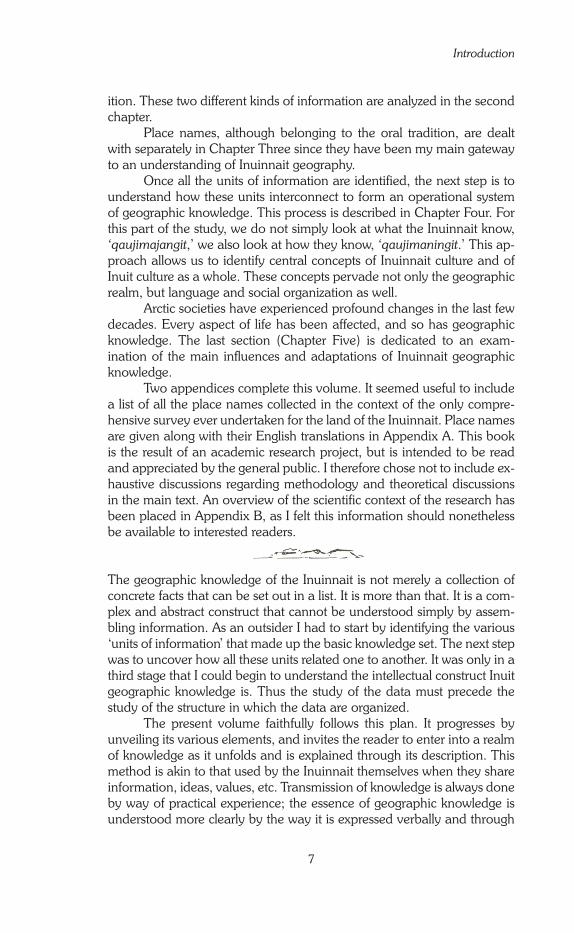
Figure 3: The land around Tatiik

Tatiik
�3
moses and home-made dried meat pulled from the grub box for a snack. Sheltered from the wind, the travellers take their time. There is no need to hurry.
At the end of a valley, a large pebble beach, Tuapaluin—the gravels (Fig. 3), opens onto Tatiik. In earlier times, the Inuinnait pitched their caribou skin tents3 on this lovely beach in summer. Today its gentle slope serves, above all, as an access ramp to the frozen lake that must be crossed to reach the northeastern banks. This is where most Ulukhaqtuurmiut (‘the people of Ulukhaqtuuq’) camp in the fall, on both sides of the Ainauqattahuk. In mid-October the ice is still young and thin. The driver must be alert to recognize safe passages where the ice is firm enough to support the weight of the snowmobile and the loaded sled. While driving, one must remember the places where the current is strong or where there are shallows and other conditions. It is never a question of simply cutting across the middle of the lake or of following a straight course: the route taken by each traveller is a compromise between an impossible straight line and the long winding route along the shoreline. For sure, though, as the days grow colder and the ice thickens, the path across the lake draws a more direct line.
On the other side of the lake, at the camp, everyone finds their own place. Related families group their tents together, keeping a distance of about one hundred metres from the tent clusters of other related fam-ilies.4 The traditional Inuinnait social structure is clearly reflected in the spatial organization of this temporary living space, which hardly changes from one year to the next. Inside the tents, domestic space is set up in a pattern that has hardly changed for at least 800 years (see fn. 25, Chap. 2, p. ��). With prevailing winds coming from the East, the doors of the tents almost all face West.
Life at Tatiik
The journey behind them, the travellers organize their camp. A block of ice must now be cut to make water. Where to get it from? There, where the lake is deep so the water is not muddy and where the ice is already thick enough so the block will last a long time? Or will someone venture back up the valley to the small lake at the top of the hill? There, the water is purer.
Soon everyone is rushing for the ice chisels. They begin cutting holes in the ice on the lake and soon can lower their fishing lines. Some time passes and there are bites. Finally, the first fish from Tatiik this fall!
3 Sometimes summer tents were made of seal skins, but that was fairlySometimes summer tents were made of seal skins, but that was fairly rare among Inuinnait.4 In the late ��80s, people started building permanent cabins atIn the late ��80s, people started building permanent cabins at Tatiik, sparing them the task of re-setting a tent on each trip.

Knowing Places
�4
Excitement is high. Let’s hope the fishing will be as good as that great year when so-and-so caught �5 iqalukpik (‘the true fish,’ Arctic char) in less than two hours on that first evening. We have to think carefully where we will place the fishing hole. We need to check for areas where the ice is solid enough to support a person’s weight. Downstream the lake narrows, so the current is strong and the fishing good, but it might not be com-pletely frozen yet. Better to avoid that section until the end of October.
Remember, down in that narrow area, just over there to the right of that huge rock on the other shore, the little girl who got a surprise bath a few years ago when the ice broke under her? Who was that again? The ideal spot is just in front of there: the lake is not too deep and the current is strong. The char should be abundant. Didn’t so-and-so get ten ihuuq (‘very large fish,’ trout or char) there in no time last year?
The hole is made, the line paid out. Once it touches the bottom, it must be taken up one or two forearm lengths—the distance that the char swim from the bottom. In daytime, it’s amusing to look into the hole, keeping an eye out for the fish. It’s maddening sometimes to see them swimming around, playing with the hook, but not biting. At dusk, kneeling on an old caribou or seal skin, everyone waits for the fish to bite. When it gets really dark, it is useless to continue. The fish, the caribou, all the animals sleep at night, just like Inuit do.
In the camp, relatives gather in one tent and neighbours come to visit. We play cards, tell stories about fishing, what we saw along the way, the fish already caught and the ones we hope to catch, the wind that is threatening to blow into a storm or the calm weather. The temperature is unimportant. Outside, someone whistles to Aqqarniq (the Northern Lights—aurora borealis). Elders say that if you whistle, Aqqarniq moves and changes shape. On a beautiful night whistling at the sky’s great light curtains and watching them change shape is a captivating game.5 The visitors leave. Everyone slides into their sleeping bags. That happy time when the young ask their elders to tell stories has come at last. Giants, evil dwarves, hunting misadventures, small incidents—who knows what the storyteller will choose?
The first day is an important one: we are going to place the nets under the young ice. The hunters steer their families to the places that are usually the richest at this time of the year. First, a few nets are set in
5 Knud Rasmussen (��32: 23) reports that according to the Umingmaktuurmiut (Fig. 6, page 30) Aqqarniq is a living spirit who comes to the aid of shamans. You need to whistle to make it come closer and spit for it to change shape. Today only the first part of the tradition still seems to be remembered. I never saw anyone spit at the Northern Lights, nor even heard mention of such practice. According to some Inuinnait, it is forbidden to whistle at the risk of having Aqqarniq surround and capture the offender with its glistening green strands.

Tatiik
�5
Aimauqattahuk (‘the one which is almost like a lake in the middle of a river’). Just downstream from Tatiik, Aimauqattahuk is not really a lake, but more a widening of the river, hence the name. Here the banks nar-row, the current is strong, and the water is not too deep. It is perfect for catching fish. In earlier times, before they started using the Qablunaat’s nets, people always dropped their lines here. We next move eastward toward the end of Tatiik. We cross Tahiluak (‘the true lake,’ because it is at the centre of this lake complex) to reach Qariaq (‘a part of something bigger from which it is separated’) that stretches out behind a very shal-low part of the lake. We go past the island of Ivaturlik (‘the place that has ducks’ nests’). Just a few decades ago, people used to go there at the start of summer to collect eggs. There is so little water here that they used to cross by foot to the island and only their legs got wet. Qariaq abounds with char each year, especially the red ones that are just about to spawn. Because of their colour these fish are called ivitaaruq (‘the red ones’). They are larger and fatter than the other fish and their meat is particularly tasty, especially when it is eaten quaq, frozen. It has long been known that the calm waters of this isolated part of the lake are good for spawning. We place the nets parallel to the bank, not too close, not too far, as we were told by our elders, and we make sure they are well-spaced one from the other. With the nets set, we return to camp, passing in front of the long slopes of Niaqurnaaryuk (‘the shape of a small head’). At the foot of this hill, remnants of past camps are scattered about: stones, pots, tools, arrow heads, . . . They have been there so long, not even the elders know who were the Inuinnait who left them there. A multitude of Inuinnait, both liv-ing and dead, inhabit Tatiik, filling it with History.
When we return to camp, we eat the fish caught the night before. The drivers check their machines for any damage from the rough journey. We jig for fish. In the evening, while the young play cards, the elders are far away in their own thoughts of the nets and the fish. What will these fish do? As if looking through the hole in the ice, the elders see them swimming and getting caught in the nets. They hope that there are many, like that other year when they were so plentiful. Perhaps such thoughts will make the fish swim into the nets, as in the ancient stories that tell us of when it was enough to say a thing and it happened. Words were powerful then.
From time to time, one of the elders breaks his silence to voice the thoughts that are filling his mind. He does not expect comments, he does not wish to start a discussion, he is just voicing his wish out loud. Perhaps, he thinks, this gives it more power, perhaps speaking out his wish gives it more of a chance of happening. “Oh, I hope we get lots of fish tomor-row!” And through the night we dream of nets and fish.
The next morning everyone in the tent gets up early. Our elder is optimistic: he dreamt that the fishing was good and dreams do not lie. On the ice, the young people pull out the nets, trying their best not to slip. The elder watches, teasing them. Those young people think he can’t get along

Knowing Places
�6
without their help, but how many times has he come here alone with his hunting partner, who is even older than he is? He and his partner man-age very well together, they are even more effective than all these youths who have not learned enough yet about hunting and fishing. That is why he needs to show them over and over. As the net is pulled out, everyone counts the number of fish out loud; excitement grows. But sometimes there is disappointment: “Let’s hope the next net has more fish.”
In the days that follow, life is rhythmed by the setting and raising of the nets. A family’s need for fish is the same from one year to the next, so if the fish are not abundant, we must stay longer. If the fishing is really poor, perhaps we will try other lakes farther upstream, where nets are not usually set. Why not at Tahiluak (not the Tahiluak of Tatiik, but the other one—Tahiluak qulliq ‘the upper Tahiluak,’ as it is sometimes called)? Then we must take care not to come too close to Tuniktalik (‘the place that has little people’). Elders say we must leave a bit of food for them, but leave them in peace.
There is always something to do between checking nets. First, look around: note the areas of bad ice, observe the advance of freeze-up on the lake, the formation of snow banks and their orientation to the wind, and any other distinctive landscape patterns. Such observations may be useful one day, if a thick fog were suddenly to fall down, for example. In particular, keep watching for game. Fish, even char, is only a portion of the diet, and fishing is but a secondary activity for the hunters. Musk-ox are always bountiful in the Tatiik region: we kill a few young ones for their tender meat. But what everyone waits for impatiently are the caribou. Each year between the middle and the end of October they begin to ar-rive from the North. One, then two, then small groups of about a dozen animals make their way to Tatiik.6
Then the place becomes less a fishing post than a base camp for hunting in the surrounding area. Having hunted here for years, the Inuinnait know every detail of this area intimately. An experienced hunt-er cannot become lost here. Even if he became disoriented, he knows that it would be enough for him to follow the valleys and, inevitably, he would find himself if not in Tatiik, at least on the southern shore of Kangiryuaqtihuk (‘the smaller big bay’). From there it’s easy to find the imposing mouth of the Kuujjuaq River. Then it is just a matter of follow-
6 On the northern part of Victoria Island, the caribou are an endemicOn the northern part of Victoria Island, the caribou are an endemic species called Peary caribou. They do not migrate to spend the winter in the boreal forest as do the barren ground caribou, which are found more to the south. Their annual movements take place within a radius of only a few hundred kilometres; they live in small groups compared to the great herds of the mainland. In the mid-���0s, at a time when the caribou population had decreased to dangerous levels, the people of Ulukhaktok decided on a voluntary ban on caribou hunting on all lands north of Kangiryuaqt —Prince Albert Sound (see inset, Chap. �, p. 27).

Tatiik
�7
ing the river upstream to Aimauqattahuk, then to Tahiluak, then to the camp.
As the season advances and the ‘very young winter’ becomes ‘young win-ter,’ and soon enough ‘truly winter’ (see Fig. �4, p. 7�), people change the way they use Tatiik. In the early fall the site is simply a fishing camp, but by the beginning of winter it has become a kind of re-supply depot, a base from which hunters pursue caribou and tend to their traplines. From December onward they move further and further north. When the ice-sheet on the sea is firm enough, they cross Kangiryuaqtihuk to hunt and trap along its northern shore.
One trip after another people bring to Tatiik all the necessary equip-ment for winter hunting, including 45-gallon drums of gasoline and naph-tha. This spares them return trips to the settlement to replenish supplies. They also store a portion of their catch at Tatiik, bringing it back to the settlement a little at a time in loads sized according to travelling conditions (which are ever-changing) and each machine’s horsepower. In springtime they will store certain pieces of equipment in caches around Tatiik camp, to be retrieved the following fall. In April Tatiik is deserted, until mid-October when the fishing and hunting cycle begins again.
Knowing Places
�8
(after Ohoveluk, Ulukhaktok)

19
Chapter One
Setting the Stage: The Inuinnait and their Land
ife in Tatiik today is fairly similar to that which the Inuinnait lived year-round before the drastic changes that have affected them since the 1970s. Those changes are described in Chapter Five. In this
chapter I concentrate on ‘traditional’ Inuinnait society, as it existed prior to 1970, because the body of geographic knowledge analyzed in this book was developed in that context. Although the term ‘traditional’ sug-gests to many people some kind of unchanging state in the past, that has never been the case. Tradition itself is not static, but is rather a dynamic set of values, knowledge, and customs. Changes did occur throughout the traditional period.
Before we begin any study of the geographic knowledge of the Inuinnait, we need to understand their social and spatial organization. But Inuinnait and Qablunaat1 anthropologists have different perspectives on the Inuinnait as a social and cultural group, and this affects the way Inuinnait are presented and ‘known.’ This chapter, then, opens with a discussion on this issue, aiming at making the reader aware that there are different levels—different scales—of thinking about identity, and of mapping this concept. Then we will move to a detailed description of life on the land throughout the 20th century. Since decisions made by the Federal Government during that period have had a significant impact on Inuinnait society, I provide a brief account of Canada’s administration of its arctic regions since the Second World War in the last section of this chapter.
1 For all Canadian Inuit, a Qablunaaq (plural Qablunaat) is any person who is neither an Inuk nor an Indian. It is thus a larger category than just the ‘White people,’ the common English translation of Qablunaat. Whether they are Euro-Canadians, Euro-Americans, Afro-Americans, Europeans or other, they are all outsiders from an Inuit perspective. And until very re-cently the Inuit perceived the outside world as one entity, ‘the South.’ This ‘South’ is basically the Western world, with its Christian culture, its capital-ist economic system, and its scientific knowledge. This is what the name Qablunaaq refers to in this book.

Knowing Places
20
Households, Camps and Groups: Inuinnait and Anthropologists on Cultural Identity
Human occupation along the coast from the Bering Strait to Greenland is fairly continuous. The boundary of one group corresponds to that of the neighbouring group. At all levels across this whole expanse, individuals, camps and neighbouring groups had contact with one another. This con-tact helped the Inuit culture and language retain its unity, although with regional differences. Such differences were variations of a common cul-ture, but the Inuit themselves consider these differences to be important. Cultural differences are reinforced by dialectal differences, and Canadian Inuit are very conscious of, and proud of, their regional and local dialects. They are a significant part of their identity.
When dealing with Inuit regional identities, the problem is that Inuit and Qablunaat anthropologists did not appreciate them on the same scale. They did not share the same idea of ‘region’; the Inuit concept of region is a much smaller one than that of the Qablunaat. This differ-ence greatly affected the way anthropologists recognized and named Inuit groups in the first half of the 20th century. Yvon Czonka (1995: 220-230) discussed at length the problems raised by Inuit group naming practices and the way anthropologists dealt with this issue over the last century.
The Inuinnait perspective
The way various Inuit groups think of themselves as one group different from the others (‘we’ vs. ‘others’) is closely linked to the geographic scale at which they feel they are members of one same community. This is usu-ally the scale,2 or level, at which a group of people gives itself a name. The socio-spatial pattern of the Inuinnait, described below, was basically the same among all Inuit.
The household has traditionally been the basic social unit among all Inuit. In the case of the Inuinnait, the household usually comprises a single nuclear family of four to six members, consisting of the parents and their minor children. Adults who have not yet founded a family of their own
2 Scale is a central concept for geographers. On maps, the metric in-formation is the scale, but more generally the ‘geographical scale’ refers to the dimensions of specific units under study. There is a loose hierarchy of geographical scales, from that of the body, the home and the community to that of the local, the regional, the national, the continental, and the global. Geographers have shown that the sense of scale is a cultural one: a scale that makes sense in one society may be meaningless in another. This is the case with Inuit and Qablunaat senses of scale. Geographical scales may not be tangible or visible but they are real in the sense that they profoundly af-fect the understanding people have of their world, a world that they have organized according to their own set of scales.

Chapter One: Setting the Stage: The Inuinnait and their Land
21
usually live with one of their siblings, less frequently with their parents. The household is integrated into a small core community of people: ‘the camp.’ The camp is a flexible, mobile structure that varies in size and composition depending on the seasons. In summer it is most often made up of one or two families, while it may gather more than twenty in winter. As already well understood by Marcel Mauss and Henri Beuchat (1906),3 such seasonal variations form a regular pattern. From one year to the next, practically the same camps form, in the same places, each season.
All families migrating within the same area over the course of a year maintain close relations and form a group, a community whose members are linked by their use of a territory.� The territory is dotted with their temporary camps, and it is this territory that gives them their sense of identity, and their name. Each group identifies itself by a name derived from a particular place name attached to an important feature in its ter-ritory (for example: a big river, a high hill, a large bay, a rich lake) and works as a symbol of the whole area. It is at this scale that a local identity is built. The group is the scale of the community. In the early 20th century, there were approximately 20 Inuinnait groups, each bearing a specific name (see Fig. 6, p. 30).
Several named groups share a series of characteristics: specific language forms called ‘dialects,’ social and spatial organization, oral tradition, material culture. These shared characteristics define a larger re-gional group, whose members perceive themselves as distinct from any other Inuit group. Yet, their sense of identity does not relate to that larger regional group, because they inhabit different territories. The Inuit sense of identity clearly operated at the local level; the region was not a con-cern. This explains why, among the Inuit, the larger regional groups did not bear a name. The current use of Inuinnait as a regional name is thus recent. Originally, the word Inuinnait simply meant the ‘true people,’ i.e., all Inuit, regardless of local or regional identity.
The anthropologists’ perspective
Anthropologists, on the other hand, approached Inuit identity on a dif-ferent scale. As outsiders, they were interested in visible common charac-teristics rather than on the invisible sense of a shared identity. As a result,
3 In 1906, French anthropologists Marcel Mauss and Henri Beuchat co-published an article which soon became a classic in anthropology. It was translated into English in 1979 under Mauss’ name with the title ‘Seasonal variations of the Eskimo: a study in social morphology.’ � In Nunavik (Northern Quebec) “the Inuit sharing the same place of residence were divided into two categories: the nunaqqatigiit ‘who share the same territory in a discontinuous manner’ and the silaqqatigiit ‘who share the same territory, the same camp,’ sila (literally: the same ‘air’, the same ‘environment’) in a continuous manner.’ In both cases, the individuals are united by solid ties of mutual assistance.” (Therrien 1987: 1�8 — translated by Linna Weber Müller-Wille: hereinafter credited as tr. lwmw). It is very likely that the Inuinnait made the same kind of distinction.

Knowing Places
22
Figu
re 4
: Th
e fo
ur m
ain
Inui
t gro
ups,
acc
ordi
ng to
Kaj
Birk
et-S
mith
(19
59)

Chapter One: Setting the Stage: The Inuinnait and their Land
23
they identified the larger regional groups and considered the local ones as sub-groups of secondary importance. These regional groups were not created by the anthropologists: the Inuit were also clearly aware of their existence. But the order of importance was reversed.
Since the regional groups were not named by the Inuit, the various names that appear in books were all created by Qablunaat anthropolo-gists. At that time, anthropologists were following the historical preced-ents of their time: that is, naming the groups they ‘discovered,’ just as ex-plorers baptized the places they drew on their maps. Names like ‘Copper Eskimo,’ ‘Caribou Eskimo,’ Natsilingmiut, were created at the beginning of the 20th century by the first anthropologists to visit those groups. These names reflect the way anthropologists thought at the turn of the century. Their training emphasized material culture in the way they approached ‘other’ people. The ‘Copper Eskimo’ were named in reference to their use of native copper, which can be found as nuggets in several places in that area. They cold-worked the copper to fashion blades, arrows and harpoon heads, needles, and sometimes rivets.
At the end of the Fifth Thule Expedition (1921-1923), the an-thropologist Kaj Birket-Smith (1959: 233) drew up a list of 17 ‘Eskimo’ groups, divided into four main branches: Siberian (Yupik), Alaskan (Iñupiat), Central (Inuit), and Greenlandic (Kalaallit), mapped on Figure �. The Inuit were distinctive for their use of snow houses (iglu) as winter dwellings, and for the seasonal pattern of their hunting activities, which alternated from seal hunting on the ice-sheet in winter and caribou hunt-ing on the tundra in summer.
Like anthropologists, geographers divide the world according to their own criteria. Their divisions are not always exactly the same as that of their fel-low social scientists. Such is the case in Canada’s North. The geographic ‘Central Arctic,’ characterized by a severe climate, a long period of freez-ing and a very noticeable variation in light from season to season, does not include all the land inhabited by the group Kaj Birket-Smith called the ‘Central Eskimos,’ the people now known as the Canadian Inuit. Their land extends beyond the ‘Central Arctic’ into Nunavik in northern Quebec, and the northern part of Labrador.
The Inuinnait are both a ‘Central Eskimo’ group and a ‘Central Arctic’ one, as are the Natsilingmiut5 (‘those of the ringed seal’) who live to the East of the Inuinnait (Fig. 5). These two groups each have specific dialects, social organizations and technologies. The land of the Inuinnait extends from 100° to 120° West longitude and from 66° to 73° North latitude, and covers around 700,000 km2. It stretches across the long
5 This name traditionally designated a sub-group that lived around lake ‘Natsilik.’ Knud Rasmussen extended its meaning to designate a whole group (Balikci 1970: xix).

Knowing Places
2�
strait that separates the northern coast of the mainland from the southern shores of Victoria Island.6
A renewed perspective
In the 1980s, some scholars thought it would be appropriate to change ‘Copper Eskimo’ to ‘Copper Inuit.’ Nonetheless, this fashionable termin-ology is unsatisfactory. While it does indeed eliminate the name ‘Eskimo,’ which in Canada has developed a negative connotation, the word ‘Copper’ still labels a people by simply one feature of their material culture. So the new term is not really much of an improvement. For Qablunaat people at the start of the 20th century, the name ‘Copper Eskimo’ was not shock-ing, but today it has become unacceptable. It reflects an outmoded form
6 The first Qablunaat explorers, arriving from the East or the West, crossed the strait heading northward instead of following its main East/West direction (perhaps ice conditions did not permit it). Therefore, they each thought they had discovered a deep bay and not a sea channel that could have been a section of the long sought-after Northwest Passage. The four English names that designate that one entity are a memorial to this geo-graphic error. From East to West the channel is successively named Queen Maud Gulf, Dease Strait, Coronation Gulf, and Dolphin and Union Strait (see Fig. 5).
Figure 5: The Inuinnait and Natsilingmiut of the central Arctic.

Chapter One: Setting the Stage: The Inuinnait and their Land
25
of thinking—a remnant of the history of science. The revision, ‘Copper Inuit,’ an effort to be politically correct in our contemporary time, is just as unacceptable because it fails to deal with the root of the problem.
The quest for a name that fits the way people think today is respectable and should be pursued, but such a search is difficult, for two reasons. First, as we have explained, the Inuinnait themselves never felt the need for a regional name; their focus was more local. Secondly, until recently the Inuit were not all that interested in replacing the alien (and irrelevant) name ‘Copper Eskimo.’ Most, in fact, are not aware that they are referred to by this name in anthropology literature. A suggestion would be that if we want to respect the way Inuit have traditionally identified themselves, it would be simply better to ignore any name made up to satisfy the needs of outsiders. After all, when outsiders apply a label to a particular people, they are imposing their own scale in describing and categorizing them.
Such a drastic solution, however, would be inappropriate. Times have changed and Inuinnait themselves now consider territory and iden-tity on a more extended scale than they did in the past, when delinea-tions of ‘cultural regions’ or of administrative regions such as Kivalliq or Kitikmeot were non-existent. Now everyone is conscious of their own and other regions, and, beyond those units, of the Northwest Territories and of Nunavut, and of the country of Canada. In this context, regional groups have acquired some importance and finding relevant names for them is essential to strengthen their very existence. At the start of the 20th century, the emphasis of distinctiveness was on techniques; today it is on words and speech. So, it seems appropriate to support the initia-tive of linguists (see inset, Introduction, p. 5) by designating as Inuinnait those who refer to themselves in that way, in their own language. In the following pages, the name ‘Inuinnait’ will be used by preference; ‘Copper Eskimo’ will be used only when referring to the culture as it was described by anthropologists in the early 20th century. Furthermore, ‘group’ will refer to the regional identities (the Inuinnait, the Natsilingmiut), and ‘sub-group’ or ‘community’ to the local ones (as they appear in Fig. 6, p. 30, for example).
The Inuinnait: a social and spatial organiza-tion of hunters
The Inuinnait have never been very numerous. Common estimates were of 700 to 800 at the beginning of the 20th century (Abrahamson et al. 1963). Their numbers have grown rapidly since the 1960s because of an increase in the birth rate and a drastic decrease in the death rate. Life expectancy increased from 25-30 years in the 19�0s to approximately 65 years in the late 1990s.

Knowing Places
26
The life of the Inuinnait was centred on hunting, just as it was for all Inuit groups. Hunting was not only the main source of food and cloth-ing, nor merely an activity; it was an entire way of life. Around the world, other societies were organized around hunting and, sometimes, gather-ing. Anthropologists have shown that all these societies share a number of characteristics, just as do agricultural societies. For this reason, they created the large category of ‘hunters and gatherers.’ All Inuit belong to that category.
We will see in the following pages that the social organization of the Inuinnait, typical of a hunter-gatherer society, was tightly linked with the spatial organization of their movements on their land. This land, as a lived-in space, was their territory—the land that held their identity as a community.
Of land and people
To understand the geography of the Inuinnait, a basic knowledge of their traditional social organization is required. The following pages are based in large part on the work of David Damas (1969, 1972b, 1975b, 198�) and on that of the anthropologists who first came to the region in the 1910s and 1920s: Diamond Jenness (Nulahugyuk—Bernard Harbour, 191�-1916) and Knud Rasmussen (Bathurst Inlet, December 1923-January 192�).
A land of scarce and scattered resources The livelihood, and the very lives, of hunter-gatherers depend on the availability of resources in their territory. They do not cultivate plants or breed domestic animals to increase the food supply. They do not change the land, they adapt themselves to it—to the way the animals and plants are distributed across it. Therefore, the size of a group, and the way its various camps are distributed across the land, depends as much on hunt-ing skills and equipment as on the richness of animal and plant life.
Certain features of the landscape in the western Central Arctic are favourable for vegetation and animal life. The boggy moraine plains are an excellent habitat for many plants, birds (migratory and resident) and large herbivores adapted to the cold, such as caribou and musk-ox. Thus, despite the severe climate, the Inuinnait can depend upon the compara-tively rich ecology of their region.
There is still a variety of plant species in this part of the Arctic (about 130 at 69° north latitude), and they often grow quite thickly on the ground. But plants do not grow everywhere. They are found in valleys and marshes, rarely more than two to three kilometres wide, separated by vast rocky expanses where only certain types of lichens grow. As a general rule, the ecological environment is poor and the ecosystems of the tundra and Arctic Ocean very delicately balanced. These environments are extremely

Chapter One: Setting the Stage: The Inuinnait and their Land
27
An Environment in Fragile Equilibrium
The arctic ecological environment is both rich and fragile, as the following examples illustrate.
From about May 20th to June 20th, migratory birds—geese and ducks, eiders, among others—arrive in the Ulukhaktok region on the west coast of Victoria Island, where they come to breed. It is a massive migration. In the spring of 1996 a team of biologists made daily counts around Qikiqtaryuaq, ‘the big island’ (five km to the southeast of Ulukhaktok, it bears the English name Holman Island, see Fig. 2, p. 10). It was estimated that about 50,000 birds flew over it.
Spring came late to the region in 1991. Usually, there are leads of open water on the ice in early June. But by that time in 1991, leads were rare and snow still covered most of the land. As a result, geese and ducks arrived ahead of spring. They could not feed on the small fish they normally would catch in the open water channels, nor could they alight on the snow-covered land. Consequently nearly all that arrived before June 15th starved to death. The people of Ulukhaktok found their carcasses on the ice at the bottom of the cliffs. The hunt for migratory birds was thus much less favourable that year, and the reproduction rate was low. So the next year (1992), there were distinctly fewer birds than normal during spring migration, and, again, a less productive hunt. It took several years for the stock to recover. This incident may be related to the climate change that scientists believe is affecting the entire world. The local effects of climate change in this region have since been studied in depth in the nearby Inuvialuit community of Sachs Harbour (Banks Island). One result was the production of a 42-minute video documentary (IISD 2000).
Climate uncertainties are not the only threat to the ecological balance. Overuse of the re-sources (from hunting, fishing, trapping, or gathering) is another. From the hunter’s point of view, the balance of nature depends on the difference between the number of animals that are born and survive to breed, and the number of animals that die before breeding. If hunters kill too many animals, then we quickly reach the point where a species is in danger of dying out in a region.
In 1993, the Hunter’s and Trapper’s Association of Ulukhaktok, after delaying for two years, had to take drastic measures to reverse a catastrophic situation at Tatiik. All fish-ing was forbidden for three years in the lake complex, where the stock of arctic char was estimated to have dropped by more than 90% after 15 years of intensive fall-time fishing. Additionally, because of the near disappearance of caribou since the start of that decade, all caribou hunting was forbidden on the Diamond Jenness Peninsula for five years. However, when it seemed that caribou had returned in large numbers in the spring of 1996, a general assembly of the whole settlement agreed to ease the restriction. Peter Collings (1997) has analyzed this episode in detail.
The Canadian Wildlife Service (Environment Canada) is, of course, very interested in such conservation decisions. Their main aim is to preserve wildlife, and they try to use their influ-ence on the local people. But there is a problem. The Inuit, particularly the elders, look upon wildlife management in a totally different manner than do Qablunaat. The latter often see themselves as an outside element operating on the balance of nature. This is part of their mixed Greco-Roman (Ancient Greek and Roman) and Judeo-Christian (from the Old and New Testament) tradition. Inuit, on the other hand, view themselves as one of the active ele-ments in the balance of nature. Also, the spiritual beliefs of the Inuit conflict with the scientific attitude of the wildlife officers. From an Inuit perspective, game animals must be pursued because ‘if they are no longer hunted they will no longer return.’ Many Inuinnait also ques-tion the relevance of population counts (usually aerial) conducted by itinerant biologists; they contrast these to their long-term and year-round observations of the movements of game and the zoological knowledge accumulated and transmitted over several generations (see also footnote 8, Chap. 4, p. 162).

Knowing Places
28
sensitive to the smallest changes, particularly changes in temperature. Most of the animals are migratory; they are in the region only during the short arctic summer. Only a few species of game animals (caribou, musk-ox, seal, polar bear) live in the Arctic year-round, moving around within the region. Each species is also limited in number. A good hunter needs to know these animals well: how they are distributed across the area, where they will be migrating during the different seasons of the year, where they breed, etc. The region is extensive and the animals are spread very thinly across it; it is very easy to over-hunt or over-fish an area. When that hap-pens, there are not enough animals or fish left to sustain the population. Several years of intensive fishing can empty even the most bountiful lake of most of its stock, as happened to Tatiik in the early 1990s.
A small population, spatially scattered Because of the low density and high dispersion of resources, all Inuit groups were small and very scattered before people started to move into settlements. Each group had to carry out its hunting activities over a large area in order to feed its members. A hunter’s daily hunting territory was restricted to a certain radius around the camp. In winter, this radius de-pended both on ice conditions and the size of the dog team.7 Food re-sources were limited to what a hunter could catch in his hunting territory, so he could only provide for a small number of people and dogs.8 That is why there were so few Inuinnait, and why they had small families and very few dogs. The birth rate was low, infant mortality was high. Adoption was very common, which helped to balance out the size of families. All of this was a social answer to the techno-ecological conditions of the times.
The spatial scattering of the Inuinnait was even more remarkable than their small numbers. They were 700 to 800 at the beginning of the 20th century, divided among some twenty sub-groups ranging from 30 to 150 members each (Fig. 6), inhabiting approximately 700,000 km2 of land. Exchanges of goods as well as of people were common among the sub-groups.9 Neighbouring sub-groups met regularly at well-established
7 Before the change to a trapping economy, Inuinnait had few dogs. According to Diamond Jenness and Knud Rasmussen, each family had one or two. The maximum seems to have been four. Travel by dog sledge was therefore fairly slow and the dogs often needed to be helped. The custom was for the women to harness themselves in front to encourage them, while the men pushed the sledge from behind and steered. In fact, Inuinnait used dogs more for hunting at the aglu (seal breathing holes) than for pulling their sledges. The dogs could sniff out the salt water beneath the breathing hole when it was covered over by a thin layer of ice. 8 It was long thought that hunting techniques before the introduction of the rifle at the start of the 20th century only permitted a rather limited number of kills. However, Douglas Nakashima (1991: 300-30�) invites us to reconsider this theory. Previous hunting techniques seem to have been much more effective than generally assumed. 9 Links between Kangiryuarmiut and Kangiryuaqtiarmiut (see Fig. 6) were so tight that these two sub-groups were perceived by other Inuinnait as a single one. I will follow this practice: references made simply to

Chapter One: Setting the Stage: The Inuinnait and their Land
29
places and seasons. A person was not tied to her or his community of origin, but could join another, taking its name after several years (Jenness 1922: 33).10 Occasionally a sub-group might disappear for a time, its re-maining members joining other sub-groups and sometimes splitting off to regroup with their original community at a later time. Each sub-group identified itself by the name of a distinct geographic feature (see p. �3, this Chapter). This practice is evidence of how important the land was in the construction of a sense of identity.
A non-hierarchical society The fact that the population was so scattered meant that each family unit, each household, had to be independent, capable of taking care of its own needs for food, clothing, and tools. Consequently, there wasn’t much point in becoming a specialist of any particular skill. On the other hand, there was a strict division by gender in carrying out the duties of daily life.11 All boys and all girls received the same gender-based training from their elders and all adults were expected to have learned the basic techniques needed to carry out the tasks that fell to them by virtue of their sex.
Within the camps and sub-groups, all households possessed the same skills, with occasionally a few basic variations. Even a bad hunter had to manage alone to feed his family more often than not and could not count on regular aid. The only ones who had specific knowledge and powers were the angatkuit (sing.: angatkuq, the shamans), but these pow-ers did not elevate them to the position of a chief. According to Diamond Jenness and oral tradition, angatkuit seem not to have been integrated into the group unless they were also good hunters. If they were not good hunters, they were left on the sidelines, on the fringe of society. Other Inuit avoided them, and feared them. It was only at times of crisis that people would ask the angatkuq for help to deal with such threats as sick-ness, a prolonged lack of game, bad weather, etc.
We could therefore call the social organization of the Inuinnait ‘simple,’ because the family groups that formed its basic units shared the same set of skills. There were no specialized technicians, no class system with one group lording it over another, no control by an elite group who claimed to be superior to their nunaqqatigiit (fellow countrymen). Any
Kangiryuarmiut apply to all inhabitants of the northwest coast of Victoria Island. 10 This is contrary to the habits of several other groups of the Central Arctic. Asen Balikci (1970: xix) reported for the Natsilingmiut that individ-uals identified themselves all their lives by the name of their sub-group of origin, even if they no longer lived within it. 11 This is common among hunter-gatherers. André Leroi-Gourhan, using the words and concepts of his time, summarizes thus, “Technical and eco-nomic relations between husband and wife are closely complementary in all known human groups. In the case of primitive peoples, we may even speak of strict specialization.” (Leroi-Gourhan 1993: 151 first published in French in 1965).
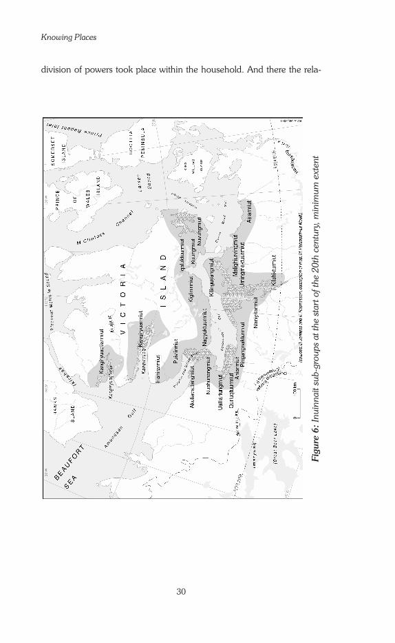
Knowing Places
30
division of powers took place within the household. And there the rela-
Figu
re 6
: Inu
inna
it su
b-gr
oups
at t
he s
tart
of t
he 2
0th
cent
ury,
min
imum
ext
ent
Chapter One: Setting the Stage: The Inuinnait and their Land
31
tionship was based more on the need to share tasks than on the power of one person to dominate all the others. Out of this brief presentation, three important features of the study of
the Inuinnait system of geographic knowledge emerge. First, there is no hierarchy, where some classes of people are superior to others. This also means that there is no special set of hidden knowledge that only the high-est class of people would have. Every hunter can learn as much about how to use the land as they are able and wish to. The land is not a tool used by a certain class to dominate and control others or the community.
Next, the strict division of tasks between men and women results in different sets of geographic knowledge. Men have one set of experiences, and so they have one kind of geographic knowledge, and they look at the space around them in a special way, a way that derives from their knowledge. Since the women have a different set of experiences, their knowledge and their view of space is also different.
Last, we must ask whether angatkuit have a specific body of geo-graphic knowledge, born of spiritual experiences or a sacred reading of the land. Alas, early anthropologists did not look closely at this issue, and today it is too late to try to investigate this, even with the most ancient of the elders. Yet, many Inuinnait stories that were collected in the 1910s, 1920s and late 1950s (see Appendix B, pp. 282-28�), as well as my own fieldwork notes, clearly show that some Inuinnait develop a strong spirit-ual, sometimes mystical, reading of their land. This certainly must have been the case for most angatkuit. An angatkuq from Greenland, Georg Quppersimaan (1992) provides a valuable account of one such specific relation with the land, but unfortunately for a group very different from the Inuinnait (the Ammassalingmiut of Eastern Greenland), so it cannot be used in this discussion.
The annual cycle of nomadic hunter-gatherers
Archaeological evidence has shown that human occupation of the North American arctic archipelago dates to the third millennium before Christ (B.C.) or roughly 5,000 years before our present time. From material remains, archaeologists have identified and described several succes-sive waves of migrations. All of the successive inhabitants of the North American Arctic developed nomadic hunter-gatherer cultures, as did the Inuit. Each loosely organized sub-group followed an annual cycle of hunt-ing and fishing. It was the drastic variations of Arctic seasons that con-trolled the time spent moving through and camping in different parts of the territory. Hunting techniques are greatly affected by the seasonal climatic variations that occur at high latitudes: temperature, types of precipitation, and light conditions all drastically change (Figs. 7 and 8). Temperature in particular is a key player in the profound annual transformations of

Knowing Places
32
the environment. Depending on the intensity of the cold, the plains are either thick bogs, difficult to cross, or become hard surfaces favourable for travel; the sea is a salty liquid (tariuq ‘the salt’ and by association ‘the sea’) or a sheet of solid ice on which one can travel and camp (hiku ‘the ice cover,’ ‘the ice-sheet’). Light conditions not only have an influence on temperature, but also on the activities of daily life, particularly of the
hunters. The longer the days, the farther they can travel from the camps. At the apex of the dark period, their movements are very limited.12
A few Inuit groups in the Kivalliq region (previously called Keewatin, see Fig. 11, p. 53), lived inland year round. But most Central Inuit were nomads of the land (nuna) and of the ice (hiku). They used these two
12 On this topic see Jean-François Le Mouël’s detailed study (1978b: 113-116).
Figure 8: Annual cycle of light at Ulukhaktok (70o44’N; 117
o 43’W).
Figure 7: Mean monthly temperature and precipitation, Ulukhaktok and Kugluktuk.

Chapter One: Setting the Stage: The Inuinnait and their Land
33
ecosystems alternately, according to the seasonal changes in hunting conditions. The contrast between the two types of spaces was reinforced by a series of taboos forbidding any mixing of these two elements. For example: eating caribou on the ice-sheet or seal on the mainland, sew-ing new clothing (out of caribou fur) on the ice-sheet, sewing caribou and seal together, etc. The list was long, but Diamond Jenness (192�) and later Knud Rasmussen (1932) noted that the list was shorter and less strict for the ‘Copper Eskimo’ than for other ‘Central Eskimo.’ The Inuinnait continued to follow this pattern of alternated land use well into the 1970s.
‘Seasonal variations’13 of the Inuinnait in the early 20th century At the beginning of the 20th century, the Inuinnait followed a well-es-tablished pattern of seasonal migrations1� (Fig. 9). In October, families gathered together in several well-known places by the coast. There they waited for the sea to freeze and the ice-sheet to become solid enough to set up camp and hunt on it. During this period of transition, the women spent their time making new clothing for each member of the household.15 The men were less busy. They hunted caribou for their new winter fur and spent some time playing games of various kinds, singing and dancing to celebrate the reunion of the community after the long summer separa-
13 This expression is taken from the title of a famous article written by Marcel Mauss and his student Henri Beuchat in 1906. The analysis that follows is partly inspired by the one developed in this outstanding article, although the latter focused on social organization seasonal patterns rather than on spatial ones. Henri Beuchat’s interest in the ‘Eskimo’ led him to join the Canadian Arctic Expedition in 191� as the appointed anthropolo-gist to study the ‘Copper Eskimo.’ Unfortunately, he died on the ice-sheet northeast of the Bering Strait when the expedition boats were blocked by ice that threatened to crush them. Diamond Jenness then took over his task. 1� The annual cycle of nomadism of the ‘Copper Eskimo,’ called the ‘sea-sonal round,’ in anthropology texts, was carefully described by Diamond Jenness (1922), and then by David Damas (1972b). Knud Rasmussen (1932) and Vilhjalmur Stefansson (1913) give some details, but do not present the whole system. I also recorded some detailed descriptions of the movements of some camps during my fieldwork in 1991-1992. Several accounts from elders are also found in Richard Condon and Julia Ogina’s book on the northern Inuinnait (1996). 15 Inuit prefer caribou fur above all others for clothing because of its com-fort. It is very warm and light, and windproof. However, caribou clothing has the disadvantage of wearing out quickly. After a few months the fur falls out by the handful, especially when it is exposed to heat. The clothing does not last more than a year. In summer caribou shed; their old damaged fur is replaced by new fur that will protect them against the winter cold. Clothing was made with this new fur. Musk-ox fur, on the other hand, is too heavy to wear and was used in the igloo to cover the snow on the sleeping platform, as was polar bear fur. Because of its thermal qualities, polar bear fur was also worn in the deepest of the winter for the hunt at the aglu, where men had to spend long hours immobile on the ice, bent over seals’ breathing holes.

Knowing Places
3�
tion, when each family had travelled on its own, independently. But that period was also often one of hardships as weeks went by. Blizzards and poor visibility made it harder to hunt caribou, and it wasn’t yet possible to hunt seal on the ice-sheet, which was still too thin. Seal hunting at the floe-edge does not seem to have been practiced much among the Inuinnait, who did not have sea kayaks.
When the ice-sheet on the sea became solid enough (in December or January, depending on the latitude and the year) the Inuinnait left the coast to set up their dwellings.16 Each sub-group established two to four camps, each numbering from twenty to more than one hundred people. Men hunted together at the agluit (sing. aglu, a breathing hole in the ice kept open by a seal). This hunt is much more effective when done collect-ively, because a large number of breathing holes can be watched at the same time. They mainly caught ringed seals, the most common species in the waters of the region. Occasionally, they hunted polar bears, especially on Victoria Island where they are numerous north of the 70th parallel. During this period each camp moved slowly, abandoning a hunting area when kills became fewer. The ‘time of the ice-sheet’17 was also the time of community life and of long evenings spent in the iglu. In early spring (March), many families took advantage of the good travelling conditions (very hard ice, longer days) to visit relatives in other camps within their territory or in a neighbouring sub-group.
Toward the end of April or May (depending on latitude and the year), the surface of the snow on the ice-sheet begins to warm and melt. The average absolute temperatures may still be low, but the effect of re-flection on the white snow cover causes melting even in the cold. Then it was time to move back onto the mainland. Equipment that was not needed for the summer (heavy furs, snow knives, harpoons for seals, etc.) was stored at special high places on coastal islands and along the coast-line. Seal meat was put into caches18 to be used later, through November and December.
Summer was the time for the community to split up. Once the
16 The Kangiryuarmiut camped in the middle of the ice-sheet, far from the coastline. The other Inuinnait sub-groups stayed on or near the shores in the interior of small bays on the southern shores of Victoria Island and the northern shores of the mainland, or around small islands. 17 Usually this period is called ‘winter,’ but I think that expression should be avoided. It gives the impression that from December to April / May weather conditions are similar, when that is not at all the case, as we see in Figs. 7 and 8. The ‘time of the ice-sheet’ is divided into four main seasons: the darkness (December/January), the great colds (February/beginning of March), the first spring—with the return of the ‘real days’ (end of March/be-ginning of April)—the second spring—of long days and mild temperatures (end April/beginning of May). Seasons are represented on Figs. 15 and 16, pp. 71 and 73. 18 The tundra has many caches, massive structures of stones piled in such a way that foxes or bears cannot break into them to steal the food stored inside. Yet, sometimes they do manage.

Chapter One: Setting the Stage: The Inuinnait and their Land
35
Inuinnait reached the mainland, they separated to travel in very small groups; sometimes a single household, rarely more than two or three.19 They often began this migration by dog sledge along valley bottoms still covered with snow. When there was no more snow, the Inuinnait would carefully store their sledges and harnesses on rocky peaks, safe from foxes and curious bears. Families then continued on foot, loading their own backs and their dogs’ with the equipment necessary for life on the tundra. Sometimes old people who were unable to manage on foot would be set
19 These migrations are described in detail by Diamond Jenness (1922), who lived among the Puivlirmiut (see Fig. 6, p. 30) and accompanied them on their summer migration to the interior of the Wollatson Peninsula from mid-May to the end of October 1915. Richard Condon and Julia Ogina (1996) also give lively accounts of those migrations.
Figure 9: The seasonal movements of the Kangiryuarmiut, early 20th century.

Knowing Places
36
up in a camp on the coast and given enough supplies to see them through until the families returned. On the land, the Inuinnait concentrated on caribou hunting. This guided their movements. They also did a lot of fish-ing. Although this activity often saved them from starvation when caribou were too scarce or could not be found at all, it was never highly regarded in the Inuit hunting society.20
People broke their camps and moved on every four or five days. When they harvested caribou or fish, some of it was eaten immediate-ly; the rest was dried and stored in caches. The Inuinnait walked as far as possible upland, following routes that varied little from year to year. Then, toward the middle of summer, they stopped and returned to the sea. They would pass by the same places both going inland and turning back to the seaside, in order to pick up the meat cached here and there a few weeks earlier. This limited the extent of the summer hunting terri-tory. Furthermore, the storage caches were quite massive. Erecting the caches was hard work. Archaeologist Maryke Hehmsoth-Le Mouël has shown (1983 and 1992) that people would normally use the same ones from one year to the next. Therefore, a family’s summer journeys would roughly follow a routine trail, and meeting another group somewhere on the tundra was rarely by sheer chance, as outsiders often would think.
After the summer dispersion, people reassembled at the larger coastal camps. There, they waited together until it was safe to move out onto the ice-sheet.
Today, when archaeologists try to identify the ancient summer mi-gration routes, they rely mostly on the ruins of the old caches. The prob-lem is that at this stage of scientific measurement, it is still impossible to date the caches: they all look the same structurally. When we find an old cache we do not know what period it comes from: was it built 50, 100, 1000, 2000 years ago? It does, however, still give us a clue to the routes people (Inuit, Thule people, others before them) followed. If we summarize the Inuinnait nomadic routine from a geographic per-
spective, it appears that specific types of spaces were connected with spe-cific types of social life, and specific seasons. The land was associated with summer—the hunt for caribou and the seasonal breaking-up of the group. The ice-covered ocean was associated with winter—the hunt for seals and the seasonal reunification of the group. The mainland was the time of the individual, the ice-sheet that of the community. As for the coast, it was a transitional zone. It wasn’t used in the same way as the mainland or the sea; people only stayed on the coast while awaiting fa-vourable conditions to move elsewhere, either on the ice-sheet or in the
20 Despite warmer temperatures, summer was a difficult period when famine often threatened. On Victoria Island the caribou herds are small, and finding them depends not only on knowing the territory, but also on good luck. On the mainland Inuinnait were at the mercy of the paths taken by the migrating herds, which might change unexpectedly.

Chapter One: Setting the Stage: The Inuinnait and their Land
37
interior of the mainland. One type of space was left completely out of the picture: tariuq, the
sea in its ‘liquid’ state. The Inuinnait only had small kayaks which they used to hunt caribou on open water lakes. Although they mastered the technology and techniques of kayak use, they did not use them to hunt seals on the open water of the ocean, unlike Baffin Island Inuit. Why they made such a choice is unknown, but it was likely for a number of rea-sons. One might be the inland topography: unlike the mountains and gla-ciers of Baffin Island, the wide moraines and rocky plateaus of the region are relatively easy to travel by foot, and might have, therefore, favoured inland summer migration. This is only an hypothesis, however, and a partial one at that. In addition, Cliff Hickey (198�) suggests that inland summer migration might have become more intense in the second half of the 19th century as a result of cultural change related to the discovery of a ship left behind by European explorers (see inset, p. �1).
This system of occupying and using the land was based on the value placed on two quite different ecosystems, which are used alternate-ly—one in the summer and one in the winter. For the Inuinnait, ‘seasonal variations’ were much more than a simple move back and forth based on the needs for hunting at different times of the year. It was a central feature of the social life of the community. It affected the way the community was organized, and it created a kind of balance of life, between the commun-ity and the individual.
This is consistent with Marcel Mauss and Henri Beuchat’s general theory on the ‘seasonal variations of the Eskimo.’ According to the two French anthropologists, seasonal migrations were not merely indicative of a change in land-use; they affected the whole way of life of the Inuit, in-cluding their social organization. In their 1906 article, the authors explain that these variations are the key organizing principle of the social system of ‘Eskimo’ societies in the Central Arctic.
As regards the Inuinnait, anthropologist Diamond Jenness (1922: 1�3) did not fully accept the theory of his French colleagues. He agreed that the ‘Copper Eskimo’ nomadic routine followed a seasonal pattern, but argued that it did not affect their social organization, which he believed remained the same year round. He based his discussion on the idea that, given the option, the Inuinnait would have subsisted on seal hunting, and stayed together in large camps, year round. But the argument, based on personal interpretation rather than on thorough analysis, is weak and in total contradiction with numerous observations made since the Inuit settled in permanent villages and began living in large communities year-round. These observations all lead to the conclusion that seasonal migra-tions created a balance around which social life was organized. This is a balance that the sedentary Inuit of today lament and try as much as possible to recover every spring and summer, when families leave their crowded ‘town’ for the isolation of their cabins on the land.

Knowing Places
38
An adaptable land-use pattern When we examine how the Inuinnait have been organizing their land-use throughout the 20th century, we see that they changed the pattern of their yearly routine at least twice in 50 years (see Collignon 1993).
In the second half of the 19th century, some Inuit groups met Qablunaat whalers; these meetings caused great changes in their lives. The main areas of contact were on Alaska’s North coast, the Mackenzie Delta, the western shores of Hudson Bay, and Eastern and Southern Baffin Island. The situation was different for the Inuinnait. Their territory is located in the archipelago of the central Arctic Ocean, and sea waters there were too cold and too shallow for the great whales. As a result, the whalers did not penetrate this area. The Inuinnait met up with a few explorers whose peculiar habits puzzled them, but had no major effect on their way of life. If Qablunaat strangers caused some social change among the Inuinnait, it was indirectly, through the wealth they left behind when abandoning a ship on the North shore of Banks Island (see inset p. �1).
Significant change first took place in the early 20th century, not due to the influence of whalers, however, but to that of trappers and traders. The most western Inuinnait occasionally encountered white trap-pers, such as the famous Captain Christian Klengenberg, as he travelled from the West in search of new land rich in small fur animals. The trap-pers exchanged goods with the Inuinnait in the hope of bringing them into a trade relationship. Rifles were quickly adopted. as Diamond Jenness noticed in 191�-1916. He discussed at length the consequences of the introduction of firearms (Jenness 1921). By 1920, several independent traders had established small posts scattered throughout the land of the Inuinnait (Usher 1971b). Nevertheless, the rhythm of ‘seasonal migra-tions’ remained unchanged until the mid 1920s.
Between 1920 and 1935, influenced by Qablunaat traders who were often trappers themselves, the Inuinnait gradually shifted from a hunting economy to a trading economy based on white fox trapping. While they continued to hunt to feed themselves and their dogs, they progressively organized their movements and their social life as a group around the trapping activity. A new nomadic system was established. It was one of trappers rather than hunters and it functioned from 1925-1935 to 1955-1960. This period is described as ‘Trapping Period 1’ in the Report of Inuit Land-Use and Occupancy Project (Freeman 1976).
The camps on the ice-sheet disappeared. Isolated from one an-other, the men gave up hunting at the aglu. A successful hunt was too uncertain without many hunters to cover the breathing holes. Too many hunters had become trappers. From November to April, each family unit travelled their trap lines, along the coast and inland. The ice-sheet was no longer a ‘lived’ space, only a space to be traversed without lingering.

Chapter One: Setting the Stage: The Inuinnait and their Land
39
Caribou hunting became a winter activity rather than a summer one. Henceforth in summer, two or three families would camp together by the seashore to hunt seal in open water, using small boats acquired at the trading posts.
The traditional seasonal migration pattern was completely reversed, but its alternative principle was still respected. Winter and spring were now the times of the mainland, of caribou and the individual; summer and fall the times of the sea, of the seal, and of the community. However, the summer camps of this period still remained limited in size. In Inuinnait history, Trapping Period 1 marks the time when people were the most scattered. Sub-groups no longer reassembled except at Christmas and Easter around the Anglican and Roman Catholic missions (conversion to Christian faith occurred in the same period) and the trading posts.21 These foreign gathering places changed the spatial organization of the land. In 19�0 there were four centres: Cambridge Bay (Iqaluktuuttiaq), Burnside (Qingaun, today officially called Bathurst and sometimes Bathurst Inlet), Coppermine (Qurluqtuq, today officially called Kugluktuk) and Holman Island22 (Ulukhaqtuuq, (later officially called Holman until April 1st, 2006, then Ulukhaktok).
In the 1950s and 60s, the Inuinnait became a people of permanent settle-ments instead of temporary camps. Once again, their yearly land-use routine changed. As a result, they were faced with a new spatial organ-ization of their territory. Once structured by multiple camps that dotted the land differently at each season, it was now structured by one single permanent place of residence. The annual land-use routine had to be adjusted to accommodate this change. The Inuinnait adapted by creating a new spatial system toward 1955-60. Although this system now had a semi-nomadic pattern, it respected the principle of seasonal alternation. ‘Trapping Period 2’—as is referred to in the Report of Inuit Land-Use and Occupancy Project (Freeman 1976)—organized the life of the Inuinnait until the early 1980s. As the name suggests, trapping remained the main economic activity during this period.
In winter, women and children stayed in the settlement while men, accompanied by their sons (approximately age 7 and older), trapped white fox and hunted caribou. They were often away three or four weeks
21 From 1939 onward, the Canadian Government required all institutions of one area to locate at the same place so they could be more easily admin-istrated (Buliard 1951).22 The Hudson’s Bay Company post and the RC Mission were located on a bay lying seven kilometers northwest of the island of Qikiqtaryuaq (‘the big island’), which bore the English name of Holman Island (see Fig. 9, p. 35). Regardless of the distance, it was chosen as the new location’s name because it was the closest English place name. In those days, the authorities would never have considered using the local place name and calling the settlement Ulukhaqtuuq.

Knowing Places
�0
at a time. In spring, as of April or May, most families (women, girls, and small children included) left the settlement and dispersed inland to fish in the numerous lakes, renewing the old way of life ‘on the land.’ They returned to the coast toward the end of May or early June to hunt geese and ducks arriving from the South to nest on the tundra, as well as seals hauling themselves out to bask in the sun on the ice-sheet. At ice-sheet break-up, single families or groups of two or three settled on the long gravel beaches of the Arctic Ocean; the men hunted seals in open water and everyone fished at the river mouths and in nearby lakes. Women and children would be actively engaged in the gathering of various plants and in berry picking at the end of August. In September, people started moving back to the settlement, which had been almost totally deserted for four to five months. But in October, when the arctic char would begin their descent to the sea, the Inuinnait would return to camp on the shores of the main lakes and rivers (see Tatiik vignette). There they would set their nets under the new thin ice. By the end of October, the families returned to their small houses in the settlement for six or seven months of sedentary life.
Thus, winter remained the time for caribou, and had again be-come the time for community. But now there was a new dimension to the life of the Inuinnait. In winter, there was a marked spatial separation by gender; women and girls remained in the settlement while men and boys went out on the land. In some cases, when there was no son in the family, girls would travel with their father. But that was considered excep-tional, albeit totally acceptable. Summer was still the time for seal, and once again became the time for the group to disperse, the time of the in-dividual. Spring and fall were seasons of transition; between community and individual, between caribou and seal. Hunting then concentrated on secondary game such as migratory birds, and fishing was intense.
The basic land-use system of the Inuinnait shows great flexibility. Throughout the past century it has enabled them to adapt to new techno-economic conditions without renouncing their own identity. In particu-lar, it has allowed them to continue to follow the principle of seasonal alternation. In this sense, it can be said that Inuinnait society remained traditional even after taking up settlement life.
Nevertheless, since the mid 1970s, the system has been chal-lenged. The increase in permanent wage employment, the collapse of the fur market, and the introduction of television into homes, to mention only the most striking changes, have disrupted the balance (see first part of Chapter 5). In the 1980s, there was a great decrease in the surface area of the territory effectively used. People no longer visit all the places they did in earlier times. The old complex form of land-use and occupancy has disappeared. Today the land is seen, more often than not, simply as a food reserve for hunting and fishing, a place you frequent from your

Chapter One: Setting the Stage: The Inuinnait and their Land
�1
The Inuinnait and the Ethnologic Context of Inuit Societies
The ‘traditional’ Inuinnait society as Diamond Jenness and Knud Rasmussen came to know it is distinct from that of other Inuit of the Central Arctic by several traits. As Clifford Hickey (1984: 20-21) recalls, they were “a rather unique group of Eskimos, and certainly not ‘typical’ in a number of categories.” In what he presents as a ‘partial list of their unique characteris-tics,’ he signals eight major points:
A use of native copper much more extensive in historic ethnographic collections than in earlier archaeological context; A striking fragmentation of the society (15 to 19 named and territorially-defined social groups, for a total population of only 8-900 people—see fig. 6, p. 30); A pronounced lack of importance of primary kin ties in certain social relationships in favour of sharing and exchange partnerships; The extreme value placed on egalitarianism, with virtually no positions or statuses demarcating certain individuals as standing above or apart from others outside of the nuclear family. In contrast to other Inuit, among the Inuinnait the family unit is not the extended family but the nuclear one, which is restricted to the people still living in the father’s home (wherever that may be) and therefore under his direct control; The absence of spring basking-seal hunting techniques that apparently disappeared from use in the mid-19th century. This type of hunt probably resumed later in the 20th century; A premium on internal inter-group trade; The apparent strength of the sea-land dichotomy, possibly stronger than in any other Inuit group; The extent of public commensality and the importance of ceremonialism. According to early ethnographic record, people possessed highly elaborate costumes expressly for use on such occasions. We can add to that list that in the 20th century at least, taboos do not seem to have
had the power that they had everywhere else in the Central Arctic. Back in the 1910s Diamond Jenness noticed this weakness of taboos among the Inuinnait (Jenness 1924: 143). He thought this weakness was important enough to put into question the general theory of Marcel Mauss and Henri Beuchat on the ‘Eskimo’ social system (1906, English edition 1979).
Various theories have been put forth to explain these differences. Vilhjalmur Stefansson, who thought he had met ‘blond Eskimos’ (1913), claimed that the ‘Copper Eskimos’ were a cultural group apart, not belonging to the Inuit family. But that idea was soon proven to be mistaken. Because the Inuinnait were among the last groups to be ‘discovered,’ it was long thought that they still followed the original, unspoiled and unchanged way of life of all Inuit groups, before the influence of whalers and missionaries. Countervailing that classic interpretation, Clifford Hickey brought forward a convincing hypothesis—that the Inuinnait were different because they experienced a profound cultural change in the second half of the 19th century, in relation to the discovery of a huge source of wealth: the abandoned ves-sel H.M.S Investigator, left at Mercy Bay (North of Banks Island) by Captain Robert McClure in 1853 (Hickey 1984).
Compared to other Inuit groups, classic anthropological research on the Inuinnait has been limited (see Appendix B, pp. 266-270). We simply do not know much about them, at least not as much as about other Inuit groups. But we know they were (and still are) quite differ-ent from their Eastern and Western neighbours. One should therefore be very careful when trying to draw general conclusions about all Inuit from this study.
1.
2.
3.
4.
5.
6.7.
8.

Knowing Places
�2
permanent home in the settlement. The land is no longer a place to live in, especially for the younger generations.
Territory and identity
Now that we have a better idea of the land and of the Inuinnait way of life, we can look more closely at the concept of territory, which has already been mentioned a few times. Most politicians and some geographers limit the use of the term ‘territory’ to describe a political unit with its network of administrative sub-units involved in social, financial, and political deal-ings. There is also always a military dimension to a political territory, whether for defence or for expansion. In other words, these geographers and politicians think of a ‘territory’ as a modern organized nation.
Since the late 1980s, however, ‘territory’ has been understood in a larger and more anthropological sense and has become a major concept in French human geography. And so it is in my own work. Anglophone geographers, on the other hand, seldom use the word ‘territory.’ Their concept of ‘place’ is quite close to our concept of ‘territory,’ but with some differences, analyzed extensively by French geographer Bernard Debarbieux (1999). The concept of territory is central to this study, and I cannot simply translate ‘territory’ by ‘place.’
It is therefore necessary to clarify this concept as it relates to Inuit identity. The following paragraphs cannot summarize several hundred pages of geographic literature. They specifically draw on definitions given by cultural geographer Joël Bonnemaison (1981 and 199�) whose re-search focused on the Melanesian people (in the Southern Pacific) and by arctic anthropologist Jean-François Le Mouël (1978a and 1978b), who conducted research in the tiny community of Naujat (Western Greenland), and my own research on the matter.
At the most basic level, ‘territory’ is the space within which people, as a community, live their life and feel ‘at home.’ It is a ‘social space.’ It is also a ‘cultural space’ as it is here that the community historically develops its knowledge and worldviews, its values and its beliefs. Drawing on the experiences lived on that land, the people who dwell on it develop their understanding of the universe, their concept of the world. The history and beliefs of the people are rooted in the territory, so that the territory be-comes the keeper of the community’s memory and values. The relation-ship between culture and territory is circular: those who inhabit the land understand it through the intellectual framework of their culture, but that framework is created through the experiences lived on that land.
So the territory does not have only economic value to the people who recognize it as theirs; the inhabitants have an emotional connection to the land as well. Generally speaking, the ‘territory’ is that piece of land, that portion of space, that has a special meaning for a people. It is the

Chapter One: Setting the Stage: The Inuinnait and their Land
�3
place of their identity. For example, the land of Israel is the only true terri-tory of the Jewish people, even for those who live elsewhere in the world and do not wish to move there, because it is the Promised Land God gave to Abraham, the founder of the Jewish religion.
The Inuinnait territory is all of this. It is a space that is inhabited and travelled following well-established routines based on seasonal changes. Its various places are regularly visited; it is a ‘lived’ space. The presence of the inhabitants is noticeable in many ways, as evidenced by the many traces they leave on the land: inukhuit,23 meat caches, traps, ancient tent circles, depots where seal fat was stored to slowly transform itself into oil, etc. The signs are obvious and readily understood by any Inuk. But many of them go unnoticed by outsiders, who do not know how to read the Arctic land. Yet, they are neither as numerous, nor as conspicuous, as the roads, buildings, religious signs or even fields and fences Qablunaat are used to seeing on their own land. The territoriality of Europeans and Euro-North-Americans is embodied in material signs. That of the Inuit is mainly embodied in non-material signs: in emotions and in words—the words of the stories and of the place names.
It is significant that at the scale of each sub-group, the scale of a shared identity, the Inuit identify themselves by reference to their land: sub-group names are constructed from the name of an important place in their territory, to which the suffix ‘-miut’ is added. When this suffix is added to a place name, it forms a noun that means ‘the people of ______.’ (In Inuinnaqtun, the singular of –miut is –miuq; it is –miutaq in some other dialects). Thus the Kangiryuarmiut are the people of Kangiryuaq, of ‘the big bay,’ the Qurluqturmiut are the people of Qurluqtuq, of ‘the rapids’—or ‘waterfalls,’ and so on. These place names are emblems of the nomadic territory of the community. They contain the history of the people who live there now as well as of those who have lived there in the past, and whose memory is connected to the places and to the living community.
23 Sing.: inukhuk, (inuksuk in Canada’s Eastern Arctic) ‘to act in the capacity of a human,’ according to Norman Hallendy (2000). These popu-lar structures made of rocks piled together come in all sizes and shapes and have become the symbol of the newly created Nunavut Territory. Of many types, they have two main functions: as markers to help people ori-ent themselves, or as caribou drives used in the summer hunt in earlier times. For this purpose, the Inuinnait raised a number of inukhuit placed in two more or less parallel lines. The drum beaters—often women and children—guided the caribou into the passage made by the inukhuit. There the beasts, frightened by the human shapes, ran right in front of them. This passage most often ended on a lake—if possible on a sheer slope—where the hunters waited in their kayaks with their bows and arrows. Sometimes hunters hid behind the inukhuit and shot at the confused animals. This weakened them so that they could not escape the men lying in wait on the lake. Norman Hallendy (2000) offers an extensive analysis of those mag-nificent and fascinating structures (see also Heyes 2002).

Knowing Places
��
By way of place names, the territory is ‘possessed by the word’ (Le Mouël 1978b: 89). But when describing Inuit and territory, one must be careful using such words as ‘possessed,’ ‘owned’ or ‘appropriated’ (in the sense of ‘take possession of’). In our culture, these words have a political or legal sense: “We own this territory. It is ours. Outsiders are not allowed here without our permission.” Hunter-gatherers in other parts of the world have a similarly exclusive approach. But for the traditional Inuit, although a sub-group might ‘own’ the territory that they regularly use, others might use it as well. Any person can live (and hunt) in a given area, whether or not it is associated with a specific group that carries its name, as long as other users are respected.
It is significant that tales of explorers being chased away by ‘Eskimos’ are very few when such stories of aggressive territorial defence are num-erous in other parts of the world. The southern party of the Canadian Arctic Expedition spent two years at Bernard Harbour, Nulahugyuk, in the territory of the Nuahungnirmiut (Fig. 6, p. 30) without the latter ever seeming to be inconvenienced or annoyed. People that regularly use a part of the land and build a strong connection with it might name their sub-group according to one of the places in the area. This community and the neighbouring ones will consider the area to belong to this group, in the sense that its identity lies there. But that does not imply that outsiders have no right to be there, as long as they behave properly. Furthermore, the suffix ‘-miut’ used in group names suggests that the people belong as much to the territory as it belongs to them. Thus, to be precise, we should speak of ‘affiliation’ or ‘connection’ rather than of ‘ownership’ (see Collignon 1999b).
When carrying out surveys of place names, one is given the op-portunity to understand this well. During inventories such as the Nuna-Top Surveys of Ludger Müller-Wille and Linna Weber in Nunavik (1982-198�) and Keewatin—now Kivalliq (1989-1991), and my own among the Inuinnait in 1991-1992, it was found that Inuit always said nearly the same thing when they reached the limits of their territory:
Farther on I know place names, but they are not ours. They belong to X [name of a group]. You have to ask them, I might say them wrong because they are not mine.
Such statements clearly express that the territory is much more than the land used. It is the ‘lived’ land, recognized as one’s homeland.
When speaking English, in their own words the Inuinnait call this territory ‘the land.’ This is a direct translation of the word nuna, which in its broader sense includes firm ground, sea-ice, and open water, as is reflected in the names chosen to identify new regional entities such as Nunavut, ‘Our land’ and Nunavik, ‘The real land.’ Throughout this book,

Chapter One: Setting the Stage: The Inuinnait and their Land
�5
rather than ‘territory’ I will use the vernacular expression ‘the land’ as often as possible, to stay close to the Inuinnait perspective.
Gradually, a picture of Inuinnait territoriality emerges. Deeply rooted on the land, it is the basis upon which the people build their identity.
So, if we analyze the geographic knowledge of the Inuinnait, it will help us understand more clearly this territoriality and their attachment to their land. It will give us a different insight into their choices regarding land-claims and land administration once the claims have been settled. It is worth noting that this practice of identity-building through a connection with the land is analogous to that observed for the Melanesian people of the Southern Pacific by geographer Joël Bonnemaison (199�) and for many other indigenous peoples around the world.
From Qablunaat to Inuit Governance
At the present time, there does not exist an independent Inuit state in the world. Inuit everywhere are under outside administration: Russia, the United States, Canada, and Denmark. Different groups of Inuit have varying levels of local autonomy depending on which foreign state has ultimate control over them. The greatest amount of local autonomy is in Greenland, where the Kalaallit have had Home Rule since 1979. Even they, however, remain under a foreign nation’s guardianship (Denmark).
On a map centred on the North Pole (Fig. 1, p. 3), the territory of the Inuinnait sits in the middle of the North American Arctic. In fact, the administrative region is officially called the Kitikmeot (Qitirmiut) Region, and the word ‘Qitirmiut’ means ‘people of the middle.’ 2� However, in the eyes of Southerners, the Inuinnait are located in one of the most remote areas of the North American Arctic. A geographer would say that they are in a peripheral situation, the centre being where explor-ers came from: Europe, southern Canada and the US. Explorers seeking the Northwest Passage approached the arctic archipelago either from the East (Labrador, Ungava Bay and Baffin Island), or from the West (the Bering Strait, the Alaskan coast and the Beaufort Sea). Taken from their perspective, the Central Arctic was anything but central. It was instead a formidable barrier that was a real challenge to traverse. For that reason, the Inuit who inhabited that region—Natsilingmiut and Inuinnait—were left in isolation. For decades they were shielded from interference from the Qablunaat world.
2� This was the Inuinnaqtun name by which Inuinnait designated the westernmost Natsilingmiut. The latter maintained close relations with the easternmost Inuinnait, from whom many of their members are descended (Csonka 1995). About the orthography of Inuinnaqtun words, see footnote 29, page �8 in this chapter.
Knowing Places
�6
The Canadian Government only really turned its attention to the administration of its North after the Second World War. Prior to this, the Inuit were not considered Canadian ‘residents’25 and the Federal Government had left its responsibilities to three institutions—in order of their appearance in the Arctic: the Hudson’s Bay Company (HBC), the churches (mainly Anglican and Roman Catholic), and the Royal Canadian Mounted Police (RCMP). In 19�5, the Federal Government granted the newly-created family allowance to Inuit as well as they had to all Canadian residents. This was a first form of recognition. In 19�8, a bill giving Inuit the right to vote was first introduced, but it was not passed until 1960—the same year Indians were granted Canadian citizenship under the Indian Act.
From the land to the settlement (1950-1965)
During the 1950s, several events combined to push Canadian Inuit off the land into urban-type settlements. Through the 1930s and 19�0s, the missionaries encouraged the Inuit to move into settlements so that they would attend church regularly. They did not succeed in doing this, how-ever, because they did not have the power to force such a drastic change on people’s lifestyle. Even less so, as the traders were also against the idea; they wanted the Inuit to stay on the land and concentrate on their trap lines. Neither was the Federal Government in favour of the move in those years, because bureaucrats feared the administrative difficulties and cost of such a move and of its consequences.
World politics, however, forced a major change. At the end of the Second World War, the two former allies—the U.S.S.R. and the United States—became hostile forces. The ‘Cold War’ had begun. It was not ac-tually a shooting war, but people were scared that it would become one, and the Americans took steps to protect themselves. They were worried that the Russians would attack across the North Pole. In the early 1950s, they decided to set up a line of radar posts along the 70th parallel to keep watch over this border. This line would be the Distant Early Warning Line, often referred to by its acronym—the DEW Line. The line would transect the American territory of Alaska and then continue across the Canadian Arctic. These stations had a single mission: to warn the U.S. military of a U.S.S.R. invasion so they would have several hours advance to protect their citizens as much as possible before the atomic bombs came down on American ground. In Canada, the Americans hired local Inuit to help build these stations. The money was good, and many people saw the whole project as a new and exciting adventure, a change from normal life. Once construction was finished, many of the Inuit carpenters settled
25 Canadian citizenship has only existed since 19�7. Before that, ‘Canadians’ were British subjects and the issue for immigrants coming from various parts of the world was to be recognized as ‘residents.’ In British Columbia for example, Chinese immigrants who came in large numbers in the 1880s were denied that recognition until after World War II.

Chapter One: Setting the Stage: The Inuinnait and their Land
�7
around the main stations. In 1955 the U.S. Air Force chose Cambridge Bay (Iqaluktuuttiaq) as the site of a main relay station controlling smaller stations on the southern coast of Victoria Island and the northern coast of the mainland. Many Inuinnait, coming to hire on for one season, stayed and settled permanently at Cambridge Bay. The history of that settlement is thus linked to that of the DEW Line.
In the meantime, the Federal Government changed its position about the Inuit moving to settlements. From 1959 onward the Government officially supported the move (Judd 1969) for several reasons. First it was a mat-ter of world geopolitics. To assert its contested sovereignty over the High Arctic, Canada had to show that it administrated the people who lived there. This also led to the dramatic move of unprepared Nunavik Inuit (of northern Quebec) to the uninhabited shores of Ellesmere Island where they established the settlement of Grise Fjord, literally from scratch. Other Nunavik Inuit and Baffin Island Inuit were relocated to Devon Island, near the DEW Line site of Resolute Bay, for the same reasons and under the same conditions. In 1997, after a long battle, the relocated Inuit or their descendants, represented by the Makivik Corporation, received fi-nancial compensation from the Federal Government ($10 Million CDN altogether). But they were never granted what they really wanted: an apology.26
Another reason was that the paternalistic Government felt it had to look after the Inuit, who, in its mind, could not look after themselves in the complex modern world. The Government decided it had to provide a modern southern-style education for all Inuit children. Before that, some children had gone to residential schools, mostly run by missionaries.27
The new outlook implied the need for schools to be located closer to Inuit families. But nomadic children could not attend a school building fixed in
26 Other relocations of Inuit took place but on a regional scale, in Keewatin (now Kivalliq) and on Baffin Island. This very sensitive issue is crucial to understand Eastern Arctic politics, but the Inuinnait were not con-cerned at all by these events. Interested readers can refer to an abundant literature, starting with The Royal Commission on Aboriginal Peoples 199� report on High Arctic relocations and its 1996 final report. 27 Each church had its school, often in the same town that served as a base for missionary activities further north, for example Churchill, on the Hudson Bay west coast, and Aklavik in the Mackenzie Delta. The chil-dren sent did not really know where they were going and the journey was long, so there was often some confusion. In the 1950s two little girls from Ulukhaktok sent to attend the Roman Catholic school in Aklavik attended the Anglican one instead for six months before somebody noticed the mistake. In the 1990s, many Inuit adults who had attended residential schools began to speak up about the abuses (verbal and sometimes physical) suf-fered while living there, away from their families. This has led to several in-quiries as well as to the establishment of various psycho-therapy programs to help victims’ recovery.

Knowing Places
�8
one place. So that, in turn, meant that the families had to be encouraged to settle down in those places where schools were built (usually where there was already a trading post and a church).28 The government also felt responsible for providing health care to the Inuit. In 1956, one out of every six Canadian Inuit was treated in the South for tuberculosis. This pulmonary condition had become an epidemic and ravaged the Inuit in the 1950s. In the eyes of the Government, the easiest way to provide health care was, once again, to construct a building—a nursing station. That also pulled people in from the land.
A third factor—an emotional one that stirred up ordinary southern Canadian citizens—was the terrible starvation suffered in the 1950s by a group of Ahiarmiut (‘Caribou Eskimo’) living in the interior of the land (District of Keewatin, Fig. 10, p. 52), because the caribou had changed their annual migration route. Canadian author Farley Mowat wrote two books about this famine, and they were widely read by the general pub-lic. The Toronto Globe and Mail also published a famous report on this situation.
It must be pointed out that in the 1950s, federal politicians and senior bureaucrats who were making all the decisions had no arctic experience and therefore no direct knowledge of the life of the Inuit. They had lit-tle respect for the knowledge of their own Qablunaat subordinates who knew the arctic, and they showed little desire to listen to any of the Inuit. They were totally convinced of the superiority of their own point of view with regard to the welfare of ‘Other Peoples.’ Such attitudes are shocking today, in the early years of a new century, but fifty years ago that was the spirit of the era, and it affected many peoples in the world, not just the Inuit.
As time went on, things changed. From the mid 1980s onward three factors helped to bring about important shifts. First was the rise of aboriginal leaders who had learned how to deal with bureaucrats and were prepared to speak their mind. Second was the legal recognition of the rights of First peoples. Third was the rise of post-colonial studies in the universities of North America and Great Britain. For the Arctic, the academic result was a multitude of studies critical of various aspects of the Federal Government’s policies regarding the Inuit throughout the 20th century. For example Tester and Kulchyski (199�) provide a major work on the effects on the Inuit of Canada’s liberal welfare state combined with
28 This education was given with a view to assimilation. Teaching was in English and followed a southern curriculum—that of the Alberta schools for the Inuinnait. While in the eastern and central Canadian Arctic Inuktitut became the language of instruction in the primary grades in the 1980s, English still largely dominated in the western arctic schools of Inuinnait and Inuvialuit settlements in the 1990s. In the second half of that decade there were at last great efforts to introduce Inuinnaqtun in the schools, and these increased after the creation of Nunavut in 1999.

Chapter One: Setting the Stage: The Inuinnait and their Land
�9
paternalist assimilationist policies. But there has also been a tendency to write a history forgetful of the context of the times, and sometimes quite biased in denouncing the actions of the Federal Government. In contrast, David Damas, an anthropologist who was a direct witness to the Inuit settlement process, published, in 2000, a thoroughly documented hist-ory of how things really happened in the 1950s and 1960s in Northern Canada. His book almost immediately became a major reference in Arctic studies.
The Inuinnait settled at various stages, depending on the area in which they lived. [All locations mentioned in this paragraph can be found on Fig. 5, p. 2�.] In the areas around Cambridge Bay (Iqaluktuuttiaq) and Kugluktuk (Qurluqtuq,29 formerly Coppermine), more and more people started moving into settlements through the 1950s. By 1960 the move was nearly complete.
In the Ulukhaktok (Ulukhaqtuuq) and Bathurst Inlet (Kiluhiktuq) areas, the move did not begin until the end of the 50s and was very rapid; in Ulukhaktok, the last family to join the settlement arrived in 1967. In Bathurst Inlet, the Inuinnait first settled on the western shore of the mouth of Burnside River (Ayappaqpaqturvik, ‘the place where someone lost his/her balance’) at a place called Qingaun (‘the place on top’) near the Hudson’s Bay Company (HBC) trading post. The official name for Qingaun was Bathurst. In 196�, the trading post was moved farther north on the eastern side of the inlet to Umingmaktok (Umingmaktuuq, ‘there are many musk-oxen’). This place was also called Bay Chimo by the HBC, but that name is not official. Most of the families followed the post
29 Roman orthography for Inuinnaqtun words can be confusing. In 1976, the Inuit Language Commission set a standard Roman orthography for all Eskimo languages, based on the recommendations of several linguists. It was approved by all main Inuit-based organizations and since then has been enhanced by the Inuit Cultural Institute (ICI). It is the one I follow in this book, as it enables any speaker of any Eskimo language to read cor-rectly all words, even unknown ones. Yet, some Inuit groups have long been very reluctant to adopt a system different from the one they have used since missionary times (before that, all Eskimo languages were strictly oral). Ken Harper (2000) very clearly presents the debate. In Canada, all Inuit except the Inuinnait and the Inuvialuit (who live in the Mackenzie Delta and on the Beaufort Sea coasts) use a standardized syllabic system to write in their language. They only use Roman orthog-raphy to communicate with other Inuit. The fact that the Inuinnait and the Inuvialuit are the only Canadian Inuit who do not use the syllabic system partly explains why, among Canadian Inuit, they are the ones that most resisted the adoption of the standard orthography. It has only been intro-duced slowly in schools since the mid 1990s. As a result, the official orthog-raphy of some Inuinnait names does not follow the standard orthography rules. That is the case with the communities of Kugluktuk, Ulukhaktok, and Umingmaktok, which should read Qurluqtuq, Ulukhaqtuuq, and Umingmaktuuq in the standard ICI orthography, as well as with the regional name Kitikmeot, which should read Qitirmiut.
Knowing Places
50
to its new location in Umingmaktok. Only two of these families, some twenty people, were still residing permanently at Qingaun in the early 1990s.
The move to settlements affected all the Inuinnait. However, after ex-periencing such ‘urban’ way of life, with all of its disadvantages as well as its advantages, some families decided to leave the settlements to live in permanent outpost camps, where they built small frame houses of salvaged wood planks. Later on, the Government encouraged this type of life by subsidising outpost camps with essential domestic fuel. Such camps continue to exist throughout the Canadian Arctic. Their members only reside for several weeks of the year in the settlement they are tied to (for the Inuinnait, Kugluktuk, and Umingmaktok).
From districts to regions
Because of the federal structure of Canada, the Inuit fall under the juris-diction of several different authorities. Those in Labrador and Northern Quebec fall under the administration of the Provincial Governments of Newfoundland-Labrador and Quebec, respectively. The others were all under the Territorial Government of the Northwest Territories (NWT) until 1999 (see p. 51). The NWT was closely dependent on the Federal Department of Indian and Northern Affairs.
Before confederation in 1867, the Northwest Territories was an enormous area, stretching both west and southwest from the Hudson Bay to the Rocky Mountains. As white settlers expanded into the great plains of the West, new provinces were carved out of the Northwest Territories.30 From 1912 until 1999, however, the territory remained the same and stabilized as an entity of some 3,377,000 square kilometres lying north of the 60th parallel. This vast area was soon divided into three districts: Franklin, Keewatin, Mackenzie (Fig. 10); then in 1982 into five regions: Baffin, Fort Smith, Inuvik, Keewatin (Kivalliq since 1999) and Kitikmeot (Fig. 11).
Today, the districts of Franklin, Keewatin, and Mackenzie no longer exist as administrative units, but they still often appear on maps while the cur-rent administrative regions most often do not. This reflects how cartog-raphers (map makers) around the world, and even those in southern Canada, are not aware of the extent of the changes in the North, and continue to copy information available on earlier maps that have become
30 This constant reshaping and reduction of the NWT is well documented on a set of maps available on the Yellowknife Prince of Wales Northern Heritage Centre website: http://pwnhc.learnnet.nt.ca/research/nwtname/index.html

Chapter One: Setting the Stage: The Inuinnait and their Land
51
obsolete. Fortunately, the widely publicized launch of the Nunavut terri-tory in 1999 has somewhat improved this situation.
Cambridge Bay occupies a relatively central position in the Kitikmeot region. As a result of the DEW line project, it was outfitted with a long airstrip, allowing for good air access to all the settlements of the region, and other regions of Nunavut, as well as to the South through Yellowknife (the capital of the NWT). For these reasons it was designated as the administrative centre of the Kitikmeot region. Unlike the other re-gions of NWT and now of Nunavut, the Kitikmeot administers only two distinct groups of Inuit: the Inuinnait and the Natsilingmiut, who are quite different from each other in culture and language. They even use different writing systems (see footnote 29 in this chapter). Despite these cultural differences, of which both groups are well aware, there is a good working relationship between them and the region works smoothly as an admin-istrative unit. Cambridge Bay has regular airline connections to all the settlements of the Kitikmeot region, except Ulukhaktok (which is now in the NWT when the rest of the Kitikmeot is in Nunavut).
From the late 1960s onward, the administrative system of the NWT slowly evolved. There was an honest effort to decentralize government operations, hindered in practice only by the usual bureaucratic unwilling-ness to relinquish control. In 1970 the seat of the Territorial Commissioner was moved from Ottawa to Yellowknife, the capital of the territory. There was also quite a successful effort to transfer power to aboriginal peoples through the Territorial Legislative Assembly. Early in this period, the fed-erally-appointed Commissioner of the Northwest Territories still held most of the administrative power; the Territorial Legislative Assembly’s function was advisory to the Commissioner. Indeed, until 1975 only some of its members were elected by the people of the NWT; others were appointed by the Federal Government. In 1966, the elected members outnumbered the appointed for the first time—by 7 to 5 in 1966; and 10 to � in 1970.
In the 1980s, further changes occurred. The Inuit settlements—pre-viously administered by Qablunaat appointed by the Federal Department of Indian and Northern Affairs—became Hamlets, administrated by locally elected Councils and Mayors. Furthermore, a Territorial Government of the Northwest Territories, appointed by the elected members of the Territorial Legislative Assembly,31 was created. It became the main decision-making body for everything concerning the NWT (economy, social framework, etc.). Its powers were similar to those of provincial governments; but it remained financially dependent on the Federal Government. As for the Territorial Commissioner, it has become an honorary appointment.
31 The representatives to the legislative assembly are elected by major-ity vote. Electoral districts did not always correspond to the administrative units: Ulukhaktok (in the Kitikmeot Region until 1999) was, from the start, in the same electoral district as Paulatuk, Tuktoyaktuk, and Sachs Harbour (all three in the Inuvik Region).
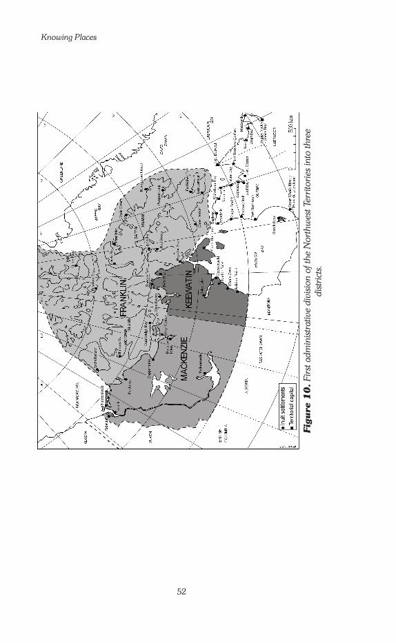
Knowing Places
52
Figu
re 1
0.
Firs
t adm
inis
trat
ive
divi
sion
of t
he N
orth
wes
t Ter
ritor
ies
into
thre
e di
stric
ts.

Chapter One: Setting the Stage: The Inuinnait and their Land
53
Figu
re 1
1:
Sec
ond
adm
inis
trat
ive
divi
sion
of t
he N
orth
wes
t Ter
ritor
ies
into
five
reg
ions
.

Knowing Places
5�
Division of the Northwest Territories
A further dramatic change took place on April 1, 1999 when the bound-aries of the NWT were again changed. This time, the change did not result from encroachment of a more southern province to accommodate a population of mostly white settlers; this division would establish a new territory, called Nunavut (‘Our Land’)—one in which the overwhelming majority of the population (85%) were Inuit (see Fig. 12). The creation of Nunavut came about as a result of two agreements between the Federal Government and the (then) Tungavik Federation of Nunavut (TFN), rep-resenting the Inuit of that part of the North. The joint agreements, ratified in 1993, specifically deal with two issues: governance and Inuit benefits. As one Inuk put it,
It is like the two runners perfectly parallel of a well-made sled (Jose Kusugak, president of Nunavut Tunngavik Inc., Nov. 1998).
One runner, governance, is essentially the creation of the administrative territory of Nunavut. The other runner, Inuit benefits, is the settlement of Inuit land ownership and financial compensations. This agreement has become a model for indigenous peoples worldwide. Collectively, the Inuit received ownership of 355,981 square kilometres of surface, of which 37,992 square kilometres included sub-surface rights (that is, rights to the minerals that lie in the ground).
Because the Inuit had set their hearts on the idea of Nunavut, and because it was a central part of their land claim agreement, people tend to think of it as an independent Inuit territory. It is not that at all. It is an administrative territory like the NWT and Yukon, and like them, it does not have the full powers of a Canadian province. Neither is it an ethnic territory: all adult Canadian citizens residing in Nunavut, whether Inuit or Qablunaat, are eligible to vote in elections for the Territorial MLAs (Members of the Legislative Assembly). In fact, several Qablunaat have run for election, and have won their seats.
The newly delineated NWT—the territory that remained after Nunavut split off, has a more diverse cultural and ethnic mix than Nunavut. It extends across the Mackenzie River Valley and Delta encom-passing the shores and islands of the Beaufort Sea, and the northwest third of Victoria Island. As in Nunavut, the majority of the population is indigenous, but this majority is not as great: only 51% according to the 2001 Canada census. Furthermore, the indigenous population of the NWT belongs to two separate cultures. One is Déné, consisting of several groups who speak distinct languages, each with various dialects. The other is Inuit. In the NWT, three Inuit dialects are spoken: Siglitun, Uummarmiutun (originally from Alaska), and Inuinnaqtun (spoken in Ulukhaktok, which voted to stay with the NWT, and by some Inuit in Sachs Harbour, on Banks Island).

Chapter One: Setting the Stage: The Inuinnait and their Land
55
Figu
re 1
2:
The
adm
inis
trat
ive
rest
ruct
urin
g as
of 1
st A
pril
1999
: Div
isio
n of
the
Nor
thw
est T
errit
orie
s in
to N
WT
and
Nun
avut
.

Knowing Places
56
A third group comprises the Euro-Canadians, which makes up the largest single group. Some have lived in the region for a long time, in particular around Yellowknife. Since the mid-1990s, a growing number of people originally from other parts of the world have come to work in the Territories, mainly in Yellowknife: Sikhs, South-East Asians, Filipinos, and Middle-East Asians have increased the cultural diversity of the NWT.
The Inuit of this territory signed an agreement on their land claims in 198� (see inset, pp. 58-59), whereas various Déné land claim nego-tiations were still ongoing in the early 2000s. The result of this division, and of Ulukhaktok’s vote, is that the Inuinnait now live in both territories: those of Ulukhaktok in the NWT, and those of Cambridge Bay, Kugluktuk, Qingaun, and Umingmaktok in Nunavut.
Inuinnait population distribution in 1992
The 2001 census of Canada indicated there were 2,939 inhabitants in the Inuinnait settlements, but these results have been heavily criticized, notably by politicians and administrators in the Northwest Territories. The figures completely contradict observations and the annual municipal sur-veys that indicate an important, steady growth of the population. There is evidence that aboriginal people tend not to reply to censuses, consider-ing them a waste of time. It is easy to avoid them as they are most often conducted by telephone. Additionally, Inuit tend to travel frequently from the settlements—either to hunt and fish on the land, to other settlements, or to Southern Canada—so they may not be at home when the census is taken. In the 1970s, Louis-Edmond Hamelin asserted the margin of error to be around 25% for censuses in the North (Hamelin 1979). Obviously the situation has not changed. In all probability and according to the mu-nicipal surveys, the Inuinnait numbered somewhat more than 3,500 by the end of the 20th century.
In June 1992, when I completed my main fieldwork for this research, there were about 3,500 people living in the western Kitikmeot, of whom approximately 3,200 were Inuinnait. These figures were taken from the municipal surveys of 1992. The Qablunaat were concentrated mainly in Cambridge Bay (about 200), where they were employed in various re-gional administrative services. There were a few more Qablunaat living in Kugluktuk; in Ulukhaktok there were about 20, and in Umingmaktok only one, who was very integrated into the community. The number of Qablunaat in the region has decreased over the last decade as more and more Inuit take Adult Education programs, and gain the skills needed to fill administrative jobs. The creation of Nunavut in 1999 accelerated this process.

Chapter One: Setting the Stage: The Inuinnait and their Land
57
The Inuinnait live in five settlements of very different size and compos-ition: Bathurst (Qingaun), Cambridge Bay (Iqaluktuuttiaq), Kugluktuk (Qurluqtuq, formerly Coppermine), Ulukhaktok (Ulukhaqtuuq, formerly Holman) and Umingmaktok (Umingmaktuuq). Movement in and out of the various Inuinnait communities has always been very important. In the 1990s migration out of the region increased, particularly to Inuvik and Yellowknife. As a result, population statistics fluctuate from one census to the next and are not very reliable. Each municipality conducts its own annual count, which tends to be more accurate.
Cambridge Bay, with some 1,500 inhabitants, is the largest settle-ment in the Kitikmeot region. It is a convergence of many Inuit groups and of Qablunaat and its population has further increased since the cre-ation of Nunavut and the strengthening of regional administration in the capital of Kitikmeot. In addition to the Qablunaat minority, there is a sig-nificant Natsilingmiut minority and a few Eastern Arctic Inuit who work for the Nunavut Territorial Government. The majority of the population are Inuinnait, who are themselves fragmented, originating from different sub-groups who settled down in the same place without ever really uniting to form a cohesive community. Kugluktuk is similar in size to Cambridge Bay (about 1,100 inhabitants) but there are a great deal fewer Qablunaat there. There is, though, the same lack of real unity among the Inuinnait inhabitants as in Cambridge Bay, since the people originate from an even greater number of different sub-groups. Nearly �0 years after people moved into the settlements, their social life still revolves around the ori-ginal sub-groups, around their traditional territorial identity.
To understand this enduring lack of a community identity, one has to remember that the largest traditional camps rarely numbered more than 100 people. The Inuinnait find it difficult to deal with the relatively large size of these two settlements.32 The people of Kugluktuk seem to have progressed in this direction more easily than those of Cambridge Bay, but even Kugluktuk still has a long way to go. Inuinnait, like other Inuit, do not feel comfortable living with people they are not clearly con-nected with in one way or another. This discomfort is voiced in the com-mon complaint, ‘it is so hard to live with neighbours we don’t know,’ which must be understood in the sense of ‘with neighbours with whom we have no ties’—of kinship or other—such as those created within the traditional sub-groups by years of common experience on the land. It is significant to hear young adults, who were born in these modern settle-ments, repeat this lament, even though they have seen these ‘neighbours we don’t know’ every day since childhood.
Ulukhaktok, Umingmaktok and Bathurst share a completely dif-ferent situation. The inhabitants of these three settlements originate from the same sub-group, with only a few exceptions, and each formed a truly united, very tightly knit community. By the fall of 1992, the population
32 By Inuit standards, a settlement of more than 600 is a large one, more than 1,000 is a town.
Knowing Places
58
Nunavik, Inuvialuit Settlement Region, Nunavut, and Nunatsiavut
All Canadian Inuit have now settled their land-claim agreements with the Federal Government, and the provincial governments of Quebec and Labrador. As a result, new re-gional names have appeared on the map: Nunavik, Inuvialuit Settlement Region, Nunavut, and Nunatsiavut. The lands concerned were allotted as collective property to all the Inuit native to each region, but as we can see on Fig. 13, they are parcels of land which never form a connected line of property.
During negotiations, one of the tasks was to determine the total number of square kilometres that would be given to the Inuit. In the case of Nunavut, the total surface area allocated was 18% of the territory recognized as traditionally inhabited and used by the Inuit. Through the negotiation process, meetings were conducted in the various Inuit settlements between Federal Government, Tungavik Federation of Nunavut (TFN) representatives, and local Inuit of each region. Commission members studied each area and decided which parcels were to be designated as Inuit land. The rest remained Crown Land, under the ad-ministration of the Canadian Government. Negotiators made their decision based on what they knew about traditional land use and occupancy, as well as about suspected or known locations of mineral resources. For the Federal Government, other criteria were also import-ant, such as possibly strategic sites relevant to transport and communications. The Nunavut Agreement, described earlier in the text, was ratified in 1993 and became effective on April 1, 1999, after more than 20 years of effort.
The first northern land claim agreement was signed in 1976 between the Federal Government, the Government of the Province of Québec, and two aboriginal groups: the Cree and the Inuit of northern Quebec. This land claim came first because the Québec Government wanted to develop an immense hydro-electric power project in the north of the Province—in the homeland of the Cree. In particular, Hydro-Québec, the province’s energy corporation, planned to build a huge dam at the north end of James Bay (bottom of Hudson’s Bay). The project would flood a large part of the territory of Cree communities and would change the regional ecosystem, and as such it would also affect the Inuit. Once the James Bay and Northern Quebec Agreement was signed, the region inhabited by the Inuit became the administrative region of Kativik. The agreement, however, did not address the political issue of aboriginal rights; it concentrated on financial compensations to the Inuit for the loss of the territory, and on the management of the funds granted. By a referendum in 1988, the Quebec Inuit chose the name Nunavik (‘the real land’) to designate their entire traditional territory, an extensive area of which the Kativik Region is only a part. In the late 1990s, negotiations were reopened to expand the 1976 agreement on the model of the more comprehensive and more political Nunavut claim. An ‘agreement-in-principle’ was reached in 2002.
It was another large-scale economic project that started things moving in the NWT. This time, it was oil instead of hydro power that was the trigger. Major oil companies wanted to install a pipeline construction project that would cut through the Mackenzie River Valley. Déné and Inuit people were very worried about the impacts of such a large project upon the environment, and on their way of life. The Federal Government agreed to set up an inquiry under Judge Thomas Berger of British Columbia, a man with a reputation for fair-minded-ness and impartiality. For the first time in recorded history, a commission created by the Government listened to the aboriginal peoples of the region concerned. The Berger Report

Chapter One: Setting the Stage: The Inuinnait and their Land
59
(1977) leaned heavily on the side of the aboriginals, and the pipeline project was put on hold. It seemed that the best long-term solution was to give more power to the aboriginal peoples of the NWT, both Déné and Inuit, so that they could deal with the oil companies as equals. In 1974 negotiations began, but progress was very slow. The aboriginal groups were not united, and there were new pressures and disagreements arising from the wish to exploit the oil discovered in the Beaufort Sea, off Canada’s northwest coast. These circum-stances led the Inuit of the Mackenzie Delta, the Inuvialuit, to negotiate a separate agree-ment with the Federal Government, Negotiations began in 1978 and were concluded in 1984. The settlement of Ulukhaktok was included in this group because, although the major-ity of its inhabitants are Inuinnait, several Inuvialuit families had lived on Victoria Island since the 1930s or 1940s, and were well integrated into the community (see Condon 1994 and Condon and Ogina 1996). The Inuvialuit and the other Inuit agreed that once the Nunavut Agreement was settled, the people of Ulukhaktok would be given the right to choose be-tween the two agreements. In 1992, they voted to remain with the Inuvialuit. On the whole, they were satisfied with the way things had gone for them over the previous ten years.
In May 2004, the Federal Government ratified the Final Agreement on the Labrador Inuit land-claim. Negotiations with the Governments of Canada and Newfoundland began in 1977. The Inuit will own and govern 6% of Labrador and co-manage a large settlement area—Nunatsiavut—with the Newfoundland Provincial Government. Labrador Inuit will also receive 3% of the mining tax from the Voisey’s Bay nickel mining project.
Figure 13: Inuvialuit and Nunavut land ownership settled by land claims agreements (settlement names are those official in 2004).

Knowing Places
60
of Ulukhaktok surpassed �00 inhabitants, while Umingmaktok num-bered only 60 in the spring of 1992. There was also a family of five who lived alone in a camp some 50 km away but kept a small house in Umingmaktok where they stayed during their short visits.
Most of the Umingmaktuurmiut spend several months of the year outside of the settlement in camps formed of one or two nuclear fam-ilies. The ties between Umingmaktok and Bathurst are very strong and people move freely between the two settlements. Despite the absence of a telephone line, the inhabitants are in daily communication by C.B. radio. They are so close that they can actually be described as a twin community. For convenience, from this point forward, Umingmaktok and Bathurst will be referred to by the name of the main sub-group that occu-pied this region prior to settlement—Kiluhikturmiut, from the place name Kiluhiktuq (‘the one that is far inland’), which refers to the bottom end of Bathurst Inlet (see Fig. 6, p. 30).
In the mid- to late-1990s, most of the Kiluhikturmiut left their settle-ment and moved to Cambridge Bay or Kugluktuk. The 2001 National Census reported only 10 inhabitants in Kikluhiktuq (5 in each post). This may be only a temporary situation; it is quite possible that the same or other Inuinnait will return there in years to come. Most of those who moved away return to spend the summer in the area, and to take part in the very popular Easter Qalvik ‘frolics’ (community celebrations) in the spring.
An Uncharted Future
Throughout the 1970s, the move from a nomadic life to settlement, the technical revolution (that went beyond guns, outboard motors and snowmobiles), and changes to the economy, all caused profound up-heaval for the Inuit of Canada. Just as they began to change their lives by moving into permanent settlements, the Western world was experi-encing the ‘Third Industrial Revolution.’ This revolution is distinguished by the advent of extremely fast systems of movement for goods, people and information. In a period of about 15 years the Inuit had been con-fronted with the shock of settlement life, and soon after by the shock of being immersed into the money-conscious consumer society of North America (where people are encouraged to buy more and more things). In Greenland and Alaska the situation was quite different. There the Iñupiat and Kallaalit had long been more semi-settled than nomadic and their contacts with Qablunaat go farther back in time.
The traditional Inuinnait culture described above belongs essentially to the past. Inuinnait society today is not working smoothly. To use a mod-ern phrase, you could say that in some ways it is ‘dysfunctional.’ The problems are many. People are deeply anxious about the future. Many adults under �0 years of age today are wondering what reasons they

Chapter One: Setting the Stage: The Inuinnait and their Land
61
have to live, other than to raise children. But what is the model they should follow when raising them so they can lead a good life? What is the future for their children and themselves? Having lost their points of reference, Inuinnait today live in a period of profound reflection, where the underlying question is their very identity.
Such a picture might seem bleak. Nevertheless, there are real rea-sons for hope. More than anything else, the Inuit have proved several times over the centuries that they can adapt to new circumstances while preserving their own cultural values. Even now, in a time of massive ac-culturation by the Qablunaat world, they are still Inuit. It is incumbent on the Inuinnait of today and tomorrow to use this strength to create a strong identity and give themselves a meaningful future.
Social scientists should avoid giving unwanted advice, but can help in this process by shedding light on the many elements of cultural identity and the ways in which identity is created. It is with this objective that I under-took this research into Inuinnait geographic knowledge, which attempts to explain a body of knowledge that is no longer used in the way it was in the past. However, it is still important to understand this form of know-ledge because it continues to exist, albeit in conjunction with new ways of knowing. It continues to guide the Inuit sense of space and place, and the inherent connection between the land and Inuit identity. For this reason, it seemed appropriate to write the following chapters using the present tense, despite the fact that this ‘present’ is again different from the current ‘present.’ It is also a means of emphasizing how the past influences the future in important ways.

Knowing Places
62
(after Ohoveluk, Ulukhaktok)

63
Chapter Two
Geographic Information: Learning Through Practices and Oral Tradition
ne of the important differences between scientific knowledge and other types of knowledge is that one is formalized—in theoretical essays and analytical descriptions and experiences that follow ex-plicit protocols—while the others are not. In the latter example,
the knowledge is there, but it is more apparent in the doing than in the talking, and it does not lead to the construction of general theories.
Therefore, to study the geographic knowledge of the Inuinnait, I had to proceed somewhat like an archaeologist digging a tent ring: first, artefacts have to be found and identified, then one has to decide how various artefacts belong to a same category, and, from this eventually people’s homes and way of life can be reconstructed. This chapter and the next present the various types of geographic information I had to scrutinize to find these artefacts. To analyze Inuinnait geography, I did what Western science trains researchers to do: dissect it, identify its com-ponents and see how these components fit together. Such a process is considered unnatural in many cultures that prefer to consider things hol-istically. But it has its uses.
Inuit geographic knowledge, as I came to understand, lies in two main spheres: first, in experience gained through practice; second, in narra-tive learned by the transmission of the oral tradition. Experience includes the practical skills and techniques the Inuinnait use in their daily life, in particular when they travel on the land, ice and sea. Narrative comprises the words they use to talk about the land, particularly through storytelling and place-naming. Together, practices and stories lay out the Inuinnait understanding of place and space.

Knowing Places
64
Practices: Cynegetic Activities as Geography
The Inuit are hunters and nomads. Many indigenous peoples in the world hunt all year close to their permanent homes, while others travel con-stantly, but not to hunt. They are traders, or shepherds who move their flocks seasonally. Central Arctic Inuit were nomadic hunters. For them, travelling and hunting were and still are two aspects of the same activ-ity. In fact, it is more important to know how to find your way back to your camp than to actually capture game. I will use the technical term ‘cynegetic’ to refer to travelling, hunting, trapping, fishing and gather-ing. ‘Cynegetic’ is a rare word; it derives from Ancient Greek and means something like ‘connected to hunting.’ As a single word that summarizes the very core of Inuit life, it is very useful in the context of this book. Inuit who fully master cynegetic knowledge are the ‘Real Inuit,’� the ‘People of the Land.’ But, of course, people who live a more ‘southern’ kind of life in the communities in present days are still Inuinnait, and are considered such by everyone.
An important part of the cynegetic knowledge is geographic know-ledge, which has various facets. These facets can be sorted into three main types. Some are technical, a set of know-how; others are intellectual and involve the building of a global understanding of environmental dy-namics; and still others are emotional.
Even though women take part in the travelling and sometimes in the hunt, cynegetic activities are mainly a man’s realm, and considered such by all Inuinnait. Therefore, the following analysis focuses on male hunters.
Technical knowledge: Land skills
An Inuinnaq’s store of geographic information includes a lot of technical know-how. As a young boy grows up on the land, he learns how to ‘read’ the land. He slowly becomes a skilled traveller, who can move efficiently not only in his own home area, but beyond it, in places that he has never seen. He learns how to understand where he is on the land; how to rec-ognize and adapt to the nature of the terrain. He learns the ‘language of the land,’ with a whole set of specialized vocabulary to which town-dwell-ers are never exposed. Those skills are developed from an early age, as adults encourage and train children to be constantly alert and aware of their surroundings.
Over the years, many scientists and explorers have been fascinated by the travelling skills of the Inuit, especially their ability to locate their position in difficult circumstances, but few Qablunaat have studied these
� The Inuinnait themselves sometimes use this expression when speak-ing English. In Inuinnaqtun there is no other word than Inuinnait—‘the true people.’

Chapter Two: Geographic Information
65
skills in detail. Richard Nelson was one of the first to do so in �969. Later, Joseph Sonnenfeld (�994, 2003) concentrated on the specialized skills needed to travel on the ice-sheet. The fieldwork of these two anthropolo-gists was conducted among the Iñupiat of Alaska’s northern coast (North Slope Borough).
At the time of this research, little information was available on this topic for the Inuit of Canada. As a woman, I was not in a favourable position to observe such knowledge in context. There was no point in try-ing to create artificial situations: any data gathered that way would have had limited value. So instead I concentrated on obtaining an overview of how Inuit gradually acquire this knowledge, leaving it to other researchers to study it in detail, out on the land, in real hunting and travelling situa-tions. Since the completion of my research, John MacDonald (�998) has published a major work on this question. Although it is based upon a study of the Iglulingmiut, (inhabitants of Igloolik, a settlement located on an island west of Baffin Island, see Fig. �2, p. 55), whose social organ-ization differs significantly from that of the Inuinnait, his analyzes large-ly complement my own and confirm the organizational scheme of the knowledge I present in this volume. Our interpretations of the status of place names, however, differ (see Chap. 3, pp. �07-�08). More recently, Claudio Aporta (2002) specifically researched the geographic knowledge of the Iglulingmiut pertaining to the sea-ice environment.
Orientation skillsOrientation is the technical term for the task of finding out where you are in relation to the surrounding landscape. The ability to orient oneself in an unfamiliar situation is a key skill for a traveller. To Qablunaat, it often seems that the Arctic has very few distinctive landmarks, especially in times of poor visibility due to fog, storms or darkness. Yet Inuit are able to ‘keep their direction’ (as they say) by aligning themselves along routes based mostly on natural landmarks and sometimes on man-made ones—the inukhuit (see footnote 23, Chap. �, p. 43). These networks of alignments are transmitted orally. This is a demanding task, but it is made easier by the nature of the Inuktitut language, which has a complex but regular series of locative expressions.
A hunter trained from youth to keep his bearings in his own terri-tory can apply these skills to travel in unfamiliar regions far from home. He has learned from childhood to read the landscape as a latticework of clues accumulated through attention to a multitude of small details that become points of reference. Until hunters in northern Canada began using Global Positional Systems (GPS) in the late �990s, those skills were of primary importance, given that the compass is useless in the Arctic because of the proximity of the North Magnetic Pole.
At lower latitudes, despite the fact that they are not always visible because of fog or clouds, the stars have guided shepherds and seafarers at night for millennia. But in the Arctic, depending on how far north one

Knowing Places
66
is, there can be months of daylight (see Fig. 8, p. 32). So for the Inuk hunter, stars cannot be his most important orientation tool. While some Inuinnait told me they use stars when they are visible, others reported not bothering with them, since one often has to do without. John MacDonald writes about similar attitudes among the Iglulingmiut. Travellers must rely more on their basic understanding of the general configuration of the land, and on their ability to grasp its most vital details. In winter, for ex-ample, the prevailing wind controls the direction of snow banks. Skillful and alert travellers can use that to read the snow, as long as they are also able to discern a major storm blowing from another direction, changing that landmark (Carpenter �973: 22; MacDonald �998: �73-�80; Nelson �969: �04-�05). Before the snowmobile, travelling was much slower, al-lowing more time to study the changing landscape and for remaining alert.
Other techniques are also used, such as the sense of touch in bad weather. One hunter from Rankin Inlet has described the technique of weaving back and forth across the snow ridge when travelling in a storm or at night by snowmobile. This is easier than trying to follow it directly.2 The senses of hearing and smell must also be useful at such times, but these barely have been studied. The few scientists who have studied Inuit orientation skills, in particular Edmond Carpenter (�973), believe that when visibility is bad, Inuit deduce their position by using sounds and smells. However, in his very comprehensive study, John MacDonald (�998) does not mention them. According to Carpenter, the quality of sounds enables the Inuit to know whether they are in a narrow valley, near a cliff, or on a wide plain. Of course, in a full snowstorm it is often difficult to identify a particular sound. Smell, on the other hand, would be a sure indicator for determining if one is on the sea ice or on the land, or in certain places that emit special odours. Unfortunately, this topic has been poorly researched to date. Anthropologists who talk about using senses other than sight tend to do so more by their own ‘intuition’ than by observed facts.
The skill of orientation is a complex one, and its acquisition is still not fully understood by outsiders.3 It derives from close observation, thoughtful deduction, and a set of ‘intuitions’ built on a lifetime of experience work-ing in synergy. Nonetheless, the ability to orient oneself is only part of the survival system. A ‘real Inuk’ must be a master of many interdependent skills. In a bad blizzard, for example, it is not enough simply to know
2 Mick Mallon, personal communication October 2003.3 As biologist Tom Smith, who has worked for over 40 years in Ulukhaktok with Jimmy Memogana (now a highly respected Elder), once told me: “It’s something you get from travelling everyday. I was able to learn some of it from Jimmy but only some of it. And I saw how his own son would, between age �4 and �8, suddenly completely master that skill” (personal communication, Ulukhaktok April �998).

Chapter Two: Geographic Information
67
where you are. You need to know how to build an igloo (iglu). For that, you need to be able to find a spot with snow suitable for igloo building. With such skills at hand, one can settle down to wait comfortably for ‘Hila to close up again,’4 in other words, for a change in weather conditions for the better. Beyond the skills, however, lie the moral qualities: the will to survive, the strength to face the most arduous hazards; these are what eventually make the difference.
Recognizing and memorizing landscapes Finding a good place to shelter oneself in a blizzard is important, but let us return to the broader subject of travelling from place to place. In the South, trips are planned according to the availability of roads. In the Arctic, Inuit plan as they travel. When they start, they know the direction in which they are heading, and have a general idea of the route, but as they go they adjust their plans according to the terrain they encounter. Each person charts their own route. Peter Freuchen, a Danish trader and explorer who lived with Knud Rasmussen in Northwest Greenland in the �9�0s reports that when he travelled with several Inuit, they would make a point of keeping at least half a mile between each sled, and how it was a matter of self-esteem not to follow someone else’s tracks (Freuchen �935). The experienced traveller knows how to locate safe terrain and avoid risky areas.
Inuinnait especially focus on learning how to read the sea-ice, since the characteristics of that solid feature vary greatly depending on the sea-son and the time of the day, the coastline, the depth of the sea, currents, etc. Decisions on sea-ice can quickly become matters of life or death.5 On the ice-sheet the hunter learns very early to recognize dangerous spots, visually observing minute details of the different types of ice. Travel on firm ground is always safer. But still, it is easy to ruin a snow machine by driving too roughly, a mistake which can also damage the sleds, and injure its passengers. Usually you can see far enough ahead to distinguish and avoid swamps, rocky areas, steep cliffs and other types of difficult or dangerous terrain. Even though a very detailed knowledge of markers of
4 The Inuinnait represent Hila, the force responsible for making the weather, as a long passage, which alternately opens and closes. The open-ing is synonymous with bad weather and the closing with good weather. If a blizzard rages it is because the door is wide open, all the winds are un-leashed to blow upon the terrestrial world. When bad weather lasts too long and starvation looms, it falls to the shaman to fly to the door and close it (Rasmussen �932: 28-29).5 Thin ice can easily break beneath the snowmobile, catching the travel-ler off-guard. The temperature of the water leaves little chance of avoiding death by hypothermia. If the sled is light and pulled by dogs, the latter, who would be in front of the dangerous ice and whose combined weight is widely distributed, could possibly pull their master out of the water. The risk of drowning has become greater today because of the snowmobile, which is heavier and will not pull the driver out.
Knowing Places
68
the nature of the terrain is less crucial here than on the sea-ice, some Inuit develop it out of sheer curiosity.
An essential part of the ‘travelling toolkit’ is the ability to memorize the general configuration of places. As they move across unfamiliar terri-tory, travellers memorize the display of the landscape, noting alignments that will be valuable later in recognizing the return route. This process relies as much on experience as on the application of some simple meth-ods. Thus, young boys learn to look back regularly as they travel, so they will see familiar landmarks on their return.6 They learn to pay attention to the general lay-out of the land before focussing on particular points. The aim is to see relationships, how the different shaped hills, lakes, and valleys all relate to each other. It would seem that the Inuit mental map is based on a pattern of connecting elements and transitional spaces (we will discuss this further in Chap. 4). This creates an abstract level of think-ing about connections and interactions that most Qablunaat raised in the South will never master.
This ability to look at underlying relationships pervades other fields of knowledge too. In the late �980s Douglas Nakashima (�99�) stud-ied the knowledge the Inuit of Sanikiluaq (on the Belcher Islands, in the south-eastern part of Hudson Bay) master about eider ducks. He has shown how their zoological knowledge of these migratory birds includes an understanding of how environmental factors such as tides and wind affect the migration, health, and survival of the ducks (p. 2�4). A �997 publication on the Inuit and Cree traditional ecological knowledge of the Hudson Bay, a project strongly supported by the Sanikiluarmiut, also demonstrated the emphasis placed on connections in Inuit knowledge of the land and its inhabitants (McDonald et al. �997).
Mastering a distinctive geographic vocabulary An Inuk hunter not only notes details of the terrain that other people would miss, he also has a language that precisely defines geographic fea-tures and locations. For example, in all dialects of Inuktitut, there are many terms that describe different kinds of ‘ice.’ Depending on the dia-lect, and the local ice conditions, there can be as many as fifty terms. According to linguist Ronald Rowe (�983) Inuinnaqtun has about thirty, but as yet no linguist, Inuk or non-Inuk, has undertaken a detailed study of them. During my survey of Inuinnait place names, I collected about
6 In order to explain the importance of this simple practice, an Inuinnaq once recounted the following anecdote. “To help [in] guiding [some trophy hunters who had come for the polar bear hunt] we took with us four young people (20-25 years old) who had never travelled with their parents. They didn’t know how to orient themselves and didn’t even care about it. All they thought about was going as fast as they could with their machines. During a break I asked them which way the settlement was and from which direction we had come. They all indicated directions opposite the right one!” (P. T., 53 years old)

Chapter Two: Geographic Information
69
ten names that were also technical terms describing types of ice.7 They precisely identify intermediate states between liquid (imiq, ‘fresh water’ or tariuq, ‘the salt,’ the sea’) and solid (hiku, ‘the ice cover,’ ‘the ice-sheet’), as well as different forms of ice accumulation. Interestingly, there isn’t a generic term for ‘ice’ in any Inuit dialect. The word most generally trans-lated as ‘ice,’ hiku in Inuinnaqtun, siku in most Inuktitut dialects, is not, in fact, a general term for ‘ice.’ Hiku refers specifically to the ‘ice-cover,’ the ‘ice-sheet.’
This lack of a generic term signals a sharp focus on types of ice, which reflects the environmental view of travelling hunters. But it has also been used as evidence of a supposed inability of the Inuit to generalize or think abstractly. It is common for a culture to have a rich specialized vocabulary for key elements of its world, whereas someone outside that culture would expect there would also be a general term to describe a recurring element or feature, in all its forms. In English or French, for example, there is no commonly used expression that includes airplanes, helicopters, gliders, and balloons. But neither French nor British people are aware of this, nor do they consider this missing category as a sign of weakness of their intellectual cultures. In earlier days, when Europeans widely believed that some cultures (theirs in particular) were superior to others (the hunter-gatherers in particular), anthropologists noticed this feature in hunter-gatherers’ languages and took it as evidence that ‘primi-tive’ people could not think abstractly. That belief led to the once-accept-ed idea that Inuit were practical people who were not inclined to develop abstract thoughts. Anyone who has ever tried to learn Inuktitut has soon found out how ill-founded that idea is. Progress in Inuit studies, specific-ally courses taught at Nunavut Arctic College in Iqaluit and the thorough ethno-linguist research of Michèle Therrien, have shown that Inuit are in-deed highly oriented toward abstraction, but from their own perspective.
In earlier days, before the shift to trapping in the �920s, hiku brought to mind three connected things to the Inuinnait. First, it was the ‘inhabited space’ of winter, where igloo settlements were built. Second, it was a ‘resource space’ where hunting took place. Third, it was the favoured ‘travelling space’ (travel is easier on snow-covered sea-ice than on snow-covered land). It is thus no wonder the Inuinnait have more terms for types of ice than types of snow. Snow can make for fast or slow travel, it can be suitable or unsuitable for igloo-building, but the subtle differences in ice can kill you. The terminology distinguishes different types of snow as it is falling (large and small flakes, blizzard, etc.) and the quality of snow on the ground (apun, ‘fallen snow’), in particular as it pertains to
7 On this topic, see the analysis Ludger Müller-Wille (�986) devoted to the relationship between snow and ice formations and place names in the eastern Canadian Arctic. More recently Claudio Aporta (2002) has been working on sea-ice vocabulary and place names around Igloolik.

Knowing Places
70
cohesiveness (how well it sticks together). Thus, auviq refers to snow that is very compact, but not frozen: suitable for building igloos (which are always built with snow, not ice).
Such word sets are more than a simple vocabulary. They create de-tailed geographical analyzes of the environment to which they refer. There is an important linguistic point here: because of the way words are built in Eskimo languages it is easy to create terms that are ‘mini definitions.’ As hunters experience different types of terrain, on ice as on land, they can quickly produce a compact word that is to a great degree self-explanatory. So the fruits of observation of diverse possible configurations have been verbalized, not in the form of long descriptions but in the form of care-fully constructed words, each expressing the specific quality observed and always put into context. Just as it is for place names (see next chapter), this terminology unfolds a subtle geographic knowledge.
These sets of specialized geographical terms have been part of Inuit trad-itional knowledge for centuries. They date to about the �0th century, the foundation of Inuit culture, when the ancestors of present-day Inuit, the Thule people, first entered the Canadian Arctic Archipelago. As the Thule people spread across their half of the circumpolar world, each group adapted this general base of knowledge to its own needs, specific to its own territory and its own pattern of hunting and travelling.
Each generation passes on this essential set of survival skills and words to the next, from father to son. Although younger boys engage in hunting and travelling approximately at the age of seven, serious training usually starts when the child reaches ten to twelve years of age. Practical education is provided in the field, in real life. Instruction does not rely on abstract theoretical lectures. The pupil (the son) carefully observes the master (usually the father but it could be another adult relative) and then tries to copy his behaviour. Inuit always prefer this method of transmis-sion, no matter what is being taught. A child taught in this way develops a great sense of self-confidence: he knows he can rely on himself in many situations. The child copies the actions of his father. Typically, there are no long explanations: the child makes his own analyzes and draws his own conclusions when he is ready to, from his own experiences. Even his mistakes elicit no more comments than affectionate mockery. The father will simply show him again, as many times as necessary. At some point, usually between age �6 and �8, the child becomes a reliable autonomous hunter and traveller himself (see fn. 3, p. 66, this Chap.). This does not mean learning is over, for he will keep learning through his own experi-ences and from his elders for many years.
Attention and caring on the part of the master should not lead us to think that the training is easy. Indeed, the male adults I heard talking about their training years all reported how hard it was and how ‘tough’ their fathers, grandfathers, uncles, were. There is no resentment in these

Chapter Two: Geographic Information
7�
statements, rather the grateful recognition that there is no other way than the hard way to teach the knowledge of the land.
Many Qablunaat living in Inuit communities have learned some of this technical know-how by the natural means of observation and logical deduction. In the second half of the �9th century, when explorers finally began to follow the example of their peers, Charles Francis Hall and John Rae—who had had the good idea to learn from the Inuit—they were able to survive in an environment that seemed unrelentingly hostile to southerners. Today there are a handful of resident Qablunaat in several settlements who are acknowledged to be skillful hunters and travellers. Though they have added an extra set of skills to their way of life, they still remain Qablunaat in terms of cultural background. For Inuit, these skills are an essential element of their culture and are connected to all other aspects of their life, in particular ways of thinking, shared beliefs, habits and behaviours of everyday life, and the Inuktitut language itself.
Understanding ecosystems
The ecosystem of an area is the whole interdependent system of an area’s natural environment: its plants, its climate, its animals, and so on. A good hunter needs to know more than the techniques of hunting and travel-ling. He needs to know something about the whole ecosystem as well. Throughout his life he increases his knowledge as he learns more details about his environment. But he also develops ideas about how the vari-ous pieces fit together, how one affects another. Gradually he develops a sense of the relationship between all the elements of his environment. Women also have a highly developed environmental knowledge.
Inuit people may not have the knowledge that a scientist has of how landforms were created millions of years ago, or how different spe-cies of animals evolved over time, but they know better than the scientist how these interact in the present. The Inuit consider human beings as an active element of any given ecosystem, whereas Western scientists con-sider them as disruptive outsiders. This leads to important differences in the way Arctic environments are understood.
The Inuinnait concept of the ecosystem insists on its dynamics and con-stant changes—seasonally throughout the year, and within the space of a few days or a few hours. We saw in Chapter � that the rhythm of the seasons is the main organizing factor of Inuinnait life. As the landscape changes and the animals change their behaviour, nomadic hunters move their camps and change the type of game they target. Inuit usually divide the year in six main seasons, according to the changes in temperature and light. The main season is ukiuq, ‘winter.’ In fact, it is so important that the term ukiuq also designates the entire year: ‘seventynik ukiuqaqtunga,’ ‘I have seventy winters—‘I am seventy years old.’ Explorer and ethnog-

Knowing Places
72
rapher Knud Rasmussen (whose mother was Kalaaliq and whose father was a Dane) published a list of the Inuinnaqtun names of the six seasons (�932: 332). This list, presented in Figure �4, is based on two sources of information: what he collected from the Umingmaktuurmiut in January �924 and what Vilhjalmur Stefansson collected from the Kangiryuarmiut in �9�5.
Seasons are further divided according to how the land changes and how the animals act. Unlike the six main seasons of the year, each of these other seasons is named not according to abstract concepts such as ukiuq, upinngaq and aujaq (see Fig. �4), but rather according to the most striking fact about the season. This naming pattern is actually quite com-mon not only in most hunter-gatherer societies, but in many rural societies at all latitudes. I could not collect a precise and complete Inuinnaqtun
Figure 14. The six main seasons of the Inuinnait.
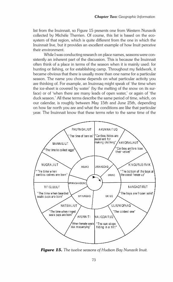
Chapter Two: Geographic Information
73
Figure 15. The twelve seasons of Hudson Bay Nunavik Inuit.
list from the Inuinnait, so Figure �5 presents one from Western Nunavik collected by Michèle Therrien. Of course, this list is based on the eco-system of that region, which is quite different from the one in which the Inuinnait live, but it provides an excellent example of how Inuit perceive their environment.
While I was conducting research on place names, seasons were con-sistently an inherent part of the discussion. This is because the Inuinnait often think of a place in terms of the season when it is mainly used: for hunting or fishing, or for establishing camp. Throughout my fieldwork, it became obvious that there is usually more than one name for a particular season. The name you choose depends on what particular activity you are thinking of. For example, an Inuinnaq might speak of ‘the time when the ice-sheet is covered by water’ (by the melting of the snow on its sur-face) or of ‘when there are many leads of open water,’ or again of ‘the duck season.’ All these terms describe the same period of time, which, on our calendar, is roughly between May �5th and June 25th, depending on how far north you are and what the conditions are like that particular year. The Inuinnait know that these terms refer to the same time of the

Knowing Places
74
year. In their choice of terms, though, they are not thinking of dates, but rather of one particular activity that usually takes place at that time of the year. There could be several other activities suitable for that time of year, but in this conversation the Inuinnaq is referring to a particular one. Among all Inuit, the sense of seasons is both highly developed and contextual, based on what is happening rather than on a number printed on a page in a calendar.
In the Arctic, as the year moves on, there are definite changes in the seasons, more so than in many other parts of the world. Because of the high latitudes, the changes are primarily astronomic and affect the annual and daily cycle of light. They are also climatic, mostly involving temperatures. These, in turn, bring about other environmental changes, such as snow cover, the freezing and thawing of water and ice, and so on. These changing conditions affect the behaviour of all living creatures—prey and hunters alike. All of this affects the way Inuinnait perceive their environment. They see it as a whole, with components that interact: a dy-namic environment, always restructuring itself. Inuinnait build their sys-tem of thought about land and sea as ecological systems on this concep-tual framework. Both Douglas Nakashima (�99�), and John MacDonald (�998) came to the same conclusion: for all Inuit, nature is a system of relationships into which humans are completely integrated. Once again, the �997 publication of Cree and Inuit knowledge of the Hudson Bay environment clearly illustrates this (McDonald et al. �997).
At the end of this section, the reader should keep in mind that if, as a geographer, I have limited my attention to seasons and landscapes, the Inuinnait knowledge of their ecosystem is much more complex than that. Several studies undertaken by both Inuit and Qablunaat, such as that of Douglas Nakashima, have led to the recognition of the quality of Inuit knowledge of fauna and flora, and of Inuit TEK (Traditional Ecological Knowledge) in general.
Beyond skills: Feelings, emotions and memories
I have presented cynegetic knowledge as having two dimensions: one is the ‘transmitted knowledge,’ the knowledge that is handed down from parents to children, often termed ‘Inuit Qaujimajangit.’ The second di-mension is the ‘knowledge of experience.’ As the young hunter’s experi-ence grows, he gradually builds his own personal body of knowledge. I have described the way fathers teach their sons, training them to learn through observation and experience without rebuke. This method of teaching encourages further development of personal knowledge through experience. Experience is not merely a means to perfect one’s technique, but a catalyst to the establishment of an intimate, very personal relation-ship with the land. Strong emotions, an appreciation of the beauty of
Chapter Two: Geographic Information
75
the land (kajjaarnaqtuq), outstanding memories of a life spent criss-cross-ing the territory: all these are integral parts of the body of geographic knowledge.
Indeed, cynegetic knowledge is more than just skills and obser-vations; it includes a third dimension that traditional Qablunaat science excludes from its definition of geographic knowledge—it is the realm of emotions, and feelings. For the Inuit, however, this dimension is an inte-gral part of the knowledge. Inuinnait hunters feel this strongly, but they are not a people who show their emotions, or easily share their feelings with outsiders. But if you live long enough with them, you just come to understand it’s there. For example, on one occasion during my research, I was discussing the object of my study (‘knowledge concerning the terri-tory, life on the land’) with a few young men (�5 to 25 years old), when one of them exclaimed:
When it comes to the land, it’s very personal. (C. T., 22 years old)
Everyone in the room agreed with this statement and they quickly moved the conversation to another subject. In Inuit society, it is not proper eti-quette to openly discuss anything that is very personal and that touches the deepest part of one’s being. It would be a serious faux-pas, a violation of the integrity of both the speaker and the listener, to enter into such a degree of intimacy. One should not indulge in what is considered to be an untimely outpouring of emotion; it is out of place in public and embar-rasses members of the group.
But this moment was real, and valuable to me. I believe that all Inuinnait feel this sense of intimacy in the way they consider the fam-iliar space of their environment. This is obviously not something that can be transmitted through words. What all parents hope is that their children will develop such insight; they lay the foundations and they let them feel its importance and its power, but do not verbalize it directly. This is clearly evident in the memoirs of Georg Quppersimaan (�992) in which he recounts, step by step, the growth of his relationship to the land, once he had decided to give himself a shaman’s education. What he called his ‘research’ was undertaken on his own initiative; there was no mentor, no educator who acted as an intermediary between him and nature. Quppersimaan’s case is specific in that he, as a shaman, would have particularly strong links with the land. But equally, John MacDonald (�998) often emphasizes the very personal nature of geographic know-ledge, built upon speculations unique to the individual and of which only a portion is shared by all.
Oral Tradition as Geographic Knowledge
Some of the geographic information I have been tracking down is found in another field of knowledge—the oral tradition. Both the geographic

Knowing Places
76
Narrative in Inuit Culture—Unipkat
Narratives of the oral tradition are called Unipkat in Inuinnaqtun (sometimes ‘ayayak,’ a word that often recurs as a storyteller’s refrain). Narratives are one of the special vehicles by which Inuinnait maintain cultural unity across the immense expanses of the Arctic, this despite the relative isolation of each group. Several of these stories have been the object of anthropological analyses, mainly of structuralist inspiration. Without going into a complex discussion of their status and their symbolic meaning, the following provides a very general overview of the role of narrative in Inuit culture.
Recitations of narratives from their oral tradition enable the Inuit to assert their unity in both time and space. In time, they anchor the people in history. They relate past events that bear witness to the antiquity of the group’s presence in the territory, giving it historical depth. In space, they conquer distance and affirm cultural continuity from one group to another and within each group. The creation myths, despite many local variations, are the same for all Inuit. Xavier Blaisel (1993) shows that Inuit society is structured on relationships issuing from rituals based on a single myth; the ‘sociogonic’ (socio + cosmogonic) myth of Arnaqtaatuq. This myth closes the ‘great cycle of tales of creation, at a time when customs guide the lives of people, game animals, spirits and the forces of the universe; this is in contrast to the asocial nature of the first mythical times’ (Blaisel and Arnakak 1993: 39, tr. lwmw). Regrettably, none of the published collections of Inuinnait stories mention this myth.
All stories transmitted through oral tradition do not have the same intellectual and geographic clarity as that of Arnaqtaatuq. Nevertheless, they all share the same basic func-tion: they assert the identity of the group. From the great myths to the small tales known only within the family circle, the variety of content illustrates the complex set of layers on which Inuit identity is built: the ethnic layer, the group, the sub-group, the camp, the family, the household, the individual.
The oral tradition of the Inuinnait has been little studied, while that of other Inuit groups has caught the attention of many anthropologists. But what do the Inuit (themselves) say about their own stories? They consider them to be very important, and worthy of sharing with future generations, but they think of them in a completely different way than the social scientist who looks for a logical and obvious ‘meaning’ for every story. Knud Rasmussen (1931) noted that although the tales are often called upon to support a demonstration or to express a complex idea, they are not followed by long explanations and comments. As an Inuinnaq woman also explained to him,
It is not always that we want a point in our stories, if only they are amusing. It is only the white men that want a reason and an explanation of everything; and so our old men say that we should treat white men as children who always want their own way. If not, they become angry and scold (Rasmussen 1932: 124).
Rasmussen’s remark is echoed by editors in recent collections of life histories. They have shown how storytellers choose which episode to recount at a particular time. They do not follow any kind of schedule like a succession of chapter headings. Instead, they respond to the precise context of the moment: the listeners at hand, recent events in the settlement, problems to be solved (Wachowich 2001). The idea is to pass on a message, but implicitly, not by some kind of ‘sermon with a stated lesson.’ Think of the Bible and the New Testament parables where the listeners work out the message for themselves. This is similar to com-munication among Inuit; that is, using narrative rather than discussion, thus promoting a subtle persuasion that is less aggressive than the confrontational approach more familiar to Qablunaat.

Chapter Two: Geographic Information
77
knowledge involved in cynegetic activities (travelling and hunting) and that garnered from the oral tradition are central to all Inuit cultures. During my research I had to deal constantly with the oral tradition: with the stories people tell and with the names people give to places on the land. Because place names were of particular importance to my research, I analyze them separately in the next chapter.
Today, the term ‘oral tradition’ is often given a very broad definition, and includes practically every kind of narrative. Life histories are an example. In this research, I have deliberately held to a more limited definition, in-cluding only stories that would be considered oral tradition in classic an-thropology. Inuinnait oral tradition has been recorded following classic anthropological standards by three different researchers in the 20th cen-tury: in �9�4-�9�6 by Diamond Jenness (�924), in �923-�924 by Knud Rasmussen (�932) and in �958 by Maurice Métayer (published as 3 vol-umes in �973). Written and oral sources of this tradition are presented in detail in Appendix B (pp. 282-84).
The richness of Inuit oral tradition is well known, and although some of it has been studied in great detail, that of the Inuinnait has not to date. The way in which Qablunaat anthropologists have analyzed oral tradition has changed over the decades. In the �920s and �930s, they were very interested in the great myths and the fact that most of them are shared by all Inuit groups. Then, in the �960s, they began to look at the structure of the narratives. It was not so much the subject of each story that was of interest, but the way in which it was constructed—the interaction between various types of events. Structural analysis sought to reveal hidden meaning, and how the same pattern of stories was found in various cultures. Their objective was to find universal concepts and rules that are common to the whole of humankind. Thus, structural ana-lysts were not much interested in how the people understood their own tradition. This approach led to multiple conflicts between anthropologists who interpreted it from their own perspectives, and indigenous peoples, who felt robbed, betrayed, and despised. Understandably, the latter did not accept having their stories interpreted in a way such that it deliber-ately ignored their own perspectives. Structural analysis is less important today. Some anthropologists have completely abandoned the approach, others recognize its limits. Today, the study of oral tradition places more emphasis on the way in which stories are told to send a message to the lis-teners, as an indirect way of giving advice, of warning, or blaming. Doing so means analyzing the context in which a story is told, and recognizing that it can be told differently depending on the message the teller wants to convey.
The Inuit themselves are not keen to answer questions about the ‘meaning’ of their stories. Nor do they relate to the way Qablunaat re-searchers usually classify stories—as myths, legends, reports of actual

Knowing Places
78
incidents, and so on. When Maurice Métayer published his collection of narratives in �973, he indicated the date on which each was recorded. There is no apparent order. For example, a creation myth might appear between two small tales of local interest. Diamond Jenness (�924) and Knud Rasmussen (�932) both organized their publications of the record-ed tales using a thematic classification. Maurice Métayer, on the other hand, purposely avoided any classification whatsoever. Despite this, his collection is still, to some extent, an artificial one. It is not a record of actual storytelling in daily life, with a teller and one or several listen-ers, all members of the same culture and often the same community (or sub-group). Just like Jenness and Rasmussen, Métayer would sit down with the Inuinnaq and ask him or her to tell a story, one-on-one. And so the stories were delivered outside of their social context, preventing a researcher from making a contextual analysis of the narratives.
We can, however, conduct a geographical analysis of these narratives. From a geographer’s perspective, stories can be classified according to the scale at which they operate: local, regional, global. The global scale considered is ‘Inuit-wide’—a general scale of myths and of certain legends that offer an explanation of the universe and human life and that are shared by all Inuit groups. The regional scale encompasses legend-ary and historical tales set in the particular territory of a specific cultural group (such as the Inuinnait) or a community (the Qurluqturmiut, the Kangiryuarmiut, the Kiluhikturmiut, etc.). In stories that operate at this scale, the land is analogous to an Inuinnait history book: memories are imbedded in the history, and the land is their guardian. The local scale comprises the remembered experiences of the family of a given hunting camp, or a group of people closely linked.8 They reveal a geography of the ‘lived’ space of the territory.
Explaining the universe and human life: The global scale
Anthropologists have been impressed with the continuity of the Inuit oral tradition. Indeed, it is remarkable to hear, thousands of kilometres away, the same stories narrated in the same language, from places as remote from each other as the shores of the Bering Strait and Greenland. Of
8 In the territorial context of a nomadic culture, the local scale applies to a surface area of much greater extent than in Qablunaat’s sedentary world. The entire territory regularly travelled from year to year by a family can be called local. Here, the size of the ‘local’ depends more on social organiza-tion than on geometric calculations. This underlines the relativity of the units of measurement of Western geography, established as they were in European and sedentary contexts. These scales—‘general,’ ‘regional’ and ‘local’ do make sense to the Inuinnait, but the average relative size of what is thought of as local or regional is different: the units are usually larger, dis-tance is not the key criterion.

Chapter Two: Geographic Information
79
course, there are differences in dialects, and local variants often reflect geographical or cultural differences. These tales, creation myths, and sagas of legendary heroes have a general message and address all Inuit. This great oral tradition has captured the attention of anthropologists ever since the time of Franz Boas (�888).9 However, although collections of narratives are fairly numerous, most of the more detailed studies are lim-ited to one or two myths, with the exception of Xavier Blaisel (�993), who developed a holistic approach for the interpretation of rituals and cosmology of Baffin Island Inuit, and John MacDonald’s work on the astronomical knowledge of the Iglulingmiut (�998) which includes a syn-thetic study of cosmogonic narratives.
The Inuit-wide narratives are very rarely localized; they express a geographic interpretation of the entire inhabited world as people know it. The narratives give meaning to this world, explaining its creation, its purpose and its very existence. They can be sorted into three types: some are cosmogonies, others deal with the origins of life and humankind, and still others recount how order was made of chaos in the world.
Cosmogonies Deriving from the Ancient Greek word ‘cosmos,’ which means the Universe, the terms ‘cosmogony’ refers to stories that recount how the Universe (Hila in Inuinnaqtun, Sila in Inuktitut) and its various elements were created. Cosmogonies express a people’s basic world-view, and as such are one of the pillars on which the geographic knowledge used daily by that people is built. In Inuit culture, a detailed cosmogony deals with things or phenomena that relate to the sky: the stars, the moon, the sun, the clouds, the northern lights, rainbows, etc.
Knud Rasmussen (�932: 23) reports that, for the Inuinnait, all these heav-enly bodies were originally either Inuit or animals (dogs, polar bears, cari-bou�0) who were transported to the sky at a key moment in their life or at their death, which was often violent. For example, the constellation Orion is Tuvaaryuit, ‘the three little hunters’ (who were brutally raised to the heavens when they were pursuing a polar bear). John MacDonald
9 A German anthropologist, he spent the winter of �883-�884 in Cumberland Sound (South Baffin Island) with a German scientific exped-ition. A few years later he became a Professor at the University of California at Berkeley and turned his attention to the North-Pacific Indian cultures. He is considered the Father of American anthropology.�0 These three animals benefit from a particular status. The dog is very close to humans, like them it can have a name (atiq); the bear is the animal par excellence, the strongest, the most clever, whose meat provides the most energy and whose fur the most warmth; and the caribou, along with the seal, is the most common game and, most importantly, envelops and protects humans with its fur.

Knowing Places
80
(�998: �5) notes that Inuit give more importance to stars that appear cyclically (those that rise and set) than to circumpolar stars (those always present in the arctic sky). The cyclical stars are more often identified as human beings than the circumpolar ones. There are practical reasons for this: cyclical stars are more useful for measuring the passage of time at all levels: of a day, a week, a month, a season. But there could well be a more abstract reason. The cyclical stars rise and set: human beings and animals wake up and go to sleep, are born and die…
Eastern Canadian Inuit think that the dead live in Qilak, (the ‘sky’, ‘heaven’) and that the stars are the sparkling windows of their igloos. Inuinnait, on the other hand, think the dead dwell in a world of abun-dance that is invisible, but their spirits remain on the tundra. To my know-ledge, they have no cosmogony that relates to snow or rain, but the origin of clouds is explained (see p. 84 in this chapter).
The Inuinnait share with most other Inuit the myth of the sun, Hiqiniq, and the moon, Tatqiq. Hiqiniq, a girl, had Tatqiq as a brother. At that time, there was no day; it was permanently night. In winter the Inuit gathered in a qalgik (big igloo for the whole community) to dance and sing. Every evening before leaving home to join the others, Hiqiniq received a visit from a man who put out the lamp upon entering and then had intercourse with her.�� Wanting to know who the man was, one night she rubbed her nose with soot and waited. After the man had come and departed, she went out. When she entered the qalgik, she saw the man with his nose black from soot: it was Tatqiq, her own brother. Furious and ashamed, she stood before him, cut off her breasts and hurled them at his face saying, “Since you love me so much, eat me.” Then she lit her lamp and ran outside holding it. Tatqiq hurried behind her, barely lighting his own lamp as he rushed out. He started chasing her around the igloo until they were suddenly lifted into the air. Today he follows her course in vain in the sky. Hiqiniq, whose lamp was well lit, shines with all its fire: she is the sun. But Tatqiq’s flickering flame only throws a feeble glimmer and no heat: he is the moon (Rasmussen �932: 33).
According to Jaarich Oosten (�983), the Inuit myth of the sun and the moon is connected to the larger tradition of Amerindian myths about those same heavenly bodies. Its symbolic meaning deals with the prop-er distance that must be kept between members of an extended family, an issue most myths touch upon. In Inuit oral tradition, the importance of keeping the proper distance between relatives is a recurring theme. Another connected theme is the relationship between humans, animals, and various monsters that used to live on earth. Society is thus partly organized around a key geographic concept: distance.
�� In a narration collected in Igloolik by Alexina Kublu from her father Michael Kupaaq Piugattuk, the teller suggests that the woman was actually being raped (Oosten and Laugrand 2000). In other accounts, it is not so clear.

Chapter Two: Geographic Information
8�
The origins of life and humankind Myths also explain how different peoples and beings came to be, and how they are distributed across the world. According to the Inuinnait oral tradition, human beings have always existed, and the Inuit are the origin of all other peoples. Indians (Itqilit) and the others (Qablunaat) were born from the unnatural union of an Inuk woman and a dog: in other words, from a situation where the proper distances were not respected. In the widely known Inuit creation myth, a girl had refused all the suitors that her father suggested. Angered, her father abandoned her on an island, alone with a dog as her mate. Children-pups were born of this union. As the story goes, their mother then made kayaks (qayaq) out of her shoe soles and sent them away. Some were sent to the South, and became Qablunaat. Others were sent to the interior of the mainland and became Itqilit (Indians). The last ones stayed with her and became Inuit like her-self (Jenness �924: narratives 72a, b, c, d, e; Rasmussen �932: 240). It is remarkable that nothing in Inuit oral tradition recalls their ancestors’ migration from the Bering Strait. According to their mythology, Inuit have always lived on the land on which they live today.
Animal life also originated from the Inuit. All marine mammals, so important in their daily life, are off-springs of the severed fingers of Arnakapkhaaluk, an Inuk woman. Kidnapped by a monstrous dog dis-guised as a man, Arnakapkhaaluk led a miserable existence on an iso-lated island in the middle of the ocean. She remained there until the day her father came by kayak to take her home with him.�2 But the dog changed itself into a storm and pursued the pair as they fled. When the father still would not give his daughter back, the storm became so strong that at any moment the kayak might capsize. His soul torn in torment, the father pushed his daughter overboard, giving her to the furious hus-band and saving his own life. But Arnakapkhaaluk clung to the boat. To release her grip, her father cut off the tips of her finger: these immediately became the seals. As she still hung on, he cut her fingers off at the second knuckle: they became the walruses and the whales. Then, because she still clung fast, he cut off the last sections of her fingers, which became the fishes. She sank to the bottom of the ocean, where she still lives. From her igloo in the deep, Arnakapkhaaluk reigns over the marine mammals and, when she is angry with the Inuit, she hides all the game under her igliq, her sleeping platform. She does not hide the body of each animal but its spirit (inua), as well as the spirits of the men’s weapons and, sometimes, of the women’s sewing kits. When this happens, the Inuit suffer from starvation. At this point, the people call upon the angatkuq (shaman)
�2 The fact that a sea kayak is mentioned in both stories, when it is well known that the Inuinnait didn’t have any, is a sign of the great age of these two myths. Just like that about the sun and the moon, they are found among all Inuit groups.

Knowing Places
82
who must go to the bottom of the sea to negotiate with Arnakapkhaaluk to calm her anger and convince her to release the spirits that she holds captive (Rasmussen �932: 24).
This one single myth explains the origin of all creatures of the sea. There is no comparable myth that considers land mammals all together; each has its own independent myth. The marine world displays unity; the land world displays diversity. This is consistent with the idea—central in the Inuit understanding of the Universe—that the land and the sea are two very different worlds that, as a rule, must be kept separate (see Chapter �, p. 32). Undoubtedly this is also related to the fact that the Inuit were originally primarily marine mammal hunters.
Bringing order to the world In all the published collections of Inuinnait oral tradition, there are no accounts of the origin of the Inuit. The ‘true people’ have always been here. But in the distant past they were fewer in number than they are now, and they were surrounded by beings of uncertain identity. This was a time when the boundaries between the animal world and the human world were blurry. Some humans were deviants: cannibals, homosex-uals,�3 Inuit married to animals. Others were monstrous: ‘those that had no orifice in the lower part of their body’ (which prevented them from having sexual relations and bearing children), ‘those with long claws,’ and giants. Finally, others were mutants—bears or dogs, sometimes foxes and wolverines—who took on human form temporarily to fool the Inuit.
Legends—often heroic sagas such as those relating the travels of Qiviuq—tell how the Inuit rid the world of those beings that were poorly linked to humanity one by one and eventually established order in a world that had been chaotic. No longer threatened by giants, cannibals and deceitful mutants, the Inuit were gradually able to multiply and de-velop their society, that of the ‘true people.’ Once the world of the Inuit was finally in place, the era of myths and great legends drew to a close. An Iglulingmiutaq man confided:
Those stories were made when all unbelievable things could happen (Rasmussen �929a: 257).
And a Natsilingmiutaq woman also commented:
That was the time when magic words were made. A word spoken by chance would suddenly become powerful, and what people wanted
�3 Métayer �973: narratives 4� and 98. In both cases, homosexuality is feminine. The central theme of the first narrative is nothing other than the origin of ‘normal’ sexual relations: the arrival of a man in the camp of three women (one hunter and two seamstresses) puts an end to deviant prac-tices which were, once again, the result of a poor appreciation of proper distances.
Chapter Two: Geographic Information
83
to happen could happen, and nobody could explain how it was (Rasmussen �93�: 208).
Nevertheless, the relationship between humans and the animal world re-mains close, and is maintained by shamanism. The angatkuq (shaman) appeals to the animals’ spirits for permission to use their power for his own benefit or for the benefit of the whole group. Xavier Blaisel (�993) illustrated how the relationship between humans and the spirits is kept strong by the performance of certain rites. In fact, the hunt is really one such ritual. Each phase of the hunt, from tracking the game to sharing it, is marked by obligatory rituals comprising gestures or words. At the mo-ment when the hunter takes a seal or a caribou, he must recite a short incantation and give fresh water to the seal. Furthermore, he must follow certain rules as he skins the game, cuts it up, and shares it with other members of his camp. If he does this correctly then the spirit of the game (its inua) is not offended. By his actions, he has thanked the animal for offering itself to his harpoon or arrow, and has thus ensured that, in the future, the reborn animal will return to Inuit hunters.
These Inuit-wide narratives are at the core of the culture and play a major role in the creation and ultimate definition of Inuit Qaujimajatuqangit, the traditional knowledge of the Inuit. Their symbolism is familiar to the whole of the society and applies to all fields of knowledge. A framework of ani-mistic and magical thought of high spirituality hence pervades Inuinnait geography. This is far removed from the linear logic that tends to domin-ate Qablunaat academic geography taught in schools and universities.
Encapsulating a people’s history: The regional scale
At one level or scale, therefore, we have a set of stories whereby the geographic content consists of an explanation of the formation of the uni-verse. At another scale in the oral tradition, a second set of stories relates more directly to the territory of the group that has created or adapted them. These narratives are significant at a regional level. Some stories are shared by several groups (the Inuinnait and the Natsilingmiut, for example), others are known only to one. In the first instance, each group adapts the stories to their own circumstances to reflect the characteristics of their own territory. For this set of stories, the tales relating geographic content are associated with real places that are named or precisely de-scribed. These historical or legendary events offer either explanations of the origin of certain land features or recommendations about how the land should be used.

Knowing Places
84
Land features and the history of the Inuinnait The first type of regional tales comprises legends that recount the ori-gin of certain conspicuous land features. In this case, the oral tradition associates tales with places visible on the land. In doing so, it achieves three goals. First, it recounts how a certain natural phenomenon came to be. Second, it provides evidence that the story is true, because it uses a specific feature as evidence that the event really happened. Third, it reinforces the sense of common identity of the local group—i.e., ‘this is our story about this landform in our territory.’ The same basic story can often be found among different groups, but the scene varies as each group adapts it to their own landscape. In doing so, they make the story uniquely theirs.
For the Inuinnait, three legends exemplify this type of narrative very well. One story associates three hills located west of Cambridge Bay (Amaaqtuq, Uvayuq, Uvayurruhiq) with the origin of death. The three peaks are the bodies of the first four humans to ever die: a couple, their young boy, and their baby. Before this event, death was unknown among the Inuinnait. One summer, people travelling inland on Victoria Island were starving. The young couple and their children died of exhaustion one after the other as they tried to make their way to the ocean, where they hoped to find food. The land forever holds the memory of that event through the names the Inuinnait have given to the three hills. Amaaqtuq (‘the one which is a woman carrying her baby’) is the body of the wife who was carrying an infant on her back. Uvayuq (‘the one facing the wrong way’) is that of her husband whose name was Uvayuq. Uvayurruhiq (‘the small Uvayuq’) is that of the young boy.�4
The second story recounts both the origin of Qurluqtuup kuugaa, ‘the river of the one with rapids’ (Coppermine River) and of the clouds. This story takes on a theme that is common to many Inuit groups (the origin of clouds) and applies it to the origin of one of the major rivers in the Inuinnait region. The story is set on the mainland, east of today’s settlement of Kugluktuk (formerly Coppermine). One day a young girl is carried off by a female grizzly bear. The clever girl holds herself stiff and rigid, so the bear thinks she is frozen. The bear leaves her prey on the ground in the den to thaw out. Then she and her cubs settle down for a sleep as they wait for their meal to become soft enough to eat. The girl slips out and runs away, but the bear chases after her. As the bear draws close, the girl pauses and traces a long line on the ground behind her with
�4 Diamond Jenness (�924: narrative 69), Knud Rasmussen (�932: 256) and my personal field notes, Cambridge Bay �992. In the late �990s, Parks Canada and a private research organization, the Kitikmeot Heritage Society based in Cambridge Bay, conduced an oral history project around that nar-rative. The research resulted in a documentary film and the publication of a book, illustrated by Elsie Klengenberg, an artist from Ulukhaktok (Pelly et al. �999).

Chapter Two: Geographic Information
85
her finger. The line becomes a raging river—Qurluqtuup kuugaa. From the other side of the river, the bear asks ‘How did you cross?’ The girl replies that she drank the water until the river was dry. So the bear drank, until it exploded. The water flowing from its entrails rose up to the sky and formed the clouds, which had not existed before that.�5 This story also shows the power of human will—in this case displayed by actions rather than words. In the oral tradition, tracing a line on the ground (on the land or the ice-sheet) is very often a powerful act; the line creates a boundary that separates, at the same time as it protects, the one who draws it.
The third story involves two different land features, quite far away from each other. The first is a pair of deep marks on the ground on the mainland, northwest of today’s settlement of Kugluktuk. The second is a huge boulder (Ahungahungalik) on the shore of an island in the Dolphin and Union Strait. Despite the distance between them, the two features are connected to one another through the journey of an ancient giant. He was walking next to the river Nuahungniq16 and was so big and heavy that his footprints remained, where they are still visible to this day. Then, after terrorizing the Inuinnait who were camping nearby, he crossed the sea in two great strides, picking up handfuls of seals as he went. When he reached the small island cluster of Ukaliqtuuq (‘there are many rab-bits’), he started to climb a cliff. At that point, the Inuinnait used magic to turn him to stone as he set foot on the top of the cliff. Since his other foot was still in the water, he was bent forward slightly, thus becoming Ahungahungalik (‘the place that has a hump’), a large boulder broader in the middle than at the base and the top.�7
A toolkit for living on the land A second type of regional tale gives advice or instructions for using the land, akin to the manuals that are provided with a new VCR or sew-ing machine. Unlike the myths and legends that refer to a time ‘before history,’ these stories deal with events that actually happened (although many of them are old enough to be considered ancient). There are a var-iety of stories of this type, but they generally fall into one of two categor-
�5 Diamond Jenness (�924: narratives 68a, b), Maurice Métayer (�973: narratives 5 and 4�) and my personal field notes, Kugluktuk �99�. Knud Rasmussen (�932: 209), who recorded Inuinnait oral tradition among the Kiluhikturmiut (Bathurst Inlet), published a narrative in which the circum-stances of the origin of clouds are exactly the same, but in which the myth is not associated with Qurluqtuup kuugaa, probably because this river is too far from their territory.�6 The Inuinnait I spoke with did not know the meaning of this place name. Maurice Métayer, does not provide a translation either.�7 Diamond Jenness (�924: narrative 8�), Maurice Métayer (�973: nar-rative 90) and my personal field notes, Ulukhaktok and Kugluktuk (�99�-�992). In Ulukhaktok, Sam Oliktoak described to me in great detail the two footprints of the giant embedded in the bank of Nuahungniq, where he had spent part of his childhood.

Knowing Places
86
ies. The first set deals with disasters resulting from errors of judgement by the people who suffer the consequences of the error; the second deals with places marked by some kind of magical power or by the presence of extraordinary beings.
Stories of catastrophes are fairly numerous in the oral tradition. They mainly report either dramatic famines that nearly destroyed a sub-group, or, (among the Inuinnait living on the mainland only), murderous en-counters with Indians.
All the stories of severe starvation follow the same pattern. In spring, a group of people dwelling on a small island offshore has a lucky period when there is plenty of food,�8 but then find themselves prisoners on the island during spring break-up, when they are cut off from the mainland or from Victoria Island.�9 Sometimes this happens because they made a deliberate choice: they decided to spend the summer on the island, liv-ing off their reserves of meat accumulated during times of plenty before break-up. Sometimes it is a simple mistake caused by not thinking ahead: they get over-excited about the good hunting, they keep putting off the return to the mainland because they want to stock up more meat. One of these stories emphasizes laziness: the Inuinnait have accumulated so much meat that they put off the heavy task of hauling their spoils over to the mainland, where they normally would be cached to be eaten in the late fall during the transition period.20 Alas! The amount of meat gathered has been overestimated. The reserves are exhausted too quickly. Famine sets in the camp trapped in the middle of the ocean. Only a few survivors manage to return to the mainland by constructing life rafts using sleds and old sealskins.
All these stories point out the obvious lesson—the foolishness of thinking only of the present and not paying attention to what experience should have taught. The geographic significance of these narratives is clear: people risk their lives if they do not respect the principle of seasonal alternation in their land-use patterns. In the tales published by Maurice
�8 The Inuinnait often camped on these islands in the spring because channels of open water form more quickly and are more numerous there than elsewhere. In this season, seals follow these leads and haul out on the sea-ice to bask in the sun. Several of these islands are also nesting sites for ducks that were hunted on the ground rather than in the air before the introduction of firearms.�9 It is important to remember that the Inuinnait did not have sea kayaks and therefore could not live from seal hunting in summer. Their small lake kayaks were left inland at the end of the summer, in caches near the lakes where they were normally used.20 Maurice Métayer (�973: narrative 34). Laziness is one of the great-est faults that an Inuk could have. There are countless narratives in which the moral of the story is that one should not be lazy. “We were told that we shouldn’t be lazy” is also one of the phrases repeated most often when elders talk about their childhood.

Chapter Two: Geographic Information
87
Métayer, the storytellers always emphasized the fact that the Inuinnait were mainly victims of their own folly: ‘they had lost their reason,’ they comment during the telling.
The oral tradition also warns that Indians (Itqilit—‘the carriers of lice’) are dangerous neighbours.2� Stories dealing with this theme follow two types of narrative frameworks. In the first situation, by error or neces-sity,22 the Inuinnait go beyond the tree limit and enter into Indian territory. Despite their attempts to avoid the enemy, they are discovered and the Indians invade their camp and murder everyone they find there. In some cases, those who escape the massacre launch a counter-attack, but the Inuinnait are rarely victorious in these encounters. In the second situa-tion, it is the Indians who, apparently driven by the sheer spirit of provo-cation, leave the forest for the tundra. They treacherously attack a camp while the hunters are gone and easily slaughter the women, the children, and the elders. When the Inuinnait hunters return, they take off after the Indians. They find the enemy off-guard, celebrating the victory in a feast in their teepees. Now it is the Inuinnait’s turn to retaliate.23
2� The relations between Inuit and Indians were more complex than usu-ally thought by the general public. As early as 25 years ago the academic journal Arctic Anthropology dedicated a whole issue to this topic (Smith �979). Most papers in it show that even though mutual sentiments of hos-tility were the rule, in practice contacts between the two were generally peaceful, based upon exchange. Neither group lived in ignorance about the other. Violent encounters were rather rare and it is only logical that, being exceptional, they became part of the oral tradition when common unevent-ful encounters would not. Yvon Csonka (�995 and �999), an anthropologist who conducted his PhD research on the Ahiarmiut (‘Caribou Eskimo’ living mostly inland in what is now the Kivalliq region), insists on the good relations this group had with its Indian neighbours—at least in the late �9th and early 20th centuries. 22 For example, to bring wood for the construction of sleds.23 Among all these narratives, that of the Bloody Falls Massacre (the falls owe their English name to this tragic incident) deserves specific attention. In �77� a small group of Inuinnait encamped near Qurluqtuq (‘the one which is rapids’) on Qurluqtuup kuugaa (Coppermine River) was attacked by the Hudson’s Bay Company’s appointed explorer Samuel Hearne’s Indian guides. Two years earlier Hearne had undertaken to follow the river down from its source. This event was engraved in memory, and oral tradition has transmitted it through the generations until today. It was recounted to Diamond Jenness (�924: narrative 74), to Knud Rasmussen (�932: 252), to Maurice Métayer (�973: narrative 66) and also to myself in �99�. For his part, Samuel Hearne reported this tragic event in his �780 book A Journey from Prince of Wales’ Fort in Hudson’s Bay to the Northern Ocean in the Years 1769, 1770, 1771 and 1772. Maurice Métayer noted that Hearne’s version of the facts was very nearly the same as the account an Inuinnaq gave him nearly 200 years later. Several studies on this story have been published, notably by MacLaren (�99�) and McGrath (�993). The latter gives an exhaustive analysis of this event, of its various versions and its symbolic meaning.

Knowing Places
88
Again, the geographic message of such stories is clear: if the Inuinnait are free in their movements and reign as masters of the tundra and the ice-sheet, they must limit as much as possible their forays into the forest, which belongs to the Indians. Once more, the theme of respect of the proper distance to be kept between different beings is critical.
A second category of regional tales that give advice deal with wise use of the land. It encompasses stories that warn of dangerous places—places where you have to be very careful because they are inhabited by strange, more or less monstrous, beings. There are the Tuniit (‘the small people’), spirits that are very small, hardly visible and who help or harass people, depending on the occasion. There are also places with carnivorous fishes, some of them huge monsters.
Tuniit usually appear in short stories that only indicate the places where they live and advise people to keep away from them. One man called Alik did not follow these recommendations. He
…once tried to put his head in through the opening to have a look at this dwarf’s house, but the inhabitants made the opening close up by magic, and Alik could not get his head out again. His life was only saved by his companions breaking a large piece out of the cliff to release him. Nevertheless, Alik had had time to see the entire ar-rangement of the house, with its platform and everything. But since then no one had dared to peep into the mountain (Rasmussen �932: 34).
Angatkuit (shamans) recommended leaving some food near the place so the Tuniit would have something to eat; because they are so tiny they can hardly hunt for themselves. During my place name survey, elders often mentioned this recommendation when indicating places, named or not, known as Tuniit camps.
As for the giant fish reported to inhabit some lakes, they are rem-iniscent of the famous Loch Ness monster of Scotland. The oral trad-ition always conveys how the Inuinnait discovered the presence of such a dangerous inhabitant. The beast attacks caribou at the places where they cross, or hunters crossing the lake by kayak. Sometimes the beast is only seen by fishermen from the shore. Today one often adds that the lake monster was seen from an airplane on a very clear day. It should be mentioned that there is never more than one giant fish per lake. In other parts of the Inuit world, stories report that such fish live to a very old age. Such stories do not advise the Inuinnait to avoid these lakes, but only to be cautious when crossing them. For example, many people use the western shore of lake Napaaqtulik (‘the place that has trees’) approxi-mately �80 km southeast of today’s settlement of Kugluktuk (see Fig. �8b, p. ��5) even though the lake is said to harbour a giant fish. But the monster only lives in one part of the lake, so people avoid that particular

Chapter Two: Geographic Information
89
area when they cross it. They also do not usually camp around that part of the lake.
All these narratives recommending how to use the land appear at least once in each of Jenness, Métayer and Rasmussen’s collections, and they were reported to me several times. Although the same stories are not always known from one end to the other of the Inuinnait territory, each is included in the tradition of several neighbouring sub-groups. In fact, each Inuinnait sub-group has at least one story of dramatic starvation on an island and one lake inhabited by a giant fish. One of the functions of these tales is to indicate how to make good use of the land, particularly by respecting certain distances and certain rhythms.
Whether they explained the origin of a land feature (first type of narra-tive) or told how to use the land in the wisest way (second type of nar-rative), these regional scale tales always came up in the conversations I had with the experts during the place name survey. This suggests to me that a place is always linked to a story. In other words, the oral tradition is systematically connected to the Inuinnait concept of geography as a prac-tical tool for living on the land. Regional stories are like a memoir left by elders to pass on to the next generation—a sort of instruction manual or ‘toolkit’ for using the land. One part of the manual tells us to respect cer-tain features for what they represent: the origins of human life. Another section tells us that misadventures of ancestors should serve as a lesson to their descendants. Of course, the oral tradition is not simply a geograph-ical tool; there is much more to it than that.
A geography of ‘lived’ space: The local scale
There is a third set of narratives that is neither Inuit-wide nor regional, but local. In fact, many of these stories are shared only within an extended family or a hunting camp. These are anecdotes telling of small incidents that have happened to familiar people in familiar places. They are very similar to family stories in Qablunaat family groups, except that, in Inuit stories, the land is usually central. These stories are forgotten as time passes and as the people in them pass on; the memories fade away.
Families tell these stories informally, in the evenings, when they talk about the place, see it on a map or a video, or when they find them-selves at the site where the incident happened. There is a little story, an anecdote, for almost all the places named on the land. For this reason, these narratives often include a great deal of geographic information. The vignette on Tatiik at the beginning of this book provided several ex-amples of this; I’ll give another here. East of Ulukhaktok the large lake Uyaraktuuq (‘the rocky place,’ see Fig. 2, p. �0) is a favourite fishing spot

Knowing Places
90
in late May. Once, a girl caught an ihuuq (‘very large fish’) in one of the small bays of the lake. That ihuuq was so heavy she could not drag it out of the water and had to ask for help from friends fishing close by. They had to widen the hole in the ice for the fishing line because it was too narrow for this truly enormous fish.
There is great variety in these simple factual anecdotes. They em-phasize the benefits and hazards of each location, indicating itineraries, short cuts, false short cuts, identifying place names, etc. Yet, the purpose of these anecdotes is not merely to give practical advice or to provide information that is obviously useful. They reach much further than that. These stories fix into people’s memories a history of the local territory. Indeed, through them a stretch of space that was originally empty—a neutral expanse—becomes a familiar homeland supporting the life of the people who make it human: a ‘lived’ space. Moreover these stories enrich the territory with a historic and emotional depth that plays a major role in the way Inuinnait look upon their land. This emotional attachment to the land is an essential dimension of Inuinnait geographic knowledge.
None of these local anecdotes appear in the publications of Diamond Jenness or Knud Rasmussen. Why not? The Inuinnait may have con-sidered them to be private family tales, and felt awkward about shar-ing them with outsiders. Or perhaps it was the anthropologists who were interested only in the more widely spread myths and legends, and de-cided not to include such ‘insignificant’ material. Interestingly, Maurice Métayer included these tales in his publication. Jenness and Rasmussen were more academic in their approach, and visitors to the area. Métayer, on the other hand, spent years among the Inuinnait and really mastered Inuinnaqtun. He probably had many occasions to hear such stories, and thus had a better appreciation of their importance for the Inuinnait. As a geographer, I consider these local anecdotes to truly belong to the oral tradition. Their geographic dimension is that of the intimate scale of fam-ily, individuals, and emotions.
Perception of Territory: An Attempt at Reconstruction
Until now, we have concentrated on two dimensions of Inuinnait geo-graphic knowledge. The first—cynegetic knowledge (travelling and hunt-ing)—relates to practical skills and know-how. The second—oral trad-ition—is based on memory put into words. Yet, a geographic knowledge system does not comprise only specific information. It is not just a collec-tion of facts. Geographic knowledge also relates the way people perceive and understand space. It is not just qaujimajatuqangit, ‘the things people know,’ it is also qaujimanituqangit, ‘the way people know.’ For this rea-son, it is important to examine what geographers call the ‘perception of space’—another facet of geography, based on the daily experience of
Chapter Two: Geographic Information
9�
space. For the Inuit, it is gained from hunting and travelling, and more generally from living on the land—the local space in which the young Inuinnait gradually ‘come to their senses’ and ‘become aware of their sur-roundings,’ as they themselves describe the experience of growing up.24
Building on our previous analysis, we can now examine how cy-negetic knowledge and oral tradition interact to shape the Inuinnait global perception of space. Just as for oral tradition and cynegetic knowledge, we must consider the actual process of perception; that is, we must try to identify the elements of this process, and understand how they relate to one another.
A seed-bed of places
Many studies have been undertaken to examine how different people around the world perceive the space in which they live, the space that sur-rounds them, and the greater spaces of the outside world. As they grow and mature, most individuals gradually become aware of the existence of ever larger territories. According to psychologist Abraham Moles (�982; �989), we first build a knowledge of the place where we have our roots: the home, then the neighbourhood, then the settlement or town. Then we slowly build a wider understanding of what space is, progressively developing a global representation of space. Moles describes this using the image of the shell: each individual is surrounded by several layers of ‘shells’—at least eight—each incorporated in a larger one. The tightest shell is our own body. The second includes the first one and encompasses our home. The third shell extends to the neighbourhood (the small camp of close relatives or partners for an Inuk). The fourth incorporates the immediate surroundings (a village or a small town, the large winter camp and the surroundings of regularly frequented places for an Inuk). The fifth shell is the regional ‘lived’ space—the territory of a sub-group, including its various places and landscapes, etc.
This same general scheme is found among the Inuinnait, obviously with some variations since they live a nomadic life. Settled villagers or towns peoples’ ideas of space are built from only one place—the settled home. The Inuinnait do not start off from only one place, but from sev-eral (all those camping and living areas that are places they experience as temporary homes). An Inuinnaq child, then, grows up in a context of great mobility, but it is also a context of great stability. The outside space is always temporary, and changing. Inside space, in contrast, never chan-ges. The mother sets up the igloo and the tent in the same way, every time. And so, from the start to the end of the year and from one genera-tion to the next, the child’s concept of interior space remains the same.25
24 See Murielle Nagy’s (2006) analysis of the expressions Inuvialuit elders use to recall their past encompassing a strong link between the act of mem-orizing and the awareness of one’s senses and of the close environment.25 This permanence is even more remarkable considering its duration throughout the centuries, at least since the Thule culture (direct ancestors

Knowing Places
92
Inuinnait perception of territory rests primarily on places. A series of places—of points—form a kind of framework on which a mental image of the land can be anchored. To elicit the image, think of a wide ex-panse of space with key anchor points, and between the points are more or less well-known surfaces—open expanses of space. These points are the places on the land used on a regular basis: the camps (one’s own and those of other people), the fishing lakes, streams, plant-gathering areas. They also include all the visible landmarks of the territory, such as inukhuit, meat caches, fox traps built from a mound of boulders, and conspicuous or unusual landforms. But there are also invisible markers: stories and anecdotes that make the places come alive through narrative. The land holds the memory of the Inuit and landscapes are indeed ‘mem-oryscapes,’ a concept created by anthropologist Mark Nuttall (�992: 5�-58), and summarized as follows:
Memoryscape is constructed with people’s mental images of the en-vironment, with particular emphasis on places as remembered places (Nuttall �992: 39).
Each person has a set of places that are the anchor points from which they slowly discover the land. These memorized anchor points form a mental map of plotted places for each individual. This mental map is the starting point for understanding the land as an organized spa-tial network of trails and places. These places can be ranked in order of importance, from the major ones—often camps—that serve as reference points for the mental map of the whole territory, to other less import-ant places, located in relation to these reference points. In the next two chapters I will discuss these relationships in more detail, but for now it is enough to know that the Inuinnait perception of space rests first and fore-
of Inuit), as the following event exemplifies. In �986 three Inuinnait from Ulukhaktok, two young adults and an elder (Frank Kuptana), came one day to Nauyat to visit the Co-Op Project excavation site where I was digging. At our invitation they went toward a Thule sod hut (dating from the �0th century) which excavation was already fairly advanced. Kuptana, then 68 years old, began to explain to his companions the interior organization of the dwelling immediately and with great ease: the entry corridor, the lamp, the platform (on which people slept at night and sat during the day). The structural layout of this semi-subterranean dwelling was exactly the same as that of the igloos of his childhood. The fact that this one was of earth and stones and not of snow did not disturb him in the least and was for him completely unimportant. This permanence, which seemed so extraordinary to us, was for him quite normal. The interiors of all the tents and cabins which I had occasion to enter between �980 and 2004 were also always organized according to the same plan, no matter the size of the shelter. These observations later led me to look more closely at the domestic spaces of the Inuinnait (Collignon 2000 and 200�).

Chapter Two: Geographic Information
93
most on the daily experience of place around the camp. Places, therefore play a key role in Inuinnait geography.
Lines and surfaces: The role of cynegetic knowledge
The Inuinnait perception of land is rooted in cynegetic knowledge. It develops from the experience of hunters (that is, people who track and pursue animals) and nomads (that is, people who move across their ter-ritory). This leads to the development of two other operative categories, which organize the Inuinnait perception of space: lines and surfaces. The perception of space as a set of lines and a puzzle (with missing pieces, see further) of surfaces, though, is notably gendered.
Most women normally only take part in cynegetic activities through fishing and plant-gathering,26 so they usually do not know a great deal about the lines of travel and the connections and relationships they lay out. Their memoryscapes and key reference points are often not con-nected to one another very precisely. While some do acquire a keen knowledge of these connections out of sheer curiosity, it is not required of them to do so. For men, on the other hand, their regular hunting and travelling activities lead them to develop a highly articulated perception of the land, in which places are the foundation of the construction of a complex mental map of the land.
Lines Inuinnait are primarily hunters, but their experience of space is mainly that of nomads, of moving on the land. Their cynegetic activities involve mobility on two scales. First is the regional scale of seasonal movements, requiring long journeys at certain times of the year. The places where families overnight on their way from one camp to another are not consid-ered real camps, but staging areas, or ‘stopovers.’ Then there is the local scale of daily movements, as hunters roam in search of game within a fairly limited distance from their camps.27
As a result, hunters perceive their territory as a set of itineraries, or travel maps comprising certain well-known lines of travel that are pre-ferred because they relate to well-known places. These lines are memor-
26 Plant-gathering is not limited to early fall berry picking. Tree branches, roots, and all kinds of lichens and mosses were very important in everyday life, at least until the �940s. These had a wide range of uses. For the stone lamp alone, which used seal oil for fuel, three different kinds of vegetation were needed: Kanguuyaq (a cotton-like lichen) for the wick, uryuk (a moss) with which to light the lamp and atqun, a hardwood stick (collected from driftwood) to control the flames (Mary Uyarartek, Ulukhaktok, April �998).27 The extent of territory covered daily by hunters varies depending on the season. For example, anthropologist Jean-François Le Mouël has shown that in Western Greenland (Upernavik district) the maximal extent of a daily journey by dog sled (in spring time) was twice as long as the minimal one, in the deep of the polar night (Le Mouël �978b: ��3-�20).

Knowing Places
94
ized through a set of landmarks. The more familiar the route, the more landmarks there are. So the hunters see their territory as organized by a network of lines that they follow. But it is not only the human population that follows these lines. Game animals do as well, especially caribou, geese, ducks and arctic char, whose migrations follow routes that usually change little from one year to the next.
These lines of travel can be described in technical terms as ‘axes of movement,’ and the Inuinnait can be said to have an ‘axial’ percep-tion of the land they inhabit.28 They see the land as a network of axes of movement—a perception clearly expressed in the maps drawn by Inuit at the request of explorers from the �6th century and into the 20th cen-tury. Robert Rundstrom, an American geographer, conducted his PhD re-search on the maps Inuit from the Central Canadian Arctic had drawn at the request of explorer-cartographer Joseph B. Tyrrell in �893-94 and of anthropologist Knud Rasmussen in �92�-�922. Unfortunately for us, he did not include the maps drawn by Inuinnait for Rasmussen in his work, because there were not enough of them to conduct a thorough analysis.29 In his thesis, Rundstrom (�987) stresses the fact that the maps consist pri-marily of what I have called ‘axes of movement.’ This is true as well of the two published maps drawn by Inuinnait. He also comments on the scale of the maps. Depending on how well the hunter knows the area, he uses a larger or smaller scale. If he knows the area well, he uses a large scale to provide greater detail. For less familiar areas he uses a smaller scale, and the map is little more than a series of a few strong lines of travel. This is consistent with the findings of anthropologist Jean-François Le Mouël (�978b) and the place name survey he conducted among the Naujamiut of Western Greenland in �968. When the Naujamiut drew maps they showed the same ‘axial perception’ and the same variation of scale as Canadian Inuit.
In my research I used official maps produced by the Canadian Department of Mines and Natural Resources. Today, most Inuinnait are familiar with these Qablunaat maps, and hunters usually have some at home and take them with them when they travel on the land. But when they were read-ing these maps in my presence it was apparent that they were guided by the same logic of spatial perception as that presented in the aforemen-tioned Inuit maps.
28 Compared to the more simple concept of ‘lines’ and ‘linear’ percep-tion, that of ‘axes’ and ‘axial’ perception implies a sense of movements, of mobility along the lines. That is why it fits better here. 29 In his �932 book on ‘Copper Eskimo’ intellectual culture, Rasmussen only published two maps drawn by Innuinait, and he does not provide any details about them. The circumstances under which the maps were drawn and the total number collected remain unknown. This leads us to ask if these are the only ones, or if they are the best of the collection?

Chapter Two: Geographic Information
95
As they read the official map, they refer to the lines of travel that are remembered from their own experience. As the traveller’s eyes move around the map, the hunter compares his mental image of the landscape to its representation on the map—its cartographic representation—by relying on his memory of the places that he knows from his own journeys. First he finds two key places on the map. Then he calls from his memory a list of places between these two more important ones, and searches the map for these smaller places on the way, using the shape of the coastline, islands, valleys, and lakes to guide him in his reading. As a rule, he will not bother with the elevation contours that show the height of the land; he will use this detail only if there is some doubt in his mind. Based on their linear perception, the Inuinnait have developed their own method of reading printed maps, on which they can orient themselves without much difficulty.
Men and women read these documents using the same method, but the women’s perception of lines is more vague than the men’s. They tend to ‘jump’ from one place to another, whereas men tend to carefully follow a mental trail that connects one place to the next.
I observed map reading techniques mainly during the place name survey I conducted in �99�-�992, and later during the numerous times I sat down and looked at maps with one or several people while visiting in their homes or occasionally meeting in an office where it is usual to have regional �:250 000 scale maps pinned on the wall. In 2003, I attended a meeting in Ulukhaktok where the blueprints of maps indicating the place names we had collected twelve years earlier were reviewed for final ap-proval (Collignon 2004b, 2005). On every occasion, the same reading technique was used, confirming my first descriptions of the process.
There are certain little tricks of memorization that strengthen this linear perception; these techniques are also organized axially. There are, for example, chants that list waypoints—sometimes place names—that stand out as landmarks on a particular itinerary. People told me about these chants, and agreed to sing them. I heard three in Cambridge Bay and two in Kugluktuk. One of the chants was known to some elders in both of settlements. Not one person among the Kangiryuarmiut men-tioned such chants, but my research leads me to suspect that they too use chants of the route. According to Robert Rundstrom (�987), the more eastern groups of the Central Arctic also had chants of this type. Indeed, Ludger Müller-Wille collected such chants in Kivalliq during his place name survey (personal communication February �994). The same was reported about the Natsilingmiut of Kugaaruk (formerly Pelly Bay) by musicologist Norma Kritsch Vascotto (ICASS V Congress, Fairbanks, 2004).
The mental map of the Inuinnait is thus built from lists of places (named or not) and landmarks that proceed in order along well-known itiner-

Knowing Places
96
aries. These itineraries are lines that, like the frame of a building, give structure to the territory. It is interesting to note that this list of places and landmarks changes depending on the direction of travel. Most places and prominent land features are equally visible in both directions, but not all. Places are not always seen in the same way when an itinerary is followed in one direction versus another (from East to West or from West to East, for example).
Surfaces The Inuinnait are a mobile people, their cynegetic practices start with the travel itself. In the preceding pages, the Inuinnaq-traveller’s perception of
Figure 16: Theoretical diagram of Inuinnait perception of territory.
Chapter Two: Geographic Information
97
space emerged as a set of lines, a network of axes. An examination of the Inuinnaq-hunter’s perception of space yields a somewhat different spatial configuration. For the hunter, land is both a network of axes and a set of surfaces over which game is distributed. Three types of surfaces are dis-tinctly defined: nuna (‘the land’), hiku (‘the ice cover,’ ‘the ice-sheet’) and tariuq (‘the salt,’ ‘the sea’). Hiku is a special surface in that it is temporary; it only exists for six to seven months a year, and is not inhabited by any particular game species.30
I have had many discussions with hunters about the land, using the government maps at a scale of �:250,000. They would simultaneously show their trails on the land, mention place names and discuss the kind of game that is usually found in the area we were looking at, or the ex-ceptional catches they had made there once. So now, a third element is added in the perception of space: it is not only seen and understood as a seed-bed of places connected by numerous lines; it is also organized in a number of zones, or, more descriptively, of surfaces. The lines join places, and the zones fill up the space between the lines. Most hunters insisted that I take care to note the extent and the characteristics of the game in each zone. They would never separate the animals from the knowledge about the land. Such a division does not make sense to them, since knowledge of game is an inherent part of what the hunters under-stand as geographic knowledge, and is included in their understanding of ecosystems.3� Zones without game are less travelled and do not hold the hunters’ attention. In fact, to a certain extent, these zones are so un-important as to be nonexistent for them.
Of course, game isn’t found everywhere; not every zone is home to game. So the space between the ‘axes of movement,’ is not always a hunting zone. Furthermore, the hunting zones are often quite small. There will usually be one or several axes passing through hunting zones, but there will also be a lot of empty spaces elsewhere along the lines (or axes). So although the hunter follows a particular line, he will not expect to stop in an empty zone. In empty zones, he is only a traveller. Following the same line in a hunting zone he is more than a traveller: he is a hunter.
30 Nanuq, the polar bear, also owes its prestige to the fact that it is at ease on all three surfaces. This animal is ubiquitous; like the Inuit, its territory knows no limits. 3� It follows then, that one would expect this research to include an analysis of faunal knowledge. However, the specialization of knowledge in Western science is such that I just did not have the proper training to undertake such a study. Ethno-biologists, who are best qualified to do such work, remain few in Inuit Studies. The works of Douglas Nakashima (�99�, �993) and Vladimir Randa (�994) are thus of particular value.
Knowing Places
98
The diagram depicting Inuinnait understanding of the land is helpful in summarizing Inuinnait spatial perception (Fig. �6). The land—Inuinnait land—is made up of spaces, empty and full. The empty spaces are uninhabited areas. Even if some of these are located in the middle of the territory, they somehow seem to be outside it. People ignore these empty spaces and usually don’t spend much time thinking about them. Sometimes the empty spaces are like a barrier in the middle of a useful territory; they seem to break the lines and spaces of human activity. The filled spaces are the true territory. The foundation of the filled territory is built on the points connected by the lines of travel that organize a network of circulation. On these axes, there are no permanent trails, visible year round, but that doesn’t matter. The axes exist in the mental maps of the Inuinnait and in their stories. For the Inuinnait, the trails do not have to be the equivalent of physical roads or highways. Their usefulness depends on the Inuinnait perception of them as efficient routes for hunting trips and camp migrations. The axes exist as concepts that organize useful surfaces—the plains, valleys, lakes, and so on, that are valued as spaces that support game.
This perception of territory can be described as a network of places connected by a set of axes, where surfaces play only a secondary role. This description calls to mind the same type of spatial network of places that organizes the territories of other nomadic and semi-nomadic peoples. Melanesian societies of the Southern Pacific, as described by Joël Bonnemaison (�986, �994) in his study of identity in the Vanuatu Archipelago, perceive their territories in this way. So do many Australian Aborigines and Sahara Touaregs, to give but a few examples.
The role of memory: From ‘lived’ space to historical space
In the academic report ethnologist Diamond Jenness published in �922 about Inuinnait after spending two years in the area, he writes:
The Eskimos, like ourselves, have that indefinable feeling of home in the country they have known since childhood. Some of the na-tives who wandered in the summer of �9�5 over southwest Victoria Island had been absent for two or three years in Coronation Gulf. Travelling with them I was greatly touched by the joy with which they would recognize each prominent lake and hill, and call up memories of earlier days with which these landmarks were associated. One of their kinsmen had died in that region; they wept as they passed near his grave, and some of them, after the day’s fishing was over, went back to visit it, and spent the night there in mourning (Jenness �922: 32-33).

Chapter Two: Geographic Information
99
To this point, I have tried to describe the Inuinnait perception of space on a ‘horizontal’ plane, looking at it as a stretch of land (and sea or ice) ‘in the present,’ at this moment of time. Now I would like to discuss this perception on a ‘vertical’ plane, in terms of time rather than space; that is, to examine how oral tradition has helped the Inuinnait establish roots in their land. My starting point is that each sub-group’s stock of shared memories anchors the points, lines (axes of movement) and surfaces of its territory in their history as a people.
This vertical plane operates very much at a local level, based on the details of local landscapes. The stories focus on specific features. Over the years, the perception of listeners and storytellers becomes modified from the effect of the stories: one no longer sees cliffs and lakes, but the cliff where that relative broke her collarbone, the lake where another lost his knife, the feature—so obvious that you can still count the ribs of the unfortunate man—that is the corpse of Uvayuq (see page 84 in this chapter).
We are not talking here about a simple map, with nothing more than axes of travel, points that mark camps and hunting areas. Through human experience and storytelling, the landscape becomes a memory-scape, a humanized environment. The territory becomes a world filled not merely with its living people (who are not numerous), but also of their ancestors, their adventures and misadventures, their bones and their spir-its. To that are added the animals, the memory of the first ‘true people,’ their spirits and those of certain animals, and finally the strange beings and monsters who remind the Inuinnait of the presence of so many dwell-ers of the tundra and the ocean. They reveal themselves—in the form of spirits—to those who know how to see them.
In this scenario, the Arctic land can no longer be considered an in-hospitable desert. Instead, albeit harsh, it is a land that is favourable for a population to flourish, in harmony with its various ecosystems and land-scapes. While they sometimes have to submit to them, ‘the true Inuinnait’ also use the physical conditions of their land, joining their intelligence to the power of nature. The Qablunaat image of the ‘hardy Eskimos’ strug-gling daily with a hostile environment in order to merely survive does not resonate with the Inuinnait experience of life on the land.
Only travelling with the Inuinnait reveals how this ‘vertical dimension’ figures in their perception of space. One can try to imagine it by reading the maps, but it is only on the land, in context, that one begins to fully understand how Inuinnait stories gradually transform the places travelled. Naturally, this is especially obvious when travelling by sled or boat; but even flying over the Arctic gives a good chance to witness the same thing: each passenger leans to a port-hole to locate an old camp, a popular trail, or even a snowmobile or a boat. The absurd idea would never occur to

Knowing Places
�00
anyone that they were looking at frozen and desolate barren grounds. That description has no meaning in reference to this land.
But to understand Inuinnait perception of the land, it is necessary to not only travel with them, but also to pay attention when they recount stories and reminisce about their lives or their dreams. Only through this listening does it become clear that these are stories of experiences—lived or dreamed—that build Inuinnait understanding of the land as a human world overflowing with life in all its forms (animals, people, spirits, rocks, plants, etc.). Inuinnait discuss little but recount much; their narratives are always located in specific places, whether they are reporting actions or dreams. Thus the space traversed becomes the historic land.
Oral tradition is the principal means through which the Inuinnait construct their territory as a ‘lived’ space. Great myths and small tales from the oral tradition are one of the many signs on the land, that transform the landscape into a ‘memoryscape,’ as Mark Nuttall describes it (�992: 5�-58). The horizontal plane of perception (of points, lines, and surfaces) is a mental diagram that the Inuinnait carry with them and apply to any new spaces they discover in their travels. In contrast, the ‘vertical’ plane of perception cannot be so easily applied to new territories. It takes time to make the new space historical and turn it into something familiar.
We are now beginning to understand how Inuinnait geography works. However, the discussion so far is missing yet another essential compon-ent: the place names, which I have left aside on purpose until now. Place names are transmitted by word of mouth. They are a verbalized expres-sion of a particular way of looking at the land, and as such, they belong to the field of oral tradition. It is now time to consider them.
(after Aliknak, Ulukhaktok)

101
Chapter Three
Toponyms: What’s in a Place Name?
oward the end of the nineteenth century, Franz Boas, a young German anthropologist, set up a scientific expedition to Cumberland Sound (southern Baffin Island). He spent an entire year in the
area—from August 1883 to August 1884.1 During his year in the Arctic he came to realize the importance of the study of the way indigenous people create place names as a means to better understand their culture gener-ally (Müller-Wille and Weber 1983). Boas believed that the study of place names could help explain the great variety of human cultures around the world. His recommendation to record and analyze them, however, long remained ignored in the North American arctic. It was not until the 1960s that researchers began paying attention to place names.
Many social science researchers in various parts of the world have stressed how important place names are in the study of how people define their territories from spatial expanses. They emphasize the symbolic power of the act of naming a place—a power very similar to that of naming a person, and with quite similar effects. When someone gives a name to a place on the land, the result is very similar to that of a baptism: the ‘place’ truly becomes part of the world, it exists because it is given iden-tity. Before he/she creates a name for the place, it is more or less anonym-ous; it is just another spot on the landscape—another hill, another valley in a world with millions of hills and valleys. A place may be important to someone because it is a good fishing spot, or because it is a familiar marker on a well-travelled trail, or because of something that happened there. But until it is given a name, a particular place is only a memory in someone’s mind. Once it is named, the memory can be shared with other people: the place becomes a part of human legacy. Through the power
1 Boas’ journals and letters written during his expedition have been translated into English (Müller-Wille 1998b). For the expedition and the fieldwork methodology see also Cole & Müller-Wille 1984. Boas was later appointed to the University of California Berkeley and by the end of his career he would be known as the father of American anthropology.
Knowing Places
102
of words alone, a neutral space is transformed into a humanized place. At the same time, the name has a practical use. If someone else knows the name, then they may also know the place. It becomes easier to give directions. Thus the place name also functions as an aid to travellers.
In 1965, André Leroi-Gourhan, a famous French paleontologist, wrote a major book reflecting on the relationship between the hand and the mouth, i.e., gestures (practices) and speech (words, conversations). He carefully and thoroughly analyzed relationships between naming a place, taking possession of it, and then making use of it for human purposes. In such a dynamic, he explains, words come before action. Only once a thought has been expressed through words can any action take place.2 Action is the practical, and physical, expression of thought. Without the correct word, the mind is not equipped to act upon situa-tions, places or things. Without the correct word these situations, places or things might as well not exist for other people, because their experi-ence cannot be shared.
Leroi-Gourhan also reminds us that for many people around the world, there is magic in words. Words do not just label; they create. We saw this earlier in some stories from the Inuinnait oral tradition (see Chap. 2, pp. 82 and 84). In many cultures, the power of words is so great that it is often equated to the power of a God. Think of the Bible, of the first verses in ‘Genesis One’ in the Old Testament; the world is created by the sheer power of God’s words. Think also of the New Testament and the striking statement of Saint John at the beginning of his Gospel:
In the beginning was the Word [...] [and] the Word was God (John 1:1 and 1:3).
When European explorers were ‘discovering’ new lands, naming places was a powerful way of taking possession of them. In the 1990s, several Anglo-American geographers involved in what is called ‘post-colonial studies’ analyzed such dynamics.
The main fieldwork component for my study of Inuinnait geography was undertaken from September 1991 to June 1992. A large part of that time was dedicated to a systematic survey of place names, as one had never been done for that region. From October 1991 to April 1992 I recorded 1,007 Inuinnait place names. (The survey methodology is presented in Appendix B.)
2 “This general property requires that the symbol commands the object, that an object does not exist until it is named, that possessing the symbol of the object gives the power to act on it. [...] one does not have a grasp of phenomena except by the measure with which thought, through words, acts on them and constructs a symbolic image to realize materially.” (Leroi-Gourhan 1965, English edition 1993: 332).
Chapter Three: Toponyms: What’s in a Place Name?
103
The collection of place names gathered soon took centre-stage in the study of the geographic knowledge of the Inuinnait. The fact that I had conducted all the survey interviews myself gave me a good under-standing of the dynamics of the place naming process and of the topo-nymic system that resulted.3 Also, the size of the collection gathered was well adapted to the kind of analyzes I wanted to do, which were based on sorting the place names into classification systems. I developed two such systems for that specific purpose. One deals with the type of geographical features that are named, while the other deals with the meanings of the names given to places.
It proved impossible to translate 23 of the 1,007 names collected. The problematic ones are primarily ancient terms whose meaning was lost as the language went through a natural process of change. Today they no longer carry the meaning that people gave them in the past. They are now simply place names; ‘just a name’ as Inuinnait say. The places they identify may have acquired meaning through experience or stories, but the actual name does not have any significance.
My research into Inuinnait toponymy involved a long process of discov-ery and understanding—first in the field while surveying place names, and later when analysing the datasets, my field notes, and the literature, and trying to make sense of it all. I was soon confronted with the fact that there was no easy answer to what had seemed at first to be a rather simple question: what are place names for?
This chapter aims at presenting not only my final interpretation of the data and of the classification systems on which it relies, but also the intellectual process through which it was built. For this purpose, it unfolds in three steps. First, the contradictory statements surrounding the function of place names in Inuit culture are discussed. Then, the spatial distribu-tion of named places in the Inuinnait territory is considered as well as the types of entities that are usually named. Last, we focus on the types of meanings place names convey.
The Purpose of Toponyms
We just saw that as early as the 1880s, Franz Boas advocated a recogni-tion of the importance of place names in anthropology. A hundred years later, another German anthropologist (and geographer), Ludger Müller-Wille, picked up on these ideas and carried them forward. In his 1987 and 1991 publications, among others, Müller-Wille emphasizes that the collection of place names maintained in an oral culture must be con-sidered a true geographic system. This system expresses the relationship
3 Another word for ‘place name’ is ‘toponym,’ and a people’s collection of place names is called their toponymy. Hence, we talk about Quebec top-onymy, explorers’ toponymy, Inuinnait toponymy, etc.

Knowing Places
104
between a people and their environment. It shows us the way they con-struct a human space from a natural environment. Place names reflect two facts. One has to do with how people use their culture to understand their natural environment and render it a familiar place. The other has to do with how they use their language. Inuit place names follow the struc-ture of the Inuktitut language.4 They combine a cultural understanding of a physical environment and a linguistic expression of that understanding. As Ludger Müller-Wille stated, place names of oral cultures are:
...extraordinary indicators of how cultures situate themselves in space and develop their philosophical and practical explanations of the landscape and nature in general (Müller-Wille 1991: 1).
I built on this statement to attempt to interpret the inner meaning of place names presented in this chapter. In undertaking the place names survey, I entered fully into the geography of the Inuinnait. Maps served as a frame-work for discussions about the land—a favourite topic of conversation for adults, and one in which they feel confident and certain of their know-ledge. Those who did not know many place names spent no less time studying the maps and commenting on them, thus delivering their own reading of their land. They were happy to contribute their knowledge, to be directed to their favourite areas on the map and to attentively reflect on their thoughts as they unfolded: these thoughts progressed in com-plexity well beyond simple factual information and technical knowledge.
All the Inuinnait I talked with did their best to express the import-ance of their relationship with the land. I was struck by the depth of their attachment to certain places, sometimes places they had left more than two decades earlier.5 The freshness of their memories was equally impres-sive. In addition to a thousand place names, I collected many narratives of personal incidents as well as a great deal of information on land-use practices and changes during the course of the 20th century. All of this shed much light on the Inuinnait perception of space, on the relationship between identity and the land, the nature of the relationship between geographic and cynegetic (hunting and fishing) knowledge, the know-ledge of place names, and oral tradition.
4 In fact, the study of the structure of place names is part of the study of Inuktitut as a Second Language at Nunavut Arctic College, Iqaluit (Mick Mallon personal communication, November 2003).5 The most moving testimony was that of a woman from Kugluktuk in her sixties. With tears in her eyes, she abruptly stopped talking and excused herself. To see on the map the lakes of the land abandoned some 20 years earlier literally made her homesick. During all those years spent in the settlement, she had preferred to suppress them from memory so as not to weep for them.

Chapter Three: Toponyms: What’s in a Place Name?
105
Place names surveys elicit and reveal a reality that goes far beyond a simple record and translation of the surface meaning of the place names themselves. My aim was to understand their role in Inuinnait geographic knowledge and in the culture as a whole. It was therefore important not only to collect the place names but to listen to what the people themselves had to say about these names.
Starting hypothesis; Concurring voices
Research published in the 1980s on Inuit place names, as well as my own first informal observations in 1986-1987, led me to believe that the main function of Inuinnait place names was to assist people in their travels. This would be especially important for all Inuit, as they were always on the move, day-by-day and season-by-season. Furthermore, they did not use maps of any kind before the 1970s. It thus makes sense to think that the first purpose of place names was to help travellers know where they were, and the direction in which they had to move. It seemed obvious to me that the place names were closely connected to the skills of travelling and an essential part of the set of knowledge mastered by every active hunter.
This opinion was supported by statements from several Inuit about place names. In his preface to the Gazetteer of Inuit Place Names in Nunavik, Johnny Epoo, then president of Avataq Cultural Institute,6 explains,
People travelled long distances without maps using place names and stories behind them. [...] Not knowing names of places, young people today lose their ski-doos, sleds and other hunting equipment. Knowing place names would help them retrieve what they have left behind (in Müller-Wille 1987: ix).
According to Johny Epoo, Inuit constantly use this knowledge of place names in their numerous journeys on the land. The knowledge of place names seems therefore to belong to two facets of Inuit culture: cy-negetic activities and oral tradition. In September 1991, when I was first starting my fieldwork, several statements made by young Inuinnait adults were consistent with this interpretation:
It’s good that you’re writing our place names on the maps. It’ll be useful to us. There’s lots of names we don’t know, so we don’t go hunting and travelling really far from the settlement. If you know the names you don’t get lost so much; it’s easier (K. T., 29 years old).
6 The Avataq Cultural Institute oversees the Kativik region cultural pro-grams (see inset, pp. 58-59).

Knowing Places
106
And from an account of a bad experience:
It’s better to know the place names when you travel, ’cause if you get in trouble, like break down or something, it’s easier to explain where you are and someone can come faster to help you7 (S. T., 31 years old).
This opinion was shared mainly by adults younger than 40 years of age. The president of the Hunters’ and Trappers’ Association of Kugluktuk, who was then 36, used exactly those arguments in support of my place names survey project in addressing the members of the Association’s lo-cal council, who had to decide whether to allow me free use of their meet-ing room for six weeks to conduct my survey in that community.8
Dissenting voices: Undermining the hypothesis
My ideas about place names seemed to make sense, since several Inuinnait had confirmed them in the first weeks of my fieldwork. However, dur-ing the course of the survey, I began to feel that there was something wrong with my original hypothesis. As I began talking to elders in all the Inuinnait settlements, it struck me that there was no systematic connec-tion between the skill of the traveller and the number of place names they knew. Certainly all those who knew many place names were highly re-spected hunters, and therefore also highly respected travellers. But there were also those who did not know a lot of place names but were equally respected hunters and travellers. This contradicted what I had learned from conversations with Inuinnait or from readings about Inuit generally, whether from Inuit themselves or from anthropology. Something seemed wrong; something did not fit.
As early as the first week of the survey, the problem came to light. During an interview, I was confronted by a 71-year old hunter from Ulukhaktok who had never felt the need to learn the place names of the Diamond Jenness and Prince Albert Peninsulas, where he had hunted and trapped practically all his adult life. He only knew the names around Qinngua (the lower part of Kangiryuaq—Prince Albert Sound), where he had grown up
7 Calls for help are handled by CB radio. Any reasonable hunter who expects to spend more than 24 hours away from the village will not leave without this precious means of communication. CB radio enables travel-lers to call for help if needed, exchange information on weather, snow and ice-cover conditions, etc. Radio contact can mean the difference between life and death. It also keeps hunters in close contact with friends and loved ones in the settlement, thus breaking the isolation and loneliness of the camp, particularly when a ‘camp’ numbers only one or two people.8 By virtue of the internal rules of the local chapter of the association, this large room was regularly rented out for CAN $100.00 per hour in 1991.
Chapter Three: Toponyms: What’s in a Place Name?
107
but had hardly ever returned as an adult (see Fig. 2, p. 10). Months later, noticing the very small number of names I had collected from him, an Inuinnaq from Cambridge Bay, after some reflection, stated to the survey group (three experts and the translator);
Eh, maybe I don’t know many names, but I sure know how to travel. I could go anywhere, even all the way to Baker Lake!9 (L. K., 66 years old).
He was roundly approved by his audience; his reputation as a great hunter—and thus as a great traveller—was not in the slightest way affected by the fact that he did not know a lot of place names.
The first episode in Ulukhaktok had been a signal for me, and from then on I had deliberately and systematically broached the topic with everyone I interviewed. They all thought the answer was obvious, and so considered my question very naïve. Over and over again they explained that there is simply no direct connection between knowing how to travel on the land and knowing the place names. Even the best experts on place names shared that opinion. Knowing where you are on the land and knowing the direction in which you need to go, these skills are one thing; knowing a lot of place names is something else. There is no need to know how to name the land in order to travel on it without getting lost.
So there I was. Right from the start of my project, the elders chal-lenged my original hypothesis, and they were the only real representatives of the traditional nomadic culture. My ideas had seemed so logical to me. I was a Qablunaaq and a Western scientist. My approach was influenced by the way we organize information, by our own thought system and the way we relate to spaces, places and direction. In our system, my original hypothesis made sense. The fact that the younger Inuinnait agreed with me only illustrates how much their thinking has been influenced by our culture, and how they have lost some of the thought structures that were an essential part of their original culture.
At this point, we need to pause and explore this particular topic more deeply. Before I began the survey, I did not expect this kind of statement. I had read all the relevant books and articles, I had spoken with several Inuit and Inuinnait (but not with many elders at that stage), and this issue was never raised. Everyone seemed to assume that skills on the land went hand-in-hand with extensive knowledge of place names: one depended on the other. The few researchers who had worked on Inuit systems of naming places had not met the kind of problem I had with the expert Inuit they had been working with. It would seem that most of these researchers did not ask the type of question that would solicit these answers, or if they
9 More than 500 km to the southeast of Cambridge Bay (see Fig. 12, p. 55).

Knowing Places
108
did, they did not do it systematically. Could this separation of land skills from the knowledge of place names be a specific trait of Inuinnait culture, not shared by other groups?
During a workshop in Quebec in November 2001 John McDonald, who has worked extensively among the Iglulingmiut and has been living in Igloolik for many years, found it ‘very hard to believe’ that there was no systematic connection between the knowledge of place names and travelling knowledge. According to him, such a separation of knowledge would be impossible among the Iglulingmiut, who all use place names to travel. But do they need them? During the same workshop Alexina Kublu, an Iglulingmiutaq herself, supported the view of the Inuinnait elders on this issue. She gave the example of one of her brothers who, since mov-ing from Igloolik to Iqaluit, regularly hunts and travels around the latter settlement without getting lost, even though he does not know most of the place names of the area.
Ludger Müller-Wille and Linna Weber, who conducted the most ex-tensive Inuit place names surveys in Canada to this day, heard statements similar to those of the Inuinnait elders during the Nuna-Top Place Names Surveys in Nunavik. But they did not push the discussion further (Müller-Wille, personal communication February 1994). Claudio Aporta dedi-cated his PhD research (1998-2003) to the knowledge of the Iglulingmiut about travel on the ice and on land, working quite closely with John McDonald when in the field. He tends to confirm both views. On the one hand, he concludes from his fieldwork that place names are import-ant to the Iglulingmiut to keep to the trail and know where they are. On the other hand, he reports that his travelling partners explained that new names are created when new routes are used because:
Inuit like to say where they are going. […] places are named, so that people can refer to them (Aporta 2004: 27) .
In the words of the Iglulingmiut, place names are provided as a major tool with which to tell the story of the journey, not to complete the journey itself.
It seems only logical that travelling could be done without know-ing the names of all the places encountered. If it was not the case, Inuit would never travel outside their yearly routine territories, and we know from various sources that they always have.10 Furthermore, how could the Thule people (the direct ancestors of the Inuit) have spread through the whole Arctic Archipelago in less than 200 years if they would have had to first build a set of place names for each area they reached before they moved on? Therefore, I do not think the separation of travelling skills and knowledge of place names is a specific trait of Inuinnait culture but rather a common trend among the Inuit and perhaps other nomadic peoples.
10 See Csonka 1995 for example.

Chapter Three: Toponyms: What’s in a Place Name?
109
But how can we explain such major disagreement among social scientists who have all been working with Canadian Inuit for many years? I believe the problem lies in our scientific culture. Western science estab-lishes various categories of knowledge. We create different ‘disciplines’ like Anthropology, Geography, History, and Philosophy and then divide them further into ‘fields of study.’ Sometimes these categories of know-ledge become so removed from one another that researchers stay locked in them. We all claim we are ‘social scientists,’ but we do not cross the ‘disciplinary boundaries.’ As a result, anthropologists and geographers do not always understand or process the same information in the same way. Even if they are exploring the same topics, researchers approach them from different disciplinary backgrounds, and so they start with a different framework and a different set of questions. Because of their specific train-ing, they do not all see and hear the same things when doing fieldwork. Each approaches the question with their own glasses and earphones as they look and listen.
As a western-trained scientist, I find the discussion about the main purpose of place names quite important, while at the same time I recog-nize that it may not make much sense in the Inuit knowledge system. The confusion around this issue probably results from the incomplete way we all, Qablunaat and Inuit, label or categorize things. I collected and analyzed place names. John McDonald and Claudio Aporta recorded and analyzed travelling practices. But as one anonymous reviewer of an article I had submitted commented in 2002, some ‘place names’ are the permanent name you give to a piece of the land, and other ‘place names’ are just a temporary description label you attach to a part of the landscape as you travel through it. It becomes hard, then, to decide what constitutes a place name and what does not. Also, as anthropolo-gist Nelson Graburn once pointed out, it is not always clear whether the mental descriptions that Inuit rely on to travel are proper place names or just travelling information.11
This entire discussion would not be so important were it not for the fact that some travelled places and regularly fished lakes in the Inuinnait re-gion are not named. Furthermore, when I was conducting the place name survey, all Inuinnait adults seemed to have a fairly clear idea of what constituted a place name, and what did not. When, then, does travelling information become a place name?
Re-evaluating place names in Inuinnait culture
Interest in a survey of place names was high among the Inuinnait. Even those who said that it would be of no use to them for travelling also said
11 Personal communication May 2003.

Knowing Places
110
recording toponyms was important. For the Inuinnait, it seemed that col-lecting place names was an important project on its own, separate from a project dedicated to hunting and travelling skills.
If I really wanted to understand the main function of place names in Inuinnait culture and how they help organize geographic information, I had to re-organize my thinking on the topic. I did this mainly by listen-ing very carefully to the Inuinnait, not only in the interviews during my survey but also on all occasions when the topic of place names came up in conversation. In my search for understanding, I found the conversa-tions to be more valuable than the interviews. The conversations were a natural part of daily life. Place names came up as people told stories about travel—real experiences that they relived through words. Despite all efforts, interviews are always artificial; my questions on the purpose of place names came as a theoretical point, out of context, and that auto-matically changed the kind of answer I could get (see also Appendix B on interviews in the research methodology pp. 274-275). As my work continued, through informal conversations as well as through the place names survey itself, the information began to come together. From hunter to hunter, from settlement to settlement, all the statements related to one another, bringing me to new conclusions about how place names fit in the geographic knowledge of the Inuinnait.
Eventually, I reached the following conclusion: place names are not es-sential for movement and survival. They are, however, essential for mak-ing people feel at home in their surroundings, and for making these sur-roundings a human territory, where the culture may flourish.
In the last part of the previous chapter, I introduced the idea that the land is not only understood by Inuinnait on a ‘horizontal’ plane, as a stretch of land, but also on a ‘vertical’ plane, as a ‘lived’ land, full of history (pp. 98-99).
Following up on this notion, I would suggest that place names intervene on the ‘vertical’ plane and not on the ‘horizontal’ in the con-struction of geographic knowledge. In other words, place names help put the places into memory—each individual’s memory, and a community’s shared memory—because they provide a commentary on the inhabited land. As such, place names enhance a common reading (and under-standing) of the land among the people who know them. Toponymy, the knowledge of place names, is more useful once the hunter has returned to the community than while he is travelling, his thoughts concentrating on not getting lost. Along with the stories of the oral tradition, place names are also guardians of people’s memory and the anchors of Inuinnait hist-ory. This is true of both anecdotal place names that commemorate an incident, a strong emotion, or the name of a hunter, and those that give details of the regular use of this or that place: Ulukhaqtuuq, ‘there are

Chapter Three: Toponyms: What’s in a Place Name?
111
many good rocks to make ulu blades,’12 Hiniktalik, ‘the place that has those who sleep away from home,’ (in other words, an overnight stop on the trail). Accurate mental descriptions of landscapes are for travelling. Place names are for telling the story.
Place names strongly remind the living Inuinnait of their ancient presence on that land. They also make one look at the landscape in a specific way, introducing individuality into an otherwise monotonous ex-panse of rocks, bogs, lakes and ice. Travellers who know them recite the names along their trail, not to remind themselves of where they are but in order to strengthen the feeling of familiarity with the countryside through which they are passing. Therefore, place names occupy a central position in the relationship that the Inuinnait maintain with their land. They play a major role in transforming landscapes into ‘memoryscapes’ (see Chap. 2, p. 92 and 99). Those with a very limited knowledge of place names travel just as well as others without becoming lost, but their relationship to the space they are crossing is different. One might consider this relationship to be less rich and less close because an essential dimension is lacking: the vertical dimension of the community’s historical connection with the land as expressed through the words that link the land and the people. There is, therefore, a connection between the number of place names known and the level of closeness of the relationship with the land.
It would have been interesting, then, to study the relationship that the ancient shamans had with the land. But by 1991, it was too late13 to observe whether shamans had a special set of place names just as they had special names for animals, or whether they simply had a very developed set. We cannot know for certain; we can only surmise. Georg Quppersimaan’s (1992) account of his life in Eastern Greenland also sheds light on this topic and supports this hypothesis. But, as I noted earlier, the Inuit group to which he belonged is culturally too far removed from the Inuinnait to apply his testimony to draw conclusions on Inuinnait geographic knowledge and relationships to the land.
Given all of this, we can now better understand why the young people are so anxious to learn place names. Obviously, they feel they are lacking something, and that a special dimension of space is missing in their rela-tionship to the land. They learn Southern styles of knowledge in schools, and pick up Southern habits of thinking on television, or by contact with the Qablunaat living in their settlements. Many Qablunaat often ask to
12 The ulu is the woman’s knife. With its trademark semi-circular blade, its shape has become an icon of Inuit culture, along with the igloo and the inukshuk. 13 Inuinnait converted to Christianity between the 1920s and 1960s, and Shamans quickly disappeared from the public scene (see also Chap. 4, p. 153).

Knowing Places
112
travel with them, so the influence of Western thought patterns extends to the land as well as the settlements. As a result, younger Inuinnait mistake the primary use of place names and expect this knowledge to increase their travelling skills. Knowing the place names will bring them closer to the land, but it will not make them better travellers.
Spatial Distribution of Named Places and Entities Named
It is with these questions and contradictions in mind that I started to ana-lyze the data collected on Inuinnait place names. The goal was to under-stand geography as expressed through these names. To this end, the first step was to map the named places, to determine their spatial distribution, and to see if the distribution followed some kind of pattern. A logical ex-tension of this first step was to identify the type of geographical features named, in order to see if some features were more often named than others. To achieve this part of the analysis, I had to classify the types of entities (of places) named.
The survey yielded a collection of more than one thousand (1,007) place names. Geographic coordinates could not be taken for all of the entries, because maps at a scale of 1:50,000 did not exist for a large part of Victoria Island. We had to be content to work with maps at a 1:250,000 scale, which are not detailed enough to locate the places named with acceptable precision to measure geographic coordinates (degrees and minutes North latitude, degrees and minutes West longitude).14 As a re-sult, only 779 of the 1007 place names could be mapped on Figure 17. All places named on the mainland appear, but only a small number of those located on Victoria Island and on numerous small islands in the sea. Therefore, in Figure 17, physical gaps in the coverage of place names only correspond to systematic gaps in the coverage of place names on the mainland. Using a geographer’s vocabulary, we would call those empty areas ‘toponymic discontinuities.’
Spatial distribution: a scattering of places in three zones
Figure 17 gives a general view of the distribution of named places in the Inuinnait territory, despite the technical gaps on Victoria Island. But its scale is too small for a detailed analysis of how the place names are dis-tributed across the area. Therefore, the region was subdivided into three: northwestern Victoria Island, western mainland and eastern mainland (Figs. 18a-c).
14 Gillian Burles, working with the Territorial Toponymy Program (Prince of Wales Northern Heritage Centre, Yellowknife) in the summer of 1992 took charge of recording the geographic coordinates of the place names in those regions for which maps at a scale of 1:50,000 were available, using a digitizing table.

Chapter Three: Toponyms: What’s in a Place Name?
113
Figure 17:: Places named by the Inuinnait (in the regions covered by maps at a scale of 1:50,000: 779 of 1,007 recorded).

Knowing Places
114
The northwestern part of Victoria Island is the only part of the island for which precise geographic coordinates of places named could be recorded (and thus mapped), with the exception of a small area around Cambridge Bay (which is included on the eastern mainland map). The boundaries of the north-western Victoria Island map simply mean that some gaps remain in the detailed mapping of Northern Canada. On the mainland, the situation is different. All the names recorded during the survey are mapped. So, on those maps, the areas without place names are simply not named and are truly ‘toponymic discontinuities.’ We will try to understand the meaning of these discontinuities.
Before interpreting Inuinnait place names and their geography, we need to describe the spatial distribution of those names on the territory. This will provide the basis for the analyses developed further and intro-duce specific concepts and expressions that will be used throughout the rest of this chapter.
At first glance, the three maps reveal how some areas are almost devoid of names while others contain a great number of them. This is a perfect example of ‘empty’ and ‘filled’ spaces discussed in the last chapter (pp. 95-99), and illustrated in the theoretical diagram of Inuinnait percep-tion of the territory (Fig. 16, p. 96).
Together, the place names displayed on the land form a network organized in a pattern of distribution in three types of zones. We immedi-ately notice high concentrations of place names, mostly centred on the coast and the islands. On northwestern Victoria Island, we also notice that one ‘filled area’ (on the north tip of Kangiryuaq) extends slightly to-ward the interior. These ‘filled areas’ are a first type of zone.
On each of the maps, we can identify ‘filled lines’ heading out from the ‘filled areas’ in several directions toward the interior of the land and the string of islands in Coronation Gulf. These ‘filled lines’ mark favour-ite routes to hunting and fishing areas. Between them lie large ‘empty spaces,’ where there are either very few place names or none at all. The ‘filled lines’ and the ‘empty spaces’ around them are a second type of zone.
The third type of zone is larger. It only occurs inland, and is more visible on the mainland maps. It forms a type of ring around the first zone, like the rim of a wagon-wheel, with the ‘filled lines’ that look like the axles of the wheel. (It’s not a very balanced wagon-wheel, but that is the idea.) In fact, the outer edges of the third zone are not regular at all, and they are not very clearly marked. Places named here are not crowded, nor are they laid out in lines. They are in small clusters, spread out more or less regularly. On the mainland, named places in that zone dot the territory about every 70 to 80 km. On the northern part of the Victoria Island map (Fig. 18a), the distances are slightly shorter (30 to 50 km) but equally regular. These points do not form a regular pattern, but a kind of hazy circle around the first two zones.

Chapter Three: Toponyms: What’s in a Place Name?
115
Figure 18a:: Places named by the Inuinnait on north-western Victoria Island.

Knowing Places
116
Figure 18b:: Places named by the Inuinnait on the west mainland.

Chapter Three: Toponyms: What’s in a Place Name?
117
Figure 18c:: Places with Inuinnait toponyms on the east mainland.

Knowing Places
118
The three grouping patterns are consistent with the three connected Inuinnait types of land use presented in Chapter 1 (see pp. 33-36). To fully understand the following description, it would be best to keep com-paring Figure 9 (p. 35) and Figure 18a (which illustrates the seasonal movements around Kangiryuaq and Kangiryuaqtihuk).
We’ll start with the first type of zone: the ‘filled areas.’ Each of these areas ’filled’ with named places represent the core of a community’s territory. They reveal a central zone, which always hugs a stretch of the coastal area. After the move to settlements in the 1950s and 1960s, the land occupancy pattern became more centralized, as all travels now ori-ginated from and terminated at one place: the settlement (see Collignon 1993). As a result, the density of named places around each village in-creased significantly; some ‘filled areas’ were reinforced and new ones were created. This dynamic appears clearly in the area that lies inland north of Ulukhaqtuuq (Ulukhaktok). Compare that to the central coastal zone around the long inlet on Figure 18c (North of Kiluhiktuq), where the two settlements (Qingaun and Umingmaktok) always remained small, es-sentially similar to a large outpost camps. Therefore, what we see in that area is an older place names distribution pattern, that reflects a more trad-itional land-use pattern. The same is true of the area around the shores of Kangiryuaqtihuk.
To better understand what this first type of zone represented for the Inuinnait prior to settlement, we can compare Figure 18a and Figure 9; the areas of high concentrations of place names around Kangiryuaqtihuk indicate meeting places. Until the 1930s people would gather there in falltime and wait together until they could move their camp onto the ice (December or January). Meanwhile, in the Ulukhaqtuuq area, the land north of the present settlement used to be the limit of the territory used in springtime by either Kangiryuarmiut moving westward from the lower part of Kangiryuaq, or Kangiryuartihukmiut moving southward from the shores of Kangiryuartihuk. From the 1930s to the 1960s (when most people moved to the settlement), the Ulukhaqtuuq area became a favour-ite trapping ground for many Kangiryuarmiut and Kangiryuartihukmiut alike (see also the maps of Inuinnait land-use in Freeman 1976).
In summary, the first type of zone stretches around the sub-group’s ancient fall and winter camps, where the community reunited in two or three camps (see Fig. 6, p. 30).15 Therefore we could call it ‘the zone of assembly.’
The second type of zone, that of empty spaces and ‘filled lines,’ is traversed rather than inhabited. People follow favourite trails but they don’t wander off very often into the empty spaces between the ‘filled
15 Brian Goehring, a Canadian geographer who studied a small collec-tion of place names gathered in the 1950s around Kugaaruk (formerly Pelly Bay, eastern Kitikmeot region), identified the same distribution pattern there (Goehring 1989). Since the collection he worked on dates from the pre-settlement period, his findings confirm that this type of pattern is an an-cient one.

Chapter Three: Toponyms: What’s in a Place Name?
119
lines’ marking the routes. So we could call this type of zone ‘travelling zones.’ The travels considered here are family seasonal migrations, not the daily journeys of the hunters. These zones have been travelled at vari-ous seasons in history. In the early 20th century, the Inuinnait travelled through them in summer. From the 1930s to the end of the 1970s they travelled across them in winter. Today they traverse these zones in fall and spring. The absence of place names does not mean that these areas are not used; it only means that people do not set up camp there.
On the mainland, the usual distance between these named places is about 20 kilometres. This is the mean distance that would be covered in one day on a normal trip by dog-team before snowmobiles were intro-duced in the 1970s. That distance, therefore, reflects the normal rhythm of movement in earlier times. But we have to use this information cau-tiously. Travelling time differed greatly from one trip to another due to fre-quently changing weather and trail conditions. Besides, not all intermedi-ate camps, where people would simply overnight, were named. In addi-tion, the patterns that I noted in 1991-1992 are influenced by changes in travel time over the last 100 years. The speed of travel, and therefore travel time changed drastically twice in that period. The first change oc-curred in the 1930s. When the mainland Inuinnait became mainly trap-pers instead of mainly hunters, they increased the number of dogs in their teams. This in turn increased the speed of travel and the distance covered in a day’s run. Then, in the first half of the 1970s, Inuit began using snow-mobiles (see Chap. 5, pp. 186-188). This had an even greater impact on travel time and distance covered. As a result, people stopped using many places that had traditionally been overnight spots. As they were no longer used, many of their names faded from memory.
The third type of zone, which is no wider than about 10 km, marks the outer margins of the mainland territory of the Inuinnait; we can call these ‘border zones.’ Prior to the shift to a trapping land-use pattern, they were the destination of summer migrations. People spent one or two weeks there before returning to the sea (see Fig. 9). When trapping became a major winter cynegetic activity (from the 1920s and 30s until the late 1970s/early 1980s), this outer ring of the various Inuinnait sub-groups’ territories became a winter destination zone. Each family main-tained long trap-lines, which ran along the filled lines of the ‘travelling zones’ and ended in the ‘border zones.’ That meant much more frequent travel into the zone, in a different season, and more time spent there in the trapping camps. These camps were not just overnight stopping places, but corresponded to places that were fixed (although temporary). Therefore, they were, more often than not, given a name.
Of features and names
Most toponymic systems around the world tend to favour certain geo-graphical features that are named more often than others. The reason

Knowing Places
120
some features are given special attention is very significant culturally. For this reason, I developed a classification to analyze Inuinnait toponymy in relation to the type of entity named: lake, river, bay, point, peak, etc.
During the survey, the nature of each entity named was systematic-ally noted. I classified each entity following a list of 366 terms contained in a computer program called ‘Nuna-Top,’ developed by Linna Müller-Wille specifically for researchers doing place names surveys (see Appendix B, p. 281). These 366 terms came from a list established by an official commis-sion of the Government of Quebec (the Quebec Toponymy Commission/Commission de Toponymie du Québec)—since the computer program was first designed for research in Nunavik. Of the list of 366 terms, only 131 were used at least once in the Inuinnait place names survey. Some terms occurred several times. For example, the term ‘lake,’ was by far the most frequently named entity. It occurs 267 times in the final list of 1,007 toponyms. This signals that of the 1,007 toponyms collected, 267 refer to a lake, or part of a lake. It also means that 267 lakes, or parts of lakes, of the Inuinnait territory bear a name.
Designing a classification systemIn the first chapter we saw that the territories of Inuinnait sub-groups extend over two clearly differentiated ecosystems. Nuna (the land) and tariuq (the salt, the sea) are lived on at different times of the year, accord-ing to an almost ritual seasonal alternation. This division of each sub-group territory shapes the social organization of the camps as well as the land-use patterns.16 It seemed logical to use this essential division of the territory as a basis for developing a classification system for all the named features (Fig. 19). I thus first sorted the named entities between ‘inland features’ and ‘marine features’ at a first level of classification.
At a second level, each of these two classes was divided into three categories, corresponding to three major types of land and sea forma-tions, as follows: the inland features include lakes (comprising lake islands and parts of lakes), waterways (or parts thereof), and land features (hills, eskers, plateaus, etc). Marine features include coastlines (capes, inlets, cliffs, etc.), islands, and sea channels (straits of all sizes and deep bays). At first glance, it might seem odd to include the coastline in the marine class; after all, it consists mainly of land. But, in fact, the coastline was al-ways a transitional space for the Inuinnait. They would wait there for the ice-sheet to be thick enough to move their camps onto it in winter; or for the land ‘to dry up’ so they could start travelling inland and hunt caribou in summer. In describing the Inuit way of life, it was not obvious whether the coastline should be considered as part of the inland or the marine
16 See pp. 36 and 38. To summarize: – In the early 20th century: the igloo, the group and the seal hunt for the (frozen) sea; the tent, the individual and the caribou hunt for the land. – From the 1930s to the 1960s: the tent, the small group and the seal hunt for the (open) sea; the igloo, the individual, the caribou hunt, and fox trapping, for the (snow covered) land.

Chapter Three: Toponyms: What’s in a Place Name?
121
class. The final decision to classify it as a marine feature was based on the fact that all through the 20th century, coastlines were lived in or travelled through in order to access the sea—frozen or open. Also, almost all of the place names related to the coastline described features as they are seen from the sea.
Analyzing the resultsFigure 20 shows the relative importance (in percentage) of each type of geographical feature compared to all the others.
At the first level of classification, the distribution appears to be very equal: the numbers are almost the same for inland and marine features. This may seem surprising, since Inuit are usually considered first and foremost as hunters of marine mammals. However, firm land has also always been important to them, and especially to the Inuinnait (see inset, Chap. 1, p. 41). People hunted caribou as part of their annual routine. Inuinnait social life was most vibrant and complex in the igloo camp, on the ice-sheet, but nuna (the firm land) was still travelled through, used and named. Moreover, when we consider the permanency of landforms in comparison to the sea ice’s ephemerality, it seems reasonable that the land would bear more names.
When we analyze these distribution patterns, though, we must keep in mind that the research methodology used for the survey influenced the results. The survey was conducted indoors and relied on reading maps displayed on tables or floors. This probably encouraged the Inuinnait to focus on permanent features rather than on seasonal ones such as ice ridges, open water leads, and polynias. Claudio Aporta’s research on ice
Figure 19: Structure of the typology based on the type of feature named.

Knowing Places
122
travel in Igloolik revealed the existence of a whole set of names for tem-porary ice features along much-travelled trails (Aporta 2002). He collect-ed most of these names on site (when travelling along with Iglulingmiut hunters on the ice). These ice features are reported to be very stable from one winter to the next: same type of ice formation and same location. Hence, they are thought of as places and are named as such.
All the same, when we consider that in the early part of the 20th century the Inuinnait spent much more time on the ice than inland, we might still be surprised at the greater number of place names associated with land features. It is important to remember, though, that place names change as hunting and travelling patterns change. The place names I collected reflect the changes in land-use patterns throughout the 20th century. Some names date from the hunting period; others from the 1st or 2nd trapping period (see Chap. 1, pp. 38-39) and others were created in the 1980s. In the early 1900s, Inuinnait spent most of their time on the marine element; from the 1920s to the 1970s most of the population con-centrated on trapping, dwelling inland from October to May. If Diamond Jenness or Knud Rasmussen had conducted a systematic survey of place names, I would expect their lists to include more marine features than mine.
Figure 20: Distribution of toponyms by type of feature named.
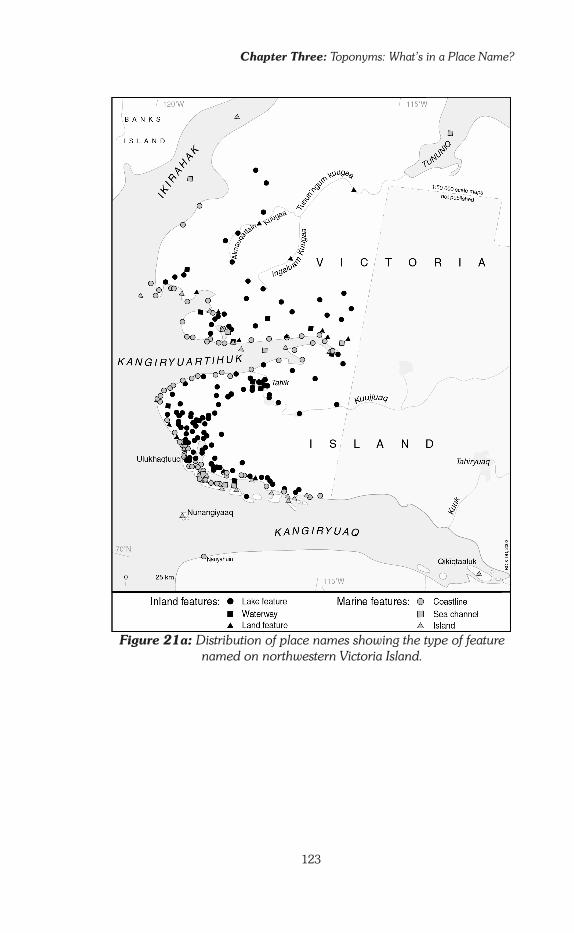
Chapter Three: Toponyms: What’s in a Place Name?
123
Figure 21a:: Distribution of place names showing the type of feature named on northwestern Victoria Island.

Knowing Places
124
Figure 21b: Distribution of place names showing the type of feature named on the west mainland.

Chapter Three: Toponyms: What’s in a Place Name?
125
Figure 21c: Distribution of place names showing the type of feature named on the east mainland

Knowing Places
126
Once the list of place names is broken down into the six sub-cat-egories at the second level of classification, there is no longer a balance among the features. For the marine element, logically enough, the fea-tures named are most often those that rise above the surface of the water, that is, coastline and islands, and they have about equal importance (20% and 24% of all the toponyms respectively). On the other hand, although there are a lot of sea channels in the region, they are rarely named: the survey collected only 28 names that relate to sea channels (less than 3% of the total), of which 21 designate straits. Straits are both dangerous and important: dangerous, since the ice on straits is thinner because of the currents; important, since most are routes used by cari-bou. Consequently, three of the 21 named straits are called Nalluq, ‘the swimming place,’ referring to caribou.
Inland, where there are so many lakes, the distribution is even more uneven. Waterways only represent 10% of all place names. Land features are named even more infrequently (7% of the total). This last observation is especially interesting because it is consistent with what older Inuinnait have said: that place names are not important for travel. It is consequent-ly logical that land features are rarely named. They can be very promin-ent on the landscape but they are of little use in daily life. On the other hand, lakes are the most frequently named entity. This is in keeping with Inuinnait land-use: life inland centred around the lakes.17 In all seasons, routes going inland follow the valleys from one lake to the next. Rivers and streams, however, were simply lines of communication—routes of travel. The flowing water bodies are rarely given a name. With few excep-tions, only the largest or longest rivers are named. Although the whole length of a river might not be very important, some parts of it might be: meanders, pools rich with fish, rapids, falls, springs, river mouths, places where streams entered the main river. Logically, such spots usually do get named.
The distribution of place names described above is consistent with what most Inuinnait explained: that place names are not some kind of route-marker. This does not apply everywhere, however. The naming practice for the coastline seems to be different. There, the list of place names for capes, bays, peninsulas, cliffs, falls and notable landmarks seems to have been drawn up by travellers to fix the landscape unfolding before their eyes in their memory. This practice breaks with the conclusion that place names are not important for travel. When we examine this more closely, we can see two reasons why the pattern for coastal areas would present a special case. First, the coast represents a very definite line, in real life as well as symbolically. On one side is the sea, frozen or liquid, (or in-between), on the other is the land, clear or snow-covered. The
17 Camps are almost always set up on the shores of lakes, and fish often saved the Inuinnait from starvation in years when caribou were scarce.

Chapter Three: Toponyms: What’s in a Place Name?
127
coast is primarily a boundary separating two ecosystems so different that certain taboos dictate that they must not be mixed (see Chap. 1, p. 32). Therefore, it is important to know and understand this frontier zone really well: the fair number of names might reflect that concern.
Second, and more importantly, according to reports by early ex-plorers and the archaeological evidence, Inuinnait life has been organized around seasonal migrations between land and ice since at least the 18th century. Migrations such as those described for the early part of the 20th century were not a new pattern. For at least a few centuries before that, Inuinnait had been spending about nine months of the year on the sea or on its borders. This long-term land-use pattern and experience would have resulted in a strong bond between Inuinnait and the coast. It was not just a line of travel, it was a ‘lived’ space and as such, its parts deserved to be named.
The maps in Figures 21a, 21b and 21c illustrate that in each ‘zone of assembly’ (see pp. 118-119 in this Chapter) it is especially the coastline and the islands that are named. Farther away, closer to the boundary of the ‘travelling zones,’ lakes become the most often named feature. Inland, the place names of the ‘travelling zones’ usually follow valleys. However, it is neither the rivers nor the slopes on their banks that are most often named, but the lakes that are encountered along the rivers. The names appear as widely separated beads on a necklace. The area around Kugluktuk is the exception. Here, land features (hills, high pla-teaus, and abrupt slopes) are more often named than elsewhere. This might be because the valley of Qurluqtuup Kuugaa (Coppermine River) is so definite in shape in the area and has been used for such a long time. Generally speaking, though, place names in the ‘travelling zones’ are more isolated, and they refer most often to lakes. Lakes are also the most named entity in the ‘border zones.’
By no means are names given to every feature in a territory. Even places regularly used in the ‘border zones’ and ‘zones of assembly’ are not al-ways named. During the place names survey, the Inuinnait themselves were often surprised to suddenly realize that a certain popular fishing lake had not been named. There is therefore a caution: an absence of place name does not mean absence of use. If during land claims negotia-tions indigenous people often use the existence of native place names as proof of traditional land-use, it is because they know from experience that this is a strong point for Westerners, who need tangible signs, artefacts, etc., to recognize land occupation. But beyond the geopolitical realm, in normal context, it is clear that among the Inuinnait (and perhaps other Inuit groups), knowledge and use of a place does not automatically mean it will be named. It is interesting to note that this does not seem to be a shared trend among nomadic groups in other parts of the world. For example, French geographer Edmond Bernus published a study on the

Knowing Places
128
Touaregs people of the Sahara Desert in Africa in which he claims they give a name to every feature in their territory:
Even the places the most devoid of particular marks for the foreign observer have an identity, and consequently a name, for the user of the region (Bernus 1981: 65; tr. lwmw).
The Meaning of Place Names: Words and Contexts
The classification of the place names according to the type of entity named deals with the ‘horizontal’ dimension of the geographic knowledge. But we should also consider the ‘vertical’ dimension of a name—the historical side that explores the term through time rather than through space. The vertical dimension describes the Inuit relationship with the land through time. The key to understanding this aspect is through linguistics—by examining the meaning of the words on which place names are built.
Designing an adapted classification strategy
Surprisingly enough, very few research projects on indigenous toponymies have attempted to analyze the meaning of place names. Yet, place nam-ing systems provide a key element for understanding a people’s rela-tionship to the land, i.e., a people’s geography, which should be a main concern for cultural anthropologists.
As regards Inuit toponymy, by 1993 only three researchers had produced lists of place names classified by their meaning (see inset, p. 131). All three classifications provided interesting input, but none of the systems was totally convincing or addressed the questions I was raising. After testing these systems on my collection of Inuinnait place names, I decided to design my own classification system.
Three earlier classifications of Inuit place names by their meaningIn 1967 and 1969, linguist Nils Holmer published an analysis of Inuit toponymy, but it was not built on any specific collection of place names. As a result, his study was very general and the discussion only theoretical. In 1989, geographer Brian Goehring drew on Holmer’s work to propose seven categories for the classification of all North American place names, regardless of their origin. His goal was to identify the specific character-istics of place naming systems of indigenous societies that are based on an oral culture, and contrast them with those of colonial societies with a written culture. In this system, most names are either: ‘Evolved names,’ associated with a long tradition and experience of the land, or ‘Bestowed names,’ given at a particular time.
‘Evolved names’ are of three types: ‘Descriptive,’ that describe physical details of the place as seen by the people who use it; ‘Associative,’
Chapter Three: Toponyms: What’s in a Place Name?
129
that connect the place with things that are found there; ‘Incidental,’ that recall some incident that occurred there. ‘Bestowed names,’ on the other hand, often have no connection to the place. They are also of three types: ‘Possessive,’ when the place is designated by the name of a person or a community who owns it; ‘Commemorative,’ when the name is given in honour of an important person or event; and ‘Imposed’—to satisfy the needs of colonizers. All place names that cannot be classified in any of these designations are placed into a handy seventh category: ‘Others.’ According to Goehring, who also refers to Holmer’s conclusions, the great majority of indigenous place names are ‘Evolved’ names, of the descriptive kind.
Brian Goehring’s work was presented as his Masters thesis and included theoretical discussion and empirical research by which he tested the classification system he had established. For the empirical analysis, he used a series of 109 place names collected in the 1950s by Father Van de Velde (OMI) among the Natsilingmiut living around Kugaaruk (formerly Pelly Bay, eastern Kitikmeot), (see Fig., 5, p. 24).
Goehring was not aware of a classification system published earlier by anthropologist Jean-François Le Mouël (1978b:100-101), so he did not test it. As part of a study on human ecology, Le Mouël had collected a series of 119 place names from the Naujamiut, a small community of Inuit (35 to 45 inhabitants in the late 1960s) on the west coast of Greenland, in the district of Upernavik. He developed a system specifically for this collection, whereas Goehring created his as a general classification, for use with any North-American collection. Le Mouël used six categories: ‘Absolute descriptive’—names that describe a place (‘the round one,’ ‘the big lake,’ etc.), ‘Relative descriptive,’—names that describe places as they relate to other places (‘the further one,’ ‘the higher one,’ etc.), ‘Fauna, game and its behaviour, hunting information,’ ‘Human traces,’ ‘Travel information,’ and finally ‘Unclassified.’
In the ‘Absolute Descriptive’ category, there are five sub-categor-ies: place names that characterize the entire place (e.g., the lake); those that identify a place by describing one of its parts; those that refer to the position or orientation of the entity; those that name the place by using a word that compares it to something else; those that name the place by its colour.
It is interesting that Edmond Bernus, whom we mentioned ear-lier, published, in 1981, a very similar classification for place names he collected among Niger Touaregs, without apparent knowledge of Le Mouël’s work. Bernus distributes place names in six categories as follows: geographical features, the human body, animals, plants, minerals, and people’s lives.
Anthropologist Mark Nuttall, who also conducted his fieldwork among a tiny community of hunters in the Upernavik district of Western Greenland, does not refer to Le Mouël’s work on place names either, probably because his research agenda and his interest in toponymy was

Knowing Places
130
quite different. Nuttall’s classification (1992: 51) is less complex and was developed from a short list of place names—about thirty, apparently. He discusses them in a framework that emphasizes ‘landscapes as memory-scapes’ (see Chap. 2, p. 92). Since the place names themselves were only of second concern to him, he does not try to analyze them linguistically. His list is divided into three categories: ‘names that refer specifically to physical features,’ ‘names that reflect analogy’ and ‘names that inform us of land and sea use.’
Although I learned a great deal from these previous works, none really fit with my own research goal. Brian Goehring’s classification cre-ates interesting categories but they are not very clearly differentiated from one another and so it is difficult to be consistent when sorting place names. When I tried to use it to sort the Inuinnait collection it quickly broke down. Deciding which category to choose was difficult to decide in a large number of cases. It is also a very general system, and thus does not really help to understand the logic of a particular naming practice. Jean-François Le Mouël created a very thorough classification system that considers the natural and physical environment as well as the cul-tural. It was therefore a better tool for the kind of analysis I sought. With one major drawback: in Le Moüel’s typology the same name, referring to one specific place, can be classified in several categories. With 1007 place names to sort, cross-indexing became problematic.
Furthermore, categories such as ‘unclassified’ or ‘others’ are never a good sign in a classification system. They indicate basically that the system is not fully operational. These issues may not arise when working with a small collection, but once a list grows larger, there is consider-able confusion in the interpretation. As for Mark Nuttall’s classification system, it is not complex enough to be a powerful tool. What is of real interest in his work on place names is his discussion about what he calls ‘memoryscapes.’
A new strategyInspired by these three models, I developed a new classification system that would serve my purpose. I retained some categories from their work, but I renamed them to serve a more geographic approach. I also organ-ized categories and sub-categories in a more detailed, and perhaps con-sistent, way. This made it easier for me to identify the various ways the Inuinnait seem to read (see and understand) their land, as expressed in their place names. The final result is a classification system organized into three levels (in one case four), with a total of ten categories, as illustrated in Figure 22. Appendix A presents the inventory of place names, along with their English translation, using this classification.
In examining Inuinnait place names from a geographer’s perspective, I could quickly divide them into two groups. This first rough division oper-

Chapter Three: Toponyms: What’s in a Place Name?
131
Previous Classification Systems of Inuit Place Names According to Their Meanings
Brian Goehring, 1989 – Typology for all North-American place names, tested on 109 Natsilingmiut toponyms
3 main categories 6 sub-categories
- Evolved names (mainly indigenous place names)
* Descriptive* Associative* Incidental
- Bestowed names (mainly colonizers’ place names)
* Possessive* Commemorative* Needs of the colonizers
- Others
Jean-François Le Mouël, 1978b – Typology for a collection of 119 Western Greenland Inuit place names
6 main categories 5 sub-categories: names that…
- Absolute descriptive
* characterize the entire place* identify a place by describing one of its parts* refer to the position or the orientation of the entity named* compare the place with something else* identify the place by its colour
- Relative descriptive- fauna, game and hunting information- Human traces- Travel information- Unclassified
Mark Nuttall, 1992 – Typology for a small collection (approx. 30) of Western Greenland Inuit place names
3 categories- Physical features (descriptions)- Analogies (comparative names)- Land and sea use

Knowing Places
132
ates at the first level of the classification system. One group was easily identified as ‘physical environment,’ the other easily labelled as ‘human environment.’ It is important to note, however, that the term ‘human’ does not necessarily identify something concrete like a house or a stone trap: the humanization aspect might be intellectual, providing no visible markers on the land. The place names of the category ‘physical environ-ment’ refer to natural geographic features; those of the ‘human environ-ment’ label places according to the human activity that is or was con-ducted at that place.
These two categories, ‘physical’ and ‘human,’ are typical of the way we Qablunaat, with our Western cultural background, analyze the world. Our cultural background is inherited from Ancient Greek philoso-phy and from Jewish and Christian theologies. All three share a world-view that establishes nature and culture (a human creation) as conflict-ing. But that is not the way most other cultures interpret the world, and that is definitely not the way Inuit people think about it. Inuit, like many other peoples, have a holistic worldview in which Nature and Culture are not separate realms but part of one same environment that encompasses natural phenomena and human life. So it seemed more suitable for this study to use Inuit categories, to better reflect the meaning of the names collected in the system.
Two concepts seemed quite adapted to the classification: Nuna and Uumajuit. At the scale of human experience, Nuna refers to the land in general, whether it is earth, ice or water (salty or fresh). Uumajuit is
Figure 22: Structure of the typology based on the meaning of the place name. (See also ‘Structure of a geographic typology of
Inuinnait oral tradition.)

Chapter Three: Toponyms: What’s in a Place Name?
133
plural, and at its most general level refers to all the living beings that roam across Nuna: the people, the animals, and all other beings such as giants, dwarfs, etc.18 These concepts are far removed from the Western categories. ‘Physical’ and ‘human’ are opposites, Nuna and Uumajuit are complementary. They work together, they are not in opposition. John MacDonald illustrates this concept when he explains that at a more gen-eral scale, Nuna translates as ‘the earth,’ which includes the Uumajuit. Nuna joins with Qilak, the sky, and Sila (Hila in Inuinnaqtun), the air and the environment, to form the Universe (MacDonald 1998: 23-38, see also Rsmussen 1932: 22-23).
At a second level in the classification system, Nuna and Uumajuit are, in turn, divided into two branches. In the Nuna category, place names are distinguished as being either ‘spatially referenced’ or ‘non-spatially referenced.’ In the Uumajuit category, place names are distinguished as referring either to a ‘regular activity’—where the name indicates the regu-lar use people make of that place, or to an ‘accidental event’—where the name recalls some dramatic event that once took place there.19
At a third level these four branches are again divided, giving rise to ten categories of classification. Among the ‘non spatially referenced’ class in the Nuna branch, we distinguish place names that are geographic terms and considered as such by Inuinnait—‘lake,’ ‘cliff,’ ‘river,’ etc.—from those that are not. For the latter (‘non-specific geographic term’) a final distinction, a fourth level, separates names that describe the place by a morphologic analogy —‘the head,’ ‘the heart,’ ‘the guts,’ etc.—from those that are simply descriptive—‘the red,’ ‘the dusty,’ ‘the flat,’ etc. Among the ‘spatially referenced’ we distinguish places that are named according to their position relative to other places (‘the sideways one,’ ‘the top one’) from those that are self-referenced (denoting the general orientation of the feature). The latter are complex or multiple entities (island and peninsula, several islands, etc.) where the name refers to the distribution of the elements that it encompasses: ‘the ones that are very scattered,’ ‘the ones that are tied to each other,’ etc.
In the Uumajuit branch, the ‘regular activities’ class is divided into three categories, depending on the nature of the activity referred to by the place name: ‘daily life,’ ‘cynegetic activities’ (hunting, fishing, and gathering) and ‘travel’ (for place names that recall how you move across the area: ‘the short cut,’ ‘the one that has to be bypassed,’ etc.). Because of the discussion about the role of place names, it seemed useful here to restrict cynegetic activities to hunting, fishing and gathering, and create a separate category for names specifically referring to travelling. The ‘ac-cidental event’ needed no further breakdown. This is where we group all
18 About the concept of Uumajuit see Randa 1996.19 For 7 place names in my collection, the translations and connected information were not precise enough to determine whether they refer to a ‘regular activity’ or an ‘accidental event.’ For this reason, they were placed in the class ‘Uumajuit’ under the category ‘no other information.’

Knowing Places
134
place names that recall an uncommon event occurring at that location, whether concerning people or strange beings: spirits, giants, dwarfs, etc. We find Amaaqtuq and Ahungahungalik (see Chap. 2, pp. 84 and 85) as well as ‘the pocket knife’ (because someone lost their pocket knife there) and commemorative names recalling Inuinnait who did something mem-orable at a special place. There is Huluraq, named after the first Inuinnaq to catch fish in that lake; Mashuyaq, named after that Iñupiaq (Northern Alaskan Inuk) who slept under his sled on this particular gravel beach be-cause he did not know how to build an igloo,20 and so on. More examples can be found in the inventory of place names in Appendix A, which sorts the collection according to the ten categories of this classification. About the relationship between place names and oral tradition, see Collingnon 2002 and 2006.
In the spring of 1996, I took advantage of a visit to Ulukhaktok to present this classification system to several Inuinnait with whom I had worked in 1991-92. They very quickly grasped the concept that drives the system and I was pleased to receive their approval and comments.
In order to use this classification system effectively, some additional in-formation is required. It is not enough just to know the literal translation of the name; knowledge of what the namer(s) had in mind is also neces-sary. The following examples illustrate this need. Tahiryuaq is easy to deal with; it means ‘big lake,’ and we classify it as ‘Nuna, non-spatially refer-enced, specific geographic term.’ A name like Qalgilik (‘the place that has a dance house’) is more difficult. Does the name refer to the shape of the feature? Is it a hill that looks like a dance house? In that case we would list it as ‘Nuna, non-spatially referenced, non-geographic term, morphologic analogy.’ But what if it was so named because the Inuinnait regularly built a dance house at that place, for example in the fall? Then we would list it as ‘Uumajuit, regular activities, daily life.’ But then maybe the name refers to an unusual occurrence when people built a dance house at a place where they had never built one before, and people remembered it for years. That would make it ‘Uumajuit, accidental.’ In this particular case, it turned out the toponym refers to the regular building of a dancing house at a meeting place on Hanningayuq (‘the big one that is sideways,’ Back River) where Kiluhikturmiut and Ahiarmiut would usually gather every summer: ‘Uumajuit, regular activities, daily life.’
Similarly, if a place has a person’s name attached to it, that is not enough information on its own to tell you how to classify it. Did that person simply camp there regularly? (‘Uumajuit, regular, daily life’). Or did he or she once do something special there (‘Uumajuit, accidental event’)? Furthermore, many people’s names often have a general mean-
20 The iglu, the snow house, was only known by the ‘Central Eskimos,’ the Canadian Inuit. The particular event involving Mashuyaq occurred in the 1930s.

Chapter Three: Toponyms: What’s in a Place Name?
135
ing that can be place names. For example Aiviq (walrus), Imirak (some kind of beverage), Ukaliq (arctic hare) can also be personal names. If you don’t know that a certain beach is named Kannuyaq because a man called Kannuyaq regularly camped there in the fall (‘Uumajuit, regular activities, daily life’), then you might mistakenly think that small nuggets of natural copper (kannuyaq) are found there, and that would make you classify the name as ‘Nuna, non-referenced, non-geographic term, simple description’. Or, you might also mistakenly get the idea that people often used copper at this site. This would give you ‘Uumajuit, regular activity, daily life’: the classification would be correct, but the reasoning would be erroneous.
During the survey, I did not have to ask for this kind of informa-tion, which is indicative of how Inuinnait relate to their place names. Those taking part in the project provided these valuable (and essential) details without being prompted to do so. This is why I believe I am on the right track with the classification system I have proposed. From what I have witnessed throughout the survey exercise, I believe the system truly reflects the way the Inuinnait conceive place names. Each place name exists in context. It belongs to the territory in which it was created. It can-not be taken out of context to be analyzed linguistically, with the thought that that is all there is to it.
So even when two place names are exactly the same two words, they are still two different names. In the classified list presented in Appendix A, what might seem to be the same place name can appear under several categories. From a purely linguistic perspective, the word listed twice is one same word. But in a cultural perspective, in the context of Inuinnait life and of the places, these are two specific names, and each name has a different meaning. Such is the case with Kannuyaq, the example dis-cussed above. The name, considered only as a word, may have several possible meanings when analyzed from a linguistic perspective, but the word as it is used for naming a particular place has only one meaning, dictated by the cultural context of that place: it is the specific name of a specific place.
Analyzing the results
Once the typology was constructed, I had to sort the 1,007 place names (or toponyms) into the various categories depending on their translation. I had collected specific names of specific places, but sometimes the same word would be used more than once to designate a different place. So the word or phrase that makes up a place name, (let’s call it the ‘place term’), is not specific and can appear several times in the collection. For example, there are ten lakes called Tahiryuaq (the big lake). ‘Tahiryuaq’ is therefore one ‘place term’ used ten times, but it is also ten different ‘toponyms.’ ‘Place term’ is a general word; ‘toponym’ is a specific name.

Knowing Places
136
In the same way, there can be ten women called Mary in a group: Mary is a common name, but each of these women considers it to be her own personal and specific name.
Among the 1,007 toponyms, 257 are duplicates. Each of these 257 words or phrases entries is a separate toponym, but the place term appears only once. Tahiryuaq is one such duplicate. Although it appears ten times in the Inuinnait collection, it appears only once as a place term in the classification by type of meaning. Because of these duplicates, I had 750 place terms to deal with altogether. Of these 750 place terms, 23 could not be translated because no one—neither translators nor elders—knew their meaning any longer. This brought the total to 727 place terms that could be translated, and which are all listed in Appendix A.
However, as I explained earlier, the Inuinnait think of their topo-nyms as specific place names, not as generic place terms. Therefore, I did
Figure 23: Distribution of toponyms according to meaning

Chapter Three: Toponyms: What’s in a Place Name?
137
not have to sort out 720 ‘place terms,’ but 1,007 toponyms. The 23 un-translatable ‘place terms’ mentioned above were also 23 untranslatable toponyms (there weren’t any duplicates among them), which could not be sorted into any category. This reduced the number of toponyms from 1,007 to 984. Therefore, the table in Figure 23, showing the percentage of place names belonging to each category, is calculated for 984 topo-nyms. The letters used as identifiers for the ten categories in the lower, more detailed graph are taken from Figure 22 (extreme right column, p. 136). There were also 25 terms that were difficult to translate; these may have been sorted incorrectly.
An inhabited landWith more than 60% of the toponyms, Nuna dominates the classification system, but the Uumajuit portion (almost 40%) is far from negligible. This is especially important when considered in terms of the way many outsiders understand the Arctic. They seem to think of it as a desert of ice where the presence of humans is barely noticeable, nearly non-existent. In addition, the important ratio of Uumajuit terms clearly leads us to ques-tion Holmer and Goehring’s (1989) conclusions about aboriginal place names being mainly physical descriptions (see p. 129 in this Chapter). The relatively balanced distribution of place names between Nuna and Uumajuit suggests that the Inuinnait have indeed placed a very human stamp on the land. This fact is of major importance for anyone who seeks to understand Inuinnait geography.
Within the two main classes, the proportion of place names that fall into each branch is fairly unequal. For Nuna the non-spatially referenced toponyms make up the bulk (80% of the total for this branch, 48% of the whole collection). This contradicts Inuinnait statements and my final con-clusions (see above) that place names do not primarily serve travel and orientation. If this was true, then why would there be so many descriptive place names? They do seem to form a kind of log-book on the geograph-ical layout of the territory. I will return to this point later (pp. 143-146).
On the other hand, there are not all that many toponyms that name places by describing their location or by comparing them to other loca-tions. In fact, only 12% of the whole collection falls into the ‘Nuna, spa-tially referenced’ category. In the Uumajuit category, the largest number of place names derive from regular activities (75% of the total), but still, the remaining 25% refer to an event of one kind or another. This again shows how ‘human’ the naming system is. People like to connect places with events, even if the events are nothing spectacular (like dropping an axe in a lake).
At the most detailed level of the classification system, no single category clearly stands out. The table shows that two categories account for 21 and 26% of the total (Nuna: ‘specific geographic terms’ and ‘non specific geographic terms’), while the next four largest categories each constitute between 10 and 12% of the whole set of toponyms (Uumajuit:
Knowing Places
138
‘daily life,’ ‘cynegetic activities’ and ‘accidental events’; Nuna: ‘referenced to another place or to the general orientation of the land features’). This illustrates the interconnection between spatial data (the position of places in relation to each other) and human data (the way people look at the territory). One additional category represents 6.5% of the total (Uumajuit: ‘movements, travels’), and finally the last two (Nuna: ‘self referenced’ and Uumajuit: ‘no other information’) are negligible, comprising only 1% to 0.5%, respectively, of the total.
The most remarkable conclusion the place names table provides is that specific geographic terms are not the most numerous (21% of the total). Rather, ‘non-spatially referenced’ terms which make up 26.5% of the total occur more often. This includes simple ‘descriptions of the feature’ (16.5%) and ‘analogies,’ comparisons based on the shape of the geo-graphic feature (10%). Furthermore, when we look at these specific geo-graphic terms, we see that although there are 206 toponyms in that cat-egory, there are actually only 113 place terms. In other words, there are a lot of duplicates. Many terms are used several times over; for example, Qikiqtalik (‘the place that has an island’) appears 11 times: one place term, eleven toponyms. This supports the notion that Inuinnait geog-raphy cannot be categorized as an isolated knowledge. Indeed, place terms would need to be made of a richer and more specifically descriptive vocabulary for that to be possible. On the contrary, the tendency is to use either common everyday words, or words that belong to other specific fields of knowledge such as hunting or physiology (the human body) to describe geographical features. For this reason, it was important to separ-ate out toponyms that compare land forms with familiar shapes.21
Toponyms linked to movements and travels represent only 6.5% of the total. This supports the claim by the Inuinnait that place names do not primarily serve travel. If they were so important for travelling, we would expect that place names that refer to movement would be at least as numerous as those that refer to hunting, fishing, and gathering.
A spatial distribution matching Inuinnait land-use patternsThe maps in Figures 24a, 24b, and 24c show that place names belonging to the Nuna categories are found everywhere: on land and at sea—the
21 These morphological analogies derive from a perception of forms specific to the culture that identifies them; it is therefore important to be especially cautious in their interpretation. The way in which an Inuinnaq depicts the shape of a heart (Uumannaq) is very different from the way a Qablunaaq would draw it. Likewise I was very surprised to discover that the word Niaquqtuq, ‘the one which is where a head is,’ did not designate, as I thought, ‘the rounded summit of a high hill,’ but instead a pointed summit. Why is the head in the shape of a point for the Inuinnait? In examining the collections of ‘Copper Eskimo’ clothing brought back by various expeditions at the start of the 20th century, the answer becomes obvious: the hood of a man’s outer clothing was always pointed.
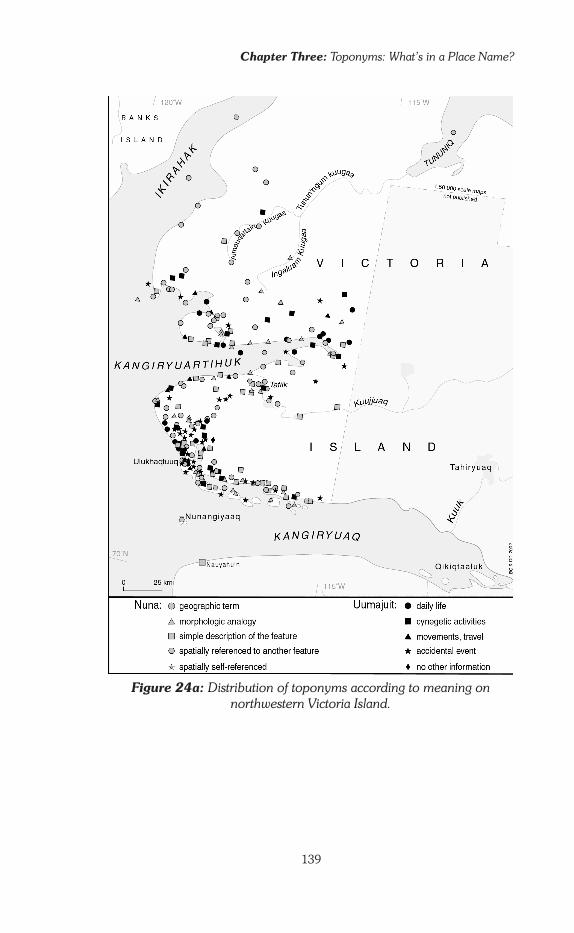
Chapter Three: Toponyms: What’s in a Place Name?
139
Figure 24a: Distribution of toponyms according to meaning on northwestern Victoria Island.
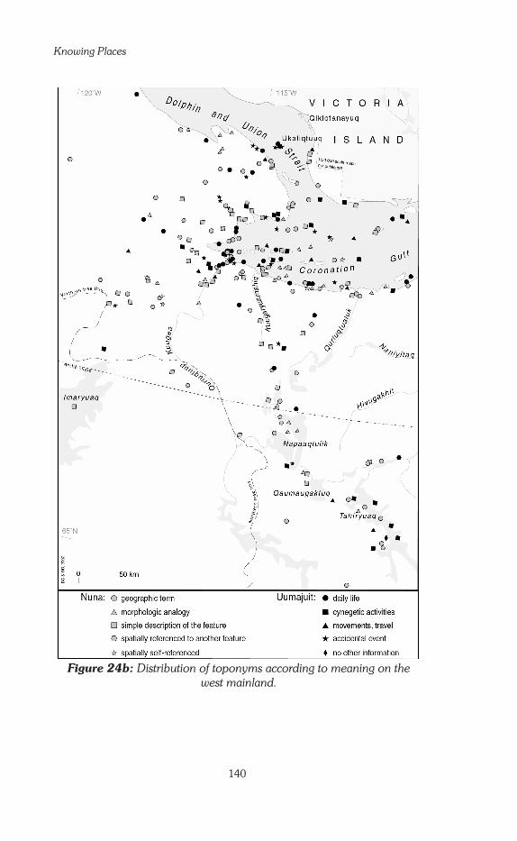
Knowing Places
140
Figure 24b: Distribution of toponyms according to meaning on the west mainland.

Chapter Three: Toponyms: What’s in a Place Name?
141
Figure 24c: Distribution of toponyms according to meaning on the east mainland
Knowing Places
142
two ecosystems that organized Inuinnait seasonal alternation. They are also found in all three zones identified at the beginning of this Chapter (pp. 112-119): the ‘zones of assembly,’ the ‘travelling zones’ and the ‘bor-der zones.’
On the other hand, place names belonging to the Uumajuit cat-egories have a more specific distribution, and are concentrated in the ‘zones of assembly.’ They are rare in the ‘travelling zones,’ except for the ‘filled lines’ (of toponyms) that lead east from the long inlet on the eastern mainland (Fig. 24c). In the ‘border zones’ they are even fewer. The hu-man element is stronger at the core of each sub-group territory. People lived closer together in the central zones, and they spent more time there each year than in the outlying areas where they usually only stayed for a few weeks. This distribution of Uumajuit place names perfectly reflects the way people used the land and the way they organized their social system (see Fig. 9, p. 35).
In the Nuna class, places that are identified in relation to others are never at a distance of more than five kilometres from at least one of those places. These kinds of toponyms are concentrated in the ‘zones of assem-bly.’ Non-geographic terms dominate in the ‘travelling zones,’ notably along the ‘filled lines’ of travel. In contrast, in the ‘border zones,’ specific geographic terms are the most numerous and lakes are the most com-mon type of entity named on the edges of the territories. The toponymic system tends to become progressively more simplified as we move away from the most heavily used areas of each territory. Also, the named places gradually become fewer as we move toward the edge of each territory.
In the Uumajuit class, toponyms that refer to the activities of daily life are concentrated in the ‘zones of assembly,’ although there are also some in the other zones. In the ‘travelling zones’ a fair number of topo-nyms relating to travel are found in coastal areas and on the islands, but they become more sporadic as we move along the lines of travel and into the interior. This supports what the Inuinnait say about good travellers: they do not always know a lot of place names. The greatest number of toponyms belonging to the ‘accidental events’ and ‘cynegetic activities’ categories are found in the ‘travelling zones’ and the ‘border zones.’ The importance of names recalling accidental events in these zones suggests that when a place is not often visited, it is more likely to be remembered by an incident that occurred there than by its physical features. And of course, it is a place where regular activities seldom occur. The incident could be a major one, or something quite unimportant, but it is enough to fix that place in one’s memory. The fair number of toponyms referring to cynegetic activities reflects the way hunters think about the land: space exists mainly through the vigilant eye of the hunter mindful of the game, as I described in the previous Chapter (see pp. 95-97).

Chapter Three: Toponyms: What’s in a Place Name?
143
Critical Reflection: Beyond the Nuna Uumajuit Distinction
At first, this system of classification seems to be very useful. As you work with it, though, a major problem begins to develop. The results of the classification seem to contradict many of the things Inuinnait had told me about place names. I have indeed pointed out where this system corrob-orates some of their claims, and I stressed that Inuinnait look at the land in a very ‘humanized’ manner.
Yet, it is the Uumajuit toponyms that express the human side of things, so we would expect the percentage of Uumajuit place names to be greater than the Nuna. This is not the case: the Nuna names outnum-ber the Uumajuit. What’s more worrying is the overwhelming number of toponyms that seem to be entirely neutral descriptions (found in the ‘non-spatially referenced’ category). What are we to conclude from all this?
When I was working through the inventory of Inuinnait toponyms, it was sometimes difficult to choose the right category for a particular place name. For a significant number of them, in fact, determining whether they belonged to the Nuna or to the Uumajuit categories was extremely delicate. The problem was always the same. It was never the word or phrase itself that disturbed me; rather, the explanations or comments that were provided with it were what concerned me. These explanations or comments were not added later, as afterthoughts; they were provided immediately.
For example, the translation for Hiuqqitak is ‘the shallow and sandy place.’ There doesn’t seem to be a problem; this toponym belongs in the category ‘Nuna, non-spatially referenced, non-geographic term, simple description.’ However, immediately following the translation of the name, the following comment was made: ‘caribou crossing place.’ To the ques-tion ‘which is the true meaning?,’ both expert and translator responded that it was not a relevant question because the two pieces of information are read on two different levels. One level is the literal, dictionary-level translation; the other is contextual, the reality—the word as it is used by people. Out of context, the sense of the name is the one given by the translation ‘the shallow and sandy place.’ But Inuinnait never take anything out of context and so the translation is, in fact, ‘caribou cross-ing place.’ For this vital reason, classifying place names must be done toponym-by-toponym and not word-by-word. Context, not the diction-ary, must prevail to guide the sorting.
To understand Inuinnait perceptions and knowledge, the explana-tions and comments provided along with the name must always be con-sidered along with the basic translation. Because they know the place named Hiuqqitak, the Inuinnait who were working with me on the trans-lations immediately elaborated on the term, which both speaker and lis-
Knowing Places
144
teners understood to be ‘caribou crossing place’ (which is usually a shal-low and sandy place). Beyond the words, people relate the toponym to context; they think of the name in connection with the human activities that are carried on in this place. Hiuqqitak, accordingly, belongs in the category of ‘Uumajuit, regular activities, cynegetic activities.’
Another example is Nilak (‘mouth of a river where the ice forms a high pile’). At first glance it would seem that this should be assigned to the category ‘Nuna, non-spatially referenced, geographic term.’ However, when one hears Nilak, what comes to mind to anyone who has travelled in the Arctic is ‘an obstacle,’ a ‘practical difficulty.’ And so it must be as-signed to the category ‘Uumajuit, regular activities, travels,’ just as most other terms describing types of ice formations (although sometimes they must be assigned to ‘cynegetic activities’).
All in all, as I was sorting the collection into the ten basic categories, some thirty toponyms were moved from the Nuna to the Uumajuit cat-egories due to comments given during the course of the survey. This re-classification was done only for the most obvious cases, because I wanted to clearly show the steps followed in interpreting the collection. The list of toponyms, along with the English translation included in Appendix A, provides the reader some insight into this.
At a general level, to correctly interpret the results of this classification, it is important to remember that Nuna and Uumajuit are understood as two elements of one environment, not as two separated realms. The Uumajuit are everywhere in the ‘filled areas’ of the territory. These ‘filled areas’ are indeed filled with actions and memory, despite few visible signs to this effect. The oneness of the Inuinnait and their environment, their detailed understanding of the land they travel, their highly developed memory for places and their histories, all of these change the meaning of even the most basic toponym: Tahiryuaq is never just ‘the big lake’ to an Inuinnaq. This word, occurring ten times in the Inuinnait toponymic collection, refers to a particular reality for each one of those ten lakes, because each lake is seen through the eyes of a human being, and it reflects a specific reality.
This is not something that is unique to the Inuinnait. We find it elsewhere in the world as well. When people live close to the land, their knowledge is their experience. Furthermore, because of the quality of the Inuinnait’s contact with the land—direct and engaged in a constant way—the Inuinnait continually update their toponyms with new experi-ences. The name of the place stays the same, but the information attached to it, and hence its meaning, changes. The toponym endures through changes in the way people use the land; its primary meaning persists (‘the shallow and sandy place,’ for example) while its secondary meaning—its true meaning (‘caribou crossing place,’ for example)—changes with the course of history. The toponym is revealed as the carrier of several layers of information and meaning, from the very superficial to the most intim-

Chapter Three: Toponyms: What’s in a Place Name?
145
ate, as well as from the most ancient to the most modern. In the begin-ning, the place’s name may have been simply a word, a linguistic fact. Gradually, as people’s connection with the place becomes personal, the toponym becomes a cultural artefact.
Such a dynamic sheds new light on the discussion on which we embarked earlier regarding the relationship between toponymy and travel. Now, an outsider such as myself can really understand the words of the elders. The descriptions of places that I first thought were simply used to facilitate a journey on the land must not be considered that way at all. Initially, they may indeed have been useful to the traveller in that capacity, but once that traveller becomes familiar with the territory, another layer of mean-ing is added. The meaning provides a deeper, more direct link to the collective memory of the community, and the landscape that was initially described as literal translations with neutral, descriptive words such as ‘the high one,’ ‘the slope,’ ‘the head,’ etc., is later transformed into a memoryscape and described with cultural or contextual toponyms.
Likewise, the names included in the category ‘Uumajuit, regular activities, travel’ do not simply inform the traveller, or assist in remember-ing the way. Such names act like a comment on the experiences other people have had at that place, such as taking a shortcut or putting on waterproof (bearded seal skin) boots to cross a river. They are not merely a travellers’ helper—they give sense to the trip by transforming the trail into a kind of ‘heritage site’, telling the stories of previous travellers, long gone or still alive. Even when they obviously refer to travelling, the topo-nyms are meant to tell a story, and as such they are a key element of the Inuinnait oral history.
Now we can better understand what the act of naming their territory means for the Inuinnait. The fact that the elders consider these place names to be so important shows that they are indeed very powerful sym-bols of how Inuinnait feel about the land. Similarly, the elders are al-ways very careful to make a precise distinction between permanent place names and the temporary identifying words they use to describe places when they need to do so. During the survey the elders never wanted to put a temporary place name on the map. A ‘real’ (permanent) name gives the place a special status; it recalls an experience of the territory and a history of the group, and in so doing, it strengthens the ‘vertical’ dimen-sion, the historical dimension, of how people look at the land.
Working with the Inuit of the Kivalliq (the ‘Caribou Eskimo’), Thomas Correll (1976) showed that their world is divided into two parts. One part contains things that have names. The other part contains things that have not been named. The basis of the relationship of these Inuit to the land is the fact that all things with names are part of the same world.

Knowing Places
146
People, game animals, flora ... and places named are therefore somewhat related. Some Inuit groups consider that for each person’s name, there is a corresponding name of a place on the land. Such an idea further reinforces the relationship between the Inuit and the places they identify on their land.
Furthermore, Jarich Oosten (1996) reminds us that most Inuit con-sider that people, animals and places all have a ‘soul.’22 This supports the idea that the Nuna and Uumajuit categories must be thought of as com-plementary—interconnected. And indeed, as I have mentioned before, at a most general level the Uumajuit are included in the concept of Nuna.
Of Knowledge, Power, and Gender Relations
Until this point, I have concentrated on identifying the various elements of Inuinnait geographic knowledge. I have not yet looked at who holds this knowledge. Knowledge is indeed power, and in many parts of the world, it is connected to the creation of social hierarchies. Some special-ists hold knowledge and do not share it except among themselves, and that makes them more important than ordinary people. Often knowledge belongs only to a special group of people, and it is kept secret from the rest of the society. A ‘caste’ system can be based on knowledge. Although this topic can be an important part of a study like this one, I have decided not to explore it in detail in this volume. We needed first to know what comprises Inuinnait geographic knowledge before we could start analyz-ing how it is shared. I will, however, make a few general remarks.
In the first Chapter I pointed out that the Inuinnait do not have a complex class system with several different levels of social standing and power. There are no sub-chiefs, chiefs, great chiefs, lord high chiefs, and so on. The only kind of specialization is gender-based: men traditionally carry
22 The term ‘soul’ poorly translates the rich and subtle Inuit notion of the being. Three concepts are developed around that notion: inua, tarniq, and atiq. Inua is structurally a possessive noun that refers to places and some collective animals, as in qimmiit inua (for dogs) or tuktuit inua (for caribou), and is often translated ‘the spirit of …’. Animals do not possess their own inua. This is why the inua survives when an individual animal is killed. Tarniq is best translated as ‘the shadow,’ according to Michèle Therrien and Jarich Oosten, and it could be said to be the soul. Humans and ani-mals both have a tarniq while it seems places do not, although anthropolo-gists who have looked into this issue remain uncertain about this. Atiq is a person’s name. With all its attributes, it can be transferred to a newborn (or occasionally another person) often on the death of its present holder among the Inuinnait. Only human beings, and some dogs, have an atiq. A thorough analysis of these concepts can be found in Oosten 1996 as well as in Therrien 1987. I also thank Alexina Kublu for her highly valuable insights on this complex topic.

Chapter Three: Toponyms: What’s in a Place Name?
147
out one set of activities, and women carry out another. That specializa-tion brings a difference in the kind of geographic knowledge that men and women hold.
Women perceive the territory from temporary fixed points (the camps) and from their personal interpretation of the stories of the oral tradition. The women know a lot about the following three topics: the surroundings of each camp (their micro-geographies); the practical use of places for the activities of daily life, including gathering; and the stories at every scale relating to the land. On the other hand, they do not know much about the lines of travel and the places and place names of the areas where people travel to hunt. The territory of the women appears as a loose collection of points quite poorly linked to one another. On an abstract level, they know those points are connected, but on a practical level, they don’t know how they are connected.
The seasonal base-camps where families usually spent approxi-mately one to three weeks before moving to another camp were the reference points from which women’s geography was organized. Their knowledge of place names follows this pattern. On average, women who engaged in the place name survey would know some forty toponyms, and rarely know more than sixty. The further away we moved from a base-camp, the fewer toponyms they knew, and these were most often only the main stopping places on a regularly travelled route. Most known toponyms were situated in ‘zones of assembly’ and, to a lesser degree, in ‘border zones.’
However, the reader must bear in mind that this knowledge varies greatly from one woman to another, according to personality, curiosity, and personal history.23
The men, on the other hand, have a general knowledge of their territory that encompasses all the elements that form their geography: cynegetic and travelling knowledge, as well as the stories of the oral trad-ition. Their view of the territory is more complete than that of the women, because the men do not know only the collections of points, the ‘filled areas;’ they also know the ‘filled lines’ of travel, and they know a great deal about the surface areas of the whole territory. All of these details fit together for them as an organized system.
The women tend to know a fair number of isolated dots; the men tend to know a whole web, with all connections between the dots. On
23 This especially applies from the 1940s to the 1960s. As groups were more scattered than ever due to the shift from a hunting to a trapping economy, girls were often taken along the trail as hunting and trapping partners by their father in the absence of a son of a suitable age for such activities. These girls acquired geographic and cynegetic knowledge which were traditionally thought to belong only to the male sphere. However, the gender-based division is still held as the ideal model. As a way of respect-ing Inuinnait values, we usually refer to hunters and travellers as males throughout this book.

average, a man would know some 80 to 100 toponyms, though rarely more than 150. They know the stories as well as the women do—all the stories; long and short, important and trivial.
Of course, perception and understanding also depend on age; a complete picture—a completeness of knowledge—is only gained slowly, through accumulated experiences over several decades. Nevertheless, age is not as important as gender. Young men often have a more pre-cise mental image of the territory than older women. The disparity of the knowledge between men and women is greater than the disparity between young and old.24 The reason for this is simple: men are the hunt-ers and travellers. They are responsible for the relationship between the family inside and the world outside. Women’s responsibility is primarily inside. The hunter brings in the game from outside: the woman relates to the ‘outside world’ from the inside of the tent or igloo to prepare food and clothing. Men travel the land while women create and restore life in the home.
In this distribution of responsibilities, relationships between women and men are best described as partnerships. Their roles and knowledge are connected; they are interdependent.
24 This is no longer true in today’s changing culture, in which the gener-ational difference is much more important than gender, although the latter also persists.
(after Aliknak, Ulukhaktok)

149
Chapter Four
Enacted Knowledge: How Inuinnait Live Their Geography
n Chapters Two and Three, I analyzed the various elements that, to-gether, make up the geographic knowledge of the Inuinnait. We saw how these elements belong to three different divisions of knowledge:
experience through cynegetic activities (including travelling), oral history (and storytelling), and toponymy (place names and what they mean). In reality, these three divisions are constantly interacting: as people live their daily lives, they continually come in contact with one another. It is when they are combined that they form the geographic knowledge of the Inuinnait.
If we wish to fully understand the geographic knowledge of the Inuinnait, and how it works, we now have to understand how it is organized—in what kind of framework. The framework is where all the information is organized and processed to create a system of geographic knowledge. The Inuinnait system is not written in books, or taught in school. It is a knowledge that is only expressed in real life: in actions on the trail, on the hunt, or at camp. It comes to life in real situations—in context. Once the framework is established, we can explore how the system works. It is akin to examining a motor while it is running, when you can see all the parts in motion. We can see how the framework is transformed into a working paradigm each time it is called upon to deal with specific situations. This will be dealt with in the first part of the chapter.
Once this is explained, we can take the concept further and con-sider the worldview, the philosophy that this knowledge conveys. In the second section, I demonstrate how three concepts act as the main pillars of Inuinnait geographic philosophy, or geosophy.1 These concepts are central to geographic knowledge, and we then move beyond a discussion
1 The ending ‘-sophy’ is from the Ancient Greek language and means ‘wisdom’ (and ‘Philosophy’ literally means ‘the love of wisdom’). ‘Geosophy’ thus translates as ‘wisdom of the land,’ suggesting something that goes beyond simple knowledge.

Knowing Places
150
of geography in order to consider whether they are also central in the structure of the Inuit language and Inuinnait social organization, which lie at the core of the culture.
The Framework of Inuinnait Geographic Knowledge
It is very difficult for an outsider to try to understand the structure of a knowledge set of another culture. There is great risk that the outsider will impose a foreign organizational scheme and cultural reference to the interpretation of that knowledge. Therefore, it is important to study the knowledge set in context, when it is in action, when it is being used. This is where what anthropologists call ‘participant observation’ becomes particularly important, despite the method’s now well-known shortfalls.� The context for Inuinnait is the land, the environment, the climate, the way people hunt and live on the Arctic land. The account of life in Tatiik (the vignette included at the start of the book), aimed at establishing that context. This chapter should be read with that episode in mind.
We first need to see how very heterogeneous units of geographic information are brought together in a framework: a structure that ‘sets the stage’ in our minds. Then, we will see how this framework is called to action in real situations and develops into a working paradigm that is constantly being re-organized, re-constructed.
A collection of information converging in a framework
The Tatiik vignette demonstrates how life in camps—which can be quali-fied as traditional—is completely saturated with geography. Daily activ-ities are performed in the most efficient way to ensure success in hunting, fishing, and gathering. To operate effectively, the hunter not only calls upon knowledge directly linked to hunting and travelling; he also calls upon the knowledge he has gained from the oral tradition: stories and narratives (analyzed in Chapter �), toponyms (analyzed in Chapter 3), and spiritual beliefs. A hunter’s knowledge is, in other words, his whole culture, not just what might be readily identified by a Qablunaaq outsider as geographic knowledge proper.
In earlier chapters, we analyzed what hunters learn from the oral tradition, and how they learn from experience. In this chapter, then, ex-perience and oral tradition will be dealt with only briefly; discussions will focus on spirituality and how it relates to geographic knowledge.
Oral tradition and experienceThe vignette describing the trip to Tatiik exemplifies how hunters call upon various types of knowledge sets on their trips. Using this know-
� Participant observation as a fieldwork methodology is discussed in Appendix B, pp. �70-�74.
Chapter Four: Enacted Knowledge: How Inuinnait Live Their Geography
151
ledge, a hunter can easily determine where he is at a particular time, and safely find his way to his destination. Along the route the hunter travels, there are numerous reference points that help him in his navigation, and in checking his progress. They are definitely part of the territory, but since they are not named, they remain on the edge of that territory, unlike the named places that turn ‘empty’ land into a ‘living place’—one that has been made human; that is full of memories.
The hunter has more than travelling skills to call upon to help him. He also has knowledge of the ‘ecosystem’ of his territory, especially any-thing that affects the behaviour of game animals. This knowledge is very broad. It includes all kinds of seasonal and climatic information about such things as currents in rivers and in the sea, the way ice is formed on lakes, rivers and bays, the way weather is forecasted, the way winds affect animals, and so on. The hunter does not have to stop at one moment and open a book of travelling knowledge, and then a moment later refer to a book on the ecosystem; both knowledge sets are together in his mind. This was illustrated in the story of Tatiik. It was also apparent when hunt-ers insisted on combining information about animals with information about the various toponyms during the place names survey (see Chap. �, pp. 95-97). They were expressing how different kinds of information are combined, intertwined in one framework.
A hunter is making decisions all the time. He relies on his travelling skills and on his knowledge of the ecosystem, but he also uses memory and oral tradition to ‘read the land’ (as Inuinnait often say) and make his choices. His own personal experiences, the experiences of relatives, and those of the elders handed down through their behaviour or through their words: he calls on all of these when he needs to make a decision. Where should the nets be placed? Which valley should be followed to hunt caribou?
In the calm of the evening, people gather and tell stories, some personal, others local and regional; still others are part of the cultural trad-ition of the Inuit generally. They all become part of the hunter’s collection of stories and they all feed his understanding of the land, and hence influ-ence his future choices regarding daily land-use and the family’s travels. And so also does his store of place names.
Among the cluster of units of information that forms Inuinnait geographi-cal knowledge is yet another essential element: emotions. Emotions play an important role in constructing and shaping the Inuinnait’s tie to the land. Indeed, emotions influence land use patterns. For example, places that trigger happiness and places that trigger fear will not be travelled and used in the same way. The emotional dimension of Inuinnait relationship to the land is definitely part of their geographic knowledge.

Knowing Places
15�
Geography and spiritualityBut there is more. The more I listened to people recounting situations where they needed to use their geographic knowledge, the more I no-ticed the importance of something else—another set of references of a non-material order. This was a spirituality based on ‘magical thought,’ where magic is defined as something mysterious that transcends the tan-gible elements of everyday life.3 This spirituality feeds a belief system that inspires Inuinnait geosophy. It permeates the surface of the framework through which territory is perceived and knowledge constructed. In Tatiik as elsewhere, the hunter finds meaning in words that are spoken, experi-ences that are lived, and events that are dreamed.
The multiplicity of knowledge sources does not confuse the Inuinnait. Thus, a dream of many fish caught in the nets is considered as one piece of information, among others. The message from the dream is as important and useful as the observed fact that arctic char are abun-dant at Aimauqattahuk, where the widening of the river provides a pas-sage for char to make their way up the Kuujjuaq to spawn at Qariaq and descend again to the ocean. Similarly, hunters often believe that if they concentrate their thoughts on a particular event or activity (such as catching many fish or finding polar bear tracks) they will make it happen. But they still need the skills. This technique is sometimes considered to be even more powerful if the idea is spoken out loud. Even today, when schools teach the southern ways of scientific thinking, belief in the power of thought expressed as dreams or as words remains strong. One must, however, be careful when tapping into the power of words. Some animals might not like it, especially polar bears that are quite powerful themselves. All Inuinnait will tell you that you should not speak about polar bears out loud: “They might hear you and get angry.”
Such beliefs come from the ancient animist concept of nature, a concept that recent Christianization (at most 70 years for the Inuinnait) has not extinguished. In this concept, everything on earth is ‘alive’ and wields some kind of power. Humans, animals and places are all so closely connected that words have power over them. People think of dreams as a direct means of communication between humans, animals, and places. Dreams can give advance information on the future, and they can also tell of events happening in the present, but at a distance. The Inuinnait do not elaborate on this subject, but they gladly discuss their dreams and will often justify an action or decision with a dream. This is particularly com-mon in two cases. When the question of where one will go hunting arises: “I saw caribou there in my dream, I will go there.”4 And when one decides
3 The expression ‘magical thought’ is no doubt somewhat simplified. It is used here only as a way to refer to the belief in the power of words that has already been mentioned in Chapter � (see pp. 8� and 84).4 Frédéric Laugrand’s analysis of Inuit elders’ dreams (in Canada’s east-ern Arctic) confirms their predictive role regarding hunting. He also insists on the ambiguity of dreams (Laugrand �001).

Chapter Four: Enacted Knowledge: How Inuinnait Live Their Geography
153
after which deceased person to name a newborn: “So-and-so talked to me in my dreams while I was pregnant, so I gave their name to my child, because it’s what they want” (or “when my daughter, my granddaughter, was pregnant ...”).5
‘Magical thought’ is obviously as important a part of the framework as cynegetic or toponymic knowledge. But there is very little information available on this topic, and people are not keen on discussing it openly. This is why I did not try to analyze it the way I have analyzed cynegetic knowledge, stories, and toponyms in the previous chapters.
Christianity reached the Inuinnait in the 19�0s. The early mission-aries attacked shamanism in their sermons and in their daily life. But it was the Anglican and Catholic Inuinnait who put an end to shamanistic rituals through social pressure. As a result, angatkuit (shamans) quickly disappeared. The last ones died in the 1970s. Not only have the shamans gone, but while they were alive they deliberately kept their practices hid-den. In the 1950s, even though shamanism contributed to an understand-ing of the land, people began to conceal its existence. It was practiced, but no one openly spoke of it. So we now know very little about such prac-tices and about how they specifically influenced geographic knowledge. The early anthropologists (Diamond Jenness and Knud Rasmussen) did not look into animist spirituality when they lived among the Inuinnait in the late 1910s and early 19�0s, but Jenness did look at shamanistic practices. Today, only scattered elements are left of what once formed a universal sacred reading of the land. The details of this reading will thus always remain unknown.
Frederick Laugrand (�00�) shows how Inuit spirituality pervaded their ‘new faith’ when they converted to Christianity. Following his path, it would be most interesting to go further than general statements and try to see what is really left of this sacred reading in today’s active geo-graphic knowledge system. In the context of this project, there just wasn’t enough time available to explore this dimension. Also, and most import-antly, the Inuinnait themselves are not inclined to discuss these matters, which concern very personal experiences not to be shared for reasons of modesty, for which Inuit culture has strict rules. I was not inclined to force people down roads they did not wish to follow, and preferred to leave this question unexplored. After all, doesn’t a knowledge, just as an individual, have the right to its own mystery?
Yet, by the mid-1990s, many Inuit had become interested in the spiritual beliefs that existed before the arrival of Christianity. Nunavut Arctic College’s Oral History Project, where young Inuit students inter-view elders about the beliefs and practices of traditional life, is evidence
5 It is often the grandparents who name the child. On the issue of people’s names, see pp. 178-179 in this Chapter.

Knowing Places
154
of this. The project includes studies of religious beliefs and the transition to Christianity, about which two books have been published (Oosten and Laugrand �000; Saladin d’Anglure �001). Also, in Volume �1 of Etudes/Inuit/Studies (1997) guest editor Bernard Saladin d’Anglure commented on the recent renewal of spiritual studies by anthropologists. Such studies might eventually give us more insight into how the belief system influ-enced the general framework of geographic knowledge in ancient times, and to what extend it does today.
For now, what we have are some analyses made by early anthropolo-gists. Knud Rasmussen studied shamanism during his stay with the Natsilingmiut (and published the results in 1931), but explains that he did not have time to do similar research among the Inuinnait. On the other hand, Diamond Jenness gave it much attention in his 19�� book on the ‘Copper Eskimo.’ He particularly sought to understand the status of shamans and of their miracles. At that time, most outsiders thought shamans were cynical tricksters, and the audiences too unsophisticated and naïve to see through their facades. But Jenness was more sympa-thetic. He asked readers not to make judgements based on notions of deception or truth, because such judgements would be made according to values that are foreign to the Inuinnait. If shamanism is considered only from that point of view, it will never be understood, he claimed. Instead, Jenness tried to explore how the shamans and their audiences perceived these beliefs and actions. His analysis was a noteworthy attempt to save the reputation of shamans in the eyes of Qablunaat.
Much later, in 1993, Xavier Blaisel showed that shamans were in fact not as important as anthropologists had once thought. If Inuit often turned to shamans for help, they also developed their own relationships with the forces of nature. The Tatiik episode shows that animistic thought and personal spirituality are still important today. I also found evidence of this in many of the stories I heard about hunting during my stay in the settlements. All this indicates that animistic thought is still important in the geographic knowledge of today’s Inuinnait.
One framework, countless working paradigms
The framework of geographic knowledge appears to be a loose assem-blage of units of knowledge of highly heterogeneous types. But what form does it take when it is operational: applied in real life?
What seems to be happening is as follows. While on the land, an Inuinnaq (let’s say a hunter, i.e., a man) has a framework of geographical knowledge available to him. It is based on all that he has heard, experi-enced, and thought about. When he needs to make a decision, he calls upon this framework and organizes the units of knowledge it contains in a way that will efficiently address an immediate and specific problem. The

Chapter Four: Enacted Knowledge: How Inuinnait Live Their Geography
155
working paradigm is the specific way in which he uses his store of know-ledge. The working paradigm constantly changes because it is re-con-structed in response to each specific situation. The working paradigm is a temporary selection and combination of elements from the framework.
Once the hunter has dealt with the present situation, that particu-lar working paradigm dissolves; only the framework is left. Of course, if he has learned something new during the process, this knowledge will also become part of his basic framework. There is thus no permanent, constrictive structure. There is, instead, a flexible structure that provides a grid for understanding the land on any given occasion. This framework evolves throughout the life of each Inuinnaq. It grows as new things are learned—even the smallest details. At times, the framework gets re-organ-ized, for example, when one of the original ideas is found to be incorrect. The framework is the underlying knowledge. The working paradigms are the enacted knowledge upon which decisions about an actual situation are made.
Each working paradigm is different, but it is always the same types of information that are called upon to organize the geographic knowledge needed at a given moment. This leads to believe that there is a common pattern controlling the perpetual creation of working paradigms that only exist in the immediate context of a temporary real-life situation. This pat-tern results from the influence of two factors. At the surface level, the constant sharing of experiences among hunters and among members of the community (usually the family or the camp) provides a first body of knowledge. A second, deeper level, comprises central concepts that sup-port the way Inuinnait read the land. We will explore these concepts in detail further in the text.
Given the way enacted knowledge works, there is no such sub-ject as ‘Geography’ in the traditional Inuinnait ‘educational system.’ The Inuinnait framework of geographic knowledge is a structure that resides in the mind, ready for use when called upon. When needed, it springs to life and becomes a working paradigm. An empty structure when out of con-text, this paradigm can only exist in the context of a particular situation. All the bits and pieces of information in the geographic framework exist on their own. All are of equal importance. Considered independently, very few pieces have a purely geographic meaning.
The various pieces of information only become geographic know-ledge when they are called up and assembled into a working paradigm to meet the specific needs of a particular situation. The same basic units of information are used over and over again. Each time they are used, they are arranged in a different pattern, and often related to each other in a different way. Because these relationships are constantly changing, the enacted knowledge is always specific and adapted to a unique situation.
But there is another dimension. So far, in this section, we have only dealt with facts, with assembling of bits of information. We must here come back to the dimension introduced earlier, of spiritual belief

Knowing Places
156
and animistic thought, which shape Inuinnait perception of territory. This dimension acts like a filter of sorts. It controls the outlook of the Inuinnait; it affects the way they think. Even though today Inuinnait are Christians, there are still underlying aspects of their outlook on the land that derive from a system of animistic thought.
Another important characteristic of Inuinnait geographic knowledge is that it is non-hierarchical. Qablunaat have a tendency to create hierarch-ies of needs, ideas, animals, people, and nations of the world. This is evidenced by, for example, the survival of the old system of dukes, lords, and earls in modern Britain. The system doesn’t mean much any more, but a century or so ago it was an important societal arrangement, a social scale (some people were higher than others; some were lower). Everyone knew where they fit. Today, civil servants talk about ‘prioritizing.’ What is more important for this community, a nursing station or a school? And we ‘prioritize’ ideas too.
This whole approach is alien to the Inuit whose society is not strongly hierarchical. Neither is there a hierarchy of information in the framework of knowledge. No one element has precedence, but in certain circumstances, at a given moment in time, certain pieces of information may become more important than others. What’s more, such flexibility is not restricted to geographic knowledge: in the oral tradition the epics are not confined to a fixed order either. The narration of each episode in a story is a tale in itself, but the storyteller has great liberty in arranging the episodes. The storyteller may change the order of events according to their mood or that of the audience, giving the collection a new mean-ing each time. This freedom of order for the elements of a story mirrors the freedom of order for the elements of geographic knowledge, and the freedom of order for parts of the language. The sense of the whole de-pends on the order in which the components are arranged. When Ronald Lowe studied the two Inuktitut dialects spoken in the Mackenzie Delta (Uummarmiutun and Siglitun), and the dialect spoken in Ulukhaktok (Inuinnaqtun), he noted:
It even happens [...] that two words containing exactly the same ele-ments will have a very different sense, resulting from the fact that the elements are not distributed in the same way within the word (Lowe 1991: 19�; tr. lwmw).
An enacted knowledge
Linguists who have worked with the Inuktitut language6 often explain that there really is no such thing as a dictionary of Inuktitut like an English
6 Throughout this chapter, Inuktitut is used as a synonym for Inuit lan-guages and encompasses all dialects, including Inuinnaqtun, although the latter is now often considered as a language distinct from Inuktitut.

Chapter Four: Enacted Knowledge: How Inuinnait Live Their Geography
157
or French dictionary. Dictionaries in those languages consist of a list of words. A dictionary in Inuktitut should consist of a list of elements that can combine to form an endless list of words. The best answer to the simple question “How many words are there in Inuktitut?” is “How many do you want?” The words are created as they are needed. In the same way, we could say that knowledge is only created as a situation requires it. Given this, how can the knowledge be learned, how is it expressed and transmitted?
Knowledge is a mental construct that remains unvoiced; only the separate bits of information that make it up come into view as a situa-tion calls them into being. An Inuk might make reference to these pieces of information, but would never give a lecture on how they all fit to-gether. Inuinnait never act as philosophers, giving lectures on a system of thought or a system of beliefs. They would see no need to. In fact, they consider lecturing others very rude: a lack of respect for people’s own ability to make sense of what they experience. This is reflected in the discussions in Nunavut concerning the choice of words that should be used to describe Inuit traditional knowledge, best known today as Inuit Qaujimajatuqangit, or ‘IQ.’ Some Inuit argue that it should be called qaujimanituqangit instead. Qaujimajatuqanngit refers to the things people know. Qaujimanituqanngit refers not only to the things people know but also to the way people know them. But since making sense of information is a personal construct, Qaujimanituqanngit belongs only to the individ-ual (not the collective), and cannot be truly shared, argue other Inuit.
As it is, the body of geographic knowledge exists only in practice. Training is not conducted through lectures and words, but through observation and imitation of elders and other skilled hunters. If children ask questions about the meaning of things, or about the why and wherefore of behav-iours, they are ignored. Only the situation itself matters. Individuals avail themselves of geographic knowledge as a tool permitting them to gain a complete understanding of a situation. Even more, this tool is free of any fixed hierarchical structuring system. All the pieces of information that are called upon are equally important, and the relationship among them changes as the situation changes from one instant to the next, making each moment a particular one.
In the final analysis, we must simply accept the evidence that Inuinnait geographical knowledge exists only as a working paradigm, and that the latter is a practical tool used on the land. The land, in turn, is where the people express their knowledge through practice. They call upon the framework as it is needed, without feeling any need to comment on what they are doing. To exemplify this, we can draw a comparison here with the actions of a Qablunaaq sailor before the arrival of G.P.S. The captain would find the ship’s position by latitude and longitude using an instrument called a sextant, and reading off sets of figures from a ser-

Knowing Places
158
ies of tables. These actions would become automatic only after years of experience, and the sailor would always be able to describe exactly each stage of the process, as such knowledge is highly formalized. This is not how the Inuinnait operate. The knowledge is part of each individual, not a formalized theory. It is basically a ‘knowledge of the moment.’
As suggested earlier, this thought pattern is quite similar to the lan-guage pattern. In his analysis of Inuinnaqtun, Siglitun and Uummarmiutun dialects, Ronald Lowe writes about how the various languages of the world can be classified into three distinct groups, depending on how words are formed. In Inuktitut, as in some other languages, each word is entirely constructed during speech. In other languages however, like English of French, words are entirely pre-formed. When we speak in those languages, we use words we have memorized or found in diction-aries and form them into a sentence while we speak. In the third group of languages, words are partially constructed during speech, as in German (Lowe 1991: �01). So, explains Lowe, in Inuktitut, the word is construct-ed as one speaks, once the action of language is triggered, and accord-ing to the specific needs of that particular speech (Lowe 1991: 191). To summarize:
The aim of speech in the speaker’s mind triggers the phrasing through which the various elements forming [words] are momentar-ily assembled (Lowe 1991: �45; tr. lwmw).
Yet, it should be mentioned here that not all linguists agree with Lowe’s analysis of Inuktitut grammar.
Inuinnait Geographic Knowledge: Three Main Concepts
Geographic knowledge is more than an assemblage of heterogeneous information. It also conveys a specific way of reading and understanding the land: a geosophy, or ‘wisdom of the land.’ It is now time to analyze Inuinnait geosophy, to identify the concepts that support it.
Through my work, I have come to identify three concepts as the ‘pillars’ that support Inuinnait geosophy. Notably, that space is relative, connected and subjective. Although these concepts are found in many other systems of geographic knowledge, including in Western geograph-ies, they hold central importance in the Inuinnait system. The conception of space as connected, relative and subjective lies at the heart of the system that organizes the Inuinnait relationship to, and perception and interpretation of, the land.
A connected space
To the Inuit, the land appears as a connected space. For example, anytime one reads maps with Inuit one quickly realizes how important the con-

Chapter Four: Enacted Knowledge: How Inuinnait Live Their Geography
159
nections among all the geographic features they have to deal with are to them. An Inuk sees space as a collection of relationships. Maps, whether they are at a large or small scale, are approached with this mindset.
Inuinnait always begin reading a map by orienting themselves to a few key places. From there, they proceed to decipher the whole map, transposing onto it their mental image of the area: a network of itineraries, of lines, and of connecting places. This highlights the role of relationships in the process of putting space in order. It is the relationships among places that make sense of the space, that make it readable, interpretable, ‘human.’
Today, all Inuinnait (including the young), still think of space pri-marily in terms of lines and trails, as a fabric of relations where each place has its location along a thread and is memorized by its connections to other places situated along other itineraries. For Qablunaat, a map is usu-ally an image of an unfamiliar place. In most cases, its symbols and de-tails give us information that is new to us. In one sense, the map is more real than the land. But for the Inuinnait, the map is usually an image of a familiar place. The places in it are already known, and so are the rela-tionships among them. What the map adds is precise information on the location of a place and on the distance between it and another. The map is a memory helper, not a definitive source of information.
It is not surprising that place names would also convey the idea of space as a world of relationships. When I categorized Inuinnait place names according to their meaning I found that 40% of them belong to the Uumajuit category. Obviously, this indicates that in 40% of cases the place is important because of the relationship people have established with it. In the Nuna category, with 60% of all toponyms, 1�% emphasize the relationship of the place named with one or several other places (see the toponyms in category D, Appendix A, pp. �43-�46). In these cases, it is not the place itself that is important, but its position in relation to other places. For a large number of toponyms, the relationship is not actually mentioned, but people think of it that way; when they think about the place, they think of its connection with other places (as well as with their daily lives and with the narratives of the oral tradition).
Generally, in discussing a particular place, speakers will keep this information to themselves, knowing that fellow discussants, being Inuinnait and using the same territory, have made the same connection to other places at the same moment at the mere mention of the name. There is no need for words to share these thoughts. However, during the place names survey, additional information was often provided, as an extra piece of explanation for the outsider I was. But the experts would emphasize that this extra information did not need to be recorded as part of the toponym itself. This was especially frequent in the case of several places bearing the same name. Whenever our experts provided the extra
Knowing Places
160
information, it was as if they were firmly establishing the place in its re-gional context, placing it in the network of relationships where it belongs. No place can exist in isolation.
We can refer to the theoretical diagram of Inuinnait perception of ter-ritory I provided in Chapter � (Fig. 16, p. 96). The diagram illustrates how the three basic elements of any geographic space—points, lines, and surfaces—organize the Inuinnait reading of the land. It also clearly shows that the lines are the most important element; places are second-ary. When Inuinnait are putting space in order, they think of the itineraries that connect places within the territory and that cross delimited areas. To understand these relationships is to understand how the land is organ-ized, and indeed to begin to see the land in the way of the Inuinnait. This way of reading the land is unique and very different from the way Qablunaat read the land, and maps. They usually identify places and surfaces, leaving connections for a later stage.
Inuinnait think of places as distributed along itineraries, and some of these places are at the intersection of several itineraries—at crossroads.7 Such places are more important in the mental image of the territory than other places: their names are well-known, even among the younger gen-erations who live a more settled life in the communities. Other toponyms, on the other hand, are more quickly lost from memory as a region be-comes less travelled.
With such perspective, a place does not exist by itself, in its own right. A place exists only because of the relationship it has with other places, or with people or animals. It is these connections that give mean-ing to places. According to this system, anything that is outside the net-work of relationships does not truly exist and therefore does not get named. However, the place is also itself an element of meaning simply because of its connectedness with other places. Because of these connec-tions, each identified place is an active partner in weaving the fabric of the spatial system. Places are reference points within a humanized space that is organized as a network of relationships.
Lines, the axes of travel, are most important and places, key points that dot the lines, are second in importance. The third element of spatial knowledge, the surfaces (i.e., areas), plays only a minor role, despite their importance for cynegetic activities. Areas act as containers for the land’s wealth, but they do not organize the mental map of the land. Again, this is quite different from the way Qablunaat think about the land and so read it: they see it in terms of blocks of space, relative to property rights. In rural areas, blocks identify with agricultural fields, and property. In
7 We have to remember that these itineraries and crossroads only exist in the traveller’s mind. There are no permanent or tangible signs of them on the snow, the ice, or the tundra, except for a few inukhuit (see fn. �3, Chap. 1, p. 4�).

Chapter Four: Enacted Knowledge: How Inuinnait Live Their Geography
161
American cities, directions are usually given in relation to the number of blocks you have to walk or drive, seldom according to street names. In European towns, places are important (‘Turn right after the �nd pub’). In Canada, a combination of the two reference systems is used. For the Inuit, though, lines are the key element when giving directions. They con-nect places and people and, therefore, organize the space. Areas do not have the same power. That is why so many large areas do not have Inuinnaqtun names, when they do have English ones (Victoria Island or Coronation Gulf, for example).
Such an approach fits quite well with what some geographers call a ‘sys-temic geography,’ in reference to a global approach interested in the nature and dynamics of connections between different elements in the territory more than in the elements themselves. The connections are the key in systemic geography; the actual nature of the lines and places are much less important.
A relative space
Inuinnait geography emphasizes connectivity and also insists on the fact that the land is not fixed or unchangeable. Because the land is primarily a set of relationships, and all relationships are likely to change, the land changes too. The fact that relationships change frequently comes across clearly in the way the working paradigm operates inside the knowledge framework. Indeed, meanings are constructed on the spot, using a com-bination of elements chosen to suit a specific situation. A change in the relationship causes a change in meaning. Once again, what is at stake is the relationship and not the raw information. This outlook is consistent with the way the ecosystem is understood (see Chap. �, pp. 7�-74).
It is quite legitimate to say that Inuinnait cynegetic knowledge is based on the idea that nothing in life is fixed and unchangeable. Experience teaches the hunter—sometimes through harsh lessons—that his hunting territory is continually being reconstructed. Inuit have learned that even caribou, that are known to have very regular seasonal migration cycles and to follow the same routes from year to year, may indeed suddenly change their route or even leave an area altogether.8 If caribou cannot always be relied on, what other game animals can?!
Likewise, a knowledgeable traveller cannot ignore the fact that weather conditions are also constantly changing. A gust of wind can dis-
8 Ulukhaktok elders often insisted on this when, in 199�, the Peary cari-bou seemed to have deserted the Diamond Jenness Peninsula (see inset, Chap. 1, p. �7). “They will return, we just have to wait. It’s always like this. They leave for a few years and then come back, that’s what our parents always said.” There’s no reason to worry unduly, just be patient.

Knowing Places
16�
lodge a piece of the ice-sheet, leaving a hunter stranded and in mortal danger on a piece of drifting ice; a sudden rise in temperature can render the solid ice too soft to cross safely; fog can suddenly make all landmarks disappear. Added to such irregular and unpredictable changes are others that are seasonal, such as light conditions, temperature, or the type of precipitation (rain or snow) (see Figs. 7 and 8, p. 3�). Cynegetic and travelling knowledge include a strong sense of how surroundings can sud-denly change from pleasant and relaxing to perilous and deadly. The experienced hunter never lets his guard down and the story of Kiviuq (Kiviuna for the Inuinnait) is there to remind him what might happen if he does. Kiviuna, a legendary hero known to most Inuit groups, begins his long wanderings in the middle of winter. While waiting at the edge of an aglu (seal breathing hole), a sudden storm dislodges a part of the ice-sheet and opens a wide lead between him and his camp. He drifts in the wide ocean encountering all kinds of strange beings, who seem to emerge from the edges of humankind, before finally making his way home (Rasmussen 193�: �37; Mamnguqsualuk 1986).
The geosophy (‘wisdom of the land’) of the Inuinnait tells us that change is the normal state of weather. The environment constantly chan-ges. Sometimes these changes are predictable, sometimes they come lit-erally ‘out of the blue.’ It is normal to be suddenly overtaken by fog or a blizzard, just as it is normal to travel under a sunny sky with perfect visibility. Either situation is as likely as the other and one adapts without protest. For example, one could never say, ‘it’s never foggy in February,’9 or ‘the ocean is always open in August,’ or ‘it is a three nights journey from this camp to that.’ Constant change is a major premise of the geo-graphic knowledge system. It fits in neatly with all the other elements of the system. This approach enables Inuinnait to accept all the hazards of climate (and there are many!), with a patience that seems extraordinary to Qablunaat. When the weather closes down, or when any natural event destroys plans, there seems to be practically no feeling of disappointment, because such blows of fate are not perceived as hazards (see inset p.
This attitude was completely opposite to that of the biologists from the Canadian Wildlife Service, who considered the Peary caribou shortage to be a major crisis possibly leading to the decimation of a threatened herd. They strongly recommended a strict hunting ban as the only appropriate protection policy. But in the winter and spring of 1996, only four years after a disappearance some had thought to be final, many hunters reported having seen lots of Peary caribou on Diamond Jenness Peninsula (see also Peter Collings 1997).9 Fog is created when the balance between temperature and humidity is modified. In the Arctic it most often indicates the presence of open water. In February, the cold is so intense and atmospheric pressure so stable that one would think fog impossible, which is not the case, since a storm can disrupt the ice-sheet or a strong current could prevent it from forming in the first place, leaving open water even in the deep of winter.

Chapter Four: Enacted Knowledge: How Inuinnait Live Their Geography
163
163). They are indeed expected, because the environment is thought of as a dynamic system, not a static one.10
Time and again, the idea of relativity is reflected in Inuinnait place names. The most basic expression of relativity comes across in such phrases as ‘the smaller one,’ ‘the biggest one.’ Sometimes the place of reference
10 Since the mid 1990s however, the Inuinnait, like most Inuit, have experienced important, irregular and unexpected changes in local climatic conditions, no doubt connected with the global warming of the planet. Their greatest worry concerns the shorter duration of the ice-sheet and a new level of unpredictability of the weather: “We can no longer read the weather the way we used to” say the Inuit (see for example the documen-tary made by the International Institute for Sustainable Development in �000). These changes are of much greater scope than those they are ac-customed to expect. But another reason for their great impact on cynegetic activities is that today the life of the Inuit is constrained by the rhythm of office life. Adapting to the changes is thus more difficult.
A ‘Wisdom of the Land’ as a Shield Against all Inclemencies
In his popular account of the Fifth Thule Expedition, Knud Rasmussen (1929b) describes a scene from everyday Inuit life during a storm. The incident took place during Rasmussen’s stay among the ‘Caribou Eskimo’ near Baker Lake (Kivalliq Region, see Fig. 12, p. 55). Interestingly, this incident was not translated for the English edition of the book (1927), originally published in Danish (1825-26), but it was for the French edition.
“Spring marks the return of capricious weather. Sometimes it is biting cold with snow flur-ries, sometimes it is thawing and raining. So to our great surprise on the 26th of May, we had a violent storm: lightning continually zigzagged above the river. There was a torrential downpour and for several hours the wind was so violent that we took our tent down rather than fighting to keep it from being blown away. We did not feel very much at ease under that canvas crashing around our ears. [...]. The camp was in a lamentable state. The ground was nothing but flowing mud, furrowed by constant dripping rain. The house roofs were only left with a covering of caribou hide. The [snow] walls were left looking like masses of powdered sugar where the rain continually made new holes. The Inuit tried their best to stuff them with old shoes, pants or hides.
[a family arrives, drenched and famished, coming to find food].
The day finally came to an end, and I was so tired of being rolled up in a wet tent that I thought it best to go and see if my companions in the camp needed my help. I went first to the newcomers, who had not had a dry thread on their backs. Approaching their tent, to my great amazement, I heard songs of joy. [...] Now that they were no longer bothered by hunger, the urge to sing overtook them. [...] This was being sung gaily and it was obvious that they had no need of me. For them, the bad weather had no significance. Then I went to one of the houses in the worst shape [...]. To get there I had to splash through a veritable lake that became deeper the farther I went. I stopped and looked through a crack in the wall. I couldn’t believe my eyes to see the family playing cards. Their laughter and happy cries alternated with the thunder claps. I understood then that people born to this could not take too seriously such small inconveniences.” (Rasmussen 1929b: 83-85; tr. lmww)

Knowing Places
164
is built right into the toponym—‘the one smaller than x.’ For example Hingilingnahiq: ‘The place that has a point but smaller than the other ‘place that has a point,’’ or Tahiryuarnahiq: ‘the big lake but smaller than the other big lake.’11 Other times, the place of reference may not be mentioned in the toponym because there is no need to include that information. Everyone knows it because they use the same territory and, moreover, they actively take part in building and transmitting a shared toponymic knowledge. These are very basic examples of relativity, but a search through the list of toponyms in Appendix A will uncover many more subtle examples.
The idea of relativity pervades the toponymy far beyond such ex-plicit cases. In particular, there seems to be no absolute fixed reference point for each place; rather there are a multitude of local contexts that combine to pinpoint each small part of the territory. These combinations provide a relative description of the qualities of each place. To Qablunaat, names like ‘the big one,’ ‘the small one,’ ‘the tiny one,’ ‘the flat one,’ ‘the tall one,’ suggest an absolute quality of a place. But Inuinnait understand such toponyms differently. Two lakes of the same size may be named ‘the big one’ and ‘the middle sized one,’ or even ‘the small one.’ Qablunaat are often confused by this, as I often observed when presenting examples of Inuinnait toponymy. They think of a small lake as being of a certain fixed size, approximately so many square meters, and middle-sized lake of a certain measurable size, while a large lake would be measured in square kilometres. But for the Inuinnait such labels are simply relative to the size of other lakes in the surrounding area. A very clear example of the relativity of size is that of coastal landscapes. Along the coast, slopes may be ‘cliffs’ or simply ‘slopes.’ These terms do not refer to any absolute elevational change, but rather to the general shape of the ten kilometres or so of the shoreline around them. It is not very surprising that a ‘moun-tain’ in Cambridge Bay is only a ‘hill’ in Ulukhaktok. Cambridge Bay and Ulukhaktok are more than 500 km apart and their landscapes are quite different (Cambridge Bay area is much flatter). Furthermore, the two ter-ritories are inhabited by two different Inuinnait sub-groups. It is much more significant that such differences are also found within one same sub-group.
The Inuinnaq who declares ‘this one is big’ knows perfectly well that that is a relative assessment; that person is well aware that there are much larger lakes elsewhere in the territory the community inhabits and that if this lake were there, the people would call it ‘the middle size one’ or even ‘the small one.’ Yet, this does not prevent the Inuinnaq from describ-ing the one being spoken of as ‘big’ because the correct unit of measure-ment here, at this very place, is not some literal meaning of ‘large,’ but a relative concept of ‘large’ that only makes sense at this particular place, a
11 See toponyms in category D, Appendix A, pp. �43-�46. The suffix -nahiq expresses relativity and usually denotes the inferiority of the item be-ing compared.

Chapter Four: Enacted Knowledge: How Inuinnait Live Their Geography
165
specific spot, with this lake here and those lakes in the surrounding area. Out of context, the sense is lost for an Inuinnaq, as well as any possible measurement. The geographic knowledge of the Inuinnait grows out of a strong awareness of the extreme relativity of human perception.
When we review stories of the oral tradition, we find more examples of relativity. Very few places are basically positive or negative.1� Most often they are neutral, neither good nor bad. There are places that are so am-biguous, though, that they can be good under some circumstances and bad under others. Many narratives emphasize the very changeable qual-ities of places. We saw earlier with the story of Kiviuna how a good hunt-ing spot can become a dangerous piece of drifting ice.
But the case of small islands is probably the best example. Numerous tales emphasize their contradictory qualities. Indeed, the island is both a place of plenty and a place of scarcity: the bounty of spring with its many seals is set against the shortages and famines of summer for the unfortu-nate Inuinnait who have remained on the island after the ice-sheet has broken off. A place of life and feasting, it is also a place of suffering and death. In the story relating the origins of human variety, the small island is both the cradle of humanity and a hell: the mother of all people on Earth (Inuit, Itqilit and Qablunaat) was trapped on an island where she had no choice but to mate with a dog. In this story, the small unique island rep-resents three different places. First, it is a prison (the young woman was put there as punishment for refusing all the suitors her father suggested). Second, it is a place of life (the young woman gives birth there). Third, it is a door to a greater world (she sends some of her children to the forest, where they become the Itqilit, and beyond the forest, where they become the Qallunaat). In another story the small island is again a prison, where the monstrous dog keeps Arnakapkhaaluk prisoner after abducting her.13
When we listen to the stories in the oral tradition we find that they reinforce the idea that the real meaning of a place comes from the com-bination of a series of natural and human factors that have come together at one moment in time. So whether a place will be a good spot to camp or should be avoided mainly depends on the context—on the specific conditions of a specific time. Of course, some places are considered to be generally ‘good’ and others to be generally ‘bad,’ but still, everyone knows these attributes are not absolute truth; things could change and no one should to be surprised when they do.
1� This distinguishes the Inuinnait from many other people of oral trad-ition (for example see Joël Bonnemaison 1994 about the positive and negative places in Melanesian cultures).13 All these accounts are reported in greater detail in Chapter �, pp. 85-86 concerning the famines; pp. 80-81 concerning the origins of the various peoples; pp. 80-81 concerning Arnakapkhaaluk.
Knowing Places
166
A subjective space
If space is a network of relationships, if space is perceived in relative terms, then it follows that any knowledge about space can only be subjective. Subjectivity is thus the third central concept of Inuinnait geosophy.
When Europeans blueprinted the concept of science in the 16th
and 17th centuries, it was based on the idea that the only way to truly understand anything was to study it in an ‘objective’ way: that is, in a way in which the researcher is an external observer who does not interact at all with what is being studied. A researcher has to create and maintain a distance from the object of the study. Statements such as ‘Scientists have no heart or feelings, just brains’ are oversimplifications, but they do convey well the idea of scientific detachment in classical Western sci-ence. In this scenario, subjectivity leads to mistakes—it cannot be trusted; only objectivity leads to true knowledge. Another important notion in this tradition is that each element must first be known separately, in isolation; it has to be studied in and of itself, isolated from its context(s). Only once the different elements are individually known can the interaction between the elements be understood.
But for the Inuit, an objective knowledge of the land is inconceiv-able because everything is connected, and what each element is depends on, and is inextricably bound up with, those connections. In addition, the qualities of spaces and places are relative and subject to constant change. And finally, humans are part of the land, constantly interacting with it; they cannot be distant observers. The context (environmental conditions, game behaviour, mood and emotions of the person who is living the situation) is key to understanding the dynamics. A body of knowledge about each element of the land taken as a separate entity is not only use-less, it can only be erroneous because it deliberately ignores the fact that the very nature of each element is affected by its interactions with other elements. Isolated knowledge has no ability to contain the qualities of specificity and variability of an Inuinnaq’s individual knowledge, which depends so much on who that person is, on their mood, and what they are doing at that precise moment. For this system, then, subjectivity is of primary importance to a knowledge of the land.
The concept of connectivity is crucial in Inuinnait geography. This connectivity emphasizes the human factor: spatial organizations in the landscape are affected by the connections between human beings and other realms. These relationships are not just physical: they are intellectual constructs, creations of the mind, and their qualities depend on the hu-man viewpoint. Subjectivity, or contingency, is at the core of a geographic system in which human beings are just one of the elements, among many others. We can say that space is a function of the awareness of human be-ings who describe what they see in their own terms. In other words, space is nothing more than the subjective ideas of human beings.

Chapter Four: Enacted Knowledge: How Inuinnait Live Their Geography
167
We are all aware how subjectivity pervades everything in our lives. But unlike many other cultures around the world, the Inuit have incorpor-ated subjectivity into the very foundations of their geographic knowledge. For them, geographic knowledge depends on the point of view and the opinions of individual human beings. Qablunaat often write books that are impersonal, general, and non-connected to particular incidents. Inuit narratives never have these qualities. Indeed, Inuit stories are always per-sonal, specific, and connected to real situations. Another example of the ‘relativity’ and ‘subjectivity’ of Inuit thought is the naming of seasons. As we have seen earlier, the same season can have different names ac-cording to the context in which the speaker mentions it (see Chap. �, pp. 7�-73).
The toponymic knowledge of the Inuinnait is rich with examples of sub-jectivity. A Qablunaat’s map reveals nothing of the personality of the map-maker. In the Inuinnait world, since it is the observer’s point of view that is the focus, when an island is called ‘the last one’ we get a clear pic-ture of the viewpoint of a certain traveller moving in a certain direction. Moreover, a number of places have two names instead of just one, allow-ing speakers to refer to a place with a different name, a different meaning, depending on where they are at the moment of the description. A place name on a western map, however, is always the same, and thus does not depend on the direction of a hypothetical traveller. An Inuinnaq toponym will often reflect the speaker’s direction of observation.14 The same place may have several toponyms according to its position relative to where the speaker is at a given moment. ‘The last one’ becomes ‘the first one,’ ‘the distant one’ becomes ‘the closer one,’ etc.15
The abstract, virtual map of the Inuinnait is closer to the experience of the land it depicts than the Western system. A place is seen differently when approaching it from different directions, and its network of connec-tions with other places is also different. That is why skilled travellers keep looking backward when they are travelling in an unfamiliar area. They know that on the return trip, each landmark will look different in the re-verse direction. The relationship will have changed, and so the character and sense of the place will have changed as well. Therefore it is appro-priate to include such important information in the toponymy. Names change according to a relationship described by a person who sees and interprets it through his or her own activities. The ‘last island’ for one who leaves the settlement becomes ‘the first island’ on their return. The
14 Several anthropologists mention this, notably Robert Rundstrom (1987) and Edmund Carpenter (1973). Ludger Müller-Wille also noticed it during his toponymic surveys (1987 and personal communication May 1991).15 In a conversation out of context, speakers mentally resituate them-selves with respect to the place in question and precisely describe to their listener(s) what their position is.

Knowing Places
168
‘river between two others’ for someone placing it in a regional context, becomes ‘the muddy river’ in a local context of a traveller seeing it up close,16 etc.
The acute awareness to subjectivity also largely explains the exist-ence of parallel toponymic systems within family circles. A family will give a second name to a favourite place that it often visits. However, the family members who use these names do not consider them to be true toponyms, as they would explain during the place name survey. They are nicknames that express a personal relationship with the place and do not belong in the toponymic knowledge of the whole group. These nicknames highlight the importance of personal experience in the en-counter between a person and a place—and the intimate character of relationships to the land. Those who use them within the family circle are aware that this expression of their own warm feelings about a place is too subjective to be part of the whole group’s relationship with the land. That communal relationship is expressed in the ‘real’ toponymic knowledge that is shared by the whole community.17
We find even more subjectivity in simple descriptions of places. Inuinnait will always take pains to tell you the point of view from which they are describing a place. They will nearly always tell you the season, as well as where they themselves stood. Were they higher, lower, coming from inland, from the sea, from a frozen lake that they crossed on foot, by snowmobile, by dog team in earlier days? Were they alone or with a group? Why were they there? Is the speaker a man or a woman? All such contextual information is necessary in order to give a faithful description. Indeed, there is no ‘objectively best’ point of view from which to describe a place, and a place possesses no ‘absolute appearance.’ The descrip-tion will depend on the position and context from which it is made. It is a given that this description is only a partial one. The only possible view is that of the ‘I’ who is speaking. Thus the speaker will include their own perspective in order to flesh out a description. It can only be entirely sub-jective, as ethnolinguist Michèle Therrien also observed:
[For Inuit], the body, the subject, plays a non-negligible role in the understanding of space. A hunter describing having seen a caribou on his route will indicate by his choice of modifiers whether that caribou was seen from below or not, close up or not, clearly distin-
16 This example applies to an important river on the west coast of Victoria Island: officially called the Kagloryuaq river; it has its mouth at the bottom of Prince Albert Sound (Kangiryuap qingua). Qaglugyuaq is really the name of a specific pool in the lower river.17 The habit of giving ‘nicknames’ to places is indeed well spread throughout the world. But what is interesting with the Inuinnait mentioning them but not wanting them recorded as place names is that it clearly shows that a knowledge based on the recognition of its own subjectivity does not lead to confusion and fragmentation, it does not impair the construction of a shared knowledge. Nicknaming is also a common practice between people among the Inuit.

Chapter Four: Enacted Knowledge: How Inuinnait Live Their Geography
169
guishable or not. The animal will be described from the position of the speaker and his visual capacity at that moment. (Therrien 1987: 107; tr. lwmw)
We could speak of an overruling subjectivity. The Inuinnaq hunter who is speaking organizes his knowledge about the land from his vantage point. That is how he understands it and that is where its meaning comes from. This knowledge is therefore always connected to a tangible situa-tion in real life.
We now have identified the three central concepts that support Inuinnait geosophy. The first is ‘connectivity’: places get meaning from the import-ance of their connections with other places. The second is ‘relativity,’ the way an Inuinnaq thinks of a place depends on the present situation. The third is the one we have just dealt with, ‘subjectivity.’ It is difficult for an outsider to look at this distinctive system of Inuinnait geographic knowledge and decide if any of these three concepts is more important than the two others. Nonetheless, it seems to me that subjectivity has preeminence in this trio. Since people’s actions are obviously driven by a reading of space as both ‘relative’ and ‘connected,’ this reading can only be performed ‘subjectively,’ and not objectively like Western science recommends.
Geographic Pillars, Cultural Pillars?
If the three concepts of subjectivity, relativity, and connectivity are as fun-damental as I believe they are, then it is likely that they not only influence geographic thinking, but every other aspect of Inuinnait thought systems. They will pervade other essential sectors of Inuinnait culture, especially the language and the social system. I have already mentioned certain similarities with characteristics of the language. It seems logical that the language we speak influences the way we think about geography, and everything else. It also seems logical that the way people relate to each other influences the way they relate to their natural environment. So we could say that linguistic and social characteristics contribute to the system of geographic thought. We could also say that this system of geographic thought, in turn, influences linguistic and social characteristics.
To discuss this idea, I draw on my own fieldwork observations as well as on the work of linguists and anthropologists. I use the latter ma-terial as it advances my own lines of questioning, as a geographer, and so call only on those aspects of published work that are of central import-ance to this specific research.
Knowing Places
170
The structure of the language
Is it possible to compare, up to a certain point, the structure of the lan-guage of the Inuinnait and the structure of their geographical thought?18 Ronald Lowe undertook a linguistic study of Inuinnaqtun, but he only studied the way the language is spoken in Ulukhaktok, and he does not combine linguistics and culture. Although his work (1983, 1985, 1991) deals with specific dialects (Uummarmiutun, Siglitun and Inuinnaqtun), what he says also applies to the Inuit language as a whole because of its great grammatical regularity.
Inuktitut is an agglutinative language, one in which words are con-structed from roots that convey a concept and are almost always either basic nouns or basic verbs. The noun roots can stand alone, but the verb roots require an ending, which can indicate subject, subject and object, and such subordinate ideas as ‘because,’ ‘if,’ ‘whenever,’ ‘whether’ and so on. The sense of the word is made more and more precise as suffixes are added to the end of the root. Theoretically, an infinite number of suf-fixes may be added one to another. Some suffixes simply add informa-tion—size, intensity, time, frequency—but others also change the gram-matical status of the word from noun to verb or vice versa, like English ‘-er’ in ‘writer.’ It is not uncommon in normal conversation for a word to go through four or five such grammatical changes before it is completed. This is why a truly efficient Inuktitut dictionary does not consist only of words, but of basic words and ‘morphemes’ (extra elements of meaning) that can turn basic words into more complex ones. The image of the lan-guage as a linguistic construction set describes aptly how Inuktitut works (see fn. 6, p. 157 for our use of the name Inuktitut).
A descriptive languageThe structure of the language makes it easy to add extra information to a basic concept. In fact, Inuktitut insists on a level of precision that most European languages are prepared to do without. There are inherent ambiguities in such English sentences as, ‘He loves his daughter’ (whose daughter? his own or someone else’s) and ‘She’s happy because she’s here’ (how many people are involved, one or two?). Standard Inuktitut automatically avoids these ambiguities through its grammar. Even young-sters will correct the fuzziness of a Qablunaaq’s attempts in Inuktitut. Some of this precision, though, is voluntary: a speaker can choose to add elements that tighten the basic meaning of a statement.
Constructing a word is a dynamic process that begins with a gen-eral idea (the root) and, through the speaker’s choice of suffixes, produ-
18 For this discussion, I particularly thank Michèle Therrien (INALCO, Paris) and Mick Mallon (Arctic College, Iqaluit), who introduced me to Inuktitut and provided me with a sense of the language and its subtleties. Mick also carefully reviewed and enriched this section when editing the manuscript.

Chapter Four: Enacted Knowledge: How Inuinnait Live Their Geography
171
ces a detailed description as faithful to the real situation as possible. You proceed through the word by small steps that refine the message as it is being transmitted. Because of this process, the Inuit language appears to be a powerfully descriptive one that is ideal for talking about any situation in terms as close as possible to reality. This character is perfectly illustrated by the place name Tahikafaalungnahiq, ‘The biggest lake but smaller than the other biggest lake.’ You can never, of course, produce the absolutely perfect description in any language, but Inuktitut comes closer than most. This fact about the Inuit language affects Inuit thought. Inuit seem to be always concerned to place things in context and not in the absolute. About the description of a caribou seen by a hunter already mentioned on p. 168, Michèle Therrien adds,
It is also frequently indicated whether the animal was part of a group or by itself. The chosen verbal formulation may emphasize whether the animal may already have been mentioned (Therrien 1987: 107; tr. lwmw).
And Ronald Lowe also writes,
The ‘Eskimo’ language, as a system, has a general tendency to add to the conceptual content of a word a maximum of specific impres-sions drawn from basic human experiences. Because of this, it comes much closer to the lived reality than a language like French, which maintains quite a distance through its tendency towards abstraction (Lowe 1991: ��5; tr. lwmw).
The locative system of English is very simple. It has two basic di-mensions: here and there. If you want to be more precise you have to tack on extra words: ‘up there’ ‘the long one here’ ‘the moving one over there,’ or even something as complicated as ‘those two down there that we have been thinking about.’ A century or so ago English had locative question words that expressed directions ‘whither?’ ‘whence?’ In Inuktitut all the possible variants mentioned above are expressed in a logical sys-tem, with the different meanings clearly organized. English farmers and shop-keepers do not need such a precise system (though English sailors could use one.) But the Inuinnait, as nomadic hunters, find their language an invaluable tool in dealing with the open landscape of the tundra. As they often say, ‘it’s hard to travel in English.’ Inuinnaqtun helps them organize and remember their own mental maps, and it helps them give directions to others. Written aids are unnecessary.
A language of relationships and subjectivityTo qualify concepts—the roots of words—speakers of any language have only two choices. Either they try to describe them impersonally—object-ively—and therefore abstractly, or they try to describe them for what they are in relation to something else. Inuit almost always choose the sec-

Knowing Places
17�
ond type. Suffixes serve to locate what is being talked about in space or time.19 In most situations the space is territorial, but it can also be social: social structures can be thought of as maps, with connections and spaces among its elements. In discussing ideas or situations, therefore, Inuit tend to use locative expressions to explain themselves better. This reflects how, for Inuinnait, understanding often arises from knowing the connections in a network of relationships.
It is essential to separate the structure of the language from the com-municative culture of the speakers. Because of their culture, the Inuit have developed a communication system emphasizing the relationships of things to one another. In Inuinnait life, nothing and no one is ever alone, except for the pitiful criminal banished from his group. Everything is linked to something or someone. So in the geographic system a lake is not merely a lake, but the lake belonging to a certain region, another is the one for spring fishing, yet another belongs to the high hill where game is ambushed, etc. Likewise, an individual is never anonymous, but always bound to someone else or to a place—which in turn are related to other places or people also with known ties. The same applies to parts of the body, as shown by Michèle Therien (1987) in her ethnolinguistic study of the metaphor of the body’s space in Inuktitut:
Among Inuit, the possessive added to a word designating a body part stresses its dependent relationship. One does not say ‘arm’ but ‘her arm.’ The anatomical part belongs to a larger element, which is the body, and the body to the individual. The notion of subordina-tion of the part is omnipresent. An Inuk will say, ‘the underneath of the table’ where we [Westerners] say ‘underneath the table.’ An Inuk is referring to the space between the underside of the table to the floor. It is the table’s quality of underneathness. What we are refer-ring to is what lies beneath the table. It is a location, not a quality. The linguistic marker of the relation between determined and deter-minant made the very first inquiries into basic vocabulary difficult. Rasmussen (1941: 60), for example, lamented the impossibility of obtaining a designation for a body part in its absolute form; with-out fail his informants added the possessive ending. (Therrien 1987: 108; tr. lwmw).
There is always a relationship, and highlighting it constructs the Inuit world as a connected world. As we see from the example above, this goes far beyond places and landscapes. Indeed, it pervades every aspect of Inuit culture.
19 Most Inuktitut dialects have a very developed set of suffixes to fix ac-tions at a precise moment in time. Oddly, Inuinnaqtun and Greenlandic lack past time markers; but this is an anomaly.

Chapter Four: Enacted Knowledge: How Inuinnait Live Their Geography
173
The importance of relational structures in the language is attest-ed by Inuktitut’s highly complex verb system. Let us look first at simple forms. In most European languages we expect a singular verb table to have three forms: singular, dual, plural: video, vides, vide: ‘I see, you see, he/she/it sees.’ This is true of ‘non-specific’ statements and question forms in Inuktitut. But there is also a ‘specific’ set of verb endings, seven of them in the singular: ‘I see you, I see him/her/it, you see me, you see him/her/it etc.’ Now include plural subjects. The number springs to fourteen end-ings. Count in the dual, and allow for objects as well as subjects. We end up with 63 possible endings for statements alone. Then consider that the so-called causative forms have four persons, and redo your calcula-tions. (There is, mercifully, some doubling-up of forms). This abundance enables a speaker to give a very precise accounting of the relationship between an active agent and a passive subject.�0
Of course, the telling of stories in any culture always ‘passes through’ the perception of the teller, the speaker, and is always subjective. However, in Inuktitut, subjectivity is explicit. The language reinforces the qualities of relativity and subjectivity on which it relies. It directly affirms that every-thing is contingent on the person who is speaking. In conversation Inuit consistently signal statements that are not the result of first-hand experi-ence. There are several favourite words or structures to handle this.
The importance of relational structures and of subjectivity in Inuktitut support my opening hypothesis that we should find in the language the same central concepts embedded in geographic thought. Relativity, ‘connectivity’ and subjectivity pervade the language just as they pervade the relationship with the environment. Building from this, it would be most interesting to conduct a detailed geo-linguistic study in the style of Michèle Therrien’s (1987) work on Inuktitut and the body al-luded to earlier.
Social organization
The ways in which relationships between individuals and groups are or-ganized within any society is another one of the basics of any culture. Just as ethnolinguists consider language to be a major key to understand-ing a culture, sociologists and anthropologists consider that the key is in identifying the rules, usually hidden, that organize social life at any level. Anthropologists have made very detailed analyzes of kinship systems and
�0 Thus, one cannot say ‘while he was walking, he spoke’ because it is absolutely necessary to specify whether the same person or another is indi-cated. One says, ‘while he was walking, he himself spoke’ or ‘while he him-self was walking he, another, spoke’ and in these two statements the ending of the present participle will be different, expressing whether the two actions belong to the same person or someone else. The Inuit language does not allow many of the ambiguities that English and French accept.

Knowing Places
174
alliance networks for most ‘Eskimo’ groups. It is thus easier to uncover the organizing concepts of the social structure than of the language. In the 1960s David Damas completed the early work of Diamond Jenness and Knud Rasmussen on the social structure of the Inuinnait. He published his main results in 1969, 197�a, 197�b, 1975a and 1975b. No other ‘classic ethnography’ of this kind has been done in the region since.
Anthropologists are not geographers; their interest is focused on social systems, not on the reading of the territory, even if they might tackle the issue here and there. My own interest with classic anthropo-logical studies is in identifying interactions between a social system and a geographic reading of the territory. And more precisely, it is in identifying whether the three concepts that are central in Inuinnait geography are also central in Inuinnait social organization.
A network of relationshipsWe saw in Chapter One how, among the Inuinnait, the nuclear family—parents and unmarried children, perhaps a widowed grandparent—is the single stable social structure of the group. In theory, the nuclear family operates as an independent unit: the man has his duties; the woman has hers; as the children grow they have theirs. Working together they form an efficient hunting group. Throughout the year these basic units join with others, forming temporary camps that vary greatly in size. As mentioned on page 38 (Chap. 1) the move from a hunting to a trapping economy caused changes in the connections of family units as well as in the seasonal rhythms of ‘the time of the community’ and ‘the time of the individual.’ The society’s foundations have remained the same, but it has become harder to see them clearly. Since the move to settlements, the social organization of the group has lost some of its tight structure. But the geographic knowledge discussed so far is that of the traditional society, and likewise, the social organization that I comment on here is as it was before the great changes of the 1960s and 1970s.
To work out the rules that govern relationships between individuals in Inuinnait society one had to visit the camps at different seasons through-out the year. David Damas (1969) explains that the small camps of sum-mer usually consisted of directly related families. The most frequent pat-tern was a family consisting of parents and an adult son with his own family, or a pair of adult brothers and their nuclear families, although there were occasionally other groupings. When fall came, the extended families whose members had been separated during the summer came together once again to form larger camps. Finally, in winter, several re-spective kinship lines that were more loosely related gathered in the large igloo (iglu) camps. In all of these cases, each nuclear family had its own igloo, though sometimes two shared a single entrance passage. These ‘semi-detached units’ might belong to two unrelated families. Kinship was

Chapter Four: Enacted Knowledge: How Inuinnait Live Their Geography
175
the primary structural element in the social organization, but it was never the only one. In fact, unlike what occurred in most Central Inuit groups, Inuinnait camps were usually not formed exclusively on the basis of ex-tended families. Their camps often included nuclear families that were not related to the others.
Anthropologists have long been intrigued by this unusual social pattern among Inuit groups, but have had difficulties identifying from what it could stem. Clifford Hickey (1984) suggests that the lesser import-ance of kinship ties among the Inuinnait may have been the result of a cultural change that occurred in the area in the second half of the 19th century in response to a potential social crisis created by the sudden ap-pearance of a huge source of material resources in the Inuinnait territory: the vessel H.M.S. Investigator, abandoned at Mercy Bay (northern Banks Island) in 1853 (see inset p. 41). Anthropologists have also wondered what the effects of a more individualistic social organization, compared to the patriarchal type of other Central Inuit groups, could be. Some have argued that this resulted in weaker social cohesion and solidarity among the Inuinnait, and to a more fragmented society. Such judgment is highly questionable, though.
Indeed, a closer examination of Inuinnait social organization reveals that the relatively weaker power of the extended family was efficiently compensated by the importance given to strong personal ties maintained between people who were not close kinfolks. Among the Inuinnait as in every Inuit group, adoption was and still is very common and plays a ma-jor role in expanding the kinship network. Adoptees—whether adopted into the extended family of their biological mother or father, or into an-other family altogether—become full members of their adoptive family. In addition, they remain full members of the family they were born into. Besides adoption, an intricate system of partnerships touching nearly every area of daily life organized relations outside the kinship network. Examples of partnerships included hunting partners (one of the most im-portant, if not the most important), sharing partners (for certain portions of game, especially seal), singing partners, partners in verbal contests, and partners in spouse exchange. These relationships were (and remain) as important to Inuinnait as kinship. In essence, they are artificial kinships that are as strong as blood relationships.
Hence, the social organization rests on a very dense network of rela-tionships among all its members. The Inuinnait social system encourages people to form the maximum number of partnerships. The aim is always to extend the circle of connections, as the circle of connections is also a circle of solidarity and mutual support from which an Inuinnaq may al-ways find help when needed. Ideally, the ultimate goal is to eliminate any possibility of becoming isolated in a dangerous situation where chances of survival are slim; this is more important in the Arctic than elsewhere.

Knowing Places
176
Figure 25a: Main kinship terminology in Inuinnaqtun, ego masculine.

Chapter Four: Enacted Knowledge: How Inuinnait Live Their Geography
177
Figure 25b: Main kinship terminology in Inuinnaqtun, ego feminine.

Knowing Places
178
Connectivity thus emerges as a central concept in the social organization, as it is in the structure of the language and in the geographic knowledge. All the variations around the idea of connectivity ensure the essential strength of Inuinnait society.
The individual and kinship Just as we began with the basic element of the linguistic system, the word root, so we must start here with the basic element of the social system, the individual Inuinnaq in Inuinnait society. How does each member of the community fit into the complex system of relationships described above?
There is no simple answer to this question. From one perspective, all Inuinnait have a great deal of personal freedom, and a real sense of their own identity. Parents and children trust and respect each other. The parents’ authority is not as absolute as it is in some other cultures; children come quickly to the age of reason and then they are responsible for themselves and their choices.�1 When children do misbehave, their parents are not blamed; Inuinnait do not believe that you can blame everything on the way a child was raised. Nevertheless, beyond this ap-parent independence, individuals are caught in a network of very tight relationship, that control their status in society and their attitudes to life. Among the Inuinnait, a person never exists alone, but is always consid-ered in relation to others, whether dead or alive. There are many expres-sions of this concept.
First, despite a very complex system of naming new-borns (that will be described further), it is rare for people within the family unit to be called by one of their own names. Most often, they will be called according to the relationship they have with the speaker: ‘older sister,’ ‘uncle,’ ‘grandpa,’ etc. Genealogy is a true oratorical art among Inuit as it is among many other cultures with strong oral traditions. Figures �5a and �5b illustrate the precision with which members of an extended family may be desig-nated, depending on their degree of kinship as well as their age compared to the age of the speaker. Add to this list the terms that apply to adopted family members, as well as those describing the many types of partner-ships that may link two individuals who are not in the same family.
So an individual may be called by a multitude of names or for-mulations, each one conveying a particular message about this person’s place in the family and in the group. The individual is always part of a lar-ger entity and we might even go so far as to say that the individual is not ‘individual’ in the full sense of the English word. By means of this system their membership in the group is recognized and emphasized through naming patterns, and each person may be situated in time and space.
�1 Although we should note that until comparatively recently arranged marriages were common.

Chapter Four: Enacted Knowledge: How Inuinnait Live Their Geography
179
But the relationships system goes far beyond this. Inuinnait have a complex relationship with their own name, which also contributes to the process that aims to give each person a more precise place in the society at large. We will therefore now look at naming customs, and how they hold clues to the definition of the individual in Inuit societies.
A new-born Inuinnaq usually receives the name of someone who has recently died.�� The baby then becomes that person, in a very real sense: it inherits the person’s characteristics as well as its name. The child’s gestures, attitudes and temper are interpreted as those of the deceased whose name he or she bears. The soul of the dead person lives again in the child, protecting it. If it happens that the spirit wishes ill upon the baby, the name is changed.�3 Names are gender free, so a female baby may become her own grandfather. In that case she will call her mother ‘Daughter,’ and her mother will call her ‘Father.’
Until late in life, people are regarded not for themselves but in reference to the relation that the person whose name they bear had while alive, with whomever they are talking with at that moment. For example, a son bearing the name of his paternal grandmother will be called ‘My mother’ (instead of ‘My son’) by his father, whom he will call ‘My son,’ and this male child will be called ‘My mother in law’ by his mother, ‘My elder or My younger Sister’ by his great uncles, etc. But it can become even more complicated. Maybe the father of that child was named after his own grandmother. So the child calls his father ‘My mother,’ and the father calls his son ‘My daughter.’ And if children have been given two names, or sets of names, belonging to two different people, they can choose either relationship to use with other people depending on the context. And of course the choice can also be that of the people who are interacting with that child and later that adult person. For example, an old friend of the deceased might call the Inuinnaq bearing its name by the nickname he had given to his/her namesake. And, of course, there might be several nicknames for that same person. Outsiders may find
�� In many groups, notably in the Kivalliq and Baffin regions, the child receives several names, which can be those of living individuals. For the Inuinnait, the custom seems to be that there should be only one, and of a deceased person (information confirmed by Emily Kudlak, Holman [Ulukhaktok] Literacy Project, August �004). However, in the last decade a new trend has taken shape in which the newborn is given the name of a still-living elder (as a sign of respect), and sometimes even several names.�3 This happened to a 5 year old girl in a settlement in which I was work-ing in 1991-9�. Because western medicine wasn’t able to cure her, the parents wondered whether it was what today is called her ‘Eskimo name’ which caused her to suffer. When the child was once again in hospital in Yellowknife, the parents asked an older woman from the same settlement, who was also in hospital at the same time, to change the girl’s name. Upon the girl’s return to the settlement, everyone was told to only use her new name from then on, so that the bad spirit of her former name could never find her again.

Knowing Places
180
this system unbelievable, especially the identity part, but even small Inuit children follow it effortlessly.
Moreover, people named by reference to the same individual are considered linked among themselves. They are ‘haunitiat’—a word built on the noun root hauniq: the bones and that conveys the idea of being part of a same chain.�4 The concept of haunitiat enlarges the circle of kin even more.
When we were discussing toponyms I made the point that places get their meaning, and even their existence, through their connections with other places. We now find the same situation with the names of people. For Inuit it is nearly impossible to communicate with a person when no previ-ous relationship has been established. Fortunately, since all forms of life arose from Inuit (see Chap. �, pp. 80-81), a tie can always be found, no matter how distant. Even Qablunaat are distantly related because they were offspring of the child-pups of the woman who refused all suitors and whose father then made her marry a dog. But that ancestry is so distant it simply acknowledges that these strangers are indeed human beings. Still today it is difficult to come to an Inuit settlement and be accepted without a recommendation from other Inuit with relatives in that community.�5
From all this evidence I would say it is clear that subjectivity is the vital factor in the Inuinnait social system. The names speakers choose to use mark their own place in society, and the place of the other people they name in connection to themselves. Unlike a name on a passport, individ-ual identity is not fixed.
Identity is mobile and relative. The three concepts already identi-fied for the geography and the language: subjectivity, relativity and con-nectivity, are clearly operative in the social system as well.
Conclusion
We have seen that three central concepts—subjectivity, relativity and con-nectivity—underlie how the land is thought of, viewed and understood. These three concepts are the pillars that support Inuinnait geographic knowledge, and they are the foundation of the framework through which
�4 Emily Kudlak (Holman [Ulukhaktok] Literacy Project) personal com-munication February �005.�5 During my year in the field, the care with which the Inuinnait of Ulukhaktok recommended me to visit their relatives in other settlements I had to go to, and the way the faces of those people lit up when I mentioned the name of a cousin, a distant aunt, etc., beautifully illustrates the import-ance of showing belonging to a common circle of kin, no matter how dis-tant. In the little settlement of Umingmaktok especially, my asking after the aunt of David—who had asked me to give her his greetings—was decisive: the hitherto reserved atmosphere at once became very friendly. I still thank David for that.

Chapter Four: Enacted Knowledge: How Inuinnait Live Their Geography
181
various information is processed to form working paradigms: the practical geographic knowledge. These concepts are active throughout the cogni-tive system of the Inuinnait, and beyond practical knowledge as we see it in action on the land, they nurture a specific geographic wisdom—the Inuinnait geosophy.
This project was conceived as a geographic study. It became an explora-tion that went far beyond simple geography into other areas of study. Social scientists often ignore geography in their research projects (save for geographers, of course). They tend to focus quite exclusively on social systems. Yet, at the end of my own exploration, I found that geography was not a by-product in Inuit culture; along with language and the social system it stands at the centre of the culture. The three fields—geography, linguistics and sociology—are bound together in an interactive relation-ship which we can only fully understand by identifying the core concepts they have in common: subjectivity, relativity, and connectivity.
This conclusion is the result of my work among Inuinnait. Does it also apply to other Inuit groups, and to the Yupik of Alaska and North-Eastern Siberia? I believe it does. This research is specific because it ori-ginated in geography, not anthropology. The central questions and the analysis of the various pieces of information gathered are particular. But other researchers, mainly anthropologists, ethno-biologists and ethno-lin-guists, have studied the way other Inuit people, or Yupik, see the land and relate to it. And their findings are consistent with mine, although the focus of their research is different.
Since we also know that the basic language structure of all Inuit and Yupik groups is identical, and since we can make the same general-ization, with some exceptions of course, about the social system, it seems reasonable to assume that geographic thought is a major structural ele-ment in the wide ‘Eskimo’ culture (Inuit and Yupik). That culture has been strong enough to survive a thousand years of dispersal over thousands of kilometres, from the Siberian shores of the Bering Strait to Greenland. In all this time and across all those distances, Yupik and Inuit identity and culture (language, social organization, geosophy, and technology mainly) have not only survived but developed with great consistency.
Given this final conclusion, one might expect the book to end with this chapter. However, if it did, this study would be only a historical one. We would not have addressed Inuinnait geography in the present, and the changes that Inuit life has undergone since moving to settlements have also touched the geographic knowledge. As one might remember, the very reason I started this research on Inuinnait geographic knowledge was that I wanted to better understand the Inuinnait of today. And we are now in a position to better understand this contemporary evolution.

Knowing Places
18�
(after Anaginak, Ulukhaktok)

183
Chapter Five
Geographic Knowledge and Cultural Change
hat is the current state of geographic knowledge, forty years after the Inuinnait began to move off the land, and two decades since the shift to a way of life permanently centred on the settlement?
Has it changed? Dramatically or only marginally? Obviously, such con-cerns extend to the culture as a whole, and not just to its geography. The following attempt at answering these questions aims to contribute to a more general understanding of how the Inuit of the Canadian North have been redefining their culture since the late 1960s.
The move into settlements brought a corresponding change in the out-look on life. Before the move, people lived out their lives on ‘the land.’ After the move, their outlook expanded to include a new and very dif-ferent environment: the urban-type settlement. There was a sharp divide between the two environments. The idea of the land is tightly linked to the idea of ‘traditional’ life—the life of camps and cynegetic activities; the life of the Inuit. In contrast, settlements are associated with the idea of ‘modern’ life, the North American cultural model for town-dwellers; that of urban Qablunaat. Inuinnait themselves emphasize this contrast: there is a life ‘on the land’ and a life ‘in town.’ Their contemporary life is set in this pair of opposites, in a constant tug-of-war between two different cultures.
The Inuinnait are the first to acknowledge that these two worlds do not fit easily together. Nevertheless, they do not think that it is impossible to achieve a balance between the two. The challenge today does not involve choosing one of the two, but finding a middle ground by adapt-ing traditions and, at the same time, adopting new customs. The trick is to retain the significance and values of the old traditions, while keeping in tune with the modern world—a world that is larger than that of yes-terday. The Inuit do not seek compromise between two ways of life, but a balance between a pair of opposites. They also import techniques and knowledge from the Western culture into their own.
This type of reaction fits perfectly with Inuit culture, which is based in large part on balancing opposites. We saw earlier, in the first chapter,

Knowing Places
184
how the annual cycle of nomadism on the land followed the principle of alternation between two opposing elements (land and sea) to the point that it was taboo to mix them; social life followed a rhythm balanced between isolation and community life. Building on this idea, Michèle Therrien notes,
If tradition and transition can cohabit, it is understandably because of what Inuit show as a remarkable case to marry combined values that appear contradictory. The society approves of both violence during the hunt where a man must attack to kill game, and non-violence in interpersonal relations that are founded on respect for the autonomy of the other. A person is expected to be attanaittuq, [...] capable of assuring his/her own well-being with total independ-ence, while simultaneously feeling protective toward those around him/her.(Therrien 1995: 251; tr. lwmw).
Likewise, Xavier Blaisel, analyzing mythology, emphasizes,
While Inuit ideology sets a limit that assures cohesion of its whole set of values, it presents the property of maintaining an aspect of indeci-sion that keeps it flexible and continually open. It is possible to open the way for changes in the accustomed ideology and, at the same time, to transmit tradition (Blaisel 1995: 316; tr. lwmw).
Modern Inuit live in a shifting, dual world. Unlike what is often said, there has not been a ‘sudden break’ with the past. These changes have been taking place since the 1950s and 1960s. The same is true of the unpopu-lar term ‘acculturation,’ which suggests that the Inuit have assimilated completely to Western culture. But the reality is that the Inuit have added new traditions to their old ones. Some of the old traditions have indeed disappeared because they were no longer in use. But many of the basic traditions are still very much alive.
The change is nonetheless profound and its final result remains uncertain. What will be the degree of continuity between the Inuinnait society described by Diamond Jenness and Knud Rasmussen at the be-ginning of the 20th century and the society of the 21st? At this point, it is difficult to answer. We can only try to shed light on the complexity of the situation. We can plainly see the disappearance of almost all of the material traditional culture, and the loss of Inuinnaqtun as the common language. Yet, at the same time, we can see how the core values of the Inuit way of thinking are still there. In addition, the Inuit have progres-sively gained some political control over their land, through the James Bay, Inuvialuit, Nunavut and Labrador land claims agreements (see inset Chap. 1, pp. 58-59). These successes have managed, to some degree at least, to reverse the power relations between Inuit and Qablunaat.

Chapter Five: Geographic Knowledge and Cultural Change
185
Major changes have affected the culture, and the geographic knowledge. We know that the geographic knowledge is central to the traditional cul-ture; therefore, if we analyze how geographic knowledge has evolved, we gain a better understanding of the global changes that have occurred in the society as a whole since the 1970s. While all Inuit today are living through the same change, their reactions are not the same everywhere. For the moment, it is risky to hazard a general prediction from local ob-servations. What I present here applies only to the Inuinnait.
Moreover, attitudes change quickly. There is the possibility that the trends of the 1990s may be reversed shortly. Back in the springs of 1996, 1998 and 2000, and in the summers of 2003 and 2004, it appeared that these trends were continuing as they had been for the previous twenty years or so.
But the creation of Nunavut on April 1st 1999 may change the situation. It looks as if young Inuit are starting to be re-attached to the culture of their elders. The Government of Nunavut has established many programs designed to transmit Inuit cultural values. This is particularly noticeable in the creation of the Department of Culture, Language, Elders and Youth (CLEY) and in the introduction of systematic language instruc-tion in the first grades (usually to grade 3) in the schools. That had not been done before in the Inuinnait settlements. Even though Ulukhaktok belongs to the Northwest Territories and not to Nunavut, it has benefited from implementing the same types of educational programs and from a very welcome increase in the number of Inuinnait teachers, now outnum-bering Qablunaat teachers in many settlements.1
The Last of the Hunters
Until the mid-1970s, the Inuinnait lived in their new settlements as if they were temporary visitors. It was as if they were spending time in a waiting room rather than in a place where they had roots. As we saw in Chapter One, their real life was on the land, and the settlements were not a part of the land (pp. 39-40). That period was one of transition and it did not last. Three main factors caused the end of it: the adoption of snowmobiles, the
1 Things change fast though. Generally speaking, Inuinnait do not plan on keeping the same job for their lifetime, even when it is a well-paid one. Hence, many trained Inuinnait teachers leave the school after a few years to take another kind of job. In the late 1990s, the efforts in training paid off, and there was a sharp decrease in the number of Qablunaat teachers. But then their number increased again because Inuinnait teachers had left the classrooms. The tide will probably change again, sooner or later. In Nunavik, the situation is different. The majority of graduates from the Kativik Teacher Education Program remain in Education (if not in the class-room, at least in administration and as counsellors to teachers).

Knowing Places
186
increase in wage labour, and the 1983 European ban on importing furs and goods made from sealskin.
From dog teams to snowmobiles
In the early 1970s, Inuinnait still relied on dog teams to pull their sleds. By the end of the decade, huskies were no longer used except to take tourists for a ride, maintaining for them the image of the fur clad ‘Eskimo’ living in an igloo and lavishing attention on his dogs. Ulukhaktok exemplifies how quickly the process happened. At the end of the 1960s, there were three snowmobiles in the community: one for each of the two missions (Anglican and Roman Catholic) and one for the RCMP (Royal Canadian Mounted Police) post. In 1972, two Inuinnait each bought one (Condon 1983); by 1977, every household with at least one active hunter owned one snowmobile and there were only two remaining dog teams. In 1978, as a result of an initiative of the Hunters’ and Trappers’ Association, 14 huskies were brought to Ulukhaktok so that the breed would not dis-appear in the region (News of the North 1978: 2). In 1992, there were seven trained dog teams in Ulukhaktok, four in Kugluktuk and none in Cambridge Bay, Umingmaktok, or Bathurst.2 These numbers remained constant throughout the 1990s.
Replacing dog teams with snowmobiles was certainly one of the most profound upsets experienced by Inuit since the beginning of the century, and it has been extensively studied. This switch fundamentally changed the patterns of activity of the preceding periods. In daily life, no longer having dogs meant a sudden freeing up of the time previously spent feed-ing and caring for the dogs, and keeping their equipment in good repair. These tasks took up several hours a day. There was also a noticeable reduction in meat requirements for the household. In earlier days, the hunter had to provide food not only for his family but for his dog-team as well. Dogs were fed mainly seal meat, because its energy value is su-
2 In the early 1980s, the arctic sections of the Hunters’ and Trappers’ Association decided that polar bear hunts organized for trophy hunters (also called ‘conservation hunters’ by the Qablunaat and ‘sports hunters’ by the Inuit) would have to use dog sleds in order to respond to the expecta-tions of the rich tourists. Ulukhaktok has always been the Inuinnait com-munity most involved in this very lucrative activity. In April 1998 the cost for a polar bear sports hunt was $19,500 CDN/hunter compared to $2,800 CDN/animal for a musk-ox hunt. In 2004, the cost for a polar bear hunt in Ulukhaktok ran from $20,000 to $28,000 CDN, depending on the level of services chosen. A musk-ox hunt fluctuated between $3,500 and $3,600 CDN/animal. The Ulukhaktok polar bear hunt is organized through an agreement between the Hunters’ and Trappers’ Committee and Adventure Northwest Ltd., an outfitter based in Yellowknife. In August 2004, the outfitter reported being fully booked for polar bear hunts in Ulukhaktok through to Spring 2006.
Chapter Five: Geographic Knowledge and Cultural Change
187
perior to that of caribou and even more so to that of fish. This dog food accounted for nearly two-thirds of a family’s daily meat consumption, a substantial portion of the hunt.
Without dogs to feed, not only did the family food requirements decrease, but from then on the patterns of eating could also change more rapidly. When fur prices plummeted in the early 1980s, making seal hunt-ing unprofitable, hunters readily abandoned this activity. At the same time, the Inuinnait taste for seal meat diminished and in the 1990s they consumed much less of it than before, preferring caribou. In addition, the daily diet has diversified. It now includes many foreign products brought in from southern Canada and bought at the local store: chicken, hot dogs, hamburgers, pizzas, seasoned rice or pasta, and prepared foods. All types of ‘junk food’ and soft drinks are also in great demand, especially by young people.
Another major effect of the adoption of the snowmobile was a fi-nancial one. Snowmobiles are very expensive (Müller-Wille 1978; Smith 1979-80; Smith and Wright 1989; Collings et al. 1998). Not only are they expensive to buy, but fuel and maintenance costs are high. The southern Canadian who buys a snowmobile for occasional use at his winter cabin may think he has acquired a tough and rugged machine, but for the Inuk it often turns out to be a fragile piece of equipment, with a thirst for spare parts.3
When hunters made the move from animal to mechanical means of transportation, they greatly increased not only their speed but also their range. They could now cover greater distances in the same amount of time, and so the territory they could cover from each location was en-larged. Regions where people had not hunted since they had moved into the settlements because they were too far now could, in theory, again be used, because snowmobiles reduced the relative distance separating them from the settlements. The range of hunting movements as well as of social visits increased (Usher 1972; Wenzel 1986 and 1991). This new relationship of time and distance also affected the rhythm of travel move-ments. Because of increased speed, people no longer stopped at many of the intermediate staging places between the main settlement and each zone of cynegetic activities.
The modification of ‘time-distance’ also affected the summer terri-tory. Since the 1920s-1930s people had been using comparatively slow motorboats. The introduction of increasingly powerful outboard motors since the early 1980s had the same effect on water that snowmobiles had had on snow and ice a few years earlier. Then, in the late 1980s, ATVs
3 Breakdowns, which occur frequently, are due to a number of factors: the intense use of machines conceived for leisure use of rarely more than a few hours per day or week, the weight of the loads pulled, and the rigorous conditions the machines are subjected to—extreme temperatures and very rocky terrain with often insufficient snow cover.

Knowing Places
188
(All Terrain Vehicles, also called ‘four wheelers’) were introduced, and they increased the time-distance effect on the summer tundra, at least in areas not too rough for them to operate. This was especially important for late summer/early fall caribou hunting. The adoption of these new means of transportation offered Inuit new means for using the land.
The introduction of motor transport was in itself a cultural revo-lution for the Inuit. A whole section of their culture disappeared along with the dogs, and the new face of the time–distance relationship upset itineraries, modes of travel and Inuit relationship with the land in gen-eral. The Inuit had to find how to use these new alien machines within their own culture. On the north-eastern coast of Baffin Island they used them to expand their hunting activities into more distant regions.4 In other words, the Baffin Islanders made use of the increased range of the ma-chines. Inuinnait have primarily taken advantage of the speed. They do not travel farther, but do not stop at the traditional staging areas anymore and they go ‘back and forth’ more often between their hunting camps and their settlement. For them, from the 1980s onward, snowmobiles (and other engine powered vehicles) have been a means toward a life increasingly centred in and around the settlement.
Entering the wage labour economy
By the late 1970s, an increase in permanent wage-paying jobs played its part in upsetting Inuinnait society. Until then, there were very few jobs available. The local Hudson’s Bay Company store employed one or two sales people, usually on a part-time basis. The Missions (Anglican and Roman Catholic) also often employed one or two lay people, with very flexible hours and seasonal employment. Most other jobs were seasonal, such as unloading goods brought in by barge in the summer, or in con-struction for government housing programs that were launched in the early 1960s. Since the mid 1960s, Inuit also had found a good source of revenue in the sale of art5 and handicrafts through local co-opera-tives.6 This industry added to the income made from the fur-trade: mainly
4 George Wenzel, personal communication November 1992.5 Drawings from which one makes lithographs and sculptures from soapstone or other stones, horns, or antlers. These works are shown in spe-cialized art galleries in North America as well as in Europe and Japan. On a global scale, a small community of active Inuit art enthusiasts and collect-ors encourages continued production and the growth of new Inuit artists. Anthropologist Nelson Graburn has been following Inuit art since its early years and regularly provides updated analyzes (see for example Graburn 1987 and 2001).6 In the early 1960s, a network of co-operatives was established in the Canadian Arctic to promote the production of objects suitable for markets in the south of the country and abroad. The Inuit were the primary share-holders from the start. This network has played an important role in local economies as well as in the formation of an elite from which many of the

Chapter Five: Geographic Knowledge and Cultural Change
189
white fox pelts from trapping and seal skins from hunting. The co-ops did not offer steady employment because they did not wish to encourage Inuit to abandon the semi-nomadic life that at that time seemed a secure way to earn a living and a suitable balance between Inuit and Qablunaat worlds.
Wage employment increased at the end of the 1970s and again at the end of the 1980s. The chief reason for the first wave was a de-centralization of the territorial administration. Settlements became ham-lets,7 which meant hiring some personnel locally: senior administrators, accountants or bookkeepers, municipal bylaw officers, etc. In order to share the revenues from these jobs, one position was often shared by two or three part-time employees. As a reaction to this new development, the co-ops changed their policies and made all employment positions in their establishments permanent, as did the Hudson’s Bay Company for its lo-cal stores.8 The number of jobs rose steadily until 1983-84, and increased again toward the end of the decade. This second phase was marked es-pecially by an increase in full-time positions and a decline in the practice of job-sharing.9 This was a consequence of the development of local ad-ministrations and of the swift demographic growth of Inuinnait commun-ities. More people meant more services were needed (such as basic water and fuel delivery, garbage pick-up, and sewage pumping), especially for youngsters (education and recreation) and elders (health). More houses needed to be built every year. Then, in 1991, Canada fell into a deep economic crisis that was also felt in the Arctic where the creation of new jobs was suddenly halted. However, by the end of that decade the cre-ation of Nunavut stimulated a new boom in wage employment, especial-ly in Cambridge Bay (capital of the Kitikmeot—one of Nunavut’s three regions—the other two being Kivalliq, formerly Keewatin, and Baffin).
It so happened that just as the expensive snowmobiles and power-ful outboard motors (and later ATVs) were introduced in the North, so did an increase in the number of permanent jobs with a steady income. But when an Inuk took on regular wage-paying employment, this also meant taking on the restrictions of time schedules and regular, rigid work rhythms. So there was a ‘catch 22’ situation. If a person wanted the
present Inuit political representatives have risen. Co-ops were often started with the help of the local missionary (see, for example, Graburn 2000).7 Except Umingmaktok and Bathurst where, to this day, there are no permanent, full time jobs except for the local teacher of Umingmaktok’s one-classroom school.8 In 1987 the Hudson’s Bay Company sold its arctic stores, the only vi-able branch of the company, in order to downsize. In southern Canada, it became simply The Bay; in the North, Northern Stores bought the entire network.9 For example, in the fall of 1992, there were 57 full-time jobs in Ulukhaktok (population 400), of which 23 were municipal positions, and 33 part-time positions, to which one must add 15 positions held by Euro-Canadians, of which 3 or 4 could have been filled by Inuit.

Knowing Places
190
money that gave them the freedom to use their machines, they had to take a job that restricted that very freedom.
Today, in most settlements, the highest paying jobs are often held by the most active hunters. Even though these jobs restrict hunting to a weekend activity, it is the only way to maintain costly equipment. There are very few full-time hunters who manage to make a living from hunting. Without a steady income to rely on, people simply cannot carry out their cynegetic activities. Even if they own a vehicle (snowmobile, boat with an outboard motor, ATV) they cannot afford to buy fuel to run it, nor the spare parts that are frequently needed. If their wife has a steady job, they might get by, but this is seldom the case: being the wife of a hunter is a full-time job in itself, and in any case, jobs are scarce. Otherwise, one can only count on family solidarity—which has remained very strong—to buy gas and other items needed. A few get by playing poker, a very popular way to redistribute wealth.10
By the early 1990s, office jobs had imposed their schedule on all Inuinnait. Employed or not, they became weekend hunters, except for the elders. Because of social conformity, even those who had the means and no job preferred to hunt or fish on weekends. Adults under 40 years old almost never went trapping, since the market fell in the late 1980s.
Unemployment, which today affects over 50% of the adult popu-lation in most Canadian Arctic communities, is a revolutionary concept in a society and culture where, a mere thirty years ago, no one was ‘em-ployed,’ but everyone was ‘active.’
Consequences of the European ban on sealskins
The introduction of the new engine-powered machines and the increase in permanent jobs carried the seeds of progressive evolution toward a
10 Poker as a mean of wealth redistribution has a long tradition among many Inuit communities across Canada (George Wenzel, personal com-munications April 1991 and June 1994). For example, one Inuinnaq woman once explained to me that her husband had never bought a snow-mobile. He always won them at poker, along with most of the consumer goods that they possessed: mini stereo system, camera, etc. Her husband is not a regular gambler, which prevents him from quickly losing that which he wins. This is not the case with most gamblers in Kugluktuk and Cambridge Bay. There, poker games were held throughout the 1990s in 4 or 5 differ-ent households every evening. Men and women of all ages (from 15 to 70 years old) would take part. Such games are less frequent and more relaxed in Ulukhaktok with the number of gamblers and sums in play usually re-maining fairly modest (between $50 and $100 Canadian Dollars in the early 1990s). In Bathurst and Umingmaktok they remain occasional and are held in relation to some special events such as the Qalvig frolics (com-munity celebrations held during Easter weekend). But when held, they are serious games.

Chapter Five: Geographic Knowledge and Cultural Change
191
more markedly settled life-style for the Inuinnait. But these were not the only factors of change at work. We cannot overlook the impact of the ban by the European Economic Community on importing furs and goods made of sealskins.
In 1972, the United States had passed the Marine Mammal Protection Act, which imposed a permanent moratorium on any taking or importing of marine mammals, with a few exceptions for scientific re-search, incidental taking by commercial fisheries, and the harvest of fur seals in Alaska by local indigenous peoples (mainly Yupik and Iñupiat).11 This did not lead to an economic crisis for Canadian Inuit seal hunters because at that time the primary market for the export of seal furs was Western Europe.
The European ban was the outcome of protests by groups opposed to seal hunting. Their anger was raised by the practices of seal-hunters in Newfoundland, but it was discharged indiscriminately on all seal-hunters, including the Inuit, who hunted a different set of species in a different manner. The European Parliament approved the ban in October 1983 for a period of two years (resolution 83/129/EEC), then made it permanent on September 27, 1985 (85/444/EEC) (European Community 1983 and 1985).
Those unfocused protests had serious consequences for the Inuit. The sale of fur and hides had provided, since the early 1920s, a means for the Inuinnait to participate in more or less equal exchange relation-ships with the western world. For decades before the ban, it had been an efficient means of providing family wealth. The system enabled them to retain a certain independence despite government aid programs, which had been instituted in 1945 with the family allowance subsidy for all Canadian residents (including the Inuit), and had gradually developed in the 1950s and 1960s. The protests of animal rights groups put an end to this fragile equilibrium. The European boycott abolished any hope of an increase in prices for sealskins and also caused the prices of all other types of hides and furs to fall steeply (Wenzel 1991). These same groups then launched campaigns against trapping, with similar results, i.e., a drop in the prices paid for furs.
In 1985, the Inuit permanently lost the unique exchange curren-cy that had enabled them to adapt to new techno-economic conditions while remaining faithful to their cultural roots. The European Economic Community unwittingly condemned the hunters of the North American Arctic to welfare. The last young Inuit who were still technically able to follow a hunting and trapping tradition were discouraged from pursuing cynegetic activities as a way of life, and they turned away from it.12 From that time on, it became impossible to make a living as a hunter-trapper,
11 For an analysis of the Act, see Parsons (1996).12 In Ulukhaktok, in 1986, of 30 teenage boys (12 to 19 years old), 7 were firm in their intention to become full-time hunters. In 1991, all had reconsidered and no teenager any longer voiced the desire to become a hunter-trapper.

Knowing Places
192
A Day in the Life of an Inuinnaq Teenager in the Early 1990s
Let us follow a young person, 16 years old, who no longer attends school. In the Western Arctic these days there is little gender differentiation among teenagers’ activities, so we can make this young person a girl.
She gets up in the afternoon between 2:00 and 5:00 pm. She has breakfast of corn flakes or toast while watching TV or playing video games. Then she walks around the settlement, finds her friends and together they go to the Northern Stores and the Co-op; they hang out in the gravel streets unless the weather is too bad. In Ulukhaktok, she looks in at the hotel cafeteria, in Kugluktuk she would go to the snack bar (before it burned down in 1991). The group strolls around the streets, go-ing from one house to another. Encountering others by chance, the group changes. They greet people, tell jokes.
At 6:00 pm, the stores close. The group breaks up: everyone returns home—it is suppertime, just like everywhere else in Canada. During dinner the TV is on as a background noise, but no one is really watching. Depending on the day and the family, supper consists of ‘land food’ (caribou, musk-ox, seal or fish, duck or polar bear in season) or of ‘Qablunaat food,’ i.e., imported food such as hot dogs, prepared chicken, macaroni and cheese and other canned or frozen foods bought at the store. The older the parents, the greater the amount of ‘land food’ served.
It is already 7:00 pm—time to go to the gym or arena to play or just watch the others. Our teenager meets friends there and some relatives, but rarely anyone older than 35. In Kugluktuk and Cambridge Bay she can also pay a visit to the arcade opened by Euro-Canadians in the 80s. At 10:00 anyone younger than 16 returns home—they have to get up early the next day to go to school. Municipal regulations forbid school kids to be in public buildings and streets after that time of night during the school year; the by-law officer enforces the curfew. A few years earlier it used to be fun to play hide and seek with him, as younger kids still do. At about midnight all the recreation facilities close.
The ‘day’ has barely begun; the night is young. In good weather, summer and winter, our teenager dawdles in the streets with her friends. In small groups, they visit a relative: an unemployed bachelor, a young couple, or go to one of their homes. The television or VCR is turned on, or the stereo, and often, people sit down to play a long card game. At the same time, they take turns playing video games. So they while away the night. Small groups come and go, wandering from one house to another to see what is going on. They also watch or take part in soft drug traffic (mainly marijuana and hashish), which takes place nearly in public.
If the adults are drinking (especially on the weekend), the teenagers wait until 4:00 or 5:00 in the morning to have a bit of fun watching them stagger home. They laugh but they worry too, hoping nothing will happen to them. Maybe there could be a fight to watch from a distance. Sometimes our teenager steals a bottle and gets drunk, hidden away with a few friends. Often she smokes up with her friends. Between 4:00 and 8:00 am, she finally goes home, goes to bed in her room, turns the TV on and falls asleep... She is light years away from the life in Tatiik, all the while, perhaps, dreaming of it.

Chapter Five: Geographic Knowledge and Cultural Change
193
as it would not bring enough cash to maintain the equipment needed to carry out these cynegetic activities, let alone sustain a family. A hunter now needed to turn to government assistance,13 help from a relative with a job, or become a wage earner himself.
In the late 1990s, seal fur prices slowly started to rise, and they increased again steeply in the early 2000s. In the summer of 2003, prices for sealskins had become very attractive again. This is a most welcome change for the Inuit, and some Inuinnait have taken advantage of it. Yet, this will not erase the damage done twenty-five years earlier. Seal hunting might become more important as an economic activity than it was through the 1980s and 1990s, but it will be conducted in a context where every-day Inuinnait life is no longer centred on hunting. Too much has changed in the last two decades; the Inuinnait themselves have changed.
A Breakdown of Geographic Knowledge
In the context of today’s Canadian Arctic, two questions can be asked about Inuinnait geographic knowledge: how is it being practised, and how is it being transmitted? The situation differs greatly depending on the generation. Adults who grew up in the nomadic or semi-nomadic rhythm of seasonal migrations, who today are settlement dwellers (those between 35 and 60 years old in the early 1990s, during my main fieldwork time) have little in common with those who came after, born since 1960 and raised in the context of an ever-increasing settlement-centred life (those younger than 35 years old in the early 1990s). The elders (over 60 years old) only turn to a sedentary life when their health compels them to. In the settlement they still live according to the rhythms and values of the land, only very minimally incorporating those of Qablunaat.
New relationships, new practices
Inuit often describe their daily settlement life by the five following characteristics:
office work with fixed hours; living in southern-type houses (multi-rooms); sedentarism (immobility of the community);leisure activities, especially sports; division of the adult population into two groups: wage earn-ers and others.
Since the late 1970s, growing sedentarism caused a profound modifi-cation of the rhythm of daily life. Life became routine, controlled by a regular schedule imposed from outside. No longer was each day made
13 As any other Canadian, Inuit are entitled to any of various subsidies. Notably, unemployed adults with no unemployment insurance are eligible for social aid (SA), the amount proportional to the size of the family. Elders over 65 receive a pension.
1.2.3.4.5.
Knowing Places
194
distinctive by an individual’s independence and a constant and essential attention to rapid changes in the weather. This change in the daily rhythm would, in turn, bring about a major change in the individual’s relationship with the land.
Today, time spent on the land has declined greatly. These days, it is not the seasonal and daily weather conditions that rule the life of the hunter, but office hours. Cynegetic activities are restricted to the weekend, and to the evening in spring and summer. The various activities (sports for teen-agers and young adults, teen dances, beer dances for those over 19 years old14) and television programs (especially ice hockey) that are part of life in the settlement also greatly influence the way people organize their free time. And, of course, bad weather ignores the calendar, which further lim-its the days when all conditions are favourable to ‘go out on the land.’
Travel movements of adults (elders excluded) now usually take the following pattern: a man decides to go hunting with a relative or friend for two or three days because his meat reserves are running low. A few days ahead, they decide to leave on the weekend if the weather is good. Unemployed people generally schedule their travel for the first weekend after the day they receive their SA (Social Assistance) check. The morning of departure, the hunters get up early and travel to a certain place where they will set up camp. They travel as fast as they can and do not really look for game along the way. Reaching the camp, they begin search-ing the area for caribou or musk-ox. For one or two days, the nearby surroundings are combed for wildlife, but only in a relatively small area (some 20 km) around the camp. Then they return to the settlement as quickly as possible with their spoils, only stopping for a quick cup of tea. On their return, they are proud of the hunt and, even more, of the speed with which they made the trip and restocked their meat supply.15
Since the mid 1980s, young adults and teenagers have a more distant relationship to the land. Most teenagers perceive the land as a space for leisure, where cynegetic activities are mainly for fun. They only pursue them in the best conditions—when it is beautiful and mild and the
14 The ‘beer dance’ is based on a simple principle: the admission ticket ($40 to $50 Canadian in 1992) includes an allotted four 330 ml cans of beer that must be consumed during the 4 hours of the dance. In theory, it is not possible to buy additional cans of beer, but in practice it regularly occurs. The evening then continues in private parties, which quickly turn into collective inebriety involving nearly all adults in the community. These dances were common in all the Inuinnait and Inuvialuit settlements until the mid-1990s as a very efficient mean of fund-raising, but were unknown farther east. Since then, some settlements have stopped these dances after some unfortunate incidents. 15 The cynegetic activities of the young adults of Ulukhaktok were the subject of an in-depth study in 1992-1993 carried out by the late Richard Condon and his student Peter Collings (Condon et al. 1995; Collings et al. 1998).

Chapter Five: Geographic Knowledge and Cultural Change
195
days are long. Therefore, these young people rarely leave the settlement, seldom travel on the land, and some have never seen a live caribou. To them, going camping means having fun, chasing musk-ox, throwing their fishing lines into every lake, shooting at rocks, and the like. They need to prepare for the boredom that sets in after a few days. A young person never sets out without a personal radio/CD player and a hand-held video game. Their sojourns on the land usually last just one day16 and seldom more than four. They do not go far from the settlement—rarely more than 30 km—so they can return as quickly as possible, but also because they know they would not be able to find the way home if they left the most travelled paths. They dread fog and blizzards, and do not know how to tell if bad weather is coming, since they never had the chance to observe how weather develops and never learned to read the signs of change. Though they have had good times on the elders’ land, they mainly see it as a dangerous world, unpredictable and bewildering, where anything might happen.
Young adults, aged 20-25 years, are hardly more familiar with the land and, like the teenagers, their relationship to it is first for recreation. Yet, when they become parents, they feel obliged to provide at least a por-tion of the family’s food through hunting. Without knowing much about the techniques of travelling on the land, they are incapable of venturing alone farther than the small zone they explored as teenagers. Hence, they seek out the company of older siblings, uncles or grandparents, or even of more distant relatives as travel and hunting companions, finally learn-ing Inuinnait skills. Their journeys always remain fairly short and only provide limited practice and experience. They acquire knowledge from their elders, but only in a fragmented way.
At the end of Chapter Two, we described the network of lines and points that, together, create the geographical framework of a region. With the way younger people live and travel today, this web network breaks down. The points become fewer, the lines fade out as fewer and fewer people travel along them. Empty spaces increase. For the Inuinnait under 35 years old at the turn of the 21st Century, the territory has become increas-ingly limited to those few points from which they can carry out cynegetic activities only to provide extra food for the family back in the settlement. The lines from those points all lead back to the settlement. These lines have begun to resemble modern highways where the modern weekend hunter travels, unaware of the areas on either side—areas that used to be important to his father, grandfathers and forefathers.
16 Which can easily last for more than 24 hours under the midnight sun. But even if a long time is spent on the land, if tea is made and something is cooked (a freshly caught fish, for example), no camp is set: one doesn’t pitch a tent and one doesn’t sleep. At most, one takes a nap in the open or in an older relative’s tent set up nearby.

Knowing Places
196
The modern young hunter does not stop to look at or use the sur-roundings. He does not think of the land as a collection of elements re-lated to each other and to the people. Expressions such as ‘travelled terri-tory’ and ‘inhabited territory’ no longer describe a reality. As an image of Inuinnait society, the land is losing its cohesion. It is becoming a puzzle of places poorly bound together, with too many missing pieces. The surfaces are becoming ever smaller, seldom connected to the rest of the territory. The problem lies not in the distance between the settlement and the areas of cynegetic use, but in the way that distance is covered—this is what has changed the hunter’s relationship to the land. As everyone goes faster they neglect the old stopover places; they forget the names and qualities of the places along the trail. The territory becomes simplified: worn down, a skeleton with no flesh or muscle or connecting tissue; it disintegrates.
As we have seen earlier, Inuinnait geographic knowledge was not recorded in textbooks or told in abstract, classroom-type lectures. It was all contained in the daily practice of the land, in the actions accomplished and the decisions taken in real situations. These new patterns of travel and hunting weaken the old knowledge. Although the practice of cy-negetic activities and camp life have not completely disappeared, they are conducted inconsistently, and so rarely would someone call upon their geographic knowledge in all its complexity. Thus, its very existence is threatened.
Yet, the situation is not as dramatic as it may seem. Younger Inuinnait are fortunate enough that there are still many elders and adults around them who are ready to share their knowledge, if asked. There are actually many examples of younger Inuinnait who totally ignored Inuinnait geographic and cynegetic knowledge until they became inter-ested in it as adults and who, with the patient help of various relatives and friends, have since become very reliable travellers. As they now take their own family to camp on the land, they pass down their newly re-acquired knowledge to the next generation, or take the time to help another young adult who is willing to learn about the land. I have described above a general situation, but we should always remember that every situation is different and never perfectly reflects the global framework.
Crisis: Dysfunction of transmission
I wonder how it is that I know so little Inuinnaqtun when my parents hardly speak any English (J. O., 21 years old, 1992).
This reflection followed a young woman’s attempt to have a telephone conversation with her 54-year-old mother, known for following a very traditional way of life. The young woman’s Inuinnaqtun was so poor and her mother’s English so rudimentary that they were not able to discuss an important matter since no older sibling was with the mother to act as a translator.

Chapter Five: Geographic Knowledge and Cultural Change
197
This type of situation is not exceptional among Inuinnait, nor among the Inuvialuit further west where the language is threatened with extinc-tion.17 Most Inuinnait under 30-35 are in the habit of addressing elders in English, even when the latter understand it only vaguely. Strange conver-sations ensue, where neither understands the other very well. This situa-tion dates to the mid-1970s, according to numerous adults’ accounts of their childhood. Even though about 35% of Inuinnait master Inuinnaqtun, they are concentrated in the older age group of the population. The lan-guage is threatened.18 Among the more eastern Canadian groups and in Greenland, on the other hand, Inuktitut is still very much alive.19
One of the main reasons for such a rapid decline in the use of Inuinnaqtun was the difficulty experienced at school by Inuinnait children in the 1960s and 1970s. Many explained to me how they, or their friends, would be scolded or ridiculed by their Qablunaat teacher because of their poor mastery of the English Language. Young adults were also strug-gling in the environment of the new settlement, as they could not apply for good jobs because of the weakness of their English. Later, they did with their children what any good parent would do, as they did not want them to suffer as they had. They were willing to give them an educa-tion adapted to modern life challenges; they did their best to raise them in English-speaking homes. Reflecting today on that choice, many have regrets, but in the context of the late 1970s and early 1980s, this choice made the most sense.
17 Official figures do not give an accurate account of the situation. First, in Census surveys, the tendency is to overestimate the use of the language. Second, one counts as ‘speakers’ not only those who use the language daily, but also those for whom it is the mother tongue. There are many Inuinnait for whom Inuinnaqtun is the mother tongue, but who rarely or never speak it.18 The elders are often monolingual and those that do know English use it very little. The 40 to 55 year-olds (in 2000) are most often bilin-gual and use whichever language is most appropriate for the audience. People younger than 40 years of age, who speak Inuinnaqtun on a daily basis (other than when talking to elders) are the exception. Most of those between 25 and 35 can follow a conversation and exchange simple thoughts. The knowledge of those between 12 and 25 is limited to a few words and expressions that have become current in the local English. As for those younger than 12, they have almost no notion of what continues to be called their mother tongue, despite new efforts in schools to teach Inuinnaqtun in kindergarden and the early grades. Because the age pyra-mid has a very proper form, with a large base, less than half of the popula-tion speaks Inuinnaqtun today.19 In Greenland and Nunavik (Northern Quebec) nearly 100% of Inuit speak Inuktitut or one of the various Greenlandic dialects, and many among them are monolingual. In Baffin, Kivalliq and eastern Kitikmeot, it is estimated that 90% of Inuit speak their mother tongue. For further reading, see Dorais 1996.

Knowing Places
198
The language situation, however, varies within the Inuinnait region. In the tiny settlements of Bathurst Inlet (Qingaun and Umingmaktok) Inuinnaqtun is the language most used by everyone. Life in those com-munities is much closer to life on the land—a big camp—than to life in a ‘real’ settlement; it is no wonder, then, that Inuinnaqtun would be fa-voured. More surprising, Inuinnaqtun is also very much alive in the large (by Inuit standards) settlement of Kugluktuk (approx. 1,200 inhabitants in 2003). I believe the reason for this is the large size of the community itself. Since there are more people in the settlement, there is a larger number of elders, and so more occasions to speak in Inuinnaqtun, and greater pres-sure to use it in public meetings.
If, as a general rule, English has come to dominate Inuinnaqtun since the early 1980s, the situation is changing today. Since the late 1990s there has been a noticeable return to the language. As young adults realized what they had lost with the loss of their language, they became more receptive to language policies first developed in the Eastern Arctic. Inuinnaqtun was introduced as the only language spoken in day-care centres and kindergarden classes, and an increasingly larger portion of teaching is done in this language in the lower grades of primary school. As young children learn their language with much pride, their parents and older relatives feel encouraged to promote its use outside of the school as well. Today, it is spoken at home by a fair number of adults with young children. There seems to be an awakened consciousness that warrants cautious optimism in 2006, in contrast to 1996.
Also, I have been noticing how adults tend to openly speak Inuinnaqtun more often as they become older. Now in their 50s or early 60s the same people who would usually speak English when not address-ing an elder when they were in their 30s or 40s often use Inuinnaqtun when speaking with others in their age group, or even when addressing younger people. As they become elders themselves, most tend to con-form to the Inuinnait norm, which stipulates that elders should act like elders: wisely transmitting the Inuinnait culture through their everyday words and actions (see Collings 2000 on the norms concerning elders’ behaviour).
Nevertheless, the language situation is now such that it is very difficult to convey the Inuinnait worldview. This worldview is the foundation of their geographic knowledge and wisdom of the land, and of many other aspects of their culture. How is it possible to transmit in English an ap-proach to space that is imbued with the notions of subjectivity, relativity, and connectivity? These ideas are built into the very structure of all Inuit languages. When a child learns one of these languages, the ideas come with it. This is not the case with English, in which these ideas come across as abstract terms that can only be understood through abstract thinking. English does not embody those ideas in its structure. But English, not

Chapter Five: Geographic Knowledge and Cultural Change
199
Inuinnaqtun, is the language that young people today use to think about the land. How can the framework that organizes the geographic know-ledge and the working paradigms that make it operational on site (on the land) be passed on to the younger Inuinnait generations?
The loss of the language also means the loss of the precise geo-graphic vocabulary that made it possible for travellers to construct the exact words that described the countryside they were crossing. These words not only explained the landscape to others, they also described the landscape precisely to the traveller himself, making it easier for him to memorize it. All of this was part of the mental equipment that guarded the traveller against the traps of a physical environment that is constantly changing. How can one single word for ice replace some thirty words in Inuinnaqtun designating different types of ice conditions?
Because less time is spent living a life on the land, the opportunities for the young to acquire the knowledge they need to operate successfully in that environment have been further reduced. School keeps them in the settlement for many months; by the time they are teenagers, they most often prefer to spend their vacation at home among their friends rather than camping with their parents out on the land. In the settlements there are few occasions for the elders to pass on their knowledge to teenagers, who prefer to spend most of the time somewhere else with others their age. Rare also are the moments when the young can attentively watch their elders and try to imitate their behaviour—their knowledge in action. Add the loss of experience to the loss of a way to express that experience, and you end up with a loss of knowledge.
A knowledge under threat
The fact is, geographic knowledge is less and less often called upon in practice and is becoming more and more difficult to transmit, and it is in danger of being lost. During the toponymic surveys, it was remarkable to see how some participants had lost so much of the knowledge they had only 15 or 20 years before. The reason was simple: they no longer trav-elled. Traditional geographic knowledge is made up of a multitude of de-tails that only make sense in context and as a whole. If it is not practiced continually, some of the details are lost. If too many details are lost, then the whole picture becomes blurred. The framework begins to collapse. When the framework is gone, what remains of the details no longer fits together, and it all slips further out of memory.
‘We forget the things we don’t use’ said Ikinilik, a Natsilingmiutaq, to Knud Rasmussen in 1922 (Rasmussen 1931: 500).
Today Inuinnait use their geographic knowledge less and less often, and so it is gradually forgotten.

Knowing Places
200
The crisis is all the more poignant for those who grew up in the nomadic tradition; before life became centred on the settlements. Some seem to suffer a kind of voluntary amnesia when it comes to their former life. Several confided that they have erased from their minds all the memories and knowledge acquired during that time, “because it hurts too much to remember” (L. B., 64 years old). Inuinnait, feeling this process to be inevitable, prefer not to look back and feel nostalgia for a time gone by.
This reaction, sad though it seems, does have a positive angle. Since the start of the 20th century, the refusal to remain tied to their past has made it possible for Inuinnait to adapt in ways that have allowed them to continue transmitting the fundamental values of their tradition. But when the reaction reaches an extreme it can be dangerous, because there is the risk of a total loss of history for the young. This lack of roots can lead to a profound identity crisis.
Young people (less than 20 years old in the mid-1990s) are in a dif-ficult position because they have not experienced the traditional life-ways; they have not camped with the elders (whom they don’t understand in any case—neither in words, nor in actions). If they do manage to acquire some bits of geographical knowledge, it is only as a result of intuition. The framework—that complex combination of information that is the work-ing paradigm acquired by experience—seems to be lost. The loss of the language—the key to the ‘treasure chest’ of traditional culture—is at the heart of the de-structuring process. Because they think in English, it has become very difficult for the young to ‘read the land’ by using the same key concepts their parents used. As has been stressed continually in this book, the geographical knowledge framework is not available in any kind of guidebook (oral or written); its content is transmitted by brief remarks, descriptive stories and legends, and by the unvoiced language of gestures inherent to the ‘People of the land.’
The crisis is deep and complex. It is caused by a set of factors that combined to force Inuinnait society into a period of tremendous change. A culture is a social system in which a change in one element influences all other elements. In earlier times, when change was more gradual, the tradition had time to adapt gradually as well. But today, so many ele-ments are undergoing such drastic changes all at once that we are wit-nessing a societal breakdown. Under such conditions, everything points to the extinction of this set of geographic knowledge. If this knowledge is not practised, if it is not used continually in context, then all the compon-ents of the framework break down and slip away. With the breakdown of family circles and the use of English in preference to Inuinnaqtun, nei-ther the information nor the methods of organizing the information are maintained.
Women are the first to experience this loss. The traditional division of tasks that worked so well for centuries had the women based in the sod house, tent or igloo while the men travelled on the land. But from the moment the home was part of a settlement instead of a camp, women

Chapter Five: Geographic Knowledge and Cultural Change
201
had fewer occasions to expand their field of knowledge, apart from a few fishing trips in spring.
The men have had more opportunity to retain some knowledge. The cultural norm is for men to hunt. Even if they do not travel long dis-tances, they travel through parts of the land and become familiar with it. They are able to put into practice at least some fragments of the traditional knowledge. Their fathers and forefathers, however, had a complete and coherent framework by which to interpret the physical environment—an interpretation that humanized it. This is what has been lost. Without the language, it is difficult to call up the traditional knowledge. As one resi-dent exclaimed (in 1991), “it is difficult to travel in English” (B. K., 50 years old). How can the toponyms still fulfil their role when, except for the simplest of geographic terms, they are not understood in their com-plexity? Nevertheless, the toponyms, at least some of them, have kept a strong emotional meaning.
Toward New Geographic Knowledge?
Knowledge is a living construct, evolving with time as it adapts to chan-ging ways of life. The geographic knowledge of the Inuinnait has changed throughout the 20th century, as it no doubt did in previous periods. Be that as it may, today we may wonder about the nature of the geographic knowledge of younger generations. Is it a continuity from that of their ancestors or is it indeed a new body of geographic knowledge in the making?
Until this point, I have stressed the disintegration of traditional knowledge. However, that is but one element of the picture. We already know that the geography of younger generations is very unlike that of their grandparents. Unquestionably, the key factor is the change in lan-guage use. New information is being processed in English rather than Inuinnaqtun, and the new framework is not only less complex than the traditional one, it is also strongly influenced by a Euro-Canadian view of the local territory.20 This new, simpler framework is developed as one small part of a geographic knowledge that now deals with the entire world, not just with the familiar land inhabited by the community. Another dif-ference is that Qablunaat geography is but one component of the general education of an informed citizen; Inuinnait geographic knowledge was the key component to living a good life on the land.
The educational system has contributed in a major way to this pro-cess. The level of education of the younger generations is generally poor. Until the fall of 1992, local schools only went through to grade eight.
20 In particular the views of the teachers who, because of their profession, are in extended daily contact with children and teenagers. For this reason, having at least a majority of Inuinnait among the teaching staff is a top cul-tural priority.

Knowing Places
202
Those few who continued their education (barely 5%) had to travel to Yellowknife to attend residential high school. Two grade nine classes were introduced in Cambridge Bay and Kugluktuk at the start of the 1992 school year, and later higher grades were added. The schools in both settlements now go through to grade 12. In the mid-1990s, a grade 9 class opened in Ulukhaktok, followed by a grade 10, and later a grade 11 and 12 class. For the higher grades, some of the curriculum is taught through distance education and the teachers are simply tutors. For this reason, some students from these communities still choose to go to Yellowknife or Inuvik to attend grade 12. Some Ulukhaktok students choose to attend grades 9 through 12 in Kugluktuk, where there is a boarding house for them. The one-classroom school in Umingmaktok only goes to Grade 5; children then go to Cambridge Bay or Kugluktuk, and often their parents move to be with them.
The level of instruction remains low and teachers have only gen-eral training. Most of them have a very poor knowledge of geographic concepts; instruction in geography is limited to basic information about the world and Canada, and the question of local relevance is usually pushed aside.21
And yet, we cannot be totally pessimistic. In daily applications, young Inuinnait are creating their own set of geographic knowledge. It is not founded on the complete and complex system of their elders, but neither is it Euro-Canadian. It encompasses knowledge about three very different types of spaces: the land of their elders, settlement life, and the outside world.
Back to the source: Rediscovering the land of the elders
Since the mid-1990s, there has been an increased interest in the long forsaken land of the elders. This is expressed in a measured return to the roots. By the time they turn 20 or so, young people suddenly begin asking their parents and relatives to take them along to camp on the land—something they had refused to do from the time they were old enough to express their own will. Realizing that it is there that they will find their roots, their history and their identity, they seek to rediscover the close relationship between the Inuit, the animals and the land as it was lived by earlier generations.
Going camping implies a return to a way of life and a set of values that are specific to Inuit people, and these are expressed in the daily activ-ities and the use of their own language; only Inuinnaqtun is spoken when
21 Inuinnait teachers are usually assigned the lower grade classes and therefore their cultural input does not reach adolescents. Schools in the Northwest Territories and western Nunavut follow the curricula of the prov-ince of Alberta.
Chapter Five: Geographic Knowledge and Cultural Change
203
one leaves the settlement with anyone over 45 years of age (or so it was in 2000). After a few years these young adults gain confidence, and some even camp alone with their own family for several weeks, reinstating, to a degree, the autonomous life of their ancestors. Young children also take part in this experience: Inuinnait with office jobs happily let their children spend most of the summer with their grandparents in camps, away from the settlement. As more and more young people go out on the land it becomes a fashionable destination and more Inuinnait are willing to get the experience. A positive momentum is established.
Although this return to the land is important, it is not meant to be a full return to the way of life and identity of the ancestors, and it is limited in time. With one or two weeks a year on the land, a bond is maintained, but it is a distant bond. And there is a gender bias. It is usu-ally the young men who show this renewed interest in the land: as they establish relationships and start families they find it necessary to hunt in order to provide at least part of the family’s subsistence. They also enjoy the status they get in the community as hunters. This is obviously good for their self-esteem. Most young men who sit idle on welfare do not have a high opinion of themselves. Young women, however, often do not take part in this movement back to the land. Most have several small children, and often the men prefer to leave their wives and children at home, rather than having to set camp for the whole family. Also, camp life is less excit-ing for women. For them it often simply means more housekeeping, but in a tent, with no modern conveniences like running water (hot and cold), electricity, toilets. Older women are more likely to find quiet satisfaction in tasks in camp.
Still, these occasional journeys on the land allow some young people to build a certain amount of geographic knowledge, especially through experience. Gradually, they learn to distinguish good ice from bad, to find their way in bad weather, to tell when a blizzard is immin-ent, to wait without panic in their tent until the weather calms down or until help arrives when their snowmobile has broken down. In time, they establish their own strong emotional bond with the land, humanizing the world that frightened them just a few years before. Their cultural bag-gage fills with small local stories, family tales that help them feel at home on the land of their parents and grandparents. The process of reclaim-ing the land and its history is made easier by the fact that genealogical knowledge is still very much alive: the land is seen as being inhabited by familiar people.
This evolving geographic knowledge differs greatly from that of the elders. By comparison, it seems rather poor. The young men may gain some practical experience; they may hear, and even remember, a few small per-sonal stories. But this experience and these few casual tales do not make for a strong foundation of oral tradition. The new generation knows very
Knowing Places
204
little about the great myths of creation and of the way the world gradually became organized. All but forgotten are the regional narratives that gave meaning to the land and taught Inuinnait how to use it. The same degree of ignorance is noticeable in the toponymy. Modern young hunters know the names only of most frequently visited places.
The spirituality linked to Inuinnait geosophy I described in the pre-vious chapter has not completely disappeared, but it has lost its coherence and its connections with daily life as a whole. And, more importantly, this new knowledge is being developed and thought about in another lan-guage that is quite removed, in all respects, from Inuinnaqtun.
A new realm: The settlement
Inuinnait more than 55 years of age view the settlement as a marginal space. The younger generations, on the other hand, see it as the centre of their territory because this is where they gained their experience; this is their reference space.
In recent years, young Inuit have started to take an interest in the history of their settlement and the way it is managed, particularly how well its roads and buildings are maintained, and how attractive and clean the community appears. Each young person develops an intimate, spe-cial relationship with this narrowly defined space that they consider their home. Their own history and that of the whole community are anchored in this spot. They take care to remember the succession of occupants of each house, the previous configurations of their ‘town,’ reconstructing the settlement that was before they were born, and the stages of its growth. The youngest inhabitants show little interest in the earlier history of life on the land, but they are quite captivated by settlement history. A new collective history is taking shape—one that is focused on a small point in the wide expanse of the North.
If we consider this in terms of geographic knowledge, we see that this concentrated attention on the settlement leads to the development of a micro-geography where the dominant relationship is an intimate af-fection for each square meter of the small town. This is quite removed from the complex set of interconnected pieces of information that was the framework used for daily life on the land. We may well ask whether ‘geographic knowledge’ is the right term for this new, emerging micro-knowledge. Yet, we must also consider that such micro-geography also existed in the traditional knowledge. Specifically developed by women, it was attached to the immediate surroundings of the various seasonal camps.
This evolving knowledge is more than just two different sets of facts jammed together: one set being the facts about the settlement history and life, the other being the patchwork of details picked up from the elders’

Chapter Five: Geographic Knowledge and Cultural Change
205
organized and coherent framework. The new knowledge, whatever we decide to call it, also includes new spaces outside the areas traditionally occupied by each sub-group.
Investing in new spaces: Lived and imagined territories
First, the micro-geography of the settlement of reference expands to the other settlements of the western Kitikmeot region. Young Inuinnait have various occasions to spend time there: sporting events, visits to rela-tives, high school (since 1992), training, temporary employment,22 etc. In the 1990s, and even more so after the creation of Nunavut in 1999, there have also been increasing opportunities to travel elsewhere in the Canadian Arctic: for meetings, training, and jobs.
But this new knowledge also contains information about places lo-cated outside the arctic area—primarily Yellowknife, the closest Canadian city, with an estimated population of about 20,000, where visits are made from time to time. The main reason for travelling there is for medical care. But more and more often, Inuinnait go to the city for jobs or training, for several months, or even for several years. Until the early 1990s, the most gifted and ambitious teenagers attended high school in Yellowknife, spending many months there for three or four long years.
Inuinnait of today take great pleasure in talking about Yellowknife—its stores, bars, and streets. Beyond the city itself, they talk about the experiences they had there, in a series of well-known places only poorly linked to each other. This is a striking change from the previous Inuinnait perception of territory, which emphasized a network of relationships rather than the places themselves. For several years now, the ties with Yellowknife have been even further strengthened. Wage earners from the settlements have developed the habit of using Yellowknife as a centre for recreation and shopping, and short visits (usually a long weekend), two or three times a year.23 They enjoy shopping in different, bigger and less expensive stores, strolling in the streets and the shopping malls, eating in restaurants, drinking or just socializing in the city’s numerous bars, but also just looking at the trees of the boreal forest.
This travelling pattern continues even farther afield. There is a trend to integrate into this broader territory cities farther away and even less familiar—such as Edmonton and Calgary—that have come to sym-bolize all Canadian cities, if not all Qablunaat cities, for the Inuinnait.
22 For young men it is most often on construction sites. For young women it is most often as babysitters.23 Inuit Government employees, who benefit from a ‘northern allow-ance,’ are more likely to take such trips. In the 1990s however, cutbacks in direct subsidies for government employees (in housing, notably) combined with a sharp increase in the cost of airfares, led to a decrease in such leisure travelling.

Knowing Places
206
Visits to such places are usually limited to one city24 for a week, or two at the most. Some residents with high-paying jobs are spending short vaca-tions in southern cities. Normally, their choice of destination depends on a member of their community already being there (working or training) who can act as a go-between in this unfamiliar world. The places they visit have almost exclusively been introduced or recommended to them by their contacts.
In this way, the Inuinnait are building up a new territory that is grad-ually expanding. It is significant that they prefer to keep returning to the same city for southern vacations, and to visit the same places once there. These are not trips of tourists looking for new experiences in unfamiliar places. Establishing and maintaining relationships with such areas outside the north brings such places slowly into the familiar ‘lived space.’
Even more interesting is the strong emotional investment that many Inuinnait have made in places that they see as powerful symbols of North American life: hockey arenas and baseball or football fields where their favourite teams play. These places differ from the others in that they are only known through television. From the images on the screen young Inuinnait build a strong historical and emotional attachment to such places. They see them as the most significant places in the lives of the Qablunaat.
The new territory—the new framework of Inuinnait identity in the 21st century—is thus composed largely of imagined places conveyed through a distorted TV image. This is true not only for sports arenas, but for large geographic regions: California as seen in Bay Watch and Falcon Crest. In the early 1990s Colorado was the world of Dynasty, Florida was Miami Vice, Dallas was Texas, etc. And as new TV series appear, this fantasized geographic knowledge changes and expands. The imagined dimension of these places does not prevent young Inuinnait from see-ing them as integral parts of what they recognize as their own territory, their safe harbour where ‘values take root and identity is reinforced’ (Bonnemaison 1981: 249; see Chap. 1, p. 42). In their imagination, these are central to the new world they live in, and a trip to any of them would be a type of ‘pilgrimage.’
A New Knowledge, But True to Inuit Values
Modern Inuinnait geographic knowledge is still new. It seems coarse in comparison to the subtle and complex geographic wisdom of the Inuinnait
24 Edmonton is the most popular of the two as Inuinnait have a well-established connection with this city. Since the 1950s, Edmonton is where they are taken for treatment of severe illnesses that still today cannot be treated in the regional hospital in Yellowknife (or Inuvik for Ulukhaktok resi-dents since 1999). In the 1950s and even the 1960s, several Inuinnait spent many long months in Edmonton’s Charles Camsell General Hospital for the treatment of tuberculosis. There are several daily direct flights to Edmonton from Yellowknife.

Chapter Five: Geographic Knowledge and Cultural Change
207
of earlier days. Nevertheless, it will certainly become more complex with time. As it matures, there is no doubt it will reach the status of a true knowledge system that will fascinate the next generation of geographers.
The new geographic knowledge system stems from information gathered about three very different types of spaces: today’s settlement, the an-cient territory of the various Inuinnait groups, and the bright world of the South. It is characterized by discontinuities and a certain unreality. More imagined than lived, and partly fantasized, it is nonetheless a true territory. The different types of spaces it comprises are complementary, each reflecting a different spatial dimension of the two faces of contem-porary Inuit identity: the image in the mirror (the Inuk), and the image on the passport photo (the Canadian). The Inuit of the late 20th/early 21st century alternate between these images and search for their true identity in a balance of the two. The moto of the Inuit Tapiriit Kanatami—an as-sociation that represents all Canadian Inuit—‘First Canadians, Canadians first,’ reflects this well.
The daily life of the Inuinnait takes place in a changing world: a world that was once characterized by a ‘uni-dimensional’ way of life, but that is now two dimensional—Inuit and Qablunaat. This world is best de-scribed as a free flow between two cultures, not as a clashing of cultures. It is not a confrontational relationship between two opposing ways of life, nor a compromise of the differences. The two faces are accepted and re-solved in a state of balance, just as in earlier times there existed a balance between the two main components of the arctic world (the land and the ocean, open or frozen). Inuit identity has always emanated from a duality of forces. Indeed, most indigenous peoples of the Arctic find balance in duality (see notably Charrin, et al. 1995)
By virtue of this paradigm, Inuinnait today live not between two worlds, but in two worlds—the land and the urban setting of the settle-ments—not simultaneously but alternatively, moving from one to the other as they choose. We, with our western values, think this is an un-stable balance, impossible to maintain even on a temporary basis. But the Inuinnait consider this to be the best possible manner to function in the present world. They very consciously accept that,
On the land [when we hunt and camp] we are Inuinnait, and then we come back to the settlement and we become White people (P. T. 53 years old).
Alas, not all are able to find a satisfactory equilibrium. The balan-cing act is a difficult one, with disaster threatening on either side. You can fail as an Inuinnaq or be a bad imitation of a Qablunaaq. It is always a matter of fragile complementarity. It depends on building sound relation-ships between places and people, and on accepting the ever-present rift between past and present that affects Inuinnait daily life. Many Inuinnait

Knowing Places
208
live this more in pain than in harmony. The rise in regular drug use, alcoholism, family violence, as well as the shocking number of suicides among teenagers and young adults, all express the hardships of the daily struggle of every Inuk, in coping with today’s dual world.
An understanding of the importance of duality in both Inuinnait tradition-al and contemporary culture is also crucial for a full understanding and appreciation of how the Inuinnait are adapting their geographic know-ledge system today. The integration of new territories (such as Southern cities’ shopping malls, hockey arenas or bars) keeps the Inuinnait at the centre of a world which descends on them mainly as North American cul-ture expressed through television, Qablunaat residents, researchers, and visitors. In building new relationships (lived or imagined) with the world that lies to the south, they still activate at least one of the operative cat-egories of the elders’ geography described in Chapter Four: ‘connectivity’ (see pp. 159-161).
(after Nilgak, Ulukhaktok)

209
Epilogue
The writing of my dissertation on Inuinnait geographic knowledge and its publication in French two years later did not bring an end to my involve-ment in Inuit studies, nor to various issues related to this work. What has happened since?
The publication of this book in English is, in my eyes, the most important event of the whole endeavour. I consider it as a chance for the Inuinnait to see the results of my research, and discuss and challenge them if they wish. I would like to think that this material will be especially useful in Inuit school and college curricula, at a time when teachers and instructors are placing more and more emphasis on studies of the local environments where Inuit children grow up and on Inuit knowledge (Inuit qaujimajatu-qangit—IQ—as it is called in Nunavut) as a framework.
The toponymic survey was undertaken with two goals in mind. The first was to gather information on Inuinnait geographic knowledge; the sec-ond was to see that the place names were not forgotten. I wanted to ensure that Inuinnait toponymy, a body of knowledge born from a close relationship with the land, would not disappear with the elders.
In 1992, I left in each settlement a set of topographic maps of 1:250,000 upon which all collected toponyms were recorded. In Kugluktuk and Umingmaktok the maps were posted in the Hunters’ and Trappers’ Association buildings, in Ulukhaktok and Cambridge Bay in the Hamlet offices building. The next step was to submit the set of 1,007 place names to the Northwest Territories (NWT) Toponymy Program, which was in charge of seeing through the process of recognizing aboriginal place names as the official names. The decision would be taken at the territorial level and endorsed at the federal level through the Geographical Names Board of Canada, a division of the Department of Natural Resources. Once accepted, Inuinnait place names would be entered into the div-ision’s database and printed on all official maps published in Canada (with the number of place names selected according to the scale of each map).
This practical step was of particular interest to the Inuinnait. It also enabled me to receive support from the Geographical Names Board of Canada through the NWT Territorial Toponymy Program located in Yellowknife. The Program’s specific mission since the mid-1980s was to encourage surveys of aboriginal place names in order to officialize them.

Knowing Places
210
This could lead to changing the names of some places so far officially designated with names of foreign origin, or with incorrectly transcribed or wrongly placed aboriginal toponyms.
Upon completion of the survey, I presented the lists of place names collected to the municipal councils of the settlements concerned, and they approved them. (In the case of Umingmaktok, which is not a hamlet, I dealt with the local Hunters’ and Trapper’s Association). The local mem-bers of the Territorial Legislative Assembly recommended official recogni-tion at that time. But despite our determined efforts and repeated requests over the 10 years following the survey, the Inuinnait and I were not able to move the appointed territorial toponymist to do what was necessary to complete the officialization process. The division of Inuinnait lands between the NWT and Nunavut Territory in 1999 further complicated the situation. This frustrating experience shows that it is sometimes not enough for researchers to be conscientious about having their research partners derive some benefit in one form or other from their work. All stakeholders in the research, including bureaucrats and government offi-cials in this case, must have the same goals in mind. With the new Century the situation has fortunately evolved in a very positive direction.
A new toponymist was appointed in the NWT in 2001 and in 2002 the 297 Inuinnait names located on the NWT part of Victoria Island were printed on a set of ‘blue print maps’ and sent to Ulukhaktok for final re-vision and approval. The Holman [Ulukhaktok] Community Corporation, along with the Holman [Ulukhaktok] Elders’ Committee, undertook their review of the maps in August 2003. I was fortunate enough to be in Ulukhaktok at that time and so attended the meeting (Collignon 2004, 2005). By the spring of 2005, 270 names were ready for officialization. Further discussion was needed for the remaining 29 names, which iden-tify places already bearing an official name (most often an English one). Eventually, a change for Inuinnait place names was decided; the change will officially occur in the spring of 2006.
In Nunavut, the recognition of Inuit place names was already iden-tified as a priority of the territorial government cultural policy in 1997 (see Müller-Wille 2000). The first years of the new territory were dedicated to establishing the procedures for official recognition of traditional place names. The toponymy program is part of the Culture and Heritage division of the Culture, Language, Elders and Youth Department (CLEY) of the Government of Nunavut. The Nunavut Geographic Names Committee, created in January 2005, has been given the responsibility of officializing Inuit place names. The place names can be submitted by agencies, com-munities or individuals. Local approval, through resolutions passed by hamlet councils, is a prerequisite. The stage is now set for submission in the coming months of the 710 Inuinnait place names located in Nunavut, of which 197 toponyms identify places already bearing an official (most often English) name.

Epilogue
211
In the meantime, the original maps used for the place names survey are stored at the Territorial Toponymy Program offices, at the Northern Heritage Centre in Yellowknife for NWT and in Igloolik for Nunavut. They are not on display, but anyone has the right to inspect the materials on request. In the past few years, various organizations have consulted the work, the Inuvialuit Regional Corporation in particular.
When I started back in September 1990, my research project had two goals. I wanted to better understand the Inuinnait of today, and Inuit culture as a whole. Geography seemed to offer a good point of entry into their 21st century world, just as it would have in earlier times. I have come to the conclusion that, although some Inuinnait occasionally seem to deny their heritage, they still remain faithful to their cultural values when they adapt their ways of knowing to the North American paradigm.
Because the project first rose from personal and academic interests it raises the issue of the researcher’s place and role in local communities. The concern in Arctic research today is to shape projects that respond to northern community demands. Since the end of the 1980s, research has evolved into a model of partnership, one from which the Inuit should derive some benefit, and participate whenever possible as full partners rather than subjects. This new approach is not superseding the need or continuance of curiosity-based or fundamental research, but it stimulates the parallel development of results-based research and practical applica-tion. Fundamental research still occurs and is still needed.
Besides the obvious practical result of having Inuinnait place names recognized as official, I believe this research also provides valuable insights into Inuinnait geography and culture. This might be of particular interest for the Inuinnait in developing adapted education curricula as mentioned earlier, but also in contributing to the Inuinnait’s on-going self-reflection about their identity. Scholarly studies such as this one, dedicated to their culture from the near or distant past, may help strengthen their search and restore a certain self-confidence in this endeavour.
My second goal was not related to the Arctic, but to geography as a social science. As a scholar, I was always struck by the gap between academic approaches to geography and that of the general population; i.e., vernacular geography. I believe academic geographers do not pay vernacular geography the attention it deserves, and do not take a lay-per-son’s knowledge seriously enough. Through the study of Inuinnait geo-graphic knowledge, I wanted to see how such knowledge systems work. This understanding has since served as a foundation upon which, along with other French geographers, I have relied for further, more theoretical, research on different geographic knowledge systems.

Knowing Places
212
But this research was really a twofold adventure: scientific and personal. Had I not already had strong personal bonds with some Ulukhaqtuurmiut, I would never have embarked on such a project. I knew I could give it a try because I knew I could rely on strong support in at least one commun-ity. And this project did not only lead to academic production; it also led to the establishment of new personal strong bonds and to the strengthen-ing of those that had already been built from earlier years. Several of my later journeys to the Inuinnait land were essentially visits driven by the sheer need to see close friends again. And here I should thank my hus-band Alban Rideau for letting me spend his own airmiles rewards.
It would take another full book to tell the personal side of the story. Here though, as we reach this book’s last pages, let me just say a few words. Rather than my own, I would like to quote those of Jean Gabus, a Swiss anthropologist who worked in the Arctic in the late 1930s and in the Sahara desert after World War II. He wrote the following passage many years ago, and although his words may sound old-fashioned today, they ring true to my ears and befit my own long arctic journey, with its many steps, back and forth, between the academic and the emotional worlds:
We are well aware that, when studying an ancient, so-called ‘primi-tive,’ people, the exotic at first creates barriers, raising a cry of shame, ‘Do not enter!’ This obstacle is easily overcome—by losing a few habits, a few conventions—and very quickly we notice, with the en-thusiasm of a neophyte, and this quite arbitrary and pretentious au-thority of a science from books, ‘They practice a patriarchal system imbued with pre-Islamic matriarchal traditions. The social hierarchy consists of six levels: the Hassanes, the Marabouts, the Taxpayers, the Jokers ...’ In fact, we have not understood anything at all!
One must pass the second stage, the collector,—’This collecting of curios!’ wrote Psichari with contempt.
Then, we discover the human being, sooner or later, often by ac-cident [...]. Immediately, everything that was extraordinary in the field, [...], the celebrations, the dances, [...] escape me, slip through my foolhardy fingers that had thought to hold so many marvels and give way to this poignant reality: a father, a mother, children. They are part of our lives, of everyone’s.
‘Nothing else?’ one will exclaim. ‘It wasn’t worth the trouble of going so far! Let’s open our neighbour’s door, look, listen!’ Indeed!
That is still but the third step.
We imagine that we know everything about this house after having gone through one floor. But, there are ten thousand floors, one hun-dred thousand doors ... and so few keys! We look at the stairs that descend into the night, disappearing gradually like small, pale spots, cold, closed to our life, mocking us from the bottom of their swamp. We shall never reach there.

Epilogue
213
For, suddenly, we understand that this neighbour who is so close, with our gestures, our face, our flesh, and our blood, is nothing else but a reflection of ourselves in the mirror.
This fourth step is called the ancient human base we all share.
It is there that we rediscover everything, sons of one mother, heirs to the same fear, the same ignorance, trembling, our hands naked and useless, disarmed, suspended by who knows what miracle or by what holy compassion above such an emptiness ... ‘Do not go farther, it would be blasphemy! This mystery is no longer yours!’
And these are but four steps of the one hundred thousand.
(Jean Gabus’ Initiation au désert, 1954: 10-11—tr. lwmw)

(after Ohoveluk, Ulukhaktok)
Knowing Places
214

215
Bibliography
AbrAhAmson, G., Gillespie, p., mcintosh, D., Usher, p., and Williamson, H. 1963. The Copper Eskimo, an Area Economic Survey. Ottawa: Department of Northern Affairs and Natural Resources (DNANR).
AnAwAk, J. (ed.). 1996. Inuuqatigiit—The Curriculum from the Inuit Perspective. Iqaluit: Government of the Northwest Territories (GNWT), Department of Education, Culture and Employment, preliminary report.
AportA, C. 2002. ‘Life on the Ice: Understanding the codes of a changing en-vironment.’ Polar Record. 28(207): 341-354.
AportA, C. 2004. ‘Routes, trails and tracks: Trail breaking among the Inuit of Igloolik.’ Etudes/Inuit/Studies. 28(2): 9-38.
bAchimon, P. 1990. Tahiti— entre mythes et réalités— Essai d’histoire géograph-ique. Paris: Comité des Travaux Historiques et Scientifiques (CTHS).
bAlikci, A. 1970. The Netsilik Eskimo. New-York: The Natural History Press. bAlikci, A. & roUsselière, G.-M. 1967. The Netsilik. Ottawa: National Film
Board of Canada, 12 documentaries serie. bAlto, A. 1996. ‘Tradition and Innovation in the Transmission of Knowledge -
Examples from Sami child-rearing.’ pp. 7-17 in M. Tennberg (ed.). Unity and Diversity in Arctic Societies - Keynotes presented at the Second International Congress of Arctic Social Sciences (ICASS II). Rovaniemi (Fin.): International Arctic Social Sciences Association (IASSA), Topics in Arctic Social Sciences series, 2.
berGer, T.R. 1977. Northern Frontier, Northern Homeland: the report of the Mackenzie Valley Pipeline Inquiry. Ottawa: J. Lorimer & Publishing Center, Supply and Services.
bernArD, R.H. 1988. Research Methods in Cultural Anthropology. London: Sage Publications.
bernUs, E. 1981. ‘Points cardinaux: les critères de désignation chez les nomades touaregs et maures.’ Bulletin des Etudes Africaines de l’INALCO. 1(2): 101-106.
bernUs, E. 1982. ‘Territoires nomades—approches d’un géographe,’ pp. 84-90 in var. aut. (eds.). Production pastorale et société. Paris: Maison des Sciences de l’Homme (MSH).
BerqUe, A. 1990. Médiance - de milieux en paysages. Montpellier: Reclus. berqUe, A. 1993. ‘L’écoumène: mesure terrestre de l’homme, mesure humaine
de la terre—pour une problématique du monde ambiant.’ L’espace géo-graphique. 22(4): 299-305.
bielAwski, E. 1984. ‘Anthropological Observations on Science in the North: The Role of the Scientist in Human Development in the Northwest Territories.’ Arctic Journal. 37(1): 1-6.
bielAwski, E. 1993. ‘Inuit Indigenous knowledge and Science in the Arctic.’ Indigenous Knowledge—Northern Perspectives. 20 (1): 5-8.
birket-smith, K. 1959. The Eskimos. London: Methuen & Co.

Kowing Places
216
blAisel, X. 1993. Espace cérémoniel et temps universel chez les Inuit du Nunavut: les valeurs coutumières inuit et les rapports rituels entre humains, gibier, esprits et forces de l’univers. Paris: Ecole des Hautes Etudes en Sciences Sociales (EHESS), PhD. dissertation, unpublished manuscript.
blAisel, X. 1995. ‘Tradition et déconstruction dans trois mythes inuit,’ pp. 315-324 in A.-V. Charrin, J.-M. Lacroix, and M. Therrien (eds.). Peuples des Grands Nords—Traditions et transitions. Paris: Presses de la Sorbonne Nouvelle / Institut National des Langues et Civilisations Orientales (INALCO).
BlAisel, X. & ArnAkAk, J. 1993. ‘Trajet rituel: du harponnage à la naissance dans le mythe d’Arnaqtaaqtuq.’ Etudes/Inuit/Studies. 17(1): 15-46.
blAkemore, M. 1981. ‘From way-finding to map-making: the spatial information fields of aboriginal peoples.’ Progress in Human Geography. 5(1): 1-25.
boAs, F. 1888. ‘The Central Eskimo.’ 6th Annual Report of the Bureau of American Ethnology for the Years 1884-1885. Washington DC: Bureau of American Ethnology, pp 399-669.
bonnemAison, J. 1981. ‘Voyage autour du territoire.’ L’espace géographique. 10(4): 249-262.
bonnemAison, J. 1986. L’arbre et la pirogue—Les fondements d’une identité. Territoire, histoire et société dans l’archipel de Vanuatu (Mélanésie). Paris: Orstom, Travaux et Documents series, 201, vol. 1 [new edition: 1996].
bonnemAison, J. 1987. Tanna: Les hommes lieux—Les fondements d’une iden-tité. Territoire, histoire et société dans l’archipel de Vanuatu (Mélanésie). Paris: Orstom, Travaux et Documents series, 201, vol. 2 [new edition: 1998].
bonnemAison, J. 1994. The tree and the canoe: history and ethnogeography of Tanna. Honolulu: University of Hawaii Press [1st edition in French: 1986].
brAvo, M. 2000. ‘Cultural Geographies in Practice—The rhetoric of scientific practice in Nunavut.’ Ecumene. 7(4): 468-474.
brAzeAU, M. & vArAGnolo, L. 1999. ‘Développement du leadership: Sivuliuqtit, un programme novateur,’ pp. 102-115 in S. Téveny & M. Therrien (eds.). Mieux comprendre le Nunavut. Paris: Institut National des Langues Orientales (INALCO) / Canadian Embassy.
briGGs, J.L. 1970. Never in anger—portrait of an Eskimo family. London / Cambridge (Mass.): Harvard University Press.
briGGs, J.L. 1998. Inuit morality play— the emotional education of a three-year-old. St. John’s: Memorial University of Newfoundland, Social and Economic Studies series, 62.
briGGs, J.L. 2002. ‘Language dead or alive: what’s in a dictionary?,’ pp. 69-82 in M. Nagy (ed.). The power of traditions: identities, politics and social sciences. Keynotes presented at the Fourth International Congress of Arctic Social Sciences (ICASS IV). Quebec: International Arctic Social Sciences Association (IASSA), Topics in Arctic Social Sciences series, 4.
broDy, H. 1975. The People’s Land—Eskimos and Whites in the Eastern Arctic. Harmondsworth (UK) / Markham (Ont.): Penguin Books.
broDy, H. 1981. Maps and Dreams—Indians and the British Columbia Frontier. London / New-York: Penguin Books & Douglas & McIntyre.
bUliArD, R. 1951. Inuk. New-York: Farrar, Strauss and Young [1st edition in French: 1949].
Bibliography
217
bUrch, E.T. Jr. 1971. ‘The non empirical environment of the Arctic American Eskimos.’ Southwestern Journal of Anthropology. 27(2): 148-165.
bUrch, E.T. Jr. 1993. ‘The Organization of Arctic Social Sciences,’ pp. 31-114 in L.-J Dorais & L. Müller-Wille (eds.). Social Sciences in the North— Keynotes presented at the First International Congress of Arctic Social Sciences (ICASS I). Québec: International Arctic Social Sciences Association (IASSA) & Groupement d’Etudes Inuit et Circumpolaires (GETIC), Topics in Arctic Social Sciences series, 1.
bUttimer, A. 1993. Geography and the Human Spirit. Baltimore / London: The Johns Hopkins University Press.
bUttimer, A. & seAmon, D. 1980. The Human Experience of Space and Place. London: Croom Helm Ltd.
cAnADiAn center for mAnAGement Development. 1996. Sivuliuqtit, Program Manual. Hull: DCCMD/CCG.
cArpenter, E. 1973. Eskimo Realities. New-York / Chicago: Holt & Rinehart and Winston.
cAstonGUAy, R. 1979. ‘The relevance of native toponymy in illustrating land oc-cupancy in the Canadian North.’ Onomastica. 56: 1-12.
certeAU, M. de. 1984. The practice of everyday life, vol. 1. Berkeley: University of California Press [1st edition in French: 1980].
certeAU, M. de, GiArD, L., and mAyol, P. 1998. The practice of everyday life, vol. 2: Living and cooking. Minneapolis: University of Minnesota Press [1st edition in French: 1994].
chArrin, A.-v., lAcroix, J.-m., and Therrien, M. (eds.). 1995. Peuples des Grands Nords—Traditions et transitions. Paris: Presses de la Sorbonne Nouvelle / Institut National des Langues et Civilisations Orientales (INALCO).
clAvAl, P. 1995. La géographie culturelle. Paris: Nathan Université. cole, D. & müller-wille, L. 1984. ‘Franz Boas’ Expedition to Baffin Island,
1883-1884.’ Etudes/Inuit/Studies. 8(1): 37-63. colliGnon, B. 1993. ‘The Variations of a Land Use Pattern: Seasonal
Movements and Cultural Change among the Copper Inuit.’ Etudes/Inuit/Studies. 17(1): 49-66.
colliGnon, B. 1999a. ‘Les fondements territoriaux de l’identité inuit d’hier et d’aujourd’hui,’ pp. 93-109 in J. Bonnemaison, L. Cambrésy, and L. Quinty-Bourgeois (eds.). Les territoires de l’identité. Paris: L’Harmattan.
colliGnon B. 1999b. ‘De l’appropriation symbolique à l’appropriation légale: Le concept de territoire dans la culture inuit et son évolution à l’heure du Nunavut,’ pp. 35-44 in S. Téveny & M. Therrien (eds.). Mieux comprendre le Nunavut. Paris: Institut National des Langues Orientales (INALCO)/Canadian Embassy.
colliGnon, B. 2000. From igloos to 3-bedrooms houses— reflections of Inuit elders. Paris: Université de Paris 1, Department of Geography, Atelier Géo-image, video documentary, Inuinnaqtun / English, 18 minutes.
colliGnon, B. 2001. ‘Dynamique des lieux et mutations culturelles: les espaces domestiques en Arctique inuit.’ Annales de Géographie— ‘Espaces Domestiques’. 110( 620): 383-404.
colliGnon, B. 2002. ‘Les toponymes inuit, mémoire du territoire: étude de l’Histoire des Inuinnait’. Anthropologie et Sociétés. 26(2): 45-69.

Kowing Places
218
colliGnon, B. 2004a. ‘It’s a long way to the Other. Geographers and geographic knowledges.’ Geojournal, 60: 375-379
colliGnon, B. 2004b. ‘Recueillir les toponymes inuit. Pour quoi faire?’ Etudes/Inuit Studies. 28(2): 89-106.
colliGnon, B. 2005. Putting Inuinnait place names on the map. Paris: Université de Paris 1, Department of Geography, Atelier Géo-image, video docu-mentary, 15’.
colliGnon, B. 2006. ‘Inuit place names and sense of place,’pp. 187-205 in P. Stern & L. Stevenson (eds.). Critical Inuit Studies: an anthology of con-temporary arctic ethnography. Lincoln : U. of Nebraska Press.
colliGnon, B. & stAszAk, J.-F. 1997. ‘Evolution du regard géographique: l’arctique canadien dans les trois premières Géographie Universelle,’ pp. 153-175 in J.-P. Augustin & V. Berdoulay (eds.). Modernité et Tradition au Canada. Paris: L’Harmattan.
collinGs, P.F. 1994. Waiting for the big game: recreation, stress and coping among the young adult Inuit males in the Copper Inuit community of Holman, NWT. Fayetteville: University of Arkansas, Department of Anthropology, Masters of Arts thesis, unpublished manuscript.
collinGs, P.F. 1997. ‘Subsistence hunting and wildlife management in the Central Canadian Arctic.’ Arctic Anthropology. 34(1): 41-56.
collinGs, P.F. 1999. Our elders come first: Human development and Aging in an Inuit Community (NWT). West Philadelphia: Pennsylvania State University, Department of Anthropology, PhD. dissertation, unpublished manuscript.
collinGs, P.F. 2000. ‘Aging and life course development in an Inuit community.’ Arctic Anthropology. 37(2): 111-125.
collinGs, P.F. & conDon, R.G. 1996. ‘Blood on the ice: status, violence, and ritual injury among Inuit hockey players.’ Human Organization. 55(3): 253-262.
collinGs, P.F., wenzel, G., and conDon, R.G. 1998. ‘Modern food sharing net-works and community integration in the central Canadian Arctic.’ Arctic. 51(4): 301-314.
conDon, R.G. 1983. Inuit Behaviour and Seasonal Change in the Canadian Arctic. Ann Harbor: UMI Research Press.
conDon, R.G. 1987. Inuit Youth—Growth and Change in the Canadian Arctic. New Brunswick (NJ): Rutgers University Press.
conDon, R.G. 1992. ‘Natkusiak (ca 1885 - 1947).’ Arctic Journal. 45(1): 90-92. conDon, R.G. 1994. ‘East meets West: Fort Collinson, the fur trade, and the
economic acculturation of the northern Copper Inuit, 1928-1939.’ Etudes/Inuit/Studies. 18(1-2): 109-136.
conDon, R.G., with oGinA, J. 1996. The Northern Copper Inuit—a history. Toronto: University of Toronto Press.
conDon, R.G., collinGs, P.F., and wenzel, G. 1995. ‘The best part of life: sub-sistence hunting, ethnicity, and economic adaptation among young adult Inuit males.’ Arctic. 48(1): 31-46.
correll, T.H. 1976. ‘Language and Location in Traditional Inuit Societies,’ pp. 173-180 in M. Freeman (ed.). Report of the Inuit Land Use and Occupancy Project, vol. 2. Ottawa: Department of Indian and Northern Affairs (DINA).
crnkovich, M. (ed.). 1990. ‘Gossip.’ A spoken history of women in the North. Ottawa: Canadian Arctic Resources Committee (CARC).

Bibliography
219
crUikshAnk, J. 1981. ‘Legend and landscape: convergence of oral and scientific traditions in the Yukon Territory.’ Arctic Anthropology. 18 (2): 67-93.
crUikshAnk, J. 1984. ‘Oral tradition and scientific research: approaches to knowledge in the North.’ ACUNS—Social Science in the North, Communicating Northern Values. Occasional Papers, 9: 3-23.
crUikshAnk, J. 1990. ‘Getting the words right: Perspectives on naming and places in Athapaskan oral history.’ Arctic Anthropology. 27 (1): 53-65.
crUikshAnk, J. 1998. The social life of stories: narrative and knowledge in the Yukon Territory. Lincoln: University of Nebraska Press.
csonkA, Y. 1993. ‘Hearne and Indian Inuit hostility.’ Polar Record. 29: 167. csonkA, Y. 1994. ‘Intermédiaires au long cours: les relations entre Inuit du
Caribou et Inuit du Cuivre au début du XXè siècle.’ Etudes/Inuit/Studies. 18(1-2): 21-48.
csonkA, Y. 1995. Les Ahiarmiut—A l’écart des Inuit Caribou. Neuchatel (C. H): Victor Attinger.
csonkA, Y. 1999. ‘A stereotype further dispelled: Inuit-Dene relations west of Hudson Bay, 1920-1956.’ Etudes/Inuit/Studies. 23(1-2): 117-144.
DAmAs, D. 1969. ‘Characteristics of Central Eskimo Band Structure,’ pp. 116-134 in D. Damas (ed.). Anthropological Series. Ottawa: National Museum of Canada, Bulletin 228, Contributions to Anthropology: Band Societies series, 84.
DAmAs, D. 1972a. ‘Central Eskimo systems of food sharing.’ Ethnology. 11(3): 220-240.
DAmAs, D. 1972b. ‘The Copper Eskimo,’ pp. 3-50 in M. G. Bicchieri (ed.). Hunters and Gatherers Today. New-York: Holt, Rinehart and Winston.
DAmAs, D. 1975a. ‘Three kinship systems from the Central Arctic.’ Arctic Anthropology. 12(1): 10-30.
DAmAs, D. 1975b. ‘Social anthropology of the central Eskimo.’ Canadian Review of Sociology and Anthropology. 12(3): 252-266.
DAmAs, D. (ed.). 1984. Arctic—Handbook of North American Indians, vol. 5. Washington DC: Smithsonian Institution.
DAmAs, D. 1988. ‘Journey at the threshold: Knud Rasmussen’s study of the Copper Eskimos.’ Etudes/Inuit/Studies. 12(1-2): 129-149.
DAmAs, D. 2002. Arctic migrants/Arctic villagers. The transformation of Inuit settlement in the Central Arctic. Montreal: McGill Queen’s University Press.
DArDel, E. 1952. L’homme et la terre. Paris: Presses Universitaires de France (PUF) [new edition: 1990, Comité des Travaux Historiques et Scientifiques (CTHS).
DebArbieUx, B. 1995. ‘Le lieu, le territoire et trois figures de rhétorique.’ L’espace géographique. 2: 97-112.
DebArbieUx, B. 1999. ‘Le territoire : histoires en deux langues, a bilingual (his)story of territory,’ pp. 33-46 in C. Chivallon, P. Ragouet and M. Samers (ed.). Discours scientifiques et contextes culturels— Géographies françaises et britanniques à l’épreuve postmoderne. Bordeaux : MSHA.
De coccolA, R. & kinG, P. 1986. The Incredible Eskimo—Life among the Barren Land Eskimo. Surrey (BC) / Blaine (WA): Hancock House Publishers Ltd.
DepArtment of northern AffAirs AnD nAtUrAl resoUrces. 1960. Eskimo Mortality and Housing. Ottawa: Department of Indian and Northern Affairs (DINA).
Kowing Places
220
Di meo, G. 1990 - 1991. ‘De l’espace subjectif à l’espace objectif: l’itinéraire du labyrinthe.’ L’espace géographique. 19-20(4): 35-73.
Di meo, G. 1991. L’Homme, la Société, l’Espace. Paris: Anthropos—Economica. Di meo, G. 1998. Géographie sociale et territoires. Paris: Nathan Université. DorAis, L.-J. (ed.). 1975. Recherches Amérindiennes au Québec —‘Inuksiutiit—
Ce qui concerne les Inuit.’ 5(3). DorAis, L.-J. 1988. Tukilik—an Inuktitut grammar for all. Quebec: Association
Inuksiutiit Katimajiit Inc. & Groupement d’Etudes Inuit et Circumpolaires (GETIC).
DorAis, L.-J. 1990a. Inuit Uqausiqatigiit— Inuit Languages and Dialects. Iqaluit: Arctic College, Nunatta Campus.
DorAis, L.-J. 1990b. Inuit uqausingit— 1 000 – mots inuit. Quebec: Groupement d’Etudes Inuit et Circumpolaires (GETIC) & Association Inuksiutiit Katimajiit, Inuit Studies Occasional Papers, 3.
DorAis, L.-J. 1996. La parole inuit: langue, culture et société dans l’Arctique nord-américain. Paris: Peeters.
DorAis, L.-J., müller-wille, L., nAGy, M., and nUttAll, M. (eds.). 1998. Aboriginal knowledge in the North. Québec: Publications du GETIC (Groupement d’Etudes Inuit et Circumpolaires).
DUhAime, G. 1985. De l’igloo au H. L. M: Les Inuit Sédentaires et l’Etat Providence. Quebec: Université Laval, Centre d’Etudes Nordiques, Nordiacana series, 48.
ekho-wilmAn, M. 2002. ‘Governance through Inuit Qaujimajatuqangit: Changing the paradigm for the future of the Inuit society,’ pp. 33-38 in M. Nagy (ed.). The power of traditions: identities, politics and social sci-ences. Keynotes presented at the Fourth International Congress of Arctic Social Sciences (ICASS IV). Quebec: International Arctic Social Sciences Association (IASSA), Topics in Arctic Social Sciences series, 4.
entrikin, N. 1976. ‘Contemporary humanism in geography.’ Annals of the Association of American Geographers. 66: 615-32.
environment cAnADA. 1982. Canadian Normals Climate—1951- 1980 / Normales du climat canadien—1951- 1980. Ottawa: Department of Environment, Canadian Climatology Program, 9 vol.
eUropeAn commUnity. 1983. Council Directive of 28 March 1983 Concerning the Importation into Member States of Skins of Certain Pups and Products Derived Therefrom. 83/129/EEC.
eUropeAn commUnity. 1985. Council Directive of 27 September 1985 Amending Council Directive 83/129/EEC. 85/444/EEC.
fArqUhArson, D. 1976. ‘Inuit Land Use in the West-Central Canadian Arctic,’ pp. 33-62 in M. Freeman (ed.). Report of the Inuit Land Use and Occupancy Project, vol. 1. Ottawa: Department of Indian and Northern Affairs (DINA).
fienUp-riorDAn, A. 1990. Eskimo Essays— Yup’ik lives and how we see them. New Brunswick (NJ): Rutgers University Press.
fienUp-riorDAn, A. 1999. ‘Yaqulget qaillun pilartat (what the birds do): Yupik Eskimo understanding of geese and those who study them.’ Arctic. 52(1): 1-22.
fortescUe, M. 1988. ‘Eskimo orientation systems.’ Meddelelser om Gronland. Man & Society. 11: 3-30.
foUcAUlt, M. 1965. Madness and civilization: a history of insanity in the age of reason. New-York: Pantheon Books [1st edition in French: 1961].

Bibliography
221
foUcAUlt, M. 1977. Discipline and punish: the birth of the prison. New-York: Pantheon Books [1st edition in French: 1975].
freDeriksen, T.H. 1981. Eskimo Diary. London: Pelham Books. freemAn, M. (ed.). 1976. Report of the Inuit Land Use and Occupancy Project.
Ottawa: Department of Indian and Northern Affairs (DINA), 3 vol. fremont, A. 1976. La région, espace vécu. Paris: Presses Universitaires de
France (PUF). freUchen’s, P. 1935. Arctic adventure: my life in the frozen North. New York:
Farrar & Rinehart Inc. freUchen’s, P. 1961. Book of the Eskimos. Cleveland / New York: The World
Publishing Company. GAbUs, J. 1954. Invitation au désert. Lausanne: F. Rouge. Geertz, C. 1983. Local knowledge: further essays in interpretative anthropology.
New York: Basic Books. Geertz, C. 1988. Works and Lives: the Anthropologist as Author. Stanford:
Stanford University Press. GoehrinG, B. 1989. Aboriginal Toponymies in Canada. Vancouver: University
of British Columbia, Department of Geography, Masters of Arts thesis, unpublished manuscript.
GoehrinG, B. 1992. ‘Economic Development: movement to employment in the Kitikmeot region of the Northwest Territories.’ Québec: First International Conference of Arctic Social Sciences, October, Université Laval, unpub-lished paper.
GoehrinG, B. 1996. Employment and Demography in the Kitikmeot Region of Nunavut. Vancouver: University of British Columbia, Department of Geography, PhD. dissertation, unpublished manuscript.
GolleDGe, R. & timmermAns, H. 1990. ‘Applications of behavioural research on spatial problems—part 1: cognition.’ Progress in Human Geography. 14(1): 57-99.
Government of cAnADA. 1998. Engineering Public Service Excellence for Nunavut: ‘The Nunavut Unified Human Resource Development Strategy.’ Hull: Department of Indian Affairs and Northern Development (DIAND), Nunavut Secretariat.
GrAbUrn, N.H. 1969. Eskimos Without Igloos— (Social and Economic Development in Sugluk). Boston: Little, Brown & Co.
GrAbUrn, N.H. 1987. ‘Inuit Art, the past twenty five years: aesthetics, trans-formations and categories,’ pp. 61-72 in W. Wonders (ed.). Knowing the North: Reflections on Tradition, Technology and Science. Edmonton: Boreal Institute.
GrAbUrn, N.H. 2000. ‘Canadian Inuit Art and Coops: Father Steinmann of Povungituk,’ in M. Lee and E. Schildkraut (eds.). Missionaries and Natives Arts. Special issue of Museum Anthropology. 24(1): 14-25.
GrAbUrn, N.H. 2001. ‘Learning to consume: what is heritage and when is it traditional?,’ pp. 68-89 in N. AlSayyad (ed.). Consuming Tradition, Manufacturing Heritage. London / New-York: Routledge.
hAllenDy, N. 2000. Inuksuit, Silent Messengers of the Arctic. Vancouver: Douglas & McIntyre.
hAmelin, L.-E. 1978. Canadian nordicity: it’s your north too. Montreal: Harvest House [1st edition in French: 1975].

Kowing Places
222
hAmelin, L.-E. 1979. Contribution to the Northwest Territories Population Studies 1961-1985: Report to the Science Advisory Board of the NWT. Yellowknife: Government of the Northwest Territories (GNWT).
hAmelin, L.-E. 1988. Le nord canadien et ses référents conceptuels. Ottawa: Department of Indian and Northern Affairs (DINA).
hArper, K. 2000. ‘Inuit Writing Systems in Nunavut,’ pp. 154-168 in J. Dahl, J. Hicks, and P. Jull (eds.). Nunavut: Inuit Regain Control of their Lands and their Lives. Copenhagen: IWGIA, doc. 102.
heArne, S. 1780. [new edition: 1911, last re-issue: 1971]. A Journey from Prince of Wales’ Fort in Hudson’s Bay to the Northern Ocean in the Years 1769, 1770, 1771 and 1772. Toronto: The Champlain Society.
hehmsoth-le moUël, M. 1983. ‘Sites côtiers et sites de l’intérieur de l’île Victoria: complémentarité saisonnière des espaces de prédation,’ pp. 102-121 in A. Leroi-Gourhan (ed.). Séminaire sur les structures d’habitat - Circulation, échanges, le déplacement et le séjour. Paris: Collège de France.
hehmsoth-le moUël, M. 1992. ‘Seasonal Alternation of Movement and Stability of Prehistoric Man in the Arctic: an Ethnohistoric Approach to an Archeological Question.’ Québec: First International Conference of Arctic Social Sciences, October, Université Laval, unpublished paper.
heyes, s. 2002. ‘Protecting the authenticity and integrity of inuksuit within the Arctic milieu.’ Etudes/Inuit Studies. 26(2): 133-156.
hickey, C. 1984. ‘An examination of processes of cultural change among nine-teenth century Copper Inuit.’ Etudes/Inuit/Studies. 8(1): 13-35.
holmer, N.M. 1967. ‘The Native Place Names of Arctic America.’ Names. 15: 182-196.
holmer, N.M. 1969. ‘The Native Place Names of Arctic America.’ Names. 17: 138-148.
internAtionAl institUte for sUstAinAble Development. 2000. Sila Alangotok—Inuit observations on climate change. Winnipeg: International Institute for Sustainable Development (IISD), video documentary, 42 minutes.
JAckson, M. 1994. ‘Concepts of Space and Time in Inuit Art.’ Iqaluit: 9th Etudes/Inuit/Studies conference, unpublished paper.
Jenness, D. 1921. ‘The Cultural Transformation of the Copper Eskimo.’ Geographical Review. 11: 541-550.
Jenness, D. 1922. The life of the Copper Eskimo—Report of the Canadian Arctic Expedition 1913-1918— Southern Party 1913-1916. Ottawa: F. A. Acland, vol. XII-A.
Jenness, D. 1924. Eskimo Folk-lore— Myths and Traditions from Northern Alaska, the Mackenzie Delta and Coronation Gulf, Report of the Canadian Arctic Expedition— 1913-18, Southern Party—1913-16. Ottawa: F. A. Acland, vol. XIII-A.
Jenness, D. 1928. The people of the twilight. Chicago / London: The University of Chicago Press.
Jenness, D. 1963. Eskimo Administration, Vol. II: Canada. Montreal: Arctic Institute of North America.
Jenness, D. & roberts, H.H. 1925. Eskimo Songs—Songs of the Copper Eskimos, Report of the Canadian Arctic Expedition—1913-18, Southern Party—1913-16, Vol. XIV. Ottawa: F. A. Acland, vol. XIV.

Bibliography
223
Jenness, D. & roberts, H.H. 1928. Eskimo Language and Technology - Comparative Vocabulary of the Western Eskimo Dialects, Report of the Canadian Arctic Expedition - 1913-18, Southern Party - 1913-16. Ottawa: F. A. Acland, vol. XV-A.
Jenness, D. & roberts, H.H. 1944. Eskimo Language—Grammatical Notes on Some Western Eskimo Dialects, Report of the Canadian Arctic Expedition - 1913-18, Southern Party - 1913-16. Ottawa: Edmond Cloutier, vol. XV-B.
Jenness, D. & roberts, H.H. 1946. Material Culture of the Copper Eskimo, Report of the Canadian Arctic Expedition—1913-18, Southern Party— 1913-16. Ottawa: Edmond Cloutier, vol. XVI.
Jenness, S.E. (ed.). 1991. Arctic Odyssey—The Diary of Diamond Jenness, Ethnologist with the Canadian Arctic Expedition in Northern Alaska and Canada, 1913-1916. Ottawa: Canadian Museum of Civilization.
JUDD, D. 1969. ‘Canada’s Northern Policy: Retrospect and Prospect.’ Polar Record. 14(92): 593-602.
kAllUAk, M. 1974. How Kabloonat Became and Other Inuit Legends. Eskimo Point / Yellowknife: Government of the Northwest Territories (GNWT), Department of Education, Program Development Division & Canarctic Publishing ltd.
kAwAGley, O.A. 1995. A Yupiaq Worldview— a pathway to ecology and spirit. Prospect Heights: Waveland Press.
keith, D. and Arqviq, J., kAmookAk, L. and AmerAlik, J. 2005. Inuit Qaujimaningnit Nanurnut— Inuit knowledge of Polar Bears. Edmonton: Gjoa Haven and Canadian Circumpolar Institute (CCI) Press, Solstice Series no. 4.
keskitAlo, A.I. 1994. Research as an Inter-Ethnic Relation. Rovaniemi (Fin.): University of Lapland, Arctic Centre, Arctic Centre Reports series, 11.
klenGenberG, CH. 1932. Klengenberg of the Arctic: An Autobiography. London: J. Cape.
kUblU, A. & oosten, J. 1999. ‘Changing perspectives of name and identity among the Inuit of Northeast Canada,’ pp. 56-78 in J. Oosten & C. Remie (eds.). Continuity and change in Inuit and Saami societies Arctic identities. Leiden: Research School CNWS.
lAliberté, R. (ed.). 2000. Expressions in Canadian Native Studies. Saskatoon: University Extension Press.
lAUGrAnD, F. 2001. ‘Des humains, des ancêtres et des esprits. Ambiguïté et hétéronomie du rève chez les aînés inuit de l’Arctique canadien.’ Etudes/Inuit/Studies. 25(1-2): 73-100.
lAUGrAnD, F. 2002. Mourir et renaître. La reception du christianisme par les Inuit de l’Arctique de l’Est. Québec/Leiden: Presses de l’Université Laval / Centre of non western studies.
lAUGrAnD, F., oosten, J., and trUDel, F. (eds.). 2000. Representing Tuurngait. Iqaluit: Nunavut Arctic College, Memory and History in Nunavut Series no. 1.
le-moUël, J.-F. 1978a. ‘Territoire et société: étude d’un territoire de chasse en hiver.’ Actes du XLIIè Congrès International des Américanistes - septem-bre 1976. 5: 51-57.
le-moUël, J.-F. 1978b. ‘Ceux des Mouettes’— Les Eskimo Naujâmiut, Groenland Ouest. Paris: Museum National d’Histoire Naturelle, Mémoires de l’Institut d’Ethnologie series, XVI.

Kowing Places
224
le-moUël, J.-F. 1984. Les 36 Eskimos de l’Ile aux Mouettes. Paris: Berger-Levrault.
le-moUël, J.-F. (ed.). 1986. Music of the Inuit—The Copper Eskimo Tradition. Berlin: UNESCO, Auvidis distribution, Musics & Musicians of the world series [CD edition: 1994].
leroi-GoUrhAn, A. 1993. Gesture and Speech. Cambridge (Mass.): MIT Press, October Books series [1st edition in French: 1964. vol. 1; 1965. vol. 2].
lowe, R. 1980. ‘De l’espace au temps en inuktitut.’ Cahier de linguistique. 10: 133-157.
lowe, R. 1983. Kangiryuarmiut Uqauhingita Numiktittitdjutingit— Basic Kangiryuarmiut Eskimo Dictionary. Inuvik: Committee for Original Peoples Entitlement (COPE).
lowe, R. 1985. Kangiryuarmiut Uqauhingita Ilihautdjutikhangit—Basic Kangiryuarmiut Eskimo Grammar. Inuvik: Committee for Original Peoples Entitlement (COPE).
lowe, R. 1991. Les trois dialectes inuit de l’Arctique canadien de l’Ouest—- ana-lyse descriptive et étude comparative. Quebec: Groupement d’Etudes Inuit et Circumpolaires (GETIC), Travaux de recherche series, 11.
mAcDonAlD, J. 1998. The Arctic Sky— Inuit astronomy, star lore and legend. Toronto / Iqaluit: Royal Ontario Museum &/ Nunavut Research Institute.
mAclAren, I.S. 1991. ‘Samuel Hearne’s accounts of the massacre at Bloody Fall.’ Ariel: A Review of International English Literature. 22(1): 25-51.
mAilhot, J. 1978. ‘L’étymologie de ‘Esquimau’ revue et corrigée.’ Etudes/Inuit/Studies. 2(2): 59-69.
mAlAUrie, J.-N. 1989. ‘Une autre lecture de l’espace arctique pour une géog-raphie sacrée des lieux.’ Ethnologie et Anthropogéographie Arctiques. 1: 159-176.
mAllon, M. 1993a. Introductory Inuktitut. Victoria (BC): Ittukuluuk Language Programs.
mAllon, M. 1993b. Introductory Inuktitut—Reference Grammar. Victoria (BC): Ittukuluuk Language Programs.
mAmnGUqsUAlUk, V. 1986. Keeveeok, Awake! and the Rebirth of Legend at Baker Lake. Edmonton: University of Alberta, CCI Press (formerly Boreal Institute for Northern Studies); Occasional publication no. 19.
mAnnik, H. (ed.). 1998. Inuit Nunamiut: Inland Inuit. Baker Lake (NT) / Altona (Manitoba): Friesen Corp.
mArtinelli, B. 1982. ‘Toponymie et société— Contribution à l’étude de l’espace communautaire en Basse-Provence.’ Etudes Rurales. 85: 9-31.
mAUss, M. (& beUchAt, H.). 1979. Seasonal variations of the Eskimo: a study in social morphology. London / Boston: Routledge & Kegan Paul [1st edi-tion in French: 1906].
mcDonAlD, M., ArrAGUtAinAq, L. and novAlinGA, Z. 1997. Voices from the Bay. Traditional Ecological Knowledge of Inuit and Cree in the Hudson Bay Bioregion. Ottawa / Sanikiluaq: Canadian Arctic Resources Committee / Environmental Committee of Municipality of Sanikiluaq.
mcGrAph, R. 1991. ‘Inuit maps and Inuit Art.’ The Inuit Art Enthusiasts Newsletter. 45: 1-20.
mcGrAph, R. 1993. ‘Samuel Hearne and Inuit Oral Tradition.’ Studies in Canadian Literature / Etudes en littérature canadienne. 18( 2): 94-109.

Bibliography
225
mcGreGor, D. 2000. ‘The state of Traditional Ecological Knowledge research in Canada: a critique of current theory and practice,’ pp. 436-458 in R. Laliberté (ed.). Expressions in Canadian Native Studies. Saskatoon: University Extension Press.
mcnicoll, P., tester, F., and kUlchyski, P. 1999. ‘Arctic abstersion: The Book of Wisdom for Eskimo, modernism and Inuit assimilation.’ Etudes/Inuit/Studies. 23(1-2): 199-200.
métAyer, M. 1973. Unipkat—Tradition Esquimaude de Coppermine – Territoires du Nord-Ouest – Canada. Quebec: Université Laval, Centre d’Etudes Nordiques, Nordicana series, 40, 3 vol.
métAyer, M. & nAnoGAk, A. 1972. Tales from the igloo. Edmonton: Hurtig Publishers.
métAyer, M. & nAnoGAk, A. 1975. New tales from the igloo. Edmonton: Hurtig Publishers.
mitchell, D. 2000. Cultural Geography. A critical introduction. Oxford / Malden (Mass.): Blackwell Publishers.
moles, A. 1982. Le labyrinthe du vécu. Paris: Méridien. moles, A. 1989. Psicologia del espacio. Barcelona: Circulo de Lectores. morrison, D. 1991. ‘The Copper Inuit soapstone trade.’ Arctic. 44(3): 239-246. morrow, P. 2002. ‘‘With stories we make sense of who we are’: Narratives and
Northern Communities,’ pp. 17-32 in M. Nagy (ed.). The power of traditions: identities, politics and social sciences. Keynotes presented at the Fourth International Congress of Arctic Social Sciences (ICASS IV). Quebec: International Arctic Social Sciences Association (IASSA), Topics in Arctic Social Sciences series, 4.
morrow, P. & schneiDer, W.S. (eds.). 1995. When our words return: writing, hearing and remembering oral traditions of Alaska and the Yukon. Logan UT: Utah State University Press.
müller-wille, L. 1978. ‘Cost Analysis of Modern Hunting Among the Inuit of the Central Arctic.’ Polar Geography. 2(2): 100-114.
müller-wille, L. 1985. ‘Une méthodologie pour les enquêtes toponymiques autochtones: le répertoire inuit de la région de Kativik et de sa zone cô-tière.’ Etudes/Inuit/Studies. 9(1): 61-66.
müller-wille, L. 1986. ‘Snow and Ice in Inuit Place Names in the Eastern Canadian Arctic.’ Proceedings of the 42nd Eastern Snow Conference. Montreal: McGill University Press, pp. 55-57.
müller-wille, L. 1987. Inuttitut Nunait Atingitta Katirsutauningit Nunavimmi (Kupaimmi, Kanatami) / Gazetteer of Inuit Place Names in Nunavik (Québec, Canada) / Répertoire toponymique Inuit du Nunavik (Québec, Canada). Inukjuak: Institut Culturel Avataq.
müller-wille, L. 1991. Toponymic Inquiry and Oral Tradition—The Nuna-Top Method: Surveying Indigenous Geographical Names in Canada, Indigenous Names Surveys. Montreal: unpublished manuscript.
müller-wille, L. 1998a. ‘Critical reflections on knowledge gathering in the Arctic,’ pp. 21-35 in L.-J. Dorais, L. Müller-Wille, M. Nagy, and M. Nuttall (eds.). Aboriginal knowledge in the North. Quebec: Publications du GETIC (Groupement d’Etudes Inuit et Circumpolaires).
müller-wille, L. (ed.) 1998b. Franz Boas among the Inuit of Baffin Island, 1883-1884. Journals and letters. Toronto: University of Toronto Press (edited and introduced by L. Müller-Wille, translated by W. Barr).

Kowing Places
226
müller-wille, L. 2000. ‘Nunavut—Place Names and Self-determination: Some Reflections,’ pp. 146-151 in J. Dahl, J. Hicks, and P. Jull (eds.). Nunavut: Inuit Regain Control of their Lands and their Lives. Copenhagen: IWGIA, doc. 102.
müller-wille. & weber, L. 1983. ‘Inuit Place Name Inventory of Northeastern Québec-Labrador.’ McGill Subarctic Research Paper. 37: 151-122.
nADAsDy, P. 1999. ‘The politics of TEK: power and the ‘integration’ of know-ledge.’ Arctic Anthropology. 36(1-2): 1-18.
nADer, L. (ed.). 1996. Naked Science— anthropological inquiry into bound-aries, power and knowledge. London / New-York: Routledge.
nAGy, M. 2006. ‘Time, space and memory in Inuvialuit narratives,’ pp. 71-89 in P. Stern & L. Stevenson (eds.). Critical Inuit Studies: an anthology of contemporary arctic ethnography. Lincoln : U. of Nebraska Press.
nAhAnni, P. 1993. ‘Thoughts on Aboriginal Knowledge,’ pp. 23-29 in L.-J Dorais & L. Müller-Wille (eds.). Social Sciences in the North. Keynotes present-ed at the First International Congress of Arctic Social Sciences (ICASS I). Québec: International Arctic Social Sciences Association (IASSA) & Groupement d’Etudes Inuit et Circumpolaires (GETIC), Topics in Arctic Social Sciences series, 1.
nAkAshimA, D. 1991. The Ecological Knowledge of Belcher Island Inuit: a trad-itional basis for contemporary wildlife management. Montreal: McGill University, Ph. D. dissertation, unpublished manuscript.
nAkAshimA, D. 1993. ‘Astute Observers of the Sea-ice Edge: Inuit knowledge as a basis for arctic co-management,’ pp. 99-110 in J.T. Inglis (ed.). Traditional Ecological Knowledge: Concepts and Cases. Ottawa: IPTEK/IDRC.
nAkAshimA, D. 1999. ‘Sources de chaleur sur la banquise. Plumes d’oiseau et sang de phoque chez les Inuit des îles Belcher,’ pp. 75-125 in S. Bobbé (ed.). Banquises. Les Inuit et l’infini arctique. Paris: Autrement.
nelson, R.K. 1969. Hunters of the Northern Ice. Chicago / London: The University of Chicago Press.
nUliGAk & métAyer, M. 1966. I, Nuligak. Toronto: Peter Martin Associates. nUttAll, M. 1992. Arctic Homeland—Kinship, Community and Development in
Northwest Greenland. Toronto: University of Toronto Press. nwt literAcy coUncil. 1996. Inuinnait Unipkaangit. Yellowknife: Government
of the Northwest Territories (GNWT), Department of Education, Culture and Employment.
oosten, J. 1983. ‘The Incest of Sun and Moon: An examination of the symbol-ism of time and space in two Iglukik myths.’ Etudes/Inuit/Studies. 7(1): 143-151.
oosten, J. 1996. ‘Dynamique des principes socio-cosmiques de la personne’, pp. 77-95 in N. Tersis & M. Therrien (eds.). La dynamique dans la langue et la culture inuit. Paris: Editions Peeters/Selaf.
oosten, J. & lAUGrAnD, E. (eds.). 1999. Interviewing Inuit Elders. Introduction. Iqaluit: Arctic College, Interviewing Inuit Elders Series no. 1.
oosten, J. & lAUGrAnD, E. (eds.). 2000. Transition to Christianity. Iqaluit: Nunavut Arctic College, Inuit Perspectives on the 20th century Series no. 1.
pArsons, R. 1996. The U.S. Marine Mammal Protection Act. A report to the High North Alliance. Reine (Lofoten Is., Norway): High North Alliance (http://www.highnorth.no/Library/Trade/gatt_wto/us-ma-ma.htm#Intro )
Bibliography
227
pelly, D.f. 1991. ‘How Inuit find their way in the trackless Arctic.’ Canadian Geographic. 111(4): 58-64.
pelly, D.F. & crockAtt, K, with klenGenberG, E. 1999. Uvajuq—The origin of death. Cambridge Bay: Kitikmeot Heritage Society.
perec, G. 1985a. Espèces d’espaces. Paris: Galilée. perec, G. 1985b. Penser / Classer. Paris: Hachette. petrone, P. (ed.). 1988. Northern Voices. Toronto: University of Toronto Press. pinchemel, P. & pinchemel, G. 1988. La face de la terre. Paris: Armand Colin. pitseolAk, P. & hArley-eber, D. 1975. People from our side— a life story with
photographs and oral biography. Edmonton: Hurtig Publishers [new edi-tion: 1993. Montreal: McGill-Queen’s University Press].
piveteAU, J.-L. 1995. Temps du territoire. Genève: Editions Zoé. pUnGowiyi, C. 1996. ‘Inuit Concerns and Arctic Social Sciences,’ pp. 25-28 in M.
Tennberg (ed.). Unity and Diversity in Arctic Societies - Keynotes present-ed at the Second International Congress of Arctic Social Sciences (ICASS II). Rovaniemi (Fin.): International Arctic Social Sciences Association (IASSA), Topics in Arctic Social Sciences series, 2.
qUppersimAAn, G. 1992. Mon passé Eskimo. Paris: Gallimard [1st edition in Greenlandish: 1972].
rAffestin, C. 1980. Pour une géographie du pouvoir. Paris: Librairies Techniques (LITEC).
rAnDA, V. 1986. L’ours polaire et les Inuit. Paris: Peteers & Société d’Etudes Linguistiques et Anthropologiques de France (SELAF).
rAnDA, V. 1994. Inuillu uumajuillu— Les animaux dans les savoirs, les représen-tations et la langue des Iglulingmiut (Arctique oriental canadien). Paris: Ecole des Hautes Etudes en Sciences Sociales (EHESS), PhD. disserta-tion, unpublished manuscript.
rAnDA, V. 1996. ‘Différencier pour mieux rapprocher. Conceptualisation de la faune chez les Iglulingmiut et la dynamique de la pensée analogique’, pp. 95-117 in N. Tersis & M. Therrien (eds.). La dynamique dans la langue et la culture inuit. Paris: Peeters.
rAnDA, V. 2003. ‘Inuit et animaux, une histoire ancienne. Questions de dis-tance,’ pp. 103-118 in P. Huret (ed.). Les Inuit de l’arctique canadien, Quebec: CIDEF-AFI et Inuksuk.
rAsmUssen, K. 1927. Across Arctic America; narrative of the Fifth Thule Expedition. New York: G.P. Putman’s Sons [new edition: 1999. Fairbanks: University of Alaska; 1st edition in Danish: 1925-26. 2 vol.].
rAsmUssen, K. 1929a. Intellectual Culture of the Iglulik Eskimos - Report of the Fifth Thule Expedition, 1921-1924, vol VII - 1. Copenhagen: Gyldendalske Boghandel, Nordisk Forlag.
rAsmUssen, K. 1929b. Du Groenland au Pacifique—deux ans d’intimité avec des tribus d’Esquimaux inconnus. Paris: Plon [new edition: 1994. Comité des Travaux Historiques et Scientifiques et Scientifiques (CTHS); 1st edition in Danish: 1925-26, 2 vol.].
rAsmUssen, K. 1931. The Netsilik Eskimo— Social Life and Spiritual Culture - Report of the Fifth Thule Expedition, vol. XIII no. 1-2. Copenhagen: Gyldendalske Boghandel, Nordisk Forlag.
rAsmUssen, K. 1932. Intellectual Culture of the Copper Eskimos—Report of the Fifth Thule Expedition 1921-1924, Vol. IX. Copenhagen: Gyldendalske Boghandel, Nordisk Forlag.

Kowing Places
228
rAsmUssen, K. (H. ostermAnn ed.). 1941. Alaskan Eskimo Words—Report of the Fifth Thule Expedition 1921-1924, vol III, no. 4. Copenhagen: Gyldendalske Boghandel, Nordisk Forlag.
relph, E. 1976. Place and placelessness. London: Pion. retAille, D. 1997. Le monde du géographe. Paris: Presses de Sciences Po. rieDlinGer, D.R. 2001. ‘Responding to climate change in northern communities:
impacts and adaptations.’ Arctic. 54(1): 96-98. rieDlinGer, D.R. 2001. Community-based assessments of change: contributions
of Inuvialuit knowledge to understanding climate change in the Canadian Arctic. Winnipeg: University of Manitoba, Natural Resources Institute, PhD. dissertation, unpublished manuscript.
riewe, R. 1992. Nunavut Atlas. Edmonton: Canadian Circumpolar Institute (CCI) & Tungavik Federation of Nunavut (TFN).
robbe, P. 1994. Les Inuit d’Ammassalik, chasseurs de l’Arctique. Paris: Museum d’histoire naturelle, Mémoires du Museum d’histoire naturelle series, 159.
royAl commission on AboriGinAl peoples. 1994. The High Arctic Relocation: a report on the 1953-55 relocation. Ottawa: INAC, Supply and Services.
royAl commission on AboriGinAl peoples. 1996. Final report. Ottawa: INAC, Supply and Services.
rUnDstrom, R.A. 1987. Maps, Man and Land in the Cultural Cartography of the Eskimo (Inuit). Kansas City: University of Kansas, Ph. D. dissertation, unpublished manuscript.
rUnDstrom, R.A. 1990. ‘A cultural interpretation of Inuit map accuracy.’ The Geographical Review. 80(2): 155-168.
sAck, R.D. 1980. Conceptions of Space in Social Thought - a geographic per-spective. Minneapolis: University of Minnesota Press.
sAck, R.D. 1997. Homo geographicus: a framework for action, awareness and moral concern. Baltimore: Johns Hopkins University Press.
sAlADin D’AnGlUre, B. 1978. La parole changée en pierre - Vie et oeuvre de Davidialuk Alasuaq, artiste inuit du Québec arctique. Quebec: Gouvernement du Quebec: Ministère des Affaires culturelles, Direction du patrimoine, Les cahiers du patrimoine series, 11.
sAlADin D’AnGlUre, B. 1990. ‘Frère-lune (Taqqiq), Soeur-soleil (Siqiniq) et l’intelligence du Monde (Sila): cosmologie inuit, cosmographie arctique et espace-temps chamanique.’ Etudes/Inuit/Studies. 14(1-2): 75-139.
sAlADin D’AnGlUre, B. (ed.). 2001. Interviewing Inuit Elders 4. Cosmology and Shamanism. Iqaluit: Nunavut Arctic College.
sAlADin D’AnGlUre, B., ArimA, E. and nUnGAk, Z. 1988. Inuit stories / légendes Inuit. Ottawa: Canadian Museum of Civilization.
sAlADin D’AnGlUre, B. & thérien, F. (eds.). 1997. Etudes/Inuit/Studies – ‘Chamanism / Christianization / Possession. 21(1-2).
smith, J.G.e. (ed.) 1979. ‘Indian-Eskimo Relations: Studies in the Inter-Ethnic Relations of Small Societies.’ Special issue of Arctic Anthropology. 16(2): 1-195.
smith, T. 1979-1980. ‘How Inuit Trapper-Hunters Make Ends Meet.’ Canadian Geographic. 99(3): 56-61.
smith, T. & wriGht, H. 1989. ‘Economic Status and Role of Hunters in a Modern Inuit Village.’ Polar Record. 25(153): 93-98.
Bibliography
229
sonnenfelD, J. 1994. ‘Way-keeping, way-finding, way-losing: disorientation in a complex environment,’ pp. 374-386 in K.E. Foote, P. Hugill, K. Mathewson, and J. Smith, (eds.), Rereading Cultural Geography. Austin: University of Texas Press.
sonnenfelD, J. 2003. ‘Social dminesions of geographic disorientation in Arctic Alsaka.’ Etudes/Inuit Studies. 26(2): 157-173.
spAlDinG, A. 1979. Eight Inuit Myths / Inuit Unipkaaqtuat Pingasuniarvinilit. Ottawa: National Museum of Man, Mercury series, 59.
stAszAk, J.-F. 1996. ‘Ethnogéographie et savoirs géographiques: quelques problèmes méthodologiques et épistémologiques.’ Bulletin de l’Association des géographes français. 1: 39-54.
stefAnsson, V. 1913. My life with the Eskimo. New York / Toronto: Macmillan. stefAnsson, V. 1921. The friendly Arctic—The Story of Five Years in Polar
Regions. New York: Macmillan. stern, P. 2000. ‘Subsistence: work and leisure.’ Etudes/Inuit/Studies. 24(1):
9-24. stern, P. 2001. Modernity at Work: wage labor, unemployment and the moral
economy of work in a Canadian Inuit town. Berkeley: University of Berkeley, Department of anthropology, PhD. dissertation, unpublished manuscript.
stern p. 2004. Historical Dictionary of the Inuit. Toronto/Oxford: The Scarecrow Press, Historical Dictionaries of Peoples and Cultures series, 2.
tAGoonA, A. 1975. Shadows. Ottawa: Oberon Press. tArDy, H. 1979-1980. ‘Les débuts de la Co-opérative d’Holman.’ Inuktitut.
Winter: 54-60. tersis, N. & therrien, M. (eds.). 1996. La dynamique dans la langue et la cul-
ture inuit - Sibérie, Alaska, Canada, Groenland. Paris: Peteers & Société d’Etudes Linguistiques et Anthropologiques de France (SELAF).
tester, F. & kUlchyski, P. 1994. Tammarniit (mistakes). Inuit relocation in the Eastern Arctic, 1939-1963. Vancouver: UBC Press.
therrien, M. 1987. Le corps Inuit. Paris: Peteers & Société d’Etudes Linguistiques et Anthropologiques de France (SELAF).
therrien, M. 1995. ‘La notion de dynamique chez les Inuit,’ pp. 245-254 in A.-V. Charrin, J.-M. Lacroix, and M. Therrien (eds.). Peuples des Grands Nords—Traditions et transitions. Paris: Presses de la Sorbonne Nouvelle / Institut National des Langues et Civilisations Orientales (INALCO).
thompson, A. & thomAs, D.K. 1972. Eskimo Housing as Planned Cultural Change. Ottawa: Department of Indian and Northern Affairs (DINA), Northern Science Research Group, Social Science Notes, 4.
tUAn, Y.-F. 1974. Topophilia—a study of environmental perceptions, attitudes and values. Englewood Cliffs: Prentice-Hall Inc. [new edition: 1990. Columbia University Press, Morning side edition].
tUAn, Y.-F. 1977. Space and Place —The Perspective of Experience. London: Edwards Arnold Ltd.
tUAn, Y.-F. 1998. Escapism. London / Baltimore: The Johns Hopkins University Press.
Usher, P. 1965. Economic Basis and Resource Use of the Coppermine —Holman Region. Ottawa: Department of Northern Affairs and Natural Resources (DNANR).

Kowing Places
230
Usher, P. 1971. Fur trade posts of the Northwest Territories, 1870-1970. Ottawa: Department of Indian Affairs and Northern Development (DIAND), Northern Science Research Group.
Usher, p. 1972. ‘The use of snowmobiles for trapping on Banks Island.’ Arctic, 25(3): 171-181.
Usher, P. & wenzel, G. 1988. ‘Socioeconomic Aspects of Harvesting,’ pp. 1-52 in R. Ames (ed.). Keeping on the Land: a Study of the Feasibility of a Comprehensive Wildlife Harvest Support Program in the NWT. Ottawa: Canadian Arctic Resources Committee (CARC).
vAllee, F.G. 1967. Kabloona and Eskimo. Ottawa: Saint Paul University, Canadian Research Center of Anthropology.
vAn Alstine, E. & cooke, A. (eds.). 1984. Sikumiut: ‘the people who use the ice.’ Ottawa: Canadian Arctic Resources Committee (CARC).
vArii AUtores. 1999. Documents d’Analisi Geografica—‘Noves Geografies cul-turals’. 34:19-140.
vezinet, M. 1974. ‘La toponymie comme modalité de l’appropriation de l’espace: le cas des Inuit.’ Recherches Amérindiennes au Québec. 4(1): 9-11.
wAchowich, N. 1999. Saqiyuq—stories from the lives of three Inuit women. Montreal: McGill-Queen’s University Press.
wAchowich, N. 2001. Making a Living, Making A Life: Subsistence and the Re-Enactment of Iglulingmiut Cultural Processes. Vancouver: University of British Columbia, Department of Anthropology, PhD. dissertation, un-published manuscript.
wenzel, G. 1986. ‘Canadian Inuit in a Mixed Economy: Thoughts on Seals, Snowmobiles and Animal Rights.’ Native Studies Review. 2(1): 69-82.
wenzel, G. 1991. Animal Rights, Human Rights— Ecology, Economy and Ideology in the Canadian Arctic. Toronto: University of Toronto Press.
wenzel, G. 1999. ‘Traditional ecological knowledge and Inuit: reflections on TEK research and ethics.’ Arctic. 52(2): 113-124.
williAmson, K.J. 2000. ‘Celestial and social families of the Inuit,’ pp. 125-144 in R. Laliberté (ed.). Expressions in Canadian Native Studies. Saskatoon: University Extension Press.
williAmson, R.G. 1974. Eskimo Underground—Social Cultural Change in the Canadian Central Arctic. Uppsala: Almqvist & Wiksell, Occasional Papers series.
zAslow, M. 1981. A Century of Canada’s Arctic Island— 1880-1980. Ottawa: Royal Society of Canada.

231
Appendix A
Translation of the Place Names
During the survey we used a non-standardized Roman spelling to record the place names, because most Inuinnait adults had not yet accepted the orthography established by the Inuit Language Commission in 1976 and recommended by the Inuit Cultural Institute (ICI). They still preferred to transcribe Inuinnaqtun according to the inconsistent orthography used by missionaries, which they consider to be their traditional writing. In 1992 they requested officialization of these place names using this orthography. Now, twelve years later, the use of the standard ICI orthography is more readily accepted, especially among young people, who learn in school to transcribe Inuinnaqtun using this standard.
In order to respect the diversity of readers, and to make it easier to compare these toponyms with other Inuit toponymic sets, I have pre-sented them in both orthographies, followed by their English translation (i.e.: Uqaq [Ukak]: the tongue). The transcription from the traditional orthography to standard orthography was only possible with the gracious assistance of Alexina Kublu in 1996, then professor at Nunavut Arctic College, Iqaluit.
The English translations are based on those given at the time of the interviews. The local translators were not professionals but they did have an in-depth knowledge of Inuinnaqtun. The translations given fol-low interpretations provided by the users of the language and not that of linguists. Linguists do not always understand a term in the same way as a native speaker. Linguists focus on a precise structural translation at the surface level; native speakers see deeper. Translators ‘in the field’ tend to render what they understand of the word in its context, rather than only the primary sense of the word.
However, despite all our efforts, there were some place names that were impossible for modern speakers to translate precisely. In these cases, we had to be content with a general meaning. Twenty-three other place names made no sense at all to any of the translators. These are undoubtedly ancient toponyms, which have remained unchanged as the rest of the language evolved. Their original meaning has been lost. They have become proper names—they exist only because they name a place. Otherwise, as words alone, they would no longer be used, and would have been forgotten by now.

Knowing Places
232
The most common suffixes in Inuit toponymy are -vik, -lik, -tuq, and -tuuq. When I reviewed the translations for this publication, I chose to al-ways translate each of these the same way, even though the result some-times sounds clumsy in English. These translations are very literal, which contributes to a clarification of the concept of geographical space that lies behind them.
-vik:
‘the place where’; is always attached to a verb, an ac-tion word. It describes a place where such an action happens. For example; Igluturvik [Iglootokvik]: ‘The place where there are houses.’
-lik:
‘the place (or person) that has’ is always attached to a noun. As a toponym it describes a place where such things can be found. For example; Iglulik [Igloolik]: ‘The place that has a house.’
-tuq or -yuq:
‘the one which is’ or sometimes ‘the one which is where’ is always attached to a verb. It suggests that this action happens here. For example; Qaumaugaktuq [Kaomaogaktok]: ‘The one which is clear water.’
-tuuq or -yuuq:
‘there are many of’ is always attached to a noun, usu-ally the name of animals. It suggests that many such creatures (or things) exist here. For example; Uyaraktuuq [Uyagaktok]: ‘There are many rocks.’ (i.e.: the rocky one)
The place names are listed alphabetically in ten categories. These cat-egories are based on the meaning of the names, as explained in Chapter 3 (pp. 132-135). At the end of each category are the few English place names that are part of the contemporary set of Inuinnait toponymy. Finally, at the end of the whole list are the 23 toponyms that could not be categorized because we were not able to translate them. I invite readers to join in the search for their meanings.
Appendix A
233
Inuinnait experts who took part in the place names survey NB: the age indicated is that at the time of the survey; 1991-1992.
Cambridge Bay James KAVANNA, 73 (translator, and expert) James PANIOYAK, 31 (translator, and expert) Eva OTOKIAK 42 (translator)
Franck ANALOK, 75 Moses KOIHOK, 71 Luke KUDLAK, 66 Tommy MAGHAGAK, 74 Bessie OMILGOITOK, 53 Paul OMILGOITOK, 69 Joe TEDJUK, 68
Ulukhaktok Mary UYARARTEK, 57 (translator, and expert)
Ida AIVEK, 54 Andy AKOAHION, 54 John ALIKAMIK, 45 Margaret EGOTAK, 63 Esau ELGAYAK, 78 Allen JOSS, 53 Willilam KAGYUT, 69 June KLENGENBERG, 77 Jimmy KUDLAK, 51 John KUNEYUNA, 54 Frank KUPTANA, 73 Robert KUPTANA, 48 Peter MALGOKAK, 37 Jimmy MEMOGANA, 72 Agnes NEGEYOK, 86 Morris NIGIYOK, 57 Elsie NILGAK, 58 Mona OHOVELUK, 56 Sam OLIKTOAK, 76 Rene TAIPANA, 68 Nicholas ULUARIUK, 68
Kugluktuk Agnes ALLEN, 42 (translator, and expert)
Aime AHEGONA, 60 John AKANA, 53 John Gordon ALGIAK, 33 May ALGONA, 64 Bobby ALGONA, 35 Owen ALLEN, 39 Jack ALONAK, 68 George ANABLAK 64 Noel ANADLUK, 71 Timothy APPATOK, 59 Jack ATATAHAK, 68 Andrew ATATAHAK, 32 Charlie BOLT, 50 Joe-Allen EVYAGOTAILAK, 38 Bennet HIKOMAK, 59 Alec KADLUN, 73 George KAMINDLAK, 50 Jack KAODLOAK, 58 John-Franklin KAODLOAK, 22 Ida KAPAKATOAK, 44 Sam KIKPAK, 49 Connie NALVANA, 70 Allan NIPTANATIAK, 34 Andrew NIVINGALOK, 63 Jimmy ONIAK, 63 Jack ONIPKAK, 65 Alec TAPTUNA, 61 Walter TOPILAK, 84
Umingmaktok Peter AGLEGOITOK, 73 Simon KADLUN, 80 (approx.) Phillip KADLUN, 39 Amy KAMOAYOK, 55 (approx.) Bobby KINGEKTAK, 34 Allan KUDLAK, 55 (approx.) George KUPTANA, 73 John NANEGOAK, 63 Joseph TIKHAK, 46
Knowing Places
234
Structure of the typology based on the meaning of the place name (repeat of Fig. 22)
�������������������������������������������������������������������������������
�����
�����������������������������������������
����������������������������������������������������������������������
����������������������������������������������������������������������
������
���
������������������������������������������������
��������������������
��������������������������
�����������
�������
���������������
�����������������������������
Structure of a geographic typology of Inuinnait oral tradition

235
AIMAUQATTAALUK [AIMAOKATALOK]: the big ‘lake in the middle of a river’
AIMAUQATTAHUK [AIMAOKATAHOK]: the one which is almost like a lake in the middle of a river
AIMAUQATTAIN [AIMAOKATAIN]: the two lakes in the middle of a river
AIMAUQATTAQ [AIMAOKATAK]: the lake in the middle of a river
AIMAUQATTAQHAN [AIMAOKATAKAN]: the small lakes in the middle of a river
AQIAK [AKIAK]: the mouth of the river
HINGIALUK [HINGIALUK]: the big/long cape
HINGIGYUAQ [HINGIKYOAK]: the big cape
HINGIKTUUQ [HINGIKTOK]: there are many points
HINGIKTUUTQUN [HINGIKTOTKON]: it has many points
HINGILIHUK [HINGILIHUK]: the little place that has a point
HINGILIK [HINGILIK]: the place that has a point
HIVIKHUAQ [HIVIKHOAK]: the big lump
IKIRAHAGYUAQ [IKIGAHAKYUAK]: the big channel
IKIRAHAK [IKIGAHAK]: the channel
IKPIGYUAQ [IKPIKYUAK]: the big slope
A. NUNA, non spatially referenced, specific geographic term
Place Names and their English Translation, Sorted by the Type of Meaning
IKPIK [IKPIK]: the slope (usually along a stream or river, some-times along the coast)
ILUITQUYAQ [ILOITGOYAK]: the place of the little islands
IMAIQTAQTUQ [IMAIKTAKTOK]: the one which is water drain-ing out over and over
IMNALIALUK [IMNALIALOK]: the big one where there are cliffs
IMNALIK [IMNALIK]: the place that has a cliff
IMNALUGYUAQ [IMNALOKYOAK]: the highest cliff
IMNARALUIN [IMNAGALOIN]: the small cliffs
IMNARYUAQ [IMNAYOAK]: the high cliff
IMNARYUAQTUUQ [IMNAYOATOK]: there are many very high cliffs
IMNATUUQ [IMNATOK]: there are many cliffs
IMNAYUKALLAK [IMNAYOOKATLAK]: the tiny cliff
IMNAYUKKAAT [IMNAYOKAAT]: the two small cliffs
IMNAYUKKAN [IMNAYOKAN]: the small cliffs
IURUK [IOKGOK]: the small slope/bank
KANGIQHIMANIQ [KANGIKHIMANIK]: that has been made as a bay/as an inlet
KANGIQHINIQ [KANGIKHINIK]: the bay that is inside the other bay

Knowing Places
236
KANGIQHUALUK [KANGIKHOALOK]: the [very] big bay
KANGIQHUARYUK [KANGIKHOAYOK]: the small bay
KANGIQHUGYUAQ [KANGIKHOYUAK]: the big bay
KANGIQHUHIQ [KANGIKHOHIK]: that is almost like a bay
KANGIQHUK [KANGIKHOT]: the bay
KANGIRYUAQ [KANGIKYUAK]: the big bay
KAPUNGAYUALUUK [KAPUNGAYUALOK]: where the cliff goes straight down into the water
KIN’NGAARYUK [KINGAYUK]: the small hill
KIN’NGAGURYUAQ [KINGAGUKYUAK]: the very high hill
KIN’NGAGUTAARYUK [KINGAGUTAKYOK]: the very high hill there
KIN’NGAGYUALIK [KINGAKYUALIK]: the place that has a high hill
KIN’NGAGYUAQ [KINGAKYUAK]: the high hill
KIN’NGAHUIN [KINGAHOIN]: the little hills
KIN’NGAQ [KINGAK]: the hill
KUARYUK [KUADYUK]: the steep cliffs
KURLUNGNIALUK, [KOKLONIALOK]: lots of ‘pressed and piled up ice’ (be-cause of a nearby open water lead or rock)
KUUGAARYUK [KUGAKYOK]: the small river
KUUGALUK [KUGALOK]: the
big river
KUUGARYUAQ [KUGAKYOAK]: the big and/or long river
KUUGUARYUK [KUGUAKYOK]: the little river
KUUGYUAQ [KUUKYUAK]: the big and long river
KUUK [KUUK]: the river
KUUKTAQ [KUUKTAK]: the small river by which a lake flows into another one (exact translation uncertain)
KUULRUK [KULGUK]: the creek - stream
KUUNAYUQ [KUNAYOK]: the long river
MANINGYAK [MANIGYAK]: the rough, hilly one
MANNGITTUQ [MANIKTOK]: the one which is not flat; i.e., rough and hilly
MANNGITTURNATIT [MANIKTOKNATIT]: several that are not flat; i.e., rough and hilly
NAARAK [NAGAK]: some kind of little bay (exact translation uncertain)
NUAHUNGNIQ [NOAHONIK]: where there are hillocks, knolls
NUVUK [NUVUK]: the point
NUVUKHIGAK [NUVUKHIGAK]: the sort of small point
NUVUKHII [NUVUKHII] the pointed ones/the last ones (de-pending on the context)
NUVUYAQ [NUVUYAK]: that is like a point
PALLIARYUK [PADLIAKYOK]: some kind of little bay (exact translation uncertain)
PALLIQ [PALIK]: the bay
PALLIRYUAQ [PATLIKYOAK]: the big bay

Appendix A
237
PINGUALUUK [PINGOALOOK]: the two mounds
PINGUGYUAQ [PINGOKYOAK]: the big mound
PINGULAHAIN [PINGOLAHAIN]: the mounds (several)
PITUUTAQ [PITUTAK]: the land-bridge (i.e., isthmus)
QAGLUGYUAQ [KAGLUKYUAK]: the big river pool (see place name qagluk)
QAGLUK [KAGLUK]: river pool (place where a river becomes wider and deeper: good fishing spot)
QARITARNAK [KAGITANAK]: where there are nice beaches [shaped by the waves] (i.e., gravel raised beaches)—transla-tion sure but ICI transcription uncertain
QIGUUHUIN [KIGOOHOIN]: the little bluff
QIGUUHUUK [KIGOOHUUK]: the two little bluffs
QIKIQTAALUK [KIKIKTALUK]: the big island
QIKIQTAARYUK [KIKIKTAKYOK]: the small island
QIKIQTAHUIN [KIKIKTAHOIN]: the small islands
QIKIQTAHUK [KIKIKTAHUK]: the small island
QIKIQTAHURYUK [KIKIKTAHOKYOK]: the big island
QIKIQTAKAFAALUK [KIKIKTAKAFALOK]: the great big island
QIKIQTALIGYUAQ [KIKIKTALIKYOAK]: the place that has a lot of islands
QIKIQTALIK [KIKIKTALIK]: the place that has an island
QIKIQTANAYUQ [KIKIKTANAYOK]: sort of an island
QIKIQTAQTUUQ [KIKIKTAKTOK]: there are many islands
QIKIQTARALUIN [KIKIKTAGALOIN]: the tiny islands
QIKIQTARYUAQ [KIKIKTAKYOAK]: the big island
QINGAGYUK [KINGAGYOK]: the high land
QINGAUK [KINGAUK]: the place on top
QINGAUTALIK [KINGAUTALIK]: the place that has a high peak
QINGINALUK [KINGINALOK]: the high place
QUKIVIAYUK [KUKIVIAYOK]: the little creek
QUNGUARYUK [KONGOAKYUK]: the small strait in a lake (see place name qunguk)
QUNGUGYUAQ, [KONGOKYOAK]: the big strait in a lake (see place name qunguk)
QUNGUK [KONGOK]: strait in a lake (‘where lands almost meet’)
QUNGULIK [KONGOLIK]: the place that has a strait [in a lake] (see place name qunguk)
QURLUQ [KUGLUK]: the water-falls or the rapids (depending on the context)
QURLUQTUALUK [KUGLUKTOALOK]: the big waterfalls or big rapids (depend-ing on the context)
QURLUQTUARYUQ [KUGLUKTOAYOK]: the big river with rapids
QURLUQTUQ [KUGLUKTUK] the one which is rapids
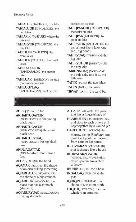
Knowing Places
238
AGIAQ [AGIAK]: a fileAKHAKTUGAYUIN
[AKHATOGAYOIN]: the young black bears
AKHAKTUGAYUK [AKHAKTOGAYOK]: the small black bear
AKHAKTURYUAQ [AKHATOYOAK]: the big black bear
AKULIAQATTAK [AKOLIAKATAK]: that is like a face
ALGAK [ALGAK]: the handAQAMAK [AKAMAK]: the shape
of an arm pulling somethingAQIARUALUK [AKIAGOALOK]:
the shape of a big stomachAQIARULIK [AKIAGOLIK]: the
place that has a stomach (shape of)
AQIARURYUAQ [AKIAGOYUAK]: the big stomach
ATGALIK [ATGALIK]: the place that has a finger (shape of)
HANIRUTIIN [HANIGOTIIN]: sev-eral close to each others as if kept together by a wound pin
HAULLUUN [HAODLON]: the marrow scoop (haulluun: tool used to dig out the marrow from caribou leg bones)
IGLUVIKKAN [IGLOOVIKAN]: that is shaped like a house
IKHIVALAKAGAYUK [IGHIVALAKAGAYOK]: sitting down (precise translation unknown)
IKUHIK [IKOHIK]: the elbowINGALUAQ [INGALOAK]: the
gutsIQHIQPAK [IKHIKPAK]: the
shape of a wisdom toothITIQTUQ [ITTIKTOK]: the one
which is an entrance
TAHIALUK [TAHIALOK]: the lake
TAHIALUUK [TAHIALOOK]:, the two lakes
TAHIAPIK [TAHIAPIK]: where the lakes are
TAHIARYUK [TAHIAKYUK]: the tiny lake
TAHIHUIN [TAHIHOIN]: the small lakes
TAHIHUK [TAHIHUK]: the small lakes
TAHIKAFAALUK [TAHIKAFALOK]: the biggest lake
TAHILUAK [TAHILOAK]: the true (par excellence) lake
TAHILUGYUAQ [TAHILOKYUAK]: the true (par
excellence) big lake
TAHIQPAALUK [TAHIKPALUK]: the really big lake
TAHIQPAK [TAHIKPAK]: the great big lake
TAHIRALUK [TAHIGALOK]: the big ‘almost-like-a-lake’ one (i.e., big pond)
TAHIRYUAQ [TAHIKYOAK]: the big lake
TAHIRYUHUK [TAHIKYUHUK]: the tiny lake
TARIUNNUAQ [TAGIONOAK]: the little salty one (i.e., the little sea)
TATIIK [TATIIK]: the two lakesTATIIN [TATIIN]: the lakesTIKYAT [TIKYAT]: the sand bar
B. NUNA, non spatially referenced, non specific geographic term, morphologic analogy

Appendix A
239
QINGALIK [KINGALIK]: the place that has a nose (also, ‘the one that has a nose’, i.e., eider duck)
QINGARLUAQ [KINGANLHOAK]: the shape of a nose
QUTAITUQ [KUTAITOK]: the one which is high and mighty (as op-posed to qutanayuq: pitiful)
QUUGAYAQ [KOGAYAK]: the colour of pee
TALIUYAQ [TALIOYAK]: the shape of an arm
TIKIRAARYUK [TIKIGAKYOK]: the small index finger pointing (at something)
TIKIRAAYUNNUAQ [TIKIGAYUNOAK]: the small shape of an index finger pointing (at something)
TIKIRAQ [TIKIGAK]: the index finger pointing (at something)
TIKIRARYUAQ [TIKIGAKYOAK]: the big index finger pointing (at something)
TUNGMIQQAN [TOKMIKAN]: the stairs
TUNGMIRAUTAK [TOKMIGAOTAK]: the big stairs
TUNIHITARNIQ [TUNIHITAKNIK]: the back of the head
TUQHUUK [TOKHOK]: the entrance corridor of an igloo (also, for the human body: the windpipes). i.e., in toponymy: the channel
TUQHUUKATAK [TOKHOKATAK]: the small en-trance corridor of an igloo (also, for the human body: the wind-pipes). i.e., in toponymy: the small channel
UKALIQTUUQ [UKALIKTOK]: there are many rabbits
IVIANGINGNAQ [IVIAGINAK]: the tits
KINGMIRUT [KINGMIGOT]: the shape of a tooth
KUUTTIQ [KUTIIK]: the hip [bone]
KUVIQPIK [KUVIKPIK]: the funnel
NAULLAN [NAOTLAN]: the ar-row head
NIAQUQTALIK [NIAKUKTALIK]: the place that has a head
NIAQUQTUQ [NIAKUKTOK]: the one which is where a head is
NIAQURNAARYUGAK [NIAKUKNAKYUGAK]: the shape of a tiny head
NIAQURNAARYUK [NIAKUKNAKYOK]: the shape of a small head
NIAQURNAHUK [NIAKUKNAHUK]: the shape of a very tiny head
NIAQURNAK [NIAKUKNAK]: the shape of a head
NIAQURNARYUAQ [NIAKUKNAKYOAK]: the big shape of a head
PITIKHITAQ [PITIHITAK]: the shape of an arrow case (today: of a gun case)
PUALRINAK [POALGINAK]: the shape of a mitt
QALURAUN [KALOGAON]: the small water dipper
QARLIIK [KAGLIK]: the pair of pants
QAYUKTAQTUQ [KAYOKTAKTOK]: the one which is a frying pan
QIMIQ [KIMEK]: the spine
QIMIRLUGUTAQ [KIMEKLUGUTAK]: the one that has a spine (i.e., eskers)

Knowing Places
240
UNGIRUN [UGIGUN]: tied up just under the top (as one’s boots are tied just under the knee when wearing traditional boots)
UQAQ [UKAK]: the tongue
UTKUHIUYAQ [UTKUHIOYAK]: the shape of a cooking pot
UUMADLUK [UMADLOK]: the one that is a heart
UUMANNAQ [UMANAK]: the shape of a heart
C. NUNA, non spatially referenced, non specific geographic term, simple description
AKHIAK [AKGIAK]: it is flowing
ALIGULAAQ [ALIGULAAK]: where there are soft stones
AMITTUALUK [AMITOALOK]: the one which is long and narrow
AMITTUARYUK [AMITOAKYOK]: the one which is small and narrow
AMITTUQ [AMITOK]: the one which is narrow
AMITTURYUAQ [AMITOKYUAK]: the one which is long and narrow
ANGMALUKATAAQ [ANGMALOKATAK]: the little round one
ANGMALUQTUALUK [ANGMALOKTOALOK]: the big round one
ANGMALUQTUARYUK [ANGMALOKTOAKYOK]: the tiny round one
ANGMALUQTUHUK [ANGMALOKTOHOK]: the small round one
ANGMALUQTUQ [ANGMALOKTOK]: the one which is round
ANIKAHIMAYUQ [ANIKAHIMAYOK]: the first one to come out (to get free of ice)
ANIUVALIK [ANIOVALIK]: the place that has aniuvak (snow patch which never completely melts)
ARIMAYAK [AGIMAYAK]: the dirty/turbid one
AUNNIQ [AONIK]: the rotten one/the easy to break one
AUPALUK [APALOOK]: reddish
AUPILATTUQ [AOPILATOK]: the one which is bloody (blood seems to ooze out from the ground)
AUPILATTUT [AOPILATUT]: the ones which are bloody (blood seems to ooze out from the ground)
AVVAQ [AHVAK]: cut in half
HAATTUARYUK [HATOAKYOK]: the very flat one
HAATTUK [HATOK]: flat
HAATTUKTUQ [HATOKTOK]: the one which is flat
HAATTUNGAT [HATOGAT]: the flat one
HAATTUNGUAQ [HATOGOAK]: the two flat ones
HAATTUNGUYAQ [HATOGOYAK]: the almost flat one
HAGURYUAQ [HAGOKYOAK]: lots of thin rocks
HALLARYUK [HATLAKYOK/HAGLAKYOK]: the small flat one
HAVAGAQTUQ [HAVGAKTOK]: the one which is steep

Appendix A
241
HIGAARVIK [HIGAKVIK]: the place where there is smoke
HIKTINIQ [HIKTINIK]: the sand piles up
HIQINIQUGIAQ [HIKINIKOGIAK]: where the sunlight is reflected
HIUQQITAK [HIUKITAK]: the shallow and sandy place (i.e., caribou crossing place)
HIURALIK [HIUGALIK]: the place that has sand
HIURAQTUUQ [HIUGAKTOK]: there is a lot of sand: sandy place
IHUGTAQ [IHOKTAK]: the one with something big
IHUQTUQ [IHOKTOK]: that which is murky (not clear)
IKAAQTURYUAQ [IKAKTOKYUAK]: the one which is a long ‘in between’
IKIARILIK [IKIAKILIK]: the place that has lines on the cliff (ap-pearing on the side of the cliff)
IKIARULLIK [IKIAGOTLIK]: the place that has a line (i.e., the edge of the cliff)
IKKATTUALUK [IKATOALOK]: the really shallow one
IMAINNILIK [IMAIKNILIK]: the place that doesn’t have any water
IMAINNIQ [IMAIKNIK]: where the water drains out
IMAQ [IMAK]: the water
IMARYUAQ [IMAKYOAK]: the very big water
IMARYUK [IMAYOK]: the big water
IMIGVIK [IMIKVIK]: the place where there is an echo
IMIRAHUK [IMIGAHUK]: the small [fresh] water
IMNARYUAQTUUK [IMNAYOATOOK]: there are two very high cliffs
INGILRANIQ [INGILGANIK]: the current
IPIULIK [IPIOLIK]: the place that has two things tied or joined together
ITIGAHUNNI [ITIGAHUNI]: the smelly feet place
ITIRVILIK [ITIKVILIK]: the place that has a little passage to go through
IVITAALIK [IVITALIK]: the place that has red colour
KAIPTALUK [KAIPTALOK]: the big round shaped one
KANGILLIALUK [KANGITLIALOK]: the big nar-row one at one end/or: that is at the end (depending on the context)
KATAKTAQTUQ [KATAGTAGTOK]: the one which is a waterfall
KATIMANIQ [KATIMANIK]: the meeting place (usually, when a place name, a confluence—where two rivers or lakes merge)
KILGAVILIQUT [KILGAVILIKUT]: the place where there are peregrine falcons (nesting place)
MARLUIT [MAKLOIT]: the muddy one
MIHUMAYUQ [MIHOMAYOK]: real cliffs that go straight down into the water
NAPIMANIQ [NAPIMANIK]: the crooked one
NAPTUK [NAKTUK]: the hard one
NAUYAAN [NAOYAAN]: the place with lots of seagulls’ nests
NAUYAAQ [NAOYAK]: a seagull’s nest

Knowing Places
242
NAUYAARYUK [NAOYAKYUK]: the small place with seagulls’ nests
NAUYAAT [NAOYAT]: seagulls’ nests
NAUYAATTURAQ [NAOYATOGAK]: where there are lots of seagulls’ nests
NAUYAATTUUQ [NAOYATOK]: there are many seagulls’ nests
NAUYAHUIN [NAOYAHOIN]: the seagulls’ nests
NUYALIGYUAQ [NOYALIKYOAK]: where there are lots of hairs
PADLIQ [PAKLIK]: where there are dried boughs
PIRIN’NGANIQ [PIGINGANIK]: the crooked one
PIRIN’NGAYUHUK [PIGINGAYUHUK]: the tiny crooked one
PIRIN’NGAYULIK [PIGINGAYULIK]: the place that has the crooked one
PIRIN’NGAYUQ [PIGINGAYOK]: the small crooked one
PIRIN’NGIQ [PIGINGNIK]: the crooked one
PIRIN’NGYUAQ [PIGINGYOAK]: the big crooked one
PIRNIQ [PIKNIK]: the bent one
PUTULIK [PUTULIK]: the place that has a hole
QAALAKTUQ [KALAKTOK]: the one which is scraping (i.e., a hawk)
QAIRAYUKTUQ [KAIGAYOKTOK]: the one which is a flat, soft rock
QAKUQTALIK [KAKOTALIK]: the place that has a white spot
QAKUQTUARYUK [KAKOKTOAKYUK]: the small white ones [rocks]
QAUMAUGAKTUQ [KAOMAOGAKTOK]: the one which is clear water
QAUVAKTUQ [KAOVAKTOK]: the one which is where it gets bright
QIKTURAQ [KIGTOKKAK]: the one broken into two pieces
QILIQTANNGUALIK [KILIKTANGOALIK]: the place that has a cut in it, or that has something tied up—meaning uncertain
QILIQTINGUALIK [KILIKTIGOALIK]: the place that seems to have a tie around it
QIRNIQTARMIUYUQ [KENIKTAKMIOYOK]: some-thing about the colour black (ex-act translation uncertain)
QITTUQAN [KITTOKAN]: the split / the busted off
QUKILRUK [KUKILGOK]: the narrow place
QUPPAK [KUPPAK]: may be ‘cut in half lengthwise,’ translation uncertain
TAHIUYAQ [TAHIUYAK]: the one which is like a lake
TAKIYUAQATTAALUK [TAKIYOAKATALOK]: the long-est one [lake]
TAKIYUAQATTAK [TAKIYOAKATAK]: the very long one [lake]
TAKIYUQ [TAKIYUK]: the long one [lake]
TARIURNIQTUQ [TAKYONIKTOK]: the one which is salty
TUAPALUIN [TOAPALOIN]: the gravels

Appendix A
243
TUARUQ [TOALGOK]: where it is narrow, thin
TUKINGAYUT [TUKINGAYUT]: the shape of something twisted
TULUKKAAK [TULUKAAK]: the two ravens
TULUKKAALUK [TULUKALOK]: where lots of ravens are
UHINGUYAT [OHINGOYAT]: the barren grounds [without any food for animals]
UN’NGUQTUUQ [ONGOKTOK]: there are many warts
UQAUYAGVIK [OKAOYAKVIK]: the place where uqauyak are (small trees with small flat leaves that grow along the ground, like crawling, unlike willows)
UQPIGYUAN [OKPIKYOAN]: the high willows
UQPIKTUUQ [OKPIKTOK]: there
are many willows
UQPILIK [OKPILIK]: the place that has willows
UVAYUALUK [OVAYOALUK]: the big one [with one slope] fa-cing the wrong way
UVINGAYUQ [OVINGAYOK]: that which is slanted
UYARAGYUALIK [UYAGAKYOALIK]: the place that has big rocks
UYARAGYUAQ [UYAGAKYOAK]: the big rock
UYARAHUGYULIK [UYAGAHOKYOLIK]: the place that has a big rock
UYARAKTUUQ [UYAGAKTOK]: there are many rocks: the rocky one
UYARALIAQ [UYAGALIAK): the place where there are small rocks
D. NUNA, spatially referenced, in reference to another place or to the general orientation of the surrounding features
AGUNGTIKTIVIK [AGONTIKTIVIK]: the place where it is in the middle
AIMAUQATTAIN KUUGAA [AIMAOKATAIN KUGA]: the riv-er of ‘the two lakes in the middle of a river’
AKULLIALUK [AKUDLIALOK]: the big one in the middle/between
AKULLIQ [AKUDLIK]: in the middle/between
AKULRUTAAQ [AKULGUTAAK]: between the two
ALGARUHIQ [ALGAGOHIK]: it is part of the land next to it
ALIGULGUP KUUGAA [ALIGULGUM KUGA]: the river of ‘where there are soft stones’
ALLIQ [ATLIK]: the bottom
APTALUUM TAHIA [APTALUK TAHIA]: Aptaluk’s lake (place name, the place bears a person’s name)
AVALATQUQ [AVALAKOK]: the one which is the farthest away
AVVAKUN [AVAKUN]: the half
HALLIQ [HALLIK]: the one more out at sea
HANIRARUN [HANIGAGUN]: from the side
HANNIMUGAKAFAALUK [HANIMOGAKAFALOK]: the very big one that is sideways, or crosswise
HANNIMUK [HANIMOK]: the sideways (or crosswise) one

Knowing Places
244
HANNIMUKAFAALUK [HANIMOKAFALOK]: the really sideways (or crosswise) one
HANNINGAYUQ [HANINGAYOK]: the big one that is sideways, or crosswise
HANNINGUP NUVUA [HANINGOP NUVUAK]: the point of ‘the sideways one’
HANNINIQ [HANINIK]: the side-ways (or crosswise) one
HATLIK [HATLIK]: meaning un-known, may be ‘just a name’—suggestion from A. Kublu: this may be halliq (the one more out at sea).
HATQAHIQ [HATKAHIK]: it’s farther down in front [of the traveller]
HATTIKTUQ [HATIKTOK]: the one that is further out toward the sea (but still on land)
HAVVIURVIM TAHIQ [HAVIOKVIK TAHIK]: the lake of ‘the place to make knives’
HINGIGYUARNAHIQ [HINGIYOAK NAHIK]: the big cape but smaller than the other ‘the big cape’ [which is in the surroundings]
HINGILINGNAHIQ [HINGILIK NAHIK]: the place that has a point but smaller than the other ‚place that has a point‘ [which is in the surroundings]
HIVUGAKHIQ TAHIRYUAQ [HIVOGAKHIK TAHIKYOAK]: the southernmost part of ‘the big lake’
HIVUGAKHIT [HIVOGAKHIT]: the farther away one/the south-ernmost one
HUANGNAHIQ [HOAK NAHIK]: the huaq but smaller than the other ‘huaq’ [which is in the sur-roundings] (meaning of huaq unknown)
IGIYUQ [IGIYUK]: the ones in the middle of deep water
IGLULGUM KANGIQHUA [IGLOOLGOM KANGIKHOA]: the bay of ‘the place that has a house’
IGLUTURVIK [IGLOOTOKVIK]: the place where there are houses
IHUKHITKUN [IHOKIITKOON]: very far into the land (bottom of a bay/inlet)
IKAAQTULIRYUAQ [IKAKTOLIKYOAK]: the place that has a long ‘in between’
IMNARUN [IMNAGON]: where the last cliffs are
IMNARYUAKKAT [IMNAYOAKAT]: the one which is next to ‘the high cliff’
INGALUAM KUUGAA [INGALOAN KUGAA]: the river of ‘the guts’
IQALLIVIUM TAHIA [IKALIVIK TAHIK]: the lake of ‘the place where there are char’
ITIBLIAP KATIMANIQ [ITIBLIAK KATIMANIK]: the short cut of ‘the meeting place’
ITIRUYUIT [ITIGOGYUIT]: far inland
KANGIRYUAQTIAQ [OR]
KANGIRYUAQTIHUK [KANGIKYUAKTIAK [OR] KANGIKYUAKTIHOK]: the smaller big bay
KAVAHIKTUQ [KAVAHIKTOK]: the one which is farther up
KILII [KILEE]: farther down
KILINGUYAK [KILINGOYAK]: the small land along the coast
KILLIARYUK [KIDLIAKYUK]: the one at the end—the last one
KILUHIKTUM KUUGAA [KILOHIKTOK KUGA]: the river of ‘the one which is way inland’ (bottom of an inlet)

Appendix A
245
NUNANGIYAQ [NUNAGIYAK]: this one is part of the land (island far away from the coast)
QALII [KALII]: on top
QARIAQ [KAGIAK]: a part of something bigger from which it is separated
QIGUUKHALLIQ [KIGOOK HALIK]: the bluff that is farther down over there
QILAKAVIK [KILAKAVIK]: the farthest one
QILANITURVIK [KILINAKTOKVIK]: the place that is on the top
QILATURVIK [KILATOKVIK]: the place that is on the very top/or that is the farthest
QINGARLUAM TAHIA [KINGANLHOAK TAHIA]: the lake of ‘the shape of a nose’
QINNGUA [KINGOA]: far inside, far inland: the inlet’s end
QINNGUK [KINGOK]: the end of an inlet
QITIIQ [KITIIK]: the middle/the spinal
QITTUQAT [KITTOKAT]: the split/the busted off
QULLIQ [KULIK]: on top
QULLIQTAAK [KULIKTAK]: far-ther up on to the top
QURLUQTUUP KUUGAA [KUGLUKTUK KUGA]: the river of ‘the one which is rapids’
TAHIALUUM KUUGAA [TAHIALOOM KUGA]: the river of ‘the two lakes’
TAHIAPIK MANIRUAQ [TAHIAPIK MANIGOAK]: the mountains of [next to] ‘where the lakes are’
TAHIHUINNALAN [TAHIIHOIN NALAN]: the one in front of ‘the small lakes’
KILUHIKTUQ [KILOHIKTOK]: the one which is way inland (bottom of an inlet)
KILULIRUTAQ [KILULIGUTAK]: the one that is on the side, aside
KIMAKTUUP KUUGAA [KIMAKTUTIP KUGA]: Kimaktuut’s river (person’s name)—a kimaktuut is also the handle of a ulu
KINGULLIQ [KILGOLIK]: the last one
KIN’NGAGYUALIM TAHIA [KINGAKYUALIK TAHIA]: the lake of ‘the place that has a high hill’
KIN’NGUGLUK [KINGOKLUK]: that one that is behind the hill
KUUGARYUARNAHIQ [KUGAYOAK NAHIK]: the big and/or long river, but smaller than the other ‘the big and/or long river’ [which is in the surroundings]
KUUJJUAQ [KUUJJUAK]: the biggest and longest river
KUUNGNAHIQ [KUUK NAHIK]: the river, but smaller than the other ‘the river’ [which is in the surroundings]
MANAKTURVIK TUNULIK [MANAKTOKVIK TUNULIK]: the other side of ‚the place where one uses baits‘ (ancient fishing technique)
MASHUYAM TAHIA [MASHUYAM TAHIA]: Mashuyaq’s lake (place name, the place bears a person’s name)
NAUYAAN IKIRAHAA [NAOYAAN IKIGAHAA]: the channel of ‘the place with lots of seagulls’ nests’
NAUYAAN TAHIA [NAOYAAN TAHIA]: the lake of ‘the place with lots of seagulls’ nests’
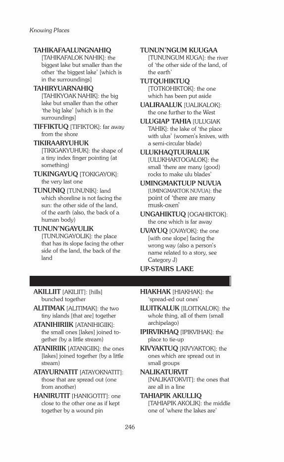
Knowing Places
246
E. NUNA, spatially referenced, self-referenced AKILLIIT [AKILIIT]: [hills]
bunched together
ALITIMAK [ALITIMAK]: the two tiny islands [that are] together
ATANIHIRIIK [ATANIHIGIIK]: the small ones [lakes] joined to-gether (by a little stream)
ATANIRIIK [ATANIGIIK]: the ones [lakes] joined together (by a little stream)
ATAYURNATIT [ATAYOKNATIT]: those that are spread out (one from another)
HANIRUTIT [HANIGOTIT]: one close to the other one as if kept together by a wound pin
HIAKHAK [HIAKHAK]: the ‘spread-ed out ones’
ILUITKALUK [ILOITKALOK]: the whole thing, all of them (small archipelago)
IPIRVIKHAQ [IPIKVIHAK]: the place to tie-up
KIVYAKTUQ [KIVYAKTOK]: the ones which are spread out in small groups
NALIKATURVIT [NALIKATOKVIT]: the ones that are all in a line
TAHIAPIK AKULLIQ [TAHIAPIK AKOLIK]: the middle one of ‘where the lakes are’
TAHIKAFAALUNGNAHIQ [TAHIKAFALOK NAHIK]: the biggest lake but smaller than the other ‘the biggest lake’ [which is in the surroundings]
TAHIRYUARNAHIQ [TAHIKYOAK NAHIK]: the big lake but smaller than the other ‘the big lake’ [which is in the surroundings]
TIFFIKTUQ [TIFIKTOK]: far away from the shore
TIKIRAARYUHUK [TIKIGAKYUHUK]: the shape of a tiny index finger pointing (at something)
TUKINGAYUQ [TOKIGAYOK]: the very last one
TUNUNIQ [TUNUNIK]: land which shoreline is not facing the sun: the other side of the land, of the earth (also, the back of a human body)
TUNUN’NGAYULIK [TUNUNGAYOLIK]: the place that has its slope facing the other side of the land, the back of the land
TUNUN’NGUM KUUGAA [TUNUNGUM KUGA]: the river of ‘the other side of the land, of the earth’
TUTQUHIKTUQ [TOTKOHIKTOK]: the one which has been put aside
UALIRAALUK [UALIKALOK]: the one further to the West
ULUGIAP TAHIA [ULUGIAK TAHIK]: the lake of ‘the place with ulus’ (women’s knives, with a semi-circular blade)
ULUKHAQTUURALUK [ULUKHAKTOGALOK]: the small ‘there are many (good) rocks to make ulu blades’
UMINGMAKTUUP NUVUA [UMINGMAKTOK NUVUA]: the point of ‘there are many musk-oxen’
UNGAHIKTUQ [OGAHIKTOK]: the one which is far away
UVAYUQ [OVAYOK]: the one [with one slope] facing the wrong way (also a person’s name related to a story, see Category J)
UP-STAIRS LAKE
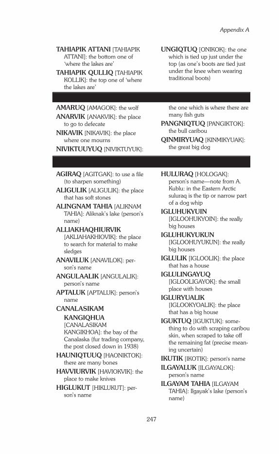
Appendix A
247
G. UUMAJUIT, regular activities, daily life
F. UUMAJUIT, no other information
TAHIAPIK ATTANI [TAHIAPIK ATTANI]: the bottom one of ‘where the lakes are’
TAHIAPIK QULLIQ [TAHIAPIK KOLLIK]: the top one of ‘where the lakes are’
UNGIQTUQ [ONIKOK]: the one which is tied up just under the top (as one’s boots are tied just under the knee when wearing traditional boots)
AMARUQ [AMAGOK]: the wolf
ANARVIK [ANAKVIK]: the place to go to defecate
NIKAVIK [NIKAVIK]: the place where one mourns
NIVIKTUUYUQ [NIVIKTUYUK]:
the one which is where there are many fish guts
PANGNIQTUQ [PANGIKTOK]: the bull caribou
QINMIRYUAQ [KINMIKYUAK]: the great big dog
AGIRAQ [AGITGAK]: to use a file (to sharpen something)
ALIGULIK [ALIGULIK]: the place that has soft stones
ALINGNAM TAHIA [ALIKNAM TAHIA]: Aliknak’s lake (person’s name)
ALLIAKHAQHIURVIK [AKLIAHAKHIOVIK]: the place to search for material to make sledges
ANAVILUK [ANAVILOK]: per-son’s name
ANGULAALIK [ANGULALIK]: person’s name
APTALUK [APTALUK]: person’s name
CANALASIKAM KANGIQHUA [CANALASIKAM KANGIKHOA]: the bay of the Canalaska (fur trading company, the post closed down in 1938)
HAUNIQTUUQ [HAONIKTOK]: there are many bones
HAVVIURVIK [HAVIOKVIK]: the place to make knives
HIGLUKUT [HIKLUKUT]: per-son’s name
HULURAQ [HOLOGAK]: person’s name—note from A. Kublu: in the Eastern Arctic suluraq is the tip or narrow part of a dog whip
IGLUHUKYUIN [IGLOOHUKYOIN]: the really big houses
IGLUHUKYUKUN [IGLOOHUYUKUN]: the really big houses
IGLULIK [IGLOOLIK]: the place that has a house
IGLULINGAYUQ [IGLOOLIGAYOK]: the small place with houses
IGLURYUALIK [IGLOOKYOALIK]: the place that has a big house
IGUKTUQ [IGUKTUK]: some-thing to do with scraping caribou skin, when scraped to take off the remaining fat (precise mean-ing uncertain)
IKUTIK [IKOTIK]: person‘s name
ILGAYALUK [ILGAYALOK]: person’s name
ILGAYAM TAHIA [ILGAYAM TAHIA]: Ilgayak’s lake (person’s name)
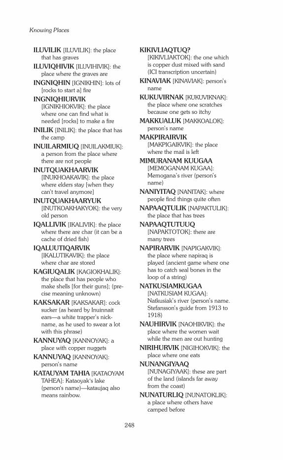
Knowing Places
248
ILUVILIK [ILUVILIK]: the place that has graves
ILUVIQHIVIK [ILUVIHIVIK]: the place where the graves are
INGNIQHIN [IGNIKHIN]: lots of [rocks to start a] fire
INGNIQHIURVIK [IGNIKHIOKVIK]: the place where one can find what is needed [rocks] to make a fire
INILIK [INILIK]: the place that has the camp
INUILARMIUQ [INUILAKMIUK]: a person from the place where there are not people
INUTQUAKHAARVIK [INUKHOAKAVIK]: the place where elders stay [when they can’t travel anymore]
INUTQUAKHAARYUK [INUTKOAKHAKYOK]: the very old person
IQALLIVIK [IKALIVIK]: the place where there are char (it can be a cache of dried fish)
IQALUUTIQARVIK [IKALUTIKAVIK]: the place where char are stored
KAGIUQALIK [KAGIOKHALIK]: the place that has people who make shells [for their guns]; (pre-cise meaning unknown)
KAKSAKAR [KAKSAKAR]: cock sucker (as heard by Inuinnait ears—a white trapper’s nick-name, as he used to swear a lot with this phrase)
KANNUYAQ [KANNOYAK]: a place with copper nuggets
KANNUYAQ [KANNOYAK]: person’s name
KATAUYAM TAHIA [KATAOYAM TAHEA]: Kataoyak‘s lake (person‘s name)—kataujaq also means rainbow.
KIKIVLIAQTUQ? [KIKIVLIAKTOK]: the one which is copper dust mixed with sand (ICI transcription uncertain)
KINAVIAK [KINAVIAK]: person’s name
KUKUVIRNAK [KUKUVIKNAK]: the place where one scratches because one gets so itchy
MAKKUALUK [MAKKOALOK]: person’s name
MAKPIRAIRVIK [MAKPIGAIKVIK]: the place where the mail is left
MIMURANAM KUUGAA [MEMOGANAM KUGAA]: Memogana’s river (person’s name)
NANIYITAQ [NANITAK]: where people find things quite often
NAPAAQTULIK [NAPAKTULIK]: the place that has trees
NAPAAQTUTUUQ [NAPAKTOTOK]: there are many trees
NAPIRARVIK [NAPIGAKVIK]: the place where napiraq is played (ancient game where one has to catch seal bones in the loop of a string)
NATKUSIAMKUGAA [NATKUSIAM KUGAA]: Natkusiak’s river (person’s name. Stefansson’s guide from 1913 to 1918)
NAUHIRVIK [NAOHIKVIK]: the place where the women wait while the men are out hunting
NIRIHURVIK [NIGIHOKVIK]: the place where one eats
NUNANGIYAAQ [NUNAGIYAAK]: these are part of the land (islands far away from the coast)
NUNATURLIQ [NUNATOKLIK]: a place where others have camped before

Appendix A
249
PANAKTAK [PANAKTAK]: per-son’s name
PAPILLUQTALIK [PAPIDLUKTALIK]: the place that has Papidlok (person’s name)
PAPILLUUM TAHIA [PAPIDLUM TAHIA]: Papidlok’s lake (person’s name)
PUTUITAAM HINGIA [POTOITAAM HINGIA]: Potoitak’s point (person’s name)
QAINNIVILIK [KAINIVILIK]: the place that has those [people] who build their kayaks
QAIRUHULIK [KAIGOHOLIK]: the place that has those who wait for one another (i.e., fall time gathering place)
QALGILIK [KALGILIK]: the place that has a dance house
QALGILIUMANIQ [KALGILIUMANAK]: that which looks like a dancing house (doesn’t refer to the shape of the place)
QALRUVIK [KALGOKVIK]: the place where they bark [the dogs]
QILUKUM QIKIQTAA [KILUKUM KIKIKTA]: person’s name
QIUYUHIVIT [KIOYOHIVIT]: a place with lots of wood
QIYUKTARVIK [KIYOOKTAKVIK]: the place where there is some wood
QIYUKTUKAM KUGAA [KIYOOKTOKAM KUGA]: the river of ‘The one which is wood’
QIYUKTULUAQ [KIYOOKTULUAK]: with lots of high pieces of wood
QIYUQITTIVIK [KIOKITIVIK]: the place where there is wood to make things
QUAHAM TAHIA [KOAHA TAHIK]: Koaha’s lake (person’s name)
QULLIHAK [KULLIHAK]: where there are lights
QUPILRUQTUUQ [KUPILGOTOK]: there are many worms
QUQAAQ [KOKAK]: person’s name
SILIKAFAALUK LAKE [SILIKAFALOK LAKE]: the lake of ‘the very silly guy’ (white trapper’s nickname)
TATITAQANAQTIT? [TATITAKANAKTIT]: may be ‘where they drag their meat [on the ground]’, ICI transcription and translation uncertain
TULLAAT [TUTLAT]: the [people’s] meeting place [be-tween Inuit belonging to different groups]
TUPIRYUAQ [TUPIGYUAK]: the big tent
UINGIQ ISLAND [WINIK Island]: Winik’s island (person’s name)
UKIURVIK [OKIOVIK]: the place where winter is spent
UKKUHIKTALIK [OKOHITHALIK]: the place that has soapstone
ULISIVIK [OLISIVIK]: the place where races are held
ULUGIAQ [ULUGIAK]: the place with ulus (women’s knives, with a semi-circular blade) i.e., where rocks for ulu blades are found
ULUKHAQTUUQ [ULUKHAKTOK]: there are many (good) rocks to make ulu blades
ULURVIK [OLOKVIK]: the place where boards to scrape skins on are found
Knowing Places
250
H. UUMAJUIT, regular activities, cynegetic activities (hunting and gathering)
ULUYURVIK [ULUYOKVIK]: the place where ulus are made (women’s knife, with a semi-cir-cular blade)
UNGIVIK [ONGIVIK]: the place to overnight (when travelling in winter time)
UNNUAGAKHIURVIK [UNNUAGAKHIOKVIK]: the place where people stay up all night long
UQAUHIRVIK [OKAOHIKVIK]: the place where a thing to speak through is used (a radio)
UQHUQHIRVIK [OKHOHIKVIK]: the place
where oil for the lamp is made (from seal blubber)
UQUHIKHAALUK [OKOHIHALUK]: the big one that has soapstone
UYARALIAQTARVIK [UYAGALIAKTAKVIK]: the place to get gravel from
AIME’S LAKEBASE CAMPEDMOND’S RIVERFATHER’S LAKEILGUQ’S LAKE (person’s name)
NO NAME LAKE
AAHANGIQTUUQ [AHANGIKTOOK]: there are many old-squaw ducks
AGLUVIK [HAKLUVIK]: the place where there are seal breathing holes
AHIARNIARVIK [AHIAKNIAKVIK]: the place to pick berries
AMUAQATTARVIK [AMOAKATAKVIK]: the place to pull them [the fish] up one after the other (where one can get lots of fish in a short time)
ANAAKHILIK [ANAKHILIK]: the place that has whitefish
ANAAKHIURVIK [ANAKHIOVIK]: the place to fish for whitefish
ANAQANIAK [ANAKANIAK]: where the fish drop feces (when pulled out of the water)
ANARUVIK [ANAGOVIK]: the place where the fish drop feces (when pulled out of the water)
ANIALIK [ANIALIK / Aniyalik]: the place that has young char going down to the sea for the first time
ANIAQHIURVIK [ANIAKHIOKVIK]: the place where the young char go through on the way down to the sea for the first time
ANIYALGUP KUUGAA [ANIYALGUM KUGA]: the river of ‘the young char going down to the sea for the first time’ (by which they travel)
ANIYALGUP TAHIA [ANIYALGUM TAHIA]: the lake of ‘the young char going down to the sea for the first time’ (from which they leave)
ANIYAQ [ANIYAK]: where they go through (fish or seals)
ANIYIVIK [ANIYIVIK]: the place where the young chars leave to go down to the sea for their first time
AQILGIQTURVIK [AKILGITOVIK]: the place where they eat ptarmigans
ATIQHILIRVIK [ATIKILIKVIK]: the place where they [the cari-bou] go down

Appendix A
251
ATIQTUQHIURVILIK [ATIKTOKHIOKVILIK]: the place that has hunters in wait for the caribou to cross
HALAIRVIK [HALAHIKVIK]: the place where they shout ‘hala’ (women and children, to scare the caribou toward the drive where hunters are waiting to spear them)
HALURVIK [HALOKVIK]: the place where fish are scooped out of the water (by hand)
HIAKHAT [HIAHAT]: losing hair
HIATKULUK [HIATKULUK]: filled with animal hairs
HIHUNGAQ [HIHUGNAK]: where there are edible plants
HIJALIK [HIJALIK]: the place that has a fox den
HIKHIKTUUQ [HIKHIKTOK]: there are many ground squirrels
HIQQUQHIQHIURVIK [HIKHOKEKHIOKVIK]: the place where they catch really big fish
HIUQQITAK [HIUKITAK]: the shallow and sandy place (i.e., caribou crossing place)
IHURVIK [IHOKVIK]: the place where hunters wait for game
IHUUQTULIK [HIOKTULIK]: the place that has very big fish (trout or char)
IQALUGAQHIURVIK [IKALUGAKHIOKVIIK]: the place where little char are hunted
IQALUKPILIK [IKALUKPILIK]: the place that has char
IQALUKTUUQ [IKALUKTOK]: there are many chars
IQALUKTUUTTIAQ [IKALUKTUTIAK]: the good one where there are many chars (i.e., ‘the one which is a fair fishing place’)
IQALULIALIK [IKALULIALIK]: the place that has char
IQALULIALUK [IKALULIALOK]: the place where there are big char
IQALULIGARYUAQ [IKALULIGAKYOAK]: the place where there are lots of small char
IQALULIK [IKALULIK]: the place that has char
IQALUQAQTUN [IKALUKAKTUN]: the one which is lots of little char
IQILGAGIAQ [IKIGAGIAK]: the gull that looks like an arctic tern (sabines gull)
IQQAKHARVIALUK [IKAKHAKVIALUK]: the big place where to throw one’s [fish-ing] lines (just a line, not a fish-ing rod)
IQQAKHARVIK [IKAKHAKVIK]: the place where to throw one’s [fishing] lines (just a line, not a fishing rod)
IVATURLIK [IVATOKLIK]: the place that has duck nests
IVITAAHURLIK [IVITAHOKLIK]: the place that has red char
IVITAARUQ [IVITAHOK]: the red one (char, when they are about to spawn)
IVITAARUQTUUQ [IVITAGOKTOK]: there are many red ones (char, when they are about to spawn)
KANAYUQTALIK [KANAYOKTILIK]: the place that has sculpins
KAPIHILIKTUUN [KAPIHILIKTUUN]: the place that has many ‘fish that have scales’ (kapihilik)
KAPIHILIKTUUQ [KAPIHILIKTOK]: the place that has many ‘fish that have scales’ (kapihilik)

Knowing Places
252
KIJJIVIK [KIJIVIK]: the place where the fish are sun bathing (because they swim almost on the surface)
KUVYAQTURVIALUK [KUVYAKTUKVIALUK]: the place to do a lot of fishing with nets
KUVYAQTURVIK [KOVYAKTOVIK]: the place where they set their fish nets
MANAKTURVIK [MANAKTOKVIK]: the place where one uses baits (ancient fishing technique)
MANNIK [MANNIK]: the eggs
MAUTARINA [MAOTAGINA]: the sighting/spotting place
MAYURLIHUK [MAYUKLIHOK]: the place where one has to climb to reach it (people or fish)
NAGYUKTUUQ [NAKYOKTOK]: there are many [caribou] antlers
NAHAUYAN [NAHAOYAN]: where birds sometimes nest
NALLUARYUK [NADLOAKYOK]: the small swimming place (i.e., small cari-bou crossing place)
NALLUKAFAALUK [NADLOKAFALOK]: the very big swimming place (i.e., very important caribou crossing place)
NALLUQ [NADLOK/Natlok]: the swimming place (i.e., caribou crossing place)
NALLURYUAQ [NADLOKYUAK]: the big swim-ming place (i.e., important cari-bou crossing place)
NATTIQTUUQ [NATEKTOK]: there are many seals
NATTIQTUURAYUUK [NATEKTOGAYUK]: there are many seals
NUNATURNIQ [NUNATONIK]: the good grass of the earth
NURRALIKTUN [NOGALIKTUN]: the one which is where the caribou calves are
NUVIKHAQTUQ [NUVIKHAKTOK]: the one which is where people making or repairing fish nets are
PATUTAAK [PATOTAK]: fish fro-zen in the water
PAUN’NGATUUN [PAONGATON]: there are many black berries
PIKIULIK [PIKIULIK]: the place where there are eggs to be found
PUBLAHIRVIK [POBLAHIKVIK]: the place where the air comes out (through the fishing holes carved in the ice)
QAKPIK [KAKPIK]: where the bearded seals almost go onto the shore [in summer time]
QALIQUVILIK? [KALIGOHILIK]: the place that has seals shedding their fur -old name, difficult to translate and ICI transcription uncertain
QANIUYUQHIURVIK [KANIOYOKHIOKVIK]: the im-portant place where hunters wait for game
QILANAAQTURVIK [KILANATOKVIK]: the place where one gets very excited
QIN’NGIGVIK [KINIKVIK]: the place where one spots things (observation place)
QIN’NGUNMILVIK [KINGONMILVIK]: the place where binoculars are used
QIRRAQTUQ [KIKAKTOK]: the one which freezes down to the bottom
QITYIVIK [KITYIVIK]: the place where fish are speared

Appendix A
253
I. UUMAJUIT, regular activities, movements—travels
QUGYULIK [KOGYOLIK]: the place that has swans
TUKTUTUUQ [TUKTUTOOK]: there are many caribou
UGYUKHIURVIK [UGYUKHIOKVIK]: the place where the bearded seals are hunted
UKALIQTUUQ [UKALIKTOK]: there are many rabbits
UKALIT [UKALIIK]: the arctic hare
UMINGMAGYUK [UMINGMAGYUK]: the small
musk-ox
UMINGMAGYUUQ [UMINGMAGYUUK]: the two small musk-oxen
UMINGMAKTUUQ [UMINGMAKTOK]: there are many musk-oxen
UQHULIUTILIK [OKHOLIOTILIK]: the place that has fat ones (fish)
UTIRVIK [OKTIKVIK]: the place where they come back to (people or caribou)
HINIKTANILIK [HINIKTANILIK]: the place that has those who overnight when travelling
HINIRALUK [HINIGALUK]: that one that is travelled by the shore
HINIUMANIQ [HINIOMANIK]: where you travel at a distance from the shore [on the sea ice]
IKHIQIQ [IHEKHIK]: the old inukshuk
IKPIGVIKHAQ [IPIKVIKHAK]: the place where the trail goes over the slope (climbing or going down)
INUKHULIK [INUKHOLIK]: the place that has an inukshuk
INUUYALIK [INUYALIK]: the place that has dolls (i.e., human-like figures, inukshuks)
IPIRAUHIQHAQHIVIK [IPIGAOHIKHAHIVIK]: the place where waterproof boots (made with bearded seal skin) are needed to cross
IPIRAUYARVIK [IPIGAOYAKVIK]: the place where waterproof boots (made with bearded seal skin) are used
IRIARALUK [IGIGALUK]: the scary place where people never stay for a long time
ATURIAQ [ATAKGIAK]: the trail
AULLATIVIK [AOLATIVIK]: the place where those who are to travel together meet before leaving
AURARYUAQ [AOGAYOAK]: the big bending one
AYUK [AYUK]: the [natural] land-mark (not built by people)
HANIRAHIK [HANIGAHIK]: along the coast
HIKUHUILAQ [HIKUHUILAK]: the one that never freezes or has only thin ice
HIKUNGIYUITTUQ [HIKUGIYUITOK]: the one which is never free of ice
HILALIURVIK [HILALIOKVIK]: the place where the [bad] weath-er is ‘made’ (where storms start)
HINATAKHIURVIK [HINAKTAKHIOKVIK]: the place where one travels following the shore line
HINGIQARVIK [HINGITKAVIK]: the place where one goes first
HINIKTALIK [HINIKTALIK]: the place that has those who sleep away from home (an overnight stop when travelling between two camps)

Knowing Places
254
ITIBLIAQ [ITIBLIAK]: the short cut
ITIBLIARYUAQ [ITIBLIAKYOAK]: the big short cut
ITIBLIARYUK [ITIBLIAKYOK]: the small short cut
ITIMYAQ [ITIMYAK]: the one that goes through (short cut)
ITIRAHUGYUAQ [ITIGAHOKYOAK]: the long one to cross
IVIYUQTUUQ [IVYOKTOK]: there is a lot of thick ice (that has been piling up there)
IVUNIRYUK [IVUNAKYOK]: there are thick layers of ice (as ice has piled up there)
KANGIQUTAAK [KANGIKOTAK]: where one crosses over the point (instead of going around it; shortcut)
MALIGHIURVIK [MALIKGIHIOGVIK]: the place where one has to travel through big waves, through a rough sea
MALLIQTUUQ [MALIKTOK]: there are many big waves (rough sea)
MAYUATUN [MAYOATON]: the one which has to be climbed
NAMAKHIVIK [NAMAKHIVIK]: the place where the last ones are
NAPAAQUYUT [NAPAKOYOT]: where a landmark made of wood has been placed
NILAK [NILAK]: mouth of a river where the ice forms a high pile (because the water keeps run-ning under the ice, so it gets thicker and thicker through the winter)
NILALIALUK [NILELIALOK]: the big nilak (see place name nilak)
NILALIK [NILALIK]: the place that has a nilak (see place name nilak)
NULAHUGYUK [NULAHUKYOK]: where one’s coat gets iced (exact translation uncertain)
NUNAHUNA [NOAHUNAK]: the one with a nice smell of earth and plants
PIRIN’NGAHIURVIK [PIGINGAKHIOKVIK]: the place where one travels through a crooked trail
QAHINGUKTARVIK [KAHINGUKTAKVIK]: the place to stop for a pause when travelling
QAKIUMANNAK [KAKIOMANAAK]: where the ground is always free of snow
QANIQHIURVIK [KANIKHIOKVIK]: the place where the water appears early under the [lake] ice (thawing starts early in spring)
QITARUNGAK? [KITAGUNAK]: where one travels by farther away, further down (ICI tran-scription uncertain)
QUARAUKKAT [KOAGAOKAT]: the one where the ice is not cov-ered by snow (exact translation uncertain)
QULLIQTAARIAQ [KULIKTAKGIAK]: the trail to ‘farther up on the top’
UGALIURVIK [UGALIOKVIK]: the place to wait when the West wind is blowing
UIVALLUK [OIVAGLOK]: the small one that has to be by-passed (instead of crossed)
UIVALLURAALUK [OIVAGLOGALOK]: the big one that has to be by-passed (instead of crossed)
UIVYAARUT [OIVYAGOT]: the one that takes a long time to cross

Appendix A
255
AGUPQANA [AGUPKANA]: person’s name
AHUNGAHUNGALIK [AHONGAHOGALIK]: the place that has a hump (name of a giant, see Chap. 2, p. 85)—note from A. Kublu: in Arctic Bay an asungasungaaq is a rock forma-tion known as a ‘hoodoo’ which has been formed by erosion
AIVIRLAK [AIVIKLAK]: almost a walrus
AJAQTITIVIK [AGAKTITIVIK]: the place where one pushes something down
AKHAKTALIK [AKHAKTALIK]: the place that has a black bear
AKUVAAM TAHIA [AKOVAAM TAHIA]: Akovak’s lake (person’s name)
ALIUGUN [ALIOGON]: a dog pot
ALLIYARVIK [ALIYAKVIK]: the place where a sled was broken
AMAAQTUQ [AMAKTOK]: the one which is a woman packing [her baby on her back]—related to the story about the origins of death (see Chap. 2, p. 84)
ANARAHUIRHIRVIK [ANAGAHOIHIVIK]: the place where someone rushed to defecate
ANGUYUHIQ [ANGOYUHIK]: where someone already caught something before
AQHAAGAQ [AKHAGAK]: something was taken away from somebody
ATUAQTARVIK [ATOAKTAKVIK]: the place where an axe was left
HALF WAY LAKE
AVAHARVIK [AVAHAKVIK]: the place where a person was smothered
AYAAYAAQ [AYAYAK]: singing
AYAAYAARA [AYAYAGAK]: my song
AYAPPAQPAQTURVIK [AYAPAKPAKTOKVIK]: the place where some-one lost his/her balance
HALUAQHIVIK [HALOAKHIKVIK]: the place to put clothes to dry
HAVIIRVIK [HAVIKVIK]: the place where a knife was lost
HAVIKTALIK [HAVIKTALIK]: the place that has a knife
HITAMAIYARVIN [ITAMAYAGVIN]: where four were taken away
HULURAHUK [HOLOGAHOK]: person’s name
ILGAAVIK [ILGAVIK]: the place where a pair of glasses was lost
INUARULLIGAQ [INUAKHOLIGAK]:, the place with ‘little people’ living there
INUINNGIRIT [INUINIGIT]: the ones who are not alive anymore (the dead)
ITIBLIVIK [ITIPLIVIK]: the place where one has nightmares
JAIGUM TAHIA [JAIGOM TAHIA]: Jaigok’s lake (person’s name)
KANGUAQ [KANGOAK]: per-son’s name
KATIQHUNNGUVIKUK [KATIKONGOVIKOK]: where there is a carcass
J. UUMAJUIT, accidental events

Knowing Places
256
Nipalaryok’s lake (place name, the place bears a person’s name)
NIRIUNAK [NIGIONAK]: person’s name
NIRIYUQ [NIGIYOK]: person’s name
NIRLIQ [NIKLIK]: person’s name and/or Canada goose
PIYUMALIQHIAQ [PIOMALIKHIAK]: where some-thing is wanted (exact translation uncertain)
PUALUIRVIK [POALOIKVIK]: the place where a pair of mittens was left
QALVIURVIK [KALVIOKVIK]: the place where there is a killed wolverine (where someone shot one)
QAMUTIKTALIK [KAMOTIKTALIK]: the place that has a sled
QAULUAQ [KAOLOAK]: person’s name
QAYAKIQTALIK [KAYAKIKTALIK]: the place that has a kayak
QAYALIHUK [KAYALIHUK]: the place where the kayak is
QILALUGARVIK [KILALOGAKVIK]: the place where a whale was found (or may-be: was caught)
QINMIARYUKTURVIK [KINMIAKYOKTOKVIK]: the place where little pups were eaten
QIQIQTIIVIK [KIKIKTIIVIK]: the place where the freezer is
QITAK [KITAK]: dog’s name
QIYUQUTAQ [KIOKUTAK]: the wooden box
QUTUIRVIK [KOTOIKVIK]: the place where a collar bone was removed (where someone broke his/her collar bone)
KIGUTAIRVIK [KIGUTAIKVIK]: the place where a tooth was lost (by a person)
KIMAKTUUP TAHIA [KIMAKTUT TAHIK]: Kimaktut’s lake (person’s name)—a kimak-tuut is also the handle of an ulu
KUNAUM TAHIA [KUNAUM TAHIA]: Kunaok‘s lake (person‘s name)
KUNIGVIK [KUNIKVIK]: the place where kisses were given
MALINIQ [MALINIK]: person’s name
MALIRUT [MALIGOT]: person’s name
MANGILANA [MANGILANA]: person’s name
MASHUYAQ [MASHUYAK]: person’s name
MATAM TAHIA [MATAM TAHIA]: Martha’s lake (person’s name)
MAYURLIHUK [MAYUKLIHUK]: the place where one has to climb to reach it (people or fish)
MIMURANA [MEMOGANA]: person’s name
NAKAHUNGATUARYUN [NAKAHONGATOAYUN]: the really full bladder that someone rushed away to empty
NANUALUK [NANOALOK]: the one with a polar bear
NANUQTUN [NANOKTUN]: the one which was two polar bears
NIAQQINNGUVIK [NIAKINNGOVIK]: the place where someone fell on his/her head
NIAQUALUK [NIAKOALOK]: person’s name
NIPALAARIYUK [NIPALAKYUK]: person’s name
NIPALAARIYUM TAHIA [NIPALAKYUM TAHIA]:

Appendix A
257
SIKIIYARVIK [SIKIYAKVIK]: the place where a (snowmobile) ski got broken (and was left there)
TAHIURVIK [TAHIOVIK]: the place where they are holding hands
TAKPALUK [TAKPALOK]: per-son’s name
TIGUHIVVIK [TIGOHIKVIK]: the place where things are grabbed
TIKHIRVIK [TIKHIKVIK]: the place where someone floated away
TUNIKTALIK [TUNIKTALIK]: the place that has ‘little people’ (Tunik is the name given by the Inuinnait to the people that were there before them, probably Dorset people whom the Thule people met when migrating from the Bering Strait)
UHUILAQ [UHUILAK]: the cut off penis
UKKUTITAQ [OKOTITAK]: the pocket knife
UMIIYARVIK [UMIYAKVIK]: the place where the boat is
UNGUARVIK [OGOAKVIK]: the place where hardships were lived through
Meaning unknown and related problems
UQHIGLITIRVIK [OKILITIKVIK]: where someone lost a lot of weight
UQHUQTIQTUQ [OKHOTITOK]: the one which is covered with oil
UQQINAP TAHIA [OKHEEN TAHIA]: Okheena’s lake (per-son’s name)
UTKUHILIK [UTKUILIK]: the place that has a cooking pot
UVAYUQ [OVAYOK]: person’s name (related to the story about the origin of death, see Chap. 2, p. 84). Also means ‘the one with one slope facing the wrong way’ (see Category D)
UVAYURRUHIQ [OVAYOKGOHIK]: the small one [with one slope] facing the wrong way/person’s name (relat-ed to the story about the origin of death, see Chap. 2, p. 84)
UYATUKKAT [UYATOKAAT]: jumping
BEAR LAKEEILEEN’S LAKEMUSK-OX MINE
AIRAQTUUQ? [AIGAKTOK]: meaning unknown, ICI transcrip-tion uncertain. It could be ‘place with lots of airait (edible roots)’
ALINGNAQ [ALIKNAK]: some-thing torn
AVAK [AVAK]: meaning unknown
AVVAKUT [AVAKUT]: halves (pre-cise meaning unknown)
GAYAKAAK [GAYAKAAK]: mean-ing unknown, may be the name of a giant
HANIKAHIMANIQ
[HANIKAHIMANIK]: meaning unknown
HAQUHAKTUQ [HAKOAKTOK]: meaning unknown
HUKAGUN [HOKAGUN]: mean-ing unknown
IMILIGAYUQ? [IMILIGAKYOK]: meaning unknown, ICI transcrip-tion uncertain
KIJJUN [KIJUN]: meaning unknown
KITIGAK [KITIGAK]: meaning unknown

Knowing Places
258
KITIKKAAN [KITIKAT]: meaning unknown
KIVIKAKVIK? [KIVIKAKVIK]: meaning unknown, ICI transcrip-tion uncertain
KULGAYUQ [KOLGAYOK]: something that is floating (trans-lation uncertain)
KULUMULIK [KOLOMOLIK]: meaning unknown
NALIMAHIVIK [NALIMAHIVIK]: meaning unknown, may be ‘just a name’
NALVAQ [NALVAK]: an old thing (translation uncertain)
NINGANAK? [NINGANAK]: meaning unknown, ICI transcrip-tion uncertain
NUKHANNAK [NOKHANAK]: meaning unknown
PITUKTAQ [PITOKTAK]: that one where one digs holes (translation uncertain)
QINMIRUT? [KINMIGOT]: tran-scription uncertain, and so trans-lation impossible
QUYAPIK? KUYAPIK? [KOYAPIK]: meaning unknown, ICI transcription uncertain—note from A. Kublu: kujapik is a ver-tebrae of a sea mammal with the ribs attached
TATIGIKNAT? [TATIGEKNAT]: meaning unknown, ICI transcrip-tion uncertain
UKATAAK? [KATAAK]: transcrip-tion uncertain, and so translation impossible
ULAMIKTAK [ULAMIKTAK]: meaning unknown—note from A. Kublu: ulamiqtaq; something that is cylindrical
259
Appendix B
The Scientific Context of the Research: Academic Background, Methods and Sources
cademic research is conducted following specific rules academics commonly agree with. These ensure the quality of the research, especially in terms of comprehensiveness, consistency and rigour.
Since everyone today agrees that social sciences can never be fully ob-jective, the rules here are to make sure that the inherent subjectivity of any study is consciously controlled.
When one writes a PhD dissertation or an article for a scientific journal, it is a very formal exercise. It has to be written in an academic format; it is part of the game. The original version of this book was a PhD dissertation, and it followed the specific rules set by French social scientists for such contributions to the literature. When it was published as a book, the most formal parts were not included. When we translated it into English, we edited it again so that it would be more accessible to non-academic readers, Inuit and others, interested in Arctic issues.
Yet, I remain an academic and I believe our rules regarding the presentation of a research process are not only formal, but necessary. It is important to know the background from which a research project stems, just as it is important to know the practical details of how that research was carried out; such as what field methods were used for collecting in-formation. I have personally been too often frustrated with books that present results without giving the reader an insight into how the author gathered the information that is analyzed. It thus seemed a good com-promise to provide at least some information about the academic back-ground, the field methods used and the written sources consulted in an Appendix. The information is made available, but presented in such a way that it will not hinder the flow of the narrative that is the main text. The reader can chose to read it or not, before or after reading the book, or even refer to it later.

Knowing Places
260
The Academic Background
Academic research too, is always tied to a context. The context of my own work is that of discussions around indigenous knowledge, of French geography, and of an abundant but at the same time quite poor literature dealing with certain Inuit groups or issues concerning them.
Recognizing indigenous knowledge
The rise of Inuit consciousness In the North-American Arctic, the rise of Inuit consciousness dates to the 1970s, when indigenous movements started to gain enough strength to get governments’ attention. Then, in the 1990s, these movements began to take a new direction. At first, the Inuit had concentrated on political recognition and land claims. They then expanded their concern to the preservation and enhancement of the whole culture, in its broadest sense. It was no longer just a matter of settling questions of territory, but of es-caping from cultural imperialism. The Inuit realized the vital importance of transmitting their own knowledge and values and of keeping their own cultural identity alive. This movement was particularly strong in Canada, where it gained momentum through the Nunavut Land Claim Settlement, ratified by the Federal Parliament in 1993 and implemented in 1999.
In negotiating the Nunavut agreement, Inuit were striving for more than influential positions; they wanted to establish an administrative model based on Inuit knowledge. We can see this clearly in statements such as that of Jack Anawack, then interim commissioner of Nunavut, on the opening of the Igloolik Social Development Council, March 20-24, 1998:
Our commitment must be strong to Inuit ways and the traditional values of our society. We must use our own way of thinking when creating a new Government.
As Canadian Inuit moved toward an Inuit-based governance, they initi-ated an important effort of self-reflection about Inuit knowledge and its supporting values. This inspired the establishment of the ‘Inuit Studies’ program at Nunavut Arctic College in Iqaluit (Nunavut), which includes research projects such as ‘Interviewing Inuit Elders’ and ‘Memory and History in Nunavut.’ At a more immediate operational level, the desire to remain faithful to traditional knowledge and its values is reflected in the promotion, at all levels of governance, of Inuit Qaujimajatuqangit (IQ), that is, the Inuit’s own knowledge and ways of dealing with life in general. It is also fostered by the Sivuliuqtit program, implemented in 1998 and administrated by the Canadian Centre for Management Development. Its mandate is to train Inuit for senior administration positions in the new

Appendix B
261
Nunavut Government (Canadian Centre for Management Dev. 1996; Government of Canada 1998).
In the same period, and for the same reasons of cultural empower-ment, the Inuit acquired the legal authority to control research under-taken in the NWT (and Nunavut, once it was created). They began ap-plying new rules to research endeavours, insisting, for example, on the incorporation of local knowledge in most studies, particularly on all topics concerning the environment. ‘Traditional Ecological Knowledge’ made its way into research reports, and today its integration is a prerequisite for all research in the North American Arctic. Respect for the rules is very effectively controlled through a system of research permits. All potential researchers must apply in advance for a permit. The application must be accompanied by details of the proposal, which in turn must have received approval from local and regional authorities. Without this permit, no field-work may be carried out within their jurisdiction. Licensing systems have been established for Alaska, Yukon, Northwest Territories, and Nunavut, but not for Nunavik (Québec) or Greenland. In Nunavik, approvals are granted by each hamlet council. In Greenland, permits are only required to camp on the land. The authorities do not control the research itself.
Changing attitudes of Western science toward other knowledge systems The recognition of indigenous knowledge is also the result of the changing attitudes of Western science toward other knowledge systems. As Inuit con-
Research Permit
Throughout the 20th century and until the mid 1980s, all and sundry could go to an Inuit community, set themselves up, conduct their research and leave. They had no obligation to explain to their hosts what they were doing, or to get their agreement for the project, even less to let them know the results. Tired of being simple objects of study rather than partners, the Inuit of Canada, with support from the Federal government, put into place a system to control all research in their settlements or in their territory.
In the Northwest Territories, the Science Institute of the Northwest Territories in Yellowknife was in charge of issuing research permits in the 1990s. To get such a permit researchers had to have written approval of their project from each aboriginal community in which they wanted to work. Without a permit, you had no right to carry out any study at all: the Inuit could ask you to leave. The procedures have remained essentially the same since the div-ision of the territories. Today, the permits are issued by the Aurora Research Institute (Inuvik) for the NWT and by the Nunavummi Qaujisaqtulirijikkut / Nunavut Research Institute (Iqaluit) for Nunavut. The forms that every researcher must complete can now be downloaded from the web at http://www.nwtresearch.com and http://pooka.nunanet.com/~research/. The two sites also post the guidelines of the research policies of the arctic territories.
I received three successive research permits through 1991 and 1992 from the Science Institute of the Northwest Territories: numbers 11165N, 12067R, and 12257R.

Knowing Places
262
sciousness was rising, southern universities in Europe and North America were experiencing an intellectual revolution in the social sciences. In the 1960s and 1970s well-known French scholars, such as Michel Foucault and Gilles Deleuze, were exploring how situations or institutions every-one considers to be universally ‘normal’ are only the contextual result of social and political choices made at a certain time by a certain society. For example, Michel Foucault carefully studied how the concept of ‘madness’ as Western culture still understands it was invented in Europe during the 17th and 18th centuries (Foucault 1961; English edition 1965). Another classic is his later study of the invention of ‘modern’ prisons during the same period (Foucault 1975; English edition 1977).
A few years later other intellectuals, such as Jacques Derrida, used these studies to challenge claims by Europeans and North Americans (Qablunaat) that Western science is completely objective and unbiased. In the 1980s and 1990s two sociologists, Michel Callon and Bruno Latour, began to examine the way social scientists design their research. Although the latter believe they are being purely rational, Latour suggests that they are always influenced by the intellectual atmosphere of the time as well as by their professional and private networks. Researchers are trained by their professors to think in certain ways, and to organize their work accordingly, whether they are working alone or in a group, and this can influence the ideas they produce. Scientific agendas are also, of course, influenced by politics and/or big business.
From the mid 1980s, such works inspired a wave of criticism in the Anglo-American world of social scientists. Based on ‘French Theory,’ as it is called in the Anglo world, it has been identified as the ‘postmodernist turn.’ People are now beginning to understand that it is impossible for hu-mans to escape the influence of their cultural situation and background. There is no such thing as ‘universal knowledge’ (at least in the sense of qaujimaniq, the ‘way of knowing,’ as opposed to qaujimajait, the ‘things that are known’). Ideas only make full sense in the context of the culture from which they emerge; therefore, they must be studied and understood within that context, and not in isolation by someone outside the cultural framework. All knowledge is contextual, i.e., ‘situated.’
The anthropologist’s outsider position was now being questioned as an efficient way of building any ‘true’ knowledge in other cultures. This encouraged the development of real partnerships in research projects.
Interestingly, French social sciences have been little affected by the post-modernist turn. There is no such thing identified as ‘French Theory’ in France, and the Modern science project of constructing an objective, dis-tanced, knowledge still holds. This does not mean the works of Foucault or Latour are ignored or refuted; they are simply considered in a different, less radical, way. Postmodern theory is thought of as a specific Anglo-American construct, the result of the particular time and conditions under

Appendix B
263
which France’s avant-garde intellectuals of the 1960s and 1970s were recognized across the Channel and the Atlantic Ocean.
In other words, British and American scientists took the work of French intellectuals, related it to situations familiar to them, and then developed the model into an approach that suited their purposes. The French consider such work interesting, but continue to develop their own theories. This is a perfect example of knowledge in context, by the way.
Naming indigenous knowledge Recognizing indigenous knowledge is also a matter of words, of naming, i.e., of labelling. The words used influence the way we think about the issue. Nunavut Inuit have coined their own label: Inuit qaujimajatuqangit (IQ), ‘the things Inuit know.’ But it only applies to the indigenous know-ledge of one people—the Inuit. Social scientists need a more general term.
I find the current scientific terminology quite unsatisfactory. In North America, ‘traditional knowledge’ and, since the early 1990s, ‘traditional ecological knowledge’ (TEK) are the labels most often used. Interestingly, TEK seems to apply exclusively to aboriginal peoples. The problem with the latter is that it limits this knowledge to environmental knowledge, when in fact it covers much more than ecology. Furthermore, to most Qablunaat the word ‘traditional’ suggests something ancient, something that competes with modern ideas. In that context, tradition is relegated to the past, to a time before the encounter with Western science. The recognition of TEK thus goes hand-in-hand with romantic and nostalgic ideas about the past. This way of thinking ignores the fact that indigen-ous knowledges are constantly being re-worked and are, therefore, still operational to this day.
Despite genuine efforts to recognize and respect the knowledge of indigenous peoples, the confrontation between indigenous and academic knowledge remains. Indigenous knowledge is thought of as competing with academic knowledge. What we need is a label that helps western academics break away from such thought patterns, to understand both kinds of knowledge sets, western and indigenous, without putting them into opposition or competition. They must be thought of as complement-ary knowledge systems, all advancing toward a shared knowledge of the world. To reach this goal, new terminology is needed.
This is why some social scientists have coined the expression ‘ver-nacular knowledge.’ The origin of the word is the Latin vernaculus = a home-born slave. Today there is nothing left of the ‘slave’ aspect of the original meaning, and ‘vernacular’ suggests something that is native, something that belongs to a particular community. In that sense, it is the opposite of ‘universal.’ The term was first applied to define different cat-egories in linguistics and architecture. In linguistics ‘vernacular language’ designates the language, the mother tongue spoken by members of an ethnic or cultural group, permitting them to communicate among them-

Knowing Places
264
selves. In contrast, ‘vehicular language’ is one that is used for external communications with neighbouring, foreign groups. For example, Italian is the vernacular language spoken among Italians, and English is a ve-hicular language that Italians use to speak with other people all around the world. In architecture, ‘vernacular construction’ refers to local types of buildings developed in a particular region, transmitted from one genera-tion to another by apprenticing within the community. ‘Scholarly’ or ‘for-mal’ architecture is the work of professionals who have gone to a special-ized school to study the organized theory of that subject. The British and Canadian Houses of Parliament and the Nunavut Legislative Assembly are examples of formal architecture. The igloo (iglu) of the Canadian Inuit is a perfect example of vernacular architecture.
In geography, ‘vernacular knowledge’ is first and foremost the knowledge that comes from a direct and subjective experience of the space around you and of your local environment. Although it remains unformalized, it is shared by all members of a cultural group. Inuinnait geography is, of course, a vernacular knowledge; the study of that know-ledge can only be an academic pursuit.
A study based on French cultural geography
This study of Inuinnait vernacular geography lies at a crossroads between geography and anthropology. The basic concepts are based on geog-raphy, but the fieldwork methods are those used in anthropology. Also, my background and approach is that of a French scholar and is thus dif-ferent from that of my fellow Anglo-American colleagues; and personal history is also involved.
My initial knowledge and understanding of Inuinnait culture came from first-hand experience. When I was 15, I had the great fortune of meeting with the Inuinnait of Ulukhaktok and of spending the summer with a few teenagers at the archaeological excavation of the Co-op Site at Nauyat. A reading of publications in Arctic ethnology, from the early clas-sics to contemporary research, came only later. I will discuss the literature in the next section. For now, I will focus on my background in human geography.
My research has been inspired by two approaches developed by French geographers. One is the ‘geography of perceptions,’ which deals with how people perceive their surroundings. French geographers began to focus on this method in the late 1970s. Another is cultural geography, which became a growing field in France from the late 1980s.
Cultural geography in France has little in common with the ‘New Cultural Geography’ that has developed in the English-speaking world and in Quebec; the themes, approaches and methods are very different. [Anyone interested in examining the difference between the two should

Appendix B
265
read the texts of French geographer Paul Claval (1995) and of American geographer Don Mitchell (2000). A special issue of the Spanish journal Documents d’Analisis Geographica (Varii aut. 1999) will complete the picture; it focuses on the different ways cultural geography is understood in the Western world.] In France, the focus is on the diversity of cultural traditions and their relationships with space and environment. The inter-est lies in how local people value their space, and how they transmit their heritage through their daily activities. Particular attention is paid to ethno-geographic studies dealing with the geographic knowledge, whether ver-nacular or scholarly, past or present, of specific cultural groups. Such stud-ies are labelled ‘ethno-geographic.’ Late geographer Joël Bonnemaison set the path for such studies in the 1980s.
As early as 1952, a French geographer by the name of Eric Dardel urged researchers to explore the subjective geographic experience of ‘be-ing in the world.’ He was not heard then. In the mid-1970s French so-cial geographers became particularly sensitive to regional identities and how these relate to the places and spaces in which people live. This led Armand Frémont (1976) to the definition of a new concept: the ‘lived space’ (espace vécu). Geographers were beginning to answer Eric Dardel’s call of 1952. Since the 1980s the geography of perceptions has been used to explore how people perceive and experience their relation-ships with space and place. Researchers study how this perception is part of a person’s sensitivity, history, and even psychology. Until this, geog-raphers tended to ignore the human factor, but they have taken great leaps with this new approach—an approach that, by the 1990s, led to the development of a so-called ‘geography of representations.’ It no longer deals only with perceptions; it deals with how a person’s ideas and images of places, spaces and the environment of ‘their world’ shape their daily actions and decisions and thus affect the world’s geography. For example, some Canadians think of northern lands as potential rich mining grounds, others as an ecological refuge that must be protected, and still others as a homeland for various living beings that must be respected (humans, animals, and spirits). These representations ultimately affect the decisions regarding northern development and its impacts on arctic landscapes.
Meanwhile, Anglo-Americans geographers were exploring similar paths, but with few exchanges with their French counterparts. In the early 1970s a new approach called ‘humanistic geography,’ also called ‘phenom-enological geography’ arose. (The main references to this approach are Buttimer and Seamon 1980; Entrikin 1976; Relph 1976; Tuan 1974, 1977). These developments occurred apart from those of French col-leagues who were exploring the same field, although Eric Dardel was an inspiration to both groups. In fact, it was through their Anglo-American counterparts that French geographers eventually became aware of Dardel’s work. My research is also partly inspired by these.

Knowing Places
266
In the ‘Anglo’ world of social sciences, there is a great deal of em-phasis on ‘postcolonial studies.’ [The study of how colonial Empires, mostly Europeans, shaped the world through their own geographic nar-ratives, defining who the ‘Others’ were regardless of how those ‘Others’ defined themselves.] If I had been trained in that tradition, my work would undoubtedly have been developed according to the theories of such studies. Although I have become familiar with the literature over the years, and studies somewhat similar have been slowly developing in France since the mid-1990s, postcolonial studies were not part of the theoretical background of my research agenda.
Nor was my research influenced by ‘postmodern theory,’ because as I have explained, it is more an Anglo-American concept and it is not so important in France. Since the 1960s and 1970s, French social scientists have been greatly influenced by Roland Barthes and Michel Foucault, whose works rapidly became mainstream references for all of us. Other authors such as Jacques Derrida, whom we call a ‘poststructuralist’ rather than a ‘postmodernist,’ have had a definite impact through an academic technique called ‘deconstruction.’ Then, from the early 1980s two soci-ologists—Pierre Bourdieu on the one hand, and Jacques Boudon on the other—became major sources of new theories of social science, and nei-ther ever considered himself a postmodernist. Bruno Latour’s sociology if science is also very influential now. Surprisingly, French geographers are only starting now to refer to Gilles Deleuze and Henri Lefebvre’s works.
Literature review
It has been said that there are more books about Inuit than there are Inuit. There are several reasons why so many books have been written about them. Southerners like to read about the extreme conditions of the ‘untamed’ arctic environment. They have had an early and long-last-ing fascination with the mythical place they call Ultima Thule, the most distant and inaccessible part of the Ancient world. Some twenty-four cen-turies ago, an Ancient Greek navigator called Pytheas left the port of Marseille in the southern part of what is now France. He passed from the Mediterranean Sea into the Atlantic Ocean through the Strait of Gibraltar (then called the Pillars of Hercules). Once in the Atlantic, he sailed North to the floe edge, where he could see an island he called Thule (possibly Iceland). When Pytheas returned with his story, many people scorned and mocked him as a great liar. But from that time onward the Thule ice fields, and the whole idea of a great frozen land to the north, have been the quest of many Western explorers.
Starting with the early encounters between European explorers and Inuit in the 1510s, Qablunaat have, over the centuries, created for themselves the fanciful, absurd image of the ‘Eskimo’—skilful and cheer-ful hunter, but eater of raw meat; uncivilized and uncultured. At a more scientific level, the Inuit have been providing an ideal textbook example

Appendix B
267
of how humans adapt to their environment. Marcel Mauss and Henri Beuchat’s 1906 study of the ‘Seasonal variations of the Eskimos’ (1979) is a perfect example of this. These are some of the factors that explain the thousands of titles that line the bookshelves of the western world’s libraries.
Despite this massive collection of literature, it is striking to note the tre-mendous differences between the various fields in the social sciences. There are a great number of books on ethnology, ethnography and lin-guistics, but not many on cultural geography. Within the former subject areas, some themes have been very popular (kinship patterns, social alliances, naming practices, ritualized seal sharing patterns, etc.) while others have been rarely treated (notably, comparative studies of various populations, ethno-linguistics and, until the late 1980s, the contemporary evolution of culture, transmission of knowledge, religion and spiritual-ity). Studies on knowledge were particularly lacking in the early 1990s, with the important exception of Douglas Nakashima (1991). Geographic knowledge was practically unexplored. Apart from the research on place names by Ludger Müller-Wille (1985, 1986, 1987, and 1991; Müller-Wille and Weber 1983) there were only a few studies that looked at spatial orientation (Sonnenfeld 1991; Fortescue 1988) and spatial perception (Rundstrom 1987 and 1990).
Since then, John MacDonald’s publication on Iglulingmiut astron-omy (1998) has filled an important gap. The 1990s witnessed the appear-ance of ever more Inuit life stories. These works are especially valuable for anyone trying to understand the relationship of Inuit with their land, and how it changed after the Inuit moved to the settlements. Saqiyuq, a collection of life stories of three generations of Inuit women in Northern Baffin Island, is a particularly rich source because of its comparative di-mension (Wachowich 1999). Traditional ecological knowledge has been the topic of too many studies to list here, but numerous articles on this topic have been published in the journals Arctic Anthropology and Arctic since the mid 1990s.
Not only are there gaps in the fields of study, there are also gaps on the map. Some regions have been studied extensively, while others have been rather neglected. In Canada, there is a striking imbalance between the much-studied Eastern Arctic (Nunavik—northern Quebec—and Baffin Island) and the Central and Western Arctic, and northern Labrador. The central Arctic groups, (the Natsilingmiut and Inuinnait) and the Labrador Inuit, are the least known and studied. The Natsilingmiut were given much attention at the end of the 1960s, when Asen Balikci produced the film series The Netsilik (with Rousseliere 1967), followed by the publica-tion of an anthropological study (1970), but there has not been much

Knowing Places
268
academic research on this group since that time. On the other hand, with the establishment of land claims and local empowerment, community-based and community-driven research initiatives have emerged. For ex-ample, in 2001, the Gjoa Haven Hunters’ and Trappers’ Organisation undertook a project to record the IQ related to polar bears. The results of this study were formally published in partnership with the CCI Press at the University of Alberta (Keith et al. 2005).
Moving westward, to the other half of the Kitikmeot region, the Inuinnait were also given attention only from time to time throughout the 20th century. In the early 1900s a thorough study was carried out as part of the Canadian Arctic Expedition (1913-18) directed by Vilhjalmur Stefansson; Diamond Jenness (1921, 1922, 1924, 1928; and Roberts 1925, 1946) undertook the ethnographic part of this study. The latter was based at Bernard Harbour (Nulahugyuk), to the northwest of the pres-ent settlement of Kugluktuk (formerly Coppermine), where he studied mainly the Western Inuinnait who lived around Coronation Gulf, both on the mainland and on the southwest coast of Victoria Island. His work is considered a classic. Knud Rasmussen (1927, 1932) completed Jenness’s in the winter of 1923-24 while leading the Fifth Thule Expedition from Greenland to the Bering Strait. He spent six weeks gathering ethno-graphic and ethnologic material among the easternmost Inuinnait (the Kiluhikturmiut) around Bathurst Inlet. His work is also a classic. But after the early 1920s and until the 1960s, the Inuinnait were only known to the outside world from accounts of missionaries and reports by govern-ment representatives. In the early 1960s, a study on economic geography was conducted for the settlements of Kugluktuk and Ulukhaktok (Usher 1965). Kinship systems and social organization were analyzed (Damas 1969, 1972a, 1972b, 1975a, 1975b). From 1973 to 1975 a vast inquiry was conducted as part of the Inuit Land-Use and Occupancy Project, a broad survey directed by Milton Freeman (1976) and carried out in all Inuit settlements in the Northwest Territories as a basis for Inuit land claims negotiations (Freeman 1976).
A number of archaeological excavations have been conducted both on the mainland and on Victoria Island since the 1960s, but they are of little interest for this study, except for Clifford Hickey’s work on suspected cul-tural change among the Inuinnait in the second half of the 19th century (1984). This work is important to this study because it provides the most convincing explanation for the cultural specificity of the Inuinnait com-pared to the other Central Inuit groups.
Since the late 1970s most research about the Inuinnait has con-centrated on Ulukhaktok. The late Richard Condon conducted fieldwork on Ulukhaktok for his PhD Dissertation in medical anthropology (1983), followed by post-doctoral research on the behaviour of adolescents in the context of rapid acculturation (1987). Along similar lines, for his

Appendix B
269
Masters degree Peter Collings (1994 and Condon 1996) explored the relation between the involvement of young adults in ice hockey and the way they went about creating a sense of self-identity. Parallel to these ef-forts, a comparative study on Ulukhaktok and Clyde River (Baffin Island) looked at young adults’ involvement in hunting and country food-sharing patterns (Collings et al. 1998). Finally, two PhD studies have been re-cently completed: one analyzed attitudes of elders toward aging (Collings 1999), the other examined the place of wage labour in the life of the Ulukhaqtuurmiut (Stern 2001).
Since the mid-1970s, there has been only one study in the human-ities and social sciences dealing with other Inuinnait settlements: Brian Goehring’s study of economic geography in the entire Kitikmeot Region (1996). In contrast, the Kitikmeot Heritage Trust (KHT) in Cambridge Bay has become very active, starting several projects on local oral history. One important project, conducted in collaboration with Parks Canada, promoted oral tradition related to three topographic features: Uvayuq (Mount Pelly) Uvayurruhiq (no English equivalent) and Amaaqtuq (Mount Lady Pelly), on the southern coast of Victoria Island (see Chapter 2, pp. 83-84 for the story). A documentary film was produced about this site and the traditional story connected with the site was published with drawings by Elsie Klengenberg, an Inuinnaq artist from Ulukhaktok (Pelly et al. 1999). Many of the results of earlier studies conducted by the KHT in the 1990s are only accessible as internal reports. Recently, however, this organization has been developing a very effective interactive website, which includes virtual exhibits and maps presenting local place names and related information (land use, stories, etc.). An important project on land-use and wildlife knowledge was conducted in Kugluktuk in the late 1990s by the BHP Diamond company, in partnership with the Kitikmeot Inuit Association and the Kugluktuk Hunters’ and Trappers’ Organization. The results were published in the form of an atlas, distributed in the com-munity but not accessible to the general public.
On the other hand, there has been quite a lot of work done on Inuinnait oral tradition throughout the 20th century. Both Diamond Jenness in 1914-1916 and Knud Rasmussen in 1923-1924 collected some stories from a few Inuinnait. In Kugluktuk, Father Maurice Métayer (O.M.I.) recorded 109 stories in 1958 and later transcribed them into Roman orthography. In 1986 French anthropologist and archaeologist Jean-François Le Mouël released a recording of songs performed by Ulukhaktok elders. Ten years later (in 1996), Richard Condon, working with Julia Ogina, published the history of the ‘Northern Copper Inuit’ as recollected by the elders. Their work appeared just a few months after the publication of the French version of this volume. The information related to Ulukhaktok history confirms what I had collected there during my own surveys.
Inuinnaqtun, the language of the Inuinnait, has not been studied extensively. There exists a dictionary and a grammar for Ulukhaktok

Knowing Places
270
that includes a linguistic analysis (Lowe 1983, 1985, 1991). This work was completed as part of a language project on Inuvialuktun dialects sponsored by COPE (Committee for Original Peoples Entitlement) in the early 1980s, but it is not comprehensive; it gives but a general overview. Since 2004, the Holman (Ulukhaktok) Literacy Project, as part of the NWT Literacy Project, has been working on an extended Inuinnaqtun dictionary and in-depth language studies related to Inuinnait culture. The Kitkmeot Education Council has also been working on publishing more material on Inuinnaqtun, including an English/Inuinnaqtun dictionary.
Fieldwork Methods: Participant Observation, Question-naires, Interviews and Place Names Surveys
A large part of the geographic knowledge of the Inuinnait is non-verbal. In other words, it is not laid out in a textbook, or even, as in some cul-tures, in a set of memorized lectures handed down by traditional keep-ers of knowledge. Rather it comes across in practice, in technical know-how and in emotions linked to the land. This knowledge is released in conversations, but in a casual way. Speakers may make reference to the knowledge, but they expect their listeners to understand their references. It’s like a group of old friends in our culture, talking hockey (or soccer in Europe) in a bar. Many things remain implicit, allusive, not explained. Which methods could I use to identify and analyze the geographic know-ledge of the people I talked with?
Participant observation
In my efforts to grasp the operative concepts, the geographic framework and the geosophy of the Inuinnait, I needed to limit, as much as I could, the influence my own words would have on their statements. In order to achieve this, I had to be a listener, and, more than anything, an observer. The technical name for this activity by researchers is ‘participant obser-vation,’ a technique commonly used in anthropology through the 20th century. This method stemmed from the work of the Father of American Anthropology, Franz Boas (1888), during his stay in southeastern Baffin Island (near Pangnirtung, see Fig. 10, p. 52) in 1883-1884, but the meth-od was only formalized later. The first anthropological studies on the Inuinnait were also partly based on this method; Diamond Jenness prac-tised participant observation among the Puivlirmiut, (see Fig. 6, p. 30) staying with them from mid-April until early November 1915 (Jenness 1922; Jenness ed. 1991).
Participant observation is not really a ‘method’ in the strictest sense, but rather a series of suggestions and pieces of advice that leave much space for the researchers’ intuition and personality; . . .
Appendix B
271
Participant observation is not a method for gathering just qualitative data. In fact, it is not really a method at all. It is a strategy that facili-tates data collection in the field—all kinds of data, both qualitative and quantitative (Bernard 1988: 150).
According to Russell Bernard’s popular textbook on research methods in cultural anthropology, participant observation is a strategy for controlled immersion into a community, allowing researchers to be accepted without losing their own identity. The main challenge for them is to find the right distance between themselves and the community. They have to get close enough to understand how people think and feel in different situations, but not so close that they get involved in local pol-itics. Researchers have to balance between being insiders and outsiders. Appropriate application of this method allows them to develop an in-depth understanding of people’s perspective and at the same time main-tain a certain degree of objectivity as they analyze the data. Gathering the data is a very human activity. Analyzing the data is a scientific activity, which requires some scientific objectivity and dissociation.
Being a participant observer Wherever possible, I avoided asking direct questions and took care not to steer the conversation artificially. If I wanted to understand the kind of situations where people would make use of their geographic knowledge, I would have to wait for the information to flow naturally, rather than prompt it. The only way to carry out research based on participant ob-servation is to spend an extended period of time in the field. I had nearly one year (September 1991 to June 1992, then November to December 1992), and so could afford the luxury of asking very few questions and not inducing artificial discussions. Even during the place names survey, I avoided direct questions except when absolutely necessary. A good part of my stay in the field was spent patiently waiting for spontaneous clues to my silent questions.
I had taken care to explain my research topic to my hosts. Naturally, therefore, my very presence in the room influenced many of the conver-sations. Because they were aware of my interest in ‘geographic things,’ my hosts probably turned the conversation more often than usual to that subject. But because I stayed so long in the settlements, people gradually stopped focusing on my reasons for being there. Fairly soon after the first days of trying to satisfy the ‘supposed wishes of the visitor,’ people re-turned to their normal habits and daily conversations. With time, I came to be seen less as a researcher and more as a person. The Inuinnait’s curiosity and the topics of conversation changed. This happened more easily and quickly in Ulukhaktok because of my earlier connection with the settlement. In a way, it became my ‘base camp’ during this long mis-sion. In other places, the process was simplified by the fact that people thought of me to a certain extent as a visitor from Ulukhaktok rather than from France (in other words, an alien from out of nowhere). It was easier

Knowing Places
272
for people to integrate me into their familiar circle when they saw that my set of relationships partially overlapped with theirs.
A considerable advantage of being in the area for a long time was that I was able to make several visits to each community (with the excep-tion of Umingmaktok). This gave people a rest, preventing the indiffer-ence that would come from prolonged contact, and creating renewed interest and empathy each time I returned. As I further explained the problems I was facing, and the particular elements I wanted to investi-gate, people gained a deeper understanding of the nature of the project. Then when I reappeared, the Inuinnait who were most interested in my project would inevitably come forward to share new, deeper reflections. This did not stop with my PhD fieldwork, but continued when I returned to the settlements in 1996, 1998, 2000, 2003, 2004, 2005 whether I came to conduct other research or to visit and provide feedback on my previous work to the communities.
In my research, I found participant observation useful for collecting information in context for all the areas I was interested in, and particularly for grasping how Inuinnait perceive space and how they relate to the land. This was especially important because of how the Inuinnait personalize their knowledge. It comes across in casual conversation, in reminiscences about life on the land, stories of personal experiences. There are often intimate feelings involved, not just thoughts. It would have been impos-sible to uncover these aspects of geographic knowledge by staging meet-ings in a formal interview situation, with me sitting behind a desk with a tape-recorder, an interpreter by my side, and the interviewee opposite us. The Inuit value system emphasizes a certain amount of reserve and even introversion when talking to strangers. For them, nothing is more difficult than talking openly about themselves, their thoughts, opinions, or emo-tions, in formal Qablunaaq-style settings. Only participant observation could enable me to understand the important role of emotions in the way Inuinnait elaborate their geographic knowledge.
A lot of the information on which my analyses are based are actions, remarks, spontaneous outbursts and unsolicited statements collected dur-ing numerous impromptu and casual conversations. At first, the data I had collected seemed to be a pile of random, unorganized facts. I did not immediately grasp the importance of each small detail. It was only when I noticed how certain of these small details added up that I began to understand their importance; but it wasn’t until the analysis stage that I truly began to fit it all together.
Because of the nature of the data collected, participant observa-tion often leaves the researcher groping in the dark, working with vague concepts that are not yet clearly defined. This is not without its difficulties. Alone in the field, without academic colleagues close by with whom to exchange ideas, I often worried about what seemed like a very meagre

Appendix B
273
harvest of results. It is only with time, review, and reflection that I began to realize how efficient this approach was in the long run.
Discussing and challenging the method But there are limitations to this method, a fact that became clear in the larger settlements of Kugluktuk and Cambridge Bay. With a larger popu-lation, it is much more difficult for the researcher to create ties of trust with enough families, a crucial condition for this approach. Also, one cannot rely only on participant observation to gather data. It may be essential in research projects such as mine, but it cannot replace other types of fieldwork; more formal methods are also needed. Other limitations lie in the very articulate criticisms that have been voiced about participant observation in the last two decades.
Until the 1980s, most anthropologists used participant observa-tion, but rarely talked about it. Most books about the theory of anthro-pology did not even mention the approach, let alone discuss it. On the other hand, practical textbooks on field research methodologies often presented it in detail.
But by the 1980s, some researchers began to have doubts about what had become a standard technique. Surely, they thought, a research-er’s own cultural backgrounds must influence the way they observe and understand what they witness in the field. Even though they think they are being objective, how can they be? Objectivity is a matter of the brain, but if the brain has developed in a French, British, or Japanese environ-ment, how could it be used to observe some ‘other’ environment object-ively? In fact, anthropologists began to have serious doubts about the whole notion of ‘cultural anthropology.’ Could it ever be possible for an outsider to truly understand another culture? The idea that a researcher could understand ‘The Other’ from the inside was rejected as illusory. Clifford Geertz (1988), for example, showed particularly well the extent to which descriptions of ‘The Other’ and analyses of their culture reveal much more about the researcher’s personality and preoccupations than about those the same researcher pretends to describe and understand. But, the purpose here is not to get into a long discussion; there exists a good deal of theoretical literature on the issue.
Bernard’s blunt recognition of participant observation as a ‘strategy’ rath-er than a method (pp. 270-271) leads to another range of criticism. Such a definition can be read as proof of the researcher’s cynicism when in the field. The strategy is to become close to the people, to build friendships in order to get information. In other words, the people are being used. They are made to believe the relationship is free of any specific inter-est when indeed this is not the researcher’s perspective. This ambiguity probably explains much of the frustration felt by Inuit people, and many other peoples around the world, in regard to anthropologists. They feel
Knowing Places
274
they have been tricked, they have not been told the truth from the begin-ning. They thought they were friends and they realize they have become research ‘objects.’
This situation is not pleasant for the conscientious researcher either, who is also ill at ease with the ambiguity. Affinity is seldom simply a strat-egy. More often than not, it is true friendship that arises from the long months spent together, learning to know, accept and understand one an-other. It is then up to the researcher, when analyzing the data and writing about the project, to draw the line between the information consciously given to the academic and that which should remain in the realm of pri-vate relations that led to confidences given to a friend and not a scholar. The task is not easy. Despite all efforts, the line is never clear and might be appreciated differently from both sides. As a researcher I think I did my best not to betray any friendships; the Inuinnait might see it differently. What should be done?
Since participant observation remains the only way of acquiring at least some in-depth understanding of people’s own perspectives, the only sure escape is in abandoning research all together. Some would advocate for such radical choices, mainly the subjects of research (in this case, the Inuit). Yet, I believe we all have too much to learn from the adventure to just step aside. Social sciences are indeed useful. But surely, we need to be more conscious and aware of the real limitations and pitfalls of the methodologies on which we rely.
Interviewing the Inuinnait
Questionnaires and formal interviews are classic tools for field surveys in the social sciences, and are still used extensively by human geograph-ers. However, the only time I used them was for the place names survey, which can be seen as a semi-formal interview type (see below). In any other situation, I preferred informal interviews, where the interviewer is an attentive listener rather than an outsider with a list of questions who judges what people say according to a prepared agenda.
Shortfalls of questionnaires and formal interviews Questionnaires and formal interviews are poorly suited to any study of vernacular knowledge. For one thing, what questions should be asked? We could ask people about the routine use of space, travel movements, destinations, and the rhythm of all of these. But questions like these, framed (openly or not) in a Qablunaaq way that expects the person to choose among a set of answers, would hardly provide clues to the geo-graphic knowledge of the people. If you took the way people use the land, and boiled it down to a few factual questions that are aimed at identifying hunting and trapping areas, you would end up nowhere near understanding how people truly perceive space and landscapes. Many surveys of this type were conducted in the Canadian Arctic in the 1970s

Appendix B
275
and 1980s. An examination of the resulting data reveals nothing about Inuit geography.
Because both the order of the questions and the possible answers are already set before the exchange actually takes place, the questionnaire tends to lock the participants into a way of thinking that is not theirs, but the researcher’s. Under these conditions, how is it possible to apprehend the knowledge of ‘The Other’? How does one uncover the categories that ‘the others’ use for putting their own knowledge in order and giving it a global sense? A questionnaire might be effective, but only if it is carefully created after a period of preliminary observation, and then completed by a sufficiently large group of people. The limited number of Inuinnait who were of an age who could respond to such questionnaires did not allow this, nor even made it necessary.
The same criticisms apply to formal interviews, although it does not involve selecting answers from a pre-determined list of options. Setting up fixed appointments immediately creates an artificial situation. It sets the same trap as questionnaires, confining the words of the ‘informant’ to the terminology and conditions set down by the ‘researcher.’ Moreover, Inuit—particularly those over forty years old (in the early 1990s)—resent being forced to a schedule; it is an enormous imposition that they do not readily accept. Why subject them to that when I had enough time avail-able to proceed in a more appropriate manner?
My reluctance to use this type of methodology also arose from pre-vious experience and the advice of several colleagues working with Inuit. During formal interviews, the answers that are usually given are typically short and vague. It is very rare to obtain, out of context, precise answers to specific questions, no matter what the subject. In addition, Inuit tire very quickly during this form of exchange, because for them it is not an exchange; it is a one-way set of questions that give them no chance to express the connections that come to their mind. I could not hope to understand their personal relationship with the land, nor the knowledge linked to cynegetic activities, using a tool that they disliked so much, and disliked for excellent reasons.
Informal interviews The people I worked with dislike questionnaires. This does not mean that they dislike giving information; it simply means that they consider this approach to be inappropriate—it is not the way they prefer to communi-cate. Narratives of explorers and the experiences of researchers of various disciplines, on the other hand, show that Inuit are indeed quite prepared to share their knowledge with outsiders, as long as they feel their words are being listened to and taken seriously. It is up to the researcher to com-municate in a way that respects the standards of the Inuit, not the other way round. Indirect, or informal, interviews are much more effective be-cause they leave the people interviewed free to guide the conversation. They are in control, not the researcher.

Knowing Places
276
In informal interviews, each person is a conversation partner, nei-ther—to use monikers that are common in social sciences literature—an ‘interviewee’ nor an ‘informant.’ These terms suggest that it is the job of the ‘informant’ simply to produce raw elements of information, while the skilled task of the scientist is to organize these elements into a deeper and more meaningful pattern. On the contrary, Inuit have to be considered colleagues—‘partners in expertise’—and treated as such. This way, we create the conditions for a real dialogue in which the Inuit control the organization of the exchange, its unfolding and its content. In this way, we can elicit their knowledge in such a way that it will be provided with the same coherence that they organize it themselves. It is only then that those of us outside the culture will be able to appreciate their system of understanding.
I conducted a large number of interviews using this format. Except for those interviews that were undertaken as part of the place names sur-vey, they always took place informally and without appointments, during visits that fit with the daily rhythm of Inuit settlements. In Inuinnait society, visits to various members of the community are acts of politeness and are gratefully appreciated. They are an accepted way of passing time by mak-ing contact with other people. These visits fall into a rhythm established by local events and in concert with each person’s moods and schedules. They are a marvellous framework for social exchange, and thus for col-lecting information. Since people were aware of my research project, I could easily direct the conversation on geographic issues. Whoever did not want to follow my path could freely do so without being rude. With younger adults and teenagers, I relied almost exclusively on informal interviews to elicit their geographic knowledge; with this age group the place name survey was not a very good method for exploring the topic.
In the process, some people began to stand out. They were the ones interested in the topic, the ones with whom I could regularly share reflections and thoughts. The exchanges were very open because in these conversations the status of the Inuinnait as knowledgeable people was recognized and they were given complete freedom to develop their own thoughts in their own way. For this reason, I see informal interviews as a natural extension of participant observation methodology.
The place names survey
As I pointed out earlier, participant observation was a useful approach, but it could not provide all the information I needed. The place names survey was a vital tool for collecting precise data, and proved to be an excellent portal to Inuinnait geographic knowledge. The informal way it was conducted created natural situations where people could focus their conversations on geographical topics. Through the recording of place names, the Inuinnait were truly able to tell about their geography. Since the survey was anchored in concrete places, it was easy to refocus con-

Appendix B
277
versations on the topic of land. No one before had undertaken a system-atic survey of place names in this region, so it had the additional advan-tage of novelty—hunters were, by then, weary from many surveys on land-use. It also established a truly collaborative partnership because the place names recorded during the survey were to be filed with the NWT Territorial Toponymy Office in order to have them officially recognized by the Government of Canada. (Alas, as mentioned in the Epilogue, this process was delayed for some time.)
I conducted this survey following the Nuna-Top Survey Method for Collecting Aboriginal Place Names (Müller-Wille 1985, 1991; Müller-Wille and Weber 1983). Ludger Müller-Wille, both a geographer and an anthro-pologist, established this method with the help of his wife Linna Weber while conducting comprehensive place names surveys in the 1980s, first in Nunavik (1982-84) and later in Kivalliq (1989-1991). I had the good fortune to profit from their guidance, and I followed their method very closely. The Nuna-Top Surveys take their name from the word nuna, ‘the land,’ and the first syllable of the word toponymy.
Organizing the survey, finding the right translators The first thing I needed was very practical: a room large enough for several large maps to be laid out and viewed by at least three people at a time (the expert, the translator, and myself). This was not always easy, and I especially want to extend my thanks once again the Hamlet of Ulukhaktok, the Kugluktuk Hunters’ and Trappers’ Association, the Kitikmeot Arctic Coast Tourist Association based in Cambridge Bay, and all the Umingmaktuurmiut for letting me invade their living spaces with all my maps spread on their floors. However, the real challenge was to find a competent translator, capable of transcribing the place names as well as translating them, and also of translating everything discussed during the course of the interviews.
The ideal translator would become involved in the project as part of the interview team. This condition was easily filled, as all the transla-tors were eager to learn more about their land even when they already knew a great deal about it themselves. During the survey, they often took advantage of the chance to ask the elders for details on various subjects: the exact location of a place, incidents in the lives of their parents or grandparents, etc. Skillful translators would also be able to come to the aid of participants when they ‘became mired’ by smoothly redirecting them. They would also be able to allow experts to follow the thread of their own thoughts, without constraints. The best translators also need to know the community well in order to help with contacting experts, and to be able to overcome the divisions that exist in the social life of any small settlement. In Cambridge Bay, division within the community presented a real problem, and I had to hire several translators in succession.
Translating place names is more than simply giving a brief English ‘equivalent’; the translator must try to convey the cultural reality of the
Knowing Places
278
name by placing it in the context of the time when it first received its meaning. For this, translators must have a good understanding of the cul-ture. Linguistically they must have a detailed knowledge of the vernacular language (Inuinnaqtun in this case) and master the vehicular language (English in this case) well enough to translate the place names precise-ly, or at least explain their meaning well. Among the Inuinnait, I had to abandon my initial intent to hire young adults (under 35 years old), because even if they had training as translators, their knowledge of their native tongue was not deep enough. Their English vocabulary was more extensive than the non-professionals with whom I worked, but they were not involved enough in the traditional culture to understand the deeper meanings expressed by the expert participants.
Translators should also know the rules of written transcription. This was an obstacle when working with the Inuinnait. Unlike the Inuit of Nunavik and of eastern and central Nunavut they do not use syllab-ics, and until the late 1990s they did not receive any formal instruction on transcription into the Roman alphabet. They therefore do not follow set rules, and only started to accept the use of the standardized alphabet enhanced by the Inuit Cultural Institute (ICI) in the late 1990s (see Chap. 1, footnote 29, pp. 48-49 Chap 1 and Appendix A, p. 231, and Harper 2000). At the end of the survey, I asked the translators in each settlement to read all the names collected, map by map, while I tape-recorded them. This audio archive proved very useful when I had to transcribe the names from the local non-standardized orthography to the ICI standard.
I was fortunate to always find competent translators (usually women), except in Umingmaktok, where no one felt confident enough to translate, but everyone, in a collective effort, furnished explanations and checked my transcriptions as I recorded the place names. When I returned to Cambridge Bay, I checked all the translations with one of the translators I had worked with previously, and who was originally from the Bathurst Inlet area. In Ulukhaktok, where the survey started, I had the pleasure of working with an excellent translator. At 58, Mary Uyarartek had a com-prehensive view of the toponymic system, and was thus able to translate with great precision and nuance. Equally fine, Agnes Allan’s abilities as a translator and animator in the interviews were very valuable to me in Kugluktuk.
Interviewing the experts The survey took two weeks to complete in Umingmaktok, four in Ulukhaktok, six in Kugluktuk, and seven in Cambridge Bay, but the latter remained incomplete. The goal was to accumulate, settlement by settle-ment, as many place names as would be known by the Inuinnait as a group. It would have been interesting to survey the corpus of expertise of each Inuinnaq, at least of all adults. Unfortunately, financial constraints
Appendix B
279
prevented such an extension of the survey. It would have required a set of maps for each individual, and a great deal more time. For such repetitive work it would also have been difficult to keep translators motivated, and they are essential to the success of the survey.
The procedure never varied: from a list of residents, the translator would help me chose potential expert participants. Because the objective went beyond a simple collection of place names, we did not stop with a few hunters renowned for their toponymic knowledge. My hope was to conduct the surveys with the largest possible number of people over 35 years of age and to include all those over 60 years of age who could handle the interview process. In each community we followed a rather strict plan; beginning with the elders, both men and women over 60 years of age, and later turning our attention to active adults (35 to 60 years of age). In this latter age group, I interviewed more men than women. These adults, mostly active hunters, were able to check place names already recorded, and at the same time they could measure their own knowledge on the topic.
Interviews were scheduled one day in advance. At the end of the afternoon, a potential participant would be contacted (by phone, CB radio or in person) for an interview the next afternoon. The translator usually did this task, briefly describing the project and asking if the person would agree to take part. Inuinnait of all ages tend to stay up late at night (at least until after midnight) and if unemployed get up quite late unless they have some specific plan such as going hunting. For that reason, I never conducted interviews in the morning. I would use that time to sort through the information gathered the day before and conduct some basic analyzes of the data.
At the start of each interview, we would explain the objectives of the project. Then we would ask the experts where they were born and where they had lived. We would then use an area map at a 1:250,000 scale, which are in current use in Inuinnait communities, but record the place names on 1:50,000 scale maps for the areas for which they were available. Although the latter provide more details, all the Inuinnait we spoke to felt more comfortable reading 1:250,000 scale maps, which most have been using since the 1970s or early 1980s. The scale of those maps fits better the scale of their travels on the land—the area covered by a 1:50,000 scale map is too small for the Inuinnait hunters. Often we would begin by recording their birthplace on the map, and from there proceed on a ‘virtual tour’ of the land. Apart from giving place names, participants had complete freedom to organize their information, and it was up to us to follow their thoughts. We would carefully let them give their place names in the order they chose. Most testimonials were organ-ized according to itineraries, but on rare occasions someone would pro-ceed by zones. This kind of survey is a strenuous process—it is mentally exhausting and tiring for the eyes for the expert, as well as for the pow-

Knowing Places
280
ers of concentration of the translator and interviewer—and so we took breaks from time to time. During breaks the discussion would open up to more general reflections.
Some experts spent the whole afternoon with us, some even re-turned two or three times to share more of their toponymic knowledge. Some interviews didn’t last as long and so, if there was time, we would try to find another expert to spend the rest of the afternoon with us. For the first 10 days the average time spent with each participant was three hours; after that it decreased to an hour or an hour and a half because we were by then well along in our coverage of the toponymic inventory, so there was less to say and record. However, obtaining confirmation of the names already recorded was equally important for the survey.
As the interviews were very informal, other Inuinnait passing by often joined in and enriched these conversations with their thoughts. Some experts also liked to return to listen to other interviews and to add their voices to the extended discussions, notably in Kugluktuk where the interview location, the local HTA (Hunter’s and Trapper’s Association), was especially convenient.
The translators were paid for their work, but the experts were not—we simply did not have the funding—and were advised of this when we called them and asked if they wanted to participate in the survey. But, the Inuinnait, as a group, would eventually see the rewards of their con-tributions when their own place names would become official, filling the voids on regional maps issued by Canada’s Department of Natural Resources, maps that every Inuinnaq hunter carries with him today and that are pinned on many office walls in the settlements. This reward, a kind of symbolic payment, suited most people and actually reinforced the partnership condition of the survey. It is unfortunate that the information was later held up in the Territorial Toponymy Office, which caused the officialization process to be delayed until 2001.
Organizing and conducting the survey Through the days and weeks that passed, what were empty spaces on the maps gradually became filled with names and stories. Incidentally, I was struck by the curiosity shown by the active hunters toward the knowledge of their elders. This curiosity seemed to be more than a simple desire to acquire information. I believe it was motivated by an unexpressed desire to confirm that they still spoke the same language: nothing gave them greater pleasure than to see that they used the same place names. When, on the contrary, there was a disagreement among the generations, they nearly always chose to favour the name given by the elders, discarding the one they had been using until that time. Ludger Müller-Wille and Linna Weber observed the same conservative attitude during their place names

Appendix B
281
surveys in Nunavik and Kivalliq from 1982 to 1991 (Ludger Müller-Wille, personal communication June 1991 and February 1994).
I had first planned to include young adults less than 35 years old in the survey. However, I had to abandon that plan because with them, no dialogue emerged from these situations. While they were happy to recognize the place names, and proud to indicate one or two on occa-sion, they also sometimes felt overwhelmed and ill at ease, faced with a document that forced them to measure the extent of their ignorance. With this generation I chose to follow intensive participant observation, includ-ing an assortment of informal interviews during my visits in their homes. This proved most effective, since this generation was my own and their common language is English and not Inuinnaqtun. Having them look at a 1:250,000-scale map spread out on the floor in their homes and then simply listen to them talking of their experiences travelling, hunting or fishing proved to be very interesting and informative. Nothing seemed better to loosen the tongue of the least talkative than to put a map of their land before their eyes. In all the generations, I found this enthusiasm about maps—they support tales, memories, and dreams.
Recording and mapping the data To record the data, I meticulously followed the Nuna-Top Survey method of Ludger Müller-Wille (1991). On the maps (1:50,000 or 1:250,000) I carefully outlined each place bearing a name, showing the exact extent of the name, and gave a unique number to each. The name and connected information was recorded on a separate form for each place numbered on the map. There was also a form for each expert and for each transla-tor. Later I entered the data into the computer for analysis. Linna Weber had created the Nuna-Top software program to handle all this informa-tion. She customized the program for my particular needs, and, seeing my meagre research funds, made me a gift of her program.
The set of maps included in Chapter Three shows how mapping the data collected was important for the analyzes. This required using GIS (Geographic Information System) computer technology, which was at its infancy in the early 1990s, so I needed help to produce the maps. A friend, Jean-Luc Vannière, was a computer programmer in 1993 with the French 3IG Company, which was developing a G.I.S. on the UNIX computer system. He wrote a GIS program using the numerical databank D.C.W. (Digital Chart of the World) which produced an accurate projec-tion of the coastlines of the Inuinnait region. He then applied this projec-tion to the coordinates of the toponyms. These two sets of data were then combined to print maps that gave a clear picture of our results. For the English publication, the use of GIS had become very common in geog-raphy and I hired Delphine Digout, a graduate student at my geography

Knowing Places
282
Department in Paris, to re-work the maps with another GIS program and a map-making software program.
For all the maps presented (Figures 17, 18, 21, and 24) the projec-tion is centred on 69° North, 110° West. The accuracy of the coastline is to within 50 metres. This remarkable precision is the result of surveys undertaken for the Distant Early Warning Line (DEW Line) project.
The information collected goes far beyond a simple list of names and translations. When we presented the survey before each interview we always emphasized that, in addition to the place names themselves, I was interested in all information that the expert perceived as complementary. A perfectly useless warning! Quite naturally the Inuinnait would explain the origin of the name—whenever they knew it—and pour out all of their knowledge about that place. Some were very insistent that it all be well recorded, “The name is not enough to tell the place,” they would tell me. They took it to heart to point out stories in the oral tradition attached to a named place, expressing that, for them, these stories are an integral part of the place. A place may not be talked about without making refer-ence to the stories concerning it; whether or not these are suggested by the place name itself. Just as important are references to the land-use of the area, and to the kind of game that can be found around it in such and such season. Had I not recorded those elements, the survey would have lost much of its validity in the eyes of the Inuinnait, and my research would have been much less useful.
The Oral Tradition: Written and Oral Sources
As I have explained in Chapter Two, I have kept to the ‘classic’ definition of oral tradition in this work. Sources on the stories that can be consid-ered as belonging to that category are of two kinds—written and oral.
Written Sources, Three Major Works: Diamond Jenness (1924), Knud Rasmussen (1932), Maurice Métayer (1973)
The oldest published record of Inuinnait oral tradition contains 52 nar-ratives, mainly from western sub-groups. It was collected by Diamond Jenness between 1914 and 1916 as part of his anthropological work for the Canadian Arctic Expedition. During the winter of 1923-1924, Knud Rasmussen, coming from the East, wrote down 51 narratives from eastern sub-groups; ten of which also appear in Jenness’ collection. Jenness and Rasmussen each published their work with a short translation in English alongside the Inuinnaqtun text. Rasmussen also supplies a word-for-word translation, but it is not a literal translation.

Appendix B
283
The Kangiryuarmiut did not figure in those surveys. Living in the most remote section of the Inuinnait territory (northwest part of Victoria Island, see Fig. 6, p. 30), they were on the margin of the itineraries fol-lowed by the two anthropologists. When Vilhjalmur Stefansson organized the Canadian Arctic Expedition, he took responsibility for the study of the Kangiryuarmiut. But he was mainly interested in the exploration of ‘new’ pieces of land, and did not spend time collecting stories.
Maurice Métayer’s work is the most complete. As a Roman Catholic missionary, wishing to learn Inuinnaqtun, the Oblate Father (OMI) be-came interested in the narratives of the oral tradition. He first used these texts as a sort of manual, transcribing them and gradually compiling a dictionary and a grammar of the language of the Inuinnait. He actually became the best specialist of the Inuinnaqtun dialect, but died before he could publish his analyses. The classic example of the priest becoming a skilled specialist of an Inuit dialect is actually quite common. There are obvious reasons for this: talking to the people was a missionary’s first job and to convert them he had to be able to be convincing in his speech. Also, missionaries, especially Catholic ones, would often spend several decades in the same area, which gave them the time to study Inuktitut dialects and learn their subtleties. Gradually, Métayer’s interest developed into a concern to save an oral tradition he felt was threatened. During the first four months of 1958 he used a tape recorder to collect 109 narratives from ten storytellers then living in Kugluktuk (then called Coppermine).
Encouraged by Rémy Savard, an anthropologist at Laval University in Quebec, Maurice Métayer transcribed the tapes using the Roman alphabet. Then he translated them word-for-word into French, taking care to check with the storytellers the meaning of obscure passages. His translations are very literal and, therefore, more reliable than the ones presented by Rasmussen. He also wrote a short English abstract for each of the 109 stories. This patient compiler’s immense work was published in three volumes in 1973, shortly before his death. Maurice Métayer also published some of these narratives, with illustrations, in a style accessible to a general public, both in French and in English (Métayer and Nanogak 1972, 1975).
In addition to these three major collections, there are a number of nar-rations in various books aimed at a general public. Father Raymond de Coccola (O.M.I.), in particular, included several in his book written in journal form (de Coccola and King 1986). Most of his stories are writ-ten in a literary style, with a very free translation so that they read easily in English. They do not stay close to the original form of the stories. De Coccola’s tales are interesting for his description of the circumstances of the narration; but these texts, with no scientific pretensions, should be treated with caution. One must distrust the background details attached

Knowing Places
284
to the tales, which likely arise more from the author’s literary style rather than from on-site observations.
This last comment highlights the major weakness of the three collec-tions mentioned above: they tell us nothing of the normal circumstances of sharing this type of story. In all three cases, the anthropologist or the priest asked the storytellers to perform the narrative for them so that they could write them down or record them on tape. This obviously created a very artificial context. At least in Maurice Métayer’s case, the storytellers were talking to someone they had known for a long time and with whom they had built a real relationship. But still, the context was artificial since the story was told on request, and although it seems Maurice Métayer was well appreciated by the Inuinnait, he remained a Falla—a Catholic priest—that is a special kind of Qablunaaq. Most Inuit respected the mis-sionaries who lived among them, but it was obvious that they came from a different background and had a different outlook on life than traditional Inuit. This decontextualization makes it difficult to elicit the sense that the tales would have for the Inuinnait themselves.
Since the early 1990s there has been an increase in the publication of collections of life histories. This in turn has encouraged researchers to study these narratives. Most of these young scholars have been trained to be sensitive to the context in which the stories are created and told. The old days of structuralist anthropology are long gone, as are purely linguis-tics studies with ethno-linguistic studies becoming the new standard. Also, since the mid-1990s, a number of small publications have appeared in Inuinnaqtun, with limited distribution. The stories are not translated and such booklets are meant for local use, as a priority in school language programs.
Oral sources
In the field, I was interested in oral tradition as it exists in its present form. The old pattern no longer exists. No longer do people gather around storytellers in the long evenings while they recite the great myths and ad-ventures of legendary heroes. This tradition vanished from the life of the Inuinnait in the 1970s. What remain are only allusions to parts of stories; rarely is a tale told in its entirety. But it was important for me to observe which situations called forth the oral tradition.
In fact, it was especially the small family tales that I heard. More or less detailed, they recalled small incidents that happened to one or an-other family member and were told with pleasure. The memory of these events is very vivid. The content of these tales is rooted in daily life and, apparently, lacks any metaphysical interpretation of the world. One could be tempted to exclude these domestic tales and to consider only the large narratives as the vehicles for transmitting geographic knowledge in oral tradition. However, as I have argued elsewhere (see Chapter 2, pp. 89-

Appendix B
285
90) it seems to me that they are a natural extension; they have a similar narrative structure, a similar function.
I heard tales on four types of occasions. During the place names survey, if there was a story linked to the place designated by the expert, he or she told it or at least alluded to it, insisting that the story be noted along with the name. This attitude showed the concern to define the place in the best way—to go beyond the name. The tales heard in this manner mostly belonged to the oral tradition shared by a whole sub-group; sometimes by all Inuinnait. Some of them were already familiar to me from hav-ing read them in one of the published works mentioned above. Smaller tales, family anecdotes that occurred at a particular place, were usually recalled afterward, when casually looking over the maps at random after the expert had finished giving the place names of that area, or during our breaks.
The second situation was during my regular visits to people in their homes. There was no lack of opportunity to hear tales recounting family traditions, especially during the long winter evenings. When the television was turned off, it was either to play cards or to ‘tell stories.’ Then, every-one takes pleasure in reminding the listeners of this or that event, telling the names of the people involved, the place where it happened, the ap-proximate year and, much more important, the season. In several homes I shared a room with a friend. This gave me an unplanned chance to explore this facet of knowledge, as young and old often tell stories before going to sleep.
Travelling (by sled or boat, depending on the season) provides ample opportunity to hear spontaneous storytelling. Each time I was a passenger, my travelling companions named the main landmarks as we passed them and mentioned tales attached to the places along the routes—even if they were totally unaware of my special interest in this topic. It was as if, for the visitor’s benefit, they were orally ticking off a sort of list that is usually kept silent.
The last and most vital situation for storytelling is the camps. In every household in the settlement, television and video have replaced storytellers. Even in Umingmaktok, where there was no satellite dish and no generator to produce electricity for the settlement, two households had small private generators and organized movie shows nearly every evening on their VCRs. The camp is the one place where all generations live together once again and listen to one another—although adolescents only rarely go to camps (see Chapter 5, p. 194 and pp. 199-200). There, elders have the opportunity to transmit memories to generations who have become unreachable in the settlement, where the youth live among themselves, alongside but often oblivious to their elders (Condon 1987).

Knowing Places
286
Putting the researcher to the test
As every researcher conducting studies in the field, I was not spared from being told ‘tall tales’—false information given for amusement. This often happens in the Arctic for several reasons. For one thing, Inuit love to mock their conversation partners as well as themselves, and they are especially gifted in recounting huge exaggerations and flights of fancy (which they recognize as such but not the ignorant stranger) without arousing the least suspicion. For another, the often reserved nature of Inuit makes it so that rather than refusing to answer a question, they will sometimes provide ‘any old answer.’ Faced with an embarrassing question, they deflect the attention with an about-face.
Lastly, Inuit are weary of being confronted by researchers. For more than a century they saw so many pass through and return South after a few weeks, never to reappear. It is no wonder that they have a very unflattering image of us. For them, researchers are strangers who arrive one day, ask a lot of questions of everyone and about everything, and leave to write a book riddled with errors that will make them famous, will nourish Qablunaat ideas about Inuit, and on which they hope to build a career as an Arctic expert. Because these people use Inuit solely for their own purposes, so much the better to mock them by showering them with nonsense. Moreover, in earlier times it was obvious that many visiting scientists had no respect for traditional knowledge. In return some Inuit took natural delight in leading their questioners onto false trails. In many fields, Inuit have very little trust of formal western science.
I should add, however, that the situation greatly improved through-out the 1990s. On the one hand, Inuit have gained some control over Northern research projects and on the other, scientists have become more open to knowledge outside their training and experience.
But the production of falsehoods is also a way to put researchers to the test. Misleading them is a sort of game. If they remain outside of this game, not suspecting its existence, then that’s just too bad. On the other hand, if they join in the game, detecting the deceit or recognizing that they have been ‘had’ or ‘mocked,’ then they can gain the trust and respect of their hosts. When I talk with Inuinnait, many quite serious statements are followed almost immediately by a burst of laughter, or by a more discreet winking of an eye. These are very amusing and have no other goal than to establish a complicity—a ground for communication with the foreigner who wants them to talk about intimate things. With the telling of tall stor-ies and outrageous tales the distance separating the Inuinnait from the outsider is reduced.
Appendix B
287
Like other researchers, I have without a doubt been fooled sometimes, particularly on the veracity of certain anecdotes. With regard to the place names, certainly, mistakes could well have been made. Undoubtedly some errors have slipped by in the survey, despite our efforts of repeated verification; from confirmation by the translator and by other experts right through to approval by each concerned hamlet council that recom-mended the officialization of the collection of names. But the prospect of seeing the authentic place names one day printed on the official maps tamed even the biggest practical joker. Participants in the survey had a feeling they were working for themselves, and I was merely an intermedi-ary between their voices and the eyes of their grandchildren.
This respect is true for every project that has a goal aimed, in all or in part, toward the needs and wishes expressed by Inuit themselves. For many reasons, notably because of the distance, the initiative for this systematic collection of Inuinnait place names was my own. It was subse-quently submitted to the various relevant councils and committees for ap-proval before I started my fieldwork. Meanwhile, Inuit in other regions of Canada were insisting that such collections be recorded before it was too late. It was specifically mentioned in the 1993 agreement on the creation of Nunavut. This, as well as the enthusiastic reaction of all the Inuinnait to my project, indicated to me that I was responding in an appropriate way to one of their aspirations, even though it was me, not they, who had initiated the research. In a way, I was just answering the call before it had been voiced.

(after Emerak, Ulukhaktok)
Knowing Places
288

289
Extended Table of Contents
Table of Contents . . . . . . . . . . . . . . . . . . . . . . . . . . . . . . . . . . . . vAcknowledgements . . . . . . . . . . . . . . . . . . . . . . . . . . . . . . . . . viiAuthor’s Note . . . . . . . . . . . . . . . . . . . . . . . . . . . . . . . . . . . . . .xiTranslator’s Note . . . . . . . . . . . . . . . . . . . . . . . . . . . . . . . . . . .xiiiIntroduction . . . . . . . . . . . . . . . . . . . . . . . . . . . . . . . . . . . . . . . . 1Vignette . . . . . . . . . . . . . . . . . . . . . . . . . . . . . . . . . . . . . . . . . . . 9Tatiik — Chronicle of a Fall Camp . . . . . . . . . . . . . . . . . . . . . . . 9
Getting to Tatiik .. . . .. . . .. . . .. . . .. . . .. . . .. . . .. . . .. . . . 10Life at Tatiik . . .. . . .. . . .. . . .. . . .. . . .. . . .. . . .. . . .. . . . 13
Chapter 1Setting the Stage: The Inuinnait and their Land . . . . . . . . . . . 19
Households, Camps and Groups: Inuinnait and Anthropologists on Cultural Identity . . .. . . .. . . .. . . .. . . . 20
The Inuinnait perspective . . . . . . . . . . . . . . . . . . . . . . . . . 20The anthropologists’ perspective . . . . . . . . . . . . . . . . . . . . . 21A renewed perspective . . . . . . . . . . . . . . . . . . . . . . . . . . . . 24
The Inuinnait: a social and spatial organization of hunters 25Of land and people . . . . . . . . . . . . . . . . . . . . . . . . . . . . . . . 26
A land of scarce and scattered resources . . . . . . . . . . . . 26A small population, spatially scattered . . . . . . . . . . . . . . 28A non-hierarchical society . . . . . . . . . . . . . . . . . . . . . . . 29
The annual cycle of nomadic hunter-gatherers . . . . . . . . . . 31‘Seasonal variations’ of the Inuinnait in the early 20th century . . . . . . . . . . . . . . . . . . . . . . . . . . . . . . . . . 33An adaptable land-use pattern . . . . . . . . . . . . . . . . . . . . 38
Territory and identity . . . . . . . . . . . . . . . . . . . . . . . . . . . . . 42From Qablunaat to Inuit Governance . .. . . .. . . .. . . .. . . . 45
From the land to the settlement (1950-1965) . . . . . . . . . . . 46From districts to regions . . . . . . . . . . . . . . . . . . . . . . . . . . . 50Division of the Northwest Territories . . . . . . . . . . . . . . . . . . 54Inuinnait population distribution in 1992 . . . . . . . . . . . . . . 56
An Uncharted Future . . . .. . . .. . . .. . . .. . . .. . . .. . . .. . . . 60

Knowing Places
290
Chapter 2Geographic Information: Learning Through Practices and Oral Tradition . . . . . . . . . . . . . . . . . . . . . . . . . . . . . . . . . . . . . . . . . 63
Practices: Cynegetic Activities as Geography . . . .. . . .. . . . 64Technical knowledge: Land skills . . . . . . . . . . . . . . . . . . . . 64
Orientation skills . . . . . . . . . . . . . . . . . . . . . . . . . . . . . . . 65Recognizing and memorizing landscapes . . . . . . . . . . . . 67Mastering a distinctive geographic vocabulary . . . . . . . . 68
Understanding ecosystems . . . . . . . . . . . . . . . . . . . . . . . . . 71Beyond skills: Feelings, emotions and memories . . . . . . . . . 74
Oral Tradition as Geographic Knowledge . . .. . . .. . . .. . . . 75Explaining the universe and human life: The global scale . . 78
Cosmogonies . . . . . . . . . . . . . . . . . . . . . . . . . . . . . . . . . 79The origins of life and humankind . . . . . . . . . . . . . . . . . 81Bringing order to the world . . . . . . . . . . . . . . . . . . . . . . 82
Encapsulating a people’s history: The regional scale . . . . . . 83Land features and the history of the Inuinnait . . . . . . . . 84A toolkit for living on the land . . . . . . . . . . . . . . . . . . . . 85
A geography of ‘lived’ space: The local scale . . . . . . . . . . . 89Perception of Territory: An Attempt at Reconstruction . . . . 90
A seed-bed of places . . . . . . . . . . . . . . . . . . . . . . . . . . . . . . 91Lines and surfaces: The role of cynegetic knowledge . . . . . 93
Lines . . . . . . . . . . . . . . . . . . . . . . . . . . . . . . . . . . . . . . . 93Surfaces . . . . . . . . . . . . . . . . . . . . . . . . . . . . . . . . . . . . . 96
The role of memory: From ‘lived’ space to historical space 98
Chapter 3Toponyms: What’s in a Place Name? . . . . . . . . . . . . . . . . . . . 101
The Purpose of Toponyms . . . .. . . .. . . .. . . .. . . .. . . .. . . 103Starting hypothesis; Concurring voices . . . . . . . . . . . . . . . 105Dissenting voices: Undermining the hypothesis . . . . . . . . . 106Re-evaluating place names in Inuinnait culture . . . . . . . . . 109
Spatial Distribution of Named Places and Entities Named 112Spatial distribution: a scattering of places in three zones 112Of features and names . . . . . . . . . . . . . . . . . . . . . . . . . . . . 119
Designing a classification system . . . . . . . . . . . . . . . . . . 120Analyzing the results . . . . . . . . . . . . . . . . . . . . . . . . . . . 121
The Meaning of Place Names: Words and Contexts. . .. . . 128Designing an adapted classification strategy . . . . . . . . . . . . 128
Three earlier classifications of Inuit place names by their meaning . . . . . . . . . . . . . . . . . . . . . . . . . . . . . . 128A new strategy . . . . . . . . . . . . . . . . . . . . . . . . . . . . . . . 130
Analyzing the results . . . . . . . . . . . . . . . . . . . . . . . . . . . . . 135An inhabited land . . . . . . . . . . . . . . . . . . . . . . . . . . . . . 137A spatial distribution matching Inuinnait land-use patterns . . . . . . . . . . . . . . . . . . . . . . . . . . . . . . . . . . . . . 138

Extended Table of Contents
291
Critical Reflection: Beyond the Nuna Uumajuit Distinction . . . . . . . . . . . . . . . . . . . . . . . . . . . . . . . . . . . . . 143
Of Knowledge, Power, and Gender Relations . . . .. . . .. . . 146
Chapter 4Enacted Knowledge: How Inuinnait Live Their Geography 149
The Framework of Inuinnait Geographic Knowledge . .. . . 150A collection of information converging in a framework 150
Oral tradition and experience . . . . . . . . . . . . . . . . . . . . 150Geography and spirituality . . . . . . . . . . . . . . . . . . . . . . 152
One framework, countless working paradigms . . . . . . . . . 154An enacted knowledge . . . . . . . . . . . . . . . . . . . . . . . . . . . 156
Inuinnait Geographic Knowledge: Three Main Concepts 158A connected space . . . . . . . . . . . . . . . . . . . . . . . . . . . . . . . 158A relative space . . . . . . . . . . . . . . . . . . . . . . . . . . . . . . . . . 161A subjective space . . . . . . . . . . . . . . . . . . . . . . . . . . . . . . . 166
Geographic Pillars, Cultural Pillars? . . . .. . . .. . . .. . . .. . . 169The structure of the language . . . . . . . . . . . . . . . . . . . . . . 170
A descriptive language . . . . . . . . . . . . . . . . . . . . . . . . . 170A language of relationships and subjectivity . . . . . . . . . 171
Social organization . . . . . . . . . . . . . . . . . . . . . . . . . . . . . . 173A network of relationships . . . . . . . . . . . . . . . . . . . . . . . 174The individual and kinship . . . . . . . . . . . . . . . . . . . . . . 178
Conclusion .. . . .. . . .. . . .. . . .. . . .. . . .. . . .. . . .. . . .. . . 180
Chapter 5Geographic Knowledge and Cultural Change . . . . . . . . . . . . . 183
The Last of the Hunters . .. . . .. . . .. . . .. . . .. . . .. . . .. . . 185From dog teams to snowmobiles . . . . . . . . . . . . . . . . . . . . 186Entering the wage labour economy . . . . . . . . . . . . . . . . . 188Consequences of the European ban on sealskins . . . . . . . . 190
A Breakdown of Geographic Knowledge . . . .. . . .. . . .. . . 193New relationships, new practices . . . . . . . . . . . . . . . . . . . . 193Crisis: Dysfunction of transmission . . . . . . . . . . . . . . . . . . . 196A knowledge under threat . . . . . . . . . . . . . . . . . . . . . . . . . 199
Toward New Geographic Knowledge? . .. . . .. . . .. . . .. . . 201Back to the source: Rediscovering the land of the elders 202A new realm: The settlement . . . . . . . . . . . . . . . . . . . . . . . 204Investing in new spaces: Lived and imagined territories 205
A New Knowledge, But True to Inuit Values .. . . .. . . .. . . 206
Epilogue . . . . . . . . . . . . . . . . . . . . . . . . . . . . . . . . . . . . . . . . 209Bibliography . . . . . . . . . . . . . . . . . . . . . . . . . . . . . . . . . . . . . 215
Appendix ATranslation of the Place Names . . . . . . . . . . . . . . . . . . . . . . . 231

Knowing Places
292
Inuinnait experts who took part in the place names survey .. . . .. . . .. . . .. . . .. . . .. . . .. . . .. . . .. . . .. . . .. . . 233Place Names and their English Translation, Sorted by the Type of Meaning .. . . .. . . .. . . .. . . .. . . .. . . .. . . .. . . 235
A . NUNA, non spatially referenced, specific geographic term . . . . . . . . . . . . . . . . . . . . . . . . . . . . . . . . . . . . . . . . . 235B . NUNA, non spatially referenced, non specific geographic term, morphologic analogy . . . . . . . . . . . . . . . 238C . NUNA, non spatially referenced, non specific geographic term, simple description . . . . . . . . . . . . . . . . . 240D . NUNA, spatially referenced, in reference to another place or to the general orientation of the surrounding features . . . . . . . . . . . . . . . . . . . . . . . . . . . . . . . . . . . . . . 243E . NUNA, spatially referenced, self-referenced . . . . . . . . . 246F . UUMAJUIT, no other information . . . . . . . . . . . . . . . . . 247G . UUMAJUIT, regular activities, daily life . . . . . . . . . . . . 247H . UUMAJUIT, regular activities, cynegetic activities (hunting and gathering) . . . . . . . . . . . . . . . . . . . . . . . . . . 250I . UUMAJUIT, regular activities, movements—travels . . . . 253J . UUMAJUIT, accidental events . . . . . . . . . . . . . . . . . . . . 255Meaning unknown and related problems . . . . . . . . . . . . . . 257
Appendix BThe Scientific Context of the Research: Academic Background, Methods and Sources . . . . . . . . . . . . . . . . . . . . 259
The Academic Background . . .. . . .. . . .. . . .. . . .. . . .. . . 260Recognizing indigenous knowledge . . . . . . . . . . . . . . . . . 260
The rise of Inuit consciousness . . . . . . . . . . . . . . . . . . . 260Changing attitudes of Western science toward other knowledge systems . . . . . . . . . . . . . . . . . . . . . . . . . . . 261Naming indigenous knowledge . . . . . . . . . . . . . . . . . . 263
A study based on French cultural geography . . . . . . . . . . 264Literature review . . . . . . . . . . . . . . . . . . . . . . . . . . . . . . . 266
Fieldwork Methods: Participant Observation, Questionnaires, Interviews and Place Names Surveys . . . 270
Participant observation . . . . . . . . . . . . . . . . . . . . . . . . . . . 270Being a participant observer . . . . . . . . . . . . . . . . . . . . 271Discussing and challenging the method . . . . . . . . . . . . 273
Interviewing the Inuinnait . . . . . . . . . . . . . . . . . . . . . . . . . 274Shortfalls of questionnaires and formal interviews . . . . 274Informal interviews . . . . . . . . . . . . . . . . . . . . . . . . . . . 275
The place names survey . . . . . . . . . . . . . . . . . . . . . . . . . . 276Organizing the survey, finding the right translators . . . . 277Interviewing the experts . . . . . . . . . . . . . . . . . . . . . . . . 278Organizing and conducting the survey . . . . . . . . . . . . . 280Recording and mapping the data . . . . . . . . . . . . . . . . 281

Extended Table of Contents
293
The Oral Tradition: Written and Oral Sources . .. . . .. . . 282Written Sources, Three Major Works: Diamond Jenness (1924), Knud Rasmussen (1932), Maurice Métayer (1973) . . . . . . 282Oral sources . . . . . . . . . . . . . . . . . . . . . . . . . . . . . . . . . . . 284
Putting the researcher to the test . .. . . .. . . .. . . .. . . .. . . 286

294

295
List of Figures
IntroductionFigure 1: Circumpolar view of the land of the Inuinnait . . . . . . 3
VignetteFigure 2: The west coast of Victoria Island. . . . . . . . . . . . . . . 10Figure 3: The land around Tatiik . . . . . . . . . . . . . . . . . . . . . . 12
Chapter 1Figure 4: The four main Inuit groups, according to Kaj Birket-Smith (1959) . . . . . . . . . . . . . . . . . . . . . . . . . . . . . . . . . 22Figure 5: The Inuinnait and Natsilingmiut of the central Arctic. . . . . . . . . . . . . . . . . . . . . . . . . . . . . . . . . . . . . . . . . . . . 24Figure 6: Inuinnait sub-groups at the start of the 20th century, minimum extent . . . . . . . . . . . . . . . . . . . . . . . . . . . . . 30Figure 7: Mean monthly temperature and precipitation, Ulukhaktok and Kugluktuk. . . . . . . . . . . . . . . . . . . . . . . . . . . . 32Figure 8: Annual cycle of light at Ulukhaktok (70
o44’N;
117 o 43’W). . . . . . . . . . . . . . . . . . . . . . . . . . . . . . . . . . . . . . . . 32
Figure 9: The seasonal movements of the Kangiryuarmiut, early 20th century. . . . . . . . . . . . . . . . . . . . . . . . . . . . . . . . . . . 35Figure 10. First administrative division of the Northwest Territories into three districts. . . . . . . . . . . . . . . . . . . . . . . . . . . 52Figure 11: Second administrative division of the Northwest Territories into five regions. . . . . . . . . . . . . . . . . . . . . . . . . . . . 53Figure 12: The administrative restructuring as of 1st April 1999: Division of the Northwest Territories into NWT and Nunavut. . . . . . . . . . . . . . . . . . . . . . . . . . . . . . . . . . . . . . . . . . 55Figure 13: Inuvialuit and Nunavut land ownership settled by land claims agreements (settlement names are those official in 2004). . . . . . . . . . . . . . . . . . . . . . . . . . . . . . . . . . . . . . . . . . . . 59
Chapter 2Figure 14: The six main seasons of the Inuinnait. . . . . . . . . . 72Figure 15: The twelve seasons of Hudson Bay Nunavik Inuit. . 73Figure 16: Theoretical diagram of Inuinnait perception of territory. . . . . . . . . . . . . . . . . . . . . . . . . . . . . . . . . . . . . . . . . . 96Figure 17: Places named by the Inuinnait (in the regions covered by maps at a scale of 1:50,000: 779 of 1,007 recorded). . . . . . . . . . . . . . . . . . . . . . . . . . . . . . . . . . . . . . . . . 113

Knowing Places
296
Figure 18a: Places named by the Inuinnait on north-western Victoria Island. . . . . . . . . . . . . . . . . . . . . . . . . . . . . . . . . . . . . 115Figure 18b: Places named by the Inuinnait on the west mainland. . . . . . . . . . . . . . . . . . . . . . . . . . . . . . . . . . . . . . . . . 116Figure 18c: Places with Inuinnait toponyms on the east mainland. . . . . . . . . . . . . . . . . . . . . . . . . . . . . . . . . . . . . . . . . 117Figure 19: Structure of the typology based on the type of feature named. . . . . . . . . . . . . . . . . . . . . . . . . . . . . . . . . . . . . 121Figure 20: Distribution of toponyms by type of feature named. . . . . . . . . . . . . . . . . . . . . . . . . . . . . . . . . . . . . . . . . . 122Figure 21a: Distribution of place names showing the type of feature named on northwestern Victoria Island. . . . . . . . . . . . 123Figure 21b: Distribution of place names showing the type of feature named on the west mainland. . . . . . . . . . . . . . . . . . . . 124Figure 21c: Distribution of place names showing the type of feature named on the east mainland . . . . . . . . . . . . . . . . . . . . 125Figure 22: Structure of the typology based on the meaning of the place name. . . . . . . . . . . . . . . . . . . . . . . . . . . . . . . . . . 132Figure 23: Distribution of toponyms according to meaning 136Figure 24a: Distribution of toponyms according to meaning on northwestern Victoria Island. . . . . . . . . . . . . . . . . . . . . . . . 139Figure 24b: Distribution of toponyms according to meaning on the west mainland. . . . . . . . . . . . . . . . . . . . . . . . . . . . . . . 140Figure 24c: Distribution of toponyms according to meaning on the east mainland . . . . . . . . . . . . . . . . . . . . . . . . . . . . . . . 141
Chapter 4Figure 25a: Main kinship terminology in Inuinnaqtun, ego masculine. . . . . . . . . . . . . . . . . . . . . . . . . . . . . . . . . . . . . . . . 176Figure 25b: Main kinship terminology in Inuinnaqtun, ego feminine. . . . . . . . . . . . . . . . . . . . . . . . . . . . . . . . . . . . . . . . . 177
Chapter 5no figures
Epilogueno figures
Appendix AStructure of the typology based on the meaning of the place name . . . . . . . . . . . . . . . . . . . . . . . . . . . . . . . . . . 234
Appendix Bno figures

297
List of Insets
IntroductionEskimo or Inuit? Copper Eskimo or Inuinnait? . . . . . . . . . . . . . 5
Chapter 1An Environment in Fragile Equilibrium . . . . . . . . . . . . . . . . . . 27The Inuinnait and the Ethnologic Context of Inuit Societies . . . 41Nunavik, Inuvialuit Settlement Region, Nunavut, and Nunatsiavut . . . . . . . . . . . . . . . . . . . . . . . . . . . . . . . . . . . . . . . 58
Chapter 2Narrative in Inuit Culture—Unipkat . . . . . . . . . . . . . . . . . . . . . 76
Chapter 3Previous Classification Systems of Inuit Place Names According to Their Meanings . . . . . . . . . . . . . . . . . . . . . . . . . . . . . . . . . . . . 131
Chapter 4A ‘Wisdom of the Land’ as a Shield Against all Inclemencies 163
Chapter 5A day in the life of an Inuinnaq teenager in the early 1990s 192
Appendix BResearch Permit . . . . . . . . . . . . . . . . . . . . . . . . . . . . . . . . . . . 261

298