joint extraordinary meeting burwood/pegasus and shirley ...
57
For copies of Agendas and Reports, visit: www.ccc.govt.nz/thecouncil/meetingsminutes/agendas/index.aspx JOINT EXTRAORDINARY MEETING BURWOOD/PEGASUS AND SHIRLEY/PAPANUI COMMUNITY BOARDS AGENDA TUESDAY 22 SEPTEMBER 2015 AT 5PM IN COMMITTEE ROOM 2, LEVEL 2, CIVIC OFFICES, 53 HEREFORD STREET Burwood/Pegasus Community Board: Andrea Cummings (Chairperson), Tim Baker, David East, Glenn Livingstone, Tim Sintes, Linda Stewart and Stan Tawa. Shirley/Papanui Community Board: Mike Davidson (Chairperson), Aaron Keown (Deputy Chairperson), Jo Byrne, Pauline Cotter, Ali Jones, Emma Norrish and Barbara Watson. Community Board Advisers Peter Croucher Phone: 941 5305 DDI Email: [email protected] Judith Pascoe Phone: 941 5414 DDI Email: [email protected] PART A - MATTERS REQUIRING A COUNCIL DECISION PART B - REPORTS FOR INFORMATION PART C - DELEGATED DECISIONS INDEX CLAUSE PG NO PART C 1. APOLOGIES 2 PART B 2. DECLARATIONS OF INTEREST 2 PART A 3. PROPOSED MARSHLAND ROAD, LOWER STYX ROAD, HAWKINS ROAD INTERSECTION IMPROVEMENT AND WIDENING OF MARSHLAND ROAD BRIDGE 3
-
Upload
khangminh22 -
Category
Documents
-
view
0 -
download
0
Transcript of joint extraordinary meeting burwood/pegasus and shirley ...
For copies of Agendas and Reports, visit:www.ccc.govt.nz/thecouncil/meetingsminutes/agendas/index.aspx
JOINT EXTRAORDINARY MEETINGBURWOOD/PEGASUS AND SHIRLEY/PAPANUI
COMMUNITY BOARDSAGENDA
TUESDAY 22 SEPTEMBER 2015
AT 5PM
IN COMMITTEE ROOM 2,LEVEL 2, CIVIC OFFICES, 53 HEREFORD STREET
Burwood/PegasusCommunity Board:
Andrea Cummings (Chairperson), Tim Baker, David East, Glenn Livingstone, Tim Sintes,Linda Stewart and Stan Tawa.
Shirley/PapanuiCommunity Board:
Mike Davidson (Chairperson), Aaron Keown (Deputy Chairperson), Jo Byrne,Pauline Cotter, Ali Jones, Emma Norrish and Barbara Watson.
Community Board AdvisersPeter CroucherPhone: 941 5305 DDIEmail: [email protected]
Judith PascoePhone: 941 5414 DDIEmail: [email protected]
PART A - MATTERS REQUIRING A COUNCIL DECISIONPART B - REPORTS FOR INFORMATIONPART C - DELEGATED DECISIONS
INDEX CLAUSE PG NO
PART C 1. APOLOGIES 2
PART B 2. DECLARATIONS OF INTEREST 2
PART A 3. PROPOSED MARSHLAND ROAD, LOWER STYX ROAD, HAWKINS ROADINTERSECTION IMPROVEMENT AND WIDENING OF MARSHLAND ROADBRIDGE
3

22. 9. 2015- 2 -
Joint Extraordinary Meeting Burwood/Pegasus and Shirley/Papanui Community Boards Agenda 22 September 2015
1. APOLOGIES
2. DECLARATION OF INTEREST
Members are reminded of the need to be vigilant to stand aside from decision making when a conflictarises between their roles as a member of any private or other external interest they might have.

22. 9. 2015- 3 -
Joint Extraordinary Meeting Burwood/Pegasus and Shirley/Papanui Community Boards Agenda 22 September 2015
3. PROPOSED MARSHLAND ROAD, LOWER STYX ROAD, HAWKINS ROAD INTERSECTIONIMPROVEMENT AND WIDENING OF MARSHLAND ROAD BRIDGE
Reference: 15/841634
Contact: Philippa Upton [email protected] 941 8808
1. Purpose and Origin of ReportPurpose of Report1.1. The purpose of this report is for the Shirley/Papanui and Burwood/Pegasus Community Boards
to recommend to the Council the staff proposal for Marshland Road, Lower Styx Road,Hawkins Road, intersection improvement, and widening of Marshland Road Bridge.
Origin of Report1.2. This report is staff generated by Plan Change 30 included within the City Plan, which requires
improvements to the Marshlands Road/Lower Styx Road intersection.
2. Significance2.1. The decision(s) in this report are of medium significance in relation to the Christchurch City
Council’s Significance and Engagement Policy.
2.1.1. The level of significance was determined by using the engagement significance matrix.
2.1.2. The community engagement and consultation outlined in this report reflect theassessment.
3. Staff RecommendationsThat the Shirley/Papanui Community Board and Burwood/Pegasus Community Board recommend thatthe Council:
3.1. Approve the staff proposal for Marshland Road, Lower Styx Road, Hawkins Road, intersectionimprovement, and widening of Marshland Road Bridge (refer Attachment 1).
3.2. Approve that the intersection of Hawkins Road, Lower Styx Road and Marshland Road becontrolled by traffic signals (lights), authorise that the project proceed to final design, tenderand construction as detailed in Attachment 1.
Traffic Control
3.3. Approve that all intersection traffic controls excluding the existing speed limits at theintersection of Hawkins Road, Lower Styx Road and Marshland Road be revoked.
3.4. Approve that the intersection of Hawkins Road, Lower Styx Road and Marshland Road, exceptthe Marshland Road northbound left turn slip lane, be controlled by traffic signals in accordancewith the Land Transport Act - Traffic Control Devices Rule: 2004 as detailed on Attachment 1.
3.5. Approve the lane marking changes, traffic islands changes and roadway alignment changes atthe intersection and its approaches to Hawkins Road, Lower Styx Road and Marshland Road asdetailed on Attachment 1.
3.6. Approve that a Give Way control be placed against the Marshland Road northbound left turnslip lane at its intersection with Hawkins Road as detailed on Attachment 1.
3.7. Approve that a special vehicle lane for the use of northbound cycles only, be established on thewestern side of Marshland Road, against the kerb or edge of seal, commencing at its intersectionwith Hawkins Road, and extending in a northerly direction for a distance of 198 metres, asdetailed on Attachment 1. This special vehicle lane is to be added to the Register of Roads orTraffic Lanes Restricted to Specific Classes of Vehicles in the Traffic and Parking bylaw 2008.
Note
To be reported to the Council - decision yet to be made.

22. 9. 2015- 4 -
Joint Extraordinary Meeting Burwood/Pegasus and Shirley/Papanui Community Boards Agenda 22 September 2015
3 Cont'd
3.8. Approve that a special vehicle lane for the use of southbound cycles only, be established on theeastern side of Marshland Road, against the kerb or edge of seal, commencing at its intersectionwith Lower Styx Road, and extending in a northerly direction for a distance of 191 metres, asdetailed on Attachment 1. This special vehicle lane is to be added to the Register of Roads orTraffic Lanes Restricted to Specific Classes of Vehicles in the Traffic and Parking bylaw 2008.
3.9. Approve that a special vehicle lane for the use of eastbound cycles only, be established on thenorthern side of Lower Styx Road, against the kerb or edge of seal, commencing at itsintersection with Marshland Road, and extending in an easterly direction for a distance of159 metres, as detailed on Attachment 1. This special vehicle lane is to be added to the Registerof Roads or Traffic Lanes Restricted to Specific Classes of Vehicles in the Traffic and Parking bylaw2008.
3.10. Approve that a special vehicle lane for the use of westbound cycles only, be established on thesouthern side of Lower Styx Road, against the kerb or edge of seal, commencing at itsintersection with Marshland Road, and extending in an easterly direction for a distance of83 metres, as detailed on Attachment 1. This special vehicle lane is to be added to the Registerof Roads or Traffic Lanes Restricted to Specific Classes of Vehicles in the Traffic and Parking bylaw2008.
3.11. Approve that a special vehicle lane for the use of southbound cycles only, be established on theeastern side of Marshland Road, against the kerb or edge of seal, commencing at its intersectionwith Lower Styx Road, and extending in a southerly direction for a distance of 189 metres, asdetailed on Attachment 1. This special vehicle lane is to be added to the Register of Roads orTraffic Lanes Restricted to Specific Classes of Vehicles in the Traffic and Parking bylaw 2008.
3.12. Approve that a special vehicle lane for the use of northbound cycles only, be established on thewestern side of Marshland Road, between the left turn traffic lane and the straight throughtraffic lane, commencing at its intersection with Hawkins Road, and extending in a southerlydirection for a distance of 100 metres, as detailed on Attachment 1. This special vehicle lane isto be added to the Register of Roads and Traffic Lanes Restricted to Specific Classes of Vehiclesin the Traffic and Parking bylaw 2008.
3.13. Approve that a special vehicle lane for the use of northbound cycles only, be established on thewestern side of Marshland Road, against the kerb or edge of seal, commencing at a point100 metres south of its intersection with Hawkins Road, and extending in a southerly directionfor a distance of 86 metres, as detailed on Attachment 1. This special vehicle lane is to be addedto the Register of Roads or Traffic Lanes Restricted to Specific Classes of Vehicles in theTraffic and Parking bylaw 2008.
3.14. Approve that a special vehicle lane for the use of westbound cycles only, be established on thesouthern side of Hawkins Road, against the kerb or edge of seal, commencing at its intersectionwith Marshland Road, and extending in a westerly direction for a distance of 197 metres, asdetailed on Attachment 1. This special vehicle lane is to be added to the Register of Roads orTraffic Lanes Restricted to Specific Classes of Vehicles in the Traffic and Parking bylaw 2008.
3.15. Approve that a special vehicle lane for the use of eastbound cycles only, be established on thenorthern side of Hawkins Road, against the kerb or edge of seal, commencing at its intersectionwith Marshland Road, and extending in a westerly direction for a distance of 209 metres, asdetailed on Attachment 1. This special vehicle lane is to be added to the Register of Roads orTraffic Lanes Restricted to Specific Classes of Vehicles in the Traffic and Parking bylaw 2008.
Marshland Road (North)
3.16. Approve that all parking and stopping restrictions on the west side of Marshland Road,commencing at its intersection with Hawkins Road, and extending in a northerly direction for adistance of 213 meters be revoked.

22. 9. 2015- 5 -
Joint Extraordinary Meeting Burwood/Pegasus and Shirley/Papanui Community Boards Agenda 22 September 2015
3 Cont'd
3.17. Approve that all parking and stopping restrictions on the east side of Marshland Road,commencing at its intersection with Lower Styx Road, and extending in a northerly direction fora distance of 199 meters be revoked.
3.18. Approve that the stopping of vehicles be prohibited at any time on the west side ofMarshland Road commencing at its intersection with Hawkins Road, and extending in a northerlydirection for a distance of 198 metres.
3.19. Approve that the stopping of vehicles be prohibited at any time on the east side ofMarshland Road commencing at its intersection with Lower Styx Road, and extending in anortherly direction for a distance of 191 metres.
Lower Styx Road
3.20. Approve that all parking and stopping restrictions on the north side of Lower Styx Road,commencing at its intersection with Marshland Road, and extending in an easterly direction fora distance of 159 meters be revoked.
3.21. Approve that all parking and stopping restrictions on the south side of Lower Styx Road,commencing at its intersection with Marshland Road, and extending in an easterly direction fora distance of 165 meters be revoked.
3.22. Approve that the stopping of vehicles be prohibited at any time on the north side ofLower Styx Road commencing at its intersection with Marshland Road, and extending in aneasterly direction for a distance of 159 metres.
3.23. Approve that the stopping of vehicles be prohibited at any time on the south side ofLower Styx Road commencing at its intersection with Marshland Road, and extending in aneasterly direction for a distance of 165 metres.
Marshland Road (South)
3.24. Approve that all parking and stopping restrictions on the west side of Marshland Road,commencing at its intersection with Hawkins Road, and extending in a southerly direction for adistance of 187 meters be revoked.
3.25. Approve that all parking and stopping restrictions on the east side of Marshland Road,commencing at its intersection with Lower Styx Road, and extending in a southerly direction ofa distance of 193 meters be revoked.
3.26. Approve that the stopping of vehicles be prohibited at any time on the west side ofMarshland Road commencing at its intersection with Hawkins Road, and extending in asoutherly direction for a distance of 186 metres.
3.27. Approve that the stopping of vehicles be prohibited at any time on the east side ofMarshland Road commencing at its intersection with Lower Styx Road, and extending in asoutherly direction for a distance of 190 metres.
Hawkins Road
3.28. Approve that all parking and stopping restrictions on the north side of Hawkins Road,commencing at its intersection with Marshland Road, and extending in a westerly direction fora distance of 200 meters be revoked.
3.29. Approve that all parking and stopping restrictions on the south side of Hawkins Road,commencing at its intersection with Marshland Road, and extending in a westerly direction fora distance of 194 meters be revoked.
3.30. Approve that the stopping of vehicles be prohibited at any time on the north side ofHawkins Road commencing at its intersection with Marshland Road, and extending in a westerlydirection for a distance of 209 metres.

22. 9. 2015- 6 -
Joint Extraordinary Meeting Burwood/Pegasus and Shirley/Papanui Community Boards Agenda 22 September 2015
3 Cont'd
3.31. Approve that the stopping of vehicles be prohibited at any time on the south side ofHawkins Road commencing at its intersection with Marshland Road, and extending in a westerlydirection for a distance of 197 metres.
4. Key Points4.1. This report supports the Council's Long Term Plan (2015 - 2025):
4.1.1. Activity: Capital Programme ID 1347 Lower Styx/Marshland intersection improvement.
· Level of Service: 10.0.3 Resident satisfaction with road and footpath.
· Level of Service: 10.01.1 Congestion peak travel times over 10 kilometres - 0
4.2. The following practicable options have been considered:
· Option 1 - Signalise intersection, allow all movements and widen bridge (preferredoption)
· Option 2 - Do nothing
· Option 3 - Additional through lanes in both directions on Marshlands Road.
· Option 4 - Signalise intersection, provide separate southbound left turn lane onMarshland Road.
· Option 5 - Signalise intersection, but retain all banned movements (southbound rightturn, westbound through movement, and eastbound right turn).
· Option 6 - Signalise intersection, provide single shared lane on side roads.
4.3. Refer to Attachment 2 for the preliminary options assessment.
4.4. Bridge Widening options assessment - After the preferred general intersection layout wasconfirmed as Option 1 Bridge Widening Design Options were assessed:
4.4.1 Option A - Widening both sides on piled abutment and pier extensions.
· Option A1 – footpath on downstream (east) side only.
· Option A2 – footpath on both sides.
· Option A3 – footpath on upstream (west) side only.
4.4.2 Option B - Downstream widening on piled abutment and pier extensions with upstreamwidening comprising a lightweight deck extension cantilevered off the existing bridgesubstructure – a combined pedestrian/cycleway on the eastern side of the bridge wasexplored as part of this option.
4.4.3 Option C - Downstream widening on piled abutment and pier extensions. Barrier faceon upstream side of bridge supported on short deck extension and offset 0.5m upstreamof existing kerb line – a combined pedestrian/cycleway on the eastern side of the bridgewas explored as part of this option.
4.5. Option B and Option C bridge widening required compromises to design standards that werenot recommended.

22. 9. 2015- 7 -
Joint Extraordinary Meeting Burwood/Pegasus and Shirley/Papanui Community Boards Agenda 22 September 2015
4 Cont'd
4.6. Option A3 was ultimately combined with Option 1 to give the best overall connectivityopportunities without the cost impact of a footpath on both sides of the road. The provision ofa footpath on the west side of the bridge will allow future access from the Kaputone ConfluenceConservation Park, across the bridge, across the signalised pedestrian crossing and then intoJanet Stewart Reserve. There is currently no formal access from Marshland Road into theKaputone Confluence Conservation Park and this part of the connection is not included as partof the Hawkins/Lower Styx/Marshland Intersection and Bridge Upgrade project.
4.7. The preferred option was chosen because it best meets the objectives of the proposal and therequirements of the City Plan. The preferred option layout also addresses the safety concernsof the intersection and allows the reintroduction of the previously banned left hand turn fromHawkins Road and reintroduces through traffic from Lower Styx to Hawkins Road. Realignmentof the intersection means that traffic flow between Hawkins and Lower Styx Roads is alsoimproved.
4.8. Option Summary - Advantages and Disadvantages (Preferred Option)
4.8.1. The advantages of this option include:
· Addresses the intersection safety and capacity concerns, catering for pedestrians andcyclists.
· Improves resilience of the Marshland Bridge and provides adequate width to matchthe improved intersection layout.
4.8.2. The disadvantages of this option include:
· Temporary disruption to traffic flows during the construction phase.
5. Context/BackgroundLocation
5.1 The project is located at the Hawkins Road/Lower Styx road/Marshland Road intersection, onthe northern edge of Christchurch. Marshland bridge is immediately north of the intersection.There are two subdivisions planned in the area, Prestons and Highfield. The proposedNorthern Arterial motorway will be constructed parallel and to the west of Marshland Road.
Objectives
5.2 The objectives of the project are:
Hawkins/Lower Styx/Marshland intersection:
· Increase capacity of intersection by implementing the traffic signals to accommodatefurther traffic demand (including allowing for the Highfield and Prestons subdivisions; and
· Cater for cyclists and pedestrians
· Safety improvement of through traffic between Hawkins and Lower Styx Road.
Marshland Road Bridge
· Assess existing bridge and strengthen to current code requirements and standards asnecessary; and
· Widen bridge to maintain consistency with intersection upgrade including catering forcyclists and pedestrians.
5.3 Complete the intersection and bridge upgrade within forecasted construction budgets.
5.4 Achieve the best overall safety outcomes for the intersection and bridge.
22. 9. 2015- 8 -
Joint Extraordinary Meeting Burwood/Pegasus and Shirley/Papanui Community Boards Agenda 22 September 2015
5 Cont'd
Context
5.5 Linked projects include Marshland/Prestons intersection, Mairehau/Burwood intersection andMarshland/Mairehau intersection.
Drivers of the Proposal
5.6 Currently, Hawkins Road and Lower Styx Road meet Marshland Road at slightly different andoffset angles. The intersection has one lane for each direction on the approach with additionalturning lanes at the intersection on all except Hawkins Road. Stop signs control vehiclemovements on Hawkins Road and Lower Styx Road and a traffic island restricts throughmovement into and right turning movement out of Hawkins Road.
5.7 These turning and crossing restrictions were put in place in 2003 as a temporary measure toaddress significant safety issues. The bridge currently measures 7m kerb to kerb with1.3 – 1.4 metre paths. The road rises slightly as it crosses the bridge. This is a semi-rural roadenvironment. There is no formal parking area on the intersection approaches but vehicles canpark on the road shoulder in some places. The speed limits in the area are 70 km/hr onMarshland Road and 80 km/hr on lower Styx Road and Hawkins Road.
5.8 Upgrading this intersection is also required as part of Plan Change 30 included within theCity Plan, in conjunction with the upgrade of Marshland Road/Prestons Road andMarshland Road/Mairehau Road intersections. Increased traffic demand is expected as thePrestons subdivision develops and other new residential areas develop to the north ofChristchurch.
5.9 There are two private properties and one Council reserve will be affected should the preferredoption is endorsed by the Council. The land areas specifically required for each property isshown in the attached land purchase scheme plan (refer Attachment 2).
5.10 The most affected property is 777 Hawkins Rd where approximately 1,300m2 is needed basedon concept design to accommodate the widened Hawkins Road approach. Council staff are inclose contact with the affected land owners regarding its proposal to improve this intersection,and to date they are receptive to Council's land requirements.
5.11 Assuming that the preferred option is adopted, staff propose to commence negotiations withaffected land owners for the acquisition of the required land as soon as detailed designprogresses to the stage where a total required land area can be finalised.
5.12 The Property Consultancy Manager has delegated authority to acquire property less than$200,000, but supported by a registered valuation. Current estimate of land values is less thanthis threshold, therefore it's likely that the affected properties will be acquired under existingstaff delegation. In an unlikely event that the purchase price is more than the threshold, staffwill report to the Council via the Board for a resolution accordingly. Proposed land purchasesare as per outlined in Attachment 3.
5.13 With respect of affected Council reserve - Janet Stewart Reserve, staff are working closely withthe internal asset owner to ensure that the impact on the reserve is kept to the minimum.Nevertheless, a separate report will come to the Board seeking a recommendation to the Councilto declare part of the reserve land as legal road at a later date.
Key Features of the Intersection
5.14 On Marshland Road northbound, a dedicated through lane, a left turn slip lane controlled by agive-way sign and a dedicated right turn lane.
5.15 On Marshland Road southbound, a shared through and left turn lane and a dedicated right turnlane.
22. 9. 2015- 9 -
Joint Extraordinary Meeting Burwood/Pegasus and Shirley/Papanui Community Boards Agenda 22 September 2015
5 Cont'd
5.16 On Lower Styx Road westbound, a shared through and left turn lane and a dedicated right turnlane.
5.17 On Hawkins Road eastbound, a shared through and left turn lane and a dedicated right turn lane.
5.18 Raised median islands on Hawkins Road and Lower Styx Road will guide right turning vehiclesinto the correct receiving lane.
5.19 A solid traffic island on the Hawkins Road corner will form a left turn slip lane fromMarshland Road and a waiting space on the north-eastern corner for pedestrians crossingHawkins Road and Marshland Road.
5.20 There will be no crossing facility for pedestrians across the slip lane as there is no footpath onthe south side of Hawkins Road and west side of Marshland Road.
5.21 Signalised pedestrian crossings on all four sides of the intersection.
5.22 Red ‘no right turn’ arrows on Marshland Road approaches to hold right turning traffic while theHawkins Road or Lower Styx Road pedestrian crossing signal is activated.
5.23 1.8 metre wide cycle lanes on all approaches to the intersection, with green coloured surfacing.
5.24 Advance stop lines with green coloured surfacing for the cycle lanes on all approaches.
5.25 Hook turn boxes with green coloured surfacing for cyclists on all approaches.
5.26 Two temporary bus stops relocated toward the Janet Stewart Reserve entrance onLower Styx Road.
Features of the Proposed Bridge Widening
5.27 The proposal is to change the existing stop sign controlled intersection to a traffic signal willincorporate:
· A 1.8 metre wide cycle lane on each side.
· A 3.5 metre wide northbound lane, and a 3.5 metre wide southbound lane, with a threemetre wide right turn bay for southbound vehicles.
· A footpath along the west side of the bridge and short sections of footpaths in the vicinityof the intersection.
5.28 The footpath will enable pedestrians to move between Janet Stewart Reserve and theStyx River Reserve on the western side of Marshland Road where a pathway from the road isproposed for the future. There are opportunities for further footpaths to be provided in thefuture.
6. Option 1 - Signalise and provide all turning and through movements at theintersection and widen the bridge (preferred)
Option Description6.1. This option provides traffic signals and all turning movements at the Marshland Road/ Styx road
intersection and widening of the bridge to the north of the intersection.
Significance6.2. The level of significance of this option is medium, consistent with Section 2 of this report.
Engagement requirements for this level of significance are to inform and consult with affectedresidents, property owners, tangata whenua and the wider community.
22. 9. 2015- 10 -
Joint Extraordinary Meeting Burwood/Pegasus and Shirley/Papanui Community Boards Agenda 22 September 2015
6 Cont'd
Impact on Māori6.3. This option does involve a significant decision in relation to land or a body of water or other
elements of intrinsic cultural value therefore this decision does impact Māori, their culture andtraditions. Janet Stewart reserve is a significant site for local iwi and is where flax is grown forcultural harvesting. The wider Styx River and surrounds is of high significance to tangata whenuaincluding the Kaputone Confluence Conservation Reserve where medicinal plants are grownupstream from this location.
Community Views and Preferences6.4. As this proposal is located on the ward boundary, a joint workshop for the Shirley/Papanui and
Burwood/Pegasus Community Boards was held on 5 May 2015, where the proposed schemewas tabled and circulated. The scheme was discussed including, continued liaison with JanetStewart Reserve stakeholders, other options investigated, differences in elevation in theNorthwest corner of the intersection, and proposed footpath on the west side of MarshlandRoad. The proposed scheme was generally accepted.
6.5. There has been ongoing consultation with adjacent land owners during planning for thisproposal. An individual property owner's concerns about the effects of storm water has beennoted and will be addressed.
6.6. Consultation with local iwi via MKT has focused on:
· The piling;
· A small utility drain (Channel Reserve Drain) that flows south and will need to be pipedunder the road;
· Some earthworks to raise land level at the Lower Styx/ Marshland Road corner where theland currently drops away;
· Removal of harakeke plants near the corner of Lower Styx Road and near the bridge - allin Janet Stewart Reserve.
6.7. There has also been ongoing input from the local runanga Nga Tuahuriri and the local whanauabout work to be done around and under the bridge including managing the flax removal andseasonal issues such as fish spawning.
6.8. Community consultation was carried out via Have Your Say leaflet distributed to approximately1050 residents, property owners and stakeholders and emailed to internal and externalstakeholders during a four week period in June and July 2015. Six people attended a drop ininformation session on 24 June.
6.9. Of the 63 written submissions received, 46 indicated full support for the proposal, (22 of theseproviding additional support comments focusing on the expected safety and accessimprovements that will result from the proposed changes). 12 submitters indicated support withadditional suggestions about the proposal or related issues, four provided comments only andone indicated opposition but gave no comment.
6.10. Two submitters requested four lanes on Marshland Road as far as Mairehau Road, to futureproof the proposal, and one suggested that the bridge widening should be left until this happens,at NZTA's expense instead of Christchurch ratepayers. CCC has considered the impact of plannedprojects in the wider network (which will result in reducing traffic volumes on Marshland Road).The wider roading strategy will result in Marshland Road predominately remaining a two laneroad. There is insufficient road width to four lane the entire length of Marshland Road unlessproperty purchases were made. To ensure the intersection operates successfully and safely thebridge needs to be widened to accommodate a right turn bay – or the right turn vehicles willblock through traffic, potentially leading to unsafe driver behaviour.

22. 9. 2015- 11 -
Joint Extraordinary Meeting Burwood/Pegasus and Shirley/Papanui Community Boards Agenda 22 September 2015
6 Cont'd
6.11. Project team response to a submitter request to retain trees is that as few trees as possible willbe removed given the need to improve safety and widen the road for the intersection upgrade.
6.12. Project team response to a request to lower the speed limit approaching the lights from thenorth and south is that existing speed limits have been reviewed this year and are seen asappropriate for the conditions and consistent with limits at other signals on Marshland Road.The updated intersection layout will help improve safety and traffic flow. There is no left turnarrow proposed at this intersection which is different to the layout at Prestons/Marshland, andin this instance left turning traffic will need to give way to any pedestrians. Currently there islow pedestrian use of this intersection and planned projects in the wider network are expectedto reduce traffic on this two lane road.
6.13. One submitter was concerned that the left-turning slip lanes from Lower Styx and Hawkinsappear to be too short, however the length has been based on traffic modelling and resultingeconomic evaluation. There was also a submitter request to synchronise the new traffic lightsalong Marshland Road to create better flow. The intent is to do this as much as possible, and sothat Marshlands Road is the dominant flow.
6.14. Another submitter supports the traffic signals to relieve commuter congestions but questionswhether pedestrian and cycle facilities should be provided in this rural area on the outside ofthe city. There is no compliant footpath or cycle lane on the bridge and the incremental cost ofadding these facilities is considered justified in terms of 'future proofing'.
6.15. One submitter suggests the proposal cannot justify the expense eg there will be little trafficexiting from Dunlops Road because it does not link up with the Prestons subdivision.
6.16. There is a proposal to upgrade the intersection of Lower Styx Road and Dunlops Road. It hasbeen approved by the Community Board. The intersection upgrade included the upgrading ofpavement on Dunlops Road, Give Way control on Dunlops Road and right turn facility onLower Styx Road.
6.17. Several ' out of scope' suggestions have been noted and referred on, including requests for lowerspeed limits in this and surrounding area.
6.18. After consideration of all feedback, there have been no changes made to the plan forconsultation, which is now presented as the plan for Council approval.
6.19. Submitters have been sent a letter enclosing a consultation summary and project teamfeedback, and details of the dates for Community Board consideration and Council approvalincluding how to request speaking rights.
Alignment with Council Plans and Policies6.20. This option is consistent with Council’s Plans and Policies.
Financial Implications6.21. Cost of Implementation - $6,976,378 (combined project total estimate) the current cost
estimate breakdown is as follows. This is in line with the budgets included in the long term plan.
CategoryIntersection Upgrade
WBS 542/001957TRIM CP 502021/02
Bridge WideningWBS 542/001279TRIM CP 502022
Construction Subtotal $954,000 $4,191,820Separate Contracts Subtotal $120,000 $150,000Professional Fees Subtotal $325,001 $597,600
Consent Fees Subtotal $326,030 $311,927
Total $1,725,031 $5,251,347

22. 9. 2015- 12 -
Joint Extraordinary Meeting Burwood/Pegasus and Shirley/Papanui Community Boards Agenda 22 September 2015
6 Cont'd
6.22. Maintenance / Ongoing Costs – Normal maintenance costs and associated costs for trafficsignals and lighting will be absorbed into existing operations budgets.
6.23. Funding source - NZTA funding will be applied for the construction phase of this project. It isnoted that funding for scheme and detail design phases of the project has been applied for andreceived.
Legal Implications6.24. Land use consents and various authorisation requirements have been identified, and will be
confirmed at the detailed design stage.
6.25. Upgrading this intersection is also required as part of Plan Change 30 included within theCity Plan.
Risks and Mitigations6.26. Flow on effect of the Northern Arterial Extension and Cranford Street 4 Laning from the LTP.
Implementation6.27. Implementation dependencies – expected that both the intersection and bridge project and
construction is tendered as a single package. Also acknowledging other design or constructionwork along Marshlands Road, namely the intersection safety improvement Main North,Marshland, Spencerville Roads and bus bypass at Chaney's Corner.
6.28. Implementation timeframe - expected start to construction targeted for March 2016, for aperiod of 18 months.
Option Summary - Advantages and Disadvantages6.29. The advantages of this option include:
· It addresses the intersection safety and capability concerns, catering for pedestrians andcyclists.
· It improves resilience of the Marshland Bridge and provides adequate width to match theimproved intersection layout.
6.30. The disadvantages of this option include:
· Temporary disruption to traffic flows while in construction phase.
7. Option 2 - Do nothingOption Description
7.1. This option retains the stop-controlled intersection with restricted traffic movements, theimprovements that could be added to this option are limited.
Significance7.2. The level of significance of this option is medium/ high which differs from section 2 of this report
due to the community expectation around improvements and the issues that have beenidentified as needing to be addressed.
Impact on Māori7.3. This option does not involve a significant decision in relation to land or a body of water or other
elements of intrinsic cultural value therefore this decision does not specifically impact Māori,their culture and traditions.
Community Views and Preferences7.4. This option is not the preferred option and has not been consulted on. The community strongly
support the proposed Option (Option 1).
22. 9. 2015- 13 -
Joint Extraordinary Meeting Burwood/Pegasus and Shirley/Papanui Community Boards Agenda 22 September 2015
7 Cont'd
Alignment with Council Plans and Policies7.5. This option is inconsistent with the Council’s Plans and Policies. Upgrading this intersection is
required as part of Plan Change 30 included within the City Plan.
7.5.1. Inconsistency - upgrading this intersection is required as part of Plan Change 30 includedwithin the City Plan.
7.5.2. Reason for inconsistency - this option does not meet this requirement.
7.5.3. Amendment necessary - not applicable.
Financial Implications7.6. Cost of Implementation - none
7.7. Maintenance/Ongoing Costs - status quo
7.8. Funding source - status quo
Legal Implications7.9. Upgrading this intersection is also required as part of Plan Change 30 included within the
City Plan.
Risks and Mitigations7.10. This option does not meet the project objectives which along with improvements in traffic flow,
address safety issues for all road users.
Implementation7.11. Implementation dependencies - not applicable
7.12. Implementation timeframe - not applicable
Option Summary - Advantages and Disadvantages7.13. This is not the preferred option because it does not meet the project objectives or the
requirements of the Long Term Plan.
7.14. The advantages of this option include:
· Minimal construction and operational costs.
· Minimal impact on delays to Marshland Road traffic.
7.15. The disadvantages of this option include:
· Reduced intersection capacity. It will perform poorly with additional traffic from Highfieldand Prestons subdivisions, resulting in extreme delays and queues for side road traffic.Increased pressure on adjacent intersections.
· Conflicts with requirements of Plan Change 30 included within the City Plan.
· Increasing traffic volumes will likely cause escalation of current safety issues. Vehiclesmaking illegal movements will likely increase.
· Poor provision for cyclists and pedestrians.
8. Other OptionsOption Description
8.1. The preferred intersection signalisation option allows all movements, which improves safety andprovision for cyclists and pedestrians but would mean increased delays to Marshland Roadtraffic. Other options considered for the intersection layout included variations of theintersection signalisation. These options included:
22. 9. 2015- 14 -
Joint Extraordinary Meeting Burwood/Pegasus and Shirley/Papanui Community Boards Agenda 22 September 2015
8 Cont'd
8.1.1. Additional turning or through lanes on Marshlands Road were considered for increasedefficiency, capacity and potential future-proofing. These options would require moreland, add more construction cost, and additional bridge widening. Based on trafficmodelling outcomes this additional capacity is not required beyond at least 2041 andfuture proofing was not recommended for the expected wider northern roadingnetwork proposals.
8.2. Other signalisation options that retained some restriction on some vehicle movements (forexample banning the right turn from Marshlands onto Hawkins Road), or fully shared throughand turning lanes (on Hawkins and Lower Styx Road) were considered to reduce costs and toincrease green light time available for major movements. Due to expected compliance problemsand resulting safety concerns these options were not carried forward.
8.3. The Do Nothing option was also considered, (see Option 2 above) which would retaining thestop-controlled intersection with restricted traffic movements. This was not recommended dueto the expected poor performance of the intersection and expected safety issues that could notbe addressed be way of minor safety improvements.
8.4. An option of a roundabout was not recommended due to the resulting larger footprint requiringadditional land and potentially detrimental impacts on the Styx River and KaputoneStream. A roundabout would also be inconsistent with the recent signalisation of otherintersections on Marshland Road.
8.5. Once the preferred signalised intersection layout was determined, options for widening thebridge were considered.
8.6. The existing bridge was determined to have in the order of 50 years remaining economic life, sowidening rather than replacement was the only economically viable option.
8.7. Options for providing footpaths as well as cycle lanes for both or either side of the bridge wereconsidered. The preferred option was to position the footpath on the upstream side (west) ofthe road as this is expected to be the main future path for access between council reserves andpositioning a footpath on both sides of the road is not considered economically viable.
Significance8.8. The level of significance of these variations on the main option differs slightly from section 2 of
this report due to the fact that there is community expectation to improve safety and access atthis intersection, which is not fully met by these variations, and which also has implications forthe wider network. There are also funding implications where additional cost would be required.Engagement requirements for this level of significance would be to consult and where relevantexplain and try to mitigate community concerns about why it doesn't meet all the projectobjectives and/or costs more than the preferred option.
Impact on Māori8.9. This option does involve a significant decision in relation to land or a body of water or other
elements of intrinsic cultural value therefore this decision does impact Māori, their culture andtraditions. Janet Stewart Reserve is a significant site for local iwi and is where flax is grown forcultural harvesting. The wider Styx River and surrounds are of high significance to TangataWhenua including the Kaputone Confluence Conservation Reserve where medicinal plants aregrown upstream from this location. This impact, to a greater or lesser extent, depends onwhether land purchase is required and/or bridge is widened.
Community Views and Preferences8.10. Not applicable as Option One (preferred option) was the plan for consultation.
Alignment with Council Plans and Policies8.11. This option is inconsistent with Council’s Plans and Policies.

22. 9. 2015- 15 -
Joint Extraordinary Meeting Burwood/Pegasus and Shirley/Papanui Community Boards Agenda 22 September 2015
8 Cont'd
8.11.1. Inconsistency - with the Council Plans and Policies.
8.11.2. Reason for inconsistency - as it does not meet the safety and performance requirementsof Plan Change 30, as outlined in the project objectives.
8.11.3. Amendment necessary - not applicable
Financial Implications8.12. Cost of Implementation - was not investigated further as it did not meet the project objectives
and available project budget. A desktop analysis of the roundabout option exceeded theavailable project budget as it involves additional land purchase and relocation of an existinghouse and also loss of existing Reserve land (Janet Stewart Reserve).
8.13. Maintenance / Ongoing Costs - Normal maintenance costs with associated costs for trafficsignals and lighting has been included in the OPEX post construction.
8.14. Funding source - NZTA funding will be applied for the construction phase of this project. Notedthat scheme and detail design phases of the project has been applied for and received.
Legal Implications8.15. Land use consents and various authorisation requirements have been identified, and will be
confirmed at the detailed design stage.
8.16. Upgrading this intersection is also required as part of Plan Change 30 included within theCity Plan.
Risks and Mitigations8.17. Flow on effect of the Northern Arterial Extension and Cranford Street Four Laning from the LTP.
As stated above, the safety and level of service requirements are not fully met by thesealternative options, resulting in the preferred option.
Implementation8.18. Implementation dependencies - expected that both the intersection and bridge project and
construction is tendered as a single package. Also acknowledging other design or constructionwork along Marshlands Road, namely the intersection safety improvement Main North,Marshland, Spencerville Roads and bus bypass at Chaney's Corner.
8.19. Implementation timeframe - The expected start to construction targeted for March 2016, for aperiod of 18 months would be compromised if an alternative options was now chosen.
Option Summary - Advantages and Disadvantages8.20. The advantages of this option include:
· As outlined in Attachment 2, Preliminary Options Assessment table.
8.21. The disadvantages of this option include:
· As outlined in Attachment 2, Preliminary Options Assessment table.
Confirmation of Statutory ComplianceCompliance with Statutory Decision-making Requirements (ss 76 - 81 Local Government Act 2002).(a) This report contains:
(i) sufficient information about all reasonably practicable options identified and assessed interms of their advantages and disadvantages; and
(ii) adequate consideration of the views and preferences of affected and interested personsbearing in mind any proposed or previous community engagement.
(b) The information reflects the level of significance of the matters covered by the report, as determined inaccordance with the Council's significance and engagement policy.
22. 9. 2015- 16 -
Joint Extraordinary Meeting Burwood/Pegasus and Shirley/Papanui Community Boards Agenda 22 September 2015
SignatoriesAuthor Philippa Upton Consultation LeaderApprovedBy
Michael Day Finance ManagerPaul Burden Unit Manager, Transport and City StreetsMichael Aitken General Manager, Culture Leisure and Parks

22. 9. 2015- 17 -
Joint Extraordinary Meeting Burwood/Pegasus and Shirley/Papanui Community Boards Agenda 22 September 2015
ATTACHMENT 1 TO CLAUSE 3

22. 9. 2015- 18 -
Joint Extraordinary Meeting Burwood/Pegasus and Shirley/Papanui Community Boards Agenda 22 September 2015
ATTACHMENT 2 TO CLAUSE 3
Preliminary intersection option assessment
Option Advantages Disadvantages
Option 1
Signalise intersection, allowall movements
Increased intersection capacity. It willperform satisfactorily with additionaltraffic from Highfield and Prestonssubdivisions. Reduced pressure onadjacent intersections.
Safety benefits. Current proliferation ofcrashes caused by crossing and turningvehicles expected to reduce.
Improved provision for cyclists andpedestrians.
Higher operational costs.
Increased delays to Marshland Roadtraffic.
Option 2
Additional southboundthrough lane on MarshlandRoad (replacing right-turnlane)
Increased efficiency: additional capacityfor Marshland Rd southbound traffic.
Potentially future-proofs againstincreased southbound traffic flowsbeyond 2041.
Traffic modelling indicates additionallane is not necessary in 2041. Future-proofing beyond this date notrecommended. Economic design life ofbridge/new standards may be limitedbeyond this date.
No Marshland Rd southbound right turnlane. Must ban movement or riskconflicts.
Additional land required.
Potentially additional bridge wideningrequired.
Additional construction cost.
Option 3
Additional through lanes inboth directions on MarshlandRoad
Increased efficiency: additional capacityfor Marshland Rd traffic.
Potentially future-proofs againstincreased southbound traffic flowsbeyond 2041.
Traffic modelling indicates additionallanes are not necessary in 2041. Future-proofing beyond this date is notrecommended due to risk related toeconomic design life of bridge/newstandards beyond this date.
Additional land required.
Additional bridge widening required.
Significantly increased constructioncost.

20. 5. 2015- 19 -
Joint Extraordinary Meeting Burwood/Pegasus and Shirley/Papanui Community Boards Agenda 22 September 2015
ATTACHMENT 2 TO CLAUSE 3 Cont'd
Option Advantages Disadvantages
Option 4Separate southbound leftturn lane on Marshland Road
Unimpeded through movement forsouthbound Marshland Rd traffic:efficiency and safety benefits.
Additional land required.
Possible additional bridge wideningrequired.
Additional construction cost.
Option 5Retain all banned movements(southbound right turn,westbound throughmovement, and eastboundright turn)
Fewer lanes, less land required.
Reduced construction cost.
Greater intersection efficiency - bannedmovements means more cycle timeavailable for major movements
Possible safety advantages – fewerconflicts.
Reduced accessibility.
Reduced overall network efficiency.Traffic has to reroute to otherintersections.
Likely non-compliance with bannedmovements, potentially leading tosafety and/or efficiency issues.
Option 6Single shared lane on sideroads
Fewer lanes, less land required.
Reduced construction cost.
Increased safety risk.
Decrease in efficiency of intersection.

20. 5. 2015- 20 -
Joint Extraordinary Meeting Burwood/Pegasus and Shirley/Papanui Community Boards Agenda 22 September 2015
ATTACHMENT 2 TO CLAUSE 3 Cont'd
Option Advantages Disadvantages
Other Options
A roundabout controlled intersection has only been briefly considered. A roundabout option is notrecommended due to the larger footprint likely requiring additional land and potentially impacting on the StyxRiver and Kaputone Stream. A roundabout is also inconsistent with the recent signalisation of the adjacentintersection to the south (Prestons Road) and planned signalisation of the adjacent intersection to the north(Belfast Road). The misalignment of Hawkins Road and Lower Styx Road would also need to be addressed in anyroundabout design.

22. 9. 2015- 21 -
Joint Extraordinary Meeting Burwood/Pegasus and Shirley/Papanui Community Boards Agenda 22 September 2015
ATTACHMENT 3 TO CLAUSE 3

22. 9. 2015- 1 -
Joint Extraordinary Meeting Burwood/Pegasus and Shirley/Papanui Community Boards Agenda 22 September 2015
ATTACHMENT 4 TO CLAUSE 3
Christchurch City CouncilMarshlands Road / Hawkins Road Intersection
ImprovementsScheme Safety Audit - Final
September 2015

22. 9. 2015- 2 -
Joint Extraordinary Meeting Burwood/Pegasus and Shirley/Papanui Community Boards Agenda 22 September 2015
Table of contents1. Background ............................................................................................................................... 1
1.1 Safety Audit Procedure .................................................................................................... 1
1.2 The Safety Audit Team (SAT) .......................................................................................... 2
1.3 Report Format ................................................................................................................. 2
1.4 Scope of Audit ................................................................................................................. 3
1.5 Documents Provided ....................................................................................................... 4
1.6 Disclaimer ....................................................................................................................... 4
1.7 Project Description .......................................................................................................... 4
1.8 Items not considered ....................................................................................................... 4
2. Safety Audit Findings ................................................................................................................ 5
2.1 General ........................................................................................................................... 5
2.2 Traffic Signals ............................................................................................................... 16
2.3 Pedestrians ................................................................................................................... 27
2.4 Cyclists ......................................................................................................................... 28
3. Audit Statement and Conclusion .............................................................................................. 31
3.1 Scope and limitations .................................................................................................... 32
Table indexTable 1 Concern Assessment Rating Matrix ........................................................................................ 3
Table 2 Risk Categories ...................................................................................................................... 3
Table 3 Summary of Issues ............................................................................................................... 31

22. 9. 2015- 1 -
Joint Extraordinary Meeting Burwood/Pegasus and Shirley/Papanui Community Boards Agenda 22 September 2015
1. BACKGROUND
1.1 Safety Audit Procedure
This report has been prepared in response to Christchurch City Council’s (CCC) request tocarry out a Scheme Design Road Safety Audit for the proposed Marshlands Road / HawkinsRoad Intersection Improvements project.
A road safety audit is a term used internationally to describe an independent review of a futureroad project to identify any safety concerns that may affect the safety performance. The auditteam considers the safety of all road users and qualitatively reports on road safety issues oropportunities for safety improvement.
A road safety audit is therefore a formal examination of a road project, or any type of projectwhich affects road users (including cyclists, pedestrians, mobility impaired etc.), carried out byan independent competent team who identify and document road safety concerns.
A road safety audit is intended to help deliver a safe road system and is not a review ofcompliance with standards.
The primary objective of a road safety audit is to deliver a project that achieves an outcomeconsistent with Safer Journeys and the Safe System approach, that is, minimisation of deathand serious injury. The road safety audit is a safety review used to identify all areas of a projectthat are inconsistent with a safe system and bring those concerns to the attention of the client inorder that the client can make a value judgement as to appropriate action(s) based on the riskguidance provided by the safety audit team.
The key objective of a road safety audit is summarised as:
To deliver completed projects that contribute towards a safe road system that is increasinglyfree of death and serious injury by identifying and ranking potential safety concerns for all roadusers and others affected by a road project.
A road safety audit should desirably be undertaken at project milestones such as:
ó Concept Stage (part of Business Case);
ó Scheme or Preliminary Design Stage (part of Pre-Implementation);
ó Detailed Design Stage (Pre-implementation / Implementation); and
ó Pre-Opening / Post-Construction Stage (Implementation / Post-Implementation).
A road safety audit is not intended as a technical or financial audit and does not substitute for adesign check on standards or guidelines. Any recommended treatment of an identified safetyconcern is intended to be indicative only, and to focus the designer on the type of improvementsthat might be appropriate. It is not intended to be prescriptive and other ways of improving theroad safety or operational problems identified should also be considered.
In accordance with the procedures set down in the “NZTA Road Safety Audit Procedures forProjects Guideline, (Interim Release May 2013)”, the audit report should be submitted to theclient who will instruct the designer to respond. The designer should consider the report andcomment to the client on each of any concerns identified, including their cost implications whereappropriate, and make a recommendation to either accept or reject the audit reportrecommendation.

22. 9. 2015- 2 -
Joint Extraordinary Meeting Burwood/Pegasus and Shirley/Papanui Community Boards Agenda 22 September 2015
For each audit team recommendation that is accepted, the client shall make the final decisionand brief the designer to make the necessary changes and/or additions. As a result of thisinstruction the designer shall action the approved amendments. The client may involve a safetyengineer to provide commentary to aid with the decision.
Decision tracking is an important part of the road safety audit process. A decision tracking tableis embedded into the report format at the end of each set of recommendations to be completedby the designer, safety engineer and client for each issue documenting the designer response,client decision (and asset manager’s comments in the case where the client and asset managerare not one and the same) and action taken.
A copy of the report including the designer’s response to the client and the client’s decision oneach recommendation shall be given to the road safety audit team leader as part of theimportant feedback loop. The road safety audit team leader will disseminate this to teammembers.
1.2 The Safety Audit Team (SAT)
The road safety audit was carried out in accordance with the “NZTA Road Safety AuditProcedures for Projects Guideline”, (Interim Release May 2013) and also reference made to itsearlier document (dated 2004).
The assessment team was as follows:
ó Andrew Fergus, GHD Limited, Christchurch (Team leader);
ó Warren Lloyd, ViaStrada Limited, Christchurch (Team member)
A site inspection was undertaken on 23 March 2015 where the weather was fine and sunny. Anight time audit was not undertaken as the auditors agreed that as it was a scheme audit, anight audit was not required.
1.3 Report Format
The potential road safety problems identified have been ranked as follows:-
The expected crash frequency is qualitatively assessed on the basis of expected exposure (howmany road users will be exposed to a safety issue) and the likelihood of a crash resulting fromthe presence of the issue. The severity of a crash outcome is qualitatively assessed on thebasis of factors such as expected speeds, type of collision, and type of vehicle involved.
Reference to historic crash rates or other research for similar elements of projects, or projectsas a whole, have been drawn on where appropriate to assist in understanding the likely crashtypes, frequency and likely severity that may result from a particular concern.
The frequency and severity ratings are used together to develop a combined qualitative rankingfor each safety issue using the Concern Assessment Rating Matrix in Table 1 below. Thequalitative assessment requires professional judgement and a wide range of experience inprojects of all sizes and locations.

22. 9. 2015- 3 -
Joint Extraordinary Meeting Burwood/Pegasus and Shirley/Papanui Community Boards Agenda 22 September 2015
Table 1 Concern Assessment Rating Matrix
Severity
(likelihood of Death orSerious InjuryConsequence)
Frequency (Probability of a Crash)
Frequent Common Occasional Infrequent
Very Likely Serious Serious Significant Moderate
Likely Serious Significant Moderate Moderate
Unlikely Significant Moderate Minor Minor
Very Unlikely Moderate Minor Minor Minor
While all safety concerns should be considered for action, the client or nominated projectmanager will make the decision as to what course of action will be adopted based on theguidance given in this ranking process with consideration to factors other than safety alone. Asa guide a suggested action for each concern category is given in Table 2 below.
Table 2 Risk Categories
Concern Suggest ActionSerious A major safety concern that must be addressed and requires changes to
avoid serious safety consequenceSignificant Significant concern that should be addressed and requires changes to
avoid serious safety consequencesModerate Moderate concern that should be addressed to improve safetyMinor Minor concern that should be addressed where practical to improve safety
In addition to the ranked safety issues it is appropriate for the safety audit team to provideadditional comments with respect to items that may have a safety implication but lie outside thescope of the safety audit. A comment may include items where the safety implications are notyet clear due to insufficient detail for the stage of project, items outside the scope of the auditsuch as existing issues not impacted by the project or an opportunity for improved safety but notnecessarily linked to the project itself. While typically comments do not require a specificrecommendation, in some instances suggestions may be given by the auditors.
1.4 Scope of Audit
This audit is a Scheme Design Stage Safety Audit, focusing on the Marshlands Road / HawkinsRoad Intersection Improvements.
The SAT is aware of the scheme nature of the design and acknowledges that many of theproject details and design will be developed in further phases.
The SAT is not aware of any previous safety audits undertaken on this project.
The audit is reported in terms of Austroads AGRS06 09 Guide to Road Safety - Part 6- RoadSafety Audit 3.4.5 Traffic Signals.

22. 9. 2015- 4 -
Joint Extraordinary Meeting Burwood/Pegasus and Shirley/Papanui Community Boards Agenda 22 September 2015
The Traffic signal audit issues from the Part 6 are included at the end of the Traffic Signalssection.
1.5 Documents Provided
The Safety Audit Team (SAT) has been provided with the following documents for this audit:
1.6 Disclaimer
The findings and recommendations in this report are based on an examination of availablerelevant plans, the specified road and its environs, and the opinions of the SAT. However, itmust be recognised that eliminating safety concerns cannot be guaranteed since no road canbe regarded as absolutely safe and no warranty is implied that all safety issues have beenidentified in this report. Safety audits do not constitute a design review or an assessment ofstandards with respect to engineering or planning documents.
Readers are urged to seek specific technical advice on matters raised and not rely solely on thereport.
While every effort has been made to ensure the accuracy of the report, it is made available onthe basis that anyone relying on it does so at their own risk without any liability to the safetyaudit team or their organisations.
1.7 Project Description
The intersection is currently a cross roads intersection, with right turn movements from HawkinsRoad banned.
The details of the project are:
ó Signalise the intersection.
ó Widening of the existing bridge deck
ó Provide pedestrian facilities
ó Provide cycle facilities
1.8 Items not considered
The auditors note the following information was not provided and therefore was not able to beaudited. This includes, but is not limited to:
ó Cross sections and long sections;
ó Barrier design / locations;
ó Sign locations
ó Lighting design; and
ó Services, including drainage details.

22. 9. 2015- 5 -
Joint Extraordinary Meeting Burwood/Pegasus and Shirley/Papanui Community Boards Agenda 22 September 2015
2. SAFETY AUDIT FINDINGS
2.1 General
2.1.1 Vehicle tracking - Moderate
Frequency Rating Infrequent Severity Rating Likely
The unlabelled plan showing the large rigid truck tracking swept paths indicates these vehiclesmaking the right turn will collide head on with the opposed right turn bay markings within theintersection.
In addition, the skew nature of the intersection could result in right turning drivers sitting forwardof the turn lines to better align with a right turn movement.
Recommendation
If filter right turns are permitted, designer to revise the opposed right turn bay markings withinthe intersection to accommodate the design vehicle making a right turn.
In addition, designer to confirm all other vehicles classes tracking, based on turning vehiclesavoiding an opposing right turn vehicle.
The client to confirm the design vehicle for the project.
Designer Response
Filter right turns are recommended to reduce congestion impact on Marshland Road. Turningtraffic volumes are shown in figures Figure 1 and Figure 2 below. The number heavy vehiclesare identified below the top total number of vehicles for each movement. The size split of theheavy vehicles is not defined. The number of heavy vehicles turning is low.
Figure 1 2041 Traffic volumes in AM (left) and PM (right) peak hours

22. 9. 2015- 6 -
Joint Extraordinary Meeting Burwood/Pegasus and Shirley/Papanui Community Boards Agenda 22 September 2015
Figure 2 2041 Traffic volumes in AM (left) and PM (right) peak hours
The swept paths of north and southbound vehicles tuning onto Lower Styx Road and Hawkinsroad was identified as a potential safety issue. Figure 3 shows that there is no conflict issuewith cars.
Figure 3 AS/NZS 2890.1 2004 B99 Vehicle (Car)
The design vehicle is a Large Rigid Truck (11.5 m). Further assessment of the swept paths hasbeen completed. These show the initial issue identified is slightly less significant than firstindicated. Figure 4 shows that for the swept paths to miss there is a conflict with the island onHawkins Road. As signals are not proposed to be positioned on the traffic islands minor islandkerb adjustments are expected to be able to address this issue.

22. 9. 2015- 7 -
Joint Extraordinary Meeting Burwood/Pegasus and Shirley/Papanui Community Boards Agenda 22 September 2015
Figure 4 LTSA RTS18: Large Rigid Truck (11.5 m)
Figure 5 shows that there is no issues with the more common Medium Rigid Truck (8 m) sweptpaths.

22. 9. 2015- 8 -
Joint Extraordinary Meeting Burwood/Pegasus and Shirley/Papanui Community Boards Agenda 22 September 2015
Figure 5 LTSA RTS18: Medium Rigid Truck (8 m)
Figure 6 and Figure 7 below shows that there are no issues with the swept paths from the otherdirection.
Figure 6 AS/NZS 2890.1 2004 B99 Vehicle (Car)

22. 9. 2015- 9 -
Joint Extraordinary Meeting Burwood/Pegasus and Shirley/Papanui Community Boards Agenda 22 September 2015
Figure 7 LTSA RTS18: Large Rigid Truck (11.5 m)
In conclusion adjusting the details of the traffic islands may fully address the potential for anyswept path conflict. However, it is also noted that the likelihood and frequency of this issue isextremely low (i.e. two large trucks turning at the same time). The Designer will make minoradjustments during detailed design, but any residual risk that remains at the conclusion ofdetailed design is expected to be minor.
Auditors Comment
Accepted – the design may also want to check the path of a quad axle and a bus given its on abus route.
Technical Services and Design Manager
Agree. Reorienting the signalised crossing across the Hawkins Road leg will mean that theisland can be moved back so that it is not struck by turning vehicles. The added advantage isthat the primary signal for the Hawkins Road approach will be more visible.
Project Sponsor
Action Completed
2.1.2 Lower Styx Road alignment - Minor
Frequency Rating Infrequent Severity Rating Unlikely
The approach alignment for Lower Styx Road appears to direct users into the central island onHawkins Road. This alignment may increase the risks of conflicts with the island.
Recommendation
Consider alignment of Lower Styx Road.
Designer Response
There is a horizontal curve across the intersection. The tangent point is effectively at the limitline on Lower Styx Road. This creates the issue raised by the safety auditor. Two possibleways to address this issue by realignment are sketched below. The dashed light blue line isshown to indicate the current alignment for comparisons of the alternative proposals:
· Option A (pink line) is to start the curve in advance of the limit line. This will flag to roadusers that there is a curve and improve the direction of vehicles across the intersection.This will result in slightly more land take on the south east corner. This option is notrecommended as it would exacerbate the safety issue identified in 2.1.1 above.
· Option B (dark blue line) adjust the alignment to allow traffic to travel across theintersection prior to turning. This requires more land take on the northwest corner andwill result in increased impact on the open drain. The bridge widening would not beimpacted. To minimise increases in land take and construction cost a tighter cornerwould be required on the approach to the intersection. This option would alleviate thesafety issue identified in 2.1.1 above.
22. 9. 2015- 10 -
Joint Extraordinary Meeting Burwood/Pegasus and Shirley/Papanui Community Boards Agenda 22 September 2015
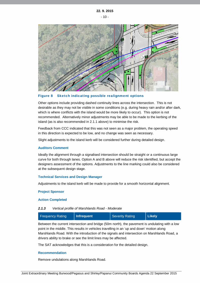
Figure 8 Sketch indicating possible realignment options
Other options include providing dashed continuity lines across the intersection. This is notdesirable as they may not be visible in some conditions (e.g. during heavy rain and/or after dark,which is where conflicts with the island would be more likely to occur). This option is notrecommended. Alternatively minor adjustments may be able to be made to the kerbing of theisland (as is also recommended in 2.1.1 above) to minimise the risk.
Feedback from CCC indicated that this was not seen as a major problem, the operating speedin this direction is expected to be low, and no change was seen as necessary.
Slight adjustments to the island kerb will be considered further during detailed design.
Auditors Comment
Ideally the alignment through a signalised intersection should be straight or a continuous largecurve for both through lanes. Option A and B above will reduce the risk identified, but accept thedesigners assessment of the options. Adjustments to the line marking could also be consideredat the subsequent design stage.
Technical Services and Design Manager
Adjustments to the island kerb will be made to provide for a smooth horizontal alignment.
Project Sponsor
Action Completed
2.1.3 Vertical profile of Marshlands Road - Moderate
Frequency Rating Infrequent Severity Rating Likely
Between the current intersection and bridge (50m north), the pavement is undulating with a lowpoint in the middle. This results in vehicles travelling in an ‘up and down’ motion alongMarshlands Road. With the introduction of the signals and intersection on Marshlands Road, adrivers ability to brake or see the limit lines may be affected.
The SAT acknowledges that this is a consideration for the detailed design.
Recommendation
Remove undulations along Marshlands Road.
22. 9. 2015- 11 -
Joint Extraordinary Meeting Burwood/Pegasus and Shirley/Papanui Community Boards Agenda 22 September 2015
Designer Response
Agree that this is a consideration for the detailed design. The intent is that this issue isaddressed.
Auditors Comment
Accept response
Technical Services and Design Manager
Agree.
Project Sponsor
Action Completed
2.1.4 Utility Drain - Minor
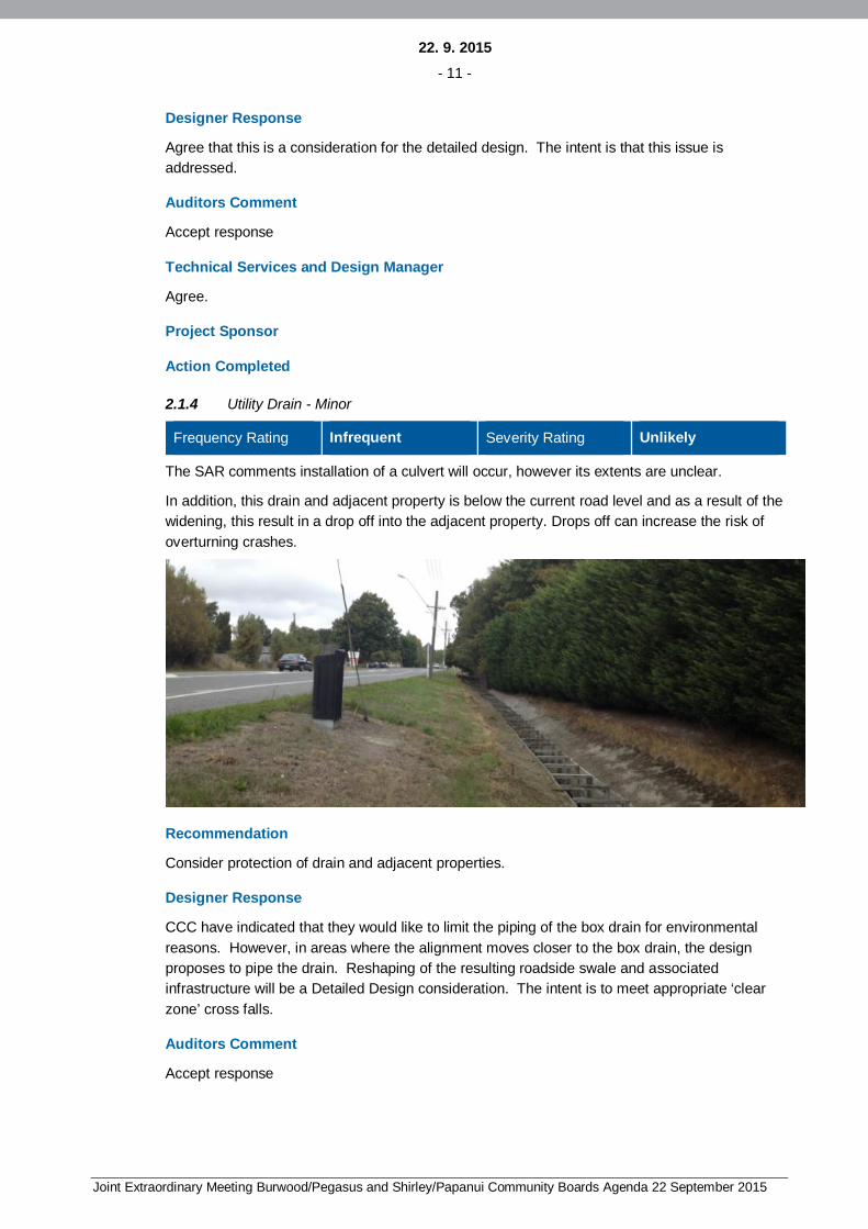
Frequency Rating Infrequent Severity Rating Unlikely
The SAR comments installation of a culvert will occur, however its extents are unclear.
In addition, this drain and adjacent property is below the current road level and as a result of thewidening, this result in a drop off into the adjacent property. Drops off can increase the risk ofoverturning crashes.
Recommendation
Consider protection of drain and adjacent properties.
Designer Response
CCC have indicated that they would like to limit the piping of the box drain for environmentalreasons. However, in areas where the alignment moves closer to the box drain, the designproposes to pipe the drain. Reshaping of the resulting roadside swale and associatedinfrastructure will be a Detailed Design consideration. The intent is to meet appropriate ‘clearzone’ cross falls.
Auditors Comment
Accept response

22. 9. 2015- 12 -
Joint Extraordinary Meeting Burwood/Pegasus and Shirley/Papanui Community Boards Agenda 22 September 2015
Technical Services and Design Manager
Agree.
Project Sponsor
Action Completed
2.1.5 Roadside hazards - Moderate
Frequency Rating Infrequent Severity Rating Likely
Widening of the roads will result in hazards (poles, swale drains, fences, water courses etc.)being closer to the running lanes. As such these hazards may present an increased risk toerrant vehicles.
Recommendation
Consider road side hazard and mitigation treatments.
Designer Response
Agree: Many of the power lines will be undergrounded with the removal of the poles andassociated utilities relocated as part of the proposed upgrade. In areas where the alignmentmoves closer to it, the design proposes to underground the adjacent box drain. The upgradedbridge and approach guardrail will also address some hazards.
Some existing hazards (e.g. fences) will remain. These will be similar to other hazards alongthe length of the alignment and immediately outside the area of the intersection upgrade.
Auditors Comment
Accept response
Technical Services and Design Manager
Agree.
Project Sponsor
Action Completed
2.1.6 Left turn angle - Minor
Frequency Rating Infrequent Severity Rating Unlikely
The left turn lane into Hawkins Road appears to intersect at an acute angle. Good practice is tohave drivers intersect at 70o to provide a satisfactory observation angle.
Recommendation
Change angle of approach at intersection
Designer Response
Agree: The kerb layout accommodates the turning circle of a large rigid truck. The line markingcan be refined in detailed design to guide drivers to intersect at a 70o angle. Minor adjustmentsto the island kerbing may also be part of this. A preliminary sketch below is provided to showintent.

22. 9. 2015- 13 -
Joint Extraordinary Meeting Burwood/Pegasus and Shirley/Papanui Community Boards Agenda 22 September 2015
Figure 9 Sketch indicating possible adjustments to allow left turningvehicles to intersect at a 70o angle
Auditors Comment
Accept response
Technical Services and Design Manager
Agree.
Project Sponsor
Action Completed
2.1.7 Bus provision - Minor
Frequency Rating Infrequent Severity Rating Very Unlikely
During the site visit, it was noted there are temporary bus stops on both sides of Lower StyxRoad, just east of Marshland Road. There is a minor safety concern that city bound buses mayforce their way into Lower Styx Road traffic. It was also noted there is no footpath provision forpedestrians at the bus stops linking to the signals along the south side of Lower Styx Road.
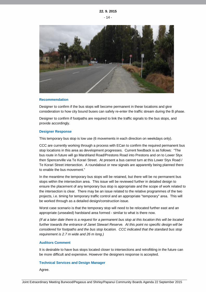
22. 9. 2015- 14 -
Joint Extraordinary Meeting Burwood/Pegasus and Shirley/Papanui Community Boards Agenda 22 September 2015
Recommendation
Designer to confirm if the bus stops will become permanent in these locations and giveconsideration to how city bound buses can safely re-enter the traffic stream during the B phase.
Designer to confirm if footpaths are required to link the traffic signals to the bus stops, andprovide accordingly.
Designer Response
This temporary bus stop is low use (6 movements in each direction on weekdays only).
CCC are currently working through a process with ECan to confirm the required permanent busstop locations in this area as development progresses. Current feedback is as follows: “Thebus route in future will go Marshland Road/Prestons Road into Prestons and on to Lower Styxthen Spencerville via Te Korari Street. At present a bus cannot turn at this Lower Styx Road /Te Korari Street intersection. A roundabout or new signals are apparently being planned thereto enable the bus movement.”
In the meantime the temporary bus stops will be retained, but there will be no permanent busstops within the intersection area. This issue will be reviewed further in detailed design toensure the placement of any temporary bus stop is appropriate and the scope of work related tothe intersection is clear. There may be an issue related to the relative programmes of the twoprojects, i.e. timing for temporary traffic control and an appropriate "temporary" area. This willbe worked through as a detailed design/construction issue.
Worst case scenario is that the temporary stop will need to be relocated further east and anappropriate (unsealed) hardstand area formed - similar to what is there now.
(If at a later date there is a request for a permanent bus stop at this location this will be locatedfurther towards the entrance of Janet Stewart Reserve. At this point no specific design will beconsidered for footpaths and the bus stop location. CCC indicated that the standard bus stoprequirement is 2.7 m wide and 26 m long.)
Auditors Comment
It is desirable to have bus stops located closer to intersections and retrofitting in the future canbe more difficult and expensive. However the designers response is accepted.
Technical Services and Design Manager
Agree.

22. 9. 2015- 15 -
Joint Extraordinary Meeting Burwood/Pegasus and Shirley/Papanui Community Boards Agenda 22 September 2015
Project Sponsor
Action Completed
2.1.8 Janet Stewart Reserve access - Minor
Frequency Rating Infrequent Severity Rating Very Unlikely
The visibility from the reserve access point is restricted due to adjacent vegetation. Reducedvisibility will result in drivers ‘nosing out’ into the lane to observe oncoming traffic, therebyincreasing the risk of conflicts.
Recommendation
Provide appropriate visibility from access.
Designer Response
Janet Stewart Reserve on Lower Styx Road is under CCC control. Ongoing vegetation controlis recommended to ensure adequate visibility from the access. The visibility will be checkedduring detailed design.

22. 9. 2015- 16 -
Joint Extraordinary Meeting Burwood/Pegasus and Shirley/Papanui Community Boards Agenda 22 September 2015
Auditors Comment
Accept response
Technical Services and Design Manager
Agree and visibility to be improved as necessary.
Project Sponsor
Action Completed
2.2 Traffic Signals
2.2.1 Is the signal phasing / sequence safe – Moderate
Frequency Rating Occasional Severity Rating Likely
The proposed two phase signal operation may not be safe as it requires right turn filtering on allapproaches. The Auckland Traffic Management Unit ATMU concludes that it is unsafe to permitfiltering where the 85th percentile operating speed of opposing traffic is greater than 70 km/h.The posted 70 km/h and 80 km/h speed limits on these roads suggest that this is a safety issue.It is also noted that intervisibility is compromised by the opposing right turn bay on allapproaches and particularly on the north and east approach where the opposing through trafficis hidden by the right turn queue due to the approach geometry.
Recommendation
Designer to confirm the operating speed environment on all approaches to determine if rightturn filtering should be permitted.
Designer to consider exclusive right turn protection on each approach as a consequence ofopposed through speed.
Provide exclusive right turn phase (no filtering) for the north and east approach due to thehorizontal alignment geometry.
Designer Response
Through traffic on Hawkins Road/Lower Styx Road is currently stop controlled or restricted. Thespeed limit on this road is 80km/hr. The proposed radius for the curve running throughHawkins/Lower Styx Road is 220m, which is slightly less than the minimum radii for a 70km/hspeed limit. This is to limit the land take required (and associated cost) to accommodate theintersection. We have assumed that the 85th percentile operating speed through theintersection will be less than 70km/h due to the alignment and the traffic light phasing, asMarshland Road will have the priority.
The speed limit on Marshlands Road has dropped to 70 km/hr. Compliance levels with thisspeed limit are currently unknown. At peak periods it is expected that actual speeds will belower, with increases in operating speeds at off-peak times.
In Christchurch where two through lanes are provided at a new intersection protected right turnphasing is generally required and for single through lanes filtered right turns have generallybeen acceptable. There is no specific additional restrictions based on speed limits inChristchurch. While the Designer agrees that ideally protected right turn phasing would alwaysbe provided, this needs to be balanced with the congestion issues that would result.

22. 9. 2015- 17 -
Joint Extraordinary Meeting Burwood/Pegasus and Shirley/Papanui Community Boards Agenda 22 September 2015
At this location the consequences of requiring protected right turns would be increased trafficcongestion on Marshland Road and inadequate performance of the intersection. As a result theDesigner recommends that filtered turns be accepted at this location.
Auditors Comment
There is no argument given that give the auditor confidence the operating speed will be at orbelow 70 km/h. The suggestion that traffic signals will slow traffic is incorrect and only appliesto those vehicles that have arrived after the dilemma zone time and are slowing to a stop orthose vehicles starting off again.
Agree with the designer that at peak periods the speed will be lower but CAS crash recordsshow that a higher number of right turn against crashes and more serious right turn againstcrashes occur off peak when there are fewer cars and speeds are higher.
The auditor is not privy to any modelling undertaken and have to assume it incorporates widernetwork implications that result in a migration of traffic away from Marshland Road.
The auditor suggests it would be astute to undertake a speed survey once the signals are inoperation to determine the safety risk for right turning vehicles rather than accept this is anacceptable risk to avoid congestion.
Technical Services and Design Manager
Agree with auditors suggestion to undertake a speed survey. There is a potential risk to turningvehicles when both back to back right turn bays are occupied.
Project Sponsor
Action Completed
2.2.2 Will the signals be visible (1) – Minor
Frequency Rating Infrequent Severity Rating Unlikely
The SAT interpret section 6.2(1A) of the Traffic Control Devices Rule to mean that it is a legalrequirement to have right turn signal displays in the primary location and these are missing onthe Marshland Road north and south approaches.
Recommendation
The designer to provide right turn signal displays in the primary signal pole locations on theMarshland Road approaches.
Designer Response
The Designer does not interpret section 6.2(1A) of the Traffic Control Devices Rule in the sameway. Positioning right turn arrows at this location is not believed to be standard practice inChristchurch. If required this can be updated during detailed design.
Auditors Comment
The auditor suggests that the council confirms their interpretation of section 6.2(1A) of theTraffic Control Devices Rule with respect to the right turn signal displays in the primary signalpole locations.
Technical Services and Design Manager
To be confirmed at Detailed Design stage.

22. 9. 2015- 18 -
Joint Extraordinary Meeting Burwood/Pegasus and Shirley/Papanui Community Boards Agenda 22 September 2015
Project Sponsor
Action Completed
2.2.3 Will the signals be visible (2) – Minor
Frequency Rating Infrequent Severity Rating Unlikely
There are large hedge rows and dense landscape planting, signs and utility poles alongMarshland Road, Hawkins Road and Lower Styx Road. These may mask the signal displaysincreasing the risk of non-compliance at the intersection.
Recommendation
The designer to confirm that the signals will be visible on all approaches and not obstructed bytrees, poles, signs etc.
Designer Response
Some power poles require removal and the power cables will be undergrounded as part of theintersection upgrade. The extent of vegetation control required and the positions of signs will bereviewed in Detailed Design.
It is noted that the intersection of Lower Styx Road and Dunlops Road is expected to beupgraded as part of the Prestons subdivision development. This will alter the road environmentalong the approach to this intersection.
If required advance warning signs for traffic signals (PW – 3) will be provided.
Auditors Comment
The auditor is pleased to hear there is under-grounding of poles at this location and accepts thatthe extent of vegetation control required can be reviewed at a later stage, possibly at the postaudit stage.
Technical Services and Design Manager
Agree.

22. 9. 2015- 19 -
Joint Extraordinary Meeting Burwood/Pegasus and Shirley/Papanui Community Boards Agenda 22 September 2015
Project Sponsor
Action Completed
2.2.4 Sunstrike – Minor
Frequency Rating Occasional Severity Rating Unlikely
As the Hawkins Road and Lower Styx Road are generally east west, there may be sun strikeissues during sun rise and sun set. This is a risk to off peak users as there is filtering permittedand sun strike may coincide with morning and afternoon peak hour traffic at certain times of theyear.
Recommendation
Designer to consider the use of larger target boards where approaches are likely to be affectedby sun strike.
Designer Response
Extended visors can be provided to mitigate against this risk.
Auditors Comment
The auditor understands a term visor to be synonymous with cowl, and these are used torestrict drivers’ visibility to the displays that aren’t intended to be seen, i.e. a driver waiting onMarshland Road should not be able to see the Hawkins Road or Lower Styx Road displays.This may be just a terminology issue, but the designer should consider the use of larger targetboards where approaches are likely to be affected by sun strike.
Technical Services and Design Manager
Sunstrike issue to be assessed prior to commissioning to note possible problems and identifyremedial measures as necessary.
Project Sponsor
Action Completed
2.2.5 Stopping site distance (1) – Minor
Frequency Rating Occasional Severity Rating Unlikely
Austroads indicate that there should be 280 m of approach visibility to at least two signal poles ifthe speed environment is over 60 km/h. This sight distance is not achieved on the HawkinsRoad approach. The lack of sight distance can result in insufficient stopping distance to thesignals or a queued vehicle.
Recommendation
The operating speed environment is unknown in this location, the designer could confirm theoperating speed to determine if the 280 m visibility distance is required on this approach.
The designer to ensure the high trees and landscape planting at the front of the Janet StewartReserve are removed to provide the 280 m sight line to the signal poles.
22. 9. 2015- 20 -
Joint Extraordinary Meeting Burwood/Pegasus and Shirley/Papanui Community Boards Agenda 22 September 2015
Designer Response
It is believed that the safety auditor is referring to the landscape planting at the front of the JanetStewart Reserve on Lower Styx Road. This reserve is under CCC control. Ongoing vegetationcontrol is recommended to ensure visibility to the intersection.
Actual sight distances achieved will be reviewed at detailed design. If required advancewarning signs for traffic signals (PW – 3) will be provided.
Auditors Comment
The auditor accepts that the extent of vegetation control required can be reviewed at a laterstage, possibly at the post audit stage. However, this may not be required if the operatingspeed is less than 60 km/h.
The auditor accepts that if the design doesn’t provide approach visibility to at least two signalpoles then permanent warning signs (PW3) can be used.
Technical Services and Design Manager
Agree.
Project Sponsor
Action Completed
2.2.6 Stopping site distance (2) – Minor
Frequency Rating Infrequent Severity Rating Unlikely
Austroads indicate that there should be 280 m of approach visibility to at least two signal poles ifthe speed environment is over 60 km/h. This sight line is not achieved on the Marshland Roadnorth approach. The lack of sight distance to two poles can result in drivers not being awarethey are approaching a signalised intersection if one of the signal displays is not operating.
Recommendation
The design to include a dual primary pole on the north approach.
Designer Response
The designer has assessed that at least two signals locations will be visible with the proposeddesign.
Sight distances achieved will be reviewed during detailed design. If required advance warningsigns for traffic signals (PW – 3) will be provided.
Auditors Comment
The auditor accepts that if the design doesn’t provide approach visibility to at least two signalpoles then permanent warning signs (PW3) can be used.
Technical Services and Design Manager
Agree.

22. 9. 2015- 21 -
Joint Extraordinary Meeting Burwood/Pegasus and Shirley/Papanui Community Boards Agenda 22 September 2015
Project Sponsor
Action Completed
2.2.7 Stopping site distance (3) – Minor
Frequency Rating Infrequent Severity Rating Very Unlikely
Austroads indicate that all signal aspects should be 300 mm diameter if the speed environmentis over 60 km/h. It was noted that this is not the practise at the Marshland Road / PrestonsRoad or at Marshland Road / QEII signalised intersections.
Recommendation
Designer to confirm the requirement for 300 mm aspects for all signal displays.
Designer Response
The Concept Design has allowed for 300 mm aspects in all locations. Feedback received fromCCC on 20 April 2015 indicated that 200 mm aspects would be acceptable in this location andbe consistent with the wider network. As this is the first set of signals for some distance forsouthbound vehicles CCC suggested that 300 mm aspects be used for north facing signals (i.e.signals viewed by southbound drivers on Marshland Road), with the view that these aspects berelocated to the next intersection upgrade to the north in the future.
The National Traffic Signals Specification 2013 (IPENZ) indicates that 300 mm shall be used forextended range signals (clause 2.4.2). This is defined as high speed sites and overhead mastarms. To comply with the National Traffic Signals Specification 2013 the designer recommendsthat all overhead mast arms at this intersection use 300 mm aspects. This may be a higherstandard than earlier intersection upgrades. Additionally 300 diameter aspects arerecommended for all north facing signals.
CCC will update if they require any alteration to their requirements.
Auditors Comment
The auditor suggests that a standard for the use of 200 mm and 300 mm LED signal displaysshould be agreed as the different size s may have been a legacy from the older low outputlantern technology. There are several options above and it is unclear which option will beadopted.
Technical Services and Design Manager
300mm LED aspects to be used on all overhead mast arms and 200mm LED aspects to beused on all low level lanterns.
Project Sponsor
Action Completed
2.2.8 Pedestrian facilities (1) – Minor
Frequency Rating Infrequent Severity Rating Very Unlikely
It is noted that pedestrian crosswalks are provided on all approaches. It is undesirable to havethese facilities when there is a very low expectation they will be used. The pedestrian detectionsystems can become faulty and result in permanent calls for the pedestrian phase. This can
22. 9. 2015- 22 -
Joint Extraordinary Meeting Burwood/Pegasus and Shirley/Papanui Community Boards Agenda 22 September 2015
result in driver frustration and noncompliance with the signals if there are no pedestrianspresent.
Recommendation
Designer to consider providing the full pedestrian cross walk provision without installing any ofthe signal hardware, or road markings until there is a demand for the pedestrian facilities.
Designer Response
At this point, based on feedback from CCC’s Project Sponsor, the intent is to continue withDetailed Design with all pedestrian crossings included. The option set out by the safety auditorabove remains. Removal of all crossings may be seen as a drastic step, but there is nopedestrian provision currently. It is recommended that Detailed Design be completed with allpedestrian facilities included. Updating this layout to provide construction drawings that removethe pedestrian crossing hardware and line marking is possible. The Design Costs of thisadditional step would be expected to be relatively minor and it would provide a design thatallows for the installation of the crossings at a later date.
Also note related comments in 2.2.10 below.
Auditors Comment
The auditor agrees that the detailed design should be completed with all pedestrian facilitiesincluded with the option of updating this layout to remove the pedestrian crossing hardware andline marking should the client agree to include these facilities when there is pedestrian demand.
Technical Services and Design Manager
All pedestrian crossings to be included as per the Scheme Plan.
Project Sponsor
Action Completed
2.2.9 Pedestrian facilities (2) – Moderate
Frequency Rating Infrequent Severity Rating Very Likely
It is noted that the pedestrians will be walking parallel to the A phase on Marshland Road andparallel to the B phase on Hawkins and Lower Styx Roads. The parallel pedestrians will not bevisible to approaching traffic on Marshland Road (city bound) or Hawkins Road or Lower StyxRoad traffic due to the offset alignment of the crosswalks and the existing dense landscapeplanting and hedges on the NW, NE and SE corners.
Recommendation
It is noted in 2.2.8 that the pedestrian facilities may not be required immediately, however ifand/or when pedestrians are expected to use the crosswalks, the designer to ensure that eitheradequate intervisibility sightlines are provided between approaching drivers and parallelpedestrians, or partial pedestrian protection be provided instead.
Designer Response
Partial pedestrian protection is provided in the north – south direction. See comments below inresponse to 2.2.10 for further information pedestrian protection in the east west direction.Removal of some vegetation is recommended, although some protected cabbage trees will
22. 9. 2015- 23 -
Joint Extraordinary Meeting Burwood/Pegasus and Shirley/Papanui Community Boards Agenda 22 September 2015
remain. Further improvement of sight lines will potentially increase the land requirementsslightly (e.g. to slightly realign the fence line at the corner of Lower Styx and Marshland Road) toprovide improved sight lines.
Auditors Comment
The auditor is concerned that partial pedestrian protection is a limited amount of time forpedestrians to start walking into the intersection and only provide limited for pedestrians walkingwith the nearside traffic. Pedestrians walking against the traffic (or across the departure lane)are at risk of collision with turning drivers. The best way to reduce this risk (without fullprotection) is increased intervisibility, which should be explored further.
Technical Services and Design Manager
Agree. Will explore increased visibility at Detailed Design stage.
Project Sponsor
Action Completed
2.2.10 Pedestrian facilities (3) – Moderate
Frequency Rating Infrequent Severity Rating Very Likely
The plans note that right turn pedestrian protection is provided for north / south pedestrianmovements only. This means that there is no pedestrian protection is provided for east / westpedestrian movements which have similar crash risks and severities.
Recommendation
It is noted in 2.2.8 that the pedestrian facilities may not be required immediately, however thedesigner to consider providing right turn pedestrian protection for east / west pedestrianmovements.
Designer Response
There is no design standard requirement to provide right turn protection.
The provision of east / west pedestrian protection would increase the east / west signal phaselength. This in turn would increase delays on Marshland Road which is seen as a concernparticularly up until NArt is constructed. The crossings in the east –west direction are relativelyshort which mitigates against some of the risk to pedestrians. At this point, based on feedbackfrom CCC’s Project Sponsor, the intent is to continue with Detailed Design with all pedestriancrossings included. To mitigate against this risk the option to only install one crossing in theshort term remains. Pedestrian numbers are believed to be very low currently and predictedturning movements are also low.
Intent is to continue as per the current design. Provision to allow for later addition of pedestrianprotection for east / west pedestrian movements will be included in the detailed design.
Auditors Comment
The auditor accepts there is no design standard requirement to provide right turn protection.
The same response re collision risk and intervisibility as per 2.2.9 above.
Technical Services and Design Manager
Agree. However, this is to be reviewed post commissioning of the traffic signals.

22. 9. 2015- 24 -
Joint Extraordinary Meeting Burwood/Pegasus and Shirley/Papanui Community Boards Agenda 22 September 2015
Project Sponsor
Action Completed
2.2.11 Signal pole locations – Minor
Frequency Rating Infrequent Severity Rating Very Unlikely
The plan indicates that some of the traffic signal poles are located very close to the kerb face.Signal poles can be a hazard on these large radius corners where vehicles are likely to becornering at speed and where there is negative camber sloping towards the kerb. This can alsoresult in ongoing pole maintenance costs and high temporary traffic management costs.
Consequently, the offsets should not create pinch points for footpath users.
Recommendation
Designer to confirm the minimum kerb offset to traffic signal poles.
Designer Response
The Concept Design Drawings have not absolutely fixed pole positions. In Detailed Designpoles will be positioned to ensure that no part of the signal lantern or backing board is closerthan 300mm to the face of the kerb. In addition the CCC requires that the pole is a minimum of600mm from the kerb. Factors raised by the safety auditor above will be considerations forDetailed Design.
CCC have requested that they be involved with final positioning of poles onsite during theconstruction phase to ensure their requirements are met.
Auditors Comment
The auditor accepts that CCC requires that the pole is a minimum of 600mm from the kerb faceand the designer should ensure, at the detail design stage, that this offset does not create pinchpoints for footpath users.
Technical Services and Design Manager
Agree.
Project Sponsor
Action Completed
2.2.12 Cycle facilities (1) – Moderate
Frequency Rating Infrequent Severity Rating Likely
The plans show that green coloured, Advance Stop Boxes ASBs are to be included in front ofthe through lanes on Marshland Road and in front of the shared through and left turn lanes onHawkins and Lower Styx Roads. As these are higher speed roads, cyclists waiting or startingfrom the centre of the traffic lane is a safety risk.
Recommendation
Designer to consider using an Advance Stop Line (ASL) only, on all approaches, as thisprovides the same head start advantage to cyclists without putting them in harm’s way.
22. 9. 2015- 25 -
Joint Extraordinary Meeting Burwood/Pegasus and Shirley/Papanui Community Boards Agenda 22 September 2015
Alternatively designer to consider extending the ASB half way across the right turn bay to allowfor cyclists who do not wish to undertake a hook turn.
Designer Response
Agreed: The partial addition of Advance Stop Boxes (ASBs) was included as a result offeedback from the CCC TOC process. Based on the above safety auditor feedback theDesigner and CCC have reviewed this issue. It is considered possible that ASBs may increasethe chances that less experienced cyclists will use the areas incorrectly and come into conflictwith through traffic.
The next intersection to the south (Marshlands Road/Prestons Road) was upgraded in 2014and this intersection does not include ASBs. The detailed design will use Advance Stop Line(ASL) as confident and experienced cyclists are likely to still use this area.
For consistency with the Marshlands Road/Prestons Road intersection to the south the designerrecommends using an Advance Stop Line (ASL) only on all approaches as suggested by thesafety auditor.
Auditors Comment
Accepted. However the designer may wish to consider half ASBs in front of the right turn lane tocater for cyclists who wish to turn right from the lane.
Technical Services and Design Manager
Agree.
Project Sponsor
Action Completed
2.2.13 Cycle facilities (2) – Moderate
Frequency Rating Infrequent Severity Rating Likely
The plans show the cycle hook turn box for the Lower Styx Road approach (NE corner) beingset well back from the desire line and locating waiting cyclists behind the traffic signal pole. Thismay result in left turning traffic not seeing a waiting or slow starting cyclist in the hook turn boxlocation. Furthermore, with this location away from the desire line, cyclists may not use thehook turn box.

22. 9. 2015- 26 -
Joint Extraordinary Meeting Burwood/Pegasus and Shirley/Papanui Community Boards Agenda 22 September 2015
Recommendation
Designer to provide the (NE corner) cycle hook turn box in a more conspicuous location.
Designer Response
Agreed: The cycle hook turn box will be repositioned more in line with the southbound throughlane for cyclists.
Auditors Comment
The auditor suggests that the drivers sightline from the through and left turn lane is alsochecked to ensure they will have good visibility of cyclists in this hook turn box.
Technical Services and Design Manager
Agree.
Project Sponsor
Action Completed
2.2.14 Cycle facilities (3) – Minor
Frequency Rating Infrequent Severity Rating Unlikely
Also noted on the plans is that “hook cycle turn boxes provided on all approaches”, but they areonly provided on three.

22. 9. 2015- 27 -
Joint Extraordinary Meeting Burwood/Pegasus and Shirley/Papanui Community Boards Agenda 22 September 2015
Recommendation
Designer to confirm if a cycle hook turn box is required for the Lower Styx Road approach forcyclists turning towards the north.
Designer Response
Agreed: The cycle hook turn box was intended to be included this will be positioned in front ofthe through lane for cyclists. This was included in an earlier revision of the drawing and wasomitted from this update in error.
Auditors Comment
Good, comments as per 2.2.13
Technical Services and Design Manager
Agree.
Project Sponsor
Action Completed
2.2.15 Austroads AGRS06 09 Guide to Road Safety - Part 6- Road Safety Audit
Traffic signals
1. Is the signal phasing/sequence safe?
2. Is adequate time provided for traffic movements and pedestrian movements?
3. Will the signal lanterns be visible? (for example, not obstructed by trees, poles, signs orlarge vehicles)
4. Are lanterns for other approach directions adequately shielded from view? The plansshow correct cowl specification.
5. Are high-intensity signals and/or target boards provided if likely to be affected bysunrise/sunset?
6. Does the alignment (vertical and horizontal) provide satisfactory stopping sight distanceto the intersection or back of queue?
7. Are pedestrian facilities provided where they are required? The plans show shadedareas that are assumed to be proposed footpaths.
8. Will approaching drivers be able to see pedestrians?
9. Are partially or fully controlled turning phases provided where required? See 1
10. Are signal posts located where they are not an undue hazard?
11. Are road markings for turning traffic satisfactory?
12. Have adequate pedestrian phases been provided? See 8
2.3 Pedestrians
2.3.1 Link footpath – Minor
Frequency Rating Occasional Severity Rating Likely
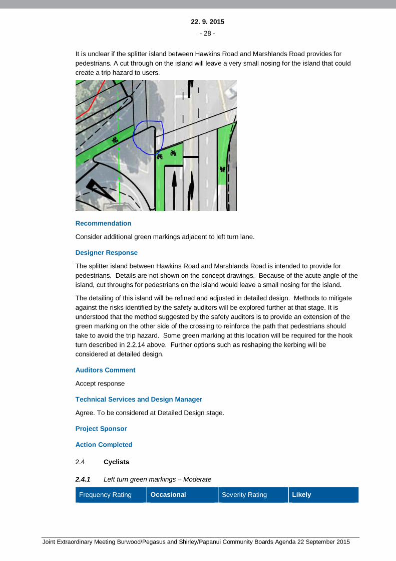
22. 9. 2015- 28 -
Joint Extraordinary Meeting Burwood/Pegasus and Shirley/Papanui Community Boards Agenda 22 September 2015
It is unclear if the splitter island between Hawkins Road and Marshlands Road provides forpedestrians. A cut through on the island will leave a very small nosing for the island that couldcreate a trip hazard to users.
Recommendation
Consider additional green markings adjacent to left turn lane.
Designer Response
The splitter island between Hawkins Road and Marshlands Road is intended to provide forpedestrians. Details are not shown on the concept drawings. Because of the acute angle of theisland, cut throughs for pedestrians on the island would leave a small nosing for the island.
The detailing of this island will be refined and adjusted in detailed design. Methods to mitigateagainst the risks identified by the safety auditors will be explored further at that stage. It isunderstood that the method suggested by the safety auditors is to provide an extension of thegreen marking on the other side of the crossing to reinforce the path that pedestrians shouldtake to avoid the trip hazard. Some green marking at this location will be required for the hookturn described in 2.2.14 above. Further options such as reshaping the kerbing will beconsidered at detailed design.
Auditors Comment
Accept response
Technical Services and Design Manager
Agree. To be considered at Detailed Design stage.
Project Sponsor
Action Completed
2.4 Cyclists
2.4.1 Left turn green markings – Moderate
Frequency Rating Occasional Severity Rating Likely
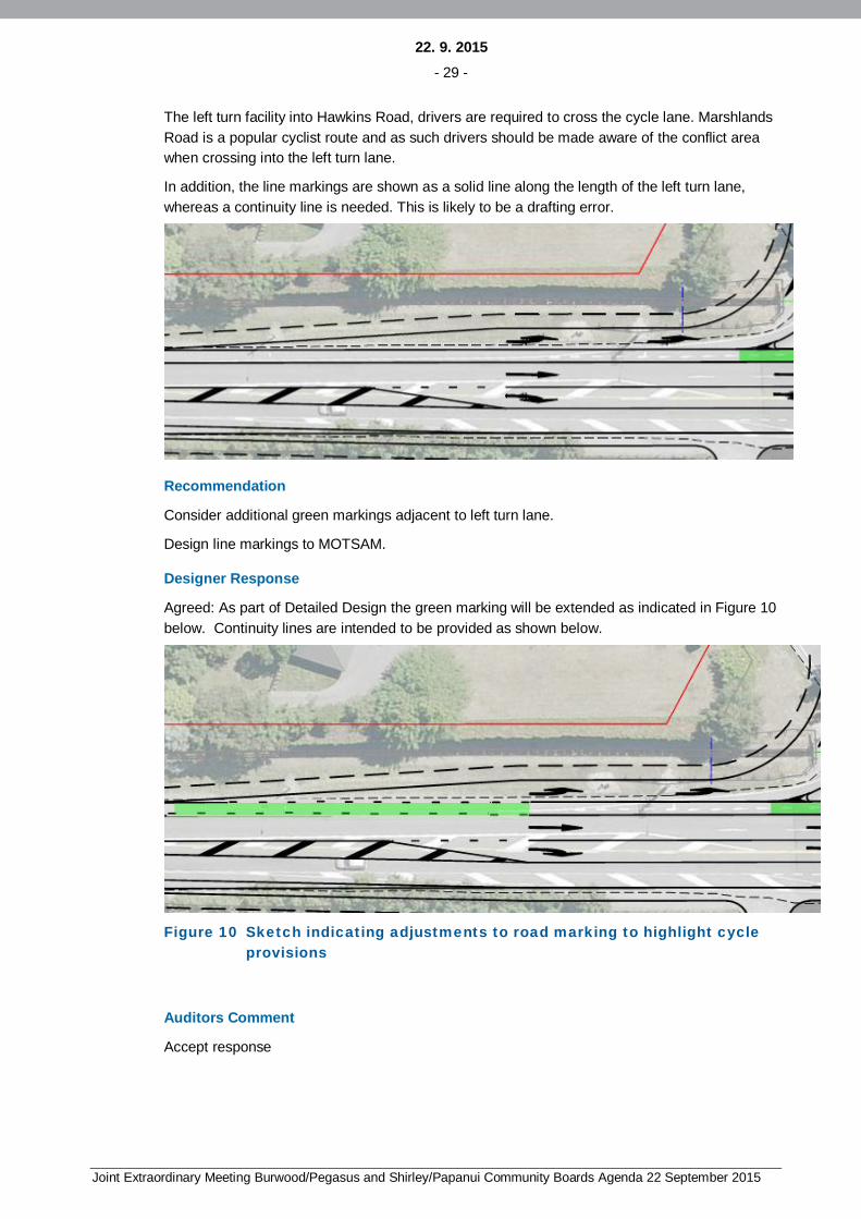
22. 9. 2015- 29 -
Joint Extraordinary Meeting Burwood/Pegasus and Shirley/Papanui Community Boards Agenda 22 September 2015
The left turn facility into Hawkins Road, drivers are required to cross the cycle lane. MarshlandsRoad is a popular cyclist route and as such drivers should be made aware of the conflict areawhen crossing into the left turn lane.
In addition, the line markings are shown as a solid line along the length of the left turn lane,whereas a continuity line is needed. This is likely to be a drafting error.
Recommendation
Consider additional green markings adjacent to left turn lane.
Design line markings to MOTSAM.
Designer Response
Agreed: As part of Detailed Design the green marking will be extended as indicated in Figure 10below. Continuity lines are intended to be provided as shown below.
Figure 10 Sketch indicating adjustments to road marking to highlight cycleprovisions
Auditors Comment
Accept response

22. 9. 2015- 30 -
Joint Extraordinary Meeting Burwood/Pegasus and Shirley/Papanui Community Boards Agenda 22 September 2015
Technical Services and Design Manager
Greening to be extended along the full length of the cycle lane on the approach to the trafficsignals given the nature of risk.
Project Sponsor
Action Completed

22. 9. 2015- 31 -
Joint Extraordinary Meeting Burwood/Pegasus and Shirley/Papanui Community Boards Agenda 22 September 2015
3. AUDIT STATEMENT AND CONCLUSION
We certify that we have used the available plans, and have examined the specified roads andtheir environment, to identify features of the project we have been asked to look at that could bechanged, removed or modified in order to improve safety. The problems identified have beennoted in this report.
It is noted by the SAT, that the proposed improvements do not entirely address the existingcrashes.
A Scheme safety audit for the Marshlands Road / Hawkins Road Intersection Improvements hasbeen undertaken with 24 issues and two comments being identified and are summarised inTable 3 below
Table 3 Summary of Issues
Serious Significant Moderate Minor Total
0 0 9 15 24
Signed: Provided on PDF copy ............................... Dated: 02/04/2015
Andrew Fergus, GHD Limited
Signed: Provided on PDF copy ............................... Dated: 02/04/2015
Warren Lloyd, GHD Limited
Designer: Helen Pullar…………………Position Senior Civil/Transportation Engineer (Opus)
Signature……………………………………………….Date…………………………….
Technical Services and Design Manager: Name………………………… Position…………….
Signature……………………………….. …………….Date…………………………….
Project Sponsor: Name…………………………………… Position………………………..
Signature……………………………………………... Date…………………………….
Action Completed: Name…………………………………… Position………………………..
Signature…………………………………………..….. Date…………………………….
Project Sponsor to distribute audit report incorporating decision to designer, Safety AuditTeam Leader, Technical Services and Design Manager and project file.Date:……………………..
22. 9. 2015- 32 -
Joint Extraordinary Meeting Burwood/Pegasus and Shirley/Papanui Community Boards Agenda 22 September 2015
3.1 Scope and limitations
This report: has been prepared by GHD for Christchurch City Council and may only be used and relied onby Christchurch City Council for the purpose agreed between GHD and the Christchurch City Council asset out in Section 1 of this report.
GHD otherwise disclaims responsibility to any person other than Christchurch City Council arising inconnection with this report. GHD also excludes implied warranties and conditions, to the extent legallypermissible.
The services undertaken by GHD in connection with preparing this report were limited to those specificallydetailed in the report and are subject to the scope limitations set out in the report.
The opinions, conclusions and any recommendations in this report are based on conditions encounteredand information reviewed at the date of preparation of the report. GHD has no responsibility or obligationto update this report to account for events or changes occurring subsequent to the date that the report wasprepared.
The opinions, conclusions and any recommendations in this report are based on assumptions made byGHD described in this report. GHD disclaims liability arising from any of the assumptions being incorrect.
GHD has prepared this report on the basis of information provided by Christchurch City Council and otherswho provided information to GHD (including Government authorities)], which GHD has not independentlyverified or checked beyond the agreed scope of work. GHD does not accept liability in connection withsuch unverified information, including errors and omissions in the report which were caused by errors oromissions in that information.

22. 9. 2015- 33 -
Joint Extraordinary Meeting Burwood/Pegasus and Shirley/Papanui Community Boards Agenda 22 September 2015
GHD
GHD Building226 Antigua Street, Christchurch 8011T: 64 3 378 0900 F: 64 3 377 8575 E: [email protected]
© GHD 2015
This document is and shall remain the property of GHD. The document may only be used for the purpose forwhich it was commissioned and in accordance with the Terms of Engagement for the commission.Unauthorised use of this document in any form whatsoever is prohibited.G:\51\2609353\WP\Marshlands Hawkins Intersection _Scheme safety audit_Draft_RevB.docx
Document Status
RevNo.
Author Reviewer Approved for IssueName Signature Name Signature Date
0 A FergusW Lloyd
N Hopman Provided onPDF copy
A Watt Provided on PDFcopy
02/04/2015

22. 9. 2015- 34 -
Joint Extraordinary Meeting Burwood/Pegasus and Shirley/Papanui Community Boards Agenda 22 September 2015
www.ghd.com