Introduction to Tourism - Lesson 7
35
Introduction to Introduction to Tourism Tourism Tourism Geography: Learning Objectives Tourism Geography: Learning Objectives : : • Understand Lines of Latitudes and Understand Lines of Latitudes and Longitude Longitude • Understand and be able to describe the Understand and be able to describe the continents of the world continents of the world • Describe the physical features of our Describe the physical features of our globe, with particular knowledge of Oceans, globe, with particular knowledge of Oceans, Seas, Islands, Rivers, Mountains and Seas, Islands, Rivers, Mountains and Desserts Desserts • Possible Exam Questions Possible Exam Questions
Transcript of Introduction to Tourism - Lesson 7

Introduction to Introduction to TourismTourism
Tourism Geography: Learning ObjectivesTourism Geography: Learning Objectives::• Understand Lines of Latitudes and Understand Lines of Latitudes and LongitudeLongitude• Understand and be able to describe the Understand and be able to describe the continents of the worldcontinents of the world• Describe the physical features of our Describe the physical features of our globe, with particular knowledge of Oceans, globe, with particular knowledge of Oceans, Seas, Islands, Rivers, Mountains and Seas, Islands, Rivers, Mountains and DessertsDesserts• Possible Exam QuestionsPossible Exam Questions
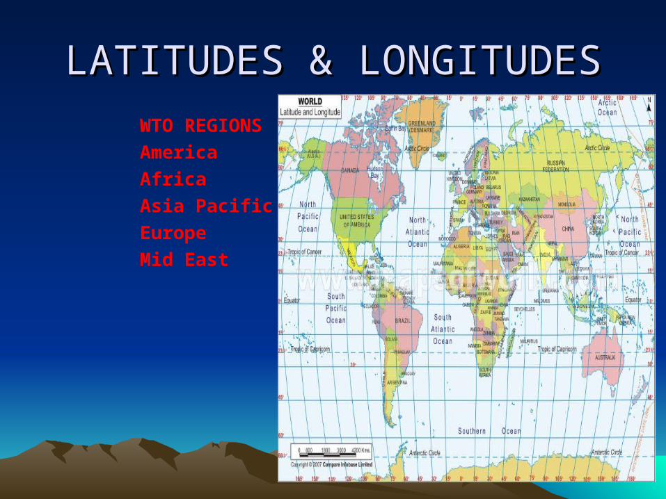
LATITUDES & LONGITUDESLATITUDES & LONGITUDESWTO REGIONSAmericaAfricaAsia PacificEuropeMid East

Important Lines of Important Lines of Latitude and LongitudeLatitude and Longitude
• Latitude- are horizontal lines (also called parallels): run east and west around earth.These lines measure distances north and south of the Equator. Equator, Tropic of cancer and Capricorn (23½ north and south) Artic Circle, Antarctic Circle (66½ degree of north and south) of equator.
• Longitude- are vertical lines (also called meridians): are lines that run from the north pole to the south pole converging at both points.
• Equator- (0° latitude) is half way between the north and south poles
• Prime Meridian- (0° longitude) is also called Greenwich Meridian.
• International Date Line: 180° longitude E/W • Point of Origin – is the intersection of the Equator and the Prime Meridian and is the point for the Earth’s latitude and longitude grid system

ContinentsContinents• North America• South America• Europe• Africa• Asia • Australia / Oceania• Antarctica

Facts about ContinentsFacts about Continents• Continents by Size - No. of
countries in Continents1. Asia (44, 579, 000 sq km)442. Africa (30, 065, 000 sq km) 533. North America (24, 256, 000 sq km)
234. South America (17, 819, 000 sq km)
125. Antarctica ( 13, 209, 000 sq km)6. Europe ( 9, 938, 000 sq km) 467. Oceania (7, 687, 000 sq km) 14

Oceans Of the WorldOceans Of the World• Pacific (deepest)• Atlantic• Indian
• Southern (newly approved in 2000)• Arctic

Seas of the WorldSeas of the World

Major Islands of the Major Islands of the World World
• Greenland• New Guinea• Borneo• Madagascar• Baffin• Sumatra• Honshu• Great Britain• Victoria• Ellesmere• Celebes• South island NZNorth island NZ
• Java• New found land

Major Rivers (by length)Major Rivers (by length)• Nile, Africa (6, 825 km)• Amazon, South America ( 6, 437 km)
• Chang Jiang (Yangtze), Asia (6,380 km)
• Mississippi, North America ( 5,971 km)
• Yenisey – Angara, Asia (5,536 km)

Major Mountains Peaks( by Major Mountains Peaks( by height)height)
• Mount Everest 8850 m( 29035 ft)• Nepal / china• Qogir ( K2) 861 m (28250 ft) Pakistan
• Kangchenjunga 8586 m (28169 ft) Nepal
• Lhotse 8501 m (27765 ft) Nepal• Makalu 8462 m (27765 ft) Nepal

Important DesertsImportant Deserts• Sahara, North Africa (3,500,000 sq miles)• Arabian, Middle East (1,000, 000 sq miles)• Great Victoria, Australia (250, 000 sq miles)• Kalahari, Southern Africa (225, 000 sq miles)• Syrian, Middle East (200, 000 sq miles)• Chihuahua, Mexico (175, 000 sq. miles)• Thar, India/ Pakistan (175, 000 sq. miles)• Gobi Desert, China

Deserts of the worldDeserts of the world

ASIAASIA• Asia is the largest continent, Asia covers about 30 % of the world’s landmass and includes(44) countries and assorted islands and / or dependencies.Significant features of the continent of Asia include the world’s tallest mountain, Mt Everest in Nepal (and china), rising to 29, 035 ft (8850m).It also includes the world’s lowest point , found in the Dead Sea,Israel/Jordan, at 1,286ft (392m) below sea level.In addition, the continent includes the world’s most Populated countries, china and India; the world’s longestCoastline, the world’s deepest lake; Lake Baykal, and some of the most important rivers on the planet


AsiaAsia• Asia is bounded to the north by the Arctic Ocean, to the east by
the Pacific Ocean, to the south by Indian Ocean, and to the west by Europe and Mediterranean.
• A continent of contrasts and extremes, the enormous diversity of Asia’s physical and cultural landscapes is unparalleled in the world. Although geographers have clubbed its constituent nations and region as part of one large continent, Asia defies all notions of homogeneity.
• Includes some of the world’s richest and developed economies like Japan and Korea but is also home to some of the world’s poorest nation.
• Has the highest point on earth, the mount Everest in the Himalayas as well as the lowest place on land, the Dead Sea.
• Also experiences the wildest extremes of weather and climate, while the continent boasts of the wettest place on earth in the Indian state of Meghalaya, certain area of the Arabian Desert may go without rainfall for years together.
• Has the widest variety of planet and animal life; from tropical rainforests to desert scrubland; from the world’s largest reptile, the komodo Dragon of Indonesia, to the shy and elusive Snow Leopard in the high reaches of Himalayas.
•

Middle EastMiddle East• The Middle East( or West Asia) sits where Africa, Asia and Europe meet. The countries of the middle east are all part of Asia, but for clarity reasons we geographically show them here as a separate landmass.
• Opinions vary as to what countries make up the Modern Definition of the middle east. Historically, Armenia and Azerbaijan have been long associated with the Middle east, but in recent years , some sources now consider them to be more closely aligned with Europe based on their modern economic and political trends. We have moved in that direction, and the same applied for the island country of Cyprus, as it does for Georgia the former Russian Republic
• The African country of Egypt is still thought (by some) to be in the Middle East, as well as the northern African countries that border the Mediterranean Sea.


Europe Europe • Europe, the planet’s 6th largest continent includes 47 countries (Physically) and assorted dependencies and territories.
• In exacting geographic definitions, Europe is really not a continent, but part of the peninsula of Eurasia which includes all of Europe and Asia. However, it’s still widely referred to as Continent.
• The European continent is separated from Asia by Russia’s.


EuropeEurope• One of the world’s smallest continents, Europe is
bounded to the north by Arctic Ocean, to the west by Atlantic Ocean, to the south by the Mediterranean Sea, the black sea and the Caspian Sea, and to the east by the Ural Mountains which separate the continent from Asia and the greater part of the vast Eurasian landmass.
• Despite its internal diversities of culture, language, customs etc., Europe has come to represent a unique civilization and ethical values which had tremendous influence on the rest of the world at the different epochs of history.
• Europe is the continent of great physical and cultural diversity and is bestowed with some of the world’s spectacular landscapes and places of scenic beauty. From the tiny hilltop villages of France to the bustling metropolises of London and Paris; from the ski slopes of Austrian Alps to the sun kissed beaches of Mediterranean Spain, from the fairy tale castles of the Scottish Highlands to the Gondolas of Venetian canals. The breathtaking beauty of Europe is feast for the eyes.

OceaniaOceania• The smallest continent, is one of the most diverse and fascinating areas on the planet.
• A large percentage of geography experts now consider the long-established continent of Australia to the more accurately defined as Australian/ Oceania.collectively it then combines all of the Australia, New Zealand, Papua New Guinea, as well as the thousands of coral atolls and volcanic islands of the South Pacific Ocean, including the Melanesia and Polynesia groups.
• Oceania also includes Micronesia, a widely scattered groups of islands that run along the northern and southern edges of the Equator.


AustraliaAustralia• Australia: The world’s smallest continent, • Regarded by many as the youngest, since civilization
started much late here but the history and culture of its original inhabitants, the Aborigines, goes back to more than 50,000 years.
• With the Pacific and Indian Ocean on either side, Australia’s location in Southern Hemisphere and relative isolation has rendered it with a unique variety of plant and animal life found nowhere else on earth.
• Although, a major portion of the continent’s land area is covered by arid desert topography, Australia’s natural sights are a big draw for the outside world. From the tropical rainforests and the Great Barrier Reef in the north to the vibrant coastal cities of Sydney roads of the arid outback to the spectacular coastal scenery of the Great Ocean Road; from the lonely Ayers rock in the middle of nowhere to the crowded beaches of Bondi and Manly;
• Australia is dream come true for many travelers and adventure loving people.

AfricaAfrica• Africa, the planet’s 2nd largest continent, includes (53) individual countries.
• It contains the Nile river, the world’s longest and the massive Sahara Desert, the world’s largest.
• The continent’s (highest point) is Mt. Kilimanjaro, in Tanzania 19,341 ft(5,895m), while the (lowest point) is Lac’ Assal in the small country of Djibouti, 512 ft (156m) below sea level.


AfricaAfrica• The second largest of the world’s continents, • Africa is bounded to the north by the Mediterranean Sea, to the west by the Atlantic Ocean, to east by the Indian Ocean and the Red Sea, and described by outsiders, as the Dark Continent or the Cradle of Mankind,
• A continent immensely rich in mineral and natural resources that helped attract plunders and explorers alike.
• Also blessed with a rich variety of wildlife and biological resources, the preservation of which continues to be a challenge for conservationists from across the world.
• Home to some of the world’s poorest people and many of its constituent countries are still undergoing the process of nation building to achieve integration with the rest of the world.

North AmericaNorth America• North America, the planet’s 3rd largest continent, includes(23) countries and dozens of small island possessions and territories – mostly in the Caribbean.
• It contains all Caribbean and central America countries, Canada, Mexico and United States of America – Three of the largest countries on the planet


North AmericaNorth America• The third largest of the world’s continents, • most areas of the North American landmass is occupied by two of the world’s most developed nations, the United States of America and Canada.
• The third major country occupying this continent is Mexico. The continent of North America is bounded to the north by the Arctic Ocean, to the east by Atlantic Ocean, to the west by the Pacific Ocean, and on the south by Caribbean Sea.
• It is connected to the continent of South America by the narrow Isthmus of Panama. Comprising of some of the world’s oldest rocks
• North America is also very rich in mineral and other resources.
• National parks in this continent contain some of the most spectacular and breathtaking sceneries in the world. Great lakes Huron Ontario, Michigan, Erie, Superior.

South AmericaSouth America• South America, the planet’s 4th largest continent, includes(12) countries and (3) major territories. It contains the massive Amazon River and the surroundings basinthe largest tropical rain forest in the world; the toothy – edged of the continent, and some of the most diverse and spectacular landforms on the planet.


South AmericaSouth America• Culturally sometimes referred to as Latin America, the continent of south America has the greatest north extension and apart from Antarctica,
• is the only continent with the farthest extension to the south. South America is bounded to the north by the Caribbean Sea, to the east by Atlantic Ocean, to the west by the Pacific Ocean, and on the south by Icy continent of Antarctica.
• South America’s high mountains and highland areas extend up to different elevation levels which together contribute to its variety of climate and natural regions ranging from the high Andes Mountains to the Amazon rainforests; and the arid Patagonian and Atacama deserts to the Sub – Arctic climes of its southernmost areas.

AntarcticaAntarctica• In any world map, the southern and the most remote continent, Antarctica is permanently covered under ice.
• The difficulties of accessibilities have, however, not discouraged several scientific expeditions and initiatives which are being currently undertaken by several nations to this part of the world.
• Many developed nations and even developing countries like India have set up scientific stations in Antarctica and many of them have their own territorial claims on this vast icy continent.


Possible Exam QuestionsPossible Exam Questions• Explain the important lines of Latitude and Longitude• Outline the continents of our world and the number
countries each has• Outline the Oceans of the world• Outlines the seas of the world• What are the major Island of the world?• What are the major Rivers of the world?• What are the major Mountains of the world?• Give the three longest Deserts of the world• Describe in detail the following continent:
– Asia– Europe– Australia/Oceania– Africa– North /South America– Antarctica