Independence Township FY2023 DWSRF Parview and ...
397
CHARTER TOWNSHIP OF INDEPENDENCE FY2023 DRINKING WATER STATE REVOLVING FUND PARVIEW DRIVE AND WALDON ROAD WATER MAIN EXTENSIONS PROJECT PLAN Prepared By: DLZ MICHIGAN, INC. July 1, 2022
-
Upload
khangminh22 -
Category
Documents
-
view
1 -
download
0
Transcript of Independence Township FY2023 DWSRF Parview and ...

CHARTER TOWNSHIP OF INDEPENDENCE FY2023 DRINKING WATER STATE REVOLVING FUND
PARVIEW DRIVE AND WALDON ROAD WATER MAIN EXTENSIONS
PROJECT PLAN
Prepared By:
DLZ MICHIGAN, INC.
July 1, 2022

Table of Contents EXECUTIVE SUMMARY .......................................................................................................................................... 1
1.0 PROJECT BACKGROUND ............................................................................................................................ 2
1.1 STUDY AREA .......................................................................................................................................... 2
1.2 INDEPENDENCE TOWNSHIP LAND USE/ZONING .................................................................................. 8
1.3 POPULATION DATA ............................................................................................................................. 11
1.4 WATER DEMAND ................................................................................................................................ 12
1.5 EXISTING FACILITIES ............................................................................................................................ 12
1.5.1 SOURCE FACILITIES .................................................................................................................. 15
1.5.2 WATER TREATMENT AND RESIDUAL DISPOSAL ...................................................................... 16
1.5.3 WATER STORAGE .................................................................................................................... 17
1.5.4 SERVICE LINES ......................................................................................................................... 17
1.5.5 DISTRIBUTION SYSTEM ........................................................................................................... 17
1.5.6 WATER METERS ...................................................................................................................... 19
1.5.7 DISTRIBUTION SYSTEM OPERATION AND MAINTENANCE ..................................................... 19
1.5.8 DESIGN CAPACITY ................................................................................................................... 20
1.5.9 EMERGENCY CONNECTIONS TO ADJACENT WATER SYSTEMS ................................................... 21
1.5.10 CLIMATE RESILIENCY ............................................................................................................... 22
1.6 SUMMARY OF PROJECT NEED............................................................................................................. 22
1.6.1 WALDON WATER MAIN EXTENSION ........................................................................................... 22
1.6.2 PARVIEW EXTENSION .................................................................................................................. 26
1.6.3 ORDERS OR ENFORCEMENT ACTIONS / DRINKING WATER QUALITY PROBLEMS ...................... 28
1.6.4 PROJECTED NEEDS FOR THE NEXT 20 YEARS .............................................................................. 28
2.0 ANALYSIS OF ALTERNATIVES ................................................................................................................... 29
2.1 ALTERNATIVE 1 – “NO-ACTION” ................................................................................................. 29
2.2 ALTERNATIVE 2 – “OPTIMUM PERFORMANCE OF EXISTING FACILITIES”................................... 29
2.3 ALTERNATIVE 3 – “REGIONAL ALTERNATIVES” ........................................................................... 29
2.4 ALTERNATIVE 4 – “EXTENSION OF EXISTING INFRASTRUCTURE” ............................................... 30
3.0 PRINCIPAL ALTERNATIVE ........................................................................................................................ 31

3.1 ENVIRONMENTAL EVALUATION ......................................................................................................... 31
3.1.1 CULTURAL RESOURCES ............................................................................................................... 31
3.2 THE NATURAL ENVIRONMENT ............................................................................................................ 31
3.2.1 CLIMATE ...................................................................................................................................... 31
3.2.2 AIR QUALITY ................................................................................................................................ 31
3.2.3 WETLANDS .................................................................................................................................. 31
3.2.4 COASTAL ZONES .......................................................................................................................... 31
3.2.5 FLOODPLAINS .............................................................................................................................. 31
3.2.6 NATURAL, WILD OR SCENIC RIVERS ............................................................................................ 31
3.2.7 MAJOR SURFACE WATERS .......................................................................................................... 31
3.2.8 AGRICULTRUAL RESOURCES ....................................................................................................... 32
3.2.9 EXISTING PLANT/ANIMAL COMMUNITIES AND ENVIRONMENTALLY SENSITIVE HABITATS ...... 32
3.2.10 TOPOGRAPHY ......................................................................................................................... 32
3.2.11 GEOLOGY ................................................................................................................................ 32
3.2.12 SOILS ....................................................................................................................................... 32
3.3 MITIGATION ........................................................................................................................................ 32
3.4 TECHNICAL CONSIDERATIONS ............................................................................................................ 32
3.5 RESIDUALS ........................................................................................................................................... 32
3.6 CONTAMINATION ............................................................................................................................... 32
3.7 NEW/INCREASED WATER WITHDRAWALS ......................................................................................... 33
4.0 SELECTED ALTERNATIVE – ALTERNATIVE 4 ............................................................................................. 33
4.1 TOTAL PROJECT BUDGET .................................................................................................................... 36
4.2 SALVAGE VALUES & REPLACEMENT COST .......................................................................................... 36
4.3 OPERATION AND MAINTENANCE (o&m) cOSTS ................................................................................. 36
4.4 INTEREST RATE SAVINGS ..................................................................................................................... 37
4.5 USER COSTS ......................................................................................................................................... 38
4.6 DISADVANTAGED COMMUNITY.......................................................................................................... 39
4.7 ABILITY TO IMPLEMENT THE SELECTED ALTERNATIVE ....................................................................... 39
5.0 ENVIRONMENTAL EVALUATION ............................................................................................................. 41

5.1 HISTORICAL/ARCEOLOGICAL/TRIBAL RESOURCES .............................................................................. 41
5.2 WATER QUALITY ................................................................................................................................. 41
5.3 LAND/WATER INTERFACE ................................................................................................................... 41
5.4 ENDANGERED SPECIES ........................................................................................................................ 44
5.5 AGRICULTURAL LAND ......................................................................................................................... 45
5.6 SOCIAL/ECONOMIC IMPACT ............................................................................................................... 45
5.7 CONSTRUCTION/OPERATIONAL IMPACT ............................................................................................ 45
5.8 INDIRECT IMPACTS .............................................................................................................................. 45
6.0 MITIGATION ............................................................................................................................................ 45
6.1 GENERAL ............................................................................................................................................. 45
6.2 SHORT-TERM IMPACTS ....................................................................................................................... 45
6.3 LONG-TERM IMPACTS ......................................................................................................................... 46
6.4 INDIRECT IMPACTS .............................................................................................................................. 46
7.0 PUBLIC PARTICIPATION ........................................................................................................................... 46
APPENDIX I .......................................................................................................................................................... 47
SUBMITTAL FORMS ................................................................................................................................. 47
APPENDIX II ......................................................................................................................................................... 48
INTENT TO APPLY (ITA) FORM ................................................................................................................. 48
APPENDIX III ........................................................................................................................................................ 49
INDEPENDENCE TOWNSHIP WELLHEAD PROTECTION PLAN .................................................................. 49
APPENDIX IV ........................................................................................................................................................ 50
SEMCOG COMMUNITY PROFILE .............................................................................................................. 50
APPENDIX V ......................................................................................................................................................... 51
PRELIMINARY DISTRIBUTION SYSTEM MATERIALS INVENTORY (DSMI) ................................................. 51
APPENDIX VI ........................................................................................................................................................ 52
2020 WATER QUALITY / CUSTOMER CONFIDENCE REPORT ................................................................... 52
APPENDIX VII ....................................................................................................................................................... 53
FEMA FIRM FLOOD MAPS ....................................................................................................................... 53
APPENDIX VIII ...................................................................................................................................................... 54

PRESENT WORTH CALCULATION ............................................................................................................. 54
APPENDIX IX ........................................................................................................................................................ 55
2022 WATER FUND BUDGET REPORT ..................................................................................................... 55
APPENDIX X ......................................................................................................................................................... 56
TRIBAL LETTERS ....................................................................................................................................... 56
STATE HISTORIC PRESERVATION ORGANIZATION ................................................................................... 56
APPENDIX XI ........................................................................................................................................................ 57
MNFI RARE SPECIES REVIEW ................................................................................................................... 57
APPENDIX XII ....................................................................................................................................................... 58
US FISHERIES AND WILDLIFE CONSISTENCY LETTERS.............................................................................. 58
EMR GENERAL BEST MANAGEMENT PRACTICES .................................................................................... 58
APPENDIX XIII ...................................................................................................................................................... 59
PUBLIC HEARING NOTICE ........................................................................................................................ 59

Independence Township FY2023 DWSRF Parview and Waldon Water Main Extensions
Page 1 of 60
EXECUTIVE SUMMARY The Charter Township of Independence (Independence Charter Township, Independence Township, or Township) completed and submitted a Water Asset Management Program (WAMP) to comply with the requirements for a WAMP as outlined in Rule 1606 within the Administrative Rules of Michigan’s Safe Drinking Water Act, 1976 PA 399, before January 1, 2018. The WAMP is considered part of the water system’s general plan, and by the Rule is to be updated with the reliability study at a minimum every five years or within six months of a request by the Michigan Department of Environment, Great Lakes, & Energy (EGLE). The last revision was completed in April of 2020. The Township also completed a Water System Reliability Study and General Plan update in April of 2016.
In 2018 per- and polyfluoroalkyl substances (PFAS) were detected at the Clarkston Gardens wellhead and the Township proactively shut it down. Continued testing has shown that PFAS levels are increasing. The Clarkston Gardens facility had the capacity to treat and pump approximately 1.4 million gallons of water daily to the distribution system for the residents and businesses of Independence Township. The shuttering of the Clarkston Gardens well has hampered the Township’s ability to provide safe and sufficient water supply. The Township’s well at Bay Court has the capacity to replace the water supply lost due to the Clarkston Gardens wellhead shutdown however the system cannot distribute as much water as the wellhead can produce.
The proposed projects that have been identified to be included in the Project Plan are the extension of water mains in two areas of the Township. In Section 32, approximately 6,450 feet of water main will be extended on Parview Road from Dixie Highway to Andersonville Road. This extension on Parview allows the Township to increase production at the Bay Court wellhead and supply additional water to the system, thus negating the loss of the water supply the Clarkston Gardens wellhead provided. Additionally, the Parview extension will provide municipal water connections to properties that currently do not have that option.
In Section 20, approximately 6,800 feet of water main will be extended on streets in the Clarkston Gardens Wellhead Protection Program area bordered by Clarkston Road to the north and Waldon Road to the south, and directly east of the Village of Clarkston. The Waldon extension will provide safe, reliable, and consistent quality water to residents currently without a public water supply. As these properties are in the Clarkston Gardens Wellhead area, the private wells are likely sourcing water from the same aquifer where PFAS were detected. The Waldon Extension will include water main constructed on the following six streets: Park Lake Drive, E. Washington Street, E. Church Street, Eastlawn Avenue, Roselawn Avenue, and Cherrylawn Avenue.
The Township has authorized the preparation of this 2023 Drinking Water State Revolving Fund (DWSRF) Project Plan to develop a plan for water distribution system improvements. Information from this plan will be incorporated into an application document that will be submitted to EGLE for consideration to receive a DWSRF low interest construction loan to make necessary water system capital improvements to the Township’s water distribution system. All forms required for submittal on July 1, 2022 can be found in Appendix I. The Township submitted an Intent to Apply form to the EGLE Water Infrastructure Financing Section (WIFS) in January 2022 and this form is included in Appendix II for reference.

Independence Township FY2023 DWSRF Parview and Waldon Water Main Extensions
Page 2 of 60
1.0 PROJECT BACKGROUND The Township encompasses 36.3 square miles and is in the northwest portion of the greater Detroit metropolitan area, in northern Oakland County. It lies adjacent to Orion Charter Township to the east, Springfield Township to the west, Brandon Township to the north, and Waterford Township to the south. The Township surrounds the Village of Clarkston. The Township has twenty-eight lakes, comprising of 1,516 acres of the community. The 2020 Census reported the Township population at 36,686 people. Figure 1 below shows a vicinity map of the Township and surrounding communities.
Figure 1 – Independence Township Vicinity Map
The Township provides water service to almost 6,066 residential and commercial connections (approximately 15,165 residents) within the Township and the Village of Clarkston. Every day, an average of 3.0 Million Gallons (MG) of water is treated at one of the Township’s sixteen well houses and distributed through a water system that is over 137 miles in length. Although the Township provides a municipal water source, over 14,000 residents in the Township still rely on individual private water wells as their source of potable water.
It is the intent of the Township to submit the final Project Plan by July 1, 2022 to EGLE to qualify for a low interest DWSRF loan to finance the proposed upgrades to provide high-quality water service to existing and water quality impacted private well future customers.
1.1 STUDY AREA The study area for this project is in the southwestern portion of the Township, Town 04N, Range 09E. The Waldon Extension area is located directly east of the Village of Clarkston in Section 20. The Parview Extension

Independence Township FY2023 DWSRF Parview and Waldon Water Main Extensions
Page 3 of 60
area is located along the southern border of the Township in Section 32. Refer to Figure 2 for a map of these areas.
Figure 2 – Section Map of Study Areas
Both study areas include Wellhead Protection Program Areas. The Township’s wellhead protection program (WHPP) was approved by the Michigan Department of Environmental Quality in December 2002, which is now EGLE. Although the program is voluntary, communities interested in having their programs state approved

Independence Township FY2023 DWSRF Parview and Waldon Water Main Extensions
Page 4 of 60
must follow the EGLE WHPP guidelines. The main goal of the program is to protect and prevent contamination in the Township’s ground water drinking water supply. There are seven elements local WHPP’s need to address in their plan:
• Roles and Responsibilities: who is responsible for development, implementation, and maintenance of the WHPP.
• Wellhead Protection Area Delineation: what areas contribute groundwater to the public water supply.
• Potential Sources of Contamination: identify known and potential site of contamination within the protection area.
• Wellhead Protection Area Management: provide procedures to reduce existing and potential sources of contamination.
• Contingency Plan: develop a plan in case of a water supply emergency.
• New Wells: provide data on existing groundwater availability, present and future water supply demands, and the vulnerability of contamination in existing wells.
• Public Education and Outreach: generate community awareness of wellhead protection.
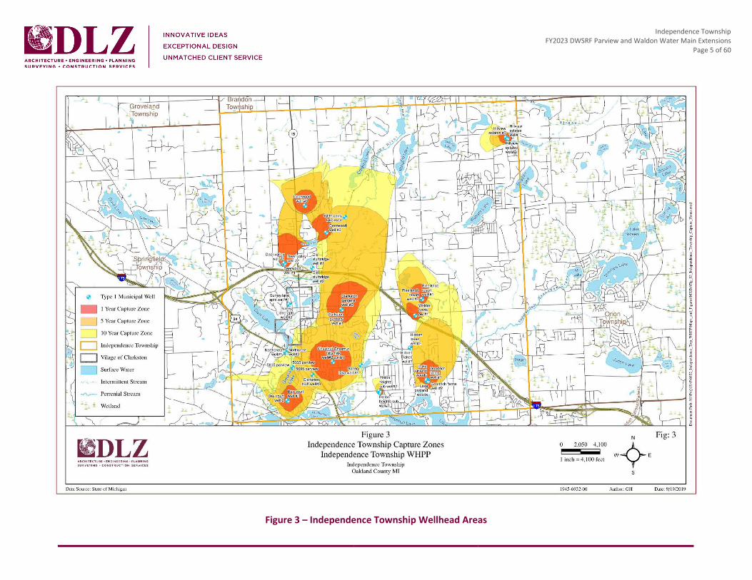
The Township has eleven approved municipal wellhead delineation areas that have been determined and are shown in Figure 3. Public education is on-going and has included brochures sent to water customers explaining the importance of protecting drinking water sources and water conservation. Road signage has also been placed in the Township designating the wellhead protection areas. A summary of the Wellhead Protection Plan that can be found on the Township’s website has been included in Appendix III.
The Waldon Drive project area is located in the Clarkston Gardens Wellhouse capture zone where per- and polyfluoroalkyl substances (PFAS) were first detected in 2018. Continued testing indicates PFAS levels continue to increase over time. At the first PFAS detection, the Clarkston Gardens Wellhouse was taken offline and remains offline to date. Figure 4, on page 6, shows the current locations of public and private wells in the Clarkston Gardens well area.
The Parview Drive project area overlaps the Bay Court Wellhouse capture zone. Currently, no PFAS have been detected at the Bay Court Wellhouse. Figure 5, on page 7, shows the current locations of public and private wells in the Bay Court well area.
In 1998, Independence Township began formulating a Master Groundwater Protection Program, which later helped shape the Wellhead Protection Program (WHPP) in 2011. The WHPP developed a Protection Plan, which was last updated in October 2019, for the Township in the event of a hazardous spill or contamination of the drinking water supply by providing emergency contact information, plans to isolate the distribution system, treatment measures, and public notification.
Independence Township FY2023 DWSRF Parview and Waldon Water Main Extensions
Page 5 of 60
Figure 3 – Independence Township Wellhead Areas

Independence Township FY2023 DWSRF Parview and Waldon Water Main Extensions
Page 6 of 60
Figure 4 – Clarkston Gardens Wellfield

Independence Township FY2023 DWSRF Parview and Waldon Water Main Extensions
Page 7 of 60
. Figure 5 – Bay Court Wellfield

Independence Township FY2023 DWSRF Parview and Waldon Water Main Extensions
Page 8 of 60
1.2 INDEPENDENCE TOWNSHIP LAND USE/ZONING The Township’s Land Use, according to SEMCOG’s 2020 Land Use/Land Cover analysis shown in Table 1, indicates approximately half of the Township’s total land use is for single-, multi-, and rural-residential areas. Single-family residential is 27.8% of the total land use and agricultural/rural-residential, which includes any residential parcel containing one or more homes where the parcel is 3 acres or larger represents another 24.6%. With over half of the Township’s land use designed as dwellings, a municipal water system will remain vitally important.
The Township has been and will continue to be primarily a residential community. The predominant commercial corridors are located along Dixie Highway, M-15, and the Sashabaw Corridor. According to the Independence Township Opportunities 2030 Master Plan, the Township aims to restrict strip commercial development to the following specific areas: White Lake Road Area, M-15 and Northwest Area, Dixie Highway Corridor, and Sashabaw Corridor. While the Land Use Plan places emphasis on providing new areas for office and research-office development, less emphasis has been placed on industrial land use. This is due to the changing market conditions and the growth of the Township as primarily a residential service community.
The Township’s Zoning Map is presented in Figure 6 on page 10. The land use within the study areas is not anticipated to change over the 20-year planning period, as there is limited available undeveloped land area within the service areas and these areas are primarily residential.

Independence Township FY2023 DWSRF Parview and Waldon Water Main Extensions
Page 9 of 60
Table 1 – Independence Township SEMCOG Land Use/Land Cover - 2020
Land Use Acres Percent
Single-Family Residential 6,447.3 27.8 %
Attached Condo Housing 193.7 0.8 %
Multi-Family Housing 253.2 1.1 %
Mobile Home 142.4 0.6 %
Agricultural/Rural Residential 5,717.1 24.6 %
Mixed Use 4.5 0.0 %
Retail 171.2 0.7 %
Office 123.5 0.5 %
Hospitality 35.8 0.2 %
Medical 109.3 0.5 %
Institutional 630.0 2.7 %
Industrial 100.7 0.4 %
Recreational/Open Space 1,762.9 7.6 %
Cemetery 118.0 0.5 %
Golf Course 656.4 2.8 %
Parking 37.8 0.2 %
Extractive 17.1 0.1 %
Transportation/Communication/Utility (TCU) 282.1 1.2 %
Vacant 3,126.5 13.5 %
Water 1,036.0 4.5 %
Not Parceled 2,242.6 9.7 %
Total 23,208.1 100.0 %

Independence Township FY2023 DWSRF Parview and Waldon Water Main Extensions
Page 10 of 60
Figure 6 – Land Use/Zoning Map

Independence Township FY2023 DWSRF Parview and Waldon Water Main Extensions
Page 11 of 60
1.3 POPULATION DATA The Township has a population of 36,686 as of the 2020 U.S. Census and is not expected to experience a rapid growth in population in the coming few decades. The total population of the Township has increased by approximately 2,000 in the last ten years and is expected to increase another 3,000 by 2045. Refer to Figure 7 for existing and forecasted population trends. A copy of the Independence Township SEMCOG Community Profile can be found in Appendix IV. The population projections for the Township’s Parview and Waldon study areas is presented in Table 2 below.
Figure 7 – Independence Township SEMCOG Community Profile: Population Forecast
Table 2 – Population Projection for Independence Township Study Areas
Area Description Existing
Population (2020)
Projected Population
2025
Projected Population
2030
Projected Population
2040
Projected Population
2045 Independence Township 36,686 37,608 38,298 39,782 39,922
Parview Study Area 582 596 607 617 620 Waldon Study Area 195 200 203 208 210

Independence Township FY2023 DWSRF Parview and Waldon Water Main Extensions
Page 12 of 60
1.4 WATER DEMAND On average, 3,000,000 gallons of treated water is pumped from Township wellhouses into the water distribution system. Throughout the Township, thirteen educational and six medical facilities rely on the wellhouses to be fully operational. Table 3 identifies the amount of water provided to Township customers in 2019, 2020, and 2021. However, over 14,000 residents and businesses still rely on private water wells for their potable water source.
Table 3 – Total Water Sold
Year Total Water Sold (CCF) Total Water Sold (gal)
2019 1,034,067 773,482,116
2020 1,203,353 900,108,044
2021 1,069,961 800,330,828
Prior to being shut down, the Clarkston Gardens well had the capacity to provide approximately 1.4 MG of water per day to the Township residents and businesses. As a result, the Township’s overall capacity of treated potable water has decreased by 1.4 MG.
1.5 EXISTING FACILITIES The Township manages three municipal water treatment and distribution systems and supplies water to both the Township and the Village of Clarkston. The Township Water System (WSSN 03342), also known locally as the Main Loop System, is the largest in the Township and serves a population of 11,790 via groundwater wells. The Deerwood Subdivision Water System (WSSN 01773) serves a population of 1,824 via a groundwater well. The Hillview Estates Subdivision Water System (WSSN 03175) serves a population of 354 via a groundwater well. The Township owns and operates the following water distribution system assets:
• 3 water storage tanks (2.0 MG storage total) • 4 booster pumping stations • 6 Pressure Reducing Valves (PRVs) • 4 emergency connections to Waterford and Orion Townships • 10 well houses • 137 miles of water main • 1,437 hydrants • A Supervisory Control and Data Acquisition (SCADA) system
The Township’s water system infrastructure is fairly new. Two of the Township’s water storage tanks were built in the early 1990s and a third one is a little over 10 years old. In 1950, the Township started building two

Independence Township FY2023 DWSRF Parview and Waldon Water Main Extensions
Page 13 of 60
treatment plants; twenty years later, two more were added to the water system infrastructure. Between 1980 and 2005, the Township invested in six additional well houses. Sixty-five percent of the Township fire hydrants were installed prior to 1990. Because of the water system’s relatively young age, the Township has only experienced six water main breaks since 2013. All of these water main breaks were associated with asbestos cement water main. The investment, by the Township, of six PRVs has assisted in creating strategic pressure zones. Refer to Figure 8, on the following page, for a map of the Township’s drinking water system.
Although the Township operates their own municipal water source and distribution, over 14,000 customers in the Township still rely on private individual water wells as their potable water source.

Independence Township FY2023 DWSRF Parview and Waldon Water Main Extensions
Page 14 of 60
Figure 8 – Overall Water Distribution System

Independence Township FY2023 DWSRF Parview and Waldon Water Main Extensions
Page 15 of 60
1.5.1 SOURCE FACILITIES The Township is served by a well water supply system, which contains sixteen operational production wells located in ten well fields. The water supply system operates as three water service areas: Main Loop System, Deerwood System, and Hillview System, which are described in Table 4.
Table 4 – Wellfield Information
Service Area Well Name Flow (gpm) Original
Construction Year
Notes
Main Loop WSSN 3342
Bay Court 1 1,114 2004 Last overhaul in 2019
Bay Court 2 Not Available 2004 Last overhaul in 2012
Chestnut Hills 1 299 1979 Last overhaul in 2013
Chestnut Hills 2 998 1979 Last overhaul in 2019
Clarkston Gardens 2 397 1955 Taken offline in 2018
Lake Oakland Woods 2 432 1975 Last overhaul in 2012
Lake Oakland Woods 3 1,997 2005 Last overhaul data not available
Pelton Heights 2 Not Available 1956 Last overhaul in 2012
Waldon Creek 1 1,061 2005 Last overhaul in 2018
Deerwood WSSN 1773
Deer Valley 1 1,026 1990 Last overhaul in 2018
Deer Valley 2 616 1990 Last overhaul in 2017
Deerwood 2 738 1974 Last overhaul in 2013
Deerwood Manor 3 1,190 1988 Last overhaul in 2019
Hillview WSSN 3175
Hillview 1 172 1970 Last overhaul in 2019
Hillview 2 547 1970 Last overhaul in 2014
Hillview 3 253 2005 Last overhaul in 2014
The Main Loop system is the primary water supply for the southern half of Independence Township, in Sections 19 through 36. This portion of the system houses six wellfields and all three of the storage tanks. The topography of this system is varying so the Main Loop is divided into one main pressure district and three smaller pressure districts. The Pine Knob wellfield area is within the Main Loop but is currently supplied by the Waldon Creek well field. The booster system at Waldon Creek supplies the customers in this area.

Independence Township FY2023 DWSRF Parview and Waldon Water Main Extensions
Page 16 of 60
The Deerwood system serves the Township customers in Sections 8, 9, 16, and 17. The northwest quarter of the Township is divided into two separate pressure districts: Deerwood and Deer Valley. The current system adequately supplies the customers in this area with no additional storage provided.
The Hillview system provides Section 1, northeast quarter of Township, customers water supply from a single wellfield with no additional storage. This service area relies completely on its own water supply and is independent of the rest of the Township systems.
1.5.2 WATER TREATMENT AND RESIDUAL DISPOSAL The Township performs water treatment at their sixteen production wells. Throughout the distribution system, there are three Ferazur Iron Bacteria Filtration systems and four Tonka Filter Media systems. There are also three pumphouses throughout the overall distribution system with no filtration. The treatment system locations have been identified in Table 5. Within the Main Loop System (WSSN 3342), where both proposed project areas are located, there are three Ferazur treatment systems, one Tonka media system, and two non-filtered pumphouses. The water treatment provides iron and arsenic removal along with disinfection treatment for customers. Residuals after treatment are disposed of via the Township sanitary sewer system.
Table 5 – Treatment Information
Service Area Well Name Treatment System
Main Loop WSSN 3342
Bay Court Ferazur
Chestnut Hills No Treatment
Clarkston Gardens No Treatment1
Lake Oakland Woods Tonka
Pelton Heights Ferazur
Waldon Creek Ferazur
Deerwood WSSN 1773
Deer Valley Tonka
Deerwood Tonka
Deerwood Manor Tonka Hillview
WSSN 3175 Hillview No Treatment
Note 1: Taken offline in 2018

Independence Township FY2023 DWSRF Parview and Waldon Water Main Extensions
Page 17 of 60
1.5.3 WATER STORAGE There are three water storage tanks within the Township that, combined, provide 2.0 MG of water storage. The water storage tanks are located within the Main Loop System in the southern half of the Township. The capacity and location of the tanks are outlined in Table 6. The Deerwood and Hillview systems do not have water storage.
Table 6 – Independence Township Water Storage
Service Area Storage Capacity Storage Type Location
Main Loop System WSSN 3342
500,000 Gallon Elevated Dixie Highway
500,000 Gallon Ground DPW Site
1,000,000 Gallon Elevated Sashabaw Road
1.5.4 SERVICE LINES In 2019, the MDEQ, now EGLE, performed a preliminary Distribution System Materials Inventory (DSMI) review on the Township water service connections. A population of 15,165 with 6,066 service connections were surveyed. Of the 6,066 service connections surveyed, no traces of lead or galvanized connections to lead were found in the system. A copy of this report can be found in Appendix V.
1.5.5 DISTRIBUTION SYSTEM There are approximately 137 miles of water main throughout the Township, ranging in size from 6 inches to 16 inches in diameter. Material types include PVC, cast iron, ductile iron, high density polyethylene (HDPE), and pre-stressed concrete. Water main age varies from 100 years to 1 year old with almost 74% of the water main installed between 1990 and 2010. Currently, ductile iron water main is the most prominent material found in the system comprising of 78.9% of the total pipes. Asbestos cement was the second most common type of water main at 11.6%. The remaining 9.5% of water main are cast iron, concrete, HDPE, PVC, steel, or unknown material. See Figure 9 below for the breakdown of water main installed by year. The Township system also includes 1,437 hydrants, 1,260 control and system valves, 6 pressure reducing valves (PRVs), and 4 emergency cross-connections. Table 7 identifies the overall systems inventory by water main size and material.

Independence Township FY2023 DWSRF Parview and Waldon Water Main Extensions
Page 18 of 60
Figure 9 – Water Main Age

Independence Township FY2023 DWSRF Parview and Waldon Water Main Extensions
Page 19 of 60
Table 7 – Water Main Inventory
Pipe Material Length (feet)
Diameter (inches)
Asbestos Cement
Cast Iron Concrete Ductile
Iron HDPE PVC Steel Unknown Total (ft) % of Total
0.75 0 0 0 33 0 0 0 0 33 <0.01%
2 0 0 0 18 0 201 0 287 506 0.08%
3 0 0 0 0 0 13 0 0 13 <0.01%
4 0 0 0 3,779 0 0 0 103 3,882 0.58%
6 16,896 56 0 13,602 60 0 0 1,139 31,752 4.75%
8 66,399 388 534.3 297,787 929 1,522 19 13,114 380,693 56.97%
10 0 0 0 56 0 0 23 0 79 0.01%
12 12,155 382 708.4 187,747 4,593 1,785 112 10,640 218,122 32.64%
14 0 0 0 0 0 0 0 0 0 0.00%
16 0 0 0 18,303 823 0 0 1,449 20,575 3.08%
20 0 0 0 132 0 0 0 8 140 0.02%
Unknown 1,807 0 0 4,087 0 450 0 6,136 12,480 1.87%
Total 97,257 826 1,243 525,544 6,405 3,971 154 32,876 668,275 100.00%
% of Total 14.55% 0.12% 0.19% 78.64% 0.96% 0.59% 0.02% 4.92% 100.00% -
Only six water main breaks have occurred within the Township since 2013. During 2016 and 2017, there were no recorded breaks. The Township follows required maintenance requirements and best management practices, which has a positive impact on low water main break numbers. Any water main repairs are addressed immediately to avoid destruction of system components. Of the 1,437 township hydrants, none are out of service.
1.5.6 WATER METERS Independence Township currently monitors 6,236 water meters ranging from less than 1 year old to 20 years old. Meters sizes range from ¾” to 8”. Record keeping of meter installation dates were not included until recently as part of Township inspections. However, a condition assessment of all Township meters has deemed the equipment is in fair to good condition.
1.5.7 DISTRIBUTION SYSTEM OPERATION AND MAINTENANCE Standard water system maintenance is the typical practice for Independence Township. Their proactive response to complaints, breaks, and leaks is what continues to provide overall longevity and quality water

Independence Township FY2023 DWSRF Parview and Waldon Water Main Extensions
Page 20 of 60
supply throughout the system. The Township completes annual hydrant inspection and dead-end main flushing. They also have a valve maintenance program, implement continuous SCADA upgrades, and complete system flushing every two years.
1.5.8 DESIGN CAPACITY The Township updated their hydraulic model in 2020 using Innovyze’s InfoWater hydraulic modeling software. Resultant pressures and flows were predicted for the current and future demand of the system. General data such as water main diameters, length, age, material, coordinates, and connections were input into the model resulting in a detailed hydraulic water model, which was also subsequently calibrated using fire hydrant flows throughout the water system. This model is used for testing scenarios to assist the Township in optimizing the water system.
On an average day in 2021, the Township produced approximately 2.3 MG of water. The system has an approximate pump capacity of 16 MGD with a firm capacity of approximately 12.4 MGD. The firm capacity is the pumping capacity of the Township’s system when the largest well and pump in each of the service areas is out of service. See Table 8 below for the water produced in 2021 as well as 20-year future predictions of use. The future system predictions were based on the existing 2021 use plus a 30% growth. The Hillview service area is fully developed therefore the existing and future demands is assumed to remain the same. The pump capacity for each pump in the well fields for the Main Loop, Deerwood, and Hillview service areas can be found in Table 9 on page 21.
Table 8 – Water Produced in 2021
Average
Day (MGD)
Peak Month (MG)
Average Day in a Peak Month
(MGD)
Current Pump Capacity (MGD)
Current Firm Capacity (MGD)
Main Loop Service Area
Existing 2.03 100.71 3.36 10.07 8.49
Future (20 year) 2.64 130.92 4.37
Deerwood Service Area
Existing 0.24 13.85 0.46 4.61 3.17
Future (20 year) 0.31 18.01 0.60
Hillview Service Area
Existing/Future (20 year)1 0.03 1.59 0.05 1.37 0.72
Note 1: The Hillview service area is fully developed so the existing and future demands is proposed to remain the same.

Independence Township FY2023 DWSRF Parview and Waldon Water Main Extensions
Page 21 of 60
Table 9 – Wellfield Pump Capacities
Service Area Wellfield Name No. of Wells
Well Size
(inch)
Permit Capacity
(gpm)
Permit Capacity (MGD)
Current Pump Capacity (MGD)
Main Loop WSSN 3342
Chestnut Hills 2 8 500 0.72 0.431
12 1,250 1.80 1.58
Lake Oakland Woods 2
12 1,403 2.02 1.442
12 1,900 2.74 1.442
Pelton Heights 1 12 597 0.86 0.72
Bay Court 2 12 1,001 1.44 1.44
16 2,000 2.88 1.583
Waldon Creek 1 12 1,000 1.44 1.44 Clarkston Gardens 1 12 1,000 1.44 0.004
Deerwood WSSN 1773
Deerwood 1 12 694 1.00 0.72 Deerwood
Manor 1 12 955 1.38 1.01
Deer Valley 2 12 1,000 1.44 1.44
12 1,000 1.44 1.44
Hillview WSSN 3175 Hillview 3
6 201 0.29 0.29
12 450 0.65 0.65
12 300 0.43 0.43 Note 1: Chestnut Hills #1 was repaired in April 2009 and a submersible pump was installed; the current capacity is 300 gpm. Note 2: Lake Oakland Woods is limited to a pump capacity of 1,000 gpm due to the inlet filter capacity. Note 3: Bay Court can only operate at a maximum 1.58 MGD capacity due to water system hydraulic conveyance limitations. Note 4: The Clarkston Gardens well is not in service.
1.5.9 EMERGENCY CONNECTIONS TO ADJACENT WATER SYSTEMS The Township has four emergency connections to adjacent water systems, summarized in Table 10. A 12-inch connection to Orion Township is located at Klais Drive and Hawksmoore Drive. There are three 12-inch connections to Waterford Township, located at White Lake Road and Andersonville Road, Andersonville Road and Windiate Road, and Clintonville Road and Mann Road.

Independence Township FY2023 DWSRF Parview and Waldon Water Main Extensions
Page 22 of 60
These emergency connections are only to be accessed in the case of an emergency and both parties must be present at the time an interconnection is activated. All connections are normally closed valves, and no meters are installed at any of the locations to monitor the quantity of water supplied through the emergency connections. Water across valves would only maintain flow and pressure in the immediate area/location of the connection. Water could not be supplied to the entire Township.
Table 10 – Emergency Interconnections
Community Size Location
Orion Township 12 inch Klais Drive and Hawksmoore Drive
Waterford Township 12 inch White Lake Road and Andersonville Road
Waterford Township 12 inch Andersonville Road and Windiate Road
Waterford Township 12 inch Clintonville Road and Mann Road
1.5.10 CLIMATE RESILIENCY One of the largest climate threats to the Township’s water system would be the increased frequency of severe storms that may cause power outages. In the case of electricity interruption, the Township has generators capable of providing their entire electrical needs at Town Hall, the DPW Complex, Fire Stations, and the water treatment facilities. No interruption of work or supply would be expected. In addition, there are four emergency connections to Orion and Waterford Townships, as described above.
Because the Township’s water is supplied from several well sites throughout the Township, a power outage would most likely not affect all water treatment facilities at the same time unless it is a large-scale regional power loss that affects all pumping and/or treatment facilities.
1.6 SUMMARY OF PROJECT NEED 1.6.1 WALDON WATER MAIN EXTENSION In 2018, as part of the Michigan PFAS Action Response Team’s efforts to investigate sources and locations of PFAS contamination in the State of Michigan, EGLE tested all sixteen wells within the Township water system. Test results from the Clarkston Gardens wellhouse confirmed the presence of PFAS analytes at 10 parts per trillion (PPT), below the then non-regulatory Lifetime Health Advisory Level of 70 PPT. Upon detection of PFAS compounds in this well, the Township proactively shut this wellhead down, and it remains so to this day.
When in service, the Clarkston Gardens facility had the capacity to treat and pump approximately 1.4 MG of water to residents and businesses daily. In addition, due to the PFAS detection, the Township began quarterly testing all water system well sites for PFAS contaminants as part of a routine water quality monitoring process.

Independence Township FY2023 DWSRF Parview and Waldon Water Main Extensions
Page 23 of 60
Results from the Clarkston Gardens PFAS well testing can be found in Table 11 which shows that two compounds, PFHxS and PFOA levels have become greater than 50% of the regulated MCL.
Table 11 – Clarkston Gardens PFAS Well Testing Results
Analyte Name
Jun 4, 2018 (ng/L)
Apr 1, 2019 (ng/L)
Oct 20, 2020 (ng/L)
Feb 24, 2021 (ng/L)
Jun 18, 2021 (ng/L)
Regulated Maximum
Contaminant Level (MCL)
PFBS 4 5 5 4.4 5 420 ng/L
PFHxA ND 2 4 4.7 4 400,000 ng/L
PFHxS 6 16 30 36 35 51 ng/L
PFOA ND ND 5 4.1 3 8 ng/L
PFOS ND 2 6 ND ND 16 ng/L
PFOA+PFOS ND 2 11 4.1 3 70 ng/L (non-regulatory)
TOTAL PFAS 10 25 50 49.2 47
Since October 2020, test results from the Clarkston Gardens well indicated that PFAS concentrations have increased with analytes at 50 PPT. Continued testing data indicates that PFAs compound results have been trending upward since 2018 when testing began. Figure 10 identifies the PFAS trends from 2018 to 2021.
As part of a contaminant source inventory in 2019, twelve sites of environmental concern were identified within the 1-year, 5-year, and 10-year capture zones of the Clarkston Gardens municipal wellfield. Of the identified sites, no information was found suggesting the possible storage, use, or generation of PFAS chemicals within the capture zones of the Clarkston Gardens wellfield except the Clarkston Road Landfill where historical hazardous substance disposal may have occurred. The Clarkston Road Landfill is a 25-acre landfill that was operated from the 1940s until 1978. The waste stream is generally unknown, but it is thought that typical municipal waste was disposed at the landfill. Information on file with EGLE indicates that the landfill was not properly closed when it ceased operations in 1978. In 1989, thirty-six residential wells in the vicinity of the landfill were identified with elevated concentrations of ammonia (NH3) and/or trace amounts of freon and all local residences were connected at that time to municipal water supply. Subsequent environmental investigations of the landfill identified arsenic and cadmium as the primary contaminants of concern in groundwater. PFAS was not included in analyses completed in the 1990s and 2000s at the landfill. Because of apparent minimal environmental impacts, the twelve existing monitoring wells were abandoned in 2008 and no additional environmental investigations have been conducted since 2008.

Independence Township FY2023 DWSRF Parview and Waldon Water Main Extensions
Page 24 of 60
Figure 10 – Clarkston Gardens PFAS Concentrations
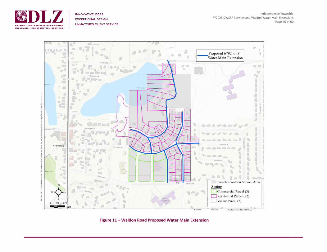
The Waldon Water Main Extension project is in the Clarkston Gardens PFAS capture zone area, which is the entire area of an aquifer that contributes groundwater to a pumping well. The Waldon Water Main Extension project will provide Township residents, whose private wells may be affected by PFAS, the opportunity to connect to the Township water system that would provide PFAS-free treated water from the Township water system. Figure 11 on the following page shows the proposed water main extension for Waldon Road.
0
10
20
30
40
50
60
70
Conc
entr
atio
n (n
g/L)
Date Collected
Clarkston Gardens - PFAS/PFOS Concentration Over Time
PFBS
PFHxA
PFHxS
PFOA
PFOS
PFOA+PFOS
Total PFAS
Independence Township FY2023 DWSRF Parview and Waldon Water Main Extensions
Page 25 of 60
Figure 11 – Waldon Road Proposed Water Main Extension
Independence Township FY2023 DWSRF Parview and Waldon Water Main Extensions
Page 26 of 60
1.6.2 PARVIEW EXTENSION The detection of PFAS at the Clarkston Gardens well has also had other water system affects in the Township. By taking the Clarkston Gardens well offline in 2018, the Township lost 1.4 MG of potential water production a day. While other wellhouses and pumps have the firm capacity to cover this loss, the existing distribution system configuration does not have the capacity to convey the flow resulting from all remaining facilities running at the same time. This is especially true with the Bay Court facility, which has a firm capacity of 4.32 MG per day. However due to water system hydraulic conveyance limitations, the facility can only operate at a maximum of 1.58 MG per day, which is 2.74 MG per day lower than its maximum firm capacity. This limitation has further reduced the Township’s overall firm capacity and exacerbates the loss of Clarkston Gardens 1.4 MG per day of capacity.
With the extension of proposed water main on Parview, including a direct connection to the Bay Court facility, the Township would be able to operate the Bay Court facility at or near the maximum firm capacity of 4.32 MG per day. This dramatically mitigates the adverse impact of the Clarkston Gardens facility being offline. The proposed Parview water main extension was developed through the Township’s updated detailed and calibrated hydraulic water model.
Additionally, the intersection of Andersonville and Parview is within 1,500 feet of an existing interconnection with Waterford Township at Andersonville and Windiate Roads. As a result, the proposed water main extension on Parview Road will help both communities in the event of an emergency and the opening of this interconnection. Figure 12 outlines the proposed water main extension for Parview Road.
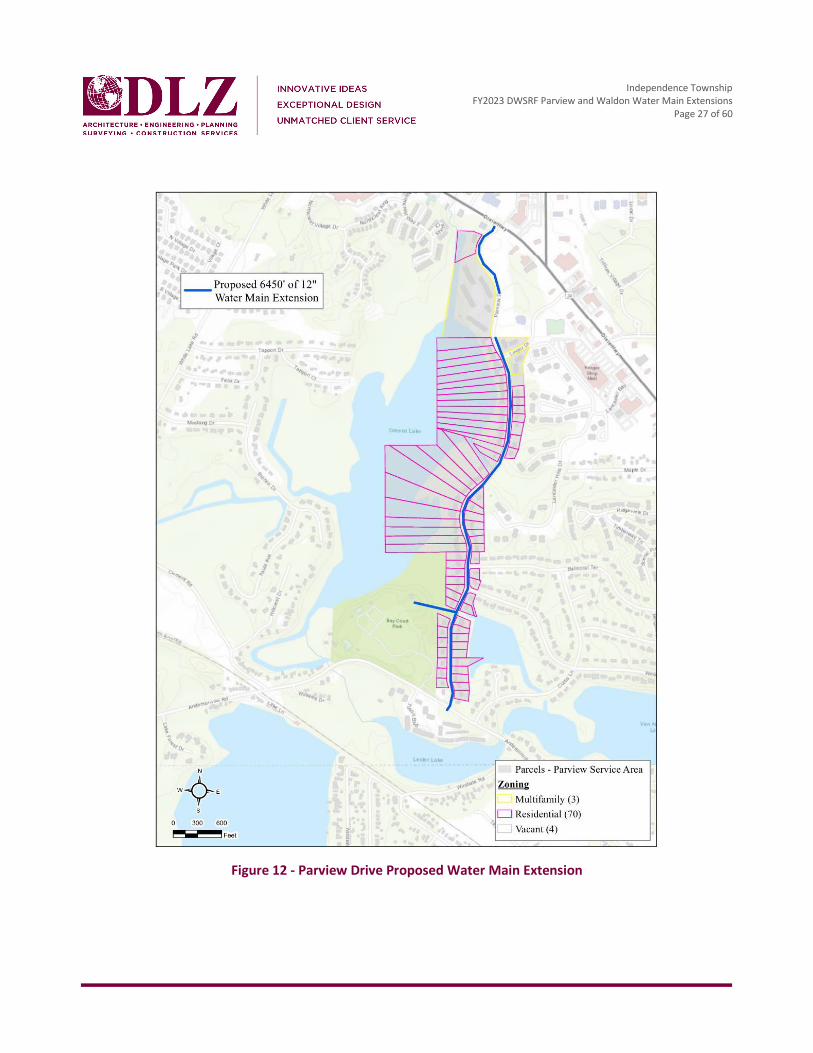
Independence Township FY2023 DWSRF Parview and Waldon Water Main Extensions
Page 27 of 60
Figure 12 - Parview Drive Proposed Water Main Extension

Independence Township FY2023 DWSRF Parview and Waldon Water Main Extensions
Page 28 of 60
1.6.3 ORDERS OR ENFORCEMENT ACTIONS / DRINKING WATER QUALITY PROBLEMS The Township currently has no Orders of Enforcement Actions against it.
As detailed in Section 1.6 above, the Township’s Clarkston Gardens wellhead had PFAS detected in 2018. While test results were well below the health advisory level, the Township immediately took the well offline.
In 2018, the Township had one water sample of 34 testing sites in the Main Loop system that tested above the Action Level for lead. The Township returned to the same site and completed a brief investigation which included taking a resample, and that result came back Non-Detect. Potential sources of the detected lead are lead service lines, corrosion of household plumbing, and/or erosion of natural deposits. The Township followed recommended protocol and does not believe there is an ongoing problem at this site. The Township’s 2020 Water Quality / Customer Confidence Report can be found in Appendix VI.
1.6.4 PROJECTED NEEDS FOR THE NEXT 20 YEARS In addition to the Clarkston Gardens wellhead, the Chestnut Hills wellhead is now seeing detections of PFAS for the first time. The wellhead tested positive for PFBS, at 2 PPT, in October 2020. The Chestnut Hills Wellhouse provides 1.2 MG per day of water to Township residents and businesses. At this time, it is speculated that these results are due to the geographic location and proximity to the Clarkston Gardens wellhead since it is closest to the Clarkston Gardens wellhead and in a general downgradient direction. Due to this detection, the Township will likely need to explore alternatives in the near future to provide water to residents in the Chestnut Hills area in the event that the wellhead also needs to be removed from service. The Township’s Water Asset Management Plan, updated in 2020, and most recent Reliability Study (2016) also identified the following general capital improvements, suggested for the Township in the next twenty years:
• Improve pressure/flow to Pine Knob (Township currently addressing) • Ongoing and continued upgrades to mechanical and electrical systems at well houses, booster stations,
pressure reducing valves, storage facilities, and emergency connections (Township currently addressing)
• Explore connecting the Deerwood/Main Loop water systems • On site generator at Oakhurst Booster Station and Water Storage Tanks • Replace older/undersized water mains • Complete looping of water mains where available

Independence Township FY2023 DWSRF Parview and Waldon Water Main Extensions
Page 29 of 60
2.0 ANALYSIS OF ALTERNATIVES 2.1 ALTERNATIVE 1 – “NO-ACTION” The no-action alternative represents a "do-nothing" scenario where the proposed water main extension along Waldon Road and Parview Drive are not installed, and the existing infrastructure is left as is. In this scenario, the residents within the Waldon area would continue to use water from their private wells and could possibly be exposed to PFAS/PFOS, if not already. Without the installation of the Parview water main, the Township will not be able to fully utilize the Bay Court facility capacity leading to further firm capacity and decreased water system reliability. Especially in max and peak day demand and drought type scenarios.
The No-action alternative will not be considered based on the need for increased water quality, public health concerns, and increased reliability for the Township's residents.
2.2 ALTERNATIVE 2 – “OPTIMUM PERFORMANCE OF EXISTING FACILITIES” Independence Township is currently operating the water system at optimum performance given the presence of PFAS at Clarkston Gardens and the water system distribution limitations at the Bay Court facility. The Township shut down the wellhouse in 2018 and has implemented quarterly PFAS testing of all well sites within the Township as part of their routine water quality testing process. However, due to taking the Clarkston Gardens facility offline, the Township's available capacity of potable water has decreased by 1.4 MG per day. Though the other well houses have the firm capacity to recover the 1.4 MG per day loss, the limitation of the Bay Court facility being able to provide its full firm capacity seriously impedes further efforts to optimize water system performance. As a result, this alternative will not be considered. Additionally, even if the Township were able to operate the water system at optimum performance, it would not solve the potential/existing PFAS issues for residents that rely on private wells within the Clarkston Gardens Capture Zone and the proposed Waldon water main extension area.
2.3 ALTERNATIVE 3 – “REGIONAL ALTERNATIVES” Regional alternatives involve the feasibility of connecting the existing system to that of a different source, be it another township or regional water authority. In the 2007 Oakland County Water and Wastewater Master Plan prepared for the Oakland County Drain Commissioner, a possible connection for Independence Township to the Great Lakes Water Authority (GLWA) system was discussed. The proposed pipeline would consist of approximately 19 miles of 72-inch to 84-inch water main and is designed to handle the Township’s projected 2035 Maximum Day Demand of 7.8 MGD. The connection to GLWA would alleviate concerns with PFAS within the Township’s system as they would receive treated water from GLWA. However, this is an extremely expensive option when compared to other alternatives. This regional alternative was projected to cost $41.2 million dollars in 2005; adjusted to 2022 dollars, this project would cost $61 million dollars. Additionally, given the current demands for materials and the rise in material costs, the proposed connection to GLWA would likely experience an even greater price increase. This is not a feasible or cost-effective option for the Township and will not be pursued.

Independence Township FY2023 DWSRF Parview and Waldon Water Main Extensions
Page 30 of 60
2.4 ALTERNATIVE 4 – “EXTENSION OF EXISTING INFRASTRUCTURE” Alternative 4 includes the proposed water main extension on both Waldon Road and Parview Drive. Due to concerns with PFAS from the Clarkston Gardens wellhouse and possible contamination of private wells, the Township is proposing to extend water main north into the residential area from Waldon Road to Clarkston Road. This extension will provide high quality water from the Township’s water system and serve as a loop between Waldon Road and Clarkston Road to provide more redundancy and reliability within the Township’s water distribution system.
A water main extension on Parview Drive between Andersonville Road and Dixie Highway with a connection to the Bay Court well house provides increased capacity and reliability in the water distribution system. Due to the shutdown of the Clarkston Gardens well house, the Township has lost 1.4 MG per day of capacity, which is exacerbated by the limited distribution capability at the Bay Court facility to provide its full maximum capacity of 4.32 MG per day. The proposed water main extension on Parview Drive would add conveyance capacity for the Bay Court facility and help mitigate the capacity loss from taking the Clarkston Gardens site offline. Extensive hydraulic modeling has shown that the extension of this water main would help the water system to operate close to full firm capacity.
The extension of the existing infrastructure on both Parview Drive and Waldon Road has been chosen as the selected alternative for the reasons outlined in the project plan.

Independence Township FY2023 DWSRF Parview and Waldon Water Main Extensions
Page 31 of 60
3.0 PRINCIPAL ALTERNATIVE 3.1 ENVIRONMENTAL EVALUATION 3.1.1 CULTURAL RESOURCES According to the Michigan Department of Natural Resources Michigan Historical Markers website, there are two Historical Markers located within the Township: the Sashabaw Cemetery and the Sashabaw United Presbyterian Church. These two Historical Markers, however, are not within the project areas and will not be influenced by any of the proposed work.
3.2 THE NATURAL ENVIRONMENT 3.2.1 CLIMATE Using standard construction practices, no unusual complications are expected for the project due to adverse climate/weather conditions.
3.2.2 AIR QUALITY During construction, heavy machinery has the potential to produce airborne dust. Procedures to minimize the dust are discussed in the Mitigation section of this Project Plan.
3.2.3 WETLANDS Wetlands are defined by Michigan’s wetland statute, Part 303, Wetlands Protection, of the Natural Resources and Environmental Protection Act (NREPA), 1994 PA 451, as amended. EGLE has integrated National Wetlands Inventory (NWI) mapping and hydric soil mapping into a Wetlands Map Viewer, which was queried to identify potential wetlands within the project area.
3.2.4 COASTAL ZONES There are no coastal zones within the influence of the project.
3.2.5 FLOODPLAINS Based on the visual observation and proposed construction methods, the selected alternative will have no impact on floodplains. Necessary permits will be obtained for any work that may occur in a floodplain. FEMA FIRM Flood Maps of the project locations will be available in Appendix VII.
3.2.6 NATURAL, WILD OR SCENIC RIVERS There are no natural, wild, or scenic rivers within Independence Township, according to the National Wild and Scenic Rivers System.
3.2.7 MAJOR SURFACE WATERS The Township is located within the Upper Clinton sub-watershed which is part of the Clinton River Watershed (HUC 04090003). The selected alternative is not anticipated to cause direct impacts on surface waters within the project areas.

Independence Township FY2023 DWSRF Parview and Waldon Water Main Extensions
Page 32 of 60
3.2.8 AGRICULTRUAL RESOURCES No prime or unique agricultural areas are located within or adjacent to the project areas.
3.2.9 EXISTING PLANT/ANIMAL COMMUNITIES AND ENVIRONMENTALLY SENSITIVE HABITATS According to the U.S. Fish and Wildlife Service’s Information for Planning and Consultation (IPaC) website, there are several species that are listed as Threatened and Endangered. Endangered species include: the Indiana Bat, the Rayed Bean, Snuffbox Mussel, and the Poweshiek Skipperling. Threatened species include the Northern Long-eared Bat and the Eastern Massasauga Rattlesnake. It is stated on the IPaC site, that there are no critical habitats at the selected project areas.
3.2.10 TOPOGRAPHY Any disturbance to the ground during repair work will be temporary and will not result in permanent topographic alteration. Restoration requirements will be included in future contract documents.
3.2.11 GEOLOGY Geological resources are not expected to be impacted by the proposed project.
3.2.12 SOILS Soils will not be heavily impacted as water main installation will be done primarily via horizontal directional drilling methods which is less invasive when compared to open cut excavation. However, excavations will still be required for a portion of the water main
3.3 MITIGATION Permits necessary for the scope of the project will be applied for and obtained prior to construction. Mitigation during the replacement and improvement procedures are the responsibility of the contractor. Examples of mitigation procedures which may be taken include airborne dust control measures and construction noise control measures. The contractor shall follow all construction standards and work to minimize all potential environmental impacts which may occur during construction.
3.4 TECHNICAL CONSIDERATIONS All proposed installation of the water main will follow applicable standards and an EGLE Permit for Water Supply Systems Act 399 will be obtained for all construction activities.
3.5 RESIDUALS The Township has been experiencing development and redevelopment in recent years and will continue to experience redevelopment. However, as mentioned previously, these changes in development are not anticipated to occur in the study areas and therefore will not affect future demand within the existing service areas.
3.6 CONTAMINATION As previously mentioned, the current project area for the Waldon water main extension falls within the five (5) year capture zone around the Clarkston Gardens well, which has shown elevated levels of PFAS/PFOS. The

Independence Township FY2023 DWSRF Parview and Waldon Water Main Extensions
Page 33 of 60
suspected source of contamination, the old Clarkston Road Landfill site, is only around half a mile away from the project site. The proposed Waldon water main extension will alleviate current residents in the zone of influence from possible PFAS contamination in their private wells, connections to the extended water main will provide them with quality water.
3.7 NEW/INCREASED WATER WITHDRAWALS It is anticipated that there will not be an increase in water withdrawals as a result of the proposed project; groundwater capacities will not be impacted by this project.
4.0 SELECTED ALTERNATIVE – ALTERNATIVE 4 Alternative 4 represents the best alternative for the Township to implement. The extension of the water main from Waldon Road will alleviate PFAS concerns in private wells by providing high quality Township water to affected residents. The extension of the water main along Parview Drive serves as a source of increased capacity and redundancy within the Township’s water system.
Estimated construction costs for each alternative are summarized in Table 12 below. Alternatives 1 and 2 do not provide improvements to the PFAS concerns and will therefore not be pursued. Alternative 3 will not be chosen due to the feasibility and cost effectiveness of connecting the proposed project areas to GLWA as an alternative water source. A breakdown of the estimated construction cost estimate for the selected alternative 4 can be seen in Table 13 on the next page.
Table 12 – Estimated Construction Costs for Alternatives
Alternative Description Total Cost Present Worth
1 No-Action $ 01 $ 01
2 Optimum Performance $ 01 $ 01
3 Regional Alternatives $ 61,000,000.002 $ 61,000,000.002
4 Extension of Existing Infrastructure $ 5,182,937.67 $ 3,892,189.36
Note 1: Alternatives 1 and 2 would incur no additional costs as Alternative 1 would leave the system as-is, and the Township is already operating the system at an optimum performance with their current conditions due to PFAS. Note 2: As stated in the Regional Alternatives, this cost estimate is an adjustment for inflation from 2005 to 2022. It is expected that this proposed project would likely incur greater costs due to the rising demand for materials and increase in material costs.

Independence Township FY2023 DWSRF Parview and Waldon Water Main Extensions
Page 34 of 60
Table 13 – Construction Cost Estimate - Alternative 4
Common Bid Items Unit Quantity Unit Price Item Price
Parview Improvements
Mobilization (~10% of total construction cost) LS 1 $ 400,000.00 $ 400,000.00
12" HDPE (directional drilled) LF 6450 $ 225.00 $ 1,451,250.00
Tapping Sleeve Valve and Well 12" EA 2 $ 11,000.00 $ 22,000.00
12" Gate Valve and Well EA 11 $ 9,500.00 $ 104,500.00
1" Service Lead (Short) EA 30 $ 1,700.00 $ 51,000.00
1" Service Lead (Long) EA 40 $ 2,750.00 $ 110,000.00
2" Service Lead (Short) Per building (apartment) 4 $ 5,500.00 $ 22,000.00
2" Service Lead (Long) Per building (apartment) 4 $ 7,500.00 $ 30,000.00
Fire Hydrant EA 11 $ 9,000.00 $ 99,000.00 Restoration (green space/landscape/seed and mulch) SQ YD 1700 $ 20.00 $ 34,000.00
Restoration (sod) SQ YD 1700 $ 20.00 $ 34,000.00
Soil Erosion Control LS 1 $ 6,500.00 $ 6,500.00
Road Remove SYD 133.33 $ 20.00 $ 2,666.67
Road Replacement SYD 133.33 $ 150.00 $ 20,000.00
Driveway Remove and Replace SYD 33 $ 80.00 $ 2,640.00
Curb and gutter Remove and Replace LF 75 $ 150.00 $ 11,250.00
Tree Removal/Clearing EA 11 $ 910.00 $ 10,010.00
Traffic Control (and construction signage) LS 1 $ 15,000.00 $ 15,000.00
Oakland County Road Commission Permit LS 1 $ 8,000.00 $ 8,000.00
Material Testing LS 1 $ 10,000.00 $ 10,000.00
Subtotal $ 2,443,816.67

Independence Township FY2023 DWSRF Parview and Waldon Water Main Extensions
Page 35 of 60
Common Bid Items Unit Quantity Unit Price Item Price
WALDON WM EXTENSION
Mobilization (~10% of total construction cost) LS 1 $ 170,000.00 $ 170,000.00
8" HDPE (directional drilled) LF 3396 $ 125.00 $ 424,500.00
8" DI (Open Cut) LF 3396 $ 150.00 $ 509,400.00
Tapping Sleeve Valve and Well 8" EA 2 $ 9,500.00 $ 19,000.00
8" Gate Valve and Well EA 10 $ 7,500.00 $ 75,000.00
1" Service Lead (Short) EA 48 $ 1,600.00 $ 76,800.00
1" Service Lead (Long) EA 24 $ 2,750.00 $ 66,000.00
Fire Hydrant EA 16 $ 9,000.00 $ 144,000.00
Restoration (green space/seed) SQ YD 4536 $ 20.00 $ 90,720.00
Restoration (sod) SQ YD 4536 $ 20.00 $ 90,720.00
Soil Erosion Control LS 1 $ 8,500.00 $ 8,500.00
Traffic Control (and construction signage) LS 1 $ 10,000.00 $ 10,000.00
Oakland County Road Commission Permit LS 1 $ 8,000.00 $ 8,000.00
Material Testing LS 1 $ 10,000.00 $ 10,000.00
Driveway Removal SQYD 1182 $ 20.00 $ 23,640.00
Driveway Placement SQYD 1182 $ 60.00 $ 70,920.00
Gravel Road Removal SQYD 250 $ 20.00 $ 5,000.00
Gravel Road Placement SQYD 250 $ 220.00 $ 55,000.00
Subtotal $ 1,866,300
Total Construction Cost $ 4,310,116.67

Independence Township FY2023 DWSRF Parview and Waldon Water Main Extensions
Page 36 of 60
4.1 TOTAL PROJECT BUDGET The total project budget is outlined in Table 14 below.
Table 14 – Total Project Budget
Item No Description Total Cost
1 Design (8%) $ 344,809.33
2 Total Construction Cost $ 4,310,116.67
3 Construction Administration, Construction Engineering, Inspection (10%) $ 431,011.67
4 Project Plan $ 30,000.00
5 Legal/Financial Service $ 32,000.00
6 Bond Counsel $ 35,000.00
Total Project Cost $ 5,182,937.67
4.2 SALVAGE VALUES & REPLACEMENT COST The planning period for the monetary evaluation is twenty years. The cost analysis considers the salvage value of items over the twenty-year period, as well as any replacement costs that are associated with items that have a life shorter than or equal to twenty years. The present worth of the salvage values were calculated using a straight-line depreciation. Salvage and replacement values are summarized along with the present worth calculations, and an extensive breakdown can be found in Appendix VIII – Present Worth Analysis.
4.3 OPERATION AND MAINTENANCE (O&M) COSTS Operation and Maintenance (O&M) for the water system improvements will include routine hydrant flushing and valve exercising activities. These estimated O&M costs are included in the present worth calculations. Note that the annual O&M for the chosen alternative is based on a rough estimate of: time taken to flush hydrants and exercise valves, labor cost, and frequency of flushing and exercising activities. For example: hydrants will be flushed once a year, with each hydrant taking roughly 45 minutes, and it will cost the Township $70 to have an operator complete the hydrant flushing. With the assumption that there will be a total of 27 hydrants on the proposed water main, it will cost the Township roughly $1,215.00 to complete the annual hydrant flushing for the proposed projects. These hydrants will be spaced at roughly 500-foot intervals, following the 350 to 600 feet spacing as required by the Ten States Standards.
Table 15 below summarizes the calculated present worth for the repair and rehabilitation project including construction, annual O&M, and salvage figures for the options under the selected alternative. Detailed present worth calculations can be found in Appendix VIII.

Independence Township FY2023 DWSRF Parview and Waldon Water Main Extensions
Page 37 of 60
Table 15 – Present Worth Cost Summary for Alternative 4
Description Total Cost
Capital Cost $4,234,810.00
Discount Rate (%) 1.875
Planning Period (years) 20
Capital Present Worth $4,156,870.00
Salvage Value $1,395,350.00
Salvage Value Present Worth $944,640.00
Replacement Cost $787,250.00
Replacement Cost Present Worth $584,830.00
O&M Cost per year $2,475.00
O&M Cost Present Worth $40,960.00
Total Present Worth $ 3,838,020.00
4.4 INTEREST RATE SAVINGS The latest low interest loan rate (discount rate) from EGLE is from 2022 and is 1.875%. This interest rate is used in the annual Principal and Interest loan calculation to determine the annual amount of Principal and Interest to be paid by the Township for the twenty-year period, the annual principal and interest payment would be approximately $313,170.00.
An estimated interest rate of 4.00% was used to calculate the annual principal and interest payment to the Township should they choose to finance the project using the bond market and their bond rating over the twenty-year loan period. The annual principal and interest payment with a conventional bond would be $381,369.63. The estimated annual principal and interest savings that the Township would realize by utilizing the low interest loan rate of 1.875% is $68,208.86. This savings projected over the twenty-year loan period results in the Township saving approximately $1.36 Million. See Figure 13 for a graphical representation of the interest rate savings.

Independence Township FY2023 DWSRF Parview and Waldon Water Main Extensions
Page 38 of 60
Figure 13 – Interest Rate Savings - Alternative 4
4.5 USER COSTS Each year the Township Board and Department of Public Works prepare an annual operating budget for the Township water operations that includes the estimated expenses and the revenues necessary to cover both the short- and long-term needs of the system. From reviewing the Township’s annual operating budget, the Township plans to finance the proposed project using their budgets for Distribution System Improvements and their Unrestricted Fund Balance to pay the annual Principal and Interest payments of $313,170.00. The 2022 Water Fund Budget Report can be found in Appendix IX.
According to the Independence Township website, the existing quarterly residential water rate is as shown in Figure 14. The Township would raise rates, as needed, in combination with the funds available in the Township budget to cover the cost of the loan repayment.
0
1000000
2000000
3000000
4000000
5000000
6000000
7000000
1 2 3 4 5 6 7 8 9 10 11 12 13 14 15 16 17 18 19 20
Cum
ulat
ive
Annu
al P
aym
ent
Year of Loan Period
Estimated DWSRF Project Cost - $5,182,937.67
DWSRF Cumulative Annual Paymenti=1.875%Conventional Bond Cumulative AnnualPayment i=4.00%
Interest Saving = $1,364,177.25

Independence Township FY2023 DWSRF Parview and Waldon Water Main Extensions
Page 39 of 60
Figure 14 – Water Billing Rates for Independence Township
4.6 DISADVANTAGED COMMUNITY Independence Township is not considered a disadvantaged community and will not be required to submit a Disadvantaged Community Status Determination Worksheet in the final project plan submittal.
4.7 ABILITY TO IMPLEMENT THE SELECTED ALTERNATIVE The Township has the legal, financial, and managerial authority to implement the selected alternative for the Parview and Waldon water main extension. The entire service area falls within Township limits. The Township maintains a capital improvement budget, and rate structure, that will be utilized and managed to finance the project with the help of the low interest loan from the State. The Township has the Management, Engineering, and Operational staff to implement the project. The Township also has the legal authority, capability, and

Independence Township FY2023 DWSRF Parview and Waldon Water Main Extensions
Page 40 of 60
willingness to plan, finance, build, operate, and maintain the proposed projects. The proposed project schedule is presented in Table 16.
Table 16 – Proposed Project Schedule
Milestone Description On or Before Date
Public Hearing Advertisement May 11, 2022 Public Hearing, Resolution from Township Board Passed & Signed June 21, 2022 Final Project Plan Submitted to EGLE July 1, 2022 Publication of Environmental Assessment March 6, 2023 Public Notice Clearance April 10, 2023 EGLE Approval of Project Plan April 10, 2023 Submittal of Draft Rate Methodology and Legal Documents November 23, 2022 EGLE Comments of Draft Rate Methodology and Legal Documents December 22, 2022 Submittal of Final Rate Methodology and Legal Documents January 27, 2023 EGLE Approval of Rate Methodology and Legal Documents February 27, 2023 Submittal of Draft Plans and Specifications to EGLE January 6, 2023 EGLE Comments of Draft Plans and Specifications February 6, 2023 Submittal of Final Design/Plans and Specifications to EGLE March 10, 2023 All Permit Applications Submitted March 10, 2023 Issuance of Construction Permit by EGLE April 3, 2023 EGLE Approval of Plans and Specifications April 10, 2023 Submittal of Application Part I and Part II March 14, 2023 Bid Ad Published April 10, 2023 Bids Received and Opened May 10, 2023 Submittal of DWSRF Application Part III (w/ tentative contract awards) May 17, 2023 Resolution of Tentative Contract Award by Governing Body May 17, 2023 EGLE Order of Approval Issued June 16, 2023 Borrower’s Pre-Closing w/ MMBA July 5, 2023 MMBA Closing July 12, 2023 Notice to Proceed Issued No Later Than August 25, 2023 Begin Project Construction August 25, 2023 Project Construction Complete November 30, 2024

Independence Township FY2023 DWSRF Parview and Waldon Water Main Extensions
Page 41 of 60
5.0 ENVIRONMENTAL EVALUATION EGLE representatives have identified this proposed project qualifies for equivalent. Therefore, coordination with the State Historic Preservation Office (SHPO), Tribal Historic Preservation Office (TPHO), US Fish and Wildlife Service (USFWS), and Natural Features Inventory (MNFI) for further environmental assessments was necessary.
5.1 HISTORICAL/ARCEOLOGICAL/TRIBAL RESOURCES It was determined that there are no historic districts or properties within the water main proposed areas. Letters were sent to the Tribal Preservation Officers regarding the proposed improvements. One response letter has been received at this time. The letters and response are provided in Appendix X.
5.2 WATER QUALITY There will be no water quality impacts anticipated from direct discharges or nonpoint sources due to the proposed project.
5.3 LAND/WATER INTERFACE EGLE Wetland mapping denotes portions of both project areas are within and around wetlands and wetland soils. The Waldon water main extension project passes through wetlands and wetland soils along Washington Street and Park Lake Drive. The northwest end of Roselawn Avenue contains wetland soils. These conditions were confirmed by the site inspection. The Parview water main extension project passes through two creeks stemming from Greens Lake. Both creeks contain wetland soils, but the creek connecting to Van Norman Lake contains wetlands as well.
In Michigan, EGLE also has Section 404 jurisdiction of wetlands and is responsible for reviewing permits to impacted wetlands and other regulated water resources through a digital online Joint Permit Application. The reviewing process is for both temporary and permanent work within the wetlands. Both the Waldon and Parview extension projects will be required to apply for permits.
There will be no impacts to floodplains, rivers, streams, creeks, or coastal zones as a part of the proposed water main extensions within the project areas. Wetland maps for the Waldon and Parview water main extension projects are shown on Figure 15 and Figure 16.
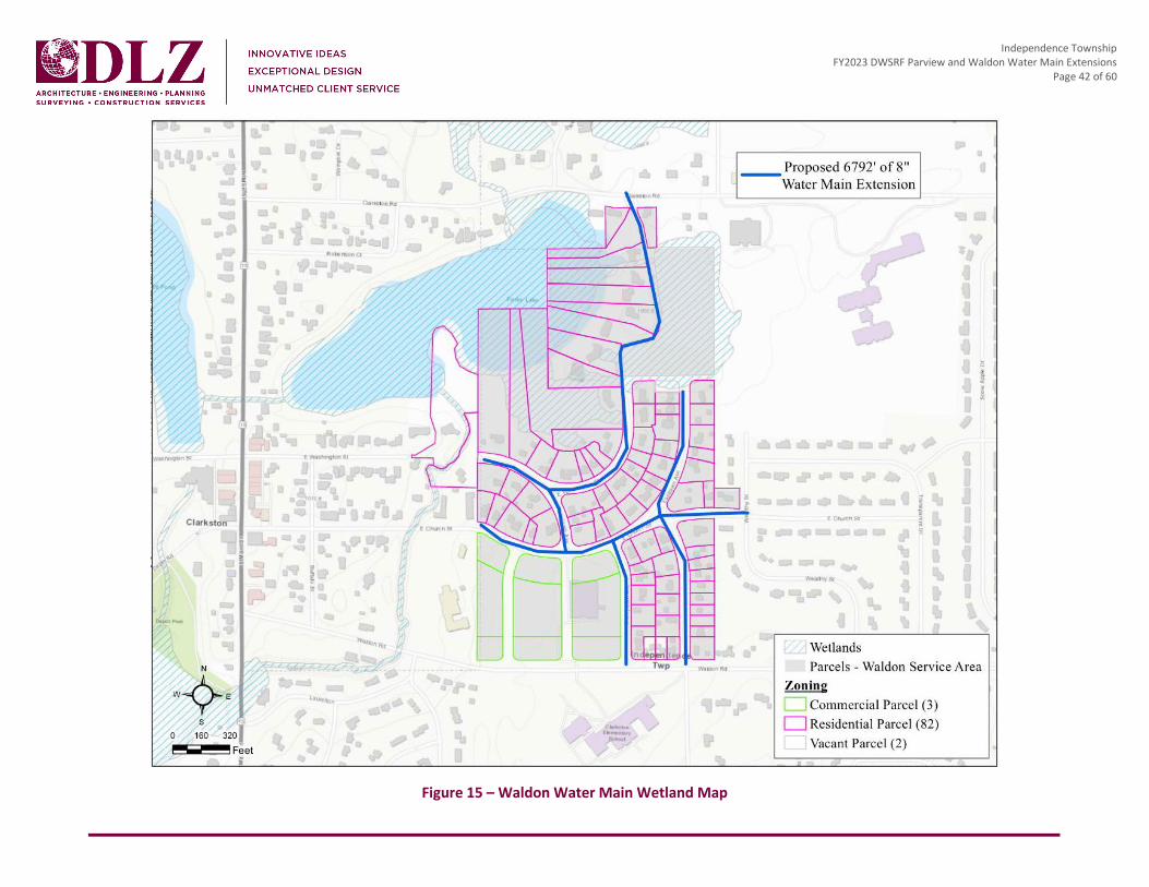
Independence Township FY2023 DWSRF Parview and Waldon Water Main Extensions
Page 42 of 60
Figure 15 – Waldon Water Main Wetland Map

Independence Township FY2023 DWSRF Parview and Waldon Water Main Extensions
Page 43 of 60
Figure 16 – Parview Water Main Wetland Map

Independence Township FY2023 DWSRF Parview and Waldon Water Main Extensions
Page 44 of 60
5.4 ENDANGERED SPECIES Michigan Natural Features Inventory (MNFI) performed a Rare Species Review for the project locations including a 1.5-mile buffer area. The results of the MNFI database search indicated that eight occurrences of state T&E species have been noted within 1.5 miles of the project area. Since records in the database include occurrences to the mid-19th century, some of the species listed are likely no longer found in the Township. Michigan includes state species status as E, T, and Special Concern (SC). The following species were noted as having been identified as present but unlikely negative impacts: lake herring, bastard pennyroyal, orange or yellow fringed orchid, eastern massasauga, rainbow, campeloma spire snail, pugnose shiner, and round pigtoe. See Appendix XI for the Rare Species Review letter.
The U.S. Fish and Wildlife Service (FWS) is the federal agency entrusted with protecting plant and animal species. The Endangered Species Act (ESA) protects the plant and animal species that are listed as endangered or threatened. The Information for Planning and Consultation (IPaC) website performed a review to generate a list of species and other resources that are known or expected to occur within a defined project area. The determination of a project is now made using the Michigan Determination Key and a letter is generated through the IPac website.
The water main project locations were reviewed separately to determine the federally recognized species per project area. Six federal species that have been found to occur in Oakland County, Michigan are: Indiana bat (Myotis sodalis), northern long-eared bat (Myotis septentrionalis), eastern massassauga, rayed bean (Villosa fabalis), snuffbox mussel (Epioblasma triquetra), and poweshiek skipperling (Oarisma poweshiek). Three species of birds, protected by the Migratory Bird Treaty Act and the Bald and Golden Eagle Protection Act, may also utilize the project area for nesting and/or resting during migration.
The “May Effect, Not Likely to Adversely Affect” determination was found to be appropriate for the following species: Indiana bat, northern long-eared bat and eastern massasauga. A “No Effect” determination was found to be appropriate for the rayed bean, snuffbox mussel and Poweshiek skipperling species. See attached Consistency Letters for the Parview and Waldon water main extension projects in Appendix XII. Although both project locations are within previously disturbed rights-of-way, land disturbance and tree removals may be necessary complete site improvements.
Both project areas are suitable roosting habitats for the northern long-eared bat and the Indiana bat. Their typical habitats can be likely present in the county and possibly adjacent to the project areas, but no known hibernacula or roost trees are present within 1.5 miles of the project area. If tree removal is necessary, the Contractor should adhere to seasonal tree clearing and trimming restrictions (no cutting April 1 – September 30) to avoid any potential impacts to both species.
The Eastern Massasauga rattlesnake (EMR) populations in southern Michigan are typically associated with open wetlands, including bogs, fens, swamps, marshes floodplain forests and moist grasslands. Due to the populated nature of the project areas, EMR is not expected to be present within the project area as neither of

Independence Township FY2023 DWSRF Parview and Waldon Water Main Extensions
Page 45 of 60
the sites have sufficient appropriate wetland or upland habitat. EMR General Best Management Practices for projects within the range of habitat should be followed (see attached Guidance in Appendix XII).
5.5 AGRICULTURAL LAND The proposed water main extension projects provide no impacts to agricultural land. The projects are in the rights-of-way along residential and commercial properties.
5.6 SOCIAL/ECONOMIC IMPACT According to the Township Water Fund Budget, the annual payments for the proposed project will be funded by a combination of the Unrestricted Fund Balance and the budget for Distribution System Improvements. If necessary, the Township may consider increasing user rates to help fund the proposed improvements. However, the Township is currently not expecting to increase user rates as a direct result of the projects at this time.
5.7 CONSTRUCTION/OPERATIONAL IMPACT The Township will experience minimal impacts to the traffic patterns in the general construction area. The water main extension work will take place within the public rights-of-way but will not likely occur in the roadways.
5.8 INDIRECT IMPACTS The proposed water main extensions are not expected to increase growth within Independence Township as both project areas are fully developed. Changes in natural areas, ecosystems, and sensitive species is not expect due to taking place within the public right-of-way. The project includes underground construction but is not expected to have lasting impacts of land use, density, or aesthetics. Indirect impacts to the floodplains will be non-existent during and after the construction of this project.
6.0 MITIGATION 6.1 GENERAL Mitigation methods will be implemented when construction impacts cannot be avoided. It is not anticipated that mitigation required would be more rigid than a normal water main installation project. Mitigating measures for the projects such as soil erosion and sedimentation control (SESC) will be utilized, as necessary. Detailed mitigation methods will be specified in the construction contract documents.
6.2 SHORT-TERM IMPACTS Short-term impacts of the selected alternative are directly related to construction activities. Operations causing traffic disruption, noise, and dust cannot be avoided. However, the efforts will be minimized thorough design and well-planned construction sequencing. Project traffic control will be implemented to cause minimal disruption to the Township.

Independence Township FY2023 DWSRF Parview and Waldon Water Main Extensions
Page 46 of 60
Construction practices creating noise, dust and soil disturbance will be minimized with the use of site restoration, regulated working hours, and Soil Erosion and Sedimentation Control applications. The contractor will adhere to all state and township SESC standards. Soil erosion and sedimentation control and restoration items are included in the overall project cost. Specific techniques will be specified in the construction contract documents based on Township standards.
6.3 LONG-TERM IMPACTS Long-term impacts due to the proposed projects are not anticipated. The aesthetic impacts due to construction within the project areas will be mitigated by site restoration. Although wetland impacts are expected to be minimal at this stage, any impacts will either be restored or mitigated.
6.4 INDIRECT IMPACTS Indirect impacts are not likely to be a significant concern for these improvements. The proposed projects do not promote growth within Independence Township.
7.0 PUBLIC PARTICIPATION A Public Hearing Notice was published on May 21, 2022, in The Oakland Press, notifying the public of a hearing to be held on June 21, 2022 at 6 PM. A copy of the public hearing notice can be found in Appendix XIII. Members of the public attended the meeting and submitted comments on the draft Project Plan. The public was allowed to comment during the month-long comment period as advertised in the local paper and at the scheduled public hearing. The Project Plan was made available to the public on the Township’s main page of the website. A hard copy of the Plan was also available at the Public Hearing.

Independence Township FY2023 DWSRF Parview and Waldon Water Main Extensions
Page 48 of 61
APPENDIX I SUBMITTAL FORMS
MICHIGAN DEPARTMENT OF ENVIRONMENT, GREAT LAKES, AND ENERGY FINANCE DIVISION
DRINKING WATER STATE REVOLVING FUNDPROJECT PLAN SUBMITTAL
Part 54, Safe Drinking Water Assistance, of the Natural Resources and Environmental Protection Act, 1994 PA 451, as amended
EGLE Environmental Assistance Center Page 1 of 4 Phone: 800-662-9278
Michigan.gov/EGLE EQP1064 (Rev. 04/2021)
Name of the Project Applicant’s Federal Employer Identification Number (EIN)
Legal Name of Applicant (The legal Areas Served by this Project name of the applicant may be different than Counties the name of the project. For example, a county may be the applicant for bonding purposes, while the project may be named Congressional Districts for the particular village or township it serves.)
State Senate Districts
Address of Applicant State House Districts
Street Address
PO Box
City State Zip
Population Served by the Water Supplier Water Supply Serial Number (WSSN)
Brief Description of the Project
Estimated Total Cost of the Project Construction Start Target Date
Name and Title of Applicant’s Telephone E-mail AddressAuthorized Representative Name
Title
DRINKING WATER STATE REVOLVING FUND PROJECT PLAN SUBMITTAL EQP1064
Page 2 of 4
Address of Authorized Representative - if same as address above, check here Street Address
O Box
ity State Zip
ignature of Authorized Representative Date
tate approval of the water supplier’s Surface Water Intake Protection if applicable) check here
Program is attached
tate approval of the water supplier’s Wellhead Protection Program is pplicable) check here
attached (if
P
C
S
S(
Sa
Joint Resolution of Project Plan Adoption/Authorized Representative Designation is attached check here
A final project plan, prepared and adopted in accordance with the Department’s Drinking Water State Revolving Fund Program Project Plan Preparation Guidance, must be submitted by July 1st in order for a proposed project to be considered for placement on Michigan’s Project Priority List for the next fiscal year.
Please send your final project plan with this form to your EGLE Water Infrastructure Financing Section Project Manager. Electronic submittal to Project Manager is acceptable.
WATER INFRASTRUCTURE FINANCING SECTION FINANCE DIVISION MICHIGAN DEPARTMENT OF ENVIRONMENT, GREAT LAKES, AND ENERGY P O BOX 30457 LANSING MI 48909-7957
For information or assistance on this publication, please contact the Drinking Water State Revolving Fund, through EGLE Environmental Assistance Center at 800-662-9278. This publication is available in alternative formats upon request.
EGLE does not discriminate on the basis of race, sex, religion, age, national origin, color, marital status, disability, political beliefs, height, weight, genetic information, or sexual orientation in the administration of any of its programs or activities, and prohibits intimidation and retaliation, as required by applicable laws and regulations.
This form and its contents are subject to the Freedom of Information Act and may be released to the public.

DRINKING WATER STATE REVOLVING FUND PROJECT PLAN SUBMITTAL EQP1064
Page 3 of 4
SAMPLE RESOLUTION (to be used as a model)
A RESOLUTION ADOPTING A FINAL PROJECT PLAN
FOR WATER SYSTEM IMPROVEMENTS AND
DESIGNATING AN AUTHORIZED PROJECT REPRESENTATIVE
WHEREAS, the ________________________________________ (legal name of applicant) recognizes
the need to make improvements to its existing water treatment and distribution system; and
WHEREAS, the ________________________________________ (legal name of applicant)
authorized ___________________________________________ (name of consulting engineering
firm) to prepare a Project Plan, which recommends the construction of
________________________________________________________________________________;
WHEREAS, said Project Plan was presented at a Public Hearing held on _________________________ and all public comments have been considered and addressed;
NOW THEREFORE BE IT RESOLVED, that the _____________________________ (legal name of applicant) formally adopts said Project Plan and agrees to implement the selected alternative (Alternative)
____________________________________________________________________________________.
BE IT FURTHER RESOLVED, that the ________________________________________ (title of the
designee’s position), a position currently held by _________________________ (name of the designee), is designated as the authorized representative for all activities associated with the project referenced above, including the submittal of said Project Plan as the first step in applying to the State of Michigan for a Drinking Water State Revolving Fund Loan to assist in the implementation of the selected alternative.

DRINKING WATER STATE REVOLVING FUND PROJECT PLAN SUBMITTAL EQP1064
Page 4 of 4
Yeas (names of Members voting Yes):
Nays (names of Members voting No):
I certify that the above Resolution was adopted by _______________________________ (the
governing body of the applicant) on _________________________.
BY: _____________________________________ ______________________________
Name (please print or type) Title
____________________________________
Signature
________________
Date

Independence Township FY2023 DWSRF Parview and Waldon Water Main Extensions
Page 49 of 61
APPENDIX II INTENT TO APPLY (ITA) FORM

EGLE Environmental Assistance Center Michigan.gov/EGLETelephone: 1-800-662-9278 Page 1 of 3 EQP6580 (Rev 11/2020)
MICHIGAN DEPARTMENT OF ENVIRONMENT, GREAT LAKES, AND ENERGYFINANCE DIVISION
CLEAN WATER AND DRINKING WATER STATE REVOLVING FUND/STRATEGIC WATER QUALITY INITIATIVES FUND
INTENT TO APPLY FORM
This form should be submitted by all applicants seeking funding in the next five years. Applicants participating in the ITA process receive early indication of the funding outlook for their project(s).
DATE: 1/25/2022PROJECT(S) NAME (Brief Identifier): Waldon & Parview Water Main Extensions PROJECT(S) PURPOSE (Including general location and public health or water quality issue being addressed): Independence Township provides water service to almost 8,000 residential and commercial customer connections (approximately 19,200 residents) within the Township as well as in the Village of Clarkston. High quality water is pumped directly from 16 wells in 10 wellfields, producing water for 3 service areas (Main Loop, Deerwood, and Hillview Estates). Every day, an average of 3.0 Million Gallons of water is treated in the Township’s well houses and distributed through a distribution system of over 137 miles in length. Although the Township has this municipal water source, over 14,000 residents, in the Township, still rely on private individual water wells for their potable water source.
In 2018, as part of the Michigan PFAS Action Response Team efforts to investigate sources and locations of PFAS contamination in the state of Michigan, EGLE tested all 16 wells within the Township water system. Test results from the Clarkston Gardens well confirmed the presence of PFAS analytes at 10 parts per trillion (PPT), below the then non-regulatory Lifetime Health Advisory Level of 70 PPT. Upon receipt of PFAS compounds in this well, the Township proactively shut this wellhead down, as it remains to this day. Clarkston Gardens pumps approximately 1.4 million gallons of water to residents and businesses per day, therefore, the overall available capacity of potable water supplied to residents has been decreased by 1.4 million gallons. Based on the PFAS detections, the Township began quarterly testing of all well sites for PFAS contaminants as part of a routine water quality monitoring process. In October 2020, test results from the Clarkston Gardens well indicated that PFAS concentrations had increased with analytes at 50 PPT. Testing data indicates that PFAS compound results have been trending upward since 2018, when testing began.
The Waldon Water Main Extension project is in the Clarkston Gardens WHPP area. This project will provide Township residents, whose private wells may be affected by PFAS, the opportunity to connect to new public water main that would be supplied by PFAS free treated Township water to mitigate the private well PFAS impacts.
The Township has a detailed and calibrated hydraulic water model that has been used to identify water system deficiencies. One project that has been identified from modeling scenarios is the Parview Water Main Extension. This project will complete a water main loop to provide the water system greater redundancy, while improving water quality and fire-fighting capability.
The Township is committed to protecting and enhancing its community drinking water infrastructure and has submitted an updated Water Reliability Study and Water Asset Management Plan to EGLE. The Township realizes an annual water system revenue of approximately 3.5 million dollars, which is dedicated to Operations, Maintenance and Capital Improvement Project expenditures.
Applicant Legal Name: Charter Township of Independence
Applicant Contact Name: David McKee Title: Public Works Director
Mailing Address (street, city, state, zip+4): 6050 Flemings Lake Rd., Clarkston, MI 48346-1620
Phone No.: (248) 625-8222 Email: [email protected]
Consulting Engineer Name (if applicable): Mike Leuffgen, PE Firm: DLZ-Michigan, Inc.
Mailing Address (street, city, state, zip+4): 4494 Elizabeth Lake Rd., Waterford, MI 48328-2825
Phone No.: (248) 836-4057 Email: [email protected]

EGLE Environmental Assistance Center Michigan.gov/EGLETelephone: 1-800-662-9278 Page 2 of 3 EQP6580 (Rev 11/2020)
PROJECT INFORMATION
Applicant Population: 36,818 Population Served by Project: 792
Treatment Facility Name (if applicable): Click here to enter text.
Estimated Total Project Cost: $4,045,735
Year 1 Costs: $40,000 Estimated Year 1 Costs Financed Through SRF: $40,000
Future Year Costs (if applicable): $4,005,735 Estimated Future Costs Financed Through SRF: $4,005,735
Other Funding Sources (check all that apply): ☐MDOT ☒MEDC ☐USDA Rural Development ☒Other Financing/Funding Agency: ARPA
Proposed Construction Start Date (mm/yyyy): 4/1/2023
Completed Project-Related Planning Documents (check all that apply; do not need to submit at this time): ☐Capital Improvements Plan ☒Asset Management Plan ☐Preliminary Engineering Report ☐Environmental Report ☐Project Plan ☐Infiltration & Inflow Study ☐Sanitary Sewer Evaluation Study ☐NASSCO Report ☐Watershed Management Plan ☐Master Plan ☒Reliability Study ☒Other: Clarkston Gardens Wells/Capture Zones Investigations; Parview and Waldon Project Area Maps
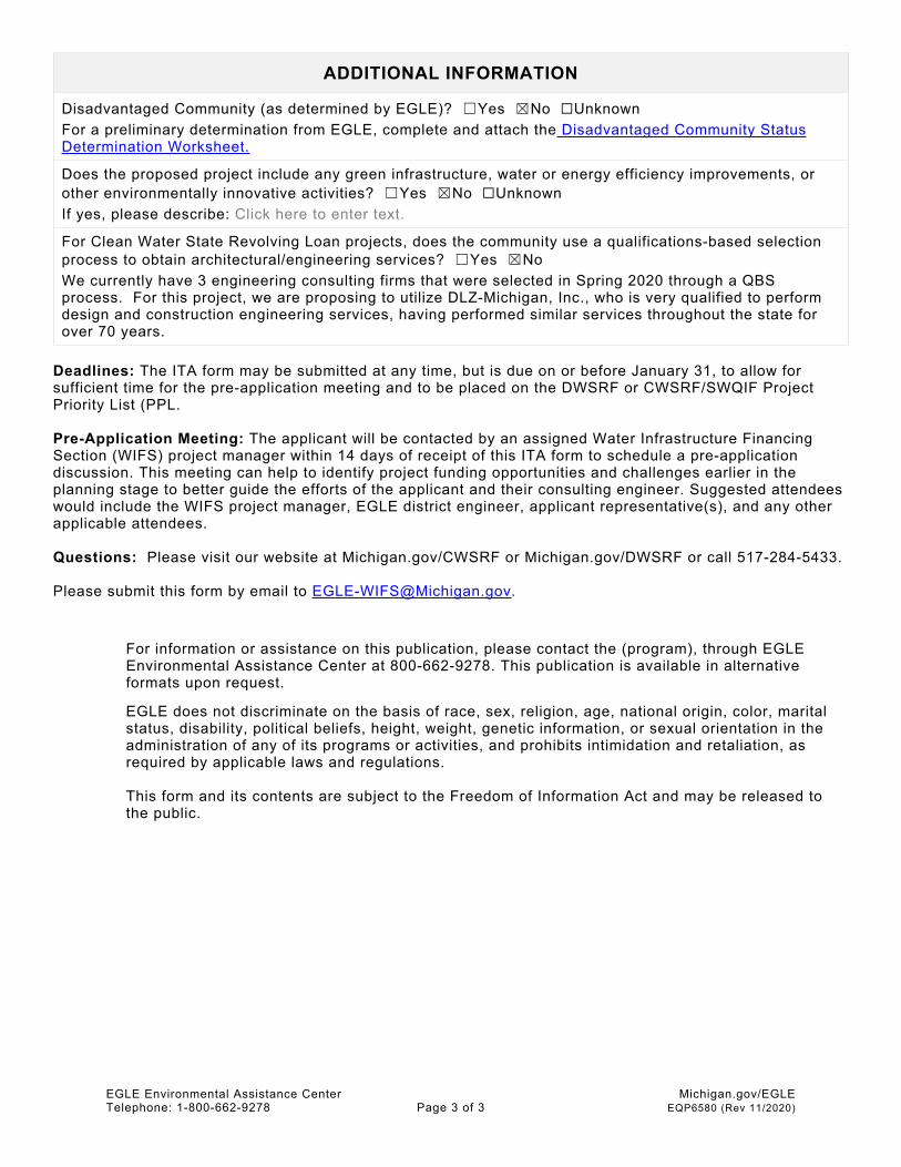
EGLE Environmental Assistance Center Michigan.gov/EGLETelephone: 1-800-662-9278 Page 3 of 3 EQP6580 (Rev 11/2020)
ADDITIONAL INFORMATION
Disadvantaged Community (as determined by EGLE)? ☐Yes ☒No ☐UnknownFor a preliminary determination from EGLE, complete and attach the Disadvantaged Community Status Determination Worksheet.
Does the proposed project include any green infrastructure, water or energy efficiency improvements, or other environmentally innovative activities? ☐Yes ☒No ☐UnknownIf yes, please describe: Click here to enter text.
For Clean Water State Revolving Loan projects, does the community use a qualifications-based selection process to obtain architectural/engineering services? ☐Yes ☒No We currently have 3 engineering consulting firms that were selected in Spring 2020 through a QBS process. For this project, we are proposing to utilize DLZ-Michigan, Inc., who is very qualified to perform design and construction engineering services, having performed similar services throughout the state for over 70 years.
Deadlines: The ITA form may be submitted at any time, but is due on or before January 31, to allow for sufficient time for the pre-application meeting and to be placed on the DWSRF or CWSRF/SWQIF Project Priority List (PPL.
Pre-Application Meeting: The applicant will be contacted by an assigned Water Infrastructure Financing Section (WIFS) project manager within 14 days of receipt of this ITA form to schedule a pre-application discussion. This meeting can help to identify project funding opportunities and challenges earlier in the planning stage to better guide the efforts of the applicant and their consulting engineer. Suggested attendees would include the WIFS project manager, EGLE district engineer, applicant representative(s), and any other applicable attendees.
Questions: Please visit our website at Michigan.gov/CWSRF or Michigan.gov/DWSRF or call 517-284-5433.
Please submit this form by email to [email protected].
For information or assistance on this publication, please contact the (program), through EGLE Environmental Assistance Center at 800-662-9278. This publication is available in alternative formats upon request.
EGLE does not discriminate on the basis of race, sex, religion, age, national origin, color, marital status, disability, political beliefs, height, weight, genetic information, or sexual orientation in the administration of any of its programs or activities, and prohibits intimidation and retaliation, as required by applicable laws and regulations.
This form and its contents are subject to the Freedom of Information Act and may be released to the public.

Independence Township FY2023 DWSRF Parview and Waldon Water Main Extensions
Page 50 of 61
APPENDIX III INDEPENDENCE TOWNSHIP WELLHEAD PROTECTION PLAN

CHARTER TOWNSHIP OF INDEPENDENCE
WELLHEAD PROTECTION PLAN
UPDATED OCTOBER 2019
SUBMITTED TO:
MICHIGAN DEPARTMENT OF THE ENVIRONMENT, GREAT LAKES, AND ENERGY
DRINKING WATER AND ENVIRONMENTAL HEALTH DIVISION
COMMUNITY DRINKING WATER UNIT -
WELLHEAD PROTECTION
CONSTITUTION HALL, SECOND FLOOR
525 WEST ALLEGAN STREET
LANSING, MICHIGAN 48913-0001
PREPARED BY:
DLZ MICHIGAN, INC ON BEHALF OF
CHARTER TOWNSHIP OF INDEPENDENCE
WELLHEAD PROTECTION TEAM
DEPARTMENT OF PUBLIC WORKS
6050 FLEMING LAKE ROAD
P.O. BOX 69
CLARKSTON, MICHIGAN 48347
OCTOBER 2019

Charter Township of Independence
Wellhead Protection Plan
(Updated October 2019)
Prepared for:
Michigan Department of the Environment, Great Lakes, and Energy
Drinking Water and Environmental Health Division
Community Drinking Water Unit – Wellhead Protection
Constitution Hall, Second Floor
525 West Allegan Street
Lansing, Michigan 48913-0001
Prepared by:
DLZ Michigan, Inc.
1425 Keystone Avenue
Lansing, Michigan 48911
On Behalf of:
Charter Township of Independence
Wellhead Protection Team
Department of Public Works
6050 Fleming Lake Road
P.O. Box 69
Clarkston, Michigan 48347
DLZ Project No. 1945-6932-00
October 2019

Charter Township of Independence
Wellhead Protection Plan
October 2019
Table of Contents
TABLE OF CONTENTS
INTRODUCTION ...................................................................................................................... I
PLAN FORM 1 - CONTACT LIST FOR WELLHEAD PROTECTION .................................................. 1
CONTACT LIST ................................................................................................................................................................ 1
PLAN FORM 2 - WATER SUPPLY AND COMMUNITY PROFILE ................................................... 2
WATER SUPPLY AND COMMUNITY PROFILE ......................................................................................................................... 2
PLAN FORM 3 - GOALS AND OBJECTIVES ................................................................................ 4
MISSION STATEMENT ...................................................................................................................................................... 4
PLAN FORM 4 - THE DELINEATION STUDY .............................................................................. 6
DEERWOOD ................................................................................................................................................................... 7 DEERWOOD MANOR ....................................................................................................................................................... 7 DEER VALLEY ................................................................................................................................................................. 8 CLARKSTON GARDENS ..................................................................................................................................................... 8 WALDON CREEK ............................................................................................................................................................. 9 HIDDEN LAKES ............................................................................................................................................................... 9 PINE KNOB .................................................................................................................................................................. 10 CHESTNUT HILLS ........................................................................................................................................................... 10 LAKE OAKLAND WOODS ................................................................................................................................................ 11 PELTON HEIGHTS .......................................................................................................................................................... 11 BAY COURT ................................................................................................................................................................. 11 HILLVIEW ESTATES ........................................................................................................................................................ 12 CONTAMINANT SOURCE INVENTORY ................................................................................................................................. 13 PFAS CONTAMINATION ................................................................................................................................................. 20
PLAN FORM 6 - REGULATORY MANAGEMENT STRATEGIES ................................................... 22
PART I: ....................................................................................................................................................................... 41 MANAGEMENT OF HAZARDOUS SUBSTANCES AND POLLUTING MATERIAL ............................................................................... 41 PART II ....................................................................................................................................................................... 45 TYPES AND QUANTITIES OF HAZARDOUS SUBSTANCES AND POLLUTING MATERIALS WHICH WILL BE USED, STORED, OR GENERATED
ON-SITE ..................................................................................................................................................................... 45
PLAN FORM 7 - EDUCATIONAL MANAGEMENT STRATEGIES ................................................. 46
EDUCATIONAL STRATEGIES ............................................................................................................................................. 46

Charter Township of Independence
Wellhead Protection Plan
October 2019
Table of Contents
PLAN FORM 8 - WELLHEAD PROTECTION CONTINGENCY PLAN ............................................. 48
STORMWATER OUTFALL SURVEY...................................................................................................................................... 48 PERSONNEL TO BE CONTACTED DURING AN EMERGENCY ..................................................................................................... 48 PLANS FOR ISOLATING PORTIONS OF THE DISTRIBUTION SYSTEM ............................................................................................ 49 TREATMENT MEASURES THAT WOULD BE TAKEN IN THE EVENT OF CONTAMINATION OF THE WATER SUPPLY ................................ 49 PLAN FOR PUBLIC NOTIFICATION OF CUSTOMERS DURING A WATER SUPPLY EMERGENCY .......................................................... 49 PLAN FOR NOTIFICATION OF EGLE DURING A WATER SUPPLY EMERGENCY ............................................................................. 50 POLICIES AND PROCEDURES FOR PROVIDING AN ALTERNATIVE SUPPLY OF WATER FOR SHORT-TERM EMERGENCY RESPONSE ............ 51 POLICIES AND PROCEDURES FOR PROVIDING AN ALTERNATIVE SUPPLY OF ................................................................................ 51 WATER FOR LONG-TERM EMERGENCY CORRECTIVE MEASURE TO A WATER SUPPLY EMERGENCY ................................................ 51 SPILL RESPONSE MANAGEMENT PLAN .............................................................................................................................. 51
PLAN FORM 9 - SITING NEW WELLS...................................................................................... 54
PLAN FORM 10 - ROLES AND RESPONSIBILITIES FOR WELLHEAD PROTECTION ...................... 55
PLAN FORM 11 - PUBLIC PARTICIPATION ............................................................................. 56
PUBLIC PARTICIPATION STRATEGIES .................................................................................................................................. 56
FIGURES
Figure 1 Charter Township of Independence Location & Surrounding Communities
Figure 2 Charter Township of Independence Lakes, Rivers and Wetlands Map
Figure 3 Charter Township of Independence Combined 1, 5, and 10-Year Capture
Zones with Municipal Well Locations
Figure 4 Charter Township of Independence Combined 1, 5, and 10-Year Capture
Zones with Potential Contaminant Sources
APPENDICES
Appendix A EDR Map
Appendix B EDR Report
Appendix C PFAS Results, Clarkston Gardens Wellfield – EGLE Correspondence

Charter Township of Independence
Wellhead Protection Plan
October 2019
Page i
INTRODUCTION
The groundwork for Charter Township of Independence’s Wellhead Protection Plan began in
1998 with the formulation of a Master Groundwater Protection Program. The program’s goal
was to address the issues associated with protecting groundwater in a multi-faceted approach
reaching across several departmental boundaries. A Township Location Diagram is included as
Figure 1.
A study was initiated to prioritize the existing municipal well sites according to the need for
completion of a wellhead plan. Zoning ordinance standards were developed for groundwater
protection. Subdivision regulations were amended to include design standards specifically
addressing protection of groundwater and alternative review standards within sensitive
wellhead zones.
In 1999 the Charter Township of Independence commenced organization for its Wellhead
Protection Plan. Enlisting the services of DLZ Michigan, Inc. (DLZ), delineation studies of the first
group of well sites was begun and a Wellhead Protection Team was formed. The Charter
Township of Independence Wellhead Protection Plan (December 2011) was the result of the
dedicated and cumulative effort on the part of the Charter Township of Independence
Wellhead Protection Team.
DLZ in coordination with the Charter Township of Independence Wellhead Protection Team has
been working to gather updated information culminating in the creation of this Charter
Township of Independence Wellhead Protection Program. In 2019, DLZ updated this current
Wellhead Protection Plan including team members, emergency contacts, contamination
sources, etc.
The Team will continue to develop the Wellhead Protection Plan as it evolves in response to the
ever-changing influence of social, economic, environmental and political impacts.

Charter Township of Independence
Wellhead Protection Plan
October 2019
Page 1
PLAN FORM 1 - CONTACT LIST FOR WELLHEAD PROTECTION
Contact List
The Charter Township of Independence Wellhead Protection Team is made up of
representatives from Independence Township, Waterford Township, White Lake Township,
Oakland County Health Division, the Clinton River Watershed Council, Independence Television,
and DLZ Michigan, Inc.
The Team recruited public officials, engineers, planners, geologists, emergency response
personnel, private advocacy groups and private citizens.
The following is the list of Team members currently serving:
Name Representing Phone Number Email
David McKee
Independence Township
Department of Public
Works
248-625-8222 [email protected]
David Ziegler
Independence Township
Department of Public
Works
248-625-8222 [email protected]
Jeff Cooper
Independence Township
Department of Public
Works
248-625-8222 [email protected]
Tom Graham
Independence Township
Department of Public
Works
248-625-8222 [email protected]
Mitch Petterson Independence Township
Fire Department 248-625-1924 [email protected]
Kathleen Sexton Clinton River Watershed
Council 248-625-6245 [email protected]
Richard Whitlock Oakland County Health
Division 248-872-6968 [email protected]
Aaron Potter White Lake Township 248-698-3300 [email protected]
Dan Stickel Waterford Township 248-618-7451 [email protected]
Laura Gruzwalski DLZ Michigan, Inc. 248-681-7800 [email protected]

Charter Township of Independence
Wellhead Protection Plan
October 2019
Page 2
PLAN FORM 2 - WATER SUPPLY AND COMMUNITY PROFILE
Water Supply and Community Profile
1. Public Water Supply Agency: WSSN 3342 Charter Township of Independence,
Department of Public Works.
2. Service Area: (see attached map) The Charter Township of Independence presently has
6,000 water connections serving approximately 15,000 residents based on 2.5 people
per connection. There are sixteen (16) operational municipal supply wells, which are
located throughout the Township. Independence Township provides iron and arsenic
removal with disinfection treatment of water supplied to its customers. The water
system operates as three (3) separate water service areas; the Southern Loop System,
Deerwood/Deer Valley System, and one (1) service area supplied by a single wellfield
(Hillview).
3. All water treatment plants pump treated water into a completely interconnected water
distribution system.
4. The table on the following page contains information on the number of wells and their
capacity:
Facility WSSN Well No. Capacity/GPM
Deerwood I & II 1773 2 694 GPM
Deerwood Manor 1773 3 955 GPM
Deer Valley 1773 1 1,000 GPM
Deer Valley 1773 2 1,000 GPM
TOTAL 3,649 GPM
Facility WSSN Well No. Capacity/GPM
Hillview Estates 3175 3 300 GPM
Hillview Estates 3175 2 450 GPM
Hillview Estates 3175 1 201 GPM
TOTAL 951 GPM

Charter Township of Independence
Wellhead Protection Plan
October 2019
Page 3
*Average daily usage for peak month in millions of gallons during 2009:
Facility WSSN Booster or Well No. Capacity/GPM
Bay Court 3342 1 1,001 GPM
Bay Court 3342 2 2,000 GPM
Chestnut Hills 3342 2 1,250 GPM
Chestnut Hills 3342 1 500 GPM
Clarkston Gardens 3342 2 1,000 GPM
Lake Oakland Woods 3342 2 1,403 GPM
Lake Oakland Woods 3342 3 1,900 GPM
Pelton Heights 3342 2 597 GPM
Waldon Creek 3342 1 1,000 GPM
TOTAL 10,651 GPM
Facility WSSN Well No. Capacity/GPM
Pine Knob 5337 1 400 GPM
Pine Knob 5337 2 900 GPM
TOTAL 1,300 GPM
WSSN Area *Average MGD Max MGD
1773 595,548 4.7
3175 65,355 1.5
3342 4,271,129 14.4
5337 off-line 1.5
TOTAL 4,932,032 22.1

Charter Township of Independence
Wellhead Protection Plan
October 2019
Page 4
PLAN FORM 3 - GOALS AND OBJECTIVES
Mission Statement
Independence Township is dedicated to the preservation and protection of water quality and
quantity. In order to prevent groundwater pollution, Independence Township has developed a
joint wellhead protection program with neighboring communities, and County & State Agencies
to protect drinking water in identified protection areas through cooperative management
strategies and public education. To achieve this, the Wellhead Protection Program has
prompted review of procedures that control activities that could affect groundwater quality
and by:
• Educating the public through workshops and other opportunities;
• Land use plan review; and
• Enforcement of government regulations which are protective of groundwater.
Goals and Objectives -
A. Identify 10-year capture zones near existing groundwater supplies by utilizing readily
available subsurface data and aquifer hydraulics.
B. Protect drinking water supply by preventing pollution and contamination of surface and
groundwater within the wellhead protection area.
C. Identify sources of potential groundwater contamination. This will be done by
contacting local Fire Marshal, reviewing Michigan’s Department of Environment, Great
Lakes, and Energy (EGLE) files, conducting a windshield survey and interviewing
residents.
D. Educate the public & schools about the importance of groundwater and ways to prohibit
or reduce the likelihood of groundwater contamination. This will be done by holding
town meetings, sponsoring and promoting workshops, assist in school curriculum,
mailings to residents and newspaper articles.
E. Develop a comprehensive plan to respond to emergencies that will threaten a wellhead
protection plan and prepare for groundwater supply emergencies. This will be achieved
by having back-up production wells in the event an existing well is shut down. Should
the emergency be a chemical spill, an emergency response plan should be available
which gives guidance for spill cleanup. Where applicable, have cross connection to
adjoining water distribution systems so that water will be shared until affected wellfield
that has been adversely affected can be put back into operation.

Charter Township of Independence
Wellhead Protection Plan
October 2019
Page 5
F. Promote governmental and intergovernmental cooperation to assure protection of
water resources within wellhead protection areas. This will be accomplished by
informing representatives of adjacent governmental entities about the existence of the
Wellhead Protection Plan and seek their assistance in controlling land use activities.
Clarify roles and duties of agencies and individuals involved in wellhead protection.
G. Evaluative Progress. This will be done by inviting representatives of governmental
entities to wellhead planning meetings in order to inform them of changes that are
mutually affecting either governmental entity. Evaluate the success of programs and
understanding of messages delivered to the public.
Goal Plan of Action
A. Identify 10-year capture zones near
existing groundwater supplies. Existing
and proposed well sites.
1.
2.
Perform well tests. Have hydraulic study
performed for delineation.
Submit report to EGLE for review and approval.
B. Protect drinking water supply by
preventing pollution and contamination of
surface and groundwater especially within
the well head protection area.
1.
2.
3.
Through Wellhead Protection ordinances and
planning we will be able develop a plan for
outreach programming in our community.
Cap and abandon wells not in use.
Apply for EGLE’s 75% matching well
abandonment grant program.
C. Identify sources of potential groundwater
contamination.
1.
2.
3.
4.
5.
6.
Compose list of pre-fire surveys of commercial
properties.
Review State and County records.
Conduct an environmental assessment.
Interview local historians.
Review of aerial photography.
Perform abandoned well survey.
D. Educate the public and work to prevent
pollution and contamination threats to the
groundwater supply within WHPA.
1.
2.
Public education in schools and town meetings.
Mailings to residents to educate public.
E. Develop an emergency response plan 1.
2.
Prepare and maintain contingency plan for
water supply emergency.
Maintain and update a database of all existing
and proposed wells and their status.
F. Promote governmental and
intergovernmental cooperation to protect
water resources in WHPAs.
1.
2.
3.
Seek assistance in controlling land use activities
with adjacent governmental entities.
Inform Oakland County Drain Commission and
Health Department of the WHPA.
Keep correspondence current with EGLE
Wellhead Protection Unit.
G. Continue to evaluate progress of the
Wellhead Protection Program.
1. Holding wellhead planning meetings to inform
of changes and evaluate success of programs.

Charter Township of Independence
Wellhead Protection Plan
October 2019
Page 6
PLAN FORM 4 - THE DELINEATION STUDY
The delineation study was performed by:
DLZ Michigan, Inc.
1425 Keystone Avenue
Lansing, Michigan 48911
(517) 393-6800
The Charter Township of Independence has twelve wellfields for which delineations have been
completed. Figure 2 shows the locations of the twelve wellfields and their respective EGLE-
DWRP approved 10-year capture zones. The wellfields (with well numbers) for which
delineations have been approved are:
• Deerwood (1)
• Deerwood Manor (1)
• Deer Valley (1,2)
• Clarkston Gardens (1)
• Waldon Creek (1)
• Hidden Lakes (1,2)
• Pine Knob (1, 2)
• Chestnut Hills (1, 2)
• Lake Oakland Woods (2)
• Pelton Heights (1,2)
• Bay Court (1, 2)
• Hillview Estates (1, 2, 3)
The following sections describe the geology and hydrogeology of the Charter Township of
Independence. Descriptions of the geology and hydrogeology of the township are based upon
the Wellhead Protection Area Delineation reports prepared for the township. The public water
supply systems are located across Independence.
Surficial deposits in Oakland County are of Pleistocene age and consist of tills, outwash sands
and gravels, and lacustrine (lake bed) material, deposited by glaciers or their meltwaters
(Mozola, 1953). Moraines and till plains are found roughly as two bands with an approximate
northeast –southwest trend. These deposits have an average thickness of 300 feet and are
capable of supplying moderate to large water quantities of water (Mozola, 1953).
Independence Township, within Oakland County, is composed of moraines, and glacial outwash
and channels, varying in thickness between 201-400 feet (Western Michigan University, 1981).
Identified wetlands and surface water bodies in Independence Township are depicted on Figure
3.

Charter Township of Independence
Wellhead Protection Plan
October 2019
Page 7
Deerwood
Based on the well log of the 12-inch diameter well at the site, the surficial geology of this site
may be described as follows, from stratigraphically highest to lowest:
1. Sandy clay to 5 feet bgs.
2. Stony dry gravel to 35 feet bgs.
3. Gravely hardpan (clay) to 95 feet bgs.
4. Sand to 132 feet bgs.
5. Gravely clay to 190 feet bgs.
6. Sand to 193 feet bgs.
7. Gravely hardpan to 201 feet bgs.
8. Sand to 203 feet bgs.
9. Hardpan gravel to 208 feet bgs.
10. Sand and gravel to 227 feet bgs.
The exact screened interval of the well could not be determined from the well log; however,
based on the total depth of 227 feet and a recorded screen length of 19 feet, it is assumed that
the producing zone for this well are the lowermost formation (units 10). The aquifer is
leaky/semi-confined conditions.
Deerwood Manor
Based on the well log of the 12-inch diameter well at the site, the surficial geology of this site
may be described as follows, from stratigraphically highest to lowest:
1. Rock, stones, and wood to 10 feet bgs.
2. Stony dry gravel to 16 feet bgs.
3. Sand and clay to 30 feet bgs.
4. Gravel and hardpan (clay) to 48 feet bgs.
5. Hard clay/hardpan to 123 feet bgs.
6. “Boulder” to 125 feet bgs.
7. Stony/gravely hardpan to 217 feet bgs.
8. Sand to 233 feet bgs.
9. Hardpan to 249 feet bgs.
10. Gravel to 263 feet bgs.
11. Sand and gravel to 272 feet bgs.
12. Sand to at least 278 feet bgs.

Charter Township of Independence
Wellhead Protection Plan
October 2019
Page 8
The exact screened interval of the well could not be determined from the well log; however,
based on the total depth of 278 feet and a recorded screen length of 30 feet, it is assumed that
the producing zone for this well are the lower sand and gravel (units 10, 11, and 12). The
aquifer is leaky/semi-confined conditions.
Deer Valley
Based on the well log for well No. 1 at this site, the surficial geology of this site may be
described from stratigraphically highest to lowest as:
1. Sand and fill clay to 18 feet bgs.
2. Clay, some gravel to 61 feet bgs.
3. Sand with clay to 73 feet bgs.
4. Sand and gravel to 88 feet bgs.
5. Sand to 165 feet bgs.
6. Gravel and sand to at least 178.5 feet bgs.
The exact screened interval of the well could not be determined from the well log; however,
based on the total depth of 178 feet and a recorded screen length of 41.5 feet, it is assumed
that the producing zone for this well are the lowermost sand and gravel (units 5 and 6). The
aquifer is under confined conditions.
Clarkston Gardens
Based on the well log for previously abandoned production well No.2, the subsurface
formations at the site may be described as follows, from stratigraphically highest to lowest:
1. Clay, gravel and sand to 13 feet bgs.
2. Clay with sand to 20 feet bgs.
3. Hard clay to 55 feet bgs.
4. Hard pan to 59 feet bgs.
5. Gravel to 71.6 feet bgs.
6. Hard clay and gravel to 72 feet bgs.
The exacted screened interval of well No. 2 could not be determined from the well logs;
however, based on the total depth (72 feet) it is assumed the well is screen in Unit 5 (59-71.6
feet bgs). This unit is under confined/semi-confined conditions.

Charter Township of Independence
Wellhead Protection Plan
October 2019
Page 9
Waldon Creek
Based on the well log for production well PW-1 at this wellfield, the subsurface formations at
this site may be described as follows, from stratigraphically highest to lowest:
1. Sand and boulders to 5 feet bgs.
2. Fine to medium sand to 8 feet bgs.
3. Sand and medium to coarse cobble to 68 feet bgs.
4. Sandy clay to 73 feet bgs.
5. Sandy and gravelly clay to 98 feet bgs.
6. Clay with cobble and boulders to 184 feet bgs.
7. Medium to coarse sand to 275 feet bgs.
The production well is screened from 230-270 feet bgs. The producing zone is in the lowermost
sand (unit 7) Site geology appears to confirm aquifer test data, indicating that the aquifer is
under confined conditions.
Hidden Lakes
Based on the log for production well PW-2, the geology of the Hidden Lakes site may be
described as follows from stratigraphically highest to lowest:
1. Sand and gravel to 40 feet bgs.
2. Hardpan (clay) with intermittent gravel to 135 feet bgs.
3. Hardpan to 170 feet bgs.
4. ‘Boulder’ and sandy clay to 175 feet bgs.
5. Hardpan with sand and gravel to 195 feet bgs.
6. Stony gravel to 210 feet bgs.
7. Hardpan with gravel to 254 feet bgs.
8. Sand and gravel, with clay to 260 feet bgs.
9. Sand and clay to 282 feet bgs.
10. Shale to at least 290 feet bgs.
The exact screened interval of the well could not be determined from the well log; however,
based on the total depth of 283 feet and a recorded screen length of 27 feet, it is assumed that
the producing zone for this well are the lowermost sand and gravel deposits (units 8 and 9). The
aquifer is under semi-confined/confined conditions.

Charter Township of Independence
Wellhead Protection Plan
October 2019
Page 10
Pine Knob
Based upon the well log from a 6-inch diameter previously abandoned well, the geology of the
Pine Knob site may be described as follows from stratigraphically highest to lowest:
1. Sand to 77 feet bgs.
2. Clay to 97 feet bgs.
3. Sand and gravel to 130 feet bgs.
4. Clay, with minor sand and gravel to 201 feet bgs.
5. Gravel with ‘mud’ to 206 feet bgs.
6. ‘Hardpan’ with gravel to 239 feet bgs.
7. ‘Water vein’ (sand/gravel) to at least 262 feet bgs.
Based on the well construction log for well No. 1 (well log unavailable) the well is screened from
236-266 feet bgs. The production zone is the lowermost sand and gravel (unit 7). The aquifer is
under confined conditions.
Chestnut Hil ls
Based upon the well log for production well 1, the lithology at the Chestnut Hills wellfield may
be described as follows from stratigraphically highest to lowest:
1. Topsoil and gravelly clay to 5 feet bgs.
2. Gravel to 20 feet bgs.
3. Clay to 40 feet bgs.
4. Clay and gravel to 60 feet bgs.
5. Gravel to 85 feet bgs.
6. Sand and gravel to 100 feet bgs.
7. Gravel to 113 feet bgs.
8. Clay to 180 feet bgs.
9. Gravel to 235 feet bgs.
10. Sand with gravel and limestone to at least 248 feet bgs.
The well is screened from 95-115 feet bgs, indicating units 6, and 7 are the producing zones.
The aquifer is under semi-confined/confined conditions.

Charter Township of Independence
Wellhead Protection Plan
October 2019
Page 11
Lake Oakland Woods
Based upon the well log for observation well PW-1, the lithology of the Lake Oakland Woods
wellfield may be described as follows, from stratigraphically highest to lowest:
1. Sand to 37 feet bgs.
2. Clay with intermittent sand and gravel to 136 feet bgs.
3. Sand to 150 feet bgs.
4. Clay to 165 feet bgs.
5. Sand to 180 feet bgs.
6. Clay to 197 feet bgs.
7. Gravel to 205 feet bgs.
8. Clay to 232 feet bgs.
9. Sand, some gravel to at least 264 feet bgs.
The exact screened interval of the well could not be determined from the well log; however,
based on the total depth of 264 feet and a recorded screen length of 28 feet, it is assumed that
the producing zone for this well are the lowermost sand formation (unit 9). The aquifer is under
semi-confined/confined conditions.
Pelton Heights
Based upon the well log from well #2, the lithology at the Pelton Heights wellfield may be
described as follows from stratigraphically highest to lowest:
1. Sand and gravel to 75 feet bgs.
2. Clay and gravel to 255 feet bgs.
3. Sand and gravel to 290 feet bgs.
The Pelton Heights production well is screened from 275-290 feet bgs, within unit 3. The
aquifer is unconfined.
Bay Court
Based upon the well log for well 1, the lithology of the Bay Court wellfield may be described as
follows, from stratigraphically highest to lowest:
1. Clay, rocks and gravel to 3 feet bgs.
2. Fine to course sand and gravel to 62 feet bgs.
3. Sandy clay to 65 feet bgs.
4. Coarse gravel and medium to coarse sand, to 92 feet bgs.
5. Medium to coarse sand with clay seams to 119 feet bgs.

Charter Township of Independence
Wellhead Protection Plan
October 2019
Page 12
6. Sandy clay to 123 feet bgs.
7. Fine to coarse sand to 155 feet bgs.
8. Fine to coarse sand and fine to medium gravel to 227 feet bgs.
9. Fine to coarse gravel and fine to coarse sand to 260 feet bgs.
10. Fine to coarse gravel, rocks, and boulders to 263 feet bgs.
11. Coarse gravel, rocks, and boulders with clay to 263 feet bgs.
The production well is screened from 235-260 feet bgs. The production aquifer for this well
field is the lowermost sand and gravel layer (unit 9). The aquifer is leaky/semi-confined
conditions.
Hillview Estates
Based upon the well log for production well PW-3, the lithology at the Hillview wellfield may be
described as follows from stratigraphically highest to lowest:
1. Muck and marl to 22 feet bgs.
2. Clay to 42 feet bgs.
3. Fine/medium-grained sand to 61 feet bgs.
12. Sand with medium gravel to 78 feet bgs.
13. Clay to 80 feet bgs.
14. Sand with gravel to 85 feet bgs.
15. Very fine sand and silt to 95 feet bgs.
The Hillview production well is screened from 63-93 feet bgs, within producing zones of sand
and gravel (units 4, 6, and 7). The aquifer is leaky/semi-confined conditions.
References:
Mozola, Andrew J., 1953. A Survey of Groundwater Resources in Oakland County, Michigan.
PhD Dissertation, Graduate School of Syracuse University.
Western Michigan University, 1981. Hydrogeologic Atlas of Michigan.

Charter Township of Independence
Wellhead Protection Plan
October 2019
Page 13
PLAN FORM 5 - CONTAMINANT SOURCE INVENTORY AND PRIORITIZATION
Contaminant Source Inventory
The contaminant source inventory for the Charter Township of Independence was compiled
from various sources including an ASTM federal, state, and local database search completed by
FirstSearch Technology Corporation (FSID) in April 2006. Updated inventories were conducted
in 2009, 2011, 2014, and 2019 from Environmental Data Resources, Inc. (EDR). A “windshield”
survey was completed in both 2006 and 2019 to verify the locations of many identified sites. A
file search at the Southeast Michigan District Office of EGLE was conducted in 2019 to obtain
detailed information regarding 15 sites listed as “open” within the 1-year, 5-year, and 10-year
groundwater capture zones. These electronic files are maintained with Independence
Township DPW and with DLZ.
An investigation to determine the presence of groundwater discharge facilities and oil/gas wells
within Independence Township was conducted. It was determined that no known groundwater
discharge facility is located within Independence Township. Upon review of oil and gas well
information, two wells, both identified as a “dry well,” are located within Independence
Township, in Section 16. Both wells are within the 5-year groundwater capture zone of the
Clarkston Gardens wellfield. The “dry wells” are specifically located as follows:
• A well is located just north of I-75, about 400 feet east of Perry Lake Road
• A well is located approximately 1,000 feet northwest of Clarkston Road and ½ mile north
of I-75
As part of the Wellhead Protection update activities in 2019, DLZ conducted a review of
Environmental Data Research’s (EDR) database and the previous information collected to
update known sites of contamination, and sites of potential sources of contamination within
the Township. Attached are the EDR map showing all identified sites (Appendix A), and the
EDR report (Appendix B) from the 2019 review.
Sites assessed to be of greatest concern (High Risk) to the Township are generally sites of
known contamination or those that have underground/aboveground storage of hazardous
substances identified within the 1-year, 5-year and 10-year groundwater capture zones. The
2019 contaminant source inventory identified 95 individual “High Risk” sites of environmental
concern within the Wellhead Protection Areas (WHPA) within the Township. Sites on one or
more of the following databases is considered High Risk: Emergency Response Notification
System (ERNS), National Pollutant Discharge Elimination System (NPDES), RCRA Hazardous
Waste Generators (RCRA-LQG, SQG, CESQG), Facility Index System (FINDS), SEMS, State
Hazardous Waste Sites (Part 201), Waste Data System (WDS), Historical Landfills (HIST LF),
Leaking Underground Storage Tanks (LUST), Underground Storage Tanks (UST), Above Ground
Storage Tanks (AST), SPILLS, Drycleaners, Brownfields, Baseline Environmental Assessment

Charter Township of Independence
Wellhead Protection Plan
October 2019
Page 14
(BEA), Department of Transportation OPS (DOT OPS), Hazardous Materials Information
Reporting System (HMIRS), EDR US Historical Auto Station and EDR Historical Cleaners. Of the
95 listed sites, 15 sites are listed as “open” meaning that they have not been fully investigated
or corrective action is ongoing. This includes 10 new “open” sites not identified in the 2014
review. The locations of “High Risk” sites with respect to the township wellfields and capture
zones are shown on Figure 4.
The following table depicts the “High Risk” sites of environmental concern within or just outside
of the 1-year, 5-year, and 10-year groundwater capture zones modeled for Independence
Township. Sites listed in bold indicate “open” sites previously identified in the 2014 review.
Sites listed in red indicate new “open” sites identified in the 2019 review.
EDR
Map ID Site Name Address Database
Well Field
Capture
Zone
1-Year
Capture
Zone
5-Year
Capture
Zone
10-Year
26 A-1 Trucking 8031
Ortonville Rd
WDS DEER VALLEY Yes Yes Yes
C14-
C16
Crawford Residence 8930 Perry
Lake Rd
FINDS, ECHO,
RCRA
NonGen/NLR,
WDS
CLARKSTON
GARDENS No No Yes
17 BVD Corporation,
Inc.
8610 Perry
Lake Rd
Hist Auto CLARKSTON
GARDENS No Yes Yes
18 Two Brown Family
LLC
8530 Elkrun
Dr
Hist Cleaner DEERWOOD
MANOR Yes Yes Yes
D21 Consumers Power
Co
8232
Deerwood
Circle
DOT OPS CLARKSTON
GARDENS No Yes Yes
D22 * 8240 Deer
Wood Circle
ERNS CLARKSTON
GARDENS No Yes Yes
24 C/O Mobil Exxon 6379 Park
Trail Dr
Hist Auto CLARKSTON
GARDENS No Yes Yes
25 * 6601 Amy
Drive
Spills N/A No No No
E30 Clarkston Square 5748
Clarkston Rd
LUST, UST,
Inventory,
BEA
N/A No No No
36 Oakland CRC-
Sashabaw Rd
7774
Sashabaw Rd
NPDES PINE KNOB No No Yes
AI172-
AI173
Clarkston MS4-
Oakland
375 Depot
Rd
FINDS, ECHO,
Spills, NPDES N/A No No No
192 Bill Craig 6281 Middle
Lake Rd
WDS N/A No No No
193 Maggie Diebel 6235 Middle
Lake Rd
WDS N/A No No No
L59-L60 Clarkston Mercury
SP
6185
Clarkston
SEMS, PRP CLARKSTON
GARDENS No Yes Yes

Charter Township of Independence
Wellhead Protection Plan
October 2019
Page 15
EDR
Map ID Site Name Address Database
Well Field
Capture
Zone
1-Year
Capture
Zone
5-Year
Capture
Zone
10-Year
71 Stillroys Standard 6605
Northview
Hist Auto Not Found
Not
Found
Not
Found
Not
Found
72
R88-
R93
Clarkston Road
Landfill
Clarkston Road
Area LF/
MI DNR
6440
Clarkston
Road
SEMS-
Archive, MI
Brownfields,
Part 201, BEA
CLARKSTON
GARDENS No Yes Yes
80 Clarkston Christian
Schools
6300
Clarkston Rd
FINDS CLARKSTON
GARDENS Yes Yes Yes
Q86 Dept of Public
Works
6050
Flemings
Lake Rd
UST CLARKSTON
GARDENS Yes Yes Yes
94 Resurrection
Episcopal
6490
Clarkston Rd
WDS CLARKSTON
GARDENS No Yes Yes
T104-
T105
Clarkston
Community Schools
6389
Clarkston Rd
FTTS, FINDS CLARKSTON
GARDENS Yes Yes Yes
113 RD Transmissions 6311 Peach
Dr
Hist Auto CLARKSTON
GARDENS Yes Yes Yes
115 Clarkston Schools 6300 Church
St
WDS CLARKSTON
GARDENS Yes Yes Yes
V118-
V119
McGill Residence 6506 Church
St
RCRA
NonGen/NLR,
FINDS, ECHO,
WDS
CLARKSTON
GARDENS No Yes Yes
AE160 Clarkston Junior
High
6595 Waldon Spills CLARKSTON
GARDENS No Yes Yes
AE161 * 6589 Waldon
Lake Rd
Spills CLARKSTON
GARDENS No Yes Yes
188 Clarkston Schools 6510 Middle
Lake Rd
WDS CHESTNUT
HILLS No No Yes
AL190-
AL191
Clarkston PS MS4-
Oak
Clarkston
Community Schools
6590 Middle
Lake Rd
LUST, UST,
Inventory CLARKSTON
GARDENS No No Yes
U107-
U109
Equilon Enterprises/
Auto City Service
CE/
Pine Knob Mobil
6889
Sashabaw Rd
Spills, WDS,
Hist Auto,
UST, N/A No No N/A
114 Park & Ride Lot Sashabaw Rd
at I-75
Part 201 N/A No No No
139 Northridge-
Clarkston
5470 Waldon
Rd
NPDES LAKE
OAKLAND
WOODS
No No Yes
146 Pine Knob Golf
Course
5580 Waldon
Rd
WDS PINE KNOB Yes Yes Yes
155 Complex Tool &
Machine
6460
Sashabaw Rd
WDS N/A No No No

Charter Township of Independence
Wellhead Protection Plan
October 2019
Page 16
EDR
Map ID Site Name Address Database
Well Field
Capture
Zone
1-Year
Capture
Zone
5-Year
Capture
Zone
10-Year
AJ174-
AJ175
Morrow Process Co 6352
Sashabaw Rd
WDS, RCRA
NonGen/NLR,
FINDS, ECHO
N/A No No No
AJ176-
AJ178
Sheffler &
Associates
6338
Sashabaw Rd
BEA, WDS,
RCRA-CESQG N/A No No No
AM195-
AM202
Magneti Marelli
Hold/
Automotive
Lighting/
Michigan
Hematology/
Recticel Interiors
5600 Bow
Pointe Dr
RCRA CESQG,
HMIRS,
FINDS, ECHO,
NPDES, WDS Lake Oakland
Woods No Yes Yes
140 Theresa Lugg 5081 Waldon
Rd
WDS N/A No No No
AS224-
AS226
Ben Powell Disposal 6023
Sunnydale
Hist Landfill CHESTNUT
HILLS No Yes Yes
AV230-
AV235
Sun Custom
Drycleaners
5930 South
Main St
Drycleaners CHESTNUT
HILLS No Yes Yes
239 Clarkston Dry
Cleaners
5908 S Main Hist Cleaner CHESTNUT
HILLS No Yes Yes
AX247-
AX248
Clarkston Post
Office
5886
Ortonville Rd
Part 201,
WDS
CHESTNUT
HILLS No Yes Yes
AX249,
253
Kieft Engineering,
Inc
Professional Plaza
5852 S Main LUST, UST
ICIS, FINDS,
ECHO
Chestnut Hills No Yes Yes
255 I-75 and Sashabaw 6830 Dixie
Hwy
Hist Auto N/A No No No
AY256-
AY258,
AY260
OHM Clarkston, Inc 5792 ½ S
Main St
Hist Cleaner,
WDS, RCRA-
CESQG,
FINDS, ECHO
Not Found Not
Found
Not
Found
Not
Found
AY259 A Cleaner Image 5792 S Main Drycleaners Not Found Not
Found
Not
Found
Not
Found
AY261 Rite Aid #4592 5789 S Main RCRA-CESQG BAY COURT No Yes Yes
AY264 Swayne Bill 5789 M 15 WDS, RCRA-
CESQG,
FINDS, ECHO
BAY COURT No Yes Yes
271 Donald Nanney 5770 S Main WDS BAY COURT No Yes Yes
276 Clarkston Clinic
Mercury SP
6815 Dixie
Hwy
SEMS-
Archive BAY COURT No No Yes
BB277-
BB280
St. Joseph Mercy
Oakland
6770 Dixie
Hwy
WDS, RCRA-
CESQG,
FINDS, ECHO
BAY COURT No Yes Yes

Charter Township of Independence
Wellhead Protection Plan
October 2019
Page 17
EDR
Map ID Site Name Address Database
Well Field
Capture
Zone
1-Year
Capture
Zone
5-Year
Capture
Zone
10-Year
BD284-
BD292
Stillroys Standard
Amoco Oil #5448
BP/Amoco #25146
Roy Bros Std Inc
Dixie & M-15
6756 Dixie
Hwy
Hist Auto,
RCRA
NonGen/NLR,
FINDS, ECHO,
US
Brownfields,
LUST, UST,
BEA
Bay Court No Yes Yes
293 Clarkston Auto
Wash
6791 Dixie
Hwy
WDS BAY COURT No Yes Yes
BE294-
BE297
John Bowman
Chevrolet
6750 Dixie
Hwy
WDS, UST,
RCRA-CESQG,
FINDS, ECHO
BAY COURT No Yes Yes
BF298-
BF300
Duggan’s Irish Pub 6722 Dixie
Hwy
BEA BAY COURT No Yes Yes
BF305-
BF310
Deer Lake Custom
Cleaners
6700 Dixie
Hwy
Drycleaners,
WDS, Part
201, RCRA-
CESQG,
FINDS, ECHO,
Hist Cleaner
BAY COURT No Yes Yes
BI315-
BI316
SOS Mechanical Inc 6696 Dixie
Hwy
RCR
NonGen/NLR,
FINDS, ECHO,
WDS
BAY COURT No Yes Yes
321 * 6695 Dixie
Hwy
Spills BAY COURT No Yes Yes
392 * 4993
Lancaster
Hill
Spills
BAY COURT No Yes Yes
BA272-
BA275
Comcast 3E
Company
Evelyn Kujawa
5765
Chickadee Ln
FINDS, ECHO,
RCRA
NonGen/NLR,
WDS
CHESTNUT
HILLS Yes Yes Yes
BL333 Joes Sunoco Service 6677 Dixie
Hwy
Hist Auto BAY COURT NO Yes Yes
BL335-
BL336
Clarkston Motors 6673 Dixie
Hwy
RCRA
NonGen/NLR,
FINDS, ECHO,
WDS
BAY COURT No Yes Yes
341 L C Dortch &
Associates
6647 Dixie
Hwy
Hist Cleaner BAY COURT No Yes Yes
BM342-
BM345
Michigan Bell
Telephone
Clarkston Co
6610 Dixie
Hwy
WDS, RCRA-
CESQG, UST,
FINDS, ECHO
BAY COURT No Yes Yes
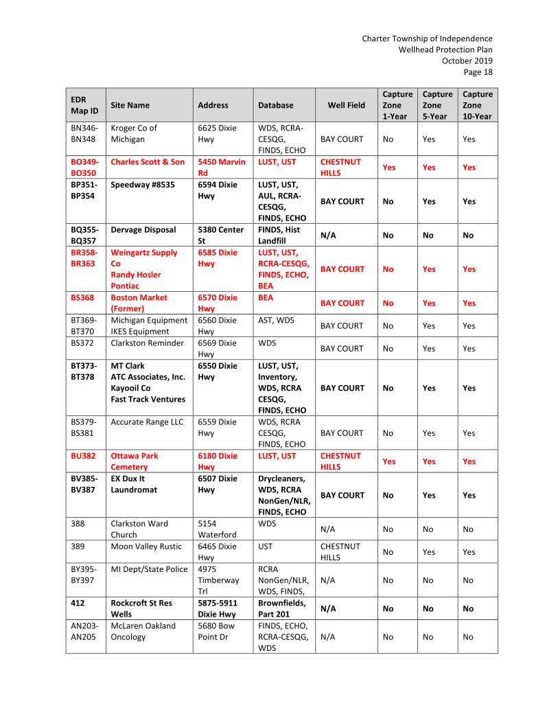
Charter Township of Independence
Wellhead Protection Plan
October 2019
Page 18
EDR
Map ID Site Name Address Database
Well Field
Capture
Zone
1-Year
Capture
Zone
5-Year
Capture
Zone
10-Year
BN346-
BN348
Kroger Co of
Michigan
6625 Dixie
Hwy
WDS, RCRA-
CESQG,
FINDS, ECHO
BAY COURT No Yes Yes
BO349-
BO350
Charles Scott & Son 5450 Marvin
Rd
LUST, UST CHESTNUT
HILLS Yes Yes Yes
BP351-
BP354
Speedway #8535 6594 Dixie
Hwy
LUST, UST,
AUL, RCRA-
CESQG,
FINDS, ECHO
BAY COURT No Yes Yes
BQ355-
BQ357
Dervage Disposal 5380 Center
St
FINDS, Hist
Landfill N/A No No No
BR358-
BR363
Weingartz Supply
Co
Randy Hosler
Pontiac
6585 Dixie
Hwy
LUST, UST,
RCRA-CESQG,
FINDS, ECHO,
BEA
BAY COURT No Yes Yes
BS368 Boston Market
(Former)
6570 Dixie
Hwy
BEA BAY COURT No Yes Yes
BT369-
BT370
Michigan Equipment
IKES Equipment
6560 Dixie
Hwy
AST, WDS BAY COURT No Yes Yes
BS372 Clarkston Reminder 6569 Dixie
Hwy
WDS BAY COURT No Yes Yes
BT373-
BT378
MT Clark
ATC Associates, Inc.
Kayooil Co
Fast Track Ventures
6550 Dixie
Hwy
LUST, UST,
Inventory,
WDS, RCRA
CESQG,
FINDS, ECHO
BAY COURT No Yes Yes
BS379-
BS381
Accurate Range LLC 6559 Dixie
Hwy
WDS, RCRA
CESQG,
FINDS, ECHO
BAY COURT No Yes Yes
BU382 Ottawa Park
Cemetery
6180 Dixie
Hwy
LUST, UST CHESTNUT
HILLS Yes Yes Yes
BV385-
BV387
EX Dux It
Laundromat
6507 Dixie
Hwy
Drycleaners,
WDS, RCRA
NonGen/NLR,
FINDS, ECHO
BAY COURT No Yes Yes
388 Clarkston Ward
Church
5154
Waterford
WDS N/A No No No
389 Moon Valley Rustic 6465 Dixie
Hwy
UST CHESTNUT
HILLS No Yes Yes
BY395-
BY397
MI Dept/State Police 4975
Timberway
Trl
RCRA
NonGen/NLR,
WDS, FINDS,
N/A No No No
412 Rockcroft St Res
Wells
5875-5911
Dixie Hwy
Brownfields,
Part 201 N/A No No No
AN203-
AN205
McLaren Oakland
Oncology
5680 Bow
Point Dr
FINDS, ECHO,
RCRA-CESQG,
WDS
N/A No No No

Charter Township of Independence
Wellhead Protection Plan
October 2019
Page 19
EDR
Map ID Site Name Address Database
Well Field
Capture
Zone
1-Year
Capture
Zone
5-Year
Capture
Zone
10-Year
AN206-
AN211
Clarkston
Dermatology
McLaren Regional
Med
5701 Bow
Pointe Dr
FINDS, ECHO,
RCRA-CESQG,
WDS N/A No No No
364 Transmission
Express
5267 Mary
Sue
Hist Auto Lake Oakland
Woods Yes Yes Yes
319 Township of
Independence
5241
Maybee Rd
WDS N/A No No No
366 * 5240 Cecelia
Ann
Spills LAKE
OAKLAND
WOODS
No Yes Yes
Orphan Res Wells Main St Main St MI
Brownfields Not Found
Not
Found
Not
Found
Not
Found
Orphan * 6701 & 6671
Clintonville
Spills Not Found
Not
Found
Not
Found
Not
Found
Orphan * Milane Circle Spills Not Found
Not
Found
Not
Found
Not
Found
Orphan * Console St Spills Not Found
Not
Found
Not
Found
Not
Found
Orphan * Northbound
I-75 at
Sashabaw Rd
Spills
Not Found Not
Found
Not
Found
Not
Found
Orphan Greenslake
Apartments
M-15 & Dixie
Greens Lake
Canal
Spills
Not Found Not
Found
Not
Found
Not
Found
Orphan Mi
Dept/Transportation
I-75 at
Clarkston
FINDS, ECHO Not Found
Not
Found
Not
Found
Not
Found
Orphan Chase Plastic
Service, Inc.
S of Waldon
Rd & W of
Sashabaw Rd
BEA
Not Found Not
Found
Not
Found
Not
Found
Orphan Camp Oweki 6125 Gulick
Rd
WDS Not Found
Not
Found
Not
Found
Not
Found
Orphan Oakland Co Rd
Comm SLF #3
Clarkston Rd
M-15
Hist LF Not Found
Not
Found
Not
Found
Not
Found
* No site name listed

Charter Township of Independence
Wellhead Protection Plan
October 2019
Page 20
PFAS Contamination
Per and Polyfluoroalkyl substances (PFAS) compounds have been identified in Michigan since
2010 and fall into a category of “Emerging Contaminants”. The compounds are very resistant to
natural degradation processes making them extremely stable and persistent in the
environment. They are typically very mobile in groundwater allowing the spread from the area
of source contamination. PFAS has been associated with, but not limited to firefighting foams,
cloth/leather/paper treatment, military facilities, airports, metal plating facilities, Teflon, and
other applications.
In an effort to evaluate the possible presence of Per and Polyfluoroalkyl substances (PFAS) in
the Townships drinking water supply, samples were collected at each of the 12 wellfields in
June 2018. At that time PFAS compounds were identified in the “Clarkston Gardens” Well No.
2. Upon receipt of the results, the Clarkston Gardens well was shut down for further
evaluation. This well was later sampled twice by the State of Michigan as part of a State funded
Quarterly Sampling effort. Samples collected in April 2019 and June 2019 had detections of
several PFAS compounds including PFOS and PFOA, which combined have a US EPA Lifetime
Health Advisory concentration of 70 part per trillion (ppt). The combined concentration in the
April 2019 sample was 2 ppt, while in June 2019 was 6 ppt. Although the combined
concentration was measured well below the EPA LHA in 2019, the “Clarkston Gardens” well will
remain inactive until further evaluation can be completed. Correspondence received by
Michigan’s EGLE dated May 13, and August 1, 2019 is included in Appendix C.
As part of the 2019 contaminant source inventory, DLZ identified twelve sites of environmental
concern within the 1-year and 5-year and 10-year capture zones of the Clarkston Gardens
Municipal wellfield. The sites identified as high priority within the capture zones of the
Clarkston Gardens Municipal wellfield are listed in the table below:
EDR Map ID Site Name Address Database
17 BVD Corporation, Inc. 8930 Perry Lake Rd Hist Auto
24 C/O Mobil Exxon 6379 Park Trail Dr Hist Auto
T104-T105 Clarkston Community Schools 6389 Clarkston Rd FTTS, FINDS
113 RD Transmissions 6311 Peach Dr Hist Auto
L59-L60 Clarkston Mercury SP 6185 Clarkston Rd SEMS, PRP
80 Clarkston Christian Schools 6300 Clarkston Rd FINDS
72
R88-R93
Clarkston Road Landfill
Clarkston Road Area LF/
MI DNR
6440 Clarkston Road SEMS-Archive, MI
Brownfields, Part 201, BEA
Q86 Dept of Public Works 6050 Flemings Lake Rd UST
V118-V119 McGill Residence 6506 Church St RCRA NonGen/NLR, FINDS,
ECHO, WDS

Charter Township of Independence
Wellhead Protection Plan
October 2019
Page 21
EDR Map ID Site Name Address Database
AE160 Clarkston Junior High 6595 Waldon Spills
115 Clarkston Schools 6300 Church St WDS
94 Resurrection Episcopal 6490 Clarkston Rd WDS
Of the identified sites, no information was identified suggesting the possible storage, use or
generation of PFAS chemicals within the capture zones of the Clarkston Gardens wellfield, with
the possible exception of the Clarkston Road Landfill where historical hazardous substance
disposal may have occurred. The Clarkston Road Landfill is a 25-acre landfill operated from the
1940s until 1978. The waste stream is generally unknown, but it is thought that typical
municipal waste was disposed at the landfill. Information on file with EGLE indicates that the
landfill was not properly closed when it ceased operations in 1978. In 1989, 36 residential wells
In the vicinity of the landfill were identified with elevated concentrations of ammonia (NH3)
and/or trace amounts of freon and all local residences were connected at that time to
municipal water supply. Subsequent environmental investigations of the landfill identified
arsenic and cadmium as the primary contaminants of concern in groundwater. PFAS was not
included in analyses completed in the 1990’s and 2000’s at the landfill. Because of apparent
minimal environmental impacts, 12 existing monitoring wells were abandoned in 2008. No
environmental investigations have been conducted since 2008.
In a telephone interview with Mr. Greg Barrows, of the EGLE Southeast Michigan District Office,
Mr. Barrows confirmed that the primary contaminants found at the landfill were the metals
arsenic and cadmium. He also stated that test pitting identified only scrap metal and this, along
with only low concentrations of methane measured at the site, suggests that little organic
waste was disposed there due to the lack of apparent decomposition. EGLE has no record or
knowledge of wastes containing PFAS being disposed at the landfill.

Charter Township of Independence
Wellhead Protection Plan
October 2019
Page 22
PLAN FORM 6 - REGULATORY MANAGEMENT STRATEGIES
Management strategies already in place:
Management approaches already in place include county sanitary codes and township
regulations. These include the:
• Oakland County Sanitary Code, Article II, Groundwater Protection (nitrate
contamination)
• Oakland County Sanitary Code, Article X, Drinking Water Supply Program, Well
Protection and Education
• Independence Township Site Plan Review Standards for Groundwater Protection
• Independence Township Environmental Permits Checklist
• Independence Township Hazardous Substances Reporting Form
• Independence Township Septic Tank Septage Ordinance
• Plumbing Code to prevent new wells being installed when public water supply is
available.
Copies of these codes and regulations are provided in the sections below. In addition to these
documents, the township has links with Michigan State University (MSU) Extension. MSU
Extension provides expert information to the public on several topics of environmental and
social significance. For example, MSU Extension provides information for the layman on ways
of preventing groundwater contamination. Such documents will be studied by members on the
Independence Wellhead Protection Team, especially those members involved in public
education and outreach.

Charter Township of Independence
Wellhead Protection Plan
October 2019
Page 23
OAKLAND COUNTY SANITARY CODE
ARTICLE II
GROUNDWATER PROTECTION
Oakland County’s unique subsurface geology, sustained growth and development (commercial,
industrial, and residential), and lack of municipal sewer systems in developing areas make it
necessary for Oakland County to develop regulations protecting its groundwater while allowing
for growth and development vital to its continued well-being. A review of professional and
scientific literature relating to groundwater contamination from on-site wastewater units as
well as a review of county population, demographics and building and water use trends in the
housing industry, indicate that control of the application of wastewater effluent in the single
most effective method of controlling groundwater contamination from on-site wastewater
units. As a result of this review, it has been determined that density control, utilization of
alternative and emergent technologies, land use restrictions and permitting procedures (i.e., a
well permit system) are all valid and useful methods to be incorporated into a comprehensive
groundwater protection policy. Consequently, this Article is enacted to protect the public
health and safety of the residents and future residents of Oakland County who rely upon on-
site water supplies and on-site wastewater disposal.
SECTION 1 – DEFINITIONS
1.1 Residential Building Site – A parcel or division of land intended for construction of a
single or two-family residential unit relying upon on-site sewage disposal.
1.2 Commercial Development – A parcel or division of land intended for construction of a
multiple family residential unit (i.e., more than two families) or businesses relying upon
on-site disposal of sanitary waste only.
1.3 Industrial Site – A facility which produces liquid waste from industrial and commercial
processes as distinct from sanitary sewage and generally requires a separate discharge
permit from the Michigan Department of Environmental Quality.
1.4 Sanitary Sewage – Water and contaminants discharged from the sanitary conveniences
(i.e., bathroom, kitchen fixtures, and household laundry) of dwellings, office buildings,
industrial plants, commercial buildings, and institutions.
1.5 Package Treatment Unit – A device designed and constructed to receive the discharge of
sewage and to diminish waste material through the application of acceptable
technology which creates an effluent acceptable for discharge to surface water or the
groundwaters of the State of Michigan.

Charter Township of Independence
Wellhead Protection Plan
October 2019
Page 24
1.6 Municipal Sanitary Sewer – All or part of sewerage systems, including sewage treatment
works owned and operated by a governmental agency where the sewage treatment
works is under the supervision of a properly certified operator, as authorized by Public
Act 98, of the Public Acts of 1913, as amended, being Sections 3235.301 to 325.214 of
the Michigan Compiled Laws.
1.7 Total Project – The gross land area available for residential development, excluding
surface areas of lakes, streams, rivers, ponds, or other water courses.
SECTION 2 – RESIDENTAIAL BUILDING SITES
2.1 Building Sites Defined – Any site which is not provided with municipal sanitary sewers
will be subject to the provisions of this Article. It shall be unlawful for any person to
develop a site established after the effective date of this Article which does not comply
with this Article.
2.2 Minimum Residential Building Site – A single or two-family residential building site must
contain a minimum of one (1) acre for each three-bedroom residence. Minimum site
size may be reduced when dedicated open spaces are provided as part of this total
project (i.e., cluster homes). For purposes of this section, open spaces include areas set
aside for roadways. Sites for structures in excess of three (3) bedrooms must contain an
additional area at the rate of one-quarter (1/4) acre per bedroom.
2.3 Land Division – Any division of existing parcels of land after the effective date of this
Code will not be approved for on-site sewage disposal systems unless they meet the
minimum requirements of this Article. Land splits which are provided with municipal
sanitary sewers do not fall under the provisions of this Code and will be allowed
provided they meet local ordinances.
SECTION 3 – COMMERCIAL DEVELOPMENT (RESERVED)
SECTION 4 – ALTERNATIVE DEVICES AND SPECIAL CONSTRUCTION METHODS
4.1 Acceptance of Alternative Technology – The Heath Officer or, when designated, the
Administrator of Environmental Health Services, may accept the application of proven
alternative technology of devices, materials, or special construction or installation
techniques acceptable to the Heath Division which provide reduction in the
contamination loading of the waste stream. This technology acceptance must be
approved in writing by the Health Officer or, when designated, the Administrator of
Environmental Health Services and be consistent with the provisions of both this Article
and Article III, which governs the construction and installation standards for on-site
sewage disposal systems.

Charter Township of Independence
Wellhead Protection Plan
October 2019
Page 25
4.2 Waiver Modification – The provisions of Sections 2 or 3 relating to lot size and/or
application rates may be modified due to unique or special circumstances, including the
use of proven alternative technology as set forth in Section 4.1 above, so long as such
waiver or modification does not diminish public health or safety.
4.3 Additional Monitoring – When in the opinion of the Heath Officer or, when designated,
the Administrator of Environmental Health Services, additional monitoring is required
for an alternative method of sewage disposal, the right of entry for the purposes of
testing, monitoring, or evaluating the system must be established for the property on
which it is installed through legal binding methods for a period of time at least
equivalent to a conventional sewerage disposal system.
4.4 Testing of System – When it becomes necessary to test sewerage systems to determine
their effectiveness as part of the overall evaluation, the Heath Division may establish
reasonable charges not to exceed the actual cost incurred for the evaluation of the
sewerage system. The Health Division may also direct the proprietor to have specific
tests conducted at a recognized laboratory. The cost of such test(s) will be incurred by
the proprietor of the system.
SECTION 5 – APPEALS
5.1 Right of Appeal – Unless otherwise regulated, a person who has failed to demonstrate
adequacy for an on-site sewerage disposal system under this Article shall have the right
of appeal by petition in writing to the Oakland County Health Division and such appeals
shall be heard before the Sanitary Code Appeal Board. The petition must be
accompanied with a fee and must be submitted within 30 days from the receipt of
written notice of the rejection by the Oakland County Health Division.
5.2 Right of Appeal for Other Regulated Facilities – Persons having projects or land
regulated under another state or federal law regulation or agency must appeal the
Health Division’s decision to disallow the proposed usage to the state or federal agency
having superintending regulatory responsibility.

Charter Township of Independence
Wellhead Protection Plan
October 2019
Page 26
SECTION 6 – EFFECTIVE DATES
This Article shall take effect on January 22, 1995-adopted by the Oakland County Board of
Commissioners on December 8, 1994.
AUTHORITY: Michigan Compiled Law 333.2441
Michigan Compiled Law 333.2433
Michigan Compiled Law 333.2435
Michigan Compiled Law 559.171a (1)
Michigan Compiled Law 559.171a (3)
Michigan Compiled Law 560.105(a)
1979 Administrative Code R 560.403
1979 Administrative Code R 500.404

Charter Township of Independence
Wellhead Protection Plan
October 2019
Page 27
OAKLAND COUNTY SANITARY CODE
ARTICLE X
DRINKING WATER SUPPLY PROGRAM
WELL PROTECTION AND EDUCATION
Article X of the Oakland County Sanitary Code is established to help protect the health and
safety of the residents and future residents of Oakland County who rely on individual sources of
well water supplies for their daily living needs.
SECTION 1 – DEFINITIONS
A. Abandoned Water Well – Means any of the following:
1. A well which has its use permanently discontinued.
2. A well which is in such disrepair that its continued use for the purpose of
obtaining groundwater is impractical.
3. A well which has been left uncompleted.
4. A well which is a threat to groundwater resources.
5. A well which is or may be a health or safety hazard.
B. Extensive Changes or Repairs – Include replacing the entire casing, removing a casing
from the ground, or changing aquifers.
1. Replacing a telescoped well screen.
2. Changing screen elevation.
3. Deepening or plugging back a bedrock well.
4. Installing a liner pipe.
5. Replacing a pump, controls, pump drop pipe, or pressure tank.
6. Chemical treatment of the well or well disinfection.
C. Person – Means a person as defined in MCL 333.1106 or a governmental entity.
D. Well – Means an opening in the surface of the earth for the purpose of removing
fresh water or a test well, recharge well, waste disposal well, or a well used
temporarily for dewatering purposes during construction.
E. The terms defined in the Public Health Code, 1978 PA 368, as amended, Article I –
Parts 11 and 12, Article 2 – Part 24, and Article 12 – Parts 121 and 127, and terms
defined in the Michigan Administrative Code, R 325.1601 to R 325.1781, have the
same meanings when used in these local health regulations.

Charter Township of Independence
Wellhead Protection Plan
October 2019
Page 28
SECTION 2 – WELL EDUCATION PACKET REQUIRED
A. The Oakland County Health Division shall produce an educational packet containing a map
documenting areas of groundwater contamination, general information on well drilling, well
maintenance, and a list of pertinent telephone numbers to assist persons requiring a new
well or extensive repairs. The educational packet shall be made available to requesting
individuals and, for the purpose of distribution to interested residents, to cities, villages,
townships, and registered well drillers.
B. No person or governmental entity shall construct, extensively change or repair, or abandon
a well without first acknowledging on a form provided for that purpose by the Oakland
County Health Division the receipt of the educational packet developed pursuant to
Subsection A, being Article X, Section 2.A. A registered well drilling contractor or a person
licensed under Article 24 of Act 299 of the Public Acts of 1980, as amended, being sections
339.2401 to 339.2412 of the Michigan Compiled Laws, may acknowledge receipt of the
educational packet on behalf of a well owner and shall, in such case, deliver the educational
packet to the well owner.
C. Except in emergency situations as detailed in Subsection E, before constructing or
extensively changing or repairing a well, a person or entity shall notify the Oakland County
Health Division in writing of such intent to construct or extensively change or repair a well.
Notification shall be made on a form provided for that purpose by the Oakland County
Health Division. The form, which shall serve as an application for the permit required by
Section 6 of this Article, shall require information sufficient to allow the Oakland County
Health Division to conduct a predrilling site review for the proposed well and shall be filed
with the Health Division not less than 48 hours prior to the time construction, extensive
change or repair, or abandonment of the water supply is to begin.
D. A copy of the well log required by MCL 333.12707 and/or by Michigan Administrative Code
rules promulgated pursuant thereto shall be submitted by a well drilling contractor to the
Oakland County Health Division not later than 60 days after the completion of a well.
E. In the event an emergency arises where the lack of water will result in undue hardship and
the offices of the Oakland County Health Division are closed or when registered well drilling
contractor is involved with minor repair work and conditions are discovered indicating that
it is necessary (in order to avoid excessive cost or undue hardship) to immediately begin
construction, extensive change, repair, or abandonment of a well, a registered well drilling
contractor may begin construction, extensive change, repair, or abandonment of a well
without prior notification or permitting. In such situations, by the close of business on the
next regular county business day, the well drilling contractor shall notify the Oakland
County Health Division of the work utilizing the “Well Action Notification/Permit Application

Charter Township of Independence
Wellhead Protection Plan
October 2019
Page 29
Form” provided for that purpose by the Oakland County Health Division. The registered
well drilling contractor or well owner shall acknowledge receipt of the educational packet,
as provided in Subsection B, within five (5) business days of commencement of the
emergency drilling action. Wells constructed or extensively changed or repaired prior to
permitting under this Subsection shall meet state construction and potable water
standards.
SECTION 3 – WELL INSPECTIONS
1. The Oakland County Health Division shall be authorized by the Health Officer to make well
inspections and shall conduct predrilling site reviews for well sites. In order to avoid
duplication of services and increased taxpayer cost, the Oakland County Health Division
shall work with cities, villages, and townships that have been approved by the State of
Michigan to administer and enforce the building codes in the State of Michigan. The Health
Division shall accept inspection(s) or analyses regarding water potability, the proper
construction, extensive change or repair, or abandonment of a water well if such
inspection(s) or analysis(es) were conducted by a legally designated city, village, or
township code enforcement official and if all of the following requirements are met:
A. 1.) The city, village, or township employing the code enforcement official has
adopted a local building, construction, health or safety code (e.g., Building Officials
and Code Administrators building code) that regulates well construction, extensive
change or repair, or abandonment utilizing requirements which are not less
restrictive than those required under Part 127 of Public Act 368 of 1978, as
amended, and administrative rules promulgated pursuant thereto; and
2.) The inspection(s) was conducted by a person(s) who has been trained to conduct
well inspections by the State of Michigan or through a program recognized as
adequate by the State of Michigan; the inspection(s) include a satisfactory
bacteriological and nitrate water sample report and a water well and pump
record log; and the satisfactory bacteriological and nitrate water sample report
are filed with the local building official or the Oakland County Health Division
before an occupancy permit is issued. In the event of an unsatisfactory water
test, a local unit of government may authorize a temporary occupancy permit
which will allow for a safe alternative source of potable water; and
3.) Any laboratory analysis of water or soil samples reflected, reported, or utilized in
such city, village, or township inspection report(s) were conducted by a
laboratory certified, licensed, or authorized by the State of Michigan to conduct
such analysis; and

Charter Township of Independence
Wellhead Protection Plan
October 2019
Page 30
4.) All local inspection documents are made available to the Oakland County Health
Division upon request; and
5.) All inspection reports indicating the existence of groundwater contamination or
a failure to comply with Part 127 of Public Act 368 construction requirements
shall be turned over to the Oakland County Health Division within 72 hours of
the completion of the inspection.
B. The Oakland County Health Division shall provide Oakland County cities, villages, and
townships who agree to participate with the Health Division in this Article’s well
notification and education program with educational packets, notification forms, well
plugging (abandonment) forms, and other materials necessary or appropriate to
facilitate their participation.
C. Any Oakland County real property owner or properly authorized representative of an
Oakland County real property owner may request a Health Division inspection of their
well for a fee established by Board of Commissioner resolution.
SECTION 4 – ADVISORY COMMITTEE
A. An Oakland County Well Advisory Committee is established consisting of nine (9) members
appointed as set forth below.
B. The Oakland County Well Advisory Committee shall be comprised of four (4) members who
are residents of Oakland County and registered under Sections 12701 and 12715 of 1978
Public Act 368, as amended, at least three (3) of whom shall be well drilling contractors; one
(1) builder licensed by the State of Michigan and a resident of Oakland County; one (1)
resident of Oakland County who is not an elected official; and one (1) local official from an
Oakland County city, village, or township that relies primarily on wells for drinking water, all
of whom shall be appointed by the County Board of Commissioners; one (1) employee of
the Oakland County Health Division appointed by the County Executive; one (1) employee
of the Drain Commission appointed by the Drain Commissioner. There shall be three-year
staggered terms; 3 members for two-year terms; and 3 members for three-year terms.
Vacancies shall be filled by appointment for the balance of the unexpired terms by the
respective officials designated herein. The first term of office shall be considered to begin
on the date set by the Board of Commissioners in the appointment of the first member.

Charter Township of Independence
Wellhead Protection Plan
October 2019
Page 31
C. Functions:
1. The members of the advisory committee shall, at their first meeting, and once each year
thereafter, organize and select a chairperson and vice chairperson from among their
members. A record secretary shall be assigned by the Oakland County Board of
Commissioners.
2. The committee shall meet not less than twice each year for the necessary conduct of
business. Additional meetings may be called by the chairperson or any three members
of the committee. Five members shall constitute a quorum. The business which the
committee may perform shall be conducted at a public meeting of the advisory
committee held in compliance with Act 267 of the Public Acts of 1976, as amended,
being Sections 15.261 to 15.275 of the Michigan Compiled Laws.
3. The first meeting of the advisory committee shall take place within forty (40) days after
this Article is adopted and the first member is appointed by the Oakland County Board
of Commissioners.
4. The Oakland County Health Division, with the advice of the advisory committee, may
promulgate rules, materials, plans, and procedures and update the educational packet
annually.
5. The advisory committee may advise Oakland County with respect to the need for or
desirability of conducting special studies. Where conditions indicate that studies,
investigations, or inquiries are warranted, the Oakland County Health Division may
participate in and/or coordinate special studies activity as provided in Section 2433 of
the Public Health Code, MCL 333.2433(2)(c) and (d).
6. Appeals on matters related to interpretation of the state well/pump code (Part 127,
Act 368, P.A. 1978) and Groundwater Quality Control Rules, R 325.1601 to R 325.1781
are not within the authority of the County advisory board.
SECTION 5 – LOCAL DISTRIBUTION
The Oakland County Health Division shall work with any Oakland County City, Village, or
Township who has agreed to participate with the Health Division in this Article’s well
notification and education program by establishing mutually agreeable arrangements for
distribution and processing of educational packets, notification forms, and other materials
necessary or appropriate to facilitate participation in the program.

Charter Township of Independence
Wellhead Protection Plan
October 2019
Page 32
SECTION 6 – PERMITS AND FEES
A permit must be obtained from the Oakland County Health Division before the construction of
or extensive repair of a well.
Pursuant to MCL 333.2444, the Oakland County Board of Commissioners may establish a fee for
services authorized or required to be performed by the Health Division under this Article. The
fees charged shall not be more than the reasonable cost of performing the service. Any fee(s)
shall be reviewed periodically by the Board of Commissioners for adjustment as appropriate.
SECTION 7 – DENIAL OF PERMIT
The Health Office shall have the right to reject a water supply permit when conditions exist or
may be created which may endanger the public health or environment.
SECTION 8 – FINES AND PENALTIES
Any person or governmental entity determined to be in violation of any of the provisions of this
Article, upon conviction thereof, shall be deemed guilty of a misdemeanor offense and subject
to incarceration for up to 90 days and/or a fine of up to $200.00 plus the cost of prosecution.
SECTION 9 - APPEALS
Appeal of permitting or regulatory actions taken by the Oakland County Health Division under
this Article (X) may be made to the Oakland County Sanitary Code Appeal Board as provided in
Article V of the Oakland County Sanitary Code.
SECTION 10 – EFFECTIVE DATES
This Article shall take effect on February 1, 1998. Adopted by the Oakland County Board of
Commissioners on December 16, 1997.
AUTHORITY: 1978 PA 368, as amended
Michigan Compiled Law 333.1101 et seq.
Michigan Compiled Law 333.2401 et seq.
Michigan Compiled Law 333.12101 et seq.
Michigan Compiled Law 333.12701 et seq.
1994 AACS, R 325.1601-R 325.1676
1994 AACS, R 325.1741-R 325.1781
The Site Plan Review Standards for Groundwater Protection presented below are part of the
Independence Township Zoning Ordinance:

Charter Township of Independence
Wellhead Protection Plan
October 2019
Page 33
6. SITE PLAN REVIEW STANDARDS FOR GROUNDWATER PROTECTION
A. DEFINITION OF HAZARDOUS SUBSTANCES AND POLLUTING MATERIALS
A chemical or other material which is or may be injurious to the public health, safety, or
welfare of the environment.
B. APPLICABILITY
These provisions shall apply to all businesses and facilities, including private and public
facilities, which use, store, or generate hazardous substances and polluting materials in
quantities greater than 100 kilograms per months (equal to about 25 gallons or 220
pounds) and which require site plan review under the provisions of this Ordinance or
other Township Ordinances.
C. SITE PLAN INFORMATION REQUIREMENTS
1. The Township may require a listing of types and quantities of hazardous substances
and polluting materials which will be used or stored on site at the facility in
quantities greater than 100 kilograms per month (equal to about 25 gallons per
month) if necessary, to ensure compliance with the provisions of this or other
Township Ordinances.
2. Completion and submission of the “Hazardous Substances Reporting Form for Site
Plan Review” and “The Environmental Permits Checklist” is required.
3. Location of existing and proposed service facilities and structures, above and below
ground, shall be shown including:
a. Public and private groundwater supply wells on site and on adjacent properties;
b. Septic systems and other waste water treatment systems (the location of the
drain field and the septic tank, if applicable, shall be clearly distinguished);
c. Areas to be used for the storage, use, loading/unloading, recycling, or disposal of
hazardous substances and polluting materials, including interior and exterior
areas;
d. Underground storage tank locations;
e. Location of exterior drains, dry wells, catch basins, retention/detention areas,
sumps and other facilities designed to collect, store, or transport storm water or
waste water. The point of discharge for all drains and pipes shall be specified on
the site plan;

Charter Township of Independence
Wellhead Protection Plan
October 2019
Page 34
f. Location of all aboveground tanks, chemical storage, hazardous waste storage,
collection of contaminated storm water or wash water, and all similar uses.
4. Location of existing wetlands and watercourses, including lakes, ponds, rivers, and
streams.
5. Soil characteristics of the parcel, at least to the detail provided by the U.S. Soil
Conservation Service.
6. Delineation of areas on the site which are known or suspected to be contaminated,
together with a report on the status of site cleanup.
D. SITE PLAN REVIEW STANDARDS
1. Groundwater Protection Standards
a. The project and related improvements shall be designed to protect the natural
environment, including lakes, ponds, streams, wetlands, floodplains, and
groundwater, and to ensure the absence of an impairment, pollution, and/or
destruction of the air, water, natural resources and the public trust therein.
b. Storm water management and drainage facilities shall be designed to retain the
natural retention and storage capacity of any wetland, water body, or
watercourse, and shall not increase flooding or the potential for pollution of
surface water or groundwater, on site or off site, and shall not result in a loss of
the use of property by any third party.
c. General purpose floor drains shall be connected to a public sewer system, an
onsite holding tank, or a system authorized through a state groundwater
discharge permit.
d. Sites at which hazardous substances and polluting materials are stored, used, or
generated shall be designed to prevent spills and discharges to the air, surface of
the ground, groundwater, lakes, streams, rivers, or wetlands.
e. State and federal agency requirements for storage, spill prevention, record
keeping, emergency response, transport and disposal of hazardous substances
and polluting materials shall be met. No discharges to groundwater, including
direct and indirect discharges, shall be allowed without required permits and
approvals.

Charter Township of Independence
Wellhead Protection Plan
October 2019
Page 35
f. In determining conformance with the standards in this Zoning Ordinance, the
Township shall take into consideration the publication entitled “Small Business
Guide to Secondary Containment” and other references.
2. Above-ground Storage and Use Areas for Hazardous Substances and Polluting
Materials
a. Secondary containment of hazardous substances and polluting materials shall be
provided. Secondary containment shall be sufficient to store the substance for
the maximum anticipated period of time necessary for the recovery of any
released substance.
b. Outdoor storage of hazardous substances and polluting materials shall be
prohibited except in product-tight containers which are protected from weather,
leakage, accidental damage and vandalism.
c. Secondary containment structures such as out buildings, storage rooms, sheds
and pole barns shall not have floor drains which outlet to soils, groundwater, or
nearby drains or natural water bodies.
d. Areas and facilities for loading/unloading of hazardous substances and polluting
materials, as well as areas where such materials are handled and used, shall be
designed and constructed to prevent discharge or runoff to floor drains, rivers,
lakes, wetlands, groundwater, or soils.
3. Underground Storage Tanks
a. Existing and new underground storage tanks shall be registered with the
authorized state agency in accordance with requirements of the U.S.
Environmental Protection Agency and the Michigan Department of
Environmental Quality, Waste and Hazardous Materials Division.
b. Installation, operation, maintenance, closure, and removal of underground
storage tanks shall be in accordance with requirements of the State Police / Fire
Marshal Division. Leak detection, corrosion protection, spill prevention, and
overfill protection requirements shall be met. Records of monthly monitoring or
inventory control must be retained and available for review by government
officials.
c. Out-of-service abandoned underground tanks shall be emptied and removed
from the ground in accordance with the requirements of the State Police Fire
Marshal Division, and the Michigan Department of Natural Resources.

Charter Township of Independence
Wellhead Protection Plan
October 2019
Page 36
4. Sites with Contaminated Soils and/or Groundwater
a. Site plans shall take into consideration the location and extent of any
contaminated soils and/or groundwater on the site, and the need to protect
public health and the environment.
b. Development shall not be allowed on or near contaminated areas of a site unless
information from the Michigan Department of Environmental Quality is available
indicating that cleanup will proceed in a timely fashion and that such
development is authorized.

Charter Township of Independence
Wellhead Protection Plan
October 2019
Page 37
Environmental Permits Checklist
Site Plan No. _______
This Checklist is designed to assist businesses in their efforts to identify and comply with State
and County environmental permit requirements. Please submit the completed form to the
Township at the time that site plans are submitted.
This Checklist is not a permit application form; businesses are responsible for obtaining
information and permit application forms from the appropriate government offices.
Notification of applicable County and State requirements is a pre-requisite for site plan
approval in Independence Township. The Township will forward this form to the Michigan
Department of Environmental Quality Permit Coordinator.
Please check the regulations which you think may apply to your business:
Y N Will the project involve the discharge of any type of wastewater to a storm sewer,
drain, lake, stream, or other surface water?
Y N Will the project involve the discharge of liquids, sludge, wastewater and/or
wastewater residuals into or onto the ground?
Y N Will the project or facility store or use hazardous substances, oil or salt? Depending
on the type of substance, secondary containment and a Pollution Incident
Prevention Plan (or a material storage permit) may be required.
Y N Will the facility use underground storage tanks? Existing and proposed tanks must
be registered with the State of Michigan. Tanks must be installed and operated in
accordance with the regulations of Independence Township and the Michigan
Department of Environmental Quality.
Y N Will the facility involve the transport, on-site treatment, storage or disposal of
hazardous waste generated in quantities of 1,000 kilograms (250 gallons or 2,200
pounds) or more per month? If Yes, one or more permits will be required.
Will the facility generate between 100 kilograms/month (25 gallons or 220 pounds)
of hazardous waste? If Yes, the facility may be a small quantity generator, subject
to federal and state regulations. An EPA identification number should be obtained
from the Michigan Department of Environmental Quality (special forms are
available) and a manifest (shipping paper) should be used to transport waste
offsite.

Charter Township of Independence
Wellhead Protection Plan
October 2019
Page 38
Y N Will the project involve burning, land filling, transferring or processing any type of
solid non-hazardous wastes on site?
Y N Will the project involve the installation, construction, reconstruction, relocation or
alteration of any process or process equipment (including air pollution control
equipment) which has the potential to emit air contaminates?
Y N Will the project involve any man-made change in the natural cover or topography
of the land, including cut and fill activities which may contribute to soil erosion and
sedimentation? Will the earth change disturb an area of one (1) acre or more, or
occur within 500 feet of a lake or stream? If the answer to both of these questions
is Yes, a soil erosion and sedimentation control permit is required.
Y N Does the project involve any work (dredging, filling, construction) proposed in a
river, stream, creek, ditch, wetland, or floodplain, or within 500 feet of an inland
lake, river, stream, creek or ditch?
Y N Will any hazardous chemicals, hazardous wastewater or hazardous waste in any
quantity be discharged to the Detroit Wastewater Treatment System? If Yes,
information may need to be provided to determine if pretreatment requirements
apply.
Y N Will an on-site wastewater treatment system or septic system be installed? Will
septic be stored on-site prior to off-site disposal?
Y N Is this facility (or any facility under your ownership) currently involved in any
compliance discussion with the Michigan Department of Environmental Quality or
the Michigan Attorney General’s Office?
Y N Is this facility/property (or any facility/property under your ownership) included on
the Act 307 Priority List, “Michigan Sites of Environmental Contamination” or
subject to corrective action under the Leaking Underground Storage Tank (LUST)
Program?
Note: For assistance with permits and approvals from the Michigan Department of
Environmental Quality including permit coordination among EGLE divisions, contact the Permit
Coordinator, Lansing Central Office at (517) 241-1346.
Charter Township of Independence
Wellhead Protection Plan
October 2019
Page 39
Business Name:
Mailing Address:
Street Address/Location:
Telephone: Sidwell No.
Facility Owner or Manager:
Type of Business: Date:
cc: DPW
Fire Marshal
EGLE – Permit Coordinator

Charter Township of Independence
Wellhead Protection Plan
October 2019
Page 40
Hazardous Substances Reporting Form
Site Plan No. _______
Note: This form must be completed and submitted as part of the site plan for all facilities:
Name of Business:
Business Owner:
Street/Mailing Address:
Telephone: Sidwell No.
Location of Property:
I affirm that the information submitted is accurate.
Owner’s Signature Dated:
Information Compiled By: Dated:

Charter Township of Independence
Wellhead Protection Plan
October 2019
Page 41
Part I:
Management of Hazardous Substances and Polluting Material
Y N Will the proposed facility store, use or generate hazardous substances or polluting materials
(including petroleum-based products) in quantities greater than 100 kilograms per months
(about 25 gallons per months) now or in the future? If Yes, please complete the rest of this
form and submit with your site plan. If No, stop here and return to the Planning Department.
Y N Will hazardous substances or polluting materials be reused or recycled on site? If Yes,
Identify the storage location on the site plan. Describe the size and type of secondary
containment
structures here and as a detail on the site plan.
_____________________________________________________________________________
Y N Will new underground storage tanks be located less than 2,000 feet from drinking water wells
serving two (2) or more establishments, or less than 300 feet from a single-family drinking
water well? If Yes, contact the Michigan Department of Environmental Quality (517-335-7211).
Y N Will hazardous waste or liquid industrial waste be transported off-site for treatment, disposal,
and/or recycling? If Yes, please list the name, address, and telephone number of your licensed
transporter(s).
______________________________________________________________________________
______________________________________________________________________________
Y N Will the interior of the facility have general purpose floor drains? (*) If Yes, will the floor drains
connect to: (Circle One)
A. Sanitary Sewer System
B. On-Site Holding Tank, or
C. System authorized by State Groundwater Discharge Permit, which requires monitoring.
(*) General purpose floor drains shall not be connected to a storm water drainage system, dry
well or septic system.
Y N Will hazardous substances or polluting materials be stored, used, or handled out of doors near
storm drains which discharge into lakes, streams, or wetlands? If Yes, describe the type of
catch basins or spill containment facilities which will be used and provide details on the site
plan.
_____________________________________________________________________________
_____________________________________________________________________________
Additional information may be requested from the Township to assure the site plans comply
with local, county, and state environmental protection requirements. The Township may
require Part II to be completed; only complete Part II if requested by the Township.

Charter Township of Independence
Wellhead Protection Plan
October 2019
Page 42
Septic Tank Septage Ordinance
ARTICLE III. SEWER USE REGULATIONS
DIVISION 1. GENERALLY
Holding tank waste means any waste from holding tanks such as vessels, chemical toilets,
campers, trailers, septic tanks, and vacuum-pump tank trucks.
Sec. 48-83. Septic tank abandonment and waste disposal.
(a) Prior to connecting an individual building sewer to the sewers of the county, either directly
or indirectly, all existing wastewater treatment facilities, including septic tanks, tile fields, and
sump pumps shall be physically and permanently disconnected from the building sewer.
(b) Septic tank sludge shall be discharged into the sewers of the county, directly or indirectly,
only at locations specified by the county department of public works, and only after obtaining
proper septic tank dumping tickets.
(c) The liquid and solids from an abandoned septic tank shall not be drained, dewatered,
pumped or in any other manner discharged to the sewers of the county, except as provided for
in this section.
(Code 1982, § 16.5-27; Ord. of 10-3-1989, § 5(G))
ARTICLE I. IN GENERAL
Sec. 40-6. Wastes from septic tanks, cesspools, or seepage pits.
(a) No person shall transport or carry wastes from septic tanks, cesspools or seepage pits in a
vehicle in the township unless the vehicle has been first duly licensed as provided for by Part
117 of Public Act No. 451 of 1994 (MCL 324.11701 et seq.). The tank shall be kept tightly closed
in transit, to prevent the escape of contents or odors, and the outside of all vehicles and
accessory equipment shall be kept clean.
(b) Under no conditions shall dumping be permitted into or adjacent to any public or private
lake, pond, stream, river or any other body of water, nor shall any vehicle be permitted to
pump directly from such body of water into and out of the vehicle for flushing and cleaning the
tank or other equipment on the vehicle. All wastes must be so disposed of, as to create no
public nuisance or health hazard.
(Code 1982, § 10-5; Ord. No. 54, §§ 8, 9, 4-15-1969)

Charter Township of Independence
Wellhead Protection Plan
October 2019
Page 43
ARTICLE III. DISTRICT REGULATIONS,
DIVISION 1. GENERALLY
Sec. 50-890. Schedule; minimum size of buildings. Footnotes:
3. The placement of structures on lots or parcels which abut a lake, stream, pond, or river shall
be regulated in order to promote: proper use and protection of land; preservation of wetlands
and the adjacent upland forming an inseparable part of the wetland; protection of water and
natural resources; proper on-site disposal of wastewater; minimization of erosion and
sedimentation into adjacent bodies of water; and protection of the economic value of adjacent
land uses. In any district where lots or parcels abut a lake, stream, pond, or river, the minimum
setback of any principal or attached accessory structure from the ordinary high-water mark
shall be 50 feet. The minimum distance of any septic system from the ordinary high-water mark
shall be 100 feet. Unless and until the ordinary high-water mark has been established by law
and/or by the state department of environmental quality, the director of building and planning
shall in the first instance determine the location of ordinary high-water mark in the
administration of this provision, with such decision being appealable to the zoning board of
appeals.
(Ord. No. 83, art. 30, eff. 1-18-1975; Ord. of 9-16-1975, eff. 10-25-1975; Ord. of 9-7-1976, eff. 9-
7-1976; Ord. of 4-17-1979, eff. 5-26-1979; Ord. Of 12-16-1980, eff. 1-23-1981; Ord. of 11-1-
1983, eff. 12-16-1983; Ord. of 10-2-1984, eff. 11-16-1984; Ord. of 6-21-1989, eff. 6-28-1989;
Ord. of 4-3-1990, § 1, eff. 4-11-1990; Ord. of 2-19-1991, eff. 2-27-1991; Ord. of 4-2-1991, § 1,
eff. 4-17-1991; Ord. of 2-16-1993, § 1, eff. 2-16-1993; Ord. of 7-11-2000, § 6, eff. 7-27-2000;
Ord. of 7-6-2004, § 6, eff. 7-22-2004; Ord. No. 83A-09-03, § 5, eff. 7-22-2009)
ARTICLE IV. SUBDIVISION CONTROL
Sec. 22-111. Preliminary plat application; review and approval.
(16) In accordance with the county sanitary code, if individual septic tanks are proposed, all
proposed subdivision land plans shall be accompanied by a letter from the county health
department stating that soil conditions in the subdivision area are suitable for septic tank
operations; and (Code 1982, § 18-73; Ord. No. 52, § 3.3, 7-3-1973; Ord. of 7-15-1975)
ARTICLE II. ADMINISTRATION AND ENFORCEMENT
DIVISION 1. GENERALLY
(9) The location of all existing or proposed underground utilities and utility leads (including
water, sanitary sewer, well, septic field and stormwater);
(Ord. No. 83, § 31.03, eff. 1-18-1975; Ord. of 11-4-1997, § 2, eff. 1-15-1998)

Charter Township of Independence
Wellhead Protection Plan
October 2019
Page 44
ARTICLE II. LICENSE
Sec. 32-31. Minimum requirements for issuance.
(6) Liquid waste disposal. The licensee shall provide for liquid waste disposal in accordance
with all rules and regulations pertaining thereto established by the health officer. If such rules
and regulations are not available or if they are inadequate, then liquid waste disposal shall be in
accordance with the United States Public Health Service Publication No. 526, entitled, "Manual
of Septic Tank Practice." If liquid waste retention and disposal is dependent upon pumpers and
haulers, they shall be licensed in accordance with Part 117 of Public Act No. 451 of 1994 (MCL
324.11701 et seq.), and the rules and regulations adopted pursuant thereto, and in accordance
with any other applicable state or local law, and, prior to issuance of any license, the licensee
shall provide the health officer with a true copy of an executed agreement in force and effect
with a licensed pumper or hauler, which agreement will assure proper, effective and frequent
removal of liquid waste from the premises so as to neither create nor cause a nuisance or
menace to the public health.
(Code 1982, § 14-22; Ord. No. 58, § 10, 9-15-1970)

Charter Township of Independence
Wellhead Protection Plan
October 2019
Page 45
Part I I
Types and Quantities of Hazardous Substances and Polluting Materials Which
Will Be Used, Stored, or Generated On-Site
Please list the hazardous substances and polluting materials (including chemicals, hazardous
materials, petroleum products, hazardous wastes and other polluting materials) which are
expected to be used, stored, or generated on-site. Quantities should reflect the maximum
volumes on hand at any time. Attach additional pages, if necessary, to list all hazardous
substances and polluting materials.
Common Name
(Trade Name)
Chemical Name
(Components)
Form
Maximum Quantity
On hand at one
time
Type of Storage
Containers
1.
2.
3.
4.
5.
Key Key
Liq. = Liquid AGT = Above Ground Tank
P. Liq. = Pressurized Liquid DM = Drum(s)
S = Solid UGT = Underground Storage Tank
G = Gas CY = Cylinders
P.G. = Pressurized Gas CM = Metal Container
TP = Portable Tank CW = Wooden/Composition
Container
Management strategies enacted during the Wellhead Protection program:
• Charter Township of Independence Code addressing Wellhead Protection Ordinance.

Charter Township of Independence
Wellhead Protection Plan
October 2019
Page 46
PLAN FORM 7 - EDUCATIONAL MANAGEMENT STRATEGIES
Educational Strategies
The Independence Township Wellhead Protection Team will continue to coordinate with
various Township departments, the Clarkston Community School District, neighboring
communities, Independence Television, and Religious and Civic Organizations to educate the
public on the importance of wellhead protection. A listing of educational activities that are
active and ongoing, and those that are planned in the future are identified in the following two
tables.
EDUCATIONAL STRATEGIES – ACTIVE AND ON-GOING ACTIVITIES
Material/Activity Brief Description Author/Sources Method of
Distribution
Include WHPP in
school curriculum
Describes importance of
groundwater for community and
ways to prevent contamination
Teachers
MSU Extension
Clinton River
Watershed Council
Classroom
Information on
Township website
Defines groundwater, the
importance of wellhead
protection and what residents can
do to protect the Township’s
groundwater supply
Independence
Township DPW
Internet
WHPP information
published in annual
CCR
Describes the wellhead protection
areas within the Township and
what residents can do to protect
the Township’s groundwater and
surface water supplies
Independence
Township DPW
Mailed to residents,
posted on Township
website
Exhibits at local
events
Public display of wellhead
information, handouts, and
giveaways
Independence
Township DPW
Local community
events
Retractable banner
and brochures
displayed at Town
Hall
Describes the importance of
groundwater protection in
Independence Township
Independence
Township DPW
On display at Town
Hall and during
exhibition
WHPP brochure Defines groundwater, wellhead
protection, and how residents can
protect the Township’s
groundwater supply
Independence
Township DPW
Distributed at the
DPW, Town Hall,
and exhibits
Water is Worth It
video
A video was produced that defines
groundwater, the importance of
wellhead protection and what
residents can do to protect the
Township’s groundwater supply
Independence
Television
Runs periodically on
Independence
Television, posted
on Township DPW
and Independence
Television websites

Charter Township of Independence
Wellhead Protection Plan
October 2019
Page 47
Wellhead
Protection articles
in Township Times
newspaper
Articles in newspapers
Independence
Township DPW
Newspapers
Water Packets
Proper abandonment, laws and
regulations, etc.
OCHD, Independence
Township
Handouts
Septic System
Packets
How to operate and maintain your
Septic System.
OCHD, Independence
Township
Handouts
Homeowner
Packets
Information on Utility systems,
purchasing or selling a home,
storm water and where it goes,
etc.
OCHD, Independence
Township
Distributed by
Assessing
Handouts
Recycling Center
A year-round facility to promote
good housekeeping practices and
stewardship of our environment.
Independence
Township DPW
Articles in local
newspapers,
Township magazine,
Township Website,
Clarkston
Community Website
EDUCATIONAL STRATEGIES – FUTURE PLANNED ACTIVITIES
Material/Activity Brief Description Author/Sources Method of
Distribution
Publish articles in
the quarterly
Recreation
Newsletter
Articles in newsletters Independence Township
DPW
Mail, Website
Direct mailers to
residents
Send letters and brochures
to residents within the
WHPP area
Independence Township
DPW
Mail, Website
Reach out to local
schools about
WHPP
Presentations, events with
local schools to educate
them on wellhead protection
Independence Township
DPW
Classroom
Model showing
how well fields can
be contaminated
Graphical display of sources
and routes of groundwater
contamination
School students Classroom

Charter Township of Independence
Wellhead Protection Plan
October 2019
Page 48
PLAN FORM 8 - WELLHEAD PROTECTION CONTINGENCY PLAN
Stormwater Outfall Survey
Stormwater outfalls within each WHPA were surveyed to aid the Township in developing their
Wellhead Protection Contingency Plan. Locations where potential pollution can enter the
groundwater system were documented, as was their ability to be temporarily captured or
passed through. A survey was conducted which included field mapping of drainage features
(including structures) within the Township Wellhead Protection Areas. Information was
gathered to be incorporated into the Independence Township Geographic Information System
(GIS). Electronic GIS files can be obtained from the Township. Stormwater outfall maps are
available at the Township offices.
Personnel to Be Contacted During an Emergency
1. Call 911
2. Call for Independence Township Fire HazMat Team
3. Dispatch to call for North Oakland Response – HazMat Protocol per Fire O.I.C. (see
phone list on next page)
4. Call Captain on duty
5. Call Chief
6. Call Fire Marshal
7. Call Township Supervisor
8. Call Township DPW Director
9. Call Township Maintenance Director
10. Call State Police
11. Call Young’s Environmental
12. Call EGLE/EPA
13. Call Marine Pollution Control
14. Notify other Wellhead Protection Jurisdictions of Impacts
The following table lists the names and contact information of individuals involved with the
North Oakland organization.
Name Department Work Phone Cell E-mail
Chief Mitch
Petterson
Independence
Township Fire
Dept.
248-625-1924 [email protected]
Carl
Wallace
Waterford Twp.
Fire Dept.
248-618-7501 248-467-6311 [email protected]

Charter Township of Independence
Wellhead Protection Plan
October 2019
Page 49
Plans for Isolating Portions of the Distribution System
If it is determined that a wellhead is in danger of contamination, the following steps, in general,
will be taken to protect the public water supply:
A. The nature and rate of travel of the contaminant will be determined.
B. Based on Item 1 above, a course of cleanup and/or isolation action will be determined.
C. If the contamination threatens an area where the zones of capture overlap another
wellhead, information from item A. above will be used to determine the extent of the threat
and course of action determined.
Ten wells in Independence Township feed treated water to the distribution systems and can be
isolated by shutting off the well or wells in the affected area. The affected areas can then be
supplied by the unaffected wells because they are all interconnected via water mains to form
four homogeneous water delivery systems. The fifth water district is currently supplied by
Waterford Township. The township has plans on supplying water to this district.
One water district, water districts geographically and by the Township’s Water Master Plan. At
this time, if this area is affected, it cannot be supplied by an unaffected well nor are there any
other sources that could be connected to the distribution system for a long-term emergency.
See the attached Independence Township contingency plan for Hillview.
Another water district, known as Pine Knob, is an isolated district from the rest of the
Township’s water districts due to elevation. At this time, if this area is affected, it cannot be
readily supplied by an unaffected well or the main looped system. Currently, there are plans to
develop a booster station to draw from the main looped system as a backup water source. See
the attached Independence Township for the current contingency plan for Pine Knob.
Treatment Measures That Would be Taken in the Event of Contamination of
the Water Supply
Treatment measures are dependent upon the seriousness of the contamination. If the water is
treatable, it would be treated with chlorine and the contaminated area would be flushed. The
Township wells are decentralized and can be isolated from the distribution system and back fed
by other wells on the distribution system.
Plan for Public Notif ication of Customers During a Water Supply Emergency
The following measures would be undertaken to inform the public during a water supply
emergency:

Charter Township of Independence
Wellhead Protection Plan
October 2019
Page 50
Creation of an Independence Township Bulletin special notice. These special notices would be
hand delivered to all residents affected and would be posted at all Township offices and
libraries. Creation of News updates on our Community Cable Channel and run it continuously
with updates as they happen. Depending on the seriousness of the contamination, our Safe
Drinking Water Act Contingency Plan (SDWA) has all emergency numbers for Radio and
Television Stations. The (SDWA) also has all personnel home phone numbers and emergency
numbers needed to notify residents in the effected contaminated area.
The following are contacts for Independence Township Water Department in case of
Emergency due to contamination:
Name Title Office Phone Mobile Email
Pat Kittle Township
Supervisor
248-625-5111 [email protected]
David McKee DPW Director 248-625-8222 248-240-2986 [email protected]
David Ziegler DPW
Administrative
Assistant
248-625-8222 248-240-2386 [email protected]
Jeff Cooper Water & Sewer
Superintendent
248-625-8222 248-894-9262 [email protected]
Plan for Notification of EGLE During a Water Supply Emergency
EGLE will be notified as soon as contamination has been detected in a wellhead delineation area
in Independence Township. The following are the emergency numbers for EGLE representatives
of the Independence Township area:
EGLE Emergency Response II
Engineer:
Abuzoha Islam - Engineer
Southeast MI District Office
27700 Donald Court
Warren, MI 48092-2793
Voice: (586) 753-3774
Fax: (586) 753-3751
District Engineer:
Kris Donaldson - Supervising District Engineer
Southeast MI District Office
27700 Donald Court
Warren, MI 48092-2793
Voice: (5860-753-3759

Charter Township of Independence
Wellhead Protection Plan
October 2019
Page 51
Policies and Procedures for Providing an Alternative Supply of Water for
Short-term Emergency Response
An impacted well that has been contaminated can be taken off line and water can still be
supplied by the remaining wells to that area by means of the distribution system. Several well
houses are interconnected in each of the distribution systems in Independence Township. If
needed, water use restrictions could be issued. Depending on the severity of the
contamination, bottled water could be provided to the affected residents. Additional water
supply from system outside the Township could be obtained from Waterford Township.
Polic ies and Procedures for Providing an Alternative Supply of
Water for Long-term Emergency Corrective Measure to a Water Supply
Emergency
Other non-contaminated areas within the township will be examined as potential production
wells. A list of potential sites has already been identified. Increasing well production at other
non-contaminated sites would also be explored. If contamination affected a large portion of all
wellheads in the township, other municipal interconnections could be utilized. These include
opening interconnections with Waterford Township to the main looped system. If additional
supply is required to the Deerwood district, a connection to the main loop system could be
made. The Hillview district does not have a long-term water supply source available.
Spil l Response Management Plan
For response to a spill of hazardous material, the Independence Township Fire Department has
devised a management plan that relies on team effort between the Fire and Police
Departments. The plan has been described in a Notice from to Fire Dispatchers in
Independence Township. The text of this Notice is provided in the following section:
The successful management of a Hazardous Materials Incident depends on a team effort of all
branches of the Fire and Police Departments. The following procedures are to be followed at a
dispatched or discovered hazardous materials incident:
1. At the discretion of the Officer-in-Charge of the incident, Independence Township Fire
Department Hazardous Materials Team members will be notified:
If an Oakway Mutual Aid Response is needed for manpower and/or equipment, the attached
worksheet should be completed when notifying other departments under the mutual aid
agreement.
2. This worksheet will become a permanent record of the incident.

Charter Township of Independence
Wellhead Protection Plan
October 2019
Page 52
INDEPENDENCE TOWNSHIP FIRE DEPARTMENT
STANDARD OPERATING GUIDELINE
SUBJECT: HAZMAT TEAM RESPONSE
PURPOSE:
To provide a system for activating the Hazardous Materials Response Team Members for
hazardous materials incidents within our jurisdiction or through the Oakway Hazardous
Materials Response Team Mutual Aid Agreement.
The Independence Township Fire Department has also entered a Joint Cooperative Agreement
with fire departments surrounding Independence Township. The text of a Memorandum,
describing this Agreement, is provided in the following section:
********************************************
TO:
FROM:
SUBJECT:
DATED:
This is an informational memorandum to keep you apprised of some important information.
In recent months, we have joined a group of surrounding Fire Departments (_____in all) which
signed an agreement called ____________________. It’s an agreement between the fire
departments to provide each other with mutual aid in the event one of these communities’
needs outside help. Outside help meaning additional manpower and equipment. The
organization is commonly known as _______________ consists of ______________________.
These are all communities that border one another. This agreement will protect us in many
ways. When a situation arises and it is determined that we need assistance, you will be notified
by the officer in charge of that incident. He will inform you that he is requesting an
“____________Response.” You will then call one or more of the above referenced Fire
Departments for assistance. The number of departments to be called will be determined by our
officer in charge.
I have put together a “mutual aid worksheet” which I think will help you. I’ve placed the closest
Fire Departments at the top of the list, as well as their dispatch telephone numbers and the
furthest departments toward the end. If this type of situation arises, all you have to do is go
down the list.

Charter Township of Independence
Wellhead Protection Plan
October 2019
Page 53
A minimum response from each Fire Department will consist of one (1) fire engine and four (4)
personnel. Worst case scenario, we can draw eight (8) pieces of equipment and thirty-two (32)
personnel. In the event that one of these departments call you for an “_________Response”
you will have to call Station #______ and relay that message to the Duty Officer. He will then
send one of our trucks and four (4) people from Station #_______ to the community asking for
help.
________________also shares a “HazMat Truck.” This is a special unit that carries all sorts of
equipment to handle hazardous materials. This vehicle is always housed at ________________
Fire Department because they are centrally located among the participating departments. In
case we have a “Hazardous Material Response”, we will call for this truck.
A “Hazardous Materials Response” will be handled slightly differently. Each of the participating
Fire
Departments must provide a designated four (4) man “HazMat Team.” These four members are
trained at a higher level and are certified by the State of Michigan to handle hazardous
materials. Our team consists
of___________________________________,_______________________ is our HazMat Team
Leader.
In the event you get a call for our HazMat Team from one of the Departments, you will have to
call/page all four men. I will include an outline for this.
If you have any questions, suggestions, or problems, please contact and we will address the
concerns.
The Mutual Aid Worksheet is attached below.

Charter Township of Independence
Wellhead Protection Plan
October 2019
Page 54
PLAN FORM 9 - SITING NEW WELLS
A. The Township currently has a well production capability of 22.1 million gallons per day
(mgd) which is developed from three well systems. The well systems are identified by the
following names: Deerwood System aka a) Deerwood Well, Deerwood Manor Well, and
Deer Valley Well’s 1 and 2; Hillview System aka b) Hillview Estates Well’s 1, 2 and 3; Main
Loop System aka c) Bay Court Well’s 1 and 2, Chestnut Hill Farms Well’s 1 and 2, Clarkson
Gardens Well 2, Lake Oakland Woods Well’s 2 and 3, Pelton Heights Well 2, and Waldon
Creek Well 1; and, d) Pine Knob Well’s 1 and 2. The locations of these well systems are
shown on the attached Independence Township map.
B. Currently, average daily demand is approximately 4.9 mgd with peak day demands of 5.6
mgd.
C. New Well Siting
As the population of Independence Township continues to grow, the Township will identify
potential well locations utilizing existing well and treatment sites as much as possible to
minimize development, and decentralization costs.
D. New Well Siting Plan
1. Identification of existing well and treatment site to perform a preliminary
hydrogeological evaluation. This consists of examining the existing aquifer’s well and
pumping data to determine the viability of improving the existing well(s) and/or the
installation of an additional well.
2. If the preliminary study proves viable, then pumping tests are conducted to determine a
potential yield and water quality tests for treatment needs. A minimum of 1,000 gpm is
the development threshold for a new well at this time.
3. If pumping tests are successful and the water quality is acceptable, the site is identified
as a future site with engineering and other activity taking place as needed.
4. New wells will be incorporated into the wellhead protection plan by having the
delineation study scheduled to be performed the following year that the well is put in to
service.

Charter Township of Independence
Wellhead Protection Plan
October 2019
Page 55
PLAN FORM 10 - ROLES AND RESPONSIBILITIES FOR WELLHEAD PROTECTION
Management Strategy Responsible Agency/Individual
Convene Wellhead Team Meetings and Keep
Contact List Current
Independence Township DPW
Participate in Educational Program Independence Township DPW, DLZ Michigan,
Inc., Clinton River Watershed Council, Upper
Clinton Watershed Group, MSU Extension office,
Oakland County Health Division, and
Independence Television
Industry Inspections Independence Township Fire Department
Emergency Response Independence Township Fire Department & DPW
Update Inventory Independence Township Fire Department & DPW
Update Community Profile Township Planner
Follow Site Plan Review Standards for New
Developments in WHP Areas
Independence Township, Springfield Township,
White Lake Township, Waterford Township, City
of Auburn Hills, Orion Township, Oxford
Township, Brandon Township, Groveland
Township, & the City of the Village of Clarkston.
Inform Community About WHPA Requirements Independence Township DPW
Maintain Private Well Log Data EGLE
Keep Township Updated Regarding Changes to
the WHPA
Independence Township DPW

Charter Township of Independence
Wellhead Protection Plan
October 2019
Page 56
PLAN FORM 11 - PUBLIC PARTICIPATION
Public Participation Strategies
The Independence Township Wellhead Protection Team will utilize the educational strategies
identified in Plan Form 7. In addition, public interaction will take the following forms:
• Wellhead Protection Meetings
• Annual Consumer Confidence Reports (CCR)
• Public Workshops on various topics that it can be included with such as integrating it
into the Public Education Plan for the National Pollution Discharge Elimination System
(NPDES).
• Clarkston Community website
• Planning reviews on new developments
• Independence Television Broadcasts

FIGURES

Lake Angelus
Loon Lake
Pontiac Lake
Kear sle y
Creek
Gal loway Creek
Cl in t onR
iv
erS
ash
abaw Creek
H uronRiv
er
Duc
kC
reek
Canadian National Railway
AtlasTownship
Metamora TownshipHadleyTownship
OxfordTownshipBrandon
TownshipGrovelandTownship
OrionTownship
SpringfieldTownship
Waterford Township
White LakeTownship
Cityof Clarkston
City ofAuburn
Hills
City ofLake Angelus
City ofPontiac
Ortonville
Oxford
Lake Orion
Figure 1Township Location
Independence Township WHPPIndependence Township
Oakland County MI
Doc
umen
t Pat
h: M
:\Pr
oj\1
945\
6932
_Ind
epen
denc
e_Tw
p_W
HPP
\Map
s_an
d_Fi
gure
s\M
XD
s\Fi
g_01
_Site
_Loc
atio
n.m
xd
Data Sources: State of Michigan, USGS
IndependenceTownship
Perrenial Stream
Intermittent Stream
Surface Water
Woodland
Map Extent
²1 in = 2 miles
0 21
Date: 9/19/2019Author: GH1341-6550-53

§̈¦I 75
§̈¦I 75
£¤24
¬«15
BrandonTownshipGroveland
Township
OrionTownship
SpringfieldTownship
WaterfordTownshipWhite Lake
Township
Indianwood
Lake
LakeLonesomeLake
Whi
pple
Lake
RoundLake
Round Lake
Gre
ens
La
ke
Cro
oked
Lake
Square
Lake
Hea
ther
Lake E
lkhornLake
Dixie
Lake
Walt
ers
Lake
Wau-Me-GahLake
Tom
mysLa
keSusin Lake
LakeSixteen
RoundLake
Cranberry Lake
Vo
orheis Lake
MillLake
Softwater
Lake
Pa rke
La ke
Deer Lake
HogbackLake
MiddleLake
GulickLake
BigLake
Judah Lake
MudLakeMorgan
Lake CarpenterLake
Gre
ens
Lake
Foster Lake
Lake Oakland
Woodhull Lake
Van NormanLake
Lotus LakeLake Angelus
Eagle Lake
MorganLakeM
acedayLake
Mohawk
Lake
Lake W
orm e r Lake
Loon Lake
SchoolhouseLakeHuntoon Lake
Clin
ton
Rive
r
Sasha
baw
Creek
C l i n t o n R i v
e
r
G a l l o w a y
C r e e k
S
t r e am
S t r e a m
Sa
sh
ab
aw
Cr
ee
k
S
as h a b a w
C r
ee
k
H u r on
R
i ve
r
Doc
umen
t Pat
h: M
:\Pr
oj\1
945\
6932
_Ind
epen
denc
e_Tw
p_W
HPP
\Map
s_an
d_Fi
gure
s\M
XD
s\Fi
g_02
_Ind
epen
denc
e_To
wns
hip_
Riv
ers_
and_
Wet
land
s.m
xd
Figure 2Independence Township Wetlands and Surface Water
Independence Township WHPPIndependence Township
Oakland County MI ²0 4,1002,050
1 inch = 4,100 feet
Fig: 2
Data Source: State of Michigan Date: 9/19/2019Author: GH1945-6932-00
Independence Township
Vilage of Clarkston
Surface Water
Intermittent Stream
Perrenial Stream
Freshwater EmergentWetland
Freshwater Forested/ShrubWetland

&<&<
&<
&<
&<
&<&<&<&<
&<&<&<&<
&<&<
&<&<
&<&<&<
&<&<
&<&<
&<
&<&<
&<&<&<
&<
&<&<
&<
&<
&<&<
&<
§̈¦I 75
§̈¦I 75
£¤24
¬«15
BrandonTownshipGroveland
Township
OrionTownship
SpringfieldTownship
WaterfordTownshipWhite Lake
Township
Indianwood
Lake
LakeLonesomeLake
Whi
pple
Lake
RoundLake
Round Lake
Gre
ens
La
ke
Cro
oked
Lake
Square
Lake
Hea
ther
Lake E
lkhornLake
Dixie
Lake
Walte
rsLa
ke
Wau-Me-GahLake
Tom
mysLa
keSusin Lake
LakeSixteen
RoundLake
Cranberry Lake
Vo
orheis Lake
MillLake
Softwater
Lake
Pa rke
La ke
Deer Lake
HogbackLake
MiddleLake
GulickLake
BigLake
Judah Lake
MudLakeMorgan
Lake CarpenterLake
Gre
ens
Lake
Foster Lake
Lake Oakland
Woodhull Lake
Van NormanLake
Lotus LakeLake Angelus
Eagle Lake
MorganLakeM
acedayLake
Mohawk
Lake
Lake W
orm e r Lake
Loon LakeSchoolhouse
LakeHuntoon Lake
S t r e a m
Clin
ton
Rive
r
Sasha
baw
Cre ek
Cl i
nt o
n
R
i ve
r
G a l l o w a y C
r
e e k
S
t r ea m
Sa
sh
ab
aw
Cr
ee
k
S
as h a b a w
C r
ee
k
H u r o nR
i v
e r
Canadian
Nat
iona
l Rai
lway
Canadian National Railway
Hillviewestateswell#1
Hillviewestateswell#2
Deerwoodwell #3
Deerwoodwell #1
Deerwoodwell #2
Oldsturbridgewell #1
Oldsturbridgewell #2
Deer valleywell #1
Deer valleywell #2
Surrey laneapts well #1
Surreylane aptswell #2
Clarkstongardenswell #1
Clarkstongardenswell #2
Pine knobresortwell #1
Pine knobresort
well #2
Hiddenlakes
well#1
Hiddenlakeswell#2
Chestnuthillswell#1
Chestnuthills
well#2
Springlake well #1
Northcrestwell#1
Northcrestwell#2
5605 parview5605 parview
Clarkstonbluff well#3
Peltonheights subwell#1
Peltonheightssub well#2
Goodrichfarmswell #1
Goodrich farmswell #2
Lakeoakland
woods
8411 perrylake road
Bay courtwell #1Bay court
well 2
Hillviewestates #3
Waldoncreekpw #1
Lakeoakland
woods
5605 parview
Doc
umen
t Pat
h: M
:\Pr
oj\1
945\
6932
_Ind
epen
denc
e_Tw
p_W
HPP
\Map
s_an
d_Fi
gure
s\M
XD
s\Fi
g_03
_Ind
epen
denc
e_To
wns
hip_
Cap
ture
_Zon
es.m
xd
Figure 3Independence Township Capture Zones
Independence Township WHPPIndependence Township
Oakland County MI ²0 4,1002,050
1 inch = 4,100 feet
Fig: 3
Data Source: State of Michigan Date: 9/19/2019Author: GH1945-6932-00
&< Type 1 Municipal Well
1 Year Capture Zone
5 Year Capture Zone
10 Year Capture Zone
Independence Township
Vilage of Clarkston
Surface Water
Intermittent Stream
Perrenial Stream
Wetland
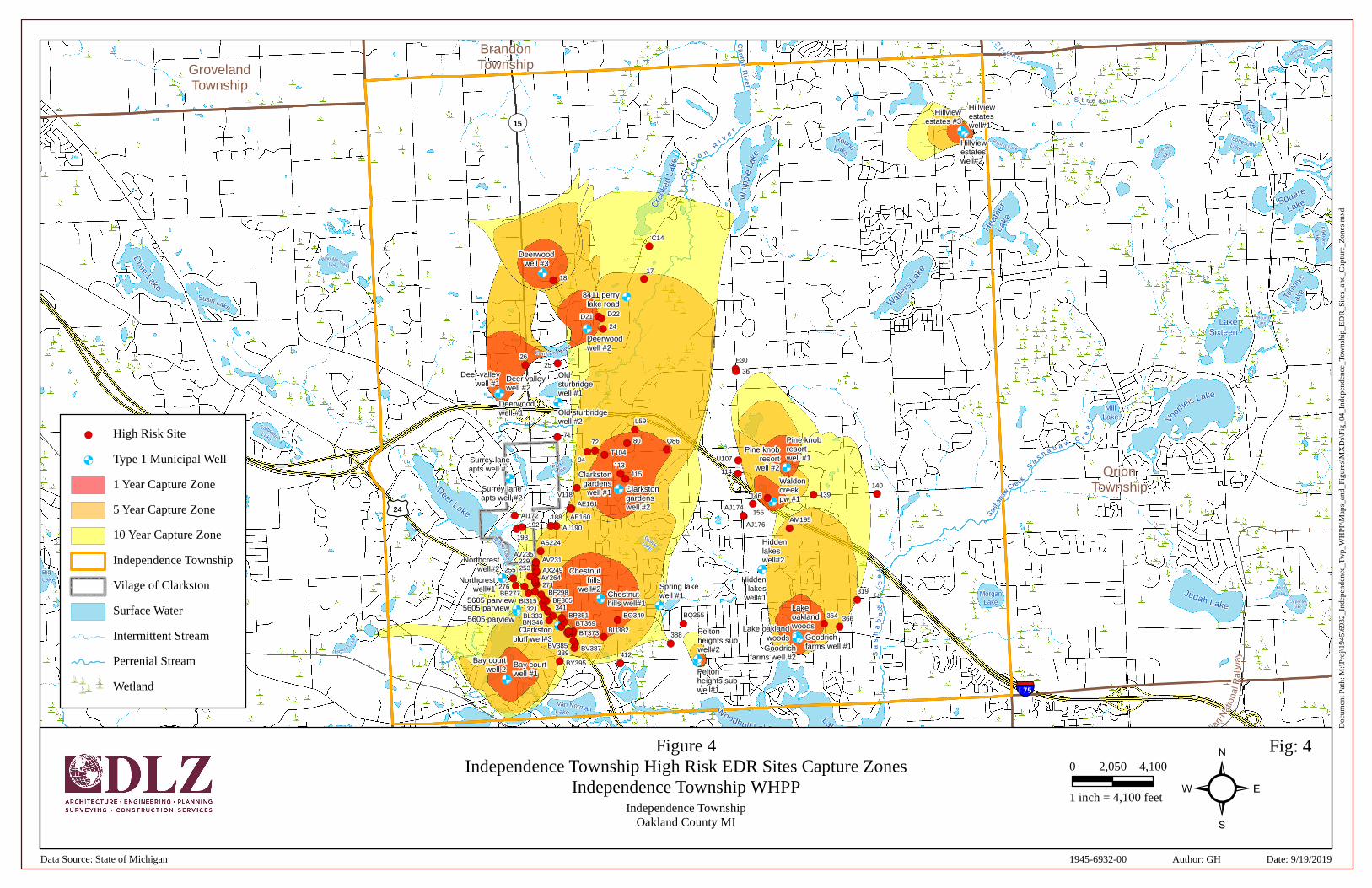
&<&<
&<
&<
&<
&<&<&<&<
&<&<&<&<
&<&<
&<&<
&<&<&<
&<&<
&<&<
&<
&<&<
&<&<&<
&<
&<&<
&<
&<
&<&<
&<
!(
!(
!(
!(
!(
!(
!(!(!(
!(!(
!(
!(
!(!(!(!(!(!(!(
!(
!(!(!(!(!(
!(
!(
!(
!(
!(!(
!(
!(
!(
!(!(
!(
!(!(
!(
!(!(
!(
!(
!(
!(
!(!(!(!(!(!(
!(
!(
!(
!(
!(
!(
!(!(!(!(!(!(!(!(!(!(!(
!(!(
!(!(
!(
!(!(
!(!(
!( !(
!(
!(
§̈¦I 75
§̈¦I 75
£¤24
¬«15
BrandonTownshipGroveland
Township
OrionTownship
SpringfieldTownship
WaterfordTownship
White LakeTownship
Indianwood
Lake
Lake
LonesomeLake
Whi
pple
Lake
RoundLake
Round Lake
Gre
ens
La
ke
Cro
oked
Lake
Square
Lake
Hea
ther
Lake E
lkhornLake
Dixie
Lake
Walt
ers
Lake
Wau-Me-GahLake
Tom
mysLa
keSusin Lake
LakeSixteen
RoundLake
Cranberry Lake
Vo
orheis Lake
MillLake
Softwater
Lake
Pa rke
La ke
Deer Lake
HogbackLake
MiddleLake
GulickLake
BigLake
Judah Lake
MudLakeMorgan
Lake CarpenterLake
Foster Lake
Lake Oakland
Woodhull Lake
Van NormanLake
Lotus LakeLake Angelus
Eagle Lake
MorganLake
Maceday
Lake
Mohawk
Lake
Lake W
orm e r Lake
SchoolhouseLakeHuntoon Lake
Cl in
ton
Rive
r
Sasha
baw
Creek
Cl i
nt o
n
R
i ve
r
G a l l o w a y C
r
e e k
St
r e a m
S t r e a m
Sa
sh
ab
aw
Cr
ee
k
S
as h a b a w
C r
ee
k
H u r on
Riv
er
Canadian
Nat
iona
l Ra i
lway
Canadian National Railway
AI172
BY395
140
388
366
319
364BQ355BO349
139146
AM195
E30
271AY264
253 AX249
412
239AV235
AV231
AS224
Q86
BU382
L59
193
192
115
80
113
AJ176
AJ174
24
T104
72
155
389BV387
94
V118
BV385
188
BT373BT369
AE161
AL190
BP351
AE160
25
71
BN346
341BL333321
BI315 BF305BF298BB277
276
255
U107
36
26
D21 D22
1817
C14
114
Hillviewestateswell#1
Hillviewestateswell#2
Deerwoodwell #3
Deerwoodwell #1
Deerwoodwell #2
Oldsturbridgewell #1
Old sturbridgewell #2
Deer valleywell #1
Deer valleywell #2
Surrey laneapts well #1
Surrey laneapts well #2
Clarkstongardenswell #1 Clarkston
gardenswell #2
Pine knobresortwell #1
Pine knobresort
well #2
Hiddenlakes
well#1
Hiddenlakeswell#2
Chestnuthills well#1
Chestnuthills
well#2 Spring lakewell #1
Northcrestwell#1
Northcrestwell#2
5605 parview5605 parview
Clarkstonbluff well#3
Peltonheights subwell#1
Peltonheights subwell#2
Goodrichfarms well #1Goodrich
farms well #2
Lakeoaklandwoods
8411 perrylake road
Bay courtwell #1
Bay courtwell 2
Hillviewestates #3
Waldoncreekpw #1
Lake oaklandwoods
5605 parview
Doc
umen
t Pat
h: M
:\Pr
oj\1
945\
6932
_Ind
epen
denc
e_Tw
p_W
HPP
\Map
s_an
d_Fi
gure
s\M
XD
s\Fi
g_04
_Ind
epen
denc
e_To
wns
hip_
ED
R_S
ites
_and
_Cap
ture
_Zon
es.m
xd
Figure 4Independence Township High Risk EDR Sites Capture Zones
Independence Township WHPPIndependence Township
Oakland County MI ²0 4,1002,050
1 inch = 4,100 feet
Fig: 4
Data Source: State of Michigan Date: 9/19/2019Author: GH1945-6932-00
!( High Risk Site
&< Type 1 Municipal Well
1 Year Capture Zone
5 Year Capture Zone
10 Year Capture Zone
Independence Township
Vilage of Clarkston
Surface Water
Intermittent Stream
Perrenial Stream
Wetland

APPENDIX A
EDR MAP
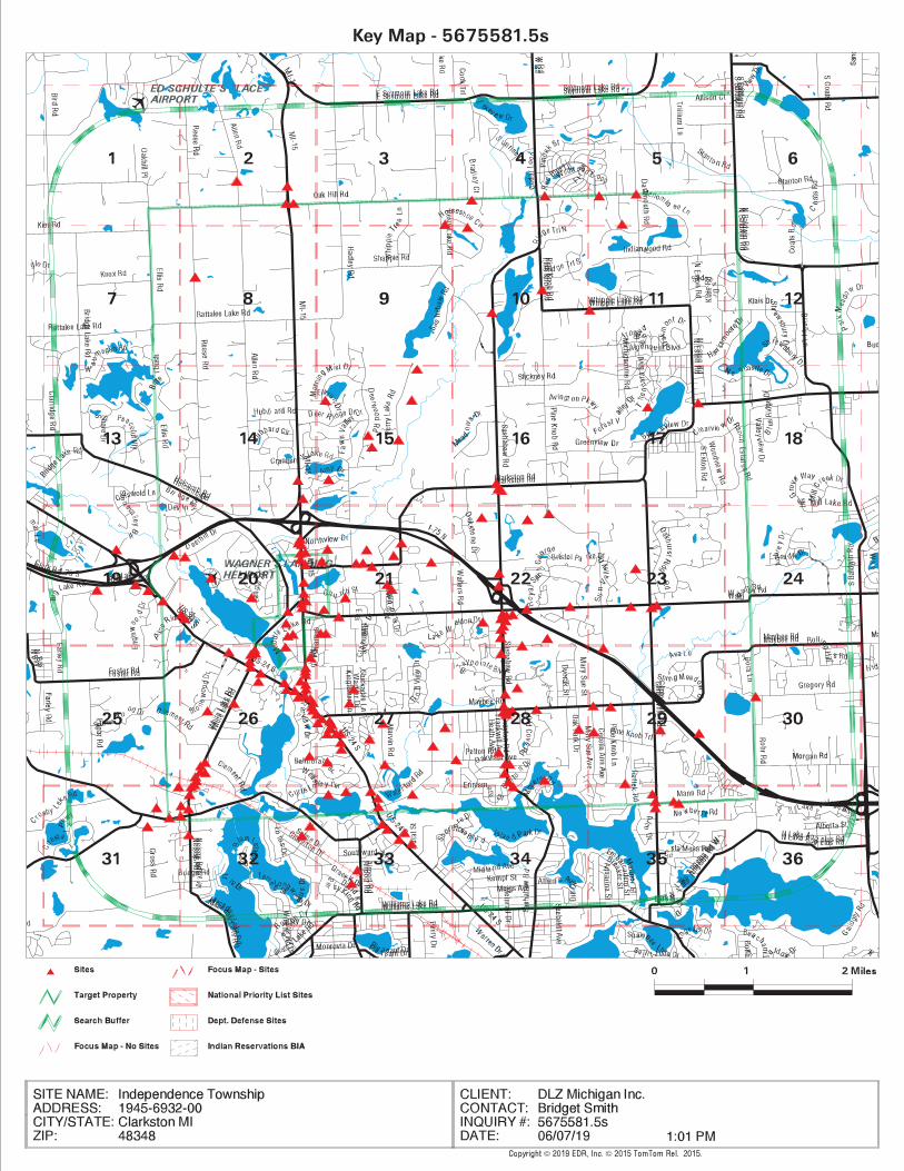
emorris
Typewritten Text
Appendix A
emorris
Pen
-
emorris
Pen
+
emorris
Pen
so.
emorris
Pen
b
emorris
Highlight
emorris
Pen
_
emorris
Text Box
EDR Map

APPENDIX B
EDR REPORT – EXEC. SUMMARY

tropeR rodirroC / aerA RDE
6 Armstrong Road, 4th floorShelton, CT 06484Toll Free: 800.352.0050www.edrnet.com
Independence Township1945-6932-00Clarkston, MI 48348 Inquiry Number: 5675581.5sJune 07, 2019

SECTION PAGE
Executive Summary ES1
Mapped Sites Summary 2
Key Map 16
Map Findings Summary 17
Focus Maps 21
Map Findings 100
Orphan Summary OR-1
Government Records Searched/Data Currency Tracking GR-1
TC5675581.5s Page 1
Thank you for your business.Please contact EDR at 1-800-352-0050
with any questions or comments.
Disclaimer - Copyright and Trademark Notice
This Report contains certain information obtained from a variety of public and other sources reasonably available to Environmental DataResources, Inc. It cannot be concluded from this Report that coverage information for the target and surrounding properties does not exist fromother sources. NO WARRANTY EXPRESSED OR IMPLIED, IS MADE WHATSOEVER IN CONNECTION WITH THIS REPORT. ENVIRONMENTALDATA RESOURCES, INC. SPECIFICALLY DISCLAIMS THE MAKING OF ANY SUCH WARRANTIES, INCLUDING WITHOUT LIMITATION,MERCHANTABILITY OR FITNESS FOR A PARTICULAR USE OR PURPOSE. ALL RISK IS ASSUMED BY THE USER. IN NO EVENT SHALLENVIRONMENTAL DATA RESOURCES, INC. BE LIABLE TO ANYONE, WHETHER ARISING OUT OF ERRORS OR OMISSIONS, NEGLIGENCE,ACCIDENT OR ANY OTHER CAUSE, FOR ANY LOSS OF DAMAGE, INCLUDING, WITHOUT LIMITATION, SPECIAL, INCIDENTAL,CONSEQUENTIAL, OR EXEMPLARY DAMAGES. ANY LIABILITY ON THE PART OF ENVIRONMENTAL DATA RESOURCES, INC. IS STRICTLYLIMITED TO A REFUND OF THE AMOUNT PAID FOR THIS REPORT. Purchaser accepts this Report "AS IS". Any analyses, estimates, ratings,environmental risk levels or risk codes provided in this Report are provided for illustrative purposes only, and are not intended to provide, norshould they be interpreted as providing any facts regarding, or prediction or forecast of, any environmental risk for any property. Only a Phase IEnvironmental Site Assessment performed by an environmental professional can provide information regarding the environmental risk for anyproperty. Additionally, the information provided in this Report is not to be construed as legal advice.
Copyright 2019 by Environmental Data Resources, Inc. All rights reserved. Reproduction in any media or format, in wholeor in part, of any report or map of Environmental Data Resources, Inc., or its affiliates, is prohibited without prior written permission.
EDR and its logos (including Sanborn and Sanborn Map) are trademarks of Environmental Data Resources, Inc. or its affiliates. All othertrademarks used herein are the property of their respective owners.
TABLE OF CONTENTS

EXECUTIVE SUMMARY
TC5675581.5s EXECUTIVE SUMMARY 1
A search of available environmental records was conducted by Environmental Data Resources, Inc (EDR).The report was designed to assist parties seeking to meet the search requirements of EPA’s Standardsand Practices for All Appropriate Inquiries (40 CFR Part 312), the ASTM Standard Practice forEnvironmental Site Assessments (E 1527-13), the ASTM Standard Practice for Environmental SiteAssessments for Forestland or Rural Property (E 2247-16), the ASTM Standard Practice for LimitedEnvironmental Due Diligence: Transaction Screen Process (E 1528-14) or custom requirements developedfor the evaluation of environmental risk associated with a parcel of real estate.
SUBJECT PROPERTY INFORMATION
ADDRESS
1945-6932-00CLARKSTON, MI 48348
TARGET PROPERTY SEARCH RESULTS
The Target Property was identified in the following databases.
Page Numbers and Map Identifcations refer to the EDR Area/Corridor Report where detailed data onindividual sites can be reviewed.
Sites listed in bold italics are in multiple databases.
STANDARD ENVIRONMENTAL RECORDS
Federal CERCLIS list
SEMS: Superfund Enterprise Management System
A review of the SEMS list, as provided by EDR, and dated 04/11/2019 has revealed that there is 1 SEMSsite within the requested target property.
Site Address Map ID / Focus Map(s) Page
CLARKSTON MERCURY SP 6185 CLARKSTON ROAD L60 / 21 158Site ID: 0510348EPA Id: MIN000510348
Federal CERCLIS NFRAP site list
SEMS-ARCHIVE: Superfund Enterprise Management System Archive
A review of the SEMS-ARCHIVE list, as provided by EDR, and dated 04/11/2019 has revealed that thereare 2 SEMS-ARCHIVE sites within the requested target property.
Site Address Map ID / Focus Map(s) Page
CLARKSTON RD AREA 6440 CLARKSTON RD R88 / 21 176Site ID: 0502624EPA Id: MID076370659
CLARKSTON CLINIC MER 6815 DIXIE HWY 276 / 26 341

EXECUTIVE SUMMARY
TC5675581.5s EXECUTIVE SUMMARY 2
Site ID: 0508229EPA Id: MIN000508229
Federal RCRA generators list
RCRA-CESQG: RCRA - Conditionally Exempt Small Quantity Generator
A review of the RCRA-CESQG list, as provided by EDR, and dated 03/25/2019 has revealed that there are44 RCRA-CESQG sites within the requested target property.
Site Address Map ID / Focus Map(s) Page
SASHABAW MARKETPLACE 5748 CLARKSTON RD E31 / 16 120EPA ID:: MIK615885886
WOODWARD DETROIT CVS 5756 CLARKSTON ROAD E35 / 16 123EPA ID:: MIK425475155
RITE AID OF MICHIGAN 5751 CLARKSTON RD F37 / 16 126EPA ID:: MIK113098012
PONTIAC COIL 5800 MOODY DR H46 / 22 136EPA ID:: MIR000033134
PALACE SPORTS & ENTE 7774 SASHABAW RD I50 / 22 140EPA ID:: MID985614783
SUNOCO INC 7251 N MAIN ST K58 / 20 156EPA ID:: MID985613900
POINTE CLEANERS 7194 N MAIN ST M68 / 20 163EPA ID:: MID985616226
MORGANS SVC INC 28 S MAIN ST W129 / 20 212EPA ID:: MID985664812
CLARKSTON AUTO BODY 6470 SASHABAW RD AD157 / 22 240EPA ID:: MID095401196
SPENCERS CLEANERS 6413 SASHABAW RD AF164 / 22 247EPA ID:: MIR000021634
SHEFFLER & ASSOCIATE 6338 SASHABAW RD AJ178 / 22 259EPA ID:: MIK488981895
CHAMPS CLEANERS INC 6315 SASHABAW RD AK184 / 22 263EPA ID:: MIK936292135
MAGNETI MARELLI HOLD 5600 BOW POINTE DR AM195 / 22 275EPA ID:: MIK118556554
MICHIGAN HEMATOLOGY 5600 BOW POINTE DR AM201 / 22 281EPA ID:: MIK925357617
MCLAREN OAKLAND ONCO 5680 BOW POINT DR AN204 / 28 284EPA ID:: MIK699447559
CLARKSTON DERMATOLOG 5701 BOW POINTE DR AN206 / 28 286EPA ID:: MIK895188531
MCLAREN REGIONAL MED 5701 BOW POINT DR AN211 / 28 289EPA ID:: MIK147308056
DEER LAKE RACQUET CL 6167 WHITE LAKE RD AP215 / 26 291
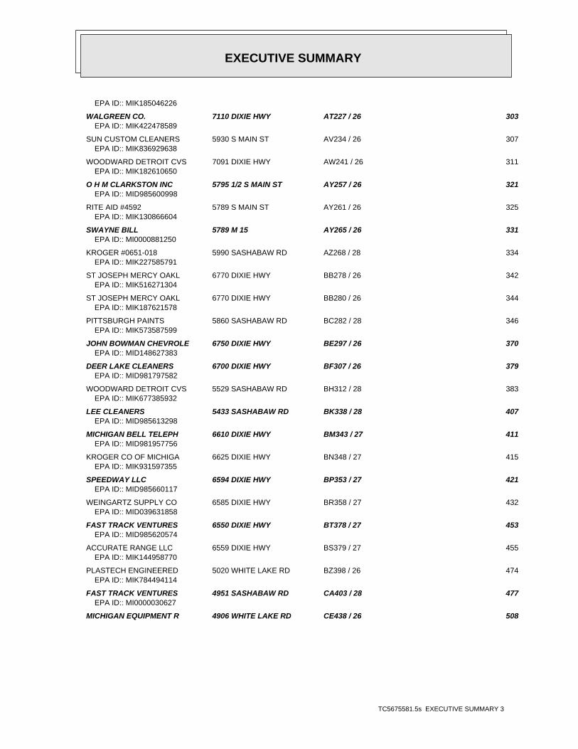
EXECUTIVE SUMMARY
TC5675581.5s EXECUTIVE SUMMARY 3
EPA ID:: MIK185046226
WALGREEN CO. 7110 DIXIE HWY AT227 / 26 303EPA ID:: MIK422478589
SUN CUSTOM CLEANERS 5930 S MAIN ST AV234 / 26 307EPA ID:: MIK836929638
WOODWARD DETROIT CVS 7091 DIXIE HWY AW241 / 26 311EPA ID:: MIK182610650
O H M CLARKSTON INC 5795 1/2 S MAIN ST AY257 / 26 321EPA ID:: MID985600998
RITE AID #4592 5789 S MAIN ST AY261 / 26 325EPA ID:: MIK130866604
SWAYNE BILL 5789 M 15 AY265 / 26 331EPA ID:: MI0000881250
KROGER #0651-018 5990 SASHABAW RD AZ268 / 28 334EPA ID:: MIK227585791
ST JOSEPH MERCY OAKL 6770 DIXIE HWY BB278 / 26 342EPA ID:: MIK516271304
ST JOSEPH MERCY OAKL 6770 DIXIE HWY BB280 / 26 344EPA ID:: MIK187621578
PITTSBURGH PAINTS 5860 SASHABAW RD BC282 / 28 346EPA ID:: MIK573587599
JOHN BOWMAN CHEVROLE 6750 DIXIE HWY BE297 / 26 370EPA ID:: MID148627383
DEER LAKE CLEANERS 6700 DIXIE HWY BF307 / 26 379EPA ID:: MID981797582
WOODWARD DETROIT CVS 5529 SASHABAW RD BH312 / 28 383EPA ID:: MIK677385932
LEE CLEANERS 5433 SASHABAW RD BK338 / 28 407EPA ID:: MID985613298
MICHIGAN BELL TELEPH 6610 DIXIE HWY BM343 / 27 411EPA ID:: MID981957756
KROGER CO OF MICHIGA 6625 DIXIE HWY BN348 / 27 415EPA ID:: MIK931597355
SPEEDWAY LLC 6594 DIXIE HWY BP353 / 27 421EPA ID:: MID985660117
WEINGARTZ SUPPLY CO 6585 DIXIE HWY BR358 / 27 432EPA ID:: MID039631858
FAST TRACK VENTURES 6550 DIXIE HWY BT378 / 27 453EPA ID:: MID985620574
ACCURATE RANGE LLC 6559 DIXIE HWY BS379 / 27 455EPA ID:: MIK144958770
PLASTECH ENGINEERED 5020 WHITE LAKE RD BZ398 / 26 474EPA ID:: MIK784494114
FAST TRACK VENTURES 4951 SASHABAW RD CA403 / 28 477EPA ID:: MI0000030627
MICHIGAN EQUIPMENT R 4906 WHITE LAKE RD CE438 / 26 508

EXECUTIVE SUMMARY
TC5675581.5s EXECUTIVE SUMMARY 4
EPA ID:: MID005319504
CADILLAC ASPHALT, L. 4751 WHITE LAKE ROAD CG459 / 31 524EPA ID:: MID980702690
4701 WHITE LAKE ROAD 4701 WHITE LAKE ROAD CK487 / 32 567EPA ID:: MID006005482
CLARKSTON TRANSMISSI 5870 DIXIE HWY CO502 / 33 585EPA ID:: MIK654233741
Federal ERNS list
ERNS: Emergency Response Notification System
A review of the ERNS list, as provided by EDR, and dated 03/25/2019 has revealed that there are 6ERNS sites within the requested target property.
Site Address Map ID / Focus Map(s) Page
Not reported 8240 DEER WOOD CIR D22 / 15 111NRC Report #: 460510
Not reported 5800 MOODY DR H48 / 22 140NRC Report #: 1122970
Not reported 6058 PINE KNOB ROAD 214 / 29 291NRC Report #: 842916
Not reported 4941 WHITE LAKE ROAD CC416 / 26 490NRC Report #: 756852
Not reported 4751 WHITE LAKE ROAD CG463 / 31 546NRC Report #: 718882
Not reported 4701 WHITELAKE RD CK486 / 32 567NRC Report #: 983617
State and tribal leaking storage tank lists
MI LUST: Leaking Underground Storage Tank Sites
A review of the MI LUST list, as provided by EDR, and dated 05/03/2019 has revealed that there are 25MI LUST sites within the requested target property.
Site Address Map ID / Focus Map(s) Page
INDEPENDENCE OAKS CO 9501 SASHABAW RD B11 / 10 103Release Status: ClosedSubstance Release: DieselFacility Id: 00007767
CLARKSTON SQUARE 5748 CLARKSTON RD E30 / 16 116Release Status: OpenSubstance Release: MixtureFacility Id: 00037264
GEB CLARKSTON INC 7650 ORTONVILLE RD G42 / 14 129

EXECUTIVE SUMMARY
TC5675581.5s EXECUTIVE SUMMARY 5
Release Status: ClosedSubstance Release: Used OilFacility Id: 00018160
CLARKSTON BP 7251 N MAIN ST K56 / 20 146Release Status: OpenSubstance Release: Used OilFacility Id: 00004155
FORMER TEXACO 7320 ORTONVILLE M66 / 20 162Release Status: OpenFacility Id: 50001543
VILLAGE MUFFLER AND 148 N MAIN ST S98 / 20 182Release Status: ClosedSubstance Release: UnknownFacility Id: 00016984
FIRE DEPT STATION #3 3 CHURCH ST W122 / 20 202Release Status: ClosedFacility Id: 00001328
RICHARD MORGAN 28 S MAIN ST W123 / 20 203Release Status: ClosedFacility Id: 00002855
SASHABAW & 75 6480 SASHABAW RD AC151 / 22 230Release Status: ClosedSubstance Release: Gasoline,UnknownFacility Id: 00040775
CONTINENTAL MACHINE 6335 SASHABAW RD AJ179 / 22 261Release Status: ClosedSubstance Release: Unknown,UnknownFacility Id: 00035905
CLARKSTON COMMUNITY 6590 MIDDLE LAKE RD AL191 / 21 268Release Status: OpenSubstance Release: UnknownFacility Id: 00006673
KIEFT ENGINEERING, I 5852 S MAIN ST AX249 / 26 317Release Status: ClosedFacility Id: 00019604
DIXIE & M-15 6756 DIXIE HWY BD292 / 26 357Release Status: OpenRelease Status: ClosedSubstance Release: Used OilSubstance Release: GasolineFacility Id: 00005810
MAYBEE AND SASHABAW 5480 SASHABAW ROAD BJ327 / 28 393Release Status: ClosedFacility Id: 50001574
DANDY OIL # 5 5465 SASHABAW RD BK329 / 28 395Release Status: OpenFacility Id: 00013336
CHARLES SCOTT & SON 5450 MARVIN RD BO350 / 27 417Release Status: ClosedSubstance Release: Gasoline

EXECUTIVE SUMMARY
TC5675581.5s EXECUTIVE SUMMARY 6
Facility Id: 00018106
SPEEDWAY #8535 6594 DIXIE HWY BP354 / 27 423Release Status: OpenSubstance Release: Unknown,UnknownFacility Id: 00019192
RANDY HOSLER PONTIAC 6585 DIXIE HWY BR362 / 27 436Release Status: ClosedSubstance Release: UnknownFacility Id: 00007642
MT CLARK 6550 DIXIE HWY BT373 / 27 445Release Status: OpenSubstance Release: Gasoline,Gasoline,Gasoline,GasolineFacility Id: 00007367
OTTAWA PARK CEMETERY 6180 DIXIE HWY BU382 / 27 457Release Status: ClosedSubstance Release: GasolineFacility Id: 00008815
CLARKSTON FUEL VENTU 4951 SASHABAW RD CA407 / 28 480Release Status: ClosedSubstance Release: GasolineFacility Id: 00012300
ALLIED CONSTRUCTION 4941 WHITE LAKE RD CC417 / 26 490Release Status: ClosedSubstance Release: Diesel,GasolineFacility Id: 00041773
PRECISION PIPE & SUP 4950 WHITE LAKE RD CD423 / 26 497Release Status: OpenFacility Id: 00007003
CLAWSON TANK CO INC 4701 WHITE LAKE RD CK489 / 32 575Release Status: ClosedSubstance Release: DieselFacility Id: 00008139
BIANCAS II INC 7880 ANDERSONVILLE R CP506 / 32 588Release Status: OpenSubstance Release: GasolineFacility Id: 00039448
State and tribal registered storage tank lists
MI UST: Underground Storage Tank Facility List
A review of the MI UST list, as provided by EDR, has revealed that there are 37 MI UST sites withinthe requested target property.
Site Address Map ID / Focus Map(s) Page
INDEPENDENCE OAKS CO 9501 SASHABAW RD B11 / 10 103Database: UST, Date of Government Version: 02/06/2019Tank Status: Removed from GroundFacility Type: CLOSED

EXECUTIVE SUMMARY
TC5675581.5s EXECUTIVE SUMMARY 7
Facility Id: 00007767
INDEPENDENCE TWP FIR 7825 SASHABAW RD E28 / 16 114Database: UST, Date of Government Version: 02/06/2019Tank Status: Currently In UseFacility Type: ACTIVEFacility Id: 00021905
CLARKSTON SQUARE 5748 CLARKSTON RD E30 / 16 116Database: UST, Date of Government Version: 02/06/2019Tank Status: Removed from GroundFacility Type: CLOSEDFacility Id: 00037264
GEB CLARKSTON INC 7650 ORTONVILLE RD G42 / 14 129Database: UST, Date of Government Version: 02/06/2019Tank Status: Currently In UseTank Status: Removed from GroundFacility Type: ACTIVEFacility Id: 00018160
AMOCO OIL CO 7777 PINE KNOB RD 45 / 22 135Database: UST, Date of Government Version: 02/06/2019Tank Status: Closed in GroundFacility Type: CLOSEDFacility Id: 00021258
CLARKSTON BP 7251 N MAIN ST K56 / 20 146Database: UST, Date of Government Version: 02/06/2019Tank Status: Currently In UseTank Status: Removed from GroundFacility Type: ACTIVEFacility Id: 00004155
DEPT OF PUBLIC WORKS 6050 FLEMINGS LAKE R Q86 / 21 174Database: UST, Date of Government Version: 02/06/2019Tank Status: Currently In UseTank Status: Removed from GroundFacility Type: ACTIVEFacility Id: 00036132
VILLAGE MUFFLER AND 148 N MAIN ST S98 / 20 182Database: UST, Date of Government Version: 02/06/2019Tank Status: Removed from GroundFacility Type: CLOSEDFacility Id: 00016984
PINE KNOB MOBIL 6889 SASHABAW RD U109 / 22 194Database: UST, Date of Government Version: 02/06/2019Tank Status: Currently In UseFacility Type: ACTIVEFacility Id: 00038031
FIRE DEPT STATION #3 3 CHURCH ST W122 / 20 202Database: UST, Date of Government Version: 02/06/2019Tank Status: Removed from GroundFacility Type: CLOSEDFacility Id: 00001328
RICHARD MORGAN 28 S MAIN ST W123 / 20 203Database: UST, Date of Government Version: 02/06/2019

EXECUTIVE SUMMARY
TC5675581.5s EXECUTIVE SUMMARY 8
Tank Status: Removed from GroundFacility Type: CLOSEDFacility Id: 00002855
SASHABAW & 75 6480 SASHABAW RD AC151 / 22 230Database: UST, Date of Government Version: 02/06/2019Tank Status: Currently In UseTank Status: Removed from GroundFacility Type: ACTIVEFacility Id: 00040775
CONTINENTAL MACHINE 6335 SASHABAW RD AJ179 / 22 261Database: UST, Date of Government Version: 02/06/2019Tank Status: Removed from GroundFacility Type: CLOSEDFacility Id: 00035905
CLARKSTON COMMUNITY 6590 MIDDLE LAKE RD AL191 / 21 268Database: UST, Date of Government Version: 02/06/2019Tank Status: Removed from GroundTank Status: Currently In UseTank Status: Closed in GroundFacility Type: ACTIVEFacility Id: 00006673
PTK VORTAC 61 WHITE LAKE RD 610 223 / 26 300Database: UST, Date of Government Version: 02/06/2019Tank Status: Removed from GroundFacility Type: CLOSEDFacility Id: 00013869
KIEFT ENGINEERING, I 5852 S MAIN ST AX249 / 26 317Database: UST, Date of Government Version: 02/06/2019Tank Status: Removed from GroundFacility Type: CLOSEDFacility Id: 00019604
KROGER D-651 5990 SASHABAW RD AZ269 / 28 337Database: UST, Date of Government Version: 02/06/2019Tank Status: Currently In UseFacility Type: ACTIVEFacility Id: 00042400
DIXIE & M-15 6756 DIXIE HWY BD292 / 26 357Database: UST, Date of Government Version: 02/06/2019Tank Status: Removed from GroundFacility Type: CLOSEDFacility Id: 00005810
JOHN BOWMAN CHEVROLE 6750 DIXIE HWY BE296 / 26 366Database: UST, Date of Government Version: 02/06/2019Tank Status: Removed from GroundTank Status: Currently In UseFacility Type: ACTIVEFacility Id: 00008929
DANDY OIL # 5 5465 SASHABAW RD BK329 / 28 395Database: UST, Date of Government Version: 02/06/2019Tank Status: Currently In UseTank Status: Removed from GroundFacility Type: ACTIVE

EXECUTIVE SUMMARY
TC5675581.5s EXECUTIVE SUMMARY 9
Facility Id: 00013336
CLARKSTON CO (M53211 6610 DIXIE HWY BM345 / 27 414Database: UST, Date of Government Version: 02/06/2019Tank Status: Currently In UseFacility Type: ACTIVEFacility Id: 00011682
CHARLES SCOTT & SON 5450 MARVIN RD BO350 / 27 417Database: UST, Date of Government Version: 02/06/2019Tank Status: Removed from GroundFacility Type: CLOSEDFacility Id: 00018106
SPEEDWAY #8535 6594 DIXIE HWY BP354 / 27 423Database: UST, Date of Government Version: 02/06/2019Tank Status: Currently In UseTank Status: Removed from GroundFacility Type: ACTIVEFacility Id: 00019192
RANDY HOSLER PONTIAC 6585 DIXIE HWY BR362 / 27 436Database: UST, Date of Government Version: 02/06/2019Tank Status: Removed from GroundFacility Type: CLOSEDFacility Id: 00007642
MT CLARK 6550 DIXIE HWY BT373 / 27 445Database: UST, Date of Government Version: 02/06/2019Tank Status: Removed from GroundTank Status: Currently In UseFacility Type: ACTIVEFacility Id: 00007367
OTTAWA PARK CEMETERY 6180 DIXIE HWY BU382 / 27 457Database: UST, Date of Government Version: 02/06/2019Tank Status: Removed from GroundFacility Type: CLOSEDFacility Id: 00008815
MOON VALLEY RUSTIC F 6465 DIXIE HWY 389 / 27 469Database: UST, Date of Government Version: 02/06/2019Tank Status: Removed from GroundFacility Type: CLOSEDFacility Id: 00020968
CLARKSTON FUEL VENTU 4951 SASHABAW RD CA407 / 28 480Database: UST, Date of Government Version: 02/06/2019Tank Status: Removed from GroundTank Status: Currently In UseFacility Type: ACTIVEFacility Id: 00012300
MORRIS AND SONS AUTO 4950 SASHABAW RD CB409 / 28 487Database: UST, Date of Government Version: 02/06/2019Tank Status: Removed from GroundFacility Type: CLOSEDFacility Id: 00042664
ALLIED CONSTRUCTION 4941 WHITE LAKE RD CC417 / 26 490Database: UST, Date of Government Version: 02/06/2019

EXECUTIVE SUMMARY
TC5675581.5s EXECUTIVE SUMMARY 10
Tank Status: Removed from GroundFacility Type: CLOSEDFacility Id: 00041773
PRECISION PIPE & SUP 4950 WHITE LAKE RD CD423 / 26 497Database: UST, Date of Government Version: 02/06/2019Tank Status: Removed from GroundTank Status: Currently In UseFacility Type: CLOSEDFacility Id: 00007003
CLARKSTON FUEL & SUP 4801 WHITE LAKE RD CH470 / 32 552Database: UST, Date of Government Version: 02/06/2019Tank Status: Non-Registered TankFacility Type: CLOSEDFacility Id: 50000333
CLARKSTON FUEL & SUP 4801 WHITE LAKE RD CH471 / 32 553Database: UST, Date of Government Version: 02/06/2019Tank Status: Non-Registered TankFacility Type: CLOSEDFacility Id: 50000714
CLAWSON TANK CO INC 4701 WHITE LAKE RD CK489 / 32 575Database: UST, Date of Government Version: 02/06/2019Tank Status: Removed from GroundFacility Type: CLOSEDFacility Id: 00008139
RETAIL / OFFICE BUIL 5886 DIXIE HWY CL491 / 33 579Database: UST, Date of Government Version: 02/06/2019Tank Status: Removed from GroundFacility Type: CLOSEDFacility Id: 00041379
DONALD PORTER LANDSC 2858 MANN RD CM496 / 35 581Database: UST, Date of Government Version: 02/06/2019Tank Status: Removed from GroundFacility Type: CLOSEDFacility Id: 00015130
BIANCAS II INC 7880 ANDERSONVILLE R CP506 / 32 588Database: UST, Date of Government Version: 02/06/2019Tank Status: Removed from GroundFacility Type: CLOSEDFacility Id: 00039448
MI AST: Aboveground Tanks
A review of the MI AST list, as provided by EDR, and dated 01/15/2019 has revealed that there are 9MI AST sites within the requested target property.
Site Address Map ID / Focus Map(s) Page
COUNTY OF INDEPENDEN 9501 SASHABAW RD B13 / 10 105Facility Id: 91063332Tank Status: Currently In Use
TRUCK KING U.S.A 7400 DIXIE 218 / 26 294

EXECUTIVE SUMMARY
TC5675581.5s EXECUTIVE SUMMARY 11
Facility Id: 92063126Removed/Closed Date: 03/19/2004Removed/Closed Date: 09/30/1991Tank Status: Removed from Premises
DANDY OIL # 5 5465 SASHABAW RD BK329 / 28 395Facility Id: 92084502Removed/Closed Date: 03/18/2015Tank Status: Removed from PremisesTank Status: Currently In Use
IKES EQUIPMENT 6560 DIXIE BT370 / 27 444Facility Id: 92063159Removed/Closed Date: 02/10/2010Removed/Closed Date: 08/06/1999Removed/Closed Date: 10/29/1998Tank Status: Removed from Premises
CAMPERS PARADISE 4941 WHITE LAKE CC419 / 26 494Facility Id: 92084957Removed/Closed Date: 07/29/2008Tank Status: Removed from Premises
NORTHERN CONCRETE PI 4950 WHITE LAKE CD430 / 26 504Facility Id: 91084339Tank Status: Currently In Use
MICHIGAN RENTAL 4906 WHITE LAKE CE440 / 26 511Facility Id: 92085102Facility Id: 81084342List Status: AbovegrounTank Status: Currently In UseTank Status: Inactive
CADILLAC ASPHALT LLC 4751 WHITE LAKE CG458 / 31 523Facility Id: 81084444List Status: AbovegrounTank Status: Inactive
CLAWSON TANK CO INC 4701 WHITE LAKE RD CK489 / 32 575Facility Id: 91084134Tank Status: Currently In Use
State and tribal institutional control / engineering control registries
MI AUL: Engineering and Institutional Controls
A review of the MI AUL list, as provided by EDR, and dated 03/19/2019 has revealed that there are 6MI AUL sites within the requested target property.
Site Address Map ID / Focus Map(s) Page
VILLAGE MUFFLER AND 148 N MAIN ST S98 / 20 182Facility ID: 00016984
MORGAN’S MARATHON 28 SOUTH MAIN STREET W125 / 20 209Facility ID: 00002855
SASHABAW & 75 6480 SASHABAW RD AC151 / 22 230

EXECUTIVE SUMMARY
TC5675581.5s EXECUTIVE SUMMARY 12
Facility ID: 00040775
MAYBEE AND SASHABAW 5480 SASHABAW ROAD BJ327 / 28 393Facility ID: 50001574
SPEEDWAY #8535 6594 DIXIE HWY BP354 / 27 423Facility ID: 00019192
CLARKSTON FUEL VENTU 4951 SASHABAW RD CA407 / 28 480Facility ID: 00012300
State and tribal Brownfields sites
MI BROWNFIELDS: Brownfields and UST Site Database
A review of the MI BROWNFIELDS list, as provided by EDR, has revealed that there are 4 MI BROWNFIELDSsites within the requested target property.
Site Address Map ID / Focus Map(s) Page
CLARKSTON BP 7251 N MAIN ST K56 / 20 146Database: BROWNFIELDS, Date of Government Version: 01/15/2016Facility Id: 00004155Ernie Id Number: 63005169
MI DEPT/NATURAL RESO 6440 CLARKSTON RD R92 / 21 179Database: BROWNFIELDS, Date of Government Version: 01/15/2016Ernie Id Number: 63000016
VILLAGE MUFFLER 148 N MAIN ST S102 / 20 191Database: BROWNFIELDS, Date of Government Version: 01/15/2016Facility Id: 00016984Ernie Id Number: 63005192
WHITE LAKE ROAD SCRA 4905 WHITE LAKE ROAD CE435 / 26 507Database: BROWNFIELDS, Date of Government Version: 01/15/2016Ernie Id Number: 63000963
ADDITIONAL ENVIRONMENTAL RECORDS
Local Brownfield lists
US BROWNFIELDS: A Listing of Brownfields Sites
A review of the US BROWNFIELDS list, as provided by EDR, and dated 12/17/2018 has revealed that thereare 5 US BROWNFIELDS sites within the requested target property.
Site Address Map ID / Focus Map(s) Page
32 SOUTH MAIN, CLARK 32 SOUTH MAIN STREET X136 / 20 217ACRES property ID: 118704
6051 SASHABAW ROAD 6051 SASHABAW ROAD AR221 / 28 297ACRES property ID: 236601
6756 DIXIE HIGHWAY 6756 DIXIE HIGHWAY BD290 / 26 351

EXECUTIVE SUMMARY
TC5675581.5s EXECUTIVE SUMMARY 13
ACRES property ID: 171664
4836 WHITE LAKE ROAD 4836 WHITE LAKE ROAD CF454 / 26 519ACRES property ID: 118705
4701 WHITE LAKE ROAD 4701 WHITE LAKE ROAD CK484 / 32 559ACRES property ID: 236410
Local Lists of Landfill / Solid Waste Disposal Sites
MI SWRCY: Recycling Facilities
A review of the MI SWRCY list, as provided by EDR, and dated 03/20/2019 has revealed that there are 2MI SWRCY sites within the requested target property.
Site Address Map ID / Focus Map(s) Page
ALLIED CONSTRUCTION 4941 WHITE LAKE RD CC417 / 26 490 INTER LAKES AUTO & T 4941 WHITE LAKE RD CC422 / 26 495
MI HIST LF: Inactive Solid Waste Facilities
A review of the MI HIST LF list, as provided by EDR, and dated 03/01/1997 has revealed that there are3 MI HIST LF sites within the requested target property.
Site Address Map ID / Focus Map(s) Page
BEN POWELL DISPOSAL 6023 SUNNYDALE RD AS226 / 26 301Status: INACTIVEFacility Id: 63000015
DERVAGE DISPOSAL 5380 CENTER ST BQ357 / 27 430Status: INACTIVEFacility Id: 63000007
INTER LAKES AUTO & T 4941 WHITE LAKE RD CC422 / 26 495Status: INACTIVEFacility Id: 63000030
Local Lists of Hazardous waste / Contaminated Sites
MI PART 201: Part 201 Site List
A review of the MI PART 201 list, as provided by EDR, and dated 10/01/2013 has revealed that thereare 12 MI PART 201 sites within the requested target property.
Site Address Map ID / Focus Map(s) Page
BUCKEYE OIL PIPELINE 7770 DEERHILL DRIVE O78 / 19 170Facility Status: Interim Response in progressFacility ID: 63000011
MI DEPT/NATURAL RESO 6440 CLARKSTON RD R92 / 21 179Facility Status: Interim Response conducted - No further activities anticipated

EXECUTIVE SUMMARY
TC5675581.5s EXECUTIVE SUMMARY 14
Facility ID: 63000016
MAIN STREET RES WELL 148 NORTH MAIN STREE S101 / 20 190Facility Status: See Leaking Underground Storage Tank Site DatabaseFacility ID: 63000156
DEER LAKE DRY CLEANE 6700 DIXIE HIGHWAY BF306 / 26 379Facility Status: Inactive - no actions taken to address contaminationFacility ID: 63005216
MAYBEE AND SASHABAW 5480 SASHABAW ROAD BJ327 / 28 393Facility Status: See Leaking Underground Storage Tank Site DatabaseFacility ID: 63000053
DRAYTON ROAD WELL 5068 DRAYTON BW391 / 28 470Facility Status: See Leaking Underground Storage Tank Site DatabaseFacility ID: 63000137
OLD DERVAGE DUMP SIT 5002 PELTON RD BX393 / 28 471Facility Status: Inactive - no actions taken to address contaminationFacility ID: 63000955
CLARKSTON FUEL VENTU 4951 SASHABAW RD CA407 / 28 480Facility Status: See Leaking Underground Storage Tank Site DatabaseFacility ID: 63000054
WHITE LK RD SCRAP YD 4905 WHITE LK RD CE436 / 26 507Facility Status: Interim Response conducted - No further activities anticipatedFacility ID: 63000963
BUCKEYE PIPELINE 4861 WHITE LAKE ROAD CE445 / 26 513Facility Status: Inactive - no actions taken to address contaminationFacility ID: 63005121
4836 WHITE LAKE ROAD 4836 WHITE LAKE ROAD CF456 / 26 522Facility Status: Evaluation in progressFacility ID: 63005916
WOODHULL LAKE 4770 WATERFORD ROAD CJ481 / 33 557Facility Status: Interim Response conductedFacility ID: 63005102
MI INVENTORY: Inventory of Facilities
A review of the MI INVENTORY list, as provided by EDR, and dated 04/23/2019 has revealed that thereare 58 MI INVENTORY sites within the requested target property.
Site Address Map ID / Focus Map(s) Page
CLARKSTON SQUARE 5748 CLARKSTON RD E30 / 16 116Facility ID: 00037264
CLARKSTON BP 7251 N MAIN ST K56 / 20 146Facility ID: 00004155
FORMER TEXACO 7320 ORTONVILLE M66 / 20 162Facility ID: 50001543
CLARKSTON ROAD LANDF 6440 CLARKSTON ROAD 72 / 21 167Facility ID: 63000016
BUCKEYE OIL PIPELINE 7770 DEERHILL DRIVE O78 / 19 170Facility ID: 63000011
MI DEPT/NATURAL RESO 6440 CLARKSTON RD R92 / 21 179

EXECUTIVE SUMMARY
TC5675581.5s EXECUTIVE SUMMARY 15
Facility ID: 63000016
6440 CLARKSTON ROAD 6440 CLARKSTON ROAD R93 / 21 180Facility ID: 63005457
VILLAGE MUFFLER AND 148 N MAIN ST S98 / 20 182Facility ID: 00016984
MAIN STREET RES WELL 148 NORTH MAIN STREE S101 / 20 190Facility ID: 63005192
PARK & RIDE LOT SASHABAW RD. AT I-75 114 / 22 198Facility ID: 63000935
RICHARD MORGAN 28 S MAIN ST W123 / 20 203Facility ID: 00002855
HQ CLARKSTON, LLC 32 SOUTH MAIN STREET X134 / 20 216 FINE ART SCULPTURE C 4975 WALDON ROAD/648 Y138 / 23 223 55 SOUTH MAIN STREET 55 SOUTH MAIN STREET Z141 / 20 224 BRIGHT SIDE CLARKSTO 55 SOUTH MAIN STREET Z142 / 20 224 SASHABAW & 75 6480 SASHABAW RD AC151 / 22 230
Facility ID: 00040775
SHEFFLER & ASSOCIATE 6338 SASHABAW RD AJ177 / 22 259 6330 SASHABAW 6330 SASHABAW AJ182 / 22 263
Facility ID: 63005678
SHEFFLER & ASSOCIATE 6330 SASHABAW ROAD ( AJ183 / 22 263Facility ID: 63005678
CLARKSTON COMMUNITY 6590 MIDDLE LAKE RD AL191 / 21 268Facility ID: 00006673
COMMERICAL PROPERTY 6215 SASHABAW ROAD 194 / 22 274 MIDDLE LAKE ROAD WEL 6103 MIDDLE LAKE ROA AO213 / 26 291
Facility ID: 63005811
7071-7157 DIXIE 7071-7157 DIXIE AW245 / 26 316Facility ID: 63005610
CLARKSTON POST OFFIC 5886 ORTONVILLE RD AX247 / 26 317Facility ID: 63005251
KIMCO WHITE LAKE 667 7071-7157 DIXIE HIGH 254 / 26 320Facility ID: 63005610
DIXIE & M-15 VACANT 6756 DIXIE HIGHWAY BD285 / 26 348 DIXIE & M-15 6756 DIXIE HWY BD292 / 26 357
Facility ID: 00005810
6722 DIXIE HIGHWAY 6722 DIXIE HIGHWAY BF299 / 26 376Facility ID: 63005585
DUGAN’S IRISH PUB 6722 DIXIE HIGHWAY BF300 / 26 376Facility ID: 63005585
DEER LAKE DRY CLEANE 6700 DIXIE HIGHWAY BF310 / 26 383Facility ID: 63005216
MAYBEE AND SASHABAW 5480 SASHABAW ROAD BJ327 / 28 393Facility ID: 50001574
DANDY OIL # 5 5465 SASHABAW RD BK329 / 28 395Facility ID: 00013336
5433 SASHABAW ROAD 5433 SASHABAW ROAD BK337 / 28 407 SPEEDWAY #8535 6594 DIXIE HWY BP354 / 27 423

EXECUTIVE SUMMARY
TC5675581.5s EXECUTIVE SUMMARY 16
Facility ID: 00019192
RANDY HOSLER PONTIAC 6585 DIXIE HIGHWAY BR360 / 27 435 WEINGARTZ 6585 DIXIE HIGHWAY 371 / 27 445 MT CLARK 6550 DIXIE HWY BT373 / 27 445
Facility ID: 00007367
OLD DERVAGE DUMP SIT 5002 PELTON RD BX393 / 28 471Facility ID: 63000955
PLASTECH ENGINEERED 5020 WHITE LAKE RD BZ400 / 26 476Facility ID: 63005418
CLARKSTON FUEL VENTU 4951 SASHABAW RD CA407 / 28 480Facility ID: 00012300
SERVANT’S HEART ISSH 4950 SASHABAW ROAD CB410 / 28 488 ROCKCROFT ST RES WEL 5875 - 5911 DIXIE HI 412 / 27 489
Facility ID: 63000983
ALLIED CONSTRUCTION 4941 WHITE LAKE RD CC417 / 26 490 ALLIED CONSTRUCTION 4941 WHITE LAKE ROAD CC418 / 26 493 PRECISION PIPE & SUP 4950 WHITE LAKE RD CD423 / 26 497
Facility ID: 00007003
MIDDLELAKE INVESTMEN 4906 WHITE LAKE ROAD 431 / 26 505Facility ID: 63000861
WHITE LK RD SCRAP YD 4905 WHITE LK RD CE436 / 26 507Facility ID: 63000963
MICHIGAN EQUIPMENT R 4906 WHITE LAKE ROAD CE437 / 26 508Facility ID: 63000861
4861 WHITE LAKE ROAD 4861 WHITE LAKE ROAD CE443 / 26 512Facility ID: 63005759
BUCKEYE PIPELINE 4861 WHITE LAKE ROAD CE445 / 26 513Facility ID: 63005121
HADLEY MOLD 4866 WHITE LAKE RD 450 / 26 516 A.W. EXCAVATING, INC 4836 WHITE LAKE ROAD CF455 / 26 521
Facility ID: 63005916
4836 WHITE LAKE ROAD 4836 WHITE LAKE ROAD CF456 / 26 522Facility ID: 63005916
WOODHULL LAKE 4770 WATERFORD ROAD CJ481 / 33 557Facility ID: 63005102
FACKS PROPERTIES, L. 5886 DIXIE HIGHWAY CL490 / 33 578Facility ID: 63005697
5886 DIXIE 5886 DIXIE CL493 / 33 580Facility ID: 63005697
SOUTH DIXIE PROPERTI 5886 DIXIE HIGHWAY CL494 / 33 580Facility ID: 63005697
BIANCAS II INC 7880 ANDERSONVILLE R CP506 / 32 588Facility ID: 00039448

EXECUTIVE SUMMARY
TC5675581.5s EXECUTIVE SUMMARY 17
MI CDL: Clandestine Drug Lab Listing
A review of the MI CDL list, as provided by EDR, and dated 11/14/2018 has revealed that there is 1 MICDL site within the requested target property.
Site Address Map ID / Focus Map(s) Page
Not reported GENOA RD 452 / 29 518
MI DEL PART 201: Delisted List of Contaminated Sites
A review of the MI DEL PART 201 list, as provided by EDR, and dated 08/01/2013 has revealed thatthere are 2 MI DEL PART 201 sites within the requested target property.
Site Address Map ID / Focus Map(s) Page
MICHIGAN EQUIPMENT R 4906 WHITE LAKE RD CE439 / 26 510Facility Id: 63000861
WHITE LAKE ROAD CONT 4790 WHITE LAKE ROAD CH474 / 32 554Facility Id: 63000158
Records of Emergency Release Reports
HMIRS: Hazardous Materials Information Reporting System
A review of the HMIRS list, as provided by EDR, and dated 03/25/2019 has revealed that there is 1HMIRS site within the requested target property.
Site Address Map ID / Focus Map(s) Page
5600 BOW POINTE DR 5600 BOW POINTE DR AM196 / 22 277System ID:: 1169
MI SPILLS: Pollution Emergency Alerting System
A review of the MI SPILLS list, as provided by EDR, and dated 12/31/2018 has revealed that there are25 MI SPILLS sites within the requested target property.
Site Address Map ID / Focus Map(s) Page
Not reported 10391 HORSESHOE CORC 5 / 3 100 Not reported 10317 HORSESHOE CIRC 6 / 10 101 Not reported 8491 THENDARA BOULEV 20 / 17 110 Not reported 6601 AMY DRIVE 25 / 15 112 Not reported 7765 DEER HILL DR O82 / 19 171 Not reported 148 N MAIN ST (BEHIN S97 / 20 181 EQUILON ENTERPRISES 6889 SASHABAW RD U107 / 22 192 CLARKSTON JUNIOR HIG 6595 WALDON AE160 / 21 244 Not reported 6589 WALDON LAKE RD AE161 / 21 246 Not reported 375 DEPOT ROAD AI171 / 20 254 CLARKSTON MS4-OAKLAN 375 DEPOT ROAD AI173 / 20 255 DEER LAKE RACQUET CL 6167 WHITE LAKE RD AP217 / 26 293 Not reported 7071 DIXIE HWY AW244 / 26 315 Not reported 5510 SASHABAW BH318 / 28 389 Not reported 6695 DIXIE HWY 321 / 26 390
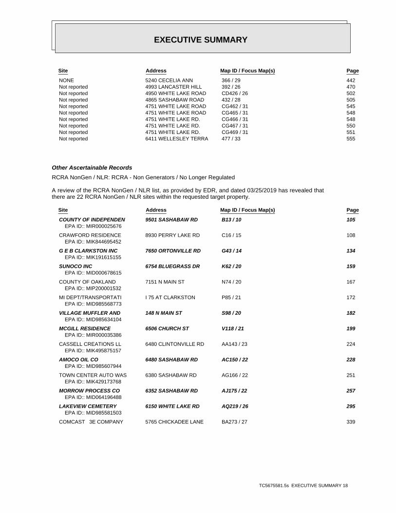
EXECUTIVE SUMMARY
TC5675581.5s EXECUTIVE SUMMARY 18
Site Address Map ID / Focus Map(s) Page
NONE 5240 CECELIA ANN 366 / 29 442 Not reported 4993 LANCASTER HILL 392 / 26 470 Not reported 4950 WHITE LAKE ROAD CD426 / 26 502 Not reported 4865 SASHABAW ROAD 432 / 28 505 Not reported 4751 WHITE LAKE ROAD CG462 / 31 545 Not reported 4751 WHITE LAKE ROAD CG465 / 31 548 Not reported 4751 WHITE LAKE RD. CG466 / 31 548 Not reported 4751 WHITE LAKE RD. CG467 / 31 550 Not reported 4751 WHITE LAKE RD. CG469 / 31 551 Not reported 6411 WELLESLEY TERRA 477 / 33 555
Other Ascertainable Records
RCRA NonGen / NLR: RCRA - Non Generators / No Longer Regulated
A review of the RCRA NonGen / NLR list, as provided by EDR, and dated 03/25/2019 has revealed thatthere are 22 RCRA NonGen / NLR sites within the requested target property.
Site Address Map ID / Focus Map(s) Page
COUNTY OF INDEPENDEN 9501 SASHABAW RD B13 / 10 105EPA ID:: MIR000025676
CRAWFORD RESIDENCE 8930 PERRY LAKE RD C16 / 15 108EPA ID:: MIK844695452
G E B CLARKSTON INC 7650 ORTONVILLE RD G43 / 14 134EPA ID:: MIK191615155
SUNOCO INC 6754 BLUEGRASS DR K62 / 20 159EPA ID:: MID000678615
COUNTY OF OAKLAND 7151 N MAIN ST N74 / 20 167EPA ID:: MIP200001532
MI DEPT/TRANSPORTATI I 75 AT CLARKSTON P85 / 21 172EPA ID:: MID985568773
VILLAGE MUFFLER AND 148 N MAIN ST S98 / 20 182EPA ID:: MID985634104
MCGILL RESIDENCE 6506 CHURCH ST V118 / 21 199EPA ID:: MIR000035386
CASSELL CREATIONS LL 6480 CLINTONVILLE RD AA143 / 23 224EPA ID:: MIK495875157
AMOCO OIL CO 6480 SASHABAW RD AC150 / 22 228EPA ID:: MID985607944
TOWN CENTER AUTO WAS 6380 SASHABAW RD AG166 / 22 251EPA ID:: MIK429173768
MORROW PROCESS CO 6352 SASHABAW RD AJ175 / 22 257EPA ID:: MID064196488
LAKEVIEW CEMETERY 6150 WHITE LAKE RD AQ219 / 26 295EPA ID:: MID985581503
COMCAST 3E COMPANY 5765 CHICKADEE LANE BA273 / 27 339

EXECUTIVE SUMMARY
TC5675581.5s EXECUTIVE SUMMARY 19
EPA ID:: MIK997679740
ROY BROS STD INC 544 6756 DIXIE HWY BD289 / 26 350EPA ID:: MID985607118
ARMAND DRILLING CO 5650 WHITE LAKE RD BG303 / 26 377EPA ID:: MIP200001187
SOS MECHANICAL INC 6696 DIXIE HWY BI315 / 26 387EPA ID:: MID980901888
CLARKSTON MOTORS 6673 DIXIE HWY BL335 / 27 405EPA ID:: MID981531205
EZ DUZ IT LAUNDROMAT 6507 DIXIE HWY BV385 / 27 460EPA ID:: MID053094124
MI DEPT/STATE POLICE 4975 TIMBERWAY TRL BY395 / 27 472EPA ID:: MIK332114479
BUCKEYE PIPE LINE CO 4863 WHITE LAKE RD CE448 / 26 514EPA ID:: MIK168323251
MOTOR CITY AUTO 4505 CLINTONVILLE RD CN498 / 35 582EPA ID:: MID981789373
FUDS: Formerly Used Defense Sites
A review of the FUDS list, as provided by EDR, and dated 03/07/2019 has revealed that there is 1 FUDSsite within the requested target property.
Site Address Map ID / Focus Map(s) Page
DELTA PROPERTIES 323 / 26 391
PRP: Potentially Responsible Parties
A review of the PRP list, as provided by EDR, and dated 04/11/2019 has revealed that there is 1 PRPsite within the requested target property.
Site Address Map ID / Focus Map(s) Page
CLARKSTON MERCURY SP 6185 CLARKSTON ROAD L60 / 21 158
ICIS: Integrated Compliance Information System
A review of the ICIS list, as provided by EDR, and dated 11/18/2016 has revealed that there are 6ICIS sites within the requested target property.
Site Address Map ID / Focus Map(s) Page
PINE RIDGE PLACE BUI 7650 DIXIE HWY 156 / 20 239FRS ID:: 110010755058
PINE RIDGE PLACE BUI 7640 DIXIE HWY 165 / 20 250FRS ID:: 110010741199
RECTICEL INTERIORS N 5600 BOW POINTE DR AM202 / 22 282FRS ID:: 110022523278
PROFESSIONAL PLAZA 5825 M-15 253 / 26 319

EXECUTIVE SUMMARY
TC5675581.5s EXECUTIVE SUMMARY 20
FRS ID:: 110010741965
GINGER LAKE & I75 4880 MAYBEE RD. 367 / 29 442FRS ID:: 110028065830
CADILLAC ASPHALT, L. 4751 WHITE LAKE ROAD CG459 / 31 524FRS ID:: 110001298925
FTTS: FIFRA/ TSCA Tracking System - FIFRA (Federal Insecticide, Fungicide, & RodenticideAct)/TSCA (Toxic Substances Control Act)
A review of the FTTS list, as provided by EDR, has revealed that there is 1 FTTS site within therequested target property.
Site Address Map ID / Focus Map(s) Page
CLARKSTON COMM SCH 6389 CLARKSTON RD P T104 / 21 191Database: FTTS INSP, Date of Government Version: 04/09/2009
HIST FTTS: FIFRA/TSCA Tracking System Administrative Case Listing
A review of the HIST FTTS list, as provided by EDR, has revealed that there is 1 HIST FTTS sitewithin the requested target property.
Site Address Map ID / Focus Map(s) Page
CLARKSTON COMM SCH 6389 CLARKSTON RD P T104 / 21 191Database: HIST FTTS INSP, Date of Government Version: 10/19/2006
DOT OPS: Incident and Accident Data
A review of the DOT OPS list, as provided by EDR, and dated 12/03/2018 has revealed that there is 1DOT OPS site within the requested target property.
Site Address Map ID / Focus Map(s) Page
CONSUMERS POWER CO 8232 DEERWOOD CIRCLE D21 / 15 111
US AIRS: Aerometric Information Retrieval System Facility Subsystem
A review of the US AIRS list, as provided by EDR, has revealed that there are 2 US AIRS sites withinthe requested target property.
Site Address Map ID / Focus Map(s) Page
CADILLAC ASPHALT, L. 4751 WHITE LAKE ROAD CG459 / 31 524Database: US AIRS (AFS), Date of Government Version: 10/12/2016EPA plant ID:: 110001298925
4701 WHITE LAKE ROAD 4701 WHITE LAKE ROAD CK487 / 32 567Database: US AIRS (AFS), Date of Government Version: 10/12/2016EPA plant ID:: 110000797665

EXECUTIVE SUMMARY
TC5675581.5s EXECUTIVE SUMMARY 21
US MINES: Mines Master Index File
A review of the US MINES list, as provided by EDR, has revealed that there is 1 US MINES site withinthe requested target property.
Site Address Map ID / Focus Map(s) Page
BURROUGHS MATERIALS 4 / 5 100Database: US MINES, Date of Government Version: 11/27/2018Mine ID:: 2000831
ABANDONED MINES: Abandoned Mines
A review of the ABANDONED MINES list, as provided by EDR, and dated 03/27/2019 has revealed thatthere is 1 ABANDONED MINES site within the requested target property.
Site Address Map ID / Focus Map(s) Page
SALEM SAND & GRAVEL A1 / 5 99
FINDS: Facility Index System/Facility Registry System
A review of the FINDS list, as provided by EDR, and dated 02/15/2019 has revealed that there are 86FINDS sites within the requested target property.
Site Address Map ID / Focus Map(s) Page
COUNTY OF INDEPENDEN 9501 SASHABAW RD B13 / 10 105Registry ID:: 110003702084
CRAWFORD RESIDENCE 8930 PERRY LAKE RD C15 / 15 108Registry ID:: 110015900649
SASHABAW MARKETPLACE 5748 CLARKSTON RD E32 / 16 122Registry ID:: 110020890712
WOODWARD DETROIT CVS 5756 CLARKSTON ROAD E34 / 16 123Registry ID:: 110045979875
RITE AID OF MICHIGAN 5751 CLARKSTON RD F39 / 16 128Registry ID:: 110054838841
G E B CLARKSTON INC 7650 ORTONVILLE RD G43 / 14 134Registry ID:: 110063755146
PONTIAC COIL 5800 MOODY DR H46 / 22 136Registry ID:: 110003706623
PALACE SPORTS & ENTE 7774 SASHABAW RD I50 / 22 140Registry ID:: 110003658701
SUNOCO INC 7251 N MAIN ST K58 / 20 156Registry ID:: 110003658159
CLARKSTON MERCURY SP 6185 CLARKSTON ROAD L59 / 21 158Registry ID:: 110039020261
SUNOCO INC 6754 BLUEGRASS DR K62 / 20 159Registry ID:: 110003574659
POINTE CLEANERS 7194 N MAIN ST M68 / 20 163Registry ID:: 110003659327
COUNTY OF OAKLAND 7151 N MAIN ST N75 / 20 169

EXECUTIVE SUMMARY
TC5675581.5s EXECUTIVE SUMMARY 22
Registry ID:: 110015876382
CLARKSTON CHRISTIAN 6300 CLARKSTON RD 80 / 21 171Registry ID:: 110011840008
VILLAGE MUFFLER AND 148 N MAIN ST S98 / 20 182Registry ID:: 110003668068
CLARKSTON COMM SCH 6389 CLARKSTON RD P T105 / 21 192Registry ID:: 110011690946
WAGNER’S LANDING UNKNOWN 111 / 20 198Registry ID:: 110041446682
MCGILL RESIDENCE 6506 CHURCH ST V118 / 21 199Registry ID:: 110003707659
MORGANS SVC INC 28 S MAIN ST W129 / 20 212Registry ID:: 110003684790
32 SOUTH MAIN, CLARK 32 SOUTH MAIN STREET X136 / 20 217Registry ID:: 110043085096
FINE ART SCULPTURE C 4975 WALDON RD Y137 / 23 222Registry ID:: 110070315435
CASSELL CREATIONS LL 6480 CLINTONVILLE RD AA145 / 23 226Registry ID:: 110066970558
AMOCO OIL CO 6480 SASHABAW RD AC150 / 22 228Registry ID:: 110003654028
PINE RIDGE PLACE BUI 7650 DIXIE HWY 156 / 20 239Registry ID:: 110010755058
CLARKSTON AUTO BODY 6470 SASHABAW RD AD157 / 22 240Registry ID:: 110003608695
SPENCERS CLEANERS 6413 SASHABAW RD AF164 / 22 247Registry ID:: 110003699819
PINE RIDGE PLACE BUI 7640 DIXIE HWY 165 / 20 250Registry ID:: 110010741199
TOWN CENTER AUTO WAS 6380 SASHABAW RD AG168 / 22 252Registry ID:: 110022304406
INDEPENDENCE TWP MS4 6483 WALDON CENTER D AH169 / 22 253Registry ID:: 110069486835
CLARKSTON MS4-OAKLAN 375 DEPOT ROAD AI172 / 20 255Registry ID:: 110069490429
MORROW PROCESS CO 6352 SASHABAW RD AJ175 / 22 257Registry ID:: 110003601040
SHEFFLER & ASSOCIATE 6338 SASHABAW RD AJ176 / 22 258Registry ID:: 110020484992Registry ID:: 110070291828
CHAMPS CLEANERS INC 6315 SASHABAW RD AK186 / 22 266Registry ID:: 110022920008
CLARKSTON PS MS4-OAK 6590 MIDDLE LAKE ROA AL190 / 21 267Registry ID:: 110069487326
MICHIGAN HEMATOLOGY 5600 BOW POINTE DR AM198 / 22 278Registry ID:: 110046396583
RECTICEL INTERIORS N 5600 BOW POINTE DR AM202 / 22 282

EXECUTIVE SUMMARY
TC5675581.5s EXECUTIVE SUMMARY 23
Registry ID:: 110022523278Registry ID:: 110070308254
MCLAREN OAKLAND ONCO 5680 BOW POINT DR AN203 / 28 284Registry ID:: 110070121249
MCLAREN REGIONAL MED 5701 BOW POINT DR AN207 / 28 288Registry ID:: 110044811870
CLARKSTON DERMATOLOG 5701 BOW POINTE DR AN208 / 28 288Registry ID:: 110044818490
DEER LAKE RACQUET CL 6167 WHITE LAKE RD AP216 / 26 293Registry ID:: 110044814779
LAKEVIEW CEMETERY 6150 WHITE LAKE RD AQ219 / 26 295Registry ID:: 110003641649
6051 SASHABAW ROAD 6051 SASHABAW ROAD AR222 / 28 300Registry ID:: 110070261935
BEN POWELL DISPOSAL 6023 SUNNYDALE RD AS224 / 26 301Registry ID:: 110013895972
WALGREEN CO. 7110 DIXIE HWY AT227 / 26 303Registry ID:: 110044923740
SUN CUSTOM CLEANERS 5930 S MAIN ST AV232 / 26 306Registry ID:: 110016718658
WOODWARD DETROIT CVS 7091 DIXIE HWY AW242 / 26 314Registry ID:: 110045978162
PROFESSIONAL PLAZA 5825 M-15 253 / 26 319Registry ID:: 110010741965
O H M CLARKSTON INC 5795 1/2 S MAIN ST AY257 / 26 321Registry ID:: 110003649311
RITE AID #4592 5789 S MAIN ST AY263 / 26 330Registry ID:: 110054839831
SWAYNE BILL 5789 M 15 AY265 / 26 331Registry ID:: 110008440534
KROGER #0651-018 5990 SASHABAW RD AZ267 / 28 333Registry ID:: 110037404742
COMCAST 3E COMPANY 5765 CHICKADEE LANE BA272 / 27 339Registry ID:: 110044821306
ST JOSEPH MERCY OAKL 6770 DIXIE HWY BB279 / 26 343Registry ID:: 110043310645
PITTSBURGH PAINTS 5860 SASHABAW RD BC281 / 28 345Registry ID:: 110042187843
ROY BROS STD INC 544 6756 DIXIE HWY BD289 / 26 350Registry ID:: 110003653476
6756 DIXIE HIGHWAY 6756 DIXIE HIGHWAY BD290 / 26 351Registry ID:: 110059722448
JOHN BOWMAN CHEVROLE 6750 DIXIE HWY BE297 / 26 370Registry ID:: 110003613983
ARMAND DRILLING CO 5650 WHITE LAKE RD BG302 / 26 377Registry ID:: 110015926239
DEER LAKE CLEANERS 6700 DIXIE HWY BF307 / 26 379

EXECUTIVE SUMMARY
TC5675581.5s EXECUTIVE SUMMARY 24
Registry ID:: 110008451709
WOODWARD DETROIT CVS 5529 SASHABAW RD BH313 / 28 386Registry ID:: 110045979580
SOS MECHANICAL INC 6696 DIXIE HWY BI315 / 26 387Registry ID:: 110003617550
CLARKSTON MOTORS 6673 DIXIE HWY BL335 / 27 405Registry ID:: 110003620305
LEE CLEANERS 5433 SASHABAW RD BK338 / 28 407Registry ID:: 110003657677
MICHIGAN BELL TELEPH 6610 DIXIE HWY BM343 / 27 411Registry ID:: 110003626229
KROGER CO OF MICHIGA 6625 DIXIE HWY BN347 / 27 415Registry ID:: 110037413607
SPEEDWAY LLC 6594 DIXIE HWY BP353 / 27 421Registry ID:: 110003681338
DERVAGE DISPOSAL 5380 CENTER ST BQ355 / 27 430Registry ID:: 110014000945
WEINGARTZ SUPPLY CO 6585 DIXIE HWY BR361 / 27 436Registry ID:: 110044974481
GINGER LAKE & I75 4880 MAYBEE RD. 367 / 29 442Registry ID:: 110028065830
FAST TRACK VENTURES 6550 DIXIE HWY BT378 / 27 453Registry ID:: 110003661804
ACCURATE RANGE LLC 6559 DIXIE HWY BS381 / 27 457Registry ID:: 110062928364
EZ DUZ IT LAUNDROMAT 6507 DIXIE HWY BV385 / 27 460Registry ID:: 110008446501
MI DEPT/STATE POLICE 4975 TIMBERWAY TRL BY397 / 27 473Registry ID:: 110037410664
PLASTECH ENGINEERED 5020 WHITE LAKE RD BZ399 / 26 476Registry ID:: 110015905617
FAST TRACK VENTURES 4951 SASHABAW RD CA403 / 28 477Registry ID:: 110012600676
INTER LAKES AUTO & T 4941 WHITE LAKE RD CC415 / 26 490Registry ID:: 110013896016
NORTHERN CONCRETE PI 4950 WHITE LAKE RD CD425 / 26 502Registry ID:: 110070287467
DIXSON METAL PROCESS 4905 WHITE LK RD CE434 / 26 506Registry ID:: 110007095268
MICHIGAN EQUIPMENT R 4906 WHITE LAKE RD CE438 / 26 508Registry ID:: 110003578842
BUCKEYE PIPE LINE CO 4863 WHITE LAKE RD CE446 / 26 514Registry ID:: 110043419707
4836 WHITE LAKE ROAD 4836 WHITE LAKE ROAD CF454 / 26 519Registry ID:: 110043085103
CADILLAC ASPHALT, L. 4751 WHITE LAKE ROAD CG459 / 31 524

EXECUTIVE SUMMARY
TC5675581.5s EXECUTIVE SUMMARY 25
Registry ID:: 110001298925
OAKLAND COUNTY SPORT 4770 WATERFORD RD CJ480 / 33 557Registry ID:: 110042370261
4701 WHITE LAKE ROAD 4701 WHITE LAKE ROAD CK487 / 32 567Registry ID:: 110070225935Registry ID:: 110000797665
MOTOR CITY AUTO 4505 CLINTONVILLE RD CN498 / 35 582Registry ID:: 110008451406
CLARKSTON TRANSMISSI 5870 DIXIE HWY CO500 / 33 584Registry ID:: 110015804307
ECHO: Enforcement & Compliance History Information
A review of the ECHO list, as provided by EDR, and dated 04/07/2019 has revealed that there are 73ECHO sites within the requested target property.
Site Address Map ID / Focus Map(s) Page
COUNTY OF INDEPENDEN 9501 SASHABAW RD B13 / 10 105Registry ID: 110003702084
CRAWFORD RESIDENCE 8930 PERRY LAKE RD C15 / 15 108Registry ID: 110015900649
SASHABAW MARKETPLACE 5748 CLARKSTON RD E32 / 16 122Registry ID: 110020890712
WOODWARD DETROIT CVS 5756 CLARKSTON ROAD E34 / 16 123Registry ID: 110045979875
RITE AID OF MICHIGAN 5751 CLARKSTON RD F39 / 16 128Registry ID: 110054838841
G E B CLARKSTON INC 7650 ORTONVILLE RD G44 / 14 135Registry ID: 110063755146
PONTIAC COIL 5800 MOODY DR H46 / 22 136Registry ID: 110003706623
PALACE SPORTS & ENTE 7774 SASHABAW RD I50 / 22 140Registry ID: 110003658701
SUNOCO INC 7251 N MAIN ST K58 / 20 156Registry ID: 110003658159
SUNOCO INC 6754 BLUEGRASS DR K62 / 20 159Registry ID: 110003574659
POINTE CLEANERS 7194 N MAIN ST M68 / 20 163Registry ID: 110003659327
COUNTY OF OAKLAND 7151 N MAIN ST N75 / 20 169Registry ID: 110015876382
VILLAGE MUFFLER AND 148 N MAIN ST S98 / 20 182Registry ID: 110003668068
MCGILL RESIDENCE 6506 CHURCH ST V118 / 21 199Registry ID: 110003707659
MORGANS SVC INC 28 S MAIN ST W129 / 20 212

EXECUTIVE SUMMARY
TC5675581.5s EXECUTIVE SUMMARY 26
Registry ID: 110003684790
CASSELL CREATIONS LL 6480 CLINTONVILLE RD AA145 / 23 226Registry ID: 110066970558
AMOCO OIL CO 6480 SASHABAW RD AC150 / 22 228Registry ID: 110003654028
PINE RIDGE PLACE BUI 7650 DIXIE HWY 156 / 20 239Registry ID: 110052103219Registry ID: 110052103200Registry ID: 110010755058
CLARKSTON AUTO BODY 6470 SASHABAW RD AD157 / 22 240Registry ID: 110003608695
SPENCERS CLEANERS 6413 SASHABAW RD AF164 / 22 247Registry ID: 110003699819
PINE RIDGE PLACE BUI 7640 DIXIE HWY 165 / 20 250Registry ID: 110010741199
TOWN CENTER AUTO WAS 6380 SASHABAW RD AG168 / 22 252Registry ID: 110022304406
INDEPENDENCE TWP MS4 6483 WALDON CENTER D AH169 / 22 253Registry ID: 110069486835
CLARKSTON MS4-OAKLAN 375 DEPOT ROAD AI172 / 20 255Registry ID: 110069490429
MORROW PROCESS CO 6352 SASHABAW RD AJ175 / 22 257Registry ID: 110003601040
SHEFFLER & ASSOCIATE 6338 SASHABAW RD AJ176 / 22 258Registry ID: 110020484992
CHAMPS CLEANERS INC 6315 SASHABAW RD AK186 / 22 266Registry ID: 110022920008
CLARKSTON PS MS4-OAK 6590 MIDDLE LAKE ROA AL190 / 21 267Registry ID: 110069487326
MICHIGAN HEMATOLOGY 5600 BOW POINTE DR AM198 / 22 278Registry ID: 110046396583
RECTICEL INTERIORS N 5600 BOW POINTE DR AM202 / 22 282Registry ID: 110022523278
MCLAREN OAKLAND ONCO 5680 BOW POINT DR AN203 / 28 284Registry ID: 110070121249
MCLAREN REGIONAL MED 5701 BOW POINT DR AN207 / 28 288Registry ID: 110044811870
CLARKSTON DERMATOLOG 5701 BOW POINTE DR AN208 / 28 288Registry ID: 110044818490
DEER LAKE RACQUET CL 6167 WHITE LAKE RD AP216 / 26 293Registry ID: 110044814779
LAKEVIEW CEMETERY 6150 WHITE LAKE RD AQ219 / 26 295Registry ID: 110003641649
WALGREEN CO. 7110 DIXIE HWY AT227 / 26 303Registry ID: 110044923740
SUN CUSTOM CLEANERS 5930 S MAIN ST AV232 / 26 306Registry ID: 110016718658
WOODWARD DETROIT CVS 7091 DIXIE HWY AW242 / 26 314

EXECUTIVE SUMMARY
TC5675581.5s EXECUTIVE SUMMARY 27
Registry ID: 110045978162
PROFESSIONAL PLAZA 5825 M-15 253 / 26 319Registry ID: 110010741965
O H M CLARKSTON INC 5795 1/2 S MAIN ST AY257 / 26 321Registry ID: 110003649311
RITE AID #4592 5789 S MAIN ST AY263 / 26 330Registry ID: 110054839831
SWAYNE BILL 5789 M 15 AY265 / 26 331Registry ID: 110008440534
KROGER #0651-018 5990 SASHABAW RD AZ267 / 28 333Registry ID: 110037404742
COMCAST 3E COMPANY 5765 CHICKADEE LANE BA272 / 27 339Registry ID: 110044821306
ST JOSEPH MERCY OAKL 6770 DIXIE HWY BB279 / 26 343Registry ID: 110043310645
PITTSBURGH PAINTS 5860 SASHABAW RD BC281 / 28 345Registry ID: 110042187843
ROY BROS STD INC 544 6756 DIXIE HWY BD289 / 26 350Registry ID: 110003653476
JOHN BOWMAN CHEVROLE 6750 DIXIE HWY BE297 / 26 370Registry ID: 110003613983
ARMAND DRILLING CO 5650 WHITE LAKE RD BG302 / 26 377Registry ID: 110015926239
DEER LAKE CLEANERS 6700 DIXIE HWY BF307 / 26 379Registry ID: 110008451709
WOODWARD DETROIT CVS 5529 SASHABAW RD BH313 / 28 386Registry ID: 110045979580
SOS MECHANICAL INC 6696 DIXIE HWY BI315 / 26 387Registry ID: 110003617550
CLARKSTON MOTORS 6673 DIXIE HWY BL335 / 27 405Registry ID: 110052171001Registry ID: 110003620305
LEE CLEANERS 5433 SASHABAW RD BK338 / 28 407Registry ID: 110003657677
MICHIGAN BELL TELEPH 6610 DIXIE HWY BM343 / 27 411Registry ID: 110003626229
KROGER CO OF MICHIGA 6625 DIXIE HWY BN347 / 27 415Registry ID: 110037413607
SPEEDWAY LLC 6594 DIXIE HWY BP353 / 27 421Registry ID: 110003681338
WEINGARTZ SUPPLY CO 6585 DIXIE HWY BR361 / 27 436Registry ID: 110044974481
GINGER LAKE & I75 4880 MAYBEE RD. 367 / 29 442Registry ID: 110028065830
FAST TRACK VENTURES 6550 DIXIE HWY BT378 / 27 453Registry ID: 110003661804
ACCURATE RANGE LLC 6559 DIXIE HWY BS381 / 27 457
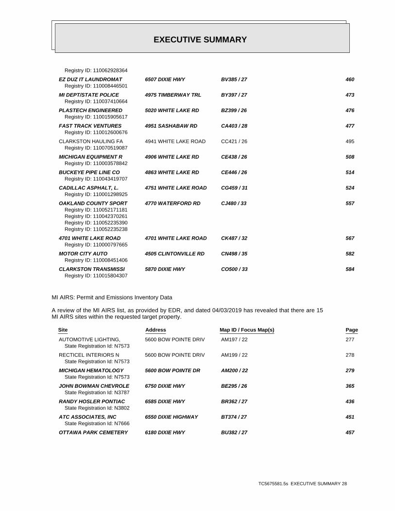
EXECUTIVE SUMMARY
TC5675581.5s EXECUTIVE SUMMARY 28
Registry ID: 110062928364
EZ DUZ IT LAUNDROMAT 6507 DIXIE HWY BV385 / 27 460Registry ID: 110008446501
MI DEPT/STATE POLICE 4975 TIMBERWAY TRL BY397 / 27 473Registry ID: 110037410664
PLASTECH ENGINEERED 5020 WHITE LAKE RD BZ399 / 26 476Registry ID: 110015905617
FAST TRACK VENTURES 4951 SASHABAW RD CA403 / 28 477Registry ID: 110012600676
CLARKSTON HAULING FA 4941 WHITE LAKE ROAD CC421 / 26 495Registry ID: 110070519087
MICHIGAN EQUIPMENT R 4906 WHITE LAKE RD CE438 / 26 508Registry ID: 110003578842
BUCKEYE PIPE LINE CO 4863 WHITE LAKE RD CE446 / 26 514Registry ID: 110043419707
CADILLAC ASPHALT, L. 4751 WHITE LAKE ROAD CG459 / 31 524Registry ID: 110001298925
OAKLAND COUNTY SPORT 4770 WATERFORD RD CJ480 / 33 557Registry ID: 110052171181Registry ID: 110042370261Registry ID: 110052235390Registry ID: 110052235238
4701 WHITE LAKE ROAD 4701 WHITE LAKE ROAD CK487 / 32 567Registry ID: 110000797665
MOTOR CITY AUTO 4505 CLINTONVILLE RD CN498 / 35 582Registry ID: 110008451406
CLARKSTON TRANSMISSI 5870 DIXIE HWY CO500 / 33 584Registry ID: 110015804307
MI AIRS: Permit and Emissions Inventory Data
A review of the MI AIRS list, as provided by EDR, and dated 04/03/2019 has revealed that there are 15MI AIRS sites within the requested target property.
Site Address Map ID / Focus Map(s) Page
AUTOMOTIVE LIGHTING, 5600 BOW POINTE DRIV AM197 / 22 277State Registration Id: N7573
RECTICEL INTERIORS N 5600 BOW POINTE DRIV AM199 / 22 278State Registration Id: N7573
MICHIGAN HEMATOLOGY 5600 BOW POINTE DR AM200 / 22 279State Registration Id: N7573
JOHN BOWMAN CHEVROLE 6750 DIXIE HWY BE295 / 26 365State Registration Id: N3787
RANDY HOSLER PONTIAC 6585 DIXIE HWY BR362 / 27 436State Registration Id: N3802
ATC ASSOCIATES, INC 6550 DIXIE HIGHWAY BT374 / 27 451State Registration Id: N7666
OTTAWA PARK CEMETERY 6180 DIXIE HWY BU382 / 27 457

EXECUTIVE SUMMARY
TC5675581.5s EXECUTIVE SUMMARY 29
State Registration Id: M4270
CLARKSTON FUEL VENTU 4951 SASHABAW RD CA407 / 28 480State Registration Id: N5765
PRECISION PIPE & SUP 4950 WHITE LAKE ROAD CD428 / 26 503State Registration Id: B7347
S & L AUTOBODY 4712 SASHABEW ROAD 457 / 34 522State Registration Id: N3117
WEBER SAND & GRAVEL, 4751 WHITE LAKE ROAD CG460 / 31 543State Registration Id: N3520
CADILLAC ASPHALT PRO 4751 WHITE LAKE ROAD CG461 / 31 544State Registration Id: B4287
CADILLAC ASPHALT, LL 4751 WHITE LAKE ROAD CG464 / 31 546State Registration Id: B4287
THOMPSON-MCCULLY QUA 4751 WHITE LAKE ROAD CG468 / 31 550State Registration Id: B4287
CLAWSON TANK CO INC 4701 WHITE LAKE RD CK489 / 32 575Facility Status: OPState Registration Id: B8815
MI ASBESTOS: ASBESTOS
A review of the MI ASBESTOS list, as provided by EDR, and dated 04/30/2019 has revealed that thereare 11 MI ASBESTOS sites within the requested target property.
Site Address Map ID / Focus Map(s) Page
RESIDENCE 9501 SASHABAW ROAD B10 / 10 102 RESIDENCE 8254 PERRY LAKE ROAD 23 / 15 112 RESIDENCE 177 NORTH MAIN STREE 83 / 20 172 RESIDENCE 62 NORTH MAIN STREET 112 / 20 198 CLARKSTON UNITED MET 6600 WALDON ROAD AB147 / 21 227 CLARKSTON UNITED MET 6600 WALDON ROAD AB148 / 21 228 CLARKSTON JUNIOR HIG 6595 WALDON ROAD AE159 / 21 244 RESIDENCE 5600 WARBLER DRIVE 301 / 27 376 NORTH SASHABAW ELEME 5290 MAYBEE ROAD 314 / 29 387 RESIDENCE 5585 MAYBEE ROAD 320 / 28 390 RESIDENCE 6635 WELLESLEY TERRA 483 / 33 558
MI BEA: Baseline Environmental Assessment Database
A review of the MI BEA list, as provided by EDR, and dated 08/21/2013 has revealed that there are 20MI BEA sites within the requested target property.
Site Address Map ID / Focus Map(s) Page
CLARKSTON SQUARE 5748 CLARKSTON RD E30 / 16 116 DWIGHT ORTHOPEDIC RE 7164 N. MAIN STREET 73 / 20 167 MI DEPT/NATURAL RESO 6440 CLARKSTON RD R92 / 21 179 COMMERCIAL PROPERTY 32 SOUTH MAIN STREET X135 / 20 216 SHEFFLER & ASSOCIATE 6330 SASHABAW ROAD AJ181 / 22 262 KIMCO WHITE LAKE 667 7071-7157 DIXIE HIGH AW246 / 26 316 DIXIE & M-15 6756 DIXIE HWY BD292 / 26 357 DUGAN’S IRISH PUB 6722 DIXIE HIGHWAY BF298 / 26 375

EXECUTIVE SUMMARY
TC5675581.5s EXECUTIVE SUMMARY 30
Site Address Map ID / Focus Map(s) Page
WEINGARTZ SUPPLY CO 6585 DIXIE HWY BR359 / 27 434 BOSTON MARKET (FORME 6570 DIXIE HIGHWAY BS368 / 27 443 CLARKSTON FUEL VENTU 4951 SASHABAW RD CA407 / 28 480 ALLIED CONSTRUCTION 4941 WHITE LAKE RD CC417 / 26 490 SANITATION COMPANY P 4941 WHITE LAKE ROAD CC420 / 26 494 PRECISION PIPE & SUP 4950 WHITE LAKE RD CD423 / 26 497 MICHIGAN EQUIPMENT R 4906 WHITE LAKE RD CE439 / 26 510 GRAND TRUNK PROPERTY 4861 WHITE LAKE ROAD CE444 / 26 513 HADLEY MOLD 4866 WHITE LAKE RD 450 / 26 516 4836 WHITE LAKE ROAD 4836 WHITE LAKE ROAD CF456 / 26 522 INDEPENDENCE SQUARE 5881 THROUGH 5901 DI CI478 / 33 556 SOUTH DIXIE PROPERTI 5886 DIXIE HIGHWAY CL492 / 33 579
MI DRYCLEANERS: Drycleaning Establishments
A review of the MI DRYCLEANERS list, as provided by EDR, and dated 01/15/2019 has revealed that thereare 9 MI DRYCLEANERS sites within the requested target property.
Site Address Map ID / Focus Map(s) Page
POINTE CLEANERS 7194 N MAIN ST M68 / 20 163Establishment#: 6300126
SPENCER CLEANERS 6413 SASHABAW ROAD AF162 / 22 246Establishment#: 6300117
CHAMPS CLEANERS 6315 SASHABAW ROAD, AK185 / 22 265Establishment#: 6300285
SUN CUSTOM DRYCLEANE 5930 SOUTH MAIN STRE AV230 / 26 305Establishment#: 6300281
A CLEANER IMAGE 5795 SOUTH MAIN AY259 / 26 324Establishment#: 6300260
DEER LAKE CUSTOM CLE 6700 DIXIE HIGHWAY BF305 / 26 379Establishment#: 6300086
LEE CLEANERS & LAUND 5433 SASHABAW ROAD BK339 / 28 409Establishment#: 6300227
EZ DUZ IT LAUNDROMAT 6507 DIXIE HIGHWAY BV386 / 27 468Establishment#: 6300002
SQUIRE CLEANERS 5907 DIXIE HWY. CI476 / 33 555Establishment#: 6300026Establishment#: 6300118
MI Financial Assurance: Financial Assurance Information Listing
A review of the MI Financial Assurance list, as provided by EDR, has revealed that there are 14 MIFinancial Assurance sites within the requested target property.
Site Address Map ID / Focus Map(s) Page
INDEPENDENCE TWP FIR 7825 SASHABAW RD E27 / 16 114Database: FINANCIAL ASSURANCE 3, Date of Government Version: 08/24/2017
GEB CLARKSTON INC 7650 ORTONVILLE RD G42 / 14 129Database: FINANCIAL ASSURANCE 3, Date of Government Version: 08/24/2017

EXECUTIVE SUMMARY
TC5675581.5s EXECUTIVE SUMMARY 31
Site Address Map ID / Focus Map(s) Page
CLARKSTON BP 7251 N MAIN ST K56 / 20 146Database: FINANCIAL ASSURANCE 3, Date of Government Version: 08/24/2017
DEPT OF PUBLIC WORKS 6050 FLEMINGS LAKE R Q87 / 21 176Database: FINANCIAL ASSURANCE 3, Date of Government Version: 08/24/2017
PINE KNOB SHELL 6889 SASHABAW RD U110 / 22 197Database: FINANCIAL ASSURANCE 3, Date of Government Version: 08/24/2017
SASHABAW & 75 6480 SASHABAW RD AC151 / 22 230Database: FINANCIAL ASSURANCE 3, Date of Government Version: 08/24/2017
CLARKSTON COMMUNITY 6590 MIDDLE LAKE RD AL191 / 21 268Database: FINANCIAL ASSURANCE 3, Date of Government Version: 08/24/2017
KROGER D-651 5990 SASHABAW RD AZ266 / 28 333Database: FINANCIAL ASSURANCE 3, Date of Government Version: 08/24/2017
JOHN BOWMAN CHEVROLE 6750 DIXIE HWY BE295 / 26 365Database: FINANCIAL ASSURANCE 3, Date of Government Version: 08/24/2017
DANDY OIL # 5 5465 SASHABAW RD BK329 / 28 395Database: FINANCIAL ASSURANCE 3, Date of Government Version: 08/24/2017
CLARKSTON CO (M53211 6610 DIXIE HWY BM344 / 27 413Database: FINANCIAL ASSURANCE 3, Date of Government Version: 08/24/2017
SPEEDWAY #8535 6594 DIXIE HWY BP354 / 27 423Database: FINANCIAL ASSURANCE 3, Date of Government Version: 08/24/2017
MT CLARK 6550 DIXIE HWY BT373 / 27 445Database: FINANCIAL ASSURANCE 3, Date of Government Version: 08/24/2017
CLARKSTON FUEL VENTU 4951 SASHABAW RD CA407 / 28 480Database: FINANCIAL ASSURANCE 3, Date of Government Version: 08/24/2017
MI LEAD: Lead Safe Housing Registry
A review of the MI LEAD list, as provided by EDR, and dated 09/15/2015 has revealed that there is 1MI LEAD site within the requested target property.
Site Address Map ID / Focus Map(s) Page
Not reported 5055 FOX CRK N, APT 365 / 29 441
RI MANIFEST: Manifest information
A review of the RI MANIFEST list, as provided by EDR, and dated 12/31/2017 has revealed that there is1 RI MANIFEST site within the requested target property.
Site Address Map ID / Focus Map(s) Page
EZ DUZ IT LAUNDROMAT 6507 DIXIE HWY BV385 / 27 460EPA Id: MID053094124Manifest Document Number: 003683646FLE
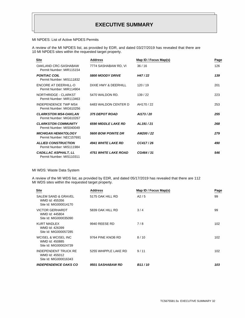
EXECUTIVE SUMMARY
TC5675581.5s EXECUTIVE SUMMARY 32
MI NPDES: List of Active NPDES Permits
A review of the MI NPDES list, as provided by EDR, and dated 03/27/2019 has revealed that there are10 MI NPDES sites within the requested target property.
Site Address Map ID / Focus Map(s) Page
OAKLAND CRC-SASHABAW 7774 SASHABAW RD, VI 36 / 16 126Permit Number: MIR115154
PONTIAC COIL 5800 MOODY DRIVE H47 / 22 139Permit Number: MIS111832
ENCORE AT DEERHILL-O DIXIE HWY & DEERHILL 120 / 19 201Permit Number: MIR114904
NORTHRIDGE - CLARKST 5470 WALDON RD. 139 / 22 223Permit Number: MIR113463
INDEPENDENCE TWP MS4 6483 WALDON CENTER D AH170 / 22 253Permit Number: MIG610256
CLARKSTON MS4-OAKLAN 375 DEPOT ROAD AI173 / 20 255Permit Number: MIG610267
CLARKSTON COMMUNITY 6590 MIDDLE LAKE RD AL191 / 21 268Permit Number: MIS040049
MICHIGAN HEMATOLOGY 5600 BOW POINTE DR AM200 / 22 279Permit Number: NEC157691
ALLIED CONSTRUCTION 4941 WHITE LAKE RD CC417 / 26 490Permit Number: MIS111984
CADILLAC ASPHALT, LL 4751 WHITE LAKE ROAD CG464 / 31 546Permit Number: MIS110311
MI WDS: Waste Data System
A review of the MI WDS list, as provided by EDR, and dated 05/17/2019 has revealed that there are 112MI WDS sites within the requested target property.
Site Address Map ID / Focus Map(s) Page
SALEM SAND & GRAVEL 5175 OAK HILL RD A2 / 5 99WMD Id: 455356Site Id: MIG000014170
VICTOR GERHARDT 5839 OAK HILL RD 3 / 4 99WMD Id: 445804Site Id: MIG000035090
KURT MADLEX 9940 REESE RD 7 / 8 102WMD Id: 426399Site Id: MIG000057285
WCISEL & WCISEL INC 9764 PINE KNOB RD 8 / 10 102WMD Id: 450885Site Id: MIG000024739
INDEPENDENT TRUCK RE 5255 WHIPPLE LAKE RD 9 / 11 102WMD Id: 455012Site Id: MIG000016343
INDEPENDENCE OAKS CO 9501 SASHABAW RD B11 / 10 103

EXECUTIVE SUMMARY
TC5675581.5s EXECUTIVE SUMMARY 33
WMD Id: 411741Site Id: MIR000025676
CRAWFORD RESIDENCE 8930 PERRY LAKE RD C14 / 15 107WMD Id: 469463Site Id: MIK844695452
A-1 TRUCKING 8031 ORTONVILLE RD 26 / 14 113WMD Id: 470575
CLARKSTON SQUARE 5748 CLARKSTON RD E30 / 16 116WMD Id: 478758Site Id: MIK615885886
WOODWARD DETROIT CVS 5756 CLARKSTON ROAD E33 / 16 122WMD Id: 490986Site Id: MIK425475155
RITE AID OF MICHIGAN 5751 CLARKSTON RD F38 / 16 128WMD Id: 491823Site Id: MIK113098012
G E B CLARKSTON INC 7650 ORTONVILLE RD G41 / 14 129WMD Id: 494248Site Id: MIK191615155
PONTIAC COIL 5800 MOODY DRIVE H47 / 22 139WMD Id: 412465Site Id: MIR000033134
PALACE SPORTS & ENTE 7774 SASHABAW RD I49 / 22 140WMD Id: 405364Site Id: MID985614783
AUSTIN OIL COMPANY 7231 N MAIN ST J54 / 20 145WMD Id: 449185Site Id: MIG000027472
CLARKSTON BP 7251 N MAIN ST K56 / 20 146WMD Id: 405276WMD Id: 445545Site Id: MID985613900Site Id: MIG000035637
SUNOCO INC 6754 BLUEGRASS DR K61 / 20 159WMD Id: 392267Site Id: MID000678615
POINTE CLEANERS 7194 N MAIN ST M68 / 20 163WMD Id: 405508Site Id: MID985616226
HOSLER PONTIAC 7151 N MAIN ST N76 / 20 169WMD Id: 418758Site Id: MIG000003815
COUNTY OF OAKLAND 7151 N MAIN ST N77 / 20 169WMD Id: 435409Site Id: MIP200001532
MURIEL ORLANDO 7689 DEERHILL DR 81 / 20 171WMD Id: 443612Site Id: MIG000039625
MI DEPT/TRANSPORTATI I 75 AT CLARKSTON P84 / 21 172
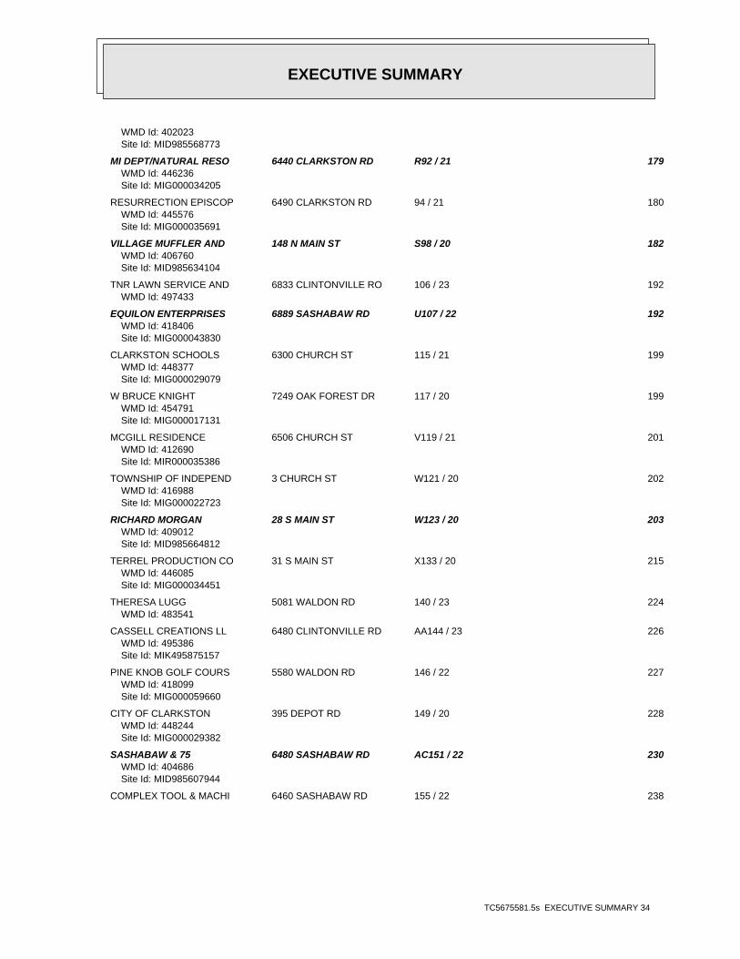
EXECUTIVE SUMMARY
TC5675581.5s EXECUTIVE SUMMARY 34
WMD Id: 402023Site Id: MID985568773
MI DEPT/NATURAL RESO 6440 CLARKSTON RD R92 / 21 179WMD Id: 446236Site Id: MIG000034205
RESURRECTION EPISCOP 6490 CLARKSTON RD 94 / 21 180WMD Id: 445576Site Id: MIG000035691
VILLAGE MUFFLER AND 148 N MAIN ST S98 / 20 182WMD Id: 406760Site Id: MID985634104
TNR LAWN SERVICE AND 6833 CLINTONVILLE RO 106 / 23 192WMD Id: 497433
EQUILON ENTERPRISES 6889 SASHABAW RD U107 / 22 192WMD Id: 418406Site Id: MIG000043830
CLARKSTON SCHOOLS 6300 CHURCH ST 115 / 21 199WMD Id: 448377Site Id: MIG000029079
W BRUCE KNIGHT 7249 OAK FOREST DR 117 / 20 199WMD Id: 454791Site Id: MIG000017131
MCGILL RESIDENCE 6506 CHURCH ST V119 / 21 201WMD Id: 412690Site Id: MIR000035386
TOWNSHIP OF INDEPEND 3 CHURCH ST W121 / 20 202WMD Id: 416988Site Id: MIG000022723
RICHARD MORGAN 28 S MAIN ST W123 / 20 203WMD Id: 409012Site Id: MID985664812
TERREL PRODUCTION CO 31 S MAIN ST X133 / 20 215WMD Id: 446085Site Id: MIG000034451
THERESA LUGG 5081 WALDON RD 140 / 23 224WMD Id: 483541
CASSELL CREATIONS LL 6480 CLINTONVILLE RD AA144 / 23 226WMD Id: 495386Site Id: MIK495875157
PINE KNOB GOLF COURS 5580 WALDON RD 146 / 22 227WMD Id: 418099Site Id: MIG000059660
CITY OF CLARKSTON 395 DEPOT RD 149 / 20 228WMD Id: 448244Site Id: MIG000029382
SASHABAW & 75 6480 SASHABAW RD AC151 / 22 230WMD Id: 404686Site Id: MID985607944
COMPLEX TOOL & MACHI 6460 SASHABAW RD 155 / 22 238

EXECUTIVE SUMMARY
TC5675581.5s EXECUTIVE SUMMARY 35
WMD Id: 418404Site Id: MIG000038975
CLARKSTON AUTO BODY 6470 SASHABAW RD AD158 / 22 244WMD Id: 397927Site Id: MID095401196
SPENCER CLEANERS 6413 SASHABAW ROAD AF162 / 22 246WMD Id: 411339Site Id: MIR000021634
TOWN CENTER AUTO WAS 6380 SASHABAW RD AG167 / 22 252WMD Id: 478957Site Id: MIK429173768
MORROW PROCESS CO 6352 SASHABAW RD AJ174 / 22 256WMD Id: 396743Site Id: MID064196488
SHEFFLER & ASSOCIATE 6338 SASHABAW RD AJ177 / 22 259WMD Id: 478134Site Id: MIK488981895
CHAMPS CLEANERS INC 6315 SASHABAW RD AK187 / 22 266WMD Id: 479787Site Id: MIK936292135
CLARKSTON SCHOOLS 6510 MIDDLE LAKE RD 188 / 21 266WMD Id: 453452Site Id: MIG000019685
CLARKSTON COMMUNITY 6590 MIDDLE LAKE RD AL191 / 21 268WMD Id: 418405Site Id: MIG000029078
BILL CRAIG 6281 MIDDLE LAKE RD 192 / 20 274WMD Id: 441958Site Id: MIG000042929
MAGGIE DEIBEL 6235 MIDDLE LAKE RD 193 / 20 274WMD Id: 418403Site Id: MIG000028456
MICHIGAN HEMATOLOGY 5600 BOW POINTE DR AM200 / 22 279WMD Id: 476419WMD Id: 491358Site Id: MIK118556554Site Id: MIK925357617
MCLAREN OAKLAND ONCO 5680 BOW POINT DR AN205 / 28 286WMD Id: 496790Site Id: MIK699447559
CLARKSTON DERMATOLOG 5701 BOW POINTE DR AN209 / 28 289WMD Id: 490374Site Id: MIK895188531
MCLAREN REGIONAL MED 5701 BOW POINT DR AN210 / 28 289WMD Id: 489859Site Id: MIK147308056
DEER LAKE RACQUET CL 6167 WHITE LAKE RD AP217 / 26 293WMD Id: 490187Site Id: MIK185046226
LAKEVIEW CEMETERY 6150 WHITE LAKE RD AQ220 / 26 297
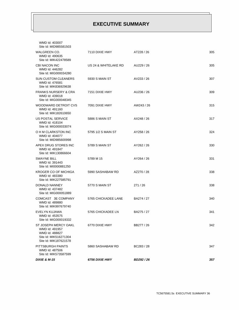
EXECUTIVE SUMMARY
TC5675581.5s EXECUTIVE SUMMARY 36
WMD Id: 403007Site Id: MID985581503
WALGREEN CO. 7110 DIXIE HWY AT228 / 26 305WMD Id: 490635Site Id: MIK422478589
CBI NACON INC US 24 & WHITELAKE RD AU229 / 26 305WMD Id: 446282Site Id: MIG000034280
SUN CUSTOM CLEANERS 5930 S MAIN ST AV233 / 26 307WMD Id: 476581Site Id: MIK836929638
FRANKS NURSERY & CRA 7151 DIXIE HWY AU236 / 26 309WMD Id: 439018Site Id: MIG000048345
WOODWARD DETROIT CVS 7091 DIXIE HWY AW243 / 26 315WMD Id: 491160Site Id: MIK182610650
US POSTAL SERVICE 5886 S MAIN ST AX248 / 26 317WMD Id: 418104Site Id: MIG000033074
O H M CLARKSTON INC 5795 1/2 S MAIN ST AY258 / 26 324WMD Id: 404077Site Id: MID985600998
APEX DRUG STORES INC 5789 S MAIN ST AY262 / 26 330WMD Id: 491847Site Id: MIK130866604
SWAYNE BILL 5789 M 15 AY264 / 26 331WMD Id: 391443Site Id: MI0000881250
KROGER CO OF MICHIGA 5990 SASHABAW RD AZ270 / 28 338WMD Id: 483380Site Id: MIK227585791
DONALD NANNEY 5770 S MAIN ST 271 / 26 338WMD Id: 437482Site Id: MIG000051889
COMCAST 3E COMPANY 5765 CHICKADEE LANE BA274 / 27 340WMD Id: 489880Site Id: MIK997679740
EVELYN KUJAWA 5765 CHICKADEE LN BA275 / 27 341WMD Id: 453575Site Id: MIG000019332
ST JOSEPH MERCY OAKL 6770 DIXIE HWY BB277 / 26 342WMD Id: 491957WMD Id: 488827Site Id: MIK516271304Site Id: MIK187621578
PITTSBURGH PAINTS 5860 SASHABAW RD BC283 / 28 347WMD Id: 487506Site Id: MIK573587599
DIXIE & M-15 6756 DIXIE HWY BD292 / 26 357

EXECUTIVE SUMMARY
TC5675581.5s EXECUTIVE SUMMARY 37
WMD Id: 404603Site Id: MID985607118
CLARKSTON AUTO WASH 6791 DIXIE HWY 293 / 26 364WMD Id: 437589Site Id: MIG000052092
JOHN BOWMAN CHEVROLE 6750 DIXIE HWY BE294 / 26 365WMD Id: 398722Site Id: MID148627383
ARMAND DRILLING CO 5650 WHITE LAKE RD BG304 / 26 378WMD Id: 435536Site Id: MIP200001187
DEER LAKE CUSTOM CLE 6700 DIXIE HIGHWAY BF305 / 26 379WMD Id: 400324Site Id: MID981797582
WOODWARD DETROIT CVS 5529 SASHABAW RD BH311 / 28 383WMD Id: 491055Site Id: MIK677385932
SOS MECHANICAL INC 6696 DIXIE HWY BI316 / 26 389WMD Id: 399323Site Id: MID980901888
TOWNSHIP OF INDEPEND 5241 MAYBEE RD 319 / 29 390WMD Id: 439892Site Id: MIG000046740
GOTTS AUTO SERVICE 5709 MAYBEE RD 322 / 28 391WMD Id: 456235Site Id: MIG000012173
MAYBEE AND SASHABAW 5480 SASHABAW ROAD BJ327 / 28 393WMD Id: 448146Site Id: MIG000029170
DANDY OIL # 5 5465 SASHABAW RD BK329 / 28 395WMD Id: 442797Site Id: MIG000041694
CLARKSTON MOTORS 6673 DIXIE HWY BL336 / 27 406WMD Id: 399778Site Id: MID981531205
LEE CLEANERS & LAUND 5433 SASHABAW ROAD BK339 / 28 409WMD Id: 405216Site Id: MID985613298
MICHIGAN BELL TELEPH 6610 DIXIE HWY BM342 / 27 411WMD Id: 400607Site Id: MID981957756
KROGER CO OF MICHIGA 6625 DIXIE HWY BN346 / 27 414WMD Id: 483354Site Id: MIK931597355
SPEEDWAY #8535 6594 DIXIE HWY BP354 / 27 423WMD Id: 408554Site Id: MID985660117
WEINGARTZ SUPPLY CO 6585 DIXIE HWY BR359 / 27 434WMD Id: 395423
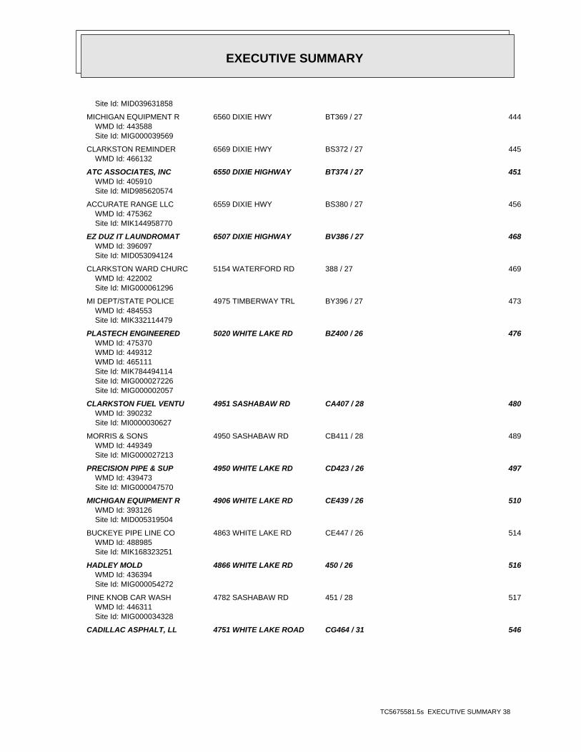
EXECUTIVE SUMMARY
TC5675581.5s EXECUTIVE SUMMARY 38
Site Id: MID039631858
MICHIGAN EQUIPMENT R 6560 DIXIE HWY BT369 / 27 444WMD Id: 443588Site Id: MIG000039569
CLARKSTON REMINDER 6569 DIXIE HWY BS372 / 27 445WMD Id: 466132
ATC ASSOCIATES, INC 6550 DIXIE HIGHWAY BT374 / 27 451WMD Id: 405910Site Id: MID985620574
ACCURATE RANGE LLC 6559 DIXIE HWY BS380 / 27 456WMD Id: 475362Site Id: MIK144958770
EZ DUZ IT LAUNDROMAT 6507 DIXIE HIGHWAY BV386 / 27 468WMD Id: 396097Site Id: MID053094124
CLARKSTON WARD CHURC 5154 WATERFORD RD 388 / 27 469WMD Id: 422002Site Id: MIG000061296
MI DEPT/STATE POLICE 4975 TIMBERWAY TRL BY396 / 27 473WMD Id: 484553Site Id: MIK332114479
PLASTECH ENGINEERED 5020 WHITE LAKE RD BZ400 / 26 476WMD Id: 475370WMD Id: 449312WMD Id: 465111Site Id: MIK784494114Site Id: MIG000027226Site Id: MIG000002057
CLARKSTON FUEL VENTU 4951 SASHABAW RD CA407 / 28 480WMD Id: 390232Site Id: MI0000030627
MORRIS & SONS 4950 SASHABAW RD CB411 / 28 489WMD Id: 449349Site Id: MIG000027213
PRECISION PIPE & SUP 4950 WHITE LAKE RD CD423 / 26 497WMD Id: 439473Site Id: MIG000047570
MICHIGAN EQUIPMENT R 4906 WHITE LAKE RD CE439 / 26 510WMD Id: 393126Site Id: MID005319504
BUCKEYE PIPE LINE CO 4863 WHITE LAKE RD CE447 / 26 514WMD Id: 488985Site Id: MIK168323251
HADLEY MOLD 4866 WHITE LAKE RD 450 / 26 516WMD Id: 436394Site Id: MIG000054272
PINE KNOB CAR WASH 4782 SASHABAW RD 451 / 28 517WMD Id: 446311Site Id: MIG000034328
CADILLAC ASPHALT, LL 4751 WHITE LAKE ROAD CG464 / 31 546

EXECUTIVE SUMMARY
TC5675581.5s EXECUTIVE SUMMARY 39
WMD Id: 399205Site Id: MID980702690
SMITHS DISPOSAL 4801 WHITE LAKE RD CH472 / 32 554WMD Id: 417656Site Id: MIG000020875
WHITE LAKE ROAD CONT 4790 WHITE LAKE ROAD CH474 / 32 554WMD Id: 452224Site Id: MIG000021767
WOODHULL LAKE 4770 WATERFORD ROAD CJ481 / 33 557WMD Id: 449368Site Id: MIG000027259
CLAWSON TANK 4701 WHITE LAKE RD CK485 / 32 567WMD Id: 393897Site Id: MID006005482
NATURES GREEN INC 2858 MANN RD CM495 / 35 580WMD Id: 449341Site Id: MIG000027239
MOTOR CITY AUTO 4505 CLINTONVILLE RD CN497 / 35 582WMD Id: 400181Site Id: MID981789373
CABINET ONE 4625 WHITE LAKE CT 499 / 32 584WMD Id: 417652Site Id: MIG000034038
CLARKSTON TRANSMISSI 5870 DIXIE HWY CO503 / 33 587WMD Id: 439437Site Id: MIK654233741
ARMAND DRILLING CO 7950 ANDERSONVILLE R 508 / 31 589WMD Id: 450323Site Id: MIG000025329
EDR HIGH RISK HISTORICAL RECORDS
EDR Exclusive Records
EDR Hist Auto: EDR Exclusive Historical Auto Stations
A review of the EDR Hist Auto list, as provided by EDR, has revealed that there are 27 EDR Hist Autosites within the requested target property.
Site Address Map ID / Focus Map(s) Page
BVD CORPORATION INC 8610 PERRY LAKE RD 17 / 15 109 C/O MOBIL EXXON 6379 PARK TRAIL DR 24 / 15 112 DEERWOOD SERVICE INC 7650 ORTONVILLE RD 7 G40 / 14 129 FENTON-HILL SHELL IN 7251 ORTONVILLE RD J51 / 20 145 FENTON-HILL SUNOCO I 7251 N MAIN ST K55 / 20 146 TOMS TEXACO SERVICE 7230 ORTONVILLE M67 / 20 163 STILLROYS STANDARD S 6605 NORTHVIEW DR 71 / 21 167 CLARKSTON MUFFLER & 148 N MAIN ST S103 / 20 191 AUTO CITY SERVICE CE 6889 SASHABAW RD U108 / 22 193 R D TRANSMISSIONS 6311 PEACH DR 113 / 21 198

EXECUTIVE SUMMARY
TC5675581.5s EXECUTIVE SUMMARY 40
Site Address Map ID / Focus Map(s) Page
MORGAN SERVICE STATI 28 S MAIN ST W130 / 20 214 ROYS ED AMOCO INC 6480 SASHABAW RD AC152 / 22 237 TAYLORS TIRE SERVICE 6103 MIDDLE LAKE RD AO212 / 26 291 I 75 AND SASHABAW AM 6830 DIXIE HWY 255 / 26 321 STILLROYS STANDARD S 6756 DIXIE HWY BD284 / 26 348 HAL & SON SUNOCO 5510 SASHABAW RD BH317 / 28 389 B P OIL INC OHIO 5480 SASHABAW BJ324 / 28 392 UNION 76 5465 SASHABAW BK331 / 28 403 JOES SUNOCO SERVICE 6677 DIXIE HWY BL333 / 27 404 SPEEDWAY SUPERAMERIC 6594 DIXIE HWY BP352 / 27 420 TRANSMISSION EXPRESS 5267 MARY SUE 364 / 28 441 KAYOOIL CO 6550 DIXIE HWY BT375 / 27 452 CLARK RETAIL ENTERPR 4951 SASHABAW RD CA402 / 28 477 UNIVERSITY AMOCO 4142 MEYERS RD 449 / 28 516 J AND J MOBIL INC 3025 REEDER RD 479 / 35 556 CLARKSTON TRANSMISSI 5870 DIXIE HWY CO501 / 33 584 C & F TRUCK & AUTO R 4525 WHITE LAKE RD 504 / 32 587
EDR Hist Cleaner: EDR Exclusive Historical Cleaners
A review of the EDR Hist Cleaner list, as provided by EDR, has revealed that there are 19 EDR HistCleaner sites within the requested target property.
Site Address Map ID / Focus Map(s) Page
TWO BROWN FAMILY LLC 8530 ELKRUN DR 18 / 15 110 SIM DRY CLEANING 4730 CLARKSTON RD 19 / 17 110 POINTE CLEANERS 7194 ORTONVILLE RD M69 / 20 166 POINTE CLEANERS INC 7194 N MAIN ST M70 / 20 166 NEENS CLEANERS & TAI 6 N MAIN ST 116 / 20 199 3J INDUSTRIES INC 6413 SASHABAW RD AF163 / 22 247 SUN CLEANERS 5930 S MAIN ST AV231 / 26 306 SUN CLEANERS 5926 S MAIN ST AV235 / 26 309 CLARKSTON DRY CLEANE 5916 S MAIN ST AV237 / 26 310 PINE KNOB CLEANERS 5916 ORTONVILLE RD AV238 / 26 311 CLARKSTON DRY CLEANE 5908 S MAIN 239 / 26 311 T & L INCORPORATED 7125 DIXIE HWY AW240 / 26 311 O H M CLARKSTON INC 5792 1/2 S MAIN ST AY256 / 26 321 O H M CLARKSTON INC 5795 1/2 S MAIN ST AY260 / 26 325 ELLIOTTS CLEANERS 6700 DIXIE BF309 / 26 382 LEE DRYCLEANING & LA 5433 SASHABAW RD BK340 / 28 410 L C DORTCH & ASSOCIA 6647 DIXIE HWY 341 / 27 410 DEER LAKE CUSTOME CL 6485 DIXIE HIGHWAY BV387 / 27 468 SQUIRE CLEANERS 5907 DIXIE HWY CI475 / 33 555
EDR RECOVERED GOVERNMENT ARCHIVES
Exclusive Recovered Govt. Archives
MI RGA PART 201: Recovered Government Archive State Hazardous Waste Facilities List
A review of the MI RGA PART 201 list, as provided by EDR, has revealed that there are 19 MI RGA PART

EXECUTIVE SUMMARY
TC5675581.5s EXECUTIVE SUMMARY 41
201 sites within the requested target property.
Site Address Map ID / Focus Map(s) Page
FORMER TEXACO - CLAR 7320 ORTONVILLE M63 / 20 161Facility ID: 630078
BUCKEYE OIL PIPELINE 7770 DEERHILL DRIVE O79 / 19 170Facility ID: 6300001Facility ID: 63000011
CLARKSTON RD AREA 6440 CLARKSTON RD R89 / 21 178Facility ID: 630016
CLARKSTON RD AREA LF 6440 CLARKSTON RD R90 / 21 178Facility ID: 6300001Facility ID: 63000016
CLARKSTON RD AREA 6440 CLARKSTON RD R91 / 21 178Facility ID: 630016Facility ID: 63000016
MAIN STREET RES WELL 154 NORTH MAIN STREE S95 / 20 180Facility ID: 63000156Facility ID: 630156
MAIN STREET RES WELL 148 NORTH MAIN STREE S99 / 20 189Facility ID: 6300015Facility ID: 63000156
DEER LAKE DRY CLEANE 6700 DIXIE HIGHWAY BF308 / 26 382Facility ID: 6300521Facility ID: 63005216
MAYBEE AND SASHABAW 5480 SASHABAW ROAD BJ326 / 28 393Facility ID: 6300005Facility ID: 63000053
MAYBEE AND SASHABAW 5438 SASHABAW ROAD 334 / 28 404Facility ID: 63000053
DRAYTON ROAD WELL 5068 DRAYTON BW390 / 28 470Facility ID: 630137Facility ID: 6300013Facility ID: 63000137
OLD DERVAGE DUMP SIT 5002 PELTON RD BX394 / 28 472Facility ID: 63000955
SASHABAW RD AREA RES 4951 SASHABAW ROAD CA404 / 28 480Facility ID: 6300005Facility ID: 63000054
WHITE LK RD SCRAP YD 4905 WHITE LK RD CE433 / 26 506Facility ID: 6300096Facility ID: 63000963Facility ID: 630963
PROPERTY 4906 WHITE 4906 WHITE LAKE ROAD CE441 / 26 512Facility ID: 630861
BUCKEYE PIPELINE 4861 WHITE LAKE ROAD CE442 / 26 512Facility ID: 63005121
4836 WHITE LAKE ROAD 4836 WHITE LAKE ROAD CF453 / 26 518Facility ID: 63005916
WHITE LAKE ROAD CONT 4790 WHITE LAKE ROAD CH473 / 32 554

EXECUTIVE SUMMARY
TC5675581.5s EXECUTIVE SUMMARY 42
Facility ID: 630158
WOODHULL LAKE 4770 WATERFORD ROAD CJ482 / 33 558Facility ID: 63005102
MI RGA LF: Recovered Government Archive Solid Waste Facilities List
A review of the MI RGA LF list, as provided by EDR, has revealed that there are 3 MI RGA LF siteswithin the requested target property.
Site Address Map ID / Focus Map(s) Page
BEN POWELL DISPOSAL 6023 SUNNYDALE AS225 / 26 301Facility ID: 63000015
DERVAGE DISPOSAL 5380 CENTER ST BQ356 / 27 430Facility ID: 63000007
INTER LAKES AUTO & T 4941 WHITE LK ROAD CC413 / 26 489Facility ID: 63000030
MI RGA LUST: Recovered Government Archive Leaking Underground Storage Tank
A review of the MI RGA LUST list, as provided by EDR, has revealed that there are 48 MI RGA LUSTsites within the requested target property.
Site Address Map ID / Focus Map(s) Page
INDEPENDENCE OAKS CO 9501 SASHABAW RD B12 / 10 105Facility ID: 00007767Facility ID: 0-007767Facility ID: 7767
CLARKSTON SQUARE 5748 CLARKSTON RD E29 / 16 115Facility ID: 37264
CLARKSTON #28 7251 ORTONVILLE RD. J52 / 20 145 CLARKSTON SHELL SERV 7251 ORTONVILLE RD J53 / 20 145
Facility ID: 0-004155
CLARKSTON SHELL SERV 7251 N MAIN ST K57 / 20 155Facility ID: 00004155Facility ID: 4155
FORMER TEXACO 7320 ORTONVILLE M64 / 20 161Facility ID: 50001543
FORMER TEXACO 7320 ORTINVILLE M65 / 20 162Facility ID: 5-001543Facility ID: 50001543
VILLAGE 76 148 N. MAIN ST. S96 / 20 181Facility ID: 0-016984
VILLAGE 76 148 N MAIN ST S100 / 20 190Facility ID: 00016984Facility ID: 16984Facility ID: 0-016984
RICHARD W MORGAN 28 S MAIN W124 / 20 208

EXECUTIVE SUMMARY
TC5675581.5s EXECUTIVE SUMMARY 43
Facility ID: 0-002855
MORGAN SERVICE 28 S MAIN STREET W126 / 20 211 MORGAN’S SERVICE 28 S MAIN STREET W127 / 20 211 RICHARD MORGAN 28 S MAIN W128 / 20 212
Facility ID: 00002855Facility ID: 0-002855Facility ID: 2855
INDEPENDENCE TWP FD 3 EAST CHURCH W131 / 20 215 FIRE DEPT STATION #3 3 E CHURCH ST W132 / 20 215
Facility ID: 00001328Facility ID: 1328Facility ID: 0-001328
SASHABAW & 75 6480 SASHABAW AC153 / 22 238Facility ID: 40775
SASHABAW & 75 6480 SASHABAW RD AC154 / 22 238Facility ID: 40775
CONTINENTAL MACHINE 6335 SASHABAW RD AJ180 / 22 262Facility ID: 35905Facility ID: 00035905Facility ID: 0-035905
CLARKSTON COMMUNITY 6590 MIDDLE LAKE RD AL189 / 21 267Facility ID: 00006673Facility ID: 0-006673Facility ID: 6673
KIEFT ENGINEERING, I 5852 S. MAIN (M-15) AX250 / 26 318Facility ID: 0-019604
KIEFT ENGINEERING, I 5852 S MAIN (M-15) AX251 / 26 319Facility ID: 00019604Facility ID: 19604Facility ID: 0-019604
KIEFT ENGINEERING 5852 S. MAIN ST. (M- AX252 / 26 319 AMOCO OIL #5448 6756 DIXIE HWY BD286 / 26 349
Facility ID: 0-005810
BP / AMOCO #25146 6756 DIXIE HWY BD287 / 26 349Facility ID: 00005810Facility ID: 5810
AMOCO OIL 5448 6756 DIXIE HWY. BD288 / 26 349 DIXIE & M-15 6756 DIXIE HWY BD291 / 26 357
Facility ID: 5810
FORMER BP #4579 5480 SASHABAW RD BJ325 / 28 392Facility ID: 50001574
DANDY OIL 5465 SASHABAW RD BK328 / 28 395Facility ID: 00013336Facility ID: 13336Facility ID: 0-013336
DANDY OIL 5465 SASHABAW RD. BK330 / 28 403Facility ID: 0-013336
DANDY OIL 5465 SASHABAW BK332 / 28 404 CHARLES SCOTT & SON 5450 MARVIN BO349 / 27 417

EXECUTIVE SUMMARY
TC5675581.5s EXECUTIVE SUMMARY 44
Facility ID: 00018106Facility ID: 18106Facility ID: 0-018106
SPEEDWAY #8535 6594 DIXIE HWY BP351 / 27 420Facility ID: 00019192Facility ID: 19192Facility ID: 0-019192
RANDY HOSLER PONTIAC 6585 DIXIE HWY BR363 / 27 440Facility ID: 00007642Facility ID: 0-007642Facility ID: 7642
MT CLARK 6550 DIXIE HWY BT376 / 27 452Facility ID: 7367
CLARKSTON CLARK 6550 DIXIE HWY BT377 / 27 453Facility ID: 00007367
OTTAWA PARK CEMETERY 6180 DIXIE HWY BU383 / 27 459Facility ID: 00008815Facility ID: 0-008815Facility ID: 8815
OTTAWA PARK CEMETERY 6180 DIXIE HWY. BU384 / 27 460Facility ID: 0-008815
CLARK SERVICE STATIO 4951 SASHABAW RD CA401 / 28 477Facility ID: 0-012300
CLARKSTON CLARK 4951 SASHABAW RD CA405 / 28 480Facility ID: 12300
CLARK STORE #1634 4951 SASHABAW CA406 / 28 480Facility ID: 0-012300
CLARK STORE #1634 4951 SASHABAW RD CA408 / 28 487Facility ID: 00012300Facility ID: 12300
ALLIED CONSTRUCTION 4941 WHITE LAKE RD CC414 / 26 489Facility ID: 41773
PRECISION PIPE & SUP 4950 WHITE LAKE RD CD424 / 26 502Facility ID: 00007003Facility ID: 0-007003Facility ID: 7003
PRECISION PIPE & SUP 4950 WHITE LAKE RD. CD427 / 26 503Facility ID: 0-007003
PRECISION PIPE & SUP 4950 WHITE LAKE CD429 / 26 504 CLAWSON TANK CO INC 4701 WHITE LAKE RD CK488 / 32 575
Facility ID: 00008139Facility ID: 0-008139Facility ID: 8139
BIANCAS II INC 7880 ANDERSONVILLE R CP505 / 32 587Facility ID: 00039448Facility ID: 39448
BIANCAS II INC 7880 ANDERSONVILLE CP507 / 32 589Facility ID: 0-039448
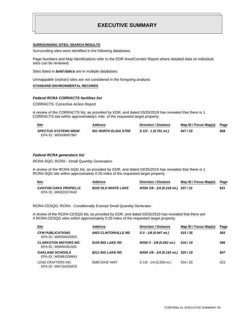
EXECUTIVE SUMMARY
TC5675581.5s EXECUTIVE SUMMARY 45
SURROUNDING SITES: SEARCH RESULTS
Surrounding sites were identified in the following databases.
Page Numbers and Map Identifcations refer to the EDR Area/Corridor Report where detailed data on individualsites can be reviewed.
Sites listed in bold italics are in multiple databases.
Unmappable (orphan) sites are not considered in the foregoing analysis.
STANDARD ENVIRONMENTAL RECORDS
Federal RCRA CORRACTS facilities list
CORRACTS: Corrective Action Report
A review of the CORRACTS list, as provided by EDR, and dated 03/25/2019 has revealed that there is 1CORRACTS site within approximately1 mile of the requested target property.
Site Address Direction / Distance Map ID / Focus Map(s) Page
SPECTUS SYSTEMS MIDW 501 NORTH ELIDA STRE S 1/2 - 1 (0.701 mi.) 547 / 33 658EPA ID:: MID006007967
Federal RCRA generators list
RCRA-SQG: RCRA - Small Quantity Generators
A review of the RCRA-SQG list, as provided by EDR, and dated 03/25/2019 has revealed that there is 1RCRA-SQG site within approximately 0.25 miles of the requested target property.
Site Address Direction / Distance Map ID / Focus Map(s) Page
CANYON OAKS PROPELLE 8220 OLD WHITE LAKE WSW 1/8 - 1/4 (0.218 mi.) 537 / 31 631EPA ID:: MIK622474542
RCRA-CESQG: RCRA - Conditionally Exempt Small Quantity Generator
A review of the RCRA-CESQG list, as provided by EDR, and dated 03/25/2019 has revealed that there are4 RCRA-CESQG sites within approximately 0.25 miles of the requested target property.
Site Address Direction / Distance Map ID / Focus Map(s) Page
CFM PUBLICATIONS 4453 CLINTONVILLE RD S 0 - 1/8 (0.047 mi.) 515 / 35 593EPA ID:: MIR000025825
CLARKSTON MOTORS INC 8105 BIG LAKE RD WSW 0 - 1/8 (0.052 mi.) 516 / 19 595EPA ID:: MI0000461020
OAKLAND SCHOOLS 8211 BIG LAKE RD WSW 1/8 - 1/4 (0.142 mi.) 525 / 19 607EPA ID:: MID981539943
LENS CRAFTERS INC 5586 DIXIE HWY S 1/8 - 1/4 (0.209 mi.) 534 / 33 623EPA ID:: MIK754235679

EXECUTIVE SUMMARY
TC5675581.5s EXECUTIVE SUMMARY 46
State and tribal leaking storage tank lists
MI LUST: Leaking Underground Storage Tank Sites
A review of the MI LUST list, as provided by EDR, and dated 05/03/2019 has revealed that there are 6MI LUST sites within approximately 0.5 miles of the requested target property.
Site Address Direction / Distance Map ID / Focus Map(s) Page
FORMER GAS & GO 5805 DIXIE HWY S 0 - 1/8 (0.116 mi.) CS524 / 33 606Release Status: ClosedFacility Id: 50001540
ALL SAINTS CEMETERY 4401 NELSEY RD S 1/8 - 1/4 (0.148 mi.) 526 / 32 610Release Status: ClosedSubstance Release: UnknownFacility Id: 00037070
WATERFORD FUEL MART 5775 DIXIE HWY S 1/8 - 1/4 (0.169 mi.) CT529 / 33 617Release Status: ClosedSubstance Release: Used OilSubstance Release: Gasoline,Gasoline,Gasoline,GasolineFacility Id: 00034345
LESSING ST. BULK PLA 4304 LESSING S 1/8 - 1/4 (0.215 mi.) CU536 / 32 625Release Status: OpenSubstance Release: UnknownSubstance Release: GasolineFacility Id: 00039287
LIBERTY OIL LLC 5676 DIXIE HWY S 1/4 - 1/2 (0.276 mi.) 539 / 33 637Release Status: OpenSubstance Release: UnknownFacility Id: 00015079
DIXIE HIGHWAY BP 8500 DIXIE HWY WNW 1/4 - 1/2 (0.395 mi.) CW543 / 19 645Release Status: OpenSubstance Release: GasolineSubstance Release: Diesel,GasolineFacility Id: 00014169
State and tribal registered storage tank lists
MI UST: Underground Storage Tank Facility List
A review of the MI UST list, as provided by EDR, has revealed that there are 7 MI UST sites withinapproximately 0.25 miles of the requested target property.
Site Address Direction / Distance Map ID / Focus Map(s) Page
NAGY CONCRETE PRODUC 4389 LESSING S 0 - 1/8 (0.102 mi.) CQ518 / 32 600Database: UST, Date of Government Version: 02/06/2019Tank Status: Removed from GroundFacility Type: CLOSEDFacility Id: 00001851
FORMER GAS & GO 5805 DIXIE HWY S 0 - 1/8 (0.116 mi.) CS522 / 33 605Database: UST, Date of Government Version: 02/06/2019
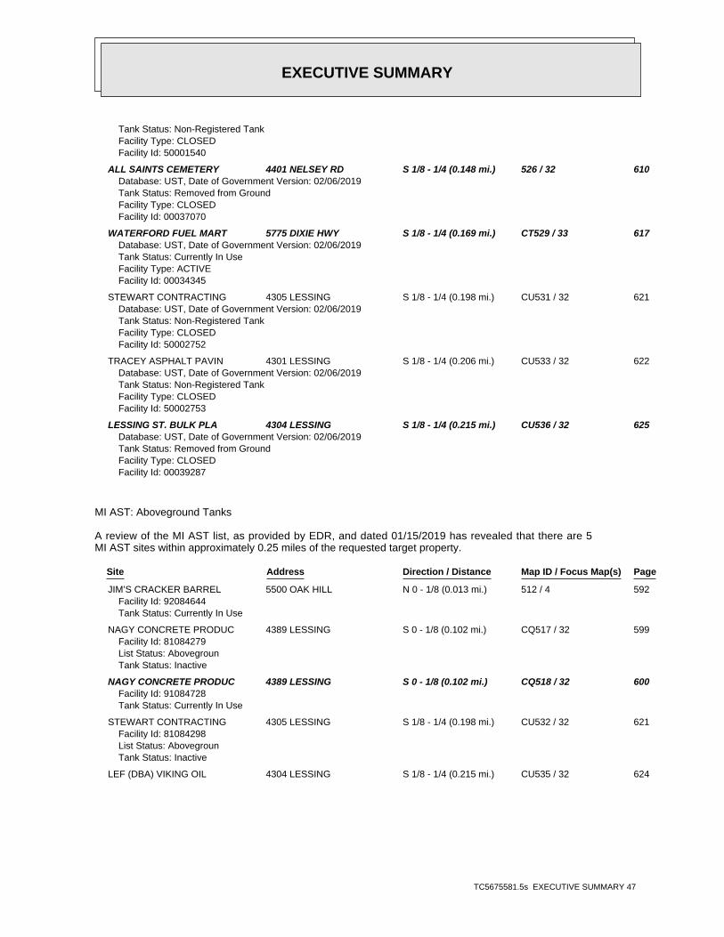
EXECUTIVE SUMMARY
TC5675581.5s EXECUTIVE SUMMARY 47
Tank Status: Non-Registered TankFacility Type: CLOSEDFacility Id: 50001540
ALL SAINTS CEMETERY 4401 NELSEY RD S 1/8 - 1/4 (0.148 mi.) 526 / 32 610Database: UST, Date of Government Version: 02/06/2019Tank Status: Removed from GroundFacility Type: CLOSEDFacility Id: 00037070
WATERFORD FUEL MART 5775 DIXIE HWY S 1/8 - 1/4 (0.169 mi.) CT529 / 33 617Database: UST, Date of Government Version: 02/06/2019Tank Status: Currently In UseFacility Type: ACTIVEFacility Id: 00034345
STEWART CONTRACTING 4305 LESSING S 1/8 - 1/4 (0.198 mi.) CU531 / 32 621Database: UST, Date of Government Version: 02/06/2019Tank Status: Non-Registered TankFacility Type: CLOSEDFacility Id: 50002752
TRACEY ASPHALT PAVIN 4301 LESSING S 1/8 - 1/4 (0.206 mi.) CU533 / 32 622Database: UST, Date of Government Version: 02/06/2019Tank Status: Non-Registered TankFacility Type: CLOSEDFacility Id: 50002753
LESSING ST. BULK PLA 4304 LESSING S 1/8 - 1/4 (0.215 mi.) CU536 / 32 625Database: UST, Date of Government Version: 02/06/2019Tank Status: Removed from GroundFacility Type: CLOSEDFacility Id: 00039287
MI AST: Aboveground Tanks
A review of the MI AST list, as provided by EDR, and dated 01/15/2019 has revealed that there are 5MI AST sites within approximately 0.25 miles of the requested target property.
Site Address Direction / Distance Map ID / Focus Map(s) Page
JIM’S CRACKER BARREL 5500 OAK HILL N 0 - 1/8 (0.013 mi.) 512 / 4 592Facility Id: 92084644Tank Status: Currently In Use
NAGY CONCRETE PRODUC 4389 LESSING S 0 - 1/8 (0.102 mi.) CQ517 / 32 599Facility Id: 81084279List Status: AbovegrounTank Status: Inactive
NAGY CONCRETE PRODUC 4389 LESSING S 0 - 1/8 (0.102 mi.) CQ518 / 32 600Facility Id: 91084728Tank Status: Currently In Use
STEWART CONTRACTING 4305 LESSING S 1/8 - 1/4 (0.198 mi.) CU532 / 32 621Facility Id: 81084298List Status: AbovegrounTank Status: Inactive
LEF (DBA) VIKING OIL 4304 LESSING S 1/8 - 1/4 (0.215 mi.) CU535 / 32 624

EXECUTIVE SUMMARY
TC5675581.5s EXECUTIVE SUMMARY 48
Facility Id: 92063215Removed/Closed Date: 01/01/2002Tank Status: Removed from Premises
State and tribal institutional control / engineering control registries
MI AUL: Engineering and Institutional Controls
A review of the MI AUL list, as provided by EDR, and dated 03/19/2019 has revealed that there is 1 MIAUL site within approximately 0.5 miles of the requested target property.
Site Address Direction / Distance Map ID / Focus Map(s) Page
SUNOCO INC 5775 DIXIE HWY S 1/8 - 1/4 (0.169 mi.) CT527 / 33 613Facility ID: 00034345
ADDITIONAL ENVIRONMENTAL RECORDS
Local Lists of Hazardous waste / Contaminated Sites
MI PART 201: Part 201 Site List
A review of the MI PART 201 list, as provided by EDR, and dated 10/01/2013 has revealed that thereare 2 MI PART 201 sites within approximately1 mile of the requested target property.
Site Address Direction / Distance Map ID / Focus Map(s) Page
COLOMBIERE CENTER 9075 BIG LAKE RD WSW 1/2 - 1 (0.536 mi.) 545 / 19 651Facility Status: Remedial Action in Progress (may incl. use restrictions, O&M and/or monitoring)Facility ID: 63000976
OAKLAND COUNTY FUELS 3943 AIRPORT ROAD S 1/2 - 1 (0.566 mi.) 546 / 33 656Facility Status: Inactive - no actions taken to address contaminationFacility ID: 63005154
MI INVENTORY: Inventory of Facilities
A review of the MI INVENTORY list, as provided by EDR, and dated 04/23/2019 has revealed that thereare 8 MI INVENTORY sites within approximately 0.5 miles of the requested target property.
Site Address Direction / Distance Map ID / Focus Map(s) Page
WATERFORD BLOCK AND 4389 LESSING RD. S 0 - 1/8 (0.102 mi.) CQ519 / 32 601Facility ID: 63005410
SUNOCO INC 5775 DIXIE HWY S 1/8 - 1/4 (0.169 mi.) CT527 / 33 613 BRANDON-GROVELAND-IN ORTONVILLE ROAD (NO N 1/8 - 1/4 (0.185 mi.) 530 / 2 620
Facility ID: 63000953
LESSING ST. BULK PLA 4304 LESSING S 1/8 - 1/4 (0.215 mi.) CU536 / 32 625Facility ID: 00039287
LIBERTY OIL LLC 5676 DIXIE HWY S 1/4 - 1/2 (0.276 mi.) 539 / 33 637

EXECUTIVE SUMMARY
TC5675581.5s EXECUTIVE SUMMARY 49
Facility ID: 00015079
DNR INVESTMENT ENTER 5498-5534 DIXIE HIGH S 1/4 - 1/2 (0.320 mi.) CV540 / 33 644 COMMERCIAL PROPERTY 5498-5534 DIXIE HIGH S 1/4 - 1/2 (0.320 mi.) CV542 / 33 645 DIXIE HIGHWAY BP 8500 DIXIE HWY WNW 1/4 - 1/2 (0.395 mi.) CW544 / 19 651
Facility ID: 00014169
MI DEL PART 201: Delisted List of Contaminated Sites
A review of the MI DEL PART 201 list, as provided by EDR, and dated 08/01/2013 has revealed thatthere are 2 MI DEL PART 201 sites within approximately1 mile of the requested target property.
Site Address Direction / Distance Map ID / Focus Map(s) Page
SALEM SAND AND GRAVE DARTMOUTH & OAK HILL N 0 - 1/8 (0.002 mi.) 509 / 5 589Facility Id: 63005112
RICKANE PEST CONTROL 6750 OAKHILL ROAD N 0 - 1/8 (0.009 mi.) 510 / 2 590Facility Id: 63000143
Other Ascertainable Records
RCRA NonGen / NLR: RCRA - Non Generators / No Longer Regulated
A review of the RCRA NonGen / NLR list, as provided by EDR, and dated 03/25/2019 has revealed thatthere are 5 RCRA NonGen / NLR sites within approximately 0.25 miles of the requested targetproperty.
Site Address Direction / Distance Map ID / Focus Map(s) Page
OAKHILL AUTO RESTORA 3994 S ORTONVILLE RD N 0 - 1/8 (0.011 mi.) 511 / 2 590EPA ID:: MID985581875
NORTH OAKS CUT STONE 4600 CLAWSON TANK DR W 0 - 1/8 (0.109 mi.) CR520 / 31 602EPA ID:: MIK249782715
CLEAN TIDE CONTAINER 4600 CLAWSON TANK DR W 0 - 1/8 (0.109 mi.) CR521 / 31 603EPA ID:: MIK918374489
SUNOCO INC 5775 DIXIE HWY S 1/8 - 1/4 (0.169 mi.) CT528 / 33 615EPA ID:: MID985582923
ROBERT CHASTAIN 3790 ALLEN RD N 1/8 - 1/4 (0.249 mi.) 538 / 2 636EPA ID:: MID982626103
MI BEA: Baseline Environmental Assessment Database
A review of the MI BEA list, as provided by EDR, and dated 08/21/2013 has revealed that there are 3MI BEA sites within approximately 0.5 miles of the requested target property.
Site Address Direction / Distance Map ID / Focus Map(s) Page
SUNOCO INC 5775 DIXIE HWY S 1/8 - 1/4 (0.169 mi.) CT527 / 33 613 DNR INVESTMENT ENTER 5498-5534 DIXIE HIGH S 1/4 - 1/2 (0.320 mi.) CV541 / 33 644 DIXIE HIGHWAY BP 8500 DIXIE HWY WNW 1/4 - 1/2 (0.395 mi.) CW543 / 19 645

EXECUTIVE SUMMARY
TC5675581.5s EXECUTIVE SUMMARY 50
EDR HIGH RISK HISTORICAL RECORDS
EDR Exclusive Records
EDR Hist Auto: EDR Exclusive Historical Auto Stations
A review of the EDR Hist Auto list, as provided by EDR, has revealed that there are 3 EDR Hist Autosites within approximately 0.125 miles of the requested target property.
Site Address Direction / Distance Map ID / Focus Map(s) Page
BP PROCESSING 2803 MANN RD S 0 - 1/8 (0.014 mi.) 513 / 35 592 J & W MOBIL SERVICE 4411 DORA LN E 0 - 1/8 (0.027 mi.) 514 / 30 592 STEVES AUTO CENTER & 5805 DIXIE HWY S 0 - 1/8 (0.116 mi.) CS523 / 33 606

TC5675581.5s Page 2
F39 / 16 RITE AID OF MICHIGAN 5751 CLARKSTON RD FINDS, ECHO TP
F38 / 16 RITE AID OF MICHIGAN 5751 CLARKSTON RD MI WDS TP
F37 / 16 RITE AID OF MICHIGAN 5751 CLARKSTON RD RCRA-CESQG TP
36 / 16 OAKLAND CRC-SASHABAW 7774 SASHABAW RD, VI MI NPDES TP
E35 / 16 WOODWARD DETROIT CVS 5756 CLARKSTON ROAD RCRA-CESQG TP
E34 / 16 WOODWARD DETROIT CVS 5756 CLARKSTON ROAD FINDS, ECHO TP
E33 / 16 WOODWARD DETROIT CVS 5756 CLARKSTON ROAD MI WDS TP
E32 / 16 SASHABAW MARKETPLACE 5748 CLARKSTON RD FINDS, ECHO TP
E31 / 16 SASHABAW MARKETPLACE 5748 CLARKSTON RD RCRA-CESQG TP
E30 / 16 CLARKSTON SQUARE 5748 CLARKSTON RD MI LUST, MI UST, MI INVENTORY, MI BEA, M... TP
E29 / 16 CLARKSTON SQUARE 5748 CLARKSTON RD MI RGA LUST TP
E28 / 16 INDEPENDENCE TWP FIR 7825 SASHABAW RD MI UST TP
E27 / 16 INDEPENDENCE TWP FIR 7825 SASHABAW RD MI Financial Assurance TP
26 / 14 A-1 TRUCKING 8031 ORTONVILLE RD MI WDS TP
25 / 15 6601 AMY DRIVE MI SPILLS TP
24 / 15 C/O MOBIL EXXON 6379 PARK TRAIL DR EDR Hist Auto TP
23 / 15 RESIDENCE 8254 PERRY LAKE ROAD MI ASBESTOS TP
D22 / 15 8240 DEER WOOD CIR ERNS TP
D21 / 15 CONSUMERS POWER CO 8232 DEERWOOD CIRCLE DOT OPS TP
20 / 17 8491 THENDARA BOULEV MI SPILLS TP
19 / 17 SIM DRY CLEANING 4730 CLARKSTON RD EDR Hist Cleaner TP
18 / 15 TWO BROWN FAMILY LLC 8530 ELKRUN DR EDR Hist Cleaner TP
17 / 15 BVD CORPORATION INC 8610 PERRY LAKE RD EDR Hist Auto TP
C16 / 15 CRAWFORD RESIDENCE 8930 PERRY LAKE RD RCRA NonGen / NLR TP
C15 / 15 CRAWFORD RESIDENCE 8930 PERRY LAKE RD FINDS, ECHO TP
C14 / 15 CRAWFORD RESIDENCE 8930 PERRY LAKE RD MI WDS TP
B13 / 10 COUNTY OF INDEPENDEN 9501 SASHABAW RD MI AST, RCRA NonGen / NLR, FINDS, ECHO TP
B12 / 10 INDEPENDENCE OAKS CO 9501 SASHABAW RD MI RGA LUST TP
B11 / 10 INDEPENDENCE OAKS CO 9501 SASHABAW RD MI LUST, MI UST, MI WDS TP
B10 / 10 RESIDENCE 9501 SASHABAW ROAD MI ASBESTOS TP
9 / 11 INDEPENDENT TRUCK RE 5255 WHIPPLE LAKE RD MI WDS TP
8 / 10 WCISEL & WCISEL INC 9764 PINE KNOB RD MI WDS TP
7 / 8 KURT MADLEX 9940 REESE RD MI WDS TP
6 / 10 10317 HORSESHOE CIRC MI SPILLS TP
5 / 3 10391 HORSESHOE CORC MI SPILLS TP
4 / 5 BURROUGHS MATERIALS US MINES TP
3 / 4 VICTOR GERHARDT 5839 OAK HILL RD MI WDS TP
A2 / 5 SALEM SAND & GRAVEL 5175 OAK HILL RD MI WDS TP
A1 / 5 SALEM SAND & GRAVEL ABANDONED MINES TP
MAPPED SITES SUMMARY
Target Property:1945-6932-00CLARKSTON, MI 48348
FOCUS MAPDIST (ft. & mi.)MAP ID /
DATABASE ACRONYMS DIRECTIONSITE NAME ADDRESS
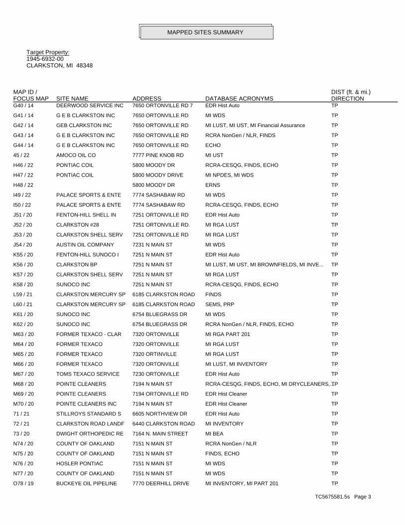
TC5675581.5s Page 3
O78 / 19 BUCKEYE OIL PIPELINE 7770 DEERHILL DRIVE MI INVENTORY, MI PART 201 TP
N77 / 20 COUNTY OF OAKLAND 7151 N MAIN ST MI WDS TP
N76 / 20 HOSLER PONTIAC 7151 N MAIN ST MI WDS TP
N75 / 20 COUNTY OF OAKLAND 7151 N MAIN ST FINDS, ECHO TP
N74 / 20 COUNTY OF OAKLAND 7151 N MAIN ST RCRA NonGen / NLR TP
73 / 20 DWIGHT ORTHOPEDIC RE 7164 N. MAIN STREET MI BEA TP
72 / 21 CLARKSTON ROAD LANDF 6440 CLARKSTON ROAD MI INVENTORY TP
71 / 21 STILLROYS STANDARD S 6605 NORTHVIEW DR EDR Hist Auto TP
M70 / 20 POINTE CLEANERS INC 7194 N MAIN ST EDR Hist Cleaner TP
M69 / 20 POINTE CLEANERS 7194 ORTONVILLE RD EDR Hist Cleaner TP
M68 / 20 POINTE CLEANERS 7194 N MAIN ST RCRA-CESQG, FINDS, ECHO, MI DRYCLEANERS,...TP
M67 / 20 TOMS TEXACO SERVICE 7230 ORTONVILLE EDR Hist Auto TP
M66 / 20 FORMER TEXACO 7320 ORTONVILLE MI LUST, MI INVENTORY TP
M65 / 20 FORMER TEXACO 7320 ORTINVILLE MI RGA LUST TP
M64 / 20 FORMER TEXACO 7320 ORTONVILLE MI RGA LUST TP
M63 / 20 FORMER TEXACO - CLAR 7320 ORTONVILLE MI RGA PART 201 TP
K62 / 20 SUNOCO INC 6754 BLUEGRASS DR RCRA NonGen / NLR, FINDS, ECHO TP
K61 / 20 SUNOCO INC 6754 BLUEGRASS DR MI WDS TP
L60 / 21 CLARKSTON MERCURY SP 6185 CLARKSTON ROAD SEMS, PRP TP
L59 / 21 CLARKSTON MERCURY SP 6185 CLARKSTON ROAD FINDS TP
K58 / 20 SUNOCO INC 7251 N MAIN ST RCRA-CESQG, FINDS, ECHO TP
K57 / 20 CLARKSTON SHELL SERV 7251 N MAIN ST MI RGA LUST TP
K56 / 20 CLARKSTON BP 7251 N MAIN ST MI LUST, MI UST, MI BROWNFIELDS, MI INVE... TP
K55 / 20 FENTON-HILL SUNOCO I 7251 N MAIN ST EDR Hist Auto TP
J54 / 20 AUSTIN OIL COMPANY 7231 N MAIN ST MI WDS TP
J53 / 20 CLARKSTON SHELL SERV 7251 ORTONVILLE RD MI RGA LUST TP
J52 / 20 CLARKSTON #28 7251 ORTONVILLE RD. MI RGA LUST TP
J51 / 20 FENTON-HILL SHELL IN 7251 ORTONVILLE RD EDR Hist Auto TP
I50 / 22 PALACE SPORTS & ENTE 7774 SASHABAW RD RCRA-CESQG, FINDS, ECHO TP
I49 / 22 PALACE SPORTS & ENTE 7774 SASHABAW RD MI WDS TP
H48 / 22 5800 MOODY DR ERNS TP
H47 / 22 PONTIAC COIL 5800 MOODY DRIVE MI NPDES, MI WDS TP
H46 / 22 PONTIAC COIL 5800 MOODY DR RCRA-CESQG, FINDS, ECHO TP
45 / 22 AMOCO OIL CO 7777 PINE KNOB RD MI UST TP
G44 / 14 G E B CLARKSTON INC 7650 ORTONVILLE RD ECHO TP
G43 / 14 G E B CLARKSTON INC 7650 ORTONVILLE RD RCRA NonGen / NLR, FINDS TP
G42 / 14 GEB CLARKSTON INC 7650 ORTONVILLE RD MI LUST, MI UST, MI Financial Assurance TP
G41 / 14 G E B CLARKSTON INC 7650 ORTONVILLE RD MI WDS TP
G40 / 14 DEERWOOD SERVICE INC 7650 ORTONVILLE RD 7 EDR Hist Auto TP
MAPPED SITES SUMMARY
Target Property:1945-6932-00CLARKSTON, MI 48348
FOCUS MAPDIST (ft. & mi.)MAP ID /
DATABASE ACRONYMS DIRECTIONSITE NAME ADDRESS

TC5675581.5s Page 4
117 / 20 W BRUCE KNIGHT 7249 OAK FOREST DR MI WDS TP
116 / 20 NEENS CLEANERS & TAI 6 N MAIN ST EDR Hist Cleaner TP
115 / 21 CLARKSTON SCHOOLS 6300 CHURCH ST MI WDS TP
114 / 22 PARK & RIDE LOT SASHABAW RD. AT I-75 MI INVENTORY TP
113 / 21 R D TRANSMISSIONS 6311 PEACH DR EDR Hist Auto TP
112 / 20 RESIDENCE 62 NORTH MAIN STREET MI ASBESTOS TP
111 / 20 WAGNER’S LANDING UNKNOWN FINDS TP
U110 / 22 PINE KNOB SHELL 6889 SASHABAW RD MI Financial Assurance TP
U109 / 22 PINE KNOB MOBIL 6889 SASHABAW RD MI UST TP
U108 / 22 AUTO CITY SERVICE CE 6889 SASHABAW RD EDR Hist Auto TP
U107 / 22 EQUILON ENTERPRISES 6889 SASHABAW RD MI SPILLS, MI WDS TP
106 / 23 TNR LAWN SERVICE AND 6833 CLINTONVILLE RO MI WDS TP
T105 / 21 CLARKSTON COMM SCH 6389 CLARKSTON RD P FINDS TP
T104 / 21 CLARKSTON COMM SCH 6389 CLARKSTON RD P FTTS, HIST FTTS TP
S103 / 20 CLARKSTON MUFFLER & 148 N MAIN ST EDR Hist Auto TP
S102 / 20 VILLAGE MUFFLER 148 N MAIN ST MI BROWNFIELDS TP
S101 / 20 MAIN STREET RES WELL 148 NORTH MAIN STREE MI INVENTORY, MI PART 201 TP
S100 / 20 VILLAGE 76 148 N MAIN ST MI RGA LUST TP
S99 / 20 MAIN STREET RES WELL 148 NORTH MAIN STREE MI RGA PART 201 TP
S98 / 20 VILLAGE MUFFLER AND 148 N MAIN ST MI LUST, MI UST, MI AUL, MI INVENTORY, R... TP
S97 / 20 148 N MAIN ST (BEHIN MI SPILLS TP
S96 / 20 VILLAGE 76 148 N. MAIN ST. MI RGA LUST TP
S95 / 20 MAIN STREET RES WELL 154 NORTH MAIN STREE MI RGA PART 201 TP
94 / 21 RESURRECTION EPISCOP 6490 CLARKSTON RD MI WDS TP
R93 / 21 6440 CLARKSTON ROAD 6440 CLARKSTON ROAD MI INVENTORY TP
R92 / 21 MI DEPT/NATURAL RESO 6440 CLARKSTON RD MI BROWNFIELDS, MI PART 201, MI INVENTOR... TP
R91 / 21 CLARKSTON RD AREA 6440 CLARKSTON RD MI RGA PART 201 TP
R90 / 21 CLARKSTON RD AREA LF 6440 CLARKSTON RD MI RGA PART 201 TP
R89 / 21 CLARKSTON RD AREA 6440 CLARKSTON RD MI RGA PART 201 TP
R88 / 21 CLARKSTON RD AREA 6440 CLARKSTON RD SEMS-ARCHIVE TP
Q87 / 21 DEPT OF PUBLIC WORKS 6050 FLEMINGS LAKE R MI Financial Assurance TP
Q86 / 21 DEPT OF PUBLIC WORKS 6050 FLEMINGS LAKE R MI UST TP
P85 / 21 MI DEPT/TRANSPORTATI I 75 AT CLARKSTON RCRA NonGen / NLR TP
P84 / 21 MI DEPT/TRANSPORTATI I 75 AT CLARKSTON MI WDS TP
83 / 20 RESIDENCE 177 NORTH MAIN STREE MI ASBESTOS TP
O82 / 19 7765 DEER HILL DR MI SPILLS TP
81 / 20 MURIEL ORLANDO 7689 DEERHILL DR MI WDS TP
80 / 21 CLARKSTON CHRISTIAN 6300 CLARKSTON RD FINDS TP
O79 / 19 BUCKEYE OIL PIPELINE 7770 DEERHILL DRIVE MI RGA PART 201 TP
MAPPED SITES SUMMARY
Target Property:1945-6932-00CLARKSTON, MI 48348
FOCUS MAPDIST (ft. & mi.)MAP ID /
DATABASE ACRONYMS DIRECTIONSITE NAME ADDRESS

TC5675581.5s Page 5
156 / 20 PINE RIDGE PLACE BUI 7650 DIXIE HWY ICIS, FINDS, ECHO TP
155 / 22 COMPLEX TOOL & MACHI 6460 SASHABAW RD MI WDS TP
AC154 / 22 SASHABAW & 75 6480 SASHABAW RD MI RGA LUST TP
AC153 / 22 SASHABAW & 75 6480 SASHABAW MI RGA LUST TP
AC152 / 22 ROYS ED AMOCO INC 6480 SASHABAW RD EDR Hist Auto TP
AC151 / 22 SASHABAW & 75 6480 SASHABAW RD MI LUST, MI UST, MI AUL, MI INVENTORY, M... TP
AC150 / 22 AMOCO OIL CO 6480 SASHABAW RD RCRA NonGen / NLR, FINDS, ECHO TP
149 / 20 CITY OF CLARKSTON 395 DEPOT RD MI WDS TP
AB148 / 21 CLARKSTON UNITED MET 6600 WALDON ROAD MI ASBESTOS TP
AB147 / 21 CLARKSTON UNITED MET 6600 WALDON ROAD MI ASBESTOS TP
146 / 22 PINE KNOB GOLF COURS 5580 WALDON RD MI WDS TP
AA145 / 23 CASSELL CREATIONS LL 6480 CLINTONVILLE RD FINDS, ECHO TP
AA144 / 23 CASSELL CREATIONS LL 6480 CLINTONVILLE RD MI WDS TP
AA143 / 23 CASSELL CREATIONS LL 6480 CLINTONVILLE RD RCRA NonGen / NLR TP
Z142 / 20 BRIGHT SIDE CLARKSTO 55 SOUTH MAIN STREET MI INVENTORY TP
Z141 / 20 55 SOUTH MAIN STREET 55 SOUTH MAIN STREET MI INVENTORY TP
140 / 23 THERESA LUGG 5081 WALDON RD MI WDS TP
139 / 22 NORTHRIDGE - CLARKST 5470 WALDON RD. MI NPDES TP
Y138 / 23 FINE ART SCULPTURE C 4975 WALDON ROAD/648 MI INVENTORY TP
Y137 / 23 FINE ART SCULPTURE C 4975 WALDON RD FINDS TP
X136 / 20 32 SOUTH MAIN, CLARK 32 SOUTH MAIN STREET US BROWNFIELDS, FINDS TP
X135 / 20 COMMERCIAL PROPERTY 32 SOUTH MAIN STREET MI BEA TP
X134 / 20 HQ CLARKSTON, LLC 32 SOUTH MAIN STREET MI INVENTORY TP
X133 / 20 TERREL PRODUCTION CO 31 S MAIN ST MI WDS TP
W132 / 20 FIRE DEPT STATION #3 3 E CHURCH ST MI RGA LUST TP
W131 / 20 INDEPENDENCE TWP FD 3 EAST CHURCH MI RGA LUST TP
W130 / 20 MORGAN SERVICE STATI 28 S MAIN ST EDR Hist Auto TP
W129 / 20 MORGANS SVC INC 28 S MAIN ST RCRA-CESQG, FINDS, ECHO TP
W128 / 20 RICHARD MORGAN 28 S MAIN MI RGA LUST TP
W127 / 20 MORGAN’S SERVICE 28 S MAIN STREET MI RGA LUST TP
W126 / 20 MORGAN SERVICE 28 S MAIN STREET MI RGA LUST TP
W125 / 20 MORGAN’S MARATHON 28 SOUTH MAIN STREET MI AUL TP
W124 / 20 RICHARD W MORGAN 28 S MAIN MI RGA LUST TP
W123 / 20 RICHARD MORGAN 28 S MAIN ST MI LUST, MI UST, MI INVENTORY, MI WDS TP
W122 / 20 FIRE DEPT STATION #3 3 CHURCH ST MI LUST, MI UST TP
W121 / 20 TOWNSHIP OF INDEPEND 3 CHURCH ST MI WDS TP
120 / 19 ENCORE AT DEERHILL-O DIXIE HWY & DEERHILL MI NPDES TP
V119 / 21 MCGILL RESIDENCE 6506 CHURCH ST MI WDS TP
V118 / 21 MCGILL RESIDENCE 6506 CHURCH ST RCRA NonGen / NLR, FINDS, ECHO TP
MAPPED SITES SUMMARY
Target Property:1945-6932-00CLARKSTON, MI 48348
FOCUS MAPDIST (ft. & mi.)MAP ID /
DATABASE ACRONYMS DIRECTIONSITE NAME ADDRESS

TC5675581.5s Page 6
AM195 / 22 MAGNETI MARELLI HOLD 5600 BOW POINTE DR RCRA-CESQG TP
194 / 22 COMMERICAL PROPERTY 6215 SASHABAW ROAD MI INVENTORY TP
193 / 20 MAGGIE DEIBEL 6235 MIDDLE LAKE RD MI WDS TP
192 / 20 BILL CRAIG 6281 MIDDLE LAKE RD MI WDS TP
AL191 / 21 CLARKSTON COMMUNITY 6590 MIDDLE LAKE RD MI LUST, MI UST, MI INVENTORY, MI Financ... TP
AL190 / 21 CLARKSTON PS MS4-OAK 6590 MIDDLE LAKE ROA FINDS, ECHO TP
AL189 / 21 CLARKSTON COMMUNITY 6590 MIDDLE LAKE RD MI RGA LUST TP
188 / 21 CLARKSTON SCHOOLS 6510 MIDDLE LAKE RD MI WDS TP
AK187 / 22 CHAMPS CLEANERS INC 6315 SASHABAW RD MI WDS TP
AK186 / 22 CHAMPS CLEANERS INC 6315 SASHABAW RD FINDS, ECHO TP
AK185 / 22 CHAMPS CLEANERS 6315 SASHABAW ROAD, MI DRYCLEANERS TP
AK184 / 22 CHAMPS CLEANERS INC 6315 SASHABAW RD RCRA-CESQG TP
AJ183 / 22 SHEFFLER & ASSOCIATE 6330 SASHABAW ROAD ( MI INVENTORY TP
AJ182 / 22 6330 SASHABAW 6330 SASHABAW MI INVENTORY TP
AJ181 / 22 SHEFFLER & ASSOCIATE 6330 SASHABAW ROAD MI BEA TP
AJ180 / 22 CONTINENTAL MACHINE 6335 SASHABAW RD MI RGA LUST TP
AJ179 / 22 CONTINENTAL MACHINE 6335 SASHABAW RD MI LUST, MI UST TP
AJ178 / 22 SHEFFLER & ASSOCIATE 6338 SASHABAW RD RCRA-CESQG TP
AJ177 / 22 SHEFFLER & ASSOCIATE 6338 SASHABAW RD MI INVENTORY, MI WDS TP
AJ176 / 22 SHEFFLER & ASSOCIATE 6338 SASHABAW RD FINDS, ECHO TP
AJ175 / 22 MORROW PROCESS CO 6352 SASHABAW RD RCRA NonGen / NLR, FINDS, ECHO TP
AJ174 / 22 MORROW PROCESS CO 6352 SASHABAW RD MI WDS TP
AI173 / 20 CLARKSTON MS4-OAKLAN 375 DEPOT ROAD MI SPILLS, MI NPDES TP
AI172 / 20 CLARKSTON MS4-OAKLAN 375 DEPOT ROAD FINDS, ECHO TP
AI171 / 20 375 DEPOT ROAD MI SPILLS TP
AH170 / 22 INDEPENDENCE TWP MS4 6483 WALDON CENTER D MI NPDES TP
AH169 / 22 INDEPENDENCE TWP MS4 6483 WALDON CENTER D FINDS, ECHO TP
AG168 / 22 TOWN CENTER AUTO WAS 6380 SASHABAW RD FINDS, ECHO TP
AG167 / 22 TOWN CENTER AUTO WAS 6380 SASHABAW RD MI WDS TP
AG166 / 22 TOWN CENTER AUTO WAS 6380 SASHABAW RD RCRA NonGen / NLR TP
165 / 20 PINE RIDGE PLACE BUI 7640 DIXIE HWY ICIS, FINDS, ECHO TP
AF164 / 22 SPENCERS CLEANERS 6413 SASHABAW RD RCRA-CESQG, FINDS, ECHO TP
AF163 / 22 3J INDUSTRIES INC 6413 SASHABAW RD EDR Hist Cleaner TP
AF162 / 22 SPENCER CLEANERS 6413 SASHABAW ROAD MI DRYCLEANERS, MI WDS TP
AE161 / 21 6589 WALDON LAKE RD MI SPILLS TP
AE160 / 21 CLARKSTON JUNIOR HIG 6595 WALDON MI SPILLS TP
AE159 / 21 CLARKSTON JUNIOR HIG 6595 WALDON ROAD MI ASBESTOS TP
AD158 / 22 CLARKSTON AUTO BODY 6470 SASHABAW RD MI WDS TP
AD157 / 22 CLARKSTON AUTO BODY 6470 SASHABAW RD RCRA-CESQG, FINDS, ECHO TP
MAPPED SITES SUMMARY
Target Property:1945-6932-00CLARKSTON, MI 48348
FOCUS MAPDIST (ft. & mi.)MAP ID /
DATABASE ACRONYMS DIRECTIONSITE NAME ADDRESS

TC5675581.5s Page 7
AV234 / 26 SUN CUSTOM CLEANERS 5930 S MAIN ST RCRA-CESQG TP
AV233 / 26 SUN CUSTOM CLEANERS 5930 S MAIN ST MI WDS TP
AV232 / 26 SUN CUSTOM CLEANERS 5930 S MAIN ST FINDS, ECHO TP
AV231 / 26 SUN CLEANERS 5930 S MAIN ST EDR Hist Cleaner TP
AV230 / 26 SUN CUSTOM DRYCLEANE 5930 SOUTH MAIN STRE MI DRYCLEANERS TP
AU229 / 26 CBI NACON INC US 24 & WHITELAKE RD MI WDS TP
AT228 / 26 WALGREEN CO. 7110 DIXIE HWY MI WDS TP
AT227 / 26 WALGREEN CO. 7110 DIXIE HWY RCRA-CESQG, FINDS, ECHO TP
AS226 / 26 BEN POWELL DISPOSAL 6023 SUNNYDALE RD MI HIST LF TP
AS225 / 26 BEN POWELL DISPOSAL 6023 SUNNYDALE MI RGA LF TP
AS224 / 26 BEN POWELL DISPOSAL 6023 SUNNYDALE RD FINDS TP
223 / 26 PTK VORTAC 61 WHITE LAKE RD 610 MI UST TP
AR222 / 28 6051 SASHABAW ROAD 6051 SASHABAW ROAD FINDS TP
AR221 / 28 6051 SASHABAW ROAD 6051 SASHABAW ROAD US BROWNFIELDS TP
AQ220 / 26 LAKEVIEW CEMETERY 6150 WHITE LAKE RD MI WDS TP
AQ219 / 26 LAKEVIEW CEMETERY 6150 WHITE LAKE RD RCRA NonGen / NLR, FINDS, ECHO TP
218 / 26 TRUCK KING U.S.A 7400 DIXIE MI AST TP
AP217 / 26 DEER LAKE RACQUET CL 6167 WHITE LAKE RD MI SPILLS, MI WDS TP
AP216 / 26 DEER LAKE RACQUET CL 6167 WHITE LAKE RD FINDS, ECHO TP
AP215 / 26 DEER LAKE RACQUET CL 6167 WHITE LAKE RD RCRA-CESQG TP
214 / 29 6058 PINE KNOB ROAD ERNS TP
AO213 / 26 MIDDLE LAKE ROAD WEL 6103 MIDDLE LAKE ROA MI INVENTORY TP
AO212 / 26 TAYLORS TIRE SERVICE 6103 MIDDLE LAKE RD EDR Hist Auto TP
AN211 / 28 MCLAREN REGIONAL MED 5701 BOW POINT DR RCRA-CESQG TP
AN210 / 28 MCLAREN REGIONAL MED 5701 BOW POINT DR MI WDS TP
AN209 / 28 CLARKSTON DERMATOLOG 5701 BOW POINTE DR MI WDS TP
AN208 / 28 CLARKSTON DERMATOLOG 5701 BOW POINTE DR FINDS, ECHO TP
AN207 / 28 MCLAREN REGIONAL MED 5701 BOW POINT DR FINDS, ECHO TP
AN206 / 28 CLARKSTON DERMATOLOG 5701 BOW POINTE DR RCRA-CESQG TP
AN205 / 28 MCLAREN OAKLAND ONCO 5680 BOW POINT DR MI WDS TP
AN204 / 28 MCLAREN OAKLAND ONCO 5680 BOW POINT DR RCRA-CESQG TP
AN203 / 28 MCLAREN OAKLAND ONCO 5680 BOW POINT DR FINDS, ECHO TP
AM202 / 22 RECTICEL INTERIORS N 5600 BOW POINTE DR ICIS, FINDS, ECHO TP
AM201 / 22 MICHIGAN HEMATOLOGY 5600 BOW POINTE DR RCRA-CESQG TP
AM200 / 22 MICHIGAN HEMATOLOGY 5600 BOW POINTE DR MI AIRS, MI NPDES, MI WDS TP
AM199 / 22 RECTICEL INTERIORS N 5600 BOW POINTE DRIV MI AIRS TP
AM198 / 22 MICHIGAN HEMATOLOGY 5600 BOW POINTE DR FINDS, ECHO TP
AM197 / 22 AUTOMOTIVE LIGHTING, 5600 BOW POINTE DRIV MI AIRS TP
AM196 / 22 5600 BOW POINTE DR 5600 BOW POINTE DR HMIRS TP
MAPPED SITES SUMMARY
Target Property:1945-6932-00CLARKSTON, MI 48348
FOCUS MAPDIST (ft. & mi.)MAP ID /
DATABASE ACRONYMS DIRECTIONSITE NAME ADDRESS

TC5675581.5s Page 8
BA273 / 27 COMCAST 3E COMPANY 5765 CHICKADEE LANE RCRA NonGen / NLR TP
BA272 / 27 COMCAST 3E COMPANY 5765 CHICKADEE LANE FINDS, ECHO TP
271 / 26 DONALD NANNEY 5770 S MAIN ST MI WDS TP
AZ270 / 28 KROGER CO OF MICHIGA 5990 SASHABAW RD MI WDS TP
AZ269 / 28 KROGER D-651 5990 SASHABAW RD MI UST TP
AZ268 / 28 KROGER #0651-018 5990 SASHABAW RD RCRA-CESQG TP
AZ267 / 28 KROGER #0651-018 5990 SASHABAW RD FINDS, ECHO TP
AZ266 / 28 KROGER D-651 5990 SASHABAW RD MI Financial Assurance TP
AY265 / 26 SWAYNE BILL 5789 M 15 RCRA-CESQG, FINDS, ECHO TP
AY264 / 26 SWAYNE BILL 5789 M 15 MI WDS TP
AY263 / 26 RITE AID #4592 5789 S MAIN ST FINDS, ECHO TP
AY262 / 26 APEX DRUG STORES INC 5789 S MAIN ST MI WDS TP
AY261 / 26 RITE AID #4592 5789 S MAIN ST RCRA-CESQG TP
AY260 / 26 O H M CLARKSTON INC 5795 1/2 S MAIN ST EDR Hist Cleaner TP
AY259 / 26 A CLEANER IMAGE 5795 SOUTH MAIN MI DRYCLEANERS TP
AY258 / 26 O H M CLARKSTON INC 5795 1/2 S MAIN ST MI WDS TP
AY257 / 26 O H M CLARKSTON INC 5795 1/2 S MAIN ST RCRA-CESQG, FINDS, ECHO TP
AY256 / 26 O H M CLARKSTON INC 5792 1/2 S MAIN ST EDR Hist Cleaner TP
255 / 26 I 75 AND SASHABAW AM 6830 DIXIE HWY EDR Hist Auto TP
254 / 26 KIMCO WHITE LAKE 667 7071-7157 DIXIE HIGH MI INVENTORY TP
253 / 26 PROFESSIONAL PLAZA 5825 M-15 ICIS, FINDS, ECHO TP
AX252 / 26 KIEFT ENGINEERING 5852 S. MAIN ST. (M- MI RGA LUST TP
AX251 / 26 KIEFT ENGINEERING, I 5852 S MAIN (M-15) MI RGA LUST TP
AX250 / 26 KIEFT ENGINEERING, I 5852 S. MAIN (M-15) MI RGA LUST TP
AX249 / 26 KIEFT ENGINEERING, I 5852 S MAIN ST MI LUST, MI UST TP
AX248 / 26 US POSTAL SERVICE 5886 S MAIN ST MI WDS TP
AX247 / 26 CLARKSTON POST OFFIC 5886 ORTONVILLE RD MI INVENTORY TP
AW246 / 26 KIMCO WHITE LAKE 667 7071-7157 DIXIE HIGH MI BEA TP
AW245 / 26 7071-7157 DIXIE 7071-7157 DIXIE MI INVENTORY TP
AW244 / 26 7071 DIXIE HWY MI SPILLS TP
AW243 / 26 WOODWARD DETROIT CVS 7091 DIXIE HWY MI WDS TP
AW242 / 26 WOODWARD DETROIT CVS 7091 DIXIE HWY FINDS, ECHO TP
AW241 / 26 WOODWARD DETROIT CVS 7091 DIXIE HWY RCRA-CESQG TP
AW240 / 26 T & L INCORPORATED 7125 DIXIE HWY EDR Hist Cleaner TP
239 / 26 CLARKSTON DRY CLEANE 5908 S MAIN EDR Hist Cleaner TP
AV238 / 26 PINE KNOB CLEANERS 5916 ORTONVILLE RD EDR Hist Cleaner TP
AV237 / 26 CLARKSTON DRY CLEANE 5916 S MAIN ST EDR Hist Cleaner TP
AU236 / 26 FRANKS NURSERY & CRA 7151 DIXIE HWY MI WDS TP
AV235 / 26 SUN CLEANERS 5926 S MAIN ST EDR Hist Cleaner TP
MAPPED SITES SUMMARY
Target Property:1945-6932-00CLARKSTON, MI 48348
FOCUS MAPDIST (ft. & mi.)MAP ID /
DATABASE ACRONYMS DIRECTIONSITE NAME ADDRESS

TC5675581.5s Page 9
BH312 / 28 WOODWARD DETROIT CVS 5529 SASHABAW RD RCRA-CESQG TP
BH311 / 28 WOODWARD DETROIT CVS 5529 SASHABAW RD MI WDS TP
BF310 / 26 DEER LAKE DRY CLEANE 6700 DIXIE HIGHWAY MI INVENTORY TP
BF309 / 26 ELLIOTTS CLEANERS 6700 DIXIE EDR Hist Cleaner TP
BF308 / 26 DEER LAKE DRY CLEANE 6700 DIXIE HIGHWAY MI RGA PART 201 TP
BF307 / 26 DEER LAKE CLEANERS 6700 DIXIE HWY RCRA-CESQG, FINDS, ECHO TP
BF306 / 26 DEER LAKE DRY CLEANE 6700 DIXIE HIGHWAY MI PART 201 TP
BF305 / 26 DEER LAKE CUSTOM CLE 6700 DIXIE HIGHWAY MI DRYCLEANERS, MI WDS TP
BG304 / 26 ARMAND DRILLING CO 5650 WHITE LAKE RD MI WDS TP
BG303 / 26 ARMAND DRILLING CO 5650 WHITE LAKE RD RCRA NonGen / NLR TP
BG302 / 26 ARMAND DRILLING CO 5650 WHITE LAKE RD FINDS, ECHO TP
301 / 27 RESIDENCE 5600 WARBLER DRIVE MI ASBESTOS TP
BF300 / 26 DUGAN’S IRISH PUB 6722 DIXIE HIGHWAY MI INVENTORY TP
BF299 / 26 6722 DIXIE HIGHWAY 6722 DIXIE HIGHWAY MI INVENTORY TP
BF298 / 26 DUGAN’S IRISH PUB 6722 DIXIE HIGHWAY MI BEA TP
BE297 / 26 JOHN BOWMAN CHEVROLE 6750 DIXIE HWY RCRA-CESQG, FINDS, ECHO TP
BE296 / 26 JOHN BOWMAN CHEVROLE 6750 DIXIE HWY MI UST TP
BE295 / 26 JOHN BOWMAN CHEVROLE 6750 DIXIE HWY MI AIRS, MI Financial Assurance TP
BE294 / 26 JOHN BOWMAN CHEVROLE 6750 DIXIE HWY MI WDS TP
293 / 26 CLARKSTON AUTO WASH 6791 DIXIE HWY MI WDS TP
BD292 / 26 DIXIE & M-15 6756 DIXIE HWY MI LUST, MI UST, MI INVENTORY, MI BEA, M... TP
BD291 / 26 DIXIE & M-15 6756 DIXIE HWY MI RGA LUST TP
BD290 / 26 6756 DIXIE HIGHWAY 6756 DIXIE HIGHWAY US BROWNFIELDS, FINDS TP
BD289 / 26 ROY BROS STD INC 544 6756 DIXIE HWY RCRA NonGen / NLR, FINDS, ECHO TP
BD288 / 26 AMOCO OIL 5448 6756 DIXIE HWY. MI RGA LUST TP
BD287 / 26 BP / AMOCO #25146 6756 DIXIE HWY MI RGA LUST TP
BD286 / 26 AMOCO OIL #5448 6756 DIXIE HWY MI RGA LUST TP
BD285 / 26 DIXIE & M-15 VACANT 6756 DIXIE HIGHWAY MI INVENTORY TP
BD284 / 26 STILLROYS STANDARD S 6756 DIXIE HWY EDR Hist Auto TP
BC283 / 28 PITTSBURGH PAINTS 5860 SASHABAW RD MI WDS TP
BC282 / 28 PITTSBURGH PAINTS 5860 SASHABAW RD RCRA-CESQG TP
BC281 / 28 PITTSBURGH PAINTS 5860 SASHABAW RD FINDS, ECHO TP
BB280 / 26 ST JOSEPH MERCY OAKL 6770 DIXIE HWY RCRA-CESQG TP
BB279 / 26 ST JOSEPH MERCY OAKL 6770 DIXIE HWY FINDS, ECHO TP
BB278 / 26 ST JOSEPH MERCY OAKL 6770 DIXIE HWY RCRA-CESQG TP
BB277 / 26 ST JOSEPH MERCY OAKL 6770 DIXIE HWY MI WDS TP
276 / 26 CLARKSTON CLINIC MER 6815 DIXIE HWY SEMS-ARCHIVE TP
BA275 / 27 EVELYN KUJAWA 5765 CHICKADEE LN MI WDS TP
BA274 / 27 COMCAST 3E COMPANY 5765 CHICKADEE LANE MI WDS TP
MAPPED SITES SUMMARY
Target Property:1945-6932-00CLARKSTON, MI 48348
FOCUS MAPDIST (ft. & mi.)MAP ID /
DATABASE ACRONYMS DIRECTIONSITE NAME ADDRESS
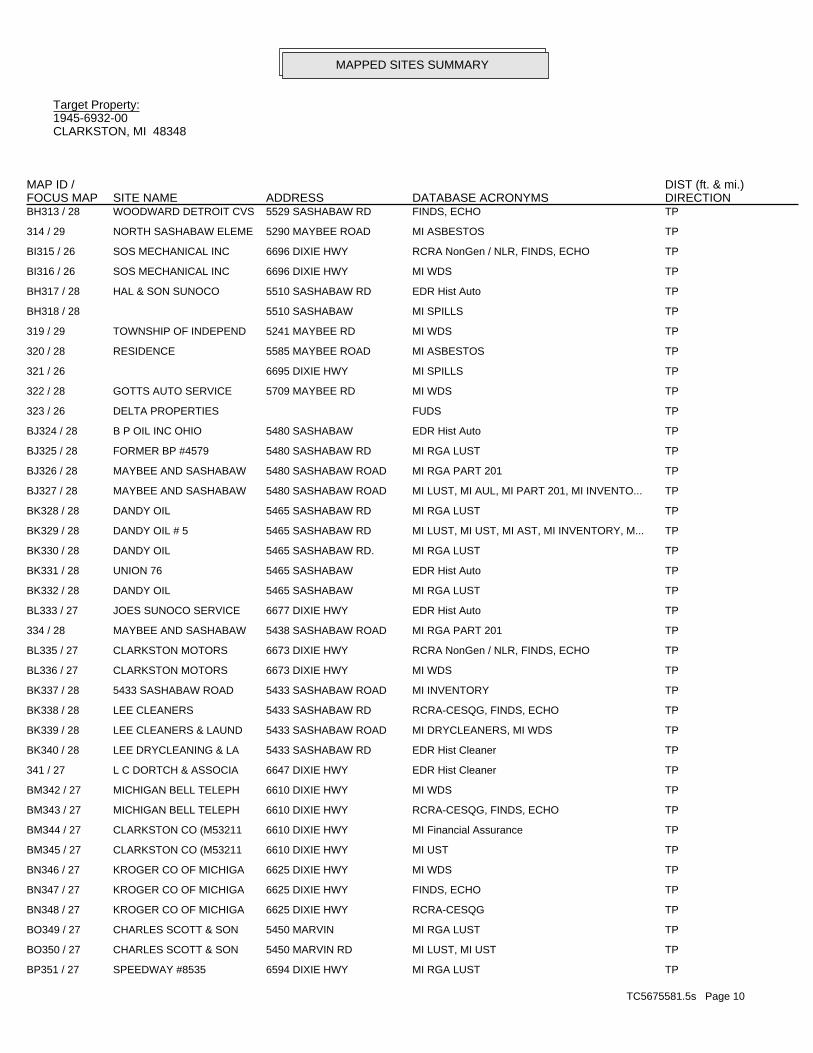
TC5675581.5s Page 10
BP351 / 27 SPEEDWAY #8535 6594 DIXIE HWY MI RGA LUST TP
BO350 / 27 CHARLES SCOTT & SON 5450 MARVIN RD MI LUST, MI UST TP
BO349 / 27 CHARLES SCOTT & SON 5450 MARVIN MI RGA LUST TP
BN348 / 27 KROGER CO OF MICHIGA 6625 DIXIE HWY RCRA-CESQG TP
BN347 / 27 KROGER CO OF MICHIGA 6625 DIXIE HWY FINDS, ECHO TP
BN346 / 27 KROGER CO OF MICHIGA 6625 DIXIE HWY MI WDS TP
BM345 / 27 CLARKSTON CO (M53211 6610 DIXIE HWY MI UST TP
BM344 / 27 CLARKSTON CO (M53211 6610 DIXIE HWY MI Financial Assurance TP
BM343 / 27 MICHIGAN BELL TELEPH 6610 DIXIE HWY RCRA-CESQG, FINDS, ECHO TP
BM342 / 27 MICHIGAN BELL TELEPH 6610 DIXIE HWY MI WDS TP
341 / 27 L C DORTCH & ASSOCIA 6647 DIXIE HWY EDR Hist Cleaner TP
BK340 / 28 LEE DRYCLEANING & LA 5433 SASHABAW RD EDR Hist Cleaner TP
BK339 / 28 LEE CLEANERS & LAUND 5433 SASHABAW ROAD MI DRYCLEANERS, MI WDS TP
BK338 / 28 LEE CLEANERS 5433 SASHABAW RD RCRA-CESQG, FINDS, ECHO TP
BK337 / 28 5433 SASHABAW ROAD 5433 SASHABAW ROAD MI INVENTORY TP
BL336 / 27 CLARKSTON MOTORS 6673 DIXIE HWY MI WDS TP
BL335 / 27 CLARKSTON MOTORS 6673 DIXIE HWY RCRA NonGen / NLR, FINDS, ECHO TP
334 / 28 MAYBEE AND SASHABAW 5438 SASHABAW ROAD MI RGA PART 201 TP
BL333 / 27 JOES SUNOCO SERVICE 6677 DIXIE HWY EDR Hist Auto TP
BK332 / 28 DANDY OIL 5465 SASHABAW MI RGA LUST TP
BK331 / 28 UNION 76 5465 SASHABAW EDR Hist Auto TP
BK330 / 28 DANDY OIL 5465 SASHABAW RD. MI RGA LUST TP
BK329 / 28 DANDY OIL # 5 5465 SASHABAW RD MI LUST, MI UST, MI AST, MI INVENTORY, M... TP
BK328 / 28 DANDY OIL 5465 SASHABAW RD MI RGA LUST TP
BJ327 / 28 MAYBEE AND SASHABAW 5480 SASHABAW ROAD MI LUST, MI AUL, MI PART 201, MI INVENTO... TP
BJ326 / 28 MAYBEE AND SASHABAW 5480 SASHABAW ROAD MI RGA PART 201 TP
BJ325 / 28 FORMER BP #4579 5480 SASHABAW RD MI RGA LUST TP
BJ324 / 28 B P OIL INC OHIO 5480 SASHABAW EDR Hist Auto TP
323 / 26 DELTA PROPERTIES FUDS TP
322 / 28 GOTTS AUTO SERVICE 5709 MAYBEE RD MI WDS TP
321 / 26 6695 DIXIE HWY MI SPILLS TP
320 / 28 RESIDENCE 5585 MAYBEE ROAD MI ASBESTOS TP
319 / 29 TOWNSHIP OF INDEPEND 5241 MAYBEE RD MI WDS TP
BH318 / 28 5510 SASHABAW MI SPILLS TP
BH317 / 28 HAL & SON SUNOCO 5510 SASHABAW RD EDR Hist Auto TP
BI316 / 26 SOS MECHANICAL INC 6696 DIXIE HWY MI WDS TP
BI315 / 26 SOS MECHANICAL INC 6696 DIXIE HWY RCRA NonGen / NLR, FINDS, ECHO TP
314 / 29 NORTH SASHABAW ELEME 5290 MAYBEE ROAD MI ASBESTOS TP
BH313 / 28 WOODWARD DETROIT CVS 5529 SASHABAW RD FINDS, ECHO TP
MAPPED SITES SUMMARY
Target Property:1945-6932-00CLARKSTON, MI 48348
FOCUS MAPDIST (ft. & mi.)MAP ID /
DATABASE ACRONYMS DIRECTIONSITE NAME ADDRESS

TC5675581.5s Page 11
BW390 / 28 DRAYTON ROAD WELL 5068 DRAYTON MI RGA PART 201 TP
389 / 27 MOON VALLEY RUSTIC F 6465 DIXIE HWY MI UST TP
388 / 27 CLARKSTON WARD CHURC 5154 WATERFORD RD MI WDS TP
BV387 / 27 DEER LAKE CUSTOME CL 6485 DIXIE HIGHWAY EDR Hist Cleaner TP
BV386 / 27 EZ DUZ IT LAUNDROMAT 6507 DIXIE HIGHWAY MI DRYCLEANERS, MI WDS TP
BV385 / 27 EZ DUZ IT LAUNDROMAT 6507 DIXIE HWY RCRA NonGen / NLR, FINDS, ECHO, RI MANIF... TP
BU384 / 27 OTTAWA PARK CEMETERY 6180 DIXIE HWY. MI RGA LUST TP
BU383 / 27 OTTAWA PARK CEMETERY 6180 DIXIE HWY MI RGA LUST TP
BU382 / 27 OTTAWA PARK CEMETERY 6180 DIXIE HWY MI LUST, MI UST, MI AIRS TP
BS381 / 27 ACCURATE RANGE LLC 6559 DIXIE HWY FINDS, ECHO TP
BS380 / 27 ACCURATE RANGE LLC 6559 DIXIE HWY MI WDS TP
BS379 / 27 ACCURATE RANGE LLC 6559 DIXIE HWY RCRA-CESQG TP
BT378 / 27 FAST TRACK VENTURES 6550 DIXIE HWY RCRA-CESQG, FINDS, ECHO TP
BT377 / 27 CLARKSTON CLARK 6550 DIXIE HWY MI RGA LUST TP
BT376 / 27 MT CLARK 6550 DIXIE HWY MI RGA LUST TP
BT375 / 27 KAYOOIL CO 6550 DIXIE HWY EDR Hist Auto TP
BT374 / 27 ATC ASSOCIATES, INC 6550 DIXIE HIGHWAY MI AIRS, MI WDS TP
BT373 / 27 MT CLARK 6550 DIXIE HWY MI LUST, MI UST, MI INVENTORY, MI Financ... TP
BS372 / 27 CLARKSTON REMINDER 6569 DIXIE HWY MI WDS TP
371 / 27 WEINGARTZ 6585 DIXIE HIGHWAY MI INVENTORY TP
BT370 / 27 IKES EQUIPMENT 6560 DIXIE MI AST TP
BT369 / 27 MICHIGAN EQUIPMENT R 6560 DIXIE HWY MI WDS TP
BS368 / 27 BOSTON MARKET (FORME 6570 DIXIE HIGHWAY MI BEA TP
367 / 29 GINGER LAKE & I75 4880 MAYBEE RD. ICIS, FINDS, ECHO TP
366 / 29 NONE 5240 CECELIA ANN MI SPILLS TP
365 / 29 5055 FOX CRK N, APT MI LEAD TP
364 / 28 TRANSMISSION EXPRESS 5267 MARY SUE EDR Hist Auto TP
BR363 / 27 RANDY HOSLER PONTIAC 6585 DIXIE HWY MI RGA LUST TP
BR362 / 27 RANDY HOSLER PONTIAC 6585 DIXIE HWY MI LUST, MI UST, MI AIRS TP
BR361 / 27 WEINGARTZ SUPPLY CO 6585 DIXIE HWY FINDS, ECHO TP
BR360 / 27 RANDY HOSLER PONTIAC 6585 DIXIE HIGHWAY MI INVENTORY TP
BR359 / 27 WEINGARTZ SUPPLY CO 6585 DIXIE HWY MI BEA, MI WDS TP
BR358 / 27 WEINGARTZ SUPPLY CO 6585 DIXIE HWY RCRA-CESQG TP
BQ357 / 27 DERVAGE DISPOSAL 5380 CENTER ST MI HIST LF TP
BQ356 / 27 DERVAGE DISPOSAL 5380 CENTER ST MI RGA LF TP
BQ355 / 27 DERVAGE DISPOSAL 5380 CENTER ST FINDS TP
BP354 / 27 SPEEDWAY #8535 6594 DIXIE HWY MI LUST, MI UST, MI AUL, MI INVENTORY, M... TP
BP353 / 27 SPEEDWAY LLC 6594 DIXIE HWY RCRA-CESQG, FINDS, ECHO TP
BP352 / 27 SPEEDWAY SUPERAMERIC 6594 DIXIE HWY EDR Hist Auto TP
MAPPED SITES SUMMARY
Target Property:1945-6932-00CLARKSTON, MI 48348
FOCUS MAPDIST (ft. & mi.)MAP ID /
DATABASE ACRONYMS DIRECTIONSITE NAME ADDRESS

TC5675581.5s Page 12
CD429 / 26 PRECISION PIPE & SUP 4950 WHITE LAKE MI RGA LUST TP
CD428 / 26 PRECISION PIPE & SUP 4950 WHITE LAKE ROAD MI AIRS TP
CD427 / 26 PRECISION PIPE & SUP 4950 WHITE LAKE RD. MI RGA LUST TP
CD426 / 26 4950 WHITE LAKE ROAD MI SPILLS TP
CD425 / 26 NORTHERN CONCRETE PI 4950 WHITE LAKE RD FINDS TP
CD424 / 26 PRECISION PIPE & SUP 4950 WHITE LAKE RD MI RGA LUST TP
CD423 / 26 PRECISION PIPE & SUP 4950 WHITE LAKE RD MI LUST, MI UST, MI INVENTORY, MI BEA, M... TP
CC422 / 26 INTER LAKES AUTO & T 4941 WHITE LAKE RD MI HIST LF, MI SWRCY TP
CC421 / 26 CLARKSTON HAULING FA 4941 WHITE LAKE ROAD ECHO TP
CC420 / 26 SANITATION COMPANY P 4941 WHITE LAKE ROAD MI BEA TP
CC419 / 26 CAMPERS PARADISE 4941 WHITE LAKE MI AST TP
CC418 / 26 ALLIED CONSTRUCTION 4941 WHITE LAKE ROAD MI INVENTORY TP
CC417 / 26 ALLIED CONSTRUCTION 4941 WHITE LAKE RD MI LUST, MI UST, MI SWRCY, MI INVENTORY,... TP
CC416 / 26 4941 WHITE LAKE ROAD ERNS TP
CC415 / 26 INTER LAKES AUTO & T 4941 WHITE LAKE RD FINDS TP
CC414 / 26 ALLIED CONSTRUCTION 4941 WHITE LAKE RD MI RGA LUST TP
CC413 / 26 INTER LAKES AUTO & T 4941 WHITE LK ROAD MI RGA LF TP
412 / 27 ROCKCROFT ST RES WEL 5875 - 5911 DIXIE HI MI INVENTORY TP
CB411 / 28 MORRIS & SONS 4950 SASHABAW RD MI WDS TP
CB410 / 28 SERVANT’S HEART ISSH 4950 SASHABAW ROAD MI INVENTORY TP
CB409 / 28 MORRIS AND SONS AUTO 4950 SASHABAW RD MI UST TP
CA408 / 28 CLARK STORE #1634 4951 SASHABAW RD MI RGA LUST TP
CA407 / 28 CLARKSTON FUEL VENTU 4951 SASHABAW RD MI LUST, MI UST, MI AUL, MI INVENTORY, M... TP
CA406 / 28 CLARK STORE #1634 4951 SASHABAW MI RGA LUST TP
CA405 / 28 CLARKSTON CLARK 4951 SASHABAW RD MI RGA LUST TP
CA404 / 28 SASHABAW RD AREA RES 4951 SASHABAW ROAD MI RGA PART 201 TP
CA403 / 28 FAST TRACK VENTURES 4951 SASHABAW RD RCRA-CESQG, FINDS, ECHO TP
CA402 / 28 CLARK RETAIL ENTERPR 4951 SASHABAW RD EDR Hist Auto TP
CA401 / 28 CLARK SERVICE STATIO 4951 SASHABAW RD MI RGA LUST TP
BZ400 / 26 PLASTECH ENGINEERED 5020 WHITE LAKE RD MI INVENTORY, MI WDS TP
BZ399 / 26 PLASTECH ENGINEERED 5020 WHITE LAKE RD FINDS, ECHO TP
BZ398 / 26 PLASTECH ENGINEERED 5020 WHITE LAKE RD RCRA-CESQG TP
BY397 / 27 MI DEPT/STATE POLICE 4975 TIMBERWAY TRL FINDS, ECHO TP
BY396 / 27 MI DEPT/STATE POLICE 4975 TIMBERWAY TRL MI WDS TP
BY395 / 27 MI DEPT/STATE POLICE 4975 TIMBERWAY TRL RCRA NonGen / NLR TP
BX394 / 28 OLD DERVAGE DUMP SIT 5002 PELTON RD MI RGA PART 201 TP
BX393 / 28 OLD DERVAGE DUMP SIT 5002 PELTON RD MI INVENTORY, MI PART 201 TP
392 / 26 4993 LANCASTER HILL MI SPILLS TP
BW391 / 28 DRAYTON ROAD WELL 5068 DRAYTON MI PART 201 TP
MAPPED SITES SUMMARY
Target Property:1945-6932-00CLARKSTON, MI 48348
FOCUS MAPDIST (ft. & mi.)MAP ID /
DATABASE ACRONYMS DIRECTIONSITE NAME ADDRESS

TC5675581.5s Page 13
CG468 / 31 THOMPSON-MCCULLY QUA 4751 WHITE LAKE ROAD MI AIRS TP
CG467 / 31 4751 WHITE LAKE RD. MI SPILLS TP
CG466 / 31 4751 WHITE LAKE RD. MI SPILLS TP
CG465 / 31 4751 WHITE LAKE ROAD MI SPILLS TP
CG464 / 31 CADILLAC ASPHALT, LL 4751 WHITE LAKE ROAD MI AIRS, MI NPDES, MI WDS TP
CG463 / 31 4751 WHITE LAKE ROAD ERNS TP
CG462 / 31 4751 WHITE LAKE ROAD MI SPILLS TP
CG461 / 31 CADILLAC ASPHALT PRO 4751 WHITE LAKE ROAD MI AIRS TP
CG460 / 31 WEBER SAND & GRAVEL, 4751 WHITE LAKE ROAD MI AIRS TP
CG459 / 31 CADILLAC ASPHALT, L. 4751 WHITE LAKE ROAD RCRA-CESQG, ICIS, US AIRS, FINDS, ECHO TP
CG458 / 31 CADILLAC ASPHALT LLC 4751 WHITE LAKE MI AST TP
457 / 34 S & L AUTOBODY 4712 SASHABEW ROAD MI AIRS TP
CF456 / 26 4836 WHITE LAKE ROAD 4836 WHITE LAKE ROAD MI PART 201, MI INVENTORY, MI BEA TP
CF455 / 26 A.W. EXCAVATING, INC 4836 WHITE LAKE ROAD MI INVENTORY TP
CF454 / 26 4836 WHITE LAKE ROAD 4836 WHITE LAKE ROAD US BROWNFIELDS, FINDS TP
CF453 / 26 4836 WHITE LAKE ROAD 4836 WHITE LAKE ROAD MI RGA PART 201 TP
452 / 29 GENOA RD MI CDL TP
451 / 28 PINE KNOB CAR WASH 4782 SASHABAW RD MI WDS TP
450 / 26 HADLEY MOLD 4866 WHITE LAKE RD MI INVENTORY, MI BEA, MI WDS TP
449 / 28 UNIVERSITY AMOCO 4142 MEYERS RD EDR Hist Auto TP
CE448 / 26 BUCKEYE PIPE LINE CO 4863 WHITE LAKE RD RCRA NonGen / NLR TP
CE447 / 26 BUCKEYE PIPE LINE CO 4863 WHITE LAKE RD MI WDS TP
CE446 / 26 BUCKEYE PIPE LINE CO 4863 WHITE LAKE RD FINDS, ECHO TP
CE445 / 26 BUCKEYE PIPELINE 4861 WHITE LAKE ROAD MI INVENTORY, MI PART 201 TP
CE444 / 26 GRAND TRUNK PROPERTY 4861 WHITE LAKE ROAD MI BEA TP
CE443 / 26 4861 WHITE LAKE ROAD 4861 WHITE LAKE ROAD MI INVENTORY TP
CE442 / 26 BUCKEYE PIPELINE 4861 WHITE LAKE ROAD MI RGA PART 201 TP
CE441 / 26 PROPERTY 4906 WHITE 4906 WHITE LAKE ROAD MI RGA PART 201 TP
CE440 / 26 MICHIGAN RENTAL 4906 WHITE LAKE MI AST TP
CE439 / 26 MICHIGAN EQUIPMENT R 4906 WHITE LAKE RD MI DEL PART 201, MI BEA, MI WDS TP
CE438 / 26 MICHIGAN EQUIPMENT R 4906 WHITE LAKE RD RCRA-CESQG, FINDS, ECHO TP
CE437 / 26 MICHIGAN EQUIPMENT R 4906 WHITE LAKE ROAD MI INVENTORY TP
CE436 / 26 WHITE LK RD SCRAP YD 4905 WHITE LK RD MI INVENTORY, MI PART 201 TP
CE435 / 26 WHITE LAKE ROAD SCRA 4905 WHITE LAKE ROAD MI BROWNFIELDS TP
CE434 / 26 DIXSON METAL PROCESS 4905 WHITE LK RD FINDS TP
CE433 / 26 WHITE LK RD SCRAP YD 4905 WHITE LK RD MI RGA PART 201 TP
432 / 28 4865 SASHABAW ROAD MI SPILLS TP
431 / 26 MIDDLELAKE INVESTMEN 4906 WHITE LAKE ROAD MI INVENTORY TP
CD430 / 26 NORTHERN CONCRETE PI 4950 WHITE LAKE MI AST TP
MAPPED SITES SUMMARY
Target Property:1945-6932-00CLARKSTON, MI 48348
FOCUS MAPDIST (ft. & mi.)MAP ID /
DATABASE ACRONYMS DIRECTIONSITE NAME ADDRESS

TC5675581.5s Page 14
CP507 / 32 BIANCAS II INC 7880 ANDERSONVILLE MI RGA LUST TP
CP506 / 32 BIANCAS II INC 7880 ANDERSONVILLE R MI LUST, MI UST, MI INVENTORY TP
CP505 / 32 BIANCAS II INC 7880 ANDERSONVILLE R MI RGA LUST TP
504 / 32 C & F TRUCK & AUTO R 4525 WHITE LAKE RD EDR Hist Auto TP
CO503 / 33 CLARKSTON TRANSMISSI 5870 DIXIE HWY MI WDS TP
CO502 / 33 CLARKSTON TRANSMISSI 5870 DIXIE HWY RCRA-CESQG TP
CO501 / 33 CLARKSTON TRANSMISSI 5870 DIXIE HWY EDR Hist Auto TP
CO500 / 33 CLARKSTON TRANSMISSI 5870 DIXIE HWY FINDS, ECHO TP
499 / 32 CABINET ONE 4625 WHITE LAKE CT MI WDS TP
CN498 / 35 MOTOR CITY AUTO 4505 CLINTONVILLE RD RCRA NonGen / NLR, FINDS, ECHO TP
CN497 / 35 MOTOR CITY AUTO 4505 CLINTONVILLE RD MI WDS TP
CM496 / 35 DONALD PORTER LANDSC 2858 MANN RD MI UST TP
CM495 / 35 NATURES GREEN INC 2858 MANN RD MI WDS TP
CL494 / 33 SOUTH DIXIE PROPERTI 5886 DIXIE HIGHWAY MI INVENTORY TP
CL493 / 33 5886 DIXIE 5886 DIXIE MI INVENTORY TP
CL492 / 33 SOUTH DIXIE PROPERTI 5886 DIXIE HIGHWAY MI BEA TP
CL491 / 33 RETAIL / OFFICE BUIL 5886 DIXIE HWY MI UST TP
CL490 / 33 FACKS PROPERTIES, L. 5886 DIXIE HIGHWAY MI INVENTORY TP
CK489 / 32 CLAWSON TANK CO INC 4701 WHITE LAKE RD MI LUST, MI UST, MI AST, MI AIRS TP
CK488 / 32 CLAWSON TANK CO INC 4701 WHITE LAKE RD MI RGA LUST TP
CK487 / 32 4701 WHITE LAKE ROAD 4701 WHITE LAKE ROAD RCRA-CESQG, US AIRS, FINDS, ECHO TP
CK486 / 32 4701 WHITELAKE RD ERNS TP
CK485 / 32 CLAWSON TANK 4701 WHITE LAKE RD MI WDS TP
CK484 / 32 4701 WHITE LAKE ROAD 4701 WHITE LAKE ROAD US BROWNFIELDS TP
483 / 33 RESIDENCE 6635 WELLESLEY TERRA MI ASBESTOS TP
CJ482 / 33 WOODHULL LAKE 4770 WATERFORD ROAD MI RGA PART 201 TP
CJ481 / 33 WOODHULL LAKE 4770 WATERFORD ROAD MI PART 201, MI INVENTORY, MI WDS TP
CJ480 / 33 OAKLAND COUNTY SPORT 4770 WATERFORD RD FINDS, ECHO TP
479 / 35 J AND J MOBIL INC 3025 REEDER RD EDR Hist Auto TP
CI478 / 33 INDEPENDENCE SQUARE 5881 THROUGH 5901 DI MI BEA TP
477 / 33 6411 WELLESLEY TERRA MI SPILLS TP
CI476 / 33 SQUIRE CLEANERS 5907 DIXIE HWY. MI DRYCLEANERS TP
CI475 / 33 SQUIRE CLEANERS 5907 DIXIE HWY EDR Hist Cleaner TP
CH474 / 32 WHITE LAKE ROAD CONT 4790 WHITE LAKE ROAD MI DEL PART 201, MI WDS TP
CH473 / 32 WHITE LAKE ROAD CONT 4790 WHITE LAKE ROAD MI RGA PART 201 TP
CH472 / 32 SMITHS DISPOSAL 4801 WHITE LAKE RD MI WDS TP
CH471 / 32 CLARKSTON FUEL & SUP 4801 WHITE LAKE RD MI UST TP
CH470 / 32 CLARKSTON FUEL & SUP 4801 WHITE LAKE RD MI UST TP
CG469 / 31 4751 WHITE LAKE RD. MI SPILLS TP
MAPPED SITES SUMMARY
Target Property:1945-6932-00CLARKSTON, MI 48348
FOCUS MAPDIST (ft. & mi.)MAP ID /
DATABASE ACRONYMS DIRECTIONSITE NAME ADDRESS

TC5675581.5s Page 15
546 / 33 OAKLAND COUNTY FUELS 3943 AIRPORT ROAD MI PART 201, MI INVENTORY, MI SPILLS, MI... 2990 0.566 South
545 / 19 COLOMBIERE CENTER 9075 BIG LAKE RD MI UST, MI AUL, MI INVENTORY, MI PART 20... 2831 0.536 WSW
CW544 / 19 DIXIE HIGHWAY BP 8500 DIXIE HWY MI INVENTORY, MI Financial Assurance 2087 0.395 WNW
CW543 / 19 DIXIE HIGHWAY BP 8500 DIXIE HWY MI LUST, MI UST, MI BEA, MI WDS 2087 0.395 WNW
CV542 / 33 COMMERCIAL PROPERTY 5498-5534 DIXIE HIGH MI INVENTORY 1691 0.320 South
CV541 / 33 DNR INVESTMENT ENTER 5498-5534 DIXIE HIGH MI BEA 1691 0.320 South
CV540 / 33 DNR INVESTMENT ENTER 5498-5534 DIXIE HIGH MI INVENTORY 1691 0.320 South
539 / 33 LIBERTY OIL LLC 5676 DIXIE HWY MI LUST, MI UST, MI INVENTORY, MI Financ... 1458 0.276 South
538 / 2 ROBERT CHASTAIN 3790 ALLEN RD RCRA NonGen / NLR, FINDS, ECHO 1316 0.249 North
537 / 31 CANYON OAKS PROPELLE 8220 OLD WHITE LAKE RCRA-SQG, FINDS, ECHO 1152 0.218 WSW
CU536 / 32 LESSING ST. BULK PLA 4304 LESSING MI LUST, MI UST, MI INVENTORY, MI WDS 1135 0.215 South
CU535 / 32 LEF (DBA) VIKING OIL 4304 LESSING MI AST 1135 0.215 South
534 / 33 LENS CRAFTERS INC 5586 DIXIE HWY RCRA-CESQG 1104 0.209 South
CU533 / 32 TRACEY ASPHALT PAVIN 4301 LESSING MI UST 1090 0.206 South
CU532 / 32 STEWART CONTRACTING 4305 LESSING MI AST 1045 0.198 South
CU531 / 32 STEWART CONTRACTING 4305 LESSING MI UST 1045 0.198 South
530 / 2 BRANDON-GROVELAND-IN ORTONVILLE ROAD (NO MI INVENTORY 979 0.185 North
CT529 / 33 WATERFORD FUEL MART 5775 DIXIE HWY MI LUST, MI UST, MI Financial Assurance 893 0.169 South
CT528 / 33 SUNOCO INC 5775 DIXIE HWY RCRA NonGen / NLR, FINDS, ECHO 893 0.169 South
CT527 / 33 SUNOCO INC 5775 DIXIE HWY MI AUL, MI INVENTORY, MI BEA, MI WDS 893 0.169 South
526 / 32 ALL SAINTS CEMETERY 4401 NELSEY RD MI LUST, MI UST, MI WDS 783 0.148 South
525 / 19 OAKLAND SCHOOLS 8211 BIG LAKE RD RCRA-CESQG, FINDS, ECHO 748 0.142 WSW
CS524 / 33 FORMER GAS & GO 5805 DIXIE HWY MI LUST, MI WDS 615 0.116 South
CS523 / 33 STEVES AUTO CENTER & 5805 DIXIE HWY EDR Hist Auto 615 0.116 South
CS522 / 33 FORMER GAS & GO 5805 DIXIE HWY MI UST 615 0.116 South
CR521 / 31 CLEAN TIDE CONTAINER 4600 CLAWSON TANK DR RCRA NonGen / NLR 578 0.109 West
CR520 / 31 NORTH OAKS CUT STONE 4600 CLAWSON TANK DR RCRA NonGen / NLR 578 0.109 West
CQ519 / 32 WATERFORD BLOCK AND 4389 LESSING RD. MI INVENTORY, MI AIRS 539 0.102 South
CQ518 / 32 NAGY CONCRETE PRODUC 4389 LESSING MI UST, MI AST 539 0.102 South
CQ517 / 32 NAGY CONCRETE PRODUC 4389 LESSING MI AST 539 0.102 South
516 / 19 CLARKSTON MOTORS INC 8105 BIG LAKE RD RCRA-CESQG, FINDS, ECHO 272 0.052 WSW
515 / 35 CFM PUBLICATIONS 4453 CLINTONVILLE RD RCRA-CESQG, FINDS, ECHO 248 0.047 South
514 / 30 J & W MOBIL SERVICE 4411 DORA LN EDR Hist Auto 143 0.027 East
513 / 35 BP PROCESSING 2803 MANN RD EDR Hist Auto 73 0.014 South
512 / 4 JIM’S CRACKER BARREL 5500 OAK HILL MI AST 67 0.013 North
511 / 2 OAKHILL AUTO RESTORA 3994 S ORTONVILLE RD RCRA NonGen / NLR, FINDS, ECHO 59 0.011 North
510 / 2 RICKANE PEST CONTROL 6750 OAKHILL ROAD MI DEL PART 201 47 0.009 North
509 / 5 SALEM SAND AND GRAVE DARTMOUTH & OAK HILL MI DEL PART 201 12 0.002 North
508 / 31 ARMAND DRILLING CO 7950 ANDERSONVILLE R MI WDS TP
MAPPED SITES SUMMARY
Target Property:1945-6932-00CLARKSTON, MI 48348
FOCUS MAPDIST (ft. & mi.)MAP ID /
DATABASE ACRONYMS DIRECTIONSITE NAME ADDRESS

TC5675581.5s Page 16
547 / 33 SPECTUS SYSTEMS MIDW 501 NORTH ELIDA STRE CORRACTS, RCRA-TSDF, RCRA-CESQG, 2020 CO...3701 0.701 South
MAPPED SITES SUMMARY
Target Property:1945-6932-00CLARKSTON, MI 48348
FOCUS MAPDIST (ft. & mi.)MAP ID /
DATABASE ACRONYMS DIRECTIONSITE NAME ADDRESS


MAP FINDINGS SUMMARY
SearchTargetDistance Total
Database Property(Miles) < 1/8 1/8 - 1/4 1/4 - 1/2 1/2 - 1 > 1 Plotted
STANDARD ENVIRONMENTAL RECORDS
Federal NPL site list
0 NR 0 0 0 0 1.000NPL 0 NR 0 0 0 0 1.000Proposed NPL 0 NR 0 0 0 0 1.000NPL LIENS
Federal Delisted NPL site list
0 NR 0 0 0 0 1.000Delisted NPL
Federal CERCLIS list
0 NR NR 0 0 0 0.500FEDERAL FACILITY 1 NR NR 0 0 0 0.500 1SEMS
Federal CERCLIS NFRAP site list
2 NR NR 0 0 0 0.500 2SEMS-ARCHIVE
Federal RCRA CORRACTS facilities list
1 NR 1 0 0 0 1.000CORRACTS
Federal RCRA non-CORRACTS TSD facilities list
0 NR NR 0 0 0 0.500RCRA-TSDF
Federal RCRA generators list
0 NR NR NR 0 0 0.250RCRA-LQG 1 NR NR NR 1 0 0.250RCRA-SQG 48 NR NR NR 2 2 0.250 44RCRA-CESQG
Federal institutional controls /engineering controls registries
0 NR NR 0 0 0 0.500LUCIS 0 NR NR 0 0 0 0.500US ENG CONTROLS 0 NR NR 0 0 0 0.500US INST CONTROL
Federal ERNS list
6 NR NR NR NR NR TP 6ERNS
State- and tribal - equivalent CERCLIS
0 NR 0 0 0 0 1.000MI SHWS
State and tribal landfill and/orsolid waste disposal site lists
0 NR NR 0 0 0 0.500MI SWF/LF
State and tribal leaking storage tank lists
31 NR NR 2 3 1 0.500 25MI LUST 0 NR NR 0 0 0 0.500INDIAN LUST
State and tribal registered storage tank lists
0 NR NR NR 0 0 0.250FEMA UST
TC5675581.5s Page 1

MAP FINDINGS SUMMARY
SearchTargetDistance Total
Database Property(Miles) < 1/8 1/8 - 1/4 1/4 - 1/2 1/2 - 1 > 1 Plotted
44 NR NR NR 5 2 0.250 37MI UST 14 NR NR NR 2 3 0.250 9MI AST 0 NR NR NR 0 0 0.250INDIAN UST
State and tribal institutionalcontrol / engineering control registries
7 NR NR 0 1 0 0.500 6MI AUL
State and tribal voluntary cleanup sites
0 NR NR 0 0 0 0.500INDIAN VCP
State and tribal Brownfields sites
4 NR NR 0 0 0 0.500 4MI BROWNFIELDS
ADDITIONAL ENVIRONMENTAL RECORDS
Local Brownfield lists
5 NR NR 0 0 0 0.500 5US BROWNFIELDS
Local Lists of Landfill / SolidWaste Disposal Sites
2 NR NR 0 0 0 0.500 2MI SWRCY 3 NR NR 0 0 0 0.500 3MI HIST LF 0 NR NR 0 0 0 0.500INDIAN ODI 0 NR NR 0 0 0 0.500ODI 0 NR NR 0 0 0 0.500DEBRIS REGION 9 0 NR NR 0 0 0 0.500IHS OPEN DUMPS
Local Lists of Hazardous waste /Contaminated Sites
0 NR NR NR NR NR TPUS HIST CDL 14 NR 2 0 0 0 1.000 12MI PART 201 66 NR NR 4 3 1 0.500 58MI INVENTORY 1 NR NR NR NR NR TP 1MI CDL 4 NR 0 0 0 2 1.000 2MI DEL PART 201 0 NR NR NR NR NR TPUS CDL
Local Land Records
0 NR NR NR NR NR TPMI LIENS 0 NR NR NR NR NR TPLIENS 2
Records of Emergency Release Reports
1 NR NR NR NR NR TP 1HMIRS 25 NR NR NR NR NR TP 25MI SPILLS
Other Ascertainable Records
27 NR NR NR 2 3 0.250 22RCRA NonGen / NLR 1 NR 0 0 0 0 1.000 1FUDS 0 NR 0 0 0 0 1.000DOD 0 NR NR 0 0 0 0.500SCRD DRYCLEANERS
TC5675581.5s Page 2

MAP FINDINGS SUMMARY
SearchTargetDistance Total
Database Property(Miles) < 1/8 1/8 - 1/4 1/4 - 1/2 1/2 - 1 > 1 Plotted
0 NR NR NR NR NR TPUS FIN ASSUR 0 NR NR NR NR NR TPEPA WATCH LIST 0 NR NR NR 0 0 0.2502020 COR ACTION 0 NR NR NR NR NR TPTSCA 0 NR NR NR NR NR TPTRIS 0 NR NR NR NR NR TPSSTS 0 NR 0 0 0 0 1.000ROD 0 NR NR NR NR NR TPRMP 0 NR NR NR NR NR TPRAATS 1 NR NR NR NR NR TP 1PRP 0 NR NR NR NR NR TPPADS 6 NR NR NR NR NR TP 6ICIS 1 NR NR NR NR NR TP 1FTTS 0 NR NR NR NR NR TPMLTS 0 NR NR NR NR NR TPCOAL ASH DOE 0 NR NR 0 0 0 0.500COAL ASH EPA 0 NR NR NR NR NR TPPCB TRANSFORMER 0 NR NR NR NR NR TPRADINFO 1 NR NR NR NR NR TP 1HIST FTTS 1 NR NR NR NR NR TP 1DOT OPS 0 NR 0 0 0 0 1.000CONSENT 0 NR 0 0 0 0 1.000INDIAN RESERV 0 NR 0 0 0 0 1.000FUSRAP 0 NR NR 0 0 0 0.500UMTRA 0 NR NR NR NR NR TPLEAD SMELTERS 2 NR NR NR NR NR TP 2US AIRS 1 NR NR NR 0 0 0.250 1US MINES 1 NR NR NR 0 0 0.250 1ABANDONED MINES 86 NR NR NR NR NR TP 86FINDS 0 NR 0 0 0 0 1.000UXO 73 NR NR NR NR NR TP 73ECHO 0 NR NR NR NR NR TPDOCKET HWC 0 NR NR NR 0 0 0.250FUELS PROGRAM 15 NR NR NR NR NR TP 15MI AIRS 11 NR NR NR NR NR TP 11MI ASBESTOS 23 NR NR 2 1 0 0.500 20MI BEA 0 NR NR 0 0 0 0.500MI COAL ASH 9 NR NR NR 0 0 0.250 9MI DRYCLEANERS 14 NR NR NR NR NR TP 14MI Financial Assurance 1 NR NR NR NR NR TP 1MI LEAD 1 NR NR NR 0 0 0.250 1RI MANIFEST 10 NR NR NR NR NR TP 10MI NPDES 0 NR NR NR NR NR TPMI UIC 112 NR NR NR NR NR TP 112MI WDS
EDR HIGH RISK HISTORICAL RECORDS
EDR Exclusive Records
0 NR 0 0 0 0 1.000EDR MGP 30 NR NR NR NR 3 0.125 27EDR Hist Auto
TC5675581.5s Page 3

MAP FINDINGS SUMMARY
SearchTargetDistance Total
Database Property(Miles) < 1/8 1/8 - 1/4 1/4 - 1/2 1/2 - 1 > 1 Plotted
19 NR NR NR NR 0 0.125 19EDR Hist Cleaner
EDR RECOVERED GOVERNMENT ARCHIVES
Exclusive Recovered Govt. Archives
19 NR NR NR NR NR TP 19MI RGA PART 201 3 NR NR NR NR NR TP 3MI RGA LF 48 NR NR NR NR NR TP 48MI RGA LUST
796 0 3 8 20 17 748- Totals --
NOTES:
TP = Target Property
NR = Not Requested at this Search Distance
Sites may be listed in more than one database
TC5675581.5s Page 4


TC5675581.5s.1 Page 21
NO MAPPED SITES FOUND
MAPPED SITES SUMMARY - FOCUS MAP 1
Target Property:1945-6932-00CLARKSTON, MI 48348
FOCUS MAPDIST (ft. & mi.)MAP ID /
DATABASE ACRONYMS DIRECTIONSITE NAME ADDRESS
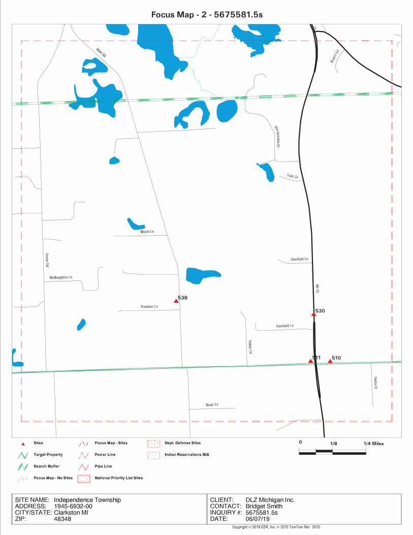

TC5675581.5s.2 Page 23
538 / 2 ROBERT CHASTAIN 3790 ALLEN RD RCRA NonGen / NLR, FINDS, ECHO 1316 0.249 North
530 / 2 BRANDON-GROVELAND-IN ORTONVILLE ROAD (NO MI INVENTORY 979 0.185 North
511 / 2 OAKHILL AUTO RESTORA 3994 S ORTONVILLE RD RCRA NonGen / NLR, FINDS, ECHO 59 0.011 North
510 / 2 RICKANE PEST CONTROL 6750 OAKHILL ROAD MI DEL PART 201 47 0.009 North
MAPPED SITES SUMMARY - FOCUS MAP 2
Target Property:1945-6932-00CLARKSTON, MI 48348
FOCUS MAPDIST (ft. & mi.)MAP ID /
DATABASE ACRONYMS DIRECTIONSITE NAME ADDRESS


TC5675581.5s.3 Page 25
5 / 3 10391 HORSESHOE CORC MI SPILLS TP
MAPPED SITES SUMMARY - FOCUS MAP 3
Target Property:1945-6932-00CLARKSTON, MI 48348
FOCUS MAPDIST (ft. & mi.)MAP ID /
DATABASE ACRONYMS DIRECTIONSITE NAME ADDRESS


TC5675581.5s.4 Page 27
512 / 4 JIM’S CRACKER BARREL 5500 OAK HILL MI AST 67 0.013 North
3 / 4 VICTOR GERHARDT 5839 OAK HILL RD MI WDS TP
MAPPED SITES SUMMARY - FOCUS MAP 4
Target Property:1945-6932-00CLARKSTON, MI 48348
FOCUS MAPDIST (ft. & mi.)MAP ID /
DATABASE ACRONYMS DIRECTIONSITE NAME ADDRESS
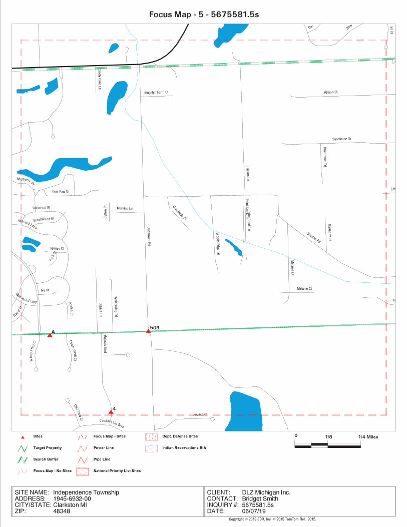

TC5675581.5s.5 Page 29
509 / 5 SALEM SAND AND GRAVE DARTMOUTH & OAK HILL MI DEL PART 201 12 0.002 North
4 / 5 BURROUGHS MATERIALS US MINES TP
A2 / 5 SALEM SAND & GRAVEL 5175 OAK HILL RD MI WDS TP
A1 / 5 SALEM SAND & GRAVEL ABANDONED MINES TP
MAPPED SITES SUMMARY - FOCUS MAP 5
Target Property:1945-6932-00CLARKSTON, MI 48348
FOCUS MAPDIST (ft. & mi.)MAP ID /
DATABASE ACRONYMS DIRECTIONSITE NAME ADDRESS


TC5675581.5s.6 Page 31
NO MAPPED SITES FOUND
MAPPED SITES SUMMARY - FOCUS MAP 6
Target Property:1945-6932-00CLARKSTON, MI 48348
FOCUS MAPDIST (ft. & mi.)MAP ID /
DATABASE ACRONYMS DIRECTIONSITE NAME ADDRESS

TC5675581.5s.7 Page 33
NO MAPPED SITES FOUND
MAPPED SITES SUMMARY - FOCUS MAP 7
Target Property:1945-6932-00CLARKSTON, MI 48348
FOCUS MAPDIST (ft. & mi.)MAP ID /
DATABASE ACRONYMS DIRECTIONSITE NAME ADDRESS
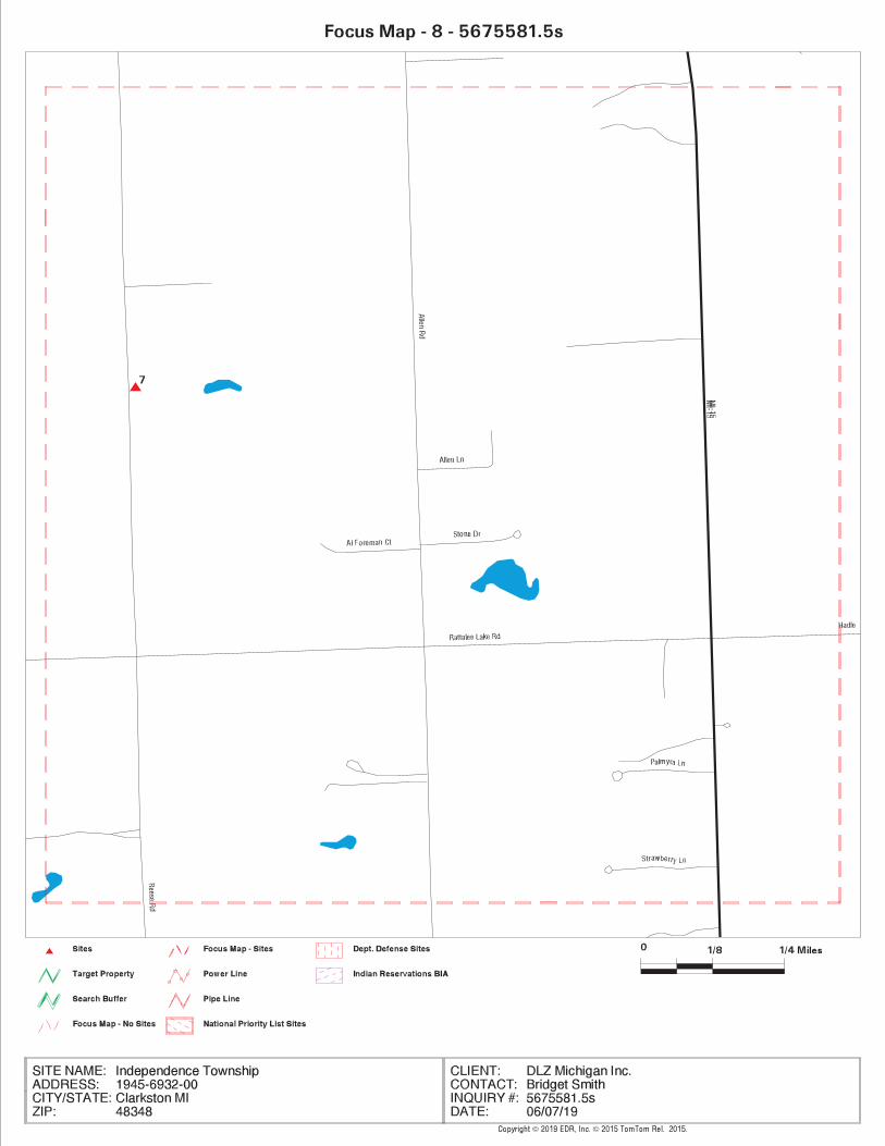

TC5675581.5s.8 Page 35
7 / 8 KURT MADLEX 9940 REESE RD MI WDS TP
MAPPED SITES SUMMARY - FOCUS MAP 8
Target Property:1945-6932-00CLARKSTON, MI 48348
FOCUS MAPDIST (ft. & mi.)MAP ID /
DATABASE ACRONYMS DIRECTIONSITE NAME ADDRESS


TC5675581.5s.9 Page 37
NO MAPPED SITES FOUND
MAPPED SITES SUMMARY - FOCUS MAP 9
Target Property:1945-6932-00CLARKSTON, MI 48348
FOCUS MAPDIST (ft. & mi.)MAP ID /
DATABASE ACRONYMS DIRECTIONSITE NAME ADDRESS


TC5675581.5s.10 Page 39
B13 / 10 COUNTY OF INDEPENDEN 9501 SASHABAW RD MI AST, RCRA NonGen / NLR, FINDS, ECHO TP
B12 / 10 INDEPENDENCE OAKS CO 9501 SASHABAW RD MI RGA LUST TP
B11 / 10 INDEPENDENCE OAKS CO 9501 SASHABAW RD MI LUST, MI UST, MI WDS TP
B10 / 10 RESIDENCE 9501 SASHABAW ROAD MI ASBESTOS TP
8 / 10 WCISEL & WCISEL INC 9764 PINE KNOB RD MI WDS TP
6 / 10 10317 HORSESHOE CIRC MI SPILLS TP
MAPPED SITES SUMMARY - FOCUS MAP 10
Target Property:1945-6932-00CLARKSTON, MI 48348
FOCUS MAPDIST (ft. & mi.)MAP ID /
DATABASE ACRONYMS DIRECTIONSITE NAME ADDRESS


TC5675581.5s.11 Page 41
9 / 11 INDEPENDENT TRUCK RE 5255 WHIPPLE LAKE RD MI WDS TP
MAPPED SITES SUMMARY - FOCUS MAP 11
Target Property:1945-6932-00CLARKSTON, MI 48348
FOCUS MAPDIST (ft. & mi.)MAP ID /
DATABASE ACRONYMS DIRECTIONSITE NAME ADDRESS


TC5675581.5s.12 Page 43
NO MAPPED SITES FOUND
MAPPED SITES SUMMARY - FOCUS MAP 12
Target Property:1945-6932-00CLARKSTON, MI 48348
FOCUS MAPDIST (ft. & mi.)MAP ID /
DATABASE ACRONYMS DIRECTIONSITE NAME ADDRESS
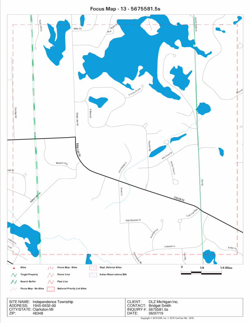

TC5675581.5s.13 Page 45
NO MAPPED SITES FOUND
MAPPED SITES SUMMARY - FOCUS MAP 13
Target Property:1945-6932-00CLARKSTON, MI 48348
FOCUS MAPDIST (ft. & mi.)MAP ID /
DATABASE ACRONYMS DIRECTIONSITE NAME ADDRESS


TC5675581.5s.14 Page 47
G44 / 14 G E B CLARKSTON INC 7650 ORTONVILLE RD ECHO TP
G43 / 14 G E B CLARKSTON INC 7650 ORTONVILLE RD RCRA NonGen / NLR, FINDS TP
G42 / 14 GEB CLARKSTON INC 7650 ORTONVILLE RD MI LUST, MI UST, MI Financial Assurance TP
G41 / 14 G E B CLARKSTON INC 7650 ORTONVILLE RD MI WDS TP
G40 / 14 DEERWOOD SERVICE INC 7650 ORTONVILLE RD 7 EDR Hist Auto TP
26 / 14 A-1 TRUCKING 8031 ORTONVILLE RD MI WDS TP
MAPPED SITES SUMMARY - FOCUS MAP 14
Target Property:1945-6932-00CLARKSTON, MI 48348
FOCUS MAPDIST (ft. & mi.)MAP ID /
DATABASE ACRONYMS DIRECTIONSITE NAME ADDRESS


TC5675581.5s.15 Page 49
25 / 15 6601 AMY DRIVE MI SPILLS TP
24 / 15 C/O MOBIL EXXON 6379 PARK TRAIL DR EDR Hist Auto TP
23 / 15 RESIDENCE 8254 PERRY LAKE ROAD MI ASBESTOS TP
D22 / 15 8240 DEER WOOD CIR ERNS TP
D21 / 15 CONSUMERS POWER CO 8232 DEERWOOD CIRCLE DOT OPS TP
18 / 15 TWO BROWN FAMILY LLC 8530 ELKRUN DR EDR Hist Cleaner TP
17 / 15 BVD CORPORATION INC 8610 PERRY LAKE RD EDR Hist Auto TP
C16 / 15 CRAWFORD RESIDENCE 8930 PERRY LAKE RD RCRA NonGen / NLR TP
C15 / 15 CRAWFORD RESIDENCE 8930 PERRY LAKE RD FINDS, ECHO TP
C14 / 15 CRAWFORD RESIDENCE 8930 PERRY LAKE RD MI WDS TP
MAPPED SITES SUMMARY - FOCUS MAP 15
Target Property:1945-6932-00CLARKSTON, MI 48348
FOCUS MAPDIST (ft. & mi.)MAP ID /
DATABASE ACRONYMS DIRECTIONSITE NAME ADDRESS

TC5675581.5s.16 Page 51
F39 / 16 RITE AID OF MICHIGAN 5751 CLARKSTON RD FINDS, ECHO TP
F38 / 16 RITE AID OF MICHIGAN 5751 CLARKSTON RD MI WDS TP
F37 / 16 RITE AID OF MICHIGAN 5751 CLARKSTON RD RCRA-CESQG TP
36 / 16 OAKLAND CRC-SASHABAW 7774 SASHABAW RD, VI MI NPDES TP
E35 / 16 WOODWARD DETROIT CVS 5756 CLARKSTON ROAD RCRA-CESQG TP
E34 / 16 WOODWARD DETROIT CVS 5756 CLARKSTON ROAD FINDS, ECHO TP
E33 / 16 WOODWARD DETROIT CVS 5756 CLARKSTON ROAD MI WDS TP
E32 / 16 SASHABAW MARKETPLACE 5748 CLARKSTON RD FINDS, ECHO TP
E31 / 16 SASHABAW MARKETPLACE 5748 CLARKSTON RD RCRA-CESQG TP
E30 / 16 CLARKSTON SQUARE 5748 CLARKSTON RD MI LUST, MI UST, MI INVENTORY, MI BEA, M... TP
E29 / 16 CLARKSTON SQUARE 5748 CLARKSTON RD MI RGA LUST TP
E28 / 16 INDEPENDENCE TWP FIR 7825 SASHABAW RD MI UST TP
E27 / 16 INDEPENDENCE TWP FIR 7825 SASHABAW RD MI Financial Assurance TP
MAPPED SITES SUMMARY - FOCUS MAP 16
Target Property:1945-6932-00CLARKSTON, MI 48348
FOCUS MAPDIST (ft. & mi.)MAP ID /
DATABASE ACRONYMS DIRECTIONSITE NAME ADDRESS
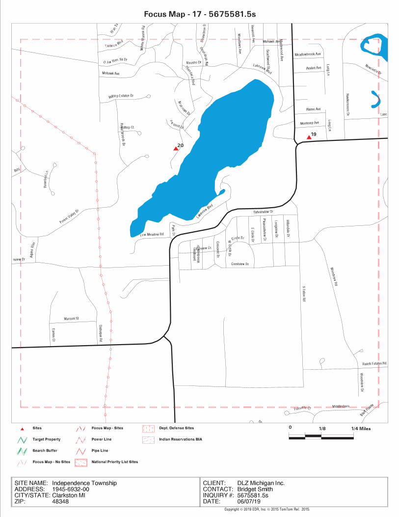

TC5675581.5s.17 Page 53
20 / 17 8491 THENDARA BOULEV MI SPILLS TP
19 / 17 SIM DRY CLEANING 4730 CLARKSTON RD EDR Hist Cleaner TP
MAPPED SITES SUMMARY - FOCUS MAP 17
Target Property:1945-6932-00CLARKSTON, MI 48348
FOCUS MAPDIST (ft. & mi.)MAP ID /
DATABASE ACRONYMS DIRECTIONSITE NAME ADDRESS


TC5675581.5s.18 Page 55
NO MAPPED SITES FOUND
MAPPED SITES SUMMARY - FOCUS MAP 18
Target Property:1945-6932-00CLARKSTON, MI 48348
FOCUS MAPDIST (ft. & mi.)MAP ID /
DATABASE ACRONYMS DIRECTIONSITE NAME ADDRESS

TC5675581.5s.19 Page 57
545 / 19 COLOMBIERE CENTER 9075 BIG LAKE RD MI UST, MI AUL, MI INVENTORY, MI PART 20... 2831 0.536 WSW
CW544 / 19 DIXIE HIGHWAY BP 8500 DIXIE HWY MI INVENTORY, MI Financial Assurance 2087 0.395 WNW
CW543 / 19 DIXIE HIGHWAY BP 8500 DIXIE HWY MI LUST, MI UST, MI BEA, MI WDS 2087 0.395 WNW
525 / 19 OAKLAND SCHOOLS 8211 BIG LAKE RD RCRA-CESQG, FINDS, ECHO 748 0.142 WSW
516 / 19 CLARKSTON MOTORS INC 8105 BIG LAKE RD RCRA-CESQG, FINDS, ECHO 272 0.052 WSW
120 / 19 ENCORE AT DEERHILL-O DIXIE HWY & DEERHILL MI NPDES TP
O82 / 19 7765 DEER HILL DR MI SPILLS TP
O79 / 19 BUCKEYE OIL PIPELINE 7770 DEERHILL DRIVE MI RGA PART 201 TP
O78 / 19 BUCKEYE OIL PIPELINE 7770 DEERHILL DRIVE MI INVENTORY, MI PART 201 TP
MAPPED SITES SUMMARY - FOCUS MAP 19
Target Property:1945-6932-00CLARKSTON, MI 48348
FOCUS MAPDIST (ft. & mi.)MAP ID /
DATABASE ACRONYMS DIRECTIONSITE NAME ADDRESS


TC5675581.5s.20 Page 59
W121 / 20 TOWNSHIP OF INDEPEND 3 CHURCH ST MI WDS TP
117 / 20 W BRUCE KNIGHT 7249 OAK FOREST DR MI WDS TP
116 / 20 NEENS CLEANERS & TAI 6 N MAIN ST EDR Hist Cleaner TP
112 / 20 RESIDENCE 62 NORTH MAIN STREET MI ASBESTOS TP
111 / 20 WAGNER’S LANDING UNKNOWN FINDS TP
S103 / 20 CLARKSTON MUFFLER & 148 N MAIN ST EDR Hist Auto TP
S102 / 20 VILLAGE MUFFLER 148 N MAIN ST MI BROWNFIELDS TP
S101 / 20 MAIN STREET RES WELL 148 NORTH MAIN STREE MI INVENTORY, MI PART 201 TP
S100 / 20 VILLAGE 76 148 N MAIN ST MI RGA LUST TP
S99 / 20 MAIN STREET RES WELL 148 NORTH MAIN STREE MI RGA PART 201 TP
S98 / 20 VILLAGE MUFFLER AND 148 N MAIN ST MI LUST, MI UST, MI AUL, MI INVENTORY, R... TP
S97 / 20 148 N MAIN ST (BEHIN MI SPILLS TP
S96 / 20 VILLAGE 76 148 N. MAIN ST. MI RGA LUST TP
S95 / 20 MAIN STREET RES WELL 154 NORTH MAIN STREE MI RGA PART 201 TP
83 / 20 RESIDENCE 177 NORTH MAIN STREE MI ASBESTOS TP
81 / 20 MURIEL ORLANDO 7689 DEERHILL DR MI WDS TP
N77 / 20 COUNTY OF OAKLAND 7151 N MAIN ST MI WDS TP
N76 / 20 HOSLER PONTIAC 7151 N MAIN ST MI WDS TP
N75 / 20 COUNTY OF OAKLAND 7151 N MAIN ST FINDS, ECHO TP
N74 / 20 COUNTY OF OAKLAND 7151 N MAIN ST RCRA NonGen / NLR TP
73 / 20 DWIGHT ORTHOPEDIC RE 7164 N. MAIN STREET MI BEA TP
M70 / 20 POINTE CLEANERS INC 7194 N MAIN ST EDR Hist Cleaner TP
M69 / 20 POINTE CLEANERS 7194 ORTONVILLE RD EDR Hist Cleaner TP
M68 / 20 POINTE CLEANERS 7194 N MAIN ST RCRA-CESQG, FINDS, ECHO, MI DRYCLEANERS,...TP
M67 / 20 TOMS TEXACO SERVICE 7230 ORTONVILLE EDR Hist Auto TP
M66 / 20 FORMER TEXACO 7320 ORTONVILLE MI LUST, MI INVENTORY TP
M65 / 20 FORMER TEXACO 7320 ORTINVILLE MI RGA LUST TP
M64 / 20 FORMER TEXACO 7320 ORTONVILLE MI RGA LUST TP
M63 / 20 FORMER TEXACO - CLAR 7320 ORTONVILLE MI RGA PART 201 TP
K62 / 20 SUNOCO INC 6754 BLUEGRASS DR RCRA NonGen / NLR, FINDS, ECHO TP
K61 / 20 SUNOCO INC 6754 BLUEGRASS DR MI WDS TP
K58 / 20 SUNOCO INC 7251 N MAIN ST RCRA-CESQG, FINDS, ECHO TP
K57 / 20 CLARKSTON SHELL SERV 7251 N MAIN ST MI RGA LUST TP
K56 / 20 CLARKSTON BP 7251 N MAIN ST MI LUST, MI UST, MI BROWNFIELDS, MI INVE... TP
K55 / 20 FENTON-HILL SUNOCO I 7251 N MAIN ST EDR Hist Auto TP
J54 / 20 AUSTIN OIL COMPANY 7231 N MAIN ST MI WDS TP
J53 / 20 CLARKSTON SHELL SERV 7251 ORTONVILLE RD MI RGA LUST TP
J52 / 20 CLARKSTON #28 7251 ORTONVILLE RD. MI RGA LUST TP
J51 / 20 FENTON-HILL SHELL IN 7251 ORTONVILLE RD EDR Hist Auto TP
MAPPED SITES SUMMARY - FOCUS MAP 20
Target Property:1945-6932-00CLARKSTON, MI 48348
FOCUS MAPDIST (ft. & mi.)MAP ID /
DATABASE ACRONYMS DIRECTIONSITE NAME ADDRESS

TC5675581.5s.20 Page 60
193 / 20 MAGGIE DEIBEL 6235 MIDDLE LAKE RD MI WDS TP
192 / 20 BILL CRAIG 6281 MIDDLE LAKE RD MI WDS TP
AI173 / 20 CLARKSTON MS4-OAKLAN 375 DEPOT ROAD MI SPILLS, MI NPDES TP
AI172 / 20 CLARKSTON MS4-OAKLAN 375 DEPOT ROAD FINDS, ECHO TP
AI171 / 20 375 DEPOT ROAD MI SPILLS TP
165 / 20 PINE RIDGE PLACE BUI 7640 DIXIE HWY ICIS, FINDS, ECHO TP
156 / 20 PINE RIDGE PLACE BUI 7650 DIXIE HWY ICIS, FINDS, ECHO TP
149 / 20 CITY OF CLARKSTON 395 DEPOT RD MI WDS TP
Z142 / 20 BRIGHT SIDE CLARKSTO 55 SOUTH MAIN STREET MI INVENTORY TP
Z141 / 20 55 SOUTH MAIN STREET 55 SOUTH MAIN STREET MI INVENTORY TP
X136 / 20 32 SOUTH MAIN, CLARK 32 SOUTH MAIN STREET US BROWNFIELDS, FINDS TP
X135 / 20 COMMERCIAL PROPERTY 32 SOUTH MAIN STREET MI BEA TP
X134 / 20 HQ CLARKSTON, LLC 32 SOUTH MAIN STREET MI INVENTORY TP
X133 / 20 TERREL PRODUCTION CO 31 S MAIN ST MI WDS TP
W132 / 20 FIRE DEPT STATION #3 3 E CHURCH ST MI RGA LUST TP
W131 / 20 INDEPENDENCE TWP FD 3 EAST CHURCH MI RGA LUST TP
W130 / 20 MORGAN SERVICE STATI 28 S MAIN ST EDR Hist Auto TP
W129 / 20 MORGANS SVC INC 28 S MAIN ST RCRA-CESQG, FINDS, ECHO TP
W128 / 20 RICHARD MORGAN 28 S MAIN MI RGA LUST TP
W127 / 20 MORGAN’S SERVICE 28 S MAIN STREET MI RGA LUST TP
W126 / 20 MORGAN SERVICE 28 S MAIN STREET MI RGA LUST TP
W125 / 20 MORGAN’S MARATHON 28 SOUTH MAIN STREET MI AUL TP
W124 / 20 RICHARD W MORGAN 28 S MAIN MI RGA LUST TP
W123 / 20 RICHARD MORGAN 28 S MAIN ST MI LUST, MI UST, MI INVENTORY, MI WDS TP
W122 / 20 FIRE DEPT STATION #3 3 CHURCH ST MI LUST, MI UST TP
MAPPED SITES SUMMARY - FOCUS MAP 20
Target Property:1945-6932-00CLARKSTON, MI 48348
FOCUS MAPDIST (ft. & mi.)MAP ID /
DATABASE ACRONYMS DIRECTIONSITE NAME ADDRESS


TC5675581.5s.21 Page 62
AL191 / 21 CLARKSTON COMMUNITY 6590 MIDDLE LAKE RD MI LUST, MI UST, MI INVENTORY, MI Financ... TP
AL190 / 21 CLARKSTON PS MS4-OAK 6590 MIDDLE LAKE ROA FINDS, ECHO TP
AL189 / 21 CLARKSTON COMMUNITY 6590 MIDDLE LAKE RD MI RGA LUST TP
188 / 21 CLARKSTON SCHOOLS 6510 MIDDLE LAKE RD MI WDS TP
AE161 / 21 6589 WALDON LAKE RD MI SPILLS TP
AE160 / 21 CLARKSTON JUNIOR HIG 6595 WALDON MI SPILLS TP
AE159 / 21 CLARKSTON JUNIOR HIG 6595 WALDON ROAD MI ASBESTOS TP
AB148 / 21 CLARKSTON UNITED MET 6600 WALDON ROAD MI ASBESTOS TP
AB147 / 21 CLARKSTON UNITED MET 6600 WALDON ROAD MI ASBESTOS TP
V119 / 21 MCGILL RESIDENCE 6506 CHURCH ST MI WDS TP
V118 / 21 MCGILL RESIDENCE 6506 CHURCH ST RCRA NonGen / NLR, FINDS, ECHO TP
115 / 21 CLARKSTON SCHOOLS 6300 CHURCH ST MI WDS TP
113 / 21 R D TRANSMISSIONS 6311 PEACH DR EDR Hist Auto TP
T105 / 21 CLARKSTON COMM SCH 6389 CLARKSTON RD P FINDS TP
T104 / 21 CLARKSTON COMM SCH 6389 CLARKSTON RD P FTTS, HIST FTTS TP
94 / 21 RESURRECTION EPISCOP 6490 CLARKSTON RD MI WDS TP
R93 / 21 6440 CLARKSTON ROAD 6440 CLARKSTON ROAD MI INVENTORY TP
R92 / 21 MI DEPT/NATURAL RESO 6440 CLARKSTON RD MI BROWNFIELDS, MI PART 201, MI INVENTOR... TP
R91 / 21 CLARKSTON RD AREA 6440 CLARKSTON RD MI RGA PART 201 TP
R90 / 21 CLARKSTON RD AREA LF 6440 CLARKSTON RD MI RGA PART 201 TP
R89 / 21 CLARKSTON RD AREA 6440 CLARKSTON RD MI RGA PART 201 TP
R88 / 21 CLARKSTON RD AREA 6440 CLARKSTON RD SEMS-ARCHIVE TP
Q87 / 21 DEPT OF PUBLIC WORKS 6050 FLEMINGS LAKE R MI Financial Assurance TP
Q86 / 21 DEPT OF PUBLIC WORKS 6050 FLEMINGS LAKE R MI UST TP
P85 / 21 MI DEPT/TRANSPORTATI I 75 AT CLARKSTON RCRA NonGen / NLR TP
P84 / 21 MI DEPT/TRANSPORTATI I 75 AT CLARKSTON MI WDS TP
80 / 21 CLARKSTON CHRISTIAN 6300 CLARKSTON RD FINDS TP
72 / 21 CLARKSTON ROAD LANDF 6440 CLARKSTON ROAD MI INVENTORY TP
71 / 21 STILLROYS STANDARD S 6605 NORTHVIEW DR EDR Hist Auto TP
L60 / 21 CLARKSTON MERCURY SP 6185 CLARKSTON ROAD SEMS, PRP TP
L59 / 21 CLARKSTON MERCURY SP 6185 CLARKSTON ROAD FINDS TP
MAPPED SITES SUMMARY - FOCUS MAP 21
Target Property:1945-6932-00CLARKSTON, MI 48348
FOCUS MAPDIST (ft. & mi.)MAP ID /
DATABASE ACRONYMS DIRECTIONSITE NAME ADDRESS


TC5675581.5s.22 Page 64
AJ183 / 22 SHEFFLER & ASSOCIATE 6330 SASHABAW ROAD ( MI INVENTORY TP
AJ182 / 22 6330 SASHABAW 6330 SASHABAW MI INVENTORY TP
AJ181 / 22 SHEFFLER & ASSOCIATE 6330 SASHABAW ROAD MI BEA TP
AJ180 / 22 CONTINENTAL MACHINE 6335 SASHABAW RD MI RGA LUST TP
AJ179 / 22 CONTINENTAL MACHINE 6335 SASHABAW RD MI LUST, MI UST TP
AJ178 / 22 SHEFFLER & ASSOCIATE 6338 SASHABAW RD RCRA-CESQG TP
AJ177 / 22 SHEFFLER & ASSOCIATE 6338 SASHABAW RD MI INVENTORY, MI WDS TP
AJ176 / 22 SHEFFLER & ASSOCIATE 6338 SASHABAW RD FINDS, ECHO TP
AJ175 / 22 MORROW PROCESS CO 6352 SASHABAW RD RCRA NonGen / NLR, FINDS, ECHO TP
AJ174 / 22 MORROW PROCESS CO 6352 SASHABAW RD MI WDS TP
AH170 / 22 INDEPENDENCE TWP MS4 6483 WALDON CENTER D MI NPDES TP
AH169 / 22 INDEPENDENCE TWP MS4 6483 WALDON CENTER D FINDS, ECHO TP
AG168 / 22 TOWN CENTER AUTO WAS 6380 SASHABAW RD FINDS, ECHO TP
AG167 / 22 TOWN CENTER AUTO WAS 6380 SASHABAW RD MI WDS TP
AG166 / 22 TOWN CENTER AUTO WAS 6380 SASHABAW RD RCRA NonGen / NLR TP
AF164 / 22 SPENCERS CLEANERS 6413 SASHABAW RD RCRA-CESQG, FINDS, ECHO TP
AF163 / 22 3J INDUSTRIES INC 6413 SASHABAW RD EDR Hist Cleaner TP
AF162 / 22 SPENCER CLEANERS 6413 SASHABAW ROAD MI DRYCLEANERS, MI WDS TP
AD158 / 22 CLARKSTON AUTO BODY 6470 SASHABAW RD MI WDS TP
AD157 / 22 CLARKSTON AUTO BODY 6470 SASHABAW RD RCRA-CESQG, FINDS, ECHO TP
155 / 22 COMPLEX TOOL & MACHI 6460 SASHABAW RD MI WDS TP
AC154 / 22 SASHABAW & 75 6480 SASHABAW RD MI RGA LUST TP
AC153 / 22 SASHABAW & 75 6480 SASHABAW MI RGA LUST TP
AC152 / 22 ROYS ED AMOCO INC 6480 SASHABAW RD EDR Hist Auto TP
AC151 / 22 SASHABAW & 75 6480 SASHABAW RD MI LUST, MI UST, MI AUL, MI INVENTORY, M... TP
AC150 / 22 AMOCO OIL CO 6480 SASHABAW RD RCRA NonGen / NLR, FINDS, ECHO TP
146 / 22 PINE KNOB GOLF COURS 5580 WALDON RD MI WDS TP
139 / 22 NORTHRIDGE - CLARKST 5470 WALDON RD. MI NPDES TP
114 / 22 PARK & RIDE LOT SASHABAW RD. AT I-75 MI INVENTORY TP
U110 / 22 PINE KNOB SHELL 6889 SASHABAW RD MI Financial Assurance TP
U109 / 22 PINE KNOB MOBIL 6889 SASHABAW RD MI UST TP
U108 / 22 AUTO CITY SERVICE CE 6889 SASHABAW RD EDR Hist Auto TP
U107 / 22 EQUILON ENTERPRISES 6889 SASHABAW RD MI SPILLS, MI WDS TP
I50 / 22 PALACE SPORTS & ENTE 7774 SASHABAW RD RCRA-CESQG, FINDS, ECHO TP
I49 / 22 PALACE SPORTS & ENTE 7774 SASHABAW RD MI WDS TP
H48 / 22 5800 MOODY DR ERNS TP
H47 / 22 PONTIAC COIL 5800 MOODY DRIVE MI NPDES, MI WDS TP
H46 / 22 PONTIAC COIL 5800 MOODY DR RCRA-CESQG, FINDS, ECHO TP
45 / 22 AMOCO OIL CO 7777 PINE KNOB RD MI UST TP
MAPPED SITES SUMMARY - FOCUS MAP 22
Target Property:1945-6932-00CLARKSTON, MI 48348
FOCUS MAPDIST (ft. & mi.)MAP ID /
DATABASE ACRONYMS DIRECTIONSITE NAME ADDRESS
TC5675581.5s.22 Page 65
AM202 / 22 RECTICEL INTERIORS N 5600 BOW POINTE DR ICIS, FINDS, ECHO TP
AM201 / 22 MICHIGAN HEMATOLOGY 5600 BOW POINTE DR RCRA-CESQG TP
AM200 / 22 MICHIGAN HEMATOLOGY 5600 BOW POINTE DR MI AIRS, MI NPDES, MI WDS TP
AM199 / 22 RECTICEL INTERIORS N 5600 BOW POINTE DRIV MI AIRS TP
AM198 / 22 MICHIGAN HEMATOLOGY 5600 BOW POINTE DR FINDS, ECHO TP
AM197 / 22 AUTOMOTIVE LIGHTING, 5600 BOW POINTE DRIV MI AIRS TP
AM196 / 22 5600 BOW POINTE DR 5600 BOW POINTE DR HMIRS TP
AM195 / 22 MAGNETI MARELLI HOLD 5600 BOW POINTE DR RCRA-CESQG TP
194 / 22 COMMERICAL PROPERTY 6215 SASHABAW ROAD MI INVENTORY TP
AK187 / 22 CHAMPS CLEANERS INC 6315 SASHABAW RD MI WDS TP
AK186 / 22 CHAMPS CLEANERS INC 6315 SASHABAW RD FINDS, ECHO TP
AK185 / 22 CHAMPS CLEANERS 6315 SASHABAW ROAD, MI DRYCLEANERS TP
AK184 / 22 CHAMPS CLEANERS INC 6315 SASHABAW RD RCRA-CESQG TP
MAPPED SITES SUMMARY - FOCUS MAP 22
Target Property:1945-6932-00CLARKSTON, MI 48348
FOCUS MAPDIST (ft. & mi.)MAP ID /
DATABASE ACRONYMS DIRECTIONSITE NAME ADDRESS


TC5675581.5s.23 Page 67
AA145 / 23 CASSELL CREATIONS LL 6480 CLINTONVILLE RD FINDS, ECHO TP
AA144 / 23 CASSELL CREATIONS LL 6480 CLINTONVILLE RD MI WDS TP
AA143 / 23 CASSELL CREATIONS LL 6480 CLINTONVILLE RD RCRA NonGen / NLR TP
140 / 23 THERESA LUGG 5081 WALDON RD MI WDS TP
Y138 / 23 FINE ART SCULPTURE C 4975 WALDON ROAD/648 MI INVENTORY TP
Y137 / 23 FINE ART SCULPTURE C 4975 WALDON RD FINDS TP
106 / 23 TNR LAWN SERVICE AND 6833 CLINTONVILLE RO MI WDS TP
MAPPED SITES SUMMARY - FOCUS MAP 23
Target Property:1945-6932-00CLARKSTON, MI 48348
FOCUS MAPDIST (ft. & mi.)MAP ID /
DATABASE ACRONYMS DIRECTIONSITE NAME ADDRESS


TC5675581.5s.24 Page 69
NO MAPPED SITES FOUND
MAPPED SITES SUMMARY - FOCUS MAP 24
Target Property:1945-6932-00CLARKSTON, MI 48348
FOCUS MAPDIST (ft. & mi.)MAP ID /
DATABASE ACRONYMS DIRECTIONSITE NAME ADDRESS


TC5675581.5s.25 Page 71
NO MAPPED SITES FOUND
MAPPED SITES SUMMARY - FOCUS MAP 25
Target Property:1945-6932-00CLARKSTON, MI 48348
FOCUS MAPDIST (ft. & mi.)MAP ID /
DATABASE ACRONYMS DIRECTIONSITE NAME ADDRESS


TC5675581.5s.26 Page 73
253 / 26 PROFESSIONAL PLAZA 5825 M-15 ICIS, FINDS, ECHO TP
AX252 / 26 KIEFT ENGINEERING 5852 S. MAIN ST. (M- MI RGA LUST TP
AX251 / 26 KIEFT ENGINEERING, I 5852 S MAIN (M-15) MI RGA LUST TP
AX250 / 26 KIEFT ENGINEERING, I 5852 S. MAIN (M-15) MI RGA LUST TP
AX249 / 26 KIEFT ENGINEERING, I 5852 S MAIN ST MI LUST, MI UST TP
AX248 / 26 US POSTAL SERVICE 5886 S MAIN ST MI WDS TP
AX247 / 26 CLARKSTON POST OFFIC 5886 ORTONVILLE RD MI INVENTORY TP
AW246 / 26 KIMCO WHITE LAKE 667 7071-7157 DIXIE HIGH MI BEA TP
AW245 / 26 7071-7157 DIXIE 7071-7157 DIXIE MI INVENTORY TP
AW244 / 26 7071 DIXIE HWY MI SPILLS TP
AW243 / 26 WOODWARD DETROIT CVS 7091 DIXIE HWY MI WDS TP
AW242 / 26 WOODWARD DETROIT CVS 7091 DIXIE HWY FINDS, ECHO TP
AW241 / 26 WOODWARD DETROIT CVS 7091 DIXIE HWY RCRA-CESQG TP
AW240 / 26 T & L INCORPORATED 7125 DIXIE HWY EDR Hist Cleaner TP
239 / 26 CLARKSTON DRY CLEANE 5908 S MAIN EDR Hist Cleaner TP
AV238 / 26 PINE KNOB CLEANERS 5916 ORTONVILLE RD EDR Hist Cleaner TP
AV237 / 26 CLARKSTON DRY CLEANE 5916 S MAIN ST EDR Hist Cleaner TP
AU236 / 26 FRANKS NURSERY & CRA 7151 DIXIE HWY MI WDS TP
AV235 / 26 SUN CLEANERS 5926 S MAIN ST EDR Hist Cleaner TP
AV234 / 26 SUN CUSTOM CLEANERS 5930 S MAIN ST RCRA-CESQG TP
AV233 / 26 SUN CUSTOM CLEANERS 5930 S MAIN ST MI WDS TP
AV232 / 26 SUN CUSTOM CLEANERS 5930 S MAIN ST FINDS, ECHO TP
AV231 / 26 SUN CLEANERS 5930 S MAIN ST EDR Hist Cleaner TP
AV230 / 26 SUN CUSTOM DRYCLEANE 5930 SOUTH MAIN STRE MI DRYCLEANERS TP
AU229 / 26 CBI NACON INC US 24 & WHITELAKE RD MI WDS TP
AT228 / 26 WALGREEN CO. 7110 DIXIE HWY MI WDS TP
AT227 / 26 WALGREEN CO. 7110 DIXIE HWY RCRA-CESQG, FINDS, ECHO TP
AS226 / 26 BEN POWELL DISPOSAL 6023 SUNNYDALE RD MI HIST LF TP
AS225 / 26 BEN POWELL DISPOSAL 6023 SUNNYDALE MI RGA LF TP
AS224 / 26 BEN POWELL DISPOSAL 6023 SUNNYDALE RD FINDS TP
223 / 26 PTK VORTAC 61 WHITE LAKE RD 610 MI UST TP
AQ220 / 26 LAKEVIEW CEMETERY 6150 WHITE LAKE RD MI WDS TP
AQ219 / 26 LAKEVIEW CEMETERY 6150 WHITE LAKE RD RCRA NonGen / NLR, FINDS, ECHO TP
218 / 26 TRUCK KING U.S.A 7400 DIXIE MI AST TP
AP217 / 26 DEER LAKE RACQUET CL 6167 WHITE LAKE RD MI SPILLS, MI WDS TP
AP216 / 26 DEER LAKE RACQUET CL 6167 WHITE LAKE RD FINDS, ECHO TP
AP215 / 26 DEER LAKE RACQUET CL 6167 WHITE LAKE RD RCRA-CESQG TP
AO213 / 26 MIDDLE LAKE ROAD WEL 6103 MIDDLE LAKE ROA MI INVENTORY TP
AO212 / 26 TAYLORS TIRE SERVICE 6103 MIDDLE LAKE RD EDR Hist Auto TP
MAPPED SITES SUMMARY - FOCUS MAP 26
Target Property:1945-6932-00CLARKSTON, MI 48348
FOCUS MAPDIST (ft. & mi.)MAP ID /
DATABASE ACRONYMS DIRECTIONSITE NAME ADDRESS

TC5675581.5s.26 Page 74
BF305 / 26 DEER LAKE CUSTOM CLE 6700 DIXIE HIGHWAY MI DRYCLEANERS, MI WDS TP
BG304 / 26 ARMAND DRILLING CO 5650 WHITE LAKE RD MI WDS TP
BG303 / 26 ARMAND DRILLING CO 5650 WHITE LAKE RD RCRA NonGen / NLR TP
BG302 / 26 ARMAND DRILLING CO 5650 WHITE LAKE RD FINDS, ECHO TP
BF300 / 26 DUGAN’S IRISH PUB 6722 DIXIE HIGHWAY MI INVENTORY TP
BF299 / 26 6722 DIXIE HIGHWAY 6722 DIXIE HIGHWAY MI INVENTORY TP
BF298 / 26 DUGAN’S IRISH PUB 6722 DIXIE HIGHWAY MI BEA TP
BE297 / 26 JOHN BOWMAN CHEVROLE 6750 DIXIE HWY RCRA-CESQG, FINDS, ECHO TP
BE296 / 26 JOHN BOWMAN CHEVROLE 6750 DIXIE HWY MI UST TP
BE295 / 26 JOHN BOWMAN CHEVROLE 6750 DIXIE HWY MI AIRS, MI Financial Assurance TP
BE294 / 26 JOHN BOWMAN CHEVROLE 6750 DIXIE HWY MI WDS TP
293 / 26 CLARKSTON AUTO WASH 6791 DIXIE HWY MI WDS TP
BD292 / 26 DIXIE & M-15 6756 DIXIE HWY MI LUST, MI UST, MI INVENTORY, MI BEA, M... TP
BD291 / 26 DIXIE & M-15 6756 DIXIE HWY MI RGA LUST TP
BD290 / 26 6756 DIXIE HIGHWAY 6756 DIXIE HIGHWAY US BROWNFIELDS, FINDS TP
BD289 / 26 ROY BROS STD INC 544 6756 DIXIE HWY RCRA NonGen / NLR, FINDS, ECHO TP
BD288 / 26 AMOCO OIL 5448 6756 DIXIE HWY. MI RGA LUST TP
BD287 / 26 BP / AMOCO #25146 6756 DIXIE HWY MI RGA LUST TP
BD286 / 26 AMOCO OIL #5448 6756 DIXIE HWY MI RGA LUST TP
BD285 / 26 DIXIE & M-15 VACANT 6756 DIXIE HIGHWAY MI INVENTORY TP
BD284 / 26 STILLROYS STANDARD S 6756 DIXIE HWY EDR Hist Auto TP
BB280 / 26 ST JOSEPH MERCY OAKL 6770 DIXIE HWY RCRA-CESQG TP
BB279 / 26 ST JOSEPH MERCY OAKL 6770 DIXIE HWY FINDS, ECHO TP
BB278 / 26 ST JOSEPH MERCY OAKL 6770 DIXIE HWY RCRA-CESQG TP
BB277 / 26 ST JOSEPH MERCY OAKL 6770 DIXIE HWY MI WDS TP
276 / 26 CLARKSTON CLINIC MER 6815 DIXIE HWY SEMS-ARCHIVE TP
271 / 26 DONALD NANNEY 5770 S MAIN ST MI WDS TP
AY265 / 26 SWAYNE BILL 5789 M 15 RCRA-CESQG, FINDS, ECHO TP
AY264 / 26 SWAYNE BILL 5789 M 15 MI WDS TP
AY263 / 26 RITE AID #4592 5789 S MAIN ST FINDS, ECHO TP
AY262 / 26 APEX DRUG STORES INC 5789 S MAIN ST MI WDS TP
AY261 / 26 RITE AID #4592 5789 S MAIN ST RCRA-CESQG TP
AY260 / 26 O H M CLARKSTON INC 5795 1/2 S MAIN ST EDR Hist Cleaner TP
AY259 / 26 A CLEANER IMAGE 5795 SOUTH MAIN MI DRYCLEANERS TP
AY258 / 26 O H M CLARKSTON INC 5795 1/2 S MAIN ST MI WDS TP
AY257 / 26 O H M CLARKSTON INC 5795 1/2 S MAIN ST RCRA-CESQG, FINDS, ECHO TP
AY256 / 26 O H M CLARKSTON INC 5792 1/2 S MAIN ST EDR Hist Cleaner TP
255 / 26 I 75 AND SASHABAW AM 6830 DIXIE HWY EDR Hist Auto TP
254 / 26 KIMCO WHITE LAKE 667 7071-7157 DIXIE HIGH MI INVENTORY TP
MAPPED SITES SUMMARY - FOCUS MAP 26
Target Property:1945-6932-00CLARKSTON, MI 48348
FOCUS MAPDIST (ft. & mi.)MAP ID /
DATABASE ACRONYMS DIRECTIONSITE NAME ADDRESS
TC5675581.5s.26 Page 75
CE439 / 26 MICHIGAN EQUIPMENT R 4906 WHITE LAKE RD MI DEL PART 201, MI BEA, MI WDS TP
CE438 / 26 MICHIGAN EQUIPMENT R 4906 WHITE LAKE RD RCRA-CESQG, FINDS, ECHO TP
CE437 / 26 MICHIGAN EQUIPMENT R 4906 WHITE LAKE ROAD MI INVENTORY TP
CE436 / 26 WHITE LK RD SCRAP YD 4905 WHITE LK RD MI INVENTORY, MI PART 201 TP
CE435 / 26 WHITE LAKE ROAD SCRA 4905 WHITE LAKE ROAD MI BROWNFIELDS TP
CE434 / 26 DIXSON METAL PROCESS 4905 WHITE LK RD FINDS TP
CE433 / 26 WHITE LK RD SCRAP YD 4905 WHITE LK RD MI RGA PART 201 TP
431 / 26 MIDDLELAKE INVESTMEN 4906 WHITE LAKE ROAD MI INVENTORY TP
CD430 / 26 NORTHERN CONCRETE PI 4950 WHITE LAKE MI AST TP
CD429 / 26 PRECISION PIPE & SUP 4950 WHITE LAKE MI RGA LUST TP
CD428 / 26 PRECISION PIPE & SUP 4950 WHITE LAKE ROAD MI AIRS TP
CD427 / 26 PRECISION PIPE & SUP 4950 WHITE LAKE RD. MI RGA LUST TP
CD426 / 26 4950 WHITE LAKE ROAD MI SPILLS TP
CD425 / 26 NORTHERN CONCRETE PI 4950 WHITE LAKE RD FINDS TP
CD424 / 26 PRECISION PIPE & SUP 4950 WHITE LAKE RD MI RGA LUST TP
CD423 / 26 PRECISION PIPE & SUP 4950 WHITE LAKE RD MI LUST, MI UST, MI INVENTORY, MI BEA, M... TP
CC422 / 26 INTER LAKES AUTO & T 4941 WHITE LAKE RD MI HIST LF, MI SWRCY TP
CC421 / 26 CLARKSTON HAULING FA 4941 WHITE LAKE ROAD ECHO TP
CC420 / 26 SANITATION COMPANY P 4941 WHITE LAKE ROAD MI BEA TP
CC419 / 26 CAMPERS PARADISE 4941 WHITE LAKE MI AST TP
CC418 / 26 ALLIED CONSTRUCTION 4941 WHITE LAKE ROAD MI INVENTORY TP
CC417 / 26 ALLIED CONSTRUCTION 4941 WHITE LAKE RD MI LUST, MI UST, MI SWRCY, MI INVENTORY,... TP
CC416 / 26 4941 WHITE LAKE ROAD ERNS TP
CC415 / 26 INTER LAKES AUTO & T 4941 WHITE LAKE RD FINDS TP
CC414 / 26 ALLIED CONSTRUCTION 4941 WHITE LAKE RD MI RGA LUST TP
CC413 / 26 INTER LAKES AUTO & T 4941 WHITE LK ROAD MI RGA LF TP
BZ400 / 26 PLASTECH ENGINEERED 5020 WHITE LAKE RD MI INVENTORY, MI WDS TP
BZ399 / 26 PLASTECH ENGINEERED 5020 WHITE LAKE RD FINDS, ECHO TP
BZ398 / 26 PLASTECH ENGINEERED 5020 WHITE LAKE RD RCRA-CESQG TP
392 / 26 4993 LANCASTER HILL MI SPILLS TP
323 / 26 DELTA PROPERTIES FUDS TP
321 / 26 6695 DIXIE HWY MI SPILLS TP
BI316 / 26 SOS MECHANICAL INC 6696 DIXIE HWY MI WDS TP
BI315 / 26 SOS MECHANICAL INC 6696 DIXIE HWY RCRA NonGen / NLR, FINDS, ECHO TP
BF310 / 26 DEER LAKE DRY CLEANE 6700 DIXIE HIGHWAY MI INVENTORY TP
BF309 / 26 ELLIOTTS CLEANERS 6700 DIXIE EDR Hist Cleaner TP
BF308 / 26 DEER LAKE DRY CLEANE 6700 DIXIE HIGHWAY MI RGA PART 201 TP
BF307 / 26 DEER LAKE CLEANERS 6700 DIXIE HWY RCRA-CESQG, FINDS, ECHO TP
BF306 / 26 DEER LAKE DRY CLEANE 6700 DIXIE HIGHWAY MI PART 201 TP
MAPPED SITES SUMMARY - FOCUS MAP 26
Target Property:1945-6932-00CLARKSTON, MI 48348
FOCUS MAPDIST (ft. & mi.)MAP ID /
DATABASE ACRONYMS DIRECTIONSITE NAME ADDRESS

TC5675581.5s.26 Page 76
CF456 / 26 4836 WHITE LAKE ROAD 4836 WHITE LAKE ROAD MI PART 201, MI INVENTORY, MI BEA TP
CF455 / 26 A.W. EXCAVATING, INC 4836 WHITE LAKE ROAD MI INVENTORY TP
CF454 / 26 4836 WHITE LAKE ROAD 4836 WHITE LAKE ROAD US BROWNFIELDS, FINDS TP
CF453 / 26 4836 WHITE LAKE ROAD 4836 WHITE LAKE ROAD MI RGA PART 201 TP
450 / 26 HADLEY MOLD 4866 WHITE LAKE RD MI INVENTORY, MI BEA, MI WDS TP
CE448 / 26 BUCKEYE PIPE LINE CO 4863 WHITE LAKE RD RCRA NonGen / NLR TP
CE447 / 26 BUCKEYE PIPE LINE CO 4863 WHITE LAKE RD MI WDS TP
CE446 / 26 BUCKEYE PIPE LINE CO 4863 WHITE LAKE RD FINDS, ECHO TP
CE445 / 26 BUCKEYE PIPELINE 4861 WHITE LAKE ROAD MI INVENTORY, MI PART 201 TP
CE444 / 26 GRAND TRUNK PROPERTY 4861 WHITE LAKE ROAD MI BEA TP
CE443 / 26 4861 WHITE LAKE ROAD 4861 WHITE LAKE ROAD MI INVENTORY TP
CE442 / 26 BUCKEYE PIPELINE 4861 WHITE LAKE ROAD MI RGA PART 201 TP
CE441 / 26 PROPERTY 4906 WHITE 4906 WHITE LAKE ROAD MI RGA PART 201 TP
CE440 / 26 MICHIGAN RENTAL 4906 WHITE LAKE MI AST TP
MAPPED SITES SUMMARY - FOCUS MAP 26
Target Property:1945-6932-00CLARKSTON, MI 48348
FOCUS MAPDIST (ft. & mi.)MAP ID /
DATABASE ACRONYMS DIRECTIONSITE NAME ADDRESS


TC5675581.5s.27 Page 78
BT375 / 27 KAYOOIL CO 6550 DIXIE HWY EDR Hist Auto TP
BT374 / 27 ATC ASSOCIATES, INC 6550 DIXIE HIGHWAY MI AIRS, MI WDS TP
BT373 / 27 MT CLARK 6550 DIXIE HWY MI LUST, MI UST, MI INVENTORY, MI Financ... TP
BS372 / 27 CLARKSTON REMINDER 6569 DIXIE HWY MI WDS TP
371 / 27 WEINGARTZ 6585 DIXIE HIGHWAY MI INVENTORY TP
BT370 / 27 IKES EQUIPMENT 6560 DIXIE MI AST TP
BT369 / 27 MICHIGAN EQUIPMENT R 6560 DIXIE HWY MI WDS TP
BS368 / 27 BOSTON MARKET (FORME 6570 DIXIE HIGHWAY MI BEA TP
BR363 / 27 RANDY HOSLER PONTIAC 6585 DIXIE HWY MI RGA LUST TP
BR362 / 27 RANDY HOSLER PONTIAC 6585 DIXIE HWY MI LUST, MI UST, MI AIRS TP
BR361 / 27 WEINGARTZ SUPPLY CO 6585 DIXIE HWY FINDS, ECHO TP
BR360 / 27 RANDY HOSLER PONTIAC 6585 DIXIE HIGHWAY MI INVENTORY TP
BR359 / 27 WEINGARTZ SUPPLY CO 6585 DIXIE HWY MI BEA, MI WDS TP
BR358 / 27 WEINGARTZ SUPPLY CO 6585 DIXIE HWY RCRA-CESQG TP
BQ357 / 27 DERVAGE DISPOSAL 5380 CENTER ST MI HIST LF TP
BQ356 / 27 DERVAGE DISPOSAL 5380 CENTER ST MI RGA LF TP
BQ355 / 27 DERVAGE DISPOSAL 5380 CENTER ST FINDS TP
BP354 / 27 SPEEDWAY #8535 6594 DIXIE HWY MI LUST, MI UST, MI AUL, MI INVENTORY, M... TP
BP353 / 27 SPEEDWAY LLC 6594 DIXIE HWY RCRA-CESQG, FINDS, ECHO TP
BP352 / 27 SPEEDWAY SUPERAMERIC 6594 DIXIE HWY EDR Hist Auto TP
BP351 / 27 SPEEDWAY #8535 6594 DIXIE HWY MI RGA LUST TP
BO350 / 27 CHARLES SCOTT & SON 5450 MARVIN RD MI LUST, MI UST TP
BO349 / 27 CHARLES SCOTT & SON 5450 MARVIN MI RGA LUST TP
BN348 / 27 KROGER CO OF MICHIGA 6625 DIXIE HWY RCRA-CESQG TP
BN347 / 27 KROGER CO OF MICHIGA 6625 DIXIE HWY FINDS, ECHO TP
BN346 / 27 KROGER CO OF MICHIGA 6625 DIXIE HWY MI WDS TP
BM345 / 27 CLARKSTON CO (M53211 6610 DIXIE HWY MI UST TP
BM344 / 27 CLARKSTON CO (M53211 6610 DIXIE HWY MI Financial Assurance TP
BM343 / 27 MICHIGAN BELL TELEPH 6610 DIXIE HWY RCRA-CESQG, FINDS, ECHO TP
BM342 / 27 MICHIGAN BELL TELEPH 6610 DIXIE HWY MI WDS TP
341 / 27 L C DORTCH & ASSOCIA 6647 DIXIE HWY EDR Hist Cleaner TP
BL336 / 27 CLARKSTON MOTORS 6673 DIXIE HWY MI WDS TP
BL335 / 27 CLARKSTON MOTORS 6673 DIXIE HWY RCRA NonGen / NLR, FINDS, ECHO TP
BL333 / 27 JOES SUNOCO SERVICE 6677 DIXIE HWY EDR Hist Auto TP
301 / 27 RESIDENCE 5600 WARBLER DRIVE MI ASBESTOS TP
BA275 / 27 EVELYN KUJAWA 5765 CHICKADEE LN MI WDS TP
BA274 / 27 COMCAST 3E COMPANY 5765 CHICKADEE LANE MI WDS TP
BA273 / 27 COMCAST 3E COMPANY 5765 CHICKADEE LANE RCRA NonGen / NLR TP
BA272 / 27 COMCAST 3E COMPANY 5765 CHICKADEE LANE FINDS, ECHO TP
MAPPED SITES SUMMARY - FOCUS MAP 27
Target Property:1945-6932-00CLARKSTON, MI 48348
FOCUS MAPDIST (ft. & mi.)MAP ID /
DATABASE ACRONYMS DIRECTIONSITE NAME ADDRESS
TC5675581.5s.27 Page 79
412 / 27 ROCKCROFT ST RES WEL 5875 - 5911 DIXIE HI MI INVENTORY TP
BY397 / 27 MI DEPT/STATE POLICE 4975 TIMBERWAY TRL FINDS, ECHO TP
BY396 / 27 MI DEPT/STATE POLICE 4975 TIMBERWAY TRL MI WDS TP
BY395 / 27 MI DEPT/STATE POLICE 4975 TIMBERWAY TRL RCRA NonGen / NLR TP
389 / 27 MOON VALLEY RUSTIC F 6465 DIXIE HWY MI UST TP
388 / 27 CLARKSTON WARD CHURC 5154 WATERFORD RD MI WDS TP
BV387 / 27 DEER LAKE CUSTOME CL 6485 DIXIE HIGHWAY EDR Hist Cleaner TP
BV386 / 27 EZ DUZ IT LAUNDROMAT 6507 DIXIE HIGHWAY MI DRYCLEANERS, MI WDS TP
BV385 / 27 EZ DUZ IT LAUNDROMAT 6507 DIXIE HWY RCRA NonGen / NLR, FINDS, ECHO, RI MANIF... TP
BU384 / 27 OTTAWA PARK CEMETERY 6180 DIXIE HWY. MI RGA LUST TP
BU383 / 27 OTTAWA PARK CEMETERY 6180 DIXIE HWY MI RGA LUST TP
BU382 / 27 OTTAWA PARK CEMETERY 6180 DIXIE HWY MI LUST, MI UST, MI AIRS TP
BS381 / 27 ACCURATE RANGE LLC 6559 DIXIE HWY FINDS, ECHO TP
BS380 / 27 ACCURATE RANGE LLC 6559 DIXIE HWY MI WDS TP
BS379 / 27 ACCURATE RANGE LLC 6559 DIXIE HWY RCRA-CESQG TP
BT378 / 27 FAST TRACK VENTURES 6550 DIXIE HWY RCRA-CESQG, FINDS, ECHO TP
BT377 / 27 CLARKSTON CLARK 6550 DIXIE HWY MI RGA LUST TP
BT376 / 27 MT CLARK 6550 DIXIE HWY MI RGA LUST TP
MAPPED SITES SUMMARY - FOCUS MAP 27
Target Property:1945-6932-00CLARKSTON, MI 48348
FOCUS MAPDIST (ft. & mi.)MAP ID /
DATABASE ACRONYMS DIRECTIONSITE NAME ADDRESS

TC5675581.5s.28 Page 81
BK339 / 28 LEE CLEANERS & LAUND 5433 SASHABAW ROAD MI DRYCLEANERS, MI WDS TP
BK338 / 28 LEE CLEANERS 5433 SASHABAW RD RCRA-CESQG, FINDS, ECHO TP
BK337 / 28 5433 SASHABAW ROAD 5433 SASHABAW ROAD MI INVENTORY TP
334 / 28 MAYBEE AND SASHABAW 5438 SASHABAW ROAD MI RGA PART 201 TP
BK332 / 28 DANDY OIL 5465 SASHABAW MI RGA LUST TP
BK331 / 28 UNION 76 5465 SASHABAW EDR Hist Auto TP
BK330 / 28 DANDY OIL 5465 SASHABAW RD. MI RGA LUST TP
BK329 / 28 DANDY OIL # 5 5465 SASHABAW RD MI LUST, MI UST, MI AST, MI INVENTORY, M... TP
BK328 / 28 DANDY OIL 5465 SASHABAW RD MI RGA LUST TP
BJ327 / 28 MAYBEE AND SASHABAW 5480 SASHABAW ROAD MI LUST, MI AUL, MI PART 201, MI INVENTO... TP
BJ326 / 28 MAYBEE AND SASHABAW 5480 SASHABAW ROAD MI RGA PART 201 TP
BJ325 / 28 FORMER BP #4579 5480 SASHABAW RD MI RGA LUST TP
BJ324 / 28 B P OIL INC OHIO 5480 SASHABAW EDR Hist Auto TP
322 / 28 GOTTS AUTO SERVICE 5709 MAYBEE RD MI WDS TP
320 / 28 RESIDENCE 5585 MAYBEE ROAD MI ASBESTOS TP
BH318 / 28 5510 SASHABAW MI SPILLS TP
BH317 / 28 HAL & SON SUNOCO 5510 SASHABAW RD EDR Hist Auto TP
BH313 / 28 WOODWARD DETROIT CVS 5529 SASHABAW RD FINDS, ECHO TP
BH312 / 28 WOODWARD DETROIT CVS 5529 SASHABAW RD RCRA-CESQG TP
BH311 / 28 WOODWARD DETROIT CVS 5529 SASHABAW RD MI WDS TP
BC283 / 28 PITTSBURGH PAINTS 5860 SASHABAW RD MI WDS TP
BC282 / 28 PITTSBURGH PAINTS 5860 SASHABAW RD RCRA-CESQG TP
BC281 / 28 PITTSBURGH PAINTS 5860 SASHABAW RD FINDS, ECHO TP
AZ270 / 28 KROGER CO OF MICHIGA 5990 SASHABAW RD MI WDS TP
AZ269 / 28 KROGER D-651 5990 SASHABAW RD MI UST TP
AZ268 / 28 KROGER #0651-018 5990 SASHABAW RD RCRA-CESQG TP
AZ267 / 28 KROGER #0651-018 5990 SASHABAW RD FINDS, ECHO TP
AZ266 / 28 KROGER D-651 5990 SASHABAW RD MI Financial Assurance TP
AR222 / 28 6051 SASHABAW ROAD 6051 SASHABAW ROAD FINDS TP
AR221 / 28 6051 SASHABAW ROAD 6051 SASHABAW ROAD US BROWNFIELDS TP
AN211 / 28 MCLAREN REGIONAL MED 5701 BOW POINT DR RCRA-CESQG TP
AN210 / 28 MCLAREN REGIONAL MED 5701 BOW POINT DR MI WDS TP
AN209 / 28 CLARKSTON DERMATOLOG 5701 BOW POINTE DR MI WDS TP
AN208 / 28 CLARKSTON DERMATOLOG 5701 BOW POINTE DR FINDS, ECHO TP
AN207 / 28 MCLAREN REGIONAL MED 5701 BOW POINT DR FINDS, ECHO TP
AN206 / 28 CLARKSTON DERMATOLOG 5701 BOW POINTE DR RCRA-CESQG TP
AN205 / 28 MCLAREN OAKLAND ONCO 5680 BOW POINT DR MI WDS TP
AN204 / 28 MCLAREN OAKLAND ONCO 5680 BOW POINT DR RCRA-CESQG TP
AN203 / 28 MCLAREN OAKLAND ONCO 5680 BOW POINT DR FINDS, ECHO TP
MAPPED SITES SUMMARY - FOCUS MAP 28
Target Property:1945-6932-00CLARKSTON, MI 48348
FOCUS MAPDIST (ft. & mi.)MAP ID /
DATABASE ACRONYMS DIRECTIONSITE NAME ADDRESS

TC5675581.5s.28 Page 82
451 / 28 PINE KNOB CAR WASH 4782 SASHABAW RD MI WDS TP
449 / 28 UNIVERSITY AMOCO 4142 MEYERS RD EDR Hist Auto TP
432 / 28 4865 SASHABAW ROAD MI SPILLS TP
CB411 / 28 MORRIS & SONS 4950 SASHABAW RD MI WDS TP
CB410 / 28 SERVANT’S HEART ISSH 4950 SASHABAW ROAD MI INVENTORY TP
CB409 / 28 MORRIS AND SONS AUTO 4950 SASHABAW RD MI UST TP
CA408 / 28 CLARK STORE #1634 4951 SASHABAW RD MI RGA LUST TP
CA407 / 28 CLARKSTON FUEL VENTU 4951 SASHABAW RD MI LUST, MI UST, MI AUL, MI INVENTORY, M... TP
CA406 / 28 CLARK STORE #1634 4951 SASHABAW MI RGA LUST TP
CA405 / 28 CLARKSTON CLARK 4951 SASHABAW RD MI RGA LUST TP
CA404 / 28 SASHABAW RD AREA RES 4951 SASHABAW ROAD MI RGA PART 201 TP
CA403 / 28 FAST TRACK VENTURES 4951 SASHABAW RD RCRA-CESQG, FINDS, ECHO TP
CA402 / 28 CLARK RETAIL ENTERPR 4951 SASHABAW RD EDR Hist Auto TP
CA401 / 28 CLARK SERVICE STATIO 4951 SASHABAW RD MI RGA LUST TP
BX394 / 28 OLD DERVAGE DUMP SIT 5002 PELTON RD MI RGA PART 201 TP
BX393 / 28 OLD DERVAGE DUMP SIT 5002 PELTON RD MI INVENTORY, MI PART 201 TP
BW391 / 28 DRAYTON ROAD WELL 5068 DRAYTON MI PART 201 TP
BW390 / 28 DRAYTON ROAD WELL 5068 DRAYTON MI RGA PART 201 TP
364 / 28 TRANSMISSION EXPRESS 5267 MARY SUE EDR Hist Auto TP
BK340 / 28 LEE DRYCLEANING & LA 5433 SASHABAW RD EDR Hist Cleaner TP
MAPPED SITES SUMMARY - FOCUS MAP 28
Target Property:1945-6932-00CLARKSTON, MI 48348
FOCUS MAPDIST (ft. & mi.)MAP ID /
DATABASE ACRONYMS DIRECTIONSITE NAME ADDRESS


TC5675581.5s.29 Page 84
452 / 29 GENOA RD MI CDL TP
367 / 29 GINGER LAKE & I75 4880 MAYBEE RD. ICIS, FINDS, ECHO TP
366 / 29 NONE 5240 CECELIA ANN MI SPILLS TP
365 / 29 5055 FOX CRK N, APT MI LEAD TP
319 / 29 TOWNSHIP OF INDEPEND 5241 MAYBEE RD MI WDS TP
314 / 29 NORTH SASHABAW ELEME 5290 MAYBEE ROAD MI ASBESTOS TP
214 / 29 6058 PINE KNOB ROAD ERNS TP
MAPPED SITES SUMMARY - FOCUS MAP 29
Target Property:1945-6932-00CLARKSTON, MI 48348
FOCUS MAPDIST (ft. & mi.)MAP ID /
DATABASE ACRONYMS DIRECTIONSITE NAME ADDRESS


TC5675581.5s.30 Page 86
514 / 30 J & W MOBIL SERVICE 4411 DORA LN EDR Hist Auto 143 0.027 East
MAPPED SITES SUMMARY - FOCUS MAP 30
Target Property:1945-6932-00CLARKSTON, MI 48348
FOCUS MAPDIST (ft. & mi.)MAP ID /
DATABASE ACRONYMS DIRECTIONSITE NAME ADDRESS


TC5675581.5s.31 Page 88
537 / 31 CANYON OAKS PROPELLE 8220 OLD WHITE LAKE RCRA-SQG, FINDS, ECHO 1152 0.218 WSW
CR521 / 31 CLEAN TIDE CONTAINER 4600 CLAWSON TANK DR RCRA NonGen / NLR 578 0.109 West
CR520 / 31 NORTH OAKS CUT STONE 4600 CLAWSON TANK DR RCRA NonGen / NLR 578 0.109 West
508 / 31 ARMAND DRILLING CO 7950 ANDERSONVILLE R MI WDS TP
CG469 / 31 4751 WHITE LAKE RD. MI SPILLS TP
CG468 / 31 THOMPSON-MCCULLY QUA 4751 WHITE LAKE ROAD MI AIRS TP
CG467 / 31 4751 WHITE LAKE RD. MI SPILLS TP
CG466 / 31 4751 WHITE LAKE RD. MI SPILLS TP
CG465 / 31 4751 WHITE LAKE ROAD MI SPILLS TP
CG464 / 31 CADILLAC ASPHALT, LL 4751 WHITE LAKE ROAD MI AIRS, MI NPDES, MI WDS TP
CG463 / 31 4751 WHITE LAKE ROAD ERNS TP
CG462 / 31 4751 WHITE LAKE ROAD MI SPILLS TP
CG461 / 31 CADILLAC ASPHALT PRO 4751 WHITE LAKE ROAD MI AIRS TP
CG460 / 31 WEBER SAND & GRAVEL, 4751 WHITE LAKE ROAD MI AIRS TP
CG459 / 31 CADILLAC ASPHALT, L. 4751 WHITE LAKE ROAD RCRA-CESQG, ICIS, US AIRS, FINDS, ECHO TP
CG458 / 31 CADILLAC ASPHALT LLC 4751 WHITE LAKE MI AST TP
MAPPED SITES SUMMARY - FOCUS MAP 31
Target Property:1945-6932-00CLARKSTON, MI 48348
FOCUS MAPDIST (ft. & mi.)MAP ID /
DATABASE ACRONYMS DIRECTIONSITE NAME ADDRESS


TC5675581.5s.32 Page 90
CU536 / 32 LESSING ST. BULK PLA 4304 LESSING MI LUST, MI UST, MI INVENTORY, MI WDS 1135 0.215 South
CU535 / 32 LEF (DBA) VIKING OIL 4304 LESSING MI AST 1135 0.215 South
CU533 / 32 TRACEY ASPHALT PAVIN 4301 LESSING MI UST 1090 0.206 South
CU532 / 32 STEWART CONTRACTING 4305 LESSING MI AST 1045 0.198 South
CU531 / 32 STEWART CONTRACTING 4305 LESSING MI UST 1045 0.198 South
526 / 32 ALL SAINTS CEMETERY 4401 NELSEY RD MI LUST, MI UST, MI WDS 783 0.148 South
CQ519 / 32 WATERFORD BLOCK AND 4389 LESSING RD. MI INVENTORY, MI AIRS 539 0.102 South
CQ518 / 32 NAGY CONCRETE PRODUC 4389 LESSING MI UST, MI AST 539 0.102 South
CQ517 / 32 NAGY CONCRETE PRODUC 4389 LESSING MI AST 539 0.102 South
CP507 / 32 BIANCAS II INC 7880 ANDERSONVILLE MI RGA LUST TP
CP506 / 32 BIANCAS II INC 7880 ANDERSONVILLE R MI LUST, MI UST, MI INVENTORY TP
CP505 / 32 BIANCAS II INC 7880 ANDERSONVILLE R MI RGA LUST TP
504 / 32 C & F TRUCK & AUTO R 4525 WHITE LAKE RD EDR Hist Auto TP
499 / 32 CABINET ONE 4625 WHITE LAKE CT MI WDS TP
CK489 / 32 CLAWSON TANK CO INC 4701 WHITE LAKE RD MI LUST, MI UST, MI AST, MI AIRS TP
CK488 / 32 CLAWSON TANK CO INC 4701 WHITE LAKE RD MI RGA LUST TP
CK487 / 32 4701 WHITE LAKE ROAD 4701 WHITE LAKE ROAD RCRA-CESQG, US AIRS, FINDS, ECHO TP
CK486 / 32 4701 WHITELAKE RD ERNS TP
CK485 / 32 CLAWSON TANK 4701 WHITE LAKE RD MI WDS TP
CK484 / 32 4701 WHITE LAKE ROAD 4701 WHITE LAKE ROAD US BROWNFIELDS TP
CH474 / 32 WHITE LAKE ROAD CONT 4790 WHITE LAKE ROAD MI DEL PART 201, MI WDS TP
CH473 / 32 WHITE LAKE ROAD CONT 4790 WHITE LAKE ROAD MI RGA PART 201 TP
CH472 / 32 SMITHS DISPOSAL 4801 WHITE LAKE RD MI WDS TP
CH471 / 32 CLARKSTON FUEL & SUP 4801 WHITE LAKE RD MI UST TP
CH470 / 32 CLARKSTON FUEL & SUP 4801 WHITE LAKE RD MI UST TP
MAPPED SITES SUMMARY - FOCUS MAP 32
Target Property:1945-6932-00CLARKSTON, MI 48348
FOCUS MAPDIST (ft. & mi.)MAP ID /
DATABASE ACRONYMS DIRECTIONSITE NAME ADDRESS


TC5675581.5s.33 Page 92
547 / 33 SPECTUS SYSTEMS MIDW 501 NORTH ELIDA STRE CORRACTS, RCRA-TSDF, RCRA-CESQG, 2020 CO...3701 0.701 South
546 / 33 OAKLAND COUNTY FUELS 3943 AIRPORT ROAD MI PART 201, MI INVENTORY, MI SPILLS, MI... 2990 0.566 South
CV542 / 33 COMMERCIAL PROPERTY 5498-5534 DIXIE HIGH MI INVENTORY 1691 0.320 South
CV541 / 33 DNR INVESTMENT ENTER 5498-5534 DIXIE HIGH MI BEA 1691 0.320 South
CV540 / 33 DNR INVESTMENT ENTER 5498-5534 DIXIE HIGH MI INVENTORY 1691 0.320 South
539 / 33 LIBERTY OIL LLC 5676 DIXIE HWY MI LUST, MI UST, MI INVENTORY, MI Financ... 1458 0.276 South
534 / 33 LENS CRAFTERS INC 5586 DIXIE HWY RCRA-CESQG 1104 0.209 South
CT529 / 33 WATERFORD FUEL MART 5775 DIXIE HWY MI LUST, MI UST, MI Financial Assurance 893 0.169 South
CT528 / 33 SUNOCO INC 5775 DIXIE HWY RCRA NonGen / NLR, FINDS, ECHO 893 0.169 South
CT527 / 33 SUNOCO INC 5775 DIXIE HWY MI AUL, MI INVENTORY, MI BEA, MI WDS 893 0.169 South
CS524 / 33 FORMER GAS & GO 5805 DIXIE HWY MI LUST, MI WDS 615 0.116 South
CS523 / 33 STEVES AUTO CENTER & 5805 DIXIE HWY EDR Hist Auto 615 0.116 South
CS522 / 33 FORMER GAS & GO 5805 DIXIE HWY MI UST 615 0.116 South
CO503 / 33 CLARKSTON TRANSMISSI 5870 DIXIE HWY MI WDS TP
CO502 / 33 CLARKSTON TRANSMISSI 5870 DIXIE HWY RCRA-CESQG TP
CO501 / 33 CLARKSTON TRANSMISSI 5870 DIXIE HWY EDR Hist Auto TP
CO500 / 33 CLARKSTON TRANSMISSI 5870 DIXIE HWY FINDS, ECHO TP
CL494 / 33 SOUTH DIXIE PROPERTI 5886 DIXIE HIGHWAY MI INVENTORY TP
CL493 / 33 5886 DIXIE 5886 DIXIE MI INVENTORY TP
CL492 / 33 SOUTH DIXIE PROPERTI 5886 DIXIE HIGHWAY MI BEA TP
CL491 / 33 RETAIL / OFFICE BUIL 5886 DIXIE HWY MI UST TP
CL490 / 33 FACKS PROPERTIES, L. 5886 DIXIE HIGHWAY MI INVENTORY TP
483 / 33 RESIDENCE 6635 WELLESLEY TERRA MI ASBESTOS TP
CJ482 / 33 WOODHULL LAKE 4770 WATERFORD ROAD MI RGA PART 201 TP
CJ481 / 33 WOODHULL LAKE 4770 WATERFORD ROAD MI PART 201, MI INVENTORY, MI WDS TP
CJ480 / 33 OAKLAND COUNTY SPORT 4770 WATERFORD RD FINDS, ECHO TP
CI478 / 33 INDEPENDENCE SQUARE 5881 THROUGH 5901 DI MI BEA TP
477 / 33 6411 WELLESLEY TERRA MI SPILLS TP
CI476 / 33 SQUIRE CLEANERS 5907 DIXIE HWY. MI DRYCLEANERS TP
CI475 / 33 SQUIRE CLEANERS 5907 DIXIE HWY EDR Hist Cleaner TP
MAPPED SITES SUMMARY - FOCUS MAP 33
Target Property:1945-6932-00CLARKSTON, MI 48348
FOCUS MAPDIST (ft. & mi.)MAP ID /
DATABASE ACRONYMS DIRECTIONSITE NAME ADDRESS
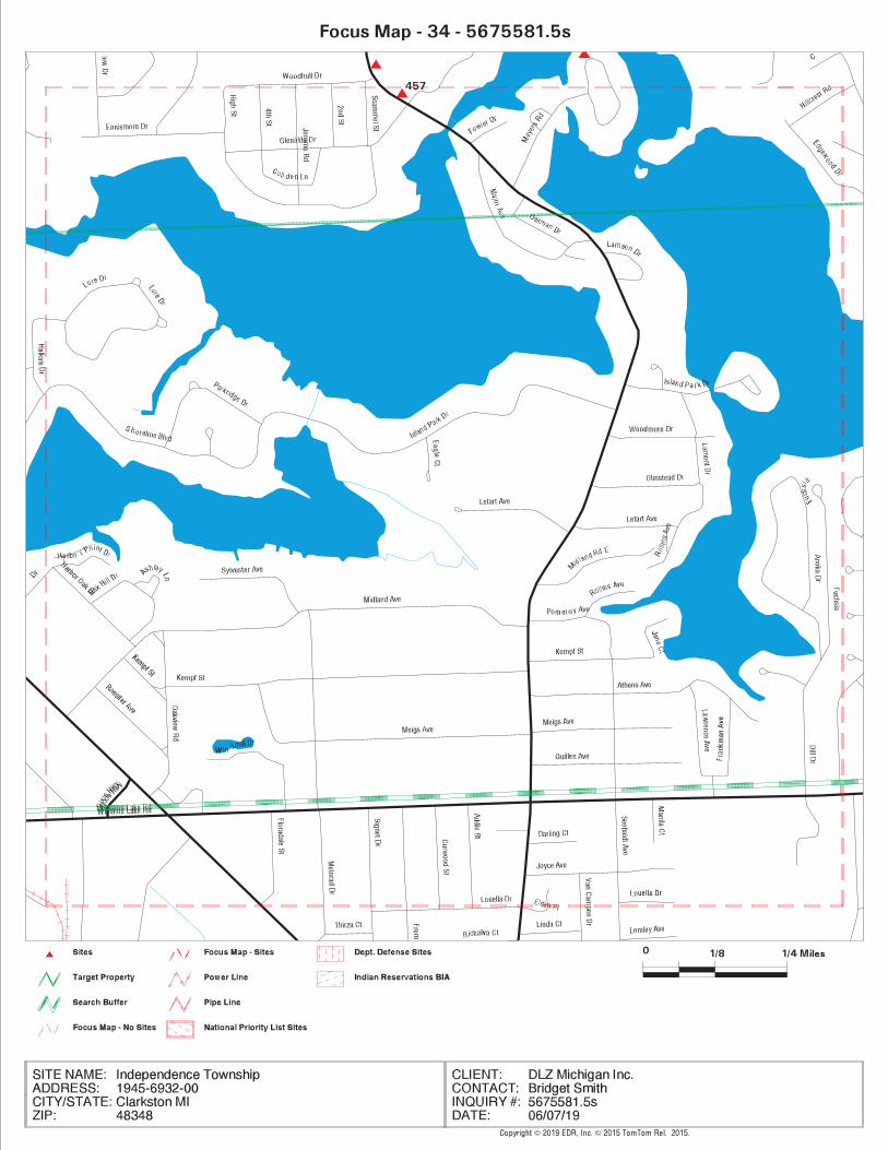

TC5675581.5s.34 Page 94
457 / 34 S & L AUTOBODY 4712 SASHABEW ROAD MI AIRS TP
MAPPED SITES SUMMARY - FOCUS MAP 34
Target Property:1945-6932-00CLARKSTON, MI 48348
FOCUS MAPDIST (ft. & mi.)MAP ID /
DATABASE ACRONYMS DIRECTIONSITE NAME ADDRESS


TC5675581.5s.35 Page 96
515 / 35 CFM PUBLICATIONS 4453 CLINTONVILLE RD RCRA-CESQG, FINDS, ECHO 248 0.047 South
513 / 35 BP PROCESSING 2803 MANN RD EDR Hist Auto 73 0.014 South
CN498 / 35 MOTOR CITY AUTO 4505 CLINTONVILLE RD RCRA NonGen / NLR, FINDS, ECHO TP
CN497 / 35 MOTOR CITY AUTO 4505 CLINTONVILLE RD MI WDS TP
CM496 / 35 DONALD PORTER LANDSC 2858 MANN RD MI UST TP
CM495 / 35 NATURES GREEN INC 2858 MANN RD MI WDS TP
479 / 35 J AND J MOBIL INC 3025 REEDER RD EDR Hist Auto TP
MAPPED SITES SUMMARY - FOCUS MAP 35
Target Property:1945-6932-00CLARKSTON, MI 48348
FOCUS MAPDIST (ft. & mi.)MAP ID /
DATABASE ACRONYMS DIRECTIONSITE NAME ADDRESS


TC5675581.5s.36 Page 98
NO MAPPED SITES FOUND
MAPPED SITES SUMMARY - FOCUS MAP 36
Target Property:1945-6932-00CLARKSTON, MI 48348
FOCUS MAPDIST (ft. & mi.)MAP ID /
DATABASE ACRONYMS DIRECTIONSITE NAME ADDRESS

APPENDIX C
EGLE PFAS CORRESPONDENCE

STATE OF MICHIGAN
DEPARTMENT OF vp_7 ~ VENVIRONMENT, GREAT LAKES, AND ENERGY
GRETCHEN WHITMER ANSING LIESL EICHLER CLARKGOVERNOR DIRECTOR
May 13, 2019
VIA E-MAIL
Independence Township WSSN: 033426483 Waldon Center DriveIndependence Township, Michigan 48346
Dear Water Supply Owner/Operator:
SUBJECT: Independence Township 2019 QuarterlyPer- and Polyfluoroalkyl Substances (PEAS) Results
Independence Township was included in a state-funded quarterly sampling effortbecause PEAS results in 2018 were greater than or equal to 10 parts per trillion (ppt)total PEAS or between 10 ppt and 70 ppt perfluorooctanesulfonic acid (PEOS) andperfluorooctanoic acid (PFOA). The results of 2019 PEAS samples collected fromIndependence Township, WSSN # 03342 (water supply) on the date(s) indicated arebelow. A copy of the laboratory report is enclosed for your review.
Date Sampling PFOS + PFOA LHA (ppt) Total TestedCollected Location (ppt) PFOS + PEAS (ppt)
PEOA4/1/2019 TPIOI 2 70 25
ND — The parameter was not detected based on the laboratory’s analytical report.See Official lab results for test method used.
Currently, there is no regulatory drinking water standard for any of the PEAS chemicals.However, in May 2016, the United States Environmental Protection Agency (USEPA)established a non-regulatory Lifetime Health Advisory (LHA) for two of these chemicals,PEOS and PFOA. The LHA for PEOS and PEOA is 70 ppt combined, or individually ifonly one of them is present.
Your water supply may have returned results greater than non-detect (ND) for the totalamount of PEAS analytes tested. Neither the Michigan Department of Environment,Great Lakes, and Energy (EGLE) (formerly the Michigan Department of EnvironmentalQuality) nor the USEPA currently have any guidance values for these other analytes. Ifadditional guidance and/or comparison values are developed for PFOS, PEOA, or otherPFAS chemicals in the future, we may reevaluate the recommendations below.
The concentrations of PEOS and PFOA in these samples are below the USEPA LHA of70 ppt. We provide the following recommendations:
CONSTITUTION HALL • 525 WEST ALLEGAN STREET • P.O. BOX 30473 LANSING, MICHIGAN 48909-7973Michigan.gov/EGLE • 800-662-9278

Independence TownshipPage 2May 13, 2019
1. Inform the public as soon as possible of these sample results through posting onyour website or other means. EGLE, in collaboration with the MichiganDepartment of Health and Human Services (MDHHS), has developed a toolkitcontaining communication templates to help notify the consumers of your watersupply on the presence of PFAS in the drinking water and the responsemeasures that are being initiated. This is a resource available to you if youchoose and can be modified to fit your needs. The toolkit is available atwww.michiqan.gov/pfasresponse; click on “news and education.”
2. Investigate potential sources of PEAS in your watershed and initiate steps toremove any identified source, if possible. EGLE’s Remediation andRedevelopment Division (RRD) District Supervisor is copied herein and isavailable to assist you with this effort.
3. Evaluate options to modify operations to reduce PEAS in the water supply shouldlevels approach the existing LHA. Eor example, this could be accomplished byminimizing use of wells with elevated PEAS levels or through the installation oftreatment technology capable of reducing PEAS prior to distribution.
4. Please continue with your regularly scheduled monitoring.
The results of the 2019 sampling will be posted online on the Michigan PEAS ActionResponse Team (MPART) website within 48 hours of this notification. The results willbe found online by going to the MPART website address listed below; click on “Testingand Treatment,” scroll down to “Drinking Water,” and select “Statewide TestingInitiative.”
Eor information on PEOS, PFOA, and other PEAS, including possible health outcomes,you may visit these websites:
• State of Michigan MPART website serving as the main resource for publicinformation on PEAS contamination in Michigan:www.michiqan.qov/pfasresponse
• USEPA website including basic information, USEPA actions, and links toinformational resources: http :I!www.epa .qov/pfas
• ATSDR website including health information, exposure, and links to additionalresources: www.atsd r.cdc.qov/pfas
To speak to a MDHHS toxicologist, call toll-free at 1-800-648-6942.
Thank you for your continued collaboration with this investigation. The ongoingpartnership between EGLE and Michigan’s public water supplies plays an integral rolein the state’s continued efforts to ascertain and address the incidence of PFAS indrinking water for Michiganders.

Independence TownshipPage 3May 13, 2019
If you have any questions concerning this sampling, please contact me at the telephonenumber below; by email at EGLE-PFAS-DrinkingWater(~michiqan.qov; or by mail atEGLE-Drinking Water and Environmental Health Division (DWEHD), P.O. Box 30817,Lansing, Michigan 48909-8311.
Sincerely,~~rnAa>m
Lois Elliott Graham, R.S., M.S.A.Drinking Water and Environmental HealthDivision810-730-8674
Enclosurecc: Mr. Anthony Drautz, Oakland County Health Division
Mr. Steven Crider, Supervisor, Drinking Water Unit, MDHHSMr. Paul Owens, Warren District Office, RRD, EGLEMs. Kristina Donaldson, Warren District Office, DWEHD, EGLE

STATE OF MICHIGAN
DEPARTMENT OFENVIRONMENT, GREAT LAKES, AND ENERGY
GRETCHEN WHITMER ANSING LIESL EICHLER CLARKGOVERNOR DIRECTOR
August 1,2019
VIA E-MAIL
INDEPENDENCE TOWNSHIP WSSN: 033426483 WALDON CENTER DRIVEINDEPENDENCE TOWNSHIP, MICHIGAN 48346
Dear Water Supply Owner/Operator:
SUBJECT: INDEPENDENCE TOWNSHIP 2019 QuarterlyPer- and Polyfluoroalkyl Substances (PFAS) Results
INDEPENDENCE TOWNSHIP was included in a state-funded quarterly sampling effortbecause PFAS results in 2018 were greater than or equal to 10 parts per trillion (ppt)total PFAS or between 10 ppt and 70 ppt perfluorooctanesulfonic acid (PFOS) andperfluorooctanoic acid (PFOA). The results of 2019 PEAS samples collected fromINDEPENDENCE TOWNSHIP, WSSN # 03342 (water supply) on the date(s) indicatedare below. A copy of the laboratory report is enclosed for your review.
6/19/2019 J TPIOI IND — The parameter was not detected based on the laboratory’s analytical report.See Official lab results for test method used.
Currently, there is no regulatory drinking water standard for any of the PFAS chemicals.However, in May 2016, the United States Environmental Protection Agency (USEPA)established a non-regulatory Lifetime Health Advisory (LHA) for two of these chemicals,PFOS and PFOA. The LHA for PEOS and PEOA is 70 ppt combined, or individually ifonly one of them is present.
Your water supply may have returned results greater than non-detect (ND) for the totalamount of PFAS analytes tested. Neither the Michigan Department of Environment,Great Lakes, and Energy (EGLE) (formerly the Michigan Department of EnvironmentalQuality) nor the USEPA currently have any guidance values for these other analytes. Ifadditional guidance and/or comparison values are developed for PFOS, PFOA, or otherPEAS chemicals in the future, we may reevaluate the recommendations below.
The concentrations of PFOS and PFOA in these samples are below the USEPA LHA of70 ppt. We provide the following recommendations:
Date Sampling Location PFOS + PFOA LHA (ppt) Total Tested~ Collected (ppt) PEOS + PEAS (ppt)~ PFOAL_________ 6 70 46
CONSTITUTION HALL • 525 WEST ALLEGAN STREET • P.O. BOX 30473 LANSING, MICHIGAN 48909-7973Michigan.gov/EGLE 800-662-9278

INDEPENDENCE TOWNSHIPPage 2August 1,2019
1. Inform the public as soon as possible of these sample results through posting onyour website or other means. EGLE, in collaboration with the MichiganDepartment of Health and Human Services (MDHHS), has developed a toolkitcontaining communication templates to help notify the consumers of your watersupply on the presence of PEAS in the drinking water and the responsemeasures that are being initiated. This is a resource available to you if youchoose and can be modified to fit your needs. The toolkit is available atwww.michiqan.qov/pfasresponse; click on “news and education.”
2. Investigate potential sources of PEAS in your watershed and initiate steps toremove any identified source, if possible. EGLE’s Remediation andRedevelopment Division (RRD) District Supervisor is copied herein and isavailable to assist you with this effort.
3. Evaluate options to modify operations to reduce PEAS in the water supply shouldlevels approach the existing LHA. Eor example, this could be accomplished byminimizing use of wells with elevated PEAS levels or through the installation oftreatment technology capable of reducing PEAS prior to distribution.
4. Please continue with your regularly scheduled monitoring.
The results of the 2019 sampling will be posted online on the Michigan PEAS ActionResponse Team (MPART) website within 48 hours of this notification. The results willbe found online by going to the MPART website address listed below; click on “Testingand Treatment,” scroll down to “Drinking Water,” and select “Statewide TestingInitiative.”
Eor information on PEOS, PEQA, and other PEAS, including possible health outcomes,you may visit these websites:
• State of Michigan MPART website serving as the main resource for publicinformation on PEAS contamination in Michigan:www.michiqan .qov!pfasresponse
• USEPA website including basic information, USEPA actions, and links toinformational resources: http ://www.epa.qov/pfas
• ATSDR website including health information, exposure, and links to additionalresources: www.atsd r.cdc.gov/pfas
To speak to a MDHHS toxicologist, call toll-free at 1-800-648-6942.

INDEPENDENCE TOWNSHIPPage 3August 1,2019
Thank you for your continued collaboration with this investigation. The ongoingpartnership between EGLE and Michigan’s public water supplies plays an integral rolein the state’s continued efforts to ascertain and address the incidence of PEAS indrinking water for Michiganders.
If you have any questions concerning this sampling, please contact me at the telephonenumber below; by email at EGLE-PFAS-DrinkinqWater~michigan.qov; or by mail atEGLE-Drinking Water and Environmental Health Division (DWEHD), P.O. Box 30817,Lansing, Michigan 48909-8311.
Sincerely,
£~ ~~ii~
Lois Elliott Graham, R.S., M.S.A.Drinking Water and Environmental HealthDivision810-730-8674
Enclosurecc: Mr. Anthony Drautz, Oakland County Health Division
Mr. Steven Crider, Supervisor, Drinking Water Unit, MDHHSMr. Paul Owens, Supervisor, Warren District Office, Remediation andRedevelopment Division, EGLEMs. Kristina Donaldson, Supervisor, Warren District Office, DWEHD, EGLE

Independence Township FY2023 DWSRF Parview and Waldon Water Main Extensions
Page 51 of 61
APPENDIX IV SEMCOG COMMUNITY PROFILE
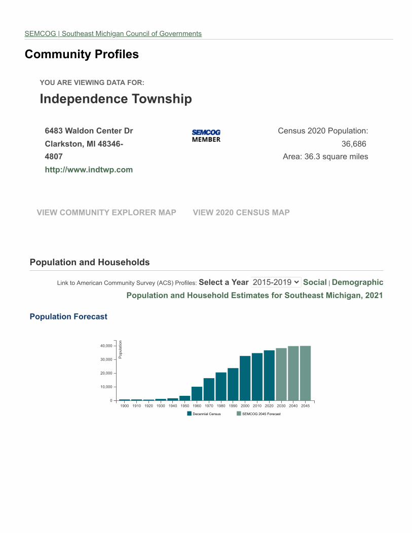
���������������� ������
������������� �������
����������� ��!�"��"#
��"$�!��%�&�������'
��()#
�!!��**���+���!��+��,
-./010#2323#4561789:5/;
<=>=?=#
@A.8;#<=B<#0C18A.#D:7.0
���� �&&�� ���EFG�����&�F #����H(H(� �I�I�&�F
F��J��!��������K�J�������
L:/M#95#@D.A:N8/#-5DD1/:9O#P1AQ.O#R@-PS#4A5T:7.0;#I����!������"#23UVW23UX #I�����#Y#��,�Z"�����
F��J��!��������K�J���������!�,�!���[�"�I�J!����!�&����Z��%�H(H\
F��J��!������"����!
�,,J��!]�F"�[����
UX33 UXU3 UX23 UX<3 UX̂3 UXV3 UX=3 UX_3 UX?3 UXX3 2333 23U3 2323 23<3 23̂3 23̂V
3
U3>333
23>333
<3>333
3̂>333
4561789:5/
.̀N.//:87#-./010 Pab-cd#23̂V#e5A.N809
Pab-cd#Y#P519f.809#b:Nf:g8/#-51/N:7#5T#d5Q.A/D./90

����������������� ������� ��������
��������������
������������������
����
� ��� ������� ���� ��������!� ���" #$ % &'
����� ##( #)) #$*
!� ��� (*+ (*# #,,
����-��� ������-������������
-��������.��"#+* ()* +)
���� ������� ������ ��� �
����� ���/�����-��� ����"0)0 ((+ '$
���� ����� �1�2�������1�
���� ����� �1�2�������1������������
�����������
�� �������������
����� �������������
34-�.5�6�������
34-�.5���7�
8�� ������ ���� 0'9'%' 0$9'%( #9)), ,:%; 0+9#%, 0*9*##
5�����<� ���������� ���� 0(* #)+ ((# ,$:(; 0(* $*$
2�������1����� ���� 0'90'+ 0$9$+$ (9%*0 ,:,; 0'9*'' 0*9$#%
2�������=���� ($9'#% (09+)* *(* ':+; ($9+*( &
2�������1���.������1�=����" (09*'% (#9%#, (9($0 %:*; ($9#,, ('9(++
>���1���� ��? � ��@�> �� $:,; ':$; &(:*; & 0:'; &
���� ���2�������1�3�A� #:') #:'* &):)% & #:,* #:$$
BCDEFGHI=�3��������� ��� �IJKLI34-�.5���7��>����� ��!�����������M���� ��
����������������� ������� ���
BCDEFGHI-����� ��!�� �����������������@
2� ����?�� ��3� �������9I=�3��������� ��� �9IJKL
BNOPQR

���
����
����
����
��������������
�������������� ����������� �������� ���������������� �������������������� ���������
!������!�"��#�$ %&'() *&+++ ,-. %)/*0 .&*'-
!���������!�"� 1-&-'. 1-&--. 2'- 2-/'0 )&,-'
3!4�������5�#�$ ,-* ).( 1.1 %-0 1&)-*
3!4�������5�6#� 1&.'. 1&+1- 21.. 2)/)0 %&-.-
�$���"����5� !�����!��"�� (&')- (&+)- 2%-- 2(/%0 +&-1*
�$���"����5� !��������!��"�� +&++. .&()' )(1 1./)0 '&%-1
������ ��������� 1%&,%+ 1*&+.1 '*. +/'0 1.&1''
789:;<=>?@�@��������A�"���&>B�����!���������&>�����������C�"!������CC��!�����"4�����D��"����!C����&>EFG>����
�����H��!�����B�4����C����I�"�����
�$� !��������!��
3!4�������5�#�$�JK
!�����!��"���L�K
3!4��������6#����K
�$� !��������!��
3!4�������5�#�$���K
!�����!��"���L�K
3!4��������6#���LK

��������
����� �
������������ �
����� �
������� ���� �
����
������ ���� ����� ���
��� ����� � ! ����� ����
�� " ����� �� ����� � ��
�� � �� �� ��� ����� ���
����" �� �� ��� ����� !��
����� �� �! �� � ����� ���
#��#" ��� ! ���� �� �� �
#��#� ����! ���� ���!� ���
"��"" ����� ���� ����� ���!
"��"� ����� ��� ��!!� ���!
����" ��� �� ����� ����
����� ����� �� ����� ���
$��$" ����� ��� ���!� ���
$��$� ����� �� ����� ���
%��%" ��� ��� ����� ���
%��%� !�� ��� ����� ���
&��&" ��� ��� �!! �
&�' ��� �� ��� ���
(�)�* ��� �� ������ �!�� ��� �
+��,�
�����- �-� ��- �
.���*�),�/�����/01/���2/�� ���� �
3456789:�;�;/���/<������:=�>�,�*/����:?@A:�� ���� �/�B��,>�/��BB�,)1/���C�1/��D���/E),B�)�
����������������
F@A86:�
���
�����
�����
�����
�����
�����
�����
�����
�����
�����
�����
�� �
�� �
!��!�
!��!�
�����
��G
HI3:���� I8@J5J:����

������������� ��������������������
�������� ���� ���� ���� ���� ���� ���� ���� ��������������� �����������������
������ ��� ! "�#"$ "��%% "�"�% "� #& "�" ' "��! '"� "'(!)
���* !�%�" !�"'# !���� !���' !�"!" !� !& !�"!& + # +'(!)
�,��� "�$"� �#&' "�$!" "�%%$ "�%#! "�!� "�!! +�%$ +%(!)
����� � �!�& � �&"! �'��'" �'� $& �'�$#' �'�%'� �%�#!# �� $� �#(�)
���-� %�"'% %�$ # %�%�" %�"&� %�#&# %� !& %�''$ "# (&)
-��,� '�'"% %��� %�&$' !��!# ��##' ��"%$ !��'� "� �! %"( )
,�. %&! !"� �#% &!% ���&& �� &$ ��%�$ &$" �!'($)
/��� %�#�' !�&�$ ��'�� $�"&$ &���' &��$" &�&"" '�$'$ � ($)
0123456789:�;�����<������ =�>� ��?�����������
#%�###�#�###�%�###
@AB537%
%+��
�$+"'
"%+%'
%%+!'
!%+$'
$%C
0DEFGH7"#'% 0DEFGH7"#�%

���������������� ����� ����� �
���������������� ����� ����� � ����������������� ��������������� ������������������� �����������
����� !�� "#$%$ %#&'" (#%)" '&*+, ((#(-&
����� !�� .#+%+ )#-)' (#-%. .%, &#.(+
��� �/� .#".- -#+". (#.'+ ."*", "#%-(
/������!�� .-) -&+ (-- -(*%, (#)%&
0������/ +#(-+ &#"-+ 1)$$ 1)*), &#-.'
��� ��2 %#.$) "#))$ 1%)) 1($*., "#'"+
0������ (#&-- '#$++ ')) (.*&, '#(".
34567894:;<=5>4?8@A8=B68CD=?B6E84F6G85>H68@6C=;E684I85D68=B>?B84I8:64:<68>?5484<J6G8=B68BG4;:E#85D68H4F6H6?584I8:64:<6#8=?J
5D684CC;GG6?C684I8@>G5DE8=?J8J6=5DE*
K4;GC6780L�L������M����#8N������������#8�����������O������� OO����P����!�P����������O��#8=?J8������
�����Q��� ���N�!�� �O����R ����
Q������S������������
Q������S�����������
��������
�������� T�� ����� �����
��������
�������� T�� ����� �����
����������� ������������������
U ��S����� ..#(.$ +)*), .-#&)& +), 1$*),
V���� .(#.(( +$*., .(#%-& &"*), 1.*%,
M��W ".$ (*&, %). '*(, $*',
��� )$" (*), "-" (*&, $*.,
������Q��� )+$ (*%, (#)(. -*(, '*-,
����� +. $*., (+& $*), $*.,
S����� (#))( -*), (#&'& ), $*),
X �� .-#"&( ($$, ."#"&" ($$, $,
K4;GC6780L�L������M�����N������������

�������������� ���������
�������
�������
�����������������������������
�������� ������������
�����!"#$ !"%$ &'"($
����������� ������� )*"($ (+"#$ &+"*$
��,�������-���
������)*"#$ ))"%$ &(")$
���������������� ."+$ .".$ '"*$
/������0�������� )*"!$ )#$ 1"!$
��������2������������
������(1"($ (+".$ )"%$
3456789:;<6=4:>?4)!4:=@46A?B
��������������� ��������
C68BD?E4FG�G��������/�����H4���I���������
���J�������,���������,,����K�����K�J�L���
���,����
����,K�M�N�O�
P<=Q4;64RS?B<D:=4T6SS8=<;U4C8BA?U4VRTCW45B6X<9?YE4��������L���4)'(!&)'(. 4 ����,��
Z����������N�O�
C68BD?E4� [�\ ���]J�̂�����������_,����Z�������
<̀@4a6;4bB:@8:;?4c<>d4CDd669
c<>d4CDd6694bB:@8:;?
C6S?4T699?>?H4a64̀
?>B??
RYY6D<:;?4̀?>B??
e:Dd?96BfY4̀?>B??
bB:@8:;?4g45B6X?YY<6=:94̀
?>B??
'
!
('
(!
)'
)!
*'
*!
!"#$
)*"($ )*"#$
."+$
)*"!$
(1"($
!"%$
(+"#$
))"%$
.".$
)#$
(+".$
RTC4)'(' RTC4)'(.
)'(! )')' )')! )'*' )'*! )'1' )'1!
'
!H'''
('H'''
(!H'''
)'H'''

�������������� ��������
���� �����
������ !"�#$%&�"'&�(� )*�+,-
.#&$)/$0�'$1�'& *�,�+
��($"�$20�� $3� 4& ��5)6
7�&892�:&' )�-)5
;0:("8&$<�9120("�� -*�-5)
=>�?�@��A�BC@�C��D A�@�>����?�>
=>�?�@��A�BC@�E��D A�@�>����?�> ���F ���� ���F ��G� ��GF ��H� ��HF�I� J�
���FK��HF�?���I� J����FK��HF
L���>���M�@�>?�@N�O� � JN�P�� @�>�?�� +�5 )�5-5 �*� �,) �** ��- )�55- ))- )-Q,R
O� �S�?��>� J /,- /�� 6+5 666 6)� 65) �+5 �)+- ��-Q6R
TI��@����U>�A� �,+ �*+ �*+ �*6 �*6 �*� �*- 6 )Q)R
M������U>�A� )�66� )�6�- )�6-� )��-+ )�-�5 )�-6, )�-�+ �-5/ �)6Q-R
U>� @>���� N�T�>�I�@� JN�P�V�������@ �*5 �*/ �*- �*5 �*� �++ ��/ -/ ,Q+R
D S>���� �P�=� � ?�����?��W����@ -�*-5 -�*�, -�*6, -�,++ -�*5+ -�*-+ -�*�- )- 5Q6R
�>S�@@� ���� A�U�?I �?�����>W�?�@�P
�>>����XY)�)6/ )�),* )�-5) )�-6� )��-� )��6* )�66� -�+ -,R
�A�� �@�>���W�N���>�N�P�T�@�����>W�?�@ )�,)/ )�,// )�,*/ )�,+6 )�*-) )�*/, )�*+5 ),/ )5Q-R
ZA�?��� ���>W�?�@ )�-// )��-6 )��-) )��), )���/ )��/5 )��,- )5* +Q/R
X����I?�>����>W�?�@ -�,-� -�+,- ��5), ��)-) ���6� ��/*5 ��*+� )�),5 66Q-R
[��@�>��P�X@������� -��*� ��5-- -��++ -��*, -���5 -��*+ -��** 6 5Q)R
\�I�>���>W�?�@ +)* +�) +)� *�* *�+ *�6 *+� ��6 �6Q-R
��C��?��A�� �@�>��� -6� -6+ -6* -6, -6, -6, -6, � )Q-R
U����Z����� ��L��C�>@ )*�5-6)*�*5�)*�,��)*�/6+)*��5�)+�),�)+�6�� )�6,� +Q,R
]�1 4&̂$�ZO�\_���HF�M�J� �����W���� ��=>�?�@�
��������������
]�1 4&̂$����K��������>�?� ����� ������>W��
FK̀��>�Z@������@$0�'$����K������� @�@
U>� @>���� ���� � J��>A�?�@��>J>��
a�U��bQ$c� $0''"("��02$"�3� 80("���$d"�"($]efghij�
D ��>�?��W�������� J������> @�O�
��(&̂$kl&$�18�& $�3$ &�"'&�(�$0((&�'"�#$�4l��2$�1(�"'&$]�1(l&0�($f"4l"#0�$"�$��($0d0"20�2&Q$m"!&n"�&�$(l&$�18�& $�3$�(1'&�(�
4�881("�#$"�(�$]�1(l&0�($f"4l"#0�$(�$0((&�'$�4l��2$"�$02��$��($!��n�Q
���� ������ !"�#$%&�"'&�(�
5
-5
65
,5
�6R
,,R

����������������������� ���
���� ������������������������ ������� �������
� ���������������� ����� �� !"
# �����$������� ���!% �# �"
� &���$�������'(��)�������� !#* ! +"
, -��(�'$(�.����� ��* /"
� 0���������� ,,, , +"
/ &�(������ �,� � !"
! ����(�� �%* � �"
+ ��(���1������� �*� # �"
* &2$������� �!, � *"
�% 3��4�.������� �!� � *"
5 6.������� #�%*# ## ,"
789:;<=;>�8?@=8�/8?AB8:C=;8=DEF:G=B8HA8IAB=E=AB=AJ=8KLE M)NNM ���O
P:Q;J=R8ST-T�������0���858#%�#5#%�/8UKVVWXUP8U:DDQYHA@8Z?Y?8?AB8���(�'����������(��-��������[(��('��
���������(����������� ���
���� ���������(������������ ������� �������
� ���������������� ����� �! !"
# \]���̂(..� #��%% �, �"
� �����$������� ���,� + !"
, ���_ ����� / �"
� ����(�� ��%�� � +"
/ &���$�������'(��)�������� /*/ � *"
! ������ /�* � !"
+ ����������̂(..� ��# # *"
* -���$(�.� ,!/ # !"
�% &�(������ ,/+ # /"
5 6.������� ��/�, �� !"
789:;<=;>�8?@=8�/8?AB8:C=;8;=>HBHA@8HA8IAB=E=AB=AJ=8KLE �̀)̀a� ���O
P:Q;J=R8ST-T�������0���858#%�#5#%�/8UKVVWXUP8U:DDQYHA@8Z?Y?8?AB8���(�'����������(��-��������[(��('��

����������������� �� ��������
��������������� �����
�������������������� �����
�������������������� ����
�������������������� ��! �
�"���������������� ���#�
�$����������"����� ��%�#
������������������ & �
������������������ !%
������������������ !��
�'����������'����� �#%
�'����������'����� �#�
������������������ #��
������������������ %�
������������������ �&
������������������ �!�
(�������������� %!�
)���� �'��$�
*+,-./0123�3�������4�����1����5����
���6 ���������6�7����87��59��
:��6����
���������� ��
�� ���;6��������������< �������� �������� ���=�����5���� >� ������=�����5����
?�6������������� �� @&%�!A� @�!� �& @� ���� �#BAC
>����D6����� �� @! ��� @!!��%! @!� #! �B�C
*+,-./0123�3�������4�����1���$5�������������5��������6 ���������6�7����87��59���:��6����
����������������� ��
>�8��7
>�8��7 �������� E��F�)�����;����< �������� E��F�)�����;����< E�>�6����=�����5����
>������6��>�8��7 #�� # AB#C #� A& �B�C G B�C
���������6��>�8��7 &#� AB!C A%! !B�C G�B&C
*+,-./0123�3�������4�����1���$5�������������5��������6 ���������6�7����87��59���:��6����
� �� ���
@# � 1+-1H+-/
@�� � 1I+1@�������
@�#�� 1I+1@�!�����
@� � 1I+1@�#!����
@��� 1I+1@������
@A � 1I+1@�!����
@� � 1I+1@������
@!�� 1I+1@!�����
@! � 1I+1@!!����
@%�� 1I+1@%�����
@% � 1I+1@%!����
@#�� 1I+1@#�����
@# � 1I+1@#!����
@��� 1I+1@������
@� � 1I+1@�!����
J/KK1ILMN1@� �

�������
���� ���������� ���������������������� ������� !"!#$%&%'!&(�)*+,-)*+. ��������
/��"0���%1!(2�$�%3444%5%3436
'!&( ���"!%7&2�"8 9:�%7&2�"8 ;$$&#<%=��0� >�"$�%7&2�"8 9�$&"%?��$� 9�$&"%@!2�� A!$%9�$&"
3444 )B* * * * )B* C ))B
3446 +.) * C * +.. B +.D
3443 +.E * +F * )+) , )*C
344G +D+ * EB * )*E * )*E
344H +B, ) ++) * )E. F )E+
344I ++B * C* * +FB . +CE
344J ,B * F * D+ C ,E
344K )B * B * )D C +.
344L ++ * B * +E + +B
344M , * * * , C -)
3464 )+ * E * ), D +.
3466 ,E * * * ,E B ,+
3463 +*, * ) * +*C ) +*,
346G +,+ * )+ * +C) + +C+
346H .) * )C * ++. , ++E
346I F+ * )B * +*E C .C
346J CE * * * CE . D,
346K DE * , * D. C D)
346L DB * +E .) +D. B +DD
346M C. * E * FB E C.
3434 C, * ) CC +,E , +E.
3436 )F * * ,B F+ , CD
3444%$�%3436%$�$&"� )N**E ) BDD ))) )N,.E +++ )NEFB
� ������ O>=PQ%@!R!"�S2!�$�
T �����������U����� ��� �������������������V���� �W������U�����WU���U�� �X��Y

����������� ������� � ����� ��������� � �� ��
����������� ������ ������ �!
"�#�������� ����� ��$�! ��!
%����# !!$ &'$ ('�
������)*+����# ��� ��� ���
�#��,����#����#� &&' � ' (���
��#�)���������-��#� ���&�' �$���� $
����� ��
���������.��
���������.� ����� � ����� �� ������� � �� �� /��-��#��0+�##�������� �1
����)�-��# ���� � ���'�$ & � ��&
2�)#��-��# ��� � ��&$� �!� �$�
2�3�)���+�����#� & � ! (&� �
��#�) ���$!� �$���� !&� $''
456789:;<=>68?;@ (�&
A;79BC=7D>9E;F<677;@9456789(9456789:;<=>68?;@G $!�
H=IFJ;K9-L�L�������M����9� N�� � ������ �O�� ����+�������++���#.���,.�O�P��Q�#�+�#��9�Q2��R
S,)��+�#
�����������
H=IFJ;K9-L�L�������M����9� N�� � ������ �O�� ����+�������++���#.���,.�O�P��Q�#�+�#�
��������%�)������"�#
��������%�)��T���� �����))��U ����� � ����� �� ������� � �� �� 0��#�������� � �� ��
2�������������,�)� V�&&�$$� V� '� �� V(&�!$� (�W!X
2�����������# V��� � V����� V$� $W�X
H=IFJ;K9-L�L�������M����9������� �9� N�� � ������ �O�� ����+�������++���#.���,.�O�P��Q�#�+�#�
������������Y1Z
"�#����������YZ
%����#�NZ

����������� � ������
������������������ ���
������������� � ���!"
�"�����������! � "�!��
�������������� � ����"
��������������! � ��#�#
��#����������� � $"�
��������������#!� $�"
��������������! � !�$
���������������!� ��#
�$���������� � ���
������������# � ��#
�!����������� � ��#
�"����������" � #�
������������� � ##
������������� � �
%�&&��'()�������� ��!
*+��,-*..�/��0�1��2� ����""
�����������
3�4�5�6�17�7� ������8�,�������9-������:�,�.�� �::���2;���,<�;�9-=�,�>�2�:2��
?���0��.��*���=�,�����@
A�B'C&��(DE����F��&�)�&�F��&�)&��(G����()H��I����ECIC)G�C)�J)H�F�)H�)5��B�K)&'CF�L��������M��� N�B'���(DE��H��&�)�����F��&�)�
F��&�)�K'����I�H��4���L�J)H�F�)H�)5��B�K)&'CF�L��������M��� N
3�4�5�6�17�7� ������8�,�������9-������:�,�.�� �::���2;���,<�;�9-=�,�>�2�:2��
�����������"����
������������������
������������� �
�"�����������! �
�������������� �
��������������! �
��#����������� �
��������������#!�
��������������! �
���������������!�
�$���������� �
������������# �
�!����������� �
�"����������" �
������������� �
������������� �
%�&&��'()��������
3(���O�4&�PCLL���)��O�4&���3(���Q�4)�R
PCLL���)��Q�4)�R�C)�SC5'CG()
PCLL���)��3�(��TD��(H
�
��
!�
��
$�
$ U
#U"U �U �U

���������������������
���
�����������������������
������ ���
������������
������������������������������������������ !"#$$"
%&'()*+"���,�����-�����,���.����/�0
��������������������1���������
2&3*+"4&&("567*8*93:"6(*";*9*(6<<=">9"9**?"&@"(*A6B><>363>&9"&("@'<<"(*)&9:3(')3>&9"3&"(*3'(9"3&";&&?")&9?>3>&9C"D6>("567*8*93:"6(*">9
9**?"&@")65>36<"5(*7*93>7*"86>93*969)*"3&"67&>?"?*3*(>&(63>9;"3&"3A*"5&&(")<6::>@>)63>&9C"E&&?"567*8*93:";*9*(6<<="(*)*>7*"&9<=
(&'3>9*"86>93*969)*F":')A"6:":3(**3":G**5>9;"69?":9&G"(*8&76<F"'93><"3A*="?*3*(>&(63*"3&"3A*"@6>(")&9?>3>&9C"
%&'()*+"HI�J-
K������H�����
K������H����� ��� �����L ��� �����L ��� �����L �������������,�� ���� ���
J��� #M #NNO #M #NNO #P Q$CRO S#NCRO
J����/��,�T���������� N NO N NO M #NCRO #NCRO
����U N NO N NO N NO NO
�����K������ #M #NNCNO #M #NNCNO #$ #NNCNO NCNO
V���������K������ R W#CPO Q XXCPO X Y#CXO S#NC#O
U"Z(>?;*:"86="B*")<&:*?"B*)6':*"&@"9*G")&9:3(')3>&9"&("@6><*?")&9?>3>&9C"
2&3*+"["B(>?;*">:")&9:>?*(*?"?*@>)>*93">@">3">:":3(')3'(6<<="?*@>)>*93"\>9"5&&(":A65*"69?"'96B<*"3&")6((="3A*"<&6?"@&("GA>)A">3"G6:
?*:>;9*?]"&("@'9)3>&96<<="&B:&<*3*"\>9";&&?"5A=:>)6<")&9?>3>&9"B'3"'96B<*"3&":'55&(3")'((*93"&("@'3'(*"?*869?:F"@&("*̂685<*F"B*>9;
3&&"96((&G"3&"6))&88&?63*"3(')_"3(6@@>)]C"
%&'()*+"̀>)A>;69"%3(')3'(*"a97*93&(="69?"[55(6>:6<"b636B6:*"
V��������c�����������d�T���V���
����eL
.�����fL
-���L
���ggL
.����h�L
-����L

����������������� ������ ������
����������������������
������������������������ !"#"
$��%�����&�'�� !"#"(
�� !"#)
$��%�����&�'�� !"#)(
$�*������+,�!"#"-!"#)
.��/0��&��0 �12�34 5�657 ��21�8 55697 �637
������&0:����/�����&0: ;53 �617 5�� 3647 <�6�7
*=>&�?��������������� 95 @697 @ @7 <@697
��&�0: �@3 @647 91@ �697 @687
A��0: 31 @617 5 @7 <@617
B�+0��C0��� �88 �7 ��8 @6�7 <@637
����0:����+�D0 4�� 36;7 ;45 8617 @637
E0��:0���F���0����,0�#G���:
�/0��82494 �@@6@7 �528�9 �@@6@7 @6@7
HI�J�K�LM M��0��=��A=�0�=2�!""G-!"#"���:�!"#N-!"#)��D0��?�����DD=���O� =�/0O�N-P0���Q���D��0�
C0������/0&���D0��������
C0������/0&���D0�������� �� �!"#" �� �!"#) �+��,0�!"#"-!"#)
R����0��:0�����,0�#G���:��/0��F+��F���0:��=���:0��+0�+�D0 9;68�S��I��� 9�6��S��I��� <163�S��I���
HI�J�K�LM M��0��=��A=�0�=2�!""G-!"#"���:�!"#N-!"#)��D0��?�����DD=���O� =�/0O�N-P0���Q���D��0�
T���� U��
V �WU������ �WU��
XIYU�J��� ��W�� ���
Z U���
[����\�]���̂
� ��
Z����� ��]S�
@
9@
3@
�@
5@
557
87@7 �7 @7 �7
87
_� ��W�� ������Z��2�9@�;�

��������������
������������������������������ �����!�"����#���������������"�$%������&������������������'()� *��+,�
-�.���/�'01�)'.'�01�2(�30�4���.1���(.3����3.56
������ �7����8
������ �7����8 �� �9 �: �; �� !�������������������������
<���" = > ? > ? @6>A
����%��&�B%�8 C ?@ D E ?F @6DA
+�����&�B%�8 ?CG ?EC ?GG ?=> ?@= ?C6DA
!������8��������+�"8 HF= H@E GDF HCG CHC H>6DA
I���"�������� ?J@@@ DHF DH@ ?J@@G G@F ?@@A
��������K8�I8��
��������K8�I8�� �� �9 �: �; �� !�������������������������
L��M��� ?G ?> ?G ?H ?F ?6EA
N��"�����L��M���OP�����%�� ?E@ ?G@ ?EH ?GC ??E ?E6DA
Q����*�M FHD FG= FG> FHD >@H FG6?A
�M��#��� ?FD ?>C ?FF ?FE HH ?F6FA
���"��R����"� >C@ >=H >FD >== >F@ >C6DA
S��T��� E >@ ?C ?D >H ?6DA
+��������U�T��#� FD F= FE >E >@ F6FA
>@?E >@?G >@?H >@?D >@>@
@
>@@
=@@
E@@
H@@
?J@@@

������������� �����
������������� ����� ���� ���� ���� ���� ���� �����������������������������
���� ��������� ! ! " # $ %&'
(���)�*������ +# ,- ,+ +" -+ +'
. ���� -- $" $- $+ $- $%+'
)���� " " - - , /%"'
)��� + !# #+ !& #/ #% '
0��� / / / / / /'
��������� �0���123�� $- $" $# - $$ $%+'
4���� �3�� $ & + , /%&'
5��������6���� � & ! & " /%!'
7������� � / " # & + /%+'
��������� --! -/" --/ -& $/& -$%!'
8��1�9�� - & - - - /%+'
��������� & - - /%-'
3���� ��� $ - $ - /%$'
)����������)����� -- && "! "" -& "%,'
: ����)������;�<����� ���= "$ ,/ !! ,# $" ,%&'
>����)������;�������?= -#, "/" -&& -,, $"" -!%+'
4������� / / / / / /'

������������� ����������������������
��������� �������� ��������� ��������� �����������������
� �� ! "#$#%&'()&*&+,#-%&./0%&12 345
� 3 !6 7/8,/9/(&12&*&+/:2;<&12 3�5
= >! ?�> "#$#%&'()&*&@/)9%%&12 3A5�
B ??? 3A> @/)9%%&12&*&7/8,/9/(&12 ��5>
C �4 66? D:/E08-;<&12&*&7/8,/9/(&12 ?>5
� >�� ?F�6� "#$#%&'()&*&GE-;<H#::%&12 ??
I >!� ?F>!? J%:8%)&12&*&+,#-%&./0%&12 ?A
K 4>6 ?F !� 7/8,/9/(&12&*&L:%M#<N8&./0%&12 !5�
O 4 ? ?F644 J&P&64&*&7/8,/9/(&12 !
�� 4�? ?F��A "#$#%&'()&*&Q<N:%(;;2&"E �5�
J;-%R&P<-%E8%S-#;<8&/E%&E/<0%2&9)&-,%&<TM9%E&;U&E%V;E-%2&SE/8,%8F&(,#S,&2;%8&<;-&-/0%&#<-;&/SS;T<-&-E/UU#S&H;:TM%5&DE/8,%8
E%V;E-%2&;SSTEE%2&(#-,#<&?4A&U%%-&;U&-,%&#<-%E8%S-#;<5&
7;TES%R&W�������X�Y���Z����[�\�����]������̂�����������Z����_������ [��Z����������&/<2&\̀ W�ab
����������������c�\��Z���������������
�������������������������� \��Z�� ���Z����c���d�����c�����������������
� 3A �� "#$#%&'() @/)9%%&12&e&f<2%E8;<H#::%&12 445�
� 6> ?! +,#-%&./0%&12 J%:8%)&12&e&"#$#%&'() >�5>
= �A �?A 7/8,/9/(&12 7/8,/9/(gJ&P&64&1/MV&e&D:/E08-;<&12 >?5
B � �3? 7/8,/9/(&12 +/:-;<&h:H2&+&e&@/)9%%&12 >A5>
C ??> 3A� GE-;<H#::%&127&@&?4gJ&P&64&1/MV&e&1/--/:%%&./0%&12 3 5�
� ?�� 3? "#$#%&'() J&"#$#%g7&P&64&1/MV&e&+,#-%&./0%&12 3
I ? 6 >>6 "#$#%&'() GE-;<H#::%&12&e&@/)9%%&12 3?
K ?�6 >!� "#$#%&'() +,#-%&./0%&12&e&GE-;<H#::%&12 �!5�
O ?!6 4�? 7/8,/9/(&12 D:/E08-;<&12&e&G/0&'#::&12 �!
�� ��3 A� @/)9%%&12 "#$#%&'()&e&7/8,/9/(&12 �65
J;-%R&7%NM%<-8&/E%&E/<0%2&9)&-,%&<TM9%E&;U&E%V;E-%2&SE/8,%8F&(,#S,&2;%8&<;-&-/0%&#<-;&/SS;T<-&-E/UU#S&H;:TM%5

�����������
��� ��������������
��������������� ���������� ���������� ���������������� ��������������������
����������� �!���������� "#$%&'& "#%%&'( )**'" ('$+
���������������,�-���� $$$'" )*('& .$/'* .)(+
-��������� �,�-���� $0('$ $0('$ 1 1+
�2����,��� )%$'% )%$'% 1 1+
�����-��-���3!-����!���������� 0#"%/'* 0#&)&') "/'$ )'$+
�4������ $'* %'0 )'" 0%')+
!����� )/)'& )&)'$ .)1'" .0'/+
�55��� ))0'/ )$('0 &'& "'"+
,��6������ (0'* (0'/ .1') .1'(+
������ )() )1*'( .$)'& .)"'"+
7�����-������ "%*'/ "(1 .)*'& .(+
7��-������ */') )11'& $'" $'"+
!�����������3�6���6��� )#&0*'$ )#&"$'* ('& 1'$+
������� ))/ ))/ 1 1+
��5���-��� "0"'% "0"'% 1 1+
���8��� (&'/ (&'/ 1 1+
�4�������� )&') )&') 1 1+
9�� $/$') $/$') 1 1+
:����� (#)(1'$ (#)$"'0 .('/ .1')+
;���� )#1(" )#1(" 1 1+
<����������� $#%%)'$ $#$%$'" .)*/'" ./')+
9���� $(#$1&'* $(#$1&'* 1 1+
)'=�����-��-����3�!-����!��=>?@ABCDE=F?G=HDE>CD?I>FA=JFH@DA=@K?IF>?>?L=)=KH=MKHD=NKMDE=ONDHD=IND=JFH@DA=>E=(=F@HDE=KH=AFHLDH'
$'=�4������=>?@ABCDE=INKED=JFH@DAE=@K?IF>?>?L=PB>AC>?LE=O>IN=QKEJ>IFA>IG#=RDIF>A#=KH=STT>@D=EUBFHD=TKKIFLD=F?C=NKBE>?L=B?>IE'
('=<�����������=>?@ABCDE=FAA=FHDFE=O>IN>?=F=@KMMB?>IG=INFI=FHD=?KI=@KVDHDC=PG=F=JFH@DA=ADLFA=CDE@H>JI>K?'
%'=WFH@DAE=INFI=CK=?KI=NFVD=F=EIHB@IBHD=FEE>L?DC=IK=IND=JFH@DA=FHD=@K?E>CDHDC=VF@F?I=B?ADEE=KINDHO>ED=>?C>@FIDC#=DVD?=>T=IND
JFH@DA=>E=JFHI=KT=F=AFHLDH=CDVDAKJMD?I=EB@N=FE=F=TF@IKHG#=E@NKKA#=KH=KINDH=CDVDAKJDC=EDH>DE=KT=AKIE'
XKIDY=ZF?C=[KVDH=OFE=CDH>VDC=THKM=\]̂ [S_̀E=$1)1=ZDFT=KTT=aMFLDHG'=
\KBH@DY=���

���� ��������� ����� �����
��������� ���������������������� !�"���#��$������%� &�'(()* +&),-
����� !���"�� � %�%�����%� � +(�./+), /*)+-
0���
1�2������3��%�����4� �����������������%��4����� *�5,6)& &&)+-
72�� ���������� ��% �#�� �����#���% ��4� ��� +/5)+ ()5-
82�� ��� ������$ �����������#���� +�'&.)6 6)&-
9�%���:3� � '&�'+&)/
1����;�22
1<=>0?;@;��2�A�B;�22
CD# ������ 9� � E# ��F#�3 G�� H�% �
(
'(
/(
+/-
/*-
&&-
+-6-
FIJKEL�M����K�� �����'(+(

Independence Township FY2023 DWSRF Parview and Waldon Water Main Extensions
Page 52 of 61
APPENDIX V PRELIMINARY DISTRIBUTION SYSTEM MATERIALS INVENTORY (DSMI)


Independence Township FY2023 DWSRF Parview and Waldon Water Main Extensions
Page 53 of 61
APPENDIX VI 2020 WATER QUALITY / CUSTOMER CONFIDENCE REPORT

Where Does Our Water Come From 3
Source Water Assessment 3
Wellhead Protection 3
Protecting Our Water Resources 5
Cross Connection 6
Water Substances 7
Water Quality Data 9
PFAS 11
Private Wells 13
Stormwater Management 15
Get Involved 16
Fats, Oils, Grease & What Not To Flush 17
West Nile Virus & EEE 18
2020
Water Quality / Consumer Confidence
Report

Welcome As our customers, we are committed to providing you the highest quality of drinking water. This report covers the drinking water quality for The Charter Township of Independence for the 2020 calendar year, which include two monitoring violations. These monitoring violations were a result of The Oakland County Health Department’s failure to test the samples and subsequently failed to notify Independence Township that all samples were not analyzed. As new safety challenges emerge for drinking water, we remain vigilant in meeting the challenges of source water protection, water conservation and community education while continuing to serve the needs of all our water customers.
Please share with us your thoughts about this report. For more information or for any questions relating to your drinking water, please call David McKee, Department of Public Works (DPW) Director.
DEPARTMENT OF PUBLIC WORKS
6050 Flemings Lake Road, Clarkston, MI 48346
248-625-8222 • fax 248-625-4393
Email [email protected]
1
Office hours
Monday-Friday (8:00 AM - 5:00 PM)
After hours emergency phone: 248-866-4844

2
Water Distribution & Treatment CLEAN WATER STARTS WITH US!
We are pleased to report that our drinking water
meets and exceeds all federal and state
requirements!

3
Where Does Our Water Come From? The water from your tap is pumped directly from one of sixteen wells in ten wellfields. The attached
map shows how the water system is divided into three service areas: Main Loop, Deerwood and
Hillview Estates. The area south of I-75 is designated as Independence Township’s Main Loop Service
Area. The majority of customers served by the Township’s water system are connected to the Main
Loop. This area is served primarily by nine wells located within six wellfields, Clarkston Gardens,
Chestnut Hills, Lake Oakland Woods, Bay Court, Waldon Creek and Pelton Heights. Deerwood Service Area is served by four wells within three wellfields;
(Deerwood II and II (Manors) and Deer Valley I and II). All three well sites have Iron/Arsenic removal with disinfection. Hillview Estates Service Area, located
in the northeast corner of the Township, is served by three wells in the Hillview Estates wellfield. Disinfection has been added to this well site.
Wellhead Protection The purpose of the Wellhead Protection Program is to identify the Wellhead
Protection Areas (WHPA), which are the surface and subsurface areas that
contribute groundwater to the municipal supply wells typically over the next
ten years. This program assists local communities utilizing groundwater for
their municipal drinking water supply systems in protecting their water
source.
Currently we have eleven approved municipal wellfields within
Independence Township. Check the map on the next page to see if you live in
a WHPA. If you live in or around a WHPA or any other wellfield, the use of
certain household hazardous chemicals (paint, solvents, gasoline, etc.)
should be closely monitored to eliminate groundwater contamination. You
can help protect our water supply by using chemicals carefully. For more
information about this program call the DPW 248-625-8222 or visit
www.michigan.gov/egle.
Source Water Assessment A Source Water Assessment Plan was performed in 2003. This plan is an
assessment of the delineated area around our listed sources through which
contaminants, if present, could migrate and reach our source water. It also
includes an inventory of potential contaminants and susceptibility to
contaminants within the delineated area. The susceptibility of our sources
range from low to moderate. A copy of the full report can be viewed at the
Department of Public Works Office.
Did You Know The Township has
• 10 water treatment plants
• 137 miles of water main
• 2 million gallons of water storage
Remember! Prevention of groundwater contamination is far less expensive than groundwater clean-up!
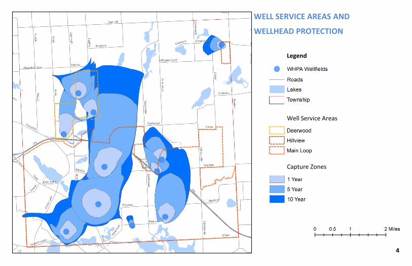
4
WELL SERVICE AREAS AND
WELLHEAD PROTECTION
Legend
Well Service Areas
Capture Zones

5
Protecting Our Water Resources
Over the last decade we have become more aware of our world, the environment and our impact on it.
Even small changes in our everyday activities will help ensure that we are doing our part to conserve
our beautiful Township and the resources we all enjoy.
Independence Township’s DPW has received several highly regarded awards from the Water Environment Federation (WEF) for our environmental educational video series that launched in 2017, titled, “Water is Worth It”: An Independence Township Perspective which focuses on stormwater and drinking water issues, can be viewed on the Township's website at www.indtwp.com. Other awards from the series also included: • “Water is Worth It”: An Introduction • “Water is Worth It”: An Enviroscape
Demonstration In 2018 Independence Township was selected to receive from Michigan Water Environment Association (MWEA) the Educational Professional of the Year Award for our efforts in promoting activities and professionalism in water resource education. Independence Township’s Water Operator Certifications held from Michigan’s Environment, Great Lakes & Energy (EGLE) include the following: • 8 Distribution Licenses ranging from S-1 to
S-4 • 4 Limited Treatment Licenses ranging from
D-1 though D-3
Awards & Recognitions
Did You Know The Oakland County Sheriff Department has a Med Return drug collection unit for discarding of prescriptions. (Due to Covid-19 restrictions, this service has been temporarily discontinued).
MEDICATIONS
Properly disposing of unused medications has become more challenging in a country where there are so
many prescription medications. The traditional advice was to flush leftover medicines down the toilet,
especially drugs that could be abused, but that means they end up in our drinking water. When we flush
medicines down the toilet we introduce drugs into the water supply in their full concentration.
LAWN CARE
Your property is part of a watershed, an area of land from which the surface water and groundwater
flows from higher elevations downhill to a common body of water. No matter how far you live from a
body of water, your property is part of a watershed. Therefore, how you care for your yard can affect
both water quality and water supply. It's hard to imagine that a green, flourishing lawn could pose a
threat to the environment. However, the fertilizers and pesticides you apply to your lawn are potential
pollutants. If you improperly or excessively apply these chemicals, they can wash off your property and
end up in ponds, bays, reservoirs and other waters.

As stated in The Charter Township of Independence Code of Ordinance: Chapter 48, Article II, Section 48-27(d) this request follows state and local laws, failure to submit completed tests to us could result in the discontinuance of water service to your location. Every three years all residential irrigation or other backflow devices on your property must be tested for proper operation.
Community water supplies are continuously jeopardized by cross-connections unless appropriate valves, known as backflow prevention devices are installed and maintained. For more information, please call the Safe Drinking Water Hotline 800-426-4791 or visit: www.michigan.gov/documents/deq/CrossConnectionManual_251521_7.pdf.
6
A cross connection is an arrangement of piping that could allow unacceptable water, sewage, or chemical solutions to enter your safe drinking (potable) water system as a result of backflow. Cross connections with potable piping systems have resulted in numerous cases of sicknesses and even death. Over the years, cross connections have been one of the most prevalent public health threats to a drinking water supply system and many times are present in residential water systems.
Contamination can also occur when the pressure in the drinking water line drops (main breaks, heavy water demand) causing contaminants to be drawn out from equipment and into the drinking water line, this is referred to as (backsiphonage).
Outside water spigots and garden hoses are the most common sources of cross-connection contamination at home. The garden hose creates a hazard when submerged in a swimming pool or when attached to a chemical sprayer for killing weeds. Garden hoses that are left lying on the ground may be contaminated by fertilizers, cesspools or gardening chemicals. Improperly installed valves in your toilet could also be a source of cross-connection contamination.
The State of Michigan’s Cross Connection Program started at the same time as Michigan’s Safe Water Drinking Act began in April of 1972. Soon Independence Township’s commercial Cross Connection Control program (CCC) was developed to comply with all State and Federal regulations. Independence Township has worked directly with our commercial inspection consultants HydroCorp since 2006. Depending on the degree of hazard, com-mercial inspections occur between one and three years.
In 2018 Independence Township implemented the Federal and State mandated Residential Cross Connection Control Program to comply with all regulatory obligations. The Department of Public Works will continue to send out residential surveys and inspections during meter changes, notify residents based on irrigation permits, prior backflow device test reports and Miss Dig information. If you have not had your irrigation backflow device tested within the last three years, it is a requirement, in keeping our water safe by having it tested. A list of certified testers can be found on the Township’s web site at www.indtwp.com or one can be emailed directly to you by calling The Public Works Office at 248-625-8222.
Contamination From Cross Connection

7
SUBSTANCES THAT COULD BE IN WATER To ensure that tap water is safe to drink, U.S. Environmental Protection Agency (EPA) sets regulations limiting the amount of certain contaminants in public water systems. U.S. Food and Drug Administration regulations establish limits for contaminants in bottled water, which must provide the same protection for public health. Drinking water, including bottled water, may contain a small amount of contaminants. The presence of contaminants does not necessarily indicate that the water poses a health risk. For more information about contaminants and potential health effects, call the U.S. EPA at 800-426-4791.
SOURCES OF DRINKING WATER
Sources of drinking water (both tap water and bottled water) include rivers, lakes, streams, ponds, reservoirs, springs and wells. Independence Township’s water supply is provided by a community wells. As water travels over land or through the ground, it dissolves nat-urally accumulating minerals that pick up substances from the presence of animals or human activity. Examples are:
• Microbial contaminants, such as viruses and bacteria, may come from sewage treatment plants, septic systems, agricultural livestock operations and wildlife.
• Pesticides and herbicides, may come from a variety of sources such as agriculture, urban storm water runoff and residential uses. These were not found in our water sampling results.
CONTAMINANTS IN DRINKING WATER
The tables inserted in this report list the drinking water contaminants that we detected during the 2020 report. The presence of contaminants in the water does not necessarily indicate that the water poses a health risk. Unless otherwise noted, the date presented in this table is from testing done January 1 through December 31, 2020.
Infants and children who drink water containing lead could experience delays in their physical or mental development. Children could show slight deficits in attention span and learning abilities. Adults who drink this water over many years could develop kidney problems or high blood pressure.
BACTERIA AND OTHER MICROORGANISMS: inhabit our world naturally, that’s a fact. They can be found all around us: in our food, on our skin, in our bodies and in the air, soil and water. Some are harmful to us and some are not. Coliform bacteria are common in the environment and are generally not harmful. The presence of this bacterial form in drinking water is a concern because it indicates that the water may be contaminated with other organisms that can cause disease. Throughout the year, we tested multiple water samples for coliform bacteria. Federal regulations now require that public water testing positive for coliform bacteria must be further analyzed for fecal coliform bacteria. Fecal coliform are present only in human and animal waste. Because these bacteria can cause illness, it is unacceptable for fecal coliform to be present in water at any concentration. All of our bacterial testing indicate an absence of coliform bacteria in our water.
CHLORIDE can be found in most common salts, such as road salt, table salt and water-softener salt. It can infiltrate the ground from de-icing roads in the
winter or from septic tank leachate from water softening.

The state allows us to monitor for certain contaminants less than once per year because the concentration of these contaminants are not expected to vary significantly from year to year. The following health effects are associated with these contaminants if the contaminant level is over the Maximum Contaminant Level (MCL) or Action Level (AL) for all parameters monitored:
COPPER is an essential nutrient, but some people who drink water containing copper in excess of the action level over a relatively short amount of time could experience gastrointestinal distress. Some people who drink water containing copper in excess of the action level over many years could suffer liver or kidney damage. People with Wilson’s Disease should consult their personal physician.
FLUORIDE: Some people who drink water containing fluoride in excess of the MCL over many years could result in bone disease, including pain and tenderness of the bones. Children may get mottled teeth. Fluoride is NOT added to our water system.
LEAD: If present, elevated levels of lead can cause serious health problems, especially for pregnant women and young children. Lead in drinking water is primarily from materials and components associated with service lines and home plumbing. Independence Township is responsible for providing high quality drinking water, but cannot control the variety of materials used in plumbing components. When your water has been sitting for several hours, you can minimize the potential for lead exposure by flushing your tap for 30 seconds to 2 minutes be-fore using water for drinking or cooking. If you have a lead service line it is recommended that you run your water for at least 5 minutes to flush water from both your home plumbing and the lead service line. If you are concerned about lead in your water, you may wish to have your water tested. Information on lead in drinking water, testing methods, and steps you can take to minimize exposure is available from the Safe Drinking Water Hotline or at http://www.epa.gov/safewater/lead.
ARSENIC is a natural element found widely in the earth’s crust. There are trace amounts in all living matter. Arsenic can enter lakes, rivers or underground naturally, when mineral deposits or rocks containing arsenic dissolve. While your drinking water meets EPA’s standards for arsenic, it does contain low levels of arsenic. EPA continues to research the health effects of low levels of arsenic, which is a mineral known to cause cancer in humans at high concentrations and is linked to other health effects such as skin damage and circulatory problems.
NITRATE is formed when oxygen, in the air or dissolved in water, combines with nitrogen. While nitrate is naturally occurring, concentrations can rise from septic tank leachate and fertilizers which are rich in nitrogen. Infants below the age of six months who drink water containing nitrate in excess of the MCL could become seriously ill and if untreated, may die. Symptoms include shortness of breath and blue baby syndrome. Our water was detected to have 2.9 mg/L as the highest level in the Main Loop service area. Nitrate was not detected in the Deerwood or Hillview service areas. The MCL for nitrate is 10.0 mg/L.
ORGANIC CHEMICAL CONTAMINANTS, including synthetic and volatile organic chemicals, which are by-products of industrial processes and petroleum production, and can also come from gas stations, urban storm water runoff and septic systems.
RADIOACTIVE CONTAMINANTS, which can be naturally occurring or be the result of oil and gas production and mining activities.
INORGANIC CONTAMINANTS, such as salts and metals, which can be naturally occurring or result from urban storm water runoff, industrial, or domestic wastewater discharges, oil and gas production, mining or farming.
8
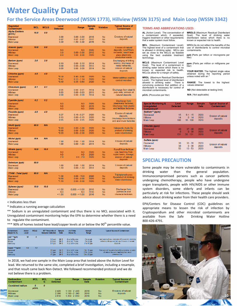
Water Quality Data For the Service Areas Deerwood (WSSN 1773), Hillview (WSSN 3175) and Main Loop (WSSN 3342)
AL (Action Level): The concentration of a contaminant which, if exceeded, triggers treatment or other requirements that a water system must follow.
MCL (Maximum Contaminant Level): The highest level of a contaminant that is allowed in drinking water. MCLs are set as close to the MCLG as feasible using the best available treatment technology.
MCLG (Maximum Contaminant Level Goal): The level of a contaminant in drinking water below which there is no known or expected risk to health. MCLGs allow for a margin of safety.
MRDL (Maximum Residual Disinfectant Level): The highest level of disinfectant allowed in drinking water. There is convincing evidence that addition of a disinfectant is necessary for control of microbial contaminants.
pCi/L (Picocuries per liter)
SPECIAL PRECAUTION Some people may be more vulnerable to contaminants in drinking water than the general population. Immunocompromised persons such as cancer patients undergoing chemotherapy, people who have undergone organ transplants, people with HIV/AIDS or other immune system disorders, some elderly and infants can be particularly at risk for infections. These people should seek advice about drinking water from their health care providers.
EPA/Centers for Disease Control (CDC) guidelines on appropriate means to lessen the risk of infection by Cryptosporidium and other microbial contaminants are available from the Safe Drinking Water Hotline 800-426-4791.
TERMS AND ABBREVIATIONS USED:
< Indicates less than
* Indicates a running average calculation
** Sodium is an unregulated contaminant and thus there is no MCL associated with it. Unregulated contaminant monitoring helps the EPA to determine whether there is a need to regulate the contaminant.
*** 90% of homes tested have lead/copper levels at or below the 90th percentile value.
MRDLG (Maximum Residual Disinfectant Goal): The level of drinking water disinfectant below which there is no known or expected risk to health.
MRDLGs do not reflect the benefits of the use of disinfectants to control microbial contaminants.
ppb (Parts per billion or micrograms per liter)
ppm (Parts per million or milligrams per liter)
YOUR WATER: The highest single value obtained during the reporting period unless noted with an *
RANGE: The lowest to the highest values obtained
ND (Not detectable at testing limit)
N/A ( Not applicable)
In 2018, we had one sample in the Main Loop area that tested above the Action Level for lead. We returned to the same site, completed a brief investigation, including a resample, and that result came back Non-Detect. We followed recommended protocol and we do not believe there is a problem.
10
11
PFAS - What is it and where does it come from? PFAS is an acronym for Per-and Polyfluorinated Substances. PFAS has been used globally during the past century in manufacturing, firefighting, along with thousands of common household and other consumer related products.
Actions to commercially produce PFAS were first developed in the 1940’s. In the 1950’s several companies began manufacturing PFAS for product applications because of its ability to repel water, protect surfaces, resist heat and many other useful properties.
Chemicals in this class of more than 5,000 substances are found in products such as nonstick pans that contain Teflon, food packaging, waterproof jackets and carpets to repel water, grease, and stains.
In recent years, experts have become increasingly concerned by the potential effects of high concentrations of PFAS on human health. These chemicals don’t break down in the environment and also bioaccumulate, meaning the amount builds up over time in organs and the bloodstream.
The Environment, Great Lakes & Energy (EGLE) coordinated a statewide program to test drinking water from all community water supplies and schools that use well water for PFAS. Michigan's EGLE took this preventative measure to test drinking water sources to determine if public health actions are needed. In 2018 the State of Michigan tested all of Independence Township’s wells, all came back with negative PFAS results with the exception of our Clarkston Gardens Wellhouse, which was immediately taken offline even though the test results were well below the health advisory level of 70 Parts Per Trillion (ppt). The Department of Public Works was transparent and forthcoming about this discovery and immediately notified the public of these findings. The Clarkston Gardens Wellhouse is offline and will continue to remain offline with repeated testing performed every quarter.
Why was The Charter Township of Independence’s source water tested for PFAS?
How can I stay updated on the situation? Michigan has developed a website to find information about PFAS contamination and efforts to address it. The website will be updated as additional Information becomes available. The website address: http://michigan.gov/pfasresponse.
There are a variety of ways that people can be exposed to these chemicals and at different levels of exposure. For instance, people can be exposed to low levels of PFAS through the consumption of contaminated food. This in combination with the soil and water used for harvesting, packaging containing PFAS as well as leather goods, non-stick cookware, weather repellants and commercially stain treated products.
How People Are Exposed to PFAS

Per- and polyfluoroalkyl substances (PFAS)
Regulated Contaminant MCL, TT, or
MRDL
MCLG or
MRDLG
Level
Detected Range
Year Sam-
pled
Violation
Yes/No Typical Source of Contaminant
Hexafluoropropylene oxide dimer acid
(HFPO-DA) (ppt) 370 N/A N/D 0 2020 No
Discharge and waste from industrial facilities utilizing the
Gen X chemical process
Perfluorobutane sulfonic acid (PFBS) (ppt) 420 N/A 5 0 - 5 2020 No Discharge and waste from industrial
facilities; stain-resistant treatments
Perfluorohexane sulfonic acid (PFHxS)
(ppt) 51 N/A 30 0 - 30 2020 No
Firefighting foam; discharge and waste from industrial
facilities
Perfluorohexanoic acid (PFHxA) (ppt) 400,000 N/A 4 0 - 4 2020 No Firefighting foam; discharge and waste from industrial
facilities
Perfluorononanoic acid (PFNA) (ppt) 6 N/A N/D 0 2020 No Discharge and waste from industrial
facilities; breakdown of precursor compounds
Perfluorooctane sulfonic acid (PFOS) (ppt) 16 N/A 6 0 - 6 2020 No Firefighting foam; discharge from electroplating facilities;
discharge and waste from industrial facilities
Perfluorooctanoic acid (PFOA) (ppt) 8 N/A 5 0 - 5 2020 No Discharge and waste from industrial
facilities; stain-resistant treatments
What is currently being done about this issue?
State and local agencies are working to gather more information about this situation as rapidly as possible. Additional testing of Independence Township’s drinking water is being continuously monitored to demonstrate that the PFAS levels are consistent and below the existing LHA (Lifetime Health Advisory). Further monitoring in and around our region and other affected areas will also be performed by The Environment, Great Lakes & Energy (EGLE), which will also assist in answering any questions and determining next steps to mitigate further and future PFAS detection.
Who can I call if I have questions about PFAS in my drinking water?
If residents have questions regarding this, the State of Michigan Environmental Assistance Center can be contacted at 800-662-9278. Representatives may be reached to assist with your questions Monday through Friday, 8:00 AM to 4:30 PM. If you are concerned about exposure to PFAS in your drinking water, please contact the Michigan Department of Health and Human Services Toxicology Hotline at 800-648-6942, the Center for Disease Control and Prevention/ATSDR at https://www.cdc.gov/cdc-info/ or 800-232-4636. You may also contact The Charter Township of Independence DPW at 248-625-8222.
12
Clarkston Gardens Test Results (Offline 2018)

13
For Our Residents With Private Wells WHAT IS ARSENIC?
Arsenic is found in nature at low levels. It is found in groundwater, air, food, and soil. Most arsenic compounds have no smell or taste. Arsenic joins with oxygen, chlorine and sulfur to make inorganic arsenic compounds. Inor-ganic arsenic compounds are used to preserve wood, make insecticides and weed killers. Arsenic in plants and animals combined with carbon and hydrogen to make organic arsenic. Organic arsenic is less harmful than inorganic arsenic. Check the labels of treated wood products, insecticides and herbicides to see if they contain arsenic.
HOW ARSENIC GETS INTO DRINKING WATER
Mineral deposits in some areas of Michigan contain high levels of arsenic. It is widely believed that naturally occurring arsenic dissolves out of certain rock formations when ground water levels drop significantly. Arsenic is removed from the air by rain, snow, and gradual settling. Once on the ground or in surface water, arsenic can slowly enter ground water. This may result in elevated levels of arsenic in well water. Arsenic has no smell or taste in drinking water. You need to test your well water and see if arsenic is present.
CAN A MEDICAL TEST TELL ME HOW MUCH ARESENIC IS IN MY BODY?
Yes, there are several ways you can be tested for arsenic exposure. A urine test is a simple way to tell if you are being exposed to harmful levels of arsenic.
HOW DO I HAVE MY PRIVATE WELL WATER TESTED FOR ARSENIC?
The Department of Public Works offers a water testing kit and instructions for sample collection that residents can complete and mail directly to the Environment, Great Lakes & Energy (EGLE) Drinking Water Laboratory. EGLE recommends that homeowners have their well water tested for arsenic. EGLE’s Drinking Water Laboratory may be reached at 517-335-8184; or any commercial laboratory certified to test for arsenic can perform the laboratory analysis for a small fee. Please call 248-625-8222 or email [email protected] with any questions.

14
HOW DO I INTERPRET MY WATER SAMPLE RESULTS?
The Environmental Protection Agency (EPA) set an arsenic maximum contaminant level (MCL) for public water supplies at 0.010 mg/L. This is equivalent to
0.010 parts per million (ppm), 10 micrograms/liter (μg/L), or 10 parts per billion (ppb). The EPA also sets the MCL Goal (MCLG) for drinking water. The MCLG
is set at a level that uses the best available science to prevent potential health problems. The EPA has set the MCLG for arsenic at zero. For private water
supplies (i.e., individual residential wells) the arsenic drinking water health advisory recommendation is also 0.010 mg/L. If the arsenic in your water exceeds
0.010 mg/L, EGLE recommends that you do not use your well water for drinking or cooking. Heating or boiling your water will not remove arsenic, as some of
the water evaporates, the arsenic concentrations can actually increase slightly as the water is boiled.
WHAT SHOULD BE DONE IF THERE IS AN ELEVATED AMOUNT OF
ARSENIC IN THE WELL?
Consider connecting to a public water supply if available. The public water supply is monitored by EPA
and state regulators to ensure your water meets Federal and State drinking water standards. Consider
installing a water filtration system. There are two types to choose from: a “Point of Use System” or a
“Point of Entry System”. The “POU” system fits under any sink but is typically installed in the kitchen,
such as a reverse osmosis, ultra-filtration, distillation or ion exchange methods. This system is the least
expensive and fairly easy to install. The “POE” System” treats all the water that enters your home; these
systems are the most expensive and should be installed by certified service personnel. Whichever system
you choose, it is important to address the problem so your family is drinking clean and safe water.

Stormwater Management
14
15
Stormwater management has been concerned with the numerous potential of downstream flooding. However, over the last
30 years, there has been a growing concern with the quality of the stormwater runoff and its impact on our environment.
Stormwater runoff picks up pollutants that have accumulated on the land surface and washes them into receiving waters.
The pollutants can include sediment, nutrients, and heavy metals just to name a few. These contaminants enter the food
chain, destroy aquatic habitat, and can cause considerable damage to lakes or streams.
As a result of the water quality and quantity concerns, stormwater management has begun to evolve into a field that
attempts to incorporate reducing future flood damages with water-quality improvements. The information presents some
background in stormwater management and will offer some approaches to addressing the urban runoff problem.
Independence Township has had an MS4 permit (Municipal Separate Storm Sewer System) in place since 2003 and is committed to the environment in
complying with all State and Federal regulations. This permit is designed to reduce the amount of sediment and other pollutants entering state waters
from stormwater systems.
Our stormwater management consultant regularly conducts surface water sampling for potential contaminants as well as bi-annual Township facility
inspections for proper good housekeeping and pollution prevention practices. In addition, Independence Township has developed several educational
videos on storm and groundwater concerns and frequently publishes articles in the local Clarkston News for stormwater and groundwater issues along with
public education assistance. Independence Township’s consultant also manages routine sampling of all storm drainage structures to determine if
contaminates are in the water.
In 2019, Independence Township’s Parks and Recreation Department was awarded a Green Infrastructure Grant
from Southeast Michigan Council of Governments (SEMCOG) to install an outdoor rain garden at Bay Court’s
Brady Lodge to help collect rain water and reduce water runoff within the stormwater system. Rain gardens
consist of natural shrubs, flowers and perennials designed to soak in rainwater runoff that flow from driveways,
roofs, patios and lawns. The rain garden’s installation was scheduled to take place in 2020, however, due to the
immense impact that Covid-19 had on all businesses, preconstruction was postponed until the fall of 2020 and
planting took place in the spring of 2021.
13 16
Get Involved Independence Township resides in the Clinton River Watershed. The area of south-eastern Michigan which flows into the Clinton River and eventually into Lake St. Clair, covering 4 counties, 760 square miles, including over 1,000 miles of streams, as well as the 80 mile long main branch of the Clinton River. Stormwater runoff, which is the water that enters the storm drains from your property and street, is the largest source of pollution in our watershed. Storm drains are the openings you see along curbs, in streets and in parking lots. Water and debris which enter the storm system do not go to a treatment facility; instead, they flow directly to our lakes and streams.
The Clinton River Watershed Council (CRWC) has several programs that encourage community members to get involved and help protect our water resources. They’d be excited to have you take part!
KEEPING IT CLEAN The Keeping It Clean program engages citizens of all ages to participate in trash clean-ups throughout the Clinton River Watershed and along the Lake St. Clair shoreline.
CLINTON RIVER COLDWATER CONSERVATION PROJECT (CRCCP)
The CRCCP seeks to generate public support for the Clinton River Watershed as a valued recreational resource through efforts to improve the water quality, aesthetics, access to the Clinton River and its fresh water streams. For more information please contact the CRWC at 248-601-0606 or visit www.crwc.org.
ADOPT-A-STREAM
The Clinton River Watershed Council’s Adopt-A-Stream program is a volunteer-based program that empowers community members to protect local streams and rivers through water quality monitoring. Citizens involvement in water quality monitoring activities has resulted in positive change across the nation, the state and right here in the Clinton River Watershed.
2020 CLINTON RIVER WATERSHED CLEAN-UP Independence Township would like to recognize and thank those who volunteered in September to assist with the 19th Annual Clinton River Clean-Up Day. You all did great and we truly appreciate your dedication and help with keeping our waterways and surrounding areas free from pollution and debris.

17
Fat, Oils and Greases (FOG) Where Does the Grease Come From? Grease is a byproduct of cooking that comes from meat fats, lard, oil,
shortening, butter, margarine, food scraps, baked goods, sauces and dairy products. When washed down the sink, grease sticks to the insides of sewer pipes (both on your property and in the street). Over time, it can and will build up, eventually forming a blockage throughout the entire pipe. If you have a backup due to this, it can lead to thousands of dollars to repair.
You Can Help With Some of These Tips! • Never pour cooking oil, bacon grease, pan drippings or salad dressing down the drains or into toilets.
• Collect excess fats and oils in a sealed container and recycle appropriately.
• Putting baskets/strainers in sink drains to catch food scraps and other solids and emptying them into the trash.
• Also, speak with your neighbors and friends about how to keep grease out of our sewers.
What’s All The Hype About Not Flushing Wipes? Since wet wipes are essential for children, many parents will carry them around everywhere where they go, especially when changing is necessary. Wet
wipes are also great for cleaning hands, removing makeup, and general cleaning. With all of the options wet wipes provide, who wouldn’t want to use them?
However, just because an item can be flushed, doesn’t mean it should be. Hygiene products used in the bathroom are flushed out of convenience and
because they simply can be disposed in the toilet, doesn't mean they should.
• More than $324,000 was spent to clean sewers by Oakland County’s Water Resource Commissioner in 2019. Clogged pipes lead to overflowing toilets and sewage backups.
• Flushing baby wipes could potentially cause you $10,000 in plumbing repairs. Plumbing experts say there's no such thing as a flushable wipe.
• With the demand for flushable wipes being heightened since the Coronavirus pandemic, greater pressure is put on the sewer system.
• “Flushable” does not mean it’s safe for the sewer system and only flush toilet paper and what humans produce.
• Most wipes don’t break apart in water and can form clumps that grow into hard masses that create blockages.
• Flushing wipes have caused many clogs around the world, and the problem is only getting worse, especially since the wipe companies are not being completely honest with consumers about the wipes they’re creating.
• The proper way to dispose of non-flushable items is to simply throw them away in the garbage.
18
West Nile Virus & Eastern Equine Encephalitis (EEE) West Nile and EEE are viruses most commonly spread to people by mosquito bites. In North America, cases of West Nile Virus and EEE occur during mosquito season, which starts in the summer and continues through fall. Cases have been reported throughout the continental United States. Currently there are no vaccines or medications to treat or prevent WNV or EEE. Fortunately, most people infected with WNV don’t experience symptoms. About 1 in 5 people who are infected develop a fever and other symptoms including headache, joint pains, vomiting, diarrhea or a rash, while signs of EEE include the sudden onset of fever, chills, body and joint aches which can progress to a severe encephalitis, resulting in headache, disorientation, tremors, seizures and paralysis.
HOW ARE THE WEST NILE OR EEE VIRUS SPREAD?
Both viruses often spread to humans bitten by an infected mosquito that became infected by biting another bird that carries the virus. Horses and other mammals bitten by mosquitoes that carry each virus can also become infected. Whenever mosquitoes are active, there is a risk of getting WNV or EEE. The highest risk is from late July through September.
AERIAL MOSQUITO TREATMENT
In September 2020, Oakland County was one of 10 Michigan counties that was considered high risk for the deadly Eastern Equine Encephalitis (EEE) and took part in an aerial treatment plan. Aerial treatment was conducted by specialized aircraft, beginning in the early evening and continuing until the following dawn. State-certified mosquito control professionals applied an approved pesticide as an ultra-low volume (ULV) spray. ULV sprayers dispense fine aerosol droplets that stayed suspended in the air and killed adult mosquitoes on contact. Aerial treatments is said to not have any impact on surface water, drinking water and found no increased human, animal or insect adverse effects.
HOW CAN THESE VIRUSES BE PREVENTED? The best way to avoid WNV or EEE infections is to prevent mosquito bites using insect repellent. The Centers for Disease Control and Prevention (CDC) recommends the use of insect repellents containing active ingredients registered with the U.S. Environmental Protection Agency (EPA). Always follow manufacturer's directions carefully. This year Independence Township will continue to provide the Repel Sportsmen Max .475 oz. Pen-Sized Pump Spray with 40% Deet and Ben’s 100 Tick & Insect Repellent 1.25 oz. Pump Spray with 100% Deet. Both products will be available for residents to pick up at the Parks & Rec Department, Senior Center, Library, Town Hall and The Department of Public Works.
Please do not apply insect repellent to eyes, mouth, cuts or irritated skin. Wear protective clothing such as long sleeved shirts and pants. Limit outdoor activity from dusk to dawn when mosquitoes are most active. Avoid areas where mosquitoes may be present (i.e., shaded and wooded areas). Maintain window and door screens to keep mosquitoes outdoors.


Independence Township FY2023 DWSRF Parview and Waldon Water Main Extensions
Page 54 of 61
APPENDIX VII FEMA FIRM FLOOD MAPS

National Flood Hazard Layer FIRMette
0 500 1,000 1,500 2,000250Feet
Ü
SEE FIS REPORT FOR DETAILED LEGEND AND INDEX MAP FOR FIRM PANEL LAYOUT
SPECIAL FLOODHAZARD AREAS
Without Base Flood Elevation (BFE)Zone A, V, A99
With BFE or DepthZone AE, AO, AH, VE, AR
Regulatory Floodway
0.2% Annual Chance Flood Hazard, Areasof 1% annual chance flood with averagedepth less than one foot or with drainageareas of less than one square mileZone X
Future Conditions 1% AnnualChance Flood HazardZone X
Area with Reduced Flood Risk due toLevee. See Notes.Zone X
Area with Flood Risk due to LeveeZone D
NO SCREENArea of Minimal Flood HazardZone X
Area of Undetermined Flood HazardZone D
Channel, Culvert, or Storm Sewer
Levee, Dike, or Floodwall
Cross Sections with 1% Annual Chance17.5 Water Surface Elevation
Coastal Transect
Coastal Transect BaselineProfile BaselineHydrographic Feature
Base Flood Elevation Line (BFE)
Effective LOMRs
Limit of StudyJurisdiction Boundary
Digital Data Available
No Digital Data Available
Unmapped
This map complies with FEMA's standards for the use ofdigital flood maps if it is not void as described below.The basemap shown complies with FEMA's basemapaccuracy standards
The flood hazard information is derived directly from theauthoritative NFHL web services provided by FEMA. This mapwas exported on 5/19/2022 at 3:21 PM and does notreflect changes or amendments subsequent to this date andtime. The NFHL and effective information may change orbecome superseded by new data over time.
This map image is void if the one or more of the following mapelements do not appear: basemap imagery, flood zone labels,legend, scale bar, map creation date, community identifiers,FIRM panel number, and FIRM effective date. Map images forunmapped and unmodernized areas cannot be used forregulatory purposes.
Legend
OTHER AREAS OFFLOOD HAZARD
OTHER AREAS
GENERALSTRUCTURES
OTHERFEATURES
MAP PANELS
8
B20.2
The pin displayed on the map is an approximatepoint selected by the user and does not representan authoritative property location.
1:6,000
83°25'39"W 42°42'39"N
83°25'2"W 42°42'13"N
Basemap: USGS National Map: Orthoimagery: Data refreshed October, 2020

National Flood Hazard Layer FIRMette
0 500 1,000 1,500 2,000250Feet
Ü
SEE FIS REPORT FOR DETAILED LEGEND AND INDEX MAP FOR FIRM PANEL LAYOUT
SPECIAL FLOODHAZARD AREAS
Without Base Flood Elevation (BFE)Zone A, V, A99
With BFE or DepthZone AE, AO, AH, VE, AR
Regulatory Floodway
0.2% Annual Chance Flood Hazard, Areasof 1% annual chance flood with averagedepth less than one foot or with drainageareas of less than one square mileZone X
Future Conditions 1% AnnualChance Flood HazardZone X
Area with Reduced Flood Risk due toLevee. See Notes.Zone X
Area with Flood Risk due to LeveeZone D
NO SCREENArea of Minimal Flood HazardZone X
Area of Undetermined Flood HazardZone D
Channel, Culvert, or Storm Sewer
Levee, Dike, or Floodwall
Cross Sections with 1% Annual Chance17.5 Water Surface Elevation
Coastal Transect
Coastal Transect BaselineProfile BaselineHydrographic Feature
Base Flood Elevation Line (BFE)
Effective LOMRs
Limit of StudyJurisdiction Boundary
Digital Data Available
No Digital Data Available
Unmapped
This map complies with FEMA's standards for the use ofdigital flood maps if it is not void as described below.The basemap shown complies with FEMA's basemapaccuracy standards
The flood hazard information is derived directly from theauthoritative NFHL web services provided by FEMA. This mapwas exported on 5/19/2022 at 3:22 PM and does notreflect changes or amendments subsequent to this date andtime. The NFHL and effective information may change orbecome superseded by new data over time.
This map image is void if the one or more of the following mapelements do not appear: basemap imagery, flood zone labels,legend, scale bar, map creation date, community identifiers,FIRM panel number, and FIRM effective date. Map images forunmapped and unmodernized areas cannot be used forregulatory purposes.
Legend
OTHER AREAS OFFLOOD HAZARD
OTHER AREAS
GENERALSTRUCTURES
OTHERFEATURES
MAP PANELS
8
B20.2
The pin displayed on the map is an approximatepoint selected by the user and does not representan authoritative property location.
1:6,000
83°25'37"W 42°42'58"N
83°25'W 42°42'32"N
Basemap: USGS National Map: Orthoimagery: Data refreshed October, 2020

National Flood Hazard Layer FIRMette
0 500 1,000 1,500 2,000250Feet
Ü
SEE FIS REPORT FOR DETAILED LEGEND AND INDEX MAP FOR FIRM PANEL LAYOUT
SPECIAL FLOODHAZARD AREAS
Without Base Flood Elevation (BFE)Zone A, V, A99
With BFE or DepthZone AE, AO, AH, VE, AR
Regulatory Floodway
0.2% Annual Chance Flood Hazard, Areasof 1% annual chance flood with averagedepth less than one foot or with drainageareas of less than one square mileZone X
Future Conditions 1% AnnualChance Flood HazardZone X
Area with Reduced Flood Risk due toLevee. See Notes.Zone X
Area with Flood Risk due to LeveeZone D
NO SCREENArea of Minimal Flood HazardZone X
Area of Undetermined Flood HazardZone D
Channel, Culvert, or Storm Sewer
Levee, Dike, or Floodwall
Cross Sections with 1% Annual Chance17.5 Water Surface Elevation
Coastal Transect
Coastal Transect BaselineProfile BaselineHydrographic Feature
Base Flood Elevation Line (BFE)
Effective LOMRs
Limit of StudyJurisdiction Boundary
Digital Data Available
No Digital Data Available
Unmapped
This map complies with FEMA's standards for the use ofdigital flood maps if it is not void as described below.The basemap shown complies with FEMA's basemapaccuracy standards
The flood hazard information is derived directly from theauthoritative NFHL web services provided by FEMA. This mapwas exported on 5/19/2022 at 3:23 PM and does notreflect changes or amendments subsequent to this date andtime. The NFHL and effective information may change orbecome superseded by new data over time.
This map image is void if the one or more of the following mapelements do not appear: basemap imagery, flood zone labels,legend, scale bar, map creation date, community identifiers,FIRM panel number, and FIRM effective date. Map images forunmapped and unmodernized areas cannot be used forregulatory purposes.
Legend
OTHER AREAS OFFLOOD HAZARD
OTHER AREAS
GENERALSTRUCTURES
OTHERFEATURES
MAP PANELS
8
B20.2
The pin displayed on the map is an approximatepoint selected by the user and does not representan authoritative property location.
1:6,000
83°25'33"W 42°43'22"N
83°24'56"W 42°42'56"N
Basemap: USGS National Map: Orthoimagery: Data refreshed October, 2020

National Flood Hazard Layer FIRMette
0 500 1,000 1,500 2,000250Feet
Ü
SEE FIS REPORT FOR DETAILED LEGEND AND INDEX MAP FOR FIRM PANEL LAYOUT
SPECIAL FLOODHAZARD AREAS
Without Base Flood Elevation (BFE)Zone A, V, A99
With BFE or DepthZone AE, AO, AH, VE, AR
Regulatory Floodway
0.2% Annual Chance Flood Hazard, Areasof 1% annual chance flood with averagedepth less than one foot or with drainageareas of less than one square mileZone X
Future Conditions 1% AnnualChance Flood HazardZone X
Area with Reduced Flood Risk due toLevee. See Notes.Zone X
Area with Flood Risk due to LeveeZone D
NO SCREENArea of Minimal Flood HazardZone X
Area of Undetermined Flood HazardZone D
Channel, Culvert, or Storm Sewer
Levee, Dike, or Floodwall
Cross Sections with 1% Annual Chance17.5 Water Surface Elevation
Coastal Transect
Coastal Transect BaselineProfile BaselineHydrographic Feature
Base Flood Elevation Line (BFE)
Effective LOMRs
Limit of StudyJurisdiction Boundary
Digital Data Available
No Digital Data Available
Unmapped
This map complies with FEMA's standards for the use ofdigital flood maps if it is not void as described below.The basemap shown complies with FEMA's basemapaccuracy standards
The flood hazard information is derived directly from theauthoritative NFHL web services provided by FEMA. This mapwas exported on 5/19/2022 at 3:24 PM and does notreflect changes or amendments subsequent to this date andtime. The NFHL and effective information may change orbecome superseded by new data over time.
This map image is void if the one or more of the following mapelements do not appear: basemap imagery, flood zone labels,legend, scale bar, map creation date, community identifiers,FIRM panel number, and FIRM effective date. Map images forunmapped and unmodernized areas cannot be used forregulatory purposes.
Legend
OTHER AREAS OFFLOOD HAZARD
OTHER AREAS
GENERALSTRUCTURES
OTHERFEATURES
MAP PANELS
8
B20.2
The pin displayed on the map is an approximatepoint selected by the user and does not representan authoritative property location.
1:6,000
83°25'W 42°44'18"N
83°24'22"W 42°43'52"N
Basemap: USGS National Map: Orthoimagery: Data refreshed October, 2020

National Flood Hazard Layer FIRMette
0 500 1,000 1,500 2,000250Feet
Ü
SEE FIS REPORT FOR DETAILED LEGEND AND INDEX MAP FOR FIRM PANEL LAYOUT
SPECIAL FLOODHAZARD AREAS
Without Base Flood Elevation (BFE)Zone A, V, A99
With BFE or DepthZone AE, AO, AH, VE, AR
Regulatory Floodway
0.2% Annual Chance Flood Hazard, Areasof 1% annual chance flood with averagedepth less than one foot or with drainageareas of less than one square mileZone X
Future Conditions 1% AnnualChance Flood HazardZone X
Area with Reduced Flood Risk due toLevee. See Notes.Zone X
Area with Flood Risk due to LeveeZone D
NO SCREENArea of Minimal Flood HazardZone X
Area of Undetermined Flood HazardZone D
Channel, Culvert, or Storm Sewer
Levee, Dike, or Floodwall
Cross Sections with 1% Annual Chance17.5 Water Surface Elevation
Coastal Transect
Coastal Transect BaselineProfile BaselineHydrographic Feature
Base Flood Elevation Line (BFE)
Effective LOMRs
Limit of StudyJurisdiction Boundary
Digital Data Available
No Digital Data Available
Unmapped
This map complies with FEMA's standards for the use ofdigital flood maps if it is not void as described below.The basemap shown complies with FEMA's basemapaccuracy standards
The flood hazard information is derived directly from theauthoritative NFHL web services provided by FEMA. This mapwas exported on 5/19/2022 at 3:25 PM and does notreflect changes or amendments subsequent to this date andtime. The NFHL and effective information may change orbecome superseded by new data over time.
This map image is void if the one or more of the following mapelements do not appear: basemap imagery, flood zone labels,legend, scale bar, map creation date, community identifiers,FIRM panel number, and FIRM effective date. Map images forunmapped and unmodernized areas cannot be used forregulatory purposes.
Legend
OTHER AREAS OFFLOOD HAZARD
OTHER AREAS
GENERALSTRUCTURES
OTHERFEATURES
MAP PANELS
8
B20.2
The pin displayed on the map is an approximatepoint selected by the user and does not representan authoritative property location.
1:6,000
83°24'57"W 42°44'33"N
83°24'20"W 42°44'6"N
Basemap: USGS National Map: Orthoimagery: Data refreshed October, 2020

Independence Township FY2023 DWSRF Parview and Waldon Water Main Extensions
Page 55 of 61
APPENDIX VIII PRESENT WORTH CALCULATION

PARVIEW IMPROVEMENTSCommon Bid Items Unit Quantity Unit Price Item Price Salvage Years Salvage Value Replacement CostMobilization (~10% of total construction cost) LS 1 $400,000.00 $400,000.0012" HDPE (directional drilled) LF 6450 $225.00 $1,451,250.00 40 725,625.00$ Tapping Sleeve Valve and Well 12" EA 2 $11,000.00 $22,000.00 40 11,000.00$ 12" Gate Valve and Well EA 11 $9,500.00 $104,500.00 40 52,250.00$ 1" Service Lead (Short) EA 30 $1,700.00 $51,000.00 20 51,000.00$ 1" Service Lead (Long) EA 40 $2,750.00 $110,000.00 20 110,000.00$
2" Service Lead (Short)Per building (apartment)
4 $5,500.00 $22,000.0020 22,000.00$
2" Service Lead (Long)Per building (apartment)
4 $7,500.00 $30,000.0020 30,000.00$
Fire Hydrant EA 11 $9,000.00 $99,000.00 20 99,000.00$ Restoration (green space/landscape/seed and mulch) SQ YD 1700 $20.00 $34,000.00Restoration (sod) SQ YD 1700 $20.00 $34,000.00Soil Erosion Control LS 1 $6,500.00 $6,500.00Road Remove SYD 133.33 $20.00 $2,666.67Road Replacement SYD 133.33 $150.00 $20,000.00 15 $13,333.33 $20,000.00Driveway Remove and Replace SYD 33 $80.00 $2,640.00 15 $1,760.00 $2,640.00Curb and gutter Remove and Replace LF 75 $150.00 $11,250.00 15 $7,500.00 $11,250.00Tree Removal/Clearing EA 11 $910.00 $10,010.00Traffic Control (and construction signage) LS 1 $15,000.00 $15,000.00Oakland County Road Commission Permit LS 1 $8,000.00 $8,000.00Material Testing LS 1 $10,000.00 $10,000.00WALDON WM EXTENSIONMobilization (~10% of total construction cost) LS 1 $170,000.00 $170,000.008" HDPE (directional drilled) LF 3396 $125.00 $424,500.00 40 212,250.00$ 8" DI (Open Cut) LF 3396 $150.00 $509,400.00 40 254,700.00$ Tapping Sleeve Valve and Well 8" EA 2 $9,500.00 $19,000.00 40 9,500.00$ 8" Gate Valve and Well EA 10 $7,500.00 $75,000.00 40 37,500.00$ 1" Service Lead (Short) EA 48 $1,600.00 $76,800.00 20 76,800.00$ 1" Service Lead (Long) EA 24 $2,750.00 $66,000.00 20 66,000.00$ Fire Hydrant EA 16 $9,000.00 $144,000.00 20 144,000.00$ Restoration (green space/seed) SQ YD 4536 $20.00 $90,720.00Restoration (sod) SQ YD 4536 $20.00 $90,720.00Soil Erosion Control LS 1 $8,500.00 $8,500.00Traffic Control (and construction signage) LS 1 $10,000.00 $10,000.00Oakland County Road Commission Permit LS 1 $8,000.00 $8,000.00Material Testing LS 1 $10,000.00 $10,000.00Driveway Removal SQYD 1182 $20.00 $23,640.00 15 15,760.00$ 23,640.00$ Driveway Placement SQYD 1182 $60.00 $70,920.00 15 47,280.00$ 70,920.00$ Gravel Road Removal SQYD 250 $20.00 $5,000.00 15 3,333.33$ 5,000.00$ Gravel Road Placement SQYD 250 $220.00 $55,000.00 15 36,666.67$ 55,000.00$ Tree Removal/Clearing EA 10 $910.00 $9,100.00 6,066.67$ 9,100.00$
Total Construction Cost $4,310,116.67Design 8% $344,809.33Construction Admin, Engineering, Inspection 10% $431,011.67Project Plan $30,000.00Legal/Financial Service $32,000.00Bond Counsel $35,000.00
Total Project Cost $5,182,937.67 Total Salvage Cost Total Replacement Cost1,434,525.00$ 796,350.00$
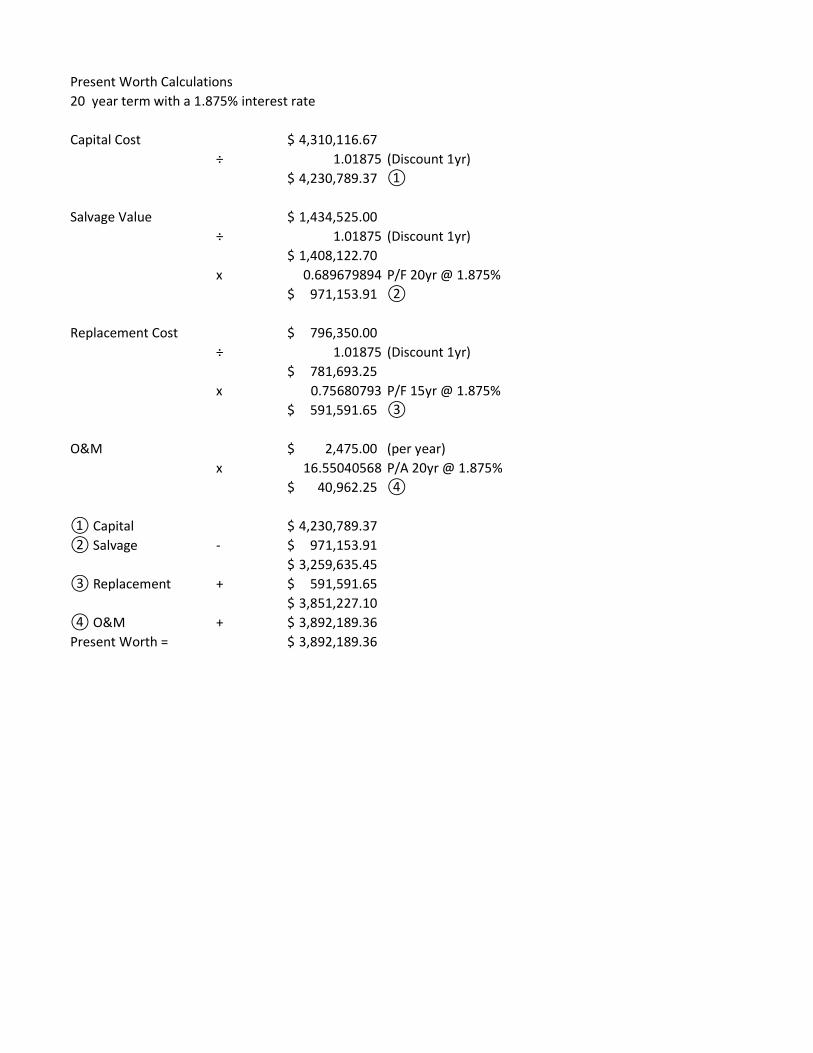
Present Worth Calculations 20 year term with a 1.875% interest rate
Capital Cost 4,310,116.67$ ÷ 1.01875 (Discount 1yr)
4,230,789.37$ ①
Salvage Value 1,434,525.00$ ÷ 1.01875 (Discount 1yr)
1,408,122.70$ x 0.689679894 P/F 20yr @ 1.875%
971,153.91$ ②
Replacement Cost 796,350.00$ ÷ 1.01875 (Discount 1yr)
781,693.25$ x 0.75680793 P/F 15yr @ 1.875%
591,591.65$ ③
O&M 2,475.00$ (per year)x 16.55040568 P/A 20yr @ 1.875%
40,962.25$ ④
① Capital 4,230,789.37$ ② Salvage - 971,153.91$
3,259,635.45$ ③ Replacement + 591,591.65$
3,851,227.10$ ④ O&M + 3,892,189.36$ Present Worth = 3,892,189.36$

Independence Township FY2023 DWSRF Parview and Waldon Water Main Extensions
Page 56 of 61
APPENDIX IX 2022 WATER FUND BUDGET REPORT

10/26/2021 BUDGET REPORT FOR CHARTER TOWNSHIP OF INDEPENDENCE Calculations as of 12/31/2021 WATER FUND - #591
2019 2020 2021 2021 2022 2022 2022 2023 2024ACTIVITY ACTIVITY AMENDED ACTIVITY REQUESTED REQUESTED REQUESTED FUTURE PROJECTED FUTURE PROJECTED
GL NUMBER DESCRIPTION BUDGET THRU 12/31/21 BUDGET AMT CHANGE % CHANGE BUDGET BUDGET
ESTIMATED REVENUESDept 000REVENUES591-000-485.000 * * Permits - Water 5,427 6,569 5,616 3,807 6,426 810 14.42 6,426 6,426591-000-485.100 * * Permits - Clarkston 416 178 119 0 119 0 0.00 119 119591-000-502.000-COVID 19 Federal Grants 0 8,293 0 0 0 0 0.00 0 0591-000-568.000 * * State Grants 9,821 8,059 0 0 3,210,000 3,210,000 100.00 10,000 10,000591-000-626.500 * * Ready To Serve Charge 611,420 625,014 686,978 506,068 714,013 27,035 3.94 732,963 745,910591-000-626.501 * * Meter Installation 5,880 4,080 7,290 5,784 6,426 (864) (11.85) 6,426 6,426591-000-626.502 * * Tap-In Fees 95,979 102,198 99,000 82,826 119,000 20,000 20.20 119,000 119,000591-000-626.503 * * Construction 6,568 9,354 3,285 6,402 8,687 5,402 164.44 8,687 8,687591-000-626.504 * * Flat Rate Fire Suppression 40,071 40,623 46,080 32,727 41,760 (4,320) (9.38) 43,200 44,640591-000-626.600 * * Ready To Serve Clarkston 13,620 13,983 17,009 11,264 17,248 239 1.41 17,487 17,726591-000-626.601 * * Meter Install. - Clarkston 416 178 119 0 119 0 0.00 119 119591-000-626.602 Tap-In Fees - Clarkston 1,800 0 0 0 0 0 0.00 0 0591-000-650.001 * * Usage 2,023,050 2,365,199 2,587,500 1,810,050 2,875,000 287,500 11.11 2,875,000 2,875,000591-000-650.001-MapleDrv Water Capital/Connections 9,813 3,743 0 460 0 0 0.00 0 0591-000-650.002 * * Usage - Flat Rate 3,760 3,760 3,760 2,975 3,760 0 0.00 3,760 3,760591-000-650.004 * * Meters 33,159 24,345 42,390 38,169 38,675 (3,715) (8.76) 38,675 38,675591-000-650.005 * * Capital Charge 274,423 245,312 465,400 382,640 309,400 (156,000) (33.52) 309,400 309,400591-000-650.101 * * Usage - City Of Clarkston 50,401 48,592 53,130 34,690 70,308 17,178 32.33 71,064 71,820591-000-650.104 * * Meters - Clarkston 2,207 895 550 0 650 100 18.18 650 650591-000-650.105 * * Capital Charge - Clarkston 1,560 2,860 520 0 520 0 0.00 520 520591-000-650.105-The_Fed_ Capital Charge - Clarkston 585 6,439 0 5,278 0 0 0.00 0 0591-000-662.000 * * Penalty 47,483 46,029 45,000 33,170 45,000 0 0.00 45,000 45,000591-000-665.000 * * Interest & Rents 59,658 41,240 44,305 25,559 30,858 (13,447) (30.35) 30,858 30,858591-000-665.002 * * Market Value Adjustment 35,386 (855) (2,215) (11,835) (2,357) (142) 6.41 (2,357) (2,357)591-000-667.300 * * Hydrant Rental 36,625 37,075 36,875 37,075 37,175 300 0.81 37,475 37,775591-000-671.200 * * Cell Tower Lease - Verizon 20,409 25,750 26,523 26,523 27,318 795 3.00 28,138 28,982591-000-676.000 Reimbursement 21,117 7,075 0 4,664 0 0 0.00 0 0591-000-676.840 * * Reimbursement - Insurance 5,567 40,115 2,500 8,432 5,000 2,500 100.00 5,000 5,000591-000-676.930 * * Reimbursement - Bldg. Maint. 14,162 10,923 15,000 6,217 15,000 0 0.00 15,000 15,000591-000-678.000 * * Other Revenue 1,107 395 1,000 0 1,000 0 0.00 1,000 1,000591-000-693.000 * * Proceeds from Sale of C.A. 0 5,199 28,000 0 5,000 (23,000) (82.14) 5,000 5,000 REVENUES 3,431,890 3,732,620 4,215,734 3,052,945 7,586,105 3,370,371 79.95 4,408,610 4,425,136
Totals for dept 000 - 3,431,890 3,732,620 4,215,734 3,052,945 7,586,105 3,370,371 79.95 4,408,610 4,425,136
TOTAL ESTIMATED REVENUES 3,431,890 3,732,620 4,215,734 3,052,945 7,586,105 3,370,371 79.95 4,408,610 4,425,136
APPROPRIATIONSDept 536 - WaterLABOR COSTS591-536-702.000 * * Wages - Full Time Employees 538,470 559,829 589,467 398,736 588,694 (773) (0.13) 608,755 619,241591-536-702.000-COVID 19 Wages - Full Time Employees 0 4,835 0 0 0 0 0.00 0 0591-536-704.000 * * Wages - Part Time Employees 3,103 655 3,705 0 0 (3,705) (100.00) 0 0591-536-707.000 * * Wages - Temporary 12,761 4,152 15,360 4,838 15,000 (360) (2.34) 15,000 15,000591-536-709.000 * * Payroll Taxes 42,077 43,637 47,850 32,897 47,480 (370) (0.77) 49,015 49,816591-536-710.000 * * Unemployment 3,867 0 5,500 0 5,500 0 0.00 5,500 5,500

10/26/2021 BUDGET REPORT FOR CHARTER TOWNSHIP OF INDEPENDENCE Calculations as of 12/31/2021 WATER FUND - #591
2019 2020 2021 2021 2022 2022 2022 2023 2024ACTIVITY ACTIVITY AMENDED ACTIVITY REQUESTED REQUESTED REQUESTED FUTURE PROJECTED FUTURE PROJECTED
GL NUMBER DESCRIPTION BUDGET THRU 12/31/21 BUDGET AMT CHANGE % CHANGE BUDGET BUDGET
591-536-713.000 * * Wages - Overtime 15,843 11,481 16,950 10,580 16,950 0 0.00 16,950 16,950591-536-716.000 * * Pension Expense - DC 401a 47,255 46,232 50,545 38,150 49,125 (1,420) (2.81) 53,059 55,641591-536-716.500 * * Dental Vision Premiums 0 10,841 11,571 7,854 12,359 788 6.81 13,590 14,955591-536-718.000 * * Health Insurance Premiums 159,973 128,639 130,103 109,561 139,325 9,222 7.09 144,793 150,462591-536-719.500 Retiree Dental Vision - OPEB 0 0 0 (490) 0 0 0.00 0 0591-536-721.000 * * Workers Compensation 8,839 8,746 12,060 12,057 12,000 (60) (0.50) 12,240 12,485591-536-723.000 * * Retiree Health Care - OPEB 21,526 25,428 32,826 29,831 35,973 3,147 9.59 37,671 39,408591-536-723.001 GASB 75 - OPEB Expense (26,890) (47,573) 0 0 0 0 0.00 0 0591-536-723.100 * * Retiree Health Care - HCSP 8,383 9,780 10,667 7,498 8,683 (1,984) (18.60) 9,083 9,382591-536-724.000 * * Life Insurance Premiums 10,827 8,562 8,887 7,181 8,649 (238) (2.68) 9,078 9,532591-536-725.000 * * Benefit - Identity Protection 0 0 555 447 660 105 18.92 660 660 LABOR COSTS 846,034 815,244 936,046 659,140 940,398 4,352 0.46 975,394 999,032
OPERATING COSTS591-536-730.000 * * Postage 6,149 7,805 10,600 5,366 9,600 (1,000) (9.43) 9,600 9,600591-536-751.000 * * Office Supplies 1,376 1,344 2,000 282 1,500 (500) (25.00) 1,500 1,500591-536-752.000 * * Operating Supplies 5,045 4,417 5,000 4,358 5,000 0 0.00 5,000 5,000591-536-752.000-COVID 19 Operating Supplies 0 1,797 0 0 0 0 0.00 0 0591-536-754.000 * * Computer Supplies 12,722 18,020 23,500 8,903 22,000 (1,500) (6.38) 22,000 22,000591-536-759.000 * * Gas & Oil 12,913 9,092 21,400 11,289 24,000 2,600 12.15 24,000 24,000591-536-767.000 * * Clothing 3,529 4,474 4,850 2,149 5,150 300 6.19 5,150 5,150591-536-801.000 * * Contractual Services 38,321 80,556 111,983 66,171 112,670 687 0.61 112,670 112,670591-536-801.000-Nth Sash Contractual Services 0 129 0 0 0 0 0.00 0 0591-536-801.001 * * Cont. Serv. - Tapping Materials 103,447 65,617 120,000 70,835 140,000 20,000 16.67 140,000 140,000591-536-801.008 * * Water Sample Testing 20,750 13,598 22,000 21,800 17,000 (5,000) (22.73) 17,000 17,000591-536-801.275 * * Cont. Serv. - Wellhead Protectn 19,650 24,663 10,000 2,090 20,000 10,000 100.00 20,000 20,000591-536-813.000 * * Water Treatment 44,496 45,894 45,000 28,259 45,000 0 0.00 45,000 45,000591-536-826.000 * * Legal Fees 4,164 2,612 9,000 2,938 6,000 (3,000) (33.33) 6,000 6,000591-536-826.000-COVID 19 Legal Fees 0 260 0 0 0 0 0.00 0 0591-536-830.000 * * Computer Services 3,415 4,242 4,130 1,603 4,980 850 20.58 5,188 5,408591-536-850.000 * * Telephone 8,392 8,492 7,560 5,757 7,860 300 3.97 6,700 7,000591-536-850.100 * * Telephone - Miss Dig 938 1,192 1,445 1,443 1,700 255 17.65 1,700 1,700591-536-852.000 * * Telecommunications Maint. 9,721 14,729 35,900 4,825 36,400 500 1.39 36,400 36,400591-536-855.000 * * Insurance & Bonds 27,378 26,853 36,315 28,814 36,585 270 0.74 38,415 40,350591-536-861.000 * * Mileage Reimbursement 491 323 1,000 328 1,000 0 0.00 1,000 1,000591-536-868.000 * * Leasing Charges 1,196 1,286 29,136 7,786 29,511 375 1.29 29,511 29,511591-536-900.000 * * Printing & Publishing 3,621 3,866 4,700 4,489 4,700 0 0.00 4,700 4,700591-536-900.100 * * Printing & Pub. - Notices 641 496 8,500 1,083 8,500 0 0.00 8,500 8,500591-536-920.000 * * Electric - DPW Building 5,630 5,312 5,400 4,012 5,600 200 3.70 5,700 5,800591-536-920.001 * * Electric - Pump Stations 261,703 289,549 270,000 218,554 300,000 30,000 11.11 315,000 330,000591-536-921.000 * * Heat 4,872 3,324 4,000 2,283 4,000 0 0.00 4,000 4,000591-536-921.002 * * Heat - Pump Stations 10,773 11,561 12,000 6,746 12,000 0 0.00 12,000 12,000591-536-922.000 * * Water 384 341 540 150 400 (140) (25.93) 400 400591-536-923.000 * * Sewer 232 232 525 116 300 (225) (42.86) 300 300591-536-930.000 * * Bldg. & Grounds Maintenance 19,511 15,902 13,800 13,388 7,650 (6,150) (44.57) 7,650 7,650591-536-932.000 * * Vehicle Repairs & Maintenance 11,051 4,571 7,500 2,694 7,500 0 0.00 7,500 7,500591-536-934.000 * * Equip. Repairs & Maintenance 17,460 9,530 20,000 11,841 20,000 0 0.00 20,000 20,000591-536-934.002 * * Eq. Repairs & Maint. - Water Mains 22,708 20,416 25,000 1,051 25,000 0 0.00 25,000 25,000591-536-934.003 * * Eq. Repairs & Maint. - Pumps 25,826 25,214 10,000 910 15,000 5,000 50.00 15,000 15,000

10/26/2021 BUDGET REPORT FOR CHARTER TOWNSHIP OF INDEPENDENCE Calculations as of 12/31/2021 WATER FUND - #591
2019 2020 2021 2021 2022 2022 2022 2023 2024ACTIVITY ACTIVITY AMENDED ACTIVITY REQUESTED REQUESTED REQUESTED FUTURE PROJECTED FUTURE PROJECTED
GL NUMBER DESCRIPTION BUDGET THRU 12/31/21 BUDGET AMT CHANGE % CHANGE BUDGET BUDGET
591-536-934.004 * * Eq. Repairs & Maint. - Meters 0 0 5,000 521 7,000 2,000 40.00 7,000 7,000591-536-940.000 * * Equipment Rental 0 0 250 0 250 0 0.00 250 250591-536-955.000 Miscellaneous 45 0 0 0 0 0 0.00 0 0591-536-957.000 * * Professional Development 5,789 2,995 8,800 3,528 9,800 1,000 11.36 9,800 9,800591-536-958.000 * * Membership & Dues 1,037 1,495 1,915 1,692 1,915 0 0.00 1,915 1,915591-536-963.000 * * Disposal Fees 0 (425) 100 0 100 0 0.00 100 100591-536-968.000 * * Depreciation 1,352,858 1,353,120 1,479,943 0 1,539,443 59,500 4.02 1,784,312 2,080,915591-536-977.001 * * Small Equipment < $5,000 5,334 7,218 16,891 4,301 10,000 (6,891) (40.80) 20,120 12,295591-536-977.001-COVID 19 Small Equipment < $5,000 0 1,401 0 0 0 0 0.00 0 0591-536-977.002 * * Equipment Meters 57,274 40,598 49,000 44,143 49,000 0 0.00 49,000 49,000591-536-977.300 * * Equipment - Safety 4,313 2,841 5,500 2,019 3,500 (2,000) (36.36) 3,500 3,500 OPERATING COSTS 2,135,155 2,136,952 2,450,183 598,517 2,557,614 107,431 4.38 2,828,581 3,134,914
DEBT591-536-993.000 * * Interest LT Debt 167,845 141,396 121,349 121,348 93,963 (27,386) (22.57) 65,888 37,266591-536-994.000 * * Paying Agent Fee 500 500 500 250 500 0 0.00 500 500 DEBT 168,345 141,896 121,849 121,598 94,463 (27,386) (22.48) 66,388 37,766
Totals for dept 536 - Water 3,149,534 3,094,092 3,508,078 1,379,255 3,592,475 84,397 2.41 3,870,363 4,171,712
TOTAL APPROPRIATIONS 3,149,534 3,094,092 3,508,078 1,379,255 3,592,475 84,397 2.41 3,870,363 4,171,712
NET OF REVENUES/APPROPRIATIONS - FUND 591 282,356 638,528 707,656 1,673,690 3,993,630 3,285,974 464.35 538,247 253,424 BEGINNING FUND BALANCE 29,307,340 29,589,699 30,228,231 30,935,887 34,929,517 35,467,764 FUND BALANCE ADJUSTMENTS 0 (1) 0 0 0 0 ENDING FUND BALANCE 29,589,696 30,228,226 30,935,887 34,929,517 35,467,764 35,721,188
ENDING FUND BALANCE SPLIT - RESTRICTED 24,646,039 24,543,952 24,574,324 28,615,881 30,255,069 30,230,154 - UNRESTRICTED 4,943,657 5,684,291 6,361,563 6,313,636 5,212,695 5,491,034 TOTAL ENDING FUND BALANCE 29,589,696 30,228,243 30,935,887 34,929,517 35,467,764 35,721,188
CAPITAL COSTS591-536-974.000 * * Land Improvements 0 0 24,362 13,856 16,000 (8,362) (34.32) 16,000 16,000591-536-975.000 Building Improvements 0 0 40,000 0 0 (40,000) (100.00) 0 0591-536-975.000-DPWBuild * * Building Improvements 0 0 170,000 0 380,000 210,000 123.53 7,500 10,000591-536-977.000 * * Equipment $5,000+ 0 0 60,000 16,651 105,000 45,000 75.00 60,000 60,000591-536-977.000-Netupgrd Equipment $5,000+ 0 0 36,903 4,494 0 (36,903) (100.00) 0 0591-536-977.000-SVRSBKUP Equipment $5,000+ 0 0 27,055 248 0 (27,055) (100.00) 0 0591-536-985.000 * * Dist. System Improvements 0 0 1,576,380 76,506 3,875,000 2,298,620 145.82 2,100,000 700,000591-536-985.000-ScadaDPW Dist. System Improvements 0 0 7,949 0 0 (7,949) (100.00) 0 0 CAPITAL COSTS 0 0 1,942,649 111,755 4,376,000 2,433,351 125.26 2,183,500 786,000

Independence Township FY2023 DWSRF Parview and Waldon Water Main Extensions
Page 57 of 61
APPENDIX X TRIBAL LETTERS
STATE HISTORIC PRESERVATION ORGANIZATION
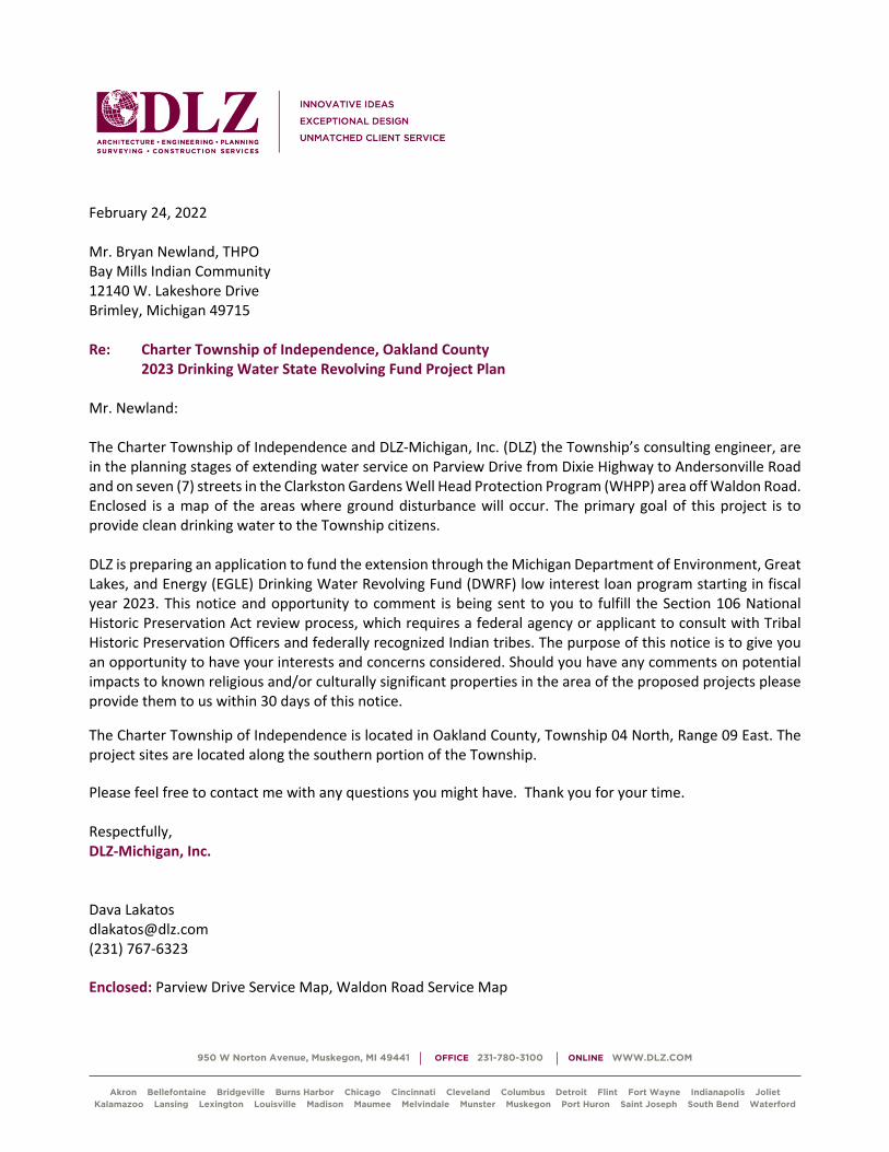
950 W Norton Avenue, Muskegon, MI 49441 OFFICE 231-780-3100 ONLINE WWW.DLZ.COM
Akron Bellefontaine Bridgeville Burns Harbor Chicago Cincinnati Cleveland Columbus Detroit Flint Fort Wayne Indianapolis Joliet Kalamazoo Lansing Lexington Louisville Madison Maumee Melvindale Munster Muskegon Port Huron Saint Joseph South Bend Waterford
February 24, 2022
Mr. Bryan Newland, THPO
Bay Mills Indian Community
12140 W. Lakeshore Drive
Brimley, Michigan 49715
Re: Charter Township of Independence, Oakland County
2023 Drinking Water State Revolving Fund Project Plan
Mr. Newland:
The Charter Township of Independence and DLZ-Michigan, Inc. (DLZ) the Township’s consulting engineer, are
in the planning stages of extending water service on Parview Drive from Dixie Highway to Andersonville Road
and on seven (7) streets in the Clarkston Gardens Well Head Protection Program (WHPP) area off Waldon Road.
Enclosed is a map of the areas where ground disturbance will occur. The primary goal of this project is to
provide clean drinking water to the Township citizens.
DLZ is preparing an application to fund the extension through the Michigan Department of Environment, Great
Lakes, and Energy (EGLE) Drinking Water Revolving Fund (DWRF) low interest loan program starting in fiscal
year 2023. This notice and opportunity to comment is being sent to you to fulfill the Section 106 National
Historic Preservation Act review process, which requires a federal agency or applicant to consult with Tribal
Historic Preservation Officers and federally recognized Indian tribes. The purpose of this notice is to give you
an opportunity to have your interests and concerns considered. Should you have any comments on potential
impacts to known religious and/or culturally significant properties in the area of the proposed projects please
provide them to us within 30 days of this notice.
The Charter Township of Independence is located in Oakland County, Township 04 North, Range 09 East. The
project sites are located along the southern portion of the Township.
Please feel free to contact me with any questions you might have. Thank you for your time.
Respectfully,
DLZ-Michigan, Inc.
Dava Lakatos
(231) 767-6323
Enclosed: Parview Drive Service Map, Waldon Road Service Map

950 W Norton Avenue, Muskegon, MI 49441 OFFICE 231-780-3100 ONLINE WWW.DLZ.COM
Akron Bellefontaine Bridgeville Burns Harbor Chicago Cincinnati Cleveland Columbus Detroit Flint Fort Wayne Indianapolis Joliet Kalamazoo Lansing Lexington Louisville Madison Maumee Melvindale Munster Muskegon Port Huron Saint Joseph South Bend Waterford
February 24, 2022
Mr. David Arroyo
Grand Traverse Band of Ottawa and Chippewa Indians
2605 NW Bayshore Drive
Peshawbetown, Michigan 49682
Re: Charter Township of Independence, Oakland County
2023 Clean Water State Revolving Fund Project Plan
Mr. Arroyo:
The Charter Township of Independence and DLZ-Michigan, Inc. (DLZ) the Township’s consulting engineer, are
in the planning stages of extending water service on Parview Drive from Dixie Highway to Andersonville Road
and on seven (7) streets in the Clarkston Gardens Well Head Protection Program (WHPP) area off Waldon Road.
Enclosed is a map of the areas where ground disturbance will occur. The primary goal of this project is to
provide clean drinking water to the Township citizens.
DLZ is preparing an application to fund the extension through the Michigan Department of Environment, Great
Lakes, and Energy (EGLE) Drinking Water Revolving Fund (DWRF) low interest loan program starting in fiscal
year 2023. This notice and opportunity to comment is being sent to you to fulfill the Section 106 National
Historic Preservation Act review process, which requires a federal agency or applicant to consult with Tribal
Historic Preservation Officers and federally recognized Indian tribes. The purpose of this notice is to give you
an opportunity to have your interests and concerns considered. Should you have any comments on potential
impacts to known religious and/or culturally significant properties in the area of the proposed projects please
provide them to us within 30 days of this notice.
The Charter Township of Independence is located in Oakland County, Township 04 North, Range 09 East. The
project sites are located along the southern portion of the Township.
Please feel free to contact me with any questions you might have. Thank you for your time.
Respectfully,
DLZ-Michigan, Inc.
Dava Lakatos
(231) 767-6323
Enclosed: Parview Drive Service Map, Waldon Road Service Map

950 W Norton Avenue, Muskegon, MI 49441 OFFICE 231-780-3100 ONLINE WWW.DLZ.COM
Akron Bellefontaine Bridgeville Burns Harbor Chicago Cincinnati Cleveland Columbus Detroit Flint Fort Wayne Indianapolis Joliet Kalamazoo Lansing Lexington Louisville Madison Maumee Melvindale Munster Muskegon Port Huron Saint Joseph South Bend Waterford
February 24, 2022
Mr. Kenneth Meshigaud
Hannahville Potawatomi Indian Community
N-14911 Hannahville B-1 Road
Wilson, Michigan 49896
Re: Charter Township of Independence, Oakland County
2023 Drinking Water State Revolving Fund Project Plan
Mr. Meshigaud:
The Charter Township of Independence and DLZ-Michigan, Inc. (DLZ) the Township’s consulting engineer, are
in the planning stages of extending water service on Parview Drive from Dixie Highway to Andersonville Road
and on seven (7) streets in the Clarkston Gardens Well Head Protection Program (WHPP) area off Waldon Road.
Enclosed is a map of the areas where ground disturbance will occur. The primary goal of this project is to
provide clean drinking water to the Township citizens.
DLZ is preparing an application to fund the extension through the Michigan Department of Environment, Great
Lakes, and Energy (EGLE) Drinking Water Revolving Fund (DWRF) low interest loan program starting in fiscal
year 2023. This notice and opportunity to comment is being sent to you to fulfill the Section 106 National
Historic Preservation Act review process, which requires a federal agency or applicant to consult with Tribal
Historic Preservation Officers and federally recognized Indian tribes. The purpose of this notice is to give you
an opportunity to have your interests and concerns considered. Should you have any comments on potential
impacts to known religious and/or culturally significant properties in the area of the proposed projects please
provide them to us within 30 days of this notice.
The Charter Township of Independence is located in Oakland County, Township 04 North, Range 09 East. The
project sites are located along the southern portion of the Township.
Please feel free to contact me with any questions you might have. Thank you for your time.
Respectfully,
DLZ-Michigan, Inc.
Dava Lakatos
(231) 767-6323
Enclosed: Parview Drive Service Map, Waldon Road Service Map

950 W Norton Avenue, Muskegon, MI 49441 OFFICE 231-780-3100 ONLINE WWW.DLZ.COM
Akron Bellefontaine Bridgeville Burns Harbor Chicago Cincinnati Cleveland Columbus Detroit Flint Fort Wayne Indianapolis Joliet Kalamazoo Lansing Lexington Louisville Madison Maumee Melvindale Munster Muskegon Port Huron Saint Joseph South Bend Waterford
February 24, 2022
Mr. Warren Swartz
Keweenaw Bay Indian Community
16429 Bear Town Road
Baraga, Michigan 49908
Re: Charter Township of Independence, Oakland County
2023 Drinking Water State Revolving Fund Project Plan
Mr. Warren Swartz:
The Charter Township of Independence and DLZ-Michigan, Inc. (DLZ) the Township’s consulting engineer, are
in the planning stages of extending water service on Parview Drive from Dixie Highway to Andersonville Road
and on seven (7) streets in the Clarkston Gardens Well Head Protection Program (WHPP) area off Waldon Road.
Enclosed is a map of the areas where ground disturbance will occur. The primary goal of this project is to
provide clean drinking water to the Township citizens.
DLZ is preparing an application to fund the extension through the Michigan Department of Environment, Great
Lakes, and Energy (EGLE) Drinking Water Revolving Fund (DWRF) low interest loan program starting in fiscal
year 2023. This notice and opportunity to comment is being sent to you to fulfill the Section 106 National
Historic Preservation Act review process, which requires a federal agency or applicant to consult with Tribal
Historic Preservation Officers and federally recognized Indian tribes. The purpose of this notice is to give you
an opportunity to have your interests and concerns considered. Should you have any comments on potential
impacts to known religious and/or culturally significant properties in the area of the proposed projects please
provide them to us within 30 days of this notice.
The Charter Township of Independence is located in Oakland County, Township 04 North, Range 09 East. The
project sites are located along the southern portion of the Township.
Please feel free to contact me with any questions you might have. Thank you for your time.
Respectfully,
DLZ-Michigan, Inc.
Dava Lakatos
(231) 767-6323
Enclosed: Parview Drive Service Map, Waldon Road Service Map

950 W Norton Avenue, Muskegon, MI 49441 OFFICE 231-780-3100 ONLINE WWW.DLZ.COM
Akron Bellefontaine Bridgeville Burns Harbor Chicago Cincinnati Cleveland Columbus Detroit Flint Fort Wayne Indianapolis Joliet Kalamazoo Lansing Lexington Louisville Madison Maumee Melvindale Munster Muskegon Port Huron Saint Joseph South Bend Waterford
February 24, 2022
Mr. James Williams, THPO
Lac Vieux Desert Band of Lake Superior Chippewa Indians
P.O. Box 249
Watersmeet, Michigan 49969
Re: Charter Township of Independence, Oakland County
2023 Drinking Water State Revolving Fund Project Plan
Mr. Williams:
The Charter Township of Independence and DLZ-Michigan, Inc. (DLZ) the Township’s consulting engineer, are
in the planning stages of extending water service on Parview Drive from Dixie Highway to Andersonville Road
and on seven (7) streets in the Clarkston Gardens Well Head Protection Program (WHPP) area off Waldon Road.
Enclosed is a map of the areas where ground disturbance will occur. The primary goal of this project is to
provide clean drinking water to the Township citizens.
DLZ is preparing an application to fund the extension through the Michigan Department of Environment, Great
Lakes, and Energy (EGLE) Drinking Water Revolving Fund (DWRF) low interest loan program starting in fiscal
year 2023. This notice and opportunity to comment is being sent to you to fulfill the Section 106 National
Historic Preservation Act review process, which requires a federal agency or applicant to consult with Tribal
Historic Preservation Officers and federally recognized Indian tribes. The purpose of this notice is to give you
an opportunity to have your interests and concerns considered. Should you have any comments on potential
impacts to known religious and/or culturally significant properties in the area of the proposed projects please
provide them to us within 30 days of this notice.
The Charter Township of Independence is located in Oakland County, Township 04 North, Range 09 East. The
project sites are located along the southern portion of the Township.
Please feel free to contact me with any questions you might have. Thank you for your time.
Respectfully,
DLZ-Michigan, Inc.
Dava Lakatos
(231) 767-6323
Enclosed: Parview Drive Service Map, Waldon Road Service Map

950 W Norton Avenue, Muskegon, MI 49441 OFFICE 231-780-3100 ONLINE WWW.DLZ.COM
Akron Bellefontaine Bridgeville Burns Harbor Chicago Cincinnati Cleveland Columbus Detroit Flint Fort Wayne Indianapolis Joliet Kalamazoo Lansing Lexington Louisville Madison Maumee Melvindale Munster Muskegon Port Huron Saint Joseph South Bend Waterford
February 24, 2022
Mr. Larry Romanelli, THPO
Little River Band of Ottawa Indians
2608 Government Center Drive
Manistee, Michigan 49660
Re: Charter Township of Independence, Oakland County
2023 Drinking Water State Revolving Fund Project Plan
Mr. Romanelli:
The Charter Township of Independence and DLZ-Michigan, Inc. (DLZ) the Township’s consulting engineer, are
in the planning stages of extending water service on Parview Drive from Dixie Highway to Andersonville Road
and on seven (7) streets in the Clarkston Gardens Well Head Protection Program (WHPP) area off Waldon Road.
Enclosed is a map of the areas where ground disturbance will occur. The primary goal of this project is to
provide clean drinking water to the Township citizens.
DLZ is preparing an application to fund the extension through the Michigan Department of Environment, Great
Lakes, and Energy (EGLE) Drinking Water Revolving Fund (DWRF) low interest loan program starting in fiscal
year 2023. This notice and opportunity to comment is being sent to you to fulfill the Section 106 National
Historic Preservation Act review process, which requires a federal agency or applicant to consult with Tribal
Historic Preservation Officers and federally recognized Indian tribes. The purpose of this notice is to give you
an opportunity to have your interests and concerns considered. Should you have any comments on potential
impacts to known religious and/or culturally significant properties in the area of the proposed projects please
provide them to us within 30 days of this notice.
The Charter Township of Independence is located in Oakland County, Township 04 North, Range 09 East. The
project sites are located along the southern portion of the Township.
Please feel free to contact me with any questions you might have. Thank you for your time.
Respectfully,
DLZ-Michigan, Inc.
Dava Lakatos
(231) 767-6323
Enclosed: Parview Drive Service Map, Waldon Road Service Map

950 W Norton Avenue, Muskegon, MI 49441 OFFICE 231-780-3100 ONLINE WWW.DLZ.COM
Akron Bellefontaine Bridgeville Burns Harbor Chicago Cincinnati Cleveland Columbus Detroit Flint Fort Wayne Indianapolis Joliet Kalamazoo Lansing Lexington Louisville Madison Maumee Melvindale Munster Muskegon Port Huron Saint Joseph South Bend Waterford
February 24, 2022
Ms. Regina Gasco-Bentley
Little Traverse Bay Band of Odawa
7500 Odawa Circle
Harbor Springs, Michigan 49740
Re: Charter Township of Independence, Oakland County
2023 Drinking Water State Revolving Fund Project Plan
Ms. Gasco-Bentley:
The Charter Township of Independence and DLZ-Michigan, Inc. (DLZ) the Township’s consulting engineer, are
in the planning stages of extending water service on Parview Drive from Dixie Highway to Andersonville Road
and on seven (7) streets in the Clarkston Gardens Well Head Protection Program (WHPP) area off Waldon Road.
Enclosed is a map of the areas where ground disturbance will occur. The primary goal of this project is to
provide clean drinking water to the Township citizens.
DLZ is preparing an application to fund the extension through the Michigan Department of Environment, Great
Lakes, and Energy (EGLE) Drinking Water Revolving Fund (DWRF) low interest loan program starting in fiscal
year 2023. This notice and opportunity to comment is being sent to you to fulfill the Section 106 National
Historic Preservation Act review process, which requires a federal agency or applicant to consult with Tribal
Historic Preservation Officers and federally recognized Indian tribes. The purpose of this notice is to give you
an opportunity to have your interests and concerns considered. Should you have any comments on potential
impacts to known religious and/or culturally significant properties in the area of the proposed projects please
provide them to us within 30 days of this notice.
The Charter Township of Independence is located in Oakland County, Township 04 North, Range 09 East. The
project sites are located along the southern portion of the Township.
Please feel free to contact me with any questions you might have. Thank you for your time.
Respectfully,
DLZ-Michigan, Inc.
Dava Lakatos
(231) 767-6323
Enclosed: Parview Drive Service Map, Waldon Road Service Map

950 W Norton Avenue, Muskegon, MI 49441 OFFICE 231-780-3100 ONLINE WWW.DLZ.COM
Akron Bellefontaine Bridgeville Burns Harbor Chicago Cincinnati Cleveland Columbus Detroit Flint Fort Wayne Indianapolis Joliet Kalamazoo Lansing Lexington Louisville Madison Maumee Melvindale Munster Muskegon Port Huron Saint Joseph South Bend Waterford
February 24, 2022
Mr. Bob Peters
Match-e-be-nash-she-wish Gun Lake Band of Potawatomi Indians
2872 Mission Drive
Shelbyville, Michigan 49344
Re: Charter Township of Independence, Oakland County
2023 Drinking Water State Revolving Fund Project Plan
Mr. Peters:
The Charter Township of Independence and DLZ-Michigan, Inc. (DLZ) the Township’s consulting engineer, are
in the planning stages of extending water service on Parview Drive from Dixie Highway to Andersonville Road
and on seven (7) streets in the Clarkston Gardens Well Head Protection Program (WHPP) area off Waldon Road.
Enclosed is a map of the areas where ground disturbance will occur. The primary goal of this project is to
provide clean drinking water to the Township citizens.
DLZ is preparing an application to fund the extension through the Michigan Department of Environment, Great
Lakes, and Energy (EGLE) Drinking Water Revolving Fund (DWRF) low interest loan program starting in fiscal
year 2023. This notice and opportunity to comment is being sent to you to fulfill the Section 106 National
Historic Preservation Act review process, which requires a federal agency or applicant to consult with Tribal
Historic Preservation Officers and federally recognized Indian tribes. The purpose of this notice is to give you
an opportunity to have your interests and concerns considered. Should you have any comments on potential
impacts to known religious and/or culturally significant properties in the area of the proposed projects please
provide them to us within 30 days of this notice.
The Charter Township of Independence is located in Oakland County, Township 04 North, Range 09 East. The
project sites are located along the southern portion of the Township.
Please feel free to contact me with any questions you might have. Thank you for your time.
Respectfully,
DLZ-Michigan, Inc.
Dava Lakatos
(231) 767-6323
Enclosed: Parview Drive Service Map, Waldon Road Service Map
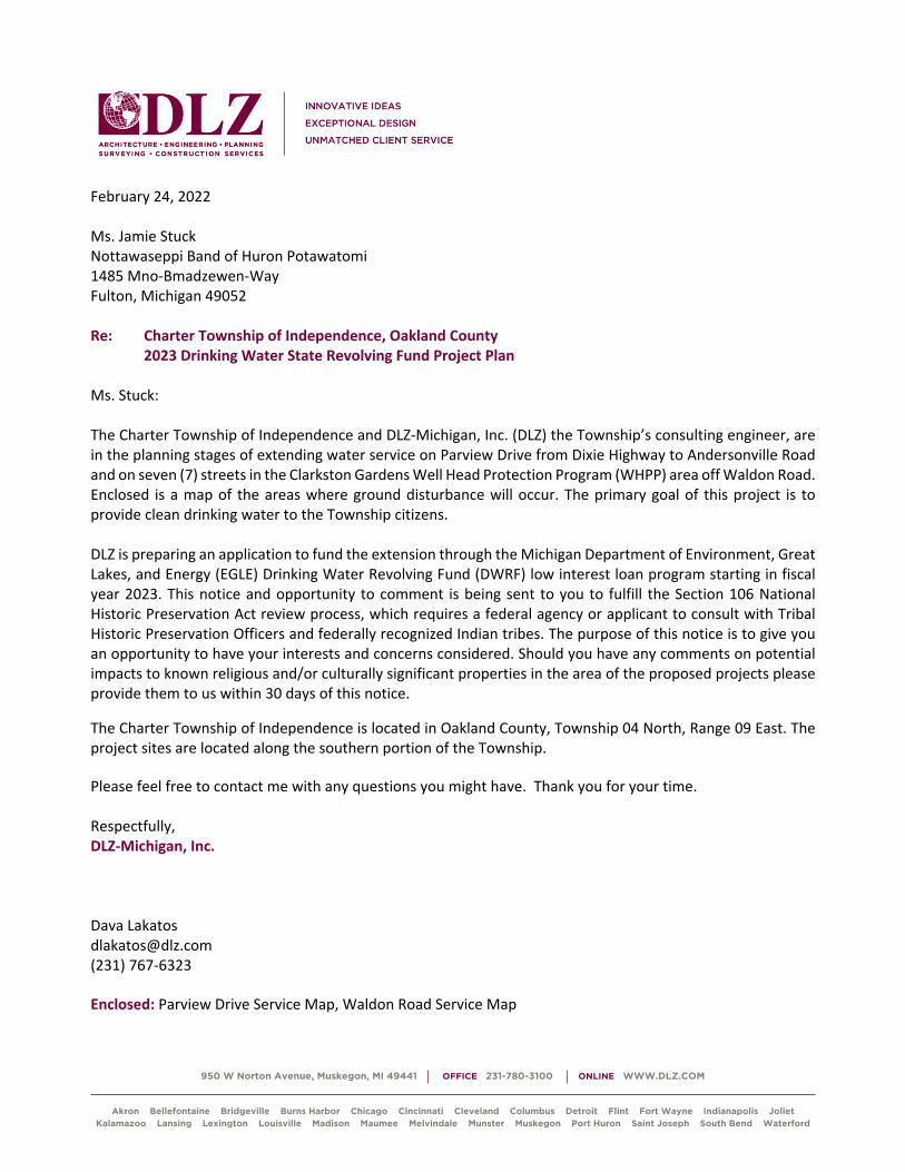
950 W Norton Avenue, Muskegon, MI 49441 OFFICE 231-780-3100 ONLINE WWW.DLZ.COM
Akron Bellefontaine Bridgeville Burns Harbor Chicago Cincinnati Cleveland Columbus Detroit Flint Fort Wayne Indianapolis Joliet Kalamazoo Lansing Lexington Louisville Madison Maumee Melvindale Munster Muskegon Port Huron Saint Joseph South Bend Waterford
February 24, 2022
Ms. Jamie Stuck
Nottawaseppi Band of Huron Potawatomi
1485 Mno-Bmadzewen-Way
Fulton, Michigan 49052
Re: Charter Township of Independence, Oakland County
2023 Drinking Water State Revolving Fund Project Plan
Ms. Stuck:
The Charter Township of Independence and DLZ-Michigan, Inc. (DLZ) the Township’s consulting engineer, are
in the planning stages of extending water service on Parview Drive from Dixie Highway to Andersonville Road
and on seven (7) streets in the Clarkston Gardens Well Head Protection Program (WHPP) area off Waldon Road.
Enclosed is a map of the areas where ground disturbance will occur. The primary goal of this project is to
provide clean drinking water to the Township citizens.
DLZ is preparing an application to fund the extension through the Michigan Department of Environment, Great
Lakes, and Energy (EGLE) Drinking Water Revolving Fund (DWRF) low interest loan program starting in fiscal
year 2023. This notice and opportunity to comment is being sent to you to fulfill the Section 106 National
Historic Preservation Act review process, which requires a federal agency or applicant to consult with Tribal
Historic Preservation Officers and federally recognized Indian tribes. The purpose of this notice is to give you
an opportunity to have your interests and concerns considered. Should you have any comments on potential
impacts to known religious and/or culturally significant properties in the area of the proposed projects please
provide them to us within 30 days of this notice.
The Charter Township of Independence is located in Oakland County, Township 04 North, Range 09 East. The
project sites are located along the southern portion of the Township.
Please feel free to contact me with any questions you might have. Thank you for your time.
Respectfully,
DLZ-Michigan, Inc.
Dava Lakatos
(231) 767-6323
Enclosed: Parview Drive Service Map, Waldon Road Service Map

950 W Norton Avenue, Muskegon, MI 49441 OFFICE 231-780-3100 ONLINE WWW.DLZ.COM
Akron Bellefontaine Bridgeville Burns Harbor Chicago Cincinnati Cleveland Columbus Detroit Flint Fort Wayne Indianapolis Joliet Kalamazoo Lansing Lexington Louisville Madison Maumee Melvindale Munster Muskegon Port Huron Saint Joseph South Bend Waterford
February 24, 2022
Mr. Matthew Wesaw, THPO
Pokagon Band of Potawatomi
58620 Sink Road
Dowagiac, Michigan 49047
Re: Charter Township of Independence, Oakland County
2023 Drinking Water State Revolving Fund Project Plan
Mr. Wesaw:
The Charter Township of Independence and DLZ-Michigan, Inc. (DLZ) the Township’s consulting engineer, are
in the planning stages of extending water service on Parview Drive from Dixie Highway to Andersonville Road
and on seven (7) streets in the Clarkston Gardens Well Head Protection Program (WHPP) area off Waldon Road.
Enclosed is a map of the areas where ground disturbance will occur. The primary goal of this project is to
provide clean drinking water to the Township citizens.
DLZ is preparing an application to fund the extension through the Michigan Department of Environment, Great
Lakes, and Energy (EGLE) Drinking Water Revolving Fund (DWRF) low interest loan program starting in fiscal
year 2023. This notice and opportunity to comment is being sent to you to fulfill the Section 106 National
Historic Preservation Act review process, which requires a federal agency or applicant to consult with Tribal
Historic Preservation Officers and federally recognized Indian tribes. The purpose of this notice is to give you
an opportunity to have your interests and concerns considered. Should you have any comments on potential
impacts to known religious and/or culturally significant properties in the area of the proposed projects please
provide them to us within 30 days of this notice.
The Charter Township of Independence is located in Oakland County, Township 04 North, Range 09 East. The
project sites are located along the southern portion of the Township.
Please feel free to contact me with any questions you might have. Thank you for your time.
Respectfully,
DLZ-Michigan, Inc.
Dava Lakatos
(231) 767-6323
Enclosed: Parview Drive Service Map, Waldon Road Service Map

950 W Norton Avenue, Muskegon, MI 49441 OFFICE 231-780-3100 ONLINE WWW.DLZ.COM
Akron Bellefontaine Bridgeville Burns Harbor Chicago Cincinnati Cleveland Columbus Detroit Flint Fort Wayne Indianapolis Joliet Kalamazoo Lansing Lexington Louisville Madison Maumee Melvindale Munster Muskegon Port Huron Saint Joseph South Bend Waterford
February 24, 2022
Mr. Timothy Davis, THPO
Saginaw Chippewa Indian Tribe of Michigan
6650 East Broadway
Mt. Pleasant, Michigan 48858
Re: Charter Township of Independence, Oakland County
2023 Drinking Water State Revolving Fund Project Plan
Mr. Davis:
The Charter Township of Independence and DLZ-Michigan, Inc. (DLZ) the Township’s consulting engineer, are
in the planning stages of extending water service on Parview Drive from Dixie Highway to Andersonville Road
and on seven (7) streets in the Clarkston Gardens Well Head Protection Program (WHPP) area off Waldon Road.
Enclosed is a map of the areas where ground disturbance will occur. The primary goal of this project is to
provide clean drinking water to the Township citizens.
DLZ is preparing an application to fund the extension through the Michigan Department of Environment, Great
Lakes, and Energy (EGLE) Drinking Water Revolving Fund (DWRF) low interest loan program starting in fiscal
year 2023. This notice and opportunity to comment is being sent to you to fulfill the Section 106 National
Historic Preservation Act review process, which requires a federal agency or applicant to consult with Tribal
Historic Preservation Officers and federally recognized Indian tribes. The purpose of this notice is to give you
an opportunity to have your interests and concerns considered. Should you have any comments on potential
impacts to known religious and/or culturally significant properties in the area of the proposed projects please
provide them to us within 30 days of this notice.
The Charter Township of Independence is located in Oakland County, Township 04 North, Range 09 East. The
project sites are located along the southern portion of the Township.
Please feel free to contact me with any questions you might have. Thank you for your time.
Respectfully,
DLZ-Michigan, Inc.
Dava Lakatos
(231) 767-6323
Enclosed: Parview Drive Service Map, Waldon Road Service Map

950 W Norton Avenue, Muskegon, MI 49441 OFFICE 231-780-3100 ONLINE WWW.DLZ.COM
Akron Bellefontaine Bridgeville Burns Harbor Chicago Cincinnati Cleveland Columbus Detroit Flint Fort Wayne Indianapolis Joliet Kalamazoo Lansing Lexington Louisville Madison Maumee Melvindale Munster Muskegon Port Huron Saint Joseph South Bend Waterford
February 24, 2022
Mr. Aaron Payment
Sault Ste. Marie Tribe of Chippewa
523 Ashmun
Sault Ste. Marie, MI 49783
Re: Charter Township of Independence, Oakland County
2023 Drinking Water State Revolving Fund Project Plan
Mr. Payment:
The Charter Township of Independence and DLZ-Michigan, Inc. (DLZ) the Township’s consulting engineer, are
in the planning stages of extending water service on Parview Drive from Dixie Highway to Andersonville Road
and on seven (7) streets in the Clarkston Gardens Well Head Protection Program (WHPP) area off Waldon Road.
Enclosed is a map of the areas where ground disturbance will occur. The primary goal of this project is to
provide clean drinking water to the Township citizens.
DLZ is preparing an application to fund the extension through the Michigan Department of Environment, Great
Lakes, and Energy (EGLE) Drinking Water Revolving Fund (DWRF) low interest loan program starting in fiscal
year 2023. This notice and opportunity to comment is being sent to you to fulfill the Section 106 National
Historic Preservation Act review process, which requires a federal agency or applicant to consult with Tribal
Historic Preservation Officers and federally recognized Indian tribes. The purpose of this notice is to give you
an opportunity to have your interests and concerns considered. Should you have any comments on potential
impacts to known religious and/or culturally significant properties in the area of the proposed projects please
provide them to us within 30 days of this notice.
The Charter Township of Independence is located in Oakland County, Township 04 North, Range 09 East. The
project sites are located along the southern portion of the Township.
Please feel free to contact me with any questions you might have. Thank you for your time.
Respectfully,
DLZ-Michigan, Inc.
Dava Lakatos
(231) 767-6323
Enclosed: Parview Drive Service Map, Waldon Road Service Map

February 24, 2022 State Historic Preservation Office Cultural Resources Management Section 300 North Washington Square Lansing, MI 48913 Re: Section 106 Application for the Charter Township of Independence, Oakland County
2023 Clean Water State Revolving Fund Project Plan To Whom It May Concern: The Charter Township of Independence and DLZ-Michigan, Inc. (DLZ) the Township’s consulting engineer, are in the planning stages of extending water service on Parview Drive from Dixie Highway to Andersonville Road and on seven (7) streets in the Clarkston Gardens Well Head Protection Program (WHPP) area off Waldon Road. Enclosed are maps of the areas where ground disturbance will occur. The primary goal of this project is to provide clean drinking water to the Township citizens. DLZ is preparing an application to fund the improvements through the Michigan Department of Environment, Great Lakes, and Energy (EGLE) Drinking Water State Revolving Fund (DWSRF) low interest loan program starting in fiscal year 2023. The scope of work is in the right of way (ROW) and is not anticipated to dramatically change. The Charter Township of Independence is located in Oakland County, Township 04 North, Range 09 East. The project sites are located along the southern portion of the Township. We would appreciate your reply no later than March 31, 2022 so there is time to enter the information into the final project plan.
Please feel free to contact me with any questions you might have. Thank you for your time. Respectfully, DLZ-Michigan, Inc. Dava Lakatos [email protected] (231) 767-6323 Enclosed: SHPO Application Form, Additional Information Letter, Parview Drive Service Map, Waldon Road Service Map

Independence Township FY2023 DWSRF Parview and Waldon Water Main Extensions
Page 58 of 61
APPENDIX XI MNFI RARE SPECIES REVIEW

Dava Lakotas April 10, 2022 DLZ-Michigan, Inc. 950 W Norton Avenue Muskegon, MI 49441
Re: Rare Species Review #3111 – Charter Township of Independence, 2023 DWSRF Project Plan, Oakland County, MI. Hello Dava:
The location for the proposed project was checked against known localities for rare species and unique natural features, which are recorded in the Michigan Natural Features Inventory (MNFI) natural heritage database. This continuously updated database is a comprehensive source of existing data on Michigan's endangered, threatened, or otherwise significant plant and animal species, natural plant communities, and other natural features. Records in the database indicate that a qualified observer has documented the presence of special natural features. The absence of records in the database for a site may mean that the site has not been surveyed. The only way to obtain a definitive statement on the status of natural features is to have a competent biologist perform a complete field survey.
Under Act 451 of 1994, the Natural Resources and Environmental Protection Act, Part 365, Endangered Species Protection, “a person shall not take, possess, transport, …fish, plants, and wildlife indigenous to the state and determined to be endangered or threatened,” unless first receiving an Endangered Species Permit from the Michigan Department of Natural Resources (MDNR), Wildlife Division. Responsibility to protect endangered and threatened species is not limited to the lists below. Other species may be present that have not been recorded in the database.
MSU EXTENSION
Michigan Natural
Features Inventory
PO Box 13036 Lansing MI 48901
(517) 284-6200
Fax (517) 373-9566
mnfi.anr.msu.edu
MSU is an affirmative-
action, equal-opportunity employer.
At-risk species have been documented within 1.5 miles of the proposed activities and it is possible that negative impacts will occur. This response reflects a desktop review of the database and MNFI cannot fully evaluate this project without visiting the area. MNFI offers several levels of Rare Species Reviews, including field surveys which I would be happy to discuss with you. Sincerely,
Michael A. Sanders
Michael A. Sanders Environmental Review Specialist/Zoologist Michigan Natural Features Inventory

Comments for Rare Species Review #3111: It is important to note that it is the applicant’s responsibility to comply with both state and federal threatened and endangered species legislation. Therefore, if a state listed species occurs at a project site, and you think you need an endangered species permit please contact: Casey Reitz, DNR-Wildlife Division, 517-284-6210, or [email protected]. If a federally listed species is involved and, you think a permit is needed, please contact Jessica Pruden, U.S. Fish and Wildlife Service, East Lansing office, 517-351-8316, or [email protected]. NOTE: special concern species and natural communities are not protected under endangered species legislation, but efforts should be taken to minimize any or all impacts. Please consult MNFI’s Rare Species Explorer for additional information on Michigan’s rare plants and animals.
Parke Lake Project Area: Table 1: Occurrences of threatened and endangered species within 1.5 miles of RSR#3111
ELCAT SNAME SCOMNAME USESA SPROT G_RANK S_RANK FIRSTOBS LASTOBS EORANK
Animal Coregonus artedi Lake herring or Cisco T GNR S3 1890 1989 H
Plant Trichostema dichotomum Bastard pennyroyal T G5 S2 1916 1916-09-15 H
Plant Platanthera ciliaris Orange- or yellow-fringed orchid E G5 S1S2 1946 1946-08-04 H
Comments for Table 1 : Eastern massasauga rattlesnake (EMR) – the federally threatened and state special concern Eastern massasauga rattlesnake (Sistrurus catenatus) has been known to occur in the area. This is Michigan’s only venomous snake and is found in a variety of wetland habitats including bogs, fens, shrub swamps, wet meadows, marshes, moist grasslands, wet prairies, and floodplain forests. Eastern massasaugas occur throughout the Lower Peninsula but are not found in the Upper Peninsula. Populations in southern Michigan are typically associated with open wetlands, particularly prairie fens, while those in northern Michigan are better known from lowland coniferous forests, such as cedar swamps. These snakes normally overwinter in crayfish or small mammal burrows often close to the groundwater level and emerge in spring as water levels rise. During late spring, these snakes move into adjacent uplands they spend the warmer months foraging in shrubby fields and grasslands in search of mice and voles, their favorite food. Often described as “shy and sluggish”, these snakes avoid human confrontation and are not prone to strike, preferring to leave the area when they are threatened. However, like any wild animal, they will protect themselves from anything they see as a potential predator. Their short fangs can easily puncture skin and they do possess potent venom. Like many snakes, the first human reaction may be to kill the snake, but it is important to remember that all snakes play vital roles in the ecosystem. Some may eat harmful insects. Others like the massasauga consider rodents a delicacy and help control their population. Snakes are also a part of a larger food web and can provide food to eagles, herons, and several mammals. Management and Conservation: protection of extant populations and suitable wetland and adjacent upland habitats is crucial for successful conservation of the Eastern Massasauga. Maintaining or restoring open habitat conditions is critical for this species. Fragmentation of suitable wetland-upland habitat complexes by roads or other barriers should be avoided or minimized. Land management practices such as timber harvesting, mowing, disking, or prescribed burning should be conducted in such a manner so as to minimize the potential for adverse impacts to massasaugas (e.g., conducting management activities during the snakes’ inactive season (November through early March) or on days when snakes are less likely to be active on the surface during the active season). Protecting suitable hibernation sites also is critical. Hydrological alterations such as drawdowns should be conducted prior to or after hibernation to reduce the potential for causing winter mortality due to

desiccation or freezing. Sudden and/or permanent increases or decreases in water levels during the active season also can cause adverse impacts.
Table 2: Occurrences of special concern species/natural features within 1.5 miles of RSR#3111
ELCAT SNAME SCOMNAME USESA SPROT G_RANK S_RANK FIRSTOBS LASTOBS EORANK
Animal Sistrurus catenatus Eastern massasauga LT SC G3 S3 1950'S 1987 H
Animal Villosa iris Rainbow SC G5 S3 1977 1978 H
Animal Cincinnatia cincinnatiensis Campeloma spire snail SC G5 S3 H
Other Great Blue Heron Rookery Great Blue Heron Rookery G5 SU 1982 1982 H
Comments for Table 2 : Negative impacts are unlikely because occurrences are Historic and/or far removed from project site.
Green Lake Project Area
Table 1: Occurrences of threatened and endangered species within 1.5 miles of RSR#3111
ELCAT SNAME SCOMNAME USESA SPROT G_RANK S_RANK FIRSTOBS LASTOBS EORANK
Animal Notropis anogenus Pugnose shiner E G3 S1S2 1927-05-10 1927-05-10 H
Animal Coregonus artedi Lake herring or Cisco T GNR S3 1890 1989 H
Animal Coregonus artedi Lake herring or Cisco T GNR S3 1890 2006 E
Plant Trichostema dichotomum Bastard pennyroyal T G5 S2 1916 1916-09-15 H
Comments for Table 1 : Eastern massasauga rattlesnake (EMR) – the federally threatened and state special concern Eastern massasauga rattlesnake (Sistrurus catenatus) has been known to occur in the area. This is Michigan’s only venomous snake and is found in a variety of wetland habitats including bogs, fens, shrub swamps, wet meadows, marshes, moist grasslands, wet prairies, and floodplain forests. Eastern massasaugas occur throughout the Lower Peninsula but are not found in the Upper Peninsula. Populations in southern Michigan are typically associated with open wetlands, particularly prairie fens, while those in northern Michigan are better known from lowland coniferous forests, such as cedar swamps. These snakes normally overwinter in crayfish or small mammal burrows often close to the groundwater level and emerge in spring as water levels rise. During late spring, these snakes move into adjacent uplands they spend the warmer months foraging in shrubby fields and grasslands in search of mice and voles, their favorite food. Often described as “shy and sluggish”, these snakes avoid human confrontation and are not prone to strike, preferring to leave the area when they are threatened. However, like any wild animal, they will protect themselves from anything they see as a potential predator. Their short fangs can easily puncture skin and they do possess potent venom. Like many snakes, the first human reaction may be to kill the snake, but it is important to remember that all snakes play vital roles in the ecosystem. Some may eat harmful insects. Others like the massasauga consider rodents a delicacy and help control their population. Snakes are also a part of a larger food web and can provide food to eagles, herons, and several mammals. Management and Conservation: protection of extant populations and suitable wetland and adjacent upland habitats is crucial for successful conservation of the Eastern Massasauga. Maintaining or restoring open habitat conditions is critical for this species. Fragmentation of suitable wetland-upland habitat complexes by roads or other barriers should be avoided or minimized. Land management practices such as timber harvesting, mowing,

disking, or prescribed burning should be conducted in such a manner so as to minimize the potential for adverse impacts to massasaugas (e.g., conducting management activities during the snakes’ inactive season (November through early March) or on days when snakes are less likely to be active on the surface during the active season). Protecting suitable hibernation sites also is critical. Hydrological alterations such as drawdowns should be conducted prior to or after hibernation to reduce the potential for causing winter mortality due to desiccation or freezing. Sudden and/or permanent increases or decreases in water levels during the active season also can cause adverse impacts.
Table 2: Occurrences of special concern species/natural features within 1.5 miles of RSR#3111
ELCAT SNAME SCOMNAME USESA SPROT G_RANK S_RANK FIRSTOBS LASTOBS EORANK
Animal Sistrurus catenatus Eastern massasauga LT SC G3 S3 1950'S 1987 H
Animal Villosa iris Rainbow SC G5 S3 1977 1978 H
Animal Villosa iris Rainbow SC G5 S3 1935-pre 1935-pre H
Animal Pleurobema sintoxia Round pigtoe SC G4G5 S3 2004-05-10 2004-05-10 E
Animal Cincinnatia cincinnatiensis
Campeloma spire snail SC G5 S3 H
Other Great Blue Heron Rookery
Great Blue Heron Rookery G5 SU 1982 1982 H
Comments for Table 2 :
Negative impacts are unlikely because occurrences are Historic and/or far removed from project site.

Codes to Accompany Occurrence Tables:
State Protection Status Code Definitions (SPROT) E: Endangered T: Threatened SC: Special concern Federal Protection Status Code Definitions (USESA) LE = listed endangered LT = listed threatened LELT = partly listed endangered and partly listed threatened PDL = proposed delist E(S/A) = endangered based on similarities/appearance PS = partial status (federally listed in only part of its range) C = species being considered for federal status Global Heritage Status Rank Definitions (GRANK) The priority assigned by NatureServe's national office for data collection and protection based upon the element's status throughout its entire world-wide range. Criteria not based only on number of occurrences; other critical factors also apply. Note that ranks are frequently combined. G1 = critically imperiled globally because of extreme rarity (5 or fewer occurrences range-wide or very few remaining individuals or acres) or because of some factor(s) making it especially vulnerable to extinction. G2 = imperiled globally because of rarity (6 to 20 occurrences or few remaining individuals or acres) or because of some factor(s) making it very vulnerable to extinction throughout its range. G3: Either very rare and local throughout its range or found locally (even abundantly at some of its locations) in a restricted range (e.g. a single western state, a physiographic region in the East) or because of other factor(s) making it vulnerable to extinction throughout its range; in terms of occurrences, in the range of 21 to 100. G4: Apparently secure globally, though it may be quite rare in parts of its range, especially at the periphery. G5: Demonstrably secure globally, though it may be quite rare in parts of its range, especially at the periphery. Q: Taxonomy uncertain
State Heritage Status Rank Definitions (SRANK) The priority assigned by the Michigan Natural Features Inventory for data collection and protection based upon the element's status within the state. Criteria not based only on number of occurrences; other critical factors also apply. Note that ranks are frequently combined. S1: Critically imperiled in the state because of extreme rarity (5 or fewer occurrences or very few remaining individuals or acres) or because of some factor(s) making it especially vulnerable to extirpation in the state. S2: Imperiled in state because of rarity (6 to 20 occurrences or few remaining individuals or acres) or because of some factor(s) making it very vulnerable to extirpation from the state. S3: Rare or uncommon in state (on the order of 21 to 100 occurrences). S4 = apparently secure in state, with many occurrences. S5 = demonstrably secure in state and essentially ineradicable under present conditions. SX = apparently extirpated from state.

Independence Township FY2023 DWSRF Parview and Waldon Water Main Extensions
Page 59 of 61
APPENDIX XII US FISHERIES AND WILDLIFE CONSISTENCY LETTERS
EMR GENERAL BEST MANAGEMENT PRACTICES

7
Within the known range of EMR
For projects within the known range of EMR, but outside of Tier 1 and Tier 2 habitat: To help ensure your project is unlikely to affect EMR: 1. Project applies the General Best Management Practices:
a. Use wildlife-safe materials for erosion control and site restoration (See Erosion Control Resources side panel, page 4). By January 1, 2019, eliminate the use of erosion control products containing plastic mesh netting or other similar material that could ensnare EMR (within the known range but outside of Tier1 or Tier 2 habitat).
b. To increase human safety and awareness of EMR, those implementing the project should first watch MDNR's "60-Second Snakes: The Eastern Massasauga Rattlesnake" video (available at https://youtu.be/-PFnXe_e02w), or review the EMR factsheet (available at https://www.fws.gov/midwest/endangered/reptiles/eama/pdf/EMRfactsheetSept2016.pdf or by calling 517-351-2555.
c. Require reporting of any EMR observations, or observation of any other listed threatened or endangered species, during project implementation to the Service within 24 hours.
2. Project will not have significant impacts to dispersal, connectivity, or hydrology of existing EMR potential habitat, i.e., filling less than 1 acre of wetland habitat or converting less than 20 acres of uplands of potential EMR habitat (uplands associated with high quality wetland habitat) to other land uses.
Within the Known Range, but Outside Tier 1 or 2 Coordination Recommendation: Document the steps above for your records and no pre-project coordination with the Service needed. If you cannot implement the General Best Management Practices contact the Service for assistance in evaluating potential impacts.
Michigan Ecological Services Field OfficeGeneral Project Design Guidelines - Indiana Bat and 5 more species
3/19/2021 11:09 AM IPaC v5.56.2 Page 16

8
Activity-Specific Best Management Practices For Tier 1, BMPs are included; however, even with implementation of the BMPs, project-specific review may be needed to determine whether they are sufficient to avoid all adverse impacts
• In Tier 1 habitat, contact the Service regarding the potential applicability of surveys to determine EMR absence in suitable habitat. In Tier 2, surveys can be conducted to confirm the presence of suitable habitat and/or the presence/probable absence of EMR. If onsite habitat is determined to be wholly unsuitable via desktop analysis (e.g., entirely mowed lawn, row crop, graveled lot, and industrial site), then it can be classified as unoccupied and the BMPs will not be necessary.
• Minimize work in Tier 1 and Tier 2 EMR habitat. When feasible, do not route new construction projects, such as pipelines, facilities, or access roads, through potential EMR habitat. Implement the use of wildlife-friendly corridors (e.g., oversized culverts) into new road design to maintain or enhance habitat connectivity.
• Projects should be designed to minimize the potential for disturbance to EMR during project activities.
Maintenance Activities (includes nominal modifications to existing roads and infrastructure)
1. Ground Disturbing Activities a. All
i. No known EMR hibernacula are destroyed or disturbed at any time of year. Because these areas are often not known:
1. For Tier 1: contact the Service to determine whether adverse impacts are likely as a result of ground disturbing work in Tier 1 habitat.
2. For Tier 2: when operating in potential hibernation areas (e.g., EMR wetlands and adjacent areas with crayfish burrows, rodent holes, small mammal burrows, etc.), work is conducted well within the active season (June – August) to avoid when snakes are likely to be present. During this time, they are most likely to be able to move out of the way of disturbance and have greater chances to find alternative hibernation sites. Destroying potential hibernacula may still impact snakes indirectly. Potential hibernation areas should be avoided to the extent possible.
b. Grading i. When working during EMR active season, use exclusionary fencing to
separate EMR habitat from the work site to prevent EMR from accessing the disturbance area. For example, in linear projects exclusionary fencing should run parallel to the disturbance, creating a barrier to snake movement. Each end of the exclusionary fencing should be angled away from the area of disturbance to direct snakes traveling along fencing away from the site. The
Michigan Ecological Services Field OfficeGeneral Project Design Guidelines - Indiana Bat and 5 more species
3/19/2021 11:09 AM IPaC v5.56.2 Page 17

9
exclusionary fencing will typically be traditional silt fence that is set up outside of all areas of disturbance and other types of fencing (i.e., snow fence used to delineate the work zone). Do not use fencing materials that can entangle or injure snakes.
ii. Any areas using exclusionary fencing should first be “cleared” by a qualified individual1 before beginning construction activities. Fencing should be installed a minimum of 1 day before construction activities occur and walked weekly to ensure the integrity of the fence. If snakes are seen within the work zone, activity should stop until the snake can be safely moved, and the fence examined for breeches.
iii. Revegetate all disturbed Tier 1 and Tier 2 habitat with appropriate plant species (i.e., native species or other suitable non-invasive species present on site prior to disturbance). Monitor all restoration plantings for proper establishment and implement supplemental plantings as necessary to ensure restorations are of equal to or better habitat quality than previous conditions.
iv. In Tier 1 and Tier 2, avoid spread of invasive species into EMR habitat by following best practices. This includes inspecting and cleaning equipment and vehicles between work sites as needed to avoid the spread of invasive plant materials.
c. Trenching i. In Tier 1 and Tier 2, avoid trenching in EMR wetlands when possible. In Tier
1, if open trenching is required install exclusionary fencing (follow measures 1(b)(i)-(iv)) and ensure the area is clear prior to trenching.
d. Fill i. In Tier 1 and Tier 2, ensure all imported fill material is free from
contaminants or invasive species could affect the species or habitat through acquisition of materials at an appropriate quarry or other such measures.
ii. In Tier 1 and Tier 2, use exclusionary fencing around the area to be filled and have the site “cleared” prior to placing fill by a qualified individual (as in 1(b)(i)-(ii).
e. Ditching i. For Tier 1 and Tier 2, conduct work well within the active season (June-
August) when snakes are not likely to be near hibernation sites and can escape disturbance, or contact Service for project specific recommendations.
ii. For Tier 1, use exclusionary fencing around the area to be cleared/graded and have the site cleared by a qualified individual prior to construction activities.
iii. For Tier 1, contact the Service for work greater than 200’ for project specific recommendations.
1 A qualified individual is someone who has received training on the identification and life history of EMR.
Michigan Ecological Services Field OfficeGeneral Project Design Guidelines - Indiana Bat and 5 more species
3/19/2021 11:09 AM IPaC v5.56.2 Page 18

10
2. Site Access with vehicles (both Tiers) a. Limit operating vehicles/equipment, clearing trees, etc., in EMR habitat to the
inactive season when the ground is frozen. During this time, under these conditions, EMR are most likely underground and will not be impacted by these activities. When possible, use low-impact equipment such as light weight track mounted vehicles with low ground pressure. In Tier 1, if the ground isn’t completely frozen (due to weather conditions during the inactive season or if working near seeps and springs that are less likely to freeze), or if working near potential hibernacula, manual access (on foot) may be required.
b. Strictly control and minimize vehicle activity in known/presumed occupied EMR habitat to the extent possible. During EMR active season, speed limits at facilities and access roads (i.e., 2-track and gravel) in occupied habitat should be <15 MPH.
c. In Tier 1 and Tier 2 habitat areas, drivers should be aware of the potential danger to the driver of swerving to intentionally drive over snakes as well as legal and conservation implications.
3. Heavy Equipment (both Tiers)
a. Spill Prevention for oils/fluids i. Site staging areas for equipment, fuel, materials, and personnel at least 100
feet from the waterway, if available, to reduce the potential for sediment and hazardous spills entering the waterway. If sufficient space is not available, a shorter distance can be used with additional control measures (e.g., redundant spill containment structures, on-site staging of spill containment/clean-up equipment and materials). If a reportable spill has impacted occupied habitat:
1. Follow spill response plan; 2. Call MDEQ and the National Response Center (800-424-8802), and the
Service’s Michigan Ecological Services Field Office (517-351-2555) to report the release.
b. Do not use large equipment or perform earth-moving activities, water withdrawal and discharge for hydrostatic testing, or other activities that substantially affect the ground or water levels in potential EMR hibernacula areas. Avoidance measures may include, but are not limited to, re-routing of pipeline and appurtenance facilities, boring or drilling, and timing/weather-related restrictions. Measures will be determined on a site-specific basis, based on local habitat conditions, contact Service for more information.
4. Hydrology impacts (both Tiers)
i. Water levels in known/presumed occupied habitats should not be artificially manipulated during the inactive season.
Michigan Ecological Services Field OfficeGeneral Project Design Guidelines - Indiana Bat and 5 more species
3/19/2021 11:09 AM IPaC v5.56.2 Page 19

11
ii. Where applicable, water levels should be allowed to flow naturally and not be artificially stabilized. This allows for the restoration of early successional habitats.
Habitat Management and Restoration 5. Vegetation Management
a. Mowing i. In Tier 1, mow during the inactive season.
ii. For Tier 2, mowing is unrestricted during the inactive season. During the active season, follow daytime mowing restrictions and mow during times of day when snakes are less likely to be active (Figure 1). Increase mower deck height to >8 inches to reduce likelihood of injury to snakes. Higher deck height will reduce the risk of death or injury to snakes in the area.
iii. In areas with turf grass or areas where trying to discourage EMR (e.g., in areas around buildings), mow regularly and keep grass relatively short (less than 4-6 inches) to reduce its suitability for EMR. If starting with longer grass (greater than 6 inches), mow during the inactive season initially, and then maintenance mowing can occur during the active season (as long as it is regularly maintained and kept shorter than 4-6 inches, so that EMR is unlikely to use those areas). Unmaintained/longer grass may be used by snakes and make them vulnerable to mortality during the next mowing event.
Figure 1. EMR Active season mowing schedule (NiSource Biological Opinion, page 273, USFWS 2015)
Michigan Ecological Services Field OfficeGeneral Project Design Guidelines - Indiana Bat and 5 more species
3/19/2021 11:09 AM IPaC v5.56.2 Page 20

12
b. Cultivation (e.g., disking) i. In Tier 1 habitat, disking should be limited to the inactive season, and areas
within 50 m of known or potential hibernacula should be avoided. In Tier 2, disking can occur in the active season if area is mowed during the inactive season and maintained shorter than 4-5 inches.
c. Brush/Tree Removal i. In Tier 1, conduct brush or tree removal in known/presumed EMR habitat
during the inactive season, when the ground is frozen (such that soils can be left undisturbed).
ii. Use low impact harvest methods in Tier 1 and Tier 2 wetlands to cut and remove individual trees. This includes using low-impact equipment such as light weight track mounted vehicles with low ground pressure. In Tier 1, if the ground isn’t completely frozen (due to weather conditions during the inactive season or if working near seeps and springs that are less likely to freeze), or if working near potential hibernacula, use hand tools and access site on foot.
iii. In Tier 1 and Tier 2, do not burn brush piles during the active season. Dispose of brush offsite or leave in place.
d. Herbicides i. Follow all appropriate label instructions regarding which herbicide
formulation to use in potential EMR habitat. Avoid spray drift beyond the target species/area (observing label instructions regarding optimal wind speed and direction, boom height, droplet size calibration, precipitation forecast, etc.).
ii. Avoid broadcast applications of herbicides in Tier 1. Spot spraying or wicking can be used to control invasive plants in occupied habitat. If using broadcast spray in Tier 2, limit the area of exposure to less than half of the available EMR habitat to allow for untreated areas to provide potential areas of refugia from exposure. Contact the Service if you need help in determining this.
e. Prescribed burning (Tier 1 and Tier 2) i. Conduct prescribed burns during the inactive season before snakes emerge from
hibernation. Walk the burn unit following the burn and report any dead or injured EMR to the Service within 24 hours. Burn only a portion (e.g., one-third) of available EMR habitat in any year to leave suitable cover for EMR and its prey.
ii. Establish fire breaks using existing fuel breaks (roads, rivers, trails, etc.) to the greatest extent possible. Cultivation (disking or roto-tilling) of burn breaks will be minimized to the extent that human health and safety are not jeopardized. Cultivation and mowing to establish fire breaks will occur during the inactive season.
Michigan Ecological Services Field OfficeGeneral Project Design Guidelines - Indiana Bat and 5 more species
3/19/2021 11:09 AM IPaC v5.56.2 Page 21

13
6. Erosion control a. Use wildlife-safe erosion control blankets (without plastic mesh netting in the layers
of material) as required in the general BMPs. Remove all silt fence used for erosion control once soils are stable to reduce barriers to EMR movement.
7. Revegetation a. Revegetate all disturbed Tier 1 and Tier 2 habitat with appropriate plant species
(i.e., native species or other suitable non-invasive species present on site prior to disturbance). Monitor all restoration plantings for proper establishment and implement supplemental plantings as necessary to ensure restorations are of equal to or better habitat quality than previous conditions.
8. Invasive species a. In Tier 1 and Tier 2, avoid spread of invasive species into EMR habitat by following
best practices. This includes inspecting and cleaning equipment and vehicles between work sites as needed to avoid the spread of invasive plant materials.
9. Wetland restoration a. Restoring natural hydrology in areas that have been drained by tiling and ditching
may greatly benefit EMR habitat. Conduct tile breaking or excavation well within the active season to avoid potential hibernacula. Have a qualified individual walk in front of the equipment to clear the area. Work with the Service for Tier 1 habitat to ensure no indirect adverse effects are expected as a result of restoration efforts.
10. Water-level manipulation a. Water levels should not be artificially manipulated during the inactive season to
avoid impacts to hibernating snakes. Contact the Service in Tier 1 habitat when water levels will be manipulated during the inactive season or will result in significant alterations to EMR habitat during the active season.
Michigan Ecological Services Field OfficeGeneral Project Design Guidelines - Indiana Bat and 5 more species
3/19/2021 11:09 AM IPaC v5.56.2 Page 22

March 09, 2022
United States Department of the InteriorFISH AND WILDLIFE SERVICEMichigan Ecological Services Field Office
2651 Coolidge Road Suite 101East Lansing, MI 48823-6360
Phone: (517) 351-2555 Fax: (517) 351-1443http://www.fws.gov/midwest/EastLansing/
In Reply Refer To: Project code: 2022-0012692 Project Name: IND TWP - Parview Water Main - DWSRF Subject: Consistency letter for 'IND TWP - Parview Water Main - DWSRF' for specified
federally threatened and endangered species and designated critical habitat that may occur in your proposed project area consistent with the Michigan Determination Key for project review and guidance for federally listed species (Michigan Dkey).
Dear Dava Lakatos:
The U.S. Fish and Wildlife Service (Service) received on March 09, 2022 your effect determination(s) for the 'IND TWP - Parview Water Main - DWSRF' (the Action) using the Michigan DKey within the Information for Planning and Consultation (IPaC) system. The Service developed this system in accordance with the Endangered Species Act of 1973 (ESA) (87 Stat.884, as amended; 16 U.S.C. 1531 et seq.).
Based on your answers and the assistance of the Service’s Michigan DKey, you made the following effect determination(s) for the proposed Action:
Species Listing Status DeterminationEastern Massasauga (=rattlesnake) (Sistrurus catenatus) Threatened NLAAIndiana Bat (Myotis sodalis) Endangered May affectNorthern Long-eared Bat (Myotis septentrionalis) Threatened May affectPoweshiek Skipperling (Oarisma poweshiek) Endangered No effectRayed Bean (Villosa fabalis) Endangered No effectSnuffbox Mussel (Epioblasma triquetra) Endangered No effect Northern Long-eared Bat: The Action “May Affect” the Northern Long-eared Bat (NLEB). However, the Action complies with the final 4(d) rule with incidental take covered by the U.S. Fish and Wildlife Service’s January 5, 2016, Intra-Service Programmatic Biological Opinion on the final 4(d) rule for the NLEB addressing “Activities Excepted from Take Prohibitions.” As such, no further consultation is required for NLEB.

03/09/2022 IPaC Record Locator: 173-110791436 2
Indiana Bat: Indiana bat may be present in the Action area. Projects have potential to affect Indiana bats if the Action area contains any known or potential hibernacula (including natural caves, abandoned mines, or underground quarries) or if the Action will remove/modify a human structure (barn, house or other building) known to contain roosting Indiana bats. Additionally, projects may affect the species if they clear ≥20 acres of forest or fragment a connective corridor between 2 or more forest patches of at least 5 acres, clear >10% of the available forested habitat within a half- mile buffer of the Action area, cut or trim any potential Indiana bat roost trees (trees ≥5 inches in diameter [at breast height] with cracks, crevices and/or exfoliating bark) during the Indiana bat active season (April 1 through September 30), or apply pesticides during the active season. Projects that include removal/modification of an existing bridge or culvert suitable for day- roosting Indiana bats may affect the species if construction activities are performed during the active season and/or will result in the permanent loss of known or potential roosting spaces (i.e., cracks/crevices/joints). Lastly, projects that include temporary or permanent lighting of roadway(s), facility(ies), and/or parking lot(s) may affect Indiana bats if they do not apply avoidance and minimization measures. Please coordinate with the Michigan Ecological Services Field Office to further evaluate effects of the Action on Indiana bats.
Bats of Conservation Concern: Implementing protective measures for bats, including both federally listed and unlisted species, indirectly helps to protect Michigan’s agriculture and forests. Bats are significant predators of nocturnal insects, including many crop and forest pests. For example, Whitaker (1995) estimated that a single colony of 150 big brown bats (Eptesicus fuscus) would eat nearly 1.3 million pest insects each year. Boyles et al. (2011) noted the “loss of bats in North America could lead to agricultural losses estimated at more than $3.7 billion/year, and Maine and Boyles (2015) estimated that the suppression of herbivory by insectivorous bats is worth >1 billion USD globally on corn alone. In captive trials, northern long-eared bats were found to significantly reduce the egg-laying activity of mosquitoes, suggesting bats may also play an important role in controlling insect-borne disease (Reiskind and Wund 2009). Mosquitoes have also been found to be a consistent component of the diet of Indiana bats and are eaten most heavily during pregnancy (6.6%; Kurta and Whitaker 1998). Taking proactive steps to help protect bats may be very valuable to agricultural and forest product yields and pest management costs in and around a project area. Such conservation measures include limiting tree clearing during the bat active season (April through October) and/or the non-volant season (June through July), when young bats are unable to fly, and minimizing the extent of impacts to forests, wetlands, and riparian habitats.
Bald and Golden Eagles: Bald eagles, golden eagles, and their nests are protected under the Bald and Golden Eagle Protection Act (54 Stat. 250, as amended, 16 U.S.C. 668a-d) (Eagle Act). The Eagle Act prohibits, except when authorized by an Eagle Act permit, the “taking” of bald and golden eagles and defines “take” as “pursue, shoot, shoot at, poison, wound, kill, capture, trap, collect, molest or disturb.” The Eagle Act’s implementing regulations define disturb as “…to agitate or bother a bald or golden eagle to a degree that causes, or is likely to cause, based on the best scientific information available, (1) injury to an eagle, (2) a decrease in its productivity, by substantially

03/09/2022 IPaC Record Locator: 173-110791436 3
interfering with normal breeding, feeding, or sheltering behavior, or (3) nest abandonment, by substantially interfering with normal breeding, feeding, or sheltering behavior.”
If the Action may impact bald or golden eagles, additional coordination with the Service under the Eagle Act may be required. For more information on eagles and conducting activities in the vicinity of an eagle nest, please visit https://www.fws.gov/midwest/eagle/. In addition, the Service developed the National Bald Eagle Management Guidelines (May 2007) in order to assist landowners in avoiding the disturbance of bald eagles. The full Guidelines are available at http://www.fws.gov/midwest/eagle/pdf/NationalBaldEagleManagementGuidelines.pdf.
If you have further questions regarding potential impacts to eagles, please contact Chris Mensing, [email protected] or 517-351-2555.
Coordination with the Service is not complete if additional coordination is advised above for any species. Please email our office at [email protected] and attach a copy of this letter, so we can discuss methods to avoid or minimize potential adverse effects to those species.
Bat References Boyles, J.G., P.M. Cryan, G.F. McCracken, T.H. Kunz. 2011. Economic Importance of Bats in Agriculture. Science 332(1):41-42. Kurta, A. and J.O. Whitaker. 1998. Diet of the Endangered Indiana Bat (Myotis sodalis) on the Northern Edge of Its Range. The American Midland Naturalist 140(2):280-286. Reiskind, M.H. and M.A. Wund. 2009. Experimental assessment of the impacts of northern long- eared bats on ovipositing Culex (Diptera: Culicidae) mosquitoes. Journal of Medical Entomology 46(5):1037-1044. Whitaker, Jr., J.O. 1995. Food of the big brown bat Eptesicus fuscus from maternity colonies in Indiana and Illinois. American Midland Naturalist 134(2):346-360.
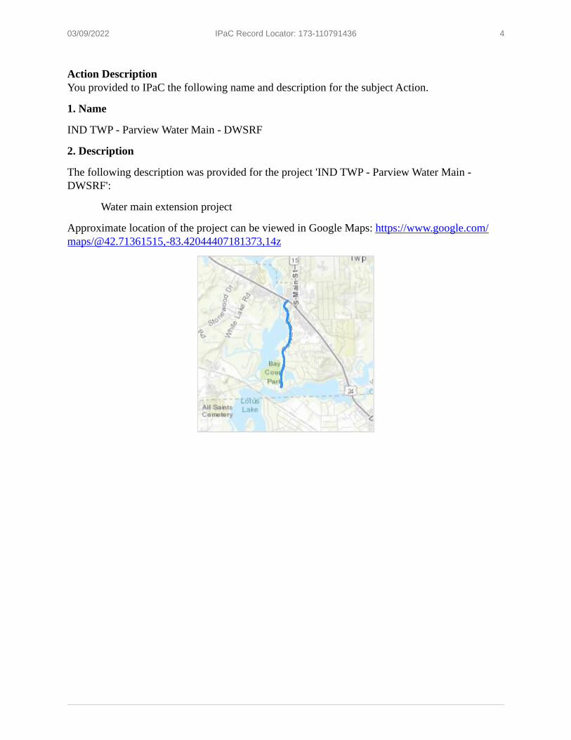
03/09/2022 IPaC Record Locator: 173-110791436 4
Action DescriptionYou provided to IPaC the following name and description for the subject Action.
1. Name
IND TWP - Parview Water Main - DWSRF
2. Description
The following description was provided for the project 'IND TWP - Parview Water Main - DWSRF':
Water main extension project
Approximate location of the project can be viewed in Google Maps: https://www.google.com/ maps/@42.71361515,-83.42044407181373,14z

03/09/2022 IPaC Record Locator: 173-110791436 5
1.
2.
3.
4.
5.
6.
7.
8.
9.
10.
11.
Qualification InterviewThis determination key is intended to assist the user in the evaluating the effects of their actions on Federally listed species in Michigan. It does not cover other prohibited activities under the Endangered Species Act (e.g., for wildlife: import/export, Interstate or foreign commerce, possession of illegally taken wildlife, purposeful take for scientific purposes or to enhance the survival of a species, etc.; for plants: import/export, reduce to possession, malicious destruction on Federal lands, commercial sale, etc.) or other statutes. Click yes to acknowledge that you must consider other prohibitions of the ESA or other statutes outside of this determination key.YesIs the action the approval of a long-term (i.e., in effect greater than 10 years) permit, plan, or other action?NoIs the action being funded, authorized, or carried out by a Federal agency?NoDoes the action involve the installation or operation of wind turbines?NoDoes the action involve purposeful take of a listed animal?NoDoes the action involve a new communication tower?NoDoes the activity involve aerial or other large-scale application of any chemical (including insecticide, herbicide, etc.)?NoWill your action permanently affect local hydrology by impacting 1/2 acre or more of wetland; or by increasing or decreasing groundwater or surfacewater elevations?NoWill your action temporarily affect local hydrology by impacting 1/2 acre or more of wetland; or by increasing or decreasing groundwater or surfacewater elevations?NoWill your project have any direct impacts to a stream or river (e.g., Horizontal Directional Drilling (HDD), hydrostatic testing, stream/road crossings, new storm-water outfall discharge, dams, other in-stream work, etc.)?NoDoes your project have the potential to indirectly impact the stream/river or the riparian zone (e.g., cut and fill, horizontal directional drilling, hydrostatic testing, construction, vegetation removal, discharge, etc.)?No

03/09/2022 IPaC Record Locator: 173-110791436 6
12.
13.
14.
15.
16.
17.
18.
19.
Will your action disturb the ground or existing vegetation? This includes any off road vehicle access, soil compaction, digging, seismic survey, directional drilling, heavy equipment, grading, trenching, placement of fill, pesticide application, vegetation management (including removal or maintenance using equipment or chemicals), cultivation, development, etc.YesDoes your action area occur entirely within an already developed area with no natural habitat or trees present? For the purposes of this question, "already developed areas" are already paved, covered by existing structures, manicured lawns, industrial sites, or cultivated cropland, AND do not contain trees that could be roosting habitat. Be aware that listed species may occur in areas with natural, or semi-natural, vegetation immediately adjacent to existing utilities (e.g. roadways, railways) or within utility rights-of-way such as overhead transmission line corridors, and can utilize suitable trees, bridges, or culverts for roosting even in urban dominated landscapes (so these are NOT considered "already developed areas" for the purposes of this question).No[Hidden Semantic] Does the action intersect the Eastern massasauga rattlesnake area of influence?Automatically answeredYesDoes your action involve prescribed fire?NoHave you determined that the area is not occupied by Eastern massasauga rattlesnake using the accepted survey protocol or an otherwise approved survey method? Only answer yes here if you have already coordinated with the Service on the survey effort to ensure the level of effort was sufficient to determine presence/absence. If you have conducted a survey in coordination with the Service, email a copy of your survey report to [email protected] with “Survey Report” in subject line, and upload the survey report(s) here in the next step of this key.NoWill this action occur entirely in the Eastern massasauga rattlesnake inactive season (October 16 through April 14)?NoWill this action occur entirely in the Eastern massasauga rattlesnake active season (April 15 through October 15)?NoWill the action result in permanent loss of more than one acre of wetland or conversion of more than 10 acres of uplands of potential Eastern massasauga rattlesnake habitat (uplands associated with high quality wetland habitat) to other land uses?No
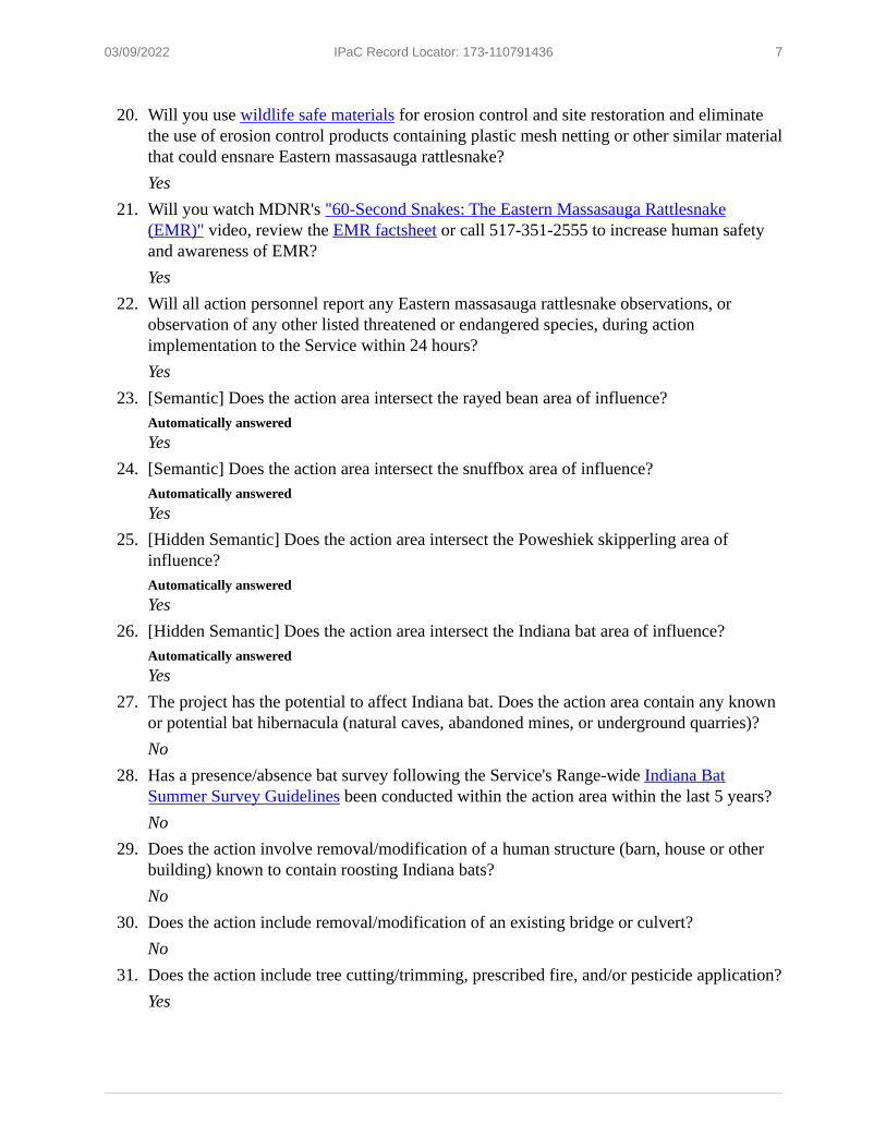
03/09/2022 IPaC Record Locator: 173-110791436 7
20.
21.
22.
23.
24.
25.
26.
27.
28.
29.
30.
31.
Will you use wildlife safe materials for erosion control and site restoration and eliminate the use of erosion control products containing plastic mesh netting or other similar material that could ensnare Eastern massasauga rattlesnake?YesWill you watch MDNR's "60-Second Snakes: The Eastern Massasauga Rattlesnake (EMR)" video, review the EMR factsheet or call 517-351-2555 to increase human safety and awareness of EMR?YesWill all action personnel report any Eastern massasauga rattlesnake observations, or observation of any other listed threatened or endangered species, during action implementation to the Service within 24 hours?Yes[Semantic] Does the action area intersect the rayed bean area of influence?Automatically answeredYes[Semantic] Does the action area intersect the snuffbox area of influence?Automatically answeredYes[Hidden Semantic] Does the action area intersect the Poweshiek skipperling area of influence?Automatically answeredYes[Hidden Semantic] Does the action area intersect the Indiana bat area of influence?Automatically answeredYesThe project has the potential to affect Indiana bat. Does the action area contain any known or potential bat hibernacula (natural caves, abandoned mines, or underground quarries)?NoHas a presence/absence bat survey following the Service's Range-wide Indiana Bat Summer Survey Guidelines been conducted within the action area within the last 5 years?NoDoes the action involve removal/modification of a human structure (barn, house or other building) known to contain roosting Indiana bats?NoDoes the action include removal/modification of an existing bridge or culvert?NoDoes the action include tree cutting/trimming, prescribed fire, and/or pesticide application?Yes

03/09/2022 IPaC Record Locator: 173-110791436 8
32.
33.
34.
35.
36.
37.
38.
39.
40.
41.
Small, isolated forest patch(es) are not considered suitable habitat for Indiana bat if they are less than 5 acres in size AND disconnected from other forest/trees by at least 1000 ft. Is your project within a small, isolated forest patch? If so, select yes. If you are not sure, follow the hyperlink above for more information or select No to answer more questions about your project.NoWill the action clear ≥20 acres of forest or fragment a connective corridor between 2 or more forest patches of at least 5 acres?NoWill the action clear >10% of the available forested habitat within a half-mile buffer of the action area?NoDoes the action area contain potential Indiana bat roost trees (trees ≥5 inches in diameter [at breast height] with cracks, crevices and/or exfoliating bark)?YesDoes the action include cutting/trimming hazard trees in order to prevent imminent loss of human life and/or property?NoWill all tree cutting/trimming, prescribed fire, and/or pesticide application occur entirely during the bat inactive (hibernation) season (October 1 through March 31)?No[Hidden Semantic] Does this project intersect the northern long-eared bat area of influence?Automatically answeredYesIs the project action area located within 0.25 miles of a known northern long-eared bat hibernaculum?Automatically answeredNoWill the action involve Tree Removal as defined in the 4(d) rule for northern long-eared bat?YesIs the project action area located within 150 feet of a known occupied northern long-eared bat maternity roost tree?Automatically answeredNo

03/09/2022 IPaC Record Locator: 173-110791436 9
42.
43.
Small, isolated forest patch(es) are not considered suitable habitat for northern long-eared bat if they are less than 5 acres in size AND disconnected from other forest/trees by at least 1000 ft. Is your project within a small, isolated forest patch? If so, select yes. If you are not sure, follow the hyperlink above for more information or select No to answer more questions about your project.NoDoes the action area contain potential northern long-eared bat bat roost trees (trees ≥3 inches in diameter [at breast height] with cracks, crevices, cavities and/or exfoliating bark)?Yes

03/09/2022 IPaC Record Locator: 173-110791436 10
Project QuestionnaireIf the project includes forest conversion, report the appropriate acreages below. Otherwise, type ‘0’ in questions 1-3.1. Estimated total acres of forest conversion:02. If known, estimated acres of forest conversion from April 1 to October 3103. If known, estimated acres of forest conversion from June 1 to July 310If the project includes timber harvest, report the appropriate acreages below. Otherwise, type ‘0’ in questions 4-6.4. Estimated total acres of timber harvest05. If known, estimated acres of timber harvest from April 1 to October 3106. If known, estimated acres of timber harvest from June 1 to July 310If the project includes prescribed fire, report the appropriate acreages below. Otherwise, type ‘0’ in questions 7-9.7. Estimated total acres of prescribed fire08. If known, estimated acres of prescribed fire from April 1 to October 3109. If known, estimated acres of prescribed fire from June 1 to July 310

03/09/2022 IPaC Record Locator: 173-110791436 11
IPaC User Contact InformationAgency: Oakland CountyName: Dava LakatosAddress: 950 W Norton AvenueAddress Line 2: Suite 207City: MuskegonState: MIZip: 49441Email [email protected]: 2317676322

March 09, 2022
United States Department of the InteriorFISH AND WILDLIFE SERVICEMichigan Ecological Services Field Office
2651 Coolidge Road Suite 101East Lansing, MI 48823-6360
Phone: (517) 351-2555 Fax: (517) 351-1443http://www.fws.gov/midwest/EastLansing/
In Reply Refer To: Project code: 2022-0017703 Project Name: IND TWP - Waldon Water Main - DWSRF Subject: Consistency letter for 'IND TWP - Waldon Water Main - DWSRF' for specified
federally threatened and endangered species and designated critical habitat that may occur in your proposed project area consistent with the Michigan Determination Key for project review and guidance for federally listed species (Michigan Dkey).
Dear Dava Lakatos:
The U.S. Fish and Wildlife Service (Service) received on March 09, 2022 your effect determination(s) for the 'IND TWP - Waldon Water Main - DWSRF' (the Action) using the Michigan DKey within the Information for Planning and Consultation (IPaC) system. The Service developed this system in accordance with the Endangered Species Act of 1973 (ESA) (87 Stat.884, as amended; 16 U.S.C. 1531 et seq.).
Based on your answers and the assistance of the Service’s Michigan DKey, you made the following effect determination(s) for the proposed Action:
Species Listing Status DeterminationEastern Massasauga (=rattlesnake) (Sistrurus catenatus) Threatened May affectIndiana Bat (Myotis sodalis) Endangered May affectNorthern Long-eared Bat (Myotis septentrionalis) Threatened May affectPoweshiek Skipperling (Oarisma poweshiek) Endangered No effectRayed Bean (Villosa fabalis) Endangered No effectSnuffbox Mussel (Epioblasma triquetra) Endangered No effect Northern Long-eared Bat: The Action “May Affect” the Northern Long-eared Bat (NLEB). However, the Action complies with the final 4(d) rule with incidental take covered by the U.S. Fish and Wildlife Service’s January 5, 2016, Intra-Service Programmatic Biological Opinion on the final 4(d) rule for the NLEB addressing “Activities Excepted from Take Prohibitions.” As such, no further consultation is required for NLEB.

03/09/2022 IPaC Record Locator: 273-110794381 2
Eastern Massasauga (EMR): EMR may be present in the Action area. The following projects are not within the scope of the Michigan DKey: prescribed fire; new roads or trails that create a permanent barrier to EMR movement; projects that alter hydrology permanently, or temporarily if during the inactive season; projects that are large in scale; and projects that do not apply recommended conservation measures. Project-specific review is needed for these types of projects. Please coordinate with the Michigan Ecological Services Field Office to further evaluate effects of the Action on EMR.
Indiana Bat: Indiana bat may be present in the Action area. Projects have potential to affect Indiana bats if the Action area contains any known or potential hibernacula (including natural caves, abandoned mines, or underground quarries) or if the Action will remove/modify a human structure (barn, house or other building) known to contain roosting Indiana bats. Additionally, projects may affect the species if they clear ≥20 acres of forest or fragment a connective corridor between 2 or more forest patches of at least 5 acres, clear >10% of the available forested habitat within a half- mile buffer of the Action area, cut or trim any potential Indiana bat roost trees (trees ≥5 inches in diameter [at breast height] with cracks, crevices and/or exfoliating bark) during the Indiana bat active season (April 1 through September 30), or apply pesticides during the active season. Projects that include removal/modification of an existing bridge or culvert suitable for day- roosting Indiana bats may affect the species if construction activities are performed during the active season and/or will result in the permanent loss of known or potential roosting spaces (i.e., cracks/crevices/joints). Lastly, projects that include temporary or permanent lighting of roadway(s), facility(ies), and/or parking lot(s) may affect Indiana bats if they do not apply avoidance and minimization measures. Please coordinate with the Michigan Ecological Services Field Office to further evaluate effects of the Action on Indiana bats.
Bats of Conservation Concern: Implementing protective measures for bats, including both federally listed and unlisted species, indirectly helps to protect Michigan’s agriculture and forests. Bats are significant predators of nocturnal insects, including many crop and forest pests. For example, Whitaker (1995) estimated that a single colony of 150 big brown bats (Eptesicus fuscus) would eat nearly 1.3 million pest insects each year. Boyles et al. (2011) noted the “loss of bats in North America could lead to agricultural losses estimated at more than $3.7 billion/year, and Maine and Boyles (2015) estimated that the suppression of herbivory by insectivorous bats is worth >1 billion USD globally on corn alone. In captive trials, northern long-eared bats were found to significantly reduce the egg-laying activity of mosquitoes, suggesting bats may also play an important role in controlling insect-borne disease (Reiskind and Wund 2009). Mosquitoes have also been found to be a consistent component of the diet of Indiana bats and are eaten most heavily during pregnancy (6.6%; Kurta and Whitaker 1998). Taking proactive steps to help protect bats may be very valuable to agricultural and forest product yields and pest management costs in and around a project area. Such conservation measures include limiting tree clearing during the bat active season (April through October) and/or the non-volant season (June through July), when young bats are unable to fly, and minimizing the extent of impacts to forests, wetlands, and riparian habitats.

03/09/2022 IPaC Record Locator: 273-110794381 3
Bald and Golden Eagles: Bald eagles, golden eagles, and their nests are protected under the Bald and Golden Eagle Protection Act (54 Stat. 250, as amended, 16 U.S.C. 668a-d) (Eagle Act). The Eagle Act prohibits, except when authorized by an Eagle Act permit, the “taking” of bald and golden eagles and defines “take” as “pursue, shoot, shoot at, poison, wound, kill, capture, trap, collect, molest or disturb.” The Eagle Act’s implementing regulations define disturb as “…to agitate or bother a bald or golden eagle to a degree that causes, or is likely to cause, based on the best scientific information available, (1) injury to an eagle, (2) a decrease in its productivity, by substantially interfering with normal breeding, feeding, or sheltering behavior, or (3) nest abandonment, by substantially interfering with normal breeding, feeding, or sheltering behavior.”
If the Action may impact bald or golden eagles, additional coordination with the Service under the Eagle Act may be required. For more information on eagles and conducting activities in the vicinity of an eagle nest, please visit https://www.fws.gov/midwest/eagle/. In addition, the Service developed the National Bald Eagle Management Guidelines (May 2007) in order to assist landowners in avoiding the disturbance of bald eagles. The full Guidelines are available at http://www.fws.gov/midwest/eagle/pdf/NationalBaldEagleManagementGuidelines.pdf.
If you have further questions regarding potential impacts to eagles, please contact Chris Mensing, [email protected] or 517-351-2555.
Coordination with the Service is not complete if additional coordination is advised above for any species. Please email our office at [email protected] and attach a copy of this letter, so we can discuss methods to avoid or minimize potential adverse effects to those species.
Bat References Boyles, J.G., P.M. Cryan, G.F. McCracken, T.H. Kunz. 2011. Economic Importance of Bats in Agriculture. Science 332(1):41-42. Kurta, A. and J.O. Whitaker. 1998. Diet of the Endangered Indiana Bat (Myotis sodalis) on the Northern Edge of Its Range. The American Midland Naturalist 140(2):280-286. Reiskind, M.H. and M.A. Wund. 2009. Experimental assessment of the impacts of northern long- eared bats on ovipositing Culex (Diptera: Culicidae) mosquitoes. Journal of Medical Entomology 46(5):1037-1044. Whitaker, Jr., J.O. 1995. Food of the big brown bat Eptesicus fuscus from maternity colonies in Indiana and Illinois. American Midland Naturalist 134(2):346-360.

03/09/2022 IPaC Record Locator: 273-110794381 4
Action DescriptionYou provided to IPaC the following name and description for the subject Action.
1. Name
IND TWP - Waldon Water Main - DWSRF
2. Description
The following description was provided for the project 'IND TWP - Waldon Water Main - DWSRF':
Water main extension project for Independence Township
Approximate location of the project can be viewed in Google Maps: https://www.google.com/ maps/@42.73648025,-83.40994928727818,14z

03/09/2022 IPaC Record Locator: 273-110794381 5
1.
2.
3.
4.
5.
6.
7.
8.
9.
10.
11.
Qualification InterviewThis determination key is intended to assist the user in the evaluating the effects of their actions on Federally listed species in Michigan. It does not cover other prohibited activities under the Endangered Species Act (e.g., for wildlife: import/export, Interstate or foreign commerce, possession of illegally taken wildlife, purposeful take for scientific purposes or to enhance the survival of a species, etc.; for plants: import/export, reduce to possession, malicious destruction on Federal lands, commercial sale, etc.) or other statutes. Click yes to acknowledge that you must consider other prohibitions of the ESA or other statutes outside of this determination key.YesIs the action the approval of a long-term (i.e., in effect greater than 10 years) permit, plan, or other action?NoIs the action being funded, authorized, or carried out by a Federal agency?NoDoes the action involve the installation or operation of wind turbines?NoDoes the action involve purposeful take of a listed animal?NoDoes the action involve a new communication tower?NoDoes the activity involve aerial or other large-scale application of any chemical (including insecticide, herbicide, etc.)?NoWill your action permanently affect local hydrology by impacting 1/2 acre or more of wetland; or by increasing or decreasing groundwater or surfacewater elevations?NoWill your action temporarily affect local hydrology by impacting 1/2 acre or more of wetland; or by increasing or decreasing groundwater or surfacewater elevations?NoWill your project have any direct impacts to a stream or river (e.g., Horizontal Directional Drilling (HDD), hydrostatic testing, stream/road crossings, new storm-water outfall discharge, dams, other in-stream work, etc.)?NoDoes your project have the potential to indirectly impact the stream/river or the riparian zone (e.g., cut and fill, horizontal directional drilling, hydrostatic testing, construction, vegetation removal, discharge, etc.)?No

03/09/2022 IPaC Record Locator: 273-110794381 6
12.
13.
14.
15.
16.
17.
18.
19.
Will your action disturb the ground or existing vegetation? This includes any off road vehicle access, soil compaction, digging, seismic survey, directional drilling, heavy equipment, grading, trenching, placement of fill, pesticide application, vegetation management (including removal or maintenance using equipment or chemicals), cultivation, development, etc.YesDoes your action area occur entirely within an already developed area with no natural habitat or trees present? For the purposes of this question, "already developed areas" are already paved, covered by existing structures, manicured lawns, industrial sites, or cultivated cropland, AND do not contain trees that could be roosting habitat. Be aware that listed species may occur in areas with natural, or semi-natural, vegetation immediately adjacent to existing utilities (e.g. roadways, railways) or within utility rights-of-way such as overhead transmission line corridors, and can utilize suitable trees, bridges, or culverts for roosting even in urban dominated landscapes (so these are NOT considered "already developed areas" for the purposes of this question).No[Hidden Semantic] Does the action intersect the Eastern massasauga rattlesnake area of influence?Automatically answeredYesWill your action impact less than 0.5 acres of suitable Eastern massasauga rattlesnake habitat?YesDoes your action involve prescribed fire?NoHave you determined that the area is not occupied by Eastern massasauga rattlesnake using the accepted survey protocol or an otherwise approved survey method? Only answer yes here if you have already coordinated with the Service on the survey effort to ensure the level of effort was sufficient to determine presence/absence. If you have conducted a survey in coordination with the Service, email a copy of your survey report to [email protected] with “Survey Report” in subject line, and upload the survey report(s) here in the next step of this key.NoWill this action occur entirely in the Eastern massasauga rattlesnake inactive season (October 16 through April 14)?NoWill this action occur entirely in the Eastern massasauga rattlesnake active season (April 15 through October 15)?No

03/09/2022 IPaC Record Locator: 273-110794381 7
20.
21.
22.
23.
24.
25.
26.
27.
28.
29.
30.
Will the action result in permanent loss of more than one acre of wetland or conversion of more than 10 acres of uplands of potential Eastern massasauga rattlesnake habitat (uplands associated with high quality wetland habitat) to other land uses?NoWill you use wildlife safe materials for erosion control and site restoration and eliminate the use of erosion control products containing plastic mesh netting or other similar material that could ensnare Eastern massasauga rattlesnake?YesWill you watch MDNR's "60-Second Snakes: The Eastern Massasauga Rattlesnake (EMR)" video, review the EMR factsheet or call 517-351-2555 to increase human safety and awareness of EMR?YesWill all action personnel report any Eastern massasauga rattlesnake observations, or observation of any other listed threatened or endangered species, during action implementation to the Service within 24 hours?YesWill your action create a new road or widen or alter an existing road?NoWill your action result in a permanent barrier to snake movement? For example, linear features such as trails, fences, walls, canals, or other permanent barriers have the potential to fragment habitat and alter movement and dispersal.NoIt is important to understand where potential hibernation habitat for eastern massasauga occurs at the project site. Has a qualified herpetologist conducted a habitat assessment of the site, including assessing whether potential EMR hibernacula are present on the action site? Or have you otherwise delineated potential hibernation habitat on the site?No[Semantic] Does the action area intersect the rayed bean area of influence?Automatically answeredYes[Semantic] Does the action area intersect the snuffbox area of influence?Automatically answeredYes[Hidden Semantic] Does the action area intersect the Poweshiek skipperling area of influence?Automatically answeredYes[Hidden Semantic] Does the action area intersect the Indiana bat area of influence?Automatically answeredYes

03/09/2022 IPaC Record Locator: 273-110794381 8
31.
32.
33.
34.
35.
36.
37.
38.
39.
40.
41.
42.
The project has the potential to affect Indiana bat. Does the action area contain any known or potential bat hibernacula (natural caves, abandoned mines, or underground quarries)?NoHas a presence/absence bat survey following the Service's Range-wide Indiana Bat Summer Survey Guidelines been conducted within the action area within the last 5 years?NoDoes the action involve removal/modification of a human structure (barn, house or other building) known to contain roosting Indiana bats?NoDoes the action include removal/modification of an existing bridge or culvert?NoDoes the action include tree cutting/trimming, prescribed fire, and/or pesticide application?YesSmall, isolated forest patch(es) are not considered suitable habitat for Indiana bat if they are less than 5 acres in size AND disconnected from other forest/trees by at least 1000 ft. Is your project within a small, isolated forest patch? If so, select yes. If you are not sure, follow the hyperlink above for more information or select No to answer more questions about your project.NoWill the action clear ≥20 acres of forest or fragment a connective corridor between 2 or more forest patches of at least 5 acres?NoWill the action clear >10% of the available forested habitat within a half-mile buffer of the action area?NoDoes the action area contain potential Indiana bat roost trees (trees ≥5 inches in diameter [at breast height] with cracks, crevices and/or exfoliating bark)?YesDoes the action include cutting/trimming hazard trees in order to prevent imminent loss of human life and/or property?NoWill all tree cutting/trimming, prescribed fire, and/or pesticide application occur entirely during the bat inactive (hibernation) season (October 1 through March 31)?No[Hidden Semantic] Does this project intersect the northern long-eared bat area of influence?Automatically answeredYes

03/09/2022 IPaC Record Locator: 273-110794381 9
43.
44.
45.
46.
47.
Is the project action area located within 0.25 miles of a known northern long-eared bat hibernaculum?Automatically answeredNoWill the action involve Tree Removal as defined in the 4(d) rule for northern long-eared bat?YesIs the project action area located within 150 feet of a known occupied northern long-eared bat maternity roost tree?Automatically answeredNoSmall, isolated forest patch(es) are not considered suitable habitat for northern long-eared bat if they are less than 5 acres in size AND disconnected from other forest/trees by at least 1000 ft. Is your project within a small, isolated forest patch? If so, select yes. If you are not sure, follow the hyperlink above for more information or select No to answer more questions about your project.NoDoes the action area contain potential northern long-eared bat bat roost trees (trees ≥3 inches in diameter [at breast height] with cracks, crevices, cavities and/or exfoliating bark)?Yes

03/09/2022 IPaC Record Locator: 273-110794381 10
Project QuestionnaireIf the project includes forest conversion, report the appropriate acreages below. Otherwise, type ‘0’ in questions 1-3.1. Estimated total acres of forest conversion:02. If known, estimated acres of forest conversion from April 1 to October 3103. If known, estimated acres of forest conversion from June 1 to July 310If the project includes timber harvest, report the appropriate acreages below. Otherwise, type ‘0’ in questions 4-6.4. Estimated total acres of timber harvest05. If known, estimated acres of timber harvest from April 1 to October 3106. If known, estimated acres of timber harvest from June 1 to July 310If the project includes prescribed fire, report the appropriate acreages below. Otherwise, type ‘0’ in questions 7-9.7. Estimated total acres of prescribed fire08. If known, estimated acres of prescribed fire from April 1 to October 3109. If known, estimated acres of prescribed fire from June 1 to July 310
03/09/2022 IPaC Record Locator: 273-110794381 11
IPaC User Contact InformationAgency: Oakland CountyName: Dava LakatosAddress: 950 W Norton AvenueAddress Line 2: Suite 207City: MuskegonState: MIZip: 49441Email [email protected]: 2317803100

Independence Township FY2023 DWSRF Parview and Waldon Water Main Extensions
Page 60 of 61
APPENDIX XIII PUBLIC HEARING NOTICE

CHARTER TOWNSHIP OF INDEPENDENCE NOTICE OF PUBLIC HEARING
DRINKING WATER SYSTEM IMPROVEMENTS 2023 DRINKING WATER STATE REVOLVING FUND (DWSRF) PROJECT PLAN
A Public Hearing will be held by the Charter Township of Independence Board of Trustees in the Township Hall Meeting Room, 6483 Waldon Center Drive, Clarkston, Michigan 48346 beginning at 6:00PM on Tuesday, June 21, 2022, for the purpose of presenting and receiving comment on the FY2023 DWSRF Project Plan for the Parview Drive and Waldon Road Watermain Extension Improvements project. A copy of the proposed Project Plan will be available for public review at the meeting and will be available on the Township website by May 20, 2022. Comments can be expressed at the Public Hearing or written comments and questions can be directed to the attention of the Township Supervisor at the above address or by email to [email protected] no later than 4:00pm on the Friday before the meeting. Questions may also be directed to the Township Clerk by phone at (248) 625-5111. Persons with disabilities needing accommodations for effective participation in this meeting should contact the Township Clerk (248) 625-5111 at least two working days in advance of the meeting. An attempt will be made to make reasonable accommodations. For those who wish to participate in the meeting virtually, please see the Township website for virtual meeting details at: https://www.indtwp.com/.
Cari J. Neubeck, Clerk Charter Township of Independence
POSTED on Website: May 20, 2022
PUBLISHED: May 20, 2022