Halt soil salinization, boost soil productivity
413
PROCEEDINGS GLOBAL SYMPOSIUM ON SALT-AFFECTED SOILS 20–22 October, 2021 Government of the Republic of Uzbekistan OF THE Halt soil salinization, boost soil productivity
-
Upload
khangminh22 -
Category
Documents
-
view
1 -
download
0
Transcript of Halt soil salinization, boost soil productivity

PROCEEDINGSGLOBAL SYMPOSIUM ON
SALT-AFFECTEDSOILS
20–22 October, 2021
Governmentof the Republicof Uzbekistan
OF THE
Halt soil salinization,boost soil productivity


PROCEEDINGSGLOBAL SYMPOSIUM ON
SALT-AFFECTEDSOILS
Food and Agriculture Organization of the United NationsRome, 2022
20–22 October, 2021
OF THE
Halt soil salinization,boost soil productivity
Required citation: FAO. 2022. Halt soil salinization, boost soil productivity – Proceedings of the Global Symposium on Salt-affected Soils. 20–22 October 2021. Rome. https://doi.org/10.4060/cb9565en
The designations employed and the presentation of material in this information product do not imply the expression of any opinion whatsoever on the part of the Food and Agriculture Organization of the United Nations (FAO) concerning the legal or development status of any country, territory, city or area or of its authorities, or concerning the delimitation of its frontiers or boundaries. The mention of specific companies or products of manufacturers, whether or not these have been patented, does not imply that these have been endorsed or recommended by FAO in preference to others of a similar nature that are not mentioned.
The views expressed in this information product are those of the author(s) and do not necessarily reflect the views or policies of FAO.
ISBN 978-92-5-136078-1 © FAO, 2022
Some rights reserved. This work is made available under the Creative Commons Attribution-NonCommercial-ShareAlike 3.0 IGO licence (CC BY-NC-SA 3.0 IGO; https://creativecommons.org/licenses/by-nc-sa/3.0/igo/legalcode).
Under the terms of this licence, this work may be copied, redistributed and adapted for non-commercial purposes, provided that the work is appropriately cited. In any use of this work, there should be no suggestion that FAO endorses any specific organization, products or services. The use of the FAO logo is not permitted. If the work is adapted, then it must be licensed under the same or equivalent Creative Commons licence. If a translation of this work is created, it must include the following disclaimer along with the required citation: “This translation was not created by the Food and Agriculture Organization of the United Nations (FAO). FAO is not responsible for the content or accuracy of this translation. The original [Language] edition shall be the authoritative edition.”
Disputes arising under the licence that cannot be settled amicably will be resolved by mediation and arbitration as described in Article 8 of the licence except as otherwise provided herein. The applicable mediation rules will be the mediation rules of the World Intellectual Property Organization http://www.wipo.int/amc/en/mediation/rules and any arbitration will be conducted in accordance with the Arbitration Rules of the United Nations Commission on International Trade Law (UNCITRAL).
Third-party materials. Users wishing to reuse material from this work that is attributed to a third party, such as tables, figures or images, are responsible for determining whether permission is needed for that reuse and for obtaining permission from the copyright holder. The risk of claims resulting from infringement of any third-party-owned component in the work rests solely with the user.
Sales, rights and licensing. FAO information products are available on the FAO website (www.fao.org/publications) and can be purchased through [email protected]. Requests for commercial use should be submitted via: www.fao.org/contact-us/licence-request. Queries regarding rights and licensing should be submitted to: [email protected].
Cover photograph: ©Matteo Sala

III
Contents
Theme 1. Assessment, mapping, and monitoring of salt-affected soils ............... 1
Salinization and sodification in irrigated agricultural areas in arid regions,
Northern Patagonia Argentina
Apcarian A., Imbellone P.A., Salaberry J.M. ..................................................................... 2
Salinization processes in irrigated soils of Mirzachul
Arabov S., Abdurakhmonov N., Bakhodirov Z., Sobitov U. ................................................ 4
Use of aboveground electromagnetic induction meter for detecting salinity
gradients and indurated soil layers in a volcanic landscape
Arriola-Morales J., Batlle-Sales J. ..................................................................................... 6
Evaluation of soil salinity levels through using Landsat-8 OLI in
Central Fergana Valley, Uzbekistan
Aslanov I., Kholdorov S., Ochilov S., Jumanov A., Jabbarov Z.,
Jumaniyazov I., Namozov N. ............................................................................................ 8
Characterization and modelling of salt-affected soils properties using
VNIR hyperspectral data
Barman A. ..................................................................................................................... 11
Characterization of spatial and temporal variability in soil salinity
in relationship to alfalfa (Medicago sativa l.) productivity
Benes S.E., Singh S., Gull U., Anderson A., Scudiero E.,
Hutmacher R.B., Putnam D.H........................................................................................ 13
Application of GIS in mapping salt washing norm maps
Bobomurodov Sh.M., Baxodirov Z.A., Normatov Yo.M. .................................................. 15
Current condition, fertility and characteristics of irrigated soils of
Peshku district of Bukhara region
Bobomurodov Sh.M., Baxodirov Z.A., Tursunov Sh.T., Turdaliev J.M. ............................ 17
Wheat salinity stress detection using VNIR spectrometry
Boloorani A.D., Mirzaei S., Bahrami H.A., Mouazen A.M. .............................................. 19
Soil salinity mapping and biosaline agriculture in Kazakhstan
Bozayeva Z., Toderich K. ............................................................................................... 21
Salinity risk mapping using an integrated approach and land cover
in semi-arid area, Morocco
Chaaou A., Chikhaoui M., Naimi M., El Miad A.K., Seif-Ennasr M. ................................. 23
Saline soils in the Baixada Maranhense: a case study in Maranhão state, Brazil
da Silva Martins A.L., Teixeira W.G., Silva M.B. ............................................................. 26

IV
Land capability and suitability maps of a salt affected costal area
(Ravenna, northern Italy)
De Feudis M., Falsone G., Gherardi M., Speranza M., Vianello G., Antisari L.V. ............... 28
Use of geoinformation system technologies to increase the fertility
of saline soils
Djalilova G., Sidikov S., Rakhimov Kh., Ergasheva O. .................................................... 30
Impact of salinity on soil organic carbon in a semi-arid environment
from 2000 to 2020 (Northwestern Algeria)
Faraoun F., Ayache A. ................................................................................................... 32
Current challenges in application of Electromagnetic Induction method
in monitoring soil salinity and sodicity in irrigated agricultural lands:
Case studies from Portugal
Farzamian M., Castanheira N., Paz A.M., Ramos T.B., Monteiro Santos F.A.,
Paz M.C., Martinez Moreno F.J., Alexandre C.A., Rodríguez M.R.,
Vanderlinden K., Gonçalves M.C. .................................................................................... 34
Methods for the Analysis of Salt-Affected Soils
Ferguson R., Hoover D. .................................................................................................. 36
Salting of ski slope snow and its ecological impact
Frolov D. ........................................................................................................................ 38
Saline gypsum soils and their biological activity
Gafurova L.A., Nabieva G.M., Makhkamova D.Yu. ......................................................... 39
Haplic Kastanozems Chromic of the North-West Caspian region
under climate change conditions
Gasanova Z.U. ................................................................................................................ 41
Salt Affected Soils in the Awash River Basin irrigation projects in Ethiopia
Gelaw A.M., Aynekulu E. ............................................................................................... 43
Study of soil salinization process in the semi-arid agricultural areas
of Masis region, Armenia
Ghazaryan K., Movsesyan H., Khachatryan H. ............................................................... 46
Monitoring tridimensional soil salinity patterns at the field scale
using electromagnetic induction sensing and inversion
Gómez Flores J.L., Ramos Rodríguez M., González Jiménez A.,
Farzamian M., Herencia Galán J.F., Salvatierra Bellido B.,
Cermeño Sacristan P., Vanderlinden K. ........................................................................... 48
Salt-affected soils in Colombia: modelling study case in CAR zone
Gonzalez R., Avila J., Ariza K., Afanador R. .................................................................. 50
Salt-affected soils in Bulgaria
Hristov B. ....................................................................................................................... 52
Changes in some hydromorphic soils of the Aral Sea region under
the influence of desertification
Iskhakova Sh.M., Abdullaeva Kh.B. ............................................................................... 54

V
Relations between the electrical conductivity and salt content
for 1:5 soil-to-water extract: contribution of the salinity chemistry
Ismayilov A.I., Mamedov A.I., Levy G.J. ........................................................................ 56
Saline soils of the Aral Sea region and their rational use
Ismonov A.J., Mamajanova O.Kh. .................................................................................. 58
Statement of soil salinity in Burkina Faso
Kabore D., Traore M., Segda Z., Sawadogo A., Omuto C.T. ............................................. 60
Salinized irrigated hydromorphic soils of Central Fergana
Kalandarov N.N., Abdurakhmonov N.Yu., Sobitov U.T., Ismonov A.J. ............................ 61
Spatial predictability of salinity hazard with machine learning algorithms
and digital data in the irrigation plain
Kaya F., Başayiğit L. ...................................................................................................... 63
Soil salinity and the associated effects in Mingbulak district,
Fergana Valley in Uzbekistan
Kholdorov Sh., Gopakumar L. ........................................................................................ 65
Status of salt-affected soils in Cameroon
Kome G.K., Silatsa F.B.T., Yemefack M. ........................................................................ 67
Salinity of irrigated soils at the Sarpinskaya hollow in the Caspian lowland
Kravchenko E.I., Khitrov N.B., Gorokhova I.N. .............................................................. 69
Physical and chemical properties of irrigated meadow soils of Jandar Region
Kurvantaev R., Nazarova S.M., Solieva N.A. ................................................................... 71
Assessment of the state of soil salinity for analysis of geochemical stability
of landscapes in dry areas
Kust G., Andreeva O. ...................................................................................................... 73
Distribution of sodium-affected soils in the Amazon: genesis, characterization
and agricultural aptitude
Melo V.F., Lima de Matos C.H., do Vale Júnior J.F. ........................................................ 75
Freshwater tidal swamp and peat collapse after storm-driven saltwater surge
Middleton B.A. ............................................................................................................... 77
Minimizing the effect of soil salinity on prediction accuracy
of soil organic carbon
Mirzaei S., Boloorani A.D., Bahrami H.A., Mouazen A.M. .............................................. 80
Investigation of short-scale soil spatial variability of a salt-affected land
allotment in Maha-Illuppallama, Sri Lanka in support of applying
site-specific soil management practices
Nayanarangani M.D.P., Rathnayaka R.A.A.S., Amarasekara M.G.T.S. ........................... 82
National study of soil degradation by salinization in Colombia
Neira M.F., Sanchez L.R., Otero G.J. ............................................................................... 84
The influence of the soil formation factors on the mapping of salt-affected
soils on a national scale in South Africa
Nell J.P. ......................................................................................................................... 86

VI
Minerals (carbonate and palygorskite) induced natural soil degradation
(sodicity and poor drainage) in Vertisols of semi-arid Central India
Paul R., Vasu D., Kaunakaran K., Tiwary P., Chandran P. ............................................. 88
Examination of chemical and physical properties of halomorphic soils
in the Surčin area–Republic of Serbia
Pivić R., Stanojković-Sebić A., Dinić Z., Maksimović J., Jaramaz D.,
Tara G., Vidojević D. ...................................................................................................... 90
Numerical phytoindication of soil salinity: the case study in the dry steppes
of Russia
Prokopyeva K., Konyushkova M., Novikova N. ............................................................... 93
Characterization and classification of natural and altered wetland soils
(Kaipad soils) of north Kerala, India
Purandhar E.,. Sreelatha A.K., Anil Kumar K.S., Nideesh. P.,
Durgadevi K.M., Ayyoob K.C. ......................................................................................... 95
Natural resource management and monitoring at salt-affected inter-channel
depressions of Amu Darya delta under desertification for the
liquorice restoration
Reymov P.R., Mamutov N.K., Statov V.A., Khudaybergenov Ya.G. ................................. 98
Preliminary study of salt-affected soils in the Zona Bananera,
Magdalena (Colombia)
Rincon-Rodriguez C.A., Loaiza-Usuga J.C., Rubiano-Sanabria Y. .................................. 100
Mapping salt-affected soils of the United States of America
Roecker S., Kienast-Brown S., Ferguson C., Philippe J., Skaggs T., Lindbo D. ................ 102
Digital assessment of soil salinity across Paraguay
Rojas A.E., Sevilla V., Guevara M., Ríos D., Moriya M.K. .............................................. 104
Prediction of soil salinity using a Random Forest-based model
between 2000 and 2016: A case study in the Great Hungarian Plain
Sahbeni G. ..................................................................................................................... 106
Characterisation of different land uses in Pokkali ecosystem
Sajan A., Sreelatha A.K. ................................................................................................ 108
Soil electrical conductivity EC modelling based on LUCAS topsoil
(2015-2018) using machine learning approach to classify salt affected soils
Schillaci C., Scarpa S., Montanarella L. .......................................................................... 111
Survey and characterization of underground waters of north western part
of Jodhpur, Rajasthan
Serawat A., Singh R., Yadav S.R., Singh S.P., Yadav R.K., Kaledhonkar M.J. ................ 114
Assessment of ground water quality for irrigation in Alappuzha district
of Kerala, India
Sreelatha A.K., Paul N., Kaledhonkar M.J. .................................................................... 116
Current state of degraded soils of the Aral region and technologies
for improving their fertility
Tashkuziev M.M., Berdiev T.T., Ochilov S.K., Korabekov O.G., Mustafaeva S.Ch. ........... 118

VII
Mapping salt-affected soils of Italy
Ungaro F., Calzolari C., Fantappiè M., Napoli R., Barbetti R., Tarocco P.,
Staffilani F., Puddu R., Fanni S., Ragazzi F., Vinci I., Giandon P., Gardin L.,
Brenna S., Tiberi M., Corti G., Dazzi C., Altobelli F. ....................................................... 120
Characterization and management of salt affected soils of Kurnool District
of Andhra Pradesh in India
Vinnakota Sailaja, Sudha Rani Y., Mohan Rao P., Venkata Subbaiah P.,
Kaldhonkar M.J. ........................................................................................................... 123
Informational support of rational use of salt-affected soils in Ukraine
Zakharova M., Baliuk S., Vorotyntseva L....................................................................... 125
The changing of the meliorative condition of soil by influencing of
anthropogene factors in downstream of Kashkadarya
Zakirova S.K. ................................................................................................................ 127
Theme 2. Integrated soil – water – crop solutions in rehabilitation and
management of salt-affected areas ........................................................................ 129
Agrobiotechnology to restore the fertility of irrigated saline soils
of the gold steppe
Abdujalilova O., Gafurova L., Paxriddinova N. ............................................................... 130
Effects of different microbiological biopreparates on the salinization
and meliorative condition of gray-meadow soils
Abdujalilova. O., Gafurova L., Pahritdinova N., Juliev M. .............................................. 132
Restoration of salt-affected soils is a function of soil profile diagnosis,
and residual sodium carbonate of irrigation water in arid and
semi-arid environments
Ahmad W., Zia M.H., Shahid S.A., Dang Yash, Sabir M. ................................................ 135
Amelioration of sodic soil and conjunctive use of canal and alkali
ground water for sustainable rice production
Alagesan A., Balasubramaniam P., Masilamani P., Kaledhonkar M.J……..….……..….138
Screening of selected rice genotypes for salinity tolerance using
morpho-physiological traits
Anusha S., Ashish K. Chaturvedi, Chandran S., Jagannathan S.,
Ganesh Kumar P., Surendran U. .................................................................................... 138
Effective halophilic microbes for bio-amelioration of coastal saline soils
Arora S., Vanza M.J., Bhuva C., Rao G.G., Sharma D.K. ................................................ 142
Biochar effect on soil EC in pesticide polluted soils of the microcosm experiment
Artikov Kh., Abdukarimov A., Otayev A., Makhamadiev S., Abdrakhmanov T. ............. 145
Effects of different types of composts, phosphogypsum and mineral fertilization
on the chemical and biochemical properties of an acid sulphate soil and
the yield of rice in Djibélor (Lower Casamance)
Badiane A., Sambou A., H-S-Manga A. ......................................................................... 147

VIII
Evaluation of Sorghum (Sorghum bicolor L.) varieties for their tolerance
to sodicity level for sustained productivity in salt affected soils
Balasubramaniam P., Alagesan A., Masilamani P., Kaledhonkar M.J. ........................... 149
Agricultural gypsum application in soils with exchangeable sodium:
study in microlysimeters
Ballestero J., del Pino A., Barbazan M. .......................................................................... 151
Deficit saline irrigation and mulch affect soil microbial activities under
zero-tilled saline soil
Basak N., Rai A.K., Sundha P., Pratiksha, Kaur H., Narjary B., Yadav G.,
Yadav R.K. and Sharma P.C. ......................................................................................... 153
Linkages between land use/land cover with soil sodicity development and soil
carbon build-up
Bhardwaj A.K., Mishra V.K. ......................................................................................... 155
Purslane as a super-high K accumulator Halophyte
Biouki R.Y., Karimi M. ................................................................................................. 157
An economic analysis of the yield of eight varieties of potato grown
under saline conditions
Bruning B., Lugtenburg C., Elbedawy N., de Vos A. ....................................................... 159
Saline-sodic soils rehabilitation using a rubble barrier and organic amendments
Chávez-García E., Siebe C. ............................................................................................. 161
Producing a Tailored soil, with an underused saline Fluvisol, for
the conservation of a critically endangered species
Cortinhas A., Cardoso Ferreira T., Abreu M.M., Caperta A.D. ......................................... 163
Introducing salt tolerant okra as a summer crop to coastal Lebanese area
Darwish T., Atallah T., Fadel A., Kourani H., Jomaa I. ................................................. 165
Improvement effect of vermicompost co-applied with coconut chaff and
coconut-shell biochar on moderately salinized soil in coastal areas
Deng Xiao, Wu Chunyuan, Li Qinfen, Su Jiancheng ....................................................... 167
Different furrow irrigation modes help soil salinity management
in permanent raised beds in salt-affected irrigated drylands
Devkota M., Devkota K. ................................................................................................ 169
Potential of biochar application to mitigate salinity stress in soybean
Egamberdieva D., Gafurova L., Shukurov O., Alimov J., Jabbarov Z. ............................. 171
eHALOPH
Flowers T., Al-Azzawi M. .............................................................................................. 173
Reclamation of saline-sodic soils with gypsum and sulphur
Foronda D.A. ................................................................................................................ 175
Crop production in sodic soils: Can the corn take the water of the Btn horizon?
Garello F.J., Melani E.M., Ploschuk E.L., Taboada M.A. ................................................ 177
Innovative technology for increasing the fertility of saline soils
Ibrayeva М.А., Poshanov М.N., Suleimenova А.I. ......................................................... 179

IX
Effectiveness of indigenous soil amendments on soil salinity amelioration
and performance of rice in vertisols
Idris S., Yahaya S.M., Sadiq Y. ....................................................................................... 181
Water- and energy-use efficiencies of drip irrigation of cotton on soils prone
to salinization: case study from the Karshi Steppe
Karimov A.Kh., Karshiev R., Tashev R., Abdurahmanov B. .......................................... 183
Opening a new door in the management of salt-affected soils with
the use of pumice
Kong C., Camps-Arbestain M., Clothier B., Bishop P., Macias F. ..................................... 185
Fertigation system for sustainable agriculture in saline-sodic soils
Kumar C., Ramawat N., Rajput V.D., Singh K. .............................................................. 187
Subsurface drainage technology for reclamation of waterlogged saline soils –
A case study of alluvial region
Kumar S., Narjary B., Prajapat K., Bundela D.S. ........................................................... 189
Development of a system for salt removal, crop cultivation, and salt
production that does not rely on a large-scale irrigation and drainage network
Kume T., Iwai C.B., Yamamoto T., Shimizu K. .............................................................. 191
Physiological and molecular adaptations of halophytic grasses under
sodic and saline stresses
Lata C., Kumar A., Rani S. ............................................................................................ 193
Reclaiming coastal saline soils by freezing saline water irrigation:
mechanisms and application
Liu Xiaojing, Guo Kai, Feng Xiaohui ............................................................................. 195
The use of saline water in the irrigation of triticale fodder crop,
and its effect on growth, productivity and soil properties
Lubna A.-B., Tamim A.-A., Saleh A.-M., Moneim A.-H.A., Ahmad M. .......................... 197
Physiological parameters of salt tolerance of Sorghum: water status
and gas exchanges
Magalhães Dourado P.R., dos Santos M. A., Teixeira Lins C.M,
Monteiro D.R., Paulino M.K.S.S., de Souza E.R. ............................................................ 199
Farmers’ participatory assessment of nutrient management strategies
for sustainable wheat production in saline environments
Mann A., Meena B.L., Kumar A., Sheoran P., Yadav R.K. ............................................. 201
Evaluation of early growth of wild rice following various salinity levels
Memon F., Jamro N.B., Abbasi A.Q. .............................................................................. 203
Subsurface irrigation of tomato with saline water using an exudation textile pipeline:
an option with risks
Misle E., Riveros A., Arenas Y., Garrido E., Kahlaoui B. ................................................ 205
Concentrated phosphate fertilizers: agrochemical efficiency and
environmental safety on saline soils
Myachina O., Kim R., Mamasalieva L. ........................................................................... 207

X
Saline soil reclamation though cut-soiler drainage technology:
Spatio-temporal assessment
Narjary B., Vivekanand, Kumar S., Bundela D.S., Yadav G., Rai A.K.,
Onishi J., Omori K., Yadav R.K. .................................................................................... 209
Effect of different mulching rate on productivity of winter wheat yield
under no-till method in salt-affected regions of Uzbekistan
Nurbekov A.I., Kosimov M., Khalilova L., Namozov F., Khalilova L., Nurbekova R.A. ... 210
Technology of cultivation of super early potatoes in the conditions
of slightly saline irrigated light serozom soils of the Kashkadarya region
Ostonakulov T., Saidmurodov H., Shamsiev A................................................................ 211
Site specific varietal selection and application of partially burnt rice husk
to improve the productivity of salinity affected rice growing soils in
Mahaweli System ‘H’ majour irrigation scheme in Sri Lanka
Perera R.A.C.J., Vitharana U.W.A., Indraratne S.P., Nawarathne N.R.A. ...................... 213
Preliminary surveys of natural plant species tolerant to severe salinity
on the Al-Jabbul Lake banks
Raed M., Ahmad M........................................................................................................ 215
Exploration of desert halophytes plant for rehabilitation of saline soils through
phytoremediation
Rafay M., Madneee M., Abid M., Ghaffar M.U. ............................................................... 217
Inorganic and organic amendments and irrigation water quality affect P losses
in saline-sodic soil
Rai A.K., Sundha P., Basak N........................................................................................ 219
Effect of saline water with different irrigation methods on soil, yield and
water use efficiency of tomato (Solanum Lycopersicum) under
Tungabhadra Project Command
Rajkumar R.H., Dandekar A.T., Nemichandrappa M., Vishwanatha J.,
Ayyanagowdar M.S., Polisgowdar B.S., Satyanarayana R., Karegoudar A.V.,
Kaledhonkar M.J. .......................................................................................................... 221
Effect of irrigation management on soil properties, growth and yield of sugarcane
(Saccharum officinarum) in waterlogged saline Vertisols under
Tungabhadra Project Command area
Rajkumar R.H., Vishwanatha J., Anand S.R., Karegoudar A.V.,
Dandekar A.T., Kaledhonkar M.J. ................................................................................. 223
Evolution and change of the main properties of difficult-to-reclaim saline soils
of the desert zone Uzbekistan during irrigation
Razakov A., Gafurova L. ............................................................................................... 225
Soil salinity control in an era of risks and opportunities:
Insights from physics-based numerical simulations of flow and transport
Russo D. ........................................................................................................................ 227
Salinity amelioration in salt affected agriculture soils of semi-arid tropics
through traditional ecological knowledge (TEK)
Sharma S.B. .................................................................................................................. 230

XI
Sustainable rehabilitation, bridging yield gaps and increasing
farmers’ income in salt affected rice–wheat agroecosystems:
A farmers’ participatory assessment
Sheoran P., Sharma R., Kumar A., Singh R.K., Barman A., Parjapat K.,
Raju R., Dar Y.J., Kumar S. .......................................................................................... 232
State of the art of difficult-to-reclaim soils of the Jizzakh steppe
Sidikov S., Ermatova M., Abdushukurova Z., Ergasheva O. ............................................ 234
Plant and soil responses to the combined application of organic amendments
and inorganic fertilizers in degraded sodic soils of Indo-Gangetic plains
Singh Y.P., Arora S........................................................................................................ 236
Impact of saline water in groundnut-wheat cropping system in
hyper arid-region of Rajasthan
Singh A.K., Singh R., Yadav S.R., Yadav R.K., Kaledhonkar M.J. ................................. 238
Integrated use organic and inorganic amendments for management
of calcareous sodic soils in eastern India
Singh S.P., Tiwari S., Suman S.N., Jha S., Prasad S.S., Manna M.C. ................................ 240
Salt-affected soil management utilizing coated sand materials -
“Breathable Sand”
Su Yuming, Wre P.E. D., Qin Shengyi, Dake C. .............................................................. 242
Utilization of flue gas desulfurization (FGD) gypsum in reclamation of sodic soil
Sundha P., Basak N., Rai A.K., Mukhopadhyay R., Kumar S.,
Yadav R.K., Sharma P.C. ............................................................................................... 244
Assessment of finger millet cultivars/landraces for performance, stability, and
interrelationships among traits under contrasting irrigation water-salinity
levels in Dubai
Talabi A., Nhamo N., Vikram P., Rahman H., Thrushar S., Shadid M., Singh R. ......... . 246
Effect of planting windows and irrigation schedules on yield of dibbled wal
(Field bean) under zero tillage in coastal saline soils of Konkan
region of Maharashtra
Vaidya K.P., Borse D.K., Khobragade S.S., Kaledhonkar M.J., Dodake S.B. ................... 248
Sandalwood (Santalum album L.): a possible high-value tree species
for the saline soils
Verma K., Kumar R., Kumar A., Bhardwaj A.K............................................................ 250
Measures of salt-affected soils rehabilitation and sustainable management
of their fertility in Ukraine
Vorotyntseva L., Baliuk S., Zakharova M....................................................................... 252
Double-desalinization approach: a promising solution to improve
the salt-affected soils in semiarid and arid regions
Wang Fei, Han Jiaoqiao, Ge Wenyan ............................................................................ 254
Standardizing optimum lateral spacing of cut-soiler constructed preferential
shallow sub-surface drainage (PSSD) for dryland salinity management
Yadav R.K., Yadav G., Neha, Narjary B., Kumar S., Sharma P.C., Omori K.,
Onishi J., Anzai T. ......................................................................................................... 256

XII
Mitigation of salinity effect through seed priming with microbial inoculants
Yadav B.K., Garg N., Pandove G., Kaledhonkar M.J. ..................................................... 258
Management of soil salinity and improvement of nutrient use efficiency
of salt-affected farmland
Yang Jingsong, Zhu Hai, Yao Rongjiang, Wang Xiangping, Xie Wenping ..................... 260
Theme 3. Agenda for action to prevent and rehabilitate
salt-affected soils, protect natural saline and sodic soils,
and scale-up sustainable soil management practices .......................................... 262
Reclamation condition of sandy desert soils on the dried bottom
of the Aral Sea
Abdurakhmonov N., Egamberdiev J. .............................................................................. 263
Fresh manure as a risk of soil salinization at high rates of application
Baigorri R., Rubio S., Gutiérrez M., Caballero M., Atarés S. ............................................ 265
Salts in the terrestrial environment of Kuwait and proposed management
Burezq Hana’a, Shahid S.A., Baron H.J. ........................................................................ 267
Managing soil salinity in irrigated drylands of Aral Sea basin:
An assessment through the lens of sustainability indicators
Devkota K., Devkota M. ................................................................................................ 269
Nutrient dynamics and bioamelioration in agroforestry system under
spatially variable sodic soil
Dey P., Mongia A.D., Singh G., Saha B., Santra P. ......................................................... 271
Integrated rehabilitation of Andean terraces (andenes) in saline-sodic
Entisol soils of pre-Columbian Inca town Caspana, Atacama Desert, Chile
Francke-Campaña S. ..................................................................................................... 273
Implications of agricultural drought processes on salt affected soils under
climate change context: recommendations for prevention and development
of soil ecosystem services
Francke-Campaña S. ..................................................................................................... 275
Identification, mitigation and adaptation to southeastern United States
soil salinization
Gibson N., McNulty S., Gavazzi M., Miller C., Worley E., Keesee D., Hollinger D. ........... 277
Modeling risks of salt-induced irreversible soil degradation
Kramer I., Bayer Y., Mau Y. .......................................................................................... 279
Salinity management and use of state and transition models
for salt-affected soils
Kucera M.J. .................................................................................................................. 280
Salt accumulation processes in soils of the South Aral region
Mambetullaeva S.M., Otenova F.T. ................................................................................ 282
The emergence of a governance landscape for saline agriculture
Negacz K., Vellinga P. ................................................................................................... 284

XIII
Salt-affected soils at the farm scale: successful experiences and innovation needs
Paz A.M., Amezketa E., Canfora L., Castanheira N., Falsone G.,
Gonçalves M.C., Hristov B., Mastrorilli M., Ramos T., Costantini E.A.C. ......................... 286
The use of halophytes in the production of feed and their salt storage capacity
in the fight against soil salinization
Rabbimov A., Mukimov T., Bekchanov B., Bobaeva A. .................................................. 288
Saline agriculture: Potential and prospective to manage saline landscape
for food and ecosystems services
Saqib Z.A., Akhtar J., Qureshi R.H., Iqbal S., Barrett-Lennard E. .................................. 290
Innovative thinking and use of salt-affected soils in irrigated agriculture
Shahid S.A..................................................................................................................... 292
Bangladesh coastal region: Sustainable land management (SLM) best practices
Shoaib J.U., Hoque A.F.M.M. ........................................................................................ 294
Salt affected soils in Prakasam district of Andhra Pradesh -
Livelihood diversification of farmers
Subbaiah V.P., Mrudhula A., Kaledhonkar M.J. ............................................................. 296
Forage production on halomorphic soils of the Flooding Pampa
Taboada M.A, Lavado R.S. ............................................................................................ 299
Soils, groundwater movements and floods in Argentina lowlands
Taboada M.A., Damiano F., Lavado R.S. ....................................................................... 301
The effect of halophilic, alkaliphilic and haloalkaliphilic rhizosphere bacteria
on different vegetative growth characteristics, soil and GN15 almond
rootstock nutrients
Torbaghan M.E., Torghabeh G.H.K. .............................................................................. 303
Applying sustainable agricultural management practices in saline and
sodic soils to increase soil organic carbon sequestration potential and mitigate
climate change
Triantakonstantis D., Detsikas S. ................................................................................... 305
Impacts of climate change on forest growth and soil salinity in saline-alkali lands
Wang Rongjia, Wang Shufeng, Zhang Jianfeng, Dong Linshui, Qin Guanghua ........... 307
Mapping and monitoring saline and sodic soil reclamation in Indo-Gangetic
Plains of India using geo-information tools
Yadav M.S., Verma D., Mathur A., Singh A.N. ............................................................... 309
Theme 4. Testimonies from the field – Good practices to manage
salt-affected soils ....................................................................................................... 311
Bioremediation of sodic soils through halophilic microbes
Arora S., Singh Y.P., Sahni D. ....................................................................................... 312
Using water hyacinth as soil amendment to reclaim and boost productivity
of calcareous sodic soils
Arora S., Singh Y.P., Singh A.K., Mishra V.K., Sharma D.K. ......................................... 314
XIV
Integrated management of nutrients from organic and inorganic sources increase
productivity, soil health and climate resilience of sodic soils.
Bhardwaj A.K., Narjary B., Chandra P. ......................................................................... 316
Land shaping practice for management of low-lying salt affected coastal soil
Burman D., Mandal S., Mandal U.K., Sarrangi S.K., Mahanta K.K.,
Lama T.D., Raut S., Maji B., Sharma P.C. ..................................................................... 318
Salinity and prevention of wind erosion in the southeast of Lake Urmia
Chakherlou S., Jafarzadeh A.A. ..................................................................................... 322
Innovative biotechnology for sustainable management of saline soil fertility,
nutrition and productivity of cotton and wheat
Djumaniyazova G.I., Narbaeva Kh.S., Rakhimov S.S., Alixanov B.B. ............................. 325
Long-term combination of pruning residues incorporation, reduced tillage and
drip irrigation to improve SOM stabilization and structure of salt-affected soils
in a semi-arid Citrus tree orchard
Garcia-Franco N., Wiesmeier M., Colocho Hurtarte L.C., Fella F., Mena M.M.,
Almagro M., Martínez E.G., Kögel-Knabner I. ............................................................... 327
Haloculture for hyper-saline drain water reuse and combating dust prone regions
Hasheminejhad Y., Dehghani F., Ranjbar G., Rahimian M. ........................................... 330
Cover crops for the management of saline seeps in areas of high flooding risk
Isasti J., Álvarez C., Noellemeyer E. ............................................................................... 333
Controlled subsurface drainage for the management of water table,
soil salinity and nutrient losses in waterlogged saline vertisols of TBP
command area of Karnataka, India
Karegoudar A.V., Vishwanath J., Rajkumar R.H., Anand S.R., Kaledhonkar M.J. ........ 338
Gravel mulches as an effective tool for salinity management in orchards
of salt-affected arid regions
Khorsandi F. ................................................................................................................. 343
Addition of biochar in saline soils to increase productivity in wheat
in central Mexico Medina-Orozco L.E., Sánchez-Duque A.,
Mondragón-Sánchez A., Medina-Orozco I.N. .................................................................. 346
Mix water tools for risk reductions when using non-conventional
water resources
Pedrero F., Parra A., García A., Ortuño M.F., Alarcón J.J. ............................................ 349
Agronomic management for rice cultivation in inland saline soil of
Northeast Thailand
Pongwichian P., Arunin S. ............................................................................................. 351
Laser land leveling: Enhancing water productivity in
Tungabhadra command area
Rajkumar R.H., Vishwanatha J., Karegoudar A.V., Anand S.R.,
Dandekar A.T., Kaledhonkar M.J. ................................................................................. 354
Halopriming; a low cost and economical shotgun solution for improving
crop stand and productivity under salt affected condition
ur Rehman H., Afzal I., Basra S.M.A. ............................................................................ 357

XV
The application of the effective actions for improvement the
chemical and physical properties of Saline-Alkaline soils
Sahakyan S.V., Yedoyan T.V. ........................................................................................ 360
Halophyte (Dixie Grass) plantation for rehabilitation severely saline soil
in Northeastern region, Thailand
Sasithorn K., Chuaysanoi P., Pongwichain P., Arunin S. ................................................ 362
The management of subsurface drip irrigation (SDI) by unconventional water
in pistachio orchards in severe soil salinity and alkalinity condition
Sherafati A., Torbaghan M.E. ........................................................................................ 365
Transforming homesteads of moderately saline area to adopt climate extremes
in coastal region (Bangladesh)
Shoaib J.U., Biswas A., Hossain K.T., Hoque A.F.M.M. ................................................. 370
Coastal single cropped land converted to year-round cropping (Bangladesh)
Shoaib J.U., Hoque A.F.M.M. ........................................................................................ 374
Usage of Gher boundary for cropping (Bangladesh)
Shoaib J.U.M. ................................................................................................................ 378
Harnessing productivity of Sodic soils through salt tolerant varieties of rice and
matching management practices
Singh Y.P., Mishra V.K., Arora S. .................................................................................. 382
Seaweed cultivation to harness the productivity of poorly drained saline lands
Singh P., Kumar S. ........................................................................................................ 384
Large-scale barren saline-alkali land amelioration with flue gas desulfurization
gypsum in Northeast China
Zhao Yonggan, Wang Shujuan, Liu Jia, Li Yan, Zhuo Yuqun ........................................ 386
Biological improvement of saline-alkali land by planting two cultivated species
of barnyard (Echinochloa)
Zhu Lin, Xu Xing, Wang Xueqin, Lan Yan .................................................................... 390

XVI
SCIENTIFIC AND ORGANIZING COMMITTEES
This book of proceedings presents the abstracts submitted to the Global Symposium on
Salt-affected Soils (GSAS21) and presented during its oral and poster sessions.
Scientific Committee
Intergovernmental Technical Panel on Soils
(ITPS) | Salinity Working Group
Mr Mohammad Jamal Khan
Ms Megan Balks
Ms Rafla Attia
Mr Ashok Patra
Mr Kutaiba Hassan
Ms Rosa Poch
Ms Lydia Chabala
Global Soil Partnership (GSP) Secretariat
Ms Maria Konyushkova
Ms Natalia Rodriguez Eugenio
Mr Ronald Vargas
International Network of Salt-Affected Soils
(INSAS)
Mr Jorge Batlle-Sales
Ms Kate Negacz
Mr Meisam Rezaei
Global Framework on Water Scarcity in
Agriculture (WASAG)
Mr Francisco Pedrero Salcedo (CEBAS)
Science-Policy Interface of the United Nations
Convention to Combat Desertification
(SPI-UNCCD)
Mr Zahurul Karim
Mr German Kust
Republic of Uzbekistan
Mr Alisher Shukurov
Ms Gulchekhra Khasankhanova
Ms Laziza Gafurova
International Union of Soil Sciences (IUSS)
Mr Tibor Toth
International Center for Biosaline Agriculture
(ICBA)
Ms Fatma Rekik
Mr Ahmed El-Naggar
Preparation of the Proceedings
Book
Ms Sofia Fortova
Ms Maria Konyushkova
Mr Sangkyung Lee
Mr Matteo Sala
Ms Natalia Rodriguez Eugenio
Ms Isabelle Verbeke
Mr Ronald Vargas
Ms Julia Mousquer
Mr Andrew Murray
1
Theme 1. Assessment,
mapping, and monitoring of
salt-affected soils

2
Salinization and sodification in irrigated agricultural areas in arid regions, Northern
Patagonia Argentina
Alicia Apcarian1, Perla A. Imbellone2, Juan M. Salaberry3
1 Universidad Nacional del Comahue, Neuquen, Argentina 2 Universidad Nacional de La Plata, La Plata, Argentina 3 Universidad Nacional del Comahue, Rio Negro, Argentina
Keywords: Aridisols, water table, electrical conductivity (EC), pH
Introduction, scope and main objectives
The north of Patagonia, (38º 35’ to 39º 14’ S; 66º 33’ to 68º 35’W) is one of the great agricultural
areas under irrigation of arid regions of Argentina. It includes the Lower valley of Neuquén River
(LVNR, 9.500 ha) and the Upper Valley of Río Negro (UVRN, 81.000 ha), with mainly fruit trees
and vineyards. Aridisols and Entisols (Apcarian et al., 2006, 2014; Echenique et al., 2007, 2013), are
developed on different levels of fluvial terraces and alluvials fans. The climate is arid mesothermal
(Thornthwaite) with annual rainfall less than 200 mm, concentrated mainly in winter; average
temperatures 15.3 ºC, with hot summers and cold winters, high evotranspiration and wide daily
temperature range. These conditions make irrigation essential to cultivate during seven months per
year. The quality of the irrigation water is C1S1 (USDA). Irrigation practices produce rising of the
water table. It is common to observe discontinuous saline efflorescences on the soil surface. The aim
of this work is to inform the presence and current increases of salinization and sodification processes
promoted by used and management in irrigated soils of arid regions.
Methodology
The information came from two areas: a) UVRN: Planialtimetry was carried out in two catenary
transects across the different levels of fluvial terraces (T1, T2, T3); 136 soil profiles were described,
sampled, analyzed and classified according to conventional standards (Soil Taxonomy). The
fluctuation of the water table during spring, summer and winter was recorded. The chemical
composition of the groundwater was analyzed in eight soil modal profiles (Apcarian et al., 2014). b)
LVNR: 3 landscape units (LUs): high fluvial terrace, alluvial fan and low fluvial terrace (LFT),
with viticultural use, and with drip irrigation only; experimental units (EU) were established on
each LU, with three repetitions. In each EU 46 soil samples were extracted at two depths, in
summer and in autumn during two years. The pH and EC were analyzed. The spatial and temporal
variability in geostadistics maps of each LU shows inter-row pH and EC (Salaberry, 2017).
Results
UVRN: Sodification and salinization processes affected to Sodic Aquicambids (T1) and Durinodic
Natrargids (T2). Salinization is present with different intensity in soils of T1 and T2, with EC from
4 to 20 dS/m without meeting the characteristics of salic horizons. During the irrigation season
(spring and summer) the elevation of the water table was observed, mainly in depressed areas. The
pH of the water table fluctuates from 7 to 8. The EC of the water table is 2 to 13.06 dS/m (T1), 2 to
2.24 dS/m (T2) and < 0.8 dS/ m near the river (T3). LVNR: EC and pH values increased in the
inter-row in all LUs, being > in the LFT.
Discussion
UVRN: Salinization is produced by raising the water table and capillary elevation of salts by
evapotranspiration, depositing the salts up to the surface. The high EC of groundwater affects the
process (Imbellone et al., 2010). LVNR: Salt washing occurs only under the drippers, moving the
salts toward the edge of the wet bulb and concentrating on the inter-row. This is a threat to crops
and a chemical barrier to root extension (Nijensohn, 1977).

3
Conclusions
UVRN: areas with > salinization are recognized in slightly depressed sectors (T1, T2) with >
elevation of the water table, and > EC in the water table. LVNR: drip irrigation produced an
increase of salinity in the inter-row, not observing salt washing. Depressed positions in the
landscape and anthropic action through irrigation accelerate the salinization processes.
Acknowledgements
To the National University of Comahue for the financing of the Research Projects.
The views expressed in this information product are those of the author(s) and do not necessarily
reflect the views or policies of FAO.
References
Apcarian, A., Echenique, M. del C., Aruani, M.C. & Reeb, P. 2006. Efecto de Capas Endurecidas de
Suelos Sobre el Potencial Productivo de Viñedos, Alto Valle de Río Negro, Patagonia, Argentina.
Agricultura Técnica, 66(1): 70–79.
Apcarian, A., Schmid P. M. & Aruani, M.C. 2014. Suelos con acumulaciones calcáreas en el Alto
Valle de Río Negro, Patagonia. In: P.A. Imbellone eds. Suelos con acumulaciones calcáreas y
yesíferas. Argentina, pp. 149–181. Buenos Aires, Asociación Argentina de la Ciencia del Suelo–
INTA.
Echenique, M. del C., Apcarian, A., Reeb, P. & Aruani, M.C. 2007. Growth-Yield Relationship of
Grapevine Cultivars on Soils with Hardened Layers, Alto Valle of the Rio Negro, Southern Wine-
Growing Region of Argentina. Agricultura Técnica, 67(3): 262–270.
Echenique M.C., Moreno, Z., Apcarian, A., Cerutti, M.R., Pavese, J., Sabino, G., Norambuena, F.
2013. Comportamiento fenológico del cv. Malbec en Patagonia Argentina. Chilean Journal of
Agricultural & Animal Sciences, 29 (1): 5–16.
Imbellone, P.A., Gimenez, J.E. & Panigatti, J.L eds. 2010. Suelos de la Región Pampeana: Procesos
de Formación. Buenos Aires, Ediciones INTA.
Nijensohn, L. 1977. Criterios de eficiencia de lavado y desalinización con riego por goteo In: Segundo
Seminario Latinoamericano sobre riego por goteo, pp.1-23. Coahuila. Mexico, OEA-IICA.
Salaberry, J.M. 2017. Salinidad interfilar en viñedos de clima árido y su relación con el rendimiento, la
expresión vegetativa y la calidad del cultivar Malbec. Facultad de Ciencias Agrarias, Universidad
Nacional del Comahue. Argentina (Mag.Sc. Thesis dissertation).

4
Salinization processes in irrigated soils of Mirzachul
Arabov Saidqul, Abdurakhmonov Nodirjon, Bakhodirov Zafar, Sobitov Ulmas Research Institute of Soil Science and Agrochemistry, Tashkent, Uzbekistan
Keywords: meadow-Serozem soil, Serozem-meadow soil, meadow soil, soil profile, salinity level, saline
Introduction, scope and main objectives It is important to determine the properties of soils formed and developed in Mirzachul, to analyze
the changes that occur in them, to prevent degradation processes under the influence of factors
limiting soil fertility, to determine the level of soil fertility (Kuziev and Abdurakhmonov, 2015;
Sobitov and Abdurahmonov, 2011).
Methodology The research was carried out in field and laboratory conditions according to the generally accepted
standard methods of soil science, using geographical, genetic, historical-comparative, lithological-
geomorphological, chemical-analytical and profile methods.
Results The Mirzachul region is a “salt-collecting” basin with no groundwater runoff, and the Paleogene
and lower Quaternary salt deposits, which retain large amounts of salt, are widespread among the
soil-forming parent rocks. Therefore, in a number of independent hydrogeological regions that
determine the geological and structural structure of the region, the depth of groundwater does not
have a constant value (indicator) It fluctuates seasonally and throughout the year, depending on
how different parts of the water balance are formed (Kuziev, Sektimenko and Ismonov, 2010). Therefore, the current modern development of soil processes can be divided into three groups; that
of saline, salting and desalination.
The key areas studied in the Mirzachul area are non-saline (salt content <0.3 percent), saline in
various degrees (0.3–3 percent) and occasionally, Solonchaks, where differences in salinity (> 3
percent) are observed. Depending on the depth, thickness and salinity of the topsoil in the soil
section, Solonchak (maximum salt content in the 0–30 cm layer), high Solonchak (30–50 cm),
Solonchak-like (50–100 cm), deep Solonchak (100–150 cm) and deep saline (150–200 cm) groups are
noted.
The total amount of salts in the topsoil of non-saline soils (0–30–40 cm) is 0.130–0.260 percent, in
weakly saline soils, 0.490–0.540 percent, chloride ion 0.014–0.035 percent, in medium and strongly
saline soils 1.190–1.785 percent, chloride ion 0.030–0.126 percent. The salinity of some highly saline
soils in the region (424 soil samples) was 0.116–0.332 percent by the chloride ion in the whole profile,
while in the lower part of the horizons of another sample (38 soil samples) chloride ion was observed
in the amount of 0.126–0.140 percent, which made a highly saline (150–200 cm) group of soils.
It should be noted that the characteristic feature of the soils of the studied key areas is the "profile
salinity", in which the salts are distributed in almost the same high quantities (1,190–1,785 percent)
in the entire profile of the soil section to groundwater.
Discussion The main salt sources of the existing transformed soils in Mirzachul are parent or deposited rocks,
as well as surface streams and groundwater (Sobitov, 2018). Depending on the condition of hydro-
meliorative systems, the amount and reserves of salts in the soils of key areas are expressed in

5
different indicators, including salinity levels and types, as well as their different appearances
depending on where the location of the upper salt horizons in the soil profile are observed.
Conclusions It was found that the amount of salts in the soil profile decreases or increases towards the
subsurface, and in some cases occurs at the same rates. The data obtained will serve to develop
recommendations for improving the reclamation of areas and maintaining and increasing soil
fertility.
The views expressed in this information product are those of the authors and do not necessarily
reflect the views or policies of FAO.
References Kuziev, R.Q. & Abdurahmonov, N.Y. 2015. Evolution and fertility of irrigated soils. Tashkent,
Navruz.
Kuziev, R., Sektimenko, V. & Ismonov, A. 2010. Atlas of soil cover of Uzbekistan. Tashkent.
Sobitov, U.T. 2018. Transformation of soil cover of Mirzachul oasis. Bulletin of the National
University of Uzbekistan, 3(1): 201–203.
Sobitov, U.T. & Abdurahmonov, N.Y. 2011. Fertility of old developed soils of Mirzachul. Bulletin of
the National University of Uzbekistan, 1(1): 145–147.
6
Use of aboveground electromagnetic induction meter for detecting salinity gradients and
indurated soil layers in a volcanic landscape
Janette Arriola-Morales1 and Jorge Batlle-Sales2
1 Fac. Ingeniería Química, Benemérita Universidad Autónoma de Puebla, Mexico 2 Departamento de Biología Vegetal, Universidad de Valencia, Spain
Keywords: Saline-alkaline soils, Electromagnetic induction, volcanic landscapes,
Introduction, scope and main objectives In some volcanic landscapes salts accumulation can appear in the bottom parts of the relief as a
consequence of the downward transport of the solutes released from rock weathering (Ma et al.,
2010). Such geochemical process can originate the appearance of mineral-zonation belts according
to the relative solubility of the minerals that precipitates from transported solutions when their
solubility product is reached (Arriola-Morales et al., 2009). Electromagnetic induction (EM) is a
non-invasive technique that allows quick surveying of landscapes, producing a primary magnetic
field that induces a secondary magnetic field, if electrical conductors are present into the soil. The
measurement integrates the induced secondary magnetic field from a volume of soil that depends
of the sensor geometry. Using the Geonics EM38 sensor, the effective depth of measurement extends
up to 2 meters what is appropriate for soil survey and agricultural applications, integrating soil and
geologic materials response from different depths (Triantafilis and Lesch, 2005; Ondrasek and
Rengel, 2021).
Methodology An andesitic hill in Central Mexico is surrounded by rings of Entisols, Calcisols and Aridisols
arranged in the downhill sense. A radial top-bottom longitudinal survey has been performed
measuring with a Geonics EM38 meter, as well as surface temperature measurement with an
infrared thermometer, in 95 points along a distance of 762 meters, positioning each measurement
with GPS-GLONASS enabled (HDOP<1 meter). Several soil samples were taken to calibrate the
EM38 for relating the bulk EM ECa with ECe of the soil saturated paste (Lesch, 2005), where pH,
EC, SAR and ionic composition was analized. Soil minerals were studied by XRD and SEM.
Results and Discussion The measurements provided data for the bulk soil conductivity at every point, showed salinity
gradients, area heterogeneity, detected the appearance of petrocalcic horizon and computed if
salinity is in top–or in bottom soil. Three distinct soil zones were clearly discriminated: a first belt
of shallow soils with moderated slope (Entisols), a second belt with non-saline soils with petrocalcic
horizon (tepetate) where halophytes are absent, and a third belt of saline-alkaline soils with
halophytes and cactacea. The pH change gradually from neutral to extreme alkaline, and minerals
recognized follow the series predicted by Eugster and Jones (1979), starting with clays 1/1,
sulphates, chlorides, borates, nesquehonite, clays 2/1, trona-soda, to zeolites.
Conclusions Electromagnetic induction was found very useful for detecting salinity gradients and for assisting
soil sampling in order to investigate the geochemical process of sequential mineral formation. A
good correspondence was found between EM signals and soil properties and mineralogy. The
calibration of the EM device makes possible making a wide area map with prediction of the soil
properties and mineralogy.

7
The views expressed in this information product are those of the authors and do not necessarily
reflect the views or policies of FAO.
References Arriola-Morales, J., Batlle-Sales, J., Valera, M.A., Linares, G. & Acevedo, O. 2009. Spatial
Variability Analysis of Soil Salinity and Alkalinity in an Endorreic Volcanic Watershed.
International Journal of Ecology & DevelopmentTM, 14(F09): 1–17.
Eugster, H.P. & Jones, B.F. 1979. Behavior of major solutes during closed-basin brine evolution.
American Journal of Science, 279(6): 609–631.
Lesch, S.M. 2005. Sensor-directed response surface sampling designs for characterizing spatial
variation in soil properties. Computers and Electronics in Agriculture, 46(1): 153–179.
https://doi.org/10.1016/j.compag.2004.11.004
Ma, L., Lowenstein, T.K., Li, B., Jiang, P., Liu, C., Zhong, J., Sheng, J. et al. 2010. Hydrochemical
characteristics and brine evolution paths of Lop Nor Basin, Xinjiang Province, Western China.
Applied Geochemistry, 25(11): 1770–1782. https://doi.org/10.1016/j.apgeochem.2010.09.005
Ondrasek, G. & Rengel, Z. 2021. Environmental salinization processes: Detection, implications &
solutions. Science of The Total Environment, 754: 142432.
https://doi.org/10.1016/j.scitotenv.2020.142432
Triantafilis, J. & Lesch, S.M. 2005. Mapping clay content variation using electromagnetic
induction techniques. Computers and Electronics in Agriculture, 46(1): 203–237.
https://doi.org/10.1016/j.compag.2004.11.006

8
Evaluation of soil salinity levels through using Landsat-8 OLI in Central Fergana Valley,
Uzbekistan
Ilhomjon Aslanov, Shovkat Kholdorov, Shodiqul Ochilov, Azamat Jumanov, Zafarjon Jabbarov,
Ilyakhoja Jumaniyazov and Normamat Namozov
Tashkent Institute of Irrigation and Agricultural Mechanization Engineers, Tashkent, Uzbekistan
Keywords: Soil salinity, Soil erosion, Land degradation
Introduction, scope and main objectives Soil salinity is a major concern in Uzbekistan. It negatively affects plant growth and crop yields in
Fergana Valley’s agricultural lands (Akramkhanov and Vlek, 2012). The central part of the valley
is semi-desert and desert which affects agricultural areas due to subsidence, erosion and lessening
ground water quality, leading to further soil erosion and land degradation (Isaev et al., 2021b).
Traditional soil salinity assessments have been done by laboratory analysis of collected samples,
through determining totally dissolved soils (TDS) and electro conductivity. However,
Geoinformatic systems (GIS) and Remote Sensing (RS) technologies provide more efficient,
economic and rapid tools and techniques for soil salinity assessment and mapping (Allbed and
Kumar, 2013; Platonov, Noble and Kuziev 2013). The main goals of this research have been to map
the soil salinity of Fergana Valley, relate the result with traditional analysis, together with GIS
technology using satellite images provided by Landsat-8 OLI (Isaev et al., 2021a; Peng et al., 2021).
The results obtained using remote sensing data were compares with those ground truth data
provided by Soil Composition and Repository, Quality Analysis Centre of Uzbekistan
(Kulmatanov, Adilov and Khasanov, 2020).
Methodology First of all, a remotely sensed Landsat 8 OLI image was projected to the WGS 1984 UTM Zone 42N
coordinate system and clipped to the extent of the study area. After that, we used an NDSI mask
to isolate the saline areas. Normalized Difference Soil Index (NDSI) using the equation formula can
be used only for the Landsat OLI 8 satellite. Sensor raster layers were calculated using the following
formula (Jumanov et al., 2020):
NDSI = (Green - SWIR)/ (Green + SWIR) (Equation 1)
Results In this research area, soil salinity caused by natural or human-induced processes is a major
environmental hazard. We have analyzed and implemented a Normalized Difference Soil Index to
achieve our goal and as a consequence, it can be detected that arable land without salt content is
partially missing in the soil salinity map (Fig. 2). The results of the NDSI analysis show that the
analysis of the soils of the area study with the help of remote sensing technology is reflected in the
statistics and can be applied (Table 3). In soil mapping from remotely sensed data, the term
‘accuracy’ is typically used to express the degree of ‘correctness’ of a classification. A map that is
derived from a remote sensing classification process should provide a high measure of accuracy.
Classification accuracy refers to the degree to which a map derived from a remote sensing
classification process matches real field information.

9
Discussion Ghabour and Daels (1993) gave recommendations to decrease the cost of soil salinization mapping.
Firstly, to use the multi-temporal satellite images for creation of soil salinity map and to collect the
soil samples from a limited amount of points inside the fields with different gradation of soil salinity
from the soil salinity map were indicated and it was mentioned that use of this approach will
increase the accuracy of soil salinity map with minimum expenditures on soil sampling.
Conclusions Soil sampling is a costly, time and labor-consuming activity with one soil specialist and two workers
able to sample an average of 15–20 points per day. Owing to our study using satellite sensors, the
level of land degradation through soil salinization, for example, can be measured at an 80 percent
accuracy. The remotely sensed satellite images are also freely available on the internet.
Consequently, soil salinity mapping using GIS and RS is extremely cost-effective with a higher
degree of spatial accuracy. Our results displayed almost all of the arable land territories threatened
by different types of salinity levels. As long as proper and prompt measures are not taken in this
field, it will continue to negatively reflect on our economy and agriculture.
Acknowledgements I would like to express my deep gratitude to all of the people and institutions who have
contributed to this research. My foremost gratitude goes to our team supervisor, Professor Christian Opp Philipps-University of
Marburg Faculty of Geography (Germany), who has always provided me with invaluable guidance
throughout my research. His unwavering support and encouragement has made the completion of
this work possible.
The views expressed in this information product are those of the authors and do not necessarily
reflect the views or policies of FAO.
References
Akramkhanov, A. & Vlek, P.L.G. 2012. The assessment of spatial distribution of soil salinity risk
using neural network. Environmental Monitoring and Assessment, 184(4): 2475–2485.
Allbed, A. & Kumar, L. 2013. Soil Salinity Mapping and Monitoring in Arid and Semi-Arid
Regions Using Remote Sensing Technology: A Review. Advances in Remote Sensing, 2(4): 373–
385.
Ghabour, T. K., & Daels, L. 1993. Mapping and monitoring of soil salinity of ISSN. Egyptian
Journal of Soil Science, 33(4), 355–370.
Isaev, S., Khasanov, S., Ashirov, Y., Karabaeva, T. & Gofirov, A. 2021a. Effect of water and
resource saving technologies of cotton growing on cotton yield. E3S Web of Conferences, 244:
02012.
Jumanov, A., Khasanov, S., Tabayev, A., Goziev, G., Uzbekov, U. & Malikov, E. 2020. Land
suitability assessment for grapevines via laser level in water-scarce regions of Uzbekistan (in the
case of Kashkadarya province). IOP Conference Series: Earth and Environmental Science, 614(1):
012150.
Kulmatov, R.A., Adilov, S.A. & Khasanov, S. 2020. Evaluation of the spatial and temporal
changes in groundwater level and mineralization in agricultural lands under climate change in the
Syrdarya province, Uzbekistan. IOP Conference Series: Earth and Environmental Science, 614(1):
012149.

10
Peng, Y., Li, F., Xu, N., Wang, G., Qiao, Y., Li, Q., Khasanov, S. et al. 2021. Spatial-temporal
variations in drought conditions and their climatic oscillations in Central Asia from 1990 to 2019.
Chinese Journal of Eco-Agriculture, 29(2).
Isaev, S., Khasanov, S., Ashirov, Y., Gafurov, A. & Karabaeva, T. 2021b. Effects of water saving
technology application on growth, development, and yield of cotton in Uzbekistan. E3S Web of
Conferences, 244: 02047.
Platonov, A., Noble, A. & Kuziev, R. 2018. Soil Salinity Mapping and Regularities in Distribution
of Salt-Affected Soils in Russia. In M. Zaman, S.A. Shahid & L. Heng, eds. Guideline for Salinity
Assessment, Mitigation and Adaptation Using Nuclear and Related Techniques, pp. 87–98. Cham,
Springer International Publishing.

11
Characterization and modelling of salt-affected soils properties using VNIR hyperspectral
data
Arijit Barman
ICAR-Central Soil Salinity Research Institute, India Keywords: salt-affected soils, spectral characterization, PLSR modelling, hyperspectral data
Introduction, scope and main objectives Soil salinization and alkalinisation are soil degradation processes in arid and semi-arid regions of
India impacting crop production. Conventional methods of detecting salt-affected soils (SAS) based
on saturation extract SAS parameters entails additional time, labour and capital. The study aims
to characterize SAS based on hyperspectral data and to estimate the SAS properties using a
multivariate modelling approach for the rapid and cost effective assessment of SAS.
Methodology The study was carried out on the SAS of five villages, situated in the Ghaghar basin of Kaithal
district of Haryana, India, where the use of poor quality sodic (with high RSC) groundwater is
common practice for irrigated agriculture. Soil sampling was done based on a 250×250m grid basis
after rice harvesting during October, 2019. Samples were then processed for spectroradiometer data
recording and chemical analysis. The whole data set was divided into calibration and validation sets
for a PLSR model using Unscrumbler-V.10.1 software. Prediction accuracy was tested based on R2,
RMSEP and RPD values.
Results The spectral reflectance value from the soil reduced with an increase of soil pHs value from 6.2 to
9.6 and ECe value from 0.1 to 5.5 dS/m. High ESP and SAR values decrease the spectral reflectance,
whereas, high organic carbon content reduces the reflectance value. The PLSR model performed
well for K in soil solution (RPD=2.7) and ESP (RPD=2.1), whereas, the performance of OC, CaCO3,
Cl, CO32-+HCO3
- and SO42- in saturation extract were acceptable (2>RPD>1.4). The wavelengths 410,
490, 910, 1020, 1410, 1910, 2210 and 2350 nm showed peculiar absorption characteristics for
different level soil pH.
Discussion The significant absorption drops at different wavebands within VNIR range were due to the
presence of different types and levels of salts and the vibration of different chemical bonds (Wang
et al., 2019). The significant band can be used for identification of salt ions in soil. The identified
bands (410, 490 and 910 nm) in the visible range are related to iron oxide contents, the bands 1410
and 1910 nm are related to water content and 2210 nm is linked to the SOM content. The presence
of highly hygroscopic salts in SAS reduces the soil spectral reflectance (Nawar et al., 2014). The
prediction accuracy using the PLSR model in the study area for pHs, ECe and SOC were less accurate
than literature (Mahajan et al., 2021; Farifteh et al., 2007) reported the advantageous site of the
PLSR model over others due to its similar prediction accuracy and requiring minimum time for
development and reproducibility of the model.
Conclusions The increased use and application of VNIR will aid in building a spectral library for SAS and in
conjunction with the developed index and model will provide real time monitoring, as well as rapid
information enabling farmers to deal with salt degradation more effectively and efficiently.

12
Acknowledgements Author gratefully acknowledges the financial assistance from the Science and Engineering Research
Board (SERB), New Delhi (Grant number – EEQ/2018/000412), and the director of ICAR-CSSRI,
Karnal for necessary support. The author acknowledges Head SCM Division and other Co-PI of the
project.
The views expressed in this information product are those of the authors and do not necessarily
reflect the views or policies of FAO.
References Farifteh, J., Meer, F.D., Atzberger, C. & Carranza, E.J. 2007. Quantitative analysis of salt-affected
soil reflectance spectra: A comparison of two adaptive methods (PLSR and ANN). Remote Sensing
of Environment, 110(1): 59–78.
Mahajan, G.R., Das, B., Gaikwad, B., Murgaonkar, D., Desai, A., Morajkar, S., Patel, K.P. et al.
2021. Monitoring properties of the salt-affected soils by multivariate analysis of the visible and
near-infrared hyperspectral data. CATENA, 198: 105041.
Nawar, S., Buddenbaum, H., Hill, J. & Kozak, J. 2014. Modeling and Mapping of Soil Salinity
with Reflectance Spectroscopy and Landsat Data Using Two Quantitative Methods (PLSR and
MARS). Remote Sensing, 6(11): 10813–10834.
Wang, H., Chen, Y., Zhang, Z., Chen, H., Li, X., Wang, M. & Chai, H. 2019. Quantitatively
estimating main soil water-soluble salt ions content based on Visible-near infrared wavelength
selected using GC, SR and VIP. PeerJ, 7: e6310.

13
Characterization of Spatial and Temporal Variability in Soil Salinity in Relationship to
Alfalfa (Medicago sativa L.) Productivity
Sharon E. Benes1, Simarjeet Singh1, Umair Gull2, Aaron Anderson2, Elia Scudiero3, Robert B.
Hutmacher2 and Daniel H. Putnam2
1 Department of Plant Science, California State University, Fresno, United States of America 2 Department of Plant Sciences, University of California, Davis, United States of America 3 Department of Environmental Sciences, University of California, Riverside, United States of America
Keywords: saline irrigation, alfalfa, salinity, EM38 surveys, spatial analysis
Introduction, scope and main objectives Drought and competing water demand from municipal and environmental sectors necessitate the
use of saline water sources for irrigation in California, especially for forages and row crops. Alfalfa
(Medicago sativa) is a valued forage for dairy production in California because of its high yields,
digestibility and protein content. The objective of this study was to examine the spatial variability
of soil salinity imposed by saline irrigation in a field trial comparing alfalfa varieties for salinity
tolerance and to develop the relationship between soil characteristics and alfalfa yield, and the
ability to detect cultivar by salinity effects in the field
Methodology Thirty-five alfalfa cultivars, including new salt-tolerant materials, were tested in a three-year field
trial in a clay loam soil, under saline, sub-surface drip irrigation. Two irrigation water treatments
(high saline (HS) = 8–10 dS/m and low saline (LS) = 0.3–1.0 dS/m ECw) were applied to field plots
in a split-plot design with salinity as the main plot and variety as the sub-plot factor with four
replications. Soil sampling (0–180 cm in 30 cm increments) was conducted in late spring and fall
each year. Assessment of the spatial variability in soil salinity imposed by the saline-sodic irrigation
was critical for a fair comparison of variety salt tolerance. Soil surveys were conducted using an
EM38-MK2 electromagnetic induction sensor after each of four harvests (April, July, August &
September) in the last growing season (2020). Ordinary least squares (OLS) regression was utilized
to build the model for the correlation of the sensor-based (ECa) data to actual soil salinity (ECe) of
soil samples collected after each survey. Bootstrapping statistics were performed to obtain the
model coefficients for the ECa to ECe conversion with an R2 value of 0.90, root mean squared error
(RMSE) of 1.64 and mean absolute error (MAE) of 1.27.
Results Soil salinity for the LS basins was relatively uniform whereas the HS basins had greater spatial
variability in ECe, due in part to differences in clay content detected in the experimental basins.
Direct EC probe readings taken from different distances away from the drip line system did not
show any significant differences in salinity on a micro scale. The accumulation of soil salinity over
three and half years of saline irrigation resulted in salinity levels ranging from 7.5–12.5 dS/m ECe
for the 0–180 cm soil depth, while the cumulative alfalfa yields were reduced 24 percent when
averaged over all varieties and the three complete years.
Discussion Our data from three field trials support Cornacchione and Suarez (2015) who concluded from sand
tank experiments that irrigation waters resulting in soil salinities less than 6 dS/m ECe could be
used throughout the alfalfa production cycle (multiple harvests) without substantial yield loss.
Although the exact soil salinity threshold beyond which alfalfa yields begin to decline can be
debated, it appears that for varieties improved for salt tolerance, 6 dS/m ECe may be a closer

14
estimate than the established threshold of 2 dS/m ECe and potentially, the slope value for yield loss
may be less than the established value of 7.3 (Maas and Grattan, 1999).
Conclusions Modeling and statistical approaches similar to that developed in this study utilizing ECe and clay
content can potentially be used in covariate analysis of the dry matter yields and ranking of the
cultivars for salt tolerance, as well as for field trials ranking salt tolerance in other crops.
Acknowledgements USDA-NIFA Alfalfa and Forage Research Program and the California State University
Agricultural Research Institute (CSU-ARI) for financial support and Rafael Solorio and the staff
of the UC Westside Research and Extension Center for assistance in the field.
The views expressed in this information product are those of the author(s) and do not necessarily
reflect the views or policies of FAO.
References Cornacchione, M. & Suarez, D. 2015. Emergence, Forage Production, and Ion Relations of Alfalfa
in Response to Saline Waters. Crop Science, 55: 444.
Maas, E. & Grattan, S. 1999. Crop yields as affected by salinity. In Skaggs, R.W., van
Schilfgaarde, J. eds. Agricultural Drainage. Agron. Monograph 38, pp. 55–108. ASA, CSSA, SSSA,
Madison, WI.

15
Application of GIS in mapping salt washing norm maps
Bobomurodov Sh.M., Baxodirov Z.A., Normatov Yo.M.
Research Institute of Soil Science and Agrochemistry, Tashkent, Uzbekistan
Key words: soil quality, soil salinity, salt washing norms, geo information systems.
Introduction, scope and main objectives It is known that, soil salinity is considered one of the main factors, which has negative influence on
soil fertility. Soil salinity has negative impacts on the development of agricultural crops, and
decreases harvest from them significantly. Soil salinity is one of the most urgent problems, in
particular, in our research areas, and most parts of the irrigated lands of Sirdarya region is
considered as less and medium saline soils.
The development of computer technology has led to the emergence of a new trend in soil
cartography–digital soil mapping (DSM) (McBratney, Mendonça, Minasny, 2003). Digital soil
mapping is the creation and computer production of soil spatial information systems using
numerical modeling of spatial and temporal variability of soils and their properties based on field
survey data and on soil formation factors (Mendonça-Santos, et al., 2010). In our study, we used
DSM methods to create salt washing norm maps according to soil salinity and soil mechanical
contents.
Methodology Coordinates–geographical location of the chosen observation sites were marked with the instrument
“GPS Garmin ETrex”. Soil samples were taken from serozem-meadow soils in the area. Field
surveys were carried out on the basis of “Instruction on soil survey and soil mapping for the State
Land Cadastre”. Laboratory-analytical and cameral studies were developed and conducted on the
basis of commonly used techniques developed by Research Institute of Soil Science and
Agrochemistry. Geographic information system analyzes were carried out using ArcGIS 10 software
and its Geostatistical Analyst modules.
Results According to the data of the aqueous extract analysis of the irrigated soils of the chosen key fields,
the total solid residues of salts in the ploughed and under ploughed layers of the light serozem soils,
distributed in this area, is 0.175–0.199 percent, and in lower layers it is 1.66–2.43 percent. Salinity
in these soils is mostly with sulphate and sulphate-cloride, according to the salinity level they are
mostly included to the group of soils of less saline, medium saline and sometimes high saline.
The soils of the studies soils according to mechanical composition of the soils and the amount of
chlorine ions are compared then differentiated to the relevant salt washing recommendation groups.
Soil with medium and light loamy according to the mechanical composition, and chlorine ion
concentrations are in the range of 0.01–0.04, salt washing norms as follows:
Common salt washing norms: 3000–3500 m² Number of salt washes: one Period of salt washing: October–December.

16
After the above salinity parameters have been identified according to soil salinity and at the next
stage spatial analyzes were performed using a several indicators. At the same time, a map of soil
salinity washing norms for the territory has been created, based on the soil mechanical composition
and the amount of Сl salts.
Conclusions It should be noted that the use of modern geoinformation technologies in the effective management
of land resources can provide accurate and timely information, increase their operational processing
and storage capacity, and creating relevant database will ultimately provide an excellent analysis
of the state of the land resources.
Acknowledgements The views expressed in this information product are those of the author(s) and do not necessarily
reflect the views or policies of FAO
References McBratney, A.B., Mendonça Santos, M.L. & Minasny, B. 2003. On digital soil mapping. Geoderma,
117(1): 3–52. https://doi.org/10.1016/S0016-7061(03)00223-4
Mendonça-Santos, M.L., Dart, R.O., Santos, H.G., Coelho, M.R., Berbara, R.L.L. & Lumbreras, J.F.
2010. Digital Soil Mapping of Topsoil Organic Carbon Content of Rio de Janeiro State, Brazil. In
J.L. Boettinger, D.W. Howell, A.C. Moore, A.E. Hartemink & S. Kienast-Brown, eds. Digital Soil
Mapping: Bridging Research, Environmental Application, and Operation, pp. 255–266. Progress in
Soil Science. Dordrecht, Springer Netherlands. https://doi.org/10.1007/978-90-481-8863-5_21

17
Current condition, fertility and characteristics of irrigated soils of Peshku district of
Bukhara region
Bobomurodov Sh.M., Baxodirov Z.A., Tursunov Sh.T., Turdaliev J.M.
Research Institute of Soil Science and Agrochemistry, Tashkent, Uzbekistan
Keywords: irrigated soils, nutrients humus, phosphorus, potassium, mechanical content, salinity.
Introduction, scope and main objectives The urgent tasks today are to systematically increase the rational use and efficiency of land
resources of the Republic and to maintain, restore and increase the current state of soil fertility used
in agriculture, especially to prevent the use of irrigated lands for other purposes, to establish
systematic control.
In particular, by analyzing the current state of irrigated agricultural land, it will be possible to
develop proposals, recommendations and obtain new information to prevent further negative
processes.
Methodology The basis of the methodology is the analysis of soil maps of the studied areas, comparative
geographical, soil-cartographic, laboratory, cameral-analytical work. (Kuziev et al., 2013) and
(Kuziev, Sektimenko and Ismonov, 2010), (Kuziev and Sektimenko, 2009).
The object of research includes irrigated soils distributed in the territory of Peshku district of
Bukhara region. The area under irrigated crops is 20122 hectares.
Results As a result of the interaction of geomorphological, lithological, hydrogeological and climatic
conditions of the region, irrigated meadows, barren meadows, desert meadows, meadow-swamp,
meadow alluvial soils formed partially swampy soils, 51.5 percent of meadows, 27.4 percent of desert
meadows, 15.0 percent are bald-meadow and 6.1 percent are brown soils. The studied soils consist
of 21.1 hectares of clayey, 1440.6 hectares of heavy sandy, 9398 hectares of medium sandy, 6326
hectares of light sandy, 2718.5 hectares of sandy and 217.8 hectares of sandy mechanical
composition. Irrigated soils are mostly supplied with humus, very little (19404.5 ha), low (717.5 ha)
and partly moderate (9.4 ha), very little, sometimes moderately, with active phosphorus and
exchangeable potassium.
Nineteen percent of the studied area was not saline, 68.9 percent of areas with varying degrees of
salinity were low, 10.4 percent were moderate, 1.3 percent were strongly saline, and 0.42 percent
were very saline.
According to the quality of irrigated lands used in agriculture, they are divided into cadastral
groups, including low-average lands 5397.2 hectares, average lands 9470.1 hectares, good lands
5254.7 hectares.
Conclusions In conclusion, it should be noted that irrigated meadows and meadows-desert soils are distributed
in the main area, medium and light sandy loam soils are more abundant than other mechanical
soils, humus and nutrients are very low, low salinity is the main area reaches

18
The views expressed in this information product are those of the author(s) and do not necessarily
reflect the views or policies of FAO.
References Kuziev R.K. & Sektimenko V.E. 2009. Soils of Uzbekistan. Monograph. Tashkent.
Kuziev, R.K., Abdurachmanov, N., Ismonov, A. & Omonov, A. 2013. Guidelines for conducting soil
surveys and compiling soil maps for maintaining the state land cadastre. Normative
document. Tashkent, NIIPA.
Kuziev, R.K., Sektimenko, V.E., & Ismonov, A. 2010. Atlas of soil cover of the Republic of
Uzbekistan. Tashkent, Ergeodezkadastr.

19
Wheat salinity stress detection using VNIR spectrometry
Ali Darvishi Boloorani1, Saham Mirzaei1, Hossein Ali Bahrami2, Abdul Mounem Mouazen3 1 Department of Remote Sensing and GIS, Faculty of Geography, University of Tehran, Iran 2 Department of Soil Science, Faculty of Agriculture, Tarbiat Modares University, Iran 3 Department of Environment, Faculty of Bioscience Engineering, Ghent University, Belgium
Keywords: salinity stress, VNIR spectrometry, wheat
Introduction, scope and main objectives Soil salinity is one of the main environmental factors that adversely affect plant growth and
productivity in arid and semiarid regions (El-Hendawy et al., 2019). This problem is most prevalent
in arid and semiarid regions of the world such as Iran. Many studies confirm the potential of
hyperspectral data in plant salinity stress detection (Hamzeh et al., 2012; El-Hendawy et al., 2021;
Zhu et al., 2021). This research aimed to investigate the capability of spectrometry in discriminating
wheat salinity stress.
Methodology Wheat (Triticum aestivum L.) species were grown in pots under controlled conditions. Here, 20 seeds
were cultivated in each pot. Five treatments were defined for irrigation based on Richards (1954):
< 2 dS/m (non-saline), 4 dS/m (slight), 8 dS/m (moderate), 12 dS/m (high), and 16 dS/m (extreme).
Each treatment was replicated seven times (70 pots in total). The treated samples were irrigated
using saline water. The chlorophyll content for each pot was measured by the SPAD-502
instrument. The samples’ spectra were measured through the FieldSpec-3 spectrometer (Analytical
Spectral Devices Inc, USA) at the canopy level. Eight spectra were collected for each sample. Splice
correction and smoothing were done for all gathered spectra before processing. The geometric
parameters (area, depth, width, and position) of absorption features (AFs) in the continuum
removed spectra were used to measure different levels of salinity stress. The support vector machine
(SVM) method was used for classifying the treatments. Cross validation method has been used for
validation.
Results The average of chlorophyll content of samples were 3.66, 3.11, 2.88, 2.45 and 2.33 mg/g for control,
slight, moderate, high, and extreme saline treatments, respectively. Results shows that the increase
of salinity levels will increase the red and 1350–2150 nm region reflectance alongside the height and
slope of red edge (680–750 nm), whereas the reflectance of 800–1250 nm will decrease. As salinity
levels increase, the area, depth, and width of AF located in 400–750 nm were reduced. Position of
AFs located at 1350–1550 nm and 1850–2150 nm tends towards higher wavelengths. SVM
classification showed an accuracy of 92 percent in separating stressed from not-stressed samples and
an accuracy of 81 percent in separating stress levels.
Discussion Increasing the salinity levels leads to some changes in the wheat spectra, including: a decrease in
the red edge height and slope, a decrease in the depth and area of the (400–750 nm) AF, and an
increase in the 1350–2400 nm reflectance. These results are in agreement with Hamzeh et al. (2013),
El-Hendawy et al. (2019), and El-Hendawy et al. (2021). The salt-affected wheat could be separated
from not-stressed samples with good accuracy using the SVM method.
Conclusions Salinity stress creates an obvious change in wheat’s VNIR spectral. The SVM classifier offers a
rapid and non-destructive alternative approach for the early detection of salinity-induced stress.

20
The views expressed in this information product are those of the author(s) and do not necessarily
reflect the views or policies of FAO.
References
El-Hendawy, S., Al-Suhaibani, N., Alotaibi, M., Hassan, W., Elsayed, S., Tahir, M.U., Mohamed,
A.I. et al. 2019. Estimating growth and photosynthetic properties of wheat grown in simulated
saline field conditions using hyperspectral reflectance sensing and multivariate analysis. Scientific
Reports, 9(1): 16473.
El-Hendawy, S., Elsayed, S., Al-Suhaibani, N., Alotaibi, M., Tahir, M.U., Mubushar, M., Attia, A.
et al. 2021. Use of Hyperspectral Reflectance Sensing for Assessing Growth and Chlorophyll
Content of Spring Wheat Grown under Simulated Saline Field Conditions. Plants, 10(1): 101.
Hamzeh, S., Naseri, A.A., AlaviPanah, S.K., Mojaradi, B., Bartholomeus, H.M., Clevers, J.G.P.W.
& Behzad, M. 2013. Estimating salinity stress in sugarcane fields with spaceborne hyperspectral
vegetation indices. International Journal of Applied Earth Observation and Geoinformation, 21: 282–
290.
Richards, L.A. 1954. Diagnosis and improvement of saline alkali soils. Agriculture Handbook №60.
US Department of Agriculture, Washington DC.
Zhu, K., Sun, Z., Zhao, F., Yang, T., Tian, Z., Lai, J., Zhu, W. et al. 2021. Relating Hyperspectral
Vegetation Indices with Soil Salinity at Different Depths for the Diagnosis of Winter Wheat Salt
Stress. Remote Sensing, 13(2): 250.

21
Soil Salinity Mapping and Biosaline Agriculture in Kazakhstan
Zhanyl Bozayeva1, Kristina Toderich2
1 Food and Agriculture Organization of the United Nations, Kazakhstan 2 Tottori University International Platform for Dryland Research and Education, Japan
Keywords: Salt-affected soils, soil salinity map, biosaline agriculture, Kazakhstan
Introduction, scope and main objectives Increasing of aridity and salinization are expected to have profound consequences on functioning
and stability of desert ecosystems (Toderich et al., 2018; Metrak et al., 2020). Kazakhstan with its
typical arid climate and intensive irrigation agriculture is severely exposed to soil salinization.
According to FAO (2017), the salt-affected area by irrigation in Kazakhstan is 404, 300 hectares as
of 2017, which is about 19.6 percent of the total irrigated area, and has been expanded by about 44
percent in 20 years (1997–2017). The FAO-GEF project “Integrated Natural Resources
Management (INRM) in Drought-prone and Salt-affected Agriculture Production Landscapes in
Central Asia and Turkey (CACLIM-2)” aims to scale up best practices and INRM approaches in
five Central Asian countries. Particularly in salinity management, CACILM-2 Kazakhstan focuses
on soil salinity mapping and dissemination of best biosaline practices and technologies.
Methodology The soil salinity mapping is being done jointly with the government of the Republic of Kazakhstan.
The government collects ground measurements, and CACILM-2 calibrates remote sensing data
using the ground data for a more precise result. Meanwhile, CACILM-2 organized related training
sessions to improve experts’ mapping capacity. An integrated modular approach on soil, water,
crop diversity and salt-affected agrolandscapes was applied for the guidelines.
Results Soil salinity maps of the Zhambyl and Kyzylorda oblasts were made as of now, and a preliminary
salinity map of the whole territory of Kazakhstan is planned to be made this year using the ground
measurement. Three training sessions about the soil salinity mapping were held in 2020, where 135
experts participated and learned how to make a map using GIS tools. The guidelines include how
to assess the soil salinity and rehabilitate the land with halophytes, and discussions about cross-
cutting themes such as value chain and gender.
Discussion The government had difficulties making effective interventions because the soil salinity map had
not been updated since the 1980s, but now, decisions can be made based on the scientific evidence.
As the government officially includes the ground measurements in its action plan, the soil salinity
mapping can be sustained with the experts’ mapping capacity developed through the training
sessions. The best biosaline practices and technologies in the guidelines are to be applied with a
focus on salinity vulnerable areas identified by the soil salinity mapping. The subsequent change in
salinity will be monitored by a regular update of the map.
Conclusions CACILM-2 makes the soil salinity maps in collaboration with the government and disseminates the
best practices via publications as well as extension services. As more oblasts are included in the
map, the salinity management is expected to be more efficient because it helps to identify which
areas need urgent interventions. In addition, a possibility of more advanced research on salinity
will open such as economic assessment of salinity. The guidelines are to be published by FAO, which
is expected to improve farmers’ access to the knowledge of the best biosaline practices and

22
technologies. These outputs by CACILM-2 will be widely scaled up in the neighboring countries
with similar climatic and socio-economic backgrounds.
Acknowledgements The work was supported by the FAO-GEF project (GCP/SEC/293/GFF) “Integrated Natural
Resources Management in Drought-prone and Salt-affected Agriculture Production Landscapes in
Central Asia and Turkey (CACLIM-2)”.
The views expressed in this information product are those of the author(s) and do not necessarily
reflect the views or policies of FAO.
References FAO. 2017. AQUASTAT Database In: FAO Land and Water Division [online]. Rome. [Cited 1
September 2021]. http://www.fao.org/aquastat/en/
Metrak, M., Pokarowski, P., Sulwinski, M., Gantumur, A. & Suska-Malawska, M. 2020. Plant
response to N availability in permafrost-affected alpine wetlands in arid and semi-arid climate
zones. Science of the Total Environment, 721:137791.
Toderich, K.N., Ismail, S.H., Khujanazarov, T. & Khasankhanova, G. 2018. Biosaline Technologies
and Approaches on salinity management of different agro-landscapes in arid climate. In R.
Vergas, E.I. Pankova, S.A. Baliyuk & P.V. Krasilnikov, eds. Salinity Management Handbook, pp.
61-72. Singapore, Springer.

23
Salinity risk mapping using an integrated approach and land cover in semi-arid area,
Morocco
Abdelwahed Chaaou1, Mohamed Chikhaoui1, Mustapha Naimi1, Aissa Kerkour El Miad1,
Marieme Seif-Ennasr2
1 Institut Agronomique & Vétérinaire Hassan II, Rabat, Marocco 2 Université Mohammed Premier, Oujda, Marocco
Keywords: Salinity Risk, Land cover, Tadla Plain, Morocco
Introduction Salt-affected soils are increasingly gaining global attention due to population pressure and the
resulting ever-increasing food demands in parts of the world where such soils exist. Globally, over
one fifth of the total irrigated land is salt-affected (Singh, 2021). In Morocco, according to Badraoui
(2003), about 16% of irrigated land is affected by secondary salinization. Soil salinization is a
multifactorial and complex phenomenon that can occur through primary (natural) or secondary
(anthropogenic) means, or the combination of both (Chaaou et al., 2020; Shahid et al., 2018).
Furthermore, natural salt accumulation processes are associated with and accelerated by certain
physical factors, such as soil properties and permeability, geological aspects, depth of water table,
topographic, climate conditions, water use, and groundwater salinity (Abdou, Al-Ali and
Mohammed, 2021; Sadiki et al., 2016). Additionally, practices management can strongly influence
the process of salt accumulation. Land cover practices have a crucial impact on local hydrology,
which exacerbates soil salinization processes (Vargas et al., 2018; Wiebe et al., 2007). Against this
background, in this research we propose a modified version of the soil salinity risk index (mSSRI).
The first goal of this work is mapping soil salinity risk in Tadla plain, through the use of the mSSRI.
The second goal is the integration of land cover as a dynamic component, in order to assess the
potential influence of agricultural practices on soil salinity risk.
Methodology The soil salinization risk index (SSRI) is an additive method (Chaaou et al., 2020; Masoudi et al.,
2006), which includes nine factors. The classical version of the SSRI is based on a 5 x 9 matrix with
two weighting levels (1 and 2):
Five risk classes of salinization, ranging from zero risk to very severe risk and nine factors including
electrical conductivity of groundwater, electrical conductivity of irrigation water, electrical
conductivity of soil, depth of water, aridity index, climate type, topography, soil texture and
substratum. Each factor is assigned a weight (Wi) to represent its relative influence on the
accumulation of salt in a given soil.
In order to calculate the mSSRI, land cover factor was elaborated. Land cover mapping has been
based on a time series of satellite images from Sentinel-2A sensor. Land cover classes have been
classified according to their contribution to the risk of salinization. The weighted values for each
factor are added together to estimate mSSRI, which ranges from 10 "very low" to 50 "very high"
depending on the risk class.
mSSRI = (Status of soil salinity X 2) + 1 X (Quality of irrigation water + Depth of water table +
Ground water quality + Soil texture + Climate + Dry index + Slope + Efficacy of surface geology
+ Land cover)

24
Results and discussions The spatial distribution of the soil salinity risk, delineates four classes: moderate potential risk, low
potential risk, moderate current risk and severe current risk. The results show the predominance of
the moderate potential risk class. It is also noteworthy that the areas of severe potential risk
correspond to soils that are very sensitive to salinity which are located meanly in the sub-perimeter
of Beni Amir. The severe risk class appears lies in areas where the salinity of groundwater and soil
is high. In addition, the variability of salinity risk shows a strong relationship with the topography
in the Tadla plain. The downstream regions are characterized by a severe risk class. According to
the results, sub-perimeter of Beni Amir has a higher level of salinity risk than sub-perimeter of Beni
Moussa. This dissimilarity is the result of several factors, notably the use of saline water for
irrigation and the intensification of agricultural practices, which is associated with high use of
fertilizers. It should also be pointed out that the increase of irrigated areas and the persistent
demand for water constrain farmers to overexploit groundwater despite its poor quality.
Accordingly, the integration of land cover allowed us to improve the salinity risk mapping scale
from a large homogeneous risk unit to the plot. In the light of the results achieved, it can be
concluded that land cover can be a key dynamic variable in the prediction of soil salinity risk in line
with its effect on soil water status. The more water- and fertilizer-demanding crops are, the more
they promote the accumulation of salts in the soil.
Conclusions Morocco faces huge challenges related to extent of salt-induced land. The results provide a spatial
distribution of different current and potential risk classes of soil salinity and demonstrate the
benefit of using mSSRI approach and the integration of multi-source data for the characterization
of soil degradation risk by salinization in Tadla plain. The use of this approach is also justified by
its simplicity and its ease of implementation in a GIS environment. The improvement of the index
by the integration of land cover in the original model allowed us to evaluate properly the soil
salinization risks in the irrigated perimeter of Tadla, and to enhance soil salinization prediction. To
maintain soil quality and control the risk of soil salinity, it is recommended that consideration be
given to crop selection, tillage practices, irrigation and nutrient management applied to a particular
field over a period of time. Additionally, the installation of a proper drainage system is
recommended. The results presented in this study will certainly instigate new studies in other semi-
arid areas in order to validate the proposed method, which might be, in the future, a fundamental
tool for evaluating and planning land cover and use.
Acknowledgements The authors would like to thank the National Center for Scientific and Technical Research, the
Hassan II Institute of Agronomy and Veterinary Medicine, the Hassan II Academy of Science
and Technology (GISEC Project) for their support. We also would like to express our thanks to
the Tadla Regional Office for Agricultural Development for their exemplary collaboration.
The views expressed in this information product are those of the author(s) and do not necessarily
reflect the views or policies of FAO.
References Abdou, B., Al-Ali, Z. & Mohammed, G. 2021. Effects of Topographic Attributes and Water-Table
Depths on the Soil Salinity Accumulation in Arid Land. Paper presented at, 12 July 2021.
https://doi.org/10.1109/IGARSS47720.2021.9555038
Badraoui, M. 2003. Etat actuel de la salinité des eaux et des sols dans le Tadla. Morocco.

25
Chaaou, A., Chikhaoui, M., Naimi, M., Miad, A.K.E. & Achemrk, A. 2020. Cartographie Du Risque
De Salinité Des Sols À L’aide De L’approche Des Indices Et Des Données Multi-Sources: Cas De
La Plaine De Tadla Au Maroc. European Scientific Journal, ESJ, 16(33): 206–206.
https://doi.org/10.19044/esj.2020.v16n33p206
Masoudi, M., Patwardhan, A. M., & Gore, S. D. 2006. A new methodology for producing of risk
maps of soil salinity, case study: Payab Basin, Iran. Journal of Applied Sciences and
Environmental Management, 10(3), 9-13.
Sadiki, M., Markhi, A., Elbelrhiti, H. & Mrabet, S. 2016. Cartographie De La Salinite A La Surface
Du Sol Dans Une Zone Du Prerif. Cas De La Region De L’ouergha. European Scientific Journal,
ESJ, 12(3): 197–197. https://doi.org/10.19044/esj.2016.v12n3p197
Shahid, S.A., Zaman, M. & Heng, L. 2018. Introduction to Soil Salinity, Sodicity and Diagnostics
Techniques. In M. Zaman, S.A. Shahid & L. Heng, eds. Guideline for Salinity Assessment,
Mitigation and Adaptation Using Nuclear and Related Techniques, pp. 1–42. Cham, Springer
International Publishing. https://doi.org/10.1007/978-3-319-96190-3_1
Singh, A. 2021. Soil salinity: A global threat to sustainable development, Soil Use Manage, p.
sum.12772, oct. 2021, doi: 10.1111/sum.12772.
Vargas, R., E.I.P. 2018. Handbook for saline soil management: Eurasian Soil Partnership
implementation plan. Rome, Italy, FAO. 142 pp. (also available at
https://www.fao.org/documents/card/ru/c/I7318EN/).
Wiebe, B., Eilers, R., Eilers, W. & Brierley, J. 2007. Application of a risk indicator for assessing
trends in dryland salinization risk on the Canadian Prairies. Canadian Journal of Soil Science, 87:
213–224. https://doi.org/10.4141/S06-068

26
Saline soils in the Baixada Maranhense: a case study in Maranhão state, Brazil
Alba Leonor da Silva Martins1, Wenceslau Geraldes Teixeira1, Marlen Barros e Silva2
1 Brazilian Agricultural Research Corporation, Brazil 2 State University of Maranhão, Brazil
Keywords: Solonetz, Vertissols, Katogypsic, Pantogleic, pastures, livestock.
Introduction, scope and main objectives The Baixada Maranhense region is located in northeastern Brazil in the Maranhão state. Is an
interior plain with around 6266 km2. It comprises hydrophilic floodplain fields, halophilic
mangroves, muddy tidal plains. Gleysols (Solonetz) and Vertisols are the dominant salt-affected
soils. The natural vegetation is a hygrophilous tropical (Dantas et al., 2013). The main land use
systems are extensive livestock and shrimp farming.
The main goal of this study is to show the characteristics of two saline soils and the contents of
PAW to crop sustainable production.
Methodology The study area is located in the Maranhão state, Brazil in a region called Baixada Maranhense. The
climate is hot and humid, type Aw, with an average annual rainfall of 1580 mm and air temperature
of 26.5°C. We selected two soil profiles to discuss the saline soil in this region, the profiles are
described in Oliveira et al. 2020 and classified using the Brazilian Soil System of Classification
(EMBRAPA, 2018) and to World Reference Base Soil (FAO and IUSS, 2015).
The Vertissolo Hidromórfico Sálico which corresponds in WRB to a Katogypsic Vertisol (saline
soil)–03° 00’ 24.7” S e 44° 21’ 30.8” W and Gleissolo Sálico Sódico which corresponds to a Katovertic
Pantogleyic Epigeoabruptic Solonetz (saline sodic soil)–03° 22’ 37.0” S e 44° 51’ 16.4” W.
We selected chemical, physical, mineralogical data to discuss these saline soil characteristics. The
characterization of these profiles are in Oliveira et al. (2020). Plant available water (PAW) was
estimated by subtraction of the volumetric soil moisture in 6, 10, and 33 kPa (field capacity) from
the moisture at the permanent wilting point - 1500 kPa (Teixeira et al. 2020).
Results The Solonetz profile studied has a predominance of the fine sand and silt fractions with smectite in
both profiles.
The exchangeable sodium percent are around 30 percent in some horizons and the electrical
conductivity is >4 dS/m1 that characterize a “Sálico Sódico Gleissolo” in the Brazilian
Classification.
The values of PAW ranged from the lowest value of AW33 of 1.18 mm/cm (in the Apw horizon in
the Vertisol) to the highest AW10.45 mm/cm in the Ag horizon in the Solonetz.
Discussion The dominant salt-affected soil in this region is the saline-sodic Solonetz in an estimative more than
70000 hectares (BDIA, 2020). The prismatic soil structure of these profiles reflect it pedogenesis and
the presence of smectite and are a good visual indicator of them (Calderano et al., 2020).

27
Mostly Solonetz in this region is saline and sodic soils, typical soils in saline mangroves. Apart from
high salinity, the productivity of those eutrophic soils is restricted due to such soil factors as iron
toxicities and deficiency of oxygen to the roots caused by the large periods of saturation. According
to Teixeira et al. (2020) the plant available water (PAW) in saline soils may be restricted to high
osmotic potential, normally are neglected.
Conclusions The large areas of Solonetz show many agricultural reactions that reduce their agricultural aptness.
Irrigated rice plantations with tolerant varieties and adapted pastures to saline soil are among the
feasible options. The PAW for salt-affected soils should be more investigated as the standard criterion to estimate
PAW may super estimate the real available water.
Acknowledgements To the participants of the XIII RCC MA and to CNPq.
The views expressed in this information product are those of the author(s) and do not necessarily
reflect the views or policies of FAO.
References BDIA. 2020. Banco de Dados de Informações Ambientais (IBGE). [Online]. [Cited 10 September
2017]. https://bdiaweb.ibge.gov.br/#/consulta/pedologia
Calderano, S.B., de Oliveira, A.P., de Ker, J.C., Silva Filho, L.A., Gregoris, G. & de Jesus, F.M.
2020. Mineralogia da fração argila dos solos da XIII Reunião Brasileira de Classificação e
Correlação de Solos – estado do Maranhão. In e Silva, M. B., de Lumbreras, J. F., Coelho, M.R. &
de Oliveira, V. A. eds. Guia de campo da XIII Reunião Brasileira de Classificação e Correlação de
Solos: RCC do Maranhão, 1st edition, Capitulo 9. Brasília, DF, Embrapa.
Dantas, M., Shinzato, E., Bandeira, Í., Souza, L. & Renk, J. 2013. Compartimentação
geomorfológica do Estado do Maranhão. In Bandeira, I. C. N. eds. Geodiversidade do estado do
Maranhão, pp. 33–62. Terestina-PI, CPRM.
EMBRAPA. 2018. Sistema brasileiro de classificação de solos, 5th edition. Rio de Janeiro, Centro
Nacional de Pesquisa de Solos, EMBRAPA-SPI.
FAO and IUSS. 2015. World reference base for soil resources 2014: International soil classification
system for naming soils and creating legends for soil maps - Update 2015. World Soil Resources
Reports 106. Rome, Italy, FAO. 203 pp. (also available at
https://www.fao.org/publications/card/ru/c/942e424c-85a9-411d-a739-22d5f8b6cc41/).
de Oliveira, V. A., de Lumbreras, J. F., e Silva, M.B., Coelho, M. R., de Almeida, J.A., de Mendonça-
Santos, M., de L., Moura-Bueno, J. M. & Santiago, C. M. 2020. Solos da XIII Reunião Brasileira de
Classificação e Correlação de Solos (RCC do Maranhão). In e Silva, M. B., Lumbreras, J. F.,
Coelho, M.R., de Oliveira, V. A. eds. Guia de campo da XIII Reunião Brasileira de Classificação e
Correlação de Solos: RCC do Maranhão, 1st edition, Capitulo 6. Brasília, DF, Embrapa.
Teixeira, W. G., Martins, A. L. da S. & Lumbreras, J. F.2020. Retenção de água em amostras de
solos da XIII RCC, estado do Maranhão. In e Silva, M. B., Lumbreras, J. F., Coelho, M.R., de
Oliveira, V. A. eds. Guia de campo da XIII Reunião Brasileira de Classificação e Correlação de
Solos: RCC do Maranhão, 1st edition, Capitulo 14. Brasília, DF, Embrapa.

28
Land capability and suitability maps of a salt affected costal area (Ravenna, northern
Italy)
Mauro De Feudis1, Gloria Falsone1, Massimo Gherardi2, Maria Speranza3, Gilmo Vianello3, Livia
Vittori Antisari1
1 Department of Agricultural and Food Sciences, Alma Mater Studiorum - University of Bologna, Italy 2 Boreal Mapping, Grizzana Morandi, Italy 3 Centro Sperimentale per lo Studio e l’Analisi Del Suolo (CSSAS), Alma Mater Studiorum - University of Bologna, Italy
Keywords: soil salinity, geographic information system, arable lands, land capability map, land suitability map, land
degradation
Introduction, scope and main objectives Salinization is one of the major threats of land degradation for coastal areas. Soil salinity of these
areas threaten the sustainability of agriculture by affecting agricultural production. To preserve
soil resource and promote the sustainable land management practices, measurements and mapping
of soil salinity are required. Land capability (LC) and land suitability (LS) can be helpful tools to
ensure delineation of management zones aimed to suitable land use. The present work aimed to
assess the suitability for cultivation purposes of a coastal reclaimed area in Italy through the
building of LC and LS maps.
Methodology The studied coastal area is 3488 ha wide and is located in North-Eastern Italy. The soil sampling
was carried out through a grid with cells of about 1 km on the side. The soil samples were analysed
for the main physicochemical properties (pH, carbonate, total organic C, particle size distribution,
electrical conductivity-EC, bulk density and available water capacity-AWC). Due to the change in
soil salinity according to the irrigation season, monitoring of soil EC has been carried out in two
different seasons (winter and summer). Topographic, morphological, geological, soil delineations
and land cover maps, remote sensing image and climate data were acquired and elaborated with
physicochemical soil data through QGIS software to obtain the LC and LS maps.
Results About 42 percent of the area was clustered in I and II classes of the LC which showed a loam texture
and low EC values. About 44 percent of the area belonged to class III and IV which was
characterized by soils with lower AWC and higher EC than the soils of class I and II. Four-and-half
percent was classified as class V and VI which was characterized by flooding happening, on average,
every 15 years or by high sand content. Finally, 9.5 percent of the area clustered in class VII and
VIII because of the excessive drainage or they were protected areas. According to the LS
classification, the area was mainly characterized to be moderately (S2) and marginally (S3) suitable
(33.9 and 35.7 percent, respectively) for cultivation. About 20 percent of the area was non-suitable
because corresponding to environments of naturalistic importance or subject to risk of flooding.
Discussion The I and II classes of the LC indicate that their soils are suited for a wide range of plants with none
or few limitations. Soils clustering in III and IV classes indicates that they have severe limitations
linked to AWC and EC that reduce the choice of plants and limit plant growth and yields. Soils of
class V and VI are not cultivable and can be addressed only to pasture, woodland, or wildlife food
and cover. Because of the lower AWC and the higher EC values in S2 and S3 areas than S1 one, the
cultivation is suitable if some agricultural management techniques are used. For example, the S2

29
areas can be cultivated also with intensive crops such as processing tomato, sunflower and melon,
but irrigation is needed. For S3, instead, tree orchards should be excluded and should be addressed
to open field salt tolerant or moderately tolerant crops.
Conclusions Our findings highlighted that LC and LS classification could help to define the best agricultural
practices in order to preserve soil functions. The application of LC and LS models should be
considered as a mandatory action for the optimization of land use planning. Further, such tools
could easily assist the authorities in decision-making regarding to accept or reject the alternative
kinds of land managements.
Acknowledgements The work has been financed by the LIFE 2014e2020 Programme, through the LIFE
AGROWETLANDS II– SmartWater and Soil Salinity Management in AgroWetlands (LIFE15
ENV/IT/000423) Project.
The views expressed in this information product are those of the author(s) and do not necessarily
reflect the views or policies of FAO.

30
Use of geoinformation system technologies to increase the fertility of saline soils
Djalilova G., Sidikov S., Rakhimov Kh. , Ergasheva O.
National University of Uzbekistan named after Mirzo Ulugbek, Tashkent, Uzbekistan
Introduction, scope and main objectives The use of automated geographic information systems (GIS) in land management, in conservation
and restoration of soil fertility, is one of the most pressing problems. The basics of using
geoinformation technologies in determining soil fertility and plotting agrochemical maps were
developed to solve the problem of soil salinization (Djalilova, 2017; Smirnova et al., 2011).
Methodology The methods for assessing soil fertility and modern experience worldwide in this area were used in
the study. These methods are based on the results of agrochemical analysis, statistical analysis of
comparative geographic laboratory data and geophysical analysis data based on geographic
information systems. To analyze the results obtained, the most widely used modern programs
ArcGIS, Microsoft Excel, Erdas Imagine were used.
Results Field studies were conducted on slightly saline alluvial-pasture soils based on the GIS technologies.
Soil samples taken at the base points were subjected to chemical analysis. Based on the data
obtained, an assessment of soil fertility was conducted using the analysis of geographic information
systems. When determining the geographical location of the main and base points from which the
soil samples were taken, the coordinates of the site were determined using GPS devices (Djalilova
et al., 2021).
To characterize the level of soil fertility and salinity on the basis of the cartogram, the main indices
were determined that indicate the fertility and agromeliorative properties of soil–humus, mobile
nitrogen N-NO3, phosphorus P2O5, potassium K2O, water-soluble salts. With the results obtained,
cartograms were compiled based on the analysis of geoinformation systems through the
Geostatisrical Analysis module of the ArcGIS program.
The soils under study are poor in humus and mobile nutrients. The ameliorative state of these soils
is satisfactory. They are slightly saline, chloride-sulfate and sulfate soils, according to the types of
salinity. The chloride content is very low–0.01 percent and has little effect on plants. It should be
noted that chlorides are mobile and easily dissolve in water. Therefore, the washing of salts can be
performed in the lower horizons.
Discussion Analysis of data on irrigated meadow soils formed on alluvial deposits using GAT technologies
allows obtaining accurate and timely information about the agromeliorative state of soil, its degree
of fertility.
Conclusions Thus, the use of technologies of geographic information systems in agriculture creates great
opportunities for the efficient use of land resources, proper farming, the placement of crops based
on agrochemical and reclamation indices of soils, obtaining high-quality yields; for correct
application of fertilizers, increasing their efficiency and reducing consumption; and for protecting
the environment.

31
The views expressed in this information product are those of the author(s) and do not necessarily
reflect the views or policies of FAO.
References Djalilova, G.T. 2017. Informatsionno-analiticheskie sistemy pri agrokhicheskom monitoring
sostoyaniya pochv. Irrigation and Melioration, 2017(1): 6.
Djalilova, G.T., Kadirova, D., Usmanova, M., Saidova, M. & Namozov, N. 2021. Creating a digital
model of regional relief using GIS technologies to evaluate degradation processes. Ural
Environmental Science Forum “Sustainable Development of Industrial Region” (UESF-2021), E3S
Web Conference, 258.
Smirnova, L.G., Narojnyaya, A.G., Krivokon, Y.L. & Petryakova A.A. 2011. Primeneniye
geoinformatsionnykh system dlya agroekologicheskoy otsenki zemel pri proektirovanii adaptivno-
landshaftnykh system zemledeliya. Dostijeniya nauki i tekhniki APK, 11: 11–14.

32
Impact of salinity on soil organic carbon in a semi-arid environment from 2000 to 2020
(Northwestern Algeria)
Fatiha Faraoun and Abbassia Ayache
Laboratory of Plant Biodiversity: Conservation and Valorization, Djilali Liabes University, Sidi Bel Abbes, Algeria
Keywords: salinity, irrigation water, soil, degradation, organic carbon, semi-arid
Introduction, scope and main objectives The largest area of saline soils in the world is in arid and semi-arid regions where evapotranspiration
exceeds precipitation and where continuous irrigation with poor quality groundwater has taken
place (Rabah and Ruellan, 2007).
Today, in all Mediterranean countries, the severity and risks of soil salinisation are not assessed
(Alexakis et al., 2015).
In 2015, the FAO and ITPS indicated that Algeria loses 300,000 ha of its useful agricultural area
(in its northern part) each year due to human or natural factors, including desertification, drought
or irregular rainfall.
The plain of Sidi Bel Abbes is an agricultural area mainly dedicated to cereals and is quite
representative of all the interior plains of Algeria in terms of soil classes. The plain belongs to the
semi-arid stage, its climate is defined by a hot and dry season, quite long, averaging more than five
months, and a cool season where the characteristics of the Mediterranean climate prevail, notably
by its highly contrasted rainfall pattern. Faraoun (2014) classifies the irrigation waters of the study
region in majority as bad, saline, very hard, with a high sodium absorption ratio (SAR), and a high
risk of alkalinity.
This study aims to compare and analyze in a geospatial context the relationship between the
salinity of irrigation water and the soil organic carbon content for two periods which are 2000 and
2020.
Methodology Our approach is based on the chronic study of soil and land cover using Landsat sensor data, after
collecting real field data. A supervised classification was applied to the selected images, namely the
normalized vegetation index (NDVI) and the soil redness index (RI) to identify soil and vegetation
types.
From the sampled irrigation water points, we were able to interpolate to characterise in a geospatial
context the distribution of different salinity levels in the study area. Several overlays of soil, vegetation, and water salinity maps were made and analysed.
Results By exploiting the data collected between 2000 and 2001 on the cereal-growing agricultural soils of
the Sidi Bel Abbes plain and comparing them with the data collected between 2019 and 2020, we
were able to observe a remarkable decrease in soil organic carbon rates over two decades.

33
Discussion The current situation shows a decrease in organic carbon capital and in soil fertility and
productivity.
One of the main causes may be related to the salinity of irrigation water. Mancer et al. (2020), in a
recent study, demonstrated that in a semi-arid context, a high salinity rate of irrigation water would
cause rapid mineralization, thus favoring the destocking of soil organic carbon and consequently
the decrease of organic capital.
Conclusions The overlaying maps revealed that the soils most marked by a decrease in organic carbon content
coincide with the highest SAR values. It was also found that calcareous soils were the most affected
with a decrease of about 50 percent in their organic carbon capital.
It would be interesting to identify the salts responsible for this degradation in order to better
understand the impact of irrigation water salinity on the storage and release of organic carbon in
the soil.
Acknowledgements Special thanks to the financial support of the Directorate General for Scientific Research and
Technological Development (DGRSDT), and the Plant Biodiversity Laboratory: Conservation and
Valorization of Sidi Bel Abbes University.
The views expressed in this information product are those of the author(s) and do not necessarily
reflect the views or policies of FAO.
References Alexakis, D., Gotsis, D. & Giakoumakis, S. 2015. Evaluation of soil salinization in a Mediterranean
site (Agoulinitsa district—West Greece). Arabian Journal of Geosciences, 8(3): 1373–1383.
https://doi.org/10.1007/s12517-014-1279-0
FAO & ITPS. 2015. Status of the World’s Soil Resources: Main Report. Rome, Italy, FAO. 650 pp.
(also available at https://www.fao.org/documents/card/ru/c/c6814873-efc3-41db-b7d3-
2081a10ede50/).
Faraoun F.2014. Évaluation de la fertilité et cartographie des sols agricoles : cas de la plaine de Sidi
Bel Abbes. Djilali Liabes University, Sidi Bel Abbés, Algeria.
Rabah, L. & Ruellan, A. 2007. Soil degradation in the Mediterranean region and cooperative
strategies. Cahiers Agricultures, 16: 318–323. https://doi.org/10.1684/agr.2007.0119
Mancer, H., Bettiche, F., Chaib, W., Dekki, N., Benaoun, S. & Rechachi, M.Z. 2020. Influence de la
salinité des eaux d’irrigation sur la minéralisation du carbone organique dans le sol. Journal
Algérien des Régions Arides, 14(1): 48–55.

34
Current challenges in application of Electromagnetic Induction method in monitoring soil
salinity and sodicity in irrigated agricultural lands: Case studies from Portugal
Mohammad Farzamian1,2, Nadia Castanheira1, Ana Marta Paz1, Tiago B. Ramos3, Fernando A.
Monteiro Santos2, Maria Catarina Paz4, Francisco José Martinez Moreno2, Carlos A. Alexandre5,
Mario Ramos Rodríguez6, Karl Vanderlinden 6, and Maria C. Gonçalves1
1 INIAV, Instituto Nacional de Investigação Agrária e Veterinária, Oeiras, Portugal 2 Instituto Dom Luiz (IDL), Faculdade de Ciências da Universidade de Lisboa, Campo Grande, Lisboa, Portugal 3 Instituto Superior Técnico, Universidade de Lisboa, Lisboa, Portugal 4 CIQuiBio, Barreiro School of Technology, Polytechnic Institute of Setúbal, Lavradio, Portugal 5 Universidade de Évora, institute of Mediterranean Agricultural and Environmental Sciences, Évora, Portugal 6 IFAPA Centro Alameda del Obispo, Córdoba, Spain
Keywords: Soil salinity and sodicity, Electromagnetic Induction, soil electrical conductivity, inversion, efficient field
assessment
Introduction, scope and main objectives
Efficient field assessment methods are needed to monitor the dynamics of soil salinity and sodicity
in salt-affected irrigated lands and evaluate the performance of management strategies. Our study
aims to examine the ability of the electromagnetic induction (EMI) sensors and recently developed
inversion techniques for field-scale monitoring of soil salinity and sodicity over several irrigated
agriculture lands in Portugal and to address the challenges associated with the proposed
methodology.
Methodology
The proposed methodology consists of four main steps: 1) use of time-lapse EMI surveys to measure
the soil apparent electrical conductivity (ECa) and its changes during the experiment period; 2)
inversion of time-lapse ECa data to assess the spatiotemporal distribution of the soil electrical
conductivity (σ); 3) calibration process consisting of a regression between σ and the electrical
conductivity of the saturated soil paste extract (ECe), sodium adsorption ratio (SAR), and
exchangeable sodium percentage (ESP), used as proxies for soil salinity and sodicity; 4) conversion
of spatiotemporal distribution of σ into salinity and sodicity cross sections using the obtained
calibration equations.
Results
Our results indicate that the ability of the proposed methodology depends on soil salinity level in
the study area and spatial variability of other soil properties (e.g. clay fraction, moisture content–
θ) which influences the EMI signal. It was possible to predict soil salinity and sodicity with good
accuracy from EMI data in Lezíria de Vila Franca, located in Lisbon region (Farzamian et al. 2019,
Paz et al. 2020a) due to high level of soil salinity in the south of the study area (ECe > 4 dS/m) and
relatively small variability of soil texture in this region. In contrast, in the Roxo irrigation district
in Alentejo region, we found a stronger correlation between σ and clay fraction due to large
variability of soil texture and reduced level of salinity (ECe < 4 dS/m) which make it difficult to
establish a regression model to predict soil salinity from σ.
Discussion
Predicting soil salinity changes from time-lapse EMI data over large areas is more challenging (Paz
et al. 2020b). This is due to the large variability of other dynamic parameters including θ, soil
temperature, level and salinity of groundwater which impact the EMI signal and make it more
difficult to infer soil salinity changes. We found it particularly challenging to assess soil salinity

35
changes in the root zone from EMI measurements, as θ and temperature vary more significantly in
this zone due to different irrigation practices, root uptake of different crops, and evapotranspiration
processes.
Conclusions
The EMI method provides enormous advantages over traditional methods of soil sampling because
it allows in-depth and non-invasive analysis, covering large areas in less time and at a lower cost.
However, a proper interpretation of the EMI inversion models in terms of soil salinity dynamics is
usually difficult owing to the fact that σ is a complex function of several soil properties, which may
vary significantly over space and time. Thus, retrieving soil salinity from EMI data requires an
appropriate understanding of site-specific soil processes, EMI data, and inversion process
(Farzamian et al. 2021). This fact highlights the necessity of collaboration of geophysicists, soil
scientists and hydrologists to construct a conceptual model which can explain the salinity and water
processes in the soil.
Acknowledgements
This work was developed in the scope of SOIL4EVER “Sustainable use of soil and water for
improving crops productivity in irrigated areas” project supported by FCT, grant No.
PTDC/ASPSOL/28796/2017.
The views expressed in this information product are those of the author(s) and do not necessarily
reflect the views or policies of FAO.
References
Farzamian, M., Autovino, D., Basile, A., De Mascellis, R., Dragonetti, G., Monteiro Santos, F.,
Binley, A. et al. 2021. Assessing the dynamics of soil salinity with time-lapse inversion of
electromagnetic data guided by hydrological modelling. Hydrology and Earth System Sciences,
25(3): 1509–1527. https://doi.org/10.5194/hess-25-1509-2021
Farzamian, M., Paz, M.C., Paz, A.M., Castanheira, N.L., Gonçalves, M.C., Monteiro Santos, F.A. &
Triantafilis, J. 2019. Mapping soil salinity using electromagnetic conductivity imaging—A
comparison of regional and location-specific calibrations. Land Degradation & Development,
30(12): 1393–1406. https://doi.org/10.1002/ldr.3317
Paz, A.M., Castanheira, N., Farzamian, M., Paz, M.C., Gonçalves, M.C., Monteiro Santos, F.A. &
Triantafilis, J. 2020a. Prediction of soil salinity and sodicity using electromagnetic conductivity
imaging. Geoderma, 361: 114086. https://doi.org/10.1016/j.geoderma.2019.114086
Paz, M.C., Farzamian, M., Paz, A.M., Castanheira, N.L., Gonçalves, M.C. & Monteiro Santos, F.
2020b. Monitoring soil salinity using time-lapse electromagnetic conductivity imaging. Soil
protection and remediation (including soil monitoring). https://doi.org/10.5194/soil-2019-99

36
Methods for the Analysis of Salt-Affected Soils
Rich Ferguso and David Hoover
USDA-Natural Resources Conservation Service
Keywords: Laboratory, Salinity, Sodic, Saline, Sodicity, MIR, EMI, mid-infrared, electromagnetic induction
Introduction, scope, and main objectives
According to Burt (ed., 2014), the USDA NRCS routinely analyzes salt and sodium affected soil
samples to place them in salinity, pH, and sodicity classes, to classify them for making
determinations of best use and management.
Methodology NRCS Soil and Plant Science Division uses various methods to characterize salt affected
soils. Electrical conductivity (EC) describes the amount of electrical current conducted by a
saturated paste extract. Sodium adsorption ratio (SAR) reports sodium relative to calcium and
magnesium in a saturated paste extract, or in irrigation water. Gypsum is determined on soil with
suspected gypsum content. Exchangeable sodium percentage (ESP) expresses sodium as a
percentage of the cation exchange capacity. As stated in a recent report (Seybold et al., 2019), mid
infrared (MIR) spectrometry is used as a rapid tool for estimating selected soil properties. As various
studies demonstrate (Corwin and Lesch, 2005; Doolittle and Brevik, 2014; Smith and Doran, 1997),
electromagnetic induction (EMI) is used as a proximal sensing method for identifying and mapping
salt affected soils.
Results Measured, predicted, and proximal soil data are used to help identify, classify, interpret and manage
salt affected soil resources.
Discussion According to Burt (ed., 2011), laboratory data help drive the understanding of salt affected soils.
For example, the more salts a soil has, the greater the EC reading. The SAR of a saturated paste
extract allows assessment of the state of dispersion of clay aggregates; sodium promotes dispersion
of clay particles while calcium and magnesium promote flocculation, influencing soil structure and
permeability to water. Sodic soils have poor structure and erode more easily during rain events.
Such information drives agronomic and engineering interpretations and, for example, is useful for
managing irrigation and drainage.
Conclusions A variety of methods are used by the USDA NRCS Soil and Plant Science Division to characterize
salt affected soils to help interpret and / or manage soil resources.
Acknowledgements
The author would like to acknowledge USDA NRCS Soil and Plant Science Division.
The views expressed in this information product are those of the author and do not necessarily
reflect the views or policies of FAO.
References
Burt R. eds. 2011. Soil Survey Laboratory Investigations Report No. 45, version 2.0. Lincoln,
Nebraska, National Soil Survey Center, United States Department of Agriculture. (and references
therein).

37
Burt R. & Soil Survey Staff eds. 2014. Soil Survey Laboratory Investigations Report No. 42, version
5.0. Lincoln, Nebraska, National Soil Survey Center, United States Department of Agriculture.
(and references therein)
Corwin, D.L. & Lesch, S.M. 2005. Apparent soil electrical conductivity measurements in
agriculture. Computers and Electronics in Agriculture, 46(1): 11–43.
https://doi.org/10.1016/j.compag.2004.10.005
Doolittle, J.A. & Brevik, E.C. 2014. The use of electromagnetic induction techniques in soils
studies. Geoderma, 223–225: 33–45. https://doi.org/10.1016/j.geoderma.2014.01.027
Seybold, C., Ferguson, R., Wysocki, D., Bailey, S., Anderson, J., Nester, B., Schoeneberger, P. et al.
2019. Application of Mid-Infrared Spectroscopy in Soil Survey. Soil Science Society of America
Journal, 83. https://doi.org/10.2136/sssaj2019.06.0205
Smith, J.L. & Doran, J.W. 1997. Measurement and Use of pH and Electrical Conductivity for Soil
Quality Analysis. Methods for Assessing Soil Quality, pp. 169–185. John Wiley & Sons, Ltd.
https://doi.org/10.2136/sssaspecpub49.c10

38
Salting of ski slope snow and its ecological impact
Denis Frolov
Geographical Faculty of Lomonosov Moscow State University, Russia Keywords: ski slopes, snow, salting, ecology
Introduction, scope and main objectives
In the preparation of ski slopes for competitions at above freezing daytime temperatures, salting is
still often used. Up to 30 kg of salt can be used to prepare one course, which may be enough to keep
the course fit for competition for five to eight hours. Salt is scattered over the snow’s surface, sinking
into the depths of the snow mass with melt water. In spring, all the added salt accumulates in the
soil and groundwater which then flows into nearby water bodies, creating salinity. The need for
salting ski slopes and the subsequent problems of soil and water salinization is becoming more
frequent and urgent in light of climate change and needs to be monitored.
Methodology and Results
The soil salinity was investigated on the Moscow ski resort’s slopes during the spring. This showed
an increase in soil salinity.
Discussion and Conclusions
The method of preparing ski slopes by applying salt is rather cheap and efficient but not very
ecologically friendly and possibly should be avoided. Perhaps some other reagents like those used
for de-icing streets and roads in winter could be used instead.
Acknowledgements
The work was performed in the frame of state topic “Danger and risk of natural processes and
phenomena” (121051300175-4).
The views expressed in this information product are those of the author and do not necessarily
reflect the views or policies of FAO.

39
Saline gypsum soils and their biological activity
Gafurova L. A., Nabieva G. M., Makhkamova D.Yu.
National University of Uzbekistan named after Mirzo Ulugbek, Tashkent, Uzbekistan
Keywords: gypsum-bearing soils, saline soils, water-physical properties, biological properties, soil respiration
Introduction, scope and main objectives
The problem of combating salinization is relevant for many countries of the arid zone worldwide,
including Uzbekistan. Over the past fifty years, the amount of saline lands has gradually increased.
Recent studies on the current state of soils in the Republic showed that out of the 2 418 800 hectares
of irrigated soils studied, the areas with varying degrees of salt-affected soils had reached 1 743 600
ha by 2018, being 72.1 percent of the total area of irrigated land (Gafurova et al., 2019;
Makhkamova, 2017; Makhkamova and Gafurova, 2017).
Methodology
In the course of the study, soil sections were selected, and samples were taken from genetic
horizons to study the structure, as well as the agrochemical, general physical and microbiological
properties and enzymatic activity of soils.
Results
Among the studied groups of microorganisms, the predominance of ammonifiers was observed.
Actinomycetes occupied second place in terms of quantity, then the nitrogen-containing and
denitrifying bacteria, cellulose-destroying microorganisms and fungi. A low content of butyric acid
and nitrifying bacteria was noted. The change in the number of microorganisms by season, soil
subtypes, and the depth of the soil horizon can be explained by a lack of moisture and a weak
accumulation of organic matter along the soil profile. In soil types, a decrease in biological activity
was observed with an increase in gypsum content. In weakly gypsum, non-saline typical Sierozem
soils, in comparison with medium and strongly gypsum, and varying degrees of saline, meadow,
Sierozem-meadow and meadow-saline soils, a high activity of microorganisms was noted. The
biological and enzymatic activity of the studied soils decreased in terms of the gypsum content,
with the highest activity being observed in soils with a gypsum content of less than two percent.
An increase in gypsum content, namely from low to medium, high and very high, with a decrease
in the microbiological and enzymatic activity of soils was observed. All studied soils are
characterized by individual interconnection systems. As a result, it becomes possible to determine
some general patterns of soils in the region. The different effects of the gypsum content of soils, as
well as the degree of salinity on the number of physiological groups of microorganisms, enzyme
activity and the release of carbon dioxide (CO2) were determined in the studied soils. There was a
decrease in the biological activity (BA) of soils in terms of the gypsum content, from non-gypsum
soils, all the way to very strongly gypsum soils.
Discussion
As a result of the complex studies conducted, the connection of the general biological activity of
soils was noted, not only with the specific properties of soils, but also with the surrounding system
and processes.

40
Conclusions
Thus, microbiological analyses have shown that the studied soils are to some extent susceptible to
salinization, affecting the microbiological activity of soils. For example, in non-saline typical
Sierozem, the activity of microorganisms is higher than in moderately and highly saline meadow
and Sierozem-meadow soils. These soils are poor in humus and nutrients, and therefore have low
biological activity. The largest number of microorganisms was observed in the sod horizon in all
studied soils; in the lower part of the profile, their number sharply decreased.
The views expressed in this information product are those of the authors and do not necessarily
reflect the views or policies of FAO.
References
Gafurova, L., Madrimov, R., Razakov, A., Nabieva, G., Makhkamova, Y., Matkarimov, R. &
Ulugbek, M. 2019. Evolution, Transformation and Biological Activity of Degraded Soils.
International Journal of Advanced Science and Technology, 28(14): 88–99.
Makhkamova, D.Yu. 2017. Actinomycetes in gypsum-bearing soils of the Jizzakh steppe. In:
XXIV International Scientific Conference of Students, Postgraduates and Young Scientists.
Lomonosov-2017, pp. 33–34. Abstracts of reports. Moscow, MAKS Press.
Makhkamova, D. & Gafurova, L. 2017. Seasonal dynamics of the amount of ammonifying bacteria
in the soils of Djizzak steppe. Austrian Journal of Technical and Natural Sciences (12): 3–8.

41
Haplic Kastanozems Chromic of the North-West Caspian region under climate change
conditions
Gasanova Z.Ul.
Precaspian Institute of Biological Resources, Russian Academy of Science, Russia Keywords: climate change, Kastanozems, salinization, mobile salts
Introduction, scope and main objectives Global climate warming affects all regions and can lead to unexpected environmental consequences.
The peculiarity of some arid regions is presence of mobile easily soluble salts in the soils, subject to
seasonal and long-term dynamics. Based on the position on pedogenesis as an integration of SPP–
specific pedogenic processes (Targulian, Krasilnikov, 2007)–the dynamics of soil salts can be
considered as a reversible SPP in accordance with groundwater dynamics, depending on Caspian
Sea level changes and determined by mutually reversible multidirectional climate trends.
The aim is to show the impact of climate change on Haplic Kastanozems Chromic in the North-
West Caspian region.
Methodology The soil identification and the degree of salinity coincide to WRB: ST–strongly salty, MO–
moderately salty, Sl– slightly salty, N–not salty. Textural classes are based on Soil classification of
Russia: the percentage of physical clay (ph.cl.)–amounts of soil particles from 10 µm and less in fine
earth fraction: light loam–30 percent and less ph.cl.
Results Over the past 30 years, two climate trends can be distinguished in the North-West Caspian region:
from the late 1980s to 2010 with an increasing in precipitation (P) and in average temperatures (T);
from 2010 to the present - a relative decreasing in P and T. Like climate trends are typical also for
other regions with similar climate conditions (Ergina and Zhuk, 2019).
Soil pits were laid on dominant and subordinate relief positions on Haplic Kastanozems Chromic
endosalic underlying with fluvial deposits covering marine ones, Dagestan, Russia (44.26.07N;
46.25.53E). Groundwater level (hG) is 4–6 meters.
Pit 1 is laid on dominant relief slopes with a relative height (H) = 3.8 m. Texture is light loam–27.1
percent ph.cl., hG is more than 4 m.
Since 1990 up to 2018 the degree of salinity in the upper 0–30 cm soil thickness was decreased by
two orders of saline value: 1990→2011→2018 yy.: MO→Sl→N. In the lower 30–70 cm thickness:
ST→MO→Sl.
Pit 2 is laid on subordinate slopes. H = 1.5 m. Texture is light loam–29.3 percent ph.cl., hG is less
than 4 m.
Since 1990 up to 2018 the degree of salinity in the whole profile was decreased by one order of value:
1990→2011→2018 yy.: MO→MO→Sl (0–30 cm); ST→ ST→MO (30–70 cm).

42
Discussion The relationship between dynamics of mobile salts in Haplic Kastanozems Chromic profiles and
climate trends has been shown.
Conclusions In the North-West Caspian region since late 1980s up to 2018 yy., positive changes have been
occurred: soil profiles have been desalinated. Of course, the dynamics of soil salts is reversible, but
taking into account the direction of soil salts migration can be useful for planning of irrigation
norms.
Acknowledgements The work was carried out on the topic of the State Task № 0172-2019-0014 RAS.
The views expressed in this information product are those of the author(s) and do not necessarily
reflect the views or policies of FAO.
References Ergina, E. & Zhuk, V. 2019. Spatiotemporal Variability of the Climate and Dangerous
Hydrometeorological Phenomena on the Crimean Peninsula. Russian Meteorology and Hydrology,
44: 494–500.
Targulian, V.O. & Krasilnikov, P.V. 2007. Soil system and pedogenic processes: Self-organization,
time scales, and environmental significance. CATENA, 71(3): 373–381.

43
Salt Affected Soils in the Awash River Basin irrigation projects in Ethiopia
Aweke M. Gelaw1 and Ermias Aynekulu2
1Agricultural Transformation Agency (ATA), Ethiopia 2 World Agroforestry (INCRAF), Nairobi, Kenya
Keywords: land degradation, ground water table, soil salinization, irrigation
Introduction, scope and main objectives In Ethiopia, most of the irrigated State Farms where export crops such as cotton, sugar cane, citrus
fruits, banana and vegetable crops are found in the Awash, Wabi-Shebele, and Rift Valley Lakes
River Basins. Yet sizeable areas of these river basins were affected by salinity (Kidane et al., 2006).
They attributed the problem largely with improper irrigation practices. Thus, this review paper
attempts to collate available studies and show a comprehensive picture of the extent and sources of
soil salinization in the Awash River Basin.
Methodology We selected Wonji, Metehara, Amibara and Tendaho large-scale irrigation projects in Aswash
Basin, Ethiopia. We used a systematic literature review to understand the history of soil
salinization in four major irrigation schemes in Aswash basin, Ethiopia.
Results Wonji Irrigation Scheme: Dengia and Lantinga (2016) studied the salinity status of soils, which
were under sugarcane cultivation for the last forty years and compared with that of soils in the
adjacent uncultivated lands. The result showed that the mean EC value of the soil in the sugarcane
cultivated land was 59 percent and 66 percent lower than the soil of the virgin land at 0–30
cm and 30–60 cm soil depths, respectively.
Metehara Irrigation Scheme: About 726 ha (6 percent of the farm) of Metehara Irrigation scheme
was highly saline. The spatial distribution of salinity in the area was highly influenced by the water
table (Mekeberiaw, 2009) and saltwater intrusion from lake Beseka (Ayenew, 2007).
Amibara Irrigation Scheme: Moltot (2004) reported that the ECe of the soils in the area increased
to 49 dS/m and seldom to 154 dS/m in some areas (Table 1). Lack of appropriate irrigation water
management and poor drainage are causing secondary salinization (Abebe, Alamirew and Abegaz, 2015).
Table 1. Salinity status of different farms in Amibara plain of middle Awash River Basin (Adapted from Heluf, 1985)
Sampling site pH EC (dSm-1)
SAR ESP Classification
Abandoned cotton field 7.20 18.57 37.06 6.21 Strongly Saline Poor cotton field 7.20 16.68 7.43 4.03 Saline
Good banana field 7.63 2.22 5.70 0.42 Slightly Saline AIP pilot drainage study site 7.20 16.24 34.15 5.92 Strongly Saline

44
Tendaho Irrigation Scheme: Sileshi (2015) analyzed extent and severity of salt affected soils using
satellite data of 1974 and 2014. Accordingly, the 2014 satellite image analysis showed that about
80 percent of the Dubti farm was affected by various degrees of salinization and sodication (Sileshi, 2015).
Discussion Further, the Awash River salinity in this part of the basin is higher as it increases from upland to
the lower basin. Solomon (2005) also reported his observation that frequent over-flooding and an
increase of salinization of the soil due to poor irrigation practice with furrow irrigation system has
decreased the suitability of the land for farming. Similar studies elsewhere showed that the longer
the water table remains close to the surface, the greater the possibility of saline or sodic soils
development due to geochemical reactions taking place between the rocks and water (Molatakgosi,
2006; Ezlit, 2009).
Conclusions The Awash River basin where over one-third of the largescale irrigation schemes of the nation are
concentrated is a typical example of the problem of secondary salinization. Discharge to the
groundwater by surplus irrigation has caused significant rise in the water table in many irrigated
fields, and problems with secondary salinization in the surface and sub-surface soil horizons are
common.
Acknowledgements
We acknowledge the Water Land and Ecosystem program of the CGIAR.
The views expressed in this information product are those of the authors and do not necessarily
reflect the views or policies of FAO.
References Abebe, T., Alamirew, T. & Abegaz, F. 2015. Appraisal and mapping of soil salinity problem in
Amibara irrigation farms, Middle Awash basin, Ethiopia. International Journal of Innovation and
Scientific Research, 13(1): 298–314.
Ayenew, T. 2007. Some Improper Water Resources Utilization Practises and Environmental
Problems in the Ethiopian Rift. African Water Journal, 1.
Dengia, A. & Lantinga, E. 2016. Impact of Long-Term Conventional Cropping Practices on Some
Soil Quality Indicators at Ethiopian Wonji Sugarcane Plantation. Advances in Crop Science and
Technology, 04. https://doi.org/10.4172/2329-8863.1000224
Ezlit, Y. 2009. Modelling the change in conductivity of soil associated with the application of
saline-sodic water. Faculty of Engineering and Surveying, Philosophy University of Southern
Queensland. (Doctor dissertation)
Kidane, G., Abebe, F., Heluf, G., Fentaw, A., Wondimagegne, C., Hibstu, A., Asegid, A., Messele, F.
& Mekeberiaw, A. 2009. Analysis and Mapping of Soil Salinity levels in Metehara Sugarcane Estate
Irrigation Farm using Different Models. Adiis Ababa, Ethiopia.
Mohammed, B. 2006. Assessment of salt affected soils in Ethiopia and recommendations on
management options for sustainable utilization. A Task Force Report Submitted to the Office of
the Deputy Prime Minister and Minister of Agriculture and Rural Development. EIAR, Addis
Ababa, Ethiopia.

45
Molatakgosi, G. 2006. Impact of infield irrigation management by Botswana cabbage farmers on
soil salinity. Cranfield University, UK. (MPhil thesis)
Moltot, Z. 2004. Environmental Impact Assessment of Irrigation Development for Amibara
Irrigation Project in Ethiopia. Arba Minch University, Arba Minch, Ethiopia. (MSc Thesis)
Sileshi, A. 2015. Impacts of irrigation water quality on selected physicochemical properties of soils
at Dubti/Tendaho area, North-Eastern Ethioipia, Haramaya University, Haramaya, Ethiopia.
(PhD Thesis)
Solomon, K. 2005. Preliminary environmental impact assessment for the development of Tendaho
geothermal area, Ethiopia, geothermal training program.

46
Study of soil salinization process in the semi-arid agricultural areas of Masis region,
Armenia
Karen Ghazaryan1, Hasmik Movsesyan1, Hrant Khachatryan2
1 Yerevan State University, Yerevan, Armenia 2 Armenian National Agrarian University, Yerevan, Armenia
Keywords: groundwater quality, soil salinization, electrical conductivity, irrigation, Masis region
Introduction, scope and main objectives Soil salinization is an environmental worldwide problem that impairs soil quality and limits the
sustainable development of regional economies and agriculture (Ghazaryan and Chen, 2016; Jiang
et al., 2019). Such an ecological issue also exists in Armenia, particularly in Masis region which is
characterized by natural and climatic conditions that can cause soil salinization (Ghazaryan et al.,
2020). These conditions are also combined with anthropogenic activities, namely agriculture, which
intensifies the process of soil salinization. Considering this fact, the monitoring of soil salinity in the
mentioned area is an important activity that is necessary to understand the distribution of saline
soils and explore the mechanism of soil salinization.
Methodology Soil salinization processes in the agricultural lands of Masis region were investigated. Soil samples
were collected from 26 agricultural lands at the beginning (April) and the end (October) of the
irrigation season in 2019. Electrical conductivity (EC) of water extracts of the soil is a standard
parameter for describing soil salinity (He et al., 2012). Extracts (1:5 soil to water) were prepared
from field soil samples using standard procedures. Soil salinity was assessed by EC of the saturated
paste extract (ECe) obtained by recalculation of EC1:5 according to the following formulas (Sonmez
et al., 2008): ECe = 7.36 EC1:5 − 0.24 for clay soil, ECe = 7.58 EC1:5 + 0.06 for loamy soil, and ECe =
8.22 EC1:5 − 0.33 for sandy soil.
Results The results of the study demonstrated that the mean values of EC in April increased in parallel with
the depth of soil layer: the lowest mean value of EC (0.3772 dS/m) was observed for the depth range
of 0–10 cm, and the highest value (0.4416 dS/m)–for the depth range of 60–100 cm. The opposite
pattern was observed in October, namely, EC values decreased in parallel with depth, and the
highest average value (0.6696 dS/m) was recorded for the depth range of 0–10 cm, while the lowest
(0.4073 dS/m)–for the depth range of 60–100 cm.
Discussion Changes in EC values observed at the beginning and end of irrigation season may have been
conditioned by certain factors: chemical composition of groundwater used for irrigation purpose,
groundwater level, and precipitation. The results of the study show that the continuous use of
irrigation systems and irrigation water of the quality that are actually used (Ghazaryan et al.,
2020a) can lead to an intensive accumulation of readily soluble salts in the upper horizons (0–10 cm
and 10–30 cm) of the soil and a slight accumulation in the middle horizon (30–60 cm), while the
accumulation was practically absent in the deep horizon (60–100 cm) and there was even
desalination, and so the improvement in salinity degree in some observation sites.

47
Conclusions The process of salinization of agricultural soils revealed in Masis region may result in decline in
productivity and, ultimately, in soil degradation. Depending on the specific area, the identification
of sources of better quality irrigation water, transition to a drip irrigation system and groundwater
level lowering, in order to prevent the salinization of soils by groundwater with a high salinity
degree and to make the process of natural washing of soils more efficient, have to be considered as
urgent measures to avert soil salinization process and improve soil condition.
Acknowledgements The work was supported by the Science Committee of RA, in the frames of the research project №
21AG-4C075.
The views expressed in this information product are those of the author(s) and do not necessarily
reflect the views or policies of FAO.
References Ghazaryan, K. & Chen, Y. 2016. Hydrochemical assessment of surface water for irrigation
purposes and its influence on soil salinity in Tikanlik oasis, China. Environmental Earth Sciences,
75(5): 383. https://doi.org/10.1007/s12665-016-5287-0
Ghazaryan, K., Movsesyan, H., Gevorgyan, A., Minkina, T., Sushkova, S., Rajput, V. &
Mandzhieva, S. 2020a. Comparative hydrochemical assessment of groundwater quality from
different aquifers for irrigation purposes using IWQI: A case-study from Masis province in
Armenia. Groundwater for Sustainable Development, 11: 100459.
https://doi.org/10.1016/j.gsd.2020.100459
Ghazaryan, K.A., Gevorgyan, G.A., Movsesyan, H.S. & Khachatryan, H.E. 2020b. Soil salinization
in the agricultural areas of Armenian semi-arid regions: case study of Masis region. Proceedings of
the YSU, Chemistry and Biology, 54(2): 159–167. https://doi.org/10.46991/PYSU:B/2020.54.2.159
He, Y., DeSutter, T., Prunty, L., Hopkins, D., Jia, X. & Wysocki, D.A. 2012. Evaluation of 1:5 soil
to water extract electrical conductivity methods. Geoderma, 185–186: 12–17.
https://doi.org/10.1016/j.geoderma.2012.03.022
Jiang, H., Rusuli, Y., Amuti, T. & He, Q. 2019. Quantitative assessment of soil salinity using
multi-source remote sensing data based on the support vector machine and artificial neural
network. International Journal of Remote Sensing, 40(1): 284–306.
https://doi.org/10.1080/01431161.2018.1513180
Sonmez, S., Buyuktas, D., Okturen, F. & Citak, S. 2008. Assessment of different soil to water ratios
(1:1, 1:2.5, 1:5) in soil salinity studies. Geoderma, 144(1): 361–369.
https://doi.org/10.1016/j.geoderma.2007.12.005

48
Monitoring tridimensional soil salinity patterns at the field scale using electromagnetic
induction sensing and inversion
J.L. Gómez Flores1, M. Ramos Rodríguez1, A. González Jiménez1, M. Farzamian2, J.F. Herencia
Galán3, B. Salvatierra Bellido4, P. Cermeño Sacristan3, K. Vanderlinden1*
1 IFAPA Centro Alameda del Obispo, Córdoba, Spain 2 Instituto Nacional de Investigação Agrária e Veterinária, Oeiras, Portugal 3 IFAPA Centro Las Torres, Alcalá del Río, Seville, Spain 4 IFAPA Centro Rancho de la Merced, Jeréz de la Frontera, Spain
Keywords: electromagnetic induction, exchangeable sodium percentage, inversion, saturated paste extract conductivity, soil
salinity, soil sodicity
Introduction, scope and main objectives Efficient monitoring of field-scale soil salinity/sodicity is essential in environments such as the B-
XII irrigation district (SW Spain) where a shallow saline water table and intensive irrigated
agriculture has created a fragile equilibrium between salt accumulation and leaching in the topsoil.
This is also affected by climate fluctuations and the implemented soil and crop management
strategies. We evaluated the extent to which electromagnetic induction (EMI) soil sensing and
inversion with calibration based on limited soil information can be used to accomplish such
monitoring purposes in this specific environment. The objectives of this work were (1) to provide
robust calibration equations to estimate the saturated paste extract conductivity (ECe) and the
exchangeable sodium percentage (ESP) from the estimated electrical conductivity (EC) using
minimal soil analysis data, and (2) to map the change in soil salinity/sodicity status across the soil
profile after three years.
Methodology EMI surveys were performed in 2017 and 2020 using a DUALEM-21 sensor in a 4-ha tile-drained
field in the B-XII irrigation district in Lebrija, SW Spain, which is characterized by heavy clay
soils (60–70 percent clay) underlain by a shallow saline water table (Dominguez et al., 2001). Soil
samples were taken during both surveys at five locations along a transect, with depth increments
of 0.2 m down to 1 m and analyzed for salinity/sodicity-indicative soil parameters. Linear
calibration relationships between EC and the soil parameters were estimated and used to produce
depth-specific salinity/sodicity maps (Triantafilis and Monteiro Santos, 2013; Koganti et al., 2018)
and evaluate spatially explicit changes in the salinity status of the field.
Results Spatial apparent electrical conductivity (ECa) was larger overall in 2017 and spatial ECa patterns
were consistent between both years, with ECa increasing with depth of exploration. Inversion of
the ECa data along the transect yielded consistent conductivity images for both years and showed
strong relationships with the soil parameters (R2=0.80). Overall, soil salinity/sodicity increased from
2017 to 2020, resulting in a shift in the topsoil (0–0.3 m) classification from “non-saline/non-sodic”
to “sodic” and “saline/sodic”.
Discussion The wetter soil profile in 2017 provided better salt leaching conditions than in 2020, resulting in a
less saline/sodic soil in 2017 despite the larger ECa. The larger soil water content appears to be
decisive for leaching salts towards the subsurface drainage system and for the sustainability of these
agricultural soils. Overall, the observed changes between both surveys show how dynamic the salt
balance of these soils is and underlines the fragility and dependence of this agricultural system on
proper water management.

49
Conclusions This study demonstrates the potential of EMI sensors and inversion for detailed field-scale
monitoring of soil salinity and sodicity under the specific conditions of the B-XII irrigation district.
Monitoring of soils at risk of resalinization using EMI is essential, since laboratory analysis of soil
samples has become prohibitive for economic reasons. Future work will address the reliability and
robustness of the used calibrations by evaluating their performance in other fields of the B-XII
irrigation district.
Acknowledgements This work is funded by the Spanish State Agency for Research through grants PID2019-
104136RRC21, PID2019-104136RR-C22 and PhD grant PRE2020-095133 and by
IFAPA/FEDER through grant AVA2019.018. The collaboration of the landowner and personnel
of Las Marismas de Lebrija S.C.A. is highly appreciated.
The views expressed in this information product are those of the authors and do not necessarily
reflect the views or policies of FAO.
References Dominguez, R., Campillo, M.C., Peña, E. & Delgado, A. 2001. Effect of Soil Properties and
Reclamation Practices on Phosphorus Dynamics in Reclaimed Calcareous Marsh Soils from the
Guadalquivir Valley, SW Spain. Arid Land Research and Management, 15: 203–221.
Koganti, T., Narjary, B., Zare, E., Pathan, A.L., Huang, J. & Triantafilis, J. 2018. Quantitative
mapping of soil salinity using the DUALEM-21S instrument and EM inversion software. Land
Degradation & Development, 29(6): 1768–1781.
Triantafilis, J. & Monteiro Santos, F.A. 2013. Electromagnetic conductivity imaging (EMCI) of
soil using a DUALEM-421 and inversion modelling software (EM4Soil). Geoderma, 211–212: 28–
38.

50
Salt-affected soils in Colombia: modelling study case in CAR zone
Rosalina Gonzalez, Julian Avila, Karina Ariza, Rocio Afanador
La Salle University, Bogotá, Colombia
Keywords: Salinity, CAR, Soil Degradation, GIS, Models
Introduction, scope and main objectives In Colombia the soil degradation study is in the incubation stage. So, this implies many challenges
to aboard. La Salle University and the environmental Authority CAR (Regional Autonomous
Corporation of Cundinamarca) decided to make a project to generate a model to determine the
damage generated in soils by salts in the CAR territory. To make that, the team work looked for
salinity historical information of the area founding some problems. The first one was that only some
places of the area where monitored previously. The second one was that different institutions with
different methods have been made measures. To take advantage of the information, a diagnosis of
the soils of CAR territory was made, to identify which variables and information were available,
and the relationships between the variables were determined.
Methodology According to Colombian Congress, 1993 the CAR territory has some cities of the Cundinamarca and
Boyaca states grouping in 14 regional directions. It was determined to the territory that the
agricultural activity is the main one, follows by livestock and mining activities. This information
gave some variables to affect the soil by places of each regional direction. The data was crosschecked
with some CAR physical-chemical analysis of soils of the regional directions (CAR, 2019) and with
the IGAC (Agustin Codazzi Geographical Institute) information obtained, this institute is the
National Reference Laboratory of Soils. The results were interpreted by the IDEAM (National
Environmental Reference Laboratory) the IGAC scales. IDEAM uses the exchangeable percent of
sodium (PSI), sodium adsorption ratio (RAS), PMgI, CaCO3 eq, pH and electrical conductivity
(IDEAM, CAR and UDCA, 2017). IGAC uses electrical conductivity, salt percent. The ranges and
scales are different of each them. All the information was run by the Narváez, Bustamante and
Combatt, 2014 model. This model was run using forward, backward and stepwise regression with
the CAR and IGAC data and interpreted by IDEAM and IGAC scales.
Results and Discussion Results indicate that CAR and IGAC data are different, they do not measure the same variables at
the same places. There are more than 10 years of difference in data, so using all the information in
the model did not generate an adequate correlation output. As CAR did not have information for
all regional directions, is impossible to predict what happened in them. Only 9 of 14 regional
directions have acceptable correlation coefficients (R2 0.7) (using only CAR data) and is necessary
to get new and complete information to validate the model. In addition to that, there are two
different interpretations according IDEAM and IGAC, so is important to make an agreement
between them.
Conclusions There is some spread information about salinity in Colombia. During the years, many institutions
have participated in the salinity measures, but using different methods in different places; so, is
necessary a complete monitoring campaign for the CAR territory. To model salinity using the
proposed model and to improve the correlation between variables in CAR territory is needed more
data. This is not only a problem in the CAR territory, is in the whole country and political decisions
about soil degradation is needed.

51
Acknowledgements La Salle University and the Regional Autonomous Corporation of Cundinamarca (CAR)
The views expressed in this information product are those of the author(s) and do not necessarily
reflect the views or policies of FAO.
References CAR. 2019. Información Fisicoquímica de Suelos 2019. Mosquera.
Congreso de Colombia. 1993.. Ley 99 de 1993. December de 22 de 1993, Congress de Columbia.
Obtenido de http://www.secretariasenado.gov.co/senado/basedoc/ley_0099_1993.html
IDEAM, CAR & UDCA, 2017. Protocolo para la identificación y evaluación de la degradación de
suelos por salinización. IDEAM. Obtenido de
http://www.andi.com.co/Uploads/11.%20Protocolo_Salinizacion.pdf
Narváez M, H., Bustamante Barrera, I. & Combatt C, E. 2014. Estimación de la salinidad en suelos
del delta del río Sinú en Colombia, mediante modelos de regresión lineal múltiple. Idesia (Arica),
32(3): 81–90. https://doi.org/10.4067/S0718-34292014000300011

52
Salt-affected soils in Bulgaria
Biser Hristov
University of Forestry, Sofia, Bulgaria
Institute Of Soil Science, Agrotechnologies and Plant Protection "Nikola Poushkarov", Bulgaria
Keywords: soil salinization, soil monitoring, Solonchak, Solonetz
Introduction, scope and main objectives Salt-affected soils cover about 55 000 ha of the Bulgarian territory, 35 500 ha of which
having been salinized by natural processes and 25 000 ha by industrial and drainage activi
ties before 1990. This was the period with high industrialisation, irrigation and intensive agriculture
(Teoharov and Hristov, 2017). Salt-affected soils in Bulgaria can be found in places such as the
Danube river plain; the lowlands along the Danube river (Karaboazka, Svishtov-Belenska,
Brashlenska, Tsibarska, etc.) and near some tributaries - Skat, Osam, Vit, Yantra, Studena, etc.
They are also present in the Upper Thracian Plain - around Plovdiv region, the Tundzha plain; in
the regions of Yambol, Nova Zagora, Kermen, Radnevo, Karnobat, Straldzha (former Straldzha
marsh) and the Southern Black Sea coast, near the Burgas lakes; Lake Vaya, Lake Mandra and
Lake Atanasovsko. There are also some small areas in western Bulgaria, close to the rivers.
(Teoharov ed., 2019).
The areas of salt-affected soils are slowly decreasing, due to using different chemical amendments,
a lack of irrigation and better industrial technologies or closed industrial pollutants.
Methodology The monitoring of the soil salinization process is carried out in selected areas defined by the
Bulgarian Executive Environment Agency (ExEA). Eight soil indicators are measured; water-
soluble Na +, Cl, SO42, HCO3- and CO3
2-, exchanged Na+, and CEC as well as groundwater properties.
The areas are representative of saline soils. The research on salt-affected soils in Bulgaria is carried
out by soil scientists from agricultural institutes and universities.
Results The process of natural soil salinization is associated primarily with a high groundwater table with
conditions for natural drainage, periodic summer droughts present in most of the plains in Bulgaria,
with the characteristics of local relief and some other natural factors. Soil salinization is a process in which the content of water-soluble salts and/or exchanged sodium in
soils increases in quantities that negatively affect their properties, and therefore their productive
potential.
Usually in Bulgaria the salinization is low, but the soil dries out significantly in the summer period
and salts are observed. In other places, spring rains bring a shallow layer of water, but in summer
the high groundwater carries up a lot of dissolved salts, which "bloom" on the surface. According to ExEA, in Bulgaria, about 35 500 ha of arable land are affected by the salinization
processes, this is under 0.5 percent of the state territory. About 252 ha of the area has sodic
salinization. The processes mainly affect the districts of Burgas, Varna, Veliko Tarnovo, Pleven,
Plovdiv, Sliven, Stara Zagora and Yambol (ExEA, 2018).
The type and degree of soil salinization is due to differences in the nature of salinization. The
accepted classification divides into the two classes of Solonchaks and Solonetz.

53
In some salt-affected areas with a high content of water-soluble salts, the Solonetz evolved as
Solonchaks-Solonets. These are the most common cases in Bulgaria. During the wet periods the
salts are washed and soils have the properties of Solonetz. During the dry seasons, capillary action
causes the salt water to rise and soils have the property of Solonchaks (Teoharov, ed., 2019).
Discussion In the last decade, the trends have continued, with some of the areas having a decrease in the
content of exchanged sodium and a decrease in the soil reaction (pH). The salinization processes is
determined by climate change, irrigation and intensive agriculture. Most of the salt-affected soils
are in abandoned agricultural areas or wet areas with low fertility. Their inclusion in the arable
fund of the country is possible after correction of the existing drainage systems and implementation
of chemical amendments, in accordance with the specific conditions of each site.
By 1990, Bulgaria had irrigated about 1.2 million ha of agricultural land. In 2012, the area was only
541 800 ha and sometimes much lower (Patamanska, 2012). A limited area with irrigation decreases
the process of salinization.
According to ExEA (2018) the salinization is high in the Plovdiv and Varna regions. The latter is
influenced by the process of industrial secondary salinization. The soils are located mainly around
the salt mine along the Provadia-Devnya salt pipeline and in the lower part of the Provadiyska
River to its delta.
Conclusions The degree of salinization processes in Bulgaria is determined by different natural and
anthropological factors such as precipitation, vegetation, land use, irrigation, drainage system,
industrial pollution, etc. Soil research and soil monitoring conducted in our state shows an
improvement of soil quality. In some observed places there are decreases in the content of
exchangeable sodium, as well as a decrease in the soil reaction. Limited irrigation in the last few
decades also decreased the salinity levels. In some areas, the implementation of chemical
amendments was also used to decrease high concentrations of exchangeable sodium. Nevertheless,
in low relief forms, salinization can arise from a rise of the water table in soils with a high presence
of sodium substances. Some salt-affected areas are in reserves, because of protected halophyte
species and wet zones.
The views expressed in this information product are those of the author and do not necessarily
reflect the views or policies of FAO.
References Teoharov, M. & Hristov, B. 2017. Soil, Earth and People–Our Care and Responsibility. Bulgarian
Journal of Soil Science, 2(2): 89–98. https://doi.org/10.5281/zenodo.2585674
Executive Environment Agency (ExEA). 2018. Soil Salinization report. [online]. Sofia. [Cited 16
September 2021] http://www.eea.government.bg/bg/soer/2018/land-use/sastoyanie-na-pochvite.
Patamanska G. 2012. Changing existing irrigation systems and management in Bulgaria for
sustainable use of water. Water Management, (5–6): 29–35.
Teoharov M., eds. 2019. Genetic and applied classifications of soils and lands in Bulgaria. Sofia,
Bulgarian Soil Science Society.

54
Changes in some hydromorphic soils of the Aral Sea region under the influence of
desertification
Sh.M. Iskhakova1, Kh.B. Abdullaeva2 Department of Soil Science, Faculty of Biology, National University of Uzbekistan named after Mirzo Ulugbek, Tashkent, Uzbekistan
Keywords: salinity formation, semi-hydromorphic soil, saline, residual-boggy, takyr, salinization
Introduction, scope and main objectives
Salinization in the lower part of the modern delta of the Amu Darya is the result of desertification
under conditions of high saturation of the soil layer with water-soluble salts, low relative air
humidity, and good capillary properties of soils.
In connection with the desertification of the lower reaches of the Amu Darya, floodplain alluvial
soils usually together with mineralized groundwater evolve into bog salt marshes. Swamp salt
marshes are a subtype of salt marshes in which the processes of salt accumulation and waterlogging
are considered.
In the virgin and pasture areas of the Aral Sea region, residual-boggy, residual-meadow Solonchaks,
moderately hydromorphic saline soils, coastal semi-hydromorphic saline soils and Takyr (desert-
sandy and sandy) soils are widespread. In particular, the residual boggy soils of the Muynak massif
are formed on the modern deposits of the lower reaches of the Amu Darya. On the Kazakdarya
massif, residual-meadow salt marshes are widespread, which are formed on the modern deposits of
the Amu Darya as a result of the development of bog soils and subsequently due to salinization.
(Rizaev, 2003).
Methodology
In the Muynak region, during the period under study, there was more than a two-fold increase in
Takyr Solonchak soils (42–116.5 thousand hectares), as well as fixed and non-fixed sands with spots
of desert soils and saline soils (52–155.6 thousand ha). Meadow and bog soils decreased from 478 to
264 thousand hectares and meadow alluvial Solonchak soils appeared (36.5 thousand hectares)
(Akramkhanov et al., 2012).
Results and discussion
Saline and Solonchak meadow alluvial soils occupy 45 percent of irrigated land. It should be noted
that all the soils under consideration are highly saline. The salt content in the dry residue from the
upper horizon of the residual bog soils is 3.915–5.05 percent, 1.894–4.916 percent in the residual
meadow Solonchak soils and between 5.06–5.79 percent in the semi-hydromorphic and coastal
Solonchaks. The maximum content of chloride ions in semi-hydromorphic and coastal salt marshes
were 2.586 percent and 2.359 percent, respectively. The salt profile was characterized by one
regularity- the mass accumulation of salts in the upper layers. The ionic composition of salts is
predominated by ions of SO4, Cl-, Ca2+, and occasionally Na+.
The complexity of the mechanical composition is striking. The mechanical composition of salt
marshes and meadow-Takyr soils are medium and light loamy and the content of mechanical
fractions has the following regularities: coarse sand (1–0.25 mm)–from 0.1–10.0 percent, medium
and fine sand (0.25–0.05 mm) from 10–85 percent.

55
Conclusion
Natural soil diversity along with the increasing modern process of anthropogenic desertification will
undoubtedly be reflected in the agrophysical properties of salt marshes and other basic types of soils
in the Aral Sea region, primarily on their mechanical and aggregate composition.
The views expressed in this information product are those of the authors and do not necessarily
reflect the views or policies of FAO.
References Akramkhanov, A., Kuziev, R., Sommer, R., Martius, C., Forkutsa, O. & Massucati, L. 2012. Soils
and Soil Ecology in Khorezm. In C. Martius, I. Rudenko, J.P.A. Lamers & P.L.G. Vlek, eds.
Cotton, Water, Salts and Soums: Economic and Ecological Restructuring in Khorezm, Uzbekistan, pp.
37–58. Dordrecht, Springer Netherlands. https://doi.org/10.1007/978-94-007-1963-7_3
Rizaev, F. 2003. Physical properties of soils. In Kurvantaev, R., Rizaev, F. Soils of Khorezm
region, pp. 220– 222. Tashkent, FAN.

56
Relations between the electrical conductivity and salt content for 1:5 soil-to-water extract:
contribution of the salinity chemistry
Amin I. Ismayilov 1, Amrakh I. Mamedov 2 and Guy J. Levy 3
1 Institute of Soil Science and Agrichemistry, Azerbaijan National Academy of Sciences, Baku, Azerbaijan 2 Arid Land Research Center, Tottori University, Tottori, Japan 3 Institute of Soil, Water and Environmental Sciences, Agricultural Research Organization (ARO), Rishon LeZion, Israel
Keywords: salinity chemistry, total dissolved salts, irrigation, salinity stress, sustainable management.
Introduction, scope and main objectives Soil salinity severely affects ecosystem quality and crop production. Large amount of data on soil
salinity has been collected in the Commonwealth of Independent States (CIS, formerly USSR) and
many other countries during more than 70 years, but its current use is complicated because in these
countries salinity was expressed by (i) total soluble salts (total soluble salts, TSS, %) and (ii) eight
salinity types (chemistry) determined by the ratios of the anions and cations (Cl-, SO4²+, HCO3
²-, and
Na+, Ca²+, Mg²+) in diluted 1:5 soil/water extract without assessing electrical conductivity (EC)
(Basilevich and Pankova, 1968; Hazelton and Murphy, 2016). Measuring the EC (1:5) is more
convenient and can be easily linked to saturated paste extract, ECe (Sonmez et al., 2008; He et al.,
2013; Kargas et al., 2020). Yet, EC is not only affected by salt concentration but also by salinity
chemistry (Corwin and Scudiero, 2019, Ismayilov et al., 2021). The latter also influences soil physical
characteristics, soil-water-plant relations and abiotic stresses (Levy et al., 2005; Rengasamy, 2010).
The objective of this study was to examine the relationship between EC and TSS of soils in a diluted
extract (1:5) for the eight classic salinity types used in CIS.
Methodology Extracts (1:5) of 1100 samples of a clayey soil (0–30 cm) collected from cultivated semi-arid and
arid regions of the Kur-Araz basin, Azerbaijan, were analysed for EC, TSS, soluble cations (Na+,
Ca²+, Mg²+), and anions (HCO3²- , Cl-, SO4
²+). Eight types of salinity chemistry were formed in light of
the geomorphological conditions, irrigation, and drainage history in the basin.
Results Results revealed that (i) the variation in the proportional relations (R2=0.91–0.98) between TSS
(0.05%–2.5%) and EC (0.12–5.6 dS/m) could be related to salinity type, and (ii) the proportionality
coefficient of the relations (TSS = a EC; a= 0.313–0.447) decreased in the following salinity
chemistry order: SO4 > Cl(SO4)–HCO3 > Cl(HCO3)–SO4 > SO4 (HCO3)–Cl > Cl. Formerly reported
mean value of the coefficient (a = 0.336) was significantly lower than our mean value (a = 0.408),
but still within the range of coefficients obtained in our study (a = 0.313– 0.447)
Discussion The traditional reported coefficient (TSS = 0.336 EC) is based on soil salinity dominated by NaCl.
This coefficient was (i) comparable for chloride dominant salinity type (0.313, 0.323, and 0.336 for
Cl, SO4–Cl, and HCO3–Cl, respectively); (ii) similar but somewhat lower for the sulfate dominant
type of salinity (0.369 and 0.371 for Cl–SO4 and HCO3–SO4, respectively); and (iii) lower for sulfate
itself and the carbonate and bicarbonate dominant type of salinity (0.447, 0.402, and 0.396 for SO4,
Cl–HCO3, and SO4–HCO3, respectively). Thus, new TSS= a EC relation were (and should be)
determined by ion characteristics or salinity type (Ismayilov et al., 2021).

57
Conclusions The findings suggest that once soil salinity type is established, EC (1:5) values can be used for
evaluation of salinity degree in irrigated land in the context of sustainable soil and crop
management. Results can assist in application of advanced precision agriculture and management
strategies associated with mapping, leaching fraction, salinity stress, and selection of cultivars
tolerance to salinity level and deterioration of soil physical quality.
Acknowledgements The support of Arid Land Research Center, Tottori University and Institute of Soil Science and
Agrochemistrty, ANAS, is acknowledged.
The views expressed in this information product are those of the author(s) and do not necessarily
reflect the views or policies of FAO.
References Corwin, D.L. & Scudiero, E. 2019. Chapter One–Review of soil salinity assessment for agriculture
across multiple scales using proximal and/or remote sensors. In D.L. Sparks, ed. Advances in
Agronomy, pp. 1–130. Academic Press.
Bazilevich, N.I. & Pankova, E. I. 1968. An experience of soil classification according to the salinity
status. Soviet Soil Science, 11: 3–16 (in Russian with English abstract).
Hazelton, P. & Murphy, B. 2016. Interpreting Soil Test Results. What Do All the Numbers Mean?
CSIRO Publishing. 201 pp.
He, Y., DeSutter, T., Hopkins, D., Jia, X. & Wysocki, D.A. 2013. Predicting ECe of the saturated
paste extract from value of EC1:5. Canadian Journal of Soil Science, 93(5): 585–594.
Ismayilov, A.I., Mamedov, A.I., Fujimaki, H., Tsunekawa, A. & Levy, G.J. 2021. Soil Salinity
Type Effects on the Relationship between the Electrical Conductivity and Salt Content for 1:5
Soil-to-Water Extract. Sustainability, 13(6): 3395.
Kargas, G., Londra, P. & Sgoubopoulou, A. 2020. Comparison of Soil EC Values from Methods
Based on 1:1 and 1:5 Soil to Water Ratios and ECe from Saturated Paste Extract Based Method.
Water, 12(4): 1010.
Levy, G., Goldstein, D. & Mamedov, A. 2005. Saturated Hydraulic Conductivity of Semiarid Soils:
Combined Effects of Salinity, Sodicity, and Rate of Wetting. Soil Science Society of America
Journal, 69.
Rengasamy, P. 2010. Soil processes affecting crop production in salt-affected soils. Functional
Plant Biology, 37.
Sonmez, S., Buyuktas, D., Okturen, F. & Citak, S. 2008. Assessment of different soil to water ratios
(1:1, 1:2.5, 1:5) in soil salinity studies. Geoderma, 1–2(144): 361–369.

58
Saline soils of the Aral Sea region and their rational use
A.J. Ismonov and O.Kh. Mamajanova Research Institute of Soil Science and Agrochemistry, Tashkent, Uzbekistan Keywords: soil salinization, desertification, soil degradation, irrigated soils
Introduction
The article presents modern data on the soil cover of the Republic of Karakalpakstan. Particularly
unfavorable salinity status of soils is observed in up to 86 percent of total land area. The purpose of
this work to develop a system of measures for the conservation and improvement of soil cover in
Uzbekistan, and especially in the Aral Sea region, the protection of soils from secondary
salinization, land degradation, desiccation and prevention of other negative phenomena due to
drying out of the Aral Sea.
Materials and methods of research Changes in hydrogeological conditions in a significant part of the republic in the direction of
aridization of the water area of the Aral Sea. Methods of generalization and comparative
geographic analysis were used in the survey of the soil cover of the Aral Sea area. We used
generally accepted methodological guidelines and instructions (Kuziev et al., 2013), the Agro soil
and land assessment maps of the Republic of Karakalpakstan (MAWR, 2002), as well as
previously compiled soil maps.
Research results and their discussion Under the current irrigation-alluvial water regime, meadow soils predominate among the genetic
groups of soils in the region, occupying 95.2 percent of its area (Kuziev and Sektimenko, 2009;
Rozanov, 2004). The territory of the Amu Darya Delta is characterized by an unsatisfactory natural
outflow of ground water. Their artificial drainage is also insufficient, creating conditions for raising
the level of mineralized ground water and developing a salt marsh process in the soils.
Currently, the amount of highly saline soils in the republic is 15 percent of the total area of the
irrigation zone, with medium-saline soils at 30.3 percent, slightly saline and washed soils at 39.6
percent and much less highly saline soils and salt marshes (15.1 percent) (Arinushkina, 1975;
Dobers, Ahl and Stuczynski, 2010). Especially unfavorable land reclamation conditions are
observed in Muinak, Karauzyak, Kegeyli, Bozatau, Kungradsky, and Tashkuprik districts, where
the proportion of highly saline soils reaches 43–86 percent, and slightly saline and washed soils at
12–23 percent (MAWR, 2020).
Conclusions
Analyzing the data on the state of irrigated soils, it can be concluded that most of the soils covered
by forest are subject to aridization. This is due to the increasing processes of soil salinization, wind
erosion and desertification, which together lead to soil degradation. At high ground water levels,
when their consumption is largely spent on evaporation, salt marsh processes are activated in the
soils.
Recommendations
To prevent secondary salinization of soils, it is advisable to maintain ground water below the critical
level of a two meters depth. The most promising solution is combined drainage, consisting of open
horizontal drains with vertical wells. In this regard, on irrigated soils In the Aral Sea region,

59
depending on their mechanical composition and the degree of salinity, it is recommended to carry
out flushing irrigation.
The views expressed in this information product are those of the authors and do not necessarily
reflect the views or policies of FAO.
References Arinushkina, E. 1975. Guidelines for chemical analysis of soils. MSU, Moscow.
Dobers, E., Ahl, C. & Stuczynski, T. 2010. Comparison of Polish and German maps of agricultural
soil quality using GIS. Journal of Plant Nutrition and Soil Science, 173: 185–197.
Kuziev, R., Abdurakhmanov, N., Ismonov, A. & Omonov, A. 2013. Instructions for maintaining the
land cadastre, conducting soil survey work, and drawing up soil maps. Tashkent, NIIPA.
Kuziev, R.K. & Sektimenko, E.V. 2009. Soils of Uzbekistan Tashkent. Tashkent.
Ministry of Agriculture and Water Resouces of the Rebublic Uzbekistan (MAWR). 2002. Agro soil
and land assessment maps of the Republic of Karakalpakstan. Scale 1: 100000. Tashkent.
Ministry of Agriculture and Water Resouces of the Republic Uzbekistan (MAWR). 2020. Land
Fund of the Republic of Uzbekistan.Tashkent.
Rozanov, B.G. 2004. Soil morphology. Moscow, Moscow State University, Academic Project.

60
Statement of soil salinity in Burkina Faso
Kabore Désiré1, Traore Mamoudou1, Segda Zacharie1, Sawadogo Adama1, Christian Thine Omuto2
1 Bureau National des Sols (BUNASOLS), Ouagadougou, Burkina Faso 2 Department of Environmental and Biosystems Engineering, University of Nairobi, Kenya Keywords: Soil salinity, salinity parameters, soil types, BUNASOLS, Burkina Faso
Introduction Burkina Faso, a Sahelian country, is located in the heart of West Africa in the Niger loop between
9° 20' and 15° 05' North latitude, 5° 30' West longitude and 2° 20' East longitude. It is located in a
tropical Sudano Sahelian climate, with rainfall unevenly distributed in space and time. This present
work aims to take stock of the salinity of the first thirty centimeters and thirty to 100 centimeters
in depth of the soils of Burkina Faso.
Methodology The methodology of this work is dependent on that of the national map of soil salinity commissioned
by the FAO for the development of the world map of soil salinity. A number of data and materials were used: Lenovo core i7 branded laptop with 8Gigas of ram
memory and 1 Terra of internal hard drive and free software. The salinity parameters: these are
mainly the water pH, electrical conductivity and sodium.
Results Electrical conductivity has a low level in the first hundred centimeters. More than 97 percent of the
land is affected by electrical conductivity, including between 0.75 and 2 dS / m for the first thirty
centimeters of soil depth and more than 99 percent for the depth of thirty to one hundred
centimeters. Soils acidity is ranges from strongly acidic to moderately acidic. Indeed, the results
show that more than 28 percent of the territory is concerned by a strong acidity with a water pH
which varies between 4.5 and 5 in the thirty first centimeters against 30 percent of the territory for
the same.
Discussion The results of this work revealed that most of the soils in country have very low electrical
conductivity. The low electrical conductivity of soils indicates low salinity and does not affect crop
development. The results of this work are also possible that the majority of soils have a very low
exchangeable sodium rate which does not impact on the development of crops in country
Conclusion This study provided us with information on the salinity state of soils in Burkina Faso. It emerges
from this study that the soils of Burkina Faso generally have a low electrical conductivity, a low
rate of exchangeable sodium and a medium to high acidity.
Acknowledgements Our thanks to FAO through the Global Soil Partnership for initiating and conducting this training
and to the experts Christian T OMUTO and Viatkin KOSTIANTYN for the pedagogy and
availability during the training.
The views expressed in this information product are those of the author(s) and do not necessarily
reflect the views or policies of FAO.

61
Salinized irrigated hydromorphic soils of Central Fergana
Kalandarov N.N., Abdurakhmonov N.Yu., Sobitov U.T.2, Ismonov A.J.
Research Institute of Soil Science and Agrochemistry, Tashkent, Uzbekistan
Keywords: soil salinization, solonchaks, soil degradation, irrigated soils, Central Fergana
Introduction Scientific research is carried out in the world in such priority areas as determining the current state
of soils and their changes under the influence of anthropogenic factors, improving the reclamation
state, and preserving and increasing fertility. In particular, special attention is paid to research on
improving the reclamation state of soils. The aim of the study is to prevent negative processes and
preserve and increase the fertility of the hydromorphic soils of Central Fergana.
Materials and methods The research was carried out in the field and laboratory conditions on the basis of the standard
methods generally accepted in soil science, in particular, geographical, genetic, historical-
comparative and chemical-analytical methods (Arinushkina, 1975; Kuziev et al., 2013).
Results and discussion The soils of the studied territories are mainly weakly and moderately saline, with strongly and very
strongly saline lands being found in insignificant territories. The weak and average salinity of the
irrigated soils of the territory is reflected in the peculiar structure of the soil cover of the soil-
lithological profile, as well as in the results of chemical analyses of water-soluble salts (Ismonov et
al., 2018; MAWR, 2020).
According to the average quantitative indicators of salts in the upper 0–100 cm layer of the soil
profile, the salt reserves in them vary widely, from 60.8–192.7 t/ha, of which the chloride reserves
are 2.0–8.7 t/ha, and sulfates, 42.2–125 t/ha. The highest content of salt reserves (0–100 cm) was
observed in newly irrigated meadow-alluvial soils (192.7 t/ha) and newly irrigated meadow soils
(169.8 t/ha). The smallest reserves (60.8 t/ha) were observed in newly irrigated meadow-alluvial
soils, while the remaining soils occupy intermediate (84.2–115 t/ha) places.
One of the characteristic features of the percentage content and t/h reserves of water-soluble salts
in the soils of Central Fergana is that the main part of the chloride and sulphate reserves have
accumulated in the sub-arable soil horizon (Ismonov, Кalandarov and Mamajanova, 2017).
Conclusion Irrigated meadow-alluvial and meadow soils have developed on the site of the complex of salt
marshes that existed in 1971 at the study area, and today there is a nearly threefold increase in
the area of irrigated hydromorphic soils. The leaching of chloride ions during the agricultural use
of salt marshes and the influence of irrigation caused the development of a sulphate type of
salinization on the studied soil. Today there is an almost nine-fold increase in weak and medium
saline lands at the studied territory against previous strong, very strong saline soils and
Solonchaks.
The views expressed in this information product are those of the authors and do not necessarily
reflect the views or policies of FAO.

62
References Arinushkina, E.V. 1975. Manual for Chemical Analysis of Soils. Moscow, MGU.
Ismonov, A.J., Abdurakhmоnov, N.Y., Karimov, X.N., Kalandarov, N.N. & Tursunov, Sh.T. 2018.
Soils of Central Fergana and their change during irrigation. Scientific review. Biological Sciences, 3:
12–17.
Ismonov, A.J., Кalandarov, N.N. & Mamajanova O.X. 2017. Optimization of irrigated soils of
Fergana valley by introducing innovative agro-technologies. Рroceedings of the iii Tashkent
International Innovation Forum. Tashkent.
Kuziev, R., Abdurakhmanov, N., Ismonov, A. & Omonov, A. 2013. Instructions for maintaining the
land cadastre, conducting soil survey work, and drawing up soil maps. Tashkent, NIIPA Ministry of
Agriculture and Water Resouces of the Republic Uzbekistan (MAWR). 2020. Land Fund of the
Republic of Uzbekistan. Tashkent.

63
Spatial Predictability of Salinity Hazard with Machine Learning Algorithms and Digital
Data in the Irrigation Plain
Fuat Kaya and Levent Başayiğit
Isparta University of Applied Sciences, Faculty of Agriculture, Department of Soil Science and Plant Nutrition, Isparta, Turkey
Keywords: Soil salinization, Digital soil mapping, CORINE land cover class, Human-induced salinization, Irrigation
associated salinity, Agricultural regions, Sentinel 2 MSI
Introduction, scope and main objectives In the irrigation area in semi-arid regions, spatially detection studies are important marker for
accurate monitoring of soil salinization. As a result of irrigation, capillarity, which is the soil
dynamic system, tends to increase soil salinity on the surface (Scanlon et al, 2016; Hopmans et al.,
2021). The association of socioecological differences with irrigation and the use of land cover classes
as a variable that can reflect its differences (Mponela et al., 2020) are investigated. Machine learning-
based modeling approaches in agricultural systems are used to suggest decision/support systems
(Yamaç, 2021).
Methodology The study was carried out in an agricultural plain where irrigation activities have been carried out
for a quarter of a century. EC (µS/cm) was determined in the saturation paste (Rhoades, Chanduvi
and Lesch, 1999) for 91 samples taken from the field. Environmental variables were generated from
Sentinel 2A-MSI satellite, Digital Elevation Model, and CORINE Land Cover Classes. The data set
was divided into 70 percent training and 30 percent test set. Relevant packages were used in R Core
Environment in data set preparation processes and modeling (R Core Team, 2021; Omuto et al.,
2020). Ordinary kriging was applied by controlling the normal distribution of the dependent
variable. Also, random forest algorithm spatial modeling was used. In the hybrid (RF-Regression
Kriging) approach, explanatory variation is estimated by RF algorithms and the process is carried
out by summing the regression value of EC and the kriging values of model residuals in non-sampled
locations. Root mean square error (RMSE) values were used as model accuracy criteria.
Results The mean of EC values, standard deviation, coefficient of variation, minimum and maximum were
612.1, 288.5, 47.1 (%), 110.0, and 2068.0, respectively. Permanently Irrigated Land Class has the
highest average EC value (828.9 µS cm-1). Modeling and cross-validation resulted from ordinary
kriging, the RMSE value was determined 270.8 µS cm-1. For the RF model, the RMSE value was
determined at 102.4 µS cm-1 in the training set and 314.0 µS/cm in the test set. The most important
environmental variables in the random forest model were CLCC 212 Permanently Irrigated Land,
Aspect, and Normalized difference vegetation index. For the RF-RK approach, the RMSE value
approached zero in the training (RMSE: 5.9e-14 µS/cm) and test sets (RMSE: 9.6e-14 µS/cm).
Discussion The approach of machine learning-based modeling was given relatively accurate results compared
to the geostatistical-based modeling, furthermore, the hybrid modeling technique obtained more
accurate modeling results than both approaches. In machine learning-based modeling approaches,
the location of sample points can also be neglected (Hengl et al., 2018). Land cover class and NDVI
value were found to be important factors in the random forest model, indicating that agricultural
activities carried out on the land are also important for salinity risk (Maleki et al. 2020).

64
Conclusions Machine learning-based modeling approaches using land cover classes as environmental variables
may be preferred to mapping soil salinity using a purely geostatistical method. In hybrid modeling
approaches, the spatial relationship present in model residuals significantly improves model
accuracy. It can provide more accurate insights into salinity management and monitoring from
digital maps produced.
The views expressed in this information product are those of the author(s) and do not necessarily
reflect the views or policies of FAO.
References Scanlon, B.R., Reedy, R.C., Xu, P., Engle, M., Nicot, J.P., Yoxtheimer, D., Yang, Q. et al. 2020.
Can we beneficially reuse produced water from oil and gas extraction in the U.S.? Science of The
Total Environment, 717: 137085. http://www.fao.org/3/cb4809en/cb4809en.pdf
Hengl, T., Nussbaum, M., Wright, M.N., Heuvelink, G.B.M. & Gräler, B. 2018. Random forest as a
generic framework for predictive modeling of spatial and spatio-temporal variables. PeerJ, 6:
e5518. https://doi.org/10.7717/peerj.5518
Hopmans, J.W., Qureshi, A.S., Kisekka, I., Munns, R., Grattan, S.R., Rengasamy, P., Ben-Gal, A.
et al. 2021. Chapter One - Critical knowledge gaps and research priorities in global soil salinity. In
D.L. Sparks, ed. Advances in Agronomy, pp. 1–191. Academic Press.
https://doi.org/10.1016/bs.agron.2021.03.001
Maleki, S., Karimi, A., Zeraatpisheh, M., Poozeshi, R. & Feizi, H. 2021. Long-term cultivation
effects on soil properties variations in different landforms in an arid region of eastern Iran.
CATENA, 206: 105465. https://doi.org/10.1016/j.catena.2021.105465
Mponela, P., Snapp, S., Villamor, G., Tamene, L., Le, Q.B. & Borgemeister, C. 2020. Digital soil
mapping of nitrogen, phosphorus, potassium, organic carbon and their crop response thresholds in
smallholder managed escarpments of Malawi. Applied Geography, 124: 102299.
https://doi.org/10.1016/j.apgeog.2020.102299
Omuto, C.T., Vargas, R.R., El Mobarak, A.M., Mohamed, N., Viatkin, K. & Yigini, Y. 2020.
Mapping of salt-affected soils – Technical manual. Rome, Italy, FAO. 112 pp.
https://doi.org/10.4060/ca9215en
R Core Team. 2021. R: The R Project for Statistical Computing [online]. [Cited 27 Aug 2021].
https://www.r-project.org/
Rhoades, J.D., F, C., Lesch, S., Smith, M., Organization, (FAO) Food and Agriculture. 1999. Soil
salinity assessment : methods and interpretations of electrical conductivity measurements. FAO
irrigation and drainage paper. Rome, FAO. 149 p. p. (also available at
http://www.fao.org/3/x2002e/x2002e.pdf).
Yamaç, S.S. 2021. Analysis and modeling of agricultural systems. In B. Pakdemirli, H.Ö. Sivritepe,
Z. Bayraktar, S. Takmaz, Eds. Next Generation Agriculture after the Pandemic, pp. 149–170.
Ankara, TR, Sonçağ publications. (In Turkish).

65
Soil salinity and the associated effects in Mingbulak district, Fergana Valley in Uzbekistan
Shovakat Kholdorov1 and Lakshmi Gopakumar2
1 Graduate School of Agriculture, Tokyo University of Agriculture and Technology, Tokyo, Japan 2 School of Environmental Studies, Cochin University of Science and Technology, Kerala, India Keywords: humus, management, soil salinity, texture
Introduction, scope and main objectives Uzbekistan has a harsh continental climate with large daily and seasonal changes in temperature.
The total agricultural land occupies 25.2 million hectares, with 4.3 million hectares being irrigated
land. Most irrigated lands in the Republic of Uzbekistan are subject to various levels of salinity
(more than 50 percent of the irrigated land), due to the country’s arid climate, as well as the
geological and hydrogeological conditions of its irrigated areas (Ruzmetov et al., 2018). Soil salinity
is one of the major soil constraints which can affect plant growth and the survival of soil organisms
(Richards, 1954). This study aims to identify the soil salinity in the Fergana Valley and its
relationship with the measured soil properties like humus, soil texture and silt content. Again,
certain management options are put forward for these salt-affected soils.
Methodology Soil samples were collected at a 40 cm depth from nine sampling points from the Mingbulak district,
Namangan region, Uzbekistan. The samples were air dried and the soil properties were analyzed in
the laboratory. Soil humus was determined using the Tyurin Method, soil salinity/total soluble salts
by the evaporation of a soil water extract (TSS), and the soil texture using an aerometric method.
Results The soil salinity of the collected soil samples varied from 0.1 percent to 1.69 percent. Based on
salinity, the soils were categorized as non-saline, low saline and medium saline. The humus content
of the soils varied from 0.36 percent to 1.45 percent. These were categorized as very low, medium
and high. The soil texture included silt clay (11.11 percent of total samples), sandy clay (33.33
percent of the samples), sandy clay loam (33.33 percent of the samples) and sandy loam (22.22
percent of the samples). The silt content of the soils varied from 10.3 percent to 53.3 percent. A
significant positive correlation was observed between the humus content and soil silt (r=0.57).
Salinity and humus showed a negative relationship but it was not statistically significant (r=-0.38).
Discussion The results showed that an increase in soil humus content can reduce soil salinity due to the
increased cation capacity of soil. The soil texture can influence various properties of the soil
(Kholdorov et al., 2021). The soils also had a high amount of silt content and it is proved that the
silty nature of soils can increase the soil salinity. Most of the soils had a clayey or silty texture and
thus this property of the soil needs to be studied in detail. Both of these are very important results
as they can be adopted for the management of salt-affected soils. A good method for the
improvement of these soils will be continuous soil monitoring, and the reduction of salinity through
the planting of salt tolerant plants with an added advantage of contributing towards soil humus
content.

66
Conclusions Soil salinity in the region is a major problem and proper management measures need to be adopted.
The monitoring of the salinity of the affected soils at regular intervals and on a seasonal basis is a
very important and primary step. Scientific crop management can also be put forward as an
efficient method for the management of saline soils.
The views expressed in this information product are those of the authors and do not necessarily
reflect the views or policies of FAO.
References Kholdorov, S., Jabbarov, Z., Aslanov, I., Jobborov, B. & Rakhmatov, Z. 2021. Analysing effect of
cement manufacturing industry on soils and agricultural plants. E3S Web of Conferences, 284:
02005. https://doi.org/10.1051/e3sconf/202128402005
Richards, L.A. eds. 1954. Diagnosis and improvements of saline and alkali soils. Agriculture
Handbook No. 60. Washington, USDA.
Ruzmetov, M.I., Jabborov, O.A., Kuziev, R., Abdullaev, S.A., Kholdorov, Sh.M. et al. 2018.
Reclamation of irrigated lands of Uzbekistan and their improvement. Monograph. Tashkent,
University.

67
Status of salt-affected soils in Cameroon
Georges K. Kome1, Francis B.T. Silatsa2, Martin Yemefack2
1 Department of Soil Science, University of Dschang, Cameroon 2 Sustainable Tropical Solutions (STS Sarl), Consulting Services, Yaoundé, Cameroon.
Keywords: Digital soil mapping, machine learning, Saline soils, salinization, sudano-sahelian climate, land management
Introduction, scope and main objectives In Cameroon, salt-affected soils (SAS) are dominant in the northern semi-arid region, where the
Sudano-Sahelian climate prevails. To a lesser extent, they are also found in the coastal southwestern
parts of the Country, where the equatorial climate prevails. According to estimates based on the
FAO-UNESCO (1977) soil map of Cameroon, soils with excess Na (ESP > 15 percent) occupy about
3 percent (1,418,670 ha) of the total land area while saline soils (EC > 4 dS/m) occupy about 1
percent (472,890 ha) (Ngachie, 1992). Estimates by Massoud (1977) indicate that Cameroon has a
total of 671,000 ha of salt-affected soils. Although it well known that the major drivers of these SAS
in Cameroon are climate, parent material and hydrography, there is no adequate information on
their spatial distribution and the precise linkage with the drivers. The main objective of this study
was to make the best use of modern techniques of digital soil mapping to generate baseline
information on the spatial extent and intensity of SAS in Cameroon.
Methodology Digital mapping of SAS was carried out following procedures described by Omuto (2020), using a
machine learning approach. Input data were mainly georeferenced soil data (EC, pH and ESP) and
soil forming factors as covariates. The dataset consisted of 291 sampling points (profiles) for EC (0–
30 cm), 285 points for EC (30–100 cm), 938 points for pH (0–30 cm), 1458 points for pH (30–100
cm), 1083 points for ESP (0–30 cm) and 924 points for ESP (30–100 cm), and were used for
calibration and validation. Soil profile data were obtained from the national harmonized soil legacy
database of Cameroon (Camsodat 0.1) (Silatsa et al., 2017).
Results Results indicate that 16 percent of the country is covered by salt-affected soils (0–30 cm),
dominating in the northern part of the country where the Soudano-Sahelian climate prevails. The
group of saline soils is the most dominant but with varying intensity as follows: Extreme salinity
(9.02 percent), Very strong salinity (4.08 percent), Strong salinity (2.08 percent), moderate salinity
(0.01 percent), slight salinity (0.03 percent) and slight sodicity (0.61 percent).
Discussion The salt-affected soils originate from various sources/drivers acting either alone or in combination.
With regards to climate, in areas where evapotranspiration exceeds precipitation, the downward
flow of water through the soil profile is only sufficient to remove the most soluble weathering
products such as Na+ salts, and accumulation of less soluble compounds is prominent due to limited
water flow (Ranst, 2007). As concerns parent material (e.g. gypsum, lime), weathering products
accumulate in situ and result in the development of salinity and/or sodicity. Additionally, irrigation
with low quality water enriched with chlorides and sulfates adds to salts already present within the
soil profile and are transported to the soil surface where they accumulate after evaporation. Soils
near coastal areas usually have high salt concentrations as sea water contributes significant
quantities of salts, with localized action along Cameroon coastal soils.
68
Conclusions In Cameroon, saline soils are more dominant than sodic soils. This information is helpful in decision-
making vis-à-vis land use and management in Cameroon. Although this preliminary study did not
identify salt-affected soils along the Cameroonian coast, their presence should not be ignored and
future assessment approaches should include mechanisms to identify and map them.
Acknowledgements We thank the FAO’s Global Soil Partnership (GSP) for providing training on digital mapping of
SAS.
The views expressed in this information product are those of the author(s) and do not necessarily
reflect the views or policies of FAO.
References Massoud, F.I. 1977. Basic principles for prognosis and monitoring of salinity and sodicity. In:
Proc. International Conference on Managing Saline Water for Irrigation. Texas Tech. University,
Lubbock, Texas. 16–20 August 1976. pp. 432–454.
Ngachie, V. 1992. A general assessment of soil resources and soil fertility constraints in Cameroon
on the basis of FAO-UNESCO soil map analysis. Tropicultura,10(2): 61–63
Omuto, C.T. 2020. Lesson 1 – Requirements and preparation for national mapping of salt-affected
soils: Global Soil Salinity Map (GSS map). Rome, Italy, FAO. 22 pp. (also available at
https://www.fao.org/publications/card/ru/c/CA9199EN/).
Silatsa, F. & Yemefack, M. 2017. Digital Soil Mapping Strategies for Regional Land Use Planning
in the North and South-West Regions of Cameroon. Dschang, Cameroon
Ranst, E.V. 2007. Major Soil Classification Systems Used in the Tropics: Soils of Cameroon.
Victoria, B.C, Trafford Publishing. 312 pp.

69
Salinity of irrigated soils at the Sarpinskaya hollow in the Caspian lowland
E. I. Kravchenko, N. B. Khitrov, I. N. Gorokhova
V.V. Dokuchaev, Soil Science Institute, Russia
Keywords: sodium ions activity, sulfate-chloride salinization, calcium chlorides, irrigated lands
Introduction, scope and main objectives A variety of natural and economic conditions affect the manifestation of soil salinity and its spatial
distribution. In the Volgograd region (Russia), many irrigation systems are built on lands with
saline soils with solonetz complexes formed in various lithological and geomorphological conditions. The aim was to study the salinity distribution of irrigated soils in the territory, where a distinctive
feature is the shallow occurrence of saline Khvalynsk chocolate clays (within 1–2.5 m).
The Dubovrazhny irrigated massive is located in the Caspian Lowland in the Sarpinskaya Hollow,
an ancient valley of the Volga. The territory is drainless, represented by the alternation of low ridges
and elongated depressions between them, composed of layered deposits of alluvial-marine origin,
being a cloak of loams and/or sands with a thickness of 1–2.5 m, underlain by saline marine heavy
clays of Khvalynian age. The soil cover pattern includes Haplic and Luvic Kastanozems (Aric,
Loamic)) and Haplic Solonetz (Aric, Loamic, Cutanic and Differentic)). In the 1980s and 1990s, the
site was irrigated with sprinkler irrigation (Gorokhova and Chursin, 2021). Currently, irrigated plot
Duboovrazhny is a vegetable-growing farm. Drip irrigation type is applied.
Methodology The salt distribution was estimated by three longitudinal catenas along weakly convex ridges and
elongated depressions between them and a transverse catena intersecting the mesorelief wave (39
wells to a depth of 200 cm). The content of water-soluble salts was determined by water extract
with a soil: water ratio of 1: 5, measuring the activities of Na +, Ca2 +, and Cl- ions in soil pastes with
a moisture content of 30–70 percent by a potentiometric method using ion-selective electrodes. Two-
dimensional distribution profiles of soil salinity were created in Surfer-13.
Results Two-dimensional distribution (depth, distance) profiles of the ion activity (Ca2+, Cl–, Na+) along four
catenas were constructed. The salinity of the sulfate-chloride-sodium type prevailed, which is
characteristic of the natural soils of the Sarpinskaya Hollow. There were signs of residual secondary
soil salinization, which were expressed in the presence of calcium chloride in the soil solution.
Discussion We discussed the reasons for the difference in the distribution of salts in the studied plot from the
other irrigated plots characterized by different lithological and geomorphological natural
conditions.
Conclusions The salt distribution in the Dubovrazhny irrigated area is determined by the Khvalynsk clays’
internal relief, which forms the areas of transit and accumulation of water and salts. Salinization of
soils occurs in the conditions of the emergence of a temporary ground water table at a depth of 1 m
on the concave areas of the clay surface.

70
Acknowledgements The work was carried out on the topic of state assignment № 0591-2019-0023.
The views expressed in this information product are those of the authors and do not necessarily
reflect the views or policies of FAO.
References Gorokhova, I.N. & Chursin, I.N. 2021. Carbonates in Irrigated Soils of the Caspian Depression.
Arid Ecosystems, 11 (2): 193–199.

71
Physical and chemical properties of irrigated meadow soils of Jandar Region
R. Kurvantaev1, S. M. Nazarova2 , N.A. Solieva1
1 Research Institute of Soil Science and Agrochemistry, Tashkent, Uzbekistan 2 Bukhara State University, Uzbekistan
Keywords: irrigated meadow soils, lowest moisture capacity, granulometric composition, water properties, reserves of humus
and nutrient elements
Introduction, scope and main objectives
A number of scientific studies are being carried out in the Republic, aimed at further developing
agriculture, preserving, reproducing and increasing soil fertility, efficiently using land resources,
optimizing the ecological state, assessing the water-physical, technological, agrochemical properties
and the reclamation state of soils.
The morphogenetic structure, geographical distribution, reclamation state, agrophysical and
agrochemical properties of the soils of the Bukhara oasis and other regions have been studied by
many scientists, such as X.T. Artikova (Artikova, 2005; Artikova, 2019), R. Kurvantaev
(Kurvantaev, 2000; Kurvantaev and Nazarova, 2019), S.M. Nazarova (Nazarova, Kungirov,
Kurvantaev, 2016; Nazarova and Kurvantaev, 2018), N. Hakimova (Hakimova and Kurvantaev,
2020) and others. However, scientific research on the study of the current ameliorative state, and
the physical and mechanical properties of irrigated meadow soils in the Jandar region have not yet
been carried out sufficiently.
Methodology
The studies were carried out in soil-field and analytical-laboratory conditions. The reliability of the
data obtained was carried out using the Microsoft Excel program based on Methodology of field
experiments.
Results and discussion
The irrigated meadow soils of the Jandar region are heavy and medium loamy. In terms of the
content of water-soluble salts, not saline (dense residue 0.150–0.375 percent), or in some places can
be slightly (mainly chloride) saline (0.014–0.031 percent). In the studied soils, the humus content
in the arable and subsoil layers is between 0.94–0.63 percent. At the same time, in the lower layers,
no sharp differences are observed in the humus content, and along the sections, the humus content
is between 0.41–0.30 percent. The influence of the irrigation’s age on the content of nutrient reserves
(nitrogen, phosphorus and potassium) is clearly seen. In the irrigated meadow soils of the Jandar
region, nitrogen is 1.9–3.2 t/ha, phosphorus is 6.5–14.5 t/ha, and potassium is 51.4–106.5 t/ha.
Physical, mechanical properties of irrigated soils in the Jandar District are distinguished
mechanical composition by their originality in the administrative and geomorphologic regions
formed on alluvial deposits of the lower part of the Zarafshan river. Basically, the mechanical
composition consists of the following particles: coarse sand (1–0.25 mm), medium sand (0.25–0 mm)
and fine sand (0.1–0.05 mm). In irrigated meadow soils in the district of the lower reaches of the
Zarafshan River, the specific weight is 2.58–2.66 g/sm3.
Volumetric mass is a variable and different unit depending on various processes occurring in the
soil. In the top, arable soil layer, the bulk density varies between 1.27–1.63 g/sm3 depending on
humus content, texture, salinity and other properties. Among the upper layers, the highest density
(1.53–1.63 g/sm3) is observed in the soils of the Jandar region. In irrigated soils, the movement of

72
water, the content of soluble salts, the preservation of moisture, and the provision of air to the root
system is directly related to the porosity of the soil. In the studied meadow soils, the total porosity,
depending on the duration of irrigation, varies widely across the genetic layers of the profile (42–51
percent).
Conclusion
According to the content of water-soluble salts in different periods, irrigated meadow heavy loamy
and medium loamy soils are classified as non-saline and in some places slightly saline. In 2010, the
content of solid residue and chloride amounted to 0.320–0.585 and 0.021–0.028 percent, and in 2017
respectively 0.215–0.280 percent and chloride ion decreased to 0.014–0.031 percent, due to
agrotechnical measures. The humus content in the arable layer of the Jandar region is insignificant
(0.94–0.63%), in the lower horizons their content (0.41–0.31%) sharply decreases.
Soils of geomorphologic regions are characterized by their peculiarity in the mechanical composition
of soils and consist of sandy loam, of light, medium and heavy-loamy varieties, mainly consisting
of coarse, medium and fine sand. The specific gravity in the genetic layers varies in the range of
2.56–2.67 g/sm3. Soils on the genetic horizons have different density (1.27–1.63 g/sm3). The total
porosity in the upper layer is satisfactory (47–51 percent), while the porosity in the lower layers is
less so (38–42 percent).
The views expressed in this information product are those of the authors and do not necessarily
reflect the views or policies of FAO.
References Artikova, X.T. 2005. Soils of the Bukhara oasis and their change under the influence of irrigation.
(dissertation PhD). Tashkent 28 p.
Artikova, X.T. 2019 Evolution, ecological state and soil fertility of the Bukhara oasis. (DSc
dissertation). Tashkent, 62 p.
Kurvantaev, R. 2000. Optimization and regulation of the agrophysical state of irrigated soils in the desert
zone of Uzbekistan. (DSc dissertation).Tashkent. 40 p.
Kurvantaev, R. & Nazarova S.M. 2019 .Agrophysical characteristics of irrigated meadow soils of the
Bukhara oasis. Modern trends in scientific support of the agro-industrial complex: Collective
monograph. [editorial board: L.I.Ilyin and others; otv for issue V.V Ogorkov]. Ivanovo, 91–95 pp.
Nazarova, S.M., Kungirov, H.N., Kurvantaev, R.K. & Dadamukhamedova, M.R. 2016. The main
factors of soil formation and their evolution in the Zerafshan valley. In the collection: Ecological
condition of the natural environment and scientific and practical aspects of modern reclamation
technologies Collection of scientific papers. Ryazan, 60–66 pp.
Nazarova, S.M. & Kurvantaev, R. 2018. Mechanical composition of irrigated soils of the Bukhara
oasis. / Actual problems of modern science. Scientific journal. No. 4 (101), 187–190 pp.
Hakimova, N. & Kurvantaev, R. 2020. Evolution of raflux soils of the midrange of the valley
Zerafshan ANNALI D / LTALIA Scientific Journal of Italy, VOL. 2. (4). 68–71 pp.

73
Assessment of the State of Soil Salinity for Analysis of Geochemical Stability of Landscapes
in Dry Areas
German Kust and Olga Andreeva
Institute of Geography, Russian Academy of Sciences, Moscow, Russia
Keywords: geochemical stability, landscape, soil salinity, drylands
Introduction, scope and main objectives
In soil science, the process of salinization or desalinization is usually diagnosed by “salt profile”.
However, the diagnostic possibilities of analysing the distribution of salts in the soils have not yet
been fully exhausted. In this work, based on the generalization of the literature data, as well as on
the basis of our own studies of soils and landscapes in the arid territories of Central Asia and
Kazakhstan, Transnistria, the North Caucasus, the SouthWestern Siberia, it is shown that the
integrated analysis of the distribution of salts along the soil profile and by the elements of meso-,
micro- and the nano-relief makes it possible to estimate the geochemical stability of landscapes in
arid territories with respect to soluble salts.
Methodology
Different combinations of soils with various soil profiles, rate of salinity and compound of salts, and
located on different elements of micro- and meso-relief in arid, semi-arid, and arid sub-humid
regions were studied.
Results and Discussion
It has been shown that the water regime of soils and the redistribution of moisture over elements of
relief determine the entire range of different types of salinity in soils occurring in arid areas. So, in
the case of high level of saline groundwater and a small amount of atmospheric or surface waters,
the evaporation of groundwater is the main factor in salt accumulation. In this case, depending on
the level of the groundwater capillary border, soluble salts are concentrated in the soil profile or on
the surface, and the salt profile develops according to the type of salinity. At the same time, in the
dry period, a "wick" effect is observed on the elevated elements of micro- and nano-relief.
If the microrelief is strongly marked, then the elevated elements are less saline than the lower
ones. In this case, a profile of salinization develops in the soils of the depressions: if the capillary
border reaches the level of the surface of the soils of the depressions and does not reach the soils of
the elevations. The desalinization profile develops when the capillary border from the
groundwater does not reach the soil body. In this case, desalinization is due to the surface and
subsurface waters located in lowered elements of the mesorelief, which cause desalination of the
soil mass.
Soils forming in conditions of periodic additional watering or irrigation and a weak outflow of
high level of groundwater, during the period of exposure to this additional precipitation are
washed to a certain depth, and filtered waters containing dissolved salts tend to nano-, micro- and
meso-depressions of the relief, causing a relative excess of salts there. In this case, such micro-
depressions serve as a local centers of salt accumulation, and saline soils are formed in them, up to
the formation of solonchaks.
The landscapes of geochemically stable territories are distinguished by a great uniformity of the
distribution of salts in soils and by relief elements. The soils of arid regions become geochemically
stable when the soil layer is separated from the groundwater and the redistribution of salts occurs
74
only within the landscape or even in their smaller elements. It should be noted that geochemical
stability is not achieved immediately after the level of saline groundwater drops below the critical
level, but gradually, as equilibrium is achieved between the redistribution of salts in the soil mass
and the regime of atmospheric precipitation.
Thus, the salt regime of any territory, which corresponds to the above scheme, makes it possible to
diagnose it as geochemically stable. This feature can serve as an important characteristic of
landscapes in conditions of rapid desertification of irrigated or deltaic areas caused by the cessation
of watering and a sharp decrease in the groundwater level.
Conclusions
The combined analysis of the distribution of salts along the soil profile and by elements of nano-,
micro- and mesorelief can serve as a method for diagnosing the geochemical stability of landscapes
with respect to readily soluble salts. In general, this method is presented in the form of a tabular
algorithm
Acknowledgements
The work was supported by FGBUN IG RAS No. 0127-2019-0010.
The views expressed in this information product are those of the author(s) and do not necessarily
reflect the views or policies of FAO.

75
Distribution of sodium-affected soils in the Amazon: genesis, characterization and
agricultural aptitude
Valdinar Ferreira Melo, Carlos Henrique Lima de Matos, José Frutuoso do Vale Júnior
Federal University of Roraima, Boa Visita, Roraima, Brazil
Keywords: Surumu depression, Planosols, sodium saturation, agricultural use
Introduction Although Amazonian tropical conditions do not influence the formation of sodium-affected soils,
the occurrence of these types of soils is well evidenced in the drier savanna environment and
forest/savanna transition of northern Amazonia. In this sense, the objective of this work was to
evaluate the occurrence and distribution of sodium-affected soils in the northern Amazon, its
genesis, morphological, chemical, physical attributes, use and agricultural aptitude.
Methodology The work was carried out based on a survey of soil profiles and the soil map of Roraima state
(Schaefer et al., 1993; Schaefer and Dalrymple, 1996; Vale Júnior, 2000; IBGE, 2005; Oliveira et al.,
2018; Melo and Vale Júnior, 2018).
Results The Amazonian sodium-affected soils are found northeast of Roraima in an intermediate depression
zone to the mountainous reliefs, (Serra de Pacaraima), and low plateau, (Boa Vista Formation),
with an altitude below 120 m and composed of acidic volcanic rocks of the Surumu Group –
rhyolites, dacites and rhyodacites. This geology, associated with a dry climate and poor drainage,
result in the formation of sodium-affected soils, which support a savanna-dominated vegetation
with some occurrences of xerophytic species, occupying an area of 3739 km2. These soils have a base
saturation above 70 percent throughout the entire profile, which rises considerably in the textural
B horizon, with a low potential acidity. The pH ranges from acid on the surface, (4.5–6), to neutral
on the subsurface, (6–8). These soils have a sodium saturation of around 26 percent, a value that
can vary with the depth of textural B.
Discussion Due to variations in the depth of the textural B horizon, the Planosols of the region have a silt/clay
ratio range between 1.0 and 15.0, being higher on the surface than the subsurface. Agricultural use
of these soils is limited by the presence of higher levels of sodium and is an impediment to
mechanization during the rainy season. Furthermore, the permeable layer of the soil is restricted to
the depth of the textural B horizon due to the dispersed clay, which may be below 20 cm in some
cases. However, this class can be suitable for pastures that have a tolerance to water deficit cycles
followed by a poorly drained environment in the rainy season.
Some Solonetz, where the textural B horizon is deeper than 15 cm, and the textural gradient is
above 3.0 can be cultivated with flood-irrigated rice, reaching a productivity above 6.5 t/ha. Other
sodium-affected soils, not classified as Solonetz or Lixic Ferralsol (Planosolo Háplico in SiBCS) have
a restricted aptitude for agriculture, due to a low water retention capacity and low fertility, and are
destined to be natural pasture. After the demarcation of the Raposa Serra do Solo and São Marcos
indigenous lands, the use of these soils was restricted to the grazing of cattle on native pasture by
the indigenous communities. The constant occurrence of fires during the dry season in the
environments with sodium-affected soils, has led to the degradation of natural pastures and soils

76
exposed to erosion, which has worried scientific authorities and public administrators. Aware of this
problem, the IBAMA has created guidance and fire control brigades in order to fight large fires.
Conclusions Sodium-affected soils in northern Amazonia have an expressive area in a depression environment,
inheriting the influence of a past dry climate that defines its genesis. Agricultural aptitude is
conditioned by the textural gradient. When high, the soil is suitable for growing irrigated rice.
Otherwise, its use is recommended for natural pastures.
The views expressed in this information product are those of the authors and do not necessarily
reflect the views or policies of FAO.
References IBGE. 2005. Mapa de solos do estado de Roraima. Instituto Brasileiro de Geografia e Estatística.
https://www.ibge.gov.br/geociencias/cartas-e-mapas/mapas-estaduais/15828-pedologia-do-estado-
de-ro-rr-to-ac-am-ap-ma-mt-pa-e-rs.html?=&t=downloads.
Melo, V.F. & Vale Júnior, J.F. 2018. Aptidão agrícola dos solos do transecto da RCC de Roraima
(RCC de Roraima). Brasília, EMBRAPA.
de Oliveira, V. A., Batista, K.D., Lumbreras, J.F., Coelho, M.R., & Vale Júnior, J.F., eds. 2018.
Guia de Campo da XI Reunião Brasileira de Classificação e Correlação de Solos: RCC de Roraima.
Brasília, EMBRAPA.
de Oliveira, V. A., Vale Júnior, J.F., Schaeffer, C.E.G.R., Lumbreras, J.F., Coelho, M.R., Melo, V.F.,
Campos, M.C.C., Corrêa, G.R., Calderano, S.B. & Ker, J.C. 2018. Solos da XI Reunião Brasileira de
Classificação e Correlação de Solos (RCC de Roraima). Brasília, EMBRAPA.
Schaefer, C.E.R. & Dalrymple, J. 1996. Pedogenesis and relict properties of soils with columnar
structure from Roraima, north Amazonia. Geoderma, 71(1): 1–17.
Vale Júnior, J.F. 2000. Pedogêneses e alterações dos solos sob manejo itinerante, em áreas de rochas
vulcânicas ácidas e básicas, no nordeste de Roraima. Departamento de solos, Universidade Federal
de Viçosa. (PhD Thesis).

77
Freshwater tidal swamp and peat collapse after storm-driven saltwater surge
Beth A. Middleton
U.S. Geological Survey, Wetland and Aquatic Research Center, Lafayette, United States of America
Keywords: Climate change, Drought, Freshwater swamp, Global warming, Regime shift, Relict forest, Soil salinification,
Taxodium distichum
Introduction, scope and main objectives Elevation maintenance via peat building is essential to the resilience of coastal wetlands after
salinification related to sea-level rise, storm surge (Chambers, Steinmuller and Breithaupt, 2019)
and freshwater over-usage (Middleton and Souter, 2016). Peat building is facilitated by root
production (Chambers, Steinmuller and Breithaupt, 2019), wood production, and slow rates of
decomposition (Middleton, 2020). Coastal freshwater wetlands are increasing in salinity as levels in
surface and groundwater rise (Wilson et al., 2011).
Mangroves and other salt-tolerant species may influence salinification in coastal wetlands by
pulling salt from saline groundwater into the vadose zone via evapotranspiration (Jiang et al., 2015).
Freshwater species are at a disadvantage because these species must stop evapotranspiration to
cope with increased salinity in the vadose zone. Even though salinity exceeding 2 ppt shifts tidal
swamp to marsh over decades, Taxodium distichum trees have several ways of coping with salinity
(Krauss and Duberstein, 2010).
The objectives of this project were to document the effects of salinity intrusion into ground and
surface water on subsequent peat collapse, tree mortality, and vegetation dominance in a tidal T.
distichum swamp observed along the Pocomoke River in Maryland (USA).
Methodology Tidal freshwater swamps in Hickory Point State Forest experienced salinity surge during the wrap-
around event that pushed saltwater upstream in the lower Pocomoke River during Hurricane
Sandy (October 29, 2012; Middleton 2016a). Forests of these freshwater tidal swamps were
dominated by T. distichum, Acer rubrum, Liquidambar styraciflua, and Pinus taeda (Middleton
2016a, 2016b). Hickory Point State Forest is part of a larger network of study areas in the North
American Baldcypress Swamp Network, with a sampling design consisting of five permanent plots
marked with a stake and placed at stratified random positions along a 125 m transect.
Measurements were taken in plots, which varied in size for each survey component (i.e., ground
vegetation, saplings/shrubs, roots, tree growth/mortality, elevation change, and soil/pore water
salinity) (Middleton, 2016a).
Results An earlier Hickory Point study connected standing freshwater tree mortality to high soil salinity
levels after salinity intrusion during Hurricane Sandy (e.g. maximum soil salinity one year after
storm = 3.5 ppt; Middleton 2016a). Salinity surge from Hurricane Sandy was apparent at channel
gages near the study site (13.1 and 18.6 ppt; Middleton 2016a).
Following salinity intrusion along the Pocomoke River during Hurricane Sandy in 2012, peat
collapse occurred in portions of a tidal swamp at Hickory Point State Forest. Between 2015–2020,
the rate of elevation change at one site fell, while the rate of elevation change at a second site
increased (rate = -1.1 cm per year vs. 4.1 cm per year, respectively; p < 0.0001). Tree growth was
slow, and by 2016, 60 percent of the T. distichum trees had died. Root biomass decreased after T.

78
distichum trees declined (root biomass: 2014–2016 and 2019–2020: 1280.1 ± 169.1 vs. 285.9 ± 52.7
g/m3y; p < 0.0001). Saplings but no seedlings of T. distichum were observed indicating that the forest
has reached relict status. Typha x glauca cover, and pore water and soil salinity increased from 2013
to 2020. Vadose zone salinity exceeded 5 ppt for more than 65.5 percent of the time in 2019, with a
maximum salinity level of 13.4 ppt.
Discussion Coastal freshwater vegetation is dying where sea-level rise has pushed too much salt into inland
ground and surface water (Wilson et al., 2011), where freshwater is depleted by extreme drought,
and over-usage (Middleton and Souter, 2016). While observed previously, regime shift in freshwater
ecosystems following salinity intrusion has been not been wholly documented. This study captured
salinity changes in surface and groundwater with subsequent peat collapse, tree mortality, and
vegetation change in a tidal freshwater T. distichum swamp in Maryland.
Typha x glauca expanded after Hurricane Sandy, but it is not known if it had a role in pulling salt
to the soil surface. Salt-tolerant species such as mangrove pull salinity from groundwater into the
root zone via evapotranspiration (DeAngelis, 2012). Reduced root production following salinity
intrusion could impact the ability of T. distichum to accumulate peat and lead to vegetation
transition.
Conclusions Salinification of freshwater swamps during storm surge can cause the ecosystem and peat collapse
along with the loss of carbon storage and vegetation.
Acknowledgements Funding came from the U.S. Geological Survey Ecosystems Program and special funding for
Hurricane Sandy.
The views expressed in this information product are those of the author(s) and do not necessarily
reflect the views or policies of FAO.
References Chambers, L.G., Steinmuller, H.E. & Breithaupt, J.L. 2019. Toward a mechanistic understanding
of “peat collapse” and its potential contribution to coastal wetland loss. Ecology, 100(7): e02720.
DeAngelis, D.L. 2012. Self-Organizing Processes in Landscape Pattern and Resilience: A Review.
ISRN Ecology, 2012. https://doi.org/10.5402/2012/274510
Jiang, J., Fuller, D., Teh, S., Zhai, L., Koh, H., Deangelis, D. & Sternberg, L. 2014. Bistability of
mangrove forests and competition with freshwater plants. Agricultural and Forest Meteorology,
213: 283–290.
Krauss, K.W. & Duberstein, J.A. 2010. Sapflow and water use of freshwater wetland trees exposed
to saltwater incursion in a tidally influenced South Carolina watershed. Canadian Journal of
Forest Research 40(3): 525– 535.
Middleton, B.A. 2016a. Differences in impacts of Hurricane Sandy on freshwater swamps on the
Delmarva Peninsula, Mid-Atlantic Coast, USA. Ecological Engineering 87: 62−70.
Middleton, B.A. 2016b. Effects of salinity and flooding on post-hurricane regeneration potential of
coastal wetland vegetation. American Journal of Botany 103: 1−16.

79
Middleton, B.A. 2020. Trends of litter decomposition and soil organic matter stocks across forested
swamp environments of the southeastern US. PloS One, 15(1): e0226998.
Middleton, B.A. & Souter, N.J. 2016. Functional integrity of freshwater forested wetlands,
hydrologic alteration, and climate change. Ecosystem Health and Sustainability, 2(1): e01200.
https://doi.org/10.1002/ehs2.1200
Wilson, A.M., Moore, W.S., Joye, S.B., Anderson, J.L. & Schutte, C.A. 2011. Storm-driven
groundwater flow in a salt marsh. Water Resources Research, 47(2): W02535.

80
Minimizing the effect of soil salinity on prediction accuracy of soil organic carbon
Saham Mirzaei1, Ali Darvishi Boloorani1, Hossein Ali Bahrami2, Abdul Mounem Mouazen3
1 Department of Remote Sensing and GIS, Faculty of Geography, University of Tehran, Iran 2 Department of Soil Science, Faculty of Agriculture, Tarbiat Modares University, Iran 3 Department of Environment, Faculty of Bioscience Engineering, Ghent University, Belgium
Keywords: soil salinity, soil organic carbon, VNIR spectrometry, EPO, PLSR
Introduction, scope and main objectives
About 34 million ha (20 percent) of Iran’s total land area is affected by salinity (Qadir et al., 2008).
In the past decades, numerous visible and near-infrared (VNIR) spectrometry techniques and
technologies were developed to quantitatively measure soil characteristics. The development of
VNIR spectrometry is related to a variety of experiments and efforts, including efforts to develop
portable spectrometer equipment for in situ field soil spectrometry (Mouazen et al., 2005, 2007).
Farifteh (2011) argues that salt causes anomalies in soil spectra and can disturb the soil moisture
prediction using VNIR. The external parameter orthogonalization (EPO) method has been
recognized as the most effective method to minimize external effects to date (Nawar et al., 2020).
This study aims to minimize the interference effect of salinity on the accuracy of VNIR estimation
of soil organic carbon (OC) by adopting EPO.
Methodology Here, 230 soil samples were taken at 0–30 cm depths. Soil samples were dried, ground, and, sieved
using a 2-mm sieve. Natural salt (dominant salt type is sodic), collected from Hoze Soltan Salt Lake
(35º00′00′′ N, 50º56′25′′ E), was used for comprising the salinity treatment into five classes of salinity
based on Richards (1954): < 2 dS/m (non-saline soil), 4 dS/m (slightly saline), 8 dS/m (moderately
saline), 12 dS/m (very saline), and 16 dS/m (extremely saline). The soil samples with initial salinity
(electrical conductivity (EC) < 1), and classified as non-saline soil, were saturated with double
distillate water. The samples’ spectra were measured by the FieldSpec-3 spectrometer (Analytical
Spectral Devices Inc, USA) using a contact probe and an internal light source. For each soil sample,
five spectra were collected from different parts of the petri dish and a total of 1125 spectra were
collected for all samples. Splice correction and smoothing were done for all of the collected spectra
before processing. An EPO algorithm was developed for soil salinity. The EPO projected spectra
were used for predicte OC through partial least squares (PLSR). Overall, 95, 45, and 90 samples
were used for OC model calibration, EPO development, and evaluation, respectively.
Results Results show that the overall reflectance was changed proportionally as salt concentrations were
increased in soil. The width and depth of the absorption features (AFs) around ⁓1400 and 1900 nm
were increase while the depth of AF around ⁓2200 nm decrease as samples became more saline. OC
prediction through salt-affected spectra showed moderate accuracy (RPD = 1.81). The Cosine
similarity method was used to describe the similarity between the transformed spectra. The
similarity between EPO transformed spectra was 98 percent. After EPO implementation, the
accuracy of OC prediction experienced an improvement (RPD from 1.81 to 2.34).

81
Discussion Change of the soil reflectance caused by the presence of salinity was seen in all spectra, whereas, it
was more obvious in AFs located around ⁓1400, 1900, and 2200 nm. These results are in agreement
with Wang et al. (2018). Farifteh et al. (2008) argued that the degradation of the absorption band
⁓2200 nm due to the presence of salt, is related to loss of crystallinity in the clay minerals. EPO
was able to successfully remove the effect of salinity in soil spectra and improve the OC prediction
accuracy as well.
Conclusions The presence of sodic salt up to 16 dS/m in soil can disturb the soil reflectance and reduce the
accuracy of OC prediction by VNIR spectrometry. EPO implementation leads to moderate
improvement in the accuracy of OC prediction.
The views expressed in this information product are those of the author(s) and do not necessarily
reflect the views or policies of FAO.
References Farifteh, J. 2011. Interference of salt and moisture on soil reflectance spectra. International Journal
of Remote Sensing, 32(23): 8711–8724.
Farifteh, J., Van Der Meer, F., Van Der Meijde, M. & Atzberger, C. 2008. Spectral characteristics of
salt-affected soils: a laboratory experiment. Geoderma, 145, 196–206.
Mouazen, A.M., De Baerdemaeker, J. & Ramon, H., 2005. Towards development of on-line soil
moisture content sensor using a fibre-type NIR spectrophotometer. Soil Tillage Res, 80: 171–183.
Mouazen, A.M., Karoui, R., Deckers, S., De Baerdemaeker, J. & Ramon, H. 2007. Potential of visible
and near infrared spectroscopy to derive colour groups utilising the Munsell soil colour charts.
Biosystems Engineering, 97(2): 131–143.
Nawar, S., Abdul Munnaf, M. & Mouazen, A.M. 2020. Machine learning based on-line prediction of
soil organic carbon after removal of soil moisture effect. Remote Sens, 12(8): 1308. Richards, L.A. 1954. Diagnosis and improvement of saline alkali soils. Agriculture Handbook №60.
US Department of Agriculture, Washington DC.
Qadir, M., Qureshi, A.S. & Cheraghi, S.A.M. 2008. Extent and characterization of salt-affected soils
in Iran and strategies for their amelioration and management. Land Degradation and Development,
19: 214–227.
Wang, J., Ding, J., Abulimiti, A. & Cai, L. 2018. Quantitative estimation of soil salinity by means
of different modeling methods and visible-near infrared (VIS-NIR) spectroscopy, Ebinur Lake
Wetland, Northwest China. PeerJ, 6: 1–24. https://doi.org/10.7717/peerj.4703.
82
Investigation of short-scale soil spatial variability of a salt-affected land allotment in
Maha-Illuppallama, Sri Lanka in support of applying site-specific soil management
practices
M.D.P. Nayanarangani, R.A.A.S. Rathnayaka, M.G.T.S. Amarasekara
Department of Agricultural Engineering and Soil Science, Faculty of Agriculture, Rajarata University, Sri Lanka,
Keywords: Short-Scale Soil Spatial variability, Potential Management Zones (PMZs), Sodic soil, Site-Specific Soil
Management (SSSM)
Introduction, scope and main objectives Development of salt-affected soils is one of major challenging constraints for sustainable
agricultural crop production in many parts of the world including Sri Lanka (FAO, 2009; Young,
1994). Delineation of Potential Management Zones (PMZs) in salt-affected soils provides a strong
basis to apply Site-Specific Soil Management (SSSM) practices. This study was conducted to
investigate short-scale spatial variability of a salt-affected land allotment in dry zone, Sri Lanka
and explore the applicability to delineate PMZs in support of SSSM.
Methodology The study site (2.94 ha) was located at Maha-Illupallama in Anuradhapura district of Sri Lanka.
Seventy soil samples from a depth of 0–30 cm were randomly collected within the study site. Each
sample was analyzed for Electrical Conductivity (EC), pH, Cation Exchange Capacity (CEC),
Exchangeable Potassium (Ex.K), Ex.Na. Ex.Mg and Ex.Ca. Sodium Adsorption Ratio (SAR) and
Exchangeable Na (ESP), K (EPP), Mg (ECP) and Ca (ECP) percentages were calculated.
Exploratory data and variogram analyses were performed for each investigated soil parameter.
Digital soil maps of the investigated soil parameters were prepared using ordinary kriging
procedure. Spatial addition of the raster layers of ESP, EPP, ECP and EMP was performed to
produce the map of Base Saturation (BS). Delineation of PMZs based on the spatial variability of
soil pH, EC, SAR, and ESP was performed using Fuzzy k-mean classification. Significant
differences in the investigated chemical parameters among PMZs were identified using Tukey’s post
hoc test.
Results The mean and standard deviation values for pH. EC, CEC, ESP, EPP, EMP, ECP, BS and SAR
were 9.11±1.1, 3.18±2.42 dS/m, 8.88±4.15 cmolc/kg, 28.3±25.40 percent, 1.7±1.63 percent,
29.69±12.24 percent, 39.75±16.84 percent, 99.41±1.93 percent and 7.06±8.04, respectively. The
Coefficient of Variation (CV) of the investigated soil properties ranged from 1.8 percent and 113.8
percent. The spherical shape variograms were best fitted with all the investigated soil parameters.
The Relative Nugget Effect (RNE) of each variogram was less than 16.2 percent. Four PMZs i.e.,
PMZ1 (1.31 ha), PMZ2 (1 ha), PMZ3 (0.4 ha) and PMZ4 (0.23 ha) were delineated using Fuzzy k-
means classification. Highest EC and SAR mean values were observed in PMZ2 (p<0.05). Higher
EMP mean values were observed in PMZ 1 and 3 in comparison to PMZ 2 and 4 (p<0.05). Other
investigated soil parameters varied among the delineated PMZs.
Discussion According to CV classification of (Warrick and Nielsen, 1980), EC, ESP, SAR and EPP showed
higher spatial variability (60%<CV) while CEC, EMP & ECP showed moderate spatial variability
(12%<CV<60%). Moreover, pH and BS revealed lower spatial variability (12%>CV) within the
study field. According to RNE classification of (Cambardella et al., 1994), variogram analyses

83
revealed presence of the strong structured (RNE<25%) spatial variability for each investigated soil
parameter within the study site. Soils of some locations showed pH>8.5, EC< 4.5 dS/m, ESP<15%
and SAR>13 values indicating an occurrence of sodic soil according to salt-affected soil
classification of Richards (1954). The ordinary kriged maps of each investigated soil parameter
showed continuous spatial variability within the study site. The investigated soil parameters were
almost uniform within each PMZ and different among the PMZs revealing a high applicability of
Fuzzy k-mean classification to delineate PMZs in the study site.
Conclusions The implementation of SSSM practices based on the PMZs in the studied salt affected soil is highly
applicable to enhance the productivity.
Acknowledgements Dr. M.S. Nijamudeen, Principal Agriculture Scientist, Field Crops Research and Development
Institute Maha- Illuppallama
Mr. R.A.C.J. Perera, Additional Director of Agriculture, Field Crops Research and Development
Institute Maha-Illuppallama
The views expressed in this information product are those of the author(s) and do not necessarily
reflect the views or policies of FAO.
References Cambardella, C., Moorman, T.B., Novak, J., Parkin, T.B., Karlen, D., Turco, R. & Konopka, A.
1994. Field-Scale Variability of Soil Properties in Central Iowa Soils. Soil Sci Soc Am J, 58.
FAO. 2009. Harmonized World Soil Database (version 1.0). FAO, Rome, Italy and IIASA,
Laxenburg, Austria. (also available at
https://www.fao.org/fileadmin/templates/nr/documents/HWSD/HWSD_Documentation.pdf)
Richards, L.A. 1954. Diagnosis and Improvement of Saline and Alkali Soils. Agronomy Journal,
46(6): 290–290.
Warrick, A.W. & Nielsen, D.R. 1980. Spatial Variability of Soil Physical Properties in the Field. In
D. Hillel, ed. Applications of soil physics, pp. 319–344. New York: Academic Press.
Young, A. 1994. Land degradation in South Asia: Its severity, causes, and effects upon the people.
Rome, Food and Agriculture Organization of the United Nations. 100 pp. (also available at
https://www.fao.org/3/v4360e/v4360e00.htm

84
National study of soil degradation by salinization in Colombia
Neira Mendez Fredy H., Sanchez Lopez Reinaldo, Otero Garcia Javier
IDEAM (Instituto de Hidrología, Meteorología y Estudios Ambientales), Colombia
Keywords: salinization, salinity, soil degradation
Introduction An approach to assess soil salinization for Colombia is presented, which includes a conceptual
framework involving a salinization classification system, based on the environmental impacts on
soil functions and services. The first step was to identify areas prone to salinization, using a model
with available data at national level. Subsequently, a national baseline map was created from
primary data between 2015 and 2017. The type, class and degree of salinization were identified in
critically affected regions.
Methodology A model integrating information about the factors influencing salinization such as soil, climate,
relief, land cover and use was carried out at a 1:100 000 scale (Ideam, 2017). For each factor,
available data from variables was analysed and weighted according to its relationship with the
salinization process. Data was integrated into a geographical information system, obtaining a map
with five proposed qualitative degrees of susceptibility to salinization, in terms of intensity and
probability of occurrence.
Once soils susceptible to salinization were identified, soil samples were taken in 1037 sites. Soil pH,
EC, SAR, and Mg, Na, CaCO2, CaCO4 content were measured using a statistical design. Laboratory
analysis allows us to identify the different chemical salinization classes such as saline, alkaline,
sodium, calcic, magnesium, gypsum and sulphated acid soils. Results were interpolated to
homogeneous land units in terms of soil, climate and use, leading to a map showing the current
salinization state. Applying the conceptual FPEIR approach by LADA (FAO, 2007), the driving
forces, pressures, status, impacts and responses were correlated with economic, social and
environmental indicators.
Results After applying the model to determine areas prone to salinization, it was estimated that 12.7 percent
of Colombian soils are susceptible to this process (144 1845 km2). Soils which are most susceptible
to salinization are situated mainly in lowland and dry areas in the Caribbean and inter-Andean
valleys, some Andean highlands and scattered areas in the Orinoco basin and the southwestern
Pacific. Approximately 100 946 75 km2 present some degree of salinization (8.9 percent of the
country), from which 116 731 75 km2 are in a critical to irreversible state of degradation, causing
desertification at extreme degree.
Salinization in Colombia occurs mainly due to human activities such as drainage, irrigation,
fertilization, amendments and deforestation. Chemically, Colombia has alkaline, sodic, calcic,
magnesium, sulphate acid (both coastal and continental) and saline soils, according to the national
study of soil degradation by salinization (Ideam, 2019).
Discussion Determining areas prone to salinization becomes the first strategy in addressing the problem, so as
to identify and prioritize areas, establish early alerts and to propose management guidelines.

85
A protocol to assess and monitor degradation by salinization using a standardized system of type,
class and degree of salinization is proposed at a national, regional and local level, setting a baseline
in order to develop guidelines and strategies to combat salinization.
Conclusions This study provides valuable information about soil degradation due to salinization in Colombia.
Results are important for decision-makers who deal with Sustainable Soil Management at diverse
temporal and spatial scales and to contribute with the Colombian national and international
compromises and goals.
Acknowledgements Special thanks to all regional environmental authorities.
The views expressed in this information product are those of the authors and do not necessarily
reflect the views or policies of FAO.
References
FAO. 2007. Proyecto Evaluación de la degradación de Tierras en Zonas Áridas LADA. Manual de
Evaluación Local de la degradación de Tierras Áridas. (LADA-L). Global Mechanism of the
UNCCD, UNEP and WOCAT. Bogota, DC. 240 pp.
Ideam. 2019. Estudio nacional de la degradación de suelos por salinización. Bogotá, Colombia,
Instituto de Hidrología, Meteorología y Estudios Ambientales.
Ideam, CAR, & UDCA. 2017. Protocolo para la identificacion y evaluacion de la degradacion de suelos
por salinizacion. Editorial Punto Aparte. Bogotá, Colombia.

86
The influence of the soil formation factors on the mapping of salt-affected soils on a
national scale in South Africa
Johannes Petrus Nell
ARC Institute for Soil, Climate and Water, Pretoria, South Africa Keywords: Geology, climate, topography, salinity, sodicity, alkalinity
Introduction, scope and main objectives A wide variety of mapping and measurement techniques are available to map salt-affected soils.
These technologies are derived from the disciplines of soil science, hydrology, geology,
geomorphology, geophysics and remote sensing. The optimum strategy for mapping salt-affected
soil depends on the scale and resources available. The purpose of this study was to determine the
baseline salinity, sodicity, and alkalinity conditions for South African soils. The research objectives
were as follow: (i) To describe and quantify the primary salinity, primary sodicity and primary
alkalinity status on a national scale in terms of the major geological formations, rainfall,
evaporation, aridity zones, elevation and slope (ii) To prepare a saline sodic soil map at a scale of
1:1 000 000 for South Africa. (iii) To develop an algorithm to quantify salt-affected soils.
Methodology Of the original more than 40 000 soil data points, only 22 404 data points were used due to the
stringent cleaning protocol. To compile the 1:1 000 000 scale primary salt-affected soil map of South
Africa, the following maps were used: 1:1 000 000 scale topographical map as base map, 1:1 000 000
scale geological map; electronic inverse distance pH, ESP and EC maps on a 1:1 000 000 scale maps.
For each soil observation point the climate parameters rainfall, aridity and evaporation; geological
formations; and topographic parameters were calculated.
Results Primary salt-affected soils do not occur extensively in South Africa. The majority of salt-affected
soils occur west of longitude 26° in areas that can be considered mainly, although not entirely, as
arid or hyper-arid. Nearly 60 percent of the soils are non-saline, 23 percent slightly saline, 5.1
percent saline, 1.4 percent moderately saline, 0.4 percent strongly saline, 3.8 percent saline-sodic
(non-alkaline), 6.3 percent saline-sodic (alkaline), and only 0.4 percent can be considered as sodic.
Geological material is an important soil formation factor, but for salt-affected soils its effect is
probably overshadowed in many areas by rainfall and position in the landscape. There is a tendency
that some of the most sodic and alkaline soils develop from geological units rich in granite and
gneiss. Sodic soils developed on geological units with a marine depositional environment
characterised by mudstone, siltstone, and shale. There is a decrease in salinity and sodicity, from
the lowest annual rainfall class to the highest annual rainfall class; an increase in salinity and
sodicity from the lowest annual evaporation class to the highest annual evaporation class; and a
drastic decrease in salinity and sodicity from the hyper-arid to the humid aridity zones. There is
an increase on a national scale in EC, ESP and pHwater from the highest elevation class to the
lowest elevation class.
Discussion Saline and sodic soils in South Africa mostly occur only in relatively small areas due to localised
factors, making the mapping on a national scale problematic. The relative area affected by primary
salt-affected soils in South African is much more favourable, compared to other countries. The main
reason for this condition is probably the fact that South African soils are mostly derived from
geological material that is Ca dominant and not Na dominant. Regression relationships for EC,

87
ESP, and pHwater versus rainfall, evaporation, aridity index, elevation and slope show weak linear
correlations on a national scale.
Conclusions All of the five natural soil-forming factors affect and are affected by water. The flux factors of soil
formation (vegetation and climate) as well as the site factors (parent materials and topography) can
be linked to landscape hydrology, which is further modified by the internal soil hydrological
environment. Soil-forming processes such as transformation, translocation, additions and deletions
that have a strong influence on the development of salt-affected soils, or the lack thereof, are all
influenced by water to a significant degree.
The views expressed in this information product are those of the author(s) and do not necessarily
reflect the views or policies of FAO

88
Minerals (carbonate and palygorskite) induced natural soil degradation (sodicity and poor
drainage) in Vertisols of semi-arid Central India
Ranjan Paul, Duraisamy Vasu, Karthikeyan Kaunakaran, Pramod Tiwary, Padikkal Chandran
Division of Soil Resource Studies, ICAR-National Bureau of Soil Survey and Land Use Planning, Maharashtra, India
Keywords: Vertisols, soil degradation, hydraulic conductivity, sodicity, carbonate, palygorskite.
Introduction, scope and main objectives
Field observations during the land resource inventory indicated that Vertisols of semi-arid tropical
(SAT) areas of India are less productive than their counterparts. Natural degradation of Vertisols
due to subsoil sodicity is one of the major causes for such low productivity (Pal, 2017). Therefore,
this study aims to identify the cause-effect relation of such degradation through a systematic
approach by analyzing the physical, chemical and mineralogical soil properties and assist soil
managers for developing innovative management protocols to make these soils resilient.
Methodology
Five Vertisols (two Typic Haplusterts and three Sodic Haplusterts) from SAT central India were
selected from toposequence representing pediment and alluvial plain landform. The texture, pH,
organic carbon, CaCO3 equivalent, exchangeable Ca2+, Mg2+, Na+ and K+ and cation exchange
capacity (CEC) were estimated by standard methods. The saturated hydraulic conductivity (Ks)
was determined by the constant head method (Klute and Dirksen, 1986). The X-ray diffractograms
(XRD) of water-dispersible clays were deconvoluted using the curve decomposition method (Paul
et al., 2020) to detect trace amount of any mineral.
Results
The Ks of these spatially associated clayey Typic Haplusterts and Sodic Haplusterts are poor to
very poor in the range of 0.01–8 mm/hr. High pH (8.2–9.3) and base saturation (BS) (> 100 %) were
observed in all soils. The sodic soils contain 3–14 percent CaCO3, which decreases with depth, and
non-sodic soils contain 3–15 % CaCO3, which however increases with depth. The sodic soils have
ESP in the range of 4.5–10 and 20–33 in the surface (0–30 cm) and sub-surface horizons (30–100
cm), respectively. Although the XRD diagrams indicated the presence of clay size smectite, mica
and kaolinite, the deconvoluted X-ray diffractogram of sodic and non-sodic soil clays showed
multiple smaller peaks of palygorskite at 1.04, 1.01, and 0.99 nm in trace amount (2–2.5 percent).
The exchangeable Ca/Mg ratio of surface and sub-surface horizons varied from 1.5 to 6 and from 0.7
to 3.5, respectively. Sodic soils exhibited higher Ca/Mg ratio than non-sodic soils and it decreased
with depth. Enrichment of Mg in subsoils suggests the translocation of very fine clay palygorskite
in preference to smectite (Paul et al., 2021).
Discussion
The sodic soils are naturally degraded due to the development of sub-soil sodicity because of the
formation of pedogenic CaCO3 in SAT environment, which ultimately impaired the hydraulic
properties of soils. As a result, a considerable reduction in crop productivity is observed. In
addition, the Mg bearing palygorskite clay mineral adversely affects the soil drainage (Ks < 10
mm/hr) due to the presence of more Mg2+ ions than Ca2+ on the soil exchange complex in non-sodic
soils. Thus, the ratio of exchangeable Ca/Mg decreases with pedon depth, likewise the Ks, but with
an increase in BS (> 100 percent) (Zade, Chandran and Pal, 2017).

89
Conclusions
The present study demonstrates a unique case on cause-effect relation of mineral induced natural
soil degradation in terms of drainage impairment in non-sodic Vertisols of SAT central India. This
novel information may help natural resource managers to innovate management protocols in order
to enhance their production potential.
Acknowledgements
We thank Indian Council of Agricultural Research for funding this study.
The views expressed in this information product are those of the author(s) and do not necessarily
reflect the views or policies of FAO.
References
Klute, A. & Dirksen, C. 1986. Hydraulic Conductivity and Diffusivity: Laboratory Methods.
Methods of Soil Analysis, pp. 687–734. John Wiley & Sons, Ltd.
https://doi.org/10.2136/sssabookser5.1.2ed.c28
Pal, D.K. 2017. A Treatise of Indian and Tropical Soils. Cham, Springer International Publishing.
Paul, R., Kaunakaran, K., Vasu, D., Sahoo, S., Tiwary, P., Gaikwad, S. & Chandran, P. 2020.
Predicament in Identifying Clay Palygorskite in Vertisols of Chhattisgarh Basin, India. Clay
Research, 39: 77–88. https://doi.org/10.5958/0974-4509.2020.00009.1
Paul, R., Karthikeyan, K., Vasu, D., Tiwary, P. & Chandran, P. 2021. Origin and Mineralogy of
Nano Clays of Indian Vertisols and Their Implications in Selected Soil Properties. Eurasian Soil
Science, 54(4): 572–585. https://doi.org/10.1134/S1064229321040128
Zade, S., Chandran, P. & Pal, D. 2017. Role of Calcium Carbonate and Palygorskite in Enriching
Exchangeable Magnesium to Impair Drainage of Vertisols of Semi-Arid Western India. Clay
Research, 36.

90
Examination of chemical and physical properties of halomorphic soils in the Surčin area–
Republic of Serbia
Radmila Pivić1, Aleksandra Stanojković-Sebić1, Zoran Dinić1, Jelena Maksimović1, Darko
Jaramaz1, Grujić Tara1, Dragana Vidojević2
1 Institute of Soil Science, Belgrade, Serbia 2 Ministry of Environmental Protection, Serbian Environmental Protection Agency, Belgrade, Serbia
Keywords: salt affected soils, solonchak, solonetz, reclamation measures
Introduction, scope and main objectives Halomorphic soils, as stated in a recent survey (Škorić, Filipovski, Ćirić, 1985; Miljković, 1996) are
divided into three classes: the class of saline soils–solonchak type of soil, the class of alkalized soils–
solonetz type of soil, and the class of dealkalized soils–solod type of soil. This research was conducted
in the area of the Surčin municipality, CM Petrovčić and CM Progar, Belgarde city, in order to
determine its suitability for intensive agricultural production on saline soils as stated in a recent
survey (Group of authors, 2019). According to pedological map of the Republic of Serbia, in the
area of CM Petrovčić, of 2086 ha of agricultural soil, 34.88 percent belongs to solonchak and solonetz
soils, while within CM Progar, of 3587.24 ha of agricultural soil, 8.24 percent belongs to mentioned
soil types. Saline soils are used mainly as pastures and meadows with very low grass yields and less
often as arable soils. On these soils (Belić, Nešić and Ćirić, 2014), agricultural production is difficult
and depends on the method of cultivation and agricultural techniques, the distribution of moisture
during the year, and the selection of appropriate crops that can thrive in the given conditions.
Methodology Composite soil samples at pre-determined locations (CM Petrovčić–104 locations, CM Progar–21
locations) were taken in disturbed condition from a depth of 0–30 cm, according to standard
sampling methods and available professional literature. In the prepared soil samples, the following
analyzes were performed: granulometric composition (%) of the soil, by the combined sieving and
pipette method, after preparation with Na pyrophosphate (JDPZ, 1997); pH in 1M KCl and H2O–
potentiometric; CaCO3 (%)–volumetric; P2O5 (mg/100 g)–spectrophotometric; K2O (mg/100 g)–flame
photometric; total carbon and nitrogen content (C, N, %), using CNS Analyzer; humus (%)–by
calculation from total C; electrical conductivity (EC, µS / cm)–conductometric; hydrolytic acidity
(TS, cmol/kg) and the sum of base cations (S, cmol/kg)–by the Kappen method; total cation
adsorption capacity (CEC, T, cmol/kg)–by calculation; degree of saturation with base cations (V,
%)–by calculation; ion balance (Na, mekv/L)– flame photometric; Ca2+ and Mg2+–
spectrophotometric; SAR (Sodium Adsorptio Ratio)–computational (JDPZ, 1966; Jakovljević, Pantović and Blagojević, 1985; Džamić, Stevanović and Jakovljević,1996).
Results The presence of total sand, silt and clay soil fractions indicates a relatively uniform texture
composition, where 94– 98 percent of the samples belong to the texture class of light clays. A more
unfavorable ratio of total sand: clay fractions is noticeable, where the clay fraction dominates.
The largest number of tested samples has a strongly acidic, moderately acidic and acidic reaction.
The soils are moderately provided with total N whose value is in the range of 0.12 to 0.41 percent,
which makes 80–85 percent of the samples. Humus supply ranges from 1.82 to 4.59 percent and is
present in 97–98 percent of the examined samples. In relation to P2O5 content, the largest number
of samples taken from the area of CM Petrovčić has a very low P2O5 content, which makes 94 percent
of the samples, while in the area of CM Progar this amount is 77 percent. In relation to К2O content,

91
the largest number of samples (80 percent), taken in the area of CM Petrovčić, is moderately
provided, while 11 percent of samples have high К2O provision. In the area of KO Progar, the largest
number of samples is moderately (61 percent) to highly (28 percent) provided with К2O.
Ninty-two–ninty-eight percent of the analyzed samples are carbonate-free and have these values
below the detection limits. The determined values for EC are in accordance with the obtained values
for pH and CaCO3.
The values of the soil adsorption complex parameters indicate the highest representation of samples
with moderately saturated and moderately unsaturated base cations (85–87 percent). Na+ content
is low in all soil samples and ranges from 0–1 meq/L. In accordance with this, the SAR values were
obtained, which are also very low in all tested samples.
Discussion Based on the conducted examinations, the basic indicators of characteristics of solonchak and
solonetz were obtained. Since the examined area is mostly flat terrain, swamps often occur. The
conversion of solonchak into arable soil should include eliminating the causes of soil salinization
(lowering saline groundwater below the critical depth, application of chemical ameliorative
measures, leaching of salt from the soil profile using various measures such as drainage, irrigation,
etc., ameliorative fertilization with organic and mineral fertilizers). Salt leaching can also have
negative consequences, such as deterioration of the structure, reduction of the amount of humus
and nutrients, which should be taken into an account by applying appropriate agrotechnical
measures. The time required for soil reclamation of solonetz depends on climatic conditions, applied
reclamation measures, as well as the degree to which its properties are to be improved, then, on the
classification of solonetz type according to salt content, lime content, reaction of the environment
and possibilities of individual soil horizons.
Conclusions Due to the unfavorable water-air regime on the examined soils, agricultural production is limited
and the yields are uneven. Permanent results of saline leaching can generally only be ensured by
the application of appropriate drainage. The efficiency of the drainage system can be enhanced by
the application of the so-called "biological drainage" by growing trees along irrigation canals and
roads, planting protective belts, growing grass, crops, etc. The application of reclamation measures
must be based on the specifics of the area such as climatic factors and they include the application
of chemical reclamation measures, scattering compacted and monolithic Bthorizon, installation of
drainage and open canal network, irrigation, ameliorative fertilization with organic and mineral
fertilizers and cultivation of appropriate plant species.
Acknowledgements Project No. 451-03-9/2021-14/200011 is funded by the Ministry of Education, Science and
Technological Development, Republic of Serbia.
The views expressed in this information product are those of the author(s) and do not necessarily
reflect the views or policies of FAO.
References Belić M., Nešić Ljiljana & Ćirić V. 2014. Popravka halomorfnih zemljišta. Poljoprivredni fakultet
Novi Sad, Univerzitet u Novom Sadu. Novi Sad, Serbia, TFK SIGNUM.
Džamić R., Stevanović D. & Jakovljević M. 1996. Praktikum iz agrohemije. Poljoprivredni fakultet
Univerzitet u Beogradu. Beograd.

92
Group of authors. 2019. Predlog mera za pretvaranje neobradivog poljoprivrednog zemljišta u obradivo
na području Surčina i izbor tolerantnih biljnih kultura.
Jugoslovensko drustvo za proucavanje zemljista (JDPZ). 1966. Priručnik za ispitivanje zemljišta.
Knjiga I: Hemijske metode ispitivanja zemljišta. Beograd, Zemun, Jugoslovensko drustvo za
proucavanje zemljita.
Jugoslovensko drustvo za proucavanje zemljista (JDPZ). 1997. Metode istraživanja i određivanja
fizičkih svojstava zemljišta, Novi Sad.
Jakovljević M., Pantović M. & Blagojević S. 1985. Praktikum iz hemije zemljišta i voda.
Poljoprivredni fakultet, Univerzitet u Beogradu. Beograd, Naučna knjiga.
Miljković, N.S. 1996. Osnovi pedologije. Prirodno-matematički fakultet, Institut za geografiju Novi
Sad. Beograd, Naučna knjiga.
Škorić, A., Filipovski, G. & Ćirić, M. 1985. Klasifikacija zemljišta Jugoslavije, knjiga 78. Odjeljenje
prirodnih i matematičkih nauka–Akademija nauka i umjetnosti BiH. Sarajevo, Posebna izdanja.

93
Numerical phytoindication of soil salinity: the case study in the dry steppes of Russia
Kristina Prokopyeva1,2, Maria Konyushkova1, Nina Novikova3
1 Lomonosov Moscow State University, Moscow, Russia 2 V.V. Dokuchaev Soil Science Institute, Moscow, Russia
3 Institute of Water Problems of the Russian Academy of Sciences, Moscow, Russian
Keywords: Assessment of soil salinity; Electrical conductivity; Plant species and communities; Indicators of salinization depth
and degree; Machine learning; CART and Random Forest; Solonetzic complexes; Caspian Lowland
Introduction, scope and main objectives
Phytoindication is a method that uses information about vegetation as an indicator of an
environmental variable (e.g. ground water table, salinity, texture, mineralogy etc.). This method
has been widely used in soil research, including salinization assessments, due to the close
relationship between vegetation and soil properties.
Plant indicators of saline soils have been identified in many studies (Bui and Henderson, 2003;
Goryaev, 2021; Novikova et al., 2017; Piernik, 2003). The indicative value of plant species and
communities in soil salinity assessments is high, although the published data on the confinement of
species and communities to quantitative salinity values and their validity as indicators are very
scarce, and there are no commonly accepted methodical approaches to the acquisition of such data.
In this regard, the purpose of this study was to identify the strength of the relationship between
vegetation and the salinity depth and degree in soils of the solonetzic complex and to explore the
possible production of quantitative predictions of the soil salinity based on the presence of plant
species typical of the Caspian Lowland (Russia).
Methodology
A 64-m transect was laid from the center of one roundish hollow to the center of another. At each
meter, the geobotanical description and soil sampling has been done. The electrical conductivity
was measured in aqueous suspensions 1:5 of collected samples.
The Classification and Regression Tree (CART) and Random Forest (RF) methods were used to
identify the species importance to indicate the degrees of soil salinity at various depths and to assess
the possibility of numerical prediction. The CART and RF models were produced with the sklearn
library in Python.
Results
Analysis of the plant species by CART method to identify their confinement to different soil salinity
degrees (from non-saline to very strong saline) based on data on the presence or absence of predictor
plants allowed the correct classification 78 percent observations in the layer 0–30 cm, 78 percent in
the layer 0–50 cm 58 percent in the layer 0–100 cm.
The RF method made it possible to correctly classify 88 percent observations in the layer 0–30 cm,
89 percent in the layer 0–50 cm, 81 percent in the layer 0–100 cm. Thus, the RF algorithm,
compared to the CART, worked much better in all layers. The best prediction is of a layer 0–50 cm
with 89 percent prediction accuracy.
Discussion
The use of modern computer programs and methods for the processing and analysis of data on plant
distribution and soil salinity made it possible to obtain the numerical value of the soil salinity range
and quantitative values of its statistical parameters for the studied species and communities. It also

94
made it possible to identify a close relationship with the degrees of salinity at different depths, and
to the validity of their indicatory importance. Communication models between individual species
and salinity of soils were produced, and their usability for indication was assessed. Further
modification of this algorithm will make it possible to create an application that will predict the
degree of salinity based on species data.
Conclusions
The application of machine learning methods made it possible to identify the indicatory importance
of species for various soil salinity degrees and to produce models reflecting their confinement to
different soil salinity degrees.
Acknowledgements
The authors are grateful to I. Sobolev for assistance in this study.
The views expressed in this information product are those of the author(s) and do not necessarily
reflect the views or policies of FAO.
References
Bui, E.N. & Henderson, B.L. 2003. Vegetation indicators of salinity in northern Queensland.
Austral Ecology, 28(5): 539–552.
Goryaev, I.A. 2021. Halophytic vegetation of the Caspian Lowland (within the Republic of Kalmykia).
Komarov Botanical Institute of the Russian Academy of Sciences. (PhD dissertation)
Novikova, N.M., Konyushkova, M.V. & Ulanova, S.S. 2017. Ecological intercomponent
relationships in the natural solonetzic soil complex of the Northern Sarpinskaya Plain (Kalmykia
Republic). Arid Ecosystems, 7(4): 224–233.
Piernik, A. 2003. Inland halophilous vegetation as indicator of soil salinity. Basic and Applied
Ecology, 4: 525–536.

95
Characterization and classification of Natural and Altered wetland soils (Kaipad soils) of
north Kerala, India
E. Purandhar1, A.K. Sreelatha2, K.S. Anil Kumar3, Nideesh. P. 4, K.M. Durgadevi1, Ayyoob K.C.
1 Dept. of Soil Science & Agricultural Chemistry. Kerala Agricultural University, Thrissure, India 2 Rice Research Station, Kerala Agricultural University, Vyttila, India 3 ICAR-National Bureau of Soil Survey & Land Use Planning, Bengaluru, India 4 College of Agriculture, Kerala Agricultural University, Padannakkad, India
Keywords: coastal wet lands, kaipad, profiles, physical properties, natural, altered
Introduction, scope and main objectives The Kaipad tracts, characterized by the unique saline hydromorphic soil covers the north Malabar
districts of Kozhikode, Kannur and Kasaragod. These coastal wetlands are located approximately
between the GPS coordinates 11.25°N 75.77°E and 12.5°N 75.0°E. The Kaipad tract covers an area
of about 4100 hectares, a major extent of which about 2500 hectares is located in the Kannur district
of Kerala. These are brackish water tracts embellished with high inherent organic matter content
and essential nutrients thereby having a high production potential. Pedologically, these soils are
dominated by the presence of different iron and Sulphur containing minerals like pyrite and
jarosite. These natural wetlands are altered for different land uses and the land use changes results
in significant changes in soil properties. The study aims at classifying the soils of altered and natural
wet lands of Kaipad soils of north Kerala according to USDA soil taxonomy.
Methodology Kaipad tracts, comprising the saline hydromorphic soils are coastal wetlands lying between 11.25°N
75.77°E and 12.5°N 75 (Vanaja, 2013). 0°E.As a part of the study, two representative soil profiles
(natural and altered) were opened and horizon wise soils samples collected from these profiles of
Kaipad areas comprising of Kalyasseri and Kannur. The soil samples collected from each profile,
dried under shade, labelled and stored in clean polythene bags. The moisture percentages of the
fresh soil samples were estimated gravimetrically. The various physical and chemical properties of
soil samples such as bulk density, textural classification, pH, electrical conductivity, organic
carbon, available N, P, and K were estimated using the standard procedures.
Results The bulk density varied from 1.10 Mg/m3 to 1.06 Mg/m3 in Natural and altered wetland ecosystem
profiles respectively. The texture varied from clay to silty clay in natural wetland ecosystem and
sandy loam to clay in altered wetland ecosystems of these selected profiles.The soil reaction of the
samples ranged from 4.74 (A) to 7.90 (BCg) and 5.97 (BCg) to 7.15 (Bw1) horizons in natural and
altered wetland ecosystems respectively. The range of electrical conductivity recorded in the soil
samples of Kaipad was from 5.14 to 17.00 dS/m and 5.00 to 14.40 dS/m in natural and altered
wetland ecosystems respectively. The organic carbon status of the sampled locations of Kaipad
varied between 0.86 (Bw3g) to 1.43 (A) and 0.79 (Bw2g and Bw3g) to 2.50 (BCg) percentages in
natural and altered wetland ecosystems respectively. The available nitrogen status of the sampled
locations of Kaipad regions varied from 324.30 kg/ha to 630.00 kg/ha and 283 kg/ha to 693 kg/ha in
natural and altered wetland ecosystems respectively. The available phosphorus content varied from
15.00 to 77.52 kg/ha 0.58 kg/ha to 56.73 kg/ha in natural and altered wetland ecosystems
respectively. The available potassium content observed in all the sampled soils was high ranging
from 290 to 1152 kg/ha and 320 to 672 kg/ha in natural and altered wetland ecosystems respectively.

96
Discussion The natural profiles were classified as Fine, mixed, acid super-active isohyperthermic Typic
Sulfaquepts and altered profile was classified as Fine, mixed, acid super-active isohyperthermic
Sulfic Entaquepts. The soil reaction of the samples analyzed with standard procedure and ranged
from 4.74 (A) to 7.90 (BCg) and 5.97 (BCg) to 7.15 (Bw1) horizons in natural and altered wetland
ecosystems respectively. The slightly acidic pH noticed in Kaipad soils might be attributed to the
presence of lime shell depositions (Iyer, 1989) as a result of frequent saline water intrusions during
the monsoon period. The ultra-acidic pH noticed in Kaipad soils might be related to the presence
of pyrite and other iron bearing minerals such as jarosite, limonite etc. The range of electrical
conductivity recorded in the soil samples of Kaipad was from 5.14 to 17.00 dS/m and 5.00 to 14.40
dS/m in natural and altered wetland ecosystems respectively. This high salinity recorded might be
attributed to the extremely high accumulation of salts during these periods. Similar findings on
electrical conductivity of Kaipad soil was reported by Chandramohan and Mohanan (2012). They
reported that the electrical conductivity of these soils ranged from 10.9 to 19.9 dS/m during the
summer months. These salts get washed away during the onset of monsoon and thus cause a
reduction in electrical conductivity of soils, which favours rice cultivation. The organic carbon
status of the sampled locations of Kaipad varied between 0.86 (Bw3g) to 1.43 (A) and 0.79 (Bw2g
and Bw3g) to 2.50 (BCg) percentages in natural and altered wetland ecosystems respectively. The
relatively high organic carbon in the Kaipad soils might be attributed to the incorporation of
stubbles and straw after harvest of rice crop in the field itself or from the remnants of the rice shrimp
cultivation practiced in Kaipad during the high saline regime prevailing from November to April.
It may also be attributed to the diverse flora and fauna present in the soils of Kaipad.The available
nitrogen status of the sampled locations of Kaipad regions varied from 324.30 kg/ha to 630.00 kg/ha
and 283 kg/ha to 693 kg/ha in natural and altered wetland ecosystems respectively. This medium to
high value of available nitrogen content may be due to the presence of high amount of organic
matter in these soils and the faster mineralization of nitrogen due to the activity of micro-organisms
(Leiros et al., 1999). The available phosphorus content varied from 15.00 to 77.52 kg/ha 0.58 kg/ha
to 56.73 kg/ha in natural and altered wetland ecosystems respectively. Chandramohan and
Mohanan (2012) reported that the available soil phosphorus content in Kaipad soils ranged from
7.2 kg/ha to 34.2 kg ha1. Samikutty (1977) reported that the saline soils of Kerala were deficient in
phosphorus contents.The available potassium content observed in all the sampled soils was high
ranging from 290 to 1152 kg/ha and 320 to 672 kg/ha in natural and altered wetland ecosystems
respectively. This may be linked to the incorporation of paddy stubbles in the soil after paddy
cultivation or due to the excrements which get deposited during the practice of aquaculture in the
high saline periods of November to April. It was reported by Samikutty (1977) that the sodium and
potassium contents in these soils are higher than those of the other paddy soils of Kerala. He
explained that this is due to the continuous submergence of these soils with salt water for over six
to eight months in a year and the recurrent barrage by the brackish waters owing to the tidal effect.
Conclusions The natural profiles were classified as Fine, mixed, acid super-active isohyperthermic Typic
Sulfaquepts and altered profile was classified as Fine, mixed, acid super-active isohyperthermic
Sulfic Entaquepts. This difference can be contributed to anthropogenic alteration for this altered
profile development. Relatively high values of pH, organic carbon, available nitrogen, potassium
can be attributed to the natural sampled sites compared to other altered sites.
Acknowledgements We are offering gratitude and thankful towards Kerala Agricultural University, Vellanikkara and
Rice research station, vyttila for immense support for conducting this research work at every stage
of work proceeds.

97
The views expressed in this information product are those of the author(s) and do not necessarily
reflect the views or policies of FAO.
References Chandramohanan, K. T. & Mohanan, K. V. 2012. Kaipad rice farming in North Kerala-An
indigenous saline resistant organic farming system. Indian Journal of Traditional Knowledge,
11(1): pp. 185–189.
Iyer, M. S. 1989. Studies on macro- meso- and micromorphology and clay mineralogy of the acid sulphate
soils of Kerala. Kerala Agricultural University, Thrissur, India. (PhD thesis).
Leirós, M.C., Trasar-Cepeda, C., Seoane, S. & Gil-Sotres, F. 1999. Dependence of mineralization of
soil organic matter on temperature and moisture. Soil Biology and Biochemistry, 31(3): 327–335.
Samikutty, V. 1977.Investigations on the salinity problems of Pokkali and Kaipad areas of Kerala
State. Kerala Agricultural University, Thrissur. (M. Sc. (Ag) thesis)
Vanaja, T. 2013. KAIPAD - a unique, naturally organic, saline prone rice ecosystem of Kerala,
India. American Journal of Environmental Protection, 2(2): 42–46.

98
Natural resource management and monitoring at salt-affected inter-channel depressions of
Amu Darya delta under desertification for the liquorice restoration
Reymov P.R., Mamutov N.K., Statov V.A., Khudaybergenov Ya.G.
Karakalpak State University, Nukus, Uzbekistan
Keywords: Licorice, salinization, environment engineering, remote sensing
Introduction, scope and main objectives One of the consequences of the Aral ecological crisis is the degradation of the Amu Darya delta.
Decrease of natural river flow, termination of floodplain regime, wide use of the drainage water for
the lakes and wetlands watering leads to anthropogenic desertification, reduction of biodiversity
and deterioration of soil quality (Reimov and Fayzieva, 2014). One of the most vulnerable
components of the delta geosystem is inter-channel depressions bounded by levees. These landscape
units are important as pastures and a source of wild herbs, especially licorice (Glycyrrhiza glabra).
Even under unfavorable desertification conditions, the yield of licorice massifs reaches 6 tons per
hectare (Bachiev, Dauletmuratov and Mamutov, 1980). Licorice, being a halo-tolerant
phreatophyte, has considerable ecological resilience and until recently formed licorice-karellinia,
licorice-camelthorns and other plant communities that occupied considerable areas in the non-
irrigated part of the Amudarya delta. However, deterioration of edaphic conditions as well as
uncontrolled harvesting of plant material led to significant decrease of licorice stocks in the wild.
Restoration of licorice in natural habitats, both independent and combined with measures on
pastures phytomelioration after overgrazing, requires considerable efforts and means, therefore it
is important to zone the restoration area according to optimal edaphic conditions for the Licorice
vegetation, considering dynamics of groundwater level, soil salinity, soil mechanical composition
and species composition of phytocenoses that replace economically valuable species.
Methodology To solve this important problem of environment engineering, we propose combining geoecological
models of landscape transformation with model-oriented recognition of remote sensing data. This
geosystem-adapted approach has been developed earlier for the non-stable landscapes of the
desertified delta of Amu Darya (Reimov et al., 2021).
We used high-resolution space imaging from LANDSAT-7 and SETNTINEL satellites, SRTM-
based DEM products and some retrospective information on Amudarya delta landscape
transformation, including field data.
We calculate NDVI, SAVI, BI, COSRI salinity indexes, enhanced built-up and bareness index
(EBBI) and мodification of normalized difference water index (MNDWI). Also, we used MODIS-
derived annual NDVI sequences to discriminate type of flora (Xue and Su, 2017; Konyushkova,
2014).
Results Connection of landscape transformation model with optical change detection based on a spatial
distribution and long-term dynamics of vegetation can be effective tool for natural resources
mapping and support of phytomelioration measures. Comparison of the obtained results with sparse
field data for key points demonstrates good correlation of the predicted environment
conditions with licorice occurrence.

99
Discussion Extended landscape mapping based upon both space images interpretation and landscape
transformation model demonstrates better prediction powers then common methods of multi-
spectral images classification.
Conclusions Use of the remote sensing data classification could me more effective being assembled with models
of landscape transformation and soil map to predict soil salinity and groundwater level. This
approach has a good predictive ability to select most suitable sites for licorice thicket restoration in
Amu Darya delta.
The views expressed in this information product are those of the author(s) and do not necessarily
reflect the views or policies of FAO.
References Bachiev, A., Dauletmuratov, C., Mamutov, N. 1980. Sokrashchenie zaroslej solodki goloj v
Karakalpakii pod vliyaniem antropogennogo faktora. Rastitel'nye resursy, 16(3): 389–393.
Konyushkova, M.V. 2014. Digital soil mapping of solonetz regions in the Nothern Caspian lowland.
Geopolitika i ekogeodinamika regionov, 10(1): 640–647.
Reimov, P. & Fayzieva, D. 2014. The Present State of the South Aral Sea Area. In P. Micklin, N.V.
Aladin & I. Plotnikov, eds. The Aral Sea: The Devastation and Partial Rehabilitation of a Great Lake,
pp. 171–206. Springer Earth System Sciences. Berlin, Heidelberg, Springer.
Reimov, M., Statov, V., Reymov, P., Mamutov, N., Abdireymov, S., Khudaybergenov, Y.,
Matchanova, S. et al. 2021. Evaluation of desertified delta plant communities using spectral
indexes and landscape transformation models. E3S Web of Conferences, 227: 02006.
Xue, J. & Su, B. 2017. Significant Remote Sensing Vegetation Indices: A Review of Developments
and Applications. Journal of Sensors, 2017: e1353691.

100
Preliminary study of salt-affected soils in the Zona Bananera, Magdalena (Colombia)
Rincon-Rodriguez C.A.1, Loaiza-Usuga, J.C.1, Rubiano-Sanabria Y.3
1 Universidad Nacional de Colombia, Medellín, Colombia 2 Universidad Nacional de Colombia, Bogotá, Colombia
Keywords: sodic soils, soil mapping, tropical soils, wetlands, remote sensing, water use
Introduction In the Zona Bananera in the Magdalena region, the presence of soils affected by salts is common,
especially in coastal areas and in mangroves subjected to soil use changes (wetlands to banana
plantations). This soil-use dynamic makes a precise mapping of the soils affected by salts necessary
for crop management purposes. In Colombia, a soil salinity map at the country level has been
carried out (IDEAM, 2016). Our preliminary study proposes an initial diagnosis of the salinity
problems in the banana zone of the Department of Magdalena, with the purpose of using and
managing the soil under banana cultivation.
Methodology The study area (44 600 ha) is located in Zona Bananera Municipality, Magdalena Department,
Colombia, covered by different ranges of soils affected by salts including Entisols, Inceptisols
(IGAC, 2009), Ustic and isohypertermic. The precipitation is 1332 mm a year, evapotranspiration
1820 mm a year, and at a temperature of 27.3 ºC under tropical dry forest (Holdridge). Digital data
was used to identify the distribution of salts in relation to soils and geomorphology, Landsat 8
images (2020) Band 1 to 11 (U.S. Geological Survey®) were used. The images were processed with
the software Grass GIS version 7.8.5 (Grass GIS®), supported by 236 soil samples and field
observations.
Results The results showed greater salt-affected soils in the western part of the municipality. The unaffected
soils are found in the foothills of the Sierra Nevada de Santa Marta under colluvium alluvial fans
and granitic materials. The soils affected by salts are frequently found in the tidal plains and
floodplains that mostly have a lake fluvial and marine fluvial origin.
Soil pH values fluctuate between 4.7 and 9.6, with 16 percent having limitation in relation with
salts (under low EC values); while 84 percent do not present limitations in terms of possible effects
of salts. The studied geomorphological zones of flood plains and tidal plains, mangroves and
wetlands present the highest concentration of the problem. Regarding electrical conductivities, 96.6
percent report low EC and 4.4 percent, medium EC values.
Discussion Our preliminary results showed that electrical conductivity is not a good predictor for soils affected
by salts. The pH provides the most important auxiliary data for the prediction of salt-affected soils
especially for sodic soils. High salts in lowlands, wetlands, mangrove and sites with high water
tables are associated with sea level incidence and flood plains. In this way, the geomorphology map
is a useful predictor for mapping possible soils affected by salts which might be due to the
geomorphological surface formed during the Holocene. These also have a good relationship with
soil processes in the semiarid regions in relation to water use related to the introduction of irrigation
on banana plantations.

101
Conclusions Preliminary results show the utility of easy acquisition data such as pH and EC together with
information from free-use satellite images in determining the problems of soils affected by salts, and
their possible use in monitoring the progress of this problem at the regional scale. Detailed scale
information and complementary analysis is necessary. In the case of the presence of bare soils or
without vegetal cover, it is possible to identify salt-affected soils easily; nevertheless, in areas under
mechanization or urban areas, this methodology has limitations. For future studies it is necessary
to generate geomorphological maps at more detailed scales, and other calibration laboratory
parameters.
Acknowledgements We gratefully acknowledge the Universidad del Magdalena in giving us the information to
support this study.
The views expressed in this information product are those of the authors and do not necessarily
reflect the views or policies of FAO.
References IDEAM. 2016. Proporción del área de suelos degradados por salinización. Technical document.
Bogotá, Colombia.
IGAC. 2009. Estudio general de suelos y zonificación de tierras. Departamento del Magdalena,
Instituto Geografíco Agustin Codazzi. Bogotá, Colombia.

102
Mapping Salt-Affected Soils of the United States of America
Stephen Roecker, Suzann-Kienast-Brown, Chad Ferguson, Jessica Philippe, Todd Skaggs, David
Lindbo
USDA-Natural Resources Conservation Service, United States of America
Keywords: soil mapping, salinity, machine learning, digital soil mapping, soil properties
Introduction, scope and main objectives
The United States of America (USA) has many agricultural regions that contain extensive salt
affected soils (SAS), such as the San Joaquin Valley and Northern Great Plains. Therefore, many
programs within the USA exist to support the sustainable development of SAS, such as the US
Salinity Laboratory (USSL) to conduct research, the National Cooperative Soil Survey (NCSS) to
inventory soil resources, and the University Cooperative Extension System to educate the public.
Methodology
Soil salinity indicators (pH, EC, and ESP) were predicted for the continental USA (CONUS) using
a digital soil mapping (Kienast-Brown, Libohova and Boettinger, 2017; McBratney, Mendonça
Santos and Minasny, 2003) approach. Machine learning methods were employed in combination
with training and validation data derived from pedon observations with laboratory measurements
of the salinity indicators and covariate data layers representing multiple environmental factors.
SAS classes were then calculated using the resulting pH, EC, and ESP predictions.
Results
According to our estimates, approximately 38 percent of CONUS includes SAS within 0–100cm, of
which 64 million hectares (158 million acres) is cropland. The majority of SAS in the US (29
percent), according to the FAO classification scheme, are only slightly saline.
Discussion
Past estimates for SAS on cropland within the USA have ranged from approximately 2.2 to 6.39
million hectares (or 5.4 to 15.8 million acres) (FAO and ITPS, 2015; NRCS, 2011; Lal, Iivari and
Kimble, 2010). Our current estimate using the USDA classification system is higher than past
estimates (NRCS, 2011), but should not be interpreted as an increase in salinity due differences in
the data source and methodologies used for both estimates. In addition, the current estimate may
be low, as indicated by a visual comparison with a map of EC produced by Scudiero et al. (2017) for
the western San Joaquin Valley, which shows more extensive areas of the USDA class moderately
saline. Lastly, many of the areas identified as ‘slightly saline’ include significant local variability
which is not captured at the resolution of 1km used in this study.
Conclusions
Future modeling of SAS for the USA would benefit from incorporating additional data, as there are
areas of missing laboratory data for EC. Even many saline areas, such as the San Joaquin Valley,
do not have extensive laboratory data. Currently, many USDA Soil Survey Offices are actively
collecting data on dynamic soil properties (DSP) (Wills, Williams and Seybold, 2017), which are
intended to evaluate changes in soil properties due to management. Salinity indicators, such as EC,
are considered DSPs and therefore will also continue to be collected.
To enhance future estimates of SAS and other soil properties throughout the USA, an initiative is
currently underway to map soil properties using digital soil mapping (DSM) (Thompson et al.,
2020). The SAS assessment and the methodology discussed above is part of that effort. This

103
information will be critical to addressing the threat of increased salinization due to climate change
(Corwin, 2020) and saltwater intrusion (Tully et al., 2019).
The views expressed in this information product are those of the author(s) and do not necessarily
reflect the views or policies of FAO.
References
Corwin, D.L. 2021. Climate change impacts on soil salinity in agricultural areas. European Journal
of Soil Science, 72(2): 842–862. https://doi.org/10.1111/ejss.13010
FAO & ITPS. 2015. Status of the World’s Soil Resources (SWSR)–Main Report. Chapter 14:
Regional Assessment of Soil Changes in North America. FAO and Intergovernmental Technical
Panel on Soils, Rome, Italy. 37 pp. (also available at
https://www.fao.org/documents/card/ru/c/e9717da0-ef86-4ee6-a18d-b6cd171168d3/).
Kiensat-Brown, S., Libohova, Z. & Boettinger, J. 2017. Chapter 5: Digital Soil Mapping. In C.
Ditzler, K. Scheffe & C. Monger, eds. Soil Survey Manual. Fourth edition, pp. 295–354. USDA
Handbook No. 18. Washington D.C., Government Printing Office. (also available at
https://www.nrcs.usda.gov/wps/portal/nrcs/detail/soils/ref/?cid=nrcs142p2_054262).
Lal, R., Iivari, T. & Kimble, J.M. 2003. Soil Degradation in the United States: Extent, Severity, and
Trends. Boca Raton, CRC Press. 224 pp. https://doi.org/10.1201/9780203496381
McBratney, A.B., Mendonça Santos, M.L. & Minasny, B. 2003. On digital soil mapping. Geoderma,
117(1): 3–52. https://doi.org/10.1016/S0016-7061(03)00223-4
National Resources Conservation Service (NRCS). 2011. The State of the Land. In RCA Appraisal
2011–Soil and Water Resources Conservation Act, pp.24–49. United States Department of
Agriculture. Washington D.C., Government Printing Office. (also available at
https://www.nrcs.usda.gov/wps/portal/nrcs/main/national/technical/nra/rca/).
Scudiero, E., Corwin, D., Anderson, R., Yemoto, K., Clary, W., Wang, Z. & Skaggs, T. 2017.
Remote sensing is a viable tool for mapping soil salinity in agricultural lands. California
Agriculture, 71. https://doi.org/10.3733/ca.2017a0009
Thompson, J.A., Kienast-Brown, S., D’Avello, T., Philippe, J. & Brungard, C. 2020. Soils2026 and
digital soil mapping – A foundation for the future of soils information in the United States.
Geoderma Regional: e00294. https://doi.org/10.1016/j.geodrs.2020.e00294
Tully, K.L., Weissman, D., Wyner, W.J., Miller, J. & Jordan, T. 2019. Soils in transition: saltwater
intrusion alters soil chemistry in agricultural fields. Biogeochemistry, 142(3): 339–356.
https://doi.org/10.1007/s10533-019-00538-9
Wills, S., Williams, C. & Seybold, C. 2017. Assessing Dynamic Soil Properties for Soil Change. In
C. Ditzler, K. Scheffe & C. Monger, eds. Soil Survey Manual. Fourth edition, pp. 295–354. USDA
Handbook 18. Washington D.C., Government Printing Office. (also available at
https://www.nrcs.usda.gov/wps/portal/nrcs/detail/soils/ref/?cid=nrcs142p2_054262).

104
Digital assessment of soil salinity across Paraguay
Arnulfo Encina Rojas1, Victor Sevilla2, Mario Guevara3, Danny Ríos1, Miguel Ken Moriya5
1 Facultad de Ciencias Agrarias, Universidad Nacional de Asunción, Chile 2 Universidad Central de Venezuela, Venezuela 3 Centro de Geociencias, Universidad Nacional Autónoma de Mexico, Mexico 5 Ministerio de Agricultura y Ganadería, Paraguay
Keywords: soil salinity, dry lands, digital soil map, soil depth, Paraguayan Chaco
Introduction, scope and main objectives
Salinization represents an important form of soil degradation. According to FAO and GTIS, (2015),
salinity and sodicity are some of the most important threats to soil health. Paraguay has two
different edaphoclimatic regions. The Western Region with a dry climate with an average rainfall
of 850 mm and the Eastern Region with a humid climate (Grassi, 2020). Although the presence of
salts is known in Paraguay, a soil salinity map is not available. Therefore, soil salinity mapping is
a first step to generate new knowledge and monitor the expansion of soil salinity. Thus, the main
objective of this study is to develop a digital soil salinity map at the national level in Paraguay.
Methodology
The methodology used to map salt-affected soils (SAS) was based on the Global Soil Partnership
approach proposed by the Global Soil Partnership (Omuto, 2021), which emphasizes three steps: a)
harmonization of input data, b) spatial modelling of input soil indicators using spatial predictors,
and c) classification of soils affected by salts. The study data included 80 soil sampling sites with
measured EC values and 204 sites with measured pH and PSI values that are standardized to 0–30.
Environmental predictors are through remote sensing imagery, thematic maps, geomorphometry
and climate surfaces. The algorithm used for modelling is an ensemble of regression trees based on
bagging known as Quantile Regression Forests (Meinshausen, 2006).
Results
Most of the soils of Paraguay (97.49 percent), at depths of 0 to 30 cm, do not show salinity or
sodicity. However, low sodium levels can be observed in soils of the lower Chaco, likewise, low
salinity levels are found east of the middle Chaco, occupying only 1.60 percent and 0.91 percent of
the national territory, respectively. Thus our results represent a benchmark to assess the expansion
of salt-affected soils across the country.
Discussion
The presence of salts and sodium in Paraguay soils could indicate relate to the level of soil moisture.
As various studies demonstrate, the amount of precipitation is closely related to the salinization of
soils (Wenquan et al., 2020; Bannari and Al-Ali, 2020).
Conclusions
The first salinity and sodium map of soils in Paraguay shows that the highest concentrations are
found in the western region or the Paraguayan Chaco.
Considering the scale of this first work, with low quantity and insufficient updating of available
data, as well as the superficial study, it is recommended that monitoring programs are promoted
with updated and more detailed information, and with more in-depth studies.

105
Acknowledgements We thank the Food and Agriculture Organization of the United Nations (FAO), the Global Soil
Partnership (GSP) and South American Soil Partnership (SASP) for their funding for data
digitization, and training; those efforts made this study possible. Both the SGP and SASP were
sponsored by FAO.
The views expressed in this information product are those of the authors and do not necessarily
reflect the views or policies of FAO.
References Bannari, A. & Al-Ali, Z.M. 2020. Assessing Climate Change Impact on Soil Salinity Dynamics
between 1987–2017 in Arid Landscape Using Landsat TM, ETM+ and OLI Data. Remote Sensing,
12(17): 2794. (also available at https://doi.org/10.3390/rs12172794).
FAO & GTIS. 2015. Estado Mundial del Recurso Suelo (EMRS). Resumen Técnico. Rome,
Organización de las Naciones Unidas para la Alimentación y Agricultura y Grupo Técnico
Intergubernamental del Suelo. 91 pp. (also available at https://www.fao.org/3/i5126s/i5126s.pdf).
Grassi, B. 2020. Estudio del Clima Paraguay 2019. Asunción, Paraguay, MADES-STP.
Meinshausen, N. 2006. Quantile Regression Forests. Journal of Machine Learning Research, 7(35),
983–999. Retrieved from https://jmlr.org/papers/v7/meinshausen06a.html
Omuto, C.T. 2021. Mapeo de suelos afectados por salinidad - Manual técnico. Rome, Italy, FAO. 125
pp. https://doi.org/10.4060/ca9215es
Wenquan, L., Fang, L., Xingyong, X., Guangquan, C., Tengfei, F. & Qiao, S. 2020. Spatial and
Temporal Variation of Soil Salinity During Dry and Wet Seasons in the Southern Coastal Area of
Laizhou Bay, China. Indian Journal of Geo Marine Sciences, 49 (2): 260–270.

106
Prediction of soil salinity using a Random Forest-based model between 2000 and 2016: A
case study in the Great Hungarian Plain
Ghada Sahbeni
Department of Geophysics and Space science, Eötvös Loránd University, Budapest, Hungary Keywords: Soil salinity, Optical, Radar imagery, Sentinel-1 SAR, Environmental monitoring, Statistical modeling, Random Forest.
Introduction, scope, and main objectives
Saline stress causes significant agricultural losses yearly by inducing slower growth, premature leaf
senescence, and reduced tillering (Schmöckel and Jarvis, 2017). Due to its rapidly evolving nature,
it is crucial to continuously monitor salinization in order to mitigate its effects and preserve food
security. While traditional monitoring methods are time-consuming and expensive, remote sensing
tools have emerged as a viable solution for more efficient and affordable methods. In this context,
researchers have intensively investigated the spatio-temporal distribution of salinization using
optical and radar sensors coupled with geostatistics, statistical modeling (Sahbeni, 2021a, 2021b),
and machine learning techniques (Szatmári et al., 2020). This study aims to predict soil salinity
between 2000 and 2016 using remote sensing tools combined with random forest (RF) based models
over the Great Hungarian Plain.
Methodology
Field data are collected within the 30 cm upper layer in the Hungarian Soil Monitoring System
framework. Salt content values are determined using saturated paste according to the Hungarian
Standard MSZ08-0206/2-1978 (IPTS, 2013). Nine Landsat images were acquired between 2000 and
2016. Once Landsat images are converted to Top of Atmosphere (TOA) Reflectance, we applied a
Fast line-of-sight atmospheric analysis of spectral hypercubes (FLAASH) for atmospheric
correction (Young et al., 2017). Twenty-one spectral indices were calculated using ENVI IDL 5.3.
Principal component analysis (PCA) was applied on stacked images to compress information from
vis-NIR and SWIR bands. Medium Resolution Image (IMM_1P) and Ground Range Detected
(GRD) products retrieved from ERS-1/2 and Sentinel-1 SAR sensors were radiometrically
calibrated and geometrically corrected using Sentinel-1 Toolbox (SNAP). Once values
corresponding to sampling sites were extracted, the dataset was divided into 80 percent for training
and 20 percent for validation. We employed RStudio to train the models and calibrate their
hyperparameters. An optimization technique based on the random search method and Recursive
Feature Elimination (RFE) was conducted to optimize the hyperparameters and extract the most
important features. The root-mean-square error (RMSE) and the correlation coefficient (r) between
predicted and measured values were computed to assess the models' performance.
Results
RF-based models showed an acceptable goodness-of-fit. The highest fit was found for RF model of
2016 (RMSE Training = 0.14, RMSE Test = 0.16, and r = 0.81), followed by RF model of 2008 (RMSE
Training =0.19, RMSE Test =0.49, and r = 0.8), and RF model of 2000 (RMSE Training = 0.28, RMSE Test
= 0.49, and r = 0.73).
Discussion
The developed models performed well in terms of RMSE and correlation coefficient (r), while the
2016-RF-based model yielded the most accurate results compared to other proposed models due to
remote sensing platforms upgrades, i.e. Landsat 8 OLI and Sentinel1 SAR. Regardless of random
forest vulnerability to overfitting and changes, a significant relationship between spectral response
and salinity has been well-established.

107
Conclusions
This study gives an overview of machine learning potential in monitoring salinization expansion
towards more sustainable agriculture. Nevertheless, the dataset size and the samples low variance
limited the complexity to be modeled, which will be investigated in future studies. Further work
must be conducted to validate the approach's applicability on the regional scale.
Acknowledgments
The author would like to thank Prof. L. Pásztor for his cooperation to obtain field data that
supported this study from the Research Institute of Soil Sciences and Agricultural Chemistry
(MTA ATK TAKI, https://www.mta-taki.hu/en).
The views expressed in this information product are those of the author(s) and do not necessarily
reflect the views or policies of FAO.
References
Institute for Prospective Technological Studies (Joint Research Centre) (IPTS). 2013. European
HYdropedological Data Inventory (EU-HYDI). LU, Publications Office of the European Union.
(also available at https://data.europa.eu/doi/10.2788/5936).
Sahbeni, G. 2021a. Soil salinity mapping using Landsat 8 OLI data and regression modeling in the
Great Hungarian Plain. SN Applied Sciences, 3(5): 587. https://doi.org/10.1007/s42452-021-04587-
4
Sahbeni, G. 2021b. A PLSR model to predict soil salinity using Sentinel-2 MSI data. Open
Geosciences, 13(1): 977–987. https://doi.org/10.1515/geo-2020-0286
Schmöckel, S.M. & Jarvis, D.E. 2017. Salt Stress. In B. Thomas, B.G. Murray & D.J. Murphy,
eds. Encyclopedia of Applied Plant Sciences (Second Edition), pp. 40–43. Oxford, Academic Press.
https://doi.org/10.1016/B978-0-12-394807-6.00086-1
Szatmári, G., Bakacsi, Z., Laborczi, A., Petrik, O., Pataki, R., Tóth, T. & Pásztor, L. 2020.
Elaborating Hungarian Segment of the Global Map of Salt-affected Soils (GSSmap): National
Contribution to an International Initiative. Remote Sensing, 12(24): 4073.
https://doi.org/10.3390/rs12244073
Young, N.E., Anderson, R.S., Chignell, S.M., Vorster, A.G., Lawrence, R. & Evangelista, P.H. 2017.
A survival guide to Landsat preprocessing. Ecology, 98(4): 920–932.
https://doi.org/10.1002/ecy.1730

108
Characterisation of different land uses in Pokkali ecosystem
Anju Sajan1 and A. K. Sreelatha2
1 College of Agriculture, Kerala Agricultural University, Thrissur, India 2 Rice Research Station, Kerala Agricultural University, Vyttila, India
Keywords: Pokkali, acid saline soils, land use systems, soil characterization
Introduction, scope and main objectives
Pokkali fields are tidal wetlands of Kerala, where a traditional indigeneous organic method of rice-
fish rotational cultivation is being practiced. Pokkali soils are highly fertile with high organic
carbon. It is now facing the challenge of prawn monoculture at the cost of the traditional rice-prawn
farming system. Though this provides higher net returns over the traditional system in the short
run, it is unstable in the long run. The study was undertaken to characterise the soils of different
land uses in Pokkali ecosystem.
Methodology
Soil sampling
Pokkali tract is found in the parts of Thrissur, Ernakulam and Alappuzha districts and is situated
between a latitude of 9o45" N and 10o15" N and a longitude of 76o10" E and 76o20" E. This study
was carried out in three major land use systems of Pokkali, which include Rice + Prawn (L1), rice
alone (L2) and prawn alone (L3). Georeferenced samples were collected from Kumbalangi (L1), RRS
Vyttila (L2) and Kadamakkudy (L3). In total, five composite samples were collected from each
land use at a depth of 0–20 cm using core auger in January 2020. The samples were sealed and
labelled for further analysis.
Soil characterization
Soil pH and electrical conductivity was measured by using pH meter and EC meter respectively.
Bulk density of samples collected were measured following the method used by Blake and Hartge,
1986. Particle size analysis was done as per standard procedure. Soil organic carbon (SOC) content
was determined by the wet oxidation method described by Walkley and Black’s (1934). Microbial
biomass carbon (MBC) was determined by chloroform fumigation extraction method (Jenkinson
and Pawlson, 1976). Dehydrogenase activity was estimated by procedure outlined by Casida, Klein
and Santoro, 1964.
Results
The mean pH of L1, L2 and L3 were 6.88, 6.41 and 6.84 respectively. The observed mean EC value
for L3 was 2.44 against 1.34 and 1.82 dSm-1 in L2 and L1 respectively. Texture analysis showed
that both L1 and L2 had a clay texture while L3 had a sandy clay loam texture. The bulk density
of the L1 was the least (0.68g/cm3) compared to L2 (0.89 g/cm3) and L3 (1.23 g/cm3). SOC was higher
in L1 (1.649 percent) than L2 (1.476 percent) and L3 (0.981 percent). MBC of L1 ranged from 140-
292 µg/g soil with a mean of 235.827 µg/g soil whereas the MBC of L2 ranged from 150-231 µg/g soil
with a mean of 204.87 µg/g soil. MBC of L3 ranged from 72-249 µg/g soil with a mean of 158.07 µg/g
soil. Mean of Dehydrogenase activity of L1, L2 and L3 were found to be 2740.9, 3575.2 and 2132.49
µg TPF/hg soil.
Discussion
Pokkali soils are saline acid sulphate soils which belong to fine loamy, mixed, iso-hyperthermic acid
family of Sulfaqueptic Tropofluents as per Soil Taxonomy (Varghese, Thampi and Money, 1970).
These low-lying lands are naturally connected to the Arabian sea through canals and backwaters
which makes them saline. The pH of Pokkali soil from L1, L2 and L3 was found close to neutral

109
values. Sasidharan (2004) reported that tidal action significantly increased pH of Pokkali soils.
Acidity in acid sulphate soils get neutralised with the seawater intrusion (Wong et al., 2010). The
observed EC values for L1, L2 and L3 were <4 dS/m. Shylaraj, Sreekumaran and Annie (2013)
reported that EC values varied from 0.001 to 7.80 dS/m during low saline phase (June–October)
and 0.10 to 9.80 dS/m during high saline phase (November–May). Joseph (2014) reported that the
mean bulk density in Pokkali soils varied from 0.56 to 1.17 Mg/m3 and the presence of organic
matter attributes to the variation. Rice+Prawn land use showed lowest bulk density compared to
other land uses which indicates better soil quality. Rice+prawn land use has an upper hand in soil
organic carbon content compared to other land use systems. Krishnani et al. (2014) reported higher
organic carbon content (0.22 to 3.74 percent) during paddy culture than shrimp culture. The
diversity and richness of microbiome in Pokkali soils are the cause of higher dehydrogenase activity
and MBC. Increased SOC, nutrient status and litter accumulation can be attributed to the high
dehydrogenase activity in rice+prawn and rice alone systems.
Conclusions
The research findings show that rice+prawn land use system have good soil properties compared to
other land use systems. The continuous monoculture of prawns in these Pokkali fields can lead to
deterioration of soil quality. These valuable wetland resources can be protected and the ecological
balance maintained by adopting organic Pokkali + prawn rotational farming practice.
Acknowledgements
The authors are grateful to the Kerala Agricultural University Thrissur and Rice Research Station,
Vyttila, Kerala, India for providing facilities for carrying out the work
The views expressed in this information product are those of the author(s) and do not necessarily
reflect the views or policies of FAO.
References
Blake, G. R. and Hartge, K. H. 1986. Bulk density. In: Klute, A. eds. Methods of Soil Analysis,
Part 1: Physical and Mineralogical Methods (2nd Ed.). American Society of Agronomy Inc,
Madison, John Wiley & Sons, Ltd, pp. 363– 375.
Casida, L.E.J., Klein, D.A. & Santoro, T. 1964. SOIL DEHYDROGENASE ACTIVITY. Soil
Science, 98(6): 371–376.
Jenkinson, D.S. & Powlson, D.S. 1976. The effects of biocidal treatments on metabolism in soil—
V: A method for measuring soil biomass. Soil Biology and Biochemistry, 8(3): 209–213.
Joseph, C. 2014. Assessment of soil quality of acid saline Pokkali soils under different land uses.
Department of Soil Science and Agricultural Chemistry, Kerala Agricultural University, Thrissur.
(M.Sc. (Ag) thesis).
Krishnani, K., Gupta, B., Muralidhar, M., Saraswathy, R., Pillai, S.M., Ponnusamy, K. & Nagavel,
A. 2011. Soil and water characteristics of traditional paddy and shrimp fields of Kerala. Indian
Journal of Fisheries, 58.
Sasidharan N. K. 2004. Enhancing the productivity of the rice- fish/prawn farming system in pokkali
lands. Vellanikkara, Department of Agronomy, College of Horticulture.
Shylaraj, K. S., Sreekumaran, V. & Annie, K. 2013. Five Decades of Glorious Research at the Rice
Research Station Vytilla (1958–2013). Directorate of extension, Kerala Agricultural University,
Thrissur, 80p.

110
Varghese, T., Thampi, P. & Money, N. 1970. Some preliminary studies on the Pokkali saline(c)
soils of Kerala. Journal of Indian Society of Soil Science, 18: 65–69.
Walkley, A. J. & Black, I. A. 1934. Estimation of soil organic carbon by chromic acid titration
method. Soil Science, 31: 29–38.
Wong, V., Johnston, S., Burton, E., Bush, R., Sullivan, L. & Slavich, P. 2010. Seawater causes
rapid trace metal mobilisation in coastal lowland acid sulfate soils: Implications of sea level rise
for water quality. Geoderma, 160: 252–263.

111
Soil electrical conductivity EC modelling based on LUCAS topsoil (2015–2018) using
machine learning approach to classify salt affected soils
Calogero Schillaci, Simone Scarpa, Luca Montanarella
Joint Research Centre, Ispra, Italy Keywords: Digital soil mapping, Electrical conductivity, LUCAS, machine learning, salt-affected soils, WRB, soil water
content.
Introduction, scope and main objectives
The accumulation of soluble salts in the soil can imbalance nutrient uptake for the majority of field
crops. Soil data has an intrinsic within-field variability that jeopardizes the production of reliable
data for monitoring purposes. Topsoil Electrical Conductivity (0–20cm) is subjected to seasonal and
other sources of variability at European scale which are reported for the average EC of the years
2015 and 2018 in the Land Use and Coverage Area frame Survey LUCAS (Orgiazzi et al., 2018).
To contribute to the efforts of the International Network on Salt-affected Soils (INSAS), which is
based on a country-driven support and to cope with inter seasonal variability, we performed a
modelling exercise based on soil Electrical Conductivity (EC) collected during the soil LUCAS
surveys. The aim of this work is to predict potential salt affected soils (EC >0.5 dS/m) and
unaffected (<0.50 dS/m) for the European countries using a digital soil mapping approach. The
reduced threshold (0.5 dS/m instead of 0.75 dS/m as proposed by FAO) reflects the possible early
sign of salinization state in European soils which shows a moderate salinity (2–4 dS/m) in the worst
cases. Furthermore, we try to define local scale cut-off values, to halt land degradation such as
secondary salinity that is a rising problem due to irrigation with poor quality water.
Methodology
The LUCAS soil survey includes a regular, harmonised soil collection across all Member States to
gather information for soil monitoring purposes. The EC training data used in this work, consisted
in the mean ECs of two surveys, (15435 points). To model the EC, we adapted the FAO classification
(Vargas et al., 2018) which allowed us to split the data in salt-affected and unaffected soils. We used
a classification-based machine learning approach and the most related environmental variables to
model the presence or absence of salinity, to be able in a second phase to map quantitatively the
EC in each susceptible area at a better spatial and temporal resolution (Lück et al., 2009).
The model selected is the gradient boosting machine (GBM) model, there are few tuning parameters
such as number of iterations, complexity of the tree, learning rate. To train the model, a set of
environmental variables (30) at 500 m spatial resolution was used: topography and related indices
(Farr et al., 2007), Soil hydraulic properties (Tóth et al., 2017), Bioclimatic (Fick and Hijmans, 2017)
and Sentinel-2 derived soil moisture (Garajeh et al., 2021) at seasonal intervals, CORINE Land and
the World Reference Based classification (FAO and IUSS, 2014). Each of the levels of CORINE
and WRB reference Soil Groups (RSGs) (ESDAC, 2007) were binarized to carry out the
classification. GBM results were evaluated using: Accuracy, Cohen’s Kappa, Precision, Recall and
F1 (Vermeulen and Van Niekerk, 2017).
Results
In general, 97.5 percent of soil samples have EC below 0.75 dS/m, and 94 percent below 0.5 dS/m,
and this suggests that soils in the study area are not severely salt affected. We trained and test the
model based on a random selection of (70/30) respectively and showed that the performances
allowed for the detection of the most susceptible areas to salinity with an Accuracy of 0.946, Kappa,

112
of 0.18, precision 0.95, recall 0.995 and F1 of 0.972. In particular, the model was able to identify 99
percent of the unaffected soil and 20 percent of the salt-affected. Furthermore, the 10 percent (EC
> 0.75 dS/m) were identified. The list of the most important variables showed that in addition to
climatic (rainfall and temperature), topographic indices, legacy soil information (WRB soil orders),
soil moisture derived by Sentinel-2 were the most important covariates.
Discussion
Water related indicators were the most important variables in terms of predictive ability. Annual
average precipitation and saturated water content (80 percent of predicted points are above the
average), soil moisture of the summer season, elevation and the WRB-RSGs Gypsisols, which shows
accumulation of moderately soluble salts or non-saline substances and Gleysols were the most
represented WRB groups that hosts European salt affected soils. The fact that other WRB groups
(Solonchak, Solonetz) are not guiding the classification is due to their unbalanced distribution over
the training data.
Conclusions
Deepening the understanding in the Salinity mapping approaches using a large scale monitoring
dataset in EU is crucial for the definition of local scale cut-off values to map land degradation.
Acknowledgements
European Soil Data Centre (ESDAC), Land Use and Coverage Area frame Survey (LUCAS) Soil.
The views expressed in this information product are those of the author(s) and do not necessarily
reflect the views or policies of FAO.
References
ESDAC. 2007. European Soil Database & soil properties–ESDAC–European Commission [online].
Brussels. [Cited 16 September 2021]. https://esdac.jrc.ec.europa.eu/resource-type/european-soil-
database-soil-properties
FAO and IUSS. 2014. World reference base for soil resources 2014: International soil classification
system for naming soils and creating legends for soil maps. World Soil Resources Reports 106. Rome,
Italy, FAO. 203 pp. (also available at https://www.fao.org/publications/card/ru/c/942e424c-85a9-
411d-a739-22d5f8b6cc41/).
Farr, T., Rosen, P., Caro, E., Crippen, R., Duren, R., Hensley, S., Kobrick, M. et al. 2007. The
Shuttle Radar Topography Mission. Rev. Geophys., 45. https://doi.org/10.1029/2005RG000183
Fick, S. & Hijmans, R. 2017. WorldClim 2: New 1-km spatial resolution climate surfaces for global
land areas. International Journal of Climatology, 37. https://doi.org/10.1002/joc.5086
Garajeh, M.K., Malakyar, F., Weng, Q., Feizizadeh, B., Blaschke, T. & Lakes, T. 2021. An
automated deep learning convolutional neural network algorithm applied for soil salinity
distribution mapping in Lake Urmia, Iran. Science of The Total Environment, 778: 146253.
https://doi.org/10.1016/j.scitotenv.2021.146253
Lück, E., Gebbers, R., Ruehlmann, J. & Spangenberg, U. 2009. Electrical conductivity mapping
for precision farming. Near Surface Geophysics, 7(1): 15–26. https://doi.org/10.3997/1873-
0604.2008031
Orgiazzi, A., Ballabio, C., Panagos, P., Jones, A. & Fernández-Ugalde, O. 2018. LUCAS Soil, the
largest expandable soil dataset for Europe: a review. European Journal of Soil Science, 69(1): 140–
153.

113
Tóth, B., Weynants, M., Pásztor, L. & Hengl, T. 2017. 3D soil hydraulic database of Europe at 250
m resolution. Hydrological Processes, 31(14): 2662–2666. https://doi.org/10.1002/hyp.11203
Vargas, R., Pankova, E.I., Balyuk, S.A., Krasilnikov, P. V & Khasankhanova, G.M. 2018.
Handbook for saline soil management: Eurasian Soil Partnership implementation plan. Rome, Italy,
FAO. 142 pp. (also available at https://www.fao.org/documents/card/ru/c/I7318EN/).
Vermeulen, D. & Van Niekerk, A. 2017. Machine learning performance for predicting soil salinity
using different combinations of geomorphometric covariates. Geoderma, 299: 1–12.
https://doi.org/10.1016/j.geoderma.2017.03.013
114
Survey and characterization of underground waters of north western part of Jodhpur,
Rajasthan
Asha Serawat1, Ranjeet Singh1, S.R. Yadav1, S.P. Singh1, R.K. Yadav1, M.J.Kaledhonkar2
1 Swami Keshwanand Rajasthan Agriculture University, Bikaner, India 2 ICAR-Central Soil Salinity Research Institute, Karnal, India
Key Words: Underground Waters, Characteristics, Water classes, Effect on soil properties
Introduction Water is important valuable and natural resource for human life and economic development.
People around the world have used ground water as a source of drinking water, and even today
more than half the world’s population depends on ground water for survival (Dagar, 2009). Water
is the elixir of life (Vidvan and Vishvam, 2003) and plays a vital role in the earth’s ecosystem.
Majority of the underground tube well waters contain high concentration of salts and their
continuous use for irrigation adversely affects the crop production and causes soil deterioration.
The use of underground water of marginal (saline or sodic) and poor (highly saline, highly sodic or
both) quality for irrigation degrades the soils. It gives rise to some apparent and hidden soil
problems. Periodically diagnosis and subsequent management is of paramount significance.
Jodhpur district is situated in North-Western Rajasthan, comprising fourteen tehsils, viz, Balesar,
Baori, Bap, Bhopalgarh, Bilara, Denchu, Jodhpur, Lohawat, Luni, Osian, Phalodi, Piparcity,
Shergarh, and Tinwari. Keeping all these points in mind, the present investigation entitle “Survey
and characterization of underground waters of north western part of Jodhpur, Rajasthan” was
undertaken with the following objectives: (i) Evaluation and categorization of underground waters
of north-western part of Jodhpur district (ii)To find out the inter-relationship between quality
characteristics of underground waters and some important soil properties (iii) To suggest the
appropriate measures for better utilization of underground waters and soils.
Methodology A field-based survey was carried out for evaluation of underground irrigation waters quality and
its effect on soil properties of north western part of Jodhpur Rajasthan, 170 water samples were
collected during March, 2019 from one hundred thirteen villages of Bap, Phalodi, Lohawat,
Denchu, Balesar and Shergarh tehsils of Jodhpur district from the tube wells which were used for
irrigation purpose. One hundred fifty- seven composite soil samples from 0–15 cm depth were also
collected from the cultivated fields irrigating with the above mentioned tube well water and fifty
two composite soil samples were also collected from un-irrigated fields on same time. The water
and soil samples were analyzed for various characteristics by adopting standard methods and
procedures.
Results and Discussion The majority of irrigation waters were found good to marginally saline, saline and high SAR saline
water quality. The majority of soils were non-saline, moderate to strong sodic in nature with loamy
sand in texture. About 38.71, 58.06 and 3.23 percent water samples in Balesar tehsil are under
good, marginally saline and saline; 6.25, 6.25, 62.50 and 25.00 percent water samples in Bap tehsil
lies under good, marginally saline, High SAR saline and highly alkali; 12.90, 58.06, 3.23 and 25.81
percent water samples in Denchu tehsil lies under good, marginally saline, saline, High SAR saline;
71.87, 18.75 and 9.38 percent water samples in Lohawat tehsil lies under good, marginally saline,
High SAR saline; 10.34, 41.38, 20.69, 27.59 percent water samples in Phalodi tehsil lies under
good, marginally saline, High SAR saline and highly alkali and 3.33, 33.33, 3.33, 56.68 and 3.33

115
percent water samples in Shergarh tehsil lies under good, marginally saline, saline, High SAR
saline and marginally alkali. The concentration of Fluoride in water samples ranged from 0.02 to
1.34 (mean 0.46), 0.02 to 1.85 (mean 0.75), 0.04 to 0.85 (mean 0.47 ), 0.30 to 0.90 (mean 0.56 ), 0.03
to 1.50 (mean 0.63) and 0.02 to 2.52 (mean 0.71) mg/L, whereas, Nitrate content of water samples
ranged from 1.10 to 114.40 (mean 52.67 ), 5.30 to 53.10 (mean 33.92), 1.50 to 128.20 (mean 31.79),
2.10 to 130.50 (mean 42.56), 2.70 to 120.60 (mean 32.93), and1.40 to123.00 (mean 46.65) mg/L,
respectively for Balesar, Bap, Denchu, Lohawat, Phalodi and Shergarh tehsils of Jodhpur
district.
Conclusion The majority of irrigation waters were found good to marginally saline, saline and high SAR saline
categories alkali. The majority of soils were belongs to loamy sand in texture with normal to alkaline
in reaction. Both irrigated and unirrigated soil having no salinity and moderate to strong sodicity
problems. Continuous use of this type of water may lead to formation of sodic soils. Based on soil
and water characteristics of the area, three major land management units are suggested.
Acknowledgements We are thankful to SKRAU, Bikaner and AICRP on SAS & USW for providing necessary facilities
for conducting this work.
The views expressed in this information product are those of the author(s) and do not necessarily
reflect the views or policies of FAO.
References Dagar, J. 2009. Opportunities for alternate land uses in salty and water scarcity areas.
International Journal of Ecology and Environmental Sciences © NATIONAL INSTITUTE OF
ECOLOGY, 35(1): 53–66.
Vidvan, V. & Vishvam, M. 2003. Atharvaveda samhita, tirumala triupati devasthanams. Triupati,
1(4): 16–17.
116
Assessment of ground water quality for irrigation in Alappuzha district of Kerala, India
AK Sreelatha1, Nisha Paul1 and MJ Kaledhonkar2
1 Rice Research Station, Kerala Agricultural University, Vyttila, India 2 ICAR-Central Soil Salinity Research Institute, Karnal, India
Keywords: Ground water quality, Alappuzha RSC, SAR, Spatial variability, Cations, Anions
Introduction, scope and main objectives
The Coastal Zone in Kerala extending over 560 krn, with a height of less than 8 m from the MSL,
covers about 15 percent of the total geographical area of the state. Alappuzha is one of the coastal
districts in southern part of Kerala state. The present study was an attempt to evaluate the quality
of groundwater for irrigation purpose on a scientific basis for its optimal utilization.
Methodology
Georeferenced ground water samples from 52 locations of coastal areas of Alappuzha district were
collected. The samples were analyzed as per the standard procedures. The water quality indices viz.,
SAR and RSC were calculated and classified as per the classification of CSSRI.
Results The pH of water samples varied from 5.20 to 8.10 with a mean value of 7.10. The electrical
conductivity of water varied from 0.02 to 1.03 dS/m with mean value of 0.27 dS/m. The sodium
adsorption ratio (SAR) was recorded in the range of 0.25 to 4.36 with mean value of 1.51. The
residual sodium carbonate was recorded in the range of 0 to 4.54 me/L with the mean value of 0.80
me/L. According to CSSRI classification, out of 52 water samples 49 were of good quality, one of
marginally alkali and two were alkaline in nature.
Discussion The pH variations in ground water samples collected are considerably small and the alkaline pH is
particularly due to presence of bicarbonate ion in huge amounts (Ahmad and Qadir, 2011). The EC
of all the samples collected recorded <2 dS/m. It was also found that 45 samples were of safe
category (RSC < 2.5 me/L), 7 were unsuitable (RSC >2.5 me/L) for irrigation purposes. Isaac et al.
(2009) ascertained that the SAR of soil solution is increased with the increase in SAR of irrigation
water which eventually increases the exchangeable sodium of the soil. Naseem et al. (2010) reported
that pH, EC and SAR of the irrigation water are significantly influenced by RSC.
Conclusions The groundwater analysis of Alappuzha district, the 86 percent of groundwater can safely be used
for irrigation purpose.
Acknowledgements Authors gratefully acknowledge the financial support by ICAR and technical support from ICAR-
CSSRI, Karnal, for conducting research through AICRP on SAS and USW, RRS, Vyttila.
The views expressed in this information product are those of the author(s) and do not necessarily
reflect the views or policies of FAO.

117
References Ahmad, Z. & Qadir, A. 2011. Source evaluation of physicochemically contaminated groundwater
of Dera Ismail Khan Area, Pakistan. Environmental Monitoring and Assessment, 175(1–4): 9–21.
Isaac, R.K., Khura, T.K. & Wurmbrand, J.R. 2009. Surface and subsurface water quality
appraisal for irrigation. Environmental Monitoring and Assessment, 159(1–4): 465–473.
Naseem, S., Hamza, S. & Erum, B. 2010. Groundwater Geochemistry of Winder Agricultural
Farms, Balochistan, Pakistan and Assessment for Irrigation Water Quality. European Water, 31.

118
Current state of degraded soils of the Aral region and technologies for improving their
fertility
M.M. Tashkuziev, T.T. Berdiev*, S.K. Ochilov, O.G. Korabekov, S.Ch. Mustafaeva
Research Institute of Soil Science and Agrochemistry, Tashkent, Uzbekistan Key words: meadow alluvial soils, desertification, degree of salinity, lower reaches of the Amu Darya, chemical properties,
nutrients, agricultural ores
Introduction At present, intensified desertification processes are taking place in the territory of the Aral Sea
region. This has attracted the attention of scientists from all over the world, wanting to study the
reasons that contribute to the manifestation of these processes and find ways to prevent or weaken
desertification processes in the lower reaches of the Amu Darya (Tashkuziev and Sharafutdinova,
1993).
In this regard, it becomes necessary to thoroughly study the soil cover of the lower reaches of the
Amu Darya on the territory of the Republic of Karakalpakstan in comparison with previous
years (World Bank, 2001; AN RUz, 1996).
Methodology The object of the study is the irrigated soils of the Dustlik massif of the Khodjeyli region, which are
under the influence of desertification. The research used the generally accepted genetic,
geomorphological and chemical analytical methods.
Results Developed meadow soils in the territory are widespread, although differing in texture. The upper
horizon of the studied soils is mainly medium and heavy loam, although sometimes light loams are
found. The lower soil horizons vary from light loam to sandy loam and sand.
When studying the reclamation state of soils, their fertility, the content of water-soluble salts and
their reserves are of great importance. The results of the analysis of the water extract showed that
the old-irrigated meadow soils widespread in the territory are mainly non-saline (0.18–0.298
percent) and slightly saline (0.364–0.798 percent) in the arable soil horizon. In the subsurface
horizon of the old-irrigated non-saline soil, the dry residue content is 0.11–0.31 percent, and in
slightly saline soils, it is slightly higher, 0.266–0.860 percent. Towards the bottom, the amount
decreases and is equal to 0.226–0.520 percent.
In the subsurface and underlying horizons of these soils, the amount of dense residue decreases
slightly and amounts to 0.340–1.010 percent. Newly irrigated and newly developed meadow soils
are moderately saline, with a dry residue 1.026–1.320 percent. According to the content of dry
residue and chloride ion, the soils are characterized as slightly saline. The soils are of the sulfate
type of salinization.
Discussion It is known that the accumulation of humus in the soil and its quality depend on many factors, such
as climatic conditions, terrain relief, the quantity and quality of decomposed plant biomass, the
chemical composition of the soil, its water-physical properties and thermal regime, as well as the

119
period of biological activity (PBA) in the zonal row of soils (Tashkuziev, 2006; Tashkuziev, Berdiev
and Ochilov, 2017).
It has been established that the distribution of salts along the profile of irrigated soils is associated
with the nature of their solubility for economic use. Under arid irrigation conditions, high irrigation
rates violate the stability of the salt profile of oasis soils, and the leaching of readily soluble salts
(Kuziev and Sektimenko, 2009).
It is known that there are deposits of natural agricultural ore in Karakalpakstan; there are
bentonites and glauconites in Krantau and Khojeyli. The use of this raw mineral material has a
positive effect on the physical, chemical, water-physical, etc. and properties of the soil.
Conclusions
To improve the water-physical, chemical, physicochemical and other properties of degraded, low-
fertile soils of Karakalpakstan, agricultural technology has been developed and introduced, aimed
at enriching the soil with organic matter using local agricultural ores and organic fertilizers.
The views expressed in this information product are those of the authors and do not necessarily
reflect the views or policies of FAO.
References IPA Academy of Sciences Uzbekistan (AN RUz). 1996. Soils of the Republic of Karakalpakstan. Books
1, 3 & 5. Tashkent.
Kuziev, R. & Sektimenko, V. 2009. Soils of Uzbekistan. Monograph. Tashkent.
Tashkuziev, M.M. & Sharafutdinova, N.R. 1993. The humus state of the Aral Sea soils under conditions
of desertification. Information message No. 522. Academy of Sciences of Uzbekistan, FAN.
Tashkuziev, M.M. 2006. Metodicheskie ukazaniya po ispol'zovaniyu soderzhaniya v pochve obshchego
gumusa i podvizhnyh gumusovyh veshchestv, kak pokazatelej ih plodorodiya. Tashkent.
Tashkuziev, M.M., Berdiev, T.T. & Ochilov, S.K. 2017. Agrotechnology for increasing the fertility of
salinized soils in conditions of desertification and the productivity of cultivated crops. In Agrarian
science, Agriculture XII International Scientific and Practical Conference, Book 2, pp. 294—296.
Barnaul.
World Bank. 2001. Basin of the Aral Sea. II. Washington, DC.

120
Mapping salt-affected soils of Italy
Ungaro, F.1, Calzolari, C.1, Fantappiè, M.2, Napoli, R.2, Barbetti, R.2, Tarocco, P. 3, Staffilani, F. 3,
Puddu, R. 4, Fanni, S. 4, Ragazzi5, F., Vinci, I. 5, Giandon, P. 5, Gardin, L. 6, Brenna, S. 7, Tiberi,
M. 8, Corti, G.9, Dazzi, C.10, Altobelli, F.11.
1 CNR-IBE, Institute of BioEconomy, Sesto Fiorentino, Italy 2 CREA-AA, Consiglio per la Ricerca in Agricoltura e l'analisi dell'Economia Agraria, Centro di ricerca Agricoltura e Ambiente, Florence
and Rome, Italy. 3 Servizio Geologico, Sismico e dei Suoli, Direzione Generale Cura del Territorio e dell’Ambiente, Bologna, Italy 4 AGRIS Sardegna, Servizio Studi Ambientali, Servizio Ricerca Studi ambientali, Difesa delle colture e Qualità delle produzioni - Settore
Suolo, Territorio e Ambiente, Cagliari, Italy 5 ARPAV, Agenzia Regionale per la Prevenzione e Protezione Ambientale del Veneto, Centro Veneto Suolo e Bonifiche, Treviso, Italy 6 Consorzio LaMMA, Sesto Fiorentino, Italy 7 ERSAF, Ente Regionale per i Servizi all’Agricoltura e alle Foreste, Milan, Italy 8 Giunta Regione Marche, Servizio Politiche Agroalimentari, P.O. Monitoraggio Suoli, Treia, Italy 9 Dipartimento di Scienze Agrarie, Alimentari ed Ambientali, Università Politecnica delle Marche, Ancona, Italy 10 Dipartimento dei Sistemi Agro-Ambientali, Facoltà di Agraria, Università di Palermo, Italy 11 CREA-PB, Consiglio per la Ricerca in Agricoltura e l'analisi dell'Economia Agraria, Centro di ricerca di Politiche e Bioeconomia, Rome,
Italy
Keywords: Italian Soil Partnership, salinity, sodicity, cubist, stratified random splitting
Introduction, scope and main objectives Soil salinization and sodification risks are two of the main threats in agricultural soils of Italy
(Dazzi, 2008). In Italy they are mainly due to irrigation with saline waters (Dazzi and Lo Papa,
2013), to seawater intrusion (Castrignanò et al., 2008, Dazzi and Lo Papa, 2013, Selvaggi et al.,
2010), and to saline parent materials (Dazzi and Fierotti, 1994). The water level is strictly regulated
by channels and pumping stations (Vittori Antisari et al., 2020; Buscaroli and Zannoni, 2010;
Teatini et al., 2007), and seawater intrusion along rivers, canals and in the groundwater aquifer is
exacerbated by subsidence (Teatini et al., 2005). The salt-rich parent material can be exposed due
to soil erosion (Piccarreta et al., 2006; Cocco et al., 2015). In the last decades, several Italian regional
authorities for soil data produced soil salinity (risk) maps, resorting to different mapping
approaches. Previous examples of salinity risk maps of Italy have been also attempted (Dazzi, 2008,
Costantini et al. 2009). This works presents the maps of salt-affected soils of Italy, as part of the 1k
grid GSSmap, realized adopting the procedure proposed by the Global Soil Partnership (GSP), and
involving the Italian regional authorities, which are part of the Italian Soil Partnership.
Methodology 12,324 point-data were collected from existing soil databases, with Electrical Conductivity (EC)
measured on different soil: water ratios (1:2, 1:2.5, 1:5, saturated) extracts. The EC 1:2.5 and 1:5
data were converted to the saturated paste using conversion functions calibrated for Italy
(Staffilani et al., 2015), the EC 1:2 using Datta et al. (2017). The average values for the reference
depth intervals (0–30 cm and 30–100 cm) were calculated fitting data with a mass-preserving spline
(Malone et al., 2009). The EC dataset were integrated with point-data retrieved from the LUCAS
2015. The final dataset of ECe sums up to 13,784 and 10,024 point-data for the 0–30 cm and 30–100
cm depth intervals respectively; to 31,239 and 22,533 pH data points for topsoil and subsoil,
respectively; and to 12,563 and 10,403 ESP data points for topsoil and subsoil, respectively. The R
script provided by GSP (Omuto, 2020) was used for the identification and application of Digital
Soil Mapping models. Cubist model types, calibrated and validated on normalized transformed
data, returned the lowest RMSE and highest R2 by stratified random splitting. They were used to
estimate the normalized target variables (EC, pH, and ESP). An inverse transformation was then
applied to produce the final maps. Standard deviation and uncertainty map were obtained resorting
to a bootstrap approach.

121
Results Salt free soils (ECe<0.75) represent 55 percent and 77.8 percent of topsoils and subsoils,
respectively; slight saline (ECe 0.75–2 dS/m) the 44.5 percent and 20.5 percent, moderate saline
(ECe 2.0–4.0 dS/m) the 0.35 percent and 0.79 percent, slightly sodic soils (ECe <4.0, ESP 15–30,
pH >8.2) the 0.005 percent and 0.001 percent, slightly saline-sodic (ECe 0.75–2.0, ESP >15, pH
<8.2) the 0.066 percent and 0.005 percent, moderately saline-sodic (ECe 2.0–4.0 ESP >15, pH <8.2)
the 0.016 percent and 0.027 percent, saline sodic (ECe>4.0, ESP 15–70) the 0.010 percent and 0.007
percent, of topsoils and subsoils, respectively.
Discussion ECe is on average slightly overestimated, but local underestimation is observed in particular in the
coastal plains of Tuscany, Latium and Apulia. As for ESP, a slight underestimation is observed,
but in most cases differences are below 1 percent, and therefore do not affect the overall risk
classification for sodification.
Conclusions The GSP procedure applied on soil data collected from local authorized data owner allowed to
produce an authoritative and good quality map of salt-affected soils of Italy.
Acknowledgements We acknowledge the Italian Soil Partnership for the collaboration and the project SoilHUB (DM
Mipaaf n. 35851 05/11/2019) for the financial support.
The following regional authorities are particularly acknowledged for data provision and validation
of the results:
Raffaele Cherchi, General Director, and Gianni Piredda, Director of the Service for Environmental
Researches of AGRIS (Sardinia); the General Direction of ARPAV (Veneto); the General Direction
of ERSA (Friuli Venezia Giulia); Bernardo Gozzini, the General Administrator of LaMMA
Consortium (Tuscany); Lorenzo Bisogni, the Director of the Agroenvironmental Policies (Marche);
Monica Guida, Director of the Geological, Seismic and Soil Service (Emilia Romagna), Sandra di
Ferdinando, Director of the Service for Characterization of Quality Productions of ARSIAL
(Lazio); Domenico Campanile, and Francesco Bellino, Service for the Sustainable Management of
Environmental Resources (Apulia).
We acknowledge for the data provision the private enterprise SO.IN.G. s.r.l. and its Director
Annalisa Morelli.
The views expressed in this information product are those of the author(s) and do not necessarily
reflect the views or policies of FAO.
References Buscaroli, A. & Zannoni, D. 2010. Influence of ground water on soil salinity in the San Vitale
Pinewood (Ravenna - Italy). Agrochimica, 54: 303–320.
Castrignanò, A., Buttafuoco, G. & Puddu, R. 2008. Multi-scale assessment of the risk of soil
salinization in an area of south-eastern Sardinia (Italy). Precision Agriculture, 9(1): 17–31.
https://doi.org/10.1007/s11119-008-9054-4

122
Cocco, S., Brecciaroli, G., Agnelli, A., Weindorf, D. & Corti, G. 2015. Soil genesis and evolution on
calanchi (badland-like landform) of central Italy. Geomorphology, 248: 33–46.
https://doi.org/10.1016/j.geomorph.2015.07.031
Costantini, E., Urbano, F., Aramini, G., Roberto, B., Bellino, F., Bocci, M., Bonati, G. et al. 2009.
Rationale and methods for compiling an atlas of desertification in Italy. Land Degradation &
Development, 20: 261–276. https://doi.org/10.1002/ldr.908
Datta, A., Basak, N., Chinchmalatpure, A., Banyal, R. & Chaudhari, S. 2017. Land-use Influences
Soil Properties of Sodic Land in Northwest India. Journal of Soil Salinity and Water Quality, 9:
178–186.
Dazzi C., 2008. La salinizzazione. In Di Fabbio A. & Fumanti F., eds. Il suolo, la radice della vita,
pp. 52–53. APAT, Roma.
Dazzi C. & Fierotti G., 1994. Problems and management of salt-affected soils in Sicily. In
Misopolinos N. & Szabolcs I., eds. In Soil salinization and alkalization in Europe, pp. 129–137.
European Society for Soil Conservation. Thessaloniki, Greece.
Dazzi, C. & Lo Papa, G. 2013. Soil Threats. In E.A.C. Costantini & C. Dazzi, eds. The Soils of Italy,
pp. 205–245. World Soils Book Series. Dordrecht, Springer Netherlands.
https://doi.org/10.1007/978-94-007-5642-7_8
Malone, B.P., McBratney, A.B., Minasny, B. & Laslett, G.M. 2009. Mapping continuous depth
functions of soil carbon storage and available water capacity. Geoderma, 154(1): 138–152.
https://doi.org/10.1016/j.geoderma.2009.10.007
Omuto, C.T. 2020. Lesson 4 – Spatial modelling of salt-affected soils: Global Soil Salinity Map –
GSSmap. Rome, Italy, FAO. 14 pp. (also available at
https://www.fao.org/publications/card/ru/c/CA9209EN/).
Piccarreta, M., Faulkner, H., Bentivenga, M. & Capolongo, D. 2006. The influence of physico-
chemical material properties on erosion processes in the badlands of Basilicata, Southern Italy.
Geomorphology, 81: 235–251. https://doi.org/10.1016/j.geomorph.2006.04.010
Selvaggi, R., Colonna, N., Lupia, F., Murgia, M. & Antonio, P. 2010. Water Quality and Soil Natural
Salinity in the Southern Imera Basin (Sicily, Italy). Italian Journal of Agronomy.
https://doi.org/10.4081/ija.2010.s3.81
Staffilani F., Tarocco P., Ungaro F., Calzolari C. 2010. Carta della salinità dei suoli della pianura
emiliano-romagnola strato 0–50 cm, 2^ approssimazione : Servizio Geologico Sismico e dei Suoli -
Regione Emilia-Romagna; CNR IPRPI Firenze.
Teatini, P., Ferronato, M., Gambolati, G., Bertoni, W. & Gonella, M. 2005. A century of land
subsidence in Ravenna, Italy. Environmental Geology, 47(6): 831–846.
https://doi.org/10.1007/s00254-004-1215-9
Teatini, P., Strozzi, T., Tosi, L., Wegmüller, U., Werner, C. & Carbognin, L. 2007. Assessing short-
and long-time displacements in the Venice coastland by synthetic aperture radar interferometric
point target analysis. Journal of Geophysical Research: Earth Surface, 112(F1).
Vittori Antisari, L., Speranza, M., Ferronato, C., De Feudis, M., Vianello, G. & Falsone, G. 2020.
Assessment of Water Quality and Soil Salinity in the Agricultural Coastal Plain (Ravenna, North
Italy). Minerals, 10(4): 369. https://doi.org/10.3390/min10040369

123
Characterization and Management of Salt Affected Soils of Kurnool District of Andhra
Pradesh in India
Sailaja Vinnakota1, Y. Sudha Rani, P. 1, Mohan Rao1, P.Venkata Subbaiah1 and M.J.Kaldhonkar2
1 Acharya N.G. Ranga Agricultural University, Andhra Pradesh, India 2 ICAR-CSSRI, Central Soil Salinity Research Institute, Karnal, India
Keywords: Salt affected soils, Kurnool district, SAR, RSC, ESP
Introduction, scope and main objectives It is estimated that total area under salinity/sodicity is 831 million ha at the global level. An area
of 6.74 million ha in India suffers from salt accumulation, out of which 3.78 million ha was sodic
while 2.96 million ha was saline soils (Mandal et al., 2010) and in Andhra Pradesh, it was 0.27 million
ha.
The study aims to develop precise scientific information on characteristics, potentials, limitations
and management of different soils that are indispensable for effective utilization of soil resources
sustaining crop productivity and food security for growing population. Soil characterization
identifies soil related problems and aids in the development of management strategies for food
security and environmental sustainability.
Methodology Geographically Kurnool district lies between northern latitudes of 140 54’ to 160 11’ and eastern
longitudes of 760 58’ to 780 25’. Surface soil samples (0–25cm) and sub-surface (25–50 cm) from 53
locations in salt affected patches of Kurnool district were collected. The survey of India (SOI)
topographical sheets in 1: 50,000 scale was used to collect topographic information. The soils were
analyzed for different physical, physico-chemical and chemical properties including ionic
composition (Jackson, 1973; Richards, 1954). The parameters like RSC, SAR and ESP were
calculated (Gupta et al., 2019). The correlations were worked out (Panse and Sukhatme, 1985)
Results Among the salt affected surface soils with varied textures sandy clay loam, clay and sandy loam
were dominant textural groups of the surface soils with the corresponding proportions of 32, 26 and
15 percent followed by clay loam (9.4 percent), loamy sand (9.4 percent) and sandy clay (7.6
percent).
Soil reaction varied from strongly acid (pH 5.5) to very strongly alkaline (pH 11.0) in surface soils,
43.4 percent surface soils are with moderately alkaline in reaction, 20.7 percent surface soils with
slightly alkaline reaction, 13.2 percent soils with strongly alkaline in reaction, 7.5 percent soils with
slightly acid, 7.5 percent soils neutral and 7.5 percent soils with strongly alkaline in reaction. The
cation exchange capacity of surface soils ranged from 2–39.1 c mol (p+) /kg.
Residual sodium carbonate of surface soils ranged from 0 to 50.2 me L -1, while in subsurface soils it
ranged from -4 to 38.6 me/L. The sodium adsorption of surface soils ranged from 0.25 to 79.8 and
in subsurface soils it was 0.19 to 57.5. The surface soils ESP ranged from 1.88 to 21.59 with mean
value of 19.27, majority of the soils (98.11 percent) were having slight to moderate alkali hazard. In
subsurface soils, ESP ranged from 5.09 to 26.1 with mean value of 26.93.
The reaction (pHe) of the soil having highly significant positive correlation with HCO3
- ion
concentration (r = 0.369**) and Residual Sodium Carbonate (RSC) (r= 0.384**). Electrical

124
conductivity (ECe) of the soil has highly significant positive correlation with Ca+2 (r = 0.769**), Mg+2
(r= 0.624**), Na+ (r= 0.968**), K+ (r= 0.540**), Cl- (r= 0.977**), SO4-2 (r= 0.924**), SAR (r= 0.854**)
and significant positive correlation with RSC (r= 0.350*).
Discussion Majority of the surface soils (98.11 percent) were slight to moderate alkali hazard, while among the
subsurface soils, 26.41 percent soils are slight alkali hazard, 49.05 percent soils slight to moderate
alkali hazard, 16.98 percent soils are moderate to high alkali hazard and 5.65 percent soils under
high to extremely high alkali hazard.
Conclusions The dominance of major ions was in the order of Na+ > Cl- > HCO3
- > Ca+2 > SO4 -2 > Mg+2 > K+ in
surface and Na+ > Cl- > Ca+2 > SO4-2 > Mg+2 > HCO3
- > K+ in subsurface soils in salt affected soils of
Kurnool District of Andhra Pradesh in India. Management of different categories were proposed
for soil health improvement and sustaining soil productivity.
Acknowledgements The authors are thankful to AICRP on Management of Salt affected soils and Use of Saline Waters
in Agriculture, CSSRI, Karnal, Haryana and Acharya N.G. Ranga Agricultural University,
Andhra Pradesh of India for the financial and technical support rendered in carrying out the study.
The views expressed in this information product are those of the author(s) and do not necessarily
reflect the views or policies of FAO.
References Gupta, S.K., Chaudhari, S.K. & Sharma, P.C. 2019. Handbook of Saline and Alkali Soils Diagnosis
Reclamation and Management. Scientific Publishers, Jodhpur, India 249 pp.
Jackson, M.L. 1973. Soil Chemical Analysis. Prentice Hall of India (Pvt.) Ltd., New Delhi, 498 pp.
Mandal, A., Sharma, R.C., Singh, G. & Dagar, J. 2010. Computerized Database on Salt Affected Soils
in India. Technical Bulletin No. 2/200, CSSRI, Karnal.
Panse, V.G. & Sukhatme, P.V. 1985. Statistical methods for Agricultural workers. New Delhi, Indian
council of Agricultural Research.
Richards, L.A. 1954. Diagnosis and improvement of saline and alkali soils. Handbook No.60. U.S.
Dept.of agriculture, U.S. Salinity Laboratory, Riverside CA.

125
Informational support of rational use of salt-affected soils in Ukraine
Maryna Zakharova, Sviatoslav Baliuk, Ludmila Vorotyntseva
National Scientific Center, Institute for Soil Science and Agrochemistry Research named after O.N. Sokolovsky, Kharkiv, Ukraine
Keywords: informational support, salt-affected soils, rational use
Introduction, scope and main objectives About seven percent of the arable land area in Ukraine is salt-affected. The distribution area of
saline soils is dynamic, as soil desalinization can be accompanied by the appearance of new areas of
salinity on adjacent territories (Balyuk et al., 2012). We need to get efficient, reliable, accurate and
prompt information data on the status of Ukrainian salt-affected soils, as well as know the causes
of the negative processes in it. In this regard, the analysis of informational support of the present-
day use of salt-affected soils becomes one of the main objectives of research.
Methodology To evaluate the informational support for rational usage of salt-affected soils, we employed an
experimental expert assessment approach. We reviewed extensive material on salt-affected soils in
Ukraine from several narrow-departmental natures. Field investigations in the Forest-Steppe and
Steppe zones of Ukraine were also been undertaken.
Results The area of saline soil in Ukraine without a morphologically marked Solonetzic horizon is 1.92
million hectares, while the area of saline soils with a morphologically Solonetzic horizon is 2.8
million hectares. Most Ukranian salt-affected soils are plowed, with only relatively small areas of
natural highly saline areas such as salt marshes (Balyuk, Truskavetskiy and Tsapko, 2012).
In the land and reclamative cadastres covered by Ukranian soil maps, saline, saline-sodic and
alkaline (including Solonetz) soils (Balyuk et al. eds., 2010) are separately taken into account. Saline
and alkaline soils are differentiated between natural and anthropogenous (secondary) origin. All the
listed soils shown and portrayed on different scale maps are a result of information gathered
between 1957 and 1961 (Petrichenko et al., 2013), but they do not reflect the real present-day
condition of soil cover.
Since 1970s, the monitoring of irrigated and adjoining rainfed croplands has been performed. The
monitoring program covers a wide range of parameters (Medvedev, 2012) but only applies to
irrigated areas. We also have the data from scientific institutions and higher educational academies,
but it fails to characterize the salt-affected soil of Ukraine as a whole.
Discussion Information about salt-affected soils is of a narrow-departmental nature, obtained by different
methods and non-correlated observation programs. These disadvantages present strong constraints
against the consistent and rational usage of materials for evaluation and forecasting changes to salt-
affected soils.Therefore, there is a necessity to undertake repeated soil observations based on
modern methodological approaches, using remote sensing, aerial photography and GIS
technologies, as well as experience gained internationally. Monitoring of salt-affected soils, aimed
at a systematic control over their condition and early detection of negative changes should be
conducted as part of monitoring of all soil cover, in line with unified programs and methods. It is
necessary to create and employ a systemic up-filling of databases and information systems,
including those harmonized with European and world soil-science resources.

126
Conclusions Contemporary informational support as to the condition of salt-affected soils in Ukraine is
estimated. It is necessary to improve the system of information support for the rational use of salt-
affected soils, through assessing their condition, and of forecasting, managing and protecting soil
resources.
The views expressed in this information product are those of the authors and do not necessarily
reflect the views or policies of FAO.
References Balyuk, S. A., Medvedev, V.V., Tararìko, O. G., Grekov, V.O. & Balayev, A. D. eds. 2010. National
Report on Status of Soil Fertility in Ukraine. Kyiv.
Balyuk, S. A., Truskavetskiy, R. C. & Tsapko, Yu. L. 2012. Chemical Melioration of Soils (Concept
for Innovative Development). Kharkiv.
Medvedev, V.V. 2012. Soil monitoring of the Ukraine. The Concept. Results. Tasks. Kharkov.
Petrichenko, V.F., Zarishniak, A. S., Baliuk, S. A., Polupan, M.I., Velichko, V. A. & Solovey V. B.
2013. Large-Scale observation of Soil Cover of Ukraine–a Strategic Approach to Its Effectively
Balanced Use. News of Agrarian Sciences, 5: 5–13.

127
The changing of the meliorative condition of soil by influencing of anthropogene factors in
downstream of Kashkadarya
S.K.Zakirova
National University of Uzbekistan named after Mirzo Ulugbek, Tashkent, Uzbekistan
Keywords: saline soils, melioration, water-physical properties, irrigated areas, soil respiration
Introduction, scope and main objectives According to this statement Karshi steppe is one of the largest territories in growing cotton and
producing agricultural products, but meliorative condition of soil is in its difficult position.
Especially, it can be observed in soil in the west part of Karshi steppe. Eliminating of irrigated
areas, avoiding coming up to existence of salt accumulation in soil layers, and eliminating all bad
processes are important obligations that can’t be postponed for developing agriculture.
Methodology Exploring the layer of soil thoroughly it should be kept the the fertility of soil, it should be created
and increased new methods. By analysing Kashkadaryadownstream’s natural – irrigational
agriculture conditions, we may come to such conclusion.
Results According to the quantity of salt the soil, that is being stated, in the layer that plant’s root spreads
are basically little and medium salinized and some positions they are strongly salinized. In upper
cultivated soil layers the quantity of salt is from 0.110–0.130 percent to 0.560–0.730 percent; the
amount of chlorine is from 0.014–0.09 percent to 0.880–1.235 percent increases. According to
branch, it has got a large amount salt to ground water and it is strongly and medium salinized soil
in 80 cm layers. According to the type of salinity, salinity are devided into these: chloride – sulphate
(74.2 percent), with sulphate (19.77 percent) and seldom with chloride (5.81 percent).
One of the type of the soil using in a collective farm indownstream of Kashkadarya is salinated and
salinated grassy soil. And they are the soil irrigated in different period and still irrigating heavy,
sandy salinated (we name it as considering the changes in soil) soil are dissalinized soil in some areas
according to the quantity of thawing salt in water. It can be observed in the information of the
table, in the silty ploughing layer of salinated grassy soil, (part-1) the quantity of thawing salt in
water doesn’t increase according to remainder from 0.23 percent and 0.066 percent, by chloride from
0.02 percent and 0.004 percent. The quantity of soil according to dry remainder of soil under
ploughing and irrigating to one metre of depth isn’t so high and it swings from 0,064 percent to
0,012 percent. It is observed accumulating of sulphate salt in only some layers of irrigating salinated
grassy soil.
Discussion In general meliorative convenience of land that is irrigated of Kashkadarya and districts that have
been learned aren’t constant beacuse of land’s keeping ground water’s medium (3–10 g/l) and
strongly (˃10 g/l) mineralized structure. For centuries, existence of ground water stream and its
spending in steaming, territory’s weak drainage caused a large amount of salt accumulation.
Conclusions According to all information that’s been taken, it can be stated the value of meliorative condition
of irrigated territory of Kashkadarya. Even tough there is a little medium and strongly salinized
soil in every collective farms (in district), it is convenient to make success in agriculture in the
128
future. The salinity of the ground water should be eliminated and meliorative actions in these areas
should be done.
The views expressed in this information product are those of the author(s) and do not necessarily
reflect the views or policies of FAO.
References Kurvantaev, R. 2010. Vliyanie orosheniya na agrofizicheskie svoystva takirno-lugovix pochv
Karshinskoy stepi.In O'zbekiston tuproqshunoslari va agrokimyogarlari jamiyatining V qurultoyi
materiallari, 106–110. Tashkent,
Rasulov, A.M. 1974. Pochvi Karshinskoy stepi, puti ix osvoeniya i povisheniya plodorodiya. Tashkent,
Uzbekistan.
Umarov, M.U. 1974. Fizicheskie svoystva pochv rayonov novogo i perspektivnogo orosheniya
zbekistana. Tashkent, Uzbekistan.
Xatamov, S.X. 1990. Vodno-solevoy rejim pochv vtoroy ocheredi osvoeniya Karshinskoy stepi.
Tashkent, Uzbekistan. (PhD Dissertation-avtoreferat)

129
Theme 2. Integrated soil –
water – crop solutions in
rehabilitation and
management of salt-affected
areas

130
Agrobiotechnology to restore the fertility of irrigated saline soils of the gold steppe
Oygul Abdujalilova, Laziza Gafurova, Nargiza Paxriddinova
Faculty of Biology, Gulistan State University, Guliston, Uzbekistan
Keywords: fraction, humus, nitrogen, phosphorus, potassium, mineral fertilizers, bioinoculant, biohumus, microorganism,
bacteria
Introduction, scope and main objectives
The prospects for the development of almost all regions of the Republic of Uzbekistan will be
associated with high yields from agricultural products. However, pollution of the environment,
deterioration of the ecological situation and the intensity of the soil salinity process adversely
affects agricultural productivity (Gafurova et al., 2007; Gafurova et al., 2012; Narkulov, 2018). For
example, salinity negatively affects crop yields in the arid and semi-arid areas of the world, causing
1–3 percent of the soils to be made unsuitable for agriculture every year (Akhmedov, Abdullaev
and Parpiev, 2005).
Methodology
For the object of the study, weakly saline, irrigated gray-meadow soils of the southern Mirzachul
were selected. The bioinoculants were used in three pairs, as follows; Azospirillum, Maxim,
biohumus, Microzyme-1, Rizokom-2 and Novostil, on the winter wheat variety Chillaki.
Phenological observations were carried out to determine the effects of these bioinoculants on plant
growth, development, tolerance and yield, as well as the biotic and abiotic effects on beneficial
microorganisms living together with the plants.
Results For the samples treated with bioinoculants, the number of yield elements compared to the control
was higher, and it was determined that the yield was significantly higher. The application of
bioinoculants was relatively low in the control. the rapid germination of the seed, especially in the
case of the Microzym-1+N180 P90 K60 treated with 70.9 percent and was seen more clearly. Growth and
development during the recovery period showed an upward trend in the wheat treated with
Azospirillum +N180 P90 K60... Compared to the control, the productivity increased to 2 c/ha, when the
Rizokom-2+N180P90K60 biosubstrate was used, while the Microzyme-1+N180 P90 K60 increased the wheat
yield to 4.41 c/ha. And this is due to the fact that the micro-organisms have a high influence on the
yield of winter wheat.
Discussion Applying microbiological bioinoculants helps in restoring and increasing soil fertility, the humus
status, agrochemical properties and the biological activity of the soil (Gafurova et al., 2012; Kuziev
et al., 2006). Soil structure and density are improved, water and nutrient supply that can be
assimilated are optimized, microbiological processes are improved and soil fertility is increased.
Conclusion In addition to the plant-stimulating property of biosubstrates, there are a number of other
important properties. In particular, they provide flexibility of plants to various unfavorable
conditions and increase their immunity, protect them from various fungal and bacterial pathogens.
The advantage of bioinoculants over other chemical pesticides and fertilizers is that they have a
high efficiency and complex effect.
131
Acknowledgements This research was supported by The Department of Science, Faculty of Biology, National
University of Uzbekistan.
The views expressed in this information product are those of the authors and do not necessarily
reflect the views or policies of FAO.
References Akhmedov, A.U., Abdullaev, S.A. & Parpiev, G.T. 2005. Irrigated soils of Sirdarya and Jizzakh
regions. Monographs. Tashkent, FAN publishing house.
Gafurova, L., Abdrakhmanov, T., Jabbarov, Z. & Saidova M. 2012. Soil degradation. Tashkent.
Gafurova, L., Akhmedov, A., Yamnova, I. & Ramazanov, A. 2007. Features of salinization of
gypsum soils of the foothill plain of the Golodnaya steppe. Bulletin of Agrarian Science of
Uzbekistan,1(2): 24–29.
Kuziev, R., Akhmedov, A., Gafurova, L., Yamnova, I., Turapov, I. & Bairov, A. 2006. The current
state of irrigated soils of the Golonaya steppe and their meliorative assessment. Bulletin of Agrarian
Science of Uzbekistan, 4: 35–44.
Narkulov, U. 2018. Melioration of gypsum soils of alkaline soils. Tashkent.

132
Effects of different microbiological biopreparates on the salinization and meliorative
condition of gray-meadow soils
Oygul Abdujalilova1, Lazizakhon Gafurova2, Nargiza Pahritdinova2, Mukhiddin Juliev3,4
1 Gulistan State University, Gulistan, Uzbekistan 2 National University of Uzbekistan, Tashkent, Uzbekistan, 3 Tashkent Institute of Irrigation and Agricultural Mechanization Engineers, Tashkent, Uzbekistan, 4 Turin Polytechnic University in Tashkent, Tashkent, Uzbekistan
Keywords: Gray-meadow, fraction, humus, nitrogen, phosphorus, potassium, mineral fertilizers, bacteria
Introduction, scope and main objectives The prospects for the development of almost all regions of the Republic of Uzbekistan will be
associated with high yields from agricultural products. Fertilizers are used in increasing the yield of
agricultural crops and improving the quality of products (Smith, 1992). In addition, pollution of
the environment, deterioration of the ecological situation, the intensity of the soil salinity process
adversely affects agricultural productivity. If we take only one salinity negatively affects the yield
in the arid and semi-arid areas of the world, causing 1–3 percent of the soils to be out of agriculture
every year (Shirokova and Morozov, 2006). According to the data, about 47.5 percent of the
irrigated lands in our republic are saline at different levels, of which less saline lands are 31.5
percent, on average saline lands are 12.1 percent and strongly saline areas are 2.1 percent. The main
part of the irrigated land areas in the steppe region of the republic is prone to salinization, salinized
areas of different sizes are 711 percent in the Republic of Karakalpakstan, 100 percent in Khorezm
region, 85.8 percent in Bukhara region, 97 percent in Sirdarya region, 81.7 percent in Navoi region
and 76.9 percent in Jizzakh region (IEJRD, 2021; Kulmatov et al., 2015).
Salinization is one of the reasons for the deterioration of land reclamation and soil fertility in the
Mirzachul region. The process of natural salinization of soils was found to be related to climate
change, rising groundwater levels, and as a result groundwater level increased and the migration of
primary reserve salts intensified, resulting in varying degrees of salinization of soils and later
salinization (Egamberdieva et al., 2010; Egamberdiyeva, Garfurova and Islam, 2007). Salinization
processes in Khavas district of Syrdarya region is 86.1 percent, of which non-saline soils– 13.7
percent, weakly saline soils–15.9 percent, moderately saline soils–65.9 percent, strongly saline–5
percent (Egamberdieva et al., 2010; Kulmatov et al., 2015).
With the application of microbiological biopreparates in restoring and increasing soil fertility, the
humus status, agrochemical properties, biological activity of the soil, soil structure and density are
improved, water and nutrient supply that can be assimilated are optimized, microbiological
processes are improved, and soil fertility is increased (Egamberdieva et al., 2010).
Methodology As the object of the study there was selected weakly saline, irrigated gray-meadow soils of the
southern Mirzachul. The study objects were used in three pairs, the following–Azospirillum, Maxim,
biohumus, Microzyme-1, Rizokom-2, Novostil biopreparates in the winter wheat variety named
Chillaki. Phenological observations were carried out to determine the effects of these biopreparates
on plant growth and development. Moreover, authors analyzed the tolerance, yield and activity of
beneficial microorganisms living together with plants on the biotic and abiotic effects of this
variety.

133
Results According to the results obtained, in the samples treated with biopreparates, the number of yield
elements compared to the control was higher, and it was determined that the yield was significantly
higher. The application of microbial biopereparates has affected the growth, development and
formation of crop structural elements in a variety of ways. On the basis of the technology of
application of mineral fertilizers and biologically active preparates in the winter wheat, all sorts of
sprouts of winter wheat planted on irrigated gray-meadow soils.
The application of biopreparates was relatively low in the control option, the rapid germination of
the seed, especially in the case of the Microzym-1+N180 P90 K60 treated with 70.9 percent and was seen
more clearly. Growth and development during the recovery period showed an upward trend in the
variant treated with Azospirillum +N180 P90 K60 .
According to the results obtained, in the samples treated with bio substrates, the number of
elements generated compared to the control was more, while the total number of stems accounted
for 311.4 in the control variant, we can see the higher result in the variant treated with Rizokom-
2+N180P90K60, that is, it was 372.3. Including the number of fertile stems, the weight of grains in the
spike, grain yield gave a higher result than others in this sample. With regard to control, we can see
that the productivity increased to 2 c/ha, while the Rizokom-2+N180P90K60 biosubstrate was used, the
Microzyme-1+N180 P90 K60 to 4,41 c/ha. And this is due to the fact that the micro-organism has a high
influence on the yield of winter wheat.
Conclusions In addition to the plant-stimulating property of biosubstrates, there are a number of other
important properties. In particular, they provide flexibility of plants to various unfavorable
conditions and increase their immunity, protect them from various fungal and bacterial pathogens.
The advantage of biopreparates over other chemical pesticides and fertilizers is that they have a
high efficiency and complex effect.
The views expressed in this information product are those of the author(s) and do not necessarily
reflect the views or policies of FAO.
References Egamberdieva, D., Renella, G., Wirth, S. & Islam, R. 2010. Secondary salinity effects on soil
microbial biomass. Biology and Fertility of Soils, 46(5): 445–449. https://doi.org/10.1007/s00374-
010-0452-1
Egamberdieva, D., Garfurova, I. & Islam, R. 2007. Salinity effects on irrigated soil chemical and
biological properties in the Aral Sea basin of Uzbekistan. In R. Lal, M. Suleimenov, B. Stewart,
D. Hansen & P. Doraiswamy, eds. Climate Change and Terrestrial Carbon Sequestration in Central
Asia, pp. 147–162. Taylor & Francis. https://doi.org/10.1201/9780203932698.ch11
IEJRD. 2021. IMPROVEMENT OF MEASURES TO IMPROVE SOIL RECLAMATION IN
BUKHARA REGION. https://doi.org/10.17605/OSF.IO/YMXRH
Kulmatov, R., Rasulov, A., Kulmatova, D., Rozilhodjaev, B. & Groll, M. 2015. The Modern
Problems of Sustainable Use and Management of Irrigated Lands on the Example of the Bukhara
Region (Uzbekistan). Journal of Water Resource and Protection, 7(12): 956–971.
https://doi.org/10.4236/jwarp.2015.712078

134
Shirokova, Yu.I. & Morozov, A.N. 2006. Salinity of irrigated lands of Uzbekistan: causes and
present state. In M.A. Khan, B. Böer, G.S. Kust & H.-J. Barth, eds. Sabkha Ecosystems: Volume
II: West and Central Asia, pp. 249–259. Tasks for Vegetation Science. Dordrecht, Springer
Netherlands. https://doi.org/10.1007/978-1-4020-5072-5_20
Smith, D.R. 1992. Salinization in Uzbekistan. Post-Soviet Geography, 33(1): 21–33.
https://doi.org/10.1080/10605851.1992.10640889

135
Restoration of salt-affected soils is a function of soil profile diagnosis, and residual sodium
carbonate of irrigation water in arid and semi-arid environments
Waqar Ahmad1, Munir. H. Zia2, Shabbir A. Shahid3, Yash Dang1, Muhammad Sabir4
1 School of Agriculture and Food Sciences, the University of Queensland, St Lucia, Australia 2 R&D Department, Fauji Fertilizer Company Ltd., Rawalpindi, Pakistan 3 Desert Agriculture and Ecosystems Program, Environment & Life Sciences Research Center, Kuwait Institute for Scientific Research
Safat, Kuwait 4 Institute of Soil and Environmental Sciences, University of Agriculture, Faisalabad, Pakistan
Keywords: Soil diagnosis, duplex soils, water quality, RSC, prevention, management, rehabilitation, salt-affected soils, arid
semi-arid environments
Introduction, scope and main objectives About 260 million ha of soils in Indo-Pak, Australia, Middle-East, and The Near-East and North-
Africa region is affected by various forms of salinity (Dang et al., 2010; FAO, 2017; ACIAR, 2018;
Hussain et al., 2019). Despite technological advancements, salinity is on hike and decelerating crop-
productivity and food system resiliency. Three unsustainable management practices emerged from
our work. Each practice pertains to author(s) geographical representation where such
unsustainable-practice(s) have been witnessed. These practices relate to three components:
Prevention-Management-Rehabilitation to achieve Complete-Restoration, and Regeneration of
improvised-lands.
Methodology Surveys by the UN-Food and Agriculture Organization, Pakistan (2017–2019), dialogues with
multiple stakeholders of the key projects that were implemented in arid and semi-arid environments
during 2000–2020. These projects focused on soil-features, salt precipitation-index and irrigation
water-quality.
Results Practice 1: Prevention No pre-diagnostics of soil profile before growing barley District Sargodha, Punjab-Pakistan; Cereals-based cropping system, Australia
Practice 2: Management Application of gypsum in standing rice-crop Increased salt-precipitation index and thus crop-burning witnessed District Sargodha, Punjab-Pakistan
Practice 3: Rehabilitation/Management Irrigation with higher Residual-Sodium-Carbonate (RSC) water Increased patchy salinity, and decreased resilience of production-system was noticed with the
prolonged irrigation with high-RSC water across all region
Discussion Dilemma of textural-contrasting-soils In the Indo-Pak region and Australia, clay-pans, and lithified sand in the Middle-East is challenging
while recommending Ca-based amendments. Duplex-nature can affect NRM-plans for salt-affected
soils (SAS) as if it is not taken into consideration through pre-project soil-profile detailed diagnosis;
it could waste time, money and energy while growing halophytes.
136
Rice crop burning: an implication of increased salt-precipitation Gypsum increases infiltration and is not widely-recommended in riziculture (puddled rice). Paddy
rice is best-grown on clayey-soils which are impermeable and keeps salinity-level low. If gypsum is
applied in standing crop the salt-precipitation index is increased which results in crop-burning.
Presence of aluminum in gypsum may also lead to crop-burning due to toxicity.
Prolonged-irrigation with high RSC water Quality of irrigation-water relates to EC, SAR and RSC (USDA, 1954; Ayers and Westcot, 1985).
Protracted application of high RSC water in arid and semi-arid ecosystems leads to sodium-
accumulation which alters physico-chemical properties, and induces patchy-salinity (Ghafoor et al.,
2011; Murtaza et al., 2010). About 15–39 percent water samples in Indo-Pak have been reported
with RSC > 2.5 mmolc/L (unsuitable level) (Murtaza et al., 2021). Irrigation @ 2.5 mmolc/L RSC
can potentially add 219 kg Na/ha for wheat.
Conclusions Soil salinization and soil modification are two different issues, need different solutions. Region-
specific NRM-frameworks should be implemented with farmers and extension agents’ trainings on
diagnostic profile-assessments. Cost-effectiveness of gypsum should not be taken for granted, rather
its application be promoted on pre-soil profile and water quality diagnosis. RSC should be
considered a key criterion for water quality as early warning in arid to semi-arid environments due
to the destructive nature of Na.
The views expressed in this information product are those of the author(s) and do not necessarily
reflect the views or policies of FAO.
References ACIAR (Australian Centre for International Agricultural Research). 2018. SRA for Improving
Salinity and Agricultural Water Management in the Indus Basin of Pakistan. Available from:
https://www.researchgate.net/publication/325921649_SRA_for_Improving_Salinity_and_Agricul
tural_Water_Management_in_the_Indus_Basin_of_Pakistan [accessed September 15, 2021].
Ayers, R.S. & Westcot, D.W. 1985. Water quality for agriculture. FAO irrigation and drainage
paper 29, Rev. 1. Rome, Food and Agriculture Organization of the United Nations. 174 pp. (also
available at https://www.fao.org/documents/card/ru/c/d5ded352-1815-5718-9797-58e42860a896/)
Dang, Y., Dalal, R., Buck, S., Harms, B., Kelly, R., Hochman, Z., Schwenke, G. et al. 2010.
Diagnosis, extent, impacts, and management of subsoil constraints in the northern grains
cropping region of Australia. Australian Journal of Soil Research 48 (2): 105–119.
https://doi.org/10.1071/SR09074
FAO. 2017. National Policy Dialogue on Salt-affected Soils. 7th March, Ramada Hotel, Islamabad,
Pakistan. http://www.fao.org/pakistan/news/detail-events/en/c/522681/
Ghafoor, A., Murtaza, G., Maann, A.A., Qadir, M. & Ahmad, B. 2011. Treatments and economic
aspects of growing rice and wheat crops during reclamation of tile drained saline-sodic soils using
brackish waters. Irrigation and Drainage, 60: 418–426.
Hussain, M.I., Muscolo, A., Farooq, M. & Ahmad, W. 2019. Sustainable use and management of
non-conventional water resources for rehabilitation of marginal lands in arid and semiarid
environments. Agricultural Water Management, 221: 462–476.
https://doi.org/10.1016/j.agwat.2019.04.014

137
Murtaza, G., Ghafoor, A., Qadir, M., Owens, G., Aziz, M.A., Zia, M.H., & Saifullah. 2010. Disposal
and Use of Sewage on Agricultural Lands in Pakistan: A Review. Pedosphere, 20(1): 23–34.
https://doi.org/10.1016/S1002-0160(09)60279-4
Murtaza, G., Rehman, M.Z., Qadir, M., Shehzad, M.T., Zeeshan, N., Ahmad, H.R., Farooqi, Z.R. et
al. 2021. High residual sodium carbonate water in the Indian subcontinent: concerns, challenges
and remediation. International Journal of Environmental Science and Technology, 18(10): 3257–
3272. https://doi.org/10.1007/s13762-020-03066-4
USDA. 1954. Diagnosis and improvement of saline and alkali soils. USDA agricultural handbook
no. 60. Washington, DC.

138
Amelioration of sodic soil and conjunctive use of canal and alkali ground water for
sustainable rice production
Alagesan A1, P.Balasubramaniam1, P.Masilamani1 and MJ Kaledhonkar2
1 Anbil Dharmalingam Agricultural College and Research Institute, Tamil Nadu Agricultural University, Tiruchirappalli, India 2 ICAR-Central Soil Salinity Research Institute, Karnal, India
Key words: Sodic soil, conjunctive water use, Gypsum, green manure, Distillery spent wash
Introduction, scope and main objectives
Soil degradation resulting from salinity and/or sodicity is a major environmental impediment with
severe adverse impacts on agricultural productivity and sustainability in arid and semiarid climates
(Qadir et al., 2006, 2007; Suarez, 2001). At the present time, there is no commercially available
commercial mined gypsum in India for reclamation of sodic soil. Phosphogypsum, an industrial by
product, which also limited in supply is being used for sodic soil reclamation. Therefore, a substitute
for gypsum needs to be found that can be readily used as an external source of Ca2+ for this region.
Distillery spent wash, a by-product of distillery industry an alternative source. We therefore
conducted a study to determine how effective distillery spent wash over the traditional application
of phosphogypsum as well as application of Phosphogypum+Green manure for reducing sodicity as
well as conjunctive use of poor quality alkali ground water with good quality canal water for
irrigation to rice crop.
Methodology
The field experiment was laid out in Factorial Randomized Block Design with the treatments viz., Factor
A,: Irrigation scenarios (4) I1:Canal water alone, I2:Canal water: Alkali water (1:1 cyclic mode),
I3:Canal+Alkali water combined (50+50 percent ) per irrigation, I4:Alkali water alone and Factor B: Soil
amendments (4) S1: Control, S2: Green / green leaf manuring @ 6.25 t/ha, S3: Sodic soil amelioration with
Distillery spent wash @ 5 lakh litres / ha and then leaching, S4:Gypsum 50 percent GR (soil application
and leaching) + Green manuring with Daincha @ 6.25 t/ha.
Results
Among the irrigation management practices, application of alkali water alone (I4) recorded a lowest grain
yield of 4536 kg/ha. The other treatments viz., I3;Applicatiion of canal water +Alkali water (50+50), I2;
application of canal and alkali water as 1:1 cyclic mode and I1; application of Canal water alone recorded
with a grain yield of 4815, 4948 and 5318 kg/ha respectively. Among the irrigation treatments I1 recorded
significantly highest yield followed by I2 and I3 which are statistically on par. I4 recorded with least yield
which is statistically has significant difference between I1, I2 and I3. Among the soil amendments, the
treatment S3, application of distillery spent wash @ 5 lakh litres/ha recorded with a significantly highest
grain yield of 5473 kg/ha followed by S4; application of gypsum 50 percent GR+green manuring @ 6.25
kg/ha, S2; green manuring @ 6.25 t/ha and S1; control with a respective grain yield of 5091, 4866 and 4187
kg/ha.
Discussions
The treated distillery spent wash has sufficient quantity of of Calcium, which has the sodic soil
reclamation potential and its chemical action with sodic soil has favoured the soil to become free
from sodium hazard. Similarly application of phospho gypsum+ green manure has reclaimed the
sodic soil. This resulted in improved growth and development of rice crop and resulted in higher
yield when compared to the growth of rice under unreclaimed sodic soil. As an irrigation
management conjunctive use of good quality water with poor quality alkali ground water reduced
the ill effect of application of poor quality alkali water by dilution effect.

139
Conclusions
a) Sodic soil can be amended with Distillery spent wash @ 5 Lakh lit/ha (or) one-time application
of Gypsum 50 percent GR+ Green manure. b) Conjunctive use of canal water and alkali water in
1:1 cyclic mode (or) mixed with poor quality Alkali ground water @ 50+50 percent at each irrigation
can be practiced.
The views expressed in this information product are those of the author(s) and do not necessarily
reflect the views or policies of FAO.
References
Qadir, M., Noble, A.D., Schubert, S., Thomas, R.J. & Arslan, A. 2006. Sodicity-induced land
degradation and its sustainable management: problems and prospects. Land Degradation &
Development, 17(6): 661–676.
Qadir, M., Oster, J.D., Schubert, S., Noble, A.D. & Sahrawat, K.L. 2007. Phytoremediation of Sodic
and Saline‐Sodic Soils. Advances in Agronomy, pp. 197–247. Advances in Agronomy. Academic
Press. Suarez, D. 2001. Sodic soil reclamation: Modelling and field study. Soil Research, 39, 1225–1246.

140
Screening of Selected Rice Genotypes for Salinity Tolerance Using Morpho-physiological
traits
Anusha S1, Ashish K. Chaturvedi1, Chandran S2, S.Jagannathan3, P. Ganesh Kumar3 and U.
Surendran1
1 Land and Water Management Research Group, Centre for Water Resources Development and Management, Kozhikode, India 2 Thiagarajar College of Engineering, Madurai, India 3 Water &Treatment Effluent (WET)-IC L&T Construction, Chennai, India
Keywords: Soil salinity, Rice, Growth, Relative water content, membrane stability index, proline
Introduction, scope and main objectives Soil salinization is a serious hindrance to agriculture and identification of saline-tolerant varieties
helps to overcome the decline in crop production due to salinity stress. Salinity intrusion adversely
affect the coastal agriculture through limiting fresh water availability and it is a major threat to
farmers in coastal areas. Rice is traditionally cultivated in Kerala, however, total production is
steadily decreasing (GoK, 2019). Identification of tolerant varieties is important for sustaining the
food security in less favorable environments.
Methodology Pot experiment with five salinity level viz. Control(C), 1000(T1), 5000(T2), 20000(T3) ppm NaCl
and 1:1 sea water (T4) through irrigation was conducted to assess the salinity response in four rice
cultivars namely Uma, Jyothi, Vaishak, C. Modana. Different morphological, physiological and
biochemical parameters were taken after salinity stress of 32 days. Standard evaluating score for
salinity (IRRI, 1997), morpho-physiological traits number of leaves, tillers, leaf area, relative water
content (RWC), membrane stability index (MSI) along with biochemical parameters as chlorophyll
and proline content were estimated using standard procedures after stress.
Results Based on scoring, all the four genotypes survived inT1 and T2 and as salinity extent increased in
T3 and T4, C. Modana was susceptible compared to Uma, Jyothi while Vaishak as most tolerant.
Salinity caused significant effect on plant height, leaf area, MSI and RWC. Proline was significantly
higher in T2, T3, and T4 treatments. Higher fold change in proline in T3 (3.0–4.1) and T4 (3.3–5.2)
over control in all genotypes was noted. C. Modana showed increased proline in T1 and T2 (1.8 and
3.6) over control but plants didn’t survive after 32 days in T3 and T4. Conversely, Vaishak showed
high proline content (4.1 and 5.2) over control in T3 and T4 treatment and survival too. This
suggests that Vaishak might have some intrinsic tolerance under salinity stress.
Discussion Salt tolerance is the sustained plant growth in the soil with NaCl and injury in rice is caused by
both osmotic imbalance and accumulation of chloride (Cl-) ions. Present study revealed that there
is distinct behavior of rice varieties. Morphological traits as decreased plant height under salinity
supports the previous findings with other crops (Hassen, 2018). MSI reduced in a manner of
imposing period as well as severity under stress. Salinity results in malfunctioning of the cellular
membranes by increasing their permeability to ions and electrolytes (Tabaei-Aghdaei, Harrison and
Pearce, 2000). However, Vaishak could maintain its water content and reduce membrane injury.
Earlier results with Pokkali rice variety suggest that it could maintain lower shoot Na+
accumulation and lower shoot Na+ /K+ ratio under high salinity (Kavitha et al., 2012). In our study,
141
we found that enhanced level of osmoprotectants such as sugars, amino acids (proline), as higher
proline content in rice genotypes under salinity stress, could assist to overcome the salinity stress.
Conclusions Salinity stress caused significant changes in morphology, physiological attributes of rice genotypes.
Through screening different traits we found reduced leaf number and total leaf area hampering the
overall growth. Leaf RWC and MSI confirmed membrane damage under salinity stress. Field
experiments are warranted to understand the tolerance mechanism in Vaishak.
Acknowledgements Authors acknowledge the Executive Director, Centre for Water Resources Development and
Management (CWRDM), Kerala, India for providing essential support and encouragement for this
work.
The views expressed in this information product are those of the author(s) and do not necessarily
reflect the views or policies of FAO.
References GoK (Government of Kerala) 2019. Farm Guide. Farm Information Bureau, Thiruvananthapuram,
India.
Hassen, A.Z. 2018. Effects of salinity stress on growth and yield of two varieties of eggplant under
greenhouse conditions. Research on Crops, 19(3), 436–440. https://doi.org/10.31830/2348-
7542.2018.0001.13
IRRI 1997. Annual Report for 1997. IRRI, Los Banos, Philippines.
Kavitha, P.G., Miller, A.J., Mathew, M.K. & Maathuis, F.J.M. 2012. Rice cultivars with differing
salt tolerance contain similar cation channels in their root cells. Journal of Experimental Botany,
63(8): 3289–3296. https://doi.org/10.1093/jxb/ers052
Tabaei-Aghdaei, S.R., Harrison, P. & Pearce, R.S. 2000. Expression of dehydration-stress-related
genes in the crowns of wheatgrass species [Lophopyrum elongatum (Host) A. Love and
Agropyron desertorum (Fisch. ex Link.) Schult.] having contrasting acclimation to salt, cold and
drought. Plant, Cell & Environment, 23(6): 561–571. https://doi.org/10.1046/j.1365-
3040.2000.00572.x

142
Effective halophilic microbes for bio-amelioration of coastal saline soils
Sanjay Arora1, Meghna J. Vanza2, Chirag Bhuva2, G.G. Rao1 and D.K. Sharma1
1 ICAR-Central Soil Salinity Research Institute, Regional Research Station, Bharuch, India 2 V.N. South Gujarat University, Surat, India
Keywords: Salinity, bio-remediation, Gujarat, halophytes, rhizosphere soil
Introduction, scope and main objectives In India, 6.73 m ha of land is salt affected of which 33 percent, or 2.22 m ha is located in Gujarat
state. Of this 2.22 m ha, about 70 percent area is affected by coastal salinity and the remaining 30
percent area is affected by inland salinity. Neither physical nor chemical remediation methods are
cost–effective for saline/sodic soil reclamation (Arora et al., 2016). There is an urgent need for better
methods to raise plants/crops on salt affected soils to meet the food, fiber and livelihood demand of
growing population. Halophilic microorganisms are salt tolerant bacteria and fungi having potential for bio-
amelioration of salt stress that has been reported by researchers (Arora and Vanza, 2017). The
applications of halophilic bacteria include recovery of saline soil by directly supporting the growth
and stress tolerance of vegetation, thus indirectly increasing crop yields in saline soil. Plant-microbe
interactions are beneficial associations between plants and microorganisms and also a more efficient
method for reclamation of saline soils. Bacteria are more commonly in this technique than fungi
(Arora et al., 2014b). The study was conducted to assess the impact of halophilic plant growth
promoting microbes in alleviating salt stress in coastal saline soils.
Methodology Soil samples were collected from the rhizosphere of several dominant halophyte plant species
(Arora et al., 2014a) from coastal saline soils and bacteria were isolated, tested for salt tolerance in
halophilic agar media. The promising halophilic bacterial strains that showed positive for plant
growth promotion were selected and tested for salt removal efficiency in broth media. To confirm
about the sodium removal efficacy of these halophilic bacterial strains from soil, CSSRY1 and
CSSRO2 were inoculated in sterile soil to test their efficacy for sodium removal from the soil
containing different concentrations of NaCl (0 percent to 10 percent NaCl).
Results Halophilic bacteria strain (CSSRO2; Planococcus maritimus) was more efficient in reducing sodium
concentration from 112230 ppm in supernatant to 100190 ppm at 24 hours while strain CSSRY1
(Nesterenkonia alba) reduced Na concentration to 92,730 ppm at 48 hours in halophilic broth with
15% NaCl. This shows that inoculation of strains in liquid media resulted in removal of 12040 and
19500 ppm of Na by halophilic bacterial strains CSSRO2 and CSSRY1, respectively. The halophilic
bacteria strains CSSRY1 and CSSRO2 were also shown to have high potential for removal of sodium
ions from soil. CSSRY1 efficiently removed sodium at higher (6%, 8%, 10% NaCl) salt
concentration in comparison of CSSRO2 and association of both organisms. This was also confirmed
by reduction of electrical conductivity or total dissolved salts (TDS). It was observed that
inoculation of strain CSSRY1 decreased soluble sodium content up to 31 percent at 4 percent NaCl
concentration while at 10 percent NaCl concentration, it reduced only 19 percent sodium from soil
(Table 1).

143
Table 1. Effect of halophilic bacterial inoculation on soil sodium content (ppm)
NaCl concentration Control CSSRY1 CSSRO2
0% 5011 3389 4096
2% 6539 4575 4830
4% 7683 5235 7100
6% 8534 7591 7952
8% 9596 8665 9543
10% 10620 8563 10068
These selected cultures were further studied in greenhouse pot experiments for plant growth
promotion. Results showed there was increase in plant growth parameters and yield of wheat when
halophilic bacteria were inoculated with seeds and saline water irrigation was applied. It was
observed that there was 10–12 percent increase in yield attributes and yield of wheat at 6% NaCl
as compared to 2% NaCl. In the 5% NaCl treated soil, only the growth of the Zea mays was
observed. Plants inoculated with a consortium of halophilic bacteria also showed growth at 10%
NaCl, whereas inoculation with single isolates did not promote plant growth at this salt
concentration. The maximum fresh weight, dry weight, shoot length and root length of plant were
found in the case of “Consortium 5% NaCl” treated pot, 194.5% percent increase in fresh weight,
98.97 percent increase in dry weight, 15.37 cm increase in shoot length and 7.4 cm increase in root
length as compared to the uninoculated control plants.
Discussion The sodium ion concentration is reduced in rhizosphere soils, plants were able to resume nutrient
and water uptake as evident from results. The isolated bacterial strains have plant growth
promoting traits that resulted in enhanced plant growth in salt affected soils. In addition to
removing Na from the rhizosphere, their inoculation increases the root growth due to production of
hormone auxin. Another very likely mechanism may be alleviation of salinity stress via their ACC
deaminase activity (Sahay et al., 2018). This enzyme removes stress ethylene from the rhizosphere.
A combination of halophilic bacteria increases N-availability, solubilise soil phosphorus and reduce
Na+ in the rhizosphere holds a big promise towards bio-amelioration of moderate saline
environment.
Conclusions Halophilic bacteria inoculation with crop plants helps in rhizospheric stress alleviation and
enhancing growth and yield to moderately sensitive crops.
Acknowledgements Authors acknowledge the support and facilities provided by Indian Council of Agricultural
Research- Central Soil Salinity Research Institute.
The views expressed in this information product are those of the author(s) and do not necessarily
reflect the views or policies of FAO.
References Arora, S., Singh, Y., Vanza, M. & Sahni, D. 2016. Bio-remediation of saline and sodic soils through
halophilic bacteria to enhance agricultural production. Journal of Soil and Water Conservation, 15:
302–305.

144
Arora, S., Patel, P.N., Vanza, M.J. & Rao, G.G. 2014a. Isolation and characterization of
endophytic bacteria colonizing halophyte and other salt tolerant plant species from coastal
Gujarat. Afr. J. Microbiol. Res., 8: 1779–1788.
Arora, S., Vanza*, M.J., Mehta, R., Bhuva, C. & Patel, P.N. 2014b. Halophilic microbes for bio-
remediation of salt affected soils. African Journal of Microbiology Research, 8(33): 3070–3078.
Arora, S. & Vanza, M. 2017. Microbial approach for bioremediation of saline and sodic soils. In:
Arora S., Singh Atul K., Singh Y. P. eds., Bioremediation of Salt Affected Soils: An Indian
Perspective, pp. 87–100. Springer International Publishing, Switzerland.
Sahay, R., Singh, A., Arora, S., Singh, A., Tiwari, D., Maurya, R., Chandra, V. et al. 2018. Effect
of Halophilic Bioformulations on Soil Fertility and Productivity of Salt Tolerant Varieties of
Paddy in Sodic Soil. International Journal of Current Microbiology and Applied Sciences, 7(9):
1174–1179

145
Biochar effect on soil EC in pesticide polluted soils of the microcosm experiment
Artikov Kh., Abdukarimov A., Otayev A., Makhamadiev S., Abdrakhmanov T.
National University of Uzbekistan named after Mirzo Ulugbek, Tashkent, Uzbekistan
Introduction There is great gap which requires comprehensive research and investigations tracking the persistent
pesticides in agricultural soils especially where intensive cropping system has been dominated over
several decades. Problem of pesticide contamination has been worthening in the conditions of
climate change, secondary salinization and desertification (UNECE, 2001, 2020). Shrinking of the
Aral Sea, causing to catastrophic consequences for the second source of land contamination and
salinization by wind deposition of small particles containing toxic residues and salts transporting
them through atmospheric deposition to surrounded areas, thus, their levels in the environmental
components including soil, water and air have been found alarming (UNECE, 2020; FAO, 2021).
Furthermore, excessive use of mineral fertilizers and organic amendments can contribute soil
salinization and contamination (Buvaneshwari et al., 2020). As an emerging bioremediation tool of
contaminated and salt affected lands, biochar application is gaining popularity with its high
capacity to revitalize soil properties and highly adsorption of toxic compounds in soil
(Egamberdieva et al., 2021). Considering above statements, we provided a microcosm experiment
investigating the effects of the biochars derived from different feedstocks including wheat straw
and poultry litter on the soil electrical conductivity after pesticide application to the soils
transported from Syrdarya region in 2021.
Methodology Selected feedstocks for biochar production were poultry litter (PL) and wheat straws (WS), and
they were pyrolyzed in a muffle furnace (Nabertherm 30–3000 C, Germany) up to 450 C.
Biochars were applied to the soils considering the pot area with 10 t/ha rate. An Entopic Super
herbicide was applied to the pots. Periodically, electrical conductivity of the soil samples in the pots
were measured with Hanna EC meter (Hanna Instruments, Germany).
Results Soil electrical conductivity (EC) were measured in the following days of the microcosm experiment:
1st week (at the beginning), 2nd week, 6th week, and last one 11th week. In total, experiment lasted 74
days in a controlled laboratory condition. Results suggested that soil EC was affected with the type
of biochar in comparison to each other. For example, soil EC in the pots treated with PL biochar
was lower in comparison to the H control and WS biochar, throughout the experimental period
(Figure 1). Moreover, soil EC was increased in the pots with H control and WS biochar.
Figure 1. Change in soil EC depending on biochar type

146
Discussion Main reason why soil EC was increased over the experimental period might be the evaporation of
the water applied on the pots due to the high temperature. Another reason is probably the biochar
type.
Conclusion In conclusion, biochar addition may decrease the soil EC, however, it might be dependent on the
feedstock type, pyrolysis temperature, and final biochar properties.
The views expressed in this information product are those of the author(s) and do not necessarily
reflect the views or policies of FAO.
References Buvaneshwari, S., Riotte, J., Sekhar, M., Sharma, A.K., Helliwell, R., Kumar, M.S.M., Braun, J.J.
et al. 2020. Potash fertilizer promotes incipient salinization in groundwater irrigated semi-arid
agriculture. Scientific Reports, 10(1): 3691. https://doi.org/10.1038/s41598-020-60365-z
Egamberdieva, D., Jabbarov, Z., Arora, N.K., Wirth, S. & Bellingrath-Kimura, S.D. 2021. Biochar
mitigates effects of pesticides on soil biological activities. Environmental Sustainability, 4(2): 335–
342. https://doi.org/10.1007/s42398-021-00190-w
FAO and UNEP. 2021. Global assessment of soil pollution: Report. Rome, Italy, FAO and UNEP.
846 pp. https://doi.org/10.4060/cb4894en
UNECE. 2001. 1st Environmental performance review of Uzbekistan. Geneva, UN.
UNECE. 2020. 3rd Environmental performance review of Uzbekistan. Geneva, UN.

147
Effects of different types of composts, phosphogypsum and mineral fertilization on the
chemical and biochemical properties of an acid sulphate soil and the yield of rice in Djibélor
(Lower Casamance)
Abdoulaye Badiane1, Antoine Sambou2 Anifane H-S-Manga2
1 Senegalese Institute of Agricultural Research, Djibélor Agricultural Research Center, Senegal 2 Department of Agroforestry, Assane Seck University of Ziguinchor, Senegal
Keywords: Oryza sativa L, Salinity, Compost, phosphogypsum, mineral fertilization, productivity
Introduction Rainfall variability has accentuated the reduction in cultivable areas due to the salinization of the
lowlands in the ricegrowing valleys in Casamance. Our study is a part of the fight against weakness
and poverty and the achievement of food selfsufficiency in Senegal. The aim is to determine the
effects of two composts formulas (F1 and F2), phosphogypsum and mineral fertilization on the
chemical and biochemical parameters of the soil and on the agromorphological parameters and the
yield of rice (War 77) in salted sulphate-acid rice fields.
Methodology A trial was performed using a Fisher block device with four replicates. A single factor was studied,
organomineral fertility with five modalities. This is a control without input (T0), a recommended
dose of mineral fertilization (FM) (200kg / ha 15N-15P-15K + 150 kg/ha Urea 46% N), a
recommended dose of phosphogypsum (1t/ha), a dose of 7t/ha of compost of formula one based on
rice straw and crushed oyster shell in powder (F1) and a dose of 7t/ha of compost of formula two
based on Andropogon gayanus Khunt (F2) phosphogypsum and urea straw.
Results The results showed that the salinity was more reduced by phosphogypsum (42.37 permille) and F1
(48.42 permille) in the 0–20 horizon and by FM (42.81 permille) and F1 (52.50 permille) in 20–40.
However, the supplementation significantly influenced the pH (Pr = 0.0001), and the activities of
β-glucosidase (Pr = 0.0001) and of acid phosphatase (Pr = 0.0023). These chemical and biochemical
parameters were further improved by the addition of compost, in particular formula F1 with one of
the pH values = 4.9 in the 0–20 horizon and 4.03 in the 20–40 horizon; β-glucosidase = 114.13 µg p-
Np / gsol sec / h; phosphatase = 76.42 μg p-Np/gsol sec/h in 0-20 and for F2 pH = 4.63 in 0–20 and
4 in 20–40; β-glucosidase = 128.58 µg p-Np/gsol sec/h in 0–20; phosphatase = 38.61 μg p-Np/gsol
sec/h in 20–40). In fact, the supply of phosphogypsum does not meet the nutrient deficiencies for
the plant compared to composts. From an agronomic point of view, the rate of plant mortality is
higher in the control (21.7 percent) than in the treatments with the addition of composts (F1 =
10.28 percent; F2 = 19.69) and mineral fertilizers. (17.67 percent). The lowest rate is obtained with
phosphogypsum (3.02 percent). The rate of increase in grain yield is 162.14 percent for F1 compared
to control (T0) followed by FM (124.1 percent) compared to T0 and the lowest rate is recorded at
the level of the treatment with phosphogypsum (46 percent) and F2 (24. 7 percent).
Discussion Organic amendments from compost increase pH, density and microbial activity. This promotes
good behavior of the rice plants and better yields. These results show that the amendment in
compost (F1) enriched with shells rich in Ca²+ not only improves the chemical parameters and the
microbiological activities in acid sulphate soils, but also the rice grain yields. This is not the case
with phosphogypsum which acts only on the leaching of salt.

148
Conclusion The addition of organic amendments based on improved compost formulas could be an alternative
to the use of phosphogypsum (polluted with heavy minerals) for the valorization of degraded
lands, in particular by salinity in Senegal.
The opinions expressed in this information product are those of the author (s) and do not
necessarily reflect the views or policies of FAО

149
Evaluation of Sorghum (Sorghum bicolor L.) varieties for their tolerance to sodicity level
for sustained productivity in salt affected soils
P.Balasubramaniam1, A. Alagesan 1, P. Masilamani1 and MJ Kaledhonkar2
1 Anbil Dharmalingam Agricultural College and Research Institute, Tamil Nadu Agricultural University, Tiruchirappalli, India 2 ICAR-Central Soil Salinity Research Institute, Karnal, India
Keywords: Sorghum varieties, sodicity tolerance, ESP levels
Introduction, scope and main objectives More than 800 million hectares of land throughout the world are salt affected, either by salinity
(397 million ha) or the associated condition of sodicity (434 million ha) (FAO, 2005). Utilizing the
uncultivable barren land due to sodicity, by identifying the crops and varieties suitable for sodic
soil condition to enhance the livelihood security of rural poor people living in the salt-affected land
is the need of the day. Accordingly, a field experiment was initiated at Anbil Dharmalingam
Agricultural College and Research Institute, Tiruchirappalli under ICAR-AICRP on Management
of Salt Affected Soils and use of saline water in Agriculture. The experiment is permanent and
several crops and varieties were evaluated for the benefit of the farming community. Presently,
Sorghum (Sorghum bicolor L.) cultivars were evaluated for the tolerance levels of sodicity based on
the Exchangeable Sodium Percentage (ESP) of 8, 16, 24, 32, 40 and 48 percent.
Methodology In existing experimental field, based on the ESP existed in the different main plots, the sodium
bicarbonate was applied to main plots and mixed thoroughly with the soil to create different
gradient ESP levels viz., 8, 16, 24, 32, 40 and 48 were artificially. Further, the ESP 8 and 16 were
created through application of gypsum and leaching with good quality water. The experimental
plot was thoroughly ploughed individually to bring optimum soil tilt and the ridges and furrows
were formed and seeds of sorghum varieties viz. K12, Co30, Local-Red and Local-Irungu (Black)
were sown in the strip plot with a spacing of 4515 cm. Uniformly 90:45:45 kg N, P2O5 and K2O per
hectare were applied basally to all the plots (50 percent of N at basal and remaining 50 percent at
30 DAS). The Atrazine herbicide has also been applied in order to control the weeds.
Results The results during 2019 revealed that the interaction of ESP and Cultivars, the highest grain yield
of 1433.7 kg per ha was recorded by Co 30 at 8 ESP level. The lowest grain yield of 26.3 kg per ha
recorded by Irungu local at 48 ESP level. However, 50 percent grain yield was recorded in the
cultivars viz., Co 30, Red-local and Irungu-local at the ESP of 32 per cent whereas in the cultivar
K12 recorded 50 percent yield at 24 ESP level. Similarly, during 2020 the results revealed that the
interaction of ESP and Cultivars, the highest grain yield of 1340 kg per ha was recorded by Co 30
at 8 ESP level. The lowest grain yield of 22 kg per ha recorded by Irungu local at 48 ESP level.
However, 50 percent grain yield was recorded in the cultivars viz., Co 30, Red-local and Irungu-
local at the ESP of 32 percent whereas in the cultivar K12 recorded 50 percent yield at 24 ESP
level. The results of haulm yield revealed that the 50 percent haulm yield was recorded in the
cultivars viz., Red-local and K12 at the ESP of 32 percent whereas, Co 30 and Irungu local recorded
50 percent yield at 48 and 40 ESP level respectively.

150
Discussion The increased ESP has negative correlation with the yield of grain and haulm, however, the critical
ESP was assessed based on the 50 per cent of maximum possible yield under the same climatic
situations (Singh and Khan, 2002).
Conclusions It is concluded that the sorghum cultivars Co 30, Red local and Irungu local could be recommended
to the farmers for growing in the sodic soil having the ESP up to 32 percent whereas the cultivar
K12 can be recommended to the sodic soil having the ESP level up to 24 percent for grain
production.
Acknowledgements The authors acknowledge the Tamil Nadu Agricultural University and Indian Council of
Agricultural Research – Central Soil Salinity Research Institute, Karnal, Haryana, India for the
Technical and Financial and Administrative support.
The views expressed in this information product are those of the author(s) and do not necessarily
reflect the views or policies of FAO.
References FAO. 2005. Global Network on Integrated Soil Management for Sustainable Use of Salt-Affected Soils.
FAO Land and Plant Nutrient Management Service, Rome, Italy.
Singh, S.S. & Khan, A.R. 2002. Enhancing productivity of salt affected soils through crops and
cropping system, p. 7. International Atomic Energy Agency (IAEA).

151
Agricultural gypsum application in soils with exchangeable sodium: study in
microlysimeters
Johana Ballestero, Amabelia del Pino, Monica Barbazan
Departamento Suelos y Aguas, Facultad de Agronomía, Universidad de la Republica, Montevideo, Uruguay
Keywords: calcium, calcium sulfate, lysimeters, leaching
Introduction, scope and main objectives Excess sodium ions (Na) in the cationic exchange complex negatively affect crop development. The
highly hydrated nature of the Na ions inhibits the flocculation of aggregates and causes a high
dispersion of soil colloids. In Uruguay, soils with excess Na are of natural origin.
The remediation of soils with excess Na in the exchange complex is achieved by applying gypsum.
The objective of this study was to evaluate, by a study using microlysimeters, the effect of the
application of agricultural gypsum in a soil with excess Na, under controlled humidity and
temperature.
Methodology For this research, the experiments focused on the Ap horizon of a soil located within a field at the
Mario A. Cassinoni Experimental Station (EEMAC) of the Agronomy Faculty of the University of
the Republic (Paysandú, Uruguay). Soil was added to each microlysimeter, having been mixed with
doses equivalent to 3 000 and 6 000 kg/ha of two agricultural gypsums from different companies
(Source A and Source B) as well as providing a control treatment (without gypsum). Each treatment
was replicated three times.
Periodic leachates were made, with 100 ml of deionized water added gradually and homogeneously
through the use of a diffuser in order to adequately moisten the system. The soil of the
microlysimeters was maintained at field capacity, with the addition of deionized water every 15
days.
Results The content in kilograms of Na displaced from the soil by Ca was plotted a function of collection
moment of leachate water, in days. After 30 days of treatment, it was observed that the highest
displacement measured was Na content, which then decreased to almost equal the control
treatment. The exchangeable Na in the soil decreased by 35 percent when comparing the initial
value with the value obtained at the end of the experiment. There was no significant difference in
the effect of Na decrease between applied doses or between the different sources of agricultural
gypsum. But there was significant difference between the treatments and the control (22 percent
less exchangeable Na in the soil with gypsum compared to control). There was a linear and positive
correlation (Pearson’s index 0.80) established between total Na content displaced from the soil in
leachate water and exchangeable Ca present in the soil after 360 days of treatment application.
Discussion Gypsum is a soluble material and due to effect of dilution over time, the largest replacement of Ca
ions by Na ions in a soil’s cationic exchange complex occurs in the first cycles of leachate. The results
of Qadir, Qureshi and Ahmad (1996) agree that the greatest loss of Na ions occur during the first
leaching.

152
However, despite the solubility of gypsum, the effect that its application has on physicochemical
properties is long term. The decrease in the concentration of Na and ESP occurs in soils that were
under treatment for a longer period of time. This is due to the fact that the exchange of Ca by Na
is a complex and continuous process, so the effectiveness of gypsum is directly related to the length
of the experiment. (Arévalo et al., 2009; Mao et al., 2016).
There is a correlation between the exchangeable Ca in soil with the Na contained in the leachate.
From which it can be determined that the higher the concentration of Ca from the gypsum, the
greater the amount of ions Na is able to displace during leaching (Mahmoodabadi et al., 2013).
Conclusions The agricultural gypsums used were effective for the displacement of Na ions in exchange complexes
in natural Uruguayan soils with excess Na.
Acknowledgements This work was initially financed by NIDERA.
The views expressed in this information product are those of the authors and do not necessarily
reflect the views or policies of FAO.
References Arévalo, E., Bonadeo, E., Lara, F., Amengual, C., Cerruti, A. & Milán, C. 2009. Aplicación de calcio
y magnesio sobre la producción de alfafa en suelos “manchoneados” del centro de Córdoba.
Agromercado: cuadernillo clásico de forrajeras, 149: 16–17.
Mahmoodabadi, M., Yazdanpanah, N., Sinobas, L., Pazira, E. & Neshat, A. 2013. Reclamation of
calcareous saline sodic soil with different amendments (I): Redistribution of soluble cations within
the soil profile. Agricultural Water Management, 120: 30–38.
Mao, Y., Li, X., Dick, W.A. & Chen, L. 2016. Remediation of saline-sodic soil with flue gas
desulfurization gypsum in a reclaimed tidal flat of southeast China. Journal of Environmental
Sciences (China), 45: 224–232.
Qadir, M., Qureshi, R.H. & Ahmad, N. 1996. Reclamation of a saline-sodic soil by gypsum and
Leptochloa fusca. Geoderma, 74(3): 207–217.
Rasouli, F., Kiani Pouya, A. & Karimian, N. 2013. Wheat yield and physico-chemical properties of
a sodic soil from semi-arid area of Iran as affected by applied gypsum. Geoderma, 193–194: 246–
255.

153
Deficit saline irrigation and mulch affect soil microbial activities under zero-tilled saline
soil
Nirmalendu Basak1, Arvind Kumar Rai1, Parul Sundha1, Pratiksha1,2, Harshpreet Kaur1, Bhaskar
Narjary1, Gajender Yadav1, Rajender Kumar Yadav1 and Parbodh Chander Sharma1
1 ICAR-Central Soil Salinity Research Institute, Karnal, India 2 Department of Microbiology, Gurukula Kangri Vishwavidyalaya, Haridwar, India
Keywords: Saline soil, tillage, mulch, deficit saline, microbial biomass C and N, sorghum
Introduction Soil biological process is the major determinant for sustainable crop production in salt-affected soils
of arid and semi-arid regions. The restoration of soil microbial activities is inevitable for productive
utilization of these soils. The zero tillage, mulch and deficit saline irrigation effect the primary
productivity of these soils by moderating the soil biological activities under rainfed sorghum-
irrigated wheat cropping system.
Methodology
The field experiment was conducted in split-plot design with three replications consisting of
irrigation with 100 and 60 percent of water requirement of wheat and mulch at 5 Mg/ha rice straw
combination in subplots since 2014 at Experimental Farm, ICAR-CSSRI, Panipat, Haryana, India.
Soil samples of surface layers (0–5 and 5–15 cm) were collected after sorghum harvest (October) in
2020 and analysed of soil biological properties using standard protocol.
Results Application of good quality water significant decreased ECe (2.47 dS/m); whereas, irrigation with
saline water maintained similar values of ECe (4.2 to 5.6 dS/m). Soil organic carbon (SOC) content
of the fallow in 0–5 cm soil depth was greater compared to other treatments. The SOC content was
increased by 1.4 times over the period of five years. The SOC was similar in GW (good quality
water), 100WRSW (100 percent water requirement through saline water) and 60WRSW. Microbial
biomass carbon (MBC) and N (MBN) in 0–5 cm soil depth was in the order of fallow> GW>
60WRMSW >100WRMSW. The 60WRMSW and 100WRMSW were having higher MBC: MBN
ratio compared to fallow, GW and saline irrigation without mulch. Dehydrogenase (DHA) activity
was greater in GW in both soil layers (P < 0.05). Its activity was at par in saline water irrigated
plots and fallow. The β-glucosidase activity (β-glu) was higher in GW; however, fluorescein
diacetate hydrolysing activity (FDA) was lowest in GW and fallow in both the soil depth. Mulching
favored for higher values of SOC and soil enzymes β-glu and FDA than no-mulch (P < 0.05).
Discussion The SOC content maintained after of the converting the barren saline soil to cultivation was mainly
because of SOC protected in soil aggregates under no tilled. Increased adsorption of SOC on
numerous Lewis acid sites was also favored because of presence of HCO3– and SO4
2– ions. Increase in
salinity causes matric and osmotic stress and reduced microbial activity in fallow. Suppressive effect
of mulch on these stresses further improved these soil microbial activities.

154
Conclusions Benefit of improvement in soil biological properties with a reduced cost of cultivation practices viz.
deficit saline irrigation and mulching is advocated for productive utilization of saline groundwater
and greening barren saline land.
Acknowledgments The authors gratefully acknowledge financial support of Indian Council of Agricultural Research
(ICAR), New Delhi for conducting research project.
The views expressed in this information product are those of the authors and do not necessarily
reflect the views or policies of FAO.

155
Linkages between land use/land cover with soil sodicity development and soil carbon build-
up
Ajay Kumar Bhardwaj1 and Vinay Kumar Mishra2
1 Central Soil Salinity Research Institute, Karnal, India 2 Regional Research Station, Central Soil Salinity Research Institute, Lucknow, India
Keywords: soil carbon, sodicity, plant cover, land use, phytoremediation, exchangeable sodium percentage, electrical
conductivity
Introduction, scope and main objectives Soil salinity poses a threat to the sustainable management of agricultural landscapes and has an
effect on soil carbon storage. This study investigated land use/land cover (LULC) relations with soil
organic carbon (C) in a salinity-rich landscape with inter-linked vegetated and non-vegetated land
areas.
Methodology A sodic area (~100 ha) along Sharda Sahayak canal in Uttar Pradesh, India was selected for
studying LULC effects on soil organic carbon (C) and soil properties to 60 cm soil depth. The area
was divided into a grid of 100 m × 100 m, and soils were sampled and analyzed at 140 geo-referenced
points representing five LULC classes. The LULC dominant in the representative area were barren-
coverless (BC), barren-grass cover (BG), rice-fallow (RF), rice-wheat (RW), and rice-okra-mentha
(ROM).
Results The soil organic C decreased with depth, with a corresponding increase in soil pH and exchangeable
sodium percentage (ESP). The effects were highly significant in the surface layers (0–0.3m).
Similarly with electrical conductivity (EC), soil organic C had a negative correlation. Soil organic C
varied significantly with LULC. The soil organic C content decreased in the order:
ROM>RW>RF>BG>BC. As the intensity of crop/plant cover increased, the soil salinity (ESP, pH
and EC) decreased. The average soil ESP was highest in BC (44 percent) followed by BG (30
percent), RF (15 percent), RW (8.5 percent), and ROM (7.0 percent).
The cumulative probability trends indicated lesser ESP with an increase in vegetative cover/
primary productivity. A strong (p<0.001), and negative relationship was observed between soil
organic C and pH in rice-based systems. Analysis of soil organic C stock in 60-cm soil depth for the
studied LULCs indicated a 4–70 percent (grass cover to rice-wheat cropping sequence) increase in
total soil organic C stock just by supporting vegetative cover on barren sodic land.
Discussion Land use significantly interacted with soil organic C content and ESP, especially in rice-fallow and
rice-wheat systems where there were highly favorable changes (increased organic C and decreased
ESP). This could be attributed to a two-step interlinked process with ( i), an increased intensity of
cropping, decreased soil ESP and pH due to the aforementioned mechanisms, and (ii), a decrease
in ESP and pH leading to the higher storage of organic carbon in the soil.
Rice-based LULCs had a significant relationship between ESP, pH and organic C. Rice, in general,
is considered to be a reclamative crop because it can tolerate higher amounts of exchangeable Na+.
A higher production of bicarbonate (HCO3-) in soils under rice cultivation, as well as an increase in
the partial pressure of CO2 due to submergence (as in case of paddy rice), and biological activity of

156
roots results in a higher solubility of soil calcium (Ca) through its conversion into Ca (HCO3)2.
Calcium ions (Ca2+) from solubilized Ca (HCO3)2 lowers soil ESP by replacing Na+ from the clay
complex. Plant roots also increase permeability via root-carved channels. The effects of
management intensity (directly related to biomass turnover), and salinity characteristics, both ESP
and EC, were distinct in this study. For both pH and EC, significant changes were observed due to
changes in LULC from natural land cover (BC, BG) to managed land uses (RF, ROM, RW).
Conclusions Land use/land cover choices seem to provide a cost-effective and viable alternative to expensive
gypsum application-based reclamation strategies for degraded sodic soils of the Indo-Gangetic
plain. Based on this study, the following specific conclusions can be drawn;
(1)Soil exchangeable sodium percentage (ESP) and soil pH are inversely related to soil organic C. (2)Cropping systems favouring enhanced build-up of C via root and litter biomass addition
expedited the mitigation of sodicity.
There is large scope for carbon sequestration in salt-affected areas of the Indo-Gangetic region by
the adoption of appropriate steps, including rice-based and grass-based cropping systems. Carbon
stock in the soil can be increased significantly (35–70 percent) by the introduction of any grassy
vegetation. Increased management intensity could have its own reclamative effects. Rice-based
agricultural cropping systems should be preferred for achieving steady and long-term benefits for
sodic lands.
Acknowledgements The financial support for this work was provided by NICRA project (National Innovations in
Climate Resilient Agriculture, DARE-ICAR-NICRA-03; CSSRI Project No. 1006538), and the
infrastructure support was extended by the CSSRI institute.
The views expressed in this information product are those of the authors and do not necessarily
reflect the views or policies of FAO.

157
Purslane as a super-high K accumulator Halophyte
Rostam Yazdani Biouki and Mehdi Karimi
National Salinity Research Center, Agricultural Research, Education and Extension Organization (AREEO), Yazd, Iran Keywords: Haloculture, Medicinal Plants, Salinity Stress
Introduction, scope and main objectives Purslane (Portulaca oleracea L.) is a valuable, nutritive vegetable crop for human consumption and
for livestock forage. It is widely distributed around the globe and is popular as a potherb in many
areas of Europe, Asia, and the Mediterranean region. This plant possesses mucilaginous substances
which are of medicinal importance. It is also a rich source of nutrients such as potassium and
magnesium as well as antioxidant (Quan et al., 2020). It is widely used in folk medicine most
probably because of the efficacy of some of its constituents. Purslane has been classified as a
moderately salt tolerant plant with a threshold of 6.3/dS m and a slope of 9.6 percent (Maas and
Grattan, 1977; Kumamoto et al., 1990). In addition, it is reported that purslane tolerance to salinity
increases after first cutting (Grieve and Suarez, 1997). Grieve and Suarez (1997) introduced Purslane
as an excellent candidate for cropping with highly saline waters.
Iran's agricultural section is negatively affected by water scarcity and salinity and it is estimated
that around 55 percent of its agricultural lands are suffered (Qureshi et al. 2007). In addition, Iran
imports huge amount of livestock foods while tries to decrease its dependence. At the same time, it
is estimated that around 75 m3/sec of saline drainage waters are available in Khuzestan province
(Howeizeh et al., 2017), in the future. So, using saline drainage waters for halophyte plant
production such as Purslane towards decreasing dependence to livestock food import seems to be a
good strategy for Iran. In this line, the present study was carried out to quantify the effect of
salinity stress on Purslane performance.
Methodology To evaluate the response of Purslane to salinity stress the effect of different irrigation water
salinities including 0.44 (control), 3, 6, 9, 12, 15 and 18 dS/m on Purslane properties was studied
under outdoor conditions. The salinity treatments arrange in a completely randomized design with
three replications. Sodium (Na) and potassium (K) content were measured using a flame
photometer.
Results Effect of salinity on Purslane K content The results showed that Purslane top K content at lowest salinity level of 0.3 dS/m of irrigation
water was the highest and it was equal to 11.4 percent. The results also showed that salinity stress
had negative effect on Purslane top K content. It decreased successively as salinity of irrigation
water increased and significantly followed the non-linear quadratic regression model (Y=11.82 –
0.63X+0.021X2, R2=0.83**). The minimum Purslane K content (7.17 percent) was observed at
highest irrigation water salinity of 18 dS/m.
Effect of salinity on Purslane Na content In contrast with Purslane K content, the top Purslane Na content was increased as salinity stress
increased and it followed a non–linear quadratic regression model (Y=1.45+ 0.76X-0.026X2,
R2=0.84**). The Na content at the lowest salinity level of 0.3 dS/m was equal to 1.9 percent and
successively increased to 6.7 percent at highest salinity level of 18 dS/m. Purslane Na and K content correlation:

158
As Purslane top K and Na content in response to salinity stress was in reverse, the hypothesis of
negative effect of Na on K absorptions is form. To document this, the Na and K content of Purslane
was correlated. The results confirmed the high and significant correlation between Na and K
content of Purslane under different salinity stresses. So, it can be concluded that low K content of
Purslane is due to higher sodium absorption as a result of increasing salinity stress.
Discussion The potassium content of Purslane shoot dry weight under conditions of our experiment was around
11 percent at nonsaline conditions and it is around ten times of average potassium content in plant
shoot dry matter sufficient for adequate growth (Marschner, 2012). Our results is in line with Kafi
and Rahimi (2011). They reported the Purslane K content of 7.3 percent at lowest salinity level of
zero Na content. They also showed the significant decrease in Purslane leaf K content with
increasing salinity stress. With increasing Na content of irrigation water from 0 to 240 mM, the
Purslane leaf K content decreased by 64 percent.
Conclusions It was concluded that Purslane is a super high K accumulator plant that can be produced with
saline water.
The views expressed in this information product are those of the author(s) and do not necessarily
reflect the views or policies of FAO.
References Grieve, C.M. & Suarez, D.L. 1997. Purslane (Portulaca oleracea L.): A halophytic crop for drainage
water reuse systems. Plant and Soil, 192(2): 277–283.
Howeizeh, H., Hooshmandzadeh, A., Yazdanpanah, M. & Shokohifar, M. 2017. The basic sources of
salinity in Khuzestan are based on the development of salinity plants. First conference on haloculture.
Yazd, Iran.
Kafi, M. & Rahimi, Z. 2011. Effect of salinity and silicon on root characteristics, growth, water
status, proline content and ion accumulation of purslane (Portulaca oleracea L.). Soil Science and
Plant Nutrition, 57(2): 341–347.
Quan, L., Hasan, M., Motmainna, M. & Madom, M. 2020. Purslane: A perspective plant source of
nutrition and antioxident. Plant Archives, 20: 1624–1630.
Kumamoto, J., Scora, R. W., Clerx, W A, Matsumura, W. A., Layfield, D. & Grieve, C.M. 1990
Purslane: A potential new vegetable crop rich in omega-3 fatty acid with a controllable sodium
chloride content. in Naqvi H. H., Estilai A. and Ting I.P. eds. Proceedings of the First International
Conference on New Industrial Crops and Products, Riverside CA, pp 229-233. Tucson, AZ, University
of Arizona.
Maas, E.V. & Hoffman, G.J. 1977. Crop Salt Tolerance—Current Assessment. Journal of the
Irrigation and Drainage Division, 103(2): 115–134. Marschner, H., ed. 2011. Marschner’s Mineral Nutrition of Higher Plants. 3rd edition edition.
London ; Waltham, MA, Academic Press. 672 pp.
Qureshi, A.S., Qadir, M., Heydari, N., Turral, H. & Javadi, A. 2007. A review of management
strategies for salt-prone land and water resources in Iran. International Water Management
Institute. (also available at https://cgspace.cgiar.org/handle/10568/39350).

159
An economic analysis of the yield of eight varieties of potato grown under saline conditions
Bas Bruning1, Corne Lugtenburg2, Nada Elbedawy3, Arjen de Vos1
1 The Salt Doctors, Den Burg. the Netherlands 2 Delphy B.V., Wageningen, the Netherlands 3 Heliopolis University, Cairo, Egypt
Keywords: Salinity, potatoes, varieties, compost, economic analysis
Introduction, scope and main objectives Salinity negatively affects yields of almost all crops. Salinization of soils and water is an increasing
problem around the globe and predicted to get worse under climate change scenarios. This is
particularly so in dry and hot regions of the world, such as in Northern Africa.
To alleviate salinity stress on crops, management practices can be adopted that are beneficial to
crop performance under saline conditions. One such practice is the application of compost to the
soil. Compost has a whole range of beneficial effects, some of the most important ones include an
improved availability of soil cations such as Ca2+, Mg2+ and K+, better water retention of the soil,
improved microbial activity and in clay soils it protects against soil dispersion. However, compost
is not for free and it is thus necessary to evaluate the economic viability of relatively large quantities
of compost application.
Methodology Eight varieties of potato (Bernice, Lotus, Spunta, Cara, Dido, Metro, Actrice and Picobello) were
cultivated on a salt affected field of a biodynamic farm in Egypt in the winter season of 2020/2021.
The seasonal mean salinity level of an extract of a saturated paste (the ECe) was 5.5 dS/m. Two
levels of compost application were applied, equivalent to 1.8 and 4.5 kg/m2. The following
parameters of the crops were evaluated at the end of the growth season: number of stems per plant,
number of tubers per plant, average tuber weight and size classes of tubers. Potatoes were fertilized
and irrigated according to the biodynamic standards throughout the growing season. After harvest,
costs of applied compost were taken into account to determine if the higher compost application
treatment was an economically viable choice, i.e. if there was an improvement in yield and if that
improvement was large enough to offset the additional cost of compost.
Results Seven of the eight varieties showed higher yields in the higher compost treatment, with an average
increase of 38 percent (Table 1). There was no effect of higher compost application on the size
distribution of the tubers.
The increased production led to higher profits for the farm, based on the price of compost cost as
determined by the farm itself (they produce their own). Table 2 shows the difference in profit of the
two different compost treatments for both the area that was actually cultivated, and per feddan,
for all eight varieties tested. This cost-benefit analysis has been done making use of the real
production costs and prices of the cultivation of potatoes at the farm. It must be noted though that
these numbers are based on an extremely low market value for the potatoes; on an average year,
the profits would be significantly higher.

160
Table 1. Yield in t/ha of the different potato varieties at the different compost treatments, and the difference between the
two compost treatments in %.
Compost (kg/m2)
1,8 4,5
yield (t/ha) yield (t/ha) increase double compost (%)
Bernice 15,1 24,7 63,7
Lotus 15,3 25,1 63,9
Spunta 13,0 17,0 30,9
Cara 10,2 9,3 -8,8
Dido 22,5 31,8 41,0
Metro 25,2 32,2 27,4
Actrice 20,4 31,5 54,4
Picobello 23,7 31,6 33,6
Table 2. The difference in profit in Egyptian pounds (EGP) between the two compost treatments of all eight varieties
Difference Bernice Lotus Spunta Cara
Area cultivated EGP 251.22 EGP 155.73 EGP 829.45 EGP 364.96
Per feddan EGP 4425.98 EGP 4295.31 -EGP 1251.84 -EGP 5894.48
6% 11% -3% -12%
Dido Metro Actrice Picobello
EGP 1118.49 EGP 835.99 EGP 1118.49 EGP 920.99
EGP 5935.50 EGP 2498.49 EGP 5685.30 EGP 3077.67
14% 6% 13% 7%
Discussion Dealing with salt-affected soils is a daily reality for farmers all over the world. Identifying
appropriate measures and management practices that improve yields and soil health is therefor of
vital importance. Here we show that adding large amounts of compost significantly increases potato
production under saline conditions, and that this translates into higher profits for the farmers.
However, it must be noted that the availability of high-quality compost can be a limiting factor.
There is a need for more studies such as the one presented here to evaluate the options for
management of saline soils and their economic viability.
Conclusions The application of a relatively large amount of compost on a salt-affected soil improves the yield of
most potato varieties. Furthermore, the improvement in yield is such that it offsets the additional
investment that is required. We recommend more studies to include this economic analysis in their
assessment of management practices aimed at adapting to salinity.
Acknowledgements
We would like to thank all the people at Sekem that have made these trials possible.
The views expressed in this information product are those of the author(s) and do not necessarily
reflect the views or policies of FAO.

161
Saline-sodic soils rehabilitation using a rubble barrier and organic amendments
Elizabeth Chávez-García and Christina Siebe
Universidad Nacional Autónoma de México, Mexico Keywords: saltgrass, construction debris, pyrochar, hydrochar, compost, gas emissions
Introduction, scope and main objectives The addition of biochar or compost has been a promising alternative to improve salt-affected soils
(Lakhdar et al. 2009; Saifullah et al., 2018). However, the effects of these amendments are unknown
in detail. Additionally, in areas where the main source of salinity comes from groundwater, reducing
or stopping the capillary rise is essential (Guo et al., 2006). An example of extreme saline-sodic soils
(>100 dS/m; pH >9; sodium adsorption ratio >200) occurs in the former lake of Texcoco, near
Mexico City, where soils hinder the colonization by native or exotic halophytes leaving the area
prone to degradation (Cruickshank, 2007; Fernández-Buces et al., 2006). In this work, we evaluated
if the implementation of a barrier made with crushed rubble and the addition of compost or biochar
mitigate the topsoil salinization and allow the development of the native grass Distichlis spicata.
Methodology We evaluated in-situ: i) changes in soil properties (pH, electrical conductivity, sodium adsorption
ratio and soil moisture), ii) survival and development of Distichlis spicata, and iii) greenhouse gas
emissions in experimental plots with or without barrier and with the addition of pyrochar,
hydrochar and compost (20 and 40 t/ha) during 24 months.
Results The amendments did not reduce the soil salinity, but improved the grass survival and plant cover,
which in turn decreased the topsoil moisture content, and increased the C and N content without
affecting the CO2 emissions. The barrier allowed the growth of the grass, decreased the topsoil
salinity and the CO2 and NH3 fluxes. However, the soil pH increased at the beginning of the
experiment and the topsoil moisture decreased in the dry season but increased during the rainy
season.
Discussion The non-significant effect of the amendments on the soil salinity was probably due to their alkaline
pH and to the small doses (Ippolito et al. 2014; Qayyum et al. 2015). The lower grass transpiration
and the salt crusts on the topsoil could favor the higher moisture of the control plots (Zhang et al.
2013; Kowaljow et al. 2017). The effect of the barrier on the moisture content could be attributed
to the capillary rise interruption during the dry season and a delay in the water infiltration in the
rainy season, affecting the soil salinity and the grass survival (Guo et al. 2006). Although the
pyrochar increased the grass survival, the opposite happened with the plant cover, likely due to its
high surface area, which could induce nutritional stress (Ramlow et al. 2018).
Conclusions Higher doses or acid amendments could decrease the soil salinity at the site. Pyrochar and
hydrochar additions can improve the establishment of vegetation and the soil C content without
affecting the CO2 emissions. The use of compost is not recommended due the NH3 emissions. The
barrier is an effective tool to decrease the salinity and increase the plant cover. However, it could
hinder the root growth. Irrigation is needed to sustain plant growth during the dry season.

162
Acknowledgements The study was funded by the PAPIME program (UNAM), project PE 102217.
The views expressed in this information product are those of the author(s) and do not necessarily
reflect the views or policies of FAO.
References Cruickshank, G. 2007. Proyecto lago de Texcoco: rescate hidroecológico. México. Comisión Nacional del
Agua-SEMARNAT.
Fernández-Buces, N., Siebe, C., Cram, S. & Palacio, J.L. 2006. Mapping soil salinity using a combined
spectral response index for bare soil and vegetation: A case study in the former lake Texcoco,
Mexico. Journal of Arid Environments, 65: 644–667.
Guo, G., Araya, K., Jia, H., Zhang, Z., Ohomiya, K. & Matsuda, J. 2006. Improvement of Salt-
affected Soils, Part 1: Interception of Capillarity. Biosystems Engineering, 94(1): 139–150.
Ippolito, J.A., Stromberger, M.E., Lentz, R.D. & Dungan, R.S. 2014. Hardwood Biochar Influences
Calcareous Soil Physicochemical and Microbiological Status. Journal of Environmental Quality, 43:
681–689.
Lakhdar, A., Rabhi, M., Ghnaya, T., Montemurro, F., Jedidi, N. & Abdelly, C. 2009. Effectiveness of
compost use in salt- affected soil. Journal of Hazardous Materials, 171: 29–37.
Ramlow, M., Rhoades, C.C. & Cotrufo, M.F. 2018. Promoting revegetation and soil carbon
sequestration on decommissioned forest roads in Colorado, USA: A comparative assessment of
organic soil amendments. Forest Ecology and Management, 427: 230–241.
Saifullah, Dahlawi, S., Naeem, A., Rengel, Z. & Naidu, R. 2018. Biochar application for the
remediation of salt-affected soils: Challenges and opportunities. Science of the Total Environment,
625: 320–335.
Qayyum, M.F., Abid, M., Danish, S., Saeed, M.K. & Ali, M.A., 2015. Effects of co-composting of
farm manure and biochar on plant growth and carbon mineralization in an alkaline soil. Pakistan
Journal of Agricultural Sciences, 51: 977–982
Kowaljow, E., Gonzalez-Polo, M. & Mazzarino, M.J. 2017. Understanding compost effects on water
availability in a degraded sandy soil of Patagonia. Environmental Earth Sciences, 76: 255.
Zhang, J.G., Xu, X.W., Lei, J.Q., Li, S.Y., Hill, R.L. & Zhao, Y. 2013. The effects of soil salt crusts
on soil evaporation and chemical changes in different ages of Taklimakan Desert Shelterbelts.
Journal of Soil Science and Plant Nutrition, 13(4): 1019–1028.
163
Producing a Tailored soil, with an underused saline Fluvisol, for the conservation of a
critically endangered species
Ana Cortinhas, Teresa Cardoso Ferreira, Maria Manuela Abreu, Ana D. Caperta
Linking Landscape, Environment, Agriculture and Food (LEAF), Instituto Superior de Agronomia (ISA), Universidade de Lisboa,
Portugal
Keywords: Estuarine water, Limonium daveaui, Plant restoration, Saline soil, Soil Technology, Wastes
Introduction, scope and main objectives Fluvisols are incipient soils developed on fluvial, lacustrine or marine deposits (IUSS Working
Group WRB, 2015). Those from marine deposits present high salinity, mainly in concentration of
Na+ and Mg2+, and high electrical conductivity, being underused soils. Man-made tailored soils are
an alternative to saline Fluvisols management since can be elaborated as a combination of soil and
wastes for using in the recovery of degraded soils (Macía et al., 2014; Cortinhas et al., 2020).
Limonium daveaui Erben is a halophyte species critically endangered endemic, narrowly distributed
in Tagus estuary marsh (Lisbon) (Caperta and Carapeto, 2020). This study aims to assess the
potential of a tailored soil (TAIL) produced with a saline Fluvisol (FLU) and irrigated with
estuarine water (Ew), in L. daveaui conservation.
Methodology The TAIL was produced with a FLU, collected in Tagus estuary marsh, and a mixture of wastes,
previously analysed: sludge and waste kieselguhr from breweries, sand, gravel limestone and
residual biomass. The FLU and the TAIL were potted and incubated at 70 percent of the maximum
water-holding capacity, in the dark, for 28 days. Seedlings were obtained by germination on filter
paper with deionised water. After the incubation, substrata’s samples were analysed and the
seedlings were transplanted to the substrata irrigated with Ew. The Ew was collected in the Tagus
estuary and analysed. At the end of this experiment, samples of substrata were analyzed again and
the number and size of leaves, the number and length of scape and dry biomass were determined.
Results The FLU was slightly alkaline, with a high EC and low values of Corg, Ntotal, Pext and Kext. By comparison
with the FLU, the TAIL presented a significant increase in the concentration of all determined
elements. The Ew was saline, had a neutral pH and high concentrations of Cl-, HCO3- Na+, Ca2+ and
Mg2+. At the end of the assay, the concentrations of nutrients did not show significant variations
compared to the beginning, except extractable K, which increased significantly. Plants grown in
the TAIL presented higher number of leaves, smaller leaves, more and larger scapes and higher
flowers production, than the plants cultivated in the FLU. The roots of the latter ones were
concentrated in the bottom of pots while roots of plants grown in the TAIL spread all over the
substrate.
Discussion The lack of the FLU structure, due to colloid dispersion, was unfavourable to roots penetration and
oxygen circulation leading to a low plant development. In contrast, the permeability and aeration
of the TAIL due to sand, gravel and biomass, and the good fertility due to high content of N total, Corg,
Pext and Kext in sludge and waste kieselguhr, allowed a better plant growth and development.

164
Conclusions This approach that uses cost-effective wastes contributes to enhancing soil fertility and structure
by valuing underused resources such as saline soils, not used in conventional reintroduction
schemes, but appropriate to this halophytic species.
Acknowledgements We thank Arq. Vitória Cochicho (C. M. Vila Franca Xira) the permission for FLU and EW
collection, and to Dra. Sandra Borges (Central de Cervejas e Bebidas) the sludge and waste
kieselguhr. This work is funded by FCT: grant SFRH/BD/130256/2017 attributed to ACo and
project LEAF UIDP/04129/2020.
The views expressed in this information product are those of the author(s) and do not necessarily
reflect the views or policies of FAO.
References Caperta, A. & Carapeto A. 2020. Limonium daveaui: Ficha de avaliação do risco de extinção, In
Sociedade Portuguesa de Botânica Associação Portuguesa de Ciência da Vegetação eds. Lista
Vermelha da Flora Vascular de Portugal Continental, pp. 320–336. Lisboa.
Cortinhas, A., Caperta, A.D., Teixeira, G., Carvalho, L. & Abreu, M.M. 2020. Harnessing sediments
of coastal aquaculture ponds through technosols construction for halophyte cultivation using
saline water irrigation. Journal of Environmental Management, 261: 109907.
https://doi.org/10.1016/j.jenvman.2019.109907
IUSS Working Group WRB. 2015. World Reference Base for Soil Resources 2014, update 2015
International soil classification system for naming soils and creating legends for soil maps. World
Soil Resources Reports No. 106. FAO, Rome. (available at
https://www.fao.org/3/i3794en/I3794en.pdf)
Macía, P., Fernández-Costas, C., Rodríguez, E., Sieiro, P., Pazos, M. & Sanromán, M.A. 2014.
Technosols as a novel valorization strategy for an ecological management of dredged marine
sediments. Ecological Engineering, 67: 182–189.

165
Introducing salt tolerant okra as a summer crop to coastal Lebanese area
Talal Darwish1, Therese Atallah2, Ali Fadel1, Heba Kourani3, Ihab Jomaa4
1 National Council for Scientific Research (CNRS), Beirut, Lebanon 2 Lebanese University, Faculty of Agronomy, Beirut, Lebanon 3 Lebanese University, Faculty of Sciences, Beirut, Lebanon 4 Lebanese Agricultural Research Institute (LARI), Tal Amara, Lebanon
Keywords: summer vegetables, salinity management, salt tolerant crops, irrigation with saline water.
Introduction, scope and main objectives Urban expansion and pressure on Mediterranean coast caused seawater intrusion into coastal
groundwater, often used for irrigation of crops (El Moujabber et al., 2006). Meeting the targets of
the sustainable development goals requires the use of saline water for irrigation (Darwish and Fadel,
2017). Many growers fallow their land when ECw reaches higher salinity values (7 dS/m). To reduce
this livelihood loss, we introduced a salt-tolerant okra to the coastal Lebanese farming systems.
Methodology The study area is located in Jieh at 23 km south of Beirut. The experiment was carried out in an
open field on loamy soil for the summer growing season of 2019 (between May and September).
Four water salinity treatments were considered with the electrical conductivity of the irrigation
water (ECw) comprised between 6 (Tc), 9 (T1), 12 (T2) and 15 dS/m (T3). A total of 15 effective plants
per treatment were selected for measurements. Crop performance of okra (PI 534521) was measured
by non-destructive readings of the chlorophyll contents, canopy temperature and yield.
Results As the salinity increased to 15 dS/m, chlorophyll contents significantly decreased as compared to
Tc, T1 and T2 treatments. Okra canopy temperature in each treatment increased over time. At the
beginning, canopy temperature was significantly different between all the treatments. At full
harvesting, temperature in T2-Tc, T3-Tc, and T3-T1 was significantly different. Treatments Tc, T1. and
T2 had maximum and similar yields throughout the study (p>0.05), while T3 fresh yield decreased
by 60 percent with respect to other treatments.
Discussion Chlorophyll content was affected by the highest salinity level (15 dS/m), which is beyond the
threshold this okra variety can withstand. Salinity tolerance in okra varieties can be done in a short
time, three weeks after the onset of salt exposure. This study suggests that yield of okra subject to
increased water salinity did not differ from the control up to 12.4 dS/m, which is twice the average
value recorded in the wells in Jieh. Beyond this level, okra yield was significantly affected by higher
salinity. The form of the pods, being similar with the local variety, they will readily find access to
the consumers’ desire.
Conclusions Salt tolerant okra can be grown on the Lebanese coastal area witnessing higher salinity levels of
irrigation water. ECw for this type of okra genotype should not exceed 10–12 dS/m. Moderate
salinity did not affect okra pod quality nor yield. This provides one more opportunity to support
farmer’s income and encourage crop diversity on farmer’s fields. For the first time, salinity tolerant
genotypes were propagated and tested for salinity tolerance on the Lebanese coastal area and on
farmer’s fields.

166
Acknowledgements This work is part of the IAEA Project RAS-5080. The project received financial and logistic support
from the CNRS, LAEC and ARASIA Program.
The views expressed in this information product are those of the authors and do not necessarily
reflect the views or policies of FAO.
References Darwish, T. & Fadel, A. 2017. Mapping of soil organic carbon stock in the Arab countries to
mitigate land degradation. Arabian Journal of Geosciences, 10(21): 474.
https://doi.org/10.1007/s12517-017-3267-7
Moujabber, M.E., Samra, B.B., Darwish, T. & Atallah, T. 2006. Comparison of Different Indicators
for Groundwater Contamination by Seawater Intrusion on the Lebanese Coast. Water Resources
Management, 20(2): 161–180. https://doi.org/10.1007/s11269-006-7376-4

167
Improvement effect of vermicompost co-applied with coconut chaff and coconut-shell
biochar on moderately salinized soil in coastal areas
Xiao Deng1, Chunyuan Wu1, Qinfen Li1, Jiancheng Su2
1 Environment and Plant Protection Institute, Chinese Academy of Tropical Agricultural Sciences, Haikou, China 2 Hainan Star Farmer Ecological Technology Co., LTD, Haikou, China
Keywords: vermicompost, coconut chaff, coconut-shell biochar, salinized soil
Introduction, scope and main objectives
Land salinization has become a key problem for the soil environment. At present, the improvement
measures mainly include engineering (Pu et al., 2014), chemistry (Zhu, 2017), physics (Pang et al.,
2015) and biological measures (Li, 2013; Radić et al., 2013). The biological measure is generally
believed to be the most effective way (Wang et al., 2020; Wu et al., 2008). However, the
improvement effect of vermicompost co-applied with coconut chaff and coconut-shell biochar on
salinized soil is unknown. The objectives of this study were to determine the optimal application
ratio of three biomaterials, and investigate the improvement effect and mechanism of the optimal
combination on salinized soil.
Methodology
The tested soil was taken from the 0–20 cm tillage layer from Nanxi Village (N 19°59.014′, E
110°37.453′), Wenchang City, Hainan Province. The tested plant was cherry tomato. The pot
experiment with orthogonal test was conducted from November 2019 to May 2020. Nine treatments
were set according to the volume ratios of the vermicompost, coconut chaff and coconut-shell
biochar to moderately salinized soil. Each treatment was repeated three times. The potted soil
samples were collected at the last harvest of cherry tomatoes. Soil physicochemical indexes were
determined by reference to the agricultural industry standards. Corresponding kits were used to
analyse soil enzyme activities. Soil microbial diversity was sequenced by a high-throughput
sequencing.
Results
The pH value and nutrient amounts were significantly increased in coastal soil after adding the
vermicompost, coconut chaff and coconut-shell bioch at a volume ratio of 3 : 3 : 1.5, with the soil
pH value changing from acid to neutral. The amounts of OM, AN, AP and AK were significantly
increased, with the soil salinity decreasing by 72.8 percent. The concentrations of soil Cl-, Na+, K+,
Ca2+ and Mg2+ were also significantly decreased, while the activities of urease and catalase were
significantly increased. The soil bacterial richness and diversity were improved and the bacterial
community structure was optimized. The results of RDA analysis showed that the amounts of soil
organic matter, available nutrients, enzyme activities and bacterial diversity indexes all had
significant negative correlation with soil salinity, but the concentrations of soil salt ions were
positively correlated with soil salinity.
Discussion
The preparation process of this soil conditioner is very simple to popularize and apply in a large
area.

168
Conclusions
The improvement effect was the best in coastal soil after adding the vermicompost, coconut chaff
and coconut-shell biochar at a volume ratio of 3 : 3 : 1.5.
Acknowledgements
We gratefully acknowledge the support by Central Public-interest Scientific Institution Basal
Research Fund for Chinese Academy of Tropical Agricultural Sciences (1630042017005,
1630042017006).
The views expressed in this information product are those of the authors and do not necessarily
reflect the views or policies of FAO.
References Li, H. 2013. Research on improvement effects on degraded saline-alkali grassland by bioremediation
measures in Songnen plains. Dongbei Agricultural University (Master Thesis).
Pang, X., Zhang, J., liu, H., Song, R., Jia, T. & Xiao, Y. 2015. Effects of plastic-film mulch on
growth traits and yield of alfalfa (Medicago sativa) in saline-alkaline fields. Pratacultural Science,
32(9): 1448–1488.
Pu, S., Karabayev, N., Wang, X. & Ma, X. 2014. The effect of subsurface pipe drainage systems on
improving saline-alkali land in chu valley basin, Kyrgyzstan. Xinjiang Agricultural Sciences,
51(11): 2144–2149.
Radić, S., Peharec Štefanić, P., Lepeduš, H., Roje, V. & Pevalek-Kozlina, B. 2013. Salt tolerance of
Centaurea ragusina L. is associated with efficient osmotic adjustment and increased antioxidative
capacity. Environmental and Experimental Botany, 87: 39–48.
Wang, X., Yang, X., Wang C., Gong, Y., Tian, Y., Li R., Liu, Y. & Shi Z. 2020. Effects and
mechanisms of methyl orange removal from aqueous solutions with modified coconut shell
biochar. Science Technology and Engineering, 20(27): 11371–11377.
Wu, Y., Liu, R., Zhao, Y., Li, P. & Liu, C. 2008. Spatial and seasonal variation of salt ions under
the influence of halophytes, in a coastal flat in eastern China. Environmental Geology, 57:1501–
1508.
Zhu, J. 2017. Effects of Controlled-release Fertilizer with Soil Conditioner on Maize–Wheat Growth
and Soil Nutrients in Coastal Saline Area. Shandong Agricultural University (Master Thesis).

169
Different furrow irrigation modes help soil salinity management in permanent raised beds
in salt-affected irrigated drylands
Mina Devkota1 and Krishna Devkota2
1 International Center for Agriculture Research in the Dry Areas (ICARDA), Rabat, Morocco 2 Mohammed VI Polytechnic University (UM6P), Laayoune, Morocco
Keywords: skip-furrow irrigation, salt-leaching, cotton, raised bed-planting, Uzbekistan
Introduction, scope and main objectives
Mismanagement of irrigation water and the ensuing secondary salinization are threatening the
sustainability of irrigated agriculture especially in many irrigated dryland regions. The permanent
raised-bed/furrow system, a water-wise conservation agriculture-based practice, is gaining
importance for row- and high value-crops in irrigated agriculture. However, because of additional
surface exposure and elevation, raised beds may be more prone to salt accumulation especially
under shallow water table conditions. The objective of the study was to investigate the effect of
different modes of furrow irrigation and leaching techniques on salt dynamics and crop performance
on permanent raised bed systems of salt-affected soil.
Methodology
The study was conducted in Khorezm region, Uzbekistan in saline soil, with average soil salinity in
the top-30 cm soil >12 dS/m. Three different irrigation methods, i.e. (i) Every-furrow irrigation
(EFI), (ii) Alternating skip furrow irrigation (ASFI) and (iii) Permanent skip furrow irrigation
(PSFI) was used in the study. In EFI, water is applied uniformly to all furrows, in ASFI, one of
two neighboring furrows was alternately irrigated during each irrigation event and in PSFI method,
one of the two neighboring furrows was permanently skipped for watering and kept dry until it
became desirable to leach the salts out of the root zone. After applying four irrigation cycles the
accumulated salts on top of the beds were leached from all treatments. For leaching, irrigation water
was applied in all furrows at the same time in the EFI and ASFI treatments. Under PSFI, leaching
started by applying water to the permanently irrigated furrow first. After filling these furrows, the
dry furrows were filled with water to leach the accumulated soluble salts from the dry furrows.
Leaching was performed by keeping 5–6 cm of standing water for about 24 hours to leach down the
salts with water. A boundary was made at the end of the furrows that prevented runoff. To analyze
salinity level, soils were sampled from seven points (center of the bed, two sides of the bed, slope of
both furrows and center of the furrows) before each irrigation event and leaching and three days
after leaching.
Results and Discussion
The EFI method increased salt accumulation on the top of the raised beds. In contrast, the PSFI
method allowed an effective salt leaching from the top of the raised beds. After leaching, salinity
on top of the bed sunder PSFI was reduced to <3 dS/m compared to 5–6 dS/m under ASFI and EFI
indicating effective leaching with the PSFI method. Raw cotton (Gossypium hirsutum L.) yield was
higher under the PSFI (2003 kg/ha) method having yield increases of 984 kg/ha (96 percent higher)
and 787 kg/ha (64 percent higher) than under EFI (1216 kg/ha) and ASFI (1019 kg/ha) methods,
respectively. Better crop performance with PSFI was linked with the lesser salinization of the raised
beds and a larger salt free root zone before the leaching events.
Conclusions
Soil salinity on top of raised beds increased when irrigation water was applied to both furrows
flanking the beds. In permanent skip furrow irrigation, salts accumulated towards the dry furrows
and hence, this technology has the potential to reduce salt concentrations on the top and the side

170
of the raised beds by two–three times compared to EFI and ASFI. In addition, the soil salinity level
on the irrigated side of the furrow under PSFI was always low, and crop roots can grow in the
direction of the low saline environment, resulting in higher yield of cotton under PSFI. PSFI
facilitated efficient leaching and concurrently reduced the amount of irrigation water and also
helped to minimize secondary soil salinization. Thus, PSFI could be an effective method to manage
the salt under raised beds in salt-affected irrigated drylands.
The PSFI practice could be possibly more beneficial to farmers if cultivating plant salt-sensitive
crops on the side of the irrigated furrows and a salt-tolerant less water requiring crop, for example,
cotton, on the side of the dry furrows. Further research is however needed to identify the
combination of the salt-tolerant and susceptible crops to cultivate on raised beds with PSFI and its
benefits to the farmers and the environment.
Acknowledgements
The research described in this paper was funded by the German Ministry for Education and
Research (BMBF; project umber0339970A)
The views expressed in this information product are those of the author(s) and do not necessarily
reflect the views or policies of FAO.

171
Potential of biochar application to mitigate salinity stress in soybean
Dilfuza Egamberdieva, Laziza Gafurova, Oybek Shukurov, Jakhongir Alimov, Zafarjon Jabbarov
Faculty of Biology, National University of Uzbekistan, Tashkent, Uzbekistan
Keywords: maize biochar, plant growth, nitrogen, phosphorus, nutrient uptake, salinity
Introduction, scope and main objectives Soybean is an important legume and is widely grown in China and other countries of the world as a
source of food, oil, and as a forage crop. Several studies reported that abiotic factors including
drought and salinity might cause nodulation failure and decrease legume production (Bouhmouch
et al., 2005; Hashem et al., 2016). Biochar application has been repeatedly reported as an effective
means of restoring saline lands and increasing plant tolerance to salt stress (Ullah et al., 2018). The
aim of our study was to evaluate the effect of biochar on plant growth, symbiotic performance and
nutrient uptake of soybeans under saline soil conditions.
Methodology The soil used in the study was sandy loam, with the following contents: C org (0.6 percent), total N
(0.07 percent), P (0.03 percent), K (1.25 percent), and Mg (0.18 percent), with a pH of 6.2. The
biochar was produced from maize by heating at 600 °C for 30 minutes and had the following
properties: Dry matter (DM percentage of fresh matter)– 18.42; total organic carbon content
(percentage)–75.47, N (percentage)–1.80; C/N ratio–41.93; Ca (g/kg) 9.26; Fe (g/kg)–11.40; Mg
(g/kg)–4.91; K (g/kg)–32.26; P (g/kg)–5.26; pH–9.89; EC–3.08 (Reibe et al., 2015).
The following treatments were set up: (i) plants grown in soil without biochar (BO), (ii) plants grown
in soil amended with 2 percent (BC). The soybeans were grown under non-saline and saline (50 mM
NaCl) conditions for 40 days at a temperature of 24 °C/16 °C (day/night). The dry weights of root
and shoot, N and P uptake and the number of nodules were determined from each plant.
Results In non-saline soil amended with BC, both the shoot and root growth of the soybean were
significantly (p < 0.05) increased, by 15 percent and 20 percent respectively, compared to plants
grown in soil without biochar addition. Under saline soil conditions, biochar improved the soybean
shoot and root biomass by 17 percent and 22 percent, respectively. Notably, soil salinity inhibited
nodule formation in the plant, with no nodules being found on roots grown in saline soil without
biochar addition. However, soil amended with biochar increased nodule numbers to 8.1 ± 1.2 per
plant. Significant increases (p< 0.05) in the N and P content of plant tissue over the controls were
observed after biochar amendments under non-saline conditions, being 21 percent and 16 percent
higher, respectively. Under saline conditions, the soil amended with biochar showed an increased
concentration of plant N and P content by 15 percent and 19 percent.
Discussion Several other reports demonstrated the positive impacts of soil amendments with biochar on plant
growth and development under salt stress (Farooq et al., 2020). Similar findings were observed for
the halophytes Sesbania (Sesbania cannabina) and Seashore mallow (Kosteletzkya virginica), where
the shoot growth under salt stress was improved by biochar application (Zheng et al., 2017). The
application rate of biochar increased the N and P content in plant tissues under both non-saline and
saline conditions. The positive effect of biochar on plant growth was explained by the increased
availability of essential nutrients for plant growth and development.

172
Conclusions The results of our study revealed synergistic effects of biochar amendments on plant growth and
nutrient uptake of soybeans in sandy loam soil under both non-saline and saline conditions. This
finding underpins the notion of an elaborate interrelationship between biochar concentration and
enhanced plant growth, nutrient acquisition and the symbiotic performance of soybeans.
Acknowledgements This research was supported by The Department of Science & Technology (DST),
Government of India and the Ministry of Innovative Development of the Republic of
Uzbekistan, UZB-Ind-2021-93.
The views expressed in this information product are those of the authors and do not necessarily
reflect the views or policies of FAO.
References Bouhmouch, I., Souad-Mouhsine, B., Brhada, F. & Aurag, J. 2005. Influence of host cultivars and
Rhizobium species on the growth and symbiotic performance of Phaseolus vulgaris under salt
stress. Journal of Plant Physiology, 162(10): 1103–1113.
Farooq, M., Romdhane, L., Rehman, A., Al-Alawi, A.K.M., Al-Busaidi, W.M., Asad, S.A. & Lee,
D.J. 2021. Integration of Seed Priming and Biochar Application Improves Drought Tolerance in
Cowpea. Journal of Plant Growth Regulation, 40(5): 1972–1980. https://doi.org/10.1007/s00344-020-
10245-7
Zheng, H., Wang, X., Chen, L., Wang, Z., Xia, Y., Zhang, Y., Wang, H. et al. 2018. Enhanced
growth of halophyte plants in biochar-amended coastal soil: roles of nutrient availability and
rhizosphere microbial modulation. Plant, Cell & Environment, 41(3): 517–532.
Hashem, A., Abd_Allah, E.F., Alqarawi, A.A., Wirth, S. & Egamberdieva, D. 2019. Comparing
symbiotic performance and physiological responses of two soybean cultivars to arbuscular
mycorrhizal fungi under salt stress. Saudi Journal of Biological Sciences, 26(1): 38–48.
Reibe, K., Götz, K.-P., Roß, C.-L., Döring, T., Ellmer, F. & Ruess, L. 2015. Impact of quality and
quantity of biochar and hydrochar on soil Collembola and growth of spring wheat. Soil Biology
and Biochemistry, 83: 84–87. https://doi.org/10.1016/j.soilbio.2015.01.014
Ullah, S., Dahlawi, S., Naeem, A., Rangel, Z. & Naidu, R. 2018. Biochar Application for the
remediation of salt-affected soils: Challenges and Opportunities. Science of the Total Environment,
625. https://doi.org/10.1016/j.scitotenv.2017.12.257

173
eHALOPH
Tim Flowers and Moh’d Al-Azzawi
School of Life Sciences, University of Sussex, Brighton, United Kingdom
Keywords: salt tolerance, halophytes, database.
The earth has an abundant supply of water, but most of this is seawater, dominated by the presence
of Na+ and Cl- (480 mM and 560 mM, respectively). Since seawater covers around 70 percent of the
surface of the planet, salts have, over the millennia, reached the land caried by wind or brought by
changes in topography. In more recent times, irrigation has also contributed to salinisation. In
plants, tolerance of salt has evolved but appears to vary continuously across species–from those
killed by just 25 mM (the most sensitive cultivars of chickpea; Flowers et al., 2010b) salt to those
that tolerate twice seawater salt concentrations (e.g. Tecticornia; English and Colmer, 2013). Within
this range, arbitrary lines have been drawn separating groups of plants: those tolerating around 80
mM NaCl are salt-tolerant, those that can grow in 200 mM NaCl, halophytes (Flowers and Colmer,
2008) and those growing in seawater concentrations of salt we call euhalophytes. Plants intolerant
of salt are known as glycophytes.
While salt-tolerant plants have been recognised for many years (Huchzermeyer and Flowers, 2013),
it was not until the early 1970s that a list of halophytes was compiled by Peta Mudie (Mudie, 1974).
Later, James Aronson built on this list to produce the database HALOPH, “for anyone growing or
planning to grow halophytes” and which was published as a book in 1989 (Aronson, Arizona Univ.
and Whitehead, 1989). In order to facilitate the use of the database, HALOPH was converted to an
electronic format between 2006 and 2014. Information in the original database on plant type, life
form, maximum salinity tolerated, photosynthetic pathway economic uses and distribution has
been extended in eHALOPH by adding information on antioxidants, secondary metabolites,
molecular data, compatible solutes and habitat, and whether or not there have been publications
on ecotypes, germination, the presence or absence of salt glands, microbial interactions and
mycorrhizal status and bioremediation (Santos et al., 2016). eHALOPH is freely available at
https://www.sussex.ac.uk/affiliates/halophytes/.
In updating the database, we have revised the names to those currently in Plants of the World
Online (http://www.plantsoftheworldonline.org/) and tried to ensure that information is supported
by a publication. New species have been added from Menzel and Lieth (2003) and Kefu, Fan and
Ungar (2002), but the database does not include most crop species. Currently, eHALOPH contains
information on about 1200 species in 421 genera and 93 families. Of the approximately 365 000
species of higher plants, around 625 species in 249 genera and 74 families, are halophytes and
tolerate the equivalent of 200 mM NaCl. So, halophytes are rare at just 0.2 percent of plant species.
How is it, then, that most plants cannot tolerate seawater, when almost all the water on the planet
is salty? An explanation of why most species are not salt tolerant is that the colonisation of land by
plants occurred from fresh, rather than salt water and so salt tolerance of terrestrial species has
evolved as a secondary trait (Flowers et al., 2010a). Apart from the academic challenge, there is a
practical reason for trying to understand this conundrum: it has proven difficult to enhance the
tolerance of our current crops to salt. We need to understand the physiology and biochemistry of
salt tolerance in order to breed salt-tolerant crops as this trait is likely to be of increasing importance
as our climate changes. eHALOPH provides information on traits contributing to salt tolerance as
well as listing potential uses of economic value.

174
Acknowledgements We are grateful to the University of Sussex and the COST organisation for financial support, to
Pedro García-Caparrós for help with the revisions and particularly to Joaquim Santos for his
continued support.
The views expressed in this information product are those of the authors and do not necessarily
reflect the views or policies of FAO.
References Aronson, J.A., Arizona Univ., T. & Whitehead, E.E. 1989. HALOPH: a data base of salt tolerant
plants of the world. Tucson, AZ (USA) Arizona Univ., Office of Arid Lands Studies.
English, J.P. & Colmer, T.D. 2013. Tolerance of extreme salinity in two stem-succulent halophytes
(Tecticornia species). Functional Plant Biology, 40(9): 897–912. https://doi.org/10.1071/FP12304
Flowers, T.J. & Colmer, T.D. 2008. Salinity tolerance in halophytes*. New Phytologist, 179(4): 945–
963. https://doi.org/10.1111/j.1469-8137.2008.02531.x
Flowers, T.J., Galal, H.K., Bromham, L., Flowers, T.J., Galal, H.K. & Bromham, L. 2010a.
Evolution of halophytes: multiple origins of salt tolerance in land plants. Functional Plant
Biology, 37(7): 604–612. https://doi.org/10.1071/FP09269
Flowers, T.J., Gaur, P.M., Gowda, C.L.L., Krishnamurthy, L., Samineni, S., Siddique, K.H.M.,
Turner, N.C. et al. 2010b. Salt sensitivity in chickpea. Plant, Cell & Environment, 33(4): 490–509.
https://doi.org/10.1111/j.1365-3040.2009.02051.x
Huchzermeyer, B. & Flowers, T. 2013. Putting halophytes to work - genetics, biochemistry and
physiology. Functional plant biology: FPB, 40(9): v–viii. https://doi.org/10.1071/FPv40n9_FO
Kefu, Z., Fan, H. & Ungar, I. 2002. Survey of halophyte species in China. Plant Science, 163: 491–
498. https://doi.org/10.1016/S0168-9452(02)00160-7
Menzel, U., Lieth, H. 2003. HALOPHYTE Database Vers. 2.0 update. In: Lieth, H., Mochtchenko,
M. eds Cash Crop Halophytes, pp 221–223. Kluwer, Dordrecht, Germany.
Mudie, P.J. 1974. The potential economic uses of halophytes. In: Reimold, R. J., Queen ,W. eds.
Ecology of halophytes, pp. 565–597. New York, Academic.
Santos, J., Al-Azzawi, M., Aronson, J. & Flowers, T.J. 2016. eHALOPH a Database of Salt-
Tolerant Plants: Helping put Halophytes to Work. Plant and Cell Physiology, 57(1): e10.
https://doi.org/10.1093/pcp/pcv155

175
Reclamation of saline-sodic soils with gypsum and sulphur
Demis Andrade Foronda
Gembloux Agro BioTech, University of Liege, Belgium Keywords: saline-sodic soil, chemical amendment, soil column, lixiviation, soil amelioration, ESP
Introduction, scope and main objectives Saline-sodic soils have an excessive amount of sodium (Na+) and soluble salts, and can be measured
by the Exchangeable Sodium Percentage (ESP) and electrical conductivity (EC), respectively.
According to the USSL classification, a saline-sodic soil has an ESP >15 percent and ECe >4 dS/m.
Loss of soil structure and osmotic stress in plants are some of the negative effects of salinity-sodicity,
which can be treated by leaching with water and adding chemical amendments as gypsum (GY) as
a source of Ca2+ to replace the Na+ in the exchange complex. Sulphur (SU) as an alternative, is
oxidized by microbes forming sulfuric acid to dissolve the calcite. The aim of the soil-column
experiment was to evaluate the effect of GY and SU at two levels (50 percent, 100 percent) on
reclamation of a saline-sodic soil from the High Valley of Cochabamba (Bolivia).
Methodology The initial soil properties (20 cm) were: ECe 20.5 dS/m, ESP 66.6 percent, pH 10.2, BD 1.3 g/cm3,
CEC 5.0 cmolc/kg, OM 0.6 percent, clay 18.2 percent, silt 52.1 percent and sand 29.7 percent. The
purity of GY was 92 percent (Ca2+ 18.5 percent) and 97.5 percent for SU. The GY requirement to
reduce initial ESP to 15 percent was calculated through the equation of Hoffman and Shannon
(2007) and for the SU was 5.38 times GY requirement (Richards et al. 1954). Fifteen soil columns
(PVC tubes–15 cm Ø) were filled with 6.7 kg of soil (4 mm sieve) and the upper layer was mixed
with respective amendment/dose, following the protocol of Ahmad et al. (2015). The volume of
distilled water for the lixiviation was defined as a pore volume (PV) using the formula of Kahlon et
al. (2013). After an initial soil saturation with 3/4 PV, four lixiviations were applied each of 1 PV.
ESP was calculated using the formula by Sumner, Rengasamy and Naidu (1998). Treatments were
evaluated as factorial using LSD–Tukey adjustment.
Results Soil ESP, ECe and pH differed significantly (p =0.05) with respect to the interaction between
amendments and doses. GY100 decreased soil ESP by 65.5 percent followed by GY50 (55.2 percent),
SU100 (47.1 percent), SU50 (33.4 percent) and control (26.3 percent) as sole water. GY100 and
GY50 were more effective to reduce soil ECe to 0.9 and 1.6 dS/m, respectively. SU100, SU50 and
control, lowered ECe in same magnitude (3.8–4.1 dS/m). Soil pH showed a reduction to 7.5 (SU100),
7.8 (SU50), and 8.1–8.4 (GY100, GY50, control). The evolution of Na+c in the leachates had higher
concentration at the first lixiviation (900–1200 mmolc/L) for all treatments, but from the second to
fourth cycle there was a minimum increase. The EC showed similar behavior as Na+c in a range of
45–58 dS/m at first cycle.
Discussion GY100 was the most effective to reduce the initial soil ESP by >98 percent and ECe by >95 percent
followed by GY50, confirming the influence of Ca2+ on displacing Na+, besides the effect of washing
soluble salts through lixiviation and the indirect effect of GY to improve the infiltration. SU was
less efficient probably due to the insufficient incubation time and the low soil organic matter, but
was more effective to improve soil pH maybe due to the acidic counteracting effect. Results agree
with those obtained by Qadir et al. (1996), Tavares et al. (2011), Manzano et al. (2014) and Ahmed

176
et al. (2016). Evolution of Na+c and soluble salts in the leachates was congruent with soil
amelioration. The salinity-sodicity was considerably reduced at first lixiviation in >90 percent.
Conclusions GY100 was most effective to improve soil ESP and ECe also reaching the thresholds from the
classification, followed by GY50 > SU100 > SU50. SU was more efficient to decrease the pH. Up to
two lixiviations might be sufficient to remediate the soil.
Acknowledgements ARES (Belgium) and ‘Laboratorio de Suelos’-FCAyP-UMSS (Bolivia)
The views expressed in this information product are those of the author(s) and do not necessarily
reflect the views or policies of FAO.
References Ahmad, S., Ghafoor, A., Akhtar, M.E. & Khan, M.Z. 2016. Implication of Gypsum Rates to
Optimize Hydraulic Conductivity for Variable-Texture Saline–Sodic Soils Reclamation. Land
Degradation & Development, 27(3): 550–560.
Ahmed, K., Qadir, G., Jami, A.R., Saqib, A.I., Nawaz, M., Kamal, M.A. & Ul Haq, E. 2016.
Strategies for Soil Amelioration Using Sulphur in Salt Affected Soils. Cercetari Agronomice in
Moldova, 49.
Hoffman, G.J. & Shannon, M.C. 2007. 4. Salinity. In F.R. Lamm, J.E. Ayars & F.S. Nakayama,
eds. Developments in Agricultural Engineering, pp. 131–160. Microirrigation for Crop Production.
Elsevier.
Kahlon, U., Murtaza, Dr.G., Murtaza, B. & Hussain, A. 2013. Differential response of soil texture
for leaching of salts receiving different pore volumes of water in saline-sodic soil column. Pakistan
Journal of Agricultural Sciences, 50: 191–198.
Manzano Banda, J.I., Rivera Ortiz, P., Briones Encinia, F., Zamora Tovar, C., Manzano Banda,
J.I., Rivera Ortiz, P., Briones Encinia, F. et al. 2014. Rehabilitación de suelos salino-sódicos:
estudio de caso en el distrito de riego 086, Jiménez, Tamaulipas, México. Terra Latinoamericana,
32(3): 211–219.
Qadir, M., Qureshi, R.H. & Ahmad, N. 1996. Reclamation of a saline-sodic soil by gypsum and
Leptochloa fusca. Geoderma, 74(3): 207–217. https://doi.org/10.1016/S0016-7061(96)00061-4
Richards, L., Allison, L., Bernstein, C., Bower, J., Brown M., Fireman, J. & Richards, W. 1954.
Diagnosis and Improvement of Saline Alkali Soils. United States Salinity Laboratory Staff.
Agricultural Research Service. Washington, DC.
Sumner, M., Rengasamy, P. & Naidu, R. 1998. Sodic soils: A reappraisal. In Sumner, M. and Naidu,
R. eds. Sodic Soils: Distribution, Management and Environmental Consequences, pp. 3–17. Oxford
University Press, New York.
Tavares Filho, A.N., Barros, M. de F.C., Rolim, M.M. & Silva, Ê.F. de F. e. 2012. Incorporação de
gesso para correção da salinidade e sodicidade de solos salino-sódicos. Revista Brasileira de
Engenharia Agrícola e Ambiental, 16: 247–252.

177
Crop production in sodic soils: Can the corn take the water of the Btn horizon?
Federico J. Garello1, Esteban M. Melani2, Edmundo L. Ploschuk3 Miguel A. Taboada4
1 Consejo Nacional de Investigaciones Científicas y Técnicas (INTA-CONICET), Buenos Aires, Argentina 2 Instituto Nacional de Tecnología Agropecuaria (INTA), Buenos Aires, Argentina 3 Catedra de Cultivos Industriales, Facultad de Agronomía, Universidad de Buenos Aires, Buenos Aires, Argentina 4 Instituto de Suelos, CIRN, Buenos Aires, Argentina
Keywords: corn, water absorption, ESP, Bt horizon
Introduction, scope and main objectives At the end of the 20th century and the beginning of the 21st, the area under agricultural crops in
Argentina grew exponentially, with greater importance as of 2005 in the Salado Basin. (MAGyP,
2019; Paruelo, Guerschman and Verón, 2005). The soils of this region have a natric (Bt) horizon
with a high special heterogeneity, where sectors with a greater accumulation of sodium salts are
observed, interspersed with sectors where these chemical limitations to the plant growth are absent
(INTA, 1980). There is evidence that the Bt horizon limits the root growth and water absorption
by the plants (Meinke, Hammer and Want, 1993; Micucci and Taboada, 2006). The aim of this
work was to evaluate the role of the Bt horizon with different degrees of sodicity in the provision of
water to the corn crop.
Methodology An experiment was carried out in field plots in the Chascomús Integrated Experimental Farm
(MDA-INTA) (35° 44’ S; 58° 03’ O), Buenos Aires province. The plots were arranged in a
randomized complete design with three treatments and six repetitions:
1. Control: crop plots with water recharge due to rainfall.
2. Drought: crop plots with limited water recharge due to rainfall from V11 to harvest. Covering
the space between rows with a polyethylene film (250 µm).
3. Bare soil: crop plots with rainwater recharge as Control Plots, but without crops.
The gravimetric moisture was determined every seven days, with measurements taken every 0.2 m,
and up to 1 m depth, taking one sample per plot. The water absorption was calculated as the
difference between treatment in each measurement moment.
To determine the hydric state of the crop, the water potential in the leaf was measured at pre-dawn
and at noon with a pressure pump (Scholander et al., 1965). The grain yield and the sodicity of the
natric horizon were related.
Results The corn crop was able to absorb, but left a remnant of 45 percent water in the Bt horizon. This
residual water was higher due to increases in ESP, but higher levels of water stress associated with
increases in ESP were not observed.
The yields were between 6848–10983 kg/ha, decreasing 1.2 percent for each unit increase in ESP. The corn roots were able to absorb to a 1 m depth in the soil profile. This absorption depth was
reduced by 0.02 m for each increase in ESP.
Discussion The magnitude of desiccation of the natric horizon differs from that reported by Taboada y Alvarez
(2008), who mention much lower values. In our study, the natric Bt showed clay contents 10–12

178
percent lower and a thickness 10–15 cm less than those of the quoted work. These two parameters
could have explained the differences in the results achieved.
The reduction in corn yield is similar to those reported for soybean and sunflower crops (Gupta and
Sharma, 1990), However, these results are novel, since the information available in the literature
regarding the effect of ESP on maize yield is still scarce (Page et al., 2021).
Conclusions The corn crop was able to extract water from the natric Bt horizon and consequently, access the
groundwater from the deepening of roots in the soil profile.
Increasing ESP values reduced the productivity of the corn crop because of physical restrictions on
water absorption and reductions of root deepening.
The views expressed in this information product are those of the authors and do not necessarily
reflect the views or policies of FAO.
References Gupta, S.K. & Sharma, S.K. 1990. Response of crops to high exchangeable sodium percentage.
Irrigation Science, 11(3): 173–179.
INTA. 1980. La Pampa Deprimida: Condiciones de drenaje de sus suelos. Buenos Aires, INTA,
Departamento de Suelos.
MAGyP. 2019. Estadísticas [online]. Buenos Aires. [Cited 15 September 2021]
https://datos.agroindustria.gob.ar/.
Meinke, H., Hammer, G.L. & Want, P. 1993. Potential soil water extraction by sunflower on a
range of soils. Field Crops Research, 32(1): 59–81. https://doi.org/10.1016/0378-4290(93)90021-E
Micucci, F.G. & Taboada, M.A. 2006. Soil physical properties and soybean (Glycine max, Merrill)
root abundance in conventionally- and zero-tilled soils in the humid Pampas of Argentina. Soil
and Tillage Research, 86(2): 152–162. https://doi.org/10.1016/j.still.2005.02.004
Page, K.L., Dang, Y.P., Martinez, C., Dalal, R.C., Wehr, J.B., Kopittke, P.M., Orton, T.G. et al.
2021. Review of crop-specific tolerance limits to acidity, salinity, and sodicity for seventeen
cereal, pulse, and oilseed crops common to rainfed subtropical cropping systems. Land
Degradation & Development, 32(8): 2459–2480. https://doi.org/10.1002/ldr.3915
Paruelo, J., Guerschman, J. & Verón, S.R. 2005. Expansión agrícola y cambios en el uso del suelo.
Ciencia Hoy, 15: 14–23.
Scholander, P.F., Bradstreet, E.D., Hemmingsen, E.A. & Hammel, H.T. 1965. Sap Pressure in
Vascular Plants. Science. https://doi.org/10.1126/science.148.3668.339
Taboada, M. & Alvarez, C. 2008. Root abundance of maize in conventionally-illed and zero-tilled
soils of Argentina. Revista Brasileira De Ciencia Do Solo-REV BRAS CIENC SOLO, 32.
https://doi.org/10.1590/S0100-06832008000200031

179
Innovative technology for increasing the fertility of saline soils
Ibrayeva М.А., Poshanov М.N., Suleimenova А.I.
Kazakh Research Institute of Soil Science and Agrochemistry named after U.U.Uspanov, Almaty, Kazakhstan
Keywords: Saline soils, satellite images, soil salinity map, agrochemical cartograms, crop yield
Introduction, scope and main objectives The Turkestan region is the most densely populated in Kazakhstan, with a population density of
over 17 people / km². At the end of nine months of 2020, the gross regional product per capita in the
Turkestan region amounted to 729.2 thousand tenge–this is the minimum value among all regions
of the country, below the national average by 70.2 percent (Tengrinews, 2021). The level of
unemployment and poverty is one of the most unfavorable in the Republic. Thus, the share of the
population with incomes below the subsistence minimum is within the critical 11.2 percent–almost
two times more than the average for the Republic of Kazakhstan (5.7 percent) (Informburo,
2021).Most of the population is engaged in agriculture, and in the irrigated areas of the Turkestan
region, due to salinization, soils on 42 912 hectares have an unsatisfactory meliorative state, due to
the rise in the level of groundwater on 80 005 hectares, and due to both factors on 24 909 hectares.
In this regard, the purpose of our research was to solve the problems of irrigated saline soils of the
Turkestan region by applying innovative technology to increase soil fertility and corn productivity,
taking into account the level of potential and effective soil fertility to ensure food security in the
region.
Methodology Field and laboratory generally accepted methods of soil and agrochemical research, geoinformation
mapping technologies, remote (space) soil research were used. Work on the compilation of a map of
the content of humus and nutrients in soils was carried out by carrying out a traditional ground soil
survey of the territory of the study object according to (Varennikova et al, 1995), Guidelines for
conducting (KazSSR, 1979) and Methodological Guide (RNMCAS, 2004). To determine the
coordinates of the points of soil sampling, the GPS global positioning system “Garmin 62s” was
used in tandem with the “ASUS” netbook. Soil sampling sites were mapped directly during field
work using the MapInfo professional software. The obtained analytical data were subjected to
variational-statistical processing (Dmitriyev, 1995) and calculated the average "background"
content of humus, basic nutrients, pH and toxic salts. Thematic maps were compiled in the GIS-
environment using the MapInfo professional computer program.
Results The results of assessing the soils of peasant farms by the degree of salinity and the content of
nutrients on an area of 1507 hectares were obtained. The soil database contains the results for 4897
soil horizons. On the territory of three pilot farms, a production test of the biological method of soil
desalinization was carried out. A microbiological preparation has been developed that increases the
biological activity of saline soils. On an area of 1507 hectares, a technology was introduced to
increase the fertility of saline soils and the yield of agricultural crops in 70 peasant farms with an
increase in the yield of corn for grain from 33.8 percent to 34.1 percent on weakly and moderately
saline soils, and on highly saline soils–14, 5 percent. The analysis of the effectiveness of the
developed technology is carried out, indicating the cost estimate per one hectare, the payback of
costs due to increased productivity, indicating the payback period.

180
Discussion The implementation of the project contributed to the conservation of soil cover as the main means
of production of agriculture, water resources, bio-diversity, agro-diversity and also increased the
possibility of sustainable livelihoods of the local population. According to farmers and heads of
peasant farms, the yield of corn on saline soils, where earlier yields were low, are higher after
applying the technology. This is due to the fact that the treatment of corn seeds and spraying at
different stages of development with a special solution of the drug has a positive effect on faster
growth in the field and the rapid growth of young shoots, and well-rooted plants give high yields.
Conclusions On an area of 1507 hectares in 70 farms, an innovative technology was introduced into production,
which provided an increase in the yield of corn for grain by 33.8 percent–34.1 percent on weakly
and moderately saline soils, and on highly saline soils–14.5 percent.
The economic efficiency of the introduction of technology in the cultivation of corn for grain in
comparison with the existing technology varied from 180.5 thousand tenge / ha on non-saline soils
to 34.2 thousand tenge / ha on highly saline soils. The cost recovery with the existing technology
ranged from 1.21 to 1.86 tenge, with innovative technology it ranged from 1.34 to 2.52 tenge.
Acknowledgments This work was supported by the Ministry of Agriculture of the Republic of Kazakhstan (Grant No.
0118RK01386; BR06349612).
The opinions expressed in this information product are those of the author (s) and do not necessarily
reflect the views or policies of FAO.
Reference Dmitriyev, Ye.A. 1995. Matematicheskaya statistika v pochvovedenii. Moscow. (also available at
https://search.rsl.ru/ru/record/01001733710).
Informburo. 2021. Informburo [online]. Almaty, Kazahstan. [Cited 31 March 2020, 20:30].
https://informburo.kz
KazSSR, eds. 1979. Rukovodstvo po provedeniyu krupnomasshtabnogo pochvennogo obsledovaniya v
Ka-zakhskoy SSR: Utv. M-vom sel. hoz-va KazSSR 07.06.78 . Almaty, Kazahstan (also available
at https://search.rsl.ru/ru/record/01007636804)
RNMCAS. 2004. Metodicheskoye rukovodstvo po provedeniyu kompleksnogo agrokhimicheskogo ob-
sledovaniyu pochv selskokhozyaystvennykh ugody. Nauchny, Kazahstan
Tengrinews. 2021. Tengrinews [online]. Almaty, Kazahstan. [Cited 11 March 2021, 10:47].
https://tengrinews.kz
Varennikova V.M., Gubina Ye.I., Kotlyarova, V.N., Tazhmagambetova T.K., Karimo-va M.Sh.,
Sergeyenko A.I. 1995. Instruktsiya po provedeniyu krupnomasshtabnykh pochvennykh izyskany zemel
Respubliki Kazakhstan. Almaty, Kazahstan.

181
Effectiveness of indigenous soil amendments on soil salinity amelioration and performance
of rice in vertisols
Sani Idris 1, Sharhabil Musa Yahaya2, Yakubu Sadiq2
1 Department of Soil Science, Ahmadu Bello University, Zaria, Nigeria 2 Department of Agricultural & Bio-Environmental Engineering, Federal Polytechnic Bauchi, Nigeria
Keywords: Soil salinity; amelioration; rice husk; rice straw, rice yield
Introduction, scope and main objectives
Vertisols are considered significant global resources for subsistence agriculture owing to their high
surface area stickiness which could support higher crop production by increasing nutrients and
water retention (Prasad, 2017). However, salinity problems noticeable in the Hadejia river valley
Nigeria (with 4 million ha of Vertisols) pose constraints for the cultivation of rice in the area (Idris,
2020). Thus, this study was designed to assess the effect of rice husk and rice straw as soil
amendments on amelioration of soil salinity and increase rice productivity in the Hadejia wetland
area.
Methodology
The research was conducted in salt-affected vertisols within the Hadejia-river valley (N12.75o,
E10.24o) of Jigawa State Nigeria. The experiment was arranged in RCBD with 2 amendments (rice
husk (RH) and rice straw (RS) at 4 levels (0, 1, 1.5 and 2 tons/ha) labelled as RH1, RH2, RH3,
RH4, RS1, RS2, RS3 and RS4 respectively, then replicated five times. The amendments were
collected, chopped, sun-dried, ground and passed through a 5 mm sieve. Plots (3m x 3m) were
earmarked using a measuring tape and each received an amendment based on the treatment.
Seedlings of FARO 44 rice variety were transplanted at 25 x 25 cm spacing. All agronomic practices
were conducted using SRI procedures. Growth and yield parameters were collected using standard
procedures. Soil samples were collected before and after experimentation and properties were
determined using appropriate procedures. All data obtained were subjected to analysis of variance
using SAS package (Gomez and Gomez, 1984).
Results
The result revealed that pHCaCl2 varied significantly between the treatments, ranging between 7.4
to 8.8, control (0 tons/ha) obtained the highest pH (8.8) and statistically different with RH4 (7.5)
and RS4 (7.5) with the lowest pH. For K (Cmol(+)/kg), RH4 (1.50) and RS4 (1.49) obtained the
highest values and were statistically different with control (0.91) having the lowest K. The same
trends as for K were observed in exchangeable Ca and Mg, total nitrogen (g/kg), and organic carbon
(g/kg) with the ranges of 1.71–1.92, 0.55–0.72, 0.55–1.86 and 0.43–0.92 respectively. For Na
(Cmol(+)/kg), control (9.44) had the highest value and differ significantly with RS4 (6.82) which
obtained the lowest value. This is similar to sodium adsorption ratio and EC (dS/m) with ranges of
12.6– 8.39 and 4.85–3.87 respectively. No significant differences were observed in bulk density.
The yield (tons/ha) and the number of tillers varied significantly and ranged between 1.45–3.1 and
15–39 respectively. Controls had the lowest while RS4 then RH4 outperformed all the others. Slight
differences in plant height (p<0.05) was observed.
Discussion
The addition of 2.0 tons/ha rice husk and rice straw had significantly reduced soil pH, SAR and EC
of the saline soil, due to higher retention of water and the polyfunctionality of the organic residue
(Rekaby et al., 2020). Furthermore, it also increases CEC, total nitrogen, organic carbon, yield and

182
yield component of rice. This is due to organic residue addition, as it provides many functions to
the soil (Urra et al., 2019).
Conclusions
Application of rice husk and rice straw reduced salinity level of soils and increase rice growth
performance under salinity status in the Hadejia wetland area, hence, can be used for soil salinity
amelioration.
Acknowledgements
Institute for agricultural research, Ahmadu Bello University, Zaria-Nigeria.
The views expressed in this information product are those of the author(s) and do not necessarily
reflect the views or policies of FAO.
References
Gomez, K.A. & Gomez, A.A. 1984. Statistical Procedures for Agricultural Research . Wiley, 2nd
edition, paperback, pp 680.
Idris, S. 2020. Effect of long–term flooding and land use under different soil types on selected soil and
groundwater properties of Hadeji-Nguru wetland, Nigeria. Department of Soil Science, Ahmadu
Bello University, Zaria. (Dissertation)
Prasad, I. 2017. Doubling Farmer’s Income through Selection of Crops and their Varieties for Salt
Affected Soils. In Prasad I., Kumar S., Chinchmalatpure A. R., Sharma P.C., eds. Technological
Interventions for Enhancing Farm Productivity in Salt-affected Vertisols, pp. 10–17. ICAR–Central
Soil Salinity Research Institute, Karnal, India.
Rekaby, S.A., Awad, M.Y.M., Hegab, S.A. & Eissa, M.A. 2020. Effect of some organic amendments
on barley plants under saline condition. Journal of Plant Nutrition, 43(12): 1840–1851.
Urra, J., Alkorta, I. & Garbisu, C. 2019. Potential Benefits and Risks for Soil Health Derived
From the Use of Organic Amendments in Agriculture. Agronomy, 9(9): 542.
https://doi.org/10.3390/agronomy9090542

183
Water- and energy-use efficiencies of drip irrigation of cotton on soils prone to salinization:
case study from the Karshi Steppe
A. Kh. Karimov1, R. Karshiev2, R. Tashev3, B. Abdurahmanov1
1 Tashkent Institute of Irrigation and Agriculture Mechanization Engineers, Tashkent, Uzbekistan 2 Minsitry of Water Management, Uzbekistan 3Amu-Kashkadarya Basin Irrigation System Administration, Uzbekistan
Keywords: saline soils, drip irrigation, energy efficiency, water productivity, Kashkadarya river basin
Introduction, scope and main objectives Irrigated land prone to salinization occupies over 50 percent of farm land in Uzbekistan, causing
low yields of cotton and other crops. Growing water deficit may accelerate salinity built-up in the
topsoil with economic losses for farmers. Under such conditions drip irrigation may become an
instrument for preventing soil salinization. Crop cultivation on salt-affected soils using drip
irrigation requires additional inputs; farmers, facing financial shortages and trying to avoid such
expenses lose crops—plants become short and soil properties degrade. One way of convincing
farmers to apply drip irrigation is to show mutual benefits of water saving. The objective of this
study was to explore resource, including water and energy, saving benefits of drip irrigation.
Methodology The study was implemented in 2011–2015 in Karshi Steppe. During 2011–2014 Gas Production
Union ‘Shurtangas’ demonstrated drip irrigation on 100 ha of farm land in Karshi district,
Kashkadarya province. Later in 2015, the research site was established in the same area on 5 ha
farm field. The trial had three treatments with three replications: 1) conventional furrow irrigation;
2) drip irrigation without plastic film cover; 3) drip irrigation with plastic film cover.
The research consisted of three steps. In the first step, all farming practices were monitored during
the crop growing season, including labor inputs, machinery use, application of chemicals and
farmyard manure, using diesel oil, electricity and water for irrigation. In the second step, energy
equivalents of different input and output values used in different farming practices were adopted
from published researches implemented in similar environments. In the third step energy expenses
were estimated using field data and the energy equivalents.
Results The study results showed, that the energy expenses to cultivate cotton totals to 44000-64613 MJ
per ha of irrigated land under furrow irrigation, 79081 MJ using drip irrigation without plastic film
cover and 81698 MJ with drip irrigation covered by plastic films. There is the difference in the value
of energy inputs, mainly due to application of polyethylene sheet and using electricity to pump
water into the drip system.
The yield response to irrigation was 3.8 t/ha under furrow irrigation, 5.4 t/ha under drip irrigation
without plastic film cover and 5.5 t/ha under drip irrigation covered by plastic film. Water
productivity was 0.47–0.53 kg/m3 under furrow irrigation, 1.01 kg/m3 and 1.98 kg/m3 under drip
irrigation using plastic sheet, at farm field and the research site, accordingly and 1.65 kg/m3 under
drip irrigation without plastic sheet cover.
Discussion The results of the study differ from those of Perry, Steduto and Karajeh (2017), Pfeiffer and Lin
Lawell (2010), Ward and Pulido-Velasquez (2008), indicating that hi-tech irrigation may increase

184
water consumption. This study found that adoption of drip irrigation improves the efficiency of
energy and water resources if proper resources use policies in place.
Conclusions Water saving technologies in combination with crop diversification and intensification, and
management of plant residues for improving soil properties and carbon sequestration can be the
pathway for gradual rehabilitation of productivity of salinized lands. Further system-level studies
require understanding a long-term response of soil salinity to wide adoption of drip irrigation at an
irrigation system and river basin scale.
Acknowledgements Financial support for field studies from the CGIAR Research Program on Water, Land and
Ecosystems (WLE), led by the IWMI, is gratefully acknowledged.
The views expressed in this information product are those of the author(s) and do not necessarily
reflect the views or policies of FAO.
References Perry, C., Steduto, P. & Karajeh, F. 2017. Does improved irrigation technology save water? Cairo,
FAO. 57pp. (also available at https://www.fao.org/3/I7090EN/i7090en.pdf).
Pfeiffer, L. & Lin Lawell, C.-Y.C. 2010. The Effect of Irrigation Technology on Groundwater Use.
Choices, 25.
Ward, F.A. & Pulido-Velazquez, M. 2008. Water conservation in irrigation can increase water use.
Proceedings of the National Academy of Sciences, 105(47): 18215–18220.

185
Opening a new door in the management of salt-affected soils with the use of pumice
Chao Kong1, Marta Camps-Arbestain1, Brent Clothier2, Peter Bishop1, Felipe Macias3
1 School of Agriculture and Environment, Massey University, Palmerston North, New Zealand 2 Plant and Food Research, Palmerston North, New Zealand 3 Facultad de Biología, Departamento of Edafología y Química Agrícola, Universidad de Santiago de Compostela, Santiago de
Compostela, Spain
Keywords: Reclamation of salt-affected soils; Lucerne; Saline water; Irrigation; Soil Amendments
Introduction, scope and main objectives The removal of soluble salts once added to a soil is difficult unless they are flushed out from the root
zone by leaching with excess irrigation water, which is a challenge due to water scarcity in arid and
semi-arid regions. Although the implementation of some reclamation strategies has been successful,
most are either still unavailable or unsuitable for many poor areas of the world. The ability of
pumice to retain water has been reported in previous studies but its influence on soil salinity has
not been investigated at depth. This has motivated our team to investigate this further (Kong et
al., 2021a, 2021b). Here we report some key findings of Kong et al. (2021b) related to the influence
of pumice on the growth of lucerne in a sandy soil irrigated with saline water under a simulated arid
environment.
Methodology An artificial saline irrigation water was prepared using Na2SO4, CaCl2, NaCl and MgSO4 salts with
final EC of 6.4 dS/m. Lucerne seedlings at the first trifoliate stage were transferred to pots with
treatments consisting of: T1 (sand–positive control), T2 (sand + 3 percent (v/v basis) PU), and T3
(sand + 12 percent PU). All pots were first wetted with deionised water until near-saturated
conditions for one week (Phase I). Thereafter, plants were drip irrigated with saline water, through
14 wetting and drying cycles (Phase II). This was followed by one last week in which plants were
drip irrigated with deionised water before harvest (Phase III).
Results The EC of the residual sand (after the removal pumice from the pots) followed the order: T1 > T2
> T3 (differences significant at P < 0.05). T3 treatment showed a 33 percent reduction in soil
compared with the control (T1). SAR values of the residual sand followed the order of T1 = T2 >
T3 (significant at P < 0.05). The use of 12 percent PU rendered a significant increase (P < 0.05) in
plant survival rate of 178.5 percent, compared with T1. Compared with T1 (shoot DW of 0.31 g/m2),
significant increases (P < 0.05) in shoot DW were observed in T3 (12 percent PU), these being of
145 g/m2. No significant effect of T2 (3 percent PU) on plant shoot and root biomass was observed
in the study compared with T1.
Discussion The CEC of the pumice was low, as well as its surface charge, and therefore the chemical retention
of ions through surface interactions cannot fully explain the differences observed. In a previous
study conducted by our team (Kong et al., 2021a), we showed that the saturation index values of
salts such as halite, KCl(s), mirabilite and thenardite increased within the pumice cavities, and this
could have helped alleviate salinity and sodicity stress. Kong et al. (2021a,b), based on the results
of Doak (1972), hypothesised that several wetting and drying cycles could cause hydraulic
connections within the water column to break, inducing the entrapment of air in pumice cavities
during desiccation. This could have resulted in a significant volume of inaccessible solution
becoming increasingly concentrated in the centre of pumice particles with respect to soluble salts
and water than the external solution, thus reducing salinity stress. Pumice could additionally

186
benefit plant growth by increasing the water-retention capacity of the soil. This could help mitigate
both water scarcity stress, and salt-induced osmotic stress and ion toxicity to plants through its
dilution.
Conclusions Kong et al. (2021a, 2021b) proposed that pumice particles, once saturated with salts, could be
removed from the soil using available technologies, such as the one currently used to harvest tubers.
This would represent an alternative to the current flushing of salts down the profile through excess
irrigation.
Acknowledgements This study was funded by China Scholarship Council, in 2018.
The views expressed in this information product are those of the author(s) and do not necessarily
reflect the views or policies of FAO.
References Doak, W.H. 1972. Cation retention and solute transport related to porosity of pumiceous soils.
Medical Laboratory Sciences, 33(1): 1–104.
Kong, C., Camps-Arbestain, M., Clothier, B., Bishop, P. & Vázquez, F.M. 2021a. Use of either
pumice or willow-based biochar amendments to decrease soil salinity under arid conditions.
Environmental Technology & Innovation, 24: 101849. https://doi.org/10.1016/j.eti.2021.101849
Kong, C., Camps-Arbestain, M., Clothier, B., Bishop, P. & Vázquez, F.M. 2021b. Reclamation of
salt-affected soils using pumice and algal amendments: Impact on soil salinity and the growth of
lucerne. Environmental Technology & Innovation, 24: 101867.
https://doi.org/10.1016/j.eti.2021.101867

187
Fertigation system for sustainable agriculture in saline-sodic soils
Chitranjan Kumar1, Naleeni Ramawat1, Vishnu D. Rajput2, Kuldeep Singh1
1 Amity Centre for Soil Sciences, Amity University, Noida, India 2 Academy of Biology and Biotechnology, Southern Federal University, Rostov-on-Don, Russia
Keywords: Biochar; Fertigation System; Irrigation water quality, micro-irrigation, poultry manure extract; saline-sodic soils
Introduction, scope and main objectives Land degradation is one of the most serious concerns of the 21st century, and the extent of the
degraded land is more than 33 percent of the global land (Abhilash, 2021). Maintaining soil health
and restoring degraded lands are our prime goals to celebrate the United Nations Decade on
Ecosystem Restoration during 2021–2030. The comprehensive review was conducted to find the
gap and direct future research in the management of saline-sodic soils.
Methodology We searched Top 100 Scopus articles with keywords biochar, fertigation, micro-irrigation, manure,
and saline-sodic soils for the last 25 years data.
Results The present study outlines a synergy among different agronomic practices like drip-irrigation water
qualities, soil nutrients, PGPRs, halophytes, plant-residue management, leaching practices,
conservation tillage, and active participation of farmers’ community for sustaining agriculture in
saline-sodic soils.
Discussions Novel technological interventions in agriculture equipped with skilled farmers can harness the
current emerging climate-resilient agricultural operations. Utilization of higher rainfall and
frequent irrigations for higher leaching, the addition of composite-biochar to soils, and growing salt-
tolerant crops (species of Sesbania, Medicago, and other halophytes), have the potential to reduce
soil salinity below a threshold (<2 dS/m), and to attain soil sustainable development goals (Xu et
al., 2009; Lastiri-Hernández et al., 2019). Wang et al. (2021) suggested a novel facile synthesis
method for the commercial application of composite biochar and its modification strategies using
microbes and green plant materials to sustain soil quality and immobile soil pollutants as well.
Despite all available technologies, we are not focusing on the higher adoption of cost-effective
technologies by the local farmers’ community for increasing the livelihood of farmers under
sustainable intensification (Bharucha, Mitjans and Pretty, 2020).
Conclusions The authors conclude a novel scheme of sustainable intensification with maximum participation of
community farmers leading to higher adoption of cost-effective agricultural technologies for
sustainable agriculture for the best utilization of natural bioresources besides their alternative use
for crop nutrition, and maximum returns for the social capitals through community farming rather
than isolated conventional practices. The authors emphasize to sustain the availability of soil
nutrients for harnessing maximum crop production in saline-sodic soils by adopting innovative
strategies for sustainable agriculture, and optimization of soil nutrients applied through
combination of biochar, vermicompost, and poultry manure extract through fertigation system
harnessing sustainable agricultural production.

188
Acknowledgment The authors acknowledge the Ministry of Human Resource Department, Government of India for
running the Unnat Bharat Abhiyan Project with D.O. No. 5-1/2016-UBA dated 20 July 2018 at
the Amity Institute of Organic Agriculture, Amity University, Noida, India.
The views expressed in this information product are those of the author(s) and do not necessarily
reflect the views or policies of FAO.
References Abhilash, P.C. 2021. Restoring the Unrestored: Strategies for Restoring Global Land during the
UN Decade on Ecosystem Restoration (UN-DER). Land, 10(2): 201.
https://doi.org/10.3390/land10020201
Bharucha, Z.P., Mitjans, S.B. & Pretty, J. 2020. Towards redesign at scale through zero budget
natural farming in Andhra Pradesh, India. International Journal of Agricultural Sustainability,
18(1): 1–20. https://doi.org/10.1080/14735903.2019.1694465
Lastiri-Hernández, M.A., Alvarez-Bernal, D., Bermúdez-Torres, K., Cárdenas, G.C. & Ceja-Torres,
L.F. 2019. Phytodesalination of a moderately saline soil combined with two inorganic
amendments. Bragantia, 78: 579–586. https://doi.org/10.1590/1678-4499.20190031
Wang, L., Ok, Y.S., Tsang, D., Alessi, D., Rinklebe, J., Masek, O., Bolan, N. et al. 2021. Biochar
composites: Emerging trends, field successes, and sustainability implications. Soil Use and
Management, 00: 1–25. https://doi.org/10.1111/sum.12731
Xu, K., Hong, P., Luo, L. & Xia, T. 2009. Overexpression of AtNHX1, a Vacuolar Na+/H+
Antiporter from Arabidopsis thalina, in Petunia hybrida Enhances Salt and Drought Tolerance.
Journal of Plant Biology, 52(5): 453–461. https://doi.org/10.1007/s12374-009-9058-2

189
Subsurface drainage technology for reclamation of waterlogged saline soils – A case study
of alluvial region
Satyendra Kumar, Bhaskar Narjary, Kailash Prajapat, D. S. Bundela
ICAR-Central Soil Salinity Research Institute, Karnal, India
Keywords: Waterlogged saline soil, sub-surface drainage technology, crop yield
Introduction The waterlogged saline soils occur in about two million hectare area in arid and semi-arid alluvial
northwestern states of India and more than one million hectares each in coastal and black cotton
heavy soil (Vertisol) regions of the country (Kamra et al., 2019). Waterlogging and salinity are
serious environmental threat adversely affecting the crop yield and soil productivity. The saline
groundwater within the crop root zone restricts plant growth drastically. The improvement in
physico-chemical condition is inevitable for sustainable crop production in waterlogged saline
environment. Subsurface drainage (SSD), an effective technology practiced extensively worldwide,
can be an effective option for amelioration of waterlogged saline areas.
Methodology The implication of adopting SSD technology in alluvial condition was studied. The study area was
located between longitudes of 76.675 E to 76.690 E and latitudes of 29.007 N to 29.0209 N, in the
Rohtak district of Haryana, India. For this purpose, subsurface drainage network was installed in
2016 in 160 ha land which was divided in four operational blocks. The size of collector and lateral
pipe was 160 mm and 80 mm, respectively. The laterals drains were installed at 60 m spacing at
the depth of 1.2–1.5 m. In this part of country, pump -outlet was used to drain effluent from the
field to surface drain network in absence of suitable natural drainage. Drainage effluent was
pumped out from the sump situated at surface drainage network. Fluctuation in water table depth,
spatiao-temporal changes in salinity of soil and improvement in crop yield were monitored to access
the effect of SSD on amelioration of waterlogged saline soil for crop production and livelihood
security of the farmers.
Results Post installation monitoring and evaluation at large field scale reveals a significant change in soil
salinity which was translated into good crop yield. The mean electrical conductivity (ECe) of
subsoil (0–135cm) profile reduced to 3.2 dS/m from 5.4 dS/m within two years period of successful
operation SSD. However, the major change (2.91 dS/m) was noticed in upper soil profile (0–75
cm) and below that it was almost similar. Similarly, water table in the study site varied between
0.42–1.45 m below ground level (bgl) during the period of October to June. Hence, SSD maintained
conducive environment for wheat production. However, in September, it was within the root zone
(22.5 cm bgl), because of excess watering of crop with portable water. The wheat crop yield was
recorded to be 40.25 q/ha after three years of successful operation of SSD in comparison to merely
10.4 q/ha yield recorded during commencement of SSD operation. The yield of rice was recorded as
41.6 q/ha as compared to 18.5 q/ha of initial period of the project.
Discussion This area was waterlogged and operation of SSD ensured flushing of salt out of crop root zone by
controlling groundwater level and facilitating leaching process. Lowering water table below the root
zone and adequate salt leaching improve soil physico-chemical condition and increase crop yield.

190
Conclusions The overall results of the study clearly suggest that SSD is an effective technology for achieving
sustainable crop production in waterlogged saline soils by improving physico-chemical condition
within the plant rootzone.
Acknowledgement The authors are thankful to the Director, ICAR-Central Soil Salinity Research Institute, Karnal
(India) for extending logistics support during execution of this study.
The views expressed in this information product are those of the author(s) and do not necessarily
reflect the views or policies of FAO.
Reference Kamra, S.K., Kumar, S., Kumar, N. & Dagar, J.C. 2019. Engineering and Biological Approaches
for Drainage of Irrigated Lands. In J.C. Dagar, R.K. Yadav & P.C. Sharma, eds. Research
Developments in Saline Agriculture, pp. 537–577. Singapore, Springer. https://doi.org/10.1007/978-
981-13-5832-6_18

191
Development of a system for salt removal, crop cultivation, and salt production that does
not rely on a large-scale irrigation and drainage network
Takashi Kume1, Chuleemas Boonthai Iwai2, Tadao Yamamoto3, Katsuyuki Shimizu4
1 Graduate School of Agriculture, Ehime University, Matsuyama, Japan 2 Faculty of Agriculture, Khon Kaen University, Khon Kaen, Thailand 3 Graduate School of Agriculture, Hokkaido University, Hokkaido, Japan 4 Graduate School of Agriculture, Tottori University, Tottori, Japan
Keywords: Desalinization, Irrigation, Drainage, Salt tolerant crop, Salt production, Thailand
Introduction, scope and main objectives The target area of this study, Ban Phai District, Khon Kaen Province, is located almost in the
center of Northeast Thailand, where 336,000 ha of saline soils are distributed in the low-lying areas
of the Korat Plateau (Arjwech, Everett and Wanakao, 2019). In the study area, the average
landholding area of farm households is about 2–4 ha, and farmlands are irregularly arranged,
making it difficult to construct a large-scale irrigation and drainage network.
The objective of this study is to develop and implement a system that can manage salt at the farm
household level without relying on a large irrigation and drainage network, and to improve the cash
income of farmers by removing salt, growing crops, and producing salt.
Methodology This study was conducted on approximately 2.6 ha of plots with salinization in Ban Phai District.
The study started in April 2018 and the approximate system was completed in May 2019. This
system completes the irrigation and drainage system and salinity management at the farm
household level (Kume et al., 2019). Evaluation of the introduced system for salt removal and crop
cultivation was done. Crop cultivation was done. A workshop was held to demonstrate salt
production by farmers and to conduct interviews.
Results Soil EC measured by EM38 decreased from an average value of about 1500 mS/m to 1100 mS/m
within one year after excavation of the drainage channel (Nohara et al., 2021). The soil EC1:5 in the
surface layer decreased from 6.0 dS/m to 1.8 dS/m as measured using soil samples. Soil pH did not
change significantly before and after excavation of the drainage channel, and was about 8.0 from
the surface layer to 1.5 m depth.
Crop cultivation was started one year after the excavation of the drainage channel was completed.
Sesbania rostrata grew up to 1.4 m in height during the rainy season in farmland that was completely
white with salts and devoid of vegetation before the study.
A workshop was held with local farmers who are using traditional methods for salt production. In
the workshop, the system was introduced to the farmers, government heads, and students.
Interviews revealed that salt is sold to middlemen at 18 baht per kg.
Discussion The system clearly reduced the soil salinity. This is due to the fact that rainfall in the wet season
acts as water for leaching, and salts are discharged from the drainage channels. This indicates that
the system is applicable to this region, which has both wet and dry seasons. During the cultivation
192
of Sesbania rostrata in the rainy season, rainfall served not only as water for leaching but also as
irrigation water for crop cultivation.
One of the unique salt management features of this system is the traditional salt production that
takes place at the downstream end of the study plots. Since it is difficult to cultivate crops during
the dry season, salt production and its sale is an effective way for farmers to earn cash.
Conclusions This system has a high potential to be introduced not only in Khon Kaen Province but also in other
areas where it is difficult to construct a large-scale irrigation and drainage network for salt removal,
crop cultivation, and salt production. The accurate water and salt balance in the field will enable
us to quantitatively calculate the amount of water used by rainfall and reservoir water. This will
make it possible to cultivate crops in the dry season using reservoir water, which will further
increase farmers' income.
Acknowledgements This work was supported by The Mitsui & Co. Environment Fund Grant Number R17-0039.
The views expressed in this information product are those of the author(s) and do not necessarily
reflect the views or policies of FAO.
References Arjwech, R., Everett, M. E. & Wanakao, P. 2019. The relationship between geological factors and
the distribution of saline soil: A case study in the Khon Kaen Basin of Thailand. Songklanakarin
Journal Science and Technology, 41(5), 974–983
Kume, T., Boonthai Iwai, C., Srihaban, P., Yamamoto, T., Shimizu, K., Matsuda, H. & Ubukata. F.
2019. The Cascading Salt Using System for Adaptive Environmental Governance to Sustain
Rural Areas in, Khon Kaen Province, Thailand. The 10th International Conference on
Environmental and Rural Development. Abstract Book 10th ICERD, 2nd NIC. Sakhon Nakhon,
Thailand.
Nohara, N., Yamamoto, T., Kume, T., Shimzu, K., Boonthai Iwai, C.2021. Effect of Excavated
Small Draingane Channels on Desalinization in Northeastern Thailand. International Journal of
Environment and Rural Development. (Accepted)
193
Physiological and Molecular Adaptations of Halophytic Grasses under Sodic and Saline
Stresses
Charu Lata1, Ashwani Kumar2 and Sulekha Rani3
1 ICAR-Indian Institute of Wheat and Barley Research, Shimla, India 2 ICAR-Central Soil Salinity Research Institute, Karnal, India 3 Kurukshetra University, Kurukshetra, India
Keywords: Antioxidant system, Halophytic grasses, Gas exchange, Gene expression, Photosynthetic attributes
Introduction, scope and main objectives Soil salinity and sodicity are the two most prolific abiotic soil-related problems affecting the crop
yield and quality (Kumar et al., 2021). Globally more than 6 percent of total land is salt affected
which is more than 20 percent of the total cultivated land (FAO, 2007). Feasible solutions are
urgently required to harness the productivity of SAS; use of halophytes is one of among them.
Improved knowledge of halophytes is of importance to understanding our natural world and to
enable the use of some of these fascinating plants in land re-vegetation, as forages for livestock, and
to develop salt-tolerant crops. In this backdrop, the experiment was planned to evaluate three
halophytes (U. setulosa, L. fusca and S. Marginatus) under saline and sodic stress at physiological
and molecular levels.
Methodology The halophytes Urochondra setulosa and Sporobolus marginatus (collected from the extreme saline
habitat of Rann of Kutch, Gujarat, India) and Leptochloa fusca (from RRS, CSSRI, Lucknow,
India) were categorised based on biomass production, gas exchange attributes, antioxidant system
and gene expression under salinity (EC 30–50 dS/m) and sodicity (pH 9.5–10). Physiological and
biochemical analyses of three halophytes were conducted to explore their tolerance as well as
phytoremediation potential.
Results L. fusca and S. marginatus produced slightly higher biomass under sodic condition of pH 9.5 while
in U. setulosa it increased under salinity stress. Under sodic condition, L. fusca showed less reduction
and maintained higher K+/Na+ ratio in their leaf tissues. Maximum reduction in net photosynthesis
was observed in L. fusca (28.55 percent) at ECe ~ 50 dS/m while minimum in S. marginatus (13.73
percent) at pH ~ 10.0. Comparatively, U. setulosa showed higher stomatal conductance and
transpiration rate than L. fusca and S. marginatus. At highest pH and salinity, the antioxidant
activities of enzyme APX, SOD, GR and POX increased in all three halophytes. Quantitative gene
expression of MnSOD, NHX1 and FuSOS1 genes in all three halophytes increased with increase in
salt stresses.
Discussion Several studies reported that halophytes played a major role in desalinization (Kumar et al., 2018a,
Kumar et al., 2018b). Results of present study showed that U. setulosa showed increased biomass
under salinity stress where as L. fusca and S. marginatus under sodicity stress and this increase
might be due to increased ionic load. These halophytes maintained potassium concentration at sodic
and salinity stresses by balancing the Na+/K+ ratio. It has been observed that Na+ competes with K+
uptake through Na+/K+ co-transporters and may also block K+ specific transporters of root cells
under salinity (Mann et al., 2015). A reduction was observed in net photosynthesis, as
pphotosynthetic system is the backbone of plant system and salt stress caused the damage of plant
membranes and pigment system as a result inhibits gaseous exchange and photosynthesis.
Reduction in Pn and Fv/Fm also described the effect of salt stress on these halophytic grasses.

194
Increased antioxidant activity with increase in salt stress was reported in this study, supported in
several studies that plants have antioxidant defense system containing non-enzymatic and
enzymatic antioxidants to mitigate salt induced oxidative effects (Dhansu et al., 2020). Salt stress
induces the A cascade of genes including MnSOD, NHX1 and FuSOS1 stimulated in these
halophytes, which played defence responsive role under salt stress (Lata et al., 2019; Mann et al.,
2021).
Conclusion It is concluded from the results that since Urochondra setulosa produces more biomass with extra
salt load under salt stress, it may be grouped as highly salt tolerant. Leptochloa fusca produced
higher biomass by maintaining higher K+/Na+ under sodic condition and could be categorized as
sodicity tolerant grass. On the other hand, Sporobolus marginatus showed tolerance to both the
stresses of salt or pH. The views expressed in this information product are those of the authors and do not necessarily
reflect the views or policies of FAO.
References
Dhansu, P., Nandwal, A., Chand, M., Kumari, A., Rani, B., Goel, V. & Kulshrestha, N. 2020. Soil
moisture deficit induced changes in antioxidative defense mechanism of sugarcane varieties
differing in maturity. Indian Journal of Agricultural Sciences: 90 (3): 507–512
FAO. 2007. Food and Agriculture Organization of the United Nations Agristat [online]. Rome.
[Cited 6 October 2021]. https://www.fao.org/3/a1200e/a1200e.pdf
Kumar, A., Kumar, P., Sharma, C. & Kumar, S. 2018a. Effect of individual and interactive
alkalinity and salinity on physiological, biochemical and nutritional traits of marvel grass. Indian
Journal of Experimental Biology, 56: 573–581.
Kumar, A., Kumar, A., Sharma, C., Kumar, S., Mangalassery, S., Singh, J., Mishra, A. et al.
2018b. Effect of salinity and alkalinity on responses of halophytic grasses Sporobolus marginatus
and Urochondra setulosa. Indian Journal of Agricultural Sciences, 88: 1296–1304.
Kumar, A., Mann, A., Kumar, A., Kumar, N. & Meena, B.L. 2021. Physiological response of
diverse halophytes to high salinity through ionic accumulation and ROS scavenging. International
Journal of Phytoremediation, 23(10): 1041–1051. https://doi.org/10.1080/15226514.2021.1874289
Lata, C., Kumar, A., Rani, S., Soni, S., Kaur, G., Kumar, N., Mann, A. et al. 2019. Physiological
and molecular traits conferring salt tolerance in halophytic grasses. Journal of Environmental
Biology, 40: 1052–1059. https://doi.org/10.22438/jeb/40/5/MRN-1089
Mann, A., Bishi, S. K., Mahatma M. K. & Kumar, A. 2015. Metabolomics and salt stress tolerance
in plants. In S.H. Wani & M.A. Hossain, eds. Managing salt tolerance in plants: molecular and
genomic perspectives, pp. 251–262. Taylor and Francis Group, USA.
Mann, A., Kumar, N., Kumar, A., Lata, C., Kumar, A., Meena, B.L., Mishra, D. et al. 2021. de
novo transcriptomic profiling of differentially expressed genes in grass halophyte Urochondra
setulosa under high salinity. Scientific Reports, 11(1): 5548. https://doi.org/10.1038/s41598-021-
85220-7

195
Reclaiming Coastal Saline Soils by Freezing Saline Water Irrigation: Mechanisms and
Application
Xiaojing Liu, Kai Guo, Xiaohui Feng
Center for Agricultural Resources Research, Institute of Genetics and Developmental Biology, CAS, Shijiazhuang City, Hebei, China
Keywords: coastal saline soil, freezing saline water irrigation, infiltration, soil water and salt dynamics
Introduction, scope and main objectives
The unitization of saline groundwater has played an important role in overcoming freshwater
scarcity (Qadir and Oster, 2004). While the local groundwater is often overhigh cannot be used for
irrigation directly. To overcome the above issue, we developed a new method of freezing saline water
irrigation (FSWI) to reclaim saline soil. Specifically, saline water is irrigated in winter, under its
freezing and thawing process on the top of soil, the strong salt leaching is realized. The objectives
of present work are to evaluate the saline ice melting process and its effect on the salt leaching for
coastal saline soil.
Methodology
Long-term field experiment was conducted in coastal plain of Bohai Sea, Hanxing County, China,
to investigate the changes of meltwater during saline ice melting, and its effect on soil leaching, the
soil samples were collected monthly to evaluate the dynamics of soil water, salt and SAR under
FSWI (Guo and Liu, 2015).
Results
The desalination of saline ice melting was obvious. The salt leaching mainly occurred in the initial
30 days after irrigation. After the meltwater infiltrated, the soil salinity (4 g/kg) and SAR (9) were
decreased significantly, lower than those of non-treated soil. Combining with plastic mulching in
spring, the low soil salinity and SAR were maintained, and the normal growths and yields of crops
were obtained.
Discussion
The soil salt and water vary with changes in evaporation and rainfall. In the present study the
natural soil salt and water movements were modified by FSWI. The saline ice mulching relieved
the soil salinization induced by the soil freezing and thawing winter. And the meltwater infiltration
resulted in effective soil salt leaching in spring, combining with the plastic mulching in spring, the
lower soil salinity was maintained, which provided suitable conditions for plant growth.
Conclusions
The desalinization effect of melting saline ice was obvious. After irrigation, the continuous
infiltration of meltwater from saline ice resulted in great salt leaching effect, combining with plastic
mulching in spring the normal growth of crops in heavy coastal saline land were realized. The FSWI
is an effective way to reclaim saline soils using local high salinity groundwater of coastal saline land.
Acknowledgements
This research was supported by the National Natural Science Foundation of China (51809260).
The views expressed in this information product are those of the author(s) and do not necessarily
reflect the views or policies of FAO.

196
References
Guo, K. & Liu, X. 2015. Infiltration of meltwater from frozen saline water located on the soil can
result in reclamation of a coastal saline soil. Irrigation science. (also available at
http://dx.doi.org/10.1007/s00271-015-0480-6).
Qadir, M. & Oster, J.D. 2004. Crop and irrigation management strategies for saline-sodic soils and
waters aimed at environmentally sustainable agriculture. Science of the Total Environment, 323(1):
1–19. https://doi.org/10.1016/j.scitotenv.2003.10.012

197
The use of saline water in the irrigation of triticale fodder crop, and its effect on growth,
productivity and soil properties
Al-Bashi Lubna1, Al-Assi Tamim1, Al-Mustafa Saleh1, Al-Hamid Abdul Moneim1, Majar Ahmad2
1 Agricultural Scientific Research Center in Deir Ezzor, Syria 2 Administration of Natural Resource, Research, General Commision for Commission for Scientific Agricultural Research (GCSAR),
Damascus, Syria
Keywords: alternating irrigation, salt water, Triticale, soil salinity, fodder crops
Introduction, scope and main objectives Saline water is one of the unconventional resources of irrigation used in conditions of available water
resources scarcity, especially for some crops of special economic value and relatively tolerant for
salinity of irrigation water. Qadir and others (2007) showed that the use of salinity-tolerant plants
is one of the reclamation techniques as the plants have ability to grow in salinity-affected soils,
which leads to a decrease of soil salinity. The possibility of using saline water in irrigation, especially
with rainfall more than 200 mm and proper drainage system installation (Hamdy, 1998; Miles, 1987;
Abdel- Gawad and Ghaibah, 2001) confirmed that agricultural drainage water can be used by
mixing with fresh water in a proportion that maintains irrigation water in a practically acceptable
manner and below the salinity threshold of the cultivated crop. Therefore, the experiment aimed to
clear up the effect of saline water used in alternative manner of irrigation on growth the production
of Triticale crop and some soil properties in particular salt dynamics and its relation to water salinity
in Deir Ezzor Governorate–Lower Euphrates Basin under semi-arid conditions. The study was
conducted during the cultivation seasons of 2018–2019 at the Saalo Research Station of the General
Commission for Scientific Agricultural Research.
Methodology This experiments were conducted in complete random block design with three replications, with the
following treatments, the first was fresh water of the Euphrates, the second saline well water with
EC of 19.61 dS/m, and the third was alternative irrigation of fresh and saline water with salinity of
water of 8.44 dS/m.
The following parameters of pH, EC and cations and anions in water before each of irrigation
portion, pH, EC, cations and anions, NPK in the three depth of 0–30, 30–60 and 60–90 cm in the
beginning, middle and the end of the seasons; more over particles sizes, bulk density once in the
beginning of each experiment, using the methods certified in the GCSAR laboratories.
Results and Discussion The results showed that the first treatment (I1) excelled over the treatments (I2) and (I3) significantly
with the differences of 5 percent for dry weight (grain+ straw) and weight of grain, where the yield
of dry weight of grain + straw were 13.26 ,11.59, 11.29 T/ha, and the grain weight (4.17, 3.48, 3.17)
T/ha for each treatment, respectively, where Zeng and Vonshak (1988) attributed the decline in the
biological yield (plant dry weight) at higher salinity levels and the increase of the concentration of
soluble salts in the root zone. It was also found that there was an accumulation of salts in the soil
by about (450 percent) when irrigating with saline water (EC=9.61 dS/m). Goral and others (1999)
also mentioned that Triticale is a medium tolerant crop of salinity and can tolerate up to 7 dS/m.
However, the accumulation of salts with alternating irrigation of fresh and saline water of (EC=8.4
dS/m) was around 88 percent, this referred to the role of fresh water in leaching some of the salt
given with saline water.

198
Conclusions Triticale can tolerate the salinity of irrigation water reflected relatively low decrease of biomass
with high water salinity of 19.61 dS/m, comparing to the treatment of fresh water. Alternative
irrigation leaded to less salt accumulation and to leach some of the salt from soil profile, however
salt accumulation was recognized during use of saline water for irrigation with 451 percent with EC
of water equal19.61 dS/m. With the use of saline water for irrigation it is crucial to use some leaching
portions of fresh water during the cultivation season.
The views expressed in this information product are those of the author(s) and do not necessarily
reflect the views or policies of FAO.
Reference Abdel-Gawad, G., Ghaibeh, A. 2001. Use of low-quality water for irrigation in the Middle East.
In: Proceeding of the Symposium on the Sustainable Management of Irrigated Land for Salinity and
Toxic Elements Control, 25–27/6/2002, pp. 20–25. US Salinity Laboratory Riverside, California.
Goral, H., Tyrka, M., Stojalowski, S., Wêdzony, M. 1999. Heterosis and Combining Ability in
Spring Triticale (x Triticosecale, Wittm.). Plant Breeding and Seed Science, 43: 25–34.
Hamdy, A. 1998. Saline Irrigation Management for Sustainable Use. CIHEAM/MAI–Bari.
Miles, D. 1987. Salinity in Arkansas valley of Colorado. Interagency Agreement Report EPA-AIG-
D4-OSS4. Environmental protection agency, Denver, CO.
Qadir, M., Oster, J.D., Schubert, S., Noble, A.D. & Sahrawat, K.L. 2007. Phytoremediation of Sodic
and Saline‐Sodic Soils. Advances in Agronomy, pp. 197–247. Advances in Agronomy. Academic
Press. https://doi.org/10.1016/S0065-2113(07)96006-X
Zeng, M. & Vonshak, A. 1998. Adaptation of Spirulina platensis to salinity-stress.
https://doi.org/10.1016/S1095-6433(98)10018-1

199
Physiological parameters of salt tolerance of Sorghum: water status and gas exchanges
Pablo Rugero Magalhães Dourado, Monaliza Alves dos Santos, Cíntia Maria Teixeira Lins, Danilo
Rodrigues Monteiro, Martha K. S. S. Paulino, Edivan Rodrigues de Souza
Rural Federal University of Pernambuco, Recife, Brazil
Keywords: Osmotic adjustment. Photosynthesis. Salt tolerance. Osmotic potential. Glicophytes plants
Introduction, scope and main objectives Salinity is one of the major environmental constraints, compromises soil quality and consequently
agricultural productivity worldwide. Sorghum bicolor (L.) Moench is a C4 fodder with moderate
resistance to salinity; however, the mechanisms underlying the salt tolerance in sorghum plants
need further investigation. In this study, we aimed to elucidate mechanisms regulating the
adaptability S. bicolor to salt stress.
Methodology The experiment was designed in a randomized block design, with five replicates. Sorghum seedlings
grown in greenhouse and were treated with seven concentrations of NaCl saline solution (0, 20, 40,
60, 80 and 100 mM). Water potential, osmotic potential and osmotic adjustment were determined.
In addition, the effect of saline stress on plant gas exchange, chlorophyll-a fluorescence and
pigments was evaluated.
The data were analysed normalized by the Kolmogorov-Smirnov test. One-way ANOVA was used
to test the differences between control and NaCl-treated followed by Tukey post hoc test at p <
0.05. Correlation tests were performed. Linear and quadratic polynomial regression analysis was
performed.
Results The results showed that irrigation with saline water reduced gas exchanges and increases water use
efficiency. External NaCl treatments had no adverse impact on leaf-relative water content, and this
resulted from lower leaf osmotic potential. With increasing salinity, sorghum can maintain
photosynthetic efficient and enhance osmotic adjustment which contribute to improvement of
plant water status.
Discussion The increase in salinity promoted changes in the water and osmotic potentials of the sorghum
plants, which represents that the sorghum adopts counter mechanistic cascades of physio-
biochemical signaling to overcome salinity stress (Khan et al., 2019).
Moreover, the increase the potential pressure shows which makes it possible to maintain the water
flow from the soil to the plant without presenting significant loss of the relative water content and
in this way can maintain practically unchanged the pressure of turgor.
As a C4 plant, has photosynthetic genes that, in addition to playing an important role in the carbon
fixation, also act in the modulation of abiotic stresses, which explains the S. bicolor performance
under stress conditions imposed in this study up 40 mM NaCl (Yadav and Mishra, 2020).
The chlorophyll contents under control were higher than those in plants under salt stress and may
explain why photosynthesis in sorghum plants was higher at control treatment compared to the
highest salinity concentration.

200
The chlorophyll fluorescence data revealed that about photosynthetic capacity in sorghum was not
inhibited under salinity stress. Our study demonstrated that reduction of F0 and Fm with
increasing NaCl concentration is an indication that sorghum irrigated with saline solutions up to
100 mM NaCl are salt tolerance.
Conclusions The osmotic adjustment is the main strategies physiological for Sorghum bicolor adapting to saline
environments.
The maintenance of photosynthetic efficiency could also help plants cope with salt stress, implying
that can be an important mechanism in salt tolerance of S. bicolor.
Acknowledgements Coordination for the Improvement of Higher Education Personnel, National Council for Scientific
and Technological Development.
The views expressed in this information product are those of the author(s) and do not necessarily
reflect the views or policies of FAO.
References Khan, A., Khan, A.L., Muneer, S., Kim, Y.-H., Al-Rawahi, A. & Al-Harrasi, A. 2019. Silicon and
Salinity: Crosstalk in Crop-Mediated Stress Tolerance Mechanisms. Frontiers in Plant Science, 10:
1429.
Yadav, S. & Mishra, A. 2020. Ectopic expression of C4 photosynthetic pathway genes improves
carbon assimilation and alleviate stress tolerance for future climate change. Physiology and
Molecular Biology of Plants, 26(2): 195–209.

201
Farmers’ participatory assessment of nutrient management strategies for sustainable wheat
production in saline environments
Anita Mann, B. L. Meena, Ashwani Kumar, Parvender Sheoran, R. K. Yadav
ICAR-Central Soil Salinity Research Institute, Karnal, India Keywords: Soil salinity, nutrient, soil health, SSNM
Introduction, scope and main objectives To evaluate the sustainability of agricultural practices, assessment of soil health with remedial
practices, using various indicators of soil quality specifically mineral nutrients; a field experiment
was carried out in participatory mode to validate and compare the farmers’ perception to buffer the
nutrient-based salinity management with exiting recommendations and site-specific nutrient
management.
Methodology In village Nain, Panipat, Haryana (India), grid-based composite soil samples (0–15 cm depth) were
collected and analysed for extent and distribution of salt stress (ECe, pHs), macro and micro
nutrients status. Following this, two fields were selected and divided into three equal parts for
comparing the fertilizer requirements for wheat production considering the traditional farmer's
practice (FP), existing recommendations (RD) and soil test based site-specific nutrient management
(SSNM) for sustainable wheat production. Fertilizer requirements were calculated accordingly and
recommended dose was applied if the nutrient level was at optimum level, 25 percent higher dose
for low to medium level, and 50 percent higher dose for very low level for a particular nutrient. Results In Nain village, soils were moderately saline and sodic with pH ranging from 6.87 to 9.02
(29º18'43"N & 76º47'36"E) and soil EC in range of 0.31–6.03 (29º19'30"N & 76º48'04"E).
Approximately 35% soil samples were deficit in available nitrogen with medium N levels in 50
percent soil samples with range of 75–301 (kg/ha N). These soils are rich in phosphorus and
phosphate with mean value of 27.79 and 348.53 (kg/ha) respectively. Forty-three percent and 21
percent soil samples were deficit in Zn and Fe, respectively where Zn content ranged from 0.15–1.74
ppm. The tested soils of selected farmer’s field were found low in available nitrogen (88–100 kg
N/ha), low in available phosphorus (6.27–6.94 kg/ha), medium in available K (221–243 kg/ha), low
in available Zn (0.22–0.23 kg/ha) and low to medium in available Fe (2.80–5.18 kg/ha). Accordingly,
site specific nutrient management practices were decided with management of DAP, MOP and
ZnSO4 which resulted in 8–10 percent higher wheat yield elucidating net return of approximately
Rs 7000/- per hectare.
Discussion Site-specific nutrient management combines plant nutrient requirements at each growth stage and
the soil’s ability to supply those nutrients within a field with proper uptake (Ahmad and Mahdi,
2018). Analysis of 2, 51, 547 soil samples from different States in India, revealed that 48 percent of
samples were deficient in Zn, 33 percent in B, 13 percent in Mo, 12 percent in Fe, 5 percent in Mn
and 3 percent in Cu (Chandra et al., 2012). The for fertilizer application are often based on crop
response data averaged over areas in different regions which sometimes may lead farmers to over-
fertilize or under-fertilize their soil or crop. Alternatively, SSNM is an optimized practice for supply
of soil nutrients w.r.t time and space to match crop requirements through four key principles of “4
Rs”, (IPN, 2012).

202
Conclusions The present study revealed the superiority of soil test-based site-specific nutrient management over
other options towards optimized nutrient feeding and augmented wheat yields, economic returns
and soil health in salt-affected soils. Further, précised fertilization need to be strongly addressed to
halt the salinity-induced land degradation, covering wheat yield gaps and eventually achieving the
UN-SGDs of land degradation neutrality and food security.
Acknowledgements The authors sincerely thank the Rashtriya Krishi Vigyan Yojna (RKVY), Govt of Haryana for
funding this work. The authors are highly thankful to the Director, ICAR-Central Soil Salinity
Research Institute, Karnal for providing necessary facilities to carry out the research work.
The views expressed in this information product are those of the author(s) and do not necessarily
reflect the views or policies of FAO.
References Ahmad, L. & Mahdi, S.S., eds. 2018. Satellite Farming: An Information and Technology Based
Agriculture. Cham, Springer International Publishing. https://doi.org/10.1007/978-3-030-03448-
1_11
Chandra, K., Kumar, D., Kumar, R., Bihari, K., Chaudhary, J.P., Singh, H.P. & Singh, G. 2012.
Compendium on Soil Health. Ministry of Agriculture, Department of Agriculture & Cooperation
(INM Division).
International Plant Nutrition Institute (IPN) 2012. 4R Plant Nutrition Manual: A Manual for
Improving the Management of Plant Nutrition. Norcross, GA, International Plant Nutrition
Institute.

203
Evaluation of early growth of wild rice following various salinity levels
Fozia Memon1, Nabi Bux Jamro2, Abdul Qudoos Abbasi3
1 Bio-Saline Center, Agriculture Research Institute, Tandojam, Pakistan 2 Department of Soil Science, Sindh Agriculture University, Tandojam, Pakistan 3 Society of Facilitators and Trainers, USAIID Center, Jamshoro, Pakistan Keywords: salinity, wild rice, salinity levels, seedlings, germination, sodium, potassium
Introduction, scope and main objectives Oryza punctata is a highly salt-resistant wild rice species, commonly found in the coastal areas of
India. The almost magical salt-tolerant level of the species means that it can be grown in saline
water having an EC level 20–40 dS/m submergence for quite a long period. It was revealed that O.
punctata has some special unicellular salt hairs (trichomes) on the adaxial surface of the leaves (Al-
Tamimi et al., 2016; Atwell, Wang and Scafaro, 2014). Sodium and chloride were the dominant ions
in the excreted material. The most critical stage in seedling establishment is usually considered as
seed germination, which consequently determines the successful crop production. Understanding
the responses of plants at these stages is particularly important for elucidating the mechanisms of
salt resistance or sensitivity in plants and their survival (Jing and Zhang, 2017; Hasanuzzaman et
al., 2009)
Methodology
Experimental design
The experiment was conducted in a Randomized Complete Block Design (RCBD) with two
replications in the glass house at the Agriculture Research Institute, Tandojam.
Treatment
Eight treatments were applied with saline water in ppm. T1=control (no salt applied), T2=500 ppm,
T3=1000 ppm, T4=2000 ppm, T5=4000 ppm, T6=8000 ppm, T7=16000 ppm and T8=32000 ppm.
Soil Analysis
Soil texture, EC (Electrical Conductivity), pH and OM (Organic Matter) (Ryan et al., 2001).
Observation to be recorded
Shoot length and shoot weight (five plants were harvested at intervals of 15 and 22 days
respectively).
Plant Analysis
For quantifying the salinity tolerance potential of wild rice genotype, two high salinity tests were
performed by analysing the sodium (Na) and potassium (K) concentration using (Ryan et al.,
2001).
Results
In invitro conditions, the experiment was conducted to evaluate the salt tolerance level of species,
eight treatments were applied with saline water in ppm. T1=control (no salt applied), T2= 500 ppm,
T3= 1000ppm, T4=2000 ppm, T5=4000 ppm, T6=8000 ppm, T7=16000 ppm, T8=32000 ppm in
normal solution. The agronomic data was recorded initially after 15 days and then repeated at 22
days after sowing. The positive response of wild rice species towards salt stress was recorded because
shoot length of wild rice was goes very well maximum to 8000 ppm.

204
Discussion
Firstly, the soil was analyzed to check the salinity status, then wild rice a land race checked at
different (artificial) salinity levels. The first stage seedlings emerged very densely, with the
population maintained at around ten plants per pot. The first five plants were observed, harvested
and recorded after 15 days of germination and next five plants at 22 days. To check the soil status
after the last harvesting, the soil was analyzed to check to the level of salinity at which the wild rice
survived best. The study concluded with unexpected scientific results, and further studies are
required to done with the salinity texture as salinity is going to degrade the soils in the world. The
situation is not better in the delta required for the different crops.
Conclusions
It is concluded that dramatically the quality of wild rice variety shown from the results, as salinity
level increases. Variety highlights the progressive performance in all traits as shoot, length and
early growth. The performance of wild rice in salt-stressed conditions makes this variety more
attractive for saline conditions. It is suggested to test O. punctata for large scale growing for
additional value.
Acknowledgements
I would like to express my gratitude to Dr. Nabi Bux Jamro (Deputy Director Bio-saline Technical-
II, ARI Tandojam) for showing his highest support and acknowledgement throughout research. It
was impossible to present such positive impact without technical as well as moral support of project
team. I wish that I could continue this practice for community at large scale.
The views expressed in this information product are those of the authors and do not necessarily
reflect the views or policies of FAO.
References Al-Tamimi, N., Brien, C., Oakey, H., Berger, B., Saade, S., Ho, Y.S., Schmöckel, S.M. et al. 2016.
Salinity tolerance loci revealed in rice using high-throughput non-invasive phenotyping. Nature
Communications, 7(1): 13342. https://doi.org/10.1038/ncomms13342
Arzani, A. & Ashraf, M. 2016. Smart Engineering of Genetic Resources for Enhanced Salinity
Tolerance in Crop Plants. Critical Reviews in Plant Sciences, 35(3): 146–189.
https://doi.org/10.1080/07352689.2016.1245056
Atwell, B.J., Wang, H. & Scafaro, A.P. 2014. Could abiotic stress tolerance in wild relatives of rice
be used to improve Oryza sativa? Plant Science, 215–216: 48–58.
https://doi.org/10.1016/j.plantsci.2013.10.007
Hasanuzzaman, M., Masayuki, F., Islam, M., Ahamed, K. & Nahar, K. 2009. Performance of four
irrigated rice varieties under different levels of salinity stress. International Journal of Integrative
Biology, 6: 85–90.
Jing, W. & Zhang, W.H. 2017. Research progress on gene mapping and cloning for salt tolerance
and variety improvement for salt tolerance by molecular marker-assisted selection in rice. Chinese
Journal of Rice Science, 31(2): 111–123. (In Chinese with English abstract).

205
Subsurface irrigation of tomato with saline water using an exudation textile pipeline: an
option with risks
Misle E.1, Riveros A.1, Arenas Y.1, Garrido E.1 and Kahlaoui B.2
1 Facultad de Ciencias Agrarias y Forestales, Universidad Católica del Maule, Chile 2 National Research Institute of Rural Engineering, Water and Forests (INRGREF), Tunisia
Keywords: subsurface drip irrigation, saline irrigation water, pipelines clogging
Introduction, scope and main objectives Subsurface drip irrigation (SDI) is an effective alternative for improving the behaviour of crops
irrigated with saline water. Frequently, yield and quality improvement are mentioned with SDI
associated to a decrease of salts at the root level (Phene et al. 1991; Hanson and May, 2004).
However, known evaluations use drip emitters but the behaviour of tomato crop with SDI using an
exudation textile pipeline (EP) was unknown, which by including three salinity levels of irrigation
water becomes the aim of this study.
Methodology Early results in SDI (Kahlaoui et al., 2011) together with our previous hydraulic evaluations of an
EP (2013) were the background for an experiment set in 2019 aiming to compare EP in SDI for
tomato crop with surface drip irrigation (DI) using a drip tape (n=5). Irrigation water was 2.5 and
5 dS/m for saline irrigation treatments, set as convenient levels for evaluating tomato based on
Ayers and Westcot (1985) and Misle and Kahlaoui (2015). Non-saline water for the control
treatment came from a well (0.24 dS/m). EP 16 mm was installed 20 cm depth and each
experimental unit of 3 m length was randomized accordingly. Soil density was 1.31 g/cm3, field
capacity 0.33 and permanent wilt point 0.184. Irrigation was carried out according to Allen et al.
(1998). Leaf area was evaluated at 20, 40, 60, 80, 100 and 120 d after transplant (DAT), measuring
leaf width and length for further calculation by an allometric function (Schwarz and Kläring, 2001).
Total soluble solids (SS), titratable acidity (TA), diameter and weight were determined for fruits.
Total yield and aerial biomass was also measured. Two way anova and Tukey (p< 0.05) test when
corresponding was used for statistical analysis.
Results SDI overpassed DI until 60 DAT by 27 percent in leaf area (p< 0.05), having no significant
differences among salinity treatments. Fruit weight and diameter decreased in response to
increasing salinity corresponding to a decrease of 21 percent and 41 percent in yield using DI with
2.5 and 5.0 dS/m, respectively. However, SS, TA, fruit diameter and weight, aerial biomass as well
as yield, revealed significant differences at harvest in EP not attributable to salinity effects but to
water deficit caused by pipelines clogging with roots. Notably, the more the salinity, the less the
pipelines clogged. Even more, root biomass found inside pipelines correlated negatively with aerial
biomass, leaf area and yield.
Discussion Despite our evaluations on EP as DI in 2013 revealed an acceptable Christiansen’s uniformity
coefficient (0.85 at 0.3 bar) using a hydraulic test unit, a first suspect of clogging was found by
that time irrigating tomato with DI. Certainly, pressure can be a factor to consider but in 2019 we
used the same 3 m hydraulic constant head employed in 2013, good quality well water and 120
mesh filtration. Surprisingly, roots were able to grow inside the pipeline. Root intrusion has been
reported for SDI and different preventive designs have been created (Lamm and Camp, 2007).
206
Some changes in irrigation pressure and frequency may help but this cannot warrant the absence
of root intrusion.
Conclusions EP has acceptable uniformity for a line without emitters but is exposed to root intrusion, causing
clogging of pipelines. Studied parameters confirmed a superiority of SDI over DI until 60 DAT
previous to root intrusion. So that the subsequent clogging by roots makes it impossible to support
EP for SDI unless further experiments can provide different evidence.
Acknowledgements No funds involved.
The views expressed in this information product are those of the author(s) and do not necessarily
reflect the views or policies of FAO.
References Allen R.G., Pereira L.S., Raes D. & Smith M. 1998. Crop evapotranspiration. Guidelines for
computing crop water requirements. FAO irrigation and drainage Paper 56, Rome. Food and
Agriculture Organization of the United Nations, 300 pp.
Ayers, R.S. & Westcot, D.W. 1985. Water quality for agriculture. FAO irrigation and drainage
Paper 29, Rev. 1. Rome, Food and Agriculture Organization of the United Nations. 174 pp.
Hanson, B. & May, D. 2004. Effect of subsurface drip irrigation on processing tomato yield, water
table depth, soil salinity, and profitability. Agricultural Water Management, 68(1): 1–17.
Kahlaoui, B., Hachicha, M., S, R., Misle, E., Rouaissi, M., N, R. & Hanchi, B. 2011. Effect Of
Saline Water On Tomato Under Subsurface Drip Irrigation: Yield And Fruit Quality. Australian
Journal of Basic and Applied Sciences, 5: 517–529.
Lamm F.R. & Camp C. R. 2007. Subsurface drip irrigation. In F.R. Lamm, J.E. Ayars & F.S.
Nakayama (Editors). Microirrigation for Crop Production, pp. 473–551. Amsterdam, the
Netherlands, Elsevier B.V.
Misle, E. & Kahlaoui, B. 2015. Nonlinear Allometric Equation for Crop Response to Soil Salinity.
Journal of Stress Physiology & Biochemistry, 11: 49.
Phene, C., Davis, K., Hutmacher, R., Bar-yosef, B., Meek, D. & Misaki, J. 1991. Effect of high
frequency surface and subsurface drip irrigation on root distribution of sweet corn. Irrigation
Science.
Schwarz, D. & Kläring, H.-P. 2006. Allometry to estimate leaf area of tomato. JOURNAL OF
PLANT NUTRITION, 24(8): 1291–1309.

207
Concentrated phosphate fertilizers: agrochemical efficiency and environmental safety on
saline soils
Myachina Olga, Kim Rimma, Mamasalieva Laziza
Institute of General and Inorganic Chemistry, Uzbekistan
Keywords: phosphorus, fertilizers, soil, efficiency, cotton, harvest, macronutrients
Introduction, scope and main objectives
New, concentrated phosphorus fertilizers, such as enriched superphosphate, ammoniated
superphosphate and ammophosphate have slow-release properties and are developed specifically
for use on saline soils under irrigation conditions. The fertilizers are obtained by innovative
technology. The use of prolonged fertilizers optimizes plant nutrition, helps to reduce the loss of
macronutrients and increases their efficiency.
Methodology
Using a complex of physical, chemical, microbiological and biochemical studies the following have
been assessed: 1) the rate of nutrients release from fertilizer granules; 2) the impact of concentrated
fertilizers on the dynamics of macronutrients in the soil, as well as the growth, development and
productivity of cotton; 3) the dynamics of microbial activity in the soil, including the number of
microorganisms and 4) the activity of enzymes involved in P and N transformation.
At the beginning of the experiment and at the main phases of plant development, the physical and
chemical properties were determined by the procedures described by Estefan (2017): concentrations
of soil organic matter, total nitrogen, total phosphorus, total potassium, available nitrogen,
available phosphorus and available potassium.
To estimate the number of living microorganisms in soil, the dilution plate method was used. The
oligonitrophylic, oligotrophic, ammonifying bacteria, bacillus, actinomycetes and amylolytic
microorganisms were identified by (Pansu and Gautheyrou, 2016). Enzyme activity (phosphatase
and urease) in the soil was measured with methods using sodium phenolphthalein phosphate and
urea as substrates (Bab’eva and Zenova, 1989).
Results
Laboratory and lysimetric experiments on two types of soils (saline and typical Sierozem) showed
that new, concentrated phosphorus fertilizers had a positive effect on the development of cotton
plants, stimulating the growth of plant organs by 3–19 percent, enhancing the uptake of elements
and increasing the aboveground mass and cotton yield. Obviously, the formation of vegetative and
reproductive biomass is probably provided mainly due to the use of nutrients, which are included
in fertilizers.
An increase of yield by 2.2–12.1 percent was observed on typical Sierozem, while on a saline
Sierozem an increase in yield of 6.4 percent was achieved with the addition of ammophosphate. This
is simply related to the worst growing conditions under salinity.
In a saline Sierozem, there was an increase in the amount of SOM by 13–15.4 percent, NH4 by 3.6–
43.1 percent, NO3 by 21–95.8 percent, P tot by 22.7–42 percent and P2O5 by 73.6–24 percent in
comparison with the initial early spring soil levels.

208
The new phosphorus fertilizers contributed to an increase in the number of oligotrophic,
ammonifying, amylolytic and oligonitrophilic microorganisms, with a sharp increase in the
proportion of active destructors - the actinomycetes and bacilli.
The study showed the protective effect of new fertilizers on enzyme activity in saline Sierozem. It
was found that the activity of phosphatase was 10–80 percent higher in saline soil with
ammophosphate addition, while no significant effect on urease activity was revealed.
Conclusions
Prolonged properties of the new fertilizer are achieved by regulating the solubility of granules, with
a slow and gradual release of nutrients into the rhizosphere during the plants’ growing season. It
should be noted that the nutritional effect of fertilizers is significantly reduced in saline conditions.
Nevertheless, the new extended fertilizers can be successfully applied to saline soils, since they have
a protective effect in terms of reducing the rate of transformation of available phosphorus
compounds, preserving them in the soil for a longer time.
The views expressed in this information product are those of the authors and do not necessarily
reflect the views or policies of FAO.
References Bab’eva, M.A. & Zenova, N.K. 1989. Biologiia pochv. Moscow, Izd-vo MGU. (Russian)
Estefan, G. 2017. Methods of Soil, Plant, and Water Analysis: A manual for the West Asia and
North Africa Region: Third Edition. (also available at
https://repo.mel.cgiar.org/handle/20.500.11766/7512).
Pansu, M. & Gautheyrou, J. 2016. Handbook of Soil Analysis: Mineralogical, Organic and Inorganic
Methods. Springer.

209
Saline soil reclamation though cut-soiler drainage technology: Spatio-temporal assessment
Bhaskar Narjary1, Vivekanand1, Satyendra Kumar1, D.S. Bundela1, Gajender Yadav1, A.K. Rai1,
Junya Onishi2, Keisuke Omori2, and R.K. Yadav1
1 ICAR-Central Soil Salinity Research Institute, Karnal, India 2 Japan International Research Center for Agricultural Sciences, Tsukuba, Japan
Keywords: Soil salinity, cut-soiler, EM-38, Spatio-temporal mapping
Introduction Soil salinity is a serious environmental threat adversely affecting the crop yield and soil
productivity. Major reclamation of such potentially productive soil is leaching and draining out of
excess salt through drainage. Cut- soiler is a machine that cuts and opens V-shape furrow at 40–60
cm soil depth and fills it back with scattered residue lying on soil surface. It improves soil
permeability and help to draining out saline water from surface and vadose zone.
Methodology The cut-soiler was run at 2.5, 5.0 and 7.5 and 10.0 m spacing at 50 cm depth with straw as residue
incorporation and being monitored for spatio-temporal changes in soil salinity and improvement in
crop yield at Nain experimental farm, CSSRI. Spatio-temporal changes in salinity in upper (0–50
cm) and below (50–90 cm) cutsoiler depths was measured trough EM-38 techniques and modeled
through quasi‐3‐dimensional inversion algorithm and mapped.
Results Model derived apparent conductivity (ECa) significantly correlated with field measured ECe for
upper (R2–0.66) and below (R2–0.64) cut-soiler depths. Successful operation of cutsoiler over a period
of three years 2018 to 2020 revealed that, in upper cutsoiler layer (0–15 cm), non-saline to slightly
saline (<4–6 dS/m) area was increased by 4 percent and high to very high (8–16) saline area
decreased by 18 percent in 2.5 m spacing cutsoiler as compared to control. The improvement in land
area was more prominent in closer the spacing of cutsoiler installation. This improvement of land
resulted in increasing crop yield. In three years (2018–2020), 22 and 32 percent increase in average
pearl millate and mustard yield was recorded in 2.5m spacing cutsoiler installed plot compared to
uninstalled plot.
Discussion Increase in non-saline area and reduction in high and very high saline area (8–16 dS/m) under
different cutsoiler spacing installation mainly be attributed to the draining out more salts through
preferential path created by cutsoiler in subsurface layer. This draining out excess salts in addition
to natural leaching process improves the land and increase crop yield
Conclusions The overall results of the study suggest that cut-soiler has significant effect on desalinization
process and improving crop yield in waterlogged saline soil
Acknowledgements ICAR, JIRCAS
The views expressed in this information product are those of the author(s) and do not necessarily
reflect the views or policies of FAO.

210
Effect of different mulching rate on productivity of winter wheat yield under no-till method
in salt-affected regions of Uzbekistan
A.I.Nurbekov1, M.Kosimov2, L.Khalilova1, F.Namozov1, L.Khalilova1, R.A.Nurbekova3
1 Tashkent State Agrarian University, Tashkent, Uzbekistan 2 Food and Agriculture Organization, Tashkent, Uzbekistan 3 Research Institute of Agricultural and Food Economics, Uzbekistan
Keywords: manure, soil, salinity, no-till method, irrigation, yield
Introduction
Salinity is becoming a major problem in Uzbekistan, which is increasing year after year, and
thereby adversely affecting crop yields. There are different options by which the salinity problem
can be managed. These include the use of salt-tolerant varieties, cropping system diversification,
and adopting Conservation Agriculture (CA) which can also include salt-tolerant varieties and
diversified cropping such as cotton-wheat-legume cropping systems. Mulching or crop residue
retention is one of the simplest and most beneficial practices. Manure application has been used
from ancient times in Uzbekistan as a fertilizer for crop cultivation, being rich in nitrogen and other
nutrients which facilitate the growth of plants. The objective of this research was to study the effect
of different mulching rates on the productivity of winter wheat yield under a no-till method.
Methods
The experiment was conducted between 2016 and 2018. A salt-tolerant winter wheat variety,
Dostlik was sown using a no-till method in the experiment.
Results
One of the main CA practices is the creation of crop residue in the field with stubble stems and
chopped straw, which provides the full effect of mulching. Consequently, salts will not be
accumulated in the upper layer of the soil due to decreased evaporation. Soil mulching with crop
residue and manure decreased the salt content in 0–10 cm soil layer 1.9–3.2 times. Current research
evidence from irrigated production in Uzbekistan shows that mulching through crop residue
retention is effective in combating salinity.
The increase of manure levels from 10 t/ha to 20 t/ha also brought a significant increase in yield and
yield-contributing traits. The coefficient of variation was 10.8. Winter wheat yield under mulching
treatments was numerically higher than the control treatment. Wheat yield in treatments with
manure application was 0.23–0.97 t/ha higher than in control plots, which was 3.52 t/ha. This is
because the evaporative loss of water from mulching plots is lower than that of plots without
mulching. With reduced evaporation, the accumulation of salts in the root zone decreases,
facilitating the proliferation of roots and in turn greater yields.
Conclusion
We clearly realize that some residue retention will be essential before attempting to adopt CA
practices, even though the primary goal may be to simply realize lower production costs which is
common with tillage reductions.
The views expressed in this information product are those of the authors and do not necessarily
reflect the views or policies of FAO.

211
Technology of cultivation of super early potatoes in the conditions of slightly saline
irrigated light serozom soils of the Kashkadarya region
Toshtemir Ostonakulov, Holmurod Saidmurodov, Anvar Shamsiev
Samarkand Scientific Experimental Station of the Scientific Research Institute of Vegetables, Melons and Potatoes, Uzbekistan
Keywords: slightly saline light Serozom soil, potato varieties, soil mulching, plant growth, development
Introduction, scope and main objectives
For growing very early potatoes, planting begins in early spring, as soon as agricultural machinery
can be used in the field. For each day that planting is delayed the early harvest reduces by an
average of 1 percent (Ostonakulov, 2018; Serderov and Serderova, 2021). Soil mulching offers many
advantages- it makes it possible to regulate the temperature and moisture of the soil, without the
formation of a crust, the destruction of weeds and improves the activity of beneficial
microorganisms in the soil.
Methodology
The experiments were carried out in the Ochiloy Zakhirova farm (slightly saline-chlorine anion
0.018–0.025 percent). The soil was an irrigated light Serozom soil, medium loamy texture, 2–3 m of
groundwater depth. The agrochemical characteristics of the topsoil in terms of availability of
mobile nitrogen was very low, mobile phosphorus was low, and exchangeable potassium was
medium.
In the study, the varieties were compared over four planting dates (15.04–20.04, 30.01–05.02,
15.02–20.02, and 02.03–07.03–control) in 2018, 2019 and 2020.
In each period, four types of soil mulching were studied; without mulch (control), manure, film, and
manure plus film.
Results
With planting from 15–20 January, the studied varieties all showed fully-formed shoots on the 31–
32nd day after planting in the variant of soil mulching with manure plus film, three to seven days
earlier than control. The seedlings appeared with the Saviola cultivar at 25 days, the Silvana
cultivar by 21 days, and the Arizona cultivar appeared 23 days after planting. When mulching with
manure and film, the seedlings appeared according to varieties two to five days earlier.
In the studied varieties with planting from 30 January to 5 February, in the control variant, 0.55–
0.64 m2 of plant leaf area was formed, and with mulching 0.70–0.93 m2.
The highest yield (29.7–32.9 t/ha) was obtained at planting dates of 30 January to 5 February with
mulching manure (5–8 t/ha) plus film.
Discussion
On slightly saline soils, the study of potato varieties and the development of their individual
elements of cultivation technology are discussed in the works of Zuev et al. (2005), and
Abdurakhimov (2014).
In the slightly saline conditions of irrigated light Serozom soils of the southern region of the
republic, we identified the formation of growth, development and yield of potatoes in the context

212
of modern early and mid-early varieties, which the data obtained agreeing with the results of the
above authors.
Conclusions
To obtain a high yielding and super-early harvest of potatoes in the slightly saline conditions of
irrigated light serozom soils of the Kashkadarya region, it is necessary to cultivate the selected
varieties–Gala, Silvana, Saviola, Arizona, Evolution, Bogizogon and Yarokli-2010, planting in the
last ten days of January and the first ten days of February with mulching manure plus film. This
forms tall plants (74.4–87.0 cm) with powerful tops (375–412 g) and a large leaf surface (0.81–0.93
m2) which ultimately contribute to obtaining a very early harvest (up to 1 June) with a yield of
28.3–30.9 t/ha.
The views expressed in this information product are those of the authors and do not necessarily
reflect the views or policies of FAO.
References
Abdurakhimov, M.K. 2014. Improvement of food and seed potato production in foothill and saline
areas of Uzbekistan. Tashkent.
Ostonakulov, T.E. 2018. Cultivation technology, selection, and seed production of potatoes in the
Zarafshan valley. Tashkent.
Serderov, V.K. & Serderova, D.V. The use of natural conditions of the high alpine province of
Dagestan for reproduction of prospective varieties and hybrids of potato. Potato and vegetables, 7:
34–37.
Zuev, V.I., Kodirkhodzhaev, O., Buriev, Kh.Ch. & Azimov, B.B. 2005. Potato growing. Tashkent

213
Site specific varietal selection and application of partially burnt rice husk to improve the
productivity of salinity affected rice growing soils in Mahaweli System ‘H’ majour irrigation
scheme in Sri Lanka
R.A.C.J. Perera1, U.W.A. Vitharana2, S. P. Indraratne3 and N.R.A. Nawarathne1
1 Field Crops Research and Development Institute, Mahailluppallama, Sri Lanka 2 Faculty of Agriculture, University of Peradeniya, Peradeniya, Sri Lanka 3 Department of Environmental Studies and Sciences, University of Winnipeg, Winnipeg, Canada
Keywords: partially burnt rice husk, proximal soil sensing, salt-tolerant rice varieties, soil salinity
Introduction, scope and main objectives Development of saline conditions in rice growing soils has become one of the major constraints that
reduce the crop productivity in a number of irrigated areas in the dry zone of Sri Lanka (Perera et
al., 2015; Sirisena and Hemachandra, 2007). Nayakkorala (1998) and Perera et al. (2015) reported
the development of salinity in some of the agricultural lands of the Mahaweli irrigation systems.
Hence, this study was conducted to assess the effectiveness of the site-specific varietal selection and
application of partially burnt rice husk to the salinity management classes identified based on the
proximally sensed soil electrical conductivity to improve the productivity of salinity affected rice
growing soils in Mahaweli System ‘H’ majour irrigation scheme in the dry zone of Sri Lanka.
Methodology Two sites were selected in Galnewa and Thalawa areas in Mahaweli System ‘H’ where rice–other
field crops cropping system has been practiced for nearly thirty years. The salinity management
classes identified based on the proximally sensed electrical conductivity data of the topsoil (0–40
cm depth) in the Galnewa and Thalawa experimental sites in a previous study were used for the
experiment (Perera, Vitharana and Nawarathne, 2015). The resultant average electrical
conductivity (ECe) values were 0.38 dS/ m, 0.48 dS/ m and 0.60 dS/ m in the identified salinity
management class 1, 2 and 3 respectively. Non-salinity tolerant rice variety Bg 300 and salinity
tolerant variety Bg 310 were investigated for their growth and yield performances without and with
the application of Partially Burnt Rice Husk (PBRH).
Results The ECe levels in all the salinity management classes at the commencement of the Yala growing
season were significantly higher than the ECe levels recorded at the commencement of the Maha
growing season indicating a greater salt stress for rice cultivation from the onset of the Yala season.
The variety Bg 310 showed 25–45 percent yield increment compared to the yield of the variety Bg
300 in the salinity management classes with comparatively higher electrical conductivity levels in
the Yala growing season.
The application of PBRH increased the rice yields and the benefits were more distinct under the
salt affected conditions recording around 20 percent more yields from the higher rate of PBRH
applied plots compared to the yields obtained from the PBRH unamended plots in the salinity
management classes with higher electrical conductivity levels in the Yala growing season.
Discussion The data obtained from the weather station located near to the experimental site indicated greater
net evaporation loss of soil water under lower precipitation received in between the Maha 2015–
2016 and the Yala 2016 growing seasons compared to evaporation loss of soil moisture between the

214
Yala 2015 and the Maha 2015–2016 growing seasons, leading to comparatively higher salinity at
the on-set of Yala growing season.
The crop performances explained by the growth parameters were significantly higher in the salt
tolerant rice variety Bg 310 compared to those of the non-salt tolerant rice variety Bg 300 in the
salinity management class two and three in the Yala 2016 growing season indicating a higher
potential of the salt tolerant rice variety to give higher yields in salt affected soils. Sirisena et al.
(2011) has also reported obtaining significantly higher rice yields from newly developed salt tolerant
rice lines compared to those of the salt sensitive varieties in salt affected soils in major irrigated
areas.
The results clearly indicated the importance of the application of PBRH on the basis of salinity
management classes to enhance the productivity in rice cultivation. Results indicated benefits of
application of PBRH for relatively less saline salinity management class one during the drier Yala
season within which an increase of soil sanity level was observed. Especially in the drier Yala season,
further increase of the application rate of PBRH need to be researched for the salinity management
classes two and three.
Conclusions Site specific varietal selection and application of PBRH to the salinity management classes
identified based on the proximally sensed soil electrical conductivity has a considerable potential
for further improvement of the rice yields in salinity affected rice growing soils in the dry zone of
Sri Lanka. Further, the results of this work showed the need of further increasing of the PBRH
rates in the salinity management classes with higher electrical conductivity levels.
Acknowledgements The authors wish to acknowledge the financial assistance provided by the Council for Agriculture
Research Policy (CARP) through National Agriculture Research Plan (NARP) to conduct this
research project. The authors greatly acknowledge the assistance given by the Mahaweli Authority
of Sri Lanka to execute the research project in a smooth manner.
The views expressed in this information product are those of the author(s) and do not necessarily
reflect the views or policies of FAO.
References Nayakekorala, H.B. 1998. Human induced soil degradation status in Sri Lanka. Journal of Soil
Science Society of Sri Lanka, 10: 1–35.
Perera, R.A.C.J., Vitharana U.W.A. & Nawarathne N.R.A. 2015. Elucidation of spatial variability
of salinity in soils in a rice–other field crops cropping system using proximal soil sensing. Tropical
Agriculturist, 163: 59–73.
Sirisena, D.N. & Hemachandra P.V. 2007. Screening rice varieties for salinity tolerance: comparison
of different methods. Annals of the Sri Lanka Department of Agriculture, Vol. 9: 169–175.
Sirisena, D.N., Rathnayake, W.M.U.K., Athapattu, K.B. & Herath, H.M.A.B. 2011. Productivity
improvement of saline rice lands in Polonnaruwa district. Annals of the Sri Lanka Department of
Agriculture, Vol. 13: 113–124.
215
Preliminary surveys of natural plant species tolerant to severe salinity on the Al-Jabbul
Lake banks
Mohammed Raed and Majar Ahmad
Administration of Natural Resource Research, GCSAR, Syria
Keywords: salt tolerant Plant species, severe salinity, Al-Jabbul Lake, natural plants.
Introduction, scope and main objectives Salinity is one of the most important environmental stresses that threatens the agricultural
production in arid and semi-arid areas, which negatively affects plant biodiversity (Ghazanfar et
al., 1995), furthermore, the biological method of saline soils reclamation comes to the fore especially
in conditions of water scarcity, and becomes the vital solution for reclaiming of saline soils in arid
and semi-arid areas (Kamel, 2001). The aim of this study is to investigate the most important
natural tolerant to severe salinity plant species naturally scattered on the banks of the Al-Jabbul
Lake to be a potential source for further breeding and growing.
Methodology Depending on Field survey and reviewing of different references, severe salinity tolerant plant
species (> 35 dS/m) were classified, taking in consideration the following factors: The taxonomic status of the species, the scientific name according to the genus and families
Botanical description of these species, leaves, flowers, fruits, and flowering date.
The use of each of these types.
Results The survey of the study area lead to find the following severe salinity tolerant plant species in the
bank of Al-Jabbul Lake in the north of Syria to the east of city Aleppo: Aloe vera (L) Burm. F. family Aloaceae
Aeluropus littoralis (Gouan) Pari family Gramineae
Juncus subulatus, Forsk family Juncaceae
Arthrocnemum glaucum, (Del.) Ung-Sternb family Chenopodiaceae
Seidlitzia rosmarinus (Ehr.) Bge family Chenopodiaceae
Salicornia strobilacea Pall family Chenopodiaceae
Gressa cretica L family Convolvulaceae
Launaea nudicaulis (L.) Hook. F Family Compositae
Pulicaria inuloides (Poir.) DC Family Compositae
Fagonia bruguieri DC Family Zygophyllacee.
Discussion There are three characteristics of these plants that make them able to tolerate dissolved salts:
Juiciness: It means its ability to retain a large amount of water in its stems and leaves, and
this phenomenon can be explained by the attempt of these plants to dilute the cellular juice,
whose concentration increases due to the absorption of chlorides.
Secretion of salts: Some halophytic plants secrete salts through saline glands located on
their leaves or stems, and within these glands there are a number of active cells work to
pump the concentrated saline solution from the plant cells to the outside. Such as Aeluropus
littoralis (Gouan) Pari, Juncus subulatus Forsk, Gressa cretica L.
Elimination of some parts of the plant: a phenomenon of partial death for the continuation
of life, and the reason for this phenomenon is the concentration of salts in some parts of the

216
plant throughout the growing season, when the concentration of salts reaches the critical
level, parts of the plant die and fall off, removing large amount of salt. (Bitanuni, 1986).
Conclusions The region is rich in distinct species of salt-tolerant plants to varying rates.
Tolerant species to severe salinity have many uses as nutritional, fodder, medical or
industrial, as well as can be used in ornamental gardens.
The importance of these types comes from the fact that they can be grown on saline lands
outside the scope of agricultural investment, to benefit from them and receive an economic
return through the multiple benefits of these plant.
Reduction of soil salinity, as the salt-tolerant plants absorb huge quantity of salts, so their
cultivation on saline soils will reclaim and remove the salts from soil profile.
The views expressed in this information product are those of the author(s) and do not necessarily
reflect the views or policies of FAO.
References Bitanuni, K. H. 1986. Environment and plant protection in the State of Qatar, First Edition. University
of Doha, Qatar.
Ghazanfar, S.A., Miller, A.G., Mcleish, I., Cope, T. A., Cribb, P. & AlRawahi, S. H. 1995. Plant
conservation in Oman. Part I. A study of the endemic, regionally endemic and threaten plants of the
sultanate of Oman. Sultan Qaboos University, Oman.
Kamel, M. 2001. Salinity storage test of forage crops. Journal of the Arab Agricultural Engineer,
52: 37–40.

217
Exploration of desert halophytes plant for rehabilitation of saline soils through
phytoremediation
Muhammad Rafay, Muhammad Madneee, Muhammad Abid, Muhammad Usman Ghaffar
Department of Forestry, Range & Wildlife Management, Islamia University of Bahawalpur, Punjab, Pakistan Keywords: Halophytes, Salinity, Phytoremediation, chlorophyll, K+, Na+
Introduction, scope and main objectives
Salinity is affecting almost 20 percent of land under cultivation and almost half of land under
irrigation across the globe (Cheong and Yun, 2007). It is nearly affecting 15 percent of world’s total
area. Phytoremediation can be inexpensive and ecologically sound technique for remediation of
saline soils (Hasanuzzamn et al., 2014). This study concerns about assessment of salinity stress to
shrubs Capparis decidua and Haloxylon salicornicum in order to suggest them to reclaim saline soils.
Methodology
C. decidua and H. salicornicum raised in nursery were shifted to hydroponic system. Before
application of treatments plants were irrigated after every three days a week with a half-strength
Hoagland solution for three months. Solutions pH was maintained at 5.5 to 7.0. At end of
experiment samples were harvested and oven dried at 50 0C. Each species having four treatments
and three replications were subjected to different doses of NaCl salt applications at 0, 70, 140, 210
mM level in a Completely Randomized Design (Kong and Zheng, 2014).
Results
Number of leaves increased for C. decidua initially but decreased at T4 (19). Number of leaves for
H. salicornicum increased to maximum at T4 (27). For C. decidua weight mean was maximum at
T3 (3.35g) but declined at T4 (2.1g). Weight initially increased and was minimal influenced at T3
(8.33g) but then increased at higher level for H. salicornicum. Shoot length increased for C. decidua,
maximum at T3 (140cm) and then declined. H. salicornicum shoot length is not affected by salinity.
This shows species is well adapted to highly saline areas. Both species root length is not affected by
salinity levels. Shoot fresh weight measured was higher in H. salicornicum (13g) as compared to C.
decidua (2.6 g). Shoot dry weight measured was maximum in H. salicornicum at T2 (11.6 g) and
remained high for C. decidua at T1 (7.4g) Maximum shoot dry weight is shown by H. salicornicum.
Root dry weight was increased at T4 for C. decidua but showed an irregular pattern for H.
salicornicum. Root fresh weight was higher at T1 for C. decidua then continuously declined but
showed an irregular pattern for H. salicornicum. Na+ uptake increased in both species maximum at
T4 (50459 and 60117ppm) respectively K+ uptake decreased in both species maximum at T1 (50162
and 56632 ppm) respectively.
Discussion
Ecological sound management of saline soils is a prerequisite towards sustainable development.
Biomass production initially increased in H. salicornicum and was minimal influenced at higher
level. These results suggests H. salicornicum more salt tolerant and are similar to the findings of
(Naz et al., 2010) which shows species is most dominant in term of percent cover under saline
conditions. Salinity stress may cause death of plant, chlorosis and necrotic stains (Mer et al., 2000;
Antcliff, Newman and Barrett, 1983) stated that plant species which are able to limit salt
accumulation in shoot are more resistant to salinity. Na+ uptake increased in both species at all
treatment levels. While at the same time K+ uptake was decreased in both species at all treatment

218
levels. C. decidua low palatable can grow under normal to moderate salinity stress as compared to
H. salicornicum and available year around which grows under highly saline environments (Ali,
Chaudhry and Farooq, 2009).
Conclusions
C. decidua is suggested for planting in normal to moderately saline soils and H. salicornicum for
highly saline above 210 mM concentrations of salts. Planting these species would help in successful
reclamation efforts.
Acknowledgements
The research is a part of post graduate study program of corresponding author. Authors are grateful
to Department of Forestry, Range and Wildlife Management, Islamia University of Bahawalpur,
Pakistan for financing the study.
The views expressed in this information product are those of the author(s) and do not necessarily
reflect the views or policies of FAO.
References
Ali, I., Chaudhry, M.S. & Farooq, U. 2009. Camel rearing in Cholistan desert of Pakistan. Pakistan
Veterinary Journal, 29: 85–92.
https://www.researchgate.net/publication/282321405_Camel_rearing_in_Cholistan_desert_of_Pak
istan
Antcliff, A.J., Newman, H.P. & Barrett, H.C. 1983. Variation in chloride accumulation in some
American species of grapevine. VITIS - Journal of Grapevine Research, 22(4): 357–357.
https://doi.org/10.5073/vitis.1983.22.357-362
Cheong, M.S. & Yun, D.-J. 2007. Salt-stress signaling. Journal of Plant Biology, 50(2): 148–155.
https://doi.org/10.1007/BF03030623
Hasanuzzaman, M., Nahar, K., Alam, M.M., Bhowmik, P.C., Hossain, M.A., Rahman, M.M.,
Prasad, M.N.V. et al. 2014. Potential Use of Halophytes to Remediate Saline Soils. BioMed
Research International, 2014: e589341. https://doi.org/10.1155/2014/589341
Kong, Y. & Zheng, Y. 2014. Potential of Producing Salicornia bigelovii Hydroponically as a
Vegetable at Moderate NaCl Salinity. HortScience, 49(9): 1154–1157.
https://doi.org/10.21273/HORTSCI.49.9.1154
Mer, R.K., Prajith, P.K., H. Pandya, D. & Pandey, A.N. 2000. Effect of Salts on Germination of
Seeds and Growth of Young Plants of Hordeum vulgare, Triticum aestivum, Cicer arietinum and
Brassica juncea. Journal of Agronomy and Crop Science, 185(4): 209–217.
https://doi.org/10.1046/j.1439-037x.2000.00423.x
Naz, N., Hameed, M., Ahmad, M.S.A., Ashraf, M. & Arshad, M. 2010. Is soil salinity one of the
major determinants of community structure under arid environments? Community Ecology, 11(1):
84–90. https://doi.org/10.1556/comec.11.2010.1.12

219
Inorganic and Organic Amendments and Irrigation Water Quality affect P Losses in Saline-
sodic soil
Arvind Kumar Rai, Parul Sundha and Nirmalendu Basak
ICAR-Central Soil Salinity Research Institute, Karnal, India
Keywords: City waste compost, Saline-sodic soil, P fractions, leachate, sodium absorption ratio
Introduction Integrated application of gypsum and city waste compost is recommended for reclamation of saline-
sodic soils. After application of amendments leaching is advocated to remove the soluble salts which
are generated during exchange reactions. Besides neutralization of sodicity, use of amendments has
profound influence in P retention because the process of reclamation alters the P retention capacity
and thereby increasing risk of P losses. The P losses also differ with application of variable water
qualities. Therefore, study of P losses from soils is important for evaluating agronomic efficacy of
P as well as environmental point of view.
Methodology A laboratory study was conducted at CSSRI, Karnal, India with sodic soils having pHs 10.0, ECe
12.2 dS/m and exchangeable sodium per cent (ESP) 77 percent and gypsum requirement (GR100)
22.7 Mg/ha. The unamended (control) and amended soil was incubated in 60 percent field capacity
with 25, 50 percent recommended doses of gypsum, GR25 and GR50 and integrated treatments
25GR + Mg/ha FYM (GR25F10); 25GR + 10 Mg/ha of Karnal GR25KC10) and Delhi compost
(GR25DC10) for 30 days. After completion of incubation, soil was packed in columns with 1.66 kg
air-dried soil to a depth of 15 cm. Further, soil was intensively leached up to ten pore volumes
separately with different water qualities normal irrigation water (NIW), and saline-SAR water with
fixed salinity of 6.0 dS/m with two-level of SAR of 5.0 and 15 mmol1/2/L1/2. Soluble and total P was
analyzed in individual pore volumes of soil leachates. After completion of leaching soil columns were
broken and air dried for analyzing soil P fractions.
Results Gypsum (Gyp) applied at the rate of 25GR or 50GR had lower dissolved reactive P (DRP) in
leachates compared to control. The quantity of P in leachates was greater in the form DRP than
particulate P (PP). Addition of gypsum and compost 25GRF10 reduced (81 percent) the P losses in
form of DRP upto fifth pore volumes followed by 25GRK10 (76 percent). Overall, cumulative P
losses decreased by amending 50GR Gyp (66.8 percent) than control (92.4) (P< 0.05). Irrespective
of treatments, the cumulative P losses through DRP were greater (109.4 me/l) when leaching with
NIW compared to SAR 15 (71.7 me/l) and SAR 5 (64.6 me/l). Organic, Olsen’s and water extractable
P in soil were greater in 50GR Gyp followed by 25GRK10/D10/F10.
Discussion The dissolution of gypsum produces Ca2+
sol which occurs precipitation of P as CaP. The cumulative
DRP concentration in Gyp was lower in the leachate may be formation of CaP. Total P leaching in
the treated soil was significantly reduced because increasing exchangeable Ca2+ in the soil. Low
concentration of electrolytes in NIW promotes deflocculation which may further enhance the P
losses.

220
Conclusions Amending soil with 50GR gypsum or integrated application of 25GR and 10 Mg/ha of compost
followed by leaching with low SAR water to prevent soil P loss during reclamation.
Acknowledgments The authors acknowledge the support of Indian Council of agricultural research for conducting this
study.
The views expressed in this information product are those of the author(s) and do not necessarily
reflect the views or policies of FAO.

221
Effect of saline water with different irrigation methods on soil, yield and water use
efficiency of tomato (Solanum Lycopersicum) under Tungabhadra Project Command
Rajkumar R. H.1, Dandekar A.T.2, Nemichandrappa M.3, Vishwanatha J.4, Ayyanagowdar M. S.3,
Polisgowdar B. S.3, Satyanarayana Rao.5, Karegoudar A. V.4 and Kaledhonkar M. J.6
1 Directorate of Research, UAS, Raichur, India 2 Department of Agricultural Engineering, CoA, Mandya, India 3 Department of Irrigation and Drainage Engineering, CAE, Raichur, India 4 AICRP on Management of Salt Affected Soils, A.R.S. Gangavathi, India 5 Dean Post Graduation Studies, UAS, Raichur, India 6 ICAR-Central Soil Salinity Research Institute, Karnal, India
Keywords: Surface drip irrigation, Subsurface drip irrigation, Water requirement, Salinity level, Yield, Water use efficiency,
HYDRUS-1D
Introduction, scope and main objectives Utilization of saline water for irrigation is associated with salt accumulation in the soil, which is
harmful to plants, and reduces yields. When water resources are limited and the cost of non-saline
water becomes prohibitive, crops of moderate to high salt tolerance can be irrigated with saline
water especially at later growth stages, provided appropriate irrigation methods and management
practices are used. Many farmers in Tungabhadra Project (TBP) command area use saline ground
water. No information is available on the effect of use of saline water on soil properties and the
threshold limit to use it.
Methodology A comparative study was carried out at Agricultural Research station, Gangavathi (Karnataka) in
2017–2018 and 2018–2019 to study the effect of three (Furrow, Surface drip and Subsurface drip)
irrigation techniques and five different salinity (0.65 dS/m (normal water), 2, 3, 4 and 5 dS/m)
irrigation water levels on soil physico-chemical properties, yield and water use efficiency of tomato.
Results The water saved in surface drip and subsurface drip over furrow irrigation was found to be 41.0 to
45.7 percent and 46.3 to 54.7 percent from 0.65 dS/m to 5 dS/m saline water treatments respectively
(Wan et al, 2007). In SDI, accumulation of salts was more at the soil surface but it was lesser near
and below the buried dripper. In surface drip and subsurface drip irrigation techniques there was
30.9 and 34.0 percent increase in the total yield as compared to furrow technique. There was 3.96,
17.53, 25.13 and 34.63 percent reduction in yield in case of 2, 3, 4 and 5 dS/m respectively as
compared to 0.65 dS/m treatment (Malash, Flowers and Ragab, 2008; Chen et al., 2010). It was
found that every one dS/m increase in salinity reduced 9–10 percent of yield.
Discussion The maximum water use efficiency was under subsurface drip irrigation technique because of the
lesser water requirement due to application of water at the root zone of tomato during growing
season and also higher yields. The HYDRUS-1D model can be used for prediction and simulation
studies in water and solute movement.
Conclusion When there is not enough fresh or good quality water available for irrigation, saline water up to 2
dS/m can be applied as an alternative water source to irrigate the tomato crop in black soils with
surface or subsurface drip irrigation techniques to get on par yield without much affect to the soil
in TBP command area.

222
Acknowledgments We express our sincere gratitude to the CSSRI, Karnal, Haryana (ICAR), India for guiding and
giving financial support.
The views expressed in this information product are those of the author(s) and do not necessarily
reflect the views or policies of FAO.
References Wan, S., Kang, Y., Wang, D., Liu, S.-P. & Feng, L.-P. 2007. Effect of drip irrigation with saline
water on tomato (Lycopersicon esculentum Mill) yield and water use in semi-humid area.
Agricultural Water Management, 90: 63–74.
Malash, N.M., Flowers, T.J. & Ragab, R. 2008. Effect of irrigation methods, management and
salinity of irrigation water on tomato yield, soil moisture and salinity distribution. Irrigation
Science, 26(4): 313–323.
Chen, W., Hou, Z., Wu, L., Liang, Y. & Wei, C. 2010. Evaluating salinity distribution in soil
irrigated with saline water in arid regions of northwest China. Agricultural Water Management,
97(12): 2001–2008.

223
Effect of irrigation management on soil properties, growth and yield of sugarcane
(Saccharum officinarum) in waterlogged saline Vertisols under Tungabhadra Project
Command area
Rajkumar R. H.1, Vishwanatha J.2, Anand S. R.3, Karegoudar A. V.2, Dandekar A.T.4 and
Kaledhonkar M. J.5
1 Directorate of Research, UAS, Raichur, India 2 AICRP on SWS, A.R.S. Gangavathi, India 3 AICRP on Potential Crops, UAS, Bengaluru, India 4 College of Agriculture, Mandya, India 5 ICAR-Central Soil Salinity Research Institute, Karnal, India
Keywords: Evapotranspiration, Saline soils, Subsurface drip irrigation, Sugar Water Use Efficiency, Water Use Efficiency
Introduction, scope and main objectives In the Tungabhadra project command (TBP) area, subsurface drainage systems are being installed
to reclaim waterlogged and salinity area, but due to higher investment cost for individuals per unit
area and very poor technical knowledge on installation, adoption of this technology taking a back
seat. Some individual farmers do not have the required elevation difference with natural drainage.
All the waterlogged and salinity areas of the TBP command cannot be brought under the subsurface
drainage system. Instead, soft options like surface or subsurface drip irrigation technology under
the waterlogged and salinity area could be a better option. However, surface drip irrigation under
saline soils is less effective as the water applied may not effectively leach down salts. To overcome
these problems, subsurface drip irrigation (SSDI) is tested in saline soils.
Methodology A field experiment was conducted at Agricultural Research Station, Gangavathi, Karnataka, India,
to know the effect of different irrigation techniques and irrigation levels on soil properties, growth
and yield of salt-tolerant sugarcane in saline Vertisols of TBP command. The experiment was laid
out in saline soils (4–6 dS/m) with irrigation methods viz., surface drip, subsurface drip, and furrow
irrigation as main treatments and with irrigation levels viz., 0.8, 1.0, and 1.2 evapotranspiration
(ET) as sub treatments.
Results Higher moisture was retained and more salts were leached out from the root zone in subsurface drip-
irrigated with 1.2 ET level treatments and water table was deeper. Among different irrigation
techniques, higher cane yield (131.0 t/ha) was recorded in subsurface drip irrigation and among
different irrigation levels, the higher yield was recorded in 1.2 ET level (124.7 t/ha). Similarly,
higher water use efficiency (WUE) and sugar water use efficiency of 83.0 kg ha/mm and 1.72 kg/m3
were recorded in subsurface drip irrigation respectively and more salts were leached out at
sugarcane roots in SSDI.
Discussion Subsurface drip irrigation with 1.2 ET level treatments in saline recorded higher cane yield due
higher salt leaching and lowering of water table (Wang et al., 2011) and higher moisture was retained
in at deeper depths (Santos et al., 2016).
Conclusions Improved subsurface drip irrigation technique with 1.2 ET regimes had contributed to better
performance of the crop under saline soils. Hence, this practice can be considered as a viable option

224
to improve the crop productivity of sugarcane in the TBP command and could be an option for
replacing drainage system.
Acknowledgements We express our sincere gratitude to the CSSRI, Karnal, Haryana (ICAR), India for guiding and
giving financial support.
The views expressed in this information product are those of the author(s) and do not necessarily
reflect the views or policies of FAO.
References Santos, L.N.S. dos, Matsura, E.E., Gonçalves, I.Z., Barbosa, E.A.A., Nazário, A.A., Tuta, N.F.,
Elaiuy, M.C.L. et al. 2016. Water storage in the soil profile under subsurface drip irrigation:
Evaluating two installation depths of emitters and two water qualities. Agricultural Water
Management, 170: 91–98.
Wang, R.S., Kang, Y., Wan, S., Hu, W., S.P, L. & S.H, L. 2011. Salt distribution and the growth of
cotton under different drip irrigation regimes in a saline area. Agricultural Water Management,
100: 58–69.

225
Evolution and change of the main properties of difficult-to-reclaim saline soils of the desert
zone Uzbekistan during irrigation
Abdumalik Razakov and Laziza Gafurova
Faculty of Biology, National University of Uzbekistan, Tashkent, Uzbekistan Keywords: soils, gray-brown, evolution, reclaimed, saline, gypsum, desert, humus
Introduction, scope and main objectives In Uzbekistan, the soils of the desert zone account for almost half of the land fund of the republic.
Among them, 24.3 percent or 11.0 million hectares are occupied by gray-brown and gray-brown-
meadow soils, the main part of which is mainly used for pastures (Kuziev and Sektimenko, 2009;
Kuziev et al., 2010). Due to unfavorable soil-reclamation conditions associated with their salinity,
gypsum content and remoteness from water sources, their share in irrigated agriculture is small -
140 .0 thousand hectares or 1.3 percent of the total area. Despite this, gray-brown soils are of
particular interest from the point of view of their use as pasture livestock, and when searching for
water sources, where possible, and small-scale irrigated agriculture. Gray-brown soils are irrigated
mainly on the Malikchul plain (Kushakov, 2007), the Bukhara oasis (Artikova, 2019), the Tashsaka
plateau (Madrimov, 2019; Gafurova et al., 2019).
Methodology The research included field and laboratory work. Field work was carried out by a comparative
geographical method with the laying of sections on hypsometric levels. Laboratory work included
the determination of the mechanical composition of soils, humus, easily soluble salts, gypsum,
batteries (Machigin et al., 1963; Sokolov, 1975), of mobile oxides and a half (Arinushkina, 1970).
Results Prolonged irrigation of gray-brown soils on the plateau with fresh water leads to the redistribution
of water-soluble salts in the direction of their indentation into the underlying soil layers. Strongly
and very strongly saline gray-brown soils pass into the category of unsalted and slightly saline,
chloride-calcium-sodium salinity passes to chloride-sulfate and sulfate, magnesium-calcium, the
alkalinity of the aqueous solution decreases to 0.06 percent, the content of organic matter increases
from 0.76 percent to 1.80 percent. Irrigation of soils with weakly and medium mineralized waters
leads to an increase in the degree of salinity in the upper horizons, the humus content remains
unchanged, while there is a decrease in the total alkalinity and leaching of gypsum deposits with
the same content of humus and nutrients. In the irrigated soils of the Tashsaka plateau, humus
increases from 0.35 percent to 0.74 percent.
Discussion Irrigation of gray-brown soils with fresh water leads to positive results, namely, to leaching from
easily soluble salts and gypsum, an increase in the content of organic matter and changes in its
qualitative composition towards the transition of the fulvate type to the fulvate-humate type, the
exposure of the biologically active soil layer increases the effective soil fertility.
Conclusion The results of the research revealed the positive influence irrigation in the use of saline gray-
brown soils in compliance with agrotechnical and reclamation measures.
226
Acknowledgements This study is recognized by the State Forestry Committee of the Republic of Uzbekistan for the
development of small-scale irrigation among pasture lands, N 05-31-4152 of 29.11.2019.
The views expressed in this information product are those of the authors and do not necessarily
reflect the views or policies of FAO.
References Arinushkina, E. V. 1970. Manual on chemical analysis of soils. Moscow, MSU.
Gafurova, L.A., Madrimov, R.M., Razakov, A.M., Nabieva, G.M., Makhkamova, D.Yu., Matkarimov,
T.M. 2019. Evolution, Transformation and Biological Activiti Of Degraded Soils. International
Journal of Advanced Science and Technology, 28(14): 88–90.
Kushakov, A. 2007. Processes and forms of salinization of irrigated gray-brown soils in the foothill
plains of Malikchul. Tashkent. (Abstract of the dissertation of the Candidate of Biological
Sciences).
Kuziev, R. K., Sektimenko, V. E. & Ismanov, A. 2010. Atlas of the soil cover of the Republic of
Uzbekistan. Tashkent.
Kuziev, R. K. & Sektimenko, V. E. 2009. Soils of Uzbekistan. Tashkent, Extremum Press.
Machigin, B.P. et al. 1963. Methods of agrochemical, agrophysical and microbiological studies in
irrigated cotton areas. Tashkent.
Madrimov R. 2019. Ecological and genetic aspects, evolution and assessment of soil fertility of the
Tashsakinsky plateau. Tashkent. (PhD in Biological Sciences Dissertation).
Sokolov, A. V. eds. 1975. Agrochemical methods of soil research. Moscow, Science.

227
Soil salinity control in an era of risks and opportunities: Insights from physics-based
numerical simulations of flow and transport
David Russo
Institute of Soil, Water and Environmental Sciences, the Volcani Institute, Rishon LeZion, Israel
Keywords: Treated Waste Water, Desalinized Water, Field scale water flow and solute transport, Numerical simulations,
crop production, groundwater quality
Introduction, scope and main objectives Declining water resources impose irrigation with low-quality water (LQW) which may have
negative effects on crop, soil (Bernstein, 1975), and, consequently, on water and solute movement
through the soil, and, eventually, on groundwater quality (Russo et al., 2009). The problem is
expected to worsen due to global warming. It is clear, therefore, that soil salinity management will
remain the core challenge for the future irrigation, requiring improved irrigation-management
schemes with emphasis on minimizing damage to agricultural productivity and environment
quality (Assouline et al., 2015).
The traditional leaching requirement (LR) concept for salinity control is based on a simplified, mass
balance approach which disregards the complex plant-soil-water-salt interactions (van Schilfgaarde
et al., 1974; Ayers and Westcot, 1985). It promotes salt removal from the soil by applying excess
amounts of irrigation water.
Due to technological innovations, desalinated water (DSW) obtained by a reverse-osmosis
technique (Tal, 2006; Elimelech and Phillip, 2011), may be considered as a competitive source of
high quality water (HQW) for irrigation (Ben-Gal, Yermiyahu and Cohen, 2009; Silber et al., 2015).
This allows a different approach for soil salinity control, namely, salt removal from the irrigation
water prior to its application to the soil. Cost, lack of nutrients, and low salinity, however, may
restrict the use of DSW for irrigation. Consequently, the efficient use of DSW for irrigation and
salinity control, should cope with the aforementioned limitations, relying on a data-driven
irrigation management scheme (Russo et al., 2015).
The objectives of this presentation are: (i) to assess consequences of soil salinity control based on
the traditional LR concept, on crop yield and groundwater quality, and (ii) to present and analyze
advanced data-driven, irrigation management scheme for salinity control.
Methodology To pursue the aforementioned goals, flow and transport in a realistic soil-water-plant-atmosphere
system are simulated using a physics-based 3-D flow and transport model (Russo et al., 2015),
considering soil-water-plant-salt interactions along with realistic features of the flow system (i.e.,
temporal and/or spatial variations of soil, plant, irrigation weather and water table depth).
Results Regarding Objective (i). The results of the simulations suggest that in contrast to predictions based
on the LR concept, when LQW is used, the damage to the crops yield is unavoidable, and salt load
in the groundwater may increase substantially. Furthermore, the results of the analysis suggest
that from both agricultural, and, particularly, environmental perspectives, irrigation with high-
quality water (HQW) is desirable.

228
Regarding Objective (ii). A data-driven protocol for soil salinity control (ADW), based on
alternating irrigation water quality between TWW and DSW (obtained by desalinization of TWW),
guided by the soil solution salinity at the centroid of the soil volume active in water uptake is
presented and analyzed. The protocol aims at minimizing the use of the HQW (DSW) while
maintaining desired levels of crop productivity and groundwater quality. The performance of the
ADW scheme is determined by a user-controlled, critical root-zone concentration, Ccr. Results of
the analyses suggest that the ADW scheme may lead to a substantial increase in crop yield, and,
particularly, to a substantial decrease in the salinity load in the groundwater.
Discussion The results of the simulations are explained by the non-linear relationships between water uptake
by plant roots and the flow-controlled attributes (i.e., solute concentrations, water content), which,
in turn, mutually depend on the soil hydraulic properties, and also depend on the boundary and
initial conditions imposed on the flow system. An increase in soil salinity in the root zone causes a
reduction in water uptake by the plant roots (i.e., a reduction in crop yield), resulting in an increase
in soil water content and soil hydraulic conductivity within the root zone, and, consequently, in an
increase in the solute mass-flux below the root zone.
Conclusions When LQW is used for irrigation, traditional salinity control methods cannot prevent the reduction
in crop yield, and may increase the salt load in the groundwater substantially. The data-driven
ADW approach for soil salinity which alternates irrigation water quality between LQW and HQW,
based on a critical root-zone concentration, Ccr, may lead to a substantial increase in crop yield, and,
in particular, to a substantial decrease in the salt load in the groundwater, while reducing the use
of the expensive HQW. Optimal selection of Ccr, which will minimize the expensive DSW, without
compromising crop production and groundwater quality, should be performed in an economical
framework.
Acknowledgements This is a contribution from the Institute of Soils, Water and Environmental Sciences, the
Agricultural Research Organization, Israel. The research was supported in part by a grant from the
Chief Scientist of the Israeli Ministry of Agriculture.
The views expressed in this information product are those of the author(s) and do not necessarily
reflect the views or policies of FAO.
References Assouline, S., Russo, D., Silber, A. & Or, D. 2015. Balancing water scarcity and quality for
sustainable irrigated agriculture: Balancing water scarcity and quality for irrigation. Water
Resources Research, 51. https://doi.org/10.1002/2015WR017071
Ayers, R.S. & Westcot, D.W. 1985. Water quality for agriculture. FAO irrigation and drainage
paper 29, rev. 1. Rome, Food and Agriculture Organization of the United Nations. 174 pp. (also
available at https://www.fao.org/3/t0234e/t0234e00.htm)
Ben-Gal, A., Yermiyahu, U. & Cohen, S. 2009. Fertilization and Blending Alternatives for
Irrigation with Desalinated Water. Journal of environmental quality, 38: 529–36.
https://doi.org/10.2134/jeq2008.0199
Bernstein, L. 1975. Effects of Salinity and Sodicity on Plant Growth. Annual Review of
Phytopathology, 13(1): 295–312. https://doi.org/10.1146/annurev.py.13.090175.001455

229
Elimelech, M. & Phillip, W.A. 2011. The Future of Seawater Desalination: Energy, Technology,
and the Environment. Science, 333(6043): 712–717. https://doi.org/10.1126/science.1200488
Russo, D., Laufer, A., Silber, A. & Assouline, S. 2009. Water uptake, active root volume, and
solute leaching under drip irrigation: A numerical study. Water Resources Research, 45(12).
https://doi.org/10.1029/2009WR008015
Russo, D., Laufer, A., Bardhan, G. & Levy, G. 2015. Salinity control in a clay soil beneath an
orchard irrigated with treated waste water in the presence of a high water table: A numerical
study. Journal of Hydrology, 531. https://doi.org/10.1016/j.jhydrol.2015.04.013
van Schilfgaarde, J., Bernstein, L., Rhoades, J.D. & Rawlins, S.L. 1974. Irrigation Management for
Salt Control. Journal of the Irrigation and Drainage Division, 100(3): 321–338.
https://doi.org/10.1061/JRCEA4.0000989
Silber, A., Israeli, Y., Elingold, I., Levi, M., Levkovitch, I., Russo, D. & Assouline, S. 2015.
Irrigation with desalinated water: A step toward increasing water saving and crop yields. Water
Resources Research, 51(1): 450–464. https://doi.org/10.1002/2014WR016398
Tal, A. 2006. Seeking Sustainability: Israel’s Evolving Water Management Strategy. Science,
313(5790): 1081–1084. https://doi.org/10.1126/science.1126011

230
Salinity amelioration in salt affected agriculture soils of semi-arid tropics through
traditional ecological knowledge (TEK)
Dr. Seema B. Sharma
Department of Earth and Environmental Sciences, KSKV Kachchh University, Bhuj, Kachchh, India
Keywords: salinity, soil, indigenous, semi-arid tropics, amendments, fertility, agriculture
Introduction, scope and main objectives
Agro-ecosystem management strategies based on traditional ecological knowledge (TEK) are
gaining importance due to their better adaptability and sustainability. TEK is the knowledge
database and adapted practices of indigenous and local communities around the world (CBD, 2021).
World over, especially in India, there is enormous wealth of TEK but it is being lost and is surviving
only in bits and pieces. The present work deals with the relevance of these TEK based systems in
dealing with the issues of salinity for better soil management and achieving overall goal for
agricultural sustainability.
Methodology
Spread across four years, the pre-, mid- and post-harvest phases of crop in six cropping seasons were
compared in ten fields/system of TEK (A1) and chemical intensive-integrated (A2) systems of a geo-
ecologically unique terrain of Western India-Kachchh that is a typical representative of allied arid
and semi-arid tropics that are prone to various natural threats and stresses like drought, salinity,
incessant rainfall pattern etc. in terms of agriculture management (Sharma and Thivakaran, 2020).
The TEK agrisystems used organic manures of different types. Farmyard compost (FYC) was
applied in quantity of 4 ton (Mg) /hectare as a basal dose before sowing and modified ‘Jivamrit S’
(Palekar, 2006), a fermented concoction consisting of cow urine, cow dung, jaggery, gram flour and
soil. It was applied with watering twice, at seven days interval from sowing. Using standard soil
sampling protocols (EPA, 1992), sample collection was carried out from the rhizosphere of the crop
up to the depth of 12–15 cm.
Results
Soil electroconductivity (EC) is a measure of the salinity of soil i.e. the amount of salts in soil is an
important soil health indicator. The range of EC for the six cropping seasons for amendment A1
and A2 was from 0.15 dS/m to 0.99 dS/m, with SE = ±0.01 dS/m and SD = ±0.18 dS/m. The mean
value for EC for the amendments was 0.62 ± 0.01 dS/m. However, A1 had a lower value (0.55 dS/m;
SE = ±0.01 dS/m) compared to A2 (0.69 dS/m; SE = ±0.01 dS/m). The post-harvest phase had a
higher EC value (0.74 ± 0.01 dS/m) than both the pre-sowing (0.58 ± 0.01 dS/m) and mid-phases
(0.53 ± 0.01 dS/m) across all the amendments and seasons. The highest EC value amongst the six
seasons was observed in season 1 (0.69 ± 0.02 dS/m) and lowest in season 5 (0.56 ± 0.02 dS/m).
Discussion
The electrical conductivity of soil affects crop suitability, agriculture yield, plant nutrient
availability, and the soil microorganisms’ activity. It is affected by irrigation, land use, and the
application of fertilizer and compost. In the present study it was found that the effect of season,
phase, and the amendments on the electrical conductivity of the soil was very highly significant (p
<0.0001). Interaction studies showed that the season by phase interaction was significant.
However, the season by amendment and phase by amendment effect did not yield significant F
values. This shows that EC of the soil is definitely affected by the prevalent management practices
adopted by the farmers, irrespective of the seasonal conditions and crop phase.

231
Conclusions
In the present scenario—where chemical fertilizers had already shown detrimental effects in the
form of long-term soil fertility depletion, health concerns occurring due to chemical inputs to both
the growers and consumers, environmental deterioration—ecologically sustainable agri-
management systems are not a choice, but a necessity. This is a first of its kind study to assess the
certain important physico-chemical properties in traditional versus chemical-based agri-
management systems in natural fields of semi-arid tropics. Studies that incorporate yield data
would be complimentary to this and are underway. The arid and semi-arid tropics are highly prone
to stressors like drought, highly erratic rainfall patterns, and salinity, and the present study
advocates the supremacy of TEK-based agri-management systems in soil salinity amelioration for
maintaining soil fertility in the long run (Sharma, Thivakaran and Thakkar., 2021).
The views expressed in this information product are those of the author(s) and do not necessarily
reflect the views or policies of FAO.
References
CBD. 2021. Article 8(j) - Traditional Knowledge, Innovations and Practices [online]. [Cited 13
October 2021]. https://www.cbd.int/traditional/
EPA. 1992. Preparation of Soil Sampling Protocols: Sampling Techniques and Strategies. Las Vegas,
Nevada, U.S. Government Printing Office.
Palekar, S. 2006. The Philosophy of Spiritual Farming. Zero Budget Natural Farming Research,
Development & Extension Movement. Amravati (Maharashtra).
Sharma, S. & Thivakaran, A. 2020. Microbial dynamics in traditional eco-knowledge vis-à-vis
chemical-intensive agri-amendment systems of stress prone semi-arid tropics. Applied Soil
Ecology, 155: 103668. https://doi.org/10.1016/j.apsoil.2020.103668
Sharma, S.B., Thivakaran, G.A. & Thakkar, M.G. 2021. The game changing role of traditional
ecological knowledge based Agri amendment systems in nutrient dynamics in the stress prone
semi arid tropics. Scientific Reports, 11(1): 9425. https://doi.org/10.1038/s41598-021-88801-8

232
Sustainable rehabilitation, bridging yield gaps and increasing farmers’ income in salt
affected rice–wheat agroecosystems: A farmers’ participatory assessment
Parvender Sheoran1, Raman Sharma2, Arvind Kumar3, Ranjay K. Singh4, Arijit Barman5, Kailash
Parjapat6, R. Raju7, Yousuf Jaffer Dar8 and Satyendra Kumar9
ICAR-Central Soil Salinity Research Institute, Karnal, India
Key words: Participatory research; salt–affected soils; soil and crop management practices; plant physiological and growth
parameters; economic assessments; rice–wheat system
Introduction, scope and main objectives Continuous use of bicarbonate-dominated residual alkalinity in groundwater (RSCiw) results in
build-up of soil sodicity and negatively impacts rice-wheat system (RWS) productivity (Minhas et
al., 2019). Therefore, it is imperative to develop a climate-resilient integrated soil-crop management
system to harness the potential of salt-affected soils.
Methodology Different sets of field experiments on adaptation (crop management) and mitigation (soil
reclamation) strategies were laid out in participatory mode (2016–2020) for sustainable rice-wheat
production in sodicity-affected Ghaghar Basin of Haryana, India.
Results Gypsum and pressmud amended sodic soils [GR25+PM5; soil pH and RSCiw–based 25 percent gypsum
requirement + pressmud 5 t/ha] accelerated the reclamation process, improved plants tolerance and
enhanced RWS performance by 26 percent compared to unamended control. Compared to highly
adapted varieties (PB1121 in rice and HD2967 in wheat), better tolerance mechanism and lesser
yield reduction in salt tolerant rice (CSR30 Basmati) and wheat (KRL210) varieties imparted
significant yield and economic gains, and also broaden the farmers’ choice to select appropriate
varieties. Curve Expert model revealed genotypic variation in N requirements attaining economic
N optima at 90 kg in CSR30 Basmati, 140 kg in PB1121, 173 kg in KRL210 and 188 kg/ha in HD
2967. Transplanting rice using 2 seedlings/hill at 20×15 cm spacing, managing resistant Phalaris
minor through sequential herbicides and foliar K–nutrition in wheat sustainably enhanced yields
and profit margins. Technology package involving GR25+PM5–mediated land reclamation, tolerant
varieties and crop–specific agronomic manipulations in RWS displayed appreciable reductions in
soil sodification, improved physiological and agronomic efficiency, and enhanced system yields,
profit margins and benefit:cost ratio (8.29 t/ha, USD 2103 per ha and 3.21) in comparison to existing
farmers’ practices (6.63 t/ha, USD 1503 per ha and 2.60), respectively.
Discussion Adequate Ca2+ availability, displacement of Na+ ions, and mobilization of Ca+ ions from native CaCO3
in GR25+PM5-mediated land reclamation led to improved soil conditions, morpho-physiological
adaptability, and yield realization under sodic conditions (Minhas et al., 2019; Sheoran et al., 2021b).
Additional N helped in improving nutrient availability and salt dilution (Esmaili et al., 2008; Singh
et al., 2010; Sheoran et al., 2021a) while optimized plant stand and balanced nutrition (N and K)
might have contributed towards regulating the photosynthetic efficiency, osmolytes accumulation,
scavenging ROS-induced damage; thereby, alleviating the negative effects of salt stress (Sikder et
al., 2020; Singh et al., 2013). Sequential use of herbicides managed herbicide–resistant P. minor
more efficiently and triggered interspecific crop-weed competition for limited resources (Yadav et
al, 2016).

233
Conclusions This study highlights the need of devising ecosystem-based approach involving combinations of
genetic tolerance with affordable soil, crop and nutrient management practices in alleviating the
sodicity stress, bridging yield gaps with optimal resource use, socio-economic development and
eventually achieving the UN-SDGs of land degradation neutrality, food security and environmental
protection. Sustainable use of sugarcane pressmud compensating 25 percent gypsum requirement
provided an affordable alternative for reclaiming sodic soils. Yield enhancement with added N
beyond the existing recommendations suggests upward revision and corrective N applications to
compensate sodicity stress.
The views expressed in this information product are those of the author(s) and do not necessarily
reflect the views or policies of FAO.
References Esmaili, E., Kapourchal, S.A., Malakouti, M.J. & Homaee, M. 2008. Interactive effect of salinity
and two nitrogen fertilizers on growth and composition of sorghum. Plant Soil Environment,
54(12): 537–546. https://doi.org/10.17221/425-PSE.
Minhas, P.S., Qadir, M. & Yadav, R.K. 2019. Groundwater irrigation induced soil sodification and
response options. Agricultural Water Management, 215: 74–85.
https://doi.org/10.1016/j.agwat.2018.12.030
Sheoran, P., Basak, N., Kumar, A., Yadav, R.K., Singh, R., Sharma, R., Kumar, S. et al. 2021.
Ameliorants and salt tolerant varieties improve rice-wheat production in soils undergoing
sodification with alkali water irrigation in Indo–Gangetic Plains of India. Agricultural Water
Management, 243: 106492. https://doi.org/10.1016/j.agwat.2020.106492
Sheoran, P., Kumar, A., Sharma, R., Barman, A., Parjapat, K., Singh, R.K., Kumar, S. et al. 2021.
Managing sodic soils for better productivity and farmers’ income by integrating use of salt
tolerant rice varieties and matching agronomic practices. Field Crops Research, 270: 108192.
https://doi.org/10.1016/j.fcr.2021.108192
Sikder, R.K., Wang, X., Zhang, H., Gui, H., Dong, Q., Jin, D. & Song, M. 2020. Nitrogen Enhances
Salt Tolerance by Modulating the Antioxidant Defense System and Osmoregulation Substance
Content in Gossypium hirsutum. Plants, 9(4): 450. https://doi.org/10.3390/plants9040450
Singh, S., Malik, R.K., Dhankar, J.S., Yadav, A., Garg, R., Kamboj, B.R., Sheoran, P. et al. 2010.
Nutrient use pattern in the irrigated rice-wheat cropping system in the Indo-Gangetic Plains of
Haryana, India. Experimental Agriculture, 46(2): 191–209.
https://doi.org/10.1017/S0014479709991086
Singh, V.K., Dwivedi, B.S., Buresh, R.J., Jat, M.L., Majumdar, K., Gangwar, B., Govil, V. et al.
2013. Potassium Fertilization in Rice–Wheat System across Northern India: Crop Performance
and Soil Nutrients. Agronomy Journal, 105(2): 471–481. https://doi.org/10.2134/agronj2012.0226
Yadav, D.B., Yadav, A., Punia, S.S. & Chauhan, B.S. 2016. Management of herbicide-resistant
Phalaris minor in wheat by sequential or tank-mix applications of pre- and post-emergence
herbicides in north-western Indo-Gangetic Plains. Crop Protection, 89: 239–247.
https://doi.org/10.1016/j.cropro.2016.07.012

234
State of the art of difficult-to-reclaim soils of the Jizzakh steppe
Sidikov S., Ermatova M., Abdushukurova Z., Ergasheva O National University of Uzbekistan named after Mirzo Ulugbek, Tashkent, Uzbekistan Keywords: saline soils, water-physical properties, soil solution, reclamation, water-soluble salts, saline soil, salinity degree
Introduction, scope and main objectives The study of the current ecological and reclamation state, the level of fertility and the development
of agrotechnical and reclamation measures for the protection and rational use of saline lands is an
urgent task today.
Methodology In the studied area, four key areas were selected, covering the most common soils taking into
account all the diversity of the lithological structure, geomorphological and hydrogeological
conditions and soil cover (the age of irrigation and cultivation, the degree of salinity and gypsum
content of soils). Field studies and laboratory analyses were conducted according to generally
accepted methods.
Results According to the position of the salt horizons on the profile, their thickness and degree of salinity,
the soils present the complexes from deeply saline soils to saline soils (Abdullaev, Mazirov and
Raxmatov, 2007). Deeply saline soils variations are practically not saline to a depth of 140–150 cm
and the content of water-soluble salts in the soil solution is less than 0.3 percent. According to a
recent report (Saidjon, Munojat and Nigora, 2020), salt in a small concentration in the range of
0.300–0.310 percent is observed from a depth of approximately 100 cm and corresponds to a low
degree of salinity. Salt reserves in the second layer are 36 t/ha, of which 21 t/ha are in the upper 1
m layer.
In saline variations to a depth of 50–70 cm, soils are slightly saline (0.425–0.676 percent), starting
from this depth (70 cm) the salt content is 1.07–1.12 percent and is characterized by a fairly uniform
distribution to the depth of groundwater. Salt reserves are quite high–from 240–250 to 300–320
t/ha.
Saline soils are highly saline from the surface. The content of water-soluble salts in the arable
horizon is 1.673 percent. From a depth of 30–70 cm, a decrease in salts to 1.1–1.2 percent is
observed, and from a depth of 70 cm, a uniform moderate and strong salinity within 1.76–1.78
percent is observed. The total reserves of water-soluble salts in the 0–2 m soil layer range from 36–
50 t/ha to 420–510 t/ha. The process of salt accumulation on the soil profile continues to this day.
Discussion The current state of the difficult-to-reclaim soils of the Jizzakh steppe was studied. The change in
the basic properties of irrigated sierozem-meadow soils under the influence of irrigation in a long-
term cycle was revealed (Abdushukurova, Ruxiddinova and Sidikov, 2016). Recommendations for
desalinization of saline soils were developed.
Conclusions The following rates are recommended for desalinization: on slightly saline lands 3–5 thousand m3/ha,
on moderately saline lands– is 5–7 thousand m3/ha and on highly saline lands– is 10–12 m3/ha. It is

235
advisable to set the frequency of desalinization depending on the degree of salinity, salt reserves in
the 0–1 m layer of soil and their mechanical composition.
The views expressed in this information product are those of the author(s) and do not necessarily
reflect the views or policies of FAO.
References Abdullaev S.A., Mazirov M.A., Raxmatov Z.U. 2007. Dinamika izmeneniya stepeni zasoleniya
osnovnix nochv Djizakskoy stepi podvliyaniem orosheniya. Realizatsiya metodologicheskix i
metodicheskix idey professora B.A.Dospexova v sovershenstvovanii adaptivno-landshaftnix sistem
zemlede-liya. Izd Moskva-Suzdal, Pres-sto.
Abdushukurova Z., Ruxiddinova N., Sidikov S. 2016. Sovremennoe meliorativnoe sostoyanie pochv
Djizakskoy stepi i puti yego uluchsheniya. Respublikanskaya nauchnaya konferentsiya s
mejdunarodnim uchastiem “Sovremennie aspekti fiziko-ximicheskoy biologii i ekotoksikologii”.
Tashkent, NUUz.
Saidjon, S., Munojat, E. & Nigora, T. 2020. Optimization of the chemical composition and
concentration of soil solution of soils of desert zone for nutrition of plants. PalArch’s Journal of
Archaeology of Egypt / Egyptology, 17(6): 14247–14265.
https://www.scopus.com/sourceid/21100286805.

236
Plant and soil responses to the combined application of organic amendments and inorganic
fertilizers in degraded sodic soils of Indo-Gangetic plains
Y.P. Singh and Sanjay Arora
ICAR- Central Soil salinity Research Institute, Regional Research Station, Lucknow, India Keywords: crop productivity, Indo-Gangetic plains, inorganic amendment, organic amendments, salt tolerant varieties, soil
fertility, sodic soils
Introduction, scope and main objectives About 930 million to 1.2 billion ha of soils globally are salt-affected and are a major part of land
degradation (Qadir et al., 2014; Ahmad et al., 2016). Salinization of arable land will result in a 50
percent land loss by 2050 if remedial actions are not taken (FAO, 2016). The major portion (2.7
million ha) of salt-affected soils in India (6.74 million ha) is in the Indo-Gangetic plain zone (Mandal
et al., 2009). Amelioration of these soils through inorganic amendments like gypsum and
phosphogypsum is a costly affair and fails to improve the physical and biological properties of salt-
affected soils (Hamza and Anderson, 2003). Thus, the present study was conducted to monitor the
combined effect of organic sources of amendments and inorganic fertilizers on the bio-physical and
chemical properties of soil and the productivity of rice and wheat crops, in order to to minimize the
dependency on inorganic fertilizers.
Methodology A three times replicated field experiment designed with 13 treatments using four sources of organic
amendments; municipal solid waste compost (MSWC), vermicompost (VC), farm yard manure
(FYM) and pressmud (PM) with uniform quantity (10 t/ha) and three levels of nutrients. These
were applied through inorganic fertilizers; 50 percent recommended dose of N (RDN), 75 percent
RDN and 100 percent RDN and one control, conducted with a rice-wheat cropping system in a
randomized block design. Grain yields of both the crops was recorded at maturity. In order to
monitor changes in soil bio-physical and chemical properties, soil samples were collected after three
years of study.
Results The application of VC at 10 t/ha−1 plus 75 percent RDN decreased soil bulk density, pH, EC, ESP
and Na content by 2 percent, 4.2 percent, 26.5 percent, 42.8 percent, and 56.6 percent respectively
and increased soil organic carbon by 34.6 percent over control. Available N, P, K, Ca, and Mg
increased by 20.5 percent, 33 percent, 36.4 percent, and 44 percent respectively, over control. Soil
MBC, MBN and MBP improved significantly due to the combined use of organic amendments and
inorganic fertilizers. Decreases in soil sodicity and increasing soil fertility showed significant
increase in grain yields of rice and wheat.
Discussion A reduction in the soil’s physical and chemical properties and increasing SOC and available N, P,
K, Ca and Mg over the initial and control might be due to an increase in root and shoot biomass,
conversion of micropores into macropores and decomposition of organic residues by further
microbial activities and higher production of CO2 and organic acids followed by solublization of
CaCO3 and removal of excess Na+ from the exchange complex sites (Wang et al., 2014; Arora et al.,
2016; Singh et al., 2018). Grain yields of rice and wheat with application of 10 t/ha VC with 75
percent of RDN through inorganic fertilizer was significantly higher over MSWC, FYM, and PM
but on par with control.

237
Conclusions The combined use of organic amendments with a reduced dose of nitrogen though inorganic
fertilizers improves soil physico-chemical and microbial properties, soil fertility, and increases the
yield of rice and wheat in sodic soils. Application of vermicompost at 10 t/ha saved 25 percent N
without significant reduction in grain yield. Therefore, application of VC with 75 percent of RDN
can be promoted to improve soil fertility and sustaining productivity of sodic soils.
Acknowledgements The authors are thankful to the Director General of Uttar Pradesh Council of Agricultural
Research, Lucknow for providing financial support and the Director of ICAR-Central Soil Salinity
Research Institute for providing the necessary facilities to conduct this research work. We are also
thankful to municipal authorities, Lucknow and DSCL sugar, Hardoi for providing MSWC and PM,
respectively.
The views expressed in this information product are those of the authors and do not necessarily
reflect the views or policies of FAO.
References Ahmad, P., Abdel Latef, A.A.H., Rasool, S., Akram, N.A., Ashraf, M. & Gucel, S. 2016. Role of
Proteomics in Crop Stress Tolerance. Frontiers in Plant Science, 7: 1336.
https://doi.org/10.3389/fpls.2016.01336.
Arora, S., Singh, Y.P., Singh, A. K., Mishra, V. K. & Sharma, D K. 2016. Effect of organic and
inorganic amendments in combination with halophilic bacteria on productivity of rice-wheat in
sodic soils. Bhartiya Krishi Anusandhan Patrika 31(3): 165–170.
FAO. 2016. More information on Salt-affected. In: FAO SOILS PORTAL [online]. Rome. [Cited 26
September 2021]. https://www.fao.org/soils-portal/soil-management/management-%20of-some-
problem-soils/salt-affected-soils/more%20information-%20on-salt-affected-soils/en/
Hamza, M. & Anderson, W. 2003. Response of soil properties and grain yield to deep ripping and
gypsum application in a compacted loamy sand soil contrasted with a sandy clay loam in Western
Australia. Crop and Pasture Science, 54: 273–282.
Mandal, A.K., Sharma, R.C. & Singh, G. 2009. Assessment of salt affected soils in India using GIS.
Geocarto International, 24(6): 437–456.
Qadir, M., Quillerou, E., Nangia, V., Murtaza, G., Singh, M., Thomad, R.J., Drecshel, P. & Noble,
A.D. 2014. Economics of salt induced land degradation and restoration. Natural Resource Forum,
38 (4): 282-95.
Singh, Y.P., Arora, S., Mishra, V.K., Dixit, H. & Gupta, R.K. 2018. Effect of organic and inorganic
amendments on amelioration of sodic soils and sustaining rice (Oryza sativa) wheat (Triticum
aestivum) productivity. Indian Journal of Agricultural Sciences, 88(9): 140–147.
Wang, L., Sun, X., Li, S., Zhang, T., Zhang, W. & Zhai, P. 2014. Application of Organic
Amendments to a Coastal Saline Soil in North China: Effects on Soil Physical and Chemical
Properties and Tree Growth. PLOS ONE, 9(2): e89185.

238
Impact of Saline Water in Groundnut-Wheat Cropping System in Hyper Arid-Region of
Rajasthan
A.K. Singh1, Ranjeet Singh1, S.R.Yadav1, R.K. Yadav1 and M.J. Kaledhonkar2
1 Agricultural Research Station, Swami Keshwanand Rajasthan Agricultural University, Bikaner, India 2 AICRP on Management of Salt Affected Soilsand Use of Saline Water in Agriculture, Karnal, India Keywords: Drip irrigation, saline water, groundnut-wheat cropping, economics
Introduction Rainfall variability has accentuated the reduction in cultivable areas due to the salinization of the
lowlands in the ricegrowing valleys in Casamance. Our study is a part of the fight against weakness
and poverty and the achievement of food selfsufficiency in Senegal. The aim is to determine the
effects of two composts formulas (F1 and F2), phosphogypsum and mineral fertilization on the
chemical and biochemical parameters of the soil and on the agromorphological parameters and the
yield of rice (War 77) in salted sulphate-acid rice fields.
Methodology A trial was performed using a Fisher block device with four replicates. A single factor was studied,
organomineral fertility with five modalities. This is a control without input (T0), a recommended
dose of mineral fertilization (FM) (200kg / ha 15N-15P-15K + 150 kg/ha Urea 46% N), a
recommended dose of phosphogypsum (1t/ha), a dose of 7t/ha of compost of formula one based on
rice straw and crushed oyster shell in powder (F1) and a dose of 7t/ha of compost of formula two
based on Andropogon gayanus Khunt (F2) phosphogypsum and urea straw.
Results The results showed that the salinity was more reduced by phosphogypsum (42.37 permille) and F1
(48.42 permille) in the 0–20 horizon and by FM (42.81 permille) and F1 (52.50 permille) in 20–40.
However, the supplementation significantly influenced the pH (Pr = 0.0001), and the activities of
β-glucosidase (Pr = 0.0001) and of acid phosphatase (Pr = 0.0023). These chemical and biochemical
parameters were further improved by the addition of compost, in particular formula F1 with one of
the pH values = 4.9 in the 0–20 horizon and 4.03 in the 20–40 horizon; β-glucosidase = 114.13 µg p-
Np / gsol sec / h; phosphatase = 76.42 μg p-Np/gsol sec/h in 0–20 and for F2 pH = 4.63 in 0–20 and
4 in 20–40; β-glucosidase = 128.58 µg p-Np/gsol sec/h in 0–20; phosphatase = 38.61 μg p-Np/gsol
sec/h in 20–40). In fact, the supply of phosphogypsum does not meet the nutrient deficiencies for
the plant compared to composts. From an agronomic point of view, the rate of plant mortality is
higher in the control (21.7 percent) than in the treatments with the addition of composts (F1 =
10.28 percent; F2 = 19.69) and mineral fertilizers. (17.67 percent). The lowest rate is obtained with
phosphogypsum (3.02 percent). The rate of increase in grain yield is 162.14 percent for F1 compared
to control (T0) followed by FM (124.1 percent) compared to T0 and the lowest rate is recorded at
the level of the treatment with phosphogypsum (46 percent) and F2 (24. 7 percent).
Discussion Organic amendments from compost increase pH, density and microbial activity. This promotes
good behavior of the rice plants and better yields. These results show that the amendment in
compost (F1) enriched with shells rich in Ca²+ not only improves the chemical parameters and the
microbiological activities in acid sulphate soils, but also the rice grain yields. This is not the case
with phosphogypsum which acts only on the leaching of salt.

239
Conclusions The addition of organic amendments based on improved compost formulas could be an alternative
to the use of phosphogypsum (polluted with heavy minerals) for the valorization of degraded lands,
in particular by salinity in Senegal.
The opinions expressed in this information product are those of the author (s) and do not
necessarily reflect the views or policies of FAO

240
Integrated use organic and inorganic amendments for management of calcareous sodic soils
in eastern India
Shiveshwar Pratap Singh, Sanjay Tiwari, Shiv Nath Suman, Shankar Jha, Shiv Shankar Prasad
and Madhab Chandra Manna
Dr. Rajendra Prasad Central Agricultural University, Pusa, India
Keywords: Gypsum, Calcareous sodic soil, Rice, Wheat, Sulphitation-Pressmud, Dhaincha
Introduction, scope and main objectives In Bihar, a state of India, out of total 92.83 lakh hectares, about 4.0 lakh ha arable area falls under
salt-affected soils (Singh et al., 2011, Sharma et al., 2011). The nature of some of sodic soils is
calcareous in nature and calcium is present as insoluble calcium carbonate thus pyrite (FeS2) is good
source for its reclamation (Chaudhary, 1980) but due to non/less availability of pyrite, response of
the other alternate amendment, natural gypsum (CaSO42H2O), along with locally available
sulphitation pressmud was evaluated under rice-wheat cropping system in farmer’s field.
Methodology A field experiment was conducted in calcareous sodic soils in farmers’ fields of Bihar (eastern India).
The different treatments T1–Control, T2–50 percent of GR (gypsum requirement), T3–Sulphitation
Press Mud (SPM) at 10 Mg/ha, T4–50 percent of GR + PM at 10 Mg/ha , T5–50 percent of GR +
Dhaincha and T6–50 percent of GR + PM at 10 Mg/ha + Dhaincha were applied in randomized
block design. After application, amendments were mixed in surface soil and fields were irrigated for
leaching the salts followed by dhaincha cultivation. In all treatments, recommended dose of
fertilizers were applied as per the crop requirement. The salt-tolerant rice (Usar Dhan-3) was
selected as the first crop to grow after reclamation of soils. The wheat crop (HD 2824) was sown
after harvest of rice.
Results Significant increase in the grain and straw yield of rice and wheat was recorded in all the treatments
over control (no amendment). The mean grain yield of rice increased from 18.7–37.9 q/ha under
control and treatments received Gypsum at 4 t/ha + Pressmud ar 10 t/ha + Dhaincha, respectively.
The mean grain yield of wheat, varied from 19.2 to 45.2 q/ha. The increase in grain yield treated
with amendments was significantly higher under all treatments over control. The application of
different treatment increased the yield as well as improves the economic condition of farmers. The
benefit: cost (B:C) ratio after two cropping cycle was recorded highest in treatment T6 (1.29)
followed by T5 (1.20), T4 (0.87), T3 (0.84), T2 (0.70) and T1 (0.40) and comparative cost of amendments
and other inputs were highest in T6 followed by T4, T5, T2 and T3. Application of different amendments
also improves the physico-chemical properties of soils.
Discussion Application of the chemical amendments i.e. gypsum gave a more pronounced result in increasing
grain and straw yield of both rice and wheat as well as soil properties in presence of organic manures
viz. pressmud and Dhaincha because organic amendments enhanced the chemical reactions. During
chemical reaction, the exchangeable Na+ ions are replaced by Ca2+ from the exchange sites of the soil
clay and thus improved soil aggregation, structure, water infiltration and nutrient availability
(Brady and Weil, 2001).

241
Conclusions The present study indicates that the calcareous soils could be managed with the alternate source of
amendment i.e. gypsum which is also economical for the farmers. The integrated application of
gypsum (at 4 Mg/ha) along with SPM (at 10 Mg/ha) and Dhaincha was found the best management
practice for reclamation of calcareous sodic soil in Bihar (eastern India).
Acknowledgements Authors are very much thankful to the farmers of villages Birahima, Mathaiya, Tajpur, Babutola
and Sirsia of Motipur block of Muzaffarpur district, Bihar (India) for their kind co-operation during
execution of research work. We are also thankful to the FCI-Aravali Gypsum Limited, Jodhpur,
Rajasthan (India) for the financial support and Dr. Rajendra Prasad Central Agricultural
University, India for conducting the experiment.
The views expressed in this information product are those of the author(s) and do not necessarily
reflect the views or policies of FAO.
References Brady, N.C. & Weil, R.R. 2001. The Nature and Properties of Soils, 13th Edition. 13th edition
edition. Upper Saddle River, N.J, Prentice Hall. 960 pp.
Chaudhary, S.N. 1980. M.Sc. Ag. (Soil Science) Thesis submitted to Rajendra Agricultural
University, Pusa Samastipur, Bihar, India.
Sharma, R.C., Mandal, A. & Singh, R. 2011. Delineation and characterization of waterlogged and
salt-affected soils in gandak command area of Bihar for reclamation and management. Journal of
the Indian Society of Soil Science, 59: 315–320.
Singh, S., Tiwari, S., Suman, S., Singh, Y., Singh, M. & Singh, V. 2011. Response of gypsum in
reclamation of sodic soils in Muzaffarpur district of Bihar. Journal of Soil Salinity and Water
Quality, 3(2): 88–92.

242
Salt-affected soil management utilizing coated sand materials - “Breathable Sand”
Yuming Su, Ph.D. P.E. D.WRE1, Shengyi Qin2, Chandra Dake3
1 State Key Laboratory of Silica Sand Utilization, Beijing, China and Maryland, USA 2 Beijing Rechsand Science & Technology Group Co., Ltd, Beijing, China 3 Dake Rechsand LLC., Dubai, United Arab Emirates
Keywords: Breathable Sand; Water Conservation; Saline/Sodic Soil; Coated Sand
Introduction, scope, and main objectives Worldwide, over 1100 million hectares of soils are affected by salinity and sodicity, including saline,
sodic, and saline-sodic affected lands (FAO, 2008). Studies have shown that coated sand can
significantly reduce water consumption and suppress evaporation (Ogawa, 1996; Shokri, 2008;
Mishra, 2018). These features can alleviate the negative impacts of salt impacts by preventing salt
from reaching the root zone, and by reducing salt accumulation due to evaporation; however, case
examples are sporadic.
An air-permeable watertight sand material (hereinafter “Breathable Sand”) was invented by
Rechsand Science & Technology Group (hereinafter “Rechsand”) (Rechsand, 2021). The objectives
are to 1) Introduce Breathable Sand. 2) Study performance as a liner. 3) Study performance as a
cover to reduce evaporation.4) Discuss a salt-affected soil management case.
Methodology Introduction to Breathable Sand Proprietary coating and surface modification processes are used to form the new coated sand
material. The finished Breathable Sand demonstrates good air permeability due to its porous
nature, while can withstand water pressure without being wet due to its water repellency properties.
Use Breathable Sand as a liner – agricultural applications Rice field in Yangqingmiao, Zhejiang Province is used as an example to evaluate the effects of
utilizing Breathable Sand as a liner.
Salt-affected soil management – case study A salt-affected soil management project in Dengkou, Inner Mongolia of China is introduced.
Use Breathable Sand as an evaporation suppression layer – lab experiment Bench-scale tests have been conducted to evaluate Breathable Sand performance in suppressing
evaporation.
Results Breathable sand properties The water-resistance of Breathable Sand is about 10.2 meters. The air-permeability of Breathable
Sand is 1.23 cm/s at 0.05 Mpa.
Breathable sand in agricultural applications Water use showed that 29 percent water saving was achieved with Breathable Sand in hybrid late
rice fields. Roots were stronger. Average leaf count, grain weight, matured grain per plant, grain
per ear, and grain maturity rates were 5.5 percent, 0.6 percent, 4.8 percent, 1.3 percent, 3.3 percent
higher than those without liner, respectively.

243
Breathable Sand applications – salt-affected soil management results Breathable Sand has been used as a liner in a salt-affected field in Dengkou, Inner Mongolia since
2017. Good vegetation establishment and plant growth were observed in fields. After four years of
the initial application, no signs of plant depression nor salt intrusion was observed.
Breathable Sand as evaporation suppress layer - laboratory experiment results A thin layer (1–5cm) of Breathable Sand can significantly reduce evaporation by 80–90 percent.
Discussion Rechsand has also invented another product called Geosynthetic Breathable Sand Liner.
Conclusions A coated sand-based material, called Breathable Sand, was invented. The material is watertight,
while air-permeable. The product has been widely used in China including a salt-affected land
management projects. Breathable Sand can be installed under the plant root zone to reduce water
infiltration, and salt intrusion if excessive salt in subsoil presents. Field tests showed that 31 percent
of water-saving and improved rice quantity and quality. Breathable Sand can also be used near the
surface to suppress evaporation by up to 90 percent, which reduces salt deposition.
The views expressed in this information product are those of the authors and do not necessarily
reflect the views or policies of FAO.
References FAO. 2008. Harmonized World Soil Database (version 1.0). FAO, Rome, FAO and IIASA,
Luxenburg.
Mishra, H., Reihmer, J., & Gallo, A. 2018. Compositions and Methods Relating to Functionalized
Sands. World Intellectual Property Organization Patent. https://patents.google.com/patent/WO2018091986A1/en
Ogawa, K., Yoichi,H., Oshima, T. & Nishimura,Y. 1996. Artificial soil structure and a method of
preventing land desertification using the same. Patent Number: 5580192.
Rechsand. 2021. Breathable Sand in agricultural applications. Rechsand Company’s Website
[online]. [Cited 28 August 2021]. https://www.rechsand.com/index.php/Pr_index_gci_40.html. (in
Chinese)
Shokri, N., Lehmann, P. & Or, D. 2008. Effects of hydrophobic layers on evaporation from porous
media. Geophysical Research Letters, 35(19). https://doi.org/10.1029/2008GL035230

244
Utilization of Flue gas desulfurization (FGD) Gypsum in Reclamation of Sodic soil
Parul Sundha, Nirmalendu Basak, Arvind Kumar Rai, Raj Mukhopadhyay, Sanjay Kumar,
Rajender Kumar Yadav and Parbodh Chander Sharma
ICAR-Central Soil Salinity Research Institute, Karnal, India
Keywords: FGD Gypsum, sodicity, leachate, reclamation, sodium absorption ratio
Introduction
Flue gas desulfurization gypsum (FGDG) is widely available byproduct of forced-oxidation wet
scrubbers that are used to reduce sulfur emissions (SOX) from coal-fired power plants using spray
of lime stone slurry. Applications of FGDG in sodic soils supply Ca2+ which neutralize soluble
alkalinity (CO32– and HCO3
–) and replace exchangeable Na+. Subsequent leaching of Na+ in presence
of abundant SO42- ions reclaim the sodicity of soil. Therefore, reclamation of soil sodicity is
accompanied with lower soil pH and improved soil physico-chemical properties suitable for crop
production.
Methodology
An on farm sodicity reclamation experiment was initiated at ICAR-CSSRI, Karnal, India for
evaluating the reclamation efficiency of FGDG produced by Thermal Power Plant of India in the
lysimeters set up with sodic soils collected from adjoining area of Karnal, India, having pH1:2 10.1,
EC1:2 0.70 dS/m and gypsum requirement of 16.7 Mg/ha. The FGDG were applied on the equivalent
basis of 100 (replacing of cent per cent of Na+ from soil exchange phases by Ca2+), 75 and 50 GR
and standard recommended reclamation dose of mineral gypsum 50GR and unamended control.
Leaching was started after 30 days of FGDG application by transplanting sodicity-tolerant rice
variety (cv. CSR-56). Leachate collecting units were installed at depth of 15 cm to monitor change
in pH and EC of the leachates at regular intervals. Rice yield and soil saturation extract pH and
EC were monitored after the crop harvest.
Results
A decrease in the pH of the leachates was observed up to thirty-five days after transplanting
(7.50–7.90) with subsequent increase towards alkaline range (8.00–8.60) for all soil treatments.
There was a significant increase in EC of leachates at 40 days after transplanting of rice;
thereafter it declined. The sodium absorption ratio (SAR) of the leachate attained peak at 21
days after transplanting of rice thereafter a gradual decrement was observed. The pHs declined
significantly compared to control and fallow treatments at 0–15 cm depth after the rice crop. 100
FGDG applications showed lowest pHs value followed by 75 FGDG, 50 FGDG and 50GR. A
higher value of ECe (5.84 dS/m) was observed in 100 FGDG treatment and was significantly
higher than other doses of FGDG and mined gypsum at 0–15 cm soil depth. Control and fallow
lysimeters had ECe of 2.01 and 2.20 dS/m. The higher paddy grain yield was recorded in FGDG-
100 GR, FGDG-75 GR, FGDG-50 GR (0.43, 0.41 and 0.40 kg/m2) compared to mined gypsum
50GR (0.33 kg/m2) and unamended control (0.23 kg/m2).
Discussion
Washing of inherent salts increased leaching of salts in the initial leachates. Subsequent increase in
EC of leachates was mainly because of the release of the FGDG and Na-soil reaction product.
Release of more Na+ in leachate increased the SAR and leachate pH. Application of gypsum and
FGDG supply soluble Ca2+ with progress of reclamation and exhibited lower values of SAR in
effluent. All doses of FGDG treatment reported a decrement in soil pH and increase in the grain
yield.

245
Conclusions
Decline in pH of the sodic soil and improved grain yield showed the potential of FGDG in the
reclamation of sodic soils and its input towards the global food security. The treatment of barren
saline-sodic soils with FGD gypsum would be of considerable benefit to both agricultural
development and the improvement of ecosystems services.
Acknowledgments
The authors gratefully acknowledge financial support of National Thermal Power Corporation
(NTPC), Madhya Pradesh and ICAR-CSSRI for conducting the research project.
The views expressed in this information product are those of the author(s) and do not necessarily
reflect the views or policies of FAO.

246
Assessment of finger millet cultivars/landraces for performance, stability, and
interrelationships among traits under contrasting irrigation water-salinity levels in Dubai
Abidemi Talabi, Nhamo Nhamo, Prashant Vikram, Hifzurrahman Rahman, Sumitha Thrushar,
Mohammed Shadid and Rakesh Singh
International Center for Biosaline Agriculture, Dubai, United Arab Emirates
Keywords: irrigation water, salinity, finger millet, marginal environments, correlations, path analysis, stability
Introduction, scope, and main objectives Soil and water salinity are major contributors to decline in productivity of agricultural lands,
thereby, limiting food and fodder production as demonstrated by Khan et al. (2006). The
International Center for Biosaline Agriculture (ICBA) is presently exploring nutrient-dense and
stress-tolerant under-utilized crops for dietary diversification in marginal environments. The
objectives of this study were to identify finger millet cultivars with high grain and/or fodder yield(s),
determine the stability of the cultivars and investigate interrelationships among traits under
varying salinity levels.
Methodology One hundred entries comprising 75 test entries (unreplicated) and 5check entries which were
replicated in each of five blocks using augmented randomized complete block design were tested
under 0 (control), 6 and 10 dS/m irrigation water salinity levels at ICBA research field in 2021. Each
experimental unit was 1 m2 with inter- and intra-row spacings of 0.25 m. Fertilization was done
using NPK and urea. Weeds were controlled manually, while pesticide was used to control insects.
Data were collected on days to maturity (DM), plant height (PHT), plant aspect (PASP), panicle
weight (PWT), fresh fodder yield (FFYLD), dry fodder yield (DFYLD) and grain yield (GYLD).
Measured traits were subjected to analysis of variance (ANOVA), correlation, path and stability
analyses using appropriate statistical softwares (SPSS Inc, 2007; SAS Institute, 2011; IRRI, 2014).
Results Cultivar IE 2457, IE 3391, IE 4028, IE 7320, IE3392, IE 6337, IE 2619, IE 4646, IE 4797, and IE
6240 were the top performers based on rank summation index (RSI) that incorporated high PWT,
FFYLD, DFYLD and GYLD (Mulamba and Mock,1978). Stability analysis revealed IE 3392 as
highest yielding and most stable across all salinity levels, whereas IE 6337 showed specific
adaptation to 0 dS/m and IE7079 to both 6 and 10 dS/m salinity levels. Path analysis revealed
PASP and PWT as the traits accounting for 86.6 percent of the variation in GYLD while DM,
PWT, and FFYLD were the traits identified as contributing 81.5 percent to the differences in
DFYLD.
Discussion The identified top performers for grain and fodder yields suggested the availability of cultivars for
addressing the food and fodder deficit in the region.
Cultivar IE 3392, with high grain yield and stability across all research environments could be
cultivated under fresh and saline water irrigations environments. Similar findings were reported by
Kandel et al. (2020). Cultivar IE6337 with specific adaptation to 0 dS/m should be explored under
freshwater irrigation while IE7079 with adaptation to 6 and 10 dS/m salinity levels should be
promoted for production under saline water irrigation environments. The PASP and PWT were the two important secondary traits for improvement of GYLD while
DM, PWT, and FFYLD were found important for DFYLD improvement.

247
Conclusions The promising cultivars could contribute to the food and fodder requirements in salt-affected areas.
Cultivar IE 3392 should be promoted for wide cultivation across environments. However, IE 6337
should be explored for fresh irrigation water production while IE7079 should be promoted for
production under saline water irrigation environments. The PASP, PWT, DM, and FFYLD could
serve as secondary traits for indirect or index selection for grain and/or fodder yield(s) improvement.
Acknowledgements We acknowledge and appreciate the Islamic Development Bank for funding this research.
The views expressed in this information product are those of the author(s) and do not necessarily
reflect the views or policies of FAO.
References Kandel, M., Shrestha, J., Dhami, N. & Rijal, T. 2020. Genotypes × environment interaction for
grain yield of finger millet under hilly region of Nepal.
Khan, M., Ansari, R., Gul, B. & Qadir, M. 2006. Crop diversification through halophyte
production on salt-prone land resources*. CAB Reviews Perspectives in Agriculture Veterinary
Science Nutrition and Natural Resources, 1.
Mulamba, N.N. & Mock, J.J. 1978. Improvement of yield potential of the ETO blanco maize (Zea
mays L.) population by breeding for plant traits [Mexico]. Egyptian Journal of Genetics and
Cytology, 7(1): 40–51.
International Rice Research Institute (IRRI). 2014. PBTools, version 1.4. Los Baños,
Laguna.Biometrics and Breeding Informatics, PBGB Division, International Rice Research
Institute.
SAS Institute Inc. 2011. Base SAS® 9.3 Procedures Guide: Statistical Procedures. Cary, NC, SAS
Institute Inc.
SPSS Inc. 2007. SPSS Base 17.0 for Windows user’s guide. Chicago, IL, SPSS Inc.

248
Effect of planting windows and irrigation schedules on yield of dibbled wal (Field bean)
under zero tillage in coastal saline soils of Konkan region of Maharashtra.
K. P. Vaidya1, D. K. Borse1, S. S. Khobragade1, M. J. Kaledhonkar2 and S. B. Dodake3
1 Khar Land Research Station, Panvel, Raigad, India 2 ICAR- Central Soil Salinity Research Institute, Karnal, India 3 Department of Soil Science and Agriculture Chemistry, College of Agriculture, Dapoli, Dr. B.S.K.K.V, Ratnagiri, India
Keywords: Wal, Irrigation water, Salinity, Planting windows
Introduction, scope and main objectives Basically, Indian bean is a multipurpose crop which is being primarily grown for its green pod.
However, it is consumed as vegetable as well pulse. Demand is excellent in local markets. Coastal
saline soils of Konkan region of Maharashtra are locally called as khar or khajan soils. Even when
encroachment of saline creek water is checked by putting an embankment, the brackish water from
shallow water table rises through the capillaries due to evaporation, enriching the upper crust of
the soil with salts and thus the salinity problem persists. Coastal saline soils are mostly
monocropped. Rice is grown during the Kharif season. The choice of crops to be grown in salt
affected soils is very important to obtain acceptable yields. This also decides cropping systems as
well as favourable diversification to meet the other requirements of farm families. The dibling of
wal (field bean) vegetable during rabi season after immediately harvest of crop with only source of
groundwater and rain harvested in ponds which is used for irrigation during rabi season of coastal
salt affected area. In this view, it is proposed to monitor the seed yield capacity of wal under
different irrigation levels and planting windows i.e. at the different date of sowing.
Methodology The study was conducted at experimental farm of Khar Land Research Station, Panvel Dist-
Raigad (Maharashtra). The experimental soil was clay loam in texture, neutral in reaction, medium
in available phosphorus and very high in potassium during rabi 2019–2020 with three levels of
irrigations viz., no irrigation (I0), one irrigation (I1–At flowering) and two irrigation (I2–At flowering
and pod formation) and three levels of planting windows i.e. immediately planted after harvest of
Rice (P1), 10 days After harvest of Rice (P2) and 20 days after harvest of Rice (P3) with four
replications by dibbling of wal crop. Seed yield data of wal determined quintal per hectare and
statistically analyzed by following the procedure given by Panse and Sukhatme (1995).
Results The data pertaining to seed yield of wal as affected by the treatment combinations of Irrigation
levels and Planting window, it revealed that, among various treatments of irrigations, the
treatment receiving application irrigation water for the two times i.e. at the time of flowering and
at the time of pod formation (I2) recorded statistically significant and higher yield of 17.63
quintal/ha over one irrigation at flowering I1 (8.10 quintal/ha) and no irrigation I0 (06.00 quintal/ha).
Critical look on the data further revealed that the planting windows for the wal crop seed produced
statistically higher yield (13.19 quintal/ha) over the treatments of planting after immediate after
harvest of rice P1 over P2 (10.08 quintal/ha) and P3 (8.46 quintal/ha). Interaction effect of I2P1 (two
irrigations at the time of flowering and at the time of pod formation with planting immediate after
harvest of rice) produced statistically significant and higher yield of (21.14 quintal/ha) over
remaining interactions.

249
Discussion It is evident that two irrigations caused a significant increase in yield of wal. Interactions of two
irrigations (I2) with sowing of wal immediately after harvest of rice (I2P1) also caused a significant
improvement in yield of wal.
Conclusion Even though two irrigations at flowering stage and at pod formation stage the sowing immediate
after harvest of rice gave maximum yield, in the view of diversified climate of Konkan region of
Maharashtra and in spite of high annual rainfall, scarcity of water is normal phenomenon during
post monsoon period (Gajbhiye et al., 2017)
Acknowledgements The research was supported by ICAR-AICRP Project on Management of Salt Affected Soils and
Use of Saline Water in Agriculture”. We thank our Project Co-coordinator, Dr. M. J. Kaledhonkar,
CSSRI, Karnal, Hariyana who greatly sharing their pearls of wisdom with us during the course of
this research.
We also thank Dr. K. P. Vaidya, Nodal Officer and Khar Land Scientist and Dr. D. K. Borse,
Assistant Agronomist, Khar Land Research Station, Panvel for their comments that greatly
improved the manuscript.
We would also like to show our gratitude to the Dr. S. B. Dodake, Head of Deptt., Department of
Soil Science and Agriculture Chemistry, College of Agriculture, Dapoli, Dr. B.S.K.K.V, Dapoli for
sharing their expert comments, always inspired us and gave the useful suggestions.
The views expressed in this information product are those of the author(s) and do not necessarily
reflect the views or policies of FAO.
References Gajbhiye, R.C., Pawar, S.N. & Haldawanekar, P.C. 2017. Effect of supplementary irrigation with
reference to growth and yield of cashew under south Konkan region of Maharashtra. Journal of the
Indian Society of Coastal Agricultural Research, 35(1): 51–55.
Panse, V.G. & Sukhatme, P.V. 1985. Statistical methods for Agricultural workers. New Delhi, Indian
council of Agricultural Research.

250
Sandalwood (Santalum album L.): a possible high-value tree species for the saline soils
Kamlesh Verma, Raj Kumar, Ashwani Kumar, A K Bhardwaj
ICAR-Central Soil Salinity Research Institute, Karnal, India
Keywords: Sandalwood, Salinity, Growth, Haustoria
Introduction, scope and main objectives
Sandalwood (Santalum album L.) is an evergreen semi-root-parasitic tree, which makes association
with the host plants through "haustoria" to meet its nutrient and water requirements. However,
only scarce information is available on performance of sandalwood with host species in the saline
environment. Therefore, we hypothesized that salt tolerance of Sandalwood may vary with type as
well as compatibility with the host species. The overall objective of present study was to provide
an insight into the salt tolerance of Sandalwood, with a future aim to develop cultivation and
management practises for species in the salt affected soils.
Methodology
The present experiment was carried out at ICAR-CSSRI for six months during 2020–2021, to
observe the effects of saline irrigation level (ECiw 9), including control and different host plant
species (Acacia ampliceps, Azadirachta indica, Citrus aurantium, Casuarina equisetifolia, Dalbergia
sissoo, Leucaena leucocephala, Melia dubia, Phyllanthus emblica, Punica granatum, Syzygium cumini)
on the growth potential and physiology of sandalwood.
Results
Results showed that the maximum (p<0.05) height (106.0 cm) and collar diameter (12.97 mm)
growth of sandalwood were observed with Melia dubia and Dalbergia sissoo, respectively, under
controlled conditions. Under saline conditions (ECiw 9), the maximum (p<0.05) height (112 cm)
and collar diameter (8.89 mm) growth of sandalwood were recorded with Dalbergia sissoo and Melia
dubia, respectively. Similar trends were observed for other growth parameters, such as number of
leaves and branches and total plant biomass. Results revealed that salinity stress reduced K+/Na+
ratio in the leaves of Sandalwood, and its higher value (0.98) was observed with Dalbergia sissoo,
while lower value (0.24) was recorded with Citrus aurantium. The number of haustoria in roots on
an average declined by more than 50 percent under saline conditions, compared to control.
Discussion
Results of the present study indicated that imposed salinity levels had only a slight effect on the
sandalwood growth; however, its growth pattern mainly varies with the type of host species. The
performance of a host plant is the single most important criteria for satisfactory growth
performance of sandalwood under saline conditions. The results showed that salinity resulted in the
moderate decrease in leaf K+/Na+ ratio and number of root-induced haustoria, while salinity had
very little effect on the plant growth; indicating the existence of salinity tolerance mechanism in
the Sandalwood.
Conclusions
Our findings showed that sandalwood growth varied with the host species both under control and
saline conditions, and it exhibited good growth potential under the saline conditions. Therefore,
based on results obtained so far, sandalwood has shown good prospects of successful cultivation
with suitable compatible host plant in the saline conditions.

251
Acknowledgements
This work is supported by ICAR-CSSRI, Karnal, Haryana, India.
The views expressed in this information product are those of the author(s) and do not necessarily
reflect the views or policies of FAO.

252
Measures of salt-affected soils rehabilitation and sustainable management of their fertility
in Ukraine
Ludmila Vorotyntseva, Sviatoslav Baliuk, Maryna Zakharova
National Scientific Center «Institute for Soil Science and Agrochemistry Research named after O.N. Sokolovsky» (NSC ISSAR),
Kharkiv, Ukraine
Keywords: ameliorants, ameliorative deep ploughing, phytomelioration, rehabilitation, salt-affected soils, soil salinity
Introduction, scope and main objectives
Soil salinity influences the soil quality, ecosystem services, soil health, productivity and food
security (Abrol, Yadav and Massoud, 1988; Novikovа, 1984). Around seven percent of soils in
Ukraine are salt-affected, a relatively small amount, constituting an area of 1.92 million hectares.
Of that, 1.71 million hectares are used in agriculture. There are about 350 000 hectares of salt-
affected soils on irrigated lands (Baliuk, Zakharova and Vorontyntseva, 2020). About 70 000–
100 000 hectares are secondary salt-affected soils.
The objectives of the work are to define the complex of methods needed for the prevention and
rehabilitation of natural and secondary salt-affected soils and sustainable management of their
fertility when diagnosed.
Methodology
Research was carried out in the Steppe zone of Ukraine on natural and secondary salt-affected soils.
Measures were applied both in the field experiments and on croplands.
The effectiveness of a complex of agrotechnical, agroameliorative and phytoamelioration measures
were studied on ordinary Chernozems and dark Kastanozem soils (weakly and moderately salt-
affected). It included salt-affected soil leaching to remove salts using clean water with an increase
in the irrigation rate by 50 percent. Ameliorative deep ploughing was carried out to the depth of 75
cm and 100 t/ha of rotted manure was introduced into a 0–25 cm plow horizon.
Phosphogypsum and calcium sulfate production wastes were added to the soil as calcium
ameliorants at 3–7 t/ha. They were used both dry and in suspension. In field experiments, the
phytomelioration and resistance of crops to salinity were studied.
Results
Washing irrigation on slightly salt-affected soils contributed to its desalination. The soil water-salt
regime was improved (Baliuk, Romashchenko and Stachuk, ed., 2009). The crops’ productivity
increased by 20–25 percent.
The introduction of ameliorants into the soil when being irrigated with saline water had a positive
effect on the physicochemical properties, with the degree of soil salinity decreasing from medium to
weak. The composition of absorbed cations was improved, while the content of absorbed sodium
and potassium decreased from 7.0 percent to 4.1–5.5 percent out of the total absorbed cations
(Vorotyntseva, 2017).
The carbonate content in the 0–50 cm layer increased to 2.6–3.1 percent. The yield gain was 15–45
percent. Ameliorative deep ploughing had a long-term positive effect on the agrophysical and
physic-chemical properties of the medium alkalinization ordinary chernozem. The calcium content
increased by 8.3–8.7 percent.

253
The cultivation of salt-resistant crops contributed to the gradual desalinization.
Discussion
The effective use of salt-affected soils is based on taking their properties into account (degree and
chemistry of salinity and salt balance), the level and salinity of groundwater and the climatic
conditions (Vargas, 2018; Baliuk, Drozd and Zakharova, 2015). Amelioration should be considered
in a single system of interrelated methods of soil fertility management (Singh, 2021). An innovative
concept of amelioration has been developed in Ukraine. First, chemical amelioration is carried out
on moderately and highly salt-affected soils. The effectiveness of the action and after-action of the
ameliorants was traced for between five and seven years. On the alkali soils, ameliorative deep
ploughing had a positive effect on soil properties over fifty years (Novikova, 2009; Drozd, 2015).
Conclusions
The differentiated complex of rehabilitation and sustainable management of salt-affected soils’
fertility based on their genesis has been developed in Ukraine. The use of these measures helps to
improve the physical, physicо-chemical properties of salt-affected soils and increase crop yields.
The views expressed in this information product are those of the authors and do not necessarily
reflect the views or policies of FAO.
References Abrol, I.P., Yadav, J.S.P. & Massoud, F.I. 1988. Salt-Affected Soils and their Management. FAO Soils
Bulletin 39. FAO, Rome. (also available at: https://www.fao.org/3/x5871e/x5871e00.htm)
Baliuk, S., Drozd, E. & Zakharova, M. 2015. Scientific Approaches to the Rational Use and
Management of Saline Soils Fertility in Ukraine. Journal of Arid Land Studies, 25(3): 69–72.
Baliuk, S., Romashchenko, M. & Stashuk, V., eds. 2009. The scientific basis for the protection and
management of irrigated land in Ukraine. Kiev.
Baliuk, S., Zakharova, M. & Vorotyntseva, L. 2020. Change of chernozems salt regime in irrigated
and post-irrigated рeriods. Scientific papers. Series A. Agronomy, LXIII(1): 21–27.
Drozd, O. 2015. Meliorative soil tillage effect on properties of dark chestnut alkaline soil in dry
Steppe zone. Agrochemistry and Soil Science, 84: 101–105.
Novikova, A. 1984. Cultivation of alkaline soils. Kiev, Crop.
Novikova, A.V. 2009. Research of saline and alkaline soils: genesis, reclamation, ecology. Kharkiv,
Ukraine.
Singh, A. 2021. Soil salinization management for sustainable development: A review. Journal of
Environmental Management, 277: 111383.
Vargas, R., Pankova, E.I., Baliuk, S.A., Krasilnikov, P.V. & Khasankhanova, G, eds. 2018.
Handbook for saline soil management: Eurasian Soil Partnership implementation plan. Rome, Italy,
FAO. 142 pp. (also available at https://www.fao.org/documents/card/ru/c/I7318EN/).
Vorotyntseva, L.I. 2017. Irrigated soils of Donetsk region: ecological-ameliorative condition, complex
of measures for the protection and rational use. Kharkiv, Ukraine, Smuhasta typohrafiya.

254
Double-Desalinization approach: a promising solution to improve the salt-affected soils in
semiarid and arid regions
Fei Wang1, 2, 3, Jiaoqiao Han1, 2, 3, Wenyan Ge1, 2, 3
1 Institute of Soil and Water Conservation, Northwest A&F University, Yangling, Shaanxi, China 2 Institute of Soil and Water Conservation, Chinese Academy of Sciences and Ministry of Water Resources, Yangling, Shaanxi, China 3 University of Chinese Academy of Sciences, Beijing, China
Keywords: salt-affected soils, semiarid and arid regions, double-desalinization approach (DSA), soil and water resource
management, high efficient utilization, green energy exploitation, sustainable development
Introduction, scope and main objectives
Salt-affected soils are one of the most degraded land worldwide, and its distribution is relatively
more extensive in the arid and semi-arid regions compared to the humid regions, mainly because of
the accumulation of water with salts and over-evaporation of the soil surface. Salt-affected soils
induced by irrigation in semiarid and arid areas can appear very easily along rivers and around
lakes. A great amount of water is necessary to flush the surface salts away and to irrigate the land
for plant growth.
The objectives of this solution are to (1) improve the soil productivity via reduction of soil salts, (2)
to reduce the pollution of drainage off-site, such as downstream and the destination of lakes or
wetlands, and (3) to save more water and reuse it in the semiarid and arid regions.
Methodology
The countermeasures of soil salinization are discussed based on the regional comprehensive
resources, especially soil and water resources and management to develop the strategy and its
relating principles and technologies to measure the soil salinization in arid areas for the sustainable
development of agriculture and environment. A new integrated strategy is put forward considering
the detailed review of references on measurements of salt-affected soils worldwide, the shortcomings
and the field investigation in arid areas suffering from soil salinization in the northwest of China
and other regions with the same condition.
Double-Desalinization Approach (DDA) is a way to reduce the soil salts with two steps. The first
step is to reduce the soil salts with fresh or low salinity water to a certain depth that could plant
crops for one year or more, and act as a healthy soil without salinization stress. The less water
method is necessary in the washing process, such as plastic mulching, dry salts collection first, low
salinity water first, etc. The drainage could be saved in a pond or tanks for the further treatment.
The second step is desalination of the high concentration drainage created from the patches of salt-
affected soils treated by the first step. As solar and wind energy is plentiful in the semiarid and arid
region, this should be used in the desalination process and the water generated could be reused for
salt washing or irrigation, and the dry salts could be saved or sold according to the values of salts.
The salts would thus be out of the water and soil system after this stage.
Results
Having a two-step strategy of separating the salts from soil first and then desalinating the salted
irrigation drainage will improve the efficiency of soil salinization measures. As a soil desalination
measure, it could be described as a “Double-Desalinization approach (DDA)”. The strategy of DDA
includes the conservation of regional water resources, leaching of soil salts with less water,
desalination of the concentrated drainage water from the salt-affected soil, and a more efficient use
of agricultural land and associated water resources.

255
Conservation of regional water resources is the premise of water resource management and
ecological protection in arid areas. Leaching of soil salts with less water is the basis of reducing the
cost of salt leaching time and water resources. Desalination of concentrated drainage is the key
technology in separating the salts and water for the further re-use of salt and fresh water. More
efficient land and water use is the core economic principle of agricultural development in arid areas.
Discussion
The new strategy of DDA as a soil salinization measure could increase the efficiency of desalination
of soil and water in the semiarid and arid areas and improve the use of both. The risks relating to
regional natural resources, environment and ecology of this strategy are relatively lower than
traditional methods, and the improved soil and land could be used for a longer time.
The strategy could maintain and improve the regional economic development and the ecological
services of the ecosystem in China, but could also be extended for use in countries and regions with
soil salinization along the Belt and Road Initiative of China, contributing wisdom and strength
from China in achieving the sustainable development goal (SDGs) 2030 of the United Nations.
Conclusions
The “Double-Desalinization approach (DDA)” could reduce soil salts, helping to improve soil and
crop productivity. It could also protect the water environment from field to rivers and lakes or
wetland in the semiarid and arid regions via reduction of soil salts, by reducing the pollution of
drainage off-site, such as downstream and the destination of lakes or wetlands, as well as saving
more water and reusing it in the semiarid and arid regions.
Acknowledgements
The research was supported by the National Natural Science Foundation of China
(NSFC)(No.42177344), the International Partnership Program of the Chinese Academy of Sciences
(Grant No.16146kysb20200001) and the 111 Project on Soil and Water Conservation and Ecological
Restoration Overseas Expertise Introduction Centre for Discipline Innovation (No. B20052).
The views expressed in this information product are those of the authors and do not necessarily
reflect the views or policies of FAO.

256
Standardizing optimum lateral spacing of cut-soiler constructed preferential shallow sub-
surface drainage (PSSD) for dryland salinity management
Rajender Kumar Yadav1, Gajender Yadav1, Neha1, Bhaskar Narjary1, Satyendra Kumar 1, P. C.
Sharma1, Keisuke Omori2, Junya Onishi2, Toshihiko Anzai2
1 ICAR-Central Soil Salinity Research Institute, Karnal, India 2Japan International Research Center for Agricultural Sciences, Tsukuba, Japan
Keywords: cut-soiler, PSSD, salinity, pearl millet [Pennisetum glaucum (L.)], mustard [Brassica juncea (L.)]
Introduction, scope and main objectives Salinity reduces the yield of agricultural crops in many arid and semi-arid areas of the world. In
India, the extent of salt-affected soils is 6.7 million ha (Mandal, Sharma and Singh, 2009), and 32–
84 percent of the groundwater resources are of poor quality. This study was undertaken to
standardize the optimum lateral spacing of cut-soiler constructed rice residue/straw-filled
preferential shallow sub-surface drainage (PSSD) for effective salt removal in the drylands of India.
Methodology A field experiment was conducted between 2019 and 2020 at ICAR-CSSRI, Nain Experimental
Farm (29°19'7.09'' N; 76°48'0.0'' E), Haryana, India. The cut-soiler PSSD lines were constructed in
15 plots (30*30 M2) at a lateral spacing of 2.5 m, 5 m, 7.5 m and 10 m with the desired rice residue
load (6.0 t/ha) on the soil surface. The seasonal changes in soil salinity in different cut-soiler lateral
spacing and the subsequent effect on yield of pearl millet-mustard cropping system was determined.
Results After two years of cut-soiler operation, the highest reduction in ECe (up to 46.7 percent) was
recorded in the closest lateral spacing of cut-soiler drains, at 2.5 m, as compared to initial ECe values
in May 2018. The lateral spacing of 5 m, 7.5 m and 10 m reduced ECc by 26 percent, 23.9 percent
and 14.6 percent salinity (ECe), respectively over their corresponding initial ECe values. This
reduction in soil salinity in 2.5 m lateral spacing was 42.2 percent lower than the control (no cut-
soiler). There was a 55.88 percent, 21.87 percent, 15.73 percent and 13.79 percent increase in
mustard yield in the 2.5 m, 5 m, 7.5 m and 10m lateral PSSD spacing, respectively. The
corresponding increase in pearl millet yield in 2.5 m, 5 m, 7.5 m and 10 m lateral PSSD spacing were
50.82 percent, 35.97 percent, 27.04 percent and 23.27 percent higher than the control.
Discussion This study found a higher reduction in soil salinity in the closest 2.5m lateral spacing, but also
significant reductions in soil salinity in all the lateral spacings. Therefore, closer spacing is more
effective in salinity removal along with increased mustard-pearl millet yield. Okuda et al. (2018)
reported the reduction in salinity through shallow subsurface drainage used in combination with a
cut-drain. The shallow subsurface drainage significantly supplemented salt removal by rain from
the field through preferential flow. The grain yield of a mustard-pearl millet cropping system was
also reported to increase with the reduction in salt stress under the dryland salinity due to the
beneficial effects of reduced salinity on the physical conditions of soil (Meena et al., 2018; Gopinath
et al., 2008).
Conclusions The narrowest lateral spacing of cut-soiler constructed PSSD was found to reduce soil salinity by
up to 46.7 percent, over no cut-soiler plots. The reduced salinity resulted in a significant increase in
yield of both mustard and pearl millet crops. Therefore, closer spacing (2.5 m or less) was found

257
promising for salinity management and sustainable agricultural production in highly salt-affected
fields
Acknowledgements We are thankful to Japan International Research Centre for Agricultural Sciences (JIRCAS),
Japan and the director of ICAR-CSSRI for their support.
The views expressed in this information product are those of the authors and do not necessarily
reflect the views or policies of FAO.
References Gopinath, K.A., Saha, S., Mina, B.L., Pande, H., Kundu, S. & Gupta, H.S. 2008. Influence of organic
amendments on growth, yield and quality of wheat and on soil properties during transition to
organic production. Nutrient Cycling in Agroecosystems, 82(1): 51–60.
Mandal, A.K., Sharma, R. C., & Singh, G. 2009. Assessment of salt affected soils in India using
GIS. Geocarto International, 24(6): 437–456.
Meena, M.D., Yadav, R.K., Narjary, B., Yadav, G., Jat, H.S., Sheoran, P. & Moharana, P.C. 2019.
Municipal solid waste (MSW): Strategies to improve salt affected soil sustainability: A
review. Waste Management, 84: 38–53.
Okuda, Y., Onishi, J., Shirokova, Y. I., Kitagawa, I., Kitamura, Y. & Fujimaki, H. 2018. Salt
removal technology by shallow subsurface drainage in combination with a cut-drain. Journal of
Arid Land Studies, 28(S): 127–130.

258
Mitigation of salinity effect through seed priming with microbial inoculants
B. K Yadav1, Naveen Garg1, Gulab Pandove1and M. J. Kaledhonkar2
1 Regional Research Station, Punjab Agricultural University, Bathinda, India 2 ICAR-Central Soil Salinity Research Institute, Karnal, India
Keywords: soil salinization, microbial inoculants, dehydrogenase, acid and alkaline phosphatise, cowpea yield
Introduction, scope and main objectives Soil salinization is one of the most serious land degradation (Science Direct, 2021) problems, which
has been increasing due to drought combined with poor irrigation practices. In India, about 8.1
million hectares are salinized (Triphati et al., 2007).Salinity results in poor plant growth and low
soil microbial activity due to osmotic stress and toxic ions. Soil micro-organisms play a pivotal role
in soils through the mineralization of organic matter into plant available nutrients. Therefore it is
important to maintain a high microbial activity in soils for better crop production as well as in order
to sustain soil health. The field experiment was conducted to evaluate the response of two liquid
microbial inoculants with vegetable cowpea (cowpea-236) under saline irrigation (EC–4.30 dS/m).
Methodology The field experiment was conducted during Kharif 2019 and 2020 at the Regional Research Station,
Bathinda, Punjab, which is situated in the Trans-Gangetic agro-climatic zone, representing the
Indo-Gangetic alluvial plains at 30°09''36’ N latitude, 74°55''28’ E longitude and at an altitude of
211 m above sea level. The experiment was laid out with two liquid microbial inoculants under two
levels of nitrogen and saline irrigation (EC–4.30 dS/m) with vegetable cowpea (cowpea-236) as a
test crop. The different treatments were as follows.
T1:100 percent RDN, T2: 100 percent RDN + Burkholderia seminalis, T3: 100 percent RDN
+ Bradyrhizobium, T4: 100 percent RDN+ Burkholderia seminalis + Bradyrhizobium,T5:75 percent
RDN, T6: 75 percent RDN + Burkholderia seminalis, T7: 75 percent RDN + Bradyrhizobium, T8: 75
percent RDN + Burkholderia seminalis + Bradyrhizobium.
The seed was inoculated with liquid microbial inoculants (2 x 10⁶ colony forming units (CFU)/g
inoculum culture) of Burkholderia seminalis, Burkholderia sp. and Bradyrhizobium sp. at 250 ml/ha.
All the soil parameters including enzyme activity were analysed as per standard methods, as
described by Tarafdar and Yadav (2013).
Results The results showed an increase in dehydrogenase as well as acid and alkaline phosphatase activity
up to 60 days after germination and a decreasing trend was reported with the further plant growth
period. Similarly, an overall 7.7 percent, 3.7 percent and 4.0 percent increase in activity was
observed in dehydrogenase, acid and alkaline phosphatase, respectively, as well as a decrease in soil
pH. Available N, P, K and micronutrient availability was recorded due to microbial inoculation,
irrespective of fertilizer application. However, a slight increase in soil electrical conductivity and
organic carbon was observed. Similarly, an increase in plant height (3 percent) and green vegetable
cowpea yield (24.8 percent) was recorded with seed priming, irrespective of inoculum sp. and
fertilizer application.
Discussion Dehydrogenase, acid and alkaline phosphatase activity was increased up to 60 DAS and further
decreases may be due to the maximum rate of root exudates secretion. Plants and microorganisms
can release enzymes, therefore underground microbial build up due to root exudates resulted in

259
higher enzyme activity. The microbial inoculants decreased the available soil macro and
micronutrients due to increased plant biomass and uptake of higher amount of nutrients. A positive
influence of inoculation on plant height and vegetable cowpea yield was recorded. Microbial activity
resulted in quantitative and qualitative alterations to the composition of root exudates due to the
degradation of exudates compounds and the release of microbial metabolites (Neumann and
Romheld, 2000). Higher enzyme activity in soils indicated the potential of soil to affect the
biochemical transformations necessary for the maintenance of soil fertility (Rao, Bala and
Tarafdar, 1990).
Conclusions The present results clearly show the positive influence of microbes to mitigate the salinity effect
and increased the cowpea yield apparently as a result of the increased soil enzymes activity and
transformation of nutrients in plants.
Acknowledgements The author is thankful to PC unit, SAS&USW, CSSRI, Karnal, Haryana for financial assistance
and Director, PAU, Regional Research Station, Bathinda for providing all necessary facilities for
this study.
The views expressed in this information product are those of the authors and do not necessarily
reflect the views or policies of FAO.
References Tripathi, S., Chakrabarty, A., Chakrabarti, K. & Bandyopadhyay, B.K. 2007. Enzyme activities and
microbial biomass in coastal soils of India. Soil Biology and Biochemistry, 39(11): 2840–2848.
Tarafdar, J.C. & Yadav, B. K. 2013. A handbook of soil analysis. Jodhpur, India, Agrobios.
Neumann, G. & Romheld, V. 2000. The release of root exudates as affected by the plant’s
physiological status. In: R. Pinton, Z. Varanini & P. Nannipieri, eds. The rhizosphere, biochemistry
and organic substances at the soil-plant interface, pp. 41–93. Marcel Dekker Inc.
Rao, A.V., Bala, K. & Tarafdar, J.C. 1990. Dehydrogenase and phosphatase activities in soil as
influenced by the growth of arid-land crops. The Journal of Agricultural Sciences, 115(2): 221–225
Science Direct. 2021. Land Degradation–an overview | ScienceDirect Topics [online]. [Cited 29
September 2021]. https://www.sciencedirect.com/topics/earth-and-planetary-sciences/land-
degradation

260
Management of Soil Salinity and Improvement of Nutrient Use Efficiency of Salt-Affected
Farmland
Jingsong Yang1, Hai Zhu1,2, Rongjiang Yao1, Xiangping Wang1, Wenping Xie1
1 Institute of Soil Science, Chinese Academy of Sciences, Nanjing, Jiangsu, China 2 Yangtze University, Jinzhou, Hubei, China
Keywords: Salt affected soils, salinity management, nutrient loss control, nutrient use efficiency enhancement, straw mulching
and interlayer, nutrient management, modifier application
Introduction, scope and main objectives Salt-affected land spreads in China with many types, large area and various degree, which has
seriously affected land productivity, ecosystem stability and environmental quality (Yang, 2008).
On the other hand, nutrient loss is often observed in saline farmland, which seriously reduces the
nutrient utilization efficiency of salt-affected farmland (Liu et al., 2021; Sun et al., 2020). The
objectives of present study are to study the ways and methodologies for better managing soil
salinity and controlling the nutrient loss of salt-affected farmland, so as to effectively reduce saline-
alkali obstacles, improve soil quality, improve nutrient utilization efficiency and improve land
productivity.
Methodology Two years of plot experiments were carried out for the study in a salt-affected farmland of Tiaozini
in Dongtai City, Jiangsu Province, China. The soil is typical coastal saline soil. Three groups of
experiments were carried out, including six treatments of combined application of organic and
inorganic fertilizer, six treatments of application of different modifiers, and six treatments of
combination of mulching and straw interlayer.
Results The application of organic fertilizer can effectively reduce the soil saline alkali obstacles by
improving the soil structure, organic matter content and water holding capacity, so as to improve
the farmland fertility level. However, higher application ratio of organic fertilizer may not ensure
sufficient nitrogen supply. OM one-fourth treatment has the best effect, which can take into
account for soil salinity management and efficient utilization of nitrogen nutrients. Mulching and
straw interlayer approaches had good effects on salt reduction and yield increase. The nitrogen use
efficiency of film mulching + straw ditch burying treatment was the highest, which mainly
promoted crop yield, increased biomass and finally improved nitrogen nutrient use efficiency by
reducing salinity, improving soil structure and increasing soil water content. Different modifiers
have various effects on reducing salinity, alkalinity and increasing organic matter content. In
general, biochar treatment can effectively reduce soil salinity, improve soil organic matter content
and improve soil structure, so as to promote crop growth and improve nitrogen nutrient utilization
efficiency, which has a better effect of salt removal and yield increase.
Discussion Organic fertilizer application is conducive to the leaching of soil salt, reduce the capillary pores of
surface soil and reduce the salt accumulation caused by water evaporation. Combined application
of organic and inorganic fertilizer can improve the utilization rate of nitrogen fertilizer by
continuously and stably release and supply of nutrients (Zhu et al., 2019). The combination of film
mulching and straw interlayer (FM + SB) has the advantages of both salt suppression and salt
removal effect. Thus, the nitrogen uptake and nitrogen use efficiency of aboveground crops were

261
improved. Compared with other modifiers, biochar has the most significant effect on reducing salt
through two channels: nutrient adsorption and improving soil structure (Zhu et al., 2020).
Conclusions Measures of combined application of organic and inorganic fertilizer, application of different
modifiers, and combination of mulching and straw interlayer are all beneficial to soil salinity
management and improvement of nutrient utilization efficiency of salt-affected farmland. OM one-
fourth treatment, film mulching and straw interlayer (FM + SB), biochar application have better
performance.
Acknowledgements The authors wish to thank financial support from the NSFC-Shandong Joint Foundation of China
(U1806215), National Nature Science Foundation of China (41977015).
The views expressed in this information product are those of the author(s) and do not necessarily
reflect the views or policies of FAO.
References Liu, X., Yang, J., Tao, J., Yao, R., Wang, X., Xie, W. & Zhu, H. 2021. Elucidating the effect and
interaction mechanism of fulvic acid and nitrogen fertilizer application on phosphorus availability
in a salt-affected soil. Journal of Soils and Sediments, 21: 2525–2539.
Sun, Y., Yang, J., Yao, R., Chen, X. & Wang, X. 2020. Biochar and fulvic acid amendments
mitigate negative effects of coastal saline soil and improve crop yields in a three year field trial.
Scientific Reports, 10(1): 8946.
Yang J.S. 2008. Development process and prospect of saline soil research in China. Acta Pedologica
Sinica, 45 (05): 837–845.
Zhu H., Yang J.S., Yao R.J., et al. 2019. Effects of combined application of organic and inorganic
fertilizers on soil salt and crop nitrogen utilization in coastal saline farmland. Chinese Journal of
Ecological Agriculture, 27 (03): 441–450.
Zhu, H., Yang, J., Yao, R., Wang, X., Xie, W., Zhu, W., Liu, X., Cao, Y., Tao, J. 2020. Interactive
effects of soil amendments (biochar and gypsum) and salinity on ammonia volatilization in coastal
saline soil. CATENA, 190: 104527.

262
Theme 3. Agenda for action to
prevent and rehabilitate salt-
affected soils, protect natural
saline and sodic soils, and
scale-up sustainable soil
management practices

263
Reclamation condition of sandy desert soils on the dried bottom of the Aral Sea
Abdurakhmonov Nodirjon and Egamberdiev Jobir
Research Institute of Soil Science and Agrochemistry, Tashkent, Uzbekistan
Keywords: Aral Sea, soil cover, elementary soil processes sandy desert soils, mechanical composition, soil properties, salt
accumulation, salinity type, absorption capacity
Introduction, scope and main objectives Today, climate change is a phenomenon recognized by the entire world community as an undeniable
fact. The main reasons for these changes are anomalous events occurring in nature and increasing
anthropogenic pressure. The negative changes taking place in the world as a result of global climate
change have affected many countries. Especially in areas where water resources are scarce,
desertification processes, which are the product of climate change, are developing rapidly. Central
Asia, especially Uzbekistan, is not out of these problems due to its geographical location, climate
and complexity of relief (Kuziev and Gafurova, 2015; Kuziev and Abdurakhmonov, 2017).
The aim of the study is to assess the reclamation state of dry seabed soils by determining the
properties of sandy desert soils in the dried part of the Aral Sea under the influence of anomalous
natural and anthropogenic pressure (Abdurakhmonov et al., 2019).
Methodology The research was carried out on the basis of generally accepted methods of soil science in the field,
laboratory, cameral conditions, including the use of comparative-geographical, genetic, historical-
comparative methods of soil in the field. In order to study soil properties in the laboratory, ten soil
cuts were made in the scattered sandy desert soils of the dried part of the Aral Sea, and 45 soil
samples were taken by genetic layers.
Results The sandy desert soils of the dried bottom of the Aral Sea are distributed in the Adjibay-Oqqala-
Uzunqair massifs, where the groundwater is at a depth of 5 meters. According to the mechanical
composition, it consists mainly of sand and sandy loam, as well as sand in some layers of the soil
profile, the amount of physical clay (<0.01 mm) particles in light sands is 23.6–29.0 percent, in
sands 10.2–19.5 percent and in sands 4.9–9.1 percent. Sandy soils have high water permeability and
small water capacity properties.
Up to 1 percent of salt accumulation was also observed in the upper part of the sandy soils on the
dried bottom of the Aral Sea. In this case, salt accumulation occurs mainly due to biogenic changes.
Clay and semi-clay layers contain large amounts of water-soluble (0.7–2 percent) salts. The
maximum amount of salt is usually located at a depth of 4.0–4.5 m, ie in the zone of influence of
mineralized groundwater. The upper layers of the sandy desert soils of the dried bottom of the Aral
Sea are weak and moderate, very strongly saline in some sections, and the salinity type is mainly
sulfate. The amount of dry residue in the genetic layers of these soils was found to be up to 0.950
percent in low salinity, up to 1.940 percent in moderately saline layers, up to 2.015 percent in
strongly saline layers, and up to 3.410 percent in very strong salinity. The salinity form of sandy
and low-sand horizons is sulphate and chloride-sulphate according to anions, and sulphate-chloride
in silt and low silt layers is sodium according to cations.
The absorption capacity of sandy desert soils varies depending on the mechanical composition and
the amount of humus. The absorption capacity of these soils is 9.33–15.15 mg-eq, the proportion of

264
absorbed calcium is 29.9–47.4 percent, magnesium 41.5–48.5 percent, potassium 1.6–2.7 percent,
sodium 8.1–23.8 percent, and moderate to severe salinity was found.
Discussion In the dry part of the Aral Sea, full-profile soils are not well developed, where primitive,
underdeveloped sandy-desert and hydromorphic soils can be distinguished. Humus in soil soils is
very low in nutrients, and now from these elementary soil processes, primarily the process of salt
accumulation, as well as light mechanical soil-soil erosion (deflation) processes play a key role
(Abdurakhmonov and Kuziev, 2017).
As a result of studying the properties and characteristics of the main soils distributed in these areas,
it was found that they are poorly supplied with humus and nutrients, water-physical,
physicochemical properties are not optimal. They are now used as low-yielding pastures, which in
turn exacerbates soil degradation (Kuziev and Abdurakhmonov, 2008; Kuziev and Sektimenko,
2009).
Conclusions These data serves as a basis for determining measures to prevent or mitigate the negative processes
caused by global climate change and the drying up of the Aral Sea, phytomelioration to improve
the ecological and reclamation of soils, as well as a creating medium-scale soil maps and soil-
geographical zoning of the Aral Sea and the dried bottom of Aral Sea the.
References Abdurakhmonov, N.Y. & Kuziev, R.K. 2017. Land use in the lower reaches of the Amu Darya
measures mitigating the impact of climate change. Uzbek biological journal, 1: 58–61.
Abdurakhmonov, N.Y., Sobitov, U.T., Egamberdiev, J.A. & Isagaliev, M.T. 2021. Changes in the
chemical composition of soils in the dried bottom of the Aral Sea. International conference:
"Prospects for the introduction of innovative technologies in the development of agriculture".
Research Support Center. https://doi.org/10.47100/conferences.v1i1.1319.
Kuziev, R.K. & Abdurakhmonov, N.Y. 2008. Eco-meliorative characteristics of soil cover in near
Aral Sea Regions. The workshop of the environment evolvement and hydro-ecology in the arid zone
of central Asia. 2008, Urumqi, China.
Kuziev, R.K. & Gafurova, L.A. 2015. Case study: Uzbekistan. In FAO and ITPS Status of the
World’s Soil Resources. Chapter 11: Regional assessment of soil changes in Europe and Eurasia, pp.
353–356. Rome, Italy, FAO. 37 pp. (also available at
https://www.fao.org/publications/card/en/c/270f29e7-6f04-49a9-b955-91919921fdf9/).
Kuziev, R.K. & Sektimenko, E.V. 2009. Soils of Uzbekistan Tashkent. Tashkent.

265
Fresh Manure as a Risk of Soil Salinization at High Rates of Application
Baigorri R.1, Rubio S. 2, Gutiérrez M.1, 2, Caballero M.1, 2, Atarés S.2
1 Fertinagro Biotech, DAS Department–R&D, Tajonar, Spain 2 Fertinagro Biotech, R&D, Utrillas, Spain
Keywords: Sodium; fresh manure, organic matter, metagenomic analysis, annamox microorganism
Introduction, scope and main objectives Salinization as an initial degradation soil step causes soil structural damage, normally by dissolution
of organic and mineral colloids, humic substances and clay materials respectively (Sparks, 2003).
At the beginning of the process, sodium and/or chloride start to accumulate, firstly displacing Ca,
Mg, Fe and Al, and then sulphates and phosphates respectively. Salinization and soil structure
degradation are initiated almost simultaneously. In the Mediterranean area, the use of high saline
water is one of the reasons salinization takes place, but this might not be the only cause. A very
useful treatment to reduce salinization in soils is Organic Matter (OM) application. OM is great for
structural restoration, affecting soils by improving water retention and contributing with colloids
to soil structure (Wichern et al., 2020). In summary, OM has a corrective effect in saline soils in
order to adequate them for a more favourable plant development (Bot, Benites and Land and Water
Division, 2005; Ding et al., 2020).
However, not any OM works this way. OM application could actually salinize soils. In Spain, under
high rates of fresh manure applications, some soil chemical analyses revealed a high increase in
available sodium and in micronutrients such as Fe, Cu and Zn. Also, metagenomic analysis of these
soils showed an increase on anammox taxa at the expense of a decrease on copiotrophic taxa.
Methodology Chemical soil analyses were conducted following Spanish official methods of soil analysis (M.A.P.A.
1986). In the metagenomic studies, 16S Genomic libraries were prepared following the official
Illumina 16S Prep guide and results were then analysed using Qiime2 (Bolyen et al., 2019).
Results Chemical analysis of 505 agricultural soils surprisingly revealed that Available Sodium was
positively correlated (0.213; p<0.05) with OM content. In a deeper way, in 25 soils under high rates
of fresh manure applications an increase of more than 100 percent in micronutrients such as Fe, Cu
and Zn was observed. In addition, metagenomic analyses of these 25 soils showed an increase on
Planctomycetes and Verrucomicrobia taxa at the expense of a decrease on Actinobacteria,
Proteobacteria, or Bacteriodetes taxa. Moreover, mineral nitrogen levels were very low for these 25
soils with an average of 33.0 ppm (the normal content for agricultural soil is 100 ppm).
Discussion Results have shown high rates of fresh manure applications in order to improve OM content can
have a negative effect in soils under some managements. This could involve the consumption of
mineral nitrogen by anammox microorganisms (Planctomycetes and Verrucomicrobia) (Lee et al.,
2009; van Niftrik and Jetten, 2012). Furthermore, an increase of available sodium is reported as a
result of materials containing high salt levels excreted by livestock. Finally, manure coming from
livestock fed with different complements may have modified soil micronutrient concentrations. In
summary, a theoretical good practice such as OM application on soil may in some cases actually be
the cause of a long-term loss of fertility and the beginning of soil salinization.

266
Conclusions Other than high salinity caused by irrigation, our hypothesis could indicate that fresh OM
application at high rates could bring about a sodium level rise in soils and a loss of soil fertility.
Composting and co-composting with vegetable residues and Ca as Na remover, could be the most
adequate process to transform fresh manure previously to be applied as OM amendments to soil,
Therefore, more studies are necessary to clarify the potential risk of this OM management.
The views expressed in this information product are those of the author(s) and do not necessarily
reflect the views or policies of FAO.
References Bot A., Benites J., & Land and Water Division. 2005. The importance of soil organic matter: Key to
drought-resistant soil and sustained food production. FAO Soils Bulletin 0253. Rome, Italy, FAO. 94
pp. (also available at https://www.fao.org/publications/card/en/c/d191e97e-633b-5f2f-a155-
eeffbd50541f/).
Bolyen, E., Rideout, J.R., Dillon, M.R., Bokulich, N.A., Abnet, C.C., Al-Ghalith, G.A., Alexander,
H. et al. 2019. Reproducible, interactive, scalable and extensible microbiome data science using
QIIME 2. Nature Biotechnology, 37(8): 852–857. https://doi.org/10.1038/s41587-019-0209-9
Ding, Z., Kheir, A.M.S., Ali, M.G.M., Ali, O.A.M., Abdelaal, A.I.N., Lin, X., Zhou, Z. et al. 2020.
The integrated effect of salinity, organic amendments, phosphorus fertilizers, and deficit irrigation
on soil properties, phosphorus fractionation and wheat productivity. Scientific Reports, 10(1):
2736. https://doi.org/10.1038/s41598-020-59650-8
Lee, K.-C., Webb, R.I., Janssen, P.H., Sangwan, P., Romeo, T., Staley, J.T. & Fuerst, J.A. 2009.
Phylum Verrucomicrobia representatives share a compartmentalized cell plan with members of
bacterial phylum Planctomycetes. BMC Microbiology, 9(1): 5. https://doi.org/10.1186/1471-2180-
9-5
M.A.P.A.1986. Official Methods of Analyses. Vol. III. Plants, Soils, Water, Plant Protection
Products and Fertilizers. Publicaciones del Ministerio de Agricultura, Pesca y Alimentación,
Madrid.
Sparks, D.L. 2003. 10 - The Chemistry of Saline and Sodic Soils. In D.L. Sparks, ed. Environmental
Soil Chemistry (Second Edition), pp. 285–300. Burlington, Academic Press.
https://doi.org/10.1016/B978-012656446-4/50010-4
van Niftrik, L. & Jetten, M.S.M. 2012. Anaerobic ammonium-oxidizing bacteria: unique
microorganisms with exceptional properties. Microbiology and molecular biology reviews: MMBR,
76(3): 585–596.
Wichern, F., Islam, Md.R., Hemkemeyer, M., Watson, C. & Joergensen, R.G. 2020. Organic
Amendments Alleviate Salinity Effects on Soil Microorganisms and Mineralisation Processes in
Aerobic and Anaerobic Paddy Rice Soils. Frontiers in Sustainable Food Systems, 4: 30.
https://doi.org/10.3389/fsufs.2020.00030

267
Salts in the Terrestrial Environment of Kuwait and Proposed Management
Hana’a A Burezq1, Shabbir A Shahid1 and Heba J Baron2
1 Desert Agriculture and Ecosystems Program, Environment and Life Sciences Research Center, Kuwait Institute for Scientific
Research, Safat, Kuwait 2 GIS Section, Kuwait Institute for Scientific Research, Safat, Kuwait
Keywords: Salinity, Abdali, Wafra, management, sabkha, osmotic pressure, Kuwait
Introduction, scope and main objectives Salts are essential for human and plants life. However, when they are increased above the tolerance
level “threshold” they become toxic and increase plants osmotic pressure resulting into decline in crop
yield. Keeping the salts, level in the root-zone below threshold level is therefore vital. In Kuwait salinity
is showing significant effects on farms (Al Menaie et al., 2018) and impacting agricultural productivity
(Omar et al., 1998). Therefore, salinity assessment and periodic monitoring in irrigated agriculture farms
is essential. In this context, we developed a salinity national action plan for implementation over three
years period. Following are the objectives; i) Assess farmland groundwater and root-zone salinities of
selected farms, and using the results develop GIS database to publish soil and groundwater salinity
maps and evaluate impacts, risks and challenges to local crop production and develop national salinity
management strategy for food security.
Methodology Based on soil survey of Kuwait (KISR, 1999) Kuwait landscape is affected by different levels of soil
salinities covering 38.54 percent area. Using soil survey data and GIS, national soil salinity is under
consideration by FAO-GSP as a part of chapter in the book. Agricultural farms were not part of
this national soil survey. To fill this gap, we proposed salinity survey of agricultural farms. Over
200 farms selected through a simple random sample method (Yamane, 1967) will be investigated
for salinity assessment (groundwater/crops root zone) in the field (soil:water 1:2.5 w/v) and in the
lab for ECe. A correlation will be developed between EC 1:2.5 & ECe to transfer field salinity to lab
salinity to publish soil and groundwater salinity maps and to develop national salinity management
strategy and associated GIS based database.
Results The soil survey of Kuwait (Omar and Shahid 2013; KISR, 1999) revealed the native sandy soils are
non-saline ECe < 2 dS/m (54.8 percent), very slightly saline (2–4 dS/m 27.5 percent), slightly saline
(4–10 dS/m 0.78 percent), moderately saline (10–25 dS/m 3.26 percent) and strongly saline >60 dS/m
7 percent). Overall 38.54 percent terrestrial desert landscape is affected by salinity. This survey did
not include agriculture farms, which we proposed to investigate in near future to develop national
salinity management strategy for food security.
Discussion The non-saline soils of Kuwait belong to two soil great groups haplocalcids, torripsamments
covering an area of 54.8 percent (ECe<2 dS/m) due clean sandy soil and low calcium carbonates
solubility. The calcigypsids, petrogypsids and petrocalcids cumulatively cover 27.5 percent area
(ECe 2–4 dS/m) due mainly to dissolution of gypsum in the profile (salinity is due to salts more
soluble than gypsum, therefore part of the landscape with gypsum may be considered non-saline).
The strong salinity is confined to coastal areas classified as aquisalids/haplosalids (Soil Survey Staff,
2014) developed over years due to sea water intrusion and subsequent evaporation. In addition, the
groundwater used to irrigate farms are brackish/saline and causing severe damage to soils and farms

268
productivity. This is a real challenge to national food security and will be addressed in the proposed
national salinity action plan.
Conclusions The native soils of Kuwait are non-saline, the coastal area is strongly saline. Secondary salinization
has been observed in the agricultural farms in Kuwait, which needs full attention in future.
Considering salinity ailment to agriculture, a national salinity management plan has been proposed
to be implemented over the next three years.
Acknowledgements We wish to acknowledge the permission granted by KISR and PAAFR management to use the
results from soil survey of Kuwait project to publish national salinity map. The views expressed in
this information product are those of the author(s) and do not necessarily reflect the views or
policies of KISR or PAAFR.
The views expressed in this information product are those of the author(s) and do not necessarily
reflect the views or policies of FAO.
References Al-Menaie, H., Al-Ragom, A., Al-Shatti, A., Babu, M.A, & Wahbi, A. 2018. Kuwait. In: Challenges
and Opportunities for Crop Production in Dry and Saline Environments in Arasia Member States, pp.
42-46. IAEA-TECDOC-1841, International Atomic Energy Agency, Vienna, Austria.
KISR. 1999. Soil survey for the State of Kuwait–vol II Reconnaissance survey. AACM International,
Adelaide, Australia.
Omar, S. a. S., Madouh, T., El-Bagouri, I., Al-Mussalem, Z. & Al-Telaihi, H. 1998. Land
degradation factors in arid irrigated areas: the case of Wafra in Kuwait. Land Degradation &
Development, 9(4): 283–294.
Omar, S.a.S., Shahid, S.A. 2013. Reconnaissance soil survey Kuwait. In Shahid S.A., Taha F.K.,
Abdelfattah M.A. eds. Developments in soil classification, land use planning and policy Implications-
Innovative thinking of soil inventory for land use planning and management of land resources), pp. 85–
107. Springer.
Soil Survey Staff .2014. Keys to Soil Taxonomy 12th Edition. USDA–Natural Resources
Conservation Service, Washington DC.
Yamane, T. 1967. Statistics: an introductory analysis–2nd Ed. New York, Harper and Row.

269
Managing soil salinity in irrigated drylands of Aral Sea basin: An assessment through the
lens of sustainability indicators
Krishna Devkota1 and Mina Devkota2
1 African Sustainable Agriculture Research Institute, Mohammed VI Polytechnic University (UM6P), Laâyoune, Morocco 2 International Center for Agricultural Research in the Dry Areas (ICARDA), Rabat, Morocco
Keywords: conservation agriculture; cover crop; furrow irrigation; bed planting; residue retention; skip-furrow irrigation
Introduction, scope and main objectives Declining water availability and poor land and water management are leading to increasing soil
salinity, land degradation, desertification, and threatening the overall sustainability of the crop
production system in salt-affected irrigated drylands. Assessment of agricultural innovations that
helps to improve sustainability while minimizing the land and environmental degradation is
urgently needed. The objective of this study was to determine the potential of Conservation
Agriculture (CA)-based practices, crop choice, water-saving irrigation, and nitrogen (N) fertilizer
rates for improving the sustainability of rice (RWS) and cotton-based (CSW) systems in salt-
affected irrigated drylands.
Methodology Methodologies included mixed approaches of two years of field experiments, soil salinity and
groundwater simulation using simulation model (LeachMod), and multi-criteria trade-off analysis
for the holistic assessment of RWS and CWS in irrigated drylands. Thirteen sustainability
indicators were computed and compared to assess the sustainability of those crops and the potential
of alternative CA-based practices for improving sustainability.
Results RWS had a higher yield (+24 percent), net profit (+81 percent), and soil organic carbon (SOC) (+29
percent) in trade-off with lower water productivity (WP) (-147 percent), nitrogen use efficiency
(NUE) (-70 percent), energy use efficiency (EUE) (-46 percent) with higher greenhouse gas emission
intensity (GHGI) (+220 percent) than CWS. The CA-based practices in CWS improved
sustainability indicators with higher yield (+19 percent), net profit (+20 percent), WP (+26
percent), SOC (+456 percent), and EUE (36 percent) with decreased soil salinity (-7 percent) and
GHGI (-14 percent) than in conventional system. Improved N rate turned out to be beneficial for
improving sustainability in CWS. Subsurface drainage loss was highest (92 percent) in wet-direct
seeded rice with flood irrigation and 65 percent from dry-direct seeded rice using alternate wet and
dry irrigation, while no water loss from wheat, cotton, and maize fields. RWS raised groundwater
depth by 25 percent compared to the CWS. Salinity levels at groundwater and top-soil profile were
higher in CWS than in RWS. Despite benefits on economic indicators, considering lower
environmental indicators flood irrigated rice might not be the appropriate choice for salt-affected
irrigated drylands.
Discussion Our results showed that soil salinity can be managed through the adoption of CA-based practices,
especially by residue retention. Permanent soil cover helps to minimize the increasing soil salinity
level by reducing evaporation loss of water from the soil surface and minimize human-induced
secondary salinization. Higher soil salinity in CWS than in RWS in this study suggests that soil
salinity decreases with the increased amount of water application (mainly with high water
demanding rice cultivation), however, the availability of a large amount of freshwater to cultivate
and irrigate rice is not available in most of the drylands. In such drylands, secondary salinization

270
can be minimized by (i) alternate-wet and dry (AWD) irrigation with a further reduced volume of
irrigation water using crop-demand based surface or subsurface, micro/drip, mulched drip, sprinkler
irrigation if RWS has to be adopted; (ii) adopt alternative crop other than rice, potentially cotton
which requires low irrigation water and tolerates salinity; (iii) cropping system with salt-tolerant
crop species; (iv) shallow-depth or efficient drainage schemes in such drylands; (v) improved sub-
surface drainage system coupled with improved agricultural water management ‘integrated on-
farm drainage management’.
Conclusions The study attempts to assess the effectiveness of resource conservation technologies such as choice
of crop species and cropping systems CA-based practices, efficient water and fertilizer management
for the sustainability of salt-affected irrigated dryland. The findings from this study strongly
contribute to understand the potentiality of those innovations to improve economic,
environmental, and soil health indicators. These findings are useful to scientific communities and
policy-makers working on sustainable intensification and climate change adaptation in salt-affected
irrigated drylands.
Acknowledgements This paper includes research results made possible by the ZEF/UNESCO project entitled:
Economic and Ecological Restructuring of Land and Water Use in Khorezm Region (Uzbekistan):
A Pilot Project in Development Research.
The views expressed in this information product are those of the author(s) and do not necessarily
reflect the views or policies of FAO.

271
Nutrient dynamics and bioamelioration in agroforestry system under spatially variable
sodic soil
P. Dey1, A.D. Mongia2, G. Singh2, B. Saha3 and P. Santra4
1 ICAR-Indian Institute of Soil Science, Bhopal, India 2 ICAR-Central Soil Salinity Research Institute, Karnal, India 3 ICAR-National Institute of Natural Fibre Engineering and Technology, Kolkata, India 4 ICAR-Central Arid Zone Research Institute, Jodhpur, India
Keywords: Agroforestry, Bioamelioration, Nutrient dynamics, Spatial variability, Sodic soil, Soil properties
Introduction, scope and main objectives Sodic conditions bring about degradation of clay minerals leading to accumulation of amorphous
oxides of silica, alumina and iron associated with repeated synthesis of clay minerals. Spread of
sodic soil is more that 50 percent of total salt affected soils of India. Multipurpose trees (MPTs)
under agroforestry system provide direct as well as indirect function in agricultural sustainability.
It was, therefore, considered worthwhile to study the nutrient dynamics and bioamelioration
properties, if any, of MPTs in agroforestry system.
Methodology A forty-month old agroforestry system in Saraswati forest range of Haryana, India under four
multipurpose trees (MPTs), viz., agroforestry species, viz., Acacia nilotica, Dalbergia sissoo,
Casuarina equisetifolia and Prosopis juliflora was selected for the study of bioamelioration of Sodic
soil, if any. Soil spatial variability of pH, EC, organic carbon, CaCO3 and available P content in
three depths, viz., 0–0.2 m, 0.2–0.6 m and 0.6–1.1 m were analyzed (Jackson, 1973; Olsen et al.,
1954). Semi-variogram models (linear, Gaussian, exponential and spherical) were studied for
identification of best fit model from nugget, sill and range parameters.
Results Fractile diagrams based on cumulative frequency distribution functions showed that all soil
parameters were normally distributed in sodic soils of Saraswati forest range of Haryana. A sharp
decrease in surface soil pH, EC and ionic concentrations of water extract was observed within three
years of growth under all the plantations. Prosopis juliflora decreased ionic composition of the water
extract (CO32-, HCO3
- and Na+) more than other species. The increase in organic C was maximum
Prosopis juliflora (3.2 g/kg) and the least in Casuarina equisetijolia (1.7 g/kg). As regards the
available nutrients, available P declined while an increase in available K was observed under all the
plantations. The highest value of available K was noticed under Prosopis juliflora. The Fe and Mn
concentrations in the profile increased in agroforestry system as compared to virgin soils.
The RMSE values revealed that error in predicting CaCO3 content was higher in surface than
subsurface layers. The RMSSE was, nevertheless, closer to 1 in surface layer indicating good fit to
theoretical semi-variogram model and low uncertainty. EC exhibited lower error of prediction in
surface layer than subsurface layer. The uncertainty as expressed by RMSSE was very close to 1
for all three soil layers. Least RMSE for the 20–60 cm soil layer was found for log (OC) prediction.
On the other hand, RMSSE was very close to 1 for 0–20 soil layer; RMSSE value of prediction was
0.77–0.78 for subsurface soil layers depicting larger uncertainty of prediction. RMSE values for
phosphorus content were lowest in 0–20 cm soil layer. However, RMSSE was very close to 1 for all
three soil layers indicating low uncertainty of prediction.

272
Discussion The lowest pH under Prosopis juliflora may be related with the highest amount of organic matter
accumulation as evident by organic C content (Dey, 2008, 2009). Tree roots increase the CO2 level
in the soil which helps mobilizing and dissolving in CaCO3 and it results in exchange of Ca++ with Na+
on the soil exchange complex, thus resulting in decreased calcium carbonate content on the surface
and subsurface (Dey, Mongia and Singh, 2004a). High variations of Olsen-P in sodic soil can be
described by water soluble silicon (Dey, Mongia and Singh, 2004b). Cross validation of results of
krigged map of soil properties, in terms of RMSE and RMSSE showed in general, good fit to
theoretical semi-variogram model leading to low uncertainty.
Conclusions The afforestation of sodic soil by tree plantations helps in bioamelioration of sodic soil by lowering
pH and soluble salts of the soil, creating favourable root environment and building organic matter
and fertility status of the soil. Among the MPTs, Prosopis juliflora was found better for
bioamelioration of sodic soil. With increasing scarcity of gypsum and cost of its transportation,
bioamelioration through MPTs are useful for bringing more land under productive agricultural use
and contribute towards circular economy.
Acknowledgements Authors are thankful to the erstwhile Directors of ICAR-CSSRI, Karnal for extending support
during the course of the study. Financial help of ICAR is gratefully acknowledged.
The views expressed in this information product are those of the author(s) and do not necessarily
reflect the views or policies of FAO.
References Dey, P. 2009. Carbon sequestration and its mechanism in sodic soils. In N.P.S. Yaduvanshi, P.
Dey and Gurbachan Singh, eds. Improving Sodic Soil Quality, Input Use Efficiency and Crop
Productivity through Integrated Nutrient Management, pp. 93–95. Central Soil Salinity Research
Institute, Karnal, India.
Dey, P. & Singh, G. 2008. Organic matter and nutrient dynamics in agroforestry system under salt
affected soils. In Yaduvanshi, N.P.S., Yadav, R.K., Bundela, D.S., Kulshreshtha and Singh,
Gurbachan, eds. Chemical Changes and Nutrient Transformation in Sodic/Poor Quality Water
Irrigated soils, pp. 224–226. Central Soil Salinity Research Institute, Karnal, India.
Dey, P., Mongia, A.D & Singh, G. 2004a. Performance of woody perennials in highly sodic soil of
semiarid climatic region under land use pattern of agro-forestry. In ISCA eds. Proc. 91st Indian
Science Congress, pp. 49–50. Chandigarh, India.
Dey, P., Mongia, A.D. & Singh, G. 2004b. Distribution and variation of water-soluble silicon in
agro-forestry under sodic soil condition. In ISCA eds. Proc. 91st Indian Science Congress, January
3 to 7, 2004, pp. 48–49. Chandigarh, India.
Jackson, M.L. 1973. Soil Chemical Analysis. Prentice Hall of India Pvt. Ltd., New Delhi, India.
Olsen, S.R., Cole, C.V., Watanabe, F.S., & Dean, L.A. 1954. Estimation of available phosphorus in
soils by extraction with sodium bicarbonate. Circular, 939, 19.

273
Integrated rehabilitation of Andean terraces (andenes) in saline-sodic Entisol soils of pre-
Columbian Inca town Caspana, Atacama Desert, Chile
Samuel Francke-Campaña
Watershed Management and Soil Conservation Department, National Forest Corporation (CONAF), Chile Keywords: integrated rehabilitation of terraces (andenes), saline-sodic soils, Atacama Desert, Chile
Introduction, scope, and main objectives The general objective is to consolidate a network of relevant territories for the national cultural and
natural heritage in the context of agricultural production systems of the Andean terraces (andenes)
in the saline-sodic Entisol soils of the micro-watershed of the river and pre-Columbian Inca town of
Caspana, Atacama Desert, Chile.
The Caspana valley has saline sodic Entisols formed on igneous volcanic substrates of the sandy
and stony granite type. Its bioclimatic zone (after Köeppen) is desert climate and high steppe
climate. It presents a marked stratification, and a product of the depositional processes of lithic
materials from the Andes mountain range. The specific objectives are:
To rescue, preserve, protect and value ancestral regional agriculture.
To develop adaptation strategies to the effects of climate change in a hostile and highly
complex desert saline-sodium-soil with a participatory approach at the community level.
To adapt advances to variations in modernity of an economic, social and regional nature
around salt-affected soils (SAS), respecting customs and traditions.
Material and Methodology Soil diagnosis and management of saline-sodic soils with a high sodium content, high electrical
conductivity, high concentration of boron, arsenic and variable contents of organic matter were
considered.
Results Soil and conservation techniques were employed, through the maintenance, improvement and
repair of ancestral terraces. The vegetation cover of the microbasin watershed sector was improved
through agricultural-ecological actions. Other measures were employed to improve the soil through
mechanical work, soil washing, amendments by calcium sulfate and guano (manure) application,
preventive phytosanitary and planting salt-tolerant crops (potatoes, beans, carrots, prickly pears,
medicinal plants, flowers, condiments, alfalfa, wheat and corn.) There was also a general move
towards organic agriculture, alternation of agricultural crops, livestock management and using
forest species (Prosopis tamarugo, Prosopis chilensis and Shinus molle).
Discussion It is important to link the terrace systems affected by salinization processes of SAS with the search
for soil management models (saline, sodic saline, and non-sodic saline) in relation to practices such
as: mechanical soil washing; application of amendments of S, Ca and organic matter; irrigation and
phytosanitary management; management and diversification of forestry and livestock species and
ecological protection.

274
Conclusions In this sense, these approaches to restoration, with an integrated and adaptive management of the
micro-watershed of saline-sodium soils and landscapes, represent a viable and sustainable
alternative: a way to restore the natural and cultural heritage of the pre-Columbian civilizations
that preceded us, with their knowledge and experience of the interrelation of man with his natural
environment.
The views expressed in this information product are those of the author and do not necessarily
reflect the views or policies of FAO.

275
Implications of agricultural drought processes on salt affected soils under climate change
context: recommendations for prevention and development of soil ecosystem services
Samuel Francke-Campaña
Watershed Management and Soil Conservation Department, National Forest Corporation (CONAF), Chile Keywords: agriculture, drought, SAS, climate change, SES
Introduction, scope, and main objectives The 2010 Global Forum on Salinization and Climate Change identifies salinization as one of the
main causes of soil degradation and warns of the increase in areas with soils affected by salts due to
the intensification of agriculture and changes in temperature and precipitation patterns because of
climate change.
The main objective of this paper according to climate change scenario forecasts (AR6) are, how arid
and semiarid salt-affected soils will put greater pressure on water resources, which will require
greater use of water for irrigation and the search for and use of groundwater, generally with a high
salt content. Similarly, the increase in temperature would increase evapotranspiration, a process
that facilitates the accumulation of bases such as sodium, calcium, and other salts.
Population growth and climate change is projected to increase the pressure on land and water
resources, especially in arid and semi-arid regions. This pressure is expected to affect all driving
mechanisms of soil salinization comprising of an alteration in soil hydrological balance, sea salt
intrusion and wet/dry deposition of wind-born saline aerosols, all leading to an increase in soil
salinity.
Results The results indicate that by the end of the twenty-first century, drylands of South America,
southern and Western Australia, Mexico, southwest United States, and South Africa will be the
salinization hotspots.
Discussion Many regions are projected to experience an increase in the probability of compound events with
higher global warming. Concurrent heatwaves and droughts are likely to become more frequent.
Concurrent extremes at multiple locations will become more frequent, including in crop-producing
areas, at 2 °C and above compared to 1.5 °C global warming.
Recommendations for prevention and development of soil ecosystem services in salt-affected soils Biogeochemical cycles and climate changes can either weaken or strengthen the potential of these
methods to remove CO2 and reduce warming. Ecosystem responses to warming have not yet fully
included climate models, such as CO2, NO2 and CH4 fluxes from wetlands, permafrost thaw and
wildfires.
Agricultural and ecological droughts, meteorological and hydrological droughts, changes in
intensity and frequency of meteorological droughts, changes in total column soil moisture,
complemented by evidence on changes in surface soil moisture, water balance and a projected
reduction in mean soil moisture by one standard deviation corresponds to soil moisture conditions.

276
Conclusion Soil salinity influences soil stability, biodiversity, ecosystem functioning and soil water
evaporation. It can be a long-term threat to agricultural activities and food security. To devise a
sustainable action plan and policy, it is crucial to know when and where salt affected soils occur.
The views expressed in this information product are those of the author and do not necessarily
reflect the views or policies of FAO.

277
Identification, mitigation and adaptation to southeastern United States soil salinization
Nancy Gibson1, Steven McNulty1, Michael Gavazzi1, Chris Miller2, Elijah Worley1, Dan Keesee3,
David Hollinger4
1 USDA Southeast Climate Hub, Research Triangle Park, United States of America 2 USDA Natural Resources Conservation Service, Cape May Court House, United States of America 3 USDA Natural Resources Conservation Service, Temple, United States of America
4 USDA Northeast Climate Hub, Durham, United States of America
Keywords: Adaptation, agriculture, forest, saline soil, salinity, salinization, sea-level rise
Introduction, scope and main objectives The Atlantic coastal plain of the United States (U.S.) is losing hundreds of square kilometres of
agricultural and forested land per year (White et al., 2021, Gedan et al., 2020). The loss is driven by
soil salinization through storm surges, tidal influences, drought, human influences, and sea level
rise (Tully et al., 2019). The objective of our work was to develop a manual to help coastal producers
(farmers, foresters, and livestock managers) in the southeastern United States remain proactive and
resilient to this threat.
Methodology The manual was created from a literature review and discussions with regional experts (including
USDA Department of Agriculture Natural Resources Conservation Service staff) on soil salinization
and working lands. The draft manual was peer reviewed by an independent group of experts in
coastal salinization and saltwater intrusion issues prior to publication.
Results The Identification, Mitigation, and Adaptation to Soil Salinization in the United States Southeast
manual delineates five stages of soil salinity ranging from Stage 0 (no impact) to Stage 5
(marshland). Each stage has an assigned range of electrical conductivity (EC) values ranging from
0 dS/m (Stage 0) to >25 dS/m (Stage 5). The characteristics of each stage (e.g. EC, commodity
impact) are included so the user can identify the stage of their soil. Each stage has adaptation
recommendations, and Stage 1 (only) has mitigation options (e.g. remediation, constructing water
control structures). Adaptation options include planting field buffers, switching to crops with
higher salt-tolerances, planting alternative crops, or enrolling land into a conservation easement.
When the land is no longer able to be economically profitable it becomes non-commercial land and
could provide benefits through ecosystem services.
Discussion The manual provides a critical resource to help coastal producers across the southeastern United
States assess and protect their working lands from current and future salinization. Regional
farmers, foresters and ranchers do not know when episodic events (e.g. hurricane) will impact
their lands. However, the long-term (chronic) rate of sea-level rise is well documented for the
southeastern United States. This manual will assist with both the episodic and chronic impact of
saltwater intrusion. Understanding how saltwater is interacting with the landscape is essential to
assessing current and future salinization issues. Management plans can be developed using
adaptation in each stage to extend the productivity of the land.
Conclusions This manual can be used to identify soil salinization, mitigate it if in early stages, and adapt to it in
during any stage, using knowledge specific to the south-eastern United States. Although the manual
is useful for assessing soil salinization impacts for a given area, the manual does not provide any

278
guidance (e.g. a map) of where current and future salinized soils are likely to exist or develop. Future
efforts should focus on forecasting potential problems areas to allow land managers to prepare
mitigation plans. Also, the manual does not provide details about post-commercial land use (e.g. as
a conservation area). Revisions of the manual should include this important topic.
Acknowledgements Funding for this project was provided by the USDA-NRCS, USDA FS SRS, and USDA SE Climate
Hub.
The views expressed in this information product are those of the author(s) and do not necessarily
reflect the views or policies of FAO.
References Gedan, K., Epanchin-Niell, R., Qi, M. 2020. Rapid land cover change in a submerging coastal county.
Wetlands, online: 1-13.
Tully, K., Gedan, K., Epanchin-Niell, R., Strong, A., Bernhardt, E.S., BenDor, T., Mitchell, M. et
al. 2019. The Invisible Flood: The Chemistry, Ecology, and Social Implications of Coastal
Saltwater Intrusion. BioScience, 69(5): 368–378.
White, E., Ury, E., Bernhardt, E. & Yang, X. 2021. Climate Change Driving Widespread Loss of
Coastal Forested Wetlands throughout the North American Coastal Plain. Ecosystems.

279
Modeling risks of salt-induced irreversible soil degradation
Isaac Kramer, Yuval Bayer and Yair Mau
Institute of Environmental Sciences, the Robert H. Smith Faculty of Agriculture, Food and Environment, the Hebrew University of
Jerusalem, Israel
Introduction, scope and main objectives
Degradation of soil hydraulic conductivity resulting from the use of saline and sodic irrigation
waters is a major environmental danger, especially in dry areas. The mechanisms of how salinity
and sodicity lead to reductions in hydraulic conductivity (e.g. slaking, swelling, clay dispersion) are
the focus of a vast body of scientific literature, but the rehabilitation process is far less understood.
Existing models treat degradation and rehabilitation in the hydraulic conductivity as reversible.
The scant experimental evidence that exists, however, suggests that these processes feature
hysteresis, i.e. the system follows different paths for degradation and rehabilitation. Our objective
is the development of a model for the dynamics of soil salinity and sodicity, which is explicitly
capable of considering hysteresis in hydraulic conductivity.
Methodology
We introduce the SOTE model, a minimalistic model designed to study the long-term dynamics of
soil water content, salinity, and sodicity, as driven by irrigation practices and climatic conditions.
We integrate the SOTE model with a novel framework in which a soil’s history of degradation and
rehabilitation are used to assess future response.
Results
We use the integrated version of the SOTE model to explore the effect of irreversibility on the risk
of soil degradation. When the potential for hysteresis is taken into account, risk of long-term
degradation from a typical irrigation regime and climate conditions in Israel increases from 0
percent to 50 percent in a span of ten years. Rehabilitation, meanwhile, requires 100 more days
when using a hysteresis-based model.
Discussion
As a tool for more effective management of marginal quality water and land resources, models that
more accurately reflect soil degradation and rehabilitation can improve risk assessment.
Conclusions
Our results emphasize the importance of considering hysteresis when assessing salinity and sodicity
induced degradation risks, which no existing models do.
The views expressed in this information product are those of the author(s) and do not necessarily
reflect the views or policies of FAO.

280
Salinity Management and Use of State and Transition Models for Salt-Affected Soils
Michael J. Kucera
USDA-Natural Resources Conservation Service, United States of America
Keywords: STM, Salinity, ES
Introduction, scope, and main objectives
Ecological Sites (ES) are spatial functional subdivisions of the landscape, defined by soil properties
and climate. Unique State-Transition Models (STMs) that describe temporal dynamics of each ES
and land use can be detailed (NMSU, 2021).
Methodology
Common salinity management principles in STMs are (NRCS, 2014):
Soil electrical conductivity (EC) must be monitored to avoid negative effects on selected
crops, and is affected by cropping system, irrigation, and nutrient/amendment addition.
Applying irrigation water in amounts too low to leach salts or too high in salt content
result in salt accumulation.
Leaving crop residue on the surface limits evaporation to retain soil moisture allowing
rainfall and irrigation water to be more effective in leaching salts.
Avoid management that leads to low organic matter content, poor infiltration, poor
drainage, saturated soil, or compaction.
Results
Management options for salt affected soils on a Sandy Basin ES in Western Riverside California
area are illustrated in an example STM. Management that improves or degrades salinity, resource
concerns, conditions, and on-site indicators are described.
Discussion
Common management detailed in STMs to manage salt affected soils is specific to an ES. STMs
detail conditions and transitions between states. STMs are particularly useful in planning and
applying adaptive actions to manage salt affected soils because they organize temporal dynamics
into a decision framework (NRCS, 2021a).
Conclusions
Ecological Sites (functional groups of soils with similar properties) and STMs provide a convenient
accessible framework for management decisions and their impact on salt affected soils (NRCS,
2021b).
Acknowledgements
The views expressed in this information product are those of the author(s) and do not necessarily
reflect the views or policies of FAO.
References
National Resources Conservation Service (NRCS). 2014. Soil Electrical Conductivity. In: Soil
Health Guides for Educators [online]. Washington, D.C. [Cited 1 September 2021].
https://www.nrcs.usda.gov/Internet/FSE_DOCUMENTS/nrcs142p2_052803.pdf

281
National Resources Conservation Service (NRCS). 2021a. Ecological Sites | NRCS [online]. [Cited 1
September 2021].
https://www.nrcs.usda.gov/wps/portal/nrcs/detail/national/landuse/rangepasture/?cid=stelprdb106
8392
National Resources Conservation Service (NRCS). 2021b. Ecological Sites Team | NRCS Soils
[online]. [Cited 1 September 2021].
https://www.nrcs.usda.gov/wps/portal/nrcs/detail/soils/focusteams/?cid=nrcseprd1319421
NMSU. 2021. Ecosystem Dynamics Interpretive Tool (EDIT). Las Cruces, New Mexico. [Cited 1
September 2021]. https://edit.jornada.nmsu.edu/

282
Salt Accumulation Processes in Soils of the South Aral Region
Mambetullaeva S.M. 1, Otenova F.T. 2
1 Karakalpak Scientific Research Institute of Natural Sciences, Nukus, Uzbekistan 2 Nukus State Pedagogical Institute, Nukus, Uzbekistan
Introduction The Aral Sea tragedy resulted in a whole series of negative consequences–from the degradation of
the animal world to the aridization of the climate. Among the negative phenomena, there is a
significant change in the wind regime in the Aral Sea region, which may be accompanied by the
removal of a huge amount of sand and salt from the drained bottom of the Aral Sea. Further
shallowing of the Aral Sea and the continuous formation of new centers of salt aerosol carryover
aggravate the problem.
Results The Aral Sea region is an area of salt accumulation for a long period. Active mountain building
processes in the adjacent territory are accompanied by the constant removal of the soil-forming
substrate containing salts and their distribution over the plain territories. In the southern Aral Sea
area, soil salinization (mainly sulfate and chloride) is a widespread and progressive process. So, in
1975, 43 percent of the irrigated land was salinized, in 1985– 80 percent, in 1997–94 percent. Since
1960, takyr and saline soils have increased by 91 thousand hectares, salt marshes, and sands–by 43
thousand hectares. The soils of the lower reaches of the Amu Darya accumulate more than 1 million
tons of salts annually (Tleumuratova, 2009).
Discussion In areas with an arid climate, where evaporation is much higher than precipitation, conditions are
created for the accumulation of salts in groundwater and soil-forming rocks. In these areas, mainly
saline soils are located. The high salt content in salt marshes determines the structural features of
their profile and properties. In most cases, the salt marsh profile is poorly differentiated into genetic
horizons. During the period of flow regulation, almost all hydromorphic soils are characterized by
a high degree of salinity. This process is especially typical for the initial stages of soil desertification.
Sulfate and chloride-sulfate types of salinization changed to sulfate-chloride and chloride, and the
salt content in the meter layer of bog soils increased from 0.23–0.45 percent to 0.31–1.25 percent,
in meadow soils–from 0.23–0.53 percent to 0.57–0.82 percent. This tendency poses a threat to the
development of secondary salinization of hydromorphic soils. The degradation of hydromorphic
soils is manifested in a decrease in the productivity of forage lands. The entire territory is
characterized by a strong degree of desertification, covering more than 50 percent of the area, the
loss of biological diversity, and practically irreversible disturbances in the morphological structure
of landscapes.
In areas of irrigated agriculture, the main sources of salt accumulation in the soil are groundwater.
With their close occurrence to the surface and a rather high content of soluble salts in them in an
arid climate, moisture from the groundwater horizon rises to the surface from the soil water level
along with the capillary voids of the soil and evaporates, while the salts dissolved in it remain
(Tolkacheva, 2000). Based on the studies carried out to study the water composition of the collector-
drainage network in the regional differentiation in the Republic of Karakalpakstan, it can be noted
that if in 2010 the maximum indicator reached 5 g/l (Chimbay region), and the minimum was 2 g/l
(Takhtakupyr region), then in 2017 there is a gradual increase in these indicators. The highest
283
indicator was also in the Chimbay region and amounted to 6.3 g/l , and the minimum indicator was
2.2 g/l (Kegeyli region).
Conclusion In the conditions of the ecological trouble in the South Aral Sea region, largely associated with the
shortage of water resources with the current state of technical equipment of irrigation and drainage
systems, these problems are becoming especially important for the region.
The views expressed in this information product are those of the author(s) and do not necessarily
reflect the views or policies of FAO.
Reference Tleumuratova, B.S. 2009. Influence of salt and dust transfer on sedimentation in the Aral Sea region.
Arid ecosystems, 15(3): 39.
Tolkacheva, G.A. 2000. Scientific and methodological foundations for monitoring atmospheric
deposition in the Central Asian region. Tashkent.

284
The emergence of a governance landscape for saline agriculture
Katarzyna Negacz1, Pier Vellinga2
Vrije Universiteit Amsterdam, the Netherlands Keywords: salinization, governance, international cooperative initiatives, policy, saline agriculture
Introduction, scope, and main objectives Salinization is one of the main challenges of contemporary agriculture. Climate change with more
persistent droughts and sea-level rise is expected to increase this challenge making it one of the most
common land degradation processes (Ladeiro, 2012). Research shows that one billion hectares of
land are negatively affected by salinity, including more than 20 percent of all the irrigated arable
land (Ghassemi et al., 1995; Qadir et al., 2014). At the same time, an increasingly complex
institutional landscape has emerged across multiple issue areas of global environmental governance
related to salinization (Negacz et al., 2021). This can be seen in a myriad of public, private, and
hybrid international institutions and initiatives coming together to address the issue of growing
salinization through saline agriculture. At present, their actions are characterized by a lack of
coordination (Vellinga et al., 2021). Therefore, the aim of this paper is to describe the development
of a governance landscape of cooperative initiatives for saline agriculture and to discuss how to
harness their potential and orchestrate their efforts.
Methodology For the purpose of this study, we define cooperative initiatives as “(i) international and
transnational institutions, which not only have the (ii) intention to guide policy and the behavior
of their members or a broader community but also explicitly mention the (iii) common governance
goal, accomplishable by (iv) significant governance functions'' (Widerberg et al., 2016: 13). Using a
systematic approach, we create a database of cooperative initiatives for saline agriculture by
applying semi-automated content analysis, internet snowballing, and expert interviews. To describe
the evolving institutional landscape and make policy recommendations, we code characteristics of
each initiative, including inter alia, their members, governance functions, focus areas, goals, and
geographic coverage. We analyze the characteristics of these initiatives using descriptive statistics
to illustrate the patterns across the sample. The data was collected from publicly available
information on the websites of the initiatives.
Results The preliminary results show that there is an increase in the number of cooperative initiatives over
time. The initiatives are often led by diversified sets of actors, varying per region. Their main
governance functions focus on information sharing and networking as well as operational activities.
The initiatives address both conventional crops and halophytes and are predominantly located in
Europe, North Africa, and Asia.
Discussion We discuss these findings in relation to ongoing scholarly debates in global environmental
governance on orchestration and polycentric governance. We compare the collaborative initiatives
focusing on saline agriculture to other governance regimes such as climate, biodiversity, and oceans.
Finally, we propose that the evolving governance landscape of collaborative initiatives for saline
agriculture offers a window of opportunity for synergy effects between actions coordinated by the
FAO and undertaken by international cooperative initiatives.

285
Conclusions Our findings suggest that saline agriculture is increasingly present on the policy agenda.
Furthermore, the orchestration of this fragmented landscape provides a pathway to harness the
potential of international initiatives for saline agriculture for addressing land degradation and food
security.
Acknowledgements This research is part of the programme of the ERA‐NET Cofund FOSC that has received funding
from the European Union’s Horizon 2020 research and innovation programme under grant
agreement No 862555.
The views expressed in this information product are those of the author(s) and do not necessarily
reflect the views or policies of FAO.
References Ghassemi, F., Jakeman, A.J. & Nix, H.A. 1995. Salinisation of land and water resources. Human
causes, extent, management and case studies. Wallingford (United Kingdom), CAB International.
Ladeiro, B. 2012. Saline Agriculture in the 21st Century: Using Salt Contaminated Resources to
Cope Food Requirements. Journal of Botany, 2012: e310705.
Negacz, K., Bruning, B., & Vellinga, P. 2021. Achieving Multiple Sustainable Development Goals
through Saline Agriculture. In Negacz, K., Vellinga, P., Barrett-Lennard, E., Choukr-Allah, R. &
Elzenga, T. Future of Sustainable Agriculture in Saline Environments, pp. 13–28. CRC Press.
Negacz, K., Vellinga, P., Barrett-Lennard, E., Choukr-Allah, R. & Elzenga, T. 2021. Future of
Sustainable Agriculture in Saline Environments. Boca Raton, CRC Press. 541 pp.
Qadir, M., Quillérou, E., Nangia, V., Murtaza, G., Singh, M., Thomas, R. j., Drechsel, P. et al. 2014.
Economics of salt-induced land degradation and restoration. Natural Resources Forum, 38(4): 282–
295.
Vellinga, P., Rahman, A., Wolthuis, B.W., Barrett-Lennard, E., Choukr-Allah, R., Elzenga, T.,
Kaus, A. et al. 2021. Saline Agriculture: A Call to Action. In K. Negacz, P. Vellinga, E. Barrett-
Lennard, R. Choukr-Allah & T. Elzenga, eds. Future of Sustainable Agriculture in Saline
Environments, pp. 3–12. CRC Press.
Widerberg, O.E., Pattberg, P.H. & Kristensen, K.E.G. 2016. Mapping the Institutional Architecture
of Global Climate Change Governance V.2. Institute for Environmental Studies/IVM.

286
Salt-affected soils at the farm scale: successful experiences and innovation needs
Ana Marta Paz1, Esperanza Amezketa2, Loredana Canfora3, Nadia Castanheira1, Gloria Falsone4,
Maria C. Gonçalves1, Biser Hristov5, Marcello Mastrorilli6, Tiago Ramos7, Edoardo A.C. Costantini8
1 Instituto Nacional de Investigação Agrária e Veterinária (INIAV), Oeiras, Portugal 2 Tracasa, Sarriguren, Spain 3 Consiglio per la Ricerca in Agricoltura e l’Analisi dell’Economia Agraria, Centro di Ricerca Agricoltura e Ambiente, Rome, Italy 4 Department of Agricultural and Food Sciences, Alma Mater Studiorum - University of Bologna, Italy 5 University of Forestry, Sofia, Bulgaria 6 Consiglio per la Ricerca in Agricoltura e l’Analisi dell’Economia Agraria, Centro di Ricerca Agricoltura e Ambiente, Bari, Italy 7 Centro de Ciência e Tecnologia do Ambiente e do Mar (MARETEC-LARSyS), Instituto Superior Técnico, University of Lisbon,
Portugal 8 CNR-IBE - Biology, Agriculture and Food Sciences Department, Sesto Fiorentino, Italy
Keywords: soil salinisation, farm-scale, irrigation, chemical remediation, phytoremediation, management, land-use changes,
operational groups
Introduction, scope and main objectives The short review reports a selection of innovations that successfully countered soil salinisation. We
reviewed different case studies at the farm-level, in order to be able to identify strategies and define
a framework to deal with soil salinisation in Europe.
Methodology The studies were selected from practical experiences at the farm scale and show good agricultural
practices related to irrigation scheduling, chemical and phytoremediation, crop selection and crop
rotation, microbial management, and land-use changes.
Results The irrigation management is specific to each type of irrigation system, being the irrigation
frequency its most flexible variable. In the case of surface irrigation, Pereira et al. (2007) used
simulation models for improving irrigation scheduling, showing how larger volumes of water and
less irrigation events helped to prevent salinization arising from rise of water tables, while meeting
the crop water requirements and leaching from the root zone, as well as providing water savings. Soil sodicity can be reduced by using chemical amendments. Amezketa, Aragüés and Gazol (2005)
tested four amendments in crusting prevention of two calcareous soils (non-sodic and sodic) and
remediation of a sodic soil. The four chemical amendments: mined-gypsum, coal-gypsum, lacto-
gypsum, and sulfuric acid, were effective in crusting prevention and sodic remediation, but sulfuric
acid was the most efficient, leading to quicker reduction of soluble salts and Na in the soil leachates.
The three gypsum materials were equally effective in the sodic remediation process and in the
crusting-prevention of the non-sodic soil, whereas lacto-gypsum was less efficient in the crusting-
prevention of the sodic soils.
Phytoremediation can be used for Na removal through a similar mechanism to that of chemical
remediation, i.e. by making Ca available to replace Na in the soil's exchange complex. New varieties are being developed that can successfully cope with high salinity values. In addition,
the plantation of halophytes is becoming an agronomical niche in some very high salinity areas.
Grafting can also constitute an approach to grow less tolerant crops in soils susceptible to
salinization.
Saghafi et al. (2019) suggested the beneficial effects and the success of the microbial amelioration of
salt stress, through the inoculation of the crop seeds and the soil with specific bacterial strains.

287
Discussion The success of the previously presented adaptation strategies depends on several factors, and in
some cases, they may not be able to counter the problem. As an alternative, the adaptation to local
salinisation problems can be to consider a change in the land-use. This can offer opportunities to
implement soil ecosystem services beyond food production, such as providing and regulating
environmental, health, climate, and cultural services. In cases that agricultural uses can lead to
severe soil degradation, alternative soil uses can be a solution, as for example converting them into
recreation and ecotourism areas, cultural heritage, or natural protection areas (Amezketa and de
Lersundi, 2008).
Conclusions The reviewed case studies constitute a set of very different approaches that can be taken to deal
with salt-affected soils at the farm level. Although the studies present successful approaches, they
also help to identify knowledge gaps and innovation needs. Such is the case of nutrient and
microbial management for improving the crop’s tolerance to saline soils, which shows high potential
but demands further research and experience in order to be more widely implemented.
Acknowledgements The work was initiated in the framework of the EIP-AGRI Focus Group “Soil Salinisation”
(https://ec.europa.eu/eip/agriculture/en/focus-groups/soil-salinisation)
The views expressed in this information product are those of the author(s) and do not necessarily
reflect the views or policies of FAO.
References Amezketa, E., Aragüés, R. & Gazol, R. 2005. Efficiency of Sulfuric Acid, Mined Gypsum, and Two
Gypsum By-Products in Soil Crusting Prevention and Sodic Soil Reclamation. Agronomy Journal,
97(3): 983–989. https://doi.org/10.2134/agronj2004.0236
Amezketa, E. & de Lersundi, J.D.V. 2008. Soil classification and salinity mapping for determining
restoration potential of cropped riparian areas. Land Degradation & Development, 19(2): 153–164.
https://doi.org/10.1002/ldr.820
Pereira, L.S., Gonçalves, J.M., Dong, B., Mao, Z. & Fang, S.X. 2007. Assessing basin irrigation and
scheduling strategies for saving irrigation water and controlling salinity in the upper Yellow River
Basin, China. Agricultural water management, 93(3): 109–122.
https://doi.org/10.1016/j.agwat.2007.07.004
Saghafi, D., Delangiz, N., Lajayer, B.A. & Ghorbanpour, M. 2019. An overview on improvement of
crop productivity in saline soils by halotolerant and halophilic PGPRs. 3 Biotech, 9(7): 261.
https://doi.org/10.1007/s13205-019-1799-0

288
The use of halophytes in the production of feed and their salt storage capacity in the fight
against soil salinization
Rabbimov A.1, Mukimov T.1, Bekchanov B.2, Bobaeva A.2
1 Research Institute of "Oriental Medicine", Samarkand, Uzbekistan 2 Research Institute of Karakul breeding and Ecology of deserts, Samarkand, Uzbekistan
Introduction
An increase in the level of salinity is the main reason for a decrease in crop yields. In this regard,
reclamation of saline soils by washing them in order to remove excess easily soluble salts has been,
and remains, the main and most radical means of successfully reintroducing these soils into
agriculture. However, even on reclaimed lands, the negative effect of salts in the root-inhabited soil
layer remains.
In this regard, the development of effective methods of combating soil salinization is a very urgent
task in the region.
Research methodology
The objects of research were saline pasture soils, using forage species of halophytes: Kochia scoparia,
Climacoptera lanata, Atriplex nitens and Suaeda altissima.
The degree of salinity of the soil was determined on experimental plots where feed halophytes were
grown. For control, soil samples were taken on a natural pasture. The level of soil salinity was
determined by measuring the dry residue of the water extract of the soil.
The use of halophytes in the production of feed
Shrubs and semi-shrubs of Chenopodiaceae are being introduced into the agriculture more and more
intensively as drought-and salt-resistant forage plants for desert pastures.
The test results allowed us to identify some promising types of halophytes that are characterized
by responsiveness to irrigation with saline waters, allowing to intensify irrigation feed production
in the conditions of the Kyzylkum desert. The prospects of using Climacoptera lanata for the
production of feed without irrigation have also been established.
Results of the study of salt storage capacity
In order to select the salt-accumulating species of halophytes, we conducted vegetation experiments
with the participation of such species as Climacoptera lanata, Kochia scoparia, Atriplex nitens and
Suaeda altisima. All types belong to the forage species of the plant.
Before sowing seeds, the level of soil salinity was determined in all variants of the experiment. At
the end of the vegetation period of plants, the level of soil salinity in all vegetation vessels was re-
determined.
Among the tested plant species, only Climacoptera lanata contributed to a decrease in the level of
soil salinity. In our case, the level of soil salinity after growing Climacoptera decreased by 0.17
percent, which indicates the salt-accumulating ability of this plant. It should be noted that the level
of reduction in soil salinity also depended on the amount of plant phytomass. In nature and in crops,
the value of phytomass in Climacoptera lanata is usually 1.5–3.5 t/ha of air-dry mass. The average
weight of one plant can vary from 1.5–5 kg or more. In the vegetative vessels, the average weight
of one plant varied from 12.6–16.2 g.

289
Conclusion
Thus, the results of vegetative experiments indicate that among the tested halophyte species,
Climacoptera is able to reduce the level of soil salinity due to its salt-accumulating ability. In this
regard, it can be assumed that growing this plant on saline soils can significantly reduce the level of
salinity.
The views expressed in this information product are those of the authors and do not necessarily
reflect the views or policies of FAO.

290
Saline Agriculture: Potential and prospective to manage saline landscape for food and
ecosystems services
Zulfiqar Ahmad Saqib1, Javaid Akhtar1, Riaz Hussain Qureshi1, Saeed Iqbal1 and Ed Barrett-
Lennard2
1 Institute of Soil and Environmental Sciences, University of Agriculture, Pakistan 2 College of Science, Health, Engineering and Education, Agricultural Science, Murdoch University, Perth, Australia
Keywords: Soil, Salinity, Eucalyptus, SOC, Organic matter, reclamation
Introduction, scope and main objectives In Pakistan, around 30–40 percent of cultivated lands are under secondary salinization causing
serious threat to national food security. Reclamation of such lands using chemical and physical
method has limitations and expensive ones, thus farmers are giving up such lands barren resulting
shrinkage of food production systems as well as increase of desertification process (Harvey and
Pilgrim, 2011). Saline agriculture i.e. use of salt tolerant halophytic plants especially woody
perennials are best option for restoration of these lands. Apart from playing a key role in mitigating
of soil salinity, tree plantation has proven to be directly profitable to growers. Keeping above facts
in mind, a study was carried out on naturally salt-affected wastelands to assess the plantation
potential and its effect on improving soil health, wood biomass production and carbon sequestration
potential.
Methodology The research trial was conducted for five years at three sites around Faisalabad district of Pakistan.
The sites were barren land due to high salinity with damaged soil properties, low infiltration rate
and no cropping history for the last ten years. The climate is arid to semi-arid with mean annual
rainfall of 250–500 mm. Eucalyptus camaldulensis seedlings were transplanted in field during
September. Non-experimental plots were also selected, with the aim to determine any changes in
soil condition without plantation, under the same environmental conditions. Soil and plant
determinations were carried out twice periodically. The results were then compared with those
obtained from plantation sites.
Results The Eucalyptus plantation significantly influence both plant and soil parameters. Tree plantations
help in progressive reduction of soil salinity. There was improvement in soil physical properties like
infiltration rate, organic matter contents and bulk density due to plantation when compared to no
plantation and enhanced mitigation of salinity, biomass and ecological resurgence at sites have tree
plantation.
Discussion Plantation helps in decreasing the salinization process by ameliorating soil microclimate and
physical conditions (Timmer and Bhojvaid, 1998). Canopy helps in lowering soil temperature and
ultimately reduces evaporation by providing shade and mulching effect, which, in turn, leads to
lesser upward movement of salts. The process is enhanced by physical impact of plant roots within
soil profile in improving the soil structure and stabilize soil aggregates (Boeuf-Tremblay,
Plantureux and Guckert, 1995). Root secretion of exudates (Damodaran and Mishra, 2016)
increases root respiration, as well as root extension and proliferation (Qadir et al., 2005). Channels
are made within soil profile, thus movement of water and solute becomes swift through soil profile
and improves the hydraulic conductivity, infiltration rate and water and solute movement in the
soil profile (Akhter et al., 2004)

291
Conclusions The salt-affected wastelands with ‘zero opportunity’ can be brought under plantation, which will
not only bring improvements in soil health, but also environmental benefits like SOC sequestration,
ecological resurgence and biological diversity will be over and above.
Acknowledgements We acknowledge the financial support of ACIAR for this work under Project No. 8619 and 9302.
The views expressed in this information product are those of the author(s) and do not necessarily
reflect the views or policies of FAO.
References Akhter, J., Murray, R., Mahmood, K., Malik, K. & Ahmed, S. 2004. Improvement of Degraded
Physical Properties of a Saline-Sodic Soil by Reclamation with Kallar Grass (Leptochloa fusca).
Plant and Soil, 258: 207–216.
Boeuf-Tremblay, V., Plantureux, S. & Guckert, A. 1995. Influence of mechanical impedance on
root exudation of maize seedlings at two development stages. Plant and Soil, 172(2): 279–287.
Damodaran, T. & Mishra, V.K. 2016. Rhizosphere Engineering: An Innovative Approach for
Sustainable Crop Production in Sodic Soils. In J.C. Dagar, P.C. Sharma, D.K. Sharma & A.K.
Singh, eds. Innovative Saline Agriculture, pp. 105–117. New Delhi, Springer India.
Harvey, M. & Pilgrim, S. 2011. The new competition for land: Food, energy, and climate change.
Food Policy, 36(1): 40–51.
Qadir, M., Noble, A., Oster, J.D., Schubert, S. & Ghafoor, A. 2005. Driving forces for sodium
removal during phytoremediation of calcareous sodic and saline-sodic soils: A review. Soil Use and
Management, 21: 173–180.
Timmer, V.R. & Bhojvaid, P.P. 1998. Soil dynamics in an age sequence of Prosopis juliflora
planted for sodic soil restoration in India. Forest Ecology and Management (Netherlands), 106:
181–193.

292
Innovative Thinking and Use of Salt-Affected Soils in Irrigated Agriculture
Shabbir A. Shahid
Desert Agriculture and Ecosystem Program, Environment and Life Sciences Research Center, Kuwait Institute for Scientific
Research, Safat, Kuwait Keywords: Salinity, innovation, civilization, insanity, paradigm shift, salinity dynamics, diagnostics, integrated approach
Introduction, scope and main objectives Historically, humanity and salinity lived one aside the other. Besides, technological advancements
salinity is ever on the hike, and business as usual (BAU) seems to be not a viable option to tackle
salinity sustainably. Doing same thing over and over again and expecting a different result is
INSANITY (Albert Einstein), so we need a paradigm shift (seeing something in a new and different
way that creates a huge change in thinking and behavior) in our understanding to manage salinity
holistically. The BAU has resulted into a daily loss of 2000 hectares’ farm land due to salinity, and
currently, 63 M ha of total irrigated land (310 M ha) is salinized causing annual global economic
losses of 27.3 billion USD. The objective of this keynote is to highlight the salinity issues and gaps
as a wakeup call, and sharing innovative thinking and ideas–currently do not exist, but expected
to happen in future–to bring a significant change in future salinity expansion.
Methodology A comprehensive picture of salinity from various aspects will be shared, and future expectations of
ambitious innovations will be placed in front of the distinguished participants, to give new and
difficult thoughts, but doable with the current high-tech and deep thinking of intellectuals. The
innovative ideas one day will be on the ground as salinity solution. Most soil labs in the developing
world are using procedures in USDA Handbook 60 as these were developed and tested on their local
soils, leading to invalid prediction of SAR and gypsum requirement (Shahid et al. 2013, 2018a). In
addition, justification to screen crops against salts present in local soils in contrast to using NaCl
will be presented. The gaps in salinity research and innovative ideas (biotechnological innovations)
to tackle salinity spread will be shared.
Results The newly developed correlation between ECe and TSS, and SAR determined from this curve and
from Handb 60- curve will be shared, and differences highlighted, as well as GR conversion factors
(Shahid et al., 2018a) will be presented. Research on crop screening against salinity is progressing
since decades using NaCl, even where thenardite (Na2SO4) dominates in saline soils (Shahid et al.,
1990). Real time dynamics of rootzone salinity gives rapid answer for timely salinity management
(Shahid et al., 2008). Moving from sedentary salinity labs to mobile labs provide farmers rapid on-
farm salinity diagnostics and timely management. In the KN some serious gaps in the past salinity
research and emerging innovative ideas will be shared as a way forward to resolve salinity issue to
significant extent leading to improved productivity of improvised farms and food security.
Discussion Prediction of SAR, by taking soluble Na+ by difference [(Na = TSS-(Ca+Mg)], where TSS are noted
from Fig. 4, p. 12 USDA Hb 60, against ECe, may predict soil a sodic, and it may not be sodic. This
will be supported by sharing new innovative curve between ECe and TSS from UAE saline soils
(Shahid et al., 2013, 2018b). The conversion factor of gypsum requirement (GR) from meq/100 to
tons per acre 6 inches (0.86) and per acre foot (1.72) is blindly used, without determining such factor
for local soils affected by salinity/sodicity, leading to predict under- or over estimation of GR. These
and other gaps will be shared along with innovative ideas to manage irrigated agriculture salinity.

293
Conclusions Current practices are not sufficient to tackle salinity problem, BAU is not a viable solution,
innovative thinking and paradigm shift, addressing the gaps in holistic ways and biotechnological
innovations are the only viable options to manage salinity in future.
Acknowledgements The views expressed in this information product are those of the author(s) and do not necessarily
reflect the views or policies of FAO.
References Shahid, S.A., Qureshi, R.H. & Jenkins, D.A. 1990. Salt-minerals in the saline-sodic soils of Pakistan.
In Proc. Indo-Pak Workshop on Soil Salinity and Water Management, 10-14 February1990,
Islamabad, Pakistan.
Shahid, S.A., Dakheel, A., Mufti, K.A. & Shabbir, G. 2008. Automated in-situ soil salinity logging
in irrigated agriculture. European Journal of Scientific Research, 26(2): 288–297
Shahid, S.A., Abdelfattah, M.A. & Mahmoudi, H. 2013. Chapter 46: Innovations in soil chemical
analyses-new ECs and total salts relationship for Abu Dhabi Emirate soils. In S.A. Shahid, F.K.
Taha & M.A. Abdelfattah eds. Developments in Soil Classification, Land Use Planning and Policy
Implications–Innovative Thinking of Soil Inventory for Land Use Planning and Management of
Land Resources, pp. 799–812. London, Springer Dordrecht Heidelberg.
Shahid, S.A., Zaman, M. & Heng, L. 2018a. Salinity and Sodicity Adaptation and Mitigation
Options. In M. Zaman, S.A. Shahid & L. Heng, eds. Guideline for Salinity Assessment, Mitigation
and Adaptation Using Nuclear and Related Techniques, pp. 55–89. Cham, Springer International
Publishing.
Shahid, S.A., Zaman, M. & Heng, L. 2018b. Introduction to Soil Salinity, Sodicity and
Diagnostics Techniques. In M. Zaman, S.A. Shahid & L. Heng, eds. Guideline for Salinity
Assessment, Mitigation and Adaptation Using Nuclear and Related Techniques, pp. 1–42. Cham,
Springer International Publishing.

294
Bangladesh coastal region: Sustainable land management (SLM) best practices
Shoaib J.U. and Hoque A.F.M.M.
Soil Resource Development Institute, Dhaka, Bangladesh
Keywords: land resources, SLM, salinity, waterlog, coastal region, climate extremes, Agro-climate
Introduction, scope and main objectives The coastal zone (17 066 sq km) of Bangladesh consists of 19 districts comprising 147 sub-districts.
The area is within the agro-ecological region Ganges Tidal Floodplain (AEZ-13) and this region
occupies an extensive area of tidal floodplain in the south-west of the country. The greater part of
this region has smooth relief having different degrees of salinity. The soils of the area are
predominantly Gleyic Fluvisols having acidic topsoil. The area has significant agro-climatic
characteristics then other parts of the country (UNDP and FAO, 1988).
The major land resource management constraints of the area are: surface water salinity in dry
season, poor communication, Big absentee land ownership, dry season salinity of soil and water in
southern part (AEZ-13d to13f), Heavy textured soils, difficult tillage operation when dry, river
bank erosion, water logging within polders, conflict among agriculture, fisheries (Shrimp) and salt
producers, and Natural hazards.
Considering the agricultural options of the area land users are trying to adopt sustainable land
management (SLM) best practices addressing “Gher” management for multiple cropping including
fresh water conservation, sorjan cultivation, polder management, social/agro-forestry etc. This
paper includes some best practices to avoid soil salinity and waterlog condition of the area. Methodology SLM best practices documented following Questionnaire on (SLM) Technologies (QT), which covers
the following sections (WOCAT, 2021): 1. General information
2. Description of an SLM Technology
3. Classification of the SLM Technology
4. Technical specifications, implementation activities, inputs, and costs
5. Natural and human environment
6. Impacts and concluding statements
7. References and links
8. ANNEX.
Results With limited time 20 SLM best practices were documented of which 14 were validated by local,
regional and national level stakeholders.
a. Slightly to moderately saline area AEZ-13a and 13b
1. Integrated homestead farming in slightly saline area.
2. Rain water harvesting in saline area.
3. Changing cropping pattern to increase cropping intensity in slightly saline area.
4. Modifying landform to grow rice-fish and vegetable in saline area.
5. Women in large scale vermin compost production at villages of Batiaghata.
6. Adoption of Climate resilience vegetable farming in slightly saline area.
7. Usage of cut-off river water to increase cropping intensity in saline area.

295
8. Raising Community seedbed to facilitate quality seed for boro rice in coastal region.
9. Tree plantation to protect embankment/dykes.
b. Strongly saline area AEZ-13b
1. Commercial crab cultivation in strongly saline area.
2. Malia cultivation by less privileged community in strongly saline area.
3. Tower gardening in saline and intermittently shallowly flooded areas in coastal region.
4. Vegetable with rice and fish in moderately saline area.
5. Transplanted aman rice and golda shrimp/white fish cultivation.
Discussion The farmers those have access to extension and marketing scaled up SLM best practices to adopt
local situation of soil salinity and waterlog condition.
Conclusions SLM combines technologies to integrate the management of physical and socio-economic principles
to meet human needs while ensuring the long-term sustainability of ecosystem services and
livelihoods. SLM integrates land, water, biodiversity, and environmental management to meet
rising demands of land users offering solutions that go beyond technologic recommendations by
including aspects of social participation and policy dialogue. It needs scale up and scale out as local
demand.
Acknowledgements Authors are grateful to the WOCAT team of the project ENALULDEP/SLM of DoE for their
contribution during documentation.
The views expressed in this information product are those of the author(s) and do not necessarily
reflect the views or policies of FAO.
References UNDP and FAO. 1988. Land Resources Appraisal of Bangladesh for Agricultural Development. Report-
2 Agro-ecological Regions of Bangladesh. Rome, FAO/UNDP. 339 pp. (also available at
https://www.fao.org/3/s7223e/s7223e.pdf)
WOCAT. 2021. Wocat. In: Wocat [online]. [Cited 24 September 2021]. https://www.wocat.net/en/

296
Salt affected soils in Prakasam district of Andhra Pradesh - Livelihood diversification of
farmers
Venkata Subbaiah P.1, Anny Mrudhula K.1 and Kaledhonkar M.J.2
1 Saline Water Scheme, Bapatla, Acharya N. G. Ranga Agricultural University, Guntur, India 2 AICRP on Management of Salt Affected Soils and Use of Saline Water in Agriculture, CSSRI, Karnal, India
Key words: Salt affected, soils, Prakasam district, livelihood, diversification
Introduction In India agricultural production is being restrained by land degradation resulting from salinity. In
salt affected soils farmers migrate to nearby towns and cities for work to make safe their livelihoods.
There are several versions that the climate change is making soils saltier and forcing farmers to find
alternate livelihoods. Salts are ruining the soils making them less productive and even non-
productive for many crops. The salinity has a great impact on the diversification of livelihoods of
the farmers in this area. In salt affected soils agriculture alone cannot provide livelihood security to
farmers. Many farmers diversify their income sources in addition to agriculture. The study was
carried out in Prakasam district of Andhra Pradesh during 2021 in Martur, Nagaluppalapadu,
Parchur, Darsi, Mundlamur, Addanki mandals. The soils are Sandy clay loam to sandy loam in
texture having pH >8.5 (1:2 soil water suspension), ECe >4 dS/m and ESP >15 and characterized
as saline sodic soils. The soils are physically weak in structure with poor vegetation and ill drainage
conditions. Low rainfall, lack of cover crops, high evaporation, more wind speed, high salt
containing minerals in soil, insufficient soil moisture has paved the way to develop salt affected soils
in parts of Prakasam District, Andhra Pradesh. The degradation of soil due to salinity and sodicity
severely limit people’s livelihoods.
As diversification options, farmers rear sheep and goat, practice dairy, plant orchards and agro-
forestry trees like casurina, eucalyptus and Subabul in the salt affected soils, etc. In these salt
affected soils natural vegetation include many trees like tamarind, raintree, pongamia, propsopis,
acacia, neem, etc. Taking advantage of the natural vegetation, farmers even go for preparation of
coal, fire wood, tamarind and collection of neem seeds. Diverse activities are practiced by these
farmers in order to survive and to improve their standard of living. Risk reduction is the main motto
for diversification. In these areas the annual rainfall is as low as 400–600 mm leading to very
reduced crop returns. At this juncture a study was conducted with an objective to compare the
livelihood diversification of farmers in salt affected soils with that of non-salt affected soils in
Prakasam district of Andhra Pradesh. The study would depict the livelihood diversification options
and reasons for such diversification options. The government and non-governmental organizations
could utilize this data to train the farmers in their livelihood diversification areas to increase their
entrepreneurial behavior thereby increasing their annual income.
Methodology The study was conducted in Prakasam district of Andhra Pradesh during 2021 in Martur,
Nagaluppalapadu, Parchur, Darsi, Mundlamur, Addanki mandals. A sample of 120 farmers having
salt affected soils and 120 farmers having non-salt affected soils were studied. The farmers were
selected using a simple random sampling procedure. Different livelihood diversification options of
farmers in salt affected and non-salt affected soils were compared. Livelihood diversification index
in both salt-affected and non-salt affected areas was calculated and compared using the formula of
Simpson’s index for diversity. The reasons for more or less livelihood diversification index in salt
affected soils and non-salt affected soils were also studied. Livelihood diversification index was
calculated and compared using the formula of Simpson’s index for diversity.

297
D=1- i=1Sni(ni-1)N(N-1)
Where D is the diversity index, n is the number of respondents opting a particular livelihood, N is
the total number of respondents. The value of D ranges from zero to one ranging from no diversity
to infinite diversity. Frequency and percentage were also used to present the data.
Results and Discussion The results indicated that 30.83 percent of the farmers practiced dairy, followed by sheep and goat
rearing (20.83 percent), Agroforestry trees (17.50 percent), orchards (16.67 percent), tamarind and
tamarind leaf collection (5.83 percent), neem seed kernel collection (4.17 percent) and coal
preparation (2.50 percent) and fire wood (1.67 percent). The findings are in conformity with that
reported by Yamba et al. (2017); Das and Ganesh-Kumar (2018) and Samuel and Sylvia (2019);
Subbaiah et al. (2020). The livelihood diversification index recorded was 0.82. This indicates that
the farmers practiced alternate livelihood strategies to cope up with reduced crop returns.
Livelihood diversification of farmers in non-salt affected soils indicated that less than two third of
the respondents practiced dairy (60.83 percent) in addition to agriculture while the remaining
practiced sheep and goat rearing (39.17 percent). The livelihood diversification index recorded was
0.34. Here the crop component is more hence the diversification is less compared to salt affected
areas.
The reasons for more livelihood diversification index in salt affected soils indicated that a greater
majority of the respondents mentioned that they are forced for diversification (83.33 percent),
followed by more barren lands (75.00 percent), less income compared to non-salt affected area (66.67
percent). However, due to the crisis situation, livelihood diversification took place.
The reasons for less livelihood diversification index in non-salt affected soils indicated that the
majority of the respondents mentioned that there is minimum scope for diversification (87.50
percent), more income compared to salt affected area (79.16 percent). Less diversification is due to
the busy schedules and more income in non-salt affected areas.
Conclusion Farming is always a challenge for farmers. In areas with scanty rainfall it is more challenging with
a very less scope due to stunted and uneven plant growth. However, some farmers are taking up
coping strategies for livelihood security by opting for other alternative and possible occupations
under the existing situation along with farming with reduced input cost. By diversifying the
livelihoods farmers could offset the reduced or lost crop revenues. These small opportunities and
attachment to the native villages reduced the migration of farmers to nearby towns and cities.
Acknowledgements Authors thank the Indian Council of Agricultural Research and ICAR–Central Soil Salinity
Research Institute, Karnal for providing financial and technical support, respectively, for
conducting this research under AICRP on Management of Salt Affected Soils and Use of Saline
Water in Agriculture at Bapatla Centre in Andhra Pradesh.
The views expressed in this information product are those of the author(s) and do not necessarily
reflect the views or policies of FAO.
References Das, V.K. & Ganesh-Kumar, A. 2018. Farm size, livelihood diversification and farmer’s income in
India. DECISION, 45(2): 185–201. https://doi.org/10.1007/s40622-018-0177-9

298
Samuel, O.O. & Sylvia, T.S. 2019. Analysis of Rural Livelihood Diversification Strategies among
Maize Farmers in North West Province of South Africa. International Journal of Entrepreneurship.
(also available at https://www.abacademies.org/abstract/analysis-of-rural-livelihood-
diversification-strategies-among-maize-farmers-in-north-west-province-of-southrnafrica-
8233.html).
Yamba, S., Appiah, D.O., Pokuaa-Siaw, L. & Asante, F. 2017. Smallholder Farmers’ Livelihood
Security Options amidst Climate Variability and Change in Rural Ghana. Scientifica, 2017:
e1868290. https://doi.org/10.1155/2017/1868290
Subbaiah, P. V., Radhakrihsna, Y. & Jyothi, V. 2020. Livelihood diversification of Farmers in salt
affected soils of YSR Kadapa District of Andhra Pradesh. Indian Journal of Extension Education,
56(2): 194–196.

299
Forage production on halomorphic soils of the Flooding Pampa
Miguel Angel Taboada1 and Raúl Silvio Lavado2
1 INTA CIRN Institute of Soils and CONICET, Buenos Aires, Argentina 2 University of Buenos Aires, College of Agronomy and CONICET, Buenos Aires, Argentina
Keywords: Tall wheatgrass, megathermal graminoids, natric soils, natural vegetation, soil heterogeneity, seeded pastures.
Introduction, scope and main objectives
More than 12 million ha of the Argentinean Pampas are covered by lowlands with soils affected by
water and exchangeable sodium excesses (INTA 1990; Taleisnik and Lavado, 2021). Periodical
waterlogging and true floods are typical events. This area is mainly devoted to cattle husbandry.
The natural vegetation is a monotonous-looking grassland, with four major types of plant
communities with numerous variants: The “Mesophyte grasslands” associated with Udolls, “Humid
mesophyte grasslands” associated with Natraquolls, “Hydrophytic meadows” associated with
Albolls and “Halophyte steppes” associated with Natraqualfs (Oesterheld et al., 2005). Recent
research focused on to restore the natural vegetation by grazing management or implanting forages
(Taleisnik and Lavado, 2017; 2021). Present communication stressed results obtained with tall
wheatgrass (Thinopyrum ponticum), and megathermal graminoids.
Methodology
An experiment was carried out across three years in the “Depresión de Laprida”, whose soils showed
an intricate pattern of Natraquoll, Natraqualf and Natralbolls. Half of the 400 ha plot was plowed
and tall wheatgrass was sown. There were non-replicated plots and appropriate statistics was
applied on soil and plant data (Taboada et al., 1998; Taleisnik and Lavado, 2017).
Experiments with Grama Rhodes (Chloris gayana) and Panicgrass (Panicum coloratum) were carried
out in the “Cuenca del Salado” basin. The seeding of them was concentrated on Natraqualfs,
because on other soils probed to be unsuccessful (Otondo et al., 2015; Taleisnik and Lavado, 2017).
Results
In the Natraquoll, tillage did not affect the A horizon properties and in the Natraqualf, the severe
limitations for plant growth were not changed. In contrast, the thin A horizon of the Natralboll was
redistributed in depths and partially replaced by the sodic clayey B horizon. The behavior of tall
wheatgrass differed and considering the productivity (biomass, persistence, soil cover, so on) of the
native vegetation as 100 percent, the productivity of the tall wheatgrass in the Natraquoll was
144.4 percent, increased to 177.8 percent in the Natraqualf and was reduced to 77.2 percent in the
Natralboll.
Both megathermals increased forage production with respect to the halophyte steppe and,
considering the natural vegetation biomass production as 100 percent, Panicgras yields 209 percent
and Grama Rhodes, 190 percent.
Discussion
In the Natraqualf the implantation of tall wheatgrass was positive from the productivity point of
view, while in the Natraquoll parches was around the indifference point. In the Natralboll the effect
of seeding was clearly negative to soil and vegetation. It must be added that this vegetation is more
nutritious and palatable than that of the other soils, especially the vegetation of the Natraqualf
(Taboada et al., 1998; Taleisnik and Lavado, 2017).

300
The replacement of the Natraqualf´s native vegetation by megathermic forages was clearly positive.
The latter can be considered a strategic forage resource to cover summer needs and also for making
forage reserves (rolls) (Otondo et al., 2015; Taleisnik and Lavado, 2017).
Conclusions
In the Flooding Pampa the soil type and its vegetation is the major factor to maintain the natural
vegetation or to replace them. The implantation of seeded pastures should be focused on Typic
Natraqualfs, the more saline and alkaline soils. Tall wheatgrass is seeded from several years ago and
more recently Grama Rhodes and Panicgrass were introduced with noteworthy success.
The views expressed in this information product are those of the author(s) and do not necessarily
reflect the views or policies of FAO.
References
INTA.1990. Atlas de suelos de la República Argentina. Tomo I y II. SAGyP-INTA. Proyecto PNUD
Argentina 85/019, Buenos Aires.
Oesterheld, M., M.R. Aguiar, C.M. Ghersa, J.M. Paruelo, eds. 2005. La heterogeneidad de la vegetación
de los agroecosistemas. Buenos Aires, EFA.
Otondo, J., Jacobo, E.J. & Taboada M.A. 2015. Mejoramiento de propiedades físicas por el uso de
especies megatérmicas en un suelo sódico templado. C. Suelo 33 (2): 119–131.
Taboada, M.A., Rubio, G. & Lavado, R.S. 1998. The deterioration of tall wheatgrass pastures in
saline sodic soils. J. Range Manage 51(2): 241–246.
Taleisnik, E. & Lavado, R.S., eds. 2017. Ambientes salinos y alcalinos de la Argentina: recursos y
aprovechamiento productivo. Buenos Aires, FCA-UCC/OGE.
Taleisnik E. & Lavado R.S., eds. 2021. Saline and Alkaline soils in Latin America: Natural
Resources, Management and Productive Alternatives. Cham, Switzerland, Springer Nature.

301
Soils, groundwater movements and floods in Argentina lowlands
Miguel Angel Taboada1, Francisco Damiano2, Raúl Silvio Lavado3
1 INTA CIRN Institute of Soils and CONICET, Buenos Aires, Argentina 2 Private advisor 3 University of Buenos Aires, College of Agronomy and CONICET, Buenos Aires, Argentina
Keywords: natric horizon, groundwater characteristics, floods, salinity of flooding water, perched water
Introduction, scope and main objectives Approximately 11.6 million hectares of the ChacoPampean region of Argentina are covered by halo-
hydromorphic soils, much of which have a natric B horizon in subsoil differing in its texture (INTA,
1990). Lowlands having natric soils undergo periodic cycles with water excesses, waterlogging and
floods, as well as periodic droughts (Lavado and Taboada, 1988; Taboada et al., 2001, 2020). The
whole region has intricate relationships between rainfall, evapotranspiration losses, groundwater,
and soil profile characteristics. In this work we aim to explain the relationship between the
phenomena of recurrent floods and droughts, the salinization processes, and the general drainage
characteristics of the Chaco-Pampean plain.
Methodology We revised and revisited allusive peer-reviewed information from the authors as well as from other
sources. This information was analyzed and synthesized in a new theory, aiming at integrating and
explaining soil functioning and the recurrent flood and drought events.
Results and discussion Characteristics of landscape and soils The plains have a poor drainage network that impede the evacuation of water excesses during high
rainfall periods (INTA, 1990). These mainly affect three sub-regions of the region: a) the Northern
Lowlands at the North, b) the Inland Pampa at the West; and c) the Flooding Pampa at the East.
The different natric horizons also determine different groundwater regimes. There are free
groundwater movements throughout soil profile in the Inland Pampa, where soils have light natric
horizons, while groundwater rises are controlled by a tough natric horizon both in the Northern
Lowlands and the Flooding Pampa. This groundwater control triggers air entrapment and
volumetric expansion of soils by a “swelling inflation” process (Taboada et al. 2001). Trapped air
decreases even more soil water storage capacity and contributes to fast flooding and droughts
occurrence. In such way, at Flooding Pampa where the soils are fine textured, floods mainly a
phenomenon of a huge and extensive perched water table. Shallow water storage above tough natric
soils are the main factor causing severe droughts in the region.
Flood types and salinization risks The origin of topsoil salinization depends strongly on the salinity of the flooding water and the
prevailing type of salts, differing if the flood is caused by rainwater, or by groundwater rises
(Lavado and Taboada 1988; Di Bella et al. 2017). In areas with tough natric horizon, groundwater
rises are checked in depth, while in areas with light natric horizon groundwater movements are free
throughout the profile and flood water could be saline. Floods caused by no saline water may only
cause soil physical constraints by trampling or agricultural traffic, while floods caused by saline
groundwater exert severe consequences as a function of the type of salts.

302
Conclusions The different types of soils determine different types of flooding. Where there are soils with a tough
natric horizon, floods are caused by rainwater. When there are soils with a light natric horizon,
floods are caused by groundwater rises.
The views expressed in this information product are those of the author(s) and do not necessarily
reflect the views or policies of FAO.
References
Di Bella, C.E., Rodríguez, A.M., Jacobo, E., Golluscio, R.A. & Taboada, M.A. 2015. Impact of
cattle grazing on temperate coastal salt marsh soils. Soil Use and Management, 31(2): 299–307.
https://doi.org/10.1111/sum.12176
INTA.1990. Atlas de suelos de la República Argentina. Tomo I y II. SAGyP-INTA. Proyecto
PNUD Argentina 85/019, Buenos Aires.
Lavado, R.S. & Taboada, M.A. 1988. Water, salt and sodium dynamics in a Natraquoll in
Argentina. CATENA, 15(6): 577–594. https://doi.org/10.1016/0341-8162(88)90008-2
Lavado, R.S.L. & Taboada, M. 2007. Soil salinization as an effect of grazing in a native grassland
soil in the Flooding Pampa of Argentina. Soil Use and Management, 3: 143–148.
https://doi.org/10.1111/j.1475-2743.1987.tb00724.x
Taboada, M.A., Lavado, R.S., Rubio, G. & Cosentino, D.J. 2001. Soil volumetric changes in natric
soils caused by air entrapment following seasonal ponding and water table rises. Geoderma, 101(3):
49–64.

303
The effect of halophilic, alkaliphilic and haloalkaliphilic rhizosphere bacteria on different
vegetative growth characteristics, soil and GN15 almond rootstock nutrients
Mehrnoosh Eskandari Torbaghan1 and Gholam Hossein Khalili Torghabeh2
1 Soil and Water Department, Khorasan Razavi Agricultural and Natural Resources Research and Education Center, AREEO, Mashhad,
Iran 2 Ferdowsi University of Mashhad, Iran
Keywords: Extremophile bacteria, exo-polysaccharide, R/S ratio, proline, toxic ions, relative water content
Introduction Currently, the use of soil biotechnology to exploit the potential of beneficial soil microorganisms to
produce a maximum yield in stress conditions has received much attention (Koskey et al, 2021).
Almond (Prunus amygdalus L.) yields are reduced by 25 percent, 50 percent, and 100 percent in
electrical conductivity of 2.8, 4.8, and 7 dS/m respectively (Collin et al., 2019). In this study, we
aimed to investigate the effect of three types of extremophilic indigenous bacteria to induce salinity
and alkalinity resistance in almond rootstocks under these soil stress conditions.
Methodology Isolating, purifying, and preserving 54 different strains from three groups of bacteria (halophilic,
alkaliphilic, and haloalkaliphilic) were carried out from the rhizosphere of almond groves soil
samples in Khorasan Razavi (Iran). Afterward, three PGPR properties including tri-indole acetic
acid, dissolution of mineral phosphates, and exo-polysaccharide were measured in all strains in the
laboratory. Then, the roots of 108 GN15 almond rootstocks were inoculated with two superior
bacterial strains and sterilized control from three groups of bacteria in four saline-alkaline artificial
soils (2, 4, 8, 16 dS/m with 10, 15, 15, 20 SAR respectively). More than 50 different morphological
characteristics, biochemical traits, soil and plant macro, micro nutrient concentration along with
some specific ions (Na+ and Cl-) were measured in the treatments.
Results Alkaliphilic, haloalkaliphilic and halophilic were superior in terms of production capacity and
amount of plant growth-promoting attributes, respectively. H10, H22, A11, A7, HA7, and HA9
were the best isolates in the laboratory.
Halophilic bacteria caused the largest increase in shoot fresh weight (19.83 g); however, the fresh
weight of the roots (22.61 g) was maximal in the haloalkaliphilic group. The highest root-to-shoot
ratio was observed in the HA9 strain of haloalkaliphilic bacteria with 1.31.
Soil pH was variable and significant from 6.9 to 7.5 in all treatments. Soil EC was significantly
reduced in 8 and 16 dS/m treatments to the 5.2 and 9.2 dS/m respectively with the bacterial
application.
With soil salinity increase, plant N and K decreased; and the concentration of plant Mg, Fe, Na,
and Cl along with soil P, Na, and Cl increased. The increasing trend of EC, P, and Cl elements in the
soil and Zn of plants under the influence of bacteria was similar to quantitative amounts of growth
enhancers; and it was more in alkaliphilic, haloalkaliphilic, and halophilic, respectively. While the
amount of plant Mg, P, and K and soil Fe were affected by the pH changing by bacteria and were
observed in halophilic, alkaliphilic, and haloalkaliphilic, respectively.
The plant P was eight times higher than the optimal P of almond leaves and 39.5 times greater than
the initial P of soil. Soil K of treatments was 21 times bigger than the initial soil K. Plant Fe was

304
12 times more than the soil Fe, and the concentration of plant zinc was about 0.3 mg/l more than
on the soil. Also, plant sodium was one-eighth of soil sodium and plant Cl was one-half of soil
chlorine under the influence of bacteria.
In general, the results showed that the halophilic bacteria increased biochemical properties such as
chlorophyll, proline, and total sugar, decreased plant uptake of specific ions such as sodium and
chlorine, and increased uptake of primary macronutrients such as plant N, P, and K. While
alkaliphilic bacteria improved morphological characteristics such as plant height, leaf area,
increased the absorption of microelements (Fe and Zn). Haloalkaliphilic bacteria were effective in
magnesium uptake, root development, and improvement of plant water relations.
Discussion These data showed higher efficiency and performance of native soil bacteria at higher salinities (16
dS/m). The greater effect of haloalkaliphilic bacteria on root growth than shoot growth can be
attributed to the production of more indole auxin compounds compared to other properties in them
that increased root growth (Kudoyarova et al, 2019).
The halophilic bacteria showed less PGPR properties in the lab but they were more effective than
the other two groups, due to their different complicated mechanisms to the availability and
absorption of essential elements or inhibition of absorption of toxic ions which represents the
complex interactions of soil, plants, and bacteria in saline and alkaline soils (Gamalero et al., 2020).
Conclusions The 8 dS/m salinity acted as a turning point for almond rootstocks under the influence of
extremophilic bacteria. So that with salinity increase to more than that, the use of bacteria strains
improved different parameters. This study indicated that the results of soil nutrient concentration
with quantitatively measured values of PGPA in the laboratory were more consistent than the
plant concentration of elements. H10 and H22 strains from the halophilic group were the most
effective strains in increased resistance in the almond rootstocks.
The views expressed in this information product are those of the author(s) and do not necessarily
reflect the views or policies of FAO.
References Collin, G., Caron, J., Létourneau, G. & Gallichand, J. 2019. Yield and Water Use in Almond under
Deficit Irrigation. Agronomy Journal, 111(3): 1381–1391.
https://doi.org/10.2134/agronj2018.03.0183
Gamalero, E., Bona, E., Todeschini, V. & Lingua, G. 2020. Saline and Arid Soils: Impact on
Bacteria, Plants, and Their Interaction. Biology, 9(6): 116. https://doi.org/10.3390/biology9060116
Koskey, G., Mburu, S.W., Awino, R., Njeru, E.M. & Maingi, J.M. 2021. Potential Use of Beneficial
Microorganisms for Soil Amelioration, Phytopathogen Biocontrol, and Sustainable Crop
Production in Smallholder Agroecosystems. Frontiers in Sustainable Food Systems, 5: 130.
https://doi.org/10.3389/fsufs.2021.606308
Kudoyarova, G., Arkhipova, T., Korshunova, T., Bakaeva, M., Loginov, O. & Dodd, I.C. 2019.
Phytohormone Mediation of Interactions between Plants and Non-Symbiotic Growth Promoting
Bacteria under Edaphic Stresses. Front. Plant Sci. 10:1368. doi: 10.3389/fpls.2019.01368.

305
Applying Sustainable Agricultural Management Practices in Saline and Sodic Soils to
Increase Soil Organic Carbon Sequestration Potential and Mitigate Climate Change
Dimitris Triantakonstantis and Spyridon Detsikas
Department of Soil Science of Athens, Institute of Soil and Water Resources, Hellenic Agricultural Organization, DIMITRA, Attiki,
Greece Keywords: salinization, sodification, Soil Organic Carbon Sequestration, Climate Change
Introduction, scope and main objectives Saline and sodic soils affect the organic matter decomposition by decreasing soil microbial activity
and therefore have a negative impact in Soil Organic Carbon (SOC) sequestration. This work
compares the SOC in 2020 and 2040 (projected for 2040) in different classes of salt-affected soils in
Greece.
The objective of this work is to highlight the importance of applying sustainable agricultural
management practices to facilitate larger SOC sequestration and mitigate salinization-sodification.
Moreover, specific agricultural practices are going to be suggested according to specific soil
conditions in Greek croplands.
Methodology The relationship between SOC and salt-affected soils was calculating by applying statistical analysis
(correlation coefficients). More specifically, the input data were retrieved by: a) the Greek Map of
SOC (2020), b) the projected Greek SOC Map for 2040 under the Business-As-Usual (BAU) scenario,
Sustainable Soil Management SSM-I , II, III and c) the Greek Map of salt-affected soils, which were
prepared by Triantakonstantis and Detsikas (2021a, 2021b, 2021c), under the guidelines of Food
and Agriculture Organization of the United Nations–FAO (Omuto et al., 2020; FAO, 2020). The
BAU scenario refers to the current land use and land management practices. SSM-I (low carbon
inputs), SSM-II (medium carbon inputs) and SSM-III (high carbon inputs) refer to practices that
are proven to remove CO2 from the atmosphere and sequester carbon in the soil.
Results It is worth mentioning that 20 percent of the Greek agricultural areas have strong salinity while 73
percent are areas with moderate salinity. In our study, the results showed a strong negative
correlation between SOC (2020, 2040) and the different classes of salt-affected soils. When the
salinity becomes stronger the predicted SOC of 2020 and 2040 appears lower. Areas with Moderate
Salinity appear to have more SOC compared with those of Strong Salinity. In significance level
0.001, both the correlation coefficients Spearman's Rho and Kendall's Tau B indicate the
importance of relationship between SOC and the different classes of salt-affected soils.
Discussion Agricultural policy needs to know how to appropriately treat soils to sequestrate more SOC and
mitigate climate change. According to Triantakonstantis and Detsikas (2021b), the application of
sustainable soil management practices could mitigate about 14–56 percent of current national
agriculture emissions. Therefore, farmers should apply sustainable agricultural practices by giving
them appropriate motivations. Agricultural practices should be focused on the draining systems,
salt leaching, suitable fertilizers (with low salt index) and salt resilient cultivations (e.g. barley and
cotton). Moreover, usual check for capillary ascension of salt from lower horizons and stern scrutiny
of pumping underground water from aquifers that contact with seawater is an important action as
well (GNCCD, 2001).

306
Conclusions Greek agriculture areas appear to have problem with saltiness. According to scenarios of global
warming the current situation is expected to become more urgent with unpredictable consequences.
Moreover, the need for healthy soils is a mandatory issue for covering the necessary agricultural
products due to the increase of global population. Therefore, applying sustainable soil management
practices in salt-affected soils is a necessity and a national strategic action plan should be conducted.
The views expressed in this information product are those of the author(s) and do not necessarily
reflect the views or policies of FAO.
References FAO. 2020. Technical specifications and country guidelines for Global Soil Organic Carbon
Sequestration Potential Map (GSOCseq). Rome, Italy, FAO. 48 pp. (also available at
https://www.fao.org/documents/card/ru/c/cb0353en/).
Greek National Committee for Combating Desertification (GNCCD). 2001. Greek National Committee
for Combating Desertification. Greek National Plan for Combating Desertification, Athens, Greece.
(also available at https://knowledge.unccd.int/sites/default/files/naps/greece-eng2001.pdf).
Omuto, C.T., Vargas, R.R., El Mobarak, A.M., Mohamed, N., Viatkin, K. & Yigini, Y. 2020.
Mapping of salt-affected soils–Technical manual. Rome, Italy, FAO. 112 pp.
https://doi.org/10.4060/ca9215en
Triantakonstantis, D. & Detsikas, Sp. 2021a. Greek National Map of Soil Organic Carbon. Rome,
FAO (under publication).
Triantakonstantis, D. & Detsikas, Sp. 2021b. Greece: Soil Organic Carbon Sequestration Potential
National Map. National Report. Version 1.0. Rome, FAO. (under publication).
Triantakonstantis, D. & Detsikas, Sp. 2021c. Salt-affected soils in Greece. In the book: Global
Status of Salt-Affected Soils. Rome, FAO. (under publication).

307
Impacts of climate change on forest growth and soil salinity in saline-alkali lands
Rongjia Wang1, Shufeng Wang1, Jianfeng Zhang1, Linshui Dong2, Guanghua Qin3
1 Institute of Subtropical Forestry, Chinese Academy of Forestry, Hangzhou, China 2 Shandong Provincial Key Laboratory of Eco-Environmental Science for the Yellow River Delta, Binzhou University, China 3 Shandong Academy of Forestry, Ji’nan, China
Keywords: Soil salinity; Climate change; Saline-alkali land; Forest growth; Yellow River Delta
Introduction, scope and main objectives Saline-alkali land is seriously threatening the balance and stability of the ecosystem (Shan et al.,
2018). In Yellow River Delta, the area of saline-alkali land increased by 0.37 million ha within 40
years, severely restricted the further development of the region (Xia et al., 2020). Climate change is
an important factor affecting land degradation (Toledo et al., 2011). Therefore, approaching the
impacts of climate change on forest growth and soil salinity is of great significance to ameliorate
this degraded land and push up forestry development.
Methodology In this study, five species of 22-year-old trees were selected, and the tree biomass was measured by
standard site methods and tree ring sampling to pursue the impacts of climate change on forest
growth. The stand was inventoried by random sampling, and inventory plot area is 20 m × 20 m.
For every plot soil profiles were created and soil samples were collected according to 0–20 cm, 20–
40 cm, 40–60 cm, 60–80 cm and 80–100 cm. Soil salinity was measured by Electric Conductivity
Meter DSS 11. All tree height and diameter at breast height (DBH) values were determined at each
standard site. According to the actual diameter range of the tree species, the number of plants and
the proportion of each diameter class were calculated. According to the diameter class, 1–3 standard
trees were determined, and the trunk was analyzed to determine the growth process and biomass of
the trees.
Results The results showed: (1) In Yellow River Delta, the most adapted tree species are Fraxinus chinensis
and Robinia pseudoacacia. (2) Precipitation is the main meteorological factor affecting tree growth.
(3) Soil salinity can be reduced with trees growing. Soil salt concentration in forested land was
decreased for every soil profile. Especially for 0–60 cm, the effect of trees on soil salinity alleviation
was obvious.
Discussion Soil salinization is impacted greatly by climate change. F. chinensis and R. pseudoacacia are the
most adapted tree species in the region, which implies that in spite of adverse site conditions there
are still tree species can grow well. And with trees growing soil salinity could be refrained to some
extent.
Conclusions To cope with climate change, developing forestry is vital, and the effect of forest on preventing land
degradation will be significant.
Acknowledgements This research is supported by the Key R&D Program of Zhejiang Province (2021C02038).
The views expressed in this information product are those of the author(s) and do not necessarily
reflect the views or policies of FAO.

308
References Shan, Q., Zhang, J., Sun, S., Chen, G., Zhang, H. & Shen, L. 2018. Construction of coastline
shelterbelts and assessment of their environmental effects in Yuyao, China. Land Degradation &
Development, 29(8): 2428–2437.
Toledo, M., Poorter, L., Peña-Claros, M., Alarcón, A., Balcazar, J., Leaño, C., Licona, J. et al.
2011. Climate is a stronger driver of tree and forest growth rates than soil and disturbance.
Journal of Ecology, 99: 254–264.
Xia, J., Ren, R., Chen, Y., Sun, J., Zhao, X. & Zhang, S. 2020. Multifractal characteristics of soil
particle distribution under different vegetation types in the Yellow River Delta chenier of China.
Geoderma, 368: 114311.

309
Mapping and Monitoring Saline and Sodic Soil Reclamation in Indo-Gangetic Plains of
India Using Geo-Information Tools
M.S. Yadav1, Dharmesh Verma2, Alok Mathur3 and A.N. Singh4 1 Remote Sensing Applications Centre, Lucknow, India 2 RNZ International FZE, Dubai, United Arab Emirates 3 Formerly with Remote Sensing Applications Centre, Lucknow, India 4 Global Institute of Land, Water and Environment Management, Lucknow, India
Keywords: Saline and sodic soils, Reclamation, Geo-information, Environment
Introduction The Indo-Gangetic Plains (IGP) covering 43.7 million ha area in India produces half of the
country’s food grains. However, its 2.35 million ha is also affected by soil salinity and sodicity,
significantly reducing crop productivity. For increasing food production, about 0.60 million ha area
has been reclaimed in the IGP under the World Bank supported Uttar Pradesh Sodicland
Reclamation Project during 1993–2018, about 0.40 million ha directly from the project cost and the
remaining by the farmers on their own. An important aspect of the project has been the use of geo-
informatics in project planning, implementation, and monitoring, which included the use of aerial
photographs, Landsat and IRS satellite data, described in this paper (Rao et al., 1991; Singh, 1994).
Methodology A multi-stage remote sensing approach was adopted to meet the requirement of the reclamation
program. While the large reclamation sites were selected based on Landsat TM derived map, the
field plots for reclamation were selected based on aerial photographs, IRS LISS III + PAN merged,
and LISS-IV data (Verma and Singh, 1998). Land levelling, field bunding, drainage provision,
gypsum application, and following rice-wheat crop rotation with green manuring in the summer
season were the main components of reclamation.
Results Land use change was monitored to assess the success of reclamation after a period of five years using
high resolution IRS data. The field plot level monitoring showed conversion of 73 percent to 91
percent of the barren sodic plots to ricewheat cropping. The increase in cropping intensity from the
pre-reclamation period of 124 percent to about 200 percent during post-reclamation led to higher
farm production and an estimated 109 percent income growth among the poverty affected
households. Environmental impact assessment carried out by studying pre- and post- project soil
quality, ground water level and its quality, surface water quality, and biodiversity also showed
positive improvement (Singh et al., 2004).
Discussion The Site Implementation Committee (SIC), Women Self Help Groups and Water Use Groups were
formed to ensure a strong beneficiary participation. About 94 percent of beneficiaries were marginal
farmers. In a few reclamation sites, however, it was observed that despite reclamation protocol
being followed, some plots reverted either from single crop to barren or from double crop to single
crop in 6–8 years. A study based on remote sensing revealed that these areas were near the banks
of unlined canal, with a water table <2 m b. g. l. leading to poor drainage condition due to either
non-existent or choked drains (Yadav et al., 2010). Such areas were later excluded from the project
to save cost.

310
Conclusions The project has led to sustainable reclamation, indicated by significant improvement in soil health,
increased cropping intensity, higher grain production, increase in farmers’ income and their socio-
economic status. Improvement in soil microbial biomass, and floral and faunal biodiversity were
also observed. No adverse impact was found on the quality of ground and surface water. The project
has thus been able to not only achieve food self-sufficiency for the farm families, but also helped in
national food security and environmental sustainability.
Acknowledgements The authors gratefully acknowledge the Managing Director and officials of UPBSN, Director,
RSAC-UP, and the scientists involved in the project.
The views expressed in this information product are those of the author(s) and do not necessarily
reflect the views or policies of FAO.
References Rao, B.R.M., Dwivedi, R.S., Venkataranam, L., Ravishankar, T., Thammappa, S.S., Bhargawa,
G.P. & Singh, A.N. 1991. Mapping the magnitude of sodicity in part of the Indo-Gangetic plains of
Uttar Pradesh, Northern India using Landsat-TM data. International Journal of Remote Sensing,
12(3): 419–425.
Singh, A.N. 1994. Monitoring change in the extent of salt-affected soils in northern India.
International Journal of Remote Sensing, 15(16): 3173–3182.
Singh, A.N., Mathur A., & Behl, H.M. 2004. Environmental monitoring and impact of reclamation.
In Rural Development through Sodic Land Reclamation in UPSLRP Experience. Int. Conference
on Sustainable Management of Sodic lands, pp. 141–176. U. P. Council of Agricultural Research,
Lucknow, India.
Verma, D., Singh A.N., 1998. Monitoring Change in the Status of Sodiclands in a Part of Uttar
Pradesh Consequent Upon Reclamation in A GIS Based Approach. Proc. National Symposium on
Remote Sensing Applications for natural resources: Retrospective and prospective, pp. 125–132. Indian
Society of Remote Sensing, Dehradun.
Yadav, M.S., Yadav, P.P.S., Yaduvanshi, M., Verma, D. & Singh, A.N. 2010. Sustainability
assessment of sodic land reclamation using remote sensing and GIS. Journal of the Indian Society
of Remote Sensing, 38(2): 269–278.

311
Theme 4. Testimonies from
the field – Good practices to
manage salt-affected soils

312
Bioremediation of sodic soils through halophilic microbes
Sanjay Arora, Y.P. Singh, Divya Sahni
ICAR-Central Soil Salinity Research Institute, Regional Research Station, Lucknow, India
Keywords: Halophilic bacteria, sodic soil, bio-amelioration, Indo-Gangetic plains
Description of the good practice Bio-remediation through halophilic plant growth promoting bacterial strains helps in recovery of
salt-affected soils especially sodic soils by directly supporting plant growth and increasing crop
yields in salt stress. This approach has scope to live with salt and optimize crop production to meet
food demands and livelihood security of resource poor farmers.
Context of the practice In present times the availability of mineral gypsum is scarce and also both chemical and physical
methods of reclamation of sodic soils is not cost-effective. The microbial strains available as growth
enhancers for different crops do not perform effectively under salt stress and their activity decreases
when used in salt affected soils due to osmolysis. The soils of vast areas of Indo-Gangetic plains are
sodic or saline sodic.
The positive impact of the practice in addressing soil salinity / sodicity In view of reducing the cost on sodic soil reclamation, salt tolerant bacterial strains of halophilic
plant growth promoting bacteria (HPGPB) were isolated from the native sodic soils of Indo-
Gangetic plains. The screened bacterial isolates have the multiple mechanisms, such as production
of hormones IAA, ACC deaminase, exo-polysaccharide, siderophore, phosphate solubilization, and
nitrogen fixation which makes them play important role in plant growth promotion under salt
stress. The efficient strains of halophilic growth promoter were mass cultured and prepared in
suitable standardized media as liquid bioformulations viz. Halo-Azo and Halo-PSB for easy
inoculating seed/seedling treatment or for soil application. Application of these bioformulations
helps to supplement plant nutrients and reduces stress through their activities in the rhizosphere
and enhances plant growth under the salt stress. It ensures better root development, effective
nutrient uptake and thereby vigorous crop growth. These formulations also help in improving soil
health, minimize environmental pollution by lowering down the use of chemicals.
Results indicated increase in rice yield by ~11.5 percent with the inoculation of seedlings with liquid
bioformulations Halo-Azo and Halo-PSB over un-inoculated control. Similarly, wheat yield was
enhanced by average of 14.03 percent with seed inoculation.
Other benefits of the practice The application of liquid bio-formulations of HPGPB improved growth and yield of crops under
salt stress and they also improved soil health. There was substantial improvement in soil pH and
exchangeable sodium content. Buildup of soil organic C and N apart from improvement in microbial
biomass C and dehydrogenase activity was observed with application of liquid bioformulations.
Costs of the practice They are affordable for most of the small and marginal farmers. Bioformulations are also ideal input
for reducing the cost of cultivation and for promoting organic farming in salt affected soils. The
there year average B:C ratio enhanced from 2.10 to 2.31 in rice and enhanced from 2.26 to 2.59 in
wheat with the use of bioformulation of halophilic microbes.

313
Challenges for scaling up the practice During the years 2017–2020, these bioformulations have been adopted by farmers covered nearly
417 ha and 554 ha of sodic lands in various districts (Lucknow, Raebarelli, Unnao, Sitapur, Hardoi,
Sultanpur, Lakhimpur, Kausambi, Pratapgarh, Mau, Agra and Eatwah) of UP in different crops
(rice, wheat, mustard, brinjal, cauliflower, field pea, tomato and sugarcane). Looking to the
potential of this technology, it has been commercially licensed through ICAR-Agrinnovate India
Ltd for large scale production and marketing. The demand is increasing among farmers and several
Government and social agencies are promoting its adoption at large scale to optimize yields from
degraded sodic soils.
Acknowledgements Authors acknowledge the support and facilities provided by Indian Council of Agricultural
Research–Central Soil Salinity Research Institute as well as Uttar Pradesh Council of Agricultural
Research for fund support. Stakeholders including farmers groups, KVKs and NGOs support for
validating this technology in different sodic areas of Indo-Gangetic plains is duly acknowledged.
The views expressed in this information product are those of the author(s) and do not necessarily
reflect the views or policies of FAO.

314
Using water hyacinth as soil amendment to reclaim and boost productivity of calcareous
sodic soils
Sanjay Arora, Y.P. Singh, A.K. Singh, V.K. Mishra and D.K. Sharma
ICAR-Central Soil Salinity Research Institute, Regional Research Station, Lucknow, India
Keywords: Organic amendment, calcareous soils, CaCO3 dissolution, sodic
Description of the good practice Surface soil amendment with locally available water hyacinth is rich in organic matter and helps in
dissolution of native calcium carbonate thereby self-ameliorate the calcareous sodic soils.
Context of the practice It is difficult to reclaim calcareous sodic soils having high clay content through chemical
amendment and also the availability of mineral gypsum is scarce and costly for agricultural use in
present times. The water hyacinth having more than 80 percent organic matter is commonly
available in village ponds and is of no use. The alkali soils of Bihar state and parts of UP and Punjab
in Indo-Gangetic plains are dominated by high CaCO3 content. They have high sodium saturation
that adversely affects the water infiltration and soil structure. Availability of soil CaCO3 may be
quite considerable for the amelioration of sodic soils. Also, it has been reported that soluble CaCO3
had significant contribution towards increase in exchangeable Ca2+ of sodic soils. The use of organic
matter, has long been advocated as an organic amendment for the reclamation of these soils since
it tends to improve soil aggregation, aeration and water holding capacity. Conversely the
production of CO2 during decomposition of organic matter can lower the pH and lead to dissolution
of CaCO3. The present study was, therefore, undertaken to study the effect of organic matter on
CaCO3 dissolution and for predicting Ca2++Mg2+release from sodic soils which differ in CaCO3 content.
The positive impact of the practice in addressing soil salinity / sodicity In a preliminary study in calcareous sodic soil (pH 9.4 to 9.8, EC 2.42 to 4.26 dS/m, CaCO3 2.2 to
28.16 percent, organic carbon 0.22 to 0.38 percent). The soil samples were amended with water
hyacinth at 2 Mg/ha at field capacity moisture and incubated at 28±1oC for 60 days. The release of
Ca+Mg increased due to dissolution of CaCO3. There was 14.4 to 22.6 per cent higher release of
Ca+Mg was observed in water hyacinth amended soils as compared to no water hyacinth
application. The study indicates that native CaCO3 dissolution can help in ameliorating sodic effect
when water hyacinth was applied to sodic calcareous soils.
An experiment was conducted to ascertain the effect in calcareous sodic soil with CaCO3 content of
12.8 percent amendment with 2 Mg/ha of water hyacinth and thereby ponding water of 5cm depth
for 10 days.
Other benefits of the practice The application of water hyacinth as soil amendment improved soil physico-chemical and biological
properties, improved infiltration, bulk density and enhanced productivity of rice and wheat by 28
and 19 percent. It was observed that after two consecutive years of rice, the surface soil pH reduced
from 9.32 to 8.44, carbon build up was 1.4 g/kg and free CaCO3 content reduced to 10.3 percent.
Costs of the practice Water hyacinth is freely available in villages in most of the community ponds, water bodies and
reservoirs as weeds. Its application as soil amendment involves only labour cost of INR 450 (US$
5) for nearly 2 Mg/ha in same village. This is affordable for most of the small and marginal

315
farmers. The 2-year average B:C ratio enhanced from 1.60 to 2.41 in rice and wheat with the use
of water hyacinth as amendment.
Table 1. Effect of water hyacinth on native CaCO3 dissolution in calcareous sodic soils
Days Treatment CaCO3 2% CaCO3 10% CaCO3 22% CaCO3 28%
2D -WH 4.15 5.15 5.30 5.58
+WH 4.65 5.24 5.71 5.81
7D -WH 4.85 5.22 5.65 5.69
+WH 5.25 5.47 5.82 6.02
15D -WH 4.98 5.30 5.88 5.90
+WH 5.12 5.49 5.94 6.41
30D -WH 5.18 5.61 6.04 6.22
+WH 5.72 6.25 6.58 7.12
60D -WH 5.20 6.40 8.05 8.95
+WH 6.02 7.85 9.77 10.11
Challenges for scaling up the practice The practice is presently adopted in scattered manner is some parts of the problematic soil region
but can be scaled up with mass scale production of water hyacinth and preparing dried and chopped
materials for easy use, application and transportation. This will enable wider adoption of this
technology. Acknowledgements Authors acknowledge the support and facilities provided by Indian Council of Agricultural
Research–Central Soil Salinity Research Institute. Stakeholders including farmers groups and
Farmers Science Centres support for testing this technology in calcareous sodic soils is duly
acknowledged.
The views expressed in this information product are those of the author(s) and do not necessarily
reflect the views or policies of FAO.

316
Integrated management of nutrients from organic and inorganic sources increase
productivity, soil health and climate resilience of sodic soils
Ajay Kumar Bhardwaj, Bhaskar Narjary, Priyanka Chandra
ICAR-Central Soil Salinity Research Institute, Karnal, India Keywords: Sodic soils, integrated nutrient management, soil carbon sequestration, organic, climate resilience
Description of the good practice Three integrated nutrient management systems for sodic soils provide benefits in terms of increased
productivity, improved soil quality and resource saving. The practices include: green manuring with
Sesbania aculeata, integration of a legume crop (Vigna radiata) in the main cropping systems and
soil incorporation of its residues, partial retention and soil incorporation of cereal crop residues.
Reduced application of inorganic fertilizers (almost 50 percent) can be afforded with these practices.
Context of the practice
Salt affected soils are inherently low in organic carbon (C), which is lifeline of a fertile soil. Organic
carbon controls many functions which play vital role in plant nutrition by controlling cation
exchange, aeration, water holding, leaching of salts, and mineralization etc. Increased levels of
sodium salts in soil adversely affect microbial and enzymatic activity which plays role in nutrient
transformations. Not only presence of salts and pH play important part but physical changes may
also assert significant role, indirectly. For example, sodic conditions result in compaction of soil and
this restricts root growth to explore more soil volume for plant nutrients. The sodic soils which
inherently have very low soil carbon and poor soil stability (slaking and dispersion are the key
processes) get benefitted in terms of enhanced C sequestration, improved hydraulic conductivity,
and improved nutrient availability throughout growing season. The integrated management
systems also provide better climate resilience and mitigation of greenhouse gas emissions.
The positive impact of the practice in addressing soil salinity / sodicity The practices have been found to decrease soil pH, though effects could be seasonal. The availability
of nutrients is inherently low in sodic soils but these practices enhance nutrient availability.
Other benefits of the practice Integrated management of nutrients provided significant benefits in terms of nitrogen
mineralization and plant availability, micronutrient uptake by plants and increased crop
productivity. Almost 50 percent cut down in inorganic fertilizer use could be afforded with use of
green manuring, integration of a legume crop in the main cropping system and soil incorporation of
residues, partial retention and soil incorporation of cereal crop residues, and even use of farmyard
manure.

317
Figure 1. Effect of different nutrient management system on mineralizable C and N in soil.
Costs of the practice There are no extra costs when the organic materials added to management include main crop
residues. In case of green manuring or integration of a legume crop in the main cropping system and
soil incorporation of its residues minimal costs towards seed materials, planting costs, and irrigation
water. The practices have immense benefits compared to the costs.
Challenges for scaling up the practice Use of inorganic fertilizers, particularly the nitrogen fertilizers, which are highly subsidized in most
countries of the world, poses a challenge to adopting any alternative practice that may otherwise
provide immense benefits for land, water and environmental quality. Integrated management
practices have marginal extra costs yet they provide long- term benefits in checking salinization
and increasing productivity.
Acknowledgements The support for the work is provided by the CSSRI, Karnal, and NICRA project (National
Innovations in Climate Resilient Agriculture, DARE-ICAR-NICRA-03; CSSRI Project No.
1006538).
The views expressed in this information product are those of the author(s) and do not necessarily
reflect the views or policies of FAO.

318
Land shaping practice for management of low-lying salt affected coastal soil
D. Burman1, S. Mandal2, U.K. Mandal1, S.K. Sarrangi1, K.K. Mahanta1, T.D. Lama1, S. Raut1,
B. Maji1, P.C. Sharma2
1 ICAR-Central Soil Salinity Research Institute, Regional Research Station, Canning Town, India 2 ICAR-Central Soil Salinity Research Institute, Karnal, India
Keywords: Salinity, water logging, coastal region, land management, land shaping
Description of the good practice Land shaping is the practice where the surface of the farm land is modified primarily for harvesting
rain water for creating source for irrigation especially for dry season, reducing effect of groundwater
salinity, reducing drainage congestion and growing multiple and diversified crops along with fish
round the year. Different land shaping practices are described in brief.
Farm pond About 20 percent of the farm area is converted into on-farm pond of about 3m depth to harvest
excess rainwater. The dug-out soil is used to raise the land to form high land/dike (20 percent area
of 1 m height) and medium land (20 percent area of 30 cm height) besides the original low land
situation (40 percent area) (Figure 1).
Schematic diagram Farm pond at farmers’ field during wet
season
Figure1. Farm pond practice. Indian Sundarbans, 2014 Deep furrow and high ridge About 50 percent of the farm land is shaped into alternate ridges (25 percent area, 1.5 m top width
×1.0 m height × 3 m bottom width) and furrows (25 percent area, 3m top width × 1.5 m bottom
width × 1.0 m depth). Dug out soil from furrows is used for making ridges (Figure 2).
Schematic diagram Deep furrow and high ridge at farmers’ field
during wet season
Figure 2. Deep furrow and high ridge practice. Indian Sundarbans, 2014
©
CS
SR
I
© C
SS
RI
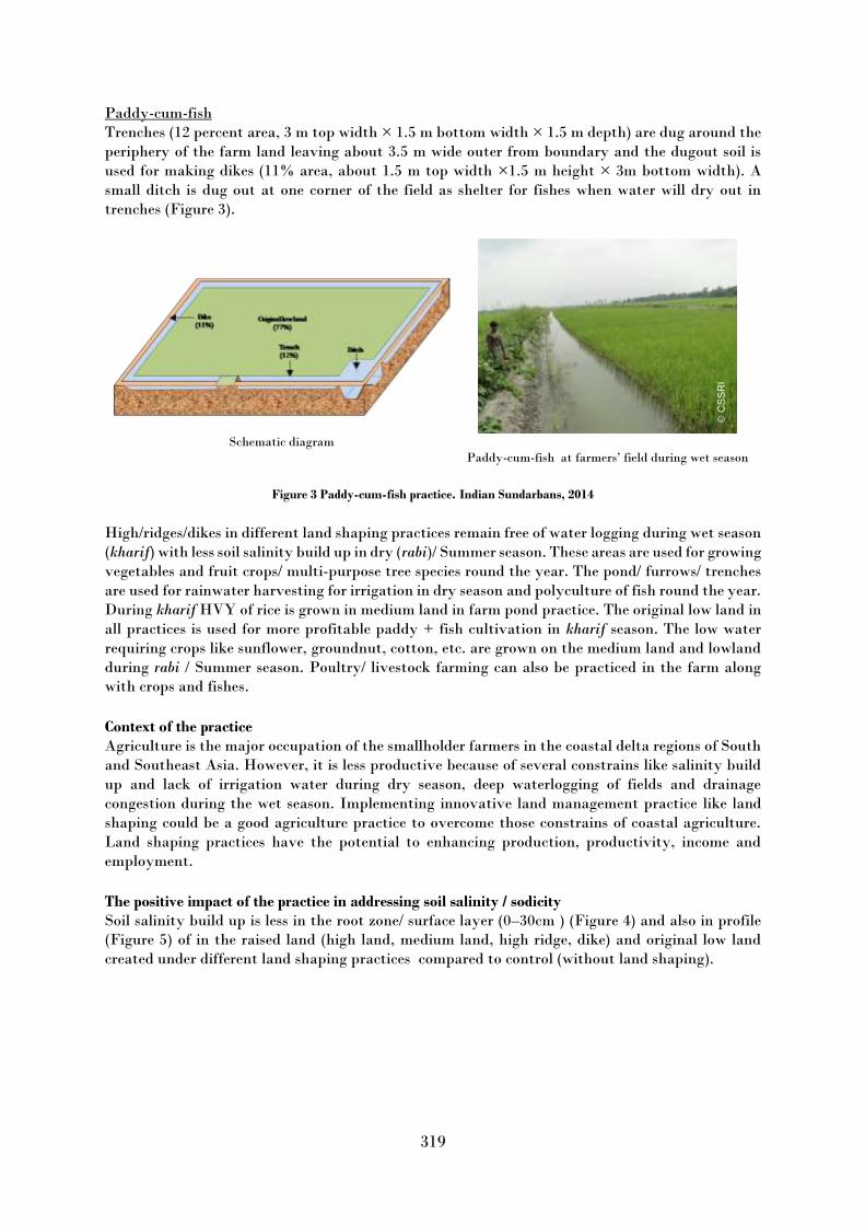
319
Paddy-cum-fish Trenches (12 percent area, 3 m top width × 1.5 m bottom width × 1.5 m depth) are dug around the
periphery of the farm land leaving about 3.5 m wide outer from boundary and the dugout soil is
used for making dikes (11% area, about 1.5 m top width ×1.5 m height × 3m bottom width). A
small ditch is dug out at one corner of the field as shelter for fishes when water will dry out in
trenches (Figure 3).
Schematic diagram
Paddy-cum-fish at farmers’ field during wet season
Figure 3 Paddy-cum-fish practice. Indian Sundarbans, 2014 High/ridges/dikes in different land shaping practices remain free of water logging during wet season
(kharif) with less soil salinity build up in dry (rabi)/ Summer season. These areas are used for growing
vegetables and fruit crops/ multi-purpose tree species round the year. The pond/ furrows/ trenches
are used for rainwater harvesting for irrigation in dry season and polyculture of fish round the year.
During kharif HVY of rice is grown in medium land in farm pond practice. The original low land in
all practices is used for more profitable paddy + fish cultivation in kharif season. The low water
requiring crops like sunflower, groundnut, cotton, etc. are grown on the medium land and lowland
during rabi / Summer season. Poultry/ livestock farming can also be practiced in the farm along
with crops and fishes.
Context of the practice Agriculture is the major occupation of the smallholder farmers in the coastal delta regions of South
and Southeast Asia. However, it is less productive because of several constrains like salinity build
up and lack of irrigation water during dry season, deep waterlogging of fields and drainage
congestion during the wet season. Implementing innovative land management practice like land
shaping could be a good agriculture practice to overcome those constrains of coastal agriculture.
Land shaping practices have the potential to enhancing production, productivity, income and
employment.
The positive impact of the practice in addressing soil salinity / sodicity Soil salinity build up is less in the root zone/ surface layer (0–30cm ) (Figure 4) and also in profile
(Figure 5) of in the raised land (high land, medium land, high ridge, dike) and original low land
created under different land shaping practices compared to control (without land shaping).
© C
SS
RI

320
Figure 4. Seasonal variation in soil salinity in root zone under
different land situations created under land shaping practices and
control (without land shaping)
Figure 5. Profile soil salinity under farm pond
land shaping practice and under control
during dry season (March) Other benefits of the practice Implementation of land shaping in coastal delta regions of India Sundarbans resulted in increase in
cropping intensity up to 240 percent from a base level value of 100 percent. Due to creation of
different land situations and following cultivation of crops round the year org. C, av. N, P & K and
biological activities in root zone have been increased. Farming activities under land shaping have
enhanced the employment opportunities for the farm families by 1.6 times per year. As the farmers
get employment in their own farm land throughout the year, this has checked the seasonal
migration rate of the farm family in search of their livelihood.
Costs of the practice On-farm demonstration have shown the success of land shaping practice in coastal delta region of
Indian Sundarbans in terms of increasing farm income and providing gainful employment to the
farmers (Table 1). However, these land shaping involved high initial investment, particularly on
soil excavation. The financial analysis has revealed a direct relationship between investment on a
land shaping and value of Internal Rate of Return (IRR), Net Present Value (NPV), Benefit Cost
Ratio (BCR) (Table 1).
Table 1. Financial feasibility of land shaping in coastal delta region of Indian Sundarbans
Criteria Farm Pond Paddy-cum-fish Deep furrow & high ridge
Initial investment (INR/ha) 145770 135800 87850
Internal Rate of Return (%) 46 42 36
Net Present Value (INR) 285059 232450 96817
Benefit Cost Ratio 1.58 1.55 1.20
Payback Period (years) 1.41 1.78 2.13

321
Challenges for scaling up the practice Land shaping practices are financially viable and attractive proposition for the coastal salt affected
region. However, major constraints for adoption of land shaping are marginal land holdings that
too divided into several parcels, high initial investment, distance from residential village etc. There
is a need to resolve issues on large scale dissemination of land shaping practice covering the areas of
input-supplies and management, market and marketing environment– the driver of change in
cropping pattern and production, credit needs and absorption of the farmers, and the role financial
institutions therein.
Acknowledgements: This work is supported by Global Environment Facility (GEF) and Indian Council of Agricultural
Research (ICAR)
The views expressed in this information product are those of the author(s) and do not necessarily
reflect the views or policies of FAO.

322
Salinity and prevention of wind erosion in the southeast of Lake Urmia
Saghar Chakherlou and Ali Asghar Jafarzadeh
Soil Science Department, University of Tabriz, Iran
Keywords: Urmia Lake, Bush, Soil salinity
Description of the good practice It is important to exploit the potential of thrush plants in resolving the growing salinity crisis in
this arid and semi-arid region. The purpose of this study was to investigate plantation in the
southeast of the lake for salinization and to prevent wind erosion.
Context of the practice The drought process of Urmia Lake (Iran) caused the saturation of the water to drain out of the
water and, as a result, the extent of the droughts increased, resulting in the creation of saline arid
zones with large amounts of salt around the lake.
The positive impact of the practice in addressing soil salinity / sodicity By planting saline plants (Halophyte) in the region, in addition to being able to be used as a barrier
against wind and prevent wind erosion, but also have a significant impact on the process of reducing
soil salinity.
Other benefits of the practice Can be said that in one of the selected areas, the high volume of plantation has caused the salinity
in this area to be estimated less than other areas. Costs of the practice There is no detail information about cost and benefit of this practice.
Challenges for scaling up the practice The most important challenges are supplying the irrigation water of plant and sociological issues
like resistance of people to accept the nonproductive species.
Figure 1. Areas under the wind in the east of Urmia Lake

323
Figure 2. Selected areas for growing Halophyte plants
Figure 3. Close view of selected areas for cultivation
Figure 4. Prepare planting sites
© S
agh
ar
Ch
akherlo
u
© S
agh
ar
Ch
akherlo
u

324
Figure 5. Establishment of halophyte plants
The views expressed in this information product are those of the author(s) and do not necessarily
reflect the views or policies of FAO.
© S
agh
ar
Ch
akherlo
u

325
Innovative biotechnology for sustainable management of saline soil fertility, nutrition and
productivity of cotton and wheat
Djumaniyazova G. I.1, Narbaeva Kh. S.1, Rakhimov S. S.2, Alixanov B.B.1
1 Academy of Sciences, Uzbekistan 2 Innovation Ideas LLC, United States
Keywords: saline soils, cotton, wheat, innovative biotechnology
Description of the good practice Based on scientific research at the Institute of Microbiology of the Academy of Sciences of the
Republic of Uzbekistan, we have developed a new environmentally safe and cost-effective resource-
saving biotechnology for sustainable management of saline soil fertility and nutrition of cotton and
winter wheat. Biotechnology is based on the complex application of two biopreparations.
Biopreparations based on salt-resistant rhizobacteria of wheat and cotton, which have
polifunctional properties, are used for pre-sowing seed treatment and a biopreparation on
microalgae is used for leaf feeding of plants during the growing season. Working in a complex, these
biopreparations restore the natural metabolism in the soil-microorganisms-plant system.
Context of the practice As a result of the use of biotechnology, saline soils are purified from organochlorine pesticides, heavy
metals and mycotoxins, the degree of salinity is reduced and the fertility of saline soils is increased,
increase the moisture-retaining capacity of the soil and plant leaves, reduce irrigation water costs
by 25–50 percent and crop maturation time by 15–20 days
The positive impact of the practice in addressing soil salinity / sodicity The practice has a positive effect on reducing the salt content in the soil, reducing the degree of
salinity, restore and increasing fertility of saline soils, normalize the alkaline pH value of soils,
increase the biodiversity of soil microflora and fauna, improve the macro-microelement nutrition of
plants throughout the growing season. Stimulate the development of a powerful root system and
the aboveground part of plants. This biotechnology is considered a good practice, as it reduces the
degree of salinity of soils and increases the productivity of cotton and wheat (Figure 1).
Other benefits of the practice As a result of the introduction of innovative biotechnology on saline soils of Syrdarya, Navoi,
Bukhara, Ferghana, Andijan, Namangan, Khorezm regions and Karakalpakistan in 2019–2020, the
condition of saline soils on an area of 30 000 hectares improved, irrigation water costs were reduced
by two times and mineral fertilizers costs by 25–50 percent. As a result, the average cotton harvest
in Uzbekistan increased by 8 c/ha (33 percent), the profitability was 284 percent (in the control–139
percent). The wheat harvest increased by 11.8 c/ha (22 percent), the profitability was 112 percent
(in the control–37 percent).

326
Figure 1. Field plots before and after the use of innovative biotechnology on cotton and wheat. Uzbekistan, Syrdarya
region, highly saline soils, 2018 Challenges for scaling up the practice For the widespread introduction of proven practices and the export of biopreparations, it is
necessary to create a new biotechnological production, for which there is a certain potential and
highly qualified specialists.
The views expressed in this information product are those of the author(s) and do not necessarily
reflect the views or policies of FAO.
© S
agh
ar
Ch
akherlo
u

327
Long-term combination of pruning residues incorporation, reduced tillage and drip
irrigation to improve SOM stabilization and structure of salt-affected soils in a semi-arid
Citrus tree orchard
Noelia Garcia-Franco1, Martin Wiesmeier1,2, Luis Carlos Colocho Hurtarte1,3, Franziska Fella1,
María Martínez-Mena4, María Almagro4, Eloisa García Martínez4, Ingrid Kögel-Knabner1,5
1 Chair of Soil Science, TUM School of Life Sciences Weihenstephan, Tecnhical University of Munich, Freising, Germany, 2 Bavarian State Research Center for Agriculture, Freising, Germany 3 European Synchrotron Radiation Facility, Beamline ID21, Grenoble, France 4 Soil and Water Conservation Department, CEBAS-CSIC (Spanish Research Council), Murcia, Spain 5 Institute for Advanced Study, Technical University of Munich, Garching, Germany
Key words: Drip-irrigation, Particulate organic matter, aggregate stability, Semi-arid agroecosystems, Soil organic carbon,
reduced tillage, salt-affected soils, pruning residues
Description of the good practice Soil salinization is a big problem around the world as a result of unsustainable land management
practices and climate change. Salt-affected soils are characterized by poor soil structure and low
organic matter contents. These soils have been used for agriculture since thousands of years.
However, poor drainage, inappropriate irrigation, high evaporation rate and excessive use of
chemical fertilizer caused severe degradation and abandonment of these soils, economic losses for
the farmers and social migration.
Eastern Spain is one of the semi-arid irrigated areas where a high amount of Citrus (mainly oranges
and lemons) is produced in Europe (Figure 1A). In Murcia, some of these lemon and orange orchards
were established on salt-affected soils and under intensive management practices (Figure 1B). In
addition, it is a common practice to burn the tree pruning residues (branches and leaves). However,
in the early 1980s, conservation tillage for improved water retention and soil structure was
implemented. Moreover, organic matter amendments (green manure, compost, biochar, and food
processing wastes) were applied to improve the physical conditions of salt-affected soils.
Figure 1. A) Citrus lemon tree and B) salt-affected soil in the studied semi-arid area (Librilla, Spain)
The combination of pruning residues incorporation through reduced tillage, and drip-irrigation
systems is a promising approach to offset the negative effects of high salt content, increase organic
© N
oelia
Garc
ia-F
ranco

328
matter storage, and maintain or even increase agricultural productivity without reducing the
farmer´s profit. The incorporation of OM of tree pruning residues combined with drip-irrigation
makes soils less susceptible to the negative influence of salts under semiarid climate conditions.
Context of the practice Site description The study was conducted in an irrigated agricultural orchard of citrus trees (Citrus limon var.
Verna) located in “Paraje la Alberquilla” between “Sierra de Carrascoy” mountains and Librilla’s
town (Murcia), Southeast Spain (37◦ 52′ 18.8′′ N, 1◦ 20′ 58.6′′ W; 119 m a.s.l.). The climate is semiarid
with a high evapotranspiration (between 900 and 1000 mm/yr) and with a mean annual water
deficit around 600 mm. The soil is classified as Calcaric Solonchak. Since 1987, the traditional soil
management system carried out by the farmers in the study area was intensive tillage (until 40 cm
soil depth and three times per year) with flood irrigation only in the topsoil (IT). The irrigation
water comes from the river Tajo. The amount of water used was around 600 m3 of water were used
each year for irrigation of the orchard (4400 ha) in January, April, June, August and September.
In 2000, at two adjacent fields sustainable land management (SLM) practices were implemented (Figure 1, table 1): (i) no-tillage plus lemon pruning residues applied on the topsoil as mulch and
drip-irrigation (NT + PM), and (ii) reduced tillage plus incorporation of the lemon pruning residues
to a soil depth of 15 cm (RT + PI) and drip-irrigation (Table 1). The drip-irrigation system consists
of an automatic flow of water (approximately an average of 760 L per tree and per month adjusted
to the varying climatic site conditions). Since 2015, 0.044 kg total nitrogen and 0.028 kg potassium
chloride (KCl) (per tree and per month) were applied with the water of the drip-irrigation system.
In addition, the farmers added 0.22 kg/m2 of a commercial solution of 15 percent of CaO and 0.5
percent of MgO per tree and per month in NT + PM and RT + PI management systems, because
gypsum, calcite, calcium chloride, and other chemical agents that provide Ca tend to replace
exchangeable Na, effectively ameliorating salt-affected soils (Table 1).
Table 1. Description of different management practices in the management systems: i) intensive tillage with flood
irrigation (IT); ii) no-tillage plus lemon pruning residues on the topsoil as mulch (NT+PM); and iii) reduced tillage plus
incorporation of lemon pruning residues (RT + PI). Source: Garcia-Franco et al., 2021, Soil and Tillage
Management
practices IT NT+PM RT+PI
Tillage until 40 cm soil depth,
3 times per year -
until 15 cm soil depth, 1
time per year Addition of
pruning - Mulching Incorporation into the soil
Addition of Ca2+
and Mg2+ - + +
Irrigation Flood
(since 1987) Drip-irrigation
(since 2000) Drip-irrigation
(since 2000) Fertilization - + +
Pesticides + + +
The positive impact of the practice in addressing soil salinity / sodicity and other benefits of the
practice Our results showed that the combination of pruning residues incorporation + reduced tillage + drip-
irrigation in a Citrus tree orchard in salt-affected soils is able to offset negative effects of salts on
soil structure by:
i) offset the negative effect of salinity on soil aggregation ii) increasing the soil porosity and macroaggregate formation iii) maximizing the accumulation of soil organic carbon

329
iv) decreasing soil erosion and soil desertification v) promoting a sustainable agriculture from a social, economic and environmental perspective.
Costs of the practice No information on costs are available. (It will be available for the Symposium)
Challenges for scaling up the practice The organization of workshops with other farmers and people responsible in the regional
administration (description of main point about how management salt-affected soil regarding to
environmental and socio-economic impacts) in this area may contribute to promote this
combination of sustainable land management practices.
Acknowledgements We would like to thank the families Ruíz Cayuela and Ruíz Pascual for inspiration for this
project.
The views expressed in this information product are those of the author(s) and do not necessarily
reflect the views or policies of FAO.

330
Haloculture for Hyper-Saline Drain Water Reuse and Combating Dust Prone Regions
Yousef Hasheminejhad, F. Dehghani, G. Ranjbar and M. Rahimian
National Salinity Research Center, AREEO, Yazd, Iran Keywords: Drain water, Dust Storms, Fisheries, Halophytes, Reuse
Description of the good practice Khuzestan in the southwest of Iran is the bed of major Rivers. While its lowland deltas are suffering
from salinity and waterlogging issues. Extension of irrigation and drainage networks in the area
releases billions of cubic meters of drain water down to the outlets. Discharge of this huge volume
of water has developed new challenges for the downstream regions. Evaporation ponds are
developing in some regions (Figure 1), while in some cases dredging and pumping is necessary to
avoid reflux of drain water back to the fields.
Figure 1. Development of evaporation ponds for discharge of drain water at Iran-Iraq border
Invasion of dust storms is another environmental issue harmed frequently some parts of the Middle
East. The flat and dry areas with fine particles are considered to have major role in dust production.
The downstream areas of Khuzestan have these conditions in addition to dispersed soil particles
due to high salinity and sodicity makes this area more prone for dust production.
Different measures have been proposed to combat dust storm hot-spots including different mulches
and flood spreading on the hot spots. As the government is the unique donor for performing such
projects, it impossible to provide the fund by the government. Haloculture, as integrated and
sustainable use of the potentials of saline environments for production, was proposed based on the
capabilities and restrictions of salt affected dust storm cannons of Khuzestan. Such a project uses
the saline drainage water as input water, reduces the volume of drainage water, stabilizes the soils
and makes it wet and produces wealth through its products. The salary of the project could be used
by the local communities to scale up the project on the large scale.
© G
oo
gle
Eart
h
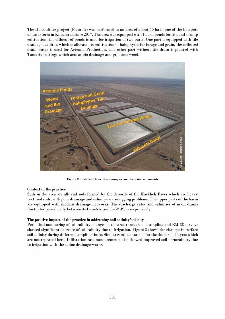
331
The Haloculture project (Figure 2) was performed in an area of about 50 ha in one of the hotspots
of dust storm in Khuzestan since 2017. The area was equipped with 4 ha of ponds for fish and shrimp
cultivation, the effluent of ponds is used for irrigation of two parts. One part is equipped with tile
drainage facilities which is allocated to cultivation of halophytes for forage and grain, the collected
drain water is used for Artemia Production. The other part without tile drain is planted with
Tamarix cuttings which acts as bio drainage and produces wood.
Figure 2. Installed Haloculture complex and its main components Context of the practice Soils in the area are alluvial soils formed by the deposits of the Karkheh River which are heavy
textured soils, with poor drainage and salinity- waterlogging problems. The upper parts of the basin
are equipped with modern drainage networks. The discharge rates and salinities of main drains
fluctuates periodically between 4–16 m3/sec and 8–32 dS/m respectively.
The positive impact of the practice in addressing soil salinity/sodicity Periodical monitoring of soil salinity changes in the area through soil sampling and EM-38 surveys
showed significant decrease of soil salinity due to irrigation. Figure 3 shows the changes in surface
soil salinity during different sampling times. Similar results obtained for the deeper soil layers which
are not repeated here. Infiltration rate measurements also showed improved soil permeability due
to irrigation with the saline drainage water.
© Y
ousef H
ash
em
inejh
ad

332
Figure 3. Changes of surface soil salinity (0-30 cm) during different sampling times Other benefits of the practice
Stabilizing dust storm producing soils in the extent of the project
Producing forage through different halophyte species
Producing Quinoa grain
Producing wood and bio-drainage
Technology transfer to the local communities and experts for maintaining the project
Direct job creation for four persons in the project
Costs of the practice Installation of the project costs for an area of 50 ha about USD 35000. Regarding the socio-
environmental services and economic benefits of the project in the long term it is quite low. The
same area could produce at least 40000 Kg of dry forage, 4000 Kg of quinoa grain, 2000 Kg of fish
and shrimp and 20000 Kg of tamarix wood annually after complete establishment which the value
of its products is at least USD 10000 /year.
Challenges for scaling up the practice More detailed environmental and socio-economic surveys are necessary before up scaling the pilot
plan.
Acknowledgements Special thanks to Biotechnology Development Council for sponsoring this project.
The views expressed in this information product are those of the author(s) and do not necessarily
reflect the views or policies of FAO.
© Y
ousef H
ash
em
inejh
ad

333
Cover crops for the management of saline seeps in areas of high flooding risk
Julián Isasti1, Cristian Álvarez2, Elke Noellemeyer3
1Argentine No-Till Farmers Association (Aapresid), General Pico, Argentina 2 Instituto Nacional de Tecnología Agropecuaria (INTA), General Pico, Argentina 3 Universidad Nacional de La Pampa, Santa Rosa, Argentina
Keywords: winter cover crops, shallow water table, saline groundwater
Description of the good practice
Cover crops (CC) contribute to mitigate soil surface salinization to and manage shallow water table
in areas of high flooding risk. They should be used to confine the movement of salts from saline
seeps and groundwater to higher portions of the landscape. This is important during the long bare
winter fallows that are usual in Argentinean cash crop production.
For successful germination and establishment, CC must be sowed when soil moisture is high enough
to reduce surface salinity and salts have been leached further down in the soil profile. However,
analysis of soil and natural vegetation of the site are very helpful. In the Argentinean Pampas
Sporobolus sp. indicates flooding while in saline soils Distichlis sp. and Salicornia sp. are common.
Conyza sp. and Salsola sp. appear in improved conditions.
Generally, a mixture of winter CC is the best option under multiple threats (salinity, sodicity,
waterlogging, etc.). While barley showed to be the best CC for saline soils, triticale has good
performance in waterlogged conditions. Well adapted legumes are Lotus tenuis and Melilotus albus,
while vetch has low salt tolerance.
An example of the results that can be achieved with this practice is resumed in Figure 1. A cover
crop of 70 percent triticale and 30 percent vetch was planted at a density of 80 kg/ha in a 92-ha field
in early fall. Salinity at the soil surface was reduced in the entire area, especially in the lowest
portion of the landscape. The water table also receded considerably, reducing flooding risk, despite
high rainfall (207 mm) during the CC growing season. Thus, 45 ha could be recovered for crop
production, representing almost half of the field after only one CC season. Currently the field is
managed with a rotation of winter CC and summer cash crops.
Figure 1. Cover crops reduce soil’s surface salinity and contribute to the lowering of a shallow water table
© J
uliá
n Isasti

334
Figure 2. Shallow saline groundwater is a major threat for plains with poor drainage. Chacra América, 2020
Figure 3. CC improve soil structure, water infiltration, and salt leaching. Chacra América, 2020
© J
uliá
n Isasti
© J
uliá
n Isasti

335
Figure 4. Triticale (right) sowed over natural saline vegetation (left). Chacra América, 2021
Figure 5. Legumes in mixed CC contribute to soil fertility by fixing nitrogen. Chacra América, 2020
© J
uliá
n Isasti
© J
uliá
n Isasti

336
Figure 6. Sorghum is an excellent cash crop after winter CC. Chacra América, 2021
Context of the practice
CC are recommended in semiarid and sub-humid (700–900 mm/year) temperate plains of poor
drainage with a high risk of flooding and salinization due to a saline shallow water table. They have
been successfully employed in the lowlands of the Western Argentinean Pampas, where the rise in
groundwater level due to land cover change is threatening millions of hectares of productive land.
These sandy-loam textured soils are being degraded due to groundwater salinity and waterlogging.
The positive impact of the practice in addressing soil salinity / sodicity
CC can contribute to mitigate the salinization of the soil’s surface and to lower the shallow water
table in areas with a high risk of flooding. Thus, with recurrent use of this practice salinity is
confined to the lower portions of the soil profile, allowing successful planting of crops and pastures.
Other benefits of the practice
Apart from reducing the capillary flow of salt water to the soil surface and lowering the water table,
CC add carbon to the soil thus improving soil structure and pore system, which in turn favours the
leaching of salts and sodium. Legumes can also provide nitrogen for following cash crops.
Costs of the practice
The cost of CC is low compared to the benefits they produce. They imply only two operations per
year, seeding and termination (with herbicides or a roller), and seeds of winter cereals/legumes can
be produced by the farmer.
© J
uliá
n Isasti

337
Challenges for scaling up the practice
At a basin level, the use of CC is not enough to manage the excess of water and to reduce shallow
water tables during flooding events. This practice should be implemented with a systemic approach,
including pastures and trees in recharge areas and salt-tolerant crops in discharge areas.
Acknowledgements
The research involved in the development of this practice was possible due to the funding and the
efforts of Chacra América (Aapresid), INTA and the Faculty of Agronomy of the UNLPam.
The views expressed in this information product are those of the author(s) and do not necessarily
reflect the views or policies of FAO.

338
Controlled subsurface drainage for the management of water table, soil salinity and
nutrient losses in waterlogged saline vertisols of TBP command area of Karnataka, India
Karegoudar A.V.1, Vishwanath J.1, Rajkumar R.H. 2, Anand S.R. 3 and Kaledhonkar M.J.4
1 AICRP on Management of Salt Affected Soils and Use of Saline Water in Agriculture, Gangavathi, University of Agricultural
Sciences, Raichur, India 2 Directorate of Research office, University of Agricultural Sciences, Raichur, India 3 AICRN on Potential Crops, University of Agricultural Sciences, GKVK Bangalore, India 4 ICAR-Central Soil Salinity Research Institute, Karnal, India
Keywords: Controlled drainage, Depth to water table, Salt removal, Salt and water balance, Nitrogen loss
Description of the good practice Installation of controlled drainage device In a controlled SSD system, the groundwater table control system consisted of a small device made
up of PVC pipes which is fitted with the outlet of the lateral drain in the manhole (Figure 1). In this
system, an 80 mm diameter PVC "T" pipe fitted with an outlet of lateral drain pipe inside the
manhole and other ends of "T” pipe is closed with end cap. To maintain the desired groundwater
table depth in the paddy field, say 0.3 m, a riser pipe (of 0.70 m) was provided from the bottom
horizontal PVC pipe through the T section. Again, one more "T" pipe is fitted at top of the riser
pipe. This simple device made up of two PVC "T" pipes and one riser pipe is efficient in
maintaining desirable the water table at the desired depth in paddy fields (Figure 2).
Conventional SSD system Controlled SSD system
Figure 1. Conventional & Controlled SSD systems
© K
are
go
ud
ar
A.V
.
© K
are
go
ud
ar
A.V
.

339
Figure 2. A view of controlled drainage device installed in a manhole Context of the practice The rural economy of Bellary, Koppal, and Raichur districts of Karnataka state, India was
improved after the introduction of irrigation (1953) through Tungabhadra Project (TBP), in these
districts. At TBP inception, Authorities provided guidelines for crop areas in the Command.
Accordingly, to guidelines, head and middle reach farmers of the irrigation command had to grow
light irrigated crops in an around (47 percent) area during Kharif (Rainy season, July–October) and
in around 31 percent area during Rabi (Post rainy season, October-March) season. The farmers of
the downstream or tail end of the command were supposed to grow paddy in around 8 percent area
and sugarcane in 4 percent area to make effective utilization of excess water coming from the
upstream (head and middle reach) area. The farmers followed these guidelines till 1970. However,
paddy was introduced in many pockets of the command with the migration of farmers from Andhra
Pradesh (AP) who well-versed with paddy cultivation. Paddy being more remunerative than other
crops, farmers of head and middle reach also started cultivation of paddy, deviating from guidelines.
The continuous violation of guidelines created canal water shortages for paddy crops in tail-end
areas and also developed secondary salinization (96 215 ha) in the downstream/tail end in the
command (CADA, 2013).
In order to reclaim these salt-affected lands TBP-CADA (Tungabhadra Project-Command Area
Development Authority) undertook surface and subsurface drainage (SSD) works in the TBP
command. However, farmers, particularly in tail-end areas, started blocking outlets of lateral drains
to avoid over draining in view of the shortage of canal irrigation supply and loss of nutrients. In
addition, farmers are also resorted to using natural stream/ drain/ Nala waters (locally called Halla)
added a new dimension to the salinity problem. On basis of a simulation study using SALTMOD
model by Manjunath et al. (2011), it was predicted that complete blocking of the SSD system during
both the cropping seasons had adverse effects on the performance of the SSD system and increased
soil salinity in the drainage area.
The situation in the tail-end area was really complex. The SSD systems were installed to control
waterlogging and soil salinity. As farmers were interested in paddy crops only, they were not
allowing the system to function with fear of a shortage of irrigation water. In view of this
background, there were two thoughts among the researchers, the first was drain spacing might be
increased to avoid over-draining and the second option was adoption-controlled drainage.
© K
are
go
ud
ar
A.V
.

340
As per available information, controlled drainage was widely dependent on watertable level,
rainfall, irrigation quantity, and management intensity (Mejia and Madramootoo, 1998). It worked
on the shallow (Benz, Doering and Reichman, 1982) groundwater table concept (controlled way)
hence it minimized drain outflow by 24 percent (Drury et al., 1996) under maize crop in clay loam
soils thereby reduced 43 percent nitrate loss. Under a loamy sand condition in southern Sweden
(Wesström et al., 2001) controlled SSD reduced drainage outflow by 79 to 94 percent and also
reduced nitrate concentration from 78 to 94 percent. In lake bed soil (fine-textured) at Ohio State,
Canada, it reduced 40 percent volume of drainage water and 45 percent of Nitrate-Nitrogen
transport (Fausey, 2004). In sandy loam soil (Zhonghua et al., 2006) with flat topography-controlled
drainage reduced subsurface discharge through field ditches up to 94 percent under rice crop in
China. Under clay loam soil controlled SSD reduced 64 percent of drainage depth and 50.4 percent
of nitrogen loss than conventional SSD at 50 m spacing under paddy situation in TBP command at
Karnataka, India (Karegoudar et al., 2019). Based on the experience shared by many scientists
across the world about the controlled drainage approach effectively reduced drain discharge,
reduced nitrate and phosphorus loss, maintained shallow water table and improved the crop yield
under different kinds of soils.
In view of this background, it was thought to increase lateral drain spacing by 10 m from present
recommended spacing of 50 m for TBP Command. As controlled drainage was found effective in
reducing drain flow in different drainage project world-wide, controlled drainage was also
considered as one option. Therefore, an experiment was planned at the Agriculture Research
Station, Gangavathi in rice fields with conventional and controlled SSD with 50 (2.8 ha) and 60 m
(4.0 ha) drain spacing with an objective to find a suitable drainage management strategy to manage
soil salinity as well as to address irrigation water shortage during paddy crop. Gangavathi town is
one of the largest and most productive rice growing areas in Karnataka state. It represents irrigated
transplanted rice belt of Tungabhadra project (TBP) command area. Agro-climatically, Agriculture
Research Station Gangavathi falls under the Northern Dry Zone of Karnataka state (semi-arid eco-
subregion) lying between 15° 27′ 14.1″ N and 76° 32′ 06.12″ E at an altitude of 419 m above mean
sea level with an average annual rainfall of around 542 mm. The soils of the experimental site at
Agricultural Research Station, Gangavathi are medium Vertisols derived from granite-gneisses
containing lime/soda-lime feldspar that are basic in nature.
The drainage water quantity and quality, soil salinity, salt balance, water table, paddy yield nitrate
losses, economic analysis for 50 and 60 m drain spacing with conventional and controlled drainage
were monitored for seven seasons to search for better drainage water management strategy for the
tail-end areas of TBP Command.
The positive impact of the practice in addressing soil salinity Compared to conventional subsurface drainage system, the controlled drainage system was helpful
in saving irrigation water to the extent of 27 to 28 cm (28 to 35 percent) and reduction in nitrate
loss by 42 to 70 percent by maintaining (Figure 3) shallow water table depth under both in Kharif
(5.3 and 4.1 cm) and Rabi season (4.6 and 4.1 cm) at 50 and 60 m lateral spacing, respectively. The
mean root zone soil salinity (0–30 cm) was reduced under both conventional and controlled drainage
systems. Around 15.0 and 9.0 percent marginally higher paddy grain yield was observed under
conventional drainage compared controlled drainage system over the seven cropping seasons at 50
and 60 m drain spacing, respectively. Looking at water shortage and economic feasibility, 60 m
lateral drain spacing with controlled drainage appears to be adaptable /feasible in the study area.
It was expected that conventional and controlled drainage systems would give similar economic
benefits in the long-term. Considering saving of irrigation water with reduced drain volume and
nitrogen loss, the controlled SSD appeared to be a more environmentally-friendly strategy. Further
combining of irrigation water management in paddy fields along with controlled drainage would be
an interesting topic for future research.

341
Figure 3. Season wise nitrogen loss (kg/ha) for the conventional and controlled SSD under different spacing Other benefits of the practice Controlled sub-surface drainage system demonstrated that it could save about 20 percent (240
mm/ha) of irrigation water per season compared to conventional SSD system in the reclamation of
waterlogged saline soils in TBP command area. Therefore, an additional area of about 19 200 ha
could be supplemented with this saved water which in turn may add up to the production increase
of about 0.0576 MT (at 3 t/ha) of paddy in the command area. Similarly, controlled sub-surface
drainage could reduce loss of NO3-N to the extent of 50 per cent per season (i.e. urea fertilizer to the
tune of ₹ 68.80 lakh per season in TBP command area.
Costs of the practice
The adaptation of the controlled drainage system to the existing SSD required an additional cost
of about 1000/ha (USD16/ ha).
Challenges for scaling up the practice Since the additional cost required for the implementation of the good practice is minimal, as such
no bigger challenges are expected. However, conduct of more demonstrations and other extension
related activities would be helpful in scaling up the practice not only in TBP command area but
also in other irrigation projects in Karnataka as well.
Acknowledgements This research was financially supported through funding received to AICRP on Management of Salt
Affected Soils and Use of Saline Water in Agriculture, Agriculture Research Station, Gangavathi,
University of Agricultural Sciences, Raichur from ICAR, New Delhi.
The views expressed in this information product are those of the author(s) and do not necessarily
reflect the views or policies of FAO.
References Benz, L.C., Doering, E.J. & Reichman, G.A. 1982. Water Table And Irrigation Effects On Alfalfa
Grown On Sandy Soils, 24: 71–75.

342
Fausey, N.R. 2004. Drainage, surface and subsurface. In Rosenzweig, C., Powlson, D.S., Scow,
K.M., Singer, M.J., Sparks, D.L., Hatfield, J., eds. Encyclopedia of Soils in the Environment, pp.
409–413. Oxford, UK, Elsevier Ltd.
Mejia, M.N. & Madramootoo, C.A. 1998. Improved Water Quality through Water Table
Management in Eastern Canada. Journal of Irrigation and Drainage Engineering, 124(2): 116–122.
https://doi.org/10.1061/(ASCE)0733-9437(1998)124:2(116)
Wesström, I., Ekbohm, G., Linnér, H. & Messing, I. 2003. The effects of controlled drainage on
subsurface outflow from level agricultural fields. Hydrological Processes, 17: 1525–1538.
https://doi.org/10.1002/hyp.1197

343
Gravel mulches as an effective tool for salinity management in orchards of salt-affected arid
regions
Farhad Khorsandi
Soil Science Department, Islamic Azad University, Darab Branch, Iran
Keywords: Dryland agriculture, Gravel mulch, Sustainable agriculture
Description of the good practice Introduction Water evaporation from the soil and subsequent movement and deposition of water-soluble salts in
the root zone, is the main reason for soil salinization of farms in arid regions. Stone mulches can be
used as an effective tool for soil salinity management. They reduce irrigation water needs, conserve
soil moisture, prevent and control root zone salinity, and thus, improve crop yields. The objective
of this practice is to introduce and recommend gravel mulches for soil moisture conservation and
root-zone salinity management in orchards of arid regions.
Orchard establishment Gravel mulched orchards are established in three stages: terracing, windbreaks and mulching.
Terracing Rainfall in arid areas is usually limited and low. Thus, if the land slope is steep, the farmers should
use terracing techniques to break the slope. Thus, water runoff is reduced and infiltrates more into
the soil (Figure 1).
Figure 1. Schematics of terracing and gravel mulch placement in the orchards
Windbreaks Strong seasonal winds are common in many arid regions. It causes wind erosion, and accelerates
water evaporation from soil, water storage ponds, and plants (transpiration). Therefore, farmers
should take proper measures to control wind speed by constructing windbreaks (living tree
windbreaks, stone walls, etc.).
Mulch placement Farmers can use different types of stones (such as sands, pebbles, pumice, scoria, etc.) as gravel
mulch.
Grain size and thickness are important factors that affect the efficiency of gravel mulches.
Grain size can vary from 5–100 mm. However, a mixture of gravels with 4–8 mm in size is
© F
arh
ad K
hors
andi

344
recommended. The thickness varies from 5–15 cm. But 8–12 cm thickness is recommended
(Figure 2).
Before application of gravel mulch, the land should be leveled, and 2 cm of manure must be
applied to where the gravel mulch is going to be placed. These operations maybe done either
by hand or mechanically.
The lifespan of gravel mulch is very long (20–35 years). The mulch replacement is not
necessary until it is completely mixed with the topsoil and has lost its effectiveness.
Gravel mulch can be placed at the tree rows, covering the tree canopy, or be applied to the
entire orchard floor (Figure 1). The tree crown must be free and not buried under the mulch
(Figure 2).
Agronomic operations The most important agronomic operations in gravel mulched orchards are weeding, fertilization,
irrigation and salinity management in the root zone.
Gravel mulch is very effective in controlling weeds. Thus, there is no need for herbicides.
Various methods can be used to provide the trees with adequate nutrients, such as vertical
fertilizer channels, foliar spraying and soluble fertilizers.
Farmers may want to use supplemental irrigation for the trees in certain seasons or months.
In general, due to the high permeability of gravel mulches, they do not interfere with
irrigation operations. In drip irrigation, droppers can be placed either on the top of gravel
mulch or under it.
To increase the amount rain-water for trees, it is very useful to construct a gentle slope in
between the rows towards the trees. This will direct the runoffs towards the foot of the trees
(Figure 2).
Figure 2. Proper placement of gravel mulch, and shaping the orchard floor
Context of the practice This practice is applicable in salt-affected, arid regions, where fresh water resources for agricultural
purposes are scarce and limited. This practice enables the farmers to continue producing and
generating income, in areas where agronomic activities would be impossible due to lack of water.
The positive impact of the practice in addressing soil salinity/sodicity Lanzarote and Fuerteventura islands, Canary Islands (Spain); and Loess plateau in north/northwest
China.
© F
arh
ad K
hors
andi

345
Other benefits of the practice Combating desertification, improved living conditions and better quality of life
Challenges for scaling up the practice This is an easily adaptable practice from technological point of view. However, farmers need to be
convinced via pilot plants and farms.
The views expressed in this information product are those of the author(s) and do not necessarily
reflect the views or policies of FAO.

346
Addition of biochar in saline soils to increase productivity in wheat in central Mexico
Lenin E. Medina-Orozco1, Alexander Sánchez-Duque1, Alfredo Mondragón-Sánchez1, Iván N.
Medina-Orozco2
1 Instituto Tecnológico del Valle de Morelia, Tecnológico Nacional de México, Mexico 2 Universidad Virtual del Estado de Michoacán, Mexico
Keywords: Recsoil, terra preta, carbon sequestration, passive pool
Biochar to increase corn and wheat production in saline soils Biochar is a carbon produced by the thermal transformation of vegetable biomass and uses
technology designed to carry out combustion with a low presence of oxygen. Among the various
sources of biomass used to manufacture this product are crop residues, tree biomass, and paper
residues, among others. The biomass used in our studies includes corn cob (Zea mays), oak firewood
(Quercus spp.), castor bean (Ricinus communis) and avocado tree pruning residues (Persea
americana). Our experience suggests the use of soft biomass such as corn cob or castor bean, as they
have short conversion times, the above with respect to other types of biomass. The technology
necessary to produce biochar is varied and consists in some cases of complex pyrolysis equipment,
both in its handling and of large size, up to easy-to-handle rustic equipment suitable for small
producers such as those developed by the authors (Figure 1) and that have been used in avocado,
corn and wheat fields.
Figure 1. Manufacture of biochar from corn cobs using rustic equipment in the town of Tarimbaro Michoacan, Mexico
Context of the practice The work area is the agricultural region of the Morelia-Querendaro Valley at 1923 meters above sea
level (Figure 2). The valley is an intermountain region of the Trans-Mexican Volcanic Belt. The
Vertisols’ are the dominant soils. The climate of the study site is of the temperate subhumid type
with rains in summer and average temperature of 19 ° C and precipitation of 796 mm per year
(Figure 2), the Köppen climatic key adapted for Mexico is (A) Cb (w1) (w ) (e) g. This region is one
of the main producing areas of basic grains for the state of Michoacan. The intermountain valley is
the product of the volcanism that gave rise to the Cuitzeo lagoon, the second largest in central
Mexico. The main economic activity is irrigated and seasonal agriculture. Irrigated agriculture uses
gray water from the City of Morelia, which has favored the salinization of the region's soils. The
hydrogen potential (pH) of the soil is in the range of 6.2 to 8.3. The electrical conductivity (dS / m)
has a range value, 0.26 to 2.35. Variability in soil salinity is associated with management; for
example, irrigation, fertilization, intensity in production, among others.
© L
enin
Me
din
a
© L
enin
Me
din
a
© L
enin
Me
din
a

347
Figure 2. Production site of basic grains in the Morelia-Querendaro Valley in the Volcanic Belt of Mexico. Climograph of
own elaboration with information from National Water Commission of Mexico (CONAGUA) Increase in productivity after adding biochar in saline soils The benefits of applying biochar on soils have been widely explored in the scientific literature.
Currently, the data on the effect of biochar on pH and electrical conductivity in soils are not
conclusive, and in some cases it is contradictory. However, benefits are reported in plant nutrition.
In our studies, the changes in chemical properties have not been statistically significant; possibly
because they are short-term studies (1 to 2 years, in corn and wheat, respectively). But they present
significant data regarding production levels as seen in Figure 3.
Figure 3. Production of wheat with biochar and without biochar under controlled conditions on basic grain production
soils. Recarbonization of soils
Biochar in farming areas of Central Mexico can be a strategy to increase the production and Re-
carbonization of soils. The application of biochar with the rates suggested (1 %) in our
investigations, can store up to 9.2 ton / ha in soils cultivated with wheat.
© L
enin
Me
din
a

348
Costs of the practice The construction cost of a rustic bioreactor like the one presented here amounts to approximately
45 dollars and conversion rates of 25 percent from biomass to biochar. The capacity of the bioreactor
is 25 kg and two hours of conversion time. The biomass used comes from the residues of corn cobs
from a previous agricultural cycle; therefore, the cost for the producer is low. The increase in the
production of wheat with biochar, compared to the production without biochar, represents a profit
of USD 96 per ton. Applied to regional yields of 7 ton per ha, it represents a profit for producers of
USD 672 per hectare.
Challenges for scaling up the practice The main challenges for the adoption and scaling of the biochar practice in this region, consists of
the training for producers to build the reactors and have reactors of a larger size, but at low cost.
Acknowledgements To TecNM for the financing of the research projects.
The views expressed in this information product are those of the author(s) and do not necessarily
reflect the views or policies of FAO.

349
Mix water tools for risk reductions when using non-conventional water resources
Pedrero F., Parra A., García A., Ortuño M.F., and Alarcón J.J.
Irrigation Department, Centro de Edafología y Biología Aplicada del Segura (CEBAS-CSIC), Murcia, Spain
Description and objective The main objective of our research was to evaluate two different tools to mix different non-
conventional water resources (a simplified and an advanced decision support system, DSS) and
adapt it for irrigation of salt affected areas. To test the DSSs under severe saline conditions, the
trial has been carried out on a Research Platform inside of a plastic greenhouse through the
cultivation of halophytes in the southeast of Spain (Fig. 1), monitoring the relation between water-
soil-plants, and then explore the possibilities to adapt conventional farming systems into saline
agriculture.
Figure 1. Salicornia trial overview at different stages of the growing season at CEBAS-CSIC pilot farm The “simplified” DSS is based on scientific literature on crop salt tolerance, crop water and nutrient
requirements and the cation ratio of soil structural stability (CROSS) as a soil structure index, and
historical meteorological data, this Excel-based tool explores different scenarios which can take
place mixing different water sources for irrigation. The “advanced” DSS is an innovative remote-
control system has been created. This system, used for the safety and sustainable mix of different
water resources for irrigation, is based on a hardware infrastructure safe and reliable, made at a real
Data Centre. Besides the monitoring system, an innovative software able to evaluate an
appropriated mix of irrigation water quality, according with crop-soil-climatic conditions of each
farm, has been developed. Each farmer has a personal sheet in the webpage where, with the help of
continuous monitoring system, he can know exactly the irrigation water quantity and quality on
the field, so a more sustainable reuse of non-conventional water is made.
In summary, we consider that the easy and intuitive functioning of these tools, together with its
reliability based on a scientific approach, could help farmers of salt affected areas who have to deal
with blending waters to take better management decisions, evaluating the soil-plant-water
© P
edre
ro F
. ©
Pedre
ro F
.
© P
edre
ro F
.

350
continuum. The simplified DSS is free for the farmers within the project and the advance DSS will
cost around 3000€ plus the water storage infrastructure (around EUR 2000)
Benefits Both tools are being implemented on different pilot farms where the project is being carried out
(Spain, Jordan and Italy). Working closely with the rest of partners, data are collecting to evaluate
two main aspects: 1. to check the reliability of our DSS’s and 2. to evaluate the use NCW applying
different irrigation strategies in several locations.
Main outputs/beneficiaries from the project Two hundred thirty-seven pilot farmers (91 ha) equipped with tailored subsets of 9 innovative
solutions, increasing WUE by 30 percent and substituting CW by NCW up to 100 percent. They
will act as change leaders in communities of about 50 000 farmers (100k ha) and beyond, reinforcing
commitment to a more sustainable use of irrigation water at Med basin level.
Eighty Extension Agents and eight local players (water user’s associations, local authorities,
providers of irrigation equipment) trained and actively involved in participatory water resources
management planning process (Fourth Memorandum of Understanding-MoUs) and four financial
institutions involved to scale-up investments.
Future Challenges The rise and continuous development of smart agriculture is leaving a large gap between the ways
we produce food worldwide. Regarding this, there are different socioeconomic aspects that highlight
these differences, one of them could be the access to the knowledge and the interpretation of the
scientific data by the farmers. This type of tools might help to reduce that gap, bringing knowledge
and know-how to farmers in remote areas. That is why, the future challenges will be the
development of a site-specific tool through the integration of more crops/varieties/rootstocks,
introducing new, easy and cheap measurable parameters (ET / LF / turbidity / TSS) and as final
step, to develop an App easy to use by the growers.
The views expressed in this information product are those of the author(s) and do not necessarily
reflect the views or policies of FAO.

351
Agronomic Management for Rice Cultivation in Inland Saline Soil of Northeast Thailand
Pirach Pongwichian1 and Somsri Arunin2
1 Land Development Department, Bangkok, Thailand 2 The Thai Rice Foundation under Royal Patronage, Bangkok, Thailand
Keywords: inland saline soil, rice cultivation, agronomic management, Sesbania rostrata, aromatic rice
Description of the good practice For Thailand, saline soil covers an area of 840 000 ha. About 395 000 ha is found in the northeastern
region, while other area of 445 0000 ha is coastal saline soil. Saline soil in northeast Thailand shows
very low fertility, causing major problems for farmers in managing the land and crops.
Management and remediation of saline soils depends upon the degree of salinity and specific
salinization processes. The Land Development Department (LDD) an involved organizations have
tried to solve this problem for a long time. For slightly (ECe 2–4 dS/m) to moderately (ECe 4–8 dS/m)
saline soils in Thailand are typically used for rice cultivation, however, rice yields are very low. The
good practices for increasing rice yields under saline condition include selection rice variety of
KDML 105, application of organic soil amendments such as green manure, transplanting of older
seedlings at thirty to thirty-five days old, closer spacing of 15×20 cm, increasing number of
seedlings.
Due to the high price of chemical fertilizers, green manures has been put as high priority for rice
cultivation. Numerous studies indicate that S. rostrata, stem-nodulation legume shows high
potential as a green manure crop in saline soils for rainfed lowland rice systems in the Northeast
Thailand. S. rostrata was planted before rice cultivation at seed rate of 30 kg/ha and incorporated
at 60 days after sowing.
From these successful studies on the management of saline soil, the Land Development Department
has transferred the appropriate technology to farmers in salinity affected areas by training and
demonstration plots until present. However, salinity problem cannot be solved by one agency alone.
Thus, stakeholders’ participation is required for sustainable land management.
Figure 1. Inland saline soils & Rice in saline soil
© P
irach P
ong
wic
hia
n
© P
irach P
ong
wic
hia
n

352
Figure 2. Land levelling & Incorporation of green manure Context of the practice During the dry season, many localities of Northeast Plateau will develop a salt crust. The soil
fertility is very low. The climate of Thailand is classified as tropical.
Figure 3. Landuse
The positive impact of the practice in addressing soil salinity / sodicity Utilization green manure is a practical method to improve soil organic matter, nutrients and
structure while soil electrical conductivity decreased. Finally, it increases rice yields by up to 30
percent.
Figure 4. After soil improvement
© P
irach P
ong
wic
hia
n
© P
irach P
ong
wic
hia
n
© P
irach P
ong
wic
hia
n
© P
irach P
ong
wic
hia
n

353
Other benefits of the practice Farmers can produce seeds for sale back to Land Development Department and get more income.
Figure 5. Seed production
Costs of the practice Total costs are about 15 000 Baht per ha. The costs including labor cost for land preparation,
planting rice, harvesting, rice seed, green manure seed and chemical fertilizers.
Challenges for scaling up the practice Utilization of green manure has remained constrained by factors such as insufficient availability of
seed, low seed germination, photoperiod sensitivity and increased variable costs. The other one is
participation of stakeholders for sustainable land management.
Acknowledgements 1. Land Development Department 2. Researcher and staff of Soil Salinity Research and Development Group, Land Development
Department 3. Researcher and staff of Land Development Regional Office 3 (Nakhorn Ratchasima province), 4
(Ubon Ratchathani province) and 5 (Khon Kaen province) 4. Farmers in saline area
The views expressed in this information product are those of the author(s) and do not necessarily
reflect the views or policies of FAO.
© P
irach P
ong
wic
hia
n

354
Laser land leveling: Enhancing water productivity in Tungabhadra command area
Rajkumar R. H.1., Vishwanatha J.2, Karegoudar A. V.2, Anand S. R.3, Dandekar A.T.4 and
Kaledhonkar M. J.5
1 Directorate of Research, University of Agricultural Sciences, Raichur, India 2 AICRP on SWS, A.R.S. Gangavathi, India 3 AICRP on Potential Crops, University of Agricultural Sciences, Bengaluru, India 4 Department of Agricultural Engineering, College of Agriculture, Mandya, India 5 ICAR-Central Soil Salinity Research Institute, Karnal, India
Keywords: Laser levelling, waterlogging, direct seeded rice, water production efficiency
Description of good practice Rice is the important crop of Tungabhadra Project (TBP) command area, though only 8.6 percent
(29 032 ha) of the TBP command has been earmarked for paddy cultivation. Recently it has been
increased to more than 70 percent (255 366 ha) and in all these cases, rice is traditionally grown by
transplanting under puddled fields. For this puddling operation, farmers in this area are going for
intensive tillage under continuous ponded water nearly 10 cm throughout the season, which serves
to break down soil aggregates, reduced macro-porosity, dispersed clay fraction, and farming dense
zone of compaction at depth. In this method, the farmers are using excessive irrigation water and
fertilizers with unscientific method, which is leading to wastage of precious natural resource i.e.
water and land becoming degraded by waterlogging and salinity. It has been estimated that 96 125
ha land has been affected by salinity and waterlogging in TBP command.
The water availability during Kharif and late Rabi is a biggest problem in tail end region. The direct
seeded rice (DSR) will facilitate better establishment of second crop in Rabi for tail-end farmers.
There are few reports evaluating mulching for rice, where 20–90 percent input water savings and
weed suppression occurred with plastic and straw mulches in combination with DSR compared with
continuously flooded transplanting rice (Lin et al., 2003). Presently, the farmers of this region use
traditional methods (viz. tractor operated bucket leveler) of land leveling (Figure 1) which are good
enough to meet only the partial requirement of land leveling. It still leaves the scope of
improvement in land leveling in the field to avoid and to become waterlogged. Laser land leveling
could be the solution for this problem in command area (Figure 2).
Figure 1. Traditional method of land leveling
© R
ajk
um
ar
R.
H.
© R
ajk
um
ar
R.
H.

355
Figure 2. Operation of laser land leveling
Figure 3. DSR sowing under laser leveled land and growth of paddy at farmer’s field Context of the practice Laser land leveling is one such important technology for using water efficiently as it reduces
irrigation time and enhances productivity not only of water but also of other non-water farm inputs. It does not only minimize the cost of leveling but also ensures the desired degree of precision. It
enables efficient utilization of scarce water resources through elimination of unnecessary depression
and elevated contours. Precision land leveling facilitates application efficiency through even
distribution of water and increases water use efficiency that results in uniform seed germination,
better crop growth and higher crop yield. It was estimated that around 25 to 30 percent of irrigation
water could be saved through this technique without having any adverse effect on the crop yield.
Keeping this in view, this study was undertaken with the objective to access the effect of laser land
leveling on water use and productivity under different methods of cultivation of paddy crop
(Puddled transplanting, PTR and Direct seeded rice, DSR) by comparing it with the traditionally
leveling and their economic feasibility.
The positive impact of the practice in addressing soil salinity/sodicity Around 10–15 percent water saved in PTR in laser leveled land compared to PTR in traditionally
leveled land. This savings in water could be attributed to uniform distribution/standing of water
under laser leveled land which also helps to minimize/avoid development of water logging and
secondary salinization.
Higher Paddy yield (87.5 q/ha) was recorded under PTR in laser leveled land (Significantly higher
compared with PTR in traditionally leveled land) and followed by laser leveled DSR land (78.75
q/ha) and least in case of PTR in traditionally leveled land (75.10 q/ha).
© R
ajk
um
ar
R.
H.
© R
ajk
um
ar
R.
H.
© R
ajk
um
ar
R.
H.
© R
ajk
um
ar
R.
H.

356
Other benefits of the practice Saves irrigation time and energy by uniform distribution of water
Increases the fertilizer use efficiency as uniform distribution of fertilizer is possible
Increases yield and profitability
Avoids waterlogging and further degradation of soil health.
Costs of the practice The cost (Rs./ha), gross returns (Rs./ha), net returns (Rs./ha), and benefit cost ratio of the good
practice i.e. DSR in laser leveled land (Figure 3) was 40 350, 141 750, 101 400 and 3.51.
Challenges for scaling up the practice This technology is very much needed and can be replicated at the tail end of the command where
there is acute shortage of water for the cultivation of paddy and no scope for taking up of two crops
as is the case with the head reach of the command. This technology can also be adopted by head
reach command area farmers’ which not only ensure proper distribution of irrigation water and
fertilizer in the entire command and also help to take care of the problems of waterlogging and
secondary salinization especially at the tail end of the command. This technology is having scope
to propagate in TBP command area of about 3.65 lakh ha.
Acknowledgements We express our sincere gratitude to the Government of Karnataka for sanctioning of the project
and giving financial support to conduct the experiment.
The views expressed in this information product are those of the author(s) and do not necessarily
reflect the views or policies of FAO.

357
Halopriming; a low cost and economical shotgun solution for improving crop stand and
productivity under salt affected condition
Hafeez ur Rehman1, Irfan Afzal2, Shahzad MA Basra1
1Alternate crops Lab, Department of Agronomy, University of Agriculture, Faisalabad, Pakistan 2S eed physiology Lab, Department of Agronomy, University of Agriculture, Faisalabad, Pakistan
Keywords: stand establishment, soil heterogeneity, salinity, seed priming, NaCl
Description of the good practice Halopriming is a simple and low-cost technique which involve soaking of seed in solutions of
different salts before sowing. These salts include NaCl, KCl, CaCl2, gypsum and some others are
added into soaking media to tolerable limits to control water uptake in seed. Halopriming increases
the capacity of seed for osmotic adjustment upon sowing under salt stress condition. Haloprimed
seed increases germination and seedling emergence under salt stress by improving water uptake
associated with reduced solutes imbalance between soil and seed. In fact, halopriming increases Na+
and Cl– in roots, organic acids and sugars in leaves of plants to counter ion the soil salinity or sodicity
that ultimately enhances salt tolerance in crops. Halopriming benefits are not limited to only crop
stand, later growth, earlier crop development and better yield performance is harvested. This makes
it practicable and economical approach to reduce harmful effects of salinity in crop plants such as
wheat (Jafar et al., 2012), sugarcane (Patada, Bhargva and Suprasanna, 2009), canola (Farhoudi
and Sharifzadeh, 2006), milk thistle (Sedghi et al., 2010), chickpea (Saha, Chatterjee and
Biswas, 2010) and melons (Sivritepe N., Sivritepe H. and Eris, 2003), (Sivritepe et al., 2005).
Normal soil Saline soil
Figure 1. Halopriming to improve wheat performance under natural saline condition
Context of the practice Halopriming had been tested in different geographical regions of world including Pakistan, India,
Iran, South Africa, salt affected soils with different salinity levels and texture and participatory
demonstration on farmer’s fields has been practiced.
The positive impact of the practice in addressing soil salinity / sodicity Halopriming has been practiced in reducing the detrimental effects of salinity/sodicity in improving
stand establishment, growth, and yield by reducing Na+/K+ ionic ratio, reducing osmotic and ion
toxicity (Table 1)
© Irf
an A
fzal
© Irf
an A
fzal

358
Table 1. Growth and yield benefits associated with halopriming in field crops
Crop Salt type Growing
condition Improvement Reference
Wheat CaCl2 (1.5%) Greenhouse Osmotic adjustment, Yield Tabassum et al.,
2017
Mung bean 50 mM NaCl Greenhouse Seedling growth Saha et al., 2010 Canola KNO3 Greenhouse Seed germination and seedling growth Omidi et al., 2009 Sugarcane NaCl (100 mM) Field Seed germination, shoot and root
growth Patade et al., 2009
Wheat CaCl2 Field Emergence and yield Jafar et al., 2012 Wheat Gypsum Field Emergence and yield Harris et al., 2001
Other benefits of the practice
No such studies showing the seed halopriming induced benefits on soil properties are reported.
Costs of the practice
Economic feasibility of halopriming is associated costs associated with salts used for soaking,
handling of haloprimed seeds, yields and net field benefits in terms of high-cost input to output
ratio. Only one study reports the percent increase in income and cost-benefit ratio for halopriming
when compared to non-primed seed (Table 2).
Table 2. Cost-benefits associated with halopriming under natural saline condition
Crop Percent increase in
income over control Percent increase in Benefit to
cost ratio over control Growing
environment Reference
Wheat 119.72 35.62 Saline Jaffar et al.,
2012
Challenges for scaling up the practice As a cost-effective technique, seed priming methods including halopriming has been practiced in
many countires including Pakistan, India, Iran, South Africa, Zimbabwe, Nepal, China,
Bangladesh and Australia. Therefore, can be recommended to farmer to harvest the benefits to
synchronize emergence and crop stand, optimize the yields using limited resources under salt
affected soils and self-sufficiency in crop production that may help to improve their socio-economics
conditions. As a challenge, to harvest the maximum benefits of halopriming, emphasis should be
given to seed drying and packaging for safe storage to maintain viability of primed seed during
storage.
Acknowledgements Authors acknowledge the Higher Education Commission, Pakistan for providing financial support
in completion of studies.
The views expressed in this information product are those of the author(s) and do not necessarily
reflect the views or policies of FAO.
References Farhoudi, R., Sharifzadeh, F., Poustini, K., Makkizadeh, M.T. & Por, M. 2007. The effects of NaCl
priming on salt tolerance in canola (Brassica napus) seedlings grown under saline conditions. Seed
Science and Technology, 35: 754–759. https://doi.org/10.15258/sst.2007.35.3.23

359
Harris, D., Raghuwanshi, B., Gangwar, J., Singh, S., Joshi, K.D., Rashid, A. & Hollington, P. 2001.
Participatory evaluation by farmers of on-farm seed priming in wheat in India, Nepal and
Pakistan. Experimental Agriculture, 37: 403–415. https://doi.org/10.1017/S0014479701003106
Jafar, M.Z., Farooq, M., Cheema, M.A., Afzal, I., Basra, S.M. a., Wahid, M.A., Aziz, T. et al. 2012.
Improving the Performance of Wheat by Seed Priming Under Saline Conditions. Journal of
Agronomy and Crop Science, 198(1): 38–45. https://doi.org/10.1111/j.1439-037X.2011.00485.x
Omidi H. 2009. Changes of Proline Content and Activity of Antioxidative Enzymes in Two Canola
Genotype under Drought Stress. American Journal of Plant Physiology, 5.
https://doi.org/10.3923/ajpp.2010.338.349
Patade, V.Y., Bhargava, S. & Suprasanna, P. 2009. Halopriming imparts tolerance to salt and
PEG induced drought stress in sugarcane. Agriculture, Ecosystems and Environment, 1–2(134): 24–
28. https://doi.org/10.1016/j.agee.2009.07.003
Saha, P., Chatterjee, P. & Biswas, A.K. 2010. NaCl pretreatment alleviates salt stress by
enhancement of antioxidant defense system and osmolyte accumulation in mungbean (Vigna
radiata L. Wilczek). Indian Journal of Experimental Biology, 48(6): 593–600.
Sedghi, M., Nemati, A., Amanpour-Balaneji, B. & Gholipouri, A. 2010. Influence of Different
Priming Materials on Germination and Seedling Establishment of Milk Thistle (Silybum
marianum) under Salinity Stress. World Applied Sciences Journal, 11: 604–609.
Sivritepe, N., Sivritepe, H.O. & Eris, A. 2003. The effects of NaCl priming on salt tolerance in
melon seedlings grown under saline conditions. Scientia Horticulturae, 97(3): 229–237.
https://doi.org/10.1016/S0304-4238(02)00198-X
Sivritepe, H.Ö., Sivritepe, N., Eris, A. & Turhan, E. 2005. The Effects of NaCl Pre-treatment on
Salt Tolerance of Melons Grown under Long Term Salinity. Scientia Horticulturae, 106: 568–581.
https://doi.org/10.1016/j.scienta.2005.05.011
Tabassum, B., Khan, A., Tariq, R., Ramzan, M., Khan, M.S., Khan, I., Shahid, N. et al. 2017.
Review Bottlenecks in commercialisation and future prospects of PGPR. Applied Soil Ecology.
https://doi.org/10.1016/j.apsoil.2017.09.030

360
The application of the effective actions for improvement the chemical and physical
properties of Saline-Alkaline soils
Sahakyan S.V.1 and Yedoyan T.V.2
1 Scientific Center of ''Soils Science, Agrochemistry and Melioration after HrantPetrossyan'', branch of the Armenian National Agrarian
University, Yerevan, Armenia 2 National University of Architectural and Construction of Armenia, Yerevan, Armenia
Keywords: Saline-Alkaline soils, not contact method of electro-melioration, local reclamation, micro-sites, improvement,
economic efficiency
Description of the good practice The methods of chemical reclamation of saline-alkaline soils by application of sulfuric acid require
the transportation of a huge amount of ameliorants from other countries.
The newly proposed none-contact method of electro-melioration of Saline-Alkaline soils is based on
the fact, that (Patent Armenia № 1361 A2, 2003) the chemical reclamation of soils by using
preliminary acidifying solutions of mineralized ground water is implemented in a special apparatus
(Fig. 1.).
Figure 1. The scheme of work of the apparatus for electro-processing of the mineralized ground water: 1-hole, 2-mineralized ground water, 3-pump, 4-beds, 5-pipes, 6-feeding tank, 7-mineralized water, 8-nutritious pipe, 9-
apparatus of electro-processing of mineralized water, 10-pipe for an output of the acid solution, 11-for an output of alkaline
water, 12-electro-aggregate, 13-transformer for decreasing of voltage, with the rectifier of current, 14-electro-lines for
feeding of the apparatus To decrease the means of the reclamation of alkaline soils, it is necessary to use the local reclamation
technology, this allows to reclaim the salt affected soils and to allocate them under fruit gardens.
The essence of this technology is that not all the sites of the real area, but only the nutritious micro-
sites of trees (1,5 x 1,5 m2) are reclaimed. Thus, on 1 ha of site, only 500–700 m2 of the area is really
reclaimed and they are allocated in the orchards, without an expensive drainage systems
construction. The experiment is carried out on a farmer site on the 0.1 ha of area. Proceeding from
the distance between lines (6 m) of trees plowing by depth of 25–30 cm is made and the construction
of the protective beds in the height of 20–25 cm around the micro-areas have been made.
© S
ahakya
n S
.V.

361
Context of the practice The Ararat plain in the territory of Armenia, located in the North of the plain the border of the
Aragats Mountain, and in the South of the Ararat Mountain. The modern surface of Ararat plain is
presented as the quaternary alluvial sediments of the Araks River, covered with proluvial-deluvial
sediments. The climate in the area is dry and continental with cold winters and hot summers. The
annual sum of rainfall is below 200–300 mm. The following soils have been formed in the Ararat
plain: Semi desert brown soils, Irrigative meadow brown, Hydro morph solonetz-solonchaks
(Saline-Alkaline soils). The object of our experiments serve is solonetz-solonchaks, which are
characterized by high alkaline reaction (pH 10–11), medium and heavy mechanical composition,
strongly alkalization (ESP 60–70 percent), high salt content (0.5–2.0 percent).
The positive impact of the practice in addressing soil salinity / sodicity The maximal contents of toxic ions are accumulated in the 25–50 cm layer of soil (20–22 meq/100
g). After giving 30 percent norm of electro-processed mineralized water (Fig. 2), decreasing of
mentioned ions is observed (17–6.0 meq/100 g). After the chemical reclamation and leaching the
contents of toxic ions are sharply decreased and in 0– 100 cm layer of soil varied in the interval of
2–3 meq/100 g.
Figure 2. The dynamics of toxic ions in the (Na exch. + HCO3) profile of Solonetz-Solonchak soils: 1-before reclamation, 2-after giving 30 % norm of ameliorant, 3- after chemical reclamation and leaching
Other benefits of the practice The implementation of the project allows to get the following positive results: a. reduction of leaching and irrigation volume of water,
b. reduction of chemical ameliorants norms and costs for its transportation,
c. exclusion of the use of tanks, dispensers,
d. exclusion of collector drainage system construction,
e. increasing of water and land resource use efficiency, poverty reduction, restoration of
ecosystem, reduction of desertification processes.
Costs of the practice The cost of reclamation of 1 ha of Saline-Alkaline soils by the traditional method makes 30000
USD. The cost of 1 ha local reclamation of saline alkaline soils makes 7000 USD. The cost of
electric energy for processing the mineralized water makes 5000 USD.
Challenges for scaling up the practice For the widespread introduction of this technology, it is necessary to manufacture apparatus for
the processing of mineralized waters with a high capacity of 10–20 l/s, as well as a solar station with
a power of 5 kW, compactly assembled on mobile technique.
The views expressed in this information product are those of the author(s) and do not necessarily
reflect the views or policies of FAO.
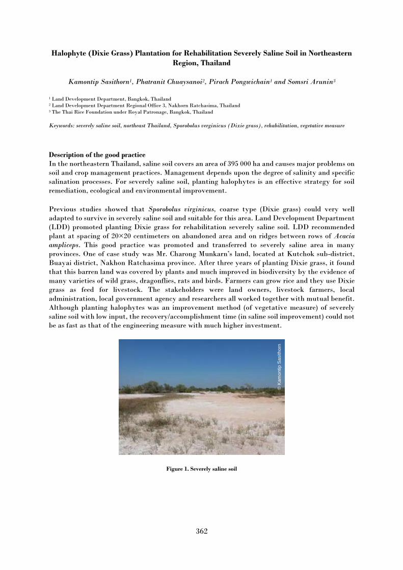
362
Halophyte (Dixie Grass) Plantation for Rehabilitation Severely Saline Soil in Northeastern
Region, Thailand
Kamontip Sasithorn1, Phatranit Chuaysanoi2, Pirach Pongwichain1 and Somsri Arunin3
1 Land Development Department, Bangkok, Thailand 2 Land Development Department Regional Office 3, Nakhorn Ratchasima, Thailand 3 The Thai Rice Foundation under Royal Patronage, Bangkok, Thailand
Keywords: severely saline soil, northeast Thailand, Sporobolus verginicus (Dixie grass), rehabilitation, vegetative measure
Description of the good practice In the northeastern Thailand, saline soil covers an area of 395 000 ha and causes major problems on
soil and crop management practices. Management depends upon the degree of salinity and specific
salination processes. For severely saline soil, planting halophytes is an effective strategy for soil
remediation, ecological and environmental improvement.
Previous studies showed that Sporobolus virginicus, coarse type (Dixie grass) could very well
adapted to survive in severely saline soil and suitable for this area. Land Development Department
(LDD) promoted planting Dixie grass for rehabilitation severely saline soil. LDD recommended
plant at spacing of 20×20 centimeters on abandoned area and on ridges between rows of Acacia
ampliceps. This good practice was promoted and transferred to severely saline area in many
provinces. One of case study was Mr. Charong Munkarn’s land, located at Kutchok sub-district,
Buayai district, Nakhon Ratchasima province. After three years of planting Dixie grass, it found
that this barren land was covered by plants and much improved in biodiversity by the evidence of
many varieties of wild grass, dragonflies, rats and birds. Farmers can grow rice and they use Dixie
grass as feed for livestock. The stakeholders were land owners, livestock farmers, local
administration, local government agency and researchers all worked together with mutual benefit.
Although planting halophytes was an improvement method (of vegetative measure) of severely
saline soil with low input, the recovery/accomplishment time (in saline soil improvement) could not
be as fast as that of the engineering measure with much higher investment.
Figure 1. Severely saline soil
© K
am
ontip S
asitho
rn

363
Figure 2. Dixie grass Context of the practice An example of successful farmer participating in the project located at Buayai district, Nakhon
Ratchasima province. The area is 0–2 percent slope and salt crust more than 50 percent found on
the surface soil. The weather is semi-arid, and the rainfall is 751–1000 millimeters per year.
The positive impact of the practice in addressing soil salinity / sodicity The severely saline soil was rehabilitated from the Dixie grass planting; salinity obviously
decreased. These induce biodiversity of both fauna and flora such as birds, butterflies, rats,
earthworms and native flowers. The farmers can use their land after planting Dixie grass for 2–3
years.
Figure 3. Rice field after planting Dixie grass three–five years
© K
am
ontip S
asitho
rn
© K
am
ontip S
asitho
rn
© K
am
ontip S
asitho
rn

364
Figure 4. Dixie grass (after three years) as pasture for cattle
Figure 5. Better biodiversity and environment (after three years)
Other benefits of the practice Dixie grasses can be used as cattle feed. Farmer can sell the Dixie shoots for propagation to Land
Development Department. They can get higher income.
Costs of the practice Total costs for technology are about 15 000 Baht per ha. The costs include labor cost for planting
Dixie grass, Dixie seedling cost (10 000 plants per ha) and fertilizers as compost and chemical
fertilizers.
Challenges for scaling up the practice The challenges are to raise awareness and participation in the rehabilitation of saline soils within
the community, and to create a model from successful farmers in order for farmers in nearby areas
to have incentives in their own areas. And the staff must continuously educate and publicize the
project.
Acknowledgements 1. Land Development Department 2. Land Development Regional Office 3, Nakhorn Ratchasima province 3. Mr. Charong Munkarn, farmer.
The views expressed in this information product are those of the author(s) and do not necessarily
reflect the views or policies of FAO.
© K
am
ontip S
asitho
rn
© K
am
ontip S
asitho
rn
© K
am
ontip S
asitho
rn
© K
am
ontip S
asitho
rn

365
The management of subsurface drip irrigation (SDI) by unconventional water in pistachio
orchards in severe soil salinity and alkalinity condition
Abdolhamid Sherafati1 and Mehrnoush Eskandari Torbaghan2
1 Horticulture Crops Research Department, Khorasan Razavi Agricultural and Natural Resources Research and Education Center,
AREEO, Mashhad, Iran 2 Soil and Water Department, Khorasan Razavi Agricultural and Natural Resources Research and Education Center, AREEO,
Mashhad, Iran
Keywords: Saline-alkaline waters, Soil degradation, Sustainable production, Toxic elements, Economic-social significance
Description of the good practice Currently, high water and soil salinity and alkalinity are the biggest challenges for the stability of
pistachio production in Iran (Figure 1). Most pistachio orchards are irrigated by furrow irrigation.
The subsurface drip irrigation (SDI) method with unconventional water can be reduced damage
and consumption of water by at least 50 percent compared to furrow irrigation.
Figure 1: Accumulation of salt in the soil surface, south of Bardaskan City, Khorasan razavi, Iran
Context of the practice The seedlings were planted in the Pistachio Research Station with the 58◦ 45 19 and 34◦ 57 12
geographical attributes. In this method, a pipeline (16 mm) with a dropper was implemented at a
depth of 70 cm and a distance of 120 cm from both sides of the seedlings. The droppers were placed
one meter apart and their flow rate was four L/h at a pressure of two atmospheres (Figure 2).
© A
. S
he
rafa
ti

366
Figure 2: Movement of water to the soil surface in SDI method (Pistachio Research Station, Khorasan razavi, Iran, 2018) The positive impact of the practice in addressing soil salinity / sodicity Since the SDI irrigation method was implemented in 2012 until now, water salinity has very
gradually increased (Table 1).
Table 1. The trend of changes in water properties used in SDI
SAR Na+ Mg2+ Ca2+ Cl- HCO3
- (CO3)2- pH
EC (dS/m) Year
meq/lit
15.5 68.2 13.9 24.7 85.5 1.9 0 7.4 11.5 2013 18.2 80.7 15.2 24 85 3 0 7.6 11.7 2015 17.6 78.6 14.4 25.6 91.5 3.2 0 7.3 12.2 2017 16.1 85.1 20 36 135.5 1.8 0 7.5 14.2 2019
The reduction of water consumed in the SDI method compare to the common irrigation (furrow
method) The consumption of water has reached nearly 2400 m3/ha after the eighth year of implementation
(2020). The amount of water consumption for trees of the same age in the furrow irrigation
(traditional irrigation) was more than 5000 m3/ha. Water requirement to produce a kg dry matter
was 761 and 1851, in the SDI and furrow method respectively.
Reduce the amount of salt entering the soil If the average inflow of water into the soil per hectare for the first eight years is 1800 m3 and the
average of water salinity is almost 11.6 dS/m, about 21 tons of salts has entered the soil every year.
This amount was estimated more than 43 tons in-furrow irrigation; which is about twice of salt
entered in the SDI.
Other benefits of the practice Dispersion of salt in SDI method and the comparison with the furrow irrigation The electrical conductivity in the topsoil (0–30 cm) was 110 dS/m.This amount was 12.33 and 14.52
dS/m for 30– 60 and 60 to 140 cm of soil layers, respectively (Table 2) which was suitable for growth
due to the expansion of roots at a depth of 60 to 140 cm in the soil in SDI.
© A
. S
he
rafa
ti

367
Table 2. Some of the most important chemical properties of the soil at the site of SDI (Sharafati, 2018)
SAR SO4 Cl Na Mg Ca T.N.V EC pH Depth - Meq/L % dS/m - cm
52.7 280 775 661.4 135 180 15.3 110 7.1 0-30 17.8 20 90 79.6 20 20 14.3 12.33 7.8 30-60 21.9 32 100 100.6 20 22 16.5 14.52 7.8 60-140
Table 3. Some of the most important soil chemical properties in furrow irrigation site (Sharafati, 2018)
SAR SO4 Cl Na Mg Ca T.N.V EC pH Depth - Meq/L1 % dS/m - cm
29.9 - - 242.8 51 70.6 15 38.82 7.53 0-50 34.9 - - 273.6 51 68.3 14.16 42.63 7.6 50-100
Improvement of horizontal and depth distribution of roots 1) There were no roots from the soil surface (0–30 cm) except the main root. 2) The main root has developed horizontally at a depth of about 60 cm. 3) The root development zone started from a depth of 60 cm and continued to a depth of more than
140 cm. 4) The roots did not accumulate in the area of water outflow (under the droppers) and were evenly
distributed in the entire volume of soil below the area of water outflow. While in furrow irrigation
the expansion of the roots starts mainly from the topsoil and reaches the maximum density up to a
depth of 50 cm
Ease of management of topsoil tillage in the SDI method To solve the soil surface compaction by agricultural implements and workers, two strategies were
performed in SDI: First, at the end of the growing season and before the onset of autumn and winter
rains, the topsoil (On average 7 cm) was collected by agricultural implements and moved out of the
orchard and second, plowing was done to a depth of about 50 cm (Fig. 3) which was not possible in
the furrow method due to the depth of root expansion.
Figure 3: Soil surface plowing with cultivator discs, Pistachio Research Station, Khorasan Razavi, Iran, 2015
© A
. S
he
rafa
ti

368
Nutrition trees with less consumption of chemical inputs in the SDI method Nutrition and supply of macro nutrients were done via an irrigation system in the SDI (Table 4).
To provide micro nutrients and achieve vegetative growth and proper yield, foliar application of
nutrients was done six and four times a year for SDI and furrow method.
Table 4. Comparison of fertilizer consumption (macro elements) and foliar feeding/ha in the two irrigation methods
Foliar application Liquid organic phosphorus (L). Potassium Sulfate Urea Irrigation method l. Kg Kg Kg Unit
30 15 20 100 SDI 20 30 50 250 Furrow irrigation
Costs of the practice Because the SDI method 1) has reduced water consumption by more than 50 percent, 2) the lowest
amount of salinity effects on the trees, 3) the suitable vegetative growth and bearing of trees (Figure
4) 4) decreased the orchard maintenance costs including labor, fertilizer, irrigation, etc. (Table 5)
was cost-effective.
Table 5. Comparison of production costs and gross income in furrow irrigation and SDI method per hectare ($). Costs and
incomes are displayed as negative and positive values respectively.
Irrigation
method Irrigation
costs Fertilizer
costs
The cost
of pest,
disease and
weed control
The cost of land
preparation,
harvest, and
processing
Total
production
costs per
hectare
Gross
income Sum
total
SDI -140 -320 -280 -480 -1410 +12800 +11390 Furrow -320 -800 -400 -600 -2120 +11200 +9080
Figure 4: Pistachio trees (Badami-sefid Cv.) in subsurface drip irrigation method, Pistachio Research Station, Khorasan
razavi, Iran, 2021 Challenges for scaling up the practice 1) The small orchards area and therefore the high cost of implementation. 2) Unfamiliarity of gardeners with this method of irrigation. 3) Insufficient management and technical knowledge for proper utilization of this method,
especially in soil and water salinity and alkalinity condition
© A
. S
he
rafa
ti

369
Acknowledgements It is necessary to thank the Khorasan Razavi Agricultural and Natural Resources Research Center
and the staff of Feyzabad Pistachio Research Station.
The views expressed in this information product are those of the author(s) and do not necessarily
reflect the views or policies of FAO.

370
Transforming homesteads of moderately saline area to adopt climate extremes in coastal
region (Bangladesh)
Shoaib, J.U.1, Biswas A.2, Hossain K.T.3 and Hoque A.F.M.M.1
1 Soil Resource Development Institute, Bangladesh 2 Soil Water Salinity Center, Bataighata, Khulna, Bangladesh 3 CODEC, NoboJatraProject, Dacope, Khulna, Bangladesh
The main focus of practice/technology Main focus of the technology is to use smallholding for multiples crops avoiding coastal climate
extremes.
Description of the practice / case study Coastal areas of Bangladesh is characterised by salinity of soils and water in dry season,
accumulation of salt on the soil surface, limited fresh water in ponds or ditch, soils became hard to
plough. On the other hand, most of the lands remain flooded up to 1 m for more than six months.
The area is predominantly single cropland with poor to moderate yield. Climate extremes like
cyclone, Sidre, heavy downpour also limit farming in this area.
Endeavours initiated by government and non-government sectors (In this case Community
Development Centre, (CODEC)) to increase cropping intensity have been observed in south-west
coastal areas of Bangladesh. Practice of transforming homesteads to a small area of unique
production unit in moderately saline areas coastal region. Growing vegetables, raring livestock and
poultry and producing fish in one compact parcel of homesteads to skip soil water salinity and water
logging in dry (rabi) and kharif (wet) growing periods respectively. A unit of about 0.22 ha
consisting of a “farm pond” for fish and sweet water source for small scale irrigation; growing
vegetables on raised pond ridge/dykes, tower gardening or in sag begs to skip soil salinity and water
logging; raring livestock and poultry, vermin compost preparation to improve soil health from
livestock refuse beside the residence. Pond is used to reserve fresh water, dykes and raised platforms
are utilized for growing year-round vegetables such as cauliflower, knolkhol, tomato, potato, bottle
gourd, chilli, spinach etc. in dry (rabi) season; sweet gourd, okra, rib gourd, snake gourd in wet
(Kharif) season. The other sub-technologies (such as tower garden, pocket method, sag bag method,
pitcher irrigation, mulching, bed system, pit system, vine of pond, use of compost fertilizer, use of
sex pheromone trap, bottle method, use of banana chopping) are also practiced for reducing water
salinity, and tipi-tap method for irrigating land. Farmers of the unions (local administrative unit)
namely Joynagar, Tildangha, Bererkhal, Bajua, Laxmikhola, Pankhali and Saherabad of Dacope
sub-district are practicing this type of technologies with their own composition of sub-technologies
since 2010. It helps to skip disaster and climate risk management in Agriculture at homestead areas
in coastal zone.
Context of the practice / case study Context of the practice includes the transformation of a fallow or rarely cropped homestead into a
multiple cropping to avoid salinity and climatic extremes. The current land use type is “homesteads” with low yielding vegetables. Before adoption of such
technology, it was used for growing vegetables with risk of soil salinity in dry season and
waterlogging in monsoon. At present, this land is used simultaneously for agriculture, aquaculture
and livestock
The coverage of the practice / case study This practice is adopted by 50 farmers, where farm size varies from 0.1 to 0.5 ha at different
unions under Dacope sub-district of Khulna district.

371
The positive effect of the practice / technology on salinity / sodicity status of soils The positive impacts of the technology are:
Skip soil salinity in dry season
Skip waterlogging.
Increased production.
Livelihood improvement.
Improvement of soil health.
Table 1. About the practice / case study
Location Climate
zone
Soil type Baseline
salinity/sodicity
levels
Mean±SD
Salinity/sodicity
after the use of
practice/case
study
Duration of
experiment
More
info
Reference
Pankhali,
Dacope sub-
district of
Khulna
district. 22°
37´ 37˝ N
latitude and
89° 30´ 33˝ E
longitude.
Tropical
wet Gleyic
Fluvisols
As the SSM
practice is being
implemented by
farmers, the
salinity level is
not recorded but
the area is known
to be as
moderately saline
area.
Not recorded as
the SSM
practice is
being
implemented
by farmers
Around 10
years
-
-
The positive effect of the practice / case study on soil health The main purposes of the technology are to improve production (crop & fodder) and to adapt with
climate extremes and its impacts like soil-water salinity and waterlogging.
Table 2. Other benefits of the practice / case study
Minimizing/Preventing soil threats YES/NO/Non
applicable Explanation / Related soil property (short,
referenced) Minimizing soil erosion/soil losses Non applicable
Enhance soil organic matter content YES As farmers use vermin compost. Foster nutrient balance and cycles (N,P,K) Non applicable
Prevent and minimize soil
contamination/pollution Non applicable
Prevent and minimize soil acidification Non applicable
Preserve and enhance soil biodiversity YES Improved soil health, enhance soil biota. Minimize soil sealing Non applicable
Prevent and mitigate soil compaction Non applicable
Improve soil water balance Non applicable
Table 3. Potential barriers for adoption of the practice / case study
Barrier YES/NO Explanation (short, referenced) Biophysical YES Need proper land budget for each micro-practices Cultural YES Peoples of the area are not acquainted with system, need awareness Social YES Need strict observation, limited access to extension, lack of education. Economic YES Poverty Institutional YES Poor extension and education on the technology Legal (Right to soil) NO Farmers own homesteads Knowledge YES Inadequate knowledge on complex farming Natural resource NO
Other

372
Economic benefits of the practice / case study
The area previously remained fallow or poor crop cover. Adopting multiple micro-technology, for
example, small pond for fish and reserving fresh water, pond dykes for seasonal vegetables, livestock
refuse for preparing vermin compost, tower garden to avoid loss during high flood etc.
From the land user’s context, the benefits compared with the establishment and maintenance costs
are very positive for both short-term (one–three years) and long-term (> ten years) returns. The
cost-benefit ratio is 1:1.5 in first two years and 1: 2.5 after two years. Farmers need financial support
during the installation of such technology.
Photos and graphical representations of the practice / case study
Figure 1. Tower Garden in the homestead
Figure 2. Farm Pond and creeping net for vegetable over the pond
©S
hoaib
, J.U
.
©Shoaib, J.U.
©S
hoaib
, J.U
.

373
Figure 3. Usage of pond dykes to grow multiple vegetables with small scale irrigation from pond.
Acknowledgements
This technology was documented following WOCAT questionnaires-QT. The process of
documentation was supported by a project from Department of Environment, MoEFCC, authors
gratefully acknowledge the support. The authors also express gratitude to the farmers and the
local extension officers to provide support and information during documentation.
The views expressed in this information product are those of the author(s) and do not necessarily
reflect the views or policies of FAO.
References
DoE. 2020. Establishing National Land Use and Land Degradation Profile toward Mainstreaming
Sustainable Land Management Practices in Sector Policies – ENALULDEP/SLM. In: Global
Environment Facility [online]. https://www.thegef.org/project/establishing-national-land-use-and-
land-degradation-profile-toward-mainstreaming-sustainable
©S
hoaib
, J.U
.

374
Coastal single cropped land converted to year-round cropping (Bangladesh)
Shoaib J.U. and Hoque A.F.M.M.
Soil Resources Development Institute, Bangladesh
The main focus of practice/technology
Saline soils. The main focuses of this practice are to increase cropping intensity and to diversify
cropping by avoiding waterlogged condition in wet season and salinity in dry season.
Description of the practice / case study A large area of the coastal region is single cropland, that is transplanted aman rice in kharif-2 (wet
season) or shrimp (Bagda or Golda) in gher areas. At present, farmers are changing the landforms
depending on the scope and ability. They are changing the landforms by raising platform, making
a ditch around or at one side of the land and the rest part remains left for growing rice. Raised
platform is used to grow small fruit trees, vegetable (Eggplant, Tomato, Okra, Gourds etc.), ditch
of 3–4m wide and 1 m deep is used for shrimp, mostly Golda (Macrobrachium rosenbergii) or white
fishes and left-over areas for growing transplanted aman or boro rice.
It is generally done during Kharif-2 season in saline areas to make sweet water availability for year-
round cultivation. The dyke of the area is 1 m wide at the crest and about 1 m high. The space is
used to grow different vegetables, chili, etc. Trails are installed to allow creeping vegetables within
the area.
The main purpose of this technology is to cultivate vegetables on the dyke of land throughout the
year. Cost of this arrangement varies with the size and height of the dyke. The soil of the dyke
becomes non saline after monsoon. Instead of single shrimp culture, rice is grown in the field and
vegetables on the dyke which increase income from farm if regular maintenance of dyke is ensured.
Context of the practice / case study The context of the practice is to skip soil salinity in dry season and waterlogging in monsoon.
The coverage of the practice / case study This practice extensively covers Khulna and Satkhira district, the south-west part of Bangladesh.
But composition and structure are different depending on the choice of the individual farmers. The
basic approach is to adopt soil salinity and waterlogged condition of the landscape.
The positive effect of the practice / technology on salinity / sodicity status of soils
Qualitative impacts estimated and included in “Other benefits” of the practice section.

375
Table 1. About the practice / case study
Location Climate
zone
Soil type Baseline salinity/
sodicity levels
Mean±SD
Salinity/sodiciy
after the use of
practice/
case study
Duration
of
experiment
More
information
Reference
Bherulia union,
Dumuria sub-
district of
Khulna District.
22°21'59.02"N
latitude
and 89°
5'6.98"E
longitude.
Tropical
wet
Gleyic
Fluvisols
Not estimated
as the SSM
practice is
being
implemented
by farmers.
The area is
moderately
saline.
Not estimated
as the SSM
practice is
being
implemented
by farmers
Around
ten years
-
-
The positive effect of the practice / case study on soil health The positive effects of this practice are:
Improved livelihood.
Improved soil health.
Improved food security.
Salinity and waterlogged skipped.
Usage of resources like soil, land, water etc. more efficiently than before.
Changed micro-climate.
Table 2. Other benefits of the practice / case study
Minimizing/Preventing soil
threats YES/NO/Non
applicable Explanation / Related soil property (short, referenced)
Minimizing soil erosion/soil
losses Non applicable
Enhance soil organic matter
content YES Previously the dykes were small, low and used for walk way. In
this practice, it is large enough to grow vegetables using
compost. Leafs of vegetables enrich SOM content as a whole. Foster nutrient balance and
cycles (N, P, K) Non applicable
Prevent and minimize soil
contamination/pollution YES Fertilizers used in pits, that limit contamination by excess
fertilizer. Prevent and minimize soil
acidification Non applicable
Preserve and enhance soil
biodiversity YES Improved soil health, enhance soil biota.
Minimize soil sealing Non applicable
Prevent and mitigate soil
compaction Non applicable
Improve soil water balance YES Small scale irrigation could be done.
Zero or minimal side-effect of practice/technology on surrounding area
On-site or off-site effects were not reported.
Tradeoffs or conflicts with other practices None

376
Table 3. Potential barriers for adoption of the practice / case study
Barrier YES/NO Explanation (short, referenced) Biophysical NO
Cultural YES Strong awareness among stakeholders is needed. Social YES Community to adopt marketing for new farm products. Economic YES High initial cost. Institutional NO Government extension institute and NGO are active. Legal (Right to
soil) YES Most of the land owned by few peoples, absentee owners.
Knowledge YES Poor excess to knowledge hub. Natural resource NO
TOther
Total polder management with strict sluice gate operation to ensure proper drainage
management.
Economic benefits of the practice / case study Initial cost of establishment of this practice is about BDT 200 000/ (USD 2400) and the farmer
can able to earn about BDT 350 000/ (USD 4100) per year per ha. There is a minimum cost for
maintenance, amounting to only USD100 per year per ha. Therefore, this a very positive cost-
benefit ratio.
Photos and graphical representations of the practice / case study
Figure 1. From left to right: Top: Creeping Vegetable on dyke, Vegetables on two dykes joined with net, Farmer
describing his experience.Bottom: Unconverted land besides converted land, Harvesting vegetable from boat, Unconverted
single cropped land.
Acknowledgements This technology was documented following WOCAT questionnaires-QT. The process of
documentation was supported by a project from Department of Environment, MoEFCC., author
gratefully acknowledge the support. The author also expresses gratitude to the farmer and the
local extension officers to provide support and information during documentation.
The views expressed in this information product are those of the author(s) and do not necessarily
reflect the views or policies of FAO.
©S
hoaib
, J.U
.

377
References DoE. 2020. Establishing National Land Use and Land Degradation Profile toward Mainstreaming
Sustainable Land Management Practices in Sector Policies – ENALULDEP/SLM. In: Global
Environment Facility [online]. [Cited 30 Septemer 2021].
https://www.thegef.org/project/establishing-national-land-use-and-land-degradation-profile-
toward-mainstreaming-sustainable

378
Usage of Gher boundary for cropping (Bangladesh)
Jalal Uddin Md. Shoaib
Soil Resource Development Institute, Bangladesh
The main focus of practice/technology Gher (shrimp cultivation) boundaries usually remain bare in the area. This technology use ‘Gher’
Bunds for multiple cropping by normal washing out or leaching salinity.
Description of the practice / case study “Gher” is a local word used for shrimp cultivation plot. The boundaries of these “Ghers” are
nowadays raised and maintained to grow vegetables, fruits and also some tree species. In this case
the boundary of the plot is raised at least 3 feet with grest width 1 feet plus depending on the height
of the boundary (Bund/dyke). Within the “Gher” the land is used for both sweet water prawn
(Golda) or saline water prawn (Bagda) with other different types of fishes (locally called Sada Mach)
if suitable depending on the salinity of water. Some of the “Gher” lands are used for transplanted
Aman with shrimp/fishes. Farmers dug a ditch along the boundary or in any corner of the field or
at the center of the plot to preserve water and fishes during the dry season. In some of the cases the
farmers used shallow tube well water to sustain the fishes. In non-to slightly saline areas they used
it even for boro (winter rice).
Establishment / maintenance activities and inputs: The boundary is constructed above flood level
(2–3 feet), the width is approximately 2–3 feet, and the ditches are 2–3 feet deep along the boundary
or at the corner or at the center. To grow vegetables farmers used nylon nets for creeping supported
by the bamboo or Dhaincha or strings. Top soils kept on top of the bunds to avoid relatively less
fertile soil on the bunds. Main inputs are seeds of vegetables, nets, bamboo, strings, fingerlings of
fish etc. Natural / human environment: The salinity of the soils from the bunds is washed away by
rainwater, which facilitates vegetable production: Rain water dissolves salt and moves to the
bottom of the bund, and soil becomes non-saline or slightly saline where vegetable could be grown. Full description in the WOCAT database.
(https://qcat.wocat.net/en/wocat/technologies/view/technologies_1171/)
Context of the practice / case study The purpose of this technology is usage of “Gher” boundary for various types of crops, including
year round vegetables and land for rice and fishes including shrimps to get more products from same
land.
The coverage of the practice / case study This type of technology is adopted almost whole shrimp farming areas of the coastal region. But is
not used as a prototype of this technology. Variations observed in crops; size, shape and height of
bunds; rice verity and fish (shrimp or normal fish).
The positive effect of the practice / technology on salinity / sodicity status of soils
Bunds are desalinized by natural washing in rainy season, means ECe became <4.00
dS/m.
Increased production per unit area.
Crop diversification increased
Livelihood improved.
Positive impact on micro-climate.
Increased food security

379
Table 1. About the practice / case study
Location Climate
zone
Soil type Baseline
salinity/sodicity
levels
Mean±SD
Salinity
/sodicity after
the use of
practice/
case study
Duration
of
experiment
More
information
Reference
Dumuria of Khulna
district.89.41395 E,
22.80719 N.
Tropical
wet
Fluvisols
Not recorded
as the SSM
practice is
being
implemented
by farmers
Not
recorded as
the SSM
practice is
being
implemented
by farmers
The positive effect of the practice / case study on soil health
Growing more crops will benefit the farmer with more return- livelihood improved.
Land could be used and managed by farmers themselves- community adoption.
Changes in land management by the farmer to grow multiple crops indeed scale up their
economy than before.
If available, give quantitative information on other indicators of soil health: recommended ones are
soil productivity, SOC, bulk density, respiration rate, and optional ones are plant available
phosphorus, soil erosion, soil biological activity, pH, available water capacity, soil infiltration rate,
soil penetration resistance, soil pollution)
Table 2. Other benefits of the practice / case study
Minimizing/Preventing soil threats YES/NO/Non
applicable Explanation / Related soil property (short,
referenced) Minimizing soil erosion/soil losses Non applicable
Enhance soil organic matter content YES Leaf litres and usage of vermin compost
increased SOM. Foster nutrient balance and cycles (N,P,K) Non applicable
Prevent and minimize soil
contamination/pollution Non applicable
Prevent and minimize soil acidification Non applicable
Preserve and enhance soil biodiversity YES Relatively better than bare soil Minimize soil sealing Non applicable
Prevent and mitigate soil compaction Non applicable
Improve soil water balance Non applicable
Zero or minimal side-effect of practice/technology on surrounding area There are no off-site impact of the technology.
Tradeoffs or conflicts with other practices Conflict between salt water shrimp (Bagda) and fresh water fish growing farmer.
Table 2. Potential barriers for adoption of the practice / case study
Barrier /NO Explanation (short, referenced) Biophysical YES Changing the Gher bund size is costly. Cultural YES Challenges of new investment Social YES Land ownership may not allow to change the landtypes. Economic YES Increased livelihood, increased food security Institutional YES Poverty, lack of fund during initiation

380
Barrier /NO Explanation (short, referenced) Legal (Right to
soil) YES In some cases absentee land owner impede development process. Still there are conflicts
of using water resources. Knowledge YES Poor literacy, access to new value chain is limited. Natural resource YES Conflict of usage for saline and fresh water sources Other
Economic benefits of the practice / case study Additional cost to normal “Gher” establishment of this technology were estimated in 2013 as
about USD 20.00 and USD 1.00 per ha for seed/seedling. Cost of “Gher” cost about USD 1000/ha.
At present valuation outcome of the “Gher” from vegetables USD 800/ha, rice 192/ha and from
fish USD 250/ha.
Photos and graphical representations of the practice / case study
Figure 1. Atypical Gher of Dumuria
Figure 2. A Gher Landscape from bird’s eye
Figure 3. Gher under vegetables and creeping in to Gher and Bean in the other side
©S
hoaib
, J.U
.
©S
hoaib
, J.U
.

381
Figure 4. Farmer who manage the Gher
Figure 5. A sketch of Gher
Figure 6. Gher bunds where not used for crop
The views expressed in this information product are those of the author(s) and do not necessarily
reflect the views or policies of FAO.
References Shoaib, J.U. 2013. Usage of Gher boundary for cropping (Bangladesh). In: wocat.net [online]. [Cited
30 September 2021]. https://qcat.wocat.net/en/wocat/technologies/view/technologies_1171/
©S
hoaib
, J.U
.
©S
hoaib
, J.U
.
©S
hoaib
, J.U
.

382
Harnessing productivity of Sodic soils through salt tolerant varieties of rice and matching
management practices
Y.P. Singh, V.K. Mishra, Sanjay Arora
ICAR-Central Soil Salinity Research Institute, Regional Research Station, Lucknow, India
Description of the good practice Management practices for rice production in salt-affected soils are different from those in normal
soils. Experiments were conducted to test the hypothesis that combining matching management
practices (Mmp) including the number of seedlings/hill, plant spacing, age of seedling and nitrogen
levels with high yielding salt tolerant variety (Stv) would enhance productivity and profitability of
rice in sodic soils. These practices were developed through on-station by optimizing existing best
management practices (Bmp) recommended for the region to match the requirements of the
variety.
Context of the practice The study site was representative of large areas of abandoned sodic soils (pH of 9.4, EC 0.61 dS/m,
OC 0.29 percent) in the Indo-Gangetic plains. The soil presents physical and nutritional constraints
to plant growth due to poor soil water and soil air characteristics caused by high bulk density (>1.5
g /cm3) and low infiltration rate (<2 mm/day). The climate of the experimental site is subtropical
monsoon, with average annual rainfall of 817 mm. The average rainfall during cropping seasons was
940 mm, and average annual evapotranspiration was 1580 mm, which varies with air temperature.
The positive impact of the practice in addressing soil salinity / sodicity The Mmp included using 4 seedlings per hill at 15 × 20 cm spacing and application of 150-60-40-25
kg N-P2O5-K2O-ZnSO4.7H2O/ha. The Mmp resulted in 35 percent higher grain yield over Bmp. Ganga
Kaveri, Moti and Narendra 359 rice varieties used to represent farmers’ varieties (Fv), did not
produce higher yields even with BMPs because of their relatively lower tolerance of salt stress.
However, under the same management practices, yield of Stv ‘CSR43’ was 17 percent higher than
the farmers’ varieties.
Other benefits of the practice Salt tolerant variety had on an average, a yield advantage of 0.62 t/ha over farmers’ varieties across
locations. However, combined effect of Stv with Mmp resulted in a 35 percent increase in grain yield
over Bmp with farmer’s varieties. Matching crop establishment and nitrogen rates, resulted in
significantly higher yields and cost/benefit ratios. On-farm validation trials of these practices
showed that the Mmp alone increased grain yield by 35 percent over existing Bmp being followed
by the farmers.
Costs of the practice Application of 175 kg N/ha resulted in the highest gross and net returns, while 150 kg N/ha resulted
in the highest benefit to cost ratio (BCR), however, differences between 150 and 175 kg N
treatments were not significant. The BCR recorded with 150 kg N/ha was 78 percent and 15 percent
higher than control and 200 kg N/ha (Fig. 1). Above 150 kg/ha, the net additional gain became
negative, indicating decreasing returns from additional N application. Hence, 150 kg N/ha was
considered the economical optimum for Stv in these sodic soils. The polynomial 5th order equation
effectively explained the net gain against corresponding nitrogen treatments (R2 = 0.994).
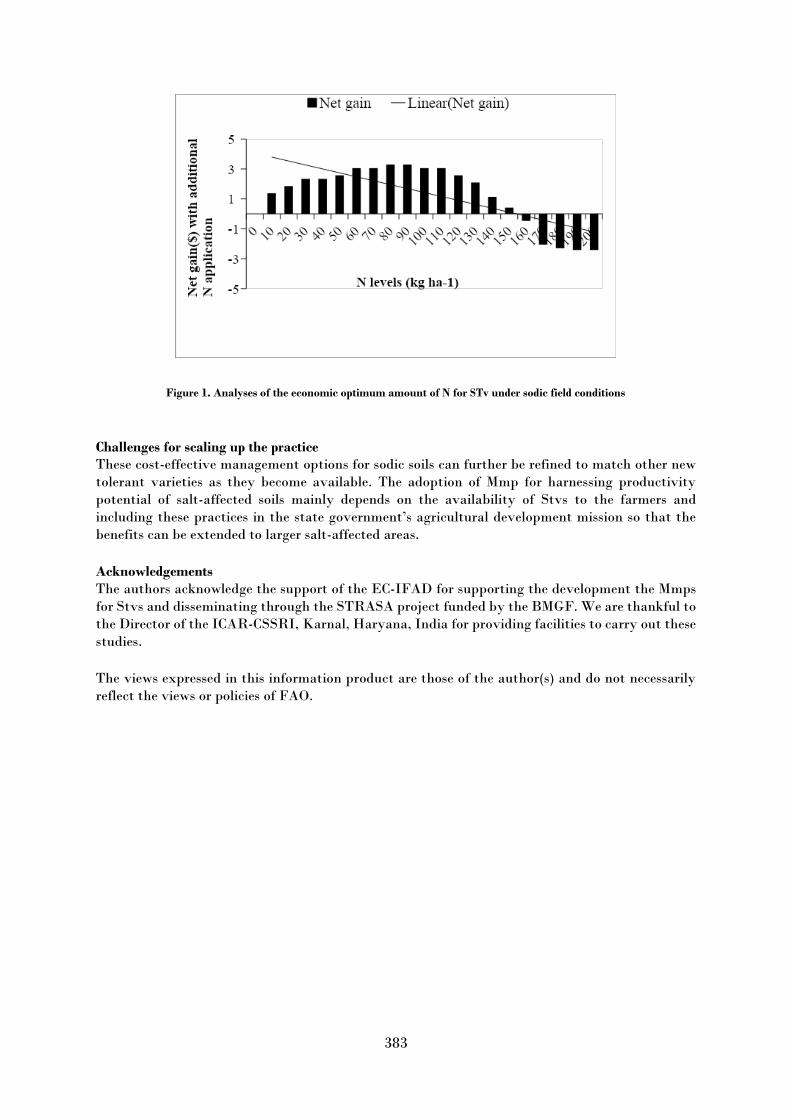
383
Figure 1. Analyses of the economic optimum amount of N for STv under sodic field conditions
Challenges for scaling up the practice These cost-effective management options for sodic soils can further be refined to match other new
tolerant varieties as they become available. The adoption of Mmp for harnessing productivity
potential of salt-affected soils mainly depends on the availability of Stvs to the farmers and
including these practices in the state government’s agricultural development mission so that the
benefits can be extended to larger salt-affected areas.
Acknowledgements The authors acknowledge the support of the EC-IFAD for supporting the development the Mmps
for Stvs and disseminating through the STRASA project funded by the BMGF. We are thankful to
the Director of the ICAR-CSSRI, Karnal, Haryana, India for providing facilities to carry out these
studies.
The views expressed in this information product are those of the author(s) and do not necessarily
reflect the views or policies of FAO.

384
Seaweed cultivation to harness the productivity of poorly drained saline lands
Preeti Singh and Santosh Kumar
ICAR-Indian Agricultural Research Institute, Jharkhand Keywords: Seaweed, saline groundwater, degraded lands, soil salinity, water table
Description of the good practice Seaweed crops could make currently degraded lands productive again using saline groundwater as
a resource. Where saline groundwater has the equivalent concentration of the minerals necessary
for seaweed growth, it could be helpful in the cropping of seaweeds. The cultivation, harvest, drying,
and baling of seaweed is as easy as making hay. All farmers who face the high-water table salinity
problems can use seaweed as a crop to maintain the sustainability of production on otherwise
degraded lands. Seaweeds are large, multicellular algae. They are eaten raw, cooked, or processed,
and their products (e.g. agars, carrageenans, and alginates) are essential ingredients in many
cosmetic and pharmaceutical products. Also, seaweed cultivation enables carbon sequestration,
breeding grounds for fish and shellfish, pollution abatement, and animal feed and fertilizers (NAAS
2003). Seaweeds are effective in mitigating eutrophication. Rising global demand for seafood has
increased the demand for seaweed cultivation (Neoria et al., 2004). Seaweed harvests could mitigate
the costs of engineering investments and costs for salinity restoration programs. Farmers who
currently have salinity problems and need a crop to substitute for the loss of traditional crops on
their salt-degraded land can use seaweed as their primary crop.
Context of the practice Seaweed cultivation assists those farmers disadvantaged by saline groundwater and enables them
to consider these waters as a resource for a crop cultivated in saline water.
The positive impact of the practice in addressing soil salinity/sodicity Seaweed sales could, at the minimum, mitigate the costs of land rehabilitation and drainage basin
operations. Seaweed production can make productive, profitable, and sustainable use of salt-
degraded land that is currently unproductive. Seaweeds also work as a soil additive and function as
both fertilizer and soil conditioner.
Other benefits of the practice It could increase the economic sustainability of farms through the use of currently non-productive
land. Seaweed will soak up excess nutrients from irrigation drainage water and help to remove
saltwater from the environment, and it helps in carbon sequestration. Cows fed certain seaweed
species belch 58 percent less methane (Mernit, 2018).
Costs of the practice Gracilaria, a type of seaweed dried and exported in bales, can generate at least $500-1000 per tonne
to processors for the production of agar gel, which has a growing international market as an additive
in the food and biotechnical industries and takes more than 35,000 tonnes of dried Gracilaria per
annum (Cordover, 2007).
Challenges for scaling up the practice
Future research and development are required to understand the major practices required for its
cultivation.

385
The views expressed in this information product are those of the author(s) and do not necessarily
reflect the views or policies of FAO.
References Cordover R. 2007. Seaweed Agronomy: Cropping in inland saline groundwater evaporation basins:
a report for the Rural Industries Research and Development Corporation. Tasmania, Australia.
Mernit, J.L. 2018. How Eating Seaweed Can Help Cows to Belch Less Methane. In: Yale E360
[online]. [Cited 2 September 2021]. https://e360.yale.edu/features/how-eating-seaweed-can-help-
cows-to-belch-less-methane
Natinal Academy of Agricultural Sciences (NAAS). 2003. Seaweed cultivation and utilization.
Policy Paper 22. National Academy of Agricultural Sciences (NAAS), New Dehli.
Neori, A., Chopin, T., Troell, M., Buschmann, A.H., Kraemer, G.P., Halling, C., Shpigel, M. et al.
2004. Integrated aquaculture: rationale, evolution and state of the art emphasizing seaweed
biofiltration in modern mariculture. Aquaculture, 231(1): 361–391.
https://doi.org/10.1016/j.aquaculture.2003.11.015

386
Large-scale barren saline-alkali land amelioration with flue gas desulfurization gypsum in
Northeast China
Yonggan Zhao1, 2, 3, Shujuan Wang1, 2, 3, Jia Liu 2, 4, Yan Li1, 2, 3, Yuqun Zhuo1, 2, 3
1 Department of Energy and Power Engineering, Tsinghua University, Beijing, China 2 Beijing Engineering Research Centre for Ecological Restoration and Carbon Fixation of Saline-alkaline and Desert Land, Beijing,
China 3 Shanxi Research Institute for Clean Energy of Tsinghua University, Shanxi, China 4 Tsinghua Agriculture Co., Ltd., Beijing, China
Keywords: FGD gypsum, large-scale application, sodic soils, saline-alkali wasteland, paddy rice field, Songnen Plain
Description of the good practice This practice was conducted from March to October 2017 in Minle village, Chagan town, Da’an city,
Jilin Province, China. The geographic coordinates of the site are between 123°22′ and 123°26′ east
longitude and 45°27′ and 45°29′ north latitude. The total area covered by different types of land use
is 1404.7 ha (Table 1). Before amelioration, saline-alkali land accounted for more than half of the
total area, with wasteland occupying the second largest land area. After amelioration, only a few
areas, such as low-lying fields that are difficult to drain, still suffer from salinization or
alkalinization. In general, after implementation, more than 80 percent of the land is paddy rice
fields with good irrigation and drainage systems and field roads.
This practice was funded by the Natural Resources Bureau of Da’an city, Tsinghua University
provided technical guidance and Tsinghua Agriculture Co., Ltd. was responsible for the technical
implementation. Because the land mainly suffered from alkalinization, it was ameliorated by
applying flue gas desulfurization (FGD) gypsum. In this case, it not only used a large amount of
this resource but also ameliorated large areas of saline-alkali land. Referring to this example of best
practices may result in a substantial increase in cultivated land and have considerable importance
in China and in similar ecological areas.
Table 1. Changes in the area of different land-use types before and after amelioration.
Land-use
type
Before amelioration
After amelioration Net
change
(ha) Area
(ha) Proportion of the
total area (%) Area
(ha) Proportion of the
total area (%)
Saline-alkali
land 789.5 56.2 6.7 0.5 -782.8
Wasteland 382.2 27.2 17.2 1.2 -365.0
Paddy rice
land 0 0 1137.0 80.9 1137.0
Dry land 203.2 14.5 99.2 7.1 -104.0
Canals and
ditches 16.5 1.2 88.8 6.3 72.3
Roads 13.3 0.9 55.8 4.0 42.5
Total 1404.7 100 1404.7 100 0

387
Context of the practice This practice was carried out on the southwestern Songnen Plain, China, which has one of the three
largest sodic soil distributions in the world. The area is characterized by a semi-humid to semi-arid
continental monsoon climate. The annual mean air temperature is 4.3 °C and the mean annual
precipitation is 400–500 mm. The topsoil (0–20 cm) is a silty clay and the groundwater table is 0.8–
1.8 m. The procedures for ameliorating saline-alkali land are summarized below.
i.The land was divided into several permanent parcels and was then ploughed to a depth of 25–30
cm. The topsoil was pulverized and then levelled using a laser-equipped drag scraper. Thereafter,
the surface height differences in the horizon for each parcel were less than 5 cm.
ii.The required rate of FGD gypsum application was applied evenly to the soil surface. The topsoil
was then tilled twice with a reverse-rotational rotary tiller to fully incorporate the FGD gypsum
into the soil.
iii.The parcels were flood-irrigated to a depth of approximately 10 cm and were then puddled and well
levelled. After the mud settled, the water with salts that remained on the soil surface was completely
drained out of the parcels. Thereafter, paddy rice was transplanted following local agronomic
standards.
The positive impact of the practice in addressing soil salinity / sodicity Soil salinity and sodicity levels in topsoil decreased remarkably after amelioration with FGD
gypsum (Figure 1). Compared to the corresponding initial levels, the mean values of electrical
conductivity (EC), pH and exchangeable sodium percentage (ESP) decreased by 34.4 percent, 21.1
percent and 64.9 percent, respectively, in the first year after paddy rice harvest. In addition, the
mean yield of paddy rice was 7.1 Mg/ha, which was approximately 80 percent of the levels of nearby
farmers’ land. Moreover, the landscape changed notably two months after amelioration (Figure 2). Five years after amelioration, there were no significant differences in salinity and sodicity between
the ameliorated and nearby farmer’s lands (Table 2). However, the EC values were significantly
higher in the ameliorated land than in the nearby farmers’ land. The increases in ECs can be
attributed to the significant increase in the concentration of Ca2+, which dissolved from FGD
gypsum. In addition, the paddy rice yield increased gradually with increasing planting years due to
the reductions in soil salinity and soil quality and increases in soil quality.
Figure 1. Electrical conductivity (EC), pH and exchangeable sodium percentage (ESP) in the 0–20 cm soil layer before
(n=162) and after (n=114) amelioration in the first year

388
Table 2. Selected properties of topsoil in the ameliorated land after five years and nearby farmers’ land
Sampling site pH EC (dS m−1)
ESP (%)
Soluble cations (mmol kg−1)
K+ Na+ Ca2+ Mg2+
Ameliorated land 7.9 a 0.5 a 8.9 a 0.2 a 6.5 a 0.9 a 0.3 a
Nearby farmers' land 7.8 a 0.2 b 7.1 a 0.2 a 6.7 a 0.5 b 0.3 a
Figure 2. Landscape changes before and after amelioration with flue gas desulfurization gypsum shown in satellite remote
sensing images.
Other benefits of the practice Other benefits of amelioration with FGD gypsum, in addition to the aforementioned positive effects
on reducing soil salinity and sodicity, are highlighted below.
i. Increased grain production and capacity. The total yield of paddy rice in this practice was more
than 8,073 tons per year. This suggests that the yielded grain can provide the annual rations of
41,252 people.
ii. Increased the income of local villagers and collectives. Each villager was allocated 1 ha of
ameliorated land and the net return was ¥12,750 per year by planting paddy rice. The village
committee rented the remaining 480 ha of paddy fields and received ¥17 million rent. The local
county finance office received ¥840 million after 350 ha of ameliorated land was committed to the
national arable land balance.
iii.Established a platform for the development of modern agriculture. The initial cultivated land was
seriously fragmented, and it was difficult to carry out mechanized planting. Currently, the
ameliorated land was suitable for the development of modern agriculture, including large-scale
planting, standardized production and brand operation.
iv.Increased the quantity and quality of cultivated land. After amelioration, the paddy rice field area
dramatically increased by 1137 ha. The increase in cultivated lands mainly comes from the
transformation of saline-alkali land and wasteland as well as dry land with low soil quality.
v. Improved the regional environment. Before amelioration, most plants struggled to grow normally
near the application site due to the toxicity of salt and alkali in the soil. After amelioration, the
deserted patchy landscape has become a regular paddy field full of rice.
Costs of the practice In this practice, the land was divided into five sodicity classes. Except for class I, the land was
ameliorated with FGD gypsum, with the application rates increasing along with the sodicity classes.
To ensure that the soil and FGD gypsum were fully mixed, rotary tillage was carried out twice in
classes II–V. In addition, the puddling and drainage operations were carried out twice in classes
III–V to leach out the dissolved salts in the soil after FGD gypsum application. Consequently, the
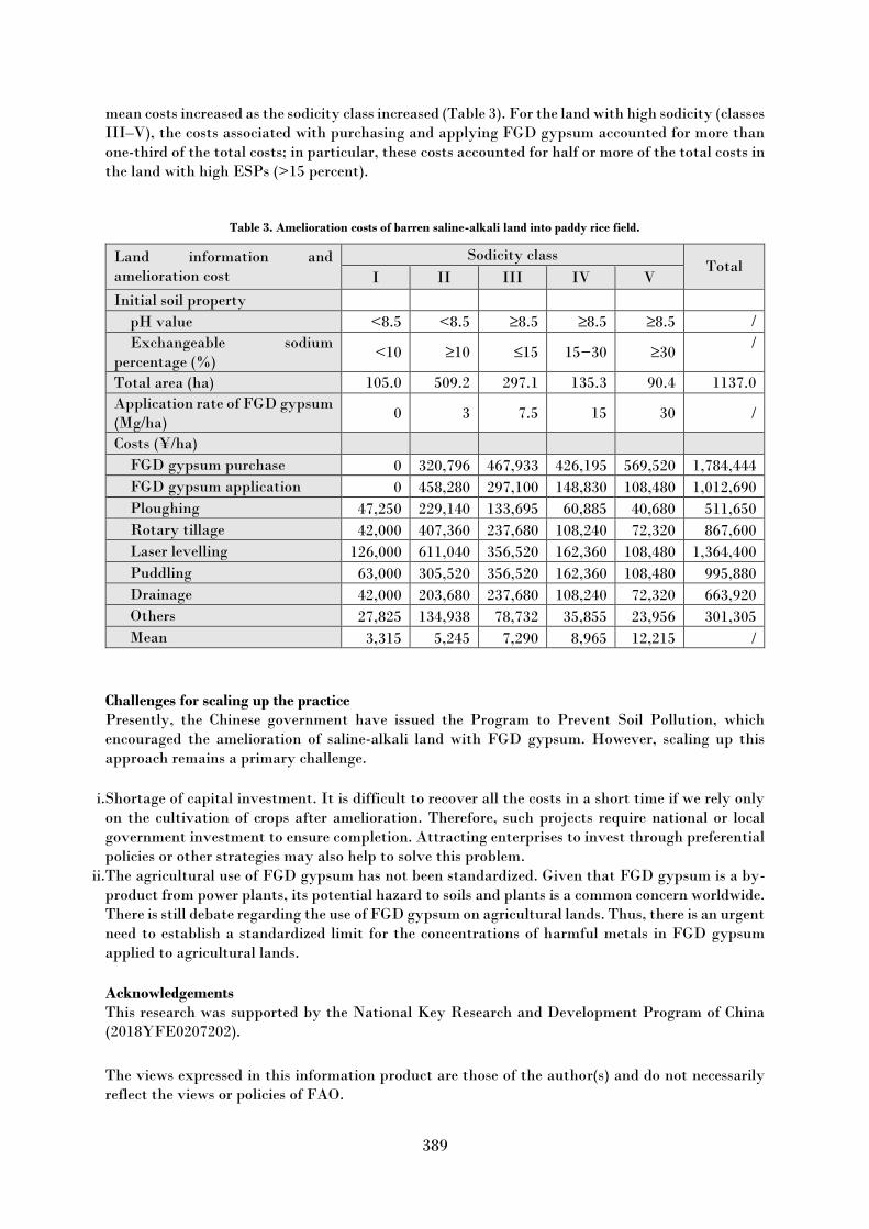
389
mean costs increased as the sodicity class increased (Table 3). For the land with high sodicity (classes
III–V), the costs associated with purchasing and applying FGD gypsum accounted for more than
one-third of the total costs; in particular, these costs accounted for half or more of the total costs in
the land with high ESPs (>15 percent).
Table 3. Amelioration costs of barren saline-alkali land into paddy rice field.
Land information and
amelioration cost
Sodicity class Total
I II III IV V
Initial soil property
pH value <8.5 <8.5 ≥8.5 ≥8.5 ≥8.5 /
Exchangeable sodium
percentage (%) <10 ≥10 ≤15 15−30 ≥30
/
Total area (ha) 105.0 509.2 297.1 135.3 90.4 1137.0
Application rate of FGD gypsum
(Mg/ha) 0 3 7.5 15 30 /
Costs (¥/ha)
FGD gypsum purchase 0 320,796 467,933 426,195 569,520 1,784,444
FGD gypsum application 0 458,280 297,100 148,830 108,480 1,012,690
Ploughing 47,250 229,140 133,695 60,885 40,680 511,650
Rotary tillage 42,000 407,360 237,680 108,240 72,320 867,600
Laser levelling 126,000 611,040 356,520 162,360 108,480 1,364,400
Puddling 63,000 305,520 356,520 162,360 108,480 995,880
Drainage 42,000 203,680 237,680 108,240 72,320 663,920
Others 27,825 134,938 78,732 35,855 23,956 301,305
Mean 3,315 5,245 7,290 8,965 12,215 /
Challenges for scaling up the practice Presently, the Chinese government have issued the Program to Prevent Soil Pollution, which
encouraged the amelioration of saline-alkali land with FGD gypsum. However, scaling up this
approach remains a primary challenge.
i.Shortage of capital investment. It is difficult to recover all the costs in a short time if we rely only
on the cultivation of crops after amelioration. Therefore, such projects require national or local
government investment to ensure completion. Attracting enterprises to invest through preferential
policies or other strategies may also help to solve this problem.
ii.The agricultural use of FGD gypsum has not been standardized. Given that FGD gypsum is a by-
product from power plants, its potential hazard to soils and plants is a common concern worldwide.
There is still debate regarding the use of FGD gypsum on agricultural lands. Thus, there is an urgent
need to establish a standardized limit for the concentrations of harmful metals in FGD gypsum
applied to agricultural lands.
Acknowledgements This research was supported by the National Key Research and Development Program of China
(2018YFE0207202).
The views expressed in this information product are those of the author(s) and do not necessarily
reflect the views or policies of FAO.

390
Biological improvement of saline-alkali land by planting two cultivated species of barnyard
(Echinochloa)
Lin Zhu 1,2, Xing Xu 1,2, Xueqin Wang3, Yan Lan 1,2
1 State Key Laboratory Breeding Base of Land Degradation and Ecological Restoration of Northwestern China, Ningxia University,
Yinchuan, China 2 Key Laboratory for Restoration and Reconstruction of Degraded Ecosystem in North-
western China, Ministry of Education, Ningxia University, Yinchuan, China 3Agricultural College, Ningxia University, Yinchuan, China
Keywords: saline-alkali land; biological amelioration; barnyard grass; Echinochloa fruntacea (Roxb.) link; Echinochloa
crusgalli (L.) Beauv. Var. mitis (Pursh) Petermann
Description of the good practice The conventional amelioration of saline-alkali land is engineering and chemical measures,
establishing drainage systems or applying chemical modifiers in salinity affected land, which are
costly or unsustainable. Planting salt tolerant forages in the medium and mild saline alkali lands
which can decrease the soil salt content (so-called biological improvement of saline-alkali land),
developing grass and livestock industry in saline alkali land, and producing high-quality livestock
products realize the sustainable improvement and utilization of saline alkali land. Barnyard grass
(Echinochloa) is a kind of herb with strong fecundity and wide ecological adaptability. It is widely
distributed all over the world. Because it endangers the growth of many crops, barnyard grass was
studied as a malignant weed in the past. However, many barnyard grass plants have high feeding
value producing high-quality forages for the development of green livestock products. Echinochloa
fruntacea (Roxb.) link and Echinochloa crusgalli (L.) Beauv. Var. mitis (Pursh) Petermann are high-
quality gramineous forages with strong salt tolerance, which play an important role in the
improvement of moderate and severe saline alkali land and the development of animal husbandry.
Echinochloa frumentacea (Roxb.) link, so-called Japanese millet has been selected and bred in
Ningxia Hui Autonomous Region, China since the 1960s. Japanese millet (Picture. 1, left) has a
stout stalk, 100–150 cm high and five-ten mm in diameter. The main shaft is thick and ribbed;
spikelets ovate elliptic or elliptic, aweless. Chromosome 2n = 54. The flowering and fruiting period
is from August to September. At maturity, the ears are yellowish green. Echinochloa crusgalli (L.)
Beauv. Var. mitis (Pursh) Petermann is an annual barnyard grass of Gramineae, which has been
domesticated from wild species for a long time. It (Picture 1, right) is lower than that of Japanese
millet, with slightly thinner stems, loose arrangement of spikelets, gray brown ear color at maturity,
early heading and flowering, and its growth period is about 1 month shorter than that of Japanese
millet. In the 1980s, Japanese millet was introduced into the saline-alkali area in north of Ningxia.
Since then, the two barnyard grasses have been grown together on the saline-alkali wasteland in
northern area of Ningxia, playing an important ecological role. In practice, the sowing date of these
barnyard grasses can be from the beginning of April to June with sowing rate being 37.5–45.0 kg/ha
and the row spacing being 15–30 cm. After continuous planting for two–three years, the soil total
water-soluble salt concentration can be decreased significantly and the crops with normal salt
tolerance such as maize, wheat or alfalfa can be planted gaining reasonable yield. In the first two
years, the stubbles are usually turned over into the soil in the autumn, and the hay can be harvested
in the third year.

391
Figure 1. The difference in the characters of spike for the two barnyard grasses (Left : Echinochloa fruntacea
(Roxb.) link; Right: Echinochloa crusgalli (L.) Beauv. Var. mitis (Pursh) Petermann) (Taken at August 2020 in
Pinluo County, Ningxia, China)
The positive impact of the practice in addressing soil salinity / sodicity The experiments conducted in 2019 and 2020 indicate that: one year after planting Japanes millet,
the pH, total salt, alkalinity and bulk density of 0–20cm soil layer decreased by 0.75 percent, 21.02
percent, 6.55 percent and 3.80 percent respectively compared with bare land. Total nitrogen, alkali
hydrolyzable nitrogen, alkaline phosphatase activity and soil urease activity increased in turn:
11.26 percent, 19.05 percent, 1.12 percent, 497.53 percent and 128.28 percent. The activities of
alkaline phosphatase and soil urease were 22.96 percent and 6.13 percent higher than those of
alfalfa. After two years of continuous cropping, the increased values of catalase activity and
invertase activity in 0–20 cm and 20–40 cm soil layers of millet in Hunan Province were less than
that of alfalfa, but higher than that of other forages.
Figure 2. The contrasted landscape at the emergence stage and the stage approaching maturation. The white colour in the
left picture was the salt patch on the experimental land in spring while the barnyard forages grew well in summer on the
same land (The photographs were taken at the same visual angle in March and June 2021 in Pingluo County, Ningxia,
China)
© L
in Z
hu
© L
in Z
hu
© L
in Z
hu
© L
in Z
hu

392
Context of the practice The climate of experimental site belongs to the semi-arid desert climate in the middle temperate
zone, with sufficient annual light (2800–3200 h), 171 days of frost-free period, drought and little
rain, large evaporation, annual average temperature of 9 ℃, annual average rainfall of 185 mm and
annual average evaporation of 1825 mm. The soil is irrigated and silted soil with heavy soil
viscosity. The improved mild saline alkali land is selected as the test site. The soil indexes are: total
nitrogen 932 mg/kg, total phosphorus 0.076 percent, total potassium 1.73 percent, available
potassium 88 mg/kg, Available phosphorus 12.0 mg/kg, Hydrolytic nitrogen 55.9 mg/kg, organic
matter 17.2 g/kg, pH 8.65, total water-soluble salt 0.43 g/kg, alkalinity 7.50 percent.
Other benefits of the practice The economic return by planting E. fruntacea and E. crusgalli (L.) Beauv. Var. mitis (Pursh)
Petermann in is shown by Table 1.
Table 1. The income for planting E. frumentacea
Yield of
hay(t/ha) Unit-price of
hay (CNY/t) Income of
hay(CNY/ha) Yield of
grain
(kg/ha)
Unit price of
grain (CNY/kg) Total income
(CNY/ha)
14.05 1000 14050 2395.8 5 11979 26029
The nutrients content in the stalks of the two cultivated species of barnyard grasses is shown in the
Table 2, which indicates higher feeding value of the two species. The crude protein content in the
stem of barnyard grasses is higher than or equal to those of paddy or wheat. The fiber content in
the stem of the two barnyard grasses is higher than that of paddy or wheat. Therefore, the stalk of
E. fruntacea and E. crusgalli (L.) Beauv. Var. mitis (Pursh) Petermann which is cut at heading stage
can be used to feed animals.
Table 2. Comparison of nutrients in the stalks of E. fruntacea and E. crusgalli (L.) Beauv. Var. mitis (Pursh)
Petermann harvested at the beginning of heading stage
Species Crude
protein
(%)
Crude
fat
(%)
Crude
fiber
(%)
Neutral
detergent
fibe (%)
Acid
detergent
fibe (%)
Acid
detergent
lignin (%)
Crude
ash (%)
Calcium
(%)
Energy
(J/g)
E.
fruntace
a
9.44 1.48 34.6 68.1 39.0 14.7 10.0 0.63 15058
E.
crusgalli
(L.)
9.97 1.78 33.0 60.8 37.2 10.3 8.9 0.64 15832
As shown in the Table 3, grain of barnyard is also nutritious, its contents of crude protein and
several amino acid are similar to or higher than those of sorghum and maize, which can be used as
concentrated feed. The grain of barnyard is also edible with high value for nutrition and health care
and can be used as the materials to ferment wine or alcohol.
Table 3. Comparison of nutrient components in the grains of barnyard grass, maize and sorghum (Yi & Peng, 1993)
Plant Crude protein(%) Lysine(%) Methionine(%) Histidine(%) Arginine(%)
Barnyard grass 10.84 0.29 0.12 0.26 0.46
Maize 9.40 0.26 0.19 0.23 0.38
Sorghum 9.00 0.18 0.17 0.18 0.33
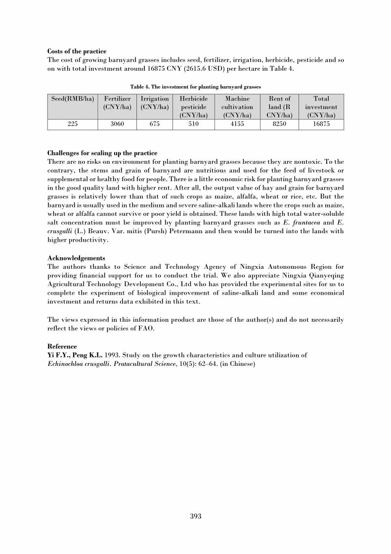
393
Costs of the practice The cost of growing barnyard grasses includes seed, fertilizer, irrigation, herbicide, pesticide and so
on with total investment around 16875 CNY (2615.6 USD) per hectare in Table 4.
Table 4. The investment for planting barnyard grasses
Seed(RMB/ha) Fertilizer
(CNY/ha) Irrigation (CNY/ha)
Herbicide
pesticide
(CNY/ha)
Machine
cultivation
(CNY/ha)
Rent of
land (R
CNY/ha)
Total
investment
(CNY/ha) 225 3060 675 510 4155 8250 16875
Challenges for scaling up the practice There are no risks on environment for planting barnyard grasses because they are nontoxic. To the
contrary, the stems and grain of barnyard are nutritious and used for the feed of livestock or
supplemental or healthy food for people. There is a little economic risk for planting barnyard grasses
in the good quality land with higher rent. After all, the output value of hay and grain for barnyard
grasses is relatively lower than that of such crops as maize, alfalfa, wheat or rice, etc. But the
barnyard is usually used in the medium and severe saline-alkali lands where the crops such as maize,
wheat or alfalfa cannot survive or poor yield is obtained. These lands with high total water-soluble
salt concentration must be improved by planting barnyard grasses such as E. fruntacea and E.
crusgalli (L.) Beauv. Var. mitis (Pursh) Petermann and then would be turned into the lands with
higher productivity.
Acknowledgements The authors thanks to Science and Technology Agency of Ningxia Autonomous Region for
providing financial support for us to conduct the trial. We also appreciate Ningxia Qianyeqing
Agricultural Technology Development Co., Ltd who has provided the experimental sites for us to
complete the experiment of biological improvement of saline-alkali land and some economical
investment and returns data exhibited in this text.
The views expressed in this information product are those of the author(s) and do not necessarily
reflect the views or policies of FAO.
Reference Yi F.Y., Peng K.L. 1993. Study on the growth characteristics and culture utilization of
Echinochloa crusgalli. Pratacultural Science, 10(5): 62–64. (in Chinese)


The Global Soil Partnership (GSP) is a globally recognized mechanism established in 2012. Our mission is to position soils in the Global Agenda through collective action. Our key objectives are to promote Sustainable Soil Management (SSM) and improve soil governance to guarantee healthy and productive soils, and support the provision of essential ecosystem services towards food security and improved nutrition, climate change adaptation and mitigation, and sustainable development.
Thanks to the financial support of
Ministry of Finance of theRussian Federation