Google Warming: Google Earth as Eco-Machinima
23
Research Article Google Warming: Google Earth as eco-machinima Leon Gurevitch Victoria University of Wellington, New Zealand Abstract This article argues that the computer automation of perspective and rendering in Google Earth has far-reaching consequences for the relationships between representations of the earth, its ecology and cultural responses to climate change. Theorists Erwin Panofsky (1991) and William Ivins (1975) to Lev Manovich (1993) and Don Ihde (2009) have argued that the emergence of Renaissance perspective structured a new relationship between the image and the object: con- tributing to the initiation of industrialisation and science. Whilst Manovich describes the impacts of Renaissance perspective in terms of its effect upon scientific and industrial structures, Jean Louis Comolli has argued that its advent was both a cause and a consequence of a shift to a huma- nist social regime. This article argues that Google Earth and its corollaries now complicate the visual and discursive constitution of the cultural and ecological environment. The contemporary computer-generated ‘visual nominalism’ of Google Earth results in a photomapped representa- tion of the earth that can elevate environmental awareness through visualised data sets at the same time as it reduces the earth to a product design–engineered object. As Comolli’s Machines of the Visible becomes Machinima of the Visible, this article asks whether public and scientific calls for a turn towards geoengineering can be viewed through a product design–engineered interface that reconstitutes the social machine as an engineer of the earth object itself. Keywords Blue marble, cartography, climate change, digital earth, earth photography, geoengineering, global warming, Google Earth, machinima, new media, panopticon, perspective In 1525, Albrecht Du ¨rer rendered a series of now famous images (Figure 1) in a treatise on measurement. These images all illustrated draftsmen in the process of using drawing grids to render various three-dimensional (3D) objects in perspective. Du ¨rer’s representations of represen- tation (as it were) now form the mainstay of illustrations deployed in textbooks and blogs on the Corresponding author: Leon Gurevitch, School of Design, Victoria University of Wellington, 139 Vivian Street, PO Box 600, Wellington, New Zealand. Email: [email protected] Convergence: The International Journal of Research into New Media Technologies 2014, Vol. 20(1) 85–107 ª The Author(s) 2014 Reprints and permission: sagepub.co.uk/journalsPermissions.nav DOI: 10.1177/1354856513516266 con.sagepub.com
Transcript of Google Warming: Google Earth as Eco-Machinima

Research Article
Google Warming: GoogleEarth as eco-machinima
Leon GurevitchVictoria University of Wellington, New Zealand
AbstractThis article argues that the computer automation of perspective and rendering in Google Earthhas far-reaching consequences for the relationships between representations of the earth, itsecology and cultural responses to climate change. Theorists Erwin Panofsky (1991) and WilliamIvins (1975) to Lev Manovich (1993) and Don Ihde (2009) have argued that the emergence ofRenaissance perspective structured a new relationship between the image and the object: con-tributing to the initiation of industrialisation and science. Whilst Manovich describes the impactsof Renaissance perspective in terms of its effect upon scientific and industrial structures, JeanLouis Comolli has argued that its advent was both a cause and a consequence of a shift to a huma-nist social regime. This article argues that Google Earth and its corollaries now complicate thevisual and discursive constitution of the cultural and ecological environment. The contemporarycomputer-generated ‘visual nominalism’ of Google Earth results in a photomapped representa-tion of the earth that can elevate environmental awareness through visualised data sets at thesame time as it reduces the earth to a product design–engineered object. As Comolli’s Machinesof the Visible becomes Machinima of the Visible, this article asks whether public and scientific callsfor a turn towards geoengineering can be viewed through a product design–engineered interfacethat reconstitutes the social machine as an engineer of the earth object itself.
KeywordsBlue marble, cartography, climate change, digital earth, earth photography, geoengineering, globalwarming, Google Earth, machinima, new media, panopticon, perspective
In 1525, Albrecht Durer rendered a series of now famous images (Figure 1) in a treatise on
measurement. These images all illustrated draftsmen in the process of using drawing grids to
render various three-dimensional (3D) objects in perspective. Durer’s representations of represen-
tation (as it were) now form the mainstay of illustrations deployed in textbooks and blogs on the
Corresponding author:
Leon Gurevitch, School of Design, Victoria University of Wellington, 139 Vivian Street, PO Box 600, Wellington,
New Zealand.
Email: [email protected]
Convergence: The InternationalJournal of Research intoNew Media Technologies2014, Vol. 20(1) 85–107ª The Author(s) 2014Reprints and permission:sagepub.co.uk/journalsPermissions.navDOI: 10.1177/1354856513516266con.sagepub.com
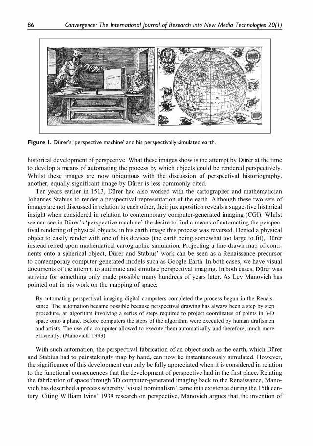
historical development of perspective. What these images show is the attempt by Durer at the time
to develop a means of automating the process by which objects could be rendered perspectively.
Whilst these images are now ubiquitous with the discussion of perspectival historiography,
another, equally significant image by Durer is less commonly cited.
Ten years earlier in 1513, Durer had also worked with the cartographer and mathematician
Johannes Stabuis to render a perspectival representation of the earth. Although these two sets of
images are not discussed in relation to each other, their juxtaposition reveals a suggestive historical
insight when considered in relation to contemporary computer-generated imaging (CGI). Whilst
we can see in Durer’s ‘perspective machine’ the desire to find a means of automating the perspec-
tival rendering of physical objects, in his earth image this process was reversed. Denied a physical
object to easily render with one of his devices (the earth being somewhat too large to fit), Durer
instead relied upon mathematical cartographic simulation. Projecting a line-drawn map of conti-
nents onto a spherical object, Durer and Stabius’ work can be seen as a Renaissance precursor
to contemporary computer-generated models such as Google Earth. In both cases, we have visual
documents of the attempt to automate and simulate perspectival imaging. In both cases, Durer was
striving for something only made possible many hundreds of years later. As Lev Manovich has
pointed out in his work on the mapping of space:
By automating perspectival imaging digital computers completed the process begun in the Renais-
sance. The automation became possible because perspectival drawing has always been a step by step
procedure, an algorithm involving a series of steps required to project coordinates of points in 3-D
space onto a plane. Before computers the steps of the algorithm were executed by human draftsmen
and artists. The use of a computer allowed to execute them automatically and therefore, much more
efficiently. (Manovich, 1993)
With such automation, the perspectival fabrication of an object such as the earth, which Durer
and Stabius had to painstakingly map by hand, can now be instantaneously simulated. However,
the significance of this development can only be fully appreciated when it is considered in relation
to the functional consequences that the development of perspective had in the first place. Relating
the fabrication of space through 3D computer-generated imaging back to the Renaissance, Mano-
vich has described a process whereby ‘visual nominalism’ came into existence during the 15th cen-
tury. Citing William Ivins’ 1939 research on perspective, Manovich argues that the invention of
Figure 1. Durer’s ‘perspective machine’ and his perspectivally simulated earth.
86 Convergence: The International Journal of Research into New Media Technologies 20(1)
86

Renaissance perspective changed the relationship between material objects and representation with
profound effects. Pointing out that other art historians only considered the significance and conse-
quence of perspective for art history, Manovich notes that Ivins was concerned with visual nomin-
alism (‘the use of vision to capture the identity of individual objects and spaces by recording
distances and shapes’) as it impacted culture and society more broadly. The most significant
impact of visual nominalism, Manovich argues, was its capacity to represent accurate and math-
ematically defined objects and spaces with the result that it propelled empirical science and con-
tributed to the rise of modern engineering and manufacturing. More recently a similar argument
has been made by Don Ihde (2009) in his work on what he calls ‘technoscience’s visualism’ and
the line that can be traced from Da Vinci to CAD (computer aided design).
Analysing Google Earth as a descendent of Durer’s original globe, I shall argue in this article
that the contemporary rise of computer-automated visual nominalism has particular implications
that are strikingly reminiscent of the historical precedent described above. If, as Manovich and
others have argued, visual nominalism marked the industrialisation of visual and material cul-
ture, demonstrated as it was in the mathematically accurate rendering and distribution of object
plans across Europe, then it also marked the rationalisation of the earth as one of these mathe-
matically rendered objects. In this sense, it is no coincidence that Durer was instrumental in try-
ing to find a means of both automating perspective and rendering the first whole earth image
with its continents mapped perspectively onto a spherical surface. Durer’s actions amounted
to more than the rendering of our earth in a new manner; they marked the first time that a rep-
resentation of the earth was brought within the auspices of the emergent processes of industria-
lisation. Durer’s image suggests that the seeds for understanding the earth as a mathematically
articulated virtual construct of perspectival rendering techniques originated from the same his-
torical root as that which Manovich identifies to be a source of industrial culture. Against this
backdrop, I will address Google Earth.
My approach in this article contrasts sharply with the myriad accounts of whole earth photo-
graphy that have characterised academic discourse over the past four decades. Such accounts have
tended to focus upon the paradigm shifting effects of indexical, analogue whole earth represen-
tation such as the famous Blue Marble photograph (Figure 2) that inadvertently emerged from the
space race. These accounts argue that the effect of whole earth observation, embodied in such
photography, was to rewrite the relationship between humanity’s social and ecological
Figure 2. The Blue Marble photograph compared with Google Earth’s default setting.
Gurevitch 87
87

understanding of its environment and its place in it. This relationship, described by Frank White
(1998) as the ‘overview effect’, has been reiterated many times and a mass of popular and aca-
demic comment now exists on the social (Poole, 2008: 158), cultural (Franklin et al., 2000: 30),
political (Cosgrove, 1994: 281), scientific (Lovelock, 1995: 192), economic (Poole, 2008, 97–115;
Redfern, 2003) and ecological (Castels, 2010: 177) effects of whole earth observation and rep-
resentation.1 Unifying almost all of these appraisals and commentaries has been the underlying
narrative – generally reinforced with relevant quotes from the astronauts who took such images
(Poole, 2008; White, 1998) – that seeing the earth for the first time, stripped of its cultural and
political borders, allowed the image of a fragile, interconnected ecosphere to come to the fore.
However, Google Earth poses a complex set of contradictions to these narratives, not least
because its existence resituates whole earth representation firmly back amongst representational
forms that existed before the supposed paradigm shift of indexical photography. Considering
Google Earth in light of Durer’s work, for instance, suggests that the predominant representation of
the earth, both before the whole earth photograph genre and since, has been a simulated model. To
paraphrase Manovich, indexical representation in this dynamic proves to be an anomaly in the face
of generations of non-indexical rendering (Manovich, 2001: 195) and in such a context, space-
based indexical photographs were a brief exception in our representations of the earth, rather than
the rule. Neither entirely virtual nor entirely indexical, Google Earth operates as a machinic hybrid
in which the panoptical power of satellite imaging2 is combined with the simulative capacities of
the product design–engineered object. It is through this combination that computer automation of
perspective and the visual nominalism of Google Earth’s simulated model changes the relationship
between earth image and environmental imagination. Representing both the environmental feed-
back of satellite surveillance and the computer-automated construction of a virtual environment
the machinic panoptacism of Google Earth reflects a new representational politics in which the
earth’s ecosystems are rationalised as always already industrialised (or industrialisable). Crucially,
however, it is not simply the industrialisation of data collection and data visualisation that marks
this new representational politics. Rather, it is the capacity of code in contemporary computer cul-
ture to reconfigure the relationship between visualisation and action or between what Wendy Chun
describes as code and its executablility (Chun, 2011: 27).
In both the executability of code and the automation of visual nominalism that computer
culture brings, we find the uniquely different role that Google Earth plays in representing our
planet’s ecology. If, as theorists of Cartesian perspective have argued,3 the shift from Byzantine
iconography to Renaissance perspective marked a shift in which our visual culture transitioned
from a theistically motivated order to that of a secular humanist order, with computer-generated
aesthetics our visual culture is characterised by a similar transition. The claim made by theorists
of the emergence of Cartesian perspective asserts that the iconographic imaging that preceded
the perspectival revolution propagated a theistic world view; the logics of iconographic space
communicated God’s primacy to the viewer by emphasising the fact that such imagery was made
for ‘the greater glory of God’. By contrast, the emergence of perspectival images both provoked
(and were provoked by) a social, cultural and political reorientation in Europe towards human-
ism; by replicating the binocular vision of the human subject, Renaissance perspective affirmed
the individual (rather than God) as the centre of both the universe and the project to empirically
understand the laws governing it. Renaissance perspective demonstrated to the viewer that the
universe was subject to laws of physics (in this case the optics of light) that could be investigated
and understood. In the contemporary context, however, the automated rendering of perspective,
and the visual automobility it affords, turns the programme user from secular humanist to deified
88 Convergence: The International Journal of Research into New Media Technologies 20(1)
88

consumer (Gurevitch, 2012). As the indexical camera of celluloid cinema has become the virtual
camera of digital game space (Jones, 2007), the user has inherited control over an interface that
conjures semi-simulated objects and spaces into being for their consumption alone. Hand in hand
with these new circumstances, the transition to computer visualisation shaped by the ‘sorcery of
source code’ (Chun, 2011) has furnished the user with seemingly omnipotent scopic capacities.
I shall argue in this article, then, that such a transition sees Google Earth and its virtual cor-
ollaries operating as ‘machinima of the visible’; representational forms that rationalise the planets
eco/mineral systems and humanity’s eco/social interactions within the logic of the computer-
generated simulated model. These developments have considerable implications for the way in
which we approach, interact with and construe the earth as both a ‘virtual’ object and simultane-
ously a complex ‘physical’ entity. Notably, notions of the ‘virtual’ earth are not separate and dis-
tinct in this account from a ‘physical’ counterpart but instead are increasingly inseparable. As the
simulation of the earth’s ecology continues to emerge as a central tenet of modern geosciences, and
in turn, as calls for physical intervention in the environment (based upon such simulations) grow,
the line between the ‘virtual’ and the ‘physical’ becomes increasingly less determinate with con-
sequent cultural, political, philosophical and ethical implications. Such implications, alongside
Google Earth’s machinic interface, are now setting the scene for both scientific discourse on
the implications of geoengineering and artistic intervention into the philosophical possibilities
on the horizon. This leads us, finally, to the notion of Google Earth as a machinima of the visible.
From machines to Machinima: Cartesian perspective and scopicdivinity in the age of dynamic imaging
In 1971, Jean Louis Comolli wrote a seminal film essay The Machines of the Visible. In this work,
he updated for film theory the above-mentioned claim that the development of Cartesian perspec-
tive was both a cause and a consequence of significant social and cultural change. For Comolli, this
thesis could be transposed onto the cinematic apparatus. On the one hand, he argued, cinema func-
tioned with, and in, the apparatus of representation at work in contemporary society. On the other
hand, society was driven and shaped by these representations (Comolli, 1985: 121). Crucially,
Comolli’s assertion was that there was a feedback loop between representation on the one hand,
and social, cultural and political constitution on the other, or, as he argued, ‘if the social machine
manufactures representation, it also manufactures itself from representations – the latter operative
at once as means, matter and condition of sociality’ (my emphasis) (Comolli, 1985: 121).
With Comolli’s appeal to the conception of mutually constitutive representation in mind, we
can turn to the idea of Google Earth as a machinima of the visible. The machinima of the visible
allows us to account for the way in which the program’s interface amounts to more than a com-
puterised renovation of either Durer’s hand-rendered images or the whole earth genre’s indexical
photography. Instead, the machinic logic of the Google Earth interface (and most other digital
globe software for that matter) has implications not only for the way in which – to borrow Comol-
li’s now seemingly rather crude terminology – the social machine manufactures representation and
manufactures itself from such representation. We might instead say that we are addressing the
way in which the social machine manufactures representations of the planet and manufactures
the planet itself from such representations.
With the concept of an industrial ecosystem already emerging as a key paradigm within a
scientific community discussing geoengineering as a potential response to climate change, the
Earth itself becomes both manufactured and remediated media. This is not to say that Google Earth
Gurevitch 89
89

is the cause or the consequence of the changing ecosystemic conditions currently taking place.
Rather, Google Earth is a scopic symptom of converging sets of scientific, industrial, ecological
and visual cultural conditions. Through these convergent conditions, we reach the concept of
Google Warming: the idea that global warming, whilst a very real physical process, is increasingly
incorporated into the social and technological capacities of our culture to simulate, represent and
direct the path of its future course. Notably, much of this simulation takes place within computers,
research programmes and scientific discourse that itself rarely filters down to the level of public
dissemination. Nevertheless, the fraction of material that Google Earth does visualise is symp-
tomatic of Google Warming: the industrial data collection, interpretation, visualisation and rep-
resentation of climate change within the auspices of an exponentially expanding computer
culture.4 If global environmental policy is increasingly based upon scientific models dependent on
the algorithmic simulations that likewise underpin new media culture, one might say that we are
not only seeing the rise of media ecology but also of ecology as media. These conditions mark the
culmination of a process started in the Renaissance and continuing to the present day where the
earth’s complex biological and ecological systems are rationalised under the logic of industrial
vision. This is the machinima of the visible.
The conception of Google Earth’s ‘Google Warming’ as a machinima of the visible leads us
quickly to the consideration of Google Earth as a form of machinima. Defining the parameters of
‘machinima’, – and therefore Google Earth as machinima – is a task easier said than done, partly
because the definition of machinima is itself still contested and somewhat indeterminate. Whilst
the term was originally coined to describe the amalgam of ‘machine cinema’ content that gamers
and film-makers made using virtual game spaces as sets for dramatic action, it has since been
theorised as a more broadly based new medium. Henry Lowood (2007: 60) has described machi-
nima’s origins in the gaming community as a means by which players could demonstrate their
skills by recording ‘speed runs’ through first-person shooter levels. For commentators like Jun
Falkenstein, this historical origin and the deep-rooted cultural foundation that has come with it
has meant that machinima as a medium is ‘naturally tied hand and foot to the gaming industry’
(Falkenstein, 2011: 87). For others such as Michael Nitsche, the defining characteristic of machi-
nima is its foundation in the principle of the procedural; ‘the main difference between machinima
and any other CGI technique is its origin in the playable real-time image’ (Nitsche, 2011: 13).
Indeed, as Hugh Hancock has pointed out, the Academy of Machinima Arts and Sciences has
similarly defined the medium in relation to its real-time function (‘film-making within a real-
time, 3D virtual environment’) for half a decade. For others still, it is less the content that defines
machinima than the platform through which it is made (Ito, 2011: 53). This last characterisation
goes some way towards accommodating both the speed runs of machinima’s origins and the nar-
rative forms that have emerged since. All of this has led Hancock to rightly suggest that scholar-
ship approaches machinima with an open-minded lack of determinism. In support of such a
point, Hancock has compared the medium’s current phase of development to the early stages
of cinema (Hancock, 2011: 32).
With such varying claims for machinima’s defining characteristics in mind, it might be more
useful to ask what kind of machinima Google Earth represents rather than whether it can be
considered machinima in the first place. For whilst Google Earth is not predominantly a game, its
platform (to which the Google company fittingly applies the industrial-sounding moniker5 ‘earth
engine’) bears enough similarities with a game engine (including a built in flight simulator) to
allow it to be deployed in a machinic manner.6 Indeed, Google Earth now has a ‘play-tour’ mode
that allows the user to create markers with which ‘tours’ can be procedurally regenerated later,7
90 Convergence: The International Journal of Research into New Media Technologies 20(1)
90

whilst Google Pro has long had a moviemaker/video capture function. Regardless of in-program
video capture capacities, the Google Earth interface functions according to the logic of the virtual
camera common to other machinic forms and as such has been used in conjunction with third-party
screen capture programmes for precisely this end.8
As computer culture has developed and the rendering of the 3D spaces opened up by it pro-
gressed, a wide range of film-makers and visual artists have emerged who use such computer-
generated space as the locations for their virtual sets. Whilst machinima makers quickly learned
the technicalities of how to use game software to make virtual movies, they also underwent a tran-
sition in their subjective positioning, beginning as players before discovering that they could oper-
ate as actor, director or even as a camera itself.
In his analysis of the virtual camera, Mike Jones argues that the virtual camera changes our
relationship to simulated space and our conception of ourselves as spectatorial subjects. Digital
cinematic forms, he argues, ‘no longer stage for the camera but stage and compose the camera
itself as a form of specific purpose scenic content’ (Jones, 2007: 227). Jones goes on to argue that
digital simulation no longer entertains a traditional relationship with object space, and instead the
camera becomes a thing that is composed for the space rather than the other way round. This is
crucial to our understanding of Google Earth and its functional construction of the user and marks a
considerably changed image form from the indexically based whole earth genre. For where the
whole earth genre represented the ultimate ‘composing of space’ in the capture of the earth image,
the digital globe ‘composes the camera’ and therefore the viewer. The difference is that in the
former the earth existed independently of the composition and capture of its image, in the latter
the simulated earth exists as a by-product of the parameters dictated by the spatial specifics of the
camera. This brings us to the heart of the shift; with Google Earth, the earth has been fabricated as a
digital object purely for the viewer. This is a profound philosophical development in which the
viewer does not simply inhabit a seemingly omniscient power of scopic automobility, they also
become the reason that the simulated earth exists at all. In booting up the program and command-
ing the visualised data into being, the contemporary user exists in a new dynamic to the visualised
earth. For Jones, this development can be traced back to the change in user expectations gained
through gaming and is aptly described by him as a shift ‘from ‘‘eye’’ to ‘‘I’’’:
The physical camera has long been associated with the ‘eye’, as a simulation of the ‘eye’ in an alternate
world (either anthropomorphically or otherwise) and in doing so is rooted to a physical and tangible
exploration and depiction of space that obeys rules of physics . . . . The virtual camera, by contrast,
moves beyond this into new conceptualisations of space and the viewer’s connection to, or immersion
in, it. Through intangibility beyond the depicted space, the virtual camera becomes a simulation of ‘I’
rather than ‘eye’; a simulation of viewer-derived presence in space rather than an anthropomorphically
based viewing apparatus. (Jones, 2007: 228)
We might summarise this dynamic as follows: For Comolli, the film camera marked the cul-
mination of a historical desire to put ‘the eye in a strictly divine place’ (1985: 126), whilst for
Jones, under the logic of the virtual camera, the ‘eye’ recedes in favour of an emphasis on place
willed into being by the ‘I’.9 Where Comolli’s spectator is invited to identify with the film camera
and the structure of perspectival optics that it uses to recreate the sense of human vision, the user of
a machinic interface literally becomes the camera in the act of interfacing with a form based upon
the primacy of first-person perspective. Where Comolli argued the machinic representation of per-
spectival space in cinema created a mutually reinforcing feedback loop in which representation
Gurevitch 91
91

was both cause and consequence of the social structure, as we shall see, with Google Earth as
machinima this relationship becomes more immediate.
In common with its new media tendency towards tailored individuation (Manovich, 2001: 51)
and composite remediation (Bolter and Grusin, 2000), the newly emergent virtual earth presents
the user and the scholar alike with a new audiovisual and philosophical node of interaction.
However, where the virtual camera that Jones describes is wholly constituted from computer-
generated space and objects, Google Earth’s ‘virtual’ camera is not so straightforward. Instead
it is an amalgam of both the computer-generated simulation and the representation of data that ori-
ginated in observation of the physical realm. Consequently the images, textures and geographic
models of Google Earth are constructed from physically derived data. Here then, the Machines
of the Visible becomes the Machinima of the Visible and changes the user’s relationship to the earth
as an entity that exists in the space between the virtual and the actual; subject to change and obser-
vation at both the physical and digital level with unexpected effects.
Through this function we see a key feature of Google Warming and its capacity to hand the
power of scopic and informational control over to the user. Google Earth presents an environment
quite different to that of the whole earth photograph (which represented an instant captured in
time). Instead Google Earth presents time and space (and therefore all subsequent temporal
functions such as ecology) as dynamic; that is to say that they are not just constantly changing and
moving forward in time but endlessly reversible and reconfigurable across space and time. This is
Google Warming; the presentation of the earth’s environment as the construction of both an
industrial data collection/simulation process in which scopic regimes of the Renaissance are
combined with the simulative capacities of contemporary digital media. Google Earth brings a new
cut and paste logic to the representation of earth’s environment; nothing is irredeemable and
nothing is permanent. Instead Google Earth presents the environment as a set of constantly
changing and changeable variables visualised according to parameters forever in the process of
being updated according to developments in measurement and simulation. In this sense, Google
Warming is the visual representation of a turning point in our culture where both science and art
begin to reconfigure the planet’s ecosystem functions within the logic of the computer simulation.
Machinima, mapping impulses and satellite art: The work of Googlein the age of ionospheric exchange
For Comolli, the link between representation on screen and its impact upon the world was both
long term and general. With Google’s machinic interface, this link can be immediate and specific.
Bizarrely, the best example of this immediacy has been provided in recent years by high school
children and college pranksters. In 2007, a group of schoolchildren kick-started a global phenom-
enon after creating graffiti on their school sports field using weedkiller to make a giant phallus.
What was interesting about this act was the degree to which it was reminiscent of a thought process
more commonly expected of conceptual artists such as Tom Van Sant or Pierre Comte (Wilson,
2002: 264–265). Childish symbol aside, these students deployed a disarming level of conceptual
sophistication in their act; rather than seeing their school sports field as the canvas for their graffiti
they saw it as a means to an end. Like a scratch film animator who carves their images onto cel-
luloid rather than the cinema screen itself, the schoolchildren graffitied their sports pitch in order to
see its projection emerge on Google Earth and broadcast to the world. With this act, the school-
children utilized Google Earth as a truly machinic form, collapsing the boundaries between
real-world geographic actuality and cartographic representation.
92 Convergence: The International Journal of Research into New Media Technologies 20(1)
92

With their graffiti, the students offer a response to the problem posed by Lisa Parks when she
considers barriers to making satellite art. Parks rightly calls for an understanding of the potential of
satellite art that operates beyond the work of art in the age of mechanical reproduction. She
suggests we understand such work as art ‘in the age of ionospheric exchange’ (Parks, 2007),
explaining the reasons why creative output in this manner has been limited up to now:
Often imagined as distant relay towers in outer space or as top-secret mechanisms of national security,
satellites lie beyond the horizon of everyday visibility. Since they are seemingly so out of reach (both
physically and financially) we scarcely imagine them as part of everyday life. In part because of this,
publics around the world have both been excluded from and/or remained silent within important dis-
cussions about their ongoing development and use . . . . Since the uses of satellites have historically
been so heavily militarized and corporatized, we need critical and artistic strategies that imagine and
suggest ways of struggling over their meanings and uses. (Parks, 2007: 207–208)
The peculiarity of the school sports ground graffiti is that it utilizes the full spectrum of military
industrial technology (at once both a symbolic and a concrete form of power and authority) to
broadcast such a long-standing symbol of playground puerility to fellow pupils, school authority
and the global public alike. It is an act of rebellion because it utilizes the ultimate form of panop-
tical surveillance (the ‘panoptical lens of space photography’) that extends and restricts ‘the pos-
sibilities of what it is to be human’ (Franklin et al., 2000: 28) to the most puerile ends.
The school sports ground cases (there are now many) recall the aerial artwork created for the
Gods by the Nazca people (in what is now Southern Peru) that could not be seen from ground level.
In these instances, however, the scopic capacities of Google Earth allow the viewer to become the
very gods that look down on their own creations. Here are the machines of the visible literalised in
the machinima of the visible; the representations constitute a literal action performed upon the
world for the specific reason that it will then appear behind the screen and within the computer-
generated composite model. Here action is driven by representation at the same time as represen-
tation is the result of action. Here Google Earth as machinima of the visible recalls Baudrillard’s
assertion that:
The territory no longer precedes the map, nor does it survive it. It is nevertheless the map that precedes
the territory – precession of simulacra – that engenders the territory . . . today it is the territory whose
shreds slowly rot across the extent of the map. (Baudrillard, 1995: 2)
In the case of Google Earth’s Google Warming, the shreds of the earth’s actual territory rot and
subsequently emerge on the map itself (Figure 3). From schoolchildren carving graffiti with
weedkiller to polar time lapses of melting icecaps, Google Earth operates as an index of social,
cultural, political and environmental rot visited upon the earth’s ecosystems. In many ways, the
school prankster’s weedkiller graffiti is reminiscent of far more ominous processes of ecological
vandalism now taking place. If the high school graffiti was made with the intention of appearing on
Google Earth, however, the ecosystem destruction now visible through virtual earth interfaces is an
unexpected by-product of the program. Whilst the cancerous destruction of the planet’s lungs is
most stark when hovering over the Brazilian rainforest, it was the Haiti Earthquake (2010), the
Mexican Gulf Oil Spill (2010) and the Japanese Tsunami (2011) that brought the panoptical envi-
ronmental capacities of Google Earth into sharp a global media focus. In the case of the Haiti
Earthquake, the promotional blurb on Google’s own website proudly (and somewhat distastefully)
proclaims that within ‘36 hours of the Haiti earthquake in January 2010, Google compiled, pre-
pared, and distributed satellite imagery of Port-au-Prince for rescue organizations and news
Gurevitch 93
93

Figure 3. (From top left to bottom right). Deforestation in Brazil; Coalfields in Tanggu Port, Tianjin, China;Gold Mine in Kalgoorlie, Australia; Salt Fields, Dampier, Australia; Tar Sands Operations, Alberta, Canada; Oilfields in Baku, Azerbaijan; SOS, Playing Field, Minamisanriku, Japan; Deepwater Oil Spill, Gulf of Mexico.
94 Convergence: The International Journal of Research into New Media Technologies 20(1)
94

outlets. This imagery helped save hundreds of lives, and was featured prominently in news clips
around the world’ (Google, 2013). Similarly, within days of the Deepwater Horizon Oil spill, the
Moderate-resolution Imaging Spectroradiometer satellite data were incorporated into keyhole
markup language (KML) plugins that demonstrated the relative size of the oil spill in relation to
users’ chosen home towns and cities.10 Finally, in the Japanese earthquake in particular one
instance stood out most starkly as it became a leading global news media story. Isolated in an ele-
vated section of Minamisanriku survivors of the Tsunami-carved ‘SOS’ onto the playing field of
their local school; a message that may have been created for passing planes and helicopters, but
which quickly appeared on Google Earth and from there quickly made it to the global news media.
Earlier I argued that Durer’s attempts to simulate and render the whole earth perspectively and
mathematically was an example of the first time its representation was rationalised within the logic
of industrialisation. We might also say, however, that Durer’s drawing represented one of the first
times that the whole earth’s representation was brought within the auspices of panoptical sur-
veillance. Whilst the image was simulated and hand drawn, it nevertheless belied the desire to see
the earth as a whole and therefore from a panoptical position. Similarly, the mathematical ren-
dering of the earth by Durer (and more specifically his mathematical co-creator Stabius) can be
seen as the 15th-century analogue of an European Space Agency (ESA) or the National Aeronau-
tics and Space Administration (NASA) project to measure and map the earth in a new and math-
ematically empirical way.
Once Durer had rendered the earth in this way, not only were its geography and topography
represented but its ecology was too. Notably, the planet in Durer’s image is surrounded by
personified trade winds blowing down upon the seas and continents. For many hundreds of years
before and after this image, maps famously represented strange creatures and dangerous geo-
graphical/ecological features (be it trade winds or lack thereof in the doldrums, or rocks and
whirlpools dangerous to seafaring travellers). This did not change with the coming of the moving
image. Drawing attention to panoramic and aerial views of war-damaged landscapes in early
cinema, Teresa Castro notes that early films served a panoptical function. Rather than operating
according to the usual picturesque logic of the panorama, these films both mapped and visually
neutralised dangerous and damaged landscapes (Castro, 2009: 12) by conveying the scale of
damage inflicted upon them.11 In the contemporary context, Google Earth renovates this rela-
tionship anew, its imaging an echo of the panoptical environmental monitoring so central to
NASA from the outset. Google Earth and emergent earth simulation programs can be seen as
ultimate attempts to map and neutralise the dangerous and damaged terrain. With the increasing
prominence of global warming as a central paradigm in our culture, all of the earth becomes
damaged and potentially dangerous terrain. Google Earth acts as a visualisation of a far broader
mapping; not just mapping in the visual spectrum but mapping of information about the planet
provided by complex spectrometers, mathematical equipment and satellite imaging technology.
Like the personified trade winds rendered to warn seafarers of ecological danger, the ecological
visualisations of Google Earth similarly warn the user of the damage and the changes currently
underway (Figures 3 and 5).
As we saw with the school graffiti,12 however, Google Earth’s relationship with ecological
representation is far more complex than its preceding media forms. On the one hand, Google Earth
can represent environmental destruction in ways similar to environmental films or the doc-
umentary photographs; on the other hand, this very same interface also communicates a profound
industrialisation inherent within this process of representation. With its basis in visual nominalism
and the computer algorithm, Google Earth’s model is bound by the same parameters that govern
Gurevitch 95
95

other areas of industrial digital culture. Like the scientific simulations of potential climate futures,
Google Earth does not exist in one form in one place at one time but in many forms in many places
at all times. Rather than follow the mass-mediated logic of the mechanical reproduction, Google
Earth’s interface follows the semi-individuated logic of digital production. This means that not
only are there many Google Earths in use at any one time but that within the interface itself there
are always almost infinite potential variations. This engenders a very different philosophical
response than the Blue Marble (Figure 2) and is where the notion of geoengineering and Google
Earth converges; in both cases, the Earth is envisaged as a malleable entity that can be acted upon
in conjunction with, or response to, a digital simulation. This contrasts sharply with the Blue
Marble image that engendered environmental alarm on the basis that our industrial actions were
leading to unknown, unknowable and irreversible consequences. The fundamental difference in
Figure 4. The 13,000 panoptical satellites in orbit around the earth are made visible in real time on GoogleEarth through the AGI plugin. AGI: Analytical Graphics Interface.
96 Convergence: The International Journal of Research into New Media Technologies 20(1)
96

these image forms is ultimately the result of the role that computer code plays in facilitating both a
dynamic interface and a uniquely empowered user.
When Google Earth operates as a machinima of the visible, it does so in two mutually rein-
forcing ways. First, the programme feeds panoptically gathered and visualised data (Figure 4) to
the user about the environments they are travelling through, constituting them in specific ways
(omniscient, scopically automobile, seemingly divine in their powers of influence over the physics
and informatics of the space). The Google Earth user is not simply a viewer of the space or a
creator of their scopic journey, they are literally placed in the position of divine manufacturer of the
very environments they wish to travel through. This is more than just a visual experience, it is a
function of the dynamic interaction between data and its visualisation in the same interface.
Second, the programme and its panoptical interface also feeds back into the way in which the earth
is acted upon. This is not to say that Google Earth literally feeds directly back into scientific
research and discourse; there are many more accurate and professional earth simulation pro-
grammes than Google Earth that do this (see Foresman, 2008; Goodchild, 2008). Nevertheless,
Google Earth’s capacity to place the viewer in the omniscient position that Jeremy Benthem’s
watchmen could have only dreamt of (Figure 4) cannot help but feed into wider public attitudes and
discourses regarding the cultural object, that is, ‘the earth’. Indeed, Parks (2009: 538) has already
claimed that Google Earth shapes policy decisions on humanitarian matters, and it seems unlikely
that the same would not be true of ecology.
If the perspectival images and the celestial points of view that accompanied Renaissance
imaging bequeathed their viewers deified scopic positions, then Google Earth provides users with
Figure 5. (From top left to bottom right). Helmut Smith’s ‘Dead Pixel’; Clement Valla’s ‘Postcard fromGoogle Earth’; Viennese Art Collective Gelitin’s 200 ft pink rabbit discarded in the Italian Alps; Asterix andObelix Field Art near Munich, Germany.
Gurevitch 97
97

an experience several orders of magnitude greater. As Margaret Wertheim has described in her
study of the relationship between Renaissance structures of space and the contemporary rise of
cyberspace, the striking parallels between past dreams of omniscience and today’s networked and
data-based digital equivalent is more than coincidental but marks a historical continuum.
Wertheim inadvertently demonstrates this deep-seated cultural association between structures of
knowledge, deified scopic capacity and the perception of landscape when she argues that, in con-
temporary online informatics, ‘the fantasy of omniscience shimmers over the digital horizon’
(Wertheim, 1999: 28). Wertheim’s deployment of a visual metaphor to describe increased access
to data is particularly apt when thinking about Google Earth; nothing could better describe the
intertwined function of information and data ‘omniscience’ that is acted out in the representational
structure of the digital globe. Data omniscience is literally played out on its ‘digital horizon’.
Equally, in a peculiarity made striking with hindsight, it seems that contemporary computational
simulation of the earth marks a historical circularity; Ellie Dekker has argued that early Renais-
sance globes, in their capacity to help users quickly calculate geolocated data such as relative local
times in different places can be regarded to have served as some of the first analog computers
(Dekker, 2007: 150).
Wertheim is not the only person to link notions of scopic and spatial omniscience to the data
processes that underpin computer culture, however. In her study of source code in contemporary
culture and its fetishised status as a function of programming ‘sorcery’, Wendy Hui Kyong Chun
argues that the coder has taken on the cultural position of an omnipotent creator in the popular
imagination. Quoting Massachusetts Institute of Technology professor and member of the Arti-
ficial Intelligence lab, Joseph Weizenbaum, Chun uncovers a distinctly theological theme
underpinning the metaphorical constructions of both the programmer and the program:
The computer programmer . . . is a creator of universes for which he alone is the lawgiver. So, of
course, is the designer of any game. But universes of virtually unlimited complexity can be created
in the form of computer programs. Moreover, and this is a crucial point, systems so formulated and
elaborated act out their programmed scripts. They compliantly obey their laws and vividly exhibit their
obedient behaviour. No playwright, no stage director, no emperor, however powerful, has ever exer-
cised such absolute authority to arrange a stage or field of battle and to command such unswervingly
dutiful actors or troops. (Chun, 2011: 47)
Both Chun and Weizenbaum refer here to the programmer rather than the program but the point
still stands; if the programmer is the creator of universes and lawgiver, so too the user of a program
inherits some of these apparent powers.13 To contextualise in relation to Google Earth; its interface
encourages its user to operate in a limited sense as a programmer. Through KML plugins, the user
can select new and different data sets that translate visually into different environmental skins.
Through these skins, users can raise and lower sea levels, slow down, speed-up and even reverse
time, change ocean temperature, insert visualisations of historical data or manipulate any other
environmental variable that has been observed and programmed into a layer. Whilst the possibi-
lities are not endless (unless the user chooses to programme new data sets in KML themselves),
they are so numerous as to hand the user a near infinite range of ‘law-giving’ capacities with which
to set and change the parameters of the simulated earth.
Weizenbaum’s reference to the programmer as more powerful than the playwright, stage
director or emperor is of particularly apt relevance when we recall Marshal McLuhan’s now
generally forgotten claim that ‘at the moment of Sputnik the planet became a global theater in
which there are no spectators but only actors’ (McLuhan, 1974: 50). His claim that the earth
98 Convergence: The International Journal of Research into New Media Technologies 20(1)
98

became a form of art in this exchange is all the more fitting when we consider that Google Earth’s
machinic interface realises McLuhan’s metaphor in ways that he may not have expected. Whilst
McLuhan noted the centrality of data in this paradigm shift, he did not discuss the omniscience
inherent in the process. By contrast, Wertheim, Weizenbaum and Chun’s appraisals of data culture
and computer code are distinctly theistic in their descriptions and metaphors. As Chun states of the
coder, in a biblical reference that points towards the digital earth’s cultural foundation in the
relationship between panoptical data and religious metaphor: ‘as a lawgiver more powerful than a
playwright or emperor, the programmer can say ‘‘let there be light’’ and there is light’ (Chun, 2011:
47). Here then, the opening lines of the bible, with its explicit reference to God’s capacity to act as
the panoptical viewer and omniscient creator, is conflated with the ‘sorcery’ of contemporary
programmers. Crucially, the relationship between notions of the playwright, the stage director or
even God and seemingly omniscient scopic capacities over landscape and environment (‘God
looked upon the face of the earth and he said let there be light’ [my emphasis]) are not limited to
Christian iconography. The words ‘panoptical’ and ‘panorama’ in part refer back to the Greek God
of nature (Pan) at the same time as they also reference the broader use of ‘pan’ for ‘all’, ‘every’ and
‘whole’. Similarly, the history of panoramic and panoptical sight can be traced back to ancient
Greek theatre that saw natural landscapes function as the stage upon which drama unfolded below
semi-circular seating carved into hillsides above (Gold and Revill, 2004: 90).14
Unsurprisingly then, artists have started to use Google Earth as a machinic canvas or theatre
set (depending on how one approaches the program as a machinima of the visible). A genre of
Google Earth-based machinima has emerged through which the effects of climate change are
visualised and the destructive effects of anthropogenic industrialisation of the earth’s surface are
documented. Indeed, Google has pages (‘Google Earth Outreach Showcase’) dedicated to the
collection of machinima surrounding climate change and wider social, ethical narratives. Here,
videos narrated by environmental celebrities such as Al Gore, Jane Goodall, Steve Schneider and
others feature at the same time as narrated videos of layers that users can view and explore for
themselves are demonstrated. There is a whole article to be written simply on the taxonomy of
these emergent machinic Google Earth videos; from shorts on the effects of global warming to
more specific, localised and immediate industrial destruction such as narrated Appalachian
Mountain top removal layer fly-throughs. Equally, news media organisations regularly refer
to Google Earth in the event of environmental catastrophe or in envisioning potential geoengi-
neered futures (see Gurevitch, 2013).
It is important to note here that Google Earth and the Google Corporation do not gather the data
on the earth’s climate itself. Rather, Google Earth functions as the representational interface
through which third-party data are visualised. Consequently, and in addition to the visual structure
of the interface, the ideological structure of Google Earth has implications for our understanding of
Google Warming. For the effects of climate change are not only presented as dynamic and recon-
figurable but also presented as the product of multiple and endlessly multiplying sources. And yet,
Google Earth’s function as the interface through which these different sources are funnelled have
particular implications for the user’s encounter with the data. The specific industrial capitalist
nature of Google Earth is a case in point. As Parks (2009) has argued in relation to humanitarian
crises visualised in the programme, its interface marks the application of a neo-liberal market logic
to the process by which both public and private research data are rationalised as the property of the
private corporation. In response to this (consciously or otherwise), artists, farmers and collectives
are responding to Google Earth in ways that reflect a wider social and philosophical reconfigura-
tion regarding the nature of the interface (Figure 5). Artists such as Helmut Smith carve ‘dead
Gurevitch 99
99

pixels’ into the earth, whilst Clement Valla finds flaws in the interface to make ‘postcards from
Google Earth’. Similarly, a farmer near Munich in Germany grows field art images of Da Vinci’s
Vitruvian Man and Asterix and Obelix, whilst Viennese art collectives knit giant (200 ft) pink rab-
bit teddy bears and leave them ‘discarded’ in the Italian Alps. These interpretations step outside the
boundaries of ‘machinima as video output’ I described earlier but do explore facets of Google
Earth as a quasi-game engine commonly found in hacker and machinima culture. Valla’s identi-
fication of glitches in the interface and Smith’s deliberate introduction of a ‘glitch’ in the form
of a dead pixel derive from the same philosophical origin. In both cases, the common theme is the
testing of boundaries between the physicality of the earth and the inculcation of that physical real-
ity in a less than perfect, corporately owned interface. This is environmental art in a new form and
it is likely to be just the start.
Deus Ex Machinima? Law, code and deified vision
Google Earth is, then, a visual manifestation of the scientific, cultural and political rationalisation
of the earth within a simulated industrial structure. With its machinic, informationally networked
interface, the user is offered the earth as an engineered (or at least engineerable) object.
The Google Earth program is symptomatic of a new, computer-simulated, blend-based scopic
regime that now feeds into the actions that humanity performs upon the earth’s environments as
climate models are played and counter played over and over. Such simulations, based upon the
continually growing body of panoptically observed data, are not just reflective of an ever more
sophisticated scientific consensus on the earth’s environmental status, they also contribute to pub-
lic perception of the potential scenarios emerging for restoring its global eco-systemic balance.
In this sense, Google Earth is the scopic manifestation of an emerging eco-industrial regime
(Figure 6) in which the program is symptomatic of a wider representational shift in the way
in which the earth is conceptualised.
We must be careful, however, in summoning a generalised constituency (‘humanity’) as if it is a
unified actor. Rather, it is more accurate to see Google Earth as a program that gathers some of the
myriad data sets and visualisations (representing multiple institutions and discourses) emerging
from earth observing environmental science under the same interface. Elsewhere I have started to
sketch out some of these institutions and the implications of their competing representational uses
of digital earth programs for the climate change and geoengineering debate (Gurevitch, 2013), but
a great deal more work is still to be done in this area.
To return, by way of conclusion, to the subject with which I opened this exploration of Google
Earth, the condition of new representational capacities facilitated by visual nominalism during
the Renaissance returns in the contemporary context through computer automation, calculation
and simulation. The mathematically precise modelling and representation of data that propels
a new expansion in science and technology recalls a similar development – described by
Manovich, Ihde and others – from the 15th century onwards. This time round, however, tech-
noscience’s visualism extends beyond botanical renderings, engineering drawings or earth
renderings of the Renaissance, occupying extremes of both representation and calculation pre-
viously inconceivable. From micro-scale genetic decoding and rendering to macro-scale whole
earth simulation, software facilitates an expansion in our conceptualisation, quantification and
representation of the physical universe. Like the Renaissance viewer positioned by a perspectival
painting to engage with a new scopic regime that placed the humanist subject at the centre of the
100 Convergence: The International Journal of Research into New Media Technologies 20(1)
100

universe, the contemporary Google Earth interface user is granted a new and extensive host of
scopic powers that reconfirm the apparent primacy of our command over the world.
With this in mind, it is notable that geographic information system scientists are already
mapping out scenarios in which ubiquitous computing allows for a dynamic digital earth in which
users function as continual real-time ‘nervous system’ sensors (see especially De Longueville
et al., 2010). One can only imagine the kinds of digital ‘nervous system’ flash mob performance
artists that may emerge if these possibilities come to pass, especially in the sphere of environmen-
tal protest. Such a concept contains a curious blend of micro- and macro-visualism at the same
time. More importantly, however, it sustains a conception of the earth as a machina mundi that has
Figure 6. (From top left to bottom right). Google Earth with daily MODIS sat data mapping; ocean aciditylevel data; global oil consumption data; global deforestation data; global ocean temperature data; NSIDCmapping of ice melt at North Pole. MODIS: Moderate-resolution Imaging Spectroradiometer; NSIDC:National Snow and Ice Data Center.
Gurevitch 101
101

existed for almost a thousand years (see Johannes Sacrobosco C. 1230), but this time positions
humanity as the central actor in the machinery. Suggestions that the digital earth could act as a
benevolent, crowdsourced, ubiquitously networked ‘nervous system’ are reminiscent of James
Lovelock’s Gaia theory (2006) except that it places a revisionist, techno-utopian gloss on a con-
dition for which Lovelock only has alarm.
The idea that humanity is viral in nature is central to James Lovelock’s work with its over-
arching structural belief in the biological interconnection of all earth’s systems. Whilst Lovelock
compares humanity and its effect in the linguistic and conceptual framework of virology, his
metaphors remain strictly biological rather than cybernetic. Consequently, whilst Lovelock does
not treat the question of earth observation in terms of software and computer culture, his inter-
vention on whole earth conception is still tellingly central.15 Particularly interesting when con-
sidered in the context of earth representations that function as panoptically constituted machinima
of the visible is his warning against treating geoengineering as a panacea:
In the longer term we have to understand that however benign a technological solution it may seem it
[geoengineering] has the potential to set humanity on a path to the ultimate form of slavery. The more
we meddle with the earth’s composition and try to fix its climate, the more we take on the responsibility
for keeping the Earth a fit place for life, until eventually our whole lives may be spent in drudgery doing
the tasks that previously Gaia had freely done for over three billion years. This would be the worst of
fates for us and reduce us to a truly miserable state, where we were forever wondering whether anyone,
any nation or any international body could be trusted to regulate the climate and the atmospheric com-
position. (Lovelock, 2006: 152)
Here, Lovelock’s suggestion that geoengineering could herald the ‘ultimate slavery’ of
humanity left in charge of the environment ‘forever wondering’ what might go wrong is strik-
ingly reminiscent of Foucault’s claim that the logical conclusion of a panoptical penal system
would be:
an indefinite discipline: an interrogation without end, an investigation that would be extended without
limit to a meticulous and ever more analytical observation, a judgement that would at the same time be
the constitution of a file that was never closed, the calculated leniency of a penalty that would be inter-
laced with the ruthless curiosity of an examination, a procedure that would be at the same time the per-
manent measure of a gap in relation to an inaccessible norm and the asymptomatic movement that
strives to meet in infinity. (Foucault, 1979: 227)
We might argue, then, that Google Earth as a panoptical machinima of the visible functions
simultaneously as a representation of Lovelock’s fear that humanity will be endlessly entangled in
the drudgery of eco-system monitoring and management, and Foucault’s file that is never closed.
As a representation, Google Earth manifests, in visual form, scientific and cultural processes
already underway in constituting the planet. As machinima of the visible, Google Earth represents
the computerisation of what Foucault refers to as the ‘panoptic machine’ and (as we know) what
Comolli refers to as ‘the machines of the visible’; an industrialised social, cultural, political and
technological feedback loop sees representation and response bound together.16 The ‘file that is
never closed’ now incorporates the capacity of the software programmer to enact code as law
as Foucault’s legal file becomes Chun’s computer file containing the digital subroutine that deter-
mines the parameters of such law.
To maintain the broad rhetorical tone of Foucault’s analysis, by becoming our own scopic gods
we monitor ourselves and our environment at the same time as we must discipline ourselves
102 Convergence: The International Journal of Research into New Media Technologies 20(1)
102

endlessly. Where, as Foucault notes, God previously brought plagues and pestilence upon us – an
upset ecological balance symptomatic of God’s wrath – we now bring it upon ourselves. Where
God disciplined and punished us, we must now discipline ourselves to reduce our carbon output or
face the punishment that we have created for ourselves. Of course (as I suggested above), the ‘we’
here is neither a simple nor a unified entity. As a consequence, it is hard to imagine a scenario
in which future debate over the severity of coming climate change will not involve disputes
over differences in panoptically gathered data and the nature of code that governs consequent
simulations.
Here, we finally come full circle and return to Durer and Stabius’s original mathematically
calculated earth image as progenitor of Google Earth. Whilst Durer’s image may be treated as the
initiation of earth representation into the industrial structures emergent with mathematically cal-
culated perspectival representation, understanding the function of Google Earth as a contemporary
eco-media form requires a wider cognizance of the machinima of the visible as a product of both
source code and its subsequent facilitation of the data-visualisation process. This is a dynamic
regime in which the boundaries between representation, simulation and reality are now porous and
interactive upon each other in ways previously unimagined. This is the machinima of the visible; a
virtual and actual feedback loop in which we move from media ecology to ecology as media. In
recent years, earth scientists have increasingly called for the recognition of a new category of earth
system era. The ‘anthropocene’ has been so labelled for the need to recognise the enormous, rapid
and earth changing effect that the human race is now having upon every facet of the earth’s sys-
tems. By the same token, we might argue that we are entering a ‘mediacene’; the rationalisation of
the earth’s systems under the auspices of digital media’s simulative effects (witness the mobilisa-
tion of the scientific community upon the shoulders of a computer culture processing big data to
divine the severity of future climate change scenarios) in which the planet’s ecological future is
role-played and counter role-played in the processors of the world’s desktops and servers, whilst
the environmental present is spectacularly visualised, like an interactive disaster movie, on their
screens. Welcome to Google Warming.
Acknowledgement
This article has been particularly long in the making, and I would like to thank a number of people,
who read earlier drafts or commented on public presentations of the article. Specifically I would
like to thank Sean Cubitt, Lisa Parks, Anne Balsamo, Chris Russill, Lisa Bloom, Margaret Petty,
Jason Petty, Bruce Bennett, Mark Bartlett, Douglas Easterly, Julie Cupples, Kevin Glynn, Dimitris
Eleftheriotis, Ben Pitcher, Rebecca Bramall, David Maskill, Anne Cronin, Sue Irwin and Steve
McCormick. This article is dedicated to Kim Stanley Robinson for half a lifetime’s inspiration.
Thanks Kim!
Notes
1. Robert Poole and Frank White both consider this topic in very specific and focused detail. Poole argues
that the origins of James Lovelock’s Gaia Theory can be approached through the viewfinder of the Apollo
missions ‘Blue Marble’ photographs, quoting Lovelock himself who has stated that ‘When I first saw Gaia
in my mind I felt as must as astronaut have done as he stood on the Moon, gazing at our home, the Earth’.
Aside from this, it is worth noting that there are even now appraisals of the appraisals that have been made
(Henry and Taylor, 2009).
2. It has been noted before that space-based photography is inherently panoptical (Franklin et al., 2000: 28).
From the military drive into space to NASA’s subsequent mission to survey the earth and gather data on its
Gurevitch 103
103

changing status (be it geopolitical, geological or ecological), multilayered networks of surveillance per-
vade Google Earth and the user’s interaction with it. Indeed, both the original Central Intelligence
Agency–funded company and software that Google purchased and rebranded as Google Earth was named
after ‘Keyhole’, the US military spy satellite programme.
3. For the best overview of this debate, see Martin Jay’s (1988) essay Scopic Regimes of Modernity in which
he outlines the considerable attention that Cartesian perspective has received amongst visual scholars from
Panofsky and Ivins to Richard Krautheimer, Samuel Edgerton and Michael Kubovy.
4. Please note, I choose to deploy the phrase ‘climate change’ here rather than the phrase ‘climate variability’
now more commonly deployed in earth science discourse. This is because I am not simply referring to
variability in the climate but changes in the natural environment and landscape that we are actively
involved in effecting.
5. This is reminiscent of the earlier ‘spaceship earth’ metaphor deployed by Buckminster Fuller in the
1960s: ‘we can make all of humanity successful through science’s world-engulfing industrial evolution
provided that we are not so foolish as to continue to exhaust in a split second of astronomical history the
orderly energy savings of billions of years’ energy conservation aboard our Spaceship Earth. These
energy savings have been put into our Spaceship’s life-regeneration-guaranteeing bank account for
use only in self-starter functions’. It is worth noting that whilst the notion of the earth as a space ship
became popular amongst many commentators during the 1960s, it goes back as far as Henry George’s
1879 book Progress and Poverty.
6. Indeed Google Earth is used as a plugin for games.
7 This is less a video capture feature than a means of directing the path of a virtual camera and saving the
result as coordinates that the programme then procedurally replays when requested.
8. If we are to limit the notion of machinima only to the use of a graphics engine explicitly in conjunction
with the capture of video, however, then this article will have to be considered an exploration of Google
Earth as a machinic interface rather than as machinima. Understanding the notion of machinima only in
relation to the graphics engine and its use for video capture, however, fails to take account of the myriad
ways in which increasing numbers of users deploy and experience the virtual camera in a cinematic and
machinic manner without ever necessarily recording the experience. It also presents a problematically
limiting account of the relationship between ‘recording’ and machinima. That is to say that reducing the
capture of ‘machinima’ only to video recording runs contrary to one of its primary principles; its basis in
the procedural. If a dramatic, virtual, spatial experience is procedurally constructed and procedurally
replayed in a game engine (as is the case with Google Earth’s ‘play tour’) are we to say that this is not
machinima?
9. Aside from Comolli, Michael de Certeau (1988), Margaret Wertheim (1999) and Alison Griffiths (2008)
have all described the drive towards scopic divinity in visual culture: be it in 15th- and 16th-century
Renaissance painting or contemporary virtual imaging. Where the Renaissance art viewer of a painting
(de Certeau, 1988), the baroque ruler attending the theatre (Schivelbusch, 1995: 189–203) and the 20th
century film viewer in the cinema (Comolli, 1985) were simply placed centre stage by a Cartesian perspec-
tive that constituted them as the subject of an externally generated scopic production, the 21st century user
of Google Earth becomes part creator of their own scopic reality.
10. Perhaps the best example of this is Paul Rademacher’s interactive demo: http://www.paulrademacher.
com/oilspill/ (accessed 1 December 2013)
11. In the contemporary context, this confluence of image form, function and subject has not waned. From
Godfrey Reggio’s Koyaanisqatsi (1982) to Ron Fricke’s Baraka (1992), from Edward Burtynsky’s epic
images to Jennifer Baichwal’s subsequent Manufactured Landscapes, the relationship between panopti-
cal imaging and the earth’s ecologically damaged and dangerous geographies remains strong. For a
104 Convergence: The International Journal of Research into New Media Technologies 20(1)
104

particularly good appraisal of these films and filmmaking of the earth’s environments, see Martin Roberts
(1998) excellent Baraka: World Cinema and the Global Culture Industry.
12. This kind of graffiti is now being given the term ‘roofiti’ in popular cultural dialogue.
13. Indeed, Chun points out that the emergence of the graphical user interface was instrumental in ‘chipping
away at the boundary between user and programmer’ computer programmer (2011: 61).
14. Perhaps it is small wonder, then, that the space programme that captured much of the first whole earth
photography was named ‘Apollo’. For much more on this relationship between the American space pro-
gramme and the social, cultural and historical relationship with European mythology, see Denis Cosgrove
(1994).
15. Ironically, however, his Gaia theory was a result of the computerization of science and culture that facili-
tated his research in the first place. Starting his career in NASA during the 1960s, the sophistication of
Lovelock’s key claim that all earth systems were fundamentally interconnected was undoubtedly facili-
tated by the growing complexity afforded by the arrival of computer modelling and simulation. Similarly,
the data captured for Lovelock’s work was the consequence of NASA’s panoptical mission to survey the
earth and all its changes (human, ecological and geological).
16. Foucault hits a strikingly similar chord to Comolli’s claim that the ‘social machine manufactures repre-
sentation, it also manufactures itself from representations’ when he goes on to assert that ‘we are neither
in the amphitheatre, nor on the stage, but in the panoptic machine, invested by its effects of power, which
we bring to ourselves since we are part of its mechanism’ (my emphasis) (Foucault, 1979: 227). It is no
accident that both Foucault and Comolli choose the metaphor of the machine with which to link vision,
surveillance and behavioural feedback loops, rather, it is a long-running cultural trope with which the
world has often been conceptualised. For more on this, see Paul Edwards excellent 2010 book A Vast
Machine: Computer Models, Climate Data, and the Politics of Global Warming.
References
Baudrillard J (1995) Simulacra and Simulation. London, UK: University of Michigan Press.
Bolter JD and Grusin R (2000) Remediation: Understanding New Media. London, UK: MIT Press.
Castels M (2010) The greening of the self: the environmental movement. In: The Power of Identity. Chester,
UK: Blackwell, pp.168–191.
Castro T (2009) Cinema’s mapping impulse: questioning visual culture. The Cartographic Journal 46(1):
9–15.
Chun W (2011) Programmed Visions: Software and Memory. London, UK: The MIT Press.
Comolli JL (1985) Machines of the visible. In: De Lauretis T and Heath S (eds) The Cinematic Apparatus.
London, UK: Palgrave Macmillan, pp. 121–142.
Cosgrove D (1994) Contested global visions: one-world, whole-earth, and the Apollo space photographs.
Annals of the Association of American Geographers 84(2): 270–294.
de Certeau M (1988) The Practice of Everyday Life. London, UK: University of California Press.
Dekker E (2007) Globes in Renaissance Europe. In: David W (ed) The History of Cartography, Vol. 3:
Cartography in the European Renaissance, London: University of Chicago Press, pp. 135–159.
De Longueville, Annoni A, Schade S, et al. (2010) Digital earth’s nervous system for crisis events: real-time
sensor web enablement of volunteered geographic information. International Journal of Digital Earth
3(3): 242–259.
Edwards P (2010) A Vast Machine: Computer Models, Climate Data, and the Politics of Global Warming.
London, UK: MIT Press.
Falkenstein J (2011) Machinima as a viable commercial medium. Journal of Visual Culture 10(1): 86–88.
Foresman TW (2008) Evolution and implementation of the Digital Earth vision, technology and society.
International Journal of Digital Earth 1(1): 4–16.
Gurevitch 105
105

Foucault M (1979) Discipline and Punish. London, UK: Vintage Books.
Franklin S, Lury C and Stacey J (2000) Spheres of life. In: Global Nature, Global Culture. London: Sage, pp.
19–67.
Gold J and Revil G (2004) Representing the Environment. London, UK: Routledge.
Goodchild MF (2008) The use cases of digital earth. International Journal of Digital Earth 1(1): 31–42.
Google Earth (2013) Google Earth for media. Available at: http://www.google.com/earth/media/ (accessed 6
December 2013)
Griffiths A (2008) Shivers Down Your Spine: Cinema, Museums, and the Immersive View. New York, NY:
Columbia University Press.
Gurevitch L (2012) Computer generated animation as product design engineered culture or buzz lightyear to
the sales floor: to the checkout and beyond! Animation: An Interdisciplinary Journal 7(2): 131–149.
Gurevitch L (2013) The digital earth as coming attraction: from theatre of operations to theatre of war. The
Canadian Journal of Communications 38(3): 334–356.
Hancock H (2011) Machinima: limited, ghettoized, and spectacularly promising. Journal of Visual Culture
10(1): 31–37.
Henry H and Taylor A (2009) Re-thinking Apollo: envisioning environmentalism in space. The Sociological
Review 57: 190–203.
Ihde D (2009) From da Vinci to CAD and beyond. Synthese. 168(3): 453–467.
Ito M (2011) Machinima in a Fanvid ecology. Journal of Visual Culture 10(1): 51–54.
Ivins W (1975) On the Rationalization of Sight. New York, NY: Da Capo Press.
Jay M (1988) Scopic regimes of modernity. In: Foster H (ed) Vision and Visuality. Seattle, DC: Bay Press.
Jones M (2007) Vanishing point: Spatial composition and the virtual camera. Animation: An Interdisciplinary
Journal 2(3): 225–243.
Lovelock J (1995) The Ages of Gaia: A Biography of Our Living Earth. London, UK: Norton Books.
Lovelock J (2006) The Revenge of Gaia: Why the Earth is Fighting Back and How We Can Still Save
Humanity. London, UK: Penguin Books.
Lowood H (2007) The making of Machinima. In: Clarke A and Mitchell G (eds) Videogames and Art. Bristol,
UK: Intellect.
Manovich L. (1993) The Mapping of Space: Perspective, Radar, and 3-D Computer Graphics. Available at:
http://manovich.net/TEXT/mapping.html (accessed June 2011).
Manovich L (2001) The Language of New Media. London, UK: MIT Press.
McLuhan M (1962) The Guttenberg Galaxy: The Making of Typographic Man. Toronto, Canada: The
University of Toronto Press.
McLuhan M (1974) At the moment of Sputnik the planet became a global theatre in which there are no spec-
tators but only actors. Journal of Communication 24(1): 48–58.
Nitsche M (2011) A look back at Machinima’s potential. Journal of Visual Culture 10(1): 13–18.
Parks L (2007) Orbital performers and satellite translators: media art in the age of ionospheric exchange.
Quarterly Review of Film and Video 24: 207–208.
Parks L (2009) Digging into Google Earth: an analysis of ‘crisis in Darfur’. Geoforum 40(4): 535–545.
Panofsky E (1991) Perspective as Symbolic Form. New York, NY: Zone Books.
Poole R (2008) Earthrise: How Man First Saw the Earth. London, UK: Yale University Press.
Redfern M (2003) The Earth. Oxford, UK: Oxford University Press.
Roberts M (1998) Baraka: world cinema and the global culture industry. Cinema Journal 37(3):
62–82.
Schivelbusch W (1995) The stage. In: Disenchanted Night: The Industrialisation of Light in the Nineteenth
Century Davies A (Trans.) London, UK: University of California Press.
Wilson S (2002) Information Arts: Intersections of Art, Science, and Technology. London, UK: MIT Press.
Wertheim M (1999) The Pearly Gates of Cyberspace: A History of Space From Dante to the Internet.
Auckland, New Zealand: Doubleday.
White F (1998) The Overview Effect: Space Exploration and Human Evolution. Virginia, VA: AIAA.
106 Convergence: The International Journal of Research into New Media Technologies 20(1)
106

Author biography
Leon Gurevitch is Director of Programme, Royal Society Research Scholar and Senior Lecturer of com-
puter-generated culture at the University of Wellington, Aotearoa/New Zealand. He has published widely and
is an associate editor of Animation: An Interdisciplinary Journal. His research focuses on software culture,
new media, design, science and technology. His current research project is a major three-year study of visual
effects industries and the migration patterns of code and coders.
Gurevitch 107
107