Geotectonic Setting and Origin of the Youngest Kula Volcanics (Western Anatolia), with a New...
22
Turkish Journal of Earth Sciences (Turkish J. Earth Sci.), Vol. 14, 2005, pp. 1-. Copyright ©TÜB‹TAK 1 Geotectonic Setting and Origin of the Youngest Kula Volcanics (Western Anatolia), with a New Emplacement Model MURAT TOKÇAER 1 , SAMUELE AGOSTINI 2 & MEHMET YILMAZ SAVAfiÇIN 1 1 Dokuz Eylül Universitesi Mühendislik Fakültesi Jeoloji Mühendisli¤i Bölümü, Bornova, TR–35100 ‹zmir, Turkey (E-mail: [email protected]) 2 University of Pisa, Istituto di Geoscienze e Georisorse-CNR, Department of Earth Sciences, Pisa I-56124, Italy Abstract: The Quaternary Kula volcanics are Na-dominant in character while all the older volcanic rocks of western Anatolia are generally definitive K-dominant rocks. As a unique example in western Anatolia, the existence of a huge amount of plateau basalts at Kula indicates rapid uplift of mantle material, as confirmed by new geochemical data. Based on our field observations, the oldest Kula volcanics are the plateau basalts with more than one main lava flow. At the beginning of volcanic activity (first-period plateau basalts), this plateau was vast. Subsequently, parts of the first-period plateau basalts were uplifted and partly eroded while other parts were covered by younger lavas, tephra and sediments. The horsts, covered by plateau basalts, are well protected because of their resistance to erosion. During extensional activity, the development of cinder cones continued without hiatus. During the last period of volcanic activity, the youngest craters once again produced lava flows to form the second-period plateau basalts. As a result, there are more than 80 cinder cones with quite different erosional stages between the first and second plateau-basalt periods. The Kula basalts are the only example of rapid uplifting of asthenospheric material in western Anatolia, and are interpreted to form due to the opening of a horizontal slab window as a consequence of the more rapid southwestward movement of the Aegean microplate overriding Africa, with respect to the Anatolian plate. Key Words: western Anatolia, extensional tectonics, Kula volcanics, geochemistry Genç Kula Volkaniklerinin Jeotektonik Konumu, Kökeni ve Yeni Yerleflim Modeli (Bat› Anadolu) Özet: Kuvaterner yafll› Kula volkanikleri Na’ca bask›n karakterde olmalar›na karfl›n önceki di¤er tüm Bat› Anadolu volkanikleri K’ca egemen volkanik kayalard›r. Bat› Anadolu için tek bir örnek olan bu büyük miktardaki plato bazaltlar›n›n varl›¤› jeokimya sonuçlar› ile de desteklenen h›zl› bir manto materyalinin yükselimini iflaret eder. En yafll› Kula volkanikleri, birden fazla lav ak›nt›s›ndan oluflan plato bazaltlar›d›r. Volkanik aktivitenin bafllang›c›nda genifl bir yay›l›m sunan bu plato bazaltlar› 1. evre plato bazaltlar› olarak adlan›rlar. Birinci evre plato bazaltlar› kimi yerde yükselmifl kimi yerlerde afl›nm›fl ve kimi yerde ise daha genç lavlar ve tortullarca örtülmüfllerdir. Plato bazaltlar› ile kapl› horstlar bazaltlar›n dayan›ml›l›¤›dan dolay› cok iyi korunmufllard›r. Bölgedeki aç›lma dönemi süresince volkan konilerinin oluflumu kesintisiz devam etmifltir. Volkanik aktivitenin son döneminde en genç volkan konileri bir kez daha lav üreterek ikinci plato bazaltlar›n› oluflturmufllard›r. Bu iki plato bazalt evresi aras›nda farkl› afl›nma derecelerine sahip 80’den fazla volkan konisi vard›r. Kula bazaltlar›, Bat› Anadolu’da astenosferik mantonun h›zl› yükselmesine tek örnektir ve bu GB’ya hareket eden Ege mikroplakas›n›n Afrika üzerine bindirme h›z›n›n, Anadolu plakas›n›n Afrika üzerine bindirme h›z›ndan daha fazla olmas› sebebiyle aç›lm›fl olan bir çeflit yatay pencerenin varl›¤›na ba¤lanabilir. Anahtar Sözcükler: Bat› Anadolu, genleflme tektoni¤i, Kula volkanikleri, jeokimya
-
Upload
independent -
Category
Documents
-
view
3 -
download
0
Transcript of Geotectonic Setting and Origin of the Youngest Kula Volcanics (Western Anatolia), with a New...

Turkish Journal of Earth Sciences (Turkish J. Earth Sci.), Vol. 14, 2005, pp. 1-. Copyright ©TÜB‹TAK
1
Geotectonic Setting and Origin of the Youngest KulaVolcanics (Western Anatolia),
with a New Emplacement Model
MURAT TOKÇAER1, SAMUELE AGOSTINI2 & MEHMET YILMAZ SAVAfiÇIN1
1 Dokuz Eylül Universitesi Mühendislik Fakültesi Jeoloji Mühendisli¤i Bölümü, Bornova, TR–35100 ‹zmir, Turkey(E-mail: [email protected])
2 University of Pisa, Istituto di Geoscienze e Georisorse-CNR, Department of Earth Sciences, Pisa I-56124, Italy
Abstract: The Quaternary Kula volcanics are Na-dominant in character while all the older volcanic rocks of westernAnatolia are generally definitive K-dominant rocks. As a unique example in western Anatolia, the existence of ahuge amount of plateau basalts at Kula indicates rapid uplift of mantle material, as confirmed by new geochemicaldata.
Based on our field observations, the oldest Kula volcanics are the plateau basalts with more than one main lavaflow. At the beginning of volcanic activity (first-period plateau basalts), this plateau was vast. Subsequently, partsof the first-period plateau basalts were uplifted and partly eroded while other parts were covered by younger lavas,tephra and sediments. The horsts, covered by plateau basalts, are well protected because of their resistance toerosion. During extensional activity, the development of cinder cones continued without hiatus. During the lastperiod of volcanic activity, the youngest craters once again produced lava flows to form the second-period plateaubasalts. As a result, there are more than 80 cinder cones with quite different erosional stages between the firstand second plateau-basalt periods.
The Kula basalts are the only example of rapid uplifting of asthenospheric material in western Anatolia, andare interpreted to form due to the opening of a horizontal slab window as a consequence of the more rapidsouthwestward movement of the Aegean microplate overriding Africa, with respect to the Anatolian plate.
Key Words: western Anatolia, extensional tectonics, Kula volcanics, geochemistry
Genç Kula Volkaniklerinin Jeotektonik Konumu, Kökeni veYeni Yerleflim Modeli (Bat› Anadolu)
Özet: Kuvaterner yafll› Kula volkanikleri Na’ca bask›n karakterde olmalar›na karfl›n önceki di¤er tüm Bat› Anadoluvolkanikleri K’ca egemen volkanik kayalard›r. Bat› Anadolu için tek bir örnek olan bu büyük miktardaki platobazaltlar›n›n varl›¤› jeokimya sonuçlar› ile de desteklenen h›zl› bir manto materyalinin yükselimini iflaret eder.
En yafll› Kula volkanikleri, birden fazla lav ak›nt›s›ndan oluflan plato bazaltlar›d›r. Volkanik aktiviteninbafllang›c›nda genifl bir yay›l›m sunan bu plato bazaltlar› 1. evre plato bazaltlar› olarak adlan›rlar. Birinci evre platobazaltlar› kimi yerde yükselmifl kimi yerlerde afl›nm›fl ve kimi yerde ise daha genç lavlar ve tortullarcaörtülmüfllerdir. Plato bazaltlar› ile kapl› horstlar bazaltlar›n dayan›ml›l›¤›dan dolay› cok iyi korunmufllard›r.Bölgedeki aç›lma dönemi süresince volkan konilerinin oluflumu kesintisiz devam etmifltir. Volkanik aktivitenin sondöneminde en genç volkan konileri bir kez daha lav üreterek ikinci plato bazaltlar›n› oluflturmufllard›r. Bu iki platobazalt evresi aras›nda farkl› afl›nma derecelerine sahip 80’den fazla volkan konisi vard›r.
Kula bazaltlar›, Bat› Anadolu’da astenosferik mantonun h›zl› yükselmesine tek örnektir ve bu GB’ya hareketeden Ege mikroplakas›n›n Afrika üzerine bindirme h›z›n›n, Anadolu plakas›n›n Afrika üzerine bindirme h›z›ndandaha fazla olmas› sebebiyle aç›lm›fl olan bir çeflit yatay pencerenin varl›¤›na ba¤lanabilir.
Anahtar Sözcükler: Bat› Anadolu, genleflme tektoni¤i, Kula volkanikleri, jeokimya

Introduction
The widely distributed small bodies of alkaline basaltsoccurring in all of the various sectors of the Aegean-Anatolian realm are derived from OIB-type rocks. Thetime-space distribution of volcanism in the Aegean andwestern Anatolia – with their main rock associations andthe involved magma sources – definitely show a transitionfrom calc-alkaline, mantle-wedge source rocks toalkaline, OIB-type mantle-source rocks. Southwestwardmigration of calc-alkaline, shoshonitic and lamproiticmagmas in the hanging wall was accompanied bysouthwestward migration of the subduction hinge. With ahigher enrichment of the more incompatible elements,the trace-element distribution is similar to OIB-typebasalts as seen in the primordial-mantle (PM) normalizedspider diagrams. The mainly potassic alkaline-basalticmagmatism, with its diverse geochemical compositions,reflects the extension-related activities prior to the Kulavolcanism. The sodic – phonolitic plateau basalts, craters,and lava flows of the Kula volcanics are thereforeproducts of the final activity where the mostlyuncontaminated material of the Aegean mantle rapidlyerupted as a new episode in a strongly extensional regimeduring the neotectonic period. The stretching betweenGreece and Anatolia, and the differential velocity ofconvergence with the underlying slabs, should havegenerated ‘horizontal windows’ both in the hanging walland in the footwall of the subduction, allowingasthenospheric upwelling and consequently its partialmelting. Thus, the OIB magmatism was generated afterregular subduction/collision evolution. With this newmodel, it is much easier to explain the one-of-a-kind andcharacteristic evolution of the Quaternary Kula volcanics.
Kula is a small town on the main ‹zmir-Ankara road,which has a number of interesting volcanological aspects(Figure 1). The youngest volcanics of western Anatolia,with widespread plateau basalts and well-preservedcraters and lava flows, are excellent examples of an alkali-basalt province in an area of active rifting. These volcanicshave been investigated by several researchers from thenineteenth century to present.
The important tectonic, stratigraphic andsedimentologic characteristics of the Kula volcanics werereported previously by Hamilton & Strickland (1841).According to those authors, topographic inversion of thebasalt stratigraphy within three periods is common in theKula area. Philippson (1914) confirmed this classification
with some remarks. Canet & Jaoul (1946) remarked thatcinder cones in the area are roughly situated on twostraight lines whose strikes are sub-parallel to the grabenedge. This is also observable on the geological map of thearea published by Hamilton & Strickland (1841).
Later researchers (Erinç 1970; Ercan 1981) made asimilar classification of the basalts of the area with someinsufficient criticism of Hamilton & Strickland (1841).Recent studies of the tectonic setting and volcanism of theKula area have yielded diverse opinions. The mostprominent neotectonic features of western Anatolia areE–W-, NE–SW- and NW–SE-trending grabens (e.g.,Koçyi¤it et al. 1999; Bozkurt 2000, 2001a, 2003;Bozkurt & Sözbilir 2004 and references there in). Shortlyafter the concentration of extension into two grabens ~ 2Ma, the generation of alkali-basalt magmas wasgenerated in Kula area (Richardson-Bunbury 1996).According to Gülen (1990), the Kula basalts containmantle xenoliths and represent volatile-rich,metasomatised asthenospheric melts (the bestrepresentative mantle material in western Anatolia).
Besides the geotectonic setting and origin of the Kulavolcanics, explanation of the evolution of the volcanismand the emplacement of volcanic rocks in the Kula area ispossible with some modifications of Hamilton &Strickland’s model – another aim of the present study.
The Kula volcanics are the youngest volcanic rocks ofwestern Anatolia and, in contrast to the older volcanics ofthe area with their general potassic affinity, are mainlysodic and have geochemical and isotopic characteristicstypical of OIB-type intraplate magmatism.
Tectonic Framework of Western Anatolia
After the closure of N–dipping subduction zone betweenthe Pontides to the NNW and the Anatolide Taurideplatform to the SSE (Late Palaeocene to Early Eocene),the ‹zmir–Ankara suture zone was formed (fiengör 1979;fiengör & Y›lmaz 1981).
According to a new tectonic model, developed in orderto explain the Cenozoic magmatic activity of westernAnatolia (Doglioni et al. 2002) as the most prominentgeodynamic factor in shaping the area, the African plate(Cyprus-Aegean subduction zone) was subducted beneaththe Greek and Anatolian microplates at differentvelocities, causing a diffuse extensional margin between
NEW EMPLACEMENT MODEL FOR KULA VOLCANICS
2

M. TOKÇAER, S. AGOSTINI & M. Y. SAVAfiÇIN
3
Gördes
0 20 km
alluvium Early Miocene, normal faults,probable sets of reactivatedolder thrust faults
low - angle normal fault
postulated tension fracturesleading to basaltic eruptions
Early Miocene, normal faults,reactivated thrust fault betweenthe Menderes Massif andİzmir - Ankara Zone
Quarternary basaltflows and cones
crystalline rocks of theMenderes Massif,Palaeogene granitoidsİzmir-Ankara Zone (İAZ):ultramafics, olistostrome
Neogene sedimentaryand calc-alkaline volcanicrocks, Quaternary deposits
NDem
irköp
rüDam
KULA
Selendi
İZMİR - ANKARAZONE
SİMAV GRABEN Simav
Alaşehir
ALAŞEHİR GRABEN
Salihli
BLACK SEA
Ankara
İzmir
Çanakkale
İstanbul
MEDITERRANEAN SEA
AE
GE
AN
SE
A
320 Km0
MANİSAStudyarea
İZMİR
Lesvos
AE
GE
AN
SE
A
0 40 km
N
b
a
Figure 1. Location of study area (a) with generalized geological map of the Kula area (b) (takenfrom Savaflç›n et al. 1999).

the Aegean Sea and western Anatolia (Doglioni et al.2002); considering Africa as fixed, the fastersoutheastward motion of Greece relative to Cyprus-Anatolia determined the Aegean extension (Figure 2). Inthis point of view, at least from the Early Miocene, theprevious horizontal NE–SW direction of the (–1) in thecompressive stage become the trend of (–3), explainingthe formation of NW–SE-trending normal faults andgrabens, E–W-trending right–lateral transtensional faults
and N–S- trending left-lateral transtensional faults(Figure 3).
Such a post-orogenic extension, caused by thehanging-wall plate overriding the slab (Doglioni et al.2002), led to the coexistence of lacustrine sediments andcoeval volcanic rocks overlying the basement(metamorphic rocks, ophiolitic nappes and flyschsediments) – a typical section of western Anatolia(Innocenti et al. 2005).
NEW EMPLACEMENT MODEL FOR KULA VOLCANICS
4
25 E0
30 E0
35 E0
40 E0
35 N0
40 N0
ARABIA
ANATOLIA
AFRICANPLATE
GREECE
Aegeansubduction
boundaries ofplates
extension zonebetween Greeceand Anatolia
Plate-motionvectors
subduction zone
X
X
NESW compression extension
asthenosphereupwelling
folded slab?lithosphere
Aegean
X X
a
b
N
mantleflow asthenosphere
African plateAnatolia
Figure 2. (a) Considering a fixed Africa, Greece is overriding Africa faster than Cyprus and Anatolia. This implies extension between Greeceand Anatolia (thick double arrow). Thin arrows indicate present-day plate-motion vectors with respect to a fixed Africa, inferredfrom space geodesy (Doglioni et al. 2002), after NASA data base (from http://sideshow.jpl.nasa.gov/mbh/series.html); (b)Schematic cross-section of overriding western Anatolia and Greece to African Plate. African slab should be folded by isostatic upliftof the mantle in the rift. This should result in a sort of window in the hanging-wall lithosphere that is splitting apart into twoindependent plates, i.e., Greece and Anatolia. It would hypothetically be coupled with a sort of horizontal window in the underlyingstretched slab, allowing melting and ascent of OIB basalts (Doglioni et al. 2002).

The petrogenesis of the younger alkaline associationand its relations with Neogene sedimentation andextensional tectonics are reviewed in this study within theframework of the relative movements of the Aegean-Anatolian, Eurasian and African plates.
Cenozoic Volcanism in Western Anatolia
Early to Middle Miocene orogenic magmatism wasfollowed by Late Miocene to Quaternary alkaline-basalticvolcanism (e.g., Francalanci et al. 1990; Savaflç›n & Güleç1990; Y›lmaz et al. 2001).
The first calc-alkaline and shoshonitic rocks werecharacterized by stratostratovolcano-type occurrencesand formed large centers with intercalated terrestrialsediments. Some investigators considered that these K-dominant, calc-alkaline to shoshonitic- type initialvolcanics (23–15 Ma) were related to compressional(subduction) tectonism (Dora et al. 1987; Y›lmaz 1989;Savaflç›n & Güleç 1990; Savaflç›n 1990), while others(Seyito¤lu & Scott 1992; Seyito¤lu et al. 1992)suggested that the entire Oligocene–Miocene volcanism ofwestern Anatolia was related to the extensional tectonicregime.
Following the Middle Miocene, basins were enlargedand they accumulated still thicker deposits. The secondphase was limited to the Middle Miocene–Early Plioceneand is characterized by the eruption of poorly evolved
mildly alkaline rocks with mainly potassic (locally, alsosodic) affinity, forming scattered outcrops in westernAnatolia and Aegean Sea (e.g., Ezine, Urla, Foça, Bodrum,Karaburun, Uflak, Kütahya, Simav, Kaloyeri, Patmos).These products generally display a within-plate character,even if a slight subduction-related geochemical signatureis also found locally. The radiometric ages from thesecond-stage alkaline volcanics (Borsi et al. 1972; Bendaet al. 1974; Besang et al. 1976; Ercan et al. 1985, 1997;Seyito¤lu & Scott 1996; Innocenti et al. 2005) areconsistent with those of the intercalating sediments.
Indeed, according to new radiometric agedeterminations (Ercan et al. 1997; Seyito¤lu et al. 1997;Innocenti et al. 2005) there is no significant time gapbetween the first-period volcanics of calc-alkaline toshoshonitic types and the succeeding ultrapotassic (U-K)and lamproitic types (Figure 4, columnar section). Somenew ages of these ultrapotassic shoshonitic and lamproiticrocks indicate that these rocks cropped out locally beforethe end of the first orogenic period (Table 1).
As a third phase of volcanism, the Na-basaltic rocks ofKula cover an area over 350–400 km2, and are located atthe intersection of NE-trending tectonic lineaments withthe youngest WNW-trending Alaflehir Graben (Figure 1b).This youngest volcanic field of western Anatoliacomprises plateau basalts, several cinder and spattercones dating back to prehistoric times (Ercan et al. 1985,1997; Bunbury 1992; Richardson-Bunbury 1996;Savaflç›n et al. 1999).
These temporal variations in volcanic phases areinterpreted to have resulted from changing thegeochemical features of the magma sources from supra-subduction (calc-alkaline to lamproitic associations) tosub-slab mantle (Agostini et al. 2003a, b). (1) In theorogenic calc-alkaline and shoshonitic associations(mantle wedge metasomatized by subduction-relatedcomponents), 87Sr/86Sr and 143Nd/144Nd isotopic ratios andtrace–element variations suggest that interaction with thecrust was moderate, so that the geochemistry of theserocks is considered to reflect mainly the heterogeneouschemical nature of their mantle source. (2) Theultrapotassic and lamproitic rocks are characterized by ahigh 87Sr/86Sr and low 143Nd/144Nd isotopic ratios and arestrongly enriched in K and Rb with respect to Ba,indicating a phlogopite-bearing lithospheric source. (3)The low 87Sr/86Sr and high 143Nd/144Nd isotopic ratios,together with low LILE/HFSE ratios, reveal an OIB-type
M. TOKÇAER, S. AGOSTINI & M. Y. SAVAfiÇIN
5
Sx transtension
Dx transtension
exte
nsion
N
Figure 3. Main trends and tectonic implications ofMiocene–Quaternary faults in the western Anatolia andAegean areas (Doglioni et al. 2002).

NEW EMPLACEMENT MODEL FOR KULA VOLCANICS
6
Ku
la
De
niz
li
Akh
isa
r
Isp
art
a
Afy
on
Kır
ka
AEGEAENSEA
ME
DIT
ER
RA
NE
AN
SE
A
BL
AC
KS
EA
BF
AS
F
WA
V
WE
ST
ER
NA
NA
TO
LIA
NV
OL
CA
NIC
S(W
AV
)
VV
VV
V
VV V
VV
VV
VV
VV V
VV
VV
VV
VV
VV
VV
VV
V VV
VV
VV
VV
VV
VVV
VV VV
VV
VV
VV
VV
VV
VV
VV
VVV
V V
VV
VV
VV
VV V
VV
VV
VV
VV
V VV
V
V
VV
V
VV
VV
VV
VV
VV
VV
VV
VV
VV
VV
VV
VV
VV
VV
VV
VV
VV
VV
VV
VV VV
VV
V V
VV
VV V
VV V V V
V V VVV
V
VVV
VVVVV
VV
VV
VV
VV
VV
VV
VV
VV
VV
VV
VV
VV
VV
VV
VV
VV
V VV
VV
VV
VV
VV
VVV
VVV
V VV
VV
VV
VV
VV
VV
VV
VV
VV
VV
VV
VV
VVVV
VV
N
Late
Mio
cene
alk
alin
ebasalts
Neogene
sedim
ents
(lacustr
ine
sedim
ents
and
allu
via
lfa
ns)
hyper-
alk
alin
ero
cks
(lam
pro
itic
,H
K-U
K)
Kula
volc
anic
sV
VV
VV
VV
VV
VV
VV
V
shoshonites
BF
:B
urd
ur
fault
AS
F:A
laşehir
-S
imav
fault
WA
V:
we
ste
rnA
na
tolia
nvo
lca
nic
s
calc
-alk
alin
ero
cks
VV
VV
VV
VV
VV
VV
VV
VV
VV
VV
VV
VV
VV
VV
Quate
rnary
sedim
ents
21
-16
Ma
18
-15
Ma
15
.5-1
4.2
Ma
2-
0M
a
VV
VV
VV
VV
VV
VV
VV
VV
VV
VV
VV
V
VV
VV
VV
VV
VV
VV
VV
VV
VV
VV
VV
VV
V
VV
V
V
VV
V
VV
VV
VV
VV V
VV
V VV
VV V
basem
ent
VV
VVV
VV
VV
VV
VV
V
UK
shoshonites
VV
VV
VV
V
16
.7-1
6.3
Ma
8.4
Ma
Figu
re 4
. D
istr
ibut
ion
of M
ioce
ne v
olca
nic
rock
s in
wes
tern
Ana
tolia
with
cha
ract
eris
tic c
olum
nar
sect
ions
(ra
diom
etri
c ag
es h
ave
been
tak
en f
rom
Ago
stin
i 200
4).

nature for the Kula volcanics, which originated from asub-slab asthenospheric mantle (Agostini et al. 2003a, b;Innocenti et al. in pres2005s). Furthermore, ultrapotassicshoshonites and Upper Miocene basalts have beengenerated by interactions of source (1) with sources (2)and (3), respectively (Agostini et al. 2003a).
Geology of the Kula Region
Stratigraphy and Tectonics
The WNW-trending Simav and Alaflehir grabens(Seyito¤lu 1997; Bozkurt 2001a, 2003; Seyito¤lu et al.2004 and references therein), filled from Pleistocene topresent, are well represented by gravity anomalies(Savaflç›n et al. 1999) and bound the study area to thenorth and south, respectively (Figure 1b). Kula is locatedon a block of crystalline rocks of the Menderes Massif(e.g., Bozkurt 2001b; Bozkurt & Oberhänsli 2001;Erdo¤an & Güngör 2004; Koralay et al. 2004; Seyito¤luet al. 2004 and references therein), which is delimited bya southward-tilted footwall block of the Simav Graben ora southward-tilted hanging-wall block of the Alaflehirgraben (Figure 5). The readers are referred to recentliterature about the continental extensional tectonics inwestern Turkey and the Menderes Massif (Bozkurt2001b, 2003, 2004; Bozkurt & Oberhänsli 2001;Seyito¤lu et al. 2002, 2004; Akal 2003; Altunel et al.2003; England 2003; Ifl›k et al. 2003, 2004;Karamanderesi & Helvac› 2003; Koçyi¤it & Özacar 2003;Lenk et al. 2003; Westaway 2003; Bozkurt & Sözbilir2004; Erdo¤an & Güngör 2004; Kaya et al. 2004;Koralay et al. 2004 and references therein).
Two different generalized stratigraphic columnarsections from Kula and surrounding area are given inFigure 6a (Bunbury 1992) and Figure 6b (Kaya; anunpublished report for the Municipality of Kula).Regionally metamorphosed units of the Menderescrystalline rocks include gneiss, schist and marble(Brinkmann 1966; Dora et al. 1987). This metamorphicbasement is poorly exposed only in the southern part ofthe study area (W and E of Kula and Demirköprü Dam),and is covered by listwaenite as relicts of the ophioliticnappes (Kaya; an unpublished report for the Municipalityof Kula), Neogene sediments and Kula volcanics.Seismotectonic data indicate that the tilted Kula blockcomprises up to 10–15 km of crystalline rocks from theupper crust (Eyido¤an 1988; Taymaz et al. 1991).
Following tilting and uplifting of the Menderes Massifassemblage, there was a a period of erosion in Kula(Richardson-Bunbury 1996; Tokçaer 2000). Small hillswere formed in the peneplain. Fluviatile and overlyinglacustrine sediments of Neogene age includeconglomerate, sandstone, limestone and marl.
The Kula area is characterized tectonically by regularlyordered NE-trending normal faults that separate thecrystalline rocks, the Neogene sediments and thevolcanics from one another. According to Savaflç›n et al.(1999), they acted as growth faults during the Miocene.NE-trending gravitational anomalies coincide in mostplaces with these NE-trending fault blocks (Savaflç›n et al.1999). This NE-trending fault system reflected an oldergraben – horst structure with older Neogene sedimentsand, in the Kula region, have been partially reactivated inthe Quaternary. To the NE of the study area, NE-trending
M. TOKÇAER, S. AGOSTINI & M. Y. SAVAfiÇIN
7
Table 1. Some new age determinations from alkaline and hyper-alkaline rocks.
Locality Rock Type Age (Ma) Data Source
Akhisar UK-latite 16.9±0.3 Ercan et al. (1997)
Akhisar UK-latite 16.72±0.15 Innocenti et al. (2005)
Simav-Nafla alkali basalt 15.2±0.3
15.8±0.3 Ercan et al. (1997)
Selendi UK-rock 15.5±0.4 Seyito¤lu et al. (1997)
Güre lamproite 14.20±0.12 Innocenti et al. (2005)
Il›caksu lamproite 15.87±0.13 Innocenti et al. (2005)

faults also cut the first-period plateau basalts of Kula(Figure 7).
Volcanics of Kula
In western Anatolia, during three distinct phases, thevolcanism changed from orogenic to K-alkaline and finallyto sodic alkaline (Pliocene to Quaternary Kula volcanics;Richardson-Bunbury 1996). As the youngest volcanicrocks of western Anatolia, the Kula volcanics are Na-
dominant in character while all of the older volcanic seriesof western Anatolia are generally K-dominant rocks.
The Kula volcanic field is a rectangular area about 15km N–S by 40 km E–W. The volcanic rocks consist oflavas and tephra originating from ~ 80 small cinder cones(Richardson-Bunbury 1996).
Basaltic cinder cones are commonly small compared toother types of volcanic edifices, e.g., they are orders ofmagnitude smaller than those of the Andes (Bunbury
NEW EMPLACEMENT MODEL FOR KULA VOLCANICS
8
PLEISTOCENE
LATEST MIOCENE ? - PLIOCENE
extension + uplift
S N
ALAŞEHİR GRABEN
ex
SİMAV GRABENalkali basaltvolc anism
? magma chamber
degraded extension + uplift
tilted Kula fault block
RECENT
1 1 2 2MSP
Alaşehir footwall Simav footwall
Figure 5. An alternative model for the latest Miocene–Pliocene to recent structural development of the Kula area (Savaflç›n et al. 1999). 1–master share plane (MSP), reactivated older weakness zone; 2– tension fracture as the product of regional updoming, or reactivatedolder strike-slip fault along with regional updoming; ex– prominent exhumation in the north.

M. TOKÇAER, S. AGOSTINI & M. Y. SAVAfiÇIN
9
1
Allu
vium
marb
lesc
his
tophio
lite
sequence
Mendere
sM
ass
ifm
eta
morp
hic
base
ment
Neogene
sedim
ents
B2
Quate
rnary
basa
lt
B3
Quate
rnary
basa
lt
B4
Quate
rnary
basa
lt
Quate
rnary
sedim
ent
unco
nfo
rmity
unco
nfo
rmity
red
Neogene
sedim
ents
lacu
strine
limest
one
fluvi
atil
eco
nglo
mera
te
20
19
732
47,4
7B
,47C
48,4
9,5
132
52,5
3
Kar
aoba
Pala
nka
yato
ngue
8,9
,10,1
1
33,3
4,3
5
54
57,5
873,7
475
50
56,3
559
Cift
Ýbra
him
17
1
62,6
3,6
524
23
2,3
4,5
,6
4,5
,6B
27,2
7B
,28
>>300>200>350150m
Me
nd
ere
scr
ysta
llin
ero
cks
listw
ae
nite
un
it
olis
tost
rom
eu
nit
Lo
we
rN
eo
ge
ne
un
it(p
eb
ble
sto
ne
,sa
nd
sto
ne
,m
ud
sto
ne
)
Up
pe
rN
eo
ge
ne
un
it(p
eb
ble
sto
ne
,sa
nd
sto
ne
,m
ud
sto
ne
an
dlim
est
on
e)
Plio
cen
e-Q
ua
tern
ary
ba
salt
2,3
:num
ber
ofco
nes
ab
Figu
re 6
.Tw
o ge
nera
lized
str
atig
raph
ic c
olum
nar
sect
ions
fro
m K
ula
and
envi
rons
fro
m B
unbu
ry (
1992
) (a
)an
d K
aya
(unp
ublis
hed
repo
rt)
(b).

1992). The diminutive size of the Kula cinder cones isprobably a result of a very low flow rate of magma to thesurface (Richardson-Bunbury 1996).
Basaltic eruption in the Kula area started 1.6 Ma ago(Richardson-Bunbury 1996) and continued up to therecent. These volcanics developed in more than threephases, or perhaps their evolution was without hiatus.Age determinations of the Kula lavas gleaned fromvarious publications (and also from different periods) areillustrated in Figure 8.
The important tectonic, stratigraphic andsedimentological characteristics of the Kula volcanicswere reported previously by Hamilton & Strickland(1841). According to those authors, topographicinversion of the basalt stratigraphy is widespread in theKula area. ‘It occurs where lava flows onto a plain, or intoa valley of material more easily eroded than the basalt.Following erosion the flow leaves as a topographic height
(plateau or hilltop) around which flowing later theyounger lavas’ (Hamilton & Strickland 1841). Thegeological map of Kula made by Hamilton & Strickland(1841) clearly illustrates the important role of NE–SW-and WNW–ESE-trending lineaments in the developmentof the cinder cones and on lava flow directions. Accordingto those authors, the development of the Kula volcanicsoccured in three periods: (1) plateau basalts with morethan one flow, (2) subsequent erosional valleys anderoded cinder cones with vegetation, (3) fresh non-eroded cinder cone without vegetation.
Philippson (1914) confirmed this classification withsome remarks. According to him, the time intervalbetween the second and third periods was not short.Rather, it was long, and there were also cinder-conephases between the second and third periods.
Canet & Jaoul (1946) remarked that the cinder conesin the area are situated along two straight lines whose
NEW EMPLACEMENT MODEL FOR KULA VOLCANICS
10
Qa
Qat
Tiah
TiuTiu
Kvm
Qkv1
Qkv1
Pzse
PzseHachallar
Qa
Qkv1
Qkv1
Tiu
Qat
Qkv1
Thy alluvium
Quate
rnary
Plio
cene
Mio
cene
Pala
eozo
icC
reta
ceous
Explanations
Burgaz volcanics
Asartepe formation
Ulubey formation
unconformity
unconformity
unconformity
unconformity
Beydağ volcanics
Ahmetler formation
Yenikoy formation
Vezirler melange
Esme formation
strike-slip fault
probable fault
N
0 1 2 3 km
Tiah
Kvm
Pzse
Qat
Qkv1
Thy
Tiu
Tibv Thy
Qat
Tiu
Tibv
Figure 7. Reactivation of older NE-trending faults (modified from MTA map of the Kula area). Explanation from the MTA map (notour own).

M. TOKÇAER, S. AGOSTINI & M. Y. SAVAfiÇIN
11
basa
lt49.0
00
9800
Abasa
ltic
tuff
65.0
00
7800
A- +- +
basa
lt1.1
Ma
- +
basa
lt0.1
30.9
Ma
basa
lt0.3
0.2
Ma
K/A
r
0.1
-0.2
Ma
K/A
r
8.5
0.2
Ma
- + basa
lt7.5
50.1
1M
a- +
- +
13.1
0.2
Ma
K/A
r
- +
15
.60
.3M
aK
/Ar
- +1
4.8
0.4
Ma
K/A
r
- +
16.9
0.3
Ma
K/A
r
- +
0.6
0.1
Ma
K/A
r
- +
basa
lt0.
190.
05M
a- +
15.8
0.3
Ma
K/A
r
- +1
5.2
0.3
Ma
K/A
r
- +
110
.1M
a1
80
.2M
aR
b/S
rb
iotit
e
- + - +
bas
alt
1.12
0.16
Ma
1.37
0.10
Ma
- + - +
13.8
2.0
Ma
17.9
2.4
Ma
K/A
r
- + - +
Quate
rnary
volc
anic
s
Mio
-Plio
cene
volc
anic
s
Bors
i(1972)
Dele
uil
(1977)
basa
lt25.0
00
6000
A30.0
00
5000
AK
/Ar
- + - +
Erc
an
.(1
985)
etal
Erc
an
.(1
997)
etal
Göks
u(1
978)
Kara
oğ
lu&
Cala
pku
lu(1
990)
Seyi
toğ
lu.1992
etal
Bunbury
(1992)
ba
sa
lt1
40
.4M
a- +
rhyo
lite
10
0.3
Ma
- +
basa
lt26
.000
5000
Ath
erm
olum
ines
ence
- +
andesi
te14.8
0.7
Ma
14.9
0.8
Ma
- + - +
EX
PL
AN
AT
ION
- +basa
lt1.7
0.1
Ma
K/A
rH
b/d
Sim
av
Gediz
Uşa
k
Görd
es
Kiraz
KU
LA
Dem
irkö
prü
Dam
Lake
rhyo
lite
16.3
0.5
Ma
16.5
0.5
Ma
17.2
0.5
Ma
17.0
0.8
Ma
17.9
0.5
Ma
18.0
0.6
Ma
18.1
0.5
Ma
18.4
0.8
Ma
- + - + - + - + - + - + - + - +
daci
te16.9
0.5
Ma
17.1
0.6
Ma
17.5
0.5
Ma
- + - + - +
Figu
re 8
.Ag
e de
term
inat
ions
for
the
Kul
a la
vas
(mod
ified
aft
er E
rcan
et
al.1
997)
.

strike is sub-parallel to the graben orientations. Theseoccurrences are observable on the geological map ofHamilton & Strickland (1841). The geological map of theregion made by Erinç (1970) also divided the basalts ofthe area, as Hamilton and Strickland, into three groupson the basis of stratigraphic position: (i) an early group ofplateau basalts in the Sarn›ç and Burgaz area; (ii) anintermediate group, which incorporated all of theremaining volcanic rocks; (iii) a late group of fresh-looking cinder cones and lavas. Ercan (1981) also usedthe same classification for the basalts of the area.
Based on our field observations, the oldest Kulavolcanics are the plateau basalts with more than one mainlava flow. At the beginning of the volcanic activity (first-period plateau basalts), this plateau was widespread(Figure 9). The first-period plateau basalts of Kula havean areal distribution of at least 330–400 km2. Thisplateau, which was initially a unique block, overlies theNeogene sedimentary succession with locally variable ages(Late Miocene–Pliocene), related to the structural patternthat preceded volcanism. Subsequent to the first episode,tilting continued in the area and led to uplift along old andnew fractures in relation to graben structures.Meanwhile, the underlying, poorly indurated sedimentsunderwent rapid erosion (Figures 9 & 10).
During the development of younger grabens(Alaflehir-Salihli and Simav grabens), both older (NE) and
younger (WNW) tectonic lineaments were reactivatedalternately. Parts of the first-period plateau basalts werethen uplifted and partly eroded while other parts werecovered by younger lavas, tephra and sediments (Tokçaer2000). The horsts covered by plateau basalts are wellprotected because of their resistance to erosion. Duringextensional activity, the development of cinder conescontinued without hiatus. During the last period ofvolcanic activity, the youngest craters once againproduced lava flows to form the second plateau basalt(Tokçaer 2000).
As a result, there are more than 80 cinder conescharacterized by quite different erosional stages betweenfirst and second plateau basalt periods. In other words,the youngest volcanic activity of the Kula area representsthe beginning of the second plateau formation (again thelava flows) along the main fault systems (Figure 10). Theexistence of a huge volume of plateau basalts indicates arapid uplift of mantle material, a scenario confirmed byour geochemical results.
Petrography and Geochemistry
More than 50 samples of lava and scoria from severallocations and different phases of activity of the Kulavolcanics were collected for petrographic and geochemicalinvestigation.
NEW EMPLACEMENT MODEL FOR KULA VOLCANICS
12
0 1 2 3 4 5km
N
Kula
SandalGökçeören
Güvercinlik Quaternary
Cretaceous
1st plateau basalts
ophiolites
Menderes Massif(schist, marble)
probable fault
main cratersand volcanic cones
2nd plateau basalts
Neogenesediments (pebblestone, sandstonemudstone, limestone
Gediz River
Figure 9. Primary spreading of the 1st plateau basalt, cinder cone and 2nd plateau basalt episodes (the border between the metamorphic rocks andsediments is modified from the MTA map of the Kula area).

Major- and trace-element data were carried out at theDipartimento di Scienze della Terra, Università di Pisa.Rock powders were prepared, after crushing, by grindingin an agate mill. Major elements were determined by XRF(Philips PW1480) on fused disks and FeO by titration.Loss-on-ignition was measured by gravimetry at 1000° Cafter pre-heating at 110° C. Trace elements weredetermined by XRF on pressed pellets following a full-matrix correction procedure after Leoni & Saitta (1976).The contents of 30 trace elements were determined byICP-MS (Fisons PQ2 Plus®) at the Dipartimento diScienze della Terra, Università di Pisa. Analyticalprecisions, evaluated by repeated analyses of the in-housestandard HE-1 (Mt. Etna hawaiite), are generallybetween 2 and 5% RSD, except for Gd (6%), Tm (7%),Pb and Sc (8%). Detection limits are in the range0.002–0.02 ng ml-1 in the solution for all elements,except for Ba, Pb and Sr (0.1–0.2) (D’Orazio 1995). Theresults of the chemical analyses are given in Tables 2 & 3(more data are available in Agostini 2004).
Representative samples, selected for major-elementdetermination, do not show (i) evident macroscopicand/or microscopic alteration or (ii) xenolithcontamination.
According to the TAS classification (Le Maitre 1989),the Kula volcanics exhibit an alkaline, mainly sodic,character and fall in the basanite, trachybasalt (hawaiite)and phonolitic tephrite fields (Figure 11).
Petrography
The Kula volcanics rocks are porphyritic in character. Thelavas generally are massive and have hypocrystallinegroundmass, while the scoriae are vesiculated and glassy,and may be subaphyric. The phenocryst assemblage isgenerally made up of clinopyroxene, olivine andamphibole, in some places together with plagioclase,while the groundmass usually contains variable quantitiesof glass and plagioclase, clinopyroxene, amphibole,olivine, feldspathoids (nepheline and probably leucite),and magnetite; ilmenite is quite scarce and confined tobasanites. Mineralogical compositions are given in Table4.
The groundmasses of the Kula rocks vary fromhypohyaline and vesicle-rich in scoriaceous samples, toholocrystalline and vesicle-free in some massive lavas:generally they are hypocrystalline, and containmicrocrystals (10–50 µm sized) or microlites of sialic,
M. TOKÇAER, S. AGOSTINI & M. Y. SAVAfiÇIN
13
W E
W E
schematic
sediments
Ne
og
en
eC
reta
ceo
us
ophiolites
crystalline rocksof the MenderesMassif
2nd plateau basalts
1st plateau basaltsQu
ate
rna
ry
fresh creaters
eroded creaters
Figure 10. Volcano-tectonic model for the development of the Kula basalts (modified after Tokçaer 2000).

femic and opaque phases. Typical mineral assemblage ofgroundmass is consisted by plagioclase (generally themost abundant phase in the groundmass), clinopyroxene(ubiquitous, and more abundant in basanites), olivine andTi-magnetite. Kaersutite microcrystals are typical inhawaiites and may be abundant in phonolitic tephrites,and small quantities of feldspathoids (nepheline, in somescases with leucite) can occur in all of the rock types.Ilmenite occurs ssparsely in some basanites.
Major Elements, Trace Elements and IsotopeGeochemistry
The Kula volcanics are alkaline and dominantly sodic incharacter; they are SiO2 poor (SiO2 ranges from 45.6 and50.8 wt%, recalculated anhydrous), and generally alkaliand Mg-rich: Mg and Mg# lie in the range 9.1–3.9 wt%and 75–52, respectively. Na2O (3.9–6.7 wt%) isabundant in all Kula rocks, while K2O contents are more
NEW EMPLACEMENT MODEL FOR KULA VOLCANICS
14
Table 2. Selected major-element analyses and CIPW norms for the Kula volcanics.
Sample IZ 73 IZ 78 K 99/5 IZ 98 IZ 83 IZ 87 IZ 94 IZ 95 IZ 96 99/12
Major Elements (wt %)*
SiO2 46.26 47.80 47.25 45.96 49.43 47.17 47.57 48.17 48.92 50.72
TiO2 2.15 2.06 1.93 2.10 1.68 2.01 2.18 1.89 2.04 2.02
Al2O3 17.24 17.36 19.47 17.16 19.43 18.24 16.15 18.76 19.63 19.68
Fe2O3 4.49 2.97 3.36 2.71 4.83 2.61 4.14 3.64 3.59 2.43
FeO 4.58 5.23 5.01 5.82 2.41 5.10 5.01 4.53 5.19 5.15
MnO 0.16 0.13 0.16 0.15 0.16 0.14 0.16 0.15 0.16 0.13
MgO 6.99 7.44 4.99 6.94 3.90 6.16 4.49 7.46 3.96 4.94
CaO 9.78 9.60 8.62 9.59 6.73 8.65 11.35 8.31 9.09 7.79
Na2O 6.28 4.43 5.46 5.23 6.65 5.65 5.75 5.08 4.73 5.23
K2O 1.00 2.42 2.40 3.31 4.21 3.53 2.57 1.32 1.74 1.23
P2O5 1.06 0.56 1.34 1.02 0.57 0.75 0.62 0.69 0.96 0.68
FeO* 8.62 7.90 8.04 8.27 6.76 7.44 8.74 7.81 8.42 7.34
L.O.I. 1.96 1.85 1.25 0.94 1.10 0.99 1.19 2.88 2.41 2.12
Mg# 64.76 68.05 58.44 65.51 57.47 65.97 54.66 68.39 51.54 61.23
CIPW Norm (mol %)
or 5.9 14.3 14.2 19.6 24.9 20.8 15.2 7.8 10.3 7.2
ab 17.7 14.0 19.2 3.5 12.0 6.6 7.8 25.3 28.2 37.1
an 15.9 20.3 21.5 13.6 10.7 14.0 10.7 24.5 27.2 26.6
ne 19.2 12.7 14.6 22.1 24.0 22.3 22.1 9.6 6.4 3.9
di 20.8 19.0 10.1 22.0 15.4 19.3 33.9 9.8 9.6 6.1
hy 0.0 0.0 0.0 0.0 0.0 0.0 0.0 0.0 0.0 0.0
ol 10.8 11.6 10.7 10.0 5.6 8.5 1.2 15.0 9.2 10.8
mt 3.0 2.7 2.8 2.8 2.6 2.9 3.4 2.7 2.9 2.8
il 4.1 3.9 3.7 4.0 3.2 3.8 4.1 3.6 3.9 3.8
ap 2.4 1.3 3.1 2.4 1.3 1.7 1.4 1.6 2.2 1.6
SUM 99.8 99.9 99.9 99.9 99.7 99.9 99.8 99.8 99.8 100.0
Rock type Basan. Basan. Basan. Tep. Ph. Tep. Ph. Tep. Ph. Tep. Haw. Haw. Mug.
Basan. – basanites; Tep. – tephra; Ph. Tep. – phonolitic tephrite; Haw. – hawaiites; Mug. – mugearite

variable, from 1.0 to 4.2 wt%. Consequently, Na2O/K2Oratios range between 1.4 and 6.2, and the Kula rocksmay display either sodic or potassic affinities: sodic rocksstrongly prevail, with 64% of collected samples havingNa2O–2>K2O, about 20% having Na2O–2≈K2O, and onlythe remaining 16% displaying mildly potassic affinity.TiO2 and Al2O3 contents vary between 1.6 and 2.3 andfrom 16.1 to 20.0 wt%, respectively.
Basanitic rocks generally display the lowest SiO2, thehighest MgO, and the highest Na2O/K2O ratios (up to6.2); they are all strongly undersaturated, withnormative nepheline ranging between 10 and 22%.Hawaiitic samples are mildly silica-undersaturated(normative nepheline from 4 to 11%), showing thelowest alkali contents (Na2O+K2O ≈ 6.0-6.8 wt%) andhigher SiO2 values (up to 50.8 wt%). Phonolitic tephritesare strongly alkaline and undersaturated (Na2O+K2O from11 to 24 wt% and ne-norm ≈ 11-24%), and arecharacterized by the lowest Na2O/K2O ratios (from 1.4and 2.2), and display high values for MgO and Mg# (from3.9 to 9.0 wt% and 55–76, respectively).
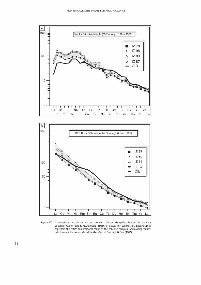
With regard to trace elements, the Kula volcanics –despite their primitive character –do not have very highcompatible-element contents; Cr does not exceed 187ppm and Ni does not exceed 92 ppm. The abundance anddistribution of incompatible elements is characterized byenrichment in both LILE and HFSE (e.g., Th/Ta≈1.3-1.9).Spider diagrams (Figure 12a) show that the Kula rockshave patterns strongly resembling the OIB of Sun &McDonough (1989) and are more enriched in mostincompatible elements (from Cs to K). Their REEdistribution patterns are characterized by evident LREEfractionation (Figure 12b), with LaN/SmN ≈ 3.8–5.5,minor fractionation for HREE (GdN/YbN ≈ 2.0–2.5), and anegligible Eu anomaly (EuN/Eu*≈0.94–1.02).
The 87Sr/86Sr and 134Nd/144Nd isotope ratios for theKula volcanics have narrow ranges,0.703087–0.703273 and 0.512924–0.512952,respectively. Such values fall in the depleted quadrant ofthe 87Sr/86Sr vs. 134Nd/144Nd isotope diagram, between theMORB field and bulk silicate earth (BSE). Thus, theisotopic compositions of the Kula magmas have valuestypical of OIB-type, intra-plate magmatism (Figure 13)(Agostini 2004).
In summary, all of the geochemical and isotopic datapoint to an asthenospheric mantle source for the Kulavolcanics, without any subduction-related contamination.Little fractionation of the HREE may be indicative of noresidual garnet in the source. Thus, the Kula alkalinemagmas were probably derived by small degrees ofmelting of a spinel lherzolite mantle. Variation in Mg andalkali contents – without coincident variation in Sr and Ndisotopic ratios – as well as trace-element distributions,indicate that crystal fractionation played a role in thedifferentiation of the Kula volcanics, with no crustalassimilation.
M. TOKÇAER, S. AGOSTINI & M. Y. SAVAfiÇIN
15
Table 3. Selected trace-element analyses for the Kula volcanics.
Sample IZ 78 K 99/5 IZ 98 IZ 83 IZ 87 IZ 94
Trace Elements (ppm)
Li 12.1 8.2 11.7 10.3 12.0
Be 1.90 2.48 2.84 2.29 2.66
Sc 24 18 10 17 13
V 198 226 181 108 165 136
Cr 187 26 96 34 64 42
Co 33 30 30 20 28 23
Ni 66 13 73 34 61 31
Rb 63.8 61 68.7 102.2 75.8 80.2
Sr 777 1672 1112 867 911 856
Y 23.7 27 28.4 26.4 25.0 26.9
Zr 178 269 237 268 214 268
Nb 61.9 125 98.6 99.8 86.8 90.6
Mo 3.53 6.93 6.48 5.28 6.36
Cs 1.03 1.30 1.35 1.34 1.38
Ba 613 1359 967 873 887 816
La 37.8 110 62.5 56.7 48.6 50.1
Ce 71 189 113 98 86 89
Pr 8.4 12.8 10.7 9.5 10.1
Nd 32.0 47.1 38.3 35.4 37.7
Sm 6.2 8.2 6.5 6.4 6.8
Eu 1.94 2.48 2.02 1.95 2.13
Gd 5.6 6.7 5.5 5.7 6.0
Tb 0.78 1.00 0.84 0.82 0.87
Dy 4.5 5.3 4.8 4.6 5.0
Ho 0.87 1.01 0.90 0.88 0.92
Er 2.14 2.56 2.48 2.29 2.54
Tm 0.32 0.39 0.37 0.35 0.38
Yb 1.79 2.22 2.23 2.04 2.21
Lu 0.25 0.32 0.33 0.29 0.32
Hf 3.9 4.9 5.2 4.4 5.5
Ta 3.44 5.56 6.18 4.87 5.45
Tl 0.10 0.10 0.15 0.09 0.13
Pb 3.74 4.86 4.70 4.34 4.33
Th 5.6 8.2 8.0 7.4 8.1
U 1.6 2.3 2.4 2.2 2.3

Discussion and Conclusion
Several granites and rhyolites in the Attic-Cycladic andMenderes massifs with dominant crustal signatures wereemplaced during the Middle–Late Miocene in relation to aregional-scale extensional phase that formed the Aegeanbasins (e.g., Hetzel et al. 1995; Delaloye & Bingöl 2000;Pe-Piper 2000; Pe-Piper et al. 2002; Keay et al. 2001;Altherr & Siebel 2002; Doglioni et al. 2002; Bozkurt2004; Ifl›k et al. 2003, 2004 and references therein).The second-period volcanics in western Anatolia are, ingeneral, poorly evolved (alkali basalts being the mostwidespread) and generally display a slight potassicaffinity. The subduction-related geochemical signature ofthese products is generally slight.
From the Late Miocene up to the Quaternary, widelydistributed small bodies of alkaline basalt with OIB-typesource characteristics were erupted in all of the differentsectors of the Aegean-Anatolian realm (Aldanmaz et al.2000; Y›lmaz et al. 2001; Wilson et al. 1997; Aydar etal. 1995; Doglioni et al. 2002.; Al›c› et al. 2002;Innocenti et al. 2005). The time-space distribution ofvolcanism in the Aegean and western Anatolia, with theirmain rock associations and involved magma sources,show an apparent transition from orogenic (calc-alkaline:CA, shoshonitic: SHO, ultrapotassic-shoshonitic: UK-SHO,lamproitic), mantle-wedge source rocks to alkaline (K–Naalkali basalts to Na-alkali basalts), OIB-type mantle sourcerocks (Doglioni et al. 2002). According to those authors,
NEW EMPLACEMENT MODEL FOR KULA VOLCANICS
16
+
+
++
+++
++++
+
+++ ++
+++
+
+++++++++
++++
+
+ ++++++
Na O wt%2
KO
wt%
2
0 1 2 3 4 5 6 7 80
1
2
3
4
5
6
7
8
ultra K-series
K-series
Na-series
35 40 45 50 55 60 65 70 75 800
2
4
6
8
10
12
14
SiO wt%2
Na
O+
KO
wt%
22
+
++ +
+++
+ ++
++
++ + ++
++++
+
+++ +
++ ++
+ +++
++ +
+
++
basanitestephrites
trachybasalts
basaltictrachy-andesites
phonolitictephrites
Na
O+
KO
wt%
22
SiO wt%245 50
6
8
10
a b
c
IB
IB
Figure 11. (a, c) TAS, total alkali versus silica (Le Maitre 1989) diagram. Shaded box in (c) is enlarged in (a) where the Kula volcanics areplotted. IB, dividing line between alkaline and subalkaline fields from Irvine & Baragar (1971); (b) Na2O vs K2O diagram for theKula volcanics: dividing lines between sodic, potassic and ultrapotassic series are from Middlemost (1975).

the southwestward migration of calc-alkaline, shoshoniticand lamproitic magmas in the hanging wall wasaccompanied by the southwestward migration of thesubduction hinge. These volcanic products were emplacedin an already extending area that eventually evolved in amore extreme setting of mantle upwelling, the source forthe OIB basalts.
The widespread (330–400 km2) plateau basalt of thefirst-period Kula volcanics (thickness 5 to 20 m) providesthe only example during Miocene volcanic activity inwestern Anatolia. In addition to this, the rapid change inchemical composition also represented a new epoch forthe western Anatolian volcanics. According to Gülen
(1990), the mantle xenolith-bearing Kula alkaline basalts(<1 Ma), with their least contaminated Sr, Nd and Pbisotopic compositions, provide the best geochemical datafor the Aegean mantle. With higher enrichments in themore incompatible elements (from Nd to Cs), the trace-element distribution is similar to that of OIB-type basaltsas is evident in PM-normalized spider diagrams. The firstproducts that show the influence of a OIB-type source arethe Upper Miocene K-alkali basalts, erupted whenextension was less developed. In this case, sodic –phonolitic plateau basalts, craters and lava flows of theKula volcanics are products of the final activity where themostly uncontaminated material of the Aegean mantle
M. TOKÇAER, S. AGOSTINI & M. Y. SAVAfiÇIN
17
Table 4. Mineralogical composition of some Kula rocks (mineral chemistry is taken from Bunbury 1992).
Olivine Clinopyroxene Amphibole Plagioclase
phenocrysts are generally smaller
the largest than pyroxene and inphenocryst phase; a few cases are
Size, form may show can reach 10–15 larger than 4 mm; and iddingsitic and mm in size generally
alteration bowlingitic euhedral, prismatic; scarce, as smallalteration pleochroic under phenocrysts;
plane-polarized light, can reach 0.5–3 mm in sizefrom brown throughpale brown tobrownish yellow
can be classified labradorite-andesine ingenerally diopside in composition as kaersutite composition; showcolorless, show (En46–49 Wo42–46 Fs7–9); (Ti-rich hornblende); little direct zoning
Composition and high pale green under plane- typically (e.g., An51–45)zoning birefringence polarized light, and may characterized by
under crossed show hour-glass zoning oxidation rims; inpolars, and are under crossed-polars many cases partially ordirectly zoned completely replaced by(e.g., Fo84–68) secondary alteration
(opaque oxides andhydroxides)
present both in in basanites and ubiquitous in basanites and hawaiites, whilst theybasanites and hawaiites, but is occur and are the mostphonolitic the most abundant abundant only in abundant phase in two
Abundance tephrites; larger and widespread phonolitic tephrites specimens of (up to ~5 mm) mineral in all rock and is often the main phonolitic tephriteand more types of the Kula phenocryst phaseabundant in areahawaiites
NEW EMPLACEMENT MODEL FOR KULA VOLCANICS
18
Rock / Primitive Mantle (McDonough & Sun 1995)
X
IZ 78IZ 98
IZ 83
IZ 87OIB
X
XX
XX
X X
XX
X
X X X
X
X
XX
X
XX
XX X
XX X
Cs Ba U Nb La Pr P Hf Sm Ti Dy Y Yb
Rb Th Ta K Ce Sr Nd Zr Eu Gd Ho Er Lu
1
10
100
1000
REE Rock / Chondrite (McDonough & Sun 1995)
X
IZ 78IZ 98
IZ 83
IZ 87OIB
X
X
X
X
X
X
X
X
X
XX
X XX X
La Ce Pr Nd Pm Sm Eu Gd Tb Dy Ho Er Tm Yb Lu
10
50
100
500
b
a
Figure 12. Incompatible trace-element (a) and rare-earth element (b) spider diagrams for the Kulavolcanics: OIB of Sun & McDonough (1989) is plotted for comparison. Shaded areasrepresent the entire compositional range of the collected samples. Normalizing values:primitive mantle (a) and chondrite (b) after McDonough & Sun (1995).

rapidly erupted as a new episode in the strong extensionalregimes of the neotectonic period (rapid upwelling ofmantle). According to Doglioni et al. (2002), thestretching between Greece and Anatolia, and thedifferential velocity of convergence with the underlyingslabs, should have generated ‘horizontal windows’ both inthe hanging wall and in the footwall of the subductionallowing melting of mantle, and generating the OIBmagmatism after normal subduction/collision evolution.With this new model, it is much easier to explain theevolution of Quaternary Kula volcanics.
Acknowledgements
This study was supported financially by the Scientific andTechnical Research Council of Turkey (TUB‹TAK) and theConsiglio Nazionale delle Ricerche (CNR) (Project No:102Y019). The authors are grateful to Sue Eronat forcritically reading the manuscript, and the referees arethanked for their useful, constructive comments.
M. TOKÇAER, S. AGOSTINI & M. Y. SAVAfiÇIN
19
Figure 13. 143Nd/144Nd versus 87Sr/86Sr diagram. The variation field of the Kula Na-rocks is after Innocentiet al. (2005).
-20
-15
-10
-5
0
+5
+10 MORB
OIBbulk silicate Earth
CB
continental crust
lower upper
.700 .705 .710 .715 .725.720
Na Alk. Kula basalts
-4
0
+4
+8
0.702 0.704 0.706 0.708
Sr / Sr87 86
Nd
/N
d1
43
14
4
References
AGOSTINI, S., VINCENZO, G., DOGLIONI, C., INNOCENTI, F., MANETTI, P.,SAVAflǛN, M.Y., & TONARINI, S. 2003a. Mantle wedge, lithosphereand asthenosphere interactions in western Anatolia Cenozoicmagmatism. Geophysical Research Abstracts 5, 03562.
AGOSTINI, S., VINCENZO, G., DOGLIONI, C., INNOCENTI, F., MANETTI, P.,SAVAflǛN, M.Y. & TONARINI, S. 2003b. Neogene and Quaternaryvolcanism in western Anatolia: evolution and geodynamicimplications. International Conference on the South Aegean ActiveVolcanic Arc: Present Knowledge and Future Perspectives (SAAVA2003) Abstracts, 42.

NEW EMPLACEMENT MODEL FOR KULA VOLCANICS
20
AGOSTINI, S. 2004. Il magmatismo post-collisionale dell’Anatoliaoccidentale: caratteri geochimici e petrologici, distribuzionespazio-temporale, quadro geodinamico [Post-collisional westernAnatolia magmatism: geochemical and petrologic characters,space-time distribution, geodynamic framework]. PhD Thesis,Università di Pisa, Earth Science Department [in Italian].
AKAL, C. 2003. Mineralogy and Geochemistry of Melilite Leucitites,Balç›khisar, Afyon (Turkey). Turkish Journal of Earth Sciences 12,215–239.
ALDANMAZ, E., PEARCE, J.A., THIRLWALL, M.F. & MITCHELL, J.G. 2000.Petrogenetic evolution of Late Cenozoic, post-collision volcanismin western Anatolia, Turkey. Journal of Volcanology andGeothermal Research 102, 67–95.
AL›C›, P., TEMEL, A. & GOURGAUD, A. 2002. Pb-Nd-Sr isotope and traceelement geochemistry of Quaternary extension-related alkalinevolcanism: a case study of Kula region (Western Anatolia, Turkey).Journal of Volcanology and Geothermal Research 102, 1–24.
ALTHERR, R. & SIEBEL, W. 2002. I-type plutonism in a continental back-arc setting: Miocene granitoids and monzonites from the centralAegean Sea, Greece. Mineralogy and Petrology 143, 397-415.
ALTUNEL, E., STEWART, I.S., PICCARDI, L. & BARKA, A.A. 2003. Earthquakefaulting at ancient Cnidus, SW Turkey. Turkish Journal of EarthSciences 12, 137-152.
AYDAR, E., GOURGAUD, A., DENIEL, C., LYBERIS, N. & GÜNDO⁄DU, N. 1995. Levolcanisme quaternaire de l'Anatolie centrale (Turquie):association de magmatism caco-alcalin en domaine deconvergence. Canadian Journal of Earth Sciences 32,1058–1069.
BENDA, L., INNOCENTI, F., MAZZUOLI, R., RADICATI, F. & STEFFENS, P. 1974.Stratigraphic and radiometric data of the Neogene in northwestTurkey. Zeitschrift Deutscher Geologischen Gesellschaft 125,183–193.
BESANG, C., ECKHARDT, F.J., HARRE, W., KREUZER, H. & MÜLLER, P. 1976.Radiometrische Alterbestimmungen an NeogenenEruptivgesteinen der Türkei. Geologisches Jahrbuch Reihe B 25,3–36.
BORSI, S., FERRARA, G., INNOCENTI, F. & MAZZUOLI, R. 1972.Geochronology and petrology of recent volcanics in the easternAegean Sea (Western Anatolia and Lesbos island). Bulletin ofVolcanolgique 36, 473–496.
BOZKURT, E. 2000. Timing of Extension on the Büyük Menderes Graben,Western Turkey and its tectonic implications. In: BOZKURT, E.,WINCHESTER, J.A. & PIPER, J.D.A. (eds) Tectonics and Magmatismin Turkey and the Surrounding Area. Geological Society, London,Special Publications 173, 385–403.
BOZKURT, E. 2001a. Neotectonics of Turkey - a synthesis. GeodinamicaActa, 14, 3–30.
BOZKURT, E. 2001b. Late Alpine evolution of the central MenderesMassif, western Anatolia, Turkey. International Journal of EarthSciences 89, 728–744.
BOZKURT, E. 2003. Origin of NNE-trending basins in Western Turkey.Geodinamica Acta (Paris) 16, 61–81.
BOZKURT, E. 2004. Granitoid rocks of the Southern Menderes Massif(southwest Turkey): field evidence for Tertiary magmatism in anextensional shear zone. International Journal of Earth Sciences93, 52-71.
BOZKURT, E. & OBERHÄNSLI, R. 2001. Menderes Massif (western Turkey):structural, metamorphic and magmatic evolution – a synthesis.International Journal of Earth Sciences 89, 679–708.
BOZKURT, E. & SÖZB‹L‹R, H. 2004. Geology of the Gediz Graben: new fieldevidence and its tectonic significance. Geological Magazine 141,63–79.
BRINKMANN, R. 1966. Geotektonische Gliederung von Westanatolien.Neues Jahrbuch Geologie und Paleontogie Mh. 10, 603-618.
BUNBURY, J.M.R. 1992. The Basalts of Kula. PhD Thesis, CambridgeUniversity [(unpublished].
CANET, J. & JAOUL, P. 1946. Report on the Geology of the Manisa-Ayd›n-Kula-Gördes Area. Mineral Research Exploration Institute ofTurkey Project Report No. 2068 [unpublished, in Turkish].
DELALOYE, M. & B‹NGÖL, E. 2000. Granitoids from western andnorthwestern Anatolia: geochemistry and modelling ofgeodynamic evolution. International Geology Review 42,241–268.
DOGLIONI, C., AGOSTINI, S., CRESPI, M., ‹NNOCENTI, F., MANETTI, P., RIGUZZI,F. & SAVAflÇ›N, M.Y. 2002. On the extension in western Anatoliaand the Aegean Sea. Virtual Explorer 8, 169–183.
DORA, O., SAVAflÇ›N, M.Y., KUN, N. & CANDAN, O. 1987. Post-metamorphicplutons in the Menderes Masif. Hacettepe Üniversitesi YerbilimleriDergisi 14, 79–89.
D'ORAZIO, M. 1995. Trace element determination in igneous rocks byICP-MS: results on ten international reference samples.Mineralogy and Petrology 64, 315–328.
ENGLAND, P. 2003. The alignment of Earthquake T-axes with theprincipal axes of geodetic strain in the Aegean region. TurkishJournal of Earth Sciences 12, 47-54.
ERCAN, T. 1981. Kula Yöresinin Jeolojisi ve Volkanitlerin Petrolojisi[Geology of Kula region and pertology of volcanics]. PhD Thesis,‹stanbul University [unpublished, in Turkish with Englishabstract].
ERCAN, T., SAT›R, M., TÜRKECAN, A., AKYÜREK, B., ÇEV‹KBAfl, A., GÜNAY, E.,ATEfl, M. & CAN, B. 1985. Bat› Anadolu Senozoyik volkanitlerineait yeni kimyasal, izotopik ve radyometrik verilerin yorumu[Interpretation of new chemical, sitopic and radiometric data fromthe Cenozoic volcanics of western Anatolia]. Bulletin of theGeological Society of Turkey 28, 121–136.
ERCAN, T., SAT›R, M., SEVIN, D. & TÜRKECAN, A. 1997. Some newradiometric ages from Tertiary to Quaternary volcanic rocks fromW. Anatolia (Turkey). MTA Dergisi 119, 103–112.
ERDO⁄AN, B. & GÜNGÖR, T. 2004. The problem of the core-coverboundary of the Menderes Massif and an emplacement mechanismfor regionally extensive gneissic granites, western Anatolia(Turkey). Turkish Journal of Earth Sciences 13, 15–36.
ER‹NÇ, S. 1970. The young volcanic topography of the Kula-Adala area.‹stanbul Üniversitesi Co¤rafya Enstitüsü Dergisi 17, 7–22.
EY‹DO⁄AN, H. 1988. Rates of crustal deformation in western Turkey asdeduced from major earthquakes. Tectonophysics 148, 83–92.
FRANCALANCI, L., CIVETTA, L., INNOCENTI, F. & MANETTI, P. 1990. Tertiary-Quaternary alkaline magmatism of the Aegean-western Anatolianarea: a petrological study in the light of new geochemical andisotopic data. International Earth Science Colloquium on theAegean Region, Proceedings 2, 385–396.
HAMILTON, W.J. & STRICKLAND, H.E. 1841. On the geology of the westernpart of Asia Minor. Transactions of the Geological Society ofLondon 6, 1–11
HETZEL, R., RING, U., AKAL, C. & TROESCH, M. 1995. Miocene NNE-directed extensional unroofing in the Menderes Massif,southwestern Turkey. Journal of the Geological Society, London152, 639–654.
GÜLEN, L. 1990. Isotopic characterization of Aegean magmatism andgeodynamic evolution of the Aegean subduction. InternationalEarth Science Colloquium on the Aegean Region, Proceedings 2,143–167.
IRVINE, T.N. & BARAGAR, W.R.A. 1971. A guide to the chemicalclassification of the common volcanic rocks. Canadian Journal ofEarth Sciences 8, 523–548.
Ifl›K, V., SEY‹TO⁄LU, G. & ÇEMEN, ‹. 2003. Ductile-Brittle transition alongthe Alaflehir detachment fault and its structural relationship withthe Simav detachment fault, Menderes Massif, western Turkey.Tectonophysics 374, 1-18.
Ifl›K, V., TEKEL‹, O. & SEY‹TO⁄LU, G. 2004. The 40Ar/39Ar age of extensionalductile deformation and granitoid intrusion in the northernMenderes core complex: implications for the initiation ofextensional tectonics in western Turkey. Journal of Asian EarthSciences 23, 555-566.
INNOCENTI, F., AGOSTINI, S., VINCENZO G. DI, DOGLIONI, C., MANETTI, P.,SAVAflǛN, M.Y. & TONARINI, S. 2005. Neogene and Quaternaryvolcanism in western Anatolia: magma sources and geodynamicevolution. Marine Geology, Special Issue - Eastern Mediterranean[in press].
KARAMANDERES‹, ‹.H. & HELVAC›, C. 2003. Geology and hydrothermalalteration of Ayd›n-Salatvatl› geothermal field, western Anatolia,Turkey. Turkish Journal of Earth Sciences 12, 175-198.
KAYA, O., ÜNAY, E., SARAÇ, G., EICHHORN, S., HASSENRÜCK, S., KNAPPE, A.,PEKDE¤ER, A. & MAYDA, S. 2004. Halitpafla transpressive zone:implications for an Early Pliocene compressional phase in centralwestern Anatolia, Turkey. Turkish Journal of Earth Sciences 13,1-13.
KEAY, S., L›STER, G. & BU›CK, I. 2001. The timing of partial melting,Barrovian metamorphism and granite intrusion in the Naxosmetamorphic core complex, Cyclades, Aegean Sea, Greece.Tectonophysics 342, 275-312.
KOÇY‹⁄‹T, A., YUSUFO⁄LU, H. & BOZKURT, E. 1999. Evidence from theGediz graben for episodic two-stage extension in Western Turkey.Journal of the Geological Society, London 156, 605–616.
KOÇY‹⁄‹T, A. & ÖZACAR, A. 2003. Extensional neotectonic regime throughthe NE edge of the Outer Isparta Angle, SW Turkey: new evidencefield and seismic data. Turkish Journal of Earth Sciences 12, 67-90.
KORALAY, O.E., DORA, O.Ö., CHEN, F., SAT›R, M. & CANDAN, O. 2004.Geochemistry and geochronology of orthogneisses in the Derbent(Alaflehir) area, Eastern part of the Ödemifl-Kiraz submassif,Menderes Massif: Pan-African magmatic activity. Turkish Journalof Earth Sciences 13, 37–61.
LE MAITRE, R.W. 1989. A Classification of Igneous Rocks and Glossaryof Terms. Recommendations of the International Union ofGeological Sciences Subcommission on the Systematics of IgneousRocks. Blackwell Scientific Publications.
LENK, O., TÜRKEZER, A., ERG‹NTAV, S., KURT, A.‹. & BELGEN, A. 2003.Monitoring the kinematics of Anatolia using permenant GPSnetwork stations. Turkish Journal of Earth Sciences 12, 55-66.
LEONI, L. & SAITTA, M. 1976. X-Ray fluorescence analysis of 29 traceelements in rock and mineral standards. Rendiconti della SocietaGeologica Italiana 32, 497–510.
MCDONOUGH, W.F. & SUN, S.S. 1995. The composition of the Earth.Chemical Geology 120, 223–253.
MIDDLEMOST, E.A.K., 1975, The basalt clan. Earth -Science Reviews 11,337–364
PE-P›PER, G. 2000. Origin of S-type granites coeval with I-type granitesin the Hellenic subduction zone system, Miocene of Naxos, Greece.European Journal of Mineralogy 12, 859-875.
PE-P›PER, G., P›PER, D.J.W. & MATARAGAS, D. 2002. Regional implicationsof geochemistry and style of emplacement of Miocene I-typediorite and granite, Delos, Cyclades, Greece. Lithos 60, 47-66.
PHILIPPSON, A. 1914. Kleinasien. Handbuch der Regionalen Geologie 2,179.
RICHARDSON-BUNBURY, J.M. 1996. The Kula volcanic field, westernTurkey: the development of a Holocene alkali basalt province andthe adjacent normal-faulting graben. Geological Magazine 133,275–283.
SAVAflÇ›N, M.Y. 1990. Magmatic activities Cenozoic compressional andextensional tectonic regimes in western Anatolia. InternationalEarth Sciences Colloquium on the Aegean Region, Proceedings 2,420–434.
SAVAflÇ›N, M.Y. & GÜLEÇ, N. 1990. Neogene Volcanism of WesternAnatolia. International Earth Sciences Colloquium on the AegeanRegion, Field Excursion B3 Guidebook, 78.
M. TOKÇAER, S. AGOSTINI & M. Y. SAVAfiÇIN
21
SAVAflÇ›N, M.Y., KAYA, O., GIESE, L.B., PEKDE⁄ER, A. & WOITH, H. 1999. Anexample for the optimal use of geothermal energy – theintegrated development project for Kula, West Anatolia.Geoenvironment Symposium, ‹stanbul Technical University,Proceedings, 201–207.
SEY‹TO⁄LU, G. 1997. The Simav Graben: an example of young E–W-trending structures in the Late Cenozoic extensional system ofwestern Turkey. Turkish Journal of Earth Sciences 6, 135–141.
SEY‹TO⁄LU, G., ANDERSON, D., NOWELL, G. & SCOTT, B. 1997. The evolutionfrom Miocene potassic to Quaternary sodic magmatism in westernTurkey: implications for enrichment processes in the lithosphericmantle. Journal of Volcanology and Geothermal Research 76,127–147.
SEY‹TO⁄LU, G., Ifl›K, V. & ÇEMEN, ‹. 2004. Complete Tertiary exhumationhistory of the Menderes Massif, western Turkey: an alternativeworking hypothesis. Terra Nova 16, 358–363.
SEY‹TO⁄LU, G. & SCOTT, B.C. 1992. The age of Büyük Menderes Graben(West Turkey) and its tectonic implications. Geological Magazine129, 239–242.
SEY‹TO⁄LU, G. & SCOTT, B.C. 1996. The age of Alaflehir Graben (WestTurkey) and its tectonic implications. Geological Journal 31,1–11.
SEY‹TO⁄LU, G., SCOTT, B.C. & RUNDLE, C.C. 1992. Timing of Cenozoicextensional tectonics in west Turkey. Geological Society of London149, 533–538.
SEY‹TO⁄LU, G., TEKEL‹, O., ÇEMEN, ‹., fiEN, fi. & Ifl›K, V. 2002. The role ofthe flexural rotation/rolling hinge model in the tectonic evolutionof the Alaflehir graben, western Turkey. Geological Magazine 139,15-26.
fiENGÖR, A.M.C. 1979. The North Anatolian transform fault: its age,offset and tectonic significance. Geological Society of London 136,269–282
fiENGÖR, A.M.C. & Y›LMAZ, Y. 1981. Tethyan evolution of Turkey: a platetectonic approach, Tectonophysics 75, 181–241.
SUN, S.S. & MCDONOUGH, W.F. 1989. Chemical and isotopic systematicsof oceanic basalts; implications for mantle composition andprocesses. In: SAUNDERS, A.D. & NORRY, M.J. (Eds), Magmatism inthe Ocean Basins. Geological Society, London, Special Publications42, 313–345.
TAYMAZ, T., JACKSON, J. & MCKENZIE, D. 1991. Active tectonics of thenorth and central Aegean Sea. Geophysical Journal International106, 433–490.
TOKÇAER, M. 2000. Geochemistry of Kula Geothermal Area. MSc Thesis,Graduate School of Natural and Applied Sciences of Dokuz EylulUniversity [unpublished].
WESTAWAY, R. 2003. Kinematics of the Middle East and EasternMediterranean Updated. Turkish Journal of Earth Sciences 12, 5-46.
WILSON, M., TANKUT, A. & GÜLEÇ, N. 1997. Tertiary volcanism of theGalatia province, north-west central Anatolia, Turkey. Lithos 42,105–121.
Y›LMAZ, Y. 1989. An approach to the origin of young volcanic rocks ofwestern Turkey. Tectonic Evolution of the Tethyan Region.Kluwer, Dordrecht, 159–189.
Y›LMAZ, Y., GENÇ, S.C., KARAC›K, Z. & ALTUNKAYNAK, S. 2001. Twocontrasting magmatic associations of NW Anatolia and theirtectonic significance. Journal Geodynamics 31, 243–271.
NEW EMPLACEMENT MODEL FOR KULA VOLCANICS
22
Received 20 February 2004; revised typescript accepted 09 May 2005