The economic contribution of the downstream oil industry to ...
Upload
khangminh22Category
view
0download
0
FireSmart® Field Guide for Upstream Oil and Gas IndustryA field guide for frontline operators to help prevent wildfires and reduce the impact of catastrophicwildfire on industry infrastructure, operations, personnel safety, liability and the environment
Prepared for Canadian Petroleum Producers and Alberta Sustainable Resource Development
released » 2012
ENF_PDV-001-FireSmartGuide-F2.indd 1 12-06-07 11:40 AM
FireSmart® Field Guide for Upstream Oil and Gas Industry
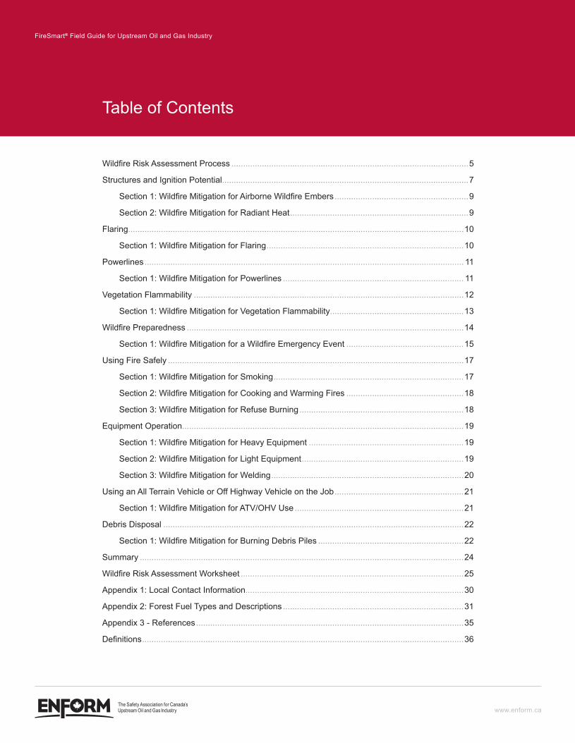
Table of Contents
Wildfire Risk Assessment Process .....................................................................................................5
Structures and Ignition Potential.........................................................................................................7
Section 1: Wildfire Mitigation for Airborne Wildfire Embers .........................................................9
Section 2: Wildfire Mitigation for Radiant Heat ............................................................................9
Flaring...............................................................................................................................................10
Section 1: Wildfire Mitigation for Flaring ....................................................................................10
Powerlines ........................................................................................................................................ 11
Section 1: Wildfire Mitigation for Powerlines ............................................................................. 11
Vegetation Flammability ...................................................................................................................12
Section 1: Wildfire Mitigation for Vegetation Flammability.........................................................13
Wildfire Preparedness ......................................................................................................................14
Section 1: Wildfire Mitigation for a Wildfire Emergency Event ..................................................15
Using Fire Safely ..............................................................................................................................17
Section 1: Wildfire Mitigation for Smoking .................................................................................17
Section 2: Wildfire Mitigation for Cooking and Warming Fires ..................................................18
Section 3: Wildfire Mitigation for Refuse Burning ......................................................................18
Equipment Operation........................................................................................................................19
Section 1: Wildfire Mitigation for Heavy Equipment ..................................................................19
Section 2: Wildfire Mitigation for Light Equipment .....................................................................19
Section 3: Wildfire Mitigation for Welding ..................................................................................20
Using an All Terrain Vehicle or Off Highway Vehicle on the Job .......................................................21
Section 1: Wildfire Mitigation for ATV/OHV Use ........................................................................21
Debris Disposal ................................................................................................................................22
Section 1: Wildfire Mitigation for Burning Debris Piles ..............................................................22
Summary ..........................................................................................................................................24
Wildfire Risk Assessment Worksheet ...............................................................................................25
Appendix 1: Local Contact Information.............................................................................................30
Appendix 2: Forest Fuel Types and Descriptions .............................................................................31
Appendix 3 - References ..................................................................................................................35
Definitions .........................................................................................................................................36
www.enform.ca
ENF_PDV-001-FireSmartGuide-F2.indd 2 12-06-07 11:40 AM

FireSmart® Field Guide for Upstream Oil and Gas Industry 3
www.enform.ca
disclaimerWhile it is believed the information contained herein is reliable under the conditions and subject to the limitations set out, the Canadian Association of Petroleum Producers (CAPP), Alberta Sustainable Resources Development (ASRD), Partners in Protection (PIP), the Consultants who contributed to this document, and Enform, do not guarantee its accuracy. The use of this report or any information contained will be at the user’s sole risk, regardless of any fault or negligence of CAPP, ASRD, PIP, the Consultants, or Enform.
ENF_PDV-001-FireSmartGuide-F2.indd 3 12-06-07 11:40 AM
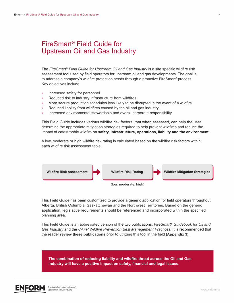
Enform » FireSmart® Field Guide for Upstream Oil and Gas Industry 4
FireSmart® Field Guide for Upstream Oil and Gas Industry
The FireSmart® Field Guide for Upstream Oil and Gas Industry is a site specific wildfire risk assessment tool used by field operators for upstream oil and gas developments. The goal is to address a company’s wildfire protection needs through a proactive FireSmart® process. Key objectives include:
» Increased safety for personnel. » Reduced risk to industry infrastructure from wildfires. » More secure production schedules less likely to be disrupted in the event of a wildfire. » Reduced liability from wildfires caused by the oil and gas industry. » Increased environmental stewardship and overall corporate responsibility.
This Field Guide includes various wildfire risk factors, that when assessed, can help the user determine the appropriate mitigation strategies required to help prevent wildfires and reduce the impact of catastrophic wildfire on safety, infrastructure, operations, liability and the environment.
A low, moderate or high wildfire risk rating is calculated based on the wildfire risk factors within each wildfire risk assessment table.
www.enform.ca
This Field Guide has been customized to provide a generic application for field operators throughout Alberta, British Columbia, Saskatchewan and the Northwest Territories. Based on the generic application, legislative requirements should be referenced and incorporated within the specified planning area.
This Field Guide is an abbreviated version of the two publications, FireSmart® Guidebook for Oil and Gas Industry and the CAPP Wildfire Prevention Best Management Practices. It is recommended that the reader review these publications prior to utilizing this tool in the field (appendix 3).
(low, moderate, high)
Wildfire Risk AssessmentWildfire Risk Assessment Wildfire Risk AssessmentWildfire Risk Rating Wildfire Risk AssessmentWildfire Mitigation Strategies
The combination of reducing liability and wildfire threat across the Oil and Gas Industry will have a positive impact on safety, financial and legal issues.
ENF_PDV-001-FireSmartGuide-F2.indd 4 12-06-07 11:40 AM
FireSmart® Field Guide for Upstream Oil and Gas Industry 5
www.enform.ca
WIldfIRe RISk ASSeSSMenT PROceSS
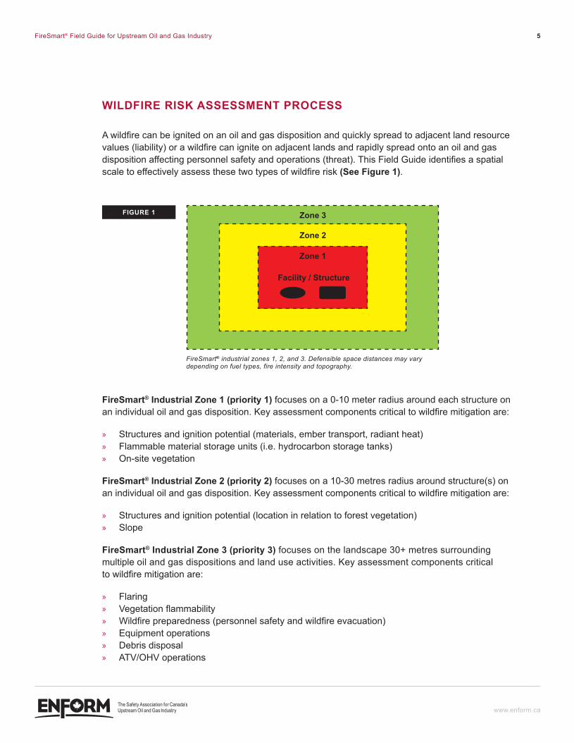
A wildfire can be ignited on an oil and gas disposition and quickly spread to adjacent land resource values (liability) or a wildfire can ignite on adjacent lands and rapidly spread onto an oil and gas disposition affecting personnel safety and operations (threat). This Field Guide identifies a spatial scale to effectively assess these two types of wildfire risk (see Figure 1).
Firesmart® industrial Zone 1 (priority 1) focuses on a 0-10 meter radius around each structure on an individual oil and gas disposition. Key assessment components critical to wildfire mitigation are:
» Structures and ignition potential (materials, ember transport, radiant heat) » Flammable material storage units (i.e. hydrocarbon storage tanks) » On-site vegetation
Firesmart® industrial Zone 2 (priority 2) focuses on a 10-30 metres radius around structure(s) on an individual oil and gas disposition. Key assessment components critical to wildfire mitigation are:
» Structures and ignition potential (location in relation to forest vegetation) » Slope
Firesmart® industrial Zone 3 (priority 3) focuses on the landscape 30+ metres surrounding multiple oil and gas dispositions and land use activities. Key assessment components critical to wildfire mitigation are:
» Flaring » Vegetation flammability » Wildfire preparedness (personnel safety and wildfire evacuation) » Equipment operations » Debris disposal » ATV/OHV operations
FireSmart® industrial zones 1, 2, and 3. Defensible space distances may vary depending on fuel types, fire intensity and topography.
fIGURe 1 Zone 3
Zone 2
Zone 1
Facility / structure
ENF_PDV-001-FireSmartGuide-F2.indd 5 12-06-07 11:40 AM
FireSmart® Field Guide for Upstream Oil and Gas Industry 6
www.enform.ca
Use the following wildfire risk assessment tables to determine the risk ratings within FireSmart® Industrial Zones 1, 2 and/or 3. The Wildfire Risk Assessment Worksheet (Page 25) can be used as a summary form in the field for completion, submission, or incorporation into FireSmart® plans. Review wildfire mitigation tips for each section and implement strategies to help reduce wildfire risk and liability.
Larger sites may require more than one assessment (or FireSmart® prescriptions) to address complex issues or if the area has a high degree of variance. Completion of the assessment should be done in the planning and design phase of all new facility construction, but may also need to be completed for existing facilities as well.
ENF_PDV-001-FireSmartGuide-F2.indd 6 12-06-07 11:40 AM
FireSmart® Field Guide for Upstream Oil and Gas Industry 7
www.enform.ca
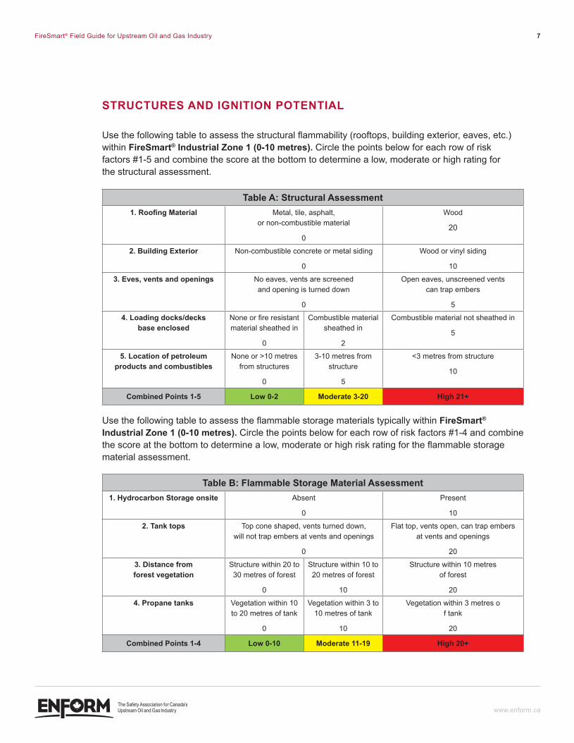
STRUcTUReS And IGnITIOn POTenTIAl
Use the following table to assess the structural flammability (rooftops, building exterior, eaves, etc.) within Firesmart® industrial Zone 1 (0-10 metres). Circle the points below for each row of risk factors #1-5 and combine the score at the bottom to determine a low, moderate or high rating for the structural assessment.
Table a: structural assessment1. Roofing Material Metal, tile, asphalt,
or non-combustible material
0
Wood
20
2. Building exterior Non-combustible concrete or metal siding
0
Wood or vinyl siding
10
3. eves, vents and openings No eaves, vents are screened and opening is turned down
0
Open eaves, unscreened vents can trap embers
5
4. loading docks/decks base enclosed
None or fire resistant material sheathed in
0
Combustible material sheathed in
2
Combustible material not sheathed in
5
5. location of petroleum products and combustibles
None or >10 metres from structures
0
3-10 metres from structure
5
<3 metres from structure
10
combined Points 1-5 low 0-2 moderate 3-20 High 21+
Use the following table to assess the flammable storage materials typically within Firesmart® industrial Zone 1 (0-10 metres). Circle the points below for each row of risk factors #1-4 and combine the score at the bottom to determine a low, moderate or high risk rating for the flammable storage material assessment.
Table B: Flammable storage material assessment1. Hydrocarbon storage onsite Absent
0
Present
10
2. Tank tops Top cone shaped, vents turned down, will not trap embers at vents and openings
0
Flat top, vents open, can trap embers at vents and openings
20
3. distance from forest vegetation
Structure within 20 to 30 metres of forest
0
Structure within 10 to 20 metres of forest
10
Structure within 10 metres of forest
20
4. Propane tanks Vegetation within 10 to 20 metres of tank
0
Vegetation within 3 to 10 metres of tank
10
Vegetation within 3 metres o f tank
20
combined Points 1-4 low 0-10 moderate 11-19 High 20+
ENF_PDV-001-FireSmartGuide-F2.indd 7 12-06-07 11:40 AM
FireSmart® Field Guide for Upstream Oil and Gas Industry 8
www.enform.ca
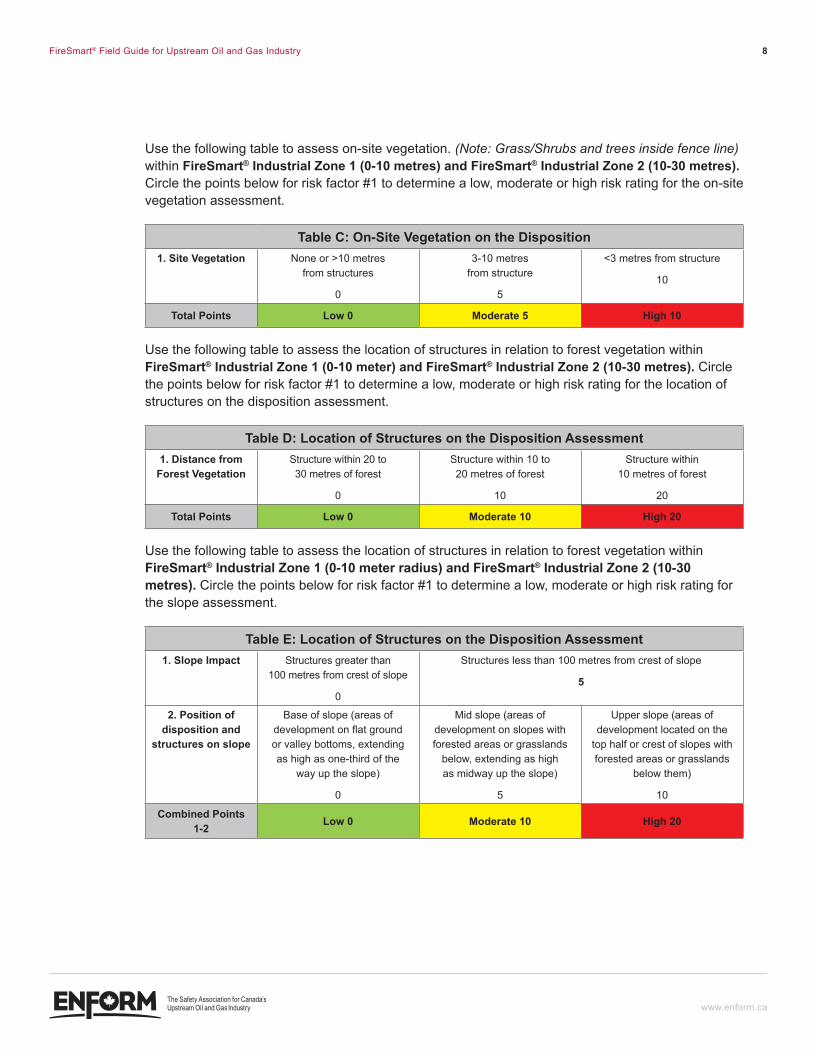
Use the following table to assess on-site vegetation. (Note: Grass/Shrubs and trees inside fence line) within Firesmart® industrial Zone 1 (0-10 metres) and Firesmart® industrial Zone 2 (10-30 metres). Circle the points below for risk factor #1 to determine a low, moderate or high risk rating for the on-site vegetation assessment.
Table c: On-Site Vegetation on the disposition1. Site Vegetation None or >10 metres
from structures
0
3-10 metres from structure
5
<3 metres from structure
10
Total Points low 0 moderate 5 High 10
Use the following table to assess the location of structures in relation to forest vegetation within Firesmart® industrial Zone 1 (0-10 meter) and Firesmart® industrial Zone 2 (10-30 metres). Circle the points below for risk factor #1 to determine a low, moderate or high risk rating for the location of structures on the disposition assessment.
Table d: location of structures on the disposition assessment1. distance from
forest VegetationStructure within 20 to 30 metres of forest
0
Structure within 10 to 20 metres of forest
10
Structure within 10 metres of forest
20
Total Points low 0 moderate 10 High 20
Use the following table to assess the location of structures in relation to forest vegetation within Firesmart® industrial Zone 1 (0-10 meter radius) and Firesmart® industrial Zone 2 (10-30 metres). Circle the points below for risk factor #1 to determine a low, moderate or high risk rating for the slope assessment.
Table e: location of structures on the disposition assessment1. slope impact Structures greater than
100 metres from crest of slope
0
Structures less than 100 metres from crest of slope
5
2. Position of disposition and
structures on slope
Base of slope (areas of development on flat ground or valley bottoms, extending as high as one-third of the
way up the slope)
0
Mid slope (areas of development on slopes with forested areas or grasslands
below, extending as high as midway up the slope)
5
Upper slope (areas of development located on the
top half or crest of slopes with forested areas or grasslands
below them)
10
combined Points 1-2 low 0 moderate 10 High 20
ENF_PDV-001-FireSmartGuide-F2.indd 8 12-06-07 11:40 AM
FireSmart® Field Guide for Upstream Oil and Gas Industry 9
www.enform.ca
SecTIOn 1: WIldfIRe MITIGATIOn fOR AIRBORne WIldfIRe eMBeRS
The greatest wildfire threat to Oil and Gas facilities from an advancing fire front will come from airborne embers that can travel long distances on wind currents. The accumulation of embers near vent openings or under eaves, stairs and other areas may cause a fire that will impact an Oil and Gas structure.
» Reduce the potential for a structure ignition from airborne embers by equipping all flammable structures with roof sprinkler systems.
» Reduce the potential of a hydrocarbon storage tank ignition, by equipping the tanks with foam sprinkler systems.
» Keep disposition area free of spilled flammable petroleum products. » Ensure tank tops are cone shaped and designed so embers will not land around tank openings
or vents. Use of floating top storage tanks should be minimized. » Remove vegetation around tanks. » To prevent the entry of airborne embers, screen all eaves and vents with corrosion resistant
non-combustible 3 mm wire mesh and turn the vent openings downward. » Construct all new structures on the disposition with metal roofs and siding. The base of the
structure must be closed in with metal, concrete or earth fill to prevent embers from getting under the structure.
SecTIOn 2: WIldfIRe MITIGATIOn fOR RAdIAnT HeAT
Structures adjacent to forest vegetation can be subjected to very high temperatures during a wildfire. The wildfire can damage or ignite structures adjacent to wildland fuels and fire can subsequently spread from structure to structure.
» Ensure there is a minimum of 20 metres between the structures with metal cladding and the flammable forest vegetation with a tree height greater than 20 metres. If structures have construction material comprised of combustible material, ensure there is a minimum of 30 metres between forest and structures.
» In grass vegetation, ensure a minimum mowed zone of 20 metres between structures and grass vegetation. If structures are constructed with combustible material, ensure there is a minimum of 30 metres. Alternatively, convert zones (depending on construction material) to bare mineral soil.
» Ensure propane tanks have a minimum of 3 metres of vegetation free space around the tank (or if grass vegetation, a 3 meter mowed zone).
» Structures should be located at the bottom of the slope or on the top of the slope with a minimum of a 100 meter set-back from the edge of the upper slope to reduce the radiant heat associated with a fire spreading upslope.
» Consult with wildfire behaviour specialists when recommending safe distances for facilities occupied by human life.
ENF_PDV-001-FireSmartGuide-F2.indd 9 12-06-07 11:40 AM
FireSmart® Field Guide for Upstream Oil and Gas Industry 10
www.enform.ca
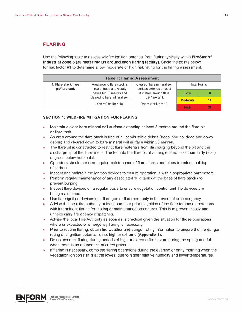
flARInG
Use the following table to assess wildfire ignition potential from flaring typically within Firesmart® Industrial Zone 3 (30 meter radius around each flaring facility). Circle the points below for risk factor #1 to determine a low, moderate or high risk rating for the flaring assessment.
Table F: Flaring assessment1. flare stack/flare
pit/flare tankArea around flare stack is free of trees and woody debris for 30 metres and
cleared to bare mineral soil.
Yes = 0 or No = 10
Cleared, bare mineral soil surface extends at least 8 metres around flare
pit/ flare tank
Yes = 0 or No = 10
Total Points
low 0
moderate 10
High 20
SecTIOn 1: WIldfIRe MITIGATIOn fOR flARInG
» Maintain a clear bare mineral soil surface extending at least 8 metres around the flare pit or flare tank.
» An area around the flare stack is free of all combustible debris (trees, shrubs, dead and down debris) and cleared down to bare mineral soil surface within 30 metres.
» The flare pit is constructed to restrict flare materials from discharging beyond the pit and the discharge tip of the flare line is directed into the flare pit at an angle of not less than thirty (30º ) degrees below horizontal.
» Operators should perform regular maintenance of flare stacks and pipes to reduce buildup of carbon.
» Inspect and maintain the ignition devices to ensure operation is within appropriate parameters. » Perform regular maintenance of any associated fluid tanks at the base of flare stacks to
prevent burping. » Inspect flare devices on a regular basis to ensure vegetation control and the devices are
being maintained. » Use flare ignition devices (i.e. flare gun or flare pen) only in the event of an emergency » Advise the local fire authority at least one hour prior to ignition of the flare for those operations
with intermittent flaring for testing or maintenance procedures. This is to prevent costly and unnecessary fire agency dispatches.
» Advise the local Fire Authority as soon as is practical given the situation for those operations where unexpected or emergency flaring is necessary.
» Prior to routine flaring, obtain fire weather and danger rating information to ensure the fire danger rating and ignition potential is not high or extreme (appendix 3).
» Do not conduct flaring during periods of high or extreme fire hazard during the spring and fall when there is an abundance of cured grass.
» If flaring is necessary, complete flaring operations during the evening or early morning when the vegetation ignition risk is at the lowest due to higher relative humidity and lower temperatures.
ENF_PDV-001-FireSmartGuide-F2.indd 10 12-06-07 11:40 AM
FireSmart® Field Guide for Upstream Oil and Gas Industry 11
www.enform.ca
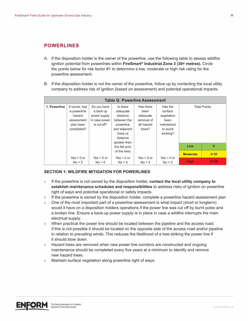
POWeRlIneS
A. If the disposition holder is the owner of the powerline, use the following table to assess wildfire ignition potential from powerlines within Firesmart® industrial Zone 3 (30+ metres). Circle the points below for risk factor #1 to determine a low, moderate or high risk rating for the powerline assessment.
B. If the disposition holder is not the owner of the powerline, follow up by contacting the local utility company to address risk of ignition (based on assessment) and potential operational impacts.
Table G: Powerline Assessment1. Powerline If owner, has
a powerline hazard
assessment plan been
completed?
Yes = 0 or No = 5
Do you have a back up
power supply in case power
is cut off?
Yes = 0 or No = 5
Is there adequate distance
between the powerline
and adjacent trees (a distance
greater than the fall arch of the tree)
Yes = 0 or No = 5
Has there been
adequate removal of all hazard
trees?
Yes = 0 or No = 5
Has the surface
vegetation been
maintained to avoid wicking?
Yes = 0 or No = 5
Total Points
low 0
moderate 5-10
High 15-20
SecTIOn 1: WIldfIRe MITIGATIOn fOR POWeRlIneS
» If the powerline is not owned by the disposition holder, contact the local utility company to establish maintenance schedules and responsibilities to address risks of ignition on powerline right of ways and potential operational or safety impacts.
» If the powerline is owned by the disposition holder, complete a powerline hazard assessment plan » One of the most important part of a powerline assessment is what impact (short or longterm)
would it have on a disposition holders operations if the power line was cut off by burnt poles and a broken line. Ensure a back-up power supply is in place in case a wildfire interrupts the main electrical supply.
» When practical the power line should be located between the pipeline and the access road; if this is not possible it should be located on the opposite side of the access road and/or pipeline in relation to prevailing winds. This reduces the likelihood of a tree striking the power line if it should blow down.
» Hazard trees are removed when new power line corridors are constructed and ongoing maintenance should be completed every five years at a minimum to identify and remove new hazard trees.
» Maintain surface vegetation along powerline right of ways.
ENF_PDV-001-FireSmartGuide-F2.indd 11 12-06-07 11:40 AM
FireSmart® Field Guide for Upstream Oil and Gas Industry 12
www.enform.ca
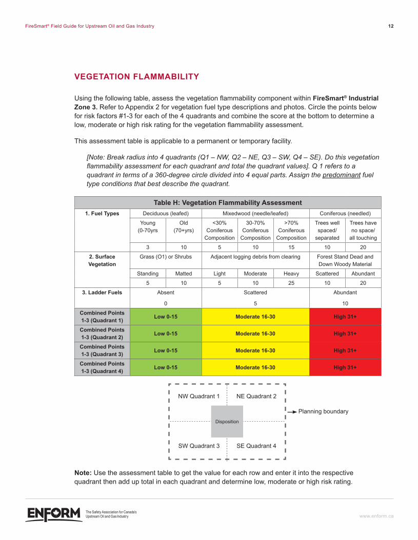
VeGeTATIOn flAMMABIlITY
Using the following table, assess the vegetation flammability component within Firesmart® industrial Zone 3. Refer to Appendix 2 for vegetation fuel type descriptions and photos. Circle the points below for risk factors #1-3 for each of the 4 quadrants and combine the score at the bottom to determine a low, moderate or high risk rating for the vegetation flammability assessment.
This assessment table is applicable to a permanent or temporary facility.
[Note: Break radius into 4 quadrants (Q1 – NW, Q2 – NE, Q3 – SW, Q4 – SE). Do this vegetation flammability assessment for each quadrant and total the quadrant values]. Q 1 refers to a quadrant in terms of a 360-degree circle divided into 4 equal parts. Assign the predominant fuel type conditions that best describe the quadrant.
Table H: Vegetation flammability Assessment1. Fuel Types Deciduous (leafed) Mixedwood (needle/leafed) Coniferous (needled)
Young (0-70yrs
Old (70+yrs)
<30% Coniferous
Composition
30-70% Coniferous
Composition
>70% Coniferous
Composition
Trees well spaced/
separated
Trees have no space/
all touching
3 10 5 10 15 10 20
2. surface Vegetation
Grass (O1) or Shrubs Adjacent logging debris from clearing Forest Stand Dead and Down Woody Material
Standing Matted Light Moderate Heavy Scattered Abundant
5 10 5 10 25 10 20
3. ladder Fuels Absent
0
Scattered
5
Abundant
10
combined Points 1-3 (Quadrant 1) low 0-15 moderate 16-30 High 31+
combined Points 1-3 (Quadrant 2) low 0-15 moderate 16-30 High 31+
combined Points 1-3 (Quadrant 3) low 0-15 moderate 16-30 High 31+
combined Points 1-3 (Quadrant 4) low 0-15 moderate 16-30 High 31+
Disposition
NW Quadrant 1
SW Quadrant 3
NE Quadrant 2
Planning boundary
SE Quadrant 4
Note: Use the assessment table to get the value for each row and enter it into the respective quadrant then add up total in each quadrant and determine low, moderate or high risk rating.
ENF_PDV-001-FireSmartGuide-F2.indd 12 12-06-07 11:40 AM
FireSmart® Field Guide for Upstream Oil and Gas Industry 13
www.enform.ca
SecTIOn 1: WIldfIRe MITIGATIOn fOR VeGeTATIOn flAMMABIlITY
» Assessing vegetation flammability and additional wildfire behavior factors is a complex process. field operations personnel should seek professional advice from a wildfire behavior specialist if there is a moderate or high rating and prior to implementing any vegetation/fuel modification.
» Any vegetation management treatment outside the approved disposition requires authorization and approvals.
» Maintain FireSmart® Industrial Zone 1 and 2 as grass mowed down to 10cm or less. » If values at risk warrant (i.e. large number of personnel, facility type and contents, location, etc.)
maintain FireSmart® Industrial Zone 1 and 2 as a vegetation free area where all woody debris is totally disposed of and the site is maintained as bare mineral soil or gravel;
» If values at risk don’t warrant a vegetation free area, then implement vegetation reduction.
ENF_PDV-001-FireSmartGuide-F2.indd 13 12-06-07 11:40 AM
FireSmart® Field Guide for Upstream Oil and Gas Industry 14
www.enform.ca
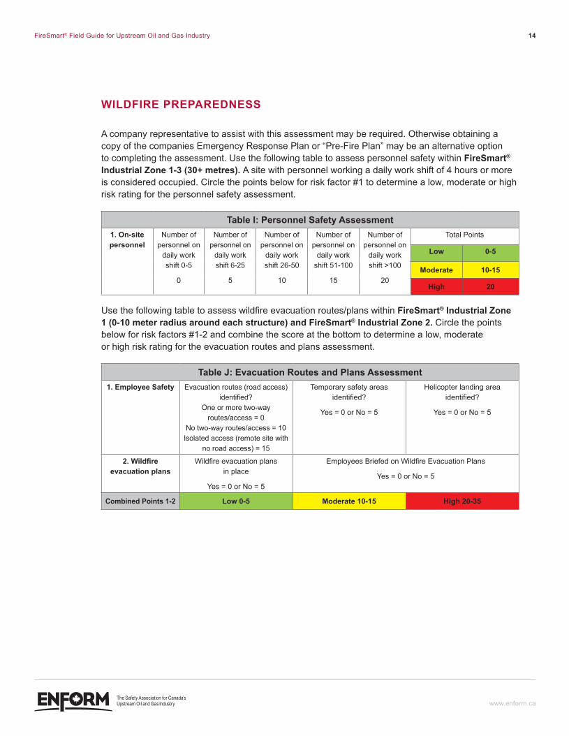
WildFire PreParedNess
A company representative to assist with this assessment may be required. Otherwise obtaining a copy of the companies Emergency Response Plan or “Pre-Fire Plan” may be an alternative option to completing the assessment. Use the following table to assess personnel safety within Firesmart® industrial Zone 1-3 (30+ metres). A site with personnel working a daily work shift of 4 hours or more is considered occupied. Circle the points below for risk factor #1 to determine a low, moderate or high risk rating for the personnel safety assessment.
Table i: Personnel safety assessment1. On-site personnel
Number of personnel on
daily work shift 0-5
0
Number of personnel on
daily work shift 6-25
5
Number of personnel on
daily work shift 26-50
10
Number of personnel on
daily work shift 51-100
15
Number of personnel on
daily work shift >100
20
Total Points
low 0-5
moderate 10-15
High 20
Use the following table to assess wildfire evacuation routes/plans within Firesmart® industrial Zone 1 (0-10 meter radius around each structure) and Firesmart® industrial Zone 2. Circle the points below for risk factors #1-2 and combine the score at the bottom to determine a low, moderate or high risk rating for the evacuation routes and plans assessment.
Table J: evacuation routes and Plans assessment1. employee safety Evacuation routes (road access)
identified? One or more two-way
routes/access = 0 No two-way routes/access = 10
Isolated access (remote site with no road access) = 15
Temporary safety areas identified?
Yes = 0 or No = 5
Helicopter landing area identified?
Yes = 0 or No = 5
2. Wildfire evacuation plans
Wildfire evacuation plans in place
Yes = 0 or No = 5
Employees Briefed on Wildfire Evacuation Plans
Yes = 0 or No = 5
combined Points 1-2 low 0-5 moderate 10-15 High 20-35
ENF_PDV-001-FireSmartGuide-F2.indd 14 12-06-07 11:40 AM
FireSmart® Field Guide for Upstream Oil and Gas Industry 15
www.enform.ca
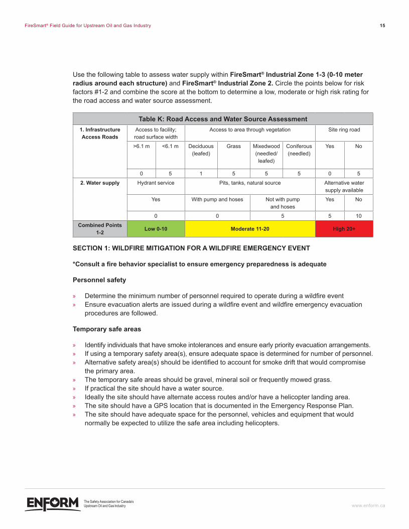
Use the following table to assess water supply within Firesmart® industrial Zone 1-3 (0-10 meter radius around each structure) and Firesmart® industrial Zone 2. Circle the points below for risk factors #1-2 and combine the score at the bottom to determine a low, moderate or high risk rating for the road access and water source assessment.
Table K: road access and Water source assessment1. infrastructure access roads
Access to facility; road surface width
Access to area through vegetation Site ring road
>6.1 m <6.1 m Deciduous (leafed)
Grass Mixedwood (needled/leafed)
Coniferous (needled)
Yes No
0 5 1 5 5 5 0 5
2. Water supply Hydrant service Pits, tanks, natural source Alternative water supply available
Yes With pump and hoses Not with pump and hoses
Yes No
0 0 5 5 10
combined Points 1-2 low 0-10 moderate 11-20 High 20+
SecTIOn 1: WIldfIRe MITIGATIOn fOR A WIldfIRe eMeRGencY eVenT
*consult a fire behavior specialist to ensure emergency preparedness is adequate
Personnel safety
» Determine the minimum number of personnel required to operate during a wildfire event » Ensure evacuation alerts are issued during a wildfire event and wildfire emergency evacuation
procedures are followed.
Temporary safe areas
» Identify individuals that have smoke intolerances and ensure early priority evacuation arrangements. » If using a temporary safety area(s), ensure adequate space is determined for number of personnel. » Alternative safety area(s) should be identified to account for smoke drift that would compromise
the primary area. » The temporary safe areas should be gravel, mineral soil or frequently mowed grass. » If practical the site should have a water source. » Ideally the site should have alternate access routes and/or have a helicopter landing area. » The site should have a GPS location that is documented in the Emergency Response Plan. » The site should have adequate space for the personnel, vehicles and equipment that would
normally be expected to utilize the safe area including helicopters.
ENF_PDV-001-FireSmartGuide-F2.indd 15 12-06-07 11:40 AM
FireSmart® Field Guide for Upstream Oil and Gas Industry 16
www.enform.ca
Water supply
» Have an adequate water supply for the purpose of firefighting. » Identify natural water sources such as streams and small lakes in the immediate area. » Ensure access to natural water sources for tanker trucks and/or portable pump set-ups are
developed and identified. » If natural water sources are not available, consider developing a water storage facility on the site.
Non-draining borrow pits or tanks may be used for storing large volumes of water. » Identify the availability of large water tankers in the region. » Consider the use of agricultural water delivery systems to move water long distances for the
protection of facilities. » Consider the use of wildfire suppression sprinkler systems (portable or permanent)
for structural protection in conjunction with the local fire department or local emergency response agency.
access roads/evacuation routes
» If there is potential for the main access to be cut off by a wildfire, alternative emergency evacuation routes (two-way access) should be identified and developed including potential helicopter landing sites for remote sites.
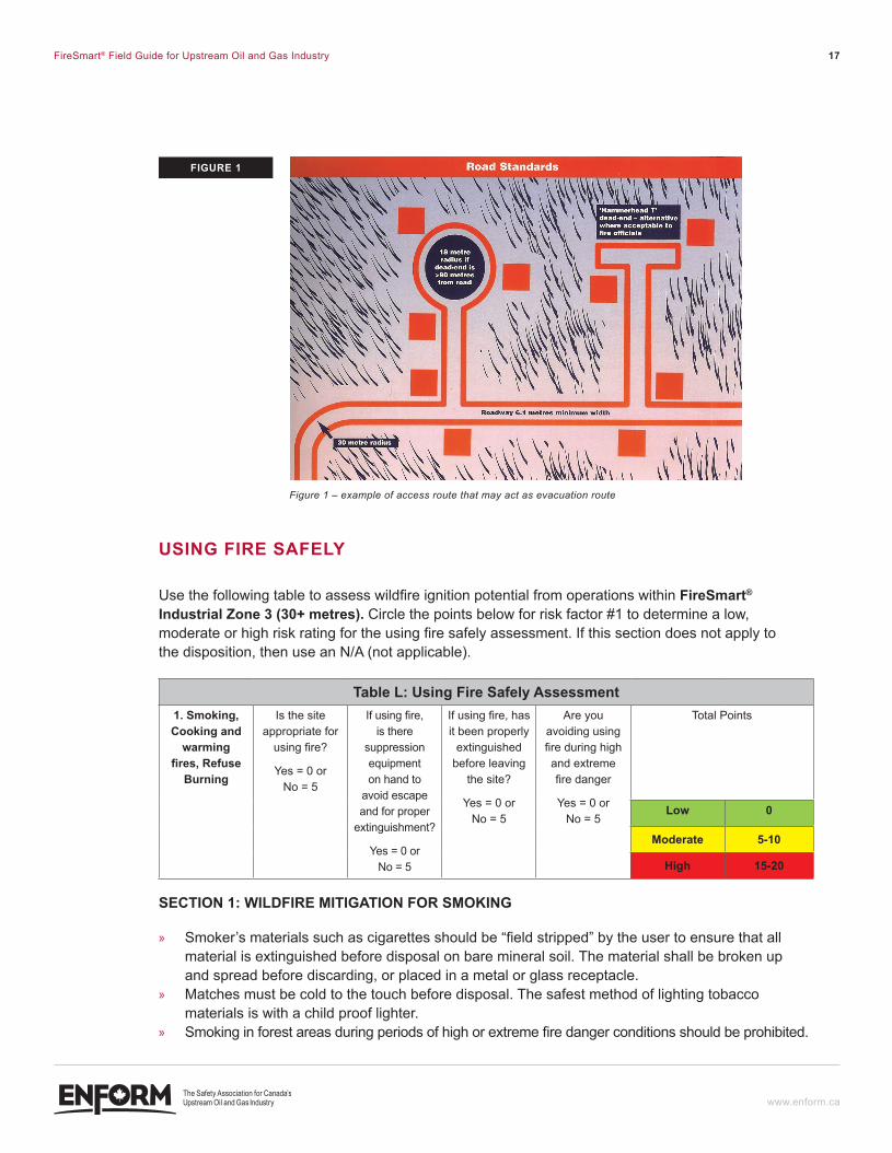
» Identify adjacent waterways that can be accessed by boat if applicable. » Provide Wildfire and other Emergency Service personnel with the ability to open locked gates. » The road should provide two-way access with a travel surface of not less than 6.1 metres. » A roadway curvature radius should be at least 30 metres, measured from the centerline. This is a
standard for Fire Department access. » Road gradient should not exceed 10 percent. » Dead-end roadways that are more than 90 metres in length should be constructed with a
turnaround at the terminus having no less than 18 metres turning radius or a hammerhead “T” alternate turnaround.
» All gates should be located at least 9 metres off the main roads and should not open outward. Gate openings should provide a clear opening of not less than 0.6 metres wider than the traveled way.
» Bridges should be designed and built with an all-weather surface capable of supporting heavy pieces of equipment traveling across the bridge. Weight limits should be clearly posted at the approaches to each bridge.
ENF_PDV-001-FireSmartGuide-F2.indd 16 12-06-07 11:40 AM
FireSmart® Field Guide for Upstream Oil and Gas Industry 17
www.enform.ca
USInG fIRe SAfelY
Use the following table to assess wildfire ignition potential from operations within Firesmart® industrial Zone 3 (30+ metres). Circle the points below for risk factor #1 to determine a low, moderate or high risk rating for the using fire safely assessment. If this section does not apply to the disposition, then use an N/A (not applicable).
Table l: Using fire Safely Assessment1. Smoking, cooking and
warming fires, Refuse
Burning
Is the site appropriate for
using fire?
Yes = 0 or No = 5
If using fire, is there
suppression equipment on hand to
avoid escape and for proper
extinguishment?
Yes = 0 or No = 5
If using fire, has it been properly
extinguished before leaving
the site?
Yes = 0 or No = 5
Are you avoiding using fire during high and extreme fire danger
Yes = 0 or No = 5
Total Points
low 0
moderate 5-10
High 15-20
SecTIOn 1: WIldfIRe MITIGATIOn fOR SMOkInG
» Smoker’s materials such as cigarettes should be “field stripped” by the user to ensure that all material is extinguished before disposal on bare mineral soil. The material shall be broken up and spread before discarding, or placed in a metal or glass receptacle.
» Matches must be cold to the touch before disposal. The safest method of lighting tobacco materials is with a child proof lighter.
» Smoking in forest areas during periods of high or extreme fire danger conditions should be prohibited.
Figure 1 – example of access route that may act as evacuation route
fIGURe 1
ENF_PDV-001-FireSmartGuide-F2.indd 17 12-06-07 11:40 AM
FireSmart® Field Guide for Upstream Oil and Gas Industry 18
www.enform.ca
SecTIOn 2: WIldfIRe MITIGATIOn fOR cOOkInG And WARMInG fIReS
When using an outdoor campfire for cooking or warming purposes during a fire season take the following precautions:
» Open fires should be prohibited during periods of high or extreme fire danger conditions. » Consider the use of alternative methods for cooking and warming; » Set the fire on a flat rock, gravel bar, sand or bare mineral soil at a spot relatively clear
of vegetation and located near water; » Clear the site of all debris down to mineral soil to a radius of at least 1 metre from the edge
of the fire; » Keep the fire under control and attended to at all times; » Extinguish the fire before leaving the site.
• Let the fire burn down.• Once the fire has burned down, spread out the remains evenly within the pit and
slowly add water or loose dirt (or sand) and stir.• Continue adding water or dirt and stir until the fire is extinguished.
SecTIOn 3: WIldfIRe MITIGATIOn fOR RefUSe BURnInG
When using incinerators:
» Burning of non-industrial wastes shall be carried out in a fully enclosed incinerator constructed of incombustible material and the draft and smoke vents thereof covered with a heavy gauge metal screen of a mesh size not greater than 6 millimetres.
» During the fire season ensure the mesh on top of the incinerator is free of any carbon or other foreign matter that can turn into a glowing ember, become dislodged and spread to surrounding flammable forest vegetation during high winds.
» An incinerator area shall be located over bare rock, gravel, sand, mineral soil or concrete at least 30 metres from a stand of trees or shrubs and the ground surrounding it outward from its base to a distance of at least 3 metres shall be clean mineral soil or be covered by any of the aforesaid materials.
» During periods of high and extreme fire danger and during high winds when the ignition probability in a forest area is high, consider using the incinerator during the late evening when the relative humidity is higher than 45 percent and the wind speed is less than 15 km per hour.
ENF_PDV-001-FireSmartGuide-F2.indd 18 12-06-07 11:40 AM
FireSmart® Field Guide for Upstream Oil and Gas Industry 19
www.enform.ca
eQUIPMenT OPeRATIOn
Use the following table to assess wildfire ignition potential from equipment operations within Firesmart® industrial Zone 3 (30+ metres). Circle the points below for risk factor #1 to determine a low, moderate or high risk rating for the equipment operation assessment.
Table M: equipment Operations Assessment1. Heavy
equipment, light
equipment and welding equipment
Is equipment parked on
bare mineral soil or other
non- flammable area?
Yes = 0 or No = 5
Is there adequate
suppression equipment
supplied with the operational
equipment during the fire
season?
Yes = 0 or No = 5
Are internal combustion
engines equipped with spark arresters and mufflers in good working
condition?
Yes = 0 or No = 5
Have the equipment
exhaust systems been cleaned on a regular basis?
Yes = 0 or No = 5
Are you operating equipment
during low to moderate fire
danger?
Yes = 0 or No = 5
Total Points
low 0
moderate 5-10
High 15-25
*Refer to the Canadian Wildfire Information System website to determine daily Fire Weather Index (FWI) fire danger ratings http://cwfis.cfs.nrcan.gc.ca/en_CA/fwmaps/fwi/20110415?fullwidth=0
FWI Index Low Moderate High Extreme
0-5 5-10 10-20 20-30 >30
SecTIOn 1: WIldfIRe MITIGATIOn fOR HeAVY eQUIPMenT
» To prevent wildfire ignition by heavy equipment, establish a policy that requires all operators to clean flammable material from their equipment’s exhaust systems on a regular basis.
» While cleaning the engines, park the equipment on bare mineral soil if possible or spray the area with water then drive the equipment over the wet areas and clean them.
» Ensure that equipment with diesel engines that idle for long periods of time are throttled up and placed under load to expel any carbon build up over a safe zone of mineral soil or other non flammable material.
» Heavy equipment should carry a backpack water container (full of water) complete with hand pump, dry chemical extinguisher, shovel, axe or pulaski during the fire season.
SecTIOn 2: WIldfIRe MITIGATIOn fOR lIGHT eQUIPMenT
» To prevent wildfire ignition by light equipment, establish a policy that requires all operators to clean their equipment’s exhaust systems on a regular basis.
» Ensure all internal combustion engines are equipped with spark arresters or mufflers in good working condition.
» When using a power saw:• Refrain from starting a power saw within 3 metres of the gasoline supply;• Refrain from placing a running or hot power saw engine on any flammable matter;• Have an approved fire extinguisher on site.
ENF_PDV-001-FireSmartGuide-F2.indd 19 12-06-07 11:40 AM
FireSmart® Field Guide for Upstream Oil and Gas Industry 20
www.enform.ca
» Ensure vehicles with catalytic converters are not parked in tall dry grassy areas. » Evaluate the risks of mowing, mulching or using graders during periods of high and extreme fire
danger periods when the grass is cured, the forest fine fuels are dry and the relative humidity is below 30 percent.
» Allow small engines to cool down before refuelling. » If it is essential that these operations are conducted during high and extreme fire danger periods
with high probability of wildfire ignitions then a water tanker complete with crew, hose and pump should accompany the operation to patrol behind the operation to detect and extinguish any fires that maybe ignited.
SecTIOn 3: WIldfIRe MITIGATIOn fOR WeldInG
» Establish a policy that requires employees and contractors operating in wildland areas to conduct welding operations on bare mineral soil if possible. As an alternative, during high fire hazard periods, the work area where welding is to take place should be wet down with water or foam additives. Water is not very effective in fibrous soils during high and extreme build up indices (BUI).
» Another option is to use a non-flammable shield around the area where welding will take place to confine and prevent the sparks from spreading in all directions.
» If it is essential that if these operations are undertaken during high and extreme fire danger periods with very high probability of wildfire ignitions then a water tanker complete with crew, hose and pump should accompany the welding operation to patrol, detect and extinguish any fires that maybe ignited.
» Wildfire foam additives should be considered for use when welding on pipelines during high and extreme ignition potential periods to reduce amount of water required and to ensure the water penetrates into the organic layers. Properly mixed foam will increase the effectiveness of water by 3-5 times, depending on the foam and equipment used. Foam solutions act as a fire suppressant rather than a fire retardant. A suppressant extinguishes the flaming and glowing phases of combustion when applied directly to forest vegetation.
ENF_PDV-001-FireSmartGuide-F2.indd 20 12-06-07 11:40 AM
FireSmart® Field Guide for Upstream Oil and Gas Industry 21
www.enform.ca
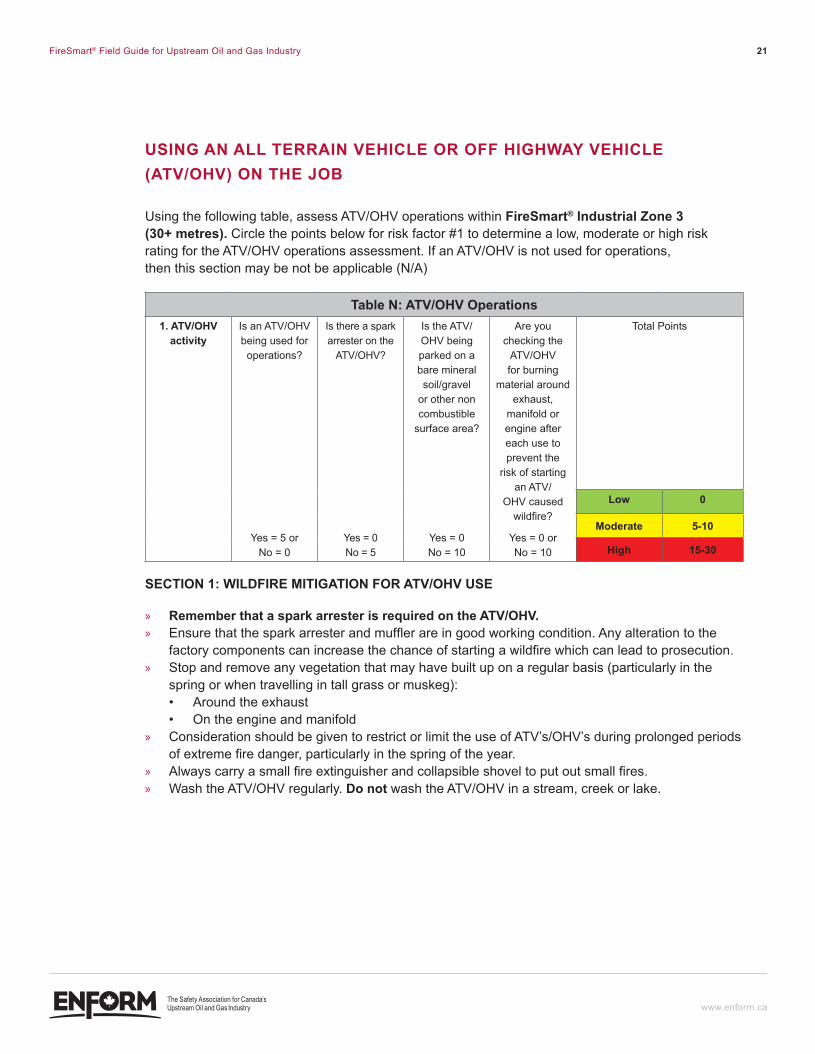
USInG An All TeRRAIn VeHIcle OR Off HIGHWAY VeHIcle (ATV/OHV) On THe JOB
Using the following table, assess ATV/OHV operations within Firesmart® industrial Zone 3 (30+ metres). Circle the points below for risk factor #1 to determine a low, moderate or high risk rating for the ATV/OHV operations assessment. If an ATV/OHV is not used for operations, then this section may be not be applicable (N/A)
Table n: ATV/OHV Operations1. ATV/OHV
activityIs an ATV/OHV being used for operations?
Yes = 5 or No = 0
Is there a spark arrester on the
ATV/OHV?
Yes = 0 No = 5
Is the ATV/OHV being parked on a bare mineral soil/gravel
or other non combustible
surface area?
Yes = 0 No = 10
Are you checking the
ATV/OHV for burning
material around exhaust,
manifold or engine after each use to prevent the
risk of starting an ATV/
OHV caused wildfire?
Yes = 0 or No = 10
Total Points
low 0
moderate 5-10
High 15-30
SecTIOn 1: WIldfIRe MITIGATIOn fOR ATV/OHV USe
» Remember that a spark arrester is required on the ATV/OHV. » Ensure that the spark arrester and muffler are in good working condition. Any alteration to the
factory components can increase the chance of starting a wildfire which can lead to prosecution. » Stop and remove any vegetation that may have built up on a regular basis (particularly in the
spring or when travelling in tall grass or muskeg):• Around the exhaust• On the engine and manifold
» Consideration should be given to restrict or limit the use of ATV’s/OHV’s during prolonged periods of extreme fire danger, particularly in the spring of the year.
» Always carry a small fire extinguisher and collapsible shovel to put out small fires. » Wash the ATV/OHV regularly. do not wash the ATV/OHV in a stream, creek or lake.
ENF_PDV-001-FireSmartGuide-F2.indd 21 12-06-07 11:40 AM
FireSmart® Field Guide for Upstream Oil and Gas Industry 22
www.enform.ca
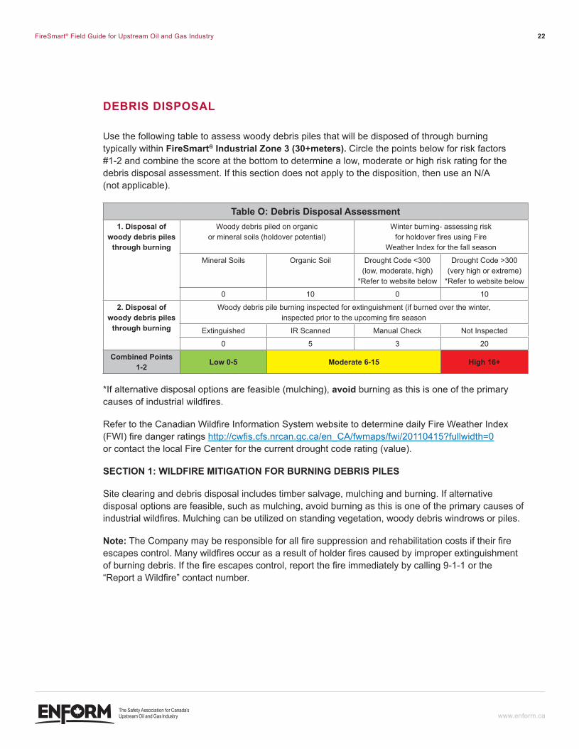
deBRIS dISPOSAl
Use the following table to assess woody debris piles that will be disposed of through burning typically within Firesmart® industrial Zone 3 (30+meters). Circle the points below for risk factors #1-2 and combine the score at the bottom to determine a low, moderate or high risk rating for the debris disposal assessment. If this section does not apply to the disposition, then use an N/A (not applicable).
Table O: debris disposal Assessment1. disposal of
woody debris piles through burning
Woody debris piled on organic or mineral soils (holdover potential)
Winter burning- assessing risk for holdover fires using Fire
Weather Index for the fall season
Mineral Soils Organic Soil Drought Code <300 (low, moderate, high)
*Refer to website below
Drought Code >300 (very high or extreme)
*Refer to website below
0 10 0 10
2. disposal of woody debris piles
through burning
Woody debris pile burning inspected for extinguishment (if burned over the winter, inspected prior to the upcoming fire season
Extinguished IR Scanned Manual Check Not Inspected
0 5 3 20
combined Points 1-2 low 0-5 moderate 6-15 High 16+
*If alternative disposal options are feasible (mulching), avoid burning as this is one of the primary causes of industrial wildfires.
Refer to the Canadian Wildfire Information System website to determine daily Fire Weather Index (FWI) fire danger ratings http://cwfis.cfs.nrcan.gc.ca/en_CA/fwmaps/fwi/20110415?fullwidth=0 or contact the local Fire Center for the current drought code rating (value).
SecTIOn 1: WIldfIRe MITIGATIOn fOR BURnInG deBRIS PIleS
Site clearing and debris disposal includes timber salvage, mulching and burning. If alternative disposal options are feasible, such as mulching, avoid burning as this is one of the primary causes of industrial wildfires. Mulching can be utilized on standing vegetation, woody debris windrows or piles.
Note: The Company may be responsible for all fire suppression and rehabilitation costs if their fire escapes control. Many wildfires occur as a result of holder fires caused by improper extinguishment of burning debris. If the fire escapes control, report the fire immediately by calling 9-1-1 or the “Report a Wildfire” contact number.
ENF_PDV-001-FireSmartGuide-F2.indd 22 12-06-07 11:40 AM
FireSmart® Field Guide for Upstream Oil and Gas Industry 23
www.enform.ca
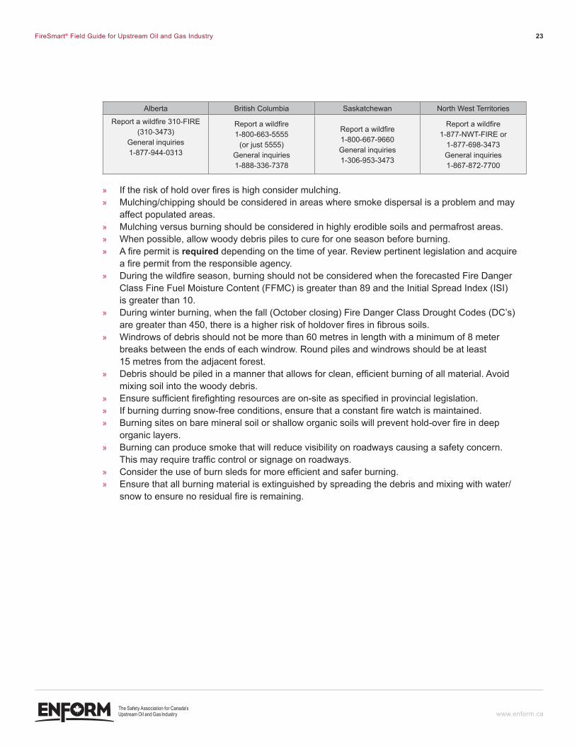
Alberta British Columbia Saskatchewan North West Territories
Report a wildfire 310-FIRE (310-3473)
General inquiries 1-877-944-0313
Report a wildfire 1-800-663-5555
(or just 5555) General inquiries 1-888-336-7378
Report a wildfire 1-800-667-9660 General inquiries 1-306-953-3473
Report a wildfire 1-877-NWT-FIRE or
1-877-698-3473 General inquiries 1-867-872-7700
» If the risk of hold over fires is high consider mulching. » Mulching/chipping should be considered in areas where smoke dispersal is a problem and may
affect populated areas. » Mulching versus burning should be considered in highly erodible soils and permafrost areas. » When possible, allow woody debris piles to cure for one season before burning. » A fire permit is required depending on the time of year. Review pertinent legislation and acquire
a fire permit from the responsible agency. » During the wildfire season, burning should not be considered when the forecasted Fire Danger
Class Fine Fuel Moisture Content (FFMC) is greater than 89 and the Initial Spread Index (ISI) is greater than 10.
» During winter burning, when the fall (October closing) Fire Danger Class Drought Codes (DC’s) are greater than 450, there is a higher risk of holdover fires in fibrous soils.
» Windrows of debris should not be more than 60 metres in length with a minimum of 8 meter breaks between the ends of each windrow. Round piles and windrows should be at least 15 metres from the adjacent forest.
» Debris should be piled in a manner that allows for clean, efficient burning of all material. Avoid mixing soil into the woody debris.
» Ensure sufficient firefighting resources are on-site as specified in provincial legislation. » If burning durring snow-free conditions, ensure that a constant fire watch is maintained. » Burning sites on bare mineral soil or shallow organic soils will prevent hold-over fire in deep
organic layers. » Burning can produce smoke that will reduce visibility on roadways causing a safety concern.
This may require traffic control or signage on roadways. » Consider the use of burn sleds for more efficient and safer burning. » Ensure that all burning material is extinguished by spreading the debris and mixing with water/
snow to ensure no residual fire is remaining.
ENF_PDV-001-FireSmartGuide-F2.indd 23 12-06-07 11:40 AM
FireSmart® Field Guide for Upstream Oil and Gas Industry 24
www.enform.ca
SUMMARY
Industrial activity ranks as the third highest of all human-caused wildfires. A historical review of industry related wildfires has identified the most common wildfire ignition risks and liabilities.
Increasing awareness of wildfire prevention best management practices and implementing wildfire mitigation strategies will help to reduce wildfire risks, liability and impacts.
The Field Guide is a site specific wildfire risk assessment tool to help prevent wildfires and reduce the impact of catastrophic wildfire. Based on the risk ratings of each assessment component, wildfire mitigation strategies can be implemented accordingly. However, it is recommended that a FireSmart® plan be developed if there are several high to extreme risk factors in conjunction with a large personnel capacity.
By adopting and implementing the principles in this field guide, the oil and gas industry will enhance personnel safety, environmental stewardship and contribute to preventing wildfires.
Based on the generic application for field operators throughout Alberta, British Columbia, Saskatchewan and the North West Territories, legislative requirements should be referenced and incorporated within the specified planning area.
ENF_PDV-001-FireSmartGuide-F2.indd 24 12-06-07 11:40 AM
FireSmart® Field Guide for Upstream Oil and Gas Industry 25
www.enform.ca
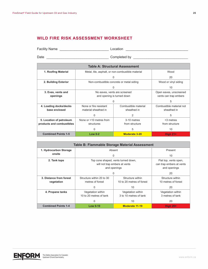
WIld fIRe RISk ASSeSSMenT WORkSHeeT
Facility Name __________________________ Location _________________________________
Date _________________________________ Completed by _____________________________
Table a: structural assessment1. Roofing Material Metal, tile, asphalt, or non-combustible material
0
Wood
20
2. Building exterior Non-combustible concrete or metal siding
0
Wood or vinyl siding
10
3. eves, vents and openings
No eaves, vents are screened and opening is turned down
0
Open eaves, unscreened vents can trap embers
5
4. loading docks/decks base enclosed
None or fire resistant material sheathed in
0
Combustible material sheathed in
2
Combustible material not sheathed in
5
5. location of petroleum products and combustibles
None or >10 metres from structures
0
3-10 metres from structure
5
<3 metres from structure
10
combined Points 1-5 low 0-2 moderate 3-20 High 21+
Table B: Flammable storage material assessment1. Hydrocarbon storage
onsiteAbsent
0
Present
10
2. Tank tops Top cone shaped, vents turned down, will not trap embers at vents
and openings
0
Flat top, vents open, can trap embers at vents
and openings
20
3. distance from forest vegetation
Structure within 20 to 30 metres of forest
0
Structure within 10 to 20 metres of forest
10
Structure within 10 metres of forest
20
4. Propane tanks Vegetation within 10 to 20 metres of tank
0
Vegetation within 3 to 10 metres of tank
10
Vegetation within 3 metres of tank
20
combined Points 1-4 low 0-10 moderate 11-19 High 20+
ENF_PDV-001-FireSmartGuide-F2.indd 25 12-06-07 11:40 AM
FireSmart® Field Guide for Upstream Oil and Gas Industry 26
www.enform.ca
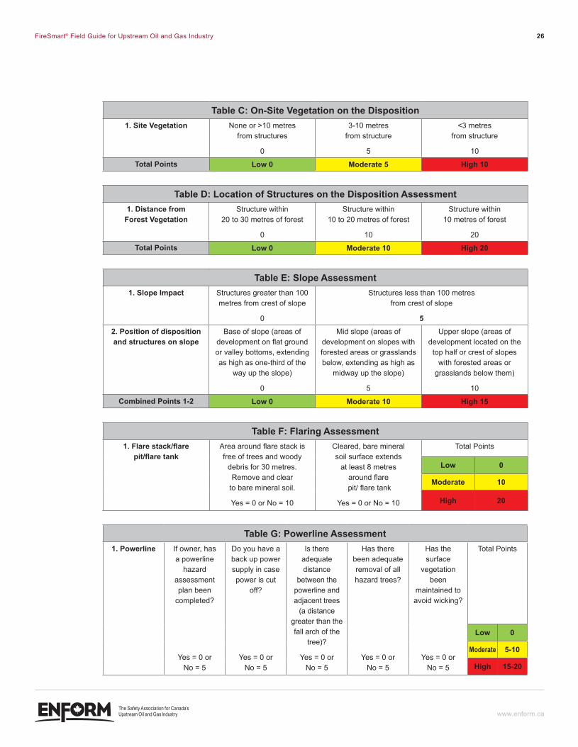
Table c: On-Site Vegetation on the disposition1. Site Vegetation None or >10 metres
from structures
0
3-10 metres from structure
5
<3 metres from structure
10
Total Points low 0 moderate 5 High 10
Table d: location of structures on the disposition assessment1. distance from
forest VegetationStructure within
20 to 30 metres of forest
0
Structure within 10 to 20 metres of forest
10
Structure within 10 metres of forest
20
Total Points low 0 moderate 10 High 20
Table e: slope assessment1. slope impact Structures greater than 100
metres from crest of slope
0
Structures less than 100 metres from crest of slope
52. Position of disposition and structures on slope
Base of slope (areas of development on flat ground or valley bottoms, extending as high as one-third of the
way up the slope)
0
Mid slope (areas of development on slopes with forested areas or grasslands below, extending as high as
midway up the slope)
5
Upper slope (areas of development located on the
top half or crest of slopes with forested areas or
grasslands below them)
10
combined Points 1-2 low 0 moderate 10 High 15
Table F: Flaring assessment1. flare stack/flare
pit/flare tankArea around flare stack is free of trees and woody
debris for 30 metres. Remove and clear
to bare mineral soil.
Yes = 0 or No = 10
Cleared, bare mineral soil surface extends
at least 8 metres around flare
pit/ flare tank
Yes = 0 or No = 10
Total Points
low 0
moderate 10
High 20
Table G: Powerline Assessment1. Powerline If owner, has
a powerline hazard
assessment plan been
completed?
Yes = 0 or No = 5
Do you have a back up power supply in case power is cut
off?
Yes = 0 or No = 5
Is there adequate distance
between the powerline and adjacent trees
(a distance greater than the fall arch of the
tree)?
Yes = 0 or No = 5
Has there been adequate removal of all hazard trees?
Yes = 0 or No = 5
Has the surface
vegetation been
maintained to avoid wicking?
Yes = 0 or No = 5
Total Points
low 0
moderate 5-10
High 15-20
ENF_PDV-001-FireSmartGuide-F2.indd 26 12-06-07 11:40 AM
FireSmart® Field Guide for Upstream Oil and Gas Industry 27
www.enform.ca
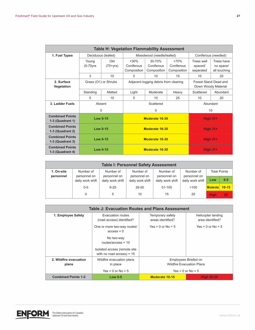
Table H: Vegetation flammability Assessment1. Fuel Types Deciduous (leafed) Mixedwood (needle/leafed) Coniferous (needled)
Young (0-70yrs
Old (70+yrs)
<30% Coniferous
Composition
30-70% Coniferous
Composition
>70% Coniferous
Composition
Trees well spaced/
separated
Trees have no space/
all touching
3 10 5 10 15 10 20
2. surface Vegetation
Grass (O1) or Shrubs Adjacent logging debris from clearing Forest Stand Dead and Down Woody Material
Standing Matted Light Moderate Heavy Scattered Abundant
5 10 5 10 25 10 20
3. ladder Fuels Absent
0
Scattered
5
Abundant
10
combined Points 1-3 (Quadrant 1) low 0-15 moderate 16-30 High 31+
combined Points 1-3 (Quadrant 2) low 0-15 moderate 16-30 High 31+
combined Points 1-3 (Quadrant 3) low 0-15 moderate 16-30 High 31+
combined Points 1-3 (Quadrant 4) low 0-15 moderate 16-30 High 31+
Table i: Personnel safety assessment1. On-site personnel
Number of personnel on
daily work shift
0-5
0
Number of personnel on
daily work shift
6-25
5
Number of personnel on
daily work shift
26-50
10
Number of personnel on
daily work shift
51-100
15
Number of personnel on
daily work shift
>100
20
Total Points
low 0-5
moderate 10-15
High 20
Table J: evacuation routes and Plans assessment1. employee safety Evacuation routes
(road access) identified?
One or more two-way routes/access = 0
No two-way routes/access = 10
Isolated access (remote site with no road access) = 15
Temporary safety areas identified?
Yes = 0 or No = 5
Helicopter landing area identified?
Yes = 0 or No = 5
2. Wildfire evacuation plans
Wildfire evacuation plans in place
Yes = 0 or No = 5
Employees Briefed on Wildfire Evacuation Plans
Yes = 0 or No = 5
combined Points 1-2 low 0-5 moderate 10-15 High 20-25
ENF_PDV-001-FireSmartGuide-F2.indd 27 12-06-07 11:40 AM
FireSmart® Field Guide for Upstream Oil and Gas Industry 28
www.enform.ca
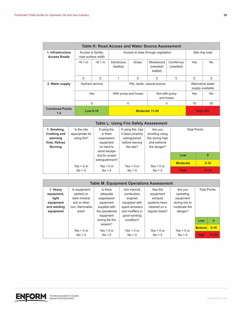
Table K: road access and Water source assessment1. infrastructure access roads
Access to facility; road surface width
Access to area through vegetation Site ring road
>6.1 m <6.1 m Deciduous (leafed)
Grass Mixedwood (needled/leafed)
Coniferous (needled)
Yes No
0 5 1 5 5 5 0 5
2. Water supply Hydrant service Pits, tanks, natural source Alternative water supply available
Yes With pump and hoses Not with pump and hoses
Yes No
0 0 5 10 20
combined Points 1-2 low 0-10 moderate 11-20 High 20+
Table l: Using fire Safely Assessment1. Smoking, cooking and
warming fires, Refuse
Burning
Is the site appropriate for
using fire?
Yes = 0 or No = 5
If using fire, is there
suppression equipment on hand to
avoid escape and for proper
extinguishment?
Yes = 0 or No = 5
If using fire, has it been properly
extinguished before leaving
the site?
Yes = 0 or No = 5
Are you avoiding using fire during high and extreme fire danger?
Yes = 0 or No = 5
Total Points
low 0
moderate 5-10
High 15-20
Table M: equipment Operations Assessment1. Heavy
equipment, light
equipment and welding equipment
Is equipment parked on
bare mineral soil or other
non- flammable area?
Yes = 0 or No = 5
Is there adequate
suppression equipment
supplied with the operational
equipment during the fire
season?
Yes = 0 or No = 5
Are internal combustion
engines equipped with spark arresters and mufflers in good working
condition?
Yes = 0 or No = 5
Has the equipment
exhaust systems been cleaned on a regular basis?
Yes = 0 or No = 5
Are you operating equipment
during low to moderate fire
danger?
Yes = 0 or No = 5
Total Points
low 0
moderate 5-10
High 15-25
ENF_PDV-001-FireSmartGuide-F2.indd 28 12-06-07 11:40 AM
FireSmart® Field Guide for Upstream Oil and Gas Industry 29
www.enform.ca
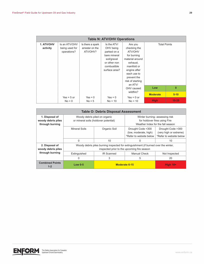
Table n: ATV/OHV Operations1. ATV/OHV
activityIs an ATV/OHV being used for operations?
Yes = 5 or No = 0
Is there a spark arrester on the
ATV/OHV?
Yes = 0 No = 5
Is the ATV/OHV being parked on a bare mineral soil/gravel
or other non combustible
surface area?
Yes = 0 No = 10
Are you checking the
ATV/OHV for burning
material around exhaust,
manifold or engine after each use to prevent the
risk of starting an ATV/
OHV caused wildfire?
Yes = 0 or No = 10
Total Points
low 0
moderate 5-10
High 15-25
Table O: debris disposal Assessment1. disposal of
woody debris piles through burning
Woody debris piled on organic or mineral soils (holdover potential)
Winter burning- assessing risk for holdover fires using Fire
Weather Index for the fall season
Mineral Soils Organic Soil Drought Code <300 (low, moderate, high)
*Refer to website below
Drought Code >300 (very high or extreme)
*Refer to website below
0 10 0 10
2. disposal of woody debris piles
through burning
Woody debris piles burning inspected for extinguishment (if burned over the winter, inspected prior to the upcoming fire season
Extinguished IR Scanned Manual Check Not Inspected
0 3 5 20
combined Points 1-2 low 0-5 moderate 6-15 High 16+
ENF_PDV-001-FireSmartGuide-F2.indd 29 12-06-07 11:40 AM
FireSmart® Field Guide for Upstream Oil and Gas Industry 30
www.enform.ca
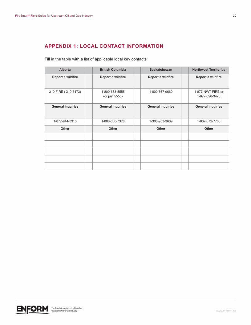
APPendIX 1: lOcAl cOnTAcT InfORMATIOn
Fill in the table with a list of applicable local key contacts
alberta British columbia Saskatchewan Northwest Territories
Report a wildfire Report a wildfire Report a wildfire Report a wildfire
310-FIRE ( 310-3473) 1-800-663-5555 (or just 5555)
1-800-667-9660 1-877-NWT-FIRE or 1-877-698-3473
General inquiries General inquiries General inquiries General inquiries
1-877-944-0313 1-888-336-7378 1-306-953-3609 1-867-872-7700
Other Other Other Other
ENF_PDV-001-FireSmartGuide-F2.indd 30 12-06-07 11:40 AM
FireSmart® Field Guide for Upstream Oil and Gas Industry 31
www.enform.ca
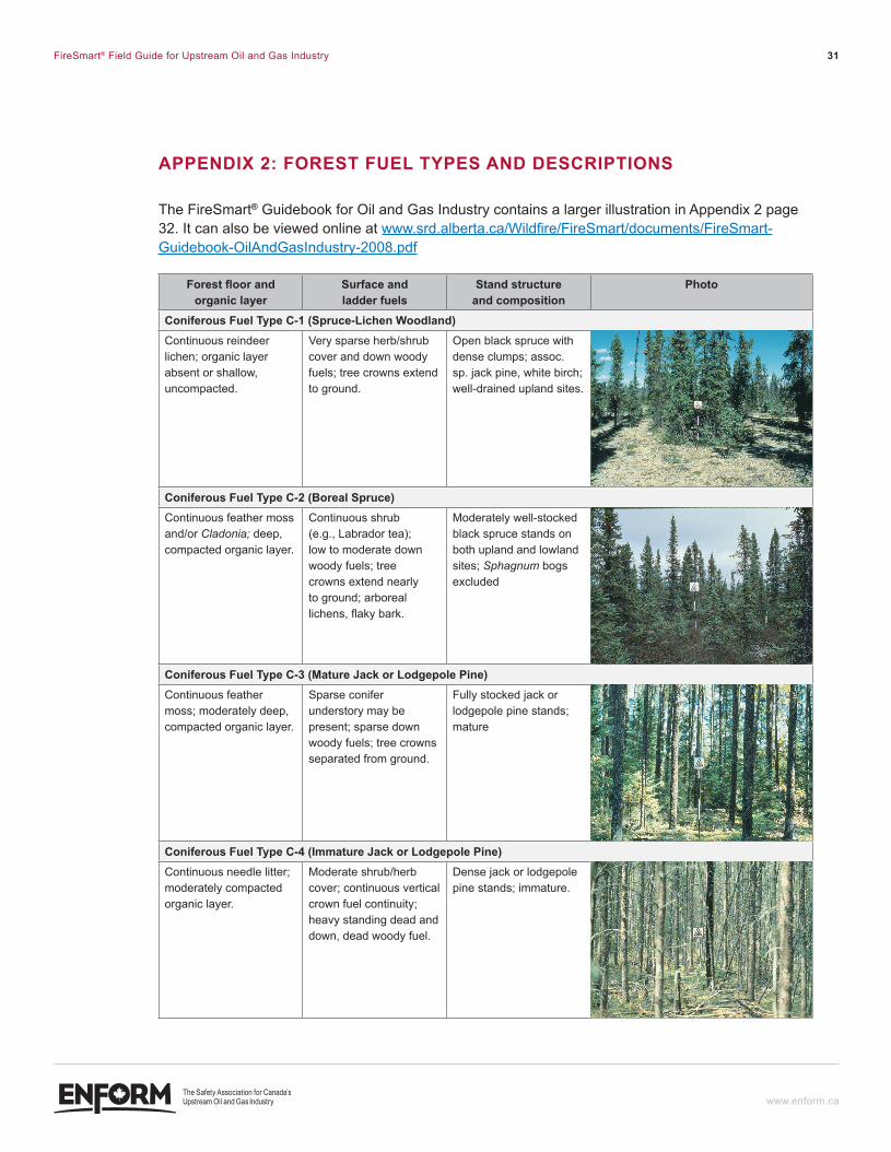
APPendIX 2: fOReST fUel TYPeS And deScRIPTIOnS
The FireSmart® Guidebook for Oil and Gas Industry contains a larger illustration in Appendix 2 page 32. It can also be viewed online at www.srd.alberta.ca/Wildfire/FireSmart/documents/FireSmart-Guidebook-OilAndGasIndustry-2008.pdf
forest floor and organic layer
surface and ladder fuels
stand structure and composition
Photo
coniferous Fuel Type c-1 (spruce-lichen Woodland)Continuous reindeer lichen; organic layer absent or shallow, uncompacted.
Very sparse herb/shrub cover and down woody fuels; tree crowns extend to ground.
Open black spruce with dense clumps; assoc. sp. jack pine, white birch; well-drained upland sites.
coniferous Fuel Type c-2 (Boreal spruce)Continuous feather moss and/or Cladonia; deep, compacted organic layer.
Continuous shrub (e.g., Labrador tea); low to moderate down woody fuels; tree crowns extend nearly to ground; arboreal lichens, flaky bark.
Moderately well-stocked black spruce stands on both upland and lowland sites; Sphagnum bogs excluded
coniferous fuel Type c-3 (Mature Jack or lodgepole Pine)Continuous feather moss; moderately deep, compacted organic layer.
Sparse conifer understory may be present; sparse down woody fuels; tree crowns separated from ground.
Fully stocked jack or lodgepole pine stands; mature
coniferous fuel Type c-4 (Immature Jack or lodgepole Pine)Continuous needle litter; moderately compacted organic layer.
Moderate shrub/herb cover; continuous vertical crown fuel continuity; heavy standing dead and down, dead woody fuel.
Dense jack or lodgepole pine stands; immature.
ENF_PDV-001-FireSmartGuide-F2.indd 31 12-06-07 11:40 AM
FireSmart® Field Guide for Upstream Oil and Gas Industry 32
www.enform.ca
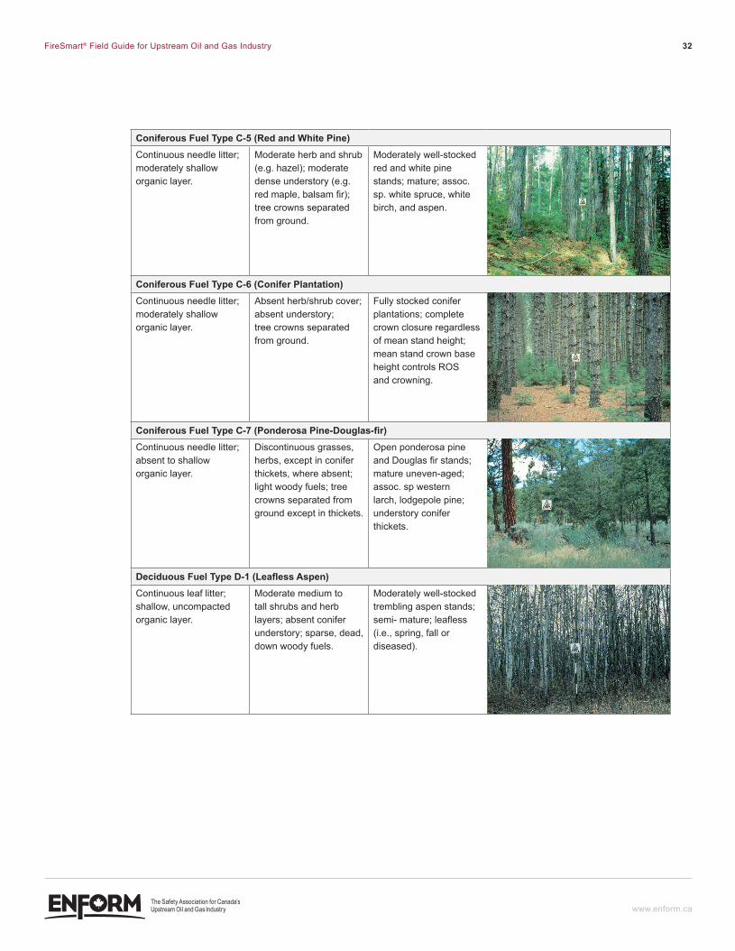
coniferous Fuel Type c-5 (red and White Pine)Continuous needle litter; moderately shallow organic layer.
Moderate herb and shrub (e.g. hazel); moderate dense understory (e.g. red maple, balsam fir); tree crowns separated from ground.
Moderately well-stocked red and white pine stands; mature; assoc. sp. white spruce, white birch, and aspen.
coniferous Fuel Type c-6 (conifer Plantation)Continuous needle litter; moderately shallow organic layer.
Absent herb/shrub cover; absent understory; tree crowns separated from ground.
Fully stocked conifer plantations; complete crown closure regardless of mean stand height; mean stand crown base height controls ROS and crowning.
coniferous fuel Type c-7 (Ponderosa Pine-douglas-fir)Continuous needle litter; absent to shallow organic layer.
Discontinuous grasses, herbs, except in conifer thickets, where absent; light woody fuels; tree crowns separated from ground except in thickets.
Open ponderosa pine and Douglas fir stands; mature uneven-aged; assoc. sp western larch, lodgepole pine; understory conifer thickets.
deciduous fuel Type d-1 (leafless Aspen)Continuous leaf litter; shallow, uncompacted organic layer.
Moderate medium to tall shrubs and herb layers; absent conifer understory; sparse, dead, down woody fuels.
Moderately well-stocked trembling aspen stands; semi- mature; leafless (i.e., spring, fall or diseased).
ENF_PDV-001-FireSmartGuide-F2.indd 32 12-06-07 11:40 AM
FireSmart® Field Guide for Upstream Oil and Gas Industry 33
www.enform.ca
forest floor and organic layer
surface and ladder fuels
stand structure and composition
Photos
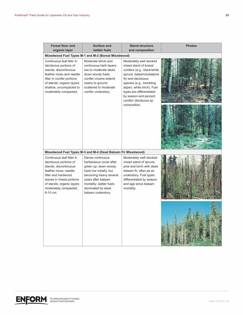
mixedwood Fuel Types m-1 and m-2 (Boreal mixedwood)Continuous leaf litter in deciduous portions of stands; discontinuous feather moss and needle litter in conifer portions of stands; organic layers shallow, uncompacted to moderately compacted.
Moderate shrub and continuous herb layers; low to moderate dead, down woody fuels; conifer crowns extend nearly to ground; scattered to moderate conifer understory.
Moderately well stocked mixed stand of boreal conifers (e.g., black/white spruce, balsam/subalpine fir) and deciduous species (e.g., trembling aspen, white birch). Fuel types are differentiated by season and percent conifer/ deciduous sp. composition.
mixedwood Fuel Types m-3 and m-4 (dead Balsam Fir mixedwood)Continuous leaf litter in deciduous portions of stands; discontinuous feather moss, needle litter and hardwood leaves in mixed portions of stands; organic layers moderately compacted, 8-10 cm.
Dense continuous herbaceous cover after green up; down woody fuels low initially, but becoming heavy several years after balsam mortality; ladder fuels dominated by dead balsam understory.
Moderately well stocked mixed stand of spruce, pine and birch with dead balsam fir, often as an understory. Fuel types differentiated by season and age since balsam mortality.
ENF_PDV-001-FireSmartGuide-F2.indd 33 12-06-07 11:40 AM
FireSmart® Field Guide for Upstream Oil and Gas Industry 34
www.enform.ca
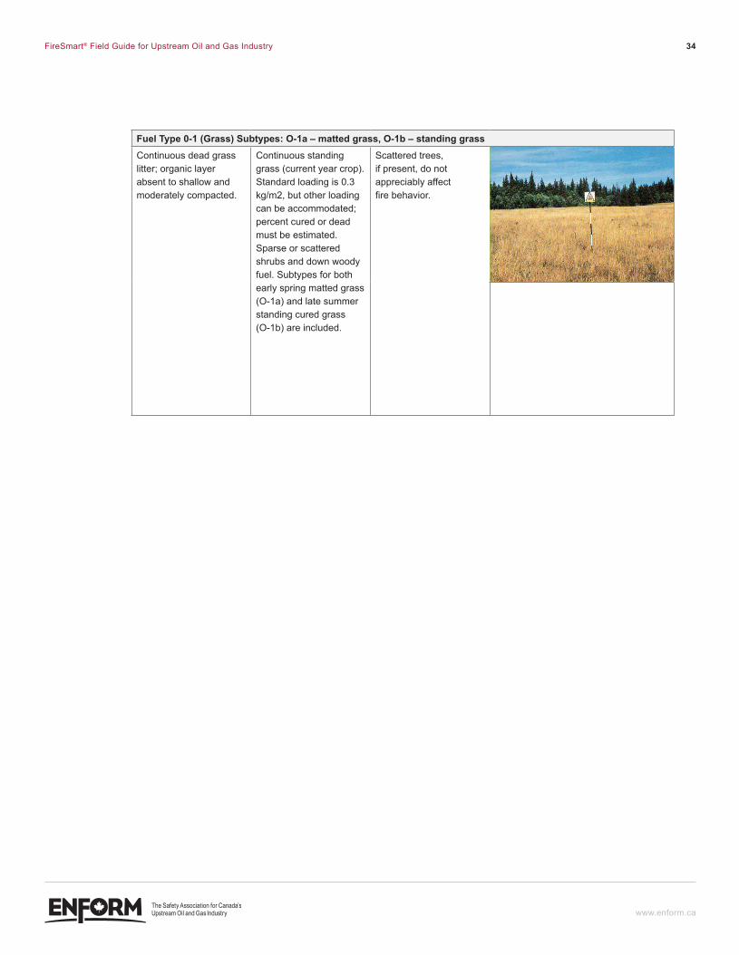
fuel Type 0-1 (Grass) Subtypes: O-1a – matted grass, O-1b – standing grassContinuous dead grass litter; organic layer absent to shallow and moderately compacted.
Continuous standing grass (current year crop). Standard loading is 0.3 kg/m2, but other loading can be accommodated; percent cured or dead must be estimated. Sparse or scattered shrubs and down woody fuel. Subtypes for both early spring matted grass (O-1a) and late summer standing cured grass (O-1b) are included.
Scattered trees, if present, do not appreciably affect fire behavior.
ENF_PDV-001-FireSmartGuide-F2.indd 34 12-06-07 11:40 AM
FireSmart® Field Guide for Upstream Oil and Gas Industry 35
www.enform.ca
APPendIX 3 – RefeRenceS
1. Alberta Forest Management Regulations Part I http://www.srd.alberta.ca/managingprograms/ForestManagement/default.aspx
2. Alberta Forest and Prairie Protection Act http://www.qp.alberta.ca/574.cfm?page=F19.cfm&leg_type=Acts&isbncln=9780779726554&displ ay=html
3. Alberta Forest Protection Regulations Part II http://www.qp.alberta.ca/574.cfm?page=1972_310.cfm&leg_type=Regs&isbncln=9780779728282 &display=html
4. British Columbia – Ministry of Forests and Range http://bcwildfire.ca/
5. CAPP Best Management Practices – Wildfire Prevention http://membernet.capp.ca/raw.asp?x=1&dt=NTV&dn=132380
6. Fire Danger Class http://www.srd.alberta.ca/UpdatesFireAlerts/FireDangerForecasts.aspx
7. FireSmart® Guidebook for the Oil and Gas Industry http://www.srd.alberta.ca/Wildfire/FireSmart/documents/FireSmart-Guidebook OilAndGasIndustry-2008.pdf
8. Government of Alberta – Alberta Sustainable Resource Development http://www.srd.alberta.ca/
9. Government of Saskatchewan – Environment – Wildfire Management http://www.environment.gov.sk.ca/fire
10. Northwest Territories Environment and Natural Resources – Forest Management Division http://forestmanagement.enr.gov.nt.ca/fire_management/index.html
11. Understanding fire weather http://www.srd.alberta.ca/UpdatesFireAlerts/FireWeather/UnderstandingFireWeather.aspx
ENF_PDV-001-FireSmartGuide-F2.indd 35 12-06-07 11:40 AM
FireSmart® Field Guide for Upstream Oil and Gas Industry 36
www.enform.ca
defInITIOnS
Canadian Forest Fire Behavior Prediction System – A subsystem of Canadian Forest Fire Danger Rating System. The fire behavior prediction system provides quantitative outputs of selected fire behavior characteristics for certain major Canadian fuel types and topographic situations. The system depends partly on the Canadian Forest Fire Weather Index System components as inputs.
Coniferous vegetation fuel type – Any of various mostly needle-leaved or scale-leaved, chiefly evergreen, cone-bearing gymnospermous trees or shrubs such as pines, spruces, and firs.
Debris – The woody or herbaceous material which results from vegetation clearing operations.
Deciduous vegetation fuel type – Typically used in reference to trees or shrubs that lose their leaves seasonally, and to the shedding of other plant structures such as petals after flowering or fruit when ripe.
Disposition – A surface land lease of Crown lands.
Ember transport – Embers or fire brands are produced as trees and other combustible objects burn. These embers are entrained in the atmosphere and may be carried by winds over long distances. Hot embers ultimately come to rest and may ignite surfaces far removed from a fire, resulting in fire spread. This process is commonly referred to as spotting.
Fire behavior – The manner in which fuel ignites, flame develops and fire spreads exhibits other related phenomena as determined by the interaction of fuels, weather and topography.
Fire hazard – A hazard based on physical fuel characteristics, such as fuel arrangement, fuel load, condition of herbaceous vegetation and presence of elevated fuels. A general term to describe the potential fire behavior, without regards, to the state of weather influenced fuel moisture content, and/or resistance to fireguard construction for a given fuel type
Fire occurrence – The number of fires started in a given area over a given period of time.
FireSmart® – A proactive initiative that enhances safety and stewardship through the creation of best management practices aimed at the prevention and mitigation of wildfires.
FireSmart® landscape – Landscapes designed to reduce the likelihood of large, uncontrollable wildfires. A FireSmart® landscape is designed to recognize the interaction between the ecological, economic and social impacts of wildfire.
Fire Weather Index System - The Canadian Forest Fire Danger Rating System (CFFDRS) system provides a uniform, numeric method of rating fire danger throughout an area; it is dependent on weather only and does not consider differences in risk, fuel, or topography. Its six components are (FFMC, DC, DMC, BUI, ISI, and FWI).
Fire Weather Index - A numerical rating of fire intensity that combines ISI and BUI. It is suitable as a general index of fire danger throughout forested and rural areas.
Fuel break – An existing barrier or change in fuel type (to one that is less flammable than that surrounding it) or a wide strip of land on which the native vegetation has been modified or cleared,
ENF_PDV-001-FireSmartGuide-F2.indd 36 12-06-07 11:40 AM
FireSmart® Field Guide for Upstream Oil and Gas Industry 37
www.enform.ca
that act as a buffer to fire spread so that fires burning into them can be more readily controlled. A strategically planned barrier, either manually or mechanically constructed, intended to stop or retard the rate of spread of a fire, and from which suppression action is carried out to control a fire.
Ladder Fuels – Vegetation that will help carry a surface fire up the tree to the crowns/tops can create a crown fire (typically in coniferous fuel types).
Local Fire Authority – Dependant on jurisdiction, an organization involved in fire prevention, emergency preparedness and response of emergency services.
Hazard reduction – Treatment of living or dead forest fuels to diminish the likelihood of a fire starting, and to lessen the potential rate of spread.
Mineral soil – Non organic soil.
Mitigation – Action that moderates the severity of a fire hazard or risk (NFPA1144).
Mixedwood vegetation fuel type – A `mixed` forest in which two or more tree species are predominant in the canopy (typically a coniferous and deciduous mix).
Radiant heat transfer – Heat transfer to the surrounding environment through radiation.
Risk from wildfire – The potential of loss from wildfire. For example, there is a 25% chance a value at risk will be destroyed by a wildfire sometime in the next 50 years. Risk can also be calculated by multiplying damage (or loss) by uncertainty (CIFFC).
Strategic evacuation – When sufficient lead time exists, a strategic evacuation can be arranged through the declaration of a State of Local Emergency under the authority of the Emergency Management Act and the local Emergency Management Bylaw.
Suppression capability – Suppression capability includes the factors and limitations that are related to the ability to contain a wildfire upon detection in order to protect values at risk.
Staging area – A location at an incident where resources can be placed while awaiting tactical assignment.
Tactical evacuation – Without sufficient lead time, the Incident Commander at the scene may have to initiate a tactical (immediate) evacuation. Evacuation under this situation is voluntary and cannot be enforced.
Values at risk – The specific or collective set of natural resources and man made improvements/developments that have measurable or intrinsic worth that could be destroyed or otherwise altered by fire in any given area.
Wicking – Vegetation connectivity or pattern that contributes to an increase in fire spread.
Wildland Urban Interface – A popular term used to describe an area where structures meet or are intermingled with the forest and vegetation.
Wildfire – Any unwanted or unplanned wildland fire that burns in forested or grassland areas.
ENF_PDV-001-FireSmartGuide-F2.indd 37 12-06-07 11:40 AM

[email protected] | www.enform.ca Enrolment Services and Certificate of Recognition: 1.800.667.5557
NISKU phone: 780.955.7770 toll free: 1.800.667.5557 fax: 780.955.2454
CALGARYphone: 403.516.8000 toll free: 1.800.667.5557 fax: 403.516.8166
BRITISH COLUMBIAphone: 250.785.6009 toll free: 1.855.436.3676 fax: 250.785.6013 web: www.enformbc.ca email: [email protected]
SASKATCHEWANphone: 306.337.9600 toll free: 1.877.336.3676 fax: 306.337.9610 web: www.enformsk.ca email: [email protected]
ENF_PDV-001-FireSmartGuide-F2.indd 38 12-06-07 11:40 AM
Copyright © 2022 FDOKUMEN