FINAL Intro Pages.indd - Pine Township
138
a nd C o m p r e h e n s i v e R e c r e a t i o n P l a n I m p l e m e n t a b l e C o m p r e h e n s i v e P l a n The Township of Pine ownship of PERFORMANCE WORKBOOK 2016
-
Upload
khangminh22 -
Category
Documents
-
view
4 -
download
0
Transcript of FINAL Intro Pages.indd - Pine Township

and Comprehensive Recreation Plan
Im
plementable Comprehensive PlanThe Township of Pineownship of
PERFORMANCE WORKBOOK
2016

Intro - 2

Intro - 3

Intro - 4

Intro - 5

Intro - 6

Intro - 7

Intro - 8

Intro - 15
Workbook organization: Th e workbook has various sections, explained below:
Introduction: Th is section includes a summary of the plan and acknowledgement of the groups and individuals who contributed ideas, guidance and expertise.
Key Issues: Th e heart of the workbook are the four Key Issue sections, which represent the big topics that the township wanted to address in the coming years. Th e sections are color coded to be easy to fi nd, and also to make topics quickly identifi able if someone who is using the workbook regularly wants to shuffl e pages around. Th e sections are:• Connectivity and Trails• Community Character and Appearance• Parks & Recreation• Public Infrastructure
Other Topics: Population growth has been the main cause of change in Pine Township for about three decades. Th is section provides research, data and analysis to explore how Pine has been and will be aff ected by continuing and changing growth patterns.
Appendices: Additional, helpful information or extra detail is available in the appendices of this workbook, under separate cover. Th e fi rst appendix is a “case study” of how this innovative plan came together, including an honest and full refl ection about lessons learned. Th e case study also shows how this plan aligns with requirements of the state’s Municipalities Planning Code and the expectations set forth by the state Department of Conservation and Natural Resources. Other appendices provide examples that help convey ideas mentioned in the workbook. Some appendices contain the important background information. Some contain contextual information that could be helpful to a reader who wants to know more.
Vision: Th e important result of the Township of Pine’s comprehensive plan
is to complete a community thought process that involves citizens,
township offi cials, staff members, as well as other experts in
deciding what’s important to the community and what
to do about those “Key Issues.”
Using this PlanA comprehensive plan in workbook form
Th is workbook is a new take on the long-lived idea of comprehensive planning.
It is an action-oriented workbook full of checklists, how-to’s and useful references. When the township fi nishes a task, it can mark it as complete, or even take the page out of the binder and move it to the recycle bin.
Th is workbook is the record of the planning work that was done by the citizens, elected offi cials, appointed offi cials and professional staff of the Township of Pine in 2014-15. It was those individuals who decided what issues were important to tackle in the coming years; this workbook summarizes the community’s thought process and provides practical next steps, timelines and other tools for moving forward.
We tried to write in plain language, not jargon.
User’s Guide

Intro - 16

Intro - 17
Introduction
Table of Contents
IntroductionResolution................................................................Intro-3 - Intro-14
Users Guide..............................................................Intro-15 Summary..................................................................Intro-19 - Intro-20
Acknowledgements...................................................Intro-21 - Intro-22
Key IssuesConnectivity & Trails..................................................Section 2Community Character & Appearance..........................Section 3Parks & Recreation....................................................Section 4Public Infrastructure..................................................Section 5
Other TopicsPopulation Growth and Township Resources................Section 6
Workbook Appendices Under separate cover.

Intro - 18

Intro - 19
Executive SummaryThe Comprehensive Plan and Comprehensive Recreation PlanInput from the public and township offi cials, expressed as hopes, concerns, ideas and suggestions, mainly fell into four categories:
• Connectivity and Trails• Community Character and Appearance• Parks & Recreation• Public Infrastructure
Focus groups helped defi ne the main topics in each category that the Township now plans to pursue. Some are more feasible than others. Some are highly desireable but not very feasible. Some would probably be fairly easy to accomplish but aren’t a very high priority.
Th e plan views the township’s future holistically by aligning a comprehensive planning process and a comprehensive recreation planning process. Th e result is a workbook that meshes strategies that normally would be divided into separate plans. Separate funding streams within the township and grants from Allegheny County and the state Department of Conservation and Natural Resources supported development of this plan. It carefully follows state and local approval processes, and rests solidly on a foundation of public input. It emphasizes action-oriented next steps.
Th is plan gives labels, called “tiers” to future tasks — all of which the Township plans at this time to complete in the next 5 to 10 years. Th ere are Tier 1, Tier 2 and Tier 3 Implementation or Management Strategies, defi ned below.
Some Tier 3 strategies might be pursued fi rst, particularly if they are not very expensive or diffi cult. A Tier 1 strategy might start later or take longer even if everyone is working toward success. It also should be noted that the tier ratings were established during the preparation of this plan in 2015, and may change depending on external circumstances such as tax revenues, the overall economy, new laws or regulations, or the availability of funding.
Introduction
WHAT THE TIERS MEAN
Tier 1: High priority and high feasibilityTier 2: High priority and medium feasibility, or medium priority and high feasibilityTier 3: Low priority and high feasibility, any priority and low feasibility, or statement of support for high-priority existing position.
The implementation and management strategies appear in summary on the next page.

Intro - 20
Connectivity & TrailsConnect Pine-Richland school complex and Pine Community
Park - Tier 1Connect Pine Community Park and North Park - Tier2Connect Pine Community Park and Route 19 - Tier 2Complete missing links in existing routes - Tier 2Add features, amenities, maps, signs - Tier 3
Community Character & AppearanceCreate attractive community gateways - Tier 1Create or maintain extensive tree cover - Tier 1Preserve or maintain natural areas - Tier 3Review land-use designations as township is built out - Tier 3Maximize township “brand” recognition - Tier 3Preserve or maintain distinctive structures and rural icons - Tier 3Limit future overhead wires and visibility of utilities - Tier 3Illustrate design standards - Tier 3
Parks & RecreationUpdate Pine Community Park - Tier 1Access to or aquisition of additional park land - Tier 2Review and update park and recreation-related operating policies
- Tier 3Develop a Community Center marketing plan - Tier 3 Explore adding aquatic features / facilities - Tier 3
Public InfrastructureImprove / extend stormwater management - Tier 2Identify potential areas of in need of public sanitary sewers - Tier 2Inventory township-owned facilities and property and schedule
replacement/maintenance - Tier 2Employ data mapping to assess needs, prioritize future work - Tier 2Support planned transportation improvements - Tier 3Develop protocol for working with Southwestern Pennsylvania
Commission - Tier 3
Key Issue strategies

Intro - 21
AcknowledgementsTh e preparation of this plan would not have been possible without the guidance and contributions of the Steering Committees, as well as the input given from local residents and offi cials. We would like to thank and recognize the following people and groups for their eff orts to make the plan possible:
Introduction
Comprehensive PlanSteering CommitteeMichael J. Dennehy, Jr. Pasquale (Pat) D. AvolioMichael HansenDon KeysJohn LombardoVic LisottoDr. Brian MillerMike Pfeiff erAngelo SpagnoloPaul Mustovic
Comprehensive RecreationPlan Steering CommitteeJoni PatskoRichard MillerKimberly PiersonChuck BerryJen CampbellPhil Henry
Board of SupervisorsMichael J. Dennehy, Jr., ChairPhil D. Henry, Vice ChairEdward HoldcroftPasquale (Pat) D. AvolioFrank Spagnolo
Planning CommissionMichael Hansen, ChairJoel Dennison, Vice ChairJohn Lombardo, SecretarySteve OlshavskyRenee EvansR. Jeff rey McGearyGarrin Welter
Professional StaffLarry Kurpakus, Director of Code Administration and Land Development Scott Anderson, Township ManagerJoni Patsko, Director of Parks and RecreationTownship Staff Lennon, Smith Souleret Engineering, Inc.Herbert, Rowland & Grubic, Inc.
Continued on next page
The preparation of this Implementable Comprehensive Plan was fi nanced in part by a grant from Allegheny County through the AlleghenyPlaces Municipal Planning Grant program.
This project was fi nanced in part by a grant from the Community Conservation Partnerships Program, Keystone Recreation, Park and Conservation Fund under administration of the Pennsylvania Department of Conservation and Natural Resources, Bureau of Recreation and Conservation.

Intro - 22
In collaboration with
Jim PashekBob Good
Elaine Kramer
Mike Kotyk
EnvironmentalAdvisory CouncilVic Lisotto, ChairBill Campbell, Vice ChairRobin Gandley, SecretaryDavid. P. ChavaraCheryl WistJohn Zerrer
Parks & Recreation CommissionJohn Gill, ChairRichard Miller, Vice ChairKimberly PiersonCindy OlshavskyDon KeyesGreg DiTullio
Additional contributors Connectivity and Trails working groupPublic Infrastructure working groups:
Transportation Sanitary Sewer Authorities from Breakneck
Creek, McCandless Township and Marshall Township
Stormwater ManagementCommunity Character and Appearance groups:
Rich-Mar Rotary Club North Way Christian Community Pine-Richland High School students Environmental Advisory Council Planning Commission
Regional Partners working groupNorthern Regional Police Chief Robert Amann
ASSOCIATESP SHEK L A N D S C A P E A R C H I T E C T U R E
-
D E S I G N P L A N N I N G
-

2-1
Connectivity & Trails
Inside: Link Pine-Richland School Complex and Community Park Link Community Park and North Park Link Community Park and Route 19 Complete “missing links” for pedestrian and bicycle routes Add cycling amenities and wayfi nding, and create trail maps Support Rachel Carson Trails Conservancy’s plans to enhance and connect Harmony Trail Connect with Rachel Carson Trailhead in North Park
The Township of PinePERFORMANCEW O R K B O O K

2-2

2-3
Talking Points• Th e public process for this comprehensive plan rated connectivity and trails as the top issue for the coming years.• A working group of bicycle/pedestrian transportation experts and enthusiasts identifi ed three routes as the top priorities for the Township of Pine.• Other connections should also be added over time.• Th e preference, by far, is for designated mixed-used trails, and that should be the ultimate goal.• More immediately, the township can develop safer routes for pedestrians and cyclists for the three highest priority connections.
Vision: Th e Township of Pine supports and encourages human-powered transportation; aff ords
residents opportunities for recreation and fi tness activities;
and creates connections between key locations within and beyond the township by
providing safe routes for walkers and
cyclists.
KEY ISSUE:Connectivity & Trails Overview
A working group of bike-pedestrian trail experts and enthusiasts helped suggest connections between places in Pine.
IntroductionTh e township’s increasing population combined with a growing interest in walking and biking have led residents to state a desire for a comprehensive network of routes in the community. Th ough interest is currently very high, according to public input for this plan, it is not new. More than a decade ago, in 2003, the Township of Pine conducted a trail feasibility study that suggested specifi c bike and pedestrian routes and next steps. Some of these steps have been completed. However, new conditions should be taken into account as the trail study is revised.

2-4
ValidationA 2003 survey indicated that three of every four residents supported development of a trail system, and that four of every fi ve residents believe trails are important community assets.
In 2014, citizens who added their voices to the public involvement process rated new trails and connectivity as the top issue. Pine residents cited these reasons: to provide opportunities for exercise, for safe mobility, to protect open space and ecological systems, and to aff ord people access to nature and outdoors.
A network of trails is very likely to increase property values and promote health, according to studies:
• Property value. Most studies show that trails make home sales easier and/or increase property values. (A few studies show no eff ect.) One of the most recent studies, conducted in the Cincinnati area, found that housing prices went up by nine dollars for every foot closer a house was to an entrance of a walking and biking trail.(Parent & vom Hofe, 2013).
• Health. Trails provide the means for people of all ages to exercise conveniently via biking, walking and running. Studies have documented, for example, that walking can reduce rates of chronic disease and ease rising health-care costs with only a modest increase in the number of activity-related injuries (Lee & Buchner, 2008); that dogs and owners who take walks experience more health benefi ts than those who do not (Bauman, Russell, Furber, & Dobson, 2001); that exercise and physical activity are associated with better quality of life and health outcomes (Penudo & Dahn, 2005).
Family fun on a mixed-use trail.

2-5
Tier 1 - BIKE AND/OR PEDESTRIAN ROUTE TO LINK SCHOOL COMPLEX AND COMMUNITY PARK: Develop safe routes between the Pine-Richland School complex and Pine Community Park. Create a plan to acquire land or easements, construct surfaces, add signs, signals and other fi xtures. Create a plan for securing funding. (Please see Pages 2-11 to 2-16.)
Tier 2 - BIKE AND/OR PEDESTRIAN ROUTE TO LINK PINE COMMUNITY PARK AND NORTH PARK: Develop safe routes between Pine Community Center and North Park. Create a plan to acquire land or easements, construct surfaces, add signs, signals and
other features. Create a plan for securing funding. Th e long-term preference is to construct a dedicated multi-use trail, which would connect the two parks in the safest
and most direct way. Th ough this would be highly desirable, the probable expense and challenge of feasibility keep this from being a top recommendation. More immediately, the township will identify on-street/shared-road routes for cyclists, and sidewalk/pathway routes for pedestrians. Further, this plan acknowledges the interest and support of the Rachel Carson Trails Conservancy for a potential hiking trail between North Park and Pine Community Park. (Please see Pages 2-19 to 2-20.)
Strategies continue on next page
Connectivity & TrailsImplementation and Management Strategies
Tier 1: High priority and high feasibilityTier 2: High priority and medium feasibility, or medium priority and high feasibilityTier 3: Low priority and high feasibility, any priority and low feasibility, or statement of support for high-priority existing position.
The tier ratings were established during the preparation of this plan in 2015, and may change depending on external circumstances such as tax revenues, the overall economy, new laws or regulations, or the availability of funding.

2-6
Continued from previous page
Tier 2 - BIKE AND/OR PEDESTRIAN ROUTE TO LINK PINE COMMUNITY PARK AND ROUTE 19: Develop safe routes between Pine Community Center and Route 19. Create a plan to acquire land or easements, construct surfaces, add signs, signals and other fi xtures. Create a plan
for securing funding. (Please see Pages 2-21 to 2-22.)
Tier 2 - COMPLETE MISSING LINKS: Continue to develop sidewalks, roads and/or trails that connect neighborhoods and key community locations, closing existing gaps. (Please see Page 2-23.)
Tier 3 - TRAIL MAPS / WAYFINDING / SIGNS: Th e township should develop digital and printable maps of completed routes, and post directional signs throughout township. (Please see Page 2-24.)
Tier 3 - CYCLE STATION: Th e township should install facilities that enhance safety and convenience. (Please see Page 2-24)
Tier 3 - BEYOND PINE: Th e township should seek opportunities to look outward to help create bike and pedestrian connections. (Please see Page 2-24.)
Tier 3 - HARMONY TRAIL: Th is plan supports the Rachel Carson Trails Conservancy’s proposal to identify, enhance and extend the Harmony Trail. (Please see Page 2-25.)
Tier 3 - RACHEL CARSON TRAILHEAD: Th is plan supports the Rachel Carson Trails Conservancy’s proposal to identify and enhance a trail segment in the township that connects the Rachel Carson Trailhead in North Park with a proposed route in Richland Township. (Please see Page 2-26.)
Connectivity & TrailsImplementation and Management Strategies

2-7

2-8

2-9

2-10

2-11
Overview: Th e two routes explained here combine existing trails, sidewalks or streets with acquisition of easements on private property. All will require the installation of a new crossing of Pearce Mill Road (a PennDOT road) in the vicinity of the Municipal Building to gain safe access to the Pine Community Park.
Th e trails are described briefl y here as 1.) Northern bike-pedestrian route; 2.) Southern recreational walking/hiking trail. (Also, please see Connectivity Map, Page 2-7, and School-to-Park detail map, Page 2-9.)
Northern bike-pedestrian route: Th is route utilizes existing and proposed multi-use trails as well as neighborhood streets for cycling and sidewalks for walking. Route: North from school property, then west along Warrendale Road on proposed segment to East Ridge Drive. Use existing tunnel to cross under Warrendale Road and continue west on proposed and existing trails to Treesdale Drive. Cross under Warrendale via existing tunnel, and continue west on existing trail. Follow South Lake Drive to Tree Line Drive to Pearce Mill Road. Follow proposed trail along Pearce Mill Road to crossing at the Township of Pine Municipal Building. Variations could include additional spurs into neighborhoods and segments that reach the Pearce Mill Road - Warrendale Road intersection.
Southern recreational walking/hiking trail network: Th is route utilizes existing neighborhood streets for cycling and sidewalks for walking, encourages new sidewalks and shared-use signs on Logan Road, and proposes sustainable hiking/walking trails on township-owned land and in partnership with private property owners. Route: From school property, west along existing sidewalks to proposed trails through township-owned and acquired private land, to a proposed Pearce Mill Road crossing at the Township of Pine Municipal Building. Other variations could include bike/pedestrian routes along Logan Road, with connections to neighborhoods, which would provide additional entry points to the woodland trails.
Vision: Th e Township of Pine supports and encourages biking and walking between the Pine-Richland school complex and
Pine Community Park by providing convenient, well-marked and safe
routes.
Link Pine-Richland school complexand Pine Community ParkDevelop safe walking and/or bike routes between the Pine-Richland school complex and Pine Community Park. Create a plan to acquire land or easements, construct surfaces, add crossings, signs, signals and other fi xtures. Create a plan for securing funding.
Talking Points• Connecting Pine-Richland school complex and Pine
Community Park is the highest priority identifi ed by a working group of trail experts and biking/walking enthusiasts.
• Several potential routes could be developed.• Th e most feasible walking trail connections “fi ll in the gaps”
between existing trail segments and sidewalks, and by adding a safe crossing on Pearce Mill Road.
• A bicycle connection can be made by “fi lling in the gaps” on existing trails, widening the trails for multi uses, identifying on-street segments within neighborhoods, and adding a safe crossing on Pearce Mill Road.
HIGH PRIORI
TY +
HIG
H FE
ASIBILITY
Connectivity& Trails
TIER
1 ST
RATE
GY

2-12
STEP 1: Township should consider forming a Bike-Pedestrian Advisory Committee that will engage in community education and outreach activities and serve as an advocate for implementing the trail initiatives outlined in the Comprehensive Plan, including the school-park routes detailed here.
STEP 2: Identify potential route impacts by parcel and ownership. Note the challenges and opportunities associated with each.
STEP 3: Township staff and/or Bike-Pedestrian Advisory Committee members walk and view potential school-park routes to consider desirability,
including potential obstacles that could require costly elements such as bridges or steep side-slope construction.
STEP 4: Create strategy for securing funding, including Township funding, other public funding, grants and/or donations.
STEP 5: Township staff and/or the Bike-Pedestrian Advisory Committee should meet at least twice with neighbors in the areas where school-park routes are proposed to hear concerns and provide information. For the initial meeting, it is important to listen and identify concerns regarding what a
trail/route will mean and how it may impact individual properties. With this information, the township and advisory committee can tailor the concept for the routes to respond to the issues, concerns and needs of the property owners. Also, by understanding concerns people may have, the township and advisory committee can best be prepared for a later, second meeting at which they can demonstrate what a pedestrian and/or bike route will be and do versus not be and not do. Ask for permission to go onto individual property to best gain understanding of concerns. Document this request in writing by having
individuals complete a form at the fi rst public meeting. Address landowner liability issue up front at the fi rst meeting; the township should consider holding property owners who grant easements harmless from liability. Information at this time could also include the protection aff orded by the Pennsylvania Recreation Use of Land and Water Act (See Appendix B).
STEP 6: Township staff and Bike-Pedestrian Advisory Committee members re-evaluate the proposed corridor/routes for viability following the fi rst public meeting.
STEP 7: Initiate conversation with potential funders such as PennDOT, DCNR, including acquiring grant application schedules.
STEP 8: Township staff and advisory committee members develop management, operation and security strategies for the continued operation of the school-park route.
Suggested Implementation Plan: Link Pine-Richland school complexand Pine Community Park
Some participants at the working group that identifi ed and prioritizes routes and connections within Pine Township.

2-13
STEP 9: Township staff and/or advisory committee members begin informal dialogs with public and private landowners about potential acquisition of easements to determine likelihood of success. Supporting information will include the Model Trail Easement Agreement from the Pennsylvania Land Trust Association (See Appendix C.
STEP 10: Prepare a plan for the routes to identify the alignment, respond to landowner issues and concerns where possible, and develop an estimate of probable construction costs as well as a fi nancial analysis to project operating costs for the proposed routes. Prepare a plan to show how these costs will be covered. Also, project benefi cial economic impact of the proposed bike-pedestrian route(s), using data from exiting comparable trails.
STEP 11: Continue pursuing funding.
STEP 12: Th e township and advisory committee conduct a second landowner/neighbor public meeting to explain the revised concept for the routes, including responses to issues, concerns and needs of the property owners as presented in the fi rst meeting, and to answer additional questions.
STEP 13: Township staff and/or advisory committee members begin formal dialog with individual landowners about acquisitions, leading to signed agreements.
STEP 14: Once routes are well defi ned, the township staff meets with PennDOT and Southwestern Pennsylvania Commission to begin dialog about creating a crossing for Pearce Mill Road.
STEP 15: Complete fi nal design, prepare construction documents, and obtain required permits forconstruction.
STEP 16: Construct trail from school to park.
STEP 1
STEP 2
STEP 3
STEP 4STEP 5STEP 6
STEP 7
STEP 8
STEP 9
STEP 10STEP 11
STEP 12
STEP 13
STEP 14
STEP 15
STEP 16
YEAR 1 YEAR 2 YEAR 3 YEAR 4
Suggested Timeline: Link Pine-Richland school complexand Pine Community Park

2-14
Northern bike-pedestrian route Opinion of Probable Costs (please see note, next page)
Cost Estimates: Link Pine-Richland school complexand Pine Community Park
Segment Description Notes Cost Description Qty Unit Cost Unit Price Total
Pearce Mill Road Crosswalk Crosswalk at Pine Park PennDOT Road,HOP required
Painted Crosswalk 1 LS $1,500 $ 1,500Pedestrian ActivatedFlasher and AdvanceWarning Signs
1 LS $40,000 $ 40,000
Pearce Mill Crosswalk Total $ 41,500
Northern Bike Ped Route Segment 1 Shared use path along east side of Pearce Mill Roadfrom Township Building to Tree Line Drive
0.28 miles
Earthwork and Grading 5,612 CY $6 $ 33,672
Retaining Wall 6,303 SFF $55 $ 346,665Shared Use Path 1,643 SY $60 $ 98,560Protective Barrier 930 LF $60 $ 55,800Seeding 45,150 SF $0.18 $ 8,127
$ 542,824
Northern Bike Ped Route Segment 2 Shared use path along east side of Pearce Mill Roadfrom Tree Line Drive to Warrendale Road, then alongsouth side of Warrendale to South Lake Drive
0.52 miles
Earthwork and Grading 8,054 CY $6 $ 48,324
Shared Use Path 3,051 SY $60 $ 183,040Tunnel Access 1 LS $45,000 $ 45,000Seeding 68,400 SF $0.18 $ 12,312
$ 288,676
South Lake Drive Connector(In addition to Segment 2 or as alternativeto Segment 2)
Connects Pearce Mill Road andWarrendale Road viaexisting streets and sidewalks
0.62 miles
Trail Signs 6 EA $250 $ 1,500Shared Road Markings 26 EA $500 $ 13,000
$ 14,500
Northern Bike Ped Route Segment 3 Shared use path along north side of Warrendale Roadbetween Treesdale Drive and developer installed OldOrchard segment
0.15 miles
Earthwork and Grading 2,806 CY $6 $ 16,836
Retaining Wall 3,247 SFF $55 $ 178,585Shared Use Path 880 SY $60 $ 52,800Tunnel access 1 LS $45,000 $ 45,000Protective Barrier 465 LF $60 $ 27,900Seeding 22,500 SF $0.18 $ 4,050
$ 325,171
Northern Bike Ped Route Segment 4 Shared use path along south side of Warrendale Roadbetween East RidgeDrive and Pine Richland schoolentrance
0.5 miles
Earthwork and Grading 4,788 CY $6 $ 28,728
Shared Use Path 2,933 SY $60 $ 176,000Tunnel access 2 LS $45,000 $ 90,000Seeding 34,950 SF $0.18 $ 6,291
$ 301,019
Northern Bike Ped Route Improvements Widen existing 5' paths to 10' standard width 0.3 miles
Shared Use Path 880 SY $60 $ 52,800$ 52,800
$ 1,524,990$ 1,236,314
Northern Bike Ped Route Segment 1 TOTAL
Northern Bike Ped Route Segment 2 TOTAL
Northern Bike Ped Route Segment 3 TOTAL
South Lake Drive Connector TOTAL
OPTION 2: Northern Bike Ped Route ADDING South Lake Drive Connector and REMOVING Segment 2OPTION 1: Northern Bike Ped Route ADDING South Lake Drive Connector as alternate route
Northern Bike Ped Route Segment 4 TOTAL
Northern Bike Ped Route Improvements TOTAL

2-15
Notes:• Th ese fi gures should be used for planning purposes only. As the Township implements this plan, the opinion
of probable costs should be updated to refl ect fi nal alignments and actual construction required to build the segment.
• Th is Opinion of Probable Construction Cost is based on 2015 dollar values. To budget for infl ation in future years, we recommend a 3.5% annual increase for all work occurring after 2015. Th e costs assume all construction will be completed through a public bidding process and with Pennsylvania Prevailing Wage Rates being paid to the contractor’s employees.
Cost Estimates: Link Pine-Richland school complexand Pine Community Park
Southern recreational / hiking trail route:From school property, west along existing sidewalks to proposed trails through township-owned and acquired private land, to proposed Pearce Mill Road crossing at the Township of Pine Municipal Building. Other variations could include bike/pedestrian routes along Logan Road and connections to neighborhoods, which would provide additional entry points to the sustainable woodland trails.
Segment Description Notes Cost Description Qty Unit Cost Unit Price Total
Southern Walking Hiking Route East west recreational trail connects Pine RichlandHigh School and Township Building
0.35 miles
Trail Surface 2,904 SY $25 $ 72,600Bridge 1 20' length 1 LS $67,500 $ 67,500Bridge 2 8' length 1 LS $22,500 $ 22,500Bridge 3 35' length 1 LS $120,000 $ 120,000Bridge 4 10' length 1 LS $30,000 $ 30,000Boardwalk 100 LF $150 $ 15,000Switchbacks/climbingturns
10 EA $3,500 $ 35,000
Southern Walking Hiking Route $ 362,600
Pine Crest to Pearce Mill Road Connector East west multi purpose trail, sidewalk and on streetroute connects Pine Crest neighborhood with PearceMill Road via proposed Sunset Ridge neighborhood
1.39 miles
Existing Pine CrestDriveway
$
Bridge 35' length By developer
Shared Use Path By developer
By developer
Wetlands Connector North south recreational trail connects the SouthernWalking Hiking Route and a developer installed PineCrest Pearce Mill trail
0.35 miles
Trail Surface 1,027 SY $25 $ 25,667Bridge 10' length 1 LS $30,000 $ 30,000Bridge 10' length 1 LS $30,000 $ 30,000Boardwalk 500 LF $150 $ 75,000
Wetlands Connector TOTAL $ 160,667
Clover Lane Connector East west recreational trail connects the Clover Laneneighborhood with the Wetlands Connector
0.17 miles
Trail Surface 499 SY $25 $ 12,467Bridge 35' length 1 LS $120,000 $ 120,000Boardwalk 250 LF $150 $ 37,500
Clover Lane Connector TOTAL $ 169,967
Logan Road Bike Ped Improvements Add sidewalks and crosswalks for pedestrians andshared road markings for cyclists
0.58 miles
Concrete Sidewalk 1,701 SY $150 $ 255,200Shared Road Markings 24 EA $500 $ 12,250
Crosswalks 2 EA $1,750 $ 3,500Logan Road Improvements TOTAL $ 270,950
Pine Crest to Pearce Mill Road Connector TOTAL

2-16

2-17
Graphic examples of bicycle and pedestrian trail types and safety features
Shared-use roadway Mixed-use trail
Buffer segregates motor vehicle traffi c from bike lane, mixed-use trail or sidewalk.
Natural surface hiking / recreation trailPainting a “sharrow” Retaining wall makes room for trail along a road.
Painted crossing with pedestrian activated fl asher. Buffered bike lane to the left.Sign example

2-18
2-19
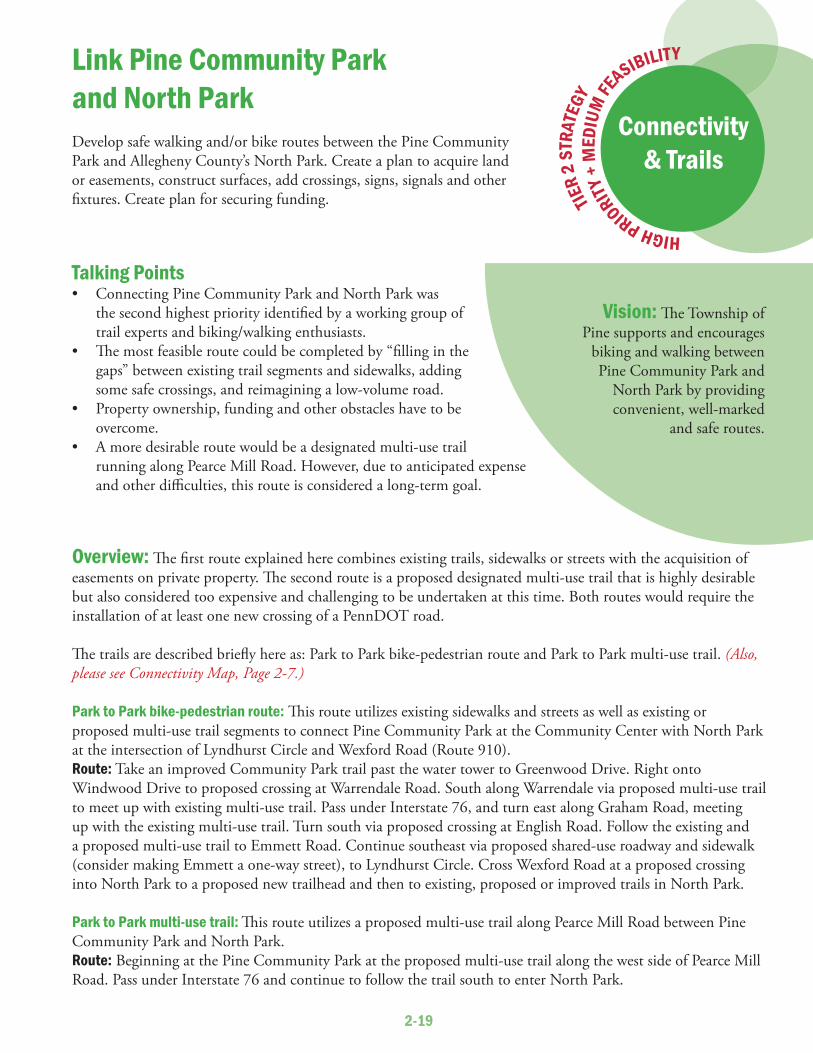
Overview: Th e fi rst route explained here combines existing trails, sidewalks or streets with the acquisition of easements on private property. Th e second route is a proposed designated multi-use trail that is highly desirable but also considered too expensive and challenging to be undertaken at this time. Both routes would require the installation of at least one new crossing of a PennDOT road.
Th e trails are described briefl y here as: Park to Park bike-pedestrian route and Park to Park multi-use trail. (Also, please see Connectivity Map, Page 2-7.)
Park to Park bike-pedestrian route: Th is route utilizes existing sidewalks and streets as well as existing or proposed multi-use trail segments to connect Pine Community Park at the Community Center with North Park at the intersection of Lyndhurst Circle and Wexford Road (Route 910). Route: Take an improved Community Park trail past the water tower to Greenwood Drive. Right onto Windwood Drive to proposed crossing at Warrendale Road. South along Warrendale via proposed multi-use trail to meet up with existing multi-use trail. Pass under Interstate 76, and turn east along Graham Road, meeting up with the existing multi-use trail. Turn south via proposed crossing at English Road. Follow the existing and a proposed multi-use trail to Emmett Road. Continue southeast via proposed shared-use roadway and sidewalk (consider making Emmett a one-way street), to Lyndhurst Circle. Cross Wexford Road at a proposed crossing into North Park to a proposed new trailhead and then to existing, proposed or improved trails in North Park.
Park to Park multi-use trail: Th is route utilizes a proposed multi-use trail along Pearce Mill Road between Pine Community Park and North Park. Route: Beginning at the Pine Community Park at the proposed multi-use trail along the west side of Pearce Mill Road. Pass under Interstate 76 and continue to follow the trail south to enter North Park.
Vision: Th e Township of Pine supports and encourages
biking and walking between Pine Community Park and
North Park by providing convenient, well-marked
and safe routes.
Link Pine Community Parkand North ParkDevelop safe walking and/or bike routes between the Pine Community Park and Allegheny County’s North Park. Create a plan to acquire land or easements, construct surfaces, add crossings, signs, signals and other fi xtures. Create plan for securing funding.
Talking Points• Connecting Pine Community Park and North Park was
the second highest priority identifi ed by a working group of trail experts and biking/walking enthusiasts.
• Th e most feasible route could be completed by “fi lling in the gaps” between existing trail segments and sidewalks, adding some safe crossings, and reimagining a low-volume road.
• Property ownership, funding and other obstacles have to be overcome.
• A more desirable route would be a designated multi-use trail running along Pearce Mill Road. However, due to anticipated expense and other diffi culties, this route is considered a long-term goal.
HIGH PRIORITY +
MED
IUM
FE
ASIBILITY
Connectivity& Trails
TIER
2 ST
RATE
GY

2-20
Suggested Implementation Plan: Link Pine Community Parkand North Park
STEP 1: Township should consider following the steps set forth in the Pine-Richland School District - Pine Community Park Trail suggested implementation plan.
STEP 2: For the Park to Park bike-pedestrian route, proceed with expectation of completing as soon as feasible.
STEP 3: For the Park to Park multi-use trail route, proceed with less immediacy, but with the expectation of completing as soon as feasible the planning steps as far as
understanding likely obstacles and eventual capital costs.
A cyclist on Pearce Mill Road near the North Park entrance.

2-21
Overview: Th e route explained here combines existing trails, sidewalks or streets with acquisition of easements on private property. It would require the installation of at least one new crossing of a PennDOT road.
Th e trail is described briefl y here as 5.) Park to Route 19 bike-pedestrian route. (Also, please see Connectivity Map, Page 2-7.)
Park to Route 19 bike-pedestrian route: Th is route utilizes existing and proposed multi-use trails, township roads and sidewalks to connect the Community Park with the high-density commercial/residential area along Route 19.Route: Beginning at an improved Community Park trail past the water tower to Greenwood Drive. Right onto Windwood Drive to a proposed crossing at Warrendale Road. South along Warrendale Road via a proposed multi-use trail to meet up with the existing multi-use trail. Pass under Interstate 76, and turn east along Graham Road, meeting up with the existing multi-use trail. Turn south via a proposed crossing at English Road. Follow the existing and proposed multi-use trail to a proposed crossing at Wallace Road. Turn south on Wallace Road and on a proposed sidewalk to meet up with the existing sidewalk (consider improving this to serve as a multi-use trail). Connect with sidewalks and existing crossings at Route 19.
Vision: Th e Township of Pine supports and encourages biking
and walking between Pine Community Park and the
Route 19 area by providing convenient, well-marked
and safe routes.
Link Pine Community Parkand Route 19Develop safe walking and/or bike routes between the Pine Community Park and the U.S. Route 19 area high-density residential and commercial zone. Create a plan to acquire land or easements, construct surfaces, add crossings, signs, signals and other fi xtures. Create plan for securing funding.
Talking Points• Connecting Pine Community Park and the Route 19
commercial/residential area was the third highest priority identifi ed by a working group of trail experts and biking/walking enthusiasts.
• Th e most feasible route could be completed by “fi lling in the gaps” between existing trail segments and sidewalk and adding some safe crossings.
• Property ownership, funding and other obstacles have to be overcome.
• Th is connection would enable residents living in the high-density areas of the township to reach Pine Community Park, and also enable residents from much of the township to reach the Route 19 commercial district safely and conveniently on foot or bicycle.
HIGH PRIORITY +
MED
IUM
FE
ASIBILITY
Connectivity& Trails
TIER
2 ST
RATE
GY

2-22
Suggested Implementation Plan: Link Pine Community Parkand Route 19
STEP 1: Township should consider following the steps set forth in the Pine-Richland School District - Pine Community Park suggested implementation plan.
STEP 2: Proceed with the expectation of completing as soon as is feasible.
Wallace Road intersection with U.S. Route 19 at the Village at Pine.

2-23
Overview: Over the course of years, the Township of Pine has installed sidewalks and multi-use trails, working with individual property owners and with developers as new neighborhoods were constructed. Some of these trails were initially “routes to no place;” however, as more development occurred, many of these routes now nearly connect with each other. Th e township should fi ll in the gaps by completing sidewalks or multi-use trails
so that cyclists and pedestrians are able to move safely and conveniently between residential neighborhoods and between other key destinations.
Missing Links: Th e gaps between existing segments are identifi ed on the Connectivity Map (Please see Page 2-7).
Improvements: Some previously constructed trails are not considered wide enough to accommodate contemporary use patterns. Th ese narrow multi-use trails should be improved to meet current design standards (Please see illustrations on Page 2-15).
Vision: Th e Township of Pine supports and encourages biking and walking between residential
neighborhoods and between key destinations within the
community by providing convenient, well-marked and safe
routes.
“Fill in the gaps” and improve existing trail segmentsCreate safe walking and/or bike routes between the residential neighborhoods and between key destinations within the community by completing missing segments and bringing existing trails up to current standards. Create a plan to acquire land or easements, construct surfaces, add crossings, signs, signals and other fi xtures. Create a funding plan.
Talking Points• If a few missing segments were built, many valuable walking
or biking links within the community could spring into use.• Property ownership, funding and other obstacles have to be
overcome.• Routes could link residential neighborhoods and also key
destinations within the community.
A trail ends along Warrendale Road near Beaver Court, creating a “missing link.”
MEDIUM PRIORI
TY +
HIG
H FE
ASIBILITY
Connectivity& Trails
TIER
2 ST
RATE
GY

2-24
BikePGH trail map could be an example.
Bike repair station provides rack, tools and air. Other amenities could be water fountain, seating and shade.
Beyond PineLOOKING OUTWARD: Th is plan encourages eff orts to coordinate bike and trail connections with neighboring communities.
Cycle stationSAFETY AND CONVENIENCE: Th e township should install a bicycle repair station and other cycling amenities at Pine Community Park.
STATEMENT OF SUPPORT
Connectivity& Trails
TIER 3 STRATEGY
LOW PRIORITY + HIGH FEASIBILITYConnectivity
& Trails
TIER 3 STRATEGY
LOW PRIORITY + HIGH FEASIBILITY
Connectivity& Trails
TIER 3 STRATEGY
Trail maps / Wayfi nding / SignsHERE TO THERE: Th e township should develop digital and printable maps of completed routes, and erect wayfi nding signs. Th is strategy could dovetail with the Community Gateways initiative in the Community Character and Appearance Strategy, Section 3 of this plan.

2-25
TIER
3 ST
RATE
GY
Harmony TrailNEW LINK: Th is plan supports the Rachel Carson Trails Conservancy’s recommendations to identify, enhance and extend the Harmony Trail.
Th e Harmony Trail is one of the conservancy’s three primary trails, extending approximately 1 mile along a former rail bed from McCandless Township north to Wexford Road (Orange Belt) in Pine Township.
Th is plan supports the conservancy’s recommendation to identify a hiking trail that connects the Harmony Trail to the Brooktree Corporate Park and its circuit road. Th e conservancy owns a linear curved parcel that connects to the circuit road near the utility building in the northwest corner of the Brooktree Corporate Campus. Hikers from the southwestern corner of Pine Township can use this route to connect to North Park, across Route 19.
Th e conservancy is willing to improve this trail, as it is recognized as part of the township’s offi cial trail network. (Please see Connectivity Map, Page 2-7.) Th e greatest expense would be a bridge across Wexford Run to connect to the existing Harmony Trail.
Th is plan also supports the conservancy’s recommendation to recognize the opportunity to extend the Harmony hiking trail north of Route 910 / Wexford Road along or adjacent to Brennan Road. Th is would follow the former right-of-way of the Harmony Short Line and has the potential to extend through Bradford Woods to Marshall Township and its trail system. Th e hiking trail would be on public roads except for a portion that may require sharing a utility right-of-way.
STATEM
ENT O
F SUP
PORT
Connectivity& Trails
Harmony Trail runs south along a former rail bed from a parking area on Wexford Road.

2-26
Rachel Carson Trailhead ENCOURAGING CONNECTIONS: Th is plan supports the Rachel Carson Trails Conservancy’s proposal to identify and enhance a trail segment through the Township of Pine that would create new connections with the Rachel Carson
Trailhead in North Park and a proposed route in Richland Township.
Th e Conservancy’s most known trail is the Rachel Carson Trail. Its western trailhead is the Beaver Shelter adjacent to Irwin Lake in
North Park. From that shelter hikers are now enjoying the Irwin Run Valley and the conservation area land owned by the Allegheny Land Trust. Th e hiking trail through this parcel connects to Jackson Road in Pine Township, as shown on the township Connectivity Map (Please see Page 2-7). A hiking route up Jackson Road toward Babcock Boulevard heads toward Richland Township. Th e Richland Township Comprehensive Plan identifi es a gateway site along Gibsonia Road and near the intersection with Montour Road. Montour provides a low-traffi c public route toward the Pittsburgh Cut Flower site. Th is route was considered during the period the Allegheny Land Trust was negotiating for that site and remains an attractive option as Richland Township awaits redevelopment options for the site.
STATEMENT OF SUPPORT
Connectivity& Trails
TIER 3 STRATEGY

2-27
Connectivity& Trails
NOTES

2-28

2-29
Connectivity& Trails
NOTES

2-30

2-31
Connectivity& Trails
NOTES

2-32

3-1
Community Character& Appearance
Inside: Create attractive community
gateways Create or maintain extensive tree cover
Preserve or maintain natural areas Review/update land-use designations as township
becomes built out Maximize township “brand” recognition Preserve or maintain distinctive structures and rural icons Limit future overhead wires and visibility of utilities Illustrate design standards
The Township of PinePERFORMANCEW O R K B O O K

3-2

3-3
Vision: Th e Township of Pine preserves vestiges of its rural and
agricultural past; values scenic views and streetscapes that emphasize
tree-cover; retains and maintains natural areas; avoids visual
clutter; and defi nes community gateways
and key public spaces.
KEY ISSUE:Community Character& Appearance
IntroductionGrowth has changed the township’s predominant land use from agriculture to residential within a generation, and has altered its appearance. Th is rapid growth rate creates a conundrum: Many residents say they chose to live in or move to the Township of Pine because of its “rural character,” yet the presence of additional residents changes the very nature of the place. What, exactly, are the features, elements and characteristics that make the township visual appealing and desirable? Th rough this planning process, we explored the issue, and now present specifi c strategies to preserve or enhance the community’s character and appearance.
Talking Points• Residents highly value the community’s appearance, specifi cally the natural areas, trees and views of rolling
hills.• Today’s look should honor the township’s rural and agricultural past.• Five focus groups identifi ed the features, characteristics and elements that “make Pine Pine,” through
discussion of what participants like and dislike about the township’s appearance.• Th e specifi c desired features and characteristics are:
- Natural areas such as woodlands, steams and watersheds, wetlands, undisturbed hillsides- Attractive and noticeable community gateways- Extensive tree cover, including more pine trees and other evergreens, as well as street trees and roadside
buff ers- Agricultural elements such as productive fi elds, pastures, fences and barns- Limits on overhead wires and visible utilities- Development of one or more outdoor public spaces- Limits on visual clutter or eyesores- Preservation and maintenance of distinctive older structures
Overview

3-4
ValidationTh e Township of Pine’s identity and character are aligned with its rural past, though currently just one active farm remains.
Pine’s transformation from rural and agricultural land uses to a residential, suburban bedroom community quickly followed the completion of I-279 in 1989. Now the township is predominately residential, with commercial development present in one main corridor and several small pockets. Open space is a signifi cant component of current land use and is highly valued. Developable parcels remain but are going fast. It is likely that this planning cycle will be the township’s last opportunity to make any signifi cant changes in future land use before build-out. Th e township should at this time determine whether changes in land-use designations should be made, and if so, what those changes should be. Moreover, the township should establish policies, programs and projects that retain or enhance the characteristics and features that make the township so appealing.
North Allegheny History Museum
View of the Kennedy/Huggins farm in Pine Township in the early 1900s.

3-5
Tier 1 - DEVELOP ATTRACTIVE COMMUNITY GATEWAYS:Identify township gateway locations and types, create design standards, estimate costs. (Please see Pages 3-9 to 3-13.)
Tier 1 - CREATE OR MAINTAIN AN EXTENSIVE TREE COVER:Extend and augment tree cover to reinforce the visual impression of rolling, forested hills. Improve forest health. (Please see Pages 3-14 to
3-22.)
Strategies continue on next page
Tier 1: High priority and high feasibilityTier 2: High priority and medium feasibility, or medium priority and high feasibilityTier 3: Low priority and high feasibility, any priority and low feasibility, or statement of support for high-priority existing position.
The tier ratings were established during the preparation of this plan in 2015, and may change depending on external circumstances such as tax revenues, the overall economy, new laws or regulations, or the availability of funding.
Community Character & AppearanceImplementation and Management Strategies

3-6
Continued from previous page
Tier 3 - PRESERVE OR MAINTAIN NATURAL AREAS: Th is plan enthusiastically supports existing township ordinances that maintain or enhance the condition or streams, wetlands, wooded parcels that make the area seem rural and untouched. (Please see Page 3-23.)
Tier 3 - LAND USE DESIGNATIONS AS TOWNSHIP BECOMES “BUILT OUT”: Determine whether any changes should be made in land-use designations, and if so, what they should be. (Please see Page 3-24.)
Tier 3 - MAXIMIZE TOWNSHIP “BRAND” RECOGNITION: Review and update a visual vocabulary and apply standards consistently on township equipment and property. Th is includes consistent use of a township logo and color palette, and design standards for fi xtures such hydrants, lights, benches, crossings, etc. (Please see Page 3-24.)
Tier 3 - PRESERVE OR MAINTAIN DISTINCTIVE STRUCTURES AND RURAL ICONS: Encourage preservation of scenic barns, fences, fi elds and interesting buildings. (Please see Page 3-25.)
Tier 3 - LIMIT FUTURE OVERHEAD WIRES AND VISIBILITY OF UTILITIES: Th is plan supports existing township ordinances. (Please see Page 3-25.)
Tier 3 - ILLUSTRATE DESIGN STANDARDS: Th e township has strong regulations to promote quality development. Visual examples of some of the requirements help prospective developers better understand the goals of the community and embed required features and elements into proposals. (Please see Pages 3-26.)
Community Character& AppearanceImplementation and Management Strategies

3-7

3-8

3-9
TIER
1 ST
RATE
GYOverview: Township residents are justifi ably proud of their community and want to underscore Pine’s distinctiveness through development of unmistakable gateways that communicate to visitors and residents alike that “you are now in the Township of Pine.”
Gateways are key locations along important transportation corridors that mark a transition from one place to another. Gateways should foster community pride, help visitors with wayfi nding, and stand as attractive landscapes for all passers-by to see and enjoy.
Th is plan identifi es three types of gateways to be established over time, with their scale dependent upon traffi c load and visibility. Type 1 gateways mark the busiest transportation arteries and/or intersections near the township’s borders with neighboring communities. Type 2 gateways mark township edges along somewhat less-traveled routes, and Type 3 gateways mark relatively quiet through-streets or pedestrian/bike trails.
Th e Type 1 gateway locations are:• Eastbound Wexford Road (Orange Belt / Route 910) near the Marshall Township line• Southbound U.S. Route 19 (Perry Highway) near the Marshall Township line• Northbound U.S. Route 19 (Perry Highway) near the McCandless Township line• Intersection of Gibsonia Road (Route 910) and Babcock Boulevard• Intersection of Warrendale Road (Red Belt) and Franklin Road• Intersection of Mt. Pleasant Road and Franklin Road• Intersection of Babcock Boulevard and Bakerstown Road (Red Belt)• Intersection of Pearce Mill Road and Wexford Road (Route 910)
Vision: Attractive and highly visible features defi ne community
gateways. Th ese gateways clearly communicate arrival into the
Township of Pine, foster community pride, and
convey a sense of the community’s character
and rural past.
Create attractive and highly visible community gatewaysIdentify the gateways to Pine Township and propose designs or features that help people “know when they’re in Pine.” Enhance design standards. Identify costs, to assist township in securing funding for new gateway features.
CommunityCharacter &Appearance
Talking Points• Creating community gateways is one of three top priorities
identifi ed by participants in fi ve community focus groups.• Th e gateways should clearly convey to visitors and residents
that they are in the Township of Pine.• Th e gateways should have a consistent appearance and be
attractive and noticeable in all seasons.• Th e gateways should have a refi ned and contemporary appearance
while also refl ecting the community’s rural and agricultural past.• Th e gateway signs should align with any new branding initiative (See
brand recognition strategy, page 3-24) or trail map / wayfi nding / signs initiative (See strategy, page 2-24) that start as part of this comprehensive plan.
HIGH PRIORITY
+ H
IGH
FEASIBILITY

3-10
STEP 1: Establish three categories of gateways — Types 1-3 — with their scale depending on traffi c load and visibility. Th e gateways may include plantings and iconic features such as signs, banners, stone walls, boulders and/or fences.
STEP 2: Identify the location of Type 1 and Type 2 gateways.
STEP 3: Create conceptual designs for each gateway tier: Type 1 gateways are visible at higher speed or amidst traffi c or distractions. Type 2 involve a
small sign with plantings, visible at lower speed or amidst few distractions. Type 3 gateways involve a simple sign at “human scale” that is visible at very low speed. (See
drawing, Page 3-11.)
STEP 4: Identify funding sources, such as township funding, grants, partnerships or donations.
STEP 5: Select one highly signifi cant gateway location to be a pilot project, including identifying the probable costs.
STEP 6: Budget money for construction and installation of pilot project.
STEP 7: Acquire right-of-way easements from PennDOT or other property owners where applicable.
STEP 8: Notify and/or meet with owners of property adjacent to the pilot project location regarding township plans.
STEP 9: Complete fi nal design, prepare construction documents, and obtain required permits for construction of the pilot project.
STEP 10: Develop management, operation and security strategies for the Type 1 gateway locations, perhaps working with community groups, businesses or regional non-profi t organizations.
STEP 11: Complete a fi nancial analysis to project the capital and maintenance costs for the remaining gateways.
STEP 12: Construct the pilot project gateway.
STEP 13: Set priorities for completing the remaining Type 1 gateway projects, and for completing construction and installation of the Type 2 and Type 3 gateways.
STEP 14: Complete remaining projects, including notifying and/or meeting with neighbors of Type 1 gateway projects.
Suggested Implementation Plan: Create attractive andhighly visible community gateways

3-11
Demonstration Project: Create attractive andhighly visible community gateways

3-12

3-13
Step 3
Step 4Step 5
Step 6
Step 7
Step 8
Step 9Step 10
Step 11Step 12
Step 13
Step 14
Step 14
Step 2Step 1
YEAR 1 YEAR 2 YEAR 3 YEAR 4+
Suggested Timeline:
Cost Estimates: Create attractive and highly visible community gateways
Type 1 gateway projects
Type 2 gateway projects
Type 3 gateway projects
ITEM NUMBER COST PER TOTALRemovals LS $ 500 $ 500Earthwork, site preparation LS $3,000 $3,000Trees 15 $ 400 $6,000Shrubs 50 $ 50 $2,500Perennials 100 $ 25 $2,500Sign 1 $5,000 $5,000Irrigation $5,000Lighting $5,000Mulch / misc. rain garden opportunities $5,000
Partner sign $ 500
TOTAL $35,000
Create attractive andhighly visible community gateways
ITEM NUMBER COST PER TOTALRemovals LS $ 500Earthwork, site preparation, mulch, watering bags LS $3,500Trees 6 $ 400 $2,400Shrubs 9 $ 50 $ 450Sign LS $1,000TOTAL $7,850
ITEM NUMBER COST PER TOTALTrees, shrubs LS $3,000Site preparation, mulch, watering bags LS $1,500Sign LS $ 750TOTAL $5,250

3-14
Overview: Although the Township of Pine is nearly “built out,” it is nevertheless possible to drive along township roads and view expanses of tree-covered rolling hills. Th is is due to existing ordinances that preserve large trees, require roadside buff ers for new residential neighborhoods and mandate planting of streetscapes and screens.
Th e strategy presented here, intended to create or maintain extensive tree cover, builds on existing practices by identifying four types of landscapes to reforest or support; suggesting native tree and shrub species; providing planting guidelines; encouraging an invasive species management plan; and providing conceptual planting plans and associated cost estimates for each of the four landscape categories.
Talking Points• Preserving and enhancing the Township of Pine’s rolling, tree-covered hills was one of three top priorities identifi ed by participants in fi ve community focus groups.
• Trees provide important ecological services such as evapotranspiration and soil conservation, and also improve air
quality and provide shade.• Trees enhance property values.
• New trees should be selected to add native species diversity — and should include pines and other evergreens to help the Township of Pine
live up to its name.• Older, larger trees should be preserved.
• Th e township should develop and implement an invasive species management plan to support forest health, perhaps enlisting the help of township volunteers.
Create or maintainextensive tree coverExtend and augment tree cover within Township of Pine greenways to reinforce the visual impression of rolling, forested hills. Improve roadside and streetscape appearance through the addition of trees. Manage invasive species. Plant more pines and other evergreens.
HIGH PRIORITY + HIGH FEASIBILITY
CommunityCharacter &Appearance
TIER 1 STRATEGY
Vision: Th e Township of Pine actively supports and augments the diversity and viability of its tree population, thereby creating a visual impression of extensive tree cover, and enhancing the health of its ecological systems and of its residents. We aim to plant 5,000 new trees in the township by 2025.
The township’s rolling hills, seen from Trees Manor Lane.

3-15
STEP 1: Identify greenway or open-space areas suitable for forest augmentation to create additional tree cover, using the categories: A) Developer-installed buff ers; B) Disturbed open space; C) Natural, unmanaged areas; and D) Township parks.
STEP 2: Adopt list of native trees and shrubs suitable for various forest, open space or greenway locations and conditions. (See list, Page 3-16.)
STEP 3: Adopt planting guidelines for correct planting techniques. (See drawings and information, Appendices D-F.)
STEP 4: Identify pilot project areas, basing plans on the conceptual designs provided in this comprehensive plan (See Page 3-17 and 3-19), with the goal of choosing visible locations in the township. Estimate planting costs and include these projects in budget.
STEP 5: Identify funding sources, such as township funding, grants, partnerships or donations.
STEP 6: Implement pilot project. Provide graphic interpretive signs explaining benefi ts of the projects.
STEP 7: Create and adopt an invasive species management plan, perhaps including volunteer corps or a township work day. (DCNR invasives management strategies and funding sources, Appendix G.)
STEP 8: Review existing ordinances for opportunities to strengthen the township’s intention to create visually appealing streetscapes and roadsides, preserve signifi cant trees, etc.
STEP 9: Continue with additional project areas each year to reach the goal of 5,000 trees by 2025.
Suggested Implementation Plan: Create or maintain extensive tree cover
Four landscape types where additional trees and shrubs could improve the ecosystem health and the appearance of township-owned or -maintained property:
A) Developer-installed buffers
B) Disturbed open space
C) Natural, unmanaged areas
D.) Township parks
A B
C D

3-16
Suggested Plant List: Create or maintain extensive tree cover
LLARGE TREESCCommon name Scientific name Light preference Moisture preference Height Wildlife value Notes
Red maple Acer rubrum sun-medium-shade wet-moist-dry 40-60 very high red flowers, adaptable, fall colorSugar maple Acer saccharum medium-shade moist 60-75 very high yellow flowers in spring, fall colorBlack birch Betula lenta medium-shade moist-dry 45-55 very high catkinsRiver birch Betula nigra sun-medium-shade wet-moist 60-80 very high peeling salmon-colored bark, catkinsShagbark hickory Carya ovata sun-medium moist-dry 70-80 very high bark shelters bats, edible nuts, fall colorAmerican beech Fagus grandifolia sun-medium-shade moist 50-70 high "tree for the ages," edible nuts, smooth gray barkRed cedar Juniperus virginiana sun moist-dry 30-65 very high tough tree, woodland edges, pioneer speciesSweet gum Liquidambar styaciflua sun moist 60-80 low tolerates deer, clay soil, fall color, drops spiky seed ballsTulip poplar Liriodendron tulipfera sun-medium-shade moist-dry 75-100 medium fast-growing, green flowers in JuneCucumbertree magnolia Magnolia acuminata sun-medium moist 50-80 high 4-10" leaves, 3" yellow flowers, does not like pollutionBlack gum Nyssa sylvatica sun-medium-shade wet-moist 30-60 high great fall color, transplant youngPitch pine Pinus rigida sun-medium wet-moist-dry 50-60 very high pioneer species, adaptable to poor soils, not pretty, pricklyEastern white pine Pinus strobus sun-medium-shade moist-dry 50-80 very high evergreen conifer, does not like roadside pollutionSycamore Platanus occidentalis sun-medium-shade moist 75-100 low peeling bark, drops spiky seed ballsBig-tooth aspen Populus grandidentata sun-medium moist-dry 50-70 very high fast growing, catkins, fall colorQuaking aspen Populus tremuloides sun-medium wet-moist-dry 30-40 high fast growing pioneer species, fall colorPrunus serotina Black cherry sun-medium-shade moist 50-80 very high white flowers, fall color, fruit, transplant youngWhite oak Quercus alba sun-medium-shade moist-dry 50-100 very high "tree for the ages," edible nutsSwamp white oak Quercus bicolor sun wet-moist 50-60 very high wet soils, transplant young, edible nutsBlack willow Salix nigra sun-medium-shade wet-moist 30-50 medium catkins, wet soilsSassafras Sassafras albidum sun-medium-shade moist 30-50 high edible uses, fall colorBasswood Tilia americana sun-medium moist 60-80 high fragrant flowers in June, great pollinator tree
SSMALL TREESCCommon name Scientific name Light preference Moisture preference Height Wildlife value Notes
Striped maple Acer pensylvanicum medium-shade moist 15-20 very high green stripes on stems, understory plant, fall colorServiceberry Amelanchier arborea sun-medium-shade moist-dry 15-25 very high white flowers in spring, edible berries, fall colorRedbud Cercis canadensis medium-shade moist-dry 20-35 very low lavender flowers in early spring, nitrogen-fixerWhite fringetree Chionanthus virginicus sun-medium moist 12-20 high hillsides, woodland borders, tolerates clay soil, pollutionFlowering dogwood Cornus florida medium-shade moist 15-30 very high white flowers in spring, red berries, disease-proneWitchhazel Hamamelis virginiana medium-shade moist 20-30 low yellow flowers in winter, fragrantSweetbay magnolia Magnolia virginiana sun-medium wet-moist 10-35 high fragrant white flowers, woodland border, tolerates clayWild plum Prunus americana sun-medium-shade moist-dry 15-25 high white flowers, edible fruit
SSHRUBSCCommon name Scientific name Light preference Moisture preference Height Wildlife value Notes
Smooth alder Alnus serrulata sun-medium-shade wet 5-10 high wet soil, multi-stemBlack chokeberry Aronia melanocarpa sun-medium-shade wet-medium-dry 3-6 medium white flowers, multi-stem, berries, fall colorNew Jersey tea Ceanothus americanus sun-medium-shade medium-dry 2-3 medium white flowers, multi-stem, nitrogen fixerButtonbush Cephalanthus occidentalis sun-medium-shade wet-medium 6-15 medium white flowers become interesting berries, multi-stemSweet pepperbush Clethra alnifolia sun-medium-shade wet-medium-dry 3-8 medium butterflies, white flowers, fragrant, adaptableSilky dogwood Cornus amomun sun-medium wet-medium 6-12 very high white flowers, blue berries, multi-stemGray dogwood Cornus racemosa sun-medium wet-medium 10-15 very high white flowers/berries, fall color, tolerates deer, red stemsWild hydrangea Hydrangea arborescens medium-shade medium 3-5 low white flowers, multi-stemWinterberry Ilex verticillata sun-medium-shade wet-medium 6-10 very high red berries in winter, needs male pollinator, multi-stemMountain laurel Kalmia latifolia medium-shade wet-medium-dry 6-15 low berries in fall, multi-stemSpicebush Lindera benzoin medium-shade wet-medium 6-12 high berries in fall, fall color, multi-stemBayberry Myrica pensylvanica sun-medium-shade wet-medium-dry 6-12 high berries, fragrant, salt tolerantNinebark Physocarpus opulifolius sun-medium-shade wet-medium 5-10 medium pink flowers, interesting peeling bark, multi-stemRhododendron Rhododendron maximus shade wet-medium 5-25 low deep pink flowers, evergreen, multi-stemWild azalea Rhododendron periclymenoides sun-medium-shade medium-dry 4-8 low pale pink flowers, multi-stemPussy willow Salix discolor sun-medium wet-medium 6-15 medium tolerates deer, tough, soft fuzzy flowers, multi-stemSilky willow Salix sericea sun-medium-shade wet 6-12 medium catkins, multi-stemElderberry Sambucus canadensis sun-medium-shade wet-medium 6-15 very high white flowers, edible berries, multi-stemLowbush blueberry Vaccinium angustifolium sun-medium medium-dry 1-2 very high white flowers, edible berries, multi-stemHighbush blueberry Vaccinium corymbosum sun-medium-shade wet-medium 5-10 very high white flowers, edible berries, fall color, multi-stemMaple-leaf viburnum Viburnum acerifolium medium-shade wet-medium-dry 4-6 medium white flowers, edible berries, fall color, multi-stemArrowwood Viburnum dentatum sun-medium-shade wet-medium 3-12 very high white flowers, multi-stem
Sourceshttp://www.dcnr.state.pa.us/cs/groups/public/documents/document/dcnr_003489.pdfhttp://www.dcnr.state.pa.us/cs/groups/public/documents/document/dcnr_003304.pdfhttp://www.stormwaterpa.org/assets/media/BMP_manual/12_Appendix_B.pdf

3-17
Reforestation Diagrams by Landscape Type: Create or maintain extensive tree cover
A
B
Four landscape types where additional trees and shrubs could improve the ecosystem health and the appearance of township-owned or -maintained property:
A) Developer-installed buffers
B) Disturbed open space

3-18

3-19
Reforestation Diagrams by Landscape Type: Create or maintain extensive tree cover
C
D
Upland UplandTerrace TerraceFloodplain
• Th e fl oodplain should be planted or augmented with moisture-loving trees and shrubs. Debris such as fallen trees should be left undisturbed to provide cover for aquatic life and to cool the water.
• Th e terrace levels should be planted or augmented with trees and shrubs that love moisture or medium con-ditions, as these higher areas can be damp at times but also dry out.
• Th e upland areas should be planted with trees and shrubs that prefer dry conditions.
Four landscape types where additional trees and shrubs could improve the ecosystem health and the appearance of township-owned or -maintained property:
C) Natural, unmanaged areas
D.) Township parks
• In landscape types A and D, plant trees and shrubs 20’ on center, staggered.
• In landscape types B and D, plant whips 10’ on center, staggered.
• Or, combine the approaches by planting mostly whips, with a few large specimens interspersed on the grid.
Planting guide
For further information about correct planting practices, please see Appendix D.
For further information about planting bare-root whips, please see Appendix E.
For further information about planting riparian buff ers, please see Appendix F.

3-20
3-21
Cost Estimates: Create or maintain extensive tree cover
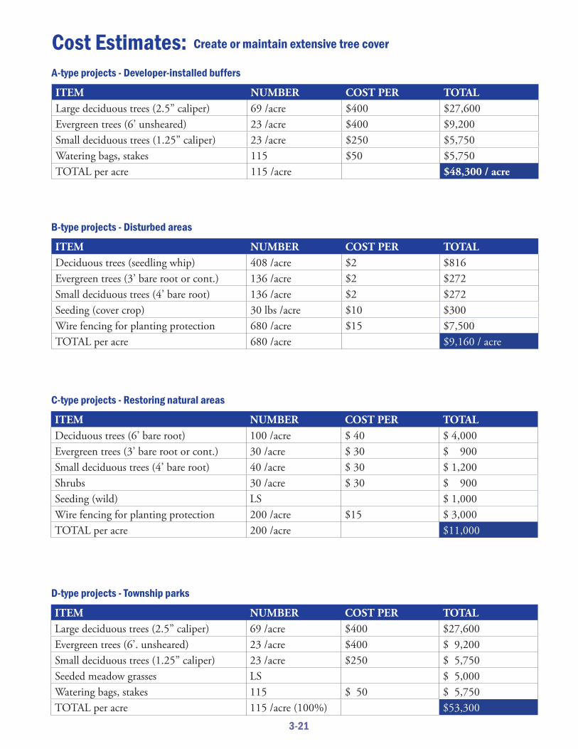
A-type projects - Developer-installed buffers
B-type projects - Disturbed areas
C-type projects - Restoring natural areas
D-type projects - Township parks
ITEM NUMBER COST PER TOTALLarge deciduous trees (2.5” caliper) 69 /acre $400 $27,600Evergreen trees (6’ unsheared) 23 /acre $400 $9,200Small deciduous trees (1.25” caliper) 23 /acre $250 $5,750Watering bags, stakes 115 $50 $5,750TOTAL per acre 115 /acre $48,300 / acre
ITEM NUMBER COST PER TOTALLarge deciduous trees (2.5” caliper) 69 /acre $400 $27,600Evergreen trees (6’. unsheared) 23 /acre $400 $ 9,200Small deciduous trees (1.25” caliper) 23 /acre $250 $ 5,750Seeded meadow grasses LS $ 5,000Watering bags, stakes 115 $ 50 $ 5,750TOTAL per acre 115 /acre (100%) $53,300
ITEM NUMBER COST PER TOTALDeciduous trees (seedling whip) 408 /acre $2 $816Evergreen trees (3’ bare root or cont.) 136 /acre $2 $272Small deciduous trees (4’ bare root) 136 /acre $2 $272Seeding (cover crop) 30 lbs /acre $10 $300Wire fencing for planting protection 680 /acre $15 $7,500TOTAL per acre 680 /acre $9,160 / acre
ITEM NUMBER COST PER TOTALDeciduous trees (6’ bare root) 100 /acre $ 40 $ 4,000Evergreen trees (3’ bare root or cont.) 30 /acre $ 30 $ 900Small deciduous trees (4’ bare root) 40 /acre $ 30 $ 1,200Shrubs 30 /acre $ 30 $ 900Seeding (wild) LS $ 1,000Wire fencing for planting protection 200 /acre $15 $ 3,000TOTAL per acre 200 /acre $11,000

3-22
Suggested Timeline: Create or maintain extensive tree cover
Step 2
Step 4
Step 5
Step 6
Step 7
Step 7
Step 7
Step 8
Step 9
Step 9
Step 1
Step 3
YEAR 1 YEAR 2 YEAR 3 YEAR 4+

3-23
TIER
3 ST
RATE
GY
Agriculture Conservation Easements
Owner AcreageRobert Boudreau 96
Agriculture Security Areas (ASAs) Owner AcreageDewey 57Micucci 11.26Mihalics 23.39Mustovic 217.04Shurko 41.76 TOTAL ACRES 350.45
Irwin Run Conservation AreaLocated along Babcock Boulevard, the Irwin Run Conservation Area conserves in perpetuity about 73 acres adjacent to North Park, helping to buff er the park and protecting benefi cial wetlands, densely wooded slopes and a stream valley.
Allegheny Land Trust photo
Preserve or maintain natural areasKEEP IT NATURAL: Th is plan enthusiastically supports existing township ordinances that maintain or enhance the condition or streams, wetlands, wooded parcels that make the area seem rural, natural and untouched. Additionally, the township should consider adopting an ordinance governing “Conservation of Natural Features.” (See sample ordinance from Pocopson Township, Chester County, Pa., in Appendix H.)
Population growth and residential development are the greatest threats to preserving open space and agricultural land, two land uses that create the rural appearance of the community that residents value highly, according to focus groups. Th e Township of Pine has the opportunity in the next few years to review and update its ordinances. Th e township can also initiate dialogues with owners of remaining large parcels to encourage participation in preservation and conservation programs such as land trusts or conservation easements.
CommunityCharacter &Appearance
STATEM
ENT O
F SUP
PORT

3-24
TIER 3 STRATEGYTIER 3 STRATEGY
Maximize Township of Pine“brand recognition”VISUAL IDENTIFICATION: Th e township should develop a visual vocabulary and apply use of its branding standards consistently. Th is branding initiative aligns with the Community Character & Appearance key issue because it is a means, along with new community gateway signifi ers, to help
people “know when they’re in Pine.”
Branding should include consistent use of a township logo and color palette, and design standards for fi xtures and features such as hydrants, lights, benches, pedestrian
crossings, traffi c signals, hardscapes, walls, etc. Th e selected logo and color palette should also be incorporated into uses as diverse as the township website and printed material, township-owned vehicles, and other fi xed,
mobile or online items.
New community gateway signifi ers, explained elsewhere in this plan, should incorporate the colors and logo selected for this branding strategy, and otherwise align appropriately with selection of materials and other visual components.
Review land-use designationsDetermine whether any changes should be made in land-use designations so the township can be positioned to encourage preservation or conservation of natural open spaces.
Th e community’s last best chance to adjust its zoning map will occur before the community becomes “built out.” During this period, the township can
use zoning designations to manage growth and development, enabling the township to preserve natural areas or other open space where desired.
STATEMENT OF SUPPORT
CommunityCharacter &Appearance
CommunityCharacter &Appearance
MEDIUM PRIORITY + MEDIUM FEASIBILITY

3-25
TIER
3 ST
RATE
GYTIE
R 3
STRA
TEGY
Preserve or maintain distinctive structures and rural iconsEVOKING PINE’S RURAL PAST: Encourage preservation of scenic barns, fences, fi elds and interesting buildings. Include rural iconography (such as fi eldstone walls, hedgerows, cut stone foundations, rail fences) in township-built features.
Limit future overhead wires and visibility of utilitiesAVOID VISUAL CLUTTER: Th is is a statement of support for existing township ordinances that require underground utilities in new development. Th e township also should continually review its ordinances to be certain they address current and emerging issues regarding cellular transmission towers, including mini cell towers, collocated antennae, installation locations and rights-of-way.
CommunityCharacter &Appearance
CommunityCharacter &Appearance
STATEM
ENT O
F SUP
PO
RT
STATEM
ENT O
F SUP
PO
RT
A barn in Pine Township.

3-26
TIER 3 STRATEGY
Illustrate design standardsTh e township has strong regulations to promote quality development. Visual examples of some of the requirements will help prospective developers better understand the goals of the community and embed required features and elements into proposals.
CommunityCharacter &Appearance
LOW PRIORITY + HIGH FEASIBILITY
Glazing and transparency at street level. Include awnings.
Articulation of facade.
Cornice, orientation for pedestrian access, awnings.
Orientation for pedestrian access.
Articulation of facade.

3-27
NOTESCommunity
Character &Appearance

3-28

3-29
NOTESCommunity
Character &Appearance

3-30

3-31
NOTESCommunity
Character &Appearance

3-32

4-1
Parks & RecreationInside: Updates to Pine Community Park Park land access and acquisition Review and update park and recreation-related operating policies Develop a Community Center marketing plan Explore adding aquatic features/facilities
The Township of PinePERFORMANCEW O R K B O O K

4-2

4-3
Vision: Th e Township of Pine’s recreational opportunities will keep pace with the community demand for parks and recreation by: adding
park land, facilities and programs to meet current and future needs;
maintaining all facilities to the highest standards; ensuring
fi rst-rate parks, facilities, and programs.
KEY ISSUE:Parks & Recreation
IntroductionTh e Township of Pine has long been on the cutting edge in providing parks and recreational opportunities for its residents as well as ensuring long-term protection of open space. Th e level of quality with which its parks and facilities have been developed and maintained has created high expectations for Pine residents as well as those considering a move to the township. Th e amount of park land, open space and recreational facilities now needs to keep pace with current and future demand.
Talking Points• Th e township has focused on ensuring a balance of recreation facilities by encouraging the development
of neighborhood recreation, trails, and open space by residential land developers. Th is has allowed the township to focus on larger community-wide facilities.
• Current facilities are well-maintained but perhaps insuffi cient to meet current and future needs as identifi ed through the public input completed as part of this study. Th e time is now to plan for acquisition of future park land for active community recreation. Recreational facilities are needed to meet the current demand and with the population continuing to grow, the township should prepare now for recreational facilities to meet the full build-out for the community.
Overview

4-4
ValidationTh e public meetings for both the community comprehensive plan and the comprehensive recreation, parks, and open space plan clearly identifi ed additional park land as a top recreational need, along with more trails (Please see Connectivity & Trails section) and sports fi elds.
Park Land: An analysis of existing park land in the township shows that through its land development ordinances, more than 700 acres of open space has been protected and as many as 20 neighborhood recreation areas have been developed. However, Pine Community Park is the only township space with larger facilities for active recreation. Th e other two township-owned parks, Pine Haven, and Karrington Woods, due mostly to their topography, are largely undeveloped, providing few recreational facilities. While Pine Community Park is meeting many of the recreational needs of the township, there are even now demands for additional facilities that cannot be met there. As the township continues to grow, the need for park land will only increase. And with the ever-increasing demand for land in the township, along with continually escalating costs, now is the time to make plans for the purchase of new park land.
Ballfi elds and other Recreational Facilities: Attendees at the public meeting supported the conclusions of the recreation facility analysis that additional sports fi elds are needed now and more will be needed in the future. In addition to sports fi elds, the demand for play areas, sport courts, teen recreation areas, open fi elds, and other community recreation facilities will continue to increase.
Recently added recreation facilities at a sports fi eld in the Township of Pine.

4-5
Tier 1 - UPDATES TO PINE COMMUNITY PARKWhile the park is nearly built-out, there are several new facilities that are still planned, upgrades to some existing facilities, and repair or replacement of others. (Please see Pages 4-9 to 4-10.)
Tier 2 - PARK LAND ACCESS AND ACQUISITION: Negotiate an agreement with Allegheny County for the use of certain facilities or amenities located in North Park that could meet some of the future recreational land and facility needs for township residents. Also, acquire a minimum of 20 and 60 acres of park land within the township that can be developed for active recreation, including
ballfi elds, sport courts, multi-use spaces, picnic shelters, etc. (Please see Pages 4-11 to 4-14.)
Strategies continue on next page
Parks & RecreationImplementation and Management Strategies
Tier 1: High priority and high feasibilityTier 2: High priority and medium feasibility, or medium priority and high feasibilityTier 3: Low priority and high feasibility, any priority and low feasibility, or statement of support for high-priority existing position.
The tier ratings were established during the preparation of this plan in 2015, and may change depending on external circumstances such as tax revenues, the overall economy, new laws or regulations, or the availability of funding.

4-6
Continued from previous page
Tier 3 - REVIEW AND UPDATE ALL OPERATING POLICIES OF THE COMMUNITY CENTER, RECREATION AND PARKS: Pine Parks and Recreation Department operates under a series of policies that help it to maintain a high level of quality in its operations, fi nances, maintenance, and staffi ng. As the township seeks across all its departments to improve its management of assets, the Parks and Recreation Department should look to update and/or create a series of management plans. (Please see Page 4-15.)
Tier 3 - DEVELOP A COMMUNITY CENTER MARKETING PLAN: As of the writing of this report, Pine Community Center has been in operation for about six years. During these early years of operation, marketing of the facility has been done through the township’s program brochures, ads and fl iers, yet a formal marketing plan has never been developed. It would be benefi cial to develop a more directed and focused marketing plan to inform township residents and others of the benefi ts of membership and to attract new users. (Please see Page 4-16.)
Tier 3 - EXPLORE ADDING AQUATIC FEATURES / FACILITIES: Many communities with similar demographics as the Township of Pine consider constructing an aquatic facility and/or specifi c aquatic features. It could be appropriate for the township to explore opportunities and options. (Please see Page 4-17.)
Parks & RecreationImplementation and Management Strategies

4-7

4-8

4-9
TIER
1 ST
RATE
GY
Vision: Develop and maintain Pine Community Park as a fi rst-rate
facility that meets the recreational needs of the community. Add
or improve facilities as they fi t within the master plan
or design of the park. Ensure the park does
not become over-developed.
Improve Pine Community Parkby adding new facilitiesWhile the park is nearly built-out, there are several new facilities that are still planned, upgrades to some existing facilities, and repair or replacement of others.
Talking Points• A master plan was completed for the park in the early
1990s and updated in 2005 to manage its development. • As the recommendations of the master plan have been
completed, a number of upgrades, amenities, or additional facilities have been proposed. Th e Parks and Recreation Committee maintains a priority listing of projects that ensures compliance with the vision for the park. Th e 2015 listing includes ten items to be implemented over the next fi ve or more years.
• Th e playground located near the concession stand was replaced and upgraded in 2015. Funding was provided by the state Department of Conservation and Natural Resources, Friends of Pine and the Township Recreation Fund. In addition, dugouts, fence lines and backstops were to be upgraded in 2015.
HIGH PRIORI
TY +
HIG
H FE
ASIBILITY
Overview: Developing existing parks can be a challenge. Changing needs and recreation trends require the township to periodically reassess and improve park features and facilities. Parks increasingly must provide fl exible spaces, adequate parking (additional capacity can be needed, depending on the new facilities provided), and comfortable spaces for spectators.
As concern with sun exposure and skin cancer increases, demands for shade trees and shelters goes up. And with new interest in alternatives to using cars, a park should provide safe circulation routes for pedestrians and cyclists between within the park and to a larger trail network beyond the park boundaries.
Parks &Recreation
Accessible path leading to lake at Pine Community Park.

4-10
STEP 1: Identify funding sources.
STEP 2: Complete the multi-purpose fi eld to include irrigation, sanitation, restrooms and water lines. Funding is to be provided through the Township Recreation Fund.
STEP 3: Construct a small pavilion at the lake. Funding will be provide by Friends of Pine and the Township Recreation Fund.
STEP 4: Build a new pavilion at the upper fi eld.
STEP 5: Plan for implementation of the remaining items in the chart below.
Suggested Implementation Plan: Improve Pine Community Parkby adding new facilities
Priority Project Estimated Cost Potential Funding Source Target
Completion Date
1 Complete the Multi-Purpose Field - irrigation and restrooms
$325,000 Township funding /Recreation Fund
2016
2 Construct Small Pavilion for Lake
$30,000 Friends of Pine Township fund-ing / Recreation Fund
2016-17
3 New Pavilion for Upper Field $110,000 Friends of Pine Township fund-ing / Recreation Fund
2017-18
4 Irrigation for Upper Fields TBD TBD TBD
5 Continue Baseball Field Main-tenance and Improvements
Pine Richland Baseball, Town-ship funding, DCNR grant
Ongoing
TOTAL (items 1-3) $465,000
PINE COMMUNITY PARK PRIORITY PROJECTS

4-11
Pine Community Park
108 acres• Pine Community Center• 1 Pony League Field/Soccer Field• 1 Colt League Field/Soccer Field• 2 Little League Fields/Soccer Field• 2 Soccer Fields• 2 Sand Volleyball Courts• Concession Stand with Restroom
Facilities
• Children’s Playground Area• Pre-School Playground Area• Fishing Lake• Nature Trail• Hiking Trails• 2 Pavilions• Basketball Court• Bocce Court• Parking• Multipurpose Fields
TIER
2 ST
RATE
GY
Vision: Recognizing that parks and recreation are an integral part of the lives of Pine residents, the township
is committed to enhancing recreational opportunities for all,
through acquisition, retention, and maintenance of
suffi cient, high-quality park lands and recreational
facilities.
Secure additional park land to meetthe current and future recreation needs of Pine residentsAcquire 20 to 60 acres of park land in the township that can be developed for active recreation, including ballfi elds, sport courts, multi-use spaces, picnic shelters, etc. Negotiating an agreement with Allegheny County for the uses of certain facilities or amenities located in North Park could meet some of the future recreational land and facility needs for township residents.
Talking Points• Th e township acknowledges that the diversity and
variations of existing park land, including township parks, neighborhood recreation spaces, conservation easements, the county park, and private facilities provide exceptional opportunities to township residents and that this variation of parks must be enriched for the future.
• Th e demand for additional park land ranked among the top three needs as identifi ed through the public input process for parks and recreation in the Township of Pine.
• Th e desire for additional park land at the municipal comprehensive plan public meeting was shown in the demand for additional outdoor recreational facilities for which there is no space in existing township parks. Th e only way to add facilities such as basketball and tennis courts, amphitheater, picnic shelters, hiking trails, and an off -leash dog park is to acquire additional land.
• Pine Community Park is the primary location that is developed with a balance of outdoor recreation facilities. Th e 36-acre Pine Haven Park provides a nature area and trail, while Karrington Woods (7 acres) includes a multi-purpose fi eld, children’s playground, picnic tables, and a basketball/hockey court.
• While approximately 770 acres of North Park is located in the township, its facilities are shared with all residents of Allegheny County and are often not available for township residents’ use.
• Available land in the Township of Pine is becoming costly and scarce. If action is not taken soon to acquire additional park land, the opportunity may be lost.
HIGH PRIORITY +
MED
IUM
FE
ASIBILITY
Parks &Recreation
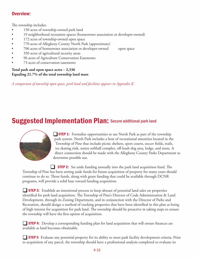
4-12
STEP 1: Formalize opportunities to use North Park as part of the township park system. North Park includes a host of recreational amenities located in the Township of Pine that include picnic shelters, sport courts, soccer fi elds, trails, ice skating rink, senior softball complex, off -leash dog area, lodge, and more. A direct connection should be made with the Allegheny County Parks Department to
determine possible use.
STEP 2: Set aside funding annually into the park land acquisition fund. Th e Township of Pine has been setting aside funds for future acquisition of property for many years should continue to do so. Th ose funds, along with grant funding that could be available through DCNR programs, will provide a solid base toward funding acquisition.
STEP 3: Establish an intentional process to keep abreast of potential land sales on properties identifi ed for park land acquisition. Th e Township of Pine’s Director of Code Administration & Land Development, through its Zoning Department, and in conjunction with the Director of Parks and Recreation, should design a method of tracking properties that have been identifi ed in this plan as being of high interest for acquisition for park land. Th e township should be proactive in taking steps to ensure the township will have the fi rst option of acquisition.
STEP 4: Develop a corresponding funding plan for land acquisition that will ensure fi nances are available as land becomes obtainable.
STEP 5 Evaluate any potential property for its ability to meet park facility development criteria. Prior to acquisition of any parcel, the township should have a professional analysis completed to evaluate its
Suggested Implementation Plan: Secure additional park land
Overview:
Th e township includes: • 150 acres of township-owned park land• 19 neighborhood recreation spaces (homeowner association or developer-owned)• 172 acres of township-owned open space • 770 acres of Allegheny County North Park (approximate)• 706 acres of homeowner association or developer-owned open space• 350 acres of agricultural security areas• 96 acres of Agriculture Conservation Easements• 73 acres of conservation easements
Total park and open space acres – 2,336Equaling 21.7% of the total township land mass
A comparison of township open space, park land and facilities appears in Appendix K.

4-13
topography, site amenities, utilities, recreational opportunities and obstacles, accessibility, and ability to meet the recreation needs of township residents. Typically, two acres of land needs to be acquired for every one acre developed for park space.
STEP 6: Acquire parcels adjacent or near to Pine Community Park as they become available, as shown by the red circles on the map below. Th ese parcels will expand the natural buff er around the park, off er connections to other open space, and provide space for some of the additional facilities needed both now and as the community grows. Connect Pine Community Park to the nearby township-owned open space, as shown with red arrow below.
STEP 7: Acquire land that will allow for the development of new active recreation facilities expected by local residents. Th ese include:
• T-ball fi elds• Rectangular sports fi elds• Sport courts – basketball, volleyball, bocce, horseshoe, etc• Picnic shelters• Outdoor amphitheater• Walking trails• Open recreational spaces• Natural features
STEP 8: Acquire additional property as required for trail development. See the Trails & Connectivity chapter of this report for specifi c locations.
STEP 9: Develop a corresponding funding plan for land acquisition that will ensure fi nances are available as land becomes obtainable.

4-14
STEP 1
STEP 2
STEP 3
STEP 4
STEP 5
STEP 6
STEP 7
STEP 8
STEP 9
YEAR 1 YEAR 2 YEAR 3 YEAR 4+
Suggested Timeline: Secure additional park land
WHEN LANDBECOMESAVAILABLE

4-15
TIER
3 ST
RATE
GY
LOW PRIORITY
+ H
IGH
FEASIBILITY
Parks &Recreation
Review and update all operating policies of the Community Center, recreation, and parksPine Parks and Recreation Department operates under a series of policies that help it to maintain a high level of quality in its operations, fi nances, maintenance, and staffi ng. As the township seeks to improve, across all its departments, its management of assets, the Parks and Recreation Department should look to update and/or create a series of management plans. Th ese include:
• A maintenance plan to establish standards of care, and clear practices for care, upkeep, and rehabilitation of park furnishings, equipment, facilities, amenities, and properties.
• A schedule for replacement of fi tness and other major recreation equipment• A turf grass maintenance and management plan• A ballfi eld maintenance and management plan• A trails maintenance and management plan• A playground maintenance and management plan• A schedule for upgrades and/or replacement of park facilities and equipment• A “useful life” and replacement schedule for all major facilities and equipment • Others that may be deemed appropriate by the department of the Township • A capital improvements plan and budget
Basketball and gear at the ready.

4-16
TIER 3 STRATEGY
LOW PRIORITY + HIGH FEASIBILITY
Parks & Recreation
Develop a Community CenterMarketing PlanAN EYE ON INCREASED USE: As of the writing of this report, Pine Community Center has been in operation for about six years. During these early years of operation, marketing of the facility has been done through the
township’s program brochures, ads and fl iers, yet a formal marketing plan has never been developed. It would be benefi cial to develop a more directed and
focused marketing plan to inform township residents and others of the benefi ts of membership and to attract new users.
While the Community Center has continued to increase its use, membership and annual income in each consecutive year of operation, this trend will not necessarily continue. Th e failure of many businesses, be they for-profi t or non-profi t, often comes as a result of lack of understanding who they serve and how to reach those people. Th is is true particularly in a municipal setting. A strong marketing plan will help to ensure continued growth in users and revenues.
Basic components of the marketing plan:• Establish a vision for what you want to accomplish at the Community Center• Defi ne the goals that will help fulfi ll your vision• Defi ne what you hope to accomplish through marketing and what results you desire • Identify your target market. Th ere may be various segmentations of your target audience• Develop methods of reaching each market audience• Build your brand – use a logo, tag line, description, colors, etc., to help ensure that people always
recognize the brand that is Pine Community Center• Use a variety of methods of outreach –
- print, electronic, digital, and social media- networking and relationship building- maintain existing customers- reach out to new customers- residents fi rst- attracting non-residents
• Evaluate how your management and operational goals are aff ecting your ability to fulfi ll your vision • Evaluate the success of your marketing plan • Contract with a professional if additional help is needed

4-17
TIER
3 ST
RATE
GY
Explore adding aquaticfeatures/facilitiesMany communities with similar demographics as the Township of Pine have constructed aquatic facilities. It could be appropriate for the township to explore opportunities and options related to aquatic features/facilities.
Should the Board of Supervisors choose to proceed with additional steps to determine the feasibility of adding aquatic features or facilities to the Pine Community Center, a multi-phase process will help answer outstanding questions or provide additional information as to the feasibility of the project.
Th e steps may include (but are not bound by or limited to) the following:• A detailed survey of the residents to help determine the desire of adding aquatic features/facilities.• A referendum of registered voters of the township.• Preparation of detailed construction cost estimates.• Preparation of detailed operation cost estimates.• Preparation of anticipated long-tem capital replacement cost estimates.• Exploration of potential funding opportunities.• Exploration of potential grant opportunities.
MEDIUM PRIORI
TY +
LOW FE
ASIBILITY
Parks &Recreation

4-18

4-19
NOTESParks &
Recreation

4-20

4-21
NOTESParks &
Recreation

4-22

4-23
NOTESParks &
Recreation

4-24

5-1
Public Infrastructu
reInside: Improve/extend stormwater management Identify potential areas for expanding public sanitary sewers Inventory township-owned facilities and property, and schedule replacement/maintenance Employ data mapping to assess needs and prioritize work Support planned transportation improvements Develop protocol to work with Southwestern Pennsylvania Commission
The Township of PinePERFORMANCEW O R K B O O K

5-2

5-3
Vision: Th e Township of Pine’s public infrastructure
protects and enhances the health, welfare and safety
of people and natural systems.
KEY ISSUE:Public Infrastructure
IntroductionTh e Township of Pine’s arc of rapid development from rural, wooded and agricultural to highly residential in the past 25 years added demands on existing roads and led to construction of new water and sewer lines as well as new stormwater management infrastructure. Infrastructure improvements will be needed to keep up with additional growth, to ensure compliance with new laws and regulations, and to preserve and enhance the health and safety of residents and natural systems.
Talking Points• Increasingly stringent regulations on stormwater management will require the township to expand its
capacity to provide oversight on public and private property. Th is may mean a need for additional staffi ng, expertise and/or equipment.
• Homes in some older neighborhoods use septic systems and not public sewers. Th e township should understand the scope of this situation, particularly in the likely case that stricter water-quality mandates create new responsibilities for the township.
• Th e township has skillfully secured funding for continual road improvements. New projects — and new funding — must be anticipated.
Overview

5-4
ValidationTh ree types of public infrastructure deserve particular attention in the coming decade: sanitary sewers, stormwater infrastructure and roads.
Stormwater: Municipal separate storm sewer systems (MS4s) are required by federal and state regulations and township ordinances to control the discharge of pollutants from stormwater runoff to the greatest practical extent. Updated regulations and requirements are anticipated to roll out in 2018 and every fi ve years thereafter. Th ese increasingly stringent rules, which are likely to aff ect public and individual private properties as well as watersheds, will generate a need for the township to provide additional oversight, such as mapping and testing.
Sanitary: Th e township’s Water and Sewer District Fund provides a provision for extending main public sewer and water lines to older homes: Th e Board of Supervisors may create a sewer or water district after receiving a petition from residents in need of these utility services. Th e cost of extending the sewer or water line is paid initially out of the fund, and aff ected residents reimburse the township for the cost. However, this provision does not always guarantee a timely resolution of a potentially serious public health problem and threat to township streams in the event that septic systems fail or if new federal and state regulations are imposed in the future.
Roads and Traffi c: Residential growth has increased the traffi c load on local streets and roads. Th e township has continually provided improvements, including projects funded via transportation impact fees and legislative sources. New projects will be needed as the township, and neighboring communities, which generate pass-through traffi c, continue to grow.
Growth in number of commuters illustrates demand
Number of workers (age 16+) commuting 2000 2008-2012 avg. (est.)Commuting alone in a vehicle 2,726 4,246Carpooling 200 462

5-5
Tier 2 - STORMWATER MANAGEMENT: Identify new demands on township resources to meet the requirements of 2018 MS4 regulations, which are expected to create aggressive new mandates for reducing runoff and protecting water quality of streams. Outline ways the township can develop additional
capacity to provide oversight of stormwater infrastructure down to the individual lot level. (Please see Pages 5-9 to 5-10.)
Tier 2 - SANITARY SEWER INFRASTRUCTURE: Identify the ways that anticipated new regulations regarding water quality are likely to intersect with health issues that arise when septic systems fail. Identify the township areas currently served by septic systems and rate by likelihood the need for future public sewer service. (Please see Pages 5-11 to 5-12.)
Tier 2 - MAINTENANCE OF TOWNSHIP-OWNED FACILITIES: Inventory the facilities, including buildings, sidewalks, trails, lights and other features, that were installed by developers but now are township-owned. Develop timeline for the anticipated lifespan of these items and create plan for maintenance or capital replacement in the future. (Please see Pages 5-13 to 5-14.)
Continued on next page
Public InfrastructureImplementation and Management Strategies
Tier 1: High priority and high feasibilityTier 2: High priority and medium feasibility, or medium priority and high feasibilityTier 3: Low priority and high feasibility, any priority and low feasibility, or statement of support for high-priority existing position.
The tier ratings were established during the preparation of this plan in 2015, and may change depending on external circumstances such as tax revenues, the overall economy, new laws or regulations, or the availability of funding.

5-6
Continued from previous page
Tier 2 - DATA MAPPING: Th e township should upgrade GIS (geographic information systems) mapping capabilities, including staff training. Using industry standard software products, the township can employ data mapping to understand trends, assess needs and prioritize work. (Please see Page 5-15.)
Tier 3 - ROAD WORK / TRANSPORTATION PROJECTS: Th is comprehensive plan supports the priorities of the township’s fi ve- and 10-year transportation plans. (Please see Page 5-16.)
Tier 3 - ROAD WORK / TRANSPORTATION PROJECTS FUNDING OPTIONS: Develop additional protocol for working with Southwestern Pennsylvania Commission with the goal of getting transportation projects on the SPC’s funding cycle. (Please see Page 5-17.)
Public InfrastructureImplementation and Management Strategies

5-7

5-8

5-9
TIER
2 ST
RATE
GYOverview: Th e new responsibilities, which the township should be prepared for by 2018, when its next permit period begins, appear at this time to include such issues or practices as:• Increased public involvement in the stormwater management process.• Responsibility for additional types of pollutants entering township streams - expanding the list from bacteria,
silt and sedimentation to also include nutrients such as phosphorus and nitrogen.• Responsibility for outfl ows into the MS4 or township surface waters from private properties, down to the lot
level.• Responsibility to identify and eliminate illegal discharges that can harm the quality of surface waters.• An expectation of complete documentation of all steps toward meeting minimum control measures,
including data collection and mapping.• Th e possibility of audits or inspections by the state
Department of Environmental Protection and/or the federal Environmental Protection Agency. Th ese could be “desktop” reviews of all documentation, ordinances, and local regulations, or site visits to assess stormwater facilities.
Improve stormwater managementSTORMWATER MANAGEMENT: Identify new demands on township resources needed to address anticipated 2018 regulations on municipal separate storm sewer systems (MS4s). Th e regulations are expected to create aggressive new requirements for reducing runoff and protecting water quality of streams. Outline ways the township can develop additional capacity to provide oversight of stormwater infrastructure.
Talking Points• As owner and operator of a municipal separate storm sewer
system, the Township of Pine has a responsibility to use minimum control measures to keep runoff from polluting surface waters, including the eight streams in the township.
• Th e township’s existing stormwater management program complies with current regulations but will need to be updated to meet new requirements.
• A new version of the regulations is expected to be in place as of 2018, and some of the probable changes are already known. Th ese will require more time, new skills and additional attention from the township.
• Reporting periods under the revised regulations will change from every fi ve years to an annual basis, although some other required “paperwork” will simultaneously be reduced.
HIGH PRIORITY +
MED
IUM
FE
ASIBILITY
PublicInfrastructure
Vision: Th e Township of Pine contributes to public health, as
well as the long-term viability of local watersheds and the region’s
natural systems by meeting or exceeding federal, state
and local standards for stormwater
management.

5-10
Suggested Implementation Plan: Improve stormwater management
STEP 1: Working with township engineers, the Allegheny County Conservation District, state Department of Environmental Protection and Southwestern Pennsylvania Commission, remain abreast of anticipated changes to the MS4 requirements.
STEP 2: Review existing stormwater management program against future regulations.
STEP 3: Plan to adopt a new stormwater management ordinance that will incorporate signifi cant public input, and will not only meet but exceed regulatory standards while adding
minimal cost burdens for landowners and developers.
STEP 4: Explore feasibility or need for enacting a stormwater management fee (such as per square foot of impervious surface), or other means of increasing revenue to help pay for additional township responsibilities. (See example, Mt. Lebanon, PA, Appendix L.)
STEP 5: Pursue new or improved working relationships with local environmental groups or advocates.
STEP 6: Pursue training opportunities for township staff to enhance capability at conducting visual inspections, collecting data and mapping.
STEP 7: Implement an aggressive illegal discharge detection and elimination program, with strong public involvement, to test for additional contaminants as required by the state Department of Environmental Protection (DEP). (See Guidance Manual, Appendix M.)
STEP 8: Participate in a pilot program with the Allegheny County Conservation District to incorporate crowdsourcing into illegal discharge detection and elimination program.
STEP 9: Develop documentation protocols and fi ling systems, in preparation for potential DEP and/or EPA reviews, including participating in a pilot program with the Allegheny County Conservation District to create a framework for data management. (Th is will require GIS capacity. See “Data Mapping” strategy, Page 5-15.)
STEP 10: Develop protocols and a schedule for inspecting stormwater facility outlets.
A page from the Illegal Discharge Detection and Elimination Manual shows the types of outfalls that should be inspected.
Ductile iron round pipe 4-6” HDPE; Check if roof leader connection (legal)
Field connection to inside of culvert; Always mark and record.
Small diameter (<2”) HDPE; Often a sump pump (legal), or may be used to discharge laundry water (illicit).
Elliptical RCP; Measure both horizontal and vertical diameters.
Double RCP round pipes; Mark as separate outfalls unless known to
connect immediately up-pipe
Culvert (can see to other side); Don’t mark as an outfall
Open channel “chute” from commercial parking lot; Very unlikely
illicit discharge. Mark, but do not return to sample (unless there is an
obvious problem).
Small diameter PVC pipe; Mark, and look up-pipe to find the origin.
CMP outfall; Crews should also note upstream sewer crossing.
Box shaped outfall CMP round pipe with two weep holes at bridge crossing. (Don’t
mark weep holes)
Figure 22: Typical Outfall Types Found in the Field

5-11
Overview: Township ordinances provide the following mechanism for neighbors to work together with the township to have public water or sewer service installed along their streets: Th e board of supervisors may create a sewer or water district after receiving a valid petition from all residents in need of the service. Th e cost of extending the water or sewer line is paid initially out of the water/sewer district. Th e residents divide the cost
and reimburse the township for the cost of the extension.
Practically speaking, this seldom happens because the cost to each property owner can easily reach thousands of dollars to pay for the new line on their property as well as the shared main line. Although 100% participation is not required to create a district, it is highly unusual for all residents of a street to agree to the costs.
Sewer Authority service areas: Th e township areas served by three diff erent sewer authorities are identifi ed on the township Infrastructure Map (See Page 5-6).
Future sewer service: Unserved residential areas are rated as likely, somewhat likely and unlikely to have public service in the future, based on geography and proximity to available service (See Page 5-6).
Vision: Th e Township of Pine anticipates the community’s
future needs for improved public sanitation by creating
a long-term plan for sanitary sewer service.
Develop a long-term planfor sanitary sewersIdentify the ways that anticipated new regulations regarding water quality are likely to intersect with health issues that arise when septic systems fail. Identify the township areas currently served by septic systems and rate by likelihood of future public sewer service.
Talking Points• Some residential areas were constructed before sanitary
sewer lines were widespread in the community.• Th e homes in most of these areas served by septic were
constructed in 1950s-1970s, or 40 to 60 years ago. Septic systems typically have eff ective life spans of 30 years.
• Some residential pockets currently using septic systems are highly unlikely to have public sewer service in the future due to geography and low density. Other areas may be possible for conversion.
• Th e costs to homeowners for conversion have not been estimated, but conversion to public water and sewer service can be cost-prohibitive for some property owners.
• Pennsylvania Act 537 requires municipalities to plan to provide sanitary sewers to residents currently using septic systems.
• Even as more septic systems reach the end of their eff ective life spans, new or stronger regulations govern the health of streams and of people, creating potential consequences to the township for failures of private septic systems.
Photo illustrating sewer line installation.
MEDIUM PRIORITY
+ M
EDIU
M FEASIBILITY
PublicInfrastructure
TIER
2 ST
RATE
GY

5-12
Suggested Implementation Plan: Develop a long-term planfor sanitary sewers
STEP 1: Establish an understanding of how many households within the township are not tied in to public sanitary sewers, and of the proximity of those households to main collector lines.
STEP 2: Determine which households, streets or neighborhoods are likely, somewhat likely or unlikely to have public tie-ins in the future, based on proximity and geography.
STEP 3: Produce estimate of probable costs for connecting locations that are “likely” or “somewhat likely.”
STEP 4: Review existing township mechanisms that residents may employ to connect their homes to public water and sewer lines, and determine whether those mechanisms could or should be adjusted to encourage future connections.
STEP 5: Explore the feasibility of or need for establishing a township water/sewer district to raise money to extend public services to township residences currently using septic systems and/or private wells. Any fee-based initiative could include a sunset clause for the time when all township properties have public utility services.
STEP 6: Meet or converse at least once a year with a representative of each of the four sewer authorities operating in Pine Township to identify potential mutual goals and foster long-term working relationships.
STEP 7: Meet with residents whose properties are not connected to public sewers, and initiate awareness-building eff orts about creating sewer districts.

5-13
Inventory and maintenanceof township-owned facilitiesINVENTORY AND SCHEDULE: Continue to inventory the facilities, including buildings, sidewalks, trails, lights and other features, that were installed by developers but now are township-owned. Develop timeline for the anticipated lifespan of these items and create plan for maintenance or capital replacement in the future. MEDIUM PRIO
RITY
+ H
IGH
FE
ASIBILITY
PublicInfrastructure
TIER
2 ST
RATE
GY
Vision: Th e Township of Pine anticipates future needs in
providing a safe, healthy and positive environment for the
community by tracking, maintaining and replacing
township-owned property.
Talking Points• Residential and commercial development grew
exponentially in the past 30 years.• Th e township has required developers to install appropriate
facilities, features and amenities that enhance the health, welfare and quality of life of residents and visitors.
• Over time, the township has assumed ownership of streets, sidewalks, trails, lights and other facilities that developers installed.
• Th e township’s inventory of these facilities, features and amenities has no schedule for tracking maintenance or replacement needs.
Overview: Th e township should begin by further developing an inventory of facilities initially built by developers but now owned by the township, including the condition of the property item. Th is inventory can be created using GIS mapping and data spreadsheets.
Once the township has an understanding of these facilities, it can include them in the township’s routine schedules for inspection, and incorporate maintenance, repair and replacement in the appropriate township budgets.
A neighborhood street deeded over to the Township of Pine.

5-14
Suggested Implementation Plan: Inventory and maintenanceof township-owned facilities
STEP 1: Acquire and begin using industry standard GIS software. (See “Data mapping” strategy, Page 5-15.)
STEP 2: Develop a data-gathering mechanism that employees can use in the fi eld and that can be converted to data tables for mapping.
STEP 3: After developing an understanding of the scope and condition of these facilities, prioritize any maintenance, repair or replacement needs and incorporate them into township
management processes.
STEP 4: Incorporate these facilities, properties, amenities and features into township operations and maintenance and/or capital budgets.

5-15
TIER
2 ST
RATE
GY
STEP 1: Select and purchase industry-standard mapping software suite and compatible hardware, including large-screen monitors.
STEP 2: Select and purchase compatible software for mobile inspections and data collection.
STEP 3: Provide access to on- or off -site training to enable staff members to participate in data-collection and / or map making. Th is might include anything from college courses to
online tutorials.
STEP 4: Arrange for ongoing desk-side training for key staff members who manage data or produce maps.
Data mappingEMPLOYING GIS TO INCREASE EFFECTIVENESS OF TOWNSHIP OPERATIONS:
Th e township should acquire industry standard GIS (geographic information systems) mapping capabilities, including staff training. Using industry standard software products, the township can employ data mapping to understand trends, assess needs and prioritize work.
Examples of potential uses in this comprehensive plan include:
• Participate in pilot projects with Allegheny County Conservation District.• Map and track suspected illicit discharges into the municipal storm system.• Map the location and condition of stormwater management facilities.• Map and track failing septic systems.• Create maps for public meetings and other public outreach or education eff orts.• Map the location and condition of township-owned facilities to enable eff ective inspection, maintenance,
repair and replacement.• Map the sources of complaints from residents about public issues.• Update the maps included in this comprehensive plan on an as-needed basis.• Collaboration with Allegheny County and contiguous municipalities on various projects or issues.
MEDIUM PRIORI
TY +
HIG
H FE
ASIBILITY
PublicInfrastructure
Suggested Implementation Plan: Data Mapping

5-16
STATEMENT OF SUPPORT
PublicInfrastructure
TIER 3 STRATEGY
Road work / transportation projectsFIVE- AND 10-YEAR TRANSPORTATION IMPROVEMENT PLANS: Th is comprehensive plan supports the priorities of the township’s fi ve- and 10-year transportations plans. (See Public Infrastructure Map, Page 5-7.)
Th e items below represent the capital improvement projects list from the Township of Pine’s Transportation Impact Fee program.
PRI-ORITY
INTERSECTION /LOCATION
IMPROVEMENT DATE CURRENT UPDATE NOTES
1 Warrendale Rd / Babcock Blvd Rechannelize and signalize intersection N/A Completed2 N. Chapel Rd and Route 910 Reconstruct and widen roadway N/A Completed3 High School Dr. and Warrendale
RdConstruct westbound left turn lane on Warrendale
N/A Completed
4 Brooktree Rd/Brooker Dr and U.S. 19
Modify side street geometry and traffi c signal
N/A Completed
5 Brown Rd and U.S. 19 Construct exclusive right turn lane on Brown Rd
N/A Completed
6 N. Chapel Dr/Manor/N. Church Roads and U.S. 19
Construct east- and westbound left turn lanes
N/A Completed
7 Pearce Mill Rd and Route 910 Add eastbound right turn lane on Route 910
N/A Completed
8 Pearce Mill Rd and Route 910 Widen, realign intersection and install traffi c signal
N/A Completed
9 Swinderman Rd and U.S. 19 Install traffi c signal and advanced warning fl ashers
N/A Completed
10 Babcock Blvd and Route 910 Relocate intersection, install traffi c signal and construct turn lanes
N/A In progress
11 U.S. 19 Install adaptive traffi c control system, revise signals (3 intersections)
N/A Completed
12 Warrendale Rd and Graham/Wal-lace Rd
Widen approaches and install signal 2018 In progress
13 Franklin Rd and Warrendale Rd Install traffi c signal and eastbound left turn lane
2018
14 Hill Rd and Route 910 Construct eastbound exclusive left turn lane
2019
15 Mars Rd and Warrendale Rd Install traffi c signal and eastbound left turn lane
2020 Turn lane completed
16 Babcock Blvd and Bakerstown Rd Construct eastbound left turn lane and install traffi c signal
2020
17 Pearce Mill Rd and Warrendale Rd
Install traffi c signal 2020
18 Route 910 Widen to 3 lanes from Marshall line to N. Chapel Dr
2025
19 N. Chapel Dr and Route 910 Widen N. Chapel and Route 910 for dual left turn lanes
2025
20 U.S. 19 Widen to 3 thru lanes in each direc-tion with center turn lanes
2025

5-17
TIER
3 ST
RATE
GY
Road work / transportation projects funding optionsSTRENGTHENING PARTNERSHIPS: Develop an additional protocol for working with Southwestern Pennsylvania Commission with the goal of getting transportation projects on the SPC’s funding cycle for potential future funding.
Th e township has a proven track record of securing funding for transportation projects by working directly with elected offi cials, PennDOT and other state agencies or offi cials, and seeking federal funds. Another potential avenue for acquiring state funds is through the work of the Southwestern Pennsylvania Commission, a regional planning authority that manages short-term (four year) and long-term (20 year) transportation planning for the region including Allegheny County municipalities. Funding through these plans are not easy to secure because of competition for fi nite public money. However, the possibility should be explored.
Th e township should enhance its relationship with SPC through increased communication so that the agency is fully aware of the township’s proposed projects and requests, including documentation of conditions and need. SPC strongly suggests these other steps:• Ensuring that citizen comments about township transportation needs are entered into the SPCregion.org
link• Participating in the public comment period for the 20-year long-range plan• Communicating to SPC how township projects fi t into countywide initiatives• Communicating to SPC how township projects align with priorities of neighboring municipalities• Communicating to SPC how potential projects have multimodal components.
LOW PRIORITY +
HIG
H FE
ASIBILITY
PublicInfrastructure

5-18

5-19
NOTES
PublicInfrastructure

5-20

5-21
NOTES
PublicInfrastructure

5-22

5-23
NOTES
PublicInfrastructure

5-24

6-1
Other Topics
Inside:u Examining population growth and community resources
The Township of PinePERFORMANCEW O R K B O O K

6-2

6-3
Population growth and community resources
Introduction: The population in the Township of Pine has grown over decades, and particularly since 2000, providing a long-term trend of annual increases in the township’s sheer numbers of homes and businesses. More assessed property, both residential and commercial, has generated additional tax revenue each year. Moreover, a steadily increasing number of residents paying earned income tax also provided a year-over-year bump in revenue as time went on.
The continuing growth both necessitated and enabled improvements in community facilities and services. For example, the township built its Community Center in 2009 and made improvements to the municipal building entrances and parking areas in 2013, and completed a new multi-purpose playing field in 2013.
Growth drives tax revenue and most municipal expenses, so future growth rates matter a great deal to the Township of Pine.
Other Topics
Source: Southwestern Pennsylvania Commission (spcregion.org)
Improvements were made at the Township of Pine Municipal Building in 2013.
I-279 is completed in 1989, turning
Pine Township into a convenient bedroom
community

6-4
Community “build out” and what happens thenAt least some trends could begin to shift in the coming decade because land that is available for development will be largely built out. Once this happens, the addition of new homes and businesses will thereafter occur only on a far smaller scale as builders fill in scattered vacant properties.It is impossible to predict with certainty when build-out will occur; however, the simple calculations shown here suggest build-out may well happen during the period covered by this 10-year comprehensive plan.
1. During 2004 through 2013, a decade that included times of high-flying growth as well as the Great Recession, Pine Township added an average of 95.8 residential units each year.
2. As of 2015, space remains for an expected 1,300 additional residential units in large-area subdivision plans.
3. If the pace of the past 10 years continues into the future, the town may become built out in 10-15 years.
Commercial build outThe number of lots currently available for commercial development is dwindling, with very few suitable for larger-scale projects.
Location Zoning District Approx. Lot Size Anticipated Use2000 Brooktree C-2 2 Acres Office/Service105 Brooker C-1 <1 Acres Small Retail11104 Perry C-1 10 Acres Retail11199 Perry C-2 <1 Acres Small RetailVillage Lot 10-1 TC-PRD 3 Acres Retail/multifamilyVillage Lot 1000 TC-PRD <1 Acres Small Retail2000 Copperleaf C-2 20 Acres Office/Service12590 Perry C-1 <1 Acres Small Retail11139 Babcock C-2 8 Acres Service/Office318 Warrendale B-2 25 Acres Small Office/multifamily
Growth’s effect on financeFinancial prudence has been a hallmark of the township’s operations, and is a stated priority of residents and elected and appointed officials. As of 2013, the township proudly stated that its 0.998 property tax rate is the lowest in Allegheny County.
Naturally, both revenue and expenses have been and will continue to be the two main factors in this general equation. Growth in the residential and commercial sectors is likely to continue in the immediate future, with the prospect that revenue will also continue to increase. Expenses will continue to increase due to growth and inflation. However, when the community becomes built out, the growth in revenue will level off (independent of inflation). The township should be prepared. It is important to identify trends and develop projections, providing both the public and township officials with information they need to create plans and make decisions.

6-5
Recent dataResidential development has been the primary driver of growth in Pine Township, with 958 units constructed in 2004-2013. The value of new home construction totaled more than $342 million during the 10-year period, with an average home value of $357,108. The value of 42 non-residential buildings constructed during the same period was slightly more than $100 million.
Renovations or additions for both residential and non-residential properties added more property value for the township, though naturally in lower total amounts.
Tax revenues accounted for approximately 80 percent of total township revenue in 2013. Of that revenue, the earned income tax brought in 45 percent of the taxes collected for general government purposes. Meanwhile, property taxes brought in 17 percent of taxes collected, and real estate transfer tax yielded 18 percent of taxes collected.
The property tax millage rate is .998 percent. (Pine-Richland School District millage rate is 19.2083.) The property transfer tax rate is 1 percent to township and 1 percent to the county. The earned income tax (EIT) rate is 0.5 percent. (Pine-Richland School District income tax rate is also 0.5 percent.)
Slowing growth in property tax revenueAs build-out occurs on the large plots of remaining developable land, the addition of new homes and businesses will be curtailed. Thus the rate of increase in property and earned income taxes that the township has enjoyed in the past few decades will also slow. Although growth in revenue will be slower, it probably will not stop entirely, however. That is because:
1. The value of existing properties could well continue to increase over time, yielding higher property tax revenue for the foreseeable future.
2. When few new buildings can be constructed, more people are likely to put money into improving existing properties through additions and alterations. Improvements add value to existing properties, providing another generator of increased property tax revenue.
Still, the rate of increase in property tax revenue is unlikely to match the pace that has occurred when additional properties were consistently being added to tax rolls.

6-6
Changing demographics and EIT revenueAs both new construction and population increases level off concurrently, the role of the earned income tax in the township’s budget will likely become ever more important. If the property tax revenue stream levels off as expected, will the earned income tax revenue stream increase to compensate? This may depend on how the demographics of the township change over time, including whether the earned income of future residents will generate more or less tax revenue than has been the case in recent decades. Wage-earning householders pay more in taxes than do retirees, for example.
During the most recent, high-growth decades, the percentage of the population age 65 and older declined steadily. Meanwhile, the percentage of the population in its wage-earning years increased.
Table 1: Age as percentage of total population, 1990-2010Under age 15 15 to 64 years Age 65 and older1990 2000 2010 1990 2000 2010 1990 2000 201020.6% 30.1% 26.0% 64.9% 60.3% 66.6% 14.5% 9.6% 7.4%
If the township’s demographics remain constant, with housing consistently occupied by families with average earned incomes of $84,000 or higher, the earned income tax revenue would also remain constant, or more likely grow with inflation over time. However, if the township’s demographics change in such a way that a significant number of households are occupied by retired individuals with far lower earned income, then it stands to reason that the township’s revenue stream from earned income taxes would stop growing or decline.
Changing needs for services and facilities When the rate of growth in new home construction slows, the town’s population growth will decelerate too. This will mean a leveling off in demand for additional facilities and services that in the past had been driven purely by the presence of more and more people. For example, when 200 additional children live in a community each year compared with the previous year, the community is likely to need a steady increase in numbers of playing
Source: Southwestern Pennsylvania Commission (spcregion.org)

6-7
fields and recreation programs. But when new houses aren’t being built and additional children aren’t moving in, the pace of increasing demand levels off.
Aside from the matter of overall growth is, once again, the issue of changing age demographics. A demographic shift profoundly affects what facilities and services residents will expect the township to provide. In the past few decades, as shown earlier, the numbers of residents age 65 and older has decreased as a percentage of the total. But if today’s residents choose to age in place during the next 20 or 30 years, the result will be a different demographic makeup than currently exists. If aging residents and retirees choose to leave the township, selling their homes to other families with children, the township’s demographic profile will remain roughly unchanged. The divergent future circumstances create different demands on the township. For example, a more elderly population would not need all the sports playing fields or summer rec programs that had been in demand 10 years earlier, but may need more walking paths.
It should be noted that decisions the township makes at this time can encourage one future circumstance over another.
For example, the township could decide now to encourage older residents to remain in the township through policy actions that encourage construction of garden apartments, other zero- or low-lot-line housing types, and continuing care facilities. Conversely, the township could emphasize the future construction of single-family homes on remaining available space to maximize the likelihood that future residents will be families with children and higher earned income. This scenario anticipates that current residents, as they age, would choose to move to other townships that provide housing types that are relatively scarce in Pine.

6-8


619 East Ohio Street, Pittsburgh, PA 15212412.321.6362 [email protected]
ASSOCIATESP SHEK L A N D S C A P E A R C H I T E C T U R E
-
D E S I G N P L A N N I N G
-