Executive Officer's Report for September 2020 - State Water ...
28
EXECUTIVE OFFICER’S REPORT September 2020 Covers July 16, 2020 – August 15, 2020 1 Contents 1. Personnel Report .......................................................................................................... 2 2. PFAS Transport, Fate, and Remediation in Groundwater ............................................. 3 3. Bacteria Water Quality Objectives Evaluation Project: August 5, 2020 Public Information Meeting ...................................................................................................... 4 4. Surface Water Ambient Monitoring Program (SWAMP) Implementation Plan .............. 5 5. Draft Environmental Impact Report/Environmental Impact Statement Notice of Availability and Tahoe Regional Planning Agency Hearings for the Tahoe Keys Aquatic Weed Control Methods Test Project ................................................................ 8 6. Eastern Caliornia Regional Cannabis Program Update ................................................ 9 7. Bishop Area Wastewater Authority (BAWA)................................................................ 10 8. Laurel Pond Monitoring Wells Geophysical Subsurface Investigation, Mammoth Community Water District, Town of Mammoth Lakes, Mono County .......................... 13 9. Crestline Sanitation District - Flow Exceedance Violations, Collection System Infiltration and Inflow, Annual Reporting Update ......................................................... 16 10. Investigation of Potential Water Quality Impacts on Lower Aquifer in the Vicinity of Upper Aquifer Contamination, Former George Air Force Base, Victorville, San Bernardino County ...................................................................................................... 19 11. Mono County Collaborative Planning Team Meeting .................................................. 19 12. Mojave Water Agency Technical Advisory Committee Meeting .................................. 20 13. Soil Excavation Activities to Achieve Remedial Action Objectives at Marine Corps Logistics Base (MCLB) Barstow, Comprehensive Environmental Response, Compensation, and Liability Act Areas of Concern (CAOCs) CAOC 10 and CAOC N-2 Area 1, Operable Unit (OU)7 .................................................................... 22 14. Standing Item – Sanitation Districts of Los Angeles County, District No. 20 Palmdale, Groundwater Nitrate Site Clean Up Project ................................................ 24
-
Upload
khangminh22 -
Category
Documents
-
view
0 -
download
0
Transcript of Executive Officer's Report for September 2020 - State Water ...
EXECUTIVE OFFICER’S REPORT September 2020 Covers July 16, 2020 – August 15, 2020
1
Contents 1. Personnel Report .......................................................................................................... 2 2. PFAS Transport, Fate, and Remediation in Groundwater ............................................. 3 3. Bacteria Water Quality Objectives Evaluation Project: August 5, 2020 Public
Information Meeting ...................................................................................................... 4 4. Surface Water Ambient Monitoring Program (SWAMP) Implementation Plan .............. 5 5. Draft Environmental Impact Report/Environmental Impact Statement Notice of
Availability and Tahoe Regional Planning Agency Hearings for the Tahoe KeysAquatic Weed Control Methods Test Project ................................................................ 8
6. Eastern Caliornia Regional Cannabis Program Update ................................................ 9 7. Bishop Area Wastewater Authority (BAWA)................................................................ 10 8. Laurel Pond Monitoring Wells Geophysical Subsurface Investigation, Mammoth
Community Water District, Town of Mammoth Lakes, Mono County .......................... 13 9. Crestline Sanitation District - Flow Exceedance Violations, Collection System
Infiltration and Inflow, Annual Reporting Update ......................................................... 16 10. Investigation of Potential Water Quality Impacts on Lower Aquifer in the Vicinity of
Upper Aquifer Contamination, Former George Air Force Base, Victorville, SanBernardino County ...................................................................................................... 19
11. Mono County Collaborative Planning Team Meeting .................................................. 19 12. Mojave Water Agency Technical Advisory Committee Meeting .................................. 20 13. Soil Excavation Activities to Achieve Remedial Action Objectives at Marine Corps
Logistics Base (MCLB) Barstow, Comprehensive Environmental Response,Compensation, and Liability Act Areas of Concern (CAOCs) CAOC 10 andCAOC N-2 Area 1, Operable Unit (OU)7 .................................................................... 22
14. Standing Item – Sanitation Districts of Los Angeles County, District No. 20Palmdale, Groundwater Nitrate Site Clean Up Project ................................................ 24
2
State and Regional
1. Personnel Report – Eric ShayNew Hires – NoneVacancies:
• Senior Environmental Scientist (Specialist), Compliance & Planning Division, SouthLake Tahoe. This position serves as the Regional Monitoring Coordinator; lead forcoordinating implementation of the Region’s Climate Change Adaptation andMitigation Strategy; and regional specialist for monitoring related special studies,investigations, and projects. The position will provide the lead responsibility formaking policy recommendations, providing technical expertise orally and in writtendocuments, evaluating and drafting environmental documents, and performinganalysis on technically complex and politically sensitive assignments related towater quality monitoring and Water Board response to climate change in theLahontan Region.
• Engineering Geologist, Department of Defense / Site Cleanup Program Unit,Victorville. This position analyzes threat of pollutants to groundwater and surfacewaters, reviews technical reports for cleanup strategies, reviews site investigationresults, reviews proposed cleanup alternatives to ensure compliance with waterquality objectives, prepares enforcement orders, investigates spills, and conductsinspections of cleanup sites and facilities.
• Water Resource Control Engineer, Wastewater & Agricultural Operations Unit,Victorville. This position provides regulatory oversight of projects involvingdischarges to ground or surface waters and projects intended to restore and/orenhance water quality.
• Scientific Aid, Cleanup/Site Investigation & Enforcement Unit, South Lake Tahoe.This position assists staff with administering the site cleanup, underground storagetank, land disposal, and enforcement programs; reviewing reports, and maintainingdatabases; reviews self-monitoring reports for cases, permits and enforcementactions; reviews project files and water quality data to prepare for field inspectionsand permit updates; assists with field inspections; and reviews CaliforniaEnvironmental Quality Act documents.
• Environmental Scientist, Non-Point Source Unit, South Lake Tahoe. This positionprovides scientific and regulatory agency review and comment focusing oncompliance with California Environmental Quality Act (CEQA) requirements ofprojects for potential impacts to water resources from non-point sources ofpollution, especially those associated with grazing and agricultural activities.Position drafts waste discharge requirements or waivers; conducts project reviews;and performs inspections of project areas to ensure activities do not result inincreased sediment, nutrient, and/or pathogen loading to surface waters.
• Scientific Aid, Planning & Assessment Unit, South Lake Tahoe. This position helpsthe SWAMP program collect and process water quality samples and ensure dataquality. The position supports the TMDL and Basin Planning programs throughmapping and data analysis, outreach, and reporting.
• Scientific Aid, Wastewater & Agricultural Operations Unit, Victorville. This positionsupports the unit in evaluating submitted self-monitoring reports for compliance with
3
waste discharge requirements. Other duties include supporting staff in conducting project-specific data analysis.
Departures – None
North Lahontan Region
2. PFAS Transport, Fate, and Remediation in Groundwater – Kerri O’KeefeOn June 24 and 25, 2020, Water Board staff attended a Per- and PolyfluoroalkylSubstances (PFAS) Transport, Fate and Remediation in Soil and Groundwater trainingcourse through the Water Board’s Training Academy and UC Davis Extension. The courseexplained what PFAS compounds are, the complexity of the compounds, how PFASmoves through the environment, and techniques that can be used to remediate PFAS-affected soil and groundwater. The PFAS compounds are emerging contaminants ofconcern that include more than 3,000 manmade chemicals used in thousands ofprocesses and products since the 1940s. PFAS compounds became popular becausethey repel oil and water, are resistant to high temperatures, and reduce friction. Thecompounds have entered the environment through firefighting activities, landfilling,biosolids applications, refining, metal plating, municipal sewer systems, and manufacturingof products including textiles/carpets, cosmetics, sunscreen, bug spray, electronics,waterproof clothing, and paper products.Soil and groundwater contamination from PFAS compounds are present world-wide. Oneissue with PFAS compounds is that there are thousands of PFAS precursors, hundreds ofintermediate transformation products, and the compounds occur in various ionic states.Each fluorinated compound has very different physical and chemical properties; andtherefore, behaves differently in soil and groundwater.Potential health effects of PFAS in humans include possible changes in growth andlearning behavior, decreased fertility, liver effects including increased production ofcholesterol, and immune effects including decreased vaccination response and asthma,and cancers of the kidney, reproductive organs, and prostate. PFAS occur widely inplants, invertebrates, fish, and humans through bioaccumulation processes. PFAStypically bio-transforms into other fluorinated compounds and bioaccumulate in theenvironment, but do not biodegrade. Attenuation is primarily based on biotransformation,diffusion, and sorption.PFAS remediation technologies now in use include sorption with activated carbon, ionexchange, membrane filtration including reverse osmosis and nanofiltration, foam andozone fractionation. Bioremediation and chemical oxidation/reduction technologies areavailable but are less utilized. A pilot study began in June 2020 to evaluate remedialtechnologies using electrochemical oxidation, plasma treatment, and sonochemicalsynthesis, but these technologies are expensive and/or not readily available.Currently, the only practical treatment for PFAS-contaminated groundwater is pump andtreat with activated carbon and ion exchange. Powdered or granular activated carbon canremove the PFAS molecules from water; however, regeneration, disposal, andreplacement of exhausted sorbents must be considered because adsorption is a non-destructive process. No chemical degradation or transformation occurs, and risksassociated with disposal of the exhausted sorbents must be considered. Ion exchange haskey advantages over granular activated carbon including faster reaction rates, higheroperating capacity, and less media replacement. A case study of PFAS contamination atPease Air Force Base in New Hampshire indicates ion exchange requires less treatment
4
vessels, less overall contact time, can sustain a higher pump rate, treats a larger volume of water, and exchange resin can be regenerated in the field. Completion of the PFAS training course is expected to help Water Board staff be more effective with work such as evaluating work plans for PFAS investigation and remediation, interpreting PFAS analytical data, and evaluating the fate and transport of the compounds.
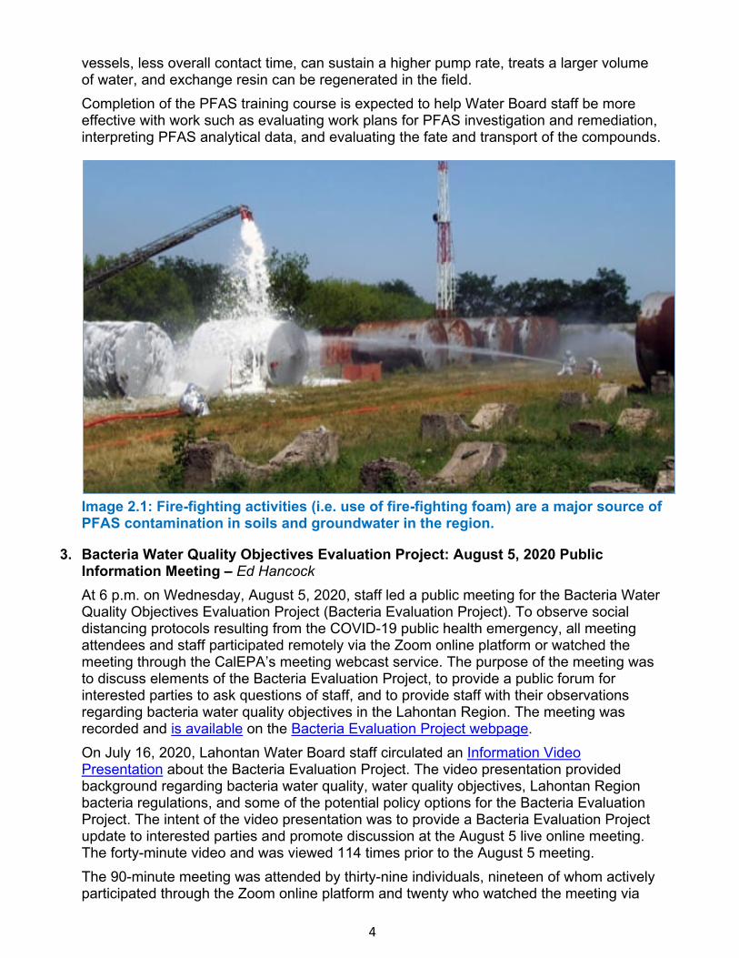
Image 2.1: Fire-fighting activities (i.e. use of fire-fighting foam) are a major source of PFAS contamination in soils and groundwater in the region.
3. Bacteria Water Quality Objectives Evaluation Project: August 5, 2020 PublicInformation Meeting – Ed HancockAt 6 p.m. on Wednesday, August 5, 2020, staff led a public meeting for the Bacteria WaterQuality Objectives Evaluation Project (Bacteria Evaluation Project). To observe socialdistancing protocols resulting from the COVID-19 public health emergency, all meetingattendees and staff participated remotely via the Zoom online platform or watched themeeting through the CalEPA’s meeting webcast service. The purpose of the meeting wasto discuss elements of the Bacteria Evaluation Project, to provide a public forum forinterested parties to ask questions of staff, and to provide staff with their observationsregarding bacteria water quality objectives in the Lahontan Region. The meeting wasrecorded and is available on the Bacteria Evaluation Project webpage.On July 16, 2020, Lahontan Water Board staff circulated an Information VideoPresentation about the Bacteria Evaluation Project. The video presentation providedbackground regarding bacteria water quality, water quality objectives, Lahontan Regionbacteria regulations, and some of the potential policy options for the Bacteria EvaluationProject. The intent of the video presentation was to provide a Bacteria Evaluation Projectupdate to interested parties and promote discussion at the August 5 live online meeting.The forty-minute video and was viewed 114 times prior to the August 5 meeting.The 90-minute meeting was attended by thirty-nine individuals, nineteen of whom activelyparticipated through the Zoom online platform and twenty who watched the meeting via
5
webcast. Attendee affiliations ranged from private citizens with interests in bacteria water quality, Water Board staff with interests in the Bacteria Evaluation Project, and staff from external organizations such as the California Cattlemen’s Association, Los Angeles Department of Water and Power, county government representatives, legal representatives from ranching interests, and private consultancy firms. Two Native American Tribes, the Bishop Paiute Tribe and the Big Pine Paiute Tribe, were also represented at the meeting. Attendees to the meeting who submitted questions and comments included private citizens, consultancy firms, a lawyer for Centennial Livestock of Bridgeport Valley in Mono County, and the Inyo/Mono Agricultural Commissioner. Question topics included technical aspects of potential project options, antidegradation concerns, clarifications on bacteria water quality and fecal indicator bacteria, and a likely timeline for the Bacteria Evaluation Project. Comments from the public highlighted the outstanding quality of some of the Region’s surface waters, the value of water contact recreation in the Lahontan Region, and a desire to ensure continued bacteria protections for such waters. One commenter also offered a potential project strategy for staff to consider. Lahontan Water Board staff appreciated those who took the time to join the online meeting and provided feedback about the Bacteria Evaluation Project, and would like to thanks staff members from a range of Water Board offices and programs who provided their assistance and ensured a successful meeting. A total of twelve Water Board staff were actively involved in planning and executing the event, including Region 6 Planning and Assessment Unit, Cannabis Unit, and Enforcement Unit staff, staff from the State Water Board’s Office of Information Management and Analysis, Office of Public Participation, and Office of Chief Counsel, and staff from CalRecycle’s Audio/Visual Services office who facilitated the meeting webcast. The November 2020 Lahontan Water Board meeting will include a workshop on the Bacteria Evaluation Project. Staff will provide an update to the Board about the Bacteria Evaluation Project, including more information gathered during the August 2020 public meeting, and will seek Board input and direction on potential project strategies.
4. Surface Water Ambient Monitoring Program (SWAMP) Implementation Plan – Kelly HuckIn response to the SWAMP Core Programmatic Review presented at the July 2019 boardmeeting, SWAMP staff have developed an Implementation Plan that includes fourrecommendations to improve and modernize the current SWAMP program. TheImplementation Plan is a spreadsheet-based document that describes tasks staff haveidentified to address the recommendations, as well as task timeframe, fundingmechanism, and priority. As new opportunities and needs arise, additional tasks can beadded to the Implementation Plan, as it is meant to be an “living” document that canaccommodate emerging issues. The document will also track completed tasks andtherefore be a reference for SWAMP efforts.Outline of Implementation Plan Recommendations and Tasks
1) Re-evaluate monitoring to improve the program and address new challenges,including the following tasks:a) Evaluate the health of the Region’s waters and watersheds, including special studiesb) Adjust Monitoring to adapt to climate changec) Analyze and report on trends of water quality changes in the Region including
20 years of SWAMP data

6
2) Identify opportunities to improve program efficiencya) Improved internal coordination and support between the Water Board’s SWAMP
and Regulatory, Enforcement, and Planning programsb) Increase stakeholder partnerships to improve monitoring efforts
3) Maximize data access and uses of analytical tools using new technology and reportout on trends and other observations
4) Integrate Water Board Priorities in SWAMP more effectivelyCriteria Used for Prioritizing Tasks Nineteen tasks have been identified to address the above recommendations. In order to determine which tasks to prioritize a scoring tool was developed. Implementation Plan tasks are scored using the following criteria, equally weighted:
• Protect Human Health and Aquatic Life• Protect/Improve Aquatic Resources & Surface Water Quality• Supports Disadvantaged Communities• Responds to Climate Change• Project Already Implemented/Resources Secure• Collaboration with External or Internal Resources
The first four task prioritization criterion are Region 6 Water Board priorities (2019 Key Efforts from 2019 Priorities and Accomplishments Report). Inclusion of Water Board priorities as prioritization criteria ensures that Recommendation 4 (Integrate Water Board Priorities into SWAMP more effectively) is addressed by the SWAMP Implementation Plan. As Water Board and SWAMP priorities evolve criteria may change, as well. The sections below describe a selection of Implementation Plan tasks that address the Core Programmatic Review recommendations. Implementation Plan, Recommendations, and Tasks in more Detail 1a. Evaluate the Health of the Region’s waters and watersheds, including special studies For close to 20 years SWAMP has performed water quality monitoring to determine if site specific objectives in the Basin Plan are being met. Routine sampling consists of chemistry monitoring at a network of sampling locations. Staff reviews and adjusts monitoring sites in response to new issues and when new information becomes available. For example, after the Integrated Report is finalized sites are either adjusted to investigate new areas of concern or discontinued if it is determined all beneficial uses are being met. The implementation plan highlights the importance of this large baseline dataset and has included this task to support evaluation of the health of the Region’s waters and watersheds. Special studies have always been an important aspect of SWAMP that allows for intense monitoring in specific locations. Currently, SWAMP is involved in two special studies. Eagle Lake Bacteria and Nutrients study is a joint effort between SWAMP, the Nonpoint Source unit, and the Guardians of Eagle Lake. The purpose of the project is to evaluate the existing water quality at Eagle Lake and to identify if current land uses along the shoreline (e.g. grazing) may be contributing pollutants (bacteria and nutrients) to the surface water. Tahoe Keys Laminar Flow Aeration study is a collaborative project with SWAMP and the Nonpoint Source unit and the Tahoe Keys Property Owners Association. The study is evaluating the effectiveness of laminar flow aeration technology (non-chemical control measure) to control harmful algal blooms. Another task staff determined to be essential for the evaluation of watershed health is to continue regular bioassessment monitoring. Biological assessment (bioassessment) is
7
an evaluation of the condition of a waterbody based on the organisms living within it. Scientists and managers around the world use this approach to directly and quantitatively measure the ecological health of a waterbody and to monitor the cumulative impacts of environmental stressors on surface waters. Staff is currently working with California Department of Fish and Wildlife to complete a region wide bioassessment data review of all available bioassessment data, present findings, and determine new bioassessment monitoring goals. To support protection of human health, SWAMP prioritizes collecting fish tissue chemistry data to aid the Office of Environmental Health Hazard Assessment (OEHHA) in the development of fish consumption advisories. Fish tissue collection will sometimes be conducted in collaboration with Integrated Report/TMDL staff, who have identified waters where data shows impairments that threaten human health. 1b. Adjust Monitoring to adapt to climate change Many of the tasks support more than one recommendation. For example, long-term water quality monitoring supports assessing waterbody health and adapting to climate change by maintaining the Region’s long-term permanent sampling locations. The resulting baseline data sets can be used to identify significant trends that may be influenced by climate change. A new task specific to climate change is to install continuous monitoring loggers at SWAMP’s long-term permanent sites and reference sites. Another example, of addressing multiple recommendations, is to continue a regular bioassessment monitoring program. SWAMP staff plans to collect bioassessment data every 3-5 years at the Region’s long-term permanent sampling locations and revisit specified reference sites to monitor changes in the biological integrity of the rivers. Funding additional bioassessment sites for the statewide Reference Condition Management Program (RCMP) would help to track changes over time at reference sites throughout the State. Reference sites define the biological conditions expected in healthy streams when human activity in the environment is absent or minimal. Therefore, long term sampling at sites with the no anthropogenic impacts can help reflect possible indicators of climate change. 1c. Analyze and report on trends of water quality changes in the Region including the prior 20 years of SWAMP data SWAMP is partnering with the San Francisco Estuary Institute – Aquatic Science Center to analyze and report on water quality trends. The report, expected in late 2021, will include: status and trends of ~20 years of SWAMP data, prioritizing the program’s existing nine, long-term, permanent sites; incorporate findings from the bioassessment data review; identify data or information gaps; and recommend potential changes to SWAMP monitoring design. 2. Identify opportunities to improve program efficiencySWAMP will strive to improve general coordination with internal and external partners. SWAMP will continue to meet with the Regulatory, Enforcement, and Planning programs to familiarize SWAMP with their program challenges and for SWAMP to familiarize program managers with SWAMP tools and resources. SWAMP will also prioritize opportunities with external partners to leverage resources. The Eagle Lake and Laminar Flow Aeration study are two examples of these efforts already implemented. 3. Maximize data access and uses of analytical tools using new technology and report outon trends and other observations
8
Staff has been working to create and improve upon data visualization tools. The goal is for SWAMP data and statistical analyses to be accessible to staff and the public through automated graphical representation that is automatically updated through a connection to the CEDEN database. Lahontan Water Board SWAMP staff has been working closely with the Office of Information Management and Analysis (OIMA) staff to display and interpret water quality data. Staff presented this tool to the Water Board at the September 2019 Board meeting during the Executive Officer's reports agenda item. A statewide online data dashboard prototype was released July 2020. SWAMP staff will work closely with State Board to expand the Lahontan data visualization interface to include additional sites and statistical analyses. 4. Integrate Water Board Priorities in SWAMP more effectivelySWAMP staff will use the Implementation Plan to guide and track work completed by the program. Developing the Implementation Plan has also been useful for staff to demonstrate that discrete tasks can respond to the Core Programmatic Review recommendations. It is also a tool for SWAMP to communicate its core functions and efforts to continually improve the program to Water Board colleagues.
5. Draft Environmental Impact Report/Environmental Impact Statement Notice ofAvailability and Tahoe Regional Planning Agency Hearings for the Tahoe KeysAquatic Weed Control Methods Test Project – Russell NormanThe Tahoe Keys Property Owners Association (TKPOA) submitted an application for anindividual National Pollutant Discharge Elimination System (NPDES) permit andexemption to a pesticide discharge prohibition prescribed by the Water Quality ControlPlan for the Lahontan Region (Basin Plan) for the Tahoe Keys Aquatic Weed ControlMethods Test project (Project) in July 2017. The Project is designed to test the efficacy ofseveral aquatic weed control methods, including one-time use of aquatic herbicides toachieve initial knock-down of aquatic weed infestations followed by use of non-chemicalaquatic weed control methods for long-term control. Project testing results are intended tosupport the development of an integrated methods approach to bring aquatic weedinfestations under control within the Tahoe Keys Lagoons.A California Environmental Quality Act (CEQA) Initial Study was performed in 2017 and itwas determined that the Project requires a CEQA Environmental Impact Report (EIR)analysis. The Tahoe Regional Planning Agency (TRPA) has also determined anEnvironmental Impact Statement (EIS), as required by the National Environmental PolicyAct (NEPA), is necessary for TRPA permitting actions. TRPA, as lead NEPA agency, andthe Water Board, as lead CEQA agency, have agreed to prepare a joint EIR/EIS documentfor the Project. Currently, both agencies are planning to bring the EIR/EIS environmentalanalysis and necessary permitting actions before their respective boards by spring of2021. This schedule is subject to change.A Notice of Availability with the Draft EIR/EIS was released on July 6, 2020, starting a60-day public comment period that is scheduled to end on September 3, 2020. The Noticealso included a Notice for Tahoe Regional Planning Agency (TRPA) Hearings with anopportunity for public comment at the on-line hearings. The TRPA hearings were held onJuly 22, 2020 at the TRPA Governing Board Meeting and on August 12, 2020 at the TRPAAdvisory Planning Commission Meeting. A webinar presentation on the Draft EIR/EIS wasalso made to the Stakeholder Consultation Circle (SCC) empaneled for the Project.Comments on the Draft EIR/EIS were solicited at the TRPA on-line hearings and SCC webinar. David Blau with the League to Save Lake Tahoe (League) commented that the
9
League feels strongly that all tools need to be tested; the League is skeptical the non-chemical alternative can achieve the project goals and would risk losing three years in getting control of the infestations; and the League was happy to see full analysis of the No Action Alternative and noted that the analysis makes a compelling case for action and minimal delay. Numerous commenters stressed the importance of reviewing the anti-degradation analysis for the proposed project with the Draft EIR/EIS and asked questions regarding the analysis. Commenters also raised concern regarding harmful algal bloom occurrence in the Tahoe Keys Lagoons and questioned whether TKPOA had exhausted all non-chemical methods of controlling the weeds and demonstrated non-chemical methods are infeasible. TKPOA noted that while the Draft EIR/EIS and anti-degradation analyses assume full label application rates for aquatic herbicide use, TKPOA is proposing reduced application rates based on their field studies in the Tahoe Keys Lagoons. TKPOA also commented that since Lake Tahoe is an Outstanding National Resource Water, use of proven tools for control of aquatic weeds should be supported by regulatory agencies. All Draft EIR/EIS comments received during the public comment period and responses to those comments will be made available following the Draft EIR/EIS comment period.
6. Eastern California Regional Cannabis Program Update – Kathleen Bindl, Carly Nilson,and TJ Middlemis-ClarkSince its inception in 2016, the Eastern California Regional Cannabis Unit, representingthe Lahontan and Colorado River Basin Regional Water Boards has issued 320 Notices ofApplicability: 149 in Region 6 and 171 in Region 7. Staff have conducted 101 inspections,sent 29 staff enforcement letters, issued 14 notices of violation, initiated 3 ACL complaintsat regulated sites in the Colorado River Basin Region, initiated 2 CAOs and an ACLcomplaint for illicit sites in the Lahontan Region, and reviewed cleanup documentation inrelation to an NOV for an illicit site.Due to the COVID-19 lockdown in the spring, staff cancelled 31 planned inspections inMarch and early April. Staff then focused on large-scale programmatic efforts, includingongoing enforcement actions. During that time, the 3 ACL complaints in the ColoradoRiver Basin Region were developed. All 3 ACL complaints were posted for publiccomment in June and have since moved to settlement negotiations. The total proposedadministrative liability amount for the 3 ACL complaints is $621,908.72.Staff also developed Standard Operating Procedures and Sampling Instructions forcollecting water quality data at regulated indoor cultivation sites. These procedures weredeveloped to support a cannabis wastewater characterization study using total maximumdaily load (TMDL) discretionary contract funds. The original intent of the study was to haveWater Board staff collect system water samples during routine site inspections at indoorcannabis cultivation facilities and use the samples to determine typical cannabiswastewater constituents. However, staff are redirecting efforts to assist permittees insample collection because of travel restrictions due to COVID-19 health and safetyconcerns.In addition to the near-term changes to cope with COVID-19, there have recently beenmajor programmatic changes. After 26 years with the Water Board, Eric Taxer, thecannabis unit supervisor, has retired. Eric Taxer was hired as the cannabis unit supervisorin October 2017 and developed this proficient program. Mr. Taxer served as a mentor tonumerous Water Board employees. His contribution to the Water Board is immeasurableand he will be missed.In addition to Eric Taxer’s retirement, the cannabis unit was reduced from six positions,including a supervisor, to two staff-level positions due to significant budget shortfalls. Of

10
the two remaining positions, one staff person is currently reassigned to contact tracing until at least March 2021. This has resulted in dissolution of the unit and integration of remaining program staff into an existing, different unit. As part of the reduction in program resources, staff were directed to pivot efforts from regulated site compliance to addressing unregulated cannabis cultivation sites. This involves identifying unregulated sites, prioritizing the abundance of unregulated sites for inspection, coordinating with law enforcement and other state agencies, collecting site data, and pursuing enforcement actions. Staff have been working on identifying unregulated sites through investigation and outreach. Staff began assisting the State Board Department of Water Rights in the CannaVision project to identify unregulated sites. This effort will provide valuable mapping imagery to identify potential illegal cannabis cultivation sites for further inquiry and enforcement. Staff have also fielded complaints from the public and continue efforts to work with local law enforcement entities to identify if sites are enrolled in the Cannabis permit. Staff have been working on prioritizing unregulated cultivation site response by implementing the Illegal Cannabis Cultivation Enforcement Strategy Framework. The first step is coordinating with the California Department of Fish and Wildlife (CDFW). This coordination includes determining prioritization criteria for Water Boards staff attending enforcement inspections with local law enforcement to better manage limited resources. The goal includes development of a mapping application to determine when to include Water Board and/or CDFW on enforcement inspections to ensure natural resources are protected.
South Lahontan Region
7. Bishop Area Wastewater Authority (BAWA) – Jehiel CassThe Bishop Area Wastewater Authority (BAWA) is a new Joint Powers Authority formed onJune 30, 2020, by the City of Bishop (City) and Eastern Sierra Community ServicesDistrict (District). This milestone means that for the first time, the City and District will beginmanaging its wastewater collection, treatment, and disposal services through a singleentity: BAWA. Walt Pachuki, president of the District’s board was elected as BAWA’s firstchair. Deston Dishon, the City’s Public Works Director, will begin managing day-to-dayoperations leading to integrating services for both entities as BAWA’s Administrator. Afterself-organizing (establishing governing rules and procedures), BAWA will focus its effortson effluent disposal management and optimizing the shared capacity of the twowastewater treatment plants. Integrating the sewer collection systems is a future task.With the combined systems, BAWA manages nearly 50 miles of collection system, theCity’s 1.6 million gallons per day (mgd) wastewater treatment plant, District’s 0.85 mgdwastewater treatment plant, and disposal percolation ponds and recycled water irrigationareas. The current combined flow from both entities is about 1.5 mgd. The effluent has anestimated 25 milligrams per liter of total nitrogen, primarily ammonia.BAWA is planning projects to alleviate conditions of nitrate groundwater pollution beneathits disposal facilities. Currently, much of the effluent is discharged to land owned by theCity of Los Angeles Department of Water and Power (Department). As shown on Figure7.1, BAWA and the Department anticipate completing transfer of 434 acres of land toBAWA for future recycled water irrigation. BAWA expects to acquire operational control ofthe Phase 1 property by the end of 2020, although full title acquisition may take someyears longer. BAWA is working with the Department to obtain a “Right to Enter and
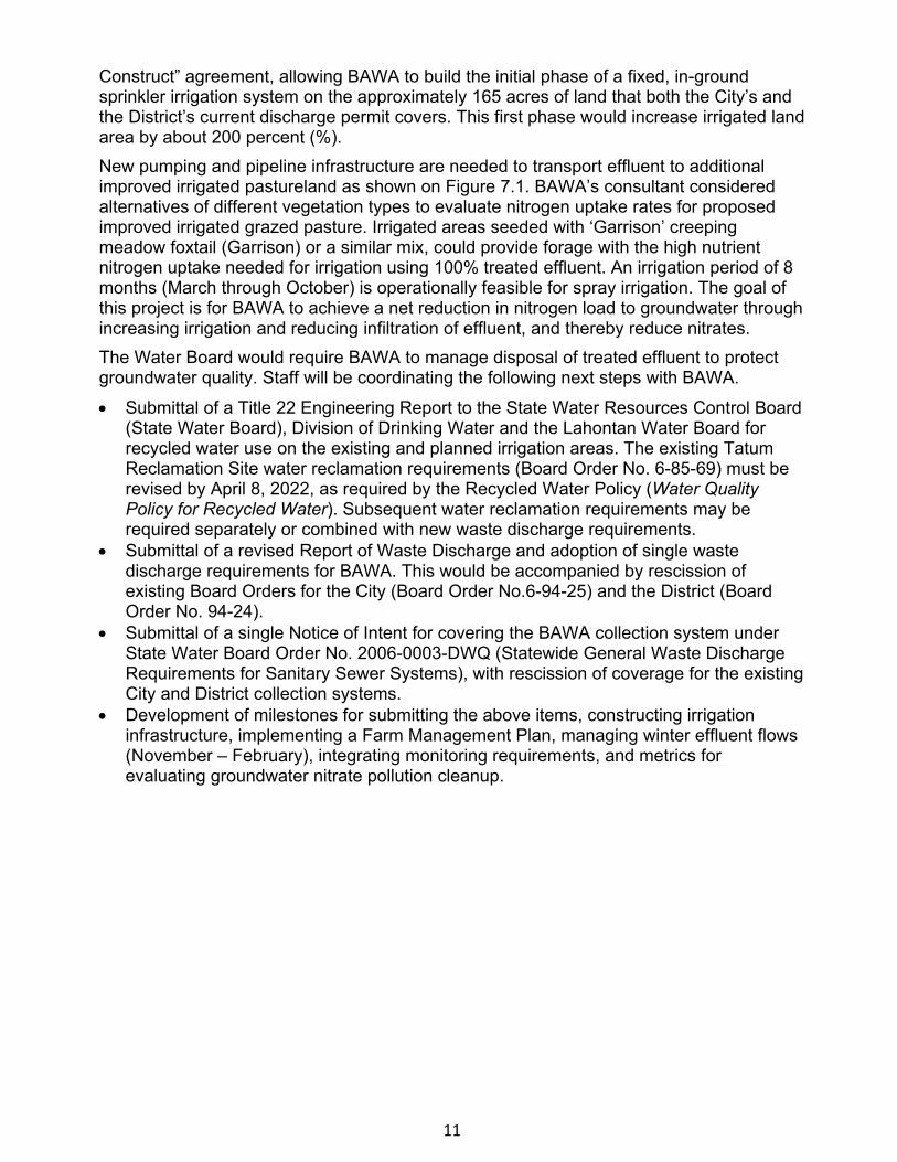
11
Construct” agreement, allowing BAWA to build the initial phase of a fixed, in-ground sprinkler irrigation system on the approximately 165 acres of land that both the City’s and the District’s current discharge permit covers. This first phase would increase irrigated land area by about 200 percent (%). New pumping and pipeline infrastructure are needed to transport effluent to additional improved irrigated pastureland as shown on Figure 7.1. BAWA’s consultant considered alternatives of different vegetation types to evaluate nitrogen uptake rates for proposed improved irrigated grazed pasture. Irrigated areas seeded with ‘Garrison’ creeping meadow foxtail (Garrison) or a similar mix, could provide forage with the high nutrient nitrogen uptake needed for irrigation using 100% treated effluent. An irrigation period of 8 months (March through October) is operationally feasible for spray irrigation. The goal of this project is for BAWA to achieve a net reduction in nitrogen load to groundwater through increasing irrigation and reducing infiltration of effluent, and thereby reduce nitrates. The Water Board would require BAWA to manage disposal of treated effluent to protect groundwater quality. Staff will be coordinating the following next steps with BAWA.
• Submittal of a Title 22 Engineering Report to the State Water Resources Control Board(State Water Board), Division of Drinking Water and the Lahontan Water Board forrecycled water use on the existing and planned irrigation areas. The existing TatumReclamation Site water reclamation requirements (Board Order No. 6-85-69) must berevised by April 8, 2022, as required by the Recycled Water Policy (Water QualityPolicy for Recycled Water). Subsequent water reclamation requirements may berequired separately or combined with new waste discharge requirements.
• Submittal of a revised Report of Waste Discharge and adoption of single wastedischarge requirements for BAWA. This would be accompanied by rescission ofexisting Board Orders for the City (Board Order No.6-94-25) and the District (BoardOrder No. 94-24).
• Submittal of a single Notice of Intent for covering the BAWA collection system underState Water Board Order No. 2006-0003-DWQ (Statewide General Waste DischargeRequirements for Sanitary Sewer Systems), with rescission of coverage for the existingCity and District collection systems.
• Development of milestones for submitting the above items, constructing irrigationinfrastructure, implementing a Farm Management Plan, managing winter effluent flows(November – February), integrating monitoring requirements, and metrics forevaluating groundwater nitrate pollution cleanup.
12
Figure 7.1 – Current BAWA infrastructure is shown with the City’s facilities in yellow and the District’s facilities in tan. Area within the dotted black line is currently authorized for recycled water use under waste discharge and water reclamation requirements. BAWA’s acquisition of 434 acres of Department land would occur in two phases (Phase 1 outlined in green and Phase 2 outlined in red).
13
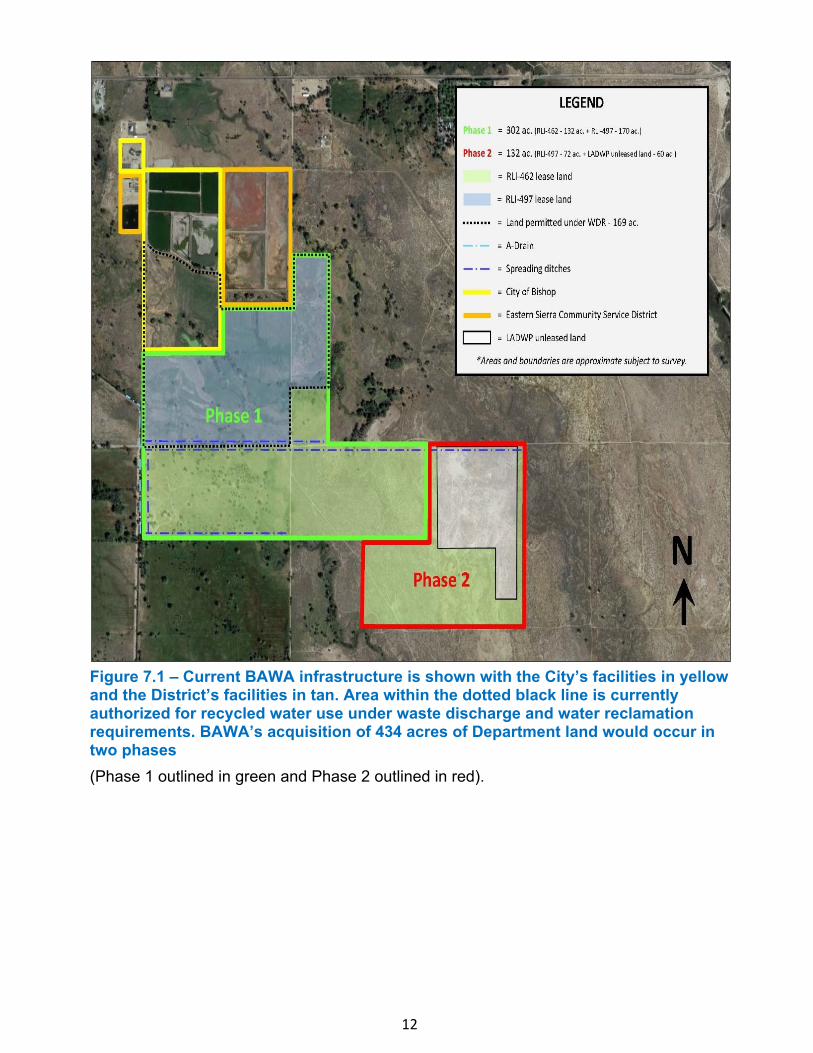
Figure 7.2- BAWA is considering installing on its Department-acquired land a fixed in-ground sprinkler irrigation system to irrigate improved pastureland. This photograph is of a property adjacent to the BAWA wastewater treatment plants showing a similar irrigation system planned for BAWA land.
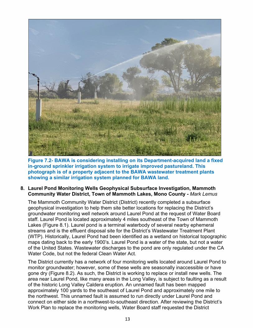
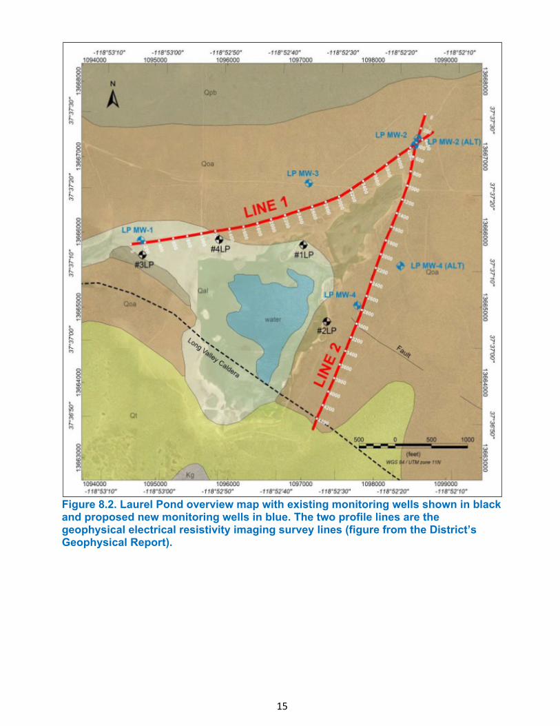
8. Laurel Pond Monitoring Wells Geophysical Subsurface Investigation, MammothCommunity Water District, Town of Mammoth Lakes, Mono County - Mark LemusThe Mammoth Community Water District (District) recently completed a subsurfacegeophysical investigation to help them site better locations for replacing the District’sgroundwater monitoring well network around Laurel Pond at the request of Water Boardstaff. Laurel Pond is located approximately 4 miles southeast of the Town of MammothLakes (Figure 8.1). Laurel pond is a terminal waterbody of several nearby ephemeralstreams and is the effluent disposal site for the District’s Wastewater Treatment Plant(WTP). Historically, Laurel Pond had been identified as a wetland on historical topographicmaps dating back to the early 1900’s. Laurel Pond is a water of the state, but not a waterof the United States. Wastewater discharges to the pond are only regulated under the CAWater Code, but not the federal Clean Water Act.The District currently has a network of four monitoring wells located around Laurel Pond tomonitor groundwater; however, some of these wells are seasonally inaccessible or havegone dry (Figure 8.2). As such, the District is working to replace or install new wells. Thearea near Laurel Pond, like many areas in the Long Valley, is subject to faulting as a resultof the historic Long Valley Caldera eruption. An unnamed fault has been mappedapproximately 100 yards to the southeast of Laurel Pond and approximately one mile tothe northwest. This unnamed fault is assumed to run directly under Laurel Pond andconnect on either side in a northwest-to-southeast direction. After reviewing the District’sWork Plan to replace the monitoring wells, Water Board staff requested the District
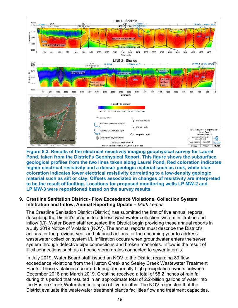
14
complete a geophysical subsurface investigation (Investigation) of proposed new well locations to better define the extent of faulting and refine the subsurface stratigraphy below and adjacent to Laurel Pond with a goal of ensuring proper placement of new wells. The Investigation was completed in June 2020, using an electric resistivity imaging survey along two profile lines to the north and east of Laurel Pond (Figure 8.2). The Investigation resulted in the relocation of two of the proposed monitoring well locations to avoid an interpreted unnamed fault (Figure 8.2) and to ensure future drilled boreholes will encounter weathered and fractured basalt (Figure 8.3). The District is moving forward with groundwater monitoring well construction, and completion is expected during Fall 2020. The new groundwater monitoring well network will help the District and Water Board staff analyze the impact that the District’s WTP effluent has on surrounding groundwater. Water Board staff intend to revise the District’s waste discharge requirements this fiscal year. Water Board staff has expressed concern regarding the fate and transport of nitrogen species to nearby groundwater from discharges to Laurel Pond, as effluent from the District’s WTP disposed into Laurel Pond is currently un-nitrified. This means that most of the nitrogen is discharged as ammonia, which can be toxic to aquatic organisms. Under aerobic conditions, ammonia oxidizes to nitrate (primary drinking water standard is 10 milligrams per Liter). Analytical results from several current groundwater monitoring wells indicate elevated ammonia levels within the groundwater surrounding Laurel Pond, which means that oxidation is occurring further downgradient and in groundwater. Monitoring of the new network of groundwater wells is expected to produce more consistent and representative groundwater sampling results. Water Board staff recommends that the District should pursue upgrades to its existing WTP to reduce overall total nitrogen levels, eliminate ammonia toxicity, and improve water quality in the surface water at Laurel Pond and in the surrounding groundwater.
Figure 8.1. Image of Laurel Pond facing South, taken from site inspection July 10, 2020 (photo taken by Mark Lemus).
15
Figure 8.2. Laurel Pond overview map with existing monitoring wells shown in black and proposed new monitoring wells in blue. The two profile lines are the geophysical electrical resistivity imaging survey lines (figure from the District’s Geophysical Report).
16
Figure 8.3. Results of the electrical resistivity imaging geophysical survey for Laurel Pond, taken from the District’s Geophysical Report. This figure shows the subsurface geological profiles from the two lines taken along Laurel Pond. Red coloration indicates higher electrical resistivity and a denser geologic material such as rock, while blue coloration indicates lower electrical resistivity correlating to a low-density geologic material such as silt or clay. Offsets associated in changes of resistivity are interpreted to be the result of faulting. Locations for proposed monitoring wells LP MW-2 and LP MW-3 were repositioned based on the survey results.
9. Crestline Sanitation District - Flow Exceedance Violations, Collection SystemInfiltration and Inflow, Annual Reporting Update – Mark LemusThe Crestline Sanitation District (District) has submitted the first of five annual reportsdescribing the District’s actions to address wastewater collection system infiltration andinflow (I/I). Water Board staff requested the District begin providing these annual reports ina July 2019 Notice of Violation (NOV). The annual reports must describe the District’sactions for the previous year and planned actions for the upcoming year to addresswastewater collection system I/I. Infiltration occurs when groundwater enters the sewersystem through defective pipe connections and broken manholes. Inflow is the result ofillicit connections such as a house storm drains connected to sewer laterals.
In July 2019, Water Board staff issued an NOV to the District regarding 89 flowexceedance violations from the Huston Creek and Seeley Creek Wastewater TreatmentPlants. These violations occurred during abnormally high precipitation events betweenDecember 2018 and March 2019. Crestline received a total of 58.2 inches of rain fallduring this period that resulted in an approximate total of 2.2-billion gallons of water intothe Huston Creek Watershed in a span of five months. The NOV requested that theDistrict evaluate the wastewater treatment plant’s facilities flow and treatment capacities,
17
considering the increasing number of flow-related violations. The District maintained that the flow violations were the result of long standing I/I- related issues within the sewer collection system, and not related to wastewater treatment plant capacities. The District has, and continues to make, sewer collection system improvements. The intent of the annual reports requested by the NOV is to provide Water Board staff with an assessment of I/I reduction activities. Staff intends to monitor the District’s progress.
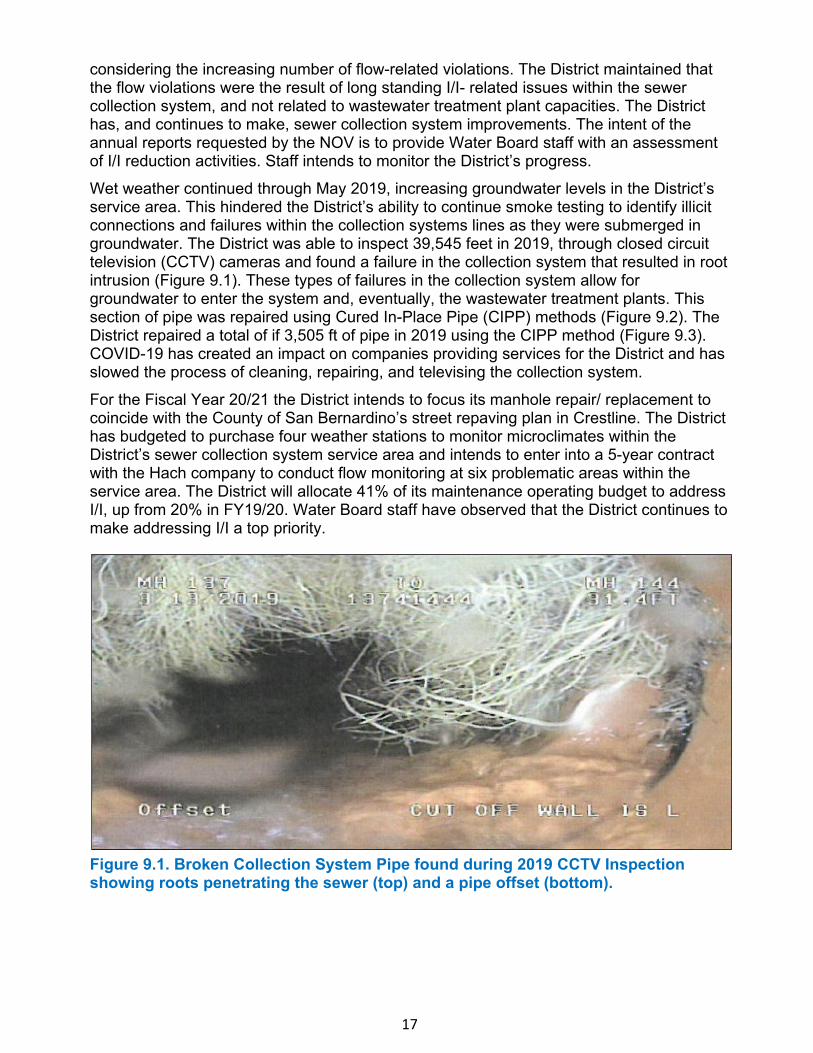
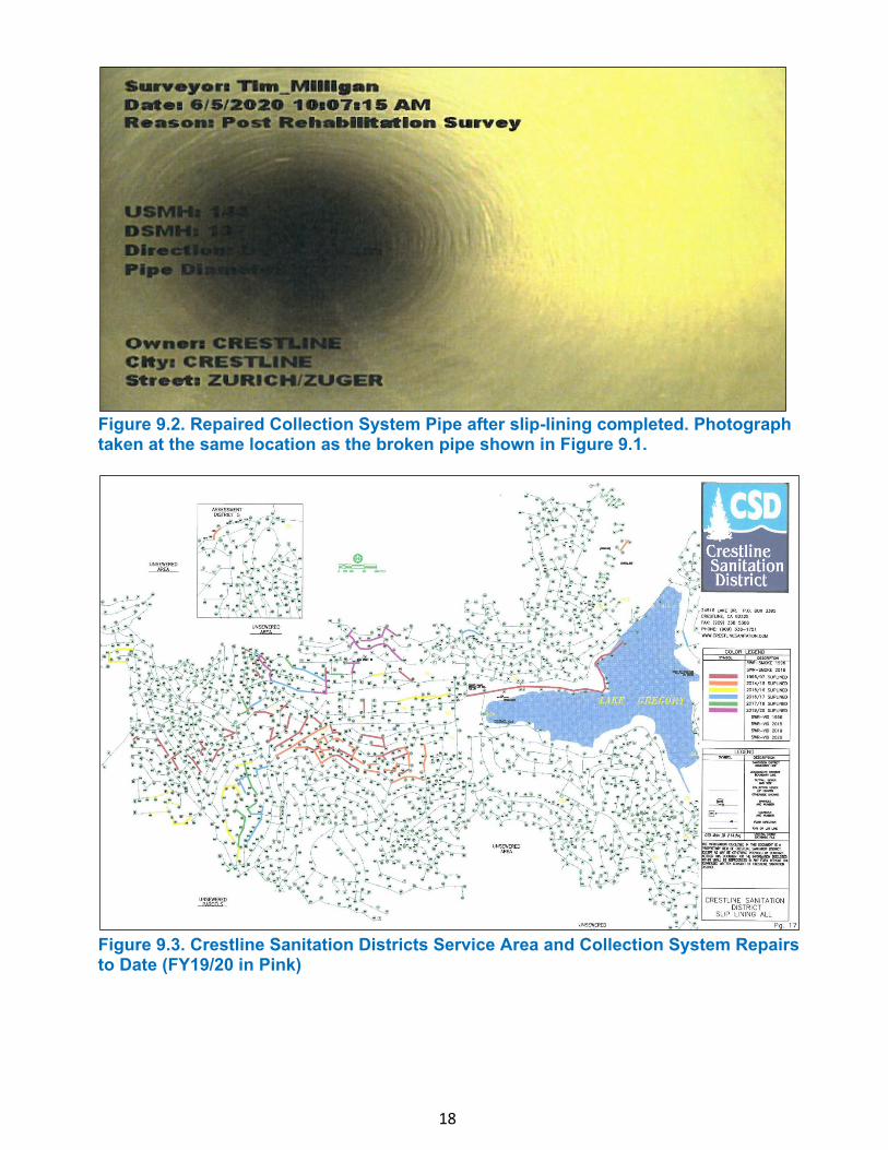
Wet weather continued through May 2019, increasing groundwater levels in the District’s service area. This hindered the District’s ability to continue smoke testing to identify illicit connections and failures within the collection systems lines as they were submerged in groundwater. The District was able to inspect 39,545 feet in 2019, through closed circuit television (CCTV) cameras and found a failure in the collection system that resulted in root intrusion (Figure 9.1). These types of failures in the collection system allow for groundwater to enter the system and, eventually, the wastewater treatment plants. This section of pipe was repaired using Cured In-Place Pipe (CIPP) methods (Figure 9.2). The District repaired a total of if 3,505 ft of pipe in 2019 using the CIPP method (Figure 9.3). COVID-19 has created an impact on companies providing services for the District and has slowed the process of cleaning, repairing, and televising the collection system.
For the Fiscal Year 20/21 the District intends to focus its manhole repair/ replacement to coincide with the County of San Bernardino’s street repaving plan in Crestline. The District has budgeted to purchase four weather stations to monitor microclimates within the District’s sewer collection system service area and intends to enter into a 5-year contract with the Hach company to conduct flow monitoring at six problematic areas within the service area. The District will allocate 41% of its maintenance operating budget to address I/I, up from 20% in FY19/20. Water Board staff have observed that the District continues to make addressing I/I a top priority.
Figure 9.1. Broken Collection System Pipe found during 2019 CCTV Inspection showing roots penetrating the sewer (top) and a pipe offset (bottom).
18
Figure 9.2. Repaired Collection System Pipe after slip-lining completed. Photograph taken at the same location as the broken pipe shown in Figure 9.1.
Figure 9.3. Crestline Sanitation Districts Service Area and Collection System Repairs to Date (FY19/20 in Pink)

19
10. Investigation of Potential Water Quality Impacts on Lower Aquifer in the Vicinity ofUpper Aquifer Contamination, Former George Air Force Base, Victorville,San Bernardino County – Linda StoneThere are three areas of groundwater contamination in the central portion of the formerGeorge Air Force Base, located in Victorville. These groundwater plumes have beencharacterized in the Upper Aquifer (perched aquifer) to varying degrees. The northernplume, Site SS030, is the result of several releases from jet fuel supply lines andunderground storage tanks located on and near the flight line. This jet fuel plume is wellcharacterized in the Upper Aquifer. The much larger southern jet fuel plume, Site ST067b,is less well characterized but its boundary is generally defined in the Upper Aquifer. Theplume in the center of this area, Site OT069e, consists of trichloroethene (TCE). Thisplume is migrating and is not adequately characterized or delineated in the Upper Aquifer.Very few groundwater monitoring wells are installed in the Lower Aquifer (regionalaquifer), and none of the Lower Aquifer groundwater monitoring wells are in locations thatcan adequately evaluate impacts from the Upper Aquifer plumes. The Air Force maintainsthat the presence of a clay aquitard in this area protects the Lower Aquifer from anydownward migration of contaminants. Water Board staff’s experience is that, in mostcases, aquitards allow some migration to underlying zones and there is site-specificevidence that downward migration is likely occurring here.Over the past eight years, Water Board staff has repeatedly insisted that the Air Forceinvestigate this portion of the Lower Aquifer and install additional Upper Aquifer monitoringwells at the poorly characterized TCE plume, Site OT069e. The Air Force recently agreedto install four monitoring wells in the Lower Aquifer and one additional well in the UpperAquifer at Site OT069e. The installation of these wells began in July of this year and theexpected completion date is late August. The installation of the Lower Aquifer monitoringwells is especially challenging because of the depth of the wells (approximately 300 feetbelow ground surface) and because special drilling and well construction practices arenecessary to ensure that no Upper Aquifer contamination is introduced to the LowerAquifer or allowed to migrate into that aquifer.The drilling effort will provide important information regarding the subsurface geology (e.g.,lithologies and thicknesses of the various units). The four Lower Aquifer wells will helpdetermine if contamination has migrated to the Lower Aquifer and provide data for a betterunderstanding of this portion of the Lower Aquifer (e.g., groundwater flow direction andgradient). Based on the evaluation of these data, Water Board staff and the Air Force willbe able to determine if additional actions are necessary and what those actions should be.
11. Mono County Collaborative Planning Team Meeting – Ed Hancock and Jeff FitzsimmonsLahontan Water Board staff attended the Mono County Collaborative Planning Team(CPT) quarterly meeting on July 30, 2020. The CPT serves as an opportunity forrepresentatives from Mono County, federal, state, and local agencies, along with tribalrepresentatives and private citizens to share information, voice concerns, and provides aforum for discussion, coordination, and collaboration of resources and efforts to meet thechallenges faced within the County. The meeting focused on the participating agencies’responses to contend with COVID-19.Most agencies indicated their respective visitor centers and offices remain closed to thepublic. However, some locations are minimally staffed with most of their staff teleworking inresponse to COVID-19. Mono County reported the communities within the county continueto be impacted and the number of COVID-19 cases reported within the county have

20
continued to increase. The Town of Mammoth Lakes has received a COVID-19 assistance grant to support local businesses and provide personal protection equipment supplies. Caltrans, District 9, informed the CPT that traffic through the region has been, and continues to be, very heavy and is approaching pre-COVID-19 levels. The United States Forest Service (USFS) reported their Inyo and Humboldt-Toiyabe National Forest group campgrounds and remote campgrounds remain closed, while their open campgrounds are full and are experiencing near-record attendance. Insufficient parking, illegal camping, and unpermitted campfires, wildfires, and maintenance of facilities are the challenges Inyo and Humboldt-Toiyabe National Forests continue to experience during this period of high recreational use. Attendees were informed that the Lahontan Regional Water Quality Control Board Offices in both South Lake Tahoe and Victorville remain open. However, the offices are lightly staffed, with most staff teleworking. Water Board staff assured the participants that staff will continue to follow-up on spills or complaints and respond as soon as possible to emails and voicemails. The California Department of Fish and Wildlife briefed the CPT on bacterial infections of fish at the Fish Springs, Blackrock, and Mojave hatcheries. Treatment with antibiotics has been ineffective and will subject the fish of all three hatcheries to euthanization. The hatcheries do not anticipate being able to return to normal operations until sometime in 2022. Hot Creek Hatchery remains unaffected. The Town of Mammoth Lakes announced that the Town had been awarded an Infill Infrastructure Grant for the development of affordable housing and Mammoth Mountain Ski Resort will be moving forward with the “Ski Lodge Project.” The Bureau of Land Management (BLM), Bishop Field Office, informed the CPT that environmental documents for the Alabama Hills National Scenic Area had been submitted for public comment in early July 2020. Additionally, the BLM anticipates receiving Great Outdoor Act Funding and having appropriated funding for the next fiscal year. The Mono County CPT serves as an example of successful partnership towards better serving the needs of the county and communities within the county. The next meeting is anticipated to occur in late October 2020.
12. Mojave Water Agency Technical Advisory Committee Meeting – Patrice CopelandWater Board staff attended a meeting of the Mojave Water Agency Technical AdvisoryCommittee (MWA TAC) on August 6, 2020. The MWA TAC is an independent, voluntarygroup of water purveyors, pumpers, and other interested parties located within MWA’sboundaries. The MWA TAC meets in a public forum to discuss common concerns and actsto assist the MWA in pursuit of its legal objectives.During this meeting, Richard Selby of California Rural Water Association gave a briefupdate on small water systems’ business continuity plans and a planned hydrogeologicinvestigation that is starting to acquire data in the mountain communities. This wasfollowed by Nick Schneider of MWA with an update to the region’s Urban WaterManagement Plan (UWMP), which must be updated every five years. The UWMP is a toolused to ensure that long-term water supply needs are available to meet existing and futuredemands. MWA ensures that the UWMP is a regional plan that will include data from allurban suppliers in their service area. This 25-year plan will also estimate projected watersupplies until 2065. Mr. Schneider reported that the area has conserved water andexceeded a goal of 20 percent (%) by 2020 by exceeding that goal and conservingapproximately 39 to 39%. A recycled water use projection is also included in the UWMP,
21
as is climate change as it may affect water supply. MWA has chosen Tully and Young, Incorporated, to assist with drafting the updated UWMP that is due to be submitted to the Department of Water Resources by July 1, 2021. A presentation was made by Nick Schneider to update the TAC members regarding Proposition 1 grants for the Integrated Regional Water Management (IRWM) group’s activities in both the Lahontan and Colorado funding regions. The Lahontan funding region is non-competitive, and the IRWM group received $4.1 million for five Round 1 projects; recipients include the City of Victorville (R3 turnout No. 5), Helendale Community Services District (potable groundwater water well No. 10), City of Hesperia (Walnut St. debris basin), and MWA (R3 Adelanto extension, large-scale cash for grass). Within the Colorado funding region, the process is competitive. Although the IRWM group had applied for $4.45 million, they were only awarded $500,000 to fund a replacement well for the Big Horn Desert View Water District. More funds for both regions will be available during Round 2 and the IRWM group members, with the assistance of MWA staff, plan to apply for more project funding. Mr. Schneider emphasized that projects that are “shovel-ready” are more likely to be approved. MWA’s Nicholas Schneider, gave an update on pending legislation, including SB 414 (Small Water System Authority Act of 2019, which shortens the pathway for smaller water agencies to join together or consolidate under a larger district), AB 1720 (promotion of long-duration energy storage – enacts a pump storage program to be used statewide, but has widespread opposition by many water and environmental groups), AB 3030 (Resource Conservation: land and ocean conservation goals that will authorize setting aside 30% of California’s land), HB 7073 (Special District’s Coronavirus Relief – Federal bill that provides financial relief to special districts for costs related to COVID-19), AB 401 (Low Income Rate Assistance Program for qualifying customers of water agencies), and an update on proposed legislation from the California Department of Fish and Wildlife to list the Western Joshua Tree as an endangered or threatened species. This proposed legislation is opposed by building trade organizations. In addition, MWA has sent correspondence to the Fish and Wildlife Commission, that meets on August 20, 2020, opposing this proposed legislation as it may impact well citing locations, and pipeline and other construction projects in the region. A vote was taken of the TAC members that approved pursuing SB 200 funding. This Senate Bill, approved by the Governor during July 2019, establishes a “Safe and Affordable Drinking Water Fund” and secures a long-term funding source that addresses the lack of safe drinking water in disadvantaged communities across the state. The State Water Board adopted a funding expenditure plan on July 7, 2020, that provides for a “Safe and Affordable Funding for Equity and Resilience (SAFER) Funding Program.” The SAFER Fund provides a set of tools, funding sources, and regulatory authorities designed to ensure that one million Californians who currently lack safe drinking water receive safe and affordable drinking water as quickly as possible. The SAFER Fund will provide $130 million per year that will be used to develop and implement sustainable solutions for small systems with violations of drinking water standards. The money may be spent on operations and maintenance costs, cost of consolidating with a larger system, provision of replacement water, and funding for administrators to run the small systems. MWA was added to the State Water Board’s advisory committee for this program. Within the Lahontan Region, there are $15.2 million available. Four local water systems are out of compliance due to high levels of fluoride, arsenic or uranium, including the Apple Valley View Mutual Water Company, Bar-Len Mutual Water Company, Daggett Community Services District, and Juniper-Riviera County Water District. California Rural Water Association is working with these water systems for SAFER funding opportunities. In
22
addition, “at risk districts” in the MWA service area were also listed. TAC members were urged to contact Mr. Schneider if they believe they should be added to this list. Lastly, Mr. Schneider walked TAC members through new websites for the California Grants portal and the Federal Grants portal. These portals contain search functions that may help member agencies more easily locate appropriate grant funding opportunities and apply for the funds. Mr. Schneider recommended that all member organizations in need of such funds set themselves a monthly reminder to visit these websites and reminded TAC members that MWA is willing to assist them regarding such opportunities. The California grant portal is located at https://www.grants.ca.gov and the Federal grant portal can be accessed at https://www.grants.gov. The next TAC meeting is scheduled for October 1, 2020.
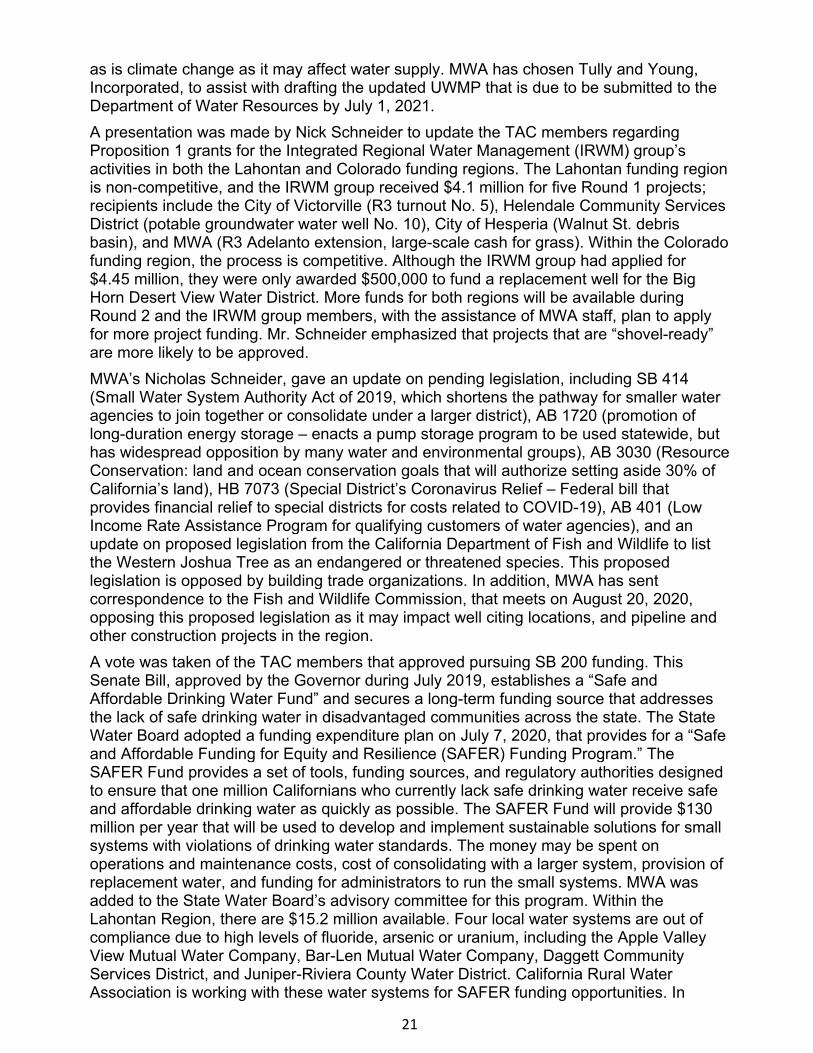
13. Soil Excavation Activities to Achieve Remedial Action Objectives at Marine CorpsLogistics Base (MCLB) Barstow, Comprehensive Environmental Response,Compensation, and Liability Act Areas of Concern (CAOCs) CAOC 10 and CAOC N-2Area 1, Operable Unit (OU) 7 – Christopher AvalosCAOC 10 is located at MCLB Barstow, Nebo Main Base and is wholly contained within thebase boundary (Figures 13.1 and 13.2). CAOC 10 was used as a source of borrowmaterial (an area of clean, uncontaminated soil that was mined for use at differentlocations on base) until approximately 2000, when the Navy discovered sodium-filledvalves, metal debris, and an unidentified canister within the former borrow area. The Navydetermined that material found at CAOC 10 was consistent with a previous MCLBemployee’s account of a site at Nebo Main Base where sodium valves were disposed inthe late 1950s. As a result of past activities at CAOC 10, elevated concentrations of leadhave been identified in soil at concentrations above industrial cleanup-levels (levelsdesignated as unsafe for industrial/construction workers, as well as potential residentialinhabitants).CAOC N-2 Area 1 is a 17-acre site, also located at MCLB Barstow, Nebo Main Base, andwholly contained within the base boundary (Figures 13.1 and 13.2). Historically, militaryequipment was stored at the site from the early 1950s until 1966. The area wasrepurposed as a skeet and trap shooting range that operated from 1982 to 1999. As aresult of these past activities, soil at CAOC N-2 Area 1 is contaminated with lead,polycyclic aromatic hydrocarbons (PAHs), and polychlorinated biphenyls (PCBs) atconcentrations above industrial cleanup levels.On December 12, 2014, a Record of Decision (ROD) was signed by the Department of theNavy (Navy) and regulatory agencies, outlining remedies for all sites within OU 7,including CAOCs 10 and N-2 Area 1. During the remedial design, the Navy and itscontractor determined that the remedy outlined in the ROD would not meet remedial actionobjectives (RAOs) at CAOC N-2 Area 1; RAOs were achievable as outlined in the ROD forCAOC 10. An Explanation of Significant Differences (ESD) document was developed andapproved by the regulatory agencies that modified the remedial approach at CAOC N-2Area 1. In summary, it was determined that lead and PAHs would be cleaned up toindustrial levels at CAOC 10. At CAOC N-2 Area 1, lead and PCBs would be cleaned up toresidential levels (safe levels for potential residential inhabitants) and PAHs would becleaned up to industrial levels.Remedial action field activities were conducted from April through June 2019 andincluded: pre-excavation soil and gravel sampling, excavation, sieving (of larger cobbles)and off-site waste transportation and disposal, post-excavation sampling and surveying,and site restoration. Through pre-excavation soil, gravel, and cobble sampling, the Navy

23
demonstrated that site contaminants were not present in the larger gravel and cobble size fractions; therefore, the larger-sized materials did not require transportation and disposal, and could be reused for site restoration. Post-excavation sampling demonstrated that RAOs were achieved for all constituents at both sites. Approximately 759 truckloads of contaminated soil, weighing nearly 20,000 tons, were transported offsite for disposal at a properly licensed facility. The CAOCs were restored to previous topographic grades, as needed, and creosote bushes were planted to restore sensitive habitat.
Figure 13.1 – Regional Location Map of MCLB Barstow
24
Figure 13.2 – Nebo Main Base - CAOCs 10 and N-2 Area 1 Site Map
14. Standing Item – Sanitation Districts of Los Angeles County, District No. 20 Palmdale,Groundwater Nitrate Site Clean Up Project – Mark LemusThis standing item describes the Sanitation Districts of Los Angeles County, District No. 20Palmdale’s (District’s) continued efforts to cleanup nitrate polluted groundwater resultingfrom historical effluent discharges. Historically, the Water Board authorized the District todispose its effluent by land disposal through spreading on a 320-acre site. The WaterBoard required the district to install groundwater monitoring wells to evaluate the effect ofland spreading practices on receiving groundwater. In 2003, Cleanup and AbatementOrder (CAO) No. R6V-2003-0056 was issued requiring the District to delineate andremediate nitrate polluted groundwater.In 2004, Cease and Desist Order (CDO) No. R6V-2004-0009 was issued requiring theDistrict to take actions to reduce the source of nitrate loading to groundwater. The Districtupgraded the wastewater treatment plant to produce higher quality effluent; lined storagereservoirs were constructed to contain excess effluent produced during the winter; and theagricultural operation was expanded to irrigate crops at agronomic rates so that nitrogen isremoved by the crops. In acknowledgement of these improvements in the wastewatertreatment and disposal operations, the Water Board issued revised Waste DischargeRequirements in Board Order No. R6V-2011-0012. The CDO and one amendment wererescinded with Board Order No. R6V-2011-0046 on June 9, 2011.
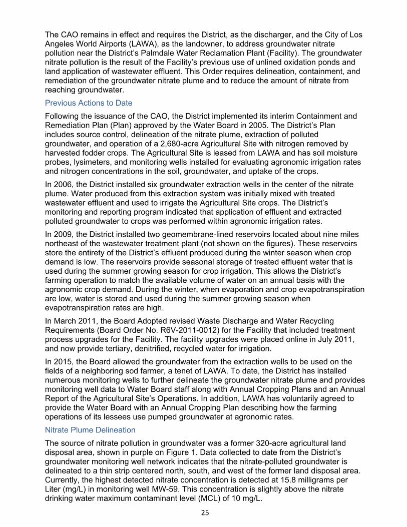
25
The CAO remains in effect and requires the District, as the discharger, and the City of Los Angeles World Airports (LAWA), as the landowner, to address groundwater nitrate pollution near the District’s Palmdale Water Reclamation Plant (Facility). The groundwater nitrate pollution is the result of the Facility’s previous use of unlined oxidation ponds and land application of wastewater effluent. This Order requires delineation, containment, and remediation of the groundwater nitrate plume and to reduce the amount of nitrate from reaching groundwater. Previous Actions to Date Following the issuance of the CAO, the District implemented its interim Containment and Remediation Plan (Plan) approved by the Water Board in 2005. The District’s Plan includes source control, delineation of the nitrate plume, extraction of polluted groundwater, and operation of a 2,680-acre Agricultural Site with nitrogen removed by harvested fodder crops. The Agricultural Site is leased from LAWA and has soil moisture probes, lysimeters, and monitoring wells installed for evaluating agronomic irrigation rates and nitrogen concentrations in the soil, groundwater, and uptake of the crops. In 2006, the District installed six groundwater extraction wells in the center of the nitrate plume. Water produced from this extraction system was initially mixed with treated wastewater effluent and used to irrigate the Agricultural Site crops. The District’s monitoring and reporting program indicated that application of effluent and extracted polluted groundwater to crops was performed within agronomic irrigation rates. In 2009, the District installed two geomembrane-lined reservoirs located about nine miles northeast of the wastewater treatment plant (not shown on the figures). These reservoirs store the entirety of the District’s effluent produced during the winter season when crop demand is low. The reservoirs provide seasonal storage of treated effluent water that is used during the summer growing season for crop irrigation. This allows the District’s farming operation to match the available volume of water on an annual basis with the agronomic crop demand. During the winter, when evaporation and crop evapotranspiration are low, water is stored and used during the summer growing season when evapotranspiration rates are high. In March 2011, the Board Adopted revised Waste Discharge and Water Recycling Requirements (Board Order No. R6V-2011-0012) for the Facility that included treatment process upgrades for the Facility. The facility upgrades were placed online in July 2011, and now provide tertiary, denitrified, recycled water for irrigation. In 2015, the Board allowed the groundwater from the extraction wells to be used on the fields of a neighboring sod farmer, a tenet of LAWA. To date, the District has installed numerous monitoring wells to further delineate the groundwater nitrate plume and provides monitoring well data to Water Board staff along with Annual Cropping Plans and an Annual Report of the Agricultural Site’s Operations. In addition, LAWA has voluntarily agreed to provide the Water Board with an Annual Cropping Plan describing how the farming operations of its lessees use pumped groundwater at agronomic rates. Nitrate Plume Delineation The source of nitrate pollution in groundwater was a former 320-acre agricultural land disposal area, shown in purple on Figure 1. Data collected to date from the District’s groundwater monitoring well network indicates that the nitrate-polluted groundwater is delineated to a thin strip centered north, south, and west of the former land disposal area. Currently, the highest detected nitrate concentration is detected at 15.8 milligrams per Liter (mg/L) in monitoring well MW-59. This concentration is slightly above the nitrate drinking water maximum contaminant level (MCL) of 10 mg/L.
26
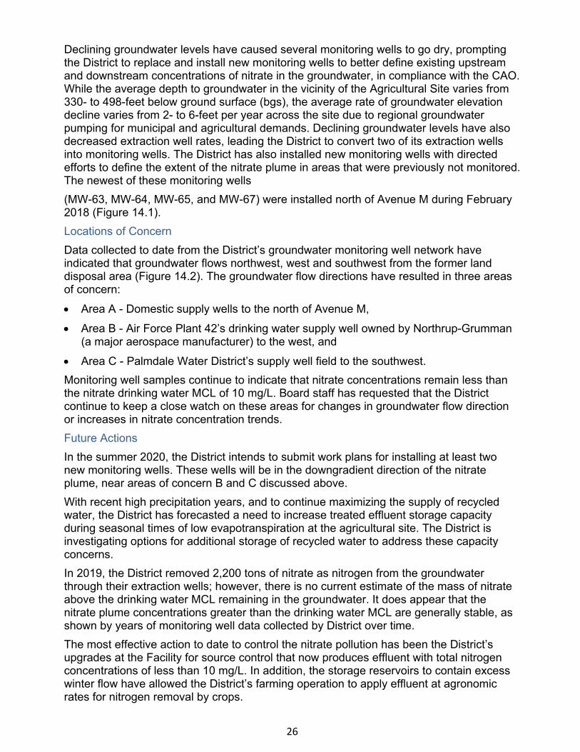
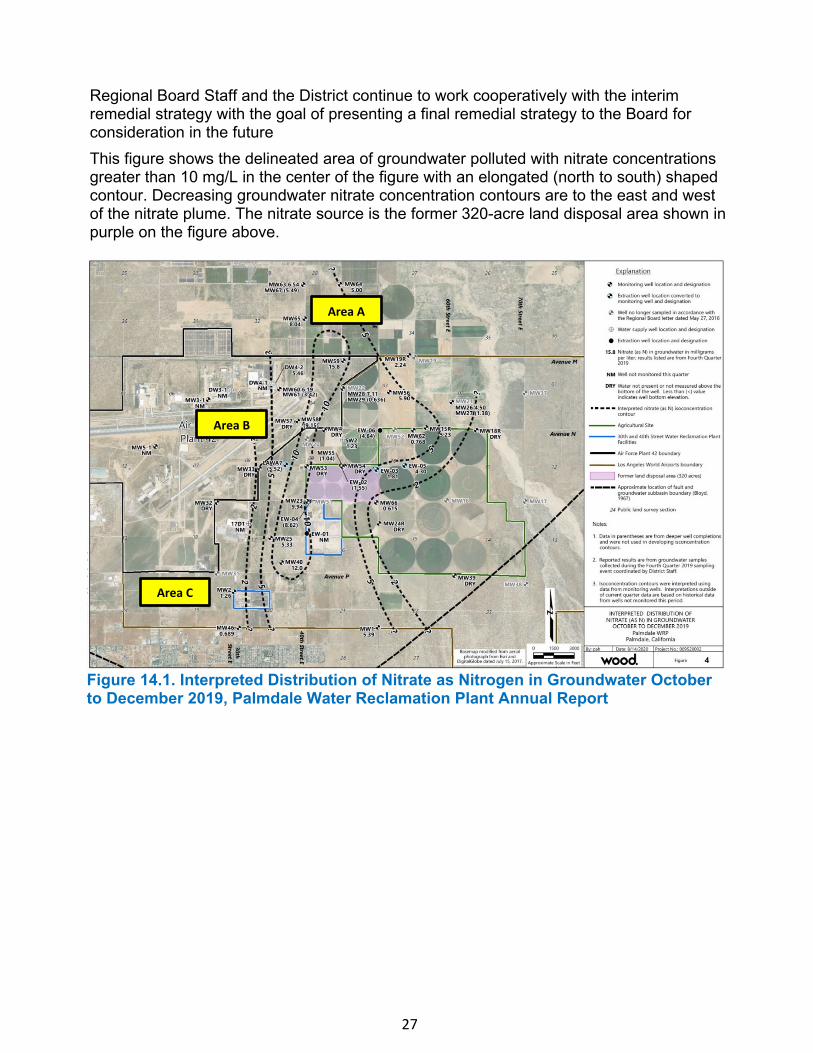
Declining groundwater levels have caused several monitoring wells to go dry, prompting the District to replace and install new monitoring wells to better define existing upstream and downstream concentrations of nitrate in the groundwater, in compliance with the CAO. While the average depth to groundwater in the vicinity of the Agricultural Site varies from 330- to 498-feet below ground surface (bgs), the average rate of groundwater elevationdecline varies from 2- to 6-feet per year across the site due to regional groundwaterpumping for municipal and agricultural demands. Declining groundwater levels have alsodecreased extraction well rates, leading the District to convert two of its extraction wellsinto monitoring wells. The District has also installed new monitoring wells with directedefforts to define the extent of the nitrate plume in areas that were previously not monitored.The newest of these monitoring wells(MW-63, MW-64, MW-65, and MW-67) were installed north of Avenue M during February 2018 (Figure 14.1). Locations of Concern Data collected to date from the District’s groundwater monitoring well network have indicated that groundwater flows northwest, west and southwest from the former land disposal area (Figure 14.2). The groundwater flow directions have resulted in three areas of concern:
• Area A - Domestic supply wells to the north of Avenue M,
• Area B - Air Force Plant 42’s drinking water supply well owned by Northrup-Grumman(a major aerospace manufacturer) to the west, and
• Area C - Palmdale Water District’s supply well field to the southwest.Monitoring well samples continue to indicate that nitrate concentrations remain less than the nitrate drinking water MCL of 10 mg/L. Board staff has requested that the District continue to keep a close watch on these areas for changes in groundwater flow direction or increases in nitrate concentration trends. Future Actions In the summer 2020, the District intends to submit work plans for installing at least two new monitoring wells. These wells will be in the downgradient direction of the nitrate plume, near areas of concern B and C discussed above. With recent high precipitation years, and to continue maximizing the supply of recycled water, the District has forecasted a need to increase treated effluent storage capacity during seasonal times of low evapotranspiration at the agricultural site. The District is investigating options for additional storage of recycled water to address these capacity concerns. In 2019, the District removed 2,200 tons of nitrate as nitrogen from the groundwater through their extraction wells; however, there is no current estimate of the mass of nitrate above the drinking water MCL remaining in the groundwater. It does appear that the nitrate plume concentrations greater than the drinking water MCL are generally stable, as shown by years of monitoring well data collected by District over time. The most effective action to date to control the nitrate pollution has been the District’s upgrades at the Facility for source control that now produces effluent with total nitrogen concentrations of less than 10 mg/L. In addition, the storage reservoirs to contain excess winter flow have allowed the District’s farming operation to apply effluent at agronomic rates for nitrogen removal by crops.
27
Regional Board Staff and the District continue to work cooperatively with the interim remedial strategy with the goal of presenting a final remedial strategy to the Board for consideration in the future
This figure shows the delineated area of groundwater polluted with nitrate concentrations greater than 10 mg/L in the center of the figure with an elongated (north to south) shaped contour. Decreasing groundwater nitrate concentration contours are to the east and west of the nitrate plume. The nitrate source is the former 320-acre land disposal area shown in purple on the figure above.
Area C
Area B
Area A
Figure 14.1. Interpreted Distribution of Nitrate as Nitrogen in Groundwater October to December 2019, Palmdale Water Reclamation Plant Annual Report
28
Figure 14.2. Groundwater Elevations October to December 2019, Palmdale Water Reclamation Plant Annual Report.
The Figure shows the iso-contour elevations of groundwater in feet above mean sea level. In general, groundwater flows from the southeast portion of the Figure where Littlerock Creek is a recharge zone, towards the west and northwest. Groundwater elevation contours indicating flow towards the southwest are the result of municipal pumping by the Palmdale Water District’s production wells. The nitrate source is the former 320-acre land disposal area shown in purple on the figure above.
Area C
Area B
Area A