Evaluation of users' satisfaction on pedestrian facilities using pair-wise comparison approach
7
This content has been downloaded from IOPscience. Please scroll down to see the full text. Download details: IP Address: 60.48.35.58 This content was downloaded on 03/01/2015 at 15:51 Please note that terms and conditions apply. Evaluation of users' satisfaction on pedestrian facilities using pair-wise comparison approach View the table of contents for this issue, or go to the journal homepage for more 2014 IOP Conf. Ser.: Earth Environ. Sci. 18 012175 (http://iopscience.iop.org/1755-1315/18/1/012175) Home Search Collections Journals About Contact us My IOPscience
-
Upload
independent -
Category
Documents
-
view
5 -
download
0
Transcript of Evaluation of users' satisfaction on pedestrian facilities using pair-wise comparison approach

This content has been downloaded from IOPscience. Please scroll down to see the full text.
Download details:
IP Address: 60.48.35.58
This content was downloaded on 03/01/2015 at 15:51
Please note that terms and conditions apply.
Evaluation of users' satisfaction on pedestrian facilities using pair-wise comparison approach
View the table of contents for this issue, or go to the journal homepage for more
2014 IOP Conf. Ser.: Earth Environ. Sci. 18 012175
(http://iopscience.iop.org/1755-1315/18/1/012175)
Home Search Collections Journals About Contact us My IOPscience

Evaluation of users' satisfaction on pedestrian facilities using
pair-wise comparison approach
R Zainol1, F Ahmad, N A Nordin, A W M Aripin
Department of Urban and Regional Planning, Faculty of Built Environment,
University of Malaya, 50603 Kuala Lumpur
Email: [email protected]
Abstract. Global climate change issues demand people of the world to change the way they
live today. Thus, current cities need to be redeveloped towards less use of carbon in their day
to day operations. Pedestrianized environment is one of the approaches used in reducing
carbon foot print in cities. Heritage cities are the first to be looked into since they were built in
the era in which motorized vehicles were minimal. Therefore, the research explores users'
satisfaction on assessment of physical attributes of pedestrianization in Melaka Historical City,
a UNESCO World Heritage Site. It aims to examine users' satisfaction on pedestrian facilities
provided within the study area using pair wise questionnaire comparison approach. A survey
of 200 respondents using random sampling was conducted in six different sites namely Jonker
Street, Church Street, Kota Street, Goldsmith Street, Merdeka Street to Taming Sari Tower
and Merdeka Street to River Cruise terminal. The survey consists of an assessment tool based
on a nine-point scale of users' satisfaction level of pathway properties, zebra pedestrian
crossing, street furniture, personal safety, adjacent to traffic flow, aesthetic and amenities.
Analytical hierarchical process (AHP) was used to avoid any biasness in analyzing the data
collected. Findings show that Merdeka Street to Taming Sari Tower as the street that scores
the highest satisfaction level that fulfils all the required needs of a pedestrianized environment.
Similar assessment elements can be used to evaluate existing streets in other cities and these
criteria should also be used in planning for future cities.
1. Introduction
Global climate change that is taking place currently has urged many people to think of how they want
to manage their lives today. Redevelopment of urban areas has moved towards using green approach.
This could be in terms of building materials or the design of the development that involves a lot of
trees as a cushion towards the extreme weather. Old cities on the other hand were designed without
using high technology such as natural air circulation, walkable environment and less pollution.
However, as time changes, development on these old cities was geared towards current demand such
as installing air conditional units and making way towards motorized vehicles [22]. As a results, more
CFCs are being emitted, roads are widened to make way for more motorized vehicles to pass through
and aesthetic value of old cities are being altered and these cities lose their original value. However,
with the rising price of fuel and depreciation of natural resources have make leaders all around the
world to look into this matter seriously. Many leaders refer to the United Nations Conference on
Environment and Development (UNCED) or the Rio Summit, Rio Conference and Earth Summit
which took place in 1992 and the United Nations Conference on Sustainable Development held in Rio
in 2012 as points of reference when making development plans for their countries. In addition, the
Kyoto Protocol to the United Nations Framework Convention on Climate Change in 2010 further sets
1 To whom any correspondence should be addressed.
8th International Symposium of the Digital Earth (ISDE8) IOP PublishingIOP Conf. Series: Earth and Environmental Science 18 (2014) 012175 doi:10.1088/1755-1315/18/1/012175
Content from this work may be used under the terms of the Creative Commons Attribution 3.0 licence. Any further distributionof this work must maintain attribution to the author(s) and the title of the work, journal citation and DOI.
Published under licence by IOP Publishing Ltd 1
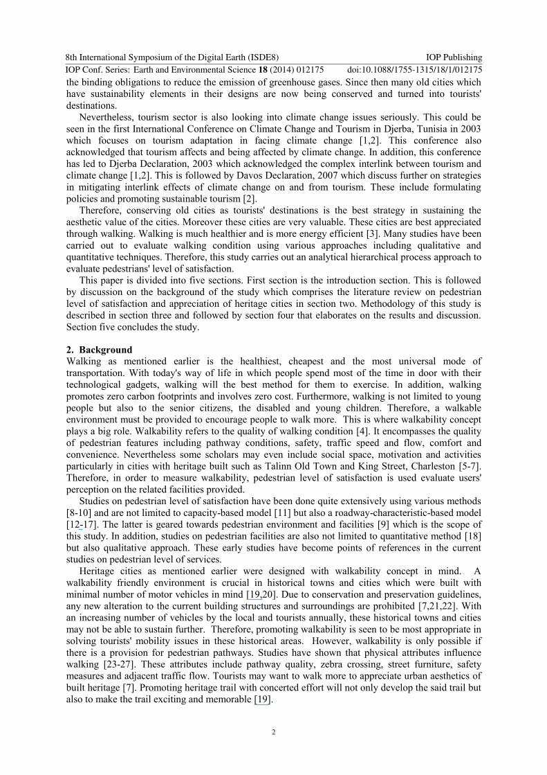
the binding obligations to reduce the emission of greenhouse gases. Since then many old cities which
have sustainability elements in their designs are now being conserved and turned into tourists'
destinations.
Nevertheless, tourism sector is also looking into climate change issues seriously. This could be
seen in the first International Conference on Climate Change and Tourism in Djerba, Tunisia in 2003
which focuses on tourism adaptation in facing climate change [1,2]. This conference also
acknowledged that tourism affects and being affected by climate change. In addition, this conference
has led to Djerba Declaration, 2003 which acknowledged the complex interlink between tourism and
climate change [1,2]. This is followed by Davos Declaration, 2007 which discuss further on strategies
in mitigating interlink effects of climate change on and from tourism. These include formulating
policies and promoting sustainable tourism [2].
Therefore, conserving old cities as tourists' destinations is the best strategy in sustaining the
aesthetic value of the cities. Moreover these cities are very valuable. These cities are best appreciated
through walking. Walking is much healthier and is more energy efficient [3]. Many studies have been
carried out to evaluate walking condition using various approaches including qualitative and
quantitative techniques. Therefore, this study carries out an analytical hierarchical process approach to
evaluate pedestrians' level of satisfaction.
This paper is divided into five sections. First section is the introduction section. This is followed
by discussion on the background of the study which comprises the literature review on pedestrian
level of satisfaction and appreciation of heritage cities in section two. Methodology of this study is
described in section three and followed by section four that elaborates on the results and discussion.
Section five concludes the study.
2. Background
Walking as mentioned earlier is the healthiest, cheapest and the most universal mode of
transportation. With today's way of life in which people spend most of the time in door with their
technological gadgets, walking will the best method for them to exercise. In addition, walking
promotes zero carbon footprints and involves zero cost. Furthermore, walking is not limited to young
people but also to the senior citizens, the disabled and young children. Therefore, a walkable
environment must be provided to encourage people to walk more. This is where walkability concept
plays a big role. Walkability refers to the quality of walking condition [4]. It encompasses the quality
of pedestrian features including pathway conditions, safety, traffic speed and flow, comfort and
convenience. Nevertheless some scholars may even include social space, motivation and activities
particularly in cities with heritage built such as Talinn Old Town and King Street, Charleston [5-7].
Therefore, in order to measure walkability, pedestrian level of satisfaction is used evaluate users'
perception on the related facilities provided.
Studies on pedestrian level of satisfaction have been done quite extensively using various methods
[8-10] and are not limited to capacity-based model [11] but also a roadway-characteristic-based model
[12-17]. The latter is geared towards pedestrian environment and facilities [9] which is the scope of
this study. In addition, studies on pedestrian facilities are also not limited to quantitative method [18]
but also qualitative approach. These early studies have become points of references in the current
studies on pedestrian level of services.
Heritage cities as mentioned earlier were designed with walkability concept in mind. A
walkability friendly environment is crucial in historical towns and cities which were built with
minimal number of motor vehicles in mind [19,20]. Due to conservation and preservation guidelines,
any new alteration to the current building structures and surroundings are prohibited [7,21,22]. With
an increasing number of vehicles by the local and tourists annually, these historical towns and cities
may not be able to sustain further. Therefore, promoting walkability is seen to be most appropriate in
solving tourists' mobility issues in these historical areas. However, walkability is only possible if
there is a provision for pedestrian pathways. Studies have shown that physical attributes influence
walking [23-27]. These attributes include pathway quality, zebra crossing, street furniture, safety
measures and adjacent traffic flow. Tourists may want to walk more to appreciate urban aesthetics of
built heritage [7]. Promoting heritage trail with concerted effort will not only develop the said trail but
also to make the trail exciting and memorable [19].
8th International Symposium of the Digital Earth (ISDE8) IOP PublishingIOP Conf. Series: Earth and Environmental Science 18 (2014) 012175 doi:10.1088/1755-1315/18/1/012175
2

3. Methodology
This study uses questionnaire approach to collect its primary data. A total of 200 respondents using
random sampling approach took part in this study. Respondents are mainly tourists. Locations of the
survey are around tourists' places of interest in the core zone of Melaka Historical City Centre. Prior
to the survey, secondary data were collected. These data include the attributes of the main streets in
the study area and are stored in geographic information system (GIS) database.
This study took place in the core zone of Melaka (Malacca) Historical City, a UNESCO World
Heritage Site. This part of the city was designated as one of the United Nations Educational, Scientific
and Cultural Organization (UNESCO) World Heritage Sites in 2008.
Respondents were asked to fill up a questionnaire that consists of evaluation of pathway, zebra
crossing, street furniture, personal safety, adjacent traffic flow, aesthetic and amenities conditions.
Table 1 shows the details of each element.
Table 1. Details of walkability elements.
Elements Details
Walkability
elements
Pathway Properties, design, quality, alleys, shade, lighting,
user friendly, landscaping, maintenance,
environment.
Zebra crossing Type, location, condition, access, waiting time at
traffic lights, safety.
Street furniture and signage Street furniture and shade, placement of lamp post,
board information, signage.
Personal safety Personal safety (day and night time), comfortable
social space, fear of crime, fear of motorized
vehicles, fear of stray animals.
Adjacent to traffic flow Traffic flow along pedestrian walkway, traffic
conditions at pedestrian crossing, traffic control by
authorities
Aesthetic and amenities Aesthetic, availability of amenities, dustbin, public
toilet, public phone, place to rest (bench).
Evaluations are rated based on a Likert Scale of 1 to 9 with 1 very unsatisfied and 9 being very
satisfied. This is consistent with nine point scale suggested by Saaty (2008). This scale is used to
assign pair-wise comparisons of all elements at each level of the hierarchy of one to nine. The
geometric approach is then used to combine the individual pair-wise comparison metrics (PCMs) to
obtain the consensus from the entire data [28].
The pedestrian walkways that were evaluated are Church Street, Jonker Street, Kota Street,
Merdeka Street to Taming Sari Tower, Merdeka Street to River Cruise terminal and
Blacksmith/Goldsmith Street (Figure 1).
8th International Symposium of the Digital Earth (ISDE8) IOP PublishingIOP Conf. Series: Earth and Environmental Science 18 (2014) 012175 doi:10.1088/1755-1315/18/1/012175
3

Legend
Road
Heritage Zone
River_region
1 centimeter = 36 meters
.
Jalan Kota
Jala
n L
aksam
ana
Ja
lan
Ba
nd
ara
n
Jala
n H
ang T
uah
Jalan Kubu
Jala
n M
erde
ka
Jalan Munshi Abdullah
Jalan Tukang Besi
Jalan Gereja
Jalan Tan Cheng Lock
Lorong Hang Jebat
Jalan Hang Jebat (Jonker Street)
Jala
n B
anda K
aba
Jala
n C
han K
oon C
heng
Bulatan
Jalan Laksamana Cheng Ho
Jalan Bandaran
Jalan Bandaran
Jala
n Ban
dara
n
Jalan Bandaran
Jalan Bandaran
Jala
n B
andara
n
Jala
n B
andara
n
Jalan Bandaran
Jala
n B
andara
n
Jalan Bandaran
Jalan Bandaran
Jalan Bandaran
Jalan Bandaran
Jala
n Ban
dara
n
Jalan Bandaran
Jalan Bandaran
Jala
n B
andara
n
Jalan Bandaran
Jalan Bandaran
Figure 1. Map of selected streets
in the core zone of Melaka
Historical City, a UNESCO
World Heritage Site.
Each of these streets has attributes that reflects the walkability condition (Table 2). Spatial and
attributes data were obtained from paper based tourist's maps and field work observation. The latter
was carried out to rectify the features placed on the maps. Geographic information database was
developed based on these data. As mentioned earlier, pair-wise comparison technique is used to
determine which entity is preferred most between given entities. Prior to this procedure, questionnaire
survey results produced by using statistical analysis were generated. The results were then analyzed
using analytical hierarchical process (AHP) analysis technique.
Jonker
Street
Blacksmith/Goldsmith Street
Kota Street
Merdeka Street
Church
Street
8th International Symposium of the Digital Earth (ISDE8) IOP PublishingIOP Conf. Series: Earth and Environmental Science 18 (2014) 012175 doi:10.1088/1755-1315/18/1/012175
4
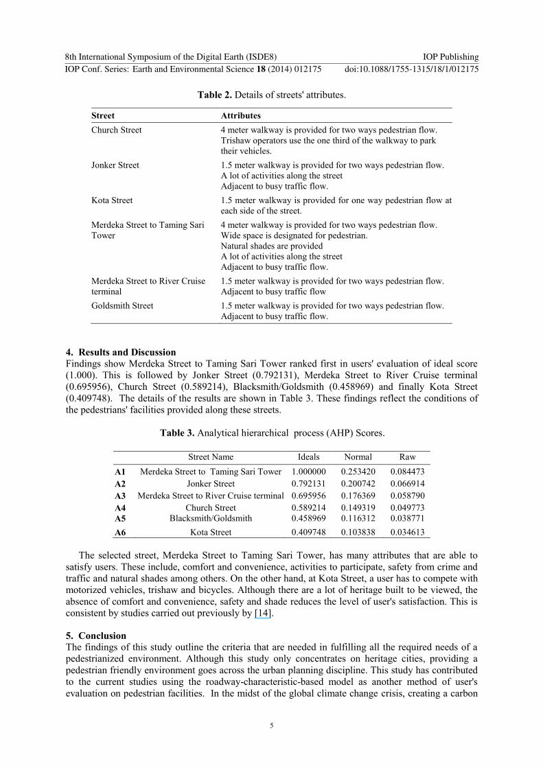
Table 2. Details of streets' attributes.
Street Attributes
Church Street 4 meter walkway is provided for two ways pedestrian flow.
Trishaw operators use the one third of the walkway to park
their vehicles.
Jonker Street 1.5 meter walkway is provided for two ways pedestrian flow.
A lot of activities along the street
Adjacent to busy traffic flow.
Kota Street 1.5 meter walkway is provided for one way pedestrian flow at
each side of the street.
Merdeka Street to Taming Sari
Tower
4 meter walkway is provided for two ways pedestrian flow.
Wide space is designated for pedestrian.
Natural shades are provided
A lot of activities along the street
Adjacent to busy traffic flow.
Merdeka Street to River Cruise
terminal
1.5 meter walkway is provided for two ways pedestrian flow.
Adjacent to busy traffic flow
Goldsmith Street 1.5 meter walkway is provided for two ways pedestrian flow.
Adjacent to busy traffic flow.
4. Results and Discussion
Findings show Merdeka Street to Taming Sari Tower ranked first in users' evaluation of ideal score
(1.000). This is followed by Jonker Street (0.792131), Merdeka Street to River Cruise terminal
(0.695956), Church Street (0.589214), Blacksmith/Goldsmith (0.458969) and finally Kota Street
(0.409748). The details of the results are shown in Table 3. These findings reflect the conditions of
the pedestrians' facilities provided along these streets.
Table 3. Analytical hierarchical process (AHP) Scores.
Street Name Ideals Normal Raw
A1 Merdeka Street to Taming Sari Tower 1.000000 0.253420 0.084473
A2 Jonker Street 0.792131 0.200742 0.066914
A3 Merdeka Street to River Cruise terminal 0.695956 0.176369 0.058790
A4 Church Street 0.589214 0.149319 0.049773
A5 Blacksmith/Goldsmith 0.458969 0.116312 0.038771
A6 Kota Street 0.409748 0.103838 0.034613
The selected street, Merdeka Street to Taming Sari Tower, has many attributes that are able to
satisfy users. These include, comfort and convenience, activities to participate, safety from crime and
traffic and natural shades among others. On the other hand, at Kota Street, a user has to compete with
motorized vehicles, trishaw and bicycles. Although there are a lot of heritage built to be viewed, the
absence of comfort and convenience, safety and shade reduces the level of user's satisfaction. This is
consistent by studies carried out previously by [14].
5. Conclusion
The findings of this study outline the criteria that are needed in fulfilling all the required needs of a
pedestrianized environment. Although this study only concentrates on heritage cities, providing a
pedestrian friendly environment goes across the urban planning discipline. This study has contributed
to the current studies using the roadway-characteristic-based model as another method of user's
evaluation on pedestrian facilities. In the midst of the global climate change crisis, creating a carbon
8th International Symposium of the Digital Earth (ISDE8) IOP PublishingIOP Conf. Series: Earth and Environmental Science 18 (2014) 012175 doi:10.1088/1755-1315/18/1/012175
5
free environment is demanded. Therefore, similar assessment elements can be used to evaluate
existing streets in other cities and these criteria should also be used in planning for future cities.
References
[1] Simpson F 1999 The Geographical Journal 165 173-83
[2] OMT-WTO-BTO 2003 Djerba Declaration on tourism and climate change [cited 2011 6 July
2011]; Available from:
http://scstsenvis.nic.in/djerba%20dec%20on%20climate%20change%20and%20tourism.pdf
[3] Gössling S 2011 Carbon Management in Tourism: Mitigating the Impacts on Climate Change
(Oxon: Routledge)
[4] Pucher J, Buehler R and Seinen M 2011 Transportation Research Part A 45 451-75
[5] Litman T A 2003 Journal of the Transportation Research Board 1828 3-11
[6] Michelson A 2011 Recent Researches in Energy, Environment and Landscape Architecture 31-
36
[7] McManus P M 1998 The Journal of Tourism Studies 19 40-50
[8] Litvin S W 2005 Tourism Management 26 421-29
[9] Papadimitriou E A 2013 Europe Safety Science 53 114-122
[10] Asadi-Shekari Z Moeinaddini M and Zaly Shah M 2013 Journal of Transportation Engineering
139 181-92
[11] Stradling S G Anable J and Carreno M 2007 Transportation Research Part A: Policy and
Practice 41 98-106
[12] Fruin J J 1971 Pedestrian planning and design (New York: Metropolitan Association of Urban
Designers and Environmental Planners)
[13] Muraleetharan T et al 2005 Journal of the Eastern Asia Society for Transportation Studies 6
127-36
[14] Lautso K and Murole P 1974 A study of pedestrian traffic in Helsinki: methods and results 446-
49
[15] Seneviratne P N and Morrall J F 1985 Transportation Planning and Technology 10 147-59
[16] Sarkar S ed 1993 Determination of Service Levels for Pedestrians, with European Examples
(Washington DC:National Research Council)
[17] Henson C 2000 ITE journal 70 26-30
[18] Landis B W et al 2001Modeling the roadside walking environment: A Pedestrian Level of
Service (Transportation Research Board)
[19] Khisty C J 1994 Evaluation of pedestrian facilities. Beyond the level-of-service concept, in
Transportation Research Record TRB (Washington DC:National Research Council) 45-50
[20] Soto D 2010 San Juan Puerto Rico to become walkable city [cited 2012 31 March]; Available
from: Planetizen Web site: http://gas2.org/2010/08/11/san-juan-puerto-rico-to-become-
walkable-city/
[21] Abujaber F 2009 Towards a walkable heritage landscape Dalhousie University
[22] Amistad F T and Regidor J R F 2005 Journal of the Eastern Asia Society for Transportation
Studies 6 2291-306
[23] Leslie E et al 2005 Health & Place 11 227-36
[24] Leslie E et al 2007 Health & Place 13 111-22
[25] Gallimore J M, Brown B B and Werner CM 2011 Journal of Environmental Psychology 31
184-91
[26] Owen N et al 2007 American Journal of Preventive Medicine 33 387-95
[27] Rastogi R I, Thaniarasu and Chandra S 2011 Journal of Transportation Engineering 137
[28] Saaty T L 2008 Int J Services Sciences 1 83-98
8th International Symposium of the Digital Earth (ISDE8) IOP PublishingIOP Conf. Series: Earth and Environmental Science 18 (2014) 012175 doi:10.1088/1755-1315/18/1/012175
6