EFFECT OF NEW UPPER NILE PROJECTS ON THE INTEGRATED MANAGEMENT OF THE BASIN: REVIEW AND METHODOLOGY...
13
Fifteenth International Water Technology Conference, IWTC-15 2011, Alexandria, Egypt EFFECT OF NEW UPPER NILE PROJECTS ON THE INTEGRATED MANAGEMENT OF THE BASIN: REVIEW AND METHODOLOGY Sayed M. Ramadan 1 , Abdelazim M. Negm 2 , and Talaat M. Owais 3 1 Assistant lecturer, Water and Water Structures Eng. Dept., Faculty of Engineering, Zagazig University, E-mail: [email protected] 2 Professor of Hydraulics, Vice Dean of Engineering Faculty, Zagazig University, E-mail: [email protected] 3 Professor of Civil Engineering, Water and Water Structures Eng. Dept., Faculty of Engineering, Zagazig University, E-mail: [email protected] ABSTRACT Nile River is one of the world longest rivers but considered the longest river by adding its tributaries which reach 6850 km. The Nile basin covers about 10% of Africa where the basin area reaches 3106 km 2 and spread over 10 countries Burundi, Congo, Egypt, Eritrea, Ethiopia, Kenya, Rwanda, Sudan, Tanzania, and Uganda. From the comparison between Nile and other major rivers such as Amazon, Congo, Mississippi, Mekong, Zambezi, and Rhine shows that the discharged water from Nile basin is very small relative to the basin area. Also fast water demand increase and multiple uses for the basin countries specially Egypt and Sudan which classified as arid regions. So it is very important to search about new projects to increase water flow in the river and also looking for river planning and management techniques to better solve water shortage problems. The complexity of the nature and economic system within a river basin makes it difficult to plan and design an optimal operation program. Modeling may be helpful in accounting for all relevant components comprising a river basin and addressing various planning and management objectives and activities. In the present paper, the state of the art review is present and the adopted methodology to study the effect of constructing water resources projects upstream the High Aswan Dam (in the upper Nile region) on the water resources planning and management of Egypt will be presented and discussed. Keywords: Integrated Water Resources Management, River Basin, Nile
Transcript of EFFECT OF NEW UPPER NILE PROJECTS ON THE INTEGRATED MANAGEMENT OF THE BASIN: REVIEW AND METHODOLOGY...

Fifteenth International Water Technology Conference, IWTC-15 2011, Alexandria, Egypt
EFFECT OF NEW UPPER NILE PROJECTS ON THE INTEGRATED MANAGEMENT OF THE BASIN: REVIEW AND METHODOLOGY
Sayed M. Ramadan1, Abdelazim M. Negm2, and Talaat M. Owais3
1 Assistant lecturer, Water and Water Structures Eng. Dept., Faculty of Engineering,
Zagazig University, E-mail: [email protected] 2 Professor of Hydraulics, Vice Dean of Engineering Faculty, Zagazig University,
E-mail: [email protected] 3 Professor of Civil Engineering, Water and Water Structures Eng. Dept., Faculty of
Engineering, Zagazig University, E-mail: [email protected]
ABSTRACT Nile River is one of the world longest rivers but considered the longest river by adding its tributaries which reach 6850 km. The Nile basin covers about 10% of Africa where the basin area reaches 3106 km2 and spread over 10 countries Burundi, Congo, Egypt, Eritrea, Ethiopia, Kenya, Rwanda, Sudan, Tanzania, and Uganda. From the comparison between Nile and other major rivers such as Amazon, Congo, Mississippi, Mekong, Zambezi, and Rhine shows that the discharged water from Nile basin is very small relative to the basin area. Also fast water demand increase and multiple uses for the basin countries specially Egypt and Sudan which classified as arid regions. So it is very important to search about new projects to increase water flow in the river and also looking for river planning and management techniques to better solve water shortage problems. The complexity of the nature and economic system within a river basin makes it difficult to plan and design an optimal operation program. Modeling may be helpful in accounting for all relevant components comprising a river basin and addressing various planning and management objectives and activities. In the present paper, the state of the art review is present and the adopted methodology to study the effect of constructing water resources projects upstream the High Aswan Dam (in the upper Nile region) on the water resources planning and management of Egypt will be presented and discussed.
Keywords: Integrated Water Resources Management, River Basin, Nile
Fifteenth International Water Technology Conference, IWTC-15 2011, Alexandria, Egypt
1. INTRODUCTION AND REVIEW Water is a vital component of the Earth ecosystems, redistributed through natural cycles, contributing to climate control and the hydrologic cycle. As water flows, river ignores political boundaries, fluctuates in both space and time, and has multiple uses. It is essential for nutrition, food production, sanitation, and economic production (recreation, power generation, transportation, etc.), and embodies symbolic and cultural value. Although it covers over 70% of our planet's surface, less than 3% consists of freshwater. Most of this freshwater is either frozen in polar ice caps or stored underground. As the flow of water totally ignores political boundaries, so does its management strain the capabilities of institutional boundaries, While water managers generally understand and advocate the concept of a watershed as a unit of management, where surface and groundwater, quantity and quality, are all connected, the institutions developed to manage the resource rarely follow these tenets. Perhaps the most example of the interaction of population growth, water scarcity and international conflict is the vast basin of the Nile River in northeastern Africa. The ten countries with territory in the Nile basin contain 40 percent of Africa's population (not all actually within the basin) and make up 10 percent of its land mass. More than 85 percent of the Nile's water comes from the Blue Nile, which originates in Ethiopia. However, the vast majority of the river's flow, estimated at about 84 billion cubic meters annually, is used by Egypt and Sudan, the last nations on the Nile's path to the Mediterranean Sea [11]. For centuries the cultural symbol of Egypt, the Nile provides almost all the fresh water used by more than 80 million Egyptians living along its banks when few people live upstream-and modern economic development was a distant dream for the entire basin. Egypt saw no reason to worry about its dependence on the Nile's waters. Its complacency is now ending, however, as the upstream nations begin to harness the Nile's waters to provide economic prosperity for their growing numbers [11]. Ethiopia, for example, recently emerged from a long period of civil war and into a period of accelerated growth and economic development. The government has overseen the construction of more than 200 small dams that will use nearly 500 million cubic meters of the Nile's flow annually. Additional dams are being planned to increase the country's irrigation and hydropower capacity. Though Ethiopia's current development plans will require only a small portion of the Nile's water, its potential demands could significantly reduce the river's flow into Egypt. Ethiopia has an estimated 3.7 million hectares of land could be irrigated. With a population nearly the size of Egypt's and a faster annual rate of population growth 3.2 percent annually for Ethiopia versus 2 percent for Egypt-Ethiopia will need to develop a large portion of this land for agricultural use. Irrigating only half this land area with water from the Nile could reduce the river's flow to Egypt by 15 percent. Hydrologists doubt the basin
Fifteenth International Water Technology Conference, IWTC-15 2011, Alexandria, Egypt
produces enough renewable fresh water to satisfy the irrigation plans of both Ethiopia and Egypt [12]. Egypt is very arid country where only 3.4 % of the area, which slightly over 1,000,000 km2 is inhabited. Water is a major constraint to the countries development. Egypt itself is raising the plans for its New Valley land reclamation project. Pressed by population growth within its own borders, the Egyptian government has begun a massive irrigation project in the country's western desert in an attempt to move seven million Egyptians from the crowded Nile Valley. When completed, a pipeline will carry up to five billion cubic meters of Nile water from the Lake Nasser reservoir to the New Valley site to facilitate the construction of new cities and provide irrigation to more than 200,000 hectares of desert City [8]. Sudan, meanwhile, has built its own dam on the Nile north of the capital, Khartoum, where the Blue Nile and the White Nile converge before flowing into Egypt. The remaining Nile basin countries currently use only a small portion of the river's water. However, with their cumulative population now numbering over 140 million and projected to grow to more than 340 million by the year 2025, it is decided that these countries will soon begin to lay claim to a larger share of the Nile's flow to meet their growing irrigation and development needs [11]. The main objective of this research is to setup a methodology to best simulate the existing river system to evaluate different operation scenarios. This methodology will enable the water planner/manager to evaluate and choose the most suitable operation guidelines for the local conditions and objectives. Also, it can be used for regional or national planning for water resources evaluation and studying the effect of new projects in the upper Nile if they are built or predicted. The second objective of this research is to define a procedure of a systematic calibration and verification of the developed model. The proposed procedure will use the available historical actual flow downstream Aswan High Dam water resources for 10 years ago to evaluate the simulation model for River Nile basin. The last objective of this research is to demonstrate the application of the developed model and procedure in the main River Nile basin as a case study and predict some scenarios for new projects or the suggested projects on the River Nile. Over 70 % of the worlds land area can potentially be influenced by river basin development. Many countries have access to the resources of at least one river basin, and some countries can access the resources of several river basins [6]. A search of the literature reveals a wide range and number of published reports in river basin models. Selected few studies representing basin wide simulation modeling will be reviewed here. Dandy and Tan (1987) examined the development of an operating policy for the Encounter Bay district in South Australia. The authors use three sources of water for their simulation
Fifteenth International Water Technology Conference, IWTC-15 2011, Alexandria, Egypt
model, each of them with differing supply costs and differing water quality characteristics (namely color, turbidity, and salinity). Based on the model results, the authors evaluate various supply policies in a multi-objective framework. However, optimal or near optimal solutions cannot always be found due to the lack of an optimization mechanism [1]. Labadie, Fontane, and Dai (1994) extended MODSIM, a widely used simulation package for river basin network flow modeling to directly include water quality regulations as constraints. The new model, MODSIMQ, handles water quality predictions and projections through a linkage with QUAL2E. QUAL2E is used to update water quality coefficients in MODSIMQ, which calculates both network flows and concentrations, which are then fed back into QUAL2E for further simulation [4]. This approach is similar to that of Dandy and Crawley (1992) with improvement on some of the limitations in that study [3]. SWAT is a basin or watershed scale model with strong physical mechanism. It has been widely applied in Canada and North America. In China, SWAT has been applied to several important river basins with great successes, Hei River Basin, Hai River Basin, and Yellow River Basin. It is demonstrated and agreed that SWAT is well established because of its flexibility and suitability for hydrological simulation in complex basins and water resources management [12]. Since 1985 RIBASIM has been applied in more than 20 countries world-wide and is used by a wide range of national and regional agencies, i.e. Jratunseluna basin, Indonesia, Choshui Basin, Taiwan, Yellow River basin, China. RIBASIM enables a schematization of the river basin to be prepared interactively from a map. This schematization consists of a network of nodes connected by branches. The nodes represent reservoirs, dams, weirs, pumps, hydro-power stations, water users, inflows, man-made and natural bifurcations, intake structures, natural lakes, etc. From May 2002 to May 2005, Planning Sector, Ministry of Water Resources and Irrigation, Egypt has formed a contract with WL | Delft Hydraulics. Objectives of the project were: (1) to assess alternatives for the management of Lake Nasser with respect to the flood and drought management, (2) to enhance the modeling facilities of the Nile Forecasting Centre, (3) to provide the Nile Forecasting Centre staff with training on climate change and impact assessment for the Nile basin, and (4) to initiate benefit from co-operation within the Nile basin 2. BASIN MODELING METHODOLOGY However, the complexity of natural and economic system within the river basin makes it difficult to plan and design an optimal investment program. A model may be helpful in accounting for all relevant components comprising a river basin, in addressing various planning and management objectives. 2.1 Simulation The RIBASIM (RIver BAsin SIMulation) model package provides an effective tool to support the process of planning and resource analysis.
Fifteenth International Water Technology Conference, IWTC-15 2011, Alexandria, Egypt
RIBASIM is a windows-based software package and includes a range of DELFT Decision Support Systems Tools. RIBASIM is a generic model package for simulating the behavior of river basins under various hydrological conditions. The model package is a comprehensive and flexible tool which links the hydrological water inputs at various locations with the specific water-users in the basin. RIBASIM enables the user to evaluate a variety of measures related to infrastructure, operational and demand management and to see the results in terms of water quantity, water quality and flow composition. RIBASIM can also generate flow patterns which provide a basis for detailed water quality and sedimentation analysis in river reaches and reservoirs. The structure of RIBASIM is based on an integrated framework with a user-friendly, graphically oriented interface. This framework is built using the DELFT tools which are a set of general applicable, Windows-oriented software modules required to set-up Decision Support Systems. Functions provided by DELFT tools include the interactive design of the river basin network from a map of the basin, data entry and the set-up of an object oriented river basin data base, presentation and animation of results on maps, simulation case management, and the analysis of results. Using DELFT tools opens options for links with other. RIBASIM, The model could be applied at basin/sub-basin scale, (1) to provide an efficient handling and structure analysis of the large amounts of data commonly associated with (complex) water resources systems, (2) to make comprehensive and flexible tool to link the hydrologic inputs of water at various locations to the various water using activities, and (3) to evaluate a variety of measures related to infrastructure and operational management.
Fifteenth International Water Technology Conference, IWTC-15 2011, Alexandria, Egypt
2.2 Simulation principle The models solve water balance per time step for each node in downstream order (simulation sequence):
0}{* 11int01 outttt QQCSS (1)
Where: t0, t1 = Simulation time steps e.g. monthly St1 = Storage at end of time step t1 (MCM) Qint1 = Flow into the node during time step t1 (m
3/s) Qoutt1 = Flow out of the node during time step t1 (m
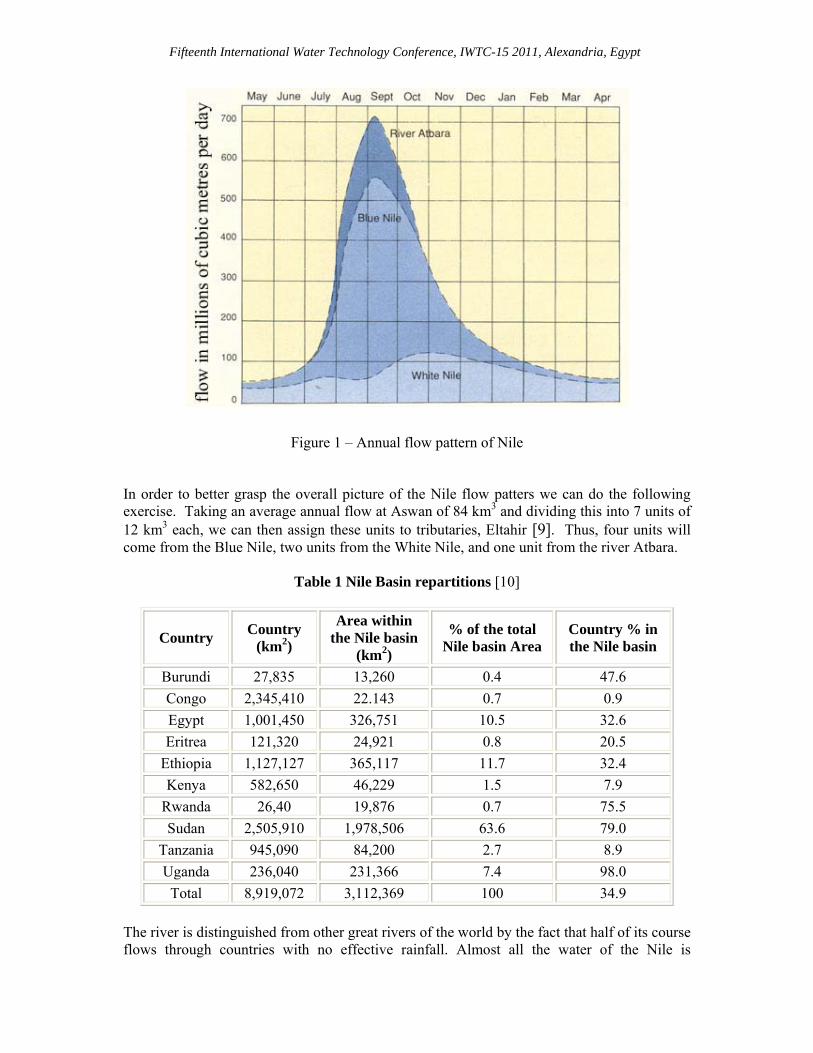
3/s) C = Conversion factor (efficiency coefficient) Considered water related elements that are included and quantified: supply side (rainfall, surface runoff, groundwater, water quality), demand side (domestic, municipal and industrial water, agriculture, aquaculture, hydro-power demand, navigation, environment, etc), Infrastructure (rivers, canals, reservoirs, weirs, pipelines, hydropower stations, pumps, including operational management). 3. RIVER NILE BASIN 3.1 Nile Hydrology 3.1.1 General Facts The Nile River is 6700 km. It traverses international boundaries and travels through 10 riparian countries a shown in table 1 with variable water Resources availability and dependency on Nile water table 2. It has a total Catchment Area of 3 million km2 its average runoff is 30 mm. The major contributors of the total flow come from the East African lake region and the Ethiopian Highlands. The Nile has three main tributaries, including the White Nile, Blue Nile and the River Atbara. This river crosses an extremely wide band of latitude originating about 4oS and emptying at 32oN [7]. 3.1.2 Flow Patterns The Nile River’s hydrology is highly influenced by the monsoon season. During the months of July-November the river Atbara and the Blue Nile contributes approximately 5/7 of the Nile’s mean annual flow. Contrarily, the White Nile is not perennial, and as such, it produces a steady base flow year around [10].
Fifteenth International Water Technology Conference, IWTC-15 2011, Alexandria, Egypt
Figure 1 – Annual flow pattern of Nile
In order to better grasp the overall picture of the Nile flow patters we can do the following exercise. Taking an average annual flow at Aswan of 84 km3 and dividing this into 7 units of 12 km3 each, we can then assign these units to tributaries, Eltahir [9]. Thus, four units will come from the Blue Nile, two units from the White Nile, and one unit from the river Atbara.
Table 1 Nile Basin repartitions [10]
Country Country
(km2)
Area within the Nile basin
(km2)
% of the total Nile basin Area
Country % in the Nile basin
Burundi 27,835 13,260 0.4 47.6
Congo 2,345,410 22.143 0.7 0.9
Egypt 1,001,450 326,751 10.5 32.6
Eritrea 121,320 24,921 0.8 20.5
Ethiopia 1,127,127 365,117 11.7 32.4
Kenya 582,650 46,229 1.5 7.9
Rwanda 26,40 19,876 0.7 75.5
Sudan 2,505,910 1,978,506 63.6 79.0
Tanzania 945,090 84,200 2.7 8.9
Uganda 236,040 231,366 7.4 98.0
Total 8,919,072 3,112,369 100 34.9
The river is distinguished from other great rivers of the world by the fact that half of its course flows through countries with no effective rainfall. Almost all the water of the Nile is
Fifteenth International Water Technology Conference, IWTC-15 2011, Alexandria, Egypt
generated on an area covering only 20 percent of the basin, while the remainder is in arid or semi-arid regions where the water supply is minimal and evaporation and seepage losses are very large.
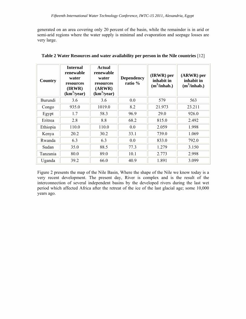
Table 2 Water Resources and water availability per person in the Nile countries [12]
Country
Internal renewable
water resources (IRWR)
(km3/year)
Actual renewable
water resources (ARWR)
(km3/year)
Dependency ratio %
(IRWR) per inhabit in
(m3/inhab.)
(ARWR) per inhabit in
(m3/inhab.)
Burundi 3.6 3.6 0.0 579 563
Congo 935.0 1019.0 8.2 21.973 23.211
Egypt 1.7 58.3 96.9 29.0 926.0
Eritrea 2.8 8.8 68.2 815.0 2.492
Ethiopia 110.0 110.0 0.0 2.059 1.998
Kenya 20.2 30.2 33.1 739.0 1.069
Rwanda 6.3 6.3 0.0 833.0 792.0
Sudan 35.0 88.5 77.3 1.279 3.150
Tanzania 80.0 89.0 10.1 2.773 2.998
Uganda 39.2 66.0 40.9 1.891 3.099
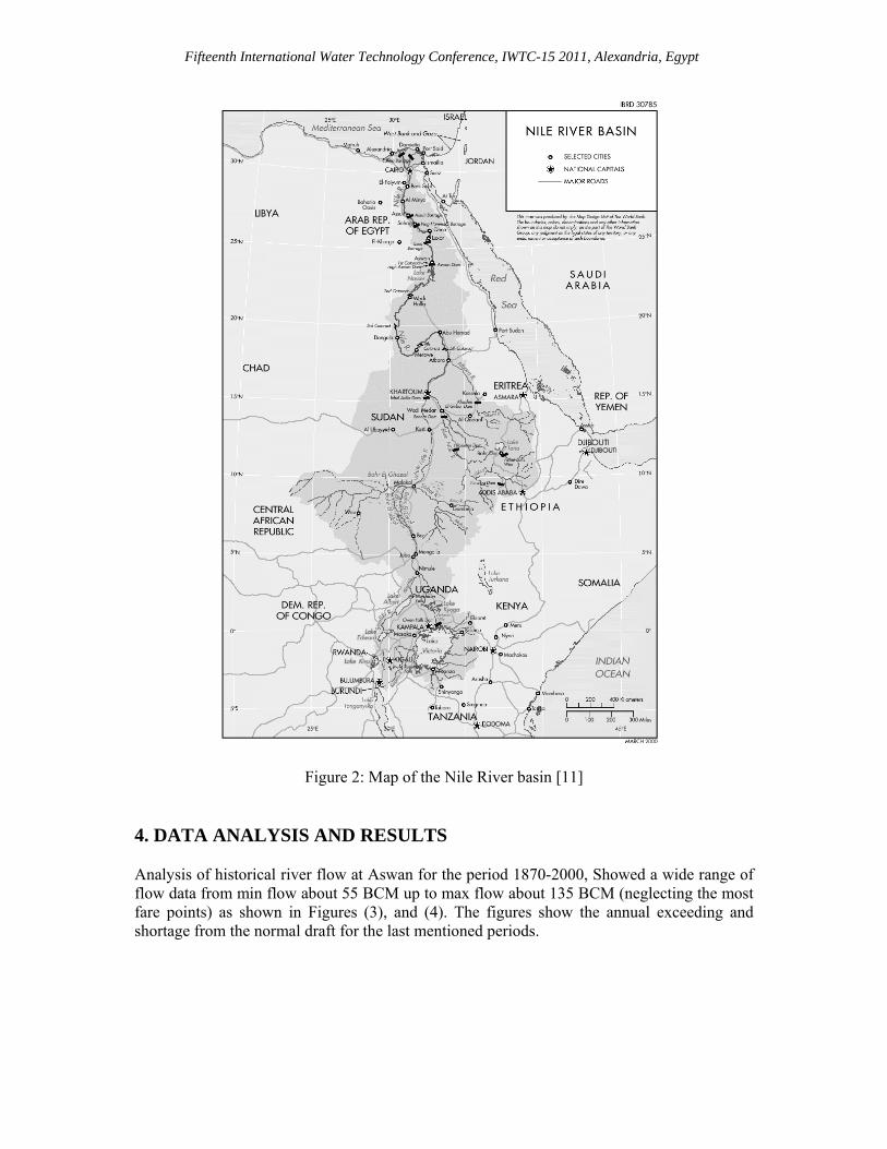
Figure 2 presents the map of the Nile Basin, Where the shape of the Nile we know today is a very recent development. The present day, River is complex and is the result of the interconnection of several independent basins by the developed rivers during the last wet period which affected Africa after the retreat of the ice of the last glacial age; some 10,000 years ago.
Fifteenth International Water Technology Conference, IWTC-15 2011, Alexandria, Egypt
Figure 2: Map of the Nile River basin [11]
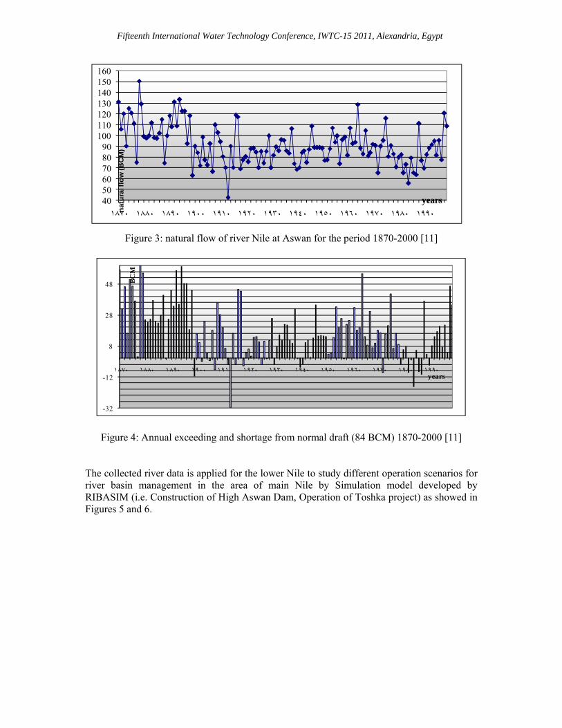
4. DATA ANALYSIS AND RESULTS Analysis of historical river flow at Aswan for the period 1870-2000, Showed a wide range of flow data from min flow about 55 BCM up to max flow about 135 BCM (neglecting the most fare points) as shown in Figures (3), and (4). The figures show the annual exceeding and shortage from the normal draft for the last mentioned periods.
Fifteenth International Water Technology Conference, IWTC-15 2011, Alexandria, Egypt
Figure 3: natural flow of river Nile at Aswan for the period 1870-2000 [11]
-32
-12
8
28
48
١٨٧٠ ١٨٨٠ ١٨٩٠ ١٩٠٠ ١٩١٠ ١٩٢٠ ١٩٣٠ ١٩٤٠ ١٩٥٠ ١٩٦٠ ١٩٧٠ ١٩٨٠ ١٩٩٠
BC
M
years
Figure 4: Annual exceeding and shortage from normal draft (84 BCM) 1870-2000 [11]
The collected river data is applied for the lower Nile to study different operation scenarios for river basin management in the area of main Nile by Simulation model developed by RIBASIM (i.e. Construction of High Aswan Dam, Operation of Toshka project) as showed in Figures 5 and 6.
405060708090
100110120130140150160
١٨٧٠ ١٨٨٠ ١٨٩٠ ١٩٠٠ ١٩١٠ ١٩٢٠ ١٩٣٠ ١٩٤٠ ١٩٥٠ ١٩٦٠ ١٩٧٠ ١٩٨٠ ١٩٩٠nat
ura
l flo
w (B
CM
)
years
Fifteenth International Water Technology Conference, IWTC-15 2011, Alexandria, Egypt
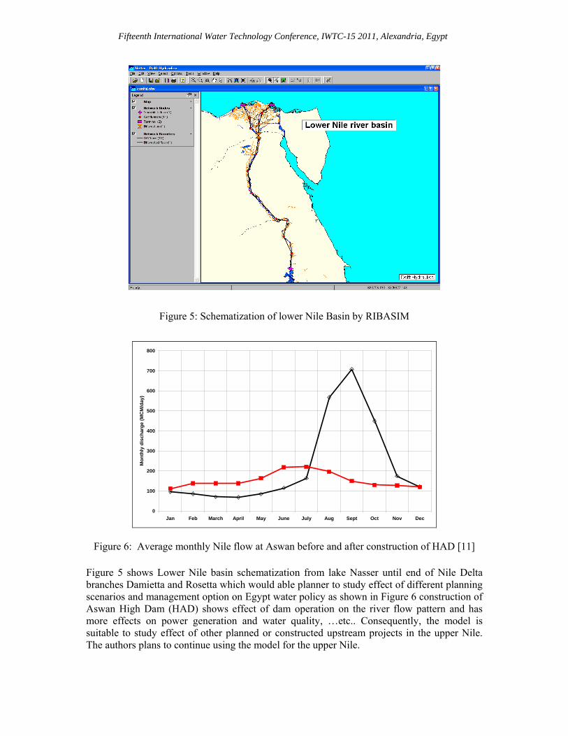
Figure 5: Schematization of lower Nile Basin by RIBASIM
0
100
200
300
400
500
600
700
800
Jan Feb March April May June July Aug Sept Oct Nov Dec
Mo
nth
ly d
isch
arg
e (M
CM
/day
)
Figure 6: Average monthly Nile flow at Aswan before and after construction of HAD [11]
Figure 5 shows Lower Nile basin schematization from lake Nasser until end of Nile Delta branches Damietta and Rosetta which would able planner to study effect of different planning scenarios and management option on Egypt water policy as shown in Figure 6 construction of Aswan High Dam (HAD) shows effect of dam operation on the river flow pattern and has more effects on power generation and water quality, …etc.. Consequently, the model is suitable to study effect of other planned or constructed upstream projects in the upper Nile. The authors plans to continue using the model for the upper Nile.
Fifteenth International Water Technology Conference, IWTC-15 2011, Alexandria, Egypt
5. CONCLUSIONS The developed methodology of using RIver BAsin SIMulation (RIBASIM) model package provides an effective tool to classify the complex water system and its surroundings in the basis of short/long-term analysis is suitable to best simulate the existing river system to evaluate different operation scenarios. This methodology will enable the water planner/manager to evaluate and choose the most suitable operation guidelines for the local conditions and objectives. Also, it can be used for regional or national planning for water resources evaluation and studying the effect of new projects in the upper Nile if they are built or proposed. Resulted data from the application of model at lower Nile basin after and before the construction of Aswan High Dam show that, the dam construction has achieved more efficiency in water supply and reduced the water deficit and increased hydropower production. In which the results was more helpful achieving systematic calibration and verification of the developed model. After the model realization from the its application on the lower Nile basin the model would be suitable for application on the upper Nile area or continued from the lower Nile region until the location of Morwie dam is Sudan to study the effect of this dam on the water system in Egypt. REFERENCES [1] Dandy, G., and K. K. Tan, Use of computer analysis to develop a management
plan for an urban water supply system, 2nd International Conference on Education, Practice, and Promotion of Computational Methods in Engineering, Guangzhou, China, 1987.
[2] Verhaeghe R. J., van der Krogt, W. N. M., Modelling of irrigation water
management, ICID, Bangkok, 1991. [3] Dandy, G. C. and P. D. Crawley, Optimization of multiple reservoir system
including salinity effects, water resources research, 28(4), 979-990, 1992. [4] Labadie, J. W., D. G. Fontane, and T. Dai., Integration of water quantity and
quality in river basin network flow modeling, ASCE Water Resource Planning and Management Annual Conference, May 23–26, Denver, Colorado, ASCE, 1994.
[5] Eltahir, Elfatih A. B., El Nino and the natural variability in the flow of the Nile
River, Water Resources Research 32(1): 131-137, 1996.
Fifteenth International Water Technology Conference, IWTC-15 2011, Alexandria, Egypt
[6] Daene, C. McKinney, Ximing Cai, Mark W. Rosegrant, Claudia Ringler and Christopher A. Scott, Modeling water resources management at the basin level: Review and future directions, SWIM Paper 6. Colombo, Sri Lanka, International Water Management Institute, 1999.
[7] Diana Rizzolio Karyabwite, Water Sharing in the Nile River Valley,
UNEP/DEWA/GRID, Geneva, 2000. [8] Alam, M. Nasr Eldean, Water and agriculture lands in Egypt, past, present, and
future in Arabic, Cairo University, Cairo, Egypt, 2001. [9] Eltahir, Elfatih A. B., Anthony Paris, Teresa Yamana, Suzanne Young,
Sustainability considerations in the Design of Big Dams: Merowe, Nile Basin, May 19, 2004.
[10] Emmanuel Olet, Koen Roest and Robert Smit, Research and Action Plan (Nile
Case Study), Report of the NeWater project, New Approaches to Adaptive Water management under Uncertainty, European Commission, 2005.
[11] Mukhtar S. Ramadan, Integrated management of shared river basin, M.Sc. thesis, water engineering, engineering faculty, Zagazig, Egypt, 2007.
[12] Yong Zhang, Jun Xia, Tao Liang and Quanxi Shao, Impact of Water Projects on
River Flow Regimes and Water Quality in Huai River Basin, Water Resources Management 24:889–908, 2010.