Drones for Agriculture - Fao.org
126
-
Upload
khangminh22 -
Category
Documents
-
view
0 -
download
0
Transcript of Drones for Agriculture - Fao.org


E-agriculture in Action: Drones for Agriculture i
E-AGRICULTURE IN ACTION:
DRONES FOR AGRICULTURE
Published byFood and Agriculture Organization of the United Nations
andInternational Telecommunication Union
Bangkok, 2018
Edited byGerard Sylvester
E-agriculture in Action: Drones for Agricultureii
The designations employed and the presentation of material in this information product donot imply the expression of any opinion whatsoever on the part of the Food and AgricultureOrganization of the United Nations (FAO), or of the International Telecommunication Union(ITU) concerning the legal or development status of any country, territory, city or area or ofits authorities, or concerning the delimitation of its frontiers or boundaries. The mention ofspecific companies or products of manufacturers, whether or not these have been patented,does not imply that these have been endorsed or recommended by FAO, or the ITU inpreference to others of a similar nature that are not mentioned. The views expressed inthis information product are those of the author(s) and do not necessarily reflect the viewsor policies of FAO, or the ITU.
FAO and ITU encourage the use, reproduction and dissemination of material in thisinformation product. Except where otherwise indicated, material may be copied,downloaded and printed for private study, research and teaching purposes, or for use innon-commercial products or services, provided that appropriate acknowledgement of FAOand ITU as the source and copyright holder is given and that FAO’s and ITU’s endorsementof users’ views, products or services is not implied in any way.
All requests for translation and adaptation rights, and for resale and other commercial userights should be made via www.fao.org/contact-us/licence-request or addressed [email protected].
FAO and ITU information products are available on the FAO website (www.fao.org/publications) and ITU website (www.itu.int/en/publications/) and can be purchased [email protected] and [email protected].
© FAO and ITU, 2018
ISBN 978-92-5-130246-0s
[Front] © OpenForests and © FAO/Jay Directo. [Back] © OpenForests; © roboticsbusinessreview.com;© Sentera and © senseFly

E-agriculture in Action: Drones for Agriculture iii
Preface ›››››››››››››››››››››››››››››››››››››››››››››››››››››››››››››››››››››››››››››››››››››››››››››››››››››››››››››››››››››››››››››››››› v
Acknowledgements ››››››››››››››››››››››››››››››››››››››››››››››››››››››››››››››››››››››››››››››››››››››››››››››››››››››››››››› vii
Abbreviations, acronyms and currency codes ››››››››››››››››››››››››››››››››››››››››››››››››››››››››››››››››› ix
An eye in the sky for agriculture: the drone revolution ›››››››››››››››››››››››››››››››››››››››››››››››››››› 1
Case studyA. Unmanned aerial systems (UAS) in agriculture: regulations and good
practices›››››››››››››››››››››››››››››››››››››››››››››››››››››››››››››››››››››››››››››››››››››››››››››››››››››››››››››››››› 9
B. Drone technology as a tool for improving agricultural productivity ›››››››››››››››››› 27
C. Mapping and monitoring rice areas using remote sensing, crop modellingand information and communication technology (ICT) ›››››››››››››››››››››››››››››››››››››› 33
D. Actionable intelligence from drones to the agricultural industry ››››››››››››››››››››››› 45
E. Drones-based sensor platforms ››››››››››››››››››››››››››››››››››››››››››››››››››››››››››››››››››››››››››› 57
F. Use of unmanned helicopters for agriculture ›››››››››››››››››››››››››››››››››››››››››››››››››››››› 67
G. Space technology use in crop insurance ›››››››››››››››››››››››››››››››››››››››››››››››››››››››››››› 73
H. Institutionalizing drone mapping applications for disaster risk managementin agriculture ››››››››››››››››››››››››››››››››››››››››››››››››››››››››››››››››››››››››››››››››››››››››››››››››››››››››››› 79
I. Drones for community monitoring of forests ›››››››››››››››››››››››››››››››››››››››››››››››››››››› 89
J. Internet of things application in agriculture and use of unmanned aerialvehicles (UAVs) ››››››››››››››››››››››››››››››››››››››››››››››››››››››››››››››››››››››››››››››››››››››››››››››››››››››› 105
Contents

E-agriculture in Action: Drones for Agricultureiv

E-agriculture in Action: Drones for Agriculture v
Preface
Information and communication technologies (ICTs) are playing an increasing role inaddressing problems faced by agriculture. The challenges faced by agriculture from climatechange alone are enormous and the need for the farming communities to adapt and becomeresilient is key to feeding the world’s growing population. Harnessing the growth andtransformative potential of ICTs provides a tremendous platform not only for addressingsome of these challenges, but also for accelerating efforts to achieve the SustainableDevelopment Goals (SDGs) by 2030.
The FAO-ITU E-agriculture strategy guide (available at http://www.fao.org/3/a-i5564e.pdf)is actively being used to assist countries in the successful identification, developmentand implementation of sustainable ICT solutions for agriculture. This framework takesa multi-stakeholder process in developing ICT for agriculture solutions.
The use of unmanned aerial vehicles (UAVs), also known as drones, and connected analyticshas great potential to support and address some of the most pressing problems faced byagriculture in terms of access to actionable real-time quality data. Goldman Sachs predictsthat the agriculture sector will be the second largest user of drones in the world in the nextfive years.1 Sensor networks based on the Internet of things (IoT) are increasingly beingused in the agriculture sector to meet the challenge of harvesting meaningful and actionableinformation from the big data generated by these systems.
This publication is the second in the series titled E-agriculture in action (2016), launchedby FAO and ITU, and builds on the previous FAO publications that highlight the use of ICTfor agriculture such as Mobile technologies for agriculture and rural development (2012),Information and communication technologies for agriculture and rural development (2013)and Success stories on information and communication technologies for agriculture andrural development (2015). The ultimate aim is to promote successful, scalable, sustainableand replicable ICT for agriculture (ICT4Ag) solutions. This publication, E-agriculture in action:drones for agriculture, is a step in that direction and is based on a willingness to shareknowledge and experiences from various countries and partners.
The chapters in this publication were written by the respective authors and are entirelytheir own views. We have tried to maintain the original narrative style of each contributor.FAO and ITU do not promote or endorse any of the statements, comments and productsmentioned in the chapters. Thus, this is an effort to share knowledge on the use ofsuccessful ICTs for agriculture initiatives and we expect that this compilation of case studieswill be read in that spirit.
1 www.goldmansachs.com/our-thinlcing/technology_driving_innovation/drones/
E-agriculture in Action: Drones for Agriculturevi
Pho
to b
y S
kitt
erp
hoto
from
Pex
els

E-agriculture in Action: Drones for Agriculture vii
Acknowledgements
FAO and ITU are grateful to all who contributed to this publication. The importance of sharingknowledge on the use of successful innovations cannot be overstated.
The support provided by Kundhavi Kadiresan, Assistant Director General and RegionalRepresentative, FAO Regional Office for Asia and the Pacific, and Ioane Koroivuki, RegionalDirector, ITU Regional Office for Asia and the Pacific are acknowledged.
We extend our special thanks to the authors and their organizations:
Giacomo Rambaldi and David Guerin from Technical Centre for Agricultural and RuralCooperation (CTA), Adam Wisniewski (PwC), Nasreen Islam Khan, International RiceResearch Institute (IRRI), James Veale (SAP), Srinivasu P and Gopi Kandaswamy fromTata Consultancy Services (TCS), Masatoshi Endo (Yamaha Motors), Shibendu S. Rayand Sunil K. Dubey, Government of India, Roberto Sandoval from FAO Myanmar,Maricarmen Ruiz Jaen, Lucio Santos and Alice Van der Elstraeten from FAO Panama,Wu Yin, Jinna Zhang, Lu Ma and Yanping Yu from Shenzhen Wissea Electronic Science& Technology Co., Ltd. and Ming Xiao from the School of Automation, GuangdongUniversity of Technology. Thanks to Lia Reich (PrecisionHawk), Patrick Ribeiro(OpenForests), Jessica Sader (senseFly) for the photographs.
We greatly appreciate the support and guidance of colleagues from FAO, ITU andAsia-Pacific Association of Agricultural Research Institutions (APAARI).
We sincerely appreciate the service provided by Iljas Baker in reviewing the language andadapting the articles to adhere to style guidelines.
The Informal Experts Group for E-agriculture (IEG4E-ag) (see https://dgroups.org/fao/e-agriculture/ieg4e-ag/) also provided valuable inputs to this publication.
The case studies were documented using an adaptation of the Good Practice Templatefrom the Food and Agriculture Organization of the United Nations (FAO), which is availableat www.fao.org/3/a-as547e.pdf

E-agriculture in Action: Drones for Agricultureviii
Pho
to b
y R
icar
do
Gom
ez A
ngel
on
Uns
pla
sh

E-agriculture in Action: Drones for Agriculture ix
Abbreviations, Acronyms andCurrency Codes
AGL Above ground levelATM Air traffic managementBVLOS Beyond visual line of sightCAA Civil Aviation AuthorityCASA Civil Aviation Safety AuthorityCCA Climate change adaptationCNY China Yuan RenminbiDRR Disaster risk reductionDRM Disaster risk managementDRRM Disaster risk reduction and managementEASA European Aviation Safety AgencyEUR Euro Member Countries (the Euro)FAA Federal Aviation AdministrationGPS Global positioning system(s)GSD Ground sampling distanceICAO International Civil Aviation OrganisationICT Information and communication technologyICT4Ag Information and communication technology for agricultureINR Indian RupeeIoT Internet of thingsJARUS Joint Authorities for Rulemaking on Unmanned SystemsNDVI Normalized Difference Vegetation IndexPHP Philippine PesoRPAS Remotely piloted aircraft system(s)SARPs Standards and recommended practicesUAS Unmanned aerial system(s)UAV Unmanned aerial vehicleUSD United States DollarUTM Unmanned aircraft (or aerial) systems (UAS) traffic managementVLOS Visual line of sightVTOL Vertical take-off and landing
Not long ago a drone would have onlymeant a male bee that is the productof an unfertilized egg. Unlike thefemale worker bee, drones do nothave stingers and do not gathernectar and pollen. (Wikipedia)

E-agriculture in Action: Drones for Agriculturex
© s
ense
Fly
E-agriculture in Action: Drones for Agriculture 1
An eye in the sky for agriculture: the drone revolution
An eye in the sky for agriculture:the drone revolution
Climate change is having a major impact on food security. More than 815 million peopleare chronically hungry and 64 percent of the chronically hungry are in Asia. The world needsto increase food production by almost 50 percent by 2050 to feed a population of ninebillion, yet resources such as land and water are becoming more and scarcer.
Farming communities and others involved in agriculture have to adapt agriculture to climatechange and other challenges. In this context, ICT-driven tools and technologies to enhancedecision making through accurate, reliable and timely information have an important roleto play. Agriculture has to look towards emerging technologies for solutions to overcomesome of the challenges facing it. FAO and ITU, together with partners, have been workingtogether in addressing same of the challenges faced in agriculture through the use ofsustainable ICTs.
“In the current milieu, use of sustainable information and communication technologyin agriculture in not an option. It is a necessity.”
Gerard Sylvester,Food and Agriculture Organization
One of the latest developments is the increase in the use of small, unmanned aerial vehicles(UAVs), commonly known as drones, for agriculture. Drones are remote controlled aircraftwith no human pilot on-board. These have a huge potential in agriculture in supportingevidence-based planning and in spatial data collection. Despite some inherent limitations,these tools and technologies can provide valuable data that can then be used to influencepolicies and decisions.
Drones are used in various fields ranging from the military, humanitarian relief, disastermanagement to agriculture. A recent PwC report (PwC, 2016) estimates the agriculture dronemarket to be worth USD 32.4 billion (see Figure 1). The advantages that “an eye in thesky” provides when combined with analytic tools that can interpret the data and images toactionable information have ushered in a new revolution. However, priority in addressingissues related to privacy, safety and security is the key to the sustainable implementationof these technologies.
The United Nations has experimented with drones in various areas of its mandate rangingfrom humanitarian crises to agriculture. For example, the World Food Programme (WFP)has joined with the Belgian government to deploy drones in humanitarian emergencies (WFP,2017). The usefulness of drones to facilitate quick data collection with greater accuracytogether with providing a safer monitoring system in emergencies was a key element intesting this in the field during challenging humanitarian crises. The United Nations Children’s

E-agriculture in Action: Drones for Agriculture2
An eye in the sky for agriculture: the drone revolution
Fund (UNICEF) in partnership with the Government of the Republic of Malawi has set upa humanitarian drone testing corridor (UNICEF, 2017) that would facilitate testing in threemain areas – imagery, connectivity and transport. The United Nations High Commissionerfor Refugees (UNHCR), also known as the UN Refugee Agency, uses drones to help assessthe needs of displaced populations in Africa, especially in the Republic of Mali, the Republicof Niger and the Republic of the South Sudan (UNHCR, 2016). This information is thenused to plan assistance including aid delivery. Instances of the use of UAVs by the UnitedNations Department of Peacekeeping Operations (DPKO), such as in the United NationsOrganization Stabilization Mission in the Democratic Republic of the Congo (MONUSCO),are well documented. FAO and Google (FAO, 2016) have partnered to make remote sensingdata more efficient and accessible. Access to quality data is the key to making effectivepolicies and interventions towards the achievement of the Sustainable Development Goalsby 2030.
The use of drones in agriculture is extending at a brisk pace in crop production, early warningsystems, disaster risk reduction, forestry, fisheries, as well as in wildlife conservation, forexample.
Crop production: precision farming combines sensor data and imaging with real-time dataanalytics to improve farm productivity through mapping spatial variability in the field. Datacollected through drone sorties provide the much-needed wealth of raw data to activateanalytical models for agriculture. In supporting precision farming, drones can do soil healthscans, monitor crop health, assist in planning irrigation schedules, apply fertilizers, estimateyield data and provide valuable data for weather analysis. Data collected through dronescombined with other data sources and analytic solutions provide actionable information.
InfrastructureInvestment monitoring,maintenance, asset inventory
$45.2 bn
AgricultureAnalysis of soils and drainage, crop health assessment
$32.4 bn
TransportDelivery of goods, medical logistics
$13.0 bn
Entertainment & MediaAdvertising, entertainment, aerial photography, shows and special effects
$8.8 bn
InsuranceSupport in claims settlement process, fraud detection
$6.8 bn
TelecommunicationTower maintenance, signal broadcasting
$6.3 bn
SecurityMonitoring lines and sites, proactive response
$10.5 bn
MiningPlanning, exploration, environmental impact assessment
$4.3 bn
How will drones impact business?Predicted commercial applications and market value by industry
Source: PwC (2016)
Figure 1. The business of drones

E-agriculture in Action: Drones for Agriculture 3
An eye in the sky for agriculture: the drone revolution
“The adoption of modern technologies in agriculture, such as the use of drones orunmanned aerial vehicles (UAVs) can significantly enhance risk and damageassessments and revolutionize the way we prepare for and respond to disasters thataffect the livelihoods of vulnerable farmers and fishers and the country’s food security.”
José Luis Fernández,FAO Representative in the Philippines
Drones such as the DJI Agras MG-1 (DJI, 2017) are designed for precision variable rateapplication of liquid pesticides, fertilizers and herbicides. Multispectral and hyper-spectralaerial and satellite imagery helps in creating Normalized Difference Vegetation Index (NDVI)maps, which can differentiate soil from grass or forest, detect plants under stress, anddifferentiate between crops and crop stages. There are strong correlations between cropyield and NDVI data measured at certain crop stages (Huang, Wang, Li, Tian and Pan, 2013).Hence tracking the crop growth at key stages will help to provide an accurate estimate ofthe crop yield and also to address issues early. Drones fitted with infrared, multispectraland hyperspectral sensors can analyse crop health and soil conditions precisely andaccurately. NDVI data, in combination with other indexes such as the Crop-Water StressIndex (CWSI) and the Canopy-Chlorophyll Content Index (CCCI) in agricultural mappingtools can provide valuable insights into crop health. The basic principle of NDVI relies onthe fact that leaves reflect a lot of light in the near infrared (NIR). When the plant becomesdehydrated or stressed, the leaves reflect less NIR light, but the same amount in the visiblerange (Figure 2). Thus, mathematically combining these two signals can help differentiateplant from non-plant and a healthy plant from a sickly plant.
Dead Leaf Stressed Leaf Healthy Leaf
BLU
EG
REEN
RED NIR
BLU
E GRE
ENRE
DN
IR
BLU
E GRE
EN
RED
NIR
Figure 2. NDVI and plant health© a
grib
otix
.com

E-agriculture in Action: Drones for Agriculture4
An eye in the sky for agriculture: the drone revolution
Drones are also increasingly used in the agricultural insurance and assessment sector,including in insurance claims forensics (Wadke, 2017). Drone imagery is very useful in givingan accurate estimate of loss. Companies such as Skymet are using drones to provideagriculture survey services to insurance companies and the state governments ofMaharashtra, Gujarat, Rajasthan and Madhya Pradesh in the Republic of India.
Disaster risk reduction: FAO has partnered with national counterparts in developingsystems to use drones for data collection that assist in disaster risk reduction (DRR) efforts.These valuable data are then fed into modelling systems with analytics capabilities thatthen provide valuable insights. Such information can provide rural communities withhigh-quality reliable advice and can assist the government in better planning disaster reliefand response services.
The drones used by FAO in the Republic of the Philippines are equipped withphotogrammetric and navigation equipment with a ground resolution of up to threecentimetres. This can be programmed to detect details such as NDVI, water stress or lackof specific nutrients in crops. The drone-supporting mapping efforts in the Republic of thePhilippines are now being mainstreamed under the FAO’s disaster risk reduction andmanagement (DRRM) and climate change adaptation (CCA) strategies.
In the Republic of the Union of Myanmar, FAO is working with the Ministry of Agriculture,Livestock and Irrigation (MOALI) as well as the Myanmar Aerospace Engineering University(MAEU) to utilize modern geospatial technology to enhance disaster preparedness and theresponse activities of the ministry. This initiative also generates useful information relatedto upland agricultural risks such as landslides and erosion that could be used to informagricultural communities and help them understand the risks and reduce the impacts ofany disaster. This was piloted in challenging and remote areas such as the Rakhine stateand Chin state to scale up community-based DRRM.
Forestry: Open Forests (https://openforests.com/) uses drone-based forest and landscapemapping to provide a new perspective for valuation, monitoring and research. Hundredsof pictures taken by drones are stitched together to large and high resolution orthomaps.These orthomaps can then be integrated into GIS systems and used for analysis, planningand management. Novadrone (Novadrone, 2017) uses drone technology to improve forestmanagement and operational planning, including the monitoring of illegal activities andencroachment. It also assists in collecting various forest metrics such as carbonsequestration, tree canopy analysis, conservation features, tracking native species,monitoring biodiversity and ecological landscape features. Goodbody, Coops, Marshall,Tompalski and Crawford (2017) reported on the successful use of UAVs to update anEnhanced Forest Inventory (EFI) in a small area in interior British Columbia, Canada. Thesame report also noted the practical advantages of UAS-assisted forest inventories,including adaptive planning, high project customization, and rapid implementation, evenunder challenging weather conditions. Instances where UAVs were used in conducting aninventory of small forest areas, such as in the Kingdom of Norway (Puliti, Ørka, Gobakken,and Naesset, 2015), led to the conclusion that UAS imagery provides relatively accurateand timely forest inventory information at a local scale.

E-agriculture in Action: Drones for Agriculture 5
An eye in the sky for agriculture: the drone revolution
Fisheries: In the fisheries sectors, the governments of a number of nations including theRepublic of Palau, Belize, Jamaica, and the Republic of Costa Rica are now using dronesto detect illegal fishing and aid in prosecution of offenders. The government of Belize isusing drones to enforce fishing regulations over the Glover’s Reef Marine Reserve and othermarine protected areas in the waters off Belize (Howard, 2016). Moreover, the use of dronesas a fisheries assessment tool by natural resource agencies in Texas and Nebraska in theUnited States of America has been documented. These agencies have used fixed-wingdrones to conduct in-channel habitat mapping during low water in the Guadalupe (Texas)and Niobrara (Nebraska) rivers.
Wildlife conservation: Drones fitted with high definition thermal cameras are also used totrack, inspect and monitor livestock remotely. The government of Assam, the Republic ofIndia has partnered with Tata Consulting Services (TCS) to use drones to conductsurveillance, identify unauthorized settlements and to deter poachers in Kaziranga NationalPark (Muggeridge, 2017) spread over 480 square kilometres. Drones fitted with thermalcameras can identify poachers from their heat signatures even if they are hiding in thickfoliage. This effort has proved beneficial for the vulnerable one-horned rhino.
Although drones are an eye in the sky, the real power comes from the strength of dataprocessing and analytics that take place after the data is collected. Solutions such asSmarter Agriculture (Precisionhawk, 2017) offer an integrated platform to use data fromdrones, sensors and other devices to automate and optimize farm management. Pix4Dag(Pix4D, no date) converts multispectral images into accurate reflectance and index maps,such as NDVI, and uses red, green and blue (RGB) images to generate high-resolutionorthomosaics. Sentera’s AgVault (Sentera, 2017) handles data that are then used to trackcrop growth stages, weeds, compaction, storm damage and more. SenseFly’s eBee(SenseFly, 2017) provides an integrated solution that includes drones and analytics tosupport various applications.
There are various classifications of UAVs based on their size – from very small, small,medium to large. Categories such as multirotor models and fixed wing models have theirunique characteristics. A fixed-wing aircraft, such as SenseFly’s eBee, has the advantageof longer endurance and hence can cover larger areas and has a fast flight speed. Thedisadvantages are that they need an area for landing and takeoff and are harder tomanoeuvre. They can fly at speeds in excess of 80 km/h. This makes fixed-wing UAVsideal for aerial survey, high-resolution aerial photos, mapping and land surveying. Thelimitation is in the requirement of a runway to facilitate takeoff and landing. In contrast,multirotor UAVs have lower speed, shorter flight duration and limited payload capacity. Theiragile manoeuvring, ability to hover around a particular area, and their ability to operate inconfined areas make them ideal for surveillance and for detecting crop pests, diseasesand weeds.
In the Philippines, a country prone to typhoons, aerial drones are taking to the sky tomap out at-risk areas of agricultural land to mitigate risk. This innovative practice isalso able to quickly assess damages when a disaster strikes.
https://www.youtube.com/watch?v=tBtCVX-j_ek

E-agriculture in Action: Drones for Agriculture6
An eye in the sky for agriculture: the drone revolution
Near future applications of UAVs are only limited by our imagination. British Telecom isworking on prototypes of drones to provide temporary Internet connectivity to challenginglocations such as areas that have suffered an earthquake. National Geographic, BritishBroadcasting Corporation (BBC) and other media groups have begun using drones to film.Companies such as the Israeli startup Flytrex are experimenting with drone delivery services.Although large scale deployment of such autonomous drone delivery systems are mired invarious technical, legal and safety concerns, many organizations including Amazon, Walmart,DHL and UPS, are actively experimenting with them. We also see the emergence ofinteresting innovations such as the drone taxi in Dubai (AsiaNews, 2017) and the Selfly(Selfly, no date), a smart flying mobile phone case that can be used to take selfies!
The global drone regulations database (Global Drone Regulations Database, no date), whichhas been developed as a multiagency effort provides more in-depth information on droneregulations. The Technical Centre for Agricultural and Rural Cooperation (CTA)-moderatedUAV4Ag (Unmanned Aerial Vehicles for Agriculture, no date) is a community of practice onthe use of UAVs for agriculture and is a valuable source of information on drones inagriculture.
The next agricultural revolution will be driven by data, which will help to increase agriculturalproductivity with minimum damage to the environment and increased livelihoods forcommunities involved in agriculture.
Favourable regulations on the use of small drones for agriculture as well as access toplatforms that can aggregate data from various sources to provide valuable insights wouldbe greatly beneficial to farming communities. Supporting ecosystems would facilitate thegrowth of many innovative start-ups providing agricultural intelligence using drones andother emerging technologies as a service to rural communities. The information gap amongrural communities would be addressed by the growth of a new breed of professionals –agricultural infomediaries – who would play a key role in providing hyperlocal actionableinformation to rural communities by combining various data sources and analytics.
References
AsiaNews. 2017. Drone taxi Dubai [video]. [Cited 22 August 2017]. https://www.youtube.com/watch?v=5Rfe4BFiVNA
DJI. 2017. Agras MG-1 [online]. [Cited 22 August 2017]. https://www.dji.com/mg-1
FAO. 2016. Google and FAO partner to make remote sensing data more efficient and effective. NewsArticle, 1 December [online]. [Cited 23 September 2017]. http://www.fao.org/news/story/en/item/350761/icode/
Global Drones Regulations Database. 2017. Find country [online]. [Cited 22 August 2017. https://www.droneregulations.info/
Goodbody, T.R.H., Coops, N.C., Marshall, P.L., Tompalski, P. & Crawford, P. 2017. Unmanned aerialsystems for precision forest inventory purposes: a review and case study. The Forestry Chronicle,93910; 71–81.
Howard, B.C. 2016. Watch how drones fight pirate fishing from the sky. National Geographic News,28 December [online]. [Cited 21 September 2017]. https://news.nationalgeographic.com/2016/12/drones-fight-pirate-fishing-belize-conservation/

E-agriculture in Action: Drones for Agriculture 7
An eye in the sky for agriculture: the drone revolution
Huang, J., Wang, X., Li, X., Tian, H. & Pan, Z. 2017. Remotely sensed rice yield prediction using multi-temporal NDVI data derived from NOAA’s-AVHRR. PLoS ONE, 8(8): e70816 [online]. [Cited22 September 2017]. https://www.ncbi.nlm.nih.gov/pmc/articles/PMC3742684/
Muggeridge, P. 2017. Saving the endangered one-horned rhino, one drone at a time. #DigitalEmpowers,8 January [online]. Tata Consultancy Services. [Cited 21 September 2017]. http://digitalempowers.com/saving-endangered-one-horned-rhino-one-drone-time/
Novadrone. 2017. Drone forestry [online]. [Cited 22 August 2017]. https://novadrone.com/en/applications/drone-for-forestry/
Pix4D. 2017. Aerial crop analysis [online]. [Cited 22 August 2017]. https://pix4d.com/product/pix4dag/
Precisionhawk. 2017. Smarter agriculture [online]. [Cited 23 August 2017]. http://www.precisionhawk.com/agriculture
Puliti, S., Ørka, H.O., Gobakken, T. & Naesset, E. 2015. Inventory of small forest areas using an unmannedaerial system. Remote Sens, 7(8): 9632–9654 [online]. Doi: 10.3390/rs70809632 [Cited 22 September2017]. http://www.mdpi.com/2072-4292/7/8/9632
PwC. 2016. Clarity from above: PwC global report on the commercial applications of drone technology.May [online]. [Cited 21 September 2017]. https://www.pwc.pl/pl/pdf/clarity-from-above-pwc.pdf
Selfly. Unleash your camera [online]. [Cited 22 August 2017]. https://www.selfly.camera/
SenseFly. 2017. eBee the professional mapping drone [online]. [Cited 23 August 2017]. https://www.sensefly.com/drones/ebee.html
Sentera. 2017. Agvault unlocks your data [online]. [Cited 22 August 2017]. https://sentera.com/agvault-software/
UNHCR. 2016. UNHCR uses drones to help displaced populations in Africa. News and stories,21 November [online]. [Cited 22 September 2017]. http://www.unhcr.org/news/latest/2016/11/582dc6d24/unhcr-uses-drones-help-displaced-populations-africa.html
UNICEF. 2017. Africa’s first humanitarian drone testing corridor launched in Malawi by government andUNICEF. Press release, 29 June [online]. [Cited on 22 August 2017]. https://www.unicef.org/media/media_96560.html
Unmanned aerial vehicles (UAV) for agriculture. 2017. Unmanned aerial vehicles (UAV) for agriculture[online]. [Cited 22 August 2017]. www.uav4ag.org
Wadke, R. 2017. Insurers now employing drones to check claims by farmers. The Hindu-Business Line,14 March [online] [Cited 22 September 2017]. http://www.thehindubusinessline.com/economy/agri-business/insurers-now-using-deploy-drones-to-check-claims-by-farmers/article9583909.ece
World Food Programme. 2017. WFP and Belgium start efforts to deploy drones in humanitarianemergencies. News, 3 February [online]. [Cited 29 August 2017]. https://www.wfp.org/news/news-release/wfp-and-belgium-start-efforts-deploy-drones-humanitarian-emergencies
For more information
Gerard SylvesterRegional Knowledge and Information Management OfficerFood and Agriculture Organization of the United Nations (FAO)Regional Office for Asia and the [email protected]
E-agriculture in Action: Drones for Agriculture8
An eye in the sky for agriculture: the drone revolution
Pho
to b
y H
aral
d_L
and
srat
h on
Pix
abay

E-agriculture in Action: Drones for Agriculture 9
Unmanned aerial systems (UAS) in agriculture: regulations and good practices
Introduction
In 2017 a situational irony played out in southern Africa as the “fall armyworm” devastatedmore than 100 000 hectares of maize in Zambia. The Zambian Air Force was directed toassist the Ministry of Agriculture and Disaster Management and used aircraft to target thepests through the aerial application of pesticides at several “hot spots” throughout thecountry (African Aerospace Online News Service, 2017).
Funding and support was also required to contain proximate infestations of red locustsacross southern Africa, again using aircraft. Three outlying airstrips were established in theUnited Republic of Tanzania to manage areas of severe locust outbreak and both fixedand rotary wing aircraft were utilized. Helicopters are preferred because of their retardedspeeds, easier access to marshy areas, and as their downwash can lift locusts from roosts.Aircraft are expensive to fly or hire and local hindrances are numerous. In this scenario theonly fixed wing aircraft available was lost in a tragic accident and helicopter maintenancehad to be carried out some distance away in the Republic of South Africa. Would regulationsallow UAVs to augment these efforts?
National early warning systems and more specifically agricultural entrepreneurs have alwaysneeded accurate and up-to-date information on the extent and status of the resources theymonitor and depend on. Agricultural aircraft have been in use for this purpose since the1920s. Remote sensed data from satellites have been used increasingly to assess cropdistribution, extent and health from the sky. Over the last few years unmanned aerial vehicles(UAVs) or drones have become one of the world’s most talked about technologies, usedby people in a wide range of professions, including surveyors, agronomists, infrastructureinspectors, and humanitarian aid workers to name a few.
Although UAVs are unlikely to entirely replace manned aircraft or satellites, they havea number of advantages over these more traditional remote-sensing methods. Thetechnology is capable of collecting very high-resolution imagery below the cloud level, withmuch more detail than the satellite imagery usually available to developing country analysts.They are easy to use: most drone mapping and data-collection missions are now conductedautonomously, meaning that the UAV essentially flies itself. Moreover, data processingapplications are becoming less expensive and easier to use.
Unmanned aerial systems (UAS)in agriculture: regulations
and good practices
Case study
A

E-agriculture in Action: Drones for Agriculture10
Unmanned aerial systems (UAS) in agriculture: regulations and good practices
When it comes to early warning systems, UAVs could enhance the present practices inlocating outbreaks, monitoring plague development and movement (Cressman, 2016), andin the localized control of early stage plague outbreaks.
The use of UAVs to monitor poaching of endangered species, or illegal or unsustainableuses of forest resources and land occupancy in general, has started in many parts of theworld. International and national non-governmental organizations have promoted thetechnology to support indigenous peoples in gathering evidence of undesired activitieswithin their ancestral territories.
UAVs can be used in livestock management and fisheries, in surveying, land tenure andland use planning, humanitarian and emergency relief, stockpile estimation, crop damageassessment, scientific research, inspection of fixed and mobile assets, real estate andtourism marketing, media production, small cargo delivery, and more.
What therefore are the barriers to the rapid deployment and uptake of the technology insome countries? What aviation regulations apply to conventional aviation operations atpresent? How do these differ for missions conducted by UAVs?
There are concerns from government authorities on the improper use of this disruptivetechnology: privacy infringements, invasion of reserved airspace and potential aircraftcollisions, personal injury and property damage.
Unmanned aircraft
Small UAVs are unmistakably different from aircraft in so many ways yet they are consideredas full-fledged aircraft in most countries. This is perhaps the prime challenge impactingtheir governance. Few understood how the UAV industry could reinvent itself so dramaticallyand become so far reaching in every enterprise and field of work. The number of UAVsnow flying is mind-boggling and this will surely increase exponentially. According to Vogt(2017) the yearly sales of small UAVs have reached 400 000 units in the Federal Republicof Germany in 2016 and are likely to reach 1 million in 2020. In the United States of America,according to a global information provider (The NPD Group, 2017), United Statesdollar sales of drones more than doubled in the 12 months ending February 2017, witha 117 percent increase each year.
The technology is considered by many as equivalent to the mobile phone revolution, i.e.game-changing and disruptive. Nevertheless, in November 2016, Violeta Bulc, the EuropeanUnion (EU) Commissioner for Transport (European Commission, 2016) stated:
Drone technologies are a unique opportunity for the EU economy to generate additionalgrowth and prosperity: they open the door to new markets for innovative services with
immense potential.
In 2016 the African Union Commission (NEPAD, 2016) appointed a High Level Panel onEmerging Technologies to provide evidence-based analyses and recommendations that

E-agriculture in Action: Drones for Agriculture 11
Unmanned aerial systems (UAS) in agriculture: regulations and good practices
could inform policy direction at the continental, regional and national level on the utilizationof existing and emerging technologies. Precision agriculture, artificial intelligence and UAVtechnology are among the technologies under consideration.
Many urban areas including airports and helicopter landing sites and their associatedapproach/departure paths need to be safe from the interference of flying objects. Aviationis not without risk and the reputation of UAV technology would be severely affected in theaftermath of a mid-air collision with a passenger aircraft. Increasingly, UAVs are equippedwith geo-fencing software that prevents them from flying within restricted areas or warnsthe pilot if they enter a sensitive no-fly zones. Automatic updates with temporary flightrestrictions around wildfires help protect authorized fire fighting aircraft and ensure fire crewscan operate without disruption. Software such as the Geospatial Environment Onlineincludes permanent flight restrictions around prisons, nuclear power plants and othersensitive locations, as well as temporary restrictions for large stadium gatherings andnational security events. It also introduces flexibility for drone pilots by giving them the abilityto unlock some restricted areas where they have permission to operate (DJI, 2016).Nevertheless, unscrupulous users may disable such controls or use UAVs that are notequipped with similar security features. A.J. Emmerson, former and often critical memberof the Australian Civil Aviation Authority (CAA), notes there is no place in aviation safetyregulations for cost–benefit analysis and that “the objective of ensuring safety of flight cannotbe left to enterprising but unregulated operators or to a doctrine of survival of the fittest(Emmerson, no date, p. 6).”
Nevertheless there is a balance required between public safety and reliable commerce,a trade-off between over-regulation and promoting private enterprise. There are pieces ofairspace where UAVs could conduct unfettered operations at low risk and there are areaswhere access will never be appropriate with our present technical know-how.
Important definitions and nomenclature
Various nomenclatures are used in reference to unmanned aircraft. The public and mediaoften use “drone”. The term unmanned aerial vehicle (UAV) refers to the unmanned aircraft.The term unmanned aerial system (UAS) denotes the larger system of the airborne portionof the UAV, the pilot located elsewhere controlling the aircraft via a ground control stationthrough wireless linkages (control and command links) plus the sensor(s) mounted on theUAV and the software that may be used to analyse the data gathered by the sensor(s). AUAV can be operated manually, or programmed to operate automatically or to be fullyautonomous.
UAVs are often dissimilar to conventional aircraft and are obtainable in a range of shapes,sizes, and configurations. The take-off mass of a UAV has been used historically to classifythe devices. Frequently used categorizations occur at 2 kg mass, at 25 kg and at 150 kg.The category a UAV is assigned to will influence the minimum age of the pilot, the expectedremote pilot competence, whether the device has to be registered with the CAA or not,the need for electronic identification and installed geo-fencing software. UAVs heavier than150 kg are generally considered the equivalent of conventional aircraft with obligations tomeet analogous airworthiness and certification standards.
E-agriculture in Action: Drones for Agriculture12
Unmanned aerial systems (UAS) in agriculture: regulations and good practices
The main configurations of UAVs are fixed wing aircraft or vertical take-off and landing rotarywing platforms such as helicopters or multicopters. Fixed-wing UAVs require an approachand landing runway and are usually flown in automated mode. Copters are easier to pilotmanually, need limited space to take off and land but have a shorter flight endurance.Hybrids in the form of vertical take-off and landing (VTOL) systems are more versatileoperationally as they maintain efficient range without the need for a runway.
Safety and a shift towards a risk-based approach
Present conventional aviation flights are conducted either under visual flight rules – wherethe pilot on board remains in visual contact with the surrounding environment and the flightis made clear of other aircraft and obstacles; or under instrument flight rules – where aircraftcan be flown through cloud or poor visibility, for example at night. These categories areregulated and do not easily transfer to the operations of UAVs. The vast majority of suchoperations thus far are flown within sight of the pilot. Experience has developed commonoperational good practices that reduce the ground and airborne safety risk. These practicesare becoming widespread, apply to small UAVs only, and are termed Visual Line of Sight(VLOS) operations. In this scenario, the UAV flies within a 500 m horizontal radius aroundthe remote pilot while remaining below 120 m above ground level (AGL). The UAV mustrespect a no-fly zone of several kilometres or more from conventional (piloted) airports andhelipads and must otherwise always give way to conventionally piloted aircraft. UAVs mustalso avoid other UAVs. Flight containment can be defined through instructing the UAV toreturn to its base or setting three-dimensional flight limitations (maximum distance fromcontrol point plus maximum altitude) and performance limitations (e.g. maximum speed).This mitigates the risks of a loss of control. UAVs are usually not allowed to fly overgatherings of people and critical infrastructure. These restrictions vary between countries.
There is however a constant appetite to fly missions unrestrained by VLOS. Beyond VusualLine of Site (BVLS) operations involve flight outside of the pilot’s locale. Impediments tothis expansion include the need to extend the command and control of the aircraft andthe payload communications links. It also necessitates “detect or sense and avoid”technology as an alternative to the pilot’s ability to monitor the airspace visually for riskswhile operating the aircraft safely clear of people and obstacles.
Discounting whether regulatory authorities should allow BVLOS or not, the operator mustremain sufficiently clear of other airspace users, and people or infrastructure on the groundso as to avoid a safety hazard. BVLOS missions have occurred, either contained in airspacerestricted from other users or integrated within the airspace system with approval from therelevant authorities. A recent example is the Zanzibar Mapping Initiative funded by the WorldBank and implemented by Drone Adventures, the State University of Zanzibar and theCommission of Lands (Guermazi, 2016).
Safety risk in aviation has hitherto focused on the overall risk to the air traffic management(ATM) system and is especially attentive to fatalities or injuries to persons on board theaircraft. As safety management for UAV operations evolves, the glaring difference is thereis no one on board a UAV and therefore this hazard is nil, although the level of risk to thoseon the ground may have increased. This latter alteration certainly originates from the
E-agriculture in Action: Drones for Agriculture 13
Unmanned aerial systems (UAS) in agriculture: regulations and good practices
proximity of UAV operations to people in both vertical and horizontal terms, and the numberof flights. It is conceivable that this change to the risk picture also relates to the standardsof design, production, operation and maintenance of UAVs, which are often lower than forconventional aircraft. It is arguable that these issues heighten the level of risk to otherairspace users especially low-level operations such as gliders, emergency services flights,or military.
Data protection laws vary among countries and even across states. Privacy is one of theprincipal barriers to UAV operations as legal institutions assess peoples’ rights around thisnew technology. Approval for operations is often predicated on proof that rights will not beviolated. Cyber security is also regulated. The risk of hacking an UAV and using it fordangerous exploits exists and Global Positioning System or control links can be jammedcausing loss of control of the UAV. Insurance and liability issues need to be addressedprior to requests for flights. Finally, dropping items from UAVs is illegal in many countries,and spraying from drones and the carriage of dangerous goods is highly regulated orprohibited.
The European Remotely Piloted Aircraft System (RPAS) Steering Group and the DroneAdvisory Committee in the United States of America are strong steering groups that haveinfluenced the acceptance of a risk-based approach to the integration of UAVs into theairspace system. An early adopter of a risk-based approach is the Swiss Federal Office ofCivil Aviation through its application process for operational approval of UAV flights. TheJoint Authorities for Rulemaking on Unmanned Systems (JARUS), an international technicalgroup delivering mature UAV guidance for authorities to use in rulemaking efforts, haspromoted this approach. This was the first formalized process to be widely accepted. TheEuropean Aviation Safety Agency (EASA) is progressively introducing regulatory changesadopting a risk-based approach to UAV integration. Additionally, EASA will regulate allEuropean member states for UAVs under 150 kg removing this previous division ofresponsibility between national CAAs and the European Commission.
The European strategy ensures that UAVs will be treated as a new type of aircraft withproportionate rules based on evaluation of the risk associated with each operation and thattheir operators are responsible for their use. A clear need for continued advancement intechnologies and standards is recognized and public acceptance is a key to growth (EASA,2017). In order to increase awareness on the need for responsible use of UAVs for bothrecreational and professional purposes, the European Commission is supporting theestablishment of a multilingual online data repository for European rules and regulations(European Commission, no date)
Risk increases progressively according to the size of the UAV, the complexity of the operation(BVLOS, night-time), the location (remote, urban, high capacity airspace) and is balancedby a range of mitigating circumstances. The EASA three-tiered approach begins at the lowrisk end with the “open” category constrained to low-altitude VLOS, away from crowdsand infrastructure and below 25 kg. As risk increases, an operational risk assessment ofeach operation must be conducted, and this is assessed by the NAA or a qualified entityfor approval under the “specific” category. This group might include flights at higher altitudesor BVLOS, near urban areas, or with heavier UAVs. As the operation becomes more like

E-agriculture in Action: Drones for Agriculture14
Unmanned aerial systems (UAS) in agriculture: regulations and good practices
a conventionally piloted flight, the mission must be treated as such and moves into the“certified” category with a regulatory regime mirroring that of manned aviation. Australiahas followed EASA’s risk approach and tiered categorization and the country moved aheadwith its amended regulations in 2016.
The risk-based approach addresses the most difficult challenge: the expectation that UAVsmust meet equivalent levels of safety as applied to conventionally piloted aircraft, whileintegrating into the present ATM structure in a seamless manner, being transparent to airtraffic control and not penalizing other airspace users. The objective of target levels of safetyin conventional aviation is to reduce risk through mitigation or prevention to protect thecrew and/or passengers on board. All risk must be reduced to an acceptable level that isas low as reasonably practicable.
Airspace and its regulatory framework
The significance of the Conference on International Civil Aviation in Chicago in 1944 shouldnot be understated. Notably, it produced the Convention on International Civil Aviationcontaining recommendations on airworthiness and air traffic control and a bilateralarrangements framework that has been used widely. The Convention has been publishedin English, French, Russian, Spanish, Arabic and Chinese language editions. The Conferenceled to the establishment of the International Civil Aviation Organization (ICAO) as the agencytasked with preparing aviation standards and recommended practices (SARPs) at the globallevel. ICAO is a specialized agency of the United Nations and is responsible for thecoordination and regulation of international air travel. Each member state of ICAO has aresponsibility to enact basic aviation law to allow for the development and promulgation ofcivil aviation rules, regulations and requirements, consistent with the provisions of theConvention’s Annexes (ICAO, 2016). States can choose either a stringent or passiveregulatory approach in regulatory implementation. The effective implementation of theseresponsibilities ensures continued safe international aviation operations.
ICAO member states and unmanned aircraft regulations
Of ICAO’s 191 member states, only 30 countries with current state regulations are listed inits online UAS toolkit (ICAO, no date). It is noteworthy that, except for the FederativeRepublic of Brazil, the links offered by ICAO include only developed countries. Many otheronline depositories provide information on national UAV regulations. Locating, collecting,translating and summarizing UAV regulations is an enormous undertaking. Because of themagnitude of the task, available information can be obsolete or out of alignment with actuallegislation. This challenge exposes the lack of standardization and interoperability for thosewanting to operate UAV missions. It becomes a barrier when consideration is given to thelarge number of countries either banning civilian UAV operations or where there is a dearthof regulations.
Much like the industry and its activities, the legislative framework surrounding aviation iscomplex. The following is a summary of the Australian civil aviation legislation to illustratethe convolutions. Australian legislation is divided into primary legislation – laws passed byparliament (e.g. the Civil Aviation Act and the Airspace Act) and delegated or subordinatelegislation – legislative instruments under the Act signed by an official empowered by the

E-agriculture in Action: Drones for Agriculture 15
Unmanned aerial systems (UAS) in agriculture: regulations and good practices
Act. Delegated legislation includes airspace, civil aviation and civil aviation safety regulations.These are the first two tiers. The third tier comprises a range of manuals and instrumentsto assist users in complying with the rule set. This framework allows the Australian CivilAviation Safety Authority (CASA) to respond quickly to technological changes and safetyconcerns, to balance safety with economic reality and to provide legal certainty.
Australia was the first country to publish UAV regulations – its Civil Aviation Act. CASA,recognizing that consistent legislation would allow integration, developed Civil AviationSafety Regulations Part 101 in 2002, which consolidated the rules governing all unmannedaeronautical activities into a single body of legislation. Even with an adaptable regulatoryframework, it took over a decade for Australia to update its rule set. Part 101 was amendedin 2016 to acknowledge a low-risk class in UAV operations and establishes a suite ofstandard operating conditions permitting reduced regulatory requirements. Also, landownerscan now fly commercial operations over their own property as long as they abide by theseconditions – significant for VLOS agricultural uses. Other changes simplified the approvalprocess and allowed for more complex operations to be dealt with under the third tier ofregulation that can be quickly adapted to necessary transformations as UAV technologyand industries using it evolve.
Other regulatory bodies and issues
The proposed changes to the basic European aviation regulations include annexesaddressing privacy, data protection, liability, insurance, security and environmentalprotection. For example, UAVs must be built and operated to be as quiet as possible, anddesigned to minimize emissions.
Operators should be aware of the surrounding ecosystems and any regulations to protectthem. Animals do react to UAV operations and sensitive areas such as breeding or feedinggrounds and migratory routes must be avoided. The United Republic of Tanzania providesan excellent example whereby UAV operations are not allowed in the national parks forsecurity reasons.
Conventionally piloted aircraft in agriculture
Aircraft have been used in agricultural for over a century. The obvious advantages of aerialagriculture come from an aircraft’s ability to cover large areas quickly without damagingthe growing environment. This is important because a quick response to disease and pestsis often imperative.
Although more expensive and complex, helicopters have better performance at slow speedsand became an alternative to fixed wing aircraft. They are especially suited to small, irregularfields bordered with obstacles or if the runway is too distant or non-existent. An addedbenefit of helicopter spraying is the spread of chemicals on the underside of leaves fromrotor wash. Aircraft administer a fifth of today’s applied crop protection (National AgriculturalAviation Association, no date).

E-agriculture in Action: Drones for Agriculture16
Unmanned aerial systems (UAS) in agriculture: regulations and good practices
Using aircraft to locate and muster livestock is known as aerial mustering. Culling of pestsor herds and protection from poaching can also be carried out more efficiently and costeffectively with aircraft. Operations are generally below 500 feet in harsh or remote areasand therefore pose additional risks that are difficult to eliminate.
Regulation of agricultural aviation activities has not gone far enough in reducing accidents.The National Transportation Safety Board reports that 81 fatalities transpired from 802accidents in agricultural aviation in the decade ending 2010 (NTSB, 2014, p. 8). Agriculturalaircraft come under the Code of Federal Regulations Part 137 in the United States ofAmerica, in which many rules are altered. For example, such aircraft are restricted fromoperating over congested areas (Federal Aviation Authority, 2014). A reduction in harm duringaccidents would occur in sorties where UAVs replaced aircraft. A similar, regulatory approachcould also be taken where UAS agricultural operations could be afforded more leniency.
Unmanned aircraft in agriculture
Potentials and challenges
UAS offer a range of exciting opportunities for improving the management of crops,livestock, fisheries, forests and other natural resources. At the most basic level, UAS permitfarmers to obtain a birds-eye-view of their crops, allowing them to detect subtle changesthat cannot be readily identified by “crop scouts” at ground level. UAVs equipped withspecial sensors can collect multispectral images that are stitched to generate spectralreflectance bands. These bands allow users to calculate indexes such as a NormalizedDifference Vegetation Index (NDVI), a Leaf Area Index (LAI) or a Photochemical ReflectanceIndex (PRI), allowing farmers to view crop changes or stress conditions that are otherwiseinvisible to the human eye.
NDVI provides information about the different biomass levels within a land parcel. InterpretedNDVI images can tell a lot about water stress or excess, nutrient deficiencies, pestinfestations, crop diseases, or other conditions affecting crop development. Imageryindicators, such as NDVI, represent a first layer of information that can be built upon throughfield visits or a dedicated algorithm. Such algorithms are already available for fertilizationwhere imagery indicators are translated into agronomic indicators to guide fertilizer inputs.
These remote sensed data can also be used to speed up the painstaking process ofconducting crop inventories and yield estimates. Ranchers and fishery managers arebeginning to experiment with the technology, hoping to take advantage of the ability ofUAVs to cut down on the time and expense of conducting patrols and reconnaissance work.Cattle ranchers, with a large area of land to cover, have used UAVs to determine the locationof their livestock, and some have found UAVs useful for conducting regular surveys offencing (Greenwood, 2016).
In Africa, there are growing efforts to increase farmers’ opportunities to access credit. Theprovision of detailed and up-to-date spatially-defined farm data on location, size, standingcrops and their health and biomass can help improve farmers’ creditworthiness.
E-agriculture in Action: Drones for Agriculture 17
Unmanned aerial systems (UAS) in agriculture: regulations and good practices
UAS technology has also been used to document illegal land and resource use. WithUAS-gathered imagery of illegal logging and land occupancy, government agencies canprioritize and speed up their inspection efforts, ensuring that a week-long field inspectionwill collect enough evidence to justify government intervention. In addition, UAVs createopenings for ICT entrepreneurs supporting the agriculture sector. This is especially trueamong younger people who are eager to embrace cutting-edge technologies and establishbusinesses based on them.
Notwithstanding the great opportunities offered by UAVs for inducing dramatic changes tothe agricultural production systems in developing countries, the presence of too restrictive,or even disabling rules and regulations governing the import and use of UAVs can hinderthe development of a very promising industry, which could attract and engage educatedyouth in rural areas. In fact, some countries have resorted to a complete ban on the importand use of UAVs.
Impact of regulations on large to small UAVs – some cases studies
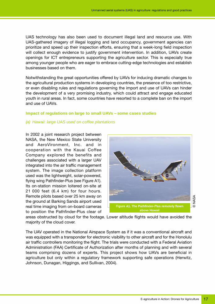
(a) Hawaii: large UAS used on coffee plantations
In 2002 a joint research project betweenNASA, the New Mexico State Universityand AeroVironment, Inc. and incooperation with the Kauai CoffeeCompany explored the benefits andchallenges associated with a larger UAVintegrated into the air traffic managementsystem. The image collection platformused was the lightweight, solar-powered,flying wing Pathfinder-Plus (see Figure A1).Its on-station mission loitered on-site at21 000 feet (6.4 km) for four hours.Remote pilots based over 25 km away onthe ground at Barking Sands airport usedreal time imaging from on-board camerasto position the Pathfinder-Plus clear ofareas obstructed by cloud for the footage. Lower altitude flights would have avoided themajority of the cloud cover.
The UAV operated in the National Airspace System as if it was a conventional aircraft andwas equipped with a transponder for electronic visibility to other aircraft and for the Honoluluair traffic controllers monitoring the flight. The trials were conducted with a Federal AviationAdministration (FAA) Certificate of Authorization after months of planning and with severalteams comprising dozens of experts. This project shows how UAVs are beneficial inagriculture but only within a regulatory framework supporting safe operations (Herwitz,Johnson, Dunagan, Higgings, and Sullivan, 2004).
Figure A1. The Pathfinder-Plus remotely flownabove Hawaii
© N
AS
A

E-agriculture in Action: Drones for Agriculture18
Unmanned aerial systems (UAS) in agriculture: regulations and good practices
(b) Japan and the United States of America: a medium UAV used on vineyards
The Yamaha RMAX from Japan is a remote controlled helicopter with over two million flighthours in agricultural spraying and weighs 94 kg. Numerous 2 500 RMAX platforms operatein Japan where more than 2.5 million acres are treated annually. The helicopter’s flight timecan reach one hour supporting VLOS agricultural missions conducted 20 m above the cropsto replace or augment the application of chemicals from backpack spraying among tightlyspaced vine rows on challenging terrain. It navigates via a precision GPS, deceleratingquickly during a failure and slowing to descend onto the field in an emergency. NewJapanese regulations were published in December 2015 (see Figure A2).
Source: Ministry of Land, Infrastructure, Transport and Tourism (2015)
Figure A2. Depiction of Japanese UAV airspace rule set
Permission from the Minister of Land, Infrastructure, Transport and Tourism is only requiredfor operations more than 150 m above ground level (AGL), near airports or above denselyinhabited districts. Otherwise, operations must occur in daytime, VLOS, clear of eventswhere people gather and more than 30 m from people or property on the ground.Transporting hazardous materials and dropping from UAVs is not allowed without permission(Ministry of Land, Infrastructure, Transport and Tourism, 2015). Crop dusting is still bigbusiness in Japan.
There are moves to utilize this platform in the United States of America. Yamaha receiveda Part 137 certification for agricultural aircraft operations in the United States of Americain late 2015 allowing the RMAX to be operated subject to state and local authority approval.In 2013 it received a permit allowing remote spraying. The conditions of this authorizationallow operations only over specific agricultural areas, not to exceed 7 m AGL, at least fivemiles from any airports and with a 48-hour pre-flight notification to the FAA.
Although VLOS operations have potential for small plots, many farms in the United Statesof America do not have small plots. Multiple VLOS operations could cover the necessaryground and complex imagery stitching could provide required mapping, although this isexpensive and not necessarily real time data (Komissarov, 2016). BVLOS operations wouldbe advantageous and need special approval. However, only a limited number have beenconducted in the United States of America outside of restricted airspace (Stöcker, Bennett,Nex, Gerke, and Zevenbergen, 2017).
Airspace around airports (B)
Permission required
Above congested area of people or
house (C)
Permission required
Airspace other than (A), (B) and (C)
No permissionrequired
Airspace abovespecified AGL (A)
Permission requiredCertainheight
Conceptual Airspace

E-agriculture in Action: Drones for Agriculture 19
Unmanned aerial systems (UAS) in agriculture: regulations and good practices
(c) The Republic of South Africa: a small UAV for vineyards
In the Republic of South Africa in 2014, flight trials were conducted using a small UAV toascertain the value of imagery in detecting vine plant health before and after the applicationof organic nutrition. Mapping flights were conducted and the nutrients were applied usingconventional methods immediately afterwards. High-resolution farm and vine mappingimagery was taken before the crops were sprayed with nutrients and at stages afterwards.This data was shared with farmers, agronomists and soil scientists. The imagery showsimprovement in the treated rows relative to untreated rows (Figure A3).
New regulations for operating UAVs in the Republic of South Africa became effective inJuly 2015. These enforce a long list of requirements that take time to complete and arereported as expensive and overly onerous (Wijnberg, 2017). For example, the licensing rulesto operate UAVs commercially require a pilot licence, air services licence from theDepartment of Transport, a letter of approval for each UAV and a remote operators certificatebased on an approved operations manual (Mortimer, 2017).
(d) The Republic of India: a small UAV on a coffee plantation
In 2016 a small UAV was used to survey land use in a coffee plantation. The results providedthe landowner with exact area measurements of land utilization to determine the exact areaunder a coffee plantation to estimate yields.
This process would have been very costly and time consuming employing ground basedsurveyors as the estate was located in a mountainous region with no road access at manypoints. UAVs are popular in the Republic of India, however there is no clear set of regulationsas yet.
In April 2016, the civilian airspace regulatory authority, the Director General of Civil Aviation,published draft “Guidelines for Obtaining Unique Identification Number and Operation ofCivil Unmanned Aircraft System” (Director General of Civil Aviation, 2016). Under these draftrules, each UAV must be issued and fitted with a unique identification. A UAS operatorpermit and insurance is required for all civil UAV operations at or above 120 m AGL inuncontrolled airspace (Global Drone Regulations Database, no date).
Figure A3. UAV before and after imagery highlighting nutrient value © C
TA

E-agriculture in Action: Drones for Agriculture20
Unmanned aerial systems (UAS) in agriculture: regulations and good practices
consistent regulations to support growth and industry innovation (India, 2017).
UAV rules and regulations in Africa
The Republic of South Africa was the first country to implement and enforcea comprehensive set of legally binding rules governing UAVs in July 2015. As shown inTable A1, a total of 15 countries has published dedicated UAV regulations as of the writingof this paper. These represent 28 percent of the total number of countries on the continent.Seven countries, listed in under “minor references”, appended early ICAO guidance to theiraviation regulations. It is noteworthy that the guidance is entirely replicated suggestingstandardization has already been a factor in Africa.
The experience gained from these trialsillustrates that UAV requirements have notbeen a hindrance and that operations aremostly low-level and away from cities withmany private properties. Operations havebeen conducted over a private propertyin a city and all necessary permissionsfrom the local police were issued. Landownership in the Republic of India tendstoward smaller areas of land and eventhough such surveys are reported astechnically positive, they are not yeteconomically viable. Future operations areplanned over large areas of land undercontract farming by multinational foodcompanies. Concern has been raisedthat the benefits from UAV use will declinein the Republic of India as multiplestates may regulate UAV activity througha patchwork of rules. It is crucial that thefederal government reviews presentinconsistent rule making and publishes
Table A1. Status of UAV regulations by country in Africa
Status Countries
Regulations are in place Botswana, Cameroon, Gabon, Ghana, Madagascar, Mauritius, Namibia,Nigeria, Rwanda, Seychelles, South Africa, Swaziland, Tanzania, Zambiaand Zimbabwe.
Minor references are included Benin, Burkina Faso, Chad, Côte d’Ivoire, Mali, Mauritania and Senegal.in aviation regulations
Regulations are pending or Angola, Kenya and Malawi.being developed
Sources: Jeanneret and Rambaldi (2016) updated by Soesilo, Meier, Lessard-Fontaine, Du Plessis, and Stuhlberger (2016)and Guerin (2017)
Figure A4. Land use survey imagery from UAVshowing buildings and access roads
© C
TA
E-agriculture in Action: Drones for Agriculture 21
Unmanned aerial systems (UAS) in agriculture: regulations and good practices
The African Civil Aviation Commission represents 54 African states and was created in 1964by ICAO but it remains autonomous. This organization could be a conduit for the evolutionof consistent regulations across Africa, recognizing that ICAO remains fixed only on creatingSARPs pertinent to large UAVs, or those deemed by EASA in the “certified” category.
The fact that the Republic of South Africa has regulations in place, is seen by some asposing serious challenges to the development of a thriving UAV service industry. Accordingto a licensed UAV operator (Wijnberg, 2017), the Republic of South Africa has arguably themost restrictive regulations in the world for commercial use. The heavy handed approachhas forced UAV companies to operate illegally locally or to move out of the country to stayin business, or close shop entirely, with or cease operating. In the Republic of South Africathe regulations consider that using an UAV for data-generation in agriculture means that itis used commercially and should be governed in the same manner as commercial mannedaircraft. This requires the operator to comply with a number of major steps, including, butnot limited to the following:
● obtaining a remote pilot license (RPL);● registering the aircraft;● obtaining an air service license (ASL) from the Department of Transport (DoT); and● obtaining a remote operator’s certificate (ROC) from the South African Civil Aviation
Authority (SACAA).
Single business owners find it difficult to comply with the regulations as they require a largenumber of positions to be filled, such as quality assurance manager, flight operationsmanager, safety officer and security officer. The total cost to comply with the regulationsamounts to over ZAR 500 000 (EUR 32 600) and takes over two years to complete. Often,some sections such as the Air Services License will expire and require renewal before theROC is issued.
Since the regulations were published in 2015, only 14 companies have been licensed tooperate and there is a backlog of over 400 applications (Wijnberg, 2017).
The Republic of Uganda has no regulations in place and UAVs are confiscated fromtravellers at the airport of Entebbe. Those attempting to obtain an import permit for runningUAS services for agriculture have to deal with a range of government bodies including theMinistry of Agriculture, Animal Industry and Fisheries (MAAIF), Ministry of Internal Affairs,Ministry of Defence, Civil Aviation Authority and more, without having the certitude ofobtaining the necessary permits.
The Civil Aviation Authority in the Republic of Kenya announced the development of itsnational regulations governing the use of remotely piloted aircrafts in February 2017. As ofthe writing of this chapter, such regulations have still to be enacted and the import anduse of UAVs is prohibited. Several development agencies and international researchinstitutions interested in supporting the introduction and use of UAVs in the agriculturaldomain are facing a legal void and have put projects on hold or cancelled allocated funding.
The Civil Aviation Authority of the Republic of Rwanda enacted its UAS regulations inJune 2016 and has issued only one permit to a local company so far.

E-agriculture in Action: Drones for Agriculture22
Unmanned aerial systems (UAS) in agriculture: regulations and good practices
The Civil Aviation Authority of the Republic of Ghana enacted its regulations in June 2016.In December 2016 it issued an additional directive instructing all UAV operators or usersto obtain written permission from regional or local police stations before operating UAVs.The enabling environment favoured the industry and a number of UAV operators alreadyservice the agricultural sector.
As a parameter of reference, in the United Kingdom of Great Britain and Northern Ireland,the legislation governing the use of UAVs is still being fine-tuned after a public consultationthat took place in 2016 and is meant to be enacted under the Vehicle Technologyand Aviation Bill (Butcher and Haylen, 2017). Nonetheless, as of 17 July 2017 there werea total of 3 046 approved Small Unmanned Aircraft (SUA) operators deploying sub-7 kgUAVs and/or 7 to 20 kg UAVs (Civil Aviation Authority (UK), 2017).
Conclusions: the impact of regulations on UASin agriculture
The world is dealing with the emergence of new technologies in the position to gather dataat an impressive level of detail. In this respect, governments have been busy legislating onpersonal data management and privacy issues. Civil UAV technology, for professional andrecreational use, adds a layer of complexity as its deployment allows access to viewspreviously inaccessible to many, and impinges on airspace, a dimension traditionally usedby manned aircraft. UAS offer a vast range of service opportunities. According to PwC,UAS will transform agriculture into a high-tech industry for the first time, with decisionsbeing based on real gathering and processing of data and a likely increase in productivityand yields (Drone Powered Solutions, 2016). Being a new technology and developing fasterthan the regulations intended to regulate its use, it is quite challenging to assess how thesehave influenced UAS operations in agriculture. In addition, a range of stakeholders usuallycontributes to the development of such regulations.
In shaping their governance, there is the need to find a balance between managing theground and air risks of UAS operations, the need for safety and privacy and the benefitsto agriculture and broader natural resource management. Hence it is of paramountimportance that CAAs closely interact with stakeholders in the agricultural sector in theprocess.
Networking and sharing are key ingredients, which could lead to the identification of bestpractices. There is a clear move away from classifying different operations based on theweight of the UAV and toward the risk of the operation. Light, VLOS low altitude operationsshould not impinge on the regulatory authorities or require them to be accountable. Thegovernments can then dedicate their energies on assessing the riskier operations and oneducation campaigns so that operators and the public understand the rule set under whichthey exist. They can also focus on addressing gaps in the legal framework (for exampleprivacy and data issues) and examining the relationship between new technologies andautomation and the ATM system (Stöcker, Bennett, Nex, Gerke, and Zevenbergen, 2017).The EASA three-category approach is clearly the world’s best practice and its spread aroundthe globe should be supported for national and international harmony and commonstandards. All steps to streamline the regulatory process should be taken.
E-agriculture in Action: Drones for Agriculture 23
Unmanned aerial systems (UAS) in agriculture: regulations and good practices
The common thread in regulation requirements around the globe are that UAVs should beregistered and insured and their operators should have a licence, with the exception ofharmless flights, i.e. very small, platforms away from people.
There is the need to continue advocating for the standardizing of regulations toward a risk-based approach, especially as this will clearly benefit agriculture. A special focus is neededon addressing data capture and privacy issues as these are the backbone of agriculturalimprovements.
UAS services represent a new frontier in technology development. Youth is attracted bytechnology, its development and use. UAS for agriculture could be a magnet for educatedyouth in developing countries to develop service enterprises based or at least operating inrural areas, thus generating jobs opportunities and improving agricultural production andfarmers’ returns on investment. As the industry is fast developing in countries where theregulations are enabling, and on hold or winding down where these are too strict, expensiveto comply with or disabling, regulators should be fully aware that the impact of theirdecisions reaches far beyond security and privacy and could determine whether agriculturebecomes a data-driven and profitable enterprise or not.
References
African Aerospace Online News Service. 2017. Going into battle against the deadly hoards [online].[Cited 7 July 2017]. http://www.africanaerospace.aero/going-into-battle-against-the-deadly-hoards
African Civil Aviation Commission. n.d. African Civil Aviation Commission [online]. [Cited 16 July 2017].www.afcac.org
Butcher, A., & Haylen, L. 2017. Civilian drones. London, House of Commons Library.
Civil Aviation Authority (UK). 2017, July 14. Small unmanned aircraft (SUA) operators holding a validCAA permission [online]. [Cited 30 July 2017]. https://publicapps.caa.co.uk/docs/33/20170714RptUAVcurrent.pdf
Cressman, K. 2016, April. Preventing the spread of desert locust swarms. ICT Update, pp. 8-9.
Director General of Civil Aviation. 2016. Guidelines for obtaining unique identification number (UIN) &operation of civil unmanned aircraft systems (UAS) [online]. [Cited 19 July 2017]. https://goo.gl/vjM7EV
DJI. 2016. DJI GO app now includes GEO geofencing system [online]. [Cited 21 July 2017]. https://goo.gl/gDoF1x
Drone Powered Solutions. 2016. Clarity from above. PwC global report on the commercial applicationsof drone technology. Warsaw, PwC.
Drones University. 2017. SACAA crackdown on illegal drone usage [online]. [Cited 21 July 2017]. http://www.drones.university/sacaa-crack-illegal-drone-usage-doubles-sa/
EASA. 2017. EASA and you, civil drones [online]. [Cited 21 July 2017]. https://www.easa.europa.eu/easa-and-you/civil-drones-rpas
Emmerson, A. no date. Why we regulate the way we regulate and who pays [online]. [Cited 21 July 2017].https://infrastructure.gov.au/aviation/asrr/submissions/files/250_a_emmerson_8_feb_2014.pdf
European Commission. 2016. Drones: Commissioner Bulc presents plans for a drones services market[online]. [Cited 14 August 2017]. https://ec.europa.eu/transport/modes/air/news/2016-11-23-drones-commissioner-bulc-presents-plans-creation-european-drone-services_en
E-agriculture in Action: Drones for Agriculture24
Unmanned aerial systems (UAS) in agriculture: regulations and good practices
European Commission. no date. DroneRules.eu [online]. [Cited 12 August 2017]. www.dronerules.eu
Federal Aviation Authority. 2014. FAA part 137 [online]. [Cited 7 July 2017]. https://goo.gl/iRdGLb
Global Drone Regulations Database. no date. [online]. [ Cited 17 August 2017]. https://www.droneregulations.info/India/IN.html#country-search
Greenwood, S. 2016, April. Drones on the horizon: new frontier in agricultural innovation. ICT Update,pp. 2-3.
Guerin, D. 2017. Global drone regulations database [online]. [Cited 22 July 2017]. www.dronregulations.info
Guermazi, B. 2016, September 11. Watching Tanzania leapfrog the digital divide [online]. [Cited 21 July2017]. https://goo.gl/ALxTKd
Herwitz, R. S., Johnson, L. F., Dunagan, S. E., Higgings, R. G., & Sullivan, D. V. 2004. Imaging froman unmanned aerial vehicle: agricultural surveillance and decision support. Computers and Electronicsin Agriculture, pp. 49–61 (also available at http://www.afcac.org/en/index.php?option=com_content&view=article&id=2&Itemid=69).
ICAO. no date. Current state regulations [online]. [Cited 21 July 2017]. https://goo.gl/AZsG3v
ICAO. 2016. Safety oversight manual, part A: the establishment and management of a state’s safety. Doc.9734. Montreal: ICAO.
India, C. 2017. Civilian drones and India’s regulatory response [online]. https://goo.gl/vq16lo
Jeanneret, C., & Rambaldi, G. 2016. Drone governance: a scan of policies, laws and regulations governingthe use of unmanned aerial vehicles (UAVs) in 79 countries. Waheningen, CTA.
Komissarov, V. 2016. Drones in agriculture: hype or reality [online]. [Cited 21 July 2017]. https://medium.com/@V.K.Komissarov/drones-in-agriculture-hype-or-reality-33b333c12376
Ministry of Land, Infrastructure, Transport and Tourism. 2015. Description of unmanned aircraftregulation in Japan [online]. [Cited 19 July 2017]. https://www.mlit.go.jp/en/koku/uas.html
Mortimer, G. 2017. South Africa’s constrained commercial drone industry [online]. [Cited 21 July 2017].https://www.suasnews.com/2017/02/south-africas-constrained-commercial-drone-industry/
National Agricultural Aviation Association. no date. Industry facts about the aerial application industry[online]. [Cited 21 July 2017]. www.agaviation.org
NEPAD. 2016. African Union Commission appoints High Level African Panel on Emerging Technologies[online]. [Cited 21 July 2017]. https://goo.gl/wUbG9s
NPD Group. 2017. Premium drones drive steady sales, while lower cost drones fly off shelves during theholidays [online]. [Cited 21 July 2027]. https://goo.gl/WwQF6P
NTSB, N. S. 2014. Special investigation report on the safety of agricultural aircraft operations. Washington,NTSB.
Soesilo, D., Meier, P., Lessard-Fontaine, A., Du Plessis, J., & Stuhlberger, C. 2016. Drones forhumanitarian and environmental applications: a guide to the use of airborne systems in humanitariancrises. Geneva, FSD.
Stöcker, C., Bennett, R., Nex, F., Gerke, M., & Zevenbergen, J. 2017. Review of the current state ofUAV regulations. Remote Sensing, Vol 9 (5). Doi: 10.3390/rs9050459
Vogt, T. 2017. UTM exploration: testing mobile connectivity for integrating UAS. RPAS 2017 and EuropeanRPAS Policy, Regulatory & Innovation Forum, 13-14 June, Brussels.
Wijnberg, L. 2017. Are South African regulations stifling the drone-based agri-service industry, a potentialgame changer for agriculture? [online]. [Cited 22 July 2017] http://www.cta.int/en/article/2017-08-08/are-south-african-regulations-stifling-the-drone-based-agri-service-industry-a-potential-game-changer-for-agriculture.html

E-agriculture in Action: Drones for Agriculture 25
Unmanned aerial systems (UAS) in agriculture: regulations and good practices
For more information
Giacomo RambaldiCTA, Senior Programme Coordinator [email protected]
David Guerin, for [email protected]
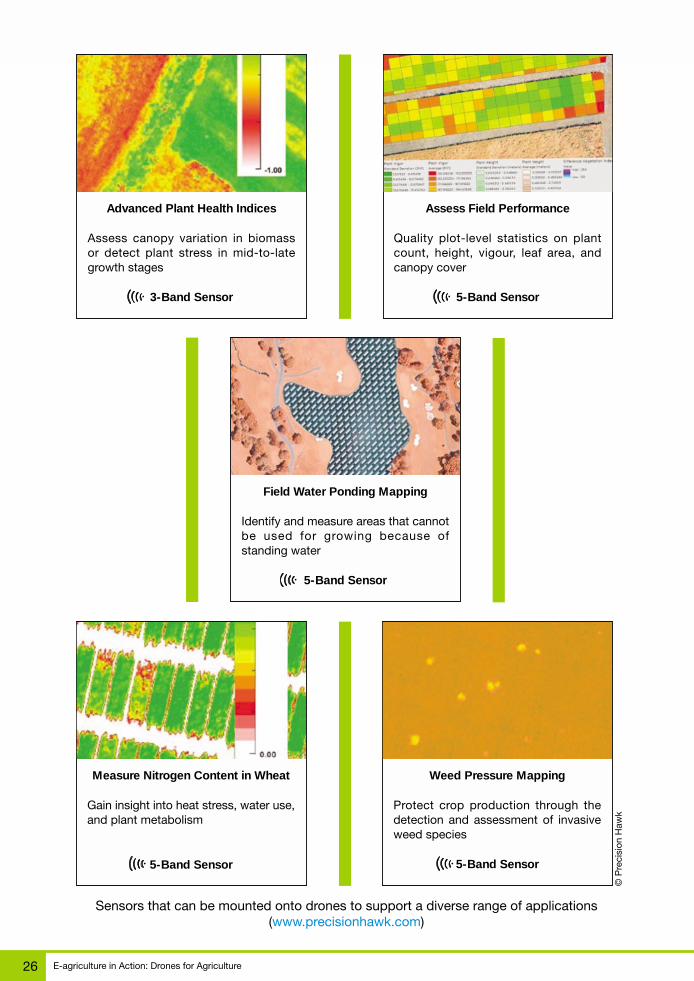
E-agriculture in Action: Drones for Agriculture26
Unmanned aerial systems (UAS) in agriculture: regulations and good practices
Measure Nitrogen Content in Wheat
Gain insight into heat stress, water use,and plant metabolism
5-Band Sensor
Weed Pressure Mapping
Protect crop production through thedetection and assessment of invasiveweed species
5-Band Sensor
Field Water Ponding Mapping
Identify and measure areas that cannotbe used for growing because ofstanding water
5-Band Sensor
Sensors that can be mounted onto drones to support a diverse range of applications(www.precisionhawk.com)
© P
reci
sion
Haw
k
Assess Field Performance
Quality plot-level statistics on plantcount, height, vigour, leaf area, andcanopy cover
5-Band Sensor
Advanced Plant Health Indices
Assess canopy variation in biomassor detect plant stress in mid-to-lategrowth stages
3-Band Sensor

E-agriculture in Action: Drones for Agriculture 27
Drone technology as a tool for improving agricultural productivityCase study
B
Technology has transformative potential for virtually every aspect of our existence. Itimproves efficiency by reducing workload and required time in numerous industries. Theagriculture industry is no exception. The progressive automation of agricultural processeshas significantly improved the productivity of agriculture labour, shifting masses of workersinto other productive industrial areas. Since then, scientific advances in chemistry, genetics,robotics and many other applied sciences have fuelled the accelerated development ofagricultural technology. In effect, in recent years agricultural production has increasedsubstantially. However, the demand for agricultural products is due to rise even further withestimations of aggregate agricultural consumption to increase by 69 percent from 2010 to2050, mostly fuelled by an increase in global population from 7 to 9 billion people duringthe same time frame. The only feasible answer for this urgent call for increased agriculturalproduction must come from technology sector. Drone technology and advanced image dataanalytics with the capabilities it provides have the potential to become important parts ofthe technology mix that could fill the gap. Between current agricultural production and theneeds of the future.
There are a number of applications of drone technology convergence with advanced imagedata analytics that can be utilized in the agriculture industry. Our recent estimations valuedthe addressable market for drone application in agriculture at USD 32.4 billion. The majorityof applications is based of drones as a mobile, aerial platform for advanced image dataacquisition. Based on particular project requirements drones can be equipped with a rangeof image data sensors. The most established application based on drone-acquired imagedata is to assess the health of crop vegetation. An unmanned airborne platform equippedwith infrared cameras can enable the development of Normalized Difference VegetationIndex (NDVI). The NDVI-view of a certain area enables the analysis of the intensity of solarradiation absorption and therefore the condition of the monitored plants. This method hasbeen widely used for decades based on satellite- or plane-borne cameras, but the resolutionof the resulting products has been insufficient to map fields, precisely, not to mention specificplants. Drone technology as a platform for image data acquisition has brought the NDVImapping capabilities to a completely new level of accuracy making it possible to monitorthe condition of not only plants, but also specific parts of plants. This level of informationenables the early identification of early identification of pests, diseases and pests. Theprecisely mapped and identified issues within a certain area can be addressed with preciseapplications of fertilizers, pesticides or herbicides. Advanced geospatial NDVI products canalso be used in case of natural disasters or destruction of crops to precisely estimate the
Drone technology as a toolfor improving agricultural
productivityPERSPECTIVES FROM PwC’s DRONE POWERED
SOLUTIONS CENTRE OF EXCELLENCE
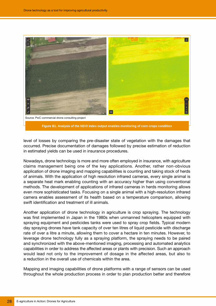
E-agriculture in Action: Drones for Agriculture28
Drone technology as a tool for improving agricultural productivity
level of losses by comparing the pre-disaster state of vegetation with the damages thatoccurred. Precise documentation of damages followed by precise estimation of reductionin estimated yields can be used in insurance procedures.
Nowadays, drone technology is more and more often employed in insurance, with agricultureclaims management being one of the key applications. Another, rather non-obviousapplication of drone imaging and mapping capabilities is counting and taking stock of herdsof animals. With the application of high resolution infrared cameras, every single animal isa separate heat mark enabling counting with an accuracy higher than using conventionalmethods. The development of applications of infrared cameras in herds monitoring allowseven more sophisticated tasks. Focusing on a single animal with a high-resolution infraredcamera enables assessment of its health based on a temperature comparison, allowingswift identification and treatment of ill animals.
Another application of drone technology in agriculture is crop spraying. The technologywas first implemented in Japan in the 1980s when unmanned helicopters equipped withspraying equipment and pesticides tanks were used to spray crop fields. Typical modernday spraying drones have tank capacity of over ten litres of liquid pesticide with dischargerate of over a litre a minute, allowing them to cover a hectare in ten minutes. However, toleverage drone technology fully as a spraying platform, the spraying needs to be pairedand synchronized with the above-mentioned imaging, processing and automated analyticscapabilities in order to address the affected areas or plants with precision. Such an approachwould lead not only to the improvement of dosage in the affected areas, but also toa reduction in the overall use of chemicals within the area.
Mapping and imaging capabilities of drone platforms with a range of sensors can be usedthroughout the whole production process in order to plan production better and therefore
Source: PwC commercial drone consulting project
Figure B1. Analysis of the NDVI index output enables monitoring of corn crops condition
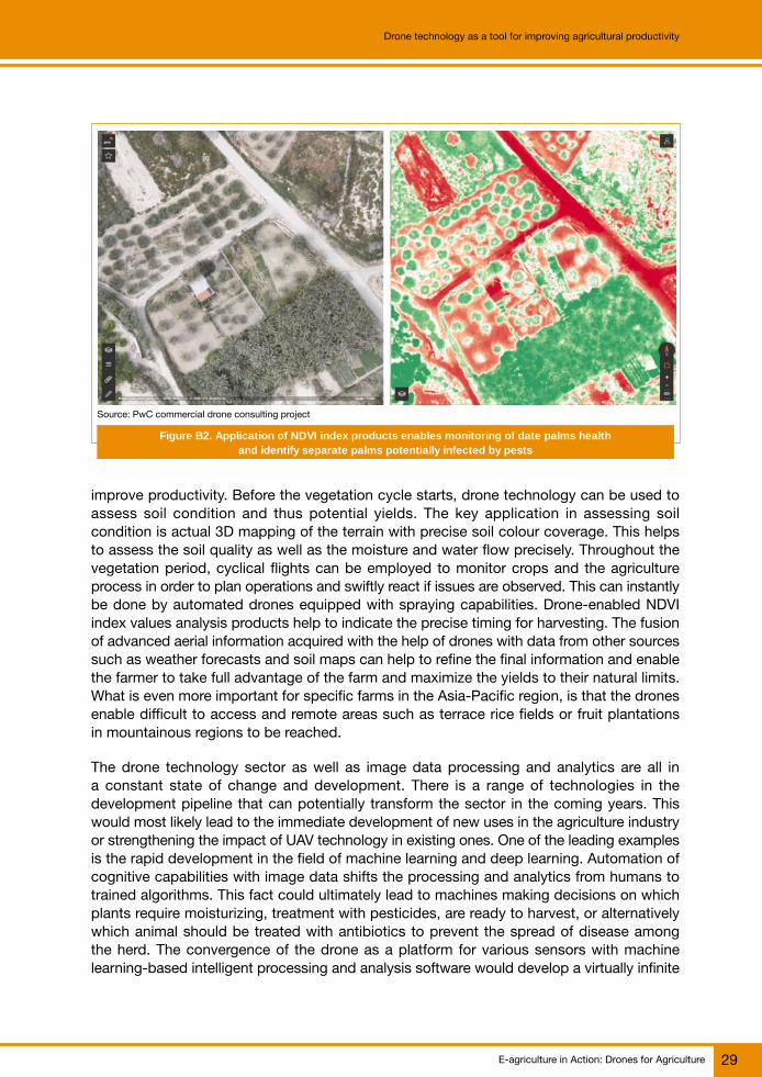
E-agriculture in Action: Drones for Agriculture 29
Drone technology as a tool for improving agricultural productivity
improve productivity. Before the vegetation cycle starts, drone technology can be used toassess soil condition and thus potential yields. The key application in assessing soilcondition is actual 3D mapping of the terrain with precise soil colour coverage. This helpsto assess the soil quality as well as the moisture and water flow precisely. Throughout thevegetation period, cyclical flights can be employed to monitor crops and the agricultureprocess in order to plan operations and swiftly react if issues are observed. This can instantlybe done by automated drones equipped with spraying capabilities. Drone-enabled NDVIindex values analysis products help to indicate the precise timing for harvesting. The fusionof advanced aerial information acquired with the help of drones with data from other sourcessuch as weather forecasts and soil maps can help to refine the final information and enablethe farmer to take full advantage of the farm and maximize the yields to their natural limits.What is even more important for specific farms in the Asia-Pacific region, is that the dronesenable difficult to access and remote areas such as terrace rice fields or fruit plantationsin mountainous regions to be reached.
The drone technology sector as well as image data processing and analytics are all ina constant state of change and development. There is a range of technologies in thedevelopment pipeline that can potentially transform the sector in the coming years. Thiswould most likely lead to the immediate development of new uses in the agriculture industryor strengthening the impact of UAV technology in existing ones. One of the leading examplesis the rapid development in the field of machine learning and deep learning. Automation ofcognitive capabilities with image data shifts the processing and analytics from humans totrained algorithms. This fact could ultimately lead to machines making decisions on whichplants require moisturizing, treatment with pesticides, are ready to harvest, or alternativelywhich animal should be treated with antibiotics to prevent the spread of disease amongthe herd. The convergence of the drone as a platform for various sensors with machinelearning-based intelligent processing and analysis software would develop a virtually infinite
Source: PwC commercial drone consulting project
Figure B2. Application of NDVI index products enables monitoring of date palms healthand identify separate palms potentially infected by pests

E-agriculture in Action: Drones for Agriculture30
Drone technology as a tool for improving agricultural productivity
range of possibilities, maximizing the production and limiting the manned workload evenfurther. This would in effect lead to an increase in productivity and a decrease in the priceof agricultural products, thus enabling the gap between current production and the needsof the growing global population to be closed.
However, the use of advanced image data analytics and processing pose a challenge inthe fields of a data strategy and data management. One of the key challenges related todata management is the fact that along with accuracy and precision of information, thesize of datasets grows accordingly generating up to 140 GB of data for a single squarekilometre with ground sampling distance (GSD) of 1 centimetre. To address this challenge,data strategy tailored to specific requirements is necessary. Another key challenge isincorporating drone-borne imaging and advanced image data processing and analytics intoexisting agricultural processes in order to ensure the agriculture sector can fully leveragenew information. The possession of additional knowledge and analytics tools will not bringbenefits on its own. The implementation and integration of the new information intoagricultural business processes is required to truly tap the potential of drone solutions andadvanced image data analytics in the industry.
Source: Food and Agriculture Organization of the United Nations agricultural land area for 2014
1 000
800
600
400
200
00.5 0.25 0.1 0.05 0.02 0.01
GSD (m)
Tota
l dat
a vo
lum
e (P
B) 818.6 PB
Figure A3. Estimated total data volume for Asia and Oceania agricultural land geospatial products,depending on their Ground Sampling Distance (Petabytes = 1015 bytes)
Drone technology and advanced image data analytics tools are of great potential for theagriculture industry. Drone solutions can be implemented in a range of applicationsthroughout the whole process from precise mapping for planning purposes, assessing thecondition of crops and plants, to precise crop spraying. But with as all other tools, theright strategy and setup is required to fully leverage the technology available. With thebooming industry of drone technology and sensors, and the availability of image dataprocessing and analytics tools, the technology mix for the required solutions must beplanned cautiously to maximize the benefits while optimizing the costs. The same is truefor the process of data acquisition itself. Along with operating drone solutions, a large volumeof data is generated. Therefore the requirements regarding precision, resolution and layersof data employed must fully reflect the requirements of any specific use and thus shouldbe planned on a project basis. Lastly, once the optimal solution is developed and the data
E-agriculture in Action: Drones for Agriculture 31
Drone technology as a tool for improving agricultural productivity
acquired does not exceed processing capabilities, the information extracted needs to befully implemented and integrated into the business process. However, once the requiredtechnology mix is deployed, the analytical capabilities are optimized and the solution isfully integrated into business processes, the full potential of the technology is ready to beexploited and the productivity improved substantially. Maximizing yields and limiting theworkload and thus the costs of goods will be vitally important in the ensuing decades ofunprecedented growth of agricultural product demand that we face globally and particularlyin the Asia-Pacific region.
For more information
Adam WisniewskiPwC, Director of the Drone Powered Solutions Centre of [email protected]

E-agriculture in Action: Drones for Agriculture32
Drone technology as a tool for improving agricultural productivity
Pho
to b
y C
M29
bre
izh
on P
ixab
ay

E-agriculture in Action: Drones for Agriculture 33
Mapping and monitoring rice areas using remote sensing, crop modelling and information and communication technology (ICT)Case study
CMapping and monitoring rice areas
using remote sensing, crop modellingand information and communication
technology (ICT)EXPERIENCES FROM THE INTERNATIONAL RICE
RESEARCH INSTITUTE (IRRI)
Introduction
Rice has been a prime focus for the development of integrated remote sensing andinformation and communications technology (ICT) based monitoring, mapping and yieldestimation systems in South Asian and Southeast Asian countries in order to target foodsecurity, which is closely connected to the livelihoods of smallholder farmers. In 2012, theInternational Rice Research Institute (IRRI) together with a private partner, sarmap, initiateda project titled “Remote Sensing Based Information and Insurance for Crops in EmergingEconomies (RIICE)”. The project was funded by the Swiss Agency for Development andCooperation (SDC) and was a public-private partnership aiming to reduce the vulnerabilityof smallholder farmers engaged in rice production. The geographic extent of Phase-I(2012–2015) of this project spans six target countries located in South Asia and SoutheastAsia, namely the Kingdom of Cambodia, the Republic of India, the Republic of Indonesia,the Republic of the Philippines, the Kingdom of Thailand and the Socialist Republic ofViet Nam (Figure C1).
In Phase-II (2015–2017) area coverage in the Kingdom of Cambodia, the Kingdom ofThailand, the Socialist Republic of Viet Nam, and Tamil Nadu, the Republic of India wasexpanded. In 2014, a new entity “Philippines Rice Information System (PRISM)” was initiatedand funded by the Department of Agriculture, the Republic of Philippines which will continueuntil the end of 2017. RIICE Phase-III activities will continue in the Kingdom of Thailand,the Kingdom of Cambodia, the Socialist Republic of Viet Nam, the Republic of India andthe Republic of Indonesia from 2017 to 2019.
These satellite-based rice monitoring (SRM) initiatives integrated remote sensing, cropmodelling and ICT tools to generate and provide near-real time and accurate informationon rice growth, yield, as well as damage caused by abiotic and biotic stresses. The RIICEtechnology is capable of providing accurate and timely village level information about riceplanted areas, including information on the start of the season and its variability withgeography, expected and actual yield and the impact of any disaster on specific rice growingareas. RIICE is now providing accurate and almost real time information for theimplementation of crop insurance programmes in various countries (i.e. the Republic of India

E-agriculture in Action: Drones for Agriculture34
Mapping and monitoring rice areas using remote sensing, crop modelling and information and communication technology (ICT)
and the Socialist Republic of Viet Nam). These projects have already made significantimpacts in terms of rice monitoring, mapping and forecasting. This integrated systemcombining remote sensing, crop modelling, web geographic information system (GIS),smartphone, unmanned aerial vehicles (UAV), and Amazon Web Services (AWS) hasgenerated promising results in all countries. With greater than 85 percent accuracy, morethan 24.5 million hectares of rice have been monitored in 2016, a significant increase ofarea coverage of 1.6 million ha when the initiative started in 2012. Partnership andagreement with national and state governments have also been established on the use ofthe RIICE technology for food security and crop insurance policies with substantialinvestment has been received from states governments in the Republic of India and theRepublic of Philippines.
The SRM initiative focused principally on the development of sustainable technologies andthus in that context both projects were fully committed to developing in-country capacitybuilding and integration of a developed rice monitoring system within the national system.This rice monitoring system helps the government and other rice sector actors by providingaccurate and up to date information that allows for better management of domestic riceproduction and distribution hence resulting in reduced vulnerability of smallholder farmersand increased food security. The generated information can also help governments andrice value chain actors to identify and manage any risks involved in rice production better.Accurate and almost real time information on rice growth can help governments and otheractors to adapt their economic policies on rice import and export and can also enable
Figure C1. Satellite-based rice monitoring (SRM) sites in South Asia and Southeast Asia © IR
RI

E-agriculture in Action: Drones for Agriculture 35
Mapping and monitoring rice areas using remote sensing, crop modelling and information and communication technology (ICT)
disaster response and preparedness agencies to better anticipate and coordinate reliefefforts in the event of natural calamities. High quality data generated through the RIICEtechnology can also be used to develop more efficient and transparent crop insuranceproducts to protect smallholder farmers.
The main beneficiaries of this practice are the national research and extension system inthe target country/state, central and local government units, insurance providers,researchers, scientists and policymakers.
These projects already demonstrate good practice for satellite-based rice crop areamonitoring and mapping and are a promising practice for UAV-based rice crop healthmonitoring. Integrated remote sensing and ICTs were applied in agronomy. ICTs were usedwith earth observation processing software, integrated remote-sensing and crop modellinginterface, ORYZA crop growth model, Geo-Open Data Kit (Geo-ODK), climate data retrievaland processing module. These practices were implemented in the Republic of thePhilippines (whole country), the Socialist Republic of Viet Nam (Mekong Delta and Red RiverDelta), the Kingdom of Cambodia (whole country), the Kingdom of Thailand (North, NorthEast, and Central Plain), the Republic of India (Tamil Nadu and Odisha states), the Republicof Indonesia (Subang district, West Java and Purbalinga district, Central Java).
Various public and private partners were involved and played specific roles. Partners inthis study include: SDC (RIICE project donor); sarmap (earth observation processingtechnology provider); German Development Agency (GIZ) (country governance and cropinsurance implementation); Alliance (crop insurance implementation), Swiss Re Group (cropinsurance implementation); Philippines Rice Research Institute (PhilRice) (ground informationcollection and dissemination and recipient of technology transfer); Philippines Departmentof Agriculture (PRISM project donor, ground information provider, IT management entity,and recipient of technology transfer); Cambodia Agriculture Research and DevelopmentInstitute (CARDI) (ground information collection and dissemination and collaborator oncapacity building); Department of Planning and Statistics (DPS), Ministry of Agriculture,Forestry and Fisheries (MAFF), Kingdom of Cambodia (ground information collection anddissemination, IT management, and recipient of technology transfer); Thailand RiceDepartment (ground information collection and dissemination, IT management, and recipientof technology transfer); Thailand Geo-Informatics and Space Technology DevelopmentAgency (GISTDA) (IT management); Thailand Department of Agricultural Extension (DOAE)(ground information collection and dissemination and recipient of technology transfer); TamilNadu Agricultural University (TNAU), Republic of India (ground information collection anddissemination, IT management, and recipient of technology transfer); Indonesian Centerfor Agricultural Land Resource Research and Development (ICALRD) (ground informationcollection and dissemination and recipient of technology transfer); State Department ofOdisha, Republic of India.
Methodology and development of ICT
The satellite-based rice monitoring system deploys three software modules, namelyMAPscape-Rice (Nelson et al., 2014), Rice Yield Estimation System (Rice-YES) (Setiyonoet al., 2017), and ORYZA Crop Growth Model (Li et al., 2017) This was done by developing

E-agriculture in Action: Drones for Agriculture36
Mapping and monitoring rice areas using remote sensing, crop modelling and information and communication technology (ICT)
and validating dedicated software to process Synthetic Aperture Radar (SAR) data supportedwith in situ information gathered using ICT and to integrate SAR information with other inputsfor ORYZA crop growth model to simulate and map rice yield results. MAPscape-Riceprocesses SAR raw data into terrain-geocoded images (see Figure C2 for the process).Figure C3 shows an example for Tamil Nadu in the Republic of India. Similar maps wereproduced for the Mekong Delta rice area (Figure C4a), and for start of season (SoS) (WinterSpring) for the Mekong Delta (Figures C4b and C4c), and leaf area index products.Rice-YES integrates remote sensing information from MAPScape-Rice together with climate,soil, and agronomic management information to simulate rice yield using ORYZA cropgrowth model and together with MAPScape-Rice the yield simulation results are convertedinto a map form.
In the case of natural disasters such as resulting from flood and drought, a map of theimpacted area, particularly the rice area, is generated by the system. The system providesmore detailed information on the flood impacted rice area in contrast to the conventionalinformation on the flood-affected area more generally.
MAPscape-RICESAR data processing
Earth Observation data
Rice-YES & ORYZARice yield processing
Leaf Area Indexin situ point data
Software Input Products
● Crop calendar● Crop practices● Administrative units
● Meteo data● Soil data● Phenological data● Management data
● Seasonal Area● Start of season date● Leaf Area Index● Seasonal dynamics● Flood damage● Drought damage
● Production● Production loss
Validation
Validation
Yield forecast/estimation
Figure C2. MAPscape-Rice processing of SAR raw data
© IR
RI
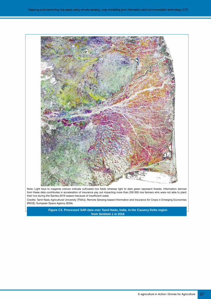
E-agriculture in Action: Drones for Agriculture 37
Mapping and monitoring rice areas using remote sensing, crop modelling and information and communication technology (ICT)
Note: Light blue to magenta colours indicate cultivated rice fields whereas light to dark green represent forests. Information derivedfrom these data contributes in acceleration of insurance pay out impacting more than 200 000 rice farmers who were not able to planttheir rice during the Samba 2016 season because of insufficient water.
Credits: Tamil Nadu Agricultural University (TNAU), Remote Sensing-based Information and Insurance for Crops in Emerging Economies(RIICE), European Space Agency (ESA).
Figure C3. Processed SAR data over Tamil Nadu, India, in the Cauvery Delta regionfrom Sentinel-1 in 2016
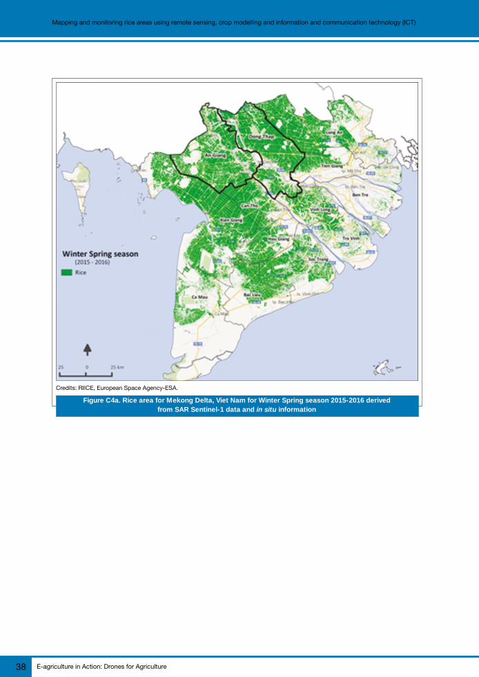
E-agriculture in Action: Drones for Agriculture38
Mapping and monitoring rice areas using remote sensing, crop modelling and information and communication technology (ICT)
Credits: RIICE, European Space Agency-ESA.
Figure C4a. Rice area for Mekong Delta, Viet Nam for Winter Spring season 2015-2016 derivedfrom SAR Sentinel-1 data and in situ information

E-agriculture in Action: Drones for Agriculture 39
Mapping and monitoring rice areas using remote sensing, crop modelling and information and communication technology (ICT)
Credits: RIICE, European Space Agency-ESA.
Figure C4b. Start of Season map for Mekong Delta, Viet Nam for Winter Spring season 2015-2016 derivedfrom SAR Sentinel-1 data and in situ information

E-agriculture in Action: Drones for Agriculture40
Mapping and monitoring rice areas using remote sensing, crop modelling and information and communication technology (ICT)
Credits: RIICE, European Space Agency-ESA.
Figure C4c. Yield map for Mekong Delta, Viet Nam for Winter Spring season 2015-2016 derivedfrom SAR Sentinel-1 data and in situ information
Rice area and yield information were made available to the stakeholders in a timely mannerand at accuracy and agreement level greater than 85 percent based on ground-truthingthe rice area map assessment and comparison against official yield data and crop cut yielddata. The practice also delivers a protocol for field and landscape level observation of ricecrop health status, including assessment of the impact of pest and disease and lodgingon rice production using an unmanned aerial vehicle (UAV) system.
Challenges
Rule-based algorithms for SAR data processing and flexibility in interface for remote-sensingand the ORYZA crop growth model were the key in addressing the challenges of site-specificvariations of the location setting. Early in the project, it was realized that because of thevaried rice ecosystem even within a country it was not possible to use a single set ofparameters for earth observation processing in order to produce reliable rice monitoringproducts. Ground information is very critical in providing inputs to ensure quality andrelevancy of the output of satellite-based rice area and seasonality maps, for example.

E-agriculture in Action: Drones for Agriculture 41
Mapping and monitoring rice areas using remote sensing, crop modelling and information and communication technology (ICT)
Context and problem addressed by ICTs
The SRM initiatives aim to provide more detailed, location-specific, timely, and accurateestimates of rice production. Such information is crucial for planning and decision makingrelated to food security. This includes assessment of potential shortfall in productionrequiring decisions on whether to import rice, better targeting of productivity enhancingtechnologies, and rehabilitation and relief in the event of a calamity.
Often, data on rice production are not available at the required level of detail. For example,in the Republic of the Philippines, official production statistics are available at provinciallevel only. Although unofficial municipal statistics are available, their accuracy and reliabilityvaries by location. With the use of high resolution SAR data, rice areas can be estimatedat a finer level of detail. Municipal and even village level data can be estimated if a gooddigital administrative map is available. Problem areas, such as those with low yields canbe located and thus targeted for technology dissemination. Moreover, estimates can beavailable two months in advance of official statistics.
In the event of a calamity, quickly obtaining estimates of the area damaged is a challengebecause of mobility issues resulting from flood, road obstructions, and/or infrastructuredamages. Also, there is a tendency to report higher damages to expedite the release ofcalamity funds. In such cases, an unbiased source of information is needed.
The effort started by relying on commercially obtained X-band SAR data from CosmoSkyMed (CSK) and TeraSAR-X (TSX) after the failure of the European Space Agency (ESA)ENVISAT (C-band) mission in April 2012. The original plan was to rely on C-band SAR datafrom ASAR ENVISAT satellite. This resulted in downscaling the coverage, in order to keepproject costs feasible, while focusing on methodology development to process the earthobservation data. In the early phase of the project, activities were dedicated to developingcorrelations between rice growth parameters and SAR signatures, automatization of theearth observation processes, and development of and interface linking remote sensing datawith the crop growth model ORYZA and preparing weather data and other inputs neededto run yield simulation. Throughout the project duration, the methodology for capturing insitu data for model calibration and validation were also refined with ICT implemented usingGeo-ODK software in smartphones and in situ LAI collection using smart phone application.The practice aimed to address the challenges of site-specific variations in rice ecosystemcaused by differences in agro-eco-climatic setting and crop cultivation practices and tomanage accurate and timely delivery of the rice monitoring products.
Impact
RIICE Phase I (2012 to 2015) demonstrated in 13 sites in six countries in South Asia andSoutheast Asia that the methodology presented can accurately map rice areas acrossdifferent environments and crop management practices (Nelson et al., 2014). Because ofpromising results in the pilot sites and the potential of the suite of technologies foroperational rice monitoring, governments have come forward and entirely funded thedevelopment of their own rice monitoring systems. The Philippine Department of Agriculture(PHL-DA) has funded the PRISM project to develop an operational rice monitoring systemfor the whole country to guide decision-making and planning related to rice security. Under
E-agriculture in Action: Drones for Agriculture42
Mapping and monitoring rice areas using remote sensing, crop modelling and information and communication technology (ICT)
this project, a sustainability plan was developed to enable the smooth transition fromresearch to operation with the handover of the entire operation of PRISM to the PHL-DAthrough the Philippine Rice Research Institute (PhilRice), a key project partner in PRISM.Currently, PRISM data are being evaluated and used by the PHL-DA Rice Programme andPHL-DA Regional Field Offices (RFOs) to complement existing data and other sources ofinformation. Likewise, the state governments of Odisha and Andhra Pradesh in the Republicof India, have provided funds to IRRI to map and monitor rice areas in their respective statesfor use in crop insurance. More Indian states are expected to do the same in line with thePrime Minister’s crop insurance scheme launched in February 2016. Several damageassessments have been conducted since 2012, one of which is the mapping of flooddamage extent resulting from typhoon Haiyan (local name: Yolanda), a category 5 tropicalcyclone that caused catastrophic destruction in the Visayas islands in the Republic of thePhilippines in November 2013. Likewise, the timely provision of flood maps and statisticsin Cuddalore district in Tamil Nadu, Republic of India in November 2015 helped identifythe flood affected areas and facilitated relief and rehabilitation measures undertaken bythe state government. The local government acknowledged that the flood assessment reportwas used to rapidly provide relief materials such as seeds and seedlings to 400 floodaffected farmers in Cuddalore district (Gille, Pazhanivelan and Yadav, 2016).
Remote sensing-based assessment was also done to quantify the impact of the 2015 and2016 El-Niño rice production in Mindanao island in the Republic of the Philippines, theMekong River Delta in the Socialist Republic of Viet Nam, and in the Kingdom of Cambodia.In 2016, Tamil Nadu was hit by the worst drought in 140 years. The technology was usedto identify affected villages, and 200 000 farmers from these villages benefited by gettinginsurance claims in record time (European Space Agency, 2017).
Constraints
During project implementation various challenges were encountered includingcommunication problems, unfulfilled expectations, technical glitches and limitations.Challenges encountered by “next users” include difficulty in interpreting results and differentexpectations of results in terms of format and coverage. The challenges were addressedby improving communication channels and frequency, resolving technical issues andresorting to more efficient options for IT solutions, which include the use of Amazon WebService (AWS) for processing raw SAR data. Feedback from the next users was used toimprove the format and coverage of the outputs to meet their needs and expectations.Capacity building efforts continued in each country at various levels to develop in-countryskill sets.
Lesson learned
● identify key stakeholders, plan how to engage them, and involve them early;● find champions and keep them informed and engaged;● clarify and manage expectations;● foster regular discussions, open and effective communication, and joint-decision
making with key project partners;● build capacity to use products and sustain the system; and● create opportunities for reflection, evaluation and joint-learning.

E-agriculture in Action: Drones for Agriculture 43
Mapping and monitoring rice areas using remote sensing, crop modelling and information and communication technology (ICT)
Sustainability and upscaling
The practice is sustainable given that the SAR satellite data from ESA Sentinel-1 missionare provided at no cost with an operational mission of seven years from the Sentinel-1 Aand B constellation with possible extension beyond such duration with the Sentinel-1 Cand D constellation. Moreover, technology know-how was transferred successfully togovernment agencies and academic institutions with a mandate to carry out the practicebeyond the project duration.
This practice to some degree has been replicated but not in the same context in terms ofgoal and institutional environment. Although rule-based algorithms and flexible remote-sensing with respect to crop growth model interface ensure that the crop monitoring systemcan be adapted to the different rice ecosystems, the caveat is that it is necessary to haveaccurate ground intelligent information to set the system in place for specific geographicallocations. At present RIICE technologies are being replicated in various Indian states (Odisha,Andhra Pradesh) and there are plans to expand in other Indian states as well as othercountries such as the Republic of the Union of Myanmar.
References
European Space Agency. 2017. Sentinel-1 speeds up crop insurance payouts. [online]. [Cited 14 August2017]. http://www.esa.int/Our_Activities/Observing_the_Earth/Copernicus/Sentinel-1/Sentinel-1_speeds_up_crop_insurance_payouts).
Gille, S., Parzhanivelan, S. & Yadav, M. 2016. RIICE remote sensing-based flood assessment helpsGovernment of Tamil Nadu, India in directing flood relief measures. ASEAN Sustainable AgrifoodSystems, 9 February. [online]. [Cited 14 August 2017]. https://www.asean-agrifood.org/riice-remote-sensing-based-flood-assessment-helps-government-of-tamil-nadu-india-in-quickly-directing-flood-relief-measures/).
Li, T., Angeles, O., Marcaida III, M., Manalo, E., Manalili, M. P., Radanielson, A., & Mohanty, S. 2017.From ORYZA2000 to ORYZA (v3): An improved simulation model for rice in drought and nitrogen-deficient environments. Agric. For. Meteorol., 237: 246–256.
Nelson, A., Setiyono, T., Rala, A.B., Quicho, E.D., Raviz, J.V., Abonete, P.J., Maunahan, A.A., Garcia,C.A., Bhatti, H.Z.M., & Villano, L.S., et al. 2014 Toward an operational SAR-based rice monitoringsystem in Asia: examples from 13 demonstration sites across Asia in the RIICE project. RemoteSensing, 6: 10773–10812.
Setiyono, T.D., Quicho, E.D., & Romuga, G.C. 2017. Rice Yield Estimation System (Rice-YES) UserManual. International Rice Research Institute. Los Baños, Philippines.
For more information
Nasreen Islam KhanSenior Scientist, Theme and Cluster Leader, International Rice Research [email protected]
Tri Setiyono and Alice LaborteScientists, International Rice Research Institute (IRRI), [email protected]; [email protected]

E-agriculture in Action: Drones for Agriculture44
Mapping and monitoring rice areas using remote sensing, crop modelling and information and communication technology (ICT)
Pho
to b
y S
tep
han
Mül
ler/
Pex
els.
com
E-agriculture in Action: Drones for Agriculture 45
Actionable intelligence from drones to the agricultural industryCase study
D
The application of drones to agriculture has developed in exciting ways over the last threeyears and SAP’s innovations in this field, namely its Leonardo® IOT and HANA® technologiesrelated to memory databases and analytics, are making important contributions.
This chapter will review the recent history of drones applied to agricultural problems, lookat how farmers’ and growers’ demands from drones are changing, and finally, present twocases where SAP drone software is being used to solve real world agricultural problems intwo diverse agricultural sectors: bush/tree based cash crops (e.g. bananas) and cattleranches. The focus will be on the technology benefits that software processing of raw dataoutput from drones bring to the agri-sector, i.e. using the outputs from the drones to providemeaningful insights into an agri-business.
Recent history of drones in agriculture
The well-documented potential for drones to revolutionize agriculture reached its zenith in2015. Drone technology captured the imagination of investors, entrepreneurs and farmingbusinesses alike as a means to replace certain tasks on the farm and play a role in “precisionagriculture” – the modern farming technique aimed at making production more efficientthrough the precise application of inputs and machinery (Burwood-Taylor, 2017).
The promise of drones not only centred on crop scouting through imagery captured by thedrone, but also on applying inputs such as pesticides. The start-ups that raised funding in2015 were split broadly into two categories: the unmanned aerial vehicle (UAV)manufacturers and the drone software platforms mapping out flights and providing someanalysis of the images received. Some did both. The focus in this chapter will be on theanalysis of the images received.
Towards the end of 2015, there were signs that expectations for the technology in agriculturemay have been inflated. One potential indicator of this could be the 64 percent drop infunding for drone start-ups and applications in 2016 compared to 2015. But, moreimportantly, the signs also showed in the agriculture community.
In the early days of using drones to capture aerial imagery, just having an aerial image ofyour farmland, added great value. The idea was that farmers could fly over their fields asoften as they wanted to pinpoint issues, such as irrigation leaks, leaf colour variation, orpests like nematodes. Soon, however, this information was not enough and farmers
Actionable intelligence fromdrones to the agricultural
industryEXPERIENCES FROM SAP

E-agriculture in Action: Drones for Agriculture46
Actionable intelligence from drones to the agricultural industry
complained they were getting less and less value out of the images. Although the imagescould help them plan their days better by highlighting where these issues were occurring,it was becoming apparent that by the time the imagery informed them about certain issues,it was often too late to remedy the situation.
Farmers soon wanted more from their images and the term “actionable intelligence” (Eisaian,2017) has become popular among start-ups and investors relating to the technology(Burwood-Taylor, 2017). The first step in providing this actionable intelligence was producingcrop health maps for farmers to pinpoint areas of potential yield loss. This was achievedby measuring the amount of biomass or live green vegetation in the crops using near-infrared(NIR) sensors (Roderick, Smith and Ludwick, 1996) that can detect vegetation levels basedon the amount of light reflected off the leaves – the higher the biomass content, the morelight that is reflected. These vegetation levels use the Normalized Difference Vegetation Index(NDVI), a simple graphical indicator for these measurements, to produce what are commonlycalled NDVI maps (Holme, Burnside and Mitchell, 1987). These maps show crop healththrough colours, which vary from dark green/blue for areas with most vegetation to red forthe least healthy areas (see Figure D1).
NDVI0.00 - 0.20
0.21- 0.25
0.26 - 0.30
0.31 - 0.35
0.36 - 0.40
0.41 - 0.50
0.51 - 0.90
Source: DroneDeploy (no date)
Figure D1. An example of an NDVI map depicting crop health
The challenges
Many early drone technologies for agriculture relied on uploading images to the cloud forprocessing or even returning to a computer to upload and then push through to an analyticsprogramme to create the NDVI maps. With limited mobile phone coverage in many

E-agriculture in Action: Drones for Agriculture 47
Actionable intelligence from drones to the agricultural industry
agricultural regions, and large distances to travel between fields and the office, farmersand agronomists have complained that this can become an arduous process. And, withoutthe benefit of real-time, actionable insights in the field, many believe the technology is notworth their time and cost.
SAP’s next wave of drone technologies for agriculture – SAPLeonardo
The commoditization of drones, which can now be purchased for as little as a few hundreddollars, has also made the actual vehicle for flying of less importance; now it’s all aboutthe sensor attached to the drone, the processing and analysis of that imagery, and thereal-time, actionable insights that analysis can give to farmers. To answer this call, SAPlaunched SAP Leonardo (METOS, no date) in 2016. This is a digital innovation platformespecially tailored to adding insights to data captured from any IoT platform – the veryactionable insights that growers and farmers are craving (Figure D2).
SAP LeonardoIoT for EdgeComputing
SAP Leonardo IoT Foundation
SAP Cloud Platform / SAP HANA Platform
SAP Leonardo Bridge
Connected
ProductsConnected
AssetsConnected
FleetConnected
InfrastructureConnected
MarketsConnected
People
Product InsightsFixed Asset Insights
Mobile Asset Insights Building Insights Market Insights People and Work
Goods and EquipmentManufacturing
Execution Logistics Safety Construction Rural Areas People and Health
Supply Networks ManufacturingNetworks
Logistics Networks Energy Grids Urban Areas People and Homes
Outcomes
Things
Valu
e ch
ain
Figure D2. SAP Leonardo – a digital innovation platform
SAP Leonardo innovation portfolio for Internet of things (IoT) solutions integratestechnologies and runs them seamlessly in the cloud. Its Design Thinking (SAP, no date, a)methodology recognizes the fact that each farmer’s and grower’s exact requirements aredifferent from a standard software offering, though they may share many of the attributesof prior solutions. For example, data captured from a drone can be incorporated intoa system in a standard way that should not have to be re-written every time an applicationis deployed, but how the data is analysed and displayed could well change from farmer tofarmer. To this end, Design Thinking offers a standard methodology to quickly brainstormand prototype solid solutions using standard Leonardo® software components.

E-agriculture in Action: Drones for Agriculture48
Actionable intelligence from drones to the agricultural industry
Drone-based sensors are particularly suited to agricultural applications. Sensor technologyand the IoT can be leveraged to collect precise agricultural machinery data, as well asweather and soil data. In fact, as of the last quarter of 2017, the agri-business sector isthe pre-eminent sector for the civil use of drones. The use cases are many, including dronesand robots being used to diagnose pests and crop diseases, monitor fertilization andirrigation status, and, increasingly, automate fertilization or crop protection tasks. In addition,farmers are getting connected to the global value chain through mobile technology even inthe most remote rural areas.
SAP Connected Agriculture
The vision for SAP Connected Agriculture using the Leonardo drone-based IoT platform isto support new business models and processes in agri-business. This includes enablinginsight creation and constant optimization of processes and practices by leveraging smartalgorithms. A good example of this was cited previously in this chapter – using drone-basedsensors and GIS overlay data to produce NDVI crop maps.
An important design attribute is that the IoT platform uses HANA Cloud. The amount ofdata that can be collected is staggering, vastly in excess of any cost-efficient traditionalon-site storage. For example, a typical drone carrying five sensors complemented by15 other IoT sensors in the field, with peak sensor data bandwidth of ~50 terabyte/month,sampling at ~1Hz and conducting 10 to 20 field operations per season for a 2 000 ha/farmcan produce the equivalent of 50 000 GB worth of data.
Apart from using the cloud to consume and store the data easily, HANA Cloud also hasfast analytic capabilities. Again, as cited in the recent history of drones section above,growers have moved on from simply viewing aerial pictures of their fields and paddocks todemanding actionable intelligence. The HANA analytics platform allows speedy analyticsof the captured data, as we will see in the use case examples discussed later in the chapter.
Finally, a challenge for remote locations is the lack of connectivity to stream drone sensordata to the cloud for processing. This is not a new challenge and has been seen in otherindustries, especially mining. Numerous hardware and software technologies exist that solvethis issue and some are listed below, but the message is that even remote off-grid farmsand regions can benefit from actionable intelligence from drones, for example:
● local Wi-Fi receiving stations can be powered by batteries/charged from solar cells;● smart intelligence, which varies the duty load of the drone receivers/Wi-Fi receiving
stations based on battery charge, will be available (i.e. if batteries are charged thenthey can have a more frequent surveying schedule);
● on-farm pre-processing of data can reduce the amount of data to be uploaded tothe cloud by a half to a third – this can be done simply by compressing files;
● a network of local Wi-Fi to get to a point where the data can be uploaded can easilybe created; and
● on-drone storage for post flight data upload will be available.

E-agriculture in Action: Drones for Agriculture 49
Actionable intelligence from drones to the agricultural industry
In order to create decision level actionable intelligence, we need to consume not only datafrom drones, but from all information sources available. It is clear that data captured viadrones alone will not give us the complete picture of the environment and must be used inconjunction with GIS data, weather data, in-field IoT data, farm machinery data, agriculturecommodity price data, fertilizer commodity price data and other agro-economic sourcesto give us the best decision tool. This is what Connected Agriculture using the LeonardoIoT platform strives to do by enabling collaboration through standardization and openinterfaces using Leonardo Foundation Technical Services.
The SAP Cloud Platform IoT services can be used to connect devices to the SAP CloudPlatform in order to use data from these devices in applications. The communication canbe two-way, not only connecting to remote devices to manage the life-cycle fromon-boarding until decommissioning, but also to receive device data and send commandsto remote devices (e.g. turning on-farm and off-farm irrigation units based on analysed dronedata).
Real world use cases
Two practical real world use cases of SAP’s Leonardo Connected Agriculture suiteconnecting drones to provide innovative solutions to two very different agricultural problemsprovide important lessons.
Use Case 1: Cash crop surveying – a complete recorded history from seedling tomaturity
Many cash crops can benefit from drone surveying to improve the yield outcome andprofitability for the grower. Tree/bush-based cash crops such as banana, cotton, fruits, nutsand forestry are often overlooked in favour of higher turnover market garden crops.
The Leonardo Connected Agriculture suite has been deployed to prove concepts/prototypesfor many of these industries, with the aim of providing a historical record of the lifecycle ofa cash crop tree, from sapling to maturity. The advantages of this record keeping are thatthe growers have:
● a history of all agriculture actions applied to the cash crop tree/bush;● absolute proof that the crop comes from areas of established plantation, the
provenance being recorded on a blockchain record, down to the tree/bush level;● a record of pest or blights affecting the trees;● a record of inputs to the tree, e.g. fertilizer/manpower/insecticide;● information on profit and loss at tree/bush level;● a record of seeds harvested from the tree and links to new tree saplings produced
(a hereditary hierarchy); and● an analysis of yields and actions to improve crop quantity and quality.
Yields are an important concern to any cash crop owner. New land for planting is hard tocome by, either because of the expense of buying farmland or restrictions on clearingforested areas or unsuitability of certain land areas for cropping. Therefore to meet the globaldemand for food as global population increases, improving yields is paramount.

E-agriculture in Action: Drones for Agriculture50
Actionable intelligence from drones to the agricultural industry
It is important here to consider the scale of the task. For plantations to be commerciallysuccessful, growers often have to upscale their operation. Banana plantains of 2 000 acresare common and surveying such a large area efficiently needs some thought. In a DesignThinking workshop, a number of solutions were brainstormed. Although IoT sensors arecheap and plentiful, the sheer number required to tag every tree in a plantation and thewired or wireless infrastructure required to support the IoT sensors was deemed impractical.
Drone overfly of fields/forestry/plantations coupled with GIS data and advance processingwas the chosen solution and has since been implemented in the project. What follows isa discussion on how the images are captured and processed, and the value added to thecollected information using the power of Connected Agriculture and HANA® advancedanalytics to produce actionable insights.
Capturing the plantation
Inexpensive commercial drones are used to overfly a bush/tree plantation. The plantationsare often well laid with the trees in a regular grid pattern, typically in strips 100 m wide by1 km long. This makes it easy for human-controlled or automatous UAVs to map large areasof plantation quickly. A series of flat two-dimensional images are taken at different angles,with the position of the images being recorded using GPS coordinates. If anything, this isthe easy part of the whole process. What happens next is where the power of digitalanalytics really comes to the fore.
Raw image processing
The thousands of images taken by the drones are stored in HANA for fast persistence.Then an open source tool called OpenDroneMap (OpenDroneMap, no date), which can beused open source toolkit for processing aerial drone imagery, is used to stitch togetherthe thousands of images into three-dimensional (3D) geographic data that can be used incombination with other geographic datasets (see Figures D3 and D4).
Figure D3. Three dimensional point cloud produced from thousands of images by ODM © S
AP

E-agriculture in Action: Drones for Agriculture 51
Actionable intelligence from drones to the agricultural industry
The next step is to use another image processing tool, Pix4D (Pix4D, no date). This isa solution to convert the 3D point cloud into 3D surface models based on advancedautomatic aerial triangulation. This process is based purely on image content and uniqueoptimization techniques.
The output of this process is a GeoTIFF file, which is a public domain metadata standardthat allows geo-referencing information to be embedded within a TIFF file. The potentialadditional information includes map projection, coordinate systems, ellipsoids, data, andeverything else necessary to establish the exact spatial reference for the file.
Creating GeoTiles and a pyramid of images
The final part of the process is to analyse the GeoTIFF, identify individual unique trees andadd in historical/metadata to each individual tree. Planet.com/Esri are GIS services thatprovide GIS layer data that can be combined into the GeoTIFF. The SAP Objectstore addsin all the historical data recorded for each tree, e.g. yield, fertilizer records, harvest records.The SAP Geoservices layer effectively creates a pyramid of images from which the usercan drill up and down through the stack, right down to an individual tree. The end productof this processing is a GeoTile that captures all information about an individual tree in aneasy to serve and process object. A GeoTile is typical at a 100 m2, but it is possible to drilldown to an individual tree/bush.
Figure D4. Three-dimensional model produced from image point cloud © S
AP

E-agriculture in Action: Drones for Agriculture52
Actionable intelligence from drones to the agricultural industry
Finally, Connected Agriculture (SAP, no date, b) is used as the front-end tool for the growersto interact with their digitized plantations (Figure D5) – Connected Agriculture can producemany attributes, even down to the tree level to record all and every action applied to thattree over time.
Corn Barley Wheat Potato
Optimization
Potential
Improvement
wheat field
potato field
barley field
Top Attention Fields
Field Crop Distribution
Field Analytics
Figure D5. Connected Agriculture Interface
According to the SAP Proof of Concept, a plantation manager can use the ConnectedAgriculture interface to replay time and see how the tree/plant/bush has developed andmatured over 30 years. The manager can also look at the inputs provided to that tree, againbetween any two points in time. HANA Analytic (SAP, no date, c) in Connected Agriculturecan be used to understand the impact of actions. For example, did costly fertilizer provebeneficial in improving yields? How did the rainy season affect the ability to harvest? Arethe weather conditions such that the farmer is at risk of pest infestations in certain localities?
The important point to remember here is that the technology that enables drones to surveyis mature. Drones are becoming commodity items and very capable units can be purchasedfor a few hundred dollars. Sensors are inexpensive too.
What has been missing up to now is the ability to store and process the vast amounts ofdata produced by even a simple drone pass. Raw data from a drone is just that, raw. It isof little use until it is processed. In the SAP Proof of Concept, explained above, the imagesare stitched together, processed into point clouds, external data from GIS sources areadded, and then database objects that form the basis of the analytics are created. Someof the most useful tools for actionable intelligence are scenario testing using the LeonardoMachine Learning (AI) engine (SAP, no date, d).
© S
AP

E-agriculture in Action: Drones for Agriculture 53
Actionable intelligence from drones to the agricultural industry
Farmers, growers and plantation managers can enter many “what if” scenarios and viewthe outcomes graphically in Connected Agriculture. SAP’s machine learning digitally modelsa farm and gives insights into potential outcomes based on varying inputs. For example,what happens if there is a drought? How is yield affected? Is it worth paying for cropprotection – will the resulting extra-protected yield justify the costs?
Once the data is in the digital domain, a whole host of technologies can be applied tocreate actionable information. Through feedback, the Leonardo Machine Learning enginebecomes tailored to an individual plantation over time and there has been remarkableaccuracy when comparing predictions to actual outcomes.
Use Case 2: cattle farming
In this second use case, we look at IoT solutions for cattle farming. Although cattle farminghas evolved since the 1800s when cowboys drove cattle along the open ranges of theAmerican west, ranchers still lose sleep over the same questions: Where are my cattle?Are they healthy? How many calves were born last week? Do my animals have enoughgrass and water? Which predators are in the area? All of these factors can influence therancher’s bottom line.
The economics of cattle farming increasingly favours big herds requiring ever-larger grazingareas managed by fewer caretakers – from ranches in the United States of America, to thePeople’s Republic of China, the Federative Republic of Brazil, the Republic of India, theRepublic of Argentine or the Russian Federation and the numbers are truly staggering. Onemajor agribusiness in the Russian Federation, for example, aspires to grow its herd to amillion cattle grazing across 10 000 square kilometres. Monitoring territory of this size is ahuge task, so farmers are increasingly looking to technology for answers, and they arefinding inventive solutions based on the IoT – in particular the IoT solution supported bythe SAP HANA Cloud Platform.
Digitalize to feed the world sustainably
In all industries, agri-businesses are becoming increasingly digitalized, a development whichis viewed by many as key to feeding the world sustainably. Digitalization of their processesenables agri-businesses to increase productivity and manage food supply chains sustainablyand transparently “from farm to fork.” Early adopters of IoT solutions in crop farming havealready shown that sensor data across farms can be collected and analysed on a cloudplatform.
The production process on cattle farms is similar worldwide. Mother herds graze in opengreen fields, bearing calves. Bulls reaching 220 kg are moved to separate grazing fields tomature. At about 400 kg, ranchers move the cattle to more densely populated feedlotswhere they remain until slaughtered at about 600 kg. The cycle is continuous and thechallenge is to maximize output while ensuring quality and minimizing operating costs.
E-agriculture in Action: Drones for Agriculture54
Actionable intelligence from drones to the agricultural industry
Spotting the calves, protecting the herd
The prototype developed by the SAP envisages a cattle collar with sensors for location(GPS), motion (accelerometer) and temperature. Batteries need to keep the collartransmitting for the life of the cow, up to three years. The current cost per collar is aboutUSD 25, however that cost will drop significantly.
Sensor data can be combined to tell whether a bull or cow is sick, trapped, lost or deceased.According to one study (Helwatkar, Riordan and Walsh, 2014), accelerometers candistinguish up to nine different cattle diseases. Temperature can indicate a dead bull, whichif left undetected might spread disease to others. An animal that is alive (temperature) butstatic (GPS) could be injured or trapped. The pictures delivered by a drone can also deliveruseful information about a herd, such as pasture grass quality or the number of newly borncalves. Where it is clear that predators have struck, ranchers can take preventativemeasures.
As with any operation in remote territory, there are technical challenges. Perhaps the mostinnovative part of the SAP solution is the way sensor data is transmitted from the herd todrones. RFID can transmit only ten metres, bluetooth is susceptible to weather conditions,and mobile communications networks seldom support underpopulated rural areas, so allthree were not viable. Therefore drones and collars were outfitted with low-power wide areanetwork (LoRa) transmitters and receivers. LoRa is a relatively new communications methodintended for wireless battery-operated devices that supports sending data long distancesat very low data-rates.
Data analysis supports “herd management by exception”
The interesting part begins once a drone completes its mission autonomously and returnsto the farm with herd data. All sensor and picture data are uploaded to HANA Cloud Platform(SAP, no date, e) for evaluation. Cattle farmers can immediately analyse and evaluate thedata to gain near-real-time status over their herds, develop action plans and even makepredictions that support upstream and downstream processes of the business. With theinformation, cattle farmers can more easily adopt a “management by exception” workingmodel, which helps them optimize the way resources are allocated.
Conclusion
Agriculture is the leading business for the application of drones. Given the huge number ofhectares of land that are given over to agricultural activities and the remoteness (i.e. lackof wired or Wi-Fi infrastructure), this is perhaps not surprising. Drones are inexpensive andreliable. What has been missing up to now is the ability to add actionable insights into thedata captured by drones. The challenges to doing this successfully have been shown tobe:
1) processing the vast amounts of data captured (5 000 PCs worth in one month for20 sensors at 1 Hz for a typical farm);
E-agriculture in Action: Drones for Agriculture 55
Actionable intelligence from drones to the agricultural industry
2) integrating multiple data sources on different protocols (e.g. GIS data, multiplesensor vendors, pre-processing of image data);
3) analysing the resultant datasets in a timely manner to produce actionable insights;and
4) presenting the actionable insights in a way that can be understood easily.
SAP has brought three of its technologies together to enable the information capture bydrones to be effective. These technologies are:
(1) the HANA cloud database technology with limitless speedy data capture, retrievaland analytics;
(2) the Leonardo IoT suite to connect and exchange information over any protocol; and(3) the Connected Agriculture suite to provide an intuitive and graphical front end to
farmers and growers.
The lessons of the use cases can be extended to any agriculture challenge. Although tree/bush plantations and cattle herding were the examples given here, any agriculturalmanagement and decision support problem can be solved with this robust, mature and fitfor purpose technology.

E-agriculture in Action: Drones for Agriculture56
Actionable intelligence from drones to the agricultural industry
For more information
James VealeVice President Agri Solutions SAP [email protected]
References
Burwood-Taylor, L. (2017). The next generation of drone technologies for agriculture. Agfunder News,16 March [online]. [Cited 22 July 2017]. https://agfundernews.com/the-next-generation-of-drone-technologies-for-agriculture.html
DroneDeploy. no date. Plant health [online]. [Cited 12 August 2017]. https://support.dronedeploy.com/v1.0/docs/plant-health
Eisaian, A. (2017). Tansformational power of digital agriculture–why now? [online]. [Cited 17 September2017]. https://www.intelinair.com/transformational-power-of-digital-agriculture-why-now/
Helwatkar A., Riordan, D. & Walsh, J. (2014). Sensor technology for animal health monitoring. Proceedingsof the 8th International Conference on Sensing Technology, Sep. 2–4, 2014, Liverpool, UK. [online].[Cited 13 July 2017]. https://www.researchgate.net/publication/265552275_Sensor_Technology_For_Animal_Health_Monitoring
Holme, A.McR., Burnside, D.G. & Mitchell, A.A. (1987). The development of a system for monitoringtrend in range condition in the arid shrublands of Western Australia. Australian Rangeland Journal 9:14–20.
METOS. no date. Integration with SAP Leonardo brings precision agriculture to a new level [online]. [Cited13 August 2017]. http://metos.at/home/integration-with-sap-leonardo-brings-precision-agriculture-to-a-new-level/
OpenDroneMap. no date. OpenDroneMap: what is it? [online]. [Cited 14 July 2017]. http://opendronemap.org
Pix4D. no date. “Measure from images” [online]. [Cited 26 July 2017]. https://pix4d.com
Roderick, M., Smith, R. C. G., & Ludwick, G. (1996). Calibrating long term AVHRR derived NDVI imagery.Remote Sensing of Environment 58: 1–12.
SAP. no date, a. Design Thinking with SAP [online]. [Cited 28 July 2017]. https://designthinkingwithsap.com/en/
SAP. no date, b. Solution explorer. Connected agriculture [online]. [Cited 24 August 2017]. https://solutionexplorer.sap.com/solexp/ui/vlm/is_cp_agriculture/vlm/is_cp_agriculture-ind-is_cp_agriculture/is_cp_agriculture-bpr-479,is_cp_agriculture-e2e-1461,is_cp_agriculture-ist-4537
SAP. no date, c. Gain new insights from advanced analytical processing in SAP HANA [online]. [Cited17 August 2017]. https://www.sap.com/australia/products/hana/features/advanced-analytics.html
SAP. no date, d. SAP Leonardo machine learning [online]. [Cited 12 August 2017]. https://www.sap.com/australia/trends/machine-learning.html
SAP. no date, e. What is SAP cloud platform [online]. [Cited 18 August 2017]. https://cloudplatform.sap.com/index.html

E-agriculture in Action: Drones for Agriculture 57
Drones-based sensor platformsCase study
E
Overview
Unmanned aerial vehicles (UAVs) or unmanned aerial systems (UAS), better known asdrones, in a technological context are unmanned aircrafts that can be remotely controlledor fly autonomously. They work in conjunction with GPS and others sensors mounted onthem. The total addressable value of drone-powered solutions in all applicable industriesis significant – more than USD 127 billion, according to a recent PwC analysis. Droneshave been mostly associated with military and warfare in the past but keeping pace withtechnological advancements, they have found application in a plethora of disciplines. Withthe world population projected to reach 9 billion by 2050 and agricultural consumptionexpected to increase by 70 percent over the same period, agri-producers need to embraceemerging technological advancements such as UAVs. Drones in agriculture are simplya low-cost aerial camera platform, equipped with an autopilot using GPS and sensors forcollecting relevant data. They can be compared to a regular point-and-shoot camera forvisible images, but whereas a regular camera can provide some information about plantgrowth, coverage and other things, a multispectral sensor expands the utility of thetechnique and allows farmers to see things that cannot be seen in the visible spectrum,such as moisture content in the soil, plant health, stress levels and fruits. These could helpovercome the various limitations that hinder agricultural production. PwC estimates thepotential market for drone-powered solutions in agriculture at USD 32.4 billion. UAVsapplication in agriculture opens the gateway to access real time information on the farm. Itcan be used at different stages throughout the cropping cycle:
● Soil and field analysis – After getting precise 3D maps for soil, planting can beplanned and nutrient status can be analysed for further operations.
● Planting – UAS shoot seeds with nutrients in the soil with an average uptake of75 percent, thus bringing down costs for planting.
● Crop spraying – Drones can scan the ground and spray the correct amount of liquid,modulating distance from the ground and spraying in real time for even coverage.
● Crop monitoring – Time-series animations can show the precise development ofa crop and reveal production inefficiencies, enabling better crop management.
● Irrigation – Drones with hyperspectral, multispectral, or thermal sensors can identifywhich parts of a field are dry or need improvements.
● Health assessment – By scanning a crop using both visible and near-infrared light,drone-carried devices can identify which plants reflect different amounts of green lightand NIR light. This information can produce multispectral images that track changesin plants and indicate their health.
Drones-based sensor platformsEXPERIENCES FROM TATA CONSULTANCY
SERVICES (TCS)
E-agriculture in Action: Drones for Agriculture58
Drones-based sensor platforms
Context and challenges
The Republic of India is a multiproduct agricultural nation with highly diverse topography,climate and soil. The country’s small-sized, family farms practice a unique kind of mixedagri-horti-livestock farming, which is a cost-effective model ideal for other developing nationswith small farms. Indian farmers multitask, and shift with ease from crop cultivation to animalhusbandry, thereby remaining engaged throughout the year. By and large, this versatilityhas transformed the Indian agricultural sector and in 2016-2017 it contributed 17.32 percentto the country’s Gross Value Added (Statistics Times, 2017). Despite the transformation,Indian agriculture is still limited by a number of factors including the unpredictable weather,scattered and small landholdings, non-scientific way of farming, poor technological adoption.It points to a dire need for technological intervention in the system. To keep pace with worldagriculture, farming needs to be become more technologically driven. It has to be morereliant on real time information thus enabling the farmers to make more informed decisions.There are several challenges pertaining to the implementation of UAVs in the agriculturalcontext:
● Quality software – Right from planning the flight path till processing the final image,software plays a crucial role in the applicability of this technology.
● Legal aspects – Different nations have their own regulatory regimes pertaining tothe use of UAVs in agriculture.
● Acceptability on the farmer front – Technological unawareness may be a hurdle inits penetration.
● Flight time and flight range – Most drones have short flight ranges thus limiting theacreage that they can cover. The ones with the longer flight ranges are relatively moreexpensive.
● Initial cost of purchase – Drones with features that are suitable for use in agricultureare quite expensive.
● Interference with the airspace – Drones share the same airspace with manuallymanned aircraft.
● Connectivity – Mostly farmlands may not have good connectivity, thus either thefarmer has to invest in connectivity or buy a drone capable of capturing data locallyfor later processing.
● Weather dependency – Drones’ operations are heavily dependent on climaticconditions, thus limiting their usage.
Benefits for stakeholders, partners and end users
This is a promising technology offering immense value across the entire crop value chain,including the stakeholders – from farmers to consumers.
The Farmers – They are the main and direct beneficiaries of this technological intervention.They get access to real time information pertaining to their farms and thus are enabled to

E-agriculture in Action: Drones for Agriculture 59
Drones-based sensor platforms
make informed decisions. They can plan their entire cropping cycle, optimize farm operationsand reap maximum benefits. The initial cost of implementation may be high but whenestimated in conjunction with the output benefits, it is surely a feasible technology thatshould be adopted. Moreover, crop damage can be highly reduced by utilizing data fromcrop health indices. This leads to an increase in farmers’ net return from their farms.
The input partners – This mainly includes the input-output companies that form a cruciallink in the agricultural value chain. Optimizing farm operations and a data driven approachmay help companies in advance planning of their stocks.
Credit and insurance institutions – Credit and insurance companies also benefit andbusiness processes are simplified for them. Insurance companies can effectively disbursethe monetary compensation based on real time data from the field with much more reliability.Similarly, the credit worthiness of a farmer can be better justified on a digitized farm.
Farm mechanization industry – Mechanized operations on the farm can be made moreprecise and thus resource use can be optimized.
The middlemen in the supply chain – Utilizing the crop yield indicators and scheduledharvesting can help aggregators plan accordingly and save on the costs of the operations.
Food processing industry – Similarly, the procurement by the food processing institutionscan be well planned and aggregated utilizing farm data that gives details of the crop,acreage, yield and harvest time. Thus companies may enter into pre-purchase agreementswith farmers and the output marketing becomes a lot simpler for them.
The technology
TCS has fully autonomous multirotor drones designed and built in-house. It uses innovativeelectronics and structural health monitoring with multiple safeguards. It has a long rangewith high endurance and a high payload capacity. There are configurable multipayloads;multispectral, visual and thermal cameras. It is offered in customizable range, payload andradio frequencies. It is suitable for multiple applications such as wildlife conservation,forestry, agriculture, infrastructure inspection.
Specifications of the UAV
1. Type: Quad-rotor (4-rotor helicopter) (Figure E1)
2. Power: Battery powered electric motors
3. Size (length x width x height): 2 feet x 2 feet x 1.5 feet)
4. Weight: 4.5 kg
5. Payload: Camera for monitoring crop health
6. Safety features Geo-fence (height set to 60 m), automatic return to home in case ofradio failure or low battery.

E-agriculture in Action: Drones for Agriculture60
Drones-based sensor platforms
Figure E1. TCS Quad-rotor drone
Cases of implementation
Case 1: Drones for precision agriculture
TCS employs the use of drones for agriculture by acquiring multispectral data for crop healthmonitoring, soil mapping and irrigation. It then utilizes cloud-based data analytics for earlydetection of water and nutrient stress and pest infestation. This ultimately ensures deliveryof actionable insights to the farmers on their handheld devices.
Crop health analysis – TCS drones capture multispectral and visual imagery of the farm(Figure E2). An accurate crop health analysis is then done using various crop health indices.It helps in the early detection of nutrient deficiencies and other problems. Advancedalgorithms have been developed for species identification, population estimation andlocalization.
Figure E2. Tea plantation – health mapping usingmultispectral imaging by drones
Early detection of crop health problems – Similar imaging and advanced algorithms canhelp in classifying areas in the field for different crop health indices (see Figures E3, E4and E5).
© T
CS
© T
CS
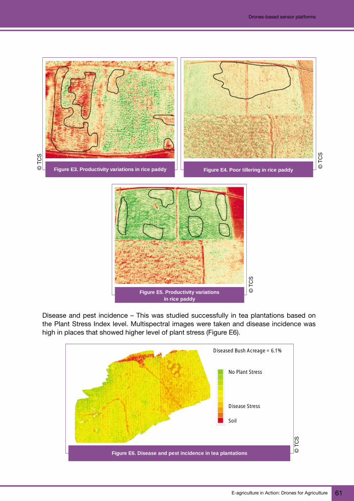
E-agriculture in Action: Drones for Agriculture 61
Drones-based sensor platforms
Figure E3. Productivity variations in rice paddy Figure E4. Poor tillering in rice paddy
Figure E5. Productivity variationsin rice paddy
Disease and pest incidence – This was studied successfully in tea plantations based onthe Plant Stress Index level. Multispectral images were taken and disease incidence washigh in places that showed higher level of plant stress (Figure E6).
Diseased Bush Acreage = 6.1%
No Plant Stress
Disease Stress
Soil
Figure E6. Disease and pest incidence in tea plantations
© T
CS
© T
CS
© T
CS
© T
CS

E-agriculture in Action: Drones for Agriculture62
Drones-based sensor platforms
Estimation of acreage – Drone technology can be successfully employed to estimate theacreage of the planted crop and crop stage of the plantation (see Figures E7 and E8). Basedon this information, harvest decisions can be planned accordingly.
Bush Acreage = 79.18%
Newer Leaf Mass ~3%
Older Bushes ~17%
Harvest-ready
Oldest Leaf
Soil
Figure 7. Crop acreage in tea plantationFigure E7. Crop acreage in tea plantation Figure 7. Crop acreage in tea plantationFigure E8. Crop acreage maturity level
in tea plantation
Case 2: Drones in forest plantations
TCS has successfully employed the drone application in forest plantations for estimatinga number of characteristics. High-resolution elevation maps are created and key forestfigures are estimated:
• Tree count and height (Figures E9 and E10)
• Area and volume estimation
0
-100
-200
-300
-100 0 100 200
Tree count: 2964
700
600
500
400
300
200
100
0
Tree
co
un
t
Tree heights (m)
3 6 10 13 16 20 23 27 30 34 37
Figure E9. Tree count Figure E10. Tree height histogram
© T
CS
© T
CS
© T
CS
© T
CS

E-agriculture in Action: Drones for Agriculture 63
Drones-based sensor platforms
Estimation of canopy diameter – This estimation is performed through a process ofcontinuous iterations of “fitting an ellipse” across the visible canopy of the targettree. A threshold of 1 200 iterations was employed for the purpose. The major axisof the ellipse for each tree was considered to be the diameter of the associated crown(Figures E11 and E12).
Input Image Segmented Image
Spruce
Figure E12. Tree height, crown diameter resultFigure E11. Canopy diameter estimation in spruce
Species recognition and proximity assessment – Deep learning algorithms are used for treespecies identification (Figure E13) and common infrastructure detection (Figure E14). It isalso employed for assessing proximity.
Figure E13. Species identification (coconut) Figure E14. Water area detection
Area 1-SpruceTree Height v/s Tree Crown Diameter (in m)
16
14
12
10
8
6
4
2
00 5 10 15 20 25 30 35 40
Cro
wn
Dia
met
erTree Height
© T
CS
© T
CS
© T
CS
© T
CS

E-agriculture in Action: Drones for Agriculture64
Drones-based sensor platforms
Case 3: Wildlife conservation at Kaziranga National Park
The operation for conservation is taken care of by a set of actions done for monitoring theanimals at the park (Figure E15 to Figure E18). These include:
1. Training
Figure E15. Training at Kaziranga National Parkwith use of UAV
2. Routine surveillance
© T
CS
© T
CS
Figure E16. Routine surveillance using a drone

E-agriculture in Action: Drones for Agriculture 65
Drones-based sensor platforms
3. Anti-poaching operations
4. Wildlife monitoring
Looking ahead: potential of drone technology to alleviateagricultural problems
The utility and benefits of drone application in agriculture are well documented. The realtime nature of information and its precision will be the key driver for agricultural development.With rapid adoption and continuous innovations, the technology will become more and moreaccessible to the common farmer. However, adequate training and awareness is a mustfor its deeper penetration into the rural masses. The future of UAVs in precision agriculture
Figure E17. Anti-poaching operation using a drone
Figure E18. Wildlife monitoring at the park using a drone
© T
CS
© T
CS

E-agriculture in Action: Drones for Agriculture66
Drones-based sensor platforms
comes down to farmers being ready and willing to try out the technology for themselves.Regulation will continue to evolve and new advances will keep changing our conceptionof what drones can do. Getting involved now helps farmers acquire an understanding ofthe tremendous potential of drones and also allows them to determine their own wayforward.
References
Statistics Times. 2017. Sector-wise contribution of GDP of India [online]. [Cited 12 August 2017]. http://statisticstimes.com/economy/sectorwise-gdp-contribution-of-india.php
For more information
Srinivasu P.Global Head of TCS Digital Farming [email protected]
Gopi KandaswamySenior Scientist at TCS Research and [email protected]

E-agriculture in Action: Drones for Agriculture 67
Use of unmanned helicopters for agricultureCase study
F
In 1983, a commission was received from the Japan Agricultural Aviation Association(an external organization of the Ministry of Agriculture, Forestry and Fisheries) to developa remote control aircraft capable of performing aerial (airborne) spraying of agrichemicals,or what became known as a remote control aerial spraying system (RCASS). Initially Yamahaworked only on an engine, but recognizing the importance of the end product operatingas a complete package led to Yamaha taking charge of developing the RCASS entirelyand the research and development (R&D) work on this began. The prototype was dubbedthe “Aero Robot RCASS”.
Another request from the same organization was for the craft to use counter-rotating rotors(a helicopter format in which two rotors on the same axle rotate in opposite directions).Yamaha focused its R&D efforts on achieving this and used a liquid-cooled 2-stroke singlecylinder 292 cc engine for the prototype. A helicopter with counter-rotating rotors has noneed for a tail rotor, making it more compact. But that also means that controlling pitch(rotating about the y-axis), roll (rotating about the x-axis) and yaw (rotating about thez-axis) becomes uniaxial, making the required mechanisms more complex to engineer.A Flight Test Stand (FTS) (Figure F1) was developed and the team worked on making theprototype ready for practical use, but factors such as the characteristics of servomotors atthe time made flying the helicopter manually very challenging.
Use of unmanned helicoptersfor agriculture
EXPERIENCES FROM YAMAHA MOTOR CO., LTD.
Figure F1. A flight training device was developed as workon implementing the RCASS progressed
© Y
amah
a M
otor
s
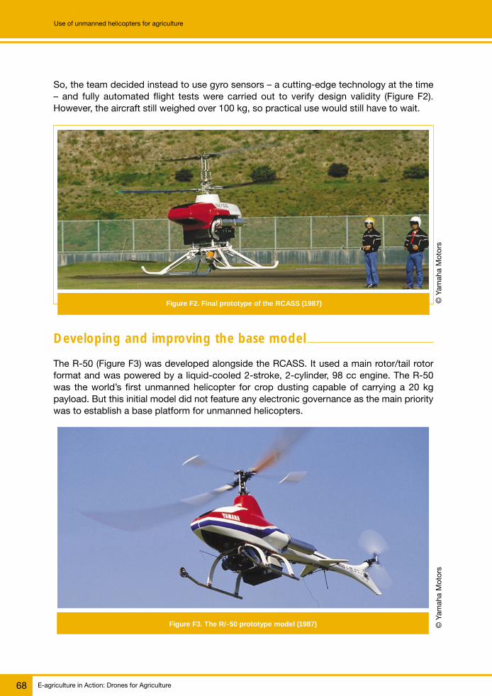
E-agriculture in Action: Drones for Agriculture68
Use of unmanned helicopters for agriculture
So, the team decided instead to use gyro sensors – a cutting-edge technology at the time– and fully automated flight tests were carried out to verify design validity (Figure F2).However, the aircraft still weighed over 100 kg, so practical use would still have to wait.
Figure F2. Final prototype of the RCASS (1987)
Developing and improving the base model
The R-50 (Figure F3) was developed alongside the RCASS. It used a main rotor/tail rotorformat and was powered by a liquid-cooled 2-stroke, 2-cylinder, 98 cc engine. The R-50was the world’s first unmanned helicopter for crop dusting capable of carrying a 20 kgpayload. But this initial model did not feature any electronic governance as the main prioritywas to establish a base platform for unmanned helicopters.
Figure F3. The R/-50 prototype model (1987)
© Y
amah
a M
otor
s©
Yam
aha
Mot
ors
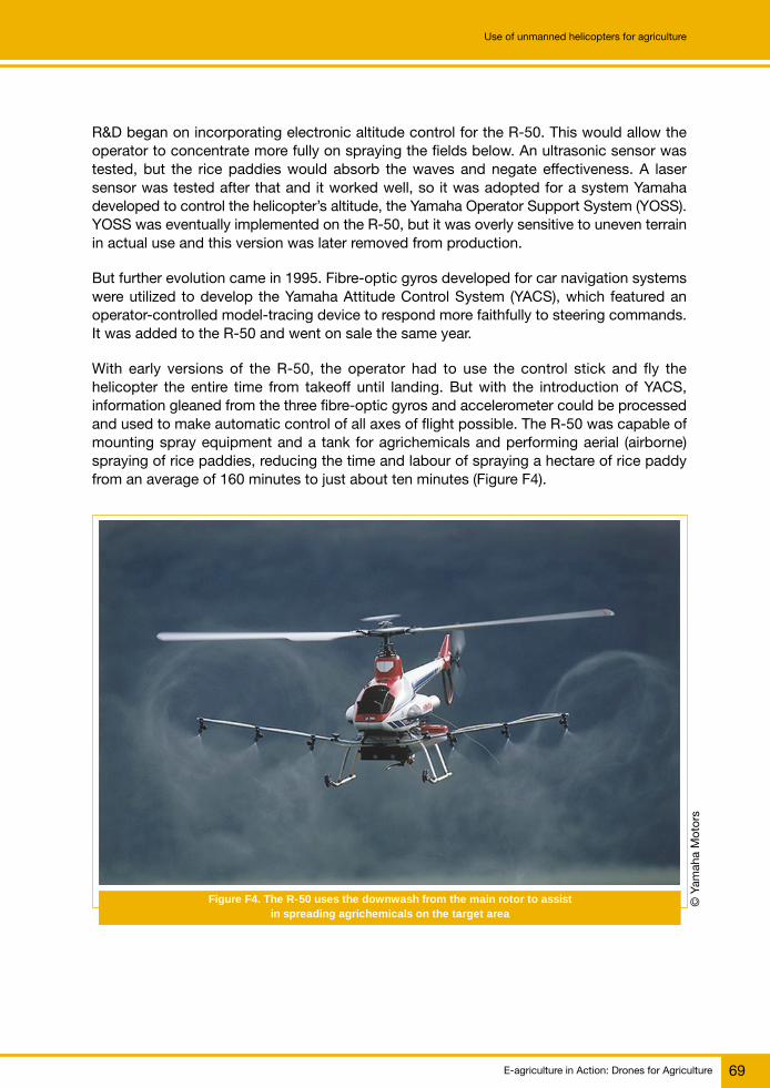
E-agriculture in Action: Drones for Agriculture 69
Use of unmanned helicopters for agriculture
R&D began on incorporating electronic altitude control for the R-50. This would allow theoperator to concentrate more fully on spraying the fields below. An ultrasonic sensor wastested, but the rice paddies would absorb the waves and negate effectiveness. A lasersensor was tested after that and it worked well, so it was adopted for a system Yamahadeveloped to control the helicopter’s altitude, the Yamaha Operator Support System (YOSS).YOSS was eventually implemented on the R-50, but it was overly sensitive to uneven terrainin actual use and this version was later removed from production.
But further evolution came in 1995. Fibre-optic gyros developed for car navigation systemswere utilized to develop the Yamaha Attitude Control System (YACS), which featured anoperator-controlled model-tracing device to respond more faithfully to steering commands.It was added to the R-50 and went on sale the same year.
With early versions of the R-50, the operator had to use the control stick and fly thehelicopter the entire time from takeoff until landing. But with the introduction of YACS,information gleaned from the three fibre-optic gyros and accelerometer could be processedand used to make automatic control of all axes of flight possible. The R-50 was capable ofmounting spray equipment and a tank for agrichemicals and performing aerial (airborne)spraying of rice paddies, reducing the time and labour of spraying a hectare of rice paddyfrom an average of 160 minutes to just about ten minutes (Figure F4).
Figure F4. The R-50 uses the downwash from the main rotor to assistin spreading agrichemicals on the target area
© Y
amah
a M
otor
s

E-agriculture in Action: Drones for Agriculture70
Use of unmanned helicopters for agriculture
Expanding fields of activity
The RMAX was introduced in 1997 and featured a newly designed engine, and was followedin 2000 by an RMAX equipped for automatic flight (built-to-order model; used to investigatethe eruption of Mount Usu). The RMAX Type II G and Type II (Figure F5) were introduced in2003 with functions that made them easier to fly, and the RMAX G1 that featured fullyautomatic flight geared towards industrial use was released in 2006. The 4-stroke FAZERmodel went on sale in 2013, followed by the FAZER R in 2016.
Figure F5. The RMAX Type II G comes with a high-precision GPS (2003)
Usage in Japanese agricultural market
Today, approximately 2 800 industrial-use unmanned helicopters such as the “RMAX” and“FAZER” are registered for operation in Japan’s agriculture industry, where they spraya total area of over 1.05 million hectares per year, or about 42 percent of the country’s ricepaddy area under cultivation. By simple calculation, this means that one in every three bowlsof rice served in Japanese homes has been grown with the agrichemical pest control spreadby an unmanned helicopter.
Over the 25 years since the birth of the industrial-use unmanned helicopter, Yamaha MotorCo., Ltd. has continued to develop know-how and technical advancements to make thesehelicopters as efficient and safe to use as possible. One of these areas of know-how is thetraining of the operators that fly them. Only people who have been through a demandingtraining curriculum can be licensed to fly and maintain these helicopters, and presently thereare about 11 000 licensed operators active in Japan. Yamaha has also worked withnumerous research institutes to expand the range of uses for the helicopters. They are now
© Y
amah
a M
otor
s

E-agriculture in Action: Drones for Agriculture 71
Use of unmanned helicopters for agriculture
being used for the direct sowing of rice paddies and pest control in vegetables, wheat/barley and soy bean agriculture. More recently, they have been used overseas for similarpurposes in countries such as the Republic of Korea and Australia.
For more information
Masatoshi (Mike) EndoGroup Manager Overseas Marketing Group Marketing DivisionUMS Business Development SectionYamaha Motor Co., [email protected]

E-agriculture in Action: Drones for Agriculture72
Use of unmanned helicopters for agriculture
© G
iaco
mo
Ram
bal
di/C
TA

E-agriculture in Action: Drones for Agriculture 73
Space technology use in crop insuranceCase study
G
Crop yield estimation at the lowest specified administrative level is the most importantindicator in the crop insurance scheme Pradhan Mantri Fasal Bima Yojna (PMFBY) of theGovernment of India for deciding insurance claims. For crop yield estimation, the well-established methodology of Crop Cutting Experiments (CCE) has been in use so far.However, for accurate assessment at lower administrative level (village or village panchayatlevel), the requirement of a huge number of CCE with utmost precision has been a causeof concern as it may not be practically feasible. In the current methodology of yieldestimation, the allocation and selection of plots for conducting CCE is based on statisticalinformation and carried out using random numbers. The current year crop situation (areasown and crop condition) is not taken into consideration. This makes CCE plot selectionnot properly representative of the actual crop situation. Additionally, carrying out sucha large number of CCE, as desired under the new crop insurance programme may not bepractically feasible. Hence, the approach documented here could be a possible option.
There is a need to optimize the CCE locations using satellite remote sensing data, whichnot only provide the crop area map, but also indicate the crop conditions. In order toevaluate and validate this a large number of pilot studies were carried out in different partsof the country. During the monsoon or rainy season of 2015, pilot studies were carried outin Kurukshetra, Shimoga, Yavatmal and Seoni districts of Haryana, Karnataka, MadhyaPradesh and Maharashtra states, respectively. During the winter season of 2015-2016 twodistricts were selected in each state: in Haryana, Hissar district and Karnal district; inKarnataka, Raichur district and Gulbarga district; in Maharashtra, Ahmednagar district andSolapur district; and in Madhya Pradesh, Vidisha district and Hoshangabad district. Duringthe winter season of 2016-2017 the study was replicated in one block of each state selectedduring 2015-2016, for validation of the approach. The blocks identified for the study wereRatiya of Fatehabad (Haryana), Shorapur of Yadgir (Karnataka), Babai of Hoshangabad(Madhya Pradesh) and Karmala of Solapur district (Maharashtra).
Multidate satellite remote sensing data is used for mapping the particular crop area, withthe support of ground truthing. For rice crop, multidate microwave SAR (Synthetic ApertureRadar) satellite data are used, whereas for wheat and other crops multidate optical(visible and near infrared) remote sensing data are used. The examples of SAR satelliteare RISAT-1 of the Republic of India, RADARSAT-2 of Canada and Sentinel-1 of theEuropean Space Agency (ESA). Optical data is taken from Resourcesat-2 of Republic ofIndia, Landsat-8 of the United States of America and Sentinel-2 of ESA.
Space technology use incrop insuranceEXPERIENCES FROM INDIA

E-agriculture in Action: Drones for Agriculture74
Space technology use in crop insurance
Again, multidate moderate resolution satellite (e.g. MODIS or AWiFS) data are used forcomputation of remote sensing based vegetation indices, such as Normalized DifferenceVegetation Index and Land Surface Wetness Index. These two indices indicate crop vigourand crop water status, respectively. Based on these two indices, the whole district isclassified into 4 groups/strata – Very Good (A), Good (B), Medium (C) and Poor (D). Thecrop map generated from high-resolution satellite data is overlaid on this crop conditionmap to generate a condition map with respect to a specific crop. CCE points are selectedrandomly within each stratum, proportionate to the number of pixels under each stratum(Figure G1).
Legend
A Type
B Type
C Type
D Type
Tehsil Boundry
Kilometers0 4 8 16 24 32
N
CCE Points for Seoni district of Madhya Pradesh under Crop Insurance 2015
Figure G1. Crop Cutting Experiment (CCE) sites planned basedon remote sensing data
© M
oAF,
Ind
ia
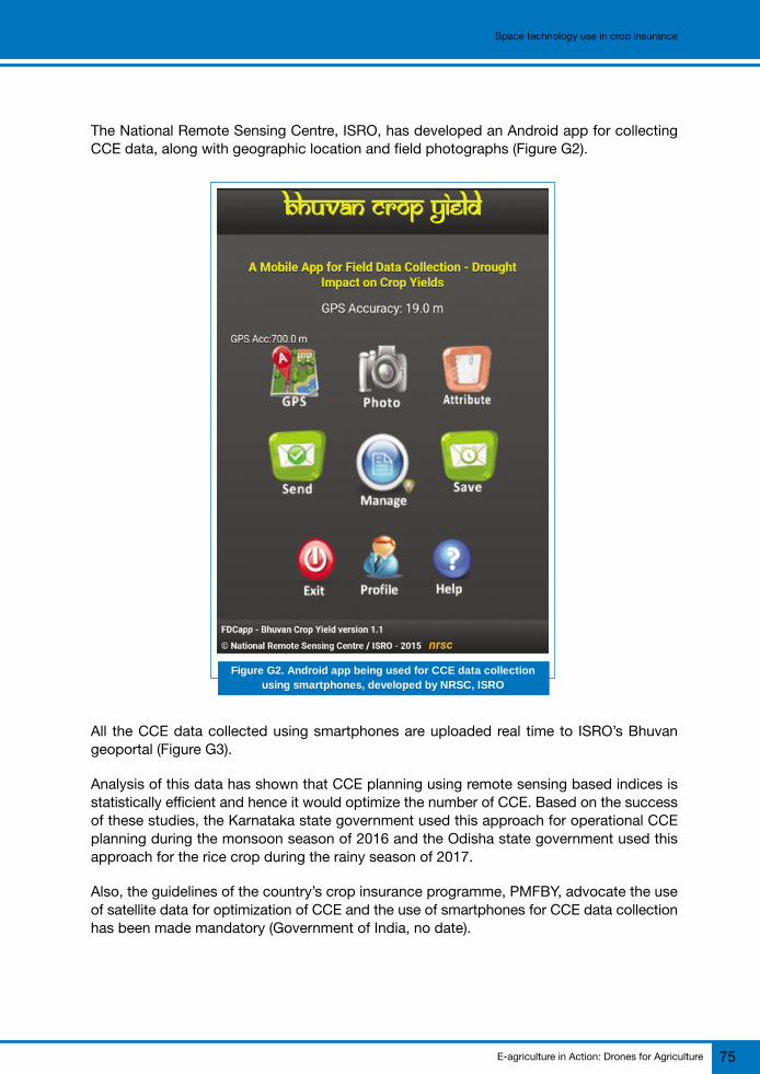
E-agriculture in Action: Drones for Agriculture 75
Space technology use in crop insurance
The National Remote Sensing Centre, ISRO, has developed an Android app for collectingCCE data, along with geographic location and field photographs (Figure G2).
Figure G2. Android app being used for CCE data collectionusing smartphones, developed by NRSC, ISRO
All the CCE data collected using smartphones are uploaded real time to ISRO’s Bhuvangeoportal (Figure G3).
Analysis of this data has shown that CCE planning using remote sensing based indices isstatistically efficient and hence it would optimize the number of CCE. Based on the successof these studies, the Karnataka state government used this approach for operational CCEplanning during the monsoon season of 2016 and the Odisha state government used thisapproach for the rice crop during the rainy season of 2017.
Also, the guidelines of the country’s crop insurance programme, PMFBY, advocate the useof satellite data for optimization of CCE and the use of smartphones for CCE data collectionhas been made mandatory (Government of India, no date).
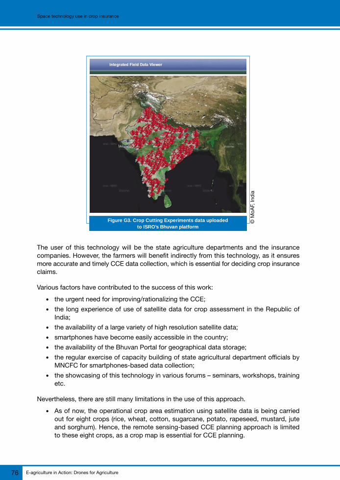
E-agriculture in Action: Drones for Agriculture76
Space technology use in crop insurance
The user of this technology will be the state agriculture departments and the insurancecompanies. However, the farmers will benefit indirectly from this technology, as it ensuresmore accurate and timely CCE data collection, which is essential for deciding crop insuranceclaims.
Various factors have contributed to the success of this work:
● the urgent need for improving/rationalizing the CCE;● the long experience of use of satellite data for crop assessment in the Republic of
India;● the availability of a large variety of high resolution satellite data;● smartphones have become easily accessible in the country;● the availability of the Bhuvan Portal for geographical data storage;● the regular exercise of capacity building of state agricultural department officials by
MNCFC for smartphones-based data collection;● the showcasing of this technology in various forums – seminars, workshops, training
etc.
Nevertheless, there are still many limitations in the use of this approach.
● As of now, the operational crop area estimation using satellite data is being carriedout for eight crops (rice, wheat, cotton, sugarcane, potato, rapeseed, mustard, juteand sorghum). Hence, the remote sensing-based CCE planning approach is limitedto these eight crops, as a crop map is essential for CCE planning.
Figure G3. Crop Cutting Experiments data uploadedto ISRO’s Bhuvan platform
© M
oAF,
Ind
ia

E-agriculture in Action: Drones for Agriculture 77
Space technology use in crop insurance
● Even among the eight crops mentioned above, for some crops (other than cereals)the relationship between remote sensing-based index and crop yield is comparativelypoor. In these cases, remote sensing-based CCE planning may not be statisticallyviable.
● Remote sensing-based CCE plans can only be generated after a crop has reachedthe maximum vegetative stage. Hence, it provides very limited lead time for its fieldimplementation.
● For the majority of monsoon season crops, getting cloud free optical data is difficult,because of persistent cloud cover during the rainy season. This limits theimplementation of remote sensing-based CCE planning.
● Even though there has been a tremendous increase in smartphone use in the country,many field officials do not have access to smartphones. For them smartphone-baseddata collection is difficult.
Various lessons learned during the pilot studies and the implementation phase are givenbelow:
● there was an overwhelming response by the implementing officials to learn the newtechnology;
● even with a comparatively lower number of experiments, yield values were statisticallyvery close to the values derived from a large number of experiments conducted ina conventional manner;
● much new information about the crops (such as major variety, major agronomicpractices, sowing and harvesting dates, harvest index, stresses) could be obtainedfrom the data collected through smartphones;
● there is a need to use higher resolution satellite data to improve the crop classificationaccuracy; and
● there is a need to combine the remote sensing-based indexes with other yieldcontrolling parameters, such as soil and weather, to improve the statistical efficiencyof CCE planning.
Given the regular improvement in the quality of satellite data being available, and thetremendous growth in various other related technologies (e.g. UAV based imaging, big dataanalytics, cloud computing, crowd sourcing, sensor networks, Internet of things, artificialintelligence), this approach will also improve further.
The pilot studies have been carried out for different crops (rice, wheat, cotton and sorghum)in different agro-climatic regions of the country. The methodology has also beenoperationally implemented in Karnataka and Odisha states. Hence there is scope forreplicating the approach and upscaling it to national scale, subject to the constraintsmentioned above.

E-agriculture in Action: Drones for Agriculture78
Space technology use in crop insurance
For more information
Shibendu S. Ray, DirectorSunil K. Dubey, Assistant DirectorMahalanobis National Crop Forecast CentreDepartment of Agriculture, Cooperation & Farmers WelfareMinistry of Agriculture & Farmers Welfare, Government of [email protected]
References
Government of India. no date. Crop Insurance [online]. [Cited 22 August 2017]. http://agri-insurance.gov.in/Pmfby.aspx
E-agriculture in Action: Drones for Agriculture 79
Institutionalizing drone mapping applications for disaster risk management in agricultureCase study
H
Introduction
The Republic of the Union of Myanmar is an ethnically diverse country with about 52 millionpeople belonging to 135 officially recognized ethnic groups in 14 states and regions andNay Pyi Taw as its capital. Over 70 percent of the population live in rural areas with farming,livestock, fisheries, aquaculture and other natural resource sectors accounting for over60 percent of employment in the country, about 36 percent of gross domestic product,and about 30 percent of exports by value.
Agriculture is the backbone of the Republic of the Union of Myanmar’s economy, but it isalso one the countries at highest risk of natural disasters in Southeast Asia and is affectedby four major natural hazards: earthquakes, floods, cyclones, and droughts. The GlobalClimate Risk Index ranks the country as Number 2 out of 178 countries in terms ofvulnerability to climate change. Long-term studies have also shown that the country isvulnerable to increased risks from climate change, and climate change is increasing theimpact of other shorter cycle natural hazards. Coastal regions, particularly Rakhine Stateand Ayeyarwady Delta Region, are at high risk for cyclones, storm surges and tsunamis.Much of the country, especially in the Central Dry Zone, is exposed to flooding andlandslides during the rainy season, in addition to drought and fire during the dry season.
Consequently, agriculture was the most effected sector by disasters, accounting for halfof all losses with rural livelihoods significantly impacted. The challenges call for morecomprehensive approaches based on an integrated analysis of hazards, risks linked withland use, livelihoods planning and natural resource management.
Since March 2016, FAO Myanmar has been stepping up its efforts to strengthen governmentagricultural sector agencies in the areas of disaster risk reduction (DRR) and resilience,including the use of modern technologies to address existing data gaps and allow moretimely and effective preparedness and response actions.
A new way of working
The World Humanitarian Summit has underscored the need to shift from reactively managingcrises to proactively reducing risks and that planning, financing and decision-making shouldbe underpinned by data and common risk analysis. The World Summit also affirmed that
Institutionalizing drone mappingapplications for disaster riskmanagement in agriculture
EXPERIENCES FROM MYANMAR

E-agriculture in Action: Drones for Agriculture80
Institutionalizing drone mapping applications for disaster risk management in agriculture
disaster response cannot be isolated from broader development and climate changeadaptation efforts. As such, new ways of working were seen as critical to building communityresilience and reducing risk and vulnerability related to natural hazards and climate change.The Sendai Framework for Disaster Risk Reduction has also recognized the need to increasethe utilization of modern geospatial technologies and help promote better understandingof risks.
In September 2016, FAO began collaborating with the Department of Technology Promotionand Coordination, Ministry of Education through its Myanmar Aerospace EngineeringUniversity (MAEU) to explore the use of unmanned aerial vehicles or drones which, aftera series of carefully structured activities, led to the institutionalization of the technologywithin the Ministry of Agriculture, Livestock and Irrigation (MOALI). The following sectionpresents the key activities undertaken by FAO, MOALI and MAEU that resulted in theestablishment of the MOALI Drone Mapping Team, which is now equipped with dronesand technical skills that are highly specific to the country’s context. FAO is recognized asthe first UN agency to utilize drones for disaster risk management (DRM) in agriculture inthe country with preliminary mapping approaches and methodologies inspired by thepioneering work of FAO and the Department of Agriculture in the Republic of the Philippines.
Exploring the application of drone mapping technology inMyanmar – the 2016 floods
Following the monsoon floods in Magway region in October 2016, FAO first explored theapplication of drones to DRM in agriculture in order to enhance understanding of hazardimpacts and strengthen beneficiary identification by collecting timely and scientificallyreliable information in flood-affected areas. The first set of drone mapping missions werecarried out to kick off FAO’s project activities of emergency response and resilience buildingsupported by the Central Emergency Response Fund (CERF).
In order to determine a comprehensive set of aerial mapping approaches and protocolsfor agriculture, FAO and MAEU conducted a series of field-based trainings and test flights.FAO provided hands-on training to MAEU on rapid aerial assessment methodologies, DRRconcepts and technical guidance on data processing.
With the use of unmanned aerial vehicles in areas determined by FAO and the Departmentof Agriculture (DoA) and MOALI, rapid mapping missions were carried out to inform villageassessments and profiling, as well as beneficiary identification. Data gathered from dronemission outputs such as high-resolution maps of flood affected areas (Orthophotographs,Digital Terrain Models and Digital Surface Models) helped FAO and government expertsstrengthen beneficiary identification/selection approaches and effective disaster impactassessment in flood-affected areas and further support the multihazard risks analysis.
A total of about 3 600 hectares were successfully mapped with a ground resolution of upto 5 cm, which enabled both FAO and government agriculture experts to analyse andvalidate cropping patterns, land use, village profiles as well as disaster risks.

E-agriculture in Action: Drones for Agriculture 81
Institutionalizing drone mapping applications for disaster risk management in agriculture
Mapping sites were identified based on:
1. standing crop and damage reports from the Department of Agriculture;
2. consultation with MOALI officials;
3. consultation with township and village officials; and
4. safety/logistics/ease of access.
This pilot activity has resulted in several positive impacts and the realization that thetechnology is highly useful and could be effectively institutionalized if the proper governmententry points are tapped. Flood-affected areas are better understood and validation ofaffected areas can be carried out together with the community. Agriculture lands are alsovalidated soon after the hazard occurrence to identify whether or not the land is alreadyplanted. Identification of beneficiaries is more reliable and effective and the highly reliablenature of the drone-derived data also helps address beneficiary prioritization issues at thefield level. Since orthophotographs allow precise area measurements, agriculture emergencyresponse teams are better able to estimate the required agriculture inputs such as seedsand fertilizers and even assist in effective planning for the next agriculture season. Irrigationsystems and other water sources can also be analysed and the processed data are usefulfor future risk assessment and emergency planning.
From lowland to uplands: drone mapping technology in highlyremote upland agricultural communities
In July 2015, torrential rains and cyclone Komen triggered severe and widespread floodsand landslides in remote western Chin State, one of the poorest areas in the country. ChinState’s capital city, Hakha, was the worst-affected region with heavy rainfall and landslidesthat displaced thousands and wiped out half of the city’s farmland.
Following the success of the Magway region drone mapping activities in 2016 and thepresence of a Japan-funded agriculture DRR and resilience project in Chin State, FAO againpartnered with MAEU in March 2017 in close coordination with the Department of Agricultureand carried out mapping activities in selected landslide and erosion prone areas in ChinState. This was determined as a crucial step in terms of further understanding theapplicability of the technology in remote and topographically complex landslide-prone anderosion-prone regions. Data derived from the drone missions in Chin State have allowedFAO and government experts access to high-resolution, high-accuracy and high-temporality(timely) landslide and erosion risk information that was not previously readily accessible(both in terms of cost and quality). The maps produced also allowed state, township andvillage agriculture and DRR officials to examine aerial images of selected communities inChin State in stunning detail, thereby promoting an entirely different level of appreciationof agriculture land use features and components, as well as a clearer understanding ofhazards and risks present in a community.
The mapping exercises allowed FAO and government experts to strongly demonstrate theapplicability and technical validity of drone mapping technology in terms of generating usefulinformation related to upland agriculture risks such as landslides and erosion, as well as
E-agriculture in Action: Drones for Agriculture82
Institutionalizing drone mapping applications for disaster risk management in agriculture
the technology’s potential in revolutionizing how agricultural communities understand theirrisks, and reduce hazard or disaster impacts.
Institutionalizing drone mapping technology and capacities foragriculture
Lessons learned from previous emergency response and resilience building activities byFAO have shown the importance of building capacities to apply technologies includingmapping systems for all aspects of DRR (such as vulnerability and risk assessment,identification of beneficiaries, implementation and monitoring of risk reduction measures).FAO has continued to partner with MAEU to build capacities within MOALI related to theuse of drone technology.
On 29 March 2017, with approval from the Minister’s Office, MOALI, the MOALI Drone Team,a subset of the bigger MOALI DRR Task Force, was established by the government withFAO’s technical assistance. The drone mapping team consists of 30 interdisciplinary expertsfrom the different departments and universities across MOALI (including the Departmentof Agriculture, Department of Livestock, Department of Extension, Department of AgricultureResearch, Department of Irrigation and Water Management, Department of Land Recordsand Statistics, the Agricultural Mechanization Department, Department of Cooperatives,Department of Agricultural Planning, the Yezin Agricultural University and the University ofVeterinary Sciences).
The drone mapping team is in charge of utilizing this modern geospatial technology toenhance disaster preparedness and response activities of MOALI, and help addresstime-critical data gaps. The responsibilities of the Drone Mapping Team, as approved bythe Minister’s Office, MOALI, include:
● participate in training events related to drone operations, maintenance and dataanalysis for enhanced DRR in agriculture;
● carry-out regular flight missions;● conduct damage assessment flight missions as needed; and● carry-out regular maintenance on drones and other flight equipment.
Building on the examples and lessons learned from previous aerial mapping work by FAOand MAEU in Magway region and Chin State, FAO together with MOALI and MAEU thenorganized a training course on drone mapping operations and scientific applications forDRR in agriculture in support of the established Drone Mapping Team from 22 to 26 May2017 (Figure H1). The week-long training course focused on operations and applicationsof drone mapping technology to DRR in agriculture, and to a broader extent its use insupporting mainstream agricultural production. The team was divided into two groups, FlightOperations and Data Processing, in order to maximize the expertise of the different membersand operational efficiency. The Flight Operations team consisted of controllers/pilotsand ground control station operators whereas the Data Processing team was in charge ofpre-data collection and post-data collection procedures. Membership in a specific teamwas determined on the basis of technical expertise and practical skills (e.g. hand to eyecoordination for drone pilots).
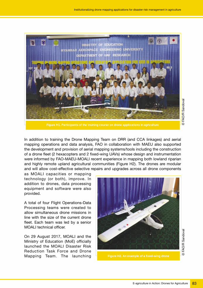
E-agriculture in Action: Drones for Agriculture 83
Institutionalizing drone mapping applications for disaster risk management in agriculture
In addition to training the Drone Mapping Team on DRR (and CCA linkages) and aerialmapping operations and data analysis, FAO in collaboration with MAEU also supportedthe development and provision of aerial mapping systems/tools including the constructionof a drone fleet (2 hexacopters and 2 fixed-wing UAVs) whose design and instrumentationwere informed by FAO-MAEU-MOALI recent experience in mapping both lowland riparianand highly remote upland agricultural communities (Figure H2). The drones are modularand will allow cost-effective selective repairs and upgrades across all drone components
Figure H2. An example of a fixed-wing drone
as MOALI capacities or mappingtechnology (or both), improve. Inaddition to drones, data processingequipment and software were alsoprovided.
A total of four Flight Operations-DataProcessing teams were created toallow simultaneous drone missions inline with the size of the current dronefleet. Each team was led by a seniorMOALI technical officer.
On 29 August 2017, MOALI and theMinistry of Education (MoE) officiallylaunched the MOALI Disaster RiskReduction Task Force and DroneMapping Team. The launching
© F
AO
/R S
and
oval
Figure H1. Participants of the training course on drone applications in agriculture
© F
AO
/R S
and
oval

E-agriculture in Action: Drones for Agriculture84
Institutionalizing drone mapping applications for disaster risk management in agriculture
ceremony, held at the Department of Agricultural Research, was opened by H.E. Dr AungThu, Union Minister, MOALI, and H.E. U Ohn Win, Union Minister, Ministry of NaturalResources and Environmental Conservation (MoNREC).
Examples of ongoing drone mapping applications by the MOALIDRR Task Force and Drone Mapping Team
Agricultural research and production
Drone and payload: Custom designed MOALI-MAEU-FAO hexacopters fitted with NDVIRed + NIR cameras (Figure H3).
Figure H3. Hexacopter fitted with cameras
Use of Normalized Difference Vegetation Index (NDVI) to support crop health monitoring,crop research and production (Figures H4a, H4b, H4c and H4d).
Promoting resilient livelihoods in agro-archaeological communities
There is ongoing exploration of how data from drones can improve production and buildresilience against disaster risks/climate change impacts while enhancing archaeologicalconservation planning, especially in areas where spatial patterns influence cultural andreligious practices (Figure H5).
© F
AO
/R S
and
oval
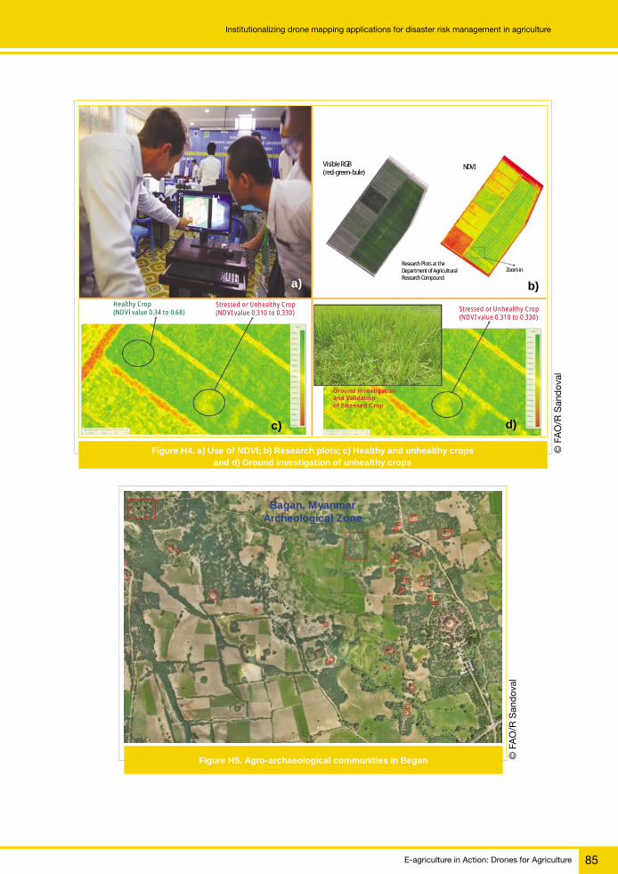
E-agriculture in Action: Drones for Agriculture 85
Institutionalizing drone mapping applications for disaster risk management in agriculture
Visible RGB(red-green-bule)
NDVI
Research Plots at theDepartment of AgriculturalResearch Compound
Zoom in
Stressed or Unhealthy Crop(NDVI value 0.310 to 0.330)
Stressed or Unhealthy Crop(NDVI value 0.310 to 0.330)
Healthy Crop(NDVI value 0.34 to 0.68)
a) b)
c) d)
Figure H5. Agro-archaeological communities in Began
Bagan, MyanmarArcheological Zone
© F
AO
/R S
and
oval
Figure H4. a) Use of NDVI; b) Research plots; c) Healthy and unhealthy cropsand d) Ground investigation of unhealthy crops
© F
AO
/R S
and
oval

E-agriculture in Action: Drones for Agriculture86
Institutionalizing drone mapping applications for disaster risk management in agriculture
Examples of drone mapping applications for disaster preparedness in agriculture
In an effort to enhance the reliability of cost-effective GIS-derived risk information (especiallyfor topographically-complex areas), a drone-based Real Time Kinematic (RTK) GlobalPositioning System (GPS) was pilot-tested in Chin State. RTK GPS, consisting of a roverand base station (as seen in Figures H6 and H7), enabled centimetre-level precision ascompared to metre-level precision of normal GPS (e.g. 1 metre normal GPS precision asused by MAEU and FAO during the CERF-supported September/October 2016 Magwayregion post-floods mapping). The RTK GPS-enabled drone mapping in Chin State resultedin up to 8 centimetres geo-precision. Combined with a map (image) resolution of up to4 centimetres, the drone mapping exercise established a strong basis for the realisticapplication of the technology, even in one of the most remote regions of the country.
Figure H6. The rover is attached to the drone Figure H7. The base station
Drone mapping technology revolutionizes community-based risk assessments and planning.The maps allow community officials to examine aerial images with very high detail, enablesincreased appreciation of agriculture and environmental features, and better understandingof hazards and risks (Figures H8 and H9).
Applications for emergency response
FAO in partnership with MAEU conducted the mapping of flooded areas in Magwayregion to aid the design of flood interventions for agriculture. Drone mapping missions(see Figure H10) through a CERF-funded project that was carried out during the 2016Magway floods covered the agro-ecologically representative sampling areas in two of themost flood-affected townships in Magway region. A total of about 3 600 hectares weresuccessfully mapped (Figures H11 and H12) with a ground resolution of up to 5 centimetres,which enabled both FAO and government agriculture experts to analyse and validatecropping patterns, land use, village profiles as well as disaster risks.
© F
AO
/R S
and
oval
© F
AO
/R S
and
oval

E-agriculture in Action: Drones for Agriculture 87
Institutionalizing drone mapping applications for disaster risk management in agriculture
Hakha, Chin State
Digital Surface Model, 8 cm, with 5 metre contours
Figure H8. Digital map showing land contours Figure H9. Community-based risk assessment
As a complement to ortho-photographs, high-resolution Digital Surface Models (DSM) enable robust analysis of elevation and other geophysical features of project villages that are important both for multi-hazard risk assessments and design of project interventions.
High-resolution ortho-photographs allow accurate area measurements and detailed visual analysis of various features of project villages by FAO and government experts (Pwintbyu Township, Magway). Size: 2.6207 km2 / 262.07 ha / 647.924 acres.
Figure H12. HR orthophotographsFigure H11. High-resolution (HR) DSMs
Figure H10. Drone mapping missions
Flight Parths
© F
AO
/R S
and
oval
© F
AO
/R S
and
oval
© F
AO
/R S
and
oval
© F
AO
/R S
and
oval
© F
AO
/R S
and
oval

E-agriculture in Action: Drones for Agriculture88
Institutionalizing drone mapping applications for disaster risk management in agriculture
Mapping sites were identified based on:
1. Crop damage reports from the Department of Agriculture (red polygons)
2. Consultation with MOALI officials
3. Consultation with township and village officials
4. Safety/logistics/ease of access.
Promoting drone mapping technology within and acrosssectors
Recognizing the significant challenges related to accessing reliable and objective informationbefore and immediately after a disaster or major hazard beyond the agriculture sector, FAOin July 2017 facilitated a collaborative mapping activity upon the request of the Relief andResettlement Department (RRD), Ministry of Social Welfare, Relief and Resettlement.
A pilot collaborative drone team comprised of representatives from the Relief andResettlement Department (MSWRR), MOALI, Myanmar Aerospace Engineering University(MAEU), and FAO conducted a pilot drone mapping mission in Pokokku and Minbu/SakuTownship from 26 to 28, July 2017. Coordinating with local authorities and Air Traffic Control(ATC), the collaborative mapping team produced aerial maps and conducted real time videomonitoring for emergency response and resettlement of flooded areas in Pakuoku andMyintbu townships in Magway region.
To sustain and further enhance the use of the technology, FAO is currently initiating a projectthat will support MOALI, MSWRR, DMH and MoE in designing and pilot-testinga methodology that will allow timely and cost-effective community profiling and assessmentfocused on disaster and food security risks. This includes the development of rapid ground-based data gathering methods whose speed and robustness/reliability will be supported(and justified) through modern aerial assessment methods while enhancing inter-ministrycoordination/cooperation.
For more information
Roberto SandovalDisaster Risk Reduction/Climate Change SpecialistFAO [email protected]

E-agriculture in Action: Drones for Agriculture 89
Drones for community monitoring of forestsCase study
I
Community forest monitoring project
REDD+ is a voluntary climate change mitigation approach to reducing emissions fromdeforestation and forest degradation, conserving forest carbon stocks and sustainablymanaging forests in developing countries. The United Nations Collaborative Programmeon Reducing Emissions from Deforestation and Forest Degradation in Developing Countries(UN-REDD) is a multilateral body that partners with developing countries to support themin establishing the technical capacities needed to implement REDD+. It was established in2008 and is based on the convening power and technical expertise of the Food andAgriculture Organization of the United Nations (FAO), the United Nations DevelopmentProgramme (UNDP) and the United Nations Environment Programme (UNEP). The UN-REDDProgramme supports nationally-led REDD+ processes and promotes the informed andmeaningful participation of all stakeholders – including indigenous peoples and other forest-dependent communities – in the national and international implementation of REDD+. TheUN-REDD Programme has been an essential partner through the comparative advantagesof each agency, in the case of the community forest monitoring project1 referred to in thischapter FAO supported the forest monitoring in indigenous territories.
Drones for community monitoringof forests
EXPERIENCES FROM PANAMA
1 Partners comprised the Food and Agriculture Organization of the United Nations (FAO), the National Coordination of IndigenousPeoples of Panama (COONAPIP), the Ministry of Environment of Panama (MIAMBIENTE), the Rainforest Foundation (United States)and the indigenous communities of Panama.
© F
AO
/T H
erna
ndez
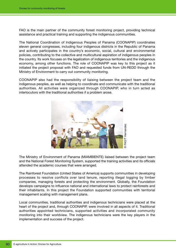
E-agriculture in Action: Drones for Agriculture90
Drones for community monitoring of forests
FAO is the main partner of the community forest monitoring project, providing technicalassistance and practical training and supporting the indigenous communities.
The National Coordination of Indigenous Peoples of Panama (COONAPIP) coordinateseleven general congresses, including four indigenous districts in the Republic of Panamaand actively participates in the country’s economic, social, cultural and environmentalpolicies, contributing to the collective and multicultural aspiration of indigenous peoples inthe country. Its work focuses on the legalization of indigenous territories and the indigenouseconomy, among other functions. The role of COONAPIP was key to this project as itinitiated the project proposal with FAO and requested funds from UN-REDD through theMinistry of Environment to carry out community monitoring.
COONAPIP also had the responsibility of liaising between the project team and theindigenous peoples, as well as helping to coordinate and communicate with the traditionalauthorities. All activities were organized through COONAPIP, who in turn acted asinterlocutors with the traditional authorities if a problem arose.
The Ministry of Environment of Panama (MIAMBIENTE) liaised between the project teamand the National Forest Monitoring System, supported the training activities and its officialsattended the academic courses that were arranged.
The Rainforest Foundation (United States of America) supports communities in developingprocesses to resolve conflicts over land tenure, reporting illegal logging by timbercompanies, managing forests and protecting the environment. Globally, the Foundationdevelops campaigns to influence national and international laws to protect rainforests andtheir inhabitants. In this project the Foundation supported communities with territorialmanagement scaling with management plans.
Local communities, traditional authorities and indigenous technicians were placed at theheart of the project and, through COONAPIP, were involved in all aspects of it. Traditionalauthorities appointed technicians, supported activities and incorporated communitymonitoring into their worldview. The indigenous technicians were the key players in theimplementation and success of the project.
© F
AO
/T H
erna
ndez

E-agriculture in Action: Drones for Agriculture 91
Drones for community monitoring of forests
The community forest monitoring project began in 2015 and was extended to 2017, whichallowed activities to be expanded to more communities and, at the same time, the exchangeof experiences with other countries to be organized. The first drone flight took place inApril 2016, in the Madugandi Comarca community. Since then, more communities havejoined, and by June 2017 the 12 indigenous territories of all ethnic groups in the Republicof Panama (Bribri, Bugle, Emberá, Kuna, Naso, Ngäbe, and Wounaan) had joined. During2017 there have been exchanges of experiences with the Republic of Guatemala, theRepublic of Paraguay, the Republic of Colombia and the Republic of Peru.
Context and problems raised
In 1950, approximately 70 percent of the Panamanian territory was covered with forests(5.3 million hectares). In 2012 this figure fell to 60 percent of the area (4.5 million hectares).According to FAO’s 2015 Global Forest Resources Assessment, between 2010 and 2015,16 400 hectares of forest per year were lost (equivalent to 90 000 soccer fields per year).Deforestation and the loss of ecosystem services associated with forests represent the lossof natural capital from which the livelihoods of local communities and indigenous peoplesderive. This implies a close relationship between deforestation and food insecurity, a riskthat is increased by the poverty conditions that in general affect this segment of thepopulation. Forests cover more than half of the Panamanian territory and indigenouspeoples, the main inhabitants of these areas, play a vital role in the care and monitoring ofthis important resource for food security.
The Republic of Panama is advancing in the development of the National REDD+ Strategy.As part of the joint UN-REDD national programme, work was done on the design ofa National Forest Monitoring System (SNMB).2 The SNMB was defined as a multipurposesystem that provides key information for REDD+ and for the monitoring of forest resourcesin general. In this context and complementary to the SNMB, a project was carried out forthe community management and monitoring of forests in indigenous territories, supportedby resources from the UN-REDD programme through FAO, in conjunction COONAPIP and
2 The development of the SNMB was part of the joint national programme. FAO provided the methodologies, the satellite system,the forest inventory and the geoportal to give it visibility and transparency. The SNMB is still under development and in the processof institutionalization in MIAMBIENTE.
© F
AO
/T H
erna
ndez

E-agriculture in Action: Drones for Agriculture92
Drones for community monitoring of forests
the Ministry of Environment of Panama (MIAMBIENTE). Based on this project, personnelof eleven of the twelve congresses and indigenous councils of the country were trained inthe use of drones. The training included the preparation of flight plans, arming andmanoeuvring drones, image processing and mapping with high-resolution images.
The main objectives of the forest monitoring project were to identify changes in specificpoints of forest cover undergoing deforestation and degradation processes, to monitor thestatus of crops and to monitor invasions of territory. The maps generated enable theauthorities to guide decision making for the protection, management and conservation oftheir forests and natural resources, thus contributing to Sustainable Development Goals 13and 15 linked to ecosystem and climate change.
The technicians were also prepared for the development of forest and carbon inventories,to generate databases on their forest resources so that, later on, they could implementa community intellectual property protocol on traditional knowledge of flora species.
Currently there are seven monitoring stations operating in the different indigenouscommunities of the country, coordinated by young indigenous technicians who forma community forest monitoring network, which favours the exchange of experiences betweenterritories and technicians, thus promoting learning among its members.
Community forest monitoring aims to improve the management and conservation of naturalresources in indigenous territories by:
● capacity development of indigenous technicians in the areas of remote sensing ofgeographic information systems (GIS) and forest and carbon inventories;
● generation of geo-referenced information among the different indigenous territories,using a standardized methodology and, at the same time, serving the specific needsof each territory; and
● standardization of the storage of remote sensing data at different scales andprocessing of field-collected information that is reliable and truthful.
© F
AO
/T H
erna
ndez

E-agriculture in Action: Drones for Agriculture 93
Drones for community monitoring of forests
Implementation of the project and development of technicaltools
The project on community-based forest monitoring of indigenous territories included thefollowing activities:
1. introductory training for indigenous technicians in Geographic Information Systems(GIS), remote sensing for forest monitoring and use of data servers;
2. acquisition of monitoring stations for the storage of geo-referenced data and remotesensors for community monitoring of forests, for some indigenous congresses andcouncils;
3. drafting of the first draft of the community intellectual property protocol on traditionalknowledge of flora species and collecting reference plant material in indigenousterritories;3
4. development of a database for forest inventories; and
5. training on methodology and measurements for the National Forest and CarbonInventory of Panama (INFC) and collection of forest data in indigenous territories.
Community forest monitoring, in a descriptive context, provides information on the differentnatural resources, biodiversity and health of the environment. In addition, communitymonitoring should obtain information that is of interest to the communities and territoriesinvolved. This information collected in the territories can provide data for the National Systemof Forest Monitoring. However, certain steps should be taken to ensure Free, Prior InformedConsent (FPIC)4 for the exchange of information at each level.
The proper management of forest land and the protection of natural resources andecosystems of indigenous communities can only be achieved through the knowledge theyhave about their territory at local level. Community forest monitoring allows the communitiesthemselves to lead the collection and analysis of information, according to the particularinterests of each community and territory.
Through continuous monitoring at territorial and local levels it is possible to determine ifthere are changes in forest ecosystems. The combination of terrestrial and remote sensingmonitoring allows scientists and others to know the dynamics of loss, degradation andrestoration of the forest cover. The results of these analyses support decision-making
3 Community Intellectual property protocol. As part of the National Forest Inventory, there is a need to collect reference plantmaterials in indigenous territories. In general, several projects have gone to these communities to collect plants in their territoriesand use indigenous genetic resources. To protect itself, the communities demanded an indigenous lawyer to develop a draft incommunity intellectual property protocol, through a participatory process, which aims to protect communities and reconcile theirdemands. This experience turned out to be a great learning experience for everyone involved.4 Free, Prior and Informed Consent (FPIC) is an internationally accepted principle of sustainable development, which recognizesthat it is desirable to open a consultation process, through which a community potentially affected by a project is involved in anopen process and informed dialogue with individuals and persons interested in following the activities in the area or areastraditionally occupied or used by the affected community. The need for consent covers all issues related to the life of indigenouspeoples, as it is an extrinsic right to the exercise of the right to self-determination and a basic component of the right to land,territories and resources.

E-agriculture in Action: Drones for Agriculture94
Drones for community monitoring of forests
(by the way of congresses, indigenous councils and local authorities) on desired actionsfor the conservation and sustainable management of resources in their territories, in favourof the well-being of the communities. This knowledge about the situation and dynamics offorests in indigenous territories, a product of community monitoring, is also an importantcomplement to the National Forest Monitoring System (SNMB).
In this sense, it was necessary to establish a conceptual framework that establishes theduties and coordination among the actors involved and defines the components, basicinfrastructure and other requirements for sustaining the community forest monitoring system.The three levels of monitoring – congresses and councils, indigenous territories and nationalterritory – are based on a technological infrastructure and technical capabilities developedthat integrate local knowledge with the technical and scientific bases of forest monitoring.The conceptual framework was developed in a participatory manner with the support ofall stakeholders.
With respect to technological infrastructure, a network of monitoring stations equipped withadequate physical equipment was installed and this will be extended to the extent thatmore resources are allocated for operation and maintenance. As an initial investment, onecentral station and six monitoring stations have been installed in different indigenousterritories of the country, where all the information generated by the monitoring system isstored and administered and the dedicated resources are housed to process thisinformation.
Community forest monitoring also brings technical capacity development in thecommunities, as it involves the active participation of local staff with varying degrees ofknowledge, professional training and roles. The technicians who are endorsed by thedifferent participating indigenous congresses and councils have received the technicaltraining necessary to carry out measurements/observations of forest inventories and thecollection of forest data for terrestrial monitoring within their own territories; monitoring byremote sensing with satellite images and aerial photographs obtained with drones and theuse of GIS for the generation and management of monitoring system information.
comarca kuna wagandi comunidad wagandi
Leyendacamino wagandi
congretotierracamilno wagandi
Edificaciones_Wagandi
concretomaderatierra
Vuelo1
Auto: Balbino GonzalazFecha; 28/7/2017
Escala 1:1,357
0 16 32 48 64 80 m
© F
AO
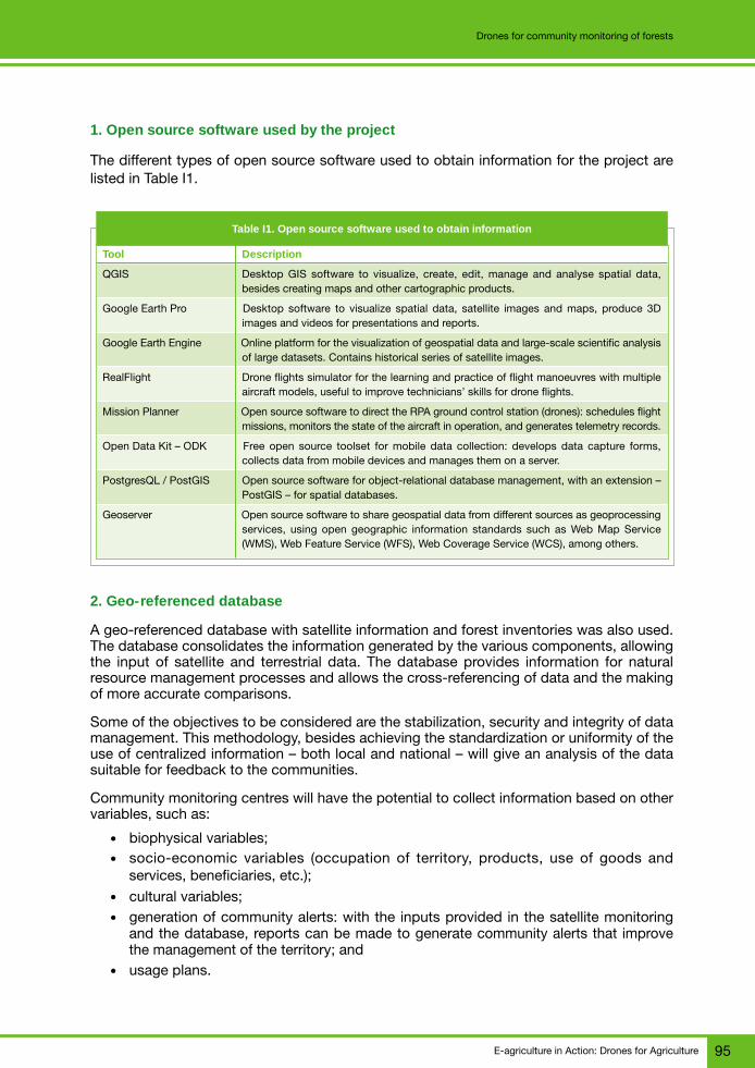
E-agriculture in Action: Drones for Agriculture 95
Drones for community monitoring of forests
1. Open source software used by the project
The different types of open source software used to obtain information for the project arelisted in Table I1.
Table I1. Open source software used to obtain information
Tool Description
QGIS Desktop GIS software to visualize, create, edit, manage and analyse spatial data,besides creating maps and other cartographic products.
Google Earth Pro Desktop software to visualize spatial data, satellite images and maps, produce 3Dimages and videos for presentations and reports.
Google Earth Engine Online platform for the visualization of geospatial data and large-scale scientific analysisof large datasets. Contains historical series of satellite images.
RealFlight Drone flights simulator for the learning and practice of flight manoeuvres with multipleaircraft models, useful to improve technicians’ skills for drone flights.
Mission Planner Open source software to direct the RPA ground control station (drones): schedules flightmissions, monitors the state of the aircraft in operation, and generates telemetry records.
Open Data Kit – ODK Free open source toolset for mobile data collection: develops data capture forms,collects data from mobile devices and manages them on a server.
PostgresQL / PostGIS Open source software for object-relational database management, with an extension –PostGIS – for spatial databases.
Geoserver Open source software to share geospatial data from different sources as geoprocessingservices, using open geographic information standards such as Web Map Service(WMS), Web Feature Service (WFS), Web Coverage Service (WCS), among others.
2. Geo-referenced database
A geo-referenced database with satellite information and forest inventories was also used.The database consolidates the information generated by the various components, allowingthe input of satellite and terrestrial data. The database provides information for naturalresource management processes and allows the cross-referencing of data and the makingof more accurate comparisons.
Some of the objectives to be considered are the stabilization, security and integrity of datamanagement. This methodology, besides achieving the standardization or uniformity of theuse of centralized information – both local and national – will give an analysis of the datasuitable for feedback to the communities.
Community monitoring centres will have the potential to collect information based on othervariables, such as:
● biophysical variables;● socio-economic variables (occupation of territory, products, use of goods and
services, beneficiaries, etc.);● cultural variables;● generation of community alerts: with the inputs provided in the satellite monitoring
and the database, reports can be made to generate community alerts that improvethe management of the territory; and
● usage plans.

E-agriculture in Action: Drones for Agriculture96
Drones for community monitoring of forests
The collection should follow the guidelines of the Intellectual Property Protocol, coordinatingactions with local community authorities, designated technicians and involving users offorests.
3. Drones
The information generated by drone flights can have multiple applications and can be usedfor different purposes, depending on the requirements of each community. This wouldinclude forest monitoring, territorial planning, monitoring of forest fires, population growthdynamics, invasion of their territories and monitoring of crops, among others.
In addition to obtaining images of very high spatial resolution, the high superposition ofimages obtained with the drones allows the derivation of height data, from a digitalstereoscopy.
With this information on the height and the ground cover, the altitude and the volume ofthe vegetation can be calculated and, together with the land points, the necessarytopographic information can be gathered. Through the multitemporal analysis of theseresults, very subtle coverage changes, such as the extraction of a particular tree, can beidentified in an automated way.
This technology, as a whole, allows the consolidation of a surveillance system in areas withactive dynamics, as it will provide information in real time, reliable, easy to process andpractically independent of climatic conditions, which allows:
1. monitoring of areas with continuous cloud permanence;
2. economically efficient monitoring of inaccessible areas and/or areas with little visualcoverage;
3. easy learning and generation of reliable results;
4. empowering communities to use the tool from their own capacities, since it can bemonitored when needed; and
5. optimizing surveillance: the evidence gathered can be useful for legal proceedings.
© F
AO
/T H
erna
ndez

E-agriculture in Action: Drones for Agriculture 97
Drones for community monitoring of forests
The drone model chosen for this project is the “Fixed-wing drone model E384” from Event38 Unmanned Systems. This model was chosen for being easy to use, easy to repair andvery light, and can cover long distances in a single flight. This model also makes it possibleto carry out, specifically, flight plans and post-processing for the monitoring of the earth.
Fixed wing equipment, model E384
This equipment is designed for photogrammetry and mapping applications and its mainfeatures are listed in Table I2.
Table I2. Characteristics of the E384 model
Physical characteristics Operational characteristics
Dimensions: 71" (180 cm) width of wings Cruising speed: 27 mph (44 km / h)51" (129 cm) long
Weight: 5 lb (2.3 kg) Flight time: 100 to 120 minutes
Maximum load capacity: 2.2 lb (1 kg) Range: 40 to 54 miles (64 to 85 km)
Flight battery: 4 cells, 8.0 Ah Climate: autonomous operation up to 25 mph (40 km/h)
Pixhawk autopilot, includes GPS Modes of operation: assisted, automatic and autonomousmode
Remote control: Spektrum DX5e Real-time telemetry station on a laptop up to 10 km
Telemetry options: 433 MHz and 915 MHz Maps up to 960 acres (3.8 km2) per flight of 5 cm/pixel
Wings and body can be assembled for Automatic camera control Canon S100 12.1 MPeasy portability
In general, it is argued that the use of drones has the following advantages anddisadvantages:
Advantages
1. obtaining very high-resolution images in areas of high cloudiness (illegal logging doesnot wait for sunny days or some satellite to pass);
2. lower cost than a field visit in large areas, in addition to generating an indisputableresult and easy interpretation to convey what is happening;
3. reduction of time: the data capture occurs at the moment and the storage capacityof the equipment allows its subsequent analysis;
4. increased staff safety – it is not necessary to cross thousands of hectares in a day,nor to fly over areas with the risk that this implies; and
5. accessibility – areas that, because of their orography, are difficult to study can beaccessed with the equipment.
Disadvantages
1. it is more expensive to use a drone and to buy all the equipment than to use satelliteimages – as images are not available for this function, the use of the drone is theonly existing alternative;

E-agriculture in Action: Drones for Agriculture98
Drones for community monitoring of forests
2. being a dynamic three point of reference system (the user, the controller and thedrone), the temporal reaction in the execution of actions can become conditioned,which could generate a delay between the emission and the execution of thoseactions, affecting the team if the conditions are not adequate;
3. the acquisition requires initial investment and the maintenance of the equipment needsfixed personnel, specifically formed to use it appropriately; and
4. new regulatory standards will define the use of drones in the national territory andthese will require updating.
To carry out the flights it is necessary to follow the protocol established in the preparedforms: pre-flight/post-flight checklist and take-off supervision, documents detailing theprocedures for:
– Preparing the equipment● verification of all equipment required for drone missions, using the pre-flight/
post-flight checklist;● battery charge – battery charger programmer (Lipro balance charger) for aircraft
batteries (8 000 ap) at 5 volts, camera battery charge and transmitter or controlbatteries;
● internal connections – connection of telemetry cables, drone battery, camera andautopilot system (Pixhawk); and
● assembly of the drone – assembly of fuselage, tail and elevator, wings, elastic bandsto fix, camera, cable connections, battery of the drone and, finally, the motorpropeller.
– Connection to telemetry and flight mission planning
To elaborate the flight plans it is necessary to:
● prepare the laptop computer by connecting the telemetry modem to the USB port,then connect to the E384 from the E38 Mission Planner software; and
● create the flight plan – search the site of interest, create the polygon of the area tobe flown and generate flight lines based on parameters such as camera, flight altitude,desired resolution of images, 60 percent photo overlap (recommended), availablebattery time and others. The Mission Planner manual describes in detail theprocedures to follow with the application.
4. Equipment for collecting forest information
For terrestrial data collection, an application is used to identify newly cleared lands and tofind areas identified during previous flights.
The application can be installed on a smartphone, since its use is quite common inindigenous communities and all technicians have one. Other applications used allowadjustments, depending on the needs of the project. For example, some allow you to makea field form to collect the data in the field. They are free access applications that technicianscan download and use on their own mobile devices.

E-agriculture in Action: Drones for Agriculture 99
Drones for community monitoring of forests
Project impact
In the Republic of Panama, the monitoring component of forests in indigenous communitieshas greatly aided global monitoring and has helped meet the demands of the REDDprogramme at the national level. It should be noted that those areas of the forests thatbelonged to indigenous territories had not been covered by pre-project monitoring.
An important component of the initiative was the emphasis on capacity development.Indigenous communities have been trained in the use of drones and other technologies tomonitor changes in land use and coverage of all areas. With these technologies, they havebeen able to generate very precise data that help them to make decisions and managetheir territory.
Communities can use data and information to halt and report illegal logging operations,but also to monitor fires, harvest crops, water resources, etc. The use of the data dependson the decisions of the indigenous authorities. Since they use the data independently, eachterritory uses the technical tools according to their own needs.
After the training of the technicians, they have applied their knowledge for other purposescomplementary to the monitoring of forests. There are pilots for community forestry andother more practical functions that are needed and, in some cases, provide economicsupport. Nowadays, the technicians support several local actions, such as the identificationof areas of fire that also can be located with the drones or with free satellite images.
Many communities want to acquire their land tenure rights and for this the technicians havehelped to implement the field survey and to design the maps. The trained technicians usethe tools and their new GIS capabilities to develop maps that support them in preparingdemands for land rights, which will be submitted to the government. They themselves outline
Edificacion de Wagandi, Comarca de wargandiRepublic de Panamá
LeyendaCamino
edificaciones_Wagandi
AfaltoTierra
Vuelo1
Auto: Marcos MartinezFecha; 28/7/2017
Escala 1:2,0903 0 3 6 9 12 m
concretomaderapencasinc
Sistema de CoordenadaUTM Zona 17N, datum WGS84
© F
AO
E-agriculture in Action: Drones for Agriculture100
Drones for community monitoring of forests
it with the members of their community and coordinate directly with COONAPIP. Thedocuments for obtaining tenure rights of five territories are already being evaluated by thecompetent national authorities.
The training has also transformed the dynamics within indigenous communities. After theproject, its members are more empowered to bring problems forward and to developproposals and to prepare high-quality technical reports that are very supportive of traditionaldecision-making authorities. Although the focus at the beginning of the project was forestmonitoring, the people involved are already applying the tools for other needs in theirterritories.
Indigenous technicians actively participated, incorporating what has been learned to therealities of their territories, which will contribute to improving the management of their forestresources, while maintaining their traditional knowledge. They have also encouraged theexchange of experiences between territories through the technicians, which has promotedlearning among them. Their participation in different training events has strengthened theirknowledge in the monitoring of forests and has strengthened the relationship between them.They are the ones to lead the discussion on community monitoring issues with theauthorities. Recently they started the initiative “Geo Indigena”(Geo Indigena, 2018),a platform of services they can provide to the different authorities to support sustainabledevelopment of the territories.
Innovation and success factors
Thanks to the use of drones and new technologies, community monitoring of forests hasbeen transformed positively. With the new knowledge and equipment available, communitiescan generate very accurate data that help them make decisions and manage their territory,and extend the range of areas that can be monitored. But beyond technology, it has beenthe people involved in the project who are responsible for the success of the project.
The practice has had positive results thanks to the close collaboration with COONAPIPand the technicians chosen by the traditional authorities of the indigenous territories. Theproject was designed for them and, at all times, adapted to the needs and demands of thecommunities. Its members not only participated in the process, but also directed it andthat is where the success of the project resides. Those involved wanted to do the work forthemselves and thanks to their motivation they managed to make the proposals work. It isclear that communities want to empower themselves and not only participate, but also toorganize the workshops.
It is worth mentioning that, thanks to the mediation of COONAPIP, each community wasable to choose at least one technician to work with the authority corresponding to theirterritory.
To achieve these results, it was very important to have a holistic vision to guide the actionsand activities developed. The introduction of new technologies was only a small part ofthe process, since training has also favoured and stimulated creativity in the use andapplication of new knowledge and technologies to solve the technicians’ own needs and

E-agriculture in Action: Drones for Agriculture 101
Drones for community monitoring of forests
to benefit their communities. The project introduced a number of innovations, for example,constant feedback between technicians and their authorities, strengthening the processesof internal governance of communities, which was essential to the success of the project.
Limitations
During the activities, there was an unanticipated limitation related to the participation ofwomen in training activities. At first there were women participating in the training, but atthe end of the activities they had stopped attending. So far we have not identified thespecific reasons why women left the project and how we could have reversed the situation.What is clear is that the gender approach in the project was poorly developed and thisshould be prioritized in future actions. For example, through the Voluntary Guidelines onResponsible Governance of Tenure, which mentions the removal of obstacles to the rightsof indigenous women as one of the keys to success for sustainable governance of naturalresources.
Moreover, the selection of the technicians created several obstacles: they were selectedby the authorities of the territories and the selection criteria were very varied and, in somecases, they did not take into account certain basic needs – for example, the need for thetechnician to have an email account – and that complicated the process at various stagesof the training.
The project also presented some challenges related to the forest monitoring system, suchas:
● system sustainability;● credibility of the information generated at community level for the national authorities;● comparability of information; and● incorporation into the National Forest Monitoring System and Nationally Determined
Contributions (NDC).
Lessons learned
In general, there was no cultural resistance to the implementation of the project since ateach stage, through the COONAPIP, the indigenous authorities were consulted and involved.The same proposal came from a joint effort with the authorities, which recognized that newtechnologies could favour forest monitoring and thus strengthen forest governance andland tenure. Currently, there are capacities created within communities in databasemanagement and geographic information systems to generate maps of territories, remotesensing with high-resolution images and low-resolution images and collection of forestinformation.
From this project, we can also draw a significant lesson on the importance of the partnerCOONAPIP. During the process, the institution was the initial driver and focus at each stageof the project and the link between all the parties involved. They also supported the Free,Prior and Informed Consent (FPIC) process before starting any activity in indigenous

E-agriculture in Action: Drones for Agriculture102
Drones for community monitoring of forests
communities. Sometimes, the authorities did not fully understand the objectives of theproject and opposed its implementation. The dialogue, facilitated by the Coordinator, wasvery important to adapt the activities to their wishes and needs.
Indigenous technicians also played a key role in the project. A bond and a network havebeen created, after having conducted various activities throughout the year. They knoweach other better, continue with the exchanges and support each other thanks to theregularity of the meetings. The indigenous technicians are those who have the trust of theindigenous authorities and were chosen by them. Therefore, they also play an importantrole in the dialogue and adaptation of activities during the process.
At the end of the project, the team believes that government participation should bestrengthened, which will contribute in the future to integration with the national monitoringsystem. Moreover, strategic alliances and the identification of new relevant actors couldbe strengthened in order to make more efficient use of available funds and broaden thescope of actions.
The continuity of the project with different sources of funding created a favourableenvironment for the understanding and dialogue among stakeholders to identify issues intheir territories. The technicians have put all their energies into ensuring the project’ssuccess, which has allowed the adaptation and improvement of activities to manage theirnatural resources during the process.
Sustainability
Global experience is contributing to environmental sustainability, however, there are someissues regarding sustainability in relation to the use of ICTs and drones to be taken intoaccount.
Over time, the drones will be damaged and at the end of their useful life they will have tobe replaced. In order to reduce costs, the project is testing a cheaper type of drone, alwaysconsidering open source alternatives.
Moreover, most trained technicians are volunteers and much of the work is done andmanaged at the community level, which avoids financial dependence on projects. But thecost of field missions is quite high and it is not always easy for communities to continuewith the work.
In order to strengthen the sustainability of the project, a national indigenous forest monitoringnetwork was created for the time being composed of 17 members, with at least onerepresentative from Congress.
To ensure greater sustainability, several alternatives can be considered, for example:
1) incorporate community monitoring into the Ministry of Environment to receive long-term support and to propose a definitive component of monitoring at the nationallevel; and

E-agriculture in Action: Drones for Agriculture 103
Drones for community monitoring of forests
2) incorporate monitoring into the costs of forest resources utilization through themanagement plans.
Project replicability appears to show promise and clearly the project has had some importantsuccesses in terms of its technical and ecological goals, but it is important to acknowledgethe profound way that it has affected indigenous communities. Eliceo Quintero, a youngindigenous person from the Ngäbe Buglé Comarca, a participant in the project, emphasizedhow interesting the experience has been thanks to its many levels of innovation:
These tools allow us to know the characteristics of the forests and the resources wehave in our territories. Training has been carried out to analyse geographic informationand use of technology tools in the field, with direct applications in the forests.
Eliceo Quintero adds that the data they have collected have been interesting because theyhave helped them discover some of the unique characteristics of the development of thespecies in the area:
We have identified local native species, analysed the forest cover, how the impact ofdeforestation has changed and it has been useful to us to discover some interestingplaces and sacred sites. It has also allowed us to test the levels of organization of thecommunity and strengthen the administrative management of our authorities.
On the future of this initiative, young people aspire to seek more instruments to expandtheir reach and to generate a community monitoring network at national level, a valuablecontribution to their efforts to monitor and protect their resources, to rehabilitate degradedareas and to manage their resources for future generations.
References
Geo Indigena. 2018. Nuestra aporte tecnologico ancestral [online]. [Cited March 1st, 2018].www.geoindigena.org
For more information
Maricarmen Ruiz JaenTechnical Advisor on community-based forestry and monitoring and part of theREDD+Team at [email protected]
Lucio Santos – FAO Forestry Officer and part of the REDD+Team at [email protected]
Acknowledgements for contributions to the writing of this chapter to Alice Van derElstraeten and the Project Team.

E-agriculture in Action: Drones for Agriculture104
Drones for community monitoring of forests
kaila
sh k
umar
from
Pex
els

E-agriculture in Action: Drones for Agriculture 105
Internet of things application in agriculture and use of unmanned aerial vehicles (UAVs)Case study
J
Introduction
Ensuring the health of the rural economy has been one of the world’s most challengingissues. In the more developed countries, the Internet of things (IoT) has been employed tobenefit farmers, increase production and reduce operating costs as well as to enhancelabour efficiency, but it is still out of reach for most developing countries. In recent years,the IoT has made remarkable progress and is regarded as the most promising technologyfor propelling agriculture, i.e. farming, fishing and the poultry industry, into the future.However, there are no base stations and Wi-Fi stations in most farming areas, which preventthe application of the IoT in agriculture. In this chapter, an unmanned aerial vehicle (UAV)-wireless sensor network (WSN) based system that has been applied in the rural area in thePeople’s Republic of China to resolve this issue will be demonstrated.
The role of surveillance in agriculture shows great promise such as in biological disasterprevention in forestry and farm plant protection, fisheries etc. Therefore, low cost, real time,large scale and stable surveillance, accurate data acquisition and transmission as well asprocessing are very crucial for agriculture production and disaster prevention. However, inmost rural areas the absence of wireless base stations and Wi-Fi stations is a major obstaclein implementing surveillance systems. That means the data acquired through the WirelessSensor Network (WSN) cannot be transmitted using wireless communications. An alternativesolution is to employ UAV to communicate with the WSN in large areas to get real timedata for processing and analysis.
UAV-WSN based system and application
In this project, UAV-WSN based systems were developed and applied in several farms inthe People’s Republic of China, including farmlands based in Baoan, Longgang and Yantiandistricts, Shenzhen in Guangdong Province.
This project has been supported by the following partners:
● Shenzhen Agriculture Technology Research Centre● Shenzhen Nopoison Agrochemicals Co., Ltd., the largest fertilizer provider in the
country● D-Tech (Xintai) Technology Co. Ltd., Xintai County, Taian City, Shandong Province● Shenzhen Economy and Trade Information Committee, funding provider
Internet of things application inagriculture and use of unmanned
aerial vehicles (UAVs)EXPERIENCES FROM CHINA

E-agriculture in Action: Drones for Agriculture106
Internet of things application in agriculture and use of unmanned aerial vehicles (UAVs)
This practice was implemented on the farmlands belonging to Shenzhen AgricultureTechnology Research Centre, Shenzhen, Shenzhen Nopoison Agrochemicals Co., Ltd. andother corporations, beginning in 2017.
The initial situation with respect to surveillance on the farms was that there was no basestation, no Wi-Fi station nearby or the signals were too weak for communication. Thus,farmers needed to spend significant time on farm data acquisition and had no access toreal time farm information. This situation is very undesirable when encountering, for example,weather disasters, high temperatures, oxygen and poisonous material or polluted water, asthese will destroy crops before any action can be taken.
In this case, it was feasible to install both Zigbee and Lora wireless modules in the UAV.Meanwhile, the Zigbee or Lora technique based on a wireless sensor network was appliedon the farm to communicate with the module in the UAV. More than 30 wireless nodeswere applied (Figures J1 and J2). The conventional technology is to apply mobilecommunications such as the GPRS or the third or fourth generation of mobilecommunications (3G or 4G). However, as there was no base station, no Wi-Fi station orvery weak and unstable signals on farmlands it was hard to transmit the data acquired tothe farmers’ control centre.
Zigbee
Bluetooth
WAN
GPRS3G
4G
Wi-Fi
WLAN
Zigbee Coordinator
Zigbee RouterZigbee End Device
Figure J1. Large-scale wireless sensor network communication
Figure J2. Heterogeneous network and multiple modular fusion and efficient interface control
© S
henz
hen
Wis
sea
Tech
nolo
gy
Co.
, Ltd
.
© S
henz
hen
Wis
sea
Tech
nolo
gy C
o., L
td.

E-agriculture in Action: Drones for Agriculture 107
Internet of things application in agriculture and use of unmanned aerial vehicles (UAVs)
This smart network system employs 3G or 4G mobile communication, GPS, 3D GIS, thatis wireless sensor network (WSN) mesh technology. The WSN network is a blend of sensorsembedded processing, distributed information, wireless communication, network security,intelligent control and a series of advanced technologies of the Internet of things technologyplatform.
Using a complex comprehensive system
The UAV-based WSN scheme comprises one complex comprehensive system, whichclosely integrates the above techniques. This means that if any of these techniques aremissing this scheme will not be successful.
Figure J3 shows the data that was acquired using serial port communication with the UAV.After the data was acquired, it was saved on an SD card for communication througha serial port.
Figure J3. Data acquired with UAV
Figure J4 shows the diagram of the UAV-WSN system. In this figure, there are WSN networksthat combine dozens of Zigbee nodes that are connected to sensor modules, and whichthen communicate with the UAV that is equipped with one Zigbee node.
Each Zigbee node can cover a radius of 200 m to 500 m of land thus dozens of nodes canactually cover about 1 000 to 2 000 acres of farm. Each sensor module consists of up toten sensors for soil and environment information, for example soil temperature, soil humidity,soil fertilizer, sunlight intensity, CO2, soil PH value, rain intensity, wind intensity. The dataacquired will then be transmitted from the coordinator inside the WSN to the UAV side fordata collection.
© S
henz
hen
Wis
sea
Tech
nolo
gy C
o., L
td.

E-agriculture in Action: Drones for Agriculture108
Internet of things application in agriculture and use of unmanned aerial vehicles (UAVs)
The parameters of the UAV in this chapter are described in Table J1. The performance ofthe UAV is affected by various factors, which will be determined regarding the performanceto cost ratio.
UAV with a Gateway on it
Data download
Data Upload
NetworkTopology
Sink node
Sink node
Sensornodes
Data analysis
ServerDatabase
centre
Monitoring areaUAV
Figure J4. Diagram of the UAV-WSN system
Table J1. parameters of the UAV
Functionality Performance
1 Climbing speed 5 m/s
2 Cruising speed 12 m/s
3 Maximum power 800 W
4 Body weight 2 650 g
5 Task reload 600 g (recommended)
6 Task reload 1 600 g (maximum)
7 Flight weight 5 000 g (maximum)
8 Body size 700 mm (wing distance opposite angle)
9 Flight time <30 minutes/per battery block
10 Working humidity 80%
11 Wind resistance ability 10 m/sec
12 Rain resistance ability Heavy rain
13 Flight radius 600 m
14 Flight height 600 m
© S
henz
hen
Wis
sea
Tech
nolo
gy C
o., L
td.
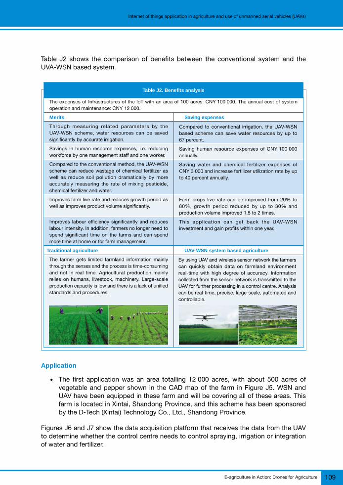
E-agriculture in Action: Drones for Agriculture 109
Internet of things application in agriculture and use of unmanned aerial vehicles (UAVs)
Table J2 shows the comparison of benefits between the conventional system and theUVA-WSN based system.
Table J2. Benefits analysis
The expenses of Infrastructures of the IoT with an area of 100 acres: CNY 100 000. The annual cost of systemoperation and maintenance: CNY 12 000.
Merits Saving expenses
Through measuring related parameters by theUAV-WSN scheme, water resources can be savedsignificantly by accurate irrigation.
Savings in human resource expenses, i.e. reducingworkforce by one management staff and one worker.
Compared to the conventional method, the UAV-WSNscheme can reduce wastage of chemical fertilizer aswell as reduce soil pollution dramatically by moreaccurately measuring the rate of mixing pesticide,chemical fertilizer and water.
Improves farm live rate and reduces growth period aswell as improves product volume significantly.
Improves labour efficiency significantly and reduceslabour intensity. In addition, farmers no longer need tospend significant time on the farms and can spendmore time at home or for farm management.
Traditional agriculture UAV-WSN system based agriculture
The farmer gets limited farmland information mainlythrough the senses and the process is time-consumingand not in real time. Agricultural production mainlyrelies on humans, livestock, machinery. Large-scaleproduction capacity is low and there is a lack of unifiedstandards and procedures.
Compared to conventional irrigation, the UAV-WSNbased scheme can save water resources by up to67 percent.
Saving human resource expenses of CNY 100 000annually.
Saving water and chemical fertilizer expenses ofCNY 3 000 and increase fertilizer utilization rate by upto 40 percent annually.
Farm crops live rate can be improved from 20% to80%, growth period reduced by up to 30% andproduction volume improved 1.5 to 2 times.
This application can get back the UAV-WSNinvestment and gain profits within one year.
By using UAV and wireless sensor network the farmerscan quickly obtain data on farmland environmentreal-time with high degree of accuracy. Informationcollected from the sensor network is transmitted to theUAV for further processing in a control centre. Analysiscan be real-time, precise, large-scale, automated andcontrollable.
Application
● The first application was an area totalling 12 000 acres, with about 500 acres ofvegetable and pepper shown in the CAD map of the farm in Figure J5. WSN andUAV have been equipped in these farm and will be covering all of these areas. Thisfarm is located in Xintai, Shandong Province, and this scheme has been sponsoredby the D-Tech (Xintai) Technology Co., Ltd., Shandong Province.
Figures J6 and J7 show the data acquisition platform that receives the data from the UAVto determine whether the control centre needs to control spraying, irrigation or integrationof water and fertilizer.

E-agriculture in Action: Drones for Agriculture110
Internet of things application in agriculture and use of unmanned aerial vehicles (UAVs)
Figure J6. Data processing and analysis as well as equipment control
Figure J5. The CAD map of the farm in the Wenshan,Yunnan, China
© S
henz
hen
Wis
sea
Tech
nolo
gy C
o., L
td.
© S
henz
hen
Wis
sea
Tech
nolo
gy C
o., L
td.
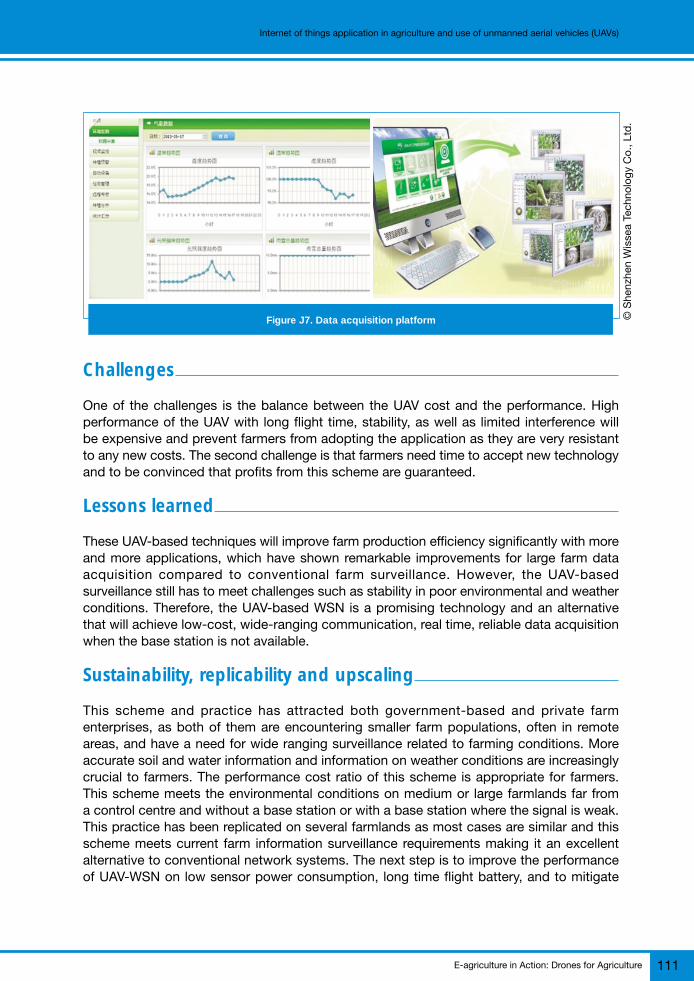
E-agriculture in Action: Drones for Agriculture 111
Internet of things application in agriculture and use of unmanned aerial vehicles (UAVs)
Challenges
One of the challenges is the balance between the UAV cost and the performance. Highperformance of the UAV with long flight time, stability, as well as limited interference willbe expensive and prevent farmers from adopting the application as they are very resistantto any new costs. The second challenge is that farmers need time to accept new technologyand to be convinced that profits from this scheme are guaranteed.
Lessons learned
These UAV-based techniques will improve farm production efficiency significantly with moreand more applications, which have shown remarkable improvements for large farm dataacquisition compared to conventional farm surveillance. However, the UAV-basedsurveillance still has to meet challenges such as stability in poor environmental and weatherconditions. Therefore, the UAV-based WSN is a promising technology and an alternativethat will achieve low-cost, wide-ranging communication, real time, reliable data acquisitionwhen the base station is not available.
Sustainability, replicability and upscaling
This scheme and practice has attracted both government-based and private farmenterprises, as both of them are encountering smaller farm populations, often in remoteareas, and have a need for wide ranging surveillance related to farming conditions. Moreaccurate soil and water information and information on weather conditions are increasinglycrucial to farmers. The performance cost ratio of this scheme is appropriate for farmers.This scheme meets the environmental conditions on medium or large farmlands far froma control centre and without a base station or with a base station where the signal is weak.This practice has been replicated on several farmlands as most cases are similar and thisscheme meets current farm information surveillance requirements making it an excellentalternative to conventional network systems. The next step is to improve the performanceof UAV-WSN on low sensor power consumption, long time flight battery, and to mitigate
Figure J7. Data acquisition platform © S
henz
hen
Wis
sea
Tech
nolo
gy C
o., L
td.

E-agriculture in Action: Drones for Agriculture112
Internet of things application in agriculture and use of unmanned aerial vehicles (UAVs)
interference from wireless communications, etc. Large-scale replicability and upscaling ofthe UAV-WSN technology application will be possible when these issues are resolved.
Conclusion
If this UAV-WSN based surveillance system is applied widely in the near future, millions offarmers will be able to benefit from the acquisition of real time farm information. Farmerswill not need to spend a significant amount of time on acquiring farm data and will haveaccess to disaster warning and weather information when a disaster event seems possible.Nevertheless, the UAV-WSN technology is still not mature enough for large-scale application.More UAV-WSN research and development work is required, including the development ofapplications for fishing, poultry and farming enterprises.
Bibliography
Baránek, R. & Solc, F. 2012. Modelling and control of a hexa-copter, pp. 19–23. Proceedings of the 13th
International Carpathian Control Conference (ICCC), 28–31 May. [online]. http://ieeexplore.ieee.org/xpl/mostRecentIssue.jsp?punumber=6222116
DJI. 2017. Smarter agriculture package. [online]. http://www.precisionhawk.com/agriculture
Wang, J. (May 2014). The design of ‘Six rotor UAV model of Agriculture’. (Translated from the Chinese).[online]. [Cited 23 Sep 2017]. http://www.taodocs.com/p-23157432.html
Yin, W., Zhang, J.N., Xiao, Yu, M.Y.P., He, Y.H. 2017. Application of the Internet of things in agriculture.E-Agriculture in action, pp. 81–85. Bangkok, FAO and ITA.
Zhang, Z., Cui, T.S., Liu, X.F., Zhang, Z.C., & Feng, Z.Y. 2017. The design and implementation of ‘theuse of UVA in agricultural ground surveillance system’. Journal of Agricultural Mechanization Research,39 (11): 64–68. Doi: 10.13427/j.cnki.njyi.2017.11.011
For more information
Wu Yin, Jinna Zhang, Lu Ma and Yanping YuShenzhen Wissea Technology Co., [email protected]; [email protected]; [email protected];[email protected]
Ming XiaoSchool of Automation, Guangdong University of [email protected]