Revised Schedule and Revised Syllabus for Periodic Test-I ...
Upload
khangminh22Category
view
1download
0
POWERTECII (USA) INC.
APPENDIX B
Well Inventory
July 2012 B-i Appendix B

POWERTECII (USA) INC.
This page intentionally left blank
July 2012 B-ii Appendix B

PowERtEcIh (USA) INC.
Inventory of Wells within 2 Kilometersof the Dewey-Burdock ProjectEdgemont, South Dakota
June 2012
Prepared by
Powertech (USA) Inc.
P.O. Box 812
Edgemont, South Dakota 57735
July 2012 B-1 Appendix B

4POWERTECh (USA) INC.
Table of Contents
1.0 HISTO RICAL RECO RDS REVIEW ED ................................................................................................... 4
1.1 Silver King M ines, Inc. Records .................................................................................................. 4
1.2 Tennessee Valley Authority Records .............................................................................................. 5
1.3 South Dakota W ater W ell Records ................................................................................................ 6
1.4 South Dakota O il and G as Records ................................................................................................ 6
1.5 South Dakota W ater Rights Records .............................................................................................. 7
1.6 W yom ing W ater Rights Records ..................................................................................................... 7
1.7 W yom ing O il and G as Records .................................... .................................................................. 7
1 .8 R ES P EC R e co rd s ................................................................................................................................... 7
1.9 Pow ertech (USA) Inc. Records ................................................................................................... 8
1.10 M isce llaneo us Reco rd s ..................................................................................................................... 8
1.11 Other Records Not Review ed ................................................................................................... 8
2 .0 SU M M A RY TA B LES ................................................................................................................................. 9
List of Tables
1 Existing Wells within 2 Kilometers of the Project Area
2 Historical Wells Noted in Data Sources within 2 Kilometers but No Longer Present at Surface
3 Plugged and Abandoned Wells within 2 Kilometers
List of Appended Source Documents
A WATER WELLS IN EDGEMONT PROJECT AREA
B DRAFT ENVIRONMENTAL STATEMENT FOR EDGEMONT URANIUM MINE TABLE 2.5.2-1
C SOUTH DAKOTA WELL COMPLETION REPORTS
D SOUTH DAKOTA OIL AND GAS RECORDS
E DEWEY BURDOCK GROUNDWATER WELL REPORT 2010 & 2011 FIELD WORK COMPLETED
F RESPEC RESPONSES TO NUCLEAR REGULATORY COMMISSION COMMENTS (REVISION)
G DOMESTIC AND LIVESTOCK WELLS MONITORED DURING FEBRUARY 1982 DEWEY PUMP TEST
H WYOMING WATER RIGHT 183561
July 2012 B-2 Appendix B

POWERTECh (USAM INC.
I ADDITIONAL WATER WELLS IN EDGEMONT PROJECT AREA
J FOREST SERVICE WELLS AND SPRINGS
K HYDROGEOLOGIC INVESTIGATIONS AT PROPOSED URANIUM MINE NEAR DEWEY, SOUTH
DAKOTA
L COORDINATES, ELEVATIONS AND WATER LEVELS FOR BURDOCK PIEZOMETERS
M CONSTRUCTION AND LOCATION DATA FOR DEWEY PUMP TEST WELLS
N BURDOCK MINE AREA HYDROLOGY STATUS REPORT
O ANALYSIS OF AQUIFER TESTS CONDUCTED AT THE PROPSED BURDOCK URANIUM MINE SITE
P HYDRO ID 704 RECOMPLETION
Q SOUTH DAKOTA WATER RIGHT 380-2
R AN EARLIER NAME FOR HYDRO ID 710
July 2012 B-3 Appendix B

POWERTECh (USA) INc.
INVENTORY OF WELLS WITHIN TWO KILOMETERS
OF THE DEWEY-BURDOCK PROJECT AREA
Details available for wells constructed within two kilometers of the Dewey-Burdock UraniumProject are provided in this report. Historical records are reviewed in Section 1.0 and summary tables
are provided in Section 2.0. Referenced materials are appended and correspond with sources cited in
the summary tables.
1.0 HISTORICAL RECORDS REVIEWED
Silver King Mines, Inc. correspondence, Tennessee Valley Authority correspondence and reports,
South Dakota and Wyoming databases, RESPEC's RSI 2020 report, Powertech (USA) Inc.'s records, andother records were reviewed to inventory water wells within 2 kilometers of the project in the following
sections:
T6S RIE Sections 7 through 10 and 15 through 36
T6S R2E Sections 30, 31 and 32
T7S RIE Sections 1 through 24
T7S R2E Sections 5, 6, 7, 8, 17, 18, and 19
1.1 Silver King Mines, Inc. Records
A letter from Keith Andersen, Silver King Mines, Inc. (SKM), to John Hatch, SD Water Rights
Commission, on January 12, 1979 was reviewed. Copies of pump test data and other records from
SKM's files were attached, including an interoffice memorandum from Keith Andersen, SKM, to R.
Caywood, SKM, dated December 18, 1978. This memorandum provides references to the following
information:
a. Water Wells in the Edgemont Project Area prepared in May 1977: this document shows the
location and available information for Hydro IDs 1 through 134; it is provided as Source A
b. Nine wells installed the Fall of 1976 for measuring water levels during the February 1977 pump
test: B-1 FR (#672), B-2 (Abandoned November 1978, no Hydro ID identified), B-3 FR (no Hydro
ID identified), B-3 (Abandoned November 1978, no Hydro ID identified), B-4 (Abandoned
December 1978, no Hydro ID identified), B-5 (Abandoned December 1978, #637), B-6 FR(#659),
B-6 (Abandoned Dec 1978, #660), B8 (#661), and Burdock Well (#668)
c. Four additional wells installed August 1977 for November 1977 pump test: B-7 FR (#665), B-7(#666), B-9 FR (#646), and B-9(#658)
July 2012 B-4 Appendix B

POWERTECh (USA) INc.
d. Ten wells installed during the Summer of 1978: BPZ 14 (#602), BPZ 15 FR (#601), BPZ 16 (#643),
BPZ 17 FR (#644), BPZ 18 (#608), BPZ 19 FR (#607), BPZ 20 (#609), BPZ 21 FR (#610), BPZ 22
(#626), and BPZ 23 FR (#625)
e. Seven replacement wells installed during the Fall of 1978: B-2 LAK (#674), B-2 FU (#673), B-10
FR (#671), B-10 FU (#670), B-10 LAK (#669), B-11 FR (#664), B-i1 LAK (#663)
f. Test well constructed January 1977 (#668) used during February and November 1977 pump
tests
1.2 Tennessee Valley Authority Records
Tennessee Valley Authority's (TVA) Draft Environmental Statement (1979) was reviewed. This
document was not finalized. Wells referenced are listed below with corresponding Hydro IDs:
p. 51, test well completed near shaft (#668)
p. 52, map showing following the wells: B-9 (BPZ-9 LAK, #658), B9FR (BPZ-9 FR, #646),
B-2 (BPZ-2 LAK, #674), BiFR (BPZ-1 FR, #672), B-7 (BPZ-7 LAK, #666), B7FR (BPZ-7 FR, #665), B-6
(BPZ-6 LAK, #660), B6FR (BPZ-6 FR, #659), B-3 (BPZ-3 LAK, no corresponding Hydro ID), B3FR
(BPZ-3 FR, no corresponding Hydro ID), B-4 (BPZ-4 LAK, no corresponding Hydro ID), B-5 (BPZ-5,
#637), B-8 (BPZ-8 LAK, #661)
p. 53,61 water wells within 4 miles are summarized on Table 2.5.2-1 (corresponding
Hydro IDs were found for all except D-14, which had no information except a location at SESE 12-75-1E,
and E-7, which also had no information except a location at NENE 6-75-IE; Source B provides the cross-
referenced list)
The TVA report "Analysis of Aquifer Tests Conducted at the Proposed Burdock Uranium Mine
Site," WR28-1-520-109, by J.M. Boggs and A.M. Jenkins, May 1980, was reviewed. Wells referenced and
corresponding Hydro IDs are: Burdock test well (#668), B-10LAK (#669), B-1OFU (#670), B-1OFR (#671),
B-11LAK (#663), B-11FR (#664), B-9[AK (#658), B-9FR (#646), B-7[AK (#666), B-7FR (#665), and Sundance
Well (#662 based on depth but not location).
A letter from Gary Cummings, TVA, to Peter Martin, TVA, on March 23, 1982 regarding water
levels at Dewey Pump test monitoring wells was reviewed. Wells referenced and corresponding Hydro
IDs are: D-8 (#147), D-6 (#617), D-5 (#616), D-4LK (#622), D-4FR (#623), D-3LK (#657), D-3FR (#436), D-
2LK (#612), D-1FU (#614), D-1FR (#613), D-1LK (#615), and Dewey Pumped Well (#611).
A letter from Gary Cummings, TVA, to Peter Martin, TVA, on April 12, 1982 regarding domestic
and livestock wells monitored during the Dewey Pump Test was reviewed. Wells referenced are: 119,
103, 104, 39, BPZ 20 FR (#610), BPZ 20 LAK(#609), D-7 (#624), 40U, 40L, 102, 13, 41, 48, BY-i FR (40U?),
BPZ LA 22 (#626), BPZ FR 22 (#625), 99, 96, 106, 107, 115, 147, 148, 38, 49, 109, 110, 111, and 117.
Water levels or flow rates are reported. Well locations, construction details and owners are not.
July 2012 B-5 Appendix B

POWEItTECh (USA) INc.
A letter from Gary Cummings, TVA, to Peter Martin, TVA, on July 12, 1982 regarding Dewey
observation wells was reviewed. Wells referenced and corresponding Hydro IDs are: Dewey Main Well
(#611), D-8 LK (#147), D-5 LK (#616), D-6 LK (#617), D-1 FU (#614), D-1 FR (#613), D-1 LK (#615), D-2 LK
(#612), D-3 FR (#436), D-3 LK (#657), D-4 FR (#623), and D-4 [K (#622).
The TVA report "Hydrogeologic Investigations at Proposed Uranium Mine Near Dewey, South
Dakota," WR28-2-520-128, by J.M. Boggs, October 1983, was reviewed. Wells referenced and
corresponding Hydro IDs are: D-PW (#611), D-1LK (#615), D-1FU (#614), D-1FR (#613), D-2LK (#612), D-
3LK (#657), D-3FR (#436), D-4LK (#622), D-4FR (#623), D-5LK (#616), D-6LK (#617), D-7FR (#624), D-8LK
(#147), D-20LK (#609), and D-20FR (#610).
A stand-alone table showing well construction and well locations for the Dewey Pump Test wells
was reviewed. The wells referenced and corresponding Hydro IDs are: Dewey Test Well (#611), D-1 FR
(#613), D-1FU (#614), D-1LK (#615), D-2LK (#612), D-3FR (#436), D-3LK (#657), D-4FR (#623), D-4LK
(#622), D-5LK (#616), D-6LK (#617), and D-7FR (#624).
1.3 South Dakota Water Well Records
South Dakota well records were reviewed online. Records were identified for sixty-nine Hydro
IDs: 2, 13 recompletion record, 17, 38, BY-1 (possible 40U recompletion), rehabilitation record for 42,
115 replacement record, 147, 220, 429, 431, 432, 433, 436, 510, 609, 610, 611, 612, 613, 614, 615, 616,
617, 622, 623, 624, 631, 657, 662, 663, 664, 668, 669, 670, 671, 673, 674, 676, 677, 678, 679, 680, 681,
682, 683, 684, 685, 686, 687, 688, 689, 690, 691, 692, 693, 694, 695, 696, 697, 698, 703, 704 Unkpapa,
705, 706, 707, 708, 709, and 3026. Seven additional wells with no matching Hydro ID were also
identified: SWSW 15-65-1E Spencer, SWNE 18-65-1E BNRR, 20-65-1E SKM, NENE 27-65-1E Smith, NWNE
29-65-1E SKM, 2-75-1E Linch, and 20-75-1E Tubbs. Assignment of Hydro IDs to these wells is pending
ongoing field location and verification work. Records found are provided in Source C.
1.4 South Dakota Oil and Gas Records
South Dakota oil and gas records were reviewed online. Twelve oil tests were identified within
two kilometers of the permit boundary. Of these, three had been converted to water wells (API
Numbers 4004720045, 4004705093, and 4004720065, which were converted to Hydro IDS 3, 4, and 5,
respectively). Of the nine remaining tests, two had no information regarding plugging and
abandonment (API Numbers 4003305219 and 400330521 at 19-6S-1E), four were identified as having
been plugged and abandoned and a dry hole marker placed at the surface (API Numbers 4004705095 at
2-7S-1E, 4004720071 at 11-7S-1E, 4004705089 at 21-7S-1E, and 40047020077at 15-7S-1E), two were
identified as having been plugged and abandoned with no dry hole marker placed per the landowner's
request (API Numbers 4004720085 at 21-7S-1E and 4004720074 at 21-7S-1E), and one (API 4004705147
at 22-7S-1E) was cased to the top of the Spearfish with a cement plug at the base of the casing. The
hole is open below the casing to a second cement plug within the 2 nd Converse. A steel cap is tack-
welded to the surface casing making it available for possible future use as a water-supply well. A dry
hole marker was screwed onto the tack-welded cap. Source D provides South Dakota Oil and Gas
records for test wells that were not converted to water wells. Completion reports for test wells
converted to water wells are provided in Source C.
July 2012 B-6 Appendix B

POWERTECII (USA) INc.
1.5 South Dakota Water Rights Records
South Dakota water rights were also reviewed online. Three PERMITTED springs (0181-2, 0182-
2 and 0183-2) issued to Grand Island and Wyoming Railroad on August 9, 1890 for springs A, B and C in
18-T6S-R1E were identified. One CANCELLED groundwater right was identified for BN Railroad in 19-
T6S-R1E. The well associated with this water right was plugged and abandoned on July 31, 1998. A
corresponding Hydro ID has not been assigned to it. One LICENSED groundwater right belonging to
Henry Hollenbeck, number 380-2, was previously identified by RESPEC and WWC and was confirmed
online in NWNW 17-65-1E. The well associated with this water right still exists and was assigned Hydro
ID 710. Coordinates for the well were estimated by Sean Hetrick, Powertech, based on the well's
location on a topographic map: East 1019431, North 459018 NAD 1927, South Dakota State Plane South
FIPS 4002 (feet). Mark Hollenbeck, Powertech, subsequently measured the coordinates using a
handheld GPS February 27, 2012. The well's coordinates converted from the handheld GPS are East
1019432, North 459053 NAD 1927, South Dakota State Plane South FIPS 4002 (feet). The surface
elevation from a USGS topographic map at the location of a mapped flowing well is 3,767 feet above
mean sea level. Inspection of the well by Mark Hollenbeck the same day indicated the well was no
longer flowing and is inaccessible by pump due to the casing being filled to the top with rocks.
Subsequent research indicated that Silver King Mines, Inc. was also aware of the presence of this well. A
water level taken from it in 1980 was below surface (the well was not flowing). The ID assigned to the
well by Silver King Mines, Inc. was 149.
1.6 Wyoming Water Rights Records
Wyoming water rights were reviewed online. Water right 183561 belonging to Putnam and
Putnam was previously identified by WWC and confirmed online at SWSW 28-41N-60W. This water
right was found to correspond with Hydro ID 5002. Information on the water right was obtained from
Ms. Krissie Groth at the Wyoming State Engineer's office in Cheyenne. A second water right, P137.0W
for Earl Carr for 2,000 gallons per minute at NENW 21-41N-60W, was identified just outside the 2-
kilometer boundary. The status of this water right shows CANCELLED. Further information was not
available online, but can be retrieved from the State Engineer's office, if needed.
1.7 Wyoming Oil and Gas Records
Wyoming oil and gas records were reviewed online. No records were identified within the 2-
kilometer area reviewed. This is a bit surprising considering the project rests on the eastern boundary of
the Powder River Basin. A number of oil tests were identified northwest and southwest of the 2-
kilometer boundary.
1.8 RESPEC Records
Logs in Source A-2 of RSI 2020, Draft Characterization of the Groundwater Flow System at the
Dewey Burdock Uranium Project, November 2008, were reviewed. State Completion Reports prepared
for 25 Powertech wells are not labeled with Hydro IDs. The order is given here for reference: 675, 677,
678, 703, 681, 686, 684, 682, 704, 683, 680, 687, 689, 3026, 698, 688, 690, 692, 696, 694, 685, 691, 693,
697, and 695. These logs are presented again in Appendix 2.2-B of Powertech's 2009 Technical Report.
July 2012 B-7 Appendix B

POWERTECh (USA) INC.
Of the 56 pages of other State logs presented in Source A-2 of RSI 2020, 33 pages representing
32 logs have matching Hydro IDs, 4 logs have no matching Hydro ID, 4 logs are duplicates, and 15 pages
representing 11 logs are outside the two-kilometer area reviewed. Logs are not labeled with Hydro IDs
in the Source. The order is given here for reference: 429, 436, 431, 617, 433, 622, 623, dup 623, 657,
432, 614, 613, 609, 610, dup 610, outside 2-km, outside 2-km, outside 2-km, outside 2-km, 663, 664,
669, 670, 671, 674, 673, 662, 11 (2 pages), 220, 115?, outside 2-km, 8, 38, outside 2-km, no match Smith
& Associates, outside 2-km (5 pages for same well), outside 2-km, outside-2km, 510, outside 2-km,
outside 2-km, no match Tubbs, 2, 17, 13, dup 13, no match Linch, 116, 631, no match Spencer, and dup
662. These logs are presented again in Appendix 2.2-B of Powertech's Technical Report, February 2009.
1.9 Powertech (USA) Inc. Records
Attachments and well construction reports provided in Appendix 2.2-B of the Technical Report,
February 2009 were reviewed and found to be the same as those presented by RESPEC in RSI 2020.
TR RAIs submitted to NRC in June 2011 and a report by Mike Beshore prepared in October 2011
were reviewed. Following are notes made regarding wells and Hydro IDs:
* Remove #108 from Table TR RAI P&R 10-1; is outside the 2-kilometer area reviewed
* #116 and #506 appear on both Tables TR RAI P&R 10-1 and 2; revise to show on Table 1 only
* #635 is not a well but a pipeline from #5; move to Table 2
* Add a footnote to #651 indicating it is not a well but a stock tank formerly filled by a pipeline
from #6 (Fall River); #6 no longer flows and the stock tank is no longer used
* Wells or former wells possibly within 2 kilometers missing from Tables 1, 2 and 3 are: 50, 710,
5002, B-3, B-3FR, B-4, and APIs 4004705089, 4003305219, 4003305221, 4004705095,
4004705147, 4004720071, 4004720074, 4004720077, 4004720085.
1.10 Miscellaneous Records
A Draft Well Test Analysis report prepared by Dan Hoyer on August 20, 2007 regarding the April
1979 Burdock Lakota Pump Test, the July 1979 Burdock Fall River Pump Test 1982, and the February
1982 Dewey Lakota Pump Test was reviewed. Wells referenced and corresponding Hydro IDs are: BPZ-
7FR (#665), BPZ-7LAK (#666), BPZ-11LAK (#663), BPZ-11FR (#664), BPZ-1OFU (#670), BPZLAK (#669), PBZ-
1OFR (#671), Burdock Test Well (#668), PBZ-1FU (#673), PBZ-1FR (#674), BPZ-1FR (#672), BPZ-9FR
(#646), PBZ-9LAK (#658), DPZ-7FR (#624), Bud Hollenbeck (#115), DPZ-8LAK (#147), D-3LAK (#657), DPZ-
3FR (#436), DPZ 4L dewey 9 (#622), DPZ 4FR dewey 8 (#623), DPZ 2 LK dewey 5 (#612), Dewey Pump
Well (#611), DPZ 1 LK dewey 2 (#615), DPZ 6 LK dewey 1 (#617), DPZ 5 LK dewey 10 (#616), 651E20AD6
(#613), BPZ 20 FR cement plant east (#610), and BPZ 20 LAK (#609).
1.11 Other Records Not Reviewed
Respec reviewed U.S. Geological Survey (USGS) records while preparing the February 2009 TR.
Work prepared by Respec regarding USGS records was not reviewed during this inventory except where
Hydro IDs within 2 kilometers occurred.
July 2012 B-8 Appendix B

PowERTECh (USA) INc.
2.0 SUMMARY TABLES
Wells within two kilometers of the Dewey-Burdock project are summarized in Tables 1, 2 and 3
as follows:
" Table 1,summarizes current wells within two kilometers of the project area. These wells have
been physically located in the field.
* Table 2 summarizes historical wells noted in data sources within two kilometers of the project
area that are no longer present at the surface. These wells were looked for, but were not found.
" Table 3 summarizes plugged and abandoned wells within two kilometers of the project area.
These wells have been confirmed by Powertech (USA) Inc. to be plugged and abandoned. Each
well was visually inspected and found to have cement within its casing and/or well bore.
Wells have one of the following uses:
" Domestic: Are currently used or can reasonably be expected to be used for drinking water use,
including wells that are also used for livestock water.
* Stock: Water of livestock is sole use; well cannot be used for drinking water use (i.e., no piping
to domestic water system, etc.).
* Monitor: Sole use is for monitoring.
" Irrigation: Sole use is for crop irrigation.
Sources referenced in tables are appended.
July 2012 B-9 Appendix B

Table 1. Current Wells within 2 Kilometers of Project Area
C0
Legal Location SD State Plane NAD 27 NGVD29 Contruction Summary Use O NSHTota Depth Depth to Top of Screen tn or Bottom of FlowSnu
't tSreen rBto of C.igDasln t e reB.Sec. t.Or East (ft) Nsorth (ft) Elevation(t Date Comnpletedl oauDph ethton To f SCae AfetIag Aquifer(2) the __________676 Open Hole (inP(Ft) f) ft) IfOw
ALLUVIAL
66 65 SE 34 SESW 5035546 43DD 3662 9/26/2007 23 O .010-slot to 22.S t-nh V o Alluvial Motitor DB-GW676 I C
D2.5Oto2.
2-itch PVC677 7S SE 4 SWSW 1023527 434377 3562 9/25/2007 14.5 0.010-slot to D4 to Alolval Moniton DB-GW677 I C
2-inch PVC677 75 1E 4 SWNE 1026522 434077 3562 9/25/2007 14.5 SO.lD-rlot to 14 2o Alluvial Monitor DB-GW6E7 C4 0o
2-inch PVC678 75 I8 27 NWE .1026229 4 312 3595 9/25/2007 14.5 O.O14 slot to 14 2-n toVC no Alluvial Monitor DB-GW678 C
2-inch PVC679 6ES E 27 .WSE 1032294 446245 3715 9/26/2007 39.40 ODD-slot to 39 2-inch PVC no Alluvial Monitor DB-GW679 C
30 0 to 19
2-inch PVC
707 E5 SE 34 SWNE 10332064 4,813 3693(3) 5/5/2011 40 0.040-slot to 40 2-incho Alluoal Monitot 4-0-34-ALLU- C
30 0 to 30
2-inch PVC
70D 7S 1L 3 SESW 1030383 434048 3631(3) 5/4/2031 3 0010D-slot to 3D 2-inch Sched 4 PVC no Alluvial Monitor D-11D -15-ALLUV-3 C20 0 to 20
2--oh PVC709 S I 42607 359(3) 5/9/011 38 101,11t t 382-itch Sthed 40 PVC
759 ~ ~ ~ ~ ~ ~ ~ 2 70 SE 1528 09S 267. 39(3 //OS3 ODco o3 no Alluvial Monitor D-SS-LD-
FALL RIVER
2267. cement briage A, B, D, E,5 75 IE 4 NENW 1035181 427284 3643 12/26/1975 plug 850,ast open hole 155 to 175 28D 8B5/8-inch 0 to SS5 and D-17D
' measuredS175 4-inch steel 0 to 155tStock A dowhole.... d15API 40 047205 to
280 origin"' open2-inch cteel6 75 1E 14 NESE 1037218 425012 3671 Late 1950s 2 B0 lt measued 0 to 135
7 7S SE 23 .W.W 1033304 422417 3574 Late . .. .s 200 A.K ASK 6 no Fall River Dometic D-27, B. Kerobb•e A. B9 75 SE 23 SINENE 1038003 4206 J 3594 3960s 90 ASK NK 6-inch (Sourtce A)
2-itch cel iSource E) yet Fail River Stock D-25 A, B, E
14 7S SE 2 NWSW 1033700 434723 3672 UNK 770(sourceA) historicallyyes,13W (source E) .UNNpresently no
17 75 IE 12 SENW 1040223 431329 3789 1954 156 UNK UNK 3 no Fall River Stock 0S13 A, B,C
Late 1920,18 75 SE 9 SWSW 1022.12 42D960 113566 Late 19,0s 527 UNK UNK 4 yes Fall River Domestic D-10, D. AndersenI A. B,EEarly 1930s
37 75 2E S8 NWSW 1044183 423947 36D9 UNK 145 open hole 93 to 145 59 Fall Dicer Stock downhEe
0 to 93 nalRvr Sokhl
38 65 SE 33 SWNW 1024328 442209 3634 11/12/1949 550 open hole 494 to 550 0-in4h yet Fall River Stock B-4 A, B.C, F
540 scree49 ES SE 32 5050 1018932 444022 3628 19700 (historically 600) 475 to 540 4 yes Fall River Stock A, E
107 69 SE S8 SWNE 1017018 458158 3708 UNK 90 UNK UNK S historcallyyes Fall River Domestic A
I1I 6ES E 57 NWNE 1022074 459586 3794 UNK 100 UNK UNK 4 no Fall River Stock A112 6S SE 16 SESE 1027864 455881 3B31 UNK 120 UNK UNK 41/2 no Fall River Stock A
116 6S SE S8 SENE 1017992 458111 3723 UNK UNK UNK UNK I hisocallyEy". FallRiver Stock Apresently Arknown
138 6S SE IS SINE 1017537 459030 3724 1977 106 UNK UNE UNO historically es, hal River Domestc Ipresently unknow-
436 6S SE 20 NWNE 1021603 454436 3737 8/18/1981 590 open hole 505 to 590 -inch 10#/ft black ino all ier M it -3F C M
01. no SO5
1-inch
40 Eack iron S-itch 408/ft black iron610 65 1E 29 SWNE 1021599 447969 3704 6/27/1978 680 r0t slotted to 672 Or 630 FaDM t-iroC
torch slth c to tODt 3 no Fall River Monitor D-2nFR, BPZ-21 FIR C, K,
630
613 E65 E 20 NWNE 1022125 - 453775 3738 8/14/1981 580, ithologic lag to 4-inch p hl/ t black i0on600 open We 504 to 580 0 to 504 no Fall River Monitor D-SFR C, K, M
623 65 SE 20 NENE 1022669 454299 3750 8/17/1981 5DB open hole 503 to 580 4-inc lff/ft black iro
0 to 503 no Fall River Monitor D-4Fn C, E, K, M
624 1 I. SE4 3723(4) 7/30/1981 12. 4-inchaslotted PVC to115 4-inch 1608 PVC historicallyny- Fall River ysMonitor ,D-7FR C,K, I624 ~~~~ ~~,n 95 SE SD S9N 10199ie 45 0i4 knowi73014110 01
0
7IS.9

C-
czt~v)
0NJ
Table 1. Current Wells within 2 Kilometers of Project Area
Legal Location SD State Plane NAD 27 NGVD29 Construction SummaryDepth to of Flowinoh
d ISurace Total Depth Depth to Top of Screen Screen ot Cott ot Caring Diameter A s Aquiterl2) Ate Othe Name ISoutce0. R. Sec. Qtr. Qtr. East (ft) North (ft) Elevationti) Date Completed Itt or Bottom oh Casing Opeo Hole (it)
(ft) (h)t() l
620 6S 1E 2D SESE tD226E4 4494D2 3737 UNK 523 326 523 UNK no Fall River Stock dowohole
tool5-inch steel
631 65 1E 26 NWNW 1t34335 440992 3700 2/1998 so 1/4 6 stots to 70 no Fall Rioen Stock C
0to 303D
638 7S 1E 2 NENE 1038269 437976 3791 Before 1979 180 UNK UNK 2 no Fall River Monitor D-2 B
3-inch PVC681" 6S 1E 32 NENW 1020330 443725 3624 1/27/2008 600 0.D20-slot to 600 6-inth SDRP 10 to 585 c Fall River Moniter t0D7-32-3C C
585 3-inh PVC 575 to 585ye565
2-inch PVC
683 65 1E 29 NESW 1020209 446107 3669 3/4/2008 650 0.20-slot to -St no Fall moor Monitot CD0-29-7 C
635 2-inch PVC 625 to 635
2-inch PVC I
685 6S 1E 32 AWNE 1D20687 443415 3626 2/4/2008 595 O020-slot to S95 2:ioch2-loch PVC 570 to 580 Yet Fall River
SOD2-inch PVC
2:in. 1 00107 0 to 5100687 6S 1E 32 NENW 1020078 003730 3626 2/6/2008 605 0.020-tlot to 605 4
2-inch PVC 580 to 590 Yes hall River Monitor 0807-32-5 C590
3-inth PVC
H-inchhl S1 701to245608 7S 1E CC NESW 1035027 429974 3687 4/1/2008 255 0O020-slot to 255 6no all 0iver Monitor D808-11-17 C
3-inch PVC 235 to 245245
3-inch PVC
691 69 1E 32 NENW 1020366 443706 3626 3/10/2008 505 0,020-slot toS05 9inch PVC 48000400 yes Pall Riven Monitor DB08-32-9C I C
490 ~ ~ ~ ~ ~ ~ ~3inc PVC 480 to 490 sFalRvr Mntr D0329 C______________490
3-inch PVC
694 7S 1E 15 VVNW 1028717 426836 3600 3/22/2008 392 0.020-slot to 392 &Inch SDR17 0 to 3773-inch PVC 367 to 377 Yes Fall 06cr Monicor DCOB-15-3 C
377
3-inch PVC 6695 6S 1E 32 SESE 1022385 439312 3594 3/20/2008 508 0.020-slot toS08 G-inch PVC 0 to 493 Yes Fall River MonitSr tB08-32-13 3-inch PVC 483 tt 493OeFltRvt M icr 00-20 C
493
3-inch PVC l698 7S CE 2 NESW 1035946 436967 3739 3/25/2008 205 0.020-slot to 25 inch SDR21 0 to 10 Fall Rier Monitor 08-2- C
3180 t-inch PVC 170 to 180
3-inch PVC H-inch 904070O to 200706 6S SE 20 NENE 1020589 453276 3823.29(5) 12/5/2009 328 0.020-sloc to 314 3-ch PVC 27 no Fall River Monitor 0809-2C-2 C
____________ ~~~2843-nhPC24t201 2504
FUSON614 16s1 6 20 .... I 1.22113. 4176 .... 73...9 9/14/18 .... open.. hole0 I ... 60 .... E2 -hl100/f~tobgl9 t iron. I .... I. onit..! ..... C ...
CHILBON
1 7S 1E 9 SESE 1027696 429227 3624 1950s 600 UNK UNK 4 yes Chilson Stock D-11 A,B1930t7 Ep 00 original 4-nch tlotted 100/t 4-inch l0#/ft black iron
7S 1E 16 SESE 1026724 423922 3554 Recompleted 650 recompleted black iron 566 to 608 and 629 to 650 0 to 566 and 608 to 629 Yes Chiltson Dometic D-20, W. Peterson A, 8, C11/17/0981
3 7S 1E 22 S WNW 1028593 421104 3541 11/28/1970 2400, cemleont bridge 4 1/2-inch steel 0 ,t 389 suspended0 ug c n0 open hole 367 " to 1030 inside 8 5/8-inch 200 steel yes Chilson Stock 0-24, A, B, D
0 to 367 API 40 07 20045
730 (sourc: A)12 75 SE 4 SESE 1026978 434370 3641 Late1960s 805(sourc UNK UNK 41/2 Yes Chilso Stock D-7 A.SB
13S~ 7eSmlee 625NW 1230 340 63 1 5 0/2-inch 1411 steel3 75 SE 3 I 0020360 438470 3673 0 2Reco2 peted 625 open hole 580 to 625 to 580 Vyes Chilson Domestic 0-6, K. Spence, A, B. C0/2211980 0 to 580
15 1035304 4cr317 3713 UNK l495 sourc UNK UNK 4 no Chiloon Stock D-3 A,B,E
56 79 SE S NWSE 1041428 434446 3069 Mid I970s 330 UNK UNK 41/2 no Chileon Domestic D-S.C. Danrel A,31949 Origia 600 4-inch PVC to 300 with 4-inch PVC 0 to 280
42 79 oE S 965WN 1021144 436430 3596 Rehabilitated Current580 0.29-slot open hole below to 8-inch stelOe0to 220 yes Chileon Domestic D-., L. P.-tnam AC
11/15/2009 280 500 reduced to 1 1/4-inch at surfce
-UC
-4CCre2'
2Cs
-o~0aC->0
w
43 69 1E 34 1 SWS- 003023 43436 3672 USK 350 UNK UNK 4
historically yes until Triangle
Mine wewtered then no,prsently unknown
Chilson Domestic -, SpencerHomestead
A,B

C-
C'
N)
;20-
-o"0a0-
Table 1. Current Wells within 2 Kilometers of Project Area
Legal Location SD State Plane NAD 27 NGVD29 Construction Summary
Hydro I Surface Total Depth Depth to Top of Screen Depth to Bottom of A lewo au
T. K. Sec. Ott. -tt. East (ht) North (ft) El Date Depte or f Screen or Bottom of Casing Diameter D C peo t f Aquiferr2) Use Other Name Soarch(ft) (ftl (ft)07 Hl
(ft)
109 6S 10 17 NENW 1020D01 459625 3835 INK 220 UNK ULNK UNK no Chilson Domesnc Cook A110 6S cE 17 NENE 1023777 459643 3817 UNK 240 UNK UNK 6 1/2 no Chilson Stock A
4 1/2-inch
147 6S 1E 17 NESW 1020A79 456566 3729 2/9/1982 750 open hole 650 to 750 0219-wall steel no Chilson Monitor D-BLK, HAM-4 C. KA to 650
S-inch PVC510 7S 1E 12 SESE 1042933 42817. 3759 S/12/1988 S40 0.064-slot and 480 to 520 A o3 a-inch PVC yes Chilson Stock C
300D to 3400 and 340 to 4803D0 to 340
c-inch609 6S 1E 29 SWNE 1021735 4478e 3702 6/26/1978 1000 4. black iron to 966 A-inch 4DB/ft black iron
toAAh shotted 0 to 903 no Chilson Monitor A-20LK. BPZ-20 C, K. L
9038 5/8-inchAS/c0-ic 1020-inch steel 0 to 25
611 6S IE 20 NWNE 1021837 453958 3731 10/17/19c1 815 0.3-Alslot and 755 to B00 B0 3/4-inch steel A to 695 no Chilson Monitor D-PW C, K, Mgal e sto 7B 5/B-inch steel 730 to 755An5 to 730
612 6S 1c 20 NWNE 1021757 454133 3732 8/14/1981 800 open hole 692 to 800 4-inch 10#/ft black iron no Chilson Monitor D-2LK C, K, M0 to 692
615 65 10E 20 NWNE 1022172 453708 3738 8/13/1981 800 open hole 712 to 800 no Chilson Monitor t-8 L o C e K, M,
0 to 712toot4-inch lOB/h( block iron
616 65 cE 20 SWNE 1022135 453141 3745 9/15/1981 835 open hole 735 to 835 no Chilson Monitor !-,on C, K.M0 to 735
4-inch te/fto black iron
617 6S 1E 20 .WNE 1021029 453580 3723 9/15/1981 810 open hole 715 to A810 C Chitson Monitor -ALA Ck K.iM0 to 715
{)4 ailWs, B,
619 75 1E s NW 1034739 437071 3701 UNK 286 231 286 4 no Chitson Stock I, D West, downholetoot
620 AS 1E 35 N5WN 1033951 443209 3731 UNK UNK UNK ANK SNK no Chilson Stock CPS4-inth 100/A toblak iron
622 6S 1E 20 NENE 1022776 454033 3747 8/17/1981 780 open hole 714 to 780 o Chiosen Monitor 0-40K C, h. K.M
0 to 714
637 7S Sc 11 NESh 103a0375 43320 3743 Fall 1976 UNA Us UNAX 2 no Chitson Monitor BPZ-S L, N
GAS,650 75 1E I SESE 1043795 433351 3820 UNK 196 146 196 4. no Chilson Stock downhole
tool4-inch 108/ft Slack iron
657 6S Bh 20 NWNE 1021637 454497 3740 8/18/1981 800 open hole 715 to 804 no Chilsen Monitor D-30K C.K. M0 to 715
680 7S cE 11 NESW 1035078 429969 3688 12/19/2007 436 4.-ich PVC 0,020-slo o43 no Cilon Monitor DB-11-1C C426 4.5-inch PVC 406 to 426
2-inch PVC
682 75 1E 11 SEcs 1035136 431259 3720 2/21/2008 460 0.020-slot to 460 4-inch "70'o450 -11-2 CS2-inch PVC 440 to 450 no Chilsor Monitor 0-
2-inch PVC
684 7S 1c c NEsW 1035100 429745 3691 2/13/2008 423 0,020-slot to423 4-inno Chilson Monitor DB7-11-14C C2-inch PVC 403 to 413
413
2-mch PVC
686 75 1E 11 NESW 1034966 429751 3694 2/24/2008 428 O.020-slot to 428 4-incht R170to4180-inch PVC 408 to 418 no Chilson Monitor DB07-11-15 C
3-A0ch PVC
689 6S 1E 32 NENW 1020316 443789 3626 3/11/2000 730 0.020-slot to 730 6-inch SDR17 0 to 715 Vet Chilson Monitor 0 8-32-10 C715 ~~~~~~~~3-inch PVC 705 to 7158e hto oitr D0-21
3-inch PVC692 7S 1E 11 NESW 1035068 429999 3701 4/1162008 335 0.020-slot t.335 -Ainch S0R17 0 to 3253-inch PVC 315 to 325Monitor 811-19 C
A9 c c c w c3A O 4 9 9 7 1 45/A A3 5A1 A sc o~3-inch PVC 3nh D175 to 572325
3-inch PVCA96 is cc cs NmWN 120A067 42A946 3A02 3/21/2030 507 O.020-slot 0o5076-nhSR70t52yeChlo Mnir DB812C3-inch PVC 5A2 tu 572V
8CisB Motn DA0c2 C
5723-inch PVC
697 6S 1E 32 SESE 022350 439347 3594 3/18/2008 682 0.020-slct to682 6AnchO R170 o667e3-inch PVC 657 to A67 Vet Chilsor Monitor D060-32-12667
Original 4/29/2008 Chilson L. Putnam704(6) 75 E 436647 3599 pers .. ated 2/4/2009 UNK UNK UNK LNK UNK 4 IDomentic P
0amp-40*5r 0
a
aCs

C-
Co
uJ
Table 1. Current Wells within 2 Kilometers of Project Area
Legal ocation SD State Plane NAD 27 NG0VD29 Conruction Summary
DSurface Depth to Top of Screen Depth to Bottom of FlowingHydro IDSceepthotomo Casing Diamete, Aquiferf2) Use Other Name Source
T, n. Sec- Ca. Eas. fact (ft) North (ft) fElevarior) Dote Completed) or Bto ottom of Cai Artesianft) (ft) Open Hole (in)
I i (ft)
3-inch PVC705 65 Oh1 21 NINE F1D02624 4533D4 ]3025.53(5) 12/S/2009 Doeo TDo .20-olot to 458 6-iCinsohMontor70Dto1-1SCementedrto 46B 4 3-inch PVC 48lor42O
I I t3-inch PVC
3026 75 IE I SESE 1043749 433354 3822 0(26120/ 0 196 O020-cot to 196 6-1nch no ChiRon 0 Monitm D-to1 D 8--6 CI 166 3-inch PVC 156 to 166
5002 41N BOW 2B I W 924627 146660 . 360 1 1970S 639 INK ... K B ye Chils.. So . . . P183561 A, H7002 7s 1f 23 NWNWI 133333 421031 3571 1930s 500 UNK UNK 51/2 Deo Chilson Stock 0-26 A,0
INYAN KARA
40(7) 65 OE 3D SWNW 1013415 44712 3635 ubou 1063 . INK INK yes K 405, 40U A, G
Original before 1977 4-irch PVC 6-inch yellow mine 0 to 180 i115 65 Of 1. SENE 1017697 57640 3720 Replaced 360 1/64-slot and 300 to 360 4-inch PVC 160 to 200 yes Inyan Kara Domestic A. C
_____ ~~~~~~10/2/1904 200to 220 4-inch PVC 220 ro 300 __________ _______10-inch stainless steel and 8-inch stainless 1I-inchseel0to280(0t,300source
668 75 Of 15 NWNE 1031029 427450 3622 1/31/1077 574 2800o 335 (300to350 steel 4800o 555(495 E) and335to40(50to495sourceE) yes InyanKara Stock Burdock Well C, E, 1,0source E) to 550 source E(
4002 60 Of 3D NWSW 1013414 06931 3621 194Os 700 UNK UNK 6 yes ryan Eara Domestic 4OL 2,1
SUNDANCE
662_ - 1 I 1. 1- IM 1 1 4H. 37 /617 torch slotted tL 71o.B ye Vuda05
u6 7 1 Ss/n1 MoInI [t Sundarce Well C, L,0660 0 to 666 Snac
I I IBt 0
UNKPAPA
114 75 2E 7 SESW 1045010 426653 3764 UNK 365 UNK UNK UNK no Unkpapa Stock A,B, JCanyon Well506 75 2E SWNW 1050123 490704 3936 UNK 470 UNK UNK UNK no Unkpopa Stock E-3 B
3-inch PVC
690 7S lf 11 NESW 1035113 429971 3700 4/15/2008 631 0.020-slot to 631 6-inch 1110 to 621 't3-inch PVC 611 to 621 yes Unkpapa Monitor P000-11-lB C
621
3-inch PVC
693 AS 1E 32 NENW 1020329 443667 3626 3/8/2008 930 0.020-slot to 930 6-ich 18# 0 to Montor D608-32-11 C3-inch PVC 800cc 910 yes Inkpep M
9103 91
3-inch PVC
703 7S iE 1 SWSE 1042294 434136 3877 4/18/2008 525 D.020-slot to 525 6-inch 18 0 to 47o Ukpapa Domestic CDanel3-inch PVC 465 to 475 0008-1-7475
3-inch PVCUnpa
704(6) 75 1O 5 SWNE I102066 436647 3599 4/29/2008 955 .020-slot to 955 6nch PC 0 to I yes (Cemented to Chilson Domestic B,757 C3-inch PVC 9D5 to 315 CB8--015 ________________ ____________ 1/20/2003) 00--
UNKNOWN
i7 1E 15 SESf 1032516 423010 3500 3/5/1965 2264,onemehnot9bidge 24#80/8-inch 0 to 971 0-19,
plug 1645 Pn hole 971 to 1645 surface yes Unknown Stock A, B,0redued o 9inc atsuraceAP1 40 007 05093
41 65 iE 31 SWNE 1015385 442081 3611 UNK UNK UNK UNK 6 yes Unknown Stock B-3 A,,1G
A, f,106 6S OE 18 ENEf 1018099 459625 3724 UNK 196 open hole 160 to196 7-inch steel 0 tO yes Unknown Stock downhole
i17 'tool
113 7S 2E 6 NESW 1046437 434417 3844 UNK 40 UNK ONK UNK no Unknown Stock E-1, Bennett #2Well A,,
117 IS Sf 0 5WSEf 1022177 460796 3023 UNK USE ONK UNK 6 No Unknown Stock Ahistorically 4-inch presenty B-inch PVC historically 6" yellow mine 0-520 and
220 65 1E 19 SENE 1017872 452334 3680 10/16/1984 900 slotted PVC 780 to 80 screen 463 to 523, 4" PVC 500-780, 800-840 & 800-900, yes Unknown Stock C, Eand 840 to 880 caved below presently 6" PVC 0-463
270 6S 1E 19 WSW A1014108 451942 3659 UNK UNK UNK UNK 2-inch steel V00 Unknown Stock CPS,
CPS,618 75 iE 2 00ES 1038074 435906 3759 UNK 133 62 133 5 no Unknown Stock downhole
tool
639 75 2E 7 SENW 1045704 430722 3771 UNK UNK UNK UNK UNK no Unknown Stock GPS640 7S fE 12 SESE 00104 0 2796 37S1111 1 USE ONE UNK UNK 1 no Ukn Stock GPS
5-i oV teel PS. 6,642 7S Of 12 Sf 1042926 42002 3757 UNK 33 open hole 12 to 33 0 te no Unknown Stock downhole
tool645 75 iE 16 NyE 1127601 427990 3600 UNK UNK UNK UNK no Unknown Stock CPS
-U
0"
-mr C
C
>
Cl
0-

CD
[-S
x
-o
Table 1. Current Wells within 2 Kilometers of Project Area
Legal Location SD State Plane NAD 27 NGVD29 Construction SummaryDeptoDeptn to Bottom ofH [:FSurface Depth to Top of Screen Dcepth tor Bottom of Flowing
HdrolD Sea Total Depth to Sop s Screen on Bottom of Casing Diameter Aquifere(2 Use Other Name Sotaced IDT., Sto. Ot. tt. Fact Itt) Nonth (tt E~evationl) Date Completed (ftI on ottom of Cating (in) tiat(ft) (f Open Hale(
656 6S IE 31 SENW 1010230 042000 3622 UNK UNK UNK UNK UNK yes Unknown Stock GPS
7N 65 CE 1 NWNW 3767(9) Before 7Oistonically yet, Unkn own Innigation WE 3t0 -2,149 0,6/29/1951 376 UNK nNK UNK presently no
"a
C,
ra
Notes: (1) Surface elevations are based on a digital elevation model (DEM), eecept where noted. Accuracy is plus on minus 15 feet.(2) Inyan ara indicates scneened inteeal in across Fall River and Chilstn.
(3) Estimated from Powetech digital topographic map(0) Coordinates and elevation for Hydro ID 116 used for Hydro ID 624 pendlng field verfcation
(,I Sumeyed by Andersen Engineers, March 2011(6) 704 was originally'completed in the Unkpapa aquifer. It was recompleted 1/28/2009 in the Chilson aquifer.
(7) Hydra ID 40 possibly replaced by BY-1 (depth 680 ft and rosing diameter 5.5 inches) cn 3/4/1982(B) Handheld GPS coordinates converted to South Dakota State Plane NAD 27. Powernech (USA) Inc., February 2012
(0) US0S 7.5 Minute Series (Topographic), Dewey Quadrangle, Wyoming-South Dakota, 1951UNK = Unknown
Sources: A. Water Wells in Edgemont Project Area, Silver King Mines, May 1977, in letter from Keith Andersen, Silver King Mines, Inc., toJohn Hatch, South Dakota Water Rights Commission, January 12, 1979B. Tennessee Valley Authority Draft Environmental Statement, 1979, Table 2.5.2-1
C. Stutn Dakota Wsn, W0Of Records - Notice of Well Consruction Recoods, Artesian Well Repair Veco.ds, and Well Drillers ReportsD. South Dakota Oil and Gas RecordsE. Dewey Burdock Groundwater Well Report for 2010 and 2011 Field Work Completed, M. Beshone, Pwertech (USA) Inc., October 4, 2011F. Responses to Nuclear Regulatory Commission Comments (Revision 1), C. Hocking, RESPEC, to M. Hollenbeck, Powertech (USA) Inc., July 22. 2010G. Letter from SKM to TVA, Domestic and ULoestock Wells Monitored During Dewey Pump Test, April 12, 1982
H. Wyoming Water Right Permit 1836S6, June 12, 2007I Additioral Water Wells in Edgemone Project Are,, Silver King Mines, Inc., Interoffice Correspondence. Andersen to Caywood, August 3,1979J. Forest Semice Wells and Springs, in letter from Keith Andersen. Silver King Mines, Inc., to John Hatch, South Dakota Water Rights Commission, January 12, 1979K. Hydrogeologic Investigation, at Proposed Uranium Mine Near Dewey, South Dakota, Tennessee Valley Authority, WR28-2-520-128, J. Mark Bogss, October 1903L. Coordinates, Elevations and Water Levels for Burdock Piezometers, in letter from Keith Andersen, Silver King Mines, Inc., to John Hatch, South Dakota Water Rights Commission, January 12, 1979M. Baseline Water Quality and Water Level/Flow Eates, in letter from Keith Andersen, Silver King Mines, Inc., to Steve Stampfli, Offce fSrface Mining, South Dakota Department of Water and Natural RBeounces, March 3,1082N. Burdock Mine Area Hydrology Status Report, Silver King Mines. Inc. Interoffice Correspondence from Keith Andersen to R.M. Caywood, December 18, 1978, included in letter from Keith Andersen to John Hatch, South Dakota Water Rights Commisssion, January 12, 19790. Anslysis ofAquifer Test, conducted at the Proposed Burdock Uranium Mine Site, Burdock, South Dakota, Tennessee Valley Authority, WR28-1-520-109, JM. Boggs and A.M. Jenkins, May 19B0P. Interoffice communication, Len Eakin, Powertech (USA) Inc., to Mike Beshoe,. Powertech (USA) Inc., May 9, 2011
Q0 South Dakota Water Right 380-2R. Letter from R.M. Caywood, Silver King Mines, Inc., to Clinton C. Smythe, Tennessee Valley Authority, regarding addition of Well No. 149 to monitoring program, May 12, 1980

0,Table 2. Historical Wells Noted in Data Sources within 2 Kilometers but No Longer Present at Surface
Legal Location SD State Plane NAD 27 NGVD29 f Construction SummaryHTotal Depth [Depth to Top Depth to Bottom Casing Flowing Former Previous Other Name SourceHyr IDc[eTotalDept D iaer OthersNameASource
CT. R. S. Qtr. Qtr. East (ft) North (ft) Elevation(l) Date Completed (ft) Screen Screen Diameter Artesian Aquifer UseIft (ft) (ft) (i n) ____ ______ ____ _______________
ALLUVIAL
502 1 271 NWSE 10o31990 I 446360 3716 IUNK 46 UNK UNK UNK no Alluvial Unknown B-2 B621 16I 1E 271 NWSE 1031930 446397 3717 UNK 50 UNK UNK UNK no Alluvial Unknown B-1 B
FALL RIVER
646 7S]1i 15 SWNt 1031248 426409 3611I August 1977 293 251I 293 I1 yes a River Monitor B-9FR L, N, 0659 7itEI 10 SWNt j 1031876 431048 3651 Fall 1976 UNK UNK INKI UNK yes Fall River Monitor B-6FR 0
664 71t 10 SWSt 1030634 428338 3621 j 11/7/1978 360 I 315 360 4.5 yes Fall River Monitor B-11FR C, L, 0671 7 1E S1 NWNE i1031016 427870 3623 10/18/1978 350 300 350 4.5 yes Fall River Monitor B-iOFR C, L, 0672 775 1E 15 NWNE 1030632 427480 3622 Fall 1976 376 334 376 4 yes Fall River Monitor B-IFR L, 0
CHILSON10 75 it 13 NtNE 1043664 427041 3736 1970s 200 UNK UNK UNK no Chilson Stock D-15 A, B
39 65 it 29 NENt 1022916 448656 3733 UNK 700 UNK UNK 5 no Chilson Stock A48 6S it 19 SENW 1015295 453037 3663 Late 1960s 725 UNK UNK 21/2 yes Chilson Stock A
425 7S it 14 SENW 1034449 426208 3630 UNK 237 UNK UNK UNK UNK Chilson Unknown USGS658 7S it 15 SWNt 1031234 426398 3611 August 1977 545 503 545 1 yes Chilson Monitor B-BLAK L, N, 0660 7S it 10 SWNt 1031822 431030 3652 Fall 1976 UNK UNK UNK UNK yes Chilson Monitor B-6 0661 7S it 12 NENW 1040977 431970 3694 Fall 1976 UNK UNK UNK UNK no Chilson Monitor B-8 0663 7S 1E 10 SWSE 10306S9 428346 3621 11/7/1978 550 504 550 4.5 yes Chilson Monitor B-11LAK C, L, 0669 7S lE 15 NWNE 1031005 427910 3622 10/25/1978 550 Sit 550 4.5 yes Chilson Monitor B-1OLAK C, L, 0674 7S it 15 NWNE 1030555 427513 3621 11/6/1978 570 525 570 4.5 yes Chilson Monitor B-2LAK C, L, 0670 7S it 15 NWNE 1031065 427936 3623 10/19/1978 395 377 395 4.5 yes Fuson Monitor B-10FU C, L, 0673 7S 15 NWNE 1030628 427511 3622 11/6/1978 420 400 420 4.5 no Fuson Monitor B-IFU, B-2FU C, L, 0
UNKNOWN
634 16S iE 34 1 NESE 1 1032502 [ 440168 ] 3689 LUNK I UNK I UNK I UNK LUNK ] no I Unknown . Unknown] I GPSOTHER
429 16S 1it 20 StEN 1023157 452953 3783 NA 800 NA NA NA NA Not a Well NA _USGS, duplicates 615431 1 65 1Ei 20 SENE 1023157 452953 3783 NA 815 NA NA NA NA Not a Well NA USGS, duplicates 611433 6S 1E 20 SENE 1023157 452953 3783 NA 835 NA NA NA NA Not a Well NA USGS, duplicates 616432 6S iE 20 SENE 1023157 452953 3783 NA 800 NA NA NA NA Not a Well NA USGS, duplicate 612
605(2) 7S iE 10 SWSE 1031814 428484 3642 NA NA NA NA NA NA Not a Well(2) NA E
635(3) 7S 1E 14 NENW 1004085 427131 3643 NA NA NA NA NA NA Not a Well(3) NA E
651 4) 7S 1E 14 NWSE 1036009 424246 3600 NA NA NA NA NA NA Not a Well(4) NA -
Notes: (1) Surface elevations are based on a digital elevation model (DEM), except where noted. Accuracy is plus or minus 15 feet.(2) Hydro ID 605 is not a well. It is a pipe from Hydro ID 668.
(3) Hydro ID 635 is not a well. It is a pipe from 5.(4) Hydro ID 651 is not a well. It was historically a pipe from Hydro ID 6.
UNK = UnknownNA = Not applicable, not a well
0
2 0
2~
2C,

I'J0
k)
wat
eaTable 3. Plugged and Abandoned Wells within 2 Kilometers of the Project Ar
Legal Location SO State Plane NAD 27 NGVD29 Construction Summary TSurface Total Depth to Top Depth to Flowing Former
Dateo ID T__ h_ _ *Previous Use~ Other Na me ISource :T. R. Sec. Ctr. Qtr. East (ft) North (ft) Elevation(1) Date Depth Screen Bottom Screen Casing Diameter (in) Artesian Aquifer
SCmpleted ft . ft (ft)
FALL RIVER
665 7S 1E WW 1033153 [ 428901 3672 August 1977 252 2 252 1 no Fall River Monitor: B-7FR JL, N, 06S 1E 19 SWSE Long 104.042397 Lat 43.508820 3690 1/1/1931 405 0 0 UNK Fall River Oil Test API 40 033 05219 D
6S 1E 19 SWSE Long 104.042397 Lat 43.508820 3690 1/1/1932 420 0 0 UNK Fall River Oil Test API 40 033 05221 D
CHILSON
666 7S 1E 3 11 SWSW 3 1033128 [ 428870 3669 [August 1977 441 [ 399 441 ] T1 no [ Chilson Monitor 3 B-7LAK [ L, N,0
MINNELUSA
--- 7S 1E 2 SESE Long 103.958032 Lat 43.466062 3792 8/19/1964 2447 0 0 8 5/8-inch 0 to 142 Minnelusa Oil Test API 40 047 05095 D
14-inch 0 to 3D--- 7S 1E 22 NWSE Long 103.983142 Lat 43.429674 3522 12/24/1965 2400 0 0 1s-inch 0 to 30 Minnelusa Oil Test API 40 047 05147 D
8 5/8-inch 0 to 1125
--- 75 1E 11 SWSE Long 103.963826 Lat 43.451453 3679 12/22/1976 2250 0 0 8 5/8-inch 0 to 163 Minnelusa Oil Test API 40 047 20071 D--- 75 1E 21 NENE Long 103.997735 Lat 43.433117 3533 4/7/1979 2500 0 0 8 5/8-inch 0 to 250 Minnelusa Oil Test API 40 047 20074 D
7S I 1E 15 SWSW Long 103.991563 Lat 43.435870 3564 8/13/1979 2462 0 0 8 5/8-inch 0 to 660 Minnelusa Oil Test API 40047 20077 D
7S 1E 21 NENE Long 103.996978 Lat 43.433064 3537 1/24/1980 2460 0 0 85/8-inch 0 to 800 Minnelusa Oil Test API 4004720085 DMADISON
- 7S 1E i 21 J NESE Long 103.997224 Lat 43.425795 3526 2/22/1964 ] 3057 [ 0 0 185/8-inch 0 to 269 Madison Oil Test J API 4004705089 D
UNKNOWN
606 7S 1E 11 SWSW 1033713 428609 3668 UNK UNK UNK UNK UNK Unknown Unknown D-16 B
636 7S 1E 11 NESW 1034774 429982 3698 UNK UNK UNK UNK 7 Unknown Unknown GPS
652 7S 1E 2 NWSE 1036360 434742 3748 UNK UNK UNK UNK UNK Unknown Unknown GPS
653 7S 1E 22 NWNE 1030679 422487 3569 UNK UNK UNK UNK UNK Unknown Unknown GPS
654 6S 1E 34 NWNE 1032372 443410 3687 UNK UNK UNK UNK 8 Unknown Unknown GPS
655 6S 1E 34 NENE 1033454 443307 3719 UNK UNK UNK UNK 12 Unknown Unknown GPS
Notes: (1) Land elevations based on Digital Elevation Model (DEM).
UNK = Unknown
ýw
-aj
0x

POWERTECh (USA) INC.
SOURCE A
WATER WELLS IN EDGEMONT PROJECT AREA
(Silver King Mines, Inc., May 1977, in a letter from Keith Andersen, Silver King Mines, Inc., to John Hatch,
South Dakota Water Rights Commission, January12, 1979)
July 2012 B-17 Appendix B

POWERTECh (USA) INC.
This page intentionally left blank
July 2012 B-18 Appendix B

POWERTECh (USA) INC.
WATER WELLS IN EDGE.ONT PROJECT AREA..,
Well No. _
1
2
3
4
5
6
7
8
9
10
II
12
13
14
15
16
17
18
19
20
21
22
23
24
25
26
27
28
29
30
31
SEA4
SE/A
sw/4
SE/A
NE/A
NEA/NW/4
NE/A
NE/k
SE/4S Elk
Nw/4Nw/4
NW/4
NWA/
sw/4
SE/4
NE/4
NE/k
sw/k
NE/k
NE/k
SE/4
sw/4
Location
SE/k Sec. 9
SE/k Sec. 16
Nw/4 Sec. 22
SE/A Sec. 15
NW/4 Sec. 14
SE/A Sec. 14
NW/k Sec. 23
SE/4 Sec. 23
NEA/ Sec. 23
NE/k Sec. 13
Sw/k Sec-. 24-
SE/4 Sec. 4
N/k Sec. 3
SW/A Sec. 2
NW/A Sec. 2
SE/k Sec. 1
Nw/k Sec. 12
SW/k Sec. 9
N•/4 Sec. 18
SW/k Sec. 17
NW/4 Sec. 19
sw/4 Sec. 27
Nw/4 Sec. 29
NW/4 Sec. 28
Nw/4 Sec. 27
NE/k Sec. 35
SE/k Sec. 33
SW/4 Sec. 22
N•w/ Sec. 16
SE/k Sec. 31
NW/4 Sec. 31
T7S,RIE
T7S,R1 E
T7S,Rl E
T7S,RIE
T7S,RI E
T7S,R1 E
T7S,RI E
T7S,RIE
T7S,RIE
T7S,RI E
T7S,RI E
T7S, RI E
T7S,RI E
T7SRIE
T7S,RIE
T7S,RI E
T7S,RI E
T7S,RI E
T7S,RIE
T7S,RI E
T4ON, R60w
T7S, RIE
T7S ,RI E
T7S,R1E
T7S,RIE
T7S,RI E
T8S,R2E
T8S,R2E
T7S,8R2E
T7S,R2E
July 2012 R-19 Appendix B

POWERTECh (USA) INC.
Continued - Page 2
Well No. Location
32 SW/k SW/k Sec. 30 T7S,R2E
33 1W/4 SE/A Sec. 25 T7S,RIE
34 NW/k WA/k Sec. 30 T7S,R2E
35 SW/4 NE/A Sec. 19 T7S,R2E
36 NW/k NE/4 Sec. 30 T7S,R2E
37 NW/4 SW/4 Sec. 18 T7S,R2E
38 Sw/k W•/, Sec. )3 T6S,RIE
39 NE/k NE/4 Sec. 29 T6S,RIE
40 NW/k SW/4 Sec. 30 T6S,R1E
41 SW/k NW/A Sec. 31 T6S,RIE
42 SW/k NE/k Sec. 5 T7SRIE
43 SE/k SW/k Sec. 34 T6S,RIE
44 NW1/ SE/A Sec. 31 TTS,R2E
45 WA/k WA/k Sec. 5 T8S,R2E
46 SW/ NE/ Sec. 31 T7S,R2E
47 SW/k SW/A Sec. 32 T7S,R2E
48 SE/k NW/4 Sec. 19 T6S,RIE
49 SW/k SW/4 Sec. 29 T6S,RIE
50 SW/4 SW/k Sec. 28 T41N,R60W
51 Sw/4 NE/k Sec. 9 T7S,RIE
52 NE/ SE/k Sec. 30 T7S,R2E
53 SW/k NE/k Sec. 30 T7S,R2E
-54 NE/k SE/k Sec. 25 T7S,RIE
55 NW/4 NE/k Sec. 36 T7S,RIE
56 SE/k SE/k Sec. 32 T7S,R2E
57 NE/k SE/k Sec. 5 T8S,R2E
58 NW/4 NE/k Sec. 31 T7S,RIE
59 NE/k NW/A sec. 5 T$S,RZE
60 NE/k SW/k Sec. 33 T7S,RZE
61 IW/k SE/k Sec. 11 T7S,RIE
62 Sw/4 SW/4 Sec. 25 T7S,RIE
63 SW/A NW/A Sec. 36 T7S,R1E
July 2012 B-20 Appendix B

POWERTECh (USA) INC.
Continued - Page 3
Well No. . ..
64
65
66
67
68
69
70
71
72
73
74
75
76
77
78
79
80
81
82
83
84
85"86
87
88
88
89
90
91
92
9394
sw/4
NE/I
SE/I.
NE/I
Sw/4
SE/4
NW/I
NW/I
NE/4
NE/I4
sw/A
SE/I
Nw/A
NE/I
NE/I
SW/I
sw/I.
HE/4
SW/I
NE/I
NW/I
NW/I
NE/I
SE/I
NW/4
SE/I.
SE/A
SE/I.
SE/I
Sw/A
Location . ..
NE/I Sec. 9 T8S,R2E
NE/I Sec. 9 T8S,R2E
IWA/I Sec. 8 T8S,R2E
Nw/I Sec. 8 T8SR2E
NE/I Sec. 8 T8S,R2E
SE/I Sec. 25 T7S,R1E
SW/I Sec. 25 T7S,RIE
SE/I Sec. 6 T8S,R2E
SE/I Sec. 6 T8S,R2E
SW/I Sec. 6- T8SRZE
SW/I Sec. 6 T8S,R2E
SW/I Sec. 17 T8S,R2E
NW/I Sec. 17 T8S,R2E
NE/I Sec. 17 T8S,R2E
SE/I Sec. 20 T8SR2E
SE/I Sec. 27 T8S,R2E
NW/I Sec. 35 T8SR2E
NW/I Sec. 14 T8S,R2E
SW/I Sec. 10 T8S,R2E
SW/I Sec. 14 T8S,R2E
NW/A Sec. 10 T8S,R2E
SE/I Sec. 28 T8S,R2E
SW/I Sec. 6 T8S,R2E
NE/I Sec. I T8S,RIE
SE/I Sec. 35 T7S,RIE
SE/I Sec. 35 T7S,RIE
NE/I Sec. 11 T8S,RIE
NW/I Sec. 23 T8S,R2E
NW/I Sec. 12 T8S,R2E
SW/. Sec. 23 T8S,R2E
NE/I Sec. 2 T8S,R2E
SW/I Sec. 34 T7SR2E
July 2012 R-21 Appendix B

POWERTECII (USA) INc.
Continued - Page 4
Well No. Location
95 SE/A Sec. 25 T40N,R6iW
96 SW/4 SW/k Sec. 22 T41N,R60W
97 Not Located
98 SW/A NW/4 Sec. 17 T41N,R6oW
99 NE/A NE/4 Sec. 17 T41N,R60W
100 NW/4 SEA4 Sec. 7 T41N,R6OW
101 SW/k NE/k Sec. I T41N,R61W
102 SW/4 NE/A Sec. 18 T6S,RIE
103 WANIf NW/4 Sec. 10 T41N,R6oW
104 NW/4 SW/4 Sec. 10 T41N,R60W
105 SE/A NW/4 Sec. 9 T4]N,R6oW
106 NE/I NE/k Sec. 18 T6SRIE
107 SE/A NE/4 Sec. 18 T6SR1E
.108 SE/4 NE/k Sec. 18 T6SRIE
109 NE/I IN/k Sec. 17 T6SRIE
110 NE/k NE/k Sec. 17 T6SRIE
II NW/4 NE/k Sec. 17 T6SRIE
112 SE/A Sec. 16 T6SRIE
113 NE/4 SW/4 Sec. 6 T7S.R2E
)l1 NE/k SW/k Sec. 7 T7S.R2E
115 SE/k NE/k Sec. 18 T6S,RIE
116 SE/k NE/k Sec. 18 T6S,RIE
117 SW/k SE/A Sec. 8 T6S,RIE
118 NE/k SE/k Sec. 7 T6S.RIE
119 NW/IA NW/k Sec. 8 T6S,RIE
120 WNA/k SW/I Sec. 5 T6S,RIE
121 SW/k SW/k Sec. 31 T5S,RIE
122 NE/k NW/k Sec. 30 T5S,RIE
123 NE/k NW/k Sec. 21 T42N,R6oW
124 NW/k SW/k Sec. 18 T5S,RIE
125 SW/I SW/k Sec. 6 T6s.RIE
July 2012 B-22 Appendix B

POWERrECh (USA) INC.
Continued - Page 5
Well No. Location
126
127
128
129
130
131
132
133
134
SE/A SW/4 Sec.
SWi4 NE/4 Sec.
NW//4 SE/l Sec.
Sec. 7 Sec.. 5
NW/4 SE/A Sec.
NW/4 SE/l Sec.
16 'TI4N,R60W
7 T41N,R60W
I T41N,R61W
T41N,R60W
4 T8S,R2E
4 T8S,R2E
SEA4 NW/l S•c. 29 T4ON,R60W :"
July 2012B-23 Appendix B

POWERTECh (USA) INC.
Water Wells in Edgeuont Project
Hap # Owner Use IDepth Prob.)
Aqui
I Peterson 8 Son Stock 600 K IInc.. -
2 Peterson & Son Domestic 640 K II nc.
3 Peterson & Son Stock Oil tesInc.
4. Peterson & Son Stock Oil TesInc.
5. Peterson & Son Stock Oil TestI nc.
6. :Glen Peterson I Stock 280' K f
7. . Glen Peterson Domestic 500' K 1f t ,200" K f
8. Leslie Coates Domestic 500 K I, " 24o K f
9. Leslie Coates Stock 90 ? K f
10 Leslie Coates Stock--- 200- - K I-I _
.. . .. . . P~L--OCK L -
Remarks
Flowing 1.) -pin, stdoped during test.Casing was cut off closer to-ground &-=flow recovered to 1.3 gpm,-6 wks after test.
Flowing est. 15 9pm.
Flowing 3 gpm.
Couldn't measure- broken out around casing.Also used by Glen Peterson for garden.
Plugged at 850", possible Sundance flow.Flowing 6.6 gpm, slowed to 5 9Pm during test
SWL 11'2", Siphon Arrangement into tank.
Flowing 4.25 gpm. Slowed to 3.6 during testSWL 12' 8"
Flowing 4.2 gpm.Flow est. I gpm. Pumped to house.
Flowing 2.5 9pm.
- SWL.7&----. New-well-..
Flowing 5 gpm.
Flowing 0.6 gpm, slowed to 4 0.1 gpm duringtest. Recovered to 0.3 gpm after 6 weeks.
Flowing 2.5 gpm., slowed to 1.2 gpm duringtest, Recovered to 2.0 gpm'after 6 weeks.
Barely flowing. Stopped during test.SWL recovered to 1.0 ft.
Pump jack. couldn't measure accuratelySWL approximately 24'
New well, SWL 157' 7"
Windmill., couldn't measure
Flowing 7.5 gpm.
1i 'Leslie Coates
12 Leslie Coates
13 Miles Spencer
14. Earl Darrow
15 Earl Darrow
16 Earl Darrow
17 H. P. Heck
18 Dick Andersen
StockStock
'Domes ti c
Stock
Stock
Stock
Domestic
ul I test
730'
500
470'
K I
K I
K I
K I2OU
330
156
527
K
K
K
I
f
f
I
July 2012 B-24 Appendix B

POWERTECI. (LISA) INC.
2
3
3
3
33
3
3
3
3•
4{
H;p /#
19
Watcr Wells in Edaciiont Project Area
Owner Use Depth Probable RemarksAquifer
Dick Andersem. Stock j 71h0 K1f Pump-jack- couldn't measure.
20 Eddwin Andersen.
21. Tubbs Ranch
22. Coates, Anders.
23 Tubbs Ranch
24 Tubbs Ranch
25 Tubbs Ranch
26 Tubbs Ranch
27 Tubbs & Schultz
28 Tubbs Ranch
29 B. Childers
10 Harold Dodson
I, IS
31 F. A. Heck:2 Tony Bryan
.3 H. P. Heck
4 Tony Bryan
5 Tony Bryan
6 Tony Bryan.
7 Tony Bryan
8 Lloyd Putnam
9 Norris Darrow
O Norris Darrow
July 2012
Domestic 530- 7 K f
Stock
n Stock
Stock
Domestic
Stock
Stock
Stock
Stock
Stock
Domestic
StockDomestic
Domes t Ic
Domestic
Stock
Stock
Stock
Stock
Stock
Stock
Domest Ic
Domest ic
"910
800
600
K f
K f
K f
350
900
300
120
120104
90
96
330
148
255
145
550
700
66o700
Kf
K
K
I
f
K f
K fK fK f
Flowing 4.5 9pm.
Flowing 14 gpm.
Pump jack, reported SWL 30'
.Flowing 0.8 gpmn.
Siphon arrangement, water level 23'
Windmill, couldn't measure, reported tobarely flow.
Windmill, couldn't measure, reported tobarely flow.
Submersible pump to pipeline. SWL 15'
Will flow 20 gpm. Ff2S
Wild well, flowing est. 35 9po. H2S around
Barely flows, pumped to house.
Flows 0.75 gpmFlows 1.3 9pm.Pumped to house, couldn't measure, flowest. I gpm.
Piped into house, flowing reported 1.25 gpm
2 wells, one no flow rr not Used, one flows1 .5 gpm.
Pumpea'well, not visited.
Flowing I0 9pm
Pumped well, not visited
Flowing 1.5 gpm. -
Windmill, reported SWL 15'
rwo wells piped together, both flow, butcouldn't measure
K
K
K
K
K
K
K
f
KIKI
I
B-25 Appendix B

POWIERTEChi (USAý INC.
Water Wells in Edgjelaint ProjeLt Ar
M.p I P11 Ow.ner U:, Dvpt~h Probob !
Aqu i fe
-1 Robert Bakewell Domestic
.2 Lloyd Putnam Domestic 600 K 1--
13 Preston Richard on Domesti c7 350 K I
14 Harold Dodson Stock 130 K f
15 Harold Dodson Stock 190 K f
t6 Harold Dodson Stock Oil test K f
47 Harold Dodson Stock 90 K f
Ca
a Roinrks
48
19
io
51
52
53
54
55
56
57
58
59
60
61
62
Norris Darrow
Norris Darrow
Lloyd Putnam
Burlington R.R.
Tony Bryan
Tony Bryan
Tony Bryan
Tony Bryan
Effie Gow
Effie Gow
F. A. Heck
F. A. Heck
F. A. Heck
Earl Darrow
F. A. Heck
Stock
Stock
Stock
725
600
609
K
K
K
Stock
S toc k
Stock
Stock
Stock
Domestic
Garden
Stock
Stock
Stock
Stock
Stock
1
1
!
550
90
92
300
270
100+
118
K I
Flows 12 gpm. .
Flowsest. z5 gpm.............
Submersible pump, couldn't measure, stopped
flowing when old Triangle mine dewatered.
Will flow est. 40 gpm.
Flows 3.1 gpm. H2S
Plugged at 140', but couldn't measure.
Flowing around casing.
SWL 10'
Will flow est. 60 gpm. "
Flows 5 gpm.
Flows 1.5 gpm., may be 2 wells piped
together.
Flows 15.5 gpm., used by Leslie Coates.
Flows 2.8 gpm.
Windmill, Couldn't measure.
Flows 0.5 gpm.
Flows 9 9pm.
Broken out around casing, flowing
Couldn't measure, reported 1.00+ gpm. H2S "
Used by Rev. Brown to irrfgate garden.
Flows 4 gpm.
Flows 2.8 gpm H2S
Windmill, couldn't measure.
Pumpjack, couldn't measure.
Couldn't measure, flowing est. 2 gpm
into covered tank.
K
-K
K
K
K
K
f
f
f
f
525
July 2012 B-26 Appendix B

POWERTECII (USA) IN4C.
Watur WJells in Ed~enissont 1ProjecA Area
Ha~p III Oviner U!'a Dt.,pth fProbible Remaorks
- - - J Aqu if erJ63 - Tdny Bryan Stock J10-0+ K Kf Flo .ws 1 .5 gpm..-
64 Leonard McElhan y Stock
65
66
67
68
69
70
71
72
73
74
75
76
77
78
79
80
81
82
83
II 'S
Si 55
Leonard HcEihanI
H. II
H. P. Heck-
H. P. Heck
Ed Benton
Ed Benton
Ed Benton ...
Ed Benton
Ed Benton
Ed Benton
Darrell Heldma
I1 1"
Stock
Y Stock
DomesticStockStock
Stock
Domes t ic
Stock
Stock....
Stock
Stock
Stock
Stock
55
Domestic
Stock
'S
'S
'S
230230130
375
212
560
305
430
4ZO
400
410
337
650
44]o
200
270
K!KIK f.
K f, K 1
Kf
Kf
K )-
Kf
Kf
Kf
Kf
Kf
Kf
KI
KI
Kf
Kf
FlowS-5 gpm2S., may- floorethrougk._big valve.
2 wells, one windmill, SWL )5','neither
apparently used.
Valve at well head shut off except for
small line to H. Dodson's stock tank.
Reported by Keene as flowing 270 9pm. in
1970
Flows 25 gpm. H2S.
Piped to house. couldn't measure.
Flows 6 gpm.
Flows 1.2 gpm.
Flows 1.0 gpm.
Pumped to house, reported to barely flow
Yard water, Flows 13 gpm H2S
Flows 1.6 gpm.
Casing rusted out, flows, couldn't measure
Windmill, reported to pump dry
Broken out around casing, est. 7 or 8 gpm.
Broken out around casing, -est. 5 gpm.
Pump jack, Keene reports SWL 30'
Couldn't measure, pump set at 250'
Pump jack, Keene reports SWL 100'
Flows 4 gpm, st. H2S
Flows 9 gpm., H2S "
Pump jack, couldn't measure.
B.
'I
Chi lders
I'
'I
5'
I'S
5,I
II It
I
July 2012 B-27 Appendix B

POWERTEChI (USA) INC.
Wrater Wl~els in Ed~jc'uont Proje~ct Area
Ki.p #
84
85
86
87
88
89
90
91
92
93
94
95
96.
97
98
99
100
to0
102
103
Owtier
Dick Ki Iler
Tubbs Ranch
Tubbs Ranch
Tubbs Ranch
Tubbs Ranch
Porter & Benton
B. Childers
Carl Reutter
Carl Reutter
Bob Runge
Bob Runge
Wayne Jackson
Depth
1 55
P rubab I e Rumarks
Aquifer
Stock
Domest ic
Stock
Appearsabandoned
Appears
abandoned
Pipeline
Stock
Stock
Domestic
Domest ic
Stock
Pipeline
Domestic
Stock
Stock
Domesti-ic
Stock
NorresyPipeline
Domestic
Stock
045
360
380
320
86o
Oil te
150
298
200
200+
560
Oil tes
420
530
665--
267
350
K.f
Kf
Kf
Kf
Kf
KI
It
Billy Stearns
Billy Stearns
Billy Stearns
Gerald Darrow
II SI
St II
K
K
K
K
K
K
K
K
K
f
f
f
Flows 0.25 gpm...
Pumped to house,.-
Reported SWL 301
Pump jack, SWL reported 20'
Plugged with wooden plug. Reported SWL 20'
Two wells, one may be caved in, oneSWL 10'
Submersible punp, runs extensive pipeline.SWL reported 5'
5WL 1.0
Windmill SWI 34•'
Pumped to house, Keene reports SWL 132'
Two wells, couldn't measure, Keene reportsSWL S0'
Flows 0.75 gpm.
Barely flows, submersible pump to pipellne.
Flows 4.8 gpm.
Uranium test cased to 200', hole reportedto be caving below that & sealing off flow.Flows.
Leaking around top of casing, flows est 2 g
Flows .2.2 gpm.
Flows 150 gpm (by HWdson) apparently usedto fill water trucks.
Pipeline serves ranches west, submersiblepump. H4,dson reports flow 3 gpm.
Will flow est. 100 gpm. Sells water
Flows 1.3 gpm.
KI
Lloyd
Lloyd
Darrow
Darrow
K
K
I
I
July 2012 B-28 Appendix B

POWERTECII (USAý INC.
wLvro- WuI Is, in Edljciiaotm Projeu-t Area
104-
105
106
107
108
109
I10
III
112
113
115
116
)17
118
119
120
121
122
123
124
125
126
127
S OwlV.Vr
Lloyd Darrow
Lloyd Darrow
Lloyd Darrow
Earl Darrow
Chet Taylor
Vivian Cook
Vivian Cook
Vivian Cook
Miles Spencer
Miles Spencer
No info
Bud Hol lenbeck
Bud Hollenbeck
Bud; Hal enbeck
Bud Hollenbeck
Bud Hol I enbeck
Forest Service
Bud Hollenbeck
Bud Hollenbeck
Bud Hol lenbeck
Bud Hot lenbeck
Bud Hol lenbeck
Francis Carr
Francis Carr
Stock.
Stock
Stock
Domestic
Domestic
Domestic
Stock
Not used
Stock
Stock
Domes t i c
1 ). 1 I I it',',.~
K .1.,
K!I
90
90
220
240
100"
120
Oil test
430
Kf
Kf
KI
KI
K'f
Kf
F
F
S bI) i: lt.:l,,urks,1)let
ml r
. Jensen jack,- reported SWL 6.'_
Not visitedl reported SWL 8 to to'
Flows 3.5 9Pm.
Pumped into house, flow est. I gpm.
Taylor lives here part of time. info
reported by Earl Darrow. Flow rep. I 9pm
Reported SWL 22'
Reported SWL 30'
Ownei" plans' to develop,' reported SWL St'
Windmill, couldn't measure.
Back up wel I for Spencer pipe)lne.
Forest Service.
Flows 3 9pm.
Flows 2.75 gpm. At Dewey Post Office.
Submersible Pump. SWL 27' 1.StockGarden
Stock
Stock
Stock
Stock
Stock
Stock
Stock
Stock
Domestic
Stock
K f
K f
K I
Flowing out of casing at ground level
Submersible pump, reported SW4 6'
Pumpjack, couldn't measure.
Will-flow??" est. 100 9pm.
Windmill, couldn't.measure-_.
pump jack, couldn't measure.
Not visited, reported windmill.
Casing rusted off. Flows at ground level.
Flows, couldn't measure.
Casing, rusted off, flows at ground level.I KI
Oil test K I
July 2012 B-29 Appendix B

POWERTECII (USA) INC.
W-sit-r W%:I It, if, Projef-t Arca
1 1) # )wie .r
128- Fia:ncis Carr
129 There are sever.reported above.
seem to be badstock from thes4
130 Dick Miller
Jl.',.
Stock
} old a-ilThere app
nd all theis possib
Domestic
Stock
Stock
Stock
I) F , ti. ltO{ r testK I
this art
131
132
133
Dick Miller
Dick Miller
Dick Miller
tests in
3ars to"e is nioiýe.
155
110
300
300
16O
b
Kf
Kf
q are soll
r -..... .. .... . ..... ....-- .-.- ..-........ .....
Could.n'r measure, est.5 - pm..-
ea- The-ones- reported as-bein9 used are.Ito, from some of these but the casingsic marshy areas. Some use of water for
Flows est. 23p,,
Not contacted. Information from KeeneKI
-S.
/
I
July 2012 B-30 Appendix B

0
w
•. £.: •. •L•. • °-•----•-O-•-; e'-=Lt, Cn.naci tv, ;=-etc-. -.S e .e-: ..e-
I S 300 ft. 4" 25 yrs. - fair none
I .cas.ing rusted out -2 DS.1. 300 ft. 5" 45 yrs. - poor _ none ;flowing around casing
0oil test'3 S 1/2 mile 4" 10 yrs.. none open hole from top of F. R.
oil test4 S 70O ft. 3" 1O yrs. -poor none ; flowing around casing
toil test -open5 S 2 miles 5" 10 yrs. - fair none hole from top of FR
, S I mile 12" 20 yrs. noneDR=Oi on site 6.1
F7 FR on .ite 6" 20 yrs. jet pump at 25 ft. !ILI L" ..1k1tO a0 yrs. - poor none _I I'8 FR 0.,.1 on site 45 yrs. - poor jet pup in basemet i
LAK S..1 on site 6" i45 poor none
9 S 1 mile 6"1 10 yrs. i none
; 11_ IC S 2 miles i2_rs; - good WpT pJackt ___
I1 S 1 1/2 mile 8" 10 yrs. none toil test
1Z :S 2000 ft. 4j" 10 yrs. - poor none ;open hole from top FR
13 US .-1 on site ' " 20 yrs. - fair none
4 S first pump test stopped flow14 S 1/2 mile 4" poor none well not used since flow stopped
2n
15 s on site 4"- fair cylinder type

I-
C
0
m
00
2
we -- . Di'stance W", 1 Ave and ?-_'mo rnfo r.at-ion-T_"pe Season of eter .. emar sS. to 1a. condition .Settinv, Capaocity, Ace, -etc. se aecirement
______ •ectricity
;16 S on site 4, .1 yr. - good no pump Installed yet
; I';7 S 1 2 miles UHK. windmill ,
08 D.s. I on site 4" 48 yrs.. pressure pump
, S9 S I mile 6" j,16 yrs. - fair pump jack
x20 M.S.l!. on site 6" 51 yrs. - poor shallow well jet pump I casing rusted out - was repaired
:21 S 1 mile 7" 65 yrs.- none oil test
i22 S on site r 10 yrs. - good cylinder type
123 S i mile i" lnone
124 0.S.1 on site 3', none
ý25 S 2 miles 4J.- windmill
:26 S I mile 5" !WindmillI ; I i
;27 S on site IZ" submersible pump serues pipeline
28 S 1/2 mile 6" poor , none ,
ý29 *S I/2 mile 511 poor none casing rusted out
iO 0.1|. on site 6"1 244 yrs. deep well jet pump

0•
we::; .. 1 Avz and ?,=7? Seascin of X-re-a. 1 Condi4t-,on Setting, Ca-jac-tv, Ace, etc. Us ae-zren-ent
I ~a~s
q
Ekec•m±c/tv
0
-4
n2~
2
cleaned 197730 S on site 6" 22 years none
31 D.S.liL. on site Sil 28 yrs. none
'i2 on.S.Ie.6 on s ite _ 5" pump type unknown I
S D.$. on site" 5" ,32 yrs. noneII..2 welIs - one does not flow and
,34 .. S I 1_mile_ _ none *"_ is nt used_.
35 I 2 miles poor !windmillI I
136 S 1 mile 4 t, poor I none
';17 2j mi)es 51 poor i cylinder type
i38 S Imile 41 1 26 yrs. none
:39 S i mile '. poor vwindmill
____ 6-.S-1 jon site 6" _ 8 yrS. , none Ir' no" I : " Ipew together
40 D.S.| I on site ."6"_ 31 yrs. poor L none
J4,1 O.S i on site i 6" f submersible i - serues Dingl .
142 D.S. l on site 5" 33 yrs. poor none c Casing rusted out and repaired
43+ o n site : 1-
I.
poor submersible

C)
*00
0
C* -, -. ,g~St2flce
01.1Age and Pianp !fornati4on-Type Sesc oi~jYWa&.e~r eax
-ae. nc.ty - - S c Ace, ci. ":So Rec. re -
44 S 1 1/2 mile 6" 20 yrs. none _
45 S I on site i4'- 8 yrs. poor none
L 6 O.S. 1/2 mile 6 18yrs. poor none _oil test -leaking around cai;n,
47 D.J on site' 6" ; yrs. fair none _
48 S i on site 2 l' 10 yr. none "__
49_ _ _______ • m 3yrs.. none
So N i S 2 miles 41 , 40 yrs. poor none. .
L50 S S 2"Mites 6" 5 yrs. poor none Isurface casing only1 10 So yrs por nn
51 S• I s mile 10, 80 yrs. oor none __repaired 1930's ?
-r
53I mile, 6" windmill
i5 S I 1500 ft. I 6 none
.55 S1 2000 ft. 6 none
56 D,..on site 3" 10 yrs, poor submersible l eaking around casirg
7I-5_7 5 .,. 1•/2 mile4"' non.

k)
50
0
-I
2
-ieDi " -st-mnc- We I I Age and -Tn• • Season of-: WaterS. 1, 0.. Condititonm Settinc, Caoac•-ty, Age, -etc. se r ae M. nT t
. Electricity i
5 Si 100 ft. 6" none
1 59 S 1500 ft. poor none . '*1i I _ _ _ _ _ _ _ _
.60 s i l wiindmill _____u._ _1
0!6 S u 1 .11., L "IN _________________
61 U 3 11* " pump jack
62 S l* mile 6 , 1 yr. good wlnone I $ wl replaced 1977
163 S i 2000 ft. 5" _ none -
64 'S 1/2 mile 2*" poor none.
65 U 1/2 mile 6" poor none
6 Si Aporox. mile 5" none _
67 S Approx. mile 5 poor none -
68 an nsite 411 none
, I I on site none none
i 69 S WO0 ft. 6 ' 18 yrs. none . !
i70 S 2000 ft. poor none open hole~from top Fall River
71 D on site 5" " pump type unknown

1~
0
I'~)We 2.1 D. ''- st1nc" I Aoe and J":rp "-nforna.o-an-Tyne Season 0: -water
S. " Condition Sett--nc, Capacity, Ac-e, etc. Use aRecqirementM. lctricitv _
72 SI. on site 6" 32 yrs. poor! none ____________________________
o3 D.S.I on site V " yrs. good! submersible
74 i S 1/2 mile 5" 30 yrs. poor! none -casing rusted out
75 iS Approx.l mile 5 Windmill pumpsdrySi. I i
76 A.prox• * . 7". 1" nonecasing rusted out
I I
77 t S Approx. 11 Kilei 5" poor none casing rusted out
78 O'S' on site 5) cylinder _ ""
75 .s.I. on site 6". submersible set at 250'
i80 S Approx. 3000 ft 61, 1 ylpdaer
,81 S Approx.' lj mile 4-1i none _ _ _ _
i82 S Approx. l mile 4"11 none
83 Approx. I mile 6" _ _ cylinder I
84 Approx. I mile 2" F none a
85 0 a onsiteoI -
stopped flowing when well #66'86 5 1/2 mile 4"1 poor cylinder flowing uncontrolled about 1970I-**-
-g0
-4C
C'
2
LI

0
w
S.
!87 U u
88 S.u.
88 S
89 •.s.S
go isu
91 I* i
92 D).S.I J
93 0 S.U.i
9 i
950'S.1
96 D.S.i .
7 S
198 S
.99 '.S.I.
Ds ta.nc3to
Electr±citv
3/14 ml I e
1500 ft.
on site
on site
on site
I mile
nn sire
on site
on site
on site
on site
on site
I mile
2 miles
on site
811C
2"
6"1
10',
4..
V0
Ace and :-. o eor.at-on-voeConeition Sett''nc, Ca.aci-y, Ae, -etc.
poor none
poor inone
pump type unknownprobably submersible
good submersible
none
windmill
submersible
Inone
____ none
submersible
none
poor none
poor none
"00
Season of Water <o.X. 0
Use Rec --'r ene•.t
.nSame as86
was used with pump jack in1977 - not'used In 1978
___erues pipeline
! •serues. pipel ine
oil test
II
i
* I
serues pipeline
cased to 200'
oiil test
none

N)
0
N)
0
~-. ~ ~0. A~ennd ~no or ajon-y~~eSeason of 'Water ~ nr5~S.. a. Conditi4on set ing, Caaeacity, Age, -etc. Use Re'qc_-remoe-t
i E2.ectri4city-
10oo S 8 none _ _ _ _ _ __ _ _ _ _ _ _ _
i-101 5 on site 7 submersible i_ ____ ________ serues extensive npp~itno
*102 D51 Ion site Ssfair none
103 S Imile V4 inone __ _ _ __ _ _ _ __ _ _ _ _ _ _ _ _ _ _
*1014 S 1.uile £4" I Jensen jack _ _ _ _ _ _ _ _ _ _ _ _ _ _ _ _ _ _ _ _ _ _
*105 S 3 all s 4, Kpump jacki__ _ _ _ _ _I_ _ _ _ _ _ _ _ _ _ _ _ _ _
106 S 11/2 mile 4" _ __ _ _ none _ _ _ _ _ _ _ _ _ _ _ _ _ _ _ _ _ _ _ _ _
107 LDIo n site 5" poor Inone ____ ______ ______________
)O 108051 on site 6.. poor Inone_____ _______ _ ______________
log OSI onl site 611 sbe ile set P90
jj ~~' onite __________ Isubmersible
110 SU 2ns t 4
LL S o20 t. 4" jnone
11IM S I mile 44 w indmil11
113 S 2 miles IW w3 ndm i I
1114 u 3 miles UNK !windmill

NJ0NJ
'0
"0
.I Dist.nce "¢lI I Age and . .. p . inf'orm io.-Type SensoOfwater.S. to -4a. ! Condition Sett-in, Capacity, Ace, etc. Use Req-cirement
DSI on site 31" i jet pump
U .on site I none
:S..I1 on site 6 submersible pump I__
S 1 1500 ft. 91 poor none a oil tet
I S on site 5 submersibl'e pump
S aonsite 2" , puP jack
s S ½i mie 5" none
S 5 miles 7 j windmi I
41S I p4ml 6" !cylinder _ _
SI s mi les : 4,,. i .ind,,ill ______ ___________________________
S 'l½ miles 6". poor none _ casing rusted off
DST on site 61 - none
S 2 miles 6" i poor ;none oil test casing rusted off
S i2 miles ,2- poor none oil test
* -

0,We 12. -Df. iDistan~ce Wel Ace and ?,:I) 'p Zor-ation-fypýe- Si~e-as' eniarof
z S. toI Con~dition Setting, Caaacity, Ace, -etc. Use Rec:__rernent1e tyiiv______________________________
covered up by owner
___ __ SI0 t none
132 si.. on site Approx.5l p______ ump type unknown ________________
133 1 U 1500 ft- ~ 6 ___ _i none
1134S.U on site I UNK
0
-44.4z- 0
24.4
>1
W

POWERTECh (USA) INC.
SOURCE B
DRAFT ENVIRONMENTAL STATEMENT FOR EDGEMONT URANIUM MINE TABLE 2.5.2-1
(Tennessee Valley Authority, 1979)
July 2012 B--41 Appendix B

POWERTECII (USA) INc.
This page intentionally left blank
July 2012 B-42 Appendix B

t-J
0•
*0* 0
U-4
1.
*20
Table 2.5.2-1
Sumary of Idells Within a Four-Milo (6.5 1ps.) Radius of theTVA Burdock. Wo. 1 Shaft Site
145tiase OR the fedeva1 SOUN Of tow-ShIPI and r~age. Lath :ewaalip %ith1m the Project Are@ Is assfpud a 1.1tte In conuu"atUW Orcer h ~- he th6 wathest cor4r Ad 134d104 wMt *F Iis the sasethern Part. Similarlyi. eelois art softo," Is ceHsthtvA orer wthi a toweaehip..forW12Ct .1.54.etc. 0&5tas 1101 0ae 1 1110 tms I.Wra. ouction. 114 Sattlas, sAM 114 sectioen. w ;06. C4tou5Ify allmVial 009O1"IS
W. c"raeaus fal lir 1% atn; l Cratocee~g takets formstleas; .bi. juroetc, "owrine fmer"An 46. Wruisl. lopeane FusamSle; IPI. Triasiic.Sesafish ISMvatas. MM P eraiaai,. Niasetakta, Liuslawno. Sei2: given I" feet (ft.) am atars, to.) IWow lead su~rface. cg Im lt14 gilions per miwut (qw) and liters pa &Need (111). Klft of L41 WMt3t. at5 meer Ivaass levol. Siuawlr'pt a indicates flow rate lost Lis 1 . ercp tA~ eatuen, ea~waelvt~s
'p.
wjetIfL-.ittsa*.idS: . 40G*loi 12~.-J 39 lJM5
.j11-1 )9g C413305-4 4Zt C*3Ott 64 dVU*5I 1 61 l 'jg05s
6.1-SIN6-1.23m
Aasfo
of so is 20 1.946 14 30 1.9
- - It .$so 1&; - J .350 10 . - -
1b &-1 4mria. imr647. mom13 1Ii#34-2 #rnWJ2, *37S?3d - -e y ~u X
r I jofl)4 l~ igr y1-1-U A6'(6. 2141W8320' 7-1 -2k 91
ND -5 43 mil-12*ss-ir i.-fiRc 11:3 04 42,26,24 M19,42. -I.361 KI2A*-7 '12-cr 1.0wcc- 7. -43d Kl&0~
4 W4'W17' !04011g- 7?.I4c K
0-11. 43-21-3V 1M-Umsr ?.1-Md El0-l4 "'1103, 144W14' I4-Ut If
330495
4?050060w
10155
I156S
14)150it'133
* 1 .1,* iS 1.1
- 16 1.0- .5
3111 113ia 100 11i6M1IS 1132 313.7. 112482(3" 115 1106
368) 111i
i 11390 3147 11463745 114)
3M 1117 U74 11101671 I1, 2B2. 1I2
36w5 1111 3614 11to34 10, 110 1103
1615 1108 1fl0 11031700 11iii 71" 1126
flawed setil Triangle amt do-vatored. 1/3 h.p. pwp.
wtrsta cosuist frot.Use-S.Vbte gow"Ims Ira..Urwied.A.C.C. water Analysis.
FIew fat&IA i 1155. 30 9:62(1.6 116).Meaur maul" Irea a Su!sphir.

t'J0
C
20?ABIZ 2.5.2-1 (cantinumo4
well
.10.12 smi7051&¶013 43-n. -0.14 .3Z2m:
100-6 msrw M*P -1. j* .16 4rL4*4W
10 5-21 4?lWToft 5422 wmw
e. :68-f 43*21*40
6~.26 1321W
LarmalkoI Location
117g46* 7-1-104~161U 7-1-110C
WWII1? 7-1-IMM
1011625 7-1-149AIWIS643' 1:1.1:1
t014**1W 7.1-106IVM'2W 7-1-11kw141010112 7-1-10C18313'25 7-1-M3
&gAjffgu
KI11If
at
lush~I I" wter M
U01 183 - 1 .0 ?6 4 115I 3131 1107 WateM 031ul4 1 ifol.55 1610 - 31700 17*8 AirC., watu.i aal~lats.i156 44 3710 1143 wtrAI~smai if,,l
V30 17m ,
20 1 -- - 37.0 10140 IllS ... 4 kl,(l
11SI Ilia UPlt 11101
n in- .4 3630 la 1101 11 ter CRIOls Iran..3 05 1 .06 - 3410 1100 316. lol7
22M 40 . .W- - 3171 1M0 1 101640 1" is .1 3111 101N 1M01 A.C.C. -star analysis.130 1 . 4 .3 3111 100 2, 1IX4 A.6.C. w b1&2$ts.
?40 VO )t
3700 112*
98 7* .. 1081 Ig Sam 127 2 3 .236*5 M1 361 111I wrOR611g
50 IA 1 .3 3574 108 We Is 01 (.61hA).m6 61 3 .2 -3174 IGO9 3161 ION
9110 19 3 nu I W imibIm ast arlorstod In~ 10 ftEM ~ ~ ~ ~ ~ ( 1LI 0Is3352 16 16 1tar~laI below, flows-
Steom 3*22 (SU2 a.. 1an 3130
240 73 - 1 .46 3M4I 133 352blog 10031 a.).1470 449 6 .3 3;501 IOU 3S5 0ON
6 '4 77 I IV 01,U~ ~ ~~i1 fl -1.1311
so is- 1 .01 3M3 107 313 1671
w.4.4
7m2.zs 4rafl3 iaN26 ?.1-m61 147 93,2,3, W OBIMv 741-21
8002. 0-28 'Y26'W 1lU.174 7-1-230C
8 -. zs icrjssri 10391 7.1 .3k0V030-3* 4:Zs.234- 103067,0 7.1.23M0
91113 .23 10'57'07 7.1-445i.1r-32434 10,315W 7.1-SeA
33'$-2 33 4 1WII*37 7-140b1940-M4 43*N446 163Wir 7-1.260
(b

NJ
0
NJ C7.
I 'II ~CIi. I
l:;D.K7.2 43-21W -. 03-66 i
D-37 43*24-42 10-7,1V:A9 -i6 43*14-4" 14,0Y062:
Uo 2-39 43'25'01" *'sa 0-43 WIS04T1" 31 7
-1j2-1 41nS- w21 3-41 0,41cl0 12,~
agO2 :-43 43-23)1 C34-
4ri-13'9 IG3£EI!
o. 4414r-031351
43'I31 10-1.,:
C*1. 43,27-32 10341!
LoS ~a V1SIS.103-M.:
~ ~ 39 7 321I1U.9SA1 213 iVL:
-ICA
If
11R3
9f
In
IV
If
TABLE 2.5.2-1 (Oa:tin1w+)
•B . •35I1 " 1010Il5 a 0 .1 211 b ads,410 1i? 3.58 10o9 s0k, 1107-SI0 7 - 2 .# 3530 1079 M5
259 IN 1.1 " 3565 1015 1m,1 1" O600 IN .06 3wr 1094* 1204zo 1in 3670 11109350 1cy as 3u I .5M ";o5 1I8 oil~
322 4 , -3181054 -14,
9 1 -n .6 N0 l04? 31SWI 1065105 30 1.5 .t 3035 90?? 3W3S61076
40 12 . - - - 3w1 11)? -
US5 12 3-. 255 11's 3475 1oss
470 143 . 3.270 1210 -
145 0vo l 1- IAU48 41 - - 3 l 10
251 78 - 39240 109 390e I cgs
220 10 2 . 2 1071, 313%6 1014so ? - 3522 1074 M .1074
lot 32 - 1.3 :06 340 105 I1W063I
194 FIG.. Is1p (A9 111);me flow in 357
FIVAi rate U* M9s. I go CA)/$)$ no flow in 19MUMS416.

POWERTECh (USA) INC.
This page intentionally left blank
July 2012 B-46 Appendix B

POWIERTECI, (USA) INC.
SOURCE C
SOUTH DAKOTA WELL COMPLETION REPORTS
July 2012 B-47 Appendix B

POWIERTIECII (USA) INC.
This page intentionally left blank
July 2012 B-48 Appendix B

POWERTECh (USA) INC.
IIi Hydro I D 2 ? / r*fiNOTICE OF WEL. CONSTRUCTION A
(I) WELL CONSTRUCTION
L•4csllo Of will* S' 1/4 SE 114_ Secht.n Township 7
w.. ..- Peterson , Son. Inc. Eduemont. SD "
004 we# d*1114 Completed 11-17-81 Purpose of
WELL LOS
fAA..5 ~V'~'. ', ,'.
LMe. ptoo .... So ft Doeoseplieof owrt
0-300 Ilk Sh
380-1.70 lB gy cist & iS
47-9 G ss tcl-st
4g5 ft.- rd-brn IL gn cli:565-560 By is
5N62 GY cust
Dope& is top of Wwop premo.i
GePf5 to 9st#6ws uter level-.
Nam* 0t pteowegfts otwelfo (it
TOMe dSOW of dutil bell -
Peepo t Skefa ot00 LOosbas
C
too"w SEWormOs"001i 166 opeso bok. oboe SAW, aft%
41" b Ik Iron 101/ft:
ivfeom 66fomfltSoS fit like @ooo bola b " sow be Iof 666*4 dosmoter OW bim of moofes or @soft#~
s lot ted S66-608629-650
SilIver Kn ie.Icmovs, sawt IN .5.0apse a euew
T • ..... • ....
Q) PUMP INSTALLATIONCompany nowe OWi $eOf PL
Too -of pimp
Islasf
•lmn,
Copoe~ll of Installed pimpIIII I
Bepk hot amp alecomewla ft.. Date of pump in5t@H@?lef
CS) WATER SURFACE MEASIURING TUBEft soemwe %a onr 4*01 10SW 4rfac Itefmfiwlng tuIs required# Sac 5evolles 14.08,y
S."w sa vwberifteb .ftgslr eovwts"Okas'n tube, whom Installed
At I C
rom o * * -,I-!,
PE 198
_ IN OF
July 2012 B-49 Appendix B

POWERTIECII (USA) INC.
13 Recomnplekwan 1 Of 1k!
NOTICE OF WELL CONSTRUCTION
11) WELL CON14"IUCTIONLocution af "san N2i... u1J.44 ,......... NWeehlein. ... emnship...Z.... -ISe RawJL....
WO we Kathryn Spencer Dewey Route- Edeavmontt.0 ý57735
ome we *aiing 09"Wge 1o~2 PUrpee ofwa
(L Itho I.23Y2t9pmr_ IO
PP "lImooe5 Boom11 ago-1
Pr- 580 -ft.F2 .1-. A.K X_.1-AMMMMMMa pN. ft No of Nonw "No"p4m "
,Kac -,-320
.Kfu -- 320-395rk shale OOMe ts mo m M NW b lows
'Ara natt 10qale we)or st - z wm at faiIt,
Laketc- -i
3g5--5 MuLa
Sao d.i
122-445, , Al f-
f 190 - 5 2 O 6 i/s t
520-5/5 ra fa ss•1mato
rawstone with 10O%
-120wth 1 grayST5M[S-SS r a '••;"-" ;'a
E i Ub
~GI wlevMMeab noesa WNW slees "a $ft% el0 1l, tuweb. oee
5 1/211 It, lbs/ft.
Random twentles
ummom~1 t"om~ mime boom &owe boo% or sells bowe bo9Wte~nw fia - o Ie IeiIra.4 9 e bl a690 efg 6*US3B
I.=%7Mstmm With <(5
r~id,,wth ? 45 ft. -ipen hole
ta *fwl"u se, noew of aeuslsedt wss I-g leJ. I..... eLI-=
- Is= ISSilver King iines. Inc.
Miese of Or~lseN Centresse
12) PUMP SISTALLATIONCompactj WNWo OW eke of PumpTweof atm cepeatv Of
Dookf of PsemP Diormen M ft.. Do* of pump
nflme4 psamp .. OP...
iogoagwum
(1" WATER SURFACE MEASURING TUBEOn m wefe an air-ti* WOW Owfece wmeewuthl lube is requkit SO@ 8 1Sction 46,406 Of CMiPhW 4&4, MINIMUMWULL 0MuSS IT MN STANCARS.Show exact verticad Mingo of mlte surface weuosw•ng tube, when Wieeed ft., tube diomer - ,
tube material
m cme 0-1 Mix-Mmotfa U.SiiAmper
July 2012 B-50 Appendix B
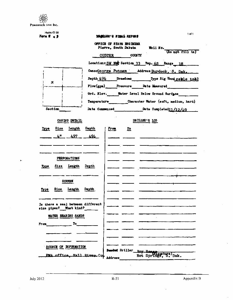
POWERTECII (USAJ INC.
H-ydro ID 38
rr IF
Section
1 Of I
O0I1C0 OF STA79 GOIbRUMPiepre, South Dakeoa Well N6.
CI,•O not tirl n)7
--OUSTER COUNTY
Locations -SW N* Seeti _ Twp. _6 Ranges
OwaerGeorge Putnam Address Burdook.- S, Oak.
Depth 494 Drawdow _ T•ye Rig Usd.-cable toml
Flow(gpm) Pressure Date Measured
Grd. Elav. Water Level Below Ground Surff4e
Teaperature Character Water (soft, nmedium, hard)
Date Comencoed Date Completedj1 /_& .
CASING DETAIL
Tk Si-ze Lenjith Det
PEPRFOATICMS
TZe Size Length Dept
$CREEK
&Ee Size Lao Dep!th.
Is there a seal between different
size pipes? Viet ktind?,
WATER WARING SANDS
From To
soRCu OF PORMTHI
DRrLLERS 18 L
From To
3.o Driller
Address
r
11-1OMA V-11 0-9-- HoA SprAflV ¶?Dak..* -~ 'JIJ
July 2012 B-51 Appendix B
July 2012 B-51 Appendix B

POWERTEChI (USA) INC.
PLEASE Cm&(.•kEENTIE FORM
BY-I
WELL DRILLERS REPORTDivision of Water Rights
Department of Water & Natural Resources
I of I
6/60
Well ~ner:Wel Owner:
Nam Francis 6 Paul Jozwlck
Address Casper, Wyoming
Water Level Information:Static water level below land surIf flowing: closed rn pressure 2811 PSI
rate of flow. i... 2 GPIControlled by: •
/X7 Valve /7 Reducers T7 Other
If other; specify -
Well Location:
mark locationwith an "X"
'I
North
X+ +I m4-I mile
1E
Well Test Data:
/-7 Pumped
f7 BalledI-7 Other
Describe:
Pumping Level Below Land. Surfaceft. After Hrs. 'iumped_
-- 1' I -- - "n rl"--- II II- I IS ' .
SI 55 5 5** -County Custer-. jI IC~- In Ra L i Q
Proposed Use: 7(7 Domestic /_-7 unicipal &-7TestHoles
/17 Irrigation /7 Industrial /-7 Stock
Method of Drilling:I7• Forward Rotary /7 Bored /_7 Jetted
/7 Reverse Rotary -- Cable /7Other
Well Construction:
WelI Log:
FormationDepth
From . To
Had, & dk ary sh IS ...AODk a"vsh &- -43- -
Intbd arv sIst & Clst 535li-Fr ss-7crst _ -- 4ý 0ClstZ, 60VfI , r9rss tr clst -W-7 -- "T-Gry cist 67i32., 67
Diameter of Hole 7 7/8Depth 68Casing ff- Steel //TConcrete
/-7 Plastic 17 OtherIf Zther, speci __y
Was casing end left open YesWas a well screen Installed No
(Use Bacc Iti Necessafy)
Date Completed; March 4. 1982Describe Well Screed
Diameter MaterialSlot size
Was well gravel packedWas well groutedWas water sample taken
NoYesNo
Driller: Contract Rig by
Silffver MKn inees Nam
Edeimon t So 57735Address
406License
Date
Remarks: Cased w/14-451 5 1/2" steelPerforation completion.
Signed By
July 2012 B-52 Appendix B

POWERTIECht (USA) INC.
SD "T Eomdrof,42 1 Of ¶
SOUTH DAKOTA WELL REHABIUTATION REPORT f0
Location j% A&-01 SwecO..TWP 7 5 Rg J A VWMaome
CM*nt Noith Nam~ PU Tf~dn 6 M± tL
PNssMOakwel ciy CStftezps-7z ES- /loadion with w Ej E oman 'X corgnb*a~~s, R/t
I I O /" T o
PF%3SED USE:RCVDIreon~ Li u Ski dI
DeC 4 onP a~cn n D we. 74-t inI A3bove&x - A r
Y ~S~W We/I Aco,- 4 Z03 t-qfsp- S' ,L d rvr-.X-fd' 7JW'tvf5c rj..
& r5 A CA f 1 Pc- 0 5 " r, d Ai J P,, 7 7,,-iY 7',41 o t i w .,~ 7 St1,
- h*nnaow. miair umvwr Ind Do 70 0 F~ea
Descvte saw ree puwbvion 5-1 )- - ,k2,ir Lmwtin Frvr vo To 3 oo
Fiom TO ____
G~x [AyES 0wj~bpwd~-gt Pq-T rrir4'fl 1- A A?'' C .AaI
WdA TedOt ~ ___________ Saticwdwb -I* L
If a floWMin vm GPM 7F Sht in Pst
ThiswvmIrhiikfim was- j*Iated der k-me gZ adti ~eti u n cl
SDror *m 7-,t-e M D R Ie1n/)
Sued~O~nw~[4~sd 0,
Lomb'jea2omm
.Do
July 2012 B-53 Appendix B

POWIERTECh (USA) INC.
STATE OF SOUTH DAKOTA WELL DRILLE.S REPORT11 92 1. D~.nt 1 of 1bg xdý
Location1 S•.. SectJTwp _,_S Rg
County North
() _. ":r .-
Please mark welllocation with - Ean X1P X
I mile
Well Completion Date _e. Z- :tV-4(/
Well Owner:
Address &•v-: S.- Rx 3A . ý9,W.O,5S, 0Vel Log: Depth
Formation IFromn To
%'W ON C- ~ g ,o
40 kv- W
PROPOSED USE:A rDomest I c /-7Municipal /--7Test Holes
F-7Irrigation Filrndustrial )TStock
4 ________
Method of Drilling:
RZaz MTDv/lI 4
WELL CONSTRUCTION: 7" sge, "
Diameter of hole Yf- inches Depth.sJ,0__feet
Casing: /-7Steel _Tnlastic f-7-Othr
specify- 4# f<,yf 40Pipe Weight Diameter From To
%f"ZD l b/f t 6 inches 0 feet _;(&~feet
S,e% p Ib/f t tWInch., ~/10 feet L~d _feet
Was a well screen used? )ýVes /-74n
If Not Specif'
Screen Type _ _ _ Slat Size_
Length M - Diameter V;
Was Casing left open end? /'EVes f/7NoWas a Packer or seal used? -7/es -7No
if so what material? 7 jjA•_f ,t
Was well gravel packed? . Y--Yes 14
Was well grouted? J/'Yes [-7ko
Describe grouting procedure EL•
To" what depth? , Feet
What was groutIng terl7If cement, how many sacks? •.r-Location of packer(s) and sc•een Of Formundpipe 20 .4- mos't-v 3W-zzo & r"
STATIC WATER LEVEL . Feet
If flowing: closed in pressure.-_C_4..rPSI
GPM flow _jg "through , -, " inch pipe
Controlled byN,/Ialve /-7Reducers /-7Other
If other; specify
Can well be completely shut off?
Remarks: /,F- zrA Mr 7 r 6 ~-,a
hot 1.,- 41%.'7 .'*(t A? dowLI ,o
ArT- /to o4p-,
WAS WELL PLUGGED OR ABANDONED / /Yes MNoIf so how and with what materla-Tr
This well was drilled under license I
and this report Is true and accurate.
0rl11ld6g Firm Si•gned by -
WHR-836 4./82
July 2012 B-54 Appendix B

POWIERTECII (USAI INC.
PLU6E 901647HAM-4
WELL DRILLERS REPORTDivision of Water Rights
Department of Water & Natural Resources
1 of 1
6/60
Well Owner:Name Tennessee Valley Authoritv
Address
Water Level Information:Static water level _4' below land surfaciIf flowing: closed In pressure PSI
rate of flow GPMControlled by:
-7 Valve /-7 Reducers 7-- Other
If other; specifyWell Location:
Hark locationwith an "X"
+ +EW
+1mil
Well Test Data:
/7 Pumped
/7 Bailed Describe:
/-7 Other
Pumping Level Below Land Surfaceft. After Hrs. pumped GPM
-- II II -- SI BI II
I, I. EI Ii IICounty Custer
5 jIC KEI Ak- Sec. 17 Twp. 6S Rg._j.
Proposed Use: I/7 Domestic /-7 Municipal /X7 Test
Holes/-7 irrigation /7 Industrial /7 Stock
Well Log:
FormationDepth
I From I To
Method of Drilling:/V- Forward Rotary /7 Bored /7 Jetted
/7 Reverse Rotary /-7 Cable /-7 Other
Well Construction:
Diameter of Hole 6 1/8Depth 7e 0Casing /_w7rteel /7..1 Concrete
/-7 Plastic /-7 otherIf other, specil_"
Was casing end left open YesWas a well screen installed NoDescribe Well Screen
Diameter MaterialSlot size
Was well gravel packed NoWas well grouted YesWas water sample taken No
IntIntbd
Gr £r
Allu--vium 0 1Gry shale 33 I 4....
tbdgysitstsh 4~1 16pry vfpr ss Ccist 0..A6...... 48Br far s~s 1.85 ..5j.07......
d vf r S & nrn riot Cn7 CIZn
Intbd
Rd f.mgrss 550 S76Dr brn clst S76 S85Rd mg rss 585 596gry, brn cist & grx sist 596 651It ortn f.mge'ss 61 693brr, clst• 95
0! f, m, cgr ss 6742gry clst 2 750
(Use Back if Necessary)
Date Completed: February 9, 1982
Driller:Silver King Mines. Inc.Driller's or Firm's Name
L 0sLicense NO.
Remarks: Cased w/.219 wall 4.1/2" steelcasing.Open hole canpletion.
Edgemont, SD 57735Address
Signed By Date
July 2012 B-55 Appendix B

POWERTECh (USA) INC.
Hydro ID 220 STATE OF SOUTH DAKOTA WELL DRILLERS REPORT I of 1
Locat Ionj*2 *. Sec/Y Twp C.Rg9
County North
Please mark welllocation with W Ean *IXsI
Well Completion Date • • ,4e
Well Owner: WV'O4 ~~c-vrFtIMaines &S4A,?.W-0 &O'4, /,,JA,
Address jr-,.C-7 st 4Well Log: Depth
Formation From TO
_____ ore=___ 2*-L... A'e
PROPOSED USE:"-7oomstic /T-7lunlcipal /7rest Holes
/f71rrigation /-7Industrial $Stockt ------ i.
Method of Drilling:
'471.1 -WWELL CONSTRUCTION: . 2, a ,O~'
Diameter of hole&" Inches Depth feet
Casing: /--Steel A lastic f-7Othor
Specify y"V 41
Pipe Weight Diameter From To
lb/ft Inches 0 feet f5 Ofeet
Ib/ft ' nches gFjfeet 9Lo feet
Was a well screen used? AVyes F7loIf Not Specify
Screen TypeI 4 . Slot Size..a e.
Length I Diameter
Was Casing lft open end? /.2rYes /--No
Was a Packer or seal used? TS!'es F7kNo
If so what material? A o_ ":•.
Was well gravel packed? . 'Tes /9wo
Was well grouted? 47es /--7oDescribe grouting procedure a a6A._ r
S* AA o./-;o
STATIC W.A7ER LEVEL . Feet
If flowing: closed in pressure .2 PSI
GPM flow /4 through inch pipe
Controlled by.Valve /-7Reducers /-70ther
If other; specify
Can well be completely shut off?
WELL TEST DATA:f-7Pumped
-76a l Ied• ! edDescri be: - '_•$,
/-lOther
Pumping Level Below Land Surface
ft. After Mrs. pumped___ ..GM..
_ ft. After Hrs. pumped GPl
ft. After frs. pumied GP4
Remarks: oe-O r,#I$ / q-,OO
it, d~fs. C',mgr /.,-- coTo what-depth? _"o FeetWhat was grouting uaterla Tvfl am&If cement, how many sacks?Location of packer(s) and screen or--erTVratpipe &A*'(• •f-i ?Zo _.,4,' 790
aT• 70.'. - j.- 71.e)WAS WELL PLUGGED OR AWJOMNED / /Yes-NoqIf so how and with what materla-•
WNR-836 4/82
11is wall was drilled under license # SMI--and this report Is true and accurate.
Drillling Firm " Signed by
B-56 Appendix BJuly 2012

POWERTIECII IUSA) INC.
I
Hydro ID 436 NOIC OF I*c L I0 ICONTiUCTION 1 of 1
WELL CONSTRUCTION CusterL.ucalflo of well. MW 1/4.!_14E..1/4 __ __ Secon........*f'_ýS ang -I
Oat. wok dilang competed 8 l 8 Purpose of wait bevto ___
WELL LOG _ _ _ _ _iL~ e s tore tomtles In uster bewspoome of later 0.30'i go top of water l *ive-.9 Itwff' 505
0-3i30 Ilk sh
____ Ito gy Cist S -
S20- ~ C 30G brp-av clst
530-545 Rd-brn 6 tn iss
5oi5-565 4PkI :n bini
s a5-52 IsktWe.. tin st mo Ss
Depth to stltig wooer leow#1. i,
riseno of plohg-As oamilor~i knwel rlTotal depth of still hole ..-..-. 86....S'Debt& to belles a .4 e.ol 9L....... . .4 ,
Cesohw lafllurneaonli the space beoom bill him, ofte. Voo. 11-6adiameteer. eft.. for pvsduttlie" 600% endI olle.e 0"6b If o"116
4" bik iron l01/ft
bepooft iftlfmorntion, Is the *pace beigo shew beagl of sae m"of Sogi*e, d-omt~fer an~Sd II o eI'.oo of 080169 iff~a~ 0
open hole 505-59D
of e Itewleg woolt~. flo o lemploed wown. ..&...2......f.£*j
Silver King Mines, Inc.'-homem of Or~ll. C.oehq *--N 3
'-C
C) PUMP INSTALLATIONCanpeny namoe nd size of ow p Hit
Too4 of pump Capacity of Insallled pump -SAPP.............................................. ..... ,, -,
ODpth of pump placement ft., Dote of pump Instaollatio•_
(3) WATER SURFACE MEAsURING TUBE .,'04 own wae,. so *41go•14 wOtp.a. ,-eeewtfg te is reqwred, Sat Section 46.400 o G-.,,1 ".
• ., . . .~~I , '. , .. 1,. ; ,. '• •WeLCONSTRVICTION STANPAROS
A .ow eac vptlel -n.t.l.Of.•,", eufoce measuring tube, ilt installed
'IJ
$sea%*.'~
, .• .:,•.
Appendix BJuly 2012 B-57

POWERTECII (USA) INC.
DAKOTA WATER WELL COMPLETION REPORT 1019-85;' - SE Sec 11- T.9-i-Fg. WINt Owee
Counyl
-I-n--1---
User. ~ ~ '. 0->~-~ ~-.9Address dL.~ ~5*~ 7)t S?3WelI log: Depth
Formatis I ro I TPlae• mark wellI son wih lWan • i I
I II mile
Well Completion Date C /Z /? V
AAs~ A $IA /90Z_________ & Aeo- A/ S
.M04,-16 5 3 a 3 44
--- I - I _PROPOSED USE:
El DomesticEl Irrigaion
D Municipal ' E Teat HolesSIndastrial 1 .Stock
v
Method at Drnlling: 12~or Ft -Uv 1b, 0*CtC
CASING OAT&El SteelIf other describe
iKf Plastic El other____ 4-
PIPEWeIIT DIAMETER FROM TO HOLE DIAMETER,, 7 " LI" t/FT IN_ a -Ft_ I.V__ FT ! ,IN
_' LB/FT __ IN __-FT FT IN
18/F1' IN - FT FT IN
LB/FT IN - FT FT IN
GROUT:Westh we* groutid? M•YES 0-No
To whalt depth? . 5ei jT" FEET
What is gfirteg material?
If cement, numer or seacks? 5 C/ i<4 C [i
Dsiatribe grouting procedure 7 ~ 1 ' 4ic
STATIC WATER LEVEL 0 - - Feet
It flowing: closed in pressure 7- PSI
GPM flow Itiluthrogh I "4" ia $I inch pipe
Controlled by 09Volve El1Reducers []lOther
If other; specify
Can will be completely allrt in? V ',P
WELL TEST DATA:
13 Pumrped ls- A I45L C41
ae-tled oessbe: to -PfftC"1other
Pumping Level Below Land Surface
__ It After - - trs. pumped-- GPM
It. After Mr___ s. pumped. GPM
It. Alter .__ Ht, pumped. GPMWhet wao areat weight? / 8 _4 7 1794 C LB/GAL
SCREEN: []Parforated pipe , Menufactured
Diameter "I- IN Length so. . FEET
Material Flu c
Slat Size q Set From 1_0' Feet to -3 40 g-- t
Slot Size *0,' Set From • Feet To fZ 0 seel
Slot Size __ Sot From __ Feet To gtel
Other informatio -
REMARKS:
Was a packer of seal usedl OYES El NO
It so. *hat netarial? A)'rd #0,4-At-•
Descrbe packerl ) and location? - 0 49 Aem. , C5.I"
This well wms drilled under license 41 _•_ _--_,
And this repor .Itre and accurete.
Orign@ firm 2= A wqon&jRpee ttivve:
Signature of License Representative.-' c:12.4 -a /0~ ~ A~~
Was well disinfected su completion? YES [INO
Explain
Bectertalegic• l anti E YES QU O
LaJ•oatory sea to
Signature of Welt Owner -
Oate
Appendix BJuly 2012 B-58

POWErTECII (USA) INc.
Hydra ID 809
• ° ,,... !
L 2 orl *411 l,'4.~./ so Se .or% 2 Tow - - n Range
*____Tnns~t Ja~~hl.' I~it vy U.. L 0 x 49,_Edoavbin¾w iuthDakota1 4 Aid to of 3. -
ct. e~ 1. lir comtetn 6j8.~ -Purpose of wq~l Obser vat ion________
H. p..
I ~
WELL LOG
LL~fila top to Ito .61!t~ ale Depth F too of 0 wal'* 0tl4d+bC me C4141' 84f
0 -2 t B ro n S o i I o f.th , ' oI ducI . io . ,e. l kno wn?___ ____ _ ft
S 20-530 Gray..y Shaole TaloI dpln of 41t.1 Rove_ 100
530" Gray Sandstoric, 966
___545-620 Lt. Gray & Brown Mudstone & SiltsLoneColIno intorpilhon'In Invi Speot 1100low sho 11141 it e Istiva U t. wowl per
620-690 11t. Gray Sands.tne d .a te . to--ltaioducl .c C oll.in.sduarfeace co,,"s. ,t a.s .
(•90-720 jDark Gray Shale w/L' ht. GrayS.-Dr S Sl- Grtone I" Schedual 40 Black Iron
7Z0-740 Gray Sands tone7_40-770 11B Dark Gray Shale, Gray-Green..... ... Mudstone
770-820 Gray Soands.tone .h SIcreet ,apfermelo. Inl the leoco beowe Chew 1.09t Cl W*COree~l hNIIIletlp
820-840 Gray Shale of Ceo-o. 4,emoet end Celd of see.en or m,1.g sor.erleee,
840-955 le AA & Yellow-Brown Torch Slotted 903-966
955-975 Red_& Yellow Sandstone
975-1000 Green w/Variegated MudstoneIf a flowinqg wall, flew *t c:omplee well waPi.
Ii'
AkItIo hsheet 'f iw0 race oI IOded_____ Silver Kin MineIn~c.
Name of oraflt~n Costiteter
(2) PUMP INSTALLATION
Company name and size of pump H _P
Tpet of pump Capacity of installed pump_ .. .P.M.
Depth of pump placement --- -t., Dole of wipmp insta;lolton. __
(3) WATER SURFACE MEASURING TUBE
On somei wils an air .fitgh water surface measuring tube is required- See Section 46.400 of Chapter 46.4, MINIMUWWELL CONSTRUCTION STANDARDS.
Show etact vertical length of water surface measuring tube, when installed ft., tube diameter
tube material __ _
'SD
Nmern of Ppig looloilIet-n Copracter,
July 2012 B-59 Appendix B
July 2012 B-59 Appendix B

POWERTECII (USA) INC.
Hydro ID 610 106f2
I - l 4 soco-. - Rangto
rn~, ~l: xUr. i..ku 9 Edqcrrvnt. South Dakota
Laf Wllr~ol 4 .0rrIfed 6-27-78 ;u;% fwl bevtori.M.614t.iof 10M~e.ffi.eC9l. 'Auver ilot otbotir
WELL LrG
UI.l.~~iu~9
OO! IJgc,,~b ~tlOP ___ owti to too of viato. Pego"~.1 aoiuf.' 6os 11
j -2 ýOovo ýi S~ nd L4 B _ ptep to $folio veto, love- _________________
11.1'14 Gra Shal F dOf* (ial I River
406 Gray S;Itstonc____ StIt ofw fLl156 ______
-605-68v 111 GraV, Sandstone G. Gray Shale
I ~Camle aig ,'fo~of on '" t~Shei seatsalsnow bmaO. I, solo. wetjft. leowli Wf0 ometo' Ott., tv gf oaactlg Cos"l Or4 SM0,14oo evwom. " ee
"Sc ti edua 1 40 Black Iron
it -eola ,nformoao'at in life trace bolos @bow 1401911A .9 scree. boom bothleof -0 coming, duinloso £41 &mfo of aOtu ofto 010109411 fO#Ofloa*.
Torch Slotted 630-672
It 4 flow-m sell.ti fl..owf Mompoolol. wei"___~..~ ~~O
__Si lverKin Mines Is. ll.femo. of &19il14g contracoro
V2) PUMP INSTALLATIONCompanly name o^t4 29o of pump - -_________ __ IP ~ -
Type of pump -CapacitV Of installed putrrp ... . .. 0P.
Depth of Dump placement Pt * Dote of puma.nltota10100pn ____- .-
(3) WATER SURFACE MEASURING 7UBE
on some welts an oer-tight water surfa~ce onsalourini; ftube is roifuired- Sea Sect-on 46.408 of Chapter 46 4. MIPEIMUOWELL CONSTRUJCTION STANDARDS.
Show effect vertical length of wafer surface n'vedsuring tube, when 'tatolled -- It,. tube diameter
tube material
.oeo lm 811#1o *w-fw
ai11 C ':.
* l7 IOt f iioll~~t~9i onoSo
July 2012 B-60 Appendix B

POWERTECII (USA) INC.
NOTICE OF WELL CONSTRUCTION
(I) WELL CONSTRUCTION
Location of well, SW 1/4 1/4 N .E Section- - 2 Townlhip- £S - Range I E
Well owner Tennessee Valley Authority, P.O. Box 49, Ed titn, South Dakota-- Not {Ail~e*n,).. .... ... .. . .
iote wel• irtill,na, completed 6-27-78 Purpose of well - Observation
WELL LOGQvil,,. TPt• V fep..• e,• ý,etcri ,on of fIoyr Depth to too of water pod.ci,, oqu., 605
0-20 1Brown Sandy Soil Dopi we static wate, ievel f....................alre ofpouigah, ,(tkon Fa I R i ver
20 -540 1G ray Shale .-i o of t.•,ic ,ng € • oi fI (f . .... ..a.............R." " ~ ~Ttal desi ol dril hol... . . ... 680 ... ... f
540-605 lGray S I tstone Told C11 O f d oiii 6.. .2 - . .
605-680 1B Gray Sandstone t Gray Shale
Caot; in9 foltnot,oel1r 100 .eco allow show kind, on-e, weight, lingithe perdiam eoter, etc .fo, producion Calling and surfoae cceflo, if eled.
IW Schedual 40 Black Iron
Scoesn tnformctoonf in tke a0ocs heine, hhow Ilenfh of acre" boe aieto aof casing. aia llife and itn4 of acres"n 0 castel perfofetioR4.
L.Torch Slotted 630-672
ofto fiow~no Oeil, flow of cooleeieed well a. -- -Pat.
Ar. spot* needed... Silver King Mines, Ijn.
INo.me of Drilinng Centractor
'l lIMP INSTALLATION
n(~ar~nilmo.ii.d sire ofpuilo -____ ~ H
Ype of pump . .......... . . . . iapocit Y of ,notalleil pump G-- - --. . P.M.
lipin ý,fh pumpij plocemcrn - ... ft Dar ifb- pump mtiqllo',on -- - - -
(J) 'NAT)R SURFACE MEASURING TUBEOn some wells on (ir -light water surface meiaurng tube is required, Sea Section 46.408 of Chanter 46.4, MINIMUM
WELL CONSTRUCTION STANOAROS.
Snow exocf vertiCal length of water surface eneasuring tube, when mintalled - ft., tube diameter ....
Uba t O rl .m. .teri
Norrie of louns tristaliot.on ~n~~o
..:z, . ,:' ji . y.. :1o.. :-'/
July 2012 B-61 Appendix B

POWIERTECII (USA) INC.
Hydro ID 611
NOTICE OF WE•.. CONSTRUCTION
Custer
;1O~1~ ?~~'
(1) WELL CONSTRUCT101i
Location~ of wal S' /4 _____ 1/4 - Section L .. Townsiph 6s Range I
Tennessee Valley AutfioraiyWell owner
core all drilling completed 10-17-81 _Purpose of oil- Test
AUUee0l
ۥ,sf#.*WI5 mUISW, SWUWW.ll -DN
WELL LOS
Lcors, top to i#p I* fest _________o____
0-e440 Dk brn-y sh.ale -40-500 Gy & brn mudstone
500-520 Lt red sandstone'
520-565 Ok brn 6 o9Yn mdst
565-600 Red sandstone
600-625 Ok brn mdst-sltst
625-6M5 Ok brn mdst
645-690 Gy £ brn mdst w/int'd
6_20L23 ,. Red ss w/orng cht
725-755 Red sltst
755-800 Red sS w/wht. orng 9 g
Depth t 000O of water peilofts eemg r 6
Noame cat porn s cowte (i keie a 815ts10101 1606 oflfrost "to fli
coseg l*.,.iewealobl fh. sof*pes hh showU. Neg*sl. U010%, wwle sd'e..olsr. otLgtw pfadvalsl" emiae WA wferse eepleq. of woo&
0-251 20" steel0-695 10 314s" steel'
730-755 8 5/8" steelrnd sltst
50,,., laterneoohf.I 10 Tho spe*s below sheir Ismol of mose. poeh baiof cosoll, ilU-vostead g bA eitilo screis W 60f e5 0p 06Nw.
Vy chert phi cgl
695-730 S 5/Oil Johrnson. We! I755-800 .030 Scrogn ilot
Fonward Drillino'Comnanv'u- show IF "a"
12) PUMP INSTALLATIONcompam Raomw and size of pump -
Two of pump Submersible -- 129
Pionefer 6"
Copocllt of InstalledPioneer 6" I'LMP- -- t•d
sogib of pump uiscem""t .. 525 -fft., Dote or pumip instllatoijn 12-2-R!12-2-81
013 WATER SURFACE MEASARING TUBEOs mome wells an ta4-IOp vt orn aurfma mesouring tube Is requireds See Sectiaf 44.408 o.1oWILL COOMUT10 IWCVPU TA111ARDs.Show exeo waflkkol lens of voter ourfocs maeasuring tube. when installed .ZL4 iutube molerlol polyt~ ~
Great West Pump'. 'I nc.
y* *1 rye. *j.........*1
Tar
July 2012 B-62 Appendix B

POWERTECII (UJSA) INC.
1 of I
Hyde 10 O12
NOTICE OF WELL CONSTRUCTION
W - I I-.
(I) WELL CONSTRUCTION CusterLocation of lli SE. 1/4 NE 114 - Si0to11 20 Township 6S. sto
Well owner Tennvsseg Val ley AuthoritycosaI CAdd....)
Do"ewas drilling cartpleted B-14I-81 purpose of well -Ob~rseatior
WELL LOS
Death to top of wlet PrewA-so o~llt 691 ~L~eto, hi i too is3 tS 00..iffiseu . at Ilert,
O-425 Blk sh
425-li95 Is gy cdat 6 is
495-505 Rd & brin as
memo6 W peft~ei
Total depth .1
Deals to belled
as eqvlfsr(It bmw..) Lk
h10bes ------- tof s- 692-w w, ww• . . ... i
505-525525-530530-545
Gy custRd 9 ormg -brn cist Ceeb, isefta~lieeDs lie 6pose belo. SeemUse,* iss, NOi4 toa P
Brn & rd-brn is
Gy 6 wht slst w/f y-gn ckst .bkIrn i/tfl,.4j bri Iro 100/ft
545-555~cC~C*C I
rA JL brn a&
585-610 Cy-wht $1tst w/gn cl1t
610-6li0 Tn-,gy is
61i0-650 Gy clst .6 gy viii sl ts
650-700 By 4 gn clst
700-730 -- Tn. orng a rd-bin as730-7115 is By am a s1ts:
.". tows . USlat h s "" M i7145-BO Tn-brn is
Verses aft'iedHlea. oil the opeft h"low abe. aso "open. boom0 too". g, Ow..... 0.0%Ad .sate *&oo orb I-toa
open hole 620
ftIft Olwase.. flegwed G.3IM~aeh weE MA -
SlIver.Kina 14ines. Inc.*4
Q) PUMP INSTA.LATIOWNC*04"ny Pam sew vibe of pump
T)" of pump Capacity at Insaleled pump
Dull. of owpup laceineid ft., Dote of pump installolkqm
0*0e arm"eg01sipuW'
A , .
In ii
i. ft80 "1111 M GO 011`41911 Wall 611'ftoMe OMWkMi tube Is tequireda See Ued1184 46.406 farbs &4
Piew Siul %W"l lengtolh Of Mpgv16e0 measuring tube, when oletu" Material
. -- , II .... J= . ...... .
SmI SI PUmp laWU~SS 54W~Wl:,
Pu- ,,J.
July 2012 B-63 Appendix B

POWERTECh (USA) INC.
Hydro ID 11 of1I ,
NOTICE OF WELL COSTRUCTION
(I) WELL CONSTRUCTION CusterLocation of ol'l, 114 114 SE_14_N Seclion 21's Towrihhp 6S RangO I F
Tennestser Vallev AuthoritvWell owner ,It u • -. =,=
001e well drillk*Cing cemio 8-1-8 -Bl P'Jrgse a well Observatio i m I
WELL LOS
LaZW. !toley in ,on hat
430-510
510-600
At"g a~w~
81k sh
III gy cust & iS
Tn-gy & rd-brn ss it/
Deph s to o0 f water o"vpts ooufe 54g
Depth to quoist Vapor 4"1 36.
"vive of prsothoesg as~oitat (~it iS)ol Fall Ilvgr
Touat depth of drill bole Soo
-- ,Ito bottomc 601set SO~gyp yn * Fil cls
Ceal me Mbrealmoia fis home@ bow"how slap h, No, g- ioneter, ala.. nor pre"Sivooeeloathme swautm =zj?, N eqi.!
I"blk Iron IOI/ft
14 Choi., diametet 0111 fod ofje 8warn ut a-bel wm'fomSaS.
open hole 501.-580 ,
we flawiml ed flow, t Of gaimplolief we W7,
avow__________ 'I
40
Silver Kina 141nes- Ina-'-ft"n at EIapI SaiNO!MdN
C2) PUMP INSTALLATIONCainsoeen me"a a"d asoe ofPIN*
Too of tmap Capacity Ofinstalled pump- ~ '
Oewth of ei-p placionant ft., Date of punop Insotlolugef
- '..,.fl
IF.'.,
~2L
4,
(3) WATER SURFACE MEASURINO TUSE
an can sam we"m or.4"ivww s s wfwemasim PAO Is rsuvlred' lsep "ell 49
It.*"oil"" low "Mr, in~e
-. , I '.
7? •. •'•. :.-•
I,,1* I. . 'I.
i '" "'1 I ] "
July 2012 B-64 Appendix B

POWIERTECh (USAý INC.
Hydro ID 614
NOTICE OF WELL CONSTRUCTION
I. •'t.,I
P i
,I) WELL CONSTRUCTION CusterLocation of wells SF 1/1/.I.-.4__ _ S& . ? Township __ Range~R) . -.
Tennessee Valley Authorlty '
2
i
W••U V•UBmE
am wel SE ndrin coffoola81 Purpose of wel Oberato II J I
WELL LOs .A* noLepoetop.t Oslote be loot
-575-600
600-620
Uwe&e ofnt ~d
OS~ttiptimm of isome
flik sh
111 12 cist &S
Depth to too of vfter produeini "uuite
loom to Olo 11g et,, level
lion# of prodwifug *omterlit' IWO ma).OL...LkotI
rAalei depth st drill 6*10Depth IM botoes of 1:666"
32.2 ::.Y*I
I _ k- • --
620 • '.: '
609,"ftd-brn clst
coo" lg 989,emstplifl the wpaeg bet"w Show 41oid, 056 eeM Ip.Rd 7 rd-brn ss-sI Itsi tolliameter. .e.etas .reuo~tie moow od etwigee *steg. it sogE g
IS g cust &ss411 bik Iran 1OI/ft
scr,... lat0'seltaftb bo the gCo*" bob"M Shwm &heft of womb bolow'
__________________open hole 609-620 '
I lewi wovellu~. flow of domeletod VON "A
SilverKing Milnes, Inc. __ Iloe of D1501, col•.owuu
12) PUMP INSTALLATIONConmpoi so"atnend ela. of pimw
* . b.c-is
* 5- ,*-
uas.am
TV" of. pump capacity of installed pump
Deafh of p"m ploc: - WO If., Onto of pump installeatio
(3) WATER SURFACE UESRNjUE<'Z
-O smemom wells ime ir-fow wisml sWfae moooeurlpg tube Is requirodi See Section 46.4009 CIePPKWULL ;0%"C'I0K :TAm)AR9,.
end WkW I** of wlel uftf meauunln tube, whatn insaleled *Y.4
-- --*-------. ----- m
•kk' . . _ • •
July 2012 B-65 Appendix B

POWERTECII (USA) INC.
Hydro 10615.. NOTICE OF WELL ON.ST.RUCTION
I WELL CONSTRUCTION CusterLocation of wsil SE 114 h |1/4 -_ Secion: 20 Township 6S RaongI E
,.....Tenn.eile. Val ley Authorif~ Av,*'wIll owner Tennesee alle Autorin
(NemI laddlre lI
Dlef well delUMa copee -8181 -Purpose of Well Obsecrvation 4m.
WELL LODo45bto top of S voter pIodels ovoar -71
- - - -- - . 9 .7 M ..Lopess. 4p to 101" tg Infal, Dateph afALy
0-5.35 Elk sh
4.35-505 Intbd gy clii, iss
505-525 Lt tn & brn is
loom* at ptowtmol *.i~forl III wosb
Total depth #1 droll title
---- * 40 6*11.. 0 of $*$inop ...
Lakoti "... .L I . . ...
I00M " " ' " I ' .
712 - ý525-550
550-590
590-600
6o0-620
685-695
695-Soo
Is gy clst-siIII rd brn & gy sitst 4 maefl sr 00er eI .0'1M Ioaf t weS9o ble e . S s ,slp h *Rdabons
i~~Jl Hi . it Iron 1001f t19 gy-gin & rd-bin slust c& s 0l
Gy-wht sitst
13 gy-wht sluti 4 pk slutslote.. intstats~oa. I* thea os"a 4wo sillo hasteb so W *we"losr6
Fk & born ss w/gX clI st o 419" e feuoisber Ole &d ~Of ces rmk 90@in Iiholison,
Urn. orilng tn, pk, rd 6. ye' Ss ,
_ _ _ _ _ _ _ _ _ _ _ _ _ _ _open ho le 712 -BO
IFa am 0" 41 WO. Is ,4004100W N -
*
.MM, = III
Sil~ver King Mines, mGK.
1) PUMP INSTALLATIONcarooeo no an fts of PusilToo of- PUMP
lime a? muwo Ca.Sftw * 1'I' ~
J~ .4.,.1.Ma
Capacity of Mintalled pump
Depth so pw*t Placement ft., Oct* of pump instaelloll
M3 WATER SUOMAE MC ASURIMN TUBEft s ow wae so em oIrqi wornll Mwilese lete ubsl NMo Is qqfredt S00 800$M. 46WELL. COhSM I'JO T " .7 .. r* I'* B m s u t w r iA 4 s. ~ f S s w t g e f s e p ~ i s f e s e ~ . , .
-milk ~ Al 0 Is nishw on .iiwh
.14. . . e e?~~ ml
-0t 0
.4t
* -,'.. ~ ~*
I
July. 2012 B-66 Appendix B

POWERTEChI (UJSA) INC.
Howo D616 NOTICE OF WE-L I.ONSTRUCTION 101
I1) WELL CONSTRUCTION CUSTER
Locotloo of wall, S1. 1/4 NE I/4.__ Sgcion.. 20 Township--_ Range-RI
Tennessee Valley AuthorityWell owner
Daft so N &liging coompletod 9 I 5-81 Purpose ofIMUUII
Observation
WELL LOGL&"'s, 50&#t Itio Is* tes 191 o~.uii of sopot
0-6 111k sh
4.62-5)-0 IS gy cist & ss
550-605 Is on Sims 6 n-gycl
605-45 ____clot___________
645-080 -GY 5S
680-720 C Wlgas cist720-760 18 rd G yw-brn ss, gy
760-835 Tn is
Moo" a" Isg Uma- o ii
Use m~os~t itireo-itereaii ~ u~diig
0904h Is sees vsot PFU~C pro .,P 135tr Bost-I% I* 1811t wae owlA
"at" * ofe"o l#9.cs oi~f o tit beiogra
Total dopth of dinl hot.
00006 I0 6011411 Ot seeingi
I len rib
835' *... .735 ". . "
Stcesime l"forteNtalhle theso ego..boom ohm how. OW, OW04 Idsommote.*o-, ..... prolts Fish evelab nd - 90,00 @oo4, a qmie-..
41' blk Iron lot/ t ~ ~
sitst &rd-brn 6 brngy clst
Serve.i Inurmetoo~lbe IR lbo ofboe hotels, 0Mshow ogb of moregi 600of giseb, duametrno and inW of 0r~omso w mmo$ 0 Ie.gt ooage I ,i
open hole 735-835 .
it@M rin flWlON. floea of "004"d WON
Silver King Mines. Inc. 4-i-4'Rome of OMII IBM
C2) PUMP INSTALLATIONcompesly now ohad eke of 9emgp
Too qf.9Pump Capacity of Installed pump
DWkeh Pon li4u19O hefi Ill., Date of pump instonal~onl
if-o
rV~i. Ii -I
V I-I
W3 WATER SURFACE MEASURING TUBE.as so" weft m OW41gb wWite owl... a**oowlmg tuabe Is requreod' See Section~ 46.40 of ;bepiw
-shw, onow verfow length of mo~t mfeso moesuuing tubeg, when InglmflodL ft.O I.
memno of runin liha~ollos cw4mVyo- ;..-ft
!
I
July 2012 R-67 Appendix B

POWERTECh (USA) INC.
Hydro ID 617 1 " o0 1
NOTICE OF WEL. CONSTRUCTION
Custer(1) WELL CONSTRUCTION
LoCtoloh of well# S• |/4 ýF Section 2( Towna6hIp- L , Rane ,
Well owner Tennessee Valley Authorilty(iNO" (immossi
Dat e orl drnel cmornloted 9-15-81 Purpose of voll Observation:1
'.j.*'~ '1
WELL LOs
us,"n. me t oot feet W b.Mtscip." .9 lover
0-1.50 Olk sh
450-520 Is gy cust 4 &
S2-5 Ad-brn 4 ay cist %v/x4555-570 Rd & brn s
- (ei.,thk,.~a.%m~el
Iofelat depth of Atilt bets 811pmot0i beles of .. " 71m
1~570-625625-655
6SS-71.0740-0110 gy Slut 6 g'j, In, Cdoiamov lemr.l'e the otsasmo ee shea elrm ago"arn, v ymog'g
14 blk Iron 1OI/ft. . t,Is 42 slit whfy-91n & bun clst -
seroma laloemastbee. Ia $he spaei hoe.f show so0 wooII ?~of Seattle. dbqieao som el bin of @crym w soeg pU'rSipehp" 4#
_________________open hole 715-810
itea flewbegs Was. flow of sopl~ote "I
~ UPS 6 ~emiSilver King 141nes, Inc..,
0
-fl-I4
4.
xJfI-A o- m.
CE) PUMP INSTALLATIONcommiemw aee 0" obe of PumpTod at PIUMP
bisomee ls 7. g
-"as -1 *
cop~elty of Insta~lled
owlt1. gat M placenrw6 ft., Date of pump ensanovioie.m -
(3) WATER SURFAZ MEAMRI!65 TUBE
00 O 00" WOOs AR dil-OW11 WONt eSefec aoe$eWino PAW Is required, Seet sectile 46.4 of '~
'Show gaM w1legh s mfs esrntuewhnIaoled
-~r kIifi it Wft f4d*0111 .11111 h nta
DEýC 1981 ,a-n .1 ptwin oss"Res" ~ GR"11
-7. a"
July 2012 B-68 Appendli x B1 J

POWIERTECII (USA) INC.
Hydro ID 622 WM5 a 1 of 2
NOTICE OF WELL CONSTRUCTION
(1) WELL CONSTRUCTION
Location of wall- NE 1,,4 N[__ 1/4.- _ Section Townshhip ~ . Range...I
Well owner Teninessee Val Icy Authruri'y____- -_______
Oct* well dtriling completed - 8- 17-81 -purpose of well O'.~yt n
WELL LOG
L~jef.!!! top to V911 In 10411 ODestnroo .01 1* or Depth to too of worti p',duw.air oqua.,~
B I ~. s~t DoptO fto 611lic wit' q0 4.7 u
4t20(-h90 lB ý cIst E. hem of ptadoc'ne 4utt~er (if bnooft) _ .i
4I-5L Y. Py ' 6?i or . irse depI I~ Sth at ditll NgwoteOs-rnL " o Dpith to bottom of cosine~ 1
58Y1 _ 6y:qn_& rd-brn ckst61 5~0 Q-whtsi _Cosine irflhrit.n~tonI, the spot* below C$tew bind., eato worom, lontilho Par
6__565_ywht s 1 diaeter.lp et.. for production tooimo and surface coitog. it wood.
650-690 Gy0) & qn c1~t- -4" bli, j r;tm I0'/ft
61)0735 Gy~w/indLtwbrn_ ss w/brn.-t~v cl'A
735- 778-t 7 n £yw-brf: -,s
$croon nfermaog~n' in like spot* beowe @how oaost, or screen Ol..w bet icoof (OS50, domeffear Aen NutE of aog....0 ga' £4o poefratisn.tl
It a flow."ll well, flow of t(.birstid wall NA W110.111.
Silver King (lines, Inc.Name. of Drilling cstilrocte
(2) PUMP INSTALLATIONCompany name and site of pump _____H
Type of pump -Capacity of Installed pump G.P.M.
Depth of pumnp placement ft., Date of pump ,sntta
(3) WATER SURFACE MEASURING TUBEOn some wells an aim-tight water vurface measuring lube i reouirods Sao Section 46.408 of Chapter 46.4. MINIMUMWELL CONSTRUCTION STANDARDS.
ShowOX.eAct Vertical length af V1afer surfacer measuring tube, when installed- ý .f.t., tubs d~amoler
tube material
July 2012 R=69 Appendix B

PowERtech (USA) INC.
Hydro ID 622 DWM-52 2o01`2
NOTICE OF WELL CONSTRUCTION
(1) WELL CONSTRUCTION
Location of well- NE 114 NE Section- 20 Township ()S Range RI
Well owner Tenncssee Va.l e Aule _r -_ t___
Dole well drilling completed- .- 1- L.. Purpose of well Observ• t ir __
(domotl...~elon~nuoc~e. vdustrFothe.etsr)
WELL LOG
Laer, 'Dp, , , . Ves, rip, NO of a__._ 0 osol1 to top of Woaer arodut, or ,fe .. . . .50 ,0-420 fJBl k sh 3p4th Is setsc vili, level 3-.7
420-500 l hoNme of producing aquifer(If Vtn | c F'it I I FR i ve r
T61ot depIth of drill holf - - -80 .
500-580 Gy. rd £ tn s,. v/y w t.brn cIst Dopth to bolote at cof nc si
0.g f_ t
Cc&"g itormsepleOp' the spae. belov stnw .imd, &see. uoetlt. iiste 111sr. . .. dimem ter, etc., for production ¢oa.e0 end surfaco ese.ni. 0f used.
4'" bWlk. riron 104/t
Screen 'utomtmlio•oIn the oetOs bel.. show longth of acres. below bottsoat cnOmmn, do.e.tler one sing ot sCreon or casing torfIorales,.
u)pen hule .503-980
of a flowing well. flow of comOlOtod well __ NA.P.U.
Altach .i--i ifo ro p $,-iir * neededSilver Kinq Mines. Inc.
$lose of Drilling Contra.ct
(2) PUMP INSTALLATION
Company name and sixe of pump -P_ H
Type of pump Capacity of installed pump G.P.M.
Depth of pump placement ft , Date of pump nstallotion
(3) WATER SURFACE MEASURING TUBEOn some welts an air-tight water surface measuring tube is required- Set Section 46.408 of Chapter 46,4, MINIMUM
WELL CONSTRUCTION STANDARDS.
Show exact vertical length of water surface measuring tube, when installed .ft., tube diameter _ _
tube materlol
name of Peilj tlstOIllls.5a Ceni-acler
July 2012 B-70 Appendix B

POWERTECII (USA) INC.
Hydro ID 623
NOTICE OtF W.1.[ CONSTRUCTION
(I) WELL CONSTRUCTION CusterLocation of wllt, NE 1/4 -L_-...I/4 54- 5.0,01- To*
w It . ,., Tenne~sete Vall,-v Authority
/~'- VoTi
.,.hip. -. GS.. Range.I
Dole wonh drilling comple ted 8 .. A17-81I Purpose at well-. Observa tion ___________
WELL LOG
Letters, fty to top Inlaet Does" vgl at neverIt
0-420 51k sh
50-580 Re, rd 6 tn ss w/gy
Al0 ~ ~ gr me'Wi., s s Uau
Depth is lop of wooer ptyapdoiF4 o~tiliv _ 50*@pll it iiislet motor towell
Nones, at ,eoducumvsoawfoli. sho wn)- Fall I It ver
'Total deptlio stil W11 oe 580 .. 116OO~t tOSall. a gg~ea~50)
CmAN" ipfhrmat.seeu Ike Itelf elow show %~*A lile..waW lov"~ foo41dlametO, sit..#. pfee tduie1o goals* sowl* osrfe.. a~~q shelf.
4i" belle Iron 101/f t
Subsol infSmleolilet It the 110044 ble" show IsAylh of Mesa bale m0of go*^#1. dal-eOm ofa huad it" eof.. *&*a W ow voroeettaIt6
I
i-I a
If o f,"Iftagwlone flout of Completed was %
Silver King Mines. Inc.tHems of 11illue Ceoorysom
(3)
PUMP INSTALLATIONCompenl gale e nd size of puamTmg~f pu"vi Capacity of I.nstled pump *PM
offlit o passw plocemrent ftI., Dota, of pump installation
WATER SURFACE MEASURING TUBEon olessu weds fen sk-tIJVMsym wowtoce maveuring tube Is rit~ired, See Section 46L409 of Chevilter 46.4w ~WELL CONGTWICTOM ATANOA111S.0 41t:*
Shollosmat 0*tkolengthmof wells, wfaee smeasuing tube, when installied ft ftvbp dis6 gpW. 711
tube a~tOI~_____________-P;_
I
memo of riump 001401,.ee v.esteew. "k 1
lei
- -'a----- ~----.
July 2012 R-71 Appendix B

POWERTECII (USA) INYC.
:1H~roD624NOTICE OF- WELLICONSrRJCTION .ji .
WELL CONSTRUCTION Cse
Loicalion of well-SEg~ 1/4 1/4... Sticitov Township- 6S -ago
Weil Owner Earl Darrow Idg.monit, SO ________
Deotwell drilrnfi. cope Pup,,oe of wall Dom~est ic
L LOGLffenrs, I!, W let is lasC
1 on' " ofiirl hrbln jL civ ClSt anu
Sepo1l to too of water Prtisacln oquif o 9
topth to 114119 .0901 level 0
$$also o peadaciag oqwutee ft kna Fal Rvr' I,0-20 sl tit- - .
20-25 Gy cust & ywtn bent
35-55. Gclstts
55-60 Gy 5s
60-q5 3n & gy cist_
Sp96.1 toe# too~s Of goews g
, ,, t',•+ -- - 1111
70-9S . Gy. bWk. rd £orag-brIl5-il5 Rd. cron-brn £ pp ss
115-120 csWA
nl
CoaSmi sts. Weello1 the seacs beow.ee all" elsho, mOIV^ 1111diaogista, Sig. far PDlecalse oo". ONi W1669f "she. I =&I"
1601 le' PVC
cist,.
Strooe Iinforat iCn- 80 the **oft belmobvi Isolew h, of seroft belet $01
slotted casing 90-115
of aflowles won, nwo of el~tsinfose was
Silver King Mines. Inc 4__
I
_ _ _ _ __k a" ffmmQ -I wle
OIse
* Z) PUMP INSTALLATION* Compoany BcMW sad clue of pump
Two of Pump Capacity of installed pump
0op* of pump placement -ft., Date of pumip inatllontiouW
0 of arm""eg qarepbo a4- *.4,.
- ILl
(3) WATER SURFACE MEASURING TUBE*On oMo WeSft ongb .MrtN sefm esuin.utn tub* Is requieda Se section 4S4,,0 0,1
~ <'~ - egi- .itet pwbe maiialeuing tube. whleft installed.
I4t" Pett ..... _ __ _
v( .1,
7 7.-7 -7
*uC~4Y ~
It ~i
~% .'~
~-y-4 1-r
July 2012 B-72 Appendix B

POWERTECh JUSA) INC.Hydro ID 631
SOUTH DAKOTA WATER WELL COMPLETION REPORITI Of 1A07-92
- - I --
~~cetie~~~10 SRJ S4TAIQn,_Count __ Nor ___
Well Omer 1ANLAO, 'N ( R)K& ý IV# 1-tf\ARnmrnaa Msm~ VI4AI~FŽ 'I(i -T
(Ne- 6q 14AY . -3
Pise fmaA vell Istauion vwft sn 1,
W EWELL LOG: DEPTH
FORMATION FROM TO
WIN Completion Date I I I- 2 Mil-
LOCATION:ODlsance from iýrsl poteutiall I Septic tk.,abandoned well.
feed let, etr.)? '. ft. frm - (identiy source).
lr._ uS£O USE:0 K
Ilinstic/Stod E Municipal 0 Business 03 Test HotesO Irigatibn [] Industri [3 Institutiom 0] monitormg wal
MEiNTHOD OF OR)WING:'k A4,CASING. DATA: )KStoot filai
If oher desribe
MMP T DIAMETER FROM
h LB/FT 67_IN b_ FT
LB/FT IN FT
o] Other
1T) HOLE",OIETER1
- FT - IN
_____ Fr IN
STATIC WATER LEVEL 9; -Feelt
It flowing: closed in pressure PSI
GPM flow _ trough inch pipe
Contlrlled by E- Valve 0 Reducers 0 Other-
Reduced Flowlae GPM
Can well be completely shut in?
GOUlTIG DATA
l-b/gl It..____
0escuibe grouting procedure 2 JI~
WELL TEST DATA.
0 Pumped O uBJ aSled
)ZOtberPumping Level Below Land Suface
ft. After - H1.
It After __ Hra.
If pump installed, pump rate
.0
0"StUEFF.EETif.rated u 0 Ma nufacture
Slot si 1 1i@W e Set From -sip..... Feet to'
.4
July 2012 R-73 Appendix B

POWERTECII (VSA) INC.
I of 1Hydro 10 857
NOTICE OF WELL CONSTRUCTION
WELL CONSTRUCTION CUSTER
Loaollon Of well, '... I/ 1 I/4 __ ,•II ,! ... Toinship 6S Range
Well oner Tennessee Valley Authority(Neu"I
Date wos drilligt comrpleted 8-18-81 .... purpose of
WELL LOG
Lopat~. top ft ter Is fItoo ~ rpbt tA
1.30-500 is gy cust & iS
500-550 Gy & rd-brn is
550-580 Gy whit sitst w/gy-gn c
500-55 FIG orng 6 yw-BrnI6By iS
- S95-60S Gy wht sitst & gy-qn cl
605-660 GV s wqVsitst & n
66069 Gy whit sitst & gn cist
-620-700-_ G ~ w/rnss yws
70-4 brn &.a py s
745-80 Orn-gy 9 rnd as
_16 a..r-_ 11 -
Depth to pop o water proovis t.,g 17 -- 1
Daiwa- to poticL O~tar lI*Si 2"ore of preodvesa 01ienori(it tres Lakota
7.641 40*01b af drift [email protected]
Depth to 11611#0 SI (comsIstceowq Impo~rnotveftA tIe apawc@ belwibs eAWA 0".~ else, IgU lawe Wi,diameter, OIL, tS pOl'OOtf4 448114 OW IWIOM 6Oboh 9 NO.i
Ist 411 b Ik I ran 108/1't
clst
open hole 715-800
" e IfthaIs was, tisou f completed WON
Silver King M~ines. Inc. 1I.LI II I I _
N.*0 t Drilsg gol
2) PUMP INSTALLATION
r.* .*.
.*-*. ~/4*"6.'
Twpo of punsp Copoelly of Installed pump
Doomh of p~ump pkgM* Eto..Dt of pump installallof,
(3) WATER SURFACE MEASURING TUBEftsdaa we% ugig k-IW*g waer. Wifte.e mkeewwng tube Is required- Sao 590101h 41L408 o.1 che~ 9j
I;VIAVise 0" ON.b seft 4Ni~te SWfMO aOogurll~ tube, when inslo1*...194
~ '~. muem of ft"p 1atelofI AWU- .~).', Iv
July 2012 B-74 Appendix B

POWERTECh (USA) INC.
Hydro ID 662 1 of 1
*~r;I ,. 1 ~
L*n.:. lied i I.,g'r,. l- -cdog -tiil, irpeffI
C'
WE L LOG,
G L I Datlm to eitatq .4'.0 loe; 4(L., f
- ~ ) row n~ -S ra .y M i s (n e " " T'?n 8 80 i da14101 depth co 4,*jj-.1 g 88
110I Lt. Gray Sandsone, and bolfe-P .* calo
135-205 Variegated Mu"dsto~ne .& S;ltstoneIcoo"# ft fPIpO'j-nI oS@( thesaeble. show unsite. wesight. langfho per
Z.05-280_ ITan &Gray Sandstone diornott. eotc. ftroE oductilem cos~no aid urtace coo-no, it used.
*280-305 ~ Gray~ Green Hudstone .,III 1W, Steel Ca'singj
-30S-335 .Gray Sands to~ne'-18n brown-irM Mdistofle,
_ 335-400 ' ray and~n tu---
400-665 Gray, Brown & Green Mudstones66-70 -~l RdBr . -ad _ý Screal "'orvilol.en in I%* Wallce beow. show 10Onth St %croen bolve befie
and Gray & Green C_aX Se6Alwn9. ami orSS one *.,i or *croon atS "time ortionarae.Allack Shale ay~-g reen
.780s8ne To~rch Slotted 666-780
840-800 - Red Siltstont.-Mudstone
ifa flow."ti well, flow * Co mo toepl d well .______C U
L
'II-
'AI-
&I, ~. '~ AitaOi sh~ier it "toe space isl e0#004
Silver King Mines, Inc.Noaii of' Floanv Contractolr
(2) PUMP INSTALLATION
Ccnpanr name and Size ot PUmp ... P.
Tmpe of purp ..... CdPocity of nstolled pump - 0 P.M.
CePIfi of PUMP plocemilent ___ -ft . Date of puri ms. ,u afoorla, ,_ --
(3) WATER SURFACE MEASURING TUBE
On some wells on oar-tight wateir surface meoguring tube is reQuired! See Section 4&408 of Choofer 46.4, MINIMUMWELL CONSTRUCTION STANDARDS.
Show eiac' veftical length of water surfoce mneosuring lube, when 1notch0ed . .... . ft., tube diamreter
tubi r omler•dI __ _
C;,1
.0. 1
Non.~ of Pe nimr, inrnstal ýtaos;;i~raiiiqo
B-75July 2012 Appendix B

POWERTEChI (USA) INC.
Hydra ID 663 loll1
id -. 0 V'. I .0 f~. - .. d.C Q
WE. L LOG~
20-250 Dark Name S0ii P-yt~dE 9#icn id'~to (oit.know.,.. L _a__t_8
250-375, L. Grany 1widUn~ -~~ns o,~o 5oon 54 _ f
375-410 Dark Gray ClaystoneL G ra y-W,, t e S 71 5( rs~or . ,Aformaotor -n the *etbeo.ilow she5 %.Ad, 0N. 0,11ftf5. foifthe pe
4.10-505 n-reen i~agsionei_ 0 @motori .t I* r products'r co..ne oftd oliffatc £oll-f if weed.e rown ajScn
.505-55 1/(ray Hudstone _
4-1' 50ivdual 40, black Iron
11c.'on ,nfo-al--o 1. the opsic. 0.Io. Shoi forefl of at#**606M boeftweiuOf C641'ng, dometer19 end 4114 Of 64F98enOr C41401 09 .ftilml"911
Open Hole 504-550
it 0 flowing Weill flow of completfed wet es It. 40 - PM
Silver King ins Inc.memo 0 .5 Orall nf .reclor
(2) PUMP INSTALLATIONCompany name and sioil.@pump -- --- ----. __---_____
TyP* af pump-_ _ _. ~..- oaiyof InStaled PUMP----_-PM
Derfh of PUMP pamnt .ft,* Dore a pump *soltvl .. . -
(3) WA-rER SURFACE MEASURING TUBE
On some weells on air-tight water surface imeosurting tube is requiredr See Section 46.408 of Chapfer 46.4, MINIMUMWELL CONSTRUCTION StANOAROS.
qhcw, .a Rat vtrticol length of water sur face measuring tutie, wthen installed. - ft., tube diamneter. _!Ube r~otero!
- aT of Gins, om nsoatiot~onoric.
x iS D0 .4 :
July 2012 B-76 Appendix B

POWERTEChI (USA) INC.
Hydra ID 6641 f
.. ~Ale .T~n. ~r*. I c A~t~j.~, ~.~ 4 EJoým~ Sui:thDakota
C~o-. opell d'pj,jr2n cPr.p0eq ofi /i~ Cbservat ion
N WELL L05~I~ ~~ ~~~ 0ol~~~ ±. Ot .0_t. of 'iýe D69Pt to 100 Of? water pb'ows~ne1 0gustol
0 0- 2 0and S ;ItPI o itcwte --
?0-21)0 D~ark Gray Shall 11'n a * prdcr gosoier (,t b FallRi ve
2 5 0 -3 6 V i~ a y S a n d s to n e w i t Ta e 4:0 I -d010 a .11 1% e - _ _
2030 Med. Gray- Uaysr.unr_. 0o,,,tt o bo'o-vi of fos-t ft. . ___
~Lt GaYSi~~tnc ConAq .' t00nc,li.n In 10-0 *pace below $PON I.Rd, 8.10. "ithg0, lengtlhs pot
- - . .@1010er, BIC.' for pS iutOOU flS co@6,11 end Stitfos £05111, It Need.
I .-- ~ 4"'' Schcd'jal 40 bllack Iron
Screen nour'nol.on- i Ill t *et*c below show "INgt of sore. belw bettumof coo-Me. donatfelo and Ing of otpeen or Edeng porteatuflene.
Open Hole 315-360
it a fle-1...g 11, lý0. of £@Mfotoetd well e t
-Aiitch seat nededSilver King Mines, mtL.homent.o Drilling. Cenetred..o
(2) IUMP INSTALLATIONCompany name ond sittlof pumnp
Type of pump -- Caticelty of -nafalled pump,.~ GPU.M
Depth of Pump ploCerntnt -____ -.. A Date Of PUMP~ -fstrlhIlofl .on.-____
(3) WATER SURFACE MEASURING TUBEon sorme wells on air-right water surface moeaguf lnj tube is required, See Section 46.406 of Chapter 46.4, MINIMNWELL CONSTRUCTION STANDARDS.
Shcow elooct ver'tical length of water surface rileavuring tube, wrien nstafleiled -. ti., tube diamteter____
tube mIl~enalVill
- av 1610of F~lows, lnerallot4--imTen se..l
C1978
c, *Z
July 2012 B-77 Appendix B

POWERTECh (USA) INC.
,U 1, r 40f2
NOTICE OF 'NELL CONSTRUCTIONHydro ID 668
"*, 4 -won P__ ________ in~ Townife.lS Raonge
WellkY~y.Ai~~ L~ o 49-ge ,Lnnjn Sop h.DaA0 a
Do'* oell rir,u1r- copeio9±I.L14 L... ge~otg of wel j est . Dewatering g
WELL LOG
-ýot.,so,5*j to .top .fa Oo1cr.p. 0?s leor Doqr sealgto ga 'p of wage, jpedt.(l* of-i-t* 280. 480
0 -1515 -2~40
•0 2- 340
3 - 365
Alluvium & brn sh rati to 19411.4; gte, iovosi-. ____ t
Dk gy fissi le sh Moore of of otdstt.nqoqlg *4,sf*( onign)Fa I - River, Lakot a
Ok gy she fod gy cist -@#Po o1 oo.0 .edqqnci st Dope" to bootee..o ctorl.- 480- ___ f
Whotgy sltst-vfgrss Coo- ,to -pre,Uos,.5In told space soow a wsdi;lre. Os"o. weeait. ligeopefe we__________ ow tiot, gift.. *oatPrnice.oO casbe" n r ot e goog tg"
Lt gn & gy cist Schedule 40 O1k Iron 101" diameter0 -280
AwlrIt gy & i ffrs335 - 480
365 - 4220
420 - 445445 - 475
475 - 485 Gy fgrss
485 - 500 AA w/brn mdst
'0 - 560 Pk & org calc
560 - 57T4 Lt-dk gy mdst
" A tooA oP#OI@l", o open oat 0"0 lo n 1 05 ovf les . s omlvencern v fgrunoo..~ arbe'o %ahid of solved or gomeO eggft'hoodi.
Johnson Well Screen Stainless Steel .030 slot sitel0"1 diem 280 - 335
"-- 8" dlam 480 - 555
Ito 0lw. oegil flg. Of gonewettd won - 35 - Cple
£I'e Is m. h5 ill 4 •0 00 0o '11 ,.&ooe- Jo rwg rd Qf I I II "C9. ý _
poprog of 0.110109 Coloffit
C?) PUMP INSTALLATION
Cog'pargy souse and sizoe lof pump Piocneer 50 011 "___ P________
Tip* of puto submers ible _ capacity of installed putnq 200P. P.M.
Of001h of pump teftcermeeM 455~ t oat@ of pumvp Il~II'OI ~ ~ -
(3) WATER SURFACE MEASURING TUBEon some wells an air-fight water surface monetureng tube is rioQuired' See Sectioni 41 405 of Chapter 4.4.4 111111111111WELL comsroucTiom STANDARDS.
Sto ooge0Rcf v.e'iC11 length of tooler out face mrogolurig tute. when nat~olled: F# ' tulpe dinefe
tube mofaersof .-
ýAe \"- -,
loge*s&
%g
*. ,.* Forward Drillin Co.
. 15
01500- Io.ot
July 2012 B-78 Appendix B

P0WERTECh (USA) INC.
Hydro ID 668 2 of 2 36
-I0"BLACK STEEL
DEPTH(FEET)
01
7/CEMENTGROUT
100-
2 0 0 -
-STAINLESS STEELSCREEN, SLOT 30
GRAVEL PACK 3GO-
LAKOTAFM.
-PNEUMATIC
PACKER
CEMENT GROUT
-REDUCER
400-
-STAINLESSSTEELSCREEN,SLOT 30
.-- PLUG
500-
600 -
Source: Analysis of Aquifer Tests Conducted at the ProposedBurdock Uranium Mine Site, Burdock, South Dakota,WR-28-I-520-109, TVA, Boggs and Jenkins, May 1980.
Figure 2: Burdock Well Profile
July 2012 B-79 Appendix B

POWERTECh (USA) INC.
Hydro ID 669 1ofI
NOTICE ('- ", _- 2C.NTRUCTION
.e Tenne:.,_V~lie~y Authoritý.l J. E.ux e×9, gdpelint, SiuuLh Dakota
_ ernt~scet vi -IJJI Hx 9T'
"le weil drill,nq CoMplefld. 10-25-78 -Porpose 0 well. 0b~ervat ion....-•--mil"- r', ?',rWl• "Inw.-.'e eell, taeulitrl. 1 3, e'l)
WELL LOG
_r e p,.m tee, L.IL?..,-- p Of Dept" to top of W.ate -rol-.. au'tor
_9-25 _-_-Brown Weathered Shale 0Dei, Co wabt,= waler 0., I _ __t. .... o f, v, p,', no., o,=ua,,r bo,,,) Lakot a23-235 Gray Shale 5 . . ......... r__
AkA with It. •y-SandsM *P-•stf d'0h IS 5"" 50_235-265 1 Stone , r 6 of 510
Oro n-liW s tone -, tWh r2265-335 Sandstone l Gray-Green Muds#one
Gray Shalie & Sand one~lon ,rftrmoatioll.n the space blew show also, oneg. wio"9t, lonlilh per
335,-355. .. S i I (5= e eieoe'er. c., o .,, 9eductin coss coo suerfmae " *. if , g•d,
S355-370 Tan-Gray Siltsone.- 370-390 Gray . Green Shale 1-" Blark Iron Schedual 140
390-4.05 Dark Brown Mudstone
405-440 Lt. Green Claystone-Siltstone$cream ."toflbiahoio, In Ithe @pac below, hob oe soHw ae l cross * oe l beeffi
440-475 Whilte. S i I t stone, Sands tdh•"'* 4. 1'0",009 end Smd of screen orc..., perfotifoea.,
47.5-485 Green MudstoneOpen Hole 510-550
485-495 Tan Mudstone-Siltstone
45-1 Gray Sandstoge~jrown If 0 f , I. II, tflo of comple ted ll es t 3.P•
15_j.5O•O Red-brown SS... .-- "ii;k- ~ eIt mpie i=iii e il i noo" --Silver Kiqg__Mtnes, Inc.
Notes 4t DriltItn C•ntralctr
(2) PUMP INSTALLATION
Company name and size of pump . -
Type of pump -Capacity of ,nalalled pump.- - O.P.M.
Depth of pump placement ft., DOte of pump lstailoton ......
(3) WATER SURFACE MEASURING TUBE
On some wells an oir-tighl water surface measurinle tube is requiredt See Section 46.408 of Chapter 46.4. MINIM
WELL CONSTRUCTION STANDARDS.
S•ow e*OCt verliCal length of wter surface measuring tube, when instolled- ft, tube diameter
tube material
•.% h '-,•..oe 0r ewli ,.,e,le,,.q Ces.,sege
'.aue., SD ,
July 2012 B-80 Appendix B

POWERTECh (USAI INC.
Hydro ID 670 1 Of I
I ,- .. . ,L CON$TRUCTION
,., sn R A - ngti"c~_s~•'V•1itiy Authc rity, F. 0. Buvx 49, Ed~e'iont South Dakota
WEL, LOj
'~ti"..'L ~ ',,C p 0 -101,8 DeS* ~ pthi to top of volat. Ptoduc-As ditto-totf
0-20 ' eat ered Firo~m,, Po•nP, to IONIC loie , leI_
20-250 Dark Gray Shale '-t ' tt e'4¢,.,e ooo~to,(.t k..et ._____-nterbedded Gray TT 7- Total dot ot ,., h, . ........ ft.
250-26(- stone F, Gra ""ds a ,* b,,.- oa .o.. 37 7 -- _
260-355 Gray Clay Stone S _____ __ IO_Lt Gt-Wite1 1tblonn,n'e inte'mitoogo~i the space below shew wndl, aims, t. it tefeh r
_ ay. y5tofl mr _ ootor, goc..to, . . odelA. o caoi,, i. end . *.tac eap. ° .g, it .aed.
375-390 ray & Green Shale-
390-395 Dark B ro.wn Mud5tone_ 4j" StI.edual 40 Black Iron
Sufo°et' ,nte.eorm ot In iohm #pace below showelength Of a'tel esetat k ,eio
of co.tg, ditameoter dei I1," et of itcoso or Mclosg Iefforweia..o".
Open Hole 377-395
It a flowing wlol flow of completed wool 4.11 0.1p.
SilverKinq Mines. Inc.Nome of primitiv centretter
(2) PUMP INSTALLATION
Compafly nome ond size of pump HP
Type of pump Copaciy of installed Pump G0P.M.
Depth of DimI placemeht f1 , Date of pump iritlliatior . .- ..
(3) WATER SURFACE MEASURING TUBE
On some wells an aa-tfigtt wateir surface measuring ?ube is required' See Section 46.408 of Chapter 46.4, MINIMUAWELL CONSTRUCTION STANDARDS.
Show eAo;f Virtifol length of Water surface measuring tube, wipen installed -_ It., tub* diameter
tube matlerai a
July 2012 B-81 Appendix B

POWERTECII (USA) INc.
Hydro ID 671 lofl
NC7 :: * ~ '7
: I.J L~.. S. ____c__._'4
Ci'- well afiflliflJ I crn~Ire It -i prost Cf we I, *.~~roI
WELL LOG
I.jee tqe.j.t. cltCpo ~ O*__~git 9~ 9.9'ud~ 5 g.f ~~- -1 .,l eathered Bro.,nr Cla~U~~I fi~~~re* .- -- . ft,
10-250 iDark Gra Shale3025026 Inte r btd2d -ýray Cla7stbi *t40- $1 4'.0, hot@ .. ... . f
260-295 ed. F5 Lt. GCrayClaystone295-300 rown Cla-s tone il~oefe'e, sit, #11 1104odCtiet 4:06og and .wrtce cc".e, ot ue.E
tt. G ray tands tone7,-ediufr,300-335 Lt. Gra lrt
ray 'GreeNAllttnerGa3115-350 lshale &S5a~nditon-e ., 4"" Schledua 1 40 BlaLk Iron
sCreen *ntoarmqt~on ini 90. epee& bsee Gloate length of Screen Dem bettiesa I tc , 41-0et01, 0941 n kItn of stre*c04 or 0ins petfori~tioig.
Open Hole 300-350
It a to...n@ qp,. item at cto~pICeCol wait_ e iIt.i....6
Silver King Mines, Inc,moo". of Dr~odife Cont~ractor
--- Attach siAet f_0W9i'iii -* 0.09 nedd
(2) PUMP INSTALLATION
Company name and size of pump HP--
TYPe of pump Capacity of installed pump . .... 0 P M.
Depth of pump placement .. ... -f Date of pump in3itallaon -
(3) WATER SURFACE MEASURING TUBEOn some wells an air -light woter surface meoslorimg tube is roajired' See Section 46.408 of Chapter 46.4, MINIMUNWELL CONSTRUCTION STANDAROS.
Show exact ve-ticol length of water surface measuring lube. whren ,nstalled tf., lube dimeter __
tube iaOtertIl
:' •• .•.. " tunic of 'jiei lglet|lletien C•111t¥g1
1078
L.. WA.. ..
' - &• zi.v, ,[) .,,-9rsco'
*1~.V
July 2012 B-82
Appendix B
July 2012 B-82 Appendix B

POWERTECh (USA) INC.
Hydro ID 673 1 Of 1
NOTi'OE (Y'Y 1EL COJNSTRUCTION
__:ýennusse vi ',I -iri o 49, Ed W.PnriI 'okit h Oakota
E,0:0 ovp-il 4USii-p-q complete o Purro.* of wall Oýservit ion
WELL LOG
.isi!..!!L0 ~ ~*I Vle' l~c ~t159000ph 9 to lot of..oler *rod.t.lng ov.tq'- 0
r- kU E~r ray Srha I 0t 911a-C C ee
260-20 raiy S e - Srll Lanp @1",401 r.of ili oe ___42Ow ..
280-350 !ray, Sqkrr'4IiQpjLS iI t on sot to boll*-" Of 44'" 409
350-355 )ark BroWn Sha'c e peble lo 1, mweg eteSt
Jj535, 95 ray Shlae 5Sand~sl(2 g~aovo., life.. #a# proflitio lee... gad Stiltfgeeg ceait, If (load.
3115-4.20 ýray-Green M1udstone__
4"Schedual ~40 Black Iron
*i'sn 0frm~alwn', In I"e specs below their leglosi of ateroo bell" bette040tcsn.deamol' to landitf at octo60 ar ceeiii portfratilet..
Open Hole 1400-420
Aet.ca. ii.... .1 Jw..e.c.T. "..i.a
it 0 11-tI s.0 14 fell w of5 cuffipimwO Well~.._____C U
Silver Kin~q Mi nes., I nc
(2) PUMP INSTALLATION
Compony name and size of pump o HP
Tope of pump Coapacily of Installed pump -. P.M.
Depth of pWTII) placement-..--- - _ft., Oate of pumpi 1n5tIaIOPOfl....
(3) WATER SURFACE MEASURING TUBE
On swrme wells an air-tlilt wOt•r surfOce meaeurinlg tube is requered See Section 46.40a of Chhpter 46.4# MINIMUY0
WELL CONSTRUCTION STANDAROS.
Show etOct verticol length of water surface measuring tube, wren instolled - -ft, tu.be doomeotet
tuDe motfer-oa . .. .
4• c . A. Name of Jlemk IAIl1IOlt,@el Contr-ctor
•.'I , ,o:.S .,, '
July 2012 B-83 Appendix B

POWIERTECI. (USA) INC.
I Of IHydro ID 674
NOTICE CF -AELL CONSTRLUCTION
Rage
t 11 r -t! renfiuv. Iie Vahe .,u ori I .t. buL)49, 1 r4Ed(ni~nt South D)akotawe!. dr.11-r.9 (.Orripl9itd H -6 7 Pt:p0 t'o hservat ion _________
--- nz -rrgotoeR, ofMC49 ttU1914 etw
- - WELL LOG
10 -2 7C
270-280
280-39C
1.30-4355
455-470
-. 7O-500500- 525
0#1c.~'.6190 *of~ 040"92 91 of Woloft v ptr oducte*qI# -- -7-----oO6range-Brown Tiath-c-rted .. . __ __-f
Dark Gray-Black Shale item Of oou.9Oufr
AA -wilt. Gray _SFR 5 ieoeeTl omthO drill hoto...9-----_____
Iflterb.I~andtn r bray to bottom of Catl-No-- * _______f
8Mr. *muds Lane G.fray & Tan Sandstonet~r rown 4us on coingt oft~m toit &9.once hloe&* 61ONin..g 41.140, ,,igm, ftowlqO Per
wIGreen -Eray C1li a5tone iteotnelr. qtzý w forepgductien cooing 0and surface coo"0. W wood.
Greenw/Bro 2& u z 4j" Schedual 40 Black IronDark Brown-Gray st~oneSnstnA ac(&_r~en.C_ -,I --- Tan SnstnGreen C lystono 0 -X hlIt.j T n Sltone-tj~oson,Gra-Brown Ndtn
w/Tar' $andstoneGray Sandstone wGi-St. A0WtQl 9 9310199Whwbtgb0 eer li 9.Brown ?tuds tone of cob."l, 4Ogmeter and kind of scre.. orwOE,s*% petfamilItto.
0* SPeCS ~i
Dpen Hole 525-570
it0 t low~nif welt. flow of completed well -, es t. 35
_____ Silv~er King Mines. Inc. ____
memo. of Or.tl1.6 C.Mtfllelfir
(2) PUMP INSTALLATIONCompany name and aill o1 pumP HP___
Typt of pump Capacity of installed pump GP .
Depth of pump placement - -. ft , Dote of pump nstallatilon
(3) WATER SURFACE MEASURING TUBE
On some wells art otr-tighf water surface meoeuring tube is reQuired, See Section 46.408 of Chapter 46.4. MINIMUNWELL CONSTRUCTION STANOARDS.
Show exact vertical length of water surface measuring tube. when ,natOlled_.. . ft_ tube diameter
tube material
€... A l\ om.n ef PainmlPt~t4Il~te9 "Celtret,it1JB8 o 0,
j"
tF\C): M*'~
\~92.a~c~i S IDo~'26cýe s(:
I 'Appendix BJuly 2012 B-84

POWERTECh (USA) INC.
Hydro ID676 SOUTH DAKOTA WATER WELL COMPLETION REPORT 1 o4 07-92
I.ocatInNF tiLJi Se s&w3_qLTw _ES RgCounty *
Pitonemor allflocaton wimjian'r + +
Well Omuer . 6v-_
O.~M. _W 41 Aa 033 8:
Add,,.- 14"C NI- Ck.G4Atj Af*VP-r Kfto.(
L
Welt-Cempletioi Dat"
I 1 IE
- - _____ ___ __
WELL LOS: DEPTH
FORMATION FROM TO
Kd~. ~kAALorJ 1I* I Ie1- 1 Mile _ _ _ _ _ _ _ _ _ _ I _ _
LOCATIOIN:Distance from nerest potential pollution somrce uptic tank abandoned well,
feed Inc OIL? - ft. from (identify source).
PROPOSEDUS0 Domesic/Stock 0 Ifnividpal 0 humunos 0 Test Holes ____________I__
Irrigation 01 Industrial 0 Institutional Mondo~umg well
11111THSD OF DRILLING:STATIC WATER LEVEL I7T 4.s-* Feet
CASE UA~ 0 SeelIf flowing: doead in pressure 9M~ObaI 3 - PSICAIGDT- Sel 6si 3fe PM Hlow - throu inch pipe
If ther describe P4Controlled by 0 Volve OliReducers ElJOther_______PIPEWEIGHT DIAMETER TO) HGB E Reduced Flowrate__________________
LB/FT -1 IN A12FT -T NCan well be completely shut in?____________
_ LB/FT -__IN -__FT -__FT -____IN
_____wr -__IN -__FT -__FT ____IN IELETAA0Pumped Desscribe: DWA92 qxLtuimr__ "GROUTING DATA IiBailed ''" .
Grout Typo No. of Sakis Grout Weight L...mAL 0Ote____________Ih./gal 0 te
lb./.d I1 •12-.6.t Pumpig Level hilow Load Surac
Describe geiotitig procedure P~ 'T'ttt4GS ft. After - lirs. pumped GPMft. AfteruHs pumped GPM
SCanwt 03 Peroateda pip, ( Moumctxda If pump installed, pump rate -GPM
Diameter .IN Lt -FEET REMARKS
Material U-.O"OW.. SetFmmA-1)2. FeAtto.WAIIV.FeEt I)" GWG 5 ee
Other information _________________________________
WAS A PACKER OR SEAL USED? % YES [0 NO
"s o. ofuat materi7al ' & MureA&MAA
D,,ee,,u pac ,) OW location? )i•ipwfe_ SwA k .DISINFECTION: Wes well disinfected upn aompleion?
-YES. Howv
Laboratory sent to for water ._No. whry moa?quality analysis o*.rAWLA
This well was lled under license N GleAnd thi report is true ad a lcuaje.
Drilling li,,.km"iC"e Ep4M IMlg~N L4Ia.
July 2012 B-85 Appendix B

POWERTECh (uSA) INc.
2 of 4
A ENGINEERING
TES~ING, INC.PRJrNUND 18-0217
MRJC HAM Owsam Bumkxdi Monitor Well Insa~llatlonLOA ,O Bumdodc. South Dskota
DRILLINGMEHOD 4.25- I0 lISAAMPLOGWfMM - Coftuous
GROUNiD ELEVATION _____________
TOP OPCASING _ _ _ _ _ _ _ _
LOOMB3y CHREtMM Won was con Dmt* wklt a 4Pro Top
BORiNGMELL CONSTRUCTION LOG
OOMNMLNWII.MJER 8-4AD"-3W076DATE 001.111 912sw0CASINGTIMEIIAMETER 2- 10 Sbdidlo 40 PVCSCA TYPE -- 2* ID Scheule4 V lotd000PACKING TYPE 810-20 SIfts SendGROUT TYPE coemenDEPTH TO WATER 17.A0GRtOUND WATER ELEVATION __________
-
July 2012 B-86 Appendix B

POWERTECh (USA) INC.Hydro ID 676 3 of 4
CONSULTANTSAMiA * GEOTECHNICAL
ENGINEERING * MATERIALS
TESTING, INC. jAm i5 0 * ENVIRONMENTAL
WATER RIGHTSpRO0GRAM
January 11, 2008
Mr. Ken BuhlerDepartment of Environment and Natural Resources (DENR)Water Rights DivisionJoe Foss Building523 East CapitolPierre, South Dakota 57501-3181
Subject: South Dakota Water Well Completion ReportsWells Installed for PowertechBurdock, South DakotaAET No. 18-02617
Dear Mr. Buhler:
Enclosed please find the well completion reports for five groundwater monitoring wells, DB-GW675, DB-GW676, DB-GW677, DB-GW678 & DB-GW679 .The wells were completed to obtain information on thepotential shallow groundwater impacts from previous uranium mining within the project area prior toinitiating new uranium production activities within the Dewey-Burdock, South Dakota area. If you haveany questions or need any additional information please contact me at (605) 388-0029.
Sincerely,
Clarke L. ýKnigge, C RREnvironmental ScientistProject Manager
CLK
attachments
pc: Mr. Cory Foreman, RESPEC
Y:\wpnfnvironmemalfConepondece-AI .O26]7 MW Completion Rqpm.wpd
ThIl document awnll not be reproduced, except in full, without written approval of American Enginaeeing Testing, Inc.1745 San" Road R aid City, SD S7702 - S.3.638*9M Fax 6d-W464 - wwwamentesixom
Chanhastseo Duluth .Mankato • Mar") * Rochester - St. Paul, MN/Plerre .Rapid Ciy Sioux Falls, SDta Crosse * Wausau, WlAN AFFIRMATIVE ACTION AND EQUAL OPPORTUNITY EMPLOYER.
July 2012 B-87 Appendix B

-. Hy~dro ID 676 K 4 4of 4
00o

POWERTeCch (USA) INC.
Hydro ID 677 SOUTH DAKOTA WATER WELL COMPLETION REPORT 1 ft07-9 2
Locaion 14 ~~jSe _j Twp2..&R_.Rg 4L Well Owner:_____________________Countl No"t Business Nam:_-_______
IIAddress 114S N.~ Ckih'fA~o A~w ,!f1cC_Plans morkwel 6aation with an "9 + -- + -7- It*~~ ____
Sa N WELLLOG: DEPTH
Lk 0r a3.l(.4 q 7•1 1 I I FORMATION FROM TO
Wall-Camplatian Don" + I4÷1
LOCATOI:Diatwice from neai pottiali poltiomn un (seplic tairk abandoned wil. .. VE-flad .1L et.? It. fronm ridentify gourceo. 2 "1_PIIOPOSEO USEu
o omeostic/soc C] mu.,pet C3 Bisinns 13 Teat Ha__o) Impillies, 0 hdutria El I]legtuicni 5 Mnitcong wall_ _ _ _
METHOD OF DRILLING:
Lf~j9 IA, •MriTiil• M•II'INL'II J •ulleO
41SIMINIA.W 911 L&VEI * rut.i
CASMUS DATk C steelif oth earieW
PPEWUGHT IHAMETER
______LIIF
____ LB/FT ____IN
- LB/FT IN
12 tasiic 1:1OcerI fowing, close in pssohm 0 ,,,a n5.r. . PSI
GPM Now - trough inch pipe
Contolled by U Va-. 0 Relucar. 01 Other
Redud Flowut GPM
Cn well be completely $hut in?FT
FT
-LFT
-FT
HOLE DIAMETER
-IN
INWELL TEST DATY
0 Pumped i),,db,: Odmol.-A , rtlaama e,onouTiMI DATA
Greut Type NIL of Sacks Smat Weight From To__ _,./gel ___It _ k
• lb./gal __ ___it ____f
9 Baitd 6Aw WvIL dd.L vqE11 othr b'i.,l 010%,W\Pumaping Levl Below Land Sudfan
- t. After - Hra. pumnped -GPM
ft. Alter tin pumiped GPMU :J~ ý . -- r!DeJ
SCIEEL. [I 'edorted pipe aq Msinufacsirved
Dimmer eae&, -IN Le.th LQ0 .F EET
ug.ig PI'CSlotsiieir L" SetFrem. 4 Feet to -.1- - Feet
Other inlonuertiao
WAS A PACKER ON SEL USES? i YES 01 NO
REMARKS
This well was tuified wndvlicenseN WI*Q~And this repti is true and saccrate.
crrfingfm Agmahceov,~E~aiIeasigns a - I en"atl
Signattufue all c !V o
coat,:__ _ _ _ _ _
If S. nmIM 11M ' Q' --. -
eacribs packeulu and location? iJIIu''t AbrJA-I21l
D1INIFECTIO: Was well disinfactal upo coropletiosi?-.YES, N1w.
Labormary can to for water $NO. Why Nt"e4il40why -- IiAsJihk . C%."&aftLL
4.
.5.'I
July 2012 B-89 Appendix B

POWIERTECh (USA INC.
p fgqRMCAN 2 ot 4
MThSNG, MC. BORINGIWELL CONSTRUCTION LOGPROJE~NXAM~ 164MS17 f NOUNOLHU&SER a-2106.vgn
p~jrm aow Bawdoa im MVor We kammf DATE OhIL1L11 W2810LOGAkM pdui~ok Soudh 00"o CANtdGITYP8UISTIAE 2"Q 8~0 40dd P*V
D.UIM 4OO 42V11) NSA SCIRNTYPE 2'10 SchufuaM 40PVC SIOSW 0.01fSAMPLIN MTHOD Connlkluo PAC(INCITYPE #10-2M SN~ca SandGROUN ELEVATION ______________GROUT TYPE CemeetTWOP PCAMI DEPT________________ ~ H TO WATM 9.00LJOGGO~a cm CN RD041 YTER ELEVATMO ___________
REMARI Ma cnwh*e *nlefth a r Pro Too
WLTERIAL OESCRIP11O
cusi IIAIW LJTnedlwg~uetr, tan
2 CL Bentoe~s Seat
3
cmr 4 a.&2
cmT 3..I~LT po"ql soded3
cars WLYN tan4 4
CaT 1AM 'mig hi- Wahd, t-n, wet
Thrde~d r
10 .01i0slot
-12-
cm-s EMLIIel Fworwm), dadapuy fthai
14
"BOB"" 0, Wet
July 2012 B-90 Appendix B

POWERTECh (uSAI INC.
Hydro ID 677 3 of 4
AMERCA RECE E CONSULTANTSa GEOTECHNICAL
R° MATERIALS
TESTING, INC. JA i s MTERIR ALS
WATER RIGHTSP06ROGA
January 11, 2008
Mr. Ken BuhlerDepartment of Environment and Natural Resources (DENR)Water Rights DivisionJoe Foss Building523 East CapitolPierre, South Dakota 57501-318J
Subject: South Dakota Water Well Completion ReportsWells Installed for PowertechBurdock, South DakotaAET No. 18-02617
Dear Mr. Buhler:
Enclosed please find the well completion reports for five groundwater monitoring wells, DB-GW675, DB-GW676, DB-GW677, DB-GW678 & DB-GW679 .The wells were completed to obtain information on thepotential shallow groundwater impacts from previous uranium mining within the project area prior toinitiating new uranium production activities within the Dewey-Burdock, South Dakota area. If you haveany questions or need any additional information please contact me at (605) 388-0029.
Sincerely,
Clarke L. Knigge, C RREnvironmental ScientistProject Manager
CLK
attachments
pc: Mr. Cory Foreman, RESPEC
Y:\wpS\EnviroummtarCoreuadencUi-O2617 MW Completion Repd.wpd
This document shall not be npmduced. except in full, without written approval of Aenrican Engineering Testing, Inc.1749 Samm Road .iRaW Cit, SD S7762 6-05,4•94M * ax 60-31&.3949 www.amengtbaeom
Cimnrtassen • Duluth - Mankato * Manbral l- Rochestr St. Paul, MN/Nnm Rapid City -Sioux Fals, SD/La Crosse - Wausau, WIAN AFFIRMATIVE ACTION AND EQUAL OPPORIUNITY eMPLOYER.
July 2012 B-91 Appendix B

POWERTECh (USA) INc.
Hydro ID 677 4 of 4
DB-GW677
Location south of Putnam house
Construction Details
Total Depth 14.5'
Screen Inverval 4.5 -14.
Sand pack 3 - 14.5'
Bentonite 1 - 3'
Cement 0-1'
Water Level -9' below surfac
Lithology
0-41f med tan, sandy s
4-6 ft sandy silt
6 - 7.5 ft cobbles in silty s
7.5 - 9 ft tan, silty sand
9 - 12.5 ft wet, tan, very fin
12.5 -14.5 ft dark gray, fissile
5,
•e
lit
and, poorly sorted
e grained sand
shale (Belle Fourche Fm)
July 2012 B-92 Appendix B

POWIERTIECI (VSA) INC.
Hydro ID 678 SOUTH DAKOTA WATER WELL COMPLETION REPORT 1of 4037-2
Load~~~L INE %se, Twp 7 S no L~.
zl..~oIol& I I
Plasowwffoaiswsg- +
WasE Gamea
owing"". Name: ý
Address: 016 N. 4agto~ h - 'WeMRAI.
. L
WELL LOG:E
FOINATION
WeM-Completion Date
LOCATION:Disttce froaa pearest pateatiel pollution sor.t luptr c tset. ebt mued well
food lot. gc.)? _ . from fidittfy swcel. i
PROPOSED USE
O1 Domeslic/Stock 0l MAuicipul 01 BusisesO E Tesl Holes
o bieaiEl l ervlo 1Idustrial 0l lusl~tuiena J( 11eteringi well
IsI
METHOD OF ODLUNG:
11. T'S
*1
fiArn watum iw;a ~ Pmil
CIIIG DATA: Steel
If other describe P'/C.
PIPEWEIGHT DIAMETER
_ _LB/FT _____IN
_LB/FT __ IN
IPlastic El therotfiewifig:. dotedý i at e_ 4 k . PSI
GPM flow fthroug inc pA"i
Coerolled by 0l VaIn [I Reducers [I Other
Reduced Flowrate GPMFRI l~at NwHL DIAMETER
a _ FT FT ..... 1..J- FT __ FT - IN
__ FT __ FT IN
Co well be completely shut in?
GIROUTING DATAGrout Type No. of Sacks Sut Weigt From To
Ib./t.l
Describe , ti , "op, I' Pl/l. -[RD
WELL TEST DATA
o Pumped 0aesft I fL901VA 1w10 Bailed "I : vidtt ,,.,0l Other 6&t 1 a
Pumping Level Below Land Suface
II. Aftir Hrs, pumped GPM
- ft. Alter__ Hrs. pumped GPMK! rumi mnlad shutmn~im l IGPU
SCREE: 0 Perforted pipe U MNafecturedDiameter 2 IN Leh ..L . -FEETU-,.1 , vL
I nume kwalled, numn tate GPM"wonHE
Slot size E010. Set Fmne4 Feet toJ..d-LFeel
uuier imnraneaau I_______________________________
WAS A PACKER OR SlL, USED? YES EfENt go. whotmnee1 afr *t
Desotibe acia) eod locIfiL. ae~ t~l~DISINFECTION: Was well disinfected oene completuio?
YEs. Hour
Labortuey snot to for water -,--A.ELWby Nt wifquility anew'ss vie Q4 6t, a
_____________ 4Ofvej1L AdtI~WihL1
This well wasdrilled under licoe s# ( 7
And fti repotl is true and accurate.
Ii
utlanql Ia C,• -•IL .- -I • -= r.. " N" 4I "-
lS!=a S _o j 'f
Sin own orEole
July 2012 B-93 Appendix B

POWERTECh (USA) IIYC.
A NGINEERIGTESTMN, INC.
PRUIm4 Owdo v SouthDaota~~rW atb
IAWRO - Can
BORING/WELL CONSTRUCTION LOG
90tONWBJL FWOME R-3J8-OM78DATEDFU BLW 257CAMNOTYPEOUAWTIM 70I Schsduie 40 PVCSCRM.I nw 113 Sdmftzb o 40PVC ShAwa 0.010PACKING TYPE #10-20 s~ow SanGR~rYE CeffMeDEWTH TOWVATI -8.00GROUND AIM B.EAIION __ _________
W&I w- comokad wit a r Pro Too...... .... r .... ......""
MAMvsuy fm grtned with 1i~nch beds ofm~kn I owm sa
July 2012 B-94 Appendix B

POWERTECII (USA) INC.Hydro ID 678 3 of 4
AERICAN RE CONSULTANTS• GEOTECHNICALg *ING * MATERIALS
- TESTING, INC. JAN 15 2 * ENVIRONMENTAL
WATER RIGHiTS
January 11, 2008
Mr. Ken BuhlerDepartment of Environment and Natural Resources (DENR)Water Rights DivisionJoe Foss Building523 East CapitolPierre, South Dakota 57501-3181
Subject: South Dakota Water Well Completion ReportsWells Installed for PowertechBurdock, South DakotaAET No. 18-02617
Dear Mr. Buhler:
Enclosed please find the well completion reports for five groundwater monitoring wells, DB-GW675, DB-GW676, DB-GW677, DB-GW678 & DB-GW679 .The wells were completed to obtain information on thepotential shallow groundwater impacts from previous uranium mining within the project area prior toinitiating new uranium production activities within the Dewey-Burdock, South Dakota area. If you haveany questions or need any additional information please contact me at (605) 388-0029.
Sincerely,
Clarke L. Knigeg, REnvironmental ScientistProject Manager
CLK
attachments
pc: Mr. Cory Foreman, RESPEC
Y:\wpfWAvifommteataNCencspoodiccc% 1 -O2617 MW Completion Repotl.wpd
This doctunent salual not be repnodxmed, exceit in full, without wrifcn approval of Anieicatn Eagincemtg Testing, Inc.1745 Sam•. Read . Rao City, SD STU .60-3.0O29 * Fax 69541=411115 ww.ameatA.eP11
Clanhasssn -Duluth • Mankalo . Marszall - Rochester • St. Paul, MN/Ptlee -Rapid City -Sioux Falls, SDLa Crosse - Wausau, WIAN AFFIRMATIVE AC"ION AND EQUAL OPPORTUNITY EMPLOYER.
July 2012 B-95 Appendix B

POWERTECh (USA) INc.
Hydro ID 678 4 of 4
DB-GW678
Location along Pass Creek west of Burdock
Construction Details
Total Depth 14.5'
Screen Inverval 4.5.- 14.5'
Sand pack 3 - 14.5'
Bentonite 1 - 3'
Cement 0-1'
Water Level -8' below surfhce
Lithology
0 -9 ft very fine grained, red, silty sand
9 - 14 ft dominantly vfg silty sand with 1" beds of med to coarse sand(did not penetrate shale)
July 2012 B-96 Appendix B

POWIERTIECI. (USA) INC.
Hydra ID 679 SOUTH DAKOTA WATER WELL COMPLETION REPORT 1 of 407.92I-
Location -N_' -LtSf-.% See &Qa LT,* & i~gll.
Please mark WNn location with an "X"°
W-Iompletq'% DataWell-Completion Date
I 1 I-- 1- --H
E
I I +IfDEPTH
FORMATION FROM TO
I III Mu.
6Cu d-ew- _ _ _ _ _
LOCATION:Distance from nearers potial poltim sour (sptic tank abandoned well
feed lot. etc.)? .tt tavm lidentity sourceal _ __
PROPOSES USE.
o] Domestic/Stack [I Municipa BuNsiness b] Tost Holes _ _ _ _ _ _ _ _ _ _
o Irrgaion 0 kudoeffial 0kwstwwtuna Im Monitonng well
METHOD OF IOLLUIG:
q%:re •
CASING DATA 0 Stop Rie •oi I- Other
N oldie daribe pPve
PIPEWEIGHT DIAMETE FROM TO HOLE DIAMETER
___LB/FT W IL.jLB/FT , i _LF____ ___ .I
L/F____IN __ FT _ FT IN
GROUTING DATAGreul Type No. of Sacks Grout Weight Frnom .o
k/gal•I_ k A_.I_
Descalb wrlin@ procdur O ~h Iil't-&Lalk~IA
SCEN: 03 Peoraed pipe go Manu ed
Dimeter 3. IN Lngot 0 -- _FEET
STATIC WATER LEVEL -1- 2) Feat
If flowing: clued in pressure N4' CIMis 1 PSGPM flew thimugh inch pipe
Controlled by 01 Valve 0 Reducers 0 Other_
Reduced Fowrm GPM
Can Welo be completely shut in? -
WELL TEST DATA,
03 Pumped Descflbe: 4Htil 11swiftm
kBoiled 6-,64;i ftA,
D ther )a%\aix .~v
Pumping Lova Below Land Surfaco
_ #L After _ Mrs. pumped -GPM
ftf After _ Hs. pumped 6PM
I0 pump installed. pump rste GPM
REMARKS
Slot Siz•S•QIQ. SatFFr -- Feetto.. 39Feet We I I De&t ot-, -. Paý7"
Oiler fvrolnamim
This well was drillad ueder lcense # (0 T )
WAS A PACKER OR SEAL MO1T IQ YES
If S&. what matena? m, I&Ana
And this teport is true and atcurate,
Oetscb peckros) &n locdon?.
OISilFKiIO: Was wofl disinecited w compleion?_YES, Now.
Liberstasy sent to for water -.K-NO. Why Not? C A pSquality mnawysi s
I
July 2012 B-97 Appendix B
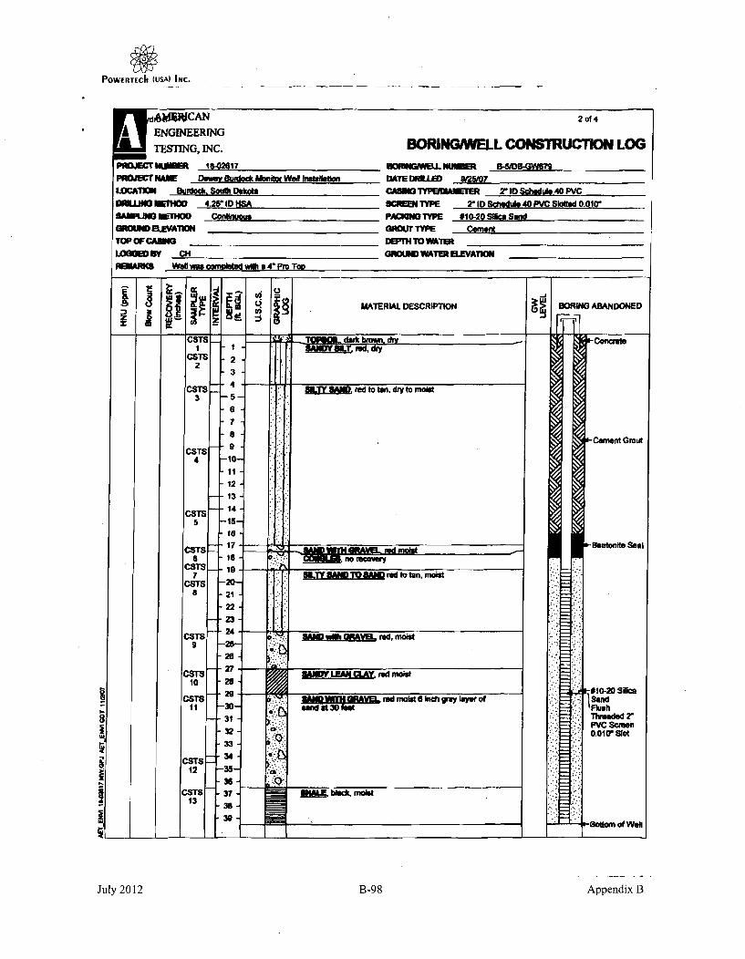
POWERTECh (USA) INC.
A ENGINEERINGTESTING, INC. BMRNG WELL CONSTRUCTION LOG
0JECTMAIV DeWOV SWddck Aftnitor Well halelaon DATE DFILE ___#2_ ___W_
LOCATMO SURlock. South Oshots CASES 7YPEIAMTER 2' 10 §SceUIe 40 PVCDRUMJ I~fHOD 4.25" ID lISA SCREENTYPE 2"ID Schdulef 40 PVC SWWe 0.010'WMLI MbTHOD Coalmigusu PACIONSTYP 9010-20MOSa~eSnd
GROUND)LVA1IO _______________ NU TYPE CementTOP OF CAIBS _ __ _ _ __ _ DWTN TOVSAT _ _ _ __ _ _
LOGOW By CH SNOIBID W#ITEM AVATO ___________
P03LMM Wet! wse aonioletec with a 4 Pro Too
111 ~! I1MAYERLAL DESCRIPTION B~N BNOEC3TS
CSTS2
CSTS3
CSTS4
CSTS5
CSTS
CSTS7
CSTSa
CSTS9
10
CSTS11
23
-" 4
6-7
9
11~
12-13
-14-15-isis
-1716
-19
-20-
-21-22
-23-2428-2627
28
29
-30-31
32
33
-35-.36
- 37-39.
1 _ 1 n o lecoudry
reI~ sd to ton.,ryt moist
0MWMA red, molst
VIAN wMA OPAVEL red, moost
! MAVEI red moist S ih;ti gr" isyi of
b~bidL. moist
~-Concrste
K-Cement Grout
i-Bentonite Seal
#10-20 Slice
Threscded 2"PvC Sfemen0.010wV slat
?-Sottomn of WonlI
CSTS12
CSTS13 i
July 2012 B-98 Appendix B

POWERTECh (USA) INC.
Hydro ID 679 3 of 4
CONSULTANTSf l AMIERICAN *~c D GEOTECHNICAL
ENGINEERING • MATERIALSTESTING, INC. JAN 15293 ENVIRONMENTALTWATER RIGHTS
January 11, 2008
Mr. Ken BuhlerDepartment of Environment and Natural Resources (DENR)Water Rights DivisionJoe Foss Building523 East CapitolPierre, South Dakota 57501-3181
Subject: South Dakota Water Well Completion ReportsWells Installed for PowertechBurdock, South DakotaAET No. 18-02617
Dear Mr. Buhler:
Enclosed please find the well completion reports for five groundwater monitoring wells, DB-GW675, DB-GW676, DB-GW677, DB-GW678 & DB-GW679 .The wells were completed to obtain information on thepotential shallow groundwater impacts from previous uranium mining within the project area prior to
initiating new uranium production activities within the Dewey-Burdock, South Dakota area. If you haveany questions or need any additional information please contact me at (605) 388-0029.
Sincerely,
Clarke L. Kmniggge, C REnvironmental ScientistProject Manager
CLK
attachments
pC: Mr. Cory Foreman, RESPEC
Y:\w,•-nvimaemaeaPCormpondeaceýl 3-02617 MW Compeion Repc*t.wpd
This documeat shall not be rqwodced. except in full, without written approval of American Engineering Testing. Inc.1745 •etwo R•ed * RaWId Ckty, SD 3792 a S•Sd-34M * Farx G.3U4W40 - wwwAmatu~om
Chmhaisen - Duluth • Mankato • MasW • Rochater StL Paul, MNIPItas Rahpid City -Sieux Fall, SD/La Crmse • Wausau, WIAN AFIfRMATIVE ACTION AND EQUAL OPPORTUNITY EMPLOYER.
July 2012 B-99 Appendix B

C,týo ~ih2i&~L~
HydroID61a - 4 of 4 0
-I
0
20
00
It
-T 5.7 <,Jps 4 r~j Rc rrl 0KlTo . .9 .4 4
70 30 '& ~~ge V~~ j
.1 is
f lnSA-7
I-
COMLD BY:-o,: F0 .
REVIEWED BY':
PAGE 2 OF 2

POWERTECh (USA) INC.
H.-, r I • SOUTH DAKOTA WATER WELL COMPLETION REPORT otI t107.127
County FA aith w
UUH rk___ .
IM,
Addreass /'.P 5. FSO " ?- /_ la t~~ S. I> 67974Please mark well location with an 'Y
Well-Complation Date
/?-/• o'
I J-
I I
Ic I
k -! Mile *
F
LOCATION:Dstance fran nearest potential poltisorn Iel aspr lank. abiudoned wedL
food Kot ete)? ft. IrootN OW ?#fSf-I(± identiiy aourc4 i
PROPOSED USE:
o Donatic/Stock 0 Muni•ipal D Business DTTest Holes
o Irrgationl 0 Indusia 0 l~onimto l PA Mmonitoring wen4
METI#00 Of DRILIUNI:
CAING M ATA, 0 Steal Plastic
If other deacise
11 O"hr
STATIC WATER LEVEL Z9- Feet
If flowing: dosed in prvaure P A
GPM flow through inch pipe
Cootrofld by C0 Valve El Redneers 0 Other
Raducad Flowitm GPM
Can wel be cornpletaI shot in? Ye
PIPEWEIGHT 0IAMETER
Wk 2 LB/FT 11__L_./FT -IN
___LB/FT -IN
FROM TO HOLE DIAMETER
-- FT __ FT - -IN
__FT -FT IN
GROUTING OATAGreIt vN L GreetWeit From To
S , I ./gal ft. __ It
Ib/•,. It,,,
Describe grouthng procedure ph ~
SCJEEN: [] Peloafhoafd pipe fi MWmfcAuddW
ciameter X ol Laest 10 -- EET
Maera 've, ______
WELL TEST DATA:
0 Puntped Descibe. A ," L0~ /-10] Baited
Pumping Leel Below Land Suiace
ft. After___ rs. pumped ZIv clA -PM
__________ft. Alter - Mrs, puped 5PM
If pnump installed, pump rate -G_________________PM
REMARKS LW eU D -07- If-
Slot Slo A- Set From _. Feet to4- Feet.... ..- , 91 W;l h P,, , ...lilm
UU Ml~lhW an-I.Ela aam
WAS APACKEIR 08SEAIUSEDTýI 11E NO
If M what material? p Alr.
Descrilbe pak0ld) and locaton? P*/'A, 4 qo 6
This well mws drilled under licanse #---.. I.h.. -ltr illl ~ n•wll
-2 Al j- PROGRQ'O
Driffing fins ~ '' ~dSignture of Litres Rapresentative:</
DISIIFECTIOI: Was wel disiofected upon comIpletion?.YES, NoWe
SLaborory sent to for ate qNO. Why fot?flaw-- onaw
Sigpawl1A.,tZ r,,
Date I)tT7
July 2012 B-I10 Appendix B

POWERTECh (USA) InC.
Hydo ID 0 PowerTech (USA) Inc. 2 of 11
DRILLED WITH' AIRE] WATER'[E HOLE NO. AW711"/1/
T.D. 4W' LOCATION' ILIL If 1i A .. f 119 g It. IF1 J1 2.BIlT SIZIE k "/ , :4 ' ,e.. q, ".-I,' -.
SAMPLE LOG BY ________ LEASE& iP.OIET) Avydik
DATE COUNTY. 1TLLE./ .. t STATE --
AII..alotI. .igelt.C(Ln. S AMPLE DESCRI-PTION YTerre. 1o S wl 01dioJm (AUWtS 1. Percent, %I IMidlfare
171 l. am. "d_ 2. a- g. I. IN.[ li it, RliUllio AIU. .••.*_lle••,j 3. ... .......
&all.. Zn.f.
July 2012 B-102 Appendix B

POWERTECh (uSA) INC.
Do~. .- PowerTech (USA) Inc. 3o,,,
DRILLFDWITH' AIR[11 WATEREJ HOLE Na 227 ,,,'(
T.D. LOCATION,
BIT 31ZESAMPLE LOG BY__ LEASE",wmacT)
DATE COUNTY STATE
H l.. I ") SAMPLE DESCRIPTION TaTrose8= iS- 00#l"m (Awwmet in Percent, %) 'ImMeto
d. Redwood PQaiMeu9 W b~uKSK.R C 1F.chutL
P. " i (p ri aIT lll 1 pf1 6. oIlllltoo
120
130
140
/80
"P•
40
/00
PAGE..2..O
y 2 012 B-103 AJul,N,ppendix B

POWERTECI (uSA) INC.
PowerTech (USA) Inc.Hydro D 6W '4 ofll1
DRILLED WITH' AIR[:] WATER[:] HOLE NO. D*!7" -1 /C
T.D . LOCATION'
SIT SIZE
SAMPLE LOG BY_________ LEASE' (.aacTL
DATE CO-t-Y STATEL .LS.Sl(L SAMPLE SESCRIPTION Ts Tt.e
ax gt 0ggg.f (AP10tit PVC 1, %e S * Meet.,.At R4W,@e I "sln r OL C9jM S eadest
/, .t d sif A
Er.
210
3/0-03-z4o
,so it'
217
JulyJ 201 01 10
July 2012 B-104 Appendix B

POWERTECIh (USA) INC.
PowerTech (USA) Inc.DRILLEDWITH- AIR[] WATERI-" HOLE NO.. A7/1"UI
T.D.. LOCATION'
f 11
BIT SIZE
SAMPLE LOG BY LEASEsL(I&-r,
DATE COUNTY . STATE'
- r T uI~i
IIDflilliL.Liumesits(Lmd SAMPLE DESCRIPTION T -TI~.i$a @WE Oz1dolls (A..,it !s Percent. %) * *r
I*moderateRig Redgeoi &PAbJi.j,.~siabudotRit. *@htsies a ,1444 J~-tsu C'Cwbom 0S.S1hodP. Pdt.IPyr) Tm'f 10~,19,319 Zoos.K Kauoln Cht' rtP.Pwrits aTrumh id ao4
t I - I ~-t--~-- I - - I '- _______________________________________pv
790
540
4
S0
4
,w 1 ;w 0
- WVOF 4 W'7h 3 4MeMAfr W(*& Ifalkd u
I -
rml iff m ~~ m "f
"70
11
July 2012 B-105 Appendix B

POWERTECh (USA) INC.
Hyo;oo6;0 PowerTech (USA) Inc. 6 of I,
DRILLED WITH, AIR[] WATER[] HOLE NO. OU7-12-1
TDO. LOCATION,
BIT SIZE
SAMPLE LOG BY LEASEI1 jPFKCTI
DATE COUNTY - STATE
L. U Ite OI~t Low~ Ia DESR IPT IO T) a TreatI . b
41fle lossKaolin Cht
qV20
NC V*Ivewl - lowi-",p
940
#860
PAGE-1O 5'
July 2012 B-106 Appendix B

POWERTECh (USAI INC.
I Hro ID PowerTech (USA) Inc. of1,
DRILLEDWITH" AIR WATER HOLE NO. bA t-/(- //k
".D.! y51) LOCATION' s,. //I 7"-;7 fI,, , I-qc
BIT SIZE
SAMPLE L-G BY. LEASE'm
DATE LbO L..... COUNTY &Le.". STATE -• ••_|A"Votin LI Lalmmamits ( 1.W SAMPLE DESCRIPTION T :Tract
1 j SM or Osildllom (A wensin Perflet, % ) 2- do :hoH~kA 2 1 U" '.
COB I• c :d.. Ito.dced P X- Primay 0xd .Oundof
4#X" c .4
eosery Oild. i&.Cwkn W)Binchedps pylits (pyt) Ta. • ltlice Zone Koi t I
f. - 0,rvl -kl- t:
July 2012 B-107 Appendix B

POWERTECh (USAý INC.
Hydro PowerTech (USA) Inc. 8Of
ORILLEDWITH: AIR [3 WATER[" HOLE NO. " /1'-
T.D. LOCATION-
SIT SIZE 01'
SAMPLE LOG BY LEASE, f__--nr--T]1
DATE COUNTY STATE
11
z IIUL-ttI L.Llaeete (Lad SAMPLE DESCRIPTION5OX sult 01iui (Amoneto in Portent, %)
me.L~ Rdfeaed OX. .OIf¶I'd GRdt~~ ~~ Reucia teesedery Oz'.II .i PO I i) Tt ~ o ZoneK
T TraceI aMinera' Moderate3 * Abadent
*CabM S 'leaghed,.Koi ~*chort
qI/v :3 .... i
11120
'1(30
Y140
'1170
qnoo
-7
.71
I*WI'- qN' ff/ ZT-WW 17~r -w'N I rd4r awnri
till Rpy-JA7 AWfW*7.j7W,&1f-LAYJW#V&
APfith 4.W few~m tr',Y" lar'tsfi~ !'v
PAGE I O-&-
July 2012 B-108 Appendix B

POWERTECh (USA) INC.
roo ID 6WPowerTech (USA) Inc. 0f11DRILLED WITH, AIRE] WATERF-] HOLE NO.'7-11-1C
T.D. LOCATION,
BIT SIZE
SAMPLE LOG BY LEASE, (PmOECr)
DATE COUNTY STATE
,,..l L,,i~me(, SAMPLE DESCRIPTION T-T,.@c0 artOadim(*mt IAPoc~?~%) 2Moderate
fl R& Reduced POX. Pdsm 1a5r).lld.
P. PydItellPyv) To - Tresaltion Zone C @ KOOli S.•-eCht
July 2012 B-109 Appendix B

POWERTECh (USA) INc.
-- - .... I-(,i•Y!a Imu•II ukvl,31) Iulluk.
HyAMULD WITH, AIRF] WATER '' HOLE NO. b7-I .. /./,
T.D. LOCATION'
BIT SIZE
SAMPLE LDG BY LEASE' tPROJEcT)
DATE COUNTY_ STATE
A•--t•io••sU.o r,,. (LJAD SAMPLE DESCRIPTION TrTaOceSw( i• Oul|eMin (AiMoWts 4. Percent, %/) I * MIoW
Rid .Rduced O.um iai 3 * Absudont
Rd#. Reductonft." _d -. 7l P1l Illlr I ox1 lileodery Oxid. C'Ct4 S.SIloahad
L - -l .oPspiZe( Til Te los Zo.e K.K.o.in cbtschort.I aI I P ' Pod IaI
July 2012 B-1 10 Appendix B

POWERTECh (USA) INC.
I Hdo I PowerTech (USA) Inc. 1o,,fDRILLED WITH' AIRF-1 WATER "' HOLE NO. 01V -I
T.O. LOCATION,
BIT SIZE
SAMPLE LOG BY LEASEIPROJECT)
DATE COUNTY STATE
AltMOa L. Liabelt. ( L) SAMPLE DESCRIPTION T Tracea. t' 1 4 3 Mo~d'satst
z I L RI a edi. . POX` Prtim O w 0 d. 3 • Abundant
P. p. y4it(Pvr) To a Tnrseileoo Zo d Csr
July 2012 R-1 11 Appendix B

POWERTECh (USA) INC.
hyeo ID 681 SOUTH DAKOTA WATER WELL COMPLETION REPORT 1 of 107.92
LncaMi d F -AY.Lý l6sac-L2..i-P45 g ZCounty North___ __ _
IN IWeil Completion Date + + --.-.-
1 Mile _ 0
Well Owner..
dnress Name
9 -
P11., C 0Ad ss:
&/ f, / S- 5-77q -)
WELL LOG: DEPTHFORMATION FRM I TO
(IU#14wl4~dk~ J/70
--I ~ ~ ~ ~ ~ F ------ - - - - - - -LOCATION:Disteac from nearest potential pollumtions (soe jpktacnk. abandoned wali.#.g.1 I-. -. Ii f. fi... gikJllh Pd, ý- (., $ :j... I
PIUOPOSO USE:-0 ODmestic/Stak 11 Municipal 0 Busines s Test Holeso Irrigaion kEdustrial 0 uatisiond $ Monitoring well
METHOD OF DRLMLUNG:
SATIC WATER LEVEL C) Fee4,If flowing: closed In prI; es I _ PS
CASES DATA. ste Plsi 0 Ote 9PM fow I& PO* - 2 -inch pipeNthe descrb Controlad by 6"VleO - Reducers 0 Other
PIPEWEGHT OIAMETER FROM To HOLE DIAMETER R6PM
5k& _2 LB/F FT FT 5 INCan wall be completely shut in?-oLB/FT IN FT -FT -
___ Lq/FT -__IN _ _FT -__FT ____IN WELSDT A .! i 57(1Pumped Describe:ONOU'lElS DATA [ a~GROIDATA NO ks Grout Weight From JTo 0 Bid~ f~ll 2 . .. JS2lb /gat - L 6 1 ' 2____Other_____
lb,/gd ILf-t Pumping, Levl Below Land Surface
Describe gm uingprocedure )d, A,/. ft. Ater _ Hr. pumped GPM
- ft. After _ Hm pumped GPM
SCREEN: 0 Perfoatetd pipe iM,,ufacred if pump sta••ef pomp arte GPM
Oisame atel' E Lmngth_____ -FEET REMARKS M -~'~ EE V&Maternal - ?//--
lo&t, S _• ( 1 2 0 From.A,& Fiato V• Vu Feat FED22Other informato tio .4 L L A~~ J
IWAS A PACKER OR SEAL USED? 91YES 0 NO0 so. what maeriaul A' Aw rD~escrbe pochelualslelocationl? PA.1.A S_75
This welt was drilled under license o -74J NRO AM
And ths repot is troe ind accurate.
'0ISIEFECTiOI: Wes wal dismiectad spoa campletion?* YE& NOW.
tLaboratory sent to her water - __No. Why Not?qultofayi /A# __
Signautur of license Reprueuntatiwe:.
g o ' aP ,. -
July 2012 B-1 12 Appendix B

POWIERTECII (USA) INC.
Hdro ItD 682 SOT KOTA WATER WELL COMPLETION REPORT I of 107-92
]cation•Ai 2(1f l% A Sec 4L..TwphI..jI.2 LEu elOwner- AD -F Tres-L 1dually North BusinessNam:VI
rig H, 81,7W.I I Address: B p OZ
lease mault wall location with an +X+
w' WELLtLOS: DEPTHI FORMATION FROM TO
Well-Completion Dlate + - - t ,s/6LI Ao j II I F-/
.OCATION:isnance Itrm newest polential pIllulion sourc (septic tank, abandoned well,
aed tot. giL? __ t. from NOdr )k"!Cientitiy source).
'ROPOSED USE:
D Omseestic/Smock 0 Municipal 0 Busines 0 Test Holes
- Irrigation [0 Industrial D Institutional gi Monitoring well
NETHOD OF ORILLING:
/4 7JSTATIC WATER LEVEL ~ .Z_ Feet• P . If flowing: dosed in pressure PSI
ASING DAt 0steel Plastic LI OGPM flow -through inch pipe
I othlr describe Controlled by 0 Valve C] Reducers C] Other
PIPEWEIGHT DIAMETER FROM TO HOLE DIAMETERA. IN Rduced Flowrate 6PM,vrZza ,. _, v__ T i F_ T 6% iN Ca weall be com.pletely shut in?_ LB/FT IN - FT __ FT - I
WELL TEST DATA-__LB/FT 111 _ FT __FT - IN [ updOsi. *' •-" l~•
El] Pumped Describe: A T_ wGROUTING DATA 0 Boiled
Grout Type No. of Sacks Grout Weight From ToCCU, 1. K•. qh./gel 0 It-WI-k ;A Other____________
Ib./gell _ k- Pumping Level Below Land Surface
3escribe 1renlting cepaielllihs 2 R - it After _ __r. pumped GPM
_. After Hrs. pumped GPM
SCREEN: 0 Perfurated pipe Mmufactured If pump installed, pump rate -GPM
Diameter IN Length /' -- FEET REMARKS "D)'-i4' I,., ..d RECEIVEDMaterial pSlot Size i0lo-nati Set F_ q6t FWeeto..StL MAR 2 4 2MOther infornmation - Ild X A-ý piktnuT¶
OAS APACKER ONRSAL USED? 'E No?,c/fs1,,so, what o, a L ,O,,,s a R
Diescribe packer(s) end location? Bqec Ai Ar.- / aD)ISIIFECTION: Was wel dilinfecled Upon completion?
.- YES. Now:.0boatory sent to for water .-&Nio. Why Not?
This well was drilled under license # 7/, PROORAM
And ihis report is true and accurate
Signature of License RePrepettativ Q oe
Signaturethl Prpft Holder
juslity ans"is
- '& -i's 0 &-,, -
July 2012 B-1 13 Appendix B

POWERTECh (USA) INC.
-,7, r-.r fv.rt. r..
SHydro ID 683 SOUTH DAKOTA WATER WELL COMPLETION REPO.rT 1 of 107-92
5 IiiesRoe ea - /C9tI 4 _
Pleat well location wihan + + __________________
w WELL too. DEPTHFOMA1O FROM To
WaellComplation Oats 36 ~ ~ '/(--4X~
- 1 Miff -.
LOCATION: .v~Distane from aserest Potential Polkilien $MCI~ (IV*~e garth d ediasdmed wall. _____
PROPOSED USE:.___0.Doeic/Stock 0 Municrpa 01 Dole,= 0 Ton Haules A RIMl4TS
o krilgation 0 C]bdishial 0 loollotimeal 0 Mnultmrnog well
METHOD OF DRILLING:
CASISIG DATA:0 swelIf other doxbPIPEWEIGHTN OIAldEMl
111 JL.J /FT 4L.IN_____I/FT -___IN
InB/FT - IN__lt
18 Pleetk 0o1 da
STATIC WATER LEVEL 9 I FeelIf floing dosed in protein PSI
GPM flow teUohll inch pipe
Cenresd by 0 Vye;. 0 Raducers 0 OtherReduced Flowar . GPM
Can well he completely shut in?-
FROM TO HOL JtIET1ER
.. FT -.0.--FT IN6L._ FT _FT IN
-FT _FT IJN
GROUTING DATAGreet Type N• . 1 O.Se re W IF To
lbJuI - IL t
Descrbe woewin preceduare ~ IV) ~
sCREEuK: El Perforated pipe • Mendtedwld
Diameter I "J . N Length L E . -FEET
Materia PvYC
WELL TEST DAT&io P..ved'{' i, 6O2co'
Pw*pdi1fve Meot Land Surfac- ft. Aftar _______Hr. pimp•e" SPM
_ft Alr, H-s. pumped 6PM
If pump installed, pump rate 0PM
11611111113
-7- zcq--7*slot site - ~ IDW -set Fmoiu6.0 Feet toJ23 5-Fast
*nnwuw . -1 e6.-1 k N k-.rLr Mo an I"1 LI .,-
WAS APACKER 04SEAL USED? 2f YES P1 NO
It : t widmteil A ADescribepakashe~) &Rd ocatiori? FArA.' 67ý-
This well weasdilled under Icsma U 7
And Oki report s trueand accinvtar_... 114t v -
Signtee of License Repraesmative:
OISIUFECIIO:. W we diisfaectud ummplneiet?-.. YES, How_.
Vtborsjgtofl sent toteor water --)-(o. Wft' woe NIF& oelt nalyisa__ _ _ _ _ _ _ _ _
bib'
S of W" 1@Prophrty Ho.lder
7;,,'ZM
July 2012 B-1l14 Appendix B

POWERTECh (USA) INc.HroD 684 SOUT DAOTA WTREL
Hyda D 91 SOUTH DAKOTA WATER WELL COMPLETION REPORT- 10of91
Loaio-#EX Sec II r414Lg leCounY NorthI
rsf A Mrs(i" Plines mark l loan tion with sn '"
W
Won Cornpeuon - ato
-- F-
-- F
Well Oiwoerc , L
BusinssNme: PRts
Adduew 0~' - :2/e •fl.-a( , •P%1S -, ,
EWELL Lee: DEPTH
FORMATIONd FROM TO'
kyI &iY4A kpqpAIw," -/V/Ie 1,7_
II• Mile
LA4ko/ 6A"&mJ vW Ii,+L,!I
LOCATION:DWsunce fromn nearest Potential polliimo i uweeypticirk ebmwned REelEDl;__food lot IlL)? - h1 . ftf14U L RECEIVED,______________ ____
MtOSED USE:- WAR I OMmCDomsiae 0 Muniipa 0 Bsinss 01 Tosn Holes I
Irrigation El ludvsiuil 01 kinjutgonau 0 Monitaningwell Iz
METHOD OF D11IILING:
mullU
CASING DATIL, C1 Stele
IN otler describe
PIPEWEIGHT DIAMETER118'7 /Fr V
__~1__LB/FT __-__ IN
_ _ U FT ' I
Sahwic '0 Dither
FROM TO
4&FT .H3-FT
___FT ___FT
HOLE ODIMEI
.. . . IN'
STATIC WATER LEVEL 2-~ Feet
If flowing: dead in pressure PSI
GPM flow _ throull•i inch pipe
Controlled by 01 Vo 01 RedcMrs 0 Other
Reduced Flowraet GPM
Can well be completely shut in?
WELL TEST DATA: A f01 Pumped Describe:;~ ' I ~ q .~o Bailed
0 Other _ _ _ _ _ _ _ _
Pumping Lel Below Land Surface
- - ft. Attert - Xrs. pumped GPM
ft. Afte __ Hrs. pumped GPM
k' pump installed, pump rate 6PM
GROUTING DATAGrout Type 40. of Saub Brut Weight From To
lb./gl _ r __L
ueaaruu pwrm In WWIg
CIm t Per foae pp •anactFEET.e...... PFEET
F. -
... . SetFro___ Feetlo &113 Feet-k 1p, 1.1
o~ther infam~ation'a r--
WAS A PMER Olt S6A USED? g?'YnE 0 NO
If so.r ,tmt, w t -erial?
Describe pacheits) med faced
RMARKS pOE,,f, f- ( //e9 t
This wel was dlilled der license# ._7 1- rAnd this report is troe al Kccuate.
Drilling finn ' -v
Sinature of License Representatv: e Z
siawur l Is e.vHold
DISINFECOIl: Waselltdsiiahcted upon completion?YES. Now.
LI•zLsberatlar sent It for war __A NO. Why MNi? -Aml--I quafty adUillI
SJM (I I
IJuly 2012 B-1l15 Appendix B

POWERTECII (USA) INC. .~-. ~ ssi7 .~I
Hydro ID 685 SOUTH DAKOTA WATER WELL COMPLETION REPORT 1 of 107_92
Incetion #W _l % /e Z w ~ 1 fWaI Ow.@: & i,g kCounty N" _ ."h Biness N•m, : e-o let L. US A
Address: PD, R.,
Pleafe math well location with, e X" + + 57 (4-
I w WELL LO G: O E M T
We~llCompletion odet + +__________________4 1 Mile.o 0T
LOCATIOm. :Distace frem nearest pential pallution some (sep took a bdmdened weal.
feed lotc. I)? It.1from W s,-c L$ Jaideifysosmnoý APROPOSED USE:
Eo Oomesti¢/Stock 0 Muiipal 0Business 0 Test Holes •__
o "riad"n 0 ldnustriaf Instfitutimnal , Monitring waN_ _
METHOD 0OF DRILLING:STATIC WATER LEVEL 0 FeetIf floowing:, cloud in prsurme 6 PSI
WINTWDL ES DATA. -t lsi 3M IGMfo . nhpp
If otherdescribth er Pupintroled beow 6P Sfulome _
ftTDIAMETER RdcdF A erpd GPMS___ )- REe: ql erNe _T _5__,•_ IN________________,Can weif be completely shut in?___________________B/FT -___IN _____FT -_T_-IN
____B/T __ f4 ___F ___ IN __ WELL TEST DATA:
GROUTING DATA 0 BaleddTpe No. of Sadits ~ gowhtl From TO .
b/g, Wat l~. 0 !& k[ Other
hJ.gal _ k _ j Pumping Leve Belowr Land Swine
Describe greeting procedure ,A- 1. AttN lrs. ptimled GPM
________________________________kI After ____ irs Pumped GPM
SCREEN: 0 Perwoated pipe MWaIeActowe Nf pump insalled. pump rate 6PM
Diameter - p e-IN Lergth _FEET REMARKS Arwer 8..~- -32 - H C.Material - Peslott Sizere Feetto. S~gqFee
Other informnation A PqagI,...- 1
WAS A PACKER ON SEAL USES? Yj'Vs 0 NO )If sawhatnmatmill? q4 1 )f tX7
Describe pedmqislseoatind FFI- /iG. ý77
The well was drilled under license # "
And this report is tue and accurate.'........ 11t /K - ,i • ,/ .
DISINFECTION: WIN WeO disialfalad upon C€'plef• ?-•ES.h o.
kLabowlmey snt to for Wa _ NO, Why N? wan?"b quality analysis'A ip L
Sijgature of License "ifpresmntafinv: X/
Signature OAVO Equg ,, Property Holdr,
July 2012 B-1l16 Appendix B

POWERTECII (USAI INC.
Hyd.'o6 Wd SO DAKOTA WATER WELL COMPLETION REPORT 1of07.2
counfrES 1/ NorthWall Owner_ 91.Aof 7,CC t,
!:Plose mark wel location with an "'
W
--Pc-
-÷--E
Address: R4, 7'o Z 3
WELL LOG: DEPTHFORMATION F FROM - T.O
U-11~ 1llr.4 _L ' 12v466PORFO// R2.1L 25s-
Fv s w AI4' /,s- I 3/..
Won Completion Date
I I I I I14-1 Mile - -*I
J. ii. C. / fI 7 i p."
LOCATION:Distance from imamis PoIH iiPthilion sre aasyuh. @bud r d well.
food lot. etc.) 41 ft.fom OA/C '~ (identify sourcl.
- ýrl cal 1 7 C-9
RCECIVED 1___
NROOSEO USE:-Oommstic/sbod 0 Motricipal 0 asins 0 Test Hols
[I Irrigation 0 bidtnal 0 Institutional~ Mmnitro wonl
I UAflhI MwmI ,, " • .I .... . •-.;, '
vM 14110-liffle IPFIQoRAM
L _____ _____
METHOD OF DRILLIES:
CASIN DATA: D Steel 0 Moisc '01 Other
STATIC WATER LEVEL - Feet
IV flowkVg closed in Paessuve -PSI
GPM flow tlirouh min pipe
Cont• od by 01 V,,e D R ,du Othe______Redocid Flowrt roll
a IOmLar asume
PIPEWFIGHT OW
____ LB/FT -___IN
_ La/FT IN
FROM TO a• IAME
0Fr L) /%hT Id IN
__ FT :__FT - IN
_FT _ FT .IN
Cen weillbe coouplataly Awu in?
GPOU7I1N DATA
Gre Type No. of Saocs Gita Weigh From To" "M71- 0 p lb..o/ 0 I_ 9_ -t
"lb,/gal _______f..____s
Dest"r..ibm x .' gro .in .". ..r... ,. . . . . ..d-.; -. :- e; .
WILL TEST DATA. I ~f0 Pumped Descnbr . i
[] Bailed
Pvfmkio Levl Blhow Lead SWaoe
N. Afte_ _ Hr_ . pumpd 6PM
_____ __ _ ft Alar ppump niGPM
If pump isiollod, Perats DoPmSCREEN: E Perfeated p*p W Mmanftclred
Diameter ZI IN Lanolt 10 -FET
Slim S~ze A2L~ Satfro 4) Featio11 2,R.stee
REMARKSd)-I?- Is-
Si ý X F,4,, 14 ý r' WAS A IPACKER OR SEAL USES? Y~ES ElNo;ifso, What mate6el 7 - K1r'UDutbesrdaPackersl and location? IL t. OpisimnFETow was well dinp4 pscmpein
* abox"stoyent tpjorwater Ituo, why Nat? N
This well was "ledwtower license # 5And this rer is tue and ecurate.
rII finemn 2)4 V'4://
Signature of License Representative /
~~~Holer -
Daterý
July 2012 B-1l17 Appendix B

POWERTIECII (USA) INC.
Hydro ID 687 SOUTH DAKOTA WATER WELL COMPLETION REPORT I of 107-92
i,,atioa.A~i NWW 8e,,__Tw_,k./ .. ,_/•_ Wa,,O,.,,r L,•.-.,. .County lNorth. am: dd?
I Addro, 0. R~
Pleans mark " welIopatif with sn. -X - - HI E WEL. LOG: DEPTH
IFORMATION FROM TO
Well-Completion (late P 1 ,~'~ 4v IO P
7_- 6,- 19 , ,,
LOCATION:Distanca from nafler. potential polltion source fts"ptjtank abandoned wall. ___4_
fe od lo. etc.)? ft. Wrom W 4 L / ) -i A (idoniy sourcol. V___-
PROPOSED USE:
o1 .omestac/stek 0 municipal E susines S Tet Noles
C1 Irrigation 01 -ldustrial 01 Lnstutieoa W Moaloring won V
METHOD OF ORILUNI:
CASING DATA- 0 Sieel j~Pl~ticIf ohdr describe
PIPEWEIGHT DIAMETER FROM
506J 11,,/FT 9LIN ) FT___LB/FT __IN -FT
__ LO/FT -I__N -FT
03 OtherI
TO HOLE DIAMETER
- FT - IN
_ FT - - IN
STATIC WATER LEVEL felt
I flowing: closed in prassure , PSI
GPM flow 5 throuh 2 inh pipe
Controlledby G"•alv 0 Reducers [ r Other
Reduced Flovurate GPM
Can well be completely shut in? I _ _ A
WELL TEST DATA.
o PumpedDemn: 10 Bailed
Other
Pumping Level Baero Land Surface
ft. After- Hrs pumped GPM
ft. After Hrs. pumped - PM
If pump instlded, pump rate -GPM
OROYTIN. DATAG49~ Tyapec Grato Weigt From To
,T, .lolgal I•-•L•.w It
e ,b.1u9b. /gil td_.
Destribe grouting procedure gulu4t
SCREEN: 0] Performed pipe V Manfactured
Diameter IN Length ) " FEET
U.*"i.] Ie
REMARKS p6'U4j/ Bý Jc~ '7- 3z. z -
Slot Size "'•_'_1_- Sat From.__6 Fsetto 5"90 Foot
Other information (: I X 1,&4 / r- I
WAS A PACKER OR SEAL USED? WJYES C NO
It so. what material? I-) • P4, r _Describe pecier(uI and locstioae' ri4 e &.- 7 'DISINFECTION: Was well disinuted upw completion?
_ YES How.
Laboraty sent to for water ..No, why Not?oqslit analyis _ _ _ _ _ _ _ _
This well was drilled under license #-_
And this report is true end accurate.
Signatwre of License IReresentativs:
Signature of WON o ,, t,,leo,,t H,,de,:
I:e' --h lik o et Hower:1f
July 2012 B-1 18 Appendix B

POWERTECh (USAI INC.
Hydro Io 680 ,OUT1AKOTA WATER WELL COMPLETION REPORT I of 107-92
Cm*nt MGMl
fA F I I I 1Pocot- 7e, L_Well Owner.um
is&Rms 51e.: TcL LJS4 rose,
P. c 15e. -M3)J. j-Plnase park will location with an X
W
W.ll-Completion Dat.
1 I- og
PT)!ýpf z
WELL LOG:E DEPTH 1.
LOCATION:Distma-e trom neaest psotial pollutioan eae (septic tank. abadoned well.
led lot GVe-j? tL fro tre O 14*f C: * S! 5 FLdntify sownee).
"IOPOSEDUSL:- - ...
0 Domegwo/Stoek 0 Municipaid 03 Busnes 0 Tesi Holes
o IBtii 0F hiduetta 0 lnstitutmnet (A Montorng Well
METMO Of ninzum&
CASING DATA. 0 Site Plastic
if other describe
PIPEWEIGHT DIAMETER FROM
.. LB/FT ____IN f_)_FT
.LB/FT __ _ IN - FT
1 Otter
'STATIC WATER LEVEL 31 Feat
It flowing: cloe in presste PSi
aPM flow _ tkough hub pipe
Controlled by [] Valae 10 Rducers 0OherReduced Flowrite GPM
Can weltbe completely nbut in
TO, HOLE 9!AEE
-AiFT i
__FT -IN_
-__ FT -IN_
'i &ROUTS DATA
Giolt -o o t Greet Weight Fromt To
lb./get _____k1
De~scibe v".tun procedur .
WELL TEST DATA:
0 ump esrbe: *'- - /P"e '"c,"bsr0 Bailed 01 b
o Other/,
Pumping Leve below Load Sp e'fee
_____ ft. After - lmrs pump@d
6'If pump installed, pump rate GPM
SCREEN: 0perforated pipe A 641-"Diramaer 3 IN le00t 0 -'FEET
Materil• • Fe,,
00 ~oSire..oOlQ. SetFrou 195'j Feelto, VZ5Fue
REMAKSIPe %' e -
's- I k- I)I
'="1
This wel was drilled under cense #_ _
And thls'hpon is true and eccrat .
Signature of Licemnse Reopasentative: /
(is
oescui~aohrs ) n o in J
DISINFECTION: Was well disinfectod upen comipltian?_YES, Hew.
Labraes sent to ter watert AN00 Waly lNs?-qua% a.. _ _ _ _.'Js .. _ _ __ _ _ __ __-_ _ _
WA1.4
Signature a~l.v ~ jl Property Holder
Date.
July 2012 B-I 19 Appendix B

POWERTECh (uSai INC.
Hydr ID 689 /. SOUTH DAKOTA WATER WELL COMPLETION REPORT 1 of 107-2i &
Locationkk A /d'e .County
SPlas mark will loc*un imth an "
"W•t
J' WONlCosnPletion Date
North- -17i* LWaill Owner
Business Name: ,~..~- /~ f.Address: -77:4 IA LA
fI b ý_?-7ql .
EWILL LOS: DEPTH
FORMATIONd FROM To
A./" 2,- 0 v X-,#. l l / / 1.- i . hJ
P LOCATIOtILDistance from neaort poternial polltion seue (septic tIn aba nod well
PAOPOSED USE:
o- omestdc/StocA 0 munici 0 Business E0 Tes Hloes
13 liigatian 03 "muUo 01 Institutional ZI Moroto&2a -WeI
METHOD OF D0i1UI1S:
,931111 DATA:. Steel Plastic
otherdescribe
PIPEWEIGHT [I4TER FROM
~LILB/FT !!tN -_LLFT
__LB/FT -IN -FT
___LB/FT - lN FT
7.A ri0 Other
STATic WATER LEVEL -)Feat
N flowing: doued inpressur 2 3. PSGPM How _ A Vntloud pipe
Controlled by 'z veto Reducer 0 Othe__________
Reduced Floatwrae GPM
Can well be completely shut in?___
TO HOLE DIAMETER
7 _FT - IN*
FT - IN
GR ODUTI=O DATA
smuGt Type No. of Saubs Grout Weight From To" -C~ t•"-- tL %/L-) /gail 0 IL_. It
lb/ga- H.Il IIt
WELL TEST DATA: . ,: "
El Pumped Oescnba: f~fL , e'0 Boiled__ _ _ _ _ _ _ _ _ _ _
Pumping Loyal Below Lad SurfaceAI
_______it Aliti Hrr pumpedG
If pijay installed, pumnp rate -GPM
"r usn ~ -W- N --
-. - I
"CREEIa : 1 Pol~onated pipe 5 Mandactunrd
,,,,..alr ,.- IN Leugth- -.EET
Material PVCSlot Si.e 0O2(/ Sao Fmol4.lý F11011t1 71( Feet
18-32-10 • ",- ••
-*:A PACM On SIUIUSED? 0YESJ NO 1
so. what meteW.I. RiaulJ
I"ecib packer5e Ond ca I, e, i~i i~~
This'will was dlled under license 7 L
40 this report is true end accurate.
Sigature el i Ucense iepieseItaln he:
I. eIUEELIIUU evs I;. 41
Laboratory sent to for water
quality analysisS • P t 0,,,
aspup" conynenuir-YS.NW.
--k W. Whny Not?ia IbPouty Holder
Date.
July 20'12 B-120 Appendix B

POWERTECII (USA) INC.
Hy!ra 6C
=" Hyroo 9o SOUWHAKOTA WATER WELL COMPLETION REPORT " o107.92
Location A-L J S!L r.~I Twp!&E no -16 Waol Owner e~(
county_ _____ Businessmome:. It.T Lc . U5 JAddress: 71 c). Aw x__Z__3
Pleass mark well location ujtj an + + -7 IIlyj7i~ 2Ij•+4ŽW _____ WELL LOG:DET
)<FORMATION FROM TO
Well -Completion Oatse + -+. iv J. i.____ -ý 2- 4~'~ 10o
LOCATION:1Ml tý.'Distanico from newest poentisal pollution sucum (septic tank, al a il~d 1. -0 1v ' I & Z .
leedlut~ ~ from- T11 NONL. ijia~tily source).JK # ec 6PROPOSED USE:"0 Owsesfie/Stock 0 Municpal 0 Business 0 Tedt Molls______________ ___
0 Irrgation 0 Imibatns 0 Institudani a monk**m WIll
I
METHOD OF DRILLHIU:
| )STA71C WATER LEVEL -
0 loin. e:loud in pSSUiPGU U-. 14.4 --
CASING DATA. Sut.. 0 Plasti,
It other describe
PIPEWEIGHT DIOAtlpR FROM
LI IrU---j.-IN 0 FT
LB/FT - IN - FT
LB/FT _ 111 - FT
0 OtherI PSI
urlli llilpll • _•l•llon • • l)Imm
TO NOLL QIAEE
FT IN
Controlled by leIVaive 01 Reducers E]Reduced Fluiorsta
Cas weell be uompietely shuat Wn
OthierEDU
-C.
GROUTING DATAGrout Type No.. ~~ Gourt Weigh Fjm To
L i K-46 .. ± .b./,e Fatft hzl
Describe Woofing d i.
WELL TIST DAT: ,
OPua~d Describe. A ,' tinVo Miled[] other~l,...
Pumping Level Below Land SuifeceS& 'tI,._ ft. Aflter Hri. pumped 4GPM
_ __ It After-H. pumped GPie 4 GP
SCREEN: 0 PN pipe Manufactured
DiamterIN Lsngia FEET
Simtsize d 0 to set romJ±L 1 ist tos ýFeOther ~ ~ inoml5T-V 4LJ c-
WAS APACKER ONSEAL 11301ED YEvS 0N~OIf so, Whiat Material? 6' ý' f. ?A LOeasch packet(s) and l~oaac? I'AC k',- SO1 47 d
n pumpi nsuiwio. pump rate - -rPM
This well was ddliod under license'# k /1
Anid this reopt is true and accusrate.1-•1
Waillig firm P/~ ~ Y~''Signature of Lticns Repres entative: < / 4
I
DISINFECTION: ý Was wall disiaticted pon completion?-YES. How
Laborary sent to for water NOWhy Net?VQuality analysis _____________
Signturetable Property Holder
WIN..
July 2012 July 2012 B~-121 ApniAppendix B

POWERTECh (USA) INc.
Hydro ID 691 SOUTH DAKOTA WATER WELL COMPLETION REPQRT I of 107-92
Locatier . 6 V ---A~Ll se, .A TW 6~t S Rcounty _ _ _ " _
A 7W -Z tWall Ovmer. .
- =
Business Name: bi- ~~ c. -4Address. 721. -1 I
e~jt %7 7 44)Pioemak wlll~tin wth in171 + I +t
2.
I IW
Well-Completion Date
E
I 1 ie
WELL LOGt DEPTH"
FOW•ATION FROM TO
<k go /,e-L •,l
S3- )0-•6,LOCATION:Dstan9t from nearest poeantial plutim sae- (septic tank abandoned well.
faed lo. ftil IL fromi A*J P~ 1 :L(*y ________________ __ _
PROPOSED USE:
o3 Domaslic/S•odk U MuEil W al 0 Business [I Test Holes
o1 kitatm El Industrial 0l institutional 9a Memitoing Vaell
NEI1IO= OF DULUtG&
MUD-CASING DAT& steel Plstic Other
If othar describe
PIPEWEIGHT DIAMETER FROM To ROLE DIAMETER
511__LB/FT ___IN __ -FT __ FT YI
_ LB/FT - IN - FT __ FT 11
STATIC WATER LEVEL . ) Feet
If Flowing: dosed in pressure PSI
GPM flow _ .s.throui _ich pipe
Comtmfled by Valv 0 Reducers 0Othier_______Reduced Flowate - GPM
Can well be coupladoiy shut in? Ye . i
GROUTING DATAGSt Tw No. of Sub Gro Welht From To
: _ lb./•dl _ k .. .0 .
1b./val It -
Describe ?otn rcdr
WILL TEST DATA-
o3 Pumiped Describe: ,,/v i 9~
o3 Bailed______________ ___
SOther
Pumpiing Leve Below Lend Surface
- ft. After - f mr.pmped A# , M- ft. After_ _ Hs, pumpedGPM
If pump inetalled, pump rate • -.. ' . Gm*SCREEN: 0 Perforated pipe MiA~nufcwd
biameif 3 U Legt -- ~FEETMaterial - P
REMARKS
~?~- *~ ~L1Slot Size iQZi9L Se rmA Feet to 5AFt
I1 I • I L
.U .-S5*~l - - 1 1.) or I
WAS APACKBRONlSEAL US1EV 9rYES C30l~if ;IV~lmamanaeisla 6' 1 t 1 AL 4 -
Dea~sb peckarls) end localion? iAP.% 13., 4: a-r 1490'
This well was drilled under license N d _1 rAnd this report is true and emutat. "...... • .. , 1...,I.. ,
* DISINFECTION: Was well disinfected upon completion?_ YEs How.
LAWort"m sent to ii water J NO. Wft N.0?riqeality analysis
unaint rniSignastue of License Representative; -
Signatur of WL~ ln' oa o itable P"ope"yFuder
-awr erI.7d
.
July 20 12 B-122 Appendix B

POWERTECh (UJSA) INC.
y;dro SD 692 Si DAKOTA WATE&iWEL. COMPLETION REPORT I of 107-92
II
Location- _&AWjY. scLwAzji reval owner A ~w ýih L" Noah Busines esNone: 4 &fWir U..d -r--,
w I I Address: ? . -7- i
T ~ ll E WELL LOG:~ _DEPTH
1 &tK5~bvIf _ so ,,.w. ,r"•f<.
LORMTIOO: FROM TO..
Oisinc hm nie aret potlenial pollution El iu (miutuitla k abndoned wall,food lot sttl? - ht . form f - "•baaify a~).
F'lloPesto USE:... .. "
[] Oamosici/Stock 07 Municipal 0] Blnimu 0] Test Hlies
[] wietion C1 indrii l Intiuioa V Mmiteiqv WWI
METMO Of DRILLING:
gD STATIC WATER LEVEL 31'. Feet
EM A T fA 1E l 0 Staf Plastic E l ) If llowint: cloud in presu re PSIGPM nlow i•hir"g Inch pipe
If other duemsbe Controlled by 11 Valme 1 Reduaets 11 Other_
PIPEWEIGHT DIAMETER FROM TO HOLE DIAMETER __ __ __ __ __ __ __ __ _ GPM
"Tm w'll2 a w on he ly shot in? -_ LB/FT -IN _ FT FT - -IN
__F__ l WELL TEST OATA -I
E] Pumped Describe: 36NOUTINB DATAD ile
Gru o f*3 Ge ~tt From To 0mle _________
4M b fL0 6t32S..ft C Other__ ________
Rb/fai _ ft _ Puniopng Lesel Salo ind'smraiel
Describe roting pfocodumr FLA1111, - - [t. Alter lrs. pumped 6PM_______________________________- -__ft. After ____ lre. pumped GPM
SCREEN: El Peftud pipe If pomp installed, pump rate 6PM
Diameter 33 nos --FEET REMARKS !;ek, .rdatkMateriel___________________
Shlo Sie X20 Set From e? 57 Feetol_ S-Feet)
Otherinfomation Soe _K FA L -, I
WAS A ACKEROR SEALSSDE V no?
Dosen~ackaufscadltof? ?AL~ ~-A 3I~
'This wall wes drilled Lider licnse #.
And this report is true and accifets.X
• m •
OlISIlPECTION: Wee wll disinlecd ip.. coimlethoi?
...... YES. Howt
Laboratoq sean to for water 4 NO. Why Met?
Ufmil Tol'm S.- O,' P) e---(• -S•fft . , , of RECELies D
Digater fý~d pv l fIV A A9 t•1T
July 2012 B-123 Appendix B

POWERTECh (USA) INC.
Hydr 1469.3. SOPTH DAKOTA WATER WELL COMPLETION REPORT lo -107.92
uIto A~l Y.-l wer J~t L
COW" Nwh~ Business Name: rawc T7 c 05AS rwvsf-I 'X I MAdrss: ;p.o. -ý
Please mnarkwell location wiuh so") -1-+ + if "F -
IWELL LUG: DEPTHIN E FORMATION FROM ITO
Welt completioas fLa/ A7 7!
LOCaTIto ro om oWp source Iseic tank abandoned sielk.~%L~A 2L. ''
fead lottc.at)? ft fomAd iL (iidea"yseer ). V% 7 5-P 910PROPO5ED USE: '~
o Doreastic/Stock 0 Mwacipal 0 Business 0 Test Hales_ _ _ _ _ _ _ _ _ _ _ __ _ _ _
o1 Imgatfion l Wnusrawa 0 biouuiutei w~ Moekenri.q wall ____________ Ilan 1IMETHOD OF onEun&.
'Cloin ~ -AL )(telI
If other describe
PIP" H. OfAreTE
S_____LB/FT -IN
___UV/FT -IN
AOLI
-W Plastic 0: other
STATIC WATER LEVEL
If fltaw dozed in *esusm
GPM flow _1_ L &k
Ceatrolad by 0 vah.13 RedluversRefuced Flmwahe
Coe wall be Comiptely 1hut in? 1 -
-Ps
YU~~i-f
I im* 0in
FROM TO HOLE RIME'ER
__9FT FT IN
FT _ FT - IN
- GPM
GROUTING DATAGrA Two No. of socsh Grout Wism From To
n."/gl .4
WEILL TEST DATA.An[IPumped Descrbe /''' AO3 G~aitd__ _ _ _ _ _ _ _
v OtherPuayN~ Level Ballow Land surakes
- IL Aker - i Hrpumped GPM;; 2I-
SCREEN: 01 P~esciqe4amatme
D' iameter- Z. -F*t i EETh- MatriallP e
Slot Size "020 Satisom.I F. Fe etA3L
othier information 5. -P L,
WAS APACKEROSAUII ~w Noif fso. Aust ,metenal h' PA I
0fasribs padees~s) and hae-?~ NLL.4LL
O ~StEFEKVOJP Was well dmsfectad ePos coaplellsn?~Xabsatoy Wi to ar wterYES, wwa
Laboratory ~ ~ IMO Wrtri tofrwtrNm~hlit? V4isetv *
If pIup installed. pump rate PM
i!MmKS
This well was dulled under license # @ 4 rAnd this report is tue sod .
SOinwe .of License R.presentative:
%Datum: o 3/ILPY = Hlo
July 2012 B-124 Appendix B

POWERTECh (USA) INC.4 0
Hydro ID 694 SOUTH DAKOTA WATER WELL COMPLETION REPORT 1 of 107-92
Please mart wen location with anT " + I +I I
R . -I ,I
4
I
Business Nome: RLj~L~. -LC(^ ~ A)A
Address 7c 90Ag 7ZJ
WILL LOG: DEPTH
FORMATION FROM TO
*/ S.-.as:
'F4 q
W E
I .1 . I-W21NCoinpletion onto
3- z2.-c8I 1 I1 11-4 1 Info.
LOCATION:Bittanr frmnt potential pwilution somut e 3to4 tank, abandoned w.l.
food lot, tc-)? kIte. kam_&0 [I. 4 (dniyswp I* 4
PROPOSED USIE-
11 Dmhetic/Stok E] Moicipal Buines ] Test Holeso] Irrigation D indtrig D Intiutonal Monitori well
.¶,. . • . ti ' ,, , . . -+
MIEnl0 OF DULU0UL
CASING ATk A Sleet4•-
PI.EWIGIHT DIAMETER
$., 'LB/FT - IN
S LB/FT iN
lvJ /4s
IPi infic So0*4r
STATIC WATER LEVEL Feot
If flowing closed in prosvre? PSI
GPM flew Z -thro , - inch pipe
Controlledby 00 Volvo 1 Reducer Other
Reduced Rloewrote BPMFROM TO NOULE DOMETER
eFTFT32LFT IN_FT _ FT -_
_ FT _ FT - IN
Can WINbe completely sut in'? )
MiOUTINi DATAGrou Type Grout Weigh From To
C 10b./gal 0 It. __ It
Describe aorvtidn amced , -7 .-.
WILL TEST DATkA
Pooped OOcribo: V
Pumping Levl Below Laod Surfate
- ft. After Hro. pumped -- 4AI
~ Afer~........l~r. pmpe
fIkII,"
.. ,- .. ... , . •, • ... .. .m~~ ~ I
SCiEEX.- 03 Perforatedl Pape 51 MInufa'1cturedDiameter 3 N Langth -- EET
?~vLc11MA18 iw4 .er)Q 7 6
IfrI
Slat Size .0N Sol from 37 l F.at to Feet
other infornvation P c
WAS A PACIER 09SEAL XSED? 91ES 0 NOWfsA,,wlatmate? i (1'43 6,dsDeScribe 41 p achwend locativn? P. A'- 51 1K 2,I 1~,2
DISINFECTIO: Wee wel dinfeoctef pe cotmpletion?.YES, How.
Laboratory eamn o for water 4Jri, N.whry Not? 14),
Ths well was drilled under lintna # u,_,. _" _____"
And tIis roepod is true end accUrate.
urinneg Burn I -
$1gnatwe of Licns Reirssntatv<
Sign WI Coer r foer
DOtte: k'6quaflty I
ML
July 2012 B-125 JAppendix B

POWERTECh (USA) INC.___________
m1 Htydro ID 695 SOUTH DAKOTA WATER WELL COMPLETION REPORT 1 of 107-92
Locatisni~~~~j~ 5~ S E ~ ~ I ,JCounty Nell
Plans merit well location with an
Well Owner. - rolo, TEA.,0, -1 __ " It A # •
it'I
IW E
Well.CoMletion Data
3- 2(. OrI LLJ
k - I M~il-.
WELL LOG: D EPTH
FORMiATION FROM TO
~F4 1
LOCATION:Distance frma neates potepwie Pollution 1a (121 titn.~cak andoned wall.
-edoec? ft. from lietysrc.
PROPOSED USE.
o Domestic/Stack 01 Miil 0 Business 0 Test Hoils
o3 lmgaiei 0 huduatrie 0 Insituting el Monitoring wel dI
METHOD OF DRILLING:
;;: CAIIIG DATA: 0 tStl -A ak i0 other
TATIC WATER LEVEL 12 Feel
If fowing cosed in pressure - -i ~ Psi
Centraled by if Vae Reduocers 03 OW
Reduced Fluwre , GPM
C" woln be co iolt shul in? W
I,
ir other describePIFEWFISGtT DIAMETER FROM To ROLE JN 'TR
5 4JLB/FT' LIN L.FT' 4 FT INA7111
__LB/FT __IN __FT FT_ -- IN
___LB/FT -__IN -F__T -__FT -___IN
amouTnOe DATAGrot Tacks uh From TO
Ib.o Q fL ŽIVLt
Desciaub puing praoedure P m i
WELL TEST DATA: -
0 Pumpe~d Describe: 4-f d/I JT fro,
o Other__ _ _ _ _ _ _ _ _
PumOpino Level Below Land Surface
ft. After - Hrs. pumped GPM
I, - t after. ,.-.u.eped-
If pump instatled, pimp ra_______________o-IL SCREEN: 0 Perfrated pipe Maonwadur
Diameter IP N Lngth FEETREMARKS
(%4~Other information
WASA•PACER ON 3ALUSED
If so. what nisterielf.......A.
jDescribe pacheuls end lecatien?_
DISINFECTION: Was welf-distal
".h• WiYrelu Sam it for Woler%quality anaelysis
e'- 3Z- 13This well wa drled undr license #
And this re•n is true ae l accurate.
Signature of Licn eresentative: o/f
Sipneturr'of'Wtl.e r or EqWote Preperti Hoer
Date - g- - -
July 2012 B-126 Appendix B

POWERTECh (uSA) INC.
- .,..'.....-
~ ~4
Hydro ID 696 SOUTH DAKOTA WATER WELL COMPLETION REPORT 1 of 107.92
L'oc*1al t y, Ssc K Twpjl7Rg-- Well O,-er_ __w_,___,_- __.__,,north &Mna Nuame. Po,.,, -. - A J ./vc
! (I Aess PI: I73
- E WELL LOS:DETW . .FOMATION DF- " " I _______________________ FRM T
-- +t - - •1... -i,,//f l.,oA 'L+, o ?lizWill-Completion Usi -l f +l! •'"r" • -II M il q ".),. ,fA. , ,.517-",
LOCAIOI:MiAStaN from $Mast PiomudIl Wu MsO Ip aandened well
food ' e "-.)?- ftfon, r (identify sm 1).
PRSPOS)ED USE:
o Demostk/Szc 0 Municipal 0 Ihiiness 0 Test N o[" _,
El brgatma Oboui 0 idb h0makucissaVMonitoring wed
MIETHOD OF ON1U1STATIC WATER LEVEL Foot
CASINO~~ foAkW 0gte ~ wA1* innedinprosam -PSIPIMIDAA. stelV 0uf OftS CPM flow ..&•Ldneu* inch pipe
" oh eIr ds Controlled by 9 Vlve '- 0 Ramcer 0 Oter_
PIPEWEIHT OIAM FROM TO HOLE INnAoEwR flowrate 6PM
__ IB/FT __ INI FT -_ FT :NTa WELL TEST DATA.
__ L/FT - -FT __FT - IN 0 p]td"w ," A6- 6GROUTII DATA 0 od
!W_ N& W0 Other _________________
_____ _ __ ____lb ga fo Pumi"g Laval Below Land Sisfaec
O-eggwpc roccan es •t . After .Hr,. pmped _._--GPM_It After - *$__ __rs; pmped 'W.
SCHEE. ] Perfereted pipit Meufacladred If pmp imillled pump ra•t GPM
Disme5_.•. La Ke --EET REMARKS &' '' / JA
Mater" i FVLo.Slot Sine 2•1.19- Set Ftom 41. FssttS.l$, Fist
Otherinfomatin - V ckc
.1'.1
WAS APACK(ER ONSEAL ISEUM YES 0 ZO
Osci b psowhat (aendl lo a ie T '.. .L ... 1 .
This will was drilleld under kcnse #
And this report is twue and accmate
ling rum _ _ ,t
-7VU
OIIIFECIIOI: Was w11 all eAftICd Open cenipltion?
,Laboratoy ant to for wter _.L O. Why not? 1)4les: w r!~d-m4Hle
July 2012 B-127 Appendix B

POWERTECh (USA) INC.
SE Hydro ID 697 SOUTH DAKOTA WATER WELL COMPLETION REPORT 1 of 107-92
ii
IS Well OOer. w C.-Count _________Noma". - c I
Please "eek wiell location wfth - 1r + !;77!-WoLOSDE~
W E WELL L' DEPTH
FORMATION FROM To.
WallIC"mllaion Data+
LOCATION:Ol'staca from nearest potantial Wuh worce (septic tank, abandoned wil.
food lo t.aI? I. from A O-L f i (identif some).j
PRO"POuDuS: - '
o Oomastic/Stoek 0 Mnia 0 unes- F Toa HolesoJ "allaia 0 lIndustrial 0 hoatitnonallJ Monitoring well
METHOD OF DRILLIN:
1.2) STATIC WATER LEEVL FeelC I DTA. Steellflowdig: closed inrssurei PSI
CASING DATA:' 0] Steel "• Piz I OtGer 6PM How 3u _ lhmuh - inch pipeIf other.derlbe Comteiled by Jav 0 Red4uc El Other____
PIPIWEIGHT DIAMETER FROM To HOLEjDIAMIETERRdUilaet6P
_D LB7/FTr . IN LJt FT - IN Canwell be completely.. sht n___I/- __-IN __FT _ -__T IN
____LI/1T ____N ___ lF" .__F __ IN WELITEST.BA: Y/&0l Pumped Describe: X520
GROUTING DATA 3 ihidGrout o. 0Sock TG Weigh From 0T
c p eIb./gal k .J. .g LevelBelow edSuifaceDoscr~euutOMng procedure h'' -~ IL After - Ms A r& GPM
.. ... G-~ i~l~ Ie..tL u psZ PM.
I
SCREEN: 0 Peujorated pipe omoenuetured
Diameter 3 -IN 14110 -FEFET
Mateirial -
If pump nimataid. pump rate_____________ P
REMARKS 'Prei - gLY /k,
,5/- 3 -SlotSeri Setofan u? Feta to Feetother eiormation S 7 A P~f
,,WASA PACKERONESD 'YES 0 No
n _A L_ý. A4 P,1 ý ci& _f' x
This vl v rllwsdwifler fiarkane #_ __ __2q__ _
Aad this report ItIrue Icurte.
Orono Eilrm .4 . .~j /I'l ISignature of Licaumo Repressentatve
6
.1
DISiIFECTION: Was weN itlaltimetd i coplion?
, asheat." Sent to far water $Nm Why N?
..- Z .... m n•
Signat4wmjetveaEutbepry Hower
Datse - t -/ r ý
July 2012 B-128 Appendix B

POWERTECIh (USA) INC.
I Hydro iD 698 1 0T C 1of1
Loation t__L.1___4.i/L A Sic' T'mp - .42Rg__L_ -on I I k). North
# &,- IJ I.r . J re I*if Uvrner
L ILLhj
Please mrku wae" locationwith as T
I. I
WaeIIcoapletioa Dole
I I I I I Address: P-- , A 77 I
WELL LOS: DEPTHFORMATION FROM TO
LOCATIOUDista•ne from nwarest potential pollution source (septic tank aibadoned well.
food IKO,•) -?IJ f JoWC1 - ,;. ':lid*MiFy source).
PIIOPOUDUSE
o Domestic/Stock 0 Mumicipel 0 Business El Tea HolesSIrrgation 0 idustral [I institutional A Monitoring wall
METHOD OF DRILULIN:
CASINO DATA : Steel P• E DOduw
It other duscribe
PIPEWEIG1T DIAMETEIR FROM To HOLE O9AJETER
R LB/FT - IN - FT -FT -IN
GRNOUTIlS DATAGrout Type No. of Sacks gramt Weighit From To
L!~Ral 1b L .Lb gal Q k A .J 1ftlb./gal - flt
Desczhagrtibe IgI procedura I"J Vy
J) 94 34OTATIP W*AEiN I SMII Fee
I flowing: dced in pressure PSI
GPM flew tlvough inch pipe
Controlled by 0 Vlvo 11 Reducers El Other
R.educed FIrmuor CPU
Can well be comletely shut in? - ,
WELL TEST DATA:C3 Pumped Describe: .Z,
COther__ _ _ _ _ _ _ _ _
Pumping Level Below Land Surfce,- ft. Aff, r - MHn. pumps' As ? GM
___ ft. After- Hlsa pumped GPM
If pump installed, pump rate "i "5i i GPMf. SCREEN: 0 Perforated pipsP ManufscturedDiameter at'IN.lN Length, FEET
Material PV
Slotk Site - 6 Set F'ro n . Feet to O Feet
Other Inforivationi t~i asir
WAS A PACER OR SMA USED? iB'YFS C1 0If 06whaet material? L A( I - KDescribe Pa,•,sraa) andL. . 5d-r J% /70
0EMAS
This well ws drilled under icense # _ 7YEAnd this report is true and acmrate.
Drilling firm VAgo, o 'J A`.Sigature of License Repusentativ >/ , )
Signature of WProperty Holder
Dole:
DISIMFECTION: Ws well disinfected popn completion?._YES. How
Juaborty sent to for water 201O. 0h No?
July 2012 B-129 Appendix B

POWERTECII (USA) INC.
Hro 10 703 SOUTH DAKOTA WATER WELL COMPLETION REPORT l of 107-92
Locati.on S,%Set. _ _\_ _ __ I__ wl , o,,,,._ _...._,,,_.
, - /-Ad F "t UPlease mark well locaieon with aso "X" + 7~FI I WE LL t,, LOOE.I FORMATION FROM TO
WeiIIComiplation cana +n ~ ~ _LXI, -; I I -. , ,,." 1 ,t0 1 / ( Z
LOCATION: (,,Jl ,!p•€•t€) •2.
Iifm m neawst potental peIwm - 4lapo taus abandoned wall. U A 2..
lead lot. etc.)? 2O aik.L.i~Liutfn~c)PROPOSED USE. _T_
Domestic/Stock E0 Municipal 0J Buskins [I Tea .Holes
METHOD OF ORILLING:
V D STATIC WATER LEVEL Ila FeetJ) "" ' •'4 lIf flowing: dosed in pressure I
CASINO DAT*A 19 SItel 0 Plastic 0 6ts GPM nlw tWo0 Inch pipe
If other describe Conltlled by 0 Valve C3 Reiucers 0 Other__PE HT FROM TO HOLE ODMETER RPM
=W/TOZMN FT FT ~A IN Can weag be ecompletely sh&It in?Bi/FT __ -IN __ FT __ FT IN
FFT _ WELL TEST OATA.LBF I F F N0 Pumped Dencibe: A~,1 i
GROUTING DATA r] od
Groat Type No. of Secha Gd eght From To 0 hld______________C MT~ 2- raig 4LAitLa 0 othre~~I1 D
M k/go _- - Pu * oLav alhB•low L sand Su rfaceW 0 2OO8Daesrib *m pedurs 1 _______t. After -list, pumped G PM
__Kt. After lre. pumped GPM
SCREEN: 0 PefWe d pipe Manufactured I pump installed, pump rate GPM
Diameter.- IN Langth -FEET
-Material V
Slat Size _ __ SatFram 1-115 Feetto 5 " Fast- jOther informnation ý I T h Pl~ic._______________________
WAS APACKER OilSEALUSr I&YES ,0 No
It so whtat miaterial? K P1,L~Describe peclemiseland Iscitioo? f.dL- (I IvIII
This well was dnlled under licensoe I
And this report is tree amd accurate.
n~ri... 8... hAd j
79(
nJA A,
UISIEiFECTION: Wan Mwe disinfedod upon euplatie.?.- YS, How.
SLabraory sent to for water AJIo. why woequaity arenayais _ _ _ _ _
4-
IAA
Signature of License Rapremntatwa: ; ,
-7-Dat e: Holde
Date.
July 2012 B-130 Appendix B

POWERTECh (USA) INC.
, 'H4• 'D 704 'k,•.SOUTH DAKOTA WATER WELL COMPLETION REPORT 1 or 10712
SLocation N 14 dLac~ TWq-7lS..Rg Wd Omar
Loun l Address: Y. 'l U3 , 71Plene mad well location with an "X
W
WellCompletion Baob
' - 2 9 - 0q
EWELL LOS: OEPTH
FORMATION FROM TO
F - Zo-o "&S
is 1 Mile 0 1,_, L . 17*- ' -7 7 fZ-
LOCATIM: ~ pl nrcg~stn anoewl _ _
let.~~ ~~ al.) f fg k Ot , th ~ ldent' vnjc
FM ED USE51OWMatC/&tkd 0 MU*iip 0I BuINeaSa 0 Test Holes_ _ _ _ _ _ _ _ _ _ _ __ _ __ _ _ _
0 Inmilist. 0 hldwwial 0 lafltlona 01 Mm*o*.vlwU
METHOD Of DOULUIJ
D~~~CASINO DATA, W. Steel U Plastic ik Other
e ther desaih_________________PIPEWEIGHT DIAMIETER FROM TO HOLE DIAMETER
-%-LB/FT Il2N 0LJT' 1A5FT IN._____LB/FT N __-IN FT __ FT -- IN
_____ISFT _____N ____FT ____FT -_____IN
GiOUTiiO DATASmutUe St Weight Frm To
lb./gel f_ _
Deeu, a sa veutino po-edm. L,.
STATIC WATER LEVEL
If flowing: deod in 9(msu,
A •PGPM flow . -L *0twogi
Contolled byoX Vale 0 Radea
Can weN he conpletely shut in?
14~0
Feet
c -inch pipe
0 h ernoel
YiLzz-WELL TEST DATA-o Pumped o.10o.: . ,- ,'"O&
0 Railed__ _ _ _ _ _ _ _
~.RECEIVED
N-l" 1 mL. pumped GPM
IfI ftl-. " Imm•,a. ,,.* GPM
SClREN: 0 " PeIatd pipe a IMaufactured
Diameter - INl Lenph FEET
Slatauinl___
Othet nfarematjw
WAS A PACKER OR SEAL. USED? OLYES 0NO
Dlescrie peabitlsi end e tePh ~ kL...1 i...
TLL. ~ ~ ~ R -d c...S 41. 2 . U 7' f5un iiiuIWIs'na
imswll was1 W inllllu mIdeI mansefl mt I
And this rep*W is em end acturete.
Signatues of License flepnantative: VDISINFECTION. Wa wal dismnfected upon ompletion?
-Y__ES. No
Ladwrety sent to for water W.h.NO. Yty Nom?!•, quality nalysis
,AN, AS4*n8mmvawe~~M fProvpany Holder.
4
noft- -.!00
July 2012 B-131 Appendix B

POWIERTIECII (USA) INC.
Hydro ID 705
Pleses muk wsOlMentuio wih an
F Won COffiplotiofi Data
.T~ I -
SOUTH DAKOTA WATER WELL COMPLETION REPORT otl 07-94 :,
s.e21 T., 6S P4_.Ef WOO~. L-,&-Z- N_ 1'ýý'7 'V"C ý IN" ! ILA I-.~ -
xr I-
W
I w-a
FWELL Loa DEPTH
FONAATION FRmm T
6A-)' iC A 0 - j'IcV./ VAj.r
1.111 -4 b:LOCATIO:Oistomc ftm rieas ueta poc etireA bfioh u
lowd 11. sit)? -' ft..... k"e.. 2..... 4 tomiw ity aIt).Y
PRO010 e:DoDemesij/Sieck 0 mmiatigip 0 Buiuess 0 Test Holes
o ~iation 01 "mwulia 03 hightumions Vimits.in weilI. P
___ IMETHOD OF OKLU. MA v ) 0
k1i C.0.. Esl. sI•As1.l so,..~d61IVIVP WAIgn L9V9L rag i
ns•gn
CAMI DATA: Saeel 14 Plastic 0 dw
It a"ie deso b ________________
N f bwhig cossed in prosmasCPUl flew - *V*q
-raI 4
~.- 'I
PtPEWEIGHT DAMETER FROM TO HOLE OiAMETE0
_ _ _ _ _T__ _ _ _ _ * ~ FT : ---- '-IN"
_ LB/FT - 0 _FT ___FT iGNOUIUIO DATA
Greet Twoe N& of Sacks kieot We**I From Ira
~t.± ~ J•LO.il JZIL ±L k111/eft mA.av aI
TESTOATA&-
Ba'kH LeiSle ad w
____ft. Afte t. hts. postd GBPM
JL Atet ft I*wpeo -GPM
II Paw istded Fatp sl6P
i
sat0 Pdrtdp. UwGrturedW
flia itv I4 N Leq". -FEET
material IY
SlotuisZ Siz etFm 42 to E3 A ~FastOwisivofeimute IL) 01,^A 4J f
ft$AAPM= ONSM hhOMUYIES 0QNO
14 s)A. 1s
s"Of to fir watr 11NI hree'I
n~tiLi_________
IWwllswe 3 *anlhd uoderkcumm 0 -7'fW A fe w is r ipe aVe u mt e cs.
OsiIumgivm of 2~f Lit""i .. I '
D ECEI2ED
- L~WIE RIGHT
Dats: PROGRAM
L64!L21,
July 2012 B-132 Appendix B

POWERTECh (USA) INc.
Hydra ID 7 SOUTH DAKOTA WATER WELL COMPLETION REPORT 1 of 1 07-92!,[
- - - -n /-7 ) Z7
w Ia to FOWJATlON FROM IT70
Wall Compleoti Dafte+
I His
LOCATIONDistsance In.. emat Potential poegigg sowea jaeptc tuul. andnd won,
leed Ii. etc)? -ft. ho. &..,L '?fL'inii OU
PSOPED USEIJDomkai/&ukc 0 MucL, ki Bosa..s Hoe T__________________ I___
Oigiption Ohsdustris ObaS*uAaiMweI"
METNOD (IF DUILLER v a 6&: /0. -Y iic0STATIC WATER LEVILIf Ik~lenn clou hi p4•l&.z *11..-
-m -PSI
II Othr deaceibe. ... - .
DWIAMETR FROM TO HOLE DAMETR
__ FT --- AIN Ft--_i A
HriM -nlvl uw ____ ____ ____ ____ ___ P roe
U..- + 0- .. _ O-h--__ _ _
k
A/a &ILi-
O] e Ib: " "*" .s Ze"I .
0OBaded P
Pmeng Lowe Bow Land Sufac
It Atar __ Hn. pumped GPM
-N. After-___ a. pe •-,GPM
Sp iledk. Ipm me GoPMscow. 0 Perforate pip miAMeatured
DisallowIN LAogo 30 ETMateria f~v e
L)0 r. 2" LI I" LetJ~ . F
KMARKS,
tr : I-I 1,/C rw C 1 si r 14 0.1 -N L C_ r.
WAS A PACM ER S M NOEST [UfY 0 isK ~A kua
Deswftemckstfa)uuWdecafiem? 4~ý- Igf Z
Trwo was *llwdunerlicgee#
Anwhs fewoi Is Ie ed ort.
sdpawr of vcowe RAemuaantaeyo
*DISUFCINAM Wa weEdaiafecudMeeelia?
kV tawelom sato to wiatr -NM Wh• • It?
July 2012
414JkL~ ~~~~5O~dY ~DEC 282"a
A ~~WATER IfTOats:4//sc) 7PROGRAM
B-133 Appendix B

POWERTECh (USA) INC.
-~ I
I-ydro ID 77 SD EForm - WILD VI
S•UTH DAKOTA WATER WELL COMPLETION REPORT 11.02
Location Y1 -N4W-y Sec 34 Twip 6S Rg I E vwi owner. ... __
Buimess Name:Powertech, Inc.
Addrsz 145 N Chicago Streetcity, slm, zip: Hot Sprngs
County Custer County
Pleas mark weNlocation vwt an "X*
W
North
SD 57747
WELL LOG: DEPTH
FORMATION FROM TO
Topsoil - Silty Lean Clay with sand,brown, moist (CL) 0 0.5'
Silty Sand. red-bin, dry (SM 0.5 12'Silty Lean Clay, red-bin, moist (CL) 12' 21'SMty Gravel with sand, It bin, moist to
wet @35' (GM) 21' 40'
Wei Completion Date I
May 5,2011 IQ-i Mile --
Cumin" to roar"l Pldanow pewidon scum. faepits al. nse e, edc.ac
a. toa Unknown Mdow.iw -~~AIII- '1 - - -
7 PQED USE:H s80 Muida 8 B w Test howeI.-
METHOD OF DRILLING:3.25* HSA to 40.0'CASHSAG D ATA: 17St]U•t )DV
STATIC WATER LEVEL FEET
If bKowg: dosed In pressure_ PSI
CiA km _..m..roh Inch pipe
C=OMdoe byE1 vow*n 5Reduoer [] Other ________
Reduced flow cats GPM
Cun wel be mpele* shut in?
RECEIVED
Ifol desr be&l
PIPIEVVEGHT
LSIFT
LmIFT
DIANIETER FROMf To2.00 IN 0.0pT 30.0OpT
IN _ FT _ FTIN FT F
HOLE 0U1rTER3.25 6u
ININ
VWLL TlT DATA:
GROUTING DATA:Grout Type No. of Sed'. GMAut Waiht From TO
Cement 8 Lb"a 0.0 Ft 26.0 FtBentonite I ___L-' 26.0 Ft 28.0 Ft
OeDwe gii-Z" w-min
[jPumpedd DO . NA NOV 0 U52'Q]ovie MtOGRAMPumping LOWe Sein Lard Surfae
Ft After We's. pumped GPM
Ft. After Mrs. pumped GPM
If pump Ialled, pump rait: GPM
1
CI.9M: U Perorated pipe MenufmcbaredDiameter 2.00 inhe Leng 10.0 FeetMag* Sch 40 PVCsoSize 0.010* SaFrom 30.0 Fee to 40.0 FeetOther Mbmaw 12-20 SHIca Sand from 28r to 40'
WAS A PACIER OR 31EAL USED? [Y9 [Z] NoIf ao. what maaladDesalk peeIarls) And ioca1on
RRMARKSMontodfng well 11-34-4
ThIa wel was ded under Io ega 878 andr lrepw Is tMo mnd ascumte.
ov *m: American Engineering Testing, Inc.Sl~Iature of Ucanse Repmeesertlve:
DISINFECTION: Was w" dwirlodd upon -m ~eQ3es. How?
Leob 1 which WaOW ONJ"* V" Nor? Monft ring well Only,"ftb sample seam for analyis
Sl~patste of Was Ogna or Equitable Prope" Howder
arI oat.
July 2012 B-134 Appendix B

POWERTECh (USA) INC.
Hyd ID S-OIL BORING AND MO-NiTONG WM1 L LOGHydro I ,71f ... i VH-CLCL ~ nmoo WELL No. 2 Wis ~ -Nofl v1 %d L~A~ in--_________ s,______ma._
I Dato [Ti. SrAINfIISE3A1O
sozn Scarce *.I-(
Boring Coup bted ý
Borling faile NV w-
Oeptk to Frost _ _ _ _
-I
Moth"< of ttnglrn."gDing
CORT smalui Porm. To -
Ia. Fi•t*iAt T"
-. __ "~ , .u.P :t .r .. . .a
In. _ _._ _,,_ _ _ __..._ __"_ "
P. D. or C. O. Tube From To
Jet. VIth Water From To
-t with DdJLJmg Had From To
Y,
..2
wmbait
'7bep o wft se
,bIO jgmasksOpmd a
Mpt s-3d
LifI to~ I3 0 6,
Disc- e~WuIl4 ~ d LEmsr~
DA1UJ ISO &#iIDW oe WMAM WM - A = t 4,40
July 2012 B-135 Appendix B

POWERTIECII (USA) INC.
Hydro ID 707
Project Number.
Project Location:
Boring Start Time:
3of3.
GEOTECHNIGAL FIELD DATA SkiEFT.
t17 -1V- Date: " .' f •oying.Number: //-4--__° a' •./ • .'" Crew Chief: . -TII
-- Boring Completion Time: -t-,e o
Defta Rev1,"*sd~br
~,iZ1'A~*rat~3 !r.0?r~
Nethqd of Advancing Boring
Condnuous SuiipIbi Fmm: To:
_________ IVA &WAge To:
A4 4/ In. Habw Skm Auger To:
Jai With 011g Mud From~ ____-Tat'____
Adduwd FpsDPf(dfrT ROM I//MA
IJuly 2012 B-136 Appendix B

POWERTECh (USA) INc.
C 3Hydro ID 708 E' P17 SD EForm - WUILD V1
gW 1 - SOUTH D KOTA v#'ER WELL COMPLETION REPORT ,,.0Location Y- -N Y- Sec "49- Twp -, Rg1E] wv, owner: ..
Fall RiverCounty -Qukterow•y--
Please mark we#location with an "X*
w
9May 4, 2011
Wall Completion Dale
14s A 284i
North
I II I* I
I II I
I I
I I* II II I
~~~-1---~ -
I III II
Bstiness Name:Powertech, Inc.A*dress: 145 N Chicago Streetcity, state, zip: Hot Spnngs SD 57747
E
WELL LOG: DEPTH
Topsoil Silty L2ean ý sand.b 0 0.5'
Sil Lean Cla wit ' ', trn CL . 20'Sfty GraviwtM 20'
90i Mile,-
olomana.o IPON," pasidpokOW. somau (aspollan st.amdd wall, Me al, d. *)?ft. hqu Unknown MenWy SOUrca)
Is silty CLAY, dry, roots 0 - 22'silty, sandy, clayey, GRAVEL, wet 22-28'competent SHALE 28-30'
I II
HwwftZo F MUNCIMRsaess [:T
" hote"
II I
METHOD OF DRALLINM- _
4.25' IlA to*i- ff. 30
STATIC WATER LEVEL
If flowin: doed In presUre
uPM ced lmowri
Controlled by r] Valm e Reducer[] Odwe
Reduced flow raoe
FEET
PSI
Inch pipe
CASING DATA: LS]eel 6d PiaesIf oethr desiedb
PIPE1WEIOIT DIAMETER FRWt ToKo__ -T 2.00 IN 0.0 F 2
2-0,1
LB/FT IN FT FT
LWfi.r IN FT FT
4 Lj Cww Opal
I$ML OIAMETER4.25 INt
ININ
Can we$ be coamleiely st in?
I.-----------I
GROUTING DATA:Grout Type NO. of Saits GrouL VAtghl From To
Cement 1 _. ,, _ ,_ ,-Bentonite I FtDeat 1 t 15 -to p2oet
WELL TT DATA:NA
JPMWn DescreNAmiC:VEsuaow NoV 0 920fl
PInpwing Level Below Lend SwIfe PROW"Ft. Aftr Hrs. pupr d GPM
FL Aftar_ Hr. punped GPM
If pump Insta•ed, pump rate: GPM
olemew 2.W ft &FootMLangev 10.0 Faet
Malhial Sdi 40 PVCSklts. 0.010 Set•Fm 1.2.0 a•.to,, 22. ,, <u.oe h...,o 12-20 Silca Sand 1mm 4**0 P- <-20 to 3(
IREMARKSMonilorfngwell 1.8-e-C1--
--- 120 to 30 Feet])Fe~et
WAS A PACKER OR SEAL U80ED? ]Yes [Z] NoIft o, ia trmewl? _
Oestafe pedler(s) endf" -0cll
This W44 was d~ d wder oaene 0 678 ant oftrepuat Is eue and asasls.
Otq inrm: American Engineering Testing, Inc.Sig ature of L icen se R epr esse t da : "e 6DISINFECTION: was wel - *ctem upon w iplelo?
QYeSo HOW?
Lob 10 willol waler IZH a Nt itoring weN only.qufty saMphe Wd fa uierk
Signuaime of Wel Ownr or Equiable Property Holder:
Dowe:
July 2012 B-137 Appendix B

POWERTECh (USA) INC.
F Hvdi
Fll eda
)epth to Frost-."
iitdof Advsaciicn fLorg
cot~im-twu Selag Paw. T6
.In. Ca .To__________Do Iblaw Stem •- •
in. -Casing To__________
P. D. or C. O. Tube From To
Jet- with ater From To
-t with Driling 6W Prmt To
... &M . _ _
I/e7 R.e
,_~ ~MW•. JM B 7IwA, ISO LM ., i .%lm l•
July 2012 B-138 Appendix B

POWERTECh (USAI INC.
HdoID08° PowerTech (USA) Inc. 3 of 3
ORILLED WITH: AIR [] WATER []T.D. •0 LOCATION,.
BIT SIZE --41 FA ,
HOLE NO. W0I-3-WAwW- 3M12119-51 JQ 7 .a At, RWP AM1PZ-7
SAMPLE LOG 1BY --L LEASEsmm 5ojcr
DATE Will COUNTY 611 piVF -STATE JIPS Altal I LsLibethit(LOW3 SAMPLE DESCRIPTION TaTtoos
$a sud osldA.M (Ammmis Ii" Percent, %) I minorat. Reduced POX' Primary 9IJ. 3S * AundestIRdt. R eductlon a~ ¶ ss ue" m a a en SS e c
July 2012 B-139 Appendix B

POWERTECh (USA) INC.
Hydro ID 709 WEL CSD EFormP- 1RaLD VSOUTH 0ýOAIAE WELL COMPLETION REPORT 11-02
Location X4 NW %4 Sec -4-- Twp -- 8-- Rg I E
Fall Rivercounty -cMshil;Goufdty-- North
Please mark welllocation with an "X"
WelA Owner: ...
Business Nam:Powertech. Inc.
Addres 145 N Chicago Street
ciy, state, zip: Hot Sprins SD 57747
W
SI I Ia I a* I I* I I
-. 4--.-* II I* Io a
-4----.I II Ia iI I
E
WELL LOG: DEOPTH
FORMATION _FROM I-TO
Topsoil - Silty Lean Clay with sand.brown, moist (CL) 0 0.5'
Silty Lean Clay with sand, bm (CL) 0.5' 35'Silty Gravel with sand, b in, wet (GM) 35' 38'Well Completion Date
May 9. 2011 IQ 1 Mile - "l
01'nc to owrI otI " potion eerca (Sapt twlo. uabodned vuat feed Kot iW-)?
n. fte Unknown (kbn* s'yource) 6~ I
a% I.Of I _________________________________ I_________JOowneaddSlock [~k~~aL utss Ts oeH uw Bers TskTiplon Industrial M51111ba41404 MoaRM"i well
I
a
4.25' HSA It) 33.A
STATIC WATIR LIVEL
doe: od in pressure
GPi, u.A "__,__
cotoldby [] vonr E] Redcers LI] Otter _
Reduced low rab
FEET
Pal
Inch P"e
CASING DATA: Jsteel Plae' OtherIf otther descuihe n2-8FTýPFEWEIGNT 0AMETER FROM HOLE WtMETER
____Tse 2.00 I 0.0 -r - ___425__
LFT - IN - FT FT INL.BIT IN. FT FT IN
Can well be conmeplalyI sht In?
- . A awrol"WrIf•EUEI|LU
GROUrTINO DATA:Orow Type No. Of Sacks GrotA V"Wht FronM To
Cement 7 Lb0,Ig 0.0 Ft 24.0 FtBentonite 1 L ___._-
[26 to 28 Ft
ElPuped De.ribe: N )0V 0 9 20110] Based
Pumping Lewl Below Lend Swface
FL After Hrs. pumped GPM
Ft. After_ Ik. pumped GPM
If pump intaled, pump rate: GPM
S C R E E N : -0 " a', ," u [h=, e , c m 'doemnter 2.00 smtpi Le1 10.0 FeetMoateriel ch 40 PVCSlotSize 0.010" SWeFrom 28.0 Fee to 38.0 Feet
od n 12-20 Sfca Sand from 2&'-to-S, -- 28 to 3
WAS A PACKER OR SEAL USED? LIYes [] NoIfgo, what materil?OsDefft padckrfs) n bocation
--- an--nIfflrmrwiMonItoing well 11-15-4
IIThis wel was dited• ud cenes 678 end oftrepeot is tue and accurate.
oDleog •rm: American Engineering Testing. Inc.S8gnakre of License Raprasentallm:
OW INECTION: Wasws difcd • mn rpme?
QVaa. HOW?
Lab is ~hc wate [ZING. wh7y -,Monitofrmn WONl ony.quality tample sent for' analysis
Sipsiumr of Vis Owner or Equilable, Propertyr Hoater
Dowe:
July 2012 B-140 Appendix B

POWERTECII (USA) INC.avU.1 DuluiNki AND MOMMIURMt* WEL.L LO)G
- ~%. UL [U 5 BORINOMO SR- wwj NO. 2 14W-
I
Sl".J
.Gmrn~i ffoom
23 0
bodmis =
BmbW adin~Method of Advaning Boringm W
Coatinams Swling Froa To --
In. Plice-Auer T-
D1. Ioliow Stem A.r, r- W9 .3
" ra. Casing To__ __ __ _
rn. Casing To
P. D. or C. O. Tube From To
Jet With Water From To
howfrs LS ' ALIheW of and
:t with Drilling Maid From -To
N" '66 7 1024 5 off. *sachm smOpeeim
fine -3C , o .7 "
LA.
a~mof Wed 3 8 -
.iaAMuafte 3t.. -
it,-------
July 2012 Appendix BB-141

POWERTECh (USA) INC.
-Hr •0 PowerTech (USA) Inc. 33
RILLEDWrmH. AIR[] WATERF"] HOLE NO. -Y,-"I'M
T.D. q97 LOCATION- 'f.bhTbl /9qfp.amIRwn' MALl07-1
SIT SIZE T FASAMPLE LOS BY L LEASEsom im L~ 7 &P6i•A,
DATE COUNTY f STATE -1,-. u SAMPLE DESCRIPTION Tar.ece
(Amaotu In Porust, %1) if : I r tee
I L iJ P. Pwdt (Pr Tah, Fw. _d.I _'. __3ar~RIenduced XPoI., aw $ a S boodest
•J] !! .R~•,o.!1•'•'.•,"•'• .¢me~OKI&.•A_ ~~Mu ! ! -tlelr c---Y m•tl•-•,,,KKOIItcab" m
July 2012 B-142 Appendix B

POWERTECII (USP) 64IC,
1 0112
* No ....X .....
. 1IvtldaNos ~ ...... .....
?fj .j c ...............
-A .* AD..- - 2- A\ I- 4: _91e--- ------. to Appiropriate water from....
:Offiice ',%,f._ State 'En~ginie'er. tuiDar.
'S DOCUMENT FILE, ', a-*%- nt
dh~i.-YAQI Nvurks .4*1joa ....
If... ....... tat
~~ lletunie'J to NPpIIC8Ift fur Corret"Ofl
l~e.) ~ 7z_ 1 L~.. Cormeted appicaStionl rrcoived.....
..................... . ..... ... ...
(I- - . * Date of Ivatcr right.........
'ii' . J ~ ~ * Itecora in~aL PL
4 Fne-l pt)o .~wor tof lie Copee
........ .......
ý%Pbofa wok to ta 0m te ........e..
- .. ................
sot (w ..... ... SA..
B-143 Appendix BJuly 2012

POWENTECII (USA) INC.
Hydra ID 710 2ap ioo, 1 29-2
Nap Ila 1I1l9-I'olm 261-.tWilfntlf- fý, I'ltoll in ArpionH~ofr Wa'ter,-Irpialwlal Ifll M. 1"'. Mc
........ ~ ~ ~ ~ ~ ~ ~~~~0147 ............ ..... ........ ...... ls I~l
Walysor DIvisi|n No....2 .... Fail.11Y.0o .............. ....... II~trict I L:•a.- AlIl.lkl• bil Vlr.l-A by hi Hi.. 101ýMIft-lli .9 t.r. I:
JUN "'" I"-.!i JAPPLICATION FOR PERMIT Lt VIAlt ENGMlE.
To Appropriate Water within the State of South Dakomapl .&OAK.
. N m o o ..... i ............. .........
Postoaileo addre ....... .......... County ...... L. t;... ........... , Slate 10%;; ......
1. If a corporation .......................... :..! ................................................................................................
(a) F am e of olm o ........................................................................................................................
(b) Da~o and place of incrporation ....................... . .... ................................................
(c) Amouut; of capital aoc. ..........................
(d) A m ount paid I .................i...................................................................................................(a) Names and midresa of dhic ora: ...................................................................................
.......................... .oI e4 a e . 4 .ti.. ......... ........ .. a.... u. ............................ ..........................
1I. Method ot accomplishing the work and financial rin.ources of the applicint:
(a) Method of aeemillishing work (Whether by contract, employment of others, or
by dir c 1 or ............. E:,5.r ,,...',"-' ... ................. . .................................
(b) Cash ii, hand, ............. (c) Treacury stock, 4L.
(d) Bonds to be issued, $.:.S ........... (e) Other resources, It ............. ...
.e olden cilqr Irrrieatlor, Proioet '..ell !:. 2N a2 H m e of w ail ........ . .................................... ........... . . ... .............. ....................................... ..... ........................ '
a. Quanilty of water claimed .. ........................... .el. per min.
4.' Source of waler Auppli (e timated depth) .. .. ................................................... .......................
5. Loatlon of well (gubdiiviion) .. '.... ... .. . . . ...1.. ........................................ +. ............. : ........ "..... .... .................................. ..... ............ ..... .......... .............................................................. ..tk Annual periods during which water Is to be used ....... ..................................... .
7. To be used *or:
I. .bigaUjin o.r domeslc use: Gravity, owerhofai alirinkllna or combination ey.item ?
(a) Number of acres to oe irrigated .. i. .. acres.
(b) Legal subdivisions to ba i td...6.uo..L U..t . .........................................OITl0--A list .f1111d11 e b l.stndM li In* ini tr41.¶wh acrta in Ibin ll. lh 10141i -a ladl.frank
boy n ii .. pmt a. FP 9~ti a In slibeAISs "Mam ma a bevallw ba u.mrsanlarg map.)I
(a) Statement as to domestk use (giving location, etc.) ........ ar .• ............................................................................. ...... .............. i ............ I............... ................ ................... ................................................ ............
Ii. HtocLwateriaar, wining, milling, power, fish tulture, fire protection and public recreation:
(a) Nature of use ... ...................
(b) Amunout of power to be generalvil........-...... ... horseo power.
"(a) Location of Plant ................................................................................................. ...............
-(d) Method of 04velopingI Pn-oer .................. ".... ........ ......... .......
(a) Point where retnrn watets wil be diverted to stream .......................
.:L, :
July 2012 B-144 Appendix B

POWERTECII (USA) INC.
Hydro ID 710 3 of 12
S. l ostlsntd cost of work.:W ) HO l~ud nt.-. •. r..i. ................. (b) Pimplowl p)lant. $....70.0a...0.0. .....
1s) P•imills, $ ......... ... I) ialart . ............... l(k, .k ,...................
(a) O. te•r,,eotures Mpf CC ... ... ........... ..... t ...... 'Tot l, $..... =140 ....9. lewcripltlo of work.i:
(0 ) Iluad note: W itith ................ .................... feel; height ........................................ f',et;. ateraln ................................................................................................................................
(b) Lon of well:
(To Im., eor.lial.tgl when well Is drilleld)
T'J, vl:0 l1- IA)Q OF WHI.I,
40f - 4uslo ul'onat! Sail
.M __ q I. _____ 0, and- - -
gs__-__ __.________Ou•L
-370 371 I*_pri.itoij rorma : .on
(c) Meugurilln 1evl.cQ:'r0 r .......... ............ ..........
I
(dt) Cartel: Total length_...... ........................................ miles.
LowO.rN DSWLW DEPTH " O11O, WIDTH AT QUADSIIAD'A?3 I I •?I I" CATk(f LiNU IM PUR mlx
At .......... .......... et .......... etJ ............ t4. ... reAt ..................... .il .. l ................. feqtl ..................... fel
At .......... .......... A1110 . ........... ........... test ............. . oIAl . . M t . . i@ . -.. .... ..............
At ................... ... ......... e ................ feet... tea.t. . f.e.At .................... M.iloJ_....•.. ....... fee ........... ........ feet ......... . .. r41 .............. :....e. . l te
A t .................... M ilel """.... 40W..'•e t ... I .. : ........* feet ................ t~ .. ...... ........... e
Is) IV" wate." tested for Irrigar.on Itarpose?
iV Reault: zc. e.
10. Time required for completion of work .. .........ers.
11. Time rej.fred for complete application ,tf water to the proposed beneiclal use 4. 1.. I.. y. ears.
12. Choice of newvapper for pul.!fatlon o1 notice if Intention to appropriate ........................... • p.... • .•.•A;•# ;, ..s ..n. k : ............... .. ....................... ............................................................................ .
STATI• OF SOUTH DAKOTA
County of ...... L. .... ...........................
., ... :.... ........ .. ....... . . ...•..... ............ ....... beil first dut, swornon my oath depoe and fay; That my relatieri to the above descrilted, undertaking in that el owner,that I ;love read the above ai.,l forenolnir astaemejit, and ext,mined the map ar.ompanuhins .the same,Rail that I know of my own persontl knowdedie tih t the ,ati-ton herein stated asd i,.he, a.- true.
Signed .
...... ... ..............uari~ .n wr obfr m hs... .da f .ih . 10 1-
' Nolsry Public (or other qualified officer,) .',
JI
July 2012 B- 145 Appendix B

POWERTECh (USA) INC.
Hy~dihltils by Ntat, i ,offineer:
...... ...... .... ........................ ........ ............. .. ........ .................................... ........ . ................ . . .. ..... . . ..... "....... .. .
II
-C.u .ty o( ...... i ....h .. ....... ....................... .......e dou th D akot I.. ............... ... .. .. .......... . . . ........
... This I. to .. rt .fy that thu f. re oi. , ng . . pli.e. th. w a. , rece , eit '. t this .... lep .................. ..... .n.. . c..
. po t ................. ...... .. .... .. ...... . ...... I ......... a .. .th .t ....e c . ....o .tio. it
w '.• fnn,me to eomnply with tho Seudh D: .kute wnter LIwa. wOS pu~abl neeenianco writh the lirrnlalonr........... ................. .iv ,-t . ... .....an ..a ..- .... ........in o rn ,. .. ..... .......... ............ ......... ........................ ......... .... ..
t . mwcu and sonIdr.to irm i )AI nOy TA l nfumte
ol . . .,.of ,l woat. ........................ a-........ _z.-a...... ................. ....
, .................
V1Apt'. a. L'tiitt:.S State Rnglnseer..i NuIrhtr of permit f.o1n ei.2 .. ............Onic of t hr.t receipt of appl..ation ...Jun .. .................. ......... ........ , at..
.D.ite o.f return to .pp. .t .r correction. ............. ...............
...D.te of recei t1 of cotrected aYpIWat) .. ............. . . . . ..... ........... .....
-i Nubro emt-)W2.......
Date from which atpplicant may claim right ............ Juna..29 ................ .............. 1.51.
Approved . ................... .......- 19_5, Re orded in Bok . . ......... . Page h ..... ........
This Is to certify that I have examined the foregoing application for a permtt to appropriatewater a/ the State of South De'clta, and I hereby grant the same at stated herein, subjlet, however,to the following limitations and conditions:
list. The equivalent of at least one-fifth, of the work above speechied is to be completed on or
before ... . . . ................................ 19.52..
S2nd. The whole of said work Is to be complete.d on or before .npL..•;22.................I...... ...3rd. The limit of time for proof of binel.cai use of water appropriatct In accordale herewith
Zell -... ... 12.., ..................................... . . 53.-
.Ith. The water appropriated ohall he used for the purpose of ....A.dic J.Arxtt~atla ............
., -..............
t.......h. Th••o prior right of all parsons who, by cunpllance with the laws of the State of South Do-ok-oa, have ane.uired - right to the dse of water ml£ia£. not be Injuriously affected by tiils appropriation.
Sitil. lhe amount of the approrriath'n herein grant'.i sholl not e;ccecl ...I .......................... ...... gallons I:er minutr; xAth-ur -shall it exceed the capsiNlty of the ablve .d.critbed systel
of .. 'di•ersln works, nor the buast anount of water that speA'z:nce may hereafter Indicate as itemes.sar" for the production of crops In the orercfia of the Iemt Ihuiandrly; and further. ead. appropl.; +lan, must be limited to not more then one-oeventilae (i/79) of 0n0 tubl foot of "wter Pel second oftime for each Amrm of land to which water In aetualyi aled ieueaeledly ipyplied for Irrigation on or
, before.. ..t...LL ......... liO53...; malu, water to , t.sel during the followinhl descrih abe
n-nl period:
A..-t1 ..1 .... otahmr... 7neltv ..................... ... . .................................
S .. . .... ........ ............... I............... . -' ........ ... ............................... .......... I............... ................. ; ................ .....
W itnepi mfy hland thil ... Z•Ut .... day of ... .. "... .... ;..T t,. ........................ .... 1 11) 5....
................ a .._. .4 . .. ...
e,. * " t-U;.,qJCK3 Stail l'nminger.
.llnter ,1rue" ( I•,ploi.. ... ...... .Fp Y11,1. ,. ... 4 .. .L .
July 2012 B-146 Appendix B

POWERTECh (USA) INC.
Hydro ID 7105of 12
4*
'I
Loatmof Leads
jId
fK IN.'el ml
to be Zrrigatod by the.
See.o fto. Rg..
Golden 011ff Irrilg'llcu
Acres
i* 34.40SOOT.0
49 Biel$e, 28.30so 10.44
10:S48
IN1ILS17.17,10/
* nota6a 6'-I6 Sola is,
Total P
MTPA1 FTAr1 - r-.10 :-TZ'ILZ - 7/3.2 & I/ If".I4
* PressUor In P601001
35* 40
45so5560
14. 116.317.6
11109
22A423.4
t 'i "
July 2012 B-147 Appendix B

POWERTECh (USA) INC.
Hydro ID 710I Vaeia lh
6of 12
STATE 01 SOUTHI DAKOTA
WATER LICENSE NO.;•o:.-.
DbarrelIHawthorune ________________
marail. W~arr fightda Apjaliramaiiaa S\a. 130' a a-3a I'm, r.t' it1 70 to.ia I..i4 ar ..........I ao(Ill al er,
4 rtos~t~in ground gossat.
f--) wilvliItA . I~ lia*th 12th _ i,' $,I A. 1).pb@ 1~ I)q51
N-11161l No,.* B - aills a 40-4li hra t i .,~a I ~ Jiaam,1
qalitiraliaaaa Igo lnaaiteirIa~ atial t, t aid awarm aaaar lwfwaar tina 12 th _ _ ,U, *, Betambor .- A. lt. 111 53
and, whor'eaa, on the 29th day of November, 1275, the ?.rlt was
twaaufeteloel to Mnmuy C. Koellebeck
(3), wil~lfIKAS. Iti. laInv-.la a.Iflei.aI 14I Ilse ,1a1 lia'uaal Is~. rooaamplieda wills lter loawitma iýum a( tihe laws adf thr. ;Iatvia tf.m Sa a klia bL
relating I.mirviaaaaprlinaa tad tiar ,aaaaatross'gjaaa ad site oa.'ar 'aalalahv . Alidjaa io. amil~rl.1a mlt~da.rI * 85 um f.-I
Isair ma.ra1,maai adwalat n I.ahefirIall lnow id
(4) WIWIW.V(. Iti.~ liatla.)- oretirmd that liai. apalafirmaa: lujaaaamIlAa w:11% tin- pnma,itiaaa4 4d Ilrlfm.1.0 Or Ike. State.f ad~t Daaall lllaa
for Irr~iathy. Go) aeres ba the R1% eto 7 OPl
'aF,
•'...I
ciJuly 2012 B-148 Appendix B

POWERTECh (USAM INC.
H ydro 10710 7 of 12
(5) No)U. T11IEIIEI livE the 11w irir air life m3ilnouitl % etriI ill it., I&.# th lawti oil Ole StAir 4,1 Suiith 1 h611~uj. vu hiromI) gra.il mill
- - £i--Ill
ila.* Illl~lr-f - jii ill f ~ire - ,#I ~.do 1wiretli N... %___________aH~it, r ripla, thliaug Ii..,.sa0-2 1 ~ n 29, M15
wolzv II -- ~ 1*iil1ii f.I 91 *.ie it, 49 the watil.r
aRFeIVPn gwoun water
il Ir lio-ivl t point In the cantor of HV%, BOectloW 17. ji§,iX**
moll C-4111h116-1 141 .*ziI aolio 160 acron In~ the Elt NVii. Section 17, TOS, RIC
~~~aabjreI ~ ~ ~ ~ ~ ~ itts-i Inndci anti-h~A~lIs ii~IanY arrtgtr'r~i\
WATER RIGHTS CONNISSION
July 2012 B- 149 Appendix B

POWERTECh (USA) INC.
Hydra ID 7108of12
Faint 15.
Permit Pa. _-360=2
W itler Divesion N o . --_ - 2Z _ __ r.A U __P W a les D ishi ,
CERTIFICATE OF CONSTRUCTION
:I This 4ij CatilfyThat.HansLW•C..- 11__ ___hn_ _
p.
dl
'it
'bhe h:hle oa
Permit No. -320..2- issued ipon Application No. - 1110-9 bearing dta of priority of a,,, 90;
1141511 ashorifing the diversionof 11-8. cu. Il per second of the waters of-
a-t-f. -- A..aZ-- .A-, f u. Iu oqt . State ll South Dakota at l .
• M"it# i4n" *N nt..,ta of tho VM1. Ratlton" 17. Tag, Rim ______'"
purpseshL -- compliud with the proiisionm of the laws of the State oa South Dakota retaling to proof of
coanpivlion ol the works of diversion set out and discuibed in said Permit; that said works we found in ,alistacl icy
co,,diticn lot diverting and conveying to the plare of intended use......2.__..u. fl. per seo.jnd of water.
Datae SamtwagM, b 4 l272
By: AER f COlMMSS .
I HATCH, Chief Eugine• r
( ' S
f,.t•
July 2012 B-150 Appendix B

POWERTECIh (USa INc.
Hydro ID 710 9of12
Y--NIotiea of Intenti to qipropria't' Wtater No3. 379-2 1. 30-2
(First iublication , i.9.)
PrRI-.1tPRATILV (F"iI.T.R
OGtice 0or state fingi.•er,
Pierre, b.o Dak., July lot, lyS1
Notice i* hereby given thant afrra .%awtlornr ThoS•e poetofi'ce nddress in new'sy,
bouth Ilokota, has made applications In accordance with the provisiona of the wa(,er laws
or bouth Iakbta ror permits to op;roptiate for beneficiaL luse an ,'oleow'i
]LO0 gallons .. f water per minute of tim.e fro', Crouni %.Ater supply tnro4'h the Golden
,lirf Irrigation Project, Well flo. 1, the poiat or divoruion of uhien is to ba locatod
in the ICI.r; or tnro LW" of LeeLion 6, Twp. 65., Range 1L.. duO gallons of water per minute
of time from ground watec, supply thrnugh the Golden Cliff irriCation Project, Well 11b. 2,
the point of diversion of which is to be located in the ?fr-| of the 1J.'L, or bection 17,
7Twp. 63., Range 1It. b-ad w*,ter to be nced for the purpose of providirn irrigation on
the following described land, NYI/ L;ec. 17, HII4 IlE:j Seo. 111, Iri4 sec. 6, W.g ItEa Sec. 6,
W, ' ý5se 6, 4 :51 •ec. 6, W•i ý See. 61, HE! H• .See. 6 an4 11Uý 1lR' Sec. 7. T. 6b.,
R. A.
This application will be taken up by V"i. -rute Lngineor at his orfice at, Pierre for
ecnhideratir.a upon the 21st day o1 August ly•l, at 1OeO A.M. All persons who believe that
their prior' rights would bu inju;r1lasly affected, or that tee allowance of the pemit would
bd detritental'to the public welfure shalt ille tuch proteut. with the S'.ate Englneor in
writine prior to the above date and may .ppear on the day above mentioned 'n person for
the piurpoae or (iacuesink- lurther, the information prevented.
Appropriate action will be t&J.ea ny thoe Ltate Lngineer after antitable time has
eldpsed for the ein3ideratlon of any ato all Information presented.
Lnc. DhAN .. MUCKScre Richardson State. kngincer
I 2, B" .p....
l',
July 2012 B- 151 Appendix B

POWERTECIh (USAI INc.
HY* tif~~p l~oo(12
Permit No. 300-2
Weitll DlvZon. .2
I-•l Itivor W.L Ojiric
REPORt OF EXAMINATION OF WORKS
AND/OR APPLICATION OF WATER TO IIENEFICIAL USE
TO: Wai, llersourc g Commiuion. Stlte Olli*c Building No, 2, Pierre. South ODak+ota 57501
I have tlhitltay made I thorob exlminaelotiol ln . Wter ito use syst onem ottutby od b ry l
Hawthorne eCLi3ter, 3D . mldL-
opeolmlINo. 380-2 , hearing date f Iprorlty of June. 29 Ig_.1L
autholizing tledircion of 1.78 cu. tI. Iper sectndof the walers o1 cdgrouisd watet
for irrigation putpons. In Custer Counly.
I have to report in the condition of th t snot as folhlm:
The Wato Us. System co.nssts at.
A. Weks usud to divmt the water:
* 376 foot flowing arteaian well, steel cased; fil's storage dtm,15 foot high, 30 foot wide at the base. and 50 .cjot in lengthon the weet side'and 60 &ot in length on the south side.
B. Works musd to trt•tport %varto place ol se,
Approx. 800 feet of natural ditch
C. Wla e to apply ill' to benelcial u.e,
Flood'irrigates by spretading
The system is In the folowinif condition:- pair
.Th.poin told,•donCenter of NW•, 8ec. 17, T66., RiE., 9.H 1 .
.t". wollus arll capable of dvetling a8.1 cooveyinl to 154 place of use * 78
cu. It. per is .,id of wow which is io be used fat irrigation
Wate hars bee put to beneflical use to tlb maximum extent as follows:Eh of .Wh of Sec. 17, TbS., RIP., B.H.M.
complsing a to I .l 60 ".acres of land.
Henry C. ItotLenbeck LStar Rt.Ec dgmont, SD 57735
THOMAS A OARDWERWater Resources Engineer
July 2012 B-152 Appendix B

POWERTECII (LISA) INC.
Hydrer ID 1011 of 12
Form 20.
~j.
Nb. - _3_ 0-2
NOTICE OF TRANSFER OF WATER PERMIT
TO: ii pW, njgQ• 4M|SsIONO It Cite Building No. 2
Pierre, South Dakota 57501 (late . .. .
This Is tnot •;' you that title Ic 1hi lands described as follow:Eh NWh ole Sec. 111, T6S., RIE., 1.1t.m..1
U,
A
'ii
Iormeri ownpd hy Darrel Hawthorne
has' sn transferred go Henry C. Hollenbeck
together with any rights to tite benricial use oi water tenon r~s evidenced by Water Right Permit No.
380-2 osprovidst ;ar in Se.Ion 61.0127 at the 1960 Supplement to tht South Dakota Code of 1939.
You are thuoloreu hereby raqunesd to file this "Notllc al Translw of Water Permit" In its approplrif ... ,le atths01ga dnc of the c.aerje(.f ovImutblp.
A lee of one dollar is hereot attached to •cvr filing lots as required under .oction 61.0159 of the 1960Supplement to the South Dakota Core of 1939.
STATE OF SOUTH DAKOTA
, . .I I ts.County of I
being I list duly smorn on my oath depose andmay: Thet ry re1ezlat'or the i haee destribem undeurtkinl(ie t I of Owner, that I have read the above foregoingstt:,ment, and I know of rty own personal knowledge uthet the information heroin tiatid is true.
tLs,,ibed and .Avorn to before me ti, _ othis, 1._.,
(Notary I-jblitl..
#I)
\ :.! ..,
July 2012 B-153 Appendix B

POWERTECh (USA) INC.
Hydro 1c
July 201!2B-154 Appendix B

POWIERTECII (USA) INC.
-w
Hdroo o ID SOUTH DAKOTA WATER WELL COMPLETION REPORT lo 1907-92
W~tiL. NN . ASt__Tw TpLZ• <Rocounty ____North
WelO mer.s.. A t~c, 7 ei~. L Lt A L
IPlease mark wagl location with an "X"
NW E
Well-Completion Data ++
ý- 6- y .. I N il
Addrei 1c- 5,;A '773
WELL LOS: DEPTHFORMATION FROM TO
r-.// R,. _e_4 7asy k
LOCATION:Distam from newest pewmu polhtin cM e (sv2t!c tamk aibadoned wIl.
tled 1lo "tc)? f t. b"m No e 1" If4it.-_L(iden*tsomusce)
* pOPOSEO USE'.owDelleki/Stack Mu] niapal 0 liveesa Test Holes
o1 kigatim Dl Industrial 0l hianstional Eq Monitoring WellMETHOD OF ORILLINS:
I I__ __
M "I) -j- 4, 1.,LCASIIODAT& U Steel
PIPEWEIGHT OltdMTEH
LS~~LB/FT-I
,_LB/FT -__IN
Pl•stic mm" Otor
STATIC WATER LEVEL / Feel
If flowing: dosed in pressura PSI
GPM flow - (koug inch pipe
Contreoled by C-l Vell 0 Reduers 0 Oter_Reoduced Flurt RPMFROM
LFT
FT_FT
TO ROLE OJAMETER
_ FT - IN
_ FT - -IN
Rodmd FkwM GPMcan WeN& econopletely shot i? I
QIoUTIN DATA
_Lk_•..._• i'1Grou TIGret W"
From T
_Ilet__
WELL TEST DATA-0 Punped Describe: 1A 4• r
0o ther _ _ _ _ _ _ _ _ _
Pumping Leivel Below Land Surface AJ%.
Speused - 112P"1M
If pump installed, pump rate'SCREEN: 1 Perforated lop Ej*Mavuanard
~ jbuete-.~-~ 3- Lmnh3 -EET
4at Sin 1010 Set reet-vo- Fe ..UL Feet
PACKEN ON SEUL USED? YES ]N
rsliwhtat material? A '''
&IWNFEN4 Was MeE &MWaps cOMPgiilion7-YESNow.
Lo~bajete seat to for Wuler -loo. Wtq Not? Aquli n '1Yi5 _ _ _ _ _ _ _ _ _
REMAREKSA~ '.QcA
This wel was drillod under license # _ ,______And thistlport is true sad accrate.
Drilling firm IN ) j ~ /Signature of licens Representative:
sipna el e4 beproperty Holder.
July 2012 B-155 Appendix B

POWERTECIII (USA) INC.
am 7111111 STATE OF iJYOMING 11
p.! FEscHaPII! ~ OFFICE OF THE STATE ENGINEERa~lmwi 11110101amS HERSCI4LER BLDG.. 4-E CHEYENNE, WYOMING 82W2
(975 S-81 I .(387) 7n4-163 .
SU0 APPLICATION FOR PERMIT TO APPROPRIATE GROUND WATER '
~O ~ APPLICATION FOR WELLS AND SPRINGS;0 t&101No 0 ap fmig 25onek per mirtfl or Itew w~Ins. M p Vpoe'umatdo ,,~ and for Bokwaterbng, wit be ammiuldudd as graild weabe "tpOsyos
FOR OFFICE USE ONLY TerwV W" FSu V No j Lw
WATERDMSIN NO.~ DIALLC ITEMS MUST BE COMPLETED BEFORElum. DwSTiEcT -Av~mc&& APPLCTION 95 ACCEPTABLE
N4AME AND NUMBSER OF WELL or SPRING .L-d 9Uii 3)) _________
1. Euw co1 11, 6~) &P1.Ida, n- -k1 L'ý .,,~ ý j-- (S'. P .:z2Y2 A~r l atee01spl~s) '77 9 6 eda- S'4- J L ~ev SD _ _ _ _ _
(MAING ADDRESS) (CITY) (SIATE) (ZIP)
a Marn. a aftgs" of mosm) teo *m corremprardnde ari no I DA kA 4, 60v 'a w\77ý Cea'ar St LX,,w;e>' 6f 57,43S - n n : ~ '~(MAN-ING ADDRlESS) (CITY) (STATE) (ZP]
4. Unto M NOW1 MI. waler VA be appWe:
I]Do..ef Ut. of water In 3 tskge "ani dwebip or leee. no~nmmnrcig wetwleg of' Mnt n odIWOtafmgm acre or Eat. Nwtibar 0hof e I *~ -7
mook vu~p Nima Ieaslock use at I"toasr"a or less wi*d am ffi. of wal or q~~sptcIuIgpoeand crninuecll bedimt we a imoleaaneomm utal Nisiner a stack lenlLL pr
- In~~gdo~ ~ r~ng of nonanrmcaly grown c-p (leg.4mt tow eecIg of goS axamme, .ewressuib arieas, 81C. Is tft1801laneo10t U09.)
*-MtAckIp1 Use ol wow In ercopo=Wte Town.t And Cidet Ntoi 1: Ln. dt WOW in ww llote csw ib-divsieonsrm. iprvnarg 11 - ,uo -aS tan put. er iscmled w ivecsrom Nwe 2:a PeINe may be rsqiirt by Mi. atonmnig Depubnut d EmatwonW (Qjdly (WDGO) N No wslwig be classifed etca piji wsaer aetI wide. fte WDE~h raes anW reglillows.
trdalkLong term mse of wwae Ir so nfuraidia ol a proclitc or proasesar 01 at/g or iw
Vj+ ), pot (01 Mel) waller flo u ao Portwer ppm vo* -u ESTA Wt.) (Daorie Am ).!AAMS
welsouormc C0 AMy us. 01 walmu not delliud Linidesetlo Im ~ Mulnton anh asg&eter poelnes. @%*0ieou.naeiedewaluig. ruteralqloi 1 1-lrao mg. poilbwe o u ins Wlecs olf.t Dseorta in ReewuteNO%:l a pa rndmay be niaskevd by ft WDEG I ft*u YA wto be W w a public vwrnu
*ICooted %Mmrwb ratmi prwintuIniepudmciwmi aondbed not. gm Nm watueb Ine to M preol Mim bed
U oriMOI Cbersuom Nole: a WDEO peir"e fay be required T"s WON: ODesg"b in RommIS)
&. Locoilor of Mu Eu or spkVi (hOTE: Ouawner-qee (40 acre fub*AsleMI MUST bie slim. EXAMPLE., SE 1/14 WN 1/4 of Sec.
,14 -. =VS L 115!ýI4o0S a. .f.T. iYLNR 40. W. ofin Mu h P.M. (W.ILMI.,Viyodeg& If locased in.a piofd trbivirian, alet promids. Laffmt BIm -ai of Viaaialdx*Wi(or Asten) . - - . P.ssur4syLocaOr Thed - (Or 0) -
*. bF, al dep~h ol Mua wal or op*Vi le -}L les. F - waaledyonedr iwmm le iAA4(i2 )0A-,L
7. (a) MAXIIMuJM Inshowuasrim Now of wale. to be darmloped .md benaMI we* g0ianI per mht.NO)TE I far dewut and/ or dck toe. Mile apptcilo vAl be proomed for a eanims of3 25gao per wfhde. Foesa mtig~
saw ppte ,M oile p awon. s type 01 eftialel *Anioen Ora Mpiuerer 0euN be Lbw Mi **Aubr E a WSWr 01CA(0) IMiaW= witlarmef quwidy d1 Euo"*we~opdsatf bui01-t UlMV e Per c W -S -- //Ceale 5pFapIat I Gre twift.g A Elopew U=-l i pp tpwe~j ofts (I) doE 01 wowe per yaw.or 32SAMgoft
. Mork Mu pateeme or use*s) of ueI the ime ukilon boaxeo
TABUIJLU1OIWE
SEE IWNRSES"32 ) PpO GI
July 2012 B-156 Appendix B

POWERTECh (USA) INc.
9. Iftqdllggs: 20(4a.-"wl tecraMIUM acreage to be irrigatled in earb 40 acre subtdivisionl in thes tabultiton box above.
b. LAMd wIl be ringaed ftron this well only.c. Larid is ktgae from existing water right(s) with water from this wel to be adlibonal suply. Describe existig water riegh•s)
undar REMARKS.
10. II tot irrigalton use, describe method o1 irri•aon. i.e. center pI•rt sprinkler, flood. estc_.
If. Theellor optngistobeconstructedon lanrdsownedby -.1±) L - v, I '.--: O" , L 2. I'(The ganting of a plrmat does not constitute the gra,'fing of Vig-of-way. ift any eassintt oir rigil"-way is Iaegaay in conneedlonwith this applicalon, A ahjtd be understood that the respondositys I*e applceatts. A cowp of the ageeen! should acorpy *tsappllication. f the lnd Is privately owned and the owner is not the co-applicsl.)
12. The witeris to beused ontaindteowned by !"LI 'l W ____- __
III the tandonier is not ha applicant. a copy of the agreement retailig to st uage of appropriated wate on the landshould be saubifted to Ofa off"e. It the ltendowner is included as oo-,pplfinl oin the applcation. th procedure neednot be Iollowed.) NOTE: Water nghts attach to the afefal) andfor polngll) Of use.
REMARKS: , .. ' ', '- .I ", C' I , ctlJ 4 U_ .- :"-A- ,- It.c• r' l% •L'•- :• _:t. .. .. ___ _____
Under paenstine of pertury. I declare that I have examined this applicaon and to ha best of my knowledge and balleit istrup~joinect and cgkpknt.
->u•••m~ad~~w. " ' N / ./'"• 1
Signature of Applicant . honzed Agent Date
THE LEGALLY REQUIRED FILING FEE MUST ACCOMPANY THIS APPLICATION
DOMESTIC ANOOOR STOCK WATERING USES 32'.00lDomeatc use as deined as wseool wowe in 3 sing4 tamily hwatega or lsea.rewcommernel wat"ofB0 lawris eon garensuri totllting mw acrtorkss.)
IRRIGATION. MUNICIPAL. INDUSTRIAL MISCFI LANEOUS. COAL BED METHANE $50.00
MONITOR (For waler leaa mnaauuiemerras or chemrical qualtly or TEST WELL No Fee
IF WELL WILL SERVE MULI IPLE USES, SU•IIT ONLY ONE THE NGH6R1E FILING FEE.
THIS SECTION IS NOT TO BE FILLED IN BY APP.ICAT
THE STAI E OF WYOCM.ING i
STATE ENGINEER'S OFFICEThislstumeran was recived and filed for record on the 12th day of JuII A.D.
2o0_-7 ,a :l _. octock. Au.4 t'1 r':ý
PFarmS No. UW. _A ) /r
THIS IS TO CERTIFY that I have examined the nrgorii'r appli.ation Find doh.rsal Efta aetaaiM ec to fh Folokfug ietioand comInions:
This aplci Is approv blesubject Io Ite condiion ithat the proroeedt use shallot Minidere witt any xistllng rights to Wounatd eae fromtha samne soubce 01 supply wand as sutiect to regulationi and correhatn wuith sulleat Yategr igia It tha ground and surace walgmr amsintercionnedaed. The use of water hereunder is siobiec to tho luathe. pnwlairso 01 Chapter flla. Sesagaii Lawas 01 Wyariltlg. 1957. and anysusqun - thnd ere touaw.Granting of a pemiitl does not guarantee the right to hnvo tine water level or art-esan iresu•Je in ih eel w Mtaired at any SpeOCc tenet.The woo MoUlld be conatolacted Io a depth adeqicite I allow for the malamun development sanId beneficial use of gound al0 insource Of supply.It the well is a Mlooel artesian well. Rt shalt tae %o co-roructed ar0d equipped thatItha Floe mnay be Shut 09vlien not in use v~llolin teofwager into esub-ertaloer tonractaon or at the land surlac 9.
wais Conditions ad end establish a valid
vater l&htk for the same. Time l•-it for Completion of Construction and Completion of Beneficial
Use ieL wa i y.-__. ------....
- • r ... •j ,eOO) I- -,,,.•- .rnr.; n.- ..etailer a! i ,-l- " .
The arnewi o0 appropitel lon "hell bte kined to the quantity to which perrnot is enlsted as deleerMed 4t1 ties ot prod of oppion 0fwater to 'an11de use.
Wilnieas my hand this ? day of A.( A __ _ _ .AD. 20.iL
-- " 1RICKT!TCK tLLI ,S. E=,gr
October 16, 2007 - Stattement of Completion on 1936 received.Beneficial Use assumed as of date of comipletion.
July 2012 B-157 Appendix B

POWERTECII (USA) InC.Hydro ID 5002 3of4
FORM U.W.eRev. 1107 STATE OF WYOMING
OWIM OF T1 STATE ENt15ERHERSCHLER BLDO.. 4-E
CIEYEHW5 WYOtiNO aIs(307) 777-163
STATEMENT OF COMPLETION AND DESCRIPTION OF WELL OR SPRINGNOT:Do not flad fths torn- Use typewoiter
orpitneatty alto btacr pen.
PERMIT NO. U.W._ 1815G1 NAME OF WELL/SPRING P.Lj a.-e ý I1 . NAME OF OWNERZ;?A; * PU LsSAM,£L2 ADDRESS -779 Cga' 5r.
QPe cOwa I zip codesS i from rsea No. o( 0e5rt2
3. USE OF WATER - Domestic 3d Stock Watering I- Irrigation ] Municipal F. Industrial C Miscellaneous- Monitor or Test D Coal Bed Meatane Explain proposed use (Example: One single family dwelling)
I -S~k 1-k4. LOCATION OF WELL/SPRING .1,6L. 14 j5 L 1/4.of Section _,?T. .All N..R._ ' W., of the 6th P.M. (oW.R.M.)
Subdivilson NaMe_ Lot_- BlockResurvey Location Tract_ _ or Lot Datum I I NAD27 UI NAD83Geographic Coordinates: Latitude __ N Longitude ..... . W (degrees, minutes, seconds)
UIM: Zone I I. Northin g I- 7*gv Eastfing _ S #316 (o(meters) PCl'Slate Plane Coordinates: Zone-__ _ _ Northing _ - - Eting -(ttls"' If•l
Land surface elevation (ft. above mean sea level) Datum L NAVD29 i -NAVO88 lalko'tSource FlGPS OMap tSurvey LlUnkown f Other V•Nimeter(forelevatlononly)
5. TYPE OF CONSTRUCTION 91 Drilled _ Dug I I Driven 17 Other
6. CONSTRUCTION Total depth of well/spring ,__M. ft.
Depth of static water le -e 0i L I--"101 ft. (below land surface) Casing height • ft. above ground
a. Diameter of borehole (bit size) S__ eje2 inches
b. Casing schedule KNew -lUsed Joint type 1- Threaded F-Glued DWelded
diametehr from ft. to_ ft. Material Gage__
__ diameter from It. to ft Material __Gage___
c. Cemnentedgrouled interval, from /1, to It.Amount of cenert/grout used
lma~ IC.~8l lrmorsi peald. Type of completion 7 Cus•o•ized perforations C Open hole LJ Factory screen
Type of perforator used
Size of perforations Inches by. inches.
Na•rner of perforations and depths where perforated
__ peoratIons from ft. toI__ peforatons from ft. to
Open hole from ft to 1t.
Well screen detalls
Diameter slot size sel from ft. toDiameter st eizeset from ft. to
9. Wed development method How long was well developed?f. Was a filerinravel pak installed? .Yes 1:. No Size of sand/grave
Filel/gravel pack ins••led from __ _ _ ft. to __.
9. Was s Iacsing usedl? fYes oNo Was it cemnted in place? ElYes )No
Surfce caslng insallued fromn . .If. to ILt.
7. NAME AND ADDRESS OF DRILLING COMPANY L.a .aceM
8. DATE OF COMPLETION OF WELL " " OR SPRING (fiWlr i) d .J3,,,
9. PUMP INFORMATION Manufacturer h" l' __ TypeSource of power Horsepower Depth of purnp setting or intakeft.
Amount of waowr being Pumped _ gailrin. (For spin•gs orflowing wells, see item 10)
Total volurmebtc quantitty used per caleandar year.' : E , , 1 "-I the"e amounits exceed permittfed amnounti an enlargement is re"~e.
10. FLOWING WELL OR SPRING (Owner Is responsible for control of flowing well)
If rts~n loworspin, yel I -f.. gallmin -Surface pressure is _ 1b/sq.1rcll, or____ feto of water.The flow lacontrled by L Valve ECap L PtugDoe, well leak wound casing? C Yes (,No
Per,,tmo.U.w. 183561 Book No. 1329 Pagemo. 61SEE REVERSE SIDE
July 2012 B-158 Appendix B

POWERTEChI (USAI INC.
11. IF SPMJ.9.•'•WAS IT CONSTRUCTED? (Some method of artficial diversion, i.e.. spring box, cribbing. etc., is ne&@ary to
qualify for a water fight) ....
12. PUMP TEST Was a pump lest conducted! Yes No
If so. by whom_.___..
Yield .. ... gal/rin, with ft drawdown after
Yield . . gal./min. w-th t., drawdown after
t3. LOG OF WELL Total depth drilleL k31 -- ft.
hours
hours
inchesDepth of completed well .. ft. Dia
Depth to first wafer bearing formation
Depth to principal water bearing formation Top__
meter of mell
ft. to Bottom -. 1.
DRILL CUTTINGS DESCRIPTION
From To -ockyeFeet Feet or Description--
-Suriic~-
Fomaio [ Wafer Bearing? -
Formatin - - ies or nof__
... .. . . i ij
K-. -i...... ........ _ . .•
14. DOES A GEOPHYSICAL LOG ACCOMPANY THIS FORM? Yes Xr No
15. QUALITY OF WATER INFORMATION
Does a chemical and/or bacteriological water quality analysis accompany this foirm? Yes , i NoIt is recommended that chemical and bacteriologic water qua;ily analyses be performed and that the repertls) be filed with therecords of this well (contact Department of Agriculture. Analytical Lab Services. Laramie, 742-2984).If not. do you consider the water as . Good Acceptable Poor .'Unusable
REMARKS
£
Under penalties of perjury. I declare that I have eramined this form and to the best of my knowledge and belief it is true. correct, and
complete
Sttu're of Owner or Authorieed Agent Dale
FOR STATE ENGINEER'S USE ONLY
Permit No. U.W. 1
Dale of Receipt . . OC 1 1 -
Date of Priorly JLLhe 1 ;11,.20 1
Date of Approval- - &( C1 __ LU
-- 0*1fý4ý ArýSlat ýEngcineer' ý
July 2012 B-159 Appendix B

POWERTECh (USA) INC.NO MATCH SWSW 15-6S-1E SPENCER
SOUTH DAKOTA WATER WELL COMPLETION REPORT
I of 1
07-92
iocatinS~W~ _AA ASASc T. Rgiwp
Please mark well Iloction with an ""
W
Well Completion Odte
-±E
WWI" uwvu r
WELL LOG: OEMFORMATIOA FROM TO
41ý Vkk Of
I
1W -11 - -e.
i llomila
soE
LOCATION-Distance fromt nearest petmniil polltionm sovrre Isoptic teek, abandoned welt.
food lat. etc 4? It. from (1S !=-identify source).
TIOJ'SED USE;[WR slmsic/Stock El Municipal El Business 0 Test Hoesg ________________ ____ ____
11 lirrption El Industrial 03 Institutiona 0 mamitortng Welt
NET!K .RlLUhS& ,
CASING DATA ] Steel
If ether descibe
PIPEWEIGHT O!ATER
LB/FT .IN
____./FT __ IN
___LB/FT -__IN
1XPtaslicC1 other
STATIC WATER IVL `Z - - - Feet
If flowing: closed in peisure PS)
GPM flow - dvoh- inch pipe
Comtoied by 0 Valve 0 Reducers 0 Other
Redced Ftorals GPM
Can wN be caompkt*y shut in?
FROM
0 _FT
FT
TO
_FT
_0fiME'TER
IN
IN
GROUlP6 DATA 6 wool wZ,f4~•__Sc _•,hAb.,,e, Aram
WELL TEST OATA- cr .t h[] Pu pt oscribo:,•t " tA
0Bailed%
Pumping Levul Below Laod Surce_____t After - Hrs. pumped.
_ _ f After _ lt pumped
N pump instadd. purp ro
~J~3~P
065-6u grultievUe.-'
CEEN:
Diameter- LAegk 'O & FEET Ifu
WASAPACKE
N sI& "~s mainal
euiffe aimriki and lcaumr
DISUF[CTIon: Wes wall Idinfedtpan cam hpltian?~~LabereletvY b~ 02yS. Now.Ljobefty I to a woo _110. Why-Not?%
'Pgewb analysis__ _ _ _ _ _ _ _ _
July 2012 B-160 Appendix B

POWERTECh (USA) INC.NO MATCH SWNE 18-6S-1E BNRR 1 0f23
Considered:_WATER PERMIT NO. jq.-'- 9.
MAP No. S,_*J
Name of Applicant j' kl1 A
Post Office Address Seri •A1 a ,J•J
Amount of Water Claimed Total Acres
Source Of Water Supply &X1JL6L 44 at •TotA . ce ..
Water to be used for & 11i L# •7 U • -cu
About -3 miles Ist of
PROOF OF PUBLICATION: Received 1., . ti Not Received
APPLICATION: Approved Ale, /•_L.• /q1 Subject to
F.F.9 C.L. Adopted _Not Approved Deferred
PRIORITY Date Received I-•7-n 4 Fee lS76_ Remarks
Corrected Application Received Period of Annual Use d2.. b et.-(
WATER QUALITY APPROVAL RECEIVED _____._ APPROVED/CONDITIONAL (Circle one)
WI-I Description same as Application YES NO__ REMARKS
Diversion Point a NE 4 S -,R
Land to be Irrigated A.A-
Well Log: Driller _______Licensed YESX NO
Depth of Weil P 2.S.O RMARKS
Type of Map 1.A , PREPARED BY.Reviewed and the Number
assigned on .a4 6 By .
July 2012 B-16I1 Appendix B

POWERTECh (USA) INc.
NO MATCH $WNE 18-6S-IE BNRRFORM I AMptkzdo h. umu odinw dm i 0A .k Mail to. Water p]a tp Div.
° .J.9 - Hydrologic Unit •DWNR, F*ss Bldg.pNO., Hydrologi in •Pierre, SD 57501Map No. 314 (605) 773-3352rNewspaper ILTf A 1141. M a
Application For Permit To Appropriate Water Within The State Of South Dakota
Check use of water Industrial 0 Commercial 13 Municipal 03 Other Common Distribution System 03Rural Water System 0 Suburban Housing [3 Geothermal Heat 0Institutional 0 RecreationalDomestic 0 (above lfgpm) Other 03
Type of Application: Check one or more of the following
New IM Vested Right 0 Futur, Use 0 Change Use [3O3 Amend Permit No - with old priority date retained
Change diveion point(s) 03 Add diversion point(s) 0 Other 0 ,o3 Application to: Change diversion point(s) 0 Add diversion points) 0 on Pennit No.
O3 Construction to use water reserved by Future Use Permit No. (308),7626000
1. Name of Applicant Burlington Northern R.R. Co. Phone No. Exto 2238Box 597, Alliance,
Post Office Address Box_597,Alliance,_ State Ne 69301(su.L RtAt of am) LipCewe
2. Amount of water claimed (c.f.s) 75 gpm ( 0.17 cfs
3. Source of water supply Ground water
4. Loation of point of diversion , SWk NEI, section 18 T6S-RIE
._ County Custer
5. Counties where water will be used Custer
6. Annual period during which water is to be used Januaryvuntil December 31
7. Give a brief description of proposed project. When available include any preliminary engineering report or otherreports or information that will help explain the project. (Attach sheet if more space is needed)Installing 12' X 48' modular Bldg. at Dewey, S.D. as headquarters for crack gangsand signal maintainer. Will include 1-lavatory , 1-water closet with tank andI-Electric water cooler. Water use will be very minimal
Attachments: Attach Form 2A if diversion from a well or dugout, or if storage of water, is proposed. Attach map(see instruction)
STATE OF SOUTH DAKOTA)ssCounty of
Burlington Northern Railroad Co. the applicant, certify that I have readthe foegoing application, have examined the attached map and that the mat s true and that I intend, andam able to complete the necessary construcuon. ,ge 7 7MSigned •• V./v•• ..
.A ri& be and sworn to before me this da of
NOINT Puy Jw (@o(NW quaified aim)
July 2012 B-162 Appendix B

POWERTECh (USA) INc.
NO MATCH SWNE 18-6S-1E BNRR 3 of 23WATER PERMIT
The Water Management Board hereby approves Water Permit Application No. / 9 -S-4- g2
A39Ar] y4i.z a OCR. Ca I~~tsax 7 Alli,qjt(Appanau) (Pon Offre A4drw)
AWE 30 With the following qualifications.(Smaep (tip Codel
The well casing shall be pressure grouted with cement (bottom to top) above the waterproducing formation (Fall River) and construction shall be in compliance with WaterMlanagement Board Well Construction Rules, Chapter 74:02:04.
The well approved under this Permit shall be valved and the flow reduced to the amountneeded or to a minimum when not being used. The well shall also be equipped with apressure gauge and a record kept of any pressure fluctuations. Such records shall beavailable to the Chief Engineer upon request. If this well is abandoned or the Permitcancelled, the well must be plugged in accordance with rules of the Water Management Board.
The well approved under this Permit will be located near domestic wells and other wellswhich way obtain water from the same aquifer. The well owner, under this Permit shallcontrol his withdrawals so there isnot a reduction of needed water supplies in adequatedomestic wells or in aglequate wells having prior water right!T- we,,-7
Date of first receips of application .Z-7 ,19_.2(
Date of return to applicant for correction, amendments or changes required -,, J ,, 2..".. , 19S.
Date of receipt of corrected application 19, 9-.=. Approved A -, , .
The Water Management Boanr hereby approves this Water Permit No. /d9S•-2. authorizing theconstuction of dhe water use system and the placing of water to beneficial use as stated in the Application and as qualified inthe Water Permit approval, subject, however, to the following limitations and conditions
.1. The date from which applicant may claim right is .T;LV•LdA•L -" , 297.
2. The equivale 4• at 'least one-fifth f the specified work is to be completed on or before
3. The whole of said work is to be compleed on or before . 19_ .
4. The limit of time W'po proof of beneficial use of water appropriated in accordance herewith is
5. The water appropriated shall be used for the purpose of So ni -esy ii t'%
6. The prior right of all persons who, by compliance with the laws of the State of South Dakota, have acquired a right tothe use of water must not be unlawfully impaired by this appropriation.
7. The amount of the appropriation herein granted shall not exceed - L-7 cubic feet per second; neither shallit exceed the capacity of the above described water supply system nor shall it exceed the amount ofwater, needed . or beneficial uses served and to which water is actually and beneficially applied for,..WW&-"fJ & It c& on or before ... AI.. / --. , 19-"±EZ; said water
to be uset/during the following described annual period: "w, I - lye.- .11
WAUR MBOARD
By: 0*HTC
oi f Water Rights JOHN HATCH
Dept. of Water and Natural Remurces
.AN 20 1M98
July 2012 B-163 Appendix B

POWERTECh (USA) Inc.
ram RA NO MATCH SWNE 18-6SIE BNRR Supplemental Informatlan 4 of 23
(type or print in ink)
I. Well Inforriiatjoaj - Proposed construction -- '
a) Drill H-ole Diameter ZO Dep Z.~
b) asing Type e"- Diazet e D -Thi•kness 5 ,, 9 0"
c) Screen Type RUC • -~ Diame..- q D - Thick.~ "'R 'i ? zoo
d) Gravel Pack Thickness / Length of Gravel Pack
e) Depth to Top of Water Bearing Material.L2Lti 4~ (10 f6 0s4WT'12--
f) Depth of Water (ground surface to water' level) LW'ý1 /J4 - A&r,4
g) Distance to nearest existing domestic well 3'o Ar,
On applicants property T~J G iL$ On property owned by others
2. Dugout Information Fstmates
a) Surface Dimensions h
b) Depth to water (ground surface to water level)
3. Water Storage Dams
If the proposed water use system contamis one at more swragedams please furnish the information requested below.The locations of each dam should be shown on the map submitted with the application.
a) Ufa private engineering firm or government agency was involved in the design of this dam please give their nameand address
b) Freeboard
c) Crest Width
Crest Length
d) Height
water surface (b) e) OludtleDimensions:
Spillway widthxCd) x & Y SlopeYY Upsuvam
Downstream
Surface Ara of Impoundment
Storage acre feet
Drainage area above dam_______
- . (,!ý 1ý.I/ xx
July 2012 B-164 Appendix B

NO MATCH4 SIY 184$-E BNRR 5 of23
SEC
ý01 11
- - -Is
6t 4
L _
DENVER REGIONFFiCE ýNIEF ENGINEER DENVER COLORADO
L•jc.osN DEWEY, S.DAK. MAPREF D-4-!s- ALLIANCE ayv R
PROPOSED LOCATION FORMODULAR BUILDING
DA-E July 12, 1985 SCALE I" IO0B •| E NIxsiT NO
R 40- 361-85 III85A FE SHEET OF~

POWERTECh (USA) I,~c.
rff &Lw.. R.C ra 4 * ,v C' -
ý&,
coo wc~C~~A9?C
j$ j'Cr(O c d / Z / 0' Di c i' r j
8 jlý -# a 11 -. ý It LC
11, '71 i/ >O
'r-.P ý I-Icy"i'alc
4 " o &aAa/I.( d ti s4<jRm N M -
9~'r~ d.JL
July 2012 B-166 Appendix B

0<
-uC
-4
20
NO kMATC VM 164&1 E IMRl• RECEIPTDivision of Water Rights N2
South Dakota Department of Water and Natural Resources
Pie~rre, .. .
RECEIVEI)OF <'7' .':
the following amount in fees fir servicc" rendered as provided for by law:
Fee for Application for Permit No. to Appropriate Water. to con-struct works and to put water to bxnrtficial u- .
Fee for Application for Perrmt \o ...... to Appropriate Water for
Future Use
Fee to retain Future Ise Permit \,, after peritxi of seven years,
Fee for Inspecting Constructed Works. ccanfirming teneficial use and issuingWatsEr Ui- rjn.- No.
Fee for Filing Tranhfer Form
Fee for Filing Extensiom ltequest
Fee for Certified (Copy of
Fee for Print Copy of Msp
Fee for Certifying -
Fee for ......
7 of 23
4 IF313 -
-.- 9 q -
tAny% Othvr W~ork Provided bY Law- Total
By
CD

POWERTECh (USA) INC.
NO MATCH SWNE 1848-iE 8NRR 8 of 23
UDepartment ofWater & Natural ResourcesJoe Foss Building Water Rights Division523 East Capitol 605 773-3352Piere,. South Dakota 57501-3181
January 28, 1986
Burlimgton Northern mI Co.ATIN: H.L. WolzenBox 597Alliance NE 69301
Mr. Wolzen;
I am in receipt of your water permit application in Custer County.
Before we can complete processing of your application we will need:
1. The want of water you plan on utilizing fromn the well.
2. A filing fee based on water use. 0-45 gpn $50.0045-75 gpn 150.0075-150 gn 225.00
When we receive the above infornation we can continue to process yourapplication. If you have any questions, please contact this office.
Thabk you,
KEVIN C ILARSONatural Reources Engineer
July 2012 B-168 Appendix B

POWERTECh (USA) INC.
NO MATCH SWNE 18iS-IE BNRR 9of23
R •CXSIMDATION OF CHIEF EMINEER 1( WATER PERMIT
APPLICATICN No. 1954-2, Burlington Northern Railroad
Pursuant to SDCL 46-2A-2, the following is the recomnendation of the ChiefEngineer, Water Rights Division, Department of Water and Natural Resourcesconcerning Water Permit Application No. 1954-2, Burlington Northern Railroad,Box 597, Alliance NE.
The Chief Engineer is recommendlng APPROVAL of Application No. 1954-2because 1) there is reasonable probability that there is unappropriatedwater available for the applicant's proposed use, 2) the proposed diversioncan be developed without unlawful impairment of existing rights, 3) theproposed use is a beneficial use and 4) in the public interest withthe following qualifications:
1. The well casing shall be pressure grouted with cement (bottomto top) above the water producing formation (Pall River) and con-struction shall be in compliance with Water Management Board WellConstruction Rules, Chapter 74:02:04.
2. The well approved under this Permit shall be valved and theflow reduced to the amount needed or to a minimn when not beingused. The well hall also be equipped with a pressure guage and arecord kept of any pressure fluctuations. Such records shall beavailable to the Chief Engineer upon request. If this well isabandoned or the Permit cancelled, the well must be plugged inaccordance with rules of the Water Management Board.
3. The well approved under this Permit will be located neardomestic wells and other wells which may obtain water from thesame aquifer. The well owner, under this Permit shall controlhis withdrawals so there is not a reduction of needed watersupplies in adequate dkimestic wells or in adequate wellshaving prior water rights.
See the attached report for additional information.
MarIc , neerMarch 10, 1986
July 2012 B-169 Appendix B

PowErTEch (USA) INC.NO MATCH 8WNE 184-S-1E SNRR 10 of 23
MRTCr ON APPLICATION NO. 1954-2BURLINMM1 N UI RAILROAD
February 6, 1986
Application No. 1954-2 proposes to appropriate 0.17 cfs from one well approximately250 feet deep, located in the SW* NE* Section 18, T6S, RIE. Water will be usedfor sanitary purposes in a maintenance building.
Aquifer: Fall River Sandstone - Inyan Kara Group
The Fall River Sandstone is the youngest member of the lower Cretaceous agedInyan Kara Group. The Fall River overlies the Fuson Shale member of the LakotaFormtion. The Fuson acts as a leaky aquitard between the Fall River and L0k0taaquifers. However, an aquifer test conducted approximately 5 miles south ofthe applicant's proposed well site suggests a direct hydrologic connectionbetween the Lakota Formation and the Fall River Sandstone. The Lakota is cam-posed of a crossbedded channel-filled sandstone, shale, some localized limestone,and thin conglomerate lenses. The Fall River consists of well-bedded, fine-grained sandstone and less abundent interbedded siltstone and claystone. Con-formably overlying the Fall River is the Skull Creek Shale, which acts as aconfining bed.
The Inyan Kara underlies approximately 360,960 acres of Custer County andcontains an estimated 8,121,600 acre-feet of recoverable water in storage(Allen, 1984). The average annual recharge to the Inyan Kara has not beenquantified and the source has not been identified. Possible sources of re-charge include: Meteroic water and downward leakage through the overlyingshale; water taken in at the outcrop; and upward migration of water from theunderlying Paleozoic Limestones, along solution collapses and breccia pipesassociated with fractures. The Inyan Kara aquifers are under artesianconditions, and wells completed in the Fall River and Lakota flow in thisarea.
The Division of Water Rights does not monitor any observation wells in thisarea, and there are few domestic wells fron which information can be obtained.
Review of Existing Permits
Permit Owner Location
0181-2 Grand Island & Wyo Cent FR. Co. Sec 18, T61, RIE0182-2 Grand Island & Wyo Cent HR. Co. Sec 18, T6S, RIE0183-2 Grand Island & Wyo Cent 1RR. Co. Sec 18, '1S, RIE379-2 Henery C Hollenbeck Sec 6, 7WS, RIE380-2 Darrel Hawthorne Sec 17, T6S, RIE
Conclusions
1. Water is available for appropriation from the Inyan Kara in the area of theproposed well.
2. Because the amount of water requested is minimal, there will be no significantimpacts on the water levels in the aquifer.
July 2012 B-170 Appendix B

POWERTECh (USA) INC.
NO MATCH SWNE 18-.O-iE BNRR 11 of 23
Application No. 1954-2Page 2
3. The well should be constructed according to the Well Construction Standardsof South Dakota, Chapter 74:02:04.
4. The three permits held by Grand Island and Wyoming Central Rail Road divertwater from three springs located near the applicant's proposed well site.Review of the geologic map of the area indicates the source of the springsmay be the Inyan Kama (Brobst, 1961). If the specific capacity of the wellis low and the springs are located high on the potenticaetric surface,interference could be a problem.
EM BLJHMNatural Resources Engineer
References
Allen, J.C., fles, D.L., Petres, A.K., 1984, Analysis of Groundwater and Stream-flow Data, Western Dakotas Region of South Dakota, Tasks 3 & 4: GroundwaterResources Inventory, U.S. Army Corps of Engineers, DWNR, Division of GeologicSurvey, Vermillion, SD, Contract DAWC 45-82-,-0151.
Brobst, D.A., 1961, "Geology of the Dewey Quadrangle, Wycmdng-South Dakota",Geology of Uraniun Deposits in South Black Hills, Geological Survey BulletinI063-B.
July. 2012 .B-171 Appendix B

POWERTECh (USA) INC.rNu MATCH SWNE 14-S-IE 1BNRR
DW 9i•°M- 11/85
Instruction to Newspaper - Publish first publIcatlon of the following Notle on or Ibe-ore-2
March 26,_19Wit_I___I2_,_ith 2nd publication I week later. The applicant Is responsible for payment.
NOTICE OF HEARING on Application No. 1954-2 to Appropriate Waterand/or to Amend Water Permit or Water Right- No.
Notice Is hereby given that Burlington Northern R.R. whose mailing address is5ox 597 .Alliance, Nebrs-lka , Bok.l...has made an application for a permit
to appropriate 0.17 cubic feget per Second from one well approximately 250 feet dee(Fall Rivr Sandstone - liqn Kale Grup) located In the SdE Secti deeWater will be used for sanitary purmos in a aintenac eon b iT.S-RIE.
Prsuant to SOdCL 46-2A-2 the Chief Engineer of the Water Rights Division recommends_____AL of Application No. 9
54- 2 because i) unappropriated water Is available,
2) willl be no unlawful Impairment of existing rights, 3) Is beneficial use of water and4) Is in the public interest.
This application will be considered by the Water Management Board at _ 916 - aOSSo,Ouliding, 523 E. Capitol. Pierre, South Dakota, lNay 14 19j%_ at 10:00 am.
The recommendation of the Chief Engineer is not final or binding upon the Board and theBoard is authorized to 1) approve, 2) approve with qualifications, 3) defer, or 4) denythis application after it reaches a conclusion based upon facts presented at the publichearing. Any interested person who may be affected by a Board decision and who intends toparticipate in the hearing before the Board and present evidence or cross-examine witnessesaccording to 5 4 ;;2gWust file a written petition with BOTH the applicant and the ChiefEngineer by . The petition may be informal, but it must include astatement describing the petitioners interest in the application, the reasons for thepetitioner's opposition toor support of the application, and the signature and mailingaddress of the petitioner or his legal counsel If legal counsel is obtained. The applicantneed not file a petition.
This application Is made pursuant to the provisions of SDCL 46-1-1 thru 46-1-9, 46-1-12thru46-1-15; 46-2-3.1, 46-2-9, 46-2-11, 46-2-13, 46-2-17; 46-2A-1 thru 46-2A-io, 46-2A-12,46-2A-14, 46-2A-15; 46-5-1 thru 46-5-11, 46-5-13 thru "6-5-15, 46-5-24, 46-5-25, 46-5-30.246-5-30.4, 46-5-31; (round) 46-6-3, 46-6-3.1, 46-6-6.1, 46-6-10, 46-6-13, 46-6-14;(F-tart e-s.)46 5 9 toi. 't; 46 5t..L kakma..J.i ) 46 5 3.L., '.6 533 tI-.. 46 5; 35, (10,000 A'.!E.4•_2"0 1, 46- 5-_.1; and Board Rules ARSD 74:02:01:01 thru 74:02:01:15; O'uf'.-iee.ýa7'i,030l2Q!i lhro- A-,01,OI&25; (10,000 AFAi) 7':.O.0iSPIS2 tIhra Aigi.0.lgiilmas.
This hearing Is an adversary proceeding. The applicant or any person, after filing apetition, has the right to be present or to be represented by a lawyer. These and otherdue process rights will be forfeited If they are not exercised. Decislonsof the Boardmay be appealed to the Circuit Court and the State Supreme Court as provided by law.
Any person wishing a copy of the Chief Engineer's recommendation, further information onthis application or to assure access to the hearing by the handicapped can contact theWater Rights Division, DWNR, Joe Foss Bldg, Pierre SD (605 773-3352) for assistanceprior to the hearing date. The time of the hearing will be automatically extended forat least twenty days upon written request of the applicant or any person who has fileda petition to oppose or suapgort the application. The request for extension must be filedwith the Chief Engineer by11 2*. IA
July 2012 B-172 Appendix B

POWERTECII (USA) INC.
NO MATCH SWNE 184-1S-E BNRR
PRooF (1ý PUBLICA~TION
L1
1301f23
Me~fli, as be~yseldm *sA Iigob"0. It A. ubom inI ef u a
Spa 391. AIMsMe. NO,~ do ba so
vsAks~ low raw "wo "aW 0.37(O".aresimmy 230 to" amip ("w RimS06VAMe - 1"Ms Kine OMO tgguu18h lSW 1/4 NEI 31 Secdoo 33 - TuB - aILlWw wll be isod for wmbe pmpen b a
s~m o 3DCL 46-IA-2 OwCEfiwof sas wow Rw &"$be
momeamosii AJYROvAL of *11954-2 bsumm ) -1 i, k
.sbwew 2) win be, as NON""sof aha m istis. 1fbv) u O
-m *" 4) is is do pal.
71is.Mm~e m s mh
Osoka. Mq 34. SON5 As SM aftThe recomooseides a do CbW
sieso 4) diver Ismc"a ommommado"D
otWd of. tho seep
I WW" ow
semi fimsws aesa" wa Is A.me.o i fo t 111111 As
--mioftl
a" an cmd on"ThUs ampibe bbiau Is
(eIda .1M. 6.)0~
Do4 spibasm 41o3.W 31~4.3
401-S12 46--IS 4&142; 645.4"11.3. 46.6-), 4&1.11l; 464M46-10. 4642-31.464-3&pWM i
AIM 74AdI03141 ohm 74610MSfThe bemas is m e61inp '-e * I
Theww -- Psoa~mymt Nowhugpmdftft ho lb 4% s 1A be * I"Pua"s107 bov no awse Tmh uFsew 'age Will to Iu 1iv ftso
U a Doamms ot to $Mem owbe deelad 4. do ckcm* C me *A
*mSup... Cowase pow"i by how.
Imom om an goe hernfa i v, lbhIpsiUN cameIs is he Wuse by Usbi..
flS13S32) for aesisasomio o. a e
Iss62s a u u dsam5ami___
T.. .....
July 2012 B-173 Appendix B

POWERTECh (USA) INC.
NO MATCH SWNE 18-SS-IE BNRR 140123
Department of 1%4-2
Water & Natural ResourcesJoO FOSS Building Water Rights Division523 East Capitol 605 773-3352Plerr, South Dakota 17501
JUN 2 0 1986
Burmlinton Northern Railroad CompanyBox 5NYAlliance, Nebraska 5930M
Dear Sir:
Enclosed herewith is your Water Permit No. 1954-2 as approved by the WaterManagement Board authorizing you to construct your water diversion system andthe water to beneficial use, not exceeding the limits as specified in saidWater Permit No. 1954-2
Also enclosed Is Form 10, Notice of Completion of Works and Application of Waterto Beneficial Use, which you are to complete and submit to the Chief Engineerwhen you have completed the system and/or have put the water to beneficial use.An inspection can then be scheduled so that your Water License may be issued toyou, thus completing your acquistlon of a Water Right.
Very tr ly yours,
OHM MATCH. Chief Engineer
Water Rights Division
JH :3S
enclosure
PLEASE NOTE: Certain changes can be made in your permit within the five yearconstruction period, usually without affecting the priority date provided anapplication to amend your permit is made within the five year period-i.e. changesin location or number of diversion points (wells) or location of land to beIrrigated. Well locations for wells rnto the same aquifer can be moved up to660 feet without application.
Applications to amend a permit after the five year construction period will beassigned a new priority date. Applications to change water sources, to add landsor Increase original diversion rates, If approved will usually receive the date ofthe new application as a priority date regardless of the five year constructionperiod.
WNR-809-5/83
July 2012 B-174 Appendix B

POWERTECIh (USA) INC.
NO MATCH SWNE 18-OS-AE BNRR 15 of 23
V4
0r h,~
NOTICE OF COMPLETION OF WORKS AND/OR "APPLICATION OF WATER TO BENEFICIAL USE
Pos t Office An~v -
Date ru I y..-a, / fye
TO: Water RightsJoe Foss BuildingPierre, South Dakota 57501
Dear Sirs:
This is to inform you that I have completed the construction of the water diver-
sion system and/or that I have put the water to beneficial use to maximum extent
It Is going to be used, not exceeding the amounts as specified in Water Right No.
Water Right Permit No./ fYY-4 states that the diversion system is to be con-
structed by /-.:.. ... , and that the water Is put to beneficial use
by________0
The diversion system was completed on Z .-2-2 -4 Applying the water
to beneficial use was completed on 6
You may schedule an Inspection so that the Certificate of Construction and/or
tth Water License may be issued, thus completing my acquisition of a water right.
U (Signature)
WNR-810-7/79Notice of Comletion of Works and/orApplication of Water to Beneficial Use
July 201i2 B-175 Appendix B

POWERTECIh (USA) INC.
NO M TCH SWE 18-4•IE BNRR
SOUTH DAKOTA-WATER WELL COMPLETION REPORT 91-15
La~o.wL. Al44 so e.L 0rqSL4U Wpm Pt-
N... N ,ve 7?0i (AD / 6 .70 W01 es
Plosse mark well Famatu Fro Toletan ithwI W .•t1 ~ k $,d~ 0
I ~ ~ /qa.,rw jA#f s"er. /9,0 ____
PRSONSEO USE:O.18Elmaeslk 0 UkitpL-.0 T.~ee~lida- '1 -- ~ol ""inge~ biwne 0Slaed
meow d 060
PwrfRV~CASING S"lk.O1S" Is mak~at eAdm daaumha
O Otý_+ 4-
PIPWBSBJT 81AMITIN ruOm 10 NOE! OMNIFT
.1__ZA L8/FT 6". N FT -(*FT A .i
L&/FT -0 FT -F~T _ 111
___LB/FT -IN_ -FT -. FT - IN
wNoof" ewvT: ~ N
ias Adi weB ese? ZYS ONEE
whit it wasikig maetuig 23,A 2r (-tW$AS' //A
if .,mos .b.e at sewt?4
/ 1~('j:..," Ile~ X 6:r . AujaA"'d
kwho wastuut W441 d~ s" L/A
Otewass ml U00S 2L* FEET
S.i %Ia Ferot Zum Feet T, Oi u
SIM itn. Sot fr"m tes FaTs.1
ito Xime St Free Feet ToI. J*
ova, •3v~v A,
STATIc WATER UAWL 0AT A-969 F Fet
f Nweui dowl i pasu We t. psL it
GPM Rae 14 ,oq.tlweh '& A'N i
Csouiwdib Ovsew [3R*6u 005w,It other asopel
WELL TEST CATA:
Os&mw Dewsrl:
Pumpinsg Law ello Les al Sarltas
fL
fL
Alta .Hrs. punted GIPM
After H". -____ _ GPM
Abel W.Ht. PsMd GPM
dZ//
IL
And this raPp Is tamam swell
61pal @m11
12_WS .9Un.Aasi
' 11 IV
We$ s mad easota aP0 ce 451isdm mpg 03111
Uisiituyaseit
I
owB Omr:~A ~ '717PAAAý?d ýo RAJ~
age ~ZZ~w,
July 2012 B-176 Appendix B

POWERTECh (USA) INC.
NO MATCH SWNE iS--IE BNRR 17 of23
SOUTH DAKOTA WELL AND TEST HOLE PLUGGING REPORT 10-85
Location soAL aJI Sec - o woni owns,
County Norh Name u~rlinqgton Northern Santa Fee Railway
C ( Address 80-44th Ave NE, minneapolis, MW 55421
Plesse mark welllocation withan "X"
W E
Plugging completion Oate 7 -31- 1/?
CHECK APPROPRIATE BOX
EXISTING WELL TEST HOLU 0
WelO depth 0 Hole depth
Casing matearil R Hole sizeh
Casing sizms) 0 .
Casing condition 06 o t
Describe plutging procedure: F," IL r. V I"
F1ý; /IIj. . , &* ...". .. ,f- -,-#- h. -o, b'.. u, zo s •A;9,
Descuibegroutor plugging material: C e m t ~ .- t
Type of non-slip plug: h 0 h .
This well or test hole was plugged under license N 331 And this report is true and acrmate.
Drilling firm fl'yzor Dri1ling
Signature .1 Licensed Raopres.Molive -- r~ - ~ 4Signature of Well Owner
Date
July 2012 B-177 Appendix B

POWERTECII (USA) INc.NO MATCH SWNE IB-GS-1E BNRR 18 of 23
TRANSMITTAL LETTER
TO:((hA~~?4 sDATE: ZeI f
PROJECT NO
FROM: -1L7iiZ"iZ •E JJ K Y
%ýX_
Cordilleran Environmental Consultants, Inc.7230 W. Ellsworth Ave.
Lakewood, CO 80226 (303) 27-5583FAX (303) 274-9542
RESPONSE REQUIRE YES
• NO
PROJECT'NAM
WE ARE SENDING YOU VIA:
EXPRESS COURIER
US. EXPRESS MAIL
_ REGULAR MAIL
THE FOLLOWING:
MESSENGER SERV.
HAND DELIVERY
OTHER
FOR YOUR APPROVAL
FOR YOUR INFORMATION
OTHER
REMARKS
trmnWsLvwk1
CORDILLERANENVIRONMENTALCONSULTANTS, INC.
July 2012 B-178 Appendix B

POWERTECh (USA) INC.NO MATCH SWNE 18-OS-IE RNRR 19 0f23
DEPARTMENT of ENVIRONMENTý , -and NATURAL RESOURCES
JOE FOSS BUILDING523 EAST CAPITOL
PIERRE, SOUTH DAKOTA 57501-3182
A4 www.state.sd.usldwr
June 11, 2001
MEMO
From:. Resources Project Engineer
Subject: Permit# 1954-2
I spoke with Burlington Northern Santa Fe Railway personnel at Alliance, NE and Edgemont,SD concerning the use of the well at their Dewey, SD depot. I was advised by the Train Master,Kenny White, at Edgemont that the depot was closed and the well was plugged. I requested andreceived the attached SD Well and Test Hole Plugging Report from Cordilleran EnvironmentalConsultants. This permit can be cancelled.
July 2012 R-179) Appendix B

POWERTECh (USA) INC.NO MATCH SWNE 1"-OS-1E 8NRR 20 of 23
DEPARTMENT of ENVIRONMENTand NATURAL RESOURCES
JOE FOSS BUILDING
523 EAST CAPITOLPIERRE, SOUTH DAKOTA 57501-3182
www.state.sd.usldefir
October 22, 2001
NOTICE OF CANCELLATION
TO: R L Wolzen, Burlington Northern Railroad CompanyPO Box 597, Alliance, NE 69301
FROM: Ron Duvall, Natural Resources Engineerfor Garland Erbele, Chief Engineer A
Water Rights Program
SUBJECT: Cancellation of Water Permit No. 1954-2
Water Permit No. 1954-2 authorizes diversion of ground water for sanitary purposes in themaintenance building at the Dewey, South Dakota railroad depot. On June 11, 2001, Don Stroup, astaff engineer with our program, met with railroad personnel from Alliance, NE and Edgemont, SDconcerning the use of the well at the depot. Don was advised by Kenny White at Edgemont that thedepot was closed and the well had been plugged. The Chief Engineer of the Water Rights Program isrecommending cancellation of Water Permit No. 1954-2, due to abandonment and/or forfeiture.
The Water Management Board will consider cancellation of Water Permit No. 1954-2 at 10:00 am,December 5, 2001, in the Floyd Matthew Training Center, Joe Foss Building, 523 E Capitol, Pierre,SD.
The recommendation of the Chief Engineer is not final or binding upon the Board. The Board isauthorized to I) cancel, 2) cancel portions of, 3) delay action on, or 4) take no action on Water PermitNo. 1954-2 based upon facts presented at the public hearing. Our records show you to be the owner ofproperty covered by this water permit. If you wish to oppose the cancellation and if you intend toparticipate in the hearing before the Board and present evidence or cross-examine witnesses accordingto SDCL 1-26, you must file a written petition with the Chief Engineer by November 26, 2001. Thepetition may be informai, but it must include a statement describing the reasons for your opposition tothe cancellation, and your signature and mailing address or your legal counsel if legal counsel isobtained. The Board may consider any abandoned or forfeited water to be available for appropriationsubject to the provisions of SDCL 46-1, 46-2, 46-2A and 46-5.
The hearing(s) will be conducted pursuant to the provisions of SDCL 46-1-1 thru 46-1-10, 46-1-14thru 46-1-15; 46-2-3.1,46-2-9,46-2-11,46-2-17; 46-5-36,46-5-37,46-5-37.1; 46-2A-1 thru 46-2A-7;and Board Rules ARSD 74:02:01:36 thru 74:02:01:41. These are contested cases pursuant toprocedures contained in SDCL 1-26.
July 2012 B-180 Appendix B

POWERTECh (USA) INC.NO MATCH SWNE 18-"S-1E BNRR 21 of 23
October 22, 2001Burlington Northern Railroad CoPage 2
These hearings are adversary proceedings. Any party has the right to be present or to be representedby a lawyer. These and other due process rights will be forfeited if they are not exercised. Decisionsof the Board may be appealed to the Circuit Court and State Supreme Court as provided by law.
The time of the hearing will be automatically extended for at least twenty days upon your writtenrequest to the Chief Engineer after a petition has been filed to oppose the cancellation. If an extensionis requested, the hearing on the cancellation will be continued until the next regular Board Meeting.Any request for extension must be filed with the Chief Engineer by November 26, 2001.
Prior to November 26, 2001, contact the Water Rights Program, Joe Foss Building, 523 E Capitol,Pierre, SD (605-773-3352) if assistance is needed with the following: 1) further information on theproposed cancellation; 2) to assure access to the meeting room for the handicapped; or 3) to obtain aninterpreter for the hearing impairel.
July 2012 R-19I Appendix B

POWERTECII (USA) INC.
NO MATCH SWNE 18-S-1E BNRR 22o(23
DEPARTMENT of ENVIRONMENTand NATURAL RESOURCES
JOE FOSS BUILDING523 EAST CAPITOL
PIERRE, SOUTH DAKOTA 57501.3182www.state.sd.us/denr
RECOMMENDATION OF CHIEF ENGINEER
FOR WATER PERMIT NO. 1954-2, BURLINGTON NORTHERN RAILROAD COMPANY
Pursuant to SDCL 46-2A-2 and 46-5-37.1, the following is the recommendation of the Chief Engineer,Water Rights Program, Department of Environment and Natural Resources concerning Water PermitNo. 1954-2.
The Chief Engineer is recommending cancellation of the above Water Permit due to abandonmentand/or forfeiture. An investigation by Donald Stroup, June 11, 200 1, found the well at the Dewey, SDdepot had been plugged and the depot was closed.
RON DUVALL, Natural Resources Engineerfor Garland Erbele, Chief EngineerOctober 22, 2001
July 2012 B-182 Appendix B

POWERTECh (USA) INC.NO MATCH SWNE 1848-iE BNRR 23 of 23
DEPARTMENT of ENVIRONMENTand NATURAL RESOURCES
JOE FOSS BUILDING523 EAST CAPITOL
PIERRE. SOUTH DAKOTA 57501-3182
S1]Al .1 [FAJ1'IAT1S, c www.state-sd.usidenr
December 7, 2001
1954-2
NOTICE
R L WolzenBurlington Northern Railroad CompanyPO Box 597Alliance, NE 69301
Dear Mr. Wolzen:
This will notify you that the Water Management Board cancelled Water Permit No. 1954-2 onDecember 5, 2001. The water permit had authorized use of ground water for sanitary purposesin the maintenance building at the Dewey, South Dakota railroad depot.
This action was taken under the conditions outlined in our notice to you dated October 22, 2001.If you have any questions concerning the Board action, please contact Genny McMath, with ourprogram, at (605) 773-3352.
Sincerely,
Garland Erbele, Chief EngineerWater Rights Program
July 2012 B-183 Appendix B

]POWERTECI, (USA) INYC.
NO MATCH 204-lS-E SKM 1oI Of I
IN.H.IT 1:0181Jii U WELL DKILLIAK REPORTDi vi!,oll 1)f Wolli Rights
D-i~ jrtr-iont of Water & Natura~ftesources 6/60
®Powertech (USA) Inc.NO MATCH 20-8S-1E I
W-11I Owner:N ame Silver King :Min
Water Levvi Iif-,rriation:Static wat,.T I:,ve~l 34 below land s.urfic(-If flowinq: closed in pressure -- PSI
rate if flow G e, IAddress 5Y:ze:ont, SD
Well Location: North
Mark locitionwith ,lr -X"
+W
4-
E
Controlled by:1 Valve / Reducers 77 Other
If other; specify
WelI Tv-I Data:
/_/ Pumped
P7 Bai led 0,Nc. r i be: hat I.ad_.
/- Other air lif'tod ; hra.
Pumping Level Below Land Surfaceft. After _ _ _ Hrs. pui-,.•.' ... .PM
Well Lon:
+I mi le
County 2~tr
4 _1 -. : Su. Twp.b 6 Rq. L .1
Proposed Use:/ Domestic I- Municipal "V Test
Holes// Irriqotion /7 Industrial /1 Stock
Method of Drillini:*'7 Forward Rotary /7 Bored /-7 Jetted
/ / Reverse Rotary /-7 Cable / Other
Well Construction:
Diameter of Hole ].51
Depth
Casinq ?C7 Steel T7
IConcrete
/- Plastic /-7 Other
If other, specify
Was casing end left open n1o
Was a well screen Installed o
Describe Well Screen
Diameter d, 5/f Material ,al.
Slot size
Was well gravel packed ye:;
Was well grouted ____
Was water sample taken
Remarks:
Dv___- 1)~ TohFormation -From T
17!iycreekt44
fall. river 447 39___fucioni-mrarirof t a.
Date Completed
(Use Back if Netvss,,rv)
Driller:Forward Drillini: 11.
Driller's or Firm's Name License NO.
22ý03 L"incoLn, Ilot 5prinms, 'ID
Address
r . eforti±I~cr
/Signed By Date
_IJuly 2012
B-184 Appendix B
July 2012 B-184 Appendix B

POWERTIEChI (USA) INC.
- -Ne~CI4-4NE 274&-1E SM4THIol
k 2)
.z-7~'W~c%./~.44.4 *~~4((ISU
94 -lfl X7-,
Y , f,,
. 7P7- 7:P
41J~( J'.'/ qrtIbk
A'i,~ r/* :'* . ~
- .~2 ~ s~r~~.. 44'AL .41,
A-c -r l - -
-c/47400e.,
j-~~y-~~4 ~X,.
As,-
4.*;,dd- P'/77/r, ~ / A
July 2012 B-185 Appendix B

POWERTECk (USA) INC.
NO MATCH NWNE 2-,S-1E 9KI
NOTICE OF WELL CONS1RUCTION
I OfI
CusterYELL CONSTRUCTION
Location. of wg~i'...JLL.. VI. 1/.J.I4 - Bscliit -- Z'-. TvwngwpW fill.. Range ... I.r
Wlowone 51* Ivor K11a1904". IBox 49 Frigginnnt W-L) lakntm 5j7741j
Onoe weil dri" 1`0 cemplted Z.A-L......Purpose of well rvt, ei i
WELL LOSLm I- toft Ifo ftoelw of ~Isuffi 4..I* too of 8W - ~
i.j......0 dka'v Ah j mst
5s9-619 tolss
619-622mot
6l226L" fags
ovelkto h BG ww .1@90f IF iNI ng
motm o 0 No4~ egms iofo iw I Elf
7.6.1 depth *1 dril444i kBan -t
Dept& " be too1 Of "b" o 9
-*mol oft'sete'late eof 8~ 100h slm W116 k. sli owif pWAsm~tO, eta. for P'od4tm 0evf slid soil" "l. a ino".
640-70
iJl-755 ~- '.7C4-7A7 -4
U
14.IAr767-015
&'A-860
w~ted dst4j" 00. Sch 40
owmtllsmm ftba~ th opm ~bao bags of@O alsb
101111 zz 60 ft. open hole;;*~si at shut in pirlitsure
WO*Sliver King MIies 4lt
of 0111011 W.fi w .i ,
CepMllv of Ietged Pump GPL""
Ct) PUMP INSTAUATICc-0 p -1 me iToo of Pa"p
0oqm of op -vkl -l".1 U4119 So PL4" WFORGIM.
(3) WATIER "JFACE WASJRWSG TIME
an em" weft m 0,41W VOdW m~ Om wawbgbe lllois required@ See $Ml~ie 44,400.of Chlfsp 4644 SMUNWU
shw eou0 vm flbd eq of VWrfm 0 eee 1 ub, wben lastolled - ft, #06
Nb. teel__ _
=*o f P~Rt~laaws
k:: Vb
July 2012 B-186 Appendix B

POWERTECII (USA) INC.
NO MATCH -$JtCZ.I'fM~~tt-..9 ~ *
Athority ii..fjps of log______
Typo of trill_____________
310fsit o-Af nawim~~ *WFu O
. r o ^d
4'w
L .A ~
177
Appendix B
4
1*kA.
-,~ .:
July 2012 B-1I 7

PowERtEch (USA) INC.7 ,../. r
NO MATCH 20-7S-1E TUBBS IofI
t y
*a. 3I D- 0
"7;Rant-
Static 24'
. ~ 2:; to:v :;c ii
- -- 1,ýef "r
July 2012 B-188 Appendix B

POWIERTECII (USA) INC.
Count12345
67891011121314151617181920212223242526272829303132
Hydro ID Cross ReferencePowertech ID Hydro IDD807-11-2 682DB07-11-11C 680DB07-11-14C 684D807-11-15 686DB07-29-7 683DB07-32-3C 681DB07-32-5 687DBOB-32-10 689DB08-1-6 3026D808-1-7 703DB08-2-1 698DBO8-5-1 704DB08-11-17 688D008-11-18 690D808411-19 692D808-15-2 696DBO8-15-3 694DBO7-32-4C 685DBO8-32-9C 691DB0O-32-11 693DB08-32-12 697D808-32-13 695D809-21-1 705DB09-21-2 706DB-GW675 675DB-GW676 676DB-GW677 677DB-"W678 678DB-GW679 679DB-11-34-ALLUV-4 707DB-11-3-ALLUV-3 708DB-11-15-ALLUV-4 709
Log Date5/24/2007
10/16/200711/2/200711/4/2007
11/19/200711/27/200711/17/2007
1/26/20083/24/2008
no date
3/21/2008
4/19/20083/25/2008
4/1/20084/4/2008
3/11/2008
3/19/200812/4/2007
1/15/20082/8/2008
2/26/20083/7/2008
11/19/200911/24/2009
n/an/a
n/an/a
n/an/a
n/an/a
July 2012 B-199 Appendix B

POWERTEChI (USA) INC.
This page intentionally left blank
July 2012 B-190 Appendix B

POWERTEChI (USA) INC.
SOURCE D
SOUTH DAKOTA OIL AND GAS RECORDS
July 2012 B-191 Appendix B

POWERTECII (USA) INC.
This page intentionally left blank
July 2012 B-192 Appendix B

POWERTECh (USA) Inc.
Oil & Gas Database Search
Hydro 0 3
Page I of I
10(29
d AMft'w Reswvtsinw'q.. re*q
Oil and Gas Search for: api.no like '40 047 20045'
Download DatabasePage I of I Page:
(Excel spreadsheet format)
Record I of I
Well InformationAPI No: 40 047 20045 County: FALL RIVER
Well Name: PETRO LEWIS 5-22 PETERSON Location: SWNW 22-7S-1E
Permit No: 606 Total Depth: 2545
Operator Memo: PETRO-.EWIS CORPORATION Bottom Hole: Minnelusa
Permit Date: 10-21-1970 KB Elevation: 3542
Spud Date: 11-17-1970 Ground Elevation: 3534
Plug Date: 11-27-1970 Latitude: 43.429484
Longitude: -103.992869
Well Feld WILDCAT Status P&A
Class: DRY HOLE Type: DRY HOLE
Formation Tops
Formation
Fail Rver
Lakota
Morrison
Sundance
Goose Eggspeartls
Mlnnekahta
Minnelusa
Converse
Red Marker
2nd Leo
Depth IlL.)324
452
700648
1704
1704
1736
1815
1838
2237
2353
Page I of I (goto t ,) Page: 1
http-:(/sddenr.net/oil gas/searchresults_oilgas.cfm 2/15/2012
July 2012 B-193 Appendix B

POWERtEcI (USA) INC.Hydro I0 3 2 of 69
COUNTY: FALL RIVER
SWNW 22-7N-1ELEGAL LOCATION:
API NO: 4004720045
PERMIT NO: 606
WELL NAME:
OPERATOR:
PERMIT ISSUED:
PERMIT CLOSED:
FILE LOCATION:
PETRO-LEWIS #5-22PETERSON
PETRO-LEWISCORPORATION
10/21/1970
12/29/1971
7N-1E-12 SWNW
TARGET CODES:
WELL HISTORY / CHECKLIST
PERMIT TO DRILL / INTENT TO DRILL
WELL INSPECTION / SCOUT REPORTS
OPERATOR'S TECHNICAL REPORTS / MAPS
ADMINISTRATIVE / SUNDRY REPORTS
CORRESPONDENCE
SURETY
MISCELLANEOUS
July 2012 B-194 Appendix B

Hydro ID 3POWERTECII (USA) INC.
WELL HISTORY ICHECKLIST
3of69
July 2012 B-195 Appendix B

POWERTECII (USA) INc.
Hydra ID 3 4 o169
Well History
Well Name Petro-Lmes 05-22 Permm Permit No. 606
Location SWNW 22-t7Sl.E Farl River Date of Permit 10-21-70
Elev. 3534' Gr,. API No.A O047 20545
Confidential From -To
Logs Received Dial ainuction-Laterl, Sonic-Gawma Ra
Cuttings Received .. ....... Cores Received_
Drill Stem Records
Cap Plug and Marker Set
Surface Restored
Plugging Affidavit Signed -Date
Bond Released - Date i-2.7i
Summary of Somut Reports
11-27-70 FVS Igging. Drilled to T.D.
6-21-71 7L '-ite a:ývrfwed.
July 2012 B-196 Appendix B

POWERTECh (USA) INC.
Hyd roID 3 5 Of 9
WELL HISTORY
WellName .% 5%'ZP a, Prm
Locations' •J 1V4 • 2'-27 - IE DateElevation , :qK S7 '1 1-"3 API
Confidential- Ye !X From / P -. •')- 70 To
Lop Received T)L4 C~ atlR
Cuttiqp Received Cores Receive
Dril Stem'Records iRt o, L . - , 7e,
it Number 4,0 C
of Permit £,e id,6 ¶90
qIumber
_,,- - 27 7 t
Cap Plug anl Marker Set - Lr.4. 'A/ ,nL 2.1 w'7/14 IT . .. I "- If
Phipnag Affidavit Sgned Date
Boed Rebated Date
Suamary of Scout Reports
A t 341 I9 A./'7
July 2012 B-197 Appendix B

Powertechf ýusa) INC.Hlydro ID 3 6 of 69
PERMIT TO DRILL IINTENT TO DRILL
July 2012 B-198 Appendix B

POWERTFCI. (USA) INC.Hydv N)03 70600
disit Pub. Co.. Plrre APPLICATION FOR PERMIT TO. S. Dsk Oil A ris. BoardFORM 2
0J DRILL
LU O1L WELLOl[':I. ATill
__PTAR9-_LEW I S -CR-AnDn•flr
FARM OR Li$•SE NAMlf;
Q DEEPEN 0 PLUG BACK
Peterson0 SINGLE ZONE WELL NO
o GAS WELL 0 MULTIPLE ZONEFIELD AND PO)OL, Oft WII.VKAT
- ___ _-.. . Wi I daLt ...I NO. ACRES IN IXA.qVF
122L4 Denver Club Buildin._% genýver. Colorado, 80202 -|.IN ATIlt\, | 1 it -tt |'t-tt ;,it e, tahitshid el- -r t, r ff the* lcga[ 1110~itl-i~
1980' FNL, 660'FWL, SW-NW Section 22, T7S, RIEFcll R;ver County, South Dakota
NAM-- AND" ADDRIESS OF SiURFACE OWNER .E.rVATiiN .. .
Mrs. M. Lenore Peterson PIOPOR. I TWill% fl -- - . -- - --- -2A IF. AiN ADDRVSS -OW -CONrtRACTOR
Will follow
SW--NW Sec.F 2,2,, TS, R IECOU1'NTY
..Fall 111-er.N11 Oh' WtFjN ETC.
JAOTARY (III VA ld.E T11111A
RotaryAl IIXIMATE lVAir151111K WILL. START
October 21. Iq7fl
II i~ PURCHASEDt WITHi Aii WI'11, oifStillI.LEDl, F11VII WHlOMi PUI1CHASFI)IN l a~necd address)
PIMIUP3,4.D CASING AND (:h:I.A:NTING I'llOI;1IAM%
hr IIhOLE SIZ)Or CASINC I'IVl lI'l V11 NFVr (At ilICl(N1 IIANDI
12- 1/4" 85 "I 24,n 1 New
I)?l~il .% KsI' Ot ct-NII NI
I 65 ?inimnum T-o Surface
IIES'nIItY OPNilATIONS. IF PROPOSAL 15 TO DEEPFN OF PIX; SAU', GIVE DATA OH PRESENT PHOUL'lT!VF ZNFAND I'lIOPOSVII' NEW PRODUCTIVE ZONE, GIVE BL40W OUT VRVI.Vlt vI PItI"GRAM IF ANY
We propose to drill this well with rotary tools to an approximate depth of2490' to test the Leo Sand. If conmercial production is encountered a 5-1/2" 0014i: oil string will be run and cemented with sufficient cement to displace 1000'.
Certified Surveyors plat attached (3 copies)Blanket drilling bond 1!672873
R J.4 61-::4UjHkTII'La Manager of Operations ,,crr 10/:;/70
no0 MO'T W~iriT Mr.( )W TlflIS I III
.1 illU NO 6
'I.
' Sho,,lcndPobill'Lcod.
- 1i.er.lar~
"' , , C ,TF T OIF SAMPLES. AND C•oREm • TAEN. MUST "f. SlUMIl• E.
A1111I'IS, AND N 'ORES IF TAKEN. 21tlOW nlPTHrli. MUSTr SE 1UBMITItED.
AN XT II CTIO V9
G~-rot Thl. fo- i., dr.lited for librutit~iff propuosl to pertformi lertlilo well operctions. as Indicated, an all types of Iands and BIs.- ,I-III-q-. hp- byithr Is redel .. 1a1 Stnta fvnrly. orboth, parstant to appictlable Federal 0nd/., Soat. I-and.0 rewuoialsflon. lii
applicable Federal lar Maof raxswgatibas a.r appeoapirlials effd-b. saisprobobahag ppronal .11 SA. Proposal leoda.s coversalos lsare otoprd.
If .lrp.lI. I-q- rill, ,,-141 thle aaflrne 'uaI .4 ,o dlloorent subapoefer. location or to a new rsr~onbolr. us.e this form. w1ith pproprial. to,'., .n.
Ifth Ole wll to te be. or has bee.. diriaettosafl drilbl. MStil&t &" O 17Mchow yalalsd sthaal.. It tineesary. lthe coo-dlrlsie IocaIItos of the b-I. it.1.) lltsanft or objective proodunrlvd, newso
FBie 3 rooka or this foran wISE steelay. Oil & Ga" Beard. roster..
4 SwnIpl,,P rationo. tW 3otih and 6140- FI-l of the North-itVorn Ssof~ It' Snion I,;i
July 2012 B-199 Appendix B

POWERTECII (USA) INC.
H f0 3soon
N
R. 1 3. j
IT.7
S,
Al
5oo.e.~*. 10oao000*at~~ise C4,meoaGY, Irnc of O4mor, O~ww$#
414oedonbe wlb e request benm a" St,,.
tb*DOeflb Of On 1i t1wodA AV
MISP~f County" 3iftou~i
I herhk4om
~ rLansehid tiikio ltune'.r NO. 1217 in1I
/
July 2012 B-200 Appendix B

POWERTECh (USA) INc.
Hodrn I 3 90o1`69
U. Valk. OIL & Gas* BoardFORM~ Iww"n .0. W..go.
ORGANIZTION REPORT
Full Nome of the Company, OrunIazUon. or individualP~t[ '- t I ew_ Ls_ .C oJ.T,. ri r. t i on
Post Orrice AL,Irirsa (Box or Strc-et Address I
1224 D,.!nv,.,r C.Lil: 9u1.i w. DIrvc.rC~,wc.,3, d n(;Pl'l of Org'•llZ"atOn tState %holiher tt•rg zatlon Is a corporation, Jtr.t s- 'k f,..,,vhIn. tirm nr partnership, nr Ildivhliual)
... -.... Cor~porat iOn
Ifa ni:rit,i au~,t,o. g~vc name anti adti:sss of presz,los organl;wt:..n
(lo ;f fctreign vorpos'a:,n, git, e t.s e %h-,.-c 2, N ntte anti pottutlite adtiress of State agent sI. Da.te of pvrmIt to 0J- Luillctu . in sIt1tinrctrpor.tetl
May 28, 1970i'ria -ilal thhil s :,r lrartnfra itl parttvr-r p,1l)1 1'T IT L P iOSTOFFICF: ADI)IWI:SS
N A V; V
_______- . SEE THE A__
.SEETH-".E-..- -HED SHE- ET.._ ... ..............
_ _.. . . .. . . . . . . . . . . . ... . . . . .. ... .. .. ... . .. . . . .. .
stateo,--CoW iaradO -. .... -- - -.. " - I"------- _- -"-. _-
. .t..t. or nC d---- -J 1r-edo SRgoJDtubre of Afoant R. J. toubek
Befnre me. the underOliged authority, on thl day personally, appea ... .. ow to me to.. . . .. . .person who'e nan-me Ii sub..,-rt'.,I to ti,,e. ;,hve irstrisnselnt. ho iteIt;, by me dul)y sv-orn On oath .statPs, that he Is duly authlerized to make the
vboce report andt "iat he tsas knowleslie fif the facts atated herein, anil that said r ort is true anti c',rr 'S.
Subieribed and i,, orn to before me th.i. .70 day of -.. tober q 70.
My rommtssion oNotary P r.r..es~tra.\ 5~County.
DO 'NOT WRITE 111.0W% TIIlS 1.SF:
July 2012 B -201 Appendix B

03
-u0
S-t0a-' 0
20
PETRO-LEWIS CORPORATION
Attachment to Annual Corporate ReportAttachment dated May 15, 1970
S
Current Officers of the Corporation:
Title: Name:
President Jerme A. LewisVice-President Don E. MettlerVice-President Dwiqht C. MoorheadVice-President David A. FrawleyVice-President Hal 11. WolfeVice-President Herbert G. AllenVice-President Jim HI. HlanlonSecretary-Treasurer Robert B. Hluffman
Current Directors of the Corporation:
Name. street Addri
Street Address:
3680 South Downing5741 East Nassau Place1437 South Fairfax7343 E. Jefferson Drive800 Lotus Way
2195 Urban Drive3162 South Gaylord
City:
EnglewoodEnglewoodDenverDenverBroomfield
LakewoodEnglewood
State:
ColoradoColoradoColoradoColoradoColoradoColoradoColoradoColorado
0•
•SB=
Jero•e A. LewisDon E. MettlerTed P. StockmarW. Dale SchouweilerCortlandt S. DietlerCarl K. ErpfJames W. Vickers
3680 South Downing5741 East Nassau PlaceIS Cherry Street5212 Indiana8$8 Logan Street960 Park346 North
City:
EnqlewoodEnglewoodDenverFort WayneDenverNew YorkWichita
State:
ColoradoColoradoColoradoIndianaColoradoNew YorkKansas
a
0
0-

POWERTECh (USA) INC.Hydro ID 3 11 of69
WELL INSPECTION ISCOUT REPORTS
July 2012 B-203 Appendix B

POWERTECh (USA) INc.
Hydro ID 3
A• SCOUT REPORTSouth Dakota Geological Surveyti, • Dal
'/ Operator PeM-n..LMdAN per
Fann/Lease Name 05-22 rg-tersm API
tahL. Sec. 22 ,T. 7S , R. r. • , rn rliv-•r
Eev. 3534 , Eat. T.D. 2490 , Actual T.D. 2545 , Spudded
Contractor A. I- orw Geologist Al N.elonm
WORK IN PROGRESS:
12 of 69
Number---_I
'e Scouted 6-21-71
mit Number GfO&
[Number 4 0 (47 20045
County
11-18-70
DEVELOPMENTS SINCE LAST VISIT:
FORMATION TOPS:
PLUGGING RECORD: Date Plugged 11-27-70
CASING RECORD:
4 1/2 From 0 To 367 Feet ___From _To_ Feet
From To Feet ._,From - To-- Feet
REM(ARKS:
Site approved, Civexted to w v. Area reno l an policed.
SCOUTED BY geA .wr• . ' 1n1sa Luuplur, Ai't. Geologist Fred V. Steince, -r'incipal Geooogi6Ut
July 2012 B-204 Appendix B

POWERTECh (USA) INC.
Hydr 1O 3 13 of 69
SCOUT REPORTSouth Dakota Geolosical Survey
Number 1
Date Scouted 11-27-70
Permit Number Rns
A IV LI__ - l.a l I.1 l lAl.Ilt .
Operator Petr=-Lewi&
Farm/Leae NJ.m*, i ~ D.a4mar,A 5-2 V6q. q -- ^r lmumuc. &9=
suImL. Sec.-22, T. 7 ,R. 1E Fall River County
E•ev.35 ,Eat.T.D. 2490 ,ActualT.D. 2545 Spudded 11-18-70
Al" kV 1IContractor A.L. Iqhlsikis,, '-i--1 -........ . j-- .... . %jWffl*W ray =. -%
WORK IN PROGRESS:
DEVELOPMENTS SINCE LAST VISIT:
Dri.lled to T.D.
DST #1-2381-2395: I1i 12111, FH 1106, IF 20, FF20, IF 30,IT 75, STP 953§ SIP? 907, Flow, 15 mitn, SIP. 15 min,Flow2 45 min, IP 15 MiA, NlT 960, ud wit. 9.5pvisiosity 50; too opened w/very weak blow and renraedop 5 min, tool op w/very weak blow 1/4" under water,renained for 10 min, then internittant blow. Rec:140 fluid; 60' GO( w/sulfur smell, 80' wsater w7-9 ofoil and sulfur swell•ng gas; water flow tbroughouttest; Resistivity: water 40.62 pf cl content 18,OOOpymmid pit spl 2.6 @ 60 Of cl content 2,500 ppm.
FORMATION TOPS: (A, Nelson
Fall Rivr- 324-,..-• 152
L•,,a----,----,--,- 469
rz',ison- 700S&mdaznce -848Lak 966Basal Sund Sd-1061SptIfsh -17
Goooogg-1441ForelleLa-1599Gleixlo - 1618Mixmiekahta-1704Qpech - 1738Minnelusa-1815lst Converse-lB 38Massive Anhiydrite 1911-194,
2nd Converse- 1961-19913rd C-verse--2075-20944th Converse-2154-2165Red Marker - 2237-22472nd Leo-- -2353Des moines- 2416
PLUGGING RECORD: Date nunwL-jL-2L-jjL-
40 sax-2410-2300 Leo30 eax-1850-1750 Comwerse30 sax-1130-1030 Basal Sand
CASING RECORD:
__ From To Feet
From To Feet
From _ To_ Feet
From To- Feet
REMARKS:Plugged back to MTons,, 1/2 casing ran to 367 and well completed as water well
for etesonfarm; lrs'5r e rn
SCOUTED BY V k ee
Fred V. Steece, Principal Geol~ogist
July 2012 B-205 Appendix B

POWIERTECh (USA) IIYC.
~~/'?A'O1 ofv - o
PERM ............
ELEV.J3 ~ F-A4. /c
-- ENGR: J.h )___
ESTT.D.:_ _ _ _
CASING' ..: 7 I. -. 1J0---73
LOS: L~f cdj 0 ,
July 2012 B-206 Appendix B

POWIERTECII (USAM INC.
-[
July 2012 B-207 Appendix B

POWERTECII (USA) INC.
[4A4~ _
700L
3414 ~~L.1o6~
~*.A4UAL 4 ~i 7e
p N
16 of $9
.4
Tb
o.
AJr-
6/-
2ZI .51-
Lv
(1(2•'f (/70
Ing,
t S S- 1
19 3-F
I'? ~i
July 2012 B-208 J 2ppenci B.

POWERTECh (USA) INc.HOW 1 3
OPERATOR'STECHNICAL
REPORTS / MAPS
17 of 09
July 2012 B-209 Appendix B

POWERTECh (USA) INC.
PHSONE 322.1206 AREA 303
Contrator A. L. Sohlaiker. The
Se. 22Twp. 7 SRng. 1
Fiel~d WildcatCounty Fall RTivernStat. south nnlnnt&
Elevation 3534 nn--jlp.,,,ao., "2nd Leo" an
TOWl Opin * 1 0 : 0 0 A M.*Flow #1..S..M at I #1 ... ^1~...M. P* Plow #3 -.......Min. $lF #3....-......Min. P
8. KT. 960MWd Wt. 9.0
a 1of19
ViifG's Y S01 712 STERLING, COLORADOV 0
STol Choko '1 TOOL SEQUENCEBottom Choke 9/16"1size Hole 7 7/8"Size Rot Hole Nona l ..
size W.t Pipe Mon'pI. D. of D. C. P"Aht
Length of D. C. 5)ToWi Depth o95'Iuervol TeO,2d 2395 2373 .......Type of Test StraightI
low #2 .LL5.. Min 3IP #D2 .. ~.Min.low X4 -.... Min. SIP #4.......Min.GrvtryViscaeay 60
|
TD 2395-------
-7--Q7,f4 PRO Moke IX--tarAT k-3No. -JsJ&l.Cap. 9W.2Q 0 .2 363
Press field Cerrocte4.INH A 1111 10FH K 3104 11 VPlow #I.IF &iFF C 20 2iVSiP #1 D 96Flow #2-IF E 30 AILIFF F ?5l ?b VSIP #2 G j 7 I29L.Flow #03IF H None Taken
SIPX3 *I niFF I I'
SBPe 3 T...
zo
0
* 3%
torI A .3 1.1. ) I Ou, Tear, Lloyd Welty
Witn•essd gif S. A. Nelson_
i1~-"Y -- 0
I
RECOVERY IN PIPE DID WELL FLOW .C-a 'Ko0 oil No woawe No0
RIMARKSII
140' Total fluid60' Gas-cut mud with a sulphur smell - .29 Bbl.80' Water with a scum of oil, & sulphur smelling gas = .39 Bbl.
let Flow - Very weak blow throughout period.2nd Flow - Tool opened with a very weak blow (¼" under water),remained for 10 minutes, then decreased to intermittent blowfor remainder of test.'By-psaed tool after 50 minutes (point "x") to see if it was plugged.
Well had 3" to 4" water flow from" anulus throughout test. 3' fillupon bottom.
Breakdown of Shut-in curves not practical because of very bad stair-etepiL on Shut-in cu•rvTes, caused by tight formation.
1,
Pl-
t5J
July 2012 B-210 Appendix B

POWIERTEChI (USA) INC.
Hydra ID 3 1 f1.90of69
Phow ~io VIRG'S YESTE4IS1, INC.Rulud Sarnplo Pieport
aox 712 - Steflng, Ce!.
Date ....................... U=25=79 ......
Company ......-------.-.-
Wel Nms. & No.... . .# ............
County . ................... ..... ..... ... .........
Sampler No ..... ........ .I.......................
Ticket No. ......................... .. .
DST No ..................... ...............
State ..................................... .
Test Interval .......................... 2 39 .. ...............
Prem.re In Sampler ............ . ............. PIIG BHT ........... ............................
Total Volume of .. t................ V.ol m ..................... .......-.... ... .................. CC.
Smple: ................................ 91P .............. ........................ CC.
.. .. ......................... .----- CC.O11+. ~ ................ ....................D............ ................. .. .... .. •
~................... ....................... c.S. . ......... ....... ft..
........... ......... .... . . ....... .... .c..
. .. ..... .... .- ........ o....... ...... . ........... ........................ ...... .......... ....
Wate.: .......... .... 1.......... .... ...... of Chloride, Content ................ .7.,.?QQ ........... ppM.
Mud Pit sample.. .......... 0 ............ o......... of Chlorlde Content .................. R.,.. ......... ppm.
Gas/Oil Ratio .... . Gvity ................. ........................... OAPI ( ................. OF
W i•'er was sample dailned .. .................... ......... ............................................. I .................................
-. . ..............................................................
Ranarkst .... .. . ..................... ..............................................................................................................
.. • ,,,..• ..... o•....• oo .. ,i ...... •. . o ............ .... •.. .. .. o....... .................. . .... ...................- ... - -+.o+ .. .......... . . ..... ......
. .. ........• .. . ..... . ..... . . .. .......+ o ......... .... .... +.+...... . ........ ........... .• ......+ • +.... ............................... . . •. . ..
............... ...........-. ......
.. ..........- .. . . . . .
July 2012 B-211 Appendix B

POWIRrECI (VSA) IN4C.
Hy" 10 3 20 of69
DISTRDUYD D.30 rx1006NI
Company Operating Well ~ t.l-~t CnxI Tict. No. 0l711 ....
IPeoetfwson well No. 5-22 Field Wildent
County Fall Rlyer State South Dakota Sec- 22 Twp. 7~ S Rng. 1.L E spot SW-NWL.
DST. No. 1____________ 0ae Of test 11257 Interval Tested 2381=2395
ME SURE AND SHO0W CORRECT ACCRES AND NUMBER OF C4VPIES. STATE APDRESS TO WHICH ORIGINAL. CHART WILL BE MAILED.
V~rizLmnl & 5 copies: Petro-Lewis-Com., 1224~ Denver Club Bldg., Nermer. Cob., 80202
2COWie: Amarill~o Oil. Co., Box 151, Amari:lbo. Texas 79:Log
conyI Georize WWI,. 811 1st Nat'l Rsank Rldg., C'Aat~ei K=o. 82601
1,Ggopy John Trrotter., ~13 Conmol-Idatpd Royalty Rlfl. rI~ a~par* Wrya. 82601
1 pog=! AT VAIlonn. JiO MaAniARtORd. 11el- Tk-flpr AMPO
Our T~ Approved by
July 2012 B-212 Appendix B

POWERTeCh (USA) INc.Hy-ro 103 G. ALLAN NELSON
4 O8ONSULTnNG 9•ETR0OLEUM GrOLOGWStROOM00. MAJSSTIC SLG. COOE 303
.wo-lm,255-7750 R... 322- 0325OSWVIR. COLORADO, 00202
21 of 69
GEOLOGICAL WELL REPORT
PETRO-LEWIS#5-22 PETERSON
C SW NW SEC. 22, T. 7 S., R. 1 E.FALL RIVER COUNTY, SOUTH DAKOTA
(Wildcat)
July 2012 B-213 Appendix B
POWERrEChI (USA) INC.Hydfo ID 3 22 a# 69
INDEX
Pa~e
Well Data ...........
Log Formation Tops ......
Sample Lithologic Description .
.Drill Stem Test .......
Log Calculations .......
Hole Deviation Surveys ....
Bit Record .... .........
Drilling Progress Summary . . .
. . . . . . . . . . . . .
2
6
9
27
29
30
31
32. A A . * A
-1-
July 2012 B-214 Appendix B

POWERTECh (USA) INC.Hy*o D3 23o169
WELL DATA
LOCATION:
ELEVATION:
TYPE WELL-
SPUD DATE:
COMPLETION DATE:
CASING RECORD:
TOTAL DEPTH:
DEEPEST FORMATION
PENETRATED:
DEPTH DATUM:
WELL STATUS:
MUD PROGRAM:
4620' from the East line and 1980' from theNorth line, C SW NW of Section 22, Township7 South, Range I East, Fall River County,South Dakota.
3534 ground (before and after grading).3542 kelly bushing (7.6' from ground to K.B.).(Surveyed by Powers, 7-24-70).
Wildcat (Driftwood Canyon Prospect).
1:15 A. M., November 18, 1970.
Approximately 5:00 P. M., November 27, 1970(Finished plugging).
Ran 4 joints of new 8 5/8" surface casing,totalling 167', 8 round, 20 pound. Cementedwith 100 sax regular cement with 3% Calcium,chloride (Plug down at 10:15 A. M., November18, 1970. Cement circulated). Pipe set at177 K. B.
2545 Driller.2544 Schlumberger.
Pre-Second Leo Sand (Des Moines or older).
3542 K. B.
Plugged and abandoned (Landowner ran pipeinto Dakota Sand to complete as flowing waterwell from Dakota-Lakota).
Mixed mud while drilling surface hole to com-bat lost circulation in river bed sands andgravels; mixed gel. Came out from under sur-face with native mud and gel and water and a32-33 vis. Make-up water from nearby BeaverCreek.
-2.
July 2012 B-215 Appendix B

POWERTECh (uSA) INc.HIlM 10 3 24 of 69
WELL DATA (Continued)
HOLE SIZE:
CORES:
DRILL-STEM TEST:
LOGS:
Jetted pits at 953 in Sundance in order toconvert to red bed type mud. Added 4 sacksof Caustic, 2 sacks of Soda Ash, and 6 sacksof Stabil-Vis. Requirements; 32-35 vis.,wt. low as possible. On first trip belowsurface at 1086 in Sundance hole was flowinga 2" stream of water.
12 1/4" from surface to 178.
7 7/8" from 178 to 2545 T. D.
(None).
D.S.T. #1 2379-93 P. D. (Second Leo Sand).
Ran Schlumberger Dual Induction-Laterologfirst, running a logarithmic 5" and a loga-rithmic 2" from 2544 T. D. up above the Minne-kahta. Then dropped back to bottom and cameup to 1736 just above base of Opeche with an-other logarithmic 5" (repeat) and a linear2". From above the Minnelusa ran a linear 2"and a linear 5" to base of surface casing at177 K. B.
Second logs run consisted of the BoreholeCompensated Sonic Log with Gamma Ray-CaliperLogs. Ran 5" Sonic, etc., from 2544 T. D.up above Minnelusa to 1732. Then ran a 5"repeat over same interval to see if variancewas above 2%. Sonic was repeating good inMinnelusa so continued all the way out tobase of surface casing at 177 K. B., runninga 5" and 2".
At approximately 1700 added 2 sacks of C.M.C.(Driscose) to lower water loss to 10 cc. orless going into Minnelusa Converse section.At 2206 in lower Converse added 1320 gallonsof #2 Diesel to speed drilling and preventdrill column getting stuck in hole. At ap-proximately 2150 added 2 sacks of C.M.C. tolower water loss to 5 cc. or less for drill-ing Leo Section of Minnelusa. In this part
"3"
July 2012 B-216 Appendix B

POWERTECh (uSA) INC.
Hv&o 10 3
WELL DATA (Continued)
of section vis. was 38-40, wt. 9.or more. Raised vis. to 72 for ISecond Leo Sand.
Raised vis. with Gel and detergerging at 2545 T. D. Could not gel44 due to Dakota-Lakota water flchole; had no problems logging.
Mud furnished by American Had ConGillette, Wyoming. Mud checks oxmade every 1-2 days by engineer,Gillette.
Est. mud bill at 2540, 5' above 1$3,344.35.
Logging truck and personnel fromWyoming. Engineer: Mr. Golas.tions in rear of report).
25 o0 69
.9, Ph. 9.5).S.T. of
it for log-vis. above
ow in upper
ipany,location
Dick Myers,
. D.:
Gillette,(Calcula-
PLUGGING RECORD: 40 sacks from 2420 to 2300 across Red Marker.30 sacks from 1850 to 1750 across top of
Converse.30 sacks from 1130 to 1030 across Basal Sand
of Sundance.Cementing by Halco.Finished plugging at approximately 5:00 P.M.,November 27, 1970. (Left Dakota-Lakota openfor flowing water well for landowner; con-tractor ran pipe into Dakota).
Schlaikjer Drilling Company, Newcastle,Wyoming.Pusher: C. W. McPeters, part owner.Rig. No. 4.Spencer-Harris 6000 - Made in 1969 (trailer-mounted rig).Spencer-Harris 97' derrick (pulls doubles)and trailer.Bethlehem S-45E with 15" double T. W. inHydromatic.
CONTRACTOR ANDRIG EQUIPMENT:
-4-
July 2012 B-217 Appendix B

POWERTECh (USAý INC.Hydro ID 3 26 of 69
WELL DATA (Continued)
SAMPLE STORAGE:
DRILLING TIMERECORDS:
1 335 H.P. Cummins Diesel engine power-ing drawworks.
1 D-300 Emsco mud pump, 7 1/4" x 14",with 5 1/2" liners.
2 6-71 (twins) G.H.C. engines with H.D.gear box, 300 H.P., powering mud pump.Space-Saver Cameron S.S. 8" blow-outpreventer with 2 valve Cameron hydrau-lic closing unit.
19 5 1/2" O.D. drill collars with 2 1/4"bore.
6,000' 3 1/2" I.F. Reed drill pipe with squareshoulder tool joints.Caterpillar D-315 generator with 25K.W. gas engine standby.32' trailer house.
1 auxiliary 4 x 6 Gardner-Denver mud-mixing pump.New General Electric 2-way radio systemon rig, in pusher's car, and in New-castle office.
Samples were shipped to American Stratigraphicin Casper where library cut will be made.Operator's complimentary cut will be sent toSouth Dakota Geological Survey as required.
Original copy of Geolograph 1' drilling timecharts is on file in Denver office of C. A.Nelson.
--5--
July 2012 B-21 8 Appendix B

Powertech (USA) INC.Hydm ID 3
LOG FORMATION TOPS
All depths are measured from 3542 K. B.
27 of 69
FORMATION
LOWER CRETACEOUS
MOWRY SHALE '
MUDDY SAND (NEWCASTLE)
SKULL CREEK SHALE
DAKOTA FORMATION (FALL RIVER FORMATION)
FUSON SHALE (FUSON MEMBER OF LAKOTA FORMATION)
LAKOTA SANDS
UPPER JURASSIC
MORRISON FORMATION
SUNDANCE FORMATION
.REDWATER SHALE MEMBER
LAK MEMBER
TENTATIVE HULETT SANDBASE OF SAND
TENTATIVE STOCKADE BEAVER SHALE
TENTATIVE TOP OF BASAL SAND
TRIASSIC
SPEARFISH FORMATION
PERMIAN
DEPTH DATUM
Surface
Surface
(Behind pipe insurface hole)
(Behind pipe insurface hole)
324 +3218
452
469 +3073
700 +2842
700 +2842
832 +2710
832
966
10611092
1092
1144
1174 +2368
1174 +2368
1441 +2101
-6-
July 2012 R-219 Appendix B

POWERTECh (USA) INC.
HydroID3 28 of 69
LOG FORMATION TOPS (Continued)
FORMATION DE PTH DATUM
GOOSE EGG FORMATION 1441 +2101
FORELLE LIME MEMBER 1594
GLENDO SHALE MEMBER 1618
MINNEKAHTA LIME MEMBER 1704 +1838
OPECHE SHALE MEMBER 1738
MINNELUSA FORMATION (REWORKED MINNEWUSA) 1815 +1727
UPPER MINNELUSA (PERMIAN) 1815 +1727
FIRST CONVERSE SAND 1838 +1704
MASSIVE ANHYDRITE 1911BASE ANHYDRITE 1942
SECOND CONVERSE SAND 1961BASE OF SAND 1991
TENTATIVE TOP OF THIRD CONVERSE SAND 2089 +1453BASE OF SAND 2094
FOURTH CONVERSE SAND 2154 +1388BASE OF SAND 2165
BASAL CONVERSE SAND 2226
RED MARKER 2237 +1305BASE RED MARKER 2247
PENNSYLVANIAN 2247 +1295
MIDDLE MINNELUSA (LEO SECTION) 2247 +1295
VIRGIL 2247 +1295
MISSOURI 2353 +1189
SECOND LEO SAND 2354 +1188
-.7-
July 2012 B-220 Appendix B

PoWERTECh (USA) INc.
Hydm 10 3 29 of 89
LOG FORMATION TOPS (Continued)
FORMATION DEPTH DATUM
BASE OF SAN4DS 2396
DES MOINES (?) 2416 +1126
TOTAL DEPTH DRILLER 2545
TOTAL DEPTH SCHLUMBERGER 2544
-8-
July 2012 R-?? I Appendix B

POWERTECh (USA) INC.Hy&O I1 3 30Ofc9
SAMPLE LITHOLOGIC DESCRIPTION
All depths are from 3542 K. B.
All sample depths following have been corrected for lag, and thenmatched to drilling time breaks wherever possible. *Sample lith-ology is then matched to log lithology so all lithology followingmatches log.
All shows are underlined with a solid line. Possible shows areshown with a dashed line.
DEPTH LITHOLOGY
Surface LOWER CRETACEOUS
Surface MOWRY SHALE
(Surface pipe to 177 K. B.; Muddy Sand or New-castle Sand probably behind surface pipe).
(Samples below are caught and described every301).
180-200 Silty shale, steel gray, very soft Skull Creek;muddy cave: sandstone, gray, dark gray, shaly,dirty, limy, glauconitic, biotitic, very hardand tight; trace light gray inoceramus prismveinlet on same gray shale; trace sandstone,light gray, very fine, soft, porous; no fluores-cence.
200-32 Same shale.232-64 Same dark steel gray, very soft shale.264-324 Same shale; trace light brown inoceramus prisms;
trace loose pyrite.
324 (+3218) DAKOTA FORMATION (FALL RIVER FORMATION)
324-28 Abundant sandstone, light gray, lot of sandstonelaminated with black silty shale, no show, slightlydirty, very fine to fine, well-cemented, poor vis-ible porosity, hard to soft, also gray; sandstone,fine, soft, porous, no show, white, friable; loosepyrite, crystalline to sandy with embedded sandgrains; all with no fluorescence.
-9-
July 2012 B-222 Appendix B

POWERTECI (USA) INC.HydmoID 3
328-54
354-78
378-452
452
452-55
455-469
469 (+3073)
31 ofe9Shaly siltstone, light gray with thin blackishshaly laminations; sandstone, fine, slightlysugary, visible porosity, some glauconite, noshow, soft, also very fine, light gray, few car-bonaceous spots; also dark gray, very shalysiltstone; sandstone has spotty white cementa-tion; no fluorescence; in stoppered shell vialDakota cuttings above 354 are cut in C. Tet.solution with no fluorescence in resulting solu-tion; this indicates no oil in samples.Abundant shaly siltstone, dark gray; some friable,porous sand as above, no show; first traces ofwaxy clay, tannish light gray, grayish brown andgray (possibly Fuson); lot of small black carbo-naceous spots and streaks in siltstone, no visibleporosity, no show, no fluorescence.Same dark gray shaly siltstone and fine light graysandstone as above with good porosity, soft, whiteclay spots, no show; limited same waxy clay, tan-nish gray mottled with black (Fuson?); very shalysiltstone, gray mottled blackish, hard, tight;gray waxy clay.
FUSON SHALE
Abundant very soft clay, waxy, light gray, tan-nish light gray, whitish; grayish light green,very waxy, very soft; part sandy where light gray.Same whitish, light gray clay; also mostly grayishpurple and red.
LAKOTA SANDS
Abundant snow white sandstone, highly kaoliniticwith abundant white waxy clay cementation, noshow, non-calcareous, very fine to fine, no vis-ible porosity, mushy soft, abundant pyrite, fewfine grains (Lakota top marked by extremely fastdrilling).Same as above, mostly loose sand grains, clear,very fine to fine to fine-plus, unconsolidated,few medium grains; very abundant pyrite; limitedlight gray sandstone, no show, fine, cleaner,friable, porous; all with no fluorescence; shalebreaks of very waxy clay, bluish white, very palegreen; trace chert, smoky gray with tiny whitespots, very coarse, subangular.
-10-
469-98
498-522
July 2012 B-223 JAppendix B

POWERTECh (USA) INC.
Hy*o 10 3 32 ofO9
522-45 Traces sandstonr, sli~ht.ytannish light grayos.ibly stained, very fine to mostly fine, ex-
cellent visible porosity, friable, no fluores-cence; abundant very sandy lime, grayish tan,very hard, dense, earthy; abundant loose pyrite,limited medium crystalline, mostly very sandywith embedded sand grains, very fine to fine,part all fine-plus; abundant chert, light graytranslucent, tan; loose clear quartz sand grains,fine to medium to medium-plus.
545-77 All very dark gray shale (sand on log), slightlywaxy, almost black, part slightly sandy; tracesconglomeratic sandstone, clean, very sugary, fineto medium, no show; trace loose clear chert,coarse, angular, also frosted, milky white; irou-stone (?) stringer, tannish brown, part verysandy, dense, very bard (Morrison-type shale).
577-620 aSme greenish black shale, slightly waxy, verysoft; trace chert, clear, angular, very coarse;traces brown sand, very fine, very well-cemented,no show, no visible porosity, very hard, tight,limy.
620-48 Abundant pebbles, mostly very coarse-plus, sub-angular, brown, milky white, clear angular; loosepyrite (pebbles surface cave?); same shale.
648-62 (Poor sample, mostly cave).662-700 Loose chart, clear, pink opaque, yellow, suban-
gular, very coarse to pebble size; loose sandgrains, very poorly sorted very fine, fine, med-ium, coarse, very coarse, mostly clear; abundantloose pyrite.
700 (+2842) JURASSIC
700 (+2842) MORRISON FORMATION
700-42 Abundant pale green waxy clay,, very soft, withembedded tan lime spots.
742-74 Same green clay; increasing tan dense lime.774-803 Same green clay, becoming dark gray; limited lime-
stone stringers, tan with green spots; tracessandstone, gray, light gray, very fine to fine,no show, no visible porosity, hard, tight, limyceeuntation.
803-32 Limestone, very light tan, cream, very dense,very hard; traces dark brown limestone, highlyuicrofomsiliferous, hard; trace sandstone, cream,vary limy, very fine, very well-cemented, scat-
-11-
July 2012 B-224 Appendix B

POWERTECII (usA) INC.
Hydro ID 3 33 of 69
tered orange grains, no visible porosity, hard,tight.
832 (+2710) SUNDANCE FORMATION
832 REDWATER SHALE MEMBER
832-33 Trace dark gray shaly siltstone, highly glaucon-itic with dark green grains, very soft; trace.,shaly siltstone, greenish gray, highly glauconitic,very fine and finer grains.
833-86 (Missing samples).886-920 Silty shale, dark gray, very soft; very shaly sand
to siltstone, dark gray, very, very fine wheresand, very silty, highly biotitic and glauconitic,very soft, no porosity.
920-40 Waxy shale, pale green, very soft; dense limestonestringer, light gray, very hard; sandstone, lightgray, very fine and finer, limy, scattered darkgreen glauconite grains, slightly soft.
940-66 Same waxy green shale; same very, very fine sand-stone, cream, limited glauconite, no show, softto slightly soft, no porosity.
966 LAK MEMBER OF SUNDANCE
966-70 Very shaly sand, dark orange, very fine and finer,excellent sorting, no visible porosity, no show,slightly soft; very silty shale, orange red, soft.
970-98 Same sand, orange brown, very fine, no show, soft.998-1002 Waxy shale, dark gray to blackish.1002-52 Black waxy shale, very soft.
1052-61 TENTATIVE HULETT SAND
1061-76 (Circulated 20" sample at 1076 before trip forbit in prospective zone). Traces light gray sand-stone, very, very fine, excellent sorting, noshow, friable, porous; also slightly greenishlight gray sandstone, very fine to very, veryfine, excellent sorting, no show, glauconitic,porous, soft to slightly soft where more cemented,no fluorescence.
1076-92 Same as above, becoming slightly shalier grayish;trace very pale green waxy shale laminations onsand; all with no show; trace light gray sand-stone, very fine, excellent sorting, no show,well-cemented but porous, soft; all with no flu-orescence.
-12-
July 2012 B-225 Appendix B

POWERTECII (USA) INC.
HydID 03
1092
1092-1144
1144
1144-74
1174 (+2368)
1174 (+2368)
340(69
TENTATIVE STOCKADE BEAVER SHALE
(Shale on log).
1174-12071207-37
1237-68
1268-13041304-361336-671367-97
1397-1441
TENTATIVE TOP OF BASAL SAND OF SUNDANCE
Sandstone, clean, friable, excellent visibleporosity; traces tannish light gray sandstone,very fine, excellent sorting, spotty clay cemen-tation in part.
TRIASSIC
SPEARFISH FORMATION
Smooth shale, red, part silty, all soft.Abundant silty shale, brownish red, finely bio-titic, few small light gray spots.Same silty shale, orange red, brownish red,finely biotitic, soft to slightly soft.Same shale, traces sandy.Same shale, trace greenish gray large spot.Same shale and silty shale.Same shale; trace fibrous white anhydrite vein-let in shale.Same silty shale, brownish red, orange red;traces loose white fibrous anhydrite; traceswhite anhydrite inclusions in shale.
1441 (+2101)
1441 (+2101)
1441-48
1448-61
1461-811481-961496-1524
1524-94
PERMIAN
GOOSE EGG FORMATION
(7' of slower drilling). (Probably anhydrite-- none visible in samples).Silty shale, brick red; small round light greenspots in smooth red shale.Silty shale, brick red.Anhydrite, white, orange white, dense, hard.Silty shale, orange red, white anhydrite incwlusions; anhydrite, white, grayish white, dense.hard; white fibrous anhydrite trace, veinlet.Same shale, orange red, few small round lightgreen spots; anhydrite interbeds, white, gray,dense, as above.
1594 FORELLE LIME MEMBER OF GOOSE EGG
-13-
July 2012 B-226 Appendix B

POWERTECh (USA) INC.
tydro 10 3
1594-98
1598-1604
1604-14
1614-18
1618
1618-25
1625-41
1641-481648-59
.1659-67
1667-77
1677-90
1690-1708
35 of69
Abundant anhydrite, white mottled violet dense,hard; trace dolomite, bright orange adjacent tocream, dense, hard.Anhydrite, white mottled with purple, dense,hard, becoming very shaly dark purple.Trace tan lime, dense, flaky; traces pink dolo-mitic lime to limy dolomite.Traces limestone, dolomitic limestone, cream,dense, very hard; trace dark tan dense lime.
GLENDO SHALE MEMBER OF GOOSE EGG
Shale, silty, finely sandy, dark orange, softto hard.Same shale, very silty, few anhydrite inclusionsand streaks.Same shale.Same shale; trace whitish anhydrite inclusion.Same as above; few white anhydrite inclusions,few small light green round spots.Same orange red silty shale with few white anhy-drite inclusions.Same as above, trace anhydrite as veinlet onshale.(Missing due to no circulation for sample justbefore trip at 1708 in nonprospective zone).
MINNEKAHTA LIME MEMBER OF GOOSE EGG
Limestone, cream to white chalky soft gradinginto tannish brown dense hard; trace light redslightly chalky limestone; trace dark orangeanhydrite, very hard.Pink dense limestone, hard; tannish pink lime-stone, dense, hard; also lime, chalky white todense tan.(Hissing).
1704 (+1838)
1708-13
1713-22
1722-38
1738 OPECHE SHALE MEMBER OF GOOSE EGG
1738-401740-491749-59
1759-691769-79
Silty shale, brownish red, reddish brown.(Poor sample, mostly cave).Silty shale, orange, orange red, soft to slightlysoft.Silty shale, brick red, soft.Silty shale, brick red, soft to slightly soft,few greenish gray spots.
-14-
July 2012 B-227 Appendix B

POWERTECIh (USA) INC.
Hydro ID 3
1779-89
1789-1815
1815 (+1727)
1815 (+1727)
1815-16
1816-27
1827-33
1833-38
1838 (+1704)
36 of 69
Top 4' white anhydrite, microcrystalline, soft,to dense gray; bottom 6' same silty shale asabove, few white anhydrite inclusions, smallround green spots also; trace very sandy anhy-drite to anhydritic sand trace, light gray, fineto fine-plus grains which powder under pressure.Same brick red silty shale with few green smallround spots; abundant white anhydrite, micro-crystalline, part dense gray, hard.
MINNELUSA FORMATION (REWORKED MINNELUSA)
UPPER MINNELUSA (PERMIAN)
Trace very shaly sand, fine, orange, soft, noshow, no visible porosity; trace dark brown pos-siblX stained sand, very quartzltic, very fine,excellent sorting, no visible porosity, veryhard and tight, tiny pyrite specks, very well-cemented, to quartzite, no fluorescence.(No consolidated sand). Loose sand grains,light orange clear, poorly sorted very fine tofine to medium to medium-plus, also all clear,subround to round.Trace rrryi.qh tan possibly stained sand, veryfine, well sorted, very well-cemented, no visibleporosity, dolomitic cementation in part, tracepyrite speck; traces very anhydritic sandstone,conglomeratic, very poorly sorted very fine tofine to medium grains, light orange grains,* like those disintegrated just above, in whiteanhydrite matrix, no show, very well-cemented,no visible porosity, hard to slightly soft; allwith no fluorescence.Trace same shaly sand as above, very fine to finegrains in orange red shaly matrix, no visibleporosity, very well-cemented, no show, slightlysoft, light orange clear grains when disinte-grated, no fluorescence.
FIRST CONVERSE SAND
(Fast drilling of l+"/ft. suggests soft, poroussand). (Poor sample, mostly Sundance cave dueto water-flow from Dakota-Lakota thinning mudor mudcake). Traces white anhydritic sandstone,very fine, clear grains, soft, no show, to fine,sugary, clean, excellent visible porosity, non-
-15-
1838-43
July 2012 B-228 Appendix B

POWERTEch (USA) INc.
Hydo ID 3
1843-52
1852-56
1856-70
1870-94
1894-1911
37 o 69
calcareous, loosely consolidated; traces darkred very shaly sandstone, very fine, well-cement-ed, less porous, no show, same as white sand butabundant red silty shale spots; all with no fluo-rescence.Same as above, mostly clean, white, light graysugary sandstone, very anhydritic cementation,non-calcareous, fine to fine-plus, clear roundto subround grains, excellent visible porosity,traces red shaly sandstone, very fine; all withno show, no fluorescence.(Slower drilling, tighter sand). (Poor sampledue to abundant Sundance cave from water flowuphole). Traces same white sandstone, no show,fine, friable, no show, excellent visible poro-sity, no fluorescence.(Mostly very rapid drilling like very soft, por-ous sand). (Very poor sample, all cave, no vis-ible sand or sand grains).(Same rapid drilling like very soft, porous sand).(Very poor sample, all cave, no visible sand norsand grains).(Top slower drilling like tight sand or anhydrite-dolomite; bottom fast drilling like soft, poroussand).
MASSIVE ANHYDRITE
Anhydrite, all hard, white finely crystalline todenser tannish cream, grading into very anhydriticdolomite, pinkish tan, and chalky white limestone;also white anhydrite mottled with orange to red-dish denser anhydrite.Anhydrite, snow white, microcrystalline, slightlysoft, to denser gray, hard, with tiny round whitespots embedded; trace red silty shale on whiteanhydrite; trace white anhydrite with red shalyanhydritic dolomite.(Circulated 20" sample at 1945 just before tripfor bit). Very dense hard anhydrite, white todenser orange red to purplish red; also chalkydolomite, dark pink, silty, limy where whiter,all purplish pink, slightly soft.
BASE OF ANHYDRITE
(Missing due to intentionally not circulatinglonger).
-16-
1911
1911-21
1921-29
1929-42
1942
1942-45
July 2012 B-229 Appendix B

POWERTECII (USA) INC.
Hydo ID 3 380169
1945-56 (Poor sample, mostly cave following trip at1945). Dolomite, anhydritic dolomite, tan,cryptocrystalline, distinctive tiny red siltyshale spots scattered in part.
1956-60 (Missing).1960-61 Tan anhydritic dolomite; mostly pink slightly
silty anhydritic dolomite with light red shalystreaks, few small clear finely crystalline an-hydrite spots.
1961 SECOND CONVERSE SAND
1961-65 Trace sandstone, light orange, very fine to fine,well-cemented but soft, no show, anhydriticcementation, light orange clear grains, no fluo-rescence, trace dolomitic cementation, porous,few small white spots.
1965-85 (1965 top of best porosity, breakdown to lessthan l"/ft. from 1965 to 1968, same from 1970to 1977, and from 1930 to 1985). (Very poorsample, mostly Sundance cave). Trace sandstone,white, very fine, friable, excellent visibleporosity, no show; trace reddish orange sand-stone, very fine, excellent sorting, shaly, novisible porosity, no show, silty; all with nofluorescence; trace same light orange sandstone;loose grains very fine to fine, light orangeclear, subround.Increasing sandstone, tannish light gray, pos-siibly stained, as above, very fine, well-sorted,porous, friable, becoming less sorted very fineto fine, slightly dolomitic cementation, slightlyyellowish, clear grains slightly yellowish, sub-round to round; trace pink silty well-cemented,soft; all with no fluorescence; sandstone, lightorange white, very fine to fine, friable, soft,excellent visible porosity, no show, no fluores-cence.(Representative cuttings from Second ConverseSand were cut in C. Tet. in stoppered shell vial;resulting solution had no fluorescence, indicat-ing no oil in cuttings).
1985-88 (Drills like sand but slower than above, suggest-ing less porous sand). (Poor sample, abundantcave). Trace sandstone, pinkish light gray, veryfine, good sorting, porous, friable, no show, fewtiny white spots like clay; traces sandstone,snow white with abundant clay cementation, no
-17-
July 2012 B-230 Appendix B

POWERTECh (USA) INc.Hydo 103
1988-91
1991
1991-2006
2006-18
2018-26
2026-41
2041-46
2046-59
2059-69
2069-75
2075-86
39 of 8
porosity, no show, non-calcareous, very fine tofine-plus, clear grains, round, friable.Trace fairly clean light gray sandstone, sugaryvery fine to fine-plus, excellent visible poros-ity, friable, no show.
BASE OF SECOND CONVERSE SAND
Trace very anhydrltic dolomite to dolomitic lime,grayish brown, slightly cherty, with tiny blackspots of possible microfossils; trace light brownlimestone, hard, brittle, dense; trace chalkylimestone, light brown, mottled with light greenshale, highly microfossiliferous with tiny round"bugs."Limestone, silty, chalky, grayish tan to tannishgray with small blackish spots, also tannishlight gray to whitish chalkier with same blackspots, slightly soft to hard and brittle wheregrayer (* good pre-Second Converse Sand markerbed).(Slower drilling, harder). (Poor sample, unus-able, all cave).(Poor sample, cave). Traces very anhydriticdolomite, light to dark greenish brown, crypto-crystalline, intermingled with snow white anhy-drite, microckystalline; trace dark brown lime-stone, cherty, dense, with trace round microfos-sil fragment.Silty dolomite to limestone, tan, light tan,grayish tan denser, part lighter tan anhydriticdenser; trace very dense limestone, cherty, tan-nish brown, highly microfossiliferous with creamKbugs" in brown limestone matrix, with encrustingwaxy; trace chalky limestone, green shaly.Silty limestone, dolomitic, chalky, dark tan,light tan, cream, slightly soft where chalky tohard where dark tan.Anhydrite, white to tannish white, finely crystal-line, denser dark gray.Abundant orange red dolomite (?) with anhydriteinclusions; top anhydrite, white to brown; tracebrown limestone, slightly silty, hard, brittle;bottom faster drilling possibly sandstone withsome porosity: loose sand grains, very fine tofine, clear.Anhydritic dolomite, greenish dark tan, dense,cryptocrystalline, slightly limy on fresh surface,
-18-
July 2012 B-231 Appendix B

POWERTECh (USA) INC.M.dM ID 3
2086-89
2089
2089-94
.2094
2094-2115
2115-25
2125-54
2154 (+1388)
2154-65
2165
2165-66
40 of 69
hard, brittle, part siltier, greenish gray,slightly soft to soft.Snow white anhydrite.
TENTATIVE THIRD CONVERSE SAND
Abundant greenish white quartzite, also gray,grading into greenish white sandstone and whitesandstone, very fine, excellent sorting, allvery well-cemented, no visible porosity, veryhard and tight where quartzitic to soft wheregreenish white silty to white silty; trace whitesandstone, very fine to fine, anhydritic; allwith no show; non-calcareous, anhydritic; lessof shaly light red sandstone mottled with samewhite sandstone, few fine grains; all with nofluorescence.
BASE OF THIRD CONVERSE SAND
Abundant anhydrite, snow white finely crystallineto denser tan to limited brown dolomitic; shalebreak, brick red; trace very shaly sand, lightred with pale green spot, very silty, very soft,no show, no visible porosity, very fine sandgrains in a silty shale matrix.Same brown and white anhydrite; shaly sandstonestreaks as above, red and white mottled, veryfine, hard, tight, no show, no visible porosity.Same white anhydrite with brown to gray denserparts.
FOURTH CONVERSE SAND
Abundant well-cemented sand, 50% white, pinkishwhite, anhydritic-looking, very fine, excellentsorting, no visible porosity, no show, slightlysoft to some hard; 50% same sand but light redto dark pink, no show; white more anhydritic spotin red sand; all possibly slightly dolomitic, nofluorescence; trace white sandstone, cleaner,very fine, soft, porous, no show.
BASE OF FOURTH CONVERSE SAND
Anhydrite, white, gray denser; silty limestone,pinkish tan, soft to hard, white anhydrite spot,few dark purple silty shale streaks; dense brown
-19-
July 2012 B-232 Appendix B

POWIERTECII (USA) INC.HYdra (o03 41 ON0
2166-76
2176-892189-92
2192-2201
2201-12
2212-24
2224-26
2226
2226-37
2237 (+1305)
dolomite grading into chalky limestone, tannishcream.Traces limestone to dolomite, creamy white,slightly soft to hard; silty dolomite to limydolomite, pinkish cream, purplish shaly streaks,soft to slightly soft, becoming anhydritic dolo-mite, reddish purple, dense, hard.(Missing).Very anhydritic dolomite, -few small limy spots,pink to light red with few small red silty shalespots, very cherty and hard, brittle, semi-crys-talline, trace clear crystalline anhydrite vein-let on dolomite.Abundant brick red shale, silty shale, smooth,with small round green spots; anhydrite, white,denser pink, light red; cream dolomite to limydolomite, becoming very anhydritic dolomite asabove, pink, light red, few yellow spots.Abundant anhydrite, snow white, finely crystal-line.Anhydritic dolomite, tannish pink, small reddishspots, cherty, hard, brittle.Anhydrite, white to denser gray; abundant brickred shale with small green round spots, soft;anhydritic dolomite, pink, cherty, to limestone,hard, brittle.
BASAL SAND OF CONVERSE
Traces sandstone, white, pinkish white, veryfine, few fine grains, no show, well-cemented,soft, anhydritic to traces of dolomitic cementa-tion, no fluorescence, poor or less visible po-rosity, purplish part.
RED MARKER
(All faster drilling 3"-4"/ft.). Shale, smooth,brick red, also silty; trace white anhydriteveinlet in shale; small round green spots in redshale.Typical shiny, splintery Red Harker, platy, verysoft.
BASE OF RED MARKER
2237-47
2247
2247 (+1295) PENNSYLVANIAN
-20-
July 2012 B-233 Appendix B

POWERTECh (USA) INc.Hyda 10 3 42 of 89
2247 (+1295)
2247 (+1295)
2247-56
2256-662266-77
2277-79
2279-81
2281-85
2285-90
2290-93
2293-2302
MIDDLE MINNELUSA (LEO SECTION)
VIRGIL
(Faster drilling from 2250 to 2256 like well-cemented sand). Trace light red sand (cave?),very fine to fine, no show, slightly soft, poorporosity, pinkish clear grains; remainder ofinterval anhydritic dolomite, cream chalky tohard tan dense, dolomite is slightly limy.Trace sand, brown pRossible stainin&, very fine,excellent sorting, friable, porous, very limy,no rainbows on acid, no fluorescence.(Dries like anhydrite and dolomite--poor sample).(Poor sample, mostly Red Marker cave; drills slowlike anhydrite and dolomite). Traces very well-cemented sand, purplish white, very fine, fewfine grains, no show; trace snow white sandstone(cave?), very well-cemented, very fine, whiteclay cementation, slightly soft, no show; tracetannish jrypossibly stained sandstone, veryfine to fine to fine-plus, friable, porous,
clear grains, clay cementation; all with nofluorescence. (All sand may be cave).Traces anhydritic dolomite, tan, cherty, hard,dark tan; traces sandstone, white, cream-white,very fine, silty, soft, no show, possibly porous,no fluorescence, few fine grains, anhydriticcementation.(Missing due to no circulation for sample at2281 just before trip for bit in slow drilling).Silty dolomite, gray, very silty, limy, someblack spots; sandstone streaks, white, lightgray, very fine, well-cemented, few black shalespots, no show, no visible porosity, soft.(Slightly faster drilling like sand). Traceswhite sandstone, very fine, good sorting, well-cemented, poor to no visible porosity, no show,slightly salt and pepper with few blackish grainsscattered, soft; trace cleaner white sandstone,less cemented, no show, porous, friable, veryfine, excellent sorting; all with no fluorescence(shale break on log).Dolomite, part slightly limy, tan to brown,flaky, no show, no porosity.(Slightly faster drilling). Trace chalky creamdolomite, slightly soft to soft, limy.
-21-
July 2012 B7-234 Appendix B

POWERTECII (USA) INc.
Hydro ID 3
2302-052305-10
2310-162316-26
2326-36
2336-47
2347-51
2351-53
2353 (+1189)
43 of 69
Same dark tan dolomite as 2290 to 2293, limy.(Slightly faster drilling, like sand). Tracessandstone, white, very anhydritic-looking, abun-dant white cementation, silty, very fine, fewfine grains, angular to subround, few purplishshaly spots, no show, soft; traces white sand,very fine, few fine grains, no show, silty,white, possibly some porosity.Same dark tan dolomite as 2290 to 2293.(Very poor unusable sample, almost all cave, not
,screened). (All drills very slow like hard dolo-mite, possibly anhydrite also).Dolomite, anhydritic dolomite, brown where moreanhydrite, also dark gray dense to dark graysiltier.(Very poor sample, almost all cave). (All drillsslow like dolomite above). Traces white sand-stone, probably in streaks, light gray, no show,well-cemented, very fine; part less cemented veryfine to fine friable with porosity (cave?).(Circulated 20" sample at 2351 before trip forbit). Anhydrite, white to tan, finely crystal-line, grading into dark tan dolomite and limydolomite.Same as above.
MISSOURI
2353-54 (Highly radioactive shale on log).
2354 (+1188)-
2354-57
2357-60
2360-64
2364-65
SECOND LEO SAND
Loose sand grains, very fine, clear, also fine;trace clean sandstone, light gray, very fine,good visible porosity, friable, no show.(Drills 4" to 5"/ft.). Traces well-cemented sand,very fine, no show, poor visible porosity, soft,light gray, white, slightly silty, no fluores-cence; loose sand grains, very fine, fine, cleargrains, round to subround.(Circulated 20" sample at 2365). Limited sand-stone, white, light gray, well-cemented, shaly,very fine, no show; part less cemented with someporosity, friable, no show; 2light brownys-sibly stained, cleaner less cemented, very fine,
soft, porous; all with no fluorescence (5"/ft.).(Circulated 30" sample at 2365). Same well-cementedsand, very fine, no show, few fine grains, anhy-
-22-
July 2012 B-235 Appendix B

POWERTECh (USA) INC.Hydra ID 3 44 of 69
dritic-looking cementation; trace same cleanersand, very fine, very light brownish possjblystained, porous, friable.* All above sand from 2354 to 2365 has no hydro-carbon cut nor fluorescence after cutting repre-sentative cuttings in C. Tet. in stoppered shellvial.
2365-66 Traces clean sandstone (probably above 2365),friable, excellent visible porosity, no show,light gray, so soft disintegrates when pickedup with tweezers; trace friable white sandstone,abundant white cementation like clay, very fineto abundant fine, porous, clear grains, no show,loosely consolidated, non-calcareous; trace samewell-cemented sand, very fine sand as above; allwith no fluorescence; trace white sandstone, veryfine, excellent sorting, well-cemented, no show,soft; trace li&ht _tan possibly stained sandstone,fine to very fine, limy, porous, friable.
2366-73 Dolomite stringer, grayish dark tan; greenishgray anhydritic dolomite to dolomitic lime; tracesandstone, liht tan possib~ly_stained, no liveoil on freshly broken surface, friable, excellentvisible porosity, salt and pepper with scattereddark gray shale grains, clear to slightly frostedgrains, non-calcareous.
2373-75 (Circulated 20" sample at 2378). 75% jet blackshale, coaly, strong hydrocarbon odor.
2375-78 25% gray chalky dolomite.* Representative sand cuttings from 2354 to 2373were cut in C. Tet. with no fluorescence in re-sulting solution, indicating no live oil in cut-tings.
2378-82 (Top 2' are 2"/ft., bottom 2' are l"/ft.). Abun-dant sandstone, light to medium tan oil stainingwhen wet, dries to fair or better tan stain, de-finite abundant tiny brown live oil spots scat-tered, 80% fair yellowish fluorescence to 20%with good bright yellow fluorescence, anhydriticto dolomitic cementation, silty, very fine, goodvisible porosity, friable.
2382-93 (Circulated 20" sample at 2393). Abundant sand-stone, light gray with tannish cast plus tiny darkbrown live oil spots scattered, limy cementation,very fine to fine more sugary, friable, excellentvisible porosity, acid cuts immediate rainbows,clear subround quartz grains; sandstone soakedwith tan oil stain in very fine, cemented sand-
-23-
July 2012 B-236 Appendix B

PowErtEch (UsaM INC.Hydro 10 3 45 of09
stone, some spotty white cementation like clay,tiny dark brown live oil stains scattered, acidbrings out tiny dark brown oil bubbles, fair orbetter visible porosity, soft to slightly soft.* Representative cuttings of show zone were cutin C. Tet. in cork stoppered shell vial; therewas no fluorescence in solution until severalhours later when it was a faint grayish to yel-lowish.
2393-96 (-and on log).
2396 BASE OF SECOND LEO SANDS
2396-2404 Chalky limy dolomite to dolomitic lime, cream-tan, denser tan also, few grayish streaks; limitedassociated anhydrite, finely crystalline white.
2404-15 Slightly silty dolomite, very finely sandy, gray-ish dark tan, minute pyrite specks.
.2415-17 Coaly black shale, hard, brittle (probably aradioactive shale marker on log).
2416 DES MOINES (?)
2417-26 Abundant red shale in fast drilling breaks, orangered, silty tn finely sandy, abundant small roundlight green spots in shale, with few anhydriteinclusions; remainder anhydritic dolomite, gray,few small limy streaks, part dark gray very shalywith few dark green spots; limited very sandydolomite, limy, gray, flaky; limited sand streaks,gray, very well-cemented, no show, no porosity,hard, tight, very fine to fine; trace white sand-stone, lot cleaner, very fine to fine, well-cemen-ted, no show, possibly porous, soft (cave?).
2426-29 (Fast drilling shale break at 2429 to 2430).Same anhydritic dolomite, light grayish tan withdark gray shaly spots, minute pyrite specks, alsodark tan with blackish spots, trace gray verysandy.
2429-30 Possibly jet black coaly shale (highly radioac-tive shale on log).
2430-35 Same as from 2426 to 2429.2435-46 Shale break from 2440 to 2441, orange red smooth
plain to silty; same anhydritic dolomite, gray totan, less of silty limy dolomite, light gray,chalky; few sandstone streaks, grayish brown,slightly quartzitic-looking, very fine, verywell-cemented, no show, poor to no visible poros-
-24-
July 2012 B-237 Appendix B

POWERTECh (USA) INC.
Hydro ID 3 46d69
ity, part slightly soft; trace gray sandstone,very shaly and well-cemented, no show, no vis-ible porosity, very fine to fine.
2446-53 Dolomite, limy dolomite, grayish tan to tan,cryptocrystalline, some associated white anhy-drite, hard, brittle, few pyrite specks.
2453-55 Faster drilling plus shale on log.2455-56 Sandstone stringer, white, fine, no show, very
well-cemented, no visible porosity, same butshalier tannish gray, soft where white.
2456-59 Abundant sandstone, (possibly Third Leo Sand),snow white, very fine, fine, good sorting, noshow, porous, anhydritic-looking, dolomitic toanhydritic cementation, part hard and tight,arayish yellow to yellow fluorescence, probablyfrom dolomitic cementation, soft, part all finegrained.
2459-73 No odor in fresh sackfull, same sandstone asabove; part softer, cleaner, more porous, tracemore porous with slight tannish possible stain-In same fair or better fluorescence; tracefine sandstone, sugary, friable, excellent vis-ible porosity; becoming gray slightly quartzitic,poorly sorted fine to few medium grains, hard,tight.
2473-85 Abundant anhydrite, snow white, grayish wheredenser; abundant red shale, orange red, plain,silty, soft to slightly soft, few small lightgray round spots.
2485-91 (Missing due to no circulation for sample beforetrip at 2491).
2491-2501 Mostly shaly dolomite, gray, dark gray, tannishdark gray, part limy, with abundant associatedsnow white anhydrite, finely crystalline; thinsand beds, white, light gray, fine, fairly clean,good visible porosity, no show, slightly soft,some black carbonaceous streaks; also dark grayshaly sand, soft, fine, porous to nonporous,black carbonaceous streaks; all with no fluores-cence.
2501-10 Faster drilling sand, traces sand, white, verywell-cemented, no show, very fine, no visibleporosity to limited porosity, soft to slightlysoft, possible faint grayish fluorescence.
2510-14 Limy dolomite to dolomitic lime, tannish brown,silty, blackish spots in part, also light gray;tan dense dolomitic lime to limy dolomite, hard,brittle.
-25-
July 2012 B-238 Appendix B

POWERTECh (USA) INc.Hydro ID 3 47 of69
2514-18 (Missing due to no circulation for sample justbefore trip at 2518).
2518-26 * First chert, trace, smoky gray translucent,very coarse and angular, also light brown trans-lucent; sandstone, white, light gray, very well-cemented, poor visible porosity, very fine,well-sorted, slightly soft, part light grayless cemented; part white hard and tight; alllimy, all with no show; limy dolomite, verylight tan, cherty, hard, brittle, also dark tanlimy dolomite,, cryptocrystalline; white anhydrite;sand in top 7'.
2526-31 Brick red shale break with few small round lightgreen spots; dolomite, sandy dolomite, gray,dark gray, mottled blackish in part, part limydolomite; same chert; sandstone streaks, shaly,quartzitic, light gray to gray, very well-cement-ed, no show, no visible porosity, slightly soft.
2531-38 Chert, tan, milky white, angular, coarse; samequartzitic sandstone streaks, brownish gray;finely sandy limy dolomite to dolomitic lime,tannish brown.
2538-43 (Circulated 30" sample at 2543 T. D.). Chert,angular, very coarse, tan to light gray milky;limy dolomite to limestone, tannish brown, denseplain to cryptocrystalline; sandstone, white,very fine, very well-cemented, no show, no vis-ible porosity, light gray, tannish light graytighter, slightly limy, becoming brown quartzitic,&oodellow fluorescence from limy mineralization.
2545 TOTAL DEPTH DRILLER
2544 TOTAL DEPTH SCHLUMBERGER
Samples examined and described on location by G. Allan Nelson.
-26-
July 2012 B-239 Appendix B

PDVWERTECII (USA) INC.Hydro ID 3 48 of 09
DRILL-STEM TEST
D.S.T. #1 2379-2393 P. D. * (Corrected uphole 2' by matchinglithology and drilling time to log).(2381-2395 drillers depths at time test was run).Zone tested: Lower of 2 Second Leo Sand benches.November 25, 1970. Open hole conventional test.Top packer at 2371 corrected.Bottom packer at 2379 corrected.Top choke 1". Bottom choke 9/16".Hole size 7 7/8". 3 1/2" drill pipe.2 1/4," I.D. of drill collars; 542' of drill collars.Mud wt. 9.5. Vis. 60.Packers held and did not leak. No cushion.
Tool opened with a very weak blow and remained open5"; very weak blow throughout period. Tool reopenedwith a very weak blow (1/4" under water); remainedfor 10", then intermittent blow throughout rest oftest. (By-passed tool after 50" to see if it wasplugged--before opening. Well had 3" to 4" waterflow from annulus throughout test--from Dakota-Lakota.3' fillup on bottom).
Recovered: 60' gas-cut mud with a sulfur smell=.29 bbl.80' water with scum of oil and sulfur
smelling gas-.39 bbl.140' Total Fluid
Pressures
5"45"15"15"
following are office-corrected:Initial hydrostatic - 1102Final hydrostatic - 1100Initial flow - 4 to 21Final flow - 31 to 76Initial shut-in - 969Final shut-in - 914
Fluid Sample Report:Pressure in samplerBHTTotal volume of saml
SampleOilWater(No mud
- ll 0 psig- 96 F.
pler - 2150 cc.- 2150 cc.- 10 cc.- 2140 cc.
or gas)
-27-
July 2012 B-240 Appendix B

POWERTECI (USA) INc.
Hydro ID 3 49 o869
DRILL-STEM TEST (Continued)
Resistivity -Water - .4 @ 620Mud pit sample -
17,200 ppm chlorides2.6 @ 60 - 2,550 ppm
chlorides
Testing done by Virg's Testers, Gillette, Wyoming.Tester: Lloyd Welty.
Checked periodically during test for combustability;would not burn. No gas to surface.
-28-
July 2012 B-241 Appendix B

POWeRTECh (USA) INC.
Hydr ID 3 50Ot169
SCHLUMBERGER LOG CALCULATIONS
Calculationson location.
were performed by Mike Golas, Schlumberger engineer
POROSITY(from Sonic)DEPTH
1062107410781866187118781885
,19661970198023762378
2.3R02382238423862388245824602462246424662468
293331504555404535353526
22%232318171618151717
625
Rw
1.6 @ 80°if
If
1.3 @ 88°
If
N
n
if
.34 @ 88°("way toohigh").34 @ 880if
H
N
It
Sw FORMATION
100%I'
if
78%90it
100%I,
ft
.4292
100if
if
if
'I
if
'I
U
Tentative Hulett SandI'
If
First Converse Sandif
if
Second Converse Sandif
Second Leo Sand
If
I!
If
if
Pre-Second LeoIN
ff
if
if
if
3542302125
6.55.56.56.05.06.5
105669111487
1510
-29-
July 2012 B-242 Appendix B

POWERTEChI (LISA) INC.Hydra 10 3 51 of 69
HOLE DEVIATION SURVEYS
Surveys were made using a TOTCO instrument with a 70 maximum.
DEPTH
178 ..............
1086 ...............
1691 ..............
1939 . . . . . . . . . .
2188 ...............
2282 ...............
2352 ..............
DEVIATION
1/49
1
1
1
1
1 (?)
1
FORMATION
Skull Creek
Tentative Hulett Sand
Glendo Shale
Massive Anhydrite
Pre-Fourth Converse
Upper Leo
Basal Virgil
-30-
July 2012 B-243 Appendix B

POWERTECh (USA) INC.Hydro ID 3 52 of 69
BIT RECORD
12 1/4" bit from surface to 178. All bits below 178 are 7 7/8".
RUNNO.
1A
1
2
3
4
5
6
7
8
9
10
II
MAKE
HTC
TYPE
OSC3 (RR)
OSC1GJ
N I
OSC1G
Reed YSlG
FROM
0
178
1086
1707
1939
2091
2189
2282
2352
2395
2493
2520
TO
178
1086
1707
1939
2091
2189
2282
2352
2395
2493
2520
2545
FEET
178
908
621
232
152
98
93
70
43
98
27
HOU
5
18
14
11
12
13
of
13
5
14
3
FORMATION AT]RS BASE OF RUN
1/2 Skull Creek
Tentative Hulett
Hinnekahta
1/4 Massive Anhydrite
1/2 Third Converse
1/4 Pre-Fourth Converse
Upper Leo
Basal Virgil
1/2 Second Leo Sand
Pre-Second Leo
1I
1/4 "
HTC
Reed
it
YMG
T.D. 25 3
-31-
July 2012 B-244 Appendix B

POWERTECh (USA) INC.Hydra ID 3 53 of 69
DRILLING PROGRESS SUM4ARY
Drilling depths as of 7 A. M. each date.
DATE
Nov. 17, 1970
18
NO. OFDAYS P.D. DEPTH
FORMATIONAT P. D.
Skull Creek
STATUS
Rigging up rotarytools.
Drilling surfacehole.
1/2 105
19
20
21
22
23
24
25
1
2
3
4
5
6
7
1/2
1/2
1/2
1/2
1/2
1/2
1/2
1/2
1/2
821
1681
2040
2189
2284
2374
2395
2493
2545 T.D.
Morrison
Goose Egg
Upper Minnelusa
of
Middle Minnelusa
t!
Drilling.
if
Trip for bit.
Drilling.
if
26
27
8
9
Starting out toput tool on --D.S.T. #1.
Trip for bit.
Logging.
(Finished plugging at5:00 P. M., November 27).
Respectfully submitted,
G. Allan Nelson, ConsultantDenver, ColoradoJanuary 26, 1971
-32-
July 2012 B-245 Appendix B

POWERTECII (USA) INC.
HRc~o ID3
.*..v /fr~j. W 14.$
C.75 ý_Cc j
1 ~ H.
I.L-644-11
-~~~ V '5:
Ms/ :iI.
1.
T UiLLLi
July 2012 B-246 Appendix B

POWIERTIECII (USA) INC.
RfdwIMO3 _S',5ilc 5Of 60
. .JI~ .4 I. ....... ..
.1w* t '(C I idk
SA~v# Ci44
or--
/0s 3rfZ ioJ
[-I ft
4, -/ Xc--'IS s -
A. k H -
July 2012 R-247 Appendix B

POWERTECII (uSA) INC.Hyk ID 3 56of 9
ADMINISTRATIVE /SUNDRY REPORTS
July 2012 B-248 Appendix B

POWERTIEChI (USA) INC. oE9
taD O m SeI
PLUaGIG SAWSD
Petro-Levisa Cgrooratlon 1224 0evi-r Club Butilding, fanwer. Colo~rado- 80202Mom of Lee won Mo Ii ru & w
Paterson 15-I2 Wildcat1,11114MO WOE SmTylowa. or almic5 A, Snw col"Ll
eAP~ ft 021 go Walk waso no. ta. 3MgA ofo0 Wal 1114 ma Ousiem 00011 Pam*-UAui:Pla - l (liblflla) On 0"Mityi DrY?
____r i 1Pi __ 1 Yes
illv L- Srawaff Toa CUb hlsa/allol .Coo.1o.W/as,-lo ~.4
-11/27/70 ~ O. 254 Loggoo I100 ..... I.V. e " eete 0 kaoe f 6 -etol ethbtralo ; 5rM11 I Sift _ _ otho ~
CARING RE~CORDt
to Pa liw-tucd "at pN51aan-al~
102___ - - Nor= 1671 __________
- se- I* k " mt n-- - - --- .. ts ------. l . __________________________h
.I. -o Ma,1,11,1m Wtewn ,-pimcl ul o toa t" ae wl gv o etmId_
@fPIW-lntO raoet'S1*0 100 Wrf o tc row later'l.0 to fft'Ii yato, oZn. .ý Oli ad". of liHtr" "-lr. al0 l f AttcI.,f,,. ." .. elb n o a 0oht.1ljrn o 0p03au of "a -e an w*0 wel.l sew ftrvr4ng to eelool. IaU Bab"Ity for dor 0105001.0,1 Olto
3103 -h~h MUM~t be 100..ttod
*in~VI MEAN DIO FebrbMLIY------------1U7
Cow~ 'ati 0. f l ey -- f- raryI7
01g tt.1110M M oe. tewatded Authorty. O 00 thil d potmally Ip0O --. .J.040ta prw. to m.0. W-eS101 out ft.!.E -h '..5 b ael d01,11 ome .3~ ai m,,le an erhot h . tlothrod
Stumbeidel end Ow- m0 b04000 no GMM 5th FibruaryEsi.MSAL da
lUodmo 4 5 !MýPAWAV-24.A37!L NoedPoi.tg &R)*.........c.w V.QlPr.kQ......__....
OL A1 M A BOARD 0.usAS~ilDAKOTA
mar no a z2f hetwnI3V
July 2012 B-249 Appendix B

POWERTECh (USA) INC.R4do 0 3 5BOf09
a OIL as k em go"ne 4
WELL 001111TIMON Olt RECONMUIWXEXPORT A"W LOW
F IOlt WAIIE HAME
VIUR AND POL ON WU.CAT
W1ildcat
tyro GNP cul.ammio
13 0il Well 0 Gas Well (3_Q ary1JjL--03 Now Well 0 Work*OverO3 Deepen 03 Plug Back 03 ase Zone 0 Dift Zora
OPNATORPetro-Lewl s Corporati on
NO ACR tie LZAEE
1221 Denver Club Buildim. Denver. Colorado. 80202LOCOATIN as ewe Iom mom IUIN so amtba w No MUK,4t whw* blomi).
1960' FKL. and 660' FWL. SW-Wd, Section 22. T7S, PIE
TooPd. • Fall River County. South Dakota
At OW&t jues
a6 W MEC. TWP. ROL
$W-IN Section 22, T7S. PIELOUUwrT
______________________I Fa11 RiverPERMIT NO. DATE sesWD PREVIUS PRMrr RO. IDATE MUMD
606 10/21170 --
NATEWUOO DATE T. D. REACHED DATE OOXPG ffEAJCI LEY`. CAS1tICLOIRAWd~ t. P~bi (,Rd T.C.Me)PO
111117/a .1127170 P AI177 I C. -Elew. 1q341 I
aw`t. uE Tu' PLUG. lACE IT J.M.ULTIPLE COMPt.. ONFVR. ROTrARY TOOLS CA.IE COOLArnn TD) Tfl(N Cfl II~ ANY- , IU.ED By)
254 ow ---- ---- I- , xxxxPRODUCDU! INTERYAL411). THIS COMFUMEItN. TOP. BOTTOMNAMAE CUD A TVO,* I ZTOA
Dry Hlei I NoneTYPE O.MUTRIC AND MUMS LO RUN3 [ChoW n. M1od) IWAS WELL CORED
Due) inductioan late a .nqu.SgsenmSaae~orahoaI a Woig - Game. Rayv hoCAUNEG HWrORD , RpMe mG Atetw a..l WU)
cauna -ms DENT a" ND .MUI N star fl. WECKT LEA/IrT. P~URPOSEI SiOONET si. On.PUL
8Ilp 16'n Iufc atI 0Sx
UMES10 RECORP ThUDh - ECORD
TOP morro N~!I O .EIEoraAC CwmDET SW(UDW SIZE ~rmi swT (AM) PACK1KK SET (UDI
WE D 131Z D) W0mPEV.5 M Ta ITS NRUTU.IC OrTN U V:LR
Nane I mNom.pRtOCUTSSI1N
DATE PFIRST UTWU m il NailED (Plwbwso. - 1 4R t~~'- yps of PVý*aI Writ. VYATUSR PraAf w e u
---- PA1I
0 UR=q 4AýC CM.WU1 01.111 OL, i WATM l-A AU RATIO
or am gum =a ~ ou. AW I& w
I T amog ga 0104 Maa moemw sm bom" Wiyr~m b6240A eemmowb"aa wYtUEDop
OIL AMW GAS OAD Or TIR NAWS OrSOT DAMA,
July 2012 B-250 Appendix B

POWERTECII (USA) INC.Hydro 10,350V
r a aem 4
BUN11111 NOIIIII AMD
C] OIL WU.L 13OAS W3L 13-- ---.----- CO~RY = . o
Petro-Lawls Corporation -MME O-ANUAVr
1960' FNL and 6601 FWL, SW-MW Section 22, T7S, RIEFtj1 %t 1 M&ANakn~ SW-NW Section 22, T7$. RIE
Gr. Elay. 3S3l' =Fail River
A"MLW TmKO AM oa. own mna I wms w
Tsar WATe T4WP~ GROOT Olt ACmn . WATER OXVO __ r~I mADI
NMULM. coups&= POU. OR ALT= ffiýi ALER C&?ifli E-1
T. D. 2541' Logger
Date of Work 11/27/70
We propose to plug and abendon this well as follios:
40 sx. cement from 23005-2420130 sx. cement from 1750'-1850'30 sx. cement from 1030'-1130'
(Contractor will run pipe to complete as water well for landowner. Pipe will beset at 350'. (Dokota).
I I
I bad oo MWa h-1041 SO me MOO WO or ew as Mfiftm a amu Mb @OWN .R.sd of an *% or soaefm.
am= - .It- 4,- .L 2-9 ------- ILLA *AmS2lR. J. Doubek
A= "&-- -bi *- -------COMIXTUSS.I? Ur or
so wow ma inseam ow &AMBAWW ~ me
anatrsMala f
July 2012 B-251 Appendix B

POWERTECII (USA) INC.Hydro ID 3 60 or 69
CORRESPONDENCE
July 2012 B-252 Appendix B

POWERTECh (USA) INC.
81 0169
HY& 14AMERICAN4 STRATIGRAPHIC COMPANY
t7 HO41" SIMT MOSV - NM.1086& MONIAN 6SS01 - FNNBW MW76d7
November 18, 1971
*4 41 %11%
South Dakota Geological SurveyAttn: Dr. Dumnan McGregorScience Center, UniversityVermillion, South Dakota 57069
GentlA-':
Sample cuts on the folloving wells are being sentto you today:
Petro-Levim Corp. #14-14 Childers14-eS-21, Fall River Co., S. D.
Ietro-lewis Corp. #5-22 Peterson22-7S-1K, Fall River Co., S. D.
Petro-Lewis Corp. 03-7 Trotter-Federal7-95-29, Fall River Co., S. D.
Very truly yours,
fred &/CotterManager
July 2012 B-253 Appendix B

POWERTECh (USA) INC.I I
Hyd 103 62of69
SOUTH DAKOTA GEOLOGiCAL SURVEYSiefie Comw, UnwoivrtyI JUMP.d
V*FsvIIeol South eoIto 70 97069-
624-4471
.'ester Field Office615 Biri.lh Ave.
Papid City, Soutih rakota 57701
aIII
-4NAJune 23, 1971
Dr. Duncan J. l--GregorState GeologistSouth Dakota Geological SIuveyScience Center USDVemillion, South Dakota 57069
Dear Dune,
On June 21, 1971 we inspected the sites of the follo..;-irg oil testsand find that they have been satisfactorily restored. The vllsare as follows:
Peicudt606 Fetro-Le.uis ;5-22 Peterson, S'f' 22-17Wn-l•, Fall Piver County614 Petro-Le.iis j14-14 Childers, SS-,W 14-8S-21, Fall Piver County631 Webb Resoummes #11-16 7Ze'lIke, SFSE 11-11-4-, Fall civer County
As soon as all other requirenents have been met I recom-end the releaseof bond.
re- V. c'teece
!
i
MV/id-lecc: retro-Lewis Ccrpcrat ion
;;e'-` Fescurces, Inc.
.4
July 2012 B-254 Appendix B

POWERTeCh (USA) INC.
January 13, 1971
Mtr. Fred V. SteeceWestern Field Office615 Birch Ave.Rapid City, Sýouthi Dal:ota
D~ear Fred:
T am oeclosinr' the fc•llowing lots:
I !'onic loe' - 7arma ray nnm I T)ual Tmduction-T.nterolog forPetro-Lewis 5-22 Peterson well, I 'aII ?'i.ver Count,
I Tnduction-Flectrical leo and I '"onic In- - Iamma ray forLee BanLs eI-23 Federal-Pichards ii !rutte,CountV
I 'licrolaterolon'- and I "onic leo - ,larma ray for Consolidated#I Tribal vml1 in Corson rfoiw'itv
1 Induction-elrctrical Ir)( 9or fon 4~i!ate 1 •! Trilal wellin Corson County.
Cincere.lv,
('!rs.) r1 uth Lynch
Accountinc? Clerk
For the State Geologist
Encl.
'5"
July 2012 B-255 Appendix B

POWIERTECII (SA) INC.
Hydra 10 3 04odfa
O ester. Field (Yfice
Rapidt City, South DRaota 57701((605)391s-2229
Dacwlkbe, IS, 1970
"Va. M. Lurem PetersoStar Router4muut, routh Dabota
Thuok y or y~ aw letter of Decembr U., 1970 repar~inag tin Webb Raowveauc05-22 Peor~so oil toot, located ayour~ loWi n 9W 1/4l rý 1/4 see. 22,T. 7S., R. IE., Fall Rtiver amefty, South Dakota. The letter is fine an forac it goes, however it in incomplete.
I haew arkelceed the original ad times carto copies of a aev~sted substi-tution to yaw letter. If you appeme of this plemee date amxi sign theW4*alga awx two aerban copies an send them ~to
Scith Dakota Oil ard Gas Ain1, Capitol Offi Btilldi~rt, Pie"r,South Dakota S7501
Hr. J. W. Qrimge, Chif Doginow. Soafh Dakota Water Re~euces Omns.,Capitol Of flos ftairogz, Pin"y, -4fth Mdakte 57051
F~WW V. Stewse, Principal Geologist, Geological Swvey, Wbotesi.Field Offtos, G1s Birch Avenue, Rapid City, qouth Doloota 57701
The oto coy is fsm- yaw file*.
Sircerely
7tod V. StoeecP'rim10pe Geologist
rYn/dcoo Dr. Dovocan J. Morega
state Geologist
July 2012 B-256 Appendix B

POWERTECII (USA) INC. R~ D3DC1 70606
Weotem MGMi Office115 Airc~h Avenue
Rapid City, South rakotA 17701(605) 394-2229
1oomber 14, 1970
Mr.. .3. i. c~rlým
South Dakota Wista Resmace Catse.Caipitoi Office Buailding~
-W Joe,
flridays Daes'te 11 1970, 1 1,520ki with Dm Dsiscol an the talephorwwith ,Wwid to Wk2 test in Fwal River county that me rsnuybeen converted to a wae walil. The wall1 is ths Petro-LAs~ 06-22rat~ers Imated In WN 22-75-i.E Fall River (parnit 60). Th wella1wa drilled frv hmembe 14 to Noekear 27, 1970 an cosplted ana wae -. ll In tVm Fall River ramostian on lMovemb 21, 1970. flutmfu. has 167 feet of 6 S/O surfac cs insig n IsI frts tp to bot~an was acqisplt with'aug feet of 24 1/2 inch ouesi -uspende~d In-
"~5 the larwe assat. The origlaul dqfth of the wsll wee 2545feet and se piuasn bac to 1080, W"u plugs V~su~ tUs Bon Min-donc sodi gM allaem the well to takA Aveettge of tim amudw senddevelopmnt of the rall River mW Lakota. The pluinilg reow' is as
40 esm.-2430-2300 ~evse ts toosendi30 mso-3950-1760 across the Oonver amid30 sax-I11EO-1030 eacrs the Basal Sundown senid
if thime is fkatlm' informwtion you noed an this wall* plaasm let ms
Sincerly
Fred V. fteseoPrinelpida Geolgist
ao~ansmmwa.3. li~recorState Geologist
Mim Abea LuoSerawtary, Oil Wid Gas &lOrd
July 2012 B-257 Appendix B

POWERTECII (USA) INC.Ihdm ID 3 asOf 69
SURETY
July 2012 B-258 Appendix B

POWERTECh (USA) INc.
v Hy 0 367 pf 0 4
... ~ .. 1... t , epa'- sc.
•*uqn 5. 1672873s., o
.... .. L.... _.... R.. .. .O .,....1..22.4...._e e. .C...b. 81di e r. _ rado 80202
• D lenve~r ...... ....... ... . . . .. .. oS Aie ... .... .
.... THE TRAVELERS INDEMNITY COMPANY
H, Ilartfordl, Connecticut
- . anb. Im4 o,). b"a... S.. Slg. alag, Data. s manay - a. ft 1h1. ftý M- Ws t W. c5 So D.b• . 1•55........ . .. a. . .a ~ ".. f. f .5 at.. a . ft nb 5WV a. "I - V. .f.. - 6
" m..hf -• -. n ad-ft- - - . l.ý sa g w -rair. 0a07 by snaafl
'53 . Wý ot Ode aW as t , 5. wk- Se avo %Mdg Wh t Pid ft, date , wita w Ia, M. Waahkpm 1. S a a algv lb.W uI.. S A W g . .... .. ... . . . . . . .
ANY ffAND ALL XOCATIONS WITHIN THE STATE 07 SOM~ 13AMTYA
" m I ,mm .So. N ala .a d a ~ U 1" 0 1w - S Ow a............l- egg d a. - Mt a .g f t.a I. i .P.M111 S a. ....a . .g . a N .......... . ...
do PM.S "~ w M ft a - W. 9-ag. .a01a5 w rea. 0 - -W~rl bi-Se ýlia fatgls al. StS, atW~ ab dWý aSS
Iw-W* -I0SN AN-O10C2,0OO~0I-------------------------------
PETRO* NI CORPORATION
IvsI
-m Qkt~ b.C* b I "--L 1 v~ .1 ,J\-E ,*ac a ao ~ J~~~br. e-fa7 ws
15 S. sa3dIsa .. l9. S taa.teS d ~td Ad nASa vlbS. l at S OU" .a D~aS A WaITA..
j.Ig. -. ggs oim..5g 5, . ~c a am~av d.,..aa a a~b.5 aa 77.Us
Do zO W T'", UC5.W mig U
A•s,sa. N~pJd City, BCu~th .Xajcota 57701 j• jJ •(
/SSa -Sa 8 M* 55b5 a sar. Ie a c .. b..
July 2012 B-259 Jy0. Appendix B

POWERTECh (USA) InC.Hyd 10 3 of 09
MISCELLANEOUS
July 2012 B-260 Appendix B

POWERTECh (USA) INC.Hydro M 3 69 of 69
NO MISCELLANEOUSINFORMATION FOR THIS WELL
AS OF 5/18/2011
July 2012 B-261 Appendix B

POWERTECh (USA) InC.
Oil & Gas Database Search
Hydro 1 4
Page 1 of I
I of 63
t ofww Eftwimmen
Oil and Gas Search for: api no_ like '40 047 05093'
Download DatabasePage I of I Page:(Excel spreadsheet format)
Record I of I
Well Information
API No: 40 047 05093 County:
Well Name: SUPERIOR OIL 1 PETERSON 44-15 Location:
Permit No: 382 Total Depth:
Operator Name: SUPERIOR OIL COMPANY Bottom Hole:
Permit Date: 02-18-1965 KB Elevation:
Spud Date: 02-20-1965 Ground Elevation:
Plug Date: 03-05-1965 Latitude:
Longitude:
Well Field WILDCAT Status
Class: DRY HOLE Type:
FALL RIVER
SESE 15-7S-1E
2264
Minnelusa
3585
3576
43.436899
-103.977905
P&A
DRY HOLE
FormationDakota Mud
Lakote
Morrison
Sundance
Minnekahto
Opeche
Minnelusa
Red River
Formation Tops
Deph ft.)185371
471
670
1557
16452108
Page I of I (goto L) Page: 1
http://sddewr.nettoil~gas/searck resultsoil gas.cfin 2/15/2012
July 2012 B-262 Appendix B

POWERTECh (USA) INC.Hydro 10 4 2 of63
COUNTY:
LEGAL LOCATION:
FALL RIVER
SESE 15-7N-1E
40 047 05093API NO:
PERMIT NO: 382
WELL NAME:
OPERATOR:
PERMIT ISSUED:
PERMIT CLOSED:
FILE LOCATION:
SUPERIOR OIL #1PETERSON (44-15)
THE SUPERIOR OILCOMPANY
02/18/1965
10/21/1966
7N-1E-15 SESE
TARGET CODES:
WELL HISTORY I CHECKLIST
PERMIT TO DRILL I INTENT TO DRILL
WELL INSPECTION / SCOUT REPORTS
OPERATOR'S TECHNICAL REPORTS / MAPS
ADMINISTRATIVE / SUNDRY REPORTS
CORRESPONDENCE
SURETY
MISCELLANEOUS
July 2012 B-263 Appendix B

POWERTECh (USA) INc.Hydra ID 4
WELL HISTORY /CHECKLIST
3of63
July 2012 B-264 Appendix B

POWIERTEChi (USA) INC.- 7...... '
Hydro 10 4 4of 63
WELL I-ISTMR
Well Hamr* Suerior nil #1 PAta.an, Aa~L- peri~ t .b. 382
Location NESE a1-S-A-l _ --Ai1 RIXaP Date of rermit 2-18n6s
Elev. _376 Gr AP ]b.
COnrfidential Fr To •
Logs Received
Cuttings Received Co__ res Received
Drill Steme Records
Cap Plug and Mar4mr Set
Suface Rebtored
Plugging Affidavit Signed Date
Bor4d released Date 10-21-66
Sumeay of Scout Reports
2-19-A; First report
2-24-65 Soudded 2-20-6.s
3-4-65 Pluaaed
3-5-65 Planned to convert t&it tn w-*-
4-9-65 Pits not filled -Bn Ri till an iqg,&ti
5-25-65 Mud pits aQt filled - Rig -nv.,a •'.1- -a-
7-30-66 Pits nnt filidd
7-1-66 PitA not fill)d
July 2012 B-265 Appendix B

POWERTECh (USA) INc.
5 d 83Hydro ID 4
96 a FJI t.,,o I FE 4
C... . . - , -' "A-t ,,?.C-,e, -sro,-.,A1.r-
iaY, R a. Pr
.Xi4
A-' d (*.oe-
Am.
Elg~,: 3S)4
3~~- ,s- z't.
°, ,° ;.
,4L) 44
~~t adA
A.t • .•A
??/' *1 914
© ca/7.• .
Ilk
c-,. .z"27A:. "'
• ~ ~ ~ . -73.. .... .
@7
* 2..L /:•' i.-. 37/l
• •7•
M . " s-a7IA
July 2012 B-266 Appendix B

POWERTECh (USA) INc.
Hydro ID 4 6ofO3
PERMIT TO DRILL IINTENT TO DRILL
July 2012 B-267 Appendix B

POWERTech (USA) INc.Hy"o 1 4 Iof 03
8. Otis Oil A Got BoardSIl. P.b, co. Plus APPLICATION FOR PERMIT TO: FORnMg 2
FARM OR LEASE NAMER[ DRILL Q DEEPEN [0 PLUG BACK
El SINGLE ZONE WELL NO.
OIL WELL I GAS WELL [1 MULTIPLE ZONE *i ("o-il.)
oPERAIroR ! FIELD AND POOL. OR WILI•CAT
The Superior Oil Comoany W
P. 0. Box 200, Casper, Wyominr ?g46.n3I(O~l1AI.| 1N 'lo Ifro I r ,i,, ., .l..tIl.hf.l ornrer iorlh ot. op Mi. hio ll l- O-.. .... i i !.EC. TWI'I"I, 111
SE SrE 1-7S-lF`70tV.%- r Y
660' FSL & 660' FEL Sec. 15-7S-lE rail Plvqr
VIAE "1N1 AlDDRE5B OF SURFACE OWNER ELEVATION NO Or~ WELL!, F.TC
F. A. Peterson 3576 O.L ROTARY OR CABLE T)OIlEdgemont, South Dakota 2s0c' Rotar.
,N'AIE AND ADDRESSa orP com cR |APPROXIMATE DATEIWONK WILL STARlT
Unimown 2-22-F5
IF I.Vki4E I'UICI AED WITH ANT WELLA DRILLED. FROM WHOM PURfCIIASEiD) (Nam* and "dress)
PROPOziED CASING AND IYMIYNTINI PROG;HAIIt
,./lfI-i HoLE SIZ OF'CASINO %% :I'All PE FIX I-O NEW OSl of&-ONO IIA.N DEC12-1/s 2411 New._ .. 0.. 2i -1/4" . 8-5/8" ".. . . . . .. ...
TiI SlK',0- Fl- MI
IIFSIItlH PROPOSED OPERATIONS IF PIIOPOSAL 1 TO DE.EPEN OF PLUG BACK. GIVE DATA ON PRESENT PNOIDUUTIVE ZONEAND PROPIOSED NEW PRODUCTIVE ZONE GIVE BLOW OUT PREi'KNIl-It IIIO•ILAM IF ANY
(1) The Stiverior Oil Company orotoses to drill a 25`'1I lt Leo Sand test a_ th- abovelocat ion.
(2) Will sat 8-58" cog. at 500' & cmt. to surface.(3) Will drill 7-7/8" hole to total depth.(4) Will catch 10' samples from base of surface to TD.(5) Expect to corse 6 test the lot Leo Sand plus any other zones that have significant
shows.(6) will run Dual Induction-Laterolog & GRS logs from TD to base of surf. cas.(7) Should commercial production be encountered. 5-1/?" casing will be cemented through
the productive zone.
,"N';). m4• ................. TITLE District Engineer ,': 2-11-65
DO W4aT WRITE DELOW Till!s SI.A1:
,-'I. N %I. IIATF .-- - .e..
'!IIIl.E F ST Or SAMPLES. AM COASS IW TZrI. • U•,ST RE SRI1'1TSO.
] IAMI.ES. AND CORES IF TAKEN, O W• __0W .. . DEPTH. MUST BE SUBMITTED.
G.-1:ro 111. form. is dolilt-d for xubittaleg ProposaSlo I, pwfiea certain well1 opamllons. as Indicated, on .1l type. of lanad. ml6. lest ormlI'lflri b10 y either,a Fdroctrl or a State a~fary, or beth. p..,.a-ri to iijpalkabI. Fodocal alidlor State to.. and Maostiort.O C-I.~I
.favik1,1bF d ~a..g1. -St"-aeell-iIo popls" .06d.,& .. t. eigininal of do pr"aýo br~o. oeationsJ am started
It !!I. ,nu. of to rrIqIIlI to IIh. same rinr-roir at a different atibstrfaw locatiobn or to a new reiiervoIr. use Nibi form Wih~topor~c0
If the Well 1. so be. fir les lo.08. dlfugterini, &4ilsll as scalaea 6"show by, attached oloea. If nesaoroy. the, coordinate 1-iorgl of lte hok. In..ny pertet or eb)grl.* prodiactlo sansts.
File 3 copige o1 f thi ta sit Scetary. ON. Gay Do l Plis
4soropbe location, SOW Siouan gnd ROW YA Eaf ath NIorthwest crger, if Seeeonlo 16.)
July 2012 B-268 Appendix B

POWIERTECh (LUSA) INC.
TRI-STATE COMPANY'I0104N 7117 746-W .O70
kICS L SI~ TOM SE 1/ 1/
L. W. Corner 3. L Cummit
*At I ococwihamw km J P-D ikofcae~.Ifygig1--- fo
je I mitA&sona sommp hswl ieIs Inam
Seln 1 7I Mp--otk AM Ron L-~t--
EAU Rime - -
above vaeg/: sea
Lkm Eley.w 357 1311
July 2012 B-269 Appendix B

POWERTECh (USA) INC.Hy"1o ID 4 9of63
WELL INSPECTION /SCOUT REPORTS
July 2012 B-270 Appendix B

PowERTECh (USA) INc.
Hydo ID 4
Pen -it 'IZM Z-.
STA", GEOLOG' CAL SURVEY
Scout Report
Date Scouted 7/) •
Onmer . urnr Oil C1 mpanae
Designstion of well #1 Peterson (44-15)
Locatloao Sec. is T. 7 S. S .R K. .
Fall _myer County, S. D. Total depth 2264 hm
Casing Rl.cord.
e s/8 . 91. Ft. Ft.
Ft. Ft.
Work in prdgress at time of visit:
None,
Devwlopments snce last visit:
None
Remarks &ad rOomMeodMaCms:
Pits not filled
Scould by_
Approved bDuts. McGra ysi ck t
July 2012 B-271 Appendix B

POWERTECh (USA) INc.
Hydro ID4 11 o063
Permit No..
STATE GEOLOGICAL SURVEY
Scout Report
Date Scouted July 30. aQ65
Owner Superior Oil Company
Designation of well #1 Peterson (44-15)
Location: Sec. 13 T. 7 K.S. R. I E.W.
.LLFall River -County, S. D. Total depth 2264 feet
Casing Record:
8 5/8 71 Ft. Ft.
Ft. Ft.
Work in progress at time of visit: I
None
15
Develosments since last visit: - ---- -
NoneI
Remarks and recommendations:
Pits not fil.ed
Scouted by Eal ox o1
Approved by 1 A
July 2012 B-272 Appendix B

POWERTECh (USA) INC.
Hydro ID 4 12 of 63Permi~t N~o. 382
SJI E GEOOW -,'AL SURiVBY
Scout Report
Date Scouted May 25. 1965
•mer- Supers
De0Ipantion of wen
Location: Sec.
Fall
ior Oil Company
#1 Peterson L44-15)
15 T. 7 u.S. R. 1 B. .
River County, S.D. Total depth 2,264 feet
Csing Record:
8 5/8 971 Ft. Ft.
Ft. Pt.
Work in progress at Utme of visit:
None
Developmnt•n since last visit
Rig moved from location
Rmarks and recommendations:
Mud pits not filled
Scouted by
Approved by
Earl Cox, Geoibuilat
NAbcan J . .i2 A
July 2012 B-273 Appendix B

POWERTECh (USA) INC.
Hydr ID4
P rrai %3 of ____
STAT" GEOLOGICAL SURVEY
Scout Report
Date Scouted April 99 1965
Owner- Superior Oil Cmpany
Designation of well #1 Petersen (44-15)
Location: Sec. 15 T. 7 U.S. R. I E.W.
Fall Riveor County, S. D. Total depth 2264 feet
Casing Record:
8 5/6 971 Ft. Ft.
_ Ft. _
Work in progress at time of visit:
3e, well Is flowing at about 10 gm
Ft.
Developments since last visit:
A three-inch control valve is in place en thewell head.
Remarks and recommendatioms:
Pits have not been filled.Rig io still over location.
Scouted by Earl
Approved by
Coxe Goe1ect
July 2012 B-274 Appendix B

POWERTECh (USA) INC.
Hydro ID 4PermNit 382
STATE GEOLOGICAL SURVEY
Scout Report
Date Scouted March 5, 1960
Owner Sup!eIr Oil CMPpany
DeeIgation of well .1 Peterson (44 - 15)
Location: Sec. 15 T. 7 1. S. R. E. '.
Fall River County, S. D. Total depth 2264 feet
Casing Record*
9 5/8 971 Ft. Ft.
Ft. Ft.
Wok i progressat tme of vV2it -- _An artesian flow at the base of the surface
casing flushed out the top of the asmentplug resulting in a 20-30 p;m flow of 15 -
Developmeans since last visit - r -
Remarks and recommendations:The flow is contained by a valve at the surface and it is planned to
convert the test to a water well.
Scoued by_
Approved by
Earl CO, Geologist
Duncan j.poSd lgsu m
July 2012 B-275 Appendix B

POWERTECh (USA) INc.H~ydr iu 4
NrrOf
STATE GEOLOGICAL SURVEY
Scout Report
Date Scouted March 4, 19(6
Owner Sueerior Oil Comany
Designation of well #1 Peterson (44 -_ 15)
Location: Sec. 15 T. 7 . S. R. 1 B. I.
Fall River
Casing Record:
County, S. D. Total depth 2264 feet
Ft&8 5/8 971 Ft.
_Ft. _t.
Work in pjoresss at time of visit:Plugged as folleoss
2 sacks 1970-1920 3rd Converse sand35 sacks 1715-1645 Top Minnelusa30 sacks Base surface casing 1020-950
Deelopments since last visit:Core #1 2175-222 ainhdrldte, Core 02 2221-22644,anhydrite essentially. Leo Sand very tight. Nopsmseability r porosity. Run sonic-gema rey logand dual Induction laterolog (971-T.D.). Run E-logsetting surface casing. Water flew of about 40 gpsafter drilling out from under surface casing.Remarks and recommendaUons:Tentative log topes
Minnekshta - 1518 3rd converse - IOpeche - 1557 Red marker - 2Minnalusa - 1645 Base of 1st Leo - 22nd Converse - 1777 T. D. - 2
IV21I I
_ _ _ _ I
I I
-
and mlcro-log prior toat M90-905 and also a flow
M42
106254264
Scouted by
Approved by
Earl -Cox, Gee s~jtea:rl.,,
.Cwt Oeo•lw!st
6J~M4x# .a10~
DEban j. @vtr- t~-Dols
July 2012 B-276 Appendix B

PowERTECh (USA) INC.
I"dr ID 4 16 of 83Pefr.!ft No. 392
STATE GEOLOGICAL SURVEY
Scout Report
Date Scouted NWNM 2, 1965
Owner Sunarim' 0il Co.Sumrior Oil Co.
Designation of wellI 01 PetersmonI
Location: Sec. 15 7___#. S. R.B1 .1%Fall River
Casing Record
County, S. D.
Ft.
Ft.
Toral depth 2179 feet
8 5/i 971 Ft.
Ft.
Work in progress at time of visit:
Cac'ing at 2179 (lot leo Sand)
Developments since last visit:Set 971' of $ 5/8" surface ceami with 575 sacks.Dl.LUed fr, 974-2175.Coaed fr, 2175-2179.
Artesian flow* wm encountered In theRemarks and recommendations:
Dakota - IM Suadane -Lakota - 371 Top SundamNorrison - 471
Lskota and Sumdance.
670m Sand - 771
S1p.m TopesKimaskahta - 1527Nimelms - 1652
Scouted by
Approved by
Zlevatiomns 3576 Sd& 356
Earl Cox, Geologist
5 go&,
July 2012 B-277 Appendix B

POWERTECk (USA) INC.
Hydro ID 4 17 of 63:Per~tt No. 382
STATE GEOLOGICAL SURVEY
Scout Report
Date Scouted Feb, 2*. 1965
Owner
Deslgnation of well
Locsticw Sec.
Fall tiver
Casing Record:
Supriw Oil Co.
01 Peterson (44-15)
15 T. 7 ).S. R. 2. IN.
County. S. D. Total depth 974 feet
Ft. Ft.
-I_________Ft. ______ t
Work In progress at time of visit: .
I IDrilling at 9714t.I
15
Developments since last visit: - - -.. .
Spudded 2-20-65.D,'illd hon 0 - 974.Run electric UOS to 2ocate water asads.
Remarks and recommendatium:
Oreo 900 feot of surface asaing will be set to case off artesian flows.
Scouted by Ear Co, •o1oKl6t
July 2012 B-278 Appendix B

POWERTECh (USA) INC.
Hydo ID 4
Pe~rr1t o 63J-n•t No. 382
STATE GEOLOGICAL SURVEY
Scout ReportFIRST REPORT
Date Scouted Feb. 19, 1965
Owner Superior
Designation of well
Location: Sec. 15
Fall River
01 ('."-15) Peterson
T. 7 XLS. R. 1 E.Nf.
County, S.D. Total depth 0 feet
Casing Record:
Ft.
Ft.
Ft.
Ft.
Work in progress at ame of visit:
Pettoleim 1rfovimetcin Infoaad m-Barnhat b0illi•g Compay was thethey were on Location.
Developments since last visit:
by phone thatcontractor' mad
Remarks a&W recommendations:
Eal. Cox, GeologistScouted by_
Approved by,ý fD'an tapelgs
July 2012 B-279 Appendix B

POWERTECh (USA) INc.
Hyd". 1 -.4, .
,•.- )- d•..••.,--• ,• •.
1.. "' ..• - 19 of 63
A. ._6 A . __A _• ,
£7
-.. 3) ., /.• 1 , 7 . "
-- -/ 9 7o-9 -Z
•).,Q_..• , 9 .7o -j 9 •.7~ vs
~Z
AP;vS
50 C
~,eat*.
, Ilas,_A-
• .A-",. /_o .
-'_! d i-j----.•o,:.,
*< -Z-- 2a YY06-L 7
(I
July 2012 B-280 Appendix B

POWERTECh (USA) INC.
20 of6 '/Hydm IO 4
o, -,./Av.,..
• . .. .. A f4..CV -,,-
fi
C-,, , 4
•4A - / /-./t- .&' OL>;• .:
eo j1
3 --0.
,, • . .... .. • ,..-•)'A •
July 2012 B-281 Appendix B

POWEnRECh (USA) INC.
Hydro I D4 e~ 3 'F.Z-
P-e,-
-- '1 C., S
U?~~~c y4jA (CI~4 ef
-~ ~.$2J 4/<
July 2012 B-282 Appendix B

POWERTECIh (USA) INC./- . . ..
-~4--
4~-&e_ I~
1. ,
'JAL"-
'-a ~ ~ ~ICl. -~.4- C
July 2012 B-283 Appendix B

POWERTECII (USAI INC.
*HydrID 4. ob
2~- /k. 4A.-
4aI.
July 2012 B-284 Appendix B

POWERTECII (USA) INC.
-Hydra ID 4 1
.31-
A-t9L
July 2012 B-285 Appendix B

POWERTECh (USA) INC.
Hydro ID4 25 of 63
L3 G P.C D
rJULCTR1C, HUD:;~ ~
UijIO FIELD:
1)":ILL 5 IJ'L ATA Pi'"C"l- *
CAP ?LU6 C:',LCKEL: F
rLU(G7CL(.c i-FI ILAVIi SL :
15 (A iD iu:LLAS D: 2
July 2012 B-286 Appendix B

Hydra IDPOWERTECh (USA) INC.
OPERATOR'STECHNICAL
REPORTS / MAPS
26 0(63
July 2012 B-287 Appendix B

PoWERTeCh (USA) INc.
Hydro ID 4
.. 1nary Report
27 of 63
CORE LABORATORIES. INC.
Petroleum Resermir EngineeringOALLAS. TEXAS
MAR 111965PWu;e No....... ... .
CORE ANALYSIS RESULTS 0mrt,,fteC.MPEN
con~i,•;1ay. JUPmaIOp 0:1 ca:.PvY I'rnm.ri,,n
'i_ N0. 1 PETER..iC . (,rc "'pc .gd~i .. WI -D-CAT D)riling Fluid.
f u.:y*"ALL PjIVE~ .'i j. DNOTI., 3576 ',rL,k,.i,mn
M1KNJEWSUA ..- iD IAVtMD...GICIV. Da
WATER Bp.AS. An
SE SE._1b-75ý-EE. __
e.. __ _ RP-4-1363.te Repo. 2-4-6a. __.
ilysts_ J•-,M
L- 41,. 11, 1 TtV*Lt~s I-*I. C. CO++tto~.**+' .o.
...... .... 'a, LL9,I 4AUI( Vt _NIA
I234567
2217-2q
21 •3
2 2222122392249
0.16C. 24C.100.10
<0. 10. iC0.10
Pf
ILitholingiel .bhhrevialionseta,. -.... *.l,,vn .Fr, r...a• t... *II.a •m sol.c++ *.e.t.1C i *. L, I ('iCE VSI OISCVLIS .*tt* flCC.V*I SItLOLIgC..,. Wilt. C.'
w1t•1 I1aiI. -lJlag~l . . ..... . ...........- ... . . ....
IS C titOA, AND SMCu#S,
2.7 7.4 63.1 SO. GRY, V/FN-EN, CALC.2.6 0-0 65.5 D, GRY, V/FN-EN, CALC.2.2 0.0 77.2 SD, GRY, V/IN-EN. SL/DOL.1.3 C,0 84.5 SD. 3RY. V/IN-EN, WO/DOL.0.5 0.0 40.0 SO, GRY, V/FN-FN, SL/CALC.2.R 0,0 68.0 SO, GRY, FN-MED, SL/CALC.1.9 0.0 47.3 SD, GRY, FN-MED, iL/CALC.
a.. to ;,.,,+- -, ",;'. :b.. St ietltr;,tet.,e- .- .. peItmfrt. ,ft ... iJ tip...,,. Ll b.tb(' i g• tISpWC1I *i * CLW¢l t. - %h,.*. ** **U. wl**i, aidlitC lind S.it'ifltt) .irCt,. -l-t..br.. :4. it.r. aheg it4l'+ll.,a ... .1Iirl; •11..Ifrd.l. a..lri I..l ,.4..., I ihI lltlaiid web 1".1 |f|-lf'l i.fltlit% 111.it', a. r-IW - t411 ltinl Ii*(Nirm) (4 kIt.II rl¢ ~ b~~l,::¢. ;•',lftl 1• l~lfl.midem ,,••. ,,mle.,,14Plllllllillp ll llll ql r~llll II" ,~le•4t~lttllti il I lh I1•11 m•. .•O •,lIII,.in
04~ ~ ~ ~ ~ ~~ ~ ~~~~~~~~" ..llt|•4+ , 1% .; l ; ,•mlitti t+ .. •~qllrtmi...l .lib .r1 t j u'. ".#I l (,.., , ict'+ ~l it
July 2012 B-288 Appendix B

POWERTECII (USA) INC.
Hydro ID 4 28 of 83
Superior Oil Campany, 44-15 Petersen Description bys D. k. BentasnC SE SE Section 1.5, T 7 5, 1R IFall River Coumty, South Dakota
Elevation, 3576G, 358Sir
974- 980 Shaly siltatone. dark reddish brown, Cale, US.
980- 990 Siltstaone, Ma S.
990-1000 Siltatone, u VS.
1000-1010 Siltaton., dark reddish brown, cale, S.
1010-1020 Siltstone, dark reddish brow, Caloe, MS.
1020-1030 Siltstone, dask reddish brown, cale, MS.
1030-1040 Shaly siltatone, dark reddish brown, talc, US.
1040-1050 Shaly
1050-1060 Shalyminor
1060-1070 Shalyminor
1070-1080 Shaly
1080-1090 Shaly
1090-1100 Shaly
1100-1110 Shaly
1110-20 Shaly
1120-1130 Shaly
1130-1140 Shaly
1140-1150 Shaly
1150-1160 Shaly
1160-1170 Shaly
1170-1180 Shalyminor
1180-1190 Shalyminor
1190-1200 Shaly
1200-1210 Shaly
1210ý-1220 Shalyminor
1220-IL230 BhI]L~y
1230-1240 Shalyminor
1240-1250 Shalyminor
siltston., dark reddish
mil•etone , dark reddishanhydrite, us.
miltatone, dazrk reddishanhydrits, NS.
siltstons, daft reddish
siltatone, dark reddish
siltstone, dark reddish
siltatons, dark reddish
siltatone, dark reddish
siltstone, davk reddish
siltatone, dark reddish
siltatoa*, dark reddish
siltatasa, dazk reddish
siltat4o*, dark reddish
siltetoan, 4dar reddishanhydrite, MS.
siltatone• dark reddishanhydrit-, MS.
uLltntase, dark reddish
siltstoae, dark reddish
silts tone, dark reddishsnhydritA, MS.
siltatoce, dark reddishanhydrite, WO
siltatone, dark reddishanhydAite, nS.
siltatone, dark reddishsthYarite, us.
bro,
brown,
cale, MS.
Cale, with
brown, cale, with
brown ,
brawn,
brown,
bsrown
brow,
brown,
brown,
brown,.
brown,
brown,
Cale$, us.
Cale, MS.Caol, MS.
Cale, US.
Casl, MS.
oalo, US.
Cale, us.
osalo, M• .
Calo, UtS.
Cale, with
bWOWn, Calo, with
brow ,
bzrow,
WrOWn
Cale, US.
Casl, MS.
cslo, with
brown, Cale# with
brown, oale, with
brown, Cale, with
July 2012 B-289 Appendix B

POWERTECh (USA) INC.
Hydo Ko 4 aof63
Superior Oil Company, 44-15 PetersenC 83 BE Section 15, T 7 5, R 1 9tall River County, South DakotaPage 2
1250-1260 Shaly siltstone, dark reddish brown, cb1, withminor anhydrite, US.
1260-1270 Shaly silttc.•e, daxk reddish brown, cal, withminor anhydrito, US.
1270-1280 shaly siltt•one, dark reddish brow., cabl, withminor anhydrite, MS.
1280-1290 Shaly siltstone, dark reddish brow., cale, with10% anhydrite, US.
1290-1300 Shaly siltstone, daxk roddish brown, oakL, with10t anhydrite MeS.
1300-1310 Shaly siltstone, dark reddish brown , €lo, withminor anhydrLte, US.
1310-1320 Shaly siltseon., dark reddish brown, calc, withminor anhydrite, MS.
1320-1330 Shaly silte•tos, dark reddish brown, cab, with2S% anhydrite, US.
1330-1340 Ibaly miltaton• , dark reddish brown, slightlycalo, with 301 anhydrite, MS.
1340-1350 JnhydrLts, white, crystalline with shaly siltatoneaa, MS.
1350-1360 Anhydrits, white, crystalline with shaly siltstoneas, us.
1360-1370 Anhydrite, white, crystalline, dcsreasing withailtatone as above, US.
1370-1380 Shaly sLitlstone, dark reddish brown osaLo, with250 anhydrite, NO.
1380-1390 ShaLy siltetons, dark reddish brown, calc, with25 aWhydrite, us.
1390-1400 Shaly siltston., daxk reddish brown, calo, with10% mahydritt, uS.
1400-1410 Anhydrits, whit*, crystalline with shaly siltstons
as US.
1410-1420 Anhydrit. and shaly silt& e, a, 50-50, US.
1420-1430 Anhydrite and shaly sLltstons, as, 50-50, MS.
1430-1440 Shaly siltamone, dark reddish brown, sliqhtly cale,with minor anhydr-ite, S.
1440-1450 ShaLy siltstons, dazk reddish brown, calb, withminor anhydrite, MS.
1450-1440 Shaly siltstao, dark reddish brown, caoe, withminor anhydrite, US.
1460-1470 Shaly siltabose, dash reddiah brown, slighltly cale,-with mainor anhydrita, MS.
July 2012 B-290 Appendix B

POWERtIECh (USA) INC.
Superior Oil Company, 44-15 PetersenC 58 BE Section 15, T 7 5, R I ZFall River County, South DakotaPage 3
30 of 83
1470-1480 Shaly ailtstome, daxk reddish brown, slightly oalo,with minor anhydrites, N.
1480-1490 Shaly siltatone, dazk reddish brawn, slightly oasl,with minor anhydrite, NOS.
1490-1500 Shaly ailtatone, dark reddish brawn, slightly cal¢,with minor anhydrite, NS.
1500-1510 Shaly siltatone, dark reddish brown, slightly cabc,.with minor anhydrite, MS.
1510-1520 Shaly siltato•e, dark reddish brwn,' calo, withminor anhydrLte, MS.
1520-1530 40S Shaly aLltstonm, &a, with 100 white anhydriteand 20t dolomite, pink, very fine granular to dans*,SUow effer•esoenoe, NS.
1530-1540 Shal sLltatone, anhydrite and dolomite, a&, inequa parts. 7be dolomite to varLoolored - white,pink, tan, NS.
1540-1550 Sample ma, with minor calcareous purple shale, KS.
1550-1560 Sample ma, with minor calcareous purple shale, NO.
1560-1570 sample wa, with no purple shaloe US.
1570-1580 sample a, NS.
1580-1590 sample aa, N8.
1590-1600 Sample "a, MS.
1600-1610 Silty shale to siltatone, reddish brown, slightly•ca1, with ninor anhydrite, uS.
1610-1620 silty shale to siltatomn, reddish brown, slightlycale, with minor anhydrite, NS.
1620-1630 Silty shale to siltseote, reddish brown, slightlycaJ., with minor anhydrLts, US.
Hote The Opeche litholqoy is similar to the pre-Minnekshtawith the exception that the silt gralns seen generallysmaller.
1630-1640 shaly ailtstone, reddish brain. csle, with minoranhydrite, N8.
1640-1650- sample &a, with sandy siLltatme, reddish brown,slightly olae, soft and sandstone, gray to pink, finegralned, non-aalc poor porosity, NS.
1650-1660 8 Isal ", with sandstone pink to white, fins to=dius grained, fair sozUtng, slightly cabo poor
porouity, grali appear to have secondary overgrowths,
1160-1670 sandy silt•tone, reddish brawn, and sandstone aNO S.
1670-1600 sample ma with sandy siltntone predominant, ES.
1680-1690 Smpyle &a, with sandstone increasing to 30%, U5.
July 2012 B-291 Appendix B

POWERTECh (USA) INc.
Rotm U) 4
SuperLor Oil Company, 44-15 PetersonC 85 S Socton 15, T 7 5, R IBFall River County, South DakotaPage 4
31 o163
1690-1700 Sample a&, with sandstone inoreasing to 30,with minor anhydrit., US.
1700-1710 Sample aat with sandstone increasing to 301,with minor anhydrite, 98.
1710-1720 Sample as, with sandstone increasing to 30t,with minor anhydrite, MS.
1720-1730 601 Anhydrite, white, crystalline with silty shale,.reddish brown and minor sandstome, US.
1730-1740 Sample aa, M8.
1740-1750 Dolomite, white to pin$, dense, with anhydrite as, MS.
1750-1760 Dolomite, white to pink to gray, deone, with anhydrit.a&#, uS
1760-1770 Sandy siltstoe, reddiash brown, cal, with minoranhydrite, MS.
1770-1780 Sandy siltatons, reddish brown, talc, with minoranhydrite, MS.
1780-1790 Sandy siltstmoe, reddish brown, cala, with minorsandstone, white to pink$ fine grained, angular, wellsorted, poor porosity anhydrite cement, MS.
1790-1800 Sandy siltstone and sandstone a&, with anhydrite, NS.
1300-1810 Shale, reddish bzrw with siltstons and anhydriteaao US.
1810-1120 Limestone, mottled gray, dense, with lithology as, MS.
1820-1830 Limostone, mottled gray, dense, with lithology so, US.
1330-1140 Shaly siltetane, reddish brown, slightly oalc, withlimmstone and anhydrite aa, MS.
1140-1850 Sample a&, US.
1850-1360 sample a, with minor white sandstone, fine grained,poor porosity, vs.
1860-1170 Limestone ", with shaly siltstcne and anhydrite a&, MS.
1870-1180 Limestone sa, with shaly silstate and anhydrite aa, MS.
1880-1890 Limestone an, with shaly siltltone and anhydrits aa, MS.
1830-1900 Shaly miltstmee increasing in proportion to limestoneand anhydrite with minor sandstome, white vezy finegrained, angular, no porosity, grALi are anhydriteencased, MS.
1900-1910 SaBple a, MS.
1310-1920 Shaly siltatemo to silty shale, reddish brown, soft0ol0, and anhydrite, white, granular with minor Lima-stem, pink, dense, US.
1920-1*30 60% Shaly siltsame aso, 30% anhydritse so, 100 lime-stonie &a, MS.
July 2012 B-292 Appendix B

POWERTECII (USA) INC.
Hydm ID 4
ISperior Oil Company, 44-15 PetersenC 8 BE Section 15, T 7 6, 1Fall River Couty, South DakotaPage 5
32 of 83
1930-1940 Sample aa, MS.
1940-1950 Silty shale, reddish brown, slightly cale, softwith minor anhydrite, MS.
1950-1960 Silty shale, reddish brown, slightly cale, softwith minor anhydrite and sandstone, white, veryfin, grained, non-cala, tight, NS.
1960-1970 Silty shals and minor anhydrite a&, no sandstone# MS.
1974 Lost circulation - No sample 1970-1980.
1980-1990 75t cave, 251 sample aa, US.
1990-2000 75% cave, 25% sample s, MS.
2000-2010 75% cave, 25% sample aa, MS.
2010-2020 30% cave and silty shale, roddish brown, non-sale,soft with minor anhydrit. and limestone, US.
2020-2030 Sample aa, with sandstone, pink, fie. to very finegrained# nub-angular, fair sorting dolomite cement,poor porosity, us.
2030-2040 Sandstone aa, MG.
2040-2050 Sandstone aa, exoept very fine to medium grainedsub-rounudd poor sorting# poor porosity, MS.
2050-2060 Sandstone aa.
2040-2070 wihydrite, white, with minor dolomite, pInk and gray,dense and sandstone u" with one chip shaly siltstone,red, slightly calo, hard, VS.
2070-2010 Sample aa, with 10% siltttone aa, 9S.
2080-2090 Sample aa, with 10 siltestone a&, MS.
2090-2100 Anhydrite and limestone ", MS.
2100-2110 Anhydrite and limestone sa, with sandstone white tolavender, very fine to fine grained, poor sorting,slightly oslo to non-oale, MS.
2110-2120 Dolomite, tan to grey, densep anhydrite, white,crystalline, shale, red, softo sandstone white tolavender, very fine to fine grained, poor sorting,slightly anal to non-cole, tight, MS.
2120-2130 1amp&e aa, with sandstone white, very fine to finegra=ned, fair sorting, rounded, slight effervesoence,fair porosity, oS.
2130-2140 Dolomite and shale "a, with white sandstone ", MS.
2 140-2150 Inoreasing white sandstone with shale am, MS.
2150-2140 shale a&, with dolomite u and decreasing sandstonean, with minor black shale, soft, slightly alce, MS.
2140-2170 sample an, with increasing black shale and limestone, MS.
2170-2175 Sample "a, MS.
2175-2221 Core 11, see detailed desoription.22321-2244 Core #2, see detailed description.
Total Depth 22641.
July 2012 B-293 Appendix B

POWERTECh (USA) INC.
Hydr 10 4 33 o063
The Superior Oil company, #44-15 PetersonC BE BE Section 15, T 7 S, R 1 EFall River County, South Dakota
CORE #1 2175-2221 Cored 46 feet. Recovered 44 feet.
2175-76 Dolomite, black, finely crystalline, tight, US.
2176-77 Anhydrite and dolomite, mottled light and darkgray, coarsely crystalline, tight, MS.
2177-78 Anhydrite, light to dark gray, tight, NS.
2178-79 Anhydrite, aa, with reddish-brown dolomite mottling,tight, MS.
2179-80 Dolomite, light gray, finely crystalline with minorclear anhydrite crystals and black shale mottling,
*1s.
2180-81 Dolomite, light gray, dense mottled with clearanhydrite and red spots, MS. Some of the anhydriteham the curved shape of shell fragments.
2181-82 Sample aa, 38.
2182-83 Sandstone, gray, very fine-grained, subrounded,dolomitic and anhydritic cement, hard and tight, MS.
2183-84 Sample aa, 98.
2184-85 Anhydrite, mottled white and gray, tight, NO.
2185-86 Shale, dark gray, anhydritic, US.
2186-87 Anhydrite, gray, very finely crystalline, dolomiticand very silty, NO.
2187-88 Anhydrite, light gray, sandy, very fine grained, NS.
2188-89 Sandstone, light gray, very fine to medium-grained,poorly sorted, dolomitic and anhydritic, tight. NS.
2189-90 Sandstone, light gray, very fine to medium-grained,poorly sorted, dolomitic and anhydritic, tight, NS.
2190-91 Sandstone, light gray, very fine to medium-grained,poorly sorted, dolomitic and anhydritic, tight, NO.
2191-92 Sandstone, light gray, very fine to medium-grained,poorly sorted, dolomitic and anbydritic, tight, NS.
2192-93 Sandstone, light gray, very fine to fine-grained,anbydritic cement, tight, NB.
2193-94 AnhydVitic, gray with white dolomite mottling, tight,MS.
2194-95 Anbydrite, gray and white mottled, NB.
2195-96 Anhydrits, gray and white mottled, KS.
2196-97 Anhydrite, gray and white mottled, NS.
July 2012 B-294 Appendix B

POWERI-ECh (USA) INC.
*
Hý* ID 4
Superior, #44-15 PetersonCore *1Page 2
34of83
2197-90 ADJ4'drite, gray and whit
2198-99 Anbydrite, gray and whit
2199-2200 Anbydrite, gray and whit
2200-01 Anhydrite, gray and whit
2201-02 Anhydrite, gray and whit
2202-03 Anhydrite, aa, mottled wtight, NO.
2203-04 sample as, U8.
2204-05 Sample &a. M8.
2205-06 Anhydrlte. mottled light
2206-07 Aa0drite. mottled light
2207-08 hAbydrite, mottled lightdolomite. US.
2208-09 Anbydrite. mottled lightwith minor dolomite, 1S.
a mottled, Ms.
a mottled, NO.
e mottled, Na.
a mottled, NO.
e mottled, NS.
ith reddish-brown dolomite,
and dark gray,
and dark gray,
and dark gray,
NS.
MS.
with minor
and dark gray and black,
2209-10 Anhydrite. as, with -g-inch tan dolomite layers,no dip, tight, S.
2210-11 -Dolomite, gray, finely crystalline, with veinlets ofblack anlydrite, tight, US.
2211-12 Thin laminae of black anydrite and light gray sandydolomite, tight, N8.
2212-13 Sandstone, black, very fine-grained, with anbydritecament, tight, NO.
2213-14 Anhydrite, mottled lLght and dark gray with tandolomite mottling, NO.
2214-15 Dolomite, tan to light gray, mottled with dark grayanhydrite, tight, NS.
2215-16 Black shale, anhbydritic with gray anhydrite leminae,
2216-17 Black shale, anbydritic, N1.
2217-18 Dolomite, light gray, very finely crystalline, verysandy, very fine to fine-grained, NO.
2218-19 Sandstone, light gsay, very fine to medtun-grained.ambrounded, fair sorting, dolomite cement, tight, US.
July 2012 B-295Appendix B

POWERTECh (USA) INC.
Hyft, I 4 35 of 63
The Superior Oil Conpany, #44-15 PetersonC BE 8E Section 15, T 7 a, R I zFall River County, South Dakota
CORZ #2 2221-2264 Cored 43 feet. Recovered 43 feet.
2221-22 Sandstone, gray, very fine to medium-grained, sub-.rounded, fair sorting, dolomitic and anhydritic-cement, tight, No.
2222-23 Sandstone, dark gray, very fine to fine-grained, goodsorting, anhydritic cement, tight, NS.
2223-24 Anhydrite, mottled gray, mS.
2224-25 Anhydrite, mottled gray, US.
2225-26 Anhydrite, mottled gray, NS.
2226-27 Anhydrite, mottled gray, No.
2227-28 Anbydrite, mottled gray, NS.
2228-29 Anhydrite, mottled gray. nS.
2229-30 Anbydrite, mottled gray, NO.
2230-31 Anhydrite. mottled gray, uS.
2231-32 Anbydrite, mottled gray, US.
2232-33 Anhydrite, mottled gray., es.
2233-34 Dolomite, gray, dense with spots of anlydrite;yellow fluorescenes in hairline fractures: very slightand very slow cut with acetone. Strong sulfur odor.
2234-35 Dolomite, as, tight,. US. Sulfur odor.
2235-36 Dolomite, as. tight with increasing amount of anhy-drite, NS.
2236-37 Anhydrite, gray, dense, MS.
2237-38 Dolomite and anhydrIte, gray. very finely crystalline,very sandy, fine to very fine grains, slight porosity.NS.
2238-39 Sandstone. fine to med iu-grained, rounded to sub-rounded, fair sorting, dolomitic and anlydriticcement. Trace of porosity. NO.
2239-40 Anbydrite, gray, very sandy, tight, NS.
2240-41 Anhydrite, gray, very sandy, tight, NU.
2241-42 Anhydrite, gray, very sandy, tight, NS.
2242-43 Anbydrite, gray, very sandy, tight, NS.
2243-44 Sandstone. gray, very fine to fine-grained, sub-rounded, fair sorting, dolomitic and anhydriticcement. tight, NO.
July 2012 B-296 Appendix B

POWERTECh (usA) INC.
Hd 04 36 M 63
superior, 044-15 PetersonCore 02Page 2
2244-45 Sandstone, aa, tight, NS.
2245-46 Sandstone, gray, fLine to medium-grained, anbydriticcement, tight, N8.
2246-47 Anbydrite, black, silty, tight. N8.
2247-48 Anhydrite, black, silty, tight, NS.
2248-49 Anbyd•ite, gray, dolomitic, tight, NS.
2249-50 Sandstone. gray, very fine to fine-grained, sub-rounded, anhydritic cement, tight, NS.
2250-51 Sandstone, gray, very fine to fine-grained, sub-rounded, anhydritic cement, tight, NM.
2251-52 Sandstone, gray, very fine to fine-grained, sub-rounded, anbydritic cement, tight, N8.
2252-53 Sandstone, gray, very fine to fine-grained, sub-rounded, anhydritic cement, tight, NM.
2253-54 Sandstone, gray, very fine to fine-grained, sub-rounded, anhydritic cemuent, slight porosity, NS.
2254-55 Anhydrite, mottled gray, dense, with streaks oftan dolomite and very fine-grained pyrite, tight, NM.
2255-56 Anhydrite, mottled gray, dense with streaks of tandolomite, tight, NB.
2256-57 Sanple &a, NO.
2257-58 Sample aa, KS.
2258-59 Sample aa, NS.
2259-60 Dolomite, light gray, dense, tight,. NB.
2260-61 Dolomite, light gray, dense, tight with small spotsof anbhydrite, NO.
2261-62 Sample a&, No.
2262-63 Sample a&, with minor spots of very finely crystallinepyrite, NB.
2263-64 Samle a., Na.
July 2012 B-297 Appendix B

POWEaRreIEa (UJSA)INC~
Hydro
• " • FI" _ " " 37 o4' 3
ID4 F
3OUTH DAKOTA 3rTATE GEOLOGICAL 3URVEY
B T" . -...... ..13Y _ .
COUNTY-----------------.
"O W N IF."P.... . . .S. ~t46
' ,1.1 6
LI .I-
4 4&s' ~ .l........L.r;tir -1
*a I * S a/6
7T7.I 4 .6 ~ ~ ~ 1I *-3
116.0 ... *
** ~i.-j*- .T
~~~ -.J Lr_
--- r~~~~e3 34o.- -,~z1a Laa± ... L.I
I IINI"11
I-
--- .,- I ...
a. I
6 5 a
I I
• I a i n i
I *" .41 "
-- - I-;.-; I a
--1-3-'--* a a
II
* ; i* a I- - a a
6 3
a S
~ IS
July 2012 B-2'98 Appendix B

POWERTECh (USA) INC.
Hydro I0 4 38 of 63
ADMINISTRATIVE ISUNDRY REPORTS
July 2012 Appendix B

POWERTECh (USA) INc.Hydo 10 4 39of63
MAWi
A. Dei. 01i & Os.. Dowd
PLUGGING RRXOORDOpssta A~dr~o
The Superior Oil Company P. C. Box 200, Casper, Wyoming
Peterson 1 (44-1) Wildcat
L 00Uo 4 WSe S-Tellc.Ri or Block & 0'urooy o,&iy660' FSL & 660' FEL C SE SE 15-7S-lE Fall River,
AppIlc.UO ton dIW- ti wll. 0 was Sd MKfi thi w.II - e1 ' I Cftorster of well at complpetion (initial prod•orton:
I-1n m. of d oil or igs Oil Ibiblt/dty) t 1M0C/d•ly I'
The Superior Oil Co. No Yes[I11t1 pul..gg Totol dptlh I AiOmttni wall producnlig when plugged;
M~arch 5. 1965 da~ tl'~iity, .41tbdy il liily
V..t. .17-Oh formation CsfltSsit- Fluid content of ~-~h tfolmstloo IVth lttenoral of eac'h fsoration Sife, kind & dcplit of plow- to~edins oil or Bil, Idi at. Which InZlr -te ,1,..- hL . 'ifefli•ii,iinlrftjrtiofl Olu'lMpen tO *tU.btor St . ui l~llf :,fliUinL ,.-fl,,,i
tan. o , . lloog 9 iBS111
• I_ -........ .......
8-/8 71 INone 97i Lfi thUj _ho
937 & basket rl 688t'.
- - - . . . . . ..-.-- ... . ..--. . ......
ia, -. 1 Ii Bird with mid-loden AotE. .eod Sto rchrucic.lonr 1i.t iIs ,r,,~n -nnn, r,,;.a
Yes Bsl. Sundance Sdin .,i,, in .. l... r inform tison requir| oftil force. It this .ii W .bl.s; l wel,- k F,.- ,• .ii (rnh wotrr -1.-ti. ;iii l.-tli. li.
ii Ii tli ~-ttlint in ha,. oI rewsh tre.040 SOBS.tK7snfsfhed if-r 2; I., Ar.ai.rn i.etiS tdr- . rfi...-ir-f - are a- thorlslnir t-omnplptlon of tilts wf4t s•sw t, o -. in, atari. i a. asaoafn. ull litibilltt fr I`- it : -,-,ati-
-9nt wh,. h moith e to r-qoilr-l.
Mr. Earl J. Cox of the State Geological Survey supervised the plugging operations.
This well was plugged & abandoned in the following manner:
Plug #1 - Equalized through open end DP 25 sx reg. cut. from 1970' to 1920'
Plug #2 - Equalized through open end DP 35 sx reg. cmt. from 1715' to 1645'
Plug #3 - Equalized through open end DP 30 sx reg. cmt. w/2% CaCI2 from 1020' to 1350'Removed csg. head & capped well as requested by land owner in attached letter.
The 2its have been fenced and the location will be cleaned & leveled when the pits dry up.
thiF REVERISE SIDE FOR ADUMON*~ L 4FTAIL
Eecti-liel chis the .l8thi.s) ot .- mNarch is. 6 5
slatl o 'Wyoming I -Zý o AJil/r
C- of atron3 a ~~'~ oro tsi
w. th ý OiuI~d Mt~lY on day P@Mn1 t
y alli*.,til J. P. Dujka known to me to twe
ph1, w5o artoL.r namt Is msoboeotbed to tki aovse, Intfructional whOot~ byi Iwdly '"T""t on1 clt. stoles, that heto isduly .oiliori-dl"htae lb ht 1.1irl ld that ItO has knowledg of the herts fratidvi ren.l.l th t msid report Istru Insd corro-r.
SobstriO sfind 1.ne tofar wao s dIN. lqthclsi o - March . S65
Mfy ornratot4iOWlul.Ž...~i4L Notar Public Inan tarS I L,
D0 NOT WRITE BELOW THIS LINZ
tiapr~ed -- - -. -OIl"AD GAS no.0ARD .rc ".ESAT" or SOUTH DAXOTA
-. SteretorY
Apriwocd for relc*:,iof* i(iontd
Dist: State Board (2)
State Geologist (1) D'U ýrL
Not.e File 2 -piea .4 thl. fitr. with Seer-esUari. Olt Al G- Board.
July 2012 B-300 Appendix B

POWERTECI' (IJSAý INC. ISoID40of3
a. Dak. Oil f. CIA P'ooMFARM ~ ~ OR Oi ESENM
WELLL COM'LIETION OR 11ECOMPLETIONFAMOlLA, NE
R6EPORT AND LOG Peterson
TLIS III, OV 40M'LLTION&), 1 ('44.15)
011i Weil E) Gas Well R3 DZY~loXa - ~lW AND POOL. oI WilDCAT
, N,,w We! :j Work-OverEJ Deepen C1 Plug Back Q Same Zone C] Diff Zone ida
NO. AG~llh IN NbiSE
ý..._.~:uioz' 200 Cosprtan
:nI-, I-e. nea-reRs line. of nwf~m or tool .,*divIslon where posble.) 4i NMI0. 1'WP. ItCE.
.60, 'S**ý & 660' EEL Sec. 15.
d""If 660' FSL & 660' FEL Sec. 1.5 r al. P'iver
DATE ISSlUED PnIVIROC'S PERINT NO UATE ISSUES)
P *; ';VI,.A uATE 'r. t). Um:?ilrr) DATE COMI.P I 11.VATLONil-i.*I'-p;(I(IReadly to Prod) (OF VKB LIT OIL YIic?.
P A 3-5-65 358t KbP LUS; PACK IF SULTIPL9 COMM...f INTPEIVAIA ROTAFLY T(5l.1 CAIL,?.: T,.V0,, T.'U. .III & TVI?, HO0W AIMY- DMILL.ESIT r
0' to 22(61.~ p. I. ~AL~?,ThI.s CONPLEON. TOP, BOTTOM. NAMSI 41MD &TVO). j TI-SI 1,1ioi~-'~?SURVE.YL .11,1-111P Il
AND ACLLC.,!C O'rlIEfLAW~S RUN ICreR? those 41.41 WAS WiLl. 0III.i.
;~s~x~ct-~ig. -Induction -LL-& GRS_ 41fldL - -- .I?12LS( RE1,0R 'Itpoet all string$ Set in1 .41)
c~-'C,.~/; i:,'II,.T' . o,.r. slZI. WEIGHT LDs.cV r PURLPOSE SAC:KS *CF-MNT . A IGSTIA-1:13
'IM. 111 1? !sACICS CE1,:.5T CHK (M D, SIZE! S.CT1 r1. I.11 NI?1 St
I?,,l.:o CI P1.. IZ AN TYE.PIJRP6FOO AMWOUNT _AND LKiNIJ OF - UKPTLL ISV1TVUIlYS. l
PRODUCTION
.1 .-; iT PHODUCtTILN PiWDUCIN. 34ETIIOD 4liOwIng. go. lift. PISSMSMpINI-lg.'- t& i .1 Pupjss~ WLI. I.TATL'S? P1-I. ,~r
.1,014 TEST ~ "as WAER JCIOI OHIANIT7 V-AI 10LII
,'~7i~"C,.,i~I~l1oiNL'24ISU 101,1l11i RATE
-o: all 1 !copy Core Analysis, !copyZ.zm~iAon'n e~O ~ -
-7 ~ ~ ~ IL District--------------DT'C'? ____ -qk-DT 3
-See gLoeleona on. 00 eri S.0h ideOZML DASBOD THE I~STATE OF SOU"I DAKOTA
7car (3) w/l copy all, attachments.S n.ze Geo;,ogist (1) w/2 copies all attachments.
Ju, )l 1012 B-301 A ppendix B.Y

0T
INSA )
IN
CleaTS VCTZM S.Coon*T~loo kdooad to br00Ig . a~omoaa mm.. 01 ~rlhto.004 444 oU~, 4040lss~~abooho abet on"td
00 rnw1 ki* adtuob I wedoU~ hot xf-M Iaooa he bmo Vh Mdwý Wn "Pah to. rmet it01.o La eb m MaOM.01 M34 ith MM oyoo I& *d. tMU.8hmm%&n Z6S~.
O~ Alah"r~p~wI~ mmUft Ut I a.Wh-Ow w I mloftoto mootu anula om f o. .. Mdti t.totL (o)t o.ft1. - 3tabho 1"m th 8mooY. an Od ow. soo.' 1101
PmNM&AR OF WAYM ON ANDa NOW ON~0MM514 UL. OR GAS m awwCIMAEEI'
04WXJTRZU MSDP O XIPOUI RATA. Ir flOWN NAVE VmfD akota lSlaket. Sd. S71 4.25 30 hbba. wtz../hr. Lik in',.-. -
Sundance Sd. 771 905 25 bble1. wtT./b1r. hozwsou 4fljDal. SurdanCO Sd US6 100 15 bblain. vtr./bti. Simad~ac 670'Sildaac* Sd. 771'
- . Cak8~ta 518'*opfth. 1557'
Himoalusa 1645,Xed Kaiker 2100'
I .

POWERTECh (USA) INC.
Hydro ID 4 42 of 03
CORRESPONDENCE
July 2012 B-303 Appendix B

POWE-RTECII (USA) INC.
Hydra 10 4 4 f
sci~Neff CgrNrci. uoitowvUsiTP' oor soum T AprorA CA Al DJ,VURAMILLION. 57060, PAVO4R 600-E4TJ
WffaraffN PILL 0 OPPICUr. SO* *AV N&ML IN0G VAr LA'f PO~fflCNUr,&ON Aar. 5??'?, PNONL 9-Wr
I
Western Field Off iceOctober 12f 1966
OCT 13s
Mr. Merlin J. TiptoenAssistant State GeologistState Geological SurveyVermillion, South Dakota
Dear Tip:
In going through my files, I find that my records show thefollowing oil tests have meet all requirements and can now bereleased from bond coverage:
•..- Superior 01 Peterson (44-15)Fall River County, South DakotaGulf 81 DahlkoJones County, South Dakota
Gulf X1 SandyJonas County, South Dakota
Gulf X1 Wolf-StateLyman County, South Dakota.
Sincerelyt
Karl CoxSenior Geologist
EC: rk
AMcv a T? saSILGS emAeft*Item" syncS 6"6OU"TCARL J. Cox
BiLLE FOUNCKi
Appendix BJuly 2012 B-304

44 of 63
SCIENCE CENTER. UNIVERSITY OF SOIUTN DAKOrA CAMPUS.VERAEILLION. 57"Oe. PHONE 6SA4-447/
WESTERN FIELD OFFICE, ROB &AY BUILOINO. BELLE FOULRCHNE,
BOX /*7. O77/7, PHONE 89*-.31S1
Western Field OfficeSeptember 29, 1966
Dr. Duncan McGregorState GeologistState Geological SurveyVermillion, South Dakota
Re:. Superior &1 Peterson (44-15)SESE-I5-7S-IEFall River County, South DakotaPermit No. 382
Dear Duncan:
I have received a copy of the RELEASE, signed by FrancisPeterson, and the letter showing two copies of the RELEASE hasbeen sent you by Superior Oil Company.
My records show all required sampwle, logx and recordshave been received by your office. The RELIASE, completes all
requirements and it is recommended the bond covering thislocation be terminated,
Sincerelyt
Earl CoxEngineering-Petroleuf Geologist
EC:rk
OU#CA, J. UMOE SON ERLuN 4. TIPTON EARL J. COX
OIN&CTOR ANM STATE etoLoGsr ASSISTANT STATE GEOLOGIST saEmNI ,EOLOSIST
VEnRM.LION VIRMI.LION SBLLE FOURCHE
July 2012 B-305 Appendix B

POWERTECh (USA) INc.
Hydo I04 45 of 63
THE SUPERIOR OIL COMPANYSUPERIOR BUILDING
P. 0. BOX 200
CASPER,WYOMING 2aeo0
September 26, 1966
State Geological SurveyScience Center-University of South Dakota CampusVermillion, South Dakota
Re: Peterson No. 1 (44-15)C SE SE See. 15-7S-lEFall River Co., South DakotaPermit No. 382
Gentlemen,
Attached ame two (2) copies of a letter agreement executedby Mr. Francis A. Peterson releasing us from all surface damages inconnection with the drilling of the above referenced well.
P '8
We shall appreciate your approval of'our abandonment of thislocation and the attendant release from bond requirement.
Very truly yours,
THE SUPERIOR OX. COMPANY
JPDI an
Attached
cc v/attach.s Mr. Earl CoxSouth Dakota Geological SurveyWestern Field OfficeBelle Fourc-he, South Dakota
July 2012 B-306 Appendix B

POWERTECh (USA) INc.
46063of3Hydro ID 4
IWE SUPERIOR OIL COMPANYSUPERIOR eUILDING
P. 0. Box 0a0
CASPER,WYOMING 82601
September 20, 1966
RETJc:'EJW
FILE_
ThE~ £UR~" CII.
cO~?ANY
~rr 2 .:j i966~4GINEER.NG
CAS9tR
THE UPE.,Kj., OIL
COME-ANY
SEP 2 6 1966
LAND OEPARTMENTC,. PER, WY••, NG
Mr. Francis A. PatersonEdgemont, South Dakota
Re: Peterson #1 (.sA•-1s)C SE SE 15-7S-1EFall River County, South DakotaPermit #382
Dear Mr. Peterson:
Reference Is made to Assignment and Agreement dated March 16, 1965 wherebywe assigned to you the well in the SE SE 15-7S-IE and you assumed theresponsibility for the well.
Regarding the reserve mud pit used in connection with said well, you haveinformed us that you wish to use it for a reservoir and will take it over,relieving us of any further clean up work or concern about surface damagesof any kind arising out of the drilling of the well mentioned above.
If you agree with the foregoing, please sign In the space provided belowand return one copy of this letter to us in the enclosed self-addressedenvelope.
Very truly yours,
THE SUPERIDR OIL COMPANY
RST/benc.
R. S. TroostDistrict Landwan
ACCEPTED AND AGREED TO
Fhls I DAY E 196E6.
FRANCIS A. PETERSON
July 2012 B-307 Appendix B

POWERTECh (USA) INc.
"f'-p r 47 of 63
1966SCIENCE CENTER, UNIVERSITY OF SOUTH DOAKOA CAMPUS,VERMILLION, 5?069. PHONE 624-4471
WESTERN FIELD OFFICE, 208 GAY BUILDING, BELLE FOURCHE,
BOX 16B, 57717, PHONE 692-3.I2
Western Field OfficeSeptember 12, 1966
Pr. Robert SchoonGeologistState Geological SurveyVermillion, South Dakota
Dear Bob:
Would you check the file on the !julp;!rioxr_#1.Pe.terson, inFall River County, and see if Superior has sent us a copy ofthe RELEASE, signed by the land owner.
Sincerely,1'
- /j
Earl CoxEngineering-Petroleun, Geologist
EC: rk
/-7 0
,
1 1.- ,., .7'
/
'1'I
I,,-.
/
.2
-7'-4(t-.' 4~.
* .. .1
DUNCAN J. McGREGOR MERLIN J. TIPTONDIRECTOR ANO STATE GEOLOGIST ASSISTANT STATE GEOLOGIST
VERMILLION VERMILLION
EARL J. COXSENIOR GEOLOGIST
BELLE FOURCHE
July 2012 B-308 Appendix B

POWERTeCh (USA) INC.
HV*o 10 4 450f63
Western Field OfficeOctober 29, 19W8
Mlr. J. P, Ujujkeýuperior Oil Company1-. 0. Blox 100Caster, fto4ming
Be: #V1ror 1 Peterson (44-15)
pall 1fvr County, So. Dakota.Plormit No. 382
Vear Msr. Duj4:
Thank Tou for yeor October 2T |etLer. A release from Mr.Peterson wi 1 meet .1 requiremetnsj•coveri g cleaning up of Lheabove location. If a c:py of the rtease Vs sent to me, It willexi.edite botsd termineti a
Far! CoxFnginee rinj-PeLroleuml Geologist
£C IS5
July 2012 B-309 Appendix B

POWERTECII (USA) INC.Hydro 10 4
490103
Western Field Office-October 7, 1966
Mr. T. . t~ujkeSal~arior (Jil Coalsa~yP. 0. 4o~x 200Cobj-er, rtyoiring
R*-: Superior N1 Isetrason (44-16)
0all River County, 5o. DakotaPermit iNe, :S2
roar Mr. 1)"1108
I #Wate d the above locakion bm8Vtinbo!i 2 and found that 1,11
wellftee~d valve was ojen and 'viter was roan I ng Into the out lit.
Asu yo*U plan to fi11 the pit after i. 4riea Uf9 yu a ws
to ooptact the landowners ad tkevo h_$* eith r clsos he valve or
divyert the water 'so It. willI not enter Lhe ýSt.
Sincerely,
rngikeoringqietroleum Geologist
Ectem
July 2012B-310
Appendix B

POWERTECh (USA) InC.
Hydro ID 4 50 of 63
July 13, 1965
Mr. Earl Coxstate Geological SurveyP. 0. Box 187Bell@ Fourhe, South Dakota S7717
Deer Earl:
I am enclosing the electric log and duel Induction latorologon the Superior Peterson *1 (44-15) well In Fell River Cowity,end carbon oopies of the scout reports that bob Saboon turnedin last week.
sincerely yours,
Janet 1. MaDonoughSenior stenographer
Enclosures
July 2012 B-311 Appendix B

POWERTECh (USA) INC.HydM ID 4 51 of 53
MAY I jl1J65gOUTrN IDA#COrA
PIERRE, SOUTH DAKOTA
Mr. fPranrci~ P. Pcetrs:cn
Ret Su ericw r':1 Pet~r'r-)r(4-1
v.½ser', 15-7>ý-I
Fprr"it An'. 3
Veait Mr. Peterson:
Tn i- :vc~h as thec re~quizements fotz t2~ yn~ui
'ý)y the Statfe CeolU-<'ical. Siyrvev, tnie W'ie': rz--ir-ý:c 2a'm-.1utssitor berebv asn'rmmei jt'rI .id. *:z )', . the wull As a
Aiter well.
"T."~ A'.7
c l~bO -.
:f:! vc/ j. n nc
Mr. Fart~ ~i~
July 2012 B-312 Appendix B

POWERTECh (uSAý INC.Hydro 104 52of63
MAY 1 965
Western illd OfficeBelle Fourche, South [)*kot*
May 10, 1968
Mr. Joe Grime#1'4t,'r Pesoureas ComissionState Office BuildingPierre, South Dakota
FIe: Sauperor *1 Peterson (44-15)SE s.-l6-7S-lEraillRiver County, bouth DakotaPermit No. 389
Dear Msi Grimes:
The-above oil test Is on land owned by Francis ",. Paterson.lie made aorrau•an ifents to convert the test to a water well. Thewell hoe , fceet of .8 5/8 inch orftae* casing, e$mented with576 seeks oe oment. The base of the Oasing is just abovethe lowest ftsdaneoe send. Immediately bow the send Is, acement plqg. Additional plugs were pi ced so as to Isolatethe MiUnelaso sands it the hole. A thsee inch control valveis in, ,laee' on tbe wellhead and when last visited# the wellwas fhlowieg about 10 gpm of fri-sh water.
Enclosed Is a letter from Mr. Peter"an asking that con-vers-leo of the oil teot i9a watoer wel; be approved. Patersonagrees to easome full lit3liity for any subsequent pluggingthat might be* requioed.
If the Water Resources Commission will dooept Juristlitkenof this test as a w1ter well, please so inform the Oil anwd GasBoard with a coo of your letter to the btate Geologitt.
rarl CoxEagineering-Petrroleum 6.ologt*e
SCION
ce. Secretary, 061 *•4 Gas Boaro w/gooO.Statipo~A
U.S. to DUO46an; Even t0t h the*a Wte r *t98tgoo Comaissio Et1ep140jyrisdkot*-*A tht pfts, inaye not, ton-l~ e@d- at thfs " 10t1j*a6d6.oiLiugested thet we not Ap~fiove the bolid ueletse untilthe•.~raeU filled'Er) .. ,
July 2012 B-313 Appendix B

PowERtEch (USA) INC.
. I
kWIN 101953 of63Hydr 104
THE SUPERIOR OIL COMPANYBUPERIOR BUILDING
P. 0. BOX 200
CASPERWYOMING 02602
May 7, 1965
State Geological SurveyScience CenterUniversity of South Dakota CampusVermillion, South Dakota
Re: Peterson #1 (44-15)C SE SE 15-7S-IEFall River CountySouth DakotaPermit #382
Gentlemen:
Attached are two copies each of the corethe above test.
and sample description on
Today we received a copy of the transmittal letter from AmericanStratigraphic Company showing they have sent you the samples forthis well. As stated on the plugging record, the mud pits have beenfenced and will be filled and leveled when they dry up.
If you need any further information or reports, please let us know.
Yours very truly.
SUPERIOR YL COMPANY
RLH/Jr
cc. Mr. Earl CoxSouth Dakota State Geological SurveyWestern Field OfficeBelle Fourche, South Dakota
July 2012 B-314 Appendix B

PoWERTECh (USA) INC.
Hydro ID 4 54of63
AMERICAN SITATIIGRAPNIC COMPANY
17 NORTH 3*81T ST. - *ILLINOU, MONTANA ALPNE 07"7
INay 4, 1965
State of South Dakota Geological surveyScience CenterVermillion, South Dakota
Attention: Dr. Duncan McGregorState Geologist
Gentlemen:
We are shipping you today via motor freight samples on the followingwell:
ISuperior, #1 Feterson15-7S-19Fall River County, South Dakota.
Very truly yours,
AIURICAN STRATIGRAPHiIC COMPA!
Fred McCotter-Aý.ýManager
FWc/becc: Mr. Jerry Davis, Superior Oil Company, Box 200, Casper, Wyoming.
July 2012 B-315 Appendix B

POWERTECII (USA) INc.
Hyýo ID 4 55of63
SOUTH DAKOTA
STATE GEOLOGICAL SURVEY
Univeriy of 2 0Duwm Caqmu.
Phane Ut4441 3WIN J. T oI N
Western Field Office A mbkt aft. Og.sbt
Belle rourchao South DakotaApril 15, 1965
Mr. J. P. DnJkaSuperior Oil CompanyP.O. Box 200Camper, Wyoming
Re: Surior'sl Peterson (4i-15)$EMJE-I6-TS-19
Fall River County, So. DakotaPermit No. 3W8
Deer Mr. Dujka:
In checking our files, at Vermillion, I find we stillneed two copies each of the core and sample descriptionoa the above test. These records should be sent in withinthirty days of completlon of the test.
Before the bond can he released, the rig must be removedfrom the loaetion, the samples sent in and the mud pitseither filled or a release obtained from Mr. Peterson.
This letter is merely to Inform you of the status of ourfiles and to outline oar requirements. It is hoped Sujeriorwill see fit to do additional work in South Dakota and beassured of our future cooperation.
Sincerely,
Carl CoxEngineering-Petroleum Geologist
ECzen
July 2012 B-316 Appendix B

POWERTECh (USA) INC.
Edgemont, South Dakotamrch 10, 1965
Mr. Joe GrimesWater Resource CommissionPierre, South Dakota
Re: Superior #1 Peterson(44-16)S3SK¼14-5-7S-lEFall River County, So. DakotaPermit No. 302
Dear M1r. Grimes:
I wish to convert the above oil test, on my land, toa water well. The water to be used will tome from the sandzone immediately below the surface casing. A cement plugis it plase, Immediately below the water zone. The lowerportion of the hole has been plugged according to speci-fications of the State Geologleal Survey.
Should conversion of the oil test to a water well beapproved, I sate* to assume full liability for any sub-sequent t~le Ving that might be requited.
Sincere ly#
Francis A. Peterson
July 2012 R-317 Appendix B

POwERTECh (USA) INC.
SOUTH DAKOTA
STATE GEOLOGICAL SURVEYSCMICZ CENTER DUNCAN J. McRGnGOR
University of South Dakota Campus DtredtWr and State GeojogwtiV E31M M O N 57 M0N L N J. T P OPhon 6244471Assistant State Geolozbt
Western Field OfficeBelle Fourche, South Dakota
March 9. 1965
Mr. Francis ;1. Peterson
Edgemont, South Dakota
Re: Superior $31 Potorson(44-15)SEVo5E%-l5-7S- lEfall River County, So. I•akotaPermit No, 38}2
Dear Mr. Peterson:
Enclosed is a letter and three copies made out to Mr.
Grimesq of the Water Resource Commission# stating you wishto convert the above oil test to a water well. Please signthe original and all copies, and return to me in the stamped#addressed envelops.
As soon as you get the valve in place, at the wellhead,please let me know so it can be inspected. An envelope isenclosed for your use.
Sincerely,
Earl CoxEngineering-Petroleum Geologist
ECisn
July 2012 B-318 Appendix B

POWERTECh (USA) INc.
Hydro ID 4 58d63
Edgemont, South DakotaMarch 4, 1965
Dr. Duncan McGregorState GeologistState Geological SurveyVermillion, South Dakota
Re: SuP erior #1 Peterson (44-15)SE'-IjE•j- 15-7S- 1E
Fall River County, So. Dak.Permit No. 382
Dear Sir:
The above oil test on my land is to be plugged andabandoned. It is requested that the test be plugged ina manner so that I can easily go back into it at a futuredate and perforate the casing and tap the artesian waterflow that is behind the casing.
To be specific, it is requested that approval be grantedto weld or screw a cap on the top of the surface casing inplace of the abandonment marker. It is also requested thatthe ten sack surface plug not be placed.
Should the test be plugged in the above manner, I agreeto assume full liability for any subsequent plugging thatmight be required.
Sincerely,
F. A. Peterson .
July 2012 B-319 Appendix B

POWERTECh (USAý INC.
Hydro ID4 59Of63
GOUTH DAKI- FEB 14 96
Se *d. ame Rwm" 4(W"d~.
PIERRE. SOUTH DAKOTA
MpeImme, beth• bbet
I bae beia advieed that the "WinM Oil 0S1I0i hasobtfed ajt'I to DM I] for oi ~Uns your 7D 5 im am I
Oooasonally, omsre of land conaider anverting abanc%2nd oi: vwe.into water wels. pleae &•inm a obetbr or not you intand to oonvert theall Y*3.l drill hoeanyuT~MMGaVM7w 1T7MW -nMMarY
If you an omasidezuIg makin a water wall out of the abanoned oilvan driU hole, Special oaiidmeti.os ar neoeao.-ry to aoup3 with theState' a oil and wmter auw, Its abandoned oil hole aunt be properlV pluggeduad the water weon popirly constructed. All oonversion ue* win be atyour eqpwnan The ooat ill very, depoduing upon the oharsoteriutics of thedrill hole, but mwob ooost v be In the un1fhbozbood of $,o(or morew.UssUy mother driller md drill rig wil have to be arranged for. Thisoter dril rig and coaing and other materials will have to be on hind totake over i at!er the special oil we.n plazon Is oomp3aed,because tkw=L/11 .e oa~ to be lefI open for azn appreciable lemth oftiam without Spoiliug it. Apoval of plem for oostzutUno of the wtervan will be required, ad a bond aovering o oonstruol;f may be re-qaired. Also, a water rdt My be required. A21 of then arrangtetstake considerable tLae to aomOpliesh.
Please advise m ijmediately if you plan to oonv-ot the oil well drillhole Into a water vell. We both hope that a producing oll v.11 results fzomthe driL bole W a your lmd however, If not and you are planing on a waterwell, we met start askig• arrangeaeats nov.
8Sinoerely,
J.w. aNtIM
IWOm a MAN So It"* 40014"t, f ematy of C.-.Ves•Uf~mSouth aw"
July 2012 B-320 Appendix B

POWIERTECII (USA) INC.
Hydo ID 4 60 o' 63
SURETY
July 2012 B-321 Appendix B

POWERTECII (USA) INC.Hydro ID4 61 of 63
NO SURETY INFORMATION FORTHIS WELL AS OF 5/18/2011
July 2012 B-322 Appendix B

POWERTECh (USA) InC.
Hyro ) 4
620163
MISCELLANEOUS
July 2012B-323
Appendix B

POWERTECh (USA) INc.
2205 Superior Oil Co. #1 Peterson
2264 15-7 S-1 E, Fall River Co.
02205
THE SUgfERIOR OIL COMPANY
86UPERIOR BUILDING
P. Wo BOx 200
CASIPC[H- WYOMING 82602
July 2012B-324
Appendix B

POWERTECII (USA) Inc.
Oil & Gas Database Search
Hrk5 105
Page I of I
1 d44
d Alatwwu Resources
r-_ -
Record I of I
Well InformationAPI No: 4004720065 County.
Well Name: PRC 21-14 PETERSON Location:
Permit No: 741 Total Depth:
Operator Name: POWER RESOURCES CORPORATION Bottom Hole:
Permit Date: 12-03-1975 KB Elevation:
Spud Date: 12-11-1975 Ground Elevation:
Plug Date: 12-26-1975 Latitude:
Longitude:
Well Field WILDCAT Status
Class: DRY HOLE Type:
FALL RIVER
NENW 14-7S-1E
2266
Minnelusa
3647
3639
43.447765
-103.968121
P&A
DRY HOLE
Formation
Morrison
Spearfish
Goose Egg
Minnekahta
Opeche
Minnelusa
Red Marker
2nd Leo
Formation TopsDepth (ft.)
322
890
1178
1425
1466
1984
2100
Pag 1 of (goto L) page: 1
http://sddenr.netloil_ps/search.results.oil.gas.cf-n 2/2/2012
July 2012 B-325 Appendix B

POWERTECII (USA) INC.
Hydro 10 5 o42 of44
COUNTY:
LEGAL LOCATION:
API NO:
PERMIT NO:
WELL NAME:
OPERATOR:
PERMIT ISSUED:
PERMIT CLOSED:
FILE LOCATION:
FALL RIVER
NENW 14-7N-IE
40 047 20065
741
PRC #21-14 PETERSON
POWER RESOURCESCORPORATION
12/03/1975
01/23/1976
7N-1E-14 NENW
TARGET CODES:
WELL HISTORY / CHECKLIST
PERMIT TO DRILL / INTENT TO DRILL
WELL INSPECTION / SCOUT REPORTS
OPERATOR'S TECHNICAL REPORTS / MAPS
ADMINISTRATIVE / SUNDRY REPORTS
CORRESPONDENCE
SURETY
MISCELLANEOUS
July 2012 B-326 Appendix B

POWERTECh (USA) INc.
Hydra 10 5
WELL HISTORY ICHECKLIST
3o•44
July 2012 B-327 Appendix B

POWEAtTECh (USA) INC.
Ilydro ID 5 ECI EYA ~4o(44
iWell Nine 9 LocationPwmit 9 741
FIRC #21-14 PeteruorNM~ 14-7S-.1E, Fall River courity API 9140 047 20065
Bondi # 4288541 Date Isueid*D.3 Date raem aAug 25 1976
Duwfaoe Pleaft~rtion
Vsite l.vel
-site Poized
ftYy-Wlo marke snolids eawl jed, ccwt2y inscribed
No cbry-twUl marker desired, letter In WI) files from i srface owner
- Ear 4 (Cmplatim or IPsooylticn Report)
- au 6 (Swifty Notices and Report on Wells)
PaFom 7 (pluggiz-g Ptepart)
Well Loge, IES9 HP9,,DILý G~IRf.-NL CAIP9 C~ament Bando TWVO-Hicotv Iaterlogg W Dimd .Cst)L
DST chmArs and reports
SGeologist's ?Repar
F RSits of coCriT ad c= analyse
VSet of 10-foot amp~le outtizU (chek with Bob Sclbon)A-4~
MAIE CHcX W______BY__
July 2012 B-328 Appendix B

POWERTECh (USA) INC.
HydoID5 5o(44
PMIT CHID=ST
Well Name mid Looadon:Pa~it 0 741
P 21-14 PeterSoN•MM 14-7S-1E, Fall River AM "40 047 20065
Bmd f, 4288541
PapM* FiWed with WO,
. orS4anzotion Rqpmt
SApplication-
SPemit fee
.h FOlL/I nker set t op• .
Psmit (Fem 2a)
,- R•eipt fav $100 pemit fee
Cmw leftte m*eijnix matwiga Omt
Pftvd Fee Fueds
,- Pwmit fee w/Cah Rscipft T•mit•al Fom sent to Stat' freaswew
)btifioa:ion of N~ew Psuit sent too
,Z" iD. W nmm J. 11cO,,M,,
W,: .',. Vegn W, Butl.er
W'. Anyn kckner
,__ M1. George Kane
'A.I Dec. 3. 197s5 CHU _M_ BY _. ______ ___
July 2012 B-329 Appendix B

POWERTECh (USA) INC.
Hyd-, ID 5 6of44
PERMIT TO DRILL /INTENT TO DRILL
July 2012 B-330 Appendix B

POWERTECII (USA) INC.Hv~o ID 5 70(~44
38 )i Oltb01 A Its. Boar
,,,1M 2State. Pb. co.. Flo APPLICATION FOR PERMIT TO:.
.#1~ F ARM OR I.F,.ASE N•AMi:
DRILL Q DEEPEN 0 PLUG BACK L
0 SINGLE ZONE wr.LL 51
V(OIL WELL 0 GAS WELL 0] MULTIPLE ZONE L t " YO P E R AFT
A ND. P O O L . O R ..
'i L I1. .
-D`Rý NOt3 A?$4IBEF.J 9.i1:ILel4EI.
I-i~, r -e~o N_,vo f.Wc 2e.~ 6ac _df4t,!,e Zzp kK q 971. 7
c6o 67~ lA4os4t rI-1 p5-le"
vii'i AND ADDRErSS 07-T SUR-FAC-E*0555111 ;LjS'ArI17 l 'FWII. ',
5"~ e.$ ~ .~~rRnF4%FIfl rFPli 11 ~ H ANI-'II 1:11
%'ýIAI AND ADDRESS OF coNTRAcrot Al-PItIlI SIIAn rI lS IIS 01iK V I I 11 TAIIT
lIf, I VAS PURCHAS WH ANIY7RO WEL ti-n rmwHIom vi'lvtltAIE11 *T4- and .ddr-,.
PO0.DCA4IVG ANDII NIISNTINSI P~NI'SAt.IT
T'1 I I f6HLEk SI-qZT -or P CAS , [,:'III- PKIT t-IT N1 V tIiit )11 IAKITI III IT?! SA 4K 1 !
III ItRttI' PROPOSED TOPIRATION'S IF 51ItOPOSAL IS TO DEEPEN OF PtI.VC HACK.t UISV DTA 0-1. PRESENT PHODUICT1II 1 IsI\I
AND1 Pilt tPI,%FI) NEW PRSODUCTIVE1 ZONE G.IVEI BlOW OUT P:N1,N-1 l It I-It'U IIASI, ANY
~~V4 40 40 'A ... Alod# C, ( UJsf1'4&0
-Le e&O*d e fde,4~'Iel eC~
1&10 #~* eye Eg ~d C9 f
/~~~~~~~~~~~O~~~c V4'r../D ,a4.. Z~ ~d ~mws~~ ~
/4"~I>AIU l .ediee ? /Per *,*& 1975 t Z-- a. Poe.-cL~T~ -zo,ýee
1,1 1 LST OF SAMPLES. AND CORES IF TAEE?*.Vi or SUBMITTED.-Sl1IrJls. AND) GOER,%AKT3O 0 D H. MUST BE N SPR.4ITED.
STATE GEOLOO 7WETR IELD OFltCi 3:4 5 ý6
DEvC71975
9.1--lr. fll, for- .1 &.19.1nd for -h.1Srti.fl groposa.ls to ?tParlorU well 0 opmralons, as inslk-sted. 11 1y''~f n It~j T,T-Pf..I"' J, ton b1 15f "Is .ra or& [ Slat. ar-rY. or both,. punatruI to a*llt.Slt FINI- andeor U Law (r I:,,-ILL.y.a. 1.
ng IrnlrP..01- .a gI01 -AM .P,9.tata tMhem-lo n a ppastr..all rda a. I beft" 11ý-- 4nto 1, 1,, 1 toI. thesame ,te-r-,Ir. a, a iTIfhrnt ambtltofr Imti-~o n. to a now r~rnronr, as, ef rl
Ifthew Is. nnto beI.1. oir h". b~is, drblrdtt..tall drillIed. -alea". oboo bp oltsard Whooet It annnar -, rosdi.. Instll . 1- hofPoramt or 053.0th. ,ttt valan
* ontT o l ow~ln 001 S-th bad 6W E4O0 of the morthwnht canr- of toV0 IS
July 2012 B-331 Appendix B

POWERTECII (USA) INC.
"Of I 0580144
R. I E /4
0
-661-41983
I1I
li II
III
T.
7- - - - 1 I- - - -
IS
II
-I __ __ - - - - I ..
JIl
L
Elevation g 6 - 3639 gr.
Scalca I= g .1,00 o
Thnmas E. N~elson, of Casper, Wyoming i,has in accordance with a request from Mr. Beeshamfor Power Resources Corporation Idetermined the location of #2i M. Lenore Petersonto be C HE MW S.i'Etion 14, Township 7 South •'Ranne 1 East of the Black Hills Meridian
Fall River County, South Dakota
I hereby cortify that this plot to anaccurate representation of a correctsurvey showing the location of
H. Lenore Peterson
IA
~~PlceI¶~N~n glR~o o.
hot~tI-N
I 2WU
July 2012 B-332 Appendix B

POWERTECII (USA) INC.
*Hyft ID 15 90o44
86 DCmL a & a1" eomaa -e *... -
OSGANUAYION RPRPall sIiw. mf Lhe Cwme. OWSMOahIin. or Zatrfawa -
PTO ORIMw Adidla(fea -B ftrsat Addrew
/AtoC L & .- " So4s.M raz' .CI.opManO at Origl timo~ (Statr wSlwtlw orgabtimdto It. coren..som. J~t am-* sadallmw. I=we vlorsbwap. or toodsl1ta)
It - roorg 1ort.aeto . Ml o . -i d ad,-.o. plrl~t.o sso, bhtUM
ii) if fato-*. M10. ~ Slat. ~bMa ~ ~ o Idiwo t Stat. 43bll t Dowa Of gPoat tlo 40 butloet In SU.
lororpowota O7f?5.
ln~q~a uo.-oO IrOM ~1 t~tflolll~lII ± Lmr AX Al .11
e4.,/ .6 ~ da
ZU
TIT L 1'(WTolrlWIl• ADORRW
.4a~i&kn. ~t4AaJ4~4
* jAgaIn.$~qtvd
S.,de 2L9.
I, *~ ad
'.7
0111C. T~fIM, XAMFl !oOMp'tcM Al 'IFý.
MZ& it dVdA&&g _r-AftfA7 -CAA L
A A &.7* w *
Ir I F
_ e~ ~ ~ ___
gaooS!. thlt. Ira_. .'0.110tAe.tiii
Mm t .. balb utho theaa y.L dw~Ol ~ *,~s*. o" It- -b. to mt to I,. th.Mm .*M"at .0 o by th d0", t Ita att tMe to doll, Imthtowtfd to M.d III,
aa -1o tM - Pmrt h Irm.. rAd 1-4oo
ro.t . 0
MI XslT WatITIC MUM11 TIIS LINE
7~~~0 ..-7.d G. Ofta ald 0* K.~
DeCt
WESTERN________________________________ Flw D
OFICE c
July 2012 B-333 Appendix B

POWERTEChI (USA) INC.
Hydro ID 5 10of44
WELL INSPECTION ISCOUT REPORTS
July 2012 B-334 Appendix B

PowERTECh (USA) INC.
Hydra ID 5ti
11 of44
SOUTH DAKOTA GEOLOGICAL SURVEYWestern Field Office Number 2
SCOUT REPORT____Date Scouted 7-27-76
Operator Pg1 ý ouvs C(•wOlati:•n Permit Number 741
Farm/Lease Name 021-14 PetQeZra' API Number 40 047 20065
NEW Sec. 14 T. 7S R. 1E County Fall River
Elev. 3639 Est. T.D. - Actual T.D. 2284 Spudded 12-11-75
Contractor Farrawoth 6 Miw Geologist Al Nelso
SCOUT'S OBSERVATION:
open pipe at surface i.ths ud,all around it rvmains at site.Haps of cement and other refuse stewnabout. No indicati•n of oampleticn aswater well.FORMATION TOPS:
DST RECORD:
PLUGGING RECORD: DATE PLUGGED/COMPLETED
CASING RECORD:
From__ To
From.- To
SITE INSPECTION:
Approved
Not Approved
REMARKS: No open =A pits. Water weoll piling is Prbaly subsurface. Messprobably belo•gs to the rawnhw.
41 ,'.Elltbar".pe, Asitn Fred V. Steece, Supervisor
July 2012 B-335 Appendix B

POWERTECII (USA) INc.
P)9&3
-- 46k PMi... tV(32.
~ELEV: _74169 v
GEOL /Md:IENGR:
SPUD-I -
EST T.Di [-o-
CASING: 2 51P~)(
!CORES:.N :DsT'S-
~LOGS: '3CVL1 I I
T.D.:. .- 2 D
PLUG:
tc$4gi
J~4
3•7 r)~oo"
p
e~_
' Ni -
-I
-... 40f44i
7 'O-lD I r >
I-i
____ ~ LJ~ ~ii.Ii-4_
nj
I i : I
July 2012 B-336 Appendix B

Hydro ID 5POWERTECh (USA) INC.
OPERATOR'STECHNICAL
REPORTS / MAPS
13 of 44
July 2012 B-337 Appendix B

POWERTECh (USA) INc.
Hydro Ki 5
71.
14 oF 44 -ig /
G. ALLAN NELSONCONSULTING PETROLEUM GEOLOGIST
ROO 40,, dO•,MM•, §•LOM
1o3 4 ,22.77•S 321.0320
DENVER, COLORADO 80202
V
SJAN 197,6
FELD
ma"MCA X"I wpoai
PWIaa XWORM OOROMPAZO
021-14 InMa 1RUMON
- w no0. 14, tTU.7800a..,
MML RIUR OO02M, SO=Y DAKO!
I,
Wid'e&
NIL
4
July 2012 B-338 Appendix B

POWERTECh (USA) INc.
Hydro ID 5 15 of 44¶U5LL DATA
Locations
Elevation I
Type Wells
Spud Dates
1983' from the West line ;Wid 6 6 0 r from the Uorthline, Q X3. NVW sea 14, Township 7 South, Rang 1 ast,fall River County, South Dakotl.
3639 ground.
3647 K.B.
Wildoat.
1O0 P.M., Decmber 11, 1975.
Ompletion vate: 9#00 P.M., December 26, 1975.
Caning teoardu ibn 8 5/18" surface casing. Sot at 15? ground, Ce-mented with 125 sacks of regular cement wit.3% g_Calcium chloride. Pipe set at 15j grounds 2 oasing.
. otal Depths 2269 Driller.2267 Bohlumbergsr.
Deepest FortiuanPenetrated: Lower Leo Seetion.
Depth Datum$
Well Statusa-
Mud Programs-
3647 KB,
Plugsed and abandoned(left as water well for landowner).
Drilled out from under surface with water. Con-tinued drilling with native mut down to 1070 InSpearfish red beds. Converted to a red bed betwenbetween 1070 and 1283 in the Goose XSg formationafter -etting stuck at 1283. Added I sack of sodaash, S Layvan, 4 caustic soda, 1 can sutf-dr1l, and25 sauas of @el. Above 1283 a water-lnow was oontinuallythinning mud, partioularly when mud pump was shutdown an trips for bit.ketween 1625 In the Converse Xsdiwe Anbydritoand 1729 in middle Converse tourly treatment wasGel, 1 sack coau•t&* soda, I soda ash, I RLyvan,and mud weight was 9.4-9.6 End via. was 36 to 37.At 2045 to 2078 in upper Leo Wt. was 9.7 and vis.was 46, with tourly treatments of I sack of sodaash, I b•svan, I caustic soda, and 4 CK( to getwater loss down to 5 *a, or loss before SecondLeo was reached at approximately 2100.At 2105 In Second Leo Sand main objective vt. was10.0, via. 36, and water loss 6.0 . Vater flow freeup the hole continued to create problems In maintain-food quality modsL6os were run without any hole trouble. Wt. was10.3, via. 65, and water lose 7.•.Mud furnlshed by Pro-lead, Casper; Phil Mogen, engineer.
Pap 1
July 2012 B-339 Appendix B

POWERTECIh (USA) INC.
Hydro IO 5 16 of 44
Hole 8Sies
Corset
Dri il-StemTests s:
12Y" froa aurf.aoc to 168.7 7/8" from 168 to 2269 T.D. Driller.
(None).
(None).
Logso Bohlumberger Borehole Compensated Sonlo Log was runfrom T.D., up to base or surface casing on a 5" scale40-70-100, and on a 5" scale 40-90-140 from T.D. upto 1400 above Mlnmekahta. Gamma Ray Log and CaliperLog were also run with Sonic Log. Two repeats wererun from T.D. up to 1980 first and then from TD, upto 1400 on a 40-90-140 scale*Dual Induction Laterolog was run second and did notork,. 8 hours were spent walting for a second tool
to arrive. A 2" scale was run frve TD, to base of surfacepipe, and a 5" scale over same Interval was also ruth,with a repeat from TD, up to 1900,Engineer: Don harques, Gillette,
Plugging Records- 40 sacks from 2020 to 1900 across the Pod Marker.30 sa&oks from 1600 to 1500 across top of the FirstConve rse Band,30 sacks from 950 to 850 accres Basal Sand of theSundanoe.OnuentIng by Holoo, Gillette(No plugl .n surface pipe sine* left as water well).
Contractor andRig Squipuents Farnsworth & KaiserNwoeastlet Wyoming.
.4 rig.3*" IF dill pipe.5* drill collare totaling 3419.Nud pump (3 FXQ with 6" liners and 16" stroke.
Madios on AS ad at Newcastle base plus in pusetrlepiokup.Mnd Vmp trailer-mounted.Ing Fatler-Mor teodMums Farnovorth, pushor-owner.
lample Storalp One out of samples were sentphio In Cksper. sent
one out of damples were to theSurvey In Vermillion.
to Amer oab Stratigra-
South Dakota Geologic
Drilling TianResents Origi•al copy of Star Foeording I drilling time
chatsr Is on flle in Denver office or GA,. 2101on.
PaRoe 2
July 2012 B-340 Appendix B

POWERTECh (USA) INc.Hydm ID 5 17 of 44
LOG FOMUTIOff TOPS
All depths are measUred from 3647 1.3.
F01MATION
LOIIR CRSTAOICUS
MN!Af!U PUSON SRALR9 (LAKOTA TOP IMDZTU(?
UPPift JURASSIC
MORRI8CM FOMA"TIONi
SUMANS FOMATION
RMDVMR SHALS XWMR
IWITATIVS MALTT SAND1120CKADI UAVAR on"~
BASAL SAND OF B8IMDAJ
TRIASSI C
SP~hRFISB FORMATION
GO0SS BOG POMATION
GLKUDO 3HALN M0KR
XZfNSLH2L LIM X330M
011013 SXALM XNhI
KKIUnTEA FORM4ATION
IWotR )INItM L M CPB3UAU)
FIRST CONVMIRS SAND1AM 0? 8M
anaVXv ANHYIUfDRBASS O? ANMYRITB
SNOON COwhlNMI amIBASS or 8200gW ccfvV3I San
MD HARMMRAWH OF RSD XAMRD
t,.
DZPTH DATUM
W17 K.B.)
339
339
571
571
817
862
877
877
1180
1180
1320
1338
IA28
1A71
1571 -2076
1571 -2076
1571 -2076
Iw16'481696
16961722
1988 -1659lggo
P040 3
July 2012 B-341 Appendix B

POWERTEChI (USA) INC.
HydroID 5LOO FORMATION TOPS 18o14
FORMATION
PS•SYLVANIAN
MIDDLE NINNELUSA (LEO SECTION)
GiCOND LEO SMBABE OF SAID
TOTAL DEPTH DRILLER (STRAP)TOTAL DEPTH SCHLt RG
OAPTH
1992
1992
20992130
22692267
DATUM
-1663
-1665
-1548
#'
Paep 4
July 2012 B-342 Appendix B

POWERTIECII (USA) INC.
Hydro ID 519 of 44
&UAXP L!TNOWGO D2M-MM~O
al
All depths are from 3647 KoBo
All sample depths following have been Oorrected for lag, and thenmatrobd to drilling time breaks wborever possible, *lample ii
Slogy i then matched to log ltholog so that all l1thology fol-loving matobes log.
All shows are undsrlined with a solid 11m Possible shows are,Underlned with a 6SgLIM4 APL
RM3 LZ1QWLOW= 0MLUODS (In first as oaughft below surface pipe
at 184 Zen.UNAZ'S 11180 ( ;AOY TOP ZUUUN(ILS)• " .... (n first aml Us caught below sufae pipe
at 18W4 rver
(Bamples following are caught at 10" intervals)
184-"d Abundiant valopted olay, red maroon, dart gay, purple,light gron; limited SUi, Mtoq no Shmp, no porosity#'ver7 weU11oomented, Wery fine5 to flas, haUy poorly sm-
--tod, slightly soft, abundant white olay-fl11.-M9W BaMe variemated clay; ve r sb3y sand, vewry sty, aeTryfine, abudant aly oementatlong part ver f 0fya~ vw fine flo
with poor sorting, no *porosity, ver sooft,197-204 lawe wd, maroon, purple waxy olay, also light green
notcalebrowniosh pay Purple; very sandy clay; liMWtevery shaly sand as above.
204-0 .1O ry fast drilling)' Traces pale green sand with abundmt.Wa ILy emýUtation, very fine, silty, ver moft, noshow, also white.
22tGO;. Sam. as above (fast drilling)..20-34 (Wry slow drilling lik, bard formation) Trace tannishbrow w shvlar sand, bad•d tight, very fine, excellents_ i or no p oroSi, nnimaoaous,
23. ' (lntgt VlaS) Wxry clays re•d, maraon, violet, tan, pale
2A3.-52 Jo•lay, also distinctive very dark chocolate brown;loose saud sprala, poorly sorted very fine to fine to
. medO=9 subround.252.- Same red, violet wazy clays, sow dark grayl sams loose"sand in•.lp, learl, poorly sorted.259-70 Same clay traces peon shWoy sand, very fine to fine,.
Ver ft, silty., trass angular med grained ornS quarts
Sans olals abundant light red very sbaly sand, waz& 0aloomsntatlo, very fWne, veryn/oOt.; first trace beort,whitish. 11iht Sm,, vry coarse aod coarser, subang--a.
27o-88 (%p 12' very, very fast drilling lhe hih Porosity), Purplish maroon vaxy shale, clay, light to dark pay;
abunudant very shall sad, light redt very, s Ityl, olaycementatln, very frim, soft.
," .. "7.:
1Pas 5
-V.
July 2012 B-343 Appendix B

POWERTECh (USA) INC.
20 of 44Hyro ID 5
BAPBUTWLOLGIC DZVCRMPTION(Colo.)
288-99 (Top 6' vezry fast drillng) Same am above*299-311 (Basal 4' hard drilllng) haly saad, darkz green, very hard
and tight, very well-cemnated, no porosity, ver ftnO, well-sorted*
311-18 Abuidant clay-fined sand, light red# very fine, silty,mUShy soft; shale breaks, waxy clay, light green, red.
318.33 ,Oiame; ren sand, shaly, very fine to fine, tight, no"9".!;0 nIBt A n dark gray silty shale, shale, slightly waxy in
part.350-61 Sar blackish shale, clay; loose calcite like from veinlet,
white, pay, dark gpay, in abundance.361-66 lSame shale.366-78 SaNe shale, also dark green waxy, few streaks quartzitio
0 " '"sand, sbaly, dark green, hard, very well-cemented, very rine,soft in part.
378-92 ZIor&msine greenish dark gray shale, clay, also very dark
mlay, slightly waxy, very dark gray to greenish dark gray,39.. lft.
3a92n. Sow waxy clay, grayish green to greenish dark gray, tracesrede
'. .414 Masn, also very dark gray olay; Intermingled with sandy.... lime " trin r (e), white to gray(Yery slow drilling In banal
mart lIke m)4.4-1 •aw lay, ve& y dark gray to greenish dark gray.419-28 (Fast drLling) Waxy clay, dark gray, greenish gray, soft,
grayish green.498-34 c clay, mostly graylsh green, very soft.
(VeA . ryl fast drilling) Same*Bane, also dark gray.
4596 Wexy clayp dark gray to greenish dark gray.
469-..79 Us* with *race white kaoliniti sand, very soft, very rine,no saw", excellent sorting.
Ps5'TI. BTY5DAN FOMATZCS.
MACAI SO=~ )EDIA699 1A" IN1
699. 699-710 waxy Gr ay9 gryish green to greenish gry, dark gry, platy,very soft; sand streaks, greenish light gmy, very silty,.very, very fine, very- soft, poor porosity, scattered fine
TXO-16 Bano clay-and sand; also light tan sand, very fine, silty,".soft, no show, porous, oxoellont sorting.
71S.30, SamS gray to goeen waxy alay, very soft*, limited sandg,light tan, very fine and finer, soft, porous, excellentsortingi no show.
. 7p0-37 -Vory waxy olay, dat;k gay, Mk eenish gray, grayish green,ver..y soT,-sanw soft tAn ad, vr j fine s.lt , no show;l adted orng. sand... very ftine well-soredd saTl, soft,
... l• • l l n'o ohs .
*Pap 6
.....................................................-
July 2012 B-344 Appendix B

POWERTECh (USA) INC.
"Hyd" ID 5 21of 44
BAJMX LTOLWGIC 'DESRIPTION (Co.)
795 1!NTATIM HULKTT SAWP17 SOTCKZ AS MAUR SMHUa2-3l Sandstone, gelnhsh white, very fine$ exoellent aortin8,
no shoV, no porosity, fine lauoonite soattered, abzn-dant tiny whit, spots of clay soattered, soft to very saft,also tiny black specks scattered, limy•&,lett oave).
831- Shalse, silty shale, gray, gzreenish gyp platy, very soft,also darker sray; sand stre. same san as above, noshow, paft yellow limonite .stain~meHlett save).
8t-57 Sane soft waxy shale, grayish peon to greenish gaylsand streaks, pe enish gray, l1 ht gay, no show, poorporosity, very well-oemented, silty, bery left, very fine,excellent sorting, fine lamuonitO, 1myey
852Samie. alternatings shale and sand as above, no show-:W2 Rua am (Very rapid drilling of 7T in 4V') Basal sand ofs etts0.* OF SUNDAEU sandstone, light greeaish gray to yellowish greenish am,.. - 862-72 no ahow, fline, exoellent sorting, porous, very soft,fine SlaUmonite and black specks scattered, no fluoresomao.
872-7. Drk gray very waxy shale, very soft; traoe also black withpyrite spot; trace tamnns gray mottled purplish mimoon.
877. TMOIar. ' sit. s 8H rom"TM
0'77-99 (Mamples up at 900 In less than 22"; red bed top markedbr faster drilling from 2j'/ft. above red bed top to2A/ft. below red bed top) Abumdant brisk red silty shale,Teo silty, very soft, fine black biotite specks soattemzd;I• - t =sooth red shale; trace white medium crystallineto coarsely crystalline anhydwite.
-t..
- Pa -e7
7 -.- : ' -. . .&
Jul 2BA n
July 2012 B-345 ,AooendixB1-1- ........

POWERTECh (USA) INC.
Hyrko ID 5, 220144
MK~LE LI2IIOWGC DIIORIPY?03 tqou.)
1528-34 Plain ehale to silty shale, briok redo soft In lower part#top 4' an•y•Ir Ile6wite, tan, mioroorystallns.
1534-441544-49 ra d it shale, soft.
.. Anlbqdrif, vwite, to tan d•nser to limited orang.1549-56 liltyshlae, glgt redo briok red, soft.1556-73. Baum shal~e1571 (-2o76 NMOLM YOU•IAOI .1571 -!.2o-6 UPPU KINULoA :PtNIAN)
1571-90 (.ll lessutaa ol+ o.ff bottom at 1590 In more than 15"a nd less than 45" (ITp 10' ver fast drilling Like hig.porosity an bottm 51 fast dllin like pood porosi41)
SAbvmeant sandstone light y.llw, 11nkish r•ow, soft@me show, Good vualsll poreasty, poopmy at veoy fineto fine to flUO-ipW,, s&n1WdVItIO-l so eler $aISS
1590-93' Anbd4rtb Sti•'l•s, white to tn to SM menser, o ,yp.to @WyetaliliUs,
1593y160 (ast 4d1rilmg like very porous sand) Sam sand as abore,. yltellow pinkish possible from red bed m onoa -anstmm poorly sorted very flne to tine to fine-plus,
,-. . - pozoua no mi11w, 3no rLuoresoeome, friaIble .1602ý-0? (Slower drilin like tight or bard streaky Possible an by-. .. ."" it -.str•i•n r, ton eser to white.
.wz. fast drilling of 1/ft. like hig. porosity) Sandstones21E-.. •y wo tai•r soting, very fine to fine, olear p.ins,
01 , godvisible porosity# no shmw, abbYdritiolooakia traceLW; Ames U•-red shtly sandstone, very tie to mos.
* ime, abundant tiny red shale speoksvey.in16.,w•.35 Abu•dant loose sand rains, very poorly sol•r•d, z fi.,
to fine to few mm5di- grains . cler grains, mostly 1iM ..tlab to lea. of lght or-nge co o oationjSlower 0oo-
" " lmlike more geu..ted' lses porosity)se ,nd Is sa"vew hit anhydrite f4inely c•yrstalline.sa as abovel an Mu-30t is In top 1'and sand is Inbottom 3' of Past drIllin.
1~54~ Ocaizaedfas dvllig)Min loose sand grains as above*1045-4U 11Sigtly slower drilling like 5and Is transiti~onal to
anhyd rite below')-1648 BASSC VIMRS CONVERM SAND.1648. mABsi AmNidRis
1648-60
1696
(Slower drIELIng ll"/ftt). ADnbydrlt, tannish light 9ry,
BABS or:siIoBIU AN.MM
1696 axe=ND CONEME Bam
1696-0 Abundant sandstone, light otns. oa~ngP Very fine, goodsorting,ý porous, -soft, .no show, ces whitish o.ay- 11scattered.- lerg ain but. light orsne., subround.
169--T2IY•noleSdm~lY abundat light oang sand, no abow, softq,
pororum, very fie, well-sorted, anhydritie aemetation.
Pap. a
A ~... -• -
'V~ ~~~~ -. r . *..
July 2012 B-346 Appendix B

POWERTeCh (USA) InC.
Hydro - 23 of 44
BANPL LUIIOLOGIO Dg98tIPTIOX -(Con.)
1702-1722 (Below top 3' very fast drilling beginos 1"/ft.)Barno light oranp sandatone, very fine to fine, soft,porous, no show, anhydritic cementation, clear lightorange grains, fair Sorting, nonoaloarsouO.
1722 BASS OF SECOND COVERESl 8AND
1806-13 Bnpv whibo sand, no show, well-oomented, poor porosity,very fine to fine, fair sorting, anhyditi- lookingacentnation, clear grains, soft to a ightly soft, no
fluorseoenoe.1813-24 Some white msad as aboVO, no Show, poor porosity due
to being very well-aemented, .abundant white oly-i-fll,soft.~• e
r
FPas. 9
S;.a. ...-.
July 2012 B-347 Appendix B

POWERTECII JUSA) INtC.
Hydro.10 5
SAMPL LX~hLOGIC Dasamw o.24 of 44
1988(-1659MD MARM
1988-92 jAt 1990 samples coming off bottom In leos then 38")(Red Marker marked by typioal faster drilling trom10'/ft. above Marker to 24,03"/ft, in it) Abundant sbale,shiny, splintery, platy, red msaeocmpurpllsh red, verysoft*
1992 BASE Or RED MAPXER
4;
199"2 4-1663'•M YL•LANIA
1992(-l66MXDDLK MINILUA (L0 SECTION)
192-2002 Abundant dolomite, tan to dark tan, aWdritio dolomite,lese of red, lighter tan slightly oalky softer, darkertan and reddenser, harder; associated white anhydritein 120%.
2002-12 (41'bblow top is 4 ' of faster drilling like possibleshalo break), Abundant silty shale briok red, orange rodvery soft$ same dolomite and ansby&ritio dolomite sod ueanhydrite, with dolomite becoming violet to tan vith pur-ple h•ale spots in part; soad streaks, .whitep, ry well-,.om.ented, no showp, lteds, no 81sible porositF, very
- fine to fine, olear rains, anhydltito oementston, nho-aslouews, soft possibly a granular shydritetsst drillng is
:2022.2 Dolomite, ta6, Lnkq violet, denee, hard# becoming an- ad.a.0 doioni, tan, finely Orystallinst sand streak(s)#.
"ývery -wfins,well-sor-t•d, no shw, no porosity, tight,fow fine o trace Mostly fine. .rained
02.... 3 VWy distinctive blackish brown to greenish brovn dolo-S.. . mite with tiy blasolih spots which in. part are e•edded
. olearsand gra•cins, seit.y o-alky-looking, nmonloaleous, bard;20L rise Zy crystalline- saw white an•bdrite with darkgreenish brow dolosmite and tan dense suhydrlto.
.20)24: '.Sam dolomlte as above, beomnw mostly snow white an-A ' . drote with part tan deoner and few brow sandy streakm-
with no porosity, tiht..2041-42 foe as above.2052-62 1bd snow white to denser &my anhydritel hard, dense
. tan -to tannish brown tolbrown mottled rod dolomite anda-hydritio dolomite, part slightly oreatillitn tannishgray veryveory finely sandy dolomite, silty, with dark
on to purplish maroon *holy spots.20R-'Il L~hyditio dolomite, dark tan, densome, very hard, orypto-
. Orystallnes wvith ahydrte,.. snow whlit, vry fi nely
207164: Dolomite, anydritio dolomite, tan with purplish tan In* * prt, rew pwpllsh red tiny shale spots in partg asaco-
-ated w1•te anhjd•rLte as above; limited violet ohalkydolomtoe-
20.-g64.92 fta to dark tan enhydritie dolomite, dense bazid, orypo-.too stanins, ý-also purplish to rL;oc shale spots inpartir 5% sandstone, light pay to tanaish pays poorliysorted wry fine to fise, lery well.oeamnteds no porodtys. - tiht,. most dolomitio re li= soft to hae, as ...a s.ted"purplsh• tiy ai spots."" . d , .-
, "..p 10.~. . .- .'..,.. !, ,- .. . .• : . •, -.":••- . . il 1 , . ' : . I " • •• -': " -:'"" : : "jWNW.-
July 2012 B-348 Appendix B

POWERTECII (USA) INC.
- Hy•u ID5 5
"SAMP LIZaOL4010 =0PT!OI (04M.) 25 Q1 44
20994'a'
2092-99 Anhydritlo dolomiteo tannish brown, very finely sandy,hard with sesodlat•ad mow white anhydrite, miorcorys.talline, limited gray deOasr.
!-15Q8) Sao=E (Wr slow drilling like hard formation) (Drills at 19"sS oAND fto in sand versus 16"/ft. above and below sand)209'..2l.• AbMndant sandLtone, light rmy, very silty, very Vell.-
oementedq no shov no visible porosity, tight, poorlysorted, part mondy vo1l fine, part mostly fine withfew ;alulm grains, llmy to dolowitil Lo ggL9Jh
•b•.i 99a aim•K or of"28oil arpl% no a ro-
222w% Tfo rtMr n e,1gzooy tr'anslue~entou angm , very coare and coarser; same light" san, no show, very silty, very well-oemented,
*e " y more ooawnted, nost.y very fine, few tin grainedstreaks, limited saw sand grayer slightly quartzitlcno ftluoreoennoe
222j,30 Sandstone, very silty, light gry, very fine, exoelentin 40-50P; sandatonoe
very fine to mostly fine, well-cOMMS poor or 108porosity, soft, nomloareous; limited gry denser.sand slightly quartsitlo, very fine, Iaro, t•gbhtSlimited fine to tine-plus sand, white,, soft, porous#no sbowlall with no fluoresoenoe.
3M OF lQorst Jet bl•ok oesly "hale @001, mostly brownish black..MM LO SAD ftur to hard, bloekys fr1m l21 to 2L124.
22~-~2 All tarn doeue doloMit~e!, aabzdritio dolomite, hard, bsttl 9tle, with few w1ite anbydrite spots and • •in•ets, oz,,-' .. . . toorys alineo.3A21-2 sam as above but dar•er brown, greenish brown dense,
:' rypt staullne, with 1 81 now white anbYdrI4.; traoeMnd vto anybrite spots •in tan dolomite matix.
:21V-6• awme dolomite &Md minor amounts of anhydlite as abovelalso silty dolomite to limeo, enniah tan, soft.
- 210W. , Milt' s1ale oramp odbrick red, softlabt dant very.Shal*. silttone, medlus Sa, no sohw, no porosity,,_dolemitio to 11i , soft to liited ha white anhydritevelnlet InterseotLng siltstone, medium orstallune.
2169-SB Ueeond Jet black coaly stles o•al, brownish blA•o,fimv, sU1htlj' softt silty red shial break(s) as above.soIl: mostly dolomite to anbyritie dolomites tarn,pay dark grey, some browa, most1des to orypto-2l~ri9~ ~ t is rom 171to 2182.
I frome 2#dn21. te*s& i dolomite, tarn@ grayish tan, veryober.., Jones *ryptoo"ystslle in part; grdbing to
very s.ady dol0 ite to very dolbultic wsa , tan to 6ay--ishea.• very poO2l 4orted very fine to tine to fewedlun, gsino, very woll-omented, no porosity.
.... .. <-", -, " ... . . .. ... I ' ... .. . . - ..
, A i ii_. ,• .~ " J• - ~ . ... ' ,,.
July • 2012 •B-"-,". : '5. ;;." .- " " ."?'"- -' 34' , 9 :" " ".: .,., . :.* A p..* d B--
Appendix BJuly 2012 B-349

POWERTECII (USA) INC.
26 of 44iina LXTHOLOG0 micrp" (RP10 am~ Im
4
2193;-2202 fame dolomito and anbydritio dolomite, becoming darkerbrown or~ptoorystallino; also obalky dolomite to1lml,cram, might tan graishp light ray; abunant sbale,oranP red, silty, soft; minor amount of anbydrite,white to brownih donsorl shale probaly in faster dril-lmg lower few feet.
-2202-12 Dame dolomite and abundant zed shale " above; increasingsnow white anlerlte, very finely crystalline; traoos
•queritzle sand# whit~e to Playwvwer tihter, very finesozoollent sorting, verzy woll-o!mntod, no porost•e,
h d2.- tight.2212-21 Abundant snow white anhydzite, part gr•y denser; abun-
dent oran red silty shale as above, very soft; minority2221-32 Dlolmite to lmestone, 8graysh tan, ory!toozrytalllneo
hard, brittle, trace dark gray. Irglr streaks, tz'aoefine pyrite 8pecko.20%, b•ok red shale, orange red, soft, silty; ve finely
p n1LucOsi silty a1y dolomite to limeatw tn p gmayishS...•.: tap, tatnl.mishvwa hafd- minority snow wtetabnydvite,
nisntoor alel in to ,Vpa denser... ".,2132-40 To * finely suorosio dolomite, dark pay, loss of brown;
l" •vhto ankhdrltoe 5f or losse limited streak of sand.lite, light pays pay, quartsitic, vez well-eosomte,no show, no porosity, 'ight.
2 "0694 2 5 luorosi. limestone, dolomitlo lime, vr, fino 1sandy -11119l , tan, greish tang tra•c• a = tie s.,w.hloe, light grays, no show, no porosity• vory voll
"eoomeeeo. oez flne, vell-sortedi 15% whlto ani-*d oite.. .235•3 lame so sboVe With limestons, booomiOn samn vMhV san
-" , ., ery fine, well-soroted w7 vell-ooented, no show, no2 '1 3jvorlstys aabodfztil olot
21$~. * ~&slong beeause when 4V~ *irctulated samples were caughtat I'D& no more cuttings were OCming sluee hole was all,cleaned out*
2249r "Matm.,I ULLaB!P
S
July 2012 B-350 A~ppendix B

POWERTECh (USA) INC.
I*dro 105NOWl DVam-OM sun"=
2? of 4
Survey* were made using * Sure Shot ModeloB with a 7T mainlumreadimn.
IDeviation 12reation
160...,.. . . ... **. .... , ..-
.• .... , , .. M.orrison........ .......... .. 1 ...... . anoe LAX member
~...2 .... • ... e.. *..... J.. ,,,,,,, ooze Egg*000006.Opeohe
2.162..,.bit 0,,,9,,66,, t i3/ .. beloower L 1o
i' r ; : / bit t. frmurfac to lee LU ~bits.eo t168 ame 7• 7 "80
2
6
Dri
IDec
Fo.matloon
Smith DW- M 168 1037 869 28 Speari'tihOW " '. 1037 1526 :.,89 24 j/4 O"p•eh
IbtI. 1526 1655 129 9 Massive-,eNo ,,22 .1750 1974 2 34 asalmost 0
n ' J33 4 2162 188 46 Pw,,.oomdW 2162 2269 ?.D. 17 - Lower Lso S
'drinteConverse.onvelraw.too Sawd.motion.
11136
I..
_. 81,9,,10g
DRIU.IIQ Psoamas UIWAU
depths -a.
so0. or
WIS.
of 9 AX. eaoh day.1-. 2.a"Dlb P.D. tes 4 hawsDl-ld+ ~ •S • FIIoote
- '- Moving@5 .... - -- 1 . ove...... U1 .O&
* - .+uai up.,a drilZ
i'uthnle,.11. .1 166. *. 168 work oni rig,
1 2 391 Morriscm 223 Drilling.1038 .Ipeatish 647 STerviLe ri,
147 43991 check u.0.P131143 rl~g2 Plo-eteomd v,
21 72 Low vGonvere 118 Drilling,22 8 1974..., ftsa1 Oonverue, 92 Triptfor bit.21 0~T~e a 0 Drilling.
W. 2 fam-5iesodeo' 65 -
2'.'. 12I ',
':' " 1'" 1 .. "."• +rI.. + ' • 1• l.km .. .+ "A I. . .. +
•::..•...:•::, . • ;..: -L1,- .. ••21 :....L~mP • o - -:...• 4- .. . '" " i :
July 2012 B-351 Appendix B

POWERTECh (USA) INc.
28 of,"4
POWER RESOURCES CORPORATION
Power Resources Corporation#21-14 M. Lenore Peterson
NE94NW% Sec. 14, T. 76, R. 1lFall River County, S. Dakota
Elevations Gr. 3639, KB 3647Well Permit #741
DAILY ORILLING REPORT
11/29/75 Surveyed and staked location
12/02/75 Graded location and dug pits .4
S DEC 197S12/08/75 Moving in rotary tools I C c:I - L"
12/09/75 Moving in and rigging up
12/10/75 Finished rigging up
12/11/75 Prep to spid
12/12/75 Spudded at 10:00 P.M., 12/11/75Ran 8-5/8" 28# surface casing. Cemented with 125 sacks regularcement with 3% calcium chloride. Plug down at midnight - goodreturns. Pipe set at 152 Gr.Shut down - waiting on crews.
12/16/75 Drilling @ 397'. 3/4° 0 268'.8 drill collars. Weight on bit - 15,0001. Rotary speed - 100 rpm.
12/17/75 1037' - Drilling. 3/40 * 541', 10 @ 779'.
012/18/75 1437' - Drilling. 1% @ 1002'.
Sample tops, Morrison - 322'Spearfish - 890'Goose Egg - 1178'
No shows.
12/19/75 1660' - Drilling. 1Wo - 1526'. Sample Top: Hinnekahta - 1425'Drilling in lot Converse sand.Mud Wt. - 9.4; Visc. - 36.
12/20/75 1765' - Drilling
12/21/75 1890' - Drilling
12/22/75 1974' - Drilling
12/23/75 2078' - Drilling
1660 So. Albion, Suite 827, Denver, Colorado 80222 303 759-5660
July 2012 B-352 Appendix B

POWERtECh (USA) INc.Hyio 10 5
29 Q44
POWER RESOURCES CORPORATION
Power Resources Corporation#21-14 M. Lenore PetersonNEkNWi Sec. 14, T. 7S, R. 1EFall River County, S. DakotaElevation: Gr. 3639, KB 3647Well Permit 4741
DAILY DRILLING REPORT cont'd.
12/24/75 2162' - drilling. Sample Top: 2nd Leo - 2100' (+1547)ss, tite, some oil stn, poor P&P
Drilling to est. total depth of 2285' and log.
1660 So. A" ton, Suite 827, Denver, Colorad( '0222 303 759-5660* "UR*1¥ sId=XVXX]ux lMXcwA*MWXIX6Xou,,XA J[331jMXX
July 2012 B-353 Appendix B

POWERTECh (USA) INC.
Hydro ID 5 30 o044
ADMINISTRATIVE /SUNDRY REPORTS
July 2012 B-354 Appendix B

POWERTECII (USA) INC.
Morrison 339Nasal gundance Send 862
IUI~tak _QWWU. L -- ____- -- ____mlI~~
2nd Leo $and 2099-2113
_________________ ~Casml RX"omn _______________
- - S - tiLY raw Ij~4 NU(R ~~8-5/8 152 -0-.
ým ý -
rmmmt.ý
W r it41. "n W.. idE Soto egN tS - - . 1 1W ICP .tf -.,r-...W ~ a"U ipax 0600"Obe of ION p.* 1 *04.t iig N. ~~n
PtEWit WWit h. fqI.imd. "mt
Well plUgged back to 650. Land owner, Lqmir* Peter~s=, Star Woute, 269gout, go. Dakota,haa furnished letter to So. Dakota Geological Survey at Rapid City requasting use of wellas a fresh water well. Mr. G. Allen Nelson ha. presented a detailed Geologic well Reportby letter dated 2 January 1976.
menaud tam meltt0 .*J"FY .
Pe. olorado 046 - A1;/mgd ... Denver-.~i~~im
1t ý. the 800mv poam1 a am .~~a .w4-k.~ .m eb
SKAL -
My~~mw Pom arJ~ow1 .s S:1t 23,911cmd~
4w,-... Jan.- 23, IM,--- OW 9OVVW DAWWA
f wwave-s, wstem¶ P134 ofrice
July 2012 B-355 Appendix B

POWERTECJI (SA) INC.Hydra 10 5 32of"44
CORRESPONDENCE
July 2012 B-356 Appendix B

POWERTECh (USA) INC.HydM ID 5 33 0(44
Peterson and Son Inc.SIgeannt, South 5,-Oct 5?735April 21, t976
Mr. Fred SteeceSouth Dakota Geological Survey308 West BoulevardRapid City, South Dakota 57701
Dear Sirs
I am writing in regard to your lrt~"* .9 February 16, t976,Gonoerning the well oonverted to our use. We are using thewell as a flowing well to water livestock. The well wascompleted by adding a 8 5/8 inch pipe to the esdating casingand reducing this nips to 4 inches with a one inch outlet.Approaxmately 100 feet of plastic pipe carries the water tothe tank. We have not had the water anal3med.
If you have any further ouestlons, feel tree to contact us.
SincereWe,
Debrah PetersonSecretary
July 2012 B-357 Appendix B

PoWERTECII (USA) INC.13
Hydra ID 5 34o(44
January ?, t976
Fr-ed Steecer teJAN 1976
South Dakota Geologocal Survey . D _
308 West Blvd. FIELD%_tOFFICE
Rapid City, South Dakota 5?a01
Dear Sir#
I. M. Lanore Peterson, accept full respoasibility f or the oil teat well
known as 421-14 Peterson located on my L.nd In JIM Section 14 Township 7S.
Range IN. Fall river County, South Dakota as it is being left for a water well.
Relieving Power Resources of their responsibilities with their bond.
The top of the highest plug is 850 feet and it has an 8 5/80 casing to
152 feet below ground level.
Sincerely,
M. Lenore Peterson
Star Route
Idgemont, S.D. 57735
0e, John Trotter
July 2012 B-358 Appendix B

POWERTECII (USA) INC.HY&O ID 5 35 of 4
-*cfrv4-er 3, 1975
Mr. R. A. Pameham, Vime PneuldentFbw Reswemme Owortim1660 S. Albion, Suaite 827Denve, Colorsdo 80222
Dow Mr. Bdaahng
Enclosed is yaw copy of Pftmit 0741 (fozu- 2a) anvd arT7rnvvd npjrnTuct~c,r, todrill (femw 2) covwizg the Itwer Iteeowce C~romution 02l1-1 Ptrrsmnr t4*'test in Fall River 0ounty, Ikxtth Dokota A cqryj of the~ rmeft should heposted at the weon site. Also encosoed in a ruevelTw Fnr vmwu 9100 per, itfee. Mlasse xuce drilling Progress rwx-wrts to the'-c terr. Field Off ice atleast weekly.
May I wish you suomess in Vow' &'Alliii ventuwv anid If th", Is anythiinr Tcmd to be of help, pleame let mp lm..
Sinc~er'ely,
ISu 1wm, W*,ntem nei~d "r~fc
FVS/13ju003 or'. Imcfmn J. momneflvEnc. 3
July 2012 B-359 Appendix B

POWIERTIECII (USA) INC.HydroID 5 o6 44~
~e~~r 1, 105S
t~e r*Vid VolkcState froaswerCapitol Office I1U1d1diwPierre, S. D. 57501
Dear M~r. vo1jr I
Dwclovied isi a check in the vx~zvt of S1im fhrr~ ~~ vueqCrtvto q~ the drillingr fee for ponvit f741 for' an oil tent ir, rall. "iverOwnrty. This check In far deproit In the rowierl fundt iirmd -. Cast1' vecewtnTrewodttal fabm 13 emiconed for the wmr mout.
!~.2cc: Dr'. IAKxe J. mcarmagor
July 2012 B-360 Appendix B

POWERTECh (USA) INC.How ID 5 37 of 44
SURETY
July 2012 B-361 Appendix B

POWERTECh (USA) INc.
Hydro 5 -S 0144
9. Deb. Oil & Gm Boirdfilage. Nulk Cl. le FORM
BONT) NO. 80987a
BOND
KNOW AS& f Miss W uuS .
That Energy Reserves Group, Inc.we; . . .. . . . . .............................. ..... ...... ........ .............. .......
f the SedgVlck on U Kansas('county of: - - - - - - - - - - - -a-.- - - - - - - -, ro~l~,el. Seaboard Surety Company
and -
Nev York, N. Y.at
. *unmty, aulhorled to do btldnalss In the Sulit of Smouth Ioto as surty. 1,re held nd Orimly bound unto the Slate tll S.tltth Dakota in the111m of 1M 2•0.OO.OOW, lawlul money of tle United Slat., for whkh paymlenl, well and U.ly to be made, we btlad 0-oeles., and -Cha, us. and4 taoh of our heirs. ealCutor,, odrtnlltlratora or avchea. and aduna Jointly and mingrally. firmly by thesm Prsents.
The on-ndlltlo of tlis obllgation Is 1tha Whereat th0 itIb.e bituntkd prinripal Prolsp• to drill a vell or -11,. flrt ll. a•.. or tlrelvivpl,bill, in ant *WJlln the followilng dtarrlfbed land ,it.l.td within the Slate. IW wit.
A"y land situated vithin State of South Dakota% I;,, tt u I. tiunel~ N-1 .t or (an'Mal -101)
...... .-- - lanket loudi------------
NOW. TIiERFi2.1OPr, It the alatro boundenl prlgctlp.l shill te0Oply with all of the protlvoalo of tlh laws of this Staff and1 Ile the l., rePl,-twat sod ardent of thlt Off and Cani Board of lt.e State. -Prtn'ally with ieft~re-rto. thell p10000o Phuggingi of said wel~l Ir well., ad ti1,115 withthe oil and Gas Board 0f this Stal, All nlkel anad no.008. rvQulalnd by gold Board. and tha n.regisrton of Ithe ,ofa-o. In IS the rl WtI well
or wells do not plodwix oil or Ill In tomfl lall slQunities. w* C•a to ptr,- oil or Im In moallttnnr1lal ioatllties. then lhi, ohllgutl,,n shallWe ter••nl~ated by th. Board. thlb. 0.n1.1sa It. -t1i rlal-nIni tll (.1 to-n .d et.
vwenty Thousand and 00/100 Dollars ($20,000.00)
21,- ._.st ...April, 1976wlt,,aa, our hande a"4 m s tiJsl day ---- --- -- ----- -- ------ --
Energy Reserves Group, Inc.
See1tard Surety Company "-.- -.-- -- .-- -- -- - .. ... -- -- --Atoney- n-saict/
.if thet gsrlnotliturto ,ar-parsgtioa thea boad shouljd be *aaagd by kI. duty agaItId ag~tflrona W01 the man at tilt O000 10Otlo Wht
Prtrttltpa or sitrnly o thise 110bond by agenlt. powee of atlonney on~ 00100hr .odota authOrltY mus~t aOrwlgnYan th. I
r •110 NOT WRIT~~l1~LN
CII.~~~ ~~ ND~ ~ ,A S L S AotA
JIh.NTC N
110
PAU",
N,tt. Iii,. I 'Itlo of 1111. ftotrt %ltb i nrelarv. toll A cat0 Heard. Pierre.
July 2012 B-362 Appendix B

POWERTECh (USA) INC.HydroD 0 9of 44
POWER OF ATTORNEYKNOW ALL MEN 3'( THESE PRESENTS: "Ihi l-' ;Il: 'i:t-"rv (i 1 01d, ,,TY
fif le I pi of Newi p . -- p lIt' pip,- t- ii: taut--f .inI ; vii, --I si..,I Ii-v theII p rese, ,sI,-it- tie-11 l' ih: l aI.pfittt ',. C. % !t r, ± ,ir or /.. f'. i I.-v ri.. A i. -:; A.. ltovw or 1I.-1,. t C.
Iy+• , :v 'n lJlm-hl~ii or 1J::,: .1. V~i y t,#- I.i IJ I U.0 I r ( ,t r.ahi 1'. (;r-v;~ or
-----------i--------t--------------------------------
it ' rii - id la i•tl A"•it.r.ie..-ii-F.-it . to make, e - tit-alnd +10if- t- on its behalf illspirtce t o!:i-ts. s•retybon,]p:.. reran and other instileup i.s. 'I similar nature us ia.,l its ': ' titl ii ,t t fOtto-
dl bf e:it ittwi t.it iiiil-*. . . It shall1
• i ii •'.Its:if i dis of -i ] thri:i-t Ii tli'- ;, o]-ui ipfmr! - ll'v ,Ii-h "i- t-,r+:,c.stra4l; ;o-! 11 oflt -l'' i .1;d' \-t llV.-n ;• , ts t o3 ; Il+l , aw h 4 ,-v.~l| h-r- l {i- e .'i " - I:•!, Ia: 'Id
T 'c lt :,I,: i5 im det pt trsi il I ll the ]E .iti :: wlil.aw tshi etih tere .,f:,i .i't,,-l.'ih tv i " I'•diti- IfDir,- I--:. pit .lh -auI C(un ,.:-u oI i)ectta!'-r Nth. -)27 i ni are ktill ii fiifl f,,:t , a.Itl - tie
, i l .i .o ..of tait'. -,lri-ini..t i-tt•e l.c ti;g tf i.
I,\ ,'.. . +- i,,--'r -+d .i It"." :.,l h, !, -v: -;. I:i i-;, -, r. h r .u~l, R ;fid ,.,l 1:. d .1 , C.i - .T ,v ,~ r..."
t:, ................................................ ... ...
...... 1 1 1 i.nc By 'it-. t~i L ~,
....... . . . ..... ............ ...... . ............................. . . . . . ....... ....... :..
1A] .\T. ()1' N11 .\% YORK 1231
<'| if..... -ii)
IN . . . ..t. ..H .................. ........... ....... ........l .. . , .......... ttW-, V .4.t - -
.......... ....................... ............................ a . . k P vi
1 N 't v + . XiliI 'h~ilt I ;|n ,,: liv- n lx., aoill;ziutt. !. whi" I'ving I~v me,, v1 Q,-r+.'. d~• , 1:!...'t !I,'w ' -i.ll,'.... ' .. . i, *+t .l~fq• .... ...... ............. ; tha;t hN ý ý' \ .... lr,. --- t~ -..... . . A i , IAI I ,'ll I I > 'I" Y .-'t -' "-d• _1A ;L .li . . ..i '+•.... I <, ii,. t , amd w hi,h om c',w•.d l lt,. w rt<g,,;",Q, I . t,,,e, :,, I, kitl.- ,r ,g •..; ',
11~~SE Itt.ll Slf;1- -01 CI :! 11M te4- 01'11.-.
1 !- z 4 JdByo1I llh:ny by hckl ,
S•tt.rt I)f ?:,u York::, .. ,;--e5!;8755 -ýuaifivd in Pichrw.n<,! Cotrntyrf tI- ,-I, fih in New Yolk Ci t,> t':-
i>,.++;, Ux" , ,. n .× ire!, Marl,lli,' 31, 19)77 .... Ka rc( n ; w,.r(i t.)" . .... ... . .
--i il : \•, , - . 1-\ Yl I tMP.N't 1 - 0 ,+: 11, ,,1..R.\..1
V:- If'. I , . i \Ildl P"m1 4 \K ,
+ . ... . , *'A I;, 1A • . I; % ( IJ I t Iý I I' l l '\"' 1I . i+ i l VA Nll 1. 11 .'+ ý,,Wd hý'l.1 : : ' :i :, ,
V s., 1';+ • , I' .1 •h • l i, 1-. 111. " .I 1~,, 0~,e'ni+ JI .ih . m',lt le n Is; to{ i h o,li•,I~+ i m,f I,".- x yI:I 1 -i I .,l
hI ll, + ,,TEl'it : W M'I 17 Ii+ ,l l a'' -'l I ni - 1 -
'h <-, i.. ., . , .. .!.l .. .. ........ . 'If,, . .. . . A p r il . ........... ... .. . .. . I _
!"" •:i • " '- "'•
til.,-leu....tlt ') 177.--/. . C vr /'
July 2012 B-363 Appendix B

PoweRrEch (USA) INC.Hydro IO 5 400144
State Thi. i.. Pg..e s. it.k. nii & t;.. .1-4
9011M 3
r'0
frln no
BOND
KNOW ALL MEN 1V TI•M PR.IIEII1.
Th.,i
of foe
*. ' .lf l ,i;* if +
'.i'~.
I'UWEJ3jfl~QfItct:S t2i)I~
i ) r:i, \; { 'tat. 'If: ,:(JIA 'If Aifi
IIAI' I'ORI) Ac;(: xt).I ' A'I) Nf :N I'",' (:t.),!t'A-.',
SA!;-R't0")Rhi, CoIN;..
1. do h-infnen In the State t.r r.oith ttnkot., ii l .s,,*. tIeihl aed tmnIlv 1.hntl ti)r ise 1,: ,ulS ttniqio It thto,'t, , vi '• b.•fof C m h1a ý ta l ".. ney of ihe Unitetd Statei. ('it I 'lhr b paytintt. well and touly to be i-de. b. ) l n, et i'e. unit i.'Sh
Ti'. i.,:.qltlhtu ),f (?On 'ibltcattin Ia itiat htres tt~i r i•he i., t'oe l tnt,'h i-l' iI$,il i'tiit.t..o I'' i. ' .ll : oi.,[ • .•'I., f''r ,,i..'a,. Of #il .itir,.hTl. 1W I ,• q.• ,. 1.;~ll ",|e 'l-., 'he. Wl.l.I•,,, - -t- " I, e ,, I d.I
11i),i. 1 Ea:dt, 'alt1 IRicr Diai~.S~it~.iC. e
li Ie..1: CŽIE Nw
W l 1.t i,, #2•J-'.\I M. L'ii.,.r lt':t:-,rp'ti
file%. 'tIlK{rtftfeI{2. If 1tue above tioittn pint pIllft nI•ol tem1 ple wIth off o1 the pro'stifle ,t the in- t 1W. I• -i I A.,tr 1lh atot as Board of fIr Stle.. r.'t .-all otto rer.o.-o to fI,., pe+)eyrr Itiiin'oliir of W1i .. e If-l pt *il'-.-r - 11i filll .
. I. t: e 'li t'- r0-; - - , i . , toi, .. I • -A- t , - 1. h' -
It ' rft.II I 'W, l . It. I'
l~~~~~~~~i,,, ~ ~ ~ ~ ~ ~ ~ ~ ~ ~ 10 00ln'+;•S[• l+•rd n ) l})... .... . ... .. '=-" :.. . •h lll, )O
v nef and to,%,. tbfs " day of
.tr' i .' ."a i +and tal. .tbfa S' t dar of
P rla 2 A', tius: I~q ; V,.'
I i -SIth Wot 'It p.'. V,", ,,- ' 7Y'
,ii: l .t l ',pl o. I'IIn blod by aognet. pO ene at nttorney ore If' elluh .1 riiii' '* altthnti fiat . ,t t hpue- ,,,ti. ,At
I-7C
DtO %tar WItITF2 if IdI'I% TIZ II
(leer~ ~ ~~L NllSAfOA P~rTATh OF. stat1711t I Kt FAi-/
- 't1' P ,
',;+,r+t 'fIS 'ototli+ DItia ot
.... ~ ,. *. •-. -# +, A .
July 2012 B-364 Appendix B

POWERTECh (USA) INC.HY*OCtartford Accident and Indenmnity Company l t"0Q8M
POWER (0F tITORNI.:Y
Ka.sw ali mens-s i11,sv , rvti I IIS, l1's Hit 11 i H 1 , l ii. . , .WIs IX , i 1ti ,
WALT FORBES, W. W. BUTLER, SHIRLEY L. McPHERSON, and THOMikS L. MYERS,of CASPER, WYOMING,
- . \ l i,' ,iis iii i . iil . lh xii! -I i, Ii- ,1 ., .ii i I l. , -i -p i I. i . -
in penalties not exceeding the sum of FIVE HUNDiRED THOUSAND DOLLARS
($500,000.00) each,
. i1 i, II. tIi ) A (JIW'Nl ANI) IND Ml N TYl' (i')NI'.ANY tiimrs-lit is illi liii] us Ihs l sit.s txII ti.t1i hi:. ll s axi s
1 xsi iilsissgt usll lhailI Il " ;il ags Ii\liij", i li iii tli lli- a lit- il l xdiii-i• lis
1iii, ., - i satirijl nihll - Ilii.% doi xiills i t ,-sIi . t .i .h-
1, 16, , il.,' grnI i.d I'. i I( I I.N \~ ' l I.'. ....I (I-ilIIS .i the lit~ltlll,,in I: h ,,hI . . . H, dI. ;h,.i s, l I la"Ilih . •
W t [Il I.I. I'
tli -- N • ith, I'lsi ists1ss1 i , ss hise- i 'si-sist-sii'n. nais iinli & litil N-ls-4'rtl£ lis .ills.isia ts-sns-.i.r'. .ih,sl hissi ll-ss-r htill ll~~ll ,• -"ll r,'lr .--ix- -i-slivt Ii -t q •isiling• an-i ,-sh'-tliii iissssl. il si x Ul vi is~kissi- ixisi s-uher xi' lissnr' i-Iuiiidss--ss isl liii" Ilisix ' ihs'ii 4. i-iii* hri-i s llis-
i- it.,lk, ,1 .adi illIt l'ii hsill Asti~l.ililii rt-li/*.iit.iill Asiiirsis\-it,-is- ls sA 5 sll it d 5isll" 5-i• Tsi, sssiv silsIt -li'lll tI--si.•iii~l ki'.lx-s. h--issxiS , , -• l' - istl~tl 'si 5 ssi.idiii .ili s sissiilst .l.. p ,th- isil-, itii.i ....i. .si .i......liii,-. I t. till5l .if-in-fatijh ss sl, i r Alss s.rot .lIliii ilssiii i s;isiiltrsiis,-isi iIs\i..- ,..-riiis.ii i- h,--sir -
-i..I, 1, t, . i5h.isi,ir i liis-5nsaias+ ht-t~l,-is-sisiii •"iits h-ixiisiIlsiii-sil -ix si- isli-i* iiii' . iii kit thliS iii' ts•[.i -t-.ilt - iutis. l t-I;, li ssHilUihis
Iii 1 1A i1--i sst i -ruin iii signs-l assia -i..ki liv f -ii ilh- IsIIslt-r il v Isit- .si i st 5i l hi Iii i nlg .s-x iii. I, -i1 tis- I)urc-vI-ui- ti alt- IIA~ -I-i' I) : I'('il] T -\-I IfNI) l ,-L._ NrI'v l'-Iti '.\\ i .i ssis.i-tissg t slmi-.
! h..,I , it, s is s iss I'e-it, si - -Ists % ,i i -ssi1 S i.
:., •t!sis-s h itusht, aishisiish-s-,--s nvii l-ii -is '¢-ss .isssssi s-nt . xlslli siii.I-.iii% 5iis, istra uskr-s i.'iti. -- iriiuu---1i-1 . x. -ii -lllr Iis l ie , v iii-, ,1 ... , -isti . i s .sI ..- ..is-dsII\--issii Ssitxs.sss- .s ..l \,...Ii i. i -., his
i. si gntii • It . ,u to a dvil 'ii h i s-r -ii .-- isl siIs i s ti.. 5.ss- i ,-- i si . .. .... -i.i I I- h ,, .d .o ,1\," D m o-, dIA-H M AC I EN II. NI'l)Hl .\tENOXIT .•. I" \ X| Y ..•1\1 1 "• M- 'm fill, -11"I
N i 1 i i III ar,- l II - t 1
iii l s N, lII." I lj'l'l-'slsjl .
I.i, j!l u ih s.i•,f Isisssls,tl . -.- I t. '5%I-i. blirs, all gIs.rssussii~ls i'. isis Jlihii I'. lsi'.rsl-.l -,' s I xli.i iii sl i -• -it. his issisiti Ii.ii -. i,, . i,. dii iii •- , iui-s- us i • t .s - uis~i is-" us->isuhs- ii iss J i ssssi"l iis i,|i Ili isuisll ull till i -I Assiillii.,i Iii - Ilisil h,- sis ih, \ iu ,
tiix isii II I ,1 d I JAR I1i ls I \ I Alll ii I' \ Ii i ANi IX I ' \ I )l \l'.\ N Ihs- IN 'A i \i 'Ai ,I Is llsi iI. i .... '.iS i -' i i s, ti , u-u\ il iii list• Is itlissi,. f -is' isA it, . liv e 11 i isi l .ld xI ll. tihAI Iti],, . i- us -,i. 1 i-.ll i, dIi
i I i i j a ,r I Ih llA r I i .tl I i X \ 4 liiliiis i .- is ix I•i\1e P l'IF It I' IF I I,,1.*,,'1.,,,,. .,I.I,
I.:[ "", ,ll,hd d'ri lit". .r. iut ,, lla• r lt r , It. ' it th\, ( I.' , III I . h , '".i Stll ....l ill\ \ l 3 1 | ,1 fi a 1' . 1' , I 111 \ .. I
,l: IsI it -r-evriit.iu 1 11s I s s l(L"11 s I rt\ I s \. I FI Ih N l1 1 1h' N Xill iI ilF s I ' \\i ,J ".; -. '1" [ , iIIX .'.• 1- l ,t. I .I!, i ssrt ssh.i-ii I 11(1i it 'il ii k li l Iht,- l salll l. Iii i. - ii , i is', '0l'1, i i ' Il ,,I I'. i - 11 slt• I - H r W-sih . u-
-Is, is- iisil i t- iks- I. isI xsil- iitri Irs hIs|,- xrIs Is- I'• S -s- ,s . h - Ii" .ii.•i 4II- Iil i,,Ix I.
Ni, -i', ii -u i . i., i IIiis I i1)R iAi iVlil \l0s l fl ls's ltls i t Ii.ix 1 (i0 11 24 1•--"• )0 II(-1V 'T F h t h w v igam 11A i
h. - .It-k~ ) .1, i ,Ibv s.v.IIm A r..I . 1 . ,III II- i,/ I ftR. - I,, f ft, l'mi A oil , - I" th t, hv i I I ." i ... .. I.
July 2012 B-365 Appendix B

POWERTECII (USA) INc.Hydra 10 5 42 of 44
MISCELLANEOUS
July 2012 JAppendix B

POWERTECh (uSA) INc.Hydra 10 5
43 of 44
NO MISCELLANEOUSINFORMATION FOR THIS WELL
AS OF 5/18/2011
July 2012 B-367 Appendix B

POWERTECh '(USA) INC.Hydro 10 5 440( 44
ORIM WE. COgiNSTR~.UCTO URN OPER ~ATION PLUGGING AND AMANUIN6MW CONSTRUCTION
API No. 4004720065
14-7S-$E
Surface
sW61 52'
TOW GPN
226T
125 rixcemientto
surflftc
&UfOs Ca~
a wr am 157No AMu in SWrbooPOO. sow iA& as aWW WO
To&d DOPM
220r
30.ix 11-0'-50
(&indmon)
30 am ISW-1600(Ist Convers Send)
40 " 19W-2020(wLou)
Fol of - omem froM Pkagqin RawoNWd wt. 10.3 NWga
July 2012 B-368 Appendix B

POWERTECh (USA) INC.
Oil & Gas Database Search
API ID 40 033 05219
Page I of I
1 OF 27
40 Abftta'o Resources00 1L..11110Twe-oq
Oil and Gas Search for: apino_ like '40 033 05219'
Download DatabasePage I of I Page:
(Excel spreadsheet format) _____
Record I of I
Well Information
API No: 40033 05219
Well Name: CARTER 1
Permit No: H31-3
Operator Name: CARTER OIL COMPANY
Permit Date: 01-01-1931
Spud Date: 01-01-1931
Plug Date: 01-01-1931
Well Field WILDCAT
Class: DRY HOLE
County:
Location:
Total Depth:
Bottom Hole:
KB Elevation:
Ground Elevation:
Latitude:
Longitude:
Status
Type:
CUSTER
SWSE 19-6S-1E
405
Fall River
3690
43.508820
-104.042397
P&A
DRY HOLE
Formation
Fall River
Formation TopsDet (ft.9395
Page 1011 (goto L) Page: 1
hnp://sddenr.net/oil_gastsearch-meults-oilgas.cfin 2/15/2012
July 2012 B-169 Appendix B

POWERTECh (USA) InC.
Submittal Requirements for Building Permit ApplicationCommunication Tower:
Evidence of Ownership: * A copy of a recorded deed from the Clerk & Recorder's Office.
Proof/issuance of Address: * Required prior to beginning construction. To apply for an address, the cost of thepermit is $75.00 & permits can be obtained at the Building Department. Questions may be directed to thePlanning & Zoning Department @ 276-7360.
County Driveway Access Permit & Inspection Report Approved by District Supervisor * Required prior tobeginning construction. The cost of the permit is $55.00 & permits can be obtained at the Building Department.If there's an existing driveway, it's required that a driveway inspection be performed by a Road & Bridgedesignee. Questions may be directed to the Road & Bridge Department @ 276-7320.
State Highway Access Permit: * Required prior to beginning construction. If access is taken from a statehighway, questions may be directed to the Colorado Department of Transportation, Region 2 AccessManagement Unit @ (719)-546-5407.
Plot Plan: * * May be prepared by applicant & must be Leible. Plot plan must contain the following: Anyquestions regarding the property set-backs, please call Planning & Zoning @ 719-276-7360.
* Configuration of lot & all property dimensions." Location on lot & the dimensions of all structures. Identify each structure as 'existing" or "proposed."" Setback distances from proposed structures to all property lines & to any existing buildings." Location & name of any public or private roads which adjoin or trespass property.* Location that driveway enters property from public or private road. Driveway will determine "fronr of
property.• North arrow clearly visible.
Foundation Design: * * Any & all foundation designs must be prepared, signed, & sealed by an engineer orarchitect licensed by the State of Colorado.
Construction Details: * * Details must identify structural components & must verify compliance with the 2006International Residential Code &Ior 2006 International Building Code & 2006 Intemational Energy ConservationCode. May be prepared by applicant & may be drawn or in written form. Details must identify structuralcomponents such as floor support beam sizes, floor joist size & spacing, wall stud size & spacing, header sizesfor all openings, roof assembly components or engineering from truss manufacturer, etc. Roof snow loaddepends on the construction elevation. Where special conditions exist, the building official is authorized torequire additional construction documents to be prepared. signed & sealed by an engineer licensed in the Stateof Colorado. For identification purposes, every page must contain the client's name & construction address.
FIre Department Permit: * Required only if in the Caflon City, Colorado Area Fire Protection District.
•mine Stuf ' Must be prepared, signed, & sealed by a Colorado licensed professional engineer.
* htt o://www.dorastate.co.us/electrical/onlinepermitsystem.htm" State Electrical Inspector: Robert Brant - (719)-275-2816* http://www.dora.state.co.us/plumbingaforms.htm#info" State Plumbing Inspector: Gary Hartsuiker - (719)-269-1255" Colorado Division of Water Resources: http://water.state.co.us/default.htm
•(1) / **(2) - Indicates number of copies to be submitted.INCOMPLETE OR FAXED SUBMITTALS WILL NOT BE ACCEPTED.
RowsI" 02r/2Or209 &ol By Dreamon of tto Suding Ofal
July 2012 B-370 Appendix B

POWERTECII (USA) INC.
Submittal Requirements for Building Permit ApplicationCommunication Tower:
Evidence of Ownership: * A copy of a recorded deed from the Clerk & Recorder's Office.
Proof/Issuance of Address: * Required prior to beginning construction. To apply for an address, the cost of thepermit is $75.00 & permits can be obtained at the Building Department. Questions may be directed to thePlanning & Zoning Department @ 276.7360.
County Driveway Access Permit & Inspection Report Approved by District Supervisor, * Required prior tobeginning construction. The cost of the permit is $55.00 & permits can be obtained at the Building Department.If there's an existing driveway, it's required that a driveway inspection be performed by a Road & Bridgedesignee. Questions may be directed to the Road & Bridge Department @ 276-7320.
State Highway Access Permit: * Required prior to beginning construction. If access is taken from a statehighway, questions may be directed to the Colorado Department of Transportation, Region 2 AccessManagement Unit @ (719)-546-5407.
Plot Plan: * * May be prepared by applicant & must be _leible. Plot plan must contain the following: Anyquestions regarding the property set-backs, please call Planning & Zoning @ 719-276-7360.
" Configuration of lot & all property dimensions." Location on lot & the dimensions of all structures. Identify each structure as "existing" or "proposed."* Setback distances from proposed structures to all property lines & to any existing buildings.• Location & name of any public or private roads which adjoin or trespass property." Location that driveway enters property from public or private road. Driveway will determine "front" of
property.* North arrow clearly visible.
Foundation Design: * * Any & all foundation designs must be prepared, signed, & sealed by an engineer orarchitect licensed by the State of Colorado.
Construction Details: * ' Details must identify structural components & must verify compliance with the 2006International Residential Code &/or 2006 International Building Code & 2006 International Energy ConservationCode. May be prepared by applicant & may be drawn or in written form. Details must identify structuralcomponents such as floor support beam sizes, floor joist size & spacing, wall stud size & spacing, header sizesfor all openings, roof assembly components or engineering from truss manufacturer, etc. Roof snow loaddepends on the construction elevation. Where special conditions exist, the building official is authorized torequire additional construction documents to be prepared, signed & sealed by an engineer licensed in the Stateof Colorado. For identification purposes, every page must contain the client's name & construction address.
Fire Department Permit: * Required only if in the Calion City, Colorado Area Fire Protection District.
Dag Must be prepared, signed, & sealed by a Colorado licensed professional engineer.
" httDp://ww.dora.state.co.us/electricaV/onlineoermitsystem. him* State Electrical Inspector Robert Brant - (719)-275-28116" htto://www.dora.state.co.us/pulumbinoq/forms.htm#info" State Plumbing Inspector: Gary Hartsuiker- (719)-269-1255" Colorado Division of Water Resources: http://water.state.co.us/default.htm
•(1) / **(2) - Indicates number of copies to be submitted.INCOMPLETE OR FAXED SUBMITTALS WILL NOT BE ACCEPTED.
Rome" O012=9 9&' By DOmeoon of tVe B•a" gOIYc
July 2012 B-371 Appendix B

POWERTECh (USA) INc.
Inter-Mountain Labs1673 Terra Avenue, Sheridan, Wyoming 82801 ph: (307) 672-8945
Sample Analysis Report
our Environmental Monitoring Partner
CUENT: ExterranP. 0. Box 6795Sheridan, WY 82801
Date Reported: 2/1/2012
Report ID: S1201249001
Work Order: S1201249Collection Date: 1/18/2012 11:15 AMDate Received: 1/18/2012 4:30 PM
Matrix: Water
COC: 4479
Project: Lance Oil & Gas-Kinney DrawLab ID: S1201249-002Client Sample ID: Treated Water PondStation ID: DP-WY0056081_019_TWP
FAnalyses Result RL Ouat Unite Date Analyzed/lInlt Method
FieldpHpH (SCADA)ConductivtyConductivity (SCADA)ChlorideTemperature
General ParameterspHElectrical ConductivityTotal Dissolved Solids (180)
Solids, Total Dissolved (Calc)Alkalinity, Total (As CaCO3)Hardness, Calcium/Magnesium (As CaCO3)Sodium Adsorption Ratio
AnionsAlkalinity, Bicarbonate as HC03Alkalinity, Carbonate as C03Alkalinity, Hydroxide as OHChlorideFluorideSulfate
CationsCalciumMagnesiumPotassiumSodium
Catlln/Anllon-MlllequlvalentsCalcium
MagnesiumPotassiumSodiumHardness
7.737.70
18451987
32.055.8
8.419701200
12001030
2050.9
122020
ND
361.4
NO
4.81.9
18.7518
0.230.150.47
22.53
ND
s.u. 01118/2012 111501/18/2012 1115
ipmhos/cm 01/18/2012 1115
pmhos/cm 01/18/2012 1115mg/L 11/18/2012 1115
'F 01/18/2012 1115
0.1
510105
0.1
S.U.
pmha•/cm
mg/Lmg/L
mg/lmg/I
5
5
51
0.1
1
0.5
0.5
0.5
0.1
0.01
0.01
0.01
0.010.01
mg/Img/Lmg/Lmg/Lmg/L
mg/L
mg/L
mg/L
mg/Img/L
meq/Lmeq/Lmeq/L
meq/L
01/20/2012 1949 MZ01/20/2012 1949 MZ
01/30/2012 1316 ARF01/27/2012925 ALA
01/20/2012 1949 MZ01/27/2012925 ALA01/27/2012 925 ALA
01120/2012 1949 MZ01120/2012 1949 MZ01/20/2012 1949 MZ01/19g2012 1220 AMB011/20/2012 1949 MZ01/19/2012 1220 AMB
01/19/2012 1538 DG01/19/2012 1538 DG01/19/2012 1538 DG01/19/2012 1538 DG
01/27/2012 925 ALA01/27/2012 925 ALA
01/27/2012 925 ALA01/27(2012 925 ALA01/27/2012 925 ALA
FieldReidField
Reid
ReidFieldField
SM 4500 H BSM 2510BSM 2540
SM 1030ESM 2320BSM 2340BCalculation
SM 2320BSM 2320BSM 23208EPA 300.0
SM 45OOFC
EPA 300.0
EPA 200.7
EPA 200.7
EPA 200.7
EPA 200.7
SM 1030ESM 1030ESM 1030ESM 1030ECalculation
Theme results apply only to the esampl tested,Quatifiera: Value erneeds Maidmum Contaminant Level
C Calculated ValueH Hoa tin mes for preparation or analysis exceedeL Anayzed by a contract laboratory
NO Not Detected at the Reporting Um"lS Spke Recovery outsde accepted recovery Eimits
RL - Reporting UmillB Analyte detected in the associated Method Bla"E Value above quantitation range
Jd J Analite delecte below quantitation imitsM Value aximeet Monthly Ave or MCL0 Outside the Flange at• ilutions
Reviewed by: A eAdrien Aletti, Project Manager Page 3 of 4
July 2012 B-372 Appendix B

POWERTECIh (USA) INc.
111FEInter-Mountain Labs
CLIENT: ExterranP. O. Box 6795Sheridan, WY 82801
Your Environmental Monitoring Partner
1673 Terra Avenue, Sheridan, Wyoming 82801 ph: (307) 672-8945
Sample Analysis Report
Date Reported: 2/1/2012
Report ID: S1201249001
Project: Lance Oil & Gas-Kinney DrawLab ID: S1201249-002Client Sample ID: Treated Water PondStation ID: DP_WY0056081_019_TWP
Work Order:Collection Date:Date Received:
Matrix:COC:
S1201249
1/18/2012 11:15 AM1/18/2012 4:30 PMWater4479
Analyses Result RL Qual Units Date Analyzed/Init Method
Cation / Anion BalanceCation SumAnion Sum
Cation-Anion Balance
Dissolived MetalsBarium
Total MetalsBarium
23.41 0.01
21.78 0.01
3.58 0.01
0.248 0.005
0.255 0.005
meq/L 01/27/2012 925 ALAmeq/L 01/2712012 925 ALA
% 01/2712012 925 ALA
mg/L 01/1912012 1254 MS
mg/L 01/19(2012 1259 MS
SM 1030ESM 1030ESM 1030E
EPA 200.8
EPA 200.8
To results apply only to the samples tased.Ouaslflers: . Value exceeds Maximum Contamirnat Level
C Caljcuated ValueH Holding times for preparation or analysis exceedecL Analyzed by a contract laboratory
NO Not Detected at the Reporting i.mitS Spike Recovery outside accepted recovery limits
Reviewed by: Aetret n e
Adrien Aletti, Project Manager
RL - Reporting Limita Analyte detected in the associated Matod BlankE Value above quanttlation range
I J Analyte detected below quantitation trmitsM Value exceeds Monthly Ave or MCL0 Outside the Range of Dilutions
Page 4 of 4
July 2012 R-373 Appendix B

N,)
2
CD

POWERTECh (USA) INc.
Oil & Gas Database Search
API ID 40 033 05221
Page I of I
1 &20
d Abtitw/ Resourves.... Tedq
Oil and Gas Search for: api no_ like '40 033 05221'
Download DatabasePage I of I Page:
(Excel spreadsheet format)
Record I of I
API No:
Well Name:
Permit No:
Operator Name:
Pemit Date:
Spud Data:
Plug Date:
4003305221
CARTER 2
H32-2
CARTER OIL COM
01-01-1932
01-01-1932
01-01-1932
Well Information
County:
Location:
Total Depth:IPANY Bottom Hole:
KB Elevation:
Ground Elevation:
Latitude:
Longitude:
Status
Type:
Formation Tops
300
CUSTER
SWSE 19-6S-1E
420
Fall River
3090
43.508820
-104.042397
P&A
DRY HOLEWell Field WILDCAT
Class: DRY HOLE
Formation
Red River
Page 1 of I (goto ) Page: Z i :
http://sddL-r.net/oil~ps/search resultsoil~gas.cfmn 2/15/2012
July 2012 B-375 Appendix B

POWERTECh (USA) INc.API ID 40 033 05221 2 of 20
COUNTY: CUSTER
LEGAL LOCATION:
API NO:
PERMIT NO:
WELL NAME:
OPERATOR:
PERMIT ISSUED:
PERMIT CLOSED:
FILE LOCATION:
SWSE 19-6S-1E
40 033 05221
H32-2
CARTER #2
CARTER OIL COMPANY
6S-1E-19 SWSE
TARGET CODES:
WELL HISTORY / CHECKLIST
PERMIT TO DRILL / INTENT TO DRILL
WELL INSPECTION / SCOUT REPORTS
OPERATOR'S TECHNICAL REPORTS / MAPS
ADMINISTRATIVE / SUNDRY REPORTS
CORRESPONDENCE
SURETY
MISCELLANEOUS
July 2012 B-376 Appendix B

PowEi-ech (USA) INc.API I0 40 033 05221
WELL HISTORY ICHECKLIST
3 of 20
July 2012 B-377 Appendix B

POWERTECII (USA) INC.API 1040033 05221
NO WELL HISTORY ORCHECKLIST FOR THIS WELL
AS OF 9/21/2011
4 of 20
July 2012 B-378 Appendix B

POWERTECh (USA) INc.API10 40 033 06221 5of20
PERMIT TO DRILL /INTENT TO DRILL
July 2012 B-379 Appendix B

4POWERTECII (USA) INc.
API 10 40 033 05221 6o(120
NO PERMIT TO DRILL OR INTENTTO DRILL FOR THIS WELL
AS OF 9/21/2011
July 2012 B-380 Appendix B

PowERtech (USA) INC.API I0 40 033 05221 7of20
WELL INSPECTION ISCOUT REPORTS
July 2012 B-381 Appendix B

POWERTECII (USA) INC.ANI D 40 033 05221 8o120
NO WELL INSPECTION OR SCOUTREPORTS FOR THIS WELL
AS OF 9/21/2011
July 2012 B-382 Appendix B

POWERTECh (USA) INc.API ID 40 033 05221
OPERATOR'STECHNICAL
REPORTS / MAPS
9o(20
July 2012 B-383 Appendix B

POWERTECII (USA) INC.
API I0 40 033 05221 10 of20
NO OPERATOR'S TECHNICALREPORTS OR MAPS FOR THIS WELL
AS OF 9/21/2011
July 2012 B-384 Appendix B

POWERTECh (USAý INC.API 10 40 033 05221 11 of 20
ADMINISTRATIVE /SUNDRY REPORTS
July 2012 B-385 Appendix B

POWERTECh (USA) INC.API 10 40 033 05221 120120
NO ADMINISTRATIVE OR SUNDRY
REPORTS FOR THIS WELLAS OF 9/21/2011
July 2012 B-386 Appendix B

POWERTECh (USA) INC.API ID 40 033 05221 13 of 20
CORRE SPONDENCE
July 2012 B-387 Appendix B

POWERTECh (USA) INC.API I 40 033 05221
NO CORRESPONDENCE FORTHIS WELL AS OF 9/21/2011
14 of 20
July 2012 B-388 Appendix B

POWEaRTECh (USA) INC.
API 10 40 033 05221 15 of 20
SURETY
July 2012 B-389 Appendix B

POWERTECh (USA) INC.API ID 40 033 05221
NO SURETY INFORMATION FORTHIS WELL AS OF 9/21/2011
16 of 20
July 2012 B-390 Appendix B

POWERTECh (USA) INC.API ID 40 033 05221 17 of 20
MISCELLANEOUS
July 2012 B-391 Appendix B

POWERTECh (USA) INC.
API ID 40 033 05221 18 of20
Carter #2Drig Date 1931'T. D, 405 dater Well
cSurface - Graneros395-405 Dak. `.qater
PY~ra. US(GS files, Newcastle
July 2012 B-392 Appendix B

POWERTECh (USA) INc.
API 10 40 033021
90 Af' I'i V 11, -::
i e19of20
No. Date Name
Total Green- Da- FallDepth horn kota River
7
8
9
10
ic
19
12
1.
IC.
i-L
i t.
19
2C
21
1931
1932".,
195C
1956
19t-
1 oc2
19-K
195t
I -)-
1 95 7
1934
1958
Carter #1
Carter #2
Ccntinental ;;IHiarrison
2:cntinental illLar ion
Dodgjn ;;l Coffing
oodlijn ;;Cbrnel ison
_fcurr.
.. CI.fiI1
.ry jil V.ilsey
GOKEI i~ Govern-mcn t-r:aiLerman
Great V4estern Eyies;; Coffinc
Harris ;;IRCot.-,eutner
Eleva-Location tion
ster County--continued
SW SE 369O+19-6S-IE
SW SE 3690+19-bS-IE
SW SE 3208124-35-8E
SV SE 3252K35-2S-8E
SE NE N•. 421134-C S-2E
S, I";., 411be,:
26-53-i-
NX ,L 433:-
1,-4.5-6LM.;
N'; ,•k 28cr-4
NV S," 3Ci~-
NE Ni, 34tt5L,21- 4 6-BE
1-Lc-IE
SJ Sl., 414127-6S-2E
Nb So. 4040+_7-CS-2E
405
420
1544
953
I'M~
1362
2500
1200
3957
300?t
1507
940
662 1100
548
IL
U---.
2422
24" 1
1 t __
July 2012 B-393 Appendix B

POWERTECII (USA) INC.
!0
inne- Minne- "adi- Devo- Red Cam-
1-hta lusa son nian River brian Locs
Custer County--continued
S
eem.rk s ý.;c.
Cored 1100-1225,1240-93
i40
S
E ,N, S
E ,ML , S
E,IA,SE ,ML , S
Ds
GRN
E,S
Production from 1379-1385
L111 s:-.Cw 745-54
','ater at 740+ with oil
Oil show 682-704, Gasshow 805-7,908-12
Oil show 1365, DST 1357-68
i0
11
12
14
15
16
17
18
19
20
21
568
4C7
141
640
500
Appendix BJuly 2012 B-394

POWE.RTECII (USA) INC.
•e)p t of Enfvmentd f'tmlo Resources
Oil and Gas Search for: api no like '40 047 05089'
Download DatabasePage I of I Page: Preyi Next
(Excel spreadsheet format)
Record I of I
Well Information
API No:
Well Name:
Permit No:
Operator Name:
Permit Date:
Spud Date:
Plug Date:
40 047 05089
SUN 1 LANCE NELSON
356
SUN OIL COMPANY
01-27-1964
02-04-1964
02-22-1964
County:
Location:
Total Depth:
Bottom Hole:
KB Elevation:
Ground Elevation:
Latitude:
Longitude:
Status
Type:
FALL RIVER
NESE 21-7S-l1E
3057
Madison
3535
3526
43.425795
-103.997224
P&A
DRY HOLE
Well Field WILDCAT
Class: DRY HOLE
Formation
Fall River
Lakota
Morrison
Sundance
Spearfish
Minnekahta
Opeche
Minnelusa
Red Marker
2nd Leo
3rd Leo
Madison
Formation Tops
Depth (ft.)
366
562
653
850
1152
1726
1764
1838
2272
2384
2618
2989
Page I of 1 (goto top) Page: Prev 1 N
July 2012 B-395 Appendix B

POWERTECh (USA) INc.
COUNTY:
LEGAL LOCATION:
API NO:
PERMIT NO:
WELL NAME:
OPERATOR:
PERMIT ISSUED:
PERMIT CLOSED:
FILE LOCATION:
FALL RIVER
NESE 21-7N-1E
40 047 05089
356
SUN #1 LANCE-NELSON
SUN OIL COMPANY
01/27/1964
09/02/1964
7N-1E-21 NESE
TARGET CODES:
WELL HISTORY / CHECKLIST
PERMIT TO DRILL / INTENT TO DRILL
WELL INSPECTION / SCOUT REPORTS
OPERATOR'S TECHNICAL REPORTS / MAPS
ADMINISTRATIVE / SUNDRY REPORTS
CORRESPONDENCE
SURETY
MISCELLANEOUS
July 2012 B-396 Appendix B

POWERTECh (USA) INC.
WELL HISTORY ICHECKLIST
July 2012 B-397 Appendix B

POWIERTIECII (USA) INC.
V=a FISTORY
Well Naoe Sun 41 rnn...nf-Al1.n.
Location NPESE 21-7?S.- - Fall River
Elev. ... 9 0 '
Confidential X FrYm
Logs Received
Cuttings Received Cores
Drill Stem Records
Pe i't No. 356
Date of ren1it 1-27-64
API .b.
To ,8-1--
Received
Cap Plug and Marker Set 2-28-64
Surface Restored 5- 12-CA
Plugging Affidavit Signed .. ... _ Date
Bond Released Date 9-A
Sumnary of Scout Reports
2-1-6A No eguipmAnt at Ineation - First rep..t
2-7-64 Spudded 9-4-64
2-22-64 Plugged
2-28-64 Rio moved out - MmrkAS p'nlce - Mud pits ntt filled
5-12-64 Mud pits filled & & ur1'Rte s~arA t_•d
July 2012 B-398 Appendix B

POWERTECh (USA) INC.
PERMIT TO DRILL IINTENT TO DRILL
July 2012 B-399 Appendix B

POWERTECh (USA) INc.
State Pub. Co.. Pi-err APPLICATION FOR PERMIT TO. sF Dol, oS & GORM 2
FA.RM On LEASE NAME[3 DRILL C3 DEEPEN El PLUG BACK Lance - Nelson Estate
0 SINGLE ZONE WELL NO,
O OIL WELL 0 GAS WELL 0 MULTIPLE ZONE 1
OPERIATORI FIELD AND POOL Ol WILDCAT
Sun Oil Company Wildcat
ADDRESS NO. ACRES IN LEASE
P.O. Box 1798 (mailing Address) 800 Security Life Bldg. 40
Denver. Colorado Phone: 266-2181LOCATION (In f("t from netrest lines of -tion .r log. tttwilvaloon. where WIvbil.). 1. '14 SEC. IVP. lIGE
1980' North of South Line & 660' West of East Line of NE SE Sec.21-7S-lESection 21, Township 7S, Range IE, Fall River, South Dakota
COUNTY
Fall River County
ELEVATION NO. OF WELT, ETC.3526.0' none
First National Bank of Black Hills, Trustee i PROPOSED DE•PTI1 ROTARY OR CAnLE TOOtL-of the Nelson Estate 3200 Rotary ToolsNAME AND ADDRESS or CONTRACTOR APPHOXIMATE DATE
WORK WILL START
Unknown January 16, 1964
IF LEASE PURCIIASED WITH ANY WELLS DRILLED. FROM WHOM PURCIHASED (Name and addmsn)
PROPOSED CASINO AND CEMENTING PROGRAM
SIZE OF HOLE SIZE OF CASINO WS-EICHT IER, O.'TO"r NEW OR SECOND HAN. -ý i)ETI SACKSOE
.2-T _.s-5-8 - 24#_ New 20 0, j 150
7-i7 , N -e 320o• 200L A /... . .... . . . .. . . . . . . - . . ... . ... . . . .
DESCRIBE PROPOSED OPERATIONS. IF PNOPOSAL IS TO DEEPEN OF PLUG BACK, GIVE DATA ON PRESENT PRODUCTIVE ZONEAND PROPOSED NEW PRODUCTIVE ZONE. GIVE BLOW OUT PREVENTER PROGRAM IF ANY
Principal Objective is Minnelusa SsCertified Location Plat AttachedCheck in the amount of #100.00 covering the drilling permit fee attached.
A $5000 bond from our South Dakota agent will be submitted in the very near future.
Please wire your approval to drill this well to the undersigned when everything is in order.
SIGNED -. TLE Div. Sut -erDepit. DATE January 7, 1964
3.,6 DO NOT WRITE BELOW TIllS LINE
,'rICIIT NO0 CHiECKED By
APPIIPOVAI. DATE anuary 27, . 964. . . ,orouy
CONDITIONS:
COMPLETE SET OF SAMPLES. AND CORES IF TAKEN. MUST BE SUBMITTED.
0 SAMPLES. AND CORES SF TAKEN. BELOW -.-....- DEPTH, MUST BE SUBMITTED.
-SCi Instmretlous On Re-ese de
July 2012 B-400 Appendix B

POWERTECh (USAM INc.
SECTION 21T7S., R.IE, EAST OF THE BLACK HILLS MERIDIAN
FALL RIVER COUNTY, SOUTH DAKOTA
NELSON ESTATE Na tI _ 'SCALE I
I" 20 Chains. IDISTANCES ARE Ix- EXPRESSED IN CHAINS IEXCEPT AS INDIGATED. -1
LEGEND ELEVATIONS:U.LS.Government Brass COp Corner....... LOCATION..... .3526.0
Original stone corner,properly marked,firmly set.. R.P O'N... .3526.6Iron pipe set at proportionate distance .................. IOO'S..... 3526.5
Corner estoblished by others as indicated ............ 1O0'E . 3526.4Dependent Resurvey ................................ 0W.,3526.3Protraction .................................Well location 0
SURVEY ANID PLAT BY
WORTHINGTON. LENHART 8 ASSOCIATES, INC,200 South LOwell St., CasperWyoming
Direct solar lines and chained distances. Ref.Book No.247, R 64f,%• , ý , V. ,
PLATTED FIELD NOTES OF SURVEY• \ LZor ;
MARKING WELL LOCATION % - *. fNE V4 SE k4, SECTION 2 1
FORSUN OIL COMPANY...........'. CASPER, WYOMING '4
Doted:1-6-64 Certified true and correclS rrveyor.Work Order No. 1-2-A 4 SOUTH DAKOTA REG.NO. i£50
July 2012 B-401 Appendix B

POWERTECh (USA) INC.
WELL INSPECTION ISCOUT REPORTS
July 2012 B-402 Appendix B

POVERTECII 4USA INC.
STATE GEt.LOGICAL SURVEY
Scout Report
Permit Number 356
Date scouted M .2, 1964
Owner Su. . .O fil Coonýany............................... ......
Designation of well . #.Lance-Nelson
Location: Sec. 21 T. 7 N. I. .R. 1 E. •.... F all River County, S.D. Total Depth .3%05.7 .. . feet
Casing Record:
8 5/8 269 Ft. Ft.
Ft. Ft.
Work in progress at time of visit:
None
Developments since last visit:
Mud pits have been filled and the surface satisfactorily restored.
Remarks and recommendations:
Scouted by. Earl Cox, Geologistpprove .. .. .. . . . . . .
July 2012 B-403 Appendix B

POWERTECh (USA) INC.
STATE GEULOGICAL SURVEY
Scout Report
February 28, 1964Date scouted . . .b ......
Owner. Su Oil Company. . . . . . ............... . . . . . . . .. .
#1 Lance-NelsonDesignation of well .. .. .. .. .. .. .. .. ..............
Location: Sec. 21 T. 7 N.S. .R. 1 E. N.Fall River County, S D Total Depth . 3057 feet
Casing Record:
8 5/8" 269 Ft. Ft.
Ft. Ft. L
Work in progress at time of visit: : -.
I I
None 21
I. I 0I I
Developments since last visit: I-1
Rig moved from location.Abandonment marker placed.
Remarks and recommendations:
Mud pits not filled.
Earl Cox, GeologistScouted by. . . . . . . . . . . . . . .. . . . . . . . . . . . . . . .
Approved by ._ ................Duncan J. State
July 2012 B-404 Appe ndix BA J

POWERTECII (USA) INC.
All information on thistest may be releasedimmediately to anyone.
STATE GEC-LOGICAL SURVEY
Scout Report
Permit No. 356
Date scouted Feb ruary 22, 1964
Owner Sun il Company.............. ............
Designation of well # Lance-Nelson
Location: Sec. 21 T. 7 S. S• .R. 1 E. N.
• . . Fall River ...... County, S. D. Total Depth . . 3057 ..... feet (T.D.)
Casing Record:
8 5/8" 269 Ft. Ft.
Ft. Ft.|. t
I" __I_y Phone: Work in progress at time of visit:Plugged as follows:
25 5x 2977-3057 Madison25 5x 2360-2440 2nd Leo Sand25 5x 1800-1880 Minnelusa25 5x 820- 900 Top Sundance40 5x 330- 460 Top Dakota25 5x 220- 290 Bottom Surface Casing10 5x Surface Plug
Developments sincelast visit:
1.21 I
10
I.
Drilled from 2916'-3057'.Run laterolog and gamma ray sonic logs.
Remarks and recommendations:
Log Tops:
Dakota 368Lakota - 562Morrison - 653Sundance - 850
Gypsum Springs - 1151Spearfish - 1186Minnelusa - 1842Red Marker - 2271
2nd Leo - 23843rd Leo - 2618 (?)Madison - 2990T.D. - 3057
Scouted by. Earl Cox, GeologistSue by ....... .. .. .. .. .. ..
Atpproved byDuncan J. M gor State Gogst
July 2012 B-405 Appendix B

POWERTECh (USA) INc.
STATE GEULOGI'CAL SURVEY
Scout Report
Hold this information confidential Date scouted . Febay 20, 1964until well is plugged.
Owner................Comp~any....................Ow er. . . . . . . . % kl P pin . . . . . . . .... . . . . . . . . . . .
Designation of well ....... .i .anc~e-Nelson. ..............
Location: Sec. 21 T. 7 M. S. .R. 1_E. j.
. . .Fall Rive .... County, S.D. Total Depth . 2.91 ..... ... feet
Casing Record:
8 5/8" 269 Ft. Ft.
Ft. Ft.
Work in progress at time of visit:
Drilling at 2916. F 21 1I. I 0
Developments since last visit: _ _ _
DST #1 2315-33. Shut in 30 min., open 60 min., shut in 40 min.Recovered 15 feet drilling mud.Shut in pressures - 15-27Flow pressures - 15-27Hydro Static pressures - 1211-1143Temp. - 670 (oil show in samples 2318-25)
DST #2 2390-2400. (Second Leo) Shut in 30 min; open 60 min; shut in 30 min.RemaFs-amd-ieeemmeada44en.,
Recovered 2036' black sulphur water, slightly gas cut.Shut in pressures 1026-1026Flow pressures 144-884Hydrostatic pressures 1341-1241Temp. - 840
Scouted by. .. Eal CoxG •.............
Anpproved b . . . . . .eo .. .J).,,-n . M rerState el s
July 2012 B-406 Appendix B

PoWtRTECI, (USAý INC.
a
STATE GELLOGICAL SURVEY
Scout Report
Date scouted . Febary.14., 1964
Owner .Sun Oil CompanyOwner • • • • ~. . .• . , • • • . . . . . . . . . . . . .. . . .. . .. .
Designation of well. .I Lankee-Npel.Sop..... ......... ....................
Location: Sec. 21 T. 7 S. .R. 1 E. X.
F . a.l. R.iver ....... County, S. D. Total Depth . 2.33.3. ...... .. feet
Casing Record:
8 5/8"1 269 Ft. Ft.
- Ft. Ft.
Work in progress at time of visit:
Preparing to drill stem test at 2333' afterobtaining oil show.
Developments since last visit:
Drilled from 300-2333'.
Elevation: Gd - 3526KB - +8.5
Remarks and recommendations:
Sample Tops: Dakota - 370Morrison - 710Sundance - 870
Spearfish - 1186
Minnekahta - 1727Opeche - 1795Minnelusa - 1840Red Marker - 2272
Earl Cox, GeologistScouted by . . . . . . •. .
Aipproved by
July 2012 R-407 Appendix B

POWERTE.CI (USA) INC.
STATE GEUMLOGICAL SURVEY
Scout Report.
Date scouted Fqbruqry 7,.1964
Owner .... ....... U*r Q1ij Q0oppny ........... .............. . .
Designation of well. # Lance Nelson ..... ..............
Location: Sec. 21 T. 7 M.S. R. 1 E.
S. .*Fall giye. ...... County, S. D. Total Depth . .O.
Casing Record:
8 5/8 269 Ft. Ft.
feet
\
Ft. Ft.
Work in progress at time of visit:
Preparing to drill out from under surfacecasing
I.I I
I' 21
I.
- ~I - - -
Developments since last visit:
Spudded; February 4, 1964
Set 269' of 8 5/8" surface casing with 175 sacks.
lipmarks and recommendations:
Scouted by. .. Earl q~ox.,.Ge~ojogls~t . .. .... . .. .. .. .. .. .. ...
ticpoutd by. . . .Br .o,~~o1t . . . . . . .
July 2012 B-408 Appendix B

POWERTECh (USA) INC.
FIRST REPORT
STATE GECLOGICAL SURVEY
Scout Report
Date scouted .Fqb~uory 1,.1l264
Owner ....... Oý Oil Corryany .......... ... .......................
Designation of well. .Lnce-.Nelon .........................
Location: Sec. 21 T. 7 _. S. .R. 1 E. C.
S. .Fall.River.. ..... County, S. D. Total Depth ............ feet
Casing Record:
-Ft. Ft.
Ft. Ft. I
Work in progress at time of visit: L
None I 21
I' II! I
Developments since last visit: V I
Remarks and recommendations:
Pits not dug.
No equipment at location
Scouted by. Earl Cox. Geologist
uipproved by M. .Duncan J. McGre.Stt 0 'G_-
July 2012 B-409 Appendix B

POWERTECII RUAM INC.
..- C 5'AL / z - ,)
C,4.-t ik',- -ap
&/o3 - S-.2
Z--
;II
o45
1710
S,-4 8-70
79 -7~
~7Z
3''~A oS-7~
A,"-3
~;$~t4a(7 7e-s.~ý-V '-'
July 2012 B-410 Appendix B

POWERTECh (USA) INc.
,. d,;L;:2• 7/ /• ._
~ 0~L ' 3 7 o
-•-.,--6 , Jo-~° ,,•.•/ '
, - /
-;.,
July 2012 B-411 Appendix B

POWERTECh (USAI INC.
/KT~
_ _ _ _ --1-- - I-_ _ _ ~ii H411 ~ji -1 ~.i. _ _ _ -
!T 4TITCI~i
L Y t I • I I
+tt V-4--~*- 1-4--- ;-4- .-.- 4 -- 4-- -&---4-4-I-+-4-4--4'--4 -- 4
ii IT ~'iTJIV N III I
KILL - K _ -P-_- _ _ _ _ ±
~1
I- t 1
~-4r4T #I~P44. tW~J1
i .t i '1 -
IL
j -
H I D
Q m El
, I i I , ; : , , !
B-4 12July 2012pppendix B

POWERTECh (USA) INC.
jQo d 0- )-242~-4q
_~_ýý- -f
,P -- Z- '.1 _c, 1-4,--
2 ~ Jg-JI,,
1- -
I
[ 6~
L --
~AA 17 "
r~fo
-if
70Ooq
July 2012 Appendix BB-413

POWERTECh (USA) INC.
-2- - 2 &- &4aII] I III _If Ite9'vEJ~pT 1111ThIv-~- 4c~rt ~ -2 ~ t-4-i-
i T i I I I I I t 1 -I r
3 AS 313 1 MeI 1.)V4~J&
~I7~ jI~i-W~7Ik1r--I zsT~ 1-711//P II& -~
- ..§~YI
- ~ -1 .2LL'~
_ _ __ I I'
I,
I- -
I-
I~ .~ *~ .IiIN~I IA x Ai CWA [f , fi N U 4J
- 1111 [I 3-6
4T4
July 2012 B-414 Appendix B

POWERTECh (USA) INC.
OPERATOR'STECHNICAL
REPORTS / MAPS
July 2012 B-415 Appendix B

POWERTECI, (USA) INC.
WELLTIO!=TIN RPORT
SUR OIL CO.
#l LITr- S~ EZSTATE
NE SE, S3EC. 21. T, 73 11., 1E.
E4L IVE C-MITIftSCUI1 tint TA
Eldrýc2 D. oxr3025 Altma Ave.
Ca~~r rr.i3
July 2012 B-416 Appendix B

POWERTECh (USA) INC.
see o.Sc 21 -78-1ZFall HIrver Countyt S.D).
"R
IRD E ,
SYNOPSIS
CiM01:TLOGICAL ":XSTO~rZ
131T RECORD, DEVIATIDI? SLII1YSY
DRILL STEII TEST DATA 6 CUL7MBRGZR POROSITY AND WATERSATURBATIO0N DETUR1F1h"TONS
SAMMPE MO~CRIPTION
ELECTRIC LOG TOPS
PLUGGI11M RECORD
pu~s
1
2
6
17
18
July 2012 B-417 Appendix B

POWERTECh (USA) INC.
FallfRiver Ce1iinty, S.D*4.,
WLL s
LOCATI01i t
SPTJDM].D
CEAAED DRILLINGt
COI-U'LTED a
QZATUS:-
TOTALN DEPTi¶1:
hOLE. SIZEI
CONTWATORt
DRILLING 1JIUD:
L&MT CIRCUTATI M.~
UflIL SM.'~ 'LTESTS
SMn 0-1 Co.V
#1 Lance-Nelton Estate
11 SE. 19PO ;-SL, 660 UWL (not center location)Sec. 3, T, 7S. H. *l.FPal1 Pder CetA-r, South Dca-ota
3526 Or., 3535 YM
February 4, 1964 (900 P.?.)
Februsx, 21, 1961+ (13230 P¶..)
Fobruary 22, 1964t (7:00 A.N.)
P&A
3057 Drillcr; 3057 Log
8-5/8" surface casing nct @ 269 w/175 sacks
9" from below surface caving to 62 0 '.83-/4" from 610' to 30 2'. 7-7/1" froa P02' to T.D.
Darnhart Drilling Co. - Rig #1lTool Pusher - Ly2.e Robins=nDrillers - 11. H. Willson, Floyd P. Rced7 Svm Rinard
Magnot-Cove Iri Corp.; Low PH Gcl-Choeicalliud Fnginoers - iiorris Carroll, Ceor•:c [•rcwn,
J. 1tartLn
Lost circulation for 5 hours 0 2125. Lost&ppro::inatcly 500 bbl. mud.Lost Circtd4atLon Waile noaking trip G 2523. Lostapproxlmately 200 bb!. nud.
No cores cut
DST #i 2315-33 (lst Leo ý') Zone)Roe. 151 drilling mud
DST #2 2390-2400 0(2nd Leo)Rec. 2036' SOC bL1ack sulphir w;ater
Johnsto.n Testers Inc.Test Engineer - Jimraiie I•lzl: Gillette, WYO.
Sc&hl:-borger Well Surveying' Corp.Laterolog from^ 3057 to 2691 Sonic L0g-Gammunay Caliper from 3057 to 269Log Engineers Ted Campen
July 2012 B-418 Appendix B

POWERTeCh (USA) INC.
Page 2.#1 La. ý-eson EstateNE as S',60 21-78-1EFall River Coumty, S.D.
All siziples v.ere delivered to AmericanStratizraphic Co., Casper, Wromin.
February 22, 1964gnO015T REUBAW;D
0G1UW0OL0GICAt 17,ISTORY
Date 8t00. &.11, De-3tJh
2-4-64 Rirgi~ng uLp
2-5-64 Drillilng ,;ur-L'Ccc holo G
2-6-64 Dr~iliii~t Surfaco hole~ Cc
2-7-164 Ili~ppiag lip
2-8-6'+
2-9-64f
2-10-61+
2-11-64+
2-14-64
2-1 5614
Trip for
Drilling
Drilling
DrillinE
Drilling
bit h Q 1102'
G 114861C-171+5'
G1942 '
@C 2079'
Spudded 9:00 P.M. this date
187 Made 187'
772 Rude 585'Drilled surface hole to 202 @ 9:05 A.14.Made 32'. No water flow; was encoumteredso surf.ce hole aso ree-ned out to 12*"to a dispth of 272'. R:!n 8-5/8" si.rfacecapxing to 2698 1,/175 Sam. Plug down0 ':30 P;: this date.
Drilled out cement and cleanoed o,:t to'02'. Began drilling nsw hole ` 1:30 PMthis date. Encountcred water flov of10-12 bbl./hr. •Žito 0 @ 900
'tade 220$
lNade 3841
Made 259'
I-lade 1971
Made 137?Lost circulatio- for 5- hr-.. G 2125.Lost aptronimately 500 'bl. mud beforeregaining' circulation.
Made 131'
Hade 100'
DST ýI' 2315-2333. Rec. 15' 0mucuno show.
Made 90 'DST #2, 2390-2h00. Rec. 2036' SGCsulph. wtr.
•mde 883'
Lost ciz'c'lation .hile -iazing tripC ` 5 23. Lost approximately 200 bbl. mud
Drillinp @ 2210'
Trip Aor Tit #13 0 2310'
Puliing DST #1
2-16-64+ Trip for DST #2 0 2~4001
2-17-64 Drill.ing Q 24381
July 2012 B-419 Appendix B

POWERTECh (USA) INC.
P8170 3#1 anioe-Nelsofl EstateNE SE Sec. 21-76-13Fall R-4er Couzntyq S.D.
2-18-64 Drilling @ 2607'
2-19-64 Drilling C 2752'
2-20-6•,- Drilling F 2891'
2-21-64 Drilling i 3005t
Made 319'
Hado 145'
Made 139'
Made 114'Drilled to TD of 30,57 @ 12:30 PM thisdate. Ilado 52'. Ran Schlumbergecr Latero-log ,nd Gauxsa Ray-Sonic-Caliper logfrom 3057 to 269'.
TD 3057 driller3057 Log
Set 25 sack pltg from 2977-3057 acrosstop of liadiscn. Set 25 sack plu-rg fron2360-2140 across 2nd Leo.Set 25 sack plug Žrom 1800-1080 acrosstop of IlinaelusaSet 25 sack plaz frorm 820-900 acrosstop of Sun'ancec.Set IiO Eack plug from 330-460 acrosstop of Dakota.tct 25 sack plur from 220-290 in baseof surface pipe.Set 10 zrtck plig with regulation markerin- to. of surface pipe.R.g released @ 7:00 AM P L A.
2-22-64 P & A
July 2012 B-420 Appendix B

POWERTECIh (USA) INc.
Page 1,#1 L, .se-NMlson 2stateNE 1 geeSo. 21-75-13Pall River County, S.D.
BitNo.
12
9
101i12
1516I119
202122
MlT RECORD
Ma~e- Ine erial DepthMate ~ ~ ~ 22 ýeSralg
98-3A17-7/87-7/87-7/37-7/87-7/87-7/87-7/87-7/87-7/87-7/87-7/87-7/87-7/87-7/87-7/87-7/67-7/37-7/87-7/8
Hours
SmithITC
SmithcPcPReedReedETCSmithaHTCReediiTCCPSmi thSmithReedHTCSmithcPcPETCReed
OGCIGDT2%IBS2fGEM2YTIA
0wic
OWIL
C2C2Y11
MillMDl1-7Y11
Re-RunRe-RunRe-bun1406715569134234D3 462739185607.273-1353Y51969.423691,59131688
127923 54-r7821.5'"b2
620802
1102161]Ai8i5191620002 20382.16222502310
252325932680267294129973057
371132300321195197
38
60619062
77
1107".5660
10-iA6-1/2
1212-1A17-3/415-1/2
7-1/496-i A
11±15-1/211-3/411-1/210-3/A9-1/2
iO-iAI'*-iAi1-1/2ib7-i/.9-3A7-3A+5-3/1+
Dep tji
72'130'328 '
538'620'
021994'
110211423'
DRVIATION P.u-RiS
Deviation:LAO
/140
3/1'+1/20+1^ 0
3Ao1/2'
'10-3/1'o
3A/
1618'1815'1916'2000'23-62'2310'2371 '
2593'2757'3057'
10i-1/20
.iA 0
1-3 ,-1-i/1'
July 2012 B-421 Appendix B

POWERTECII (USA) INc.
£ance-INe18on rotateRB113B Sees 21-78-13Fall River Countyp S.D*
DRILL STEI4 TEST DATA
DST #1, 2315-2333 (1st Leo (?) Zone)ISI 30 minutes. Open I hour. FSI 40 minutes.
Tool opened with a very sligbt blow wid diedRecovered 15 drillin uid.ISIP 15# 3 15' IIPFSIP 27# FF? 27# FlIP
B. H.T. 670F.
1211#114-3#
DST #2, 2390-24OO (2nd Leo)IS '0 minutes. Open 1 hour. FSI
Tool opened with a good blow forat end of test.Recovered 2036' slightly gas cutISIP 102 #IF/ 14-4#FSIP 1026# FFP 881#
B. s - T. 84 F.
30 minutes30 minutes, decreased to fair blow
-black sulphurnlipFlip
water.1341#1242#
Drill stem tests by Johnston Tes-ters, Inc.Engineor: Jimmie Hulve, Gillette, Wyoring
SCI1•bNB•ERGER POROSITY &D WATER SATUM.AT01, DETEERCIlATI0D1S
Dahota 4*50-4~60SP +10 Rll 35&+* 115 11W 2.140 =27% S11 7580
Lakota 590-600SP =+10 P11I
4= 115 11w0= 27% SW
50.2.5
SundanceSP = +10A+ = 100
0 =2"
1080-1090R11
R%-1=SW
1+82.43.00%
Converse•+ !+10
4+ =100
0= 2l"ý
1850-1900Sl=S=
Converse 19•SP = +20
ist Leo M?)SP -10&+ 650= 11%
3rd (?) LeoSP= +50 2N%
70-1980RlI = 200
Rvi = 3.0Sw = 90%
Converse 2106-2138R11 :
0 = 17% S•w
3061-78
Zone
S"wSw
2318- 2325
3 7%
2nd Leo 24-00-21+20R11 = 13 Rw 60(
+ = 110 Rw .380 = 29% Sw=7o%
Pahasapa 30,0-30-4•SP = -45 R11 200
A+ = 35 Rw 1w 00= 22% S= 85%
600I00oo
2685-2690R1 1 0
rw .i0Sw = loofý
July 2012 B-422 Appendix B

POWERTECh (USAI INC.
#I. Ance-Nelson EstateNE SE Sec. 21-76-lBFall River County, S.D.
SJIGE.. DESCRIPTION
Samples were examincd under the binocularmicroscope with 9X eyepiece and IX 2X, and3X objective lenses during the drilling ofthe w..rell, February, 1963.- 30' sa-mples verecaught froa surface to 600'. 10' samplesiiere caught from• 600' to T.D. The sanplesdescription is condensed from the well-sitedescription aad adjusted to the E-Log depths.
om To Ft Descriptlon
Surface 45 lq5 Stream gravel; red, pink, oraaeo chert and quartzgran•ules and pebbles, unconso! dated.
45 260 215 Shale, very dark gray to black, :irm to hard,slixhtly micaceous, bentonitic to siliceous,silty. Trace of dark brovm h.zrd, slightlycalcareous siltstone in interval 150-.180.Scattered traces of calcite and selenitc fragments.
260 270 10 Sandstone, medium gray, very fine grained, sub-anguaAr pocr sorting, clay filcd, ver- heavilyglauconitic, poor P a P, no show.
270 365 96 Shale, very dark gray to black, firm to hardsoe sof't, silty•, slightly ilcaceous, bentoniticin part.
•akota sandstone 3<6 (+3169) lo-
366 400 34t Sandstone, white-light gray, very fine grainod,sub-angular, clay filled, fairly friable, poorP & P, no chow interbedded with shcle, verydark gray to black, fi2: to hard, some soft,silty, M...ecu....
W0 425 25 Sh~le as above, very dark gray to black, *IMLsome lntc~obddcd strea':s ;f sarý,Istone, as above,Viite, hard and calcarcous in part.
)+25 4+50 25 San(VtoneM7 v.:itc, f'no to ver fine grained, sub-an-ular, hard, calcareous ' n part, poor P & P,interbedoad uit- shale, as above, very dark grayto black, cilty, aso sone redium gray, smooth,-onomwhat w:,7, Ir part vari-ated with browmto tar. sl1ale.
)+50 500 50 Sandstone, white fine to very. fne gr-.'lied, ,ub-anz.-1ex.r, glauconltic in part fair P & P to veryhard aid tight. Spotty bright yellow fluoreicencewit', fair to good cut in sample 450-480. Someinterbodded mediuti'fray to green claystone, waxy,smooth, with floating saziC grains, and somescattered gray to black silty shale, as above.AbiLnant brown siderite pellets in sample 1+50-4p8.Scattered pyrito and vcry abundant loose verycoarse quartz Erains at base of interval*
July 2012 B-423 Appendix B

POWERtECh (USA) INC.
Page "#1 La. ,a-Velson BstateNE SE Sec. 21-TS-11Fall River County, S.D.
From To Feet Description
500 562 62 Sandstone, white to gray, medium to very coarsegrained, conglomeritic, sub-rounded to sub-angular, extremely friable, being mostly loosegrains in samples, no show. Some traces ofinterbedded shale, variegated medium gray,lavender, olive green, trace pink, smooth,somewhat waxy, some light green shale withfloating sand grains.
Lakota sandstone 562 (+2973) log
562 600 38 Sandstone, white to gray, fine to coarse grained,conglomeritio, sub-rounded to sub-angular, poorsorting, extremely friable, excellent P & P, somescattered fairly bright yellow fluorescence, poorto fair cut. Some interbedded shale, as above,variegated, purple, gray, green, rust-brown, waxy.
600 653 53 Sandstone, white to fine to coarse grained, con-glomeritic, poor sorting, sub-rounded, extremelyfriable, excellent P & P, slight trace of stain,spotty bright yellow fluorescence, poor cut atbase of interval. Some interbedded shale, varie-gated as above, but mostly gray and lavender.
Morrison formation 653 (+2882) log
653 690 37 Shale, medium gray, firm, smooth and waxy, somesilty, with some variegated shale, as above, andsandstone white, fine to very coarse grained,conglomeritic, sub-rounded, poor sorting, veryfriable, good to excellent P & P, some scatteredfairly bright yellow fluorescence with poor tofair cut at base of interval. At top of intervalis some yellow to yellow-brown sandstone, veryfine grained, sub-rounded to sub-angular, mica-ceous, hard to friable, calcareous, Scatteredpyrite fragments throughout interval.
690 720 30 Shale, as above, medium to dark gray, some var-iegated, with some sandstone, white, fine to verycoarse grained, conglomeritic, sub-rounded, veryfriable, good to excellent P & P, some scatteredbright yellow fluorescence with fair to good cutat top of interval. Trace white, fine grained,fairly hard, clay filled sandstone. Slight tracehard, brown, silty, crystalline limestone. Soeevery coarse red and yellow chert grains.
July 2012 B-424 2Appendix B

POWERTECII (USA) INC.
Page 8#1 La a-Ielson EstatoNE = See. 21-761-1.Fall River County, S.D.
Des-.riptionFrom To Foet
720
750
750 30 Shale, medium to dark gray some variegated,firm, smooth, waxy arid sanastone, conllomeratic,as above, very friable, and cone Whito to lightgray, fine to very fine grained sub-angular tosub-rounded, clay filled, friable to hard andtight, slightly micaceous, slightly glauconiticin part, no show. Fairly abundant pyrite at topof :iterval.
780 30 Shale, medimu to dark grcq, and greenish gray,firm, blocky fairly smoothl, romewhat waxy,becoming sil~y in part. Some mcdltim to dark grayand dark grayish brovnj hard, silty, very arE-il-laceous linestone, increasing towara base of In-terval, Scattered traces of calcite fragments.Slight trace of pyrite.
700 850 30 Limestone, ligh•t to mediums gray, some gray-green,hard, very argillaceous, gradnx to and interbeddedwith shale, .med.iw to dark, gray, calcareous tovery calcareous, silty in part, mostly smoothand wa:.r. Some .right rceen shale, snooth waxy,some Vith floating sand grrains at bottom ofinterval. roneo vry argillacecus limcstonc showsfairly brig'it yeellow fluorescence lut nro cut.Also at base of interval is some san&='stone, whiteto bright treen, very fin -raeind, sub-angulnrto sub-rounded, friable, calcarcouz! clay matrix,fair to good P ' P, somne dull to falrly brightyellov fluorescence, no cut.
Sxkacildace formation 850 (+268W) log
B50 830 30 Shale, mediun gray to grayish-h'c-rn, soft, silty,some carboiaceous inclusions, airo ,:right greenwaxy shal'e, interbcdded with sanstox.e, white tomedium gray and green, ver-/ fine griiined sub-rounded, clny sitrI, silty fairly friable,becoming glauconitic, fair to jood P & P, noshow. Soc hard, gray-, very argillaceous lime-stone at to, of interw.v.
t0 830 920 40 Shale, mediun to dark ;'roy and rzayilzh-brounsoft, silty calcareous in part, also light todark, soft :L.v-ender shale slightly silty, slightlycalcareous in prrt. Some intorbcded sandstone,light grC.y' ts 'recn, ve• fnry' rina urued, sub-rounded, glauconitic, clay matrix, clcalreous,hard to soft :rnd friable, no show.
B-425 Appendix BJuly 2012

POWERTECh (USA) INC.
Page 9#1 Lane Nelson EstatoeNX SE Sea, 21-78-13EFall River County, S.D.
DescriRtIonZ2 1 Eta920
970
970
990
990. 105O
.050 1100
100 1152
50 Shale, variegated, medium gray, greent maroon,lavender, red, some olive green, firm to soft,silty to va-y, calcaoeous, Jnterbedded with sand-stone, as above, gray to green, very fine grained,sub-rounded, glauconitic, calcareous, no show.
20 Siltstons, rust-red, sandy soft' shaly andsandstone, rust-red very line gtained sub-angular to sub-rounded, very- silty, friable, noshow. Some variegated shale, ae above.
60 Sandstone and siltstone, rust-red, as above,and sandstone light to medium gray and graygreen, very fine grained, sub-angular to sub-rounded, glauconitic sli-htly calcareous friable,no show. Some interbedded shale, variegated asabove, becoming predominathly gray, soft to firm,smooth and waxy to silty. Come bright greenwaxy shale with floating sand grains.
50 Sandstone, light gray to green, some very lighttan, very Line trained, sub-_ngular to sub-rounded, clay filled in part, becoming glauconiticat base of interval' calcareous friable, fairto good P & P, no show. Some interbedded shale,gray as above, some variegated.
52 Shale, medium to dark* gray, firm to soft, slightlysilty, calcareous, tith soma light green andlavender variegated shale, as above.
Gv'osum Spring formation 1152 (+2383) IoU
1152 1186 34 Shale, medium to dark gray and grayish-brown,some green and lavenderý soft, slightly silty,calcareous. Some scattered sandstone, uhite,fine to vcry fine grained, friable, caleareous,no show,(The above description of the Gypsum Spring iswhat was observed in the samples. From the drillingtime, however, it would appear that the intervalis maIe up predominently of gypsum or anhydrite.This interval drilled at the rate of .25 minutesper foot as compared to 1 .1+5 minutes per footboth immediately above and below the GypsumSpring. The log also looks like gypsum, especially.Minee the cal!ner shows a washed out zone atthis interval.)
July 2012 B-426 Appendix B

POWERTE.CI (USA) INC.
fttarfish formati
1186 1290 1
1290 1350
1350 145 o
1i50. 1500
1500 1600 1
.0k~
Page .0 *#1 L ce-Kelson EstateNE 53 Pec. 21-7•.32Fall RiverlCounvy, S.D.
Descrintion
1166 (+2349) log
Giltstone brick red, becoming bright brick redin lower 2/3 of interval, sandy, shaly in partslightly calcareous with interbedded dark brickred shale, silty, slightly calcareous. Trace ofwhite crystalline to earthy anhydrite near baseof interval.
60 Siltstone, bright brick red firm to hard, sandytcalcareous becoming anhydritic, and some shale,bric!l red to red!sh-broim, hard, silty# slightlycalcareous. Soue traces of anhydrite, white, sort,sucrose to earthy, some clear and crystalline.
.00 Siltstone, and shale, as above, becoming onlyslichtly calcareous, interbedded with thin stringer-of anhydrite, Vhite, soft, sucrose to earthy,some crystalline to fibrous.
50 Siltstone, bright red-orange, becoming O.&rkerin lower 1/2 of interval, sandy, hard slightlycalcareous to non-calcareous, anhydrit.d; andsome brick-redt silty shale, as above, and someinterbedded anhydrite, as above.
.00 Anhydrite, white, firm to hard, brittle, sucroseto crystalline, also soft and earthy, inzterbeddedwith siltstone and shale, as above, non-calcareous.
1600 1620 20 Anhydrite, white, firm to hard, sucrose tocryztalline, brittle.
1620 1640 20 Dolomite, dhite, light gray, pink, light purple$very fine to microcrystalline, hard, brittle,dull to light yellow fluorescence, no out. Someinterbedded siltstone bright, red-orange, sandy,anhydritic.
164-0 1680 40 Interbedded siltstone, bright red-orange as above,abd dolomite, white pink purple, fine to micro-crystal2line, silty in part, light to dull yellowfluorescence, no cut.
1680 1726 4.6 Biltstone, as above, red-orange, sandy enhydritic.Scattered traces of dolomiite anA enhydrlte, asabove. '
July 2012 B-427 Appendix B

POWERTECI. (USA) INC.
#1 nc-Heso ZtateNE SE Sec. 21-781B3rall River~ County, S.D.
Llinnelrahta limes tone 1726 (+1V09) log
1126 1764 38 Limestone, white to gray pink, hard, brittle,very fine to zicrocrysalline, dull to lightyellow fluorescence, no cut, grading to dolomitepink to light purple, hard, brittle, microcrys-talline, dull to light yellow' fluorescence,no cut.
Opeche shale 1764 (+1771) log
1761+ 1800 36 Dolomrity, white-light gray, pink, hard, brittle,microcrystalline with some traces of limestoneas aboe, 0omitic, dull yellow fluorescence,no cut, enterbadded with siltatone, red-orangeto brick-redg sandy, rnhydrltic and somc brice)-red silty shale. -
1800 1838 38 Siltstone, red-orange to brick-red, firr,, sandy,dolomitic, shaly in part, with soun scattereddolomite, ar above, aid anhydrite, white, sucrosc.
=neaelusp formation 12838 (+1697) log
1838 1895 57 Sndstono, pink to mbite, fine to medium grained,51-.-roimded to sub-n "l'.r, .ell sorted friable,good to excellent P a P, no show. TowarA base ofGn terval sandstone becomes dark pink- to red, ,slightly harder, clay Zilled, dolomitic poor tofair P & P. Trace of interbedded dolomite, asabove, at top of intervnl.
1895 1960 65 Doloinite wUite pt-ink, light gray, trace of purple,hard, brittle, .ine to nicrocrystalline, sandyin part very slight trace of brown stain• dullyellow fluorescence$ no cut. Some interbeAdedshale dark gray to blaek, and grayish-green,firm to soft silty to smooth and some'what vm.xy7sandy in part.
1960 1990 30 Sandstone, pink to red-orange, some vhite, finegrained su>b-angular to sub-rdunded, well sorted,anhydrite filled, friable, poor to fair P & Pt somegood P &ý P, no show. Abundant anhydrite, tfhite,soft to very soft, granuler to earthy.
1990 2030 4o Limestone, mottled r.ediur to dark gra hardt fineto microcrystalline some medium Ociys lLne, siltyto sandy becomaing dolomitlc and grading to dola-mite dull yellow fluorescence, no cut. Somescattered shale, meditta gray to blteV also laven-der and green, smooth, fairly soft, somewhat waxy,with some floating sand grains. Some scattoredsoft, white, earthy to suorose anhydrite.
July 2012 B-428 Appendix B

POWERTECh (USA) INc.
Z3M02'030 -2060
Feet
16:
SLrwasne R4 EstateUE BE See. 21-78-ZIFall River County, S.D.
Dolomite, mottled medium to darrk gray, somelight gray, h,-'d, lneiy, brittle, very tine tofine cryctall.ti, scattered dull fluorescence,no cut. dose interbedde4'linestone at base ofinterval, very-fine to microcrystalline, hard,brittle, silty to sandy, du1X fluorescence, no cut.
2060 2070 10 Sandstone, pink to puZp'le fine to very finegrained sub-annular to s•b-rounded, clay filled,dolomitio hard and brittle to fria'Ic. noor tofair P "" P, no show, with doloai•te, u1hti topink, some purple, very fine to microcrystalline,hard, light yellow fluorescence, no aut. Scatteredcoarse yellow chert grains.
2070 2080 10 Siltstone,
shcloý, ar-danfhydrite.
tright red-orange, hard, san.dy,with some bright red-oraLSe siltyabundant very soft, white, earthy
2080 2100 20 Shale, medium to dark gray, some green, firm,snooth to silty, with some anhydritc,7 soft tofirm, cucrogo to earthy. Sorue sandstone, as above.
2100 2160 60 Sandstone, wVite, fine to medium grained, somevery fine grained srnb-roiuded, well sortedanhydritic in parl friable to extrenely friable,-ood to ecellcnt P & P, no show, vith someEnterbedded shale, med(iun ginyr to grayish-green,some light green, firu, smooth and waxy to silty.
2160 2210
2210 2230
50 Dolomite, white to gray, pink, purple, very fineto Microcrystalline, hard, brittle, scattered dullto light yellow fluorescence, no cut. Someinterbedded Aiite, dolomsitic arnydrite at top ofinterval very fLine crystalline, firm to hard.Scattered white chert Erains.
20 Sandstone white, fine to medium grained, sub-angular to sub-rounded, well sorted, very friable,anhydritic, fair to good P & P, no sh-ow anddolomite, as above, hard, microarystallbne, Sairlight yellow fluorescence, no cut.. Some softwhite eartk, anhydrite.
2230 2272 12 Dolomite, ,i-ite to light gray-, some pink andpurple, vary fine to microcrystalline, hard,liney lipht to dull yellow fluorescence, no cut,with Interbedded shale, gray to greenish gray,
soft, silty to waxy. Some scattered streaks ofsandstone, white to pi-ik and light purpleg finegrained, dolomitic n aihydritic f .rni to somewhatfriable, 'ho show. Lome very soh uhite, earthyanhydrite, eid scattered yellow chert grains.
July 2012 B-429 Appendix B

POWERTECII (USA) INc.
Par- 13#1 .ince--Nelson. EstateNE BE Sec. 21-7S-IEFall River County, S.D.
2272 (+1263) log
FroM TO .ee-
2272 2280
2280 2318
2318 2333
.8 S&-'alo red, soft, flalty, smooth vAth silkymetallic l~i.ster•
38 Dolomite, white to gray, pin~k, very fine tomicrocrystalline, hard, trace of mediuma brownstain trace faint fluoresce-nce no cut, withsome Interbedded sandstone while to pin-, andpurple, fine. to medium jrainod sub-angitlar tosub-rounded, dolomLitic, anhydritic, hard tofairly friable, poor P & P, no show. Some sand-stone at base of interval, white to pink, fineto mcdium grained, sub-rounded to sub-angular,troll sorted, friable, dolomitic in part, somefaint yellow fluorescence, trace ve faint c"t
15 Dolomite, dark gray, fine crystalline, hard tosomewhat porous, shaly in part, scattered-darkIin, fairly bright yellow Poldfluores-c good bright yellow gold cut, with some
tone, white Line Crsined, sub-roundeddolomitic in pmrtj hard to friable with fairlyabundant loose grains, fairly even light bro.nstain, pale yellow fluorescence, faint lightyellow cut. I
Circulated samiules Q 231'
Dolomiteý as above, more light brown ptain, andsandstone, as above light stain, pale fluores-cence, nore abundant loose grains in sanple.Entire sample gives ;Air-to brightl -iht -illow
D.S.T. /a. lst Leo (?) Zone g2IL-2R3. (See page 5 for data on DST #1)
2333 2384 51 Shale, dark to very dark gray, some grayish-green,firm, waxy, silty in part, with some interbeddeddolomite white to gr•ay, tan, very fine to micro-crystallinet hard. Some stringers of sandstolewhite fine to very fine grained, hard, dolomitic,poor P & P, no show.
2nd Leo rsndstone
2384 2390
2384 (+1151) log
6 Sandstone, mediu= gray, very fine grained, sub-angular, hard, dolomitic poor P C: P no showbecoming softer, somewhat friable, %Ath slithtfluorescence, no cut.
July 2012 B-430 Appendix B

POWERtECh (USA) INC.
Page I•.#: Lan. -Nelson. EstateNE SE Sec. 21-78-1EFall River County, S.D.
From To Feet Descriptiord
2390 2400 . 10 (Circulated 30 minutes for saziples)Sga-.dsto;-e, white, fi•.e grained, sub-rounded, vellsorted, friablh good P ýc P rfair light brownstain, even fairly bright light yellow fluores-cence, fair to good cut. Sulphur odor in sample.
DPT #2. -Zd LLop 2390-20 (Eee page 5• eor data on DST #2)
2a40 2430
21+30 21+60
30 Sandstone, ubite, fine to medium gralned, sub-roU=ded, well sorted, friable to extremely friable,good to excellent P 6 P, even light brown stainat top of interW. becoming spotty fairly brightto dull yellow fluorescence, good to poor cut.
30 Shale, dark to very dark gray some greenishgray, frm, waxy to silt--, with dolomte, grayto pink, tan, fine to microcrystalliLne, hard
limey, silty in pert. Some interbeddod sandstone,idtes, fine to medium trained sUb-rounded, friibe,to very friable, good to excellent P & P1 slighttrace lilht brown stain, faint to fair lirhtyellow fluorescence, trace fair to good cut.Scattered traces hard, blacI, brittle, silty shale.
2460 2500 40 Dolomite, tan to dark gray, fine crystallinehard, limey, silty to sandy in part, with inteT-bedded mcdium to dark gray, firm wnax to siltyshale and, very hard black, brittle, silty shale.Some traces of interbedded sandstone wnite tolight gray, fine to very fire grained, sub-anigularto sub-rounded, hard, dolomite matrix, poor P & P,very slight trace of fluorescence, no cut.
2500 2515 15 Sandstone, uhite, fine to veny fine grained -"b-rounded to sub-angular, hard and dolomitio inpart, becoming friable, with good P & P .sonevery light bro'rn stain, faint yellow fluorescence,very slight trace of cut, sulphur odor.
2515 2580 65 Dolomite, gray to dark gray, fine to very finecry-.talline hard silty to sandy limtey andWihydritic Ln paA, wita interbedcWed chale,medium to dark gray, firm to hard, with somescattered shale black, verv hard, brittlesilty. aome scattereQ ?:andsonel white to jinhtgray, fine to very fine grainroC, s.';-rounded tosub-angaular hard and Colomitic to friable, noP & P to good P &: P! trace fair light yellowfluorescence, no cult
, .... 8 , B-431 Appendix BJuly z1utI

POWERTECII (USA) INiC.
0. ance-ffelson- EstateNE BE See. 21-7S-iEFall River Couaty, S.D.
Des criuti.0n
2580 2618
3rd Leo (?) srnds
,PC t38 Dolomite, dark gray to tan, hard, silty to sandy,
and sandstone, white tp gray, line grained, sub-rounded to .- engular hard, doloraitic, somefriable, poor to fAir P& P, some scattered evenbronm stain, very poor to fair yellow fluorescence,no cut.
tone 2618 (+917)
2618 2650 32 Sandstone, White to gray, very fine grained,sub-antj'ular to sub-rounded, dolomitic, friable,poor to fair P & P dull to fair yellow fluores-cence no cut, witA dolomite, tan, gray, white,fina to microcrystall ie, h ard, larmey, sandy$duJ2l to fair .rellow ±luorescencc, no cut. ;
2650 2630 30 Sandstone, white to light gray, very fine to finenraiied, sub-roundor§, very calcareous hard tofriab2n, poor to fair P & P) poor 1ght yellowfluorescence, no cut, vith some intorbeddcdlimestone, white, hard, microcrystalline, veryacady, 411 dolomite, tan gray, hard microcry-stalline, very limey, fair light yellowsluoresconce, nio cut. Abundant very soft, wbita,eorthy- rixydrite uear top of interval.
2680 2700
2700 2730
20 Sandstone, white, fine to very fine grained,sub-rounded to sub-angulax, calcareous to verycalcareous hard to friable, poor to fairly goodP & P no hflorescence or, porous sand, to fairlybrii-ht ligclt yellow fluoresvence on hnrd madtight sand, no cut. Some dolor•ite, dark gray tobrown' hard, very fine crystalline silty inpart, somewhat limey. Scattered roA, yellow,orange and wfnite chert fragtients.
30 Shale, dark maroon to red, soft to firm, silty,some green shale inclusions, intcrbedded withsandstone, white to light gray, very finegrained sub-robrnded to sub-angular, hard anddolomitic to friable and very calcareous,anujdritic' no P & P to fairly good P & P, veryfaint fluorescence, no cut. Abundant anhydriteat top of interval, white, soft and earthy tofirm and sucrose.
2730 2760 30 Sandstone, white to gray and greenish grays withmaroon spcckling, vedr fine grained, sub-an[:ularto sub-rounded, calcereous to very calcareous,firm to friable, scattered faint fluorescence, nocut, with interbedded dolomite, tan to gray, micro-crystalline, hard, fairly briLht fluorescence, nocut, and some limestone, white, v.er'y fine to micro-crystallina, hard.
July 2012 B-432 Appendix B

POWERTECh (USA) InC.
pace 16#1 L& e-Nelson EstateNE AE Sec. 21-78-IEFall River County, S.D.
From To Feet Descripti~on
2760 2795
2795 2848
2848 2870
2870 2905
2905 2917
2917 2965
2965 2989
35 Shale, variegated red, green, maroon, lavender,soft to firm, silty, sandy in part and calcareousin part, interbedded with limestone, white to.light gray and tan, very fine to microcrystalline,hard, shaly in part. Same scattered yellow andorange chert fragments.
53 Limestone, white, light gray, very light pink,light lavender, very fine to microcrystalline,hard to very hard, with abundant orange, tan,and lavender chert, some interbedded shale,variegated gray to dark gray, green, red andgreen mottled, firm and waxy to soft and silty.Some soft, white, earthy anhydrite in upper halfof interval.
22 Sandstone, white to tan4 fine to medium grained,sub-angular, calcareous, very conspicuous brightgreen glauconite grains, hard to friable, poorr & P, no show, interbedded with -variegatedshale andtan, hard limestone, as above.
35 Limestone, light tan to light gray, some lavender,and very light green, very fine to microcrystal-line, trace of floating sand grains, hard, shalyin part, dolomitic in upper half of interval,some pale yellow fluorescence, no cut. Fairlyabundant scattered yellow, orange, red, and somewhite chert.
12 Anhydrite, white, very soft, earthy and abundantchert, mottled scarlet and light gray.
48 Limestone, light tan to light gray, fine to veryfine crystalline, hard, asme lithographic, veryhard and siliceous, with some interbedded shale,variegated, gray, red. .purple, firm smooth,somewhat waxy. Scattered, chert, red, gray,oraete, yellow. Bryozoan (?) fragment in sample2930-40.
24 Shale, variegated red, gray, green, purple, red-orange, soft, silty to sandy, anhydritie in part.Some limestone, as above, light tan to lightgray, hard. Trace piuple dolomitic limestone withfloating sand grains.
July 2012 B-433 Appendix B

POWERTECh (USA) INC.
Page -P#1 La..4e-Nelson EstateNE SE See. 21-7S-12Pall River County, S.D.
From To Feet
Pahasapa limestone
Description
2989 (+546) log
2989 3057 68 Limestone, white to 'light gray, some light tan,becoming pink at base of interval, fine to veryfine crystalline, some traces medium to coarsecrystalline, firm brittle, some soft and earthy.Some limestope has very fine purple speckling.
Circulated for logs @ 3057
30 min. circulation Limestone, white to light gray and light pink,fine to very fine" crystalline, some medium tocoarse crystalline and darker pink, firm to hard,brittle. Trace coarse white calcite rhombs.
1 hour circulation Limestone, as above, white to light gray andpink, trace tan, fine to very fine crystalline,trace medium to coarse crystalline, fairly hard,brittle. Fairly abundant variegated shale cabings.
11 hour circulation Limestone, as above. Sample mostly cavings.
T.D. 3057 Driller (+478) Drilling time was kept on an Eastman3057 Log (+478) Star drilling time recorder and the
original chart was delivered to the.Sun Oil Co., district office inCasper, Wyoming.
ELECTRIC LOG TOPS
Formation
Dakota sandstoneLakota sandstoneMorrison formationSundan ce formationGypsum Spring formationSpearfish formationMinnekahta limestoneOpeche shaleMinnelusa formation"Red Marker"2nd Leo sandstone3rd Leo (?) sandstonePahasapa limestoneT.D.
366562653850
115211861726
ii382Z2
29893057
Datum (K.B.)
+3169
+2685+2383+2349+1809+1771+16 7+1%6
+1151+ 917+ 546* 478
July 2012 B-434 Appendix B

POWERTECII (USA) INC.
Page 8#1. L ie-Nelson EstateN~E BE Seo, 21.4S-J.EIPall River County, S.D.
Set 25 sac! plug across top of Phhasapa f'rom. 2977-3057,Set 25 sack p3.ur acrocs 2nd L~eo from P36-2440Set 25 sack plw; acro,;5 toý) of 14±nnelu!:a 7roc 1800- 1 ,020.Set 25 sack- plug airo~sstop of Samddrice f-rom 820-9w0.Set 40 ~a c'. plug acrocs top of Dakota from 33o,-46o.Set 25 sac'.' pluZn in btase -nf surface !pip fronm 4220-c"00.Sot 1.0 sack- plug with rojulation mar.-or -n top of surface pipe.
July 2012 B-435 Appendix B

POWERTECh (USA) INc.
ADMINISTRATIVE ISUNDRY REPORTS
July 2012 B-436 Appendix B

POWERTECh (USA) INC.
SN'RETA11Y OF, ' Sý Oak, On & Gas BoardPLUGGINGREORD___STATIE FORM] 7
PLUGGING RECORD
Sun Oil Company " P.o. Box 1798, Denver, Colorado
.nIor Of ~ Lance-Nelson Estate 1 Wildcat
Iratlon of Well Sgc-Top-Rge or Block & Survey I Cottly
NE SE Sec. 21-7S-IE Fall RiverA.pplication to drli! this well was Sied Hl-o thi, 1Wellreer Char.cter of well at completion (initial production):
tin ame of I pdued oil or ess Oil bbl/./day) s {MCv'/day) j Dry?
Sun Oil Company no - - xDate plugged: Tota dptih Amount well producing when plugg,-h
2-22-64 Oil ibbl,/dny) Gao (htCF/dy) Water lihle.,day)
3057'-No.0e 01 each formoatlon co-main, Iuitd onicn]t of tool, fornlilo. Dr1pt b jterval of each fornation Sl1e, kind & depth of plogo usedlng oil or Io lndicate whichh indicate ones squeeze ceietntod,foroOllo0 per] no t.velil.uro ot ]giving tanoumt cerent.hlic of plu•ging
None
CASING RiECOiI)-i0e plpe v i oial ý', idleh] oct Ii.] I i n well II : i t"1, )il] o ioi tlr isI Ioh-V
in e;•l o' of t
I ,Irfppe• :iLo
8-5/8" 269 1 None 269 - Surface Casing Remaines in hole
V.,0 sell Il. "al n1.-h>]ln.? fld t!igli! W i,' t 'osl fo alto - uuntaunlhg fre".] "vA r
yes j Unknown (possibly the Pahasapa Zone 7)ut oddlIlo to ,th-r iOforoloilon rnqohId on 0 hl, foim. if this well in.. li -I1,e hock fo o af-esreh water wellh gle all pertinrnE detliio01 piooillulg . i n .roiio] 0 b, rr 01 freeh wtoier on] p floruzed Intero to foe. • to naI. h n d ocdrwo of surf-ce owner, onl attclhletter romi Sonl'ar~ (0 r •tltho z i~for lt¢i• of' Ii, well O & a we Ioi hgc1rn1og a sn- o W ounsa to!] liabill.y for z0n0 o rqole-nt plug-gll, •t. 1 0' h nlgli 1e r"t lui r•I.
PSE* REViERSE SIDE FOR ADDITIONAL DETAIL
E oted w.,l •Ie 24thd.,, o February ..- io-6i
4
sotaite e Cd~jrzdo ?•L~~AQsa~7 0 - - - - - - - - - - - - -County c .... of_.... .. AII Div. Supi. -per. Dept,
Before mr, the -nierosgned authority. on this day Irerooally apearood J- .............--- .. known Mn te to Is,the personwh0 e ni] .n au,ibserlhed to thee or instrent wro being bo 1.)ly d worn no oath titeto, than hr in duly authorlztd to
ass ihe rbovle ceprc' orn anti that he ooý knowledge of lIe facts 0t ined roin. that isld t" 10 ' and correct.
Soi~rribed ord -- tro i before t1 his _24thdioy or .. FebrtiaZ.r-y-AYA 89 Cflipgissior, kEihiily 9, i9niu -------.
My c-ronlaIro ewlilco No]ay ibli noe ~County, s,....eo Ct .~u "' ~.7:
A pprlell '4 ý/ -eq -"- l 4o _
DO NOT WRITE BEL,2OW THIS LINE
OIL AND GAS BOARD OF TIT', STATE OF SOUTH DAKOTA
.:_...., ........ ....... Secretory
S oV e Sid,
L4
July 2012 B-437 Appendix B

POWERTECh (USA) InC.
.. I. a -o", of 0* form with S.retary. O 1d GM B004 r M
Our Casper Office will submit copies of all logs run, ecoplete vel1 history alýg With otherpertinent information in the near future.
log Tops:Dakota 366Lakota 562MDrrison 653Sundance 850Gypsum Springs 1152Spearfish 1186minnekahta 1726Opeche 1764Minnelusa 1838Red Marker 2272Amaden 2848Pahasapa 2989
3057'TD
July 2012 B-438 Appendix B

PoWERTECh (USA) INC.
I//
S Bsk. 01 & GU BoaedPORM S
FARM OR LEASE NAME
SUNDRY NOTICES ANDREPORT ON WELLS Lance - Nelson
WELL NO.
tC3 OIL WELL C3 GAS WELL ------------ g] DRY FIELD AND POOl OR WILDCAT
OPERATOR W•IdcatSun Oil Company... o. "CRA IN LEASE
"ADD R E.S
P.O. Box 1798, Denver, Colorado 40- TOCATION (In feet rom 001 lines of sention or legal subdivilson, where ponIble) 04 SEC. TWP. RCE.
1980 NSL and 660 WEL NE SE Sec. 21 - 7S - 1E NE SE Sec. 21-7S-lEELEVATIONS D.F,, R.3.B., RT..-?IIID. eWo how e-termined) COUNTY
3526.0 Grd. Fall RiverINDICATE BELOW BY CHECK ]MARK NATURE OF REPORT, NOTICE OR OTHER DATA
NOTICE OF INTENTION TO: SUBSEQUENT REPORT OF:
TEST WATER SHUT-OFF __ (OTO CDZ AE HTOF~SHOOTING ON ACIDIZINO
FRACTURE TREAT Rf:I'AIR WjVIL FRACTURE TREATMENT IIEI'AIPING WELL
MULTIPLE COMPLETE PUll, Oft ALTER CASING I ALTERING CASING(Note: JIL~om results of Multiple rolapletlon on Well
ABARNDON Compet ion or Rerplet-on and o-oFro 4
DESCRI BE pROPOSED OR COMPLETED OPERATIONS (Clearly state all poertlnent details, and give pertinant dten., trna-hdirng estioaed ,}ateo. starting an," propo-ed work)
Subsequent report of cleared location:
This well was P & A 2-22-64 and the pits haveand location has been cleaned up and the wellabandonment, inspection and approval.
been filled and leveledsite is now ready for final
I hereby certify that hte forr olng as to any work or operation performed Is a troe and cort relrort of such work or oper-aton.
TýIGNED(4~ CVtL\ - IL DATE 7-1-64
U.' DO NOT WIRITE BELOW THIS LINE
Appro-I ;7 OIL AND GAS BOARD OF THE STATE OF SOUTH DAKOTA
CONDITIONS, IF ANY! ----
Sea Instrotlors On Renerse Side
Az':
Juy202B- peni)
(, • • • ..... •• •-• .-.. ,.. ,•--• •- I.J •)
July 2012 B-439 Appendix B

POWERTECh (uSA) INc.
CORRESPONDENCE
July 2012 B-440 Appendix B

POWERTECh (USA) INC.
AUG 2SOUTH DAKOTA
STATE GEOLOGICAL SURVEYSCIENCE CENT'ER DUNCAN J. MNeOR(
Ulniverslty of South Dakota Campus Director and StateVERMJLIAON NO0W MERLIN J. TPThON
Phone 6244471 Asistant State GL4
Western Field OfficeBelle Fourche, South Lakota
August 21, 1964
Dr. Duncan McGregorState GeologistVermillionSouth Dakota
RE Sun 41 Lance-NelsonNEV4 SEV4-21-7S-lEFall River County, South DakotaFermit No. 356
Dear Duncan:
The six months confidential period on information fromthe above test has now terminated and all information may hereleased.
Sincerely,
Earl CoxEngineering-Petroleum Geologist
419W
iORGeologtst
)iogila
EC: cr
J,/ I IJ
July 2012 B-441 Appendix B

POWERTECh (USA) InC.
August 10, 1964
Mr. Earl J. CoxState Geological SurveyBox 208Belle Fourche,, South Dakota
Dear Earli
Please find enclosed the Sonic Log and Laterolog for
Sun Lance 01 Nelson, Fall River County, See. 21-7S-IE.
Sincerely youra,
(Mrs.) Donna Jean Hedges
Administrative Assistant
For the State Geologist
Enclosures
July 2012 B-442 Appendix B

POWERTECh (USA IN9C.MAY 1 8 1964
SOUTH DAKOTA
STATE GEOLOGICAL SURVEYSCIENCE CENTER DUNCAN J. MeORGOI
University of South Dakota Campus Director and State Geologlat
VE•MJUAAON 57009 MERLU J'. TiXTowPhone 624-4471 Assistant State Geologisl
Western Field OfficeBelle Feurche, Seuth Dakota
May 15, 1964
Dr. Duncan McGregorState GeologistScience CenterVermillion, South Dakota
Dear Duncan:
Re: Sun #1 Lance-NelsonNE• SEV -21-7S-lEFall River County, SouthDakotaPermit #356
As shown by the attached Scout report, the abovelocation meets our requirements.
If your office has received the samples, and two copieseach of the sample descriptions, two drill stem tests and thelogs (latereleg, gamma ray sonic), the bond can be released.
As information on this test is Confidential, both setsof records should be kept at Vermillion until August 22, 1964,when the Confidential period ends.
You may wish to wait until August 22, before recommendingthe bend released.
Sincerely,
Earl Cox
Engineering-Petroleum Geologist
EC:cr
Enc
July 2012 B-443 Appendix B

POWERTECh (USA) INC.
March 27, 1964
Mir. Fred McCotterAmerican Stratibgraphic :;onpany,17 North. 31st 'Street" -
Billings, 'Montarna
Dear Mr..' McCotter s,
W•e received th -sanples:,in good shape yeifrom the fIlowing V1el isai -
Citiý4 Service #1 Carl Wagner91 W~ 13-5N-29E.Stahley'. -County, -:Soubth!Dakota
Cities Service #1-A Phipps•'Nil S;i 4-2S-23E -
Jackson Countyt*/South Dakota
WSun Oil Coupany ft1 Lance-Nel son21"7S-IEFall -River. County,, South Dakota
Thank you very much.
sterday
Sincerely yours,
Merlin 3. TliptonAssistant State Geolo9lst
MJTt md
July 2012 B-444 Appendix B

POWERTECh (USA) INC.
MAR -14 2~4s.:SOUTH DAKOTA. - . .
STATE GEOLOGICAL SURVEY. .SCIMENCE CBNI Pism"CA J .GOO
University of South Dakota CamPus Dh*e, br and Ett. A.- • ' .VEUMI"ON WOOD ,eurU. "
Phone 824.4471Aaalstant WTooAu9CPhone 026"4 ""
Belle Fourche, South DakotaMarch 11, 1964
Dear Duncan,
I have your March 10 letter XX with the mention that FrankNeighbor wants the logs on the Sun Sl Lance-Nelson kept confiden-tial.
The Rules, page 3*42, state that all records shall be Kept flEXconfidential for six months if requested in writing by the owner.
I am XX always careful to check with the geologist, engineer,or operator, to see if information I obtain when s.couting isconfidential. Even if no letter has been written, if I am verballyasked to keep the information confidential, I treat is as such,and so mark the scout sheets.
The geologist on the Sun #I Lance-Nelson test told me several:times~it was not a tite hole. Sun themselves gave out the sample_tops and DST results to Rineharts. However, now that Sun haschanged their mind on this, we are obligated to hold the informationuntil August 21, 1964, unless Sun approves the release before that.N~eighbor seems to want only the mechanical logs kept confidential,but to be on the safe side I suppose the whole file should be ..considered confidential. Under the circumstances, any information wemight have released prior to Neighbors letter cannot be considereda violation.
The method followed in the past seems to have worked satisfactoril)and we have not had any hard feelings or misunderstandings abomtthis to my knowledge. I believe we would get adverse reactions fromthe oil industry if we made it a policy inot to release any informationfor six months on "non Confidential" tests.
SincerelyV
Earl Cox'
July 2012 B-44. Appendix .
July 2012 B-445 Appendix B

POWERTECh (USA) INc.
March 10, 1964
Mr. Earl CoxState Geological SurveyP. 0. Box 208Belle Fourche, South Dakota
Dear Earli
I just received your two memos telling us (1) that youare about to make your move, and (2) the fact that you aregetting together with Mr. Hanson about pictorial coverage onyour big article on petroleum In South Dakota. Both of theseare very good, and I feel that this will materially improvenot only the physical space of the Geological Survey in ourWestern Field OffiLe, but certainly will get the meaning andworth of our organization before the public.
I just got a letter from Frank Neighbor relative to theSun Oil Company Lance Nelson Estate #1, in which he sent mecopies of the logs. He wrote a P. S., saying that he wanteothese logs kept confidential as they have not released them todate. I note on some of the scout reports that informationyou submitted on the Sun Viells carried no confidential word atthe top. I was wondering if this Wýere an oversight, or if theyhave actually waited until now before they declared it confiden-tial. I am wondering if we should adopt a policy that allrecords we get from these oil companies are held confidentialfor the six-month period from close of operation. On the otherhand, I reblize this may hold up getting information out, par-ticularly if the company doesn't mind if it is released. Thispresents a bit of a problem, because since they have not seenfit to mark the information you got for scout confidential, vwemay have given out some information that we shouldn't have.
You might ponder this and give me your ideas on what todo about it.
Sinuerely yours,
Duncan J. McGregor
State Geologist
DJM•jmd
July 2012 B-446 Appendix B

POWERTECh (USA) INC.
March 10, 1964
Mr. Frank NeighborDistrict Exploration Manager411 Petroleum BuildingP. 0. Box 1732Casper, Wyoming
Dear Frank:
Referenco is made to your letter of March 5, 1964,in which you attathed a P. S., requesting that we keepthe logs confidential until released by you.
This letter is to inform you that because of yourrequest, we have so placed your logs in confidentialfile, and they will remain there for six months from thedate of completion of the Lance-Nelson Estate #1 well.
Seeing your signature at the bottom of the lettermade me feel homesick for Salt Lake City. You may or maynot remember me, but back in the early "WO's I was workingwith Darwin Quigley for the Sinclair Oil and Gas .Company.At that time you and Lou Wells held the fort down on thethird floor in the Newhouse Building.
If and when I am in Casper, and I hope it won't betoo long before I am, I will certainly make an effort tolook you up and at least say "hi".
Sincerely yours,
Duncan J. tMcGregor
State Geologist
DJMjjma
July 2012 B-447 Appendix B

POWIERTIECII (USA) INC.
SUN OIL COMPANYROCKY MOUNTAIN DIVISION
DENVER CLUB BUILDINGP. e. Box 1'7DBDENVER 1, COLORADO
March 5, 1964
MAR 9-1964
DISTRICT OrFICE411 PETROLEUM OUILDINr
P.O. 0.X 10 *32CASPER. WOOMING
WM. WALU SLEY
.A...GCR
Dr. Duncan McGregorState GeologistScience CenterVermillion, South Dakota
Re: Sun Oil Co. Lance Nelson Estate # 1Section 21, T. 7 S., R. I E.Fall River County, South Dakota
Dear Sir:
Enclosed you will please find the following information onthe subject well:
1: Two Copies - Well History by Eldred JohnsonConsulting Geologist
2: Two Copies - Final Print - Sonic Gamma Ray LogBy Schlumberger
3: Two Copies - Final Print - LaterologBy Schlumberger
If additional copies are needed please do not hesitate to callon us. American Stratigraphic Company as per your requirementshas been instructed to furnish you with a cut of the samples.
Very truly yours,
SUN OIL COMPANY
Frank NeighborDistrict Exploration Manager
FN/mkEnc.
P.S. We would appreciate your keeping the logs confidential,since we have not released these logs to-date.
July 2012 B-448 Appendix B

POWERTECh (USA) INC.
SOUTH bA5R3
Stae Water Resources omwassdoeSTATE OPIFCE BUILDING
PIERRE, SOUTH DAKOTA
Jftuawy 291 1964First National Back of Black Rills(as Trustee of the Nelson Estate)Hot Springs, South Ukota
Gent leue•:I have been advised that the Sun %i g an has
obtained a Permit to Drill for Oil and Gas on your land- in ecI 0n2 ,T 7, R 1 B
Occasionally, owners of land consider converting abandoned oil wellsinto water wells. Please advise me whether or not you intend to convert theoil well drill hole on you-r T=a to a wate"w-1 T-wate-r7s'noountere"
=ed r-"-o- F - -n-ea- nan oiT -- l.---
If you are considering making a water well out of the abandoned oilwell drill hole, special considerations are necessary to comply with theStates oil and water laws. The abandoned oil hole must be properly pluggedand the water well properly constructed. All conversion work will be atyour expense. The oost will vary, depending upon the characteristics of thedrill hole, but such cost will be in the neighborhood of $5,000 or more.Usually another driller and drill rig will have to be arranged for. Thisother drill rig and casing and other materials will have to be on hand totake over immediately after the special oil well plugging is completed,because the d--ril boe cannot be left open for any appreciable length oftime without spoiling it. Approval of plans for construction of the waterwell will be required, and a bond covering proper constructin may be re-quired. Also, a water right may be required. All of these arrangementstake considerable time to accomplish.
Please advise me immediately if you plan to convert the oil well drillhole into a water well. We both hope that a producing oil well results fromthe drill hole on your land; however, if not and you are planning on a waterwell, we must start making arrangements now.
Sincerely,
J.W. GRIMESChief Engineer
JWG/bwcc State Oil and Gas Board, Seqretary of State ,State Capitol,PierreS.1
/State Geologist, Dr. Duncan Me•GesorVarmilion, S.D.
July 2012 R-449 Appendix B

POWERTECI (USA) INC.
SURETY
July 2012 B-450 Appendix B

POWERTECk IUSA) INC.
NO SURETY INFORMATION FORTHIS WELL AS OF 5/18/2011
July 2012 B-451 Appendix B

POWERTECII (USA) INc.
MISCELLANEOUS
July 2012 B-452 Appendix B

ITFUI4 (USAI
July 2012 B-453 Appendix B

POWERTECh (USA) INC.
Edgemont Herald TribuneFebruary 27, 1964
Sun abandons
'second oil est.The Sun Oil Company plug-
;ged andy abandoned their No. 1Lance-Nelson 611 test in Fall
,%River County lst, Friday, Feb.according to A reporti releas-,
ed thi week by:Earl Cok, BelleFourche,! - E'ngineering-4NroieumGeIlogist of,' the State GeologicalSurvey. This was the second ciiltest in the Edgemont area whichSun hOsi made, unsuccessfully,within -the *past few months..
Cox s'id oil and gas showswere found in ý the , Minnelusasands byi Sun in this :latest test.but were not present in com-mercial quantities. The Coim-pany has not indicated if .addi-tional tests are 1 planned for.South Dakota, he said.ý, Drilling. continues at the Car,
penterNo.1I Cox test. near theBiarker" Dome-Field. A depth of'1530, feet had been reached -byF'ebiruary, 20, Cox reported' In-formation on this test, is confl-
i'dential and the only part beingreleased to the public is thedrilling depth.
July 2012 B-454 Appendix B

POWERTECh (USA) INC.
Rapid City JournalFebruary 25, 1964
Company pl aban-doned its, N &4 ,Lance-Nelson oil t ie -F River:County Fridby, 'Moi g to'Earl Cox neer letreum
ca ure nibhlie Potiche.Coxi said, the, te reached a
depth of -9"i07 feetOil and Iga. s'shows were found
in the IelUsI snds but wereýno. tC iresent incomm e r c I a 1:quantities.
. Cox said SunOil Co. has-notindicated if ad.ýditlonal tests are:planned-in South;Dakota.
Drilling con-*tinues -at theCarent Num-bW';!O'Je Cox,
test near the Barkb'irDome field,in Fall River County.
A depth of 1,5301fet had beenreache Feb• 20 Abuf Ccx said
=- :,"utest is cn,info6mationfi '•ttmcnfiddOial afidtheie l informa-
epfoijg refa~ed concerns'drligdepth.
July 2012 B-455 Appendix B

POWERTECh (USA) INC.
Edgemont Herald TribuneFebruary 13, 1964
Sun Oil g"ts permit.for second test well
Earl'Cox, Engineering-Petro-leum Geologist of the StateGeological Survey, Belle Fourchelast week announced that theState Oil and Gas Board grant-ed a -permit 'January 27 to theSun Oil Company. to drill their,No. 1 Lance-Nelson Oil and gastest "in Fall River County. The-location is twelve miles north-west. of Edgemont land 'will reachan estimited depth of 3200feet.. The , test is seven mileseast of the West Mule Creek,Oil Field in Wyoming and eightmiles southwest of- the BarkerDome Oil Field in Custer Coun-ty, South Dakota.
This test will be the second,recent wildcat to be drilled bySun Oil Company in Fall RiverCounty. Sun plugged 'and aband-oned!: their No. I Governmenttest a month ago after- reachinga dept 'of 3250 feet. TheNo. 1Government test was locted sixmiles west of Edgemont.
July 2012 B-456 Appendix B

POWERTECh (USA) INC.
Rapid City JournalJanuary 31, 1964
Wildcat well InFall, livYre SeSun Oil 00.was ganii4 r-.
mit 'Monday to, drill an dilTnd'.gas test well-aii Fall River Couiib,ty 12 mfies i-th;ýj6et ofe Edge-,mont. accordiiig-L -Earl Cox,ýgco!ogist Wit h the State Geolog•,:ical Surey..
The State Oil and Gas Board.,issued the permit-jtor the Well,'ýthe No. ' UIanc -.6-e , withdrillipj ,timated •to . reach a
The teSt is seven miles east ofthe .West Muje Oil. Fieldin IWyoming_ a ddeight milessoutest. :ofr theBa rk Dome,Oil ie•d: inCu st'. C tty. I
The test wili be the secondrecent- wildcatidtbe 4drilled bySun Oil:.in tRiver -oun-tyhz.,,•. l~~_g ged andabandoii•l ,e i t1 govern-,mentest a- rnoný,.-ago 'afterreaching a deTfeet.This test wa lýNtix.ThileslVwest of'EdNe-'i -
July 2012 B-457 Appendix B

POWERTECh IUSA) INC.
Rapid City JournalDecember 24, 1963
Su n OG "SWlc-at ~We~l"
IEDGEMJOý11Sn Oil. Com-,panys has set s'usface dngý snd(was ..drllling 919400ttlevel! last'week a its N I'NCRA-Goveribmen %oil
,miles west. of EdgeMont1 The projected 32 onelusa wildcat-is f1i i _swest, of the Barker •i oiie,in Fall River County• ao hgto C. W. Sanderfs own
•C. W. Sanders andA itaeof Rapid City, a pxetrbleuk-ploration and consu :d _
S.Sanders said tlinfhr-a lrancame from Rineharts OiRFýport, a daily publicatn Isged;from Denver.
The wildcat was started Dec.,,13 and surface casingfwas stat 199 feet.
In , Stanlev Counv Cities-ýService Oil Co., wasmakinghole below 2,230 feet,,, sfis ýNo.,1 Carl Wagner well!, l-pro-,jected 2,50-foot wildcat, JS 12miles northwest of Pierre'
July 2012 B-458 Appendix B

POWERTECh (USA) INC.
Oil & Gas Database Search
API t0 40 047 05095
Page 1 of I
I of 63
A5~bftaI Rasogrcers
OIl and Gas Search for: api no like '40 047 05095'
Download DatabasePage I of I Page:
(Excel spreadsheet format)
Record 1 of I
Well InformationAPI No: 4004705095
Well Name: DOLEZAL I DARROW
Permit No: 361
Operator Name: GEORGE DOLEZAL JR
Permit Date: 07-03-1964
Spud Date: 07-24-1964
Plug Date: 08-19-1964
Well Field WILDCAT
Class: DRY HOLE
County: FALL RIVER
Location: SESE 2-7S-1E
Total Depth: 2447
Bottom Hole: Minnelusa
KB Elevation: 3797
Ground Elevation: 3792
Latitude: 43.466062
Longitude: -103.958032
Status P&A
Type: DRY HOLE
Formation
Dakota Mud
Lakota
Morrison
Sundance
Spearfish
Goose Egg
Minnekahta
Opeche
Minnelusa
Red Marker
Formation Tops
Depth (ft.)120
300
426
640
918
1240
1479
1620
1616
2032
Page lot I (goto LO) Page:
http://sddenr.net/oilgjp/searchýresults-oil~gas.cfin 2/16/2012
July 2012 B-459 Appendix B

POWERTECII W SA) INC.API 10 40 047 (095 2 d 63
ORIGINAL WELL CONSTRUCTION DURING OPERATION PLUGGING AND ABANDONMENT CONSTRUCTION
API No. 40O47050952-7S-IE
Surface Surface
10 ax a surk"c
Swf" ca"8 W. 24, set147 whh00 ax 25 sx @9W-16&
25 ex 0 325-400(Lakofai~ofoon)
25 ax @ S25-OW0
25 sx 1575*1630
Surffce C4asin8 5WF.240. set
147 with 60 x
salance o~flnot908d With gak-exed,,g mtod
rotwDepth244r"
(Opeh-a ksa)
Hne 5*We
I V(to 146) &
7 718, 14T5TD
Total Depth244r
25 ax 230' - 2435'
Feot of emnt fnm Plqggng ReportMud wt. Unknown
July 2012 B-460 Appendix B

POWERTECh (USA) INC.
API 10 40 047 009 3o(63
PLIJGGIfG .ABODu
sNot - so.. -
OPWM- Addim- . --
wo No. rim& a b tfr
ptd Ond w 4. OR OWIJSM) OK .V/hay
Oil (bb w fty& ) OKw lt~ ~ . d
ýM toft of sKO ftlWi*P Dope0
lnorW~a of amb bsooda 2,Md&mrh0 ho-
ob. Pilo 1t M -* W) RdW Ai0Mrr11 o (ft) 01. Md h *Ap -b------b
WO WOl iliad with MugJd- n a id. s..do MM ns. g~o 4wdt lotlott dowi64 ftrimttm mohlaimk fro waorw.
ft.Mk -ato 4. dl-a o~ k ~~. . =kd k.r .mr fr tdI mo. h-=ft= 2md oaus " "te wso o n a" if. o
ausoloo bokbk'is aS liW~S .o . 01 .K O....tg
-il .- - -II - - . -~rP•P•A.. - Ac.. /I
smut" af.Slt - ---- ------ ---
23~ a --- - - - --- --- --- --- ---Boftm 0% kb. M-dam p &Morr Of tha M a
,mmK.ototh0.aw~pSbOK M"04 at wast heN ft am 1 uataw
wI. sd twas 5.gw t me Of &W do I- ---- -- -
0 0 0 , S oK ---------------d
£0- ~at442YMDo NOT WTNpr anjo w. IN Ti
c:Ic 7ýamBUDW Y M PTM Or S0171 DAKOTA
Jrbwmusm 0. -ý s I
July 2012 B-461 Appendix B

POWERTECh (USA) inC.
API 10 40 047 0505 8 coM m a t O WO." form W"th koan" O1 lmd ams Board, PlanI 4o(63
CeDlont r2.usjs Lzt As
525 j
,o%7 %:Olt W±1 .".z 10:am*of hole z31We
$ac*'
toto IV$5tw 311'to 327
aqktg at .'srtsn,wttŽ gel-bass drtfLtsiL mid,
.- i.
July 2012 B-462 Appendix B

POWERTECII (USA) INC.
AW iD40047 5 '.. . .
W .
8UMMARYjOF' -WELL DAT'AOperators " ,eorge Dolezal Jr,, Sun Oil Co., btal.
Leases : o: o.. I Earl Darrow
Lo cations a SE SE Section 2, Z- 73.." R. 19.660' FPL 660' ..L •1Fall River County, south.Dakota.'
Elevations .' .O•Ound 3792' " .- ..." ',, , E. 3797'
.ontraotor, v.-.:- Baker Drilling ComranyR I1B NO. 3 .- Sullivan draw works
. ,.~,: fool PusherI Jim BakerDrillers t Don Gerhart
Ed Budhannan
Spud. Da~te: July 24, 1964
0701 pletion Datefýi.AusUSt 19, 1964
Cai~i '1" 10 -5/8" used. 245 @ 142- groundwith 60 'acke of regular oment.
CMole ,izes I o."• cable t.ool hole to 1 5', 77/8" from .145' to total depth.
Nud:Muds o-Kar Mud Company
Casper, WyomingJ. .-. Bunco -ninser
I.." ba se
L 'inet . V Drilling time: From surface casingto.total depth (Golograp)
Bo"lumberg8s: Dual Induction-Laterlog.170' to:. 244'
Sctilumberger: Sonic Log,;Gamma Ray147.' to .241.'
Samples : , ," 1i0-oot samples 140 2100 feet.5-foot samplas 2100 225C0 fest'10-foot samples 2250 2450 rest
Samples on file at ~rat in Denver.
TO "olosyl Well site geology by 8. D. Ayres
Lost Circulation:, Lost minor amounts of "mud, from 1630'to. total depth.
I .- . ... . , . . ;.; .• . , ,. .. . . -.. *. ,• . y. 4/:,:_.,•• •,., *-•[;•••. :.;. '.•: '..:.+:,, -.-.. : . .
July 2012 B-463 Appendix B

PowERTIECh (USA) INC.
API0 40 047I$ OS 81W63
SUMMARY O VWELL DATA (continued)
Total Depths ' 2450' - Driller2446 - Bohlumberger
Status . Plugged and Abandoned
Plug. . 2435' to 2360' - 25 sacka1650' to 1575' - 25 sacks600' to 525' - 25 sacks400' to 325' - 25 sacks165' to 90' z25 sacksDry-hole marker and 10 sacks at surface.
Drill Otem Testse.. Schlumberger Formation TesterA.688' to 1690.5' Converse sand.Tool open 30 minutesTool shut In 23 minutesRecovered 600 co mudPressures 0
Coresr Core #1-2155' to 2206'.First Leo zone ( see sample des-.)
Formation,
FusonLakotaMorrisonSundanoeSpearfishOoose EggMinnekahtaOpeoheMinnelunaRed Shale Mar
ELECTRIC LOG FORMATION TOPS
30(35(425.
0h
ker-
91 a'I 2401479152016162032
Datum
+3497+3447+3372+3157+2879+2557+2318+2277+2181+1765
GEOLOGIMCA Bn4A
The subject well was drilled to a total depth of 2450feet within a sand that would possibly ooorelate withthe Third Leo sandstone of the Pennsylvanian stratigraphiosection in the Lance Creek field.
The Dakota sandstone between the base or the surfaceaseins and 300. feet gave no indications of oil staining
2.
July 2012 B-464 Appendix B

POwERTech (USA) INC.
ARI ID 40 047 09l 7 of 63
COUNTY:
LEGAL LOCATION:
FALL RIVER
SESE 2-7S-1E
4004705095API NO:
PERMIT NO: 361
WELL NAME:
OPERATOR:
PERMIT ISSUED:
PERMIT CLOSED:
FILE LOCATION:
DOLEZAL #1 DARROW
GEORGE DOLEZAL, JR.
07/03/1964
03/12/1965
7S-1E-2 SESE
TARGET CODES:
WELL HISTORY / CHECKLIST
PERMIT TO DRILL I INTENT TO DRILL
WELL INSPECTION / SCOUT REPORTS
OPERATOR'S TECHNICAL REPORTS / MAPS
ADMINISTRATIVE / SUNDRY REPORTS
CORRESPONDENCE
SURETY
MISCELLANEOUS
July 2012 B-465 Appendix B

POWERTECh (USA) INC.
API I1) 40 047 05095
WELL HISTORY /CHECKLIST
80o63
July 2012 B-466 Appendix B

POWERTECh (USA) INC.
V
API I 40 047 05095 9ot 63
11ML HIS7mRY
Well Namw Dolezal V1 Darrnw -- 'Peamik I
Location SESE 2-7S.11 - Fall River Date of
Elev. 3792 Gr. . API 11o.
Confidential X Fým 8-20-61 To
Logs Racoived
Cuttings Received_ Cores Received
Drill St-e Records
1b, 361
rermit 7-3-64
-18-65
Cap Plug and Maker Set 10-2-64
Surface Restored 10-21-64
Pluging Affidavit Signed Date __, ___
Ebord Peleased Date . -12-6.
Smamry of Scout Reports
7-8-64 First visit - rig was not at lnegtinn
8-3-64 Snudded 1-24-6a
9-19-64 0 lugaed
10-2-64 Marker haa been pnlrA - mud pits nnt fillm..i
10-21"-6 Mud Pits filled & surface 6mn,1th-d_
Wireline test 1688 - 1690.5. Op 30. SI 2 .' P,,, Ann cc Mud, PZ'qss ZAm.
-r
July 2012 B-467 Appendix B

POWERTECh (USA) INC.API ID 40 047 05095 10of63
PERMIT TO DRILL IINTENT TO DRILL
July 2012 B-468 Appendix B

POWIERTE.CI (USA) INC.AFI 10400470509 110(63
AWL. Pub V.o. P1.1.l
G9 OIL WELL
APPLICATI
[I DEEPE~N
EQ GAS WELL
ION FOR PERMIT TO: l .k 1111 2 ,,)
o PLUG BACK FARII LYME NAME
[o SINGLE ZONE WELL. NO "
O] MULTIPLE ZONE ni.FIELD AND 114(11. OIL WILI.CAj
,i Idca tNOI NO ."V4I IN
U-1i 'o.er Luildin.v, :.enver Cc,;roraxdlilArlflN On frmt frrm nf-Ari Hn-a ',.If o legal ;lldl'lnln, whre PonIlllel-
_1 .'ý,::,ast tiortns - 450 i~.5 from tneto ~utiieast corrsl'oif Jýction .7,'fownship ',' .outh, muanr-u - _as
*i SkX~. 11VV. I
C'UNjTY
NAME AND A10OIIES Or RURVACE OWN1',FR ELE'VAITI.N_ 4.v -~ OF, ELwms rm
:.arl. airraow, ýoao~nvk~ PAIOPOIIED ii' ROTA RY OR ('AJiLE TOOI.4
IAN AD O 6FS OF ONTRACO APPRIOXIMIATE IAri.
Aker _-riilirv ' ormany, Csa:?z. •yOlil WILL. STAR
IF LEASE PURICHAS4ED WIT11 ANY WELLS MLEDIIIP. FROM WIIOM PURCHASFJ iNsmen.sd .dd-)n
Pf(PlOI'OfD CARING AND CEMENTING PROGRAMdiZ OFWOLt.[( O AYN 11IIIT PER:, ai-r NEW OR SECOND VAN DII SACKS 01' E11:
12,fiinh - 3-5 inh' Z4 lbs. -new.- ~ ee C
DESCRIBe PRlOPOSE:D OPERATIONS, IF PROPOSAL IS To DEEPEN OF PLUG BACK. GIVE DATA ON PRESENT PRODUCTIVE ZONEAND PROPOSED NEW PRODUCTIVE ZONE. GIVE BLOW OUT PRE"VENIEII PROGRIAM IF ANY
Frrinciual oojective is to* Lao Jianaz of the Ilxinclua frurration. i;pJ120AL to~drill to 2`110 fiat, or ro a uoint 4CO fe~t beOlow thu to1 ' of Mbar .ar%,or a=~rtcst any :tone.ý havin- si'-njfjcant sh;owjS of oil or rt
ITL C perator -- DATE :11JLy 1, o
1411W I NNOT.
%4PliN,SI. DATR July 31, 1 )lAMDNDITmONg!
X) ISTIPLkTrF SEF OF SAMPLES, AND COESh W TAKEN. MOST BE aUmM~irPED
I SAMPLES. AND CORER IF TAKVN, BELO0W DENII. Mju ET IDr. gsuUD.
-an Ioagrm;.~ Ons Renw SWe
July 2012 B-469 Appendix B

POWIERTIECII (USA) INC.API 1040 047C 058 12 c 6
N. W. Ccornot.. ...
S. Wcomrne
am l cordsmcoe'' .1!n a !,.rn
SZ:tczColo.
I .d.a survey (date) --
1Qr :he :ocar~on and .!-!iA i .
-f 2.T:
A3 QntWOC above msp, .- -.
To2 .,-
July 2012 B-470 Appendix B

POWERTECh (USA) INC.
API I0 40 047 095 13 of 63
WELL INSPECTION /SCOUT REPORTS
July 2012 B-471 Appendix B

POWERTECII (USA) INC.API ID 40 047 05095 14 Of 63
SCOUT REPORT
Well Name:Location:Directions:Spud Date:Elevation:
Dolezal #1 DarrowTS-1E-2 SESE, Fall River933.5 FNL and 450 west of SE comer7-24-643792
Permit Date: 7-3-64Permit t. 361API: 40 047 05095Plug Date: 8-19-64Total Depth: 2446
Dry Hole MarkMarker CorrectMarker Sturdy
Marker Cappiod
Fences Up
Pits Back Fill
Site Leveled
Site Smoothed
Site Seeded
Site Clean
Roads ReclaimApproved by
Not ApprovedRemarks:
7- 8-64: Mud pits has not been dug. Rig was not at location8- 3-64: Casing 8 5/8 142 feea By phone from Dotezal - drilling at 977 in Spearfish.
Spudded July 24, 1964, set 142 8 5/8 surface casing with 60 sacks, drilled 0-977. Geologist Sam Ayres.
8- 6-64: Drilling at 1700 in Minnelusa, drilled from 977-1700. Saple tops:Lakota 320, Morrison 407, Sunmance 600. Spearfish 932,Minnekahta 1472, Opeche 1508
8-13-64: Coring at 2163, drilled from 17-0-02155, Cored from 2155-21638-18-64: Drilling at 2429 and preparing to log, drilled from 2162-24298-19-64: Plugged 2435-2360 25 sacks Leo Sand
1650-1575 25 sacks Top Mirnnelusa600- 525 25 sacks top Sundance400- 325 25 sacks top Lakota165- 90 25 sacks base surface cuing
10 sacks surface plug
July 2012 B-472 Appendix B

POWERTECh (USA) INc.API ID 40 047 05095 15 of63
cored 2155-2206 no shows, DST #1 1688-90 12(?) recovered only a little drillingmud-formation tight, drilled 2206-2446, run induction-laterolog and gamma raysonic. Tentative log tops:
Fuson-300, Lakota-350, Morrison-460, Sundance-640, Basal Sundancesand-866, Triassic-918, Minnekahta-1479, Opeche-1520, Minnelusa-1578, Red Marker-2032, 3rd Leo-2400
9-21-64: Abandorynent marker had been placed, mud pits filled and surface smoothed
satisfactorily. /
.1r e4f -ý
July 2012 B-473 Appendix B

.lINC.
16 of 63
Permit No. 361
STATE GELLUGICAL SUIRVEY
Scout Report
Date scouted. "! ZI96
Owner ..... Do..i. . . .................Designation of well . . #A Darrow
.9 V . . .
Locations Sec. 2 T. 7 L S. R. I E. J.
Fall Rive 2446..... ....... County, S. Dak. Total Depth ..... feet
Casing Records
8 5/8 142 Ft. __ Ft.
Ft. ___Ft.
work in progress at time of visits
None
Developments since last visits [ ,
AW pits had been filled and surface smoothed satisfactorily
Remarks and recomendationsa
Scote by * * *Earl Cox g Goal 'tApproved by. . ..•.,..I .. .l ... ..... .Duncan J. 0ad• State Gogist
July 2012 B-474 Appendix B

4POWERTECh (USA) INC. V of 63
API ID 40 047 05095
fpt&.•elt, •. 361
STATE GIa)L(GICAL SURVEY
Scout Report
Date scouted . S.ept. 2. l9.64.
Ownr ** *** Do~le zalOwner .... .. .o. : . .. .. .. .. &.. .. .. .... . . .
Designation of well . . . . . . . . . . . . . . . .........
Locations Sec. 2 T. 7 J. S. R. 1 E. J.
. * ,1. AA Per, .... County, S. Dak. Total Depth .Z446 . feet
Casing Records
a 5/8 142 t. _ Ft.
Ft. Ft.
work in progress at time of visits
None 2
-- "r -Developments since last visits
Abandonment marker had been placed.
Remarks and recoumendations,
*u pits not filled.
Scouted by . . . . .E r '. . .
Approved by . . . . ogi..Duncan J . c rd~ tt G~ it
July 2012 B-475 Appendix B

POWERTECI (USA) INc.API ID 40 047 06095 18 of 63
Permit No. 361STATE GEUWGICAL SURVEY
Scout Report
Date scouted August 19,Owner........... Dolezal
• ° • . • o . . . . . . . . . . . . . . . . . . . . . . . . . . . . .
Designation of welI. . #l.Dar.ow ................. ........................
Location: Sec. 2 T. 7 _. S. .R.. 1 H. I.
. a1l*.R~ver . . .County, S. D. Total Depth . . ?446. ...... feet
Casing Record:
8 5/8 4Ft. - Ft.
_ Ft. Ft.
Plugged as follows:Work in progress at time of visit:
2435-2360 25 sacks Leo Sand1650-1575 25 sacks Top Minnelusa600-525 25 sacks Top Sundance400-325 25 sacks Top Lakota165-90 25 sacks Base surface casing
10 sacks Surface plug
Developaunts since last visit:
Cored 2155-2206 No showsDst#1 1688-901(?) Recovered only a little drillingDrilled 2206-2446Run induction-Laterolog and gamma ray sonic
2
I. !
0I II
mud - formation tight
R.marks and recommendations:Tentative log tops:
Fuson- 300Lakota - 350Mbrrison - 460Sundance - 640Basal Sundance Sand - 866Triassic - 918
Minnekahta - 1479Opeche - 1520Minnelusa - 1578Red Marker - 20323rd Leo - 2400
Scoutibd by. .. . .. .......ar.~C, G~eologist
tipproved by.Duncan J. McGregor jtat GI.;g4
July 2012 B-476 Appendix B

POWERTECh (USA) InC.API ID 40 047 095 f9 o(63
STATE GELCOGICAL SURVEY
ScoUt Report
DolezalOw.nr .................. ...... . .#1 Darrow
Designation of well. . . . . . .
Locationt Sec. _ _ T. 7 A L S.Ffl! Rive~r County, S. Deko
Casing Record,
S51/ 12 t Ft.
Date scouted . &9U~t.lQ0,.164
.. . . . . . .. .. .. . ......
R. l •h .
Total Depth . feet
Ft. Ft.
Work in progress at time of visits
Drilling at 2429 and preparing to log
Developments since last visits
Drilled from 2163-2429 (details later)
l. 2
I I
Remarks and recommendationsi
ScoutedbEa , Geologist
Approved by .' .4 ,C t... .... . . ..DXmcan. J. c•btteeodts
July 2012 B-477 Appendix B

POWERTECIh (USA) INC.API ID 40 047 05095 20 of 63
STATE GOLOGICAL SURVEY
Scout Re.oet
mer . .Dolezal
Designation of well * .#1 Darrow ...
Locations Sec. --.2.- T. . -.. M._-.. S.
•. Fall .Rtver . . .. County, S. Dak.
Casing Records
8 5/8 .IAFt. Ft.
Datescoted August 13, 1964
R. t 2.6. feTotal Depth . ,2163 . feet
Ft. __Ft.
Work in progress at time of visits
Coring at 2163
Developments since last visits
Drilled from 1700-2155Cored from 2155-2163
Remarks and recommendations,
Scouted by * . Earl " Geologist
Approved by.. . ..9....
Duncan. A.W o at Geo1logis
July 2012 B-478 Appendix B

POWERTECII (USA) INC.
API D 40 047 050M 21 of 63
: ,I Pezmit'1 361
STATE GSOLOGICAL SLRVEY
Scout Report
Owner . ... . oPo'a; . .# ...
Designation of well . Parr.o .
Locations Sec. 2 T. 7 N. S.
.a~l. .Rv r. . ... County, S. DOak.
Casing Records
8 5/8 _.J•A_Ft. Ft.
__---Ft. Ft.
Work in progress at time of visits
Drilling at 1700 in Minnelusa
Develop"ent since last visits
Drilled from 977-1700
Remarks and recomewdationstSample topss Lakota 320
ikorrison 407Sundance 600Spearfish 932
Scouted by Earl C
Approved byc2 w,
Dete scouted ýWtA 6,, J9-64-
. . .. .. .. .. .. ....
R. 1. g. O.
Total Depth . k 7 •..feet
II
2II
I I
~0
Mlnnekahta 1472Opeche 1508
;*, tG*'oiogi'0St
July 2012 B-479 Appendix B

SPowIEaTECh (USA) INC.
API I 40 047 050 22 of 63
lý :361.
STATE GEOLOGICAL SURVEY
Scout Report
Owner .oia ..e . .
Designation of well * lDarfo?. ..
Locationa Sec. 2 T. 7 RX S.
Fall River............ County, S. . ako
Casing Records
8 5/8 -W Ft. __.j .
Date scouted uqust. 3a, ;19[4.
R. 1 E. J.
Total Depth .f2?. . •feet
Ft. Ft.
Work in progress at ti.me of visit:
By phone from Dolezal
Drilling at 977 in Spearfish
Developmelts since last visits
Sppoded July 24, 1964Set 142' 8 5/8" surface casing with 60 sacks.Drilled 0-977'
Remarks and recoemendationst
Geologists Sam Ayres, Rainbow Motel, Edgemont, South Dakota
EarljQx, GeologistScouted by .. . . . .. .. .. .. ..Approved by 1ý
i QB
July 2012 B-480 Appendix B

POWIERrECh (USA) INC.
APj V 4"lej 05095r eport23of 63
STATE GIBLCGICAL SURVEY
Scout Report
Dolezal
Designation of well . al. D .a ...
Locations Sec. 2 T. 7 L S.
o... ... ... Countyp S. Dak.
Casing Records
Date scouted . July.8. 1.964.
• . . . . . . . . . . *. . . .
R. . 3.
Total Depth . 0. .feet
Ft.
•. Ft.
_Ft.
_Ft.
Work in progress at time of visit, - II I
Mud pits had not been dug 2 IRig was not at location I
Developments since last visits
Remarks and recomoendationss
Scouted by. Earl Cox, GeooGist
Approved ;;ý * 0 . . . * . * ...........Duncan J. *r4 , stt .loist
July 2012 R-48 1 Appendix B

POWERTECk (USA) INc.
API ID 40047,
T.O4. "•2!'/~ -- -J~
Sýý 3- a
Ys /'- -,,..p
•.•. . " . 24oE 63
" " ~3 S'--?
.. 71.2" !.
/.j -"
.• - •-o ... * •,••.
ySP. ~L(q.4
. ,:, ... . . .
rnz7
CR4j j
Agb -1 d
:• •MS•e.-. .. , /741._L _
- .... . . A -• • , ,
.. •S t• •_.,
... .- :,•_ .. ?r "o, • ,
July 2012 B-482 Appendix B

POWERTECh (USA) INC.
API 00 40 047 050/ 25 of.63
,•.,•- ~"ý -•/, •
.33
SC . .
LI••4A 4p7._
, . M
' 250?63L
1,-.73 -17? 74
•
0-4) /f• " • 7
yt-" A ý A"ý-OL, rxv , -
July 2012 B-493 Appendix B

POWERTECII (USA) INC.
L4 bt) 640/ -2 163
4 Ld.~ 37j2 ~
4 ~ A1'~
1*ld- t 1~~t* ~?~
'(~~'~ Y2 -- A- ~L
4 -
11, - CA'" ;
,,~. (*
'.,.-
"tI
4' ;- -~.
.I~ T~
) '4
-- ~' ~
A.,i~~LtX
'i - I ; (- I
July 2012 B-484 Appendix B

POWERTECh (USA) INC.
API Ia40 047 05005
7-'4
71l) L.4qh
('3^
i..46-3
* *1*
4- /~
July 2012 Appendix B

POWERTECII (USA) INC.
API ID 40 047 05095 28 of 63
WEbLL 1 - .. c-6,. , -...
L'.iCAi ION;!-
TOP 5; -
ELECTRIC,' F IELD; -e ,
•RAD IO,, FIELDI-
o T4E F,s; - ;I , e2,. ,.•-
CUITING6 RLGc1;- •- 1- -
'ýORt- RUA');l- _- l -- ." "
:).ILL J1rEM DATA REQ.;;-
CAP ?LLKu U tCKLLD-Ck
PLUU3ING AFFIDAVIT SIGNED;- 0
July 2012 B-486 Appendix B

POWERTECh (USA) INC.API ID 40 047 050M9
OPERATOR'STECHNICAL
REPORTS / MAPS
In Of 3
July 2012 B-487 Appendix B

POWERTECh (USA) INc.
API ID 4.9 047 P5095 3
Georg- Dolezal Jr.,. Sun Oil Co., et aI
No. I Earl Darrov
Fall River County
Iouth Dakota
Contents
Pa6e
Summary of Well Data 1
Eleotric Log Formation Tops 2
Geological Summary 2
Sample Description 4
Chronologioal History 9
Bit Record t0
Deviation BurVey8 10
Drilling Tim. 11
Coring Time 12
C..,
Sr
July 2012 B-488 Appendix B

POWERTECh (USA) INC.
AP4 ID 40 047 05095ft'ý 63-
Operators
Leases
Locations
Elevation:
Qontraotor3
MMAY" OF WIL DATA
George Dolezal Jr., Bun 01 Co., etal.
So o I Earl Darrow
0 BE BE Section 2, To 78, R. 1E.660' FSL 660' FELFall River County, South Dakota.
Ground 3792'I. B. 3797'
Baker Drilling CompanyRig No. 3 - Sullivan draw worksTool Pusher: Jim BakerDrillers: Don Gerhart
Ed Buahannan
Spud Dates
obmpletion Dates
Casings
Hole sizes
Muds
Loggingo
Samplesa
Geologys
Lost Circulatlons
July 24, 1964
August 19, 1964
140' 8-5/8" used 24#@ 142' groundwith 60 sacks of regular cement.
11" cable tool hole to 145'7-7/8" from 145' to total depth.
Mo-Mar Mud CompanyCasper. WyomingJ. N. Bunoe EnglneerGel base
Drilling time: From sarfaoe casingto total depth (Geolograph)
Sohlumbergeri Dual Induation-Laterlog14'' to 2442'
Schlumbergert Sonic Log-Gamms Rayi4T,' to 2441'
tO-foot samples 140 - 2100 feet5-foot samples 2100 - 2250 feet
10-foot samples 2250 - 2450 feet
Samples on file at AmStrat in Denver.
Well site geology by 3. D. Ayres
Lost minor amounts af mud from 1630'to total depth.
1._____ D.
July 2012 B-489 Appendix B

POWERTECh (USA) INc.
API ID 40 047.05096
SUMMARY 01 WLL DATA (continued)
2o1 83O
Total Depth#
Status I
Plugs,
Drill Stem Testse.
Ceres:
2450' - Driller2446' - Bohlumberger
Plugged and Abandoned
24351 to 2360' - 25 sacks16501 to 1575' - 25 sacks
600' to 525' - 25 sacks400' to 325' - 25 sacks165' to 90' "-'25 sacksDry-hole marker and 10 sacks at surface.
Sohlumberger Formation Touter1688' to 1690.5' Converse sand.Tool open 30 minutesTool shut in 23 minutesRecovered 600 0o mudPressures 0
O re #1-21551 -'o 2206'.First Leo zone ( see sample dose.)
KJETRIC LOG FO(ATION TOF)
Formation
FusonLakotaMorrisonOundanoeSpearfishGoose EggMinnekahtaOpecheMinnelusaRed Shale Marker
Depth Datum
300350425640918'
12401479152016162032
+34V7+3372+3157+2879+2557+2318+2277r'+2818/+1765
The subject well was drilled to a total depth of 2450feet within a sand that would possibly ooorelate withthe Third Leo sandstone o0 the Pennsylvanian stratlgraphiosection In the Lance Creek field.
The Dakota sandstone between the base of the surfacecasing and 300 feet gave no Indications of oil staining
2.
i.
July 2012 B-490 Appendix B

POWERTECh (USA) INc.
APO ID 40 047.05M95 33of6 .
GEOLOGICAL SUIMA._ (Gontinued)
or fluorescence,
No Indloations of oil and/or gas were noted in theLakota horizon.
The Canyon Spring sandstone of the Sundanoe was missing.
A circulated sample of the First Converse sandstone at1638 feet showed no oil staining. A ciroulated sampleof a Converse sand at an electric log depth of 1690'showed no indloation of oil or gas staining.
Minor amounts of lost circulation occurred from 1650'.to total depth but this did not notioeab~y effect the-drilling or the samples.
The First Leo sandstone was cored, no effective orreservoir sands were found and no stainIng was noted.
No effective sands or staining was found in the SecondLeo zone.
The Third Leo zone did contain some 'ossible reservoirsands but no staining or fluorescence was noted
Because of electric log interpretation a Sohlumbergerformation test was made on the Converse sand from1688 feet to 1690.5 feet.
Ko showv of oil and/or gas and the lack of reservoirbeds in the Leo zones led to the decision to abandonthis well without further testing.
W~. D. A a
3.
July 2012 B-491 Appendix B

POWERTECh (USA) INC.
API I1 40 047-0509 54oB3
pAJR DWRTION
Surface - Skull Oreek10-foot samples between 140 and 2100 feet..Samples have been corrected for lag.
14O - 180 Sand, fine grained, sub-rounded, vitreous,friable, white, well sorted, good perm-eability and porosity. Some gray friablesiltatone. No show.
180 - 200 Siltstone, medium gray, friable.200 - 230 Shale, light to pale gray, silky, waxy,g bentonitic.230 - 250 Band fine to coarse grained, oonglomeritic,
poorly sorted in part, with white to palegreen matrix,, rounded to angular. No shows.
250 - "260 Shale, medium to dark gray.260 - B00 Sand, fine grained, friable, olay-filled,
white to pale green, slightly glauoonitio.No shows. Traoes of dark gray to red torose to yellow silty shale.
300 TOP FUSON SHALZ
300 - 330 Shale, silty, slightly oonglomeritio, yellow.330 - 350 Shale, as above, traces of sand, fine to
medium grained,. oaloareous. Traces of goodporosity. No show.
350 TOP LAKOTA350 - 380 Band, fine to medium grained, vitreous to
frosted,. slightly caloareous, pink to red.No show. Some traces of shale.
380 - 425 Band, fine to very coarse grained, vitreousto coated, friable, clay-filled, mostly red,poorly sorted, sub-rounded, numerous freefloating sand grains, conglomeritio. No shows.
425 TO.P MORRISON425 -450 Shale,, gray to green to yellow. Quit waxy,
traces of gray bentonite.450 - 460 Sand,. fine grained, angular, frosted,. hard,
poorly sorted,. tight. No show.460 - 490 Shale, dark gray to dark green,. waxy, soft.490 - 520 Shale, green, waxy,. bentonitio. Trace of
pyrite. Traces of calcite crystals and whitecrystalline limestone.
520 - 550 Shale, •green, as above. Red to maroon siltyshale.
4.
July 2012 R-492 Appendix B

POWERTECh (USA) INC.
APO ID 40 047 05095
SJFLE DES ,tTZION (continued)
550 - 620 Shale, light gray to green, traces of buffto gray dense limestone. Traces of whitesandy limestone.
620 - 640 Shale, medium to dark gray.
35 9 63
640 TOP SUNDRM•OE
640 - 700 Shale,. litht gray to green, silty. Tracesof green glauconitio, fine grained, friablesandstone. No show.
100 - 750 SBnd and shale, as above. Trace + of sand,fine grained, white, friable, slightlycalcareous. No show.
750 - 870 Sand, fine to medium grained, vitreous tocoated, friable, white to gray to pink tored, slightly caloareous,traoes of goodporosity. No show. Shale, gray to green tored to purple. Silty in part.
870 - 920 Shale, silty, red, gray to green. Tracesof sand, as above.
918
920 - 10001000 - 1110
1110 - 1240
1240
12401250
1 280
- 1250- 1280
- 148o
TOP SPEARFISH
Red silty shale.Red silty shale,. traoes of red siltysand. No shaw.As above. Traces of white anhydrite, buffto white limestone and calcite.
TOP GOOSE EGG
Anhydrite, white.Shale, red, very silty to sandy, veryhard and brittle.Anhydrite, white, sucrosic, interbeddedwith red shlty shale. Traces of dolomite.
TOP MIZNEKAHTA
Dolomite - limestone, gray to buff to whiteto pink to purple. Mioro-crystalline todense, soma suorosic. No show. Good mineralfluorescence, no out.
TOP OPEOHZ
Shale, red to purple, silty to a sandyshale tio a silty sand, fine grained,friable,. cosated. No show,
1480
1480 - 1520
1520
1520 - 1560
5.
July 2012 B-493 Appendix B

Q
POWERTECh (USA) INC.
API ID 40 047.0509M
SAMPLE DESCRIPTION (continued)
3bof6S
1560
1590
- 1590
- 1620
1616
1620 - 1660
8
1660 - 1680!68o - 169o
1690 - 1750
1750 - 1775
1T75 - 18301830 - 1"855
1855 - 1865
1665 - 1880
1880 - 1905
1905 - 1915
1915 - 19401940 - 1960
1960 - 2000
2000 - 20202020 - 2030
Red silty shale, as above and white suorosiaanhydrite, slightly dolomitic.Red silty to sandy shale to a red, hard,brittle, very fine grained silty sand.
TOP MINNELUSA
Sand, medium grained, rounded to sub-rounded, vitreous to frosted, friable,.white to pink to red, good porosity inpart, wlay-filled in part, fairly wellsorted. Red sand is dolomitic. Sand becomesmore red at the base. No show.Anhydrite, gray, hard, dense.Sand, medium grained, rounded to sub-rounded. vitreous to frosted, friable,slightly dolomitic. red. Traces of goodporosity. No show.Anhydrite,,gray, hard, dense. Traces of redand gray silty shale. Traobeeof dolomiteand sand.Shale,. red to gray, silty. Traces of sand.Traces of medium grained, well sorted,friable,. c-lay-filled red to pink sand.No show.Dolomite,. buff to pray, fairly hard, suorosic.Dolomite - anhydrite, buff to gray, micro-crystalline, very hard.Sand, medium to coarse grained, rounded tosub-rounded, vitreous to frosted, friable,poorly sorted,white, clay-filled, dolomitic,poor porosity. No show.Dolomite, buff to gray, traces of pink.Dolomite, buff to white, dense. Traces ofsand and anhydrite.Sand, medium grained, dolomitic and anhydritic.No show.Anhydrite, white to buff to pink. Some gray.Dolomite, buff to pink to red, mostlypink, hard, dense. 20% buff to red verydolomitic sand, very hard,Dolomite, as above with increase in fairlyfriable sand as above. No show.Anhydrite, white to buff to gray.Dolomite, buff to gray to pihk.
r
I
k
U
6.
July 2012 B-494 Appendix B

POWERTECh (USA) INC.
API i 4 047.06095 3V P63
8AWILE DESCRIFTION (oontinued)
2030 TOP 1ED SHALE MARKER
2030 - 2042 Shale, red to -irik to Yellow, flirile,metallic luster.
2042 - 2070 Dolomite, white to buff to pray to pink,hard and donee.
2070 - 2085 Dolomite, gray, very hard, iiicro-oryst:ALline. Shale, very blaak, hard,brittle.
2085 - 2125 Dolomite, dark gray to black, some brownand tan, micro-crystalline. Chert, vitreous,
I angular, some smoky. Dark gray to blackdolomitio shale with oily taste. No out orfluorescence.
Five foot samrles from 2100 to 2250 feet.
2125 - 2145 Dolomite, as above, with no chert. Tracesof a poorly sorted dolomitic sand. Noshow.
2145 - 2151 Dolomite, medium to dark gray, micro-crystalline, hard, slightly anhydritl,.
Core #1 2155 to 2206 feet is adjusted up four feet Indepth to fit the electric log.
2151 - 2152.5 Sand, gray, fine grained, well sorted,anhydrite filled, hard, tight, noporosity. No show.
2152.5 - 2153 Sand, gray, fine grained, well sorted,trace of porosity, slightly dolomitic,No show.
2153 - 2158 Dolomite, gray, hard, dense, micro-orystallioe. Slightly shaley.
2158 - 2160.5 Shale, black, carbonaceous, mioaceous-,hard.
2160.5 - 2167 Sand, gray to greenish gray, fine grained,anhydrite and dolomite filled, wellsorted, hard, tite, no porosity. No show.
2167 - 2171 Anhydrite, gray, hard.2171 - 2176 Shale, black, mloaceous, c&rbonaceous,.
with ooasional:.anhydrite streaks.2176 - 2180 Shale, black,. carbonaceous, micaceous,
with sulfur odor.2180 - 2188.5 Sand,. Fray to greenish gray, fine grained,
anhydriti and dolomite filled, well sorted,hadr, tight, no porosity. No show.
2188.5-2189.5 Shale, gray, hard.
Ir
July 2012 B-495 Appendix B

POWERTECh (USA) INC.
API ID 40 047.05095
SAMLE DISCRIPTION (continued)
38 of063
2189.5 - 2194
2194 - 2202
End of core #1
22022203221822202228223022382242
22062218222022282230223822422250
Band, gray to grQenish gray, fine grained,anhydrite and dolomite filled, well sorted,hard, tight, no show.Dolomite, gray to brown, anhydritio,trace of vuSFy porosity.
Shale, black, carbonaoeous,, micaoeous.Dolomite, Fray, dense,Shale, black, micaoeous, carbonaceous.Dolomite, gray, dense.Shale, black, carbonaceous, mioaosous.Dolomite, Fray, dense.Shale, black, carbonaceous, mioaceous.Sand, fine to sedium grained, rounded,vitreous to frosted, hard to friable,anhydrite filled and dolomite filled,tight. No show.
Te)b foot: babpIestfrom 2250 to 2450 feet. Total depth.
225022682272
22982300
2325 i
226822722298
2300
2325
2395
2395 - 24002400 - 2450
2450
Dolomite, gray, hard.Black silty shale with oily taste.Dolomite, gray, hard, traces of sandand anhydrite as above.Black silty shale.Dolomite, gray to dark pray, hard, dense,traces of sand as above.Sand, fine grained, rounded, frosted,very caloareous, lime or dolomite matrix.Very dense, tight, buff to tan. No show.Traces of medium grained, rounded, frosted,friable, slightly clay-filled sandstone.Trace of porosity, white. No show.Dolomite, gray, dense.Sand, fine to medium 8rained, mostlyfine, rounded, frosted, calcareous, friableiTrace to fair porosity, white to buff togray. No show.Total Depth.
*1
1-
F.
I,
4
July 2012 B-496 Appendix B

POWERTECh (USA) INC.
API I1D40 047 D509 39'of 83
Chronological HIstory
7-24-64- C"t7-27-64
7-28-647-29-647-30-647-31-648- 1-64
P- 2-64
8- 3-64
8--4464
8- 5-64
8- 6-64
8- 7-64
Spudded 11" cable tool surface hole.Set 140 feet of 8-5/8" used 24# pipe-with 60 sacks of regular cement at 142feet ground. Flug down 10100 P.M.Waiting on rotaryWaiting on rotaryWaiting on rotaryMoving in rotary and riging up.Finished rifring up. Drilled out from undersurface-C 6630 P.M. Drilled to 415 feet.Drilled to 530 feet, made trip for bit #2.Drilled to 572 feet, made trip for bit #3.Drilled to 925 feetDrilled to 977 feet, made trip for bit A4.Strapped out of hole and found a 33 footerror. 977 feet equals 1010 feet. Drilledto 1217 feet,, started trip for bit #5.Finished trip for bit #5. Drilled to 1341feet. Made trip for bit #6. Drilled to 1410feet.Drilled to 1525 feet. Made trip for bit #7.Drilled to 1590 feet.Drilled to 1622ýfeet. Made trip for bit #8.Drilled to 1752 feet.Drilled to 1756 feet. Made trip for bit #9.Began mudding up. Drilled to 1834. Madetrip for bit #10. Drilled to 1845 feet.Drilled to 1875 feet. Made trip for bit #11.Drilled to 1933 feet.Drilled to 1942 feet. Made trip for bit ;12.Drilled to 1987 feet. Started trip for bit#13.Finished trip for bit #13. Drilled to 2036feet. Made trip for bit #14. Drilled to2075 feet.Drilled to 2091 feet. Made trip for bit#15. Drilled to 2116 feet.Drilled to 2125 feet. Made trip for bit#16. Drilled to 2155 feet, came out of holeto go in with core barrel for core #1.Cored from 2155 feet to 2200 feet.Cored from 2200 feet to 2206 feet. Reamed-core hole. Drilled to 2250 feet. Twisted off.Recovered fish. Drilled to 2275 feet withbit 019.Drilled tO 2285 feet. Made trip for bit #20.Drilled to 2309 feet. Made trip for bit #21.Drilled to 2318 feet.
8-
8-
8-64
9-64
8-10-64
8-11-64
8-12-64
8-13-64
8-14-64
8-15-64
8-16-64
I9.
July 2012 B-497 Appendix B

POWERTEch (USA) INC.
PI 1040047 05 400f63
CHRONOLOGICAL HISTORY (continued)
8-17-64 Drilled to 2341 feet. Made trip for bit #22.Drilled to 2400 feet.
8-18-64 Drilled to 2429 feet. Made trip for bit #23.Drilled to 2450 feet. Ran logs.
8-19-64 Ban Bohlumberger Formation Test #1. P. & A.
BIT RECORD
No, Size Make From To Foota&Se Hours
1 7-7/8 Retip 140 530 390 8.502 7-7/8 Retip 530 605 75 2.00
7-7/8 Retip 605 1010 405 11.257-7/8 Retip 1010 1217 207 12.50
5 7-7/8 Retip 1217 1341 124 11.50'6 7-7/8 Retip 1341 1525 184 22.007--,,7-7/8 Retip 1525 1622 97 -.508 7-7/8 Rotip 1622 1756 134 11oo9 7-7/8 Retip 1756 1834 78 14.0010 7-7/8 Retip 1834 1875 41 11.5011 7-7/8 Retip 1875 1942 67 11.5012 7-7/8 Retip 1942 1987 45 11.5013 7-7/8 Retlp 1987 2036 49 14.5014 7-7/8 Retip. 2036 2091 55 16.0015 7-7/8 Retip 2091 2125 34 14.0016 7-7/8 Ratip 2125 2155 30 11.5017 7-27t/32: Christ. 2155- 2206 51 24.00
Diam.18 7-7/8 Betip 2206 2250 • 46 14.0019 7-7/8 Retip 2250 2285 35 12.5020 7-7/8 Retip 2285 2309 24 8.2521 7-7/8 Retip 2309 2341 32 10.5022 7-7/8 Retip 2341 2429 88 17.0023 7-7/8 Retip 24I29 2450 21 2.75
DEVIATION SURVEYS
Dot Deg'rees DeOPt Degrees
977 1 1834 1/21217 3/4 1942 3/41525 3/4 2125 3/4
2341 3/4
10.It
July 2012 B-498 Appendix B

POWERTECh (USAI InC.
API ID40 047 05095 41 of 63
DRILLING TIME - MIV-FOOT INTERVAS
150 - 200200 - 250250 - 300300 - 350350 - 4o040o0:. -- 450450 - 500500 - 550550 -- 600600 - 650
1650 - 700700: - 750750 - 8008.00 - 850850 - 900900 - 950950 - 10001000 - 10501050 - 11001100 - 11501150 - 120012-00 - 12501250 - 13001300 - 13501350 - 14001400 - 14501450 - 15001500 - 15501550 - 16oo1600 - 16501650- 17001700 - 17501750- 16001800 -18501850 - 19001900 - 19501950 - 20002000.- 20502050 - 21002100 - 21502150 - 22002200 - 22502250 -. 23002300 - 23502350 - 24002400 - 2450
5 4 4 4 8 8 9 6 6 67 4 3 2 5 5 4 4 3 3•
2 3 4 4" 3 3 6 7 5 33 3 3 4 4 4 5 3 3 32 1 2 1 3 3 3 2 2 23 17 9 6* 10 8 7 8 20 198 9- 11 6 7 6" 8 6 8. 78 8 8 8 11 10 9 12 15 10a 10 17 11 13 14 17 17 15 88 9 5 7 6 5 6 6 6- 96' 5 6 7 9 8 6 6 5 54 5 5 4 7 9 a 4 7 55 4 7 5 5 5 5 6 T 55 5 5 5 6 6 10 8 5 57. 5 6 5 5 5 7 7 7 56' 6 7 8 6 6 10 13 11 12
111, 16"' 16' 16* 15: 137'" 13' 15' 13 1516 16 13:] 17 12 16 18 15 14 1511 12 15 16 17 10 10 11 12 1210 12 17 19 20 22 25 18 16 1820 20 20 23 21 23 22 25 25 1820 23 25 21 23• 19 22 23 28 3020. 20 24 21 25 26 27 28 28 2025 31 27 28 37 22 43039 35 48. 33 33 37 46 38 38338 36 40 381 0 45 43 38 31 2725 8 0- 35 30 17 16 16 16 14 1314 18 23. 18 22 24 21 22 25 2726 30. 68 53 38 15 9 9 14 157 10 12 15 32 25 20 18 15 18
47 44 50 51 60 71 70 6 6090 18 14 18 24 26" 48 40 28 2828 50 106 117 100o 99 18 69- 60 9592 5 40 76 66 5 50 45 38 40 40 4247 43 42 50 67 78 81 93 55 3597 5 103 13 85 501 75 97 75 45 8590 90 97 98 60 1260 120-3 41 4445 73 73 70 801 165 1820 75 70
1103 16 14 160 167 80 100 137 122 100135 1o2ed2o0e0 0 3 2 80 92 22 115 1o 145207 o3 112 80 135 195 45 723 2 0
130 140!85 2 0 2 10108 127 110 37 4232 50 45 48 82 75 3 68 62 70 5895 77 32 34 37 60 38 52 25 25
S.
.1I'.
I.S1V.
July 2012 B-499Appendix B

POWERTECh (USA) INC.
API ID 40 047 05095 42 o863
CORING TIME
Minutes per foot11'6 ý'33 .".36 -39 382155 - 2160 -3 30 1. 1 27 29
2160 -2170 30 33 17 2839 011 527 92•0 - 2180 29 26 42 43 39 23 27 30 28 272180- 2190 31 30 29 30 28 14 12 20 16 152190 - 2200 19 15 2? 31 20 25 20 34 35 332200 -2206 41 35 20 37 29 '41
12.
. j
July 2012 B-500 Appendix B

PowertechI (usaý INC.Atq IU 4U1 U, UOLM 43 of 63
ADMINISTRATIVE ISUNDRY REPORTS
July 2012 B -501 Jl22-1Appendix B -

POWERTECII (USA) INC.API 0D40 oi041 95 44 of63
8. Disk. Oil & Gas Booe.... ... FORM 4
WELL COMPLETION OR R'ECOMPLETION FR 11LAENMREPORT AND LOG
Ol Oil Well 0 Glas Well F ~ IILII AND MOL. ORl WILDICAT
0 New Well [2 Work-Over 0j Deepen 0 Plug Back [2 Same Zone C2] Diff Zone
OPERATR I N At~tI IN ASHjeorý!e L41ezal, jr.
U A IO in feet from nearest ion- of iettlof or 1,01 twbdttt~lll.1 tvtere Pes.Itl,)-SA ,V.
S',.rfP. :601 ' L -6601 72L
At total 11.11th
tim~ri; stutllill'i tATE I.DI.IE t tIF1l, ttATI-. C*O Itl KLEVATIOS, I*ItS' I A
I ---dy, P--r~ i*R ,I :I
It~tltt If, T!-II VALI., TOIS t05t14A itiN. TOP. BOTlfOM. NA 1E i r, E I~~ I TllI6I I
.one
-0a.~av '- ;lordc and W~a indu~ction -Latarao~g. Z~t~t'15 St/C l~ttlt SE - 'Il. - 11thSI/It ItII -Ittli . .lls 10191 j . .IlIIjSK1.1ItN ltl I l t
6-/ - 14L' 1.. L4 zuirface ~ -SL.
I rit1
I~A IA i-- I-
PRODUC TIONI..% it: /i i; ttttý ltr l t1-;,Ift -fNft; _Sth:T1tttll g~Otlt.as lift pumptitg-4lu & Wyp, f~ I it UCl. - -l-SS.a
IA t:tI -r--,-tttI.hA rESTIAlt I-l4t NE SIZE IPIt kl~lt I-nfýx O)Iltt- l K- AS. Ma.1 ItATEtt. Wit-tS A -Ml~. tGt SE TV-Alt 4 tli
Ill llt~t tIt it f-tt, 'X.4iýt P0tiSVIXlt I 15145 bA_,TED Oil. Rtttt. t;s- NA~IIf IlIArTP. 4 1Ibtll.A -i* XOA iII It All24-1101.1t RATE
LtT F TACMETS .o copies final. w~ell complotion report rQ,,- -.. . ro :;e, icludlini:
I It-I- St tet ~ atd05ft41tW~d frW.-1 ... f~linht. -teee-
G.l -D ~ ~ 4~L ''- DATE W4 -
I ,, see Iistmet~siotnl On itever' Rid,
Ahit~lttt/LI ~* f~,k;OIL AND GAS BOARD OF THE STATE OF SOUTH DAKOTA
July 2012 B-502 Appendix B

KW3?RVCTIONEGeerasl; This tam Is aes So, destue, . son". sad mfc edt oo jpet sa mr al ial a i m sdWafia 2
k)~r s v - tOip as.10 Paknoi we 5s t a~m It.is .4 tnd soý Mitdt aid uili W male l
W elW - -U- pth)Cu
9 aen t, .U0 i . s p i u a e e L .this wal a ~ sah a pst e asus I Use .t t Lb"n O ~ s ei a i theW Wa s~ sho O the UM oa n a t tel p ndaai. me sDBW NS sli VL thme Seorn Is~ ended.my Cii 0155 Ca. Dm14. Pla
-1*11 sl-120 I-T UCUd soD am~ UMBA -ft* (.ba am .0,4 terG2 Uft owsot ie nm W a ole oma e ~ aneU"O Neu win wask~ ftl*al 52to4 5115wie .~t inea n P. Whl asa1eie ~ aiU
a--"- (if SayAIO DUTI Awr on4 DWTU am.oi toth. DTH10we d am puem tt >RE W ~ W A E T R E V I m ~ r v & E a sM A W U Tt S m_ m"wl Aw~U the d-U _____IWII toFU* Ow of tow ft sosmr anam m aae.Pset -Masbg M 1 wod" ofth ayt ma 0'
Dakcot 1520'Wo.neta 36161Moredrison 232

POWERTECII (USA) INC.API ID 40 047 05005 40 of63
IL Oak. Of] A Gas flo".n!'!.- swd
PLUGGING RECORD
.lliefllorAdd-ee
I fa~g , Well see-TakwpI. or wiork & boneY
AMMpilnn i o 14drli Chi, well was filed lhO 1131*11tu b 10 Ch W ,f~wj .1n l o-ple.Lna 11111844 prod-1-1oe:In Im.- ,f we -9.ol II C Oil fhla,.liyl ;1 11 1"'14111yi ii,,:
1131. ~ ~ ~ ~ ~ ~ II- -11iti.ml I-l lo~l. prod,-jejl whel pluggied:
"it Iblu lay, 1;.. 1 %WF, d,,I Walt, -Obbl day,
CAIN II X110)-
Na:-1 IIllona PipeittI n,-I .,iilil.1 1 tan I.itwell I. l leil ur.l~ ~ Ollid Ilt 011, ,, & n d pt f lgsu
-It pi 1e1- , -o4i !I l l--MMi.l In1 l.lI el f I ltleiibk
'If j. .. m M.o e L 1 Iniplo- 11 - -,M 1," ,-I ,- f.,f~ ~ -1hl*uI _ 1 a .- ull..IyIn y.h".tpu
t.-11: lti.EHSiFl SIDE FOR ADDITIONAL DETAIL
Far-lelitel. hea ii 27th digy .1 AiUUs t I
lief-~ -,III. ih nie.d-tavd SIw~horlly. -1 IMi dsj memetnillv -9%-Ind G0orgL. W~le~al1 ~.. bnawa us - Ito beshi~~ ~~ peo lijr a , Is elbrrlb.d .t he ahs lIroe~el. whohl li @I- byme duly swore1 -~ oath j1310. thatb 1. da uly auth-1-4' I
fl he lilt Lll e Iar nd that1 he hats hegnowedirc lfb1h f-el a-Wtd 'herifen, 0nd that eald rvleprl t i 11 and OfOWI
giubs.-T,,ri and hug1 1 er-l -11 mita 2?tfi day af Alugut4 .
SEL . ,~I :-- npires May Z6, IM0
3YPul~elaw o
IXl) W(Yr WhITE 6841.0W TIlM LINEP
Ai~f~eall~lOil. AND GAS 90A55 10 P THE STATE flY SOUTH DAKOTA
It- - Stil
.dP1 V`0 or r fli
July 2012 B-504 Appendix B

POWERTECh (USA) INC.
M'1104041
05095 47 of 63
S. 0is. 01L O a GB a."FORM 6
FARM OR LEARK~ SAWF
SUNDRY NOTICES AND
REPORT ON WELLS
U OIL WIELl U GAS WELL E l DRY " +-i, A.1 10,1.. 6-I I.i,.AT
-1. 4z.. . .. . .. .. n •.. .1 ,.ýVnver,1.1_fTAl);'I" HI P. TctWr Ir m 'st il t 0 e t• ll 101;.n W WV ¶I -,,i . t P I" It'71"i.
"l.i'•1r ll. NdOS iCl , F .K- , i --*''er. CII. elli -.++: how l~i~lhLtlinI1l -- •''T
.r•ound; 1'771 - -•..t AL;',rINmle-rFc piiow Dy 11111CR MAfRK NATtUer n'lrOF IMT. Idocr~ on) OTJIPJI DA.%v
rill,1 OF' INTENrTION TI). SMIIIT -UI1Nr Il-lllil it
I-i WAiF:ili gmI•ll r p .•. I ,ilT Il Al M17IZE-: WATIER i . 1T 11 - SlIli)I.IIl; I t 11ll l,:Fitl Wrl'"'I¢': TIWAIT 1:1 PIR~i WVE3I+ L 1,1.1""-:"'IFA +$1+TIl:1.AlMING WELL.
MI'TT I+I,., 1W•III•-T• I'+.: A.I )11:1 14 IAINI -,1 '11 32; ('ASIN(¢;
tll.\+•lOR M M 'l I OP R TI N I(..l -t.lI. .1..,1 pl-tl , ~lll~l •II.*• 1 .+V
. ... . . "rI. 1i. ,, l*llI li-irk I ,,t •,i~;+ f ,l l, 4
Jri.LL:AC to 2,Ž6<' feot total dent:1 in the .linnelua formatio," .. o sr:ows o' oi: -r.;ee encounteroj. Wct t'ue .oiilowtv- cernent ri vs ar; rco:-ieno eio v Ir. :al! o:-. o:JLare Jeoio-icai iurvey:
_-5 41.C Z- . to ,, o
5 sack. - ' to %rI::5 000Ž0 " to 525'25 sac..s - 40, to "NI23 sacý5 - 1c to 90'
ryv tote M'iarcýer and LO sac400 at aurfac-.valance cf nole 'ile i,- a-bnse drit Lin- !;ud.
.... l. .... l . 1w.... .. .I t st. 7# i ..... . .. .t . . .- -i t . .Sill h . ... ir .......
'I"NI. walzir IIATK ."i -oct " L .2,
DO NOT WRITE B-EWW THIS LINE
ApDonv" OIL AND GAS OARD OF THilE STATE. OF SOUTH DAKOTA
I' -%IsITI{)NP, IV* ANY •'l 'trIt' VIY-lua•i)1li~ei +M
he-.sut lIll l, or td
July 2012 R-505 Appendix B

POWERTECh (USA) INC.APM 10 40 047 05095 48o"63
CORRESPONDENCE
July 2012 B-506 Appendix B

POWERTECh (USA) INC.
API 10 40 047 05095
SOUTH DAKOTA
STATE GEOLOGICAL SURVEYWliIMC CEiTNR
Univeras" of Italb Shm CampusVIRMUnlDON 010
Western Field OfficeBelle Fourche, South Dakota
February 18, 1966
49 of 63
Figj 191965
DUNCAN J. amsONOD4,Ettr amd Rat. Ge0ologift
XNDUE J. 21PtONAuistant ON&t OlG*~w
Dr. Duncan McGregorState GeologistVermillionSouth Dakota
Re: Dolezal #I DarrowSEIVEV-2-7S-IEFall River County, South DakotaPermit No. 361
Dear Duncan:
The six month confidential period on the above test terminatestoeny, and all information may now be released to anyone wantingit.
The marker pipe has been placed and the mud pits satisfactorilyfilled and smooth. My file indicated that all required logs andrecords have been sent in by Mr. Dolezal. -
If you have received the samples of this test, I believe thebond can be released.
Sincerely,
Earl CoxEnglneering-Petroleum Geologist
EC:sn(
"" i
cc: Secretary, Oil and Gas Board
I.
I./
July 2012 R-507 Appendix B
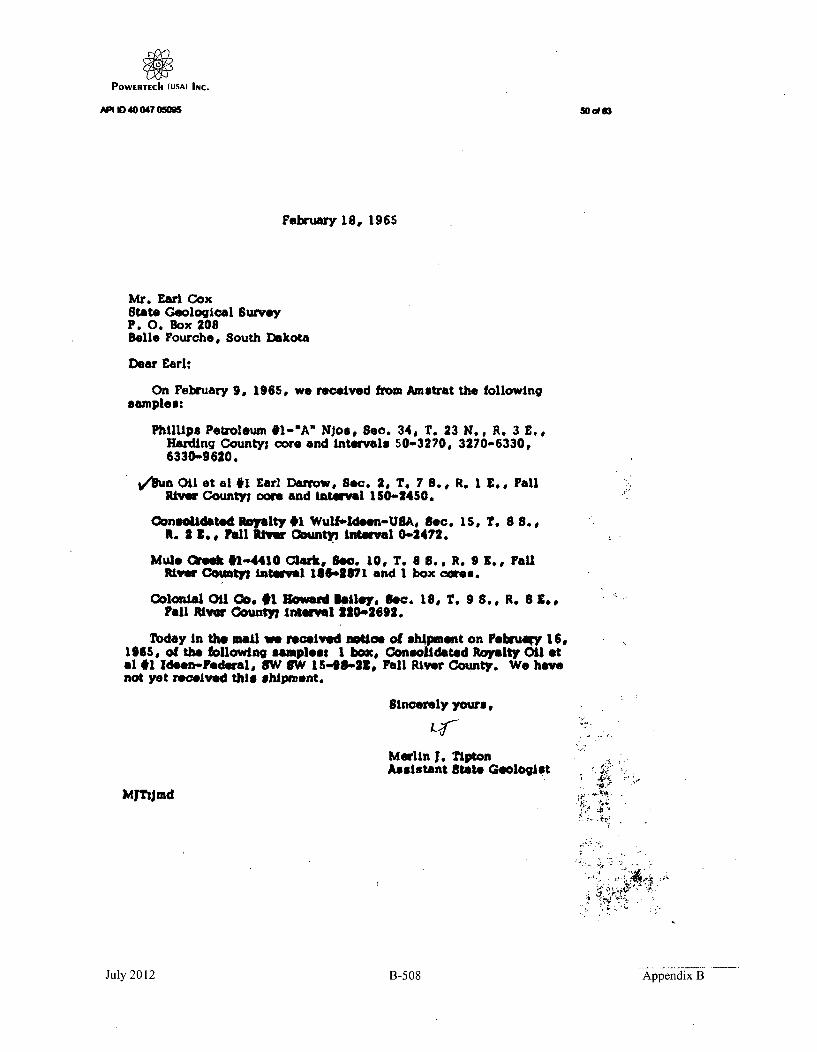
POWERTECh (USA) INC.
API ID 40 047 0505 50&o63
February 18, 1965
Mr. Earl CoxState Geological SurveyP. O. Box 208Belle Fourche, South Dakota
Dear Earl:
On February 9, 1965, we received from Amotrat the followingsamples:
Phillips Petroleum #1-"A" NJos, 8.e. 34, T. 23 N.. R. 3 E.,Harding County; core and Intervals 50-3270, 3270-6330,6330-9 620.
/a Oil et al #1 EalDarrow, Sec. 2, T. 7 S., R. I E., FallRiver County; oore and interval 10-2450.
Consolidated "oallty #1 Wulfiddeen-USA, Sec. IS, T. 8 8.,R. 2 Z., Fall River Oounty Interval 0-2472.
Mule eek #1-4410 Clark, Seo. 10, T. 6 8., R. 9 1., FallRiver Coity; inteoval 186-3871 and I box owes.
Colonial Oil Oo. 1 wa ailey.iSc. 18, T. 9 8.. R. 6 Z.,?all Rtivr 0ountyl inteirvl 220-4692.
Today In the moil we received notice of shMpmeut on Februagy 16,196S, of the following sampless I box, Consolidated Royalty Oil etal #1 Ideen-Federal, OW SW 154-5-22, Fall River County. We havenot yet received this shipment.
Sincerely yours,
Marlin I. TiptonAssistant State Geologist
MjTsjmd
4,• .
July 2012 B-508 Appendix B

POWERTECII (USAI INC.
API 10 40 047 050g
510(483
Nouhp13, 1964
Mr. rew1 J. CoxState. Geeowa"e saw".am 2083.11. lowsb., South Dakota
Doew Emwls
I am 4861681 a sepy of *be Mual WvautlasI-Lsetwlvg and 'I
SOW*. LOW41MOSPA RAW D"08 3 .191 DemVO, DOLL RVWa 0eMty,43Se e. 2, T. 75 , X. It.
8 6 W 2 o
(mrs.) Domes Jewa Heft*$h~dulstrative aita
irr 'tho State goolog~ft
July 2012
B-509
Appendix B

POWERTEChI (USA) INC.
API ID 40 047 0s5MD~ 52NOV 5 52 1W
SOUTH DAKOTA
STATE GEOLOGICAL SURVEYSCIONCU CZNTUR
Unlverulty Of Death Daket CimpusVURMI•ON Im
PM"oa."" Aaiatm 8tate GmeolOgs
Western Field OfficeBelle Fourche, South Dakota
November 4, 1964
Dr. Duncan McGregorState GeologistVermillionSouth Dakota
Re: Dolezal #I DarrowSEt4 SEV4-2-7S-IEFall Fiver County,Permit No. 361
South Dakota
Dear Duncan:
Enclosed for your files is one copy each of the followinglogs: sonic-gama ray, dual induction-laterolog, formationtester.
Sincerely,
Engineering-Petroleum Geologist
EC; cr
July 2012 B-510 Appendix B

POWERTECh (USA) INc.API ID 40 047 050M5
SOUTH DAKOTA
STATE GEOLOGICAL SURVEYSCIENCO CETER
Univerelt of @eaouth 3alka (CmpusVuRNJLlaON arm
rbane 064Wrt
Western Field OfficeBell* Fourche, South Dakota
September 22, 1964
SEr 21 194
IUNC*N J. MdC3O0l5~lDirsctrw and Stat.o Gologist
MEILIN a. ?iPTONAssisGant 8tate 00o0o06st
Dr. Duncan McGregorState GeologistScience CenterVermillion, South Dakota
Re: Dolezal #1 DarrewSE14 SEV-2-?S-lEFall River CountySouth DakotaPermit No. 361
Dear Duncan:
The pits have been filled and the marker pipe placed atthe above location.
After the samples have been received, it would seem thatthe bend can be released an this test.
Sincerely,
Earl Cox
Engineering-Petroleum Geologist
EC:cr
July 2012 B-511 Appendix B

POWERTECII (USA) INC.
API ID 4004705095 -,5o(83
%vrste~rn Fie~ld Ufrico[Ifl ie Foiirchr, Smi th Dakota
Mr. 'smorye IbolezaI, Jr.Tower' IY ildiiuj1700 i~ro;-dwayI'enver '., Coloraulso
!-' oeL.ýJ ;I i'iurrow
1*all l-iver Cokinty
IDetr :ýr. IPolozal:
-ire deta il1i of Llia a'hove test 1i;~vt heen released toF' inchiart I'
I f i if orw~a Li-uI fruits tsii i Les t is no I Pagyer ciptif iaienti a I,I woiilc allreciate yo~u wri~iny mle 10 Lhis affect.
~',, nc e re ly
I:arl CoxEnyineeriny-letroleir~. (,ruloijist
cr
July 2012 B-512 Appendix B

POWERTECIh (usA) INC.API 1040 047 05095 55 of 63
SOUTH DAKOTA
STATE GEOLOGICAL SURVEY?II:N4": (ENTERI.
tuli•l'le•ll. of Sonelh I; Mkola 41animpul i.
V hIF0II,hlO N 3-70,9 1.11 oI . 'rellro)11hiolll 624441-71 A-10-II• 1 :|1 " SIM, lgl
Western Fielo Officebelle Fourche, South [.akota
August lr1, 190-4
&ir. ueoryje ['olezal, Jr.MA- 'rower Ihuilding
FenverCo161 ti~o
f E: L'olezi~l $ 1I-aorrow-. 4* SEk4-2-75-lE
F~iI River Coun~tySouth LuakotiGPermidt No. ~3f,1
IeAr Mr. boleLisj:
I have received fromrun on the above test.
Schlumberfj r one col y of lotqs
'-se re~,uire two coi ies of a I IlogJs an recorus on oxIlor qi~s tests. Logs ant; recoros ý,gr retquirodL within -0) daysiof comjilet~ion of the test. This letter is uthiy to informyou of the status of our recores a~t this th1e.
I iq Ireciate Lfic cool eration givan hy N;r. Ayres -,no~Iit. e you i Itn adujitional %ý:ork in South t~akotce.
S inceroly.
Ei~ri Cox
FX:C F
cc: ou'ncon kNcuregjor
July 2012 B-513 Appendix B

POWERTECh (USA) INC.API H0 40 047 05095 o63
SOUTH DAKOTA
STATE GEOLOGICAL SURVEYSCINNCZ CENT=R
Uaiverwty of South Dheft cl amp"VIRMUIAON V"
Phone OftlfiVestern Field Office
Belle Fourche, South DakotaAugust 20, 1964
DEPNCAN J. MN353meDIb-w. and mcate OeolelMERLIN J. TxPTOE
An.ant State G~$tst
Dr. Duncan McGregorState GeologistVermillionSouth-Dakota
RE: Dolezal $l DarrowSEY SEV-2-7S-lEFall River CountySouth DakotaPermit No. 361
Dear Duncan:
We have been asked to keep information on this testconfidential for the six months period, unless releasedsooner by the operator.
Sincerely,
Earl CoxEngineering-Petroleum Geologist
EC: cr
July 2012 B-514 Appendix B

POWERTECh (USA) INc.
AP I I D 40 047 0 5
* 0 uTH I45, 0 KO.
State 7#ate rcwe4evv4d•TAE OPIC 30UING
PIERRE. SOUTH DAKOTA
July 7, 194
M. arl borrov
Dewey, South Dakota
Dear gir, 121 Tower BldI have been advised that Man Goorne Dalse l.j•. z a+Devr
obtained a Permit to Drill for Oil andc as on your land in bection 2 ,T 79 R 12 .
Occasionally, owners of land consider converting abandoned oil wellsinto water wells. Please advise ise whether or not you intend to convert theoil well drill holse-on ur- ladIto a Mr--e= 1U aT -en1-•unV5--e -
If you are considering making a water well out of the abandoned oilwell drill hole, special considerations are necessary to comply with theState' s oil and water laws. The abandoned oil hole must be properly pluggedand the water well properly constructed. All conversion work will be atyour expense. The cost will vary, depending upon the characteristics of thedrill hole, but such cost will be in the neighborhood of $5,000 or more.Usually another driller and drill rig will have to be arranged for. Thisother drill rig and casing and other materials will have to be on hand totake over m after the special oil well plugging is completed,because tkhdPrIIhoe cannot be left open for any appreciable length oftime without spoiling it. Approval of plans for construction of the waterwell will be required, and a bond covering proper conetructin may be re-quired. Also, a water right may be required. All of these arrangementstake cunsiderable time to accomplish.
Please advise me immediately if you plan to convert the oil well drillhole into a water wall. We both hope that a producing oil wall results fromthe drill hole on your land; however, if not and you are planning on a waterwell, we must start making arrangements now.
Sincerely,
J. W. GRIMESChief Engineer
cc state geoloqlgstOil a gas Board
July 2012 B-515 Appendix B

POWERTECh (USA) INC.API ID400470595. 58 of 63~SOUTH DAKOTA
STATE GEOLOGICAL SURVEY,4CIENt'F CENTER O (N.A J. Mc'ftk:GK
I'nivelsity of Soutl Dakola (ampus I~ert,,r Sa te h
VERM1L10N aIm MNKLIN J. TIVMMIPhone 8 1 A824slaflt state f;ehI.,ti,..
'.'eastern Field OfficeBelle Fourche, South [akota
July ,, 19 '..,
Mr. (;eorge bolezal, Jr.1121 Tower BuildingDenver 2, Colorado
f : Dolezal ;: DarrowSWJ• SE!j-2--7S-I F
Fall F•lver ;'ounty, SouthDakotaPermit No. •36l
[Uear Mr. Dolezals
The Secretary of the Oil and Gas Board has forwqrdedme a copy of your approved pers-it to drill it test. Thiswill he an interesting test and we wvill watch it withInterest.
During the drilling of oil tests in the State, Iscout them periodically. Our Rules require the use of asblow-out preventer, on wildcat tests as spelled out inParagraph 2, Section A, Pa'ge 10, of the Rules and Pegulttionswhich states:
"In all unproven areas, (wildcat wells)all drilling wells shell be equipped with amasLergatew or its equivalents an adequateblow-out preventer, together with a flow linevalve of the proper size and working lpressure.The entire control equipment shall be in goodworking condition at all times."
It is a pleasure to welcome you to South Dakotaand wish you success in your test.
Sincerely#
I
,Earl CoxEngineering-Petroleum Geologist
EC :cr
4c: •ecretary Oil and Gas BoardStite Geologist -
July 2012 B-516 Appendix B

POWERTeCh (USA) INC.API ID 40 047 05095 59 o 63
SURETY
July 2012 B-517 Appendix B

POWERTECh (USA) INC.API ID 40 047 05095 60 of 63
NO SURETY INFORMATION FORTHIS WELL AS OF 5/18/2011
July 201!2 B-518 Appendix B

Powertech (USA) INC.APN ID 40 047 05M 61 of 63
MISCELLANEOUS
July 2012 B-519 Appendix B

POWERTECh (USA) INC.
buffalo Times Herald
August 13, 1964
STATE Q1L IDRILLINGACTIVITY ON INCREASE
.Oil well- drilling activity, ini'South Dakota is expetted to in-creaIse wit.h the granting last.weei of' four permits. Dr Dunca,!. McGi~egor, state Geologistreports that the Oil and Gas"Board has graonted perits, ms to the"' C o'nsolidated Royalty Company,.Ga~sper, Womring, for 'tw ests in,
,FalIl River, Coun•ý' One. test,the. No. 1 Ieen-Fe-demrbl is three'mfe othe o een of_ Adk'nt oný'the H.-C. P-rter raphd. The testwil .r reh.•- an e.4imatd depthof :3300 fekt and test the Leosands of ~e~he ih'lu~sa Forma-
tion. The other permjt to- Con-solidated, is licateld, eight milesýsoutheast.,o.f- kdgenJTont- on the'Kenneth Helsel ranch, and willalso test theý -Leo zands.* Dritlingý onutiues on Cthe Dole-
zal N40. 1 Darrovv testj and h~reache.4 k-depth of 1700 feet on
i Augu.s 6L. The t•stjis located;fourteen miles northwest' ofEdgwrnont.
Gulf Oil ,has been granted 'twoperni-iti. 'One location is ninemiles southeast of Murdo, on theDoj, tHik. h raneh., The other istwelv6 mile~bssouth of Alurido on,Ithe 'Rsisel[ _Olson ranch. On!Augus_10i the Olson :test! was ingthe pr cess of being dHll•ed, ...
ino.ifurther information a Xa beingreleased at t~hat tame.
July 2012 B-520 Appendix B

i/ 1CF
0
1Ca0 BROPWAV. DENVg.n 524 M. YLILOWSTONE. 1A'4 T
South Daokota sItate Geolog~ical Survey NActn; Dr.,Ddocan KcGregorScience cenaterUniversity of South DakotaVermillioti, Souch IDekoca
V
P.,O NU
SQUrII DAKOTA WELLS NIG
ýýJ1lipS #1-,A Njos, 34-23N-3E,S&un Oil et al, RL Earl Darrow,Consolidated Royalty #1 Wolf-1
colon~iat oil Co., #i Howard U3
Harditng Co~.2-7S-IF., Foll kiver Co.)
ý- N-4
6's

POWERTECh (USA) INC.
Oil & Gas Database Search
APO ID 40 047 05147
Page 1 of I
1 Of46
d Abftffvio/ fcra
IT~i rudy
Record I of I
Well Information
API No: 4004705147 County:
Well Name: CONROY I PETERSON Location:
Permit No: 408 Total Depth:
Operator Name: CONSOLIDATED ROYALTY OIL CO Bottom Hole:
Permit Date: 11-22-1965 KB Elevation:
Spud Date: 12-11-1965 Ground Elevation:
Plug Date: 12-24-1965 Latitude:
Longitude:
FALL RIVER
NWSE 22-7S-1 E
2400
Minnelusa
3533
3522
43.429674
-103.983142
P&A
DRY HOLE
Well Field WILDCAT
Class: DRY HOLE
Fornui~lon
Mlnnekahta
Minnelusa
Converse
Red Marker
2nd Leo
statusType:
Formation TopsDepth ItII
1610
1690
1741
2158
2290
IPage I of I (goto t_.) Page: q-:r
http://sddenr~neoil~gas/search~resuts-oilgas.cfin 2/15/2012
July 2012 R-599 Appendix B

POWERTECh (USA) INc.API ID 40 047 05147 2 of46
COUNTY: FALL RIVER
NWSE 22-7N-1ELEGAL LOCATION:
API NO: 4004705147
PERMIT NO:
WELL NAME:
OPERATOR:
408
CONROY #1 PETERSON
THE CONSOLIDATEDROYALTY OIL COMPANY
PERMIT ISSUED:
PERMIT CLOSED:
FILE LOCATION:
11/22/1965
06/14/1966
7N-1E-22 NWSE
TARGET CODES:
WELL HISTORY / CHECKLIST
PERMIT TO DRILL / INTENT TO DRILL
WELL INSPECTION / SCOUT REPORTS
OPERATOR'S TECHNICAL REPORTS / MAPS
ADMINISTRATIVE / SUNDRY REPORTS
CORRESPONDENCE
SURETY
MISCELLANEOUS
July 2012 B-523 Appendix B

POWERTECh (USA) INC.APM ID 40 047 05147
WELL HISTORY /CHECKLIST
3 of 40
July 2012 B-524 Jl202Bn4Appendix B

POWERTECh (JUSA) INC.API 10 40 047 05147
4 of 48.0
V.U1,, F.ISTOR
Well Nam Conwaa #1 P&LaMARn . Pr.i'tt
Locatio:n NSI 22.s'1-•- nll.River Date of
Elev. a_ API lbo.
:m.nidenrt.ial Proa To
logs Received
Cu-tngs Received ............ Cores Received
rlriU Stan Records
lb, 408
remt , 12 - _
Cap Plug and Malker Set .2-2R-65
Surface Restored 12-28-65
Plugging Affidavit Sipied ,__Date
bod P•ased ,_Date, 6-14-66
Summary of Scout Repots
12-16-65 hieK L visit .•p.ud.d i12--
12-24-66 Plugued
12-28-65 Marker in glece - nits ftlulad A., lo0ation pmopthad
July 2012 B-525 Appendix B

POWERTECh (USA) INC.API ID 40 047 05147 5 of 46
PERMIT TO DRILL IINTENT TO DRILL
July 2012 B-526 Appendix B

POWERTECII (USA) INC.AP1ID40047 05147 anA
S. 011 Oil & ia. Bo.,
Ar,. radb. c.. Pl APPUCATION FOR PERMIT TO, FORM 2
rAJS OR LEASE. NAME[M DRILL [I DEEPEN [I PLUG BACK F.A. Peterson
[I SINGLE ZONE •W•.io.... ...
U Oil. WELL 0 GAS WELL [I MULTIPLE ZONE........... IFlEL AND POOL ORl WILDCAT
OPENATOR
THE CONSOLIDATED ROYALTY OIL COMPANY Wildcat
P. 0. Box 605Casper, Wyoming 82602 1840 acres
* ('\ I A) h (0)lf~lt .il o-Ih.t~ei *,,rn-,dr, h•l•H -Ilel~.i. l '.* t I 16'• EE. IE .- ROY
1980' from East Line and 1980' from South Line of Section 22, C N1AE• Section 22-7S-IETownship 7 South. Range I last, B.H.1.
Fall River
N-AEA-ND ADDRE•n O SURfCt E OWNER "LV:'ATIo. - NO-. OF W ..LL.S K.TCFrancis A. Peterson I 3522' - One (I-_P. 0. Box 5, Burdock, South Dakota 260 . OA. o CtAl Ol.. .NA W'IAN ADDRiE3SS _0? CNTAC;MR APPRIOXIMtATE VAT!-:
WORK WILL STAR
Bullock and Barnhart November 15. 1965P. 0. Box 2426
ill l 9b WITH AMW(Li DIILLI'IL, P11.FO WHOM rUnClIAtiED 4r-tr, rnd .dd res)
None
PHOlA)IA() CtASNING AND CE:M(:NTING PRIOGRAM
.F/K: Il" HOLE T SIZE OP CA,~sME !; OF C I Nr G.1 "W , I -y.r.v io 5:1-ON .) . ..!) i .... A -
l2. i -- 8-5,TI 1 24 lb.-i, . ._ '._ ___pwilen to as _urfaca casing in SpearfLsh fouration o. shut off anticipated water flows
fr-te noa ad Suiqdance formations-.-
Itl:SCRIUI- PROPOSCID OPERATIONS. IF PRIOPOSAL IS TO DE.EPEN OF PLUG BACK. GIVE DATA ON PRESE1-T PROUC-TIVE ZONEAND PROPOSED NEW PRODVC.'TIVE ZONE. GIVE BLOW OUT PuRKVnTFv-It PFOalAM IF A.NY
Blow Out Preventer: Schaffer 12" Series 900 Mechanical doublegate.
A 7-7/8" hole will be drilled from the base of the surface casing to total depth. In theevent oil or gas production is indicated. either 4-1/2" or 5-1/2" casing will be setthrough the productive zone or &ones and cemented with an appropriate amount of cement.In the event this test is abandoned then the hole will be plugged in accordance with theRegulations of the State Oil and Gas Board.
Anticipated Formation Tops: Dakota 205'; Lakota 398'; Ssmdance 687'; Basal Sundance 996';Goose Egg 1295'; Minnekahta 1537'; Opeche 1578';Hinnelusa 1615'; Converse Anhydrite 1742'; Red Marcker 2130';2nd Leo 2255'.
TTLE President : ovember 17,. 1965
00 NOT ilRItr RrE. ILOV TI41Q lI.1 •% J
I~~~ q,.1AINY
F TI rInNS
•1-4 tlFjFI K AC "rF SAMPLES AND CORES IT TASEN. MUST BE SUBIWIUED.
2 FA~t't!. ND ORS IF TAKEN. BEOW EH.MTR 5MFO
INATRUTS IIONSI[r-s.-~ar: "Vt! totfltFrm UOAA.IJ for ,,llt'oFrle proplP-.I to pentorm tfl-n -etl opertons. &P indhcated. on all ty•es of land, rd tleam, ftr
it, by aithr a vFxwral tr a Sta. a..rnry. or both. purmfrnt to atiluabIe Federal atd/nr State laws and ngtallons C• 11.pplle.6fr Fedle r rn..I.Is,, s•b ... ,pewfMI 101U. -,e0 liS t , I I lefori b,4r0. oseoo.0*O1s.IlcrdF ',.- ir,.I•rirt is tIt n.Ft-trrl ,)he tarn st..v r At ., UlFIVCI .-t *ue far-. Ire-blo, or a to . ew hi. rsolr. r•b 1hl form wilth Vpp r-pr-
it thr well Is to ha .r Iae. bemn. dirat-ioealnY dr-IUe. as aite and show by a.tb hsd nrata. If nro .bory. the ooriltnare Ilarllon of rite I-tl, F,' y pm-b or objective pIrtad~nl- sonv
FileO 3 coo". or this forim artR senrs,I. O& a" 0o hnAl. Plerf, .
b-4-jJ Srtltt 6110"istaI and 6SO" Eel of rte@ Nosth-tw Corner of So-lion 16.1
July 2012 B-527 Appendix B

POWERTECh (USaM INc.
0hD 41047 05147 I7of 46
SECTION 22T.7 S.-R.I E., BLACK HILLS MER.
FALL RIVER COUNTY, SOUTH DAKOTA
SCLrImago Ohalve
SMeAiNM Aft EX-POPM... gg PMein
rE COUNTY ROAD
F, A. PETERSON NO. I-1 .
f---_ _ _ _ _ _ I i*_ _ _ _ i
LEGENDU, s. ov0rn~ /t Brma"Cp Comrne ................. !Orl•ol b row e c'oner,proporly morkodfrmly soet..... P.Iron pipe Wetr irportionoto ditonm .............. R.
rnew .toblished by Where eS Indicated ........... RDepenlent Rfetrm..........................Protrow ion .......................................Weall lo tio • ....................................
ELEVATIONS:Before groding
LOCATION 3522R. P. IOO'N, 3IlR.P. M00 S. 381R.P. lOO'E. 3MR.P. I00' W. 3j1t
ELEV'S. REFERREO TO:U.S.a.s. uM TTI WUR i4
0b• ý~rSURVEY*. ANPLATE @W.
WORTHINGTON, L.ENNART & ASSOCIATEs, INC.WO Southl Low# Ve., Casserw.vmbf
Wrest "ofe Woo OWd "Red divionce.1I.SuA&IM .. su* u .
PLATTED FIELD NOTES OF SURVEY~ .I4
MAfARKING WELL- LOCATIONNW11S9k. SECTION 22 ~..
CON ROY -SUN~ FROST, CA SPER 7YOMIN,~
R0 Vi *WTI# "am
July 2012 B-528 Appendix B

PowETrtEch (USA) INC.API ID40 047 05147 8of14
wELL INSPECTION ISCOUT REPORTS
July 2012 B-529 Appendix B

POWERTECh (USA) INC.API 1040 047 05147 9 0(46
Permit No. 408
STATE GEOLOGICAL SURVEY
Scout Report
Date Scouted 12-28-65
Owner ConRoy
Designation of well #1 Peterson
Location: Sec. 22 T. 7 It. S. R. I W.
Fall River _County, S. D. Total depth 2400 feeP
Casing Record:
14 30 Ft. Ft.
8 5/8 1125 Ft. Ft.
Work In progress at Ume of visit. -None. .
22
Developments since last visit: - - -
Abandonment marker in place. Pits filled and l 1 1location smoothed.
Remarks and recommendations:
Rig stacked at location.
Scouted by Earl CoxGeologist
Dunc~an J0Obaregor, 8tate(•logist
July 2012 B-530 Appendix B

POWERTECh (USA) INC.API 1040047 05147 10of48
Permit No. 408
STATE GEOLOGICAL SURVEY
Scout Report
Date Scouted 2.L-24-65
Owner
Designation of well #1 Petersa
Location: Sec. . 22. T 7 1. S. R. 1 E .W/.Fall Rivezr .County, S. D. Total depth 2400 feet.
Casing Record:
14 30 Ft. Ft.
8 5/8 1125 Ft. . Ft. ____
Work in progress at time of visit: IPlused as folows:
1925 - 1850 25 sacks 3rd C0nverseU95 - 1320 25 sacks Base Surface casi•-.
-. j- 22I . 0 I
Developments since last visit ,-
Run Oual Induction and Soni Ganna Ray log IAvtatw1: ,, pv l:'ooese sampl.es .No coves taken, no shows abser-ed, no trests rtm.
Remarks and recommendations:SazzIls toPS:
Ibiunkahta - 1610Minnelusa - 16902nd mwer~se - 17413rd Oonverse - 18714th Convese - 2020Red Marker - 21582nd Lto - 2290 (tite - no shohs)
Scouted byWA Im- Cf_%. 1eAt
Approved ~
July 2012 B-531 Appendix B

POWERTECh (uSA) INc.APItD40 047 05147 11 od46
First Report
Permit No. 408
STATE GEOLOGICAL SURVEY
Scout Report
Date Scouted 12-16-65
Owner ConRoy
Designation of well #1 Peterson
Location: Sec. 22 T. 7 N.%. R. 1 E.WN.
Fall River County, S. D. Total depth 1140 feet
Casing Record:
14N 30 __Ft. Ft.
8 5/8 112§ Ft. Ft.
Work in progress at time of visit,Had Just finished cementing surface casing...
I I22
I I
Spudded: 12-11-65Set 30 feet of 14' conductor pipe with 11 saoks.Set 1125 feet of 6 5/8 surface casing at 1136 with . .
850 sacks.Slight flow from basal Sundance that was controlled with heavy mud.
Remarks and recommendations: Sample tops:Dakota 260Lakota 460Morrison 560Sundance 750Spearfish 1122
Elevation: 3522 gd.
3533 K. B.
Scouted by Earl Clx. nenlan
Approved byDufc-anJ . McGre ,State 1 Moot
July 2012 B-532 Appendix B

POWERTECh (USA) INc.I
10 40 047 05,, /&rr2/
Pro
.,".•L -i/ " •,12of 46
C e ,j D/"•..
r-l.r St
4~ o
~ 0
p,'-,-)4-/ e/- . c S. a- '"VI-1,€
" , / &.4A /1 "7. .-L -# (,-,y.e"o.M, fcis o .#r .
K/.- .3 C,- r-
42-a-
h7/c
dig tu~L~/ ~34~- /e9$~*~ ~
C7,
•- ,.•.,.
) 0&,•../' 7
July 2012 B-533 Appendix B

POWIERTECII (USA) INC.
API ID 40 047 05147 o
C4W51 ~t~,22ý TJ/s. Rir
12 -jI~
e/2 $440 -
I- ju
July 2012 B-534 Appendix B

POWERTEcII (USAI INC.
a4ýt_/2.a- 24
Pr" ~ 1-1 - 6
July 2012 B-535 Appendix B

POWERTECII (USA) INC.
roT TPS- e Ar
FTLGTR1'U,# Fit"!:
~'i. 4
V -1 TO:PIT'AL
ot L, 44A (j44. a2
r) rH P:
t~~~p C;IN 0:*F i 3 -
f';AP PLMc 1)G~~: 4 2"LY4
T, T T rýT' T Pr E
BOND RELr.AS!Mr: 4'
July 2012 B-536 Appendix B

POWERTECII (USA) INC.AP 10 40 047 05147
OPERATOR'STECHNICAL
REPORTS / MAPS
16ol46
July 2012 B-537 Appendix B

POWERTECII (USA) INC.API ID 40 047 05147 17 of 46
ConRoy #1 F. A. Peterson
C NE SE 22 T7S RIBFall River Co., South Dakota
CONTENTS
SU•ARY Page 1
GEOLOGIC RECORD Page 3Remarks Page 3
'Sample Description Page 3
DRILLING RECORD Page 8Remarks Page 8Well History Page 8Bit Record Page 9Casing Record Page 9Mud Program Page 9Plugging Record Page 10Penetration Rate Page 11
July 2012 B-538 Appendix B

POWIERTECII (USA) INC.
API ID 40 047 05147 18 of 46
ConRoy #1 F. A. PetersonC NE SE 22 TS RIEFall River Co., South Dakota
SUMMARY
Operator:
Name:
Location:
Elevation:
Status:
Geologic Record:
The Consolidated Royalty Oil Company
#1 F. A. Peterson
C NE SE See 22, Twp 7 South,County, South Dakota
Rge 1 East, Fall River
3522 G., 3533 K.B.
December 10, 1965 Complete: December 24, 1965
Plugged and abandoned
Formation
DakotaFusonLakotaMorrisonSundance
Canyon SpringsSpearfishGoose Egg
MinnekahtaOpeche
Minnelusa2nd Converse SSConverse Anhy3rd Converse SS4th Converse SSRed Marker2nd Leo SS
Total Depth:
Formation Tests: None
Cores: None
SpI. Top
260380146052074o ?
1110112014201600165o0169017401810187o202021602290
2400
Schl. Top Datum
260 -3273383 43150458 -3075524 .3009753 12780
1106 -214271120 ,24131371 .21621613 -19201648 .18851685 .18481741 -17921821 +17121879 #16632024 .15092166 +13672295 .1238
2400
By Schlumberger,Sonic & CalGama RayDuallnd- LL
Newcastle, Wyoming5"(1I)5"12"5"1
1136-2393300-2393
1136-23941136-2394
-1-
July 2012 B-539 Appendix B

POWERTECII (USA) INC.19of46
ConRoy #1 F. A. PetersonC ME SE 22 T7S RiEFall River Co., South Dakota
SUiAiY (Cont'd.)
Drilling Mud:
Drilling Contractor:
Geologic Supervision:
Mo-Mar Mud Company, Casper, Wyoming
Barnhart & Bullock Drilling Company,Casper, Wyoming
James D. Copen, Consulting Geologist,Casper, Wyoming
-2-
July 2012 B-540 Appendix B

POWERTECh (USA) INC.
ANID 40 047 05147 20 of 46ConRoy #1 F. A. PetersonC NE SE 22 T1S RiEFall River Co., South Dakota
GEOLOGIC RECORD
Remarks
The test was proposed primarily to investigate a permeabilitypinch-out of the Second Leo Sandstone member of the Minnelusa. The testwas located approximately midway between a down-dip dry hole having 40feet of permeable sandstone which was wet with a show of oil and twoup-dip dry holes, both of which had no permeable sand. One of the up-dip tests had good oil staining in the Second Leo. Secondary objectiveswere the Canyon Springs member of the Sundance and the several Conversesands of the upper Minnelusa. The test was proposed to drill to a totaldepth of 2500 feet; or 300 feet below the Red Marker.
In drilling, a normal sequence of formations was encountered.The Second Leo was found to be thin, dolomitic, tight and had no shows.The various Converse sandstones were found to be nicely developed buthad no shows. There were no cores or formation tests.
The test was plugged and abandoned at a depth of 2400 feet;approximately 240 feet below the Red Marker.
Sample Description
Samples from the surface hole (0-ll40') are generally poorto useless, being predominently material which was recircu-lated by the very heavy drilling mud used to control waterflows. Samples were caught both from the pilot hole andwhile reaming. The descriptions below are partly of each,depending on which seemed the most representative. Samplesfrom 1140 to total depth were of uniformly good quality.Sample intervals are 10 feet with the exceptions notedbelow. The samples are in possession of the American Strati-graphic Company, Billings, Montana.
20' Samples
100-260 Sh - drk gry to blk, fial; occas silt strk; Pyr
DAKOTA 260
260-300 SS - gry partly mottled blk, wh, Th,, v/firm w/poorto no porosity, occas blk sh prtg, NS; Pyr
Begin 10' Samples
300-310 Sh - gry to brn-blk, partly mottled w/blk carb material;SS - as abv grdg to Siltst; Pyr
-3-
July 2012 B-541 Appendix B

POWERTECII (USA) INC.
API ID 40 047 05147 21 of 46
ConRoy #1 F. A. PetersonC NE SE 22 T7S RIEFall River Co., South Dakota
GEOLOGIC REORD (Cont'd.)
310-340 SS - wh to it gry mottled and banded w/blk, fg, vht, NS;little Sh - a/a; Pyr
34•.360 SS - a/a grdg to v/argill Siltst; little Sh - v/it gry,wxy to silty; few Siderite pellets; Pyr
360-370 Same a/a w/free Sd - fmg, NS370-380 Same a/a w/abun free Sd$ little SS - cir, fmg, v/frm,
ex porosity, NS; Pyr
FUSON 380
380-420 Sh - it gry, wh, pale lvndr, wxy; decr SS - a/a420-430 Sh - v/drk gry v/brn cast, w'Xy430-440 Sh - a/a; Sh - wh, pale grn, wxy440-460 Sh - pale grn to vh, v/sdy, vxy; little Sd - free; Sh a/a
LAKOTA 46o
460-480 Sd - free, feg, poor sorting; NS; Sh - a/a; Pyr480-500 Same a/a; little Sh - pale grn, sdy grading to SS-pale
grn, v/argll, NB; Pyr
Begin 20' Samples
500-520 SS - f1g, fri, porous, NB; SS - vh, pale grn, v/argill; abunfree Sd; Sh - brite grn, wh, gry, blk, ady; entire splballed-up v/gry Bent
M)RRISON 520
520-560 Sh - blu-grn to brn-gry, wxy; little SS - clr, meg, v/frL& porous, NS; abun free ad
560-580 Siltst - deed wh w/thin even bands of blk carb Sh; Sh - blk,silty; Ls -drk gry, dna; abun Pyr
580-600 Same a/a; Sd - free, mvcg, ang to rd, NS; Pyr600-660 SS - gry, vf-vcg, v/Pyrtc, fri, argill, poor porosity, NS;
Sh - a/a; abun free Sd660-910 Samples this interval were composed 100% of recirculated
material, one fragment of grn, glauc siltstone observedin 740-760 sample is thought to be near the top of theSundance
Resume 10' Samples
910-920 Mostly recire material; Siltst - red-brn, v/argill & soft920-980 SS & Siltat - red-brn to wh, fag, partly w/ex porosity, NS980-1040 SS - it gry-grn, fmg, partly w/ex porosity, NS; Sh - blu-gry,
wxy
July 2012 B-542 Appendix B

POWERTeCh (USA) INc.
API 1040 047 05147ConRoy #1 F. A. rersonC NE SE 22 T78 RIBFall River Co., South Dakota
GEOLOGIC RECORD (Cont 'd.)
i040-.090 Sh - blu-gry, wxy, blocky; little SS a/a1090-1110 Poor samples, apparently same a/a
CANYON SPRINGS 1110
1110-1120 Poor spl; abun free sd - fvcg, clr qtz,well rdd, NS
SPEARFISH 1120
1120-1140 Same a/a; increasing SS & Siltst - red-b2tite
1140-150 No sample1150-1160 Same a/a w/occas Anhy
lrg frns are
,n, vfg, argill,
me clr; occas Anhy
Begin 20' S8
1160-11801180-1420
aples
Same a/aSiltst - red-brn a/a grading to Sh
GOOSE EGG 1420
of sam
1420-1580 Anhy - wh, buff, dns to xln; Siltst & Sh - red-brn1580-1600 Siltst & Sh - red-brn v/little Anhy
KIEUNXASTA 1600
1600-1640 Le - wh, pnk, viol, dns; abun Anhy & Sh a/a
Resume 10' Samples
1640-1650 Same a/a
oPEcu 1650
1650-1690 Sh - brite red-brn, earthy; little LA & Anhy a/a
KIENNIl/A 1690
1690-1700 Sh - brite red-brn aa, partly ady; Dolo - red-brn, dns;Anhy - vh, xln
1700-1720 Sh - red-brn a/a, bcg silty; sbun Anhy - vh1720-1740 Silt & Sh a/a becoming edy, no porosity, NS; abun Anhy
-5-
July 2012 B-543 Appendix B

POWERTECh (USA) INC.
API ID 40 047 05147 23 of 48ConRoy #1 F. A. PetersonC NE SE 22 T7S RiEFall River Co., South Dakota
GEOLOGIC RECORD (Cont'd.)
SECOND CONVERSE SANDSTONE 1740
1740-1746 SS -Sb
Circ 1746 Same1746-176o same1760-1790 SS -
Sh1790-1810 SS -
wh, tan, orng, fmg, argill, tite w/rare porosity, NS;& Anhy a/aa/a, NSa/a, mwh, pnk, orag, mcg, ex porosity in part, NS; little& Anhy a/aa/a to viol, mg, argill & tite, NS; Sh & Anhy a/a
O-W-VERSE ANHYDRITE i8lo
i80o-i84o
1840-1870
1870-1876
Circ 18761876-1890
1890-19001900-1940
1940-19701970-19801980-2000
2000-2020
2020-2030Circ 2035
2035-20402040-2060
206O-207O2070-21002100-21102110-21202120-21302130-2160
Anhy - wh, buff, dns, xln; Dolo - pnk, viol; Sh - britered w/occas grn mottling; diminishing SS a/a
Dolo - gry, viol, dns, gran; Anhy & Sh a/a
THIRD CONVERSE SANDSTONE 1870
SS - wh to orng, mg, partly argill, v/fri, fair poroL Sy,M; Sh, Anhy & Dolo a/a
Same a/a, NSSS - same a/a to red, fmg, v/argill & tite; NS; Sh, Anhy
& Dolo a/aSame a/a w/decr SSDolo - tan, wh, gry mottled blk, dns to gran; little SS,
Sh & Ashy a/aolo - a/a v/abun smoky cht; little Anhy & Sh a/a
Dolo - a/a to tan, brn; abun AnhySS - wh, ing, dolotc, hd & tite, NS; Dolo - a/a to wh, pnk;
abun AshyDolo & Anhy a/a
F0LMTH COMMXISE SANDSBTONE 2020
SS - cir, mg, fri, porous, NS; Dolo & Anhy a/aSS - wh, Mg., fri, porous, abun free Sd, NS; Sh, Dolo &
Anhy a/aSame a/aAnhy - wh to brn, dns to xln; little Dolo - tan, pnk;
diminishing SS a/aSame a/a w/abun free Sd - mcg, NSDobo - tan, pnk, viol, dna, gran; little Anhy, Sh & SS a/aAnhy - vh, dns, xln; Dolo - tan, pnk; abun Sh - redDob - vh mottled viol, dns; little Anhy & Sh a/aSame a/a v/free SdSame as 2110-20 v/little SS - wh to lvndr, fg, poor porosity,
KS
-6-
July 2012 B-544 Appendix B

POWIERTIECII (USA) INC.
API ID 40 047 05147 24 of 46
ConRoy #1 F. A. PetersonC NE SE 22 T7S RIEFall River Co., South Dakota
cGhOLOGTc RECORD (Cont'd.)
RED MARnR 2160
216o-2170 Same a/a v/little "Red Marker" Sh - red, lvndr, splntry,sub-metallic, specular sheen
2170-2180 Abun "Red Marker" Sh v/Dolo, Anhy & SS a/a2180-2190 Dolo - wh, tan, gran to dns; abun Anhy; little "Red Marker"
Shale2190-2200 Little SS - wh mottled viol, rmg, tite, NS; Dolo, Anhy &
abun "Red Marker" Sh2200-2210 Sh - dead blk, v/hd & brtl, fisl; Same a/a2210-2220 Same a/a v/Dolo - lt to drk gry, gran to earthy2220-2260 Dolo - tan, brn, vh, pnk; little Anhy; little SS - wh, fmg,
tite, NS; Sh a/a2260-2270 SS - gry, feg, dolotc, tite, NS; Dolo, Anhy & Sh a/a
Begin 5' Samples
2270-22752275-22852285-2290
DOlo - gry to drk bra, microxun; SS - a/a, NSDolo - a/a; little Anhy - whSh - blk, brittle, flakey; tr SS - gry, fmg, dolotc, tite,NS
SECOND LEO SARDSTONE 2290
2290-2300 SS - gry, fmg, v/dolotc grading to sdy dolo, tite, NS;little Anhy - vh, xln
2300-2311 Dolo - med gry, fn xlnCirc 2314 Sh - blk, silty, brittle2314-2320 Dolo - med gry, microxln, prtly w/sctrd sd grns2320-2325 SS - gry to vh, fmg, v/dolotc, tite, NS
Resume 10' Samples
2325-23352335-23452345-23552355-2363Circ 23632363-23752375-23852385-2390
2390-24002400
Dolo - gry to wh, microxia, tite; Anhy - gry, sdySh - blk, silty, hdDolo - gry, microxin, hdDolo - a/a w/abun Anhy - wh, xln88 - gry, mg, v/dolotc, tite, NSDolo - med gry, microxln; little Anhy - wh, xlnSh - blk & drk brn, silty, carbDolo - med gry, microxla; little SS - wh to buff, fmg,
dolotc, tite, NSSS - a/a, NSTOTAL DEPTM
-7-
July 2012 B-545 Appendix B

POWERTECh (uSAý INC.
AP 10 40 047 05147 25 of 46ConRoy #1 F. A. PetersonC NE SE 22 T7S RlEFall River Co., South Dakota
DRILLOiG RECORD
Remarks
The original proposal was to drill a 12-JJ4-inch surface hole-o a depth of approximaaely 1050 feet and set surface casing at thatpoint to shut off water flows which were anticipated from the Dakota,Lakote and Sundance Sandstones. From under surface a 7-7/8-inch holewzs to be drelled to the total depth of approxlmately 2600 feet.
In practice, 30 feet of 14-inch conductor pipe was set in 30feet of 17-1/4-inch hole. 8-3/4-inch pilot hole was drilled 30-645feet, followed by 7-7/8-inch pilot hole 645-906 feet; reamed 12-1/4inch from 30-847 feet; 7-7/8-Inch pilot hole 906-1140 feet and reamed12-1/4-inch from 947-1140 feet. 8-5/8-inch surface pipe was set at1136 feet resulting in a successful water shut-o-'f. The balance ofthe hole was drilled 7-7/8-inch to the total depth of 2400 feet.Lost circulation was encountered mcmentarily at 2025 feet, but wascured by the addition of lost circulation material. Because of devia-tion problems, 5-1/2 days were required to drill and ream the surfacehole. Casing was set and the balance of the test was drilled in 8days.
The test was drilled with a Unit U-34 rig utilizing two 671 GMDiesel draw works motors (300 HP) and a 214P Oil Well 7-1/4" x 14" mudpump with two 6-110 GM Diesel motors (600 HP).
Well History
12-10-65 Rig up; drill 30' of 17-1/4" conductor hole and set 30'of 14" conductor pipe
12-11-65 Drill 8-3/4" surface hole 30-663'12-12-65 Drill 8-3/4" surface hole 633-645'; drill 7-7/6" surface
hole 645-852'12-13-65 Drill 7-7/6" surface hole 852-906'; ream surface hole
30-565' to 12-1/o"12-14-65 Ream surface hole 565-847' to 12-1/4"12-15-65 Drill 7-7/8" surface hole 906-1140'; ream 847-947' to 12-1/4"12-16-65 Ream surface hole 947-1140 to 12-1/4"; set surface casing;
W. 0.C.12-17-65 W.0.C.; drill cement 1093-1140; drill 7-7/8" hole 1140-
1340'12-18-65 Drill 7-7/8" hole 1340-1656'12-19-65 Drill 7-7/6" hole 1656-1919'12-2o-65 Drill 7-7/8" hole 1919-2046'12-21-65 Drill 7-7/8" hole 2046-2196'12-22-65 Drill 7-7/8" hole 2198-2301'12-23-65 Drill 7-7/8" hole 2301-2400' total depth; prepare to log12-24-65 Run logs; plug and abandon
- 8-
July 2012 B-546 Appendix B

POWERTECh (USA) INC.API 10 40 047 05147 2 of46
ConRoy #1 F. A. PetersonC NE SE 22 TTS RIEFall River Co., South Dakota
DRILLING RECORD (Cont'd.)
Bit Record
Bit # Size Make Type In Out Footage
1 8-3/4 h'Co 0SC3 30 646 Dr 616'/12 hra.2 7-7/8 HTCo OSC3 646 845 Dr 199'/16 hrs.3 7-71/8 H'Co OWC 845 906 Dr 61'/ 7 hrs.4 7-7/8 hTCo LW3 906 1120 Dr 2.4,'/16 hrs.5 7-7/8 HTCo LW3 1120 1140 Dr 20'/ 2 hra.6 12-1/4 Smith DT 29 667 Rm 638'/16 hrs.7 12-1/4 Smith DT 667 847 Rm 180'/ 7 hrs.8 12-1/4 HTCo OSC3 847 1140 Rm 293'/ 8 brs.9 7-7/8 Smith K2PJ 1140 1462 Dr 322'1/12 hrs.
10 7-7/8 Reed YSIR 1462 1656 Dr 194'/ 8 hrs.11 7-7/8 Smith K2PJ 1656 1854 Dr 198'/12 hrs.12 7-7/8 HTCo OWVJ 1854 1948 Dr 94'/10 hra.13 7-7/8 Smith T2J 1948 2046 Dr 98'/12 hrs.14 7-7/8 Reed YMR 2046 2153 Dr 107:/13 hrs.15 7-7/8 Reed YHGJ 2153 2228 Dr 75'/12 hrs.16 7-7/8 HTCO OWV 2228 2273 Dr 45'/ 8 hrs.17 7-7/8 Smith 4W4 2273 2321 Dr 48'/ 9 hrs.18 7-7/8 HT!Co OWC 2321 2400 Dr 79'/10 hrs.
Casing Record
30' of 14" spiral weld conductor pipe at 30' w/10 ax1125.36' of 8-5/8" surface casing at 1136.36 KB w/ 8 50 ex
Mud Program
The surface hole (30-1140') was drilled with weighted mud inanticipation of water flows from the Dakota, Lakota and Sundance Sand-stones. The mud was maintained at an average weight of 11 lb/gal andan average viscosity of 50 sec/qt.
After surface casing, the balance of the hole was drilled withmud having the following average characteristics:
Weight 10.4 lb/gailViscosity 38 sec/qtWater Loss 13 cc. API
A momentary loss of circulation occured at 2025' in the 4thConverse Sand tone. The condition was remedied with very little loss ofmud by the addition of lost circulation material. No further trouble wasencountered.
-9-
July 2012 B-547 Appendix B

POWERTIECI. (USA) INC.APOID 140 047 05147 27o(48
ConRoy #1 F. A. PetersonC NE SE 22 TTS RiEFall River Co.. South Dakota
MIILLING RECCRD (Cont'd.)
Plugging Record
Used 50 sacks of cement to plug as follows:
1925-1850 w/25 sacks1195-1120 w/25 sacks
In lieu of a surface plug, a cap was screwed and tack-welded to the surface casing to permit later re-entryfor conversion to a water well.
-10-
July 2012 B-548 Appendix B*

POWERTECh (USA) INC.
API ID 40 047 0514728 of46
Co~op, #1 Pt~EaEsomNESE2 T7S RIE
FALL RIVENk CO-, SO.'
PEWHATIN RATE
A~# ~ AP~UIAV
July 2012 B- 549 Appendix B

POWERTECh (USA) INc.API ID 48 047 05147 29 of 46
ADMINISTRATIVE /SUNDRY REPORTS
July 2012 B-550 Appendix B

POWERTECh (USA) INC.API ID 40 047 05147 30ol,45
a. Dek. Oil a 0.u BOadFORK 7
PLUGGING RECORD
operator Add.,.
THE 0ONSOLIDAYED ROYALTY OIL COMPANY P. 0. Box 605, Casper, WyomLnit 82601NPan or L.eae ",I. No. ; I-- - R.iosr-
F. A. PetersonJ I WildcatLonotrn of Wall on.nT.vRile or Black & Suhey 't ,0,u1980' IEL and 1980' FSL of Section 22-7S-Ei Pall River
ApptlaUoo tA drill Lhbi wellII ans |l :iol lhoi well ener Cho",-ter of well 11t -otple11t1- 11h.1111-• pt lo '..... ..... .. o' &W . . .. r. Oil orbO /ft ........... M I.THE CONSOLIDATED ROYA3T_ OIL eo - - I - YesData plolitgd:. Totol deplh Ao-nt ,WIt pnd•dnuel whenf 91p.ted:
IOIl. b11., dy0 Gas (M1kV dog. W-111btor y
12-24-65 2400' -- - -Nane. W . h . o00 1stromldo contain. Fluid onOtent of o•alh fmrrnall.o Dep1th interval of each forltnhf 0 st'., kwlnl & depth of plug, ... dItng oIl no Is, IPZdlt. WhliS l n*I te at, hich,, . 'nn.. n tn
I., n.Welinoen voUbna
No oil or gas. - -- _ 1925' to 1850' - 25 ft:
Re+fer to veil s,-ry . 1195' to 1125' - 25 ex.
and sample.deckriptio
for details
CASING I(tV'<IIII- + -•0 -I :. +. .. f,+ P,,.• o. . + t +,- .i . I S+ I..r, tor., .. . . .... , ,• - ,, +, , •+ t + ~I ll *.tOIAmli[ 31I rlF.ti pit, ,I (ns. T14
8-5/8" 1125.36' I All _ Guide, s.oq_ float collar and sixcentralizersS.-............ ... .I ...... .... ++ + ++; . ...1" +
It,. 11 A',!1 nith mud-liden ho(ld. o"ordlnl to {milOns? Infl,'.,tn Ihflo-n brtmeolfn tultln lttlnl frt., Io
Yes a..u l Ps ||fl'.l-t 1035i0, ,t,oi ,l,,t ,, Vtlhlr Infnrrnttnn r 01.040w l~sts IIn.. ltist well si+ ,1I,,outunlt.,,h ,I-on nso"• tr. hflnst~rnt.t.. II, l~ rnr~Il..nt (tll..1|£,.tpto.g•,l ,,, ' . 'I..tlt+ tottha0n' rb5 i m • Orll dI tnfe• ; i)f.t .I er rnlt):nonaltd .td'-,, ,r+,,,te,,.n tl'
I. t,: ,y: ,rI . . 1m ee nthnrlhleenm[ om llnn o e+ftai ri. WO W~l. .. .. +i +nh n: , ro I-,. nun€t o. ++ t oll, ll noljhllto 0,.r u,)s*+1.,,++ii1ltl wh"h no.51 hI r'hqotr•"I.
With the verbal approval of Mr. Karl Cox, State Engineer, the cement plugs normally set tothe bottom and top of the surface casing wera omitted to allow the surface owner. Mr.Francis A. Peterson, P.OBox 5. Burdock, South Dakota to convert the cased surface hole intoa vater vell pending approval of Oil and Gas Board and Water Resources Commission. The waterproducing sands of the Dakota-Lakota series, Sundance and Basal Sundance formations weresuccessfully cased oftf with 8-5/8" 24 lb. casing set in the Spearfish @ 1128' ground level.The surface casing string was cemmuted to surface vith 850 sacks of cement with good returnsof cement slurry (estimate 50 bbla.) flowing to reserve pit during displacement. No additionalvater zones were encountered while drilling below the surface casing to total depth. A casingprotector with the abandonmsnt marker welded on top has been screwed into the top casing collarat ground level and tack welded to permit later re-entry for conversion to a vater vell.
r-u0e. this I.* toql1.hin of -4Janary It s6 6
Slew of WyQ)*W.c.,03 NATMO8A ISl50Otut.o Ala t
In. 00 tethe on.'=,r-~n Loytely me,11 =0 invonrln ons. .t sdatrd. tha. hok tnon tul ,Ino- to h_0.@ the W11,, repot nd! that he has haonwlde of the tots tested tZIhwn, sod sa10 id enpf 1. I.-. Mn orl
sob oei~ei -. 4 -n.5n to won me this . 13thuoi or - January it .I 66
SEAL *. *
M ooignn..PIlo)7 4 .1 b~.. Notr oubillk in and fo MX8Ncotioty. WYIW.,lIG
[tat.
DO NOT WRITE RFI.OW THIlS LINE
OIL A•ND G DOARD OfP TlE ATE OF SOUTH DAKOTA
- :0 ~ 0. . io~j~~'*hN Ooratary
110 II 2 Otiles lIt!, POint 0110 500 fOtOcY lOll & 0... 11o5t0,I. PIt.*eO.
July 2012 B-551 Xppendix- B

POWERTIECI, (USA) INC.ANI ID 40047 05147 31 f46
a. O.k. Otta &c.. 11"erFORM 4
FARM OR LEAS,: NAM'WELL COMPLETION OR RECOMPLETION
REPORT AND LOG F. A. htNerl
WF,¥LI" "•' . .. ...
TVYI' OF ('OMtI'LKTION N
[] Oil WVell 0 Gas Well ii l*E] New Well ] Work-Over[] Deepen [I Plug Back 03 Same Zone [ Diff Zone
UKCONSD 1um MU Gim1 OMANI
VIELl) ANDI P'IXiI. lok %%ILIcAkT
NI Cit& IN
AI1URKSS 1640 &aft.P @.-. am A". e g 40 -MotICAII~ioNl .1, feet f__ ,.. I.. t -l .e of I[.. -in0 I~gO -WWo on p . .. WI~kl lit.
90196 .-I aFd9WPL of 811ae 22-731-13,-Tot.P- I,,oI teller
22-75-11
At UIta d~p~t
PERMI~IT NO0 DATE l'tISSUED
408 31-1243
_1. T1- .s1 F*1- _
DATE '.1II.-ttIII I DATE T IF, 14V.11 UFA, DAr: comi'. -i FL SATII,'.' Wi ,i iI N.vflJ It I'. td p'.1I
140' - ~01 to 240' nowINTERNAL. !'F 0 1., THIl' COSII'LETI)N. TOK' BOTTOMI. NAM .%11: TXl 1- ft1t1~tF t It: 11110: 1i.
111
IYPF,_. FFkTrHIr AND tATIIER LOIGS RUN XtCir-e thIt..I fteld
emu tvb t am. Eq t wftbCuff, DWI Indmtiw-L~a"Itrn
124101" 24 lb. IUwtfamw f.1u
W3 i V-A1
a-~1 -U~m
SI?.,:
itl-:t-Ft, I
tIN PtlMttli RV10 ITUINt; RFICO~il
Al.~t F, l~is vvmvF Itst.. ItIIUSEN siv mqi yn(its -cttE P1 st:-r sIMF"
ALX.TD. VCH1 '111 FT.. AIZF. ANI) TVYP. M-lttI ).SF: -A.f1S; A n UIIF P5: F1' N II
Pflf fDUCTr ION
.O.K gi. Un P. Pnu.-f- I)I. ff 11n!" I N VI. IA I .1 1"AI t Fjtl'.2 NItODTt (INi
Own:l 'wP mPNT 1101wf 'FTI-TIII f-1K *.lXCP1.1tTII 111..Rti AIS It, ol 1.'A I 11:. HA %i IT AN11 t-t. t I t i r
'2-100ltItl RATE
ittll'IIAITIIIN lI O AF 0,14. oMt foruf. venw*S. 1.
.I .Gk. 5111iv ,lrF:ll. iti;in? & *~ doioii. II A'.
TDiTWIThtn:SAF:i, ItT
UIT OF AfMTACHMCENTS7 3 fjg g 'fg4 a' ia al.2 empst won Bauutte"lae .. z~Subm-Latevelg __
I y-~ty17h--h ---e~.y~J~ hod 1AfA stton 1, mnotnp~.edoe.' ~~nl f_.n .11 eibi rrr,. - -
S I G N F I)'_O 7 /A fis DATE 1*'DOFFT U~ hVWT~l N
/ - / 7 ~t-~<t S- Ineits-tiop On le-enw tIlde
Appros--d RI J S BOARD "M,41 STATE OF S01717 DAKOTA
f7en..
July 2012 B-552 Appendix B

PowiERvEcII (USA) INC.API 10 40 047 05147 32 o46
CORRESPONDENCE
July 2012 B-553 Appendix B

POWERTECII (USA) INC.
Mcr. !7arl CoxSouth M40ts Goaloglaza smz-aRox 187MAIG FOUveho, sOmh DZ40ý
Miar KEr1:
Referaco9 Maoe go vazs C9 cM~iam1 V ROGGO OdzfQocd w iyOR1 Lcw~ca Buw M~ln 0DýnpsL7 aý ý ýL Dzon,ý 01 Wdlvowc
rmpcrtc had baon ~oen to azicd? co. W 2~o k ~oOO ocvod7 mv i~la QZvacptvc* piiaa of theo d1al-t2~aec on two =cpla of dt cd
gzirsla-fay log.
G.~ Wa rocoivod tho oamplon1i~ fl t o Wlv lqtoglo qc~av.Cono~datod Rovaltv M PL-Acyae 0?Fo~~~t 1 CtflhdcoKw 32W I 22-7s'-1z
Consoldated Royallt 401 Q~2'
FGHl Ri~2z,
July 2012 B-554 Appendix B

POWERTECh (USA) INc.API ID 40 047 05147 34 of 48
wuar~y 31, LIGG
"r. Lau'J1 J. a~x
iý. U. ix~ 187
1 r.W tiC1os5nk.f a dual Iz-u, -dt!ý*faSKtK5CZI
(C.nfky Ni ChilderFail' Rivur Couxity
Ccrikoy 01 Q1-ettror
rail river' Ccunt,
FallI hiver County
(:-4-.) Puth Lyrvwzl
.01, tJm 5,tate e-ýolcrist
uclosurva 6
July 2012 B-555 Appendix B

4POWERTECh (USA) INC.
API ID 40 047 05147 35 of 46
Janmuhl 10, 19W1
Res OauaPoY *1 Petersonll Riemr County
Mr. Bao 1. OCmBeta Oeological surveyDoset IS?Isll. Pach., south •e•bts
Dow lad,
I hnk you an quite uir h we do not eod to inolve Joe GrimesIn MNkn vg o do t Pa rticlar w a is time I think tht it is advisable
* us t kW d@e dhuk WO Wo. PtWSm o 4 ea that be does fulfill1 t0qulMt metM of 9* O a 9600h1 to oamvWt t well to water and to
make eem that Toe IhI*= stih acoersion dos take ploce.
As lag as the 0a11M boo beem placed OW the mued pits filled andwith Potetem's release I tink we can my *At all things hae beIflfle In qualiling tug well • w release as DO Oas awe areceidth hlwmaimo as stated in ~ letter.
I'em beI flooded with leftere giviag viewpoints about our changesin dos amd Reguleluis. At this ntoa it appears that Gulf is definitelyAa the minorty In te tUhM and oGartnly h awe latters that t can0-to velid a pattinuiat poolliam, that will bhe te diction la which I
Wwao fie adths eo board. W•im Oe time dons me, thet a decision noeste he ama%. I wNo to sit iwow aihyo nd go oeall the ocaomrep cmdemoto w ot atoa a te v ets mati to gv to thO board for any rule
omgws. Pmsibly this ould be dame in Mrie sometmdo.
3lZt I wentto w m7y s&Awe end dNeepet apg•toiatt, as I havedom to the peheem el h toe a 3pW kindoame In jit* mo the bowlingboll the peat afsmaws. It does my earte al•t good to know tlat.eamploqoe we behlid the aeWwtts of the MOey 100 and you arm beove ima In g--ng to de my amost to see that the people in the Surveya ft e evy benefit W &rm me stemo sa of IprovIw teIteltoso boathoI watt simd time
July 2012 B-556 Appendix B

POWERTECh (USA) INc.API 10 40 047 05147 36 of46
Wl. Bad . COu P I Jmy 10, 1966
I be to go feo Pierr Os Wedesaby to appear beNOO the d pwo paionsamiUe. Mhe Q esW usew vt to giv W AW gv g "st. Atemh I did Wt ask w *is WmOW, the pressure outside
bas ýmu doh adm u•atim to am bt to bld to this teqest wsd Otefeasind m to gv e teim a mode sMi fow iaobaes is om budget to samgew I aend wat igm- . soe sm tat I as w Ves $16, 650,00 to be
dttwded beesm sr0 &y i Msand direct matob io9ey- for the U0GS.
I Iool somewiat reousa i* A IM that 9. Y. Deery sfepoded to yow~ abt thies plate to 11s 00e. I mield e10 rs m and
bv Iust mow wAd it. Whim you bear &am 3Utog I tikIt veold bemiss to wito 2, Y. Bony sad ffm hma as t bWat not you sohievedThs material. ma heotw is emlosed.
Namemly,
4m I. mearegor11110111 Geologist
July 2012 B-557 Appendix B

37 of 46.-- /ENCE CENTER, UNIVERsITY o.- SOUTr DAKOTA CAMPUS,VERMdILLION, 8T7Oe9. PHONE 004-44.r
WESTERN rIEL 0 FPICE, AO& GAY DUILDING. DEL.LE L OUIRCP.E,aOX /671, 6T7'IP/ PHONE 595.31R1
Western Field OfficeJanuary 6, 1966
Dr. Duncan McGregorState GeologistState Geological surveyVermillion, South Dakota
Re: Conroy #1 PetersonlWSE-22-7S-IEFall River County, So. DakotaPermit No. 408
Dear Duncan:
Enclosed is an original and copy of a letter from thelandowner of the above test that Is self-explanatory. Peterson'sletter Is addressed to you, rather than Joe Grimes, as thetest may not be converted for a long time and it would seempointless to have the Water Resources Commission assume juris-diction of the well at this time. However, we can go throughthe procedure of turning It over to the Water Resources Com-mission if you feel this Is the proper action to take.
The marker has been placed and the pits filled and smoothed.The location can be released from bond coverage after we havereceived the following:
One set of samplesTwo copies of the dual induction logTwo copies of the sonic-gamma ray logTwo copies of the sample descriptionFinal plugging forms.
Sincerely,
Earl CoxEngineering-Petroleum Geologist
EC asn
OUNCAN J. Meeneofi A91.1 J. TlTON EARL J. COXmcToD AN STATE GEOLOGIST ASSISTANT STATE GEOLOGIST sENIOR EOLOGIST
VERMILLION VERnMLLION BELLE FOURCHE
July 2012 B-558 JAppendix B

POWERTECh (USA) INC.AN110 40 D47 05147 38 o4
Burdock, South Dakota '" -December 28, 1965
Dr. Duncan McGregorState GeologistState Geological SurveyVermillion, South Dakota
Re: Conroy #l PetersonNFMSE-22-ZS-IEFall River County, So. DakotaPermit No. 408
Dear Dr. McGregor:
At my request, the ten sack surface plug was eliminatedin plugging the above test. It is planned that some time inthe future, the surface casing in the hole will be perforatedand the test made into an artesian water well.
Should the test be converted to a water well, in the future,I agree to assume full liability for any subsequent pluggingthat might be required.
Sincerely,
Francis A. Peterson
July 2012 B-559 Appendix B

POWERTECh (USA) INc.
AM 10 40 047 0514739 of 46
''4
Burdock, South LakotoDecember 28. 1965
•r:".)
Dr. Duncan McGregorState GeologistState Geological SurveyVermillion, South Uakota
Re: Conroy l JetersonNSES-22-7S- IEFa•l River County,l'ermit No. 400J
So. lakote
bear Dr. McGregor:
At my request, the ten sack surface plug wcb eliminatedin Ilu~ging the above tebt. It is ilanned that Son.e time inthe future, the surface casing in the hole will he jperforrtedand the test made into an artesian wrter well.
Shoulo the test be converted to a water well, in the future,I agree to assume full liability for any subsequent 1.luggingthat might be required.
Sincerely,
Francis A. Peterson
July 2012 B-560 Appendix B

POWERTECh (USA) INC.
API ID 40 047 05147 LC 2 8 1865 40of46
Nostorn Field OtfticýDeocember 27, 1965
Mr. .. 9rom.44sA.-otDbkflockg, 8bqitb Dad"it
lot og =I, Pa0 terso0SIvIjor' Count~y,
INO. o..4oe So. Dakota
8.4 i~~ac~d . ve" t L Iws to to ev 64&p)lsagg It Is aei I Ly~ou roqotl~t I in W*&,Ioqb
t Ared. '?lease: tko, or$ 034+ Ow pf. 06614 a fae, plf ws, -rbot~4-.
$i-e#.1yti
4~A 4 ~'I .4 to.4ii G o
I Min
• - •. .*i
1V
July 2012 B-561 Appendix B

POWERTECh (USA) INC.
API 10 40 047 05147 4 of 4,.
soul-M oaIC). ,*OUT8 OMC BTIN0.State Water Resources 4V''~
PIERRE. SOUTH DAKOTA
NoveMber 24, 1965
rraswLe A. ,PheremP. 0. a• 53rdockk South Dota
I have been advised that the @@M4 UdiatAd !ajato ! @11 00. has
obtained a Permit to Drill for Oil arnd ass on your land in section 22R7 8_ Rr Ij .
Occasionally, owners of land consider converting abandoned oil wellsinto water wells. Please advise me whether or not you intend to convert theoil well drill hole onyor -an IntoZ a -aTir-7e TY-Zfer-TsF-enou-niere-dM 11 ~hioie is aatEo~niasan _6iT~vle
If you are considering making a water well out of the abandoned oilwell drill hole, special considerations are necessary to comply with theStatet a oil and water laws. The abandoned oil hole must be properly pluggedand the water well properly constructed. All conversion work will be atyour expense. The oost will vary, depending upon the characteristics of thedrill hole, but such cost will be in the neighborhood of $5,000 or more.Umually anotber driller and drill rig will have to be arranged for. Thisother drill rig and ceaing and other materials will have to be on hand totake over imamdi_ tU after the special oil well plugging is completed,because t drill ole cannot be left open for any appreciable length oftime without spoiling it. Approval of plans for construction of the waterwell will be required, and a bond covering proper construotin may be re-quired. Also, a water right may be required, All of these arrangementstake considerable time to accomplish.
Please advise me immediately if you plan to convert the oil well drillhole into a water well. We both hope that a produoing oil well results fromthe drill hole on your land; however, if not and you are planning on a water,well, we met start making arrangements now.
Sincerely,
J.W. GRMESChief Engineer
JWQAAEVco 011 • cam nDosu. pierre. Suth iketa
Mr. DMmm mutegoe@, Itat* ouvlist, VeiaillLon, S.D. -
July 2012 B-562 Appendix B

POWERTECII (UJSA) INC.
NA~ POW AWT~i. UNIVWR5IY C *OUrN DAAWYA 4f~o'"WWaUmiat £JOmw8. PN@Nwr &A4-44ri
IwW5TWrN PIWLO OPPOWS, "0 WAY M#LVAN40a APAL L PCUI.WSO xR * 17P ?IRi PHONWr Asf-S~I& No SIgo
Western Field OfficeNevenber 4, 1966
Dr. Dunces MIGregorState GOelogistState Geological ServeyVermillion, South Dakota
Dear Dunces:
Just a mole to lot yes knew that Consolidated Royalty OilCompsay will make appliestion for permits so the following locstions:
Conreoy 1 ChildarsN=9-9-SS -2Fall River County
Conroy 1 PStoerson
0S91-95-1Fall liver CountyConoys 401 5 uor.o11-UA
Fell River county
The first well will test the basal $destdce fermation. Theother two will toot the second Lee Sand.
Ceseeolidated Royalty is it the proness of ebtaiming a $20,000blanket bend. This wuld indieete that further tests are planned.
Simeerely,
Zorl Coxbngiuotoris-pe-rorolM Geologist
Mcoa
VAAM. A. NWS"sinecw am ~6T OIL~u
vuer~fma
mem a vMIS:M11ne se*Amnt
VAL A OMae maes~eTe0ELLW MUuHE
- e*
July 2012 B-563 Appendix B

POWERTECh (USA) INC.
API ID 40 047 05147 43 of 48
SURETY
July 2012 B-564 Appendix B

POWERTeCh (USA) INC.API ID 40 047 05147 44cf 48
NO SURETY INFORMATION FORTHIS WELL AS OF 5/18/2011
July 2012 B-565 Appendix B

POWIERTIECII (USA) INC.API I D 40 047 05147
45 of 46
MISCELLANEOUS
July 2012 B-566 J 2 p -Appendix B

l
0.K.
INVOICE
'LA'e
-4
C
20
. 14 - "
-
1020 000AOWAV. 0OixVaA - 024 a. YaLL0%wsCoN~g, CAG3pten I? WO 310? UT OILLINt.5
103-1- ý. F466
LSouth Dnkota Geological SurveyAttn: Dr. Duncan McGregorScience CenterVarmillion, South Dakota
SNC 1825, 0. No.
G6,
-- VConaolidated Royalty 01 PeteroonNU SE 22-7S-19Poll River County, South DaIkota
ConsolidoLed Royalty #1 Childers9-8S-2EFall River County, South DWkota
Consolidated Royalty 41 Superior -Uzi•
Ioll hlver County, South i•ko•
N/C
0
CD

POWERTECII (USA) INC.
Oil & Gas Database Search
API I 40 047 20071
Page I of I
I of 47
41 A~btww/ Resources.. dq'
Oil and Gas Search for: apino_ like '40 047 20071'Pagelo I of 1 !7u-o ge I
(temporarily unavailable) 1Page:Pag loI
Record I of I
API No:
Well Name:Permit No:
Operator Name:
Permit Date:
Spud Date:
Plug Date:
Well Information4004720071
ARC 34-11 PETERSON
776
AQUARIUS RESOURCES CORPORATION
11-10-1976
12-09-1976
12-22-1976
County:
Location:
Total Depth:
Bottom Hole:
KB Elevation:
Ground Elevation:
Latitude:
Longitude:
status
Type:
FALL RIVER
SWSE 11-7S-1E
2250
Minnelusa
3689
3679
43A51453
-103.963826
P&A
DRY HOLE
Well Field WILDCAT
Class: DRY HOLE
Formation
Morrison
Sundance
Spearfish
Goose Egg
Minnekahta
Opeche
Converse
Red Marker
1st Leo
2nd Leo
3rd Leo
Formation Tops
406
570866
1156
1412
14621652
1952
1964
216221"8
Page l of I (goto tL) Page: P: 1 1e
http://sddenr.net/oiifgas/search_results-oilgas.cfrn 2/2/2012
July 2012 B-568 Appendix B

POWERTEECh (USA) INC.API 1040 047 20071 2 of47
ORGdINAL WELL CONSTRUCTION DURING OPERATION PLUGGING AND ABANDONMENT CONSTRUCTION
API No. 4004720071
11-73-IE
Su-t Surface
Sudece Caskg
8SW, 240. M.4ley W/ 035 6o
to ow tarn
Sudece Casing
8 SW8. 240, SM~183'w? 135 sxto surfac.
Mud fýoffa4-rTO
7 7W8 below StAt
bs N TD
TOW lDepth,225(Y
TOW. Depth2250'
Fee of owmen froms Pugging RapetMUd Wl-9.3 VOW
July 2012 B-569 JAppendix B

PowerTech (USA) INc.
APF ID 40 047 20)11 3d47
X1N!T M022M AND8811 ON IInI P aterson
Wma. mp.
34-11
G OIL WICL C DGASWULL C ~------- *DRY - V~U06OfWgaCZar
QrzRAT~mwildcat
AQUARIUS RESOUCES ODRPOBATICK MU Aa.0 5
307 Conroy Building, Casper, Wyoming 82601 1090.00mar5m 115 NO Rom m"M M 1 m TA V1 ma "Imo F&M. Am
6601 FSL, 2217' PhI Section 11-7S-19SW SE 11-7S-LE
EnZTATIUIYU Mr.. 5.5.5. X.T, in.. .W: UV5 mm6AWO,- _____
3679' Gr.,* 3689' K.B. Fall River
7Wr WAYMo @u~fW = AM= WAU InVT4, __ momamon em aammaIPUACMU TUam? FH Sa Ulu MWAIMJ TUU-mzXW RMSUIM W".NULTI" COMMUV .: w& OR ALTMI -MI Ma AMM E l~"AM"OC M.
Water was encountered in al porous zones drilled. The Leo sand had emoellentporosity but yielded sulphur water when tested. Proposed plugging as approvedby telephone is as follows:
35 ex50 ax30 Ux10 ax
1900-2000, Minneluea-Leo750- 900 Sundance105- 190 base of surface casing
Surface plug a erect dry hole marker
I 5.155 .Wt 9W. UIA 'SIW~f 0 ft.MW IMF% W 40000 pEOPON ft 6a W Ml OW4MW IVVW o on OWa W asal
......'* 1mms ..... ULA..... DV D?!eibet 23, 1976
A. Jan1. '4A *977 .....
coNmoNms, tv Amr.
no I WE
54eT JAN 1977~
oica
July 2012 B-570 Appendix B

POWERTECII (USA) INC.
API 10 40 047 20071
Operators
.Velli
Loa&+aiont
Areas
Elevations
Spudded.
Ceased Drillings
Completed s
Statues
Total Depths
Casings
Hole sla..
Contractors
Drilling Muds
Lost Circulation$
Coringi
Drill Stem Testae
Loges
Saxplese
#4-•, 'keteraon 4of47sea. ll-70-1ZFall River County. 8. D.
Aquarius - Double U - Poverco
#34-11 Peterson
C/AW SEt 660- FSL, 2217' FELSection 11, T. 7S.. R. 1E.Fall River County, South Dakota
Wildoct (Driftwood Canyon Prospect)
3679' Ground, 3689' K.B.
December 9, 1976 (130 A.M.)
December 22, 1976 (3,3o A.M.)
Oecember 23. 1976 (12.30 A.m.)
P&A
2250' driller. 2248' log
8-5/8" surfaoe caning mot 0 163y
7-7/8" below surface to TD
A. 0. Bullock Drilling Co. - Rig #1Tool Pusher - Ray CottrellDrillers - Larry Kalligin, D. F. Elleworth, Chuck Sides
Wyoming Mud Co., Casper. Wyo.Gol-Chemioal from 384' to TDEngineer - Bruce Johnson
Lost Circulation for 41 hours 0 3S1'.
No coroe out.
Halliburton ServicesDST 0li 2nd Leo, 2060'-2082' (adJuetnd to log from 2068'-2090')Rea. 125' muddy water, 1838' black eulfur water.Engineer - D. H. Book, Gillette, Wyoaing
Soblumberger Well Survyinzg Corp.on Duall Induotion-LatemLog from 2248' to base of surface caming.
Ran Borehold Compensated Sonic Log w/oaliper from 228' to beas ofeuxroce caaing. Ran COama Ray log from bne of surface coaing tosurface.Engineer - Craig Rang. Gillette. Wyo.
All amplem were delivered to American Stratigraphic Co., Casper,Wyo.. for ahipment to their Bll -,e, Montana off ioe where a cutwill be made for the South Dakota State' Geologist.
July 2012 B-571 2Appendix B

POWERTECh (USA) INC.AR 1040 047 2D071 5cd47
COUNTY: FALL RIVER
SWSE 11-7S-1ELEGAL LOCATION:
API NO: 4004720071
PERMIT NO:
WELL NAME:
OPERATOR:
PERMIT ISSUED:
PERMIT CLOSED:
FILE LOCATION:
776
ARC #34-11 PETERSON
AQUARIUS RESOURCESCORPORATION
11/10/1976
01/05/1977
7S-1E-11 SWSE
TARGET CODES:
WELL HISTORY / CHECKLIST
PERMIT TO DRILL / INTENT TO DRILL
WELL INSPECTION / SCOUT REPORTS
OPERATOR'S TECHNICAL REPORTS / MAPS
ADMINISTRATIVE / SUNDRY REPORTS
CORRESPONDENCE
SURETY
MISCELLANEOUS
July 2012 B-572 Appendix B

POWERTECh (USA) INC.API ID 40 047 20071
WELL HISTORY ICHECKLIST
6 &47
July 2012 B-573 Appendix B

POWERTECJS WSA) IIVC.
API ID 40 047 20071 7 of 47
BCYD7 FTIFMsr gorlisT
Aquarius 134-11 Neteraw Pnt 7
WS 17S-IE - FallRiv'er ApI #1 4o117 20071
_______________7C~at Ismied Sept. 20, l976 ate Released
ct'mface Restcwation
Pits filled
Site level
V/Dry-bole r~arkr 9-lid, scaled, corm..;t'l.y'~i
-~No -1-y-hole iYmrker desired, letter in '.- files ifrom -urFAce or-ý
-Fm4 (OCnplerti.oi cr R cxmple'z&on Repcrt)
_/Fom. 6 (Sudry Natiices and Repcwt, on V7,01]'0
V. .,n7 (Pbu~ixg Report) (/imd a~4ed ok-' ,0k-
Ic~ Womto rr -i -C .O .JC
-Zý-IrChaits mid~ Reportz
_IL Gec;:gist's FeccrtAI---- tj ~ ~ A
- -~l3J~t c " .;n W'I-4 .d mmr analyses.t
*Ll- et of ]0--foct vample ci-ittirgs (check 6trth Po- Sc:,-xoon)6;i VAP~e t rcoLeiLd
DAM__ _ )A~~A1T-= ByIr
July 2012 B-574 Appendix B

POWERTeCh (USA) INC.
API ID 40 047 20071 8of47
PE1rT (HU71MM
1U Name and Location: N nt # T76
Aquarius 34-11 Peterson Api P 40 047 20071SS1E 11-7S-IE - Fall River Bond t 19-0130-1584-76
Pa!rk filed with WO
X Organization Report
X Application
X Bond
X Pe•-nt Fee
T-& Fol1,-Vir.j. Fkpers sent to 0r
X Permit (Form 2a)
X Receipt for $100 permit fee
X Cover letter erplainin material sent
Periit Fee Filed:
X Permit fee w/Cash Receipts Transmittal Form sent to State
Notification of Mew Pamit sent to!
X Dr. Dwuncan J. 4V,'e~or
X 1-.r. Vern WJ. Ritler
X Dr. Allyzn I kwer
X Mr. Geuge Yam
DATE November 11, 1976 amfKcn By Jean Miller, Secretary, a
July 2012 B-575 Appendix B

POWERTECII (USA) INC.AMY ID 40Q04? "071 9 of 47
PERMIT TO DRILL IINTENT TO DRILL
July 2012 B-576 Appendix B

POWERTECh (USA) INiC.PPi ID 40 0W 200171 10 ofl 47
n..I. IN.b Iw.V.. P. APP'LICATION V0 R PERMIT TO:S rl:fk 00 P, ,G.1, i..,ý
, , 11, M 2
~JIIIUIJ.I [] DEEPEN Li
U"1
El OIL WELL 01 GAS WELL 0]OPE IT-.41 I l, .. .. . ..
AQUARIUS RESOURCES CORPORATION
307 Conroy Building, Casper. Wyomin 826Ol_
I/' 660' trom South line2217' from East lineSection 1l-7S-IE
INAE- AND ADDRI)ESS OF SURFACE OWNER:It 1.1
Peterson and Son, Inc. 36
Edgemont, South Dakota 5773523
A. 0. Bullock Drilling CompanyP. 0. wox 821
Casper. Wyoming 82602
VAHM OR i.LEA" NA.%1:
PLUG BACK iPeter sont
SINGLE ZONE WE ,.
MULTIPLE ZONE 34-11. .. . ....... ~ -IlEUi) A•NtI IhlL' II.'¢l 4%L' I~~t
Wildcat
N) ArIrWS IN It 1-I.:
t 080O.0"•
SW SE II- ?:-ln:Fal RNIv
Fall River
79' Gr. NoneI-lSF1 ' ll 11 ll ,ll 1 45 I I. "r l l.
00, RotaryA' 1 I-X1I ,xI I I i 'it IIS'lIK rAI1. 1 K Ir' ,l
November 10, 1957.
i1, IL ASE tit I4)IIA.Sci WITH AN I< 1. 4I1. I'llJ.C' FIlIN .IIS- 11I _rt;IICIIASFI: I,4Nm. 4, atlt ,.I
7-'" - 7-/8"_.-5g . . -. L2"
I'll' - I"II 1 ASINCl A h 1) 1 f4I:N I I.N,;Il 1 JI ~4A %I
240 0
15. 5# N4ew
IWt Ill1
150'2300'
12575
Itll:- 11t : V IVI 11'.l 44 OPKI(ATINS. It 1'4:01 INAL. I., T nIt:EI'FN IF ItI V IXQ ' l. (.AVE: I.ATA ON PRESENT picc0 rt-ri I' F A NEANDl *'I11MF"aY44l, NKLW I'IIfIt'tYIl SE ZON E IVE DeLOW OU.T Pi4l il I i I'I:,".II.A I I A NV
Drill a 7-7/8" hole from bottom of surface casing to estimated total depth of 2300 feet.Will test the Leo zones of Minnelusa formation. Drillstem test any zones with shows of oiland gas. If commercial production indicated will set 5" casing to total depth, perforateand complete.
A double ram, hydraulically operated preventer (Shaffer 10" API Series 300) will heinstalled and will be tested to a minimum of 500 psi for L5 minutes prior to drillingout from under the surface casing. Deficiencies, if any, will be corrected befcredrilling ahead. The blowout equipment will be checked daily by opening and closincithe pipe rams and blind rams.
-* 7.i..-: President November 4, 1976
John F. Trott r .... ... ...
I~~~~~n~- fl RY' II4 1 .. 4
* ,4':4. T41'4 ,G.'
I IV Sj4 '**tIF '4' AMMS. ARIM Ct)RIS IF TAXrm. w-.S? orE. nmirv1PTrn
....... .4
kTj (ORL IF TAKtN. srIo w prIEPT. WI's? or !IlvvvITI'EI
.xception to statewide sncInr •-tterr allvovd for t0,•ron-r!hr eFIOP 67• 8
I N N rt1: 411041 A
,,I* . 4 " : , 'i i. ,' . . 4c ."' , I~illi.I 14' ,'f;ir .p4 P'' l " 41#Ixl4 tL. 4lifl SI-ll lidlltb•l'•.4 ,I'4'44,1 , i • I.C I, r4 .JSA;'li,4.Ar, 4'.ll
...... ... .. .-. .... .1 .
.1 1 .. i .1 . vi, ti ii. 11-1.111ty lill . .. a, . it h . It .1w i~d h - . t - 4j, 1,. 1 41- 1..: .,
144. 3 -oe'l of IM.s (Q•u t CIII S . O"l & Ga. Re-l4. PlwIn.
,'"$rl ' l..a4'a 4,A' .Iln(f Set -d 6 , C.. I th. N 1 4h-m V-1 I .Ir I..•I, IAi
July 2012 B-577 Appendix B

POWERTECh (USA) INC.. 40047 P.RTIN P.106 11 4d47
N
R. I E
I- j-
TElevmti,n,- 3;9*r
3 683 Fr.%7~65 ýr.I VA
11 - - - - - - T..7
S.I- II - -
~2217IIII
I0'0
5380 .-IScale- I-- IOOOa
Powers Elevation Company, Inc. of Denver, Coloradohas in accordance with a request from Mr. Trotterfor Aquarius Prsourcer t•orporn•tton
determined the location of #34-11 Peteraon
to be 6o7os & ?21i? Section 11 Township 7 S.Range ' I E. or the 3lck Hills Meridian
!'All River County, Srnuth Dakota
I hereby codfy that this plot is onaccurate rearesntotlon of aoff$survey eh ng the location
#34-11 Petarson6 7-
Licensed Land Surveyor No"!
State of South DRUvntaIj4~
Date: -*22-7
July 2012 B-578 Appendix B

POWERtECh (USA) INc.API 0) 40 047 20071 12 of 47
WELL INSPECTION ISCOUT REPORTS
July 2012 B-579 Appendix B

POWERTECII (USA) INC.
APR ID 40 047 20071
SOUTH DAKOTA GEOLOGICAL SURVEYWestern Field Office
SCOUT REPORT
Operator Aquarius Resources Corporation
Farm/Lease Name -3#34-Ii Peterson
SWSL Sec. 11 T. 7S R. 1E
Ele,. 3689 Qb Est. T.D. - Actual T.D.
Contractor Geologist E
13d47
Number 3
Date Scouted 5/31/78
Permit Number 776
API Number 4l0 047 20071
County Fall River'
2250 Spudded 11-09-76
ldred Johnson
SCOUT'S OBSERVATION: DST RECORD:
Pits filled, landscape recontoured, wild grass and shrubs taking over, noweedplanted. Dry hole marker sound, sealed, and properly labeled.
Site Approved.
FORMATION TOPS:
PLUGGING RECORD: DATE PLUGGED/COMPLETED 12-22-76
CASING RECORD:
8 5/8 From.0 To 163
From.- To
REMARKS:
SCOUTED BYA Id L 19L..Jcfn Fricke, GeologistF~id Assistant
SITE INSPECTION:
Approvedx
Not Approved
Fred V. Seece, SupervisorWestern Field Office
July 2012 B-580 Appendix B

CD
rNi
C•
Co
2"
Y,00
-o-o0
0-

POWERTECII (USA) INC.ANID 040 047 20071 15o(t47
SOUTH DAKOTA GEOLOGICAL SURVEYWestern Field Office
SCOUT REPORTNumber ?-
Date Scouted 6-15-77
Permit Number 776
API Number 40 047 20071
Operator Aquarius Resources Coromoation
Farm/Lease Name #34-11 Peterson
SWSE Sec. --JLL-.. T. 7Si.... R. IF....... County Fall1 River
Elev. 3689 Bu Est. T.D. - Actual T.D. 2250 Spudded 11-09-76
Contractor A. 0. Buillock Geologist Fldred Johnson
SCOUTS OBSERVAT7ON: DST RECORD:The site has not been restored. Mounds of dirt surround a pit that is practicallydry. There is no fence and plenty of garbage is laying on the ground. A dry holemarker is in place and is solid, sealed and correctly marked. Near the marker poleis a snall open hole and traenh that should be filled in. The area has not beenleveled or policed and therefore at this time cannot be approved.
FORMATION TOPS:
PLUGGING RECORD: DATE PLUGGED/COMPLETED 1229-7-
CASING RECORD: SITE INSPECTION:
From - To Approved
___ __ From - To _ _ _ _Ll__a. • ...... V1401 Ann UveU
4qLDDI'UV•(J ""
REMARKS: Ito site is difficult to locate since the road leading up to thedrillirg area is for the most part covered with grass and alsobecause the urwmum companies have made so many rxads in their
ion efforts, which inevitably 1 the wrog.• direction. (3 pictures).
SCOUTD 't ., "4Assistant
July 2012 B-582 Appendix B

k ý ", I, K '!4 1
tQ0
-ua
an
~.4'' I&u ,,
-e-o(V
0-

POWERTECh (USA) INC.
API QD 40 047 20071 17 of47
SOUTH DAKOTA GEOLOGICAL SURVEYWestern Field Office
SCOUT REPORTNumber 1
Date Scouted 12-22-76
1/77Operator -- Aquarius Resources Corpration Permit Number 776
Farm/Lease Name #34-11 Peterson API Number 40 047 20071
_ _ _E Sec. 11 T. 7S R. 1E County Fall River
Elev. 3689 Cb Est. T.D. - Actual T.D. 2250 Spudded 11-09-76
YContractor A. 0. Buillock
scours OBSERVATION:
P-epaz'rM to plug.
Geologist ELdred Joinson
DST RECORD:
DST #1! 2060-20q0! 2rtd IARecovered 1963 water (125 MW, 1838 B1k.sul. water)RW - 2.16g 48O - 1200 ppm ce.
FORMATION TOPS:Morriso- 406Sundance 570BRal sand 819Spearfish 866Goom- 1158Mirmekalita--1412
o0pwv - 1521st Corivese 1552Conw. kto.d 16302nd Converse 16773rd Conerke- 1769Red Markr-1952
3rd To .2168
PLUGGING RECORD:35 sax: 2000-1900 Red Marker50 sax: 900- 750 Basal Sundance25 sax: 190- 120 Bane Strface10 sax: Surface plug w/m-rker
DATE PLUGGED/COMPLETED 12-22-76
CASING RECORD:
8 5/8 From 0 To 163.
From To
REMARKS:
(W/135 sax) A .
SITE INSPECTION:
Approved
Not Approved
-p.SCOUTED BY -p
Fred V. Steece, &aperviaor
_C casper, Wycdzg.
July 2012 B-584 JAppendix B

POWERTECh (USA) INC.
.-.. *PI JOAO 4-120MZ -____
-j ----- + 7 A
-- API: 4Q. LL.-- 00 1 ___--...---0J
- - ENGR; -2 o _ _ ~-L . _ _
SPUD: l- 72 j? 4 -- .6q( t
_CASING:~~/~~ C?-
-- DSTS: _:L .-- 977~ - 5'
July 2012 B-585 Appendix]BB

POWERTECII (USA) INC.
j,ý4 -7 7
~~'o- 9P
74 940 ~4
"N 00
~ _ _
July 2 012 B-586 JAppendix B

POWERTeCh (USA) INc.AMID 040 047 2U011
OPERATOR'STECHNICAL
REPORTS / MAPS
20 o 47
July 2012 B-587 Appendix B

POWERTECh (USA) INC.
21 of 47API ID 40 47 2W71
21o4
QUARIUS RESOURCES CORPORMAONJohn F. Trotter, Preuidis
Aquarius Resources Corporation#34-11 PetersonC SW SE Sec. 11, T. 7S., R. 1z.Fall River County, South Dakota
3lev. - Gr. 36791, Ka 3689'Well Permit #776
DAILY DRILLING REPORT
12/06/76 Moving equipment to #34-11 Peterson
12/07/76 Moving equipment to drillsite
12/08/76 Rigging up
12/09/76 Finished rigging up and started drilling rat hole 6 2:00 A.M.Spudded surface hole 6 7030 A.M. Drilled 12% in. hole to 164 ft. K.B.Set 153 ft. of 24# 8-5/8" casing @ 164 ft. K.B. with 135 ox cement,2% CaCd 2
12/10/76 Finished setting surface casing, plug down I 1:00 A.M. Good returnsto surface. W.O.C. Expect to drill out early this afternoon.
Drilled out at midnight.
12/11/76 8,00 A.M. - PTO - 319'. Lost circulation @ 386'
12/12/76 8S00 A.M. - PTM - 486'. Drilling. Made trip for bit 0 447'
12/13/76 8:00 A.M. - PTD - 600' - drilling.
12/14/76 8,00 A.M. - PTD - 967' - drilling in the red beds.Drilled 279' in last 24 hours.
12/15/76 8&00 A.M. - PTO - 1243' - drilling. Drilled 276 ft. in last 24 hours.Repairing mud pump - 8 hours. N.W. - 9.6; Vise. - 31Made trip for bit #4 6 978 ft.
12/16/76 8s00 A.M. - lID - 1515' - drilling. Drilled 272 ft. in last 24 hours.
12/17/76 8*00 A.M. - PTD - 1663' - drilling. M.W. - 9.1, Visc. - 32Drilled 148' in last 24 hours. Tripped for bit 6 1553*.Dropped one drill collar - lost approximately 6 hours fishing.Sample tops: Ninnskahta - 1407' (+2282)
Opeche - 1454' (+2235) 17Lst Converse - 1540' 7Converse Anhydrite - 1636' (+2053)
12-06-76 Moving equipment to 034-11 Peterson
307 Conroy bldh1dg* lCsper, Wyoming 82601* (307) z65-9025
July 2012 B-588 Appendix B

POWERTECh (USA) INc.API 1D 40 047 20071 22 of 47TICKET NO. 771061
I I
.... • WWW
O.o. I..6 L3f
Drill Pipe or Tubing..............Roveing Su....................
WOWer CA ilan Valv ................DrillPipe .......................Will Collars .....................Hanling b & Choke Aumbl . ...Dual CIP Valve ....
Dual CSP . .nl.r.Hydro.Spansg Tester ................
Multile CIP Sampler...............
Eloension Joint
AP R lv ng Com ...............
Hv4drvic Jor ........ ...
Vi Safety JointPr IUMe EOA- lhlgl .....u...
Podtw A•My,................
Sol
5"
51.
5n
7"
IIDlsftr6it .
Packer Aummbly................
Fhaluh Jdn Andow .Preaum Equs*ltlng Tube
IManlWd I.T. Rinning Com .......
Dril U oi u ......................Anch Pip. Soe"y JoInt
Packer A y...................
Packer Asmn*ly..........
2--.75"-
3.826"f2.25"
.87"
.75"
3"1. 5"
1"
1.53"
1. 68"
1.53"
2.37"
1
1795'- -242'
- -6.65'
2.5'
6'
2'
6'
12'
4'
2044'
2045'
2060'
2068'
53
5w
Anchor Ppe So" Joint ..........
Sw. wail Ancor........
WaDrill Cllrs
Fkh Joint A, lho ..................
Iaiusatiff E.T. Ruini ........
TOW e po .. .. . .. . .. . .. . m9DL.80 w9.0-aitr U.,.A. EQUIPMENT DATA ~.*Y1LS~* SU~S,. S/N
(-<p.,)
July 2012 B-589 Appendix B

SPowertech (USA) INC.
'$77623 of 47API ID 40 047 20071
GIOLOGICAL REPORT AND VWLL HISTORY
Aquarius - Double U - Powerco
#3•-11 Feterson
Section 11, T. 7S., R. 1U.
Fall River County. South Dakota
JAN 1977
'~WESTERN~~
,o FIELD~OFFICE
ldred D. Johnson830 Trriood Dr.Camper, Wyoi•nl 82601Phones 23 l.-8568
July 2012 B-590 Appendix B

POWERTECh (USA) INc.APO ID 40 047 20071 24 of 47
#3-1Petezrgessee. U-73-IEfall River Coimty, a. D.
INDEX
Synopsis
Chronological History
Sit RecoW
Deviation Surveys
Drill Stea Test Oats.
Schlumberger Lo6 Analysis
Electric Log Tops
Sanple Descriptions
2
3
3
'4
5
5
July 2012 B-591 Appendix B

POWERTECII (USA) INC.
API ID 40 047 20071
Operators
,Well$
LocationI
Areas
Elevations
Spuddedg
Ceased Drillingi
Completed.
Statues
Total Depths
Casing.
Hole Sisal
Contractors
Drilling Nude
Lost Circulations
Coring$
Drill Stan Tests,
Logso
Sample&$
#14-il kotesro 25o147
Sec. 11-76-15Fall liver county, 8. D.
Synopesi
Aquarius - Double U - Powerco
034-11 Peterson
C/sW s5, 660' FSL, 221?' FCLSection 11. T. 78. R. 1S.Fall River County, South Dakota
Wildcat (Driftwood Canyon Prospect)
36?9' Ground, 3689' [.B.
December 9. 1976 (73, A .M.)
December 22. 1976 (0,00 A.M.)
December 23, 1976 (12:30 A.N.)
P&A
2250' driller. 2248' log
8-5/80 surface casi sat 0 163'
7-7/8" below surface to TD
A. 0. Bullock Drilling Co. - Big #1Tool Pusher - Ray CottrellDrillars - Larry Halligan, D. F. Ellsworth, Chuck Sides
Wyomlng Ned Co.. Casper, Wyo.Gel-Chemeil from 3%0' to TDVagineer - Bruce Johnson
Lost Circulation for A hours a 384'.
No core, cut.
Valliburton ServicesMST 012 Leo, 2o6o'-20e2" (adjusted to log from 20684-2090')Rec. 125' auld~y water, 1838' black sulfur water.Ingineer - D. R. Rook, Gillette, Wyoming
Soblumberger Well Survey ng Corp.Ha Dual Induntion-latesiog from 228' to be" of surface casing.Ban Borehold Campeastad Sonic Log w/caliper from 2248' to bast, ofsuxtsoe casing. Pa CGame Ray log from base of surface caling tosurface.Engineer - Craig Rang, Gillette, Wyo.
All samples were delivered to American Stratigraphic Co., Caspar.WyO., for shipsent to their Billings, Montana office where a cutwill be made for the South Dakota State Ceologist.
July 2012 B-592 Appendix B

POWERTECh (USAý INC.
APR 1 40 047 20071 26 of 47
Pqag 2034-11 PetersonSec. 11-70-1ZFall River County, 8. D.
. Date 8,00 A.M. Depth Data
12/8/76 fuiggn up
/9/76 Drilling surface hole
12/10/76 PTD 163, v.o.c.
12/11/76 Drilling 0 319'.
12/12/76 Drilling 0 486'.
12/13/76 Drilling a 688.
12/14/76 Drilling 6 968:
12/15/76 Drilling * 123W'.
12/16/76 Drilling • 1517'.
12/17/76 Drilling @ i663.
12/18/76 Drilling . 1823'.
12/19/76 Drilling 1939'.
12/2o/76 PID 206'. v.o.o.
Spudded 0 7030 A.M. Drilled 12*" surface holeto 163' • 8,30 P.M.
Made 163ySet 8-5/8" surface casing @163' K.B. w/135 maim,regular cement, % CaC1", 01 Flo Cale per mack.Plug down @ 1,00 A.M. W.O.C. Began drillingcement 6,00 P.M.
made 156'.Drilled out from under cement 0 2800 A .M. Lostcirculation 3 V8i' 6 8.11.5 A .M. Regained circula-tion and resumed drilling 0 2145 P.M.
Made 167'.Shut down 5,45 P.M. to repair pump. Resumeddrilling @ 10s0 P.M.
Made 202'.
Made 260'.Started trip 0 978' * 10,00 A.M. Resum•ddrilling a 6,30 P.M. after trip & working onpump for 4-3A bra.
Made 266'.
Made 283.Started tripe 1553' a 1800 P.M. Droppedbottom hole drill collar to bottom s 3100 P.M.Fished out drill collar v/ris overshot andresumed drilling 0 11A15 P.M.
Ne 146'.
Made 160'.Started trip 1852' 0 l,•l, P.M. Spent 4-3/4 hrareplacing carrier bearing In torque converter.Reseaed IrIlling * 8,15 P.M.
Made 116'.
Mad. 1*4?'.
Rosebud 2086' 0 5130 A.M. Cimulated samples,V.0.0. for DST tinl 8830. Drilled to 2092' 09O00. Started out of hole for DST 01 010.00 A.M.SIX 2092 - 9090
July 2012 B3-593 Appendix B

POWERTECh (USA) INc.
API ID 40 047 20071 27 of 47
I3 l1 PetezsonSea. U-78-22Fall River oumty, a. a.
Began picking up test tools 6 100 P.M. Onbottom testing a 4,20 P.M. Finished testing6 7100 P.M. Out of hole u/teat tools 6 11100 P.M.DST #1 2nd Leo, 2068-2090. Reo. 125#' muadwater, 188 b]Lkk sulfur ater.
12/2•1/? Driling 0 21" Mad "9Re1u2/d drilling after test 0 3o45 A.M.
12/22/76 TD 2250' ping in hole Made 117'.w/lou'rn6 too'. Reached TD of 2250' 6 3,30 A.N. Started out
of bole for logo 0 5t00 A.M. Began rigging uploggers ?7310 A.M. Pan Dual Induction Laterologfrom 2248' to base of surface casing. BanBorehole Compensated Sonic log w/Oaliper from2248' to base of surface casing. Ban Gamma R&Ylog from base of surface casing to surface.Finished logging 0 100 P.M. Prep to P & A.
12/23/76 TD 2250' driller Set 35 sack plug from iqo0'-2000' across lRed2248* log Shale Marker".
Set 50 sack plug from 7?50'-900' across BasalSundanse saadstone.
Set 30 sack Plug across casin shoe from 105' -190'.Set reulation mrkber In top of surface oasing
v/10 sacks.Plug down 0 12g.30 A.M.P&A
Bit Record
Bit No. sise -_serial # Deh Out Feet Kra Run
12
3
5
?-?/87-7/87-7/8
NughesRu~shHfughes014WOHugh"s
JW-IA
014-JJ-33J-55
l-Y3708Re.-Run
Re-BuiltRe-Run
1447978
155318522250
25i531575299398
29'49f42A6
56
1850
Deviation Survey
Deviation
210
July 2012 B-594 Appendix B

POWERTECh (USA) INc.
API ID 40 047 20071 28 of 47
Page 4I#:*-il Pee, e
See. 11-7S-13fall River County, 8. D.
Drill Stem Test Dta.
EST #1; 2Zd Leo sandstone, 2060'-2088' (adjusted to log from drillers depth of20681-2090')
Open 11 min. 81 30 ala. Open 60 man. SI 60 ,in.Tool opened on pze-flow v/very strong blow. off bottom of 5 aL. bucket in 30 mc..remined steady for 11 sin. Tool re-opened on final flow off bottom of 5 &1l. bucket,begn pdumally deoreasing after 12 min.. deoreaied to surface bubbles after 44 aln.,decreasing to intermittent surface bubbles aed of test.No gsa - to - surfaoe.Recovered 1963' fluldl 125' mudd~y water, 1838' black sulfur water. Rw - 2.16a 480o F.
1200 pjm chlorides.Sample chamber contained 2175 cc black sulfur water, Q# pressure
pro-flow final flowIFP 29V.I 1P 8821 IF 59V 1HP 979#w~r 5WV 'SIP 88OW FTP 8821 F" 9830
BIT 780 F.
Tested by Halli~atrton ServioesEnginor - D. R. Book, Gillette, 11".
Sa§lunbrsM r Log Agns
Hulett *tons Baadl Sundance saMstoneDepth Rv ft 0 SW Depth Dr Rt 0 SW
708 2.5 20 3W 80 870-885 5.0 20 3W 100%718 2.5 18 309" 70
lot Converse savatoe 2ad, ConveMe sa.d•tonDepth Iw Rt S Sw Depth iv It 0 Sw1592 8 8 30% 7 1686 3.5 50 28 100%
1728 3.5 150 12 10(o%
2nd Igo SlagstoneDepth Rw ft % Sw2071 2.0 25 )W 80%2088 2.0 18 3W% 8O
Engineer - Cri Bang, Gillette, Vy,.
July 2012 B-595 Appendix B

POWERTECh (USA) INC.
API ID 40 047 20071 2947#34-11 PetersonSec. 11-75-13Fall Biver comuty. a. D.
zlootric bo Tops
Formation Depth patum (K.u.)
Morrison formation 406 +3283Sundance formation 570 +3119Basal Sundance smadstone 866 +2823Spearfish formation 888 +2801Goose Ba formation 1158 +2531,Mimiekahts, limestons 1412 +227MOpe•he shale 1432 +223?lot Converse sandstone 1552 +2137Converse anhydrite 1630 +20592nd Converse sandstone 167? +20123rd Conyerse sandstone 176*1 +1925"Red Shale Marker" 1952 '1737let Leo sandstone sone 196& +17252nd Leo sandstonm sons 2062 +16273rd Leo sandstone son@ 2168 +15•1TD 2248 +14,1
Sapple Decrlptions
Samples ver examined uvsr the Winocular microscope during the drillift of the well inDecember, 1976, using UK eyepiece and 1X and 2Z objective lenses. 10' samples werecaught from under sufmre to TID. Sample quality was generally fair to good. Thefollowing sample descriptions wmms condensed from the well-site description with thedepths adjusted to the 3-log to compensate for lg.
Prom To Feet Description
1350 1412 62 Shb red orange, soft, silty, interbedded w/red orange sltat,soft - firm. ady, anhy & soatt anhy. uht. fn - v fn xin. soft -firm, sucroslo - massive.
MinWu ,ta, limestone 14,12 (+Zl) log
1412 1436 21 Dol, oreas - it tan, some lavender uray, v fn - aicroxln,sahy, hasp In part. firm - aM, brittle, w/ashy, wht - pink,v fn xln. massive, some sucrosic, firm.
1436 1452 16 La, cream - wht, so, pink, v fn - iarosla. anhy In part. firm -
ha, brittle, w/asnhy, wht. fn - v ftn xln, sucroslc, sowe massive,soft - firm.
Oipeoe sale 1452 (0.2237) log
1452 1490 38 Sb, drk rust red, soft, silty, anhy.
1490 1515 25 Sh as, w/intsamtb ed ashy, wht, v fn xin, saucocic, some massive.soft - firm.
1515 1535 20 Sh. rust red, soft, silty, af. prdng to P1tst. rust red - redred orange, firm, dy. ab, afht.
1535 1552 17 Sh. rust red, soft. silty, ash & some rust red - red ornge,ably, ady, altet am. interbodded w/la. wht - cream a tan, v ft -
July 2012 B-596 Appendix B

POWERTECII (USA) INC.
API 1040047 20071 30 0(47P 6
Sec. 1-75-12ran1 Eiver County, a. D.
aioroxln, firm - hbd, brittle, ashy. v/some ashy, wht, v fn xin,
suacraolo, soft.
lot Converse snton 1552 (+213?) log
1352 1580 28 So, wht - It pink A buff. fn - med grn. a ang - a rad, ahyfilled in part, all dole. firm - fri. fr - ed. some poor P & P.NS. Sactt ashy, whit, v fn xn, massive. some suorooic, firm.
1580 1600 20 S., vht - pink & buff, woe red @ base of interval, fn - sodgn, s ang - a rad, ashy filled In part, all dole, poor - goF & P, VS. Sowm catt ashy as.
16A0 1630 30 Se, red - pink, sam wht, fn gra, some ned, a ang - a rnd, anhyfilled, dole in pert. tfir - fri. poor - fr. some wi P & P. NS.
Cony s+.Ze Manh its 1630 (+2059) log
1630 1660 30 Anhy, wht, v fn xln, firm. some hrd, massive - suorosi•.
1660 167? 17 Anhy wht. fn - Yfn zin, massive, some suorosic, firm - soft,Y/dol, pink, v fn - meicona, hzd, brittle, asnhy.
2nd Converse einaton. 1677 (+2012) log
1677 1682 5 S,. &.. - buff, fn gru, soae red. a rod - a ang, ashy filled,silty in part, dolo, firm - fri, no - poor P & P. 31.
1682 1690 8 So, It red orange - buff, fn gr. some mad, a rnd - a ang, anhyfilled, dolo, firm - fri. poow - fi P & P, MSB.
1690 1720 30 Se. It red orange, fn psn, aome mad, anhy filled, fri. no - poorP a P, 35, /6s.84, vht, v fn xi., eucroeso - massive., firm - soft.
1720 1736 16 Dol, it ry w/blk mottling. & tan v fn granular, firs, limey,somewhat brittle.
1736 1750 14 Dol. tan - It gry., some blk mottling, v fn - mlcracla, firm - hrd,brittle, limey w/soms anhy wht, fn - v fn xis. massive - sucrosic,firm - soft.
175D 1764 14 Afhy, wht - y, fn - v fn zis, massive, some sucrouie , firm - hzd,some soft -4acme,,,tt as, wht, fa pra. a rnd - a ange anhyfilled, dole. had,- firm, some fri, no P A P, fat - poor It yellfluor, no cut.
3rd CoMvMe, sandstoe 1.7&4 (+1925) log
1764 1774 10 SB, wht, fA On, a rnd - sang,. ashy filled, dole, firm - fri,no - poor P a PF, sos fat fluor. no cut, u/ashy st uht - gry.fn - v fn xis, massive, .ome suezvoic, fire - hird, some soft.
July 2012 B-597 Appendix B

POWERTECII (USA) INC.
API1104004720071 31 o047
Peae ?#03-1i NtermSea. 11-73-]/Fall River county, S. D.
l77m 1796 24 Dol, tan - gy. some brn, v fn granular, some v fn - microzin,fimr - hrd, brittle, liay w/soon anhy, wht - brn, som gry,ft - Y ftn zn, massive, some sucroaic, firm - hid, some soft.Scatt stringers of as, wht - pink, fn gr, s rmd - a sang, anhyfilled., dol, firm - fri, no - poor P & P. some poor - fr ityell fluor, no cut.
1796 1810 1i Dol, it pink - crem & v it gry, v fn - alcroxIn, firm - hrd,brittle, anhy w/ucatt os. wht, fa gru, a rod - a af, anhyfilled., firm - fri. no - poor P & P, fnt, tr fr It yell fluor,no cut.
1810 1860 50 Anhy, wht - gry. fn - v fn xsn, massive - sucroslc, firm - hrd,same soft w/o interbodded. d•l., pink - crea" & It tn - gy,v fn - sloroxln, some granular, firm - hd. brittle, ashy Inpert, V/scatt strinters of as, wht - It gzy. smew buff, a red -a sang nhy filled. dole, frm - fri. no - poor P & P. sli tr frfluor, no cut, 99% NS.
1860 188M 24 Sh, ,rust red, soft, silty, anhy, all dole, interbedded w/dol,tan - gry, some lavender, v fn - microxIn & granular, firm - hrd,brittle, anhy.
MM 1926 42 Dol It tan - lavender pink & It gry, v fn - iormein, tire - hid,brittle, ashy, v/ashy wht, v fn - fn Xin, masslve - sumrslc,firm - soft. Scatt Intertedded eh, drk rust red, soft. silty,sll dol, anhy & sow- scatt as, wht - v it pink, fn ,rn. s rnd -a ang, anhy filled, dole. firm - fri, poor - fr P & P. MS.
1926 1938 12 Dol, crema - It tan, & pink - It gry, v fn - ticroxln. hrd - firm,brittle, ashy, limy.
1938 1952 14 Dol, It pry - tan A pink, v fn - sloroxln, firm - hid, brittle.anby, limy In part. ady in part, w/se, wht - it pink, fn Smn.acme med, a rnd - a anf, anhy filled, dole, firm - fri, poorP & P, tr fat - poor fluor, no cut.
"Red Shale Parker- 1952 (+1737) log
I'52 1964 12 Sh. ruat red v/metalllc luster from finely dissemimnated mica,V soft, fissile u/some Intembedded Is bass of interval, tan -cream, saue pink, v fn - alcrox1n, firi - hxr. tbittle. dolo, &anhy, wht, v fn - fn xln, massive - sucrosic, fire - soft.
1ot Le q~tn sane 1961. (.1725j) log
1964 1976 12 Del, it tan, Y fn - aicrouin, hid - firm, brittle, anhy.
1976 2000 21k S., wht - med gry & v It pink, ft Cm. a rnd - a sag, ashyfilled, dole, firm - ft 1, no - poor P & P, ali tr blk dead oilstn, tr fat flws, no out, mostly M, v/soatt dol, pink - cxram,v ft - alcroxun, hzd - firm, anhy, brittle.
July 2012 B-598 Appendix B

POWERTECIh (USA) INC.
API ID 40 047 20071 32 of 47
Pae 8#34-ll Peterassee. 11-73-3sFall Rliver County, S. D.
2000 2020 20 Dol. mad gry - gry brn. v/blk mottling, v fa gmauld.r - v fnxin, firm - hrd. brittle. adhV, limay & anby i/W& mottling,v fn xln, massive, sowe suarosic, firm. W/AE Sa, med M - tan,fn grn. a rnd - a ang, athy filled. dolo, firm - fri. no P & P,snae tr blk dead oil eta, poor - fr it yell fluor, no cut.
2020 2046 26 Dol tan - brn & Mry v fn - -icroxin, some granxlr, hrd - firm,brittle, anhy, somewhat lu•ey u/interbodded anhy. wit w/mome brnmottling, ft - v fn xln. massive. some awreeo , firm - soft.
2016 2062 16 Dal, tan - gry brn. v fn xln - granular, firm - hxd, anhy.somewhat liney, brittle W/s, wht - tan. fn grn, mom msd.s rnd - a ang, anhy filled In part, dolo, firm - fri, no - frP & P. some tr blk dead oil stn, sll tr bin oil (?) stn, fnt Ityell fluor. no out. Sowm tr hrd blk carb, silty sh O base ofinterval.
2nd Leo sandstone none 2062 (+1627) lu;
2062 2072 10 Dol tan - it gry, v fn xln. edy, hid, brittle, grdng in partto v dolo as, w/interbedded wht m. fn grn, a rnd - a ang, anhyfilled In part, dolo In part. firm - fri, poor - fr P & P, fnt -
poor fluor, no out.
2072 2102 30 So, wbt - clear, fn - mod ga. a rad - a anM, anby atrix, alldolo. fri. fr - gO P & P. ell tr blk dead oil stn, fnt it yellfluor, no out.
Samples were ciroulated 9 2076' and 20B2' for 1 hr 0 each point before DST #1DST Olt 2060*-20820 (adjusted to log frvm 20681-20900 driller's depth)(See ~ 4 for DST dta)
2102 2110 8 Se. It gry, fn prn, a rnd - a ang, anhy filled, dolo, firm, noP & P. poor - fr It yell fluor, no out.
2110 2116 36 Dol, med 7y - bea & tan, v fn - mioroxun, hrd, brittle w/ucattanhy, whlt, v f xIin, massuve - sucrosie, & some etat se, It gzy,ft pa, a red - a ag,. afy filled, dolo. firm, no P & P, poor -fr It yell fluor, no cut. Some Interbedded sh, hid, blk. carb.silty, brittle.
2146 2168 22 Dol, med gry - prn brn, sows tan. v fn - mioroxun, some v fngranul"a, firm - hrd, brittle, anhy, vi/som scatt es, 1L sodgry, ft grn, a rnd - a ag, anhy filled, dolo, firm. no P & P,poor - fr fluor, no cut. Scatt blk, car silty, sh. firm - hxd.
ldLeo saritltane zone 2168 (+1521) log
2168 2178 10 Be. wh+t, fn prn. a rod - a aft. ashy filled, all dolo, firm - fri,no - poor P & P, ftt, It yell fluor, no cut.
2176 2204 26 Doi. tan, v ft - aioroxln. firm - hxd, brittle, anh• w/anhy,uht, ft - v fn xln, maselve, sOmse surosoo, firm - woft. SomebLk carb silty sh 0 base of interval, firm - hld.
July 2012 B-599 Appendix B

POWIERTECII tUSA) INC.
API ID 40 047 20071 33 of 47
PAgt -ý
#%L-Ui Peterson
Faý.l River County, S. D.
2201& 2250 146 Dol, tan - grn .rr: v fn - microxln & v fn granular, firm - hrd,brittle w/,sopv -.n.erbadded - .y. wht, fr. - v fn xun. massive -sucrooic, fi-a - soft. Some scatt str'.rers of as, wht - itgry & tan, fn genm s rnd - s a'g, anhy eilled. lob, firm - hrd,no P & F, trr 41L•ead oil *tn, tnt - ft. some gd it yell fluor.no cut.
Samplea circulated for 1 hr @ TD before logging
TD 223-0 drilled
224 og
Drill'-ng time was kept on a Geolo~rat.'h ý.r'ing t!ar recorder. A dlrilling time 1o•r
." constr-ucted for ea.:' ') interva'. -,.. zxile of 5' .0 " frtm 1300' to TID.t. orlg.nal drilling ti... .art and t. Irilling t•L log •,'i delivered to tuffices oa Aquarius Resourcus r'orp.. Z-sper. Wyo.
IAdr '. hnsun
July 2012 B-600 Appendix B

POWERTECh (USA) INC.
TICKET NO. 771061
0606 1.6 .
Drill Pie or Tsmsbw................NAt,4" Su .................
Wowe, CA..Mln Velv ................
SP1 .........................Drift Cuiwst............
Duel vIP . ..v.
Dual CIP 5mpht..yd-S T ...........
-oaO cwr so r.......•e Jh*n
AF Ru•mnb Cme
Hvdraouf Jar ............
VR $o"tt )060 .... ... .. .
proiWr. Equalsw Cromwe.........
Disorbwier ..
I
6i
5"
5"
5.
5h5"
7"
5"
70
-2.75'-
3.829w2.25"
. 75w-
1"
1.53"
1.68"
1. 53"
2,37"
5142'
5.65
2.5'
6'
2'
6'
-4'-
12'
S2039'
2045'
2060'
2068'
Fkh dJ*W A..dw .............PAmmam f4W*Xlng TtA . ..
gSlohad.Off 31. fta.,,w GO*....
Oro Calk ..... .....
! iw Plip Wa Jo ......
Ae"~ AsmMy.......
A-cia P%,e Se.dp Jow......
Sele Wall #%WW .......
Om cela . ......... ..
Rbm Joho Amber.........
Wh.Iwd.Cf I LT. RWminbg Cies....
t
TOM 0900 . - ._L,-rI V.W--IEWU •1. W.O.A. EQUIPMENT DATA -X.
July 2012 B-601 Appendix B

0-
0
Gaup O. 48Deth 2051Clock No. 9984 12hrITN.716\. iNt second Thid thirdflf Pi OkiPia-n wlow PeP& .oud Il In Pressure
TiM Oak f" DaeL P4 TWA Deft. SOR TIMI OWL O tis II ODelL S TWO OR"l. ~jAL aw T=" a. • = o____..
o .0000 288 .0060 524 .0000 65 .0000 __m I_ 0199" 389 .OOW: 836 ,0738'**790 .3950 882•
462 .0203 857 408 8473 4 23 .0338 863 .2079 868A .06.7 8 88 .749 876
.0 4 .0508_ 870 .3419 8786 .04 872 .4090 88071 .0879 8741
I .10T4_ 876 1t 9]11 8761
10.18 8781I11 2 878 112,1S 880 1
14 ,18a2S8.ý . 1960
ckmNo. L7 Dso 20a6 Clock 94.o79 2 hour--A .0-".0 =3 50•35 L.00001 676 .0000 894 1-- .0199• L 1 Or 849 1 .0731' "1' 05 .3920 898g8
.,0332 49 .2 87.0 1.1395 860S.04"s S 0 877 1.2059 ]881,-1-57 5A,0 . 07 22
-A .0730 9•35. -0612• 11.3387 89161 1 0747 H1 .40501 894
1 .10191 890
-, .1427 8. _4
A ; I I3 8913 .11 8474 114 __ 894
_is 101 894
"_Firs_ _nto Is eamal to 3 mnutes_ _ - I minute _ __11 mnus.
0
.4
2
fin a.m-fln~fl lb U.S.A. ~flnr. SVAfl ft. Sn
rowl 1..llr Ill'S.,A. SPECIAL PRESSURE DATA ums.. ft." ft, a/"

POWERTECh (USA) INC.
FLUID SAMPLE DATA Tike 12 -20-76 771061
Sampler Pressre P.S.I.G. ot Surface Kind HolliburtonRetawry: CL Ft. G *ob OPEN HOLE District GILLETTE
cc, O4 MR. JOHNSON
cc. Watr 2175 Toster D.R. ROOK wltus MR. JOE FAIRcc. Mud rll
Tot. Liquid cc._-_., BULLOCK DRILLING COMPANY SMGrovity _ API• *F. EQUIPMENT & HOLE DATA
Gas/Oil Rafti cu. ft.ibbl. Formatian Tesed IZ Leo SandREISTWITr & i•o.'' Vroune level
NotProductlweaervoa IU" Ft.Recwmry Water -. 0 4 F. A . 2Ifl a All Deaths Measured Frmn Kelly I. ushingRom"" Mud @ "*F, PPm TOW Depth ZU•U Ft.Pecovely Mud Filtrat "F. 'Fm Main Ilale/Caisno Size 'Mud Pi.1 Sae 41"F. 7WPam Drill Coilas Lr" th1.0 . "Mud Pit Sam.le F"lt"at __ 1. 4 j 41-'P" 7 Pn m- min Poo L,, h D .
Pe -4eD"i *ZUbU-UW- Ft.mud~ 'fW Ij~ yeIoh ot ov ZU44' Ft-
TYPL 'AMUNT Depth Back Surface laet'CANIVIa Ft. P... Valve Choke 3/80 Coke 3/4"
mecovere 125 eatf brownfsh colored water
iacat*.i 1838 Festal black colored sulphur water
ReCawerd Ieetof
Roarseesed FMetof
Recoe..ed Feet of
It1'r' SEF PROIICTTI1N TFST flATA SUMFIT . n gar to the tairfapm
TWMA Gauge No. 48 Gouse No. 47 Gouuge Ne "S2045 : 2096 Om. h Ft._______v
I 12 .lo 12 Homw Cmk Hour Ok Toel A.M.ft,. 76 -p. Smtoedo0f no 111111d Off yes h! off 1615 PA.
Acul78 'T, Pro Un r w peBg.M,
ITi
0
.4I
Field O"ke 11101111 Omift Irk" O"ke mmowftd
Initial NVJNok*k 979 1019 996 1034Floor UAW 294 288 346 337
- Fiml 624 605 635 -TT---CMW in W 907 1 894 29
593 651 652 1 676 1W- 894 51
In 907 8W -59Flow 111*111011
1017
I
II
It-t
#5
U
.4
.4
FORMATION TEST DATA kp~-bý m#/t .2 C>
July 2012 B-603 Appendix B

POWERTECII (USA) INiC.
AM" is3 OC4 it. T of 47
______ _ -__ - ", 771061Cakig -,,011M ottom -surf. ~*tony ... Ticketo
INDICATE TYP AND Sill OF GAS MMSIESUlIG DEVICR y•j
Daft kM Swri Go UqtMWTime a.m. Sirnsaur Rode Rae Rom-
PA -W MCF IPo
1300 On location
1315 Made up tools
1355 Started in hole
1615 Opened tool with a strong blow at
bottom of bucket, remained same until
closed in.
1625 Closed tool, blow died in 9 minutes.
1655 Opened tool with blow at bottom
of bucket, after 12 minutes appeared
to start decreasing.
In 28 minutes had 1" off bottom of
bucket.
In 35 minutes had g9I" Into bucket
In 37 minutes had 2h " in bucket
In 38 minutes had Il" in bucket
In 40 minutes had 1" in bucket
In 42 minutes - 1/2 in bucket
In 44 minutes had surface bubbles.
Remained same until closed in.
1755 Closed tool - dead.
1855 Pulled loose with no trouble.
?1S in.,-.~ W.A W.G.A PRODUCTION TEST DATA LmVVgs POM.,, #/!
CW:
July 2012 B-604 Appendix B

POWERTECh (USA) INC.APO ID 40 047 20071 39 of 47
ADMINISTRATIVE ISUNDRY REPORTS
July 2012 B-605 Appendix B

POWERTECh (USA) INC.A, ID 410 047 2071 400d 47
I.
IL nfi. Oil & am neui
PLUGGING REOORv
,VUAkXIUS PESOUHCLS; CORPORATIONJ 3,U Coiiro-1 1w i Ltinq, 4 a.ii,,r, Wyomning) k2wil
N ofSy Learn. Wall H. Field & ?Wae..nirP'mtersl.u 34-11
C .w st: :;Lctiorl 11-7S-IE Paill JRivcI-Ap~iie~rn i. u~ ue .. ~aam~d k. u. wel .s claeWr of clIt a., -00'l..naitalw pnndnniineOofP-neutd .nil. IMS Oil .bIW.,eY) G.. M(cT,.)U MrY?
Aqu.vi..s Ausourcuzi__ j Noe Ilin. "l.'"d Total "40th Amo-l .. 0l Vtnd-lrg -t-n Wplgeid
.ec,zvuu .J3, 1971., ý 1350 1 1"! u.1.f day. .a IY iY. W.-t bhfl. 'dayi
v:20,.* irtilf~fi~l ilinnl~i.ietliflii ,.lh~ . 4, '..- . .. 4,.l!lIe..
.sCndace-vatial
Guyph waater
wa ter ,ilIJ .2bl 150l, 9u-
.22 25 .SX _ yW- JW)j
iii7 itv .i ni
a/i" 162 ft., 162 ft.
Yes Fall River-1.akota
.... :,;,'i~,,lui hinn tynpd nis iii'. :onni. if thisi well ,.*...i ,..- .
Fat' . iIV urLaklti - behind surface casincj in part. M~inl-ulusa8.or- - 406lleifs
.,*U11dallhl. - 570 uoi.' !i.fkui 1912ý-,niil L-nzd - 819 1-1 ! 6-1
spi-r f is 1 - 866 ('ltd Uept~i 2( r t. CIG;Ooisi iyyj - 1158lIiln1iek]Lat - 1412
v.pchun - 1452
i 3vl 0t;Eit SFI ru ADiiirill1NAL VCTIrri
1 - 0th , ofDcuember . 76niWyomingll
aninnelty. " hsday F. titr to t
- - olat) PibiC ii -d fn.WYW -y Wyomimng
ft; IW Tic i . LANE
5,,197 -t' 42 ..i.*a GAS 11i1 t.Fi" nril$OFetOUTHiiDAKOTA
B-06Apedi
July 2012

POWERTECh (USA) INc.
Al I040047 20071 41 OF47
DA16 M OW E 111 Ban ai
gummy! N0XoX AN"UlucoS ON WUIR
VhEN OIL LEAMS "AME
P.'tur son
-WRLAp - -
C3OIL WELL O3GAS WELL C3--- ------------ M DRY VVWAMPC.0 MA
AQUARIUS RESOURCES CORPOR~AT ION . Zfn15v -
307 Conroy Building, Casper, Wyomnjg 82601-IRRMNR(1 r-t INNI -*- ib T or . ~ m 6. -bM
buV' k'5L, 22117' 1'EL Svetion l'-:
-1V" pm (r. KNE. W. N... .1 -; .w
lOW). Co~4 '4 5EC TWP WE.
I-i 1.. Z~
IMOICATX SIULOW BY C4El MARK PIATIVRIM OF aUIOR?. NOTICS OR O&hIE DATAmOrwa aw flfrtUrN Y.0 SUM3•EU•I1 "R? Op
TEtr WATM U w ------ SHO'W ON ACIOI-E WATE 1rIHOWrS u.aOOIXN OR ACSO Z --O
VRAL~~~1ISU OnEA W ALE M WEIJ O I-. RAMM9E TEEATEWI? __IREPAISING WEU. IMULIWIZ 00LWE-OPU.0 ATR AIN ALTERING CASING4
ANWANDON INS3. '..~ 1UUs~W--Miteu. &N, N..q..d. Na Lk )*
Water was encountered in all porous zones drilled. The Leo Sand had excellentporosity but yielded sulphur water when tested. r'rowoedt pluigi; i.s adpprovedoy telephone is as follows:
35 SX 1900-2U00 Minnelusa-Leo50 Sx 750- 900 Sundance30 Sx 105- 190 base of surface casing10 sx Surface plug & erect diy hole •arkur
I C....I .. ¶&fl L IS "W " W O---q M I.. , . 1. - -. 00. 5 N.i..- - - P-AMM
m- 0.... i. . ............... On.D cmbrer 23, 1976
: 5x . ý,1977DiC ' ..
CONDITIONS. IF A":
so my ~M W~? CUrr -w I=KO*a
DA 7 FMOF AM
July 2012 B-607 Appendix B

POWERTECh (USA) INC.API ID 40 047 20071 42 of 47
CORRESPONDENCE
July 2012 B-608 Appendix B

POWERTECh (USA) INC.
API 10 40 047 2W071 43 of 47
Novmbe 10, 197
hAqussus RmmesM Owprsticn
AttatIM Jclx Fe Trotter
Rholoe Is yaw aw cC ermt rM7 (ft.' 2R) old~'o. AppIlatimito Drill (Ya~m 2) @wWIIW the A~3i'iu U3Al1 ?@temm on test inVanl Rive Owuty, kSoth Dakota. A aopy or the puvdt muldai be po@Weat t~wio@ al sto. Also winmloe in a receipt fbr yaw' 4100 pmwit fe..
Plasse wake weddy dr1311, Pmrs reports to tts Vhsten Field Office.
My I iAb sh ycumuus In yaw &'lllw ventur wd if thw. is uaythbiI con do to be of help, phase lot = knw..
V"ed V. St....&W"S.Wicv %Mtrn Fleld Of Yb.
mm.. 3Go: Dr". Duman J. ~ragmw
W. Vem W. fbtler
we' almrml KmO
July 2012 B-609 Appendix B

POWERTECII (USA) INC.AMI ID 401 0I120071 44 of 47
SURETY
July 2012 B-610 Appendix B

POWERTECh (USA) INc.API ID 40 04 20071 45 of 47
NO SURETY INFORMATION FORTHIS WELL AS OF 5/18/2011
July 2012 B-61 1 Appendix B

PoWERTECh (USA) INc.
API ID 40 047 20071 46o47
MISCELLANEOUS
July 2012 B-612 Appendix B

POWERTECh (USA) INC.AP 1040 047 20071 47of47
NO MISCELLANEOUSINFORMATION FOR THIS WELL
AS OF 5/18/2011
July 2012 B-613 Appendix B

POWERTECh (USA) Inc.2R15112
API ID 40 047 20074 l0146
04;-,!ýMefit of Efivio 0mventd Ahtim/ Resot"es
Oil and Gas Search for: api_no_ like '40 047 20074'
Download Database
Page I of I Page: Prey 1 [] Next(E~cel spreadsheet format)
Record 1 of I
API No:
Well Name:
Permit No:
Operator Name:
Permit Date:
Spud Date:
Plug Date:
40 047 20074
WULF 1 PETERSO
903
CRYSTAL OIL COM
12-13-1978
03-10-1979
Well Information
County:
N Location:
Total Depth:
IPANY Bottom Hole:
KB Eoevalon:
Ground ievallon:
Latude:
Longitude:
Status
Type:
FALL RIVER
NENE 21-7S-1 E
2500
Minnelusa
3539
3533
43.433117
-103.997735
P&A
DRY HOLE
Well Field WILDCAT
Claw DRY HOLE
FmiionDakota Mud
Lakota
Sundance
Minneluva
Red Marker
le Leo
2nd Lao
Formation Tops
25M840
1840m272290
2362
I !
Page I Of1(90boIM) Page: Prey Iw Next
1/1
July 2012 B-614 Appendix B

POWIERTIECh (USA) INC.AN ID 40 047 20074 2 of 46
COUNTY:
LEGAL LOCATION:
API NO:
PERMIT NO:
WELL NAME:
OPERATOR:
PERMIT ISSUED:
PERMIT CLOSED:
FILE LOCATION:
FALL RIVER
NENE 21-7N-1E
40 047 20074
903
WULF #1 PETERSON
CRYSTAL OIL COMPANY
12/13/1978
05/08/1979
7N-1E-21 NENE
TARGET CODES:
WELL HISTORY / CHECKLIST
PERMIT TO DRILL / INTENT TO DRILL
WELL INSPECTION / SCOUT REPORTS
OPERATOR'S TECHNICAL REPORTS / MAPS
ADMINISTRATIVE / SUNDRY REPORTS
CORRESPONDENCE
SURETY
MISCELLANEOUS
July 2012 B-615 Appendix B

POWERTECh (USA) INc.API I0 40 047 2074
WELL HISTORY ICHECKLIST
3 of 46
July 2012 B-616 J 2ppendix B

POWERTECII (USA) INC.
API ID040 047 2D074 .. 4 Of48
Wulf 01. Peterson ei093MM2~ 21-TS-IE, Fall River APT f' 40 0147 20074
Bondue # T0E6 Dte Ite~eajqp Oý 3 ý1986 i
Surface Re.qtoatkin
V/Pits filled.
V Site level
V1 Site policed
Dr Iy-ho~le ra~rker soli, sealed, com-rct I- nscribod
SNo dry-hole rm*rk'r dealrwd, letter in~ V"R fi-lo fra'm surfane mn'rr
ftpwm * filed
Fom' 4 (cWbmieption or Rpem'lotion Pe~rmct)
Iwo' Fc 6 (F.untwry tfoti".se and P#qv't on tk-~119)
v/ Fom' 7 (Plu~rgi~g Tterort)
(4v Nia- now-i ricrttM 1p
DffSr Chr and Reprti
VGeologist'a Report
%oO" Results of coring and oore analysape
/'set of 10-foot uwqfle O=tirM (ciieck vith Bob Sho1on)
A-ef'e/ap.c -Ce .1 ~'
Date OCT 3 IM Chwke~d y_____ __________
July 2012 B-617 Appendix B

POWERTECh (USA) INC.
API ID 40 047•2D074 5rd46
PEMVT CHF.KLST
Well Name Md Location: Penidt 1 903
Wulf 01 PetersonNE 21-7S-lE, Fall Piver AP 110 017 )0071
Bord ( 708E675-4
faewoi iled with WFO
X Oranization Report
XApplication
X Bond
X Permt Fee
Th bnwn Papers sent to Oprtor
X _erdt (Form 2a)
X Receipt for $100 permit fee
X Cover letter explaining material sent
PerwIt Fee Filed:
X Pevtit fee w/Caah Receipts Tranmittal Form sent to S!tate'Treasurer
Notification of Mw Pbeiwt sent to:
X Dr. Duncan J. NMreir
X W__ . Vern W. Butler
X__r. Allyn Lockner
X W--. Georg Kane
DNIM 12..]13=78 OM=Q BY My"Iij Pmd.mw
July 2012 B-618 Appendix B

PowIertech (USA) INC.API ID 40 047 20074 6 of 46
PERMIT TO DRILL IINTENT TO DRILL
July 2012 B-619 Appendix B

POWERTECh (USA) INC.
APOI 1 40 047 20074 I of46
S. Dik 1i1 & Gas BoairSta. Pub. co.. Pierr. APPLICATION FOR PERMIT TO. FORM 2
FARM OR LEASE NA.IE
Vj DRILL [] DEEPEN [] PLUG BACKPeterson\ El SINGLE ZONE WELL NO.
9 OIL WELL El GAS WELL 0 MULTIPLE ZONE #1
Wulf Oil Corporation WildcatAITrI~tk_, NO. ACRES IN LEASE
P. 0. Box 1320 - Chadron, Nebraska 69337 1200.00[,(S(ýAl I[IN on reet from nearest lirns of -'dton or le~gal ,bdlvslon. where PossIble)• SEC. Nr P. I'(:F
660' FNL - 658' FEL Section 21
NE¼NEý Sec. 21, T7S, RIC'OUNTY
Fall RiverNAME ANI) ADDRESS OF SURFACE OWNER ELEVATION PNO. OF, WELLS FTC.
Peterson & Son, Inc. PiiIRDry t ROTARY OR CANLE. 113f1,S-1___2.____ .. ....... _ R__1• axL--------------
W. IOWA11R CNT APPROXIMATE DATEWORK WILL START
Northern Wyoming Drilling Co., Inc.Bo 76December 28, 1978Box 746
I, IT LL.SDRILLED. FROM WHOMd PURCHASED (Nam*. and addres)
PROPOSED CASINO AND CEMENTING PROGRAM
SIZE OF OLE•-- SIZ" OPF CASING ýkir- G "_WEIGT IER I•(T01 NEW OR SECOND HAND - I-H SACKS OF LEMEN"
.. ...... _24# . New 2 ' 20 sx.-- .2~&! 5~ -- 15.5t ~150 --§;.
DESMRBE PROPOSED OPE•ATIONS. IF PROPOSAL IS TO DEEPEN OF PLUG BACK, GIVE DATA ON PRESENT PRODUCTIVE ZONEAND PROPOSED NEW PRODUCTIVE ZONE. GIVE BLOW OUT PREVENTER PROGRAM IF ANY
We plan to drill a 2,400' well into the Leo Formation. We plan to start the well
Dec. 28, 1978 with operations lasting approximately 14 days.
E
Northern Wyoming Drlg.-Rig #2 is equipped with a 10" Ragan Blowout Preventor,,eVU'11l?1jY".which will be used while drilling the well. /\ +\
/ ~ DEC 1978R LC.. IVED VE
.VESTERN_FIELD. . .......... .. ... @ ... OFFCE • ,Vice-,, p resident
.- ~ ~ " jn..m TITLE OperatorDATE
iiI -- I i --
N&I
Dco•tc. 13, 1978 e.....CON 1DITIONS: GOre r V
4' Or, _'_ste n __e]
r M POIL-TE SET OF SAMPLES. AND COZFJ MI TA MUST BE SUDM~rrWE.
BDEPTH. MUSTr BE: EsusuTrlr
STATE GEOLOGICAL SURVMYWESTERN FIELD OFFICE
July 2012 B-620 Appendix B

POWERTECh (LISA) INiC.
AM Inflgab 20074PLAINS ENGINEERINGA OrVEM !F i~u-5(.SOM .M~UOQWMI3 *MCseT&l - ftAMuaAB k*W
8 of46M. MjCF 117 *m MUU WV UF5I
it.,,j IV UA CRYa o. me geSM * 4wame
'All SS SMO inI -62M W PI - dS-0?414i
T 7S Sl1E
Eiwie.atn at the following reference- Pointa
130, teawt (an bank of Beve Creek) -3532'
1501 Mbt ton banak of Uewwr Creek) -3533,
200: Smith - 3532,200 East (poseble alternate site) -3537.4'
ow~~ ~ in scwm ftaMua hrry Suea
Gillete, yarWVIM Nf oil oorp.
P. 0. Bo 1320, chadron, Hebraska 69337
November 29, 178
Mth. b=a ... A ob,.. - f 2 tba N Peterson W6llaite
As mbwm . A ne"e sp. the we@ W in - O
21 South 1M fEM t
Paul Rive 353 IA________
abj -'n ow level befor &=ing.
719663.54Mtes in sk 312 PL 46
July 2012 B-621 Appendix B

POWERTECh (USA) INC.API 10 40 047 20074 9of46
WELL INSPECTION /SCOUT REPORTS
July 2012 B-622 Appendix B

POWERTECh (USA) INC.
API 1O 40 047 20074 10 of 46
SOUTH DAKOTA GEOLOGICAL SURVEYWestern Field Office Number 4
SCOUT REPORTDate Scouted 8-7-79
operator Wulf Oil & Crystal Permit Number 903
Farm/LeaseName #1 Peterson APINumber I(0 047 20074
NFMF. Sec..._I T. 7S R,".E County Fall River
Elev. 3511 ar _ Est. T.D. 2200L ActualT.D. ;2r4LQ Spudded 3-10-79.
Contractor N- Wynminy Drilling - Geologist Jim Cox
SCOUT'S OBSERVATION: DST RECORD:
Site clean, level, no dry hole marker (as requested by landowner),site approved.
FORMATION TOPS:
PLUGGING RECORD: DATE PLUGGED/COMPLETED 4-7-79
CASING RECORD:
P&5/2 From 0 To 2SO
From - To
SITE INSPECTION:
Approved X
Not Approved
REMARKS:
SCOUTED BYTim Kenyon-Geologic Assistant
F/ed V. Steece, SupervisorWestern Field Office
July 2012 B-621 Appendix B

POWERTECh (USA) INC.
API ID 40 047 20074 11 o(46
SOUTH DAKOTA GEOLOGICAL SURVEYWestern Field Office Number 2 1
SCOUT REPORTDate Scouted
Operator Wulf Oil & crystal Permit Number 903
Farm/Lease Name #1 Peterson API Number 40 047 20074
Sec. 21 T. 7S R.L19 County Fall River
Elev. 3533 Gr. Est. T.D. 2400) Actual T.D.2500 Spudded 3-10-79
Contractor Northern Wyoming Drilling Geologist Jim Cox
SCOUT'S OBSERVATION: DST RECORD:4-9-79: Pits filled but surface is not leveled. Surface plug not in yet, and
no dry hole marker erected. Dozer still at site.
5-15-79: Pits filled and surface leveled to original topography. No seed planted.
FORMATION TOPS:
PLUGGING RECORD: DATE PLUGGED/q0IIM*!ThU4-7-79
CASING RECORD:
8 5/8 From 0 To 250
From- To
SITE INSPECTION:
Approved
1IuI A A.J~of pPrOM
REMARKS:Mr. Peterson requested that no dry hole marker be erected. Peterson also wantedus to hold the bond since he and Joe Banks ven't come to an agreement yet.
SCOUTED BY-An "o Fricke Fre v sted V ce, SupervisorGeologic P %.etant Western Field''7fice
July 2012 B-624 Appendix B

POWIERTIECII (USA) INC.API 10 40047 20074 12 o(46
SOUTH DAKOTA GEOLOGICAL SURVEYWestern Field Office
SCOUT REPORT
f% Wulf Oil a Crystal
Number I
Date Scouted
Permit Number 9 0 3
Farm/Lean Name #1 Peterson API Number 40 047 20074
NENE Sec. 21 T. 7S R. l1 County Fall River
Elev. 3533 Gr Eat. T.D. 2400 Actual T.D. Spudded 3-1i-77
Contractor Northern WVomina nrilling Geologi Jim Cox. Gillette Wy
Joe Banks, owner, Gillette, WY
SCOUT'S OBSERVATION: DST RECORD:3-6-79: Still MINT'S, performing minor repairs.
3-22-79. Drilling at 2434. DST #1, 2nd Leo (misrun). Presently down hole withcore baxrel (core #4). Plan to drill down to 2500'. Good oil showsreported in cores #1 I #3.
FORMATION TOPS:
PLUGGING RECORD: DATE PLUGGED/COMPLETEDCore #1, 17', 2379-2395
42, 2', 2395-239713, 25',2397-242214, 12', 2422-2434
CASING RECORD:
a 5/8 From 0._° To 250
From.- To
SITE INSPECTION:
Approved
Not Approved ___2L
REMARKS:Nylo Wisuan, toolpusher. Will probably spud tomorrow, and test should lastapproximately 2 weeks. Location extremely muddy.
SCOUTED BY 4;ALA
Fricke Fred Y. Steece, Supervisor4 091oqi Assistant Nester= Field Office
July 2012 B-625 Appendix B

POWERTECh (USA) INC.APN ID 40 047 20074 13 cii46
Wulf #1 Peterson l -I /e"!"------------------------------------------------------------- r45/22/95: MM received a call from Wayne Peterson, the landowner.He discovered water surfacing in his alfalfa field several monthsago, near the well location. He dug down almost to the wellhead,and the flow increased substantially. Mr. Peterson dug a trenchaway from the wellhead to keep his alfalfa from damage.5/30/95: MM inspected the site, accompanied by Wayne Peterson.The flow was estimated at 10 gpm, and since the Inyan Kara andSundance both exhibit artesian conditions in that area, it was•ossible the flow was emanating from either (or both) of thoseormations, travelling up the 5 1/2, 8 5/8 csg annulus.
6/1/95: FVS contacted Sam Clinton w/ Crystal Oil Co. Mr. Clintonassured FVS Crystal was a responsible co. and would fix theproblem.6/1/95: Pat Eddings (Crystal) called FVS and requested info fromwell files, which wererfaxed that day.6/6/95: Received fax from Pat Eddings, Updike Brothers WellService (Newcastle, WY), had been contracted to plug well.8/22/95: Received fax from Ed Gibbs (Updike Bro.s) with Sundry ofproposed P&A procedure.8/24/95: MM called Ed Gibbs, approved P&A procedure. Ed saidplanning to move rig on-site the following week.8/31/95: MM witnessed P&A (see procedure above).9/11/95: Received Sundry from Ed Gibbs (Updike Bro.s) w/ P&Aprocedure. Aprroved by FVS.
July 2012 B-626 Appendix B

POWERTECh (USA) INc.APO ID 40 047 20074
OPERATOR'STECHNICAL
REPORTS / MAPS
14oV46
July 2012 B-627 Appendix B

CORE ANALYSIS RESULTS FOR
CRYSTAL OIL COGIANY
fl PETERSON
WILDCAT
PALL RIVER COUNTY, SOUTH DAKOTA
N)

CORE LABORATORIES, INC.Petroleum Reservoi Saglmeerixg
DAL1.1S. YmXAB
Y__: TE3rL_ 0X3L. CO3MF:114%tYI'J0
PAGE NO. 1
DATE ; 3-19-79FILE NO* t RP-4-5055-HANALYSTS : BOWENELEVATION! 3533 GR
01 PETERSONWILDCATFALL RIVER COUNTY
FORMIATION : MINNELIJSAORLG6 FLUIDI WATER BASE MUDLOCATION : NE NE SEC 21 T7S-RLESTATE I SOUTH DAKOTA
0
N-I
oa~. :.-~ 0
CONVENTIONAL CORE ANALYSIS
SANP.NO.
1
34
6
789
10111213141516171819
202122Z3
PDEPTH
2378-23852385-862386-872387-9082388-892389-902390-912391.-922392-932393-942394-952395-962396-972397-982398-992399 -02400 -12401. -22402 -32403 -12401-24062406 -72407 --82408 -924o9--0
ERM. TOHORZ.
0.020.03
0.080.08
0 1 080.070.14
0*050,05
0.060,066,10.18
13977
4.74.5
t098
137qO
AIR (MD)VERTICAL
POR.FLD.
3.02.92.11.61.72.02.22,72.02.37.2
,28.7
11.311.030.524.915.212.6
13$1.21.614.218.5
1415
15,419.6
11.841,1I27o9
7.610.4
9.00.02#50.0
15.55.5
16.821.17.63.2
1.40.9010
21.1
FLUID SATS.OIL WATER DHS.
80.077.268.5419.6
47.231,3
60.6.62.463.091.287.9866765.576.448.340.0800975.8
88.994,290,749.0
ANHYDRITE-NO ANALYSISDOLe LTBRN VFXLNDOL, LTBRN VFXLNDOL, LTBRN VFXLNSS, GY VFG88, GY VFGSS GY VFGSSP GY VFG CALCSS, GY UFGSS GY VFG89, GY VFGSS6 LTGY FGSS, LTGY FGSSP LTGY FGSSw LTGY FG8SP LTGY FGSS, LTGY FG P/CMT 280 APiSSP LTGY FG P/CMTSS, LTGY FGSS, LTGY FGSHALE-NO ANALYSISSS, LTGY VFG SL/CAL.CSS, LTGY VFGSS, LTGY VFGS'S LTGY FG 340 API
DESCRIPT7ON
~0
w
VF -VERTICAL FRACTURE
Tbummu,. ep~ w k~w~sw -, d " abinwa aid =wJ* wwo by do dho atw u.i dmMi~, "*Arm 6 n.TeMus~wee~imiu~ ~ mLa~~ L.Ca "m idMaSoho" ~ h~~m ýmsina rmIy Mi' m ugnw y wq
opmaak ad puaideidy. poqs wu,. pusimbam i akpw dw sab~w wu4 =A un.oftwt"au p v~rd vpw

0
0CORE LABORATORIES, INC.Petroleuim Refervai, Enhineering
bAfhLAS. 111*
aM'y~sAL- 0ThI- C0?31FW4Y"'
PAGE NO. 2
DATE : 3-19-79FILE NO. I RP--4-5055-HANALYSTS I BOWENELEVATION? 3533 GR
0
-l
0
20
*I PETERSONWILDCATFALL RIVER COUNTY
FORMATION I MINNELUSAORLG, FLU'ID? WATER BASE MUDLOCATION t NE NE SEC 21 T7S-RIESTATE : SOUTH DAKOTA
a.
2
&
CONVENTIONAL CORE ANALYSIS
SAMP.NO.
CD
242528272829303132333435363738
FDEPTH
2410-24172417-192418-192419-202420-212421-Z22422-232423-242424-252425-262426-272427-282428-292429-302430-312431-322432-2431
ERM . TOHORZ.
045818536948
0.OS0.090.080.170.080.130.080.05041 070,02
AIR (MO)VERTICAL
POR.FLO.
15.917,8186915.91619
2.73.22.53.12.82.43,81622.72.9
FLUID SATS.OIL WATER
0.0
0.00100.00.00.00600.00.00.00.00.00.00.0
80.671.391.1489.792.381,495,398.078.786.191.797.4929792.491.7
GR,DNS. DESCRIPTION
LOST RECOVERYSSP LTGY FGSSv LTGY FGSS, LTGY FG8S6 LTGY FGSSP LTGY FG89P GY VFG ABNT/ANHY
988 GY VFG ABNT/ANHY88, GY VFGSSP CY UFG588 GY VFG86S GY VFGSS GY VFGSS, GY VFGSS, GY VFG59, GY UFGSHALE-NO ANALYSIS
VF - VERTICAL FRACTURE
Tbw .km, oqm w bohow M bwmi tbs n~ ad nwrb upb by db df ovinmd~ nkkn is an ietmgt M.n. blapdia aew- lbb i ~ Immub lu (.1 ~ _____ -L~. bdinad~by..ins ,7 -m
uqp Wlb muy.IIbqUU. pwao Grew wksaU.af Iwkwwd a se fteu soinwSA ast ft anwff bd "Ma
"a
CD

POWERTECII (LJSAI INC.
APO 0 45 04720074 10 of4a
CORN LABOEA1IOUIIS. INC. ialm eri "#rq
com"'Aw -CUY1L 011. - FIELD -- VILOCT- IE_______
We -- 0 mwu COUNTyFAL KV ----- DATE______
LOCATION a K mc 211-R TWN STT SOW YAMT - __._X= ___
CORE- GAMMA CORRELA iN1
YUIICAI SMAII 3"*4
-to0420 9
100 18 S 1 30 ft010 a to
L 4 .. 241. Pot - oil. pwentiV* Aafttpeebtle.
P.**oo. _Ala.. ofe o,.d.. pit0 J4..croo'.~...*-'.-.h . ogpýd.boo00 ho. 4. ,Oo 0*090Nc'Ao A.... wat caem. b eoo.do' .. oveste,.h
20.6-2.432.0 Ps"d *.p fttw4. b oo m IT*.,,. .oA -4.*" P 0000 "I .04yd
Fd~k9ofo..., .J.oo.~ .o..o .. Oo -P 4... '*bSi..- 4o~to0.0..4 nf~o r~wn~w .qd...0n0. Im
~~~~~~6-.~ ~ ~ ~ ~ ~ ~ ~ ~ ~ ~ n 60O.. 'a..ru. .. Af.....4adb ... 4.,....-...ah
-60 f.. - T-:.1%0. - 0. *. ~ -(0Lb~9
July 2012 B-631 Appendix B
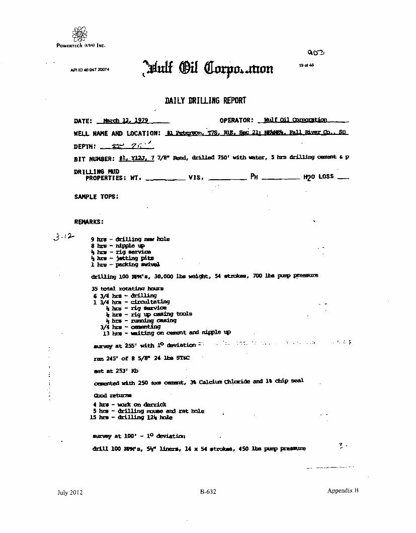
POWERTECII (uSA) INC.
ftpl ID 40 047 20074 If4f 4 p 3 d fl1o 4
DAILY DRILLING REPORT
DATE: 3br 12. 1979 OPERATOR: 1'alf oil 0z0oManM
WELL NAME AND LOCATION: #L 1etar~on '19. MO. Se 21: 812Mz. -aL l.ver (b.. SD
DEPTH: • 7 '
BIT NUMBER: #1, Y12j, 7 7/8" Feed, drlIed 750' with water, 5 hrs drilling p
DRILLINS hUDPROPERTIES: VT. ViSa t PH H20 LOSS
SAMPLE TOPS:
REMARKS:
9hrs-drillingnowhole8 kuo - nipple Up% his - rig service%br - jetting pits1 bhr - psddng iwivel
drilling 100 WlN's, 30,000 lbs weight, 54 strokes, 700 lbs pump presMue
35 totfl rotatina hmur6 3/4 brs - drilling1 3/4 hr. - crCultating
;A hr. - rig serviceA[ bra - rig 'p casing toolsh hr. - umwing casing
3/4 hbr - camnting13 hre - waiting on cemet and nipple '4p
survey at 255' with 10 deviatic-' """
ran 245' of 8 5/8" 24 lhs STAC
set at 253' ]a)
cmted with 250 sxs cement, 3% Calcium Od~1ide and 1 chiip seal
030d retrn4 brh - •s•k on dierrickS hrs - drilling mine arl rat hole
15 hre - drilling 121s hole
survey at 1001 - 10 deviation
drill 100 NM's, 5%w liners* 14 x 54 strokes, 450 The punp pressure
July 2012 B-632 Appendix B

POWERTECh (USA) INC.20a(46
APt ID 40 047 20D74MflRP
Estivated spud date, March 1.
-2-22-79 Grading locatic.
Expect to move in rotary tools by February 28.
Rig is curently under day work contract for the Federal GovernmentatPhillip, South Dakota on a geothernul test.
March 2, 1979, ls35p.m.'
Moved last load onto location this a.m.
Rig is on location and set in.
Shut down and recruiting crews.
•Wt crews are hired, neeed welding on derrick will begin.
Anticipate spudding 1tiday, March 5, 1979.
Ma~rch I o 1979
march 4. 19L
Hiring crews.
Crame or truck •mavailable.
Anficipated spud date, 1lursday, March 8, 1979
Hiring crws.
Crane or truck unavailable.
Anticipated spud date, 9uwrsday, March 8, 1979
Vbridn on derrick. 1aiting on crane or truck to move derrick offfloor.
of the
Anticipated spud date Mardc 8, 1979.1ad 6, 977 95
vdrking on derrick.
Anticipated spud date Mauch 8, 1979.March 7, 1979
Mr 19 dcing on derrick.
Anticipated spud date march 8, 1979.March 8, 1979
- errick repaired and set up on drilling rig floor.
Should spu late this aftermo.Much 9, 1979
Miixed .OW an prepared to spud yesterday but derrick would rot so~pe upto dam.ge incurred in transit to loaticn. .I.L contin• e to repair derrick
today. if you have further questions, please fee.I free to ontact Joe Banks,
TelelhNoe (307) 682-9354. - ,_'• .,Nn IV, I
ID1
July 2012 B-633 Appendix B

POWERTECh (USA) INC.API I 40 047 20074 210 46
DRILLING REPORT
Crystal OIL Company Peterson #1AFE #80883 Driftwood ProspectTotal Eat Cost $ Fall River County, S. DakotaCrystal's Share $100,550
LOCATION: NE/4, NE/4, Sec. 21, T7S, RIE - 979
PROPOSED TO: 2400'
CONTRACTOR: .iRD
ELEVATION;
3-10-79 TO 1551, made 155', 1 day - - - This AM drilling - - - 4 hrs work onderrick, 5 hrs drill mouse a rathole, 15 hr-s spud 12 1/4" hole. Survey100'., 10.
3-11-79 TO 255', made 100', 2 days - - - Thrs AM WOC & NU BOP's - -- 6 3/4hrs drilling, 1 3/4 hrs circ, 1/4 hr, rig service, 1/4 hr RU csg tools, 1 1/2hra run 8 5/8" 24# STWC surface cog set at 253', cement w/
250 sx + 3% CaCI
+ 1% chip seal, good returns, 3/4 hr cement, 13 hr-s WOC & NU BOP's.
Survey 255', 10.
3-12-79 713 750', nmad 4951, 3 days - - - This AM drilling - - - drilling w/watar- - - 5 hrs drill cement plug, 9 hrs drilling w/30,000, 100 RPM, 700 pp,
8 hrs NU, 1 1/2 hrs rig service, 1 1/2 hr-s jet pits, 1 hr pack swival - - -Bit #1, Y12J, In 255', made 495'.
Crystal Oil assume operation 3-13-79.
3-13-79 TO 1478', made 734', 4 days - - - This AM drilling - - - drilling w/water
- - - 1 1/4 hrs rig service, 1 1/2 hr survey, 1/2 hr rig repair. 4 1/2 hrstrip, 17 1/4 hrs drilling w/25,OOO , 100 RPM, 650 pp - - - Bit *1, 7 7/8".Y12J, In 255', out 816,. made 561' in 11 hrs. Bit #2, 7 7/8", Y12J, in 816',
made 860' In 14 1/2 hrs. Survey 818', 10.
3-14-79 TD 1721', made 245', sh, 5 days - - - This AM mudding up - - - Mud 9.2,Via 46, WL 8.3 - - - 14 3/4 hrs drilling w/30,0000, 80 RPM, 650 pp, 1 1/4hro rig repair, 4 3/4 hr-s work stuck pipe, ream 120' to btm, 1/4 hr servicerig, 3 hrs mudding up & cr-c - - - Bit #2, 7 7/80, Y12j, in 818', made 905'In 29 1/4 hro.
3-15-79 TO 1944', made 223', sd & sh, Minnelusa, 6 days - - - This AM work on mudpump - - - Mud S.8, Via 38, WL 12.6 - - - 4 1/2 hrs trip (I hr pull 1st 3stds, tight spot, 1/2 hr washing down), 1/2 hr survey, 1 1/2 hrs circ & cond,1/2 hr service rig, 13 3/4 hrs drilling w/30,000, 50 RPM, 550 pp, 3 1/4hrs rig repair, work on mud pump - - - Bit #2, 7 7/8", Y12J, In 816',out 1721', made 905' in 29 1/4 hrs. Bit #3, 7 7/8"q FP-52, in 1721', made223' in 13 3/4 hrs. Survey 1721', 1 1/40.
3-16-79 TO 2177', made 233', ad & sh, 7 days - - - This AM drilling - - - Mud 8.7,VIa 53, WL 6.6 - - - 3 1/4 hr-s rig repair-, 3/4 hra service rig, 1 1/2 hrs cir-c& cond mud, 1i 1/2 hrs drilling w/30,0000, 50 RPM, 500 pp - - - Bit *3, 7 7/8FP-52, in 1721', made 456' in 32 1/4 hr-s. Cum cost $90,004.
3-17-79 TO 2218', made 109', ad & sh, 8 days - - - This AM drilling - - - Mud 10,Vie 64, WL 4.8 - - - 1 1/4 hrs service rig, 22 3/4 hr-a drilling w/35,0000,50 RPM, 600 pp - - - Bit #'3, 7 7/8", FP-52, In 17211, made 551' in 55 hri.Top of Red Marker- 2270', Btrn at 22781. Cum cost $98,684.
July 2012 B-634 Appendix B

POWERTECII (USA) INc.APIM O 40 047 20D74 ,r 46
DRILLING REPORT • fC;-'E'(2) WESH
CEPCO Peterson #1AFE 480883 DriftwoOd ProspectTotal Est Cost $ Fall River County, S. DakotaCrystal's Share $100,650
3-18-79 TO 2378', made 9'2, ad & sh, 9 days - - - This AM trip to run core barrel- - - Mud 10, Via 45, WL 4 - - - 21 3/4 hrs drilling w/35,0000, 50 RPM,600 pp, 1/2 hr service rig, 1/4 hr rig repair, 1 1/2 hrs trip - - - Bit #3,7 7/8", FP-52, in 1721', out 2378', made 657' in 76 3/4 hrs. Cum cost$107,429.
3-19-79 TD 2395', made 17', sh & Leo sd, 10 days - - - This AM WOO, lay downcore barrel - - - Mud 9.9, Via 43, WL 8 - - - 4 hrs reaming, 13 hrs coring2378--95'r-5 hrs trip, cut 17', 1/4 hr survey, 1/4 hr RU to TOOH w/core,1 1/2 hr break out & lay down core, show of ad on btm 8 1/2', Leo ad2386.5-95', light to med gray, very, very fine grain, hard anhy, poor porosity& permeability. Survey 2378', 1 1/20.
3-20-79 TO 2395', made 0', Leo Sd, 11 days - - - This AM wash core barrel tobtm - - - &Ad 9.7, Via 51, WL 7.6 - - - 11 3/4 hr-s trip, 3/4 hr ream,4 1/2 hr's PU DST tool, run DST test #1, 15 mine, surface bubbles only,close tool 30 mins, reopen tool 00 mins, surface bubbles only, blow died in52 mine, Cl for 80 mins, POOH, CI pressures were higher than hydro•static,tool slid 5' to btm, Cl press appears to be of' no value, mud may have beenby passed or pkrs compressed rathote rrd during CI, intarval tested 2386-95',surface ck 1/4", btr ck 15/16", rec 50' drilling mud, Cal 300 PPM
1st Period. 2nd Period:IHH 1168# IF ---IF 17-230 FF 23-0OIFF - FCI -ICI---- FHH 11210
Test not valid, 2 hrs ctdr & cond mud, 1/2 hr service rig, 4 1/2 hrs WOO,PU 60' core barrel, RIH at 7 AM, wash core barrel to btm. Cum cost$124,415.
3-21-79 To 2422', made 27', 2nd Leo Sd, 12 days - - - This AM lay down core - - -Mud 9.8, Vie 49, WL 5.8 - - - 3 1/2 hrs wash & ream 50 to btrn, 1/2 hrcirc & clean hole, 1 1/2 hr coring 2395-96', 1 hr go through pump, changefuel filters, 1/2 hr coring 2398-47', TOO- w/core #2 2395--97', 2 1/2 hrsTOOH & check core barret, 1 1/2 hrs TIH w/core barrel, 1 1/2 hre wash 4 jitsto btm, 1 hr circ & cond mud, 3 hS coring 2397-2422', 1/4 hr service rig,2 1/2 hrs cond & circ mud, lay down kelly, 2 1/4 hrs TOOH w/core #3. Cumcost $133,060.
3-22-79 TD 2434', made 12', 2nd Leo Sd & sh, 13 days - - - This AM POOH w/core #4- - - Mud 10.5, Via 48, WL 14 - - - I hr lay downcrore •3, cut 25', rec 18',1 1/4 hrs WOO, 1/2 hr TIH to ream & cord core hole, 1 hr reaming core hole,1 1/2 hrs circ & cond hole for core *4, 2 1/4 hr's TOOH, 1/2 hr service rig,1/2 hr PU core barrel, 2 hre T[H w/core barrel, 2 hrs reaming & circ, a 1/2hrs coring, 2422-34', 12', 1/4 hr service rig, 2 3/4 hrs circ & cond mud.Cum cost $140,880.
3-23-79 TO 2500', made 68', ad, sh & dolomite, 14 days - - - This AM circ & condto log - - - Mud 9.8, VIa 45, WL 8 - - - 2 1/2 hrs TOOH w/core *4, 2422-34',cut 12', 2 hrs lay down core & core barrel, rec 12', 1/2 hr service rig,2 hr- TIH w/bit, 1/2 hr ream, 3/4 hr service rig, 14 1/2 hrs drilling, 1"1/4hr circ & cond mud to tog - - - Bit #3, 7 7/8", FP-52, RR, made 66' in14 1/2 hrs. Cum cost $150,653.
July 2012 B-635 Appendix B

POWERTECh (USA) INc.
AP 10 40 047 20074 23 of346
DRILLING REPORT(3)
CEPCO Peterson @#AFE 080883 Driftwood ProspectTotal Est Cost $ Fall River County, S. DakotaCrystal's Share $100,650
3-24-79 TD 2500', made 0', 15 days - - - This AM circ, prep to run cag - - - Mud
9.9, Vis 49 - - - 1/2 hr clrc to log, 1/4 hr survey, 1 3/4 hws TOOH to log,10 hre logging, Schlurmbergar ran DILL-SFL, bore hole compensated, sonic &dip moetr, Schlumberger's TO 2490', driller's -M 2500', 1 1/2 hr TIH to circ,
11 hrs cire, WO csg. Survey 2500', 20. Cum cost $162,326.
3-25-79 TD 2500', made 0', 16 days - - - This AM WOC --- 1 1/2 hr cdr, WOcsg, 3 1/2 hrs lay down kelly, DP, collars, RU cog crew, 3 hre run 71 jts5 1/2" 140 K-55 R-2 ST&C ceg, test to 43000, total 25003.94', land cog at 249W,
PBD 2486', 3/4 hr RU Howco to cement, cement w/10 BW, 500 gale mud flush,200 sx Class "G" cement, 3% KCL, .75% CFR-2, .4% Halad 22-A, .25 D-AIr,displace w/61.13 2% KCL water, bump plug w/20000, held 5 rmnr OK, plug downat 3:48 PM, broke out Howco, break down F-Iril to set slips, 7 1/4 hmw wellhad strong water flow out cag, CI csg head, RD Howco, release rig at 11 PM,3-24-79, 8 hres WOC. Cum cost $174,208.
- -DTO 250W, PBD 2488'.
3-26-79 24 hrs, waiting to move rig off location. Cum cost $174,208.
3-27-79 RD & MO rig, WO completion rig. Cum cost $174,208.
3-28-79 WO completion rig. Cum coat $174,200.
3-29-79 I1 hns MI & RU Eatmon Rig #12 from Kimball, NB. Plan to run CBL &perforate today. Cum Coat $186,208.
3-30-79 11 hrs, Schlumberger ran CBL-VOL-GR from 24,50-14002, good bond to topof cement at 1530', found POD at 24W0, Howco preas tested cog to 2500#, heldOK, TIH w/4" csg gun,Jgl j4iS00, 4/SPF, FL at surface after perf,RIH w/tbg as follows:
Tbg breakdown:8.00' K8
2342.51' 75 j)s 2 7/8", 8.40 J-55 thg1.12' 1 - SN
2349.•1' 75 ito
RIH w/swab, FL at surface, swab 3 hr., rec 53 BLW, pulling from SN, fluid100% load wat or, no gas, last run FL 1001 above SN, 13 hrs CIFN. This AMCIrP 58, FL 1900', rec 300' dirty, brackish water, prep to actdize. Cumcost $195,240.
TD 2500', PBD 2480', 5 1/2" cog perfs 2399-2400'.
3-31-79 11 hrs, CITP 50, CICP 50, FL 1900', Halliburton acidized perfs 2399-2400' asfollowas load hole w/136 Wels 2% KCL water, circ 12 bbIls 15% I-CL + 1%, dis-place w/3 bbls 2% KCL, CI csg w/1 bbt of acid acreIs perfs, start pump onacid, break down foration at 800i at 1 IPM, 4000 pp w/6 bbls of acid pump,SD, let acid eoak 10 min•, press dropped to 0t, pump final 6 bble acid at 2
IPM, 7000 pp, overdlsplace 1 bbl, ISIP 8000, 15 min 1000, RIH w/swab, FLat surface, swab 8 hrs, rec 187 bble 100% water, swabbing from SN w/FL
maIntaining 400', wra-o tO E9 OW per ht feed in after load rec, 13 hrs CIFN.This AM CIIP 500, CICP 500, FL 200' from surface, bled off air (no gad)(no hydrocarbons). Cum cost $W01,218.
July 2012 B-636 Appendix B

POWERTECh (USA) InC.
API ID 40 047 20074 24 of 46
DRILLING REPORT(4)
CEPCO Peterson #1
AFE #80883 Driftwood Prospect
Total Est Cost $ Fall River County, S. Dakota
Crystal's Share $100,650
TD 250W, PBD 2460'.
4-1-79 10 hra, CUIP 500, CICP 50#, bled off air (no gas), FL 200Y from surface, fluid
sample indicated 100% water, TVOOH w/ttag, MUt & TiH w/pkr & tbg, set pkr at
2290.53', WO Halliburton 4 hrs, mix & pump 25 ox Class "G" w/Halad 22-A,75 sx Ctles "0" v*Qgar... 20 bble slurry, sq perft 2399-2400' at 2 8PMI 500I9pp%7 W -'1•56 -W" press Increased to 1500*, reduce rate slowly from 2 1PM
to 0 w/8 bbls in per0,e, cement locked up, held 1500* on well for 30 mirn w/
min bleed off, rev out cement, press up to 1500#, Ihold 5 min, OK, POOH w/
tbgp 14 hrs CTFN0 This AM WOC. Cum cost S208,452.
4-2-79 24 hrs WOC. This AM drill out cement sq. Cum cost $208,452.
4-3-79 11 hrs, MU & TIH w/4 3/4" bit & scraper, 2 7/8" tbg, tag cement at 23481,
RU power swival, rev circ equip, drill 50' cement, circ hole clean, •est sqto 15000, hold OK, MU & TIH w/pkr, set at 2350', swab dry In 2 runa, no fluid
entry, 13 his CIFN I This AM TOOH w/pkr', prep to perr 2400-02'. Cum cost
$210,442.
4-4-79 10 hrs, TP 0#, CP 00, -FL 2350', no fluid feed in, POOH w/tbg & pkr-, RU
Goodwill §Lgwf 2400ý- 2'. 4/SPF, made 7 hoils w/4'. gut%,. I shot did not
fire, found PBD 2424', RD Good will, TIH w/tbg & pkr as follows:
Tbg breakdown:6.00' KB
2342.51' 75 jts 2 7/8" 8.4# J-55 tbg1.12' 1 - SN
3.50' 1 - Baker Model "R" pkr
2353.13' 75 jts
RU swab, swab well dry in 2 runs, made I run every 30 mine to 1 hr, rec100' fluid per run, 100% water, no W, cont to swab while WO Goodwill to
r H6~r4 made 2 BW in 3 hrs swabbing, RU Goodwill, TIH w/ 1 11/16" through
tbg gun, FL 200' above SN, peIrf 2400-' w/9 hotes RD Goodwill, GIH w/swab, fOund FL 20(0 abOve SN, swab dry, made 1 e& ery 30 mins, rec
50-1001 fluid per run, 100% water, 14 hr. CIFN, rec 3 BW In 5 hrte swabbing.
This AM opened tbg w/-light blow, no gas, CP 0*, FL 1000' from surface,100% water, swab down in I run, FL maintaining 100' above SN, making 1 run
every 30 mnsl. Cum cost $213,732.
July 2012 B-637 Appendix B

POWertECh (USA) INC.
APID 40 047 20074 25 of 48
DRILLING REPORT
(5)
CEPCOAFE 080883Total Eat Cost $Crystal's Share $100,680
Peterson #iDrtftwvood ProspectFall River County, S. Dakota
TD 2500', PBD 2460', 5 1/2" cog perfs 2400--'.
4-7-79 12 hrs, work, 3 hra WO HIallburton, RU, pump plug from 2424-2274' w/16 ex50-50 Poz mix, lay down tbg, pump plug from 290-210' w/8 ax 50-60 Poz mix,filled top of 5 1/2" cog w/15' cement, pumped 10 sx cement into surface cog,RD Halltburton, RD Eatnon rigp load out pipe & clean up location.
SWMSERN
P&AOF
FINAL REPORT
July 2012 B-638 Appendix B

POWERTECh (USA) INC.
AM ID 40 047 20074 2
ADMINISTRATIVE /
SUNDRY REPORTS
July 2012 B-639 Appendix B

POWERTECII (USA) IsC.
API 10 40 047 20074
SUNDRY NOTICES AND REPORT ON WELLS
27 of 40
P00 AIMOVUDbefto okoef Me. tma133
3"oo 5"Noboo 3M ImS. Lina Doutdo s Slowa No.
T 6. If lnthom. Allamoo or Toese Mount
SUBMIT IN TRIPLICATE I It U101 W CA. A- Do• pioa
I. T1j of Wde
afvL m at Peterson #lCrystal Oil Company 9. AN WdO Ma
3. Aos ad Tdoso,,, ,. 40-047-20074P.O. Box 21101, Shreveport, LA 71120 8on-231-49,14 II. FPWk WA aa. Wa* ,uaryAm
A . o.. atod IF, - . Soc.. T.. L. M.. or Soo,7 Darid.i WildcatII. COWW7 00 PusA. Suote
NENE Sect. 21, T7S RIE Fall River, SD
660' FNL A 75R' FEL
CHECK APPROPRIATE BOX(s) TO INDICATE NATURE OF NOTICE, REPORT, OR OTHER DATA
TYPE OF SUBMISSION TYPE OF ACTION
0 Iorxoto, lo(toto 9 Abmdoamorn 0 Cheapo Man i
Clubo. i... Fosinog Back 0 NOR-Rowoft Frairwria
0 cuos, ,,, 0r Wast g.o-f01 Filia .badaoaw Nasm Mo MoarrCing Coa, 0 Coal",to Iogmu,
1No.%: Repo" ruto oaft rApe C II" 00 WON CiImoam MRK*wukdm Bp-n NA Lot tIa.)
I J. DeombPo' M a tr CorormpIt Op unOp as ICIesity su m deeds, pc nol penrulv datar,. ln.cMhodistatusa dat of sriqng 001 po9004d *o. JF wei is disncaiOm) drdlod.g aivo adarflet ilooen oll a M Ma tin. yernal d qi for WIr marl•rn w1 toovet pomem to iis *.ork.I-
8-31-95
Found fresh water leak to be in 5 k" csq.Tagged T.D. at 1800' with sand line.Welded a seal between 5S" and 8 5/8" with an outlet in 8 5/8"Pump 50 sx class G. cement down B 5/8" and shut in.Pump 50 sx cement in 5½" from 370' to surface.Cerment settled inside S½"Filled 5%" back up with 20 sxCement settled RECEIVEDWait 1 hour and filled 5½" back up with 24 sx.Cement settled slowly.Wait 3 hours and filled 5h" back up with 32 sx. CFP
5½ and 8 5/8 stayed full.Welded a cap over the 8 5/8"Filled in holes and ditches and leveled location up. OIL&GAS PROGRAM
rIl. I U CMo" to"* 1111@11 dgeoa hnW Ito is aats amwd wilatl.~ : ~tt.1iUt~a, o,.Iktl~sattoaalt IJOo12l
at ,d ..eTWO Foreman Date -eat 9-7-95
. ...... S Pe'l fllucSE 1 1n 199r S
July 2012 B-640 Appendix B

POWERTECh (USA) INc.
. IRW-•VO A O 48PWM UPDI. BROS INC
SUNDRY NOTICES AND REPORT ON WELLS roam ApglVUD& #fo .f 14- 1o"S
S.oon II.-.. 311.- * SadN
6. If 600. Alieist Orrlba 'Msa
7. II Usia t CA. Av.MM ~~ssovs
SUBMIT IN TRIPLICATE
2. Pmuma doperato
Crystal ail Company
1. itWd aI CA.M Amsi o No. r-
Peterson #19. API W40 No
17 U.W A.4"M *.
Fall River, SD
Am. Nmsa TdSet. No.
P.O. Box21601, Shreveport, LA 71120 800-231-48144. Lacls o 4 SIfooll#ingi. Sec.. T.. It. KL. 4r SmW'o l
NENE Sect. 21. V7S RIE660' FNL & 6581' FEL
12. CHECK APPROPRIATE BOX(s) TO INDICATE NATURE OF NOTICE, REPORT, OR OTHER DATA-
TYPE OF SUBMISION TYPE OF ACTION
NRpir r of logo.ka h srf a" t bee of pltueo NC. Centronics-
0 Seit . femein Repo"a 0 Psquez the Pit lfo classMM pmanog
Pu Aa spua Csriog Ripest oWf 5a.off
f Amthe cement 0 isnot folt-29"0 Cotpwnloe th ajx m
INost: Riogn missfu of m51Mph coomplains on won Cooo51assn or
11. Om,* 1Pampodw at Cocpsse Operadoftocartaoy some .0perfaa deasib. slad give pensom aodis. .mtuding oanmdowd solf mar" m ay propolssdwork. IfU is dirleondclOy lfeileV". ,dbnlsft lcimm sed somssred sod moe .oada dqdpu for adl erakstrs amo zoots, ;Omw oo i0 work,)-
Repair a fresh water leak at the surface of the well which had been pluggedon 4-6-79.
RJH with Tubing and Tag cement plug at 210'-290'If the plug is still there and is not leaking then perforate at 275' andset a cement retainer at 210' and squeeze the 8 5/8 with 100 sx of class Gcement.Put a 15 sx plug at surface of 5 k.If the cement plug is not found at 210'-290' then replace~it with 35 sxcement and 15 sx at surface of 5 ½ý plus pump 50 sx cement down the surfacepipe.
Sigmd~ (I, Foreman URI Daleii 8-22-95
Tide to U.S.C. Selk. UIW. omalati s 3 ern fr me, P~on Illowlsely NeE .lIN. . soub Mo sy deossnuo"s or mew.. ;-:kt VO~se Sss3,A My fabs. fkaitiols or frowdaftat .sacOciOsMof tiplesimMeiole W to5 smy wae Osiss i sieoft 0 osht,
*Se. 1"GnarnC**., *n Paven.e 55'a
July 2012 B-641 Appendix B

POWERTECh (USA) INc.
.A...0. . 047 20074S. Dak. Oil l~ wd
i
PLUGGING RECORD
tIp tafer n Addres
CRYSTAL OIL COMPANY _ _P. 0. Box 21101, Shreveport, LA 71120eters of Lj- %%alil o-. Field & lteaervoir
Peterson_ 1 Wildcat - DrI.watln -it %%Veit Sec.Twp.Rge or Block & Survey I *,%;nl"
660' FNL & 658' FEL NE., N of Section 2j..T7SRI ---.. Fa4_ll. RiverAvpiii-itiiiO tI drill ilils -1i l lo, iid It-,, this wil] -' r tsrCe- of 11l at ruflmPletloti (initial priiductise I:fi .4nti ,.1 i* .iticl ii or gas Oil bbla/iday) (Cas (NMi'F!,ty) itry'
Wul f Oil Corporation I No ... __ YesW",. 1h19,vlwiiiiuII '. J Amnnuot well pnduciflc vie pliIiutod.
Oil I lhum: day' I .\t('.iiay Vas,,r W bhi.,lay
Naeii ni fnoarfiin noitain.iici un i
iii011 ,f ia a
ji ... I -rden 4! -,-sh folmaiaon Deputh Interval of eaclh formnation Si,!n. islol & lepth of pision used
Dry__ -'--ii7
CASING It F01RnD4ir., pipe 1' . i ft. Wilct .11.i l-eft in WellI ft.) ~~ ephin PzI, 7,-rSiiI mnt'hioo of pait.
ripped ¢etri_
_i-5/8" 253' . 0 . 253-..... -- .one. ........
5-1/2" 2499' 0 . 2499' . N---ne
W.-.-. .. ..-t .1 . r Ila.... ll d ... . .. .... ,..-- ....- -
i%'.a. writ A lih..t-iu miiilai~hn ftlid. :nrO•ding to regruiatiorn 4d,;ZP,' wsl: turierstion uurianlutrok frrsh i:i i.r
Yes Second Leohi uililuiirn tih, r infuurn Illln req d ire, on this form. If this well va, phluged b,.ak for use as a fresh water well, r'ihe all peritincrt detailsi f uuiflhc uui -- ratf.. in las.• if fresh water- sad, perforatel interti io f-.1h wat-r salnd. name and address of surface owner. and attachl,' ii.,r fl iort',. r auihorleing compilein of thi, well a. a water .Il and iareinog to asairne full lability for any surtts'luenl plaui.RInK Khili e.h he rcitifi-r.Al.
4-6-79 - Pump plug from 2424-2274' w/16 sx 50-50 PosmixPump plug from 290-210' w/8 sx 50-50 PosmixPump plug from 15'-0' w/5 sx cementPump 10 sx cement into surface casing annulus.
Plugged and Abandoned 4-6-79
I'S1K IEVE'lRlKl- S113E F-OR ADDITIOn.S DETAIL.............. rl • •
l,,ite~d this i,., ?4 la f Apri 1 1979
sto, of Louisiana -oi,,nty ý, Parish of Caddo
,........ .... au,,., ...... d athority. so this day ,..lsofally ap p'ared James. 0. Gla&ss known to Ine to be_hi lunr .. t oho-; n, is ..unhcrihrd Io the iaboltr menl. who heIng by me duly sworna on oath states, that he is duly authorized toi'-ik' I r," ill.. i neil arit •i•t he has knuwuledge of ti. facts stated therein, and that &aid report It true antd torrm-t.
subscritd and 6-. before nie this 24 day of April -1 19 79SE't.- -- 2K-:)N'CILXIA X: Nioh~ry Pulllik
ly iu .n i i l i r .X ld r . L .J /--" . N o t a r ) P u b lic I n a n d f o r CLIA N 1 ' . N ,1 ," [ ,i ni ai/t;1ý1iýiiaII
- M4 8. a19.-00o s.OT wRITE 9 lI LINE
D SOUTH DAKOTA
_________________ Secretary
Supervisor, Western Field Office
July 2012 B-642 Appendix B

POWERTIEChI (USA) INC.
^P11D4 72007
rcýe m ~ e-
V eccj ccc.,41 )A)L2/?~9
3 1 of,46
C~c/c Ac/e ;,20 0 )
0~ cp,52C
fc~ o -~/Lu~1
1,4 I
240
'e y- ~ / 14
*.-.z.5 , , .ý 4
-Z')
6(c
(t )I-i
/
I.
L~*1
-2 V .
Th- ;~~~L( -
July 2012 B-643 Appendix B

POWERTEChI (USA INC.
.oo, .. -MO 4047 2007
SUNDRY NOTICES ANDREPORT ON WELLS
El OIL WELL El GAS WELL [I -.-......... )(I DRY
Crystal Oil Company
P.O. Box 21101 -Shreveport. Louisiana 71120- -CXT .-- 'ff--Irtt-from n~eorst lines o' t-cctlu-n or legal Eubdfvlsion, whers porzile
660' FNL and 658' FEL of Sec. 21, TVS, RIE353F'vxf-, :Is- T -Kn. IT. ;rD., etc.G-R-ow-.e ,-l)
3533' GR.
S. Dak. Oil & Gas Board32of46 FORM 6
FARM OR LEASE NAMEI
PetersonWVILL NO.
- 1FFIR AND POOL. OR WILDCAT
WildcatNO. ACRICS IN I.EASE
1200t SEC. T\I '. I lIE.
NE t, NE ;Sec. 211 T7S RIE
Fall River
INIIICATF. 14ETOW 14Y CHECK MARK NATURE OF REponT. NOTICE Oft OTIIFR DATAKOTICRF OF' INTENTION To: SU.RSEQUE-CT nFlPORT OF:
TEST WATERI SHUT.OPF l~lI OR ACIDIE WATER SILT-OFF __ SHOOTING Olt ACIDIZINC __
F~l~r~lE IIET ___ 111Allt WELL. FRACUTIE TRlEATMENT ___ It.'PAIIIING %VEIL _
MULTIP1,E1 COMPI.FETi*Z 11"I.1. Ult ALTrER CASING'. --- - I IAL.TER(ING CASINGAIANWI x_ : ,:d 1ponI of ___i-h Well
I)E-S(lI lIC PROP1 OSED ORl COMPLETED) OPPRATIONS (Clearly state all 1-'tie.-ni ,1,t.ail. nI c, p-.rc ,tin ,eec.,ro, .h .cc e-Oiwad,*I .:'of .limbr~t any 3.ro0lvIcd it ork)
4-6-79 PumpPumpFill
plug from 2424'-2274' w/16 sx 50-50 pozmixplug from 290'-210' w/8 ax 50-50 pozmixtop of 5 1/2" casing w/15' cement, pump 10 ax cement in to surface casing.
I hierehy /-,ft the foregoing its awork or operation Verformred Is a trite anid correct report of socl, scork or- opIrllofl.SIGNE... .1I . Ast. Mgr. of Prod. Admn AI 4/9/79
DO NOT wRITrE BELOW T IS LINE
ApI.r.v.d 4-17-79 01 AND G D TE OF SOUT11 DAKOTADlate
CONIIIION-.. IF' ANY:
See. Insttict Ions On Rev~erse Side
July 2012 B-644 Appendix B

POWERI"E(Ih (USA) INC.,
API 10 40 047 20074 33 of 46
CORRESPONDENCE
July 2012 B-645 Appendix B

POWERTECh (USA) INC.API 10 40 047 2DO74 34 of 46
!all", Um*c
oMm Maolnway. MackTO: SNWe, Pred Towmend. BobCc? Oladd RAswumr; Hammim, 8&UldoSUNNe RE Leaf• an Miet , al Mver Countyowe: Tuesday. 88e0l01 05, IN 425PM
1 f e On of Of1a m l e Tules (31). IMmn ar enlved on leca im a bocdhoe had lIulhed gdamn ito go ca . Wier was 1 c ob ou alois weld aroumd ft cap on Owe surlae (8 M) cei,. maweldw welded a r oner on Uw 81de of ti aurtao pipe mnd ad a hole I#oh Urn pipe. I ailme li flaw iobmi 20 gpM. WMe 0 Urn Cdw i off ft Ol cuin ap k wU aPPusM U. lOaW wee Ommn Up OW hulde Ofth poiuaatn (S cM eelug, n the umim e eaI i R- nai. as we had empeted ThN fed us toapeaOIethl S ll go 5 dJ ind mmholees. InIt t= to do lhad400 4 of Ukn I hadthe Ow nmOler$10d Imn V a g ~eo bar ls o bo h iol In i1iere Urwn I W me pluO was, They di~t hk
o ad l U00. there auwppomd ls be cemesn plus0el the malice meid s 210-230'.
A ftn ws welded In Voe manndul 6 lbole the kwm •bg• of easink, ad a vmcuan Iruck pum;ed up ft wMersioehg ou of Urn e- Ig. A Sn frms tlhe ceme pwee ac'ked upin t el 8/8 tnngoab. adwe piumped 50
moits Of cemet d om ing e 2 bpm.400D pl, a pl bum 23-o'. There wa-s I300pi Wedopped pumping, asow elo thev ve, ail loll eftthe pre an the pipe. The flow from Ime 5 1/2n nerdWood
Tis dg r 12 Jts of 2 30r Wf4IngMeslo 112eeekuto 3i', aid we pumpeda loakplug lcml 41 (ban ofmwff cog - 365). VAWn lIn bfq was pled out, Ue oemenI leWMe drpped about 100' b twe pip, but Urnwmewlwlhad MaPped ocampleeo . Ihad llieu mimoiVi I mho, vlte meps e 20rmareds a. Th
nie owM dpped aiin in ir 100' ft IvL i ted sm I ,weie i lie00 ie emeN Iel May 8 l amA., as wemseed If ftad weled ums fr ft mm I* adup. Akr 3 houm we pumpsd a&alr 5 diei ia o11IMpipe.Thinsue, Ue eent level lyd alai. A lei f 105 isantwerepumped dm wle 1/2ca,
~ d elcul dalees toa phg frae 76W to esufaew.
A eel cp we welded on tap ofIw pipe. aidhe b se filledW tIe hle m&d levelled lIe oc1n. WawiePeleremn (ftelendeiies1 vkopped hVsad eds he pkesedwils me , re e. copm tian, wndresuiefromicry"l O Co. am DONR.
A& a alte nart, I wft$med anather piagft of a Mumer prodefb well li day before sass of Provy. TheNOMpM M Se m o"nft•. •ll bs mt meHlD ikqv rep - i. eao t rand emenv. ed wem
•idib ma nft0 I day ft lie wel, No I mld ilo w hMn why.
Ftm leow, FredTo: TommmNd, BabCc: McGNMy, Mack&90&e Leatg O Well. Fl Pld or CamyOMo: Weieday, Jun 07, 105 10c4AM
ob, I receved a fox from Cri• ONl Co. flle moi 11g ghey em Whin Yl Updlo BAuMv, Ifc.. a drlofcMRneoa i NeP cle, WY. and have aeked for Upike to a•teml a bld on repeldg tft wall.
Pag I
July 2012 B-646 Appendix B

POWERTECh (USA) INC.API 10 40 047 2D074 35 di 46
ftme. Fmd
Pram; Towmn*I, BobTO: Ma•loy. 8 Goodmmi, JA" Tdofn•fd, TimCc: Plmw. roSt; lsN, FiudS11111" FW. MdI 11M
eMay. AMm 0U. 1 W tSAM
I dmeumd ts it Fod tMmorni TheI e~ rat wmo abm d by Mmk* at dou 10 gpn. The eklmp ym• ied l e p m ~ edh ign hi the minia b n the rs •nOb and bg ubn Fred
b oowea w lie company tM id4 the d ti saW e times mO d haN lcel wal hidforet Sm Ithm kiIM V"ey n agoer hverao o an thi ws. Fred ihiw that t ihe pla i• x h weoo aho •• ty daftha esm Im fhr i fhu yd becrAm e am dtheyare atthe khom Fred sa. Ifhe comany doesnot mepon eih a p i tho neIo weok otwo, Fred wi wfle them a lawer re hgts n pmfor idthoe le.
MileA Me vd.0 IPMt.woeo Ma.iNoteFrom Sleae, FredTo: Toenmnd, fObCc Gisdd RAOMe
Mcouway. uas*S r"uW IS tehais llg• twr, Fall Miver Cou•yOdE IS.-041 10:48
Convmmilom D: 5•4DUEI
S.b thi• mle is fryour w1-lt mlo.
Mr. W--u Pediso, a uim r hi FIn Ral r Coemty kilurmd u1Ns th ollFAld on his Md In 7lh am swu to "e Iuw for fI pagsvwrlam Mak aI mowlMlrmm. P iahpuld th lton TueanT da anfoun Ur Vwwdfmsbeflawi~ng m~te10pm. The waerla beingdvedad hmnMs hey ai•d A e fte CNo mem eer flood plI wm It Is b anwaalpdk hmo IAi•hvium. I tead ID Aan, dd me d ev ew nhough own opwobuts doll" hod ham b"g slto bea isboleaa they woul~diilrnv a me mop-h11111 W ft th p obism. I pod te op eraNOlo@td In Lindmie and we Wl they wokid ropair the wel at an aVdue.
July 2012 B-647 Appendix B

POWERTECI (USA) INC.API 1040 36 of 46
DEPARTMENT Of ENVIRONMENTand NATURAL RESOURCES
OL AND GAS PROGCRM200 WV" Mmn. SUM #1Rind CRY. 80 57702605-304-2220 FAX 605-3644317
TO: WFO FilesFROM: Fred V. SteamDATE: June 2, 1996SUBJECT: Leaking oil test, Fall River County
This office was contacted by Mr. Mark Tubbs for Mr Wayne Peterson on ow am May 29.1995 informing Mack that an old oil tos drilled on Peterson's land had begun to flow waterseveral morths ago. The Wulf #1 Peterson located in NENE 21-7S-1E. Fall River County, wasstarted by Wulf, taken over mid plugged by Crystal O( Company in 1979.
The following day Mook McGIWlvray met Lt. Peterson and inspected the well location and tookphoto* and kept notee on his findings. He found that the water waa flowing at an estimatedrat of 10 gpm and had been ciannelled awy from a hayfield toward the Cheyenne River.The water was not entern the river but wa dappeing into the alluvium some distancefrom th river.
I spoke to Roxanne Gledd, Assistant Attorney Genral, to find out what responsibility thecompany would have alter al this time, particularly since their drilling and plugging bond hadlong sice bee r osed. Roxanng told me as "on as the wall was not completed as a waterwall and turned over to the landowner for his use th, the company would still be responsiblefor plugging the hole.
I ned visited w1h Jim Gooedman at Water Rights to inform him of the flowing well and to inquirewhelher hiN division had a fund for plugging uncontioled walls. He WItrmed me thy did not
On Juno 1, 199.61 telephoned th company in Shreveport LA and spoke with Mr. Sam Clintonwho assured me that Crystal is a responsble company and would fix the problem. Hearranged for Lt. Pat Eddings to calan, me and we spoke about details f information in ourwell files I faxed the informatki that he requeleteL incuding a hit of dlling contractors whohave driled In Soulh Dakota in recent times. Mr. Eddings sold he would study the informationand get back to me when they had mede a decision on the well.
I conveyed some of Oile ormstion to Bob Townsend vim E-Mail dated June 2,1995.
July 2012 B-648 Appendix B

37 of 46
SMeICme C. MILLER
September 2, 1986
(30o) 866-7542
Mr. Fred steece, SupervisorDepartment of water & Natural ResourcesWestern Field Office36 E. ChicagoRapid City, South Dakota 57701
Re: Letter of 06/09/86Wulf Oil Corporation
Dear Mr. Steece:
As per requested in your letter of June 9, 1986, in regard tothe Wulf I1 Peterson well and the Wulf #4 Federal well in FallRiver County, South Dakota, I have sent you the material I foundin the company files. The Wulf i1 Peterson was operated by CrystalOil, who took over in the middle of the drilling of it. Any furtherinformation you need on this, I wuld suggest you contact them.
The information I am sending includes this:(1) Geological Report Wulf Oil #4 Federal(2) Plugging Record Wulf Peterson 11(3) Drilling Report Wulf #1 Peterson
I received copies of the above from Banks Enterprises, Inc., oneof the partners on the rojects. -.:Mommottour records-were: lost'Th
PeidentWULF OIL CORPORATION
LCW/lwEnc: 1
LIMO ADfU PA. NOX MW0l. DNVUR, CO k.OF1t AVOI "I WAAIT 371h A•YNIL SUMtE M00. DIN". &.CO
July 2012 B-649 Appendix B

POWERTECIh (USA) INC.API 1040 047 2DO74
Mr. Fred V. Steece, Supervisor
Western Field Office
36 East Chicago
Rapid City, SD 57701
Dear Mr. Steece:
This letter informs you that the surface restoration
at the site of the following oil or gas test well
has been completed to my satisfaction.
Permit Well Name and Location
903 Wulf #1 Peterson, NENE 21-7S-IE, Fall River
I am the surface owner of record.
SIGNED J' )P• /C7) _ DATE /& -
38 of 40
July 2012 B-650 Appendix B

POWERTECII (USA) INc.
AIt ID 40 047 20074 390o46
SUITE 1119, TOWER U1. PAK CENTAAL BUtLDhNG1ISI ARAI'SE ST. DENVER, COLAOO 86Q0•TELEP 4" 30•423-n
April 10, 1979
Department of Natural ResourcesSouth Dakota Geological SurveyWestern Field Office308 West BoulevardRapid City, South Dakota 57701
Attention: Fred V. Steece
Re: Crystal No. 1 PetersonNE/4NE/4 Section 21Township I East, Range 7 SouthFall River County, South'Dakota
Gentlemen:
This is to advise I do not want a dry hole marker locatingNo. 1 Peterson erected in nm cultivated field because of amy future fanming of same. Thank you.
the Crystalhindrance to
Very truly yours,
PETERSON AND SONS, INC.
r; -ve
BY:ý -
July 2012 B-651 Appendix B

POWERTECh (USA) INC.Am1 ni 4 U4U •WMu4 40 of 46
P.O. e 21a1.0l SH C , LOUISIANA 711207a.4W4N S16222-77I1 TAX 510097847
March 13, 1979
South Dakota
State Geological Survey308 West BoulevardRapid City, South Dakota 57701
Re: Transfer of Drilling PermitWulf Oil Corp.-Peterson #lPermit no. 903
Gent lemen:
We acquired the above well March 13, 1979 and assume the full responsibilityfor its operation and abandonment in conformity with the law, rules,regulations, and orders issued by the board.
A Blanket Bond in our name is attached.
If there is any other information we should furnish you, please let us know.
Yours very truly,
CRYSTAL OIL COMPANY
Asst. Manager of Prodtetion Admin.
JOG/mr
Attacaents
July 2012 B-652 Appendix B

POWERTECh (USA) INC.
API 10 40 047 20074 41 of 46
SURETY
July 2012 B-651 J 2Appendix B

POWERTECII (USA) INC.
AM~ 104 0 047 20074 0 9842 of 4a
f- & 016 10130191 III, .Du. 4O o
Borx No 708E675-4BOND
Know M& inimi a vuse 1smUW
----- -W kL L a . Q L L 9 -------------------------- - - --- --------------SM he 01
oMWa ---- - ----- --------- --Maof me --- N- R "S- ~~ ------------------------
Travelers Indemnity Company.
.1 - ------ - - -- - - - -- - - -- - - -- - - - -- - - -- - - -- - - - - - -.- - -
as awgtY. SMOIholSM ?A do bariNg. ft n MOW a oe 01 ~ DUw4 M asee -Morty. am 1,01 sa" bAmn bmin h lb Ow in 0W& ad Sw, Dalkfta OR lb.am of 0600581Aaf SMPIMM). lawfu ONNOW of "ve UlMM Sane he winub Panw w(A Cad liwly to to vamile. we W"r owurdve. Win mAftof 8% and emb at SW balm13 -i~nnU abiEMSlInm Or ~ -ieea M -anlgn 1969 az , Wna t"I A 0
Tb..eendlon of ate blub ~is.4 tam whelm. no. Av. hewbdab gtinoale Prpwoen to 0 a won or Wave. in, amt am or strat".aelpurpom In Md wow lb. WeinWi i4Sopei hd MMelualed wilMa the 6SU*% to utO
(m4Y to Used as btanke bW or Par ~@a was)
OFFICE
NO0W. ~TEinWO11111 It 11" abmt bos"ei~ uu 110111 -imw w011h an Oc lb. Pe . owie *110 wIo of eda sow. Wdname add aidere w1te no Go anda"111"d atIS amie.Sod leb w veh amm~es 60 ath Powe Phoof of MW WON at .01k. .MA a. w"
Ow 06 a Gas 9"M .49 0t SUM 0100 ordem AM eOwdO "R I I byuf Odd.fr mUdu *a eleitoIla ad Me mf.s in tM v~0 a" woO-W~ ao s a" ,h g odn. or am Is01 11g3 - 4.001. W1 muM to I - *111.or WO In iuznerl!q uan#-mllS.t Uebb oblimbaft n Olean
be fanallaud bylow the mba4 s ho" 1.0 3 bean venlli M ftl h. a"d .511
Twenty Thousand Dollars and no/100---------------- ($20,000.00)
---- th a t ----------w01
------~xP .Q -- ------ W- -- ---- - ------
Wa. ~ ~ ~ 2 t . . m.0 a W 1 --- ct-- ~ ober 1978..................
Count -----W
Nran Stalygy-'in-fac(W The PrIM101111101 10 5 Ow Singf 06 111111 OmtI by OS.A 11W ' -IF h 3. 01410. ew" doe, moal 09 the al 0 aft" VWapMing W =N uif OW b ORMW f be" 11 Wt "W gof -01 aifea M fthW diedm W1 aekrlbitaMO SMOt O inu'Lb. ban)
I~5 no~ we33 wal4W LamS
July 2012 B-654 Appendix B

POWERTECh (USA) INC.
APO ID40 047 20074 A3,1I i4
.1.,, ... v Is)
SMTE OF SCK7I1 rYA=Asj
Depwart of Natural Resourc Development Division of Geological &wmy_______________________Fai
WInIJ COHPAU MUftATIG St=F
Infonmstin about yw bour irg ompmnys
Name of bxadifzii omnW: rvler. Indemnity .. oepany
Street Add8 10.1. University Blvd.
City, Statez Denver, CO 80206
Phones (303) 321-2333 Ramrks:
Infbmtion about your Soth Daeta ordlirg oupiany agmt:
Oo South D ta Agent: Kluthe A Land AgencX
StreeAdPdsO: 619 Mount Rushmore Rd., P.O. Box 3031
City, State: Rapid City, South Dakota 57701
_ _ _ _ Re__ _ _ _ _ _
Infoarmtion about releasui yaw bond:
Men the , fo t wh o you we providig has fulfilued allob1tlticons wh= should we oentact with ow E1ilease?
No= of ntat: Bayly, Martin & Pay, Inc.
Street Address: 817 17th Street, Suite 500
City, State: Denver, Colorado 80202
Phow: (303) 292-500 Rmarms:
Please file this fcu togetha wdith Oi1 & Gas Fcm No~. 3 with: Yrt. F~ed V.St ,ce, S vewa , South Nkoto Owbgical &wvey, htamrn Field Office,306 West Boulevard, Rapid City, South Mota 57701 RP: (605) 394-2229
July 2012 B-655 Appendix B

4POWeRTECh (USA) INC.
AP l bI0 047 20074 4The Travelers Indemnity Company Nov-m8
Hartford. ConnecelkuI ti~~LPOW*ER OF ATTORNEY ., WESTERN
B1OW ALL MEXN NT T1HUX PRESE1INTS: " n FIlD 'l
That TIlE TRAVELFRS INDEMNITY COMI'ANY, a corporation of the State of C 'r
doe hereby make. constitute and appoint
Norman Sterling, Jr., Paul H. Batbourt, Norman C. Hteadrick, David H. Snead,Thomas 3. Sisk, Jr.. all of Denver, Colorado, RAC -
its true and lawful Attontny(al)4.-act. with full power and authority, (or and on behalf of the Companyas surety, to execute and deliver and affix the well of the Company thereto, if a real is requred, bonds,undertakings. re.-oenitanteb, consents siunrty •r other written oliligations in the nature thereof, an follows:
Any and alt bonds, undertaekings, recognixances, consents of surety orother vritten obligations in the nature thereof not exceeding in mountTwo Hundred Thousand Dollars ($200,000) in any single instance
and tobi adTHETRAVELERS INDEMNITY COMPANY thereby, and aif of the actsof said Attarney(s)-in.Fact, purauaat to thee prmeenta an hereby ratifed and confirmed.This appointment is made under and by authority of the following by-lawa of the Company which by-tawsme now is full ftac and tflect:
Asrusz IV, plaCuIr4. 'the Chiav,irt .4 the towir, the |id•,iem, the Choienmha u the Fimnre Cotnimittee.an) ESr:wtwe Vi•e Pr'•Men•i yentm, Vi'e IWlederi, aa- Vim voWi•de., 4n)" .ftood V'rs Pry'en., the
tn se m , , t 611 ctru"t.at with Power .. w-
aad deli:er:tad :,,i .•z et '14 M',I emtoyt h.nth., 0tnc emd ~kit• , rt t.r tilt iorti.wr other written ontlitiontt Ito the nattwe thvwgo .ad arty- oil aid tillert may hrtv ay ec to~e~wtr-r tAgain had revoke e power atdthoity • h e' , to hmt.Aaytax IV. Sacum" 14. Asy i.mtl. adretakiu, nt,•n,..,ae, t.w .- I .tt.cty e ire.m t~igl.tw., to.hSatire thereo -ktll be Rvd aed Itridllailte to it; ii,'t hiny when ti by the Chairman of the Itd, the
ay~et. the Ciwimee of the biatttet Corintinttule .tttEwettive i r~fthrotentwysettio Vice Prrew.ikt.itoy Vire Prie..em urallotiaod VWe Pre-itherywd mat dolattwoemat ideakd. if, retI wreptlieed. by the C-o
ae~trl.rtarorn •kotscteror t~~..t:t~pee~r~resi ... ewtIrtr..to
byý n aktoihesi it~nli-s~ e tnt. meroapte-ti itat.e hit, the hwi~t- 4 tht,-tuthtwity 4ntitttd ItySit aw her pftwr t4 attorney.
This power of attorney ;s signed and sealed by farsitmls tnder and by the aushority of the following Realts-tion adopted by the Directors of THE TRAVELERS INDEMNITY COMPANY at a metiegl duty cailedand held on the J0tb day of November. 1939:
Vovant: Thai the sisecture of ay fidest authoizied bydi Sh y-Laws mod the Caruepsay maim&t e ilbeaued heIceomile to, o p~e gelo aftetaor eqmisal perw ad attownevr is it.isticaof' drier given for ttctiaobay bomcd. oterhaking. m aocre is eth e , btq o . i th eae e ; oa ,tco and Kiet.wihe ..o se ton• hwe1%by tel by th Caeomny ci o thlel wrststi suic ii eat •e sad •of*. Cospity, iso he "W~ sad hi~as upnt the nos"ey with the ma etae or and eke, a. uh6tqt maenuallyhss..
This poser of attorney revokes that dated October 20, 1976 on behalf ofNorman Sterling, Jr., Schuyler F, Cross, Paul H. Barbour
IN WITNESS WHEREOF. THE TRAVELERS INDEMNITY COMPANY ba caused threeprewents to be signed by ice power oicer and its corporate msat to be hereunto allized this 30thday of may 1978
THg TRAV]LIRS f1W$•MDlNM COMPANY
By
Secrctary, Surety
State o Connecticut. Covaty ad larrdV-ss.On this 30th day of Nay in the your 1978 heton: me pItreonstly
terne D. J. Nud to mra ktown. who. being by au- duly mwoen, dkl deptos and my: that ba' nusittl inthe State uf Cinnt'ctk'ut: that hbi is Secetary (Surnty) of T1II TKAV ZLEIS INDEMNIft'Y COMPANY.the corporation destribed in and which executed the above Instrument; that he knows the seal of saidcrplration; that the seal affixed to said intrumenet is suh. corporate sealn that it was to affixed byauthority of hit office under the by-laws of said corporation, and that he signed his name thereto bylike authority.
Notary Psi-,9
My commtmanin expires April 1. 1933
July 2012 B-656 Appendix B

POWERTECII (USA) INC.APt ID 40 047 20074 45 of 46
MISCELLANEOUS
July 2012 B-657 Appendix B

POWERTECII (uSA) INC.
AP 10 40 047 20074
NO MISCELLANEOUSINFORMATION FOR THIS WELL
AS OF 5/18/2011
46 of 46
July 2012 B-658 Appendix B

POWERTECh (USA) INC.
API 10 40 047 20077
2)15/12 014& Gas D~adtebe SoomhI1 OM35
bepaimut of Enwiwwrnnt44 ,Vbt"r Resmovres
,n. . rok
Oil and Gas Search for: apino_ like '40 047 20077'
Download Database
Page I of I (Excel spreadsheet format) Page: prey 1 R Next
Iv I
Record I of I
Well InformationAPI No: 4004720077
Well Name: WULF 2 PETERSON
Permit No: 919
Operator Name: WULF OL CORPORATION
Permit Date: 06-08-1979
Spud Date: 06.03-1979
Plug Date: 08-13-1979
County:
Location:
Total Depth:
Bottom Hole:
KB Elevation:
Ground Elevation:
Latitude:
Longitude:
Status
Type:
FALL RIVER
SWSW 15-7S-1E
2462
Minnelusa
3572
3564
43.435870
-103.991563
P&A
DRY HIOLE
Well FieldClass:
Fon.a•
Sundance
Spearfish
Goose Egg
Minnekahte
Opeche
Mlnneluse
Rod Marker
lot Leo
2nd Leo
WILDCAT
DRY HOLE
Formation Tops
822
11641515Iis
1728
1817
2232
2242
2340
I||
Page 1 of I (goto 1Page: Pre Ii[j] Next
a-denr -A.m b..wc gmdt 1/2
July 2012 B-659 Appendix B

POWERTECh (USA) INC.API 1040 047 20077 3 d 35
COUNTY:
LEGAL LOCATION:
API NO:
PERMIT NO:
WELL NAME:
OPERATOR:
PERMIT ISSUED:
PERMIT CLOSED:
FILE LOCATION:
FALL RIVER
SWSW 15-7N-1E
40.047 20077
919
WULF #1 PETERSON
WULF OIL CORPORATION
06/08/1979
09/21/1979
7N-1E-15 SWSW
TARGET CODES:
WELL HISTORY / CHECKLIST
PERMIT TO DRILL / INTENT TO DRILL
WELL INSPECTION / SCOUT REPORTS
OPERATOR'S TECHNICAL REPORTS / MAPS
ADMINISTRATIVE / SUNDRY REPORTS
CORRESPONDENCE
SURETY
MISCELLANEOUS
July 2012 B-660 Appendix B

POWERTECII (USA) INC.API D0 40 047 20077
WELL HISTORY ICHECKLIST
4 of 35
July 2012 R-661 Appendix B

POWERTeCh (USA) INC.
API to 40 047 20077 5 of 35
BOWD R~EA" CHEKL
WeU Mame and LocationPemdt 0 919
Wulf 92 Peterson API jSISW 15-7S-IE, Fall River
Boixi # 708Z675-4 Date Issued . Date Reaeallsed a
Surface Restortion,
V Pits filled
_ Site Level
_ Site policed
\/ Dry-hole marker solid, saled, oyectly inscribed
.. &-INo d&y-hole 'ker desk.ed,, letter in WO files f.tiu suate oner
_Z• Le4er -ftokfl swrfAce own~er
Form:4 Ccqxletion or Reomqp1etion Report)
_ om 6 ( Sundky Notice and Report on Well.s)
Fm7 (Plugging Report)
Geolocioal Infmation riled
J Well Liog: IES W, D Nwl, CALI.J C311W1LoTK, Temp,M), LetwRag, s.S.Dom
/ DS]6T Charts and Reports
o Geologisti Report
-Resuts of ooring and owe analyses ('.~c~~tV~Set of 10-foot amnVe a cuttings (Check with Bob Schoon)
'Df 1UN Checleed __________________
-VI
July 2012 B-662 Appendix B

POWERTECh (USA) INC.API 0) 40 047 20077 6of35
FIFM OMLIS'f
Well Nam~ and Location: FPrmit 9 919
Wulif #2 Peterson API 9 40 047 20077SwSW 1S-7S-IE, Fall River BOtI) I 708E675•4
Paperwok -filed with WIM
L..Organiwztion Report"jApli]ation
..__ABond
._Permit Fee
The rollmiM P4rf sent to opeatcg.
.jPeruit (Form 2a)
j Receipt for, $.00 permit fee
_.ACover letter' explaixrrig.material sent
NryIit Fee Filed;
x Pemut fee w/Cash Remeiplts Transmiittal Flom sent to StateTreasurer
Notifiation of Hme Pezmit aunt to:
x Dr. Dimean J. Mc1~regor
_ •3 ,q&']lV'9'Y*,1A ' Mr. Warren R. Neufeld
X.=..X.A.J /rq~lst/yfe Mr. Jack Gerken
Date June 22, 1979 , awk By cp
July 2012 B-663 Appendix B

POWERTECh (USA) INC.AR ID 40 047 20077 7o135
PERMIT TO DRILL /INTENT TO DRILL
July 2012 B-664 Appendix B

POWERTECII (USA) INC.ALPI 10 40 047 2007 8 of 35
SLat.. C... Plo.. APPLICATION
I)RII.L [J DEEPEN
XX OIL WELL [C GAS WELL
Wulf Oil CorporationA I.ll
IM'.S
P.O. Box 1320, Chadron, NE 69337
1.1 I AITO 1%' Io. In fNtfn nearest Brcea of -- t ion or legal subdivis
FOR PERMIT TO.
C5 PLUG BACK
M(SINGLE ZONE
D MULTIPLE ZONE
S Pobt 00i& rag BoardFOIiM 2
FARM OR LEASE ,SAM I:
PetersonWELL NO.
#2
WildcatNn. ACRES IN L.I:4SK
1200.00[ion., where possible)- 14 ' SEIC. Trwp. I I:
Sec 15: T7S, RIECenter SEW3AJ½SW¼
Fall River, South Dakota
Y/330' FSL - 987' FWL Section 15
.. D.•DW• RS. OUSR-FACE OWNERI ELEVATION NO. OF WELLS ETC
Ede nSuhDkt 3564.9' gr T
NAMP AND A "flRESN OF-c-• .. . . ..A..R APPROXIMATE DATEWORK WILL START
Northern Wyoming Drilling Co., Inc.P.O. Box 487 July 1, 1979Gillette, WYaoni 8271•................. ........
IF LfASE PURlCHAFI)D WITH ANT WELLS DRILLED. FROM WHOM PURCHASED (Name and addrta)
NA -- -----
PROPOSED CASING AND CEMENTING PROGRAM
.... + I•IlOLF" sISIC OF .ASING ' WEIclHIT PEn E(yI' NEW OR SECOND HAND DEPTH SACKS OF CEMEINlT
85 8 i 24-# New 250' i____2D sx.-7 5h" ... 15.50 I . . .2.oD 150._sx.
DESCRIIBE: PROPOSED OPERATIONS. IF PROPOSAL IS TO DEEPEN OF PLUG BACK. GIVE DATA ON PREENT PRODUCTIVE ZONEAND PROPOSED NEW PRODLCTIVE ZONE. GIVE BLOW OUT PREVENTER PROGRAM IF ANY
We plan to drill a 2,400' well into the Leo Fr•-tion. We plan to start thewell July 1, 1979 with operations lasting approximately 14 days.
Northern Wycming Drilling Rig #2 is equipped with a 10" Ragan BlowoutPreventor which will be used while drilling the well.
r 17¢ I. G 919 . .
(-c,%rIjF, sr'.ET Slt ( SAMPLES. AND CORES IF
Lj SAM1I.I,.'. AND CORES IF• TAKEN, BLOW -
1ll•AA~ff w1ide sp
E President A'.//
/bIadPublic Lands
for geologic reasons. FVS
July 2012 B-665 Appendix B

POWERTECII (USA) INC.
Oawum
.inU a4 07m. sun%. am f..
PLAINS ENGINEERING "o pamsuAn g r, emI taswwual w om 110 OMMI &?aves -tV U
3 1 vL_A. W. cfew• ft .& V~
Road Inter-section
N
-I-.- --- --
a -- __________
* I
I I*I t
.. .. . . .... . I
Ungraded Elfl. - 3564.9'
I • |
Temp. cornem.Of~jin, 1 i C~w Irnja
Dry Role Site -NEI NEI Sect~ioni 21 -Elev.=3536.51
Water Well -V SWI M Section 22 , Elev.=3532.51
L n-a' I Rcb1.sp out&-aal W~~agwI
ab, eedav ali vuIkW lear Ji Co._____
.j-_S!adro~wiebrask& 1,Aulf Oil Corp.~___
P. 0. -Box 1320. Chadron, Nebraska 69337
That I_ -
mada .ydaa__ MaLy vs79~
1- 1. abeIsatb. Am. 'aa~ oli._______
As Amuw r., abov a, th abs ,ita j. t. SWte II yj~
seelest 1 5 Tm..mu 7 South I -~ R~aag 1 East W"
.1AL1.i~sn. County. .jB~~aam 1. ___156 4.9 ý_ j
July 2012 B-666 Appendix B

POWERTECh (USA) INC.API ID 40 047 20077 10 of 35
WELL INSPECTION ISCOUT REPORTS
July 2012 B-667 Appendix B

POWERTECh (USAý INC.API 10 40 047 20077 11 Of 35
SOUTH DAKOTA GEOLOGICAL SURVEYWestern Field Office
SCOUT REPORTNumki -)L-1 2- 3
DALt 'ScotatcLI_____________
I't-itop Nimi~iwr-______________
All N jiic~r
Operator Na. e ,
Farm/ Lease Name :Žerr
-sec .LI. T..1 . R. ~ ('ti0 v_____11%___
1-1ev, ý . Est. Ti). 'I........;L2o. Atitul T.1). 2462 ____________
Contiractor UL I t 1-o L1 12 1 -L' - i ll' 1.n G;eologist Dr. Cries
SCOUT'S OBSERVATION: D)SI RLC(ORI):
D I- 1" .112 : i I . ,ý , o, ect ' LC i 1" (iI , - tI VO ' , t 1; 1 ,, --- [ .8-12-79: Logger was broken down but is now fixed. Couldn't get all theway down the hole. Contractor plans to trip in and condition and thentry logging again, will plug sometime tomorrow. Had fresh water flow fromLakota.FORMATION TOPS: " -8/12-13/79: Plugged, no problems. , 7L-'8- 21- 79:pip~e areassortekd
Dr-' hole marker solid, sealed, properly labeledJ. "Tvwo L,,I;kets of,":'still .it the site. The pits are open and not Fenced .am( there isjunk lying around. Mouse, rat hole' still operi. Site ,not ipproved.
-10-6-79: Pits are filled, site is
< PLUGGING RECORD:10 sax - 0' - surface60 sax - 682' - Top Morrison - BS25 sax - 1922' - Minnelusa25 sax - 2232' - Red Marker
CASING RECORD:
Zc, /From ___ To :____-'
clean, level. Not seeded. Site approved.
DATt: PLUG(;I.IW•fDIk)y..L. 7 9
SIlE INSPFICTION:
Approved Ir
From __ To Not Approved
REMARKS:
'7,
- (SCOUTED BY-
Tim Kenyory{
A-'~---'-,A
11"r'~d 'I. 5~teeue , ~npCPVi P
July 2012 B-668 Appendix B

POWERTECII (USA) INC.
tL
:3
July 2012 B-669 Appendix B

POWERTECII (USA) INc.APO ID 40 0-47 2M77
OPERATOR' STECHNICAL
REPORTS / MAPS
13 of 35
July 2012 B-670 Appendix B

POWERTECh (USA) INc.BIT NUMBER: _ _
D~ ~j42~MVD140f35PROPERTIES: WT. VIS. PH H20 LOSS
SAMPLE TOPS:
REMARKS:
Finis.khe Rd & Spudded at 7:00 P.M.Xnqust 4, 1979
Drilling rat and nouse hole
* 7;00 A.M. - .ripping
drilled 600' of 12V" hole
2 bra - rat hole3 bra - trip
18h hs -- drillh bra - rig service
Surveys at- 250' with 10 0eviation600' with 3/4 deviation
7;00 A.M. nippling up
Is hr - circul~ating1 hr - trip out2 hr - rig up & ru casing2 hr - i ting
12 hr - waiti on ceiment6h br - nippling up
ran 13 joints of 8 5/8", 24 lbs. ST & C588' set at 596' KBplugged down at 11:00 A.M. with good returns
water flow in Lakota at 500', strong 3 inch, inproving
225 sxs lite r ent with 34 calcium dC11loride and 1% chip plug follcued by* 175 mm regular cment with' 3% calcium chloride and 1% chip load.
7 d~s since move
drilling with water
surface bit - 12¼ y-12-J - drilled 600' in 20 hrs.
bit #1 -- 7 7/8" Y-12-J, in at 600', drilled 820' in 17 3/4 hrs.
1 bra - rig service17 3/4 hrs - drilling
2 bra drilling WMit1 hra redrill wouse hole3 hr f•inish niplling__ g ......ý* ----_"
July 2012 B -671 Appendix B

POWERTECh fUSA) INC.
API ID 40 047 20077 05of 35
REMARKS'
4 days since spuid
drilled 495' in 24 hrs-
present operation - drilling
drilling in shale
total rotating hrs. - 56 3/4 hrs
drilling with water
Bit 12 - 7 7/8" Y-12, in at 600', out at 1432', drilled 832' in 18 hrs.
Bit #3 - 7 7/8" Y-13, in at 1432', present operation is drilling,drilled 483' in 19 hrs.
19 hrs. -,drilling3 hrs. - trip½ kits. - rig repairI hrs. - washing½ hrs. - rig service
Nam: amin surface bit is Bit #1. G '
five days since spudL~~
present operation is drilling
Bit #3 - 7 7/8e Y-13. in at 1432', out at 1924', drilled 492' in 20 hrs.teeth are 7, bearings are 8
Bit #4 - FP-53, in at 1924', drilled 281' in 20 hrs., weight 25-30,000 le.,55-60 rWH's, pufp 14 x 52, 54 strokes per minute, 900 lbe.pre~sure
20 hrs. - drilling2 hrs. - trip2 hra. - wash to bottom
1½" estismted water flow
0 6 74 W~
July 2012 B-672 Appendix B

POWERTECII (USA) INC.
W. 0.0 Vj~ I ' bl4 U Ui. 'An
SAMPLE TOPS:
2nd LeW - 2344'
REMARKS:
6 days sine spud
Formation is Minnelusa
drilled 149' in 24 hrs.
present operation is drilling.
total rotating hrs. - 97 3/4
21 hrs. - drilling2½ hrs. - circulatingh hrs. -- rig service
Saple DescriptionDrilling break at 2344'2nd Leo Sandstone 2344'-2360'
sandstone, hard, calcareous and anhydritic, stained, bleedingoil, drilled slo but that may. be because of button bit.
will drill to 2365' and test 2nd Leo
8:00 P.M. - DST *1 2346-2378 (oourected kl feet &wnhole based an pipe strap)Bottan hole temperature - 86-F
q=n 5 minutes. SI 30 minutes, Open 30 minutes, SI 60 minutesopeed with very strong blow off bottom of bucket in 2 minutes; decreasedto top of water at end of second flow period.
Peoovermd 2250 feet of fluid-600 feet gas cut muddy water, 1650 feet ofgas cut sulphur water
TCp saxple Bw 1.08 @ 640 (3800 ppm).Middle 0. 9 700 (6800 ppm)Bottoim 0.89 , 70 (6950.Ipm) 11
HP 1163-1134 •0 " .FP, 379-437 4 &P2 452-988 ./-9"
S31 1003-1006 Nt a
Geologic Notes: Fair to good sdiming in sauples but very poor porosity; -"sand w4' dolomifLv and anhydritic. No significantdrilling break. Considerable chattering of bit indicatingfrattures thrcghtout 2nd Leo section; flctures in cuttingsalso. Generally poor saffples.
(W&,2/
July 2012 B-673 Appendix B

POWERTECh (USA) INC.
7 days since spL 17of 35AMa 10 40 047 200T77 -
drilled 51' in 24 hrs.
104 3/4 total rotating hrs.
7 hrs -- drilling10 3/4 -hrs -trip
1 hrs w- it on tester2h hrs -- testing2Aj hrs - pick up & make & break doim & load out test tool.
8:00 P.M. -brilied to 2462', ran Laterolog-SP from 2458'-2150. Tool nrifunctioned.Tentative log tops (KD=3572)
Red Marker 2230 (+1342)ist Leo (MKng) 22502nd Leo "Zone" 2351 (+1221)
July 2012 B-674 J 22Appendix B

POWERTECII (USA) I1yC.
18 of35
'-- 8 days sincespu
drilled 57' in 24 hrs.
116 3/4 tatal rotating hrs.
4 hr s- rig service12 hrs - drilling
4 3/4 hra - trip1 irs - circulate6 bhr - logging
At*oted to run logs, but hoble bad; will recOnditimn hble and finish1g9g•ig -n August 13.
9 days since spud
8-30 a.u. on bottom logging one log 10
7h hro - trip3 bra - clrculate to log30 hmr - logging10 bra - wash to bot~tcm
i-~ 14 -NO
4:00 P. M
Toag Tap and Calculaticz.s:
P 4 Marker 2229 (+1343)1st Leo 2248
2248-53 100% water, 25% par2255-58 100% water, 22% por
2nd la 2350
2350-2406 loot .ater, 5% par
A CR Sonic Loq frm~ 596-2458
Ran Dual biuction Fbcused xog from 605-2460
(p
July 2012B-675 Appendix B

POWERTECh (USA) INC.
API ID 40 04T 200?7 79of-5 •
~I~ON (1i1(lorjynrmion
DAILY DRILLING REPORT
DATE: N I 14, IqS OPERATOR: mif oil oxpriation
WELL NAME AND LOCATION: #2 Veteran, T7S, ME11, Sec. 1S: 2;0, Fall River Co., SD
DEPTH:
BIT NUMBER:
DRILLING MUDPROPERTIES: WT, VIS. PH r20 LOSS
41 s -½ wahiBting c1onordes5h hrs - logging8 bhr - Jay down oollars, picking Up ppe, going in hole, Pluggng,
and3 lay dim I6 hre - rigging m DOP
2132-2232 25 sBs1822-1922 25 =a
582-682 4kft SM5-25 10 mm
Plugged at 1:30 A.X.
AO Atte
_ v
July 2012 B-676 Appendix B

POWERTeCh (USA) INC.
AID 40 047 20077 20 of 35
JOHN PAUL CRIESCo-Mu1& 9 Geeie9ist=6 fr. RABLUSm
RAMP gTIT. SOMT DAKOT1A
Vulf No. 2 WayneSk S* 8V see.Custer County,
Paterson15, T. 7 S., R. 1E.
louth DakotaElevation: 3572 KB
3564 Ond
Contractors Northern Wyoming Drilling Co., Toe Banks Enterprises. - T5 s-Tool pushers Milo Wiseman, Gillette, Wyoming 30-7- r.qa- •/q61Spud: August 4, 1979 Plugged August 13, 1979Well site geologist, J. P. Gries, Rapid City, S. D. 605-342-5841Testings B & S Testers, P. 0. Box 1436, Gillette, Wyoming
Dean Bosse, tester, 307-682-9626Loggings Dresser-Atlas, Gillette, Wyoming 307-682-5123; Paul Gardner, Eng'r.
Ran BHC Acoustio w/ caliper and GRDual Induction focused log w/ GR
Casings 596' of 8 5/8-inch 24 pound in 12J-Inch halo with 300 sacks cement
Bit records 12 1/4-in. Reed X-227 7/8-in. Reed r-127 7/8-in. Reed 1-137 7/8-in. Reed FP-53
14562840794
212925141792
outoutoutout
of hole at 600 feetof hole at 1432. 18 hr.of hole at 1924. 20 hr.of hole at 2462.
Cores: none
DST Ito. 1. Drillers depth 2336-2366. After strapping out, corr. to 2348-2378.
Test started 4:00 PM, Aug. 10th.utea, open 30 minutes, sbut in 60gas cut muddy water and 1650 feet
Open 5 minutes, shut in 5 min-minutes. Recovered 600 feetof gas cut sulfur water.
Pro a sureIH
I7-217-2
SIP-isrP-2
inside1163113437943745298810031006
outside12011172447566507954987987
2-log tops& SundanceSpearfishGoose EggMinnekahtaOpecheMinn.luJRed marker
8221.16415151689172818172232 - 2240
July 2012 B-677 Appendix B

POWERTECII (USA) INC.
S API K) 40 047 20077 21 of 35
JOHN PAUL CRIEScomsuhing G"iistza ST. CISARM STMUKT
wAtID CMl, SOUTH DAKUTA
Vulf No. 2 W&aXe PetersonSample description by J. P. Gries
Note: There are intervals where samples were not taken or where depth lab-eling is obviously in error. Due to constant inflow of water frombasal Lakota sand, drilling mud was not maintained until a criticaldepth was reached with the result that the button bit ground thecuttings very fine. Erros of depth were found when strapping outof hole. Cuttings above these points were not corrected to the newdepth, and none of the samples was lagged to correct for return time.
Lakota formation
617 - 648 sandstone, f to m, poorly sorted, gray to white, with calcareousand pyritic cement
Morrison formatio"
648 - 679 shale or clay, gray to greenish gray; some now light green,very waw
711 clay, conchoidal fracture, gray to greenish gray741 clay, same; and very light gray lithographic limestone805 clay, same; sample almost all limestone836 shale and clay, brownish gray to greenish gray
Sundapce formatio'
836 - 868 clay, same, and sandstone and siltatone, greenish gray, glauc.896 shale, greenish gray; very poor sample930 shale, greenish gray; trace glauconitic siltstone
1020 no samples1170 samples mislabeled1200 salue, silty, greenish gray
Spearfiah formation (E-log top at 1164)
1200 - 1230 redhede and anhydrite, cx, white1260 anhydrite and rodbeds1290 redbeds1310 redbeds; trace of anhydrite1340 redhedo1466 no samples149 redbeds; mostly cavings of Jurassic shale1529 redbeds, poor sample1560 redbeds, good
Gqose EBi formation (E-log top at 1515)
1560 - 1592 redbeds and fresh white anhydrite1666 no samples
July 2012 B-678 Appendix B

POWERTECII (USA) INC.API ID40 047 20077 22 of 35
-- 2 -
Wuilf No. 2 Wayne Peterson (contid)
Iinnekahta formation (E-log top at 1689)
1686 - 1717 redbeds and anhydrite; trace limestone very fx, pink, brown- 1817 no samples
Opeche formation (9-log top at 1728)
no samples
Hinneluaa formatiop (B-log top at 1817)
1817- I99320132010
20222027
2029203320432053
20632073206320932103
2123213323432153216321732183219322002210222022302240225022602270228323032310232023332339
2343
no samples Itraces of Minnelusa sand in very poor samplesdolomite, orange and white sand, traces of anhydrite. Sample
caught by geologist using 80-mesh sievesame fine ly ground mixture of dolomite and sanddolomite, light brown, dense, 2/3; anhydrite, white, 1/3; trace
sandstonesandstone, fine, white, V2j dolomite, as above, 1/4; anh., 1/4poor sample, mostly redbedslog as anhydrite, 2/3; dolomite, 1/3dolomite, fx, light gray-brown, 1/2; anhydrlte, fx to mx, white,
1/2anmydrite, same; 3/4; dolomite, sae, 1/4dolomite, vy fx, dne, gray, 2/3; anhydrite, white, 1/3dolomite as above, 1/2; anbydrite, 1/2poor sample, log as anbdriteanhtydrite, Ex, white, 2/31 dolomite, very fx, dense, light gray-
brown, 1/3anhbydrite, same but sace very sandy, 2/3; dolomite, same, 1/3.dolomite, finely crystalline, dense, gray-browndolomite, same, 1/2; anhydrite, same, 1/2poor a•aple, about same; some anhydrite is very sandyanhydrite, same, 3/41 dolomite, same, 1/4dolocite, 2/3; anhydrites, 1/3dolomite, iase, 1/21 anhydrite, same, 1/2poor sample; log as anhydriteno samplepoor sample, trace splintery red shaleno samplesample all gray shale, cydsameno samplecirculated sample, all shale from aboveno samplepoor sample; redbeds with some ,innelusa dolomite & anhqdritspoor samples, probably fine white anbydritic sandstone and anh.starting -to build up drilling mad; dolomite and anhydritedolomite, fx, dense, light brown; trace sandstone, fn, white, per.probably dolomite, vy fx, light gray; trace sandydolomite, fx, light gray, anhydritic, to medium gray, dense, 3/4;
anhydrite, I/4. First good sample after mudding updolomite, medium bray dense, fractured %/ anbydrite in the frac-
tures1 dolomite, liCht gray, anhydritlc
July 2012 B-679 Appendix B

* POWERTECh (USA) INC.
AP ID 40 047 20077
Wulf No. 2 Peterson (cont'd)
23 of 35
-3-
2343 - 2345 sandstone, f to m, rounded to angular, cemented w/ dolociteand anhydrite, light gray; some porous pieces have fairoil staining
2346 sandstone, same but botter staining-some bleeding oil whenfirst examined
2348 poor sample; some stained sandstone as above; some now tightwhite siltstone or fine sandstone
2352 sandstone, f to m, dolomitic, gray; little staining2338 sandstone, poorly sorted, larger grains well rounded, tight,
gray, little staining2360 sandstone, f, round to angular, tight, with dolomite and an-
hydrite cement2365 probably dolomite, argillaceous, dark gray2366 dolomite, fx, medium gray, some sandy, grading to sandstone,
fine, tight, gray; much black fisaile shale. Circulatedsample
SI4 2367 = 2383
2383 - 238823932398
2403
2402.41324202425243024352"0244524502455
246024622462
Trip, poor sample. dolomite and some sand as abovepoor sample. Dolomite, vy ft, dense, gray to browndolomite, vy fx, dense but slightly vuggy, medium gray; good
sampledolomite, same, fractured with an.ydrite healing the fractures;
2/3; sandstone, f, dolomitic, tight, gray, 1/3dolomite and sand, same; also more black fissile shaledolomite, vy fx, denve, medium graydolomite, same, 2/3; sandstone, f, dolomitic, light graydolomite, same, with some thin streaks black fissile shaledolomite, same, 1/3; shale, black, fissile, 2/3dolomite, same; still some black shale coming indolomite, same, some sandy; traces mx white an Wyritedolomite, same, 2/31 sandstone, f, dolomitic, tight, gray, 2/3dolomite, same, 3/4; shale, black, fissile, 1/4dolomite, same, 1/2; sandstone, same, 1/4; shale, black,
fissile, almost coaly, 1/4dolomite, vy fx, dense, very light graydolomite, same, with some fractures healed with anhydriteoirc. dolomite, same, 1/2; sandstone, vy f, dense, tight,
no staining, 1/2. TOTAL DEPTH
July 2012 B-680 Appendix B

July 2012 B-681 Appendix B

POWEIZTECh (USA) INC.
AP 1040 047 2077 25 of 35
ADMINISTRATIVE ISUNDRY REPORTS
July 2012 B-682 Appendix B

POWERTECh (USA) INC.API ID,40 047 20o77 S. Divat Oil ft"IMa41
PLUGGING RECORD
t }l~rai, .r I AcIdre~s
WULF OIL CORPORATION P. 0. BOX 1320 - CHADRON,NEBRASKA 69337Name of t.. Well Field A Resrvoir
Peterson #2 Wildcat - LeoIa-Wov WiI See-Twp-Rge or Wiotk & sursey I '-vo
3L FSLJ 987 FWL (SE•SW_•SW_) . . Sec. 15, T7S.RIE Fa.l RiverApplihatlon I,, drill lhlI wIall wai 1`h141 Ilu'. thl. ,.,-c 1 Charorcer of well at completion (Initial productloni:in ..... f IaIl, . It- $ *.. 1 Oil tbbladal tiui f 'fday) Lry?
Wuif Oil Cfr tion Noi lN/A N/A - YESIDat l- f •logitil I delopI. %m,otint well pr tt(tlng l wtenl plugsid:
i)tl 'hibt day. I as I MCF,dIay) lva., l s. dayt
August 13, 1979 2462' N/A N/A ??eoa'.Iv V1 .. f].,!,1~ 1oii~ -~t I, lI 1,r. nichiI for. . loli I*41 ýtlklci0 of eachi
Ililir• I+ p tal't l Iu
Leg See Geologists _ See Attached_ Report, Attached
formatilonl Sie. kind & depth of phtgsi us.tdIf|nlitati- zo,.•.• ,iltieti* ccmenlet•l,. .. .. . i2 ..... .. ... .....n w.1t h ;i -iiiulit -fltit ý
213-2232 25 sx.
1 I 22Z-iL9221_25..ax ...
582 - 682 40 sx
.5..- 21 tO. sx._Surf. w/marker - 10 sx.
CASING fIi-C( tiRD
~'* ilp~ ' I.: It ft ltI.0.4Ioul 'ft) 1, 11 4. -fIt it -l fit. Ni . deptht .ind Pa e.-t aimretbod of part-
-- a 518" 596' -0-No- .96-- .l Mlne-
- -- - - . . . .. -.... . -_. . .. .... . . .. . .
-.. . . .. . I . d 1 1, r, : 1 ; , ild il , , ,t n i d I S C o r e g u l a t io n s , 'IIt .l , l s .;s -o, 't- r m a l l n r - n t h l n l n g f r"s h w a t er
Lakota .tno .ure of type of water)t'l,, nth form. it this well wa. tited ha•rk for usa as a fresh water well. Wi-, all pertiment details
4if :""lu 'Krc -. I.-r~lt,,,ii I ~ ha-e of freh i water ia•nd. gerfort.e Inteval to frl-sI iwater sand, iarne and address of avnrfa,-e owner, and attachh,. ftiiiv 'ti " , ,.-r, awhorlzle -i•onmdeion of t1ls well ius a waler -ll and atrreelnfi to assume, full liability for any soulooliuent plug-gtlng wit'I I ngli~t t,,. I'lcqilreo
on August 15, 1979 we went back in and squeezed the well with 50 sx. of cement to
kill the water flow. (Cement had 3% CaCl)
Iin.s-ledi thkt theý iOihdaý of
stateo it Mbrco~i~-5 -k(*~tyo Oa 'L7(!')
-~ STi~JSignatoge of Aiflant
i'-fa'€,....-I.-tid.. .- rt...d authoritll. thi day pirosonally Cppt.i.i..d t•epri k, - iJI_. . us k t... ta me to befit,' licr-,tn I+-i- o•,Jii!i-t- kc rl•,lah t to the ,,hOxe Instrt mont. who helvn by me duly sworn on oath Stites, that ie Is duly authorized toralki lht..t,,. r'a ort inI ll;,, t he has knowledge of tho fact walved therein, and that Paid report is true and ior"Ot.
Stiuhdt ard , in - -- t,-g 10 th ofa kpernbe&r 1i9SE~AL ANNE Ma RU3XKr, :EC,,
My . ..... i lelie G .C4 AL NJT.,,ly Notary PubllI, In and for 01(.O.,k •
-U6s of *ebroask i outy, fl)bA.CL-
. SEP.21 19,.o m 4. 182 INO CAS It n STATE OF SOUTH , AKOTA
July 2012 B-683 Appendix B

POWERTECh (USA) INC.API ID 40 047 20077
S. Oak. Oil 17G2d
3fosrd
FORM 4
WELL COMPLETION OR RECOMPLETION FARM Ol LEASE NAME
REPORT AND LOG Peterson
\IVELI. NSI
4 1)TVPE OF COMPLETION "
•] Oil Well El Gas Well @)ryiAle ..... VII*.LD ANDI lPIL. -t i- WHI '-"CAT
[2 New Well[] Work-Over E5 Deepen [I Plug Back Q Same Zone [J Diff Zone Wildcat
OPKATR - - -~~1ACRES. IN. LI~.
WULF OIL CORPORATIONADDRESS
P A BQY 1-1111 - CHAIROAN NEBRASKA 6Q337 1200.00
lO•CATION Iln feet from nenrelt Ilnen of ectilon or legal wlbhi'sln %here Po$.Iblt,*
S,.are 330 FSL, 987 FWL (SA1 SWASWJ)
Top prod. ninerval
Same
SEC. I Wil ilI - -
SW's4SW- Sec. 15, T7S, RIE
-1 Il
At total depth Same Fall River
PDRSIIT NO. DATE ISSUED PREVIOUS PERMIT No. IATI: ISI.:1)
919 6-8-79 None NoneDATE SPUDDED DATE T. I)). IACFI-:r DATE COMPL. ELEVATIONS V AINIIIIl
D ri dy to Prod. iDl.'. RKI . RT. GIl. et,'.) F."
8-3-79 8-12-79 Dry hole 3.-R 3572 KB GroundTOTAL DIEPTH PLUG. IAL'I Iw M'IILrlIl.E COMPL., INTEIIRAI. IMTAIY I:)•TNS'I . 'A ll. lIll
I MD T 1)VI T.) % MI) & TVI D, fI ANY* DIIILI [ID 11Y.
242 AN/A VA_ ......pRODUCING INTERVALiS', THIS COMPMETION. TOP. BOTTOM. NAME MID A TVNl D)1T-: ll I"Il'
None - Dry Hole None
,rypE ,LE:RIC AND OTHER L.OGS UN 10-Ire ihose filed)
BHC Acoustic,w/caliper & GR - Dual Induction Focused Log w/GRI('.\INI; A II' 1111 port all Mringsg crt In well
(.-,,INC, SIZE - 1:Th'r I- -- .1101,1: SIVNE.: - VFl iI •TI' 1" Il ;ii '1I t -- "5-
8A/.....5~IKB 12¾".-V . 24# iuX-kc 30
No
-t I..
0 ax. ýNone
SIZE rIIP I MYi 111iTTI 151 .,,) .IJSIKI I:S:T-1 SIE 011) 'IZE I iIEflti SET 0ID MI , lAINUI 0I' Sll.
PErlEI)IIA'rtlIN RECORAD ,~~ I. 51).ll).IE ~(~1/IDETINER.A.ND ')I WIC~ E, PER1 FTr.. '4I7F AND) rypp. PUi IIOE MOUNT AND KIN I- (IF ITII-I'il [-I I? Al. Mll,1
-- Nonei- .
PRODUCTION
DA.I1 II.I Il! 'l PRfltCT10Nj I'ItI IDUCINAI MEHO 1:1 1 `1 0 I Fow(,g 9- lift. puniping.- ftl.e & type of ji-iii-I ill i. VI' P - 0 .. I
None - Below not applicable - Dry Hole
I In1 TEST
24110111 RATE
I)iSPIINITIIIN, (IF-GSI511.oe o focI. efet.,.,
(I AS, ?1, -.
LIST OF AiTTACHMENTS
Nonec. ri reod
TH~D/J""~ ___ TrrLF e nL'/~L e /Z D-ATEJ§• W2-2
01) NOT WA FLOIP..W Th4 LiN
Approved SEP_2_1_197 OIL AND ~SBOARJQ THE STATE OF SOUTH DAXOTA
Dow' ~ -~-~ -
July 2012 B-684 Appendix B

POWERTEChI (USA) INC.API10 40 047 20077 28 of 35
SUNDRY NOTIICES ANDREPORT ON WELLS
C (;AS \VELL [ .
V Pe
EX OIL WuVl, IA DRY
ISa.M 005& 0Ow Deod
kii LAE _NA ME
terson
#2NI) I'00l,o1)14Wir.Z)CT-
ldcat
1,200.00
14 Sec. 15, V7S, RIE
I River
-- I, R • A T )t . .... . . .... . . .. . .... . . . ... . .... .. -..... .. -... . . .... . . lv i
W4ULF OIL CORPORATION NO A(
P. 0. BOX 1320 - Chadron, Nebraska 69337TC•.~A~T N in , fe.t .-m 'Rret lInes "f .-. tIol i lr in.-l .bIil il-, w- --Cib. .. ,
330 FSL, 987 FWL (SE-SWtSWtJ) SWASW
I 4VVA (IONS 35 it K n . RT.. C.11D.. et B how denarlnedl
3564' CR (Survey) 3572 KB Fal
INIDICATE I"-7LOW DY CHECK MAflK NATURE OF REPORT. NOTICE OR OTIIER nATA
N'OTI'!: OF INTENTION TO' SUBSEQUENT REPORT OF'" )' i A~ t;I1 .•H UT FF j. ._ [ SHOO TI'N G O il A CIDII ZIN G; I -iIF .;T W ATF ER SHI'T-,' " i •IHOOT O ft A(.Il OIZE w ATER SH VT OFF
F-IIAC•I"rlF" TIl-AT wfIIEAIn \VELL ". FRA I.URE TEATMENT I ItEAI -NG \VE.L
%IITLTII'I.I ( l TfE - Pl).I ()1 ALT El CASI.N -- Abandonment X ALTF-:IING CASINGARAXIIIIN ; iNote: R-epon rt-ull of multiple ..ll.ple.l.44... Well......... ___ _ 1 ( _ Jom i en-0)~-rl nplethln . l Iad 1,h r'-n l".- in 4,
DESI'III1K PRtOP1ISED OR COMPLETED OPERATIONS (Clearly staLe .111 perinen d.ladls, and Alle perltiant d1'i.- inv. 4),,. •1 ,nnted daleof - ILrlIIil ,.ily i-rrO-o) ,, ,,wrk)
Well was plugged on August 13, 1979 with plugs as follows:
2132 - 2232 25 sx1822 - 1922 25 sx582 - 682 40 sx
5 - 25 l0 Sx.Surface w/ marker 10 sx
On August 15, 1979 it was necessary to go back in and squeeze the well with50 sx. cement w/3% CaCl to kill the water flow.
Dry hole marker has been set, and location wiLl be cleaned up and re-seeded assoon as possible. We would like to know if your office has any requirements
as to the seed mixture it would like used when we do re-seed the location, etc.
I hereby ,erllfy th he raw k or l* atIOl performed Is a tl .e and Correct report o c, work or op.-r.lo.
sl(;NI-:I (_ ~ .- r1 TIT.l / D''~ ATE - I
Apgflflfel &EUP-. 1IS-qroNI4ITIONS. IF A4NY
DO NOT W BELOW THIS UNE T
OI D GAS. ... _§. OF .... STATE. O.. SOT bi
July 2012 B-685 Appendix B

POWERTECh (USA) INC..
Ti4 d?2q'729 of 35
. - -ta em as
M OPT Nwrums ANDsaft? ON WaLLS ____________
#2
01%L WELL 0GAS WELL 0 ----------- DRY VMM AND MS ww
wildcat
TaLIL CORPORATION ________ NO. ACKR MW i
P. 0. 301 1320 - CHADM0, MRIASKA 69337 1,200.00AEMW M m nM ur. M N a 'g m T w 0" .. wh..s piuj WFw
130- IVIL 967 rAl (8104MsV) se 5 7,UIMCNTIV far. ME5 NLT, ORM. @4 bw darWFT-ou"
3564 Ga (survey) 3572 RD Fall ltivetMMUTS BELW WT CMC MAUN NATVUR Or REPORT NOH 00 TMIE DATA
?M, WAM SHIMWY MlhOM 0 AMIZEU - WAYM ImTft4W 7] "" aNODI s CUM_
PEACKMBIEAE hRm? AR WU.L -l RACIMMD "TEETMTI__ RWAIRMI =E _=_
IMMIMP COMOLE P¶JLL OR ALTER CAMG EIO ALTUWM CAMM __
as a~ar oP&?II .i pasa:t d"Rn. s sh fewsk"M 1aqm uijwonIm dAIIIAN OIN 0- .U)
I
Vqabal permission to plug vas obtained August 13, 1979.
Well to be plvSged as follows.
2132 - 22321922 - 1922
$82 - 6825 - 25
surface vi marker
25 ax25 sx.40 sx10 Sx.10 Sx.
SEP 1919 9RJ.
ci WESTERFIE~LD
I WW hIwhfhf tU M~~ m70W atoe Mwwuo ewadum Pm-.r'- to a w" a owe in aw" so~ owkn vanO swath&
MNU ~TITL OT 9 AT
sWaw-" ~ 1mSmmwjNT
to mow ww flr 3= umuAi~MS~a0~9 THU rnTS Or MOUTM DANOT&
~'W'~.Y ~w -'~r -
July 2012 B-686 J 2ppendixiB -

POWERTECII (USA) INc.API ID 40 047 20077 30 o35
CORRESPONDENCE
July 2012 B-687 Appendix B-

POWERTECh (uSA) INC.AMIU 40 U47 2W77 31 of 35
Mr. Fred V. Steece, Supervisor
Western Field Office
36 East Chicago
Rapid City, SD 57701
Dear Mr. Steece:
This letter informs you that the surface restoration
at the site of the following oil or gas test well
has been completed to my satisfaction.
Permit Well Name and Location
919 Wulf #2 Peterson, SWSW 15-7S-lE, Fall River
I am the surface owner of record.
SITGNIED ajL g j?," ,(/7~DATE 4 -
July 2012 B-688 Appendix B

POWERTECh (USA) INC.API ID 40 047 20077 32 of 35
SURETY
July 2012 B-689 Appendix B

POWERTECh (USA) InC.API ID 40 047 20077 33 of 35
NO SURETY INFORMATION FORTHIS WELL AS OF 5/18/2011
July 2012 B-690 J 2Appendix B

POWERTECk (USAJ INC.APN ID 40 047 2077
34 of35
MISCELLANEOUS
July 2012B-691
Appendix B

POWERTECh (USA) INC.API I0 40 047 20077
NO MISCELLANEOUSINFORMATION FOR THIS WELL
AS OF 5/18/2011
35MoM35
July 2012 B-692 Appendix B

POWErtECh (USA) InC.
Oil & Gas Database Search Page 1 of I
APID 40 047 2005 1 o138
J Abtu"r. Ptesuces
OI and Gas Search for: api no like '40 047 20085'
Download DatabasePage I of 1 (Excel spreadsheet format) Pae:
Record I of I
Well Information
API No: 4004720085 County: FALL RIVER
Well Name: WULF IA PETERSON Location: NENE 21-7S-1E
Permit No: 957 Total Depth: 2460
Operator Name: WULF OIL CORPORATION Bottom Hole: Minnelusa
Permit Date: 12-18-1979 KB Elevation: 3545
Spud Date: 01-13-1980 Ground Elevation: 3537
Plug Date: 01-24-1980 Latitude: 43.433064
Longitude: -103.996978
Well Field WILDCAT Status P&A
Class: DRY HOLE Type: DRY HOLE
Formation TopsFormation Depth Lfl.Dakota Mud 335
Lakota 645
Sundance 840
Minnekahta 1706
Minnelusa 1840
Converse 1910
Red Marker 2267
IstLeo 2290
2nd Leo 2382
Page I of I (goto LOP) Page: =r. 1
http://sddenr.net/oilgas/sewrch results,_oil~ga.cftn 2115/2012
July 2012 B-693 Appendix B

POWERTECh (USA) INC.Ap ID 40 047 20085 2of38
COUNTY:
LEGAL LOCATION:
API NO:
PERMIT NO:
WELL NAME:
OPERATOR:
PERMIT ISSUED:
PERMIT CLOSED:
FILE LOCATION:
FALL RIVER
NENE 21-7N-1E
40047 20085
957
WULF #1-A PETERSON
WULF OIL CORPORATION
12/13/1979
04/21/1982
7N-1E-21 NENE
TARGET CODES:
WELL HISTORY I CHECKLIST
PERMIT TO DRILL / INTENT TO DRILL
WELL INSPECTION / SCOUT REPORTS
OPERATOR'S TECHNICAL REPORTS / MAPS
ADMINISTRATIVE / SUNDRY REPORTS
CORRESPONDENCE
SURETY
MISCELLANEOUS
July 2012 B-694 Appendix B

PowERtEch (USA) INc.API 10 40 047 20085
WELL HISTORY /CHECKLIST
3 of38
July 2012 B-695 J 2 Appendix B

POWERTIECII (USA) INC.
API 10 40047 20065 4o(38
BOM' RT1YA.M. c(rnl"LIT
We~ll Maim 6 LocationPeirit 0
Wfulf #1-A PetersonNENE 21-7S-lE, Fall River
I Bond _2 ARKI%-A Date Isisued__________ e'.taaAe d MQ a
Surfame Re'stonat ion
Pisfillid.
.Z Site LevelZSite woliced
IYA 1Dv-Yzle rarker solid, sealed, oorrectlv iracriyv~d
V"No dry-hole -~rir desired, letter in I'M) f~ilps fran' surfacme m.nrr
,Awsk1 fi-led
Form 4' (C'wmp1-tioni or Recclr~r~t5.on Pt-rort)
~~{ ~ BCJV otiocre an~i Rrmrt cm ni)
Form. 7 (Pu' ,i - Mrot)
J6 W-ll Yrgs: Ym', MZ~IT,!.~ CALIP, Cm'wwmt B~ond, Tqm,,
DFlT Chairts ary! RvrvyrtR
C(tr-l,-Wgst' s Rpport
- Rcrults of coritV. and~ corc analysps (V~~ s~~
J-<St of 10-foot sarple cuttinfs (ch~eck w.ith Bt+ Sc1Koon)
Date NO I Checked BlY_________________
July 2012 B-696 Appendix B

POWERTECh (USA) INc.
API ID 40 047 20065 5o1o38
PEW= CHIST
Well Namn and Lo•ation: Permit # 957
Wulf #l-A Peterson API # 4d 047 20085NENE 21-7S-1E, Fall River
Paerigr -filed with WE
xOr~ganization Report
....ApplIC~tioflBondp~cao
X FaLerit Fee
The Fo~ldwiix Paesofet to Operator:
xPerzdt (FMm 20)
.RLjeceipt fbr $100 pemit fee
_,x Cover letter explaining mterial sent
B.,.t Fee Filed:
X Peiumt fee w/Cash Receipts Treamnittal Form sent to State
Notification of flo Pewmt sent to-
X Dir. umaan J. IoreGcz
X .._X. hC3MM Mr. Warren R. Neufeld
X MMX Mr. Jack Gerken
X 122JM XM Fall River County Auditor
Date 12-18-79 Check By Cheryl Pederson
I.-
July 2012 R-697 Appendix B

powertechI (USA) INC.API I 40 047 20085 8of38
PERMIT TO DRILL IINTENT TO DRILL
July 2012 B-698 Appendix B

POWERTECh (USA) INC.
API ID 40 047 20085 7 of 38
state Pub. CD.. Pma8 D3It Oil & Gas Board
APPLICATION FOR PERMIT TO: FORM 2
I AnkM no• rrAt- •At#L
gI DRILL 0 DEEPEN O PLUG BACKPetersono] SINGLE ZONE WELL NO.
[] MULTIPLE ZONE #1-AK) OIL WELL [I GAS WELL
OPERATOR FIELD ANLD POO
Wulf Oil Corporation WildcatADDRESS NO ACRES IN 1.
P. o. Box 1320 - Chadron, Nebraska 69337 1,200.00l. 'ATIO)N ,In feet frorn an *-tablishecI iorner of the legal u l-w o n I-'. . . I,
660' FNL - 458' FEL Section 21 NE¼ , Sec. 2
C (OUNTY
Fall RiverINAME AND AJDDR]ESS OP SUWRACE OWNER ELEVATION NO. OF WELL-S ETC
Peterson & Son, Inc. 3,537 GR 1Edgemont, S. D. PROPOSE.D DEPTHf ROTARY Olt CAIALF TOOlS
- -2,400" RDtaryMA•lE AND AI5DRESS OP CONTRA]oR.. A-PI'OXIMATE DATE
Northern Womng Drilling Oo:m:anyJ !WOIK WILL START
P. 0. Box 487Gillette, Wyoming 82716 December 28, 1979
IF LEASE PUIRCHASED WITH At ,ELLS DRILLED. FRO.M WnHOM PURICIIA.IED (Na0m, and address)
L. OR WILDCAT
1AS E
1, V7S, RIE
N/A
PROPOAED CASING AND CEMENTING PROGRAM
IZ47E OF HOLE SIZE OF CASING W:I('1IT I'P-I'lt FtKITNFW Oft SECOND IIAND
........ 5. 15.50 NewI
DEPTHl SACKS OF Cf:-I:.Nr
S2,500' - 150. sx.2, 400'__ 150 sx.
DESCRIBE PROPOSED OPERATIONS. IF PROPOSAL IS TO DEEPEN OF PLUG BACK. GIVE DATA ON PRESENT PRODUCTIVE ZONEAND PROPOSED NEW PRODUCTIVE ZONE. GIVE BLOW OUT PREVENTRFIt PhOGItAM IF ANY
Me plan to drill a 2,400' well into the Leo Fbrmation. We plan to start the wellDeoemr 28, 1979 with operations lasting approximately 14 days.
Northern Wyoming Drlg. Rig #2 is equipped with a 10" Ragan Blowout Preventorwhich will be used while drilling the well. - 2" 2;; - :"
, C
PERMIT NIO': ,Fc2
Preside~nt .,/.:,.,
,IGE TIT- ,•• . . .Vt Operatur. ...... )tr 1 -0-79 ..
DO NOT rTF BELOW TI41q I.I%*
;.-EI \IIT NO - S WT H D A K O TA (n /lf( IS h I, . ,. Pb l,- u s w
STATE GEOLOGICAL SUJRVEY I -. 1
" "'Lns Dt
J{~~u -vior %frb -- "ZlML TIO:"ALS Western Fileld oW
SomrPI.ETE SET OF SAMPLES. AJN1D BORUE SUBNTr)ED.
' haI'IV ANn CORFR I TAKENI. RR.lW NO-
July 2012 B-699 Appendix B

POWIERTECh (USA) INC.
Aft" "N ENGINEERING a "1.', 11gsC" oso ý7;A awlsoom D 01 O 0SAýtI S W(S(N SONDIREGGER. INC so- -37 - 2781.O -301." 1Q9IA A
NI(ERS ARt141LICTIS PLAINNERS - SURVIVORS SPA .P at "kr 01 SI-~Gs.11. .1 flA A05 IAS SIM
to011A 202CGtal %.AI6( W16 -I 307487.I3VS
T 7 S I E
- -- -- -- -- +WUILF- OIL CC
o AA
0 ____
= = - 0 GL.. -------ZE:eaina h ClAgrfrnePit'
30 NotIo ako evrCek 52
50ks o &IX of BevrCek
t1i n obrdaceih at requstf refrec pin
Gillette, Wycining walf oil Cor-p.Of - - -- _w - '--- ___- ----. for.
p. 0. Box 1320. Chad-o, Nebrasý,a 69337
~hI SA. - . avrefkr 29. 78
for uth mocation man 0I.,atn of the #11 Peterson wellsite
M. hos ". obw son ti -.lsa is in HE%____ N_
21ton- T.O,__LS-Uth MM~ R.,e__!_____MM
ftll River South Dkt~ka mi 353 Mcounty. Imn zUeveIo s iq
above nean mm level befor dozing-
789663.54Iltr-s in M.k 312 Ma 46
July 2012 B-700 Appendix B

POWIETITECI. (USA) INC.
API 1040 047 20M Nutf H(Ii (%orporidionP. 0. Box 1320
Suite 25. CJmmy Center building
.IADRON. NEBRASKA 69WPhone 3 RO-MED-44TI
WELL DRILLING PROCEDURE RECOMMENDATION
9 of
LOCATION AND WELL NAME:
METHOD OF DRILLING:
HOLE SIZE:
CASING:
MUD PROGRAM:
SURVEYS:
DRILL STEM TESTS:
Iilf Oil #1-A Peterscn1)VRf, Section 21, T7S, M1E, Fall River aun*y,South Dkota
Rotary
12)4" surface - 7 7/8" drilling hole
set 150' to 300' of 8 5/8" surface pipe.
Mel chmdical aud-wigt 88293#'s per gallon-viscsity of 35-45. seoomis per quart-viac=xsityof 75-100 for testing or logging-water lassof 8 cC's and Ph of 8295
Dual IU-:itictm taterlog aud Sonic--G.am Iaylog from bane of surface casing to TD
l-2nd 10o Sandbase
NOrM
Every 10 1 from bae of surface casing to TDCORES:
SAMPLES:
POOL NAME:
ELEVATION: 3537'
DEPTH AND OBJECTIVE:
FORMATION DATA:
2400' or 250' below red Marker, whichver is thelesser.
Dakota - 295' (+3238)red Marker - 2208' (+1325)2nd Leo - 2328' (+f205)
CONTRACTOR:
GEOLOGIST:
Dill.1ing ampany ,~DEC 1919
f3 WESTERN ''
% FIELDebrest 'Mdford
July 2012 B-701 Appendix B

Powertech (USA) INC.AMl 1U1 4u w I W 10 of 38
WELL INSPECTION /SCOUT REPORTS
July 2012 B-702 Appendix B

POWERTECII (USA) INC.
APM ID 40 047 20065
SOUTH DAKOTA GEOLOGICAL SURVEYWestern Field Office
SCOUT REPORT
Well Name Wulf #1-A Peterson
P&A110038
Permit Number 957
API Number40 047 20095
NENE Sec. 21 T. 7S
Elev. 3537 Gr Est. T.D. 2400
Contractor N. Wyoming #2
PORMATION TOPS.
R. 1E County Fall River
Actual T.D. 2460 Spudded 1/13/80
Geologist Dennis Stahl, Engr.
PLUGGING RECORD: DATE PLUGGED/COMPLETED 1/24/80
fII I I
X - satIefactory d - Not aotiafactory wA - not applicableREMARIS: 5/27/81: Includes #1 &1& Peterson; landowner unhappy w/results. -am.letter regarding dry hole marker. 6/8/82: Mr. Peterson not satisfied with restor-ation. Says he seeded site himself, but only weeds grew. Company didn't seedsite. Lots of garbage in creeki looks like owner dumped it.
July 2012 B-703 Appendix B

POWERTECh (USA) INC.
* Nofi&Larker dL -red ltr from land owner in. ile dated 4/4W9.
7/11/83: Mr. Peterson contacted company in 1982. They said they would lookat the site, but never have. Mr. Peterson says site is still veryrough and he's not satisfied. Didn't visit site. Owner said sitchas not changed. MNS.
July 2012 B-704 Appendix B

POWERTECh (USA) INC.
API ID 40 047 20086 13 of 38
SOUTH DAKOTA GEOLOGICAL SURVEYWestern Field Office
SCOUT REPORT
Operator Wulf Oil Company
Farm/Lease Name i1-A Pa-arann
Number 1
Date Scouted 1-9-80
Permit Number., 957
APINumber 40 047 20085
hIPM2 sec. 2.1. T. -I&-........ R. I E... County Va I I R i imr
Elev. 3%7 r - Eat. T.D. 2400
"ninrrctor N- wyrnning nxT~I iing z
SCOUTS OBSERVATION:RURr, will spud 1-11av0
Plugged: 1-24-80[1tW
FORMATION TOPS:
Dakota-----------------0335Lakota ----------------- 0545Sundance --------------- 0840Basal-- ----------- 1130-1195Minnekahta-------------1705
PLUGGING RECORD:
Actual T.D. 2460 Spudded 1-13-80
Geologit flconnin Stppl.. P~ngr-
DST RECORD:#1: 23900-2410; rec 200 SG&MCW
1200 GC sulfur/lo gas
Minnel .------------------- 1840Blue Anhyd ------------------- 1910Red Marker ------------------- 2267let Leo ---------------------- 22902nd Leo ---------------------- 2382
DATE PLUGGED '2XM 1-?A-I-
2300-2200 ---- 40 sax1922-1800 ---- 25 sax1149-1050 ---- 30 sax0868-0750 ---- 50 saxSurface ---- 10 sax9-09-80: Site is clean, level, seeded. Pits are filled, there is no
marker and no letter from landowner in files.
CASING RECORD: SITE INSPECTION:
8L 5/LI From 0 To 800
Fromn- To
Approved
Not Approved
REMARKS:
SCOUTED BYTim KenyonGeologic Assistant
-7Fred V. Steece, SupervisorWestern Field Office
July 2012 B-705 Appendix B

POWERTECh (USA) INC.
API 10 40 047 20085
OPERATOR'STECHNICAL
REPORTS / MAPS
14 ot38
July 2012 B-706 Appendix B

POWERTECh (USA) INc.
#, 410 40 041200%S 16938
DAILY DRILLING REPORT
DATE: Ja ryj. OPERATOR: fluWELL NAME AND LOCATION:fl-
DEPTm, ,__&.
BIT NUMBER: __
DRILLING MUDPROPERTIES: WT. .... VIS. PHfi H20 LOSS
DRIU.ERS REPORT:
Present o0eratiJc - rigging &do,
3e tuaP:liggiig 4 lAY~igdwn pip8 hou• iting on orders8 hours rigging amm
0-t to data - s182,158.15
PROPERTIES: WT. l• ,' VIS. 60 PH 10 H20 LOSS 6
RI LLERS REPORT:Drilled 0' in last 24 bho,=. 135 total rotating hoursPreent operation - tripping w/•tT 112; testing too SandFoooered, 1366' •f gas cut wtear
514 hours besting5 hors tipr
12 hours witing an orders1 3V4 h0U8 pdck up taut tool
GeXLGI SS RP0ORT:DO 12--.ntatval t•sted wa 2395-2404'. TD Drillez-2463';ID Iogger-2459'
Opened tool with week blow k" In water bucket; decreased to surface b%jtbles af ter 5 min.Fami.ed for rest of I3 mln. flow.Clcewd tool for 60 minj opened tool with %" blow on surface and refaed staeady for 20 rin;dereased to surface bqjit1es for remander of tet.Cloved tool. for I0 mn-n ga to suface.heoo ed, 1366' of sl.gh~ty gs cut vu•lpAr water.
SW top mm.le 1.10 @ 460 F1, mid sample 1.10 0 461W bhot aanpla 1.20 4UP F&u, -ai•li 1.14 0 440 F.IE of mk-tW watar - 4.14 0A, of ,m pit "Ae - 1.38 5 v2Aal volum&-aappler-2400 or' a % OTtal volume-a-mple -2250 cc's
Oil - 1.1e 61f
gas - 1.18 cuhic fetOther - nomm
July 2012 B-707 JAppendix B

POWERTECh (USA) INC.AMI 10 40 047 2'0065 1 5.0f 38
#Il-A PetersonJanLury 24, 1980Page 2
18 1388 1392
EN 1374 1392
IF1 30 -
FF 89 -
IF2 179 -
FT2 596 -
SIP1 1013 1197
SIP2 1013 -
BO Teqerature - 86 F
Wulf Oil Corporation recomnaren plugging; please indicate your confirmationas soon as possible today.
, 2GEOLOGISTS REPRT:
Pan Dual Laterolog and GR-Neutron Density 1ogs. TD Driller-2460'; TD Loger-2459'.XB-3545*.
W~t 336LakUta 545lbrriuw 686 P 9
Sundance 840Minnekahta 1707 Cred marker 2267 (+1271)2nd Lao Zore-2385 (+1160)2nd Io SS 2399 (+1146)
1) 2nd leo SS is 6' high to #1 Peterson.2) Based on cam analysis in I1 Peterson, the zone 2399-2405 should be productive in the
HI-A.3) fteparing to run DT 12 2397-2404. Test should be out t a.m.
MIUM REP(RT:
ntilled 0' in last 24 honrsPresent operatim - witing on orders
6 hours waiting on loggers9 hours witing on orders9 bouws logging
o~st to date - $155,362.15
CELIO ISTS REPORT:
Cilcul1ating & analyzing lops.
July 2012 B-708 Appendix B

POWERTECII (USA) INC.
DRILLING MUDPROPERTIES: WT, 10.0 VIS. so PH - k H20 LA0
2.-" •,,. API ID 40 047 20065
DRILLERS REPORT:10 days from spud. Drilled 50' in last 24 hours.Present operation - out of hole to log.Bit #3 7 7/8" F3-in at 2410', out @ 2460'; drilled 50' in30,0001 wt., 55 rpm, 5½ x 14 pump, 52 SPM, 950# punp pressure6 3/4 hours drilling
9h hours tripping3 hours rig repairA hours testing
3/4 hour rig service2½ hours circulating
6 3/4 hours
Cost to date - $147,794.15GEOLOGISTS REPORT:
Drilled last 50' at 5-10 upf with a few 2-3 mpf.Present operation is waiting on loggersSamples ame poor and soi'-Sbale shaker is freezing up because mud is sticking.
. Til.b_.. ' ,.._. j• . r-. i -1 j -,,-._ ._--._,._._----___
DRILLING MUDPROPERTIES: WT. 10.6 VIS. 63 PH 10 H20 LOSS 6
DRILLERS REPORT:Drilled 0' in last 24 hours. 129 total rotating hours.Present formation - Leo SandPresent operation - testing LeoBit #2 7 7/8" FP53--in at 1810', out at 2400'; drilled 600' in 54 hours.30,0001 wt., 55 rpms, 54 SF4, 900#.pump pressure
5½ hours tripping3 hours waiting on test tool
11½ hours waiting on orders4 hour rig service
3 3/4 hours testingPipe strap was 2432' and tally board was 2422'Cost to date - $129,411.086EOL0GIS7S REPORT:EST 81 from 2390-2410' (depth correction of 10'). Corrected Drilling top of Red Marker -2270'
1orrected top of 2nd Leo - 2400'IF Feriod of 15 minutesTool opened with weak blow ½ min. in bucket. 5 min. blow increased to 1 min. 15 minuteblow increased to 2 min.
ISI period--60 minutesFF period of 90 minutes, opened tool with weak blow mrin in bucket, 5 min blow increasedto 1 min, 15 min blow increased to 2 min, 15 - 90 minutes blow remained steady in bucket.Closed tool, blow died in 1 minute.
iouvered 1400' of fluid. 200' of slightly gas cut/mud cut water1200' of gas cut sulphur smelling water.joints.
0top sanple - .129 @ 500 F oil -IW mid saaple - 0.8 @ 500 F WaterA! bottm ample - 0.89 @ 50 F mudIW of make-up water - 4.:1 600 F gasMuA pit sample 1w - 1. 38 @ 500 Fl-aaipler - 0.60 @ 500 FPressure in sampl~er - 30 psiTbtal %olum - 2700 c's a Total volume of sample - 2600 cc's
Gas would burn at tool
norm- 2600 cc's
.16 cubic feet
July 2012 B-709 Appendix B

POWERTECh (USA) INC.API ID 40 047 200•5
#1-A PetersonPace 2January 21, 1980
Pressures
IH 1334
FH 1334
IF 1 3
FF1 146
IF2 207
FF2 583
SIP1 985
SIP 2 991
BOP temiperatUre--86° F
18of38
1388
1388
36
149
265
596
1013
1016
Will drill to 2460' and run Dial Laterolog and GR-Density-Neutron to determineif addit~ional DST' s ame needed.
)I
July 2012 B-710 Appendix B

POWERTECh (USA) INC.
API ID 40 047 20085 19 Of 38
Nufuf QMi (9jaryprafitio
DAILY DRILLING REPORT
DATE: Janury 20, 1980 OPERATOR:Wulf Oil CbrPortiM
WELL NAME AND LOCATION:#]-A Petern. NEW . Sec Ah. TVS, RPE, Fall Rier do., sp
DEPTH: 2400'
BIT NUMBER: 2
DRILLING MUDPROPERTIES: WT, 10 VIS, 45 PH 10 H20 LOSS 6
DRILLERS REPORT:
7 days from spud. Drilled 110' in last 24 hours.Present formntion - sandPresent operation - dirculating saplesBit #2 7 7/8" FP53-in at 1810; drilled 590' in 54 hours.30,0001 wt., 55 rpm, 52 SP1, 950#;pump pressureSurvey at 2290' - 3/40 dev.21 tours drilling1½ hours circulatingh hou survey1 hour r•-eirs
GEOt..OG IS'TS REPORT:
Drilling in Upper PenseYlvanian.
2:00 p.m. report -top of 2nd Leo Zone at 2390'. Good drilling break frcm 20 wpf to2 upf. Circulated sanples mere S8, encllent P & P, good vsible staiD. e6IMent flu=and excellent steaimi cut. M1D 2400'. Will test fro; 2385-2400'. Test should be out bynoon 1-21-80.
I ý'i
July 2012 B-71'1 Appendix B

POWERTECh (USA) INC.API ID 40 047 20085 20of38
W f if (11jayoration
DAILY DRILLING REPORT
DATE: January 19. 1980 OPERATOR:Wulf oil Corporation
WELL NAME AND LOCATION S-A -etarnN. NRkEhNf-. Seci. T79. Rl- . Fall River co.. SD
DEPTH: 2290'
BIT NUMBER: 2
DRILLING MUDPROPERTIES: WT, 9.0 ViS. 40 PH 9 H20 LOSS 10
DRILLERS REPORT:6 days from spud. Drilled 360' in last 24 hours.Present foruation-sand; Present operation-drillingBit #2 7 7/8" FP53--in at 1810'; drilled 480' in 33 hours.30,000# wt., 55 rpms, 52 SPm, 9001 pump pressure
24 hours drilling
GEOLOGISTS REPORT:
Drilling in lower Pernian.
$
._
July 2012 B-712 Appendix B

POWERtECh (USA) INC.
ApiD 40 04720085 ~:A f(~4Q~ffr n21 of 38
DAILY DRILLING REPORT
DATE: January 16, 1980 OPERATOR: i,1if ,. .
WELL NAME AND LOCATION:#1-A Ptzson, Mum, secS4, VS, RIB, -ell River CO., SD
DEPTH: 1035'
BIT NUMBER:
DRILLING MUDPROPERTIES: WT, drilling with VIS, PH H20 LOSS
DRILLERS REPORT:
3 do". from Spud.Drilled 233' in last 24 hours. 43 total rotating hors.Pinwit formtion - SholePresent qparation - wmdng on motorBit #1 Y-12 - in at 802'; drilled 233' in 7 hours.25,000f wt., 100 rpm,
7 hous drllingL% houirs waiting on trnt3/4 hour •t
1 hour circulating asing
Set 18 jaints of 8 5/8" M24# - set MZ2'at 802'
Oement - 380 am re~guar, 31 CmM, 11 chip plug.
$85,061.49 - Omulative Costs.
July 2012 13-713 Appendix B

POWERTECII (USA) INC. 22 of 38
APn K)40 04T 200W5
BIT NUMBER: 2
DRILLING MUDPROPERTIES: WT.dri•lYw/iB. VIS. PH H20 LOSS
rRILLERS REPORT:
5 days frm spud. •rilled 180' in last 24 hours.Present operation - drillingBit #1 7 7/8" Y12-in at 802', out at 1810'; drilled 1008' in 31 hour=Bit #2 7 7/80 FP-53--in at 1810'; drilled 120' so far.25,000# wt., 55 rpm, 54 SPM, 8001 pump pressure
9 hours drilling12% hours triping (had to borrow drill collars from another rig)1½ hours reaming1 hou eieaning mud tan
Cbst to date - $97,224.84
GEOLOGISTS REPORT:
DRILLERS REPORT:
4 days fr= spud. Drilled 115' in last 24 hours. 75 total rotating hours.present operation - DrillingBit #1 7 7/8" y12-in at 802'; drilled 948' in 29 hours.pulp 51 x 14, 54 SPM, 9501 pulp Pressure22 hours drilling2 hours mixing m0d
Cost to date - $93,593.54
GEOLOGISTS REPORT:
S JAN 1980RECEIVFD
d' WSEMRNMILS.D
OFFICE
July 2012 B-714 Appendix B

POWERTECII (USA) INC.
.API ID 40 047 20085 g71d ai ro&4o 23 of 38
DAILY DRILLING REPORT
DATE: a 15, 1980 OPERATOR;: Wulf O•li _tnf
WELL NAME AND LOCATION: #i-A P•terson, r j40*. Sec. '7s. ER. i•a P m.- s
DEPTH: 802'
BIT NUMBER:
DRILLING MUDPROPERTIES: WT. water flow VIS, PH H20 LOSS
mRI LERS REPIRT:
37s bta.] rotating hourPresent fnt:ioa - shsi.PX,0ent ctreUion - circulating
Bit #I-A 12W - in at 0', out at 802'; drilled 802' in 371% hours., Six•' h~ u 20 dffr7--
19fs hous drillingVU1 pt& n12 huw. 4-V-4 yin WF
211 hoax. rim canirng¼Is vrsurvey
~IS13 WJIR:
DATE:. Jmumzy 14. 09
Cuinlative O(tas - $74,301.91
DAILY DRILLING REPORT
OPERATOR: mulf ni1 n-%jrrwm-jn
WELL NAME AND LOCATION: tl-A B~ersto. N .mk. ac .T7S. R]R 1 riir C_.
DEPTH: 300'
BIT NUMBER: 1-A
DRILLING MUD 8.6 35PROPERTIES: WTI VIS. - PH H20 LOSS
DRIULLES REP :1 daY frem spalDriled 3DO' In last 24 kDUrV18 tota1 rotating hour.Present firsto - shalePremst oaratia1 - drillingBit #1]-A 12 3/40 Y-12--in at 0'; out at 300', drilled 300' in 18110 rpm, 54 SV4. 600# puffp p~sureSur•ey at 300' - 10 dviationlB houI. dy •ling
6 hours waiting on water
CumeiVgatS O(st $ 66,894.07-OLOGIS73 ERT-
JAN 1980I CE IV6
'0 WESTEINS FWUDA QWICE
July 2012 B-715 Appendix B

POWERTECII (USA) INC.
or :CZ,.&S TesteC.;24 of 30
-,.Sx 14300111.1m, WYw8271
Flefd Tieko 11A2 S&S Talon 01striot G114 I i1ti Wy osseAanu~arX21L-1. i0ow~ W~ilf 011 rarnoratiom
P.O. Box 13200f*ttn
N.5llm 'UI6 ITAsk& 9 7
dre- - w '%Datarsin I 11-i 0
aeN.W.D.C.
** 2 2,, ~ NE M
>AL
T". 75
RM.. I
AMw W41deAt
awB., vei 350iOv 5r
2 nd Leo
~IM. 7 718
meawT.D.P. 3 142 TV~ 13-3flMILP Kong1. .od oc. 2.25 4& 1/2 XIILqI'UIDC..w-Tw 419
TooDIP& 2J&10I'mvo 2390-2410Tm.lTM C0onventIonal
Ib. I smot.p"U 1019 M
6090 Io
120
WiA WNW 10.6a,-" 1.11
inO,..d*03:37 AN 1/21/BO
,LOW: Oxl 15Rtert tonl In. holae Tbp. 23RBk ew"ftm -----
03;12-Openi tool w/weak blow 112" dean In smoom~a2'190 .r.4w -----th -aer 5 in *bw ~.fe~e To 1 20dee rte an 15 I- 1.in m ~Io ncrenAMM TMese end* 2M 0 GdMQ 0 OPto 21, d-ep In. the water, Od nd - c----
0~.- -- -- too-blow died lin 1 4 mmini.ew wg.ggNO ven.. minOh,:5Z-Oniem tool w/e~bloy-1/2" deepo in .ea.I* P'wwu, -
the water, 5 al. * blow inceaagud tn I" ___
d~k@ in he wterIS mn., low acz~m TW so.I8.. HMES m acu PEITIAY
to 2w" deep in the Traatr. 30 0411- blw-ny______
stoeady *ý - dee in ' h 6ae mf i -,
blnor Ateady A 2"t Ase , the ater d0
biow steedy A 2"0 deep I" thea waten.09:22-Caose tool-blow died in I min, %goo_
-~No xas to surface, R
A~h~30 Pooe
__________ AMMM ft. dhw ,2600-
200 n.nj Slightly gacu,.14,ut-ak e. ___________
120 mi None
Was not OWIW 0,0ao 50
T.Imm.uW. 1-29 a 500 Mu..~frMWu 4-1 0 p00
owsrm. 0.89 a soo lA p t'h;j
ow 520 - -34o_ _ ==- w 05 k
___ _L Wn
-.dft *Ad*
W 138A 1 13A II
U U I iI J I "i1.0e | UA IXr-•...:1 13~i~ 1'2 t z2Ikl. "n I56I 1 T'p.'
Wl~
0S4 C l&• 140 1 I.•II __bb5I"4~tiit152
Z68!3'.2
".3.11 611
MI.1I I-2l
Il0,4
eS~ H +1 1
BUS T§CHNICIAN
___ J..- I +4-n An:II llllJlL• lll.I I,, me'
-- -- - -v-- - - - - - - T -
WOLL OWMERS REPAESENTATIVE ruee.MW~nt
Dean Boese Na. PhielBepl"de-15rNo 1-'noi * .''"
July 2012 B-716 J 2Appendix B

N)
0
N)
0
H _m
IFli.J HvrOSt*¢ • 1388
Fi..i Hld J.3t W-.- I
I'. r,r.t rio. 39 152I C I r _ _ _
iec-d F". 268 611
~i cr 1 022 __
fact-
• ,. ••, 1182 i.5nim :-I. :".nr cl-k _,ý. IAJ.aa hur >L
;x zi L'Rf mmIAL ci" 2.d FLt PRESSURE FINVAO OF.I .I~~~TTi. Tot Psi It -i'r-- '.I IL" 91.Icl.' lcýr Wit0. of(l. Tep. mfl Off. Ttam. a,fl. DeFl.
-. (101 .02 .42 9 .o4" --• •9. ' .001 .. 00•V0 C .C . .000 98.-
S00 -1 -? -U - - -(() . -0 1
-01 .62h 93 ____ .030 .638 9',__
_____ __ .0 ~272~ .642 95 652__ _________
--- Q5405 .1_5_ g_1 .121 .666"- __ ,068 .664 990 ,15_ .670 99-.9_____ ,_B2 .6. 68 99_ .182 .672 1001.
r [.Og5 .670 999 .212 .674 1004,
- i1D9 .674 1004 ,2A2?Ag 1007.122 .I2 .626 1007 .272 .678 1010 _.
-_.I_6 .680 1013 .303 .680 1013_-__ __ .150 . KAD 101A .333 .AS .1016
_..-j.163 .682 1016 .363 683 1017
-_2.177 68-.3 1017 ._3 . 85 100 - ,
19Q _ _.I_ _ .685 10_0 .424 .686 1012-.204_ .686 1022 .454 .686 1022
1 9
rig
Rl
>1.

POWERTIEChI (USA) INWC.
COMPANY o'UFr.l' CO:iPA:.y - Quontlilolive Log Interpretc 3WELL ,..b.iL• % -*'i. This int~erprtaion ,erpresen •, .... vst judge-pnet,. However, -
FiELD ;vu' DcA,r••.I Icaum eli log analysis is based vn best oitumptions and
ýOUNT PA71, P~ i'Rempirical relatianships, we cannot luctronlee the accuracyL(•OU TY FALI R T |:Rof these f igures. For' Osis retnon, w.- muis! dicluimr uny resfiofsibilily for ani
St'ATE i•.OUT1I DA)/lK)•;0TA, loss or expense which resui!,, from Iliae me of tht%, inlerpric'•iao.•
rn
DEPTH AT 0 AL D De 0 o R w R R w. S w Remarks
29-7TgT If use IN=.65 I I'll2403 20 12 ..45 S 0 .4 80 Then w 95
_'2404-or! ______ _ _ 4 . .;: 1. ,_.. O_ _
2406-08 25 _ 12 ,4-1 40' 8F
2409-11 21 17 .45 -.1 72
2412-14 21 17 .45 "' 84
2414-16 20.5 17 .5 .45 2 6 78
2416-19 23 19 .4 26 69
2420-21 22 if. .,4_5 70 __ .. 50
2422-23 20 1_ ) .41 40 100
2422-25 19 8 .45 I0 80
2425-27 18 7 .45 _ _5 _00 S .V Rh,
UZ¢2RT
2298'2_304 18 8 .65 .15 100 _________23048 .5 is100 Rw TOP 1 .29 J,. 5C2291-95 IB 7 .65 22 .100
RW MIDDLE .9 L51
2171-74 14 2 1 .65 1.000 100 wK . .b 1 " I U
2176-80 20 6 .65 30 100 W 100
2182-88 20 6 .65 65 100 RW _ ,_ . 48 T o -00_
L967-72 23 17 .65 75 55
1973-78 23 17 16 00QQ 45
ReferencesA•Tma Oma
ATq Of(C. \',.UGJW" 1/2)./80
__T___--_ DRESSER ATLAS ENGINEER DATE
July 2012 B-718 Appendix B

POWERTeCh (USA) INC.APR ID 40 047 20085 27 of 38
Ticket No. 1182 D.S.T.No.1 Gauge No.
1000
2000
3851
4Asm09
9L
TIME
2000
Ticket No.1182 D.S.T.No.1 Gauge No. 2015
Each Hor )ntal Line Equal to I0k p.s.i.
July 2012 B-719 Appendix B

POWERTECh (USA) InC.APlID4004720085 280138
ADMINISTRATIVE ISUNDRY REPORTS
July 2012 B-720 Appendix B

POWERTECh (USA) INC.API1040 047 20085 S Oak ()It Z&9l 4*ord
,. .... FORtM 7
Wulf Oil Corporation
S'•t~tr :Son
Nll".'i[Ct .Soc.2)].t. T7SJ.tpl.Lh,,stlln I,, drill th•s wrlI woi itle
.ulf .Oi Corporation
pl 1 . 4WeRl:
January 25, 1980
P'LUGGIMG REC40RD
B~les ox 1 320, Chnilron, ME '19337
ki It I S., h'lrd &,:It ar,.IT
1-A Wil [,at. - Ury
sec.Trwltimge or [ho,,k & Sluresy io
-RIE -- . .-- ,FIII Hiv(Žrd It-. thla w.lItie ('hararter of well at compkleton (initial production)-
c,,I Io~l 1 or ga, Oi tIblody 4-.. lMCFv/aY) . I.>
No Ye 5ay
r,L. Ic iItJl Arnulit wt11 pr.oducingl toht0 hgd
2460 00
N4i,. ilOi irti,, ci ontain- F11J'I orl I, 14m itlalJ, I-plb Interval of each furnatimn -size, klind & depth of plugi; u,,edni ol r gu.Intlirat which I"n":Cat ,;,n.. ~~venitd"" .IJJ,,I.. too' I,*ell-leorc ýt tng-ri
ii ýfS plogt if i I
Dry
CASING IRECORD
-" n in I "p-ld OUll o it I tlft In tit weIn.I Gt•e depth "n9t Ptilu and hiI I I method of part. I
Int casfIng (shot.~____ __________[ ~ripFp et,.) I
-Z=548."- ....-802' . .. _P02 '
Wa elfilIled wt o ee fluid. -.roednhg to regulations! I Ind1,al, depst formation containnge fresh water.
Yes NoneIn adlillmrn to other Inform.tion 1equ1rd an this vIorm. If tils well was plugged back for usa a5 5 fresh water well. 'Iv1 ll pertildent alslsof pI.h lng op~eratlonts so bar of fresh wateer set. Sersofatal Intermal to fresh water send. e and Madde.s Of iwrfeee owner, and atta•h.,tier frot .,t'fisu'e owner authorizing conmplelion of ti.s well -t a water .ell and agreeing to asu•uim full liability for any subsequent plug-sting whl,-h mglht be requlire.
January 25, 1980 Plugs were placed as follows:2200 to 2300 40 sx.1800 to 1900 25 sx.1050 to 1150 30 sx.
750 to 850 40 sx.surface no/marker 10 sx.
Plugged and abandoned 1-25-80
LiSE RIEVERSE SIDE FOR ADDITIONAl. D•TAIL .
A_ _Ill
I-A •uled hIn, the I't! day of .
State of . 1,
, 19-'60 - a
4- -7
County of Iuthority, George R. Wulf . '
re._nc, the ufterbllgIed authority. 0 this day persorally sipeared . . ..... t.... ... knawq.lo.n to beJW .whs name Is subscrlbed to the above Istru-menL. who eIng by me duly swam-n an onth saUr tlat he Is Wlls le•Shnoriled to
inI has knowledge of the facts statedi therein. and that said report Is true a~l Oytsonto fore nhthis ;..day of ' *. . . .
jVjyg or NEDR'A'IKAMy tor iseaW" eplf•st Notar- Public In and for
/ 21,1 . ... .. County.
APR 2 1 1982I lJI). il -.,i
flat.
00f XMT WRT IhLINE.
HLAND r-4eLQAt2oFr.ESTATE OF SOUTH D)AKOTA
I-W
July 2012 B-721 Appendix B

POWERTECII (USA) INC.API ID 40 047 20085 30of38
S Dak 0 &£ Gas RodFORM 8
FARM OR LEASE NAME
SUNDRY NOTICES ANDREPORT ON WELLS Peterson
WEI.EA NA,
"lA
[3 Oil, WELL Li GAS \VELL 0 Z] DRY FiI+LI, I',k.IL. RILDCAT
-- . .. . ...... .. - Wildcat
WULF OIL .CORPORATION 6.o..... . . .A) ACiI i • 1•
P. 0. BOX 1320 - CHADRON, NEBRASKA 69337 1,200.00FCWEDATIII' in fect froo,ncI Ilwsp .,f '.,m'Iin or lellal -bdTW[1z0F- Zi.,n po...ibr . . .* SriT a
660 FNL - 458 FEL Section 21 (NEW E¼) iNE+'NE Sec. 21, T7S, RIE
-E L R. VIO' N S Cf I ". R I.K It. lI T .. (G H D *. eHt .; hc.- "R e-r ,lnd( " .. -0 )l 'N" v
3537' Ungraded Ground (Surveyed Elevation) Fall River
IND.ICATE B -ELOW BY CHECK MARK- NATURE OF REPORT, NOTICE OR OT.I.r DATANOTICE OF INTEINTION TO: SUBSEQUENT REPORT 01"
TF.ST WATI:It 11T11.t.1. : ýIltITO T Olt, ACIIDIZE - " WATER SIIUT.OFW ._-- SHuUTING O4l A•. IDZIN .
P IAIm-',Iw: TREAT ... ,KI'Atl. W.I.... FRACTURIE TREATMENT I 11.1,'AIING WI"I.l. I
%it 11TIPL COMP LET 13 1 TTAj3 .. OHt ALTERI CASING .AurtaIIIN CASING
ABHA NDON X . Nile: ftpr 1`1 -ilt*. [1Ifl I ~lt.I.- .i.()II-11'11 .191i Well- - - - - - --.... . . . . . .. .. "ln ll Itt mo. plethion alnd i.-; 1orzii- -Fu)rrn 4)
DESf CI "II + FlI'OPOSF 11 OR COMPLETEID OPEIIATIONS (Clearly suta all pertinent -Jetaila. aind Sile pertl., n aI l,. In, . 'huin in, d•. tnM rl, ý, eof "Iairtoni joy pr-upowl trki
Verbal permission was obtained co plug the well January 25, 1980.
Plugs to be placed as follows:
2200 to 2300 40 sx.1800 to 1900 25 sx. . 71050 to 1150 30 sx. ,750 to 850 40 sx. l ,
Surface w/marker 10 sx. + '-' •
19-
I hereby (erify that (he foregoing of to any work or operation lI Elformed I. A true and correct report of wuth work or ,pl r(lon.
£,,.. . _ _ .----•.---- + I : .. o.C A I.kn L __. . ... DATE.... ....
. DO NOT WRITE.f THI LINE.. 0ll- /ANBD GAI _"AD OF TH• ST•TE OF SOI'TII DAEOTA
IN IITIONS. It'. ANY ;"
July 2012 B-722 Appendix B

POWIERTECh (USA) INC.API D 40 047 20045 31 of 3
C ORRESPONDENCE
July 2012 B-723 Appendix B

POWERTeCh (USA) InC.API H) 40 047 20085 32 of 38
Mr. Fred V. Steece, Supervisor
Western Field Office
36 East ChicagoRapid City, SD 57701
Dear Mr. Steece;
This letter informs you that the surface restorationat the site of the following oil or gas test wellhas been completed to my satisfaction.
Permit Well Name and Location957 Wulf #1-A Peterson, NENE 21-7S-IE, Fall River
I am the surface owner of record.
SIGNED _)'zý'- DATE
July 2012 B-724 Appendix B

POWERTECh (USA) INC.
API ID040 04? 20065 3 f333 of 38
WVULK. OJL CORP.
Wulf Oil CorporationP.O. Box 1320Chadron, NE 69337
Edgemoni, South Dakota 5773S. April 1982
Attention: Tim Schucnan
Re: Wulf NI-A PetersonNEl/4NE1/4, 21-7S-lEFall River County, South Dakota
Dear Mr. Schuclonan:
This is to advise Wulf Oil Corporation that as surface ownerI hereby request that no dry hole marker be erected for the abovereferenced well.
Very truly yours,
Wayne Peterson
July 2012 B-725 Appendix B

POWERTECII (USA) INc.API ID 40 047 20085 34 of 38
March 11, 1960
Ms. Deb RichardsWulf Oil CorporationP.O. Box 1320Suite 25, Chaney Center Bldg.Chadxon, MR3 69337
Dear Ms. Richardst
Please find enclosed the approved copy of Sundry Noticesand Report on Wells, (Form 6) for the follovwig well:
Perwit Well Name and Location
957 Nult hlA Peterson, 1E34 21-7S-1B, Fall River
This is for your information.
If tiae. is any other way that I can be of help, pleaselet me know.
Sincerely,
rd V. Ste, SuervisorWestern Field Office
FYS/op"InD.cc: sOr. Duncan J. McGregor
July 2012 B-726 Appendix B

POWERTECII (USA) INc.API ID 40 047 20085 35o(38
SURETY
July 2012 B-727 Appendix B

POWERTEChI (USAý INC.lU 'U , £LMJO:36 of 38
NO SURETY INFORMATION FORTHIS WELL AS OF 5/18/2011
B-728 Appendix BJuly 2012

POWERTECh (USA) INC.AR 10 40 047 20085 37 of 38
MISCELLANEOUS
July 2012 B-729 Appendix B

POWERTECII (USA) INC.API 10 40 047 2C005 38of38
NO MISCELLANEOUSINFORMATION FOR THIS WELL
AS OF 5/18/2011
July 2012 1B-730 Appendix B

POWERTECh (USA) INC.
SOURCE E
DEWEY BURDOCK GROUNDWATER WELL REPORT
2010 & 2011 FIELD WORK COMPLETED
(Mike Beshore, Powertech (USA) Inc., October 4, 2011)
July 2012 B-731 Appendix B

POWERTIECII (USA) INC.
This page intentionally left blank
July 2012 B-732 Appendix B

POWERTECII (USA) INC.By WMm Be .m,. Poweedm (USA) Inc. Octob 4, 2011
Dewey Burdock Groundwater Well Report (2010 & 2011 - Field Work Completed):
During the field seasons of 2010 and 2011, Powertech personnel conducted groundwater well work atthe Dewey Burdock project area. This work consisted of locating groundwater wells within the Area of
Review (AOR), monitoring water levels of selected wells, measuring flow rates of artesian wells, and
determining groundwater well construction information by running the down-hole camera and
geophysical logging tools. Groundwater wells within the AOR are shown in Map 1. The conducted field
work is detailed below.
Groundwater Level Measurements:
Groundwater levels were monitored by Powertech personnel on selected groundwater wells, in order to
construct groundwater potentiometric surfaces for various aquifers. Standard operating procedures
(SOP) for water level measurements under artesian and sub-surface conditions are shown in
Attachment 1. Groundwater elevation data from the monitoring program are contained within Table 1.
It should be noted that a significant amount of work had to be completed on many groundwater well
surface casings in order to obtain accurate measurements. This was particularly the case for artesian
groundwater wells that needed to be fully sealed up and shut in, in order to obtain accurate pressure
measurements. Below is a photograph showing an example of well head work completed in order to
accurately obtain artesian pressure measurements.
IL -
Artesian/Windmnll Groundwater Well Flow Rates:
Groundwater wells that free-flow at the ground surface under artesian pressure and by the use of a
windmill and their associated flow rates are shown in Table 2. This information was provided to
Petrotek to incorporate into the project area groundwater flow model. Flow rates of free flowing
groundwater wells was obtained by using a S-gallon bucket, and noting the amount of time it took to fill
the bucket, which yielded an estimate of the flow rate. Below are photographs of a typical artesian
groundwater well and a flowing windmill within the project area, that are allowed to free-flow to the
ground surface.
July 2012 B-733 Appendix B

POWERTECh (USA) INC.By Mike Beshore, Povutech (USA) Inc. OCtobter4, 2011
Groundwater Well Work Completed:
Below is a well by well summary of work completed on groundwater wells during the field season of
2011. Several tasks were completed In order to determine the construction details of many
groundwater wells. A tabulated summary of groundwater well status as of September 30, 2011 is
induded in Table 3. Hdro ID 5 is former oil test well API 40 047 20065
Groundwater We# Hydra ID 5:
Groundwater well number 5 is located about 0.5 miles south of the Powertech Burdock pump test
location. The well is artesian and consists of a 4-inch casing. Originally the well was expected to
produce water from the Chilson aquifer, however further investigations utilizing the down-hole camera
and geophysical tool actually revealed that the well is screened within the lower Fall River aquifer. The
geophysical log and the screened interval were sent to Powertech geologists for sub-surface geologic
interpretations. The well consists of 4-inch casing to a depth of 155 feet below the ground surface, and
is open hole from 155 to 175 feel
Groundwater Well Hydra ID 6:
2
July 2012 B-734 Appendix B

POWERTECh (USA) INC.By Mike Beahwe. Powerlech (USA) Inc. Octber4, 2011
Groundwater well number 6 is located within the project AOR and about 1-mile south of the PowertechBurdock pump test location. This well is non-flowing and consists of a 12-inch steel casing. The static
water level in the well is at about 20 feet below ground surface.
The 2-inch down-hole camera was run down the well casing in order to determine the well constructiondetails. As with many groundwater wells in the area, it was very difficult to see the screened interval ofthe well due to mineralization on the inner casing walls. It appeared from the video that the steel wellcasing ended at a depth of 135 feet below the ground surface, below which was open bore hole to atotal depth of 200 feet below ground surface. These depths correspond to other Fall River wells in thearea. The geophysical logging tool was also run down the well casing to its total depth. The logs suggestthat sandy facies with good porosity exists from the ground surface to 200 feet below the ground
surface.
Groundwater Well Hydrao 109:
Groundwater well number 9 is located within the AOR and south of the Powertech Burdock pump testarea. The status of this well was unknown, and was identified at the ground surface by the presence ofupwelling water flow from what was hypothesized to be a broken-off casing (see photo below).Historical documents from TVA identify this well as being screened within the Fall River Aquifer.Conversations with the landowner also help validate that well number 9 is screened within the Fall RiverAquifer.
July 2012 B-735 Appendix B

POWERTECII (USA) INC.By MW Beshore, Powertech (USA) fnt. Octber 4, 2011
Powertech personnel excavated a small portion of the area near the upwelling water In an attempt to
locate the groundwater well. After much effort, the broken off 2-inch groundwater well casing was
located about 6 feet below the ground surface. A pipe was then attached to the casing to ensure that
artesian pressure would lift the groundwater to the pound surface before repairing the well-head, but
water did not flow to the ground surface.
Powertech personnel then constructed a 6-foot long 1-inch drill bit. This tool was used to ream out
sulfide mineralization that had accumulated on the inner walls of the well casing. This process increased
artesian flow from the well to about 1.0 gallon/minute at the ground surface.
After verifying flow from the well at the ground surface, a 2-inch pipe was placed inside the existing well
casing and penetrated into the well about 2-feet. A protective riser was then placed around the 2-inch
pipe, and cement was added to the space between the 2-inch well head and the protective riser.Artesian flow of 1 gallon/minute was observed at the ground surface. Below is a photograph of the final
well-head configuration.
The excavated area around the well was then replaced and smoothed out to match the existingtopography. The landowner can now utilize the groundwater well for stock watering purposes.
4
July 2012 B-736 Appendix B

POWERTECh (USA) INc.By Mike Behomre. Powertech (USA) Inc. October 4, 2011
Powertech personnel were unable to run a down-hole camera on the well due to mineralization on the
inner casing walls. A one inch camera, once obtained, may penetrate into the water well and allow
construction details to be ascertained. This effort resulted in verifying the presence of a groundwater
well and is now set up so water level measurements can be obtained.
Groundwater Well Hydro ID 37:
Groundwater well number 37 is located outside of the project boundary but within the AOR, about 0.75
miles south-east of the south-east corner of the project boundary. This groundwater well is not artesian
and produces stock water by a windmill. The windmill was disassembled by Powertech personnel so
access to the well could be obtained.
This groundwater well originally produce water from an unknown aquifer, but further investigations
reveal that it produces from the upper Fall River aquifer according to Powertech geologists whointerpreted the geophysical log and screened interval obtained from the down-hole camera. The down-
hole camera revealed that the well is cased at the surface, but is open-hole from a depth of 93-145 feet
below the ground surface.
Groundwater Well Hydra ID 49:
Groundwater well number 49 is located within the Powertech Dewey aquifer pump test area. This well
has a construction report associated with it, is screened from a depth of 475-540 feet, and is known to
be screened within the upper Fall River aquifer. The total depth of the well was verified to be 540 feet
by Powertech personnel.
This groundwater well is artesian, and when first visited had a leaky surface casing. in order to be ableto measure artesian pressure and groundwater levels with a high degree of accuracy, the leak in the
surface casing had to be fixed, and fitted with valves to isolate the pressure gauge. Below is a
photograph of surface casing work completed. There are no leaks at the ground surface, and measured
water levels now correlate very well with other surrounding upper Fall River wells.
July 2012 B-737 Appendix B

POWERTEChI (USA) INC.By Mike Beshore, Powettech (USA) Irte. Octobr 4, 2011
Groundwater Wel Hydro ID 106:
Groundwater well number 106 is located within the AOR just north of the town of Dewey, and north of
the Dewey Fault zone. The status of this 7-Inch was unknown, and expected to produce from Inyan Kara
aquifers. The well is artesian and flows about 0.1 gallons/minute.
The 2-inch down-hole camera was run down the well casing to determine well construction details. The
casing walls were very difficult to see due to mineralization and algae growth. It appeared from the
video that the steel casing ended at 160 feet below the ground surface, below which was open borehole to a depth of 196 feet below ground surface. The geophysical logging tool was then run down thewell casing to its total depth. The logs show a zone of good porosity below about 175 feet to 196 feet
below the ground surface.
Groudwvater Well Hydro ID 220:
Groundwater well number 220 is an existing stock well located about 1.5 miles north north-west of thePowertech Dewey pump test location, consisting of a 6-inch surface casing. Flow from the groundwater
well is artesian and produces about 0.2 gallons of water per minute to a nearby stock tank. Below is aphotograph of well number 220.
July 2012 B-738 Appendix B

POWERTECII (USA) INC.By Mike Beeshoe, Powertech (USA) Im. October 4, 2011
The down-hole camera and geophysical logging tool was used by Powertech personnel to investigate the
groundwater well. The well was initially screened within an unknown aquifer. Through the use of the
down-hole camera, it was determined that the well is screened from at least 463-523 feet below the
ground surface. This corresponds to the upper Fall River aquifer according to Powertech geologists.
However as can be seen from the down-hole video, the screened interval extends below 523 feet to an
unknown depth. At 523 feet the camera could not go any deeper as the casing was broken and caved in.
Groundwater Well Hydra ID 270:
Groundwater well number 270 has been found and is located about 1.5 miles north and west of the
Powertech Dewey pump test location. This groundwater well is artesian and produces about 12
gallons/minute from a 2-inch steel casing. Currently the construction details of the groundwater well
are unknown, but is expected to produce from the Inyan Kara aquifers.
Powertech personnel excavated the area around the groundwater well to fix the leaky well-head and
prepare it for down-hole tools. A new well-head riser pipe was installed and fitted with a valve for
artesian water level measurements. The well-head is no longer leaky.
An attempt was made to run a down-hole camera in the well in order to obtain construction details.
Due to mineralization on the inner casing walls, the down-hole camera would not enter the well casing.
A 1-inch camera must be obtained to penetrate the well casing and obtain construction details.
Groundwater Well Hydra ID 605:
The original groundwater well database provided to Powertech from their consultants identified aground water well hydro ID 605, which was suppose to be located about 1500 feet east of the TVA
Burdock aquifer pump test well 668. There is in fact no groundwater well at this location. There is a
vertical 1-inch pipe that comes up from the ground and provides water to a livestock tank. However this
pipe comes from groundwater well Hydro ID 668, which provide water to this location via artesian flow
from 668. There is no evidence that groundwater well 605 exists.
Groundwater Wells Hydra IYs 622 and 623:
July 2012 B-739 July 012 -739Appendix B
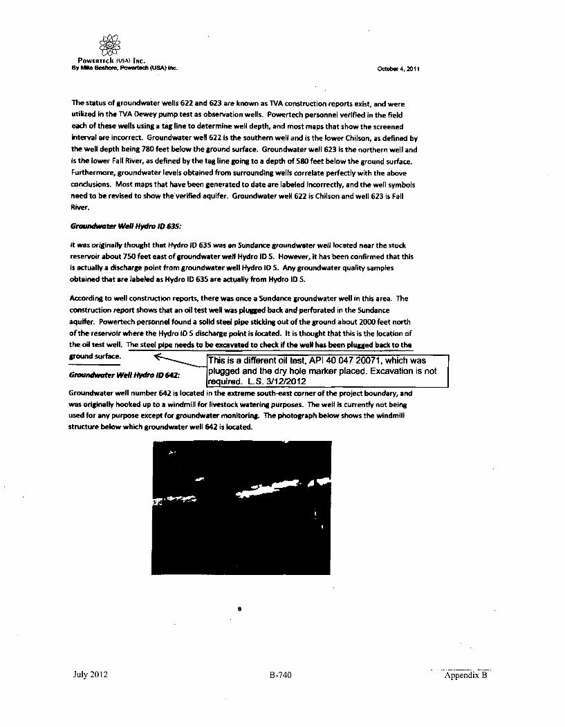
POWERTEch (USA) INc.By Me Beshore. Powertech (USA) Inc. October 4. 2011
The status of groundwater wells 622 and 623 are known as TVA construction reports exist, and wereutilized in the TVA Dewey pump test as observation wells. Powertech personnel verified in the field
each of these wells using a tag line to determine well depth, and most maps that show the screened
interval are incorrect. Groundwater well 622 is the southern well and is the lower Chilson, as defined by
the well depth being 780 feet below the ground surface. Groundwater well 623 is the northern well and
is the lower Fall River, as defined by the tag line going to a depth of 580 feet below the ground surface.
Furthermore, groundwater levels obtained from surrounding wells correlate perfectly with the above
conclusions. Most maps that have been generated to date are labeled incorrectly, and the well symbols
need to be revised to show the verified aquifer. Groundwater well 622 is Chilson and well 623 is Fall
River.
Groundwater Well Hydro ID 635:
It was originally thought that Hydro ID 635 was an Sundance groundwater well located near the stockreservoir about 750 feet east of groundwater well Hydro ID 5. However, it has been confirmed that thisis actually a discharge point from groundwater well Hydro ID 5. Any groundwater quality samples
obtained that are labeled as Hydro ID 635 are actually from Hydro ID S.
According to well construction reports, there was once a Sundance groundwater well in this area. The
construction report shows that an oil test well was plugged back and perforated in the Sundanceaquifer. Powertech personnel found a solid steel pipe sticking out of the ground about 2000 feet north
of the reservoir where the Hydro ID 5 discharge point is located. It is thought that this is the location ofthe oil test well. The steel pipe needs to be excavated to check if the well has been plugged back to the
ground surface. This is a different oil test, API 40 047 20071, which was
Groundwater Well htvdro ID 642: plugged and the dry hole marker placed. Excavation is not........... uIrured. L.S. 3/12/2012Groundwater well number 642 is located in the extreme south-east corner of the project boundary, and
was originally hooked up to a windmill for livestock watering purposes. The well is currently not beingused for any purpose except for groundwater monitoring. The photograph below shows the windmill
structure below which groundwater well 642 is located.
9
July 2012 B -740 Appendix B

POWERTECI (USA) INC.By Mie Seshou, Powertech (USA) Inc. Octcber 4. 2011
Well number 642 consists of a 5-inch steel surface casing that is in good condition. Groundwater level
measurements completed by Powertech personnel yield a water level of about S-feet below the ground
surface. Below is a close up photograph of groundwater well 642.
The construction details of groundwater well 642 were initially unknown. Powertech personnel ran
down-hole tools on the well to determine construction information. The down-hole camera shown that
the 5-inch surface casing extends to a depth of 12 feet below the ground surface, below which is an
open hole to a total well depth of 33 feet. Location and geophysical log information was provided to
Powertech geologists, and they interpreted the well to be producing water from surface alluvial
sediments. However while running the camera down the hole, it was noted that the walls of the
borehole consisted of solid-rock. The geophysical log from the hole should be re-examined to make sure
the well Is not completed in a sandstone formation such as the Fall River or Chilson.
Gronmdwarer Well Hydra 10651:
The original groundwater well database provided to Powertech from its consultants identified a
groundwater well Hydro ID 651. Powertech personnel inspected this area, and confirmed that there is
no groundwater well at this location. There is a stock tank at the location, but it originally receivedwater from groundwater well Hydro ID 6 via a trenched pipeline. Inspection of an aerial photograph of
this location dearly shows that a pipeline exists from well number 6 to the location of the stock tank,
which was originally thought to be a stand-alone well. From conversations with the current landowner,the groundwater well 6 at one time would provide water to the stock tank, but following TVA pumping
of aquifers, the well failed to deliver water to the stock tank location.
Groundwater Well Hydro ID 669:
Groundwater well number 668 is located within the project area and within the proposed groundwater
aquifer exemption boundary at the location of the TVA Burdock groundwater pumping test.
9
July 2012 B-741 Appendix B

POWERTECII (USA) INC.By Mike Beshom. Powerehe (USA) Inc. Octoba 4, 2011
As can be seen from the above photograph, this groundwater well is in excellent condition and consists
of a 10-inch casing. The groundwater well is artesian and provides livestock water for the landowner.
This groundwater well was used as the pumping well during the TVA Burdock aquifer test, and so there
is a lot of construction information available. The TVA well construction report shows that the well
produces groundwater from both the Fall River and Chilson aquifers, but Powertech personnel thought
it was important to verify that information by running the down-hole camera and geophysical logging
tool.
Powertech personnel ran the down-hole camera on the water well and confirmed that the well is
screened at multiple intervals. The upper screen of the well extends from 300 feet to 350 feet below
the ground surface. A solid, unscreened interval exists from 350 feet to 495 feet below the ground
surface. From 495 feet to 550 feet below the ground surface is the lower screened interval of the well.
The total depth of the well is 550 feet.
The geophysical logs ran by Powertech personnel were provided to Powertech geologists for geologic
interpretation. It was confirmed that the upper screened interval of the well (300-350 feet) is In fact
within the lower Fall River Formation aquifer. The lower screen of the well from 495 to 550 feet
intersects the Lower Chilson Member of the Lakota aquifer. The solid casing that runs between the two
screened intervals intersects the Fuson Member confining layer.
During the summer of 2011 Powertech personnel installed an inflatable packer within the groundwater
well 668, in an attempt to isolate the two screened intervals of the groundwater well and conduct
monitoring of the artesian pressures of each screened aquifer. That task and monitoring details are
contained within a stand-alone report provided to Powertech engineering.
10
July 2012 B-742 Appendix B

B Mike B hoem, Pow ~ (USA) Inc. October 4, 2011
Dmew twSo* Ouuumo ktwcomt Surfac Memummeum - Caked by Suhoq and VWeafcu T5
row TO(: Water Lem El-valom (Fee) - Water Level Waterle" Water Lee Water Level_C, y IDor S SO StJteP e 14 830 Ptea Pt019603 wet twoollon M Point E (Feel)- wooof ol4%km(Feet)- flevawo(Fee)- Elevaton(Feet)- Elevagm (Fe" -9Code tog (Feet) N (Feet) Fam n (Feet) (Fee) P E004(Fe) We1k2of VW2010 JZ/13/2010 wrok•Z/1T/2011 waeko/2/211 Weekof3/21/IJ wqmkuf4/2V20I112 354371 43437LS Labmtm 0 3641.14 3641.51 36SLS 3663.46 3554.06 3654.26 3654.09 3654.55 F
14 10133 41472334 F&d Nlv 300 309AM 3669* Nat Measured 3662391 1643.07 3663.02 3663,05 366315NS 96726 4421.26 Fad tKw 434 3638.75 363.63 3644.6 3644,23 36"4.76 3646.61 3646,75 3647.03 -4* 957330A 444022.8 Fag lur 600 3638.6 3621.27 3641.59 3642.36 3642.34 Not Measured 3644.64 3645.47 n436 Sao"" 454700.39 Fad RKer 90 3739.5S 3739S NOt Meesured 3707.48 3707.56 3707.31 3707.36 3707.311n 920133.3 44780. .aIVA 2000 3700.67 3700.67 MISS 3611.8S 3663.81 3587.76 3667.75 368.05610 SI B 44796.5 Fa Osve 630 3704.85 3704AS 39.1.75 3591.74 3691.51 3691AS 3691.83 369132u11 90CM9n 4S5S.33 La"o 804 3737.36 3737.36 Not Masured 3691.99 36&0.77 391.03 3691-3 3691.26612 39015349 454128637 LataU 000 3732.34 3732.34 Not Measured 3614.04 3692.69 3692.9 3693.17 3693.15613 99523.4 453775.8 FaPd m 510 3736.93 3731.93 3700.03 3700.2 370.23 3700.02 3700 3700.03515 93571 4537L.9 Laie Se00 3741 " 3741 3652.31 3649.79 3611.49 368L 72 3688.99 3688.9961 9e03i.5 453135.16 9mbytA 83 3751.04 3751.04 Not Measured 3693.43 3692.16 3692.4 3692.63 3692.6617 9i425.3s 453553.39 Labou 810 3725.51 3M23.55 Not Measured 3692.35 3691.11 3691.33 3691.38 3691.53622 251174.5 45403U Lakots 7M0 3754.91 3754.91 3692.85 3193.33 369Z.03 3692.24 3692.5 3692.47623 991054.6 4S4311.84 Fall 31w Sao 3733.23 3753.28 3701.51 370B.64 37L.6S 370LS 370313 37L.5562 96034.7 449719.2 FaPg Rlo 520 3731.99 3731.99 3694.73 3694.93 3694.77 3894.69 3694.42 3694.66631 1002357.7 449309-8 FAll Aver 80 3745.37 3745.37 37165 3716.95 3716.92 3717.11 3717.37 3717.4107 6988•2.27 454729.93 Lakta 8O0 3747.S& 3747,5 Not Measued 3693.34 3692.06 3692.28 3692.48 3692.53m0 1003476.6 4293.1 *ahm 436 3701.94 3701.94 3661.02 3660.69 3661.06 3661.09 3661.07 3661.45661 987213 44372S.3 Fagl 3Iver 600 3626.99 3630.31 3649.22 3643.19 3644.21 Not Measured 3646.05 3646.63632 15S33.2 431257.9 Laeoe 450 3738.24 3718.24 366.4 3G65.14 3646.49 3665.54 3665.45 3G65.7563 961W0.5 446104.7 Fl River 650 3663.66 . 3666.64 3662.67 3659.2 36588 Not Mesured 3660.21 360.5S764 10036I0.36 429744.24 Lakbo 423 365.04 3iI.04 Not kMiared 3661.S? 3661.96 3661.96 3661.93 3662.3465 13 .4 443409.7 Fail SRr 56 3627.51 3630.33 366 3642.12 36413 Not Measured 3645.51 3646.14GAS 10l333. 77 42948.S6 Laote 428 3692.06 392.06 Not Measued 3661.23 3661L.2 3861.56 3661.48 3661.96667 l48.1i 443724.72 Fag Rie 608 3623.84 3624.79 Not Measured 3641.44 3642S8 Not Measured 3643.99 3644.3963i 10042SA 42W4.4 Fal Rluer 255 3701.26 3701.26 3663.36 3662.81 3643.09 3663.08 3663.06 3663.37m 58715 4437m2 LoA 730 3627.27 3629.69 3664.72 3684.1 36786 Not Measured 3684.23 3683.9901 984762.9 4463694 Fall Rew SOS 36286. 3630.29 3544,65 3643.51 3643.8 Not Measured Not Measured 3646.1252 100474.41 430014.33 Lahou 335 3704.96 3704.48 Not Meaured 3663.21 3611634 3663.57 3663.54 3683.83494 197116.1 4ZI253.1 FPA W 392 359.29 3600.19 310.23 3640.-12 3641.29 3641.2 3641.28 3641.64I9S 90718.4 4331.2.5 FPa Rkr Soo 3597.6 339.12 368 3634,18 3633.64 3634.95 3634.42 3634.95m6 96966•.6 427141.5 LSIts 587 3597.96 3539.91 364109 3649.16 3649.78 3649.6 3649.58 3650.7407 90748.4 439147.4 Laknts 692 3597.69 3600.3 3679.68 3675.76 367031 3678.16 3672.58 3672.69as 100430738 435651.1 Fe RIver 205 3724.25 3714.25 3679.28 367945 3679.38 3679.22 3679.21 3679.35705 997022.63 453314.89 Lakmta 460 386,4 382642 Not Meared 3709.977 3709.62 3709.41 3709.53 3709,64706 99697.91 453276.44 Fal0 RIver 31 324.32 3624.32 Not Meanured 3725.19 372S.32 3715.1 3725.29 3725.153JO6 10120174 432933.2 tamnt 196 3320.48 3820.48 3630.3 3680.89 3610178 3660.38 3680.46 3680.56
OLD - OUTtEpSS
C 11
0-•

By Mike 808htoq, Powmelch (USA) Inc. October 4.2011
NJ
NJ
1/4 - 1/4 Coordinates Screened Flow RateHydra ID Township Range Section Coordinates East C Well Use Status FlwRt
Location North Location (GPM)
1 7 1 9 SESE 1027696 429227 Chilson Stock Flowing 1.52 7 1 16 SESE 1026724 423922 Chilson Domestic 4.113 7 1 22 SWNW 1028593 421104 Chilson Stock Flowing 34 7 1 15 SESE 1032516 423080 Unknown Stock Flowing 55 7 1 14 NENW 1035131 427284 Chllson Stock Flowing 1.5
6 7 1 14 NESE 1037218 425012 Unknown Stock7 7 1 23 NWNW 1033304 422417 Fall River Domestic 0.0568 7 1 23 SWSE 1036052 418515 Fall River Domestic 0.149 7 1 23 NENE 1038003 421306 Fall River Stock Flowing 312 7 1 4 SESE 1026978 434378 Chllson Stock Flowing 3.313 7 1 3 NWNW 1028360 438470 Chilson Domestic 0.08514 7 1 2 NWSW 1033704 434723 Fall River Stock15 7 1 2 NENW 1035304 438317 Chllson Stock16 7 1 1 NESW 1041428 434446 Chllson Domestic17 7 1 12 SENW 1040223 431329 Fall River Stock18 7 1 9 SWSW 1022812 428960 Fall River Domestic 637 7 2 18 NWSW 1044183 423947 Unknown Stock 2.538 6 1 33 SWNW 1024328 442289 Fall River Stock Flowing 1.540 6 1 30 SWNW 1013415 447182 Inyan Kara Domestic41 6 1 31 SWNE 1015385 442081 Unknown Stock42 7 1 5 SWNE 1021144 436481 Chilson Domestic 16.243 6 1 34. SWSE 1031123 439436 Chilson Domestic49 6 1 32 NWNW 1018932 444022 Fall River Stock Flowing 1.251 7 1 9 SENE 1027411 431417 Chilson Stock Flowing 12.961 7 1 11 NWSE 1036832 429987 Chilson Stock96 41 60 22 SWSW 1011630 451853 Chllson DomestIc 0.11
102 6 1 18 SWNE 1016125 458312 Chilson Domestic 1.5106 6 1 18 NENE 1018099 459625 Unknown Stock
107 6 1 18 SWNE 1017018 458158 Fall River Domestic
106 6 1 18 SWNE 1016478 458698 Fall River Domestic109 6 1 17 NENW 1020601 45962S Chilson Domestic 0.085110 6 1 17 NIENE 1023777 459643 Chillson Stock
111 6 1 17 NWNE 1022074 459586 Fall River Stock112 6 1 16 SUE 1027864 455881 Fail River Stack113 7 2 6 NESW 1046437 434417 Unknown Stock114 7 2 7 SESW 1045410 428654 Unkpapa Stock 0.56115 6 1 18 SENE 1017697 457640 Fall River Domestic 0.17116 6 1 18 SENE 1017992 458111 Fall River Stock Flowing 1.5
Notes
2 X 40 GPD (Est)
S X 40 GPD (Est)
1 X 123 GPD (Est)
Not In Use
Windmill - Not In Use
Not In Use
Not In Use
Not In Use
4X4OGPD
2 Residents & 2 Gardens
Not In Use
Not In Use
1 X 123 GPD (Est)
Windmill - Not in Use
Not In Use
40 cows X 20 GPD
2 X 123 GPD
Dewey Post Office
0
C
C
2
4I
12

By Mike Beghorm. Powbrtsch (USA) Inc. Octobr 4, 2011
0
Hydro ID Township Range Section 1/4-1/4 Coordinates East Coordinates Screened UseLocation North Location
117 6 1 8 SWSE 1022177 460796 Unknown Stock138 6 1 s1 NENE 1017537 459030 Fall River Domestic147 6 1 17 NESW 1020179 456566 Chllson Monitor220 6 1 19 SENE 1017172 452334 Unknown Stock270 6 1 19 NWSW 1014108 451942 Unknown Stock436 6 1 20 NWNE 1021450 454700 Fall River Monitor506 7 2 8 SWNW 1050129 430704 Unkpapa Stock510 7 1 12 SESE 1042933 421178 Chilson Stock609 6 1 29 SWNE 1021735 447808 Chilson Monitor610 6 1 29 SWNE 1021599 447969 Fail River Monitor611 6 1 20 NWNE 1021835 453954 Chilson Monitor612 6 1 20 NWNE 1021755 454128 Chilson Monitor613 6 1 20 NWNE 1022125 453775 Fall River Monitor614 6 1 20 NWNE 1022185 453769 Fuson Monitor615 6 1 20 NWNE 1022172 453708 Chilson Monitor616 6 1 20 SWNE 1022132 453134 Chilson Monitor617 6 1 20 NENW 1021026 453382 Chllson Monitor618 7 1 2 SENE 1038074 435906 Unknown Stock619 7 1 2 SENW 1034866 436729 Chllson Stock620 6 1 35 NWNW 1033951 443209 Chllson Stock622 6 1 20 NENE 1022776 454033 Chlbon Monitor623 6 1 20 NENE 1022686 454311 Fall River Monitor628 6 1 20 SESE 1022496 449718 Fall River Stock631 6 1 23 SWSW 1034177 449309 Fall River Stock635 7 1 14 NENW 1004035 427131 Sundance Monitor637 7 1 11 NESE 1038075 430320 Unknown MonitorUS 7 1 2 NENE 1038269 437976 Fall River Monitor639 7 2 7 SENW 1045704 430722 Unknown Stock640 7 1 12 SUE 1043010 427965 Unknown Stock642 7 1 12 SUE 1042926 4238042 Unknown Stock645 7 1 16 NINE 1027681 427998 Unknown Stock650 7 1 1 SESE 1043781 433331 Chilson Stock656 6 1 31 SENW 1014230 442000 Unknown Stock657 6 1 20 NWNE 1021483 454729 Chilson Monitor662 7 1 11 SESW 1035381 423928 Unknown Monitor668 7 1 15 NWNE 1031029 427450 Iryan Kars Stock676 6 1 34 SSW 1030846 439891 Alluvial Monitor677 7 1 4 SWSW 1023527 434077 Alluvial Monitor
FlStatus
ow Rate Notes(GPM)
Not In Use
0.75 2 Residents & 10 Horses
0.2
0.8mFlowing
Flowing
Flowing 6.25
Flowing 6.25 Measured @ ST
'0*-o
13

By Mike Reshor, Povr~isc (USA) Inc. O1~r.21October 4. 2011
C)
0ý
Hydro ID Township Range Section 1/4-1/4 Coordinates East Coordinates Screened Well UseLocation North Location
678 7 1 9 SWNE 1026522 431925 Alluvial Monitor679 6 1 27 NWSE 1032294 446245 Alluvial Monitor680 7 1 11 NESW 1035078 429969 Chllson Monitor681 6 1 32 NENW 1020330 443725 Fall River Monitor682 7 1 11 SENW 103S139 431257 Chilson Monitor683 6 1 29 NESW 1020212 446104 Fill River Monitor684 7 1 11 NESW 1035191 429744 Chilson Monitor685 6 1 32 NWNE 1020690 443409 Fall River Monitor686 7 1 11 NESW 1034970 429749 Chilson Monitor687 6 1 32 NENW 1020081 443724 Fall River Monitor688 7 1 11 NESW 1035027 429974 Fall River MonitorG89 6 1 32 NENW 1020316 443789 Chllson Monitor690 7 1 11 NESW 1035114 429970 Unkpapa Monitor691 6 1 32 NENW 1020364 443698 Fall River Monitor192 7 1 11 NESW 1035075 430014 Chllson Monitor693 6 1 32 NENW 1020327 443661 Unkpaps Monitor694 7 1 15 NWNW 1028717 426836 Fall River Monitor695 6 1 32 SESE 1022385 439312 Fall Rver Monitor696 7 1 1s NWNW 1028538 427141 Chilson Monitor697 6 1 32 .SESE 1022350 439347 Chilson Monitor698 7 1 2 NESW 1035909 435651 Fail River Monitor703 7 1 1 SWS( 1041621 434334 Unkpaps Domestic704 7 1 5 SWNE 1020966 436647 Chilson Domestc705 6 1 21 NENE 1028624 453314 Chilson Monitor706 6 1 21 NENE 1028589 453276 Fall River Monitor707 6 1 34 SWNE 1031935 441809 Alluvial Monitor708 7 1 3 SESW 1030254 434094 Alluvial Monitor709 7 1 15 SENW 1029286 426603 Alluvial Monitor
3026 7 1 12 NENE 1043638 432833 Chilson Monitor4002 6 1 30 NWSW 1013414 446931 Inyan Kara Domeic7002 7 1 23 NWNW 1033333 421931 Chllson Stock
Flow RateStatus (PM) Notes 0
-I
C
C
zFlowing
Flowing
Flowing
FlowingFlowingFlowing
FlowingFlowingFlowingFlowingFlowing
Shut-in
Shut-In
Shut-in
41
0ON
Shut-InShut-InShut-In
Shut-In
Shut-In
Shut-In
Shut-In
Shut-In
Not In Use
1.5 1 Resident & Stock (est)
2.72
3.45
>0
Q.l 14

A
U
I.
.7 .- "j*~ I>
July 2012 B-747 J 21,4Appendix B

By Mike Bahore, Powerbach (USA) Inco OCtober 4, 2011
0
I'J
Hydro ID Township Riale Section 1/4 -1/4 Coordinates Coordinates Screened Well Use Total Screened Screened Aquifer Work to CompleteLocation East North Location DeWlh Interval _ _ _
1 7 1 9 $ESE 1027696 429227 ChOlson Stock 1 Inch Camera2 7 1 16 SESE 1026724 423922 ChlLson Domestic 650 566-650 Need Access, Artesian x3 7 1 22 SWNW 1028593 421104 Chilson Stock 1 Inch Cameras4 7 1 15 SESE 1032516 423060 Unknown Stock I Inch Camera & Access5 7 1 14 NENW 1035181 427284 Fall River Stock 17S 155-175 Lower Fall River Completeo6 7 1 14 NESE 1097218 42S012 Unknown Stock 200 13S-200 Compilet .7 7 1 23 NWNW 1033304 422417 Fall River Domestic 200 Need Access, Artesian8 7 1 23 SWSE 1036052 41851S Fall River Domestic 240 Need Access, Artesian9 7 1 23 NENE 1038003 421106 Fall River Stock 1 Inch Camera
12 7 1 4 5151 1026978 434378 Chlion Stock 80S I Inch Camera13 7 1 3 NWNW 1028360 438470 Chilson Domestic 625 580-625 Complete14 7 1 2 NWSW 1203704 434723 Fall River Stock 300 Lower Fall River I Inch Camera15 7 1 2 NENW 1035304 438317 Chilson Stock _ Ready, Dry Hole16 7 1 1 NESW 1041428 434446 Chilson Domestic 330 Remove Shed17 7 1 12 51NW 1040223 431329 Fall River Stock Need Access, Pull Windmill18 7 1 9 SWSW 1022812 428960 Fall River Domestic 527 Need Access37 7 2 sJI NWSW 1044183 423947 Fall River Stock 145 93-145 Upper Fall River cmleifte38 6 1 33 $WNW 1024321 442239 Fall River Stock 494 Pull Pump40 6 1 30 SWNW 1013415 447182 Irr•an Kara Domeatic 1 Inch Camera & Access41 6 1 31 SWNE 1015385 44"Ma1 Unknown Stock Need Access42 7 1 5 SWNE 1021144 436481 Chilson Domestic 600 Need Access, Artesian43 6 1 34 SWIE 1031123 439436 ChIlson Domestic Need Access49 6 1 32 NWNW 101332 444022 Fall River Stock 600 47"3-540 Upper Fall River51 7 1 9 SENE 2027411 431487 Chison Stock Need Access61 1 7 1 1 11 NWSE 1031M32 429987 Cholwsn Stock Ready96 41 60 22 SWSW 1011630 451853 ChUson Domestic Need Access
102 - 6 1 18 SWNE 1016625 458312 Chllson Domestic Need Access106 6 1 18 NENE 1011099 459625 Unknown Stock 196 160-196 Complete107 6 1 18 SWNE W017018 458158 Fall River Domestic Need Accessll 6 1 s1 SWNE 1016478 438M19 Fall River Domestic Need Access101 6 1 17 NENW 1020801 459625 Chlison Domestic Need Access110 6 1 17 NENE 1023777 459643 Chlson Stock Need Access
111 6 1 17 NWNE 1022074 459186 Fall River Stock Need Access112 6 1 16 51.1 1027864 4551M Fall River Stock Need Access, Pull Windmill113 7 2 6 NESW N104837 434417 Unknown Stock Need Access, Pull Windmill114 7 2 7 SISW 104S410 42864 Unkpap Stock Need Access, Pull Windmill115 6 1 18 SINE 1017697 457640 Fall River Domestic Need Access116 6 1 18 SENE 1017992 458111 Fall River Stock Need Access217 6 1 8 SWSE 1022177 480796 Unknown Stock Pull Pump13i 6 1 18 NENE 1017537 453090 Fall River Domestic Need Access147 6 1 17 NESW 1020679 456S66 Chllson Monitor 750 650-750 1 Complefe220 6 1 19 SENE 1017872 452334 Unknown Stock 463-523+ Upper Fall River Complete270 6 1 19 NWSW 1014108 451942 1Unknown Stock __7___1 Inch Camera
00
16

By Mike a .eeho, Powertsc (USA) Inc. October 4, 2011t
IJ
Hydro ID Township Range Section 1/4-1/4 Coordinates Coordinae Screened Total Screened Screened Aquifer Work to CompleteLocation East North Location WellUse Depth Interval SreneAuie WrktoC
436 6 1 20 NWNE 1021450 4S4700 Faill River Monitor 590 505-590 Lower Fall River Complete506 7 2 a SWKW 1050o29 430704 Unkpapl Stock Ready510 7 1 12 5156 1042133 43178 Chillson Stock Need Access, Pull Pump609 6 1 29 SWNE 1021735 447m06 Chilson Monitor 1000 903-966 Lower Chilson Complete610 6 1 29 SWNE 1021519 447969 Fall River Monitor 610 630-672 Lower Fall River Complete
611 6 1 20 NWNE 102183S 453954 Chillson Monitor 04 695-730, MLddle Chilson, Complete______ _______ ________755-80 Lower Chllson
612 6 1 20 NWNE 10217S5 454122 Chilson Monitor am 692400 Lower Chilson613 6 1 20 NWNE 1022125 4S3775 Fall River Monitor S80 504-S80 Lower Fall River complete614 6 1 20 NWNE 10221.8 453768 Fuson Monitor 620 609420 Fuson Complete615 6 1 20 NWNE 1022172 453708 Chilson Monitor 800 712-800 Lower Chilson Complete616 6 1 20 SWNE 1022132 453134 Chilson Monitor 835 73-535 Lower Chillson complete617 6 1 20 NENW 1021026 4S3S82 Chillson Monitor 810 7154-10 Lower Chlison Complete618 7 1 2 SENE 1038074 435•06 Unknown Stock Complete619 7 1 2 SENW 1084866 436729 Chilson Stock 288 230-288 Upper Chilson Pull Pump620 6 1 35 NWNW 1033SS1 443209 Chilson Stock Need Access, Pull Pump622 6 1 20 NENE 1022776 454033 Chilson Monitor 780 714-780 Lower Chilson Complete623 6 1 20 NENE 1022686 454311 Fall River Monitor S80 503-SS0 Lower Fall River Complete628 6 1 20 S.5E 1022496 449718 Fall River Stock 520 Upper Fall River Need Access, Pull Pump
631 6 1 23 SWSW 1034177 449309 Fall River Stock 80 30-80 Lower Fall River Need Access, Pull Pump635 7 1 14 NENW 0I040IS 427131 Sundance Monitor Not A Well6i7 7 1 11 NIESE 1038075 430320 Unknown Monitor 1 Inch Camera638 7 1 2 NENE 1038C26 437976 Fall River Monitor Pluued?, Need to Verfy
639 7 2 7 SENW 1045704 430722 Unknown Stock Ready, Hand D Well640 7 1 12 SSE 1043010 427965 Unknown Stock Pull Pump642 7 1 12 SI45 1042926 428042 Alluvial Stock 33 12-33 Alluvial Complete645 7 1 16 NENE 102761 427998 Unknown Stock Need Access, Pull Pump650 7 1 1 SESE 1043781 433331 Chilson Stock Pull Pump65 6 1 31 SENW 1014230 442000 Unknown Stock Remove Shed to Access657 6 1 20 NWNE 1021483 454729 Chilson Monitor 800 7154800 Lower Chllson complivie662 7 1 11 SESW 1035381 428928 Unknown Monitor 1 Inch Camera
8 7 it300-350, Lower Fall River, lete1 15 NWNE 1031029 427450 inyan Kara Stock 550 495-550 Lower Chilson
676 6 1 34 SESW 1030846 439891 Alluvial Monitor 22.5 12-22 Alluvial Complete677 7 1 4 SWSW 1023527 434077 Alluvial Monitor 14.5 4-24 Alluvial Complete678 7 1 9 SWNE 1026522 431925 Alluvial Monitor 14.5 4-14 Alluvial Complete679 6 1 27 NWSE 1032294 446245 Alluvial Monitor 39 29-39 Alluvial Complete680 7 1 11 NESW 1035078 429969 Chilson Monitor 436 426-436 Lower Chilson Complete681 6 1 32 NENW 1020330 443725 Fall River Monitor 600 585-600 Lower Fall River Complete682 7 1 11 SENW 1035139 431257 Chilson Monitor 460 450-460 Lower Chilson Complete683 6 1 29 NESW 1020212 446104 Fall River Monitor 650 635-650 Lower Fall River Complete684 7 1 11 NESW 1035191 429744 Chilson Monitor 423 413-423 Lower Chilson Complete685 6 1 32 NWNE 1020690 443409 Fall River Monitor 595 580-595 Lower Fall River Complete
0
2-I
0
C
2
>
17

By Mike o•a*om, Powimflh (USA) Inc. 0~~e 4,2011
C
Hydro ID Township Range Section 1/4-1/4 Coordinates Coordinates Screend Well Use Total Screened Screened Aquifer Work to CompleteLocation East North Location Depth Interval M__
686 7 1 11 NESW 1034970 429749 Chllson Monitor 428 418-428 Lower Chilson Complete
687 6 1 32 NENW 1020081 443724 Fall River Monitor 608 S93.608 Lower Fall River Complete688 7 1 11 NESW 1035027 429974 Fall River Monitor 255 245-255 Lower Fall River Complete689 6 1 32 NENW 1020316 443789 Chilson Monitor 730 715-730 Middle Chilson Complete690 1 7 1 11 NESW 1035114 429970 Unkpapa Monitor 631 621-631 Unkpapa Complefte691 6 1 32 NENW 1020364 443698 Fall River Monitor 505 490-505 Upper Fall River Complete692 7 1 11 NESW 1035075 430014 Chilsom Monitor 335 325-335 Upper Chilson Complete
693 6 1 32 NENW 1020327 443661 Unkpapa Monitor 930 910-930 Unkpapa Compete694 7 1 15 NWNW 1028717 426836 Fall River Monitor 392 377-392 Lower Fall River Complete695 6 1 32 S.SE 1022385 439312 Fall River Monitor 508 493-508 Lower Fall River complete696 7 1 15 NWNW 1028538 427141 Chilson Monitor 587 572-587 Middle Chilson Complete697 6 1 32 SESE 1022350 439347 Chilson Monitor 682 667-682 Middle Chilson Complete698 1 7 1 2 NESW 1035909 43S651 Fall River Monitor 205 180-205 Lower Fall River Complete703 7 1 1 SWSE 1041621 434334 Unkpapa Domestic 525 475-525 Unkpapa Complete704 7 1 5 SWNE 1020966 436647 Chilson Domestic Complete705 6 1 21 NENE 1028624 453314 Chllson Monitor 460 428-458 Middle Chilson Complete706 6 1 21 NENE 1028589 453276 Fall River Monitor 316 284-314 Lower Fall River Complete707 6 1 34 SWNE 1031935 441809 Alluvial Monitor 44 30-40 Alluvial Compliet709 7 1 3 SESW 1030254 434094 Alluvial Monitor 28 17-27 Alluvial Complete709 7 1 15 SEtW 1029286 426603 Alluvial Monitor 40 28-38 Alluvial Complete3026 7 1 12 NENE 1043638 432833 Chilson Monitor 196 166-196 Middle Chilson complete4002 6 1 30 NWSW 1015414 4,46931 Inyan Kara Domestic Need Acces 1 Inch Camera
7002 7 1 23 NWNW 1033333 421931 Chilson Stock 500 Need Access, Artesian0•
18

POWERTECh (USA) INC.By We Beehom. Powamrb (USA) fn. Ockobe4, 2011
Powertech (USA) Inc.
Standard Operating Procedure (SOP)
Groundwater Well Water Level Monitoring
This SOP outlines procedures for measuring and documenting artesian and sub-surface water levelswithin groundwater monitoring wells.
Materials:
* Powertech Groundwater Well Monitoring Data Sheet.
" Electric Logging Water Level Measuring Tape.
" High-Resolution Digital Pressure Gauge.
" Tape Measure with 1/100'h foot accuracy.
Personal Protective Equipment (PPE):
* Several potential hazards exist during groundwater well water level monitoring. These indude
but are limited to pinch-points, pressure, slip/trip/fall, and environmental hazards. Appropriate
PPE must always be utilized when conducting groundwater well water level monitoring.
Docurmentation:
* The person conducting the groundwater well monitoring must completely and accurately fill out
the Groundwater Well Monitoring Data Sheet.
" The person conducting the groundwater well monitoring must read and sign the SOP forGroundwater Well Water Level Monitoring. A copy of the signed SOP should be filed at thenearest Powertech Field Office. A copy of the SOP must accompany the person conducting themonitoring in the field.
Procedures:
1. Completely fill in the Powertech Groundwater Well Monitoring Data Sheet.
2. Procedure for pressurized artesian groundwater wells.
a. Fully shut-in the artesian groundwater well so that there are no leaks that result in the lossof artesian pressure. This may require some tightening or replacement of plumbing fixtures.
A dosable valve should be fitted to the well head that allows the attachment of the high-
resolution digital pressure gauge. This valve and other plumbing fittings should not beremoved, so that future measurements can be conducted at the same elevation.
b. Make sure that all air has been evacuated from the artesian groundwater well. The high-
resolution digital pressure gauge can now be installed and turned on. Make sure that the
gauge has been reset, or zeroed out.
July 2012 B-751 Appendix B

POWERTECh (USA) INc.By Me Beslore, Poweroah (USA) Inc. OctobWer4. 2011
c. Take an initial pressure measurement in pounds/square-inch (PSI) and document themeasurement and time on the Powertech Groundwater Well Monitoring Data Sheet.
Pressure measurements should be taken with an accuracy of 0.01 PSI.
d. Continue to take and document pressure measurements until the artesian water well
pressure has stabilized. A stabilized artesian pressure measurement is defined as one of the
following:
a. A pressure measurement that reaches a maximum value, and then slightly
decreases, but does not exceed the maximum documented value within a period of
15 minutes.
b. If the pressure measurements DO NOT fluctuate more than 0.04 PSI (or 0.1 feet of
water head) over 3 measurements within a 15 minute time period.
e. Make sure to measure the vertical distance between the surveyed control point (Top of
Casing or Survey Pin) and the pressure sensor diaphragm on the pressure gauge. This
measurement must be taken with an accuracy of 1/100"h of a foot.
3. Procedure for sub-surface water level groundwater wells.
a. Lower the probe of an Electric Logging Water Level Measuring Tape into the groundwater
well, and lower at a slow rate. Be careful not to let the probe and tape unwind too quickly
as they may come free of the spool and be lost Into the well.
b. Also make sure that the probe sensitivity is adequately adjusted. The deeper the water is in
the well, the less sensitivity the probe will require. This is important as condensation in the
well could give false readings of the water level in the well.
c. Measure and document the depth to the water in the well from the top of the well casing.
This measurement must be logged with an accuracy of 1/100• of a foot. Make sure to take
several measurements to ensure an accurate final water level.
I certify that I have read and understand the content of this Standard Operating Procedure.
Employee Signature: Date:
20
July 2012 B-752 Appendix B

POWERTECh (USA) INC.
SOURCE F
RESPEC RESPONSES TO NUCLEAR REGULATORY COMMISSION COMMENTS (REVISION 1)
(Letter from Crystal Hocking, RESPEC, to Mark Hollenbeck, Powertech (USA) Inc., July 22, 2010)
July 2012 B-753 Appendix B

POWERTECII (USA) INiC.
This page intentionally left blank
July 2012 B-754 Appendix B

POWERTECh (USA) INC.
S&TLSRSI(RCO)-1853/7-10/20
IRATER&N ATUIAL |!$0UICI5
External Memorandum
To: Mr. Mark HollenbeckPowertech (USA) Inc.310 2nd AvenueP.O. Box 812Edgemont, SD 57735
ce- Mr. John Mays, PowertechMr. Cory Foreman, RESPECProject Central File 1853 - Category A
From: Ms. Crystal HockingStaff GeologistRESPECP.O. Box 725Rapid City, SD 57709
Date: July 22, 2010
Subject: Responses to Nuclear Regulatory Commission Comments (Revision 1)
The purpose of this memorandum is to respond to the five tasks designated by Powertech tohelp respond to Nuclear Regulatory Commission (NRC) comments regarding the technicalreport. These tasks were outlined by Mr. John Mays and you at a meeting with RESPEC onJune 24, 2010.
Task 1. Check Well 650 and Compare Water Level to Depth to Lakota to DetermineSaturated/Unsaturated Conditions at That Location
In an effort to help identify areas where the Lakota Formation is fully saturated, water levelmeasurements of Lakota wells were compared to the elevation of the top of the aquifer.Tables 1 and 2 include well completion and water level measurements for Wells 650, 3026, and619. Well locations are shown on Figure 1.
The elevation of the top of the Lakota at Well 650. 3,775 feet, was approximated byinterpolating the known depth to Lakota at Well 3026 with the location of the outcrop (wherethe depth equals 0). The average water level measurement is at 3,682 feet elevation, or 92 feetbelow the approximate top of the Lakota. At the location of Well 3026 (DB08-01-06), the waterlevel is approximately 60 feet below the top of the Lakota Formation. At both of these wells, theLakota is only partially saturated. At Well 619, the water level in the Lakota is approximately300 feet above the top of the Lakota Aquifer based on estimates of the Lakota elevation from thesitewide structural contour maps; here the Lakota is fully saturated.
U24 Jo YOh jo la 75bpi Cly. So" &*M 57M -OM2 Pflm 50534400 far 65%M456456 wwrVJwsse - DRAFT -
July 2012 B-755 Appendix B

POWERtECh (USA) InC.Mr. Mark Hollenbeck Page 2
Table 1. Well Completion for Wells 650, 3026, and 619
July 22, 2010
Hydro I.D. or Hydro Code 650 3026 619
Powertech Borehole I.D. DBO8-01-06
Formation Lakota Lakota Lakota
Subsurface (SS) or Free-Flowing (FF)
Depth (ft) Unknown 196 280
Screened Interval (ft) Unknown 166-196 Unknown
Top of 8-inch Top of 6-inch Top of 5-inch steelMeasuring Point steel casing casing pipe coupling on casing
Surveyed Well Casing 3,820.48 3,700.12Elevation (ft)
Stick Up (Well Casing -0.20 0.00Mark) (ft)
Surveyed Control Point 3,821.06 3,698.82Elevation (ft)
Stick Up (Control Point) (ft) -0.56
Calculated Measuring Point 3,821.62 3,820.68 3,700.12Elevation (ft) ,8___,2._,7.1
In an effort to better delineate where the Lakota Aquifer becomes fully saturated, RESPECrecommends Powertech acquire water levels from two or three additional Lakota wells in closeproximity to the outcrop. Recommended wells include Wells 16, 61, and/or 620 (Figure 1). Noneof these wells have well completion reports, although they are listed in Tennessee ValleyAuthority (TVA) reports as being completed within the Lakota. Well 16 is listed in the TVA
draft Environmental Impact Statement (EIS) as having a water elevation of 3,747 feet, andbased on approximations from structure contour maps, the elevation of the Lakota is 3,730 feet
or just below the water level of the Lakota. Based on this information alone, it appears thatWell 16 is at or very near the area where the Lakota Aquifer becomes fully saturated. Fromthis, it is reasonable to assume that the transition from saturated to unsaturated conditions inthe Lakota is located geographically in the central to western portion of the Fall RiverFormation outcrop. However, because of fluctuations in the water table with time andprecipitation patterns, it is highly recommended to take a new water level measurement at Well16, the only Lakota well located on the Fall River outcrop.
Task 2. Check Field Notes to Verify Data on Existing Potentlometric Surfaces Is Correct
Water level data for wells with questionable data were spot checked to compare field noteswith the tabular data. An explanation of the results is provided in the following sections.
- DRAFT -
July 2012 B-756 Appendix B

POWERTECh (USA) INC.Mr. Mark Hollenbeck Page 3
Table 2. Water Level Measurements for Wells 650, 3026, and 619
July 22, 2010
Hydro 1.D. or Hydro Code 650 3026 619
Powertech Borehole I.D. DB08-01-06
Date ft above mean sea level
2007-09-27 3,679.13
2007-10-02 3,682.35
2007-11-09 3,682.35 3,679.19
2008-02-20 3,682.13
2008-03-24 3,,81.92
2008-03-30 3,681.89
2008-04-22 3,681.77
2008-05-21 3,682.8 3
2008-05-28 3,681.732008-05-30 3,682.00
20080)6-24 3,681.852008-07-13 3,681.78
2008-08-19 3,681.63
2008-09-22 3,681.78
2008-10-20 3,"81.83
2008-11-18 3,681.85
2008-12-17 3,682.50
2009-01-20 3,682.53
2009-02-24 3,682.50
Number 5 13 2
Mean Water Level Elevation 3,682 3,682 3,679
Elevation of Top Lakota 3,775t" 3,741 3,375
Differenceb -492 -59 304
(a) Based on interpolation.
(b) Negative value indicates Lakota Aquifer is unsaturated at well location.Positive value indicates Lakota Aquifer is saturated at well location.
- DRAFT -
July 2012 B-757 Appendix B

POWERTEih (USA) INC.Mr. Mark Hoilenbeck Page 4 July 22, 2010
RSI-1853-10-033
---
' :'•\ s- '.' 7 ... .
La,. W la, Nea .th"
• .-. , ..-e', ola: l_--,is.,a-m-
.--10•-- 3phemer Al ,e, .'
Legend J•Lakocs Wells Nearth0Lakots AW SaturatedtUnmatmrated
If er~tftndry 0 OA 0.8 1.2 1.4
Figure 1. Lakota Welb Near the SaturatcdUnsaturated Interface.
DRAFT
July 2012 B-758 Appendix B

POWERTECh (USAI INc.
Mr, Mark Hollenbeck Page 5 July 22, 2010
Fall River Aquifer
Well 613 and Well 622. These two wells are both completed to similar depth in the Fall RiverFormation (well completion reports available) and are located about 700 feet apart. Both wellshave a total depth of 580 feet and similar surface elevation with well 613 screened between 504and 580 feet and well 622 screened between 503 and 580 feet. The average water levelsreported on Figure 2.7-14 of the NRC technical report (TR) are correct as compared to originalfield notes. These two wells have a difference in head of about 8 feet based on recent averages(3,701 and 3,709 feet elevation, respectively); at the time these wells were drilled, they alsoexhibited a difference of 8 feet (3,711 and 3,719 feet elevation). The difference in head betweenthese two closely spaced wells is likely the result of minor differences in lithology andpermeability of the aquifer.
Well 695. The mean water elevation for this well is 3,632 feet and is correct as presented onFigure 2.7-14 of the NRC TR. The pressure has a mean average of 12 pounds per square inch(psi) with individual measurements that range from 12.7 to 13.8 psi. As in all free-flowingwells, psi is converted to feet by the formula:
Feet H 20 above measuring point = psi x(144 in'/ft2 )x(ft/62.431b). (1)
Lakota Aquifer
Well 8002. This Lakota stock well has an average elevation of 3,578 feet as presented onFigure 2.7-15 of the TR. This value was not used while generating the water level contours forseveral reasons. First, this well is a free-flowing artesian that was shut in duringmeasurements; although no leaks were visible, it is possible that this well could not completelybe shut in, as it is an older well with multiple fittings at the surface. Over the measurementtime interval (September 2007 through February 2009), only 3 pressure measurements weremade: 13, 15, and 14.65. Based on field notes, the value of 14.65 psi should be discarded as oneof the lines froze during the stabilization period and the sampler was required by the landownerto open the valve to prevent well damage. It is also believed that the other two readings werepotentially taken before the well had completely stabilized. ,
In generating the water level contours, Well 608 to the west was considered to have morereliable readings as this well is nonartesian and was measured with a water level tape. Waterlevels at Well 608 indeed exceeded estimates at Well 8002; that is unexpected and unlikelygiven the water gradient decreases toward the southwest. Water level data for Well 696,although not used in the generation of the original potentiometric surface, have an averagevalue of 3,639 feet elevation; this value is extremely close to the potentiometric surfacegenerated by ignoring the data from Well 8002. Therefore, it is our position that this decision tonot use data from Well 8002 was sound. It is advisable to verify completion of this well andobtain additional water level measurements.
Well 615. Based on six measurements, the mean potentiometric surface at Well 615 iscorrectly reported at 3,690 feet elevation. A well completion report for this well is available toverify this well is completed into the Lakota.
- DRAFT -
July 2012 B-759 Appendix B

POWERTECh (USA) INc.Mr. Mark Hollenbeck Page 6 July 22. 2010
Well 609. There are a total of 11 measurements for this well, all within ± 2 feet of each other.The value of 3,690 feet elevation on the existing potentiometric surface map is correct. A wellcompletion report for this well is available to verify this well is completed into the Lakota. Inaddition, Well 610 (completed in the Fall River) is immediately adjacent to this well and has acomparable water level of 3,693 feet.
Well 689. This well was recently installed by Powertech as a monitoring well for the Deweypump test. It is screened for 15 feet in the upper Lakota Formation. A total of 11 pressuremeasurements were collected from this well, ranging from 23 to 25 psi. The mean water level of3,684 feet presented on the potentiometric surface is correct according to our database and fieldrecords.
Well 38. Based on the TVA EIS, this stock well is located in Sec. 33, T6S, R1E with a depth of550 feet and completed in the Lakota. However, data from a well completion report (Figure 2)indicate this well has a depth of 494 feet. The surface elevation at this well is roughly3,630 feet, making the depth of this well have an elevation of 3,136 feet (assuming the wellcompletion report is correct). Based on structure contour maps, the bottom of the Fall River(top of Fuson) is around 3,130 feet. Based on the depth reported on the well completion formand the structural contour information based on exploration boreholes, this well is now believedto be completed in the Fall River Formation and not the Lakota Formation. The mean waterelevation of 3,644 feet measured at this well could be used in the future to slightly modify thepotentiometric surface for the Fall River Formation; the measured value is not unreasonable forthe Fall River. Since this is a free-flowing well, it is also possible the water level could behigher than measured if shut in for a longer period of time. If potentiometric surfaces areredrawn in the near future, it is recommended to not include Well 38 on the Lakota surface. Itis also recommended to log this well to verify completion.
Task 3. Generate Map of Potentlometric Surfaces That has-Wells Labeled by Well I.D.
Existing potentiometric surfaces for the Fall River, Lakota, and Unkpapa Aquifers arepresented in Figures 3 through 6. Contours have not been modified from previous versions.Figure 5 is a revised potentiometric map of the Lakota that has wells not used in generatingcontours removed to reduce confusion.
Task 4. Compile Water Level Data and Completion Information Into a Table
Tables 3 through 8 contain the field water level measurements and calculated water tableelevations. Tables 3 and 4 contain data for the Inyan Kara Aquifers, Tables 5 and 6 containalluvial aquifer information, and Tables 7 and 8 contain water level information on theUnkpapa Aquifer.
DRAFT -
July 2012 B-760 Appendix B

POWERTECII (USA) INiC.
Mr. Mark Holienbeck
RSI-1853-10-034
Page 7 July 22, 2010
e~Iq
Secation
O1FFIB OF STAI ]NODPierre, $outh Dakekbs Well No.
(Ic not till 6-TCUSTER O Y
Loo~tlan $'Wfjj* $*otlftmL-eP.-& RanJ~
Owner~eorge Putnamzu ~ rdk L.e, p s ,
Doyth&h2kA Prawfos Trpe Rig Ua*4,qAk.qnk1
F low("=a) _ Prossure Date Measured________
Ord. 31ev. Water Level Below Ground Sr&--to____
Temperature Character Water (soft, medium, hard)
Date Camamoo4 Date Cmltd" A
CUSNG N.AfIL
PUPOUIONG
IýM 8ste L-t Depth
Bias Lagt Depth.
Is there a seul betw differentsize pipes?_ What kind._
UtIR WARM BARN
From Te_ _
8111 W N/•FO1MTICK
DRILUf'8 L*G
Lo
IUAff4A~ - .1 I 4 y k=LCCI Address
Figure 2. Well Completion Report for Well 38.
- DRAFT -
July 2012 B'-761 Appendix B

POWERTECIh (USA) INC.
Mr. Mark Hollenbeck
RSI-1853-10-035
Page 8 July 22, 2010
Figure 3. FaHl River Aquifer Potentiometric Map With Wells Labeled by Hydro I.D.
- DfRFT -
July 2012 B-762 Appendix B

POWERTECI (USA) INC.Mr. Mark Hollenbeck
RSI-1853-10-036
Page 9 July 22, 2010
I .. 4 .?vW 100"•a O"W 103*--c~ Ie's ory5
% N
oai - iiZ3029 a
0~
.,A N A24f
%5 %% %, % 0
5440
Legend NPotentlomeiric Surface. Permit Boundary Lakolm AquiferC-3 Lakolm Outcrop A 2000 8.dhodar.
-- Perennial Weems 0 CJA CA8 1.2 2.0 C-~ k$PrsifoO
Eploeraral Streams _______________
2008 cilentiomevic Suiface in Feet t4AD 1 3 . D&si Sn.fl (t)*LakatafterF~eationsiFeed
Figure 4. Lakota Aquifer Potentiometric Map With Wells Labeled by Hydro I.D.
DRAFT -
July 2012 B-763 Appendix B

POWERTECh (USA) InC.
Mr. Mark Hollenbeck
R•I-1853-10-041
Page 10 July 22, 2010
Figure 5. Revised Lakota Aquifer Potentiometric Surface. This map has removed Wells 38 and8002 and added Well 696 to reflect data that were actually used to generate thecontour map.
-DRAFT-
July 2012 B-764 Appendix B

POWERTECh (USM INC.Mr. Mark Hollenbeck
RSI-1853-10-037
Page 11 July 22, 2010
ftLA DA..t
Nidmhv
Figure 6. Unkpapa Aquifer Potentiometric Map With Wells Labeled by Hydro I.D.
1 DRAFT -
July 2012 B-765 Appendix B

0O
Mr. Mark Hollenbeck Page 12 Juy 2Z 2010
20
rl
Table 3. Inyan Kara Water Level Measurements in Feet or Pound per Square Inch i
I'ZI ___ F . 1 .~ I r I .~e [,r. II ~.Io[.,, 17 1 [ ii I re 1., [ n I m I ___ ~ I 1___ - ~
_ ~ 1 4 L L 4L I~J____ 4-"".' -4 4.". 4. 4 '.'." 4. .4 '4'~ L .4 '"'. I. ~'' 0 '~ .4 .1 1 1~i2~ ~ I ~1;• I I I - I
4 4'-+ 4'-4 ~-4-"-I---'-4-4--F~O- 4' 4-'-- F-4--- - ' -'-44'- 14'- 4' 4-'- +-'--1 -4-n 4--lI-'- I -4- 4-4-b1'-4-4--F-1-I4 4~44 ~ __ 4- ~4 - 0~ '-- 4 4' 4 4 44'4'~. -~ 4 ~L ~. .~ 4 ~I ~ tnerIi J I I I I III I I I I- - - -'.r 1 - ~~**~___ m4 -~ '4'~r ~ .. 4'-" -~ ~ ____ r4'~ 4em -~ - - - 4
.. I. .1 1 . I . . I .
~E fill 4n.Ki..'..V _ _1 4 -,~r 4 4. 4
-I I-
cO
-- DRAFT-

POWERTECh (USA) INC.
Q Iii~
I• IT-I
111, I IIIk fIN 16 1 .1111 11 11. 111.I I 3
1iCI ii I11M O A V 1''
*001 1 11
is
I I .I I
July 2012 B-767 Appendix B

POWERTECII (USA) INC.
Mr. Mark Hollenbeck Page 14 July 22, 2010
Table 5. Alluvial Water Level Measurements in Feet Below Measuring Point
Hydro I.D. or Hydro Code 675 676 677 678 679
Targeted Measurement Monthly Monthly Monthly Monthly MonthlyFrequency
Measuring Point top of well top of well top of well top of well top of wellcasing casing casing casing casing
Distance from Measuring 2.3 2.4 2.3 2.3 2.3Point to Ground (ft)
Approximate Land
Elevation From 3,491 3,662 3,570 3,591 3,717
Topographic Map (ft)
Calculated Measuring Point 3,493.3 3,6641.4 3,5723 3,593.3 3.719.3
Elevation (ft) 3 3
Date ft below measuring point
9/2812007 -11.18 -20.14 -11.51 -12.1 -33.6
10/26/2007 -11.04 -20.3 -11.35 -11.73 -M3.83
11/912007 -10.99 -20.3 -11.25 -11.45 -33.85
1111412007 -33.85
11t27/2007 -10.99 -20.37 -11.12 -11.22
12/1112007 -10.82 -20.4 -11.15 -33.88
1/11/2008 -10.6 -20.44 --33.87
1/30/2008 -10.17 -10.82
21&/2008 -33.88
2/5/2008 -10.37 -20.5 -10.1 -10.81
3/6/2008 -10.045 -20.53 -9.9 -10.75 -33.93
4/29/2008 -10.42 -20.6 -9.63 -10.38
5/18/2008 -34.02
6/3/2008 -20.65 -9.4 -10.95 -34.03
-- ORAFT-
July 2012 B-768 Appendix B

POWERTECh (USA) INc.Mr. Mark Hoaenbeck Page 15 July 22, 2010
Table 6. Alluvial Water Level Measurements in Elevation Above Mean Sea Level
Hydro ID or Hydro Code 675 676 677 678 679
Formation Alluvial Alluvial Alluvial Alluvial Alluvial
Subsurface (SS) or Free- SS 88 SS SS SSFlowing (Fi)
Depth (ft) 14-4 22.5 14.5 14.5 39
Screened Interval (ft) 4-14 12-22 4-14 4-14 29-39
Targeted Measurement Monthly Monthly Monthly Monthly MonthlyFrequency
Measuring Point top of well top of well top of well top of well top of wellcasing casing casing casing casing
Distance from Measuring 2.3 2.4 2.3 2.3 2.3Point to Ground (ft)
Approximate LandElevation From 3,491 3,662 3,570 3,591 3,717Topographic Map (ft)
Calculated Measuring 3,493.3 3,664.4 3,572.3 3,593.3 3,719.3Point Elevation (ft)
Date ft above mean sea level
9/=8/2007 3,482.1 3,044.3 3,560.8 3,581.2 3,685.7
10/26/2007 3,482.3 3,644.1 3,561.0 3,581.6 3,685.5
11/9/2007 3,482.3 3,644.1 3,561.1 3,581.9 3,685.5
11/14/2007 3,685.5
11127/2007 3,482.3 3,644.0 3,561.2 3,582.1
12/1112007 3,482.5 3,644.0 3,582.2 3,685.4
1111/2008 3,482.7 3,644.0 3,685.4
1/30/2008 3,562.1 3,582.5
2/3/2008 3,685.4
2/5/2008 3,482.9 3,643.9 3,562.2 3,582.5
3/612008 3,483.3 3,643.9 3,562.4 3,582.6 3,685.4
4/29/2008 3,482.9 3,643.8 3,562.7 3,582.9
5/18/2008 3,685.3
03,6438 3,5629 3,582.4 3,685.3
Mean 3,488 8,644 8,8 9,8802 9,695
- DRAFT -
July 2012 B-769 Appendix B
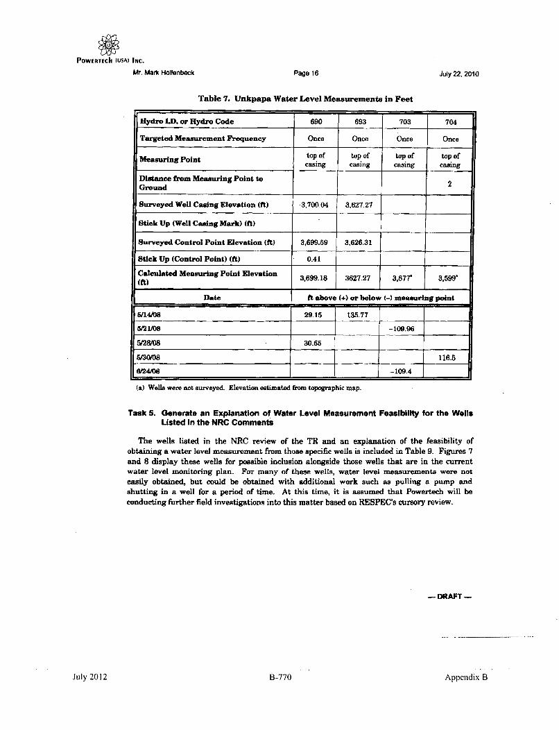
POWERTECI (USA) INC.
Mr. Mark Hollenbeck Page 16 July 22, 2010
Table 7. Unkpapa Water Level Measurements in Feet
Hydro LD. or Hydro Code 690 693 703 704
Targeted Measurement Frequency Once Once Once Once
Measuring Point top of top of top of top ofcasing casing casing casing
Distance from Measuring Point to 2Ground
Surveyed Well Casing Elevation (ft) 3,700.04 3,627.27
Stick Up (Well Casing Mark) (ft)
Surveyed Control Point Elevation (ft) 3,699.59 3,626.31
Stick Up (Control Point) (ft) 0.41
Calculated Measuring Point Elevation 3,699.18 3627.27 3,877' 3,599.(ft) 3,I 99.1 I 7 I 7 I
Date ft above (+) or below (-) measuring point
5/14/08 29.15 135.77
5/21/08 -109.96
5/28/08 30.65
5/30/08 116.5
&IAM -109.4
(a) Wells were not surveyed. Elevation estimated from topographic map.
Task 5. Generate an Explanation of Water Level Measurement Feasibility for the WellsListed In the NRC Comments
The wells listed in the NRC review of the TR and an explanation of the feasibility ofobtaining a water level measurement from those specific wells is included in Table 9. Figures 7and 8 display these wells for possible inclusion alongside those wells that are in the currentwater level monitoring plan. For many of these wells, water level measurements were noteasily obtained, but could be obtained with additional work such as pulling a pump andshutting in a well for a period of time. At this time, it is assumed that Powertech will beconducting further field investigations into this matter based on RESPEC's cursory review.
DRAFT -
July 2012 B-770 Appendix B

POWERTECh (USA) InC.
Mr. Mark Hollenbeck Page 17 July 22, 2010
Table 8. Unkpapa Water Level Measurements in Elevation Above Sea Level
Hydro LD. or Hydro Code 690 693 703 704
Formation Unkpapa Unkpapa Unkpapa Unkpapa
Subsurface (SS) or Free-Flowing (FF) FF FF SS FF
Depth (ft) 623 930 525 955
Screened Interval (ft) 621-&91 910-930 475-525 915-955
Targeted Measurement Frequency Once Once Once Once
Meaur-ng. Point top of well top of well top of well top of wellcasing casing casing casing
Distance from Measuring Point to 2Ground
Approximate Land Elevation from 3877 3,599topographic map (fit) 38_5
Calculated Measuring Point Elevation 3,699.2 3,627.3 3,877 3,599(it)
Date ft above mean sea level
5/14/08 3,728.3 3,763.0
'/21108 3,767.0
5/28/08 3,729.8
M30108 3,715.5
6W24108 3,767.6
Mean 3,729 8,763 3,7678 3%716
Task 6. Review the Water Rights, Well Completion, and Water Quality for the Well Northof Kennobble's Ranch to Determine Aquifer
Well 4, a stock well located in SESE Sec. 15, T7S, RIE, was brought into question as to
which aquifer the well is completed in. A well log indicates this well was originally drilled as on
oil exploration well (API# 5093) into the Minnelusa Formation to a depth of 2,264 feet. This log(Figure 9) also indicates the well was plugged and abandoned. RESPEC was not able to find
any water rights or well completion information describing howy, this well was completed as awater well. However, information in Table 2.5.2-1 of the TVA 'EIS report describes this well(D-19) as being 2,264 feet deep, coinciding with the original drilling depth into the Minnelusa,and with a water level of 3,580 feet elevation.
- DRAFT -
July 2012 B-771 Appendix B

POWERTECI ý(USA) -INC.
W. Mark Hoilenbeck Page 18 July 22, 2010
Table 9. Wells for Possible Inclusion in Water Level Measurement Plan (Page 1 of 3)
Free Reason for not Could be MeasuredAquifer Well Flowing or Measuring With Minimal Other Comments
Subsurface Originally Additional Effort
Domestic can not There is a.las file forFall River 7 Unknown measure without Yesthis well, so it must
pulling pump be possible tomeasure
Domestic can notmeasure without Requires further
Fall River 8 FF pulling pump and Maybe investigation toshutting in for period determine feasibilityof time
Stock well would need equires furtherpump pulled and to Maybe investigation toFall River 17 stop being useto determine feasibility
stabilized
Domestic can notmeasure without Requires further
Fall River 18 FF pulling pump and Maybe investigation toshutting in for period determine feasibilityof time
Domestic can notmeasure without Requires further
Fall River 20 Unknown pulling pump and Maybe investigation toshutting in for period determine feasibilityof time
Could not be sealed forpsi measurement Could only be
Lakota I FF because of leaks No measured if wellcaused by corrosion casing is repairedand age
Could not be sealed forpsi measurement Could only be
Lakota 2 FF because of leaks No measured if wellcaused by corrosion casing is repairedand age
Domestic can notmeasure without Requires further
Lakota 13 Unknown pulling pump; well is Maybe investigation tono longer used as determine feasibilityresident moved
-- DRAFT-
July 2012 B-772 Appendix B

POWERTECh (USA) INC.
Mr. Mark Hollenbeck Page 19 July 22, 2010
Table 9. Wells for Possible Inclusion in Water Level Measurement Plan (Page 2 of 3)
Free Reason for not Could be Measured
Aquifer Well Flowing or Measuring With Minimal Other CommentsSubsurface Originally Additional Effort
Requires furtherLakota 14 SS Difficult surface access Maybe investigation to
determine feasibility
difficult surface accessI because of fittings, Requires further
Lakota 16 SS domestic well would Maybe investigation tohave to be shut in for determine feasibilityperiod
Domestic could notmeasure without We are not surepulling pump. Well when or to what
Lakota 42 Unknown has been revamped Yes formation this well isand completed in the fom pleted inFall River Formation now completed in.(?)
casig in poor NThis well is notLakotarace caing No measurable undercondition, leaking the present condition
Domestic can notmeasure without Requires further
Lakota 96 FF pulling pump and Maybe investigation toshutting in for period determine feasibilityof time
Domestic can notmeasure withoutpulling pump and Requires further
Lakota 115 FF shutting in for period Maybe investigation toof time; also not detigat itymeasured because of determine feasibilitylocation north ofDewey Fault
This is a 1-inchNot measured because *m that
Lakota 147 SS of location north of Yes could easily beDewey Fault measured
Requires furtherLaoti F cuit access, would Myeinvest~igation toLakots 510 FF require shut detin ty...... Idetermine feasibility
- DRA•T
Appendix BJuly 2012 R-773

POWERTECII (USA) INc.Mr. Mark Hollenbeck Page 20 July 22. 2010
Table 9. Wells for Possible Inclusion in Water Level Measurement Plan (Page 3 of 3)
S Free 1 Reason for not Could be MeasuredAquifer Well lowing or Measuring With Minimal Other Comments
Subsurface Originally Additional Effort
Stock well would need This well has a good
Lakota 620 SS pump pulled and to Maybe potential forstop being use to measurementstabilized measurement
Could not be measuredat time ofpotentiometric mapgeneration because of
Lakota 696 FF poor or cracked valve Y, and it has beenfittings. Valves werereplaced and RESPEChas record of sixmeasurements from9/22/08 to 2/22/09
This well wasinadvertently left off
Lakota 697 FF potentiometric maps. Yes, and it has beenIt has been measured12 times between3/30/08 and 2/24g09.
Because of the age of Could only be
Lakota 7002 FF this well, it is believed No measured if wellthat pressurizing may caging is repairedcause a line to rupture
This well was sampled three times in 1979 by TVA and once by RESPEC in 2008. Dataresults are presented in Table 10. In comparison to nearby Well 7 and Well 7002, this well hasnearly twice the value of chemical conductivity and sulfates. Conductivity and sulfate valuesobserved at this well are dissimilar from other Inyan Kara wells in the area as well, but valuesare more compatible with expected water quality for the Minnelusa Aquifer. A detailedstatistical comparison of water quality was not conducted at this time.
Based on the available information, it is now reasonable to believe Well 4 may be completedin the Minnelusa Aquifer. It is recommended to try to log this well with a borehole televiewer toconfirm the completion of this well.
If you have any further questions or need further explanation of these items, please do nothesitate to contact me.
CMH:lIf
- DRAFT -
July 2012 B-774 Appendix B

POWERTECh (USA) INc.
Mr. Mark Hollenbeck
RSI-1853-10-042
Page 21 July 22, 2010
Figure 7. Fall River Aquifer Wells for Possible Inclusion in the Water Level MeasurementPlan. Black dots are wells in the current monitoring plan while blue dots are wellsnot currently included.
DRAFT -
July 2012 B-775 Appendix B

POWERTECII (USA) INC.
Mr. Mark Hollenbeck
RSI-18&3-10-M4
Page 22 July 22, 2010
Figure 8. Lakota Aquifer Wells for Possible Inclusion in the Water Level Measurement Plan.Black dots are wells in the current monitoring plan while blue dots are wells notcurrently included.
- DRAFT -
July 2012 B-776 Appendix B

POWERTECII (VSA) INC.Juy2,01Mr. Mark Holienbeck Page 23Juy2,01
RSt-1 853-10-0,38
SrtTE Ris m RonNM.PXWE 01M CAMOA
0 OIuL WULI a" WE" XO
caspws ~ c wYOma 2090
OX U 11-75-12ova"
650 A"£M' I e. LI.-13X roSLI Atva
We U.810 P0-A WA ~ -~oYMW f ý F -
w aamm -oso sm"y00 -NWA
:= or ~,L 50" can"" peam to &Wl a 2500' It Us lug moat at the ate
6- 11 m05/00 mas. at we, a mt. te Warem
(0)Ul Gm Ig' amp1ee Smh.imbomb(8) 310of to an A ft"a so It Lm0 "a PlW aw ~6 Sab Sot bale delrIdfIt
(g) fUU agael tmohw~m4otwug I le p foo T9 to h~mof Sf c~.(1) 600Ai emeoai 908aolhi he fteaatUd. SI.Li* 002108 NUIi We O-e tblt
lbo wrootbve no.
-- - --------- y~wa .JdZLViM~btm---- ee2i
o A d-mm. .- --- - -- - Bomyw.mm 580110
. =om-. ,
osm or- - 00, - - * - - - -3
Fiur 9 Wl Copeto Reor fo Wel I.D 00.14 (Pae of 3).
_ DRAFT -
July 2012 B-777 Appendix B

POWERTECh (USA) INC.
Mr. Mark Hollenbeck
RSI-1853-10-039
Page 24 July 22, 2010
UNITED STATESDEPARTMENT OF THE INTERIOR
GEOLOGICAL SURVEYWATER RELOURC•,S IVISION
~CE~UL1~ WELL LOG Norl.um ~ (,J~.
state .. 2t'• County ....z lI•;....- Suae ..... ,..
OwnerŽ?L iCy /
MORE INFORMATION . '~"'I'
Drilled by Address . ...
Source of data -P "ý'C> ad L 1 ýj
(Enter type of aefc, p~r~forations, yield, and drawd oun at end of log)
CORRnAiION MII. L TnTnvIL I (t L
. ....... . , ., . . ...... ..... . . .
............... ............................ .................... .............. ... . 1.. ........
7 ... . ) :... /..... _ ......... I.................................. ...................... ... ........ ... . . ........... . .............
.. .... ......... ........... .................. ..................... ............ ............... . ........... ..... •€ .
.................. ...............@ 4 ,. . .,.. . ........ ............... ................... ............ ...... ... . . .. . _'• •I
,ij ................ ............................. ...........
. . . . .." . . .. . .. . .. .. . ..... .......... ... ...... .. .. .... ... ......... ... .. .. ............ . . ... ...... .......... .......
el.............Y
. .. ... . .......... ..... .... .................. .... ..I...... ..... ..~...... ..... ......... I.. ............
.... .... ..-............. .... .. ..._ ...
f t ............................... .............. DaTE. .. . . . . . . . .."1' ......... OF
-0 M..,
Figure 9. Well Completion Report for Well I.D. #4 (Page 2 of 3).
- DRAFT -
July 2012 B-778 Appendix B

POWERTECII (IJSAI INiC.
Mr. Mark iHOllebedk
RSI-1853-i0-M4
July 22, 2010Page 25
; ,.~
rzLi
SIl-STATE COMPAO'Yw ifwy
Hto~.1i 6# cf= w
In - --.- -- -w O.wdI WA& I&MfI Ow hm I
Aa~um~mhIn -A~Wchbh Z "M "'JAL
Town*J 1 w- MM 1U L~aw-NOW'
t.. m •~ - ý A-.. . 4....
ýýLk.wwsw my- NLZSU*1
Figure 9. Well Completion Report for Well I.D. #4 (Page 3 of 3).
- DRAFT -
July 2012 B-779 Appendix B

POWERTECII (USA) INC.Mr. Mark Hollenbeck Page 26 Juty 22, 2010
Table 10. Water Quality Data for Well 4 (Page 1 of 4)
B
1 1979-06-151979-08-15 197%-W12 1 200&N-12
ALKALIN 80 181 88
ANIONS 53.3
As 0.01 0.01
B 1 1
BALANCE -57.3 -54.9 -2.6
BICARB 73 220 107
B-TDS 1.02
Ca 349 477
CARB 12 0 5
CATIONS 50.6
Cl 28 26 26
Cond, Field 4,550 4,500
CONDUCT Lab 4,400
C-SOLIDS 3,600
D-Ag 0.005
D-AI 0.1
D-As 0.001
D-B 0.7
D-Ba 0.1
D-Ca 241
D-Cd 0.005
D-Cr 0.05
D-Cu 0.01
D-Fe 0.03
D-GALPHA 3.5
D-GBETA 14.4
D-GGAMMA 20
- DRAFT -
July 2012 B-780 Appendix B

POWERTECh (USA) INC.Mr. Mark Hollenbeck Page27 July 22, 2010
Table 10. Water Quality Data for Well 4 (Page 2 of 4)
11 1979-06-15 1979-W815 1979-09-12 20-212008-02-12
D-Hg - 0.001
D-K 7.8
D-Mg 87
D-Mn 0.07
D-Mo 0.1
D-Na 716
D-Ni 0.05
DO
D-Pb 0.001
D-Pb21O 1
D-Po21O 2.7
D-Ra226 1.1
D-Se 0.001
D-SeIV 0.001
D-SeVI 0.001
D-Si 10.2
D-SOLIDS 4,733 4,117 3,700
D-Th 0.005
D-Th230 0.2
D-U 0.0004
D-V 0.1
D-Zn 0.01
F 0.4
Fe 1.68 1.59
F-pH 7.83
hardness 1,459 { 1,392
K 15 14
- DRAFT -
July 2012 B-781 Appendix B

POWIERTECh (USA) INC.Mr. Mark Hollenbeck Page28 July 22, 2010
Table 10. Water Quality Data for Well 4 (Page 3 of 4)
~i=rn
11 1979-06-15 1979-08-15 1979-09-12 1 2008-02-12
L-pH 8 7.7 7.94
Mg 143 49
Mn 0.12 0.08
N 0.64 0.22
Na 920 743
NH3 0.8
N02 0.1
N03 0.1
ORP 120
Pb 0.05 0.05
P04 0.01 0.01
SAR 10
Se 0.01 0.01
Si02 9.4 8.6
S04 3,230 2,700 2,440
S-Pb21O 1
S-Po21O 1
S-Ra226 0.7
S-Th230 0.2
S-U 0.0003
T-Ag 0.005
T-As 0.001
T-B 0.6T-Ba 0.1
T-Be 0.001
T-Cd 0.005
T-Cr 0.05
- DRAFT -
July 2012 B-782 Appendix B

POWERTECk (USA) INc.Mr. Mark Hollenbeck Page 29 July 22, 2010
Table 10. Water Quality Data for Well 4 (Page 4 of 4)
1 1979-06-15 1 1979-08-15 1979-09-12 2008-02-12
T-Cu 0.01
TEMP 11.92
T-Fe 1.32
T-Hg 0.001
T-Mn 0.06
T-Mo 0.02
T-Ni 0.05
T-Pb 0.001
T-Pb210
T-Po21O
T-Ra222 908
T-Ra226 0.11
T-Sb 0.003
T-Se 0.002
T-Sr 5.7
TSS 6 5.2
T-Th230
T-T1 0.001
T-U 28 0.0005
TURB 0T-Zn 0.01V 0.05 0.05
Zn 0.01 0.01
- DRAFT -
July 2012 B-783' Appendix B

POWERTECh (LISA) INC.
This page intentionally left blank
July 2012 B-784 Appendix B

POWERTECh (IJSAý INc.
SOURCE G
DOMESTIC AND LIVESTOCK WELLS MONITORED DURING FEBRUARY 1982 DEWEY PUMP TEST
(Letter from Gary Cummings, Silver King Mines, Inc., to Peter Martin, Tennessee Valley Authority, April
12, 1982)
July 2012 B-785 Appendix B

POWERTECh (USA) INc.
This page intentionally left blank
July 2012 B-786 Appendix B

POWERTECh (USA) INC.
1D19 820414 0"07
Silver King MinesInc.PO. BoDx 49
Edgeutont, South Dakota 57735
APR 14192
aoý -w
April 12, 1982
Peter W. MartinTechnical EngineerEdgemont ProjectTennessee Valley AuthorityP. 0. Box 2957Casper, Wyoming 82602
Dear Pete:RE: GWC; 223,82
'-¾Enclosed you will find the information relating to domestic and livestockwells that were monitored during the Dewey Pump Test.
If you have any questions, please call.
Very truly yours,
SALVE NG M S,
WU CumummingsResid t Manager
GWC:dlgEnclosurecc: R. H. Caywood
D. H. MarksR. H. DavidsonMark Boggs
July 2012 B-787 Appendix B

610 60 4 I 400 140U Recompletion?
0
lkusa 2 I P PZIII "101 104 Aq I D lo' 20 rAK
-1 7 102 1.4 1 SUT-1
00
- - - " - .. .= I.. . IL--• . ..IIATI FT SPA I FI FT FT FT FlT OPo PSI CPA FT GPM PSi PSi
2"16-"i PW TI Y ST T• 0
2-17-8I - - 26.65 Frogs 4.8 4.54 - " * -
2-18-SI 10.73 .72 ..40 26.. 3 Fros. 14,35 4.,_ - -.
2-IS-Si - - Z- 26.0 3.91 20.18 4.6141100 PHl 4100 PH
-i2-1 -f 26.94 IL, 19 .411
I-li-li - 26.54 1.9S 4,.30 4.6'2-I0M)D An bi1 A"
.-23-Si - ].. 1 47.50 1.48 1 - 10.90 1
_-_- - - -" .70GM -OMVlmdm• I ~12:00 ro
2-4-. 1. 70. .0 9.62 Rum m 4.70 54.12 4.78 _rlbl., to.. - •
1-I5.. - 28.43 5.00 7.64 4.74 Drips - 10.80 7.10 11.40
t--Si 10.10 .72 9.63 - 4.* 6S.. . 4.78 No wateý - 10.80 .7 11.5 So
2-7-2 - -625 - I - - -
12:30 PH
3--6 - .07 61.10 4.9.0 - - 10.80 - - -
3-4- . 10.47 .72 9.52 - . 29.Ll.. 4.70 1__ .50 - 0.80 6.37 11 .20 1
I3-82 - -9-4.7s .92 - 1334,
3-7-b - - - 51.60 --- - - 5.6 -
3-Si 10.70 .75 9. 6.00 50.2I ,.8 .80 0I.0 6.63 . 5.54
3-g.Si 1042 - - 6.98 46.37 4.8.0 . - - - .80 -
I p .n .. T.2 I.•6 O.i
3-Il-b - - - - Or MMS - - - 25 PSI
3-12-b 10.11 .;2 9.411 6.4 42.98 4.61 - 0 - 0.8 6.86 11.t 80 GM
.691 go1 8 Fo
6-.7 - . - 3.4. 3.42 4. il PSI - - ,15GPM I M. PSI
1-17--42 7.1 3L6 . 4.99• 14.55.-0 IS 1 -5 , ' 5pi10oo PM -" -- ______
3-I-bi IO.5O .5 5 9.4.0 71. 0 .548 4.91 1 1 I.2 10.8o 6.666.79 25.0
2l-U-1 10.72 .7 9.41 .4. .. 8 4.27 -,80 1.8. 10.80 1 G . 0.
0
-I
0
20
~0
702 1 21A. IPS In~aB -I 8. •
rs.8 40 IC 0 Psi

- -- . -r- y - r -*, ,
A 22 L 4,A22 49 1 laq I Ila i III I IIIq6 I 06 I 107 lli4 1&7 I11 18
1'.)0
.o:=====626 MIL FI Gl/A GPM I Grx I rr Gpem fT FT rpml GPM FT FT F7
I 1-1 1-i-i *
F~~I I~ I I I ~I~"±-4.- I- -- 'I--IFT
VtaP TIST STAA71
2-Ih-li 10.62 11.9 - 1.00 1.0 1.23 1.15 13.06 - .10 2.50 1 60.3i 83.51 8.01 29.78
ilI In use Leaks2-411-2 70.69 71.89 1.50 1.00 1.7S 1.25 1. is 13.06 1.75 2.13 60.02 83.66 8.21 29.l8
2-13-82 70.63 71.8 a1.00 1.0S 1.27 1.15 13.06 - 1.80 2.38 Ss.as 83.61 8.13 23.83
19-841
Ibli In use1-l-04 70..)h 711.96 1.55 1.00 1.75 1.16 1.15 11.0s - 1.90 2.12 60.32 91.6s 8.21 29•.0
Il In sle2-21-12 70.75 711.5 1.00 1.80 1.55 1.17 13.08 - 1.81 2.35 60.60 83.86 8.26 29.91
9;00 AMl1-22-82 70.71 711.i 3.90 1.80 1.30 1.17 13.10 - 1.80 2.10 60.13 33.78 $.1? 19.89
1-233-n 3.30 - - 2.40
_____ - Idte. at2-21-842 70.92 7.l I.S 3.90 1.60 1.45 1.10 13.35 surface 1.80 2.10 60..)5 83.56 8.33 29.95
latter at2-26-82 70.32 75.09 3.90 1.80 1.12 1.10 13.68 Surface 1.80 2.35 60.20 83.94 8.32 30.02
.9 16 3I9l nI .2-26-82 70.87 711.35 I.60 3.30 1.80 1.11 1.15 11.I1 Surface 1.80 2.36 60.32 83.3l 8.25 29.95
T
0
00
3-28-03 70.98 7S.00 1 3.70 1.80 1-IS 1.20 15.411 0.10' 1 2.351 60.57 81.21 1 8.2 1 30.00
1-01-62 70.75 17.87 1.6o 3.35 1.80 1 .111 1.20 16.32 .60 1.801 2.351 60.15 1 83.951 8.311 P.P
3-0-82 70.82 711.85 3.95 1.60 1.23 17.09 .0 - 2.30 59.83 861.19 8.15 29.77
3-03-82 70.80 7.1 - 3.95 1.80 1.25 1.17 17.93 1.22 - 2.32 59.89 611.27 8.17 29.80
3-wa-12 70.1 711.35 1.57 3.95 1.60 1.36 1.20 10.72 1.117 1.80 2.35 53.33 81.31 5.25 23.-2
3-1-112 70.97 75.05 3.95 1.80 1.412 1.15 t9.4 1.74 .l.32 60.05 81.10 8.30 23.95346-82 - - -- - - -21 - -o.-I -
3-47-52 - -OIt - - -
3-83-52 70.33 75.06 1.60 3.5 1.o 1.27 1.210 21.38 1.39 1.90 2.35 60.00 84. k9 $.I1 30.35
3-10-It 70.31 7.3 9 3.75 1.80 1.23 N flo 22.35 1.73 60.00 64.51 8.16 23.30
3-I1-82
3-13-62 70.73 74.118 1.60 3.35 .30 1.2 1.1 01 22.8 1.52 1.80 2.20 60.21 11.60 6.20 29.73
3-15-1a 70.5s 71.I1 3.30 1.80 1.52 1.00 23.61 1.A1 i.25 59.79 11.36 8.11
3-17-81 - - . 1.61 .85 23."6 1.1-
Wll In3-1i-62 70.63 71.67 1.57 3.85 1.60 1.57 us 211.02 1.22 1.80 2.20 53.75 6%.410 C.1i
3-22-8I .80 1.10 211.05 1.15 2.11 - "
-3-214 - .21 1.11 11,41 .8G - -VA
3-6-82 70.36 7m.oo 0 1.5 3.30 I.80 1.1I 1.25 24.06 .76 1.70 2.25 60.02 54.71 8.10 29.32
3-38-81 - " 211.02 .13 - I - . -

PowERTEch (USA) INc.
This page intentionally left blank
July 2012 B-790 Appendix B

POWERTECII (USA) INC.
SOURCE H
WYOMING WATER RIGHT 183561
July 2012 B-791 Appendix B

POWERTECII (USA) Ir4C.
This page intentionally left blank
July 2012 B-792 Appendix B

POWERTECII (USA) INC.
a ,,) STATE OF iYOMING 'taMl MainuPi OFFICE OF THE STATE ENGINEER
HERSCHLER BLDG.. 4-E CHEYENNE. WYOMING 8200e(307) M-6163
' . APPLICATION FOR PERMIT TO APPROPRIATE GROUND WATERAPPLICATION FOR WELLS AND SPRINGS
NOte: Orny stirngti flowing 25 gallons peI minute or les. wlere the proposed Itak isdaseale aid or stock watlenog, win be consicleed as graid waern apd ---- -n--
FOR OFFICE USE ONLY TWriomay Fp No UiWl ___al,
PERMIT NO. U'W.".__ . NOTE: 00 M l thi sm fmn ts I•rea or put nestlp
with blc 1101.WAE-DVSON L ITEMS MUST BE COMPLETED BEFORE
NAME AND NUMER OF WELL or SPRING .. `iY1JP 2L2 1_____________
1. iNpbaaa Aahuia,y,- 2 4e-,&1 - Z7VV.Y
2. Addess of slienate) C!d ayC ttJ-L S'Th773S(MAILING ADODIESS) (CITY) (SfATE) (ZIP)
3. Narn& adm ofAgeient omosiv corvespontlnce andxfnotica e- J,\ vi 4, AWrt va IV
(MAL ,O AVER.SS) (CITY) (STATE) (ZIP)
4. Uie towid, th.t weak al be aeapd:
Damrgeoahe Used0 water in 3 single ramiy dwalmgaor lessA nonontrimienica wital ter eiggirten edg~fardertlosiv one amre or lee. itanber 04 hofra ae'•s&e.
Stdock bwiq Normal Inmvmo use at lour tanks or less ettn rm nt. of wel or saprn. Skinokleling paidl conirn•nicrdal feedlots are a t(lac t-l,,n1us iu•. Nier of dick tah.L. Mr .
- tr~ft Watering of connnnercalir, grown crope (large-scaleter lwn " oflei 904 coumee.recreation areas. 9iC.. 1s M1wcellanaUS (Jst).
ucath Use of water in Incorporaled Towns and Citse. Note 1: Le 0of wo e mi loas , adt-•eide.e, ipnivsint dbl. mIdhe ltte perk, i in prksas adislIiarnm iLe. Note 2:
a permitmaybe req~ired by ~e WyaiskigDepaalrnt at twlrmmi.0 Oaft(WOEG) iii. wsitWia be cVa(le as a Public eater supp wlydLer It* WOEO's aim arid regieom.
Long lei use of water fo the mranuflucref a predict or productionl odiieor asia, sbat(oll fhaimI lDWoa pereatios.pw panrt wter a** at4ý Iesi in REIAMS)
tiwodewaedag rn sN hgps nab ibmein RselhmclwLL . Anyutneof water not deftio wder prawious iittlauisafo mrpna.dwabe
"l111e Note; a petm't may be required by the WEOI to we wiOl be c ld a puli mwupplySh WE's rules ad .
Coomiload edimme meeNwi reqsim a* peromdni lof ooms bUthd cmads U1L Nome:waf odI thren WObe
li mior. Osaemtlan Note: a WDEO permb nevy be requ•i•d Teot Wll: (Oaba in REMARWS)
5. L. otftIo wall or fteeg: (NOTE: Querer{-quarler (40 acre eutidlision) MUST be Eliamn. EXAMPLE: SE 114 MIN 1/4 4 oSec.
-Cuny- 1451'1/4 o4Ssc.!i, T. JL.N-,R A.0 W.of tig 65 P.M W.R.M.).Wyonasig e epe addoin ~ sb*An.ao oprovide Lot(1ral Stack- Ott________________tenltstlalon (or Ajdn) of - escevey Location: Tried -. (or Loll
6. F 11 - I depth o towallor aptqisg kCY' teat Eetistepradiuction irmervel i U Ak n qt/'itL o t
7.(a) MAXIMUM kubmibwaSaw o sea wtorI be deoslopa and hber'tefi wed /as . ' .LC.....pea per inieNOTE S f drnme a or shamuse. tSes soplicatio al be pnosd for a ammum aa 2625 par emo.s For a gegMalr Ie Ie of Shim aplcain somitye tof 04ritrIcdal dhwveron or eliproviretmin WAN be -nda to qua" ONt a W
(bi) MAXIMUM plsimlifqtAfy of~ei~eeae aid bfenstid* used per c".Wih V. JK -S ihq/Child ae~b I a I -t ~mi) aqu ýF A four paeasn buytnage d pi edam 16.r (1) acua 4o wale per yew
or 32~SAM - e
Mar Sol paitaga) or eaid*) ofn ueIn Mte tbuati~on box beIow.
TABLATION BOX
[MEj PnfewJ5% BE Iet NEV ljIW S% N4P%1ifi` SIE% 11110% laW%lefm
FaV U& UM. SEE REVERSE SIDE 1 P9 emfe, 61
__l________,_______Lt/ a ______
July 2012 B-793 Appendix B

PowIertech (USA) INC.VP 11`1ýCi o MUAX IMUM acreage to be trigated ,r eWh 40 acre subdivsion in the tebulatosn box above. 204
b. Land we4 be irrgeted from this wall onlyc. Land is migated form existing waler righl(sl with water from this well to be adlitno" suppy. Descone sealig water rglo(s)
under REMARKS.
tO. It for ngation uise. describe inethod of wirtKgtr¢v. i e center pivot sponklter. Food, etc •
II The+wellorsprngistobeconstructed onlanrdsownedby.__ 4, L t i jl , . .
(The graning of a perirrm does not constitute the griu ing of righl-oftwey. If any essmeno• Or light-ol-wal, i necesry in connectionwrlh this appl•cation, it should be untlSlt ood that the responsiolby is the applicants. A copy of the agreemt should accompany Oftapp•istion. if the lend is pivletety owned and the owner ts not the co-applicanr,
12 Thewateritobeusedonladsownedby L',A I ._ : t I : V\ •Iy -lly_ ..IfI the landowner is not the applicant. a copy Of the agreermet relatein to the usage of epproprislled water an the ladshould be subvidtrtd to this office. It the landowner is included as co-aplIcant on the alppiceftia. this procedur neednot be followed.) NOTE: Water tights attach to the area(s) andlor point(s) of use,
REMARKS: A R","_'..... - -L ' Y "
Under penalties of perfury. I declare that I have examined this apphcation and to the best of my knowledge and belief It IstlrA,.orrect and cwtnple. ."
Sin e of Applican 6t lti•,,zed Agent Date
THE LEGALLY REQUIRED FILING FEE MUST ACCOMPANY THIS APPLICATION
DOMESTIC ANDrOR STOCK WATERING USES 525.00(Do•estic ure, . droned as. use owfater - 3 rinqs trr dwelhngs or l•os.,ioneoimirnrer iswaring lasetrsn and gaTimmis lataltr, ore ire or km,)
IRRIGATION. MUNICIPAL. INDUSTRIAL. MhSCFI I ANEOUS, COAL BED METHANE $W0.00
MONITOR (For water level nrasruennerlS o ,:h l crmldo rtr.s.lr rtin or TEST WELL No Fee
IF WELL WILL SERVE MULTIPLE USES, JSUMIT ONLY ONE (+THE HIHER) FILM FEE.THIS SECTION IS NOT TO BE FILLED IN BY APPLICANT
THE STATE OF WY(VAINT, I) ss
STATE ENGINEERS OFFICE IThis insterumnt was received and hled for record on the. 12th d(ay of Jue A.D.
20-17 . al -A. L&. ocock . . A M.
PerrnilrNo. UW . rrIJ_ _ _ _ _ _ _
T1HS IS TO CERTIFY That I have examined the ftrrrorjr popl itrlion a•d do hetreS7rstV fte same stued to the aollowrlgand conditions:
This application is approved subtici to the ,rxrolrrorr [rnet he proposed uise salla not knterler with any aarallasg rights to0ground wow hornthe same source of supply aild a subject to regrlaton rind correlation with surtaoe walerig ht. if the growld and surtace waer emistenCOneeOd• The tee of water hereren(d is stitrihrl to he twrter provsilons of Ctapter 166. Sesseio Laws 01 Wyorrilrg. 1957. and anysubsequent amendmrents thereto.Granting of a permil does not guarantee the right to have+r It" water level or artesran prese in the vil maitained at any al level.The wal sthutd be constructed to a depth arfr•oulo to itow for the maximum devltopmeiri and bee ueiw of ground water in thesource o0 supply.It the well is a flowing attesian wel. it shall be ?,o :onstrucled arid equipped that the flow may be shut d whn not in ra without los• O0water into eeb-surface formtation or at the land surfaceCoat Bed k4l~etae wae~t hae A~lronat C~ondeoarrdLrmrtationa or attact m•sloeewel
Thie sin~ ris wh•Ar.1•. nd•. _pava n .l notlces aerve .to - O.V.ft.r an O atstni well_ and establish a valid
water ffhjgts for the same. Time limit fo lotetion of Conetruction and Completion of Beneficial
Use iiii-walyldi . ......
The amount o0 approprIatIonsh all tbe eled to tIe qnuttarrtrt to which peronttee is endled as detatnined at tfime o1 proot of appcon of-eter In berseO cial use.
Witne,, my hand this _ 0 01 day A __D. 20-. L
October L6, 2007 - Statement of Completion on 1936 received.Beneficial Use assumed as of date of completion.
July 2012 B-794 Appendix B

POWERTECII (USA) INC.Hydro ID 5002 3014
FORM U.W.6R•,. 1.07 STATE OF WYOMING
OFCE OF THE STAT E NOINEERHERSCHLER BLDG., 4-E
CHEYENNE. WYOMNG
(307) 777-6163
STATEMENT OF COMPLETION AND DESCRIPTION OF WELL OR SPRING
NOTE: Do not foxf this torn. Use t
or vaim Peatty - wit hledi Pe
PERMIT NO. U.W. jI3RR 5 . NAME OF WELL/SPRING , .... , ,? I
N E. , OFOW • -,Rm , __t p,_,.,._,,2 ADDRESS '779 e•-et0if 5r "
- Ph~ae Owa d 8&'- hit CrangW Wi tht ilhl own fn pimý
City state .5 ____ ZIP Code 67 7 3L Phone No _',,-71q/.
3. USE OF WATER O Domestic Wk Stock Watering Irrigation -lMunicipal =-Industretl E aiscellaneous1 Monfto or Test -1 Coal Bed Methane Expleait proposed use (Example: One single family dwelling)__ is J ~ k ......................
4. LOCATION OF WELL/SPRING • 1/4 5 1/4 of Section _,Q T..A.l N..R.._• W., of the 6th P.M. (or W.R.M.)
Subdivision Name________...... Lot Block
Resurvey o Tract or Lot Datum -NAD27 I - NAD83
Geograpic Coordinates: Latitude ___N Longitude -..... W (degrees. minutes. seconds)
UTM: Zone /23 Nortnring __________- Easting •5M (,'I _meter
State Plane Coordinates: Zone_______ Northing Easting _ (jteet)., Ar
Land surface elevation (ft. above mean sea level) . . ... . . Datum L. NAVD29 NAVD88 Id 13"
Source FIlGPS C1 Map i Survey L Unkown I Other -- Altimeter (lot elevation only)
5. TYPE OF CONSTRUCTION 9 Drilled Dug Driven r-Other
Desribe
, CONSTRUCTION Total depth of well/sprM . f
Depthof static waer level -- O- F10Ai _ ft. (below land surface) Casing height _L ft. above ground
a. Oiameter of borehole (bit sizo)i__ ainchesb. Casing schedule I New -1 Used Joint type I .Threaded I Glued IWelded
-- diameter from_ _ ft. to ... . Material --.- _ _ _ -Gage ....
__ diameter from ft. to - -ft. Material__ _age .....
c. Cementedlgrouted interval. from _ft. _o. _ ft.Amount of cement~grout used type . .. O
d. Type of completion -. Customized perforations Open hole i Factory screenType of perforator used
Size of perforatkns__ inches by_ inches.
Number of perloratdirs and depths where perforatec__ perforations from f. to ft.__ perforaions from ft. to ft.
Open hole from _ ft. to . ..... tWell screen details
Diameter - slot size set from ft. to
Diameter s size_ set from ft. to __ -ft
e. Well develop ment•How long was well developed?
I. Was a hitel/gravel pack Installed? Yes -1 No Size of sandigravel . -,
Fiter/dgria pack installed from ft. to ft.
g. Was surface casing used? r Yes - No Was it cemented in place? Yes No
Surface caskvg instadl from ft.to ft.
7. NAME AND ADDRESS OF DRILLING COMPANY _ J4f Xat
8. DATE OF COMPLETION OF WELL ( " " ) OR SPRING If 5irs us•d j|.3•4
9. PUMP INFORMATION Marpofacturer.W .j• Type.-
Source ofpowe _ --. _ Horsepower Depth of pump setting or intake _1.
Amount of water being pumped gal./min.' (For springs or flowkig wells, see item 10)
TOMe volumetric quanfti used pe calendair year.' AE 6.- (ie . ___
'If these amounts exceed permitted amount an enlargement is required.
10. FLOW1NG WELL OR SPRING (Owner Is responslote for control of flowing well)
If afteeanflow or eping, yield is V _ gatirnin. *Surface pressure is ibdsq.inch, or_ _ feet of water.
The Now is ottoffeby iby 1.fve ,._. ý.C . Pug
Doea wll le"k around casing? CYes X0No
Pern-itNlOUW. UOook No. 1329 PageNo. _ _
SEE REVERSE SIDE
July 2012 B-795 Appendix B

POWERTECh (USA) INC.It. IF SPf0f .II.o
1 AS IT CONSTRUCTED? (Some method of arificial diversion. i.e.. spring box. cribbing. etc. is neeewry to
quality to, a water right) ..... . ... ... . .
12. PUMP TEST Was a pump test conducted? Yes No
if so, by whom
Yield
Yield
gal. 'rn. with
gal 'mrin with
I:. drawdown aflter hours
Ift. orawdown after ......... hours
13 LOG OF WELL Total depth drilled . It,
Depth of completed well it Diameter of well
Depth to tirst water bearing tormation It
Depth to principal water bearing formation Top o~. It. to Bottom
inches
ft.
DRILL CUTTINGS DESCRIPTION1
From - ToFeet Feet
Surface -
Rock Typeor Description
- Water Beaing? -, Foreration t Yes 0r noI
L)a
.. . .. .•U -i .. . .... . ... .. . __ -------
-. ... .-. ...--.. i-. -
DOES.... i ... . . _ __
14. DOES A GEOPHYSICAL LOG ACCOMPANY THIS FORM9 Yes X No
15 QUALITY OF WATER INFORMATION
Does a chemical and/or bacteriological water quahlt analysis accompany this form*) Yes NoIt is recommended that chemical and bacteriologic water quality analyses be performed and that the repordlsI be filed with therecords of this well icontact Department of Agriculture, Analytical Lab Services. Laramie. 742-29841.It not. do you consider the water as Good Acceptable Poor Unusable
REMARKS
Under penalties of perjury. I declare that I have examined this form and to the best o0 my knowledge ani belief it is true. correct, and
complele.
_--J
..Sijaure of Owner or Authorized Agent
FOR STATE ENGINEER'S USE ONLY
1(". 05 '/Date
2C
Permit No. U.W. , G.•• _
Date o0 Receipt . OCI
Date ot Piorty ,JiLe I
. 20
.20 0"1
Date of Appov.al C)..2 _L_ 20 _tr
Slat Engineer
July 2012 B-796 Appendix B

POWERTECh (USA) INC.
SOURCE I
ADDITIONAL WATER WELLS IN EDGEMONT PROJECT AREA
(Silver King Mines, Inc., Interoffice Correspondence, Keith Andersen to R.M. Caywood, August 3, 1979)
July 2012 B-797 Appendix B

POWERTECII (USA) INC.
This page intentionally left blank
July 2012 B-798 Appendix B

POWERTECh (USA) INC.
INTE31OFFICE CORRESPONDENCE
Company - Silver King Mines, Inc. Dote August 3.,j22_
To- R. M. Caywood
From: Keith E. Andersen Subject: quarterly Burdock Area Water Levels
Attached are quarterly measurements of Burdock Area water well flow rates andwater levels. Wells numbered 135 - 143 are new wells or wells added to ourmonitoring program by request. Wells numbered 200 - 216 are probable Sundance wellslocated east of the Burdock Area.
In an effort to obtain all possible information, several measurements ofquestionable accuracy were made as noted below.
Well No. Problem
.2 Leaking around casing4 Leaking around casing
7S Measuring point changes13 Pipeline use affects flow33 Measuring point changes35 Measured inside cylinder drop pipe36 Leaking around pipeline fittings37 Measured inside cylinder drop pipe40 Two wells at different elevations piped together41 Pump had been operating42 Leaking around pipeline fittings52 Measuring point changed53 Measured through cylinder drop pipe56 Casing broken out98 Casing leaking
113 Measured inside cylinder drop pipe114 Measured inside cylinder drop pipe
Water quality data on these wells is not yet complete.
Keith E. Andersen, Chief Engineer
July 2012 B-799 Appendix B

POWERTECh (USA) INc.
Additional Water Wells In'Edgemont Project Area
Well No. Location
135 T 8 S, R 2 E, Sec. I bd
136 T 8 S, R2 E, Sec. 5 bb
137 T 7 S, R 2 E, Sec. 17 bd
138 T 6 S, R 1 E, Sec. 18 a
139 T 41 N, R 60 W, Sec. 18 dd
140 T 9 S, R 3 E, Sec. 19 bc
141 T 10 S, R 3 E, Sec. 20 aa
142 T 7 S, R 2 E, Sec. 35 bd
143 T 8 S, R I E, Sec. 30 dc
200 T 7 S, R 2 E, Sec. 13 Ga
201 T 7 S, R 2 E, Sec. 13 ca
202 T 7 S, R 2 E, Sec. 13 ca
203 T 7 S, R 2 E, Sec. 12 cd
204 T 7 S, R 2 E, Sec. 12 cb
205 T 7 S, R 2 E, Sec. 12 ac
206 T 7 S, R 2 E,-Sec. 12 ac
207 T 7 S, R 2 E, Sec. 12 aa
208 T 7 S, R 2 E, Sec. 2 bc
209 T 7 S, R 2 E, Sec. 3 da
210 T 7 S, R 2 Ep Sec. 2 bd
211 T 7 S, R 2 E, Sec.. )2 ba
212 T 8 S, R 3 E, Sec. 8 db
213 T 7 S, R3 E, Sec. 20 dc
214 T 7 S, R 3 E, Sec. 18 cd
215 T 6 S, R 2 E, Sec. 27 dd
216 T 6 S, R 2 E, Sec. 22 aa/,V'y T'gs, ,R 3E, .scr- .1
145 T l5, R•36, Se. '3 A• cTISq , A a.~ E-1 . b Cz
July 2012 B-800 Appendix B

POWERTECII (USA) INC.
Additional Water Wells In Edgemont Project Area
No.
135
136
137
138
139
14o
141
142
143
200
201
202
.203
204
205
206
207
208
209
210
211
212
213
214
215
216
I 9lq
Owner Use
Mike Ringer D,S
Ed Dodson D,S
USFS S
John Carlson D
Gerald Darrow S
Ken Barker D,S
Howard Henderson S
Jack Standen D,S
Jeff Schultz D,S
George Hey D,S
George Hey S
George Hey S
Donald Spencer D,S
Donald Spencer U
Mason Miller U
Mason Miller D,S
Mason Miller D,S
Mason Miller S
Donald Spencer U
George Hey S
Donald Spencer S
Carl Reutter S
George Hey S
George Hey S
Claude Smith S
Claude Smith U
s.o
360th
36o
Probable Aquifer Remarks
Lakota
Spring
100 Fall River
620 Lakota
280
1,64o
108
110
200
200
170
108
200
179
247
125
161
2,204
100
270
900
Spring
Fall River
Fall River
Sundance
Sundance
Sundance
Sundance
Sundance
Sundance
Sundance
Sundance
Sundance
Sundance
Sundance
Sundance
Sundance
Drilled 1977 - Submersible Pump
Source Uncertain
Windmill
Drilled 1977, flows, Jet Pump
Drilled 1978, flows 20 gpm
Source Uncertain
Submersible Pump
Drilled 1962, Submersible Pump @440
Water Level 52,7', Submersible Pump
Pump Jack
Water Level 16.7'
Submersible Pump at 160
Water Level 24.5
Water Level 18.4, Jet Pump
Submersible Pump, Pipeline
Pump Jack
Water Level 145.2
Pump Jack
Pump Jack - Water Level 8.14
Flows 1.5 9pm, old oil test
Submersible Pump, Water Level 34.1
Water Level 39L1
Water Level 60.7, Submersible Pump,Pipeline
Water Level 217.9
watc- LeuI 3gZ.Y"
July 2012 B7801 Appendix B

POWERTECII (USA) INC.
This page intentionally left blank
July 2012 B-802 Appendix B

POWERTECI. (USA) INC.
SOURCE J
FOREST SERVICE WELLS AND SPRINGS
(Letter from Keith Andersen, Silver King Mines, Inc., to John Hatch, South Dakota Water Rights
Commission, January 12, 1979)
July 2012 B-803 Appendix B

POWERTECh (USA) INC.
This page intentionally left blank
. July 2012 B-804 Appendix B

POWERTECh (USA) InC.
FOREST SERVICE WELLS AND SPRINGS
Tlhis ist of wells and springs located on U. S. Forest Service landwas obtained- fre -the- Forest Service office in Newcastle,. Wyo.These wells -ind sprinfjs will be visited Inda'n 3ttLt1q)tmvdc to determinethe aquifer froom whio.h they produce. The water on Forest Service landis used by ranches For stock water during the sunmer months and tosupply water for wild life.
Name Location
Bennett Canyon WellDriftwood Canyon Well
Heck WellSpencer WellBennett # 2 Well
Hey WellRoderick Spring
North Roderick SpringNorth Long Mountain SpringSouth Long Mountain SpringDewey Well
Cook WellPass Creek WellLower Turkey SpringTurkey SpringTailend Reservoir SpringBowl SpringBosley SpringBarrel SpringSheepuagon SpringLower Dugout Spring
Dugout SpringNorth SpringSouth SpringCarr SpringMix SpringPipeline SpringPollard Spring
T75, R2E, SW*T,NWk4,
NW4,lEEk,
WS5, R3ý, Si4,T75, R2E, SE4.
NE4,T7S, R3E, NWd~
T65, RlE, SW1,
T5S, RIE, SW4.NE4,
15S, RIE, NEk,
NW4,r4S, RIE, SWk.
NW4,
Sec.Sec.Sec.
Sec.Sec.Sec.Sec.Sec.Sec.Sec.Sec.Sec.Sec.Sec.Sec.Sec.Sec.Sec.Sec.Sec.Sec.Sec.Sec.Sec.Sec.Sec.Sec.Sec.
#"141~(no match > 2km
17 F#137 >2km7 no match 16. #11 31 2 2km 11817325 1120 > 2 km
9 Ino match > 2 km22 1#632 > 2 km3232152917732291966
2821
'9
T42N,T43N.
R6ow,R6ow,
S E~J,
Nwk,
July 2012 B-805 Appendix B

POWERTECII (USA) INC.
This page intentionally left blank
July 2012 B-806 Appendix B

POWERTECh (USA) INC.
SOURCE K
HYDROGEOLOGIC INVESTIGATIONS AT PROPOSED URANIUM MINE NEAR DEWEY, SOUTH DAKOTA
(Report No. WR28-2-520-128, J. Mark Boggs, Tennessee Valley Authority, October 1983)
SEE APPENDIX I FOR THIS SOURCE REPORT
July 2012 B-807 Appendix B

POWERTECII (USA) INC.
This page intentionally left blank
July 2012 B-808 Appendix B

POWIERTECh (USA) INC.
SOURCE L
COORDINATES, ELEVATIONS AND WATER LEVELS FOR BURDOCK PIEZOMETERS
(Letter from Keith Andersen, Silver King Mines, Inc., to John Hatch, South Dakota Water Rights
Commission, January 12, 1979)
July 2012 B-809 Appendix B

POWERTECh (USA) INC.
This page intentionally left blank
July 2012 B-810 Appendix B

POWIERTE.CI (ýJSA) INC.
Coordinates (SKM Grid) and Elevations for Burdock Area Observation Wells
Measuring PointElevation PCWelI Aquif
Original Nine W
B-I FR6721 Kf
B-2zFAbn K1
B-3 FR=IKf
B-3 baýn KI
4A..637 Aban K
P:6 FRF659 Kf
B- 660 Abanl,B-8 661 KI
Burdock Well Kf;K
Four Additional
B-7 FR66-5 Kf
B-7F666 K1
B-9 FRrg46 Kf
B-9r-• KI
Seven Repf'acement
B-2 LAK46 7 j Kf
B-2 Fu6-73 KIf
B-10 FRI-jjJ Kf
B-10 FUF70 KI f
B-iO LAP66
I
her -- Coordinates
I Is lnstalled Fall 1976 (Abandoned five Fall 1978)
90,856 E 188,869 N
90,808 E 188,859 N
93,532 E 190,992 N
93',583 E 191.005 N
95,531 E 190,551 N
97,944 E 191,909 N
91,925 E 192,493 N
91,874 E 192,472 N
100,952 E 193,839 N
66-8 91,081 E 189,167 NWell s lnstalled August 1977
93,303 E 190,402 N
93,279 E 190,373 N
91,389 E !87,658 N
91,389 E 187,658 N
Wel Is Ilnstalled Fall 1978 1
90,776 E 188,900 N
90,767 E 188,841 N
91,221 E 189,275 N
91,265 E 189,344 N
91,206 E 189,317 N
90,805 E 189,721 N
90,843 E 189,739 N,
3622.07
3621.08
3701.16
3701.63
3679.45
3731.04
3642.64
3644.12
3788.58
Height of Measuring)lnt Above Ground Level
- 1.0 ft.
0
2.0 ft.
1.6 ft.
2.58 ft.
1.9 ft.
0
0
2.0 ft.
3624.16 = GL Elevation
3671.24
3671.1
3605.42
3605.42
3621.11
3619.96
3631.19
3630.31
3631.24
3623.94
3624.82
1.75 ft.
2.08 ft.
3.0 ft.
2.6 ft.
1.3 ft.
0
1.4 ft.
1.6 ft.
1.6 ft.
0
1.0 ft.
Source: Ledet. urn KeIUMAndemen, Sly. KkigrMines. 1o..~Jdm6WM, Sail OdwaWWateriwFý4bCnuidui10i. January 12, 1979
July 2012 R-91 1 Appendix B

POWERTECII (USA) INc.
Revised Coordinates and Elevations for Burdock Piezometers
lelI Coordinates
I-! FR 90,856.22-E1-2 LAK 90,775.65'E1-2 Fuson 90,767.34.E1-3 FR 93,531.56 E1-4 95,530.98 E
i-6 FR 91,924.72 E1-6 91,874.49 E3-7 93,279.33 E3-7 FR 93,303.13 E3-9 91,388.52 E
3-10 FR 91,220.54 E3-10 LAK 91,205.623-10 Fuson 91,265.093-11 LAK 90,842.73.3-I1 FR 90,805.193undance Well 6 5,80.49 E3urdock Well 91,081.12
188,868.81 N188,899.89 N188,841.37 N190,991.69 N190,550.99 N192,492.25 N192,471.83 N190,372.99 N190,401.62 N187,657.99 N189,274.64189,317.02189,343.85189,738.78189,720.73189,370.12 N189,167.42
Measuring PointElevation
3622.073621.113619.963701.163679.453642.643644.123671.103671.243605.423631.193631.243630.313624-.823623.943647.843624.16 = GL
Height of MeasuringPoint to Ground Level
-1.01.3 ft.0'
2 ft.2.58 ft.0'01
2.08 ft.1-75 ft.3 ft.1.4 ft.1.6 ft.1.6 ft.1 ft.o'3 ft.
Elevation
Water Level Measurements
Ul1 pressure measurements on 9-21 are 2-2.75 psi
not have been accurate.
for Burdock Piezometers
maylower than previous measurement - gauge
B-1
8-2
B-3
7-20-78 1)49-21-78 1210-13-78 8
7-20-78 169-21-78 13
7-20-78 358-4-78 36
airlifted on 8-48-21-78 369-21-78 36
.25 psi
.25 psI.80 psI
.0 psi
.25 psi
.9'
.31
Burdock well flowing
Abandoned /1-10-71
Abandoned Il-/o.79
.5
.8
B-3 FR 7-20-788-4-78
airlifted on8-21-789-21-7810-13-7811-22-78
e-4 7-20-789-21-78
. .. .-1.0 7 1 3 - 7 811-21-78
37.537.7
8-437.337.638.738.811.•5'
12.1'13.613.9
Burdock well flowing
Water Level in Annulus 1.1.80
Burdock well flowing
Scurce: I.W from KeMl AadrseOn, SIM KhVg Me,. Inc,. to JIim Hae"i. SaMW D~cot Waer Riýlt Comfnislo, Janusey 12, 1979
July 2012 B-812 Appendix B

POWIERTECII (USA) INC.
,Cont inued - Page 2)
B-5
B-6
B-6 FR
B-7
7-20-789-21-78 -10-13-78l1-21'-78-
7-20-789-21-7810-13-78
7-20-789-21-7810-13-78
7-20-787-26-78
48.849NIj-49.7
- 50.0
10.3 psi8.25 psi7.75 psi
7.75 psi5.5 psi.5.5 psi
8.9'9.0'
Burdock-well flowing-ABurdoc- el o2-5-79
Burdock well flowing
Burdock welldflowing
Airlifted
8-7 FR
B-8
B-9
B-9 FR
8-4-788-787&88-21-789-21-7810-13-7811-21-78
7-20-787-26-788-4-788-8-788-21-789-21-7810-12-7811-21-78
7-20-788-4-788-21-789-21-78
7-20-789-21-7810-13-78
7-20-78fl. 0, -
9.3'
9.2'
9.3'12.611.5
17.6'17.412.5'12.4'12.3'12.6'13.7515.5
96.25'97-5'97.3'97.9'
19.2 psi17.0 psi15.0 psi
17.9 psiit A I
AirliftedAirliftedBurdock well flowing
Airi if ted
AirliftedAirliftedBurdock well flowing
Airlifted
Burdock well flowing
Locations
Y/-41-1O m. psl
10-13-78 15.25 psi Burdock wei BPZ 14 # 6 02BPZ 15 FR #601BPZ 16 #643
Out.)_ji n Piezometer Weils BPZ 16 #64 4BPZ 17FR #644
SBPZ 18 #608
15 FR T8S, R2E. sec 23 NE/4 W/A NW/-- BPZ 19 FR #60717 FR ... T7S, R2E, sec 30 Sw/4 SE/A SEI.. BPZ20#60919 FR T4ON. R6OW. sec 27 SE/A SE/4 NW//4 BPZ 21 FR #61021 FR T6S, RIE, sec 29 SW/I. mw/h NE/A BPZ22#62623 FR- T41N, R6OW, sec 9 SW/4 SE/4 SE/4 BPZ23 FR#625Sourc Le:tr *am KeAnierimder., Sam " Miese. Inc, b John laid, SouM D~ots Wae r ftht. omiuul, Mmy 12.197
BPZOn4BPZ 16BPZ 18BPZ 20BPZ 22
&&&
£_
July 2012 B-813 Appendix B

POWERTECh (USA) INC.
/(Continued - Page 3)
Water Levels:
BPZ 14
BPZ-15 FR
• 7-20-788-7 -78
8-22-789-21-7810-13-7811-21-78
7-20-788-7-788-9-788-22-789-21-7810-13-78* 11-21-78
BPZ-16
BPZ-17
BPZ-18
BPZ-19 FR
7-20-78-8-9-78 -
9-21-7810-13-78
7-20-788-9-788-22-789-21-7810-13-7811-21-78
8-7-789-21-78IO-16-7811-20-78
8-7-788-22-789-21-7810-16-7811-21-78
7-20-787-31-788-3-788-21-789-20-7810-12-7811-21-78
130.5'130.2'136'136.5'136.6135.9
59-5'51.5'47.7'47-547.7'47.847-5
7.0 psi
9.0 psi9.0 psi
20.6'20.6'21.8'21.9121.9'22.0'
17.5'17.7'17.720.3"
21.8'18.3'18.7'21.119.8
4.8'4.75'172.7'83'73.3'108.589.9
AirliftedAtrI if ted
Airlifted
AirliftedAirlifted
shut in on this dateAirlifted
Ai rlifted
Airlifted
Ai rl i ft edAi rl i ftedAi r i fted
BPZ-20Airlifted - much mud
AirliftedAirlifted
Souroe: Letter romn KU•M Andeowe, Silver Kkg Mines, Inc., to John Hath, Sou Dakota Water Fight CanWion, January 12, 1979
July 2012 B-814 Appendix B

* POWERTECII (USA) INC.
(Cont inued-Page 4)
BPZ-21 FR
BPZ-22
BPZ-23 FR
8-3-788-8-788-21 -789-20-7810-12-7811-21-78
7-20-787-31-788-3-788-21-789-20-7810-12-78
- 11-21-78
7-20-787-31-788-3-788-21-789-20-7810-12-7811-21-78
Slight Flow15'
11.5'6.3'7.5'9.38.7
65.9'64.5'153.9'
89.3'76.l85.1 '70.5'
73.2'70'72.7170.3'68.6'73.873.3
Airl ifted
AirliftedAirlifted
Airlifted - much mud
Airlifted
AirliftedAirlifted
Airlifted
Airlifted
Airlifted
Depth of Screen:
BPZ-14
BPZ-15 FRBPZ-16BPZ-17 FRBPZ-18BPZ-19 FRBPZ-20BPZ-2IFRBPZ-22BPZ-23 FR
588-630336-378252-29484-126798-882672-714903-966630-672588-630420-462
attempted to set 42' dc(
not pressure grouted
BPZ 14 #602BPZ 15 FR #601BPZ 16 #643BPZ 17FR #644BPZ 18 #608BPZ 19 FR #607BPZ 20 #609BPZ 21 FR #610BPZ 22 #626BPZ 23 FR #625
All wells constructed of I" blk iron pipe with torch slot screen. Grout pumped down annulusto desired depth with I" plastic pipe.
Soume: Left frorn KeUf An ,SveseSr KkVn t0m~, ft., o Jam He", SeOu Okota Waler Right Comr a, Januwy 12,1979
July 2012 B-815 Appendix B

(Powertech (USA) INC.
This page intentionally left blank
July 2012 B-816 Appendix B

POWERTECh (USA) INC.
SOURCE M
CONSTRUCTION AND LOCATION DATA FOR DEWEY PUMP TEST WELLS
(in letter from Keith Andersen, Silver King Mines, Inc., to Steve Stampfli, Office of Surface Mining, South
Dakota Department of Water and Natural Resources, March 3, 1982)
July 2012 B-817 Appendix B

POWERTECII (USA) INC.
This page intentionally left blank
July 2012 B-818 Appendix B

NJ
C
N) WELL #
Hole Number
Date Drilled
Date Completed
Depth Cased
Depth Completed
X-Coord.
Y-Coord,
Collar Elev.
SWL (12-3-81)
DEWEYTESTWELL
OWT-99
10-17-81
1O-17-81
654
801
80798
214898
3736.2
D-1 FR
OWM-51
7-21-81
8-14-81
504
580
80923
215036
3737.3I 1*..I
0-1 Fu
54
9-04-81
9-14-81
609
620
80982
215035
3741.1
) "I 'I
0-1 LK
46
7-07-81
8-13-81
712
800
80972
214972
3741.4
D-2 LK
47
7-09-81
8-14-81
692
800
.80710
215068
3728.5
D-3 FR
49
7-16-81
8-18-81
505
590
80385
215595
3738.0
D-3 LK
48
7-14-81
8- 18-81
715
800
80W16
215658
3744.3
0-4 FR
52
7-23-81
8-17-81
503
580
81564
215330
3753.5
ý-. I. /
D-4 LK D-5 LK
50 55
7-20-81 9-09-81
8-17-81 9-15-81
714 735
780 835
81618 81126
215281 214090
3751.4 3747.7
0-6 LK
56
9-11-81
9-15-81
715
810
80004
214495
3723.3
D-7 FR
OXM- 1
7-30-81
7-30-81
120
120
76979
219008
3723.9
2
o0ý0
34.16 26.23 32.16 39.68 26.56 21.03 42.37 34.22 49.68 45.86 21.42 Surface
Source: Letter from Keith Anderaen. Silver Kmng Mines, Inc., to Steve Stanpfti. Office of Surface Minig, South Dakota Department of Water and Natural Resources, March 3, 1982

POWERTECII (USA) INC.
This page intentionally left blank
July 2012 B-820 Appendix B

POWERTECh (USA) INC.
SOURCE N
BURDOCK MINE AREA HYDROLOGY STATUS REPORT
(Silver King Mines, Inc. Interoffice Correspondence from Keith Andersen to R.M. Caywood, December18, 1978, provided in a letter from Keith Andersen to John Hatch, South Dakota Water Rights
Commission, January 12, 1979)
July 2012 B-821 Appendix B

POWERTECII (USA) INC.
This page intentionally left blank
July 2012 B-822 Appendix B

PoWeRTECh (USA) INC.
IWTEROFFICE CORRESPONDENCECompany Silver King Mines, Inc. D ecember 18, 1978
R.M. Caywood
Keith E. Andersen Subjecl: Burdock Mine Area Hydrology
Status Report
Uranium ore in economically recoverable quantities has been discovered north-west of Edgemont. Souih Dakota, near Burdock on lands leased by the Tennessee ValleyAuthority. The ore is located in the Lakota Formation. Tentative plans call forconventional underground-mInln§ techhlqbes whichW Will rIluire dewatering the orezone during the mining operation. The Lakota Formation and the overlying Fall RiverFormation are the two principal aquifers supplying domestid water for area ranches.In view of this information, It was apparent that extensive hydrologic investigationswould be required in planning the proposed mine.
An attempt has been made to Identify all wells and springs having their sourcein the Fall River or Lakota Formation within approximately a 25 mile radius of theproposed mine. Appended are lists of these wells. The list entitled 'Water Wellsin the Edgemont Project Area" includes.those wells felt most likely to be affectedby proposed mine dewatering because of their proximity to the mine and their topo-graphic location along the.. Cheyenne..REverBasin-...Informat[on on. these wells.wasobtained from personal visits to the wells and with the well owners, Silver KingMines, Inc. files, South Dakota Geological Survey Report #109 '"round Water Resourcesof the Western Half of Fall River County, SD" by Jack Keene, and from USGS HydrologicAtlas "Water Resources of the Powder River Basin and Adjacent Areas, NortheasternWyoming" by Hadson, Pearl, and Druse. Since completion of this listing in May, 1977,selected wells from this list have been monitered on a quarterly basis. Informationon other wells within 25 miles of the proposed mine is as shown on the listings.
In addition to monitering selected existing wells several observation wells havebeen installed to moniter water levels in the Fall River and Lakota aquifers.Initially nine observation wells were constructed in the Burdock area during the fallof 1976 to moniter water level drawdown during the February, 1977, pump test. Fourmore wells were Installed during August, 1977, to provide additional information forthe November, 1977, pump test. To provide additional information on area water levelsten wells were Installed during the summer of 1978 at selected locat.lons throughoutthe project area. Finally, when it appeared that some of the original nine wells werenot providing reliable data, five of these wells were cemented off and abandoned andseven replacement wells drilled during the fall of 1978.. information on all of theobservation wells is appended.
An ,.,*I.
July 2012 B-823 Appendix B

4POWERTECh (USA) INc.
R. M. CaywoodKeith E. Andersen Page 2
A test well was constructed during January, 1977, for the purpose of conduct-ing pump tests and potentially-for dewatering use.- This well was pumped-during theFebruary, 1977, and November, 1977, pump tests.
The wellwas allowed to free flow after completion until February II, 1977,the starting date for the first pump test. This flow resulted in pre-pump testdrawdown as shown in the attached data. The well was pumped from both aquifersfor 337 hours at an average discharge of 261 9pm. The water level in the wellstabalized at 433 feet of drawdown after 280 hours. Data from observation well B-2indicated the static head on the well before it was allowed to flow was about +30feet. Using a total drawdown of 463 feet the specific capacity of the well wasestimated at 0.56 gpm/ft..
Coeffic~ients--of- t-ransmissibi I i-ty- and -storage-were-es-t lne t ed-.from, the observa-..-.-tion well drawdown data using the time-drawdown graphical solution to the Theisnon-equilibrium well formula. It was necessary to estimate the pumping rate fromthe Fall River and Lakota for this analysis. The Fall River pumping rate wasestimated at 100 gpm and the Lakota at 161 gpm. Using these figures, the trans-missivity and storage coefficient of the Lakota were estimated at 1600 gpd/ft. and5.5 x 10-5, respectively, and at 860 gpd/ft. and 4 x 1O-5 for the Fall River.
Since approximately one-half of the domestic wells in the area produce fromthe Fall River aquifer and since it would be possible to sink a shaft through theFall River with minimal disturbance to water levels, another pump test was planned
to determine if the Fall River and Lakota were hydraulically connected. Fouradditional observation wells were Installed in preparation for this test.
Following the February, 1977, pump test the well was shut In and not allowedto flow at the surface. Water was able to communicate between the aquifers sincethe well screen was open to both aquifers. During the week of October 25, 1977,the Fall River aquifer was isolated and shut in with a pneumatic packer. The Lakotawas allowed to free flow until the pump test, November 14, again resulted in pre-pump test drawdown.
The pump test began at 10:00 a.m. on November 14, and continued until November 17.By the morning of November 17, it appeared that sufficient data had been obtained todetermine whether or not leaky aquifer conditions existed in the Burdock area and theinitial phase of the test was terminated at 11:30 a.m.. The average pumping rate forthis period was 193 gpm. Assuming that the water levels in plezometers B-I FR andB-2 were the same as the Fall River and Lakota water levels in the well before thepump was installed, the total Lakota drawdown at the end of the initial phase was267 feet and the total Fall River drawdown was 49 feet. At 11:30 a.m. the pumpingrate was increased to 225 gpm in an attempt to provide additional data on the apparentspecific capacity of the well and on the rate of drawdown in the Fall River withrespect to the head differential between the Fall River and Lakota water levels.
July 2012 B-824 Appendix B

POWERTECII (USA) INC.
R. M. Caywood
Kei th E.- Ahd•-sofn'.. Page.3- -
After two hours additional pumping at 225 gpm the Lakota drawdown was 298 feetand the Fall River drawdown was 50 feet. At 1:30 p.m. the pumping rate wasincreased to 250 gpm. For the next hour the pumping rate fluctuated consider-ably because the pipeline from the well head to the holding reservoir was notcapable of handling the increased flow. The pipeline broke and was repairedseveral times causing a varying pumping head and varying pumping rate. Thepumping rate was cut back to 230 gpm at 3:00 p.m.. The pneumatic packer, whichhad been set at 200 psi, was pressured to 250 psi at 3:15 p.m. to see what effectthis might have on the rate of drawdown in the Fall River. The pump was shutoffat 4:15 p.m. and water level recovery rates monitered.
Time-drawdown. data-from .this, pump ..test. i ndIcated.a-complex..hydrol og-systen-I--in this area, with the effects of both leakage and boundary conditions influenc-ing ground water flow. Early time data indicated-a transmissivity of about1600 gpd/ft. and storage coefficient of about 7.5 x 10⁻⁵ for the Lakota, whichagreed reasonably well with the values calculated for the first test. Attemptsat more detailed analysis of the data were not successful.
Because of the difficulty In analyzing the drawdown data It began to appearthat some of the data might be unreliable. To investigate this possibility,cemoton logs were run on wells 0-2, B-3, 0-4, and B-5. These logs showed thecement grout was not properly placed to Isolate the Fall River and Lakota inthese wells. These four wells and well B-6 have been abandoned and replacedwith seven new wells. Sonic bond logs were run on the new wells, which showedthe wells to be properly grouted.
At this time two additional pump tests are planned in the Burdock Area toobtain more reliable hydrologic data on the Lakota and Fall River aquifers. Athree-five day test pumping from the Lakota is tentatively scheduled for earlyJanuary, 1979, followed by a three-five day test pumping from the Fall River.
Keith E. Andersen, Chief Engineer
July 2012 B-825 Appendix B

POWERTECh (USA) INC.
This page intentionally left blank
July 2012 B-826 Appendix B

POWERTECh (USA) INC.
SOURCE 0
ANALYSIS OF AQUIFER TESTS CONDUCTED AT THE PROPSED BURDOCK URANIUM MINE SITE, BURDOCK,
SOUTH DAKOTA
(Report No. WR28-1-520-109, J. M. Boggs and A.M. Jenkins, Tennessee Valley Authority, May 1980)
SEE APPENDIX I FOR THIS SOURCE REPORT
July 2012 B-827 Appendix B

POWERTECh (USA) 1,4C.
This page intentionally left blank
July 2012B-828
Appendix B

POWERTECh (USA) InC.
SOURCE P
HYDRO ID 704 RECOMPLETION
(Email from Len Eakin, Powertech (USA) Inc., to Mike Beshore, Powertech (USA) Inc., May 9, 2011)
July 2012 B-829 Appendix B

POWERTECh (USA) INC.
This page intentionally left blank
July 2012 B-830 Appendix B

POWERTECh (Us) INc.
Elizabeth Scheinost
From: Leonard Eakin [[email protected]: Monday, May 09, 2011 4:44 PMTo: Michael Beshore; Frank Lichnovsky; [email protected]: [email protected] re: Putnam Water Well 704Attachments: _Certification_.htm
For DBO8-5-1 the Unkpapa completion date was 4/29/2008. The Unkpapa was cemented off on 1/28/2009 and theLakota was per'd by Goodwell on 2/4/2009.
From: "Michael Beshore" < mbhore~ powseeuranium.com>Sent: Monday, May 09, 2011 4:35 PMTo: "Frank Lichnovsky" <fichnovskv@i)owertechuranlum.con>, leakin~powertechuranium.comSubrJect: Putnam Water Well 704
Gents, Could Lisa and myself be provided the following information on well 704. This was the Putnam well that wasoriginally drilled to the Unkpapa, and then cemented up to the Lakota.
Please Provide:Date Drilled to Unkpapa and the Date Cemented up to the Lakota.
This may have occurred on the same day, but need to make certain so we know what water quality samples are fromwhat.
Thanks, Mike
PoWflEf[CI (USA) 1I1c.
Michael D. Beshore, P.G.Senior Environmental Coordinator
Powertech (USA) Inc.
P.O. Box 10668305 6th StreetWellington, CO 80549(970) 282-7777 office(970) 556-5988 cellEmail: [email protected]: www. powertechuranium.com
This communication may contain information that is legally privileged, confidential or exempt jfom disclosure. If you are not theintended recipient, please note that any dissemination, distribution or copying of this communication is strictly prohibited. Anyone
who receives this message in error should notify the sender Immediately by telephone or by return e-mail and delete itfrom theircomputer.
July 2012 B-831 Appendix B

IPowertech (USA) I1vc.
This page intentionally left blank
July 2012B-832
Appendix B

POWERTECh (USA) InC.
SOURCE Q
SOUTH DAKOTA WATER RIGHT 380-2
July 2012 B-833 Appendix B

POWERTECII (USA) INC.
This page intentionally left blank
July 2012 B-834 Appendix B

POWERTECh (USA) INc.
IHdro ID 7101of11
*-*"
: Of fice of. State 'EngineerDOCUMENT FILE
- - - --
4C--
".n l V.• '" L• t . '"
No ... .....
lMvbikuit No.... 2............. 1,1 A ...... istr klt
pERtMIT
R IjlptfopriIt e waiter front .......... ....
Counity. %cuthtj Dacor:I.
4..UiwrC4..111tplicfitn .....................
Vanlfl of dl~nclworks .~Q1n
Ii I~?%*ojec-t..-. e.;J. 1o.
I~ke6 first receipt. at otfl cC Uf State
Lengtiner .. J~uf(Lf.9.......----- iou..._ibeturille to app~lecntm fur Correction
............................... ....
Corrected PP~licutiOn ra"Wcvd ......
.... . .......I.... ...... .19.....
Ditto of watcr right ......................... j nj;...2 ?s ................
Rtecorded! In "Rcok-A ..... ......4*'
O,,e-fift fi* of wo.rkc to be completed
....15KA4 ....................... 19- 52.
Whole Awork to be completed.---
Finil1 ja~Of~ftiee of tvater..........
* Sp- ..Y...... ........... .~.
Approvedl ........... ilp ....?
C aeEnier.
IC.
I:
II
C,I!
July 2012 B-835 Appendix B

POWERTECh (USA) INC.Hyr .... "•,710
Nap 11i. . 09-2S-o2'-lll I vo.I .•I 0.. P..0IIl I. .%feP•oldme. •.'lt-Ill~ ILIII Bi..lr -II.I. ( "
• , '...........
WoVner Divislon No....2 . . vor ........... tirit $I: r P.M*IiI1.ka to he. V2d br it,. *i-. SJUN .
APPLICATION FOR PLRMIT L*L MAR fNGIiEt.To Approprinte Water within the State of South Dakot .,iE, s. OAK.
(.•1OTl--3N~n r. SI., Ihvnobl Ihymn 0.t 01.kI.rbIy.I J.J
1. Nam e of applicant..................................................Postolfice address . r . .............. County ... .. . .... state ............
. If a corporation ..................... .. ".. .. ....................... ........................... .................. .
(a) N am e of sam e .............. ......................... .............................................................................
(b) Dlita and place of Inciorpomr a n ..................................... ..........................
(e) A m ount of capo it l A moc'; ....................................... ..........................................................
(d) Amount paid In ....................................................
(e) Names and rddresA of dheetori: ... ....................................
.............. .. h . ...................... -1 .......... ....... ..t.~ o ..15 .0 0 ............... a .p y...,.. .... .......
It. Method of acseemplhluX the syork and financial re:Lorces of the applic-nt:
(a) Method of 2ocmplishing work (Whether by contract, employment of others, or
by dir .t cl a r) ............. .................. ............................................................
(b) Cub in. band. ........ (c) TreLcury stock, & ....... ...........
(d) Blonds to be lssued, $. ......... (e) Other resources, $ ...........................2 . N o r m a o nf w e l l '* * o l d on C )i ,i * l r tr,1 . t '. ar , P r e t o i 1 • ," ,
2 N a e of w al e l .......................................................
3. Quantity of water claimed -----.. ----. ge, r m•i.
4.' Source of waler Supply (estimated depth) ... . .. ..d .. . . . . . . .................................
, Location of wsell (subdivision) .1 .. , ...... • I 6 ..... '..:...6 , o:• lon o ............ lo ) .a:........7... .. .......; ...+ .•.•.9..;.. ...3...... ........... .t+..........7....................................... .
(t. Amnual perioda during which water is to be used r o ... ................ .....................
'7. To be used or:
1. -IJIWgg&l or domestic use: Gravity, ovwradsedýrlklal. or combination say'cm?
(a) Number of acres to se irrigated se.,...... acres.
(b) LIoal subdivilonas to be Ir a•ida...f.ac..L.2L..'LucLe'L•............NOfK* -AJU Hkt f lU-4h 10 Is i lm' d hlo 00* 0h.; 'nd trrlsekj -0 osI% o lh.e.. thotid h,. w-ltt,.
.v.. Of o0r as X.•.4.d.0 0 Mel i1 h ppHe1l.So, most lll0 .. sho ." no•i• o efmrtl mil)
(c) Slttement an to domestic use (tlving location, etc) .. :r. ....................................
1i. Storkwalerign, wining. millinM, power, Ash culture, fire protectlon and public recreation:
(. ) N ature of use .................. .. ........................................................................... .......... .... .....
(b) Amount of power to be genera'td ....... . . hors0 power.
(a) lo tim of p lnt . ......................................... .. ..... .... . ...............................................
(d) Method of valophw g er i"..r....................... .
(e) Point where rebtrn water will be diverted to stream ......................,
July 2012 B-836 Appendix B

POWERTIEChI (USA) INC.
#4y&o 10 71 3olcii
K. K:stim.itte vast of workds:(h) Head jgatit, .......... ..... (4 1.3 ounlibin ijililt. ".3_0.5 ..
le) Pial~zing. $8 ..........k.. (d) (.'nual-virth. $....... ......... (P, ..............
(us) Other et~uwturoe tii.5C .............. .d..j Total, JO'CZ.00
(1) 110 11tQoria......l .. ... ....... eih ......~.............................
lb,) .Off of well.t'ra 1,.. com~plotLI wheni %v41 Its deImielcI)
'.VILTva. MWII. IAM) OF WEI.l.
4 Ghalo unel alli Sail
ruscri Fanint!on
570 371- l.rrrhlks Treru.ton
(C) mleasuringu AeviccrAu:- APA J!PA.Po..pnd ........ .....................
(ji) Csa al: Total length .... !:onc .............. ............... male..
Low.rIO" D I.L1, DEPTH DOTTOM W WIDTlIAT I GRADE
IIRAD)A"h IODTII ArX--"- LiEt, 3l.Ml IlLREI -I ,.'IA ..... .. .............. ...... . ........l. ......... . e . ..e .......... ..
At .... ..... 1f.... . ...... .. ...............At . ........ ........ Mile] ............... Intl ........ ....... tntI.-.. ........... 'n: . ..........1~
I.I•a ............... .... M ile'..- " j •t1_-_ r ._ .. ..... .. t' ............ ..... foc
At ................ ýM llerl . ...... frs !.......... eet ................ C"It ............... estt
At, . ................. M let.. ..- _.r .'.. . .... e ................. 1.410 .. ............... feet
lOt?. d•lu1f1n0l Witte. .40l4u11= In .12. . i'ad.,)
(i) Was wale.- tested for irrigarhn purimose?
I' Result: •z•XnR esult :... ..... ......... ... I....................................... .......... ............. ............. ..................... .
t0. Time required for c•upletion of workA ...... ... years.
11. Time relvaired for complete applicntion oft water to the propoced beneficial use ...... .. years.•t~u at. 0i12. Choice of newspaper for pul .. aston of* notice if intention to appropriate ........
..h. ... ................... .. .. ... ........... ...... .................... ...... .............................. .......
STATH OF SOUTH DAKOTA
County of ..... ".I: .................................
a . . ..................-..... . ............... el00 nr5t outl swornon my oath depose ant! say: That my reuto3 to tile ohova descriled undertaking 1j, that oI owner,thot I hay. read the above and foregolng atatemeft, and oxi,mlted Rio map ar.Ompuaiting t.he same,nodl Ihat. I knot"w of my own ltrasnnl.i knowle, ge Ihl t the i•atteri herein stated and hlnwi, are true.
Slinedu.abacrl, and #worn to before me this .1.22 .......... day of ... l ......................... ........ ..31
... ......... ..Nolary Public (i oher qafleel officer.)'1.-"..W
July 2012 B-837 Appendix B

4POWERTECII (USA) INc.
"*MriV. by Itato ieer: 40111
....... . ...... ..................... ............ ......... ................ ....... ,........................ ....... ......................................................... .......
.. . . .. ..... ... ................................................ .I. .................... .... ... .................. ................................. .+ ............. ........ .. .. ....................... .. ............. .............. . . ..
: ~ ~~ STATr+ OF .sou'Pt MKXIOTA.74,1 y Of . . Ilu r ................. . ............ . .
.. .......... . ......
This Is to tirtlfy that the fareprolag ap)p)lilctatio wv11 received at tIlls off'lep RI...:1 ..... orlnck
....... n. upon the .. ..29 I . ta. I'( ,f................... Ju Lg ............. 1t1\ -1 saitd that after c•ta,,. ntion itwas found to comply with the South l)1 Iuta wvater hwa. wae pulIhenh'lin eccordance with the provisions
thma eci and eonuier.tlon Iuh'eIn Ir. ony and all Iln'frmatlon pre.cnto.J'!,.j.•.i•f....-...,.u.ioia•
.. Dle~in •:,Le...amr+-ua..vp abt.d. Iin. acconlanrco..Li,.l,.po 'a o.•_:+cZxn. -
... o d+•at, on.g~ve -.to •any., aneO-.ai-L.-i•n r tiotmaion., Ppori+,tUd, ........................................................
............. I. T.. . . . ........................... . ...... ........... .... ............ ... ..................
MC MI T5 Stlate PnRaineer.
Nurmher of permit ... 40-2 ..............
Date of first receipt of naPllrntlon .... .ne ....................... .................. iL.-
Date of return to uppliean t for correction ............................................ .......................................... 19.
Date .of recell,t of corrected opplcatun ............... ............ 1.
Date from which applicant may claim right ............ 2une..29. ............................ 19_.
, Approved .................... 9...t51., Recorded in B.'ek ............ S . Pe .. .........
This Is to certify that I hae•e examIned the foregoing application for a permit to oppropriaterooar at thu State of South De'Erta. and I hereby grant the same as stated herein, subject, however.
to the folowing limitations and conditions:
lat. The equivalent of at least one-fifth, of the work above speefed Is to be eompleted on or
befo... .. .............. ........ .9_5L_fail, The whole of said work Is to be completed on or before ..8oa.t.................. . ..
8rd. The limit of time for proof of benef.fni use of water nppropriatd In cý.l
................... .............................
4th. The writer -ppropriated shall DIe used for the imurpmose of ...Yro.vi.dinv..irxriU.. ............
I5th. The prior right of all persons who, by o~mlilance with the lawe of the Stasto of South Do-hketa. have acquired -- right to the dse of water mant not be Injuriously affected by this appropriation.
oil,. •he amount of the approl-riathn herein vra'esdci ahall not exceLAJ . . .. ..
.. ............ gllons r er m hnate; sh•ttC - .loll it exceed the eapecity of the abive d .dribed systemof diveorsion works, nor the uast amount of water that expe.&-nce may hereaftlne tl•tdree as neces-sary for the producto of crops in the e.-ercis of the beot hure.bndry,; and further, aad appropria-tain must bo iimiled to tat more than one-seventleth (lj70) of ono cubic foot of wi-Pter pet- second oftime for each icra of la•d to which waler Is actually nnd haneo+lally a"plied for Irrfgation on or
before . ..... pL.. .......... . ...... 19_...53 mle water to In. ,,seJ (luring the llowin.g described a• -
nual lacri-d:
Ar.rfl..l. t2 0•etier..1, InclisIe ..
..... . . .. .................. •t.... ................. ........ .............. . .. . .................I. ...................... . ... .................... .... I...........
Witness my !and thl.• . t• .... day of ..... .. ....... ............. ......... I .lo 51.
Ca • .>-"C. .- "• " -
* Ccu~ to* lrtc i 'sd.•.. . . . k.q";,n.. K3 ,.Itt SIInioeer.
S, n , o c,.Water ,l.e I..dl J•l - ...Ht . -. . .7
July 2012 B-838 Appendix B

PowEmrech (USA) Isc.
Hydro IO 705
50(11
L~o1ornf of Luead to be Irrtgatod by the79 8.o2
I..
I -/ LooatIou
I,
law i~*,ii ~tmt
/ ~wr
-JI */ 1k1t&~.~flA~I.
1 ~ a ~ -~ -E~ DT~hVtrZ 0r ~
8ý'G. ftP. R500
IT.17is
: 6 f* n.tgo-.,$65so6 U161
I A.I s.I .0
a014.5 011ff Irrigatlen
Acres
p' 34.40
* 0.46
1 Pd .48Total,
Presmursto Pomade
26
354045so55so
bl.shal0 In OPII.
14.4
17.6
10,3,
21.4#23.4
July 2012
B-839
Appendix B

*POWERTEChI (USA) INC.
* ty~bo 1710 80111
STATE OF SOUTH DAKOTA
.8
WATER LICENSE NI.~.-o,
(1) wihI-liv..s . 11 w the, * June - - A) 141 a' JDarrel )Ivthavaos ___
"afli.2l %I8 IligdIll I1iiIjS8~* sa.z f- 2 In,* i'intil* 1-. t:-- 1 70 ~ ~ 8l~~1. .8 8l I I. ae
f a rteslan Aioundwater_____________________
I.8888881 88f _________________ ________~~8r88 Nahs AI,8.(W
w-..,,lif., 44 1I.1 fiW th 'ier 8I8 .188 8 'Ja,.I -ter. and, pn8i w tntIir.-mijldSim Ii'v..101,.88,ht ii*~ ... 4I *II,, "Aet,
.8118 ~l~-rene~ei~, n, or je-leerr I Ie.- 12..Ath .1.....~ SaroLbvte A.D~. ."d Aw *,e .eit"
deehs.nto lwe.,eirIb it-. eo aiti-I teablir ,.e lwwIew the 12th -6 S, eptember -.. 1vt. lot 53
and, uherea's, an the 29th day of Novembex', 1975. the Perfat wan
twanelwx'. to HemuT C. Hallhnbeck
I431) 4II1:hIIFA'S It i. lrheyr84 .-,,irwie that ll,2411w I.SaIme-t V4.,e1elniI i.4 , U1ther gprmkim.iwn *d w Ia., taf ftii 'I~la .d ~on~the IaL.4,e
M~ating It. .:gidet;,rion, d. Hie t-oenonarlij.n of1 the. ,jW-upI4%.v,l8,uem , ani 6,etitilfr8 li,d ivrt rmehwl.t
IN4! 8"rieitt 4, tealv fo 6101 ee,.irjia ee.e and,.
(4) WIMIKAS~~. It Is ee-, *..'tifi!tled 13 tI,. ea~irm. un ., . .usIte.Ir wihthe ml weinhiemt 4, the, Ia-P d8 the State. Smiteh 11.6a~i
n-oats8. I,. ame. a1.. ifraetinoi ..r wit.*r to 61m-firi-ji mt.-. oil the. (Ahm ,.tent.
for' 1wrivatina. Gof a-res 11- the C IN%, Section 37<. TGS. 3.13
if
(
July 2012 B-840 Appendix B
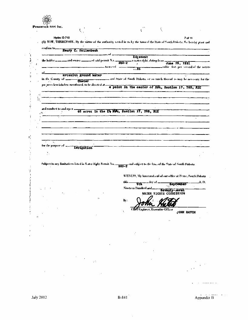
POWERTECh (USA) INC.
HydmID 710 7&A1145) NO W, 1TIF EF IF IwII I(. By ife Ihrijihr elf th I S 2U fil~i) toI,, ill'I Iit 6 .11d Ialvm (of 11 ti ll, f its.11d $ 1 .t h i:ls t~i. .' 'Ic.. ruI11011
tIw haltb r - le'uri - ,~114 of :.oilI 1-l tislit N... -5________ 3__ Ii h r rII& f I, i., raq.380-2 ,June 29, 1951
if.I. fir -4.11,1afuja 111.1 Birr -f.c.1rg, fir the- ..aI~ra.
firar'tesian g3-Ound waterin the, C-111miiI efori~ .1isel hiat..* o S 41. 111',I I .laestn. er o.1,1111411 flwwoeesf i'idi e..s.h- ..uera feir Ilw
lowwo11-wld.111%fi Io-$lie ivl fa pOln't In thes cantor of NW'. SectIon j7,fii ýKjrI
usi e~ag~fli IGo6 acres tin the C'g Mh~, $action 17, TOS, HIE
(fir ill, J5iTlHbir. 514
$..h15 '., fto ai lniuiassIsIi.V..lrI% Ilirnitit N... 3W - uand 1sulsjvrt lo he be. thy a rofi. Slabt. il ~Smith I aLsida.
wIrN i~ss, my iiiias now a,,sai off our 4irrii.t. at I' f.'..'saI, Inakilae
NIitsd a I ........... M aitaI.....A. 1).
soventy- sevenWATER RIGHITS C0OD4ISSY0N
j!0HM HATCH
July 2012 B-841 Appendix B

POWERTECh (USA) INc.
Hydro ID 710 8 of 11
Fore, 15.
* JrPermit No. ........ -O2 -
Wi1ter Diversion No-. - ...... IAR.1.EY181, Wae District
CERTIFICATE OF CONSTRUCTION
ti
This is to Crtify, That lions* C.- tn110 t, hankr
_________________]he htidrr of
Permit No. -3J ... issued •pon Application No. _ 3*U2.---, bearing dte oi priouity of Jim,,. !q,
IaO' authorizing the divertion of I..ll cu. It p• seond of the waters ol-
_ a eual- -ISW•' UA+.,nuy of - State of South Dakota at
to f A In Ah .•tva n th 9 3f& R&.2t4an 17- TOM. RIE '"
purlous.h; - complied with the providOIm of the laws of the Slate of SoutI Makotm relating to proof ol
complelion of the works ol diversion set out and desuibed in said Permit; that said works tie found in satislacl iry
co,odititn lot diverting and conveying to the plar.e of intended use .J-711 cu. ft. per sr.and al water.
! OatI- Sebt',a1•... , $97°
By: W R
jai AT ICifEgne
July 2012 B-842 Appendix B

POWERTECh (USA) INc.
Hydro ID 710 9o111
y.-llotLca or Intenti tc, eppropriatV Water !foo. 379'-2 t: 30--2
(iirst kublication .... _, . )
Ot|'Jice of StLe Fngir.,oel-
Pierre, 6. Dak., July -1(, 1y9l
Notice is hereby given tbut inrreL .haythorne ydiosi, posto'lice ndJress in Dwcwey,
bouth Dakota, has nwJe applications in accordodace with the provisionn of the wacer lais
of bouth Dakbta for prrmits to appropriatc tfo. beneficial ae an '0olloenz
ILW) Valona ,if water per minute of time. fro'a .rouni %.Ater supply tnrout'h the Golden
Cliff Irrigation Project, Wel 11lo. 1, the polat of diveruion of hnicn is to be located
in the iM:', or tno Ol of -cltimi o, T rp. 65., nange il.. 8U gallons of ivater ;er minute
or tima rrom romund wntei" sulr.ly tjIro(ugh the Golden Cliff IJriCation Project, ITeLl No. 2,
the icxnt of diversion of which 1z to be located in the 1T11:, of the .J" of ziect-ion .7,
Nwlp. 6S., Range Ut-. b:cd w',ter to be uced for te fpurposf of providlinr irrigation on
the follcrainc descri-bed lands NPT; .1;ec. 17, U1j- nE:! Sao. 1i, wl~l sec. 6, Wi NiE1 .5c. 6,
'-I;ST~ ec , ~ tec 6, f S4 Sc. , 1I.~ Y~ ce.~iawl flirl- up.4? Sec. 7. T. 6b1.,
ft. liF.
This application will be taken up by t:.-. •t.ate Lngineer at his office at Pierre for
consideratirn upon the 21st day of August 19y1, at 10of A. Ai. A persons who believe that
their prior rights would bu injuriously affet:tea, or that tre allowance of the pemit would
bo dotrintental to the public welfare shall nile auch protest with the S.ate Engineer in
writing prior to thu ahovo date and may ppear on the day above mentioned in person for
the purpose of discu.aini- iurther, the information presented.
Appropriate action will be ta.ken tvy the Ltate Lngineer after aviitoble time has
r1.dpaed for the c~n~lderation of any oa" all information presented.
UiCSzmt
k n. T)I., T. LOUCKSces Richarduon Ustei tegincer
I " !. .% ..
.I':
July 2012 B-843 JAppendix B

POWERTECh (USA) INC.
Ptitnit • - 300-2
WaMt Divn0n. 2 1,'aLl Iliver Wue, Mriselrct
RIPORT OF EXAMINATION OF WORKS
ANDIOR APPLICATION OF WATER TO NENEFICIAL USE
TO: Waltr Rtesourc - Commission. Stile Office Bulldin No. 2. Pierre., South Dakiota 51501
I have Ifalictty mdeda thorough exattinntlon at the water rise system onsturlad by. D± rro -, -Hawthorne of Cu ts .t3, o
o Pimil No. 38LI-2 , bbearin date of prilority of June 29
allthOliidng IPAdiaaeaun Of 1.78 cuif. pot andaluatr groutid wateraulhoiz~n9Ih4 |•sio ol 178 c...... pet second of the watens of__(•oh aIe
i, irrigation Custerfo purposes, in - Counly.
I ave to report an th condilion o Ihe same as follmsm:
The Water UtN System ctnetsus of,
A. Works usud to divwel the valer:
376 foot flowing artesian well, s91e:1 cased; fii *" storage danm,15 foot high, 30 toot wide at the base] and 50 ,oot in length.on the west side ard 60 ftaot in length on the jouth eide.
A
B. Works used to transport taler to place of use,
Approx. 800 feet of natural ditch
C. Work:a-sed so apply water to lienlrctll use.
Flood'irrigates by spreading
* Thle intl ol ndhame.._ Pair
To Center of W., Sec. 17, T6S., RIE., B.H H.The piMln of divindon Is located
Tke earkshat capable oa d'vmling ol; conveying to the plue of usa • 1.78
cu. h. pFlue ad olvatetvhichisIobeusedfr __irrigation
Waterlisa baa puls tio nelkilul aito thu mautnum eileostousfolow:Eh of Wia of See. 17, T6S., RIH., B.H._4,
corpiniz i .io 60 1..1 et of land.
eIonry C. lloI•enbeck
Star Rt. %.Edgernont, So 57735
THOMAS A GARDINERWater Resources Engineer
July 2012 B-844 Appendix B

POWERTECh (USA) INC.
Hydkro I 710 11 of I1
Form 20.
-A.;.,
Ni.. -J600-2_____
.1
.9
.9
21
NOTICE OF TRANSFER OF WATER PERMIT
Stale Oficer Building No. 2Pierce, South Dakota s75so nate
This is to nor;:;, you that title tc Ih. leads de~culbed as tollowm:F½ Ni.4 Ce Sec. 17, T6S., RIE., D.II.m.
fomaik," ownrd hv Darrel Hawthorne
has" sonltranslaedo Henry C. Hollenbeck
together with any rights to the benrfirial use oi watfeir thereon is evidenced by Water Right Permit No.
380-2 . as povidge. or In Seclion 61.0127 at the 1960 Supplement to tIe South Oakola Cod* of 1939.• • .•. . . .' • gi
You aem thereore beeby rqultead Io lile this "Notice offaTends of Water Permit" in its appropri,. d,, atth¶a i1 f• WM'ftg •,e Iftev"denice of the ca,,p .f ownership.
A flee of or. dollar is hereto attached to cover fling lets as required under .lectlon 61.0159 of the 1960Supplment to the South Dakota Co.o of 1938.
STATE OF SOUTH OAKOTA I
County a''
I being first duly , mon n my oath depor, andsayo That my if to the above describes undarlinIs ftf A of Owner. that I have read Ith alove foregoingsat:a~ent, and I know of ray own pesonal knowlidgae that the information herpin elated is true.
, (Signed)
.utcribed and woa to hbeore me tis da-_ of, .
INofary f'ibliil
I,"•*.41
.I, '
July 2012 B-845 Appendix B

POWERTECII (USA) INC.
This page intentionally left blank
July 2012 B-846 Appendix B

POWERTECII (USA) INC.
SOURCE R
AN EARLIER NAME FOR HYDRO ID 710
(Letter from R.M. Caywood, Silver King Mines, Inc., to Clinton C. Smythe, Tennessee Valley Authority,
May 12, 1980)
July 2012 B-847 Appendix B

POWERTECIh (USA) INc.
This page intentionally left blank
July 2012 B-848 Appendix B

POWERTECk (USA) INC.
LSilver King MinesInc.PO. Box 49
Edgemont. South Dakota 57735
May 12, 1980
Clinton C. SmytheProject ManagerEdgemont ProjectTennessee Valley AuthorityP. 0. Box 2957Casper, Wyoming 82602 RE: CAY; i143,80
Dear Clint;
Attached are water levels and flow rates for Burdock Area water wells measuredduring the April, 1980 quarterly well check. Please note the addition ofWells l149 and 150.
Well No. Location' Well Owner
149 T 6 S, R I E, Sec. 17 bb H. C. Hollenbeck
150 T 6 S. R I E, Sec. 6 aa H. C. Hollenbeck
Very truly yours,
SILVER KING MINES, INC.
R. M. Caywood
Resident Manager
KEA:dlgEnclosurecc: David C. Arnold
C. Richard Dodson(encl)R. J. MullinJ. M. Boggs "
R. L. Doty IfJ. T. Watson
July 2012 B-849 Appendix B

POWERTECII (USA) INC.
QUA..TEP.LY WE'LL CHECK
April, 1980
W~ell Date
Read
Water
Level/IQvm
change SinceLast RPeort
--- 4 - -_ -
136
139
141
4-17-80
4-25-80
5-1-80
3.60' down .10'
23.00 gpm None
Remarks
MP elevation has been
.60 gpm None
147
148
149
200
5-1-80
5-1-80
4-29-80
4-29-80
4-30-80
10.90' Down .75'I_ i
flowsWell still flows, budropped about 8".
I • |T
19.20'
70.70'
52.02'
first measurement
first measurement
I
1 I -
up 1.00'I
202 4-30-80 16.34' up .121
down .29'204 4-28-8o 37.12'-4 ----
205
206
209
212
4-30-80
4-30-80
4-30-80
4-28-80
24.48' down .37'A ________________________________________________________ -.-- - ________________--- ________________ -
18.49'
145.75
2.75 gpm
down .33'
down 1.11'
None
213 4-28-80 32.97' down .42'-----------------------
214
216
14-28-80
4-30-80
80.4,0' down .40'
220.37 down 1.37'
I I
_________________________________________________________________ I ___________________ _____________________ ______________________________________________
1- -~_________
July 2012 R-950 Appendix B
Copyright © 2022 FDOKUMEN