
Development of Methods and Practices of Virtual Reality as a Tool for Participatory Urban Planning
13
ORIGINAL ARTICLE Open Access Development of methods and practices of virtual reality as a tool for participatory urban planning: a case study of Vilnius City as an example for improving environmental, social and energy sustainability Gintaras Stauskis Abstract Background: Multiple channels of sustainable urban development could be managed in the process of an inter-disciplinary cooperation and creative involvement of all stakeholders. The paper aims to verify how the specific methods of virtual reality simulation could be used as an effective tool for setting an efficient participation platform between the stakeholders to improve environmental, social and energy sustainability of urban development in modern cities. The paper is based on the case study of Vilnius City. Methods: The article shows how innovative tools could facilitate better cooperation based on more balanced approaches in participatory urban planning by chronological review of traditional public involvement practices and structured analysis of emerging public participation techniques. As each discipline involved in sustainable urban development covers specific socio-economic, environmental, economic and creative competence fields, it is essential to develop a comprehensive tool for public participation that is well accessible, reliable and efficient. Results: The provided analysis of research theories and practical applications of public involvement through virtual simulation in the case of Vilnius City shows that virtual reality and spatial modelling integrated on gaming platforms under the conditions of widespread information and communications technology (ICT) applications could be developed and used as an innovative, involving and efficient tool for facilitating wider and more effective public involvement in the planning and design of urban environment and so increase social and environmental sustainability of urban development process. The application of this method for planning public spaces leads to more efficient use of environmental resources also reducing the need for primary energy and using it more rationally. Conclusions: The analysis of using virtual urban simulation (VUS) method for representing, analysing, referring and improving urban design projects reveals that virtual applications can make public participation more accessible for citizens of the community and improve reliability of its results thus having direct impact on the planning process and its outcomes in terms of more sustainable impact on environmental and economic development of urban community. Keywords: Urban planning; Landscape; Virtual reality; Public participation; Stakeholder involvement Correspondence: [email protected] Vilnius Gediminas Technical University, Sauletekio ave. 11, Vilnius LT-10223, Lithuania © 2014 Stauskis; licensee Springer. This is an open access article distributed under the terms of the Creative Commons Attribution License (http://creativecommons.org/licenses/by/2.0), which permits unrestricted use, distribution, and reproduction in any medium, provided the original work is properly cited. Stauskis Energy, Sustainability and Society 2014, 4:7 http://www.energsustainsoc.com/content/4/1/7
Transcript of Development of Methods and Practices of Virtual Reality as a Tool for Participatory Urban Planning
Stauskis Energy, Sustainability and Society 2014, 4:7http://www.energsustainsoc.com/content/4/1/7
ORIGINAL ARTICLE Open Access
Development of methods and practices of virtualreality as a tool for participatory urban planning:a case study of Vilnius City as an example forimproving environmental, social and energysustainabilityGintaras Stauskis
Abstract
Background: Multiple channels of sustainable urban development could be managed in the process of aninter-disciplinary cooperation and creative involvement of all stakeholders. The paper aims to verify how thespecific methods of virtual reality simulation could be used as an effective tool for setting an efficient participationplatform between the stakeholders to improve environmental, social and energy sustainability of urban developmentin modern cities. The paper is based on the case study of Vilnius City.
Methods: The article shows how innovative tools could facilitate better cooperation based on more balancedapproaches in participatory urban planning by chronological review of traditional public involvement practices andstructured analysis of emerging public participation techniques. As each discipline involved in sustainable urbandevelopment covers specific socio-economic, environmental, economic and creative competence fields, it is essentialto develop a comprehensive tool for public participation that is well accessible, reliable and efficient.
Results: The provided analysis of research theories and practical applications of public involvement through virtualsimulation in the case of Vilnius City shows that virtual reality and spatial modelling integrated on gaming platformsunder the conditions of widespread information and communications technology (ICT) applications could bedeveloped and used as an innovative, involving and efficient tool for facilitating wider and more effective publicinvolvement in the planning and design of urban environment and so increase social and environmental sustainabilityof urban development process. The application of this method for planning public spaces leads to more efficient useof environmental resources also reducing the need for primary energy and using it more rationally.
Conclusions: The analysis of using virtual urban simulation (VUS) method for representing, analysing, referring andimproving urban design projects reveals that virtual applications can make public participation more accessible forcitizens of the community and improve reliability of its results thus having direct impact on the planning process andits outcomes in terms of more sustainable impact on environmental and economic development of urban community.
Keywords: Urban planning; Landscape; Virtual reality; Public participation; Stakeholder involvement
Correspondence: [email protected] Gediminas Technical University, Sauletekio ave. 11, Vilnius LT-10223,Lithuania
© 2014 Stauskis; licensee Springer. This is an open access article distributed under the terms of the Creative CommonsAttribution License (http://creativecommons.org/licenses/by/2.0), which permits unrestricted use, distribution, and reproductionin any medium, provided the original work is properly cited.
Stauskis Energy, Sustainability and Society 2014, 4:7 Page 2 of 13http://www.energsustainsoc.com/content/4/1/7
Tell me, I forget,Show me, I remember,Involve me, I understand,Step back, I will act.
Old Chinese proverb
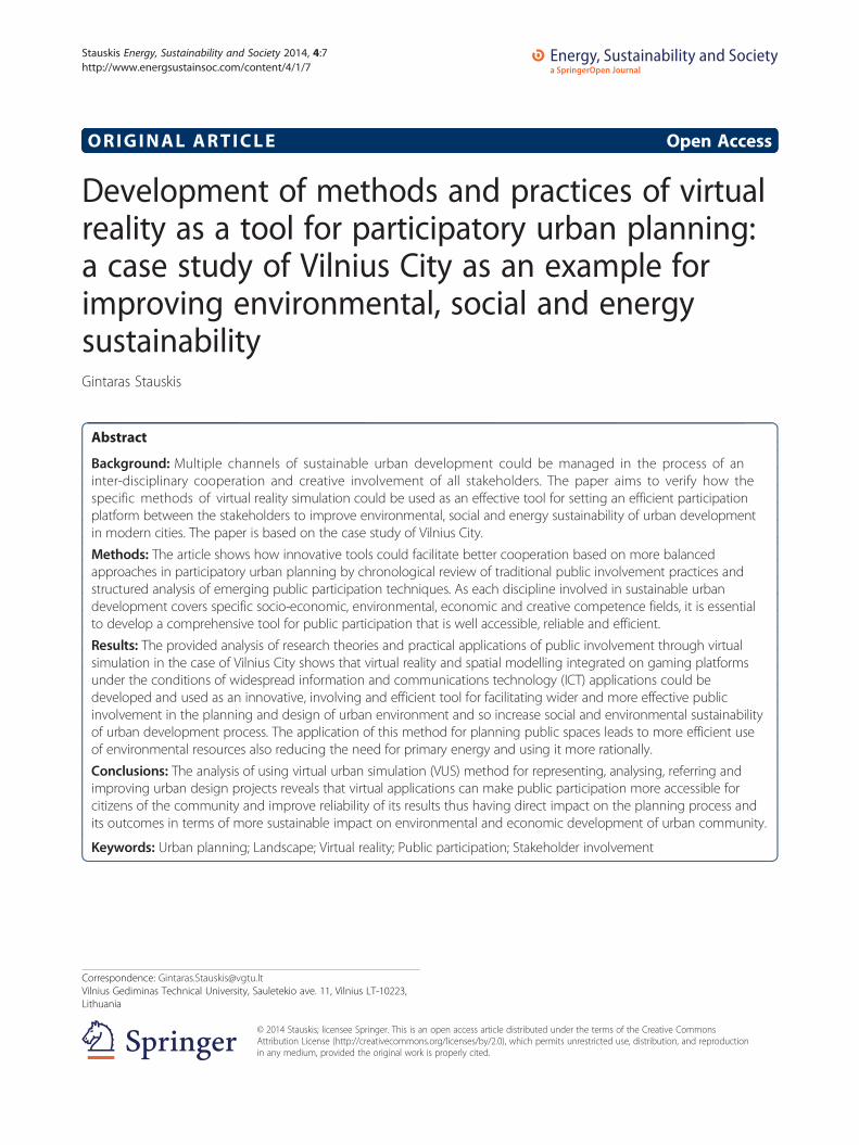
BackgroundEmerging public participationThe public initiatives that emerged in the early 70s inthe UK and other European countries are good cases toanalyse and illustrate how public participation graduallyturned into an instrument of urban planning and designas we understand and use it today. The post-war policyof rebuilding the ruined blocks in big British citiesturned into the method of urban renewal when the en-tire residential areas were pulled down on the reason oflow sanitary quality and the goal of rising living stan-dards. In reality, this brought demolition of old develop-ment in Birmingham, Manchester, Glasgow and othercities. That process of ‘improving’ was additionally fuelledby rising income of urban councils as a result of relativelydynamic economic development [1]. Several drawbacks ofthis urban policy were fast to appear. On the one hand,valuable urban legacy was destroyed; the entire urbancommunities with specific lifestyles and cosy neighbour-hoods were completely erased. On the other hand, themodernist style of concrete blocks that appeared on theirformer land sites were sold fast but appeared to be dis-gusting to live in and were abandoned in a short term bytheir residents turning the whole areas into urban deserts.Last but not least, complete rebuilding was a very costlyventure compared to gradual refurbishment of existingstock. The process of protests of local residents was fastto appear, and it was professionally supported by archi-tects (Figure 1). In Manchester, an architect Rod Hackneyand his neighbours established a Black Road Area ActionGroup to protect historic residences from demolition and
Figure 1 Residents looking for real participation power in urban redevestrikes their home. Images: Communities in Control [2]; http://www.ourpatch.c
went into a massively supported campaign of debates withthe city council called ‘Save my house’ in 1972.The success of a particular case in Manchester turned
into a precedent for the whole country that led to widerdiscussions on the issues of urban redevelopment be-tween the residents and the councils. The case of hear-ing local residents and then setting the refurbishmentstrategies was finally formalised and included into theUK’s housing law. Still, efficient methods of communica-tion between the clerks, the public and the businesswere to be developed. In Europe, many countries havegone through a similar process like in the UK in ap-proximately the same decade. As a matter of fact, mod-ern public participation methods were not used in EastEuropean countries until the last decade of the twentiethcentury for evident socio-political reasons. Finally, regu-lations on public involvement found their stake in na-tional construction law mostly following the examplesof other West European countries. In general perspec-tive, public participation facilitates decisions on morerational planning and design thus saving material andsocial resources including urban land, materials, labourand energy.
MethodsThe paper is designed as a set of analysed practices andcase studies with public participation in planning. Tech-niques and potentials of spatial modelling and virtualrepresentation are reviewed and analysed. The researchstarts by presenting the development of techniques invirtual representation and turning them into a planningtool. Virtual simulation in gaming environment is ana-lysed by presenting several case studies including theone developed by the author of this paper. By comparingdifferent tools and methods used for public participa-tion, their strengths and weaknesses are identified. Bycomparative analysis, passive, active and interactive public
lopment of the UK. Real people need real power before Megatropolisom.au/system/attachments/0003/3949/Megatropolis.jpg.
Stauskis Energy, Sustainability and Society 2014, 4:7 Page 3 of 13http://www.energsustainsoc.com/content/4/1/7
participation methods are structured in the aspect oftheir interactivity. As a conclusion, the recommenda-tions are drawn on how to apply and replicate innovativeinformation and communications technology (ICT)-based public participation tools for better results in urbandevelopment.
Research of virtual reality applications in urbanismSince the first papers were published on research in vir-tual reality and space simulation in 1989, the immenselist of publications is available, illustrating the scope ofresearch activities ongoing in different knowledge cen-tres around the globe [3]. As noted by Simpson in 2001,the published research primarily focused on general is-sues of environment simulation later calling for applica-tion of virtual reality in planning and design as well asanalysing current examples and the role of urban simula-tion [4]. Along that road, the aspects of urban simulationin geographic information system (GIS) environment wereanalysed, reflecting state of the art in virtual urban model-ling. Applications of simulation for hazard research areone more area for research. Wider development of re-search on virtual reality applications in urbanism collidewith technical limitations of both hardware and software,as well as lack of established research methodology. Themost advanced research centres focus on the complex re-search of three-dimensional city scale simulation in a GISenvironment also combining it with dynamic building ofintegrated modelling systems. Several main topical cat-egories of references in virtual reality simulation could beidentified. Urban and environmental simulation is a broadarea covering references in urban and environmentalsimulation, visualisation and virtual reality, focusing oncontributions to urban planning. Virtual reality and GISapplication is another field for researchers whose centre oftheir glance is on virtual reality and urban simulation as itis developed in GIS environment. Urban and regionalmodelling by building, evaluating and testing urban andregional development models is the next broad cat-egory of references. Urban simulation and gamingsection explores simulation and technical aspects of gam-ing. Technical aspects of urban and environmental simula-tion are common category of research being presentedindependently or incorporated into one of the above-mentioned categories.Virtual reality models are different from reality, so it is
an impression of a person involved in experiencing vir-tual reality. There are important aspects of human per-ception of the presence in virtual models that empowerhuman senses as memory, bodily movement and kinesthe-sis [5]. The sets of parameters such as awareness, memory,sensory notion, feeling of realism, attention and inter-action are offered to identify the notion of mixed presenceof the user in virtual models.
Stakeholder involvement as planning methodSpecial regulation adopted in the UK for developing astatement of community involvement (SCI) in urbanplanning allows the local government to set a goal in en-dorsing this regulation, to fulfil its vision in order to en-gage the people and organisations of Sheffield in planningfor sustainable development [6]. The experienced benefitsof exercising this practice in Sheffield, the third largestmetropolitan district in the UK, promote planning as aproactive tool for delivery of sustainable development, re-flection of needs of local community, quality improvementand efficiency of planning as well as promotion of socialcohesion by giving communities a tangible steak in deci-sion making. The involvement covering public, private,community and voluntary sectors of local urban settle-ments has to be transparent, promoting real participationand involvement, accessible and inclusive, also account-able. The principles of SCI stated hereby include cul-ture of engagement, early and continuous involvement,reaching out and fit for purpose, clarity and formal repre-sentation based on a certain code of practice. Several par-ticipation tools are identified to be applied by SCI: media,letters, public meetings, websites, distributed documents,exhibitions and questionnaires. Continuing the involve-ment, using its results and giving feedback on implemen-tation are most important aspects for local communities.The stages of SCI are evolving in the process of its
undertaking as more cooperation experience is accumu-lated by the stakeholders. Starting with informing localresidents about the planning process that is going to hap-pen, it moves to the next phase: consultation of local resi-dents and survey of their opinions, and further on, it leadsto active involvement of communities in becoming astakeholder and partner of the planning process [6]. Thenecessity to consider the needs and expectations of all citi-zens’ groups is meant as ‘equality’, an aspect which is im-portant for the residents of all groups to believe that theparticipation process is legitimate and timely organisedwhere the results are used for the public interest [7].As underlined by the International Association of Pub-
lic Participation in their project aimed at the improve-ment of cross-cultural exploration of public governanceand decision making, innovative use of communicationtechnology can improve the quality of public partici-pation with indigenous communities who have muchbetter perception of simulated images compared to two-dimensional maps and drafts [8].However, several decades of applying traditional tools
to involve the public into the planning turned out to berestricted in terms of access and time, transparency ofthe process as well as needed resources. Different types ofmeetings, committees and working groups spend muchtime as participants have little practice in understandingplanning strategies, the process itself and its outcomes.
Stauskis Energy, Sustainability and Society 2014, 4:7 Page 4 of 13http://www.energsustainsoc.com/content/4/1/7
Additional time is needed to access all groups of citizens,especially the teenagers and the youth. The meetings in-volving the members of local communities are usuallydominated by few most active members who reveal theirown opinion more than that of the whole community. Ithappens that these ‘activists’ have some motivated interestin the outcome of planning in terms of market competi-tion, and so transparency becomes an issue difficult tocontrol. Multiple meetings, repeated access attempts andthe need to control the process involve professional staff,premises and services; therefore, the process usually be-comes long and expensive compared to its results.Several of the above-mentioned methods are practiced
in Lithuania as regulated by the Guidelines for PublicParticipation in Urban Planning [9]. Public participationis outlined therein as ‘Voluntary participation of legaland private entities and their groups in preparation ofterritorial planning document’. Providing informationabout the goals of planning on the Internet and in localpaper, placing it at the local authority’s premises, makingan exhibition of the project and holding public hearingsare the main activities required by the code. Completedplanning projects are registered by the local authority atthe publicly accessible Planning Register. Time framesfor different stages of informing and involving the publicdepend on a scale of planning: for general plans, that inLithuania’s case covers big urban areas, and all spatial,social and environmental aspects’ time intervals are lon-ger; for special plans, covering some specific planningaspects, time intervals are relatively shorter (Table 1).The practice of implementing participatory planning
methods in Lithuania has demonstrated quite similarlimitations as in the other countries, transparency andefficiency being the main ones. There were cases whenorganised groups of community representatives have se-verely criticised selected development projects but latersupported similar ideas presented by another devel-oper. Citizen’s groups often act against everything and
Table 1 Basic phases of public participation as regulatedby the Planning Law of Lithuania
Type of plan/timespan for procedures
General plan Special plan
Information for citizensabout planning procedures
Immediately Immediately
Letters to owners,residents, companies
Letters to owners ofneighbouring andplanned plots
Getting acquainted withplan
1 month 20 working days
Public exhibition time 15 working days 10 working days
Public meeting 10 working days inadvance
10 working days inadvance
Complains accepted frompublic
1 month 1 month
anything without a constructive dialogue, and for thisreason, the architects in Lithuania are very modest devel-oping more interactive dialogue and tend to have just for-mal procedures usually limited to a purely bureaucraticpaperwork of announcements, protocols and reports. Inthis case, the real voice of residents remains unheard.Accountability of planning organisers and transpar-
ency of planning process are the main social gains thatare generated in the process of public participation asnoted by the EU Directive on Public Participation [10].Involvement of groups of residents and other NGOs isespecially encouraged as it brings also environmentaleducation for people. Wider use of electronic media isappreciated by the Directive as one of the means for ap-propriate information and involvement.The basic methods used for public participation based
on their interactivity are structured as passive, active andinteractive (see Table 2). Passive methods are basedmainly on one-way communication between the plan-ners and the public as one of the stakeholders with nointeractivity. Active methods have some elements ofinteractivity as they try to establish ‘a dialogue’ insteadof ‘a monologue’. The emerging ICT-based techniquesare attributed to interactive methods as their goal pro-vides a person or representative group with possibilitiesof direct access and reliable and monitored feedback onthe goals, roles, process and consequences of planning.Present challenges in urban development and limita-
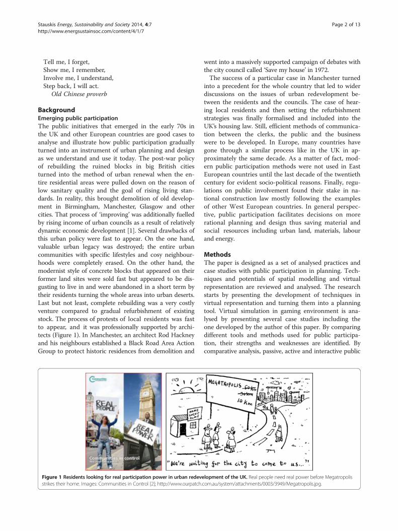
tions of traditional participation methods in Vilnius Citywere the reasons of looking for new more efficientmethods of public participation in urban planning anddesign. Numerous cases popped out in recent years inVilnius City when centrally prepared development pro-grammes and projects met severe opposition from urbanresidents: demolition of old housing units at Šnipiškėsarea close to modern skyscrapers (Figure 2a); protest ofPilaitė housing district residents against the municipal-ity’s plan to urbanise recreation area at a local lakeshore(Figure 2b). These protests left local authorities confusedand city planners disappointed. On the other hand, at-tempts of planners, architects and authorities to estab-lish a constructive dialogue with the residents practicallyfailed because of lack of experience from both sides aswell as the proposed methods showed up as inefficientand non-transparent.Analysis of the analysed cases shows that the attempts
to maintain a contact with local residents and involvethem in planning were carried out in primitive ways byusing just formally required methods with no follow-upand real impact on the planned development projects.There were several cases during the last years when cer-tain urban development programmes and decisions of citybureaucrats that were not supported by a part of Vilniuscitizens ended with social protest of local communities.
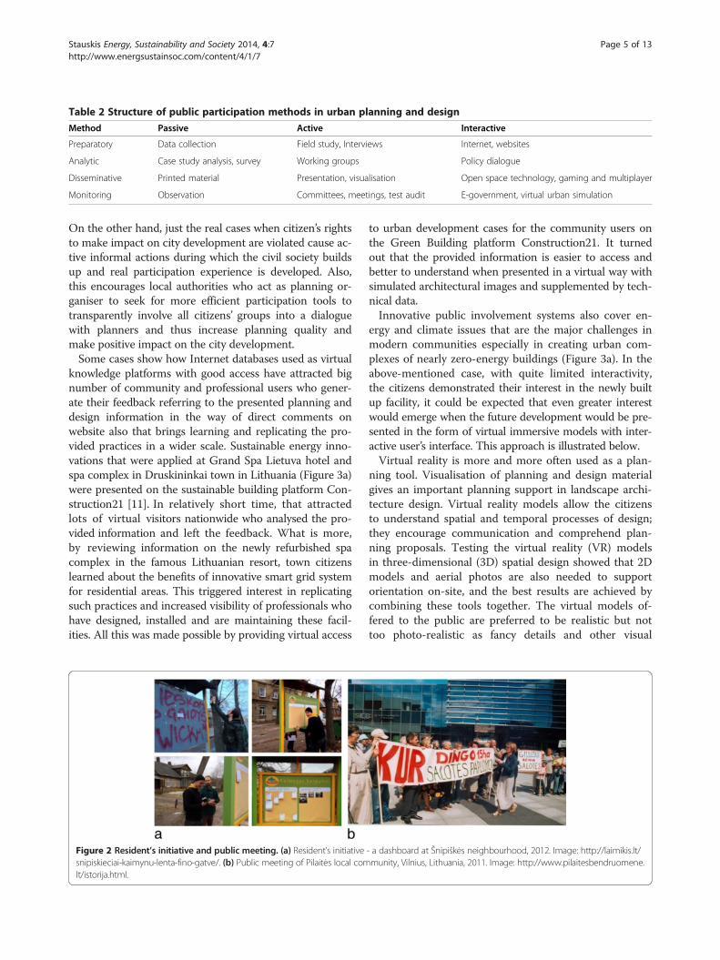
Table 2 Structure of public participation methods in urban planning and design
Method Passive Active Interactive
Preparatory Data collection Field study, Interviews Internet, websites
Analytic Case study analysis, survey Working groups Policy dialogue
Disseminative Printed material Presentation, visualisation Open space technology, gaming and multiplayer
Monitoring Observation Committees, meetings, test audit E-government, virtual urban simulation
Stauskis Energy, Sustainability and Society 2014, 4:7 Page 5 of 13http://www.energsustainsoc.com/content/4/1/7
On the other hand, just the real cases when citizen’s rightsto make impact on city development are violated cause ac-tive informal actions during which the civil society buildsup and real participation experience is developed. Also,this encourages local authorities who act as planning or-ganiser to seek for more efficient participation tools totransparently involve all citizens’ groups into a dialoguewith planners and thus increase planning quality andmake positive impact on the city development.Some cases show how Internet databases used as virtual
knowledge platforms with good access have attracted bignumber of community and professional users who gener-ate their feedback referring to the presented planning anddesign information in the way of direct comments onwebsite also that brings learning and replicating the pro-vided practices in a wider scale. Sustainable energy inno-vations that were applied at Grand Spa Lietuva hotel andspa complex in Druskininkai town in Lithuania (Figure 3a)were presented on the sustainable building platform Con-struction21 [11]. In relatively short time, that attractedlots of virtual visitors nationwide who analysed the pro-vided information and left the feedback. What is more,by reviewing information on the newly refurbished spacomplex in the famous Lithuanian resort, town citizenslearned about the benefits of innovative smart grid systemfor residential areas. This triggered interest in replicatingsuch practices and increased visibility of professionals whohave designed, installed and are maintaining these facil-ities. All this was made possible by providing virtual access
Figure 2 Resident’s initiative and public meeting. (a) Resident’s initiativesnipiskieciai-kaimynu-lenta-fino-gatve/. (b) Public meeting of Pilaitės local comlt/istorija.html.
to urban development cases for the community users onthe Green Building platform Construction21. It turnedout that the provided information is easier to access andbetter to understand when presented in a virtual way withsimulated architectural images and supplemented by tech-nical data.Innovative public involvement systems also cover en-
ergy and climate issues that are the major challenges inmodern communities especially in creating urban com-plexes of nearly zero-energy buildings (Figure 3a). In theabove-mentioned case, with quite limited interactivity,the citizens demonstrated their interest in the newly builtup facility, it could be expected that even greater interestwould emerge when the future development would be pre-sented in the form of virtual immersive models with inter-active user’s interface. This approach is illustrated below.Virtual reality is more and more often used as a plan-
ning tool. Visualisation of planning and design materialgives an important planning support in landscape archi-tecture design. Virtual reality models allow the citizensto understand spatial and temporal processes of design;they encourage communication and comprehend plan-ning proposals. Testing the virtual reality (VR) modelsin three-dimensional (3D) spatial design showed that 2Dmodels and aerial photos are also needed to supportorientation on-site, and the best results are achieved bycombining these tools together. The virtual models of-fered to the public are preferred to be realistic but nottoo photo-realistic as fancy details and other visual
- a dashboard at Šnipiškės neighbourhood, 2012. Image: http://laimikis.lt/munity, Vilnius, Lithuania, 2011. Image: http://www.pilaitesbendruomene.
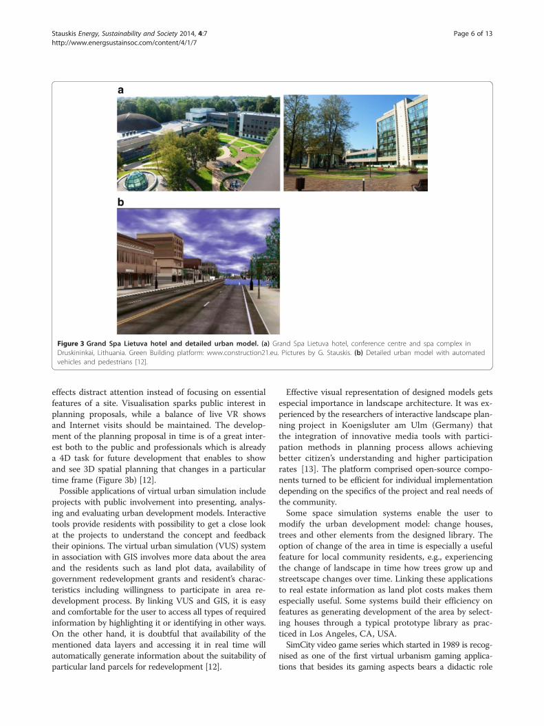
Figure 3 Grand Spa Lietuva hotel and detailed urban model. (a) Grand Spa Lietuva hotel, conference centre and spa complex inDruskininkai, Lithuania. Green Building platform: www.construction21.eu. Pictures by G. Stauskis. (b) Detailed urban model with automatedvehicles and pedestrians [12].
Stauskis Energy, Sustainability and Society 2014, 4:7 Page 6 of 13http://www.energsustainsoc.com/content/4/1/7
effects distract attention instead of focusing on essentialfeatures of a site. Visualisation sparks public interest inplanning proposals, while a balance of live VR showsand Internet visits should be maintained. The develop-ment of the planning proposal in time is of a great inter-est both to the public and professionals which is alreadya 4D task for future development that enables to showand see 3D spatial planning that changes in a particulartime frame (Figure 3b) [12].Possible applications of virtual urban simulation include
projects with public involvement into presenting, analys-ing and evaluating urban development models. Interactivetools provide residents with possibility to get a close lookat the projects to understand the concept and feedbacktheir opinions. The virtual urban simulation (VUS) systemin association with GIS involves more data about the areaand the residents such as land plot data, availability ofgovernment redevelopment grants and resident’s charac-teristics including willingness to participate in area re-development process. By linking VUS and GIS, it is easyand comfortable for the user to access all types of requiredinformation by highlighting it or identifying in other ways.On the other hand, it is doubtful that availability of thementioned data layers and accessing it in real time willautomatically generate information about the suitability ofparticular land parcels for redevelopment [12].
Effective visual representation of designed models getsespecial importance in landscape architecture. It was ex-perienced by the researchers of interactive landscape plan-ning project in Koenigsluter am Ulm (Germany) thatthe integration of innovative media tools with partici-pation methods in planning process allows achievingbetter citizen’s understanding and higher participationrates [13]. The platform comprised open-source compo-nents turned to be efficient for individual implementationdepending on the specifics of the project and real needs ofthe community.Some space simulation systems enable the user to
modify the urban development model: change houses,trees and other elements from the designed library. Theoption of change of the area in time is especially a usefulfeature for local community residents, e.g., experiencingthe change of landscape in time how trees grow up andstreetscape changes over time. Linking these applicationsto real estate information as land plot costs makes themespecially useful. Some systems build their efficiency onfeatures as generating development of the area by select-ing houses through a typical prototype library as prac-ticed in Los Angeles, CA, USA.SimCity video game series which started in 1989 is recog-
nised as one of the first virtual urbanism gaming applica-tions that besides its gaming aspects bears a didactic role
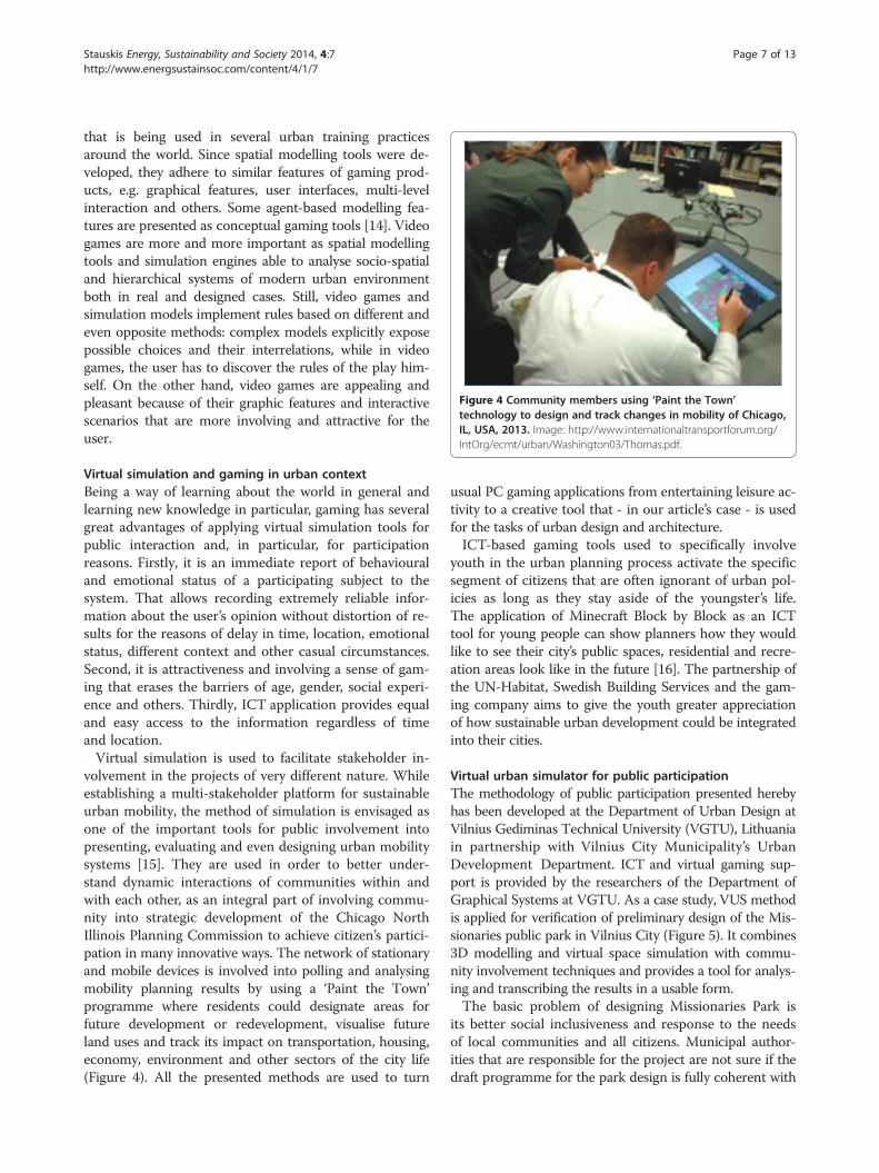
Figure 4 Community members using ‘Paint the Town’technology to design and track changes in mobility of Chicago,IL, USA, 2013. Image: http://www.internationaltransportforum.org/IntOrg/ecmt/urban/Washington03/Thomas.pdf.
Stauskis Energy, Sustainability and Society 2014, 4:7 Page 7 of 13http://www.energsustainsoc.com/content/4/1/7
that is being used in several urban training practicesaround the world. Since spatial modelling tools were de-veloped, they adhere to similar features of gaming prod-ucts, e.g. graphical features, user interfaces, multi-levelinteraction and others. Some agent-based modelling fea-tures are presented as conceptual gaming tools [14]. Videogames are more and more important as spatial modellingtools and simulation engines able to analyse socio-spatialand hierarchical systems of modern urban environmentboth in real and designed cases. Still, video games andsimulation models implement rules based on different andeven opposite methods: complex models explicitly exposepossible choices and their interrelations, while in videogames, the user has to discover the rules of the play him-self. On the other hand, video games are appealing andpleasant because of their graphic features and interactivescenarios that are more involving and attractive for theuser.
Virtual simulation and gaming in urban contextBeing a way of learning about the world in general andlearning new knowledge in particular, gaming has severalgreat advantages of applying virtual simulation tools forpublic interaction and, in particular, for participationreasons. Firstly, it is an immediate report of behaviouraland emotional status of a participating subject to thesystem. That allows recording extremely reliable infor-mation about the user’s opinion without distortion of re-sults for the reasons of delay in time, location, emotionalstatus, different context and other casual circumstances.Second, it is attractiveness and involving a sense of gam-ing that erases the barriers of age, gender, social experi-ence and others. Thirdly, ICT application provides equaland easy access to the information regardless of timeand location.Virtual simulation is used to facilitate stakeholder in-
volvement in the projects of very different nature. Whileestablishing a multi-stakeholder platform for sustainableurban mobility, the method of simulation is envisaged asone of the important tools for public involvement intopresenting, evaluating and even designing urban mobilitysystems [15]. They are used in order to better under-stand dynamic interactions of communities within andwith each other, as an integral part of involving commu-nity into strategic development of the Chicago NorthIllinois Planning Commission to achieve citizen’s partici-pation in many innovative ways. The network of stationaryand mobile devices is involved into polling and analysingmobility planning results by using a ‘Paint the Town’programme where residents could designate areas forfuture development or redevelopment, visualise futureland uses and track its impact on transportation, housing,economy, environment and other sectors of the city life(Figure 4). All the presented methods are used to turn
usual PC gaming applications from entertaining leisure ac-tivity to a creative tool that - in our article’s case - is usedfor the tasks of urban design and architecture.ICT-based gaming tools used to specifically involve
youth in the urban planning process activate the specificsegment of citizens that are often ignorant of urban pol-icies as long as they stay aside of the youngster’s life.The application of Minecraft Block by Block as an ICTtool for young people can show planners how they wouldlike to see their city’s public spaces, residential and recre-ation areas look like in the future [16]. The partnership ofthe UN-Habitat, Swedish Building Services and the gam-ing company aims to give the youth greater appreciationof how sustainable urban development could be integratedinto their cities.
Virtual urban simulator for public participationThe methodology of public participation presented herebyhas been developed at the Department of Urban Design atVilnius Gediminas Technical University (VGTU), Lithuaniain partnership with Vilnius City Municipality’s UrbanDevelopment Department. ICT and virtual gaming sup-port is provided by the researchers of the Department ofGraphical Systems at VGTU. As a case study, VUS methodis applied for verification of preliminary design of the Mis-sionaries public park in Vilnius City (Figure 5). It combines3D modelling and virtual space simulation with commu-nity involvement techniques and provides a tool for analys-ing and transcribing the results in a usable form.The basic problem of designing Missionaries Park is
its better social inclusiveness and response to the needsof local communities and all citizens. Municipal author-ities that are responsible for the project are not sure if thedraft programme for the park design is fully coherent with
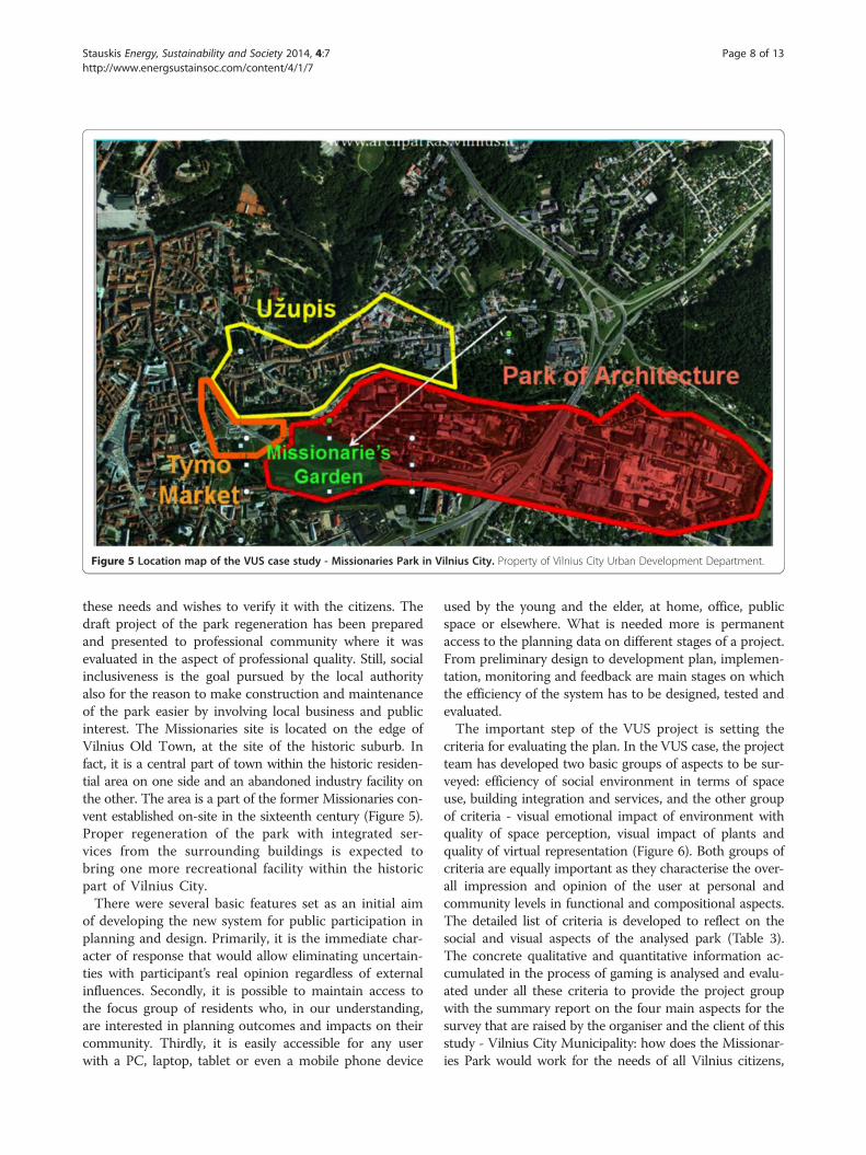
Figure 5 Location map of the VUS case study - Missionaries Park in Vilnius City. Property of Vilnius City Urban Development Department.
Stauskis Energy, Sustainability and Society 2014, 4:7 Page 8 of 13http://www.energsustainsoc.com/content/4/1/7
these needs and wishes to verify it with the citizens. Thedraft project of the park regeneration has been preparedand presented to professional community where it wasevaluated in the aspect of professional quality. Still, socialinclusiveness is the goal pursued by the local authorityalso for the reason to make construction and maintenanceof the park easier by involving local business and publicinterest. The Missionaries site is located on the edge ofVilnius Old Town, at the site of the historic suburb. Infact, it is a central part of town within the historic residen-tial area on one side and an abandoned industry facility onthe other. The area is a part of the former Missionaries con-vent established on-site in the sixteenth century (Figure 5).Proper regeneration of the park with integrated ser-vices from the surrounding buildings is expected tobring one more recreational facility within the historicpart of Vilnius City.There were several basic features set as an initial aim
of developing the new system for public participation inplanning and design. Primarily, it is the immediate char-acter of response that would allow eliminating uncertain-ties with participant’s real opinion regardless of externalinfluences. Secondly, it is possible to maintain access tothe focus group of residents who, in our understanding,are interested in planning outcomes and impacts on theircommunity. Thirdly, it is easily accessible for any userwith a PC, laptop, tablet or even a mobile phone device
used by the young and the elder, at home, office, publicspace or elsewhere. What is needed more is permanentaccess to the planning data on different stages of a project.From preliminary design to development plan, implemen-tation, monitoring and feedback are main stages on whichthe efficiency of the system has to be designed, tested andevaluated.The important step of the VUS project is setting the
criteria for evaluating the plan. In the VUS case, the projectteam has developed two basic groups of aspects to be sur-veyed: efficiency of social environment in terms of spaceuse, building integration and services, and the other groupof criteria - visual emotional impact of environment withquality of space perception, visual impact of plants andquality of virtual representation (Figure 6). Both groups ofcriteria are equally important as they characterise the over-all impression and opinion of the user at personal andcommunity levels in functional and compositional aspects.The detailed list of criteria is developed to reflect on thesocial and visual aspects of the analysed park (Table 3).The concrete qualitative and quantitative information ac-cumulated in the process of gaming is analysed and evalu-ated under all these criteria to provide the project groupwith the summary report on the four main aspects for thesurvey that are raised by the organiser and the client of thisstudy - Vilnius City Municipality: how does the Missionar-ies Park would work for the needs of all Vilnius citizens,
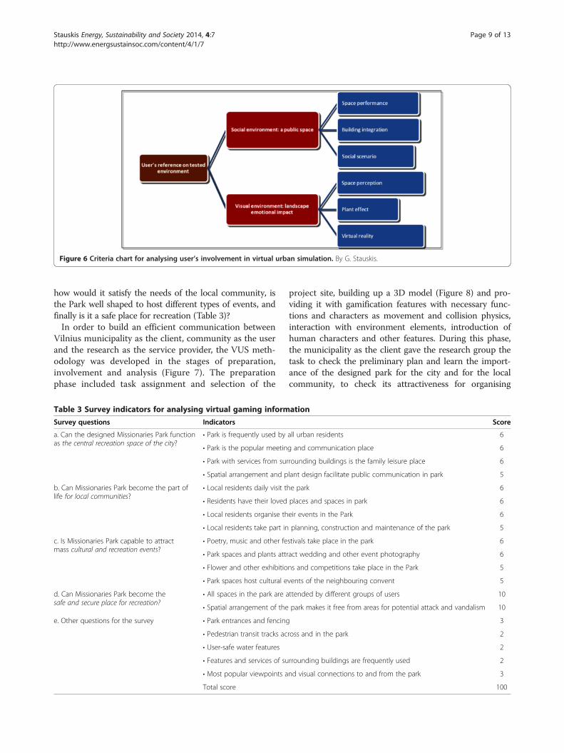
Figure 6 Criteria chart for analysing user’s involvement in virtual urban simulation. By G. Stauskis.
Stauskis Energy, Sustainability and Society 2014, 4:7 Page 9 of 13http://www.energsustainsoc.com/content/4/1/7
how would it satisfy the needs of the local community, isthe Park well shaped to host different types of events, andfinally is it a safe place for recreation (Table 3)?In order to build an efficient communication between
Vilnius municipality as the client, community as the userand the research as the service provider, the VUS meth-odology was developed in the stages of preparation,involvement and analysis (Figure 7). The preparationphase included task assignment and selection of the
Table 3 Survey indicators for analysing virtual gaming inform
Survey questions Indicators
a. Can the designed Missionaries Park functionas the central recreation space of the city?
• Park is frequently used by
• Park is the popular meetin
• Park with services from sur
• Spatial arrangement and p
b. Can Missionaries Park become the part oflife for local communities?
• Local residents daily visit t
• Residents have their loved
• Local residents organise th
• Local residents take part in
c. Is Missionaries Park capable to attractmass cultural and recreation events?
• Poetry, music and other fe
• Park spaces and plants attr
• Flower and other exhibitio
• Park spaces host cultural e
d. Can Missionaries Park become thesafe and secure place for recreation?
• All spaces in the park are a
• Spatial arrangement of the
e. Other questions for the survey • Park entrances and fencing
• Pedestrian transit tracks ac
• User-safe water features
• Features and services of su
• Most popular viewpoints a
Total score
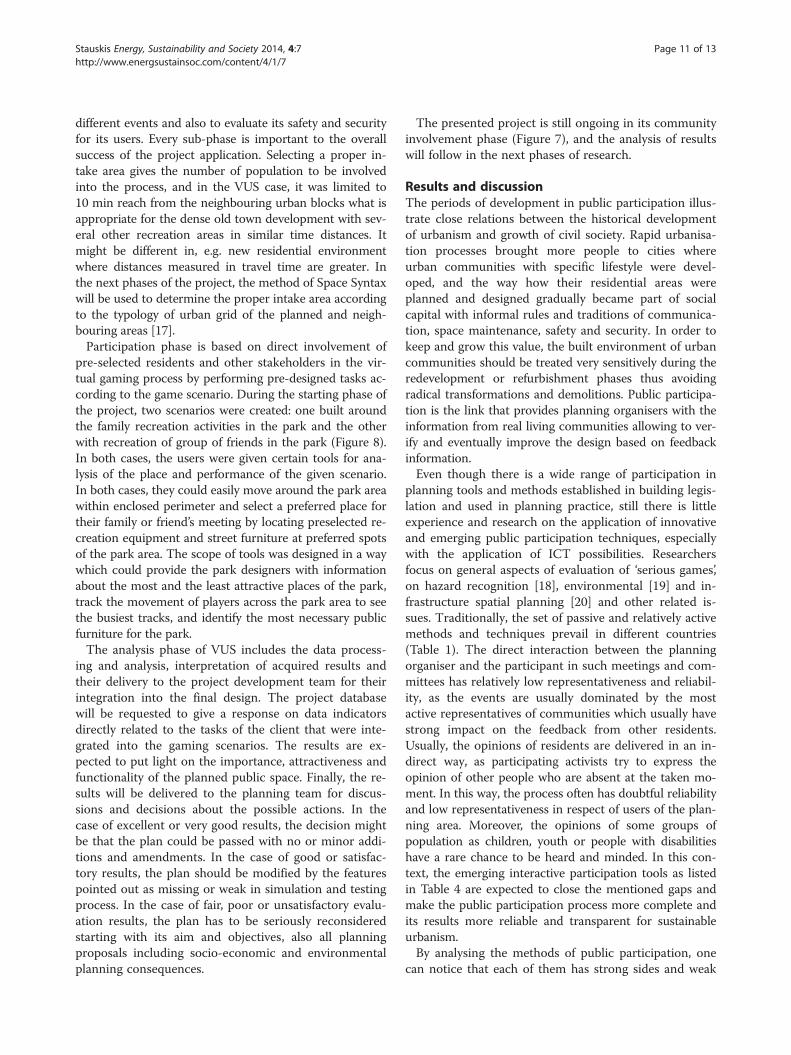
project site, building up a 3D model (Figure 8) and pro-viding it with gamification features with necessary func-tions and characters as movement and collision physics,interaction with environment elements, introduction ofhuman characters and other features. During this phase,the municipality as the client gave the research group thetask to check the preliminary plan and learn the import-ance of the designed park for the city and for the localcommunity, to check its attractiveness for organising
ation
Score
all urban residents 6
g and communication place 6
rounding buildings is the family leisure place 6
lant design facilitate public communication in park 5
he park 6
places and spaces in park 6
eir events in the Park 6
planning, construction and maintenance of the park 5
stivals take place in the park 6
act wedding and other event photography 6
ns and competitions take place in the Park 5
vents of the neighbouring convent 5
ttended by different groups of users 10
park makes it free from areas for potential attack and vandalism 10
3
ross and in the park 2
2
rrounding buildings are frequently used 2
nd visual connections to and from the park 3
100
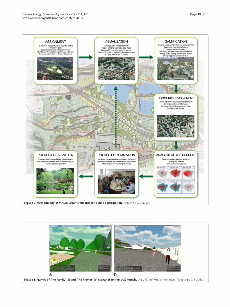
Figure 7 Methodology of virtual urban simulator for public participation. Picture by G. Stauskis.
Figure 8 Frames of ‘The Family’ (a) and ‘The Friends’ (b) scenarios on the VUS models. Unity 3D software environment. Pictures by G. Stauskis.
Stauskis Energy, Sustainability and Society 2014, 4:7 Page 10 of 13http://www.energsustainsoc.com/content/4/1/7
Stauskis Energy, Sustainability and Society 2014, 4:7 Page 11 of 13http://www.energsustainsoc.com/content/4/1/7
different events and also to evaluate its safety and securityfor its users. Every sub-phase is important to the overallsuccess of the project application. Selecting a proper in-take area gives the number of population to be involvedinto the process, and in the VUS case, it was limited to10 min reach from the neighbouring urban blocks what isappropriate for the dense old town development with sev-eral other recreation areas in similar time distances. Itmight be different in, e.g. new residential environmentwhere distances measured in travel time are greater. Inthe next phases of the project, the method of Space Syntaxwill be used to determine the proper intake area accordingto the typology of urban grid of the planned and neigh-bouring areas [17].Participation phase is based on direct involvement of
pre-selected residents and other stakeholders in the vir-tual gaming process by performing pre-designed tasks ac-cording to the game scenario. During the starting phase ofthe project, two scenarios were created: one built aroundthe family recreation activities in the park and the otherwith recreation of group of friends in the park (Figure 8).In both cases, the users were given certain tools for ana-lysis of the place and performance of the given scenario.In both cases, they could easily move around the park areawithin enclosed perimeter and select a preferred place fortheir family or friend’s meeting by locating preselected re-creation equipment and street furniture at preferred spotsof the park area. The scope of tools was designed in a waywhich could provide the park designers with informationabout the most and the least attractive places of the park,track the movement of players across the park area to seethe busiest tracks, and identify the most necessary publicfurniture for the park.The analysis phase of VUS includes the data process-
ing and analysis, interpretation of acquired results andtheir delivery to the project development team for theirintegration into the final design. The project databasewill be requested to give a response on data indicatorsdirectly related to the tasks of the client that were inte-grated into the gaming scenarios. The results are ex-pected to put light on the importance, attractiveness andfunctionality of the planned public space. Finally, the re-sults will be delivered to the planning team for discus-sions and decisions about the possible actions. In thecase of excellent or very good results, the decision mightbe that the plan could be passed with no or minor addi-tions and amendments. In the case of good or satisfac-tory results, the plan should be modified by the featurespointed out as missing or weak in simulation and testingprocess. In the case of fair, poor or unsatisfactory evalu-ation results, the plan has to be seriously reconsideredstarting with its aim and objectives, also all planningproposals including socio-economic and environmentalplanning consequences.
The presented project is still ongoing in its communityinvolvement phase (Figure 7), and the analysis of resultswill follow in the next phases of research.
Results and discussionThe periods of development in public participation illus-trate close relations between the historical developmentof urbanism and growth of civil society. Rapid urbanisa-tion processes brought more people to cities whereurban communities with specific lifestyle were devel-oped, and the way how their residential areas wereplanned and designed gradually became part of socialcapital with informal rules and traditions of communica-tion, space maintenance, safety and security. In order tokeep and grow this value, the built environment of urbancommunities should be treated very sensitively during theredevelopment or refurbishment phases thus avoidingradical transformations and demolitions. Public participa-tion is the link that provides planning organisers with theinformation from real living communities allowing to ver-ify and eventually improve the design based on feedbackinformation.Even though there is a wide range of participation in
planning tools and methods established in building legis-lation and used in planning practice, still there is littleexperience and research on the application of innovativeand emerging public participation techniques, especiallywith the application of ICT possibilities. Researchersfocus on general aspects of evaluation of ‘serious games’,on hazard recognition [18], environmental [19] and in-frastructure spatial planning [20] and other related is-sues. Traditionally, the set of passive and relatively activemethods and techniques prevail in different countries(Table 1). The direct interaction between the planningorganiser and the participant in such meetings and com-mittees has relatively low representativeness and reliabil-ity, as the events are usually dominated by the mostactive representatives of communities which usually havestrong impact on the feedback from other residents.Usually, the opinions of residents are delivered in an in-direct way, as participating activists try to express theopinion of other people who are absent at the taken mo-ment. In this way, the process often has doubtful reliabilityand low representativeness in respect of users of the plan-ning area. Moreover, the opinions of some groups ofpopulation as children, youth or people with disabilitieshave a rare chance to be heard and minded. In this con-text, the emerging interactive participation tools as listedin Table 4 are expected to close the mentioned gaps andmake the public participation process more complete andits results more reliable and transparent for sustainableurbanism.By analysing the methods of public participation, one
can notice that each of them has strong sides and weak
Table 4 Methods of reality representation for stakeholder involvement and public participation
Method Traditional Modern Emerging
Graphical Drawing, drafting, painting CAD linear drawing Virtual reality simulation
Spatial Building hard models, photography Three-dimensional modelling, model rendering Gaming, virtual role play, virtual cities
Stauskis Energy, Sustainability and Society 2014, 4:7 Page 12 of 13http://www.energsustainsoc.com/content/4/1/7
points; on the other hand, each of them activates a spe-cific area in the community and checks the plan at aspecial angle. This takes us to an important finding thatdifferent tools of public participation should be used incomplex by combining methods that are appropriate tothe taken case and could give the best available results.To avoid duplication, the most fit-for-purpose methodshave to be selected minding cultural, ethical, technical,social, and the other features both in the communityand in the project.In the situation when ICTs are more and more becom-
ing a daily use feature, it is natural to involve them asone of the important tools to be used in public participa-tion. Analysis of recent participation practices demon-strate that ICT-based tools can attract the groups ofpopulation that often fall out from the group of partici-pants and give them a modern easily accessible toolusing technologies and devices that are already at theirdisposal. At the very beginning, it should be clear aboutthe strong features and the limitations of this tool asVUS or similar. Virtual reality is not a substitute to thereal face-to-face interaction of citizens; it is a supportivetool with several very strong and efficient features aslisted in this paper (efficiency, transparency, accessibilityand resource consumption) that was missing amongtraditional instruments of public participation. ICT toolsallow creating a multi-layer stakeholder platform thatis an essential feature of planning job. Allowing thepublic into this circle makes the group more complete,and by ICT tools - more powerful in the decisions andthe results.It is essential to have proper software and technical sup-
port for the development of this kind of ICT-supportedsystems. The main dilemma in this phase is finding thebest compromise between the systems that are most ef-fective for space modelling on the one side and gamingprocess on the other. In the VUS case, Unity 3D waschosen as an efficient and comfortable gaming envir-onment that opens wide opportunities in model buildingand optimisation. Usual drafting, modelling and ren-dering techniques could be used for the initial phasesof the process, later converting the files to a programmesupporting virtual gaming. It is essential to keep inorder the GIS background and environment so as to getdirect references to land sites and buildings in real urbanlocations.By responding to the goals of transparency, immediacy,
direct access, permanence and follow-up, VUS extends
the methods of public participation and introduces a mod-ern, efficient and reliable tool. Essentially, VUS is a newword in the development of interactive and interdisciplin-ary cooperation platform for public participation that isessential for efficient and effective urban planning and de-sign as foreseen by Agenda 21 and the Aarhus conventionin 1998 [21].
ConclusionsThe presented VUS methodology is developed as an in-novative tool to help Vilnius City Municipality, on smallscale, to examine in an interactive way to what extentthe project of Missionaries Park meets the interests oflocal and all the city’s community. The latter will begiven an opportunity to get acquainted with the projectand report its opinions about all features of the project.Moreover, the method allows checking the planned facilityon public attractiveness, functionality, safety and securityand, if needed, making the necessary improvements.Lastly, the system enables local authority to establish acontact with potential event organisers and other smallbusinesses in order to shape the park as a space fit for dif-ferent types of public events that will also be an importantfeature for economic viability of the place. All together, itleads to more rational use of social and material resourcesas human labour, urban land, natural and constructionmaterials, and energy.As permanence and monitoring are important features
of planning and design, VUS opens perfect possibilitiesto monitor the process of planning, construction andmaintenance as it could be repeatedly used to indicatethe preferred modifications while the facility is in use.There are many other possibilities how the VUS toolcould deviate once taken into regular practice by localauthorities, communities, businesses and moderated byresearchers. Numerous lines of research are open to fur-ther development and investigation of specific featuresof melting public participation with virtual imaging andgaming. As the on-going VUS project already revealed,gaming feature is extremely attractive and involving anenvironment that could facilitate wider involvement of res-idents into public participation activities compared to trad-itional techniques. Interdisciplinary teams of researchersand practitioners are needed to creatively apply the know-ledge from the fields of planning and architecture, urbansociology and anthropology, environmental science, ICTand related themes in order to increase the quality of plansand make the implementations more sustainable for the
Stauskis Energy, Sustainability and Society 2014, 4:7 Page 13 of 13http://www.energsustainsoc.com/content/4/1/7
citizens and the environment in the process of construc-tion, use and maintenance.VUS as an interaction platform can drastically change
the design, evaluation, teamwork and participation inplanning and design and bring more sustainability in-stead of hierarchy to the process. VUS application has ahigh technology edge when the urban space is plannedand designed. High visual quality of VUS models is es-sential to bring realistic familiarity with the realisticlandscape image to seriously motivate and involve theuser. Finally, the broader questions arise: whether newplanning and interaction tools give too much control tothe public over their decisions about the future of spacesand buildings usually planned and designed by urbanplanners and architects. The answers lie in the balancedsocio-economic understanding of the roles and missionsof architects and the public.Looking forward, public participation could and should
become a trendy exercise to be used actively; joining inICT technologies is the way to its wider application. Popu-lar and widely used tool would extend the number ofusers and make it more popular among the groups ofyoung population rarely engaged in ordinary hearings,meetings and committees. In the long run, ICT-basedpublic participation would transfer as a specific applica-tion to social media and offer plenty of easily accessible in-formation and effective tools under moderate resource.
Competing interestsThe author declares that he has no competing interests.
Author’s informationGintaras Stauskis is a Doctor of the Humanities in Architecture and aprofessor at Vilnius Gediminas Technical University (Lithuania). He isconducting academic training and research activities at the Department ofUrban Design, Traku str. 1, Vilnius LT-01332, Lithuania. He is involved in theEuropean Union research programmes on Green Building and sustainableurbanism. He is the Head of Lithuania Green Building Council LTGBC and amember of the editorial board of the Journal of Civil Engineering andArchitecture (USA), Landscape Architecture and Art (Latvia) and Arhitekturaun Pilsetplanošana (Latvia). His current research fields include landscapearchitecture and planning, ‘green’ urban architecture and mobility,accessibility of environment, recreation and urban health. His research resultshave been presented in numerous national and international publicationsand conferences.
Received: 11 September 2013 Accepted: 19 March 2014Published: 17 April 2014
References1. Hackney R (1990) The good, the bad and the ugly. Frederick Muller, London2. Communities in Control (2008) Real people, real power. Crown copyright.
Electronic resource. http://www.openeyecommunications.com/wp-content/uploads/CommunitiesinControlFull.pdf. Accessed 25 Aug 2013
3. Sheppard SRJ (1989) Visual simulation: a user’s guide for architects,engineers and planners. Van Nostrand Reinhold, New York
4. Simpson DM (2001) Virtual reality and urban simulation in planning: aliterature review and topical bibliography. J Plan Lit 15:3
5. Papasarantou C, Bourdakis V (2012) Represent-ing presence, V!RUS, n. 8.http://www.nomads.usp.br/virus/virus08/?sec=4&item=4&lang=en. Accessed19 August 2013
6. Sheffield Development Framework (2006) Statement of communityinvolvement. Sheffield City Council, Sheffield
7. Statement of Community Involvement and Planning Applications (2004).Office of the Deputy Prime Minister, London. http://www.communities.gov.uk/corporate/. Accessed 30 July 2013
8. Painting the Landscape (2009) A cross-cultural exploration of public-government decision-making. International Association of Public Participation.http://c.ymcdn.com/sites/www.iap2.org/resource/resmgr/imported/Kettering_FINALExecutiveSummaryReport.pdf. Accessed 25 Aug 2013
9. Visuomenės dalyvavimo teritorijų planavimo procese nuostatai (2004)[Guidelines on public participation in territory planning]. LietuvosRespublikos Vyriausybės 1996 m. rugsėjo 18 d. nutarimas Nr.1079 (LietuvosRespublikos Vyriausybės 2004 m. liepos 16 d. nutarimo Nr. 904 redakcija)[Approved by the Decree of the Government of Lithuania No. 1079 from18.09.1996 (Version Decree of the Government of Lithuania No. 904 from16.07.2004)]. http://www3.lrs.lt/pls/inter3/dokpaieska.showdoc_l?p_id=237982&p_query=&p_tr2=. 15 May 2013
10. The European Commission (2003) Directive 2003/35/Ec of the EuropeanParliament and of the Council providing for public participation in respectof the drawing up of certain plans and programmes relating to theenvironment and amending with regard to public participation and accessto justice Council Directives 85/337/Eec and 96/61/Ec. http://www.enviros.cz/ippc/AIP_smernice_2003_37_ES_20031007.pdf. Accessed 25 Aug 2013
11. Vilnius Gediminas Technical University (2013) Hotel DZŪKIJA in Druskininkai.Part of the Grand Spa Lithuania complex. http://www.construction21.eu/case-studies/lt/hotel-dzkija-in-druskininkai-part-of-the-grand-spa-lithuania-complex.html. Accessed 23 Aug 2013
12. Liggett R, Friedman S, Jepson W (1995) Interactive decision making in avirtual urban world: visual simulation and GIS. In: Proceedings of the 15thESRI user conference. Palm Springs. 24 Feb 2003
13. Bartlett WK, Neumann A, Meifort J (2005) Interactive landscape planning –results of a pilot study in Koenigslutter am Elm, Germany. Proceedings/Tagungsband; Ed./Hg.: Manfred SCHRENK. CORP 2005 & Geomultimedia05.http://www.researchgate.net/publication/228863270_Interactive_Landscape_PlanningResults_of_a_pilot_study_in_Koenigslutter_am_Elm_Germany. Accessed 25 Aug 2013
14. Ruffat S, Ter Minassian H (2012) Video games and urban simulation: Newtools or new tricks? Eur J Geogr. article no. 622. http://cybergeo.revues.org/25561?lang=en. Accessed 25 Aug 2013
15. Dhingra Ch KRSR (2013) Establishing a multi-stakeholder forum for urbanmobility. UN-Habitat, EMBARQ, Washington
16. Manneh C (2012) Computer game provides inspiration for new planningtool. Cities Today 7:43
17. Bučys J (2013) Funkcinių Ir kompozicinių urbanistinės struktūros analizėsaspektų sujungimas: vilniaus miesto lokalių centrų tyrimas. [Combiningfunctional and compositional aspects of the analysis of urban structure:a case study of local centres in Vilnius]. J Arch Urbanism 37(2):69–87.doi:10.3846/20297955.2013.807565
18. Mayer IS, Wolff A, Wenzler I (2013) Learning efficacy of the ‘hazardrecognition’ serious game: a quasi experimental study. In: Serious gamesdevelopment and applications. Springer, Heidelberg, pp 118–129
19. Nefs M, Gerretsen P, Dooghe D, Mayer IS, Meijer SA (2010) Gaming theinterrelation between rail infrastructure and station area development: part1 - modeling the serious game ‘SprintCity’. In: Third international conferenceon infrastructure systems and services: next generation infrastructuresystems for EcoCities. 11–13 Nov 2010
20. Zhou Q, Mayer IS (2010) Gaming as the method to integrate modelling andparticipatory approaches in interactive water management. In: InternationalEnvironmental Modelling and Software Society (iEMSs) 2010 Internationalcongress on environmental modelling and software modelling forenvironment’s sake, fifth biennial meeting. International EnvironmentModelling and Software Society iEMSS, Ottawa
21. United Nations Economic Committee for Europe (1998) Convention onaccess to information, public participation in decision-making and access tojustice in environmental matters. http://www.unece.org/fileadmin/DAM/env/pp/documents/cep43e.pdf. Accessed 25 Aug 2013
doi:10.1186/2192-0567-4-7Cite this article as: Stauskis: Development of methods and practices ofvirtual reality as a tool for participatory urban planning: a case study ofVilnius City as an example for improving environmental, social andenergy sustainability. Energy, Sustainability and Society 2014 4:7.