Detection of the impact of early Holocene hunter-gatherers on vegetation in the Czech Republic,...
19
ORIGINAL ARTICLE Detection of the impact of early Holocene hunter-gatherers on vegetation in the Czech Republic, using multivariate analysis of pollen data Petr Kunes ˇ Petr Pokorny ´ Petr S ˇ ı ´da Received: 27 September 2006 / Accepted: 2 April 2007 ȑ Springer Verlag 2007 Abstract Pollen data from the Czech Republic was used to detect the early Holocene impact of hunter-gatherers on vegetation based on a selection of 19 early Holocene pollen profiles, complemented with archaeological information regarding the intensity of local and regional Mesolithic human habitation. Archaeological evidence was assigned to simple categories reflecting the intensity of habitation and distance from pollen sites. Multivariate methods (PCA and RDA) were used to determine relationships between sites and possible anthropogenic pollen indicators and to test how these indicators relate to the archaeological evidence. In several profiles the pollen signal was influenced by local Mesolithic settlement. Specific pollen types (e.g. Calluna vulgaris, Plantago lanceolata, Solanum and Pteridium aquilinum) were found to be significantly correlated with human activity. The role of settlement proximity to the investigation site, the statistical significance of pollen indicators of human activity, as well as the early occurrence of Corylus avellana and its possible anthropogenic dis- persal, are discussed. Keywords Anthropogenic pollen indicators Á Mesolithic Á Early human impact Á Corylus avellana Á Multivariate analysis Introduction In the Czech Republic the Mesolithic period of human prehistory lasted from the Preboreal to the early Atlantic (i.e. from about 10,000 B.P. to 7,000 B.P. according to the most accepted contemporary view; Pavlu ˚ 2004; Vencl 2006). It was a period during which dramatic changes occurred both in the global climate and in ecosystems. Reacting to these environmental changes, Mesolithic human populations adopted various hunting, gathering and fishing strategies, all of which were generally more spe- cialized than those of the big game hunters of the Paleo- lithic period. As post-Glacial natural afforestation proceeded, Mesolithic populations started to be less mobile and thus they affected local environments around camp sites more intensively. However, this impact was probably only of local character and hence could be easily over- looked in pollen diagrams. Moreover, the occurrence of anthropogenic pollen indicators in the sedimentary record may be strongly dependent upon the distance between the settlement and the sampling point (Behling and Street 1999; Wacnik 2005), as well as upon the type of sediment or local geomorphology. A number of detailed palaeoecological studies concerned with the wider relationships of Mesolithic archaeology have been made (Simmons et al. 1985; Simmons and Innes 1988a, b; Clark 1989; Simmons and Chambers 1993; Turner et al. 1993; Macklin et al. 2000; Innes and Blackford 2003). Important surveys have come from Scandinavia, showing interesting pollen-analytical evidence for local Communicated by A. Lotter. P. Kunes ˇ(&) Department of Botany, Faculty of Science, Charles University in Prague, Bena ´tska ´ 2, 128 01 Praha 2, Czech Republic e-mail: [email protected] P. Pokorny ´ Institute of Archaeology, Academy of Sciences of the Czech Republic, Letenska ´ 4, 118 01 Praha 1, Czech Republic P. S ˇ ı ´da National Museum, Va ´clavske ´ na ´m. 68, 115 79 Praha 1, Czech Republic 123 Veget Hist Archaeobot DOI 10.1007/s00334-007-0119-5
Transcript of Detection of the impact of early Holocene hunter-gatherers on vegetation in the Czech Republic,...
ORIGINAL ARTICLE
Detection of the impact of early Holocene hunter-gathererson vegetation in the Czech Republic, using multivariate analysisof pollen data
Petr Kunes Æ Petr Pokorny Æ Petr Sıda
Received: 27 September 2006 / Accepted: 2 April 2007
� Springer Verlag 2007
Abstract Pollen data from the Czech Republic was used
to detect the early Holocene impact of hunter-gatherers on
vegetation based on a selection of 19 early Holocene pollen
profiles, complemented with archaeological information
regarding the intensity of local and regional Mesolithic
human habitation. Archaeological evidence was assigned to
simple categories reflecting the intensity of habitation and
distance from pollen sites. Multivariate methods (PCA and
RDA) were used to determine relationships between sites
and possible anthropogenic pollen indicators and to test
how these indicators relate to the archaeological evidence.
In several profiles the pollen signal was influenced by local
Mesolithic settlement. Specific pollen types (e.g. Calluna
vulgaris, Plantago lanceolata, Solanum and Pteridium
aquilinum) were found to be significantly correlated with
human activity. The role of settlement proximity to the
investigation site, the statistical significance of pollen
indicators of human activity, as well as the early occurrence
of Corylus avellana and its possible anthropogenic dis-
persal, are discussed.
Keywords Anthropogenic pollen indicators �Mesolithic �Early human impact � Corylus avellana � Multivariate
analysis
Introduction
In the Czech Republic the Mesolithic period of human
prehistory lasted from the Preboreal to the early Atlantic
(i.e. from about 10,000 B.P. to 7,000 B.P. according to the
most accepted contemporary view; Pavlu 2004; Vencl
2006). It was a period during which dramatic changes
occurred both in the global climate and in ecosystems.
Reacting to these environmental changes, Mesolithic
human populations adopted various hunting, gathering and
fishing strategies, all of which were generally more spe-
cialized than those of the big game hunters of the Paleo-
lithic period. As post-Glacial natural afforestation
proceeded, Mesolithic populations started to be less mobile
and thus they affected local environments around camp
sites more intensively. However, this impact was probably
only of local character and hence could be easily over-
looked in pollen diagrams. Moreover, the occurrence of
anthropogenic pollen indicators in the sedimentary record
may be strongly dependent upon the distance between the
settlement and the sampling point (Behling and Street
1999; Wacnik 2005), as well as upon the type of sediment
or local geomorphology.
A number of detailed palaeoecological studies concerned
with the wider relationships of Mesolithic archaeology have
been made (Simmons et al. 1985; Simmons and Innes
1988a, b; Clark 1989; Simmons and Chambers 1993;
Turner et al. 1993; Macklin et al. 2000; Innes and Blackford
2003). Important surveys have come from Scandinavia,
showing interesting pollen-analytical evidence for local
Communicated by A. Lotter.
P. Kunes (&)
Department of Botany, Faculty of Science,
Charles University in Prague, Benatska 2,
128 01 Praha 2, Czech Republic
e-mail: [email protected]
P. Pokorny
Institute of Archaeology, Academy of Sciences of the Czech
Republic, Letenska 4, 118 01 Praha 1, Czech Republic
P. Sıda
National Museum, Vaclavske nam. 68,
115 79 Praha 1, Czech Republic
123
Veget Hist Archaeobot
DOI 10.1007/s00334-007-0119-5
Mesolithic settlements (Hicks 1993; Regnell et al. 1995;
Vuorela 1995; Hornberg et al. 2006). A few studies have
recently been presented from Western continental Europe
(Bos and Janssen 1996; Bos 1998; Behling and Street 1999;
Bos and Urz 2003; Bos et al. 2006) and Poland (Wacnik
2005).
The area of the present Czech Republic was selected as
a model landscape for our study because of the abundant
organic deposits of mire or lacustrine origin. However,
very few of them have been studied by means of pollen
analysis, and even fewer go as far back as the early
Holocene or Late-glacial. Up to the present, no studies
have been undertaken in the Czech Republic that focus on
the impact of hunter-gatherers on the vegetation. In gen-
eral, detailed high-resolution palaeoecological and ar-
chaeobotanical studies of this period as undertaken in other
countries are missing. In order to perceive more clearly
what could possibly be achieved and what should we
concentrate on in the future, we have collected the avail-
able palynological data from the Czech Republic that in-
cludes the early Holocene and analyzed them using
multivariate numerical methods. In this paper we want to
show how Mesolithic settlements can be verified or pre-
dicted based on pollen analysis, and which plants in par-
ticular can be considered as indicators of human presence
in the Mesolithic. To achieve this goal, we ask the fol-
lowing questions:
1. Are there patterns in the pollen data that can be
attributed to Mesolithic human influence?
2. Are there specific anthropogenic indicators for this
period in the pollen assemblages?
3. Is there a relationship between the distance of a
Mesolithic settlement from the sampling point and the
(anthropogenic) pollen signal?
4. Are there differences in anthropogenic pollen signal
between sites of different origin (small/large lakes and
mires)?
5. Was human influence important for early Holocene
immigration and the spread of some trees?
Materials and methods
Selection of sites
The pollen sites for this study were first selected according to
information available in the literature (Table 1). Data were
either extracted from the European Pollen Database (EPD
http://www.ncdc.noaa.gov/paleo/epd/epd_main.html) or
from the original spreadsheets of the authors. The sites were
selected in order to best cover the sequence of the early
Holocene and, in addition, to have sufficient archaeological
data in the surroundings such as findings of artefacts, or
already excavated archaeological sites. Another important
criterion for site selection was the possibility of building an
absolute chronology for the period of interest. Unfortu-
nately, this could not always be fully achieved due to the
generally low number of radiocarbon dates in the available
pollen diagrams.
The evidence of habitation around the sampling points
was assessed on the basis of published or ongoing
archaeological surveys and excavations. Basic sources and
the first comprehensive lists of Mesolithic sites in different
areas have been gathered since 1990 (Vencl 1992; Sklenar
2000; Svoboda 2003; Vencl 2006; Prostrednık and Sıda
2006). However, these catalogues do not cover the whole
area of the Czech Republic equally and survey progress is
not at the same level everywhere (Mesolithic evidence in
some areas has been discovered only recently and the
number of localities is now steadily growing). Many areas
are markedly under-represented (e.g. the surroundings of
Komoranske jezero, the Elbe region and certainly the
highland and mountain regions). For example, information
about Mesolithic settlements around Komoranske jezero
originates exclusively from before the Second World War
(Skutil 1952), as the lake was later completely destroyed
by coal mining. On the other hand the best-investigated
area nowadays is southern Bohemia (Vencl 2006), but
there uninvestigated parts still remain. Hence our approach
was to attempt to estimate potential Mesolithic habitation,
taking into account not only the known localities but also
some measure of the intensity of archaeological survey. We
expect an increasing concentration of discovered localities
in the near future; for this reason we assume the continual
growth of the parameters presented. The area of Cesky raj
provides a good example; the number of Mesolithic
localities has increased from only 1 known in 2002 to 16 in
2006 (Prostrednık and Sıda 2006).
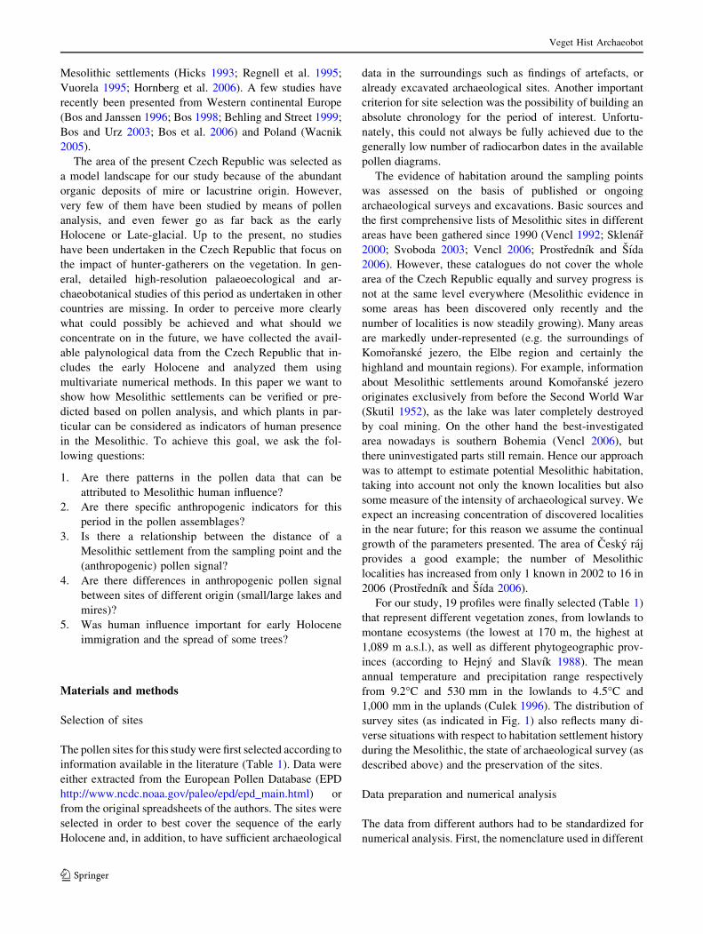
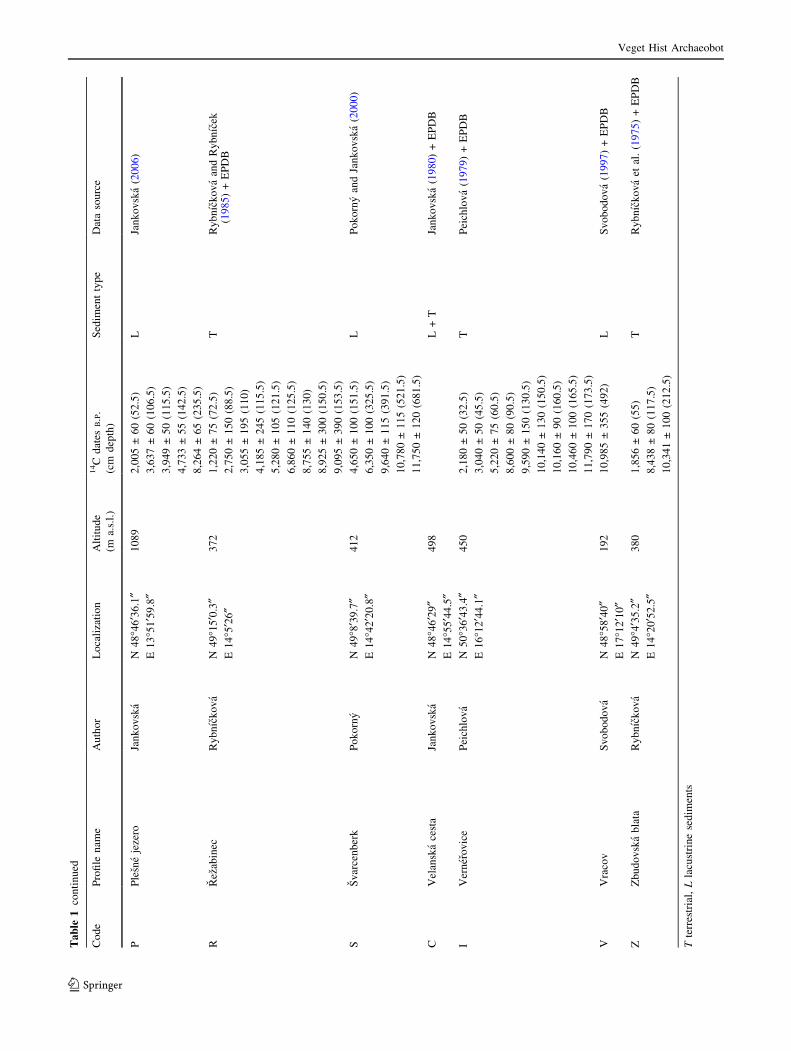
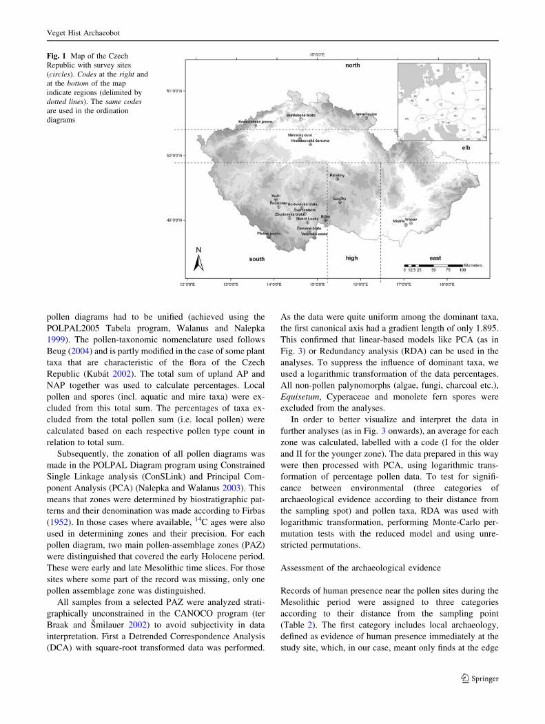
For our study, 19 profiles were finally selected (Table 1)
that represent different vegetation zones, from lowlands to
montane ecosystems (the lowest at 170 m, the highest at
1,089 m a.s.l.), as well as different phytogeographic prov-
inces (according to Hejny and Slavık 1988). The mean
annual temperature and precipitation range respectively
from 9.2�C and 530 mm in the lowlands to 4.5�C and
1,000 mm in the uplands (Culek 1996). The distribution of
survey sites (as indicated in Fig. 1) also reflects many di-
verse situations with respect to habitation settlement history
during the Mesolithic, the state of archaeological survey (as
described above) and the preservation of the sites.
Data preparation and numerical analysis
The data from different authors had to be standardized for
numerical analysis. First, the nomenclature used in different
Veget Hist Archaeobot
123
Ta
ble
1L
ist
of
po
llen
pro
file
su
sed
for
dat
aan
aly
sis
Co
de
Pro
file
nam
eA
uth
or
Lo
cali
zati
on
Alt
itu
de
(ma.
s.l.
)
14C
dat
esB.P
.
(cm
dep
th)
Sed
imen
tty
pe
Dat
aso
urc
e
BB
lato
Ry
bn
ıck
ov
aN
49�2
¢30†
E1
5�1
1¢3
0†
64
51
0,5
70
±1
50
(25
0)
11
,06
0±
25
0(2
77
.5)
TR
yb
nıc
ko
va
(19
74)
+E
PD
B
TB
ork
ov
ick
ab
lata
Jan
ko
vsk
aN
49�1
3¢5
7.6
†E
14
�38¢0
.6†
42
06
,18
4±
12
5(2
45
)
7,0
40
±1
00
(43
0)
TJa
nk
ov
ska
(19
80)
+E
PD
B
EC
erv
ene
bla
toJa
nk
ov
ska
N4
8�5
1¢3
8.6
†E
14
�48¢3
9.3
†4
70
TJa
nk
ov
ska
(19
80)
+E
PD
B
HH
rab
ano
vsk
ace
rnav
aP
etr
N5
0�1
2¢5
8.1
†E
14
�49¢5
6.5
†1
85
8,6
60
±5
0(8
5)
11
,31
0±
60
(10
5)
12
,50
0±
60
(11
5)
13
,63
0±
50
(19
5)
L+
TP
etr
(20
05
)
JJe
stre
bsk
eb
lato
Jan
ko
vsk
aN
50�3
6¢3
0.6
†E
14
�35¢5
7.8
†2
59
TJa
nk
ov
ska
(19
92)
KK
om
ora
nsk
eje
zero
Jan
ko
vsk
aN
50�3
6¢3
0.6
†E
14
�35¢5
7.8
†2
31
1,4
90
±7
0(3
0)
2,5
90
±7
0(9
0)
6,5
70
±8
0(1
17
.5)
7,7
70
±8
0(1
28
.5)
LJa
nk
ov
ska
(19
83)
OK
ozl
ıP
ok
orn
yN
49�2
1¢3
5.8
†E
14
�1¢1
8.3
†4
85
1,4
08
±1
65
(40
)
2,1
59
±2
37
(80
)
8,2
12
±2
25
(11
5)
TP
ok
orn
y(u
np
ub
l.)
LL
ou
cky
Ry
bn
ıck
ov
aN
49�1
9¢2
6.5
†E
15
�32¢3
.2†
56
01
0,2
25
±1
45
(20
2.5
)T
Ry
bn
ıck
ov
a(1
97
4)
+E
PD
B
UM
eln
ick
yu
val
Pet
rN
50�1
7¢5
6.4
†E
14
�34¢4
4.1
†1
70
5,6
00
±4
0(2
5)
14
,20
0±
70
(10
5)
TP
etr
(20
05
)
MM
istr
ınS
vo
bo
do
va
N4
8�5
7¢5
6.9
†E
17
�4¢4
8.7
†1
75
1,8
10
±7
0(1
05
.5)
3,3
70
±6
0(1
51
)
4,1
00
±6
0(1
75
.5)
4,6
00
±6
5(1
86
.5)
6,6
20
±7
5(2
15
.5)
TS
vo
bo
do
va
(19
97
)+
EP
DB
YM
ok
relo
uk
yJa
nk
ov
ska
N4
9�1
¢5.2
†E
14
�46¢1
6.5
†4
25
7,3
90
±8
0(2
25
)
8,1
80
±9
0(2
85
)
8,6
50
±9
0(3
26
)
9,6
30
±1
00
(35
5)
9,6
00
±1
00
(36
5)
TJa
nk
ov
ska
(19
87)
+E
PD
B
NP
alas
iny
Jan
ko
vsk
aN
49�4
1¢2
0†
E1
5�2
9¢0
†5
20
9,5
30
±2
70
(95
)T
Jan
ko
vsk
a(1
99
0)
+E
PD
B
Veget Hist Archaeobot
123
Ta
ble
1co
nti
nu
ed
Co
de
Pro
file
nam
eA
uth
or
Lo
cali
zati
on
Alt
itu
de
(ma.
s.l.
)
14C
dat
esB.P
.
(cm
dep
th)
Sed
imen
tty
pe
Dat
aso
urc
e
PP
lesn
eje
zero
Jan
ko
vsk
aN
48�4
6¢3
6.1
†E
13
�51¢5
9.8
†1
08
92
,00
5±
60
(52
.5)
3,6
37
±6
0(1
06
.5)
3,9
49
±5
0(1
15
.5)
4,7
33
±5
5(1
42
.5)
8,2
64
±6
5(2
35
.5)
LJa
nk
ov
ska
(20
06)
RR
ezab
inec
Ry
bn
ıck
ov
aN
49�1
5¢0
.3†
E1
4�5
¢26†
37
21
,22
0±
75
(72
.5)
2,7
50
±1
50
(88
.5)
3,0
55
±1
95
(11
0)
4,1
85
±2
45
(11
5.5
)
5,2
80
±1
05
(12
1.5
)
6,8
60
±1
10
(12
5.5
)
8,7
55
±1
40
(13
0)
8,9
25
±3
00
(15
0.5
)
9,0
95
±3
90
(15
3.5
)
TR
yb
nıc
ko
va
and
Ry
bn
ıcek
(19
85)
+E
PD
B
SS
var
cen
ber
kP
ok
orn
yN
49�8
¢39
.7†
E1
4�4
2¢2
0.8
†4
12
4,6
50
±1
00
(15
1.5
)
6,3
50
±1
00
(32
5.5
)
9,6
40
±1
15
(39
1.5
)
10
,78
0±
11
5(5
21
.5)
11
,75
0±
12
0(6
81
.5)
LP
ok
orn
yan
dJa
nk
ov
ska
(20
00
)
CV
elan
ska
cest
aJa
nk
ov
ska
N4
8�4
6¢2
9†
E1
4�5
5¢4
4.5
†4
98
L+
TJa
nk
ov
ska
(19
80)
+E
PD
B
IV
ern
ero
vic
eP
eich
lov
aN
50�3
6¢4
3.4
†E
16
�12¢4
4.1
†4
50
2,1
80
±5
0(3
2.5
)
3,0
40
±5
0(4
5.5
)
5,2
20
±7
5(6
0.5
)
8,6
00
±8
0(9
0.5
)
9,5
90
±1
50
(13
0.5
)
10
,14
0±
13
0(1
50
.5)
10
,16
0±
90
(16
0.5
)
10
,46
0±
10
0(1
65
.5)
11
,79
0±
17
0(1
73
.5)
TP
eich
lov
a(1
97
9)
+E
PD
B
VV
raco
vS
vo
bo
do
va
N4
8�5
8¢4
0†
E1
7�1
2¢1
0†
19
21
0,9
85
±3
55
(49
2)
LS
vo
bo
do
va
(19
97
)+
EP
DB
ZZ
bu
do
vsk
ab
lata
Ry
bn
ıck
ov
aN
49�4
¢35
.2†
E1
4�2
0¢5
2.5
†3
80
1,8
56
±6
0(5
5)
8,4
38
±8
0(1
17
.5)
10
,34
1±
10
0(2
12
.5)
TR
yb
nıc
ko
va
etal
.(1
97
5)
+E
PD
B
Tte
rres
tria
l,L
lacu
stri
ne
sed
imen
ts
Veget Hist Archaeobot
123
pollen diagrams had to be unified (achieved using the
POLPAL2005 Tabela program, Walanus and Nalepka
1999). The pollen-taxonomic nomenclature used follows
Beug (2004) and is partly modified in the case of some plant
taxa that are characteristic of the flora of the Czech
Republic (Kubat 2002). The total sum of upland AP and
NAP together was used to calculate percentages. Local
pollen and spores (incl. aquatic and mire taxa) were ex-
cluded from this total sum. The percentages of taxa ex-
cluded from the total pollen sum (i.e. local pollen) were
calculated based on each respective pollen type count in
relation to total sum.
Subsequently, the zonation of all pollen diagrams was
made in the POLPAL Diagram program using Constrained
Single Linkage analysis (ConSLink) and Principal Com-
ponent Analysis (PCA) (Nalepka and Walanus 2003). This
means that zones were determined by biostratigraphic pat-
terns and their denomination was made according to Firbas
(1952). In those cases where available, 14C ages were also
used in determining zones and their precision. For each
pollen diagram, two main pollen-assemblage zones (PAZ)
were distinguished that covered the early Holocene period.
These were early and late Mesolithic time slices. For those
sites where some part of the record was missing, only one
pollen assemblage zone was distinguished.
All samples from a selected PAZ were analyzed strati-
graphically unconstrained in the CANOCO program (ter
Braak and Smilauer 2002) to avoid subjectivity in data
interpretation. First a Detrended Correspondence Analysis
(DCA) with square-root transformed data was performed.
As the data were quite uniform among the dominant taxa,
the first canonical axis had a gradient length of only 1.895.
This confirmed that linear-based models like PCA (as in
Fig. 3) or Redundancy analysis (RDA) can be used in the
analyses. To suppress the influence of dominant taxa, we
used a logarithmic transformation of the data percentages.
All non-pollen palynomorphs (algae, fungi, charcoal etc.),
Equisetum, Cyperaceae and monolete fern spores were
excluded from the analyses.
In order to better visualize and interpret the data in
further analyses (as in Fig. 3 onwards), an average for each
zone was calculated, labelled with a code (I for the older
and II for the younger zone). The data prepared in this way
were then processed with PCA, using logarithmic trans-
formation of percentage pollen data. To test for signifi-
cance between environmental (three categories of
archaeological evidence according to their distance from
the sampling spot) and pollen taxa, RDA was used with
logarithmic transformation, performing Monte-Carlo per-
mutation tests with the reduced model and using unre-
stricted permutations.
Assessment of the archaeological evidence
Records of human presence near the pollen sites during the
Mesolithic period were assigned to three categories
according to their distance from the sampling point
(Table 2). The first category includes local archaeology,
defined as evidence of human presence immediately at the
study site, which, in our case, meant only finds at the edge
Fig. 1 Map of the Czech
Republic with survey sites
(circles). Codes at the right and
at the bottom of the map
indicate regions (delimited by
dotted lines). The same codesare used in the ordination
diagrams
Veget Hist Archaeobot
123

of the deposit or in the close proximity (less than 500 m
from the sampling point). The next two categories repre-
sent archaeological evidence within 5 and 25 km, respec-
tively; the scale attempts to give a quantitative estimate of
intensity of human impact. Data had to be simplified to
some extent, and, in some cases, due to their complete
absence or inconsistency, extrapolated using analogies
from more intensively-studied nearby regions; these pos-
sible shortcomings may thus distort the results of the
analyses. Only part of southern Bohemia can be considered
as widely surveyed. Hence other regions are markedly
under-represented, where localities have been found rather
fortuitously. On the basis of the sites so far investigated,
Mesolithic settlement in southern Bohemia was very
intensive and can be found in every suitable location
(including highland areas). Nevertheless, some places were
markedly preferred, such as river confluences, lakes or
large rivers. Extrapolating from these Mesolithic settle-
ments, we assumed that a low intensity of human presence
would be higher in all areas in lowland regions and ex-
tremely high around spots distinguished by having a high
diversity of ecosystems (e.g. lakes, rivers, confluences).
The above three categories of intensity of human presence
were used in the numerical analyses as environmental
variables to interpret the pattern in the pollen data.
Furthermore, a ‘Human Impact Factor’ (HIF) was cre-
ated, which is a combination of all three categories (for the
formula for its evaluation see Table 2), describing the
character/extent of human habitation in the surroundings of
each sampling point. HIF aims to express the intensity of
human impact, which decreases proportionally with
increasing distance of an archaeological record from a
pollen sampling point.
Anthropogenic indicators in pollen diagrams
Selected pollen types were characterized as human-impact
indicators according to Behre (1981). The following pollen
types were used to create a sum of anthropogenic indicators
for each site: Calluna vulgaris, Achillea-type, Artemisia,
Aster-type, Avena-type, Bupleurum-type, Campanula,
Cannabis/Humulus, Caryophyllaceae Subfam. Silenoideae-
type, Cerastium-type, Cerealia, Cirsium, Asteraceae Sub-
fam. Cichorioideae, Cruciferae (Brassicaceae), Daucus
carota, Gnaphalium-type, Helianthemum, Heracleum,
Hordeum-type, Chenopodiaceae, Melampyrum, Peuceda-
num-type, Pimpinella major-type, Plantago lanceolata,
P. major-type, Pleurospermum austriacum, Polypodium,
Pteridium aquilinum, Ranunculaceae, Ranunculus acris-
type, Rubiaceae, Rumex-type, Secale cereale, Senecio,
Silene vulgaris-type, Solanum dulcamara, Succisa, Thal-
ictrum, Trifolium-type, Umbelliferae (Apiaceae), Urtica
and Trapa natans.
Construction of summary pollen curves
In this study, two summary pollen diagrams with percentage
pollen curves from all sites in the analysis were used. Using
the spreadsheet program TILIA (Grimm 2004), an age-scale
was reconstructed with linear interpolation between the
available uncalibrated radiocarbon dates (Table 1). This
age-scale has to be taken as being only tentative, since it is
based on a very weak chronology.
Results
Archaeological background
The occurrence of Mesolithic settlements around some
lakes is well known, for example Komoranske jezero
(Skutil 1952), Svarcenberk (Pokorny et al. 2007) and
Rezabinec (Vencl 2006). Other regions with a high inten-
sity of human presence were investigated with another aim
in mind. Melnicky uval and Hrabanovska cernava were
surveyed by Skutil (1966) and Sklenar (2000), whereas
Svoboda (2003) and Prostrednık and Sıda (2006), have
Table 2 Mesolithic occupation in relation to palynological sites
Profile/site Archaeology Human Impact
Factor (HIF)Local 0.5–5 km 5–25 km
Blato 0 0 1 1
Borkovicka Blata 0 1 2 7
Cervene blato 0 1 1 6
Hrabanovska cernava 0 1 2 7
Jestrebske blato 0 2 3 13
Komoranske jezero 3 1 1 81
Kozlı 1 2 2 37
Loucky 0 0 1 1
Melnicky uval 0 1 2 7
Mistrın 0 1 1 6
Mokre louky 0 1 2 7
Palasiny 0 0 1 1
Plesne jezero 0 0 1 1
Rezabinec 3 3 2 92
Svarcenberk 3 2 1 86
Velanska cesta 0 1 1 6
Vernerovice 0 1 2 7
Vracov 0 1 1 6
Zbudovska blata 0 1 2 7
The ‘archaeology’ variable indicates four categories of increasing
intensity of human presence: 0 absence; 1 low; 2 medium-strength;
3 intensive habitation. The summary values of the HIF variable are
calculated as a distance-weighted intensity of human presence in
the landscape using the values of the ‘archaeology’ variable:
(HIF = 25 · Local + 5 · (0.5–5 km) + (5–25 km))
Veget Hist Archaeobot
123
focused on sandstone areas for the last ten years. The site
Vernerovice is located in an area that has largely never
been investigated. However, during the last few years some
single finds of Mesolithic stone manufacture have appeared
(Bronowicki 2000), hence archaeological finds are to be
expected in this area. Southern Bohemia is the region
where rather intensive Mesolithic archaeological research
has been undertaken and consequently has a high index of
human impact for all profiles. Southern Moravia has been
the poorest in archaeological investigations. Although
studies have uncovered several localities (e.g. Valoch
1978), the intensity of human presence is not as great as
that around comparable profiles in the Bohemian lowlands.
This difference cannot be due to dissimilar preferences of
the Mesolithic populations, because the landscape provides
similar conditions (e.g. Elbe region). It is for this reason
that we reconstruct higher values for human habitation
intensity in southern Moravia.
Table 2 shows the results of the categorisation of
archaeological finds. Komoranske jezero, Svarcenberk and
Rezabinec could be considered as important Mesolithic
settlement sites; all three sites are former lakes. For some
of the other sites there is strong regional evidence of
Mesolithic occupation. This category is represented by
profiles in the Elbe region of central Bohemia (Hraba-
novska cernava, Melnicky uval), sandstone landscapes
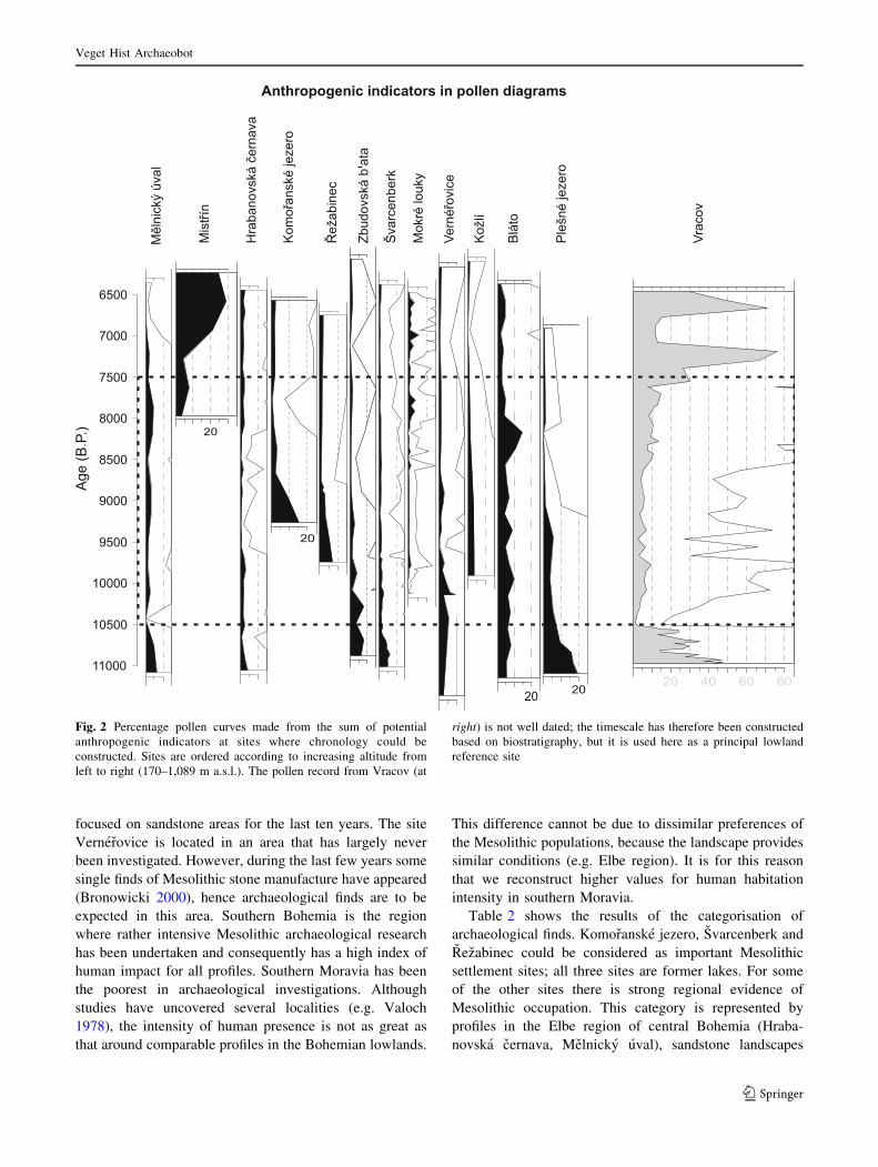
Fig. 2 Percentage pollen curves made from the sum of potential
anthropogenic indicators at sites where chronology could be
constructed. Sites are ordered according to increasing altitude from
left to right (170–1,089 m a.s.l.). The pollen record from Vracov (at
right) is not well dated; the timescale has therefore been constructed
based on biostratigraphy, but it is used here as a principal lowland
reference site
Veget Hist Archaeobot
123
(Jestrebske blato, Vernerovice), part of southern Bohemia
(Borkovicka blata, Kozlı, Mokre louky, Rezabinec, Zbu-
dovska blata) and southern Moravia (Mistrın, Vracov).
Numerical analysis of pollen data
The results of the data analysis for each pollen profile
provided the first insight into the pollen assemblage zones
(PAZ). We combined both ConSLink and PCA to deter-
mine the period of the early Holocene, also taking into
account radiocarbon data. Finally, two pollen-analytical
zones in each profile were assigned to the early (I) and late
Mesolithic (II). In the pollen diagrams for Melnicky uval,
Mistrın and Rezabinec (I) and Komoranske jezero (II), the
analysis resulted in a single period only, depending on the
age of the samples.
The sums of selected anthropogenic indicators for
different pollen profiles are shown in Fig. 2; however, there
was no clearly visible pattern between sites during the
investigated period of the early Holocene (i.e. both PAZ I
and II). We have therefore chosen more sensitive multi-
variate statistical methods. The PCA of all pollen samples
from the period of interest (early Holocene) indicated the
main distribution of pollen assemblages between and
within all sites, and also explained the main trend in the
data. A cluster of samples was represented by the sites
Svarcenberk, Komoranske jezero, Plesne jezero and Ver-
nerovice, the first two of which have strong archaeological
Fig. 3 PCA triplot of averaged
samples over pollen assemblage
zones (PAZ), using type of
sediment (lake lake sediment)
and archaeology (a-loc local
archaeology; a-5 archaeology
within 5 km; a-25 archaeology
within 25 km) as environmental
variables. Localities (marked
crosses) are labelled following
codes in Table 1. Taxa
indicated are mainly dominant
trees, mostly responsible for the
distribution of sites according to
the age of each zone
Veget Hist Archaeobot
123
evidence of Mesolithic habitation (Table 2). However,
using all pollen samples separately made interpretation of
the ordination diagram difficult and some important trends
may have remained hidden.
The results of the PCA using all the samples but aver-
aged within pollen assemblage zones provided a more
coherent view (Figs. 3, 4). In addition, environmental
variables were included, with altitude being used as a
co-variable. The first ordination diagram (Fig. 3) shows the
distribution of both the sites and the abundant (mainly tree)
species, the latter being mainly responsible for deciding the
principle distribution of samples in the diagram. This
means that the first axis of the ordination represents an
approximate time axis between the older (from the left) and
younger (to the right) samples. In the second ordination
from the same PCA, where only anthropogenic indicators
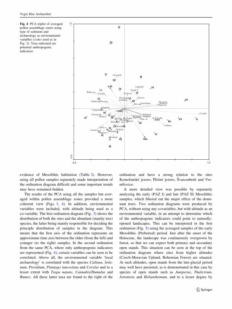
are represented (Fig. 4), certain variables can be seen to be
correlated. Above all, the environmental variable ‘local
archaeology’ is correlated with the species Calluna, Sola-
num, Pteridium, Plantago lanceolata and Corylus and to a
lesser extent with Trapa natans, Cannabis/Humulus and
Rumex. All these latter taxa are found to the right of the
ordination and have a strong relation to the sites
Komoranske jezero, Plesne jezero, Svarcenberk and Ver-
nerovice.
A more detailed view was possible by separately
analyzing the early (PAZ I) and late (PAZ II) Mesolithic
samples, which filtered out the major effect of the domi-
nant trees. Two ordination diagrams were produced by
PCA, without using any covariables, but with altitude as an
environmental variable, in an attempt to determine which
of the anthropogenic indicators could point to naturally-
opened landscapes. This can be interpreted in the first
ordination (Fig. 5) using the averaged samples of the early
Mesolithic (Preboreal) period. Just after the onset of the
Holocene, the landscape was continuously overgrown by
forest, so that we can expect both primary and secondary
open stands. This situation can be seen at the top of the
ordination diagram where sites from higher altitudes
(Czech-Moravian Upland, Bohemian Forest) are situated.
At such altitudes, open stands from the late-glacial period
may well have persisted, as is demonstrated in this case by
species of open stands such as Juniperus, Thalictrum,
Artemisia and Helianthemum, and to a lesser degree by
Fig. 4 PCA triplot of averaged
pollen assemblage zones using
type of sediment and
archaeology as environmental
variables (codes used as in
Fig. 3). Taxa indicated are
potential anthropogenic
indicators
Veget Hist Archaeobot
123

Rumex, Plantago lanceolata and Urtica. These latter can
here be considered as indicative of both primary open
stands and as anthropogenic indicators. In the bottom left
of the diagram are sites correlated with archaeological
evidence and thus with possible indicators of human
activities such as Calluna, Cannabis/Humulus, Aster-type,
Solanum, Melampyrum, Pteridium and Achillea-type.
These species were closely related to sites having an
archaeological record of local settlement or intensive re-
gional occupation. The next ordination, taken from the late
Mesolithic (Boreal) period (Fig. 6), is less straightforward
to interpret. It shows great variability in its samples, rep-
resented by a group of lake sites in the top-right corner and
a group of terrestrial (mire) sites in the lower part of the
diagram. The latter group represents sites with a local and
regional archaeology that may represent extensively-used
landscapes rather than the lake examples with only a local
impact. Again one can see certain taxa grouped together,
such as Melampyrum, Pteridium, Plantago lanceolata and
Rumex.
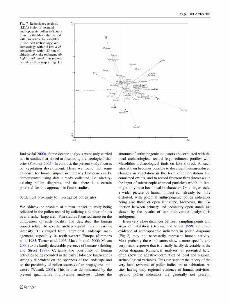
In the subsequent analyses, RDA was used to test the
significance of relationships between taxa and environ-
mental variables. The first two RDA figures show the
relationships of different taxa to various components of
archaeology, one with the effect of altitude (Fig. 7) and one
without (Fig. 8), altitude being effectively filtered out as a
co-variable. The first RDA axis explained 17.4% of the
total variance in the fossil pollen data (p value = 0.034)
and the second represented a further 11.8%. A positive
correlation could be seen between lake-type sediment and
local archaeology. The following potential anthropogenic
indicators are correlated with local archaeology: Calluna,
Plantago lanceolata, Solanum dulcamara, Pteridium,
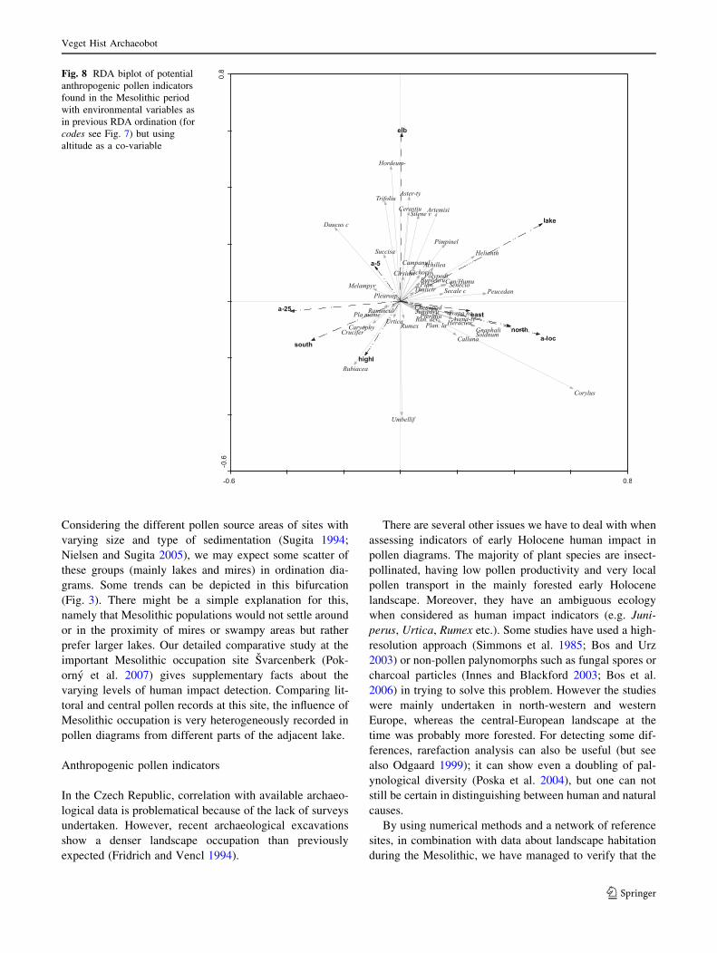
Helianthemum and Cannabis/Humulus. Using altitude as a
co-variable (Fig. 8), there were species that had been quite
sufficiently filtered from the effect of altitude and which
could be considered both as anthropogenic indicators and
primary open landscape indicators at higher altitudes.
These included Juniperus, Urtica, Chenopodiaceae,
Rumex, Plantago major/media, Cruciferae (Brassicaceae)
Fig. 5 PCA triplot of early
Mesolithic samples using type
of sediment and archaeology
(codes used as in Fig. 3), and
altitude (alt) as environmental
variables
Veget Hist Archaeobot
123
etc. In the first diagram (Fig. 7) these are located to the
right, and, after elevation has been allowed for statistically,
more towards the middle (Fig. 8). Other indicators more
probably represented lowland environments (i.e. they were
negatively correlated with altitude) that could also be
regarded as potentially settled areas (marked as regional
archaeology ‘a-5’, ‘a-25’). Into this category for example
fall the commonly prevalent Melampyrum, Aster-type,
Daucus and Trifolium-type.
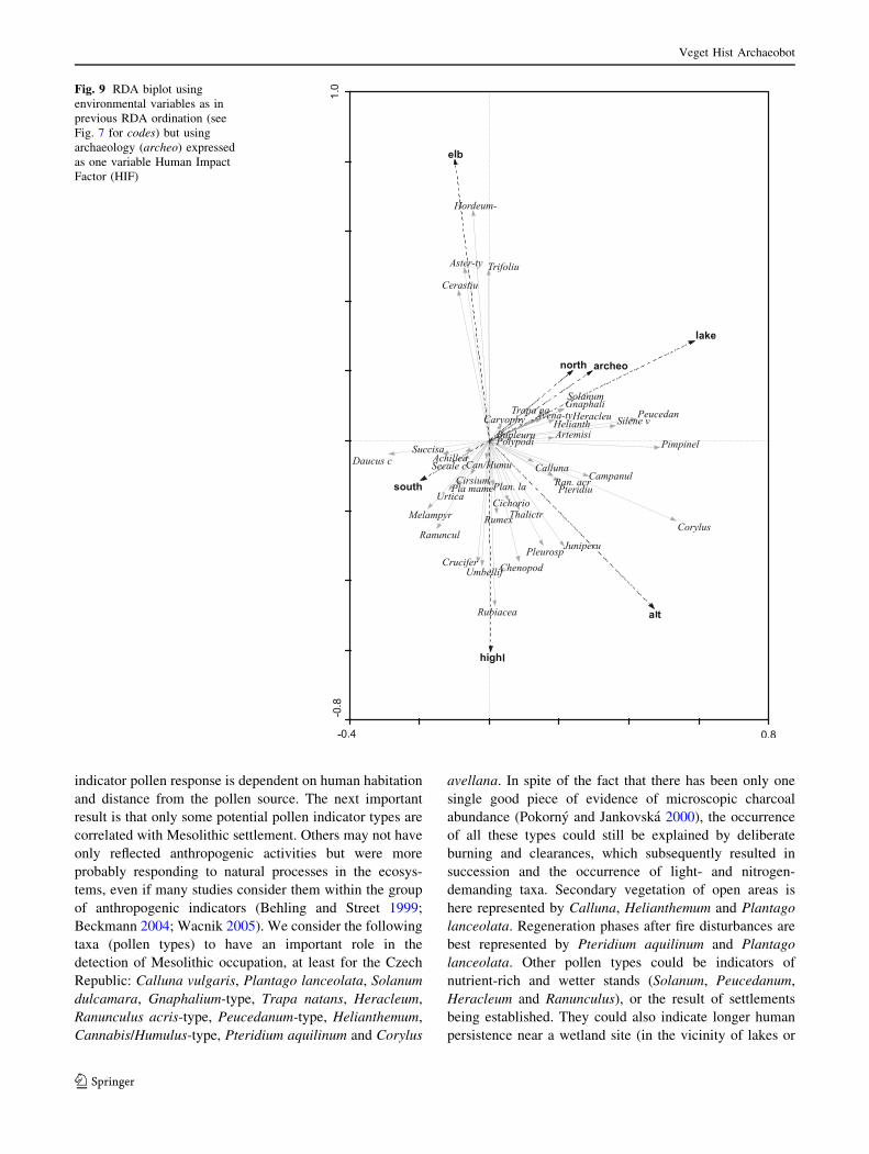
In a further RDA (Fig. 9), we tried to determine those
indicators related to human activities in the landscape that
do not depend on distance but rather on human impact
intensity. In this case, archaeology was expressed as a
single environmental variable. The list of potential
anthropogenic indicators includes Artemisia and Silene
vulgaris, both of which are probably correlated with human
activity in general. An interesting aspect also depicted in
the RDA ordinations was the position held by hazel
(Corylus avellana), which was significantly correlated with
local archaeology and archaeology in general.
Corylus avellana in pollen diagrams (Fig. 10)
Figure 10 shows the percentage curves of Corylus avellana
pollen at selected sites during the early Holocene. The sites
have been ordered according to altitude (increasing to the
right). However, there was no discernible relation in hazel
occurrence and dominance, neither was there any rela-
tionship to geographical distribution. Earlier occurrences of
Corylus were documented at the sites of Komoranske
jezero, Svarcenberk, Vernerovice and Plesne jezero (sites
marked with an arrow in Fig. 10). The abrupt start and the
long persistence of high percentages of hazel were
remarkable at these sites, which could be related to human
habitation at these localities or in their proximity (Skutil
1952; Vencl 2006; Pokorny et al. 2007). The occurrence of
Corylus avellana is significant as tested in the RDA (see
above) and was strongly correlated with both local human
activities (local archaeological record) and general inten-
sity of human habitation (summed archaeology HIF
Fig. 9).
Discussion
The pollen-analytical data used in this study represent a
selection of reference profiles for the area of the Czech
Republic. The question of human impact of hunter-gath-
erers on environments in the early Holocene and its evi-
dence in the pollen spectra has been a marginal part of
previous studies in the Czech Republic (Jankovska 1983;
Svobodova 1989, 1997; Jankovska 2000; Pokorny and
Fig. 6 PCA triplot of late
Mesolithic samples using type
of sediment and archaeology
(codes used as in Fig. 3), and
altitude (alt) as environmental
variables
Veget Hist Archaeobot
123
Jankovska 2000). Some deeper analyses were only carried
out in studies that aimed at discussing archaeological the-
ories (Pokorny 2005). In contrast, the present study focuses
on vegetation development. Here, we found that some
evidence for human impact in the early Holocene can be
demonstrated using data already collected, i.e. already-
existing pollen diagrams, and that there is a certain
potential for this approach in future studies.
Settlement proximity to investigated pollen sites
We address the problem of human impact intensity being
reflected in the pollen record by utilizing a number of sites
over a rather large area. Past studies focussed more on the
uniqueness of each locality and described the human
impact related to specific archaeological finds of various
intensity. This ranged from intentional landscape man-
agement, especially in north-western Europe (Simmons
et al. 1985; Turner et al. 1993; Macklin et al. 2000; Mason
2000) to the hardly detectable presence of humans (Behling
and Street 1999). Certainly the possibility of human
activities being recorded in the early Holocene landscape is
strongly dependent on the openness of the landscape and
on the proximity of pollen sources of anthropogenic indi-
cators (Wacnik 2005). This is also demonstrated by the
present quantitative multivariate analyses, where the
amounts of anthropogenic indicators are correlated with the
local archaeological record (e.g. sediment profiles with
Mesolithic archaeological finds on lake shores). At such
sites, it then becomes possible to document human-induced
changes in vegetation in the form of deforestation and
connected events, and to record frequent fires (increases in
the input of microscopic charcoal particles) which, in fact,
might only have been local in character. On a larger scale,
a wider picture of human impact can already be more
distorted, with potential anthropogenic pollen indicators
being also those of open landscape. Moreover, the dis-
tinction between primary and secondary open stands (as
shown by the results of our multivariate analysis) is
ambiguous.
Even very close distances between sampling points and
areas of habitation (Behling and Street 1999) or direct
evidence of anthropogenic indicators in pollen diagrams
(Fig. 2) may not necessarily represent human activity.
Most probably these indicators show a more specific and
very weak response that is visually hardly detectable in the
pollen diagram. Numerical analyses, as presented here,
often show the negative correlation of local and regional
archaeological variables. This can support the theory of the
very local response of pollen indicators to habitation. At
sites having only regional evidence of human activities,
specific pollen indicators are generally not present.
Fig. 7 Redundancy analysis
(RDA) biplot of potential
anthropogenic pollen indicators
found in the Mesolithic period
with environmental variables
(a-loc local archaeology; a-5archaeology within 5 km; a-25archaeology within 25 km; altaltitude; lake lake sediment; elb,
highl, south, north four regions
as indicated on map in Fig. 1 )
Veget Hist Archaeobot
123
Considering the different pollen source areas of sites with
varying size and type of sedimentation (Sugita 1994;
Nielsen and Sugita 2005), we may expect some scatter of
these groups (mainly lakes and mires) in ordination dia-
grams. Some trends can be depicted in this bifurcation
(Fig. 3). There might be a simple explanation for this,
namely that Mesolithic populations would not settle around
or in the proximity of mires or swampy areas but rather
prefer larger lakes. Our detailed comparative study at the
important Mesolithic occupation site Svarcenberk (Pok-
orny et al. 2007) gives supplementary facts about the
varying levels of human impact detection. Comparing lit-
toral and central pollen records at this site, the influence of
Mesolithic occupation is very heterogeneously recorded in
pollen diagrams from different parts of the adjacent lake.
Anthropogenic pollen indicators
In the Czech Republic, correlation with available archaeo-
logical data is problematical because of the lack of surveys
undertaken. However, recent archaeological excavations
show a denser landscape occupation than previously
expected (Fridrich and Vencl 1994).
There are several other issues we have to deal with when
assessing indicators of early Holocene human impact in
pollen diagrams. The majority of plant species are insect-
pollinated, having low pollen productivity and very local
pollen transport in the mainly forested early Holocene
landscape. Moreover, they have an ambiguous ecology
when considered as human impact indicators (e.g. Juni-
perus, Urtica, Rumex etc.). Some studies have used a high-
resolution approach (Simmons et al. 1985; Bos and Urz
2003) or non-pollen palynomorphs such as fungal spores or
charcoal particles (Innes and Blackford 2003; Bos et al.
2006) in trying to solve this problem. However the studies
were mainly undertaken in north-western and western
Europe, whereas the central-European landscape at the
time was probably more forested. For detecting some dif-
ferences, rarefaction analysis can also be useful (but see
also Odgaard 1999); it can show even a doubling of pal-
ynological diversity (Poska et al. 2004), but one can not
still be certain in distinguishing between human and natural
causes.
By using numerical methods and a network of reference
sites, in combination with data about landscape habitation
during the Mesolithic, we have managed to verify that the
Fig. 8 RDA biplot of potential
anthropogenic pollen indicators
found in the Mesolithic period
with environmental variables as
in previous RDA ordination (for
codes see Fig. 7) but using
altitude as a co-variable
Veget Hist Archaeobot
123
indicator pollen response is dependent on human habitation
and distance from the pollen source. The next important
result is that only some potential pollen indicator types are
correlated with Mesolithic settlement. Others may not have
only reflected anthropogenic activities but were more
probably responding to natural processes in the ecosys-
tems, even if many studies consider them within the group
of anthropogenic indicators (Behling and Street 1999;
Beckmann 2004; Wacnik 2005). We consider the following
taxa (pollen types) to have an important role in the
detection of Mesolithic occupation, at least for the Czech
Republic: Calluna vulgaris, Plantago lanceolata, Solanum
dulcamara, Gnaphalium-type, Trapa natans, Heracleum,
Ranunculus acris-type, Peucedanum-type, Helianthemum,
Cannabis/Humulus-type, Pteridium aquilinum and Corylus
avellana. In spite of the fact that there has been only one
single good piece of evidence of microscopic charcoal
abundance (Pokorny and Jankovska 2000), the occurrence
of all these types could still be explained by deliberate
burning and clearances, which subsequently resulted in
succession and the occurrence of light- and nitrogen-
demanding taxa. Secondary vegetation of open areas is
here represented by Calluna, Helianthemum and Plantago
lanceolata. Regeneration phases after fire disturbances are
best represented by Pteridium aquilinum and Plantago
lanceolata. Other pollen types could be indicators of
nutrient-rich and wetter stands (Solanum, Peucedanum,
Heracleum and Ranunculus), or the result of settlements
being established. They could also indicate longer human
persistence near a wetland site (in the vicinity of lakes or
Fig. 9 RDA biplot using
environmental variables as in
previous RDA ordination (see
Fig. 7 for codes) but using
archaeology (archeo) expressed
as one variable Human Impact
Factor (HIF)
Veget Hist Archaeobot
123

palaeochannels) and the creation of environments with
prevalently herbs and shrubs to attract wild animals
(Mellars 1976; Zvelebil 1994; Bos and Urz 2003). Finally,
mention should be made of those species connected with
the Mesolithic diet or other kind of plant use (Zvelebil
1994; Merlin 2003), especially Trapa natans, demonstrably
gathered for nuts. Corylus avellana, which played an
important role in the Mesolithic diet, deserves special
attention (see ‘‘discussion’’).
The next group of potential indicators that should be
discussed is comprised of Juniperus, Thalictrum, Cheno-
podiaceae, Rubiaceae, Pleurospermum, Artemisia, Rumex,
Plantago major/media, Urtica and Silene vulgaris. These
taxa are often used as indicators of mosaic woody land-
scape or larger open landscape patches, hence also as
potential human-activity indicators, e.g. by Beckmann
(2004). Taking into account the environment, climatic
conditions and vegetation of the early Holocene, we must
also consider alternative explanations for the occurrence of
these taxa. For example, juniper is also often mentioned as
an indicator of dry pastures (Behre 1981), but it was
common in the late-glacial and Preboreal patchy landscape.
Fig. 10 Percentage pollen curves of Corylus avellana from selected
sites. The time-scale is tentative since it is in some cases based on a
very weak chronology (see Table 1). Sites are ordered according to
increasing altitude from left to right (170–1,089 m a.s.l.). Vracov is
not well dated (time-scale based on the Glacial–Holocene boundary
and tree-zonation), but is used here as a lowland reference site
Veget Hist Archaeobot
123
Juniperus, Thalictrum, Chenopodiaceae, Rubiaceae and
Pleurospermum together form a group in the Preboreal
ordination diagram (Fig. 5) and are best explained as
indicating natural open stands of the early Holocene, which
is in agreement with their position being determined by
increasing altitude. The remaining pollen types represent
mainly light-demanding species: Artemisia, Rumex, Plan-
tago major/media and Silene vulgaris. Urtica is connected
with nutrient-rich soils. Their inclusion as anthropogenic
indicators has been suggested (Behre 1981); however,
according to the results of our numerical analyses, they are
strongly affiliated in our case with trends other than
archaeology. Especially during the early Mesolithic
(Fig. 5), they appear correlated with increasing altitude,
which may be interpreted as more or less persistent tundra
or tundra/steppe environments, or just a high proportion of
open stand vegetation with a relatively high nutrient con-
tent. Good examples of this are the present-day environ-
ments of the continental southern Siberian mountains,
where good examples of gradients from species-rich boreal
or hemi-boreal forest to steppe or tundra can be found
(Ermakov 1998). Similar vegetation conditions might be
expected during the early Holocene in central Europe
(Jankovska 1998; Jankovska et al. 2002). This fact has
been to a large extent verified by the RDA analysis, which,
after partialling out the effect of altitude, showed signifi-
cant correlation of these pollen indicators to altitude, and
hence to natural types of ecosystems, rather than to human-
created environments (Fig. 8). According to our results the
interpretation of Artemisia pollen is still very debatable.
The occurrence of this could be connected with some
human presence as an indicator of ruderal stands or along
footpaths (Behre 1981), a fact partly proved by our data
analyses (Fig. 9). On the other hand, an Artemisia record
may also represent larger, natural, forest-free areas
(remains of late-glacial vegetation at higher altitudes, dry
lowlands or extreme habitats), due to the ability of its
pollen to be transported long distances (as shown by our
recent pollen studies in southern Siberia; unpublished
results).
Anthropogenic use and spreading of Corylus avellana
Hazel is traditionally believed to have spread to the area of
the present-day Czech Republic from its glacial refugia. In
most studies, these refugia are often reconstructed as
having been more to the south, as well as in the British
Isles or close to south-west Scandinavia (Deacon 1974;
Bennett et al. 1991). However, some surveys in the Czech
Republic also argue that these glacial refugia were in
central Europe (Peichlova 1979; Rybnıckova and Rybnıcek
1988). What is indisputable, however, is the mainly sudden
appearance and abrupt rise in Corylus pollen at many early
Holocene sites (Jankovska 2000, 2006). Moreover, at some
of these sites, its appearance can be observed as occurring
at the very start of the Holocene (Peichlova 1979; Pokorny
and Jankovska 2000). Similarly, the very early spread of
Corylus and its fairly high pollen abundance in the early
Holocene has also been detected throughout the rest of
Europe (Boyd and Dickson 1986; Simmons and Innes
1988a, b). This fact has often been cited as being connected
with Mesolithic habitation in an area (Hicks 1993; Regnell
et al. 1995). On the other hand, this trait could be the
product of many ecological factors acting together
(Huntley 1993; Tallantire 2002), with, in the meanwhile,
human populations just beginning to exploit these same
conditions.
The pollen-analytical results from the Czech Republic
show that Corylus avellana started to spread suddenly at
some sites around 8,500 14C B.P., or in some cases even
earlier (Svarcenberk around 9,500 14C B.P., Fig. 10). Our
recent studies at the Svarcenberk locality show finds of
Corylus macrofossils (nuts) stratigraphically just preceding
the rise in the pollen curve. There was no visible rela-
tionship between Corylus avellana pollen distribution and
altitude, geographical position, or any other ecological
factor tested or taken into account. Also, a comparison
of closely adjacent localities in southern Bohemia
depicted big differences between Corylus curves (Fig. 10)
(Rybnıckova et al. 1975; Rybnıckova and Rybnıcek 1985;
Jankovska 1987; Pokorny and Jankovska 2000). This
suggests that the pollen records indicate local conditions,
which were very different at different localities.
The relationship between Corylus pollen and archaeo-
logical data tested with RDA indicated a significant rela-
tion between local archaeology and the appearance of
Corylus avellana (Fig. 8), as well as between the human
impact factor (HIF, Table 2) and Corylus (Fig. 9). Human
influence was the only environmental variable tested that
could explain the rapid and irregular spread of Corylus
avellana in the Czech Republic during the early Holocene.
An evaluation of sites that had strong signs of Mesolithic
habitation (Fig. 3) enabled us to identify Corylus pollen as
a rather good anthropogenic indicator. We cannot say,
however, whether the spreading of hazel by humans was
deliberate, unintentional or coincidental (e.g. by providing
good conditions through deforestation).
Conclusions
The use of pollen diagrams for evaluating the potential
impact of Mesolithic settlement on vegetation was exam-
ined using multivariate analyses. The selection of 19 pro-
files from the Czech Republic and their pollen records
between 10,500 and 7,500 B.P. were processed using PCA
Veget Hist Archaeobot
123
and RDA together with some information about the
Mesolithic occupation of areas surrounding the pollen sites.
Patterns in the data distribution between those sites possi-
bly influenced by Mesolithic habitation were recognized,
and also in sites without that evidence. The results of these
analyses support the hypothesis that some potential
anthropogenic indicators react very specifically, although
weakly, to Mesolithic human activity in the landscape.
Summary pollen curves of all anthropogenic indicators
were reconstructed for each site but did not show any
explainable differences between sites. A closer look at
certain specific indicators might reveal some possible hu-
man impact. However, the occurrence of these indicators is
generally very sporadic, their percentages low, and they
can easily be overlooked in pollen diagrams. Multivariate
analysis applied to several pollen sites together proved a
better tool for studying this early human impact.
We have also tested the relationship between Mesolithic
occupation and its distance from the pollen sampling
points. Human activity during the early Post-glacial in
central Europe (an area largely forested) was only local in
character (of the order of hundreds of metres) and can
hardly be detected at greater distances.
The early occurrence, rapid spreading and high initial
abundance of Corylus avellana was apparent at most of the
study sites. However, even if its occurrence has been found
to be significantly correlated with human presence, the
possibility of an asynchronous spread of hazel in different
climatic and edaphic conditions cannot be ruled out.
Acknowledgments This study was supported by the Grant Agency
of the Academy of Science of the Czech Republic through project no.
KJB6111305, IAAX00020701 and by the Ministry of Education
project no. MSM0021620828. We are also very grateful to the ori-
ginal data contributors, Vlasta Jankovska and Libor Petr. We also
thank Steve Ridgill, who made our English more concise and read-
able.
References
Beckmann M (2004) Pollenanalytische Untersuchung der Zeit der
Jager und Sammler und der ersten Bauern an zwei Lokalitaten
des Zentralen Schweizer Mittellandes. Diss Bot 390, Cramer,
Berlin Stuttgart
Behling H, Street M (1999) Palaeoecological studies at the Mesolithic
site at Bedburg- Konigshoven near Cologne, Germany. Veget
Hist Archaeobot 8:273–285
Behre K-E (1981) The interpretation of anthropogenic indicators in
pollen diagrams. Pollen et Spores 23:225–245
Bennett KD, Tzedakis PC, Willis KJ (1991) Quaternary Refugia of
North European Trees. J Biogeogr 18:103–115
Beug H-J (2004) Leitfaden der Pollenbestimmung fur Mitteleuropa
und angrenzende Gebiete. Pfeil, Munchen
Bos JAA (1998) Aspects of the late Glacial–early Holocene
vegetation development in Western Europe. Lab Palaeobot
Palynol Contrib Ser 10:1–240, Utrecht
Bos JAA, Janssen CR (1996) Local impact of palaeolithic man on the
environment during the end of the last Glacial in The Nether-
lands. J Archaeol Sci 23:731–739
Bos JAA, Urz R (2003) Late Glacial and early Holocene environment
in the middle Lahn river valley (Hessen, central-west Germany)
and the local impact of early Mesolithic people-pollen and
macrofossil evidence. Veg Hist Archaeobot 12:19–36
Bos JAA, van Geel B, Groenewoudt BJ, Lauwerier R (2006) Early
Holocene environmental change, the presence and disappearance
of early Mesolithic habitation near Zutphen (The Netherlands).
Veg Hist Archaeobot 15:27–43
Boyd WE, Dickson JH (1986) Patterns in the geographical-distribu-
tion of the early Flandrian Corylus rise in Southwest Scotland.
New Phytologist 102:615–623
Bronowicki J (2000) Stan i perspektywy rozwoju badan nad epokakamienia w Sudetach polskich [State and perspectives of
research upon stone age in Polish Sudetes]. In: Boguszewicz
M, Wisniewska A, Boguszewicz D (eds) Człowiek i srodowisko
w Sudetach. Wroclav, pp 11–28
Clark G (1989) Economic prehistory. Papers on archaeology by
Grahame Clark. Cambridge University Press, Cambridge
Culek M (1996) Biogeograficke clenenı Ceske republiky [Biogeo-
graphical zonation of the Czech Republic]. Enigma, Praha
Deacon J (1974) The Location of Refugia of Corylus avellana L.
During the Weichselian Glaciacion. New Phytol 73:1055–1063
Ermakov N (1998) The Altaian relict subnemoral forest belt and the
vegetation of pre-Pleistocene mountainous landscapes. Phyto-
coenologia 28:31–44
Firbas F (1952) Spat- und nacheiszeitliche Waldgeschichte Mitteleu-
ropas nordlich der Alpen: Waldgeschichte der einzelnen Lands-
chaften. Fischer, Jena
Fridrich J, Vencl S (1994) Investigations into the Palaeolithic and
Mesolithic, 1969–1993. Pamatky archeologicke Supplementa
1:11–22
Grimm EC (2004) TILIA and TGView 2.0.b.4, 2.0.2. Illinois State
Museum, Springfield
Hejny S, Slavık B (1988) Kvetena Ceske Republiky [Flora of the
Czech Republic]. Academia, PrahaHicks S (1993) Pollen evidence of localized impact on the vegetation
of northernmost Finland by hunter-gatherers. Veg Hist Archae-
obot 2:137–144
Hornberg G, Bohlin E, Hellberg E, Bergman I, Zackrisson O,
Olofsson A, Wallin JE, Passe T (2006) Effects of Mesolithic
hunter-gatherers on local vegetation in a non-uniform glacio-
isostatic land uplift area, northern Sweden. Veg Hist Archaeobot
15:13–26
Huntley B (1993) Rapid early-Holocene migration and high abun-
dance of hazel (Corylus avellana L.): alternative hypotheses. In:
Chambers FM (ed) Climate change and human impact on the
landscape. Chapman & Hall, London, pp 205–266
Innes JB, Blackford JJ (2003) The ecology of late mesolithic
woodland disturbances: model testing with fungal spore assem-
blage data. J Archaeol Sci 30:185–194
Jankovska V (1980) Palaogeobotanische Rekonstruktion der Vegeta-
tionsentwicklung im Becken Trebonska panev wahrend des
Spatglazials und Holozans. Academia, Praha
Jankovska V (1983) Palynologische Forschung am ehemaligen
Komorany-See (Spatglazial bis Subatlantikum). Vest Ustred
Ust Geol 58:99–107
Jankovska V (1987) Entwicklung des Moores Mokre Louky bei
Trebon im Postglazial. Folia Geobot Phytotax 22:199–216
Jankovska V (1990) The evolution of late-Glacial and Holocene
vegetation in the Vicinity of Svetla nad Sazavou (in the western
Forland of the Bohemian-Moravian uplands). Folia Geobot
Phytotax 25:1–26
Veget Hist Archaeobot
123
Jankovska V (1992) Vegetationsverhaltnisse und Naturumwelt des
Beckens Jestrebska kotlina am Ende des Spatglazials und im
Holozan (Doksy-Gebiet). Folia Geobot Phytotax 27:137–148
Jankovska V (1998) Pozdnı glacial a casny holocen podtatranskych
kotlin - obdoba sibirske borealnı a subborealnı zony? [Late
Glacial and Early Holocene of Sub-Tatra basins—an analogue of
siberian boreal and sub-boreal zone?]. Rastliny a clovek
1998:89–95
Jankovska V (2000) Komoranske jezero Lake (CZ, NW Bohemia)—a
unique natural archive. Geolines 11:115–117
Jankovska V (2006) Late Glacial and Holocene history of Plesne
Lake and its surrounding landscape based on pollen and
palaeoalgological analyses. Biologia, Bratislava 61:371–385
Jankovska V, Chromy P, Niznianska M (2002) Safarka—first
palaeobotanical data of the character of Last Glacial vegetation
and landscape in the West Carpathians (Slovakia). Acta Palae-
obot 42:39–50
Kubat K (2002) Klıc ke kvetene Ceske republiky [Key to the Flora of
the Czech Republic]. Academia, Praha
Macklin MG, Bonsall C, Davies FM, Robinson MR (2000) Human-
environment interactions during the Holocene: new data and
interpretations from the Oban area, Argyll, Scotland. Holocene
10:109–121
Mason SLR (2000) Fire and mesolithic subsistence—managing oaks
for acorns in northwest Europe? Palaeogeogr Palaeoclimatol
Palaeoecol 164:139–150
Mellars P (1976) Fire ecology, animal populations and man: a study
of some ecological relationships in prehistory. Proc Prehist Soc
42:15–45
Merlin MD (2003) Archaeological evidence for the tradition of
psychoactive plant use in the old world. Econ Bot 57:295–323
Nalepka D, Walanus A (2003) Data processing in pollen analysis.
Acta Palaeobot 43:125–134
Nielsen AB, Sugita S (2005) Estimating relevant source area of pollen
for small Danish lakes around AD 1800. Holocene 15:1006–
1020
Odgaard BV (1999) Fossil pollen as a record of past biodiversity. J
Biogeogr 26:7–17
Pavlu I (2004) The origins of the early linear pottery culture in
Bohemia. In: Lukes A, Zvelebil M (eds) LBK dialogues. Studies
in the formation of the linear pottery culture, vol 1304. BAR, pp
83–90
Peichlova M (1979) Historie vegetace Broumovska [Vegetation
history of the Broumovsko region]. Ms. Cand.diss. Academy of
Science CR, Pruhonice
Petr L (2005) Vyvoj vegetace pozdnıho glacialu a raneho holocenu v
centralnı casti ceske kotliny [Late Glacial and Early Holocene
vegetation development in the central part of Czech basin]. MSc
thesis, Charles University, Prague
Pokorny P (2005) New evidence for early human impact on
vegetation and utilization of plants during Mesolithic—two
examples from Bohemia. In: Archaologische Arbeitsgemeins-
chaft Ostbayern/West- u. Sudbohmen. Leidorf, Rahden/Westf,
pp 214–219
Pokorny P, Jankovska V (2000) Long-term vegetation dynamics and
the infilling process of a former lake (Svarcenberk, Czech
Republic). Folia Geobot 35:433–457
Pokorny P, Sıda P, Kunes P, Chvojka O (2007) Vyzkum mez-
olitickeho osıdlenı v okolı byvaleho jezera Svarcenberk v jiznıch
Cechach [Investigation of Mesolithic habitation in the vicinity of
a former lake Svarcenberk in Southern Bohemia]. In: Benes J,
Pokorny P (eds) Bioarchaeology in the Czech Republic, JCU,
Ceske Budejovice
Poska A, Saarse L, Veski S (2004) Reflections of pre- and early-
agrarian human impact in the pollen diagrams of Estonia.
Palaeogeogr Palaeoclimatol Palaeoecol 209:37–50
Prostrednık J, Sıda P (2006) Mezoliticke osıdlenı pseudokrasovych
skalnıch dutin v Ceskem raji [Mesolithic habitation in pseudo-
carst caverns in Czech Paradise]. In: Sbornık z konference k 50.
vyrocı zalozenı ChKO Cesky raj, Sedmihorky, pp 83–106
Regnell M, Gaillard MJ, Bartholin TS, Karsten P (1995) Reconstruc-
tion of environment and history of plant use during the Late
Mesolithic (Ertebølle Culture) at the Inland Settlement of
Bokeberg-III, Southern Sweden. Veget Hist Archaeobot 4:67–91
Rybnıckova E (1974) Die Entwicklung der Vegetation und Flora im
sudlichen Teil der Bohmisch-Mahrischen Hohe wahrend des
Spatglazials und Holozans. Academia, Praha
Rybnıckova E, Rybnıcek K (1985) Paleogeobotanical evaluation of
the Holocene profile from the Rezabinec fish-pond. Folia Geobot
Phytotax 20:419–437
Rybnıckova E, Rybnıcek K (1988) Holocene palaeovegetation and
palaeoenvironment of the Kamenicska kotlina basin (Czecho-
slovakia). Folia Geobot Phytotax 23:285–301
Rybnıckova E, Rybnıcek K, Jankovska V (1975) Palaeoecological
Investigations of Buried Peat Profiles from the Zbudovska blata
Marshes, Southern Moravia. Folia Geobot Phytotax 10:157–178
Simmons IG, Chambers FM (1993) Vegetation change during the
Mesolithic in the British Isles: some implications. In: Climate
change and human impact on the landscape. Chapman and Hall,
London, pp 109–117
Simmons IG, Innes JB (1988a) Late Quaternary vegetational history
of the North York Moors. VIII correlation of Flandrian-II litho-
stratigraphy and pollen stratigraphy at North Gill, Glaisdale
Moor. J Biogeogr 15:249–272
Simmons IG, Innes JB (1988b) Late Quaternary vegetational history
of the North York Moors. IX numerical-analysis and pollen
concentration analysis of Flandrian-II peat profiles from North
Gill, Glaisdale Moor. J Biogeogr 15:273–297
Simmons IG, Turner J, Innes JB (1985) An application of fine-
resolution pollen analysis to Later Mesolithic peats of an english
upland. In: Bonsall C (ed) The Mesolithic in Europe. Donald
Publishers, Edinburgh, pp 206–217
Sklenar K (2000) Horın III Mesolithische und hallstattzeitliche
Siedlung. Fontes Archaeologici Pragenses 24
Skutil J (1952) Prehled ceskeho paleolitika a mesolitika [Review of
Czech Palaeolithic and Mesolithic]. Sbornık Narodnıho muzea
v Praze VI-A-Historicky 1
Skutil J (1966) Paleoliticke a mesoliticke nalezy a osıdlenı strednıho
Polabı [Palaeolithic and Mesolithic finds and settlement of
Central Elbe region]. Vlastivedny zpravodaj Polabı 1–2:1–8
Sugita S (1994) Pollen representation of vegetation in Quaternary
sediments: theory and method in patchy vegetation. J Ecol
82:881–897
Svoboda J (2003) Mezolit severnıch Cech. Komplexnı vyzkum
skalnıch previsu na Ceskolipsku a Decınsku [Mesolithic of
Northern Bohemia. A complex study of rock-shelters in Ceska
Lıpa and Decın districts]. ARU AV CR, Brno
Svobodova H (1989) Rekonstrukce prırodnıho prostredı a osıdlenı v
okolı Mistrına. Palynologicka studie [Reconstruction of natural
environment and human settlement round about Mistrın. A
palynological study]. Pamatky archeologicke 80:188–206
Svobodova H (1997) Die Entwicklung der Vegetation in Sudmahren
(Tschechien) wahrend des Spatglazials und Holozans - eine
palynologische Studie. Verh Zool-Bot Ges Osterreich 134:317–
356
Tallantire PA (2002) The early-Holocene spread of hazel (Corylusavellana L.) in Europe north and west of the Alps: an ecological
hypothesis. Holocene 12:81–96
ter Braak CJF, Smilauer P (2002) CANOCO Reference manual and
CanoDraw for Windows User’s Guide: software for canonical
community Ordination (version 4.5) Microcomputer Power,
Ithaca
Veget Hist Archaeobot
123

Turner J, Innes JB, Simmons IG (1993) Spatial diversity in the mid-
Flandrian vegetation history of North Gill, North Yorkshire.
New Phytol 123:599–647
Valoch K (1978) Die endpalaolithische Siedlung in Smolın. Studie
archeologickeho ustavu CSAV v Brne VI., Praha
Vencl S (1992) Mesolithic settlement on cadastral territory of
sopotnice, district of Ustı-nad-Orlicı. Pamatky archeologicke
83:7–40
Vencl S (2006) Nejstarsı osıdlenı jiznıch Cech [The earliest
settlement of South Bohemia]. Archeologicky ustav AV CR,
Praha
Vuorela I (1995) Palynological evidence of the stone age settlement
in southern Finland. Geological survey of Finland, Special
Paper, vol 20, pp 139–143
Wacnik A (2005) Wpływ działanosci człowieka mezolitu i neolitu na
szate roslinna w rejonie Jeziora Miłkowskiego (Kraina Wielkich
Jezior Maziurskich) [The impact of Mesolithic and Neolithic
man on the vegetation in the Lake Miłkowskie area (Great
Masurian Lake District, north-eastern Poland)]. Bot Guidebooks
28:9–27
Walanus A, Nalepka D (1999) POLPAL. Program for counting pollen
grains, diagrams plotting and numerical analysis. Acta Palaeobot
Suppl 2:659–661
Zvelebil M (1994) Plant use in the Mesolitic and its role in the
transition to farming. Proc Prehist Soc 60:35–74
Veget Hist Archaeobot
123