Confederate Guns in the Graveyard
14
243 Confederate Guns in the Graveyard Cook Hale and Skaggs INTRODUCTION: TALL TALES AND GEOPHYS- ICS All too often, the work of specialists in Ground Penetrating Radar (GPR) surveys carries with it a certain gravitas; GPR is one of the most popular shallow geophysical techniques used to locate missing gravesites, although certainly other techniques such as magnetometry, resistivity, and EM/conductivity are also widely employed (eg. Buck 2003; Fielder, et al. 2000; Garrison and Herz 1998; Ruffell, et al. 2009). These sensitive sites may be in cemeteries under threat from development, or crime scenes, or mass burials meant to cover up war crimes and other atrocities. There is often little to no room for humor, and local tall tales rarely enter into consideration when writing up and re- porting the results. Sometimes, though, this is not the case. When local tall tales meet archaeogeophysics, with a dose of Southern Gothic humor, the results when the report is released to the public and the press can turn surreal very quickly. We offer such a case study below. However, all potential humor aside, the survey we will describe below is a com- petent example of the use of multiple techniques in locating, delineating, and describing as best as possible a target that lies within an extremely sensi- tive cemetery that is listed on the National Historic Register, and therefore was not a likely candidate for ground-truthing. While geophysical survey has for several decades been employed by archae- ologists for identifying targets for excavation, it has CONFEDERATE GUNS IN THE GRAVEYARD by Jessica Cook Hale (University of Georgia Department of Anthropology) and Sheldon Skaggs (Bronx Community College, CUNY Department of Chemistry and Chemical Technology) also been shown to be a valid means by which to test hypotheses about human behaviors that can be detected by revealing subsurface features that can- not, or will not, be excavated (Conyers 2010:176). This development is extremely useful when deal- ing with very sensitive sites. This case study also explores how profes- sional archaeologists are sometimes called on to manage the resulting fallout when multiple non- specialist parties become privy to the results of this kind of survey via the press and the internet, and a highly sensitive site becomes a potential target for looters or other parties who might disturb it. We are called upon then to translate our findings from professional terminology and assessments into common parlance while preserving accuracy and precision in our discussion of the site, and this can present interesting challenges. CONFEDERATE GUNS ON MYRTLE HILL; LO- CAL LEGENDS AND MODERN INTEREST As Confederate forces retreated in 1864 during Sherman’s march on Atlanta, several artil- lery pieces in the city were dumped into the Coosa River adjacent to the downtown area of Rome, Georgia (Battey 1922; Cary Tilley personal com- munication 2006, Figure 1). Local legend has it that there may also be buried Confederate artillery located in Myrtle Hill cemetery; one of the authors (Cook Hale) grew up in the area and can attest that these folk tales are very persistent, with many local people firmly believing them.
Transcript of Confederate Guns in the Graveyard

243 Confederate Guns in the Graveyard Cook Hale and Skaggs
INTRODUCTION: TALL TALES AND GEOPHYS-ICS
All too often, the work of specialists in Ground Penetrating Radar (GPR) surveys carries with it a certain gravitas; GPR is one of the most popular shallow geophysical techniques used to locate missing gravesites, although certainly other techniques such as magnetometry, resistivity, and EM/conductivity are also widely employed (eg. Buck 2003; Fielder, et al. 2000; Garrison and Herz 1998; Ruffell, et al. 2009). These sensitive sites may be in cemeteries under threat from development, or crime scenes, or mass burials meant to cover up war crimes and other atrocities. There is often little to no room for humor, and local tall tales rarely enter into consideration when writing up and re-porting the results.
Sometimes, though, this is not the case. When local tall tales meet archaeogeophysics, with a dose of Southern Gothic humor, the results when the report is released to the public and the press can turn surreal very quickly. We offer such a case study below. However, all potential humor aside, the survey we will describe below is a com-petent example of the use of multiple techniques in locating, delineating, and describing as best as possible a target that lies within an extremely sensi-tive cemetery that is listed on the National Historic Register, and therefore was not a likely candidate for ground-truthing. While geophysical survey has for several decades been employed by archae-ologists for identifying targets for excavation, it has
CONFEDERATE GUNS IN THE GRAVEYARD
by Jessica Cook Hale (University of Georgia Department of Anthropology) and Sheldon Skaggs (Bronx Community College, CUNY Department of Chemistry and Chemical Technology)
also been shown to be a valid means by which to test hypotheses about human behaviors that can be detected by revealing subsurface features that can-not, or will not, be excavated (Conyers 2010:176). This development is extremely useful when deal-ing with very sensitive sites.
This case study also explores how profes-sional archaeologists are sometimes called on to manage the resulting fallout when multiple non-specialist parties become privy to the results of this kind of survey via the press and the internet, and a highly sensitive site becomes a potential target for looters or other parties who might disturb it. We are called upon then to translate our findings from professional terminology and assessments into common parlance while preserving accuracy and precision in our discussion of the site, and this can present interesting challenges.
CONFEDERATE GUNS ON MYRTLE HILL; LO-CAL LEGENDS AND MODERN INTEREST
As Confederate forces retreated in 1864 during Sherman’s march on Atlanta, several artil-lery pieces in the city were dumped into the Coosa River adjacent to the downtown area of Rome, Georgia (Battey 1922; Cary Tilley personal com-munication 2006, Figure 1). Local legend has it that there may also be buried Confederate artillery located in Myrtle Hill cemetery; one of the authors (Cook Hale) grew up in the area and can attest that these folk tales are very persistent, with many local people firmly believing them.

244 Early Georgia volume 41, number 2
Figure 1: Civil W
ar era map of R
ome, G
eorgia. Myrtle H
ill/Fort Stovall is located on the hill where the O
ostanaula and Etow
ah rivers converge to form
the Coosa. T
he Etow
ah flows from
the east, the Oostanaula from
the north, and the Coosa flow
s to the west after the tw
o tributaries join.
245Confederate Guns in the Graveyard Cook Hale and Skaggs
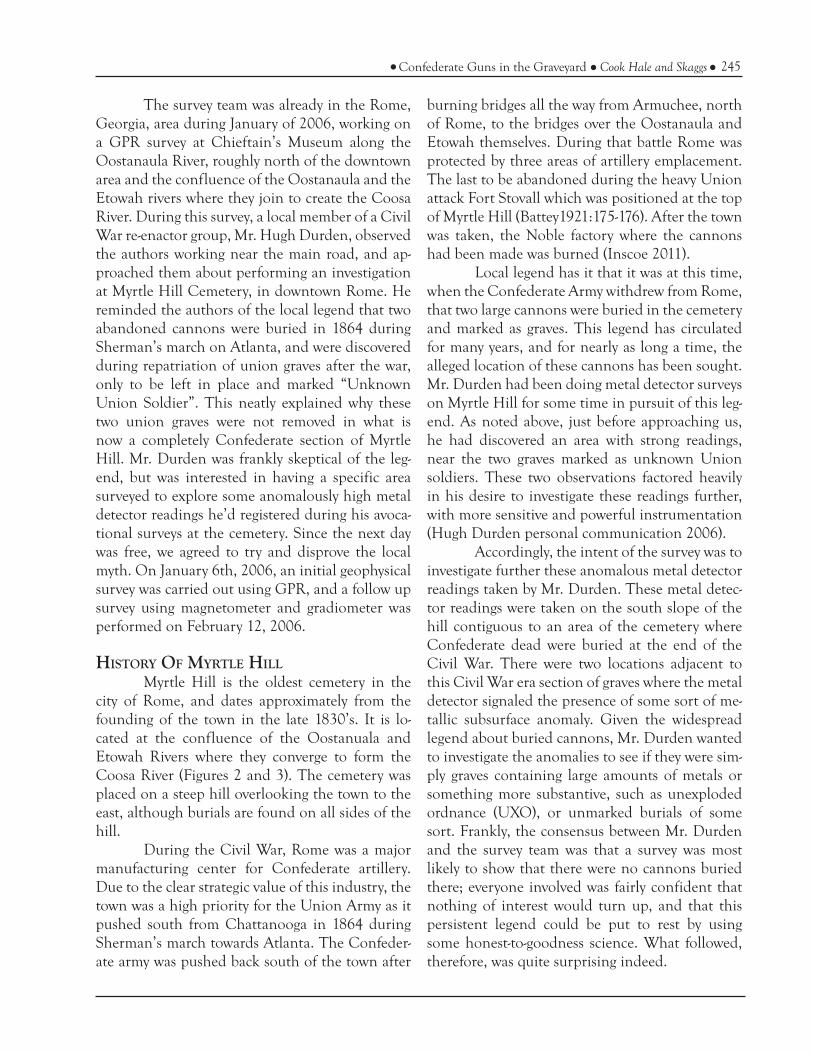
The survey team was already in the Rome, Georgia, area during January of 2006, working on a GPR survey at Chieftain’s Museum along the Oostanaula River, roughly north of the downtown area and the confluence of the Oostanaula and the Etowah rivers where they join to create the Coosa River. During this survey, a local member of a Civil War re-enactor group, Mr. Hugh Durden, observed the authors working near the main road, and ap-proached them about performing an investigation at Myrtle Hill Cemetery, in downtown Rome. He reminded the authors of the local legend that two abandoned cannons were buried in 1864 during Sherman’s march on Atlanta, and were discovered during repatriation of union graves after the war, only to be left in place and marked “Unknown Union Soldier”. This neatly explained why these two union graves were not removed in what is now a completely Confederate section of Myrtle Hill. Mr. Durden was frankly skeptical of the leg-end, but was interested in having a specific area surveyed to explore some anomalously high metal detector readings he’d registered during his avoca-tional surveys at the cemetery. Since the next day was free, we agreed to try and disprove the local myth. On January 6th, 2006, an initial geophysical survey was carried out using GPR, and a follow up survey using magnetometer and gradiometer was performed on February 12, 2006.
HISTORY OF MYRTLE HILLMyrtle Hill is the oldest cemetery in the
city of Rome, and dates approximately from the founding of the town in the late 1830’s. It is lo-cated at the confluence of the Oostanuala and Etowah Rivers where they converge to form the Coosa River (Figures 2 and 3). The cemetery was placed on a steep hill overlooking the town to the east, although burials are found on all sides of the hill.
During the Civil War, Rome was a major manufacturing center for Confederate artillery. Due to the clear strategic value of this industry, the town was a high priority for the Union Army as it pushed south from Chattanooga in 1864 during Sherman’s march towards Atlanta. The Confeder-ate army was pushed back south of the town after
burning bridges all the way from Armuchee, north of Rome, to the bridges over the Oostanaula and Etowah themselves. During that battle Rome was protected by three areas of artillery emplacement. The last to be abandoned during the heavy Union attack Fort Stovall which was positioned at the top of Myrtle Hill (Battey1921:175-176). After the town was taken, the Noble factory where the cannons had been made was burned (Inscoe 2011).
Local legend has it that it was at this time, when the Confederate Army withdrew from Rome, that two large cannons were buried in the cemetery and marked as graves. This legend has circulated for many years, and for nearly as long a time, the alleged location of these cannons has been sought. Mr. Durden had been doing metal detector surveys on Myrtle Hill for some time in pursuit of this leg-end. As noted above, just before approaching us, he had discovered an area with strong readings, near the two graves marked as unknown Union soldiers. These two observations factored heavily in his desire to investigate these readings further, with more sensitive and powerful instrumentation (Hugh Durden personal communication 2006).
Accordingly, the intent of the survey was to investigate further these anomalous metal detector readings taken by Mr. Durden. These metal detec-tor readings were taken on the south slope of the hill contiguous to an area of the cemetery where Confederate dead were buried at the end of the Civil War. There were two locations adjacent to this Civil War era section of graves where the metal detector signaled the presence of some sort of me-tallic subsurface anomaly. Given the widespread legend about buried cannons, Mr. Durden wanted to investigate the anomalies to see if they were sim-ply graves containing large amounts of metals or something more substantive, such as unexploded ordnance (UXO), or unmarked burials of some sort. Frankly, the consensus between Mr. Durden and the survey team was that a survey was most likely to show that there were no cannons buried there; everyone involved was fairly confident that nothing of interest would turn up, and that this persistent legend could be put to rest by using some honest-to-goodness science. What followed, therefore, was quite surprising indeed.
246 Early Georgia volume 41, number 2
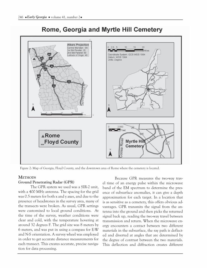
Figure 2: Map of Georgia, Floyd County, and the downtown area of Rome where the cemetery is located.
Because GPR measures the two-way trav-el time of an energy pulse within the microwave band of the EM spectrum to determine the pres-ence of subsurface anomalies, it can give a depth approximation for each target. In a location that is as sensitive as a cemetery, this offers obvious ad-vantages. GPR transmits the signal from the an-tenna into the ground and then picks the returned signal back up, reading the two-way travel between transmission and return. When the microwave en-ergy encounters a contact between two different materials in the subsurface, the ray path is deflect-ed and diverted at angles that are determined by the degree of contrast between the two materials. This deflection and diffraction creates different
METHODSGround Penetrating Radar (GPR)
The GPR system we used was a SIR-2 unit, with a 400 MHz antenna. The spacing for the grid was 0.5 meters for both x and y axes, and due to the presence of headstones in the survey area, many of the transects were broken. As usual, GPR settings were customized to local ground conditions. At the time of the survey, weather conditions were clear and cold, with the temperature hovering at around 32 degrees F. The grid size was 8 meters by 6 meters, and was put in using a compass for E-W and N-S orientation. A survey wheel was employed in order to get accurate distance measurements for each transect. This creates accurate, precise naviga-tion for data processing.

247Confederate Guns in the Graveyard Cook Hale and Skaggs
ger hard reflector signal, albeit not nearly as strong as metal cannons (Conyers 2006:70). Depth of graves can vary based on the amount of erosion that has taken place since the burial was interred, however.
These profiles are processed using one of several software packages that create horizontal plan views according to time depth (the measure of different two way travel times calculated based on return time, and strength, and soil or bedrock conditions). Actual depth can be calculated by us-ing known parameters for local soil and bedrock conditions (Conyers and Cameron 1998:429; Gar-rison and Herz 1998:171-173), and these data can be compiled into maps showing the placement of the anomalies within the surveyed grid. Various depths can be displayed in two-dimensional maps or in three-dimensional volumes. Vertical profiles for individual transects are useful for analysis as well.
GradiometerFurther investigation on February 12,
2006, was done using a magnetometer/gradiom-
return times and velocities, which are then pro-cessed by the control unit into vertical profiles of the subsurface along the transect that the antenna is traversing. Two materials with two very differ-ent dielectric values will create a large contrast, but materials with only slightly different dielectric values will create only minimal contrast (Garrison and Herz 1998:170; Milsom 2003:169-171). This is one reason why GPR is an excellent choice for the detection of something as large and impermeable as a cannon, since a cannons will create a very high contrast, large anomaly signature.
On the other hand, a grave shaft contain-ing a wooden coffin burial should not create a hard reflector signal, because the materials within are unlikely to contain large amounts of metal. In-stead, a single burial grave shaft usually returns an “X” shaped signal in the vertical view of the GPR data due to contrast between the infilling soil and the nearly vertical walls of the shaft, and should create a roughly oblong signal in plan view that is rarely longer than 2.5 meters, or wider than 1.5 meters (7.5 feet and 4.5 feet, roughly) (Conyers 2006:66). A metal coffin will create a much stron-
Figure 3: Myrtle Hill Cemetery, from Google Maps.

248 Early Georgia volume 41, number 2
2003:58). Unless there is a detectable change in magnetic susceptibility in the subsurface, the mag-netometer reads the earth’s magnetic field only (Garrison and Herz 1998:167). Subtracting the general field strength detected by the top sensor from the local changes read by the bottom sensor will help remove natural variations in the Earth field strength that can obscure subtle changes. In short, using a gradiometer instead of a regular mag-netometer allows the investigator to remove back-ground noise from the survey without having to take base station readings to account for fluctua-tions of the Earth field strength during the day.
Readings were taken on a somewhat en-larged grid of 9 meters by 11 meters at 0.5 meter in-tervals between each reading; this spacing was used for both the X and Y axes, so that we had data for points every 0.5 meters. The weather was cold and overcast with light intermittent snow showers and a temperature of approximately 32 F. Both magne-tometer and gradiometer readings were recorded. The data was then plotted in an Excel spreadsheet and placed in the Surfer 7 mapping program for analysis. Mass and depth estimates were calculated in order to get an estimate of the size of the anom-aly.
RESULTSInitial processing using RADAN software
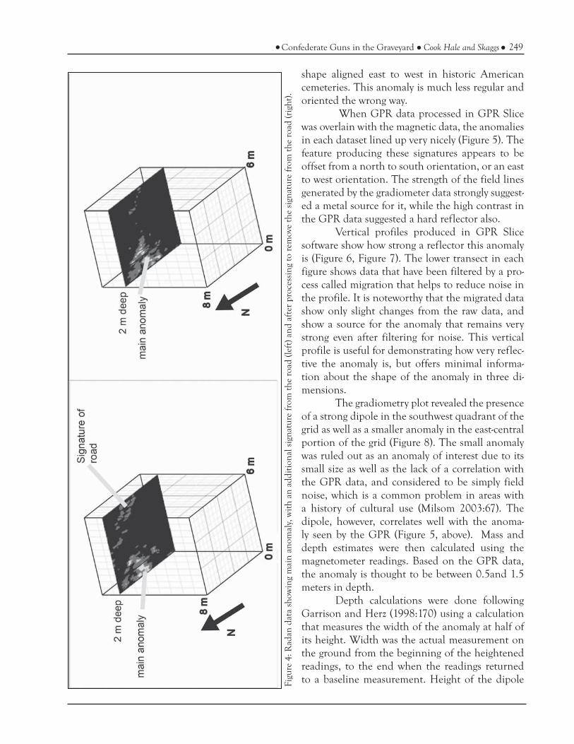
revealed the presence of an unknown anomaly of larger size than one would expect for a grave, and with less regular shape that was oriented off-axis from the known graves (Figure 4). The anomaly can clearly be seen in on the northwest edge of the grid as a smear of brighter reds, oranges, and yellows. The left portion of Figure 4 shows the unprocessed data, with a signature in the north-east portion of the grid. The cemetery road is in that location and this signature is probably best sourced to this surface feature. Processing of the data, on the right hand side of Figure 4, shows the data once the signature created by the cemetery road was removed. The remaining anomaly in the northwest portion of the grid is very inconsistent with what one might expect for a grave signature; it is larger and of the wrong shape. As noted above, a grave typically presents a sub-rectangular to ovoid
eter to gather data concerning anomaly strength. This technique is deceptively simple in concept: readings of the Earth’s magnetic field are taken at close intervals, and the differences are plotted in order to determine if any fluctuations in that field exist. Nonmetal features such as standard graves create much smaller fluctuations compared to features that contain materials that can hold a magnetic signature, such as the iron in cannons, UXO such as cannon balls, or iron coffins. Gra-diometer surveys take this principle one step fur-ther by measuring the Earth’s magnetic field at two heights above the ground; subtracting one reading from the other gives a sense of the relative strength of an anomaly (Garrison and Herz 1998:167). Sig-nificant gradiometer readings generally only occur over magnetically susceptible objects such as those containing a large amount of iron or magnetite, an iron mineral (Milsom 2003:52-53)
The instrument chosen for the survey was an Overhauser-Abragam effect gradiometer, which is a much more sensitive version of a proton pre-cession magnetometer. These kinds of instruments work by the use of proton procession within the sensors. A conducting coil is suspended around a proton rich fluid (gasoline). Initially, all the pro-tons in the fluid are oriented to the magnetic field at that location. A small electrical charge is run through the coil, which creates a local magnetic field inside the sensor. The protons quickly align with this new magnetic field. The electric charge is then stopped, and the protons relax back to align-ment with the ambient magnetic field. The relax-ation of the protons causes an electrical current to move back through the coil and be recorded by the magnetometer.
Overhauser-Abragam effect gradiometers are much more sensitive than regular proton pre-cession magnetometers, and can detect differences as small as 0.01 nanoTeslas (nT). Regular proton precession magnetometers typically detect differ-ences of 1 nT or more (Garrison and Herz 1998: 167). For comparison, consider that the Earth’s magnetic standard field strength averages around 50,000 nT and can fluctuate throughout the day, and that soil changes typically encountered in ar-chaeological surveys are less than 10 nT (Milsom
249Confederate Guns in the Graveyard Cook Hale and Skaggs
Figu
re 4
: Rad
an d
ata
show
ing
mai
n an
omal
y, w
ith a
n ad
ditio
nal s
igna
ture
from
the
road
(lef
t) a
nd a
fter
pro
cess
ing
to r
emov
e th
e si
gnat
ure
from
the
road
(rig
ht).
shape aligned east to west in historic American cemeteries. This anomaly is much less regular and oriented the wrong way.
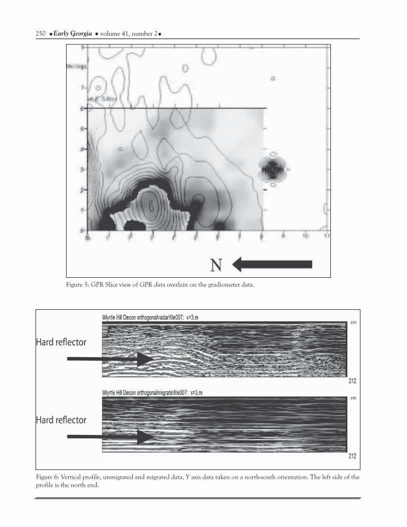
When GPR data processed in GPR Slice was overlain with the magnetic data, the anomalies in each dataset lined up very nicely (Figure 5). The feature producing these signatures appears to be offset from a north to south orientation, or an east to west orientation. The strength of the field lines generated by the gradiometer data strongly suggest-ed a metal source for it, while the high contrast in the GPR data suggested a hard reflector also.
Vertical profiles produced in GPR Slice software show how strong a reflector this anomaly is (Figure 6, Figure 7). The lower transect in each figure shows data that have been filtered by a pro-cess called migration that helps to reduce noise in the profile. It is noteworthy that the migrated data show only slight changes from the raw data, and show a source for the anomaly that remains very strong even after filtering for noise. This vertical profile is useful for demonstrating how very reflec-tive the anomaly is, but offers minimal informa-tion about the shape of the anomaly in three di-mensions.
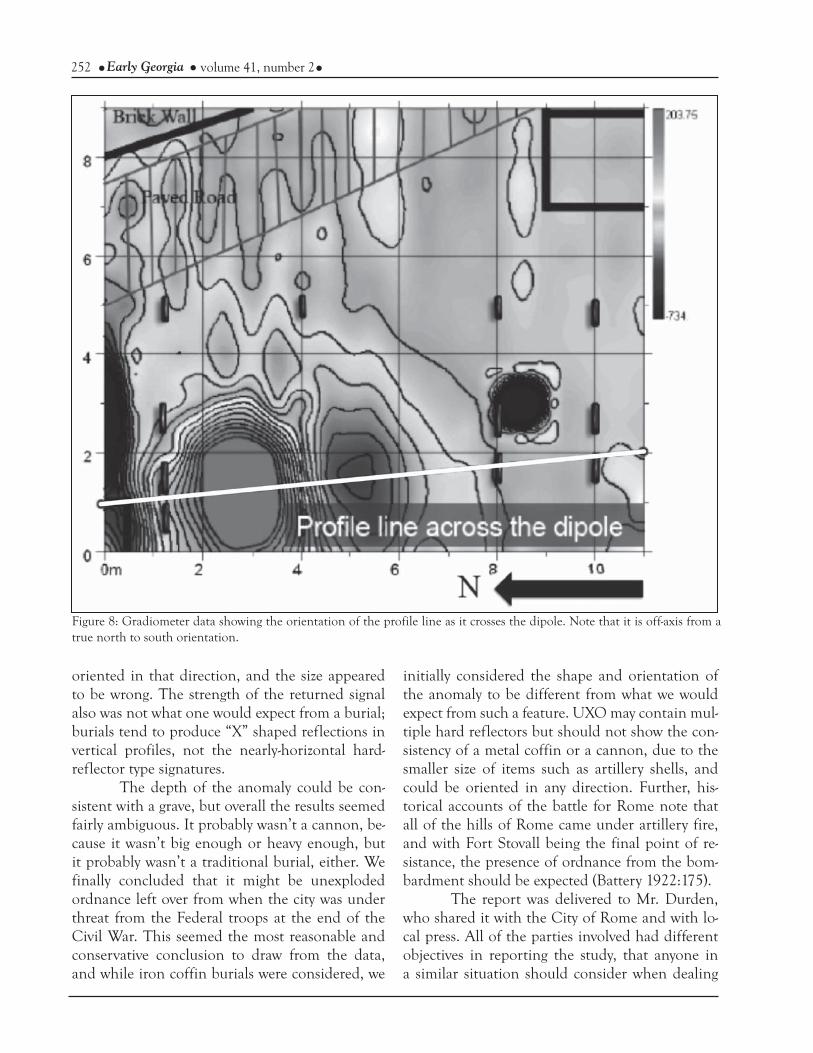
The gradiometry plot revealed the presence of a strong dipole in the southwest quadrant of the grid as well as a smaller anomaly in the east-central portion of the grid (Figure 8). The small anomaly was ruled out as an anomaly of interest due to its small size as well as the lack of a correlation with the GPR data, and considered to be simply field noise, which is a common problem in areas with a history of cultural use (Milsom 2003:67). The dipole, however, correlates well with the anoma-ly seen by the GPR (Figure 5, above). Mass and depth estimates were then calculated using the magnetometer readings. Based on the GPR data, the anomaly is thought to be between 0.5and 1.5 meters in depth.
Depth calculations were done following Garrison and Herz (1998:170) using a calculation that measures the width of the anomaly at half of its height. Width was the actual measurement on the ground from the beginning of the heightened readings, to the end when the readings returned to a baseline measurement. Height of the dipole
250 Early Georgia volume 41, number 2
Figure 5: GPR Slice view of GPR data overlain on the gradiometer data.
Figure 6: Vertical profile, unmigrated and migrated data, Y axis data taken on a north-south orientation. The left side of the profile is the north end.

251Confederate Guns in the Graveyard Cook Hale and Skaggs
is measured in the different between the baseline of the dipole, and its strongest measurement. The height and width of the dipole suggested a depth of 2-2.5 meters. Mass calculations assuming the ob-ject is a non-magnetized steel sphere (using the dif-ference between the lowest and the highest num-bers of the magnetic readings, that is to say, the height) rendered a possible mass of approximately 3500 lbs. However, the GPR depth of 0.5-1.5 me-ters is most likely the more accurate depth, because it is based on calculations that take local soil and bedrock conditions into consideration, whereas the calculations using dipole height and width can’t do so with the same accuracy and precision. When mass calculations were done assuming the depth of 0.5 meters, the results suggest that the ob-ject still has a mass of approximately 350 lbs. As seen in Figure 5 there is good correspondence in location in both datasets. The best approximation for the depth of the top of the buried feature as rendered in GPR Slice is approximately 0.75 me-ter to 1 meter. Given the estimates for mass, this places the feature towards the lower end for mass estimate, i.e., somewhere between 350 and 500 lbs.
DISCUSSION AND CONCLUSIONS When any sort of calculation of mass and
depth for a geophysical anomaly is made, it must, for the sake of the scientific method, be bracketed with caveats. The very title of “remote sensing” ne-cessitates a cautious approach, and any prognosti-cations require critical thinking, to say the least. While legend can be a useful roadmap at times to valuable cultural resources, it cannot and should not replace other meticulous scientific methods. This is especially true when dealing with local leg-ends and folk tales; the potential for results like this to be misinterpreted is very high, and given how very sensitive the site is, any sort of ad hoc attempts to ground truth these findings have the potential to wreak considerable destruction as well as violate any number of state and federal laws.
The orientation of the anomaly was not completely consistent with what one would ex-pect from a grave. Graves tend to be oblong, ovoid shapes in plan view that are oriented east to west in historic Christian cemeteries, generally speak-ing. The shape of this anomaly was not completely
Figure 7: Vertical profile, unmigrated and migrated data, X axis data taken on an east to west orientation. The left side of the profile is the eastern end.
252 Early Georgia volume 41, number 2
oriented in that direction, and the size appeared to be wrong. The strength of the returned signal also was not what one would expect from a burial; burials tend to produce “X” shaped reflections in vertical profiles, not the nearly-horizontal hard-reflector type signatures.
The depth of the anomaly could be con-sistent with a grave, but overall the results seemed fairly ambiguous. It probably wasn’t a cannon, be-cause it wasn’t big enough or heavy enough, but it probably wasn’t a traditional burial, either. We finally concluded that it might be unexploded ordnance left over from when the city was under threat from the Federal troops at the end of the Civil War. This seemed the most reasonable and conservative conclusion to draw from the data, and while iron coffin burials were considered, we
initially considered the shape and orientation of the anomaly to be different from what we would expect from such a feature. UXO may contain mul-tiple hard reflectors but should not show the con-sistency of a metal coffin or a cannon, due to the smaller size of items such as artillery shells, and could be oriented in any direction. Further, his-torical accounts of the battle for Rome note that all of the hills of Rome came under artillery fire, and with Fort Stovall being the final point of re-sistance, the presence of ordnance from the bom-bardment should be expected (Battery 1922:175).
The report was delivered to Mr. Durden, who shared it with the City of Rome and with lo-cal press. All of the parties involved had different objectives in reporting the study, that anyone in a similar situation should consider when dealing
Figure 8: Gradiometer data showing the orientation of the profile line as it crosses the dipole. Note that it is off-axis from a true north to south orientation.

253Confederate Guns in the Graveyard Cook Hale and Skaggs
with clients; the authors were focused on employ-ing a conservative scientific approach to data col-lection and interpretation, while Mr. Durden, was greatly interested in raising awareness of Civil War history and local support for related activities such as Civil War re-enactments. The actual landown-er, the City of Rome, had a mandate in the 2004 master plan for Myrtle Hill cemetery to locate un-marked or lost graves, but not to investigate Civil War history or endanger the property. While the report itself is appropriately cautious in its inter-pretations, once the press was notified that there was a mysterious anomaly on Myrtle Hill, the story was picked up and spread via the internet as well as the regional press. Future authors should bal-ance the need to treat geophysical results for sites such as this in vague terms that still satisfy a curi-ous public enough such that risks to the site are minimized; vague or cautious language may inad-vertently enhance the “mysteriousness” of the site and therefore appeal to both the client and public in ways intended by the report, or the investigators. When the press began contacting both authors, we had to choose our words very carefully to minimize the chances that someone would misinterpret our findings. It was important to us that we describe how geophysical findings cannot determine with certainty what is creating an anomaly. It was also very important to us that this attention to the site did not invite looting or other damage to the cem-etery. This approach tends to run counter to the goals of the press, whose job is to obtain as much specific information as possible.
As archaeologists, this was our first true interaction with the press when discussing a site. We definitely were very concerned about the more sensational aspects to the story, best exemplified by the headline from the Augusta Chronicle on Janu-ary 30th, 2006: “Object in Civil War cemetery con-fuses archaeology team.” While the press did man-age to report the names of the instruments used, and quoted one of the authors, Skaggs, in a mostly accurate manner when he described the methods and findings, we remained very concerned. It’s not every day that one finds one’s survey results on websites listed under “News of the Weird.” Our concerns where quickly justified when Skaggs re-
ceived a call from the SHPO office requesting that any excavations at Myrtle Hill be stopped immedi-ately. It was rapidly established that the geophysi-cal survey had not involved excavation, no exca-vation was ongoing or planned, and that no one needed to be arrested.
We decided that the only reasonable way forward was to restrict our interpretations as con-servatively as possible when speaking to the press. When pushed to name possible sources for the anomaly, we emphasized the possibility that it may have been unexploded ordnance. We did this not only because that was the most reasonable possibil-ity of which we were aware at the time, but also be-cause we thought it might minimize the possibility that someone might attempt to illegally excavate in the dark of night for fear they’d be blown to bits by Civil War era ammunition stores.
Eventually, the hubbub died down and the press moved on to other things, but local interest remained about what, precisely, might be buried up there on Myrtle Hill. Several years later, one of the authors, Skaggs, received an email from city of Rome’s director of cemeteries that informed him that the City had secured permission for excava-tion (Stan Rogers personal communication 2013). The results were surprising: it was an unmarked iron coffin burial that intersected another burial at an angle, creating a “V” shaped outline.
Iron coffins were part of what Bell (1990:54) refers to as the Victorian era “beautifi-cation of death;” the role that they played in this cultural phenomenon is likely rooted in the way that sealing an iron coffin halts decomposition of the dead within it; once the oxygen within the iron coffin is used up by the oxidation of the iron, along with the oxygen being taken up by decompo-sition processes, then decomposition stops due to the now-anoxic environment that is sealed off from bugs and other pests (Brennan 1894; Grabowski et al. 2010:60). These coffins sometimes had win-dows, allowing the deceased to be viewed in a rela-tively uncorrupted state. Cast iron coffins became more common during and after the 1850’s, but at a cost 50 times greater than a pine coffin. Thus, they were reserved for very important and affluent customers (Owsley et al. 2006:89).

254 Early Georgia volume 41, number 2
Further discussion in June of 2013 with Mr. Rogers confirmed the presence of the iron cof-fin at 4 feet in depth, or just over 1 meter, well within what the data suggested. Mr. Rogers also noted that the coffin was a “toe-pinch” type of cof-fin, meaning that it is shaped like a very elongated hexagon, with the head and foot of the coffin ta-pering from a wider point at what should be the shoulder area of the deceased (Stan Rogers person-al communication 2013). This finding was some-what of a surprise initially, but when the geophysi-cal data are reviewed, make perfect sense. There was indeed a hard reflector within the cemetery plot surveyed, but it was certainly not an artillery piece or UXO of any stripe. Instead, it was a far more interesting item that offers direct evidence for historical mortuary practices in Rome during the Victorian period, and connects those practices in Rome with a larger regional context (eg., Little et al. 1992; Owsley et al. 2006).
In closing, it is clear that this is an instruc-tive example for assessing how vital it is for profes-sionals to remain aware of the ways in which local oral histories and tall tales can influence public interpretations of geophysical or archaeological survey results. The stories in the regional press made comments like, “archaeologists mystified by strange object in cemetery,” which apparently stemmed from our very careful statements that the readings were not consistent with cannons, or any-thing else straightforward, and that absent actual excavation (which we also noted was definitely not going to happen, at least not by us), no one could say exactly what it was. As archaeologists, we are accustomed to using terminology such as “anoma-ly” or “feature” with an implicit understanding of what those terms mean; however, without careful discussion of those meanings when working with the interested general public, wild misinterpreta-tions are possible and have the potential to encour-age looting or other extra-legal excavations.
That being said, non-invasive geophysical techniques are ideal for investigating these kinds of legends and tall tales without compromising sensi-tive sites. If we have any recommendations at all to others who find themselves in this sort of situ-ation, it would be that the investigators should re-
main very attuned to the potential for professional jargon to be misunderstood, and for local legends to impact public interpretations of archaeological or geophysical findings. Beyond a certain point, however, the archaeologists’ control over the in-terpretations ends, and so strong cautions to the public about the ethical and legal ramifications of unauthorized excavations should be given at ev-ery opportunity. Still, these kinds of situations do offer an opportunity for investigators to create a teaching moment in which they can educate the public about archaeological investigations, and can help bolster efforts to involve the public at large in thoughtful historic preservation efforts within their communities.
AcknowledgmentsWe would like to gratefully acknowledge the invaluable help we received from Drs. Ervan Garrison and Kent Schneider in data processing, as well as Mr. Hugh Durden and the Rome chapter of the Sons of Confederate Veterans, who were most gracious in their assistance during the surveys. Mr. Stan Rog-ers, cemetery director for the city of Rome, Georgia, was ex-tremely helpful in discussing the outcome of the excavations of the burial, and this study would be lacking a critical compo-nent without his assistance. Mr. Carey Tilley, at Chieftain’s Museum in Rome, was very helpful when discussing the details of local history during the Civil War. Ms. Ellie Maclin Hay-wood showed great fortitude and patience with data recording and survey set-up, making sure among many other things that the tapes were flat and straight. She endured without com-plaint some of the more unpleasant surveying conditions we’ve experienced – gradiometer survey in the snow is not the most comfortable way to spend one’s day. We are also most grateful to the reviewers who have greatly improved this manuscript. Any mistakes or errors in this study are all our own.
REFERENCES CITEDBattery, George Magruder.1922 A History of Rome and Floyd County, State of
Georgia, United States of America: Including Numerous Incidents of More Than Local Inter-est, 1540-1922, Volume 1. Webb and Vary Company, Floyd County (Ga.).
Bell, Edward L. 1990 The Historical Archaeology of Mortu-
ary Behavior: Coffin Hardware from Ux-bridge, Massachusetts. Historical Archaeol-

255Confederate Guns in the Graveyard Cook Hale and Skaggs
ogy 24(3):54-78, Stable URL: http://www.jstor.org/stable/25615794
Brennan, J. R. M.1894 Exhumation After Fourteen Years’ Burial.
The British Medical Journal 2(1770):1237. Article Stable URL: http://www.jstor.org.proxy -remote.galib.uga.edu/sta-ble/20230686
Buck, SC 2003 Searching for graves using geophysical tech-
nology: field tests with ground penetrating radar, magnetometry, and electrical resis-tivity. Journal of Forensic Sciences 48(1):5-11.
Conyers Lawrence B. 2006 Ground-Penetrating Radar Techniques to
Discover and Map Historic Graves. Histori-cal Archaeology, Vol. 40, No. 3, Remains of the Day: Forensic Applications in Archae-ology (2006), pp. 64-73.
2010 Ground penetrating radar for anthropolog-ical research. Antiquity 84 (2010): 175-184.
Conyers, Lawrence B., and Catherine M. Cameron1998 Ground-Penetrating Radar Techniques and
Three-Dimensional Computer Mapping in the American Southwest. Journal of Field Archaeology 25(4):417-430.
Fiedler, Sabine, Bernhard Illich, Jochen Berger, and Matthias Graw2000 The effectiveness of ground-penetrating
radar surveys in the location of unmarked burial sites in modern cemeteries. Journal of Applied Geophysics 68 (2009):380–385.
Garrison, Ervan, and Norman Herz 1998 Geological Methods for Archaeology. Oxford
University Press, Oxford, New York.
Grabowski, Mark W., Douglas W. Owsley and Kar-in S. Bruwelheide2010 Cemetery Vandalism: The Strange Case
of William Wirt. Washington History, 22
(2010):57-68. Article Stable URL: http://www.jstor.org.proxy-remote.galib.uga.edu/stable/41000589
Inscoe, John C.2011 The Civil War in Georgia: A New Georgia En-
cyclopedia Companion. University of Geor-gia Press, Athens, Georgia.
Little, Barbara J., Kim M. Lanphear and Douglas W. Owsley1992 Mortuary Display and Status in a Nine-
teenth-Century Anglo-American Cemetery in Manassas, Virginia. American Antiquity 57(3):397-418. Article Stable URL: http://www.jstor.org.proxy remote.galib.uga.edu/stable/280930
Milsom, John2003 Field Geophysics, 3rd edition. John Wiley
and Sons Ltd. Chichester, UK.
Owsley, Douglas W., Karin S. Bruwelheide, Larry W. Cartmell, Sr., Laurie E. Burgess, Shelly J. Foote, Skye M. Chang and Nick Fielder2006 The Man in the Iron Coffin: An Interdisci-
plinary Effort to Name the Past. Historical Archaeology 40(3):89-108.
Ruffell, Alastair, Alan McCabe, Colm Donnelly, and Brian Sloan2009 Location and Assessment of an Historic
(150–160 Years Old) Mass Grave Using Geographic and Ground Penetrating Ra-dar Investigation, NW Ireland. Journal of Forensic Science 54(2):382-394.

256 Early Georgia volume 41, number 2