CONCLUSIONS (p. 24) - Shelby County
39
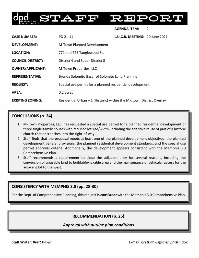
Staff Writer: Brett Davis E-mail: [email protected] AGENDA ITEM: 2 CASE NUMBER: PD 21-11 L.U.C.B. MEETING: 10 June 2021 DEVELOPMENT: M-Town Planned Development LOCATION: 771 and 775 Tanglewood St. COUNCIL DISTRICT: District 4 and Super District 8 OWNER/APPLICANT: M-Town Properties, LLC REPRESENTATIVE: Brenda Solomito Basar of Solomito Land Planning REQUEST: Special use permit for a planned residential development AREA: 0.2 acres EXISTING ZONING: Residential Urban – 1 (Historic) within the Midtown District Overlay CONCLUSIONS (p. 24) 1. M-Town Properties, LLC, has requested a special use permit for a planned residential development of three single-family houses with reduced lot size/width, including the adaptive reuse of part of a historic church that encroaches into the right-of-way. 2. Staff finds that the proposal meets at least one of the planned development objectives, the planned development general provisions, the planned residential development standards, and the special use permit approval criteria. Additionally, the development appears consistent with the Memphis 3.0 Comprehensive Plan. 3. Staff recommends a requirement to close the adjacent alley for several reasons, including the conversion of unusable land to buildable/taxable area and the maintenance of vehicular access for the adjacent lot to the west. RECOMMENDATION (p. 25) Approval with outline plan conditions CONSISTENCY WITH MEMPHIS 3.0 (pp. 28-30) Per the Dept. of Comprehensive Planning, this request is consistent with the Memphis 3.0 Comprehensive Plan.
-
Upload
khangminh22 -
Category
Documents
-
view
0 -
download
0
Transcript of CONCLUSIONS (p. 24) - Shelby County
Staff Writer: Brett Davis E-mail: [email protected]
AGENDA ITEM: 2
CASE NUMBER: PD 21-11 L.U.C.B. MEETING: 10 June 2021
DEVELOPMENT: M-Town Planned Development
LOCATION: 771 and 775 Tanglewood St.
COUNCIL DISTRICT: District 4 and Super District 8
OWNER/APPLICANT: M-Town Properties, LLC
REPRESENTATIVE: Brenda Solomito Basar of Solomito Land Planning
REQUEST: Special use permit for a planned residential development
AREA: 0.2 acres
EXISTING ZONING: Residential Urban – 1 (Historic) within the Midtown District Overlay
CONCLUSIONS (p. 24)
1. M-Town Properties, LLC, has requested a special use permit for a planned residential development of three single-family houses with reduced lot size/width, including the adaptive reuse of part of a historic church that encroaches into the right-of-way.
2. Staff finds that the proposal meets at least one of the planned development objectives, the planned development general provisions, the planned residential development standards, and the special use permit approval criteria. Additionally, the development appears consistent with the Memphis 3.0 Comprehensive Plan.
3. Staff recommends a requirement to close the adjacent alley for several reasons, including the conversion of unusable land to buildable/taxable area and the maintenance of vehicular access for the adjacent lot to the west.
RECOMMENDATION (p. 25)
Approval with outline plan conditions
CONSISTENCY WITH MEMPHIS 3.0 (pp. 28-30)
Per the Dept. of Comprehensive Planning, this request is consistent with the Memphis 3.0 Comprehensive Plan.

Staff Report 10 June 2021 PD 21-11 Page 2
2
GENERAL INFORMATION Street Frontage: Tanglewood Street (Local street) 59 linear feet Saulsbury Place (Local street) 126 linear feet Alley (unimproved) 70 linear feet Zoning Atlas Page: 2035 Parcel ID: 031134 00008 and 031134 00009 Existing Zoning: Residential Urban – 1 (Historic) within the Midtown District Overlay NEIGHBORHOOD MEETING The required neighborhood meeting was held at 6 p.m. on 25 March 2021 via Zoom. PUBLIC NOTICE In accordance with Sub-Section 9.3.4A of the Unified Development Code (UDC), a notice of public hearing is required to be mailed and signs posted. A total of 72 notices were mailed on 23 March 2021, and a total of two signs posted at the subject property. The sign affidavit has been added to this report.

Staff Report 10 June 2021 PD 21-11 Page 3
3
LOCATION MAP
Subject property located in Cooper-Young
SUBJECT PROPERTY
Staff Report 10 June 2021 PD 21-11 Page 4
4
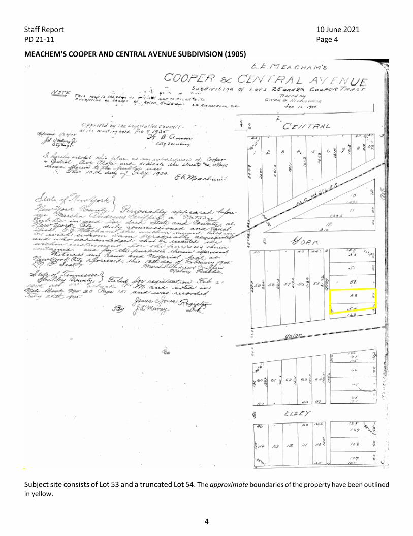
MEACHEM’S COOPER AND CENTRAL AVENUE SUBDIVISION (1905)
Subject site consists of Lot 53 and a truncated Lot 54. The approximate boundaries of the property have been outlined in yellow.

Staff Report 10 June 2021 PD 21-11 Page 5
5
CITY BLOCK MAP (1929)
Although no instrument of dedication of Saulsbury has been found, this 1929 City map shows it – then named Wintersmith Place – as a public right-of-way. The creation of this street allowed the subdivision of the long lots tucked between York and the Union-Pacific railroad right-of-way.

Staff Report 10 June 2021 PD 21-11 Page 6
6
VICINITY MAP

Staff Report 10 June 2021 PD 21-11 Page 7
7
SURVEY

Staff Report 10 June 2021 PD 21-11 Page 8
8
AERIAL PHOTOGRAPH SUPERIMPOSED ON SURVEY
This aerial photograph superimposed on the zoning map shows the church’s encroachment into the right-of-way. It also shows that the alley right-of-way does not neatly coincide with the existing drive off Saulsbury. In fact, overhead utilities – represented here by red dots – go down the middle of the right-of-way. Note that the adjacent property to the west of the alley currently relies on the subject property for vehicular access to its rear parking area. That access would no longer be available if the proposal were developed.

Staff Report 10 June 2021 PD 21-11 Page 9
9
ZONING MAP
Existing Zoning: Residential Urban – 1 (Historic) within the Midtown District Overlay Surrounding Zoning North: Residential Urban – 1 (Historic) within the Midtown District Overlay East: Employment within the Midtown District Overlay South: Residential – 6 within the Midtown District Overlay West: Residential Urban – 1 (Historic) within the Midtown District Overlay The subject site is across the street from two planned developments approved by the Memphis City Council in 2021: Tanglewood Place to the south and Central Yards to the east.

Staff Report 10 June 2021 PD 21-11 Page 10
10
LAND USE MAP
Nearby uses include single-family residential, two-family residential, light industrial, and vacant land.

Staff Report 10 June 2021 PD 21-11 Page 11
11
SITE PHOTOS
View of the corner of Tanglewood and Saulsbury, as well as subject structure

Staff Report 10 June 2021 PD 21-11 Page 12
12
View of the subject vacant parcel

Staff Report 10 June 2021 PD 21-11 Page 13
13
View north down Tanglewood

Staff Report 10 June 2021 PD 21-11 Page 14
14
View south down Tanglewood

Staff Report 10 June 2021 PD 21-11 Page 15
15
View east down Saulsbury

Staff Report 10 June 2021 PD 21-11 Page 16
16
View of alley right-of-way, looking north. The center of the 12’-wide right-of-way roughly coincides with the overhead utilities, despite appearances.

Staff Report 10 June 2021 PD 21-11 Page 17
17
View of existing rear drive, looking south

Staff Report 10 June 2021 PD 21-11 Page 18
18
PROPOSED OUTLINE PLAN

Staff Report 10 June 2021 PD 21-11 Page 19
19
PROPOSED CONCEPTUAL SITE PLAN

Staff Report 10 June 2021 PD 21-11 Page 20
20
PROPOSED ELEVATIONS
Staff Report 10 June 2021 PD 21-11 Page 21
21
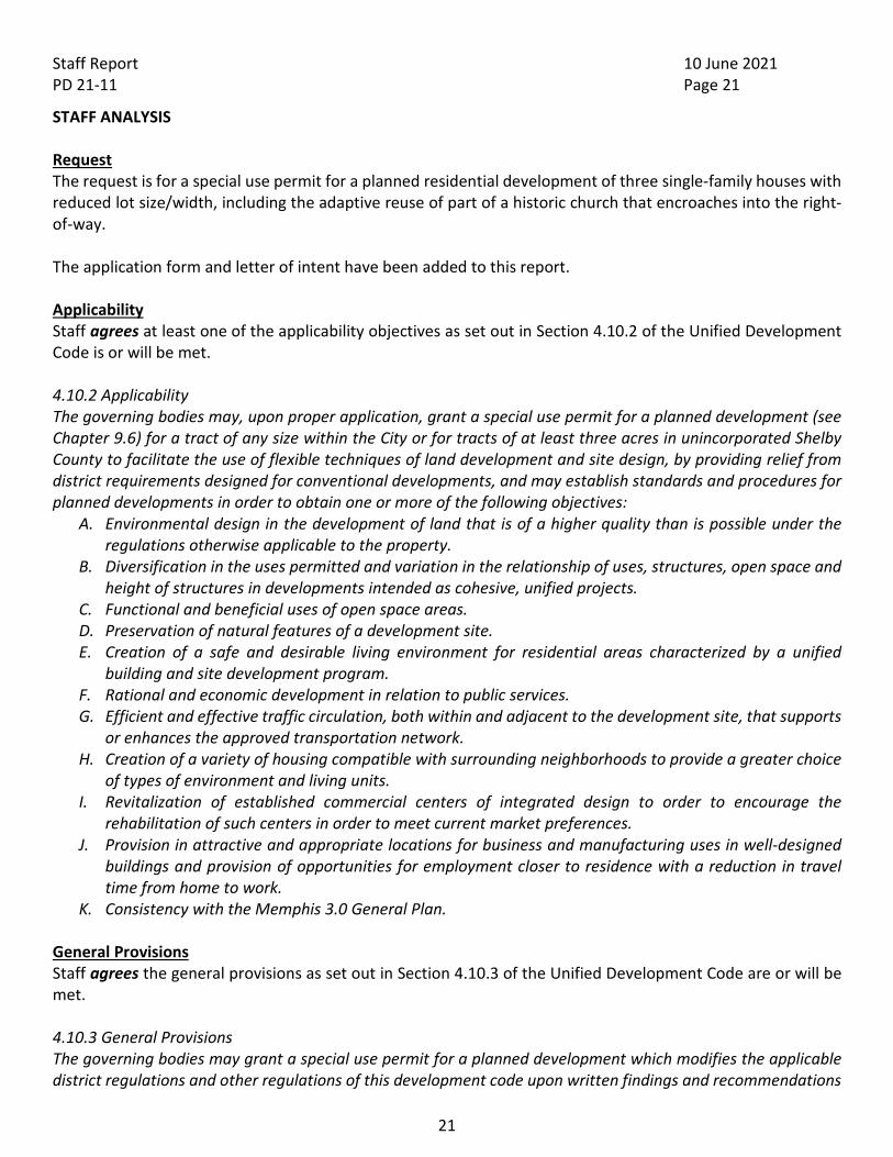
STAFF ANALYSIS Request The request is for a special use permit for a planned residential development of three single-family houses with reduced lot size/width, including the adaptive reuse of part of a historic church that encroaches into the right-of-way. The application form and letter of intent have been added to this report. Applicability Staff agrees at least one of the applicability objectives as set out in Section 4.10.2 of the Unified Development Code is or will be met. 4.10.2 Applicability The governing bodies may, upon proper application, grant a special use permit for a planned development (see Chapter 9.6) for a tract of any size within the City or for tracts of at least three acres in unincorporated Shelby County to facilitate the use of flexible techniques of land development and site design, by providing relief from district requirements designed for conventional developments, and may establish standards and procedures for planned developments in order to obtain one or more of the following objectives:
A. Environmental design in the development of land that is of a higher quality than is possible under the regulations otherwise applicable to the property.
B. Diversification in the uses permitted and variation in the relationship of uses, structures, open space and height of structures in developments intended as cohesive, unified projects.
C. Functional and beneficial uses of open space areas. D. Preservation of natural features of a development site. E. Creation of a safe and desirable living environment for residential areas characterized by a unified
building and site development program. F. Rational and economic development in relation to public services. G. Efficient and effective traffic circulation, both within and adjacent to the development site, that supports
or enhances the approved transportation network. H. Creation of a variety of housing compatible with surrounding neighborhoods to provide a greater choice
of types of environment and living units. I. Revitalization of established commercial centers of integrated design to order to encourage the
rehabilitation of such centers in order to meet current market preferences. J. Provision in attractive and appropriate locations for business and manufacturing uses in well-designed
buildings and provision of opportunities for employment closer to residence with a reduction in travel time from home to work.
K. Consistency with the Memphis 3.0 General Plan. General Provisions Staff agrees the general provisions as set out in Section 4.10.3 of the Unified Development Code are or will be met. 4.10.3 General Provisions The governing bodies may grant a special use permit for a planned development which modifies the applicable district regulations and other regulations of this development code upon written findings and recommendations

Staff Report 10 June 2021 PD 21-11 Page 22
22
of the Land Use Control Board and the Zoning Administrator which shall be forwarded pursuant to provisions contained in this Chapter.
A. The proposed development will not unduly injure or damage the use, value and enjoyment of surrounding property nor unduly hinder or prevent the development of surrounding property in accordance with the current development policies and plans of the City and County.
B. An approved water supply, community waste water treatment and disposal, and storm water drainage facilities that are adequate to serve the proposed development have been or will be provided concurrent with the development.
C. The location and arrangement of the structures, parking areas, walks, lighting and other service facilities shall be compatible with the surrounding land uses, and any part of the proposed development not used for structures, parking and loading areas or access way shall be landscaped or otherwise improved except where natural features are such as to justify preservation.
D. Any modification of the district standards that would otherwise be applicable to the site are warranted by the design of the outline plan and the amenities incorporated therein, and are not inconsistent with the public interest.
E. Homeowners’ associations or some other responsible party shall be required to maintain any and all common open space and/or common elements.
F. Lots of record are created with the recording of a planned development final plan. Residential Criteria Staff agrees the additional planned residential development criteria as set out in Section 4.10.4 of the Unified Development Code are or will be met. 4.10.4 Planned Residential Developments In addition to the standards and criteria set forth in Section 4.10.3, planned residential developments shall comply with the standards and criteria set forth below:
A. Formal Open Space A minimum of 0.6% of the total land area of a planned residential development of 15 acres or more shall be subject to the formal open space requirements of Section 6.2.3. No open area may be delineated or accepted as formal open space under the provisions of this Chapter unless it meets the standards of Chapter 6.2, Open Space.
B. Accessibility of Site All proposed streets, alleys and driveways shall be adequate to serve the residents, occupants, visitors or other anticipated traffic of the planned residential development. The location of the entrance points of the streets, alleys and driveways upon existing public roadways shall be subject to the approval of the City or County Division of Public Works.
C. Off-Street Parking Off-street parking shall be conveniently accessible to all dwelling units and other uses. Where appropriate, common driveways, parking areas, walks and steps may be provided, maintained and lighted for night use. Screening of parking and service areas shall be required through use of trees, shrubs and/or hedges and screening walls.
D. Pedestrian Circulation The pedestrian circulation system and its related walkways shall be separated, whenever feasible, from the vehicular street system in order to provide an appropriate degree of separation of pedestrian and vehicular movement.
E. Privacy

Staff Report 10 June 2021 PD 21-11 Page 23
23
The planned residential development shall provide reasonable visual and acoustical privacy for dwelling units within and adjacent to the planned residential development. Protection and enhancement of property and the privacy of its occupants may be provided by the screening of objectionable views or uses and reduction of noise through the use of fences, insulation, natural foliage, berms and landscaped barriers. High-rise buildings shall be located within the development in such a way as to minimize any adverse impact on adjoining low rise buildings.
F. Distance Requirements Where minimum distance requirements are provided between single family residential zoning districts and certain stipulated uses in this Code, the single-family residential areas of planned developments shall be considered zoned residential.
Approval Criteria Staff agrees the special use permit approval criteria as set out in Section 9.6.9 of the Unified Development Code are or will be met. 9.6.9 Approval Criteria No special use permit or planned development shall be approved unless the following findings are made concerning the application:
A. The project will not have a substantial or undue adverse effect upon adjacent property, the character of the neighborhood, traffic conditions, parking, utility facilities and other matters affecting the public health, safety, and general welfare.
B. The project will be constructed, arranged and operated so as to be compatible with the immediate vicinity and not interfere with the development and use of adjacent property in accordance with the applicable district regulations.
C. The project will be served adequately by essential public facilities and services such as streets, parking, drainage, refuse disposal, fire protection and emergency services, water and sewers; or that the applicant will provide adequately for such services.
D. The project will not result in the destruction, loss or damage of any feature determined by the governing bodies to be of significant natural, scenic or historic importance.
E. The project complies with all additional standards imposed on it by any particular provisions authorizing such use.
F. The request will not adversely affect any plans to be considered (see Chapter 1.9), or violate the character of existing standards for development of the adjacent properties.
G. The governing bodies may impose conditions to minimize adverse effects on the neighborhood or on public facilities, and to insure compatibility of the proposed development with surrounding properties, uses, and the purpose and intent of this development code.
H. Any decision to deny a special use permit request to place, construct, or modify personal wireless service facilities shall be in writing and supported by substantial evidence contained in a written record, per the Telecommunications Act of 1996, 47 USC 332(c)(7)(B)(iii). The review body may not take into account any environmental or health concerns.

Staff Report 10 June 2021 PD 21-11 Page 24
24
Site Description The 0.2-acre subject property consists of Lot 53 and a truncated Lot 54 of Meachem’s Cooper and Central Avenue Subdivision. Together, the lots have 59 linear feet of frontage on Tanglewood St. and 126 linear feet of frontage on Saulsbury Place. Both are local streets, although some esteem Saulsbury an alley due to the 20-foot width of its right-of-way. The Tanglewood frontage has overhead utilities and no curb, gutter, or sidewalk. The Saulsbury frontage has overhead utilities on the opposite side of the street and no curb, gutter, or sidewalk. Additionally, the lots have 70 feet of frontage on an unimproved 12’-wide alley right-of-way, the middle of which coincides with overhead utilities and which in certain instances has been inappropriately incorporated into lots’ backyards. Lot 54 contains a church – approximately 70’ x 25’ – built circa 1920 to house a Black Baptist congregation. In fact, a small baptistery still stands to the rear of the structure. The church’s stone facades are accentuated by a cross of individual bricks above the front door. Although the history is murky, staff postulates that at some point in the 1920s after the church’s construction the southern portion of Lot 54 was dedicated as right-of-way: the entrance (and exit) to the small, unrecorded subdivision that is today known as Saulsbury Place. The church structure encroaches into the Saulsbury right-of-way. The rear of Lot 54 has an asphalt drive off Saulsbury that provides vehicular access to the lot on the opposite side of the alley right-of-way; the drive might easily be mistaken as the apparently offset right-of-way. Lot 54 is vacant. Plan Review A full plan review will take place during final plan review, if approved. Conclusions M-Town Properties, LLC, has requested a special use permit for a planned residential development of three single-family houses with reduced lot size/width, including the adaptive reuse of part of a historic church that encroaches into the right-of-way. Staff finds that the proposal meets at least one of the planned development objectives, the planned development general provisions, the planned residential development standards, and the special use permit approval criteria. Additionally, the development appears consistent with the Memphis 3.0 Comprehensive Plan. Staff recommends a requirement to close the adjacent alley for several reasons, including the conversion of unusable land to buildable/taxable area and the maintenance of vehicular access for the adjacent lot to the west.

Staff Report 10 June 2021 PD 21-11 Page 25
25
RECOMMENDATION Staff recommends approval with the following outline plan conditions:
I. Uses Permitted A. Uses shall be permitted in accordance with the underlying zoning, with the exception that no
short-term rental housing shall be permitted. II. Building Envelope Standards
A. The minimum lot size shall be 1900 square feet. B. The minimum lot width shall be 18 feet. C. Minimum front setbacks shall be 10 feet. D. Minimum side and rear setbacks shall be 3.5 feet, with the following exception:
i. Lot 1 shall have no minimum street side setback. E. Street-facing garages and carports shall not be permitted. F. Unenclosed front porches with a minimum depth of 8 feet shall be required.
i. Such porches may be permitted to encroach into setbacks in accordance with Unified Development Code standards.
G. Finished ground floors shall be raised a minimum of 18 inches above the top of grade. III. General Development Standards
A. A modified S-13, S-14, or S-15 streetscape plate, including curb and gutter, shall be installed along the site’s Tanglewood frontage, subject to approval of the Zoning Administrator. Improvement of Saulsbury shall not be required.
i. Dedication of right-of-way or pedestrian easements may be required by the Zoning Administrator.
B. Curbs cuts shall be subject to approval of the Zoning Administrator and City Engineer. A maximum of one lot may have vehicular access from Saulsbury.
IV. Final Plan A. The applicant shall make a good faith effort to close the adjacent alley from York to Saulsbury,
subject to administrative approval. B. If any common open space is provided, a home owners’ association shall be required to own and
maintain said land. Any such association shall be created concurrently with the recording of a final plan.
C. Unless modified by the outline plan conditions, all standards of the Unified Development Code shall apply.
D. Any construction, and similar work, within the Cooper-Young Historic District shall be subject to the approval of the Landmarks Commission in accordance with the Cooper-Young Historic District design guidelines.
E. A final plan shall be submitted that demonstrates compliance with the outline plan conditions, as well as substantial conformance with the proposed conceptual design.

Staff Report 10 June 2021 PD 21-11 Page 26
26
DEPARTMENTAL COMMENTS The following comments were provided by agencies to which this application was referred: City Engineer: 1. Standard Subdivision Contract or Street Cut Permit as required in Section 5.5.5 of the Unified Development
Code. Sewers: 2. City sanitary sewers are available to serve this development.
3. All sewer connections must be designed and installed by the developer. This service is no longer offered by
the Public Works Division. Roads: 4. The Developer shall be responsible for the repair and/or replacement of all existing curb and gutter along
the frontage of this site as necessary.
5. All existing sidewalks and curb openings along the frontage of this site shall be inspected for ADA compliance. The developer shall be responsible for any reconstruction or repair necessary to meet City standards.
6. Dedicate and improve Tanglewood Street 25 feet from the centerline with curb, gutter, and sidewalk in
accordance with the Unified Development Code consistent with development to the north at Central Yards PD.
7. Dedicate and improve a 5-foot property line radius at the intersection of Saulsbury Place and Tanglewood
with an ADA accessible ramp at the corner. 8. The proposed encroachment only leaves 9 feet of pavement on Saulsbury Place. Dedicate and improve to
provide a minimum of 24 feet of asphalt to provide for two-way traffic. Traffic Control Provisions: 9. The developer shall provide a traffic control plan to the city engineer that shows the phasing for each
street frontage during demolition and construction of curb gutter and sidewalk. Upon completion of sidewalk and curb and gutter improvements, a minimum 5 foot wide pedestrian pathway shall be provided throughout the remainder of the project. In the event that the existing right of way width does not allow for a 5 foot clear pedestrian path, an exception may be considered.
10. Any closure of the right of way shall be time limited to the active demolition and construction of sidewalks
and curb and gutter. Continuous unwarranted closure of the right of way shall not be allowed for the duration of the project. The developer shall provide on the traffic control plan, the time needed per phase to complete that portion of the work. Time limits will begin on the day of closure and will be monitored by the Engineering construction inspectors on the job.

Staff Report 10 June 2021 PD 21-11 Page 27
27
11. The developer’s engineer shall submit a Trip Generation Report that documents the proposed land use, scope and anticipated traffic demand associated with the proposed development. A detailed Traffic Impact Study will be required when the accepted Trip Generation Report indicates that the number for projected trips meets or exceeds the criteria listed in Section 210-Traffic Impact Policy for Land Development of the City of Memphis Division of Engineering Design and Policy Review Manual. Any required Traffic Impact Study will need to be formally approved by the City of Memphis, Traffic Engineering Department.
Curb Cuts/Access: 12. The City Engineer shall approve the design, number and location of curb cuts. 13. Any existing nonconforming curb cuts shall be modified to meet current City Standards or closed with
curb, gutter and sidewalk. Drainage: 14. A grading and drainage plan for the site shall be submitted to the City Engineer for review and approval
prior to recording of the final plat. Site Plan Notes: 15. Adequate queuing spaces in accordance with the current ordinance shall be provided between the street
right-of-way line and any proposed gate/guardhouse/card reader. 16. Adequate maneuvering room shall be provided between the right-of-way and the gate/guardhouse/card
reader for vehicles to exit by forward motion. Memphis Light, Gas and Water: MLGW has reviewed the referenced application, and has no objection, subject to the following conditions: • It is the responsibility of the owner/applicant to identify any utility easements, whether dedicated or prescriptive
(electric, gas, water, CATV, telephone, sewer, drainage, etc.), which may encumber the subject property, including underground and overhead facilities.
• No permanent structures, development or improvements are allowed within any utility easements, without prior MLGW written approval.
• It is the responsibility of the owner/applicant to comply with the National Electric Safety Code (NESC) and maintain minimum horizontal/vertical clearances between existing overhead electric facilities and any proposed structures.
• Underground Utility separation and clearance: The subject property is encumbered by existing utilities which may include overhead and underground facilities. It is the responsibility of the owner/applicant to maintain a minimum 3-foot (3') separation between any existing underground service lines or utilities and any proposed permanent structure or facility. This separation is necessary to provide sufficient space for any excavations to perform service, maintenance or replacement of existing utilities.
• It is the responsibility of the owner/applicant to pay the cost of any work performed by MLGW to install, remove or relocate any facilities to accommodate the proposed development.
• It is the responsibility of the owner/applicant to contact TN-1-CALL @ 1.800.351.1111, before digging, and to determine the location of any underground utilities including electric, gas, water, CATV, telephone, etc.
• It is the responsibility of the owner/applicant to comply with Memphis/Shelby County Zoning Ordinance - Landscape and Screening Regulations.

Staff Report 10 June 2021 PD 21-11 Page 28
28
• Street Trees are prohibited, subject to the review and approval of the landscape plan by MLGW Engineering. It is the responsibility of the owner/applicant to submit a detailed landscape plan to MLGW Engineering.
• Landscaping is prohibited within any MLGW utility easement without prior MLGW approval. • Street Names: It is the responsibility of the owner/applicant to contact MLGW–Address Assignment @ 729-8628
and submit proposed street names for review and approval. Please use the following link to the MLGW Land & Mapping website for Street Naming Guidelines and the Online Street Name Search: http://www.mlgw.com/builders/landandmapping
• It is the responsibility of the owner/applicant to submit a detailed plan to MLGW Engineering for the purposes of determining the impact on or conflict with any existing utilities, and the availability and capacity of existing utility services to serve any proposed or future development(s). Application for utility service is necessary before plats can be recorded.
o All residential developers must contact MLGW Residential Engineer at Builder Services: (901) 729-8675 to initiate the utility application process.
o All commercial developers must contact MLGW Builder Services line at 729-8630 to initiate the utility application process.
• It is the responsibility of the owner/applicant to pay the cost of any utility system improvements necessary to serve the proposed development with electric, gas or water utilities.
Dept. of Comprehensive Planning: Land Use Designation (see page 80 for details): Anchor Neighborhood – Primarily Single-Unit Based on form and location characteristics and existing land use, the proposal IS CONSISTENT with the goals of the Memphis 3.0 Comprehensive Plan. The following information about the land use designation can be found on pages 76 – 122: 1. FUTURE LAND USE PLANNING MAP
The red box indicates the application site on the Future Land Use Map.

Staff Report 10 June 2021 PD 21-11 Page 29
29
2. Land use description & applicability: The site is designated a Single-Unit Anchor Neighborhood. AN-S neighborhoods are characterized by house-scale buildings between one and three stories high and a mix of attached and semi-detached homes, around the anchor designation, mostly consisting of single-family homes or duplexes. These neighborhoods are located within a 10-minute walk of the anchor, making residential more accessible for pedestrians to anchor amenities. See graphic portrayal to the right “AN-S” Goals/Objectives: Preservation and stabilization of neighborhoods, focusing investment toward areas that support plan goals and objectives, locating housing near services and jobs, building up not out. “AN-S” Form & Location Characteristics: The parcels are located within a Sustain Anchor. Primarily, detached, single-family residences. Attached single-family permitted on parcels within 100 feet of an anchor, one to two stories in height, and house scale. The applicant intends to build three single-family homes on two parcels. One of the parcels is an existing, vacant church and the applicant intends to preserve the front of the church building. The request meets the criteria by proposing to build three single-family homes that are detached and two stories in height. Also, the applicant is promoting infill that is in line with the current and future neighborhood context. Therefore, the proposal is consistent. 3. Existing, Adjacent Land Use and Zoning
The subject site is surrounded by the following land uses: Residential, Commercial and Employment. The subject site is surrounded by the following zoning districts: R-6 (H), CMU-1, EMP. This requested land use is compatible with these adjacent land uses and zoning districts because existing land use surrounding the parcel is similar in nature to the requested use.

Staff Report 10 June 2021 PD 21-11 Page 30
30
4. Degree of Change Map
The red box indicates the application site. The degree of change is Sustain.
5. Degree of Change Description
Based on the information provided, the proposal is CONSISTENT with the goals of the Memphis 3.0 Comprehensive Plan. Summary Compiled by: Melanie Batke, Office of Comprehensive Planning

Staff Report 10 June 2021 PD 21-11 Page 31
31
City Fire Division: No comments received. City Real Estate: No comments received. County Health Department: No comments received. Shelby County Schools: No comments received. Dept. of Construction Enforcement: No comments received. Dept. of Sustainability and Resilience: No comments received.
Staff Report 10 June 2021 PD 21-11 Page 32
32
APPLICATION FORM

Staff Report 10 June 2021 PD 21-11 Page 33
33

Staff Report 10 June 2021 PD 21-11 Page 34
34

Staff Report 10 June 2021 PD 21-11 Page 35
35
LETTER OF INTENT
Staff Report 10 June 2021 PD 21-11 Page 36
36

Staff Report 10 June 2021 PD 21-11 Page 37
37

Staff Report 10 June 2021 PD 21-11 Page 38
38
SIGN AFFIDAVIT

Staff Report 10 June 2021 PD 21-11 Page 39
39
LETTERS RECEIVED No letters received at the time of publication.