Chapter 190 of the Talbot County Code Enacted
295
TALBOT COUNTY CODE • CHAPTER 190 REVISIONS November 10, 2018 • Page 1 Chapter 190 of the Talbot County Code Enacted: September 11, 2018 Effective: November 10, 2018
-
Upload
khangminh22 -
Category
Documents
-
view
0 -
download
0
Transcript of Chapter 190 of the Talbot County Code Enacted
TALBOT COUNTY CODE • CHAPTER 190 REVISIONS
November 10, 2018 • Page 1
Chapter 190 of the Talbot County Code
Enacted: September 11, 2018
Effective: November 10, 2018
TALBOT COUNTY CODE • CHAPTER 190 REVISIONS
November 10, 2018 • Page 2
Table of Contents
Article I: General Provisions ............................................................................... 5
Section 190-1 Title and Authority ................................................................................................................. 5
Section 190-2 General Purpose and Intent ................................................................................................. 5
Section 190-3 Applicability and Jurisdiction ............................................................................................... 6
Section 190-4 Severability ............................................................................................................................. 8
Article II: Zoning Districts ................................................................................... 9
Section 190-5 Zoning Districts Established ................................................................................................... 9
Section 190-6 Official Zoning Map .............................................................................................................. 9
Section 190-8 Conservation Districts .......................................................................................................... 11
Section 190-9 Residential Districts ............................................................................................................. 21
Section 190-10 Village Districts .................................................................................................................... 22
Section 190-11 Commercial And Industrial Districts .................................................................................. 27
Section 190-12 Supplemental Bulk Requirements ..................................................................................... 29
Article III: Overlay and Floating Zoning Districts ........................................... 33
Section 190-13 Purpose and Establishment ................................................................................................ 33
Section 190-14 Affordable Workforce Housing Floating District (AWH) ............................................ 34
Section 190-15 Critical Area Overlay District (CAO) .............................................................................. 36
Section 190-16 Easton Airport Overlay District (EA) ............................................................................... 73
Section 190-17 Gateway Overlay District (GWO) ................................................................................. 74
Section 190-18 Historic Overlay District (HD) ............................................................................................ 77
Section 190-19 Sustainable Tourism and Reinvestment Floating District (STAR) .................................. 81
Section 190-20 Village Overlay District (VO) ........................................................................................... 84
Article IV: Land Uses .......................................................................................... 87
Section 190-25 Table of Land Uses ............................................................................................................. 87
Section 190-26 Agriculture and Related Uses ........................................................................................... 94
Section 190-27 Residential Uses ................................................................................................................... 98
Section 190-28 Institutional Uses ................................................................................................................ 100
Section 190-29 Commercial Uses ............................................................................................................... 103
Section 190-30 Industrial Uses .................................................................................................................... 112
Section 190-31 Marine Uses........................................................................................................................ 116
Section 190-32 Utility, Transportation and Communication Uses ......................................................... 121
TALBOT COUNTY CODE • CHAPTER 190 REVISIONS
November 10, 2018 • Page 3
Section 190-33 Accessory Uses ................................................................................................................... 137
Section 190-34 Temporary uses ................................................................................................................. 152
Article V: Development Standards ................................................................ 154
Section 190-35 Road Access And Design ................................................................................................ 154
Section 190-36 Subdivision Design ........................................................................................................... 156
Section 190-37 Protection Of Sensitive Environmental Areas ............................................................... 158
Section 190-38 Noise .................................................................................................................................. 161
Section 190-39 Outdoor Lighting ............................................................................................................... 161
Section 190-40 Landscaping ...................................................................................................................... 162
Section 190-41 Off-Street Parking; Off-Street Loading ..................................................................... 175
Section 190-42 Signs ................................................................................................................................... 185
Section 190-43 Other Development Standards ...................................................................................... 193
Article VI: Nonconforming Lots, Structures and Uses ................................ 195
Section 190-47 General ............................................................................................................................... 195
Section 190-48 Nonconforming Uses ......................................................................................................... 197
Section 190-49 Nonconforming Lots .......................................................................................................... 198
Section 190-50 Nonconforming Structures ................................................................................................ 200
Section 190-51 Contiguous Lots Treated as One Lot for Zoning Purposes ......................................... 202
Article VII: Administration ............................................................................. 204
Section 190-53 Advisory and Decision-Making Bodies .......................................................................... 204
Section 190-54 General Application and Review Procedures ............................................................. 205
Section 190-55 County Council Applications ........................................................................................... 209
Section 190-56 Special Exceptions ............................................................................................................ 221
Section 190-57 Reasonable Accommodation For Needs of Disabled Citizens ................................ 223
Section 190-58 Variances ......................................................................................................................... 224
Section 190-59 Use Certificates ............................................................................................................... 228
Section 190-60 Site Plans ......................................................................................................................... 228
Section 190-61 Developer Agreements .................................................................................................... 234
Section 190-62 Waivers ............................................................................................................................. 235
Section 190-63 Short-Term Rental Licenses and Review Board .......................................................... 236
Section 190-64 Enforcement .................................................................................................................... 243
Article VIII: Procedures for Subdivision of Land ......................................... 244
Section 190-66 Major, Small Scale and Minor Subdivisions ................................................................. 244
Section 190-67 General Procedures for Review of Subdivision Plans ............................................ 245
TALBOT COUNTY CODE • CHAPTER 190 REVISIONS
November 10, 2018 • Page 4
Section 190-68 Sketch Plan Procedures .................................................................................................... 248
Section 190-69 Preliminary Plat Procedures ........................................................................................... 250
Section 190-70 Final Plat Procedures ...................................................................................................... 251
Section 190-71 Revision Plats...................................................................................................................... 254
Section 190-72 Division of Land for Conservation or Future Development ....................................... 256
Section 190-73 Reserved Land Agreements and Reservation of Development Rights Agreements257
Section 190-74 Required Improvements and Common Space .............................................................. 258
Section 190-75 Survey Markers ............................................................................................................... 259
Section 190-76 Other Requirements .......................................................................................................... 260
Article IX: Definitions ..................................................................................... 261
Section 190-77 General ............................................................................................................................... 261
Section 190-78 Terms Defined. ................................................................................................................... 261
TALBOT COUNTY CODE • CHAPTER 190 REVISIONS
November 10, 2018 • Page 5
ARTICLE I: GENERAL PROVISIONS
Section 190-1 TITLE AND AUTHORITY
1.1. TITLE AND EFFECTIVE DATE
A. This chapter shall be known and may be cited as the "Talbot County Zoning, Subdivision, and Land Development Ordinance" or “Chapter 190.”
B. The effective date of this amended Chapter 190 is November 10, 2018.
1.2. GENERAL Talbot County is organized pursuant to Art. XI-A of the Maryland Constitution and derives its authority for planning, zoning, and subdivision from the Land Use Article, Annotated Code of Maryland.
1.3. CRITICAL AREA The County's local Critical Area Program is adopted pursuant to Natural Resources Article §8-1801, et seq., Maryland Annotated Code. The Code of Maryland Regulations (COMAR) Title 27, Critical Area Commission for the Chesapeake and Atlantic Coastal Bays, also applies to the Critical Area.
Section 190-2 GENERAL PURPOSE AND INTENT
2.1. LAND USE DECISIONS The Planning Commission and Planning Director shall consider and advance the purposes of this chapter when making land use and subdivision decisions.
2.2. GENERAL
A. The general purposes of this chapter are to:
1. Protect and promote public health, safety, and welfare;
2. Implement zoning and subdivision controls that govern land use, growth, and development in accordance with the duly adopted County Comprehensive Plan and Critical Area program;
3. Preserve the County's existing rural character and quality of life;
4. Protect the County's economic stability and local economy;
5. Avoid undue concentration of population;
6. Provide for adequate light, air, and privacy, and secure safety from fire, flood, and other danger;
TALBOT COUNTY CODE • CHAPTER 190 REVISIONS
November 10, 2018 • Page 6
7. Protect and conserve the value of land, buildings, and improvements, and minimize conflicts among their differing uses;
8. Secure the most beneficial relationship between uses of land and buildings and circulation of traffic, avoid congestion in the streets and highways, address pedestrian traffic movements appropriate to the various uses of land and buildings, and provide for the proper location and width of streets and building lines;
9. Encourage orderly and beneficial development through appropriate growth management, including timing and sequencing of development and infill in areas with adequate public facilities;
10. Provide adequate and efficient roads, water, sewerage, drainage, schools, parks, playgrounds, recreation, and other public infrastructure and facilities;
11. Ensure that public infrastructure, facilities, and services are adequately planned, sized, and made available concurrently with new development;
12. Ensure that developers will bear the cost of providing the necessary infrastructure, facilities, and services caused by their development through exactions, fees, land dedication, and mitigation of the effects of the development;
13. Conserve and encourage wise use and management of natural resources, safeguard groundwater, and prevent air and water pollution;
14. Protect environmentally sensitive areas;
15. Preserve agricultural lands;
16. Preserve the natural beauty and topography of the County, and ensure appropriate development with regard to these natural features;
17. Establish reasonable design standards and procedures for subdivision and property line revisions, and ensure proper legal descriptions and monumenting of subdivided land;
18. Provide for open space and working lands through clustering development and efficient design and layout of subdivisions;
19. Prevent and resolve problems from inappropriately subdivided lands, including premature subdivision, excess subdivision, partial or incomplete subdivision, and scattered and poorly designed subdivision;
20. Minimize conflicts between incompatible land uses by requiring separation and adequate buffers and screening;
21. Protect and conserve historically and archaeologically significant sites and structures.
Section 190-3 APPLICABILITY AND JURISDICTION
3.1. WHERE APPLIED This chapter applies to all lands, submerged lands, waters, and islands within the unincorporated areas of Talbot County.
3.2. PRIOR ORDINANCES All previously enacted zoning ordinances and subdivision ordinances are hereby repealed.
TALBOT COUNTY CODE • CHAPTER 190 REVISIONS
November 10, 2018 • Page 7
3.3. MINIMUM REQUIREMENTS This chapter establishes minimum requirements that apply in addition to conditions, restrictions, or limitations imposed by the Planning Director, Planning Commission, or Board of Appeals on any approval, plat, or permit, and in addition to other requirements of this Code, or other laws, rules, or regulations.
3.4. COMPLIANCE REQUIRED
A. LAND DEVELOPMENT OR SUBDIVISION
1. No land may be developed without compliance with this chapter.
2. No land may be subdivided through the use of any legal description other than a plat recorded in the Talbot County land records in accordance with this chapter.
3. No part of any lot or parcel shall be sold or transferred unless the part to be sold or transferred is first divided in accordance with this chapter.
B. STRUCTURES
No structure may be constructed, created, altered, moved, approved, developed or permitted without compliance with this chapter.
C. USE OR OCCUPANCY
1. No land or structure may be used or occupied except in accordance with this chapter.
2. A use not specifically allowed in this chapter is prohibited unless the Planning Director makes an interpretation that it is permitted pursuant to §190-25.1.
D. PERMITS ISSUED IN ERROR
If a building or structure was constructed or reconstructed under a permit that is otherwise valid except for the failure to comply with the setback requirements, the County may not initiate an action or proceeding that arises out of a failure of the building or structure to comply with a setback requirement more than three years after the date on which the violation first occurred. For purposes of this subsection, the date on which the violation first occurred shall be deemed to be the date on which the final building inspection was approved.
3.5. RELATIONSHIP TO OTHER LAWS OR REGULATIONS
A. Whenever any provision of this chapter conflicts with any other provision of law, rule, or regulation covering the same subject matter, whether set forth in this chapter or elsewhere, that provision which is more restrictive or imposes the higher standard or requirement shall govern.
B. Whenever this chapter refers to a law, rule, or regulation that is later amended, reenacted, or superseded, such reference shall be deemed to refer to the amended or reenacted provision, or the one that most nearly corresponds to the superseded provision.
3.6. PRIVATE AGREEMENTS OR RESTRICTIONS If the provisions of this chapter are more restrictive or impose higher standards than an easement, covenant or other private agreement, the requirements of this chapter shall govern. If the provisions of an easement, covenant or other private agreement are more restrictive or

TALBOT COUNTY CODE • CHAPTER 190 REVISIONS
November 10, 2018 • Page 8
impose higher standards than this chapter, the private agreement shall govern. The County will not be responsible for enforcing a private agreement.
3.7. RIGHT TO FARM Chapter 128, Right to Farm, Talbot County Code, protects agricultural operations on all agricultural land in the County. There is no recourse against the inherent effects of agricultural operations as permitted in this chapter and conducted in accordance with commonly accepted agricultural practices. These effects may include, but are not limited to, noise, odor, vibration, fumes, dust or glare.
3.8. EXISTING SPECIAL EXCEPTIONS AND VARIANCES
A. Special exceptions and variances approved by the Planning Director, Planning Commission, or Board of Appeals prior to adoption or amendment of this chapter may continue, subject to the terms, conditions or restrictions imposed on the approval.
B. Modifications to existing special exceptions will be subject to the provisions of this chapter as enacted or amended. An approved special exception that is no longer allowed by right or by special exception is subject to the nonconforming use provisions of Article VI.
Section 190-4 SEVERABILITY Should any application or provision of this Zoning Ordinance be held invalid for any reason in a court of competent jurisdiction, the invalidity does not affect other provisions or any other application of this Ordinance which can be given effect without the invalid provision or application, and for this purpose the provisions of this Ordinance are severable.
TALBOT COUNTY CODE • CHAPTER 190 REVISIONS
November 10, 2018 • Page 9
ARTICLE II: ZONING DISTRICTS
Section 190-5 ZONING DISTRICTS ESTABLISHED
5.1. PURPOSE Article II establishes the Official Zoning Map that divides the County into zoning districts; establishes the purpose and requirements for each of the County’s base zoning districts; and provides dimensional standards and bulk requirements that apply within all zoning districts.
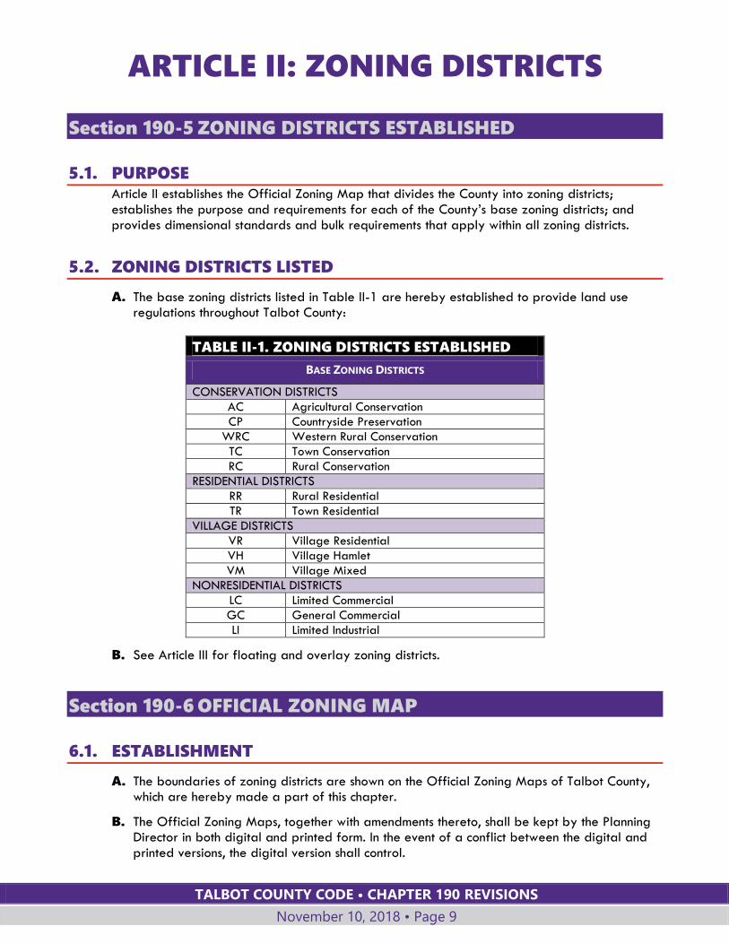
5.2. ZONING DISTRICTS LISTED
A. The base zoning districts listed in Table II-1 are hereby established to provide land use regulations throughout Talbot County:
TABLE II-1. ZONING DISTRICTS ESTABLISHED
BASE ZONING DISTRICTS
CONSERVATION DISTRICTS
AC Agricultural Conservation
CP Countryside Preservation
WRC Western Rural Conservation
TC Town Conservation
RC Rural Conservation
RESIDENTIAL DISTRICTS
RR Rural Residential
TR Town Residential
VILLAGE DISTRICTS
VR Village Residential
VH Village Hamlet
VM Village Mixed
NONRESIDENTIAL DISTRICTS
LC Limited Commercial
GC General Commercial
LI Limited Industrial
B. See Article III for floating and overlay zoning districts.
Section 190-6 OFFICIAL ZONING MAP
6.1. ESTABLISHMENT
A. The boundaries of zoning districts are shown on the Official Zoning Maps of Talbot County, which are hereby made a part of this chapter.
B. The Official Zoning Maps, together with amendments thereto, shall be kept by the Planning Director in both digital and printed form. In the event of a conflict between the digital and printed versions, the digital version shall control.
TALBOT COUNTY CODE • CHAPTER 190 REVISIONS
November 10, 2018 • Page 10
C. The Department of Planning and Zoning shall ensure that, where applicable, each project submittal utilizes the digitally generated, georeferenced Critical Area boundary, as shown on the Official Zoning Maps of Talbot County, Maryland (Digital Version).
6.2. INTERPRETATION OF BOUNDARIES
A. DETERMINATION BY PLANNING DIRECTOR
Upon written request from a property owner, the Planning Director shall issue a determination on the location of a zoning district boundary, in accordance with the provisions of Subsection B below.
B. INTERPRETATION OF DISTRICT BOUNDARIES
Where uncertainty exists as to the boundaries of districts shown on the Official Zoning Maps, the following rules shall apply:
1. Boundaries indicated as approximately following the centerlines of existing or proposed streets, highways, alleys, or waterways shall be construed as following such centerlines.
2. Boundaries indicated as approximately following property lines or election district boundary lines shall be construed as following such property lines or election district boundary lines.
3. Boundaries indicated as following approximately the incorporated limits of municipalities shall be construed as following such incorporated limits.
4. Boundaries indicated as approximately following County boundary lines shall be construed as following such County boundary lines.
5. Wherever a district adjoins a river or other body of water, the zone boundary line shall be deemed to extend to the center line of such body of water.
6. Boundaries indicated as parallel to or extensions of features indicated in Subsections B.1 through B.5 above shall be so construed.
7. Where a boundary line is indicated as obviously not coinciding with property lines, centerlines, municipal incorporation limits or other features as indicated in Subsection B.1 through B.6 above, the boundary shall be scaled from the Official Zoning Map.
8. For other circumstances not covered above, the Planning Director shall determine the zoning district boundary after considering the recommendation of the Planning Commission.
C. PARCELS DIVIDED BY CRITICAL AREA BOUNDARY
1. Parcels that are divided by the Critical Area boundary and are partially in the Rural -Conservation or Rural Residential Zoning District:
a. If a smaller portion of a divided property is less than two acres in area, it is subject to the same zoning district as the larger portion. However, all requirements of the Critical Area Overlay District still apply to the Critical Area portion.
b. If the smaller portion is two acres or larger, the parcel is subject to two zoning districts, the zoning district for the portion outside the Critical Area and the zoning district for the portion inside the Critical Area.
2. Parcels that are divided by the Critical Area boundary and are partially in any other district:
TALBOT COUNTY CODE • CHAPTER 190 REVISIONS
November 10, 2018 • Page 11
a. If a smaller portion of a divided property is less than one acre in area, it is subject to the same zoning district as the larger portion. However, all requirements of the Critical Area Overlay Districts still apply to the Critical Area portion.
b. If the smaller portion is one acre or larger, the parcel is subject to two zoning districts, the zoning district for the portion outside the Critical Area and the zoning district for the portion inside the Critical Area.
Section 190-7 RESERVED
Section 190-8 CONSERVATION DISTRICTS
8.1. AGRICULTURAL CONSERVATION (AC)
A. PURPOSE
The AC District is characterized by rural agricultural and low-density residential uses. This district provides a full range of agricultural activities, forestry, agribusiness uses and limited single-family residential development. Development in this district shall:
1. Maintain and, wherever possible, improve the quality of runoff and groundwater entering the Chesapeake Bay and its tributary streams;
2. Conserve and protect agricultural lands and uses;
3. Protect environmentally sensitive lands; and
4. Preserve rural character through conservation of open space and agricultural lands.
B. SUBDIVISION STANDARDS
Subdivisions shall comply with the following standards:
1. §190-8.6, Conservation Subdivision Design Standards;
2. §190-8.7, Density Calculations for Conservation Subdivisions; and,
3. §190-8.8, Cluster Subdivision Standards.
C. DENSITY AND BULK REQUIREMENTS
TABLE II-2. AC DISTRICT DENSITY AND BULK REQUIREMENTS
TYPE OF REQUIREMENT REQUIREMENT
1. Maximum Density See §190-8.7 for additional requirements for calculating density
a. Original parcel less than 6 acres
1 dwelling unit per 2 acres
b. Original parcel 6 acres or larger
3 dwelling units plus 1 dwelling unit per 20 acres
2. Minimum Lot Dimensions
a. Lot Size 1 acre
b. Lot Width 100 feet
3. Minimum Setbacks See supplemental setback requirements in §190-12.2.
Lots 2 acres or larger Lots less than 2 acres
a. Front 50 feet 50 feet
TALBOT COUNTY CODE • CHAPTER 190 REVISIONS
November 10, 2018 • Page 12
b. Side 50 feet 15 feet
c. Rear 50 feet 25 feet
4. Height See § 190-12.1
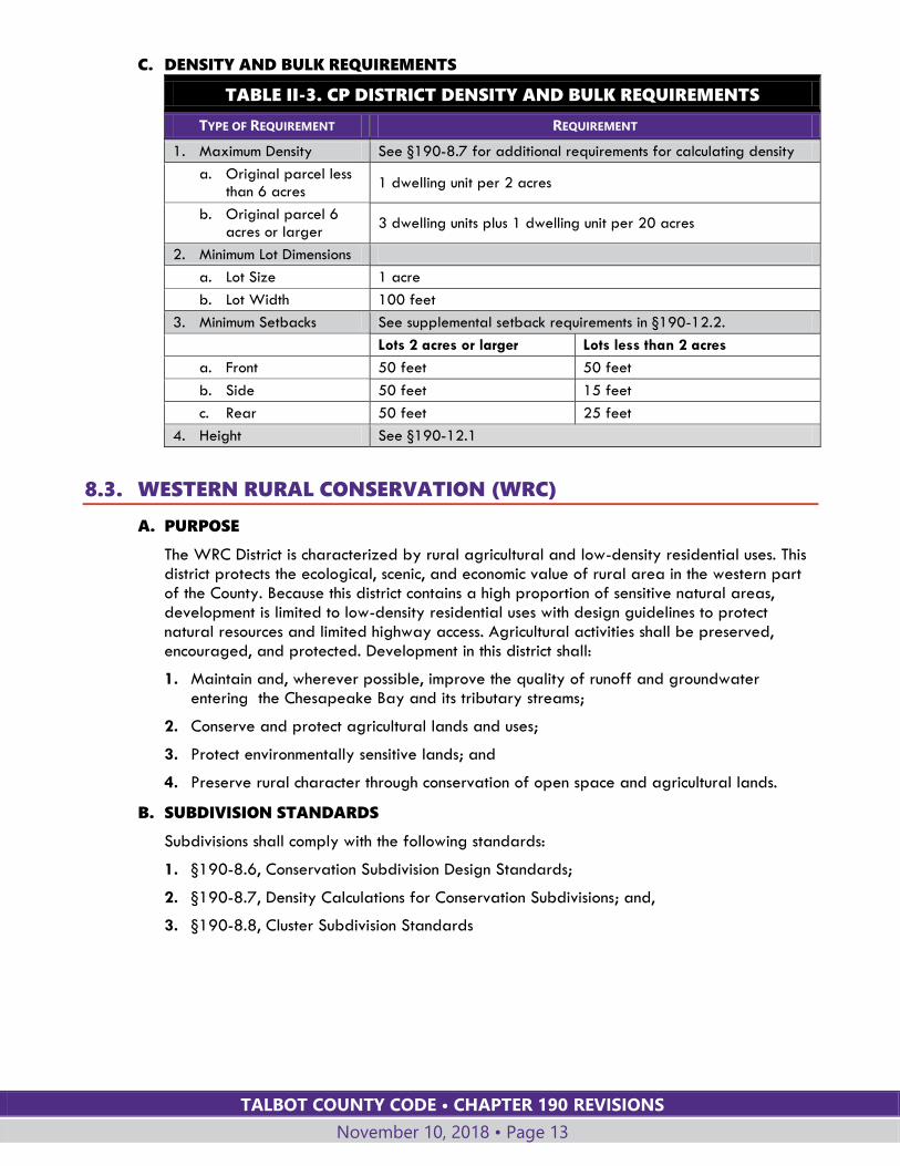
8.2. COUNTRYSIDE PRESERVATION (CP)
A. PURPOSE
The CP District is characterized by rural agricultural and low-density residential uses. This district protects the rural character of land bordering the growth areas of incorporated towns; protects farmland, forests, and open spaces, prevents sprawl, and provides physical and visual boundaries to growth areas. Land within this district should be targeted for permanent protection by creation of agricultural and conservation easements; agricultural activities shall be preserved, encouraged and protected. Development in this district shall:
1. Maintain and, wherever possible, improve the quality of runoff and groundwater entering the Chesapeake Bay and its tributary streams;
2. Conserve and protect agricultural lands and uses;
3. Protect environmentally sensitive lands; and
4. Preserve rural character through conservation of open space and agricultural lands.
B. SUBDIVISION STANDARDS
Subdivisions shall comply with the following standards:
1. §190-8.6, Conservation Subdivision Design Standards;
2. §190-8.7, Density Calculations for Conservation Subdivisions; and,
3. §190-8.8, Cluster Subdivision Standards.
TALBOT COUNTY CODE • CHAPTER 190 REVISIONS
November 10, 2018 • Page 13
C. DENSITY AND BULK REQUIREMENTS
TABLE II-3. CP DISTRICT DENSITY AND BULK REQUIREMENTS
TYPE OF REQUIREMENT REQUIREMENT
1. Maximum Density See §190-8.7 for additional requirements for calculating density
a. Original parcel less than 6 acres
1 dwelling unit per 2 acres
b. Original parcel 6 acres or larger
3 dwelling units plus 1 dwelling unit per 20 acres
2. Minimum Lot Dimensions
a. Lot Size 1 acre
b. Lot Width 100 feet
3. Minimum Setbacks See supplemental setback requirements in §190-12.2.
Lots 2 acres or larger Lots less than 2 acres
a. Front 50 feet 50 feet
b. Side 50 feet 15 feet
c. Rear 50 feet 25 feet
4. Height See §190-12.1
8.3. WESTERN RURAL CONSERVATION (WRC)
A. PURPOSE
The WRC District is characterized by rural agricultural and low-density residential uses. This district protects the ecological, scenic, and economic value of rural area in the western part of the County. Because this district contains a high proportion of sensitive natural areas, development is limited to low-density residential uses with design guidelines to protect natural resources and limited highway access. Agricultural activities shall be preserved, encouraged, and protected. Development in this district shall:
1. Maintain and, wherever possible, improve the quality of runoff and groundwater entering the Chesapeake Bay and its tributary streams;
2. Conserve and protect agricultural lands and uses;
3. Protect environmentally sensitive lands; and
4. Preserve rural character through conservation of open space and agricultural lands.
B. SUBDIVISION STANDARDS
Subdivisions shall comply with the following standards:
1. §190-8.6, Conservation Subdivision Design Standards;
2. §190-8.7, Density Calculations for Conservation Subdivisions; and,
3. §190-8.8, Cluster Subdivision Standards
TALBOT COUNTY CODE • CHAPTER 190 REVISIONS
November 10, 2018 • Page 14
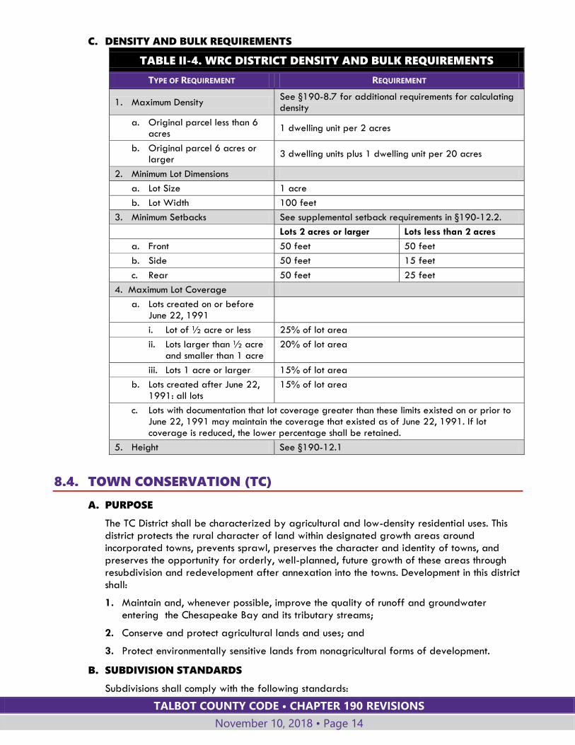
C. DENSITY AND BULK REQUIREMENTS
TABLE II-4. WRC DISTRICT DENSITY AND BULK REQUIREMENTS
TYPE OF REQUIREMENT REQUIREMENT
1. Maximum Density See §190-8.7 for additional requirements for calculating density
a. Original parcel less than 6 acres
1 dwelling unit per 2 acres
b. Original parcel 6 acres or larger
3 dwelling units plus 1 dwelling unit per 20 acres
2. Minimum Lot Dimensions
a. Lot Size 1 acre
b. Lot Width 100 feet
3. Minimum Setbacks See supplemental setback requirements in §190-12.2.
Lots 2 acres or larger Lots less than 2 acres
a. Front 50 feet 50 feet
b. Side 50 feet 15 feet
c. Rear 50 feet 25 feet
4. Maximum Lot Coverage
a. Lots created on or before June 22, 1991
i. Lot of ½ acre or less 25% of lot area
ii. Lots larger than ½ acre and smaller than 1 acre
20% of lot area
iii. Lots 1 acre or larger 15% of lot area
b. Lots created after June 22, 1991: all lots
15% of lot area
c. Lots with documentation that lot coverage greater than these limits existed on or prior to June 22, 1991 may maintain the coverage that existed as of June 22, 1991. If lot coverage is reduced, the lower percentage shall be retained.
5. Height See §190-12.1
8.4. TOWN CONSERVATION (TC)
A. PURPOSE
The TC District shall be characterized by agricultural and low-density residential uses. This district protects the rural character of land within designated growth areas around incorporated towns, prevents sprawl, preserves the character and identity of towns, and preserves the opportunity for orderly, well-planned, future growth of these areas through resubdivision and redevelopment after annexation into the towns. Development in this district shall:
1. Maintain and, whenever possible, improve the quality of runoff and groundwater entering the Chesapeake Bay and its tributary streams;
2. Conserve and protect agricultural lands and uses; and
3. Protect environmentally sensitive lands from nonagricultural forms of development.
B. SUBDIVISION STANDARDS
Subdivisions shall comply with the following standards:
TALBOT COUNTY CODE • CHAPTER 190 REVISIONS
November 10, 2018 • Page 15
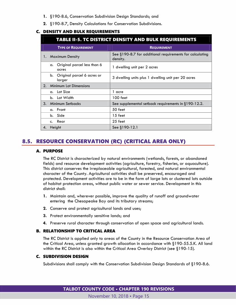
1. §190-8.6, Conservation Subdivision Design Standards; and
2. §190-8.7, Density Calculations for Conservation Subdivisions.
C. DENSITY AND BULK REQUIREMENTS
TABLE II-5. TC DISTRICT DENSITY AND BULK REQUIREMENTS
TYPE OF REQUIREMENT REQUIREMENT
1. Maximum Density See §190-8.7 for additional requirements for calculating density.
a. Original parcel less than 6 acres
1 dwelling unit per 2 acres
b. Original parcel 6 acres or larger
3 dwelling units plus 1 dwelling unit per 20 acres
2. Minimum Lot Dimensions
a. Lot Size 1 acre
b. Lot Width 100 feet
3. Minimum Setbacks See supplemental setback requirements in §190-12.2.
a. Front 50 feet
b. Side 15 feet
c. Rear 25 feet
4. Height See §190-12.1
8.5. RESOURCE CONSERVATION (RC) (CRITICAL AREA ONLY)
A. PURPOSE
The RC District is characterized by natural environments (wetlands, forests, or abandoned fields) and resource development activities (agriculture, forestry, fisheries, or aquaculture). This district conserves the irreplaceable agricultural, forested, and natural environmental character of the County. Agricultural activities shall be preserved, encouraged and protected. Development activities are to be in the form of large lots or clustered lots outside of habitat protection areas, without public water or sewer service. Development in this district shall:
1. Maintain and, wherever possible, improve the quality of runoff and groundwater entering the Chesapeake Bay and its tributary streams;
2. Conserve and protect agricultural lands and uses;
3. Protect environmentally sensitive lands; and
4. Preserve rural character through conservation of open space and agricultural lands.
B. RELATIONSHIP TO CRITICAL AREA
The RC District is applied only to areas of the County in the Resource Conservation Area of the Critical Area, unless granted growth allocation in accordance with §190-55.5.K. All land within the RC District is also within the Critical Area Overlay District (see §190-15).
C. SUBDIVISION DESIGN
Subdivisions shall comply with the Conservation Subdivision Design Standards of §190-8.6.
TALBOT COUNTY CODE • CHAPTER 190 REVISIONS
November 10, 2018 • Page 16
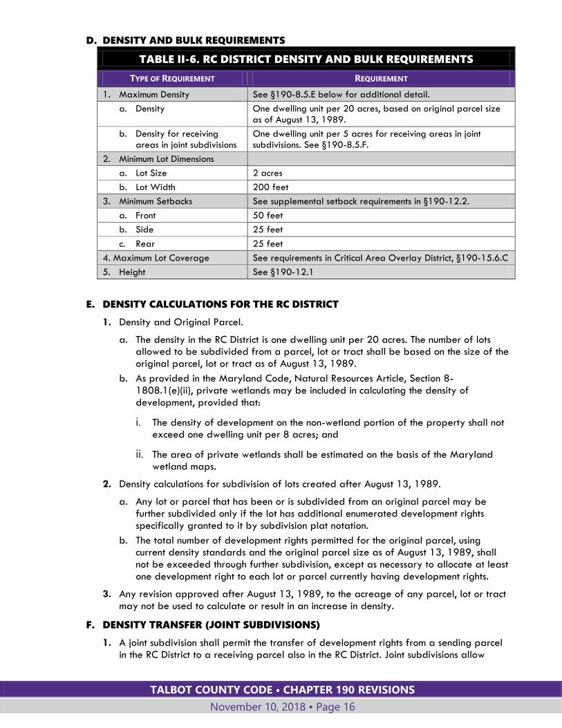
D. DENSITY AND BULK REQUIREMENTS
TABLE II-6. RC DISTRICT DENSITY AND BULK REQUIREMENTS
TYPE OF REQUIREMENT REQUIREMENT
1. Maximum Density See §190-8.5.E below for additional detail.
a. Density One dwelling unit per 20 acres, based on original parcel size as of August 13, 1989.
b. Density for receiving areas in joint subdivisions
One dwelling unit per 5 acres for receiving areas in joint subdivisions. See §190-8.5.F.
2. Minimum Lot Dimensions
a. Lot Size 2 acres
b. Lot Width 200 feet
3. Minimum Setbacks See supplemental setback requirements in §190-12.2.
a. Front 50 feet
b. Side 25 feet
c. Rear 25 feet
4. Maximum Lot Coverage See requirements in Critical Area Overlay District, §190-15.6.C
5. Height See §190-12.1
E. DENSITY CALCULATIONS FOR THE RC DISTRICT
1. Density and Original Parcel.
a. The density in the RC District is one dwelling unit per 20 acres. The number of lots allowed to be subdivided from a parcel, lot or tract shall be based on the size of the original parcel, lot or tract as of August 13, 1989.
b. As provided in the Maryland Code, Natural Resources Article, Section 8-1808.1(e)(ii), private wetlands may be included in calculating the density of development, provided that:
i. The density of development on the non-wetland portion of the property shall not exceed one dwelling unit per 8 acres; and
ii. The area of private wetlands shall be estimated on the basis of the Maryland wetland maps.
2. Density calculations for subdivision of lots created after August 13, 1989.
a. Any lot or parcel that has been or is subdivided from an original parcel may be further subdivided only if the lot has additional enumerated development rights specifically granted to it by subdivision plat notation.
b. The total number of development rights permitted for the original parcel, using current density standards and the original parcel size as of August 13, 1989, shall not be exceeded through further subdivision, except as necessary to allocate at least one development right to each lot or parcel currently having development rights.
3. Any revision approved after August 13, 1989, to the acreage of any parcel, lot or tract may not be used to calculate or result in an increase in density.
F. DENSITY TRANSFER (JOINT SUBDIVISIONS)
1. A joint subdivision shall permit the transfer of development rights from a sending parcel in the RC District to a receiving parcel also in the RC District. Joint subdivisions allow

TALBOT COUNTY CODE • CHAPTER 190 REVISIONS
November 10, 2018 • Page 17
residential development rights to be transferred to parcels with eroding shorelines, subject to implementation of measures that achieve shoreline stabilization.
2. Joint subdivisions shall be processed and approved in the same manner as other subdivisions.
3. The sending area must be located within one of the following areas, excluding portions of these areas that are within 500 feet (measured landward) of shoreline with an erosion rate of at least two feet per year and adjacent shoreline within 100 feet on both sides:
a. Plant and wildlife habitat areas;
b. Drainage basins of anadromous fish propagation waters; or
c. Natural park or recreation open space sites.
4. The receiving area must be located within 500 feet (measured landward) of shoreline with an erosion rate of at least two feet per year, including adjacent shoreline within 100 feet on both sides.
5. The maximum density on the receiving parcel, including both preexisting development rights and transferred development rights, is one dwelling unit per five acres. The total area of the receiving parcel(s) is used for calculating the one-dwelling-unit-per-five-acre density.
6. Dwelling units erected on the receiving parcel(s) by reason of the transferred development rights must be placed within 500 feet, measured landward, from the shoreline with an erosion rate of at least two feet per year, including adjacent shoreline within 100 feet on both sides.
7. The joint subdivision approval shall be conditioned upon satisfactory arrangements for the protection of the eroding shoreline on the receiving parcel, and permanent protection of at least 20 acres of property in the sending area for each development right transferred to receiving parcel(s).
8. The protection from future development of acreage in the sending area shall be accomplished through recordation of a reserved land agreement or reservation of development rights as deemed appropriate by the Planning Director.
G. INTRAFAMILY TRANSFERS IN THE RC DISTRICT
Notwithstanding the density limits in the RC District, a lot of record that remains in the same configuration and ownership as of March 1, 1986, located in the RC District may subdivide the lot by means of a bona fide intrafamily transfer subject to the following limits:
1. A parcel that is at least seven acres and less than 12 acres may be subdivided into not more than two lots, with the newly created lot subject to the intrafamily transfer restrictions established in this Section.
2. A parcel that is at least 12 acres and less than 40 acres in size may be subdivided into not more than three lots, with the two newly created lots subject to the intrafamily transfer restrictions established in this Section. A parcel at least 40 and less than 60 acres may be subdivided into not more than three lots, with one of the newly created lots subject to the intrafamily transfer restrictions established in this Section. The lots may be created at different times provided the intrafamily provision is utilized for all lots created after March 1, 1986.
3. A lot created by means of an intrafamily transfer may be transferred only to a member of the owner's immediate family for the purpose of establishing a residence for that family member. For the purposes of this Section, "immediate family" means a father,
TALBOT COUNTY CODE • CHAPTER 190 REVISIONS
November 10, 2018 • Page 18
mother, son, daughter, sibling, grandfather, grandmother, grandson, or granddaughter who has attained the age of 21 years.
4. Only the recipient of a lot created through an intrafamily transfer may request a building permit for a structure on a lot created through this process. The building permit application for a primary residential structure must be filed with the final subdivision plat creating the lot. The residential structure must be completed within 18 months of the permit approval. A single extension of this time period, not to exceed 18 months, may be granted by the Planning Commission.
5. A lot created through intrafamily transfer shall not be rented or leased to any party except for a member of the owner's immediate family; shall not be further subdivided; and is not eligible for joint subdivision.
6. A lot created through intrafamily transfer shall not be conveyed subsequently to any person other than a member of the owner's immediate family (except for a conveyance to a third party as security for a mortgage or deed of trust and except for a conveyance resulting from court proceedings, including bankruptcy, divorce, mental competency, probate, foreclosure, etc., or from the disposition of a will). A variance from this limitation may be obtained from the Board of Appeals with the applicant showing that:
a. The lot was created as part of a bona fide intrafamily transfer and not with the intent of subdividing the original parcel for the purpose of ultimate commercial sale; and
b. A change in circumstances has occurred since the original transfer was made that is not inconsistent with this Section and warrants an exception. Changes in circumstances include situations where the intrafamily transfer recipient has not resided in the County for five years prior to application for a variance or suffers significant financial hardship. The Board may define such hardship as being unable to meet all financial obligations for the preceding six months.
7. Any deed for a lot created by intrafamily transfer shall contain a covenant stating that the lot is created subject to the provisions of this Section.
8. The restrictions in Subsection G.3 through 7 above apply only to the lots created pursuant to the intrafamily transfer provisions and not to the remaining land or to lots not created through intrafamily transfer.
9. The remaining portion of the original parcel shall not be conveyed to a different owner until the primary residential structures on lots created through intrafamily transfer have been completed and occupied.
8.6. CONSERVATION SUBDIVISION DESIGN STANDARDS Within the Conservation Districts, the following design standards shall be applied to subdivisions to conserve farmland and natural resources.
A. Subdivisions shall be designed and the lots located in a way that preserves the agricultural and open space integrity of the remainder of the property and retains contiguous areas of farmland or forest. This standard governs location and design of all lots, whether clustered or not.
B. Development shall locate lots and subdivision roads to avoid conflicts with existing farming operations through separation and preservation of existing natural buffers.
C. Particularly in the CP District, development should be sited to preserve the rural landscape views from County and state roads.
TALBOT COUNTY CODE • CHAPTER 190 REVISIONS
November 10, 2018 • Page 19
D. Residential lots and structures shall be located in the fringe edges of woodlands and fields to the fullest extent possible.
E. Landscapes shall be preserved in their natural state to the fullest practical extent. Tree and soil removal shall be minimized. Topography, drainage ways, tree cover and other natural features shall be given priority as fixed design determinants rather than elements to be changed to follow a preferred development plan.
F. Areas with environmental constraints may be included to calculate density, but development shall minimize disturbance of these areas and their buffers to the fullest practical extent.
G. Subdivision plats shall contain plat notes to notify all lot owners that:
1. They have no recourse against the inherent effects of agricultural operations conducted in accordance with commonly accepted agricultural practices;
2. These effects may include, but are not limited to, noise, odor, vibration, fumes, dust or glare; and
3. Chapter 128, Right to Farm, Talbot County Code, protects agricultural operations on all agricultural land in the County.
H. Proposed subdivisions shall include a concept plan for the entire parcel or project showing potential future development. The concept plan is nonbinding.
8.7. DENSITY CALCULATIONS FOR CONSERVATION SUBDIVISIONS The following method of calculation applies to subdivisions in the AC, CP, WRC and TC Districts. See §8.5.E for RC District density calculations.
A. ORIGINAL PARCEL
The density and number of lots allowed to be subdivided from a parcel, lot, or tract shall be based on the size of the original parcel, lot, or tract as of June 22, 1991.
B. FURTHER SUBDIVISION
1. Any lot or parcel that has been or is subdivided from an original parcel may be further subdivided only if the lot has additional enumerated development rights specifically granted to it by subdivision plat notation.
C. DENSITY CALCULATIONS FOR SUBDIVISION OF LOTS CREATED AFTER JUNE 22,
1991:
1. If the subdivision that created the lot or parcel was based on an allowed density greater than the current density, the development rights that were specifically granted to the lot by the plat shall be adjusted to reflect current density requirements through the following calculation:
a. Calculate the development rights for the original parcel based on the current density requirements of this article and the acreage of the original parcel on June 22, 1991.
b. Calculate the development rights for the original parcel based on the density standard used for the prior recorded subdivision and the acreage of the original parcel on June 22, 1991.
c. Divide the development rights based on current density by the development rights based on the June 22, 1991, regulations to obtain the development rights factor.
d. Multiply the enumerated development rights granted on the plat by the development rights factor. This product equals the number of available development rights for the lot.
TALBOT COUNTY CODE • CHAPTER 190 REVISIONS
November 10, 2018 • Page 20
e. No lot, parcel, or tract shall be allocated less than one development right. Development rights shall be allocated in whole numbers, with fractional development rights of 0.50 or greater rounded up to the nearest whole number.
2. The total number of development rights permitted for the original parcel, using current density standards and the original parcel size as of June 22, 1991, shall not be exceeded through further subdivision, except as necessary to allocate at least one development right to each lot or parcel currently having development rights and to round up fractional development rights greater than 0.50.
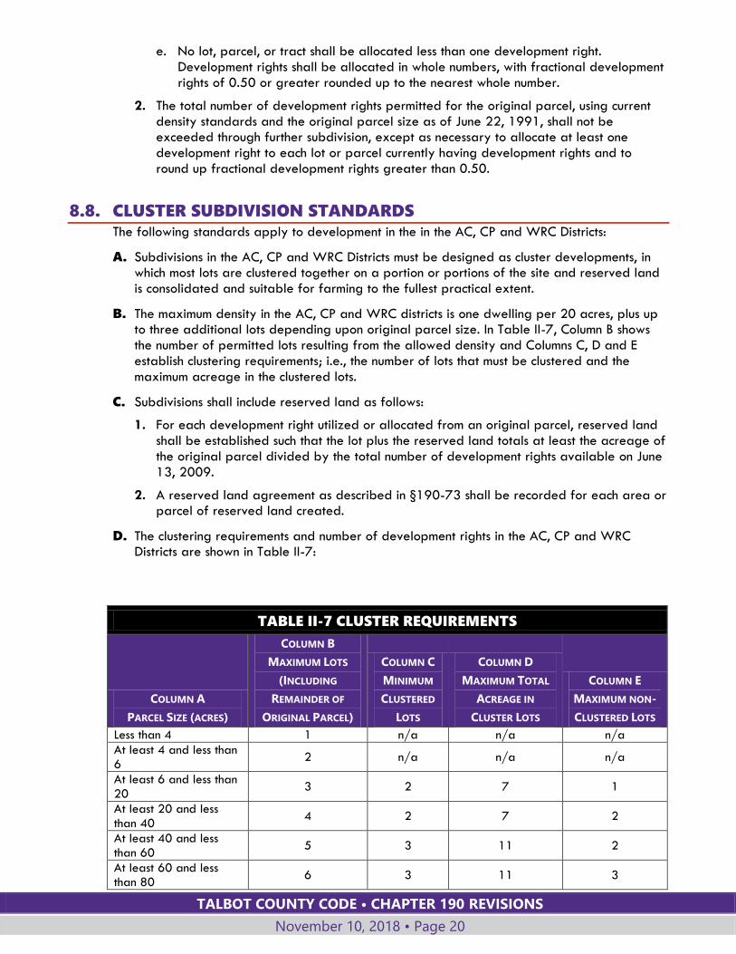
8.8. CLUSTER SUBDIVISION STANDARDS The following standards apply to development in the in the AC, CP and WRC Districts:
A. Subdivisions in the AC, CP and WRC Districts must be designed as cluster developments, in which most lots are clustered together on a portion or portions of the site and reserved land is consolidated and suitable for farming to the fullest practical extent.
B. The maximum density in the AC, CP and WRC districts is one dwelling per 20 acres, plus up to three additional lots depending upon original parcel size. In Table II-7, Column B shows the number of permitted lots resulting from the allowed density and Columns C, D and E establish clustering requirements; i.e., the number of lots that must be clustered and the maximum acreage in the clustered lots.
C. Subdivisions shall include reserved land as follows:
1. For each development right utilized or allocated from an original parcel, reserved land shall be established such that the lot plus the reserved land totals at least the acreage of the original parcel divided by the total number of development rights available on June 13, 2009.
2. A reserved land agreement as described in §190-73 shall be recorded for each area or parcel of reserved land created.
D. The clustering requirements and number of development rights in the AC, CP and WRC Districts are shown in Table II-7:
TABLE II-7 CLUSTER REQUIREMENTS
COLUMN A
PARCEL SIZE (ACRES)
COLUMN B
MAXIMUM LOTS
(INCLUDING
REMAINDER OF
ORIGINAL PARCEL)
COLUMN C
MINIMUM
CLUSTERED
LOTS
COLUMN D
MAXIMUM TOTAL
ACREAGE IN
CLUSTER LOTS
COLUMN E
MAXIMUM NON-
CLUSTERED LOTS
Less than 4 1 n/a n/a n/a
At least 4 and less than 6
2 n/a n/a n/a
At least 6 and less than 20
3 2 7 1
At least 20 and less than 40
4 2 7 2
At least 40 and less than 60
5 3 11 2
At least 60 and less than 80
6 3 11 3
TALBOT COUNTY CODE • CHAPTER 190 REVISIONS
November 10, 2018 • Page 21
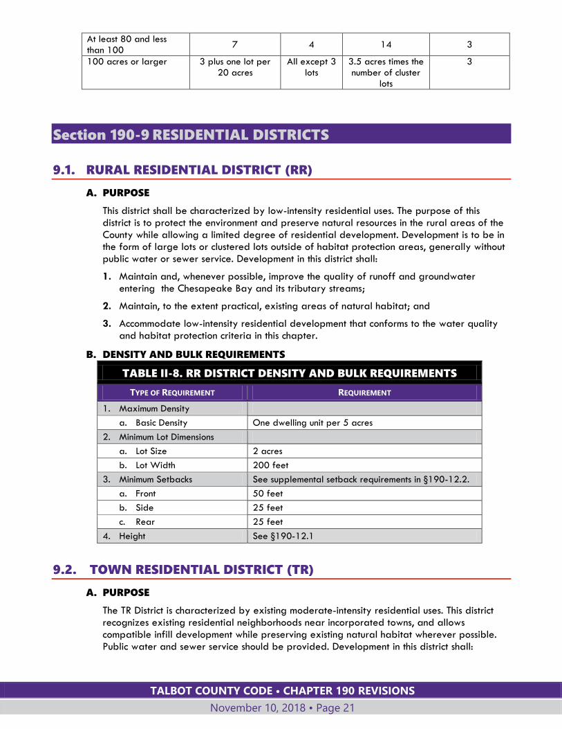
At least 80 and less than 100
7 4 14 3
100 acres or larger 3 plus one lot per 20 acres
All except 3 lots
3.5 acres times the number of cluster
lots
3
Section 190-9 RESIDENTIAL DISTRICTS
9.1. RURAL RESIDENTIAL DISTRICT (RR)
A. PURPOSE
This district shall be characterized by low-intensity residential uses. The purpose of this district is to protect the environment and preserve natural resources in the rural areas of the County while allowing a limited degree of residential development. Development is to be in the form of large lots or clustered lots outside of habitat protection areas, generally without public water or sewer service. Development in this district shall:
1. Maintain and, whenever possible, improve the quality of runoff and groundwater entering the Chesapeake Bay and its tributary streams;
2. Maintain, to the extent practical, existing areas of natural habitat; and
3. Accommodate low-intensity residential development that conforms to the water quality and habitat protection criteria in this chapter.
B. DENSITY AND BULK REQUIREMENTS
TABLE II-8. RR DISTRICT DENSITY AND BULK REQUIREMENTS
TYPE OF REQUIREMENT REQUIREMENT
1. Maximum Density
a. Basic Density One dwelling unit per 5 acres
2. Minimum Lot Dimensions
a. Lot Size 2 acres
b. Lot Width 200 feet
3. Minimum Setbacks See supplemental setback requirements in §190-12.2.
a. Front 50 feet
b. Side 25 feet
c. Rear 25 feet
4. Height See §190-12.1
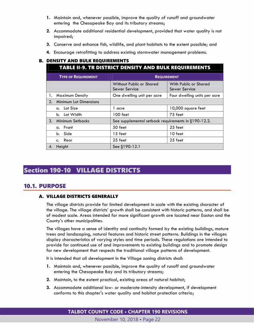
9.2. TOWN RESIDENTIAL DISTRICT (TR)
A. PURPOSE
The TR District is characterized by existing moderate-intensity residential uses. This district recognizes existing residential neighborhoods near incorporated towns, and allows compatible infill development while preserving existing natural habitat wherever possible. Public water and sewer service should be provided. Development in this district shall:
TALBOT COUNTY CODE • CHAPTER 190 REVISIONS
November 10, 2018 • Page 22
1. Maintain and, whenever possible, improve the quality of runoff and groundwater entering the Chesapeake Bay and its tributary streams;
2. Accommodate additional residential development, provided that water quality is not impaired;
3. Conserve and enhance fish, wildlife, and plant habitats to the extent possible; and
4. Encourage retrofitting to address existing stormwater management problems.
B. DENSITY AND BULK REQUIREMENTS
TABLE II-9. TR DISTRICT DENSITY AND BULK REQUIREMENTS
TYPE OF REQUIREMENT REQUIREMENT
Without Public or Shared Sewer Service
With Public or Shared Sewer Service
1. Maximum Density One dwelling unit per acre Four dwelling units per acre
2. Minimum Lot Dimensions
a. Lot Size 1 acre 10,000 square feet
b. Lot Width 100 feet 75 feet
3. Minimum Setbacks See supplemental setback requirements in §190-12.2.
a. Front 50 feet 25 feet
b. Side 15 feet 10 feet
c. Rear 25 feet 25 feet
4. Height See §190-12.1
Section 190-10 VILLAGE DISTRICTS
10.1. PURPOSE
A. VILLAGE DISTRICTS GENERALLY
The village districts provide for limited development in scale with the existing character of the village. The village districts’ growth shall be consistent with historic patterns, and shall be of modest scale. Areas intended for more significant growth are located near Easton and the County’s other municipalities.
The villages have a sense of identity and continuity formed by the existing buildings, mature trees and landscaping, natural features and historic street patterns. Buildings in the villages display characteristics of varying styles and time periods. These regulations are intended to provide for continued use of and improvements to existing buildings and to promote design for new development that respects the traditional village patterns of development.
It is intended that all development in the Village zoning districts shall:
1. Maintain and, whenever possible, improve the quality of runoff and groundwater entering the Chesapeake Bay and its tributary streams;
2. Maintain, to the extent practical, existing areas of natural habitat;
3. Accommodate additional low- or moderate-intensity development, if development conforms to this chapter's water quality and habitat protection criteria;
TALBOT COUNTY CODE • CHAPTER 190 REVISIONS
November 10, 2018 • Page 23
4. Be compatible with and complement the character of the existing community in terms of land use, density, scale, setbacks, site layout, mix of use, and general design to maintain the villages’ unique “sense of place”;
5. Maintain densities that reflect village lot sizes existing after zoning boundary modifications. Existing dwelling units per acre and other factors will be considered through the rezoning process, keeping in mind the unique character of each village or portion thereof; and
6. Where needed, be granted sewer connection consistent with allocation policies in Water Quality Strategy Areas Tier III-B to resolve failing, inadequate and substandard septic systems within villages and allow for infill, redevelopment and new development on existing lots of record.
B. VILLAGE MIXED (VM)
The Village Mixed District provides for low- or moderate-intensity residential and commercial uses. This district may contain a mixture of residential, commercial, and maritime/agricultural service uses. The commercial and service uses serve residents of the village and nearby areas, and may include heritage tourism uses to attract visitors. Limited new development is directed to this district so that the environment and natural resources of nearby rural areas are protected and preserved. These districts may have public water and/or sewer service with relatively smaller lots and higher densities than surrounding rural areas.
C. VILLAGE HAMLET (VH)
The Village Hamlet District is characterized by low- or moderate-intensity residential and limited commercial uses. This district is intended for principally residential use, with limited compatible commercial uses that serve residents of the village and nearby areas. The scale and intensity of commercial uses shall comport with the existing development pattern. Limited new residential and suitable commercial development is directed to this district, so that the environment and natural resources of nearby rural areas are protected and preserved. These districts may have public water and/or sewer service with relatively smaller lots and higher densities than surrounding rural areas.
D. VILLAGE RESIDENTIAL (VR)
The Village Residential District provides for low- or moderate-density residential use. Limited new infill residential development is directed to this district, so that the environment and natural resources of nearby rural areas are protected and preserved. These districts may have public water and/or sewer service; however, these services should not be the basis for new development inconsistent with the established scale or character of the Village.
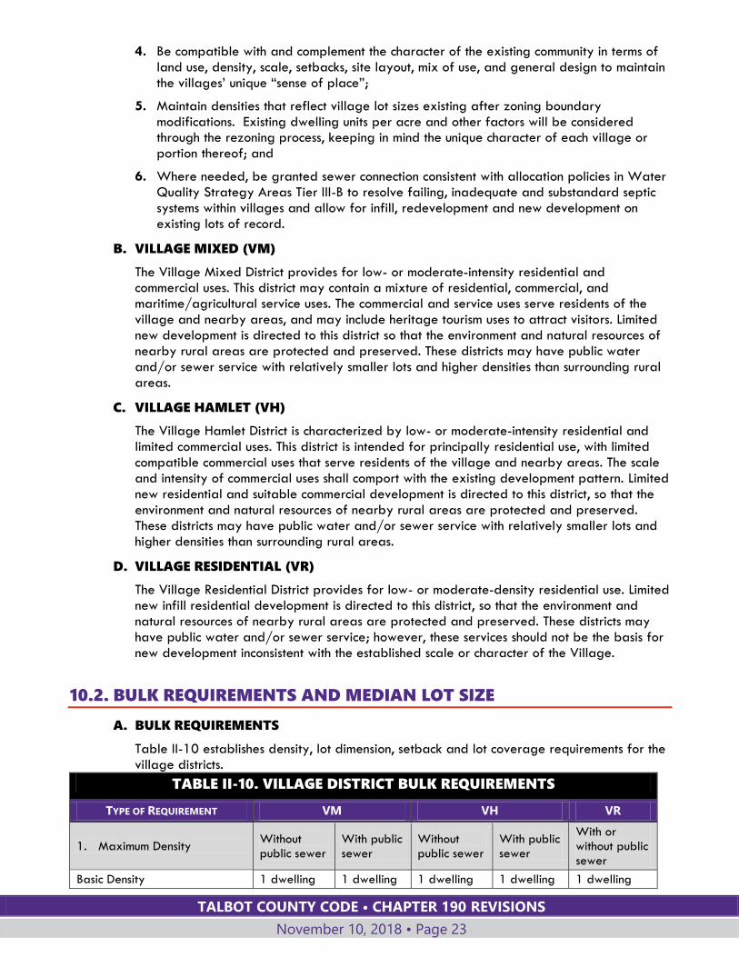
10.2. BULK REQUIREMENTS AND MEDIAN LOT SIZE
A. BULK REQUIREMENTS
Table II-10 establishes density, lot dimension, setback and lot coverage requirements for the village districts.
TABLE II-10. VILLAGE DISTRICT BULK REQUIREMENTS
TYPE OF REQUIREMENT VM VH VR
1. Maximum Density Without public sewer
With public sewer
Without public sewer
With public sewer
With or without public sewer
Basic Density 1 dwelling 1 dwelling 1 dwelling 1 dwelling 1 dwelling

TALBOT COUNTY CODE • CHAPTER 190 REVISIONS
November 10, 2018 • Page 24
TABLE II-10. VILLAGE DISTRICT BULK REQUIREMENTS
TYPE OF REQUIREMENT VM VH VR
per acre per acre per acre per acre per acre
2. Minimum Lot Dimensions
a. Lot Size 1 acre
30,000 square feet
1 acre 30,000 square feet
1 acre
b. Lot Width 100 feet 100 feet 100 feet
3. Minimum Setbacks See supplemental setback requirements in §190-12.2.
a. Front 25 feet 25 feet 25 feet
b. Side
i. From VM, VH and VR Districts
10 feet 10 feet 20 feet
ii. From all other zoning districts
25 feet 25 feet 25 feet
c. Rear 25 feet 25 feet 25 feet
4. Maximum site coverage for all buildings and uses, not including parking areas and access drives:
a. Outside Critical Area 25% 25% 25%
b. Within Critical Area Use Critical Area lot coverage limits (see §190-15.6.C)
5. Height See §190-12.1
B. MEDIAN LOT SIZE
1. New subdivisions using public sewer service shall maintain a median lot size of one acre or less, not including the remaining land.
2. Median lot size may be increased through a waiver petition if approved by the approving authority for the subdivision. The approving authority must find that a larger average lot size will result in a better site design or is necessary due to the site’s physical constraints.
10.3. USE STANDARDS
A. Commercial/industrial uses are to be limited in size. Individual commercial/industrial establishments or businesses that are permitted by right (Article IV, Table IV-1) are limited to:
1. 5,000 square feet of gross floor area, with 1,000 square feet of outdoor display area, in the VM District; and,
2. 2,000 square feet of gross floor area, with no outdoor display area, in the VR and VH Districts.
B. Larger commercial/industrial uses shall be permitted by special exception.
10.4. DESIGN STANDARDS
A. APPLICATION OF STANDARDS
1. The design standards below are to be applied in a manner that achieves the purposes of the district. The Planning Commission or Planning Director, as applicable, shall apply these standards in review of development applications.

TALBOT COUNTY CODE • CHAPTER 190 REVISIONS
November 10, 2018 • Page 25
2. Expansion or alteration of existing buildings or site improvements shall comply with the standards of this §190-10.4 to the extent feasible for the portion of the building or site impacted by the new improvements.
3. The Planning Director may request a recommendation from the Planning Commission on these standards for any application.
B. MASTER PLANS FOR VILLAGE PLANNING AREAS
1. Village Planning Areas consist of Village Mixed and Village Hamlet zoning districts as defined in §190-10. Village Master Plans guide the evaluation of development proposals in Village Planning Areas by describing the village’s character, and the compatibility and suitability of existing and proposed land uses, infrastructure, facilities and services associated with development and redevelopment.
2. Village Master Plans include policies and elements addressing the following: (i) village character; (ii) land use; and, (iii) infrastructure, facilities, and services. Small scale subdivisions, major subdivisions, and major site plans in Village Planning Areas shall be consistent with the policies and elements of the village’s Village Master Plan.
3. The Planning Commission shall be responsible for reviewing consistency with Village Master Plans. This review shall consider the following:
a. Proposed design and layout of development, including features such as the siting and scale of buildings and the placement and design of landscaping, parking, pedestrian pathways, lighting, signs, and other features; and,
b. Compatibility with existing character in terms of land use, density, scale, setbacks, site layout, mix of use, and general design to maintain their unique “sense of place”.
4. If no Village Master Plan has been adopted for a village, the applicant for a small scale subdivision, major subdivision, or major site plan in a Village Planning Area shall submit with the application a comprehensive study addressing compatibility and suitability of the proposed development with existing and proposed land uses, infrastructure, facilities, and services associated with the new development or redevelopment, along with consideration of the elements of subsection 3 a. and b. above, which the Planning Commission shall review in lieu of consistency with the Village Master Plan.
C. SITE DESIGN AND ARCHITECTURAL STANDARDS
The approving authority shall be guided by the following site design requirements and guidelines.
1. Landscaping
a. Mature trees shall be protected during development, especially along roadways.
b. New and replacement trees along roadways should be chosen to diversify the tree species and prevent loss due to disease.
c. For new non-residential development, street trees shall be provided and the front yard areas between the building façade and the street shall be landscaped using a variety of native plantings. This area may be used for seating, canopies or awnings and other amenities.
2. Parking
a. Off-street parking for nonresidential development shall, wherever possible, be located to the rear or side of the building.
b. When off-street parking is provided to the front or side of nonresidential buildings, the parking area shall be separated from the street by a landscaped edge
TALBOT COUNTY CODE • CHAPTER 190 REVISIONS
November 10, 2018 • Page 26
incorporating trees as well as a hedge, fence, wall or shrubs at least two feet in height.
c. When possible, residential garages and parking should be located to the side or rear of the lot.
3. Fences, Display and Storage Areas
a. Walls and fences shall be uniform and compatible with the architectural style and building material of the building.
b. If needed, off-street loading areas shall be provided to the rear of new, nonresidential structures.
c. Outdoor sales or display areas shall be screened from adjacent residentially-zoned land by a solid fence or landscape screen and shall not be located within a setback area or a required landscaped area
d. Commercial outdoor storage areas, exposed machinery, and outdoor areas used for storage and collection of trash shall be located in a side or rear yard, shall not be located within a setback area or required landscaped area, and shall be visually screened from roads and public areas. This does not include the personal property or equipment of watermen, farmers, or other residents who are not regulated as cottage industries.
e. Storage yard requirements for cottage industries are specified in §190-33.5.
4. Sidewalks and Pathways
a. Sidewalks and pedestrian paths or easements for future improvements shall be provided where specified in the Village Master Plan.
b. Pedestrian access connecting buildings and parking areas for nonresidential uses, or dedicated easements for future improvements, shall be provided as feasible based on site characteristics, lot coverage limitations, and stormwater management goals.
c. Sidewalks should be separated from the roadway by a planting strip at least four feet wide where feasible based on right-of-way width.
5. Lighting
a. Street lights and other freestanding lights:
i. Shall have a maximum height of 20 feet to the top of the pole and light fixture combined.
ii. Shall meet the “full cut-off” or “fully shielded” criteria of the Illuminating Engineering Society of North America.
b. All lighting fixtures shall be directed and shielded so that the illumination is directed downward and shielded so that it does not produce glare.
6. Signs
In addition to the sign standards of §190-42, the following standards apply within the village zones.
a. Sign size, materials, color, lettering, placement, and illumination shall respect the character of existing buildings and be designed as an integral architectural element.
b. Signs located above or projecting from the roofline or parapet wall are not permitted.
c. The maximum height of freestanding signs shall be eight feet.
d. Pole-mounted commercial signs are not permitted.
TALBOT COUNTY CODE • CHAPTER 190 REVISIONS
November 10, 2018 • Page 27
e. A non-residential use may have one double-sided monument sign per street frontage, not to exceed 60 square feet per side.
7. Architectural Standards
The following standards apply to new buildings for commercial or institutional use.
a. Buildings shall be designed with architectural details that provide visual interest and contribute to a pedestrian orientation on facades facing a street.
b. Buildings shall have a principal façade with windows and an entry (with operable doors) facing a street. Buildings may have more than one principal façade and/or entry.
c. All sides of a proposed building visible from a roadway or public area shall be of finished quality and consistent in material and style with the front facade.
d. Canopies or awnings may extend into the front setback area a maximum of two feet and shall have a clearance height of at least 8 feet.
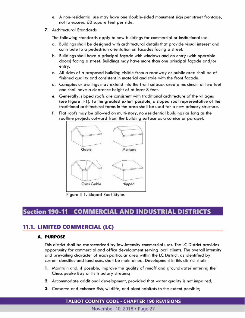
e. Generally, sloped roofs are consistent with traditional architecture of the villages (see Figure II-1). To the greatest extent possible, a sloped roof representative of the traditional architectural forms in the area shall be used for a new primary structure.
f. Flat roofs may be allowed on multi-story, nonresidential buildings as long as the roofline projects outward from the building surface as a cornice or parapet.
Figure II-1. Sloped Roof Styles
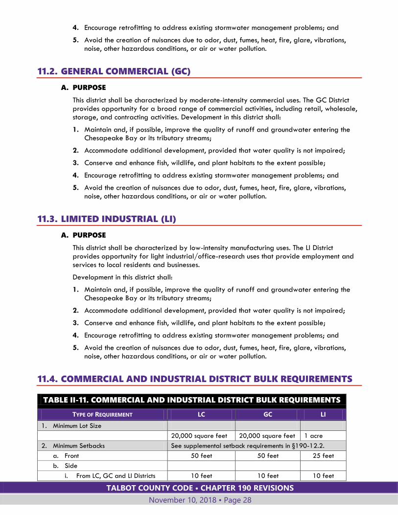
Section 190-11 COMMERCIAL AND INDUSTRIAL DISTRICTS
11.1. LIMITED COMMERCIAL (LC)
A. PURPOSE
This district shall be characterized by low-intensity commercial uses. The LC District provides opportunity for commercial and office development serving local clients. The overall intensity and prevailing character of each particular area within the LC District, as identified by current densities and land uses, shall be maintained. Development in this district shall:
1. Maintain and, if possible, improve the quality of runoff and groundwater entering the Chesapeake Bay or its tributary streams;
2. Accommodate additional development, provided that water quality is not impaired;
3. Conserve and enhance fish, wildlife, and plant habitats to the extent possible;
TALBOT COUNTY CODE • CHAPTER 190 REVISIONS
November 10, 2018 • Page 28
4. Encourage retrofitting to address existing stormwater management problems; and
5. Avoid the creation of nuisances due to odor, dust, fumes, heat, fire, glare, vibrations, noise, other hazardous conditions, or air or water pollution.
11.2. GENERAL COMMERCIAL (GC)
A. PURPOSE
This district shall be characterized by moderate-intensity commercial uses. The GC District provides opportunity for a broad range of commercial activities, including retail, wholesale, storage, and contracting activities. Development in this district shall:
1. Maintain and, if possible, improve the quality of runoff and groundwater entering the Chesapeake Bay or its tributary streams;
2. Accommodate additional development, provided that water quality is not impaired;
3. Conserve and enhance fish, wildlife, and plant habitats to the extent possible;
4. Encourage retrofitting to address existing stormwater management problems; and
5. Avoid the creation of nuisances due to odor, dust, fumes, heat, fire, glare, vibrations, noise, other hazardous conditions, or air or water pollution.
11.3. LIMITED INDUSTRIAL (LI)
A. PURPOSE
This district shall be characterized by low-intensity manufacturing uses. The LI District provides opportunity for light industrial/office-research uses that provide employment and services to local residents and businesses.
Development in this district shall:
1. Maintain and, if possible, improve the quality of runoff and groundwater entering the Chesapeake Bay or its tributary streams;
2. Accommodate additional development, provided that water quality is not impaired;
3. Conserve and enhance fish, wildlife, and plant habitats to the extent possible;
4. Encourage retrofitting to address existing stormwater management problems; and
5. Avoid the creation of nuisances due to odor, dust, fumes, heat, fire, glare, vibrations, noise, other hazardous conditions, or air or water pollution.
11.4. COMMERCIAL AND INDUSTRIAL DISTRICT BULK REQUIREMENTS
TABLE II-11. COMMERCIAL AND INDUSTRIAL DISTRICT BULK REQUIREMENTS
TYPE OF REQUIREMENT LC GC LI
1. Minimum Lot Size
20,000 square feet 20,000 square feet 1 acre
2. Minimum Setbacks See supplemental setback requirements in §190-12.2.
a. Front 50 feet 50 feet 25 feet
b. Side
i. From LC, GC and LI Districts 10 feet 10 feet 10 feet
TALBOT COUNTY CODE • CHAPTER 190 REVISIONS
November 10, 2018 • Page 29
ii. From all other zoning districts 25 feet 25 feet 25 feet
c. Rear
i. From LC, GC and LI Districts 10 feet 10 feet 10 feet
ii. From all other zoning districts 25 feet 25 feet 25 feet
3. Maximum site coverage for all buildings and uses, not including parking areas and access drives:
a. Outside Critical Area 25% 25% 50%
b. Within Critical Area Use Critical Area lot coverage limits
4. Height See §190-12.1
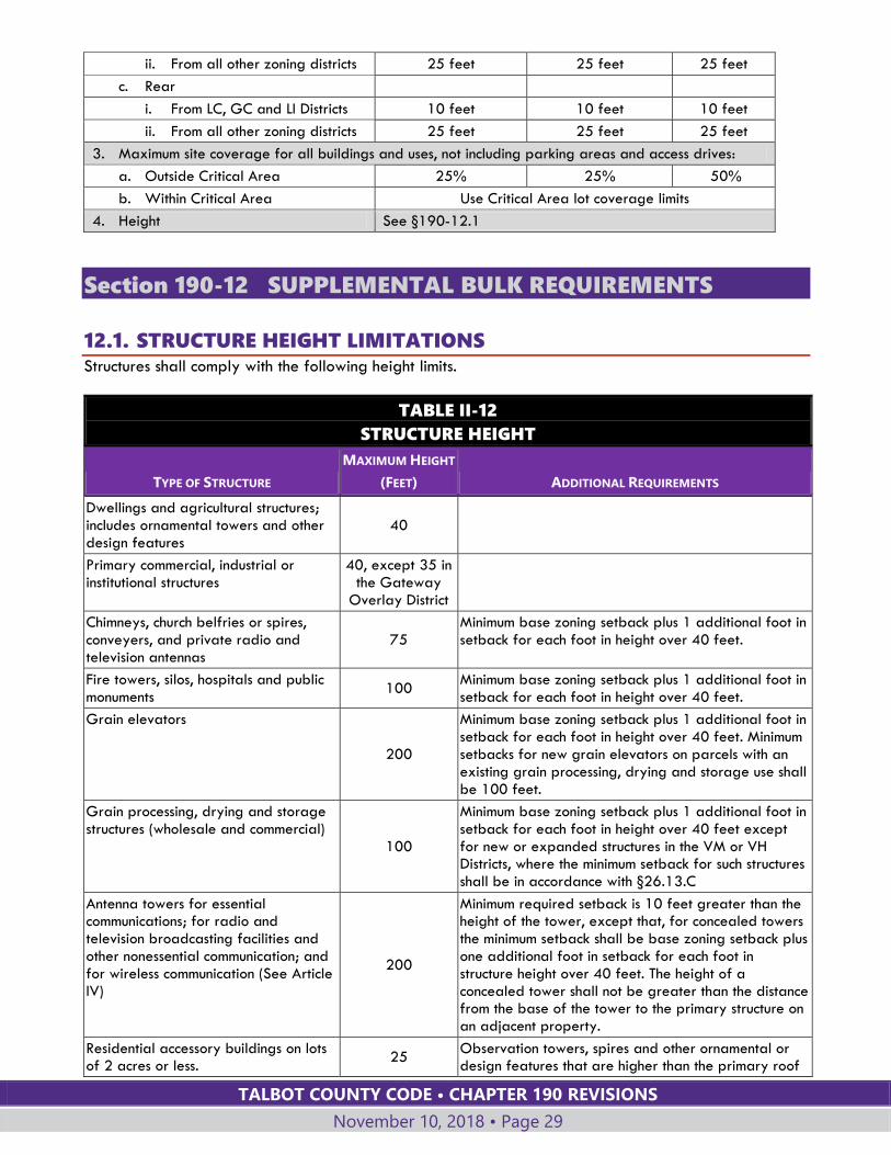
Section 190-12 SUPPLEMENTAL BULK REQUIREMENTS
12.1. STRUCTURE HEIGHT LIMITATIONS Structures shall comply with the following height limits.
TABLE II-12
STRUCTURE HEIGHT
TYPE OF STRUCTURE
MAXIMUM HEIGHT
(FEET) ADDITIONAL REQUIREMENTS
Dwellings and agricultural structures; includes ornamental towers and other design features
40
Primary commercial, industrial or institutional structures
40, except 35 in the Gateway
Overlay District
Chimneys, church belfries or spires, conveyers, and private radio and television antennas
75 Minimum base zoning setback plus 1 additional foot in setback for each foot in height over 40 feet.
Fire towers, silos, hospitals and public monuments
100 Minimum base zoning setback plus 1 additional foot in setback for each foot in height over 40 feet.
Grain elevators
200
Minimum base zoning setback plus 1 additional foot in setback for each foot in height over 40 feet. Minimum setbacks for new grain elevators on parcels with an existing grain processing, drying and storage use shall be 100 feet.
Grain processing, drying and storage structures (wholesale and commercial)
100
Minimum base zoning setback plus 1 additional foot in setback for each foot in height over 40 feet except for new or expanded structures in the VM or VH Districts, where the minimum setback for such structures shall be in accordance with §26.13.C
Antenna towers for essential communications; for radio and television broadcasting facilities and other nonessential communication; and for wireless communication (See Article IV)
200
Minimum required setback is 10 feet greater than the height of the tower, except that, for concealed towers the minimum setback shall be base zoning setback plus one additional foot in setback for each foot in structure height over 40 feet. The height of a concealed tower shall not be greater than the distance from the base of the tower to the primary structure on an adjacent property.
Residential accessory buildings on lots of 2 acres or less.
25 Observation towers, spires and other ornamental or design features that are higher than the primary roof
TALBOT COUNTY CODE • CHAPTER 190 REVISIONS
November 10, 2018 • Page 30
TABLE II-12
STRUCTURE HEIGHT
TYPE OF STRUCTURE
MAXIMUM HEIGHT
(FEET) ADDITIONAL REQUIREMENTS
of an accessory building and do not cover more than 25 percent of the roof area may exceed the 25-foot height limit by no more than 5 feet.
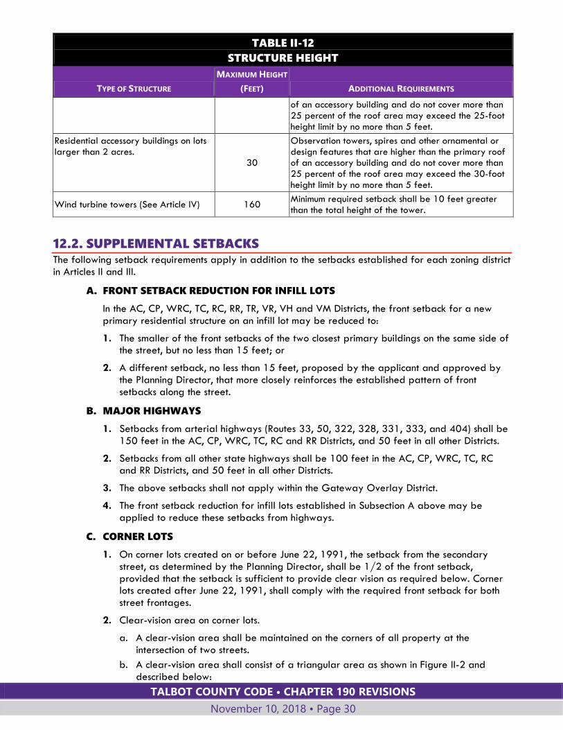
Residential accessory buildings on lots larger than 2 acres.
30
Observation towers, spires and other ornamental or design features that are higher than the primary roof of an accessory building and do not cover more than 25 percent of the roof area may exceed the 30-foot height limit by no more than 5 feet.
Wind turbine towers (See Article IV) 160 Minimum required setback shall be 10 feet greater than the total height of the tower.
12.2. SUPPLEMENTAL SETBACKS The following setback requirements apply in addition to the setbacks established for each zoning district in Articles II and III.
A. FRONT SETBACK REDUCTION FOR INFILL LOTS
In the AC, CP, WRC, TC, RC, RR, TR, VR, VH and VM Districts, the front setback for a new primary residential structure on an infill lot may be reduced to:
1. The smaller of the front setbacks of the two closest primary buildings on the same side of the street, but no less than 15 feet; or
2. A different setback, no less than 15 feet, proposed by the applicant and approved by the Planning Director, that more closely reinforces the established pattern of front setbacks along the street.
B. MAJOR HIGHWAYS
1. Setbacks from arterial highways (Routes 33, 50, 322, 328, 331, 333, and 404) shall be 150 feet in the AC, CP, WRC, TC, RC and RR Districts, and 50 feet in all other Districts.
2. Setbacks from all other state highways shall be 100 feet in the AC, CP, WRC, TC, RC and RR Districts, and 50 feet in all other Districts.
3. The above setbacks shall not apply within the Gateway Overlay District.
4. The front setback reduction for infill lots established in Subsection A above may be applied to reduce these setbacks from highways.
C. CORNER LOTS
1. On corner lots created on or before June 22, 1991, the setback from the secondary street, as determined by the Planning Director, shall be 1/2 of the front setback, provided that the setback is sufficient to provide clear vision as required below. Corner lots created after June 22, 1991, shall comply with the required front setback for both street frontages.
2. Clear-vision area on corner lots.
a. A clear-vision area shall be maintained on the corners of all property at the intersection of two streets.
b. A clear-vision area shall consist of a triangular area as shown in Figure II-2 and described below:

TALBOT COUNTY CODE • CHAPTER 190 REVISIONS
November 10, 2018 • Page 31
i. Two sides of the triangular area are lot lines measured a distance of at least 25 feet from the intersection of the street right-of-way lines (or, if the right-of-way has rounded corners, the lines extended in a straight line to a point of intersection and so measured);
ii. The third side of the triangular area is a line across the corner of the lot joining the nonintersecting ends of the two right-of-way lines.
c. A clear-vision area shall contain no planting, fence, wall, structure, or temporary or permanent obstruction exceeding 2 1/2 feet in height, measured from the established street center-line grade, except that trees exceeding this height may be located in this area, provided that all branches and foliage are removed to a height of eight feet above grade.
Figure II-2 Illustration of Clear Vision Area at Intersection
D. THROUGH LOTS
For a through lot which lies between two streets, a front setback shall be required from both streets.
E. SETBACK MEASURED FROM RIGHT-OF-WAY
If a lot includes all or part of the right-of-way of a street or road, the setback shall be measured from the nearest edge of the road right-of-way or road easement.
F. NONCONFORMITIES
For structures nonconforming to required setbacks, see nonconforming structure provisions of §190-50.
TALBOT COUNTY CODE • CHAPTER 190 REVISIONS
November 10, 2018 • Page 32
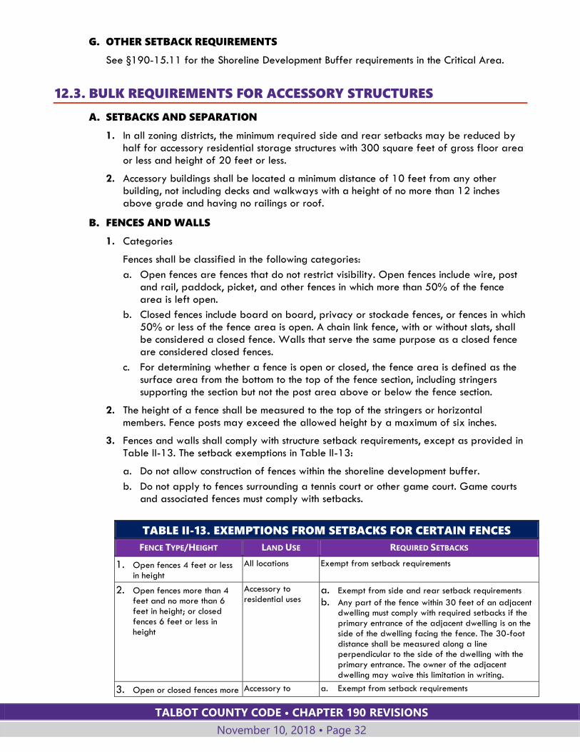
G. OTHER SETBACK REQUIREMENTS
See §190-15.11 for the Shoreline Development Buffer requirements in the Critical Area.
12.3. BULK REQUIREMENTS FOR ACCESSORY STRUCTURES
A. SETBACKS AND SEPARATION
1. In all zoning districts, the minimum required side and rear setbacks may be reduced by half for accessory residential storage structures with 300 square feet of gross floor area or less and height of 20 feet or less.
2. Accessory buildings shall be located a minimum distance of 10 feet from any other building, not including decks and walkways with a height of no more than 12 inches above grade and having no railings or roof.
B. FENCES AND WALLS
1. Categories
Fences shall be classified in the following categories:
a. Open fences are fences that do not restrict visibility. Open fences include wire, post and rail, paddock, picket, and other fences in which more than 50% of the fence area is left open.
b. Closed fences include board on board, privacy or stockade fences, or fences in which 50% or less of the fence area is open. A chain link fence, with or without slats, shall be considered a closed fence. Walls that serve the same purpose as a closed fence are considered closed fences.
c. For determining whether a fence is open or closed, the fence area is defined as the surface area from the bottom to the top of the fence section, including stringers supporting the section but not the post area above or below the fence section.
2. The height of a fence shall be measured to the top of the stringers or horizontal members. Fence posts may exceed the allowed height by a maximum of six inches.
3. Fences and walls shall comply with structure setback requirements, except as provided in Table II-13. The setback exemptions in Table II-13:
a. Do not allow construction of fences within the shoreline development buffer.
b. Do not apply to fences surrounding a tennis court or other game court. Game courts and associated fences must comply with setbacks.
TABLE II-13. EXEMPTIONS FROM SETBACKS FOR CERTAIN FENCES
FENCE TYPE/HEIGHT LAND USE REQUIRED SETBACKS
1. Open fences 4 feet or less in height
All locations Exempt from setback requirements
2. Open fences more than 4 feet and no more than 6 feet in height; or closed fences 6 feet or less in height
Accessory to residential uses
a. Exempt from side and rear setback requirements
b. Any part of the fence within 30 feet of an adjacent dwelling must comply with required setbacks if the primary entrance of the adjacent dwelling is on the side of the dwelling facing the fence. The 30-foot distance shall be measured along a line perpendicular to the side of the dwelling with the primary entrance. The owner of the adjacent dwelling may waive this limitation in writing.
3. Open or closed fences more Accessory to a. Exempt from setback requirements
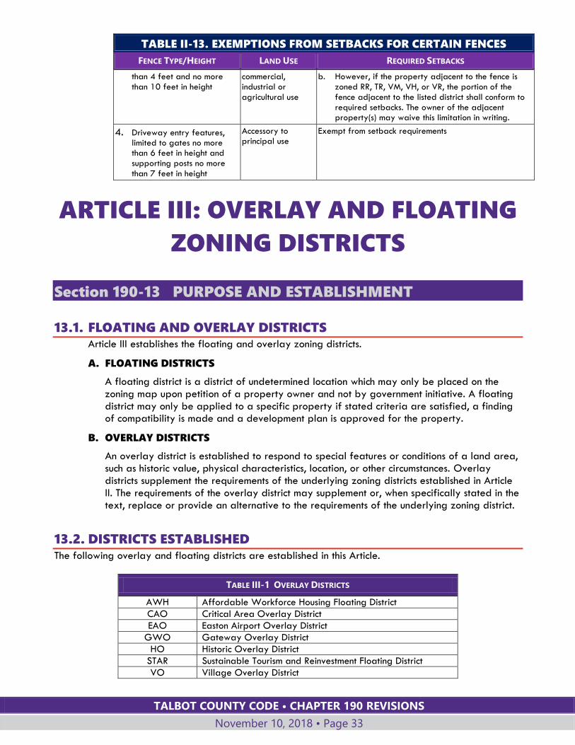
TALBOT COUNTY CODE • CHAPTER 190 REVISIONS
November 10, 2018 • Page 33
TABLE II-13. EXEMPTIONS FROM SETBACKS FOR CERTAIN FENCES
FENCE TYPE/HEIGHT LAND USE REQUIRED SETBACKS
than 4 feet and no more than 10 feet in height
commercial, industrial or agricultural use
b. However, if the property adjacent to the fence is zoned RR, TR, VM, VH, or VR, the portion of the fence adjacent to the listed district shall conform to required setbacks. The owner of the adjacent property(s) may waive this limitation in writing.
4. Driveway entry features, limited to gates no more than 6 feet in height and supporting posts no more than 7 feet in height
Accessory to principal use
Exempt from setback requirements
ARTICLE III: OVERLAY AND FLOATING
ZONING DISTRICTS
Section 190-13 PURPOSE AND ESTABLISHMENT
13.1. FLOATING AND OVERLAY DISTRICTS Article III establishes the floating and overlay zoning districts.
A. FLOATING DISTRICTS
A floating district is a district of undetermined location which may only be placed on the zoning map upon petition of a property owner and not by government initiative. A floating district may only be applied to a specific property if stated criteria are satisfied, a finding of compatibility is made and a development plan is approved for the property.
B. OVERLAY DISTRICTS
An overlay district is established to respond to special features or conditions of a land area, such as historic value, physical characteristics, location, or other circumstances. Overlay districts supplement the requirements of the underlying zoning districts established in Article II. The requirements of the overlay district may supplement or, when specifically stated in the text, replace or provide an alternative to the requirements of the underlying zoning district.
13.2. DISTRICTS ESTABLISHED The following overlay and floating districts are established in this Article.
TABLE III-1 OVERLAY DISTRICTS
AWH Affordable Workforce Housing Floating District
CAO Critical Area Overlay District
EAO Easton Airport Overlay District
GWO Gateway Overlay District
HO Historic Overlay District
STAR Sustainable Tourism and Reinvestment Floating District
VO Village Overlay District

TALBOT COUNTY CODE • CHAPTER 190 REVISIONS
November 10, 2018 • Page 34
13.3. BOUNDARIES
A. The boundaries of the overlay and floating districts are as established on the Official Zoning Map.
B. Rules for the interpretation of boundaries established in §190-6.2 also apply to the boundaries of overlay zoning districts.
C. The boundaries of floating districts must be clearly delineated in the development plan approved as part of the zoning map amendment application.
Section 190-14 AFFORDABLE WORKFORCE HOUSING
FLOATING DISTRICT (AWH)
14.1. PURPOSE AND INTENT
A. The Affordable Workforce Housing Floating District is intended to increase the supply of affordable housing in Talbot County in appropriate locations near incorporated towns where facilities and services are most easily accessible.
B. This district allows flexibility in housing types, design and density. In exchange for this flexibility, the developer of the AWH District must ensure that at least one-half of the units in the development are offered at a cost affordable to families earning no more than the Talbot County median income.
C. The AWH District is also intended to promote economical and efficient land use, an improved level of amenities, harmonious physical development, and creative design consistent with the best interest of the County and the area in which it is located.
14.2. PROCEDURE AND CRITERIA FOR APPROVAL
A. The procedure for establishing an AWH Floating District is the same as the procedure set forth in Article VII for amendments to the Official Zoning Maps.
B. An AWH District may only be approved in areas zoned TR and TC outside the Chesapeake Bay Critical Area.
C. A concept plan or plat shall be submitted with the rezoning application. The plans or plat shall be of sufficient detail to determine if the development generally complies with the site plan and design standards for an AWH District.
D. Additional information. In addition to the concept plan or plat the following information may be required by the Planning Commission or County Council after the initial public meeting or public hearing and prior to a recommendation or decision on the petition:
1. Building elevations, sections, floor plans and site sections to clearly define the character of the development.
2. Landscaping and screening plans showing open spaces, plantings, existing and proposed tree cover, and recreational facilities and areas.
3. Existing streets and proposed internal circulation plans for vehicles and pedestrians.
4. Information regarding surrounding land uses.
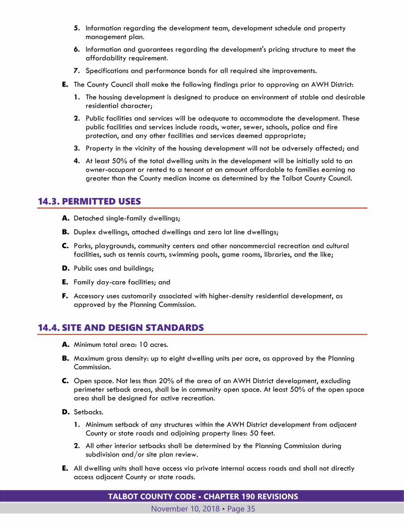
TALBOT COUNTY CODE • CHAPTER 190 REVISIONS
November 10, 2018 • Page 35
5. Information regarding the development team, development schedule and property management plan.
6. Information and guarantees regarding the development's pricing structure to meet the affordability requirement.
7. Specifications and performance bonds for all required site improvements.
E. The County Council shall make the following findings prior to approving an AWH District:
1. The housing development is designed to produce an environment of stable and desirable residential character;
2. Public facilities and services will be adequate to accommodate the development. These public facilities and services include roads, water, sewer, schools, police and fire protection, and any other facilities and services deemed appropriate;
3. Property in the vicinity of the housing development will not be adversely affected; and
4. At least 50% of the total dwelling units in the development will be initially sold to an owner-occupant or rented to a tenant at an amount affordable to families earning no greater than the County median income as determined by the Talbot County Council.
14.3. PERMITTED USES
A. Detached single-family dwellings;
B. Duplex dwellings, attached dwellings and zero lot line dwellings;
C. Parks, playgrounds, community centers and other noncommercial recreation and cultural facilities, such as tennis courts, swimming pools, game rooms, libraries, and the like;
D. Public uses and buildings;
E. Family day-care facilities; and
F. Accessory uses customarily associated with higher-density residential development, as approved by the Planning Commission.
14.4. SITE AND DESIGN STANDARDS
A. Minimum total area: 10 acres.
B. Maximum gross density: up to eight dwelling units per acre, as approved by the Planning Commission.
C. Open space. Not less than 20% of the area of an AWH District development, excluding perimeter setback areas, shall be in community open space. At least 50% of the open space area shall be designed for active recreation.
D. Setbacks.
1. Minimum setback of any structures within the AWH District development from adjacent County or state roads and adjoining property lines: 50 feet.
2. All other interior setbacks shall be determined by the Planning Commission during subdivision and/or site plan review.
E. All dwelling units shall have access via private internal access roads and shall not directly access adjacent County or state roads.
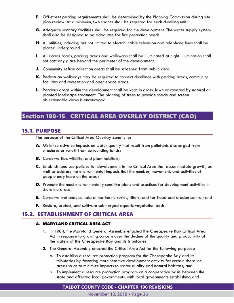
TALBOT COUNTY CODE • CHAPTER 190 REVISIONS
November 10, 2018 • Page 36
F. Off-street parking requirements shall be determined by the Planning Commission during site plan review. At a minimum, two spaces shall be required for each dwelling unit.
G. Adequate sanitary facilities shall be required for the development. The water supply system shall also be designed to be adequate for fire protection needs.
H. All utilities, including but not limited to electric, cable television and telephone lines shall be placed underground.
I. All access roads, parking areas and walkways shall be illuminated at night. Illumination shall not cast any glare beyond the perimeter of the development.
J. Community refuse collection areas shall be screened from public view.
K. Pedestrian walkways may be required to connect dwellings with parking areas, community facilities and recreation and open space areas.
L. Pervious areas within the development shall be kept in grass, lawn or covered by natural or planted landscape treatment. The planting of trees to provide shade and screen objectionable views is encouraged.
Section 190-15 CRITICAL AREA OVERLAY DISTRICT (CAO)
15.1. PURPOSE The purpose of the Critical Area Overlay Zone is to:
A. Minimize adverse impacts on water quality that result from pollutants discharged from structures or runoff from surrounding lands;
B. Conserve fish, wildlife, and plant habitats;
C. Establish land use policies for development in the Critical Area that accommodate growth, as well as address the environmental impacts that the number, movement, and activities of people may have on the area;
D. Promote the most environmentally sensitive plans and practices for development activities in shoreline areas;
E. Conserve wetlands as natural marine nurseries, filters, and for flood and erosion control; and
F. Restore, protect, and cultivate submerged aquatic vegetation beds.
15.2. ESTABLISHMENT OF CRITICAL AREA
A. MARYLAND CRITICAL AREA ACT
1. In 1984, the Maryland General Assembly enacted the Chesapeake Bay Critical Area Act in response to growing concern over the decline of the quality and productivity of the waters of the Chesapeake Bay and its tributaries
2. The General Assembly enacted the Critical Area Act for the following purposes:
a. To establish a resource protection program for the Chesapeake Bay and its tributaries by fostering more sensitive development activity for certain shoreline areas so as to minimize impacts to water quality and natural habitats; and
b. To implement a resource protection program on a cooperative basis between the state and affected local governments, with local governments establishing and
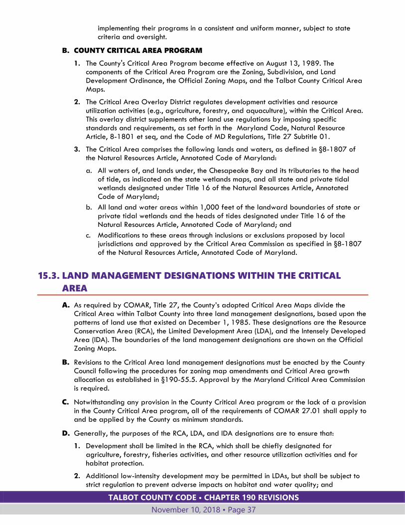
TALBOT COUNTY CODE • CHAPTER 190 REVISIONS
November 10, 2018 • Page 37
implementing their programs in a consistent and uniform manner, subject to state criteria and oversight.
B. COUNTY CRITICAL AREA PROGRAM
1. The County's Critical Area Program became effective on August 13, 1989. The components of the Critical Area Program are the Zoning, Subdivision, and Land Development Ordinance, the Official Zoning Maps, and the Talbot County Critical Area Maps.
2. The Critical Area Overlay District regulates development activities and resource utilization activities (e.g., agriculture, forestry, and aquaculture), within the Critical Area. This overlay district supplements other land use regulations by imposing specific standards and requirements, as set forth in the Maryland Code, Natural Resource Article, 8-1801 et seq, and the Code of MD Regulations, Title 27 Subtitle 01.
3. The Critical Area comprises the following lands and waters, as defined in §8-1807 of the Natural Resources Article, Annotated Code of Maryland:
a. All waters of, and lands under, the Chesapeake Bay and its tributaries to the head of tide, as indicated on the state wetlands maps, and all state and private tidal wetlands designated under Title 16 of the Natural Resources Article, Annotated Code of Maryland;
b. All land and water areas within 1,000 feet of the landward boundaries of state or private tidal wetlands and the heads of tides designated under Title 16 of the Natural Resources Article, Annotated Code of Maryland; and
c. Modifications to these areas through inclusions or exclusions proposed by local jurisdictions and approved by the Critical Area Commission as specified in §8-1807 of the Natural Resources Article, Annotated Code of Maryland.
15.3. LAND MANAGEMENT DESIGNATIONS WITHIN THE CRITICAL
AREA
A. As required by COMAR, Title 27, the County’s adopted Critical Area Maps divide the Critical Area within Talbot County into three land management designations, based upon the patterns of land use that existed on December 1, 1985. These designations are the Resource Conservation Area (RCA), the Limited Development Area (LDA), and the Intensely Developed Area (IDA). The boundaries of the land management designations are shown on the Official Zoning Maps.
B. Revisions to the Critical Area land management designations must be enacted by the County Council following the procedures for zoning map amendments and Critical Area growth allocation as established in §190-55.5. Approval by the Maryland Critical Area Commission is required.
C. Notwithstanding any provision in the County Critical Area program or the lack of a provision in the County Critical Area program, all of the requirements of COMAR 27.01 shall apply to and be applied by the County as minimum standards.
D. Generally, the purposes of the RCA, LDA, and IDA designations are to ensure that:
1. Development shall be limited in the RCA, which shall be chiefly designated for agriculture, forestry, fisheries activities, and other resource utilization activities and for habitat protection.
2. Additional low-intensity development may be permitted in LDAs, but shall be subject to strict regulation to prevent adverse impacts on habitat and water quality; and

TALBOT COUNTY CODE • CHAPTER 190 REVISIONS
November 10, 2018 • Page 38
3. Intense development should be directed outside of the Critical Area; however, intense development activities proposed in the Critical Area shall be directed towards IDAs.
E. The purposes of this chapter for areas designated as "Resource Conservation Areas" are to:
1. Conserve, protect, and enhance the overall ecological values of the Critical Area, its biological productivity and its diversity;
2. Provide adequate breeding, feeding, and wintering habitats for those wildlife populations that require the Chesapeake Bay, its tributary streams, or coastal habitats in order to sustain populations of those species;
3. Conserve the land and water resource base that is necessary to maintain and support land uses, such as agriculture, forestry, fisheries activities, and aquaculture; and
4. Conserve existing developed woodlands and forest for the water quality benefits that they provide.
F. The following provisions apply to areas designated as "Limited Development Areas."
1. LDAs are areas which are currently developed in low or moderate intensity uses. They also contain areas of natural plant and animal habitats, and the quality of runoff from these areas has not been substantially altered or impaired.
2. The purposes of this chapter for Limited Development Areas are to:
a. Maintain or, if possible, improve the quality of runoff and groundwater entering the Chesapeake Bay and its tributary streams;
b. Maintain, to the extent practical, existing areas of natural habitat; and
c. Accommodate additional low- or moderate-intensity development, if the development conforms to the water quality and habitat protection criteria.
G. The following provisions apply to areas designated as "Intensely Developed Areas."
1. IDAs are areas where residential, commercial, institutional, and/or industrial, developed land uses predominate, and where relatively little natural habitat occurs.
2. These areas shall have at least one of the following features:
a. Industrial, institutional, or commercial uses are concentrated in the area; or
b. Public sewer is currently serving the area and housing density is greater than three dwelling units per acre.
3. The purposes of this chapter for Intensely Developed Areas are to:
a. Improve the quality of runoff and groundwater from developed areas that enter the Chesapeake Bay or its tributary streams;
b. Accommodate additional development, provided that the water quality is not impaired;
c. Minimize the expansion of Intensely Developed Areas into portions of the Critical Area designated as "habitat protection areas" and Resource Conservation Areas by the Critical Area Program;
d. Conserve and enhance fish, wildlife, and plant habitats to the extent possible; and
e. Encourage the use of retrofitting measures to address existing stormwater management problems.
H. Table III-2 shows the County's base zoning districts that are permissible within each Critical Area land management designation, based on the definition of each designation established by the Maryland Critical Area law and the criteria above.
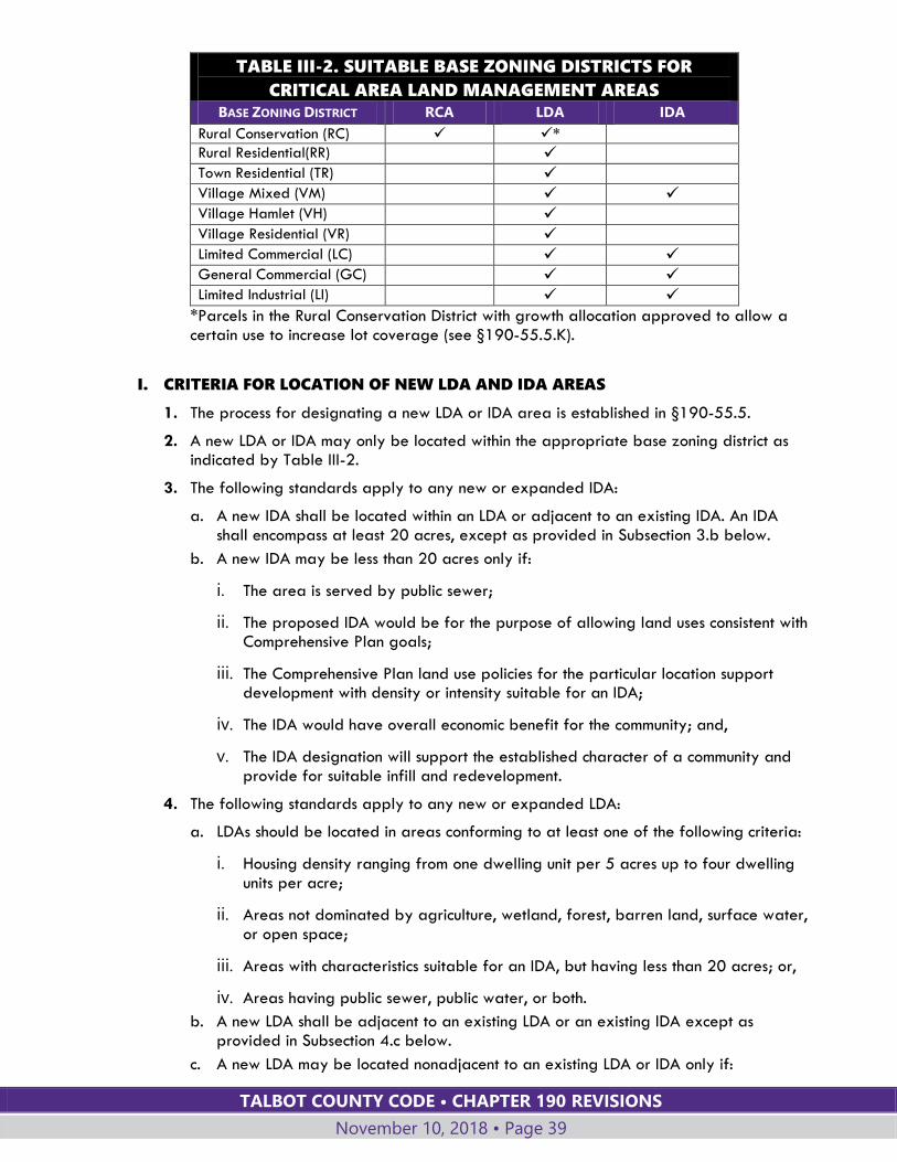
TALBOT COUNTY CODE • CHAPTER 190 REVISIONS
November 10, 2018 • Page 39
TABLE III-2. SUITABLE BASE ZONING DISTRICTS FOR
CRITICAL AREA LAND MANAGEMENT AREAS
BASE ZONING DISTRICT RCA LDA IDA
Rural Conservation (RC) *
Rural Residential(RR)
Town Residential (TR)
Village Mixed (VM) Village Hamlet (VH) Village Residential (VR)
Limited Commercial (LC) General Commercial (GC) Limited Industrial (LI)
*Parcels in the Rural Conservation District with growth allocation approved to allow a certain use to increase lot coverage (see §190-55.5.K).
I. CRITERIA FOR LOCATION OF NEW LDA AND IDA AREAS
1. The process for designating a new LDA or IDA area is established in §190-55.5.
2. A new LDA or IDA may only be located within the appropriate base zoning district as indicated by Table III-2.
3. The following standards apply to any new or expanded IDA:
a. A new IDA shall be located within an LDA or adjacent to an existing IDA. An IDA shall encompass at least 20 acres, except as provided in Subsection 3.b below.
b. A new IDA may be less than 20 acres only if:
i. The area is served by public sewer;
ii. The proposed IDA would be for the purpose of allowing land uses consistent with Comprehensive Plan goals;
iii. The Comprehensive Plan land use policies for the particular location support development with density or intensity suitable for an IDA;
iv. The IDA would have overall economic benefit for the community; and,
v. The IDA designation will support the established character of a community and provide for suitable infill and redevelopment.
4. The following standards apply to any new or expanded LDA:
a. LDAs should be located in areas conforming to at least one of the following criteria:
i. Housing density ranging from one dwelling unit per 5 acres up to four dwelling units per acre;
ii. Areas not dominated by agriculture, wetland, forest, barren land, surface water, or open space;
iii. Areas with characteristics suitable for an IDA, but having less than 20 acres; or,
iv. Areas having public sewer, public water, or both.
b. A new LDA shall be adjacent to an existing LDA or an existing IDA except as provided in Subsection 4.c below.
c. A new LDA may be located nonadjacent to an existing LDA or IDA only if:

TALBOT COUNTY CODE • CHAPTER 190 REVISIONS
November 10, 2018 • Page 40
i. The proposed revision would be for the purpose of allowing land uses consistent with Comprehensive Plan goals;
ii. The Comprehensive Plan land use policies for the particular location support development with density or intensity suitable for an IDA or LDA;
iii. The area would have overall economic benefit for the community; and,
iv. The area designation will support the established character of a community and provide for suitable infill and redevelopment.
5. In addition, any new LDA or IDA shall be located in a manner that:
a. Minimizes impacts to habitat protection areas;
b. Optimizes benefits to water quality; and,
c. Minimizes impacts to agricultural land and forests.
6. If a new LDA or IDA is in a Resource Conservation Area (RCA), locate it at least 300 feet beyond the landward edge of tidal wetlands or tidal waters, unless alternative measures for enhancement of water quality and habitat that provide greater benefits to the resources are approved by the Critical Area Commission.
7. A majority of the County’s Critical Area lands for which growth allocation is planned are currently classified Resource Conservation Areas. More than one-half of the County’s growth allocation may be utilized on lands located in the Resource Conservation Area (RCA) provided that the area to receive growth allocation meets the following standards:
a. Any development will be served by public sewer;
b. The area is located in a Priority Funding Area or municipal growth area;
c. Development is consistent with the County Comprehensive Plan;
d. The development will have an overall economic benefit to the community, or implements a specific goal, objective or policy of the Comprehensive Plan.
J. COMPREHENSIVE OR SECTIONAL ZONING MAP AMENDMENT
1. Applicability
a. The procedures in this Section shall govern the County’s reclassification of Critical Area land management designations in the County when the reclassifications occur through the County’s comprehensive or sectional map amendment process.
b. Section 190-55 governs the use of growth allocation for reclassifying Critical Area land management designations other than through the comprehensive or sectional map amendment process.
2. The following standards apply to reclassification of Critical Area land management designations through the comprehensive or sectional map amendment process:
a. A new IDA:
i. Shall meet the adjacency standards under § 190-15.3.I.3.a.; and,
ii. May include areas of less than 20 acres if the standards under § 190-15.3.I.3.b are met.
b. A new LDA:
i. Shall meet at least one of the conforming location standards under § 190-15.3.I.4.a.; and,
TALBOT COUNTY CODE • CHAPTER 190 REVISIONS
November 10, 2018 • Page 41
ii. Shall be adjacent to an existing LDA or an existing IDA, or shall meet the non-adjacency standards as listed in §190-15.3.I.4.c.
c. New LDA or IDA in the RCA shall be located at least 300 feet beyond the landward edge of tidal wetlands or tidal waters.
3. The County Council shall consider each of the following factors in reclassifying Critical Area land management designations from less intense to more intense land management designations:
a. Consistency with the County’s adopted comprehensive plan and whether the reclassified Critical Area land management designations would implement the goals and objectives of the adopted plan;
b. Consistency with State and regional environmental protection policies concerning the protection of threatened and endangered species and species in the need of conservation;
c. Impacts on a priority preservation area, as defined under §2-518 of the Agricultural Article;
d. Environmental impacts associated with location in coastal hazard area or an increased risk of severe flooding;
e. Whether the area is located in a manner that:
i. Minimizes impacts to habitat protection areas;
ii. Optimizes benefits to water quality; and,
iii. Minimizes impacts to agricultural land and forests.
f. Whether the area is to be served by a public wastewater system or septic system that uses the best available nitrogen removal technology; and
g. For a new IDA, whether the area will:
i. Have an allowed average density of at least 3.5 units per acre, as calculated under §5-7B-03(h) of the State Finance and Procurement Article;
ii. If a new IDA that is greater than 20 acres, be located in a priority funding area, as described under §§ 5-7B-02(1) and 5-7B-03 of the State Finance and Procurement Article; and,
iii. Have a demonstrable economic benefit to the area.
4. If the comprehensive or sectional map amendment reclassifies the Critical Area land management designations from more intense land management designations to RCA, the County Council shall consider how the characteristics of the land reclassified to RCA is consistent with the purposes listed under §190-15.3.E.
5. In addition to the above, all comprehensive or sectional map amendments shall include the following documentation:
a. A description of the Critical Area land change for all parcels;
b. Zoning maps of the existing and proposed Critical Area land designations;
c. Recent aerial maps of each parcel to show exiting conditions; and,
d. A table with the:
i. Proposed Critical Area land designation change;
TALBOT COUNTY CODE • CHAPTER 190 REVISIONS
November 10, 2018 • Page 42
ii. Talbot County Map ID Number;
iii. Tax Map and Parcel Number;
iv. Existing land use of each parcel;
v. Total parcel acreage;
vi. Total parcel acreage in the Critical Area; and,
vii. Total parcel acreage of the proposed Critical Area land destination change.
6. Calculating growth allocation.
a. The total acres reclassified to a more intense designation shall be deducted from the County’s growth allocation allotment.
b. Five percent of the area reclassified from a more intense designation to RCA may be added to the County’s available acreage that may be used for growth allocation in unincorporated areas of the County or through supplemental growth allocation.
7. Such comprehensive or section amendments, if approved by the County Council, shall comply with § 190-55.1 D. and E., describing the process for approval by the Chesapeake Bay Critical Area Commission.
15.4. REQUIREMENTS APPLICABLE THROUGHOUT THE CRITICAL AREA
A. PROHIBITED USES
The following uses are prohibited in the Critical Area.
1. Non-maritime heavy industry;
2. Transportation facilities and utility transmission facilities, except those necessary to serve permitted uses, or where regional or interstate facilities must cross tidal waters. Utility transmission facilities do not include power plants;
3. Permanent sludge handling, storage, and disposal facilities, except those facilities associated with current wastewater treatment operations in Talbot County, and except the agricultural or horticultural land applications of sludge (with Maryland State approvals and approved application methods and rates) outside of the Shoreline Development Buffer;
4. Solid or hazardous waste collection or disposal facilities;
5. Sanitary landfills;
6. Septage storage or holding facilities, except facilities on the site of a Talbot County wastewater treatment plant; and
7. Boathouses and floating residences.
B. STORMWATER MANAGEMENT
Facilities for treatment of stormwater within the Critical Area shall not serve development outside of the Critical Area.
C. TRIBUTARY STREAM MANAGEMENT
All development activities that cross or affect streams shall be prohibited unless there is no feasible alternative. If no alternative exists, development activities that cross or affect a stream shall be designed to:
TALBOT COUNTY CODE • CHAPTER 190 REVISIONS
November 10, 2018 • Page 43
1. Reduce increases in flood frequency and severity that are attributable to development;
2. Retain tree canopy so as to maintain stream water temperature within normal variation;
3. Provide a natural substrate for stream beds; and
4. Minimize adverse water quality and quantity impacts of stormwater.
D. OTHER REQUIREMENTS APPLYING THROUGHOUT THE CRITICAL AREA
The requirements for Agricultural Uses (§190-15.8), Forests, Developed Woodlands and Trees (§190-15.9), and Habitat Protection Areas (§190-15.10) apply throughout the Critical Area Overlay District.
15.5. REQUIREMENTS SPECIFIC TO THE RCA
A. The RC Zoning District covers all land areas within the RCA in Talbot County unless granted growth allocation in accordance with §190-55.5.K. Lot size, density, subdivision and land use requirements for the RCA are incorporated into the RC zoning district requirements; see §190-8.5.
B. See Article IV for land use requirements. New commercial, industrial, and institutional uses are prohibited in the RCA except uses that are specifically permitted in the RC District by Article IV.
15.6. REQUIREMENTS SPECIFIC TO THE RCA AND LDA The following development standards apply within areas designated as RCA (Resource Conservation Area) or LDA (Limited Development Area).
A. FOREST AND DEVELOPED WOODLAND STANDARDS
The following requirements apply to all development activity.
1. A forest preservation plan (§190-15.9.B) is required to address these forest planting and preservation requirements.
2. Existing forests and developed woodlands in habitat protection areas shall be protected.
3. The following standards shall apply to the removal of existing forest or developed woodland:
a. The removal of any existing forest or developed woodland shall be limited to 20% of the forest on any parcel.
b. The remaining 80% shall be protected and maintained through fee title donation, conservation easements, cooperative agreements with landowners and/or special provisions in forest management plans. The Planning Director shall approve the delineation of the area to be protected and the protection method.
c. Any natural vegetation, forest or developed woodland that has been removed shall be replaced on a not-less-than-equal-area basis, with the same species or a species appropriate to the site. Preferred location for replacement shall be on-site and adjacent to existing woods, streams or other natural habitat.
d. An additional 10% of any forest or developed woodland may be removed from forest use, provided that the replacement forest shall be 1.5 times the entire area of the forest or developed woodland being removed, including the first 20 percent.
e. Except for lots less than one acre, clearing more than 30% of any forest or developed woodland is prohibited unless authorized under a variance. See §190-58
TALBOT COUNTY CODE • CHAPTER 190 REVISIONS
November 10, 2018 • Page 44
for variance procedures. Lots less than one acre are exempt from clearing limits, provided that mitigation or fee-in-lieu are provided at 1.5 times the entire area of forest or developed woodland being removed.
f. A fee-in-lieu shall be provided to the County, sufficient to ensure the restoration or establishment of an equivalent forest area, if the area of the site precludes the implementation of Subsection c and d above. The amount of the fee shall be determined in the fee schedule adopted by the County Council.
g. Surety shall be provided by the property owners or developers in an amount acceptable to the Talbot County Council that will be suitable to assure satisfactory forest replacement as required in Subsection c and d above.
h. The Planning Director may require approval of an erosion and sediment control plan for the project prior to approving a forest preservation plan.
i. Any vegetation removed before obtaining required permits, or any forest area removed that exceeds the maximum allowed in Subsection a and d above, shall be replaced at three times the area of forest removed.
4. Afforestation is required when development occurs on an unforested or partially forested (less than 15% forested) parcel or lot existing as of August 13, 1989. The lot shall be planted to provide a forest or developed woodland cover of at least 15%. The preferred location for plantings shall be within the Shoreline Development Buffer, then adjacent to streams, woods or other natural features. The afforestation areas shall be shown on a forest preservation plan.
B. STEEP SLOPES
Development on slopes equal to or greater than 15 percent, as measured before development, shall be prohibited unless the project is the only effective way to maintain or improve the stability of the slope and is consistent with the purposes of the RCA and LDA (§190-15.3.E and F).
C. LOT COVERAGE
1. 15% LIMIT THROUGHOUT RCA AND LDA
Lot coverage in the RCA and LDA is limited to no more than 15% of a parcel or lot. There are limited exceptions to this lot coverage limitation for lots of one acre or smaller, as provided in Subsection C.4 below. Lot coverage shall be calculated separately for the area in the RCA and the area in the LDA, so that the 15% limit is met for each land use designation.
2. 15% LIMIT FOR CERTAIN SUBDIVISIONS
If an individual lot one acre or less in size is part of a subdivision approved after December 1, 1985, the total lot coverage for the entire subdivision may not exceed 15%, and the lot coverage of an individual lot may not exceed 40%.
3. LOT COVERAGE IN THE SHORELINE DEVELOPMENT BUFFER
Within the Shoreline Development Buffer, there is no allowable, by right, lot coverage. Increases in lot coverage may be allowed based upon certain allowances for:
a. Properties in the Modified Buffer Area (§190-15.11.H),
b. For certain water dependent facilities (§190-15.14), or
c. Through a variance for expansion of a legal, nonconforming structure (§190-58).
4. EXCEPTIONS TO 15% LOT COVERAGE LIMIT
a. Additional lot coverage in the LDA is permitted if official documentation (plats, deed records) demonstrates that the lot existed on December 1, 1985. Lot coverage for such lots shall be limited as shown in Table III-3.
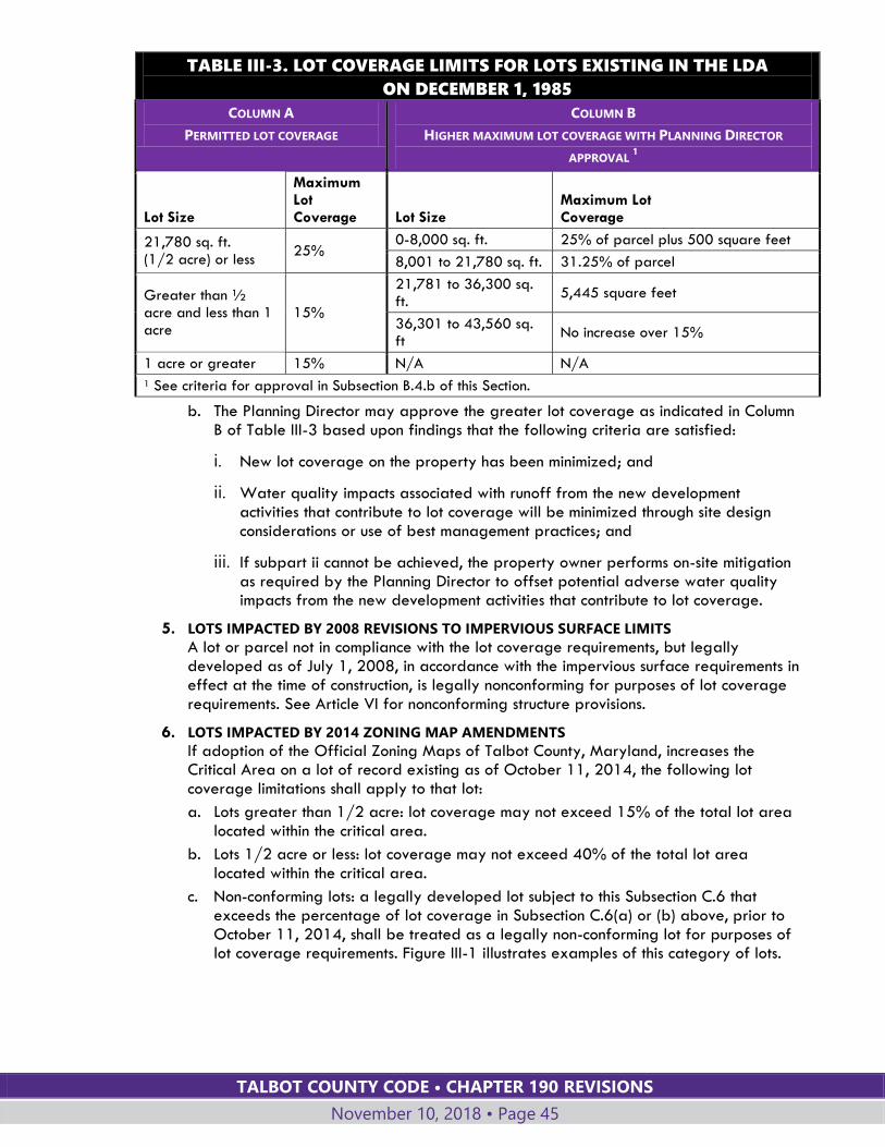
TALBOT COUNTY CODE • CHAPTER 190 REVISIONS
November 10, 2018 • Page 45
TABLE III-3. LOT COVERAGE LIMITS FOR LOTS EXISTING IN THE LDA
ON DECEMBER 1, 1985
COLUMN A
PERMITTED LOT COVERAGE
COLUMN B
HIGHER MAXIMUM LOT COVERAGE WITH PLANNING DIRECTOR
APPROVAL 1
Lot Size
Maximum Lot Coverage Lot Size
Maximum Lot Coverage
21,780 sq. ft. (1/2 acre) or less
25% 0-8,000 sq. ft. 25% of parcel plus 500 square feet
8,001 to 21,780 sq. ft. 31.25% of parcel
Greater than ½ acre and less than 1 acre
15%
21,781 to 36,300 sq. ft.
5,445 square feet
36,301 to 43,560 sq. ft
No increase over 15%
1 acre or greater 15% N/A N/A
1 See criteria for approval in Subsection B.4.b of this Section.
b. The Planning Director may approve the greater lot coverage as indicated in Column B of Table III-3 based upon findings that the following criteria are satisfied:
i. New lot coverage on the property has been minimized; and
ii. Water quality impacts associated with runoff from the new development activities that contribute to lot coverage will be minimized through site design considerations or use of best management practices; and
iii. If subpart ii cannot be achieved, the property owner performs on-site mitigation as required by the Planning Director to offset potential adverse water quality impacts from the new development activities that contribute to lot coverage.
5. LOTS IMPACTED BY 2008 REVISIONS TO IMPERVIOUS SURFACE LIMITS
A lot or parcel not in compliance with the lot coverage requirements, but legally developed as of July 1, 2008, in accordance with the impervious surface requirements in effect at the time of construction, is legally nonconforming for purposes of lot coverage requirements. See Article VI for nonconforming structure provisions.
6. LOTS IMPACTED BY 2014 ZONING MAP AMENDMENTS
If adoption of the Official Zoning Maps of Talbot County, Maryland, increases the Critical Area on a lot of record existing as of October 11, 2014, the following lot coverage limitations shall apply to that lot:
a. Lots greater than 1/2 acre: lot coverage may not exceed 15% of the total lot area located within the critical area.
b. Lots 1/2 acre or less: lot coverage may not exceed 40% of the total lot area located within the critical area.
c. Non-conforming lots: a legally developed lot subject to this Subsection C.6 that exceeds the percentage of lot coverage in Subsection C.6(a) or (b) above, prior to October 11, 2014, shall be treated as a legally non-conforming lot for purposes of lot coverage requirements. Figure III-1 illustrates examples of this category of lots.
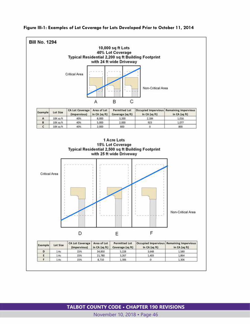
TALBOT COUNTY CODE • CHAPTER 190 REVISIONS
November 10, 2018 • Page 46
Figure III-1: Examples of Lot Coverage for Lots Developed Prior to October 11, 2014
TALBOT COUNTY CODE • CHAPTER 190 REVISIONS
November 10, 2018 • Page 47
D. CLUSTERING REQUIREMENTS FOR SUBDIVISIONS
The following standards apply to subdivisions in the TR, RR and RC Districts that are within the Critical Area RCA and LDA.
1. The cluster development form of subdivision shall be used.
2. In clustering lots, the following priorities shall be observed:
a. Minimize alteration to habitat protection areas described in the project's habitat protection plan;
b. Minimize development activities on land that has been used for agricultural purposes within the two years prior to the subdivision request.
15.7. REQUIREMENTS SPECIFIC TO THE IDA The following requirements apply within areas designated as an IDA (Intensely Developed Area).
A. All permeable ground surfaces shall be established in vegetation.
B. Stormwater management plans shall comply with the Maryland Chesapeake and Atlantic Coastal Bays Critical Area 10% Rule Guidance - Fall 2003 (the 10% Rule Guidance) and as subsequently amended.
1. Redevelopment and new development proposals in the IDA shall demonstrate use of best management practices for stormwater management that assure a 10% reduction of predevelopment pollutant loadings. This demonstration shall be based on methodologies agreed on by the County and the Critical Area Commission.
2. Plans that cannot demonstrate the required on-site reductions in predevelopment pollutant loadings may be approved only if the plan demonstrates that mitigation measures, including fees-in-lieu, or offsets will be provided to achieve equivalent water quality benefits elsewhere in the same watershed. All such mitigation measures or offset plans shall be consistent with methodologies agreed on by the County and the Critical Area Commission.
C. Forest Preservation Plans (§190-15.9.B) shall comply with the following criteria:
1. Forest and developed woodland resources shall be enhanced through techniques such as urban forestry (street tree plantings, gardens, landscaping, open land buffer plantings);
2. Destruction of forest and woodland vegetation shall be minimized; and
3. Existing forests and developed woodlands in habitat protection areas shall be protected.
15.8. AGRICULTURAL USES Permitted agricultural uses in all portions of the Critical Area shall be conducted in accord with the following provisions:
A. BEST MANAGEMENT PRACTICES
1. Agricultural activity within the Critical Area shall utilize best management practices (BMPs) by having in place and implementing:
a. A soil conservation and water quality plan approved by the County Soil Conservation District; and,
TALBOT COUNTY CODE • CHAPTER 190 REVISIONS
November 10, 2018 • Page 48
b. A nutrient management plan prepared by a certified nutrient management consultant or certified farm operator in accordance with COMAR §15.20.07 and 08.
2. The BMPs implemented within the Critical Area shall include the following:
a. Farming activities, including the grazing of livestock, shall not disturb stream banks, tidal shorelines, or other habitat protection areas; and
b. The feeding or watering of livestock may not occur within 50 feet of the mean high-water line of tidal water and edge of tidal wetlands, and of tributary streams, whichever is further inland.
B. NEW AGRICULTURAL LANDS
The creation of new agricultural lands shall not be accomplished by:
1. Diking, draining, or filling of any class or subclass of palustrine wetlands as described in the State Critical Area Program that are seasonally flooded, unless mitigation is accomplished in accordance with applicable state and County regulations;
2. Clearing forests or woodlands with soils having a slope greater than 15%; or on soils with a K-value greater than 0.35 and slope greater than 5%;
3. Clearing vegetation that will adversely affect water quality or will destroy plant and wildlife habitats; or
4. The clearing of existing natural vegetation within the Shoreline Development Buffer.
C. VEGETATED FILTER STRIP
Agricultural activities are permitted in the Shoreline Development Buffer provided that, as a minimum best management practice, a vegetated filter strip conforming to the following standards is provided:
1. The filter strip shall be at least 25 feet wide, measured landward from the mean high-water line of tidal water, edge of tidal wetlands, and edge of tributary streams (excluding drainage ditches), whichever is further inland.
2. If the average slope of the strip is greater than 6% (measured from the water's edge to the landward edge of the strip, along a line perpendicular to the water), then the strip shall be expanded in four-foot increments for each 1% of slope over 6%.
3. The filter strip shall be composed of either trees with a dense ground cover, a dense ground cover with suitable native shrubs and grasses, or a thick sod of grass, and shall be managed so as to provide water quality benefits and habitat protection consistent with the Shoreline Development Buffer purposes.
4. Invasive species and noxious weeds that occur in the filter strip, including Johnson grass, Canada thistle, and multiflora rose, may be controlled by authorized means.
5. The filter strips shall be maintained until such time as the landowner is implementing, under an approved Soil Conservation and Water Quality Plan, a program of best management practices for the specific purposes of improving water quality and protecting plant and wildlife habitat; and provided that the portion of the Soil Conservation and Water Quality Plan being implemented achieves the water quality and habitat protection objectives of the filter strip.
15.9. FORESTS, DEVELOPED WOODLANDS AND TREES
A. PURPOSES AND REQUIRED PLANS
1. Development in the Critical Area is to be designed to:
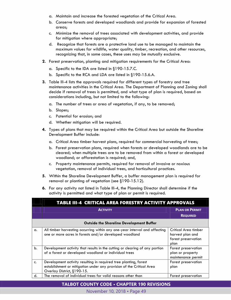
TALBOT COUNTY CODE • CHAPTER 190 REVISIONS
November 10, 2018 • Page 49
a. Maintain and increase the forested vegetation of the Critical Area.
b. Conserve forests and developed woodlands and provide for expansion of forested areas;
c. Minimize the removal of trees associated with development activities, and provide for mitigation where appropriate;
d. Recognize that forests are a protective land use to be managed to maintain the maximum values for wildlife, water quality, timber, recreation, and other resources, recognizing that, in some cases, these uses may be mutually exclusive.
2. Forest preservation, planting and mitigation requirements for the Critical Area:
a. Specific to the IDA are listed in §190-15.7.C.
b. Specific to the RCA and LDA are listed in §190-15.6.A.
3. Table III-4 lists the approvals required for different types of forestry and tree maintenance activities in the Critical Area. The Department of Planning and Zoning shall decide if removal of trees is permitted, and what type of plan is required, based on considerations including, but not limited to the following:
a. The number of trees or area of vegetation, if any, to be removed;
b. Slopes;
c. Potential for erosion; and
d. Whether mitigation will be required.
4. Types of plans that may be required within the Critical Area but outside the Shoreline Development Buffer include:
a. Critical Area timber harvest plans, required for commercial harvesting of trees;
b. Forest preservation plans, required when forests or developed woodlands are to be cleared; when multiple trees are to be removed from within a forest or developed woodland; or afforestation is required; and,
c. Property maintenance permits, required for removal of invasive or noxious vegetation, removal of individual trees, and horticultural practices.
5. Within the Shoreline Development Buffer, a buffer management plan is required for removal or planting of vegetation (see §190-15.12).
6. For any activity not listed in Table III-4, the Planning Director shall determine if the activity is permitted and what type of plan or permit is required.
TABLE III-4 CRITICAL AREA FORESTRY ACTIVITY APPROVALS
ACTIVITY PLAN OR PERMIT
REQUIRED
Outside the Shoreline Development Buffer
a. All timber harvesting occurring within any one-year interval and affecting one or more acres in forests and/or developed woodland
Critical Area timber harvest plan and forest preservation plan
b. Development activity that results in the cutting or clearing of any portion of a forest or developed woodland or individual trees
Forest preservation plan or property maintenance permit
c. Development activity resulting in required tree planting, forest establishment or mitigation under any provision of the Critical Area Overlay District, §190-15.
Forest preservation plan
d. The removal of individual trees for valid reasons other than Forest preservation

TALBOT COUNTY CODE • CHAPTER 190 REVISIONS
November 10, 2018 • Page 50
TABLE III-4 CRITICAL AREA FORESTRY ACTIVITY APPROVALS
ACTIVITY PLAN OR PERMIT
REQUIRED
accommodating development activity plan or property maintenance permit
e. Removal of individual trees that are in danger of falling and causing damage to dwellings or other structures, or that are in danger of falling and therefore causing the blockage of streams, or resulting in accelerated shore erosion
Forest preservation plan or property maintenance permit
f. Horticultural practices, including thinning, necessary to maintain the health of individual trees, or removal of trees that are dead, diseased or damaged from natural causes and are unlikely to survive
Forest preservation plan or property maintenance permit
g. Other cutting techniques which may be undertaken under the advice and guidance of the Maryland Departments of Agriculture and Natural Resources, if necessary to preserve the forest from extensive pest or disease infestation or threat from fire
Forest preservation plan or property maintenance permit
h. Removal of invasive species or noxious vegetation, including Johnson grass, Canada thistle, and multiflora rose
Property maintenance permit
Within the Shoreline Development Buffer
i. All timber harvesting regardless of the area affected Critical Area timber harvest plan, buffer management plan
j. Development activity, subdivision, change in use, clearing or installing vegetation for any purpose
See §§190.15.12 and 190.15.13
B. FOREST PRESERVATION PLANS
1. WHEN REQUIRED
A forest preservation plan is required for tree removal or planting within the Critical Area and outside of the Shoreline Development Buffer.
2. PREPARATION; SUBMITTAL; DECISION
a. The Planning Director shall publish an application form and a checklist of required information for forest preservation plans.
b. At a minimum, the forest preservation plan shall show existing vegetation, vegetation proposed to be removed, proposed planting, including the size, species and location of all plantings and proposed planting dates.
c. The Planning Director may require that a forest preservation plan be prepared by a registered professional forester or other qualified professional.
d. The application shall be filed with and decided by the Department of Planning and Zoning.
3. IMPLEMENTATION AND MAINTENANCE
a. A forest preservation plan shall include either of the following:
i. A time period for implementing the plan and provisions for a final inspection by the County, after which the plan will be certified complete; or
ii. Provisions for removal of invasive species and/or maintenance of natural vegetation for a period of up to five years, including provisions for annual inspection by the County.
b. Approval of a forest preservation plan authorizes the current property owner to maintain the approved area or activity in accordance with the plan, without any requirement for reapplication or re-approval.
TALBOT COUNTY CODE • CHAPTER 190 REVISIONS
November 10, 2018 • Page 51
C. PROPERTY MAINTENANCE PERMITS
1. A property maintenance permit is required for removal of invasive or noxious vegetation, removal of individual trees and horticultural practices within the Critical Area and outside the Shoreline Development Buffer.
2. The Planning Director shall publish an application form and checklist of required information for property maintenance permits.
3. The application shall be filed with and decided by the Department of Planning and Zoning.
4. In approving the application, the Department of Planning and Zoning may include conditions necessary to achieve the purposes and general requirements of this §190-15.9.
D. CRITICAL AREA TIMBER HARVEST PLANS
1. PROCEDURES
a. The plan shall be prepared by a registered professional forester or the Maryland Forest Service.
b. The plan shall be submitted to the Talbot County Forest Conservancy District Board and, upon approval, to the Talbot County Soil Conservation District.
c. Upon approval by the Talbot County Soil Conservation District, the plan shall be forwarded to the Planning Office, accompanied by an application for approval of a Forest Preservation Plan. The Department of Planning and Zoning shall approve the Forest Preservation Plan provided it is consistent with the applicable requirements for the Critical Area Land Management Area and with the approved Timber Harvest Plan.
2. REQUIREMENTS FOR TIMBER HARVESTING IN THE CRITICAL AREA
All Critical Area Timber Harvesting Plans shall:
a. Include measures to protect surface water and groundwater quality;
b. Identify whether the activities will disturb or affect habitat protection areas and incorporate protection measures for these areas; and
c. Provide for the continuity of habitat through forest management techniques, including scheduling, size, timing and intensity of harvest cuts, afforestation and reforestation.
3. REQUIREMENTS FOR TIMBER HARVESTING WITHIN THE SHORELINE DEVELOPMENT
BUFFER
a. Cutting or clearing of trees within the Shoreline Development Buffer is prohibited, except that commercial harvesting of trees may be permitted in the portion of the buffer more than 50 feet from the mean high-water line of tidal water and edge of wetlands, and more than 50 feet from tributary streams. Such harvesting shall allow the selective cutting of any species or clear cutting of loblolly pine and tulip poplar trees.
b. Commercial harvesting shall not be permitted within those portions of the Shoreline Development Buffer located in the following habitat protection areas:
i. Wetlands;
ii. Habitats of threatened and endangered species or species in need of conservation;
iii. Anadromous fish propagation waters; and
iv. Plant and wildlife habitats
TALBOT COUNTY CODE • CHAPTER 190 REVISIONS
November 10, 2018 • Page 52
c. For harvest activities within the Shoreline Development Buffer, the timber harvest plan shall also insure that:
i. Disturbance to stream banks and shorelines is avoided;
ii. The area disturbed or cut will be replanted or allowed to regenerate in a manner that assures the availability of cover and breeding sites for wildlife, and reestablishes the wildlife corridor function of the Shoreline Development Buffer; and
iii. The cutting does not involve the creation of logging roads and skid trails within the Shoreline Development Buffer.
4. EROSION AND SEDIMENT CONTROL PLAN
a. For any timber harvest that will disturb an area of 5,000 square feet or more, including harvesting of trees on agricultural lands, an Erosion and Sediment control plan shall be submitted to the Soil Conservation District. This plan is also required for any harvests which cross tidal streams.
b. This plan shall be developed according to the state guidelines entitled "Standard Erosion and Sediment Control Plan for Harvest Operations."
5. IMPLEMENTATION AND ENFORCEMENT
Harvest operations shall be implemented in accordance with specifications set out by the Maryland Department of Natural Resources. The County will enforce the timber harvest plan.
15.10. HABITAT PROTECTION AREAS; HABITAT PROTECTION PLANS
A. HABITAT PROTECTION AREAS
1. As established in COMAR Title 27, habitat protection areas are the following: the Shoreline Development Buffer, nontidal wetlands, habitats of species in need of conservation, threatened and endangered species, plant and wildlife habitat areas, and anadromous fish propagation waters.
2. Development and redevelopment activities shall be subject to the requirements of this Section to avoid disturbance to habitat protection areas. When no alternative exists and such activities must cross or be located in habitat protection areas, the applicant shall minimize impacts to habitats and show that no reasonable feasible alternative location for such activity exists.
3. An applicant for a development activity proposed for a site within the Critical Area that is in or near a Habitat Protection Area listed above shall request review by the Department of Natural Resources Wildlife and Heritage Service (DNR WHS), and as necessary United States Fish and Wildlife Service (USFWS), for comment and technical advice.
B. HABITAT PROTECTION PLANS
1. A habitat protection plan is required when a proposed subdivision would affect any of the habitat protection areas described in Subsections D, E, F or G below.
2. The Planning Director may require a habitat protection plan for types of development activity other than subdivisions.
3. A habitat protection plan shall be prepared by a professional biologist, ecologist, or other professional qualified to prepare such plans.

TALBOT COUNTY CODE • CHAPTER 190 REVISIONS
November 10, 2018 • Page 53
4. The habitat protection plan shall show how the development activity will meet the purposes and specific requirements for each type of habitat protection area set forth in the individual habitat protection area Sections below.
C. ROADS, BRIDGES AND UTILITIES
1. Roads, bridges, and utilities are prohibited in any habitat protection area unless no feasible alternative exists.
2. If authorized, all roads, bridges, and utilities that must cross a habitat protection area shall be located, designed, constructed, and maintained so as to provide maximum erosion protection, minimize negative impacts to wildlife, aquatic life and their habitats, and maintain hydrologic processes and water quality.
D. NONTIDAL WETLANDS
1. A permit shall be obtained from the Maryland Department of the Environment for any activity regulated under COMAR 26.23 (Nontidal Wetlands) that is proposed as part of a development activity in or within 25 feet of nontidal wetlands.
2. A minimum twenty-five-foot buffer around nontidal wetlands shall be maintained. Regulated activities within nontidal wetlands and their buffers authorized by a permit or letter of exemption from the Maryland Department of the Environment, and development activities that do not require a permit or letter of exemption from the Maryland Department of the Environment, are not subject to this requirement.
3. Nontidal wetlands and a twenty-five-foot buffer shall be shown on all required plans and plats, including, but not limited to, concept plans, subdivision plans, forest preservation plans, buffer management plans and site plans.
E. THREATENED AND ENDANGERED SPECIES; SPECIES IN NEED OF PROTECTION OR
CONSERVATION
1. PURPOSE
The purpose of this Section is to provide protection for threatened and endangered species, for species in need of conservation, and for the habitats of these species in the Critical Area.
2. SPECIES
a. Species protected under this Section include, but are not necessarily limited to, the Bald Eagle, Delmarva Fox Squirrel, and the Sedge Wren.
b. As part of the habitat protection plan, the applicant shall coordinate with the appropriate State and Federal agencies (Department of Natural Resources, United States Fish and Wildlife Services, etc.) to identify any threatened and endangered species and species in need of conservation that might be affected by the proposed development activity, and to identify protection and management mechanisms.
3. REQUIREMENTS
The habitat protection plan shall include measures to protect threatened and endangered species and species in need of conservation. These measures shall include:
a. Designation of protection areas around the habitats of the species; and
b. A program for protecting the habitats of the species which may include, but is not limited to areas or periods of restricted access or activity, conservation easements, cooperative agreements with landowners, special provisions in forest preservation plans, buffer management plans, soil conservation and water quality plans, soil erosion and sediment control plans, or other plans.
TALBOT COUNTY CODE • CHAPTER 190 REVISIONS
November 10, 2018 • Page 54
F. PLANT AND WILDLIFE HABITAT AREAS
1. PURPOSE
The purpose of this Section is to:
a. Conserve wildlife habitat in the Critical Area;
b. Protect those wildlife habitats that tend to be least abundant, or which may become so in the future if current land use trends continue;
c. Protect those wildlife habitat types which are required to support the continued presence of various species; and
d. Protect natural heritage areas.
2. PLANT AND WILDLIFE HABITAT AREAS
Plant and wildlife habitat areas include:
a. Colonial waterbird nesting sites;
b. Historic waterfowl staging and concentration areas in tidal waters, tributary streams or tidal and nontidal wetlands;
c. Riparian forests (for example, those relatively mature forests of at least 300 feet in width which occur adjacent to streams, wetlands, or the bay shoreline and which are documented breeding areas);
d. Forest areas utilized as breeding areas by forest interior dwelling birds and other wildlife species (for example relatively mature forested areas within the Critical Area of 50 acres or more or forest connected with such areas).
e. Natural heritage areas;
f. Other areas which may in the future be identified by state and federal agencies as important plant or wildlife habitat areas;
g. Other plant and wildlife habitats determined to be of local significance because they contain species uncommon or of limited occurrence in the County, or because the species are found in unusually high concentrations; and
h. Nontidal wetlands.
3. REQUIREMENTS
The habitat protection plan shall include measures to protect and enhance plant and wildlife habitat areas. These measures shall include:
a. Buffer areas for colonial water bird nesting sites. Protect these areas from development activities and from disturbance in the breeding season.
b. Locate new water-dependent facilities so as to prevent disturbance to sites of significance to wildlife such as historic, aquatic staging and concentration areas for waterfowl.
c. Protect and conserve forested areas required to support plant and wildlife species (see A Guide to the Conservation of Forest Interior Dwelling Birds in the Chesapeake Bay Critical Area, dated June 2000, and as may be subsequently amended). Management measures may include, but are not limited to:
i. Clustering development;
ii. Other site design practices;
iii. Easements and other land preservation techniques; and
iv. Preserving the vertical diversity of plant type by maintaining natural bush and ground cover layers beneath stands of trees.
d. Provide effective connections between wildlife habitat areas.
TALBOT COUNTY CODE • CHAPTER 190 REVISIONS
November 10, 2018 • Page 55
e. Protect by appropriate means locally significant plant and wildlife habitats.
f. Protect natural heritage areas from alteration due to development activities or cutting or clearing so that the structure and species composition of the areas are maintained.
g. Incorporate plants with high benefit to wildlife into development.
G. ANADROMOUS FISH PROPAGATION WATERS
1. PURPOSE
The purposes of this Section are to:
a. Protect the in-stream and streambank habitat of anadromous fish propagation waters;
b. Promote land use policies and practices in the watershed of spawning streams that minimize the adverse impacts of development on the water quality of the streams; and
c. Provide for the unobstructed movement of spawning and larval forms of anadromous fish in streams.
2. IDENTIFICATION OF WATERS
Bodies of water that have been identified as spawning areas in Talbot County are identified by the Maryland Department of Natural Resources.
3. REQUIREMENTS
a. Unobstructed movement in streams shall be provided for spawning and larval forms of anadromous fish. The construction or placement of dams or other structures that would interfere with or prevent the movement of spawning fish or larval forms in streams shall be prohibited. The removal of existing barriers shall be accomplished wherever possible.
b. The construction, repair, or maintenance activities associated with bridges or other stream crossings, or with utilities and roads, which involve disturbance of the Shoreline Development Buffer or which occur in streams with identified spawning areas, shall be prohibited between March 1 and June 15.
c. The installation or introduction of concrete riprap or other artificial surfaces onto the bottom of natural streams shall be prohibited, unless it can be demonstrated that installation of such surfaces improves water quality and fisheries habitat.
d. Channelization or other physical alteration that may change the course or circulation of a stream and thereby interfere with the movement of fish shall be prohibited.
e. Construction of shore-based facilities (such as marinas), dredging, filling, and construction of jetties or bulkheads shall not be allowed in areas of established submerged aquatic vegetation within spawning waters.
H. SHORELINE DEVELOPMENT BUFFER (SEE §§190-15.11 AND 190-15.12)
1. The Shoreline Development Buffer is intended to consist of naturally vegetated areas, or areas to be established in vegetation, that are managed to protect aquatic, shoreline, wetland, and terrestrial environments from human-made disturbances.
2. In order to accomplish this intent, the Shoreline Development Buffer generally prohibits new development, requires protection of naturally vegetated areas, and requires mitigation whenever natural vegetation is disturbed or new development occurs.
3. The location and width of the Shoreline Development Buffer is determined by COMAR, §27.01.09.01.E. This area is established for each lot or parcel based upon the criteria given in §190-15.11.B below.
TALBOT COUNTY CODE • CHAPTER 190 REVISIONS
November 10, 2018 • Page 56
4. Requirements for the Shoreline Development Buffer are given in §§190-15.11 and 190-15.12.
15.11. SHORELINE DEVELOPMENT BUFFER (ALSO REFERRED TO AS THE
BUFFER)
A. PURPOSE
The Shoreline Development Buffer is a Habitat Protection Area that shall be established and managed to achieve or enhance the following functions:
1. Remove or reduce the sediments, nutrients, and potentially harmful or toxic substances in runoff entering the Chesapeake Bay and its tributary streams;
2. Minimize the adverse effects of human activities on wetlands, shorelines, stream banks, tidal waters, and aquatic resources;
3. Maintain an area of transitional habitat between aquatic and upland ecological communities;
4. Maintain the natural environment of streams;
5. Protect riparian wildlife habitat; and
6. Maintain natural vegetation.
B. MEASUREMENT
1. The Shoreline Development Buffer shall be measured based on existing field conditions from the landward edge of the mean high water line of tidal waters, the edge of each bank of a tributary stream, and the upland boundary of a tidal wetland.
2. The Shoreline Development Buffer shall be:
a. When within the RCA and measured from the edge of mean high water or tidal wetlands:
i. At least 200 feet wide for subdivisions and site plans submitted after July 1, 2008, excluding, for subdivisions only, one parent parcel, which shall be subject to Subsection ii below;
ii. At least 100 feet wide for all parent parcels, lots legally created prior to July 1, 2008, or lots for which subdivision plans were submitted before July 1, 2008, and final plats were recorded on or before July 1, 2010;
b. At least 100 feet wide for lots within the LDA or IDA; and
c. At least 100 feet wide from the edge of tributary streams.
3. The 200-foot Shoreline Development Buffer may be reduced if the strict application of the minimum 200-foot Buffer would preclude:
a. Subdivision of the property at a density of one dwelling unit per 20 acres, provided all other state and local requirements will be satisfied; or
b. An intrafamily transfer as permitted by the RC District standards.
c. The reduced Buffer should be the minimum necessary to accommodate a dwelling and a sewage reserve area, as determined by the Planning Director, but no less than 100 feet.
4. A Buffer expansion shall be required, beyond the minimum 100-foot or 200-foot Shoreline Development Buffer, to include and extend beyond contiguous sensitive areas, such as soils with slopes 15% or greater, hydric soils, or highly erodible soils.
TALBOT COUNTY CODE • CHAPTER 190 REVISIONS
November 10, 2018 • Page 57
5. The Buffer shall be expanded for slopes of 15% or greater (steep slopes) in accordance with the following. Also see “Buffer Expansion” as defined in Article IX.
a. If a steep slope is contained completely within the Buffer, Buffer expansion is required only to provide a Buffer of at least 25 feet from the top of the slope.
b. If a steep slope is partially within or contiguous to the Buffer, the Buffer shall be expanded four feet for every 1% of slope beyond the required Buffer, or 25 feet from the top of the slope, whichever is greater in extent, except as provided in Subsection c below.
c. The Planning Commission may approve a buffer expansion limited to 25 feet from the top of the slope, even if greater expansion would be required based on the Subsection b above, if the Planning Commission determines that the slope has one or more of the following characteristics:
i. Steep slopes less than 10 feet in width, such as agricultural ditches;
ii. Steep slopes that are isolated and less than 10,000 square feet in area, irrespective of property lines;
iii. Steep slopes with width of less than 25 feet where the slope crosses the 100-foot Buffer boundary; or,
iv. Similar characteristics exists that result in a narrow and/or isolated area of steep slopes.
6. The following criteria shall be used to measure the expanded Buffer for highly erodible soils or hydric soils contiguous to the Buffer:
a. For a nontidal wetland of special State concern, expand the Buffer to include the upland boundary of the wetland and its regulated 100-foot Buffer;
b. For other nontidal wetlands, expand the Buffer to include the upland boundary of the nontidal wetland;
c. For highly erodible soils or hydric soils with a slope of 5% or greater, expand the Buffer to the lesser of the landward edge or 300 feet, including the Buffer width required under Subsection B.2 above.
7. If the Buffer is contiguous to hydric or highly erodible soils on a slope less than 15%, and the Buffer is on a lot created before January 1, 2010, development activity may be approved in the expanded Buffer if:
a. The development activity is in the expanded portion of the Buffer, but not in the Buffer required under Subsection B.2 above;
b. The Buffer occupies at least 75% of the lot or parcel; and
c. Mitigation occurs at a 2:1 ratio, based on the lot coverage of the proposed development activity that is in the expanded Buffer.
8. In Modified Buffer Areas, under certain conditions, Shoreline Development Buffer setbacks may vary in accordance with provisions set forth in §190-15.11.H.
C. MAINTAINING THE SHORELINE DEVELOPMENT BUFFER
1. The Buffer shall be maintained in natural vegetation and managed to achieve or enhance the functions stated in subsection A above.
2. New development activities, including structures, fences, roads, parking areas and other impervious surfaces, mining and related facilities, or septic systems, are not permitted in the Shoreline Development Buffer, except for those necessarily associated with water-dependent facilities or individual private piers.
TALBOT COUNTY CODE • CHAPTER 190 REVISIONS
November 10, 2018 • Page 58
3. Lot coverage in the Buffer may not exceed the minimum amount necessary for water-dependent facilities, regardless of the Critical Area classification or the size of the parcel or lot, except:
a. In Modified Buffer Areas;
b. If a variance is granted in accordance with §190-58; or,
c. In accordance with §190-15.11.B.7.
4. Cutting, clearing, and removal of existing vegetation, including understory trees, shrubs and ground cover within the Buffer is prohibited except as authorized by a Buffer Management Plan.
5. Existing areas of public access to the shoreline, such as footpaths, scenic drives, and other public recreational facilities, shall be maintained, with new facilities encouraged in the IDA.
6. Vegetation may be removed for one pathway to the shore or piers, subject to the approval of a Buffer Management Plan (see §190-15.12).
a. The pathways shall be:
i. Direct and no longer than necessary;
ii. No wider than six feet; and,
iii. Constructed to maintain as much canopy as possible.
b. Pathway surfaces shall be:
i. Grass or similar low vegetation, stabilized only with pervious wood chips or,
ii. Materials such as boards, asphalt, or gravel, provided that mitigation is provided, in accordance with a buffer management plan, that covers two times the area of the hard surfaced pathway.
c. In areas of steep slopes, wooden stairways may be constructed as approved by the Planning Director.
7. Normal and customary maintenance of lawns located in the Shoreline Development Buffer may continue until approval of a development activity requiring a buffer management plan.
D. SHORELINE BUFFER ESTABLISHMENT
1. Shoreline Buffer establishment requirements apply to:
a. Development or redevelopment activity on a lot that includes a Buffer to tidal waters, a tidal wetland, or a tributary stream if the development or redevelopment activity is located outside the Buffer; and
b. A subdivision that includes a Buffer to tidal waters, a tidal wetland, or a tributary stream.
2. When the Shoreline Development Buffer is not fully forested or fully established in existing, naturally occurring woody or wetland vegetation, an applicant shall establish the Buffer to the extent required in Table III-5.
3. The required Buffer establishment area shall be:
a. Calculated as the linear length of the tidal shoreline times the depth of the Buffer (including required Buffer expansion);
b. Reduced by the area within the Buffer of existing naturally occurring wetland or woody vegetation or forest; and,
c. Reduced by the lot coverage which existed in the Buffer before December 1, 1989.
4. Buffer establishment is not required for:

TALBOT COUNTY CODE • CHAPTER 190 REVISIONS
November 10, 2018 • Page 59
a. In-kind replacement of a structure; or,
b. Land that remains in agricultural use after subdivision, provided that the applicant records an approved buffer management plan with the plat and implements the Buffer management plan when the lot is converted to a nonagricultural use.
5. The applicant may deduct from the total establishment requirement an area removed within the Shoreline Development Buffer that is covered by existing improvements if:
a. The lot coverage existed before December 1, 1989; and
b. The total area is stabilized.
6. When the establishment requirement is based on the total square footage of lot coverage located outside of the Buffer:
a. At least 50% of the Buffer establishment requirement shall be located within the first 100-feet and the remainder of the requirement may be within 300-feet (as measured landward from the edge of tidal waters or the upland boundary of tidal wetlands). Plantings shall be designed in a manner that provides water quality and habitat benefits.
b. At least half of the canopy and understory tree requirement shall be located within the 100-foot Buffer and in accordance with Table III-8.
TABLE III-5. SHORELINE DEVELOPMENT BUFFER ESTABLISHMENT
REQUIREMENTS
DEVELOPMENT CATEGORY LOT CREATED BEFORE 8/13/89 LOT CREATED AFTER 8/13/89
Development on a vacant lot Establish an area of the Buffer equal to the total square footage of lot coverage outside the Buffer
Fully establish the Buffer
Subdivision Fully establish the Buffer
New lot with an existing dwelling unit
Establish an area of the Buffer equal to the total square footage of lot coverage outside the Buffer
Conversion of a land use on a parcel or lot to another land use
Fully establish the Buffer
Construction of an addition, accessory structure, or redevelopment
Establish an area of the Buffer equal to the net square footage increase in lot coverage outside the Buffer
Substantial alteration to an existing structure
Establish an area of the Buffer equal to the total square footage of lot coverage outside the Buffer
E. BUFFER MITIGATION
Mitigation is required when existing vegetation in the Buffer is disturbed in accordance with the following standards:
1. Mitigation for development or redevelopment activity in the Buffer or for the removal of an individual tree, developed woodland, or forest shall be calculated:
a. According to the ratios in Table III-6, Minimum Planting Mitigation Ratios, below; and
b. Based on the area (square footage) of canopy coverage removed, as determined by the Planning Office.
2. Mitigation for or removal of a diseased, dying, invasive, or hazardous tree:
a. Mitigation shall be one tree of at least a 3/4-inch caliper for each tree removed; or
b. The affected area shall be stabilized in native woody vegetation, if a tree cannot be replanted due to space constraints.
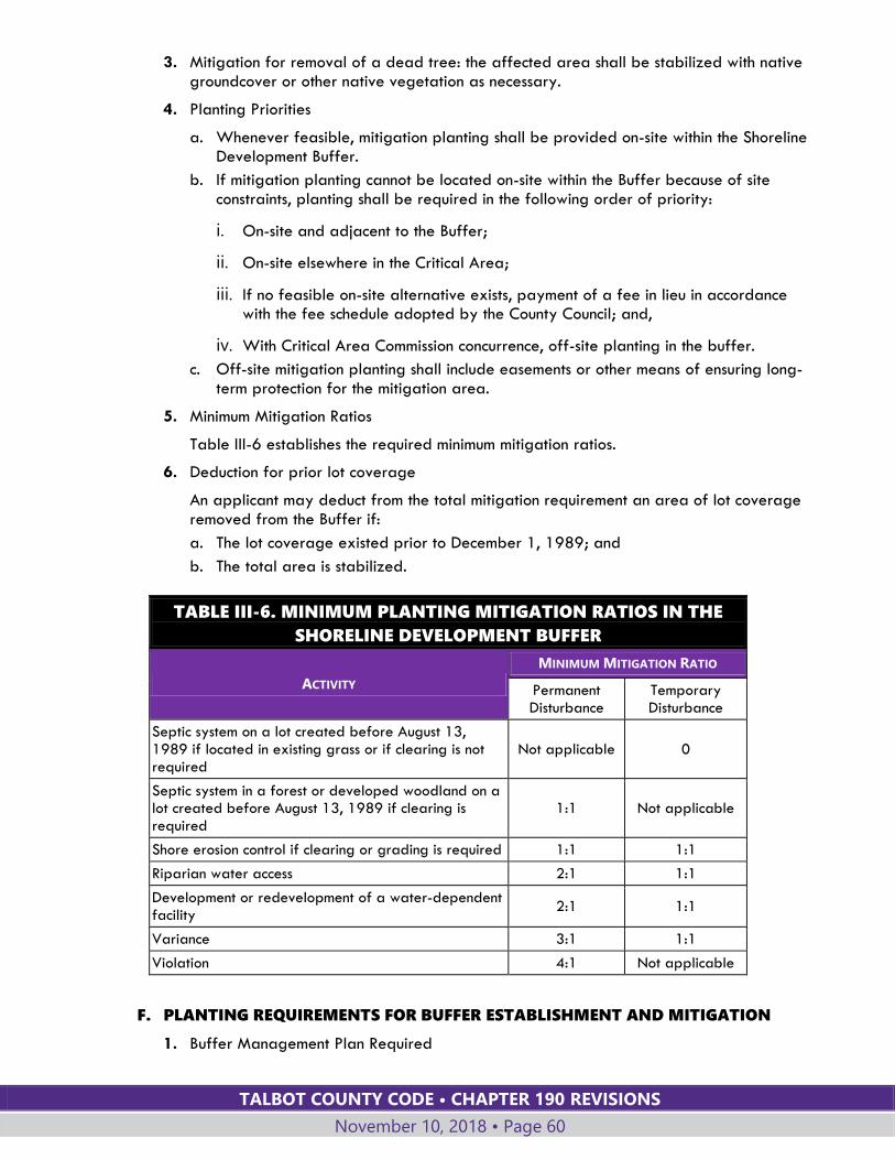
TALBOT COUNTY CODE • CHAPTER 190 REVISIONS
November 10, 2018 • Page 60
3. Mitigation for removal of a dead tree: the affected area shall be stabilized with native groundcover or other native vegetation as necessary.
4. Planting Priorities
a. Whenever feasible, mitigation planting shall be provided on-site within the Shoreline Development Buffer.
b. If mitigation planting cannot be located on-site within the Buffer because of site constraints, planting shall be required in the following order of priority:
i. On-site and adjacent to the Buffer;
ii. On-site elsewhere in the Critical Area;
iii. If no feasible on-site alternative exists, payment of a fee in lieu in accordance with the fee schedule adopted by the County Council; and,
iv. With Critical Area Commission concurrence, off-site planting in the buffer.
c. Off-site mitigation planting shall include easements or other means of ensuring long-term protection for the mitigation area.
5. Minimum Mitigation Ratios
Table III-6 establishes the required minimum mitigation ratios.
6. Deduction for prior lot coverage
An applicant may deduct from the total mitigation requirement an area of lot coverage removed from the Buffer if:
a. The lot coverage existed prior to December 1, 1989; and
b. The total area is stabilized.
TABLE III-6. MINIMUM PLANTING MITIGATION RATIOS IN THE
SHORELINE DEVELOPMENT BUFFER
ACTIVITY
MINIMUM MITIGATION RATIO
Permanent Disturbance
Temporary Disturbance
Septic system on a lot created before August 13, 1989 if located in existing grass or if clearing is not required
Not applicable 0
Septic system in a forest or developed woodland on a lot created before August 13, 1989 if clearing is required
1:1 Not applicable
Shore erosion control if clearing or grading is required 1:1 1:1
Riparian water access 2:1 1:1
Development or redevelopment of a water-dependent facility
2:1 1:1
Variance 3:1 1:1
Violation 4:1 Not applicable
F. PLANTING REQUIREMENTS FOR BUFFER ESTABLISHMENT AND MITIGATION
1. Buffer Management Plan Required
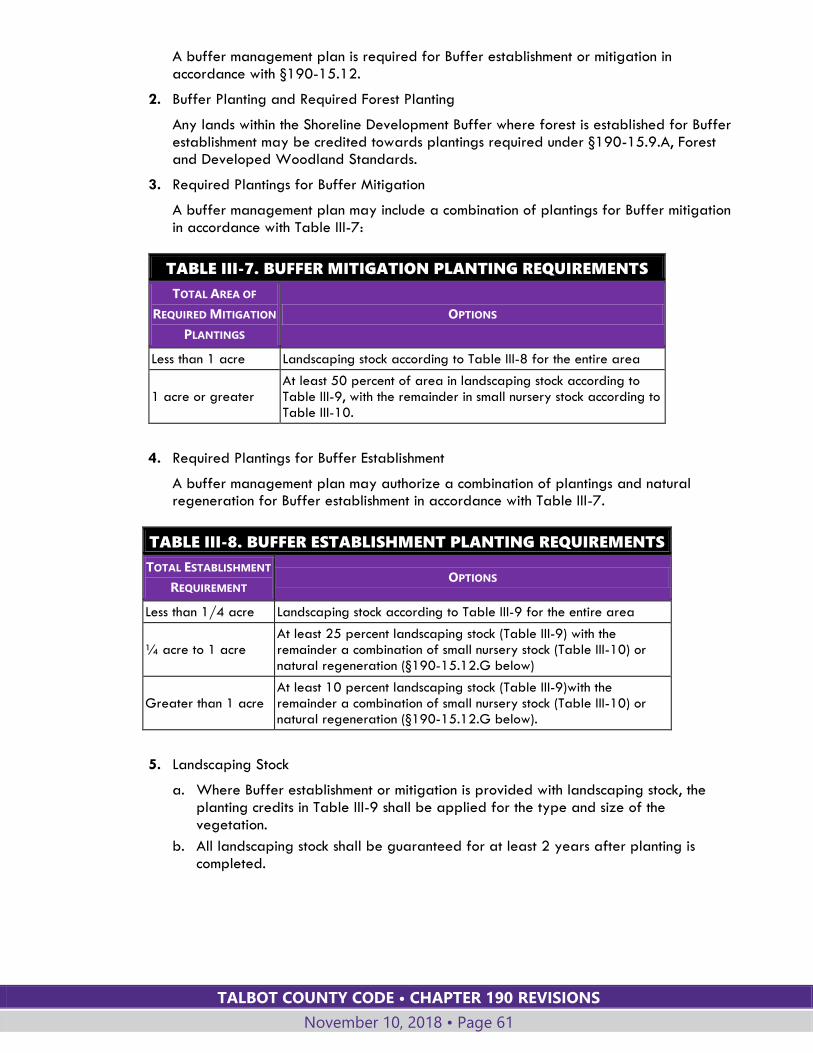
TALBOT COUNTY CODE • CHAPTER 190 REVISIONS
November 10, 2018 • Page 61
A buffer management plan is required for Buffer establishment or mitigation in accordance with §190-15.12.
2. Buffer Planting and Required Forest Planting
Any lands within the Shoreline Development Buffer where forest is established for Buffer establishment may be credited towards plantings required under §190-15.9.A, Forest and Developed Woodland Standards.
3. Required Plantings for Buffer Mitigation
A buffer management plan may include a combination of plantings for Buffer mitigation in accordance with Table III-7:
TABLE III-7. BUFFER MITIGATION PLANTING REQUIREMENTS
TOTAL AREA OF
REQUIRED MITIGATION
PLANTINGS
OPTIONS
Less than 1 acre Landscaping stock according to Table III-8 for the entire area
1 acre or greater At least 50 percent of area in landscaping stock according to Table III-9, with the remainder in small nursery stock according to Table III-10.
4. Required Plantings for Buffer Establishment
A buffer management plan may authorize a combination of plantings and natural regeneration for Buffer establishment in accordance with Table III-7.
TABLE III-8. BUFFER ESTABLISHMENT PLANTING REQUIREMENTS
TOTAL ESTABLISHMENT
REQUIREMENT OPTIONS
Less than 1/4 acre Landscaping stock according to Table III-9 for the entire area
¼ acre to 1 acre At least 25 percent landscaping stock (Table III-9) with the remainder a combination of small nursery stock (Table III-10) or natural regeneration (§190-15.12.G below)
Greater than 1 acre At least 10 percent landscaping stock (Table III-9)with the remainder a combination of small nursery stock (Table III-10) or natural regeneration (§190-15.12.G below).
5. Landscaping Stock
a. Where Buffer establishment or mitigation is provided with landscaping stock, the planting credits in Table III-9 shall be applied for the type and size of the vegetation.
b. All landscaping stock shall be guaranteed for at least 2 years after planting is completed.
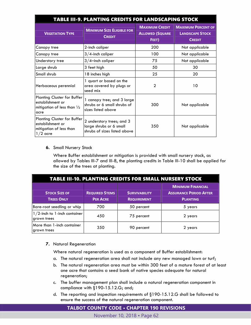
TALBOT COUNTY CODE • CHAPTER 190 REVISIONS
November 10, 2018 • Page 62
TABLE III-9. PLANTING CREDITS FOR LANDSCAPING STOCK
VEGETATION TYPE MINIMUM SIZE ELIGIBLE FOR
CREDIT
MAXIMUM CREDIT
ALLOWED (SQUARE
FEET)
MAXIMUM PERCENT OF
LANDSCAPE STOCK
CREDIT
Canopy tree 2-inch caliper 200 Not applicable
Canopy tree 3/4-inch caliper 100 Not applicable
Understory tree 3/4–inch caliper 75 Not applicable
Large shrub 3 feet high 50 30
Small shrub 18 inches high 25 20
Herbaceous perennial 1 quart or based on the area covered by plugs or seed mix
2 10
Planting Cluster for Buffer establishment or mitigation of less than ½ acre
1 canopy tree; and 3 large shrubs or 6 small shrubs of sizes listed above
300 Not applicable
Planting Cluster for Buffer establishment or mitigation of less than 1/2 acre
2 understory trees; and 3 large shrubs or 6 small shrubs of sizes listed above
350 Not applicable
6. Small Nursery Stock
Where Buffer establishment or mitigation is provided with small nursery stock, as allowed by Tables III-7 and III-8, the planting credits in Table III-10 shall be applied for the size of the trees at planting.
TABLE III-10. PLANTING CREDITS FOR SMALL NURSERY STOCK
STOCK SIZE OF
TREES ONLY
REQUIRED STEMS
PER ACRE
SURVIVABILITY
REQUIREMENT
MINIMUM FINANCIAL
ASSURANCE PERIOD AFTER
PLANTING
Bare-root seedling or whip 700 50 percent 5 years
1/2-inch to 1-inch container grown trees
450 75 percent 2 years
More than 1-inch container grown trees
350 90 percent 2 years
7. Natural Regeneration
Where natural regeneration is used as a component of Buffer establishment:
a. The natural regeneration area shall not include any new managed lawn or turf;
b. The natural regeneration area must be within 300 feet of a mature forest of at least one acre that contains a seed bank of native species adequate for natural regeneration;
c. The buffer management plan shall include a natural regeneration component in compliance with §190-15.12.G; and;
d. The reporting and inspection requirements of §190-15.12.G shall be followed to ensure the success of the natural regeneration component.
TALBOT COUNTY CODE • CHAPTER 190 REVISIONS
November 10, 2018 • Page 63
8. Increased Proportion of Shrubs and Perennials
The percentage of shrubs or herbaceous perennials required by Table III-9, for the landscape stock component of Buffer establishment, may be increased:
a. If the Buffer has existing canopy coverage of at least 50%; or,
b. If site constraints preclude canopy planting, including severely eroding slopes, salt water intrusion, predominately sandy soils, or unconsolidated fill; or,
c. To allow Buffer planting in shrubs and herbaceous perennials, rather than trees, within an area no wider than 15 feet located immediately adjacent to a marsh creation.
G. PLAN AND PERMIT APPROVAL
1. No waiver or variance may be granted to the planting and mitigation standards of this Section.
2. A final subdivision application shall not be approved until the required buffer management plan is approved.
3. A use and occupancy permit for a site that includes land in the Shoreline Development Buffer shall not be issued until the applicant:
a. Completes the planting required under an approved buffer management plan; or
b. Pending completion of the planting during the next planting season, provides financial assurance to cover the costs for:
i. Materials and installation; and
ii. At least 2 years of monitoring and assurance of survivability.
4. Before final plat recordation or approval of a site plan for a multifamily, commercial, industrial, or institutional use, an applicant shall post permanent signs delineating the upland boundary of the Buffer at a ratio of at least one sign per lot or per 200 linear feet of shoreline, whichever is applicable. Each sign shall:
a. Be at least 6 inches in width and 8 inches in height;
b. Be placed at a height of 4.5 feet, but not attached to a tree; and
c. Clearly state "Critical Area Buffer—No clearing or disturbance permitted".
5. Concurrent with the recordation of a final plat, an applicant shall record an easement or similar instrument for a buffer management plan.
H. MODIFIED BUFFER AREA
1. Purposes
a. Modified Buffer Areas are portions of the Shoreline Development Buffer where patterns of development that existed as of December 1, 1989, prevent the Shoreline Development Buffer from fulfilling its natural functions. In such areas special regulations apply to accommodate limited use of shoreline areas while protecting water quality and wildlife habitat to the extent possible, and providing for mitigation measures where encroachment of the Shoreline Development Buffer takes place.
b. In Modified Buffer Areas, certain types of development activities are permitted to encroach into the Shoreline Development Buffer without the need for a variance.
c. The Shoreline Development Buffer requirements remain in effect for the depth of the buffer as specified in §190-15.11.B. Only the requirements specified in this §190-15.11.H are modified.
TALBOT COUNTY CODE • CHAPTER 190 REVISIONS
November 10, 2018 • Page 64
2. Establishment
a. Modified Buffer Areas shall be designated by the County Council pursuant to the authority granted to the County by COMAR §27.01.09.01. Any creation of or revision to a Modified Buffer Area boundary also requires approval by the Maryland Critical Area Commission.
b. Creation of or revision to Modified Buffer Areas shall be submitted and heard following the procedures for County Council applications for amendments to the Official Zoning Maps in Article VII of this Chapter.
c. A request for individual property reclassification may not be considered, with the exception of commercial, institutional, or industrial sites, or those properties adjacent to an existing mapped Modified Buffer Area.
3. Standards for decision
The Council shall decide whether to grant approval based on the following findings and standards with respect to the community in which the mapping amendment is requested:
a. That existing patterns of residential, commercial, industrial and institutional development prevent the Shoreline Development Buffer from fulfilling its functions for water quality protection and conservation of wildlife habitat;
b. That the lots in the proposed Modified Buffer Area were created prior to August 13, 1989;
c. That the primary structures in the proposed Modified Buffer Area are located within the Shoreline Development Buffer;
d. That other development activities (i.e., accessory structures, access roads, septic systems, riprap and bulkheading, etc.) impact the Shoreline Development Buffer; and
e. That the Shoreline Development Buffer does not contain forest cover.
4. Applicability
The requirements in Subsection 5 below apply to the following structures and uses in Modified Buffer Areas:
a. The construction of a primary dwelling or a primary structure;
b. The reconstruction, conversion, structural alteration, relocation or enlargement of, or attachment to, any primary dwelling or existing primary structure located on a lot of record as of August 13, 1989 and:
i. Located within 100 feet of the mean high-water line of tidal waters; or
ii. Located within 100 feet of the edge of tidal wetlands or their tributary streams; and,
c. Accessory structures.
5. Requirements
a. Residential:
i. The encroachment into the Shoreline Development Buffer for any structure on an infill lot may be reduced to the average shoreward development setback of all existing primary structures within the community as depicted on the Official Zoning Maps.
ii. New structures and other development activities shall be designed to minimize encroachment into the Shoreline Development Buffer, and in no case shall they be closer than 50 feet to mean high water, edge of tidal wetlands or tributary streams.
TALBOT COUNTY CODE • CHAPTER 190 REVISIONS
November 10, 2018 • Page 65
b. Nonresidential:
i. New commercial, industrial, or institutional uses shall not be located closer than 50 feet to mean high water except for water-dependent activities.
ii. New, nonresidential accessory structures and impervious surfaces shall not extend closer to the water than 50 feet except for water-dependent activities.
c. Habitat protection areas: Development and redevelopment may not impact any habitat protection areas other than the Modified Buffer Area.
d. Natural vegetation: Natural vegetation shall not be removed in the Modified Buffer Area except that required by the proposed construction.
e. Lot coverage: The total lot coverage of the Critical Area portion of the site shall be in compliance with the applicable standards of §190-15.6.C.
f. Mitigation. Development activity in a Modified Buffer Area shall be mitigated as follows:
i. The extent of the lot or parcel shoreward of the proposed development shall be required to remain in natural vegetation, or shall be established and maintained in vegetation, in accordance with §190-15.11.D, E and F and per Subsection f.ii below.
ii. Mitigation equal to an area two times the square footage of the proposed lot coverage in the Shoreline Development Buffer area will be required to be planted within the Shoreline Development Buffer. Should on-site planting of required vegetation be precluded, an off-site Shoreline Development Buffer location may be established. The applicant shall be responsible for filing a buffer management plan with the Planning Office.
iii. Should the on-site or off-site Shoreline Development Buffer locations preclude the implementation of the preceding subsection, a fee-in-lieu shall be provided to the County adequate to ensure the restoration or establishment of an equivalent forest area in the Shoreline Development Buffer. The amount of the fee is established in the schedule of fees adopted by the County Council.
g. New lots: New lots created within Modified Buffer Areas are subject to full compliance with all development requirements as set forth in this chapter, including those for the Shoreline Development Buffer.
h. Administrative appeals: When granting permission to allow construction in the Shoreline Development Buffer as the result of an administrative appeal or variance, the Board of Appeals must find that the proposed construction meets the criteria set forth in this Section for Modified Buffer Areas and may impose such conditions and restrictions as are deemed necessary to mitigate any potential adverse impacts upon adjacent properties, the Shoreline Development Buffer, and habitat protection areas.
15.12. BUFFER MANAGEMENT PLANS
A. WHEN REQUIRED
1. A buffer management plan is required for establishment of the Buffer or disturbance to the Buffer resulting from the issuance of a:
a. Variance;
b. Subdivision approval;
c. Site plan approval;
TALBOT COUNTY CODE • CHAPTER 190 REVISIONS
November 10, 2018 • Page 66
d. Shore erosion control permit;
e. Building permit;
f. Grading permit;
g. Special exception; or
h. Permit for installation, repair, or replacement of a septic system.
2. A permit or approval of a development activity will not be issued for a property that is the subject of a violation due to failure to apply for or comply with a buffer management plan.
3. A buffer management plan is not required for maintenance of an existing grass lawn or an existing garden in the Buffer.
B. APPLICATION
1. The Planning Director shall publish application forms and a checklist of required information for:
a. Simplified buffer management plans;
b. Minor buffer management plans; and
c. Major buffer management plans.
2. The Planning Director may require that a buffer management plan be prepared by a registered professional forester or other qualified professional.
3. The application shall be filed with the Department of Planning and Zoning and decided by the Planning Director.
4. All buffer management plans shall also be in accordance with COMAR 27.01.09.01-3.
C. STANDARDS FOR APPROVAL
A buffer management plan shall:
1. Establish appropriate measures for the protection and maintenance of the Buffer;
2. Prohibit the installation or cultivation of new lawn or turf in the Buffer;
3. Ensure planting in compliance with the amounts specified in §190-15.11.D, E and F;
4. Ensure coverage of the Buffer with mulch or native ground cover or both until Buffer plantings are established; and
5. Ensure plantings are distributed throughout the Buffer to provide optimum habitat and water quality benefits.
D. SIMPLIFIED BUFFER MANAGEMENT PLAN
1. A simplified buffer management plan is required for:
a. Providing access up to 3 feet wide to a private pier or shoreline that is up to 3 feet wide;
b. Manually removing invasive or noxious vegetation;
c. Filling to maintain an existing grass lawn;
d. Managing storm damage;
e. Repairing or replacing a septic system; or
f. Except for an emergency situation under Subsection D.2 below, cutting up to five dead, diseased, dying, invasive, or hazardous trees.
2. If cutting a tree in the Buffer is immediately necessary because of an emergency situation, the applicant shall submit a simplified buffer management plan to the
TALBOT COUNTY CODE • CHAPTER 190 REVISIONS
November 10, 2018 • Page 67
Department of Planning and Zoning at the earliest possible time after the tree has been cut.
E. MINOR BUFFER MANAGEMENT PLAN
A minor buffer management plan is required for:
1. An application listed in §190-15.12.A for which establishment of less than 5,000 square feet of the Buffer is required under §190.15.11.D; or
2. An application listed in §190-15.12.A for which mitigation of less than 5,000 square feet is required under §190-15.11.E.
F. MAJOR BUFFER MANAGEMENT PLAN
1. A major buffer management plan is required for:
a. An application listed in §190-15.12.A for which establishment of at least 5,000 square feet of the Buffer is required under §190-15.11.D; or
b. An application listed in §190-15.12.A for which mitigation of at least 5,000 square feet is required under §190-15.11.E.
2. For a major buffer management plan a single species may not exceed 20 percent of the total planting requirement.
G. NATURAL REGENERATION COMPONENT OF BUFFER MANAGEMENT PLAN
1. Where natural regeneration is a component of Buffer establishment, the buffer management plan shall include a component including the required items for natural regeneration on the application form and checklist published by the Planning Office.
a. The natural regeneration component shall also be in accordance with COMAR 27.01.09.01-4.
b. The financial assurance for implementing the buffer management plan:
i. Must be sufficient to cover the cost of planting an area equivalent to the area of proposed natural regeneration; and
ii. Specifies that release of the financial assurance may not occur until the later of 5 years after the date of plan approval or when the natural regeneration area contains at least 300 native woody stems, on a per acre basis, that are at least 4 feet tall.
2. Report, Inspection, and Release of Financial Assurance
a. Five years after the date of approval of a buffer management plan that includes natural regeneration, the applicant shall submit to the Department of Planning and Zoning a report that contains:
i. Photographs of the natural regeneration area;
ii. An estimate of the number and average size of trees growing within the natural regeneration area on a per acre basis; and
iii. A list of plant species found within the natural regeneration area.
b. If the natural regeneration area does not contain at least 300 native woody stems on a per acre basis that are at least 4 feet tall, the applicant shall implement a supplemental planting plan for two years.
c. Upon expiration of the 2-year supplemental planting term, the applicant shall submit to the Department of Planning and Zoning an updated report as described in Subsection G.2.a above.
TALBOT COUNTY CODE • CHAPTER 190 REVISIONS
November 10, 2018 • Page 68
3. At any time, if the Planning Director determines that natural regeneration is not likely in the time anticipated in the buffer management plan and that applicant is no longer available to complete performance of the buffer management plan, the County may use the financial assurance to implement the plan.
15.13. SHORELINE STABILIZATION MEASURES
A. PLAN REQUIRED
1. A shore erosion protection works plan shall be prepared when measures are proposed to protect eroding portions of the shoreline. Improvements to protect property against erosion shall consist of nonstructural shoreline stabilization measures that preserve the natural environment, such as marsh creation, except in areas:
a. Designated by Maryland Department of the Environment (MDE) maps as appropriate for structural shoreline stabilization measures; or
b. Where MDE determines that nonstructural measures are not feasible, including areas of excessive erosion, areas subject to heavy tides, and areas too narrow for effective use of nonstructural shoreline stabilization measures.
2. For purposes of this Section, the terms "structural" and "nonstructural" shall be determined by the MDE.
3. For shoreline stabilization measures that will disturb an area of 5,000 square feet or more an Erosion and Sediment control plan shall be submitted to the Soil Conservation District.
B. PREPARATION AND SUBMITTAL
1. A zoning certificate from the Office of Permits and Inspections is required prior to construction of shore erosion control measures.
2. The shore erosion control plan shall be submitted to the Office of Permits and Inspections with the zoning certificate application. The Department of Planning and Zoning shall review the shore erosion control plan and supporting information for compliance with this Section.
3. The plan shall include:
a. A copy of all relevant, federal and state permits, including, but not limited to, those approvals by MDE and the U.S. Army Corps of Engineers.
b. Specifications for the proposed shore erosion protection, including information on the design storm, calculated wave run-up, required stone weight, and other information required for review by Talbot County, MDE and/or the U.S. Army Corps of Engineers.
c. Any other information necessary for review of the plan in relation to the criteria in this Code to include, but not be limited to, erosion and sediment control plan, stormwater management plan, floodplain management compliance, impacts to historical property or sites, environmental impacts to wildlife or aquatic habitats and oyster bars.
d. Buffer management plan delineating existing vegetative cover that would be removed and how it would be mitigated. Shore erosion control requiring grading or clearing shall be mitigated at a ratio of 1:1.
e. Location and quantity of fill materials.
f. Plans for restoration of disturbed area.
g. Copy of review comments from the Critical Area Commission.
TALBOT COUNTY CODE • CHAPTER 190 REVISIONS
November 10, 2018 • Page 69
C. CRITERIA FOR PLANS
The following criteria shall be used in developing and reviewing shore erosion control plans. These criteria shall be applied based on the written determination from MDE as to whether the project is structural or nonstructural:
1. Use structural control measures only when nonstructural control measures would be impractical or ineffective;
2. Where structural erosion control is proposed, use measures that best provide for conservation of fish and plant habitat;
3. Use nonstructural measures in areas of erosion where they would be a practical and effective method of erosion control;
4. Structural erosion measures are not to be encouraged in areas where no significant erosion occurs;
5. If significant alterations in the characteristics of a shoreline occur, the measure that best fits the change may be used for sites in that area; and
6. Habitat enhancement practices, such as dredge fill and marsh creation, are encouraged.
15.14. WATER-DEPENDENT FACILITIES
A. USES INCLUDED
As indicated in Table IV-1, Land Uses, the following uses, which use water for transportation and derive economic benefits from shore access, may be allowed:
1. Private piers, community piers and related boat facilities;
2. Marinas; and
3. Water-oriented public recreation, education, research areas.
B. ADDITIONAL REGULATIONS
For the above uses, in addition to the specific requirements for the uses in Article IV and, where applicable, the findings and requirements for special exceptions in Article VII, the following regulations apply which the approving authority shall review as part of the development plan or special exception:
1. REQUIRED FINDINGS
The following findings must be made:
a. The request is consistent with the intent and purpose of the Maryland Chesapeake Bay Critical Area Law;
b. The activity shall have minimal individual and cumulative impact on water quality and fish, wildlife, and plant habitat in the Critical Area through design and location criteria;
c. The activity shall be water-dependent;
d. The project shall meet a recognized private right or public need;
e. Non-water-dependent structures or operations associated with water-dependent projects or activities shall be located outside the Buffer with sufficient area provided for these associated structures or operations.
2. REQUIREMENTS
The following requirements must be met:
TALBOT COUNTY CODE • CHAPTER 190 REVISIONS
November 10, 2018 • Page 70
a. The activity shall not alter existing water circulation patterns or salinity regimes;
b. The activity shall maintain or improve the flushing characteristics of the water body adjacent to the activity;
c. Wetlands, submerged aquatic plant beds, or other areas of important aquatic habitats shall not be disturbed except for approved research projects;
d. The operation procedures shall preclude any adverse impacts to water quality that may occur as a result of the activity, such as non-point-source runoff, sewage discharge from land activities or vessels, or from boat cleaning and maintenance operations;
e. The operation procedures shall ensure that shellfish beds will not be disturbed or be made subject to discharge that will render them unsuitable for harvesting;
f. The construction procedures shall ensure that dredging will be conducted in a manner, and using a method, which causes the least disturbance to water quality and aquatic and terrestrial habitats in the area immediately surrounding the dredging operation or within the Critical Area;
g. The construction procedures shall ensure that dredged spoil will not be placed within the Shoreline Development Buffer or elsewhere in a habitat protection area except as necessary for:
i. Backfill for permitted shore erosion protection measures;
ii. Use in approved vegetated shore erosion projects; and
iii. Placement on previously approved channel maintenance spoil disposal areas; and
h. Interference with the natural transport of sand shall be minimized.
15.15. USABLE WATER AREA; HARBOR LINE; LATERAL LINES Prior to the construction of any pier, wharf, dock, marina or water-dependent facility, the usable water area shall be determined. The usable water area is the maximum water area that may be used for piers, pilings, buoys, and other such facilities, including open areas for navigation, and is the area bounded by the mean high-water line of a subject property, two side property line extensions, referred to as "lateral lines," and a line connecting their channelward ends, referred to as the "harbor line."
A. DETERMINATION OF THE HARBOR LINE
1. The length of each lateral line extension for the purposes of location of the harbor line and any point along the line connecting their channelward ends shall be limited to the lesser of:
a. One-half the distance from the mean high-water line to the center point of a cove; or
b. One-half the distance from the mean high-water line to the center line of the subject body of water; or
c. Three hundred feet from the mean high-water line of the subject site.
2. In the event of conflict between the location of the harbor line through the method prescribed in Subsection A.1.a, b or c above, and the location of any U.S. Army Corps of Engineers recognized channel, the most restrictive line shall apply for purposes of limiting construction.
B. DETERMINATION OF THE LATERAL LINE EXTENSION
The direction of a lateral line extension channelward from the mean high-water line shall be determined through the following method, which is illustrated in Figure III-2.

TALBOT COUNTY CODE • CHAPTER 190 REVISIONS
November 10, 2018 • Page 71
1. Prepare a scale drawing showing the applicant's property and all adjacent waterfront properties within a minimum two-hundred-foot radius of the shoreline owned by the applicant. (A larger radius may be required when lot sizes and configuration so dictate). (See Figure III-2.)
2. Locate the shoreline (mean high water) and harbor lines on the drawing. The harbor line shall be located as prescribed in Subsection A above.
3. Identify the intersection of all property lines with the shoreline (Points A, B, C, D, E, and F on Figure A).
4. From the applicant's property line shoreline intersections (Points D and E on Figure A) identify the intersection at a two-hundred-foot radius with the shoreline (Points 1 and 2 on Figure A).
5. From the applicant's property, connect all property line shoreline points, ending at Points 1 and 2 with straight lines (i.e., D to C, C to B, B to 1, and E to 2 on Figure A).
6. Bisect each respective angle formed by these straight lines and extend the lines bisecting the angle from the shoreline to the harbor line. These are lateral lines (B-G, C-H, D-I, E-J on Figure A).
C. USABLE WATER AREA CONDITIONS
The usable water area for the purposes of defining setbacks for structures, as defined by lateral lines, shoreline, and harbor line, shall meet the following conditions:
1. If a pair of lateral lines extended to the harbor line result in a distance of 25 feet or more on the harbor line (lines G-H, H-I, I-J), the lateral lines are satisfactory, and define the usable water area.
2. If any pair of lateral lines, extended, intersect before reaching the harbor line, or when extended in a harbor line segment (G-H, H-I, I-J, Figure A) of less than 25 feet, an imaginary line shall be moved toward the shoreline and parallel to line D-E, (Figure A) until a twenty-five-foot clearance is obtained (line N-O, Figure B).
3. Two additional lateral lines N-P and O-Q will be drawn perpendicular to line N-O to the harbor line. The lines D-N-P, E-O-Q are the new lateral lines for the applicant's parcel and the adjoining properties. For all amended lateral lines, construction will be limited to the area enclosed by the shoreline, the lateral lines (D-N, O-E) and the imaginary clearance line N-O (Figure B). This procedure will ensure adequate clearance for adjacent piers. These new lateral lines, the harbor line and the shoreline define the usable water area for the applicant.

TALBOT COUNTY CODE • CHAPTER 190 REVISIONS
November 10, 2018 • Page 72
Figure III-2. Determination of Lateral Lines
TALBOT COUNTY CODE • CHAPTER 190 REVISIONS
November 10, 2018 • Page 73
Section 190-16 EASTON AIRPORT OVERLAY DISTRICT (EA)
16.1. PURPOSE
A. The purpose of the Easton Airport Overlay District is to prevent structures, towers, trees, temporary structures, or other objects from constituting hazards or obstructions to aircraft operating to, from, or in the vicinity of the Easton Airport.
B. The purpose of the larger area defining the proximity of the airport is to inform residents and businesses undertaking development activity about the presence of the airport.
16.2. ESTABLISHMENT
A. The boundaries of the Easton Airport Overlay District are shown on the Official Zoning Maps.
B. It is intended that the Easton Airport Overlay District should, at a minimum, include all areas that are currently or could in the future be airport obstruction zones as defined below.
16.3. AIRPORT OBSTRUCTION ZONE
A. The airport obstruction zone is the area within which notification of proposed construction or alterations must be submitted to the FAA pursuant to the Code of Federal Regulations (CFR) Title 14 Part 77, §77.9.
B. The Department of Planning and Zoning shall produce, publish and make available for public review, maps identifying the airport obstruction zone for the Easton Airport.
1. The Department of Planning and Zoning shall work with the Easton Airport Manager and may seek assistance from the Maryland Aviation Administration in mapping the airport obstruction zone.
2. The Easton Airport Overlay District should include all airport obstruction zones and may encompass a larger area to account for possible future airport expansion or revisions to flight paths that may alter the airport obstruction zones.
16.4. PLAN REVIEW Prior to giving zoning approval for any proposed construction activity or alteration in the Easton Airport Overlay District the Planning Director shall:
A. Consider the comments of the manager of the Easton Airport with respect to the effects of the proposed construction activity on airspace used by aircraft operating to, from, or in the vicinity of the Easton Airport.
B. Determine whether the construction activity or alteration is located within an airport obstruction zone.
C. If the proposed project is located within an airport obstruction zone, County staff shall instruct the applicant to do the following:
1. Complete and submit form FAA 7460-1, Notice of Proposed Construction or Alteration, to the FAA.
TALBOT COUNTY CODE • CHAPTER 190 REVISIONS
November 10, 2018 • Page 74
2. Submit a copy of the form 7460-1 to the Maryland Aviation Administration (MAA).
3. The submittals must occur at least 45 days prior to the commencement of the construction or alteration.
D. The Department of Planning and Zoning shall:
1. Defer action on the application until it receives comments, transmitted by the applicant, from the FAA and MAA.
2. Based on these comments, place conditions upon approval for the development activity as necessary to prevent a hazard or obstruction to aircraft.
16.5. NOTIFICATION
A. Subdivision plats and site plans for land in the proximity of the airport shall be annotated to indicate the proximity to the Easton Airport.
B. For purposes of this Section, proximity is defined as any land within two miles of the center line of a runway.
C. The annotation shall indicate that the property may experience low overhead flights, vibrations and noise as a result of the proximity to the airport.
Section 190-17 GATEWAY OVERLAY DISTRICT (GWO)
17.1. PURPOSE The purpose of the Gateway Overlay District (GWO) is to consider and incorporate the long-range development plan for the towns and County within the sensitive roadway corridors that enter and exit the towns. Gateway areas are intended to preserve a scale and design that is compatible with the community's vision for the area.
17.2. DESIGNATION OF DISTRICT Gateway Overlay Districts may be established by the County Council within roadway corridors meeting the purpose of the GWO, in accordance with the procedure set forth in Article VII for amendments to the Official Zoning Maps.
17.3. APPLICABILITY
A. Standards established in this Overlay District apply to development activities requiring major site plan approval in the Gateway Overlay Districts that are shown on the Official Zoning Maps. These standards are in addition to standards for the underlying district established elsewhere in this chapter.
B. Development activities requiring a minor or administrative site plan shall comply with the standards of this District applicable to the particular development.

TALBOT COUNTY CODE • CHAPTER 190 REVISIONS
November 10, 2018 • Page 75
17.4. GENERAL STANDARDS
A. LANDSCAPE YARD
1. Table III-11 establishes a minimum front setback and landscape yard depth along the roadway for the Gateway Overlay District.
2. Permitted uses and structures in the landscape yard, in addition to plantings, shall be limited to access entrances, utilities, pedestrian paths, sidewalks, gateway signage, fences, or similar uses or structures approved by the Planning Commission.
3. The perimeter landscape yard required by §190-40.5, as applicable to the particular site, shall be provided adjacent to the road right-of-way within the front landscape yard required for the Gateway Overlay District. The remainder of the Gateway Overlay landscape yard area may be used as additional landscaped area, pedestrian amenities, or yard area as approved by the Planning Commission.
4. Mechanical equipment and refuse storage and removal areas.
a. All mechanical equipment and refuse storage and removal areas shall be screened from any public roadway.
b. Where screening by landscaping is not possible, the Planning Commission may approve substitution of features such as fencing or other materials, to establish an attractive buffer.
5. Plant materials for landscape yards.
a. Plant materials for landscape yards may include a mix of trees, shrubs, grasses, flowers and hedges.
b. Selection of plant materials shall be subject to constraints due to easements and traffic safety.
B. SIGNAGE
1. Freestanding signs:
a. Maximum number per property: one.
b. Maximum height: eight feet.
c. Maximum sign face area: 60 square feet per side.
d. Shall be landscaped at the base.
e. May be located in the landscaped portion of the landscape yard if made of a natural or decorative material.
f. Signs mounted on a single freestanding pole are prohibited.
2. Wall signs: The maximum sign area is 75% of that permitted by the underlying zoning district. For example, 100 square feet of sign area permitted in underlying district translates to 75 square feet in the GWO.
3. Signage shall be compatible with the style and character of adjacent properties and the primary building to which it relates.
C. LIGHTING
1. Lighting shall be directed downward and contained on the site using shielded fixtures with full cutoff recessed flush lenses.
2. Parking lot lights may be incorporated into a streetlight scheme to illuminate public and private streets and pedestrian paths.
TALBOT COUNTY CODE • CHAPTER 190 REVISIONS
November 10, 2018 • Page 76
D. PEDESTRIAN ACCESS
1. Lots located within a town's designated growth area, as identified in the County Comprehensive Plan, shall provide for a pedestrian walkway separate from the parking area and linking adjacent parcels.
2. Where construction of a walkway is not practical at the time of development, a ten-foot easement shall be dedicated for future use.
E. ACCESS AND PARKING
1. Parking areas shall not be permitted within a landscape yard.
2. Parking areas shall be located to the side or rear of the primary building, except that not more than three parking spaces may be located in front of the building, outside the landscape yard.
3. All parking areas shall be landscaped from the view of any public road and include a landscape yard of not less than 10 feet in depth, consisting of a continuous three-foot-high hedge or other landscape materials, unless the screening requirement is met by planting within the required landscape yard.
4. All required parking spaces shall be located on the lot with the building or use unless shared with an adjacent property.
5. For retail sales and service establishments, development of up to 25% of the parking spaces required by Article V may be deferred by the Planning Commission, provided there is a shared parking agreement with adjoining uses of similar or less intensive activity and with inter-parcel connections linking the two properties.
6. Curb cuts shall be consolidated and parallel service roads shall be created where possible.
7. Inter-parcel connections are required where practical. Properties providing connections are permitted to share off-street parking space requirements, as indicated in Subsection E.5 above.
8. New lots in the AC, CP, WRC, TC, RC, RR and TR Districts shall achieve access through use of County roads, shared entrances or private roads.
F. MECHANICAL EQUIPMENT
1. Fixed mechanical equipment for ventilation, refrigeration or other operational uses is not permitted within the landscape yard and must be located to the side or rear of the primary building as defined.
2. Side and rear yard setbacks for such equipment shall be the same as required for primary structures in the underlying zoning district.
G. REFUSE AREAS
1. Refuse areas are not permitted within a landscape yard, and must be located to the side or rear of the primary building.
2. Side and rear yard setbacks for such refuse area shall not be less than 10 feet unless a common refuse area is shared by adjacent properties.
H. DESIGN AND HEIGHT OF STRUCTURES
The following guidelines and standards are intended to create a cohesive streetscape as buildings are constructed or enlarged.
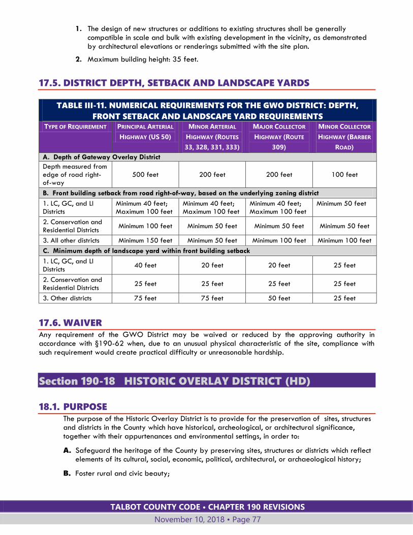
TALBOT COUNTY CODE • CHAPTER 190 REVISIONS
November 10, 2018 • Page 77
1. The design of new structures or additions to existing structures shall be generally compatible in scale and bulk with existing development in the vicinity, as demonstrated by architectural elevations or renderings submitted with the site plan.
2. Maximum building height: 35 feet.
17.5. DISTRICT DEPTH, SETBACK AND LANDSCAPE YARDS
TABLE III-11. NUMERICAL REQUIREMENTS FOR THE GWO DISTRICT: DEPTH,
FRONT SETBACK AND LANDSCAPE YARD REQUIREMENTS
TYPE OF REQUIREMENT PRINCIPAL ARTERIAL
HIGHWAY (US 50)
MINOR ARTERIAL
HIGHWAY (ROUTES
33, 328, 331, 333)
MAJOR COLLECTOR
HIGHWAY (ROUTE
309)
MINOR COLLECTOR
HIGHWAY (BARBER
ROAD)
A. Depth of Gateway Overlay District
Depth measured from edge of road right-of-way
500 feet 200 feet 200 feet 100 feet
B. Front building setback from road right-of-way, based on the underlying zoning district
1. LC, GC, and LI Districts
Minimum 40 feet; Maximum 100 feet
Minimum 40 feet; Maximum 100 feet
Minimum 40 feet; Maximum 100 feet
Minimum 50 feet
2. Conservation and Residential Districts
Minimum 100 feet Minimum 50 feet Minimum 50 feet Minimum 50 feet
3. All other districts Minimum 150 feet Minimum 50 feet Minimum 100 feet Minimum 100 feet
C. Minimum depth of landscape yard within front building setback
1. LC, GC, and LI Districts
40 feet 20 feet 20 feet 25 feet
2. Conservation and Residential Districts
25 feet 25 feet 25 feet 25 feet
3. Other districts 75 feet 75 feet 50 feet 25 feet
17.6. WAIVER Any requirement of the GWO District may be waived or reduced by the approving authority in accordance with §190-62 when, due to an unusual physical characteristic of the site, compliance with such requirement would create practical difficulty or unreasonable hardship.
Section 190-18 HISTORIC OVERLAY DISTRICT (HD)
18.1. PURPOSE The purpose of the Historic Overlay District is to provide for the preservation of sites, structures and districts in the County which have historical, archeological, or architectural significance, together with their appurtenances and environmental settings, in order to:
A. Safeguard the heritage of the County by preserving sites, structures or districts which reflect elements of its cultural, social, economic, political, architectural, or archaeological history;
B. Foster rural and civic beauty;

TALBOT COUNTY CODE • CHAPTER 190 REVISIONS
November 10, 2018 • Page 78
C. Promote the preservation, appreciation, and where permitted and appropriate, the use of historic sites, structures and districts for the education, welfare, and pleasure of the residents of the County; and
D. Strengthen the local economy.
18.2. DESIGNATION OF HISTORIC OVERLAY DISTRICTS
A. The County Council may establish, modify, and define the boundaries of Historic Overlay Districts to include historic sites, structures or districts that are of local, state or national historic, archeological, architectural or cultural significance. At least one of the following criteria must be met to support the establishment of a District:
1. The District consists of or contains a landmark or structure, or a grouping of such sites, listed in the Maryland Inventory of Historic Properties or the National Register of Historic Places.
2. The District contains sites, structures or landmarks associated with persons, events, or activities that have made a significant contribution to local, regional or national history;
3. The District contains sites, structures, or archeological resources that exemplify distinctive characteristics of one or more historic periods or types or whose exterior design or features exemplify distinctive historic architecture, materials or craftsmanship.
B. The County Council shall follow the procedures set forth in Article VII for amendments to the Official Zoning Maps, and shall consider the recommendation of the Historic Preservation Commission.
C. The boundaries of Historic Overlay Districts may be drawn to include those lands adjacent to the sites, structures or districts that are reasonably related to the essential character of the district.
D. The County Council may only establish an Historic Overlay District after receiving the consent of the property owner(s).
18.3. APPLICATION FOR PERMISSION TO BUILD, ALTER, OR DEMOLISH
A. CERTIFICATE OF APPROPRIATENESS REQUIRED
1. Before the construction, alteration, reconstruction, moving or demolition of any site or structure within a designated Historic Overlay District, and before any changes take place that would affect either the exterior appearance of a structure or the character of its related environment within the designated Historic District, the person proposing to make the changes shall file with the Historic Preservation Commission an application for a Certificate of Appropriateness.
2. Every such application shall be referred to and accepted or rejected by the Historic Preservation Commission.
3. No building permit, zoning permit, site plan or grading plan shall be approved within the Historic District, and no work shall commence, until a Certificate of Appropriateness is approved by the Historic Preservation Commission.
B. FACTORS FOR CONSIDERATION IN REVIEWING APPLICATIONS
In reviewing applications for a Certificate of Appropriateness, the Historic Preservation Commission shall give consideration to:
TALBOT COUNTY CODE • CHAPTER 190 REVISIONS
November 10, 2018 • Page 79
1. The effect of the proposed changes on the historic, archeological, or architectural significance of the site or structure and its relationship to the historic, archeological, or architectural significance of the surrounding area.
2. The relationship of the exterior architectural features of the structure to the remainder of the structure and to the surrounding area.
3. The general compatibility of exterior design, scale, proportion, arrangement, texture, and materials proposed to be used.
4. Any other factors, including aesthetics which the Historic Preservation Commission considers pertinent.
5. Documentation about the structure and the Historic District that is on file at the Talbot County Department of Planning and Zoning.
C. STANDARDS FOR EVALUATION
In judging the compatibility of proposed changes, the Historic Preservation Commission:
1. Shall rely on the objective standards set forth in the Secretary of the Interior's Standards for the Treatment of Historic Properties.
2. May, in addition, consider any pertinent factors relevant to the case but not specifically addressed in the Secretary's guidelines and standards.
D. EXTERIOR FEATURES
The Historic Preservation Commission shall consider only exterior features of a structure, and shall not consider any interior arrangements.
E. STRICTNESS AND LENIENCY IN JUDGMENT OF PLANS
The Historic Preservation Commission:
1. Shall be strict in its judgment of plans for those sites or structures deemed by research to be of historic, archeological or architectural significance.
2. Shall be lenient in its judgment of plans for sites or structures of little significance or for plans involving new construction, unless such plans would seriously impair the historic, archeological or architectural significance of the surrounding site or structures.
3. Is not required to limit new construction, reconstruction, alteration, or repairs to the architectural style of any one period.
F. HISTORIC PRESERVATION COMMISSION DECISION
1. The Historic Preservation Commission shall file with the Planning Director written notification of its approval, approval with conditions, modification, or rejection of all applications for a Certificate of Appropriateness.
2. The Commission may approve the application subject to reasonable and practical conditions that are clearly related to the historic and aesthetic appropriateness of the proposed construction, reconstruction or alterations.
3. The failure of the Historic Preservation Commission to act upon a pending application within 45 days after the date the complete application was filed shall be deemed to constitute automatic approval of the proposed change unless an extension of this forty-five-day period is agreed upon mutually by the applicant and the Commission or the application is withdrawn.
4. If an application is rejected by the Commission, no application for substantially the same proposal shall be submitted within one year of the Commission’s decision.
TALBOT COUNTY CODE • CHAPTER 190 REVISIONS
November 10, 2018 • Page 80
18.4. ORDINARY MAINTENANCE; COMPLETION OF WORK UNDER
PRIOR PERMIT
A. Nothing in this Section shall be taken or construed to prevent work and repairs on any structure coming under the heading of ordinary maintenance.
B. For the purposes of this Section, ordinary maintenance is defined as that which does not alter the exterior architecture of a site or structure, or the environment of the designated Historic District; customary farming operations; or landscaping which will have no material effect on the historic, archaeological, or architectural significance of a historic site, structure or district.
C. Nothing in this Section affects the right to complete any work covered by a permit issued prior to the date upon which the Historic Overlay District was established.
18.5. STRUCTURES OF UNUSUAL IMPORTANCE
A. If an application is submitted for construction, alteration, or reconstruction affecting a site or the exterior of a structure, or for the moving or demolition of a structure, and the Historic Preservation Commission considers preservation of the site or structure to be of unusual importance to the County, the State or the Nation, the Commission shall attempt, with the owner of the site or structure, to formulate an economically feasible plan to preserve the site or structure.
B. Unless the Historic Preservation Commission is satisfied that the proposed work or changes will not materially impair the historic or architectural value of the structure, the Commission shall reject the application, filing a copy of its rejection with the Planning Director. The application shall not be renewed in less than one year.
C. Should the Historic Preservation Commission conclude that no economically feasible plan can be formulated, it shall have 90 days from the time it so concludes to negotiate further with the owner and other parties in an effort to find a means of preserving the site or structure.
D. If a site or structure is considered to have historic, archeological, or architectural significance, the Historic Preservation Commission may approve an application for construction, reconstruction, alteration, moving or demolition, despite the fact that the change comes within the provisions of this Section, if:
1. The site or structure is a deterrent to a major improvement program which will be of substantial benefit to the County; or
2. The retention of the site or structure would cause undue financial hardship to the owner; or
3. The retention of the site or structure would not be in the best interest of a majority of persons in the community.
18.6. HISTORIC PRESERVATION COMMISSION MEETINGS
A. All meetings of the Historic Preservation Commission shall be open to the public.
B. The applicant and any interested person or their representative is entitled to appear and be heard by the Historic Preservation Commission before it reaches a decision on any matter.
C. The Historic Preservation Commission shall keep an open record of its resolutions, proceedings, and actions which shall be kept available for public inspection.

TALBOT COUNTY CODE • CHAPTER 190 REVISIONS
November 10, 2018 • Page 81
D. Should the Historic Preservation Commission reject an application, the Commission shall provide a written notice of rejection.
18.7. REMOVAL OF HISTORIC OVERLAY DISTRICT DESIGNATION
A. A property owner of a site or structure within an Historic Overlay District may request to have the Historic Overlay District modified or removed from the site or structure if this Section is amended so as to substantially alter the effect of the Historic Overlay District zoning on an existing Historic District.
B. If such an amendment is made to this Section, the Historic Preservation Commission shall notify all existing Historic District property owners within 30 days of the effective date of the amendment. The property owner shall have 30 days from notification to request in writing to the County Council to have the Historic Overlay District modified or removed.
C. If a request is made, the following procedures shall occur:
1. The Historic Preservation Commission shall hold a public hearing to receive comments from all interested parties, and forward its recommendation to the County Council.
2. The County Council may then introduce an amendment to the Official Zoning Maps in accordance with Article VII to remove the Historic Overlay District from the property in question.
Section 190-19 SUSTAINABLE TOURISM AND REINVESTMENT
FLOATING DISTRICT (STAR)
19.1. PURPOSE AND INTENT
A. The Sustainable Tourism and Reinvestment ("STAR") district is intended to promote reinvestment and redevelopment of existing tourism-related structures or uses that are subject to the restrictions in Chapter 190, Article VI (Nonconforming Lots, Uses, and Structures).
B. The STAR district is intended to promote the local tourism industry, and to encourage the economical and efficient use of land and reinvestment in existing nonconforming tourism-related structures and uses through rehabilitation, redesign, upgrades, demolition, and reconstruction.
19.2. DISTRICT REQUIREMENTS
A. ELIGIBILITY
A STAR district is a floating zone that may be applied only to a parcel of record or portion thereof that, as of February 20, 2016, is improved by an existing legal nonconforming hotel, motel, community and cultural facility, golf course open to the public, inn, marina, or restaurant:
1. That had been in continuous use for a period of at least 10 years, ending, if at all, not more than five years prior to the date of the application; and
2. That has a legal nonconforming status.

TALBOT COUNTY CODE • CHAPTER 190 REVISIONS
November 10, 2018 • Page 82
B. EFFECT OF DISTRICT ADOPTION
Adoption of a Sustainable Tourism and Reinvestment district permits redevelopment of existing tourism-related structures and uses without regard to the restrictions in Chapter 190, Article VI (Nonconforming Lots, Uses, and Structures).
C. PERMITTED USES AND STRUCTURES
1. Principal uses and structures in a STAR district include:
a. Hotels, motels, community and cultural facilities, golf courses open to the public, inns, marinas, and restaurants; and
b. Uses or structures permitted in the underlying zoning district.
2. Accessory uses and structures include those that are incidental and subordinate to, and customarily found in connection with, the principal uses or structures listed in Subsection C.1 above.
D. BULK REQUIREMENTS
1. Bulk requirements shall be as specified in the base zone or applicable overlay zone(s), whichever is more restrictive, subject to Subsection D.2, 3 and 4 below.
2. Existing legal nonconforming sizes, areas, dimensions, and locations (nonconforming to bulk standards) of any existing use or structure as of the date of the approval of an application under this §190-19 may be continued for any replacement use or structure, and may be consolidated or reconfigured, but may not be increased without a variance.
3. Any limitation on expansion of a nonconforming use set forth in §190-48 of this chapter shall not be applicable to redevelopment approved under this §190-19.
4. Calculation of maximum structure height shall exclude rooftop mechanical equipment, elevator overruns, and any approved architectural detail or parapet minimally sized to hide those elements. The area excluded from maximum structure height shall not exceed:
a. Fifteen percent of the structure's footprint; and
b. Ten feet above the maximum structure height permitted in the underlying zone.
E. OTHER REQUIREMENTS
1. Architectural requirements: Architectural requirements shall be set forth in an approved redevelopment plan.
2. Parking: Off-street parking shall be provided in accordance with an approved redevelopment plan.
3. Landscaping: Landscaping shall be provided in accordance with §190-40 of this chapter.
4. Signs: Signage shall be provided with the provisions of §190-42 of this chapter.
19.3. PROCEDURE FOR APPROVAL The procedure for establishing a STAR district is the same as the procedure for amendments to the Official Zoning Maps set forth in Article VII, except as modified herein.
A. A preapplication meeting in accordance with §190-54.1 shall be required prior to submission of an application.
B. Applications for a STAR district shall be filed with the Planning Director and shall contain:
1. An adequate legal description of the property proposed for inclusion in the district;
TALBOT COUNTY CODE • CHAPTER 190 REVISIONS
November 10, 2018 • Page 83
2. A redevelopment plan deemed by the Planning Director to include all information required to permit complete review of the application. The Planning Director may require the applicant to provide additional or supplemental information as necessary to evaluate or process the application.
3. A certification of nonconforming status under §190-47.
C. Sponsorship of the application by at least one council member shall be required in accordance with §190-55.1.B.3 for the application to proceed.
D. If sponsored, the application shall be scheduled for review and comment by the Technical Advisory Committee in accordance with the site plan procedures of §190-60.
E. The applicant shall hold a community meeting in accordance with §190-60.6.A.
F. The Planning Commission shall review the application for compliance with this §190-19 and for consistency with the Comprehensive Plan in accordance with §190-55.2.B. The Planning Commission may recommend modification of the structures, uses, or redevelopment plan prior to forwarding its recommendations to the County Council.
G. Upon conclusion of the Planning Commission's review, and upon the request of either the Planning Commission or the County Council, the County Council shall schedule a joint work session with the Planning Commission to review the application and the Planning Commission's recommendations.
H. Legislation to adopt a STAR district may be introduced in accordance with §190-55.1.B.3.
I. Required findings: An application for a STAR district may be approved based upon the following findings:
1. Approval of the district is consistent with the Comprehensive Plan;
2. Approval of the district is consistent with the purposes and intent of this Section, §190-19;
3. Public facilities and services are or will be adequate, including roads, individual or community water systems, individual or community sewerage systems, police and fire protection, and any other facilities and services deemed appropriate;
4. The beneficial purposes achieved by the district are not outweighed by any adverse effects on the surrounding neighborhood;
5. The district will promote, and will not interfere with, the adequate and orderly provision of public facilities; and
6. All requirements of this Section have been met.
J. Site plan approval
1. After approval of a STAR district the applicant shall apply for site plan approval in accordance with §190-60 to implement the redevelopment plan.
2. The approved redevelopment plan shall include sufficient detail to permit accurate preparation, review, comment, and approval of a site plan to implement all features, conditions, and requirements of the approved district. The sizes, areas, dimensions, and locations of all preexisting nonconforming bulk standards referenced in §190-19.2.D.2 and those proposed for use in the redevelopment, shall be quantified and delineated on the site plan.
3. The site plan approval shall be based upon, consistent with, and shall implement the approved redevelopment plan.
TALBOT COUNTY CODE • CHAPTER 190 REVISIONS
November 10, 2018 • Page 84
4. If the final site plan is not approved within two years of the effective date of the STAR rezoning, the County Council may reclassify the property back to its original zoning designation.
5. Construction of improvements authorized by adoption of a STAR district shall commence within two years of final site plan approval. If construction does not commence within two years following final site plan approval, the County Council may reclassify the property back to its original zoning designation.
K. Amendments
An approved STAR district, a redevelopment plan, or an approved site plan may be amended in the same manner and subject to the same conditions as an original application.
L. Construction
1. §190-19 does not waive, suspend, modify, or supersede any applicable federal or state laws, regulations, or requirements, including, without limitation, Critical Area requirements.
2. Except as expressly set forth herein, this §190-19 does not waive, suspend, modify, or supersede any other applicable local laws, regulations, or requirements.
Section 190-20 VILLAGE OVERLAY DISTRICT (VO)
20.1. PURPOSE AND INTENT The Village Overlay District is established for the following purposes:
A. To protect and enhance the character of established and historic neighborhoods in keeping with the unique character of the County’s rural villages.
B. To provide modified bulk requirements and design standards for areas of the VM, VH or VR Districts where the requirements of the underlying zone are not suitable given the established character of the neighborhood.
C. To encourage renovation, expansion, infill and redevelopment in established neighborhoods in a manner that reinforces character-forming attributes that may include lot size, lot proportions, building setbacks, building dimensions or orientation, and the location of site features such as parking, fences and landscaping.
20.2. REVIEW AND APPROVAL PROCESS
A. Establishment of Village Overlay Districts shall be submitted and heard following the procedures for amendments to the Official Zoning Maps.
B. The Village Overlay is intended to protect the character of neighborhoods. Therefore, a request for individual property reclassification may not be considered with the exception of properties adjacent to an existing mapped Village Overlay Zone.
C. The County Council shall decide whether to grant approval based on the following findings with respect to the community in which the map amendment is requested:
1. Traditional or historic patterns of residential, commercial, and institutional development will be better protected through application of the Village Overlay than by the underlying VM, VH or VR zoning district.
TALBOT COUNTY CODE • CHAPTER 190 REVISIONS
November 10, 2018 • Page 85
2. Application of the Village Overlay will promote a sustainable community by allowing suitable reinvestment, reuse and infill development.
D. For each proposed zoning map amendment to apply the Village Overlay:
1. The Department of Planning and Zoning, in its report on the zoning map amendment, shall provide aerial photographs or other documentation showing existing lot lines, streets, structures, land uses and natural features for the area of the proposed Village Overlay.
2. The Planning Commission, in its recommendation to the County Council, shall identify key features that are important to the traditional or historic character of the village area.
E. The County Council, in adopting legislation applying the Village Overlay to a portion of a particular village:
1. Shall include in its decision documentation showing lot lines, streets, structures, land uses and natural features.
2. Shall also include in its decision specific standards, supported by the documentation, that specify appropriate dimensions, design guidelines or other criteria for development within the particular Village Overlay.
F. The VO District shall not impact the permitted uses of the underlying zone, but shall establish other standards, which may include bulk requirements and/or design guidelines, that supplement or supersede the requirements of the underlying zone.
G. The documentation and standards included in the County Council’s decision shall be published by the Department of Planning and Zoning as the Village Overlay Design Guidance for the particular village.
H. Where applicable, Village Overlay Design Guidance for minimum lot size, lot width and setbacks shall be no less than the average (mean) lot size, lot width or setbacks of the lots within the Village Overlay. The Shoreline Development Buffer shall not be reduced unless the area within the Village Overlay also includes a Modified Buffer Area Overlay.
20.3. DEVELOPMENT STANDARDS AND DECISION
A. Proposals for subdivision or development shall be guided by and comply with the Village Overlay Design Guidance for the particular Village Overlay.
B. All requirements applicable to the underlying zoning district shall apply except as specifically replaced by the Village Overlay Design Guidance.
C. Decisions on development applications within a Village Overlay shall be made in accordance with the provisions of Article VII, Administration, except that the Planning Director may request the recommendation of the Planning Commission on any application that is decided by the Planning Director.
Section 190-21 RESERVED

TALBOT COUNTY CODE • CHAPTER 190 REVISIONS
November 10, 2018 • Page 86
Section 190-22 RESERVED
Section 190-23 RESERVED
Section 190-24 RESERVED
TALBOT COUNTY CODE • CHAPTER 190 REVISIONS
November 10, 2018 • Page 87
ARTICLE IV: LAND USES
Section 190-25 TABLE OF LAND USES
25.1. GENERAL
A. Table IV-1, Land Uses, establishes permitted uses, special exception uses and accessory uses in the zoning districts set forth in this article.
B. All uses not listed in the table are prohibited except as provided below in Subsection C.
C. If a use is not listed in Table IV-1 or defined in Article IX, the use may be interpreted by the Planning Director to be of a similar nature or character as a listed use. The Planning Director shall refer to the following sources:
1. The most recent edition of the “Land Based Classification Standards, LBCS Tables” published by the American Planning Association (APA);
2. The most recent edition of “A Planner’s Dictionary,” a publication of the APA’s Planning Advisory Service;
3. If a use or term is not listed or defined in the APA documents, the most recent edition of Webster’s Unabridged Dictionary or the “North American Industry Classification Manual (NAICS);” and,
4. The Planning Director may also seek a recommendation from the Planning Commission.
D. This Section shall not be interpreted to allow a use in one zoning district when the use in question is more closely related to another listed use that is allowed in other zoning districts.
E. Specific standards and requirements for many of the listed land uses are given in §§190-26 through 190-34.
F. Maximum floor area standards for commercial and industrial uses in the Village zones are established in the Village zoning district requirements, §190-10. Uses that exceed the applicable floor area standards may be approved as a special exception by the Board of Appeals.
25.2. TABLE OF LAND USES Key: P: Permitted principal use A: Permitted accessory use S: Special Exception C: Requires approval by the County Council Blank: Not permitted
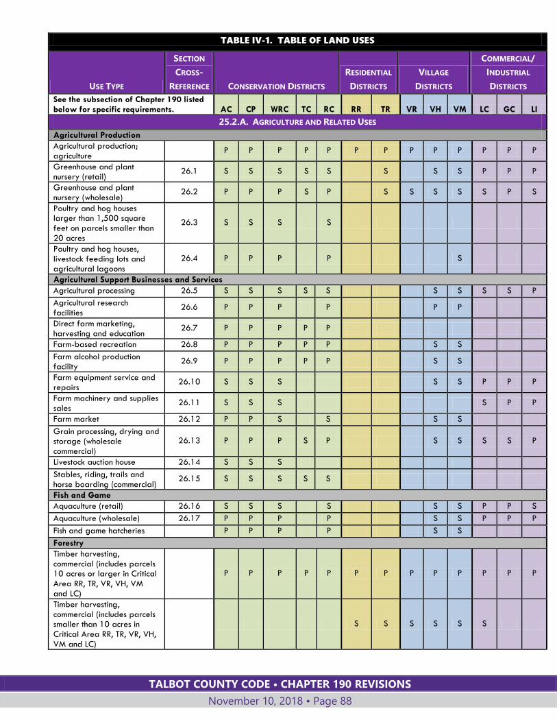
TALBOT COUNTY CODE • CHAPTER 190 REVISIONS
November 10, 2018 • Page 88
TABLE IV-1. TABLE OF LAND USES
USE TYPE
SECTION
CROSS-
REFERENCE CONSERVATION DISTRICTS
RESIDENTIAL
DISTRICTS
VILLAGE
DISTRICTS
COMMERCIAL/
INDUSTRIAL
DISTRICTS
See the subsection of Chapter 190 listed below for specific requirements. AC CP WRC TC RC RR TR VR VH VM LC GC LI
25.2.A. AGRICULTURE AND RELATED USES
Agricultural Production
Agricultural production; agriculture
P P P P P P P P P P P P P
Greenhouse and plant nursery (retail)
26.1 S S S S S S S S P P P
Greenhouse and plant nursery (wholesale)
26.2 P P P S P S S S S S P S
Poultry and hog houses larger than 1,500 square feet on parcels smaller than
20 acres
26.3 S S S S
Poultry and hog houses, livestock feeding lots and agricultural lagoons
26.4 P P P P S
Agricultural Support Businesses and Services
Agricultural processing 26.5 S S S S S S S S S P
Agricultural research facilities
26.6 P P P P P P
Direct farm marketing, harvesting and education
26.7 P P P P P
Farm-based recreation 26.8 P P P P P S S
Farm alcohol production facility
26.9 P P P P P S S
Farm equipment service and repairs
26.10 S S S S S P P P
Farm machinery and supplies sales
26.11 S S S S P P
Farm market 26.12 P P S S S S
Grain processing, drying and storage (wholesale commercial)
26.13 P P P S P S S S S P
Livestock auction house 26.14 S S S
Stables, riding, trails and horse boarding (commercial)
26.15 S S S S S
Fish and Game
Aquaculture (retail) 26.16 S S S S S S P P S
Aquaculture (wholesale) 26.17 P P P P S S P P P
Fish and game hatcheries P P P P S S
Forestry
Timber harvesting, commercial (includes parcels 10 acres or larger in Critical Area RR, TR, VR, VH, VM and LC)
P P P P P P P P P P P P P
Timber harvesting, commercial (includes parcels smaller than 10 acres in Critical Area RR, TR, VR, VH, VM and LC)
S S S S S S
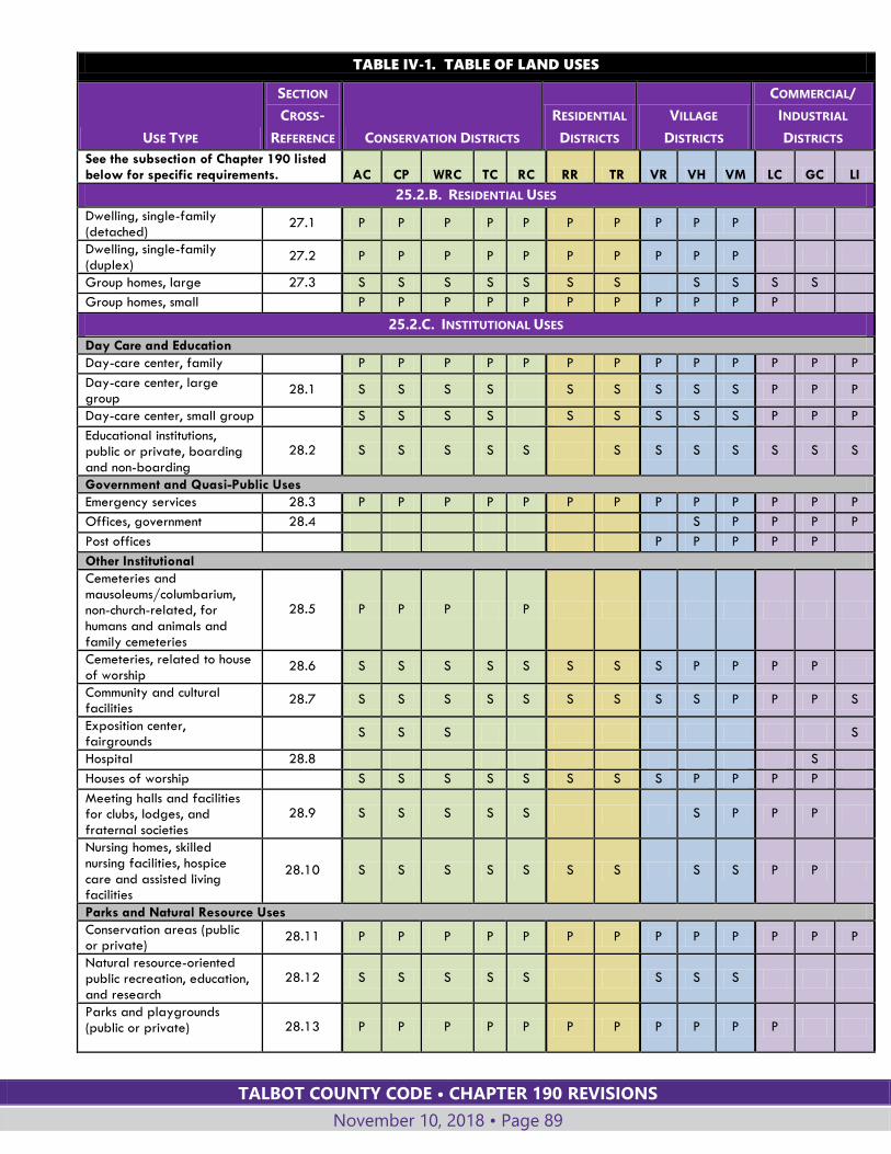
TALBOT COUNTY CODE • CHAPTER 190 REVISIONS
November 10, 2018 • Page 89
TABLE IV-1. TABLE OF LAND USES
USE TYPE
SECTION
CROSS-
REFERENCE CONSERVATION DISTRICTS
RESIDENTIAL
DISTRICTS
VILLAGE
DISTRICTS
COMMERCIAL/
INDUSTRIAL
DISTRICTS
See the subsection of Chapter 190 listed below for specific requirements. AC CP WRC TC RC RR TR VR VH VM LC GC LI
25.2.B. RESIDENTIAL USES
Dwelling, single-family (detached)
27.1 P P P P P P P P P P
Dwelling, single-family (duplex)
27.2 P P P P P P P P P P
Group homes, large 27.3 S S S S S S S S S S S
Group homes, small P P P P P P P P P P P
25.2.C. INSTITUTIONAL USES
Day Care and Education
Day-care center, family P P P P P P P P P P P P P
Day-care center, large group
28.1 S S S S S S S S S P P P
Day-care center, small group S S S S S S S S S P P P
Educational institutions, public or private, boarding and non-boarding
28.2 S S S S S S S S S S S S
Government and Quasi-Public Uses
Emergency services 28.3 P P P P P P P P P P P P P
Offices, government 28.4 S P P P P
Post offices P P P P P
Other Institutional
Cemeteries and mausoleums/columbarium, non-church-related, for humans and animals and family cemeteries
28.5 P P P P
Cemeteries, related to house of worship
28.6 S S S S S S S S P P P P
Community and cultural facilities
28.7 S S S S S S S S S P P P S
Exposition center, fairgrounds
S S S S
Hospital 28.8 S
Houses of worship S S S S S S S S P P P P
Meeting halls and facilities for clubs, lodges, and fraternal societies
28.9 S S S S S S P P P
Nursing homes, skilled nursing facilities, hospice
care and assisted living facilities
28.10 S S S S S S S S S P P
Parks and Natural Resource Uses
Conservation areas (public or private)
28.11 P P P P P P P P P P P P P
Natural resource-oriented public recreation, education, and research
28.12 S S S S S S S S
Parks and playgrounds (public or private)
28.13 P P P P P P P P P P P
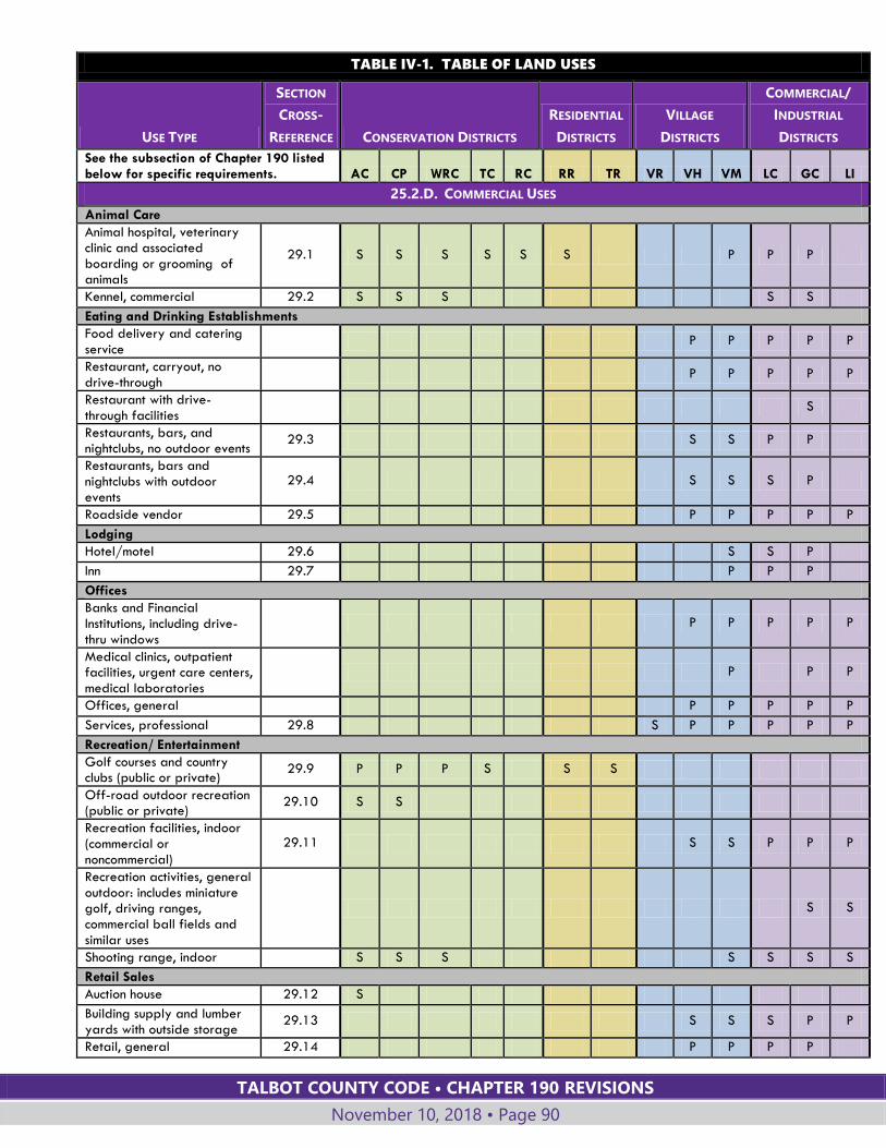
TALBOT COUNTY CODE • CHAPTER 190 REVISIONS
November 10, 2018 • Page 90
TABLE IV-1. TABLE OF LAND USES
USE TYPE
SECTION
CROSS-
REFERENCE CONSERVATION DISTRICTS
RESIDENTIAL
DISTRICTS
VILLAGE
DISTRICTS
COMMERCIAL/
INDUSTRIAL
DISTRICTS
See the subsection of Chapter 190 listed below for specific requirements. AC CP WRC TC RC RR TR VR VH VM LC GC LI
25.2.D. COMMERCIAL USES
Animal Care
Animal hospital, veterinary clinic and associated boarding or grooming of animals
29.1 S S S S S S P P P
Kennel, commercial 29.2 S S S S S
Eating and Drinking Establishments
Food delivery and catering service
P P P P P
Restaurant, carryout, no
drive-through
P P P P P
Restaurant with drive-through facilities
S
Restaurants, bars, and nightclubs, no outdoor events
29.3 S S P P
Restaurants, bars and nightclubs with outdoor events
29.4 S S S P
Roadside vendor 29.5 P P P P P
Lodging
Hotel/motel 29.6 S S P
Inn 29.7 P P P
Offices
Banks and Financial Institutions, including drive-thru windows
P P P P P
Medical clinics, outpatient facilities, urgent care centers, medical laboratories
P P P
Offices, general P P P P P
Services, professional 29.8 S P P P P P
Recreation/ Entertainment
Golf courses and country clubs (public or private)
29.9 P P P S S S
Off-road outdoor recreation (public or private)
29.10 S S
Recreation facilities, indoor (commercial or noncommercial)
29.11 S S P P P
Recreation activities, general outdoor: includes miniature golf, driving ranges, commercial ball fields and similar uses
S S
Shooting range, indoor S S S S S S S
Retail Sales
Auction house 29.12 S
Building supply and lumber yards with outside storage
29.13 S S S P P
Retail, general 29.14 P P P P
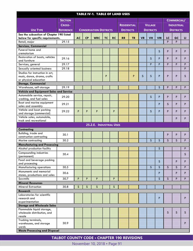
TALBOT COUNTY CODE • CHAPTER 190 REVISIONS
November 10, 2018 • Page 91
TABLE IV-1. TABLE OF LAND USES
USE TYPE
SECTION
CROSS-
REFERENCE CONSERVATION DISTRICTS
RESIDENTIAL
DISTRICTS
VILLAGE
DISTRICTS
COMMERCIAL/
INDUSTRIAL
DISTRICTS
See the subsection of Chapter 190 listed below for specific requirements. AC CP WRC TC RC RR TR VR VH VM LC GC LI
Retail, major 29.15 P P
Services, Commercial
Funeral home and crematorium
S P P P
Restoration of boats, vehicles and furniture
29.16 S P P P P
Services, general 29.17 P P P P P
Sexually oriented business 29.18 P
Studios for instruction in art, music, dance, drama, crafts or physical education
P P S S P P P S
Storage, Commercial
Warehouse, self-storage 29.19 S P P P
Vehicle and Equipment Sales and Service
Automobile service, repair, washing, and fuel sales
29.20 S P P P P
Boat and marine equipment sales and assembly
29.21 P S P P
Vehicle and boat parking and storage (commercial)
29.22 P P P P S P P P P
Vehicle sales, automobile, truck and recreational
P P
25.2.E. INDUSTRIAL USES
Contracting
Building, trade and construction contracting
30.1 P P P
Marine contracting 30.2 S S S S P
Manufacturing and Processing
Alcohol production facility S P
Compounding industries (permanent)
30.4 S
Food and beverage packing and processing
S P P
Manufacturing operations 30.5 S S S S P
Monuments and memorial stones, productions and sales
30.6 P P P
Sawmills 30.7 P P P P S S P P
Mineral Resources
Mineral Extraction 30.8 S S S S
Research
Laboratories for scientific research and experimentation
P P
Storage and Wholesale Sales
Flammable liquid storage, wholesale distribution, and resale
S S S
Trucking terminals, warehouses, and storage yards
30.9 P
Waste Processing and Disposal

TALBOT COUNTY CODE • CHAPTER 190 REVISIONS
November 10, 2018 • Page 92
TABLE IV-1. TABLE OF LAND USES
USE TYPE
SECTION
CROSS-
REFERENCE CONSERVATION DISTRICTS
RESIDENTIAL
DISTRICTS
VILLAGE
DISTRICTS
COMMERCIAL/
INDUSTRIAL
DISTRICTS
See the subsection of Chapter 190 listed below for specific requirements. AC CP WRC TC RC RR TR VR VH VM LC GC LI
Junkyard 30.10 S
Organic Waste Recovery Facility
30.11 S S
Recycling collection center P P P P P P P S P P P P
Recycling, product 30.12 S S S S
Recycling processing center 30.13 P
Scrap metal processing 30.14 P
Solid waste disposal facilities
30.15 C C C C C C C C C C C C C
Solid waste transfer stations 30.16 S S S S S S S S S
25.2.F. MARINE USES
Fisheries activities facilities S S S S
Marinas 31.1 S S S S S S
Piers and related facilities: Community and Private
31.2 S S S S S S
Ports and related industry P
Shoreline stabilization measures
31.3 P P P P P P P P P
Water-oriented public recreation, education, research areas
31.4 S S S S S S
25.2.G. UTILITY, TRANSPORTATION AND COMMUNICATION USES
Communication
Antenna tower for essential communications
32.1 S S S S S S S S S P P P
Antenna tower for radio and television transmission and other nonessential radio communications
32.2 S S S S P P P
Wireless communication towers 100 feet or taller
32.3 S S S S S S S
Wireless communication towers less than 100 feet
32.3 P P P P S P P P P
Energy and Fuel
Pump stations for gas and oil pipelines
S S S S S S S S S S S
Solar energy system, large-scale
32.4 S S S S S S S S S S S S
Utility services, nonessential 32.5 S S S S S S S S S S S S
Utility services, essential P P P P P P P S S P P P P
Utility structures 32.6 S S S S S S S S S S S S
Wind turbine production facility, small
32.7 S S P P P
Sewage and Water
Septage treatment facilities 32.8 S S S S
Wastewater treatment plant 32.9 S S S S S S S S S S S S S
Water treatment and storage facilities
32.10 S S S S S S S S S S S S S
Transportation
Landing strips, private 32.11 S
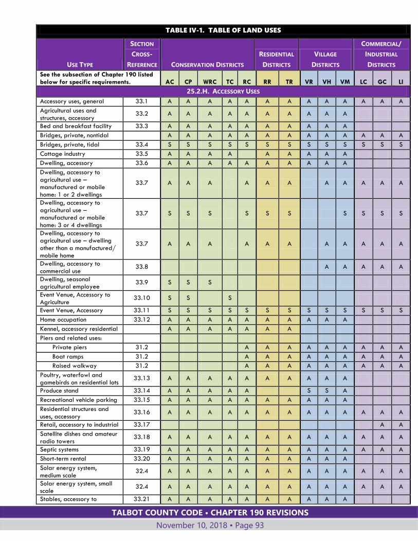
TALBOT COUNTY CODE • CHAPTER 190 REVISIONS
November 10, 2018 • Page 93
TABLE IV-1. TABLE OF LAND USES
USE TYPE
SECTION
CROSS-
REFERENCE CONSERVATION DISTRICTS
RESIDENTIAL
DISTRICTS
VILLAGE
DISTRICTS
COMMERCIAL/
INDUSTRIAL
DISTRICTS
See the subsection of Chapter 190 listed below for specific requirements. AC CP WRC TC RC RR TR VR VH VM LC GC LI
25.2.H. ACCESSORY USES
Accessory uses, general 33.1 A A A A A A A A A A A A A
Agricultural uses and structures, accessory
33.2 A A A A A A A A A A
Bed and breakfast facility 33.3 A A A A A A A A A A
Bridges, private, nontidal A A A A A A A A A A A A A
Bridges, private, tidal 33.4 S S S S S S S S S S S S S
Cottage industry 33.5 A A A A A A A A A
Dwelling, accessory 33.6 A A A A A A A A A A
Dwelling, accessory to
agricultural use – manufactured or mobile home: 1 or 2 dwellings
33.7 A A A A A A A A A A A
Dwelling, accessory to agricultural use – manufactured or mobile home: 3 or 4 dwellings
33.7 S S S S S S S S S S
Dwelling, accessory to agricultural use – dwelling other than a manufactured/ mobile home
33.7 A A A A A A A A A A A
Dwelling, accessory to commercial use
33.8 A A A A A
Dwelling, seasonal agricultural employee
33.9 S S S
Event Venue, Accessory to Agriculture
33.10 S S
S
Event Venue, Accessory 33.11 S S S S S S S S S S S S S
Home occupation 33.12 A A A A A A A A A A
Kennel, accessory residential A A A A A A A
Piers and related uses:
Private piers 31.2 A A A A A A A A A
Boat ramps 31.2 A A A A A A A A A
Raised walkway 31.2 A A A A A A A A A
Poultry, waterfowl and gamebirds on residential lots
33.13 A A A A A A A A A A
Produce stand 33.14 A A A A A S S A
Recreational vehicle parking 33.15 A A A A A A A A A A
Residential structures and
uses, accessory 33.16 A A A A A A A A A A A A A
Retail, accessory to industrial 33.17 A A
Satellite dishes and amateur radio towers
33.18 A A A A A A A A A A A A A
Septic systems 33.19 A A A A A A A A A A A A A
Short-term rental 33.20 A A A A A A A A A A
Solar energy system, medium scale
32.4 A A A A A A A A A A A A A
Solar energy system, small scale
32.4 A A A A A A A A A A A A A
Stables, accessory to 33.21 A A A A A A A A A A
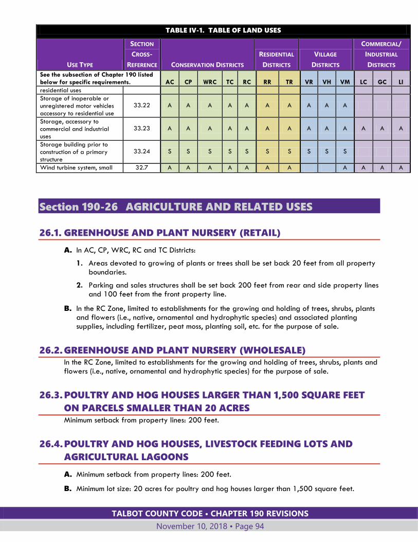
TALBOT COUNTY CODE • CHAPTER 190 REVISIONS
November 10, 2018 • Page 94
TABLE IV-1. TABLE OF LAND USES
USE TYPE
SECTION
CROSS-
REFERENCE CONSERVATION DISTRICTS
RESIDENTIAL
DISTRICTS
VILLAGE
DISTRICTS
COMMERCIAL/
INDUSTRIAL
DISTRICTS
See the subsection of Chapter 190 listed below for specific requirements. AC CP WRC TC RC RR TR VR VH VM LC GC LI
residential uses
Storage of inoperable or unregistered motor vehicles accessory to residential use
33.22 A A A A A A A A A A
Storage, accessory to commercial and industrial uses
33.23 A A A A A A A A A A A A A
Storage building prior to construction of a primary structure
33.24 S S S S S S S S S S
Wind turbine system, small 32.7 A A A A A A A A A A A
Section 190-26 AGRICULTURE AND RELATED USES
26.1. GREENHOUSE AND PLANT NURSERY (RETAIL)
A. In AC, CP, WRC, RC and TC Districts:
1. Areas devoted to growing of plants or trees shall be set back 20 feet from all property boundaries.
2. Parking and sales structures shall be set back 200 feet from rear and side property lines and 100 feet from the front property line.
B. In the RC Zone, limited to establishments for the growing and holding of trees, shrubs, plants and flowers (i.e., native, ornamental and hydrophytic species) and associated planting supplies, including fertilizer, peat moss, planting soil, etc. for the purpose of sale.
26.2. GREENHOUSE AND PLANT NURSERY (WHOLESALE) In the RC Zone, limited to establishments for the growing and holding of trees, shrubs, plants and flowers (i.e., native, ornamental and hydrophytic species) for the purpose of sale.
26.3. POULTRY AND HOG HOUSES LARGER THAN 1,500 SQUARE FEET
ON PARCELS SMALLER THAN 20 ACRES Minimum setback from property lines: 200 feet.
26.4. POULTRY AND HOG HOUSES, LIVESTOCK FEEDING LOTS AND
AGRICULTURAL LAGOONS
A. Minimum setback from property lines: 200 feet.
B. Minimum lot size: 20 acres for poultry and hog houses larger than 1,500 square feet.
TALBOT COUNTY CODE • CHAPTER 190 REVISIONS
November 10, 2018 • Page 95
C. In the VM District:
1. Limited to poultry houses.
2. Poultry houses must be located outside the Chesapeake Bay Critical Area.
26.5. AGRICULTURAL PROCESSING
A. Two-hundred-foot setback from property lines for structures, processing, storage and loading areas.
B. Minimum lot size: 20 acres
C. The use must be located on a property that is actively being farmed and granted agricultural assessment value by the Maryland Department of Assessments and Taxation.
D. Site plan approval is required.
26.6. AGRICULTURAL RESEARCH FACILITIES
A. The operation shall be conducted on a site of at least 25 acres.
B. Livestock, wildlife and crops shall not be offered for commercial resale.
C. Any structure, including feeder lots and barns, and ponds shall be constructed at least 200 feet from any property lines, residential structures, tributary streams, drainage swales or ditches, with landscape buffering as necessary.
D. Maximum site coverage for all primary and accessory buildings: 10%.
E. A fence shall be constructed around all structures, research plots and ponds within the research facility.
F. An incinerator shall be constructed on the premises for the disposal of all nonliquid waste generated on the site.
G. Any research involving fish or marine life shall be conducted in aboveground facilities, except that agriculturally related products registered with the United States Environmental Protection Agency may be applied to in-ground ponds, provided that the amount applied does not exceed the maximum recommended label rate of application for such products on crops or land. Ponds for such research shall be constructed in a manner which shall preclude leaching of any liquid from the facility or pond.
26.7. DIRECT FARM MARKETING, HARVESTING AND EDUCATION
A. Includes:
1. Pick-your-own produce operations, cut-your-own tree or flower operations, pumpkin patches, and similar uses. An accessory building or structure may be located on the property and used for the day-to-day operation of such activities and for the sale of products grown onsite;
2. Additional activities directly related to education about farm production, including participation in harvesting, farm tours, classes related to production or use of farm products, and similar activities; and,
B. May be established in conjunction with other agricultural support businesses or services.
TALBOT COUNTY CODE • CHAPTER 190 REVISIONS
November 10, 2018 • Page 96
C. The farm must be actively producing agricultural products for purchase and sale.
D. Minimum lot size: 5 acres
E. The use must be located on a property that is and remains actively farmed and is granted agricultural assessment value by the Maryland Department of Assessments and Taxation.
F. Minimum setbacks, including structures, parking areas, and other areas open to visitors, excluding farm production areas: 30 feet from property lines and 100 feet from any off-site residence.
G. Site plan approval is required.
H. Hours of operation shall be established as part of the site plan.
I. Warning signs shall be posted indicating that participation in activities on a farm involves inherent risks, and notifying participants that by choosing to participate they are accepting the “inherent risks of agritourism activity.”
26.8. FARM-BASED RECREATION
A. Includes activities that predominately use agricultural products, buildings or equipment, such as corn mazes, hayrides, pony rides, petting zoos, farm museums and similar activities. The facilities may be available as venues for weddings, receptions and similar uses, subject to 26.8.H below.
B. Minimum lot size: 20 acres.
C. The use must be located on a property that is and remains actively farmed and is granted agricultural assessment value by the Maryland Department of Assessments and Taxation.
D. Minimum use setbacks for structures, parking areas, and outdoor areas open to customers: 100 feet from property lines and 200 feet from any off-site residences.
E. A Type D landscape yard, or an equivalent combination of vegetation and distance, shall be provided between the use and adjacent properties.
F. Site plan approval is required.
G. Hours of operation shall be established on the site plan and limited to hours between 9:00 a.m. and 11:00 p.m.
H. A farm-based recreation site is permitted to host outdoor weddings, receptions and similar events, provided that:
1. Each event shall be limited to no more than 200 guests.
2. No outdoor music is permitted before 9 a.m. or after 10:00 p.m.
3. Such events shall take place on no more than 12 days per calendar year.
4. The operator of the farm-based recreation use does not need to apply for a use certificate for each of the twelve events. Records shall be maintained and made available to the Planning Office upon request that provides event details to include date, event time lines, and number of attendees.
I. Warning signs shall be posted indicating that participation in activities on a farm involves inherent risks, and notifying participants that by choosing to participate they are accepting the “inherent risks of agritourism activity.”
TALBOT COUNTY CODE • CHAPTER 190 REVISIONS
November 10, 2018 • Page 97
26.9. FARM ALCOHOL PRODUCTION FACILITY
A. Includes:
1. Production of wine, beer and/or distilled spirits using a product or products grown on-site.
2. Bottling, aging, storage, shipping, and loading facilities and administrative offices.
3. Accessory sales of products produced on-site and the regular sale of promotional items including but not limited to glassware, clothing, bottle openers and similar items. The retail sales display area shall be no larger than 500 square feet.
4. Product tasting, and limited food service, provided the area inside the building used for such activities shall not exceed 49 percent of the gross floor area of the building.
B. Promotional events, larger retail sales areas, private parties and receptions are permitted pursuant to §190-26.8, Farm-Based Recreation.
C. Site plan approval is required if retail sales or product tasting are included as part of the use.
D. Minimum structure and use setbacks for parking, processing, storage, shipping, loading and customer facilities and areas: 100 feet from property lines.
E. The use must be located on a property that is and remains actively farmed and granted agricultural assessment value by the Maryland Department of Assessments and Taxation.
F. In the VH and VM Districts the minimum lot size shall be 20 acres.
26.10. FARM EQUIPMENT SERVICE AND REPAIRS One-hundred-fifty-foot setback in the AC, CP, WRC and VM Districts.
26.11. FARM MACHINERY AND SUPPLIES SALES
A. Includes agricultural vehicles and implements, and agricultural supplies.
B. Includes home and garden supplies and equipment, except in the AC, CP, and WRC Districts.
C. In the AC, CP, and WRC Districts, minimum two-hundred-foot setback is required for structures used for milling of grain and feed, and chemical and fertilizer storage.
26.12. FARM MARKET
A. Maximum farm market structure size: 2,000 square feet; this may include space in a single, owner-occupied accessory farm building.
B. The use must be located on a property that is actively being farmed and granted agricultural assessment value by the Maryland Department of Assessments and Taxation.
C. Site plan approval is required.
TALBOT COUNTY CODE • CHAPTER 190 REVISIONS
November 10, 2018 • Page 98
26.13. GRAIN PROCESSING, DRYING AND STORAGE (WHOLESALE
COMMERCIAL)
A. In the RC District (wholesale only), limited to an accessory use to a farm operation existing as of August 13, 1989.
B. Minimum two-hundred-foot setback from property lines.
C. In the VH and VM Districts, new or expanded structures shall maintain the minimum setback from lot lines of the existing structures on the same property.
26.14. LIVESTOCK AUCTION HOUSE
A. Ten-acre minimum lot size.
B. Minimum two-hundred-foot setback for buildings and structures.
C. Minimum fifty-foot setback for parking areas.
26.15. STABLES, RIDING, TRAILS AND HORSE BOARDING
(COMMERCIAL)
A. Minimum lot size: 10 acres or one acre per horse, whichever is greater.
B. Minimum setback for related structures: 200 feet.
C. Minimum setback for feeding and watering stations: 50 feet from any body of water, including tributary streams and tidal wetlands.
26.16. AQUACULTURE (RETAIL)
A. Minimum fifty-foot front setback and two-hundred-foot setback from all other property boundaries.
B. Ten-acre minimum lot size.
C. No on-site processing allowed.
D. All aquaculture products must be raised on site.
26.17. AQUACULTURE (WHOLESALE)
A. Excludes on-premises processing of aquaculture products.
B. Minimum two-hundred-foot setback for related ponds in the AC, CP, WRC, RC, VH and VM Districts.
Section 190-27 RESIDENTIAL USES
27.1. DWELLING, SINGLE-FAMILY (DETACHED)
A. Limited to one single-family primary residence per parcel or lot.

TALBOT COUNTY CODE • CHAPTER 190 REVISIONS
November 10, 2018 • Page 99
B. Includes modular homes and double-wide manufactured homes.
C. Excludes single-wide manufactured homes and mobile homes.
D. The following standards apply for the placement of double-wide manufactured homes permitted as single-family residences on individual lots or parcels:
1. The home must be manufactured after January 1, 2001, and be in compliance with the National Manufactured Housing Construction and Safety Standards Act of 1974, as amended.
2. The base width of the home for any front, side and rear elevation must be 22 feet wide and it must have eaves on each side with a minimum of one-foot overhang beyond the base width, such that the total width from eave to eave shall be at least 24 feet.
3. The home must have a minimum 4/12 roof pitch.
4. The roof must be finished with shingles or other conventional roofing materials common to residential construction, and the exterior siding must be similar in appearance to common residential construction.
5. The home must have a County-approved permanent continuous masonry foundation, unpierced except for required ventilation and utilities access installed under the home. The permanent masonry or brick foundation shall be left exposed or skirted with other masonry or brick.
6. Permanent landing and steps with handrails are required at each exterior doorway.
7. The tongue, axles, transporting lights and removable towing apparatus must be removed after placement on the lot and before occupancy.
8. Standards set forth in Subsection D.1 through 7 above are not applicable to the following:
a. Manufactured homes located in a manufactured home rental community;
b. Manufactured or mobile homes accessory to agricultural uses and activities.
27.2. DWELLING, SINGLE-FAMILY (DUPLEX)
A. Includes two attached single-family dwellings constructed on site or modular dwellings manufactured off site.
B. Excludes manufactured homes and mobile homes.
C. Each dwelling unit must be located on a separate lot, and the side yard setback where the dwelling units are attached is waived.
D. The use is allowed only on individual lots smaller than two acres.
27.3. GROUP HOME, LARGE
A. Minimum lot area: two acres per dwelling unit.
B. Adequate supervision and professional services shall be provided.
C. Required Maryland licensing shall be maintained as applicable.
D. The dwelling shall be of sufficient size to accommodate the proposed number of residents and staff.
TALBOT COUNTY CODE • CHAPTER 190 REVISIONS
November 10, 2018 • Page 100
E. The site shall provide adequate outdoor space free from hazard and appropriately equipped for the age and number of persons residing.
Section 190-28 INSTITUTIONAL USES
28.1. DAY-CARE CENTER, FAMILY In the RC District, the following regulations apply:
A. The use shall be located in a structure existing prior to August 13, 1989.
B. Expansion is permitted, provided lot coverage is limited to 15% of the site or 20,000 square feet, whichever is less, except that lot coverage may be increased through the use of growth allocation subject to §190-55.5.
28.2. EDUCATIONAL INSTITUTIONS, PUBLIC OR PRIVATE, BOARDING
AND NONBOARDING
A. In RC and TR Districts, limited to nursery schools and schools with Grades K through 8.
B. In the RC District:
1. Public schools allowed, in accordance with COMAR 27.02.02 (State and Local Agency Actions Resulting in Development of Local Significance on Private Lands or Lands Owned by Local Jurisdictions); and
2. Private schools allowed, subject to lot coverage limitation of 15% of the site or 20,000 square feet, whichever is less.
C. Private institutions existing in the RC District prior to August 13, 1989, may be expanded, provided lot coverage is limited to 15% of the site or 20,000 square feet, whichever is less, except that lot coverage may be increased through the use of growth allocation subject to §190-55.5.
28.3. EMERGENCY SERVICES
A. Includes fire, police, rescue and ambulance uses.
B. In the AC, CP, WRC or RC District, the use shall be within 0.25 mile of a collector or arterial highway.
C. In the RC District, the following regulations apply:
1. Public and quasi-public services are permitted.
2. Privately owned and operated services in operation prior to August 13, 1989, may be expanded, provided lot coverage is limited to 15% of the site or 20,000 square feet, whichever is less, except that lot coverage may be increased through the use of growth allocation subject to §190-55.5.
28.4. OFFICES, GOVERNMENT In the LI District limited to offices offering agricultural, technical, investigative, or community outreach and support services.
TALBOT COUNTY CODE • CHAPTER 190 REVISIONS
November 10, 2018 • Page 101
28.5. CEMETERIES AND MAUSOLEUMS/COLUMBARIUM, NON-CHURCH-
RELATED, FOR HUMANS AND ANIMALS AND FAMILY CEMETERIES
A. Twenty-acre minimum lot size for cemeteries.
B. Five-acre minimum lot size for pet cemeteries.
C. Two-acre minimum lot size when limited to use of the property owner and the owner's family members and their pets.
D. A minor site plan shall be required.
E. Non-church-related cemeteries are prohibited in the RC District, excepting family cemeteries. For family cemeteries, lot coverage is limited to 15% of the site or 20,000 square feet, whichever is less, except that lot coverage may be increased through the use of growth allocation subject to §190-55.5.
28.6. CEMETERIES, RELATED TO HOUSE OF WORSHIP The following regulations apply in an RC District:
A. A cemetery related to a house of worship is allowed, provided the house of worship was in existence prior to August 13, 1989, and lot coverage is limited to 15% of the site or 20,000 square feet, whichever is less.
B. In an RC District, includes columbarium associated with a house of worship, provided lot coverage is limited to 15% of the site or 20,000 square feet, whichever is less.
C. Notwithstanding the twenty-thousand-square-foot limitation in Subsections A and B, the lot coverage may be increased through the use of growth allocation subject to §190-55.5.
28.7. COMMUNITY AND CULTURAL FACILITIES
A. Includes public and quasi-public buildings and structures for recreation, conservation, cultural, museum, library and public service uses.
B. In the RC District, lot coverage shall be limited to 15% of the site or 20,000 square feet, whichever is less.
C. Structures existing in the RC District prior to August 13, 1989, may be expanded, provided lot coverage is limited to 15% of the site or 20,000 square feet, whichever is less, except that lot coverage may be increased through the use of growth allocation subject to §190-55.5.
28.8. HOSPITAL
Minimum two-hundred-foot structure setback.
28.9. MEETING HALLS AND FACILITIES FOR CLUBS, LODGES AND
FRATERNAL SOCIETIES
A. Excludes gun and firearm shooting clubs.
B. In the RC District the following additional regulations apply:
TALBOT COUNTY CODE • CHAPTER 190 REVISIONS
November 10, 2018 • Page 102
1. Limited to service organizations and nonprofit charitable organizations and institutions.
2. Uses are subject to lot coverage limitation of 15% of the site or 20,000 square feet, whichever is less.
3. Structures existing prior to August 13, 1989, may be expanded, provided lot coverage is limited to 15% of the site or 20,000 square feet, whichever is less, except that lot coverage may be increased through the use of growth allocation subject to §190-55.5.
28.10. NURSING HOMES, SKILLED NURSING FACILITIES, HOSPICE CARE
AND ASSISTED LIVING FACILITIES
A. Inside the Critical Area a home or facility shall be located in a structure existing prior to August 13, 1989.
1. Maximum number of patients: eight.
2. Expansion is permitted, provided lot coverage is limited to 15% of the site or 20,000 square feet, whichever is less, except that lot coverage may be increased through the use of growth allocation subject to §190-55.5.
B. The nursing home shall not constitute a nuisance caused by noise, vehicle traffic or parking, or other physical activity.
C. Adequate setbacks and a Type C Landscape Buffer shall be provided to screen neighboring residential properties.
D. The facility shall have access to roads suitable for emergency responders.
28.11. CONSERVATION AREAS (PUBLIC OR PRIVATE)
A. Includes arboretums, bird sanctuaries, demonstration forests, hunting preserves, reforestation areas, wildlife reservations and regulated hunting areas.
B. May be open to the public for hunting or passive recreation such as walking, bicycling or boating.
C. May include accessory offices, visitor information and storage structures
D. Does not include active recreation facilities (athletic fields, playgrounds)
28.12. NATURAL RESOURCE-ORIENTED PUBLIC RECREATION,
EDUCATION, AND RESEARCH
A. Includes conservation areas owned by a quasi-public or private organization that include, as a principal use, visitor centers, research facilities, educational programming, and similar uses.
B. Minimum setbacks:
1. Structures: 200 feet
2. Parking and outdoor displays, amphitheaters or congregating areas: 150 feet
C. Site plan approval is required.
D. In the Critical Area, the following regulations apply. The Board of Appeals shall review these requirements as part of the special exception.
TALBOT COUNTY CODE • CHAPTER 190 REVISIONS
November 10, 2018 • Page 103
1. The requirements for water dependent uses in §190-15.14, Water-Dependent Facilities, shall be considered to the extent that they are applicable to the particular use.
2. Sanitary facilities shall be provided meeting the requirements of Maryland state law.
3. Permeable surfaces shall be used wherever standard engineering practices allow, if no degradation of groundwater would result.
4. Not more than 15% of existing natural vegetation shall be permanently disturbed.
5. All facilities, including areas for passive recreation (trails, education) shall be located outside the Shoreline Development Buffer.
28.13. PARKS AND PLAYGROUNDS (PUBLIC OR PRIVATE) In the RC District, this use is limited to passive recreation, except that commercial and public pools may be permitted in the RC District where growth allocation is approved subject to §190-55.5.
Section 190-29 COMMERCIAL USES
29.1. ANIMAL HOSPITAL, VETERINARY CLINIC AND ASSOCIATED
BOARDING OR GROOMING OF ANIMALS
A. Minimum fifty-foot setback from all property lines.
B. No outside animal pens in a VM District.
C. In the RC District, must be accessory to a farm use and lot coverage is limited to 15% of the site or 20,000 square feet, whichever is less, except that lot coverage may be increased through the use of growth allocation subject to §190-55.5.
29.2. KENNEL, COMMERCIAL
A. Two-hundred-foot setback in AC, CP and WRC Districts.
B. Outside pens must be screened.
29.3. RESTAURANTS, BARS AND NIGHTCLUBS WITH NO OUTDOOR
EVENTS
A. Excludes uses with drive-through facilities.
B. Excludes bars and nightclubs except liquor sales associated with a restaurant in the VH and VM Districts.
29.4. RESTAURANTS, BARS AND NIGHTCLUBS WITH OUTDOOR EVENTS
A. Excludes uses with drive-through facilities.
B. The special exception and site plan approval shall establish limits and location for outdoor seating and music, as well as, frequency and hours.
TALBOT COUNTY CODE • CHAPTER 190 REVISIONS
November 10, 2018 • Page 104
C. All applications in the Village Zoning Districts requesting outdoor amplified music shall include a noise compliance plan that includes a means for continuous electronic monitoring of sound levels from one hour prior to, until one hour after, the approved outdoor music time restriction, along with all other materials required by the application form and checklist published by the Planning Office.
D. In addition to the public notice requirements of §190-54.5 below, notices must be postmarked at least 30 days prior to any public meeting or hearing and shall be sent to all owners of land with a property line within 1,000 feet of the subject parcel, including in line of site within 1,000 feet across waterways.
29.5. ROADSIDE VENDORS
A. Use certificate, license
1. A use certificate and vendor's license is required. A separate license is required for each location.
2. The roadside vendor or food truck shall display the license in a conspicuous location at the site where the vendor is operating.
3. Fees for the use certificate and vendor's license shall be paid in accordance with the adopted fee schedule.
B. Short-term roadside vendors shall meet the following standards:
1. Maximum number of days of operation per calendar year for short-term vendors: seven.
2. The Planning Director may waive license fees and extend the number of days that a short-term roadside vendor may operate, provided the vendor holds federal tax-exempt status under §501(c)(3) of the Internal Revenue Code or otherwise dedicates its proceeds to a charitable organization or valid fundraising activity.
C. Long term roadside vendors shall not use tents or open air tables.
D. For all roadside vendors:
1. If located on a commercial or industrial site, the roadside vendor may occupy surplus parking spaces or similar areas on site, but shall not occupy required landscape yards or parking spaces.
2. A roadside vendor may locate on an unimproved lot in the LC or GC zoning district, subject to approval of a simplified site plan as well as a use certificate.
3. Vendors must obtain the written permission of each property owner on whose property the vendor's operation is located.
4. Maximum number of employees on site: three.
5. Vendors shall operate in a manner that permits safe ingress and egress to and from the operation.
6. Roadside vendors and food trucks shall locate such that the site they occupy complies with all development standards pertaining to the zoning district and applicable overlay districts such as the Gateway Overlay District.
7. All facilities associated with the roadside vendor shall be removed immediately upon discontinuation of the use.
TALBOT COUNTY CODE • CHAPTER 190 REVISIONS
November 10, 2018 • Page 105
29.6. HOTEL/MOTEL Any restaurant and indoor banquet/event facility(ies) located on the property shall not exceed 49 percent of the total floor area of the Hotel/Motel.
29.7. INN
A. An inn shall have no more than 10 guest rooms and no more than 30 guests.
B. On parcels of two acres or greater, no more than 2 guest rooms may be detached from the primary structure.
C. No cooking facilities shall be permitted in guest rooms.
D. The maximum stay for guests shall not exceed 14 consecutive days.
29.8. SERVICES, PROFESSIONAL
A. Includes accounting, architecture, chiropractic services, insurance, land planning, law, medical or dental offices, physical therapy, real estate and similar uses.
B. In the LC District: Maximum gross floor area of 2,500 square feet.
29.9. GOLF COURSES AND COUNTRY CLUBS (PUBLIC OR PRIVATE)
A. Excludes miniature golf courses.
B. Excludes driving ranges not primarily associated with the golf course.
C. Courses shall not be lighted for night play.
D. In the RC District, golf courses that legally existed as of August 13, 1989 may be expanded in accordance with §190-48.3.E.
E. A country club may be used to host weddings, receptions, and similar outdoor events unrelated to common golf course and country club uses, provided that:
1. All areas used for such events shall be within 500 feet of the primary country club structure.
2. Each event shall be limited to no more than 200 guests.
3. No outdoor music shall be permitted before 9 a.m. or after 10:00 p.m.
4. Such events shall take place on no more than 12 days per calendar year. The operator does not need to apply for a use certificate for each of the twelve events. Records shall be maintained and made available to the Planning Office upon request that provides event details to include date, event time lines, and number of attendees.
5. These restrictions shall not apply to customary country club uses or events.
29.10. OFF-ROAD OUTDOOR RECREATION (PUBLIC OR PRIVATE)
A. Includes motorized and nonmotorized vehicle race and other recreation courses, excluding automobiles and trucks.
B. Minimum site size: 50 acres.
TALBOT COUNTY CODE • CHAPTER 190 REVISIONS
November 10, 2018 • Page 106
C. Minimum setback from property lines: 200 feet, of which 100 feet shall be vegetative buffer of at least 10 feet in height.
D. Minimum setback from existing inhabited dwellings: 1,000 feet.
E. Site access shall be by arterial or collector road.
F. Maximum merchandise retail sales area: 400 square feet.
G. Entire course must be laid out so that vehicles shall not be driven on the courses above natural prevailing grade of surrounding land.
H. The facility shall post rules and regulations regarding the use of safety equipment.
I. Trained first aid personnel shall be on site during operating hours.
J. Hours of operation may not exceed 9:00 a.m. to 7:00 p.m.
K. Nighttime lighting is not permitted.
L. Overnight camping or campgrounds are not permitted.
M. The recreation area shall be fenced with at least a six-foot-high fence and locked during nonoperating hours.
N. No paid spectator tickets are permitted.
29.11. RECREATION FACILITIES, INDOOR (COMMERCIAL OR
NONCOMMERCIAL)
A. Includes billiard/pool halls, bowling alleys, health clubs, indoor ball courts, skating rinks, theaters with fewer than 500 seats, and sports arenas with fewer than 500 seats.
B. Minimum one-hundred-foot setback from property lines.
C. In the VM District, the use must be located within 0.25 mile of a collector or arterial highway.
29.12. AUCTION HOUSE
A. Minimum lot size: five acres.
B. Minimum setbacks for parking and display areas: 20 feet from road right-of-way and 50 feet from other property boundaries.
29.13. BUILDING SUPPLY AND LUMBER YARDS WITH OUTSIDE
STORAGE
A. Includes home and garden supplies and equipment.
B. No structure shall exceed 65,000 square feet in gross floor area. For the purposes of this Subsection, the term "gross floor area" shall include indoor and outdoor space utilized for retail display and sale of goods. No combination of structures or structures and outside retail display and sales areas on the same or on contiguous lots or parcels shall exceed 65,000 square feet in gross floor area for a single or commonly controlled retail business operation.
TALBOT COUNTY CODE • CHAPTER 190 REVISIONS
November 10, 2018 • Page 107
C. A building supply and lumber yard in a single or multiple building(s) occupying more than 25,000 square feet of gross floor area shall follow the standards for retail, major uses in §190-29.15 of this article.
29.14. RETAIL, GENERAL
A. Includes sales of antiques, books, baked goods, clothing, crafts, drugs, dry goods, furniture, gifts, groceries, hardware, household items, liquor, plants (flowers, shrubs, and trees), seafood, sports equipment, and items generally found in department stores, general stores or variety stores.
B. General retail uses shall not exceed 25,000 square feet in gross floor area. For purposes of this Section, the term "gross floor area" includes indoor and outdoor space utilized for retail display and sale of goods.
29.15. RETAIL, MAJOR
A. APPLICABILITY
1. Major retail uses are all retail establishments in a single building or multiple buildings occupying more than 25,000 square feet but no more than 65,000 square feet of gross floor area.
2. For purposes of this Section, the term "gross floor area" shall include indoor and outdoor space utilized for retail display and sale of goods. No combination of structures, or structures and outside retail display and sales areas on the same or on contiguous lots or parcels, shall exceed 65,000 square feet in gross floor area for a single or commonly controlled retail business operation.
3. The standards for major retail uses do not apply to:
a. Nonretail commercial uses;
b. Automobile, truck and recreational vehicle sales; or
c. Farm machinery and supplies sales.
B. GENERAL DESIGN FEATURES
Buildings shall be designed to complement and replicate the character and vernacular of the area. Landscaping shall include a variety of trees, shrubs, and grassy areas in order to create an eye-pleasing addition to the community.
C. FACADES AND EXTERIOR WALLS
1. All facades greater than 100 feet in length, measured horizontally, shall incorporate wall plane projections or recesses having a depth of at least 3% of the length of the facade. No uninterrupted length of any facade shall exceed 100 horizontal feet.
2. All facades shall have arcades, display windows, entry areas, awnings, or other such features along no less than 60% of their horizontal length.
D. DETAIL FEATURES
Building facades must include a repeating pattern that shall include no fewer than three of the elements listed below. At least one of these elements shall repeat horizontally. All elements shall repeat at intervals of no more than 30 feet, either horizontally or vertically.
1. Color change.
2. Textured change.
TALBOT COUNTY CODE • CHAPTER 190 REVISIONS
November 10, 2018 • Page 108
3. Material module change.
4. Expression of architectural or structural bay through a change in plane no less than 12 inches in width, such as an offset, reveal, or projecting rib.
E. ROOFS
Roofs shall have at least two of the following features:
1. Parapets completely concealing the flat roofs and all rooftop equipment from public view. The average height of such parapet shall not exceed 15% of the height of the supporting wall, and such parapet shall not at any point exceed 1/3 of the height of the supporting wall. Such parapet shall feature three-dimensional cornice treatments.
2. Overhanging eaves, extending no less than three feet past the supporting walls.
3. Sloping roofs that do not exceed the average height of the supporting walls, with an average slope greater than or equal to one foot of vertical rise for every three feet of horizontal run and less than or equal to one foot of vertical rise for every one foot of horizontal run.
4. Multiple roof slope planes.
F. MATERIALS AND COLORS
1. Predominant exterior building materials shall be high-quality materials. These include, without limitation:
a. Brick
b. Wood
c. Painted, textured, concrete masonry units
d. Other native material.
2. The predominant facade color shall be low reflectance, subtle, neutral, or earth colors. The use of high-intensity or fluorescent colors is prohibited.
3. Building trims and accent areas may feature brighter colors, including primary colors, but neon tubing shall not be an acceptable feature for building trim or accent areas.
4. Predominant exterior building materials shall not include the following:
a. Smooth-faced block
b. Tilt-up concrete panel
c. Prefabricated steel panels
d. Vinyl siding
e. Aluminum siding
G. ENTRYWAYS
1. Each primary building on the site shall have a clearly defined, highly visible customer entrance featuring at least three of the following:
a. Canopies or porticoes
b. Overhangs
c. Recesses/projections
d. Arcades
e. Raised corniced parapets over the door
f. Peaked roof forms
g. Arches
TALBOT COUNTY CODE • CHAPTER 190 REVISIONS
November 10, 2018 • Page 109
h. Outdoor patios
i. Display windows
j. Architectural details such as tile work and moldings which are integrated into the building structure and design
k. Integral planters or wing walls that incorporate landscaped areas and/or places for sitting
2. Entrance. All sides of a primary building that directly face an abutting public street shall feature at least one customer entrance. Where a primary building directly faces more than two abutting public streets, this requirement shall apply only to two sides of the building, including the side of the building facing the primary street, and another side of the building facing a secondary street.
H. PARKING LOTS
Not more than 50% of the off-street parking area for the entire property shall be located between the front facade of the primary building(s) and the primary abutting street.
I. SETBACKS
The minimum setback for any portion of the structure shall be 50 feet from the nearest property line. In addition, when property in a conservation, residential, or village district either abuts the parcel on which the structure is to be located or is separated from the parcel by a public or private road, the fifty-foot setback shall be increased by an additional setback (the "additional setback") which shall be calculated according to the following formula: an additional 50 feet plus one additional foot for each 1,000 square feet that the building exceeds 50,000 square feet in gross floor area. If either U.S. Route 50 or Maryland Route 322 acts as an intervening public street between the parcel on which the building is to be located and the adjacent property in a conservation, residential, or village district, the width of that road's right-of-way shall be deducted from the additional setback otherwise required by this Section.
J. OUTDOOR STORAGE, TRASH COLLECTION, AND LOADING AREAS
1. Areas for outdoor storage, truck parking, trash collection or compaction, loading, or other uses shall not be visible from abutting streets.
2. No areas for outdoor storage, trash collection, or trash or compaction, loading or other uses shall be located within 25 feet of any public street, public sidewalk or internal pedestrian way.
3. Loading docks, truck parking, outdoor storage, utility meters, HVAC equipment, trash collection, trash compaction and other service functions shall be incorporated into the overall design of the building and the landscaping so that the visual and acoustic impacts of these functions are fully contained and out of view from adjacent properties and public streets, and no attention is attracted to the functions by the use of screening materials that are different from or inferior to the principal materials of the building and landscape.
4. Non-enclosed areas for the storage and sale of seasonal inventory shall be permanently defined and screened with walls and/or fences. Materials, colors, and design of screening walls and/or fences and the cover shall conform to those used as predominant materials and colors on the building. If such areas are to be covered, then the covering shall conform to those used as predominant materials and colors on the building.
K. PEDESTRIAN FLOWS AND BICYCLE TRAFFIC
1. Sidewalks at least eight feet in width shall be provided along all sides of the lot that abut a public street.
TALBOT COUNTY CODE • CHAPTER 190 REVISIONS
November 10, 2018 • Page 110
2. Continuous internal pedestrian walkways, no less than eight feet in width, shall be provided from the public sidewalk or right-of-way to the principal customer entrance of all primary buildings on the site. At a minimum, walkways shall connect focal points of pedestrian activities, such as, but not limited to, transit stops, street crossings, and building and store entry points, and shall feature adjoining landscaped areas that include trees, shrubs, benches, flowerbeds, ground covers or such other materials for no less than 50% of its length.
3. Sidewalks, no less than eight feet in width, shall be provided along the full length of the building along any facade featuring a customer entrance, and along any facade abutting public parking areas. Such sidewalk shall be located at least six feet from the facade of the building to provide planting beds for foundation landscaping, except where features such as arcades or entryways are part of the facade.
4. Internal pedestrian walkways provided in conformance with Subsection K(2) above shall provide weather protection features, such as awnings or arcades, within 30 feet of all customer entrances.
5. All internal pedestrian walkways shall be distinguished from driving surfaces through the use of durable, no-maintenance service materials, such as pavers, bricks, or scored concrete to enhance pedestrian safety and comfort, as well as the attractiveness of the walkways.
6. Bicycle traffic shall be accommodated by providing adequate bicycle circulation routes (which may or may not be combined with the required pedestrian walkways and sidewalks) as well as bicycle storage facilities (i.e., racks or lockers).
L. CENTRAL FEATURES AND COMMUNITY SPACE
1. Each establishment subject to these standards shall contribute to the establishment or enhancement of community and public spaces by providing at least two of the following:
a. Patio/seating area
b. Pedestrian plaza with benches
c. Transportation center
d. Window-shopping walkway
e. Outdoor playground area
f. Kiosk area
g. Water feature
h. Clock tower
i. Other such deliberately shaped areas and/or a focal feature or amenity that, in the judgment of the Planning Commission, adequately enhances such community and public spaces.
2. Any such areas shall have direct access to the public sidewalk network, and such features shall not be constructed of materials that are inferior to the principal materials of the building and landscape.
M. ABATEMENT OF NUISANCE TO NEIGHBORING PROPERTIES
Neighboring properties shall be protected from site illumination, noise, odor, or any other impacts that could potentially be a nuisance to those properties. Lighting shall be designed to prevent any night sky illumination.
TALBOT COUNTY CODE • CHAPTER 190 REVISIONS
November 10, 2018 • Page 111
29.16. RESTORATION OF BOATS, VEHICLES AND FURNITURE
A. Limited to repair and restoration of antique furniture and antique or classic vehicles.
B. In the AC District:
1. Permitted only in a structure that existed on June 22, 1991.
2. All restoration work and storage shall be indoors.
C. In the VM Districts, all restoration work and storage shall be indoors.
29.17. SERVICES, GENERAL
A. Includes beauty parlor, barbershop, blacksmith, dry cleaning, equipment rental, laundromats/laundry, locksmith, outdoor power equipment repair, photo processing, shoe repair, tailor shop, signs, sheet metal, printing and publishing, appliance repair, upholstery, taxidermy, woodworker/carpenter and welding.
B. In the LC District, maximum gross floor area: 2,500 square feet.
29.18. SEXUALLY ORIENTED BUSINESSES
A. In addition to any buffer, buffer yard, setback, or other design criteria generally applicable to permitted uses, a sexually oriented business must meet the following minimum setbacks:
1. A building or structure housing a sexually oriented business shall be located at least 1,000 feet from any land parcel zoned residential and at least 1,000 feet from any parcel containing a school, house of worship, park or recreation facility, day-care center-small group, day-care center-large group, or day-care facility-family.
2. For this Section's purposes, measurement shall be made in a straight line, between the closest points of the affected structures and the affected parcels.
3. A lawfully operating sexually oriented business shall not be rendered a nonconforming use by the subsequent change in zoning of neighboring parcels or the subsequent location of a use listed in Subsection A.1 above.
B. A sexually oriented business shall:
1. Have lighting to a level of at least two footcandles for all exterior areas, including but not limited to parking lots or areas, loading docks, and sidewalks; and
2. Be equipped with video surveillance cameras that monitor the premises' exterior from a management station located within the business.
C. A sexually oriented business shall keep all parking areas visible from a public right-of-way to the maximum extent possible. The location or construction of a fence, wall, or other barrier that prevents any portion of the parking lot(s) from being visible from a public right-of-way is prohibited. Any such barrier that exists at the time a sexually oriented business is established shall be removed.
D. A sexually oriented business shall post signs that limit its parking areas to the exclusive use of its patrons and employees and shall prohibit trespassing by all others.
E. A sexually oriented business shall conduct, display, deliver, perform, and/or provide adult entertainment or adult material so as to be visible only from within the interior of the building. No such adult entertainment and adult material or visual representations of such
TALBOT COUNTY CODE • CHAPTER 190 REVISIONS
November 10, 2018 • Page 112
entertainment and material shall be visible in any way, manner, or degree from any place outside the building.
F. A sexually oriented business shall locate only on parcels or in buildings not containing any hotel, motel, bed-and-breakfast, inn, or boardinghouse. No sexually oriented business may operate in any structure or portion thereof not generally open to the public and freely accessible and fully visible to patrons and employees at all times, except storage or other areas restricted to employees only.
29.19. WAREHOUSE, SELF-STORAGE In a VM District the following regulations apply:
A. Minimum property size: one acre.
B. Minimum setback from property lines: 50 feet.
C. Security fencing and landscaping is required.
D. Maximum building height: 20 feet.
29.20. AUTOMOBILE SERVICE, REPAIR, WASHING, AND FUEL SALES
A. Includes trucks and recreational vehicles.
B. Access driveways shall be at least 50 feet from any AC, CP, WRC, TC, RC, RR, TR, VR and VH District.
29.21. BOAT AND MARINE EQUIPMENT SALES AND ASSEMBLY
A. Includes outdoor commercial storage associated with sales.
B. In an LI District sale of boats is limited to boats fully assembled on site.
29.22. VEHICLE AND BOAT PARKING AND STORAGE (COMMERCIAL)
A. Excludes any vehicle repairs and maintenance in the AC, CP, WRC and RC Districts.
B. Limited to indoor storage in structures existing as of August 13, 1989, in the RC District and June 22, 1991, for the AC, CP, WRC, VM, and LC Districts.
C. Outside boat parking and storage may be allowed by special exception in the LC District
Section 190-30 INDUSTRIAL USES
30.1. BUILDING, TRADE AND CONSTRUCTION CONTRACTING
A. Includes carpentry, construction, electrical, excavation/grading, floor covering, glass repair, heating/air conditioning, home improvement, masonry, painting, paving, plumbing, roofing, septic system installation, utility installation, well drilling and similar uses.
B. No exterior storage is permitted in the LC District.
TALBOT COUNTY CODE • CHAPTER 190 REVISIONS
November 10, 2018 • Page 113
30.2. MARINE CONTRACTING Includes businesses that install or repair pilings, piers and similar structures located in or over water to include shoreline stabilization.
30.3. RESERVED
30.4. COMPOUNDING INDUSTRIES (PERMANENT)
A. Includes concrete and asphalt plants.
B. One-thousand-foot setback from existing residences unless consent to reduce the setback is received from all residence owners within the one-thousand-foot setback.
C. The use is not permitted in the Chesapeake Bay Critical Area.
D. Shall have direct access to a major collector highway or higher designation road.
30.5. MANUFACTURING OPERATIONS
A. Includes any uses involved in assembling, processing or packaging operations.
B. In VM, VH, LC and GC Districts, shall be located in a structure existing as of June 22, 1991.
C. Not allowed in the Critical Area.
30.6. MONUMENTS AND MEMORIAL STONES, PRODUCTION AND SALE Minimum one-hundred-foot setback for stone cutting activities.
30.7. SAWMILLS
A. Includes temporary noncommercial sawmills when associated with on-site timber harvests.
B. Minimum setback in all districts except LC, GC, and LI Districts: 200 feet.
30.8. MINERAL EXTRACTION
A. Includes sand and gravel operations.
B. The approved plans for the use shall identify and implement appropriate methods for protecting existing neighborhoods from the impacts of adjacent extraction operations and the transportation of extracted resources.
C. Minimum two-hundred-foot setback from property boundaries for power-driven machinery, extractive operations and excavation pits.
D. Access drives shall be dust-proofed with a tar and chip surface, pavement or other acceptable means sufficient to control windblown particulate matter.
E. The Board of Appeals may require fencing where necessary for safety purposes.
F. The Board of Appeals may require visual screening where necessary to mitigate aesthetic impacts on the surrounding neighborhood.
TALBOT COUNTY CODE • CHAPTER 190 REVISIONS
November 10, 2018 • Page 114
G. Hours of operation are limited from sunrise to 7:00 p.m., Monday through Saturday.
H. The reclamation plan for mining sites shall identify the intended post-extraction use of the property.
1. The post-extraction use shall be consistent with County plans and regulations. The following shall be given priority for post-extraction uses: recreational uses, such as parks and lakes; forestry; aquaculture; or residential development.
2. Any post-extraction use as a rubble fill shall be limited to County-generated rubble.
I. In the Chesapeake Bay Critical Area, in addition to meeting the general standards for granting special exceptions, the following regulations apply which the Board of Appeals shall review as part of the special exception:
1. The operational procedures shall protect the Critical Area from all sources of pollution from mineral extraction activities, including, but not limited to, sedimentation and siltation, chemical and petrochemical use and spillage, and storage or disposal of waste, dusts, and spoils; all runoff shall be retained on site;
2. The post-extraction or post-excavation use(s) of the site shall be proposed with the operational procedures to ensure that extraction activities permit reclamation of the site within two years after excavation is completed;
3. Mineral extraction activities shall not:
a. Be located in habitat protection areas and Natural Heritage Areas;
b. Be located in areas of highly erodible soils;
c. Cause the loss for 25 years or more of productive forest and agriculture uses as determined by the Soil Conservation Service or Maryland Department of Natural Resources;
d. Result in degradation of water quality or a loss of anadromous fish spawning waters, shellfish beds, and submerged aquatic vegetation areas;
e. Be located within the Shoreline Development Buffer; or
f. Have wash plants, including ponds, spoil piles, and equipment, located within the Shoreline Development Buffer.
4. Surety shall be provided to guarantee that all proposed reclamation activities are accomplished.
30.9. TRUCKING TERMINALS, WAREHOUSES, AND STORAGE YARDS Not allowed in Critical Area.
30.10. JUNKYARD
A. Setback for outdoor storage and processing areas:
1. One hundred feet from road right-of-way;
2. Fifty feet from adjacent properties in the same zoning district;
3. Three hundred feet from other zoning districts.
B. Outdoor storage areas shall be completely enclosed by a solid wood or masonry wall or fence at least six feet high, of a design approved by the Board of Appeals. Building walls may form part of the enclosure.
C. Walls and fences shall be maintained in good condition.
TALBOT COUNTY CODE • CHAPTER 190 REVISIONS
November 10, 2018 • Page 115
D. Adequate environmental controls shall be employed.
30.11. ORGANIC RESOURCE RECOVERY FACILITY
A. Minimum property size: 75 acres.
B. Minimum setback: 1,000 feet from existing residences for structures and outdoor use areas unless consent to reduce the setback is received from all residence owners within the 1,000 foot setback. In no case shall the setback be reduced to less than 500 feet. Lesser setbacks, but not less than the minimum setbacks for the zoning district, may be permitted for re-use of existing structures.
C. Safe access shall be available as approved by the State or Talbot County. Access shall be by means of an arterial or collector road and shall not result in truck traffic on roads serving primarily residential lots.
D. A Type D landscape yard shall be provided along property lines. In addition, a security fence shall be installed inside the landscape yard.
E. The use shall be designed to control odors, dust and emissions to avoid adverse impacts on surrounding properties.
F. The use shall comply with requirements of the Maryland Department of the Environment.
30.12. RECYCLING, PRODUCT
A. Includes masonry products (including concrete, asphalt, brick, block and stone) and material products (including trees, stumps, branches, leaves, grass trimmings and soil).
B. Minimum property size: 75 acres.
C. Maximum storage and operation area: 15 acres.
D. Minimum equipment and storage setbacks from property lines: 500 feet.
E. Minimum setback from existing residences of 1,000 feet for equipment and storage facilities unless consent to reduce the setback is received from all residence owners within the one-thousand-foot setback. In no case shall the setback be reduced to less than 500 feet.
F. The property shall have direct access to a major collector or arterial highway.
G. Access drive(s) shall be gated and dust-proofed from storage/processing area to the highway.
H. The Board of Appeals may require fencing where necessary for safety purposes.
I. The Board of Appeals may require visual screening where necessary to mitigate aesthetic impacts on the surrounding neighborhood.
J. Operating hours shall be restricted to between sunrise and 7:00 p.m., Monday through Friday. Material may be received and sold on Saturday between 7:00 a.m. and 12:00 noon, but no processing shall be permitted.
K. If the operator is not the property owner, evidence of permission of the property owner to use the property for the use must be provided.
TALBOT COUNTY CODE • CHAPTER 190 REVISIONS
November 10, 2018 • Page 116
30.13. RECYCLING PROCESSING CENTER
A. Must be located in an opaque-fenced yard or enclosed structure.
B. Shall not be used for a permanent storage or disposal site of recyclable materials.
30.14. SCRAP METAL PROCESSING This use is not permitted in the Critical Area.
30.15. SOLID WASTE DISPOSAL FACILITIES
A. This use requires County Council approval in accordance with Article VII.
B. The following requirements apply to this use:
1. Disposal areas shall be set back a minimum of 100 feet from public and private rights-of-way;
2. Disposal areas shall not be located nor expanded within 300 feet of a dwelling, school, or church or within 100 feet of any boundary of the site;
3. Solid waste disposal sites shall be effectively screened from public view by dense foliage, topography, or fencing. A surrounding security fence, a minimum of six feet in height, shall be constructed prior to operation of the site. The fence shall be of suitable construction, shall be unobtrusively painted or finished and shall be maintained in good condition. In addition, a landscaped buffer strip 100 feet in width, located outside of the security fence, shall be provided around the entire periphery of the site.
C. Whenever possible, rubble fills or rubble recycling facilities shall be located in conjunction with mineral extraction sites.
D. Within the Critical Area, the use shall be consistent with COMAR 27.01.02.02.G.
30.16. SOLID WASTE TRANSFER STATIONS
A. Not permitted within the Critical Area.
B. Minimum setback from property lines: 100 feet.
C. Shall be fenced and screened from view on all sides by plantings.
Section 190-31 MARINE USES
31.1. MARINAS
A. Includes piers, wharves, berthing and boat docking facilities, launching ramps, wet and dry storage facilities for seaworthy craft in operable condition, yacht clubs, retail sale of maritime-related items (fishing equipment, bait, ice, etc.), minor repair of watercraft, watercraft sales, rental and charter, marine equipment sales, watercraft fuel sales, fishing facilities (crab sheds, fish off-loading docks, shellfish culture operations, and fishery activities), guestroom rental (no more than 10 rooms), cafes.
TALBOT COUNTY CODE • CHAPTER 190 REVISIONS
November 10, 2018 • Page 117
B. In the RC District, uses are limited to expansion of commercial marinas and piers existing as of August 13, 1989.
C. In the Chesapeake Bay Critical Area, in addition to the general findings and requirements for special exceptions in Article VII, and the general requirements for the use in §190-15, Critical Area Overlay District, the following regulations apply which the Board of Appeals shall review as part of the special exception:
1. The operational procedures shall minimize the discharge of bottom wash water into tidal waters;
2. The operational procedures shall meet the sanitary requirements of the Maryland Department of the Environment as required by COMAR 26.04.02.
3. New marinas shall not be located adjacent to anadromous fish spawning waters, shellfish beds, and submerged aquatic vegetation areas;
4. Expansion of existing marinas in the Rural Conservation District shall not degrade water quality and shall result in an overall net improvement in the water quality within and at the entrance to the marina; and
5. The number of slips or mooring buoys shall not exceed two for each vehicle parking space which shall be provided outside the shoreline development buffer.
D. Floating residences are prohibited.
E. A cafe, limited to 20 seats, is permitted within a marina existing on the effective date of this chapter.
F. A yacht club may be used for weddings, receptions, and similar outdoor events, provided that:
1. Each event shall be limited to no more than 200 guests.
2. No outdoor music shall be permitted before 9 a.m. or after 10:00 p.m.
3. Such events shall take place on no more than 12 days per calendar year. The operator does not need to apply for a use certificate for each of the twelve events. Records shall be maintained and made available to the Planning Office upon request that provides event details to include date, event time lines, and number of attendees.
4. These restrictions shall not apply to customary yacht club uses or events.
31.2. PIERS AND RELATED FACILITIES (COMMUNITY AND PRIVATE)
A. NUMBER OF PIERS, COMMUNITY PIERS, PRIVATE PIERS, COMPENSATION
1. Parcels and lots shall be limited to one pier. Private piers shall be limited to six outboard mooring piles, and a cumulative total of six boat or personal watercraft lifts. The six lifts shall include no more than four boat lifts. Lifts with a fixed or floating platform, or covered lifts will be counted in the cumulative total platform area limit.
2. The owner(s) of a pier shall not be permitted to receive compensation for the use of their pier.
3. Community piers are permitted as a special exception use, subject to the following:
a. A community pier shall serve at least two lots.
b. Two or more community piers may be permitted by the Planning Commission to serve a riparian subdivision.
TALBOT COUNTY CODE • CHAPTER 190 REVISIONS
November 10, 2018 • Page 118
c. The right of access to a community pier shall be adequately provided for in a properly recorded set of covenants that incorporate maintenance agreements.
d. Primary dwelling footings and foundation members shall be in place and construction shall be diligently pursued on at least one lot prior to issuance of a permit for a community pier.
4. Private piers are permitted as an accessory use, subject to the following:
a. They shall not be permitted on a lot served by a community pier.
b. Primary dwelling footing and foundation members shall be in place and construction shall be diligently pursued on at least one lot prior to issuance of a permit for a private pier.
B. SETBACKS
Except for a community pier located on a joint property line, piers may not be constructed closer to a side property line than the required side yard setback for the zoning district in which they are located.
C. WATER AREA FOR LOCATION
1. The water area within which a pier may be located is defined by the harbor lines and lateral lines and shall be determined in accordance with §190-15.14, Water-Dependent Facilities.
2. All piers shall be located a minimum distance of 25 feet from the lateral lines. This setback may be reduced to no less than five feet if a letter of no objection is obtained from the adjacent property owner.
D. EXTENSION, WIDTH, LENGTH, IMPEDANCE OF NATURAL CHANNEL, REPAIR OR
REPLACEMENT PIERS
1. New piers, or any portion thereof, including outboard pilings, finger piers, catwalks, boat or personal watercraft lifts, platform areas or floating docks shall extend 150 feet or less in length measured from the mean high-water. Notwithstanding any other Section of this chapter, this limitation shall not be subject to modification by either a special exception or a variance.
2. The maximum width of a pier shall be six feet. Finger piers shall be limited to two for private piers and to the number of slips permitted in Subsection F(4) below for community piers and shall not exceed three feet in width nor be longer than fifty percent of the slip length.
3. Platform areas, including but not limited to, floating or fixed docks, launching facilities, or boat lift platforms attached to or associated with a pier shall not exceed a cumulative total area of:
a. 200 square feet for private or community piers located along a joint property line shared by two adjacent lots. Additional area projecting from a pier, including finger piers, and catwalks, shall be no greater than three feet wide. Finger piers, catwalks and platform areas associated with boat lifts as described in Subsection A.1 above shall not exceed a cumulative total of one hundred twenty square feet for private piers and one hundred twenty square feet per side for a community pier serving two adjacent lots.
b. 350 square feet for community piers serving three or more lots, excluding finger piers, catwalks and platform areas associated with boatlifts as described in Subsection A.1 above.
TALBOT COUNTY CODE • CHAPTER 190 REVISIONS
November 10, 2018 • Page 119
4. In no case shall any parts of a pier exceed 1/2 of the distance from the mean high-water line to the center line of the body of water, said line herein established as the tributary harbor line.
5. In no case shall any parts of a pier impede the natural channel of the waterway.
6. When measuring the width of creeks or rivers with a total width of less than 500 feet, small and shallow coves along the shoreline shall not be used in determining the width of the waterway.
7. Replacement or extension of existing piers. The following requirements apply to piers completed prior to February 14, 2004.
a. A functional pier, meeting the state standard of performing at least 85% of the designed purpose, may be replaced in kind, even if it exceeds the maximum allowed width, the one-hundred-fifty-foot extension into a body of water or the two-hundred-square-foot limit on additional area.
b. Piers may be widened or lengthened and finger piers, platform areas, floating docks, and boat lifts may be added, only if the additional areas are in compliance with the requirements in Subsection D.1 through 6 above. Boat or personal watercraft lifts may be added to a legal, nonconforming pier, so long as they do not add platform area.
8. Functional piers, meeting the state standard of performing at least 85% of the designed purpose prior to any damage sustained by a storm event or other natural cause, may be repaired or restored in accordance with §190-50.4, “Reconstruction and Relocation” of Nonconforming Structures.
E. MOORING PILINGS, FLOATING DOCKS AND PLATFORMS
All detached mooring pilings, floating docks and platforms associated with a land-based pier shall be considered a part of the land-based structure and shall comply with the applicable setback, pier length and platform area requirements contained in this chapter.
F. ADDITIONAL REQUIREMENTS FOR COMMUNITY PIERS
The following requirements apply to community piers, in addition to the supplemental requirements for water-dependent facilities in the Critical Area Overlay District §190-15.14:
1. The facilities shall not offer food, fuel, or other goods and services for sale.
2. The facilities shall be community owned and established and operated for the benefit of the residents of a platted and recorded riparian subdivision.
3. Disturbance to the shoreline development buffer shall be the minimum necessary to provide a single point of access through the buffer to the facilities.
4. Per COMAR finger piers shall be limited to a maximum of three feet wide and not exceeding 50 percent of the proposed slip length.
5. The number of slips shall be the lesser of Subsection F.5.a or b below:
a. One slip for each 300 feet of shoreline in the subdivision in the Rural Conservation District or for each 50 feet of shoreline in the subdivision in a rural residential, village center, or town residential district; or
b. A ratio of slips to platted lots or dwellings within the subdivision in the Critical Area according to the following schedule:
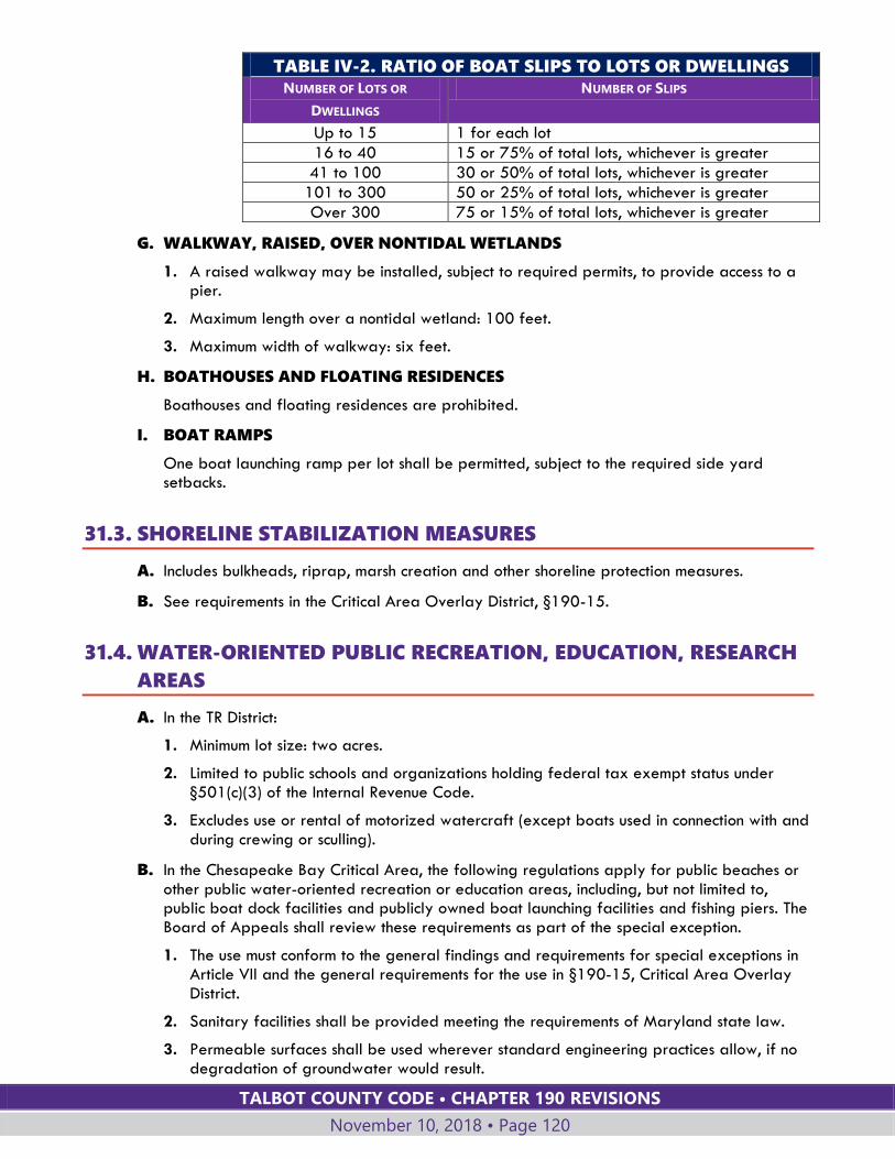
TALBOT COUNTY CODE • CHAPTER 190 REVISIONS
November 10, 2018 • Page 120
TABLE IV-2. RATIO OF BOAT SLIPS TO LOTS OR DWELLINGS
NUMBER OF LOTS OR
DWELLINGS
NUMBER OF SLIPS
Up to 15 1 for each lot
16 to 40 15 or 75% of total lots, whichever is greater
41 to 100 30 or 50% of total lots, whichever is greater
101 to 300 50 or 25% of total lots, whichever is greater
Over 300 75 or 15% of total lots, whichever is greater
G. WALKWAY, RAISED, OVER NONTIDAL WETLANDS
1. A raised walkway may be installed, subject to required permits, to provide access to a pier.
2. Maximum length over a nontidal wetland: 100 feet.
3. Maximum width of walkway: six feet.
H. BOATHOUSES AND FLOATING RESIDENCES
Boathouses and floating residences are prohibited.
I. BOAT RAMPS
One boat launching ramp per lot shall be permitted, subject to the required side yard setbacks.
31.3. SHORELINE STABILIZATION MEASURES
A. Includes bulkheads, riprap, marsh creation and other shoreline protection measures.
B. See requirements in the Critical Area Overlay District, §190-15.
31.4. WATER-ORIENTED PUBLIC RECREATION, EDUCATION, RESEARCH
AREAS
A. In the TR District:
1. Minimum lot size: two acres.
2. Limited to public schools and organizations holding federal tax exempt status under §501(c)(3) of the Internal Revenue Code.
3. Excludes use or rental of motorized watercraft (except boats used in connection with and during crewing or sculling).
B. In the Chesapeake Bay Critical Area, the following regulations apply for public beaches or other public water-oriented recreation or education areas, including, but not limited to, public boat dock facilities and publicly owned boat launching facilities and fishing piers. The Board of Appeals shall review these requirements as part of the special exception.
1. The use must conform to the general findings and requirements for special exceptions in Article VII and the general requirements for the use in §190-15, Critical Area Overlay District.
2. Sanitary facilities shall be provided meeting the requirements of Maryland state law.
3. Permeable surfaces shall be used wherever standard engineering practices allow, if no degradation of groundwater would result.
TALBOT COUNTY CODE • CHAPTER 190 REVISIONS
November 10, 2018 • Page 121
4. Not more than 15% of existing natural vegetation shall be permanently disturbed.
5. Service facilities shall be located outside the shoreline development buffer wherever physically possible.
6. Service facilities for passive recreation, such as nature study, and hunting and trapping, and for education shall be located outside of the shoreline development buffer.
Section 190-32 UTILITY, TRANSPORTATION AND
COMMUNICATION USES
32.1. ANTENNA TOWER FOR ESSENTIAL COMMUNICATIONS
A. Includes towers for essential telecommunications and emergency service radio communications antennas.
B. New antenna towers shall not be located within a three-mile radius of any existing antenna towers in the unincorporated area of the County.
C. See §190-32.3, Wireless communications towers, for regulations for other types of towers.
32.2. ANTENNA TOWER FOR RADIO AND TELEVISION TRANSMISSIONS
AND OTHER NONESSENTIAL RADIO COMMUNICATIONS
A. Includes towers for public and commercial radio and television antennas, business band radio antennas and necessary transmission facilities.
B. Includes associated broadcasting studios in the LC, GC, and LI Districts.
C. New antenna towers shall not be located within a three-mile radius of any existing antenna towers in the unincorporated area of the County.
D. See §190-32.3, Wireless communications towers, for regulations for other types of towers.
32.3. WIRELESS COMMUNICATION TOWERS
A. Exemptions. Private amateur (ham) radio towers 75 feet or less are exempt from the requirements of this Section. See §190-33.16 for specific land use regulations.
B. General requirements. The following requirements are applicable to all wireless communications towers regardless of height or date of construction:
1. Wireless communication priority placement areas identified on WCPPA Guidance Plans shall be given priority for new service. Applications within wireless communication priority placement areas meeting all technical and other requirements established by this amendment shall be presumed to provide optimal value to the County wireless communication network. Applications outside wireless communication priority placement areas shall be subject to a presumption that they provide less than optimal value to the County wireless communication network.
2. The applicant shall provide written verification that the proposed wireless communication tower is greater than 500 feet from a parcel containing a public playground, ballfield or school use. Notwithstanding any other Section of this chapter, this limitation shall not be subject to modification by either a special exception or variance. County-owned
TALBOT COUNTY CODE • CHAPTER 190 REVISIONS
November 10, 2018 • Page 122
property may be considered suitable for a tower location on an equal basis with non-County-owned property.
3. The ground base of any wireless communications tower structure shall be set back from any property line, road, or public recreation area a distance that is the height of the tower plus 10 feet, except for concealed towers, which shall comply with setback requirements set forth in Table II-12, Structure Height. Notwithstanding any other Section of this chapter this limitation shall not be subject to modification by either a special exception or variance. Any icefall or debris from tower structural failure shall be contained in the immediate tower area. Any accessory structures shall comply with the minimum building setback requirements of the applicable zoning district. These setback requirements may be reduced through a variance application as provided for in Article VII.
4. Wireless communications tower height shall be no higher than necessary to ensure the effective service for the relevant service area, but in no case shall exceed 200 feet. Notwithstanding any other Section of this chapter, this limitation shall not be subject to modification by either a special exception or variance.
5. The applicant for a wireless communications tower is required to have a letter of intent from at least one Federal Communications Commission (FCC) licensed operator to locate on the wireless communications tower at the time the application is filed with the Planning Office. The application shall not be accepted without the letter of intent that defines the type of service(s) to be provided and the time schedule for commencement of services after construction.
6. The applicant is required to have at least one FCC-licensed operator under contractual agreement to locate on the wireless communications tower prior to issuance of a building permit.
7. The wireless communications tower shall be designed to minimize adverse visual and environmental impact (e.g., paint, camouflage, screening, stealth technology, concealed towers, color, use of existing structures and natural landscape, etc.). All equipment shelters shall be maintained in neutral shades consistent with the natural landscape.
8. The wireless communications tower and associated appurtenances shall not be lit unless required by federal or state regulations. If lighting is required, the least-intensive lighting shall be used.
9. The wireless communications tower shall be either a self-supporting monopole or self-supporting lattice structure, except concealed towers, which include an alternate or supplemental structural design accompanied by certification from a Maryland licensed structural engineer that the proposed tower is designed to withstand all design loads required by the Talbot County Building Code by a minimum of 110%.
10. The applicant shall submit a landscaping plan prepared by a licensed professional with the site plan application which identifies existing vegetation and specifications, including species, size, and location, of all proposed plant materials to be utilized for buffering and screening of the wireless communications tower structure and equipment structures. A secure fence or enclosure, a minimum of eight feet in height, shall enclose the entire base of the wireless communications facility. All required plantings shall be kept in a live, healthy condition. Any plants not in a live, healthy condition shall be replaced by the owner to the satisfaction of the Planning Director. Landscaping and fencing requirements may be waived for concealed towers through a waiver petition approved by the Planning Commission in accordance with §190-62.
11. The owner of a wireless communications tower shall provide financial surety in a form and amount acceptable to the County to secure payment of 125% of the cost of removal
TALBOT COUNTY CODE • CHAPTER 190 REVISIONS
November 10, 2018 • Page 123
of the tower, base, foundation to six feet below ground level, and accessory structures if the tower's use is discontinued for 12 or more continuous months. The surety instrument shall be provided prior to building permit application. The Department of Planning and Zoning may increase the amount of the surety as necessary from time to time to insure the amount is adequate to cover the cost of removal.
12. An abandoned wireless communications tower shall be removed within 90 days of abandonment. If the owner of the tower does not remove the tower, the County may utilize the financial surety to do so, and any excess cost of the removal of the tower shall be borne by the property owner of the land on which the tower is located. Talbot County shall retain the right to place a lien against the property until all such excess costs are paid.
13. A sign shall identify the property owner, tower owner, contact phone number, and emergency information and shall comply with the sign requirements of this chapter. Information on the sign shall be current, and the tower owner shall notify the Planning Director of any information change.
14. Existing wireless communications towers may be demolished and an in-kind replacement constructed within the approved compound of the original tower. The original tower must be removed within 60 days after the completion of the replacement tower. The in-kind replacement may not exceed the height of the original tower or its appurtenances, and all new antenna arrays and dishes must comply with the maximum size criteria. Replacement wireless communications towers shall be submitted for a site plan review in accordance with Article VII and receive a recommendation from the Planning Commission.
15. Calculation of height limits for new wireless communications towers shall be measured from the lowest finished grade elevation at the base to the highest point of the tower to include the tower and all antennas, lightning rods and miscellaneous appurtenances. The lowest finished grade elevation may not be changed from the preexisting natural topography without prior approval from the Planning Director.
16. The applicant for a new wireless communications tower outside of a wireless communication priority placement area shall provide documentation with the site plan application proving that existing wireless communications towers and other existing structures over 50 feet in height within a one-mile radius of the proposed location and structures 100 feet or higher from a one-mile to two-mile radius of the proposed location are not viable collocation opportunities.
17. Extension of wireless communications towers above the initial approved height shall require a special exception amendment if the original tower was 100 feet or higher.
18. Extension of wireless communications towers to 100 feet or higher after initial construction of a tower less than 100 feet shall require a special exception.
19. Extension of wireless communications towers to 75 feet, but still less than 100 feet, after initial construction of a tower less than 75 feet shall require a site plan review in accordance with Article VII and receive a recommendation from the Planning Commission.
20. All wireless communications tower owners must comply with all federal, state or local laws or regulations, as amended, concerning electromagnetic radiation and other electronic emissions applicable to the facility within 120 days of the effective date of the regulations.
C. General application requirements. All applications shall provide the following information:
1. The name, address and telephone number of the corporate headquarters and local office, and current contact information for each office.
TALBOT COUNTY CODE • CHAPTER 190 REVISIONS
November 10, 2018 • Page 124
2. Proof of ownership of the proposed wireless communications tower site or proof of contract or license with the owner of the site and the right to construct and operate the proposed tower.
3. A copy of FCC license application or license number, date of issuance, and type of license (cellular, PCS, etc.) if applicable.
4. A master report plan of applicant's current proposed communication network, including an illustrative wireless communications map detailing existing and proposed wireless coverage, antenna sites and collocation sites.
5. The current zoning of the proposed wireless communications tower site.
6. The maximum proposed wireless communications tower height.
7. The maximum proposed height of the antenna in feet above ground level (AGL).
8. The wireless communications tower design.
9. The number of potential collocation sites on the proposed wireless communications tower.
10. The name, address, and telephone number of the responsible entity for removal of the wireless communications tower if the tower's use is discontinued for 12 or more continuous months.
11. Wireless communications towers proposed outside of a wireless communication priority placement area shall provide an analysis of the nearest priority placement area and a detailed narrative as to why sites within this area are unsuitable, with the site plan application.
12. Proof that the site will not interfere with the County's Emergency Management Communication System. The applicant shall contact the Director of Emergency Management, and obtain written comments from the Director, prior to site plan application submittal for any new tower.
13. Site plan applications for a new wireless communications tower 75 feet or greater shall include copies of comments received from the Talbot County Historic Preservation Commission, the State Historic Preservation Office, the Federal Aviation Administration, the Maryland Aviation Administration, the Easton Airport, and the Medivac Unit of the State Police, and any other agency required to be notified by federal or state law. The applicant shall also contact the Maryland Department of the Environment and the U.S. Army Corps of Engineers, as applicable to the site. A site plan application shall not be accepted as complete until each of these agencies has either commented or confirmed it has no comment on the application. The applicant shall forward all comments received from these agencies to the Department of Planning and Zoning for consideration with the site plan application. At the applicant's request, the application shall be submitted to the Planning Commission to decide whether the application is complete or incomplete. If an incomplete application is not completed within 30 days after written notice from the Planning Office, the matter shall be submitted to the Planning Commission for a decision on the merits of the application. However, if the applicant stipulates in writing that the application is not complete, the time for final action by the County on the application shall be extended and shall not begin to run again until the application is completed.
14. A written statement that collocation sites on the tower shall be made available for lease at fair market rates.
15. Information on the type(s) of service (data or voice) to be provided by operators locating on the tower.
16. The time period before voice or data service will commence once the tower is constructed.
TALBOT COUNTY CODE • CHAPTER 190 REVISIONS
November 10, 2018 • Page 125
D. General collocation requirements. The following requirements apply to all wireless communications collocation applications:
1. Collocation is permitted in all zoning districts if the antennas are mounted on an existing structure, and the at-grade mechanical equipment meets all applicable zoning requirements.
2. The applicant shall obtain a building permit for collocation on an existing wireless communications tower. Prior to building permit application, collocation on structures other than existing wireless communications towers located in all zoning districts shall require a site plan review in accordance with Article VII, including a recommendation from the Planning Commission.
3. As a condition of permitting and continued operation, collocation space on wireless communications towers constructed after January 26, 2002, shall be made available for lease at fair market rates.
4. All building permits shall contain a provision granting Talbot County the right of first refusal to lease or purchase tower space for installation of public telecommunications and data transmission equipment or antennas at negotiated fair market rates.
E. Specific tower requirements (towers less than 75 feet high). The following requirements are applicable to all wireless communications towers less than 75 feet high:
1. All general requirements in Subsection B of this Section.
2. All general application requirements in Subsection C of this Section.
3. All applicable general collocation requirements in Subsection D of this Section.
4. The new construction shall be designed to support a minimum of one FCC-licensed operator.
5. The applicant shall provide a project location map and narrative description of the proposed wireless communications tower site.
6. New construction of towers less than 75 feet is permitted in all zoning districts except Rural Residential (RR), Town Conservation (TC) Town Residential (TR) and Village Residential (VR) if the individual antennas meet the size criteria stated in the general requirements Section and all at-grade mechanical equipment meets all applicable zoning requirements.
7. Applications meeting the above criteria require a minor site plan in accordance with Article VII and a building permit.
8. When considering approval or denial of the minor site plan for a wireless communications tower, the Planning Director shall place greater emphasis on the impact of a proposed tower site on the surrounding community when it is located outside of a wireless communication priority placement area.
F. Specific tower requirements (towers from 75 feet to less than 100 feet high). The following requirements are applicable to all wireless communications towers from 75 feet to less than 100 feet high:
1. All general requirements in Subsection B of this Section.
2. All general application requirements in Subsection C of this Section.
3. All applicable general collocation requirements in Subsection D of this Section.
4. The new tower construction shall be designed to support a minimum of two FCC-licensed operators.
TALBOT COUNTY CODE • CHAPTER 190 REVISIONS
November 10, 2018 • Page 126
5. Construction is allowed in all zoning districts except Rural Residential (RR), Town Conservation (TC), Town Residential (TR) and Village Residential (VR) if the individual antennas meet the size criteria stated in the general requirements Section and all at-grade mechanical equipment meets all applicable zoning requirements.
6. Applications meeting the above criteria require major site plan review in accordance with Article VII and a building permit.
7. When considering approval or denial of the major site plan for a wireless communications tower, the Planning Commission shall place greater emphasis on the impact of a proposed tower site on the surrounding community when it is located outside of a wireless communication priority placement area.
8. Prior to acceptance of the application in accordance with §190-54.2, the applicant shall:
a. Notify all adjoining property owners by mail of the wireless communications tower proposal, including neighbors across water bodies that are within 1,000 feet of the property containing the tower site.
b. Erect a sign on the proposed site notifying the public of the applicant's intent to construct a wireless communications tower. Said sign design and size shall be approved by the Planning Director.
c. Provide public notice in the local newspaper of the applicant's request for the new proposed wireless communications tower, identifying location, type, height, etc. at the applicant's expense. The newspaper notice shall include a map showing the proposed tower location, and be approved by the Planning Director.
9. A project location map and narrative description of the proposed wireless communications tower site documenting the area of potential effect, including but not limited to residential properties, public rights-of-way, historical sites, parks, conservation areas, and other significant existing structures, shall be provided.
10. At the time of site plan application, the applicant shall submit copies of the antenna propagation analysis or drive test studies used for analysis, and type of coverage (i.e., single or system), including a coverage and interference analysis.
11. If located outside of a wireless communication priority placement area, the applicant shall provide a coverage/interference analysis and capacity analysis with the site plan application which demonstrates that the location of the antenna as proposed is necessary to meet the frequency reuse and spacing needs of the wireless communications facility and to provide adequate coverage and capacity to areas that cannot be adequately served by locating the antenna at an alternative site. At the applicant's expense, the site plan application for a new wireless communications tower shall include a report prepared by an independent engineer stating:
a. It is technically impossible to provide a reasonable level of service by collocating wireless communications antennas on existing structures and that existing wireless communications towers are not adequate to meet the coverage needs for any proposed wireless communications tower if located outside of a wireless communication priority placement area, and providing sufficient factual detail to support those conclusions.
b. The proposed wireless communications tower and attached antenna does not exceed the minimum height necessary to accomplish the purpose for which it is constructed and in no case shall exceed 200 feet.
c. Frequency of transmission of all proposed antennas on the wireless communications tower.
d. Power and size of proposed antennas in effective radiated power (ERP).
TALBOT COUNTY CODE • CHAPTER 190 REVISIONS
November 10, 2018 • Page 127
e. Azimuth of antennas.
f. Down-tilt of antennas.
g. Calculations utilized to justify design requirements (i.e., engineering trade-off analysis between height, ERP, antenna performance and coverage area).
h. The wireless communications tower has sufficient structural integrity for its current and future use, including multiple collocation antennas, and that the tower facility complies with all American National Standards Institute (ANSI) standards. Factors to be stated are the maximum wind load and snow/ice load calculations.
12. The Planning Commission may require a review of the applicant's engineer's report by an independent consultant of its choosing, the cost of the review to be borne by the applicant.
G. Specific tower requirements (towers 100 feet high or higher). The following requirements are applicable to all wireless communications towers 100 feet high or higher:
1. All general requirements in Subsection B of this Section.
2. All general application requirements in Subsection C of this Section.
3. All applicable general collocation requirements in Subsection D of this Section.
4. All wireless communications tower applications for towers 100 feet or higher shall require a special exception in accordance with §190-56.2.C. When considering approval or denial of a special exception application, the Board of Appeals shall place greater emphasis on the impact of a proposed tower site on the surrounding community when it is located outside of a wireless communication priority placement area or within a three-mile radius of an existing wireless communications tower that is greater than 75 feet in height.
5. Applications meeting the above criteria require major site plan review in accordance with Article VII and a building permit.
6. The applicant must obtain major site plan approval prior to the special exception hearing with the Board of Appeals.
7. The new construction of a tower from 100 feet to less than 150 feet shall be designed to support a minimum of three FCC-licensed operators.
8. The new construction of a tower from 150 feet to less than 180 feet shall be designed to support a minimum of five FCC-licensed operators.
9. The new construction of a tower from 180 feet to 200 feet shall be designed to support a minimum of six FCC-licensed operators.
10. Allowed by special exception in all zoning districts except Rural Residential (RR), Town Conservation (TC), Town Residential (TR), Village Residential (VR), Village Hamlet (VH), and Village Mixed (VM) if the individual antennas meet the size criteria stated in the general requirements Section and at-grade mechanical equipment meets applicable zoning requirements.
11. Prior to acceptance of the application in accordance with §190-54.2, the applicant shall:
a. Notify all adjoining property owners by mail of the wireless communications tower proposal, including neighbors across water bodies that are within 1,000 feet of the property containing the tower site.
b. Erect a sign on the proposed site notifying the public of the applicant's intent to construct a wireless communications tower. Said sign design and size shall be approved by the Planning Director.
TALBOT COUNTY CODE • CHAPTER 190 REVISIONS
November 10, 2018 • Page 128
c. Provide public notice in the local newspaper of the applicant's request for the new proposed wireless communications tower, identifying location, type, height, etc. at the applicant's expense. The newspaper notice shall include a map showing the proposed tower location, and be approved by the Planning Director.
12. The applicant shall conduct a community meeting open to the public to discuss the proposed site plan application for any wireless communications tower. The applicant shall conduct the community meeting at least one week prior to the Planning Commission meeting at which the tower site plan application is scheduled to be reviewed. The meeting shall be held at the applicant's expense and staffing. County staff is not required to attend the community meeting.
13. Prior to the Planning Commission meeting for site plan review, the applicant shall perform a highly visible balloon test lasting a minimum of 30 minutes. The date, location, and beginning and ending time of the test shall be published in a local newspaper at least one week prior to the test. The Planning Director shall approve the newspaper notice. The results of the balloon test shall be incorporated into a computerized simulation submitted to the Department of Planning and Zoning 10 days prior to the Planning Commission meeting. The computerized simulation shall illustrate the wireless communications tower at the proposed height, antenna arrangements, maximum number of collocation antennas, and the color scheme of the entire structure, including accessory structures.
14. A project location map and narrative description of the proposed wireless communications tower site documenting the area of potential effect, including but not limited to residential properties, public rights-of-way, historical sites, parks, conservation areas and other significant existing structures, shall be provided.
15. At the time of site plan application, the applicant shall submit copies of the antenna propagation analysis or drive test studies used for analysis, and type of coverage (i.e., single or system), including a coverage and interference analysis.
16. If located outside of a wireless communication priority placement area, the applicant shall provide a coverage/interference analysis and capacity analysis with the site plan application that demonstrates that the location of the antenna as proposed is necessary to meet the frequency reuse and spacing needs of the wireless communications facility and to provide adequate coverage and capacity to areas which cannot be adequately served by locating the antenna at an alternative site.
17. At the applicant's expense, the site plan application for a new wireless communications tower shall be accompanied by a report prepared by an independent engineer stating:
a. It is technically impossible to provide a reasonable level of service by collocating wireless communications antennas on existing structures and that existing wireless communications towers are not adequate to meet the coverage needs for any proposed wireless communications tower, if located outside of a wireless communication priority placement area, and provide sufficient factual detail to support those conclusions.
b. The proposed wireless communications tower and attached antenna does not exceed the minimum height necessary to accomplish the purpose for which it is constructed and in no case shall exceed 200 feet.
c. Frequency of transmission of all proposed antennas on the wireless communications tower.
d. Power and size of proposed antennas in effective radiated power (ERP).
e. Azimuth of antennas.
f. Down-tilt of antennas.
TALBOT COUNTY CODE • CHAPTER 190 REVISIONS
November 10, 2018 • Page 129
g. Calculations utilized to justify design requirements (i.e., engineering trade-off analysis between height, ERP, antenna performance and coverage area).
h. The wireless communications tower has sufficient structural integrity for its current and future use, including multiple collocation antennas, and that the tower facility complies with all American National Standards Institute (ANSI) standards. Factors to be stated are the maximum wind load and snow/ice load calculations.
18. The Board of Appeals may require a review of the applicant's engineer's report by an independent consultant of its choosing, the cost of the review to be borne by the applicant.
32.4. SOLAR ENERGY SYSTEMS
A. GENERAL REQUIREMENTS
The following apply to all solar energy systems (SES)
1. PROCEDURES FOR APPROVAL
a. Small-scale SES require a building permit and a planting plan for screening.
b. Medium-scale SES require a major site plan, building permit, and a landscaping and screening plan.
c. Large-scale SES require a special exception, major site plan, building permit, a landscaping and screening plan, Reservation of Development Rights Agreement(s), and mitigation.
d. Other site specific approvals, such as nontidal wetland permits, forest conservation plans, forest preservation plans, and habitat protection plans, are also required.
2. SITING REQUIREMENTS
a. Rooftop solar systems or projects above existing lot coverage are preferable.
b. Height:
i. Rooftop solar systems shall not extend more than 10 feet above the surface of the roof. The total height of the building or structure, including the solar collection devices, shall comply with the height regulations established in this chapter.
ii. Ground-mounted solar systems shall not exceed 16 feet in height.
iii. Ground-mounted solar systems that function as a roof above a parking area shall be subject to applicable accessory structure height limits.
c. SES shall be sited to maximize on-site agricultural opportunities on remaining agricultural lands to the greatest extent possible. SES shall be sited to preserve existing view sheds along scenic byways to the greatest extent possible.
d. SES in residential districts shall be located in a side or rear yard to the extent practicable.
e. Projects that result in significant loss of prime agricultural land or undue impacts to forests, wetlands, habitat protection areas, other natural resources, or environmentally sensitive areas are strongly discouraged and shall be redesigned to avoid or minimize impacts to the maximum extent practicable.
3. LANDSCAPING AND SCREENING WAIVER
a. In locations where natural features and existing vegetation are proven to meet the screening objectives of this Section, the Planning Commission may waive landscaping and screening requirements in accordance with §190-62.
TALBOT COUNTY CODE • CHAPTER 190 REVISIONS
November 10, 2018 • Page 130
4. LIGHTING
a. If lighting is required it shall be activated by motion sensors and shall be fully shielded and downcast to prevent the light from shining onto adjacent parcels or into the night sky.
5. SITE MAINTENANCE
a. The property owner and SES owner shall be jointly and severally responsible to maintain the SES site as follows:
i. Vegetation and ground cover shall be established and maintained not to exceed 12 inches in height.
ii. Noxious weeds shall be controlled in accordance with state law.
6. LOT COVERAGE
a. SES above pervious surfaces within the critical area are subject to lot coverage requirements and stormwater regulations.
b. Except for gravel drip lines and other impervious surfaces, SES outside the critical area are exempt from lot coverage requirements but are not exempt from stormwater regulations.
B. SMALL-SCALE SES
The following requirements apply to small-scale SES.
1. SCREENING
a. Small-scale SES shall be screened to shield the system from public view to the maximum extent practicable. Screening shall be designated on a planting plan approved by the Planning Director and shall be maintained throughout the existence of the SES.
2. SETBACKS
a. Small-scale SES shall comply with required setbacks for the parcel size in the zoning district where the project is located.
C. MEDIUM-AND LARGE-SCALE SES
The following requirements apply to medium- and large-scale SES:
1. SIZE LIMITATION
a. The combined additional aggregate acreage in the agricultural and resource zoning districts (AC, WRC, RC, CP) utilized throughout the County by medium and large scale SES shall not exceed 0.5% of the total land area in the AC, WRC, RC, and CP Zones, or not more than 726 new acres after February 11, 2017.
2. SETBACKS
a. Setbacks shall be 150 feet from all property lines and edges of rights-of-way. Setbacks may be reduced to minimum setbacks in the base zoning district or any applicable overlay district, whichever is greater, with written consent from the affected adjacent property owner.
b. Setbacks shall not be less than required in the base zoning district or overlay, whichever is greater, without a variance.
3. SCREENING
a. The applicant shall submit a landscaping and screening plan, prepared by a licensed professional, along with the major site plan application, to provide vegetative screening from adjoining lands and road rights-of-way and road easements. The
TALBOT COUNTY CODE • CHAPTER 190 REVISIONS
November 10, 2018 • Page 131
plan shall identify existing vegetation, including species, size, and the location of all proposed plant materials to be used for buffering and screening of the SES. Screening shall include a minimum of two staggered rows of evergreen screen trees, interspersed with shrubs and low-lying native vegetation, or an equivalent approved by the SES approving authority. The evergreen trees shall be a minimum of six feet in height when planted, or an equivalent combination of tree and berm height. The plant species shall be only those noted within the approved Talbot County plant species list for screening and landscaping, unless authorized to substitute on an approved planting plan. Existing vegetation within or near a required planting area that meets or exceeds these standards may be used to satisfy screening requirements. All required screening shall be maintained in a live, healthy condition for the duration of the SES and shall be replaced by the owner as necessary to maintain all required screening to the satisfaction of the Planning Director.
4. FENCING
a. The SES shall be enclosed by a fence or other appropriate barrier to prevent unauthorized persons or vehicles from gaining access.
5. SIGNAGE
a. A sign, not to exceed one square foot, shall be posted at each entrance to the SES to identify the property owner, the SES owner, their contact phone numbers and emergency contact information. Information on the sign shall be kept current and the property and SES owners shall provide all updated information to the Planning Director.
b. Signage indicating "DANGER - HIGH VOLTAGE - KEEP OUT" shall be posted along all SES exterior fencing or barriers.
c. Placards shall be posted to identify the location of the AC power supply emergency disconnects. All other signage required by the electrical, building, or fire code shall be posted as required.
d. No other signage shall be permitted without approval from the County.
e. The site, fencing, or barriers shall not be used to display any advertisements.
6. ABANDONMENT
a. SES that cease to produce electricity continuously for one year shall be presumed abandoned. The property owner may overcome this presumption by substantial evidence, satisfactory to the Planning Director, that cessation of the use occurred from causes beyond the owner's reasonable control, that there is no intent to abandon the system, and that resumption of use of the existing system is reasonably practicable.
b. Following abandonment, the operator and landowner shall remove all equipment and systems and restore the site as near as practicable to its original condition. The obligation of the operator and owner to remove the SES and restore the site shall be joint and several.
c. Failure to comply with the requirements of this Section shall authorize, but not require, the County to remove the SES and restore the site in accordance with the approved decommissioning plan.
7. PUBLIC NOTICE
Prior to filing an application for a site plan for medium- or large-scale SES or special exception for large-scale SES, an applicant shall:
a. Erect a sign on the proposed, site notifying the public of the applicant's intent to construct a medium- or large-scale SES. The sign design and size shall be approved by the Planning Director.

TALBOT COUNTY CODE • CHAPTER 190 REVISIONS
November 10, 2018 • Page 132
b. Publish in the local newspaper, at the applicant's expense, public notice of the applicant's request for the proposed SES, identifying the proposed location, type, height, setbacks, screening, etc. The public notice shall include a map showing the proposed location of the SES site, shall advise the public that a community meeting to discuss the proposed site plan application shall be open to the public and shall be held at least one week prior to the Planning Commission meeting at which the SES site plan application will be heard. The public notice shall be pre-approved by the Planning Director.
8. DECOMMISSIONING
A decommissioning plan shall be required. The plan shall include:
a. The expiration date of the contract, lease, easement, or other agreement for installation of the SES and a timeframe for removal of the SES within one year following termination of the use.
b. A requirement that the operator and property owner provide written notice to the County whenever a SES is out of active production for more than six months.
c. Removal of all above and underground equipment, structures, fencing and foundations. All components shall be completely removed from the subject parcel upon decommissioning.
d. Removal of substations, overhead poles, above ground electric lines located on-site or within a public right-of-way that are not usable by any other public or private utility.
e. Removal of lot coverage and access roads associated with the SES.
f. Re-grading and, if required, placement of like-kind topsoil after removal of all structures and equipment.
g. Re-vegetation of disturbed areas with native seed mixes and plant species suitable to the area or evidence of an approved nutrient management plan.
h. A recordable covenant executed by the property owner to reclaim the site in accordance with the decommissioning plan and associated approvals upon cessation of the use.
i. A requirement for County inspection and approval of the decommissioning and reclamation of the SES site.
9. FINANCIAL ASSURANCE
The operator or property owner of a medium- or large-scale SES shall provide a bond, surety, letter of credit, lien instrument, or other financial assurance in a form and amount acceptable to the County to secure payment of 125% of the anticipated cost of removal of all equipment, structures, fencing, above or below ground level, and any accessory structures, and restoration of the site in accordance with the requirements of this Section if use of the SES is discontinued continuously for one year. The financial assurance shall be provided prior to issuance of a building permit and shall be renewed so as to remain in full force and effect while the SES remains in place. The financial assurance shall require the obligor and the owner to provide at least 90 days' prior written notice to the County of its expiration or nonrenewal. The Planning Director may adjust the amount of the surety as reasonably necessary from time to time to insure the amount is adequate to cover the cost of decommissioning, removal and restoration of the site.
D. LARGE-SCALE SES
The following requirements apply to large-scale SES:
1. LOCATION
Large-scale SES are prohibited in the RC Zoning District.
TALBOT COUNTY CODE • CHAPTER 190 REVISIONS
November 10, 2018 • Page 133
2. MITIGATION
a. Large-scale SES in the AC, WRC or CP Zoning Districts shall provide mitigation through a Reservation of Development Rights Agreement approved by the County and recorded among the land records of Talbot County, reserving development rights on an equivalent area of land in the AC, WRC, RC or CP Zoning District.
b. The required mitigation through the Reservation of Development Rights Agreement shall remain in place and shall be extended as necessary until the SES is abandoned or discontinued, the decommissioning plan has been implemented, the work inspected and approved by the County and applicable portions of the project area have been converted back to active agricultural production.
c. Upon termination of the original lease term and any extensions, if the SES is to remain active, mitigation shall be provided pursuant to requirements in effect at that time.
3. DEVELOPMENT RIGHTS
a. An approved SES shall utilize development rights equal to the number of rights attributable to the project area with a minimum reservation of one development right. The property owner shall set aside the requisite number of development rights by a Reservation of Development Rights Agreement approved by the County and recorded among the land records of Talbot County. The Agreement shall restrict development and density rights on the balance of the property to the extent the SES has used those rights for the SES until the SES has been removed, the decommissioning plan has been implemented and the site has been inspected and approved by the County. The number of rights placed under reservation shall be calculated using the base density multiplied by the total area of land encumbered by the SES and all its appurtenances.
b. Provided a minimum of six acres is unencumbered by the SES, the three additional development rights permitted in the AC, CP, WRC, and TC Zoning Districts shall be excluded from the required reservation of development rights. The remaining land unencumbered by the SES and the Reservation of Development Rights Agreement may be developed in accordance with the cluster requirements as defined in this chapter.
c. Lots, parcels, or parts thereof are ineligible for large-scale SES if the development rights have already been preserved, conserved, reserved or otherwise allocated for the area of land to be utilized for the SES.
4. PUBLIC NOTICE
a. Prior to filing an application for a site plan or special exception, an applicant shall mail written notice of the SES proposal to all adjoining property owners, including property owners across water bodies that are within 1,000 feet of the property proposed for the SES site.
b. At least one week prior to the Planning Commission meeting at which the SES site plan application is scheduled to be reviewed, the applicant shall conduct a community meeting open to the public to discuss the proposed site plan application. The applicant shall conduct the community meeting. The meeting shall be held at the applicant's expense and staffing. County staff is not required to attend the community meeting.
32.5. UTILITY SERVICES, NONESSENTIAL
A. Excludes essential utility services.

TALBOT COUNTY CODE • CHAPTER 190 REVISIONS
November 10, 2018 • Page 134
B. Includes utility transmission facilities.
C. In the RC District:
1. Excludes generation of electricity.
2. Must meet the definition of a local government agency action in accordance with COMAR 27.02.
32.6. UTILITY STRUCTURES Excludes essential utility services.
32.7. WIND TURBINE TOWERS
A. SMALL WIND TURBINE USES
The following are specific requirements for small wind turbine systems and small wind turbine production facilities.
1. SMALL WIND TURBINE SYSTEMS:
a. Must comply with all general requirements listed in Subsection B below.
b. Are limited to a minimum lot size of five acres. This is not applicable to small wind turbine towers and windmills with a total height of 40 feet or less.
c. Are limited to a maximum of one small wind turbine tower on parcels 20 acres or less.
d. Are limited to a maximum of two small wind turbine towers on parcels greater than 20 acres.
e. Shall be limited to single-site consumption.
f. Sound levels shall not exceed dBA levels specified in the noise standards of the Talbot County Code.
g. Shall not exceed a cumulative metering rate of 100 kilowatts on a single site.
h. Include windmills limited to a total height of less than 75 feet.
2. SMALL WIND TURBINE PRODUCTION FACILITIES:
a. Must comply with all general requirements listed in Subsection B below.
b. Are limited to a minimum lot size of 10 acres.
c. Shall provide an engineering report stating the proposed small wind turbine tower does not exceed the minimum height necessary to accomplish the purpose for which it is constructed.
d. Shall be limited to off-site or a combination of both off-site and single-site consumption.
e. Sound levels shall not exceed dBA levels specified in the noise standards of the Talbot County Code.
f. May have cumulative metering rates that exceed 100 kilowatts.
B. GENERAL REQUIREMENTS
All small wind turbine systems and small wind turbine production facilities shall be subject to the following general requirements:
1. All small wind turbine systems with a total height of 75 feet or higher shall be subject to a major site plan review.
2. All small wind turbine production facilities shall be subject to a major site plan review.
TALBOT COUNTY CODE • CHAPTER 190 REVISIONS
November 10, 2018 • Page 135
3. Prior to the Planning Commission meeting for a small wind turbine production facility, the applicant shall perform a highly visible balloon test lasting a minimum of 30 minutes. The date, location, and beginning and ending time of the test shall be published in a local newspaper at least one week prior to the test. The Planning Director shall approve the newspaper notice. The results of the balloon test shall be incorporated into a computerized simulation submitted to the Department of Planning and Zoning 10 days prior to the Planning Commission meeting. The computerized simulation shall illustrate the small wind turbine tower at the proposed height and color scheme.
4. All small wind turbine towers shall comply with all guidelines and procedures provided by the Talbot County Office of Permits and Inspections.
5. The ground base of any small wind turbine tower shall be set back from any property lines, road rights-of-way and overhead utility lines a distance that is the total height of the small wind turbine tower plus 10 feet. Notwithstanding any other Section of this chapter, this limitation shall not be subject to modification by either a special exception or variance.
6. The blade tip of a small wind turbine tower, at its lowest point, shall be a minimum 30 feet above any obstruction within 300 feet. This is not applicable to vertical-axis wind turbines (VAWT) and windmills.
7. Small wind turbine towers shall be located a minimum distance of 30 feet from any other structure on the same lot or parcel. This is not applicable to vertical-axis wind turbines (VAWT) and windmills.
8. The distance between small wind turbine towers shall be a minimum of 10 times the length of the blade or foil.
9. The total height of a small wind turbine tower shall be no higher than necessary to access adequate winds but in no case shall exceed 160 feet. The total height is measured from the lowest finished grade elevation at the base to the uppermost tip of the blade. The lowest finished grade elevation may not be changed from the preexisting natural topography without an approval from the County. Notwithstanding any other Section of this chapter, this limitation shall not be subject to modification by either a special exception or variance.
10. The blade tip of any small wind turbine tower shall, at its lowest point, have ground clearance of no less than 25 feet, as measured at the lowest point of the arc of the blades from the lowest finished grade elevation at the base. The lowest finished grade elevation may not be changed from the preexisting natural topography without an approval from the County. This is not applicable to vertical-axis wind turbines (VAWT).
11. The blade tip or foil of any vertical-axis wind turbine (VAWT) shall, at its lowest point, have ground clearance of no less than 12 feet, as measured at the lowest point of the arc of the blades from the lowest finished grade elevation at the base. The lowest finished grade elevation may not be changed from the preexisting natural topography without an approval from the County.
12. The building permit or major site plan application shall be accompanied by a letter from a local utility company acknowledging the applicants intend to install a small wind turbine tower. This is not applicable to windmills.
13. All electrical wires associated with a small wind turbine tower, other than wires necessary to connect the wind generator to the wind tower wiring, the wind tower wiring to the disconnect junction box, and the grounding wires, shall be located underground.
14. The small wind turbine tower shall be designed to minimize environmental impact.
15. The small wind turbine tower shall not be used for the displaying of any advertisements.
TALBOT COUNTY CODE • CHAPTER 190 REVISIONS
November 10, 2018 • Page 136
16. Warning signs and signs identifying the manufacturer, installer, or owner of the small wind turbine tower shall be attached to the tower, not to exceed one square foot in size. No other signage shall be permitted without approval from the County.
17. The small wind turbine tower shall be a self-supporting monopole or lattice structure.
18. The small wind turbine tower shall not be sited on piers or other water-dependent facilities in accordance with the Annotated Code of Maryland, §16-104.
19. The small wind turbine tower shall not be lit unless required by federal or state regulations. If lighting is required, the least-intensive approved lighting shall be used.
20. The small wind turbine rated capacity shall be calculated using the current Maryland Energy Administration (MEA) standard.
21. The small wind turbine tower shall be designed so as to prohibit step bolts or a ladder readily accessible to the public for a minimum height of 12 feet above the lowest finished grade elevation at the base. The lowest finished grade elevation may not be changed from the preexisting natural topography without an approval from the County. This is not applicable to vertical-axis wind turbines (VAWT).
22. Pursuant to any request for code compliance regarding an abandoned or inoperable wind turbine tower, the burden of proof indicating current wind energy production shall be upon the owner of the land. A determination made by the County regarding wind turbine inoperability or abandonment may be appealed to the Talbot County Board of Appeals.
23. Any small wind turbine tower found to be abandoned or unsafe by the County Engineer shall be repaired or removed by the landowner. A small wind turbine tower that fails to operate, or is out of service for a continuous twelve-month period, shall be deemed to be abandoned.
24. A wind turbine tower shall be removed within 90 days of abandonment. Failure to comply within the period of time specified above will result in the complete removal of the abandoned wind turbine tower by Talbot County. As provided by code, all costs associated with this action incurred by Talbot County will be forwarded to the property owner for payment. Should the property owner fail to make payment to Talbot County within 30 days of turbine tower removal, the costs shall be charged to the owner of such property on the next regular real estate tax bill forwarded to such owner by the County, and said charges shall become a lien on the property and be due and payable by said owner at the time of payment of such bill.
25. The small wind turbine tower must comply with all regulations of the Federal Aviation Administration (FAA), if applicable, including any necessary approvals for installations within the Airport Overlay Zone.
32.8. SEPTAGE TREATMENT FACILITIES
A. Minimum setback: 300 feet.
B. Minimum distance from existing residences: 1,000 feet.
32.9. WASTEWATER TREATMENT PLANT A wastewater treatment plan in the RC District may only serve other properties in the RC District. It may not serve areas outside the Critical Area or areas within the Critical Area in the LDA or IDA land management areas.
TALBOT COUNTY CODE • CHAPTER 190 REVISIONS
November 10, 2018 • Page 137
32.10. WATER TREATMENT AND STORAGE FACILITIES A wastewater treatment plan in the RC District may only serve other properties in the RC District. It may not serve areas outside the Critical Area or areas within the Critical Area in the LDA or IDA land management areas.
32.11. LANDING STRIPS, PRIVATE
A. Forty-acre minimum lot size.
B. Minimum two-hundred-foot setback.
C. Shall be maintained in grass or similar low vegetation.
D. Helicopter landing facilities are prohibited.
Section 190-33 ACCESSORY USES
33.1. ACCESSORY USES, GENERAL REQUIREMENTS
A. PRINCIPAL USE OR STRUCTURE REQUIRED
Except as allowed by this Section, an accessory use or structure may be established only if a principal use or primary structure exists on the lot or parcel; or if construction of the primary structure has begun to the point of putting in place footings and foundation members and is diligently pursued.
B. ON LOTS WITHOUT A PRINCIPAL USE OR STRUCTURE
1. An accessory storage structure may be approved as a special exception on a lot without a principal use or structure, as listed in the Table of Land Uses (Table IV-1) and §190-33.24 below under "Storage building prior to construction of a primary structure."
2. An accessory storage structure is also permitted as a temporary use during construction, as provided in §190-34.2.A, “Accessory building prior to construction of a primary structure."
3. If a proposed subdivision would create a lot with an existing private pier but no principal use or primary structure, the pier may be retained subject to approval of a waiver. The waiver must be approved by the approving authority for the plat prior to or at the time of subdivision plan approval.
C. ACCESSORY LAND USES IN TABLE IV-1
Certain specific accessory uses are listed in Table IV-1. Requirements for these uses are listed below.
D. BULK REQUIREMENTS
See §190-12.3 for bulk requirements specific to accessory structures.
33.2. AGRICULTURE USES AND STRUCTURES, ACCESSORY
A. Includes farm buildings, barns, dairy barns, cribs, sheds, stables, tool rooms, workshops, farm-related offices, tanks, silos; open or enclosed storage of farm materials, products, equipment or vehicles; petroleum storage, not for resale, subject to County, state, and
TALBOT COUNTY CODE • CHAPTER 190 REVISIONS
November 10, 2018 • Page 138
federal regulations; and grain flow and field blending and packaging including milling, drying and storing.
B. Minimum setback for structures for animal manure, composting and similar purposes: 200 feet.
C. Minimum setback for stables and dairy barns: 100 feet.
D. Value-added production of farm products is permitted, subject to the following:
1. The primary product being processed is grown on or produced by the farm doing the processing.
2. The processing use is subordinate to and supports the agricultural use of the property.
33.3. BED-AND-BREAKFAST
A. A use certificate is required.
B. The use certificate shall be renewed annually. Renewal may require a site inspection.
C. In the Chesapeake Bay Critical Area, a bed-and-breakfast shall only be permitted in a primary dwelling existing as of August 13, 1989. Enlargement of the primary dwelling may not exceed 50% of the gross floor area which existed as of August 13, 1989.
D. Minimum lot size in an RC (Rural Conservation) or RR (Rural Residential) Zoning District: two acres.
E. Bed-and-breakfast uses shall be a minimum of 500 feet apart. For purposes of this Subsection, the measurement shall not be taken over navigable water and shall be taken between structures used for the bed-and-breakfast use and not between property lines.
F. A bed-and-breakfast enterprise shall have no more than six guest bedrooms, accommodating no more than 12 guests at any one time. No paying guest shall stay on any one visit for more than 30 days.
G. Guestrooms shall have no primary outside entrance.
H. Guest parking shall be provided in a side or rear yard.
I. Meal service is limited to one daily meal between 4:00 a.m. and 11:00 a.m. per paying overnight guest. Meal service is subject to State Health Department approval of food preparation areas.
J. Bed-and-breakfast accommodations shall be operated by the property owner who must occupy the residence. Any new owner of a residence in which a bed-and-breakfast is operated must apply for a new use certificate.
K. Bed-and-breakfast enterprises shall pay the Talbot County accommodations tax for each guest bedroom. Should such accommodation tax not be paid for a two-year period, the use certificate will be revoked.
L. A bed-and-breakfast may be used for weddings, receptions and similar events, provided that:
1. All areas used for such events shall be at least 500 feet from a primary residential structure on a neighboring property;
2. Each event shall be limited to no more than 100 guests;
3. No outdoor music shall be permitted before 9:00 a.m. or after 10:00 p.m.;
TALBOT COUNTY CODE • CHAPTER 190 REVISIONS
November 10, 2018 • Page 139
4. Such events shall take place on no more than six days per calendar year; and
5. The operator of the bed-and-breakfast must apply for a use certificate at least 30 days prior to the event.
M. In the RC District rental of nonmotorized water craft may be permitted as a special exception, accessory to the bed-and-breakfast use, subject to the following:
1. Rental shall be limited to guest(s) of the bed-and-breakfast.
2. Only structures existing on November 25, 2003, may be used for the rental and storage associated with the use.
3. Access to the structure shall be from a collector or arterial highway.
4. Maximum number of craft: 12.
33.4. BRIDGES, PRIVATE, WHICH CROSS TIDAL WATERS
A. A private bridge is permitted only if necessary to provide access to a property for a residential or water-dependent use.
B. Setbacks for the private bridge shall be the same as for other structures unless the bridge directly abuts an existing public road; then setbacks are waived.
33.5. COTTAGE INDUSTRY See also Home Occupation.
A. USES APPROPRIATE AS COTTAGE INDUSTRIES
The following list indicates uses that would be appropriate as cottage industries.
1. Craftsman (cabinetmaker, furniture maker, saddler, gunsmith etc.).
2. Property maintenance and landscape contractors.
3. Farm equipment services and repairs.
4. Firewood harvesting and sales.
5. Home improvement contractors (plumber, heating/air-conditioning technician, carpenter, mason, electrician, roofer, glazier, painter, etc.).
6. Septic, sewer or drain service.
7. Vehicle and boat repair, detailing or painting conducted exclusively inside an accessory structure.
8. Wholesale seafood distribution without operation of truck refrigeration units on the property.
B. STANDARDS FOR COTTAGE INDUSTRIES
1. Minimum lot size: five acres.
2. The cottage industry shall not occupy more than 3,000 square feet in a single accessory structure or in a combination of accessory structures, unless minimum lot size exceeds ten (10) acres in size, in which case the accessory structure(s) may occupy up to but not more than 5,000 square feet.
3. No more than one cottage industry per residence or lot is permitted. The use shall be incidental and secondary to the use of the residential dwelling.
TALBOT COUNTY CODE • CHAPTER 190 REVISIONS
November 10, 2018 • Page 140
4. Major site plan approval is required. See Article VII.
5. A use certificate is required for continued operation of all cottage industries. Cottage Industry use certificates shall be renewed every two years. The County shall conduct a site inspection to ensure compliance with the terms and conditions of the original approval, including any amendments, as a condition of renewal.
6. The property used for the cottage industry shall contain the primary residence of the proprietor.
7. If the proprietor is not the property owner, evidence of permission of the property owner to use the property for the cottage industry must be provided to the Planning Director.
8. Setbacks for structures and outdoor storage, loading, operations or parking areas:
a. From neighboring property lines: 150 feet.
b. From neighboring residences: 200 feet.
c. From tidally influenced waters: 100 feet.
9. The following requirements apply to outdoor areas used for equipment or material storage, repair or work areas, and parking, loading or circulation of trucks with a gross vehicle weight rating over 10,000 pounds. Such outdoor areas shall:
a. Occupy no more than 10,000 square feet;
b. Be limited to locations shown on the approved site plan; and,
c. Be screened from adjacent properties, public ways, and shorelines by a Type D landscape yard (§190-40.5.C), or an equivalent combination of vegetation, setbacks and topography.
10. Truck limits:
a. No more than two trucks used for the cottage industry may be based on the lot (parked during non-business hours), unless minimum lot size exceeds ten (10) acres in size, in which case up to but not more than five (5) trucks are permitted.
b. The cottage industry shall not generate visits to the site by trucks with a gross vehicle weight rating over 16,000 pounds.
c. On any single day, no more than 10 truck trips may be generated by the cottage industry (including employee’s commuter vehicles arriving at or leaving the site), with no more than four trips by trucks with GVWR of 10,000 pounds or more.
11. Adequate, dust-free areas shall be provided for safe on-site circulation and parking of vehicles related to the cottage industry.
12. Any change, enlargement or alteration of a cottage industry use, or of the structure and facility occupied by the use, shall require site plan approval.
13. New accessory structures for cottage industries:
a. Proprietors who desire to construct a new accessory structure for a cottage industry must own and reside on the property.
b. Proprietors of a cottage industry operated on land owned by an immediate family member may be allowed to construct a new accessory structure.
c. Proprietors who rent their primary residence on property that contains the cottage industry must operate the cottage industry using existing accessory structures only.
d. New accessory structures shall be limited to a roof ridge height of not greater than 25 feet.
TALBOT COUNTY CODE • CHAPTER 190 REVISIONS
November 10, 2018 • Page 141
14. No more than five nonresident employees shall report to a cottage industry site, unless minimum lot size exceeds ten (10) acres in size, in which case up to but not more than seven (7) employees are permitted.
15. In the VR, VH or VM district employees shall not report prior to 7:00 a.m. or leave after 9:00 p.m.
16. No use shall require internal or external construction features or the use of electrical, mechanical, or other equipment that would change the fire rating of the structure or in any way increase the fire danger to neighboring structures or residences.
17. Cottage industries shall not conduct retail sales. In this Section, “retail sales” means providing goods directly to the customers where such goods are displayed on site and are available for immediate purchase and removal from the premises by the purchaser. “retail sales” does not include:
a. Displaying goods online or by catalogue where the customer browses and completes the purchase remotely, such as online, by phone, or mail, and the purchased goods are then shipped to the customer;
b. Maintaining a workshop or showroom displaying a limited selection of custom-made goods; or,
c. Passing along to the customer the cost of new parts or components needed to repair or modify an item.
18. Cottage Industries shall comply with all federal, state or local regulations, including without limitation, obtaining all necessary governmental approvals.
19. Cottage industries on lots less than five acres and approved prior to adoption of this chapter:
a. All work associated with the cottage industry must be carried out in an accessory structure.
b. All materials and equipment associated with the cottage industry shall be stored inside the accessory structure.
33.6. DWELLING, ACCESSORY
A. One accessory dwelling is permitted on the same lot as a single-family detached dwelling unit.
B. An accessory dwelling shall not be included in density calculations.
C. An accessory dwelling may be:
1. Within the primary dwelling; or
2. Within an accessory structure, such as over a detached garage; or,
3. A detached accessory dwelling.
D. Permitted use of accessory dwellings:
1. The property owner may live on-site and rent one of the dwellings, or may rent the entire property. The primary dwelling and accessory dwelling shall not be rented to different tenants, and a tenant shall not sublease one of the dwellings.
2. The accessory dwelling may be used as a guest house or an employee dwelling.
3. An accessory dwelling in a detached accessory structures shall not be used as or in conjunction with a bed and breakfast establishment.
TALBOT COUNTY CODE • CHAPTER 190 REVISIONS
November 10, 2018 • Page 142
E. Standards for accessory dwellings within the primary dwelling:
1. Limited to a minimum of 300 square feet of gross floor area and a maximum of no more than 35% of the gross floor area of the primary residence or 900 square feet of gross floor area, whichever is less.
2. The dwelling shall retain the appearance of a single-family home.
F. Standards for detached accessory dwellings:
1. A detached accessory dwelling is permitted only on a lot of at least one acre, if a private septic system is used, or on lots of at least ½ acre if served by a public sewer system.
2. The accessory dwelling shall be generally compatible in design with the primary dwelling.
3. Double-wide manufactured dwellings are permitted subject to the standards for single-family detached dwellings (§190-27.1).
4. On lots of five acres or less, the accessory dwelling shall:
a. Be limited to 900 square feet of gross floor area, including porches and decks,
b. Use the same sewage disposal system as the primary dwelling;
c. Use the same driveway access.
5. For lots over five acres, the accessory dwelling shall be limited to no more than 1,500 square feet of gross floor area, including porches and decks.
6. Subject to recordation of a nonconversion agreement, unconditioned gross floor area within an accessory structure used solely for parking of vehicles or limited storage of household or yard goods shall not count toward the size limits of Subsection F.4 and 5 above.
G. A single accessory dwelling is permitted in the RC District subject to the following requirements.
1. Maximum 900 square feet of gross floor area, including porch and decks.
2. The entire perimeter of the accessory dwelling must be located within 100 feet of the primary dwelling unit.
3. Housing shall be served by the same sewage disposal system as the primary dwelling unit.
4. The additional dwelling unit, meeting the criteria of Subsections A through C above, may not be subdivided or conveyed separately from the primary dwelling unit.
5. The County shall maintain records of all building permits issued under this Section for additional dwelling units considered part of a primary dwelling unit and shall provide this information on a quarterly basis to the Critical Area Commission.
An accessory apartment that is detached or in a detached accessory structure shall not be subdivided or sold separately from the primary residence unless each lot meets current density standards and each dwelling unit meets current bulk requirements. Subdivision shall not create or result in a nonconforming lot or structure.
TALBOT COUNTY CODE • CHAPTER 190 REVISIONS
November 10, 2018 • Page 143
33.7. DWELLING, ACCESSORY TO AGRICULTURAL USE
A. MANUFACTURED OR MOBILE HOMES
Manufactured or mobile homes accessory to agricultural uses are permitted for full-time tenant labor or members of the immediate family of the owner of the farm subject to the following conditions:
1. Required minimum acreage in active farm production: 50 acres.
2. The manufactured or mobile home(s) shall be located in the immediate vicinity of and be an integral part of the complex composed of other major farm buildings and shall be located no more than 300 feet from the complex.
3. Minimum setbacks from property lines: 200 feet.
4. Maximum number of homes without a special exception: two.
5. Maximum number of homes with a special exception: four. An additional 50 acres of farm property in active production is required for each additional home above two.
6. The manufactured or mobile home shall not be rented, sold separately or subdivided from the primary residence unless each lot meets current density standards and each dwelling unit meets current design standards from existing and proposed property lines. Subdivision shall not create or result in a nonconforming lot or structure.
7. The manufactured or mobile home shall be placed on a permanent foundation, securely anchored, and provided with skirting of a suitable material.
B. FARM TENANT DWELLING UNITS OTHER THAN MANUFACTURED OR MOBILE
HOMES
The following non-manufactured/non-mobile-home dwellings for full-time tenant labor shall be permitted:
1. For a farm with more than 150 contiguous acres in active production, one additional dwelling unit.
2. For each additional 100 acres in excess of 150 acres, one additional dwelling unit.
3. A farm with the additional tenant dwelling units shall not exceed the maximum density allowed under this chapter.
4. A dwelling accessory to agricultural use shall not be rented, sold separately, or subdivided from the primary residence unless each lot meets current density standards and each dwelling unit meets current design standards from existing and proposed property lines. Subdivision shall not create or result in a nonconforming lot or structure.
33.8. DWELLING, ACCESSORY TO COMMERCIAL USE
A. The commercial use must remain in operation.
B. A single accessory dwelling may be located either within the commercial structure or within an accessory structure.
C. The property may contain two accessory dwelling units in addition to the principal commercial use, provided at least one dwelling is located within the commercial structure.
TALBOT COUNTY CODE • CHAPTER 190 REVISIONS
November 10, 2018 • Page 144
33.9. DWELLING, SEASONAL AGRICULTURAL EMPLOYEE
A. Twenty acre minimum lot size.
B. Two hundred foot setback from property lines.
C. Not more than 15 units, with six persons per unit.
D. A seasonal agricultural employee dwelling shall not be rented, sold separately, or subdivided from the primary residence unless each lot meets current density standards and each dwelling unit meets current design standards from existing and proposed property lines. Subdivision shall not create or result in a nonconforming lot or structure.
33.10. EVENT VENUE, ACCESSORY TO AGRICULTURE
A. For all event venues:
1. The use must be located on a property that is and remains actively farmed and is granted agricultural assessment value by the Maryland Department of Assessments and Taxation.
2. The use is permitted only partially outside of permanent structures and partially inside of one or more permanent structures or entirely inside of one or more permanent structures.
3. To the maximum extent practicable, the event venue shall be confined to the portion of the farm site that includes the majority of the agricultural structures currently located on the parcel.
4. A site plan is required. The site plan shall delineate any existing agricultural structures that will support the event venue and shall include areas at a minimum proposed for parking, access, and storage; the location and height of outdoor lighting; the location of any stage, structure or other location where music will be performed; and proposed screening.
5. The maximum number of guests and hours of operation shall be stated on the site plan.
6. New structures shall complement or enhance, rather than detract, from the rural environment.
7. The event venue location shall not displace any existing tree cover or vegetation that serves as a buffer between adjoining properties.
8. A Type D Landscape Yard shall be established between outdoor use areas (guest areas, parking and storage) and adjoining residential properties.
B. The following shall apply for Board of Appeals review of the special exception:
1. The Board in its decision approving a special exception shall establish the maximum number of events permitted per year; the maximum number of guests per event; and the structures and outdoor areas allowed to be used in conjunction with the event venue.
2. A use certificate is not required for each event; however, records of all events shall be retained and made available to confirm compliance with the Board of Appeals decision if requested by the Code Enforcement Officer.
3. The Special Exception application shall include a traffic management plan which demonstrates how traffic entering and exiting the site for an event will be managed to ensure safe and convenient access to and from the site; includes planned routes of vehicular access to the event venue; and depict on-site traffic circulation and travelways that can accommodate emergency vehicles.
TALBOT COUNTY CODE • CHAPTER 190 REVISIONS
November 10, 2018 • Page 145
4. The applicant shall demonstrate that the activities conducted as a part of the event venue will be located, designed and operated so as to not have significant adverse impacts on existing agricultural uses and activities.
5. The Board in its decision may increase the minimum required setbacks to mitigate any adverse impacts to abutting parcels.
C. Bulk Requirements:
1. Minimum lot size: 20 acres
2. Setbacks for structures and outdoor use areas: 200 feet from lot lines. Parking shall be set back 100 feet from all lot lines. Outdoor use areas shall be setback 200 feet from all lot lines.
D. All existing structures are required to be fully permitted, and shall be classified with respect to the occupancy group and the listed use, as determined by the Building Official. The applicant shall comply with all additional applicable county codes and any applicable food service regulations and on-site sewage disposal requirements of the Environmental Health Department.
33.11. EVENT VENUE, ACCESSORY
A. All event venues shall:
1. Be located on a parcel containing an existing hotel/motel, inn, golf course and country club, marina or private educational institution use. This accessory use shall cease once the principal use is no longer operating.
2. Require site plan approval. The maximum number of guests and hours of operation shall be stated on the site plan.
3. A Type C Landscape Yard shall be established between outdoor use areas (guest areas, parking and storage) and adjoining residential properties.
B. The following shall apply for Board of Appeals review of the special exception:
1. The Board in its decision approving a special exception shall establish the maximum number of events permitted per year; the maximum number of guests per event; and the structures and outdoor areas allowed to be used in conjunction with the event venue.
2. A use certificate is not required for each event; however, records of all events shall be retained and made available to confirm compliance with the Board of Appeals decision if requested by the Code Enforcement Officer.
3. No outdoor music shall be permitted unless specifically approved by the Board of Appeals. The hours of such music must be as established by the Board of Appeals but shall not be before 9:00 a.m. or after 10:00 p.m.
4. All applications in the Village Zoning Districts requesting outdoor amplified music shall include a noise compliance plan that includes a means for continuous electronic monitoring of sound levels from one hour prior to, until one hour after, the approved outdoor music time restriction, along with all materials required by the application form and checklist published by the Planning Office.
5. Structures for event uses are required to be fully permitted, and shall be classified with respect to the occupancy group and the listed use, as determined by the Building Official. The applicant shall comply with additional applicable County Codes and all applicable State and Federal regulations to include food service, sewage disposal and ADA (the Americans with Disabilities Act) Standards for Accessible Design.
TALBOT COUNTY CODE • CHAPTER 190 REVISIONS
November 10, 2018 • Page 146
33.12. HOME OCCUPATIONS See also §190-33.5, Cottage industry.
A. USES APPROPRIATE AS HOME OCCUPATIONS
The following list indicates uses that would be appropriate as home occupations:
1. Studios for the production of art, handicrafts, music, writing, photography, or similar, low impact or handcrafted items;
2. Business or professional office;
3. Catering and production of food items (e.g., baked goods, candy);
4. Office and workshop/storage (no sales) for dealers in antiques and collectibles;
5. Direct sale product distribution (Amway, Avon, Tupperware, etc.), internet sales businesses, and other types of sales;
6. Dressmaker, seamstress, tailor;
7. Cosmetology, including hair cutting and styling, manicure or pedicure, limited to two stations;
8. Massage therapists;
9. Mental health care practitioner;
10. Pet grooming without overnight boarding or exterior kennels;
11. Repair of small appliances, small engines and limited machining of small parts, office machines, cameras, and similar small items;
12. Taxidermy;
13. Tutoring, counseling, and other individualized instruction;
14. Vending machine business.
B. STANDARDS FOR HOME OCCUPATIONS
1. A use certificate is required.
2. Home occupation use certificates shall be renewed every two years. Renewal may require a site inspection.
3. The home occupation must be conducted within a residence and/or an accessory structure on the same lot as the residence.
4. The use must be incidental and secondary to the use of the dwelling for residential purposes.
5. The home used for the home occupation shall be the primary residence of the proprietor.
6. If the proprietor is not the property owner, evidence of permission of the property owner to use the property for the home occupation must be provided to the Planning Director.
7. No more than three nonresident employees shall report to a home occupation site. Only one nonresident employee may remain on the site during any portion of the day.
8. Residential character
a. The use shall not change the character of the residential use or adversely affect the uses permitted in the residential district of which it is a part.
b. Home-based occupations shall be conducted in such a manner as not to produce noise, dust, vibration, glare, smoke or smell, electrical interference, fire hazard,
TALBOT COUNTY CODE • CHAPTER 190 REVISIONS
November 10, 2018 • Page 147
traffic, or any other nuisance not typically experienced in the zoning district where property is located.
c. No use shall require internal or external construction features or the use of electrical, mechanical, or other equipment that would change the fire rating of the structure or in any way increase the fire danger to neighboring structures or residences.
9. Area
a. All work associated with a home occupation shall be performed inside the residence or an accessory structure not to exceed 1,500 square feet. No more than 1,500 square feet of an accessory structure may be used for a home-based occupation. A combination of existing accessory structures may be used to achieve the one-thousand-five-hundred-square-foot maximum.
b. The area used for the home occupation shall not exceed 25% of the gross floor area of the residence.
c. More than one home-based occupation per residence or lot may be allowed, provided that the area limitations of Subsection B(9)(a) and (b) above are not exceeded.
10. Outdoor storage of materials is not permitted.
11. Deliveries of equipment, parts and supplies shall be limited to commercial delivery services (i.e. UPS, Federal Express, etc.).
12. Customer, client or student visitation to the home-based occupation shall be scheduled to prevent an increase in vehicle trips not normally expected in a residential zone.
13. Home Occupations shall not conduct retail sales. In this Section, “retail sales” means providing goods directly to the customers where such goods are displayed on site and are available for immediate purchase and removal from the premises by the purchaser. “Retail sales” does not include:
a. Displaying goods online or by catalogue where the customer browses and completes the purchase remotely, such as on-line, by phone, or mail, and the purchased goods are then shipped to the customer;
b. Maintaining a workshop or showroom displaying a limited selection of custom-made goods; or,
c. Passing along to the customer the cost of new parts or components needed to repair or modify an item.
33.13. POULTRY, WATERFOWL AND GAMEBIRDS ON RESIDENTIAL
LOTS
A. Birds shall be maintained on the subject parcel and not permitted to run at large onto neighboring properties or roadways, and shall be maintained so that they do not constitute a nuisance due to noise, odor, or public health or safety concerns.
B. Structural enclosures shall meet minimum bulk requirements based on parcel size and zoning.
C. Roosters shall be permitted provided their enclosures are a minimum of 200 feet from neighboring residential dwellings.
D. On-site retail sale of eggs requires registration with the Maryland Department of Agriculture.
E. See agricultural production for lots larger than 5 acres.
TALBOT COUNTY CODE • CHAPTER 190 REVISIONS
November 10, 2018 • Page 148
33.14. PRODUCE STANDS
A. A use certificate is required, which must be renewed annually.
B. A produce stand shall not exceed 600 square feet in gross floor area, in one structure or cumulatively in more than one structure; this may include space in an owner-occupied accessory farm building.
C. All temporary structures shall be set back at least 25 feet from property lines and shall be located so as to provide safe ingress and egress from public roads.
D. Produce stands may use either a temporary or permanent structure, but shall not operate year-round.
E. Temporary structures, carts, or stands shall be removed from the roadside location when not in use.
F. A permanent structure:
1. Requires site plan approval,
2. Shall be secured and maintained in good condition throughout the year, and
3. Shall comply with setback requirements for the zoning district.
G. Produce stands may operate throughout the year except between January 15 and March 15.
H. An area around the sales structure, 25 feet deep and at least 25 feet from public roads, may be used for display of product.
33.15. RECREATIONAL VEHICLE PARKING
A. In all zoning districts, one recreational vehicle may be stored on a lot as an accessory use to the residential structure.
B. The vehicle may be parked on the lot or parcel for storage only, and shall not be occupied or lived in.
C. The vehicle shall be placed in the rear or side yards only, and shall be located at least eight feet from all property lines.
D. No recreational vehicle shall be used as a principal permitted use.
33.16. RESIDENTIAL STRUCTURES AND USES, ACCESSORY
A. Includes detached carports and garages, game courts, greenhouses, storage sheds, swimming pools and pool houses, and other structures not for human occupation.
B. Also includes accessory storage of equipment associated with a landowners agricultural and aquaculture activities.
C. See also §190-12.3 for specific requirements.
33.17. RETAIL, ACCESSORY TO INDUSTRIAL
A. Must be accessory to a principal use allowed in the LI District.
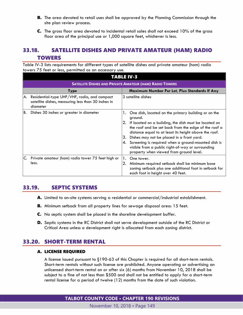
TALBOT COUNTY CODE • CHAPTER 190 REVISIONS
November 10, 2018 • Page 149
B. The area devoted to retail uses shall be approved by the Planning Commission through the site plan review process.
C. The gross floor area devoted to incidental retail sales shall not exceed 10% of the gross floor area of the principal use or 1,000 square feet, whichever is less.
33.18. SATELLITE DISHES AND PRIVATE AMATEUR (HAM) RADIO
TOWERS Table IV-3 lists requirements for different types of satellite dishes and private amateur (ham) radio towers 75 feet or less, permitted as an accessory use.
TABLE IV-3
SATELLITE DISHES AND PRIVATE AMATEUR (HAM) RADIO TOWERS
Type Maximum Number Per Lot, Plus Standards If Any
A. Residential-type UHF/VHF, radio, and compact satellite dishes, measuring less than 30 inches in diameter
3 satellite dishes
B. Dishes 30 inches or greater in diameter 1. One dish, located on the primary building or on the ground.
2. If located on a building, the dish must be located on the roof and be set back from the edge of the roof a distance equal to at least its height above the roof.
3. Dishes may not be placed in a front yard.
4. Screening is required when a ground-mounted dish is visible from a public right-of-way or surrounding property when viewed from ground level.
C. Private amateur (ham) radio tower 75 feet high or less.
1. One tower.
2. Minimum required setback shall be minimum base zoning setback plus one additional foot in setback for each foot in height over 40 feet.
33.19. SEPTIC SYSTEMS
A. Limited to on-site systems serving a residential or commercial/industrial establishment.
B. Minimum setback from all property lines for sewage disposal area: 15 feet.
C. No septic system shall be placed in the shoreline development buffer.
D. Septic systems in the RC District shall not serve development outside of the RC District or Critical Area unless a development right is allocated from each zoning district.
33.20. SHORT-TERM RENTAL
A. LICENSE REQUIRED
A license issued pursuant to §190-63 of this Chapter is required for all short-term rentals. Short-term rentals without such license are prohibited. Anyone operating or advertising an unlicensed short-term rental on or after six (6) months from November 10, 2018 shall be subject to a fine of not less than $500 and shall not be entitled to apply for a short-term rental license for a period of twelve (12) months from the date of such violation.
TALBOT COUNTY CODE • CHAPTER 190 REVISIONS
November 10, 2018 • Page 150
B. ELIGIBILITY
A short-term rental license may be issued for a primary residential dwelling unit or for an accessory dwelling unit on a property but not for both.
C. OPERATING GUIDELINES
1. The maximum number of persons permitted to be on-site associated with any short-term rental shall be limited at all times to the lesser of 12 persons or two persons per bedroom in the primary dwelling, excluding infants under 18 month of age, and not including any bedrooms within an accessory dwelling.
2. Three night minimum stay for all short-term lease holders.
3. Outside areas intended for use by short-term tenants, such as decks, patios, porches, game courts, swimming pools, and similar areas, shall be screened from neighboring properties by one or more of the following prior to approval of a new short-term rental license:
a. Setbacks of at least 50 feet; or
b. If A combination of vegetation and topographic features determined by the Planning Director or Short-Term Rental Review Board to provide sufficient separation and screening.
4. Sufficient off-street parking spaces shall be provided to accommodate all short-term rental tenants’ vehicles during any rental period.
5. The area for trash storage shall be identified on the site plan and located to minimize nuisance to neighbors.
6. During any short-term rental, no dwelling, grounds, or associated appurtenances shall be subleased or used for the following activities:
a. A wedding, reception, banquet, corporate retreat, fundraiser, or similar activities that would exceed the maximum persons permitted to be on-site associated with the short-term rental;
b. Fireworks; or,
c. Any activity that exceeds the noise limitations established in the Talbot County Code.
7. Pets shall be leashed or confined at all times.
8. The owner of the short-term rental property shall be responsible for payment of the Talbot County Accommodations Tax and the Maryland Sales Tax.
9. The short-term rental property shall comply with the International Residential Building Code adopted by Talbot County, as amended, with respect to emergency escape and rescue openings, exits and smoke alarms. The property shall be equipped with fire extinguishers in the kitchen and any other area in which flammable or combustible materials are kept or stored. All inspection reports shall be submitted to the Talbot County Department of Planning and Zoning on a form prepared and approved by the Planning Director. A third party certified building inspector may complete the form, or requests for County inspections must be accompanied by a $40 inspection fee. This fee may be reset and changed from time to time by the County Council through the fee schedule during the annual budget process.
10. All conditions, restrictions, and limitations imposed by this Chapter or by any regulation adopted by any governmental agency authorizing use or occupancy as a short-term rental, or the physical condition of a rental property shall be conspicuously included in a written lease signed by the parties. A copy of the lease shall be available on site and to Code Enforcement Officers upon request.
TALBOT COUNTY CODE • CHAPTER 190 REVISIONS
November 10, 2018 • Page 151
11. The applicant shall comply with all codes, regulations, and requirements administered by the Talbot County Health Department regarding potable water and sanitary facilities. A short-term rental license shall not be issued until the Health Department has determined that the short-term rental property complies with the requirements of this Subsection.
12. The short-term rental property shall comply with all conditions, restrictions and limitations imposed by all governmental entities and officials authorizing the use or occupancy of the short-term rental.
D. The short-term rental license shall include all requirements listed herein. The license, including requirements and conditions of approval of the license, and any house rules shall be conspicuously posted in the residence during any short-term rental. House rules shall include minimum requirements as listed in the application package provided by the County.
33.21. STABLES, ACCESSORY TO RESIDENTIAL USES
A. Minimum lot size: two acres for one horse and one additional acre for each additional horse.
B. Minimum setback from property lines for stables and related manure storage areas is 100 feet.
C. Minimum setback for stables on lots smaller than three acres: 75 feet.
33.22. STORAGE OF INOPERABLE OR UNREGISTERED MOTOR
VEHICLES ACCESSORY TO RESIDENTIAL USE
A. On residential properties:
1. No more than two such vehicles shall be stored outside of a building. Storage shall be at least 20 feet from lot lines.
2. Additional vehicles may be stored if they are within a completely enclosed building.
B. These restrictions shall not apply to farm equipment and implements on parcels with active farming operations.
C. Storage of inoperable or unregistered motor vehicles not in accordance with this Section is permitted only pursuant to the provisions for junk yards (see Table IV-1, §190-30.10 and definition in Article IX).
33.23. STORAGE ACCESSORY TO COMMERCIAL AND INDUSTRIAL
USES
A. Storage areas or structures accessory to a commercial or industrial use require a major, minor or administrative site plan based upon the criteria in §190-60.2.
B. Portable storage units are permitted temporary uses as provided in §190-34.2.D. In addition, portable storage units may be used as permanent storage structures accessory to commercial and industrial uses in the LC, GC and LI Districts, subject to site plan review and provision of a Type C landscape yard in accordance with §190-40.5 to screen the view of the unit from the property line.
C. Accessory storage to a commercial and industrial use can only be located in the Critical Area RCA when the principal use or structure is located within the RCA.
TALBOT COUNTY CODE • CHAPTER 190 REVISIONS
November 10, 2018 • Page 152
33.24. STORAGE BUILDING PRIOR TO CONSTRUCTION OF A PRIMARY
STRUCTURE
A. A special exception may be granted for a storage building where it would not otherwise be permitted as an accessory use because there is no principal use established for the lot.
B. This special exception use differs from the temporary use provisions of §190-34.2.A, which allow a storage building to be erected for use during construction of the primary structure. The Board of Appeals may approve this special exception on a lot where there is no imminent plan for establishment of a principal use.
Section 190-34 TEMPORARY USES AND EVENTS
34.1. GENERAL REQUIREMENTS
A. The Planning Director may approve the specific temporary uses listed in this Section. Temporary uses not specifically listed may be approved, provided that:
1. A use certificate is required and shall be issued for a period not exceeding 90 days or an event that does not exceed three days.
2. The Planning Director determines that:
a. The use requires no permanent changes to existing topography, vegetation, structures or other site features.
b. The use will not adversely affect neighboring properties.
B. The Planning Director may solicit the recommendation of the Planning Commission before making a determination on a temporary use.
C. The land shall be entirely cleared of the use within five days after the temporary authority expires.
D. The Planning Director may:
1. Approve specified extensions of time; and
2. Impose conditions on temporary uses in addition to those listed above to avoid adverse impacts.
34.2. PERMITTED TEMPORARY USES AND EVENTS The following temporary uses are permitted in all zoning districts subject to a use certificate and the conditions listed below:
A. ACCESSORY BUILDING PRIOR TO CONSTRUCTION OF A PRIMARY STRUCTURE
1. The building may be used for storage during construction of the primary structure.
2. A use certificate is required.
3. Construction of the primary structure must begin within six months and be completed within 18 months of placement of the accessory building.
B. CONSTRUCTION OR SALES OFFICE ACCESSORY TO A CONSTRUCTION SITE
1. Includes an office trailer.
TALBOT COUNTY CODE • CHAPTER 190 REVISIONS
November 10, 2018 • Page 153
2. A use certificate is required.
3. The certificate shall be issued for a period of six months. The Planning Director may grant six-month extensions of the certificate if the extension is reasonably necessary to allow completion of the project.
4. Structures must meet minimum setback requirements for the zoning district.
5. Structures must be removed on completion of the construction and sales function.
C. PAVING MATERIAL COMPOUNDING
1. Includes asphalt and concrete processing.
2. The use must be associated with a major public road or facility construction project.
3. A use certificate is required and must be renewed after one year.
4. One-thousand-foot setback from any structure intended for human occupancy unless the owner of the structure consents to a lesser setback, no less than 200 feet.
D. PORTABLE STORAGE UNITS
1. A portable storage unit may be located in any yard for a maximum of 90 days in a calendar year.
2. See §190-33.23 for use of portable storage units for longer periods of time in the LC, GC and LI districts.
E. CARNIVALS, WEDDINGS AND OTHER TEMPORARY EVENTS
1. Subject to provision of safe and adequate access and parking, and approval by the Health Department as applicable.
2. No permanent structure may be erected or permanent disturbance approved for the temporary event.
3. No more than six events per calendar year per parcel.
F. TEMPORARY ANEMOMETERS AND WIND VANE FOR PURPOSES OF GATHERING
DATA FOR WIND ENERGY DEVELOPMENT
1. Minimum lot size: five acres.
2. Structure may not exceed 120 feet at top of blade.
3. Must meet setback of height of structure plus 10 feet from all property lines.
4. Upon expiration of use certificate, the temporary structure and foundation must be removed unless a building permit is issued for a permanent facility.
G. RECREATIONAL VEHICLES
1. Recreational vehicles may be used at special events. This use on any given site shall be limited to no more than 90 days within a calendar year and no more than seven consecutive days.
2. No mobile home or recreational vehicle shall be parked overnight on any highway, road, street, public park or other public way or public landing except in an emergency.
TALBOT COUNTY CODE • CHAPTER 190 REVISIONS
November 10, 2018 • Page 154
ARTICLE V: DEVELOPMENT
STANDARDS
Section 190-35 ROAD ACCESS AND DESIGN
35.1. MINIMUM FRONTAGE
A. All lots shall have frontage of at least 50 feet on a public or private road. Pipestem or flag lots shall maintain a minimum lot width of 50 feet for a depth of at least 25 feet from the road right-of-way.
B. The minimum road frontage may be reduced to not less than 25 feet if the lot has joint access with an adjacent lot.
35.2. ACCESS REQUIREMENTS
A. ACCESS REQUIRED
1. All lots shall have direct access to a public or private road.
2. Every building hereafter constructed or use established, shall be on a lot with access to a public or approved private road and shall be located to provide safe and convenient access for fire protection vehicles. Structures on islands are excluded from this provision.
B. DESIGN AND LOCATION
1. The design and location of new access points shall be reviewed and approved by the County Engineer.
2. Access points to state roads shall also be approved by the State Highway Administration.
3. As a condition of site plan approval, the County Engineer or Planning Director may require improvement and consolidation of existing access points to a commercial, industrial or institutional use where the improvements will enhance vehicular and pedestrian safety.
4. The number of new access points to existing state and County roads shall be limited to the extent possible. Joint entrances for adjacent lots shall be required wherever practical.
5. In the AC, CP, WRC, TC, RC, RR, and TR Districts, not more than two lots divided off an original parcel shall have access to an existing County or state road. Additional lots shall have access to an internal subdivision road, unless a waiver is granted based upon findings that:
a. The size, shape, topography, soil types or other physical conditions prevent internal access to all of the lots required to have such access; or
b. The additional lots having access to an existing road are at least 10 acres in size and have no development rights that would make future subdivision possible; or
TALBOT COUNTY CODE • CHAPTER 190 REVISIONS
November 10, 2018 • Page 155
c. No reasonable alternative is available other than access to an existing state or County road.
35.3. RIGHT-OF-WAY DEDICATION
A. RIGHT-OF-WAY FOR ROAD WIDENING
If property undergoing subdivision is adjacent to an existing road right-of-way, the property owner shall provide an easement or dedication of 1/2 the width necessary to bring the right-of-way up to the width required by Chapter 134, the Roads Ordinance.
B. NEW PUBLIC ROAD RIGHT-OF-WAY
New public road rights-of-way shall be dedicated and deeded to the County or state as part of the final plat recordation.
C. NEW PRIVATE ROAD RIGHT-OF-WAY
A private road right-of-way may be established through an easement or fee simple dedication as approved by the County approving authority.
35.4. ROAD DESIGN AND LAYOUT FOR SUBDIVISIONS
A. Subdivision layout shall minimize the number of access points to collector and arterial highways.
B. Neighborhood residential roads shall be laid out to discourage their use by traffic not having its destination within the neighborhood.
C. Road crossings over environmentally sensitive areas are prohibited unless no feasible alternative exists.
D. The road layout shall provide for the continuation or projection of existing roads into areas adjacent to the land being subdivided, unless such continuation or extension is deemed undesirable due to topographic constraints or design.
E. Layout of roads in residential areas shall discourage high traffic speeds.
F. Layout of roads shall minimize potential conflicts between pedestrians and vehicles.
G. The applicants shall provide easements, right-of-way and road improvements as required by the County Engineer in conformance with the Talbot County Roads Ordinance.
H. The applicant shall erect street signs and traffic control devices as required by the County Engineer.
35.5. SIDEWALKS AND STREETLIGHTS The applicant for a subdivision or site plan shall provide for installation of sidewalks and streetlights as required by this Section.
A. The decision to require sidewalk and streetlight improvements or easements shall be made by the Planning Director for minor subdivisions and minor site plans, or by the Planning Commission for major and small scale subdivisions and major site plans.
B. Sidewalks may be required for residential subdivisions with lot sizes averaging two acres or less, for commercial, industrial, or institutional uses, or for other development where the

TALBOT COUNTY CODE • CHAPTER 190 REVISIONS
November 10, 2018 • Page 156
approving authority finds that sidewalks will serve anticipated pedestrian traffic and provide for convenient and safe travel by pedestrians.
C. Sidewalks shall be required for major retail development in accordance with the requirements for major retail uses in Article IV.
D. Streetlights may be required for residential subdivisions with lot sizes averaging two acres or less, for nonresidential development, and in any location where desirable to improve public safety.
Section 190-36 SUBDIVISION DESIGN
36.1. AREA INCLUDED
A. PLAN TO INCLUDE ALL OF PARCEL
A subdivision plan shall include all of the area within the parcel or lot being subdivided. Land being subdivided shall be designated as lots, rights-of-way, open space, agricultural parcels or remaining lands. Undesignated remnants of land shall not be created.
B. NONCONTIGUOUS PARCELS
If a parcel is divided into two or more noncontiguous sections by a public road or a major watercourse, each section shall be considered a separate parcel for purposes of subdivision design and calculation of the number of development rights allowed under this chapter.
36.2. GENERAL STANDARDS
A. Subdivision design shall be consistent with the purposes of this chapter, the purposes and design guidelines of the zoning district, and the policies of the Comprehensive Plan.
B. Subdivision design shall be based on comprehensive analysis of the site and consideration of the character of the surrounding land.
C. Lots shall be located to minimize the need for grading and altering topography and to avoid areas of environmental sensitivity.
D. The following resources shall be preserved to the extent possible, consistent with rational utilization of land and in accordance with applicable local, state and federal regulations.
1. Nontidal wetlands.
2. Perennial and intermittent streams.
3. One-hundred-year floodplains.
4. Habitats of threatened and endangered species.
5. Forests, woodlands and significant trees.
6. Slopes in excess of 15% grade.
7. Historically significant structures and sites as determined by available inventories.
E. To the maximum extent practical, and provided that the subdivision complies with standards for preservation of environmentally sensitive areas, the subdivision shall conserve agricultural lands through the following means:
TALBOT COUNTY CODE • CHAPTER 190 REVISIONS
November 10, 2018 • Page 157
1. Wherever feasible, new subdivisions should primarily consist of subdivision lots of five acres or smaller and larger parcels that retain contiguous areas of working agricultural lands.
2. Residential lots and associated subdivision roads should not dissect or break up contiguous agricultural fields.
3. Where practical, residential lots should be clustered on the edges of fields and along woodland fringes.
4. Adequate buffering or separation should be maintained or established within a subdivision between residential lots and working agricultural fields and operations in order to minimize conflicts between these often incompatible land uses.
F. The subdivision shall be designed to mitigate adverse effects of noise, dust, odor, traffic, and drainage onto neighboring properties.
36.3. LOT DESIGN
A. GENERAL
1. The area dedicated to a public or private road right-of-way shall not be included within the area of adjoining lots for purposes of compliance with lot size, width or setback requirements.
2. Where future subdivision is possible, the Planning Director or Planning Commission may require that lots be arranged to allow further subdivision.
3. In general, side lot lines shall be at right angles to street lines (or radial to curving street lines) unless a variation from this rule will give a better street or lot plan.
4. Dimensions of corner lots shall be large enough to allow for erection of buildings while observing the minimum front yard setback from both streets.
5. Depth and width of properties intended for business, commercial or industrial purposes shall be adequate to provide for off-street parking and loading facilities required for the type of use and development contemplated.
B. PIPESTEM LOTS
Pipestem or flag lots may be permitted in residential districts, subject to the following requirements:
1. The minimum lot area shall not include the area of the pipestem.
2. The pipestem area of the lot shall be at least 25 feet wide.
3. No more than two pipestem lots shall have adjacent frontage on a road.
4. Lots with adjacent pipestem frontages shall share a single driveway entrance to the road. Access and maintenance easements for the shared access shall be recorded and referenced on the final plat.
5. Orientation and setbacks.
a. The front setback shall not apply to the pipestem area.
b. For subdivisions with more than one pipestem lot, the lot layout shall pair pipestem lots whenever possible, so that the units share a driveway access and face each other across a common driveway.
TALBOT COUNTY CODE • CHAPTER 190 REVISIONS
November 10, 2018 • Page 158
6. New subdivisions and/or development activities whose development or dwelling units are located outside of the Critical Area shall not include a flag or pipestem connection through the Critical Area so as to create riparian access.
36.4. PRIVATE WATER BODIES AND WATERCOURSES If a tract being subdivided contains a private water body, such as a lake, pond or stream, or portion thereof:
A. Lot lines shall be drawn to assign ownership of the entire water body to an adjacent lot or to distribute ownership among the adjacent lots.
B. If ownership is distributed among the adjacent lots, covenants establishing responsibility for maintenance of the water body shall be required for all lots sharing ownership. The covenants shall be approved by the Planning Director and shall ensure that responsibility for safe maintenance of the water body will not become a County responsibility.
C. No more than 25% of the minimum required lot area shall be satisfied by land which is under water.
36.5. DRAINAGE AND UTILITY EASEMENTS
A. Lots shall be laid out to provide drainage away from buildings. Individual lot drainage shall be coordinated with the surface runoff pattern for the area to avoid drainage onto adjacent lots.
B. Drainage and utility easements as deemed necessary by the County Engineer shall be provided along lot lines and road frontages for the purpose of installing and maintaining utilities and drainage ways.
C. The County Engineer may also require drainage easements on private property that connect to and impact drainage ways along County roads.
D. Drainage and utility easements shall be noted on the plat and shall be at least 15 feet wide along a boundary contiguous to a road right-of-way, at least 15 feet wide if centered along a new line of division, at least 10 feet wide along an existing lot line, or as required by the County Engineer.
Section 190-37 PROTECTION OF SENSITIVE ENVIRONMENTAL
AREAS
37.1. BUFFERS FROM STREAMS AND NONTIDAL WETLANDS OUTSIDE
THE CRITICAL AREA The following standards apply to all applications for development activity outside the Critical Area, including building permits; major, small scale and minor subdivisions; and major and minor site plans.
A. A one-hundred-foot buffer from all perennial streams and a fifty-foot buffer from intermittent streams shall be required for all development activity. The buffer shall be measured from the edge of the streambank.
TALBOT COUNTY CODE • CHAPTER 190 REVISIONS
November 10, 2018 • Page 159
B. A buffer expansion shall be required, beyond the minimum one-hundred-foot or fifty-foot stream buffer, to include and extend beyond contiguous, sensitive areas, such as slopes 15% or greater, hydric soils, or highly erodible soils, whose development or disturbance may impact streams, wetlands, or other aquatic environments. See "buffer expansion," as defined in Article IX.
1. If a steep slope is contained completely within the stream buffer, buffer expansion is required only to provide a buffer of at least 25 feet from the top of the slope.
2. If a steep slope is partially within or contiguous to the stream buffer, the buffer shall be expanded four feet for every 1% of slope beyond the required buffer, or 25 feet from the top of the slope, whichever is greater in extent, except as provided in Subsection 3 below.
3. The approving authority may approve a buffer expansion limited to 25 feet from the top of the slope, even if greater expansion would be required based on the Subsection 2 above, if the approving authority determines that the slope has one or more of the following characteristics:
a. The area of steep slopes is less than 10 feet in width;
b. The steep slopes are isolated and less than 10,000 square feet in area, irrespective of property lines;
c. The area of steep slopes has a width of less than 25 feet where it crosses the stream buffer boundary; or,
d. Similar characteristics exist resulting in a narrow and/or isolated area of steep slopes.
4. The following criteria shall be used to determine the extent of the expanded buffer for highly erodible soils or hydric soils:
a. For a nontidal wetland of special State concern, expand the Buffer to include the upland boundary of the wetland and its regulated 100-foot Buffer;
b. For other nontidal wetlands, expand the Buffer to include the upland boundary of the nontidal wetland;
c. For highly erodible soils or hydric soils with a slope of 5% or greater, expand the Buffer to the lesser of the landward edge or 300 feet, including the required stream buffer width.
5. The approving authority may reduce the extent of the expanded buffer for erodible soils or hydric soils when it is demonstrated that:
a. Development and lot layout will minimize adverse impacts on water quality and natural habitats; and
b. Impacted area for the development is minimized; and
c. Disturbed area is mitigated 2:1 as shown on a planting plan approved by the Department of Planning and Zoning; and
d. Clearing of natural vegetation on the property is restricted to less than 30% of the lot or parcel and a variance to exceed this restriction shall be prohibited in perpetuity through appropriate deed restrictions.
C. A 25-foot buffer from nontidal wetlands shall be required for all development activity, measured from the edge of the wetland. Regulated activities within nontidal wetlands and their buffers authorized by a permit or letter of exemption from the Maryland Department of the Environment, and development activities that do not require a permit or letter of exemption from the Maryland Department of the Environment, are not subject to this requirement.
TALBOT COUNTY CODE • CHAPTER 190 REVISIONS
November 10, 2018 • Page 160
D. Lots shall be designed to provide buildable area and useable yard area outside of required buffers.
E. Stream and wetland buffers shall be undisturbed and maintained in natural vegetation, except as provided in Table V-1.
TABLE V-1. RESTRICTIONS ON LAND USES WITHIN STREAM AND WETLAND
BUFFERS
TYPE OF LAND USE GROUNDS FOR APPROVAL
1. Agricultural practices Permitted within buffers provided the practices are consistent with an approved soil conservation and water quality plan and/or nutrient management plan.
2. Forestry or timber harvesting Permitted within buffers subject to an approved forest management plan.
3. Practices or activities to maintain the health of individual trees
Permitted within buffers in accordance with accepted forestry practice. A property maintenance permit is required.
4. Water-dependent facilities Permitted within buffers subject to requirements of Article IV for the particular land use; disturbance of the buffer must be the minimum necessary for the facility. A permit shall be obtained from the Maryland Department of the Environment if required by Maryland regulations.
5. New structures and improvements
For lots existing prior to June 22, 1991, and having at least 50% of the lot area located within a required stream or wetland buffer, a waiver may be granted to allow structures within the buffer if: a. No practical or feasible alternative exists for locating such structures
outside the buffer; and b. The disturbances proposed are the minimum necessary.
6. Alterations to existing structures
Existing structures located within the required stream buffer or wetland buffer as of June 22, 1991, may be altered, repaired, or expanded along the established setback from the edge of the stream or wetland, in accordance with the provisions of §190-50 for nonconforming structures.
7. Permanent or temporary stormwater management facilities
Permitted within buffers only if one of the following conditions is met: a. No feasible alternative exists for locating the facility outside the
buffer; and, b. The County Engineer finds that the facilities are consistent with best
management practices.
8. Permanent or temporary sediment control devices
Permitted within buffers only if one of the following conditions is met: a. No feasible alternative exists; and, b. The Soil Conservation District finds that the devices are consistent with
best management practices.
9. Utilities and transportation: a. Road or trail crossings b. Utility transmission lines c. Sewer and water lines d. Other public or
community utilities
Permitted within buffers only if: a. No practical or feasible alternative exists for locating such
improvements outside the buffer; and, b. The disturbances proposed are the minimum necessary for the
facilities.
37.2. THREATENED AND ENDANGERED SPECIES HABITAT OUTSIDE THE
CRITICAL AREA The following standards apply to major site plans and to all subdivision plans outside the Critical Area.
TALBOT COUNTY CODE • CHAPTER 190 REVISIONS
November 10, 2018 • Page 161
A. A habitat protection plan shall be required for major site plans and all subdivision plans if the plan:
1. Is in a location identified by the Maryland Department of Natural Resources as habitat of threatened and endangered species; or
2. Proposes development activities that will impact a nontidal wetland or the twenty-five-foot nontidal wetland buffer.
B. A habitat protection plan will prohibit development activities and disturbances that would disrupt the nesting, breeding, stopover, and/or feeding activities of the threatened or endangered wildlife or plant species on the site.
C. The Planning Director or Planning Commission in approving the development application shall determine which recommended protection measures shall be made a condition of approval. Such measures may include, but shall not be limited to:
1. Restrictions on location of structures;
2. Establishment of undisturbed open space areas;
3. Restrictive covenants; or
4. Restrictions on noise levels and timing of construction activities.
Section 190-38 NOISE
A. MEASUREMENT, LEVELS AND STANDARDS
Noise shall be measured and comply with the decibel levels and standards defined in Chapter 92, Noise Ordinance.
B. EXEMPTIONS
Exemptions and prohibited noise acts are listed in Chapter 92, §§ 92-5 and 92.6.
C. SITE PLAN REFERENCE TO NOISE STANDARDS
For development requiring a site plan and having an outdoor use area, the site plan shall indicate the applicable noise limit at the property line, based on Talbot County’s noise standards within Chapter 92, and indicate that the use shall comply with the noise limit. Mitigation measures, as applicable to a site, shall be installed and maintained in accordance with §92-7.E.
Section 190-39 OUTDOOR LIGHTING
A. Outdoor lighting shall be installed so that direct or indirect illumination from the source does not cause excessive illumination beyond any lot line and does not cause a nuisance to surrounding properties due to glare.
B. Flickering and intrinsically bright sources of illumination shall be controlled by shielding or aiming the light source away from roads and neighboring properties.
C. Outdoor lighting for nonresidential uses shall be shielded and directed away from adjacent properties, public rights-of-way and the night sky.
D. Outdoor lighting fixtures for parking areas shall not exceed 20 feet in height.
TALBOT COUNTY CODE • CHAPTER 190 REVISIONS
November 10, 2018 • Page 162
E. Lighting installed on piers, docks or wharves shall be shielded in such a way that the bulbs, lenses or light globes are not directly visible more than 75 feet away from the pier, dock or wharf at a height greater than six feet above pier decking.
F. Site plans for properties adjacent to conservation, residential or village zoning districts shall include sufficient details of proposed exterior lighting to indicate that the lighting will be directed and shielded in compliance with these standards.
Section 190-40 LANDSCAPING
40.1. PURPOSE The minimum landscaping requirements in this Section are intended to:
A. Ensure the planting, maintenance, restoration, and survival of trees, shrubs, and other plants;
B. Promote the conservation of existing healthy trees and vegetation, and provide for the restoration of land denuded as a result of grading and construction;
C. Establish a clear and attractive boundary between the public road and private property;
D. Mitigate negative impacts on residential properties, including lack of privacy, visual appearance, noise and lighting, that can occur when higher intensity land uses locate near lower intensity land uses;
E. Filter and screen the glare of headlights and exterior lighting;
F. Safeguard and enhance property values and aesthetic qualities; and,
G. Coordinate landscaping standards with stormwater management.
40.2. APPLICABILITY AND GENERAL REQUIREMENTS
A. APPLICABILITY
1. The provisions of this Section apply to:
a. Major, minor and administrative site plans.
b. Subdivisions (streetyard landscaping only; §190-40.5.D.2.)
2. For site plans that expand an existing use, the following standards apply:
a. Calculate the percentage of cumulative expansion as follows: total square footage of increased lot coverage by buildings, paved areas and outdoor use areas, divided by the total square footage of lot coverage by buildings, paved areas and other outdoor use areas existing on the effective date of this ordinance, times 100.
b. For cumulative expansion of 100 percent or less, the landscaping standards apply only to the portions of the lot impacted by the expansion of the building, parking area and outdoor use area.
c. For cumulative expansion of more than 100 percent, the landscaping standards apply to the entire lot.
B. RELATIONSHIP TO OTHER STANDARDS
1. These landscaping are in addition to:
TALBOT COUNTY CODE • CHAPTER 190 REVISIONS
November 10, 2018 • Page 163
a. Landscaping requirements within the regulations for certain zoning districts and overlay districts, such as the VM, VH, VR, Critical Area Overlay and Gateway Overlay Districts.
b. Landscaping requirements specific to certain land uses established in Article IV.
c. Planting requirements for stream buffers and habitat areas (§190-37).
2. In the case of conflicting requirements, the more stringent requirement shall apply. Where differing requirements have different purposes, the requirements more closely related to protection of water quality and habitat protection shall prevail.
C. TYPES OF REQUIREMENTS
This §190-40 establishes four types of landscaping requirements:
1. Minimum planting requirements (§190-40.3);
2. Parking area interior landscaping (§190-40.4);
3. Perimeter landscaped yards (§190-40.5); and
4. Other required landscaping (§190-40.6).
40.3. MINIMUM PLANTING REQUIREMENTS
A. APPLICABILITY
The minimum planting requirements apply only to development requiring a major site plan.
B. REQUIREMENTS
The cumulative area of all on-site plantings must provide the following:
1. At least 25 percent of the site shall be landscaped area; and;
2. At least one tree must be provided or retained for each 5,000 square feet, or fraction thereof, of developed site area. At least half of the minimum required trees shall be canopy trees (See definition of “tree, canopy” in Article IX).
40.4. PARKING AREA INTERIOR LANDSCAPING
A. APPLICABILITY
1. The parking area interior landscaping requirements apply to development having 12 or more parking spaces.
2. For purposes of this requirement, the parking area:
a. Includes all areas within the outer boundary of the parking lot including parking spaces, drive aisles, walkways, and loading areas;
b. Includes paved areas used for display of vehicles for sale or for rent;
c. Includes parking spaces for visitors, employees or fleet vehicles; but,
d. Does not include the perimeter landscape yard or vehicle repair areas.
B. MINIMUM LANDSCAPED AREA AND PLANTING
1. For each 100 square feet or fraction thereof of parking area, ten square feet of landscaped area shall be provided.
2. One canopy tree is required for every 10 parking spaces or fraction thereof.
TALBOT COUNTY CODE • CHAPTER 190 REVISIONS
November 10, 2018 • Page 164
3. Trees shall be distributed so that the closest point of each parking space is either no more than 80 feet from the trunk of a canopy tree or no more than 50 feet from the trunk of an understory tree.
4. Residual areas not used for parking, access, or circulation must be landscaped.
C. LANDSCAPE ISLANDS AND MEDIANS
1. Trees shall be distributed throughout parking areas, and may be located in landscape islands, landscape divider medians between rows of parking, or driveway medians (see Figure V-1 in §190-40.7 below).
2. Any parking aisle with more than 10 spaces in a single row shall end in a landscape island.
3. Islands for planting trees shall have a minimum dimension of 9 feet and a minimum area of 162 square feet, including the curb.
4. A continuous landscape divider median shall be provided between every four rows of parking spaces. Landscape divider medians between adjoining rows of parking spaces and serving as driveway medians shall have a minimum dimension of 7 feet, including the curb.
5. Landscape islands or medians that do not have canopy trees shall include shrubs planted no further apart than 10 feet on center.
6. Landscape islands and divider medians should generally be protected from vehicle damage by curbing or wheel stops, but designs without such protection are permitted for stormwater management. Where curbing is used, gaps in curbing to accommodate stormwater management are encouraged.
7. The placement of plant material shall allow for a 2-foot vehicle overhang from the face of the curb or wheel stop.
8. Any landscaped area may be designed to function for stormwater management.
40.5. PERIMETER LANDSCAPE YARDS
A. APPLICABILITY
Perimeter landscape yards may be required for:
1. Development requiring a site plan: see Subsection C and D.1below.
2. Subdivisions: Streetyard landscaping only, see Subsection D.2 below.
B. GENERAL
1. Perimeter landscape yards will generally be located on the outer perimeter of a lot, extending to the lot line, and may not be located on any portion of a public or private street or right-of-way.
2. For a use that occupies only part of a larger parcel, such as an agricultural support business on a farm, the perimeter landscape yard may be around the perimeter of the use rather than along the lot line.
3. To determine the type of perimeter landscape yard required on a lot:
a. Identify whether any portion of the lot line of the site is a zoning district boundary
b. Identify any street adjacent to the site as an arterial, collector, or local street; and,
c. Determine the required perimeter landscape yards based on Subsections C and D below.
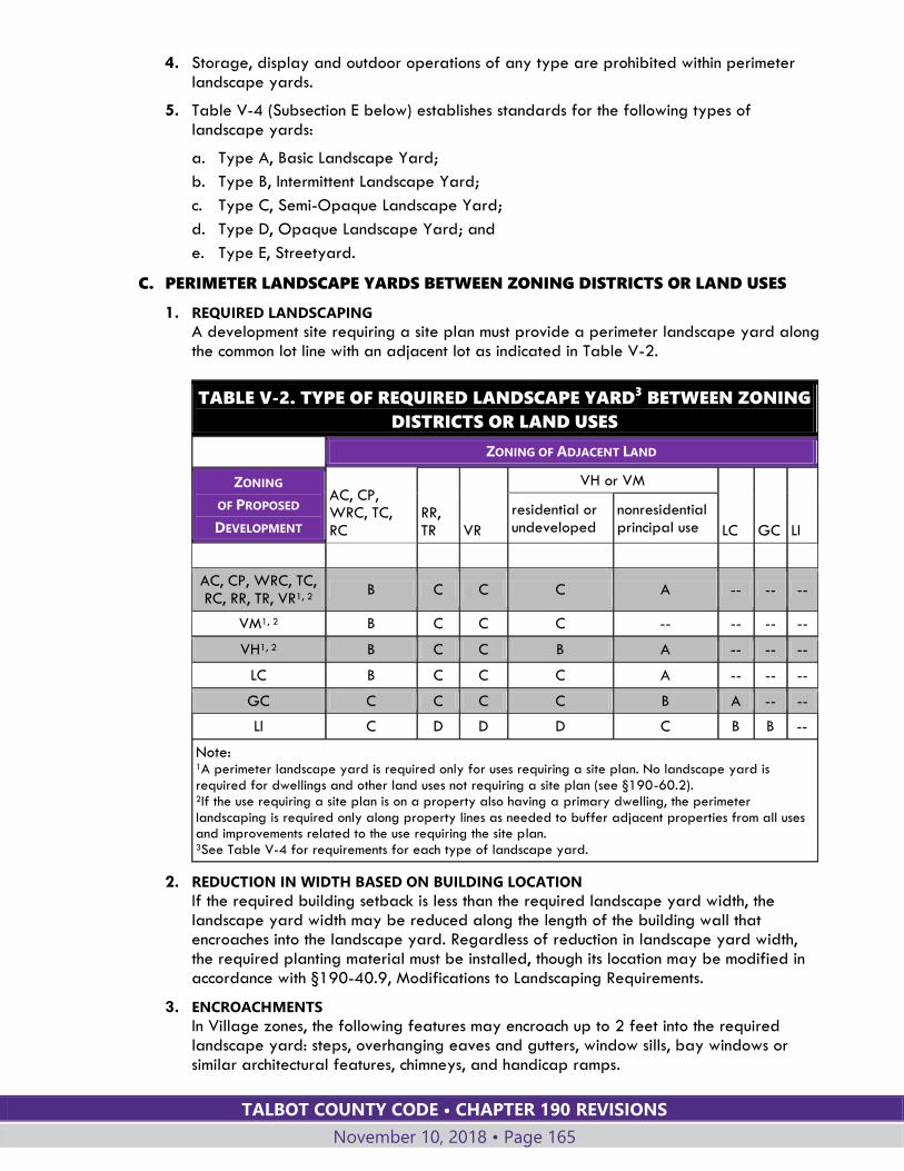
TALBOT COUNTY CODE • CHAPTER 190 REVISIONS
November 10, 2018 • Page 165
4. Storage, display and outdoor operations of any type are prohibited within perimeter landscape yards.
5. Table V-4 (Subsection E below) establishes standards for the following types of landscape yards:
a. Type A, Basic Landscape Yard;
b. Type B, Intermittent Landscape Yard;
c. Type C, Semi-Opaque Landscape Yard;
d. Type D, Opaque Landscape Yard; and
e. Type E, Streetyard.
C. PERIMETER LANDSCAPE YARDS BETWEEN ZONING DISTRICTS OR LAND USES
1. REQUIRED LANDSCAPING
A development site requiring a site plan must provide a perimeter landscape yard along the common lot line with an adjacent lot as indicated in Table V-2.
TABLE V-2. TYPE OF REQUIRED LANDSCAPE YARD3 BETWEEN ZONING
DISTRICTS OR LAND USES
ZONING OF ADJACENT LAND
ZONING
OF PROPOSED
DEVELOPMENT
AC, CP, WRC, TC, RC
RR, TR VR
VH or VM
LC GC LI
residential or undeveloped
nonresidential principal use
AC, CP, WRC, TC, RC, RR, TR, VR1, 2
B C C C A -- -- --
VM1, 2 B C C C -- -- -- --
VH1, 2 B C C B A -- -- --
LC B C C C A -- -- --
GC C C C C B A -- --
LI C D D D C B B --
Note: 1A perimeter landscape yard is required only for uses requiring a site plan. No landscape yard is required for dwellings and other land uses not requiring a site plan (see §190-60.2). 2If the use requiring a site plan is on a property also having a primary dwelling, the perimeter landscaping is required only along property lines as needed to buffer adjacent properties from all uses and improvements related to the use requiring the site plan. 3See Table V-4 for requirements for each type of landscape yard.
2. REDUCTION IN WIDTH BASED ON BUILDING LOCATION
If the required building setback is less than the required landscape yard width, the landscape yard width may be reduced along the length of the building wall that encroaches into the landscape yard. Regardless of reduction in landscape yard width, the required planting material must be installed, though its location may be modified in accordance with §190-40.9, Modifications to Landscaping Requirements.
3. ENCROACHMENTS
In Village zones, the following features may encroach up to 2 feet into the required landscape yard: steps, overhanging eaves and gutters, window sills, bay windows or similar architectural features, chimneys, and handicap ramps.
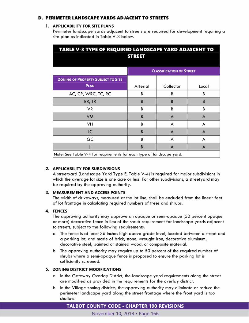
TALBOT COUNTY CODE • CHAPTER 190 REVISIONS
November 10, 2018 • Page 166
D. PERIMETER LANDSCAPE YARDS ADJACENT TO STREETS
1. APPLICABILITY FOR SITE PLANS
Perimeter landscape yards adjacent to streets are required for development requiring a site plan as indicated in Table V-3 below.
2. APPLICABILITY FOR SUBDIVISIONS
A streetyard (Landscape Yard Type E, Table V-4) is required for major subdivisions in which the average lot size is one acre or less. For other subdivisions, a streetyard may be required by the approving authority.
3. MEASUREMENT AND ACCESS POINTS
The width of driveways, measured at the lot line, shall be excluded from the linear feet of lot frontage in calculating required numbers of trees and shrubs.
4. FENCES
The approving authority may approve an opaque or semi-opaque (50 percent opaque or more) decorative fence in lieu of the shrub requirement for landscape yards adjacent to streets, subject to the following requirements:
a. The fence is at least 36 inches high above grade level, located between a street and a parking lot, and made of brick, stone, wrought iron, decorative aluminum, decorative steel, painted or stained wood, or composite material.
b. The approving authority may require up to 50 percent of the required number of shrubs where a semi-opaque fence is proposed to ensure the parking lot is sufficiently screened.
5. ZONING DISTRICT MODIFICATIONS
a. In the Gateway Overlay District, the landscape yard requirements along the street are modified as provided in the requirements for the overlay district.
b. In the Village zoning districts, the approving authority may eliminate or reduce the perimeter landscape yard along the street frontage where the front yard is too shallow.
TABLE V-3 TYPE OF REQUIRED LANDSCAPE YARD ADJACENT TO
STREET
CLASSIFICATION OF STREET
ZONING OF PROPERTY SUBJECT TO SITE
PLAN Arterial Collector Local
AC, CP, WRC, TC, RC B B B
RR, TR B B B
VR B B B
VM B A A
VH B A A
LC B A A
GC B A A
LI B A A
Note: See Table V-4 for requirements for each type of landscape yard.
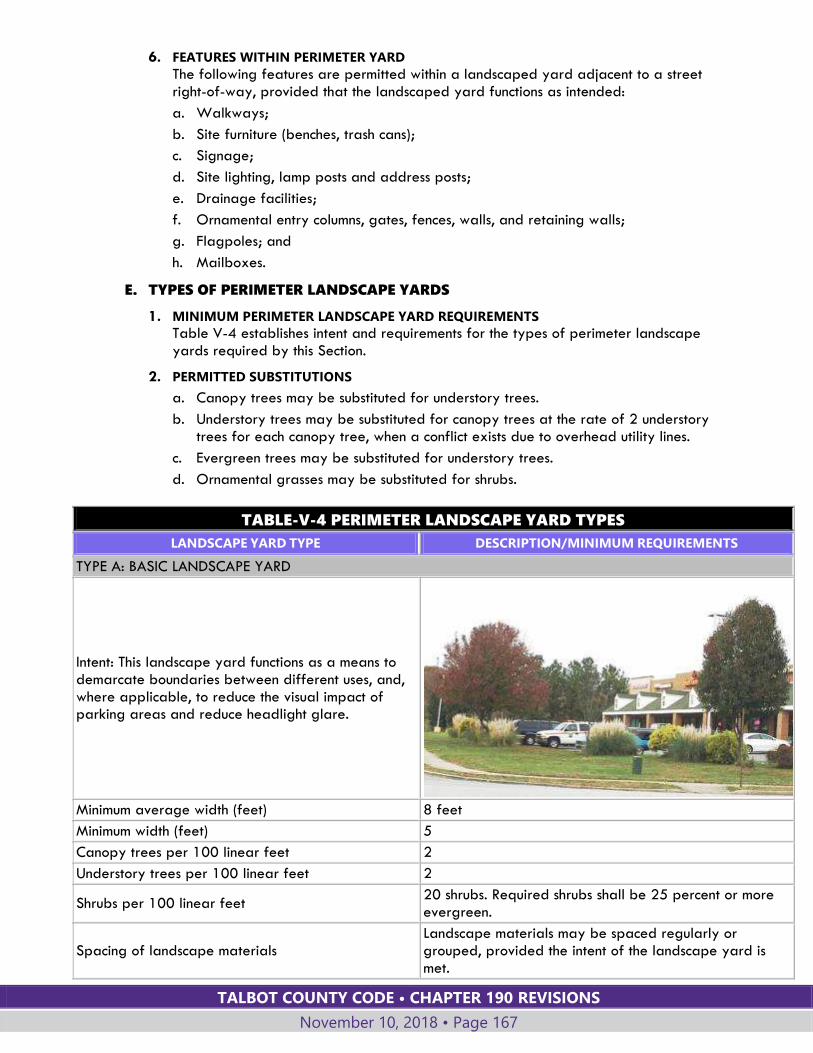
TALBOT COUNTY CODE • CHAPTER 190 REVISIONS
November 10, 2018 • Page 167
6. FEATURES WITHIN PERIMETER YARD
The following features are permitted within a landscaped yard adjacent to a street right-of-way, provided that the landscaped yard functions as intended:
a. Walkways;
b. Site furniture (benches, trash cans);
c. Signage;
d. Site lighting, lamp posts and address posts;
e. Drainage facilities;
f. Ornamental entry columns, gates, fences, walls, and retaining walls;
g. Flagpoles; and
h. Mailboxes.
E. TYPES OF PERIMETER LANDSCAPE YARDS
1. MINIMUM PERIMETER LANDSCAPE YARD REQUIREMENTS
Table V-4 establishes intent and requirements for the types of perimeter landscape yards required by this Section.
2. PERMITTED SUBSTITUTIONS
a. Canopy trees may be substituted for understory trees.
b. Understory trees may be substituted for canopy trees at the rate of 2 understory trees for each canopy tree, when a conflict exists due to overhead utility lines.
c. Evergreen trees may be substituted for understory trees.
d. Ornamental grasses may be substituted for shrubs.
TABLE-V-4 PERIMETER LANDSCAPE YARD TYPES
LANDSCAPE YARD TYPE DESCRIPTION/MINIMUM REQUIREMENTS
TYPE A: BASIC LANDSCAPE YARD
Intent: This landscape yard functions as a means to demarcate boundaries between different uses, and, where applicable, to reduce the visual impact of parking areas and reduce headlight glare.
Minimum average width (feet) 8 feet
Minimum width (feet) 5
Canopy trees per 100 linear feet 2
Understory trees per 100 linear feet 2
Shrubs per 100 linear feet 20 shrubs. Required shrubs shall be 25 percent or more evergreen.
Spacing of landscape materials Landscape materials may be spaced regularly or grouped, provided the intent of the landscape yard is met.
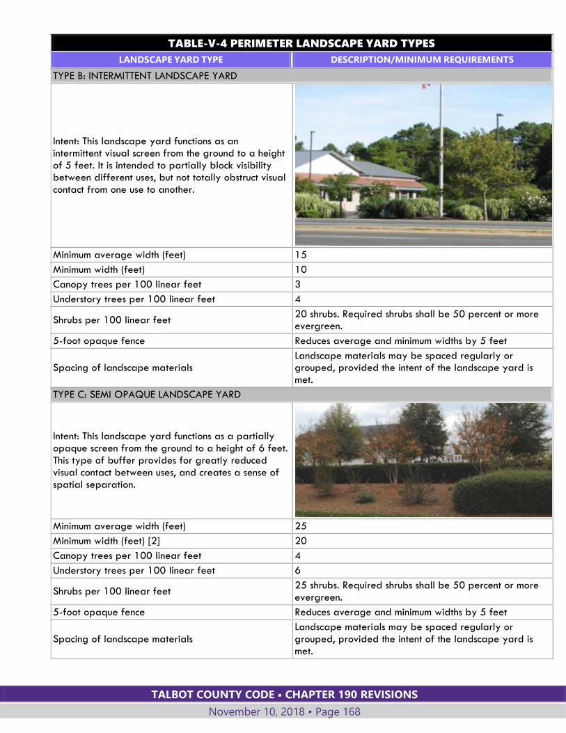
TALBOT COUNTY CODE • CHAPTER 190 REVISIONS
November 10, 2018 • Page 168
TABLE-V-4 PERIMETER LANDSCAPE YARD TYPES
LANDSCAPE YARD TYPE DESCRIPTION/MINIMUM REQUIREMENTS
TYPE B: INTERMITTENT LANDSCAPE YARD
Intent: This landscape yard functions as an intermittent visual screen from the ground to a height of 5 feet. It is intended to partially block visibility between different uses, but not totally obstruct visual contact from one use to another.
Minimum average width (feet) 15
Minimum width (feet) 10
Canopy trees per 100 linear feet 3
Understory trees per 100 linear feet 4
Shrubs per 100 linear feet 20 shrubs. Required shrubs shall be 50 percent or more evergreen.
5-foot opaque fence Reduces average and minimum widths by 5 feet
Spacing of landscape materials Landscape materials may be spaced regularly or grouped, provided the intent of the landscape yard is met.
TYPE C: SEMI OPAQUE LANDSCAPE YARD
Intent: This landscape yard functions as a partially opaque screen from the ground to a height of 6 feet. This type of buffer provides for greatly reduced visual contact between uses, and creates a sense of spatial separation.
Minimum average width (feet) 25
Minimum width (feet) [2] 20
Canopy trees per 100 linear feet 4
Understory trees per 100 linear feet 6
Shrubs per 100 linear feet 25 shrubs. Required shrubs shall be 50 percent or more evergreen.
5-foot opaque fence Reduces average and minimum widths by 5 feet
Spacing of landscape materials Landscape materials may be spaced regularly or grouped, provided the intent of the landscape yard is met.

TALBOT COUNTY CODE • CHAPTER 190 REVISIONS
November 10, 2018 • Page 169
TABLE-V-4 PERIMETER LANDSCAPE YARD TYPES
LANDSCAPE YARD TYPE DESCRIPTION/MINIMUM REQUIREMENTS
TYPE D: OPAQUE LANDSCAPE YARD
Intent: This landscape yard functions as an opaque screen from the ground to a height of at least 8 feet. This type of buffer prevents all visual contact between uses, and creates a strong impression of total separation.
Minimum average width (feet) 45
Minimum width (feet) 35
Canopy trees per 100 linear feet 4
Understory trees per 100 linear feet 10
Shrubs per 100 linear feet 33 shrubs. Required shrubs shall be evergreen.
5-foot opaque fence Reduces average and minimum widths by 10 feet
Spacing of landscape materials Trees and shrubs must be spaced regularly to provide a visual screen.
TYPE E: STREETYARD
Intent: This landscape yard ensures that shade trees are provided along streets.
Minimum average width (feet) 8
Minimum width (feet) 5
Canopy trees per 100 linear feet 2
Shrubs per 100 linear feet None required. Shrubs used may be evergreen or deciduous.
Spacing of landscape materials Trees no more than 50 feet apart, except as needed for access drives.
40.6. OTHER REQUIRED LANDSCAPING
A. Trash receptacles and dumpster areas must be screened by an opaque fence with a minimum height of seven feet, and consisting of wood, brick, vinyl or masonry.
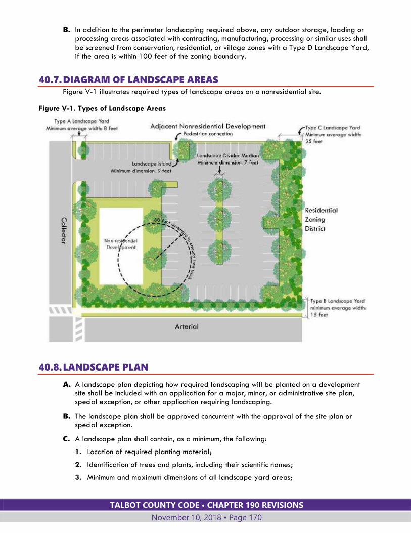
TALBOT COUNTY CODE • CHAPTER 190 REVISIONS
November 10, 2018 • Page 170
B. In addition to the perimeter landscaping required above, any outdoor storage, loading or processing areas associated with contracting, manufacturing, processing or similar uses shall be screened from conservation, residential, or village zones with a Type D Landscape Yard, if the area is within 100 feet of the zoning boundary.
40.7. DIAGRAM OF LANDSCAPE AREAS Figure V-1 illustrates required types of landscape areas on a nonresidential site.
Figure V-1. Types of Landscape Areas
40.8. LANDSCAPE PLAN
A. A landscape plan depicting how required landscaping will be planted on a development site shall be included with an application for a major, minor, or administrative site plan, special exception, or other application requiring landscaping.
B. The landscape plan shall be approved concurrent with the approval of the site plan or special exception.
C. A landscape plan shall contain, as a minimum, the following:
1. Location of required planting material;
2. Identification of trees and plants, including their scientific names;
3. Minimum and maximum dimensions of all landscape yard areas;
TALBOT COUNTY CODE • CHAPTER 190 REVISIONS
November 10, 2018 • Page 171
4. Calculations determining the number of canopy trees, understory trees, and shrubs required;
5. Locations, species, and sizes of existing vegetation to be retained and counted towards minimum landscaping requirements; and
6. Existing topography or proposed topography where site grading is proposed to occur.
40.9. MODIFICATIONS TO LANDSCAPING REQUIREMENTS
A. An alternate landscape plan may be approved by the approving authority in accordance with the procedures in §190-62 for waivers.
B. Any alternate landscape plan approved shall meet the intent of the applicable landscape yard(s) and the general intent of the landscaping standards of this Section, and shall provide sufficient screening and separation between uses.
C. An alternate landscape plan may include modifications to the width of the landscape yard, the number or type of required plan materials, or the spacing of plant materials.
D. The alternative landscape plan shall include justification for the modifications requested, based upon one or more of the following:
1. Natural physical conditions (such as streams, wetland areas, and topography),
2. Lot configuration,
3. The presence or planned location of public utilities, infrastructure, or easements;
4. The location of existing healthy vegetation or other beneficial site features to be retained after development;
5. The size, shape, or topographic elevation of the site relative to adjoining streets and properties;
6. Extent of setbacks or natural barriers between proposed uses and the property line;
7. Permanent restrictions on use of adjoining property;
8. Existing shaded areas or other site features that reduce the chances of survival for landscape materials in required locations; and,
9. The need to protect solar access or avoid permanently shaded areas on the site.
40.10. CREDIT FOR EXISTING VEGETATION
A. GENERAL STANDARDS
Existing healthy, well-formed canopy and understory trees that are in or within 10 linear feet of a required landscape yard and that meet or exceed the standards of this Section may be credited toward the applicable tree planting requirements of this Section, provided that:
1. The applicant has provided a plan showing the location and size of canopy and understory trees to be credited, and trees depicted on the plan have been marked or identified on the site.
2. The canopy and understory trees to be credited are protected before and during development by tree protection fencing.
3. The existing canopy and understory trees to be credited contribute to the screening functions of the landscaping.
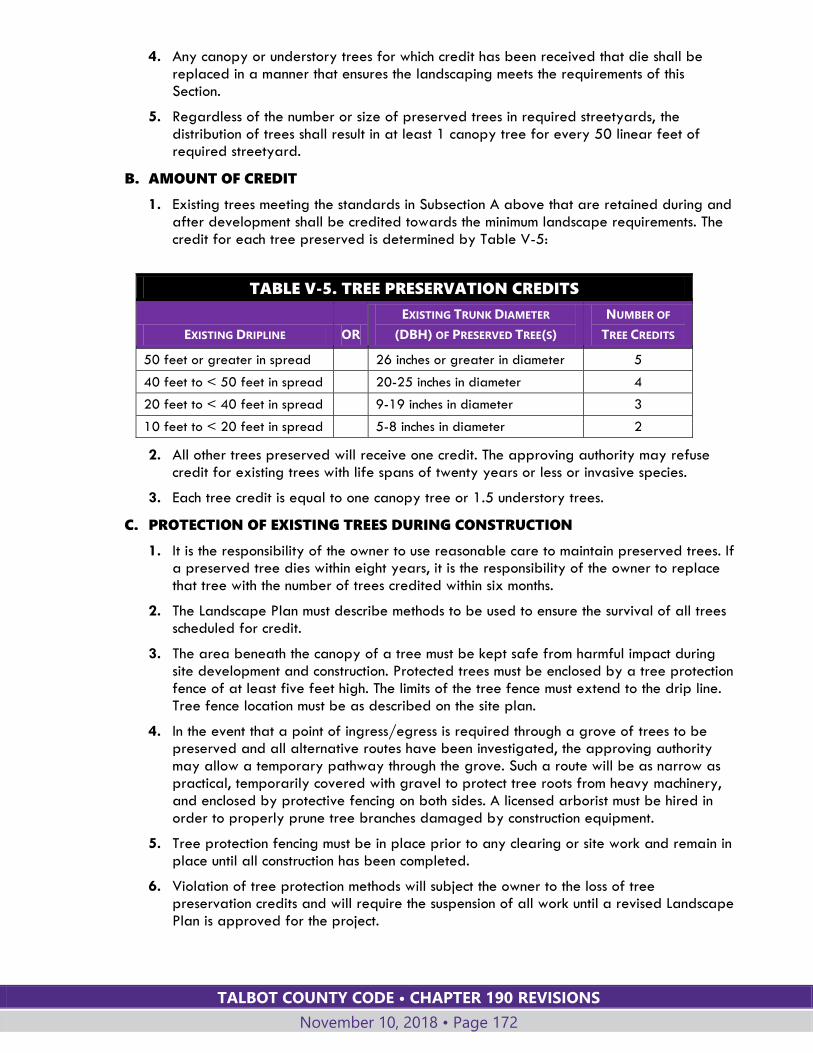
TALBOT COUNTY CODE • CHAPTER 190 REVISIONS
November 10, 2018 • Page 172
4. Any canopy or understory trees for which credit has been received that die shall be replaced in a manner that ensures the landscaping meets the requirements of this Section.
5. Regardless of the number or size of preserved trees in required streetyards, the distribution of trees shall result in at least 1 canopy tree for every 50 linear feet of required streetyard.
B. AMOUNT OF CREDIT
1. Existing trees meeting the standards in Subsection A above that are retained during and after development shall be credited towards the minimum landscape requirements. The credit for each tree preserved is determined by Table V-5:
TABLE V-5. TREE PRESERVATION CREDITS
EXISTING DRIPLINE OR
EXISTING TRUNK DIAMETER
(DBH) OF PRESERVED TREE(S)
NUMBER OF
TREE CREDITS
50 feet or greater in spread 26 inches or greater in diameter 5
40 feet to < 50 feet in spread 20-25 inches in diameter 4
20 feet to < 40 feet in spread 9-19 inches in diameter 3
10 feet to < 20 feet in spread 5-8 inches in diameter 2
2. All other trees preserved will receive one credit. The approving authority may refuse credit for existing trees with life spans of twenty years or less or invasive species.
3. Each tree credit is equal to one canopy tree or 1.5 understory trees.
C. PROTECTION OF EXISTING TREES DURING CONSTRUCTION
1. It is the responsibility of the owner to use reasonable care to maintain preserved trees. If a preserved tree dies within eight years, it is the responsibility of the owner to replace that tree with the number of trees credited within six months.
2. The Landscape Plan must describe methods to be used to ensure the survival of all trees scheduled for credit.
3. The area beneath the canopy of a tree must be kept safe from harmful impact during site development and construction. Protected trees must be enclosed by a tree protection fence of at least five feet high. The limits of the tree fence must extend to the drip line. Tree fence location must be as described on the site plan.
4. In the event that a point of ingress/egress is required through a grove of trees to be preserved and all alternative routes have been investigated, the approving authority may allow a temporary pathway through the grove. Such a route will be as narrow as practical, temporarily covered with gravel to protect tree roots from heavy machinery, and enclosed by protective fencing on both sides. A licensed arborist must be hired in order to properly prune tree branches damaged by construction equipment.
5. Tree protection fencing must be in place prior to any clearing or site work and remain in place until all construction has been completed.
6. Violation of tree protection methods will subject the owner to the loss of tree preservation credits and will require the suspension of all work until a revised Landscape Plan is approved for the project.
TALBOT COUNTY CODE • CHAPTER 190 REVISIONS
November 10, 2018 • Page 173
40.11. LANDSCAPE SPECIFICATIONS
A. PLANT MATERIAL
1. SIZE AT PLANTING
a. Canopy trees shall have a minimum caliper size of 2 inches at planting.
b. Understory trees shall have a minimum caliper size of 2 inches at planting.
c. Evergreen trees shall be a minimum of 6 feet in height at planting.
d. All shrubs must be at least a 3-gallon size and have a minimum height or spread of 15 inches at the time of planting. Shrubs shall reach a minimum height of 36 inches and a spread of 30 inches within 3 years of planting.
2. ACCEPTABLE SPECIES
Plant species used in required landscape yards must be native species or species of a locally adapted nature. Invasive species shall not be used. Refer to the List of Acceptable Landscape Species published by the Department of Planning and Zoning for listings of acceptable plant material.
3. SPECIES DIVERSITY
To curtail the spread of disease or insect infestation in a plant species, new plantings shall comply with the following standards:
a. When fewer than 20 trees are required on a site, at least 2 different species shall be utilized, in roughly equal proportions.
b. When more than 20 but fewer than 40 trees are required to be planted on site, at least 3 different species shall be utilized, in roughly equal proportions.
c. When 40 or more trees are required on a site, at least four different species shall be utilized, in roughly equal proportions.
B. STABILIZATION
1. Landscape yards shall be stabilized and maintained with ground cover, mulch, or other approved materials to prevent soil erosion and allow rainwater infiltration.
2. Landscape yards with slopes of 15 percent or more shall be stabilized with vegetative cover to minimize erosion and mulch washout.
C. STORMWATER MANAGEMENT AND LANDSCAPING
Trees and shrubs used in bio-retention cells or rain gardens located in parking lots or within landscape yards may be counted toward tree or shrub requirements provided they meet the minimum specifications of this Section.
D. BERMS
1. Berms may be used independently, or in conjunction with a wall or fencing, to meet the screening intent of the landscape yard.
2. Berms must be stabilized, have a slope not exceeding 3:1 (horizontal to vertical), have a crown width at least ½ the berm height, and may be no taller than 8 feet above the toe of the berm slope.
3. A berm may not damage the roots of existing healthy vegetation designated to be preserved.
4. A berm may not be designed or placed as to interfere with sight distance at driveway entrances or road intersections.
TALBOT COUNTY CODE • CHAPTER 190 REVISIONS
November 10, 2018 • Page 174
E. FENCES
1. Opaque fences in the side or rear yard, a minimum of 5 feet in height, may reduce the minimum and average landscape yard width requirement in accordance with Table V-3, Perimeter Landscape Yard Types.
2. If utilized, fences shall be located within the landscape yard, and all required shrubs shall be planted between the fence and the lot line. Required trees may be planted on either side of the fence.
F. STREETS AND EASEMENTS
1. Trees shall not be located within four feet of the right-of-way line of a street.
2. Required trees and shrubs planted within a utility, drainage, or other easement must be approved by the easement holder.
3. When trees or shrubs are planted in an easement, the landowner is responsible for replacement of any required vegetation, if maintenance or other utility requirements result in its removal.
G. OBSTRUCTIONS AT INTERSECTIONS
No trees or shrubs shall be planted or maintained to obstruct visibility at any street intersection in accordance with §190-12.2.C.2, “Clear Vision Area on Corner Lots.”
H. MULTIPLE-LOT DEVELOPMENT
A multiple-lot development, such as a shopping center, that is configured and developed as a single entity shall be treated as a single lot for the purposes of applying the landscaping requirements.
40.12. INSTALLATION AND MAINTENANCE
A. INSTALLATION
1. Required landscaping (including mulching and seeding) shall be installed in accordance with this Section prior to the issuance of a certificate of occupancy, unless a Developer Agreement with financial guarantee is approved (§190-61) to ensure installation during the next growing season.
2. The maximum length of time for deferral of landscaping pursuant to a Developer Agreement shall be 6 months after the Use and Occupancy permit is issued, which may be extended one time for up to 90 days by the Planning Director.
B. LANDSCAPE YARD MAINTENANCE
1. GENERAL
The landowner is responsible for maintaining all required plant materials and landscape yards in good health and appearance. Any dead, unhealthy, severely damaged, or missing plants (whether preserved or installed) must be replaced with new plant material equal in quantity and quality. Replacement plant material shall be installed within 180 days of the date of owner notification. The obligation for continuous maintenance is binding on any subsequent owners of the land, or any other parties having a controlling interest in the property.
2. PROTECTION OF PLANT MATERIAL
The landowner or developer shall take actions to protect trees and landscaping from unnecessary damage during all facility and site maintenance operations. When
TALBOT COUNTY CODE • CHAPTER 190 REVISIONS
November 10, 2018 • Page 175
landscape yards are adjacent to parking lots or drives, plants shall be protected from damage by vehicles, lubricants, or fuels.
3. AUTHORIZED REMOVAL
Once installed and inspected, required landscape material shall not be removed or relocated without approval of a revised landscape plan.
4. REPLACEMENT OF DEAD OR DISEASED MATERIAL
The replacement of dead or diseased trees and shrubs in a 1:1 ratio in the same location is considered normal landscape yard maintenance, and does not require approval of a landscape plan.
5. HAZARDOUS TREES
If any required tree is determined to be in a hazardous condition such that it is an immediate danger to the public safety, the Planning Director may authorize the removal of the tree without landscape plan approval. Following removal, the Planning Director shall determine if tree replacement is necessary in accordance with this Subsection.
6. UNAUTHORIZED REMOVAL
Except in accordance with Subsection B.5, Hazardous Trees, removal of required plant material without approval of a revised landscape plan shall be considered a violation of this Ordinance.
Section 190-41 OFF-STREET PARKING; OFF-STREET LOADING
41.1. APPLICATION
A. Off-street parking and loading spaces shall be provided in accordance with this Section for:
1. New buildings or uses;
2. Additions to or enlargement of existing buildings or uses; and
3. Changes in the use of a building or site.
B. Requirements of this §190-41 may be the subject of a waiver application as provided in §190-62.
41.2. DETERMINATION OF REQUIRED OFF-STREET PARKING
A. Off-street parking spaces shall be provided in accordance with §190-41.3, Table V-6 below. For land uses not specifically covered by this Section, the Planning Director shall determine the required parking using this Section as a guide.
B. The required off-street parking area shall be provided in addition to areas used for:
1. Parking of vehicles owned or used in a business;
2. Display or storage of vehicles for sale or rent; or
3. Vehicles being stored while awaiting repair.
C. Due to the particular circumstances of a given development, application of the parking standards may result in a development with inadequate parking area or parking area in excess of its needs. Therefore, a waiver to the number of parking spaces required by this Section may be approved or required as follows:
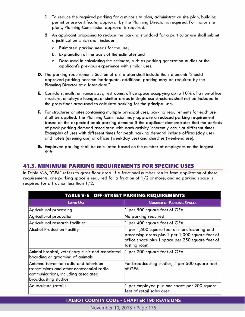
TALBOT COUNTY CODE • CHAPTER 190 REVISIONS
November 10, 2018 • Page 176
1. To reduce the required parking for a minor site plan, administrative site plan, building permit or use certificate, approval by the Planning Director is required. For major site plans, Planning Commission approval is required.
2. An applicant proposing to reduce the parking standard for a particular use shall submit a justification which shall include:
a. Estimated parking needs for the use;
b. Explanation of the basis of the estimate; and
c. Data used in calculating the estimate, such as parking generation studies or the applicant's previous experience with similar uses.
D. The parking requirements Section of a site plan shall include the statement: "Should approved parking become inadequate, additional parking may be required by the Planning Director at a later date."
E. Corridors, malls, entranceways, restrooms, office space occupying up to 10% of a non-office structure, employee lounges, or similar areas in single-use structures shall not be included in the gross floor area used to calculate parking for the principal use.
F. For structures or sites containing multiple principal uses, parking requirements for each use shall be applied. The Planning Commission may approve a reduced parking requirement based on the expected peak parking demand if the applicant demonstrates that the periods of peak parking demand associated with each activity inherently occur at different times. Examples of uses with different times for peak parking demand include offices (day use) and hotels (evening use) or offices (weekday use) and churches (weekend use).
G. Employee parking shall be calculated based on the number of employees on the largest shift.
41.3. MINIMUM PARKING REQUIREMENTS FOR SPECIFIC USES In Table V-6, "GFA" refers to gross floor area. If a fractional number results from application of these requirements, one parking space is required for a fraction of 1/2 or more, and no parking space is required for a fraction less than 1/2.
TABLE V-6 OFF-STREET PARKING REQUIREMENTS
LAND USE NUMBER OF PARKING SPACES
Agricultural processing 1 per 500 square feet of GFA
Agricultural production No parking required
Agricultural research facilities 1 per 400 square feet of GFA
Alcohol Production Facility 1 per 1,500 square feet of manufacturing and processing areas plus 1 per 1,000 square feet of office space plus 1 space per 250 square feet of tasting room
Animal hospital, veterinary clinic and associated boarding or grooming of animals
1 per 200 square feet of GFA
Antenna tower for radio and television transmissions and other nonessential radio communications, including associated broadcasting studios
For broadcasting studios, 1 per 500 square feet of GFA
Aquaculture (retail) 1 per employee plus one space per 200 square feet of retail sales area

TALBOT COUNTY CODE • CHAPTER 190 REVISIONS
November 10, 2018 • Page 177
TABLE V-6 OFF-STREET PARKING REQUIREMENTS
LAND USE NUMBER OF PARKING SPACES
Aquaculture (wholesale) 1 per 500 square feet GFA
Auction House 1 per 4 persons based on maximum capacity; use estimated capacity if outdoor sales areas are used.
Automobile, truck and recreational vehicle service, repair, washing, and fuel sales:
Service and repair 1 per 375 square feet GFA, including service bays and wash tunnels
Car washing 1 per 375 square feet GFA, including wash tunnels
Fuel sales without convenience store 1 per 375 square feet GFA plus 1 per pumping nozzle
Fuel sales with convenience store 1 per 150 square feet GFA plus 1 per pumping nozzle
Banks and financial institutions 1 per 300 square feet GFA
Bed-and-breakfast 1 per guest bedroom in addition to the required spaces for the dwelling
Boat and marine equipment sales and assembly 1 per 500 square feet of GFA plus 1 per 1,000 square feet of outdoor display area
Building supply and lumber yards with outside storage
1 per 300 square feet of GFA
Cemeteries and mausoleums/columbarium, non church related, for humans and animals; family cemeteries
No parking required
Cemeteries, related to house of worship No parking required
Community and cultural facilities 1 per 400 square feet of GFA
Compounding industries (permanent) 1 per employee
Conservation areas (public or private) No parking required
Contracting:
Building trade and construction contracting 1 per 600 square feet of GFA
Marine contracting 1 per 600 square feet of GFA
Cottage industry Apply requirement of most similar use in this table in addition to parking required for residential use
Day-care center, large group, small group, or family
1 per employee plus 1 per 8 clients or fraction thereof; minimum of 2
Direct farm marketing, harvesting and education 1 per four persons based on maximum estimated capacity of areas open to the public; seasonal uses may utilize unpaved areas for temporary parking
Dwelling, accessory; dwelling accessory to commercial use
1 for dwelling with 900 square feet GFA or smaller; 2 for dwelling larger than 900 square feet
Dwelling, accessory to agricultural use; seasonal employee
2 per dwelling unit
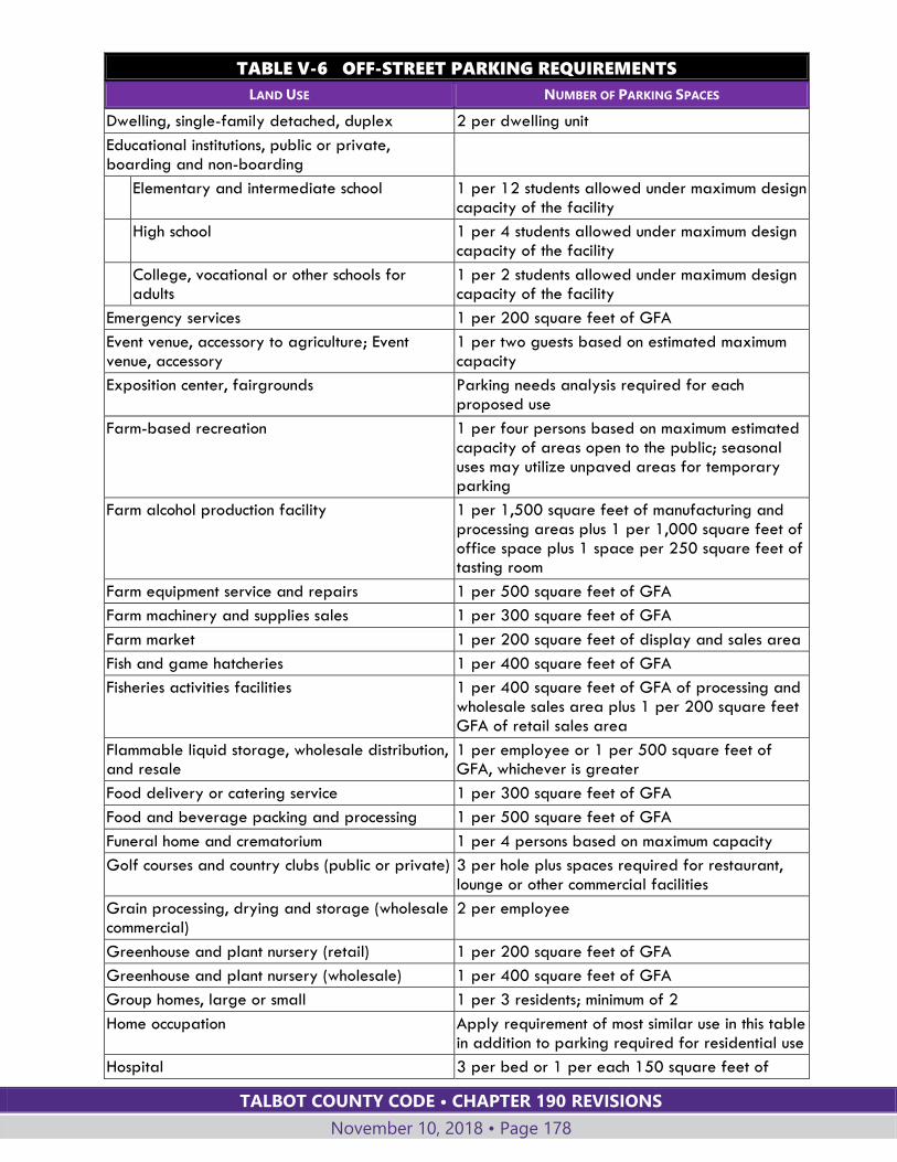
TALBOT COUNTY CODE • CHAPTER 190 REVISIONS
November 10, 2018 • Page 178
TABLE V-6 OFF-STREET PARKING REQUIREMENTS
LAND USE NUMBER OF PARKING SPACES
Dwelling, single-family detached, duplex 2 per dwelling unit
Educational institutions, public or private, boarding and non-boarding
Elementary and intermediate school 1 per 12 students allowed under maximum design capacity of the facility
High school 1 per 4 students allowed under maximum design capacity of the facility
College, vocational or other schools for adults
1 per 2 students allowed under maximum design capacity of the facility
Emergency services 1 per 200 square feet of GFA
Event venue, accessory to agriculture; Event venue, accessory
1 per two guests based on estimated maximum capacity
Exposition center, fairgrounds Parking needs analysis required for each proposed use
Farm-based recreation 1 per four persons based on maximum estimated capacity of areas open to the public; seasonal uses may utilize unpaved areas for temporary parking
Farm alcohol production facility 1 per 1,500 square feet of manufacturing and processing areas plus 1 per 1,000 square feet of office space plus 1 space per 250 square feet of tasting room
Farm equipment service and repairs 1 per 500 square feet of GFA
Farm machinery and supplies sales 1 per 300 square feet of GFA
Farm market 1 per 200 square feet of display and sales area
Fish and game hatcheries 1 per 400 square feet of GFA
Fisheries activities facilities 1 per 400 square feet of GFA of processing and wholesale sales area plus 1 per 200 square feet GFA of retail sales area
Flammable liquid storage, wholesale distribution, and resale
1 per employee or 1 per 500 square feet of GFA, whichever is greater
Food delivery or catering service 1 per 300 square feet of GFA
Food and beverage packing and processing 1 per 500 square feet of GFA
Funeral home and crematorium 1 per 4 persons based on maximum capacity
Golf courses and country clubs (public or private) 3 per hole plus spaces required for restaurant, lounge or other commercial facilities
Grain processing, drying and storage (wholesale commercial)
2 per employee
Greenhouse and plant nursery (retail) 1 per 200 square feet of GFA
Greenhouse and plant nursery (wholesale) 1 per 400 square feet of GFA
Group homes, large or small 1 per 3 residents; minimum of 2
Home occupation Apply requirement of most similar use in this table in addition to parking required for residential use
Hospital 3 per bed or 1 per each 150 square feet of
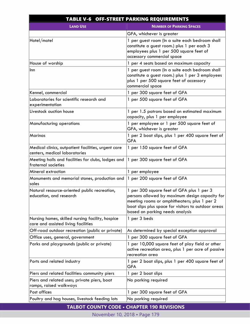
TALBOT COUNTY CODE • CHAPTER 190 REVISIONS
November 10, 2018 • Page 179
TABLE V-6 OFF-STREET PARKING REQUIREMENTS
LAND USE NUMBER OF PARKING SPACES
GFA, whichever is greater
Hotel/motel 1 per guest room (In a suite each bedroom shall constitute a guest room.) plus 1 per each 3 employees plus 1 per 500 square feet of accessory commercial space
House of worship 1 per 4 seats based on maximum capacity
Inn 1 per guest room (In a suite each bedroom shall constitute a guest room.) plus 1 per 3 employees plus 1 per 500 square feet of accessory commercial space
Kennel, commercial 1 per 300 square feet of GFA
Laboratories for scientific research and experimentation
1 per 500 square feet of GFA
Livestock auction house 1 per 1.5 patrons based on estimated maximum capacity, plus 1 per employee
Manufacturing operations 1 per employee or 1 per 500 square feet of GFA, whichever is greater
Marinas 1 per 2 boat slips, plus 1 per 400 square feet of GFA
Medical clinics, outpatient facilities, urgent care centers, medical laboratories
1 per 150 square feet of GFA
Meeting halls and facilities for clubs, lodges and fraternal societies
1 per 300 square feet of GFA
Mineral extraction 1 per employee
Monuments and memorial stones, production and sales
1 per 200 square feet of GFA
Natural resource-oriented public recreation, education, and research
1 per 300 square feet of GFA plus 1 per 3 persons allowed by maximum design capacity for meeting rooms or amphitheaters; plus 1 per 2 boat slips plus space for visitors to outdoor areas based on parking needs analysis
Nursing homes, skilled nursing facility, hospice care and assisted living facilities
1 per 3 beds
Off-road outdoor recreation (public or private) As determined by special exception approval
Office uses, general, government 1 per 300 square feet of GFA
Parks and playgrounds (public or private) 1 per 10,000 square feet of play field or other active recreation area, plus 1 per acre of passive recreation area
Ports and related industry 1 per 2 boat slips, plus 1 per 400 square feet of GFA
Piers and related facilities: community piers 1 per 2 boat slips
Piers and related uses; private piers, boat ramps, raised walkways
No parking required
Post offices 1 per 300 square feet of GFA
Poultry and hog houses, livestock feeding lots No parking required
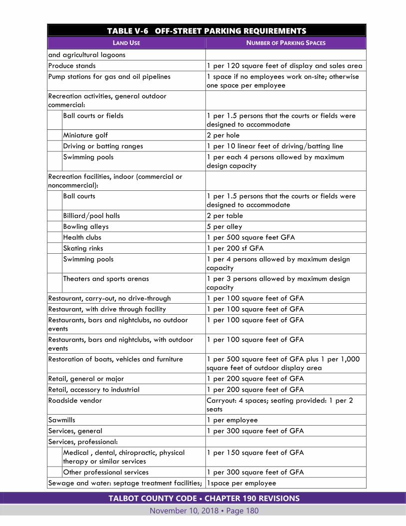
TALBOT COUNTY CODE • CHAPTER 190 REVISIONS
November 10, 2018 • Page 180
TABLE V-6 OFF-STREET PARKING REQUIREMENTS
LAND USE NUMBER OF PARKING SPACES
and agricultural lagoons
Produce stands 1 per 120 square feet of display and sales area
Pump stations for gas and oil pipelines 1 space if no employees work on-site; otherwise one space per employee
Recreation activities, general outdoor commercial:
Ball courts or fields 1 per 1.5 persons that the courts or fields were designed to accommodate
Miniature golf 2 per hole
Driving or batting ranges 1 per 10 linear feet of driving/batting line
Swimming pools 1 per each 4 persons allowed by maximum design capacity
Recreation facilities, indoor (commercial or noncommercial):
Ball courts 1 per 1.5 persons that the courts or fields were designed to accommodate
Billiard/pool halls 2 per table
Bowling alleys 5 per alley
Health clubs 1 per 500 square feet GFA
Skating rinks 1 per 200 sf GFA
Swimming pools 1 per 4 persons allowed by maximum design capacity
Theaters and sports arenas 1 per 3 persons allowed by maximum design capacity
Restaurant, carry-out, no drive-through 1 per 100 square feet of GFA
Restaurant, with drive through facility 1 per 100 square feet of GFA
Restaurants, bars and nightclubs, no outdoor events
1 per 100 square feet of GFA
Restaurants, bars and nightclubs, with outdoor events
1 per 100 square feet of GFA
Restoration of boats, vehicles and furniture 1 per 500 square feet of GFA plus 1 per 1,000 square feet of outdoor display area
Retail, general or major 1 per 200 square feet of GFA
Retail, accessory to industrial 1 per 200 square feet of GFA
Roadside vendor Carryout: 4 spaces; seating provided: 1 per 2 seats
Sawmills 1 per employee
Services, general 1 per 300 square feet of GFA
Services, professional:
Medical , dental, chiropractic, physical therapy or similar services
1 per 150 square feet of GFA
Other professional services 1 per 300 square feet of GFA
Sewage and water: septage treatment facilities; 1space per employee

TALBOT COUNTY CODE • CHAPTER 190 REVISIONS
November 10, 2018 • Page 181
TABLE V-6 OFF-STREET PARKING REQUIREMENTS
LAND USE NUMBER OF PARKING SPACES
wastewater treatment plant; water treatment and storage facilities
Sexually oriented business 1 per 200 square feet of GFA
Shooting range, indoor 2 per shooting alley plus 1 per employee
Shoreline stabilization measures No parking required
Short-term rental 1 per 2 guests based on maximum licensed capacity
Solar energy system, medium or large scale 1 space if no employees work on-site; otherwise one space per employee
Stables, riding, trails and horse boarding (commercial)
1 per 4 stalls plus 1 per 2,000 square feet of riding arena area(s)
Studios for instruction in art, music, dance, drama, crafts or physical education
1 per employee plus 1 per 300 square feet of GFA
Timber harvesting No parking required
Trucking terminals, warehouses and storage yards
1 per 5,000 square feet of freight storage area (indoor or outdoor)
Utility services and structures 1 space if no employees work on-site; otherwise one space per employee
Vehicle and boat parking and storage (commercial)
1 per 5,000 square feet of storage area
Vehicle sales, including sale of automobiles, trucks and recreational vehicles
1 per 400 square feet of GFA
Warehouse, self-storage 1 per 300 square feet office space plus 1 per 50 storage units
Waste processing and disposal uses: includes junkyard; organic waste recovery facility; recycling collection center; product recycling; recycling processing center; scrap metal processing; solid waste disposal facilities and solid waste transfer stations
1 per employee or 1 per 500 square feet of GFA, whichever is greater
Water-oriented public recreation, education, research areas
1 per 300 square feet of GFA plus 1 per 3 persons allowed by maximum design capacity for meeting rooms or amphitheaters; plus 1 per 2 boat slips plus space for visitors to outdoor areas based on parking needs analysis
Wind turbine production facility 1 space if no employees work on-site; otherwise one space per employee
Wireless communication towers 1 space if no employees work on-site; otherwise one space per employee
41.4. ACCESSIBLE PARKING AREAS Off-street parking areas shall include accessible parking spaces in accordance with ADA (the Americans with Disabilities Act) Standards for Accessible Design.
TALBOT COUNTY CODE • CHAPTER 190 REVISIONS
November 10, 2018 • Page 182
41.5. DESIGN STANDARDS FOR OFF-STREET PARKING AND
CIRCULATION
A. OFF-STREET CIRCULATION
Site plans for commercial, industrial and institutional uses shall incorporate safe and convenient off-street circulation in accordance with the following standards:
1. Provide sidewalks and walkways for safe and convenient pedestrian travel from business to business or building to building within the site.
2. Provide vehicular and pedestrian connections that connect, wherever possible, travel lanes and driveways with similar facilities in adjacent developments.
3. Design driveways and parking areas for nonresidential uses to avoid impact on adjoining residential properties due to dust (for unpaved surfaces) or light from vehicle headlights.
B. STANDARDS FOR ALL OFF-STREET PARKING
1. The vehicle accommodation area shall be entirely within lot lines and shall not encroach on any road or other public right-of-way. No parked vehicle shall overhang a road or public right-of-way.
2. Except for parking facilities serving single-family residences, off-street parking areas shall be designed so that it will not be necessary for vehicles to back into any road or public right-of-way.
3. Off-street parking spaces shall not be located in required buffer yard, landscaped areas or sewage disposal areas.
4. Vehicle accommodation areas shall be designed to provide access for sanitation, emergency, and other public service vehicles without backing unreasonable distances or making other hazardous turning movements.
5. Driveways and parking aisles shall be designed so that vehicles can proceed safely without posing a danger to pedestrians or other vehicles and without interfering with parking areas.
C. STANDARDS FOR FACILITIES FOR FIVE OR MORE VEHICLES
Off-street parking and loading facilities required by this Section for five or more vehicles shall be constructed and maintained in accord with the following standards.
1. The minimum dimensions of paved, off-street parking facilities shall be as prescribed in the off-street parking dimension requirements below, except that:
a. A parking space within a garage or carport shall not be less than 20 feet in length and 10 feet in width.
b. Dimensions for unpaved parking facilities shall be increased by 10% of the stall and curb length dimensions required by Table V-7.
2. Minimum driveway width in commercial or industrial districts:
a. Posted one-way driveway: 15 feet for access from a state or federal highway; 10 feet for access from other roads.
b. Two-way driveways: 20 feet.
c. The driveway shall maintain the required width for a distance of not less than 50 feet back from the road right-of-way.
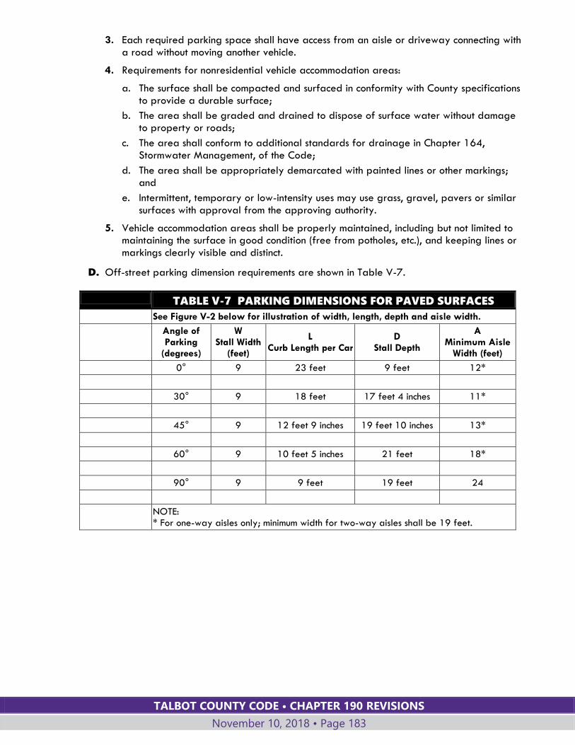
TALBOT COUNTY CODE • CHAPTER 190 REVISIONS
November 10, 2018 • Page 183
3. Each required parking space shall have access from an aisle or driveway connecting with a road without moving another vehicle.
4. Requirements for nonresidential vehicle accommodation areas:
a. The surface shall be compacted and surfaced in conformity with County specifications to provide a durable surface;
b. The area shall be graded and drained to dispose of surface water without damage to property or roads;
c. The area shall conform to additional standards for drainage in Chapter 164, Stormwater Management, of the Code;
d. The area shall be appropriately demarcated with painted lines or other markings; and
e. Intermittent, temporary or low-intensity uses may use grass, gravel, pavers or similar surfaces with approval from the approving authority.
5. Vehicle accommodation areas shall be properly maintained, including but not limited to maintaining the surface in good condition (free from potholes, etc.), and keeping lines or markings clearly visible and distinct.
D. Off-street parking dimension requirements are shown in Table V-7.
TABLE V-7 PARKING DIMENSIONS FOR PAVED SURFACES
See Figure V-2 below for illustration of width, length, depth and aisle width.
Angle of Parking
(degrees)
W Stall Width
(feet)
L Curb Length per Car
D Stall Depth
A Minimum Aisle
Width (feet)
0° 9 23 feet 9 feet 12*
30° 9 18 feet 17 feet 4 inches 11*
45° 9 12 feet 9 inches 19 feet 10 inches 13*
60° 9 10 feet 5 inches 21 feet 18*
90° 9 9 feet 19 feet 24
NOTE: * For one-way aisles only; minimum width for two-way aisles shall be 19 feet.
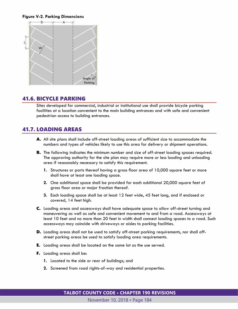
TALBOT COUNTY CODE • CHAPTER 190 REVISIONS
November 10, 2018 • Page 184
Figure V-2. Parking Dimensions
41.6. BICYCLE PARKING Sites developed for commercial, industrial or institutional use shall provide bicycle parking facilities at a location convenient to the main building entrances and with safe and convenient pedestrian access to building entrances.
41.7. LOADING AREAS
A. All site plans shall include off-street loading areas of sufficient size to accommodate the numbers and types of vehicles likely to use this area for delivery or shipment operations.
B. The following indicates the minimum number and size of off-street loading spaces required. The approving authority for the site plan may require more or less loading and unloading area if reasonably necessary to satisfy this requirement.
1. Structures or parts thereof having a gross floor area of 10,000 square feet or more shall have at least one loading space.
2. One additional space shall be provided for each additional 20,000 square feet of gross floor area or major fraction thereof.
3. Each loading space shall be at least 12 feet wide, 45 feet long, and if enclosed or covered, 14 feet high.
C. Loading areas and accessways shall have adequate space to allow off-street turning and maneuvering as well as safe and convenient movement to and from a road. Accessways at least 10 feet and no more than 20 feet in width shall connect loading spaces to a road. Such accessways may coincide with driveways or aisles to parking facilities.
D. Loading areas shall not be used to satisfy off-street parking requirements, nor shall off-street parking areas be used to satisfy loading area requirements.
E. Loading areas shall be located on the same lot as the use served.
F. Loading areas shall be:
1. Located to the side or rear of buildings; and
2. Screened from road rights-of-way and residential properties.

TALBOT COUNTY CODE • CHAPTER 190 REVISIONS
November 10, 2018 • Page 185
Section 190-42 SIGNS
42.1. PERMIT REQUIRED
A. No sign may be erected, moved, enlarged, illuminated or substantially altered except in accordance with the provisions of this article. Repainting or changing the message of a sign shall not in and of itself be considered a substantial alteration.
B. Signs may be constructed, erected, moved, enlarged, illuminated or substantially altered only in accordance with a sign permit issued by the Office of Permits and Inspections, unless exempt from the sign permit requirement under this §190-42.
C. In the case of a lot occupied or intended to be occupied by multiple business enterprises (e.g., a shopping center), sign permits shall be issued in the name of the lot owner or his agent rather than in the name of the business requesting a particular sign. The County shall be responsible for enforcing only the provisions of this Section and not the provisions of any lease, formula for allocating sign area among tenants, or other private restriction.
42.2. OTHER SIGN REQUIREMENTS In addition to the requirements of this Section, signs shall comply with the sign requirements in Article IV for a particular land use, and the sign requirements in Articles II or III for a specific zoning district.
42.3. SIGNS EXCLUDED FROM REGULATION The signs listed in Table V-8 are exempt from the sign permit requirement and other requirements of this §190-42, but must comply with the standards specified in this Table:
TABLE V-8 EXEMPT SIGNS
TYPE OF SIGN REQUIREMENTS (IF ANY)
A. Signs customarily associated with residential uses, such as:
1. Signs giving property identification names or numbers, or names of occupants;
2. Signs on mailboxes or newspaper tubes; and
3. Signs relating to private parking or warning the public against trespassing or danger from animals.
Maximum area per sign: six square feet
B. Signs identifying a home-based business such as a home occupation, cottage industry, bed and breakfast or similar accessory business use.
Maximum area per sign: six square feet Only one sign per lot
C. Property security system identification sign.
Maximum area per sign: 50 square inches. Only one sign per lot
D. Signs erected by, on behalf of, or with No specific requirements.
TALBOT COUNTY CODE • CHAPTER 190 REVISIONS
November 10, 2018 • Page 186
TABLE V-8 EXEMPT SIGNS
TYPE OF SIGN REQUIREMENTS (IF ANY)
the authorization of a government body, including legal notices, identification and informational signs, and traffic, directional, or regulatory signs, but not including state game signs or gas pricing signs.
E. Official signs of a noncommercial nature erected by public utilities.
No specific requirements.
F. Flags or insignia of a government or nonprofit organization.
Shall not be displayed as an advertising device.
G. Directional signs, located on the same property as a business or institutional use, that direct traffic, vehicular or pedestrian, to locations on the property.
Maximum area per sign: 4 square feet. Signs shall bear no advertising matter. Examples of permitted signs include "Deliveries in Rear", "Customer Parking", and "Service Entrance".
H. Signs painted on or permanently attached to licensed motor vehicles.
Shall not be primarily used as freestanding signs.
I. Signs on the site of institutional uses.
Maximum area per sign (for signs exempt from permit): 16 square feet. No more than one sign per abutting street. Signs shall not be internally illuminated. Parcels fronting on principal arterial highways may have one freestanding identification signs with an electronic message sign that has a total area of not more than 16 square feet.
42.4. PERMIT EXEMPTIONS AND REGULATIONS FOR CERTAIN
TEMPORARY SIGNS
A. The temporary signs listed in Table V-9 are permitted without a sign permit and are not subject to the requirements of this Section for maximum sign area and maximum number of signs. However, such signs shall conform to the requirements set forth below and other applicable requirements of this Section.
B. Other temporary signs not listed in Table V-9 shall be regarded and treated in all respects as permanent signs.
TABLE V-9. TEMPORARY SIGNS
TYPE OF SIGN REQUIREMENTS
1. Real estate signs a. Limited to one sign per street frontage;
b. Maximum area per sign: four square feet, plus one or two additional attached signs (readers) adding no more than two square feet of additional sign area;
c. Must be removed within 14 days after sale, lease or rental.
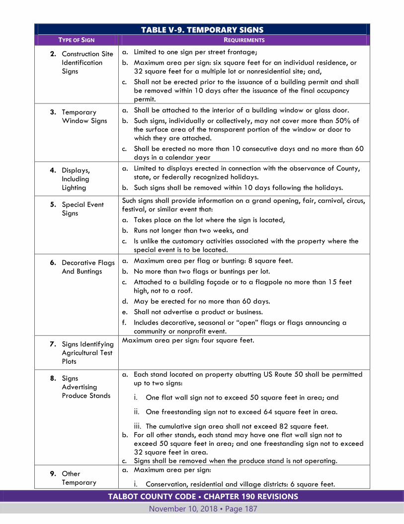
TALBOT COUNTY CODE • CHAPTER 190 REVISIONS
November 10, 2018 • Page 187
TABLE V-9. TEMPORARY SIGNS
TYPE OF SIGN REQUIREMENTS
2. Construction Site Identification Signs
a. Limited to one sign per street frontage;
b. Maximum area per sign: six square feet for an individual residence, or 32 square feet for a multiple lot or nonresidential site; and,
c. Shall not be erected prior to the issuance of a building permit and shall be removed within 10 days after the issuance of the final occupancy permit.
3. Temporary Window Signs
a. Shall be attached to the interior of a building window or glass door.
b. Such signs, individually or collectively, may not cover more than 50% of the surface area of the transparent portion of the window or door to which they are attached.
c. Shall be erected no more than 10 consecutive days and no more than 60 days in a calendar year
4. Displays, Including Lighting
a. Limited to displays erected in connection with the observance of County, state, or federally recognized holidays.
b. Such signs shall be removed within 10 days following the holidays.
5. Special Event Signs
Such signs shall provide information on a grand opening, fair, carnival, circus, festival, or similar event that:
a. Takes place on the lot where the sign is located,
b. Runs not longer than two weeks, and
c. Is unlike the customary activities associated with the property where the special event is to be located.
6. Decorative Flags And Buntings
a. Maximum area per flag or bunting: 8 square feet.
b. No more than two flags or buntings per lot.
c. Attached to a building façade or to a flagpole no more than 15 feet high, not to a roof.
d. May be erected for no more than 60 days.
e. Shall not advertise a product or business.
f. Includes decorative, seasonal or “open” flags or flags announcing a community or nonprofit event.
7. Signs Identifying Agricultural Test Plots
Maximum area per sign: four square feet.
8. Signs Advertising Produce Stands
a. Each stand located on property abutting US Route 50 shall be permitted up to two signs:
i. One flat wall sign not to exceed 50 square feet in area; and
ii. One freestanding sign not to exceed 64 square feet in area.
iii. The cumulative sign area shall not exceed 82 square feet. b. For all other stands, each stand may have one flat wall sign not to
exceed 50 square feet in area; and one freestanding sign not to exceed 32 square feet in area.
c. Signs shall be removed when the produce stand is not operating.
9. Other Temporary
a. Maximum area per sign:
i. Conservation, residential and village districts: 6 square feet.
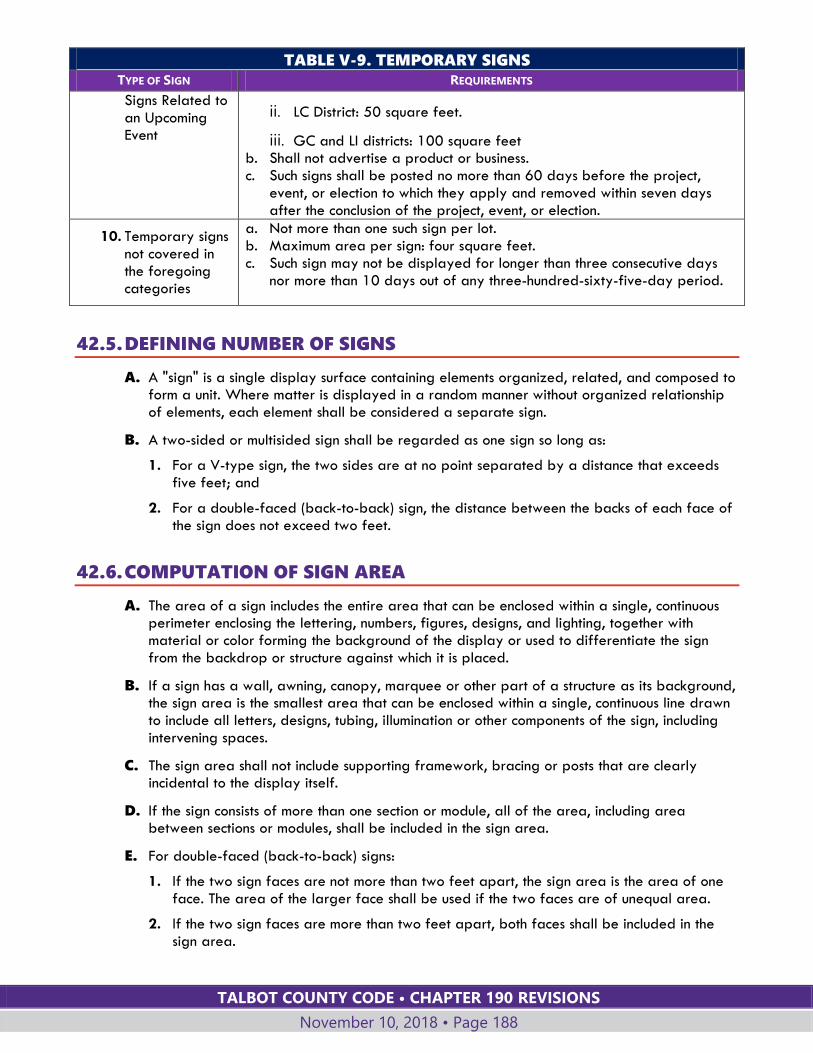
TALBOT COUNTY CODE • CHAPTER 190 REVISIONS
November 10, 2018 • Page 188
TABLE V-9. TEMPORARY SIGNS
TYPE OF SIGN REQUIREMENTS
Signs Related to an Upcoming Event
ii. LC District: 50 square feet.
iii. GC and LI districts: 100 square feet b. Shall not advertise a product or business. c. Such signs shall be posted no more than 60 days before the project,
event, or election to which they apply and removed within seven days after the conclusion of the project, event, or election.
10. Temporary signs not covered in the foregoing categories
a. Not more than one such sign per lot. b. Maximum area per sign: four square feet. c. Such sign may not be displayed for longer than three consecutive days
nor more than 10 days out of any three-hundred-sixty-five-day period.
42.5. DEFINING NUMBER OF SIGNS
A. A "sign" is a single display surface containing elements organized, related, and composed to form a unit. Where matter is displayed in a random manner without organized relationship of elements, each element shall be considered a separate sign.
B. A two-sided or multisided sign shall be regarded as one sign so long as:
1. For a V-type sign, the two sides are at no point separated by a distance that exceeds five feet; and
2. For a double-faced (back-to-back) sign, the distance between the backs of each face of the sign does not exceed two feet.
42.6. COMPUTATION OF SIGN AREA
A. The area of a sign includes the entire area that can be enclosed within a single, continuous perimeter enclosing the lettering, numbers, figures, designs, and lighting, together with material or color forming the background of the display or used to differentiate the sign from the backdrop or structure against which it is placed.
B. If a sign has a wall, awning, canopy, marquee or other part of a structure as its background, the sign area is the smallest area that can be enclosed within a single, continuous line drawn to include all letters, designs, tubing, illumination or other components of the sign, including intervening spaces.
C. The sign area shall not include supporting framework, bracing or posts that are clearly incidental to the display itself.
D. If the sign consists of more than one section or module, all of the area, including area between sections or modules, shall be included in the sign area.
E. For double-faced (back-to-back) signs:
1. If the two sign faces are not more than two feet apart, the sign area is the area of one face. The area of the larger face shall be used if the two faces are of unequal area.
2. If the two sign faces are more than two feet apart, both faces shall be included in the sign area.
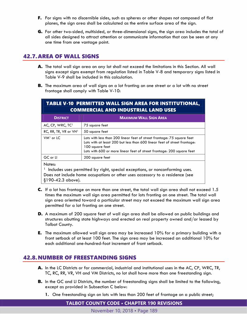
TALBOT COUNTY CODE • CHAPTER 190 REVISIONS
November 10, 2018 • Page 189
F. For signs with no discernible sides, such as spheres or other shapes not composed of flat planes, the sign area shall be calculated as the entire surface area of the sign.
G. For other two-sided, multisided, or three-dimensional signs, the sign area includes the total of all sides designed to attract attention or communicate information that can be seen at any one time from one vantage point.
42.7. AREA OF WALL SIGNS
A. The total wall sign area on any lot shall not exceed the limitations in this Section. All wall signs except signs exempt from regulation listed in Table V-8 and temporary signs listed in Table V-9 shall be included in this calculation.
B. The maximum area of wall signs on a lot fronting on one street or a lot with no street frontage shall comply with Table V-10:
TABLE V-10 PERMITTED WALL SIGN AREA FOR INSTITUTIONAL,
COMMERCIAL AND INDUSTRIAL LAND USES
DISTRICT MAXIMUM WALL SIGN AREA
AC, CP, WRC, TC1 75 square feet
RC, RR, TR, VR or VH1 50 square feet
VM1 or LC Lots with less than 200 linear feet of street frontage: 75 square feet Lots with at least 200 but less than 600 linear feet of street frontage: 100 square feet Lots with 600 or more linear feet of street frontage: 200 square feet
GC or LI 200 square feet
Notes: 1 Includes uses permitted by right, special exceptions, or nonconforming uses. Does not include home occupations or other uses accessory to a residence (see §190-42.3 above).
C. If a lot has frontage on more than one street, the total wall sign area shall not exceed 1.5 times the maximum wall sign area permitted for lots fronting on one street. The total wall sign area oriented toward a particular street may not exceed the maximum wall sign area permitted for a lot fronting on one street.
D. A maximum of 200 square feet of wall sign area shall be allowed on public buildings and structures abutting state highways and erected on real property owned and/or leased by Talbot County.
E. The maximum allowed wall sign area may be increased 10% for a primary building with a front setback of at least 100 feet. The sign area may be increased an additional 10% for each additional one-hundred-foot increment of front setback.
42.8. NUMBER OF FREESTANDING SIGNS
A. In the LC Districts or for commercial, industrial and institutional uses in the AC, CP, WRC, TR, TC, RC, RR, VR, VH and VM Districts, no lot shall have more than one freestanding sign.
B. In the GC and LI Districts, the number of freestanding signs shall be limited to the following, except as provided in Subsection C below:
1. One freestanding sign on lots with less than 200 feet of frontage on a public street;
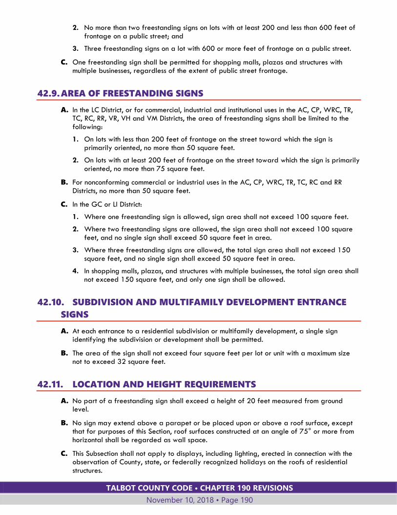
TALBOT COUNTY CODE • CHAPTER 190 REVISIONS
November 10, 2018 • Page 190
2. No more than two freestanding signs on lots with at least 200 and less than 600 feet of frontage on a public street; and
3. Three freestanding signs on a lot with 600 or more feet of frontage on a public street.
C. One freestanding sign shall be permitted for shopping malls, plazas and structures with multiple businesses, regardless of the extent of public street frontage.
42.9. AREA OF FREESTANDING SIGNS
A. In the LC District, or for commercial, industrial and institutional uses in the AC, CP, WRC, TR, TC, RC, RR, VR, VH and VM Districts, the area of freestanding signs shall be limited to the following:
1. On lots with less than 200 feet of frontage on the street toward which the sign is primarily oriented, no more than 50 square feet.
2. On lots with at least 200 feet of frontage on the street toward which the sign is primarily oriented, no more than 75 square feet.
B. For nonconforming commercial or industrial uses in the AC, CP, WRC, TR, TC, RC and RR Districts, no more than 50 square feet.
C. In the GC or LI District:
1. Where one freestanding sign is allowed, sign area shall not exceed 100 square feet.
2. Where two freestanding signs are allowed, the sign area shall not exceed 100 square feet, and no single sign shall exceed 50 square feet in area.
3. Where three freestanding signs are allowed, the total sign area shall not exceed 150 square feet, and no single sign shall exceed 50 square feet in area.
4. In shopping malls, plazas, and structures with multiple businesses, the total sign area shall not exceed 150 square feet, and only one sign shall be allowed.
42.10. SUBDIVISION AND MULTIFAMILY DEVELOPMENT ENTRANCE
SIGNS
A. At each entrance to a residential subdivision or multifamily development, a single sign identifying the subdivision or development shall be permitted.
B. The area of the sign shall not exceed four square feet per lot or unit with a maximum size not to exceed 32 square feet.
42.11. LOCATION AND HEIGHT REQUIREMENTS
A. No part of a freestanding sign shall exceed a height of 20 feet measured from ground level.
B. No sign may extend above a parapet or be placed upon or above a roof surface, except that for purposes of this Section, roof surfaces constructed at an angle of 75° or more from horizontal shall be regarded as wall space.
C. This Subsection shall not apply to displays, including lighting, erected in connection with the observation of County, state, or federally recognized holidays on the roofs of residential structures.

TALBOT COUNTY CODE • CHAPTER 190 REVISIONS
November 10, 2018 • Page 191
D. No sign attached to a building may project more than two feet from the building wall.
E. No sign or supporting structure may be located in or over any portion of a public right-of-way. Signs may be located in a required setback area.
F. No sign may be located so that it interferes with the view necessary for motorists to proceed safely through intersections or to enter onto or exit from public streets or private roads.
42.12. SIGN ILLUMINATION
A. Lighting directed toward a sign shall be shielded so that it illuminates only the face of the sign and does not shine directly into a public road right-of-way or premises.
B. Signs may be backlit, provided that the lighting source is adequately diffused as determined by the Planning Director.
C. No sign within 150 feet of a residential zone shall be illuminated between 11:00 p.m. and 6:00 a.m., unless the impact of such lighting beyond the boundaries of the lot where it is located is entirely inconsequential as determined by the Planning Director.
D. Illuminated tubing or strings of lights that outline property lines, sales areas, rooflines, doors, windows, or similar areas are prohibited.
E. No sign may contain or be illuminated by flashing or intermittent lights or lights of changing degrees of intensity, except that electronic changing message signs in accordance with Subsection 190-42.13 below may be used to indicate the time, date or weather conditions.
F. Subsections D and E above do not apply to temporary signs erected in connection with the observance of County, state, or federally recognized holidays.
42.13. ELECTRONIC MESSAGE SIGNS Freestanding signs that incorporate or consist of an electronic message center are subject to the following:
A. No more than one such sign per lot shall be used.
B. The maximum area of the electronic, changing message board is 16 square feet.
C. The surface area copy may not change more frequently than once daily.
D. The sign shall have no revolving, flashing, moving, scrolling, rotating or similar intermittent lights or features that simulate movement.
E. The sign may not be animated, play video or audio messages, or blink in any manner.
F. The changing message shall consist only of alphabetic or numeric characters. Logos and images, if used, shall not change.
G. Such signs are prohibited except where specifically permitted by this §190-42.
42.14. PROHIBITED SIGNS The following signs are prohibited in all districts:
A. Off-premises signs, except those exempted from regulation or permit requirements under this §190-42.
TALBOT COUNTY CODE • CHAPTER 190 REVISIONS
November 10, 2018 • Page 192
B. Signs that revolve, are animated or utilize movement or apparent movement, such as banners, streamers, animated display boards, pennants, and propellers, except that:
1. Signs that only move occasionally because of wind are not prohibited if their movement is not a primary design feature of the sign and is not intended to attract attention to the sign.
2. This restriction shall not apply to flags or insignia permitted by §190-42.3.F.
3. This restriction also does not apply to electronic changing message signs that are limited to displaying the time, date, or weather conditions, included in the allowed sign area for the site.
C. Any sign that by its location, color, size, shape, nature, or message tends to obstruct the view of or be confused with official traffic signs or other signs erected by governmental agencies.
42.15. CONSTRUCTION AND MAINTENANCE OF SIGNS
A. Signs and components thereof, including supports, braces, and anchors, shall be kept in a state of good repair.
B. Freestanding signs shall be securely fastened to the ground or to a substantial supportive structure so that there is virtually no danger that the sign or supportive structure may be moved by the wind or other forces of nature and cause injury to persons or property.
C. If a sign advertises a business, service, commodity, or other enterprise or activity that is no longer operating or being offered, that sign shall be considered abandoned and shall, within 30 days after such abandonment, be removed by the sign owner, the owner of the property where the sign is located, or other party having control over such sign.
D. If the message portion of a sign is removed, leaving only the supporting shell of a sign or the supporting braces, anchors, or similar components, the owner of the sign or the owner of the property where the sign is located or other person having control over such sign shall, within 30 days of the removal of the message portion of the sign, either replace the entire message portion of the sign or remove the remaining components of the sign.
E. No person may, for the purpose of increasing or enhancing the visibility of a sign, damage, trim, destroy, or remove any trees, shrubs, or other vegetation located:
1. Within the right-of-way of a public road, unless the work is done pursuant to written authorization from Talbot County or the State of Maryland.
2. On property that is not under the ownership or control of the person doing or responsible for such work, unless the work is done pursuant to the express authorization of the person owning the property where such trees or shrubs are located.
3. In any area where such trees or shrubs are required to remain under a permit issued under this chapter.
42.16. NONCONFORMING SIGNS
A. On-premises signs that lawfully existed on November 9, 1991, and were nonconforming to the height, size, or spacing limitations by no more than 10%, or were nonconforming to setback requirements, are permitted to remain in their existing location subject to the remaining requirements of this Section.
TALBOT COUNTY CODE • CHAPTER 190 REVISIONS
November 10, 2018 • Page 193
B. Signs that were lawfully installed after November 9, 1991, and are nonconforming due to revisions to bulk requirements, are permitted to remain at their existing location subject to the remaining requirements of this Section.
C. All other on-premises signs not complying with the requirements of this Section were required to be removed within three years of November 9, 1991. All off-premises signs were required to be removed within two years of November 9, 1991. Any such signs still in existence are in violation of this chapter and subject to the enforcement provisions of this chapter.
D. No nonconforming sign may be enlarged or altered in such a manner as to aggravate the nonconforming condition, nor may illumination be added to any nonconforming sign.
E. A nonconforming sign may not be moved or replaced except to bring the sign into complete conformity with this chapter.
F. If a nonconforming sign is destroyed by natural causes, it may not thereafter be repaired, reconstructed, or replaced except in conformity with all the provisions of this chapter, and the remnants of the former sign structure shall be cleared from the land. For purposes of this Section, a nonconforming sign is destroyed if damaged to an extent that the cost of repairing the sign to its former stature or replacing it with an equivalent sign exceeds more than 50% of its present value.
G. The message of a nonconforming sign may be changed so long as this does not create any new nonconformity (for example, by creating an off-premises sign under circumstances where such a sign would not be allowed).
H. Subject to the other provisions of this Section, nonconforming signs may be repaired and renovated so long as the cost of such work does not exceed within any twelve-month period 50% of the value (tax value if listed for tax purposes) of such sign.
I. If a nonconforming sign advertises a business, service, commodity, or other enterprise or activity that is no longer operating or being offered or conducted, that sign shall be considered abandoned and shall be removed within 30 days after such abandonment by the sign owner, owner of the property where the sign is located, or other person having control over such sign.
Section 190-43 OTHER DEVELOPMENT STANDARDS In addition to the requirements established in this chapter, development activity shall comply with applicable local, state and federal plans and regulations, including but not limited to the following:
A. Roads and Bridges (Chapter 134), Floodplain Management (Chapter 70), Stormwater Management (Chapter 164), Building Construction (Chapter 28), Noise Ordinance (Chapter 92) and other applicable laws of the County.
B. Sediment and erosion control. The applicant shall construct sediment and erosion control structures and facilities as required by the Talbot County Soil Conservation District.
C. Water and sewerage systems. The applicant shall construct water supply and sewage collection or disposal facilities as required by the state health regulations and/or the County Engineer.
D. The County Comprehensive Plan, Comprehensive Water and Sewer Plan, and Capital Program as adopted.
E. State and federal regulations relating to the development of land.

TALBOT COUNTY CODE • CHAPTER 190 REVISIONS
November 10, 2018 • Page 194
Section 190-44 RESERVED
Section 190-45 RESERVED
Section 190-46 RESERVED

TALBOT COUNTY CODE • CHAPTER 190 REVISIONS
November 10, 2018 • Page 195
ARTICLE VI: NONCONFORMING LOTS,
STRUCTURES AND USES
Section 190-47 GENERAL
47.1. PURPOSE
A. This Article is intended to allow lawfully established nonconforming lots, uses and structures to continue, but to limit the number and extent of nonconforming uses and structures by prohibiting or restricting enlargement, reestablishment after abandonment, reconstruction or change in use.
B. Except as otherwise provided in this Article, any nonconforming lot, structure or use may continue, provided it remains otherwise lawful.
47.2. CERTIFICATION OF NONCONFORMING STATUS
A. AUTHORITY; CERTIFICATION REQUIRED FOR DEVELOPMENT
The Planning Director shall have the authority to certify that a lot, structure or use is legally nonconforming. An application to the Department of Planning and Zoning for certification of nonconforming status for a lot, structure or use:
1. May be submitted by a property owner at any time.
2. Must be submitted prior to review of an application for development activity on a nonconforming lot or a site with a nonconforming structure or use.
B. APPLICATION
The application shall include, as applicable:
1. Documentation that the lot was legally created.
2. Documentation that the structure was legally constructed, including all structure dimensions and lot coverage.
3. Documentation that the use was legally established, continuously maintained and not abandoned since its establishment, including documentation of the area of land and structures devoted to the nonconforming use.
C. BURDEN OF PROOF
1. The burden of establishing the legal nonconforming status shall be upon the owner of the land.
2. The casual, temporary, intermittent or illegal use of land is insufficient to establish the existence of a nonconforming use or structure.
3. The existence of a nonconforming use shall not be construed to establish a nonconforming use on the entire premises. The portion of the premises where the legal nonconforming use exists must be defined.
TALBOT COUNTY CODE • CHAPTER 190 REVISIONS
November 10, 2018 • Page 196
D. CERTIFICATE OF NONCONFORMITY
Upon finding that a legal nonconforming lot, structure or use exists, the Planning Director shall issue a certificate of nonconformity. The certificate shall specify the nature and extent of the legal nonconformity, including the land and building area devoted to a nonconforming use, the extent of nonconforming lot coverage, the dimensions of nonconforming structures and other dimensions as applicable
E. APPEAL
The Planning Director's determination may be appealed to the Board of Appeals within 30 days of certificate issuance.
F. REGISTER OF CERTIFICATES
The Planning Director shall maintain a register of certificates issued for nonconforming lots, structures and uses.
47.3. ABANDONMENT If a nonconforming use is discontinued or abandoned, or a nonconforming structure is unused or abandoned, for 12 consecutive months, the land or structure shall not thereafter be used except in conformity with the regulations of the district in which it is located. Cessation of the use for the purpose of repair or remodeling, or a temporary vacancy between occupants while the property is being actively marketed and maintained in good condition, shall not constitute discontinuance or abandonment.
47.4. REPLACEMENT AND RECONSTRUCTION Nonconforming uses and structures may be replaced or reconstructed subject to the restrictions in this Article. As used in this Article:
A. "In-kind replacement" means the replacement of a structure with another structure that is identical to or smaller than the original structure in all dimensions, including footprint area, height, width, length, and use. An in-kind replacement may include minor modifications or relocations, such as differences in roofline or small shifts in location that do not increase any nonconformity, as determined by the Planning Director.
B. “Reconstruction” means the replacement or restoration of a structure after substantial damage has occurred due to fire, flood or other natural cause, or intentional demolition. Substantial damage is damage sustained by a structure whereby the cost of restoring the structure to its before damaged condition would equal or exceed 50 percent of the structure’s market value before the damage occurred.
47.5. NONCONFORMITIES TO CERTAIN CRITICAL AREA REQUIREMENTS
A. Structures located over water, including boathouses and floating residences, but excluding piers, are prohibited in the Critical Area by §190-15.4.A.
1. Existing, nonconforming structures over water shall not be expanded or enlarged.
2. In-kind replacement of existing boathouses shall be permitted.
B. Certain land uses in the Critical Area are restricted by standards in Article IV, Land Uses, to a maximum floor area or site area. Uses in the Critical Area that are nonconforming to such Critical Area requirements shall not be enlarged to increase the nonconformity through the provisions of this Article for expansion of a nonconforming use or nonconforming structure.
TALBOT COUNTY CODE • CHAPTER 190 REVISIONS
November 10, 2018 • Page 197
Section 190-48 NONCONFORMING USES
48.1. CHANGE OF USE; IN-KIND REPLACEMENT
A. A nonconforming use shall not be changed to any use other than a use currently permitted in the zoning district in which it is located.
B. A structure utilized for a nonconforming use shall not be moved, or razed and rebuilt, unless the use is changed to a permitted use or unless approved by the Planning Director as an in-kind replacement.
48.2. MINOR MODIFICATION OF NONCONFORMING USE The Planning Director shall have authority to approve the following minor modifications of nonconforming uses:
A. In-kind replacement of a building.
B. Minor alterations that do not increase or relocate the area devoted to a nonconforming use. These include installment of fencing or landscaping, driveway or access improvements, handicapped access ramps, and other minor site or building features.
C. Replacement of a nonconforming mobile or manufactured home with another mobile or manufactured home, provided that the replacement home:
1. Is in the same general location; and
2. Complies with the setback requirements for the zoning district unless a variance is granted; and,
3. Shall be placed on a permanent foundation, securely anchored and provided with skirting of a suitable material.
48.3. EXPANSION AND MAJOR MODIFICATION OF NONCONFORMING
USES Expansion of a nonconforming use, or modifications to site improvements deemed major by the Planning Director, shall be permitted only if approved by the Board of Appeals, subject to the following criteria:
A. Applications shall be subject to the procedures and requirements of §190-56 for Board of Appeals special exception applications.
B. Expansion of structures utilized for nonconforming uses shall be limited to no more than 20% of the gross floor area of the nonconforming use.
C. Expansion of areas of a nonconforming use not involving structures, such as outdoor parking and storage, shall be limited to no more than 20% of the site area existing on the date the use became nonconforming.
D. The Board of Appeals shall evaluate applications for expansion or modification of a nonconforming use applying the standards for special exceptions in §190-56.2. The Board of Appeals shall consider the recommendation of the Planning Commission.
E. Expansion of a golf course in the RC District shall be permitted if the new "in play" expansion area is:

TALBOT COUNTY CODE • CHAPTER 190 REVISIONS
November 10, 2018 • Page 198
1. Limited to no more than 20% of the total "in play" area of the course located within the RC District as of August 13, 1989;
2. Set back a minimum of 300 feet from tidal water or tidal wetlands;
3. Set back a minimum of 150 feet from edge of tributary streams; and
4. If accessed by cart paths, the cart paths shall be designed to minimize environmental impacts, including the number, location, configuration and construction of the crossings.
48.4. RECONSTRUCTION
A. A structure used for a nonconforming use that is substantially damaged by fire or natural cause may be reconstructed at the same location, provided that:
1. A building permit for restoration/reconstruction shall be issued only to the person(s) who owned the property at the time of the destruction.
2. Restoration must be started within one year of the destruction and completed in accordance with the building permit.
3. The Planning Director may grant a single extension of this time limit, for a period not to exceed one year, only to the same property owner.
B. The reconstructed use shall not increase the extent of the nonconformity.
C. A restored or rebuilt structure that is to be occupied by the nonconforming use must be an in-kind replacement of the destroyed structure.
D. If the use is not replaced or restored within the required time period, any future use on the site shall comply with the current zoning requirements.
Section 190-49 NONCONFORMING LOTS
49.1. DEVELOPMENT ACTIVITY ON NONCONFORMING LOTS
A. A legally existing lot that does not meet current lot size or width requirements shall not be treated as a separate lot if it is combined for zoning purposes with another lot or parcel as provided in §190-51.
B. If it is not combined for zoning purposes with another lot or parcel, a nonconforming lot may be developed or reconfigured, provided that the proposed improvements will comply with all other requirements of this chapter and applicable environmental regulations, including required setbacks, lot coverage limits, and preservation of habitat protection areas to include streams, wetlands and forest.
C. If located within the Critical Area:
1. A nonconforming lot may be improved if the proposed development activity complies with Critical Area purposes and requirements. The extent of development on the site shall be limited as necessary to allow compliance with Critical Area standards within the constraints of the nonconforming lot.
2. If the proposed development activity does not comply with all Critical Area standards:
TALBOT COUNTY CODE • CHAPTER 190 REVISIONS
November 10, 2018 • Page 199
a. If possible, the lot shall be consolidated with adjacent lots under common ownership to reduce or eliminate nonconformity and allow compliance with Critical Area standards;
b. If lot consolidation is not possible, variances may be considered in accordance with the standards for Critical Area variances (§190-58.4).
49.2. CONSOLIDATION OR RECONFIGURATION OF NONCONFORMING
LOTS IN THE CRITICAL AREA
A. The proposed consolidation or reconfiguration of legally existing, nonconforming lots of record within the Critical Area Overlay District shall not:
1. Result in a greater number of development rights, lots or dwelling units in the Critical Area than the existing configuration of all legally created lots; or
2. Create any additional riparian lots; or
3. Increase or intensify impacts associated with riparian access.
B. Proposed consolidation or reconfiguration of lots shall identify habitat protection areas and result in no greater impacts to any habitat protection area than impacts that could have resulted from the existing lot configuration. Protective measures shall be provided to minimize impacts and restoration measures to mitigate for impacts.
C. The proposed consolidation or reconfiguration of lots shall be in conformance with the revision plat procedures of §190-71 and the Critical Area Commission’s criteria for lot consolidation and reconfiguration found in COMAR 27.01.02.08.
49.3. RESIDENTIAL DENSITY IN THE CRITICAL AREA
A. Development on any lot within the Critical Area that does not comply with Critical Area density requirements is subject to the following as required by COMAR 27.01.02.07.B.
B. Except as otherwise provided, the County shall permit a single lot or parcel of land that was legally of record on August 13, 1989, to be developed with a single-family dwelling if a dwelling is not already placed there (notwithstanding that such development may be inconsistent with the density provisions of this Chapter), provided that:
1. It is on land where development activity as of December 1, 1985 progressed to the point of the pouring of foundation footings or the installation of structural members; or,
2. It is either a legal parcel of land, not being part of a recorded or approved subdivision, that was recorded as of December 1, 1985, or land that was subdivided into recorded, legally buildable lots, where the subdivision received the County's final approval prior to June 1, 1984, if:
a. At the time of development, the land is brought into conformance with the Critical Area Program insofar as possible, including the consolidation or configuration of lots not individually owned; or
b. The land received a building permit subsequent to December 1, 1985, but prior to local program approval.
3. It is on land that was subdivided into recorded, legally buildable lots, where the subdivision received the County's final approval between June 1, 1984, and December 1, 1985.
TALBOT COUNTY CODE • CHAPTER 190 REVISIONS
November 10, 2018 • Page 200
4. It is on land that was subdivided into recorded, legally buildable lots, where the subdivision received the final approval after December 1, 1985, and provided that either development of any such land conforms to the IDA, LDA or RCA requirements in this chapter or the area of the land is counted against the County’s growth allocation (§190-55.5).
C. Nothing in this Section may be interpreted as altering any requirements for development activities set out in the water-dependent facilities Section or the habitat protection areas Section of this chapter.
D. Consolidation or reconfiguration of lots shall be in conformance with §190-49.2 above.
49.4. DIVISION OF PARCEL WITH TWO OR MORE PRIMARY DWELLINGS
A. A parcel or lot that has been developed with two or more primary single-family residences prior to August 13, 1989, in the Critical Area and June 22, 1991, in the non-Critical Area may be divided into lots that do not conform to the density provisions of this chapter. The subdivision shall comply in all other respects with the provisions of this chapter.
B. In no case shall the property be divided into more lots or parcels than there are existing single-family residences. One residence must be located on each parcel.
C. Property containing employee residences, detached accessory dwellings, or hotel or motel uses may not be divided under this Section.
49.5. LOT REDUCED IN SIZE BY GOVERNMENT ACTION
A. If a lot is reduced in size below the minimum lot size by a government action (such as right-of-way acquisition), the lot shall be considered conforming for purposes of these regulations. The property owner is not required to seek a Certificate of Nonconformity prior to development activity.
B. If a lot is nonconforming to lot width by a government action (such as a comprehensive rezoning), the property owner shall seek a Certificate of Nonconformity prior to development activity.
Section 190-50 NONCONFORMING STRUCTURES
50.1. EXPANSION THAT DOES NOT INCREASE NONCONFORMITY
A. Expansion of a nonconforming structure is permitted if the proposed area of expansion complies with bulk requirements (setback, lot coverage and height).
B. Vertical expansion of nonconforming buildings is permitted without a variance for buildings within the Shoreline Development Buffer and buildings nonconforming to lot coverage requirements, if the expansion:
1. Does not increase lot coverage;
2. For a building within the Shoreline Development Buffer, is no closer to Mean High Water than the existing walls; and
3. Complies with all other requirements of this chapter.
TALBOT COUNTY CODE • CHAPTER 190 REVISIONS
November 10, 2018 • Page 201
50.2. CHANGE OF USE The use of a nonconforming structure shall not be changed to a more intensive use.
50.3. VARIANCE REQUIRED TO EXPAND
A. A variance is required to expand a nonconforming structure if the expanded area does not comply with bulk requirements.
B. The variance must be approved by the Board of Appeals, unless the expansion can be approved by the Planning Director as a minor variance as provided in Subsection C below. Procedures and standards for variance applications are established in §190-58.
C. Expansion of a nonconforming structure may be submitted as a minor variance application if the application meets all of the following criteria:
1. The expansion encroaches no further than the existing structure into a required setback or buffer.
2. Within the Critical Area, the expansion will not increase the structure’s lot coverage by more than 20% of the nonconforming portion of the structure existing on August 13, 1989. The cumulative result of multiple expansions must comply with this standard and the lot coverage limits for the entire site.
3. Outside the Critical Area, the expansion will not increase the structure’s lot coverage by more than 20% of the nonconforming portion of the structure existing on June 22, 1991. The cumulative result of multiple expansions must comply with this standard and the lot coverage limits for the entire site as applicable.
4. The expansion will not result in lot coverage that exceeds the limits set forth in this Chapter.
5. If the lot is currently nonconforming to the lot coverage requirement, the proposed expansion will not increase the site’s lot coverage beyond that authorized in the certificate of nonconformity as required by §190-47.2.
50.4. RECONSTRUCTION AND RELOCATION
A. RECONSTRUCTION
Reconstruction of a nonconforming structure is permitted without approval of variances, provided that all of the following requirements are met:
1. The substantial damage or destruction is not the result of neglect and deferred maintenance due to abandonment of the structure for 12 or more consecutive months. A structure that has been abandoned for 12 or more consecutive months is no longer a legal nonconforming structure.
2. A building permit for restoration/reconstruction shall be issued only to the person(s) who owned the property at the time the substantial damage occurred.
3. Construction must be started within one year of the substantial damage and completed in accordance with the building permit.
4. The Planning Director may grant a single extension of this time limit, for a period not to exceed one year, only to the same property owner.
5. The replacement shall be in-kind.
TALBOT COUNTY CODE • CHAPTER 190 REVISIONS
November 10, 2018 • Page 202
6. Increases in the elevation of a building required by floodplain regulations shall not be counted as an increase in height unless the elevation increase creates additional gross floor area.
7. If the Planning Director determines that a proposed reconstruction is not in-kind, the new structure shall be permitted only with approval of the applicable variances.
8. If a structure in the Shoreline Development Buffer is replaced under this Section, the replacement structure shall not be expanded through the minor variance provisions. Instead, any expansion of the replacement structure that does not comply with bulk requirements shall require a variance application to the Board of Appeals.
B. RELOCATION
A nonconforming structure may be relocated or demolished and replaced at a different location on the same lot, provided that any one of the following requirements is met:
1. The relocated structure complies with all bulk requirements.
2. The Board of Appeals grants the necessary variances.
3. A minor variance application may be submitted for a decision by the Planning Director if the relocated structure lessens the extent of the nonconformity; is of the same or smaller dimensions than the original structure; and is located in the same general area of the lot.
4. A minor variance application may be submitted for a decision by the Planning Director for relocated structures within the Shoreline Development Buffer, provided that:
a. The relocated structure lessens the extent of the nonconformity; is of the same or smaller dimensions than the original structure; and is located in the same general area of the lot; and,
b. Both the Buffer area and the entire site will comply with the Critical Area lot coverage requirement or, if nonconforming to the lot coverage requirement, the proposed relocation will not increase the lot coverage either within the Buffer or for the entire site. (See §190-15.6.B for lot coverage requirements.)
5. The procedures and standards for variances in §190-58 shall apply.
Section 190-51 CONTIGUOUS LOTS TREATED AS ONE LOT FOR
ZONING PURPOSES
51.1. IMPROVEMENTS ACROSS LOT LINES OR IN VIOLATION OF
SETBACKS
A. Two contiguous lots in common ownership shall not be treated as a single lot to construct improvements across lot lines or in violation of setback requirements.
B. Where structures were legally erected prior to June 13, 2009, contiguous lots shall be treated as one lot for purposes of this chapter, and must remain under common ownership, if any one of the following is true:
1. A structure is built across a property line of contiguous lots in common ownership; or
2. A structure is built within the building restriction area of a lot line shared with a contiguous lot in common ownership, without a variance from the Board of Appeals or other authorization as provided in this chapter; or
TALBOT COUNTY CODE • CHAPTER 190 REVISIONS
November 10, 2018 • Page 203
3. A primary structure is built on one lot and accessory structures or uses (e.g., garage, shed, pool, driveway, sewage disposal area) are located on a contiguous lot under common ownership without the granting of a special exception by the Board of Appeals.
51.2. TREATMENT AS SEPARATE LOTS Parcels considered merged for zoning purposes shall be treated as separate lots again only if both lots, including all uses and structures on the lots, comply with current requirements of the Talbot County Code, including minimum lot size, minimum lot width and setback requirements. This shall include the following:
A. Structures or portions of structures crossing the common boundary line shall be removed so that all structures meet required setbacks;
B. Structures or portions of structures within the required building setback shall be removed;
C. Accessory structures and uses on the lot without a primary dwelling shall be removed; and,
D. If the merged lots have more than one pier or primary dwelling, the separated lots shall have only one primary dwelling unit and only one pier per lot.
Section 190-52 RESERVED
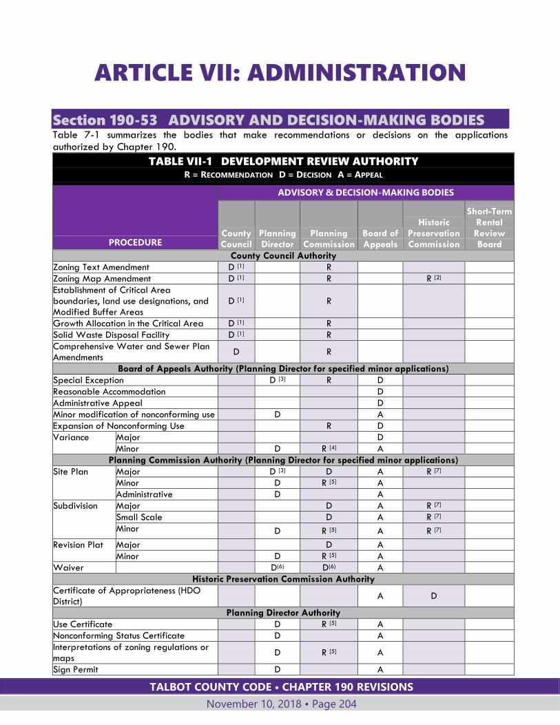
TALBOT COUNTY CODE • CHAPTER 190 REVISIONS
November 10, 2018 • Page 204
ARTICLE VII: ADMINISTRATION
Section 190-53 ADVISORY AND DECISION-MAKING BODIES Table 7-1 summarizes the bodies that make recommendations or decisions on the applications authorized by Chapter 190.
TABLE VII-1 DEVELOPMENT REVIEW AUTHORITY R = RECOMMENDATION D = DECISION A = APPEAL
PROCEDURE
ADVISORY & DECISION-MAKING BODIES
County Council
Planning Director
Planning Commission
Board of Appeals
Historic Preservation Commission
Short-Term Rental Review Board
County Council Authority
Zoning Text Amendment D [1] R
Zoning Map Amendment D [1] R R [2]
Establishment of Critical Area boundaries, land use designations, and Modified Buffer Areas
D [1]
R
Growth Allocation in the Critical Area D [1] R
Solid Waste Disposal Facility D [1] R
Comprehensive Water and Sewer Plan Amendments
D
R
Board of Appeals Authority (Planning Director for specified minor applications)
Special Exception D [3] R D
Reasonable Accommodation D
Administrative Appeal D
Minor modification of nonconforming use D A
Expansion of Nonconforming Use R D
Variance Major D
Minor D R [4] A
Planning Commission Authority (Planning Director for specified minor applications)
Site Plan Major D [3] D A R [7]
Minor D R [5] A
Administrative D A
Subdivision Major D A R [7]
Small Scale D A R [7]
Minor D R [5] A R [7]
Revision Plat Major D A
Minor D R [5] A
Waiver D(6) D(6) A
Historic Preservation Commission Authority
Certificate of Appropriateness (HDO District)
A D
Planning Director Authority
Use Certificate D R [5] A
Nonconforming Status Certificate D A
Interpretations of zoning regulations or maps
D R [5] A
Sign Permit D A
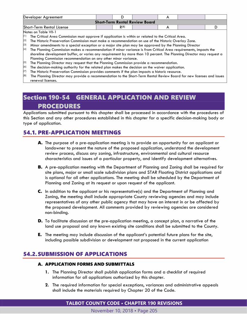
TALBOT COUNTY CODE • CHAPTER 190 REVISIONS
November 10, 2018 • Page 205
Developer Agreement D A
Short-Term Rental Review Board
Short-Term Rental License R[8] A D Notes on Table VII-1 [1] The Critical Area Commission must approve if application is within or related to the Critical Area. [2] The Historic Preservation Commission must make a recommendation on use of the Historic Overlay Zone. [3] Minor amendments to a special exception or a major site plan may be approved by the Planning Director [4] The Planning Commission makes a recommendation if minor variance is from Critical Area requirements, impacts the
shoreline development buffer, or varies any requirement by more than 10 percent. The Planning Director may request a Planning Commission recommendation on any other minor variance.
[5] The Planning Director may request that the Planning Commission provide a recommendation. [6] The decision-making authority for the related plan makes the decision on the waiver application. [7] The Historic Preservation Commission provides comments if the plan impacts a historic resource. [8] The Planning Director may provide a recommendation to the Short-Term Rental Review Board for new licenses and issues
renewal licenses.
Section 190-54 GENERAL APPLICATION AND REVIEW
PROCEDURES Applications submitted pursuant to this chapter shall be processed in accordance with the procedures of this Section and any other procedures established in this chapter for a specific decision-making body or type of application.
54.1. PRE-APPLICATION MEETINGS
A. The purpose of a pre-application meeting is to provide an opportunity for an applicant or landowner to present the nature of the proposed application, understand the development review process, discuss any zoning, infrastructure, environmental and cultural resource characteristics and issues of a particular property, and identify development alternatives.
B. A pre-application meeting with the Department of Planning and Zoning shall be required for site plans, major or small scale subdivision plans and STAR Floating District applications and is optional for all other applications. The meeting shall be scheduled by the Department of Planning and Zoning at its request or upon request of the applicant.
C. In addition to the applicant or his representative(s) and the Department of Planning and Zoning, the meeting shall include appropriate County reviewing agencies and may include representatives of any other public agency that may have an interest in or be affected by the proposed development. All comments provided by reviewing agencies are considered non-binding.
D. To facilitate discussion at the pre-application meeting, a concept plan, a narrative of the land use proposal and any known existing site conditions shall be submitted to the County.
E. The meeting may include discussion of the applicant’s potential future plans for the site, including possible subdivision or development not proposed in the current application
54.2. SUBMISSION OF APPLICATIONS
A. APPLICATION FORMS AND SUBMITTALS
1. The Planning Director shall publish application forms and a checklist of required information for all applications authorized by this chapter.
2. The required information for special exceptions, variances and administrative appeals shall include the materials required by Chapter 20 of the Code.
TALBOT COUNTY CODE • CHAPTER 190 REVISIONS
November 10, 2018 • Page 206
3. The Planning Director shall have the authority to request additional information not specifically listed on the application forms to ensure compliance with this Code.
4. All applications must be accompanied by required fees in accordance with the fee schedule established by the County Council.
B. REVIEW FOR COMPLETENESS
Unless otherwise specified in Chapter 190, all proposed development shall be subject to the following:
1. A complete application accompanied by all required fees shall be submitted prior to the regularly scheduled meeting of the applicable advisory or decision-making body where the request is considered. The Planning Director has the discretion to not schedule an application for the next regularly scheduled meeting if the Planning Director determines more time is needed to investigate and prepare a review in order to make an appropriate presentation before the applicable advisory or decision-making body.
2. All applications shall be submitted to the Department of Planning and Zoning. The applicant shall submit paper copies of the application to the Planning Director for staff review of completeness. The Director may require a greater or fewer number of copies of the plan as it determines to be appropriate. If produced electronically, an electronic copy of the required submission materials (plats, plans, exhibits, studies, reports, legal documents and letters) shall also be included with each submission in standard digital format as specified by the Planning Director.
3. The Planning Director shall determine, within fifteen (15) days, if the application is complete. No application shall be deemed complete unless all the information required is included, and all filing fees have been paid.
4. If an application is determined not to be complete, the Planning Director shall specify those parts of the application which are deficient and list additional information that must be supplied. No further action on the application shall be taken until the deficiencies are remedied and the application shall not be processed until deemed complete.
5. The Planning Director’s determination that an application is deemed complete is solely for the purpose of determining whether preliminary information required for submission with the application is sufficient to allow further processing and shall not constitute a determination that the application meets requirements for approval and shall not preclude a request for additional information or materials in the future to complete the review of the application.
6. The provisions of this Subsection shall not be construed as requiring an applicant to submit, with the initial application, the entirety of the information which the reviewing agency may require in order to take final action on the application.
7. When the application is determined complete, copies of the application shall be distributed to the appropriate reviewing agencies or decision-making bodies.
C. COORDINATED PROCESSING
If more than one type of application is required by this chapter for a particular development proposal, the Planning Director will, to the extent possible, provide for concurrent review of applications related to the same proposed development or activity.

TALBOT COUNTY CODE • CHAPTER 190 REVISIONS
November 10, 2018 • Page 207
54.3. NOTIFICATION OF CRITICAL AREA COMMISSION
A. If an application for a Zoning Map amendment, special exception, variance, site plan or subdivision plan involves development located wholly or partially within the Critical Area:
1. The Planning Director shall send the application to the Critical Area Commission at least two weeks prior to a scheduled public meeting before the decision-making body for the application.
2. The Planning Director shall notify the Critical Area Commission of the decision to approve or deny the application within 10 days of the decision.
3. If the application is for a variance to a Critical Area requirement, the County shall provide the Critical Area Commission with a copy of the written decision approving or denying the variance within 10 working days after the decision is issued.
B. Comments received from the Critical Area Commission in response to an application shall be forwarded to the body considering the application for its consideration at the public hearing or public meeting. No final decision shall be made on the application until the County has received notification that the application was received by the Critical Area Commission.
C. Amendments to the Critical Area requirements of this chapter and applications for growth allocation, if approved by the County Council, require approval by the Critical Area Commission in accordance with §190-55.1.D below.
54.4. FEES
A. FEE SCHEDULE
The County Council shall establish by resolution a schedule of fees for applications, licenses and other items for which a fee is required. Required fees shall be paid at the time of filing. Processing of an application shall not commence until required fees are paid.
B. THIRD PARTY REVIEW
Where the requirements of this chapter for a particular application or land use authorize an agency, board or commission of Talbot County to obtain third party review of material submitted with the application, the cost of such review shall be paid by the applicant.
54.5. PUBLIC NOTICE Public notice shall be provided of public meetings or hearings required by this chapter as specified below, unless different requirements are specified in this chapter for the particular type of application. Public notice requirements for Board of Appeals hearings are in Chapter 20 of the Code.
A. PUBLICATION OF AGENDAS
1. An agenda shall be published for public meetings or hearings held under the provisions of this chapter. The agenda shall be published prior to the meeting, shall be available to the public in the Department of Planning and Zoning, and shall be made available through other means as required by specific provisions of this chapter, by the rules of procedure of the particular body, or as deemed appropriate by the Planning Director.
2. The agenda shall include the date, time and location of the public meeting or hearing and shall list, for each application, the file or case number, the location of the property, and the type of application.
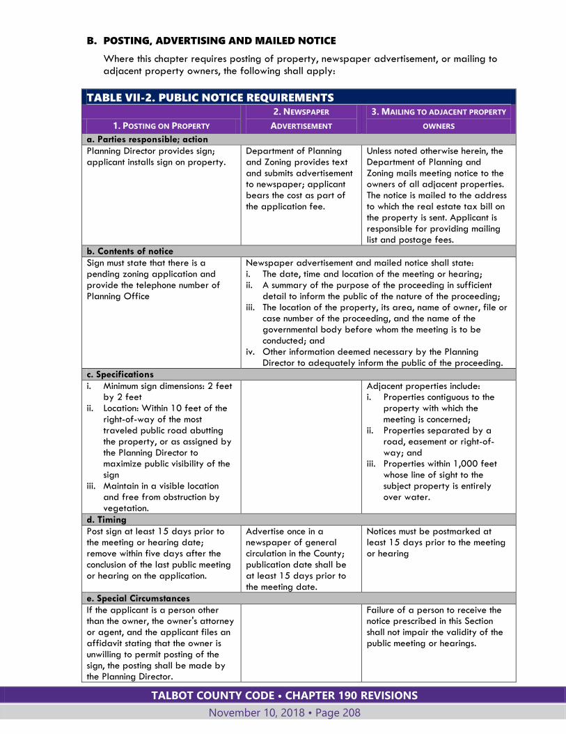
TALBOT COUNTY CODE • CHAPTER 190 REVISIONS
November 10, 2018 • Page 208
B. POSTING, ADVERTISING AND MAILED NOTICE
Where this chapter requires posting of property, newspaper advertisement, or mailing to adjacent property owners, the following shall apply:
TABLE VII-2. PUBLIC NOTICE REQUIREMENTS
1. POSTING ON PROPERTY
2. NEWSPAPER
ADVERTISEMENT
3. MAILING TO ADJACENT PROPERTY
OWNERS
a. Parties responsible; action
Planning Director provides sign; applicant installs sign on property.
Department of Planning and Zoning provides text and submits advertisement to newspaper; applicant bears the cost as part of the application fee.
Unless noted otherwise herein, the Department of Planning and Zoning mails meeting notice to the owners of all adjacent properties. The notice is mailed to the address to which the real estate tax bill on the property is sent. Applicant is responsible for providing mailing list and postage fees.
b. Contents of notice
Sign must state that there is a pending zoning application and provide the telephone number of Planning Office
Newspaper advertisement and mailed notice shall state: i. The date, time and location of the meeting or hearing; ii. A summary of the purpose of the proceeding in sufficient
detail to inform the public of the nature of the proceeding; iii. The location of the property, its area, name of owner, file or
case number of the proceeding, and the name of the governmental body before whom the meeting is to be conducted; and
iv. Other information deemed necessary by the Planning Director to adequately inform the public of the proceeding.
c. Specifications
i. Minimum sign dimensions: 2 feet by 2 feet
ii. Location: Within 10 feet of the right-of-way of the most traveled public road abutting the property, or as assigned by the Planning Director to maximize public visibility of the sign
iii. Maintain in a visible location and free from obstruction by vegetation.
Adjacent properties include: i. Properties contiguous to the
property with which the meeting is concerned;
ii. Properties separated by a road, easement or right-of-way; and
iii. Properties within 1,000 feet whose line of sight to the subject property is entirely over water.
d. Timing
Post sign at least 15 days prior to the meeting or hearing date; remove within five days after the conclusion of the last public meeting or hearing on the application.
Advertise once in a newspaper of general circulation in the County; publication date shall be at least 15 days prior to the meeting date.
Notices must be postmarked at least 15 days prior to the meeting or hearing
e. Special Circumstances
If the applicant is a person other than the owner, the owner's attorney or agent, and the applicant files an affidavit stating that the owner is unwilling to permit posting of the sign, the posting shall be made by the Planning Director.
Failure of a person to receive the notice prescribed in this Section shall not impair the validity of the public meeting or hearings.

TALBOT COUNTY CODE • CHAPTER 190 REVISIONS
November 10, 2018 • Page 209
TABLE VII-2. PUBLIC NOTICE REQUIREMENTS
1. POSTING ON PROPERTY
2. NEWSPAPER
ADVERTISEMENT
3. MAILING TO ADJACENT PROPERTY
OWNERS
f. Proof of advertising required
Applicant shall affirm by affidavit that the sign has been continuously posted in compliance with this Section up to the time of the meeting.
Department of Planning and Zoning shall provide proof of publication as part of the official record of the application.
Applicants required to mail notice shall submit Certificates of Mailing, signature receipts, or comparable proof of mailing to the Planning Director at least 15 days prior to the hearing.
g. Notification for continued hearing
The sign shall be maintained until the close of the hearing on the case.
If a meeting is held and continued, a new newspaper advertisement shall not be required.
If a meeting is held and continued, a new mailing to the adjacent property owners shall not be required.
54.6. GENERAL PROCEDURES FOR BOARD OF APPEALS APPLICATIONS
A. The Board of Appeals shall hear and decide on applications for special exceptions, variances, expansion of nonconforming uses, and reasonable accommodation for needs of disabled citizens, as authorized by this Article.
B. In addition, any person aggrieved by a final order or decision of the Planning Director, Planning Commission or Historic Preservation Commission may file an administrative appeal with the Board of Appeals in accordance with Chapter 20 of the County Code.
C. Procedures for the Board of Appeals are given in Chapter 20, Board of Appeals, of the County Code.
Section 190-55 COUNTY COUNCIL APPLICATIONS
55.1. GENERAL PROCEDURES
A. TYPES OF APPLICATIONS
The County Council is authorized to hear and decide on the following applications, as authorized by this Article:
1. Amendments to the text of this chapter.
2. Amendments to the Official Zoning Maps.
3. Amendments to the Critical Area Maps, which include amendments to the boundaries of the Critical Area, the Critical Area land management designations (RCA, LDA and IDA), and Modified Buffer Areas.
4. Applications for use of growth allocation in the Critical Area.
5. Applications to establish or enlarge solid waste disposal sites.
B. PERSONS AUTHORIZED TO APPLY
1. Amendments to the Official Zoning Maps or the zoning text, including Zoning Map amendments in the Critical Area that require growth allocation, may be initiated by the County Council, Planning Commission, or Planning Director.
TALBOT COUNTY CODE • CHAPTER 190 REVISIONS
November 10, 2018 • Page 210
2. In addition to the applications authorized by Subsection B.1 above:
a. A proposed amendment to the text of this chapter may be submitted to the Council by any interested person; and
b. A proposed amendment to a Zoning Map, an application for growth allocation, or an application for a solid waste disposal site may be submitted to the Council by a person with a committed financial, contractual or proprietary interest in the property affected by the amendment.
3. For amendments proposed pursuant to Subsection B.2.a or b above the Council shall review the proposed amendment and any member of the Council may determine that:
a. The subject matter of the text or map amendment has comprehensive impacts to the general welfare of the County and shall direct staff to draft or share in the drafting of the proposed amendment; or
b. The subject matter of the text or map amendment is focused on a specific land use, zoning or other topic and the Council shall authorize staff to process the application to be filed by the interested person; or
c. The proposed amendment is inherently inconsistent with this Chapter and the general policies of the Comprehensive Plan and shall not be processed.
C. REVIEW AND DECISION
1. For applications submitted pursuant to Subsection B.1, B.2.a or B.2.b above, the application shall proceed as indicated below.
2. The Planning Director shall prepare a staff report and recommendation on the application and forward it to the Planning Commission.
3. The Planning Commission shall consider the application and the Planning Director's recommendation at a public meeting and make a recommendation based on the factors and standards required for the particular type of application. The Planning Director shall submit the recommendations and any pertinent information to the County Council within 60 days of acceptance of a complete application.
4. After receiving the recommendations of the Planning Director and Planning Commission, any member of the Council may introduce legislation; if no member of the Council introduces legislation, the application fails.
5. If any member of the County Council introduces legislation the public hearing shall be advertised in accordance with the requirements for posting, newspaper publication, and notice to adjacent property owners specified in §190-54.5 of this Article. Notification of adjacent property owners and posting of the property shall not be required for sectional or comprehensive amendments to the Official Zoning Maps or for zoning text amendments.
6. The Council shall not approve or disapprove an amendment to the Official Zoning Maps until a site visit has been made by a majority of the Council members to inspect the physical features of the property and determine the character of the surrounding area. A site visit shall not be required for sectional or comprehensive amendments to the Official Zoning Maps.
7. Legislation shall be heard in accordance with County Council legislative procedures.
D. APPROVAL BY CHESAPEAKE BAY CRITICAL AREA COMMISSION
These provisions apply to all applications for amendments to the County's Critical Area Program, including revisions to the Critical Area requirements of this chapter, requests for use of growth allocation, and amendments to Critical Area maps.
TALBOT COUNTY CODE • CHAPTER 190 REVISIONS
November 10, 2018 • Page 211
1. Such applications, if approved by the County Council, shall be submitted by the County to the Critical Area Commission for approval. By state law, the Commission has 130 days to act on a request. If no action is taken in 130 days, the request will be considered approved.
2. The County's request for approval of amendments to its Critical Area Program shall include all relevant information necessary for the Critical Area Commission Chairman and, as appropriate, the Commission, to evaluate the changes. The Chairman and, as appropriate, the Commission, shall determine if the program changes are consistent with the purposes, policies, goals and provisions of the Critical Area Law and the Commission's criteria.
3. In accordance with the determination of consistency as outlined above, the Chairman or, as appropriate, the Commission will:
a. Approve the proposed program refinement or amendment and notify the local jurisdiction; or
b. Deny the proposed program refinement or amendment; or
c. Approve the proposed program refinement or amendment subject to one or more conditions; or
d. Return the proposed program refinement or amendment to the local jurisdiction with a list of changes to be made.
4. A request denied by the Critical Area Commission, or returned with changes to be made, may be reconsidered by the County Council. Such a request may be revised by the applicant to address the reasons for Critical Area Commission decision. The revised request shall be submitted to the Planning Director for reconsideration by the County Council within 90 days of Critical Area Commission denial. An extension of the ninety-day deadline may be requested for a specific period of time, if the applicant can demonstrate, to the satisfaction of the Planning Director, circumstances beyond the applicant's control.
E. EFFECTIVE DATE
An application approved by the County Council shall take effect 60 days after the Council bill is passed, and upon approval by the Critical Area Commission if required.
55.2. AMENDMENTS TO OFFICIAL ZONING MAPS
A. PROCEDURES
See §190-54, General Application and Review Procedures, and §190-55.1 above.
B. FACTORS TO BE CONSIDERED
The Council shall consider findings of fact including, but not limited to, the following when making a decision on a proposed amendment to the Official Zoning Maps:
1. Consistency with the purposes and intent of the Talbot County Comprehensive Plan;
2. Compatibility with existing and proposed development and land use in the surrounding area;
3. Availability of public facilities;
4. The effects on present and future transportation patterns; and
5. The effect on population change within the immediate area.
TALBOT COUNTY CODE • CHAPTER 190 REVISIONS
November 10, 2018 • Page 212
C. STANDARDS FOR DECISION
1. After a review of the applicable findings, the Council may grant a Zoning Map amendment based upon one of the following findings:
a. That there was a substantial change in the character of the neighborhood or community where the property is located since the last comprehensive or sectional Zoning Map Amendment, such that the zoning district applied through the comprehensive or sectional amendment is no longer appropriate to the setting and context of the property; or
b. That there was a mistake in the existing zoning classification.
2. The findings given in Subsection C.1 above shall not be required to establish a floating or overlay district or to approve a comprehensive or sectional Zoning Map amendment.
3. Entitlement to connect to public sewer shall not alone be sufficient to support a finding of substantial change in the character of the neighborhood or community where the property is located as set forth in Subsection C.1.a. above.
4. The fact that an application for a Zoning Map amendment complies with all the specific requirements and purposes set forth in this chapter shall not be deemed to create a presumption that the proposed amendment would be compatible with surrounding land uses and is not, in itself, sufficient to require approval.
D. NEW APPLICATION AFTER DENIAL OF MAP AMENDMENT
1. If an application to amend the Official Zoning Maps is denied, either in whole or in part, no application shall be submitted to rezone all or part of the same property for at least one year from the date of the decision.
2. The Council may allow an applicant to withdraw an application at any time. However, if the request for withdrawal is made after publication of the newspaper notice of the public hearing, no application shall be submitted to rezone all or part of the same property for at least one year from the advertised public hearing date, unless the Council specifies that the time limit shall not apply.
E. CHANGING OF OFFICIAL ZONING MAPS
The Planning Director shall change the Official Zoning Maps within 60 days after the adoption of any amendments and shall provide a copy to the Critical Area Commission within 120 days.
55.3. COUNTY COUNCIL PERMIT FOR SOLID WASTE DISPOSAL
FACILITIES
A. PROCEDURES
The establishment or enlargement of a solid waste disposal facility shall require a permit from the County Council. See §190-54, General Application and Review Procedures, and §190-55.1above.
B. REVIEW AND DECISION
1. After an application for a solid waste disposal facility is accepted, the Department of Planning and Zoning shall transmit it to state approval authorities. The application shall not be scheduled for a public meeting before the Planning Commission until any additional information required by state agencies is provided by the applicant.
TALBOT COUNTY CODE • CHAPTER 190 REVISIONS
November 10, 2018 • Page 213
2. The Council decision shall be based upon its determination as to whether the application complies with the requirements of this chapter and adequately protects and safeguards the public health, safety and welfare of the inhabitants of the surrounding residences and of the County.
55.4. TEXT AMENDMENTS
A. PROCEDURES
See §190-54, General Application and Review Procedures, and §190-55.1 above.
B. TEXT AMENDMENTS GENERALLY
Text amendments shall be evaluated based upon their consistency with:
1. The purpose and intent of Chapter 190 and the individual Sections of this Chapter; and
2. Policies and goals of the Comprehensive Plan.
C. TEXT AMENDMENTS TO CRITICAL AREA PROVISIONS
1. Amendments to the Critical Area text provisions shall be consistent with Maryland State Critical Area Law.
2. Any amendment shall not result in permitting uses that would adversely affect any wildlife or plant habitats as a result of a use's intrinsic nature and potential impact.
3. Proposed amendments shall not be granted if they would allow uses in the Critical Area that are prohibited by the Critical Area requirements, §190-15.4.A.
55.5. GROWTH ALLOCATION AND RECLASSIFICATION OF CRITICAL
AREA LAND MANAGEMENT DESIGNATIONS
A. PURPOSE
Pursuant to Maryland’s Critical Area law and the County’s Critical Area Program, Talbot County has a limited amount of growth allocation for development within the Critical Area. Growth allocation is used when the designation of land in the Critical Area is changed from a less intense to a more intense land management designation.
B. USE OF GROWTH ALLOCATION
1. The procedures in this Section govern applications to use the County’s growth allocation or to amend the Critical Area land management designation in the County or specified municipalities.
2. Growth allocation is used when the County Council revises the designation of land from RCA to LDA or IDA, or from LDA to IDA. (See §190-15.3.B, Critical Area Overlay District, for definition of RCA, LDA and IDA).
3. Growth allocation must also be used to allow expanded lot coverage for certain land uses in the Critical Area, as indicated in the requirements for the applicable land uses in Article IV.
4. Change in the land designation from RCA to LDA or LDA to IDA will most often occur in conjunction with a zoning map amendment from the current district to a zoning district allowing more intensive development.
5. Growth allocation may also be used to reclassify land from LDA to IDA without amending the zoning map, in order to allow more intensive land use.
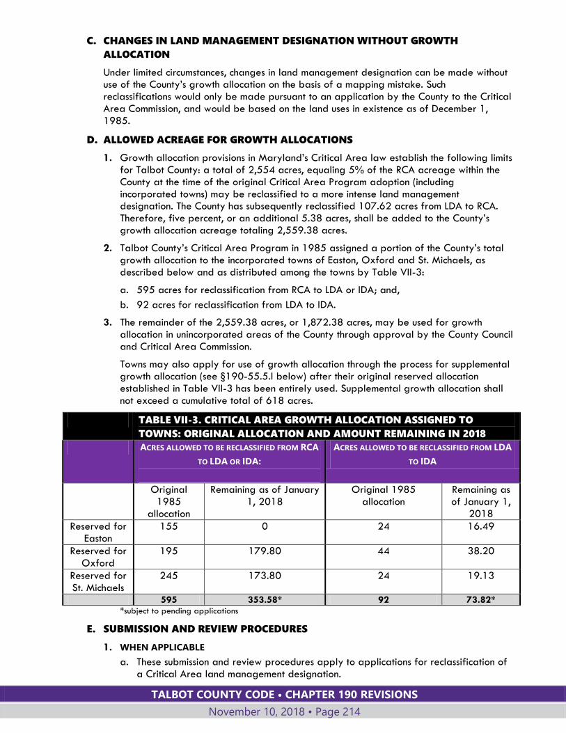
TALBOT COUNTY CODE • CHAPTER 190 REVISIONS
November 10, 2018 • Page 214
C. CHANGES IN LAND MANAGEMENT DESIGNATION WITHOUT GROWTH
ALLOCATION
Under limited circumstances, changes in land management designation can be made without use of the County’s growth allocation on the basis of a mapping mistake. Such reclassifications would only be made pursuant to an application by the County to the Critical Area Commission, and would be based on the land uses in existence as of December 1, 1985.
D. ALLOWED ACREAGE FOR GROWTH ALLOCATIONS
1. Growth allocation provisions in Maryland’s Critical Area law establish the following limits for Talbot County: a total of 2,554 acres, equaling 5% of the RCA acreage within the County at the time of the original Critical Area Program adoption (including incorporated towns) may be reclassified to a more intense land management designation. The County has subsequently reclassified 107.62 acres from LDA to RCA. Therefore, five percent, or an additional 5.38 acres, shall be added to the County’s growth allocation acreage totaling 2,559.38 acres.
2. Talbot County’s Critical Area Program in 1985 assigned a portion of the County’s total growth allocation to the incorporated towns of Easton, Oxford and St. Michaels, as described below and as distributed among the towns by Table VII-3:
a. 595 acres for reclassification from RCA to LDA or IDA; and,
b. 92 acres for reclassification from LDA to IDA.
3. The remainder of the 2,559.38 acres, or 1,872.38 acres, may be used for growth allocation in unincorporated areas of the County through approval by the County Council and Critical Area Commission.
Towns may also apply for use of growth allocation through the process for supplemental growth allocation (see §190-55.5.I below) after their original reserved allocation established in Table VII-3 has been entirely used. Supplemental growth allocation shall not exceed a cumulative total of 618 acres.
TABLE VII-3. CRITICAL AREA GROWTH ALLOCATION ASSIGNED TO
TOWNS: ORIGINAL ALLOCATION AND AMOUNT REMAINING IN 2018
ACRES ALLOWED TO BE RECLASSIFIED FROM RCA
TO LDA OR IDA:
ACRES ALLOWED TO BE RECLASSIFIED FROM LDA
TO IDA
Original 1985
allocation
Remaining as of January 1, 2018
Original 1985 allocation
Remaining as of January 1,
2018
Reserved for Easton
155 0 24 16.49
Reserved for Oxford
195 179.80 44 38.20
Reserved for St. Michaels
245 173.80 24 19.13
595 353.58* 92 73.82* *subject to pending applications
E. SUBMISSION AND REVIEW PROCEDURES
1. WHEN APPLICABLE
a. These submission and review procedures apply to applications for reclassification of a Critical Area land management designation.

TALBOT COUNTY CODE • CHAPTER 190 REVISIONS
November 10, 2018 • Page 215
b. These procedures are not applicable to County comprehensive or sectional rezoning that result in the need for growth allocation or addition to RCA lands.
2. APPLICATION REQUIREMENTS
The application shall include:
a. A concept site development plan;
b. Appropriate environmental reports, maps and studies to provide sufficient information to permit the Planning Commission to review the application for consistency with the proposed Critical Area land management classification; and
c. Preliminary comments from the Maryland Department of the Environment, Department of Natural Resources and the Army Corps of Engineers, for the resources listed within the growth allocation application to include:
i. Rare, threatened, and endangered species;
ii. Forest interior dwelling birds and colonial water birds
iii. Anadromous fish and their propagation waters and any other aquatic species located onsite;
iv. Plant and wildlife habitat and historic waterfowl staging and concentration areas;
v. Submerged aquatic vegetation;
vi. Riparian forests and tidal and nontidal wetlands; and
vii. Natural heritage areas and other historical and cultural resources;
d. Critical Area map confirming the land area and land classification of the growth allocation area;
e. Verification that the amount of proposed growth allocation indicated on the Critical Area map equals the requested number of acres proposed for deduction from the County’s existing allotment of growth allocation.
3. The concept site plan shall consist of all application items and requirements listed in COMAR 27.01.02.06-1 to include:
a. Project name and street address;
b. Tax Map, grid, parcel and lot number;
c. Property and project boundaries;
d. Field run topography and natural features;
e. For a proposed subdivision, the general location of proposed lots, structures, and roads;
f. For a proposed commercial or industrial use, the general location of proposed structures, stormwater management, paved areas and open space.
4. The required environmental report shall consist of all application items and requirements as listed in COMAR 27.01.02.06-2.
5. The application shall be submitted and heard in accordance with the process established in this Article for applications to amend the Official Zoning Map, except that the concept site plan shall be reviewed concurrently as indicated below.
6. The Planning Director may circulate the concept site plan to applicable reviewing agencies for comments.
TALBOT COUNTY CODE • CHAPTER 190 REVISIONS
November 10, 2018 • Page 216
7. The zoning application shall not be considered by the Planning Commission until the Planning Director finds that the development shown on the concept site plan has the potential to comply with applicable requirements in subsequent subdivision or site plan review.
8. The Planning Commission shall make recommendations on the proposed rezoning, request for growth allocation and concept site plan.
9. The applicant may revise the concept site plan to address the Planning Commission's comments and recommendations. The revised application shall repeat the initial review process and the Planning Commission's recommendation on the revised application shall be forwarded to the County Council.
10. If the County Council approves the application:
a. The County Council may impose conditions on the concept site plan, stating the reasons for such actions.
b. The Council may condition its approval of growth allocation on the provision of specific public benefits in furtherance of the implementation strategies of the Comprehensive Plan.
11. Upon approval by the County Council, the County shall request approval by the Critical Area Commission of the use of a portion of the County's growth allocation. The County's request shall:
a. Be accompanied by the approved application with pertinent plans and environmental reports and studies; and
b. State how the Council has applied the standards of this Section. The Commission shall ensure that the standards have been applied in a manner that is consistent with the purposes, policies, goals and provisions of the Critical Area Law and the criteria of the Commission.
c. Be accompanied by all information and documentation required by the Critical Area Commission at the time of submittal for a growth allocation request, as stated in COMAR 27.01.02.06.
12. Following approval of the growth allocation request by the County Council and the Critical Area Commission, the applicant may submit subdivision or site plan applications for review as provided by this chapter.
13. The subdivision or site plan shall be substantially in accordance with the concept plan approved by the County Council.
a. The Planning Commission in its approval of the subdivision or site plan may approve minor deviations from the concept plan resulting from more detailed engineering and site design.
b. Significant changes must be approved by the County Council in accordance with the procedures for the original growth allocation application.
14. REVERSION OF APPROVAL
a. As a condition of approval, the County Council may require that a project receiving growth allocation, and not located within a town, be substantially completed within three years of the date of approval by the Critical Area Commission, or the zoning may revert to the prior zoning district upon a recommendation of the Planning Commission and approval by the County Council.
b. The Planning Commission shall determine whether a project is substantially complete, but at a minimum the project must have received final subdivision recordation or final

TALBOT COUNTY CODE • CHAPTER 190 REVISIONS
November 10, 2018 • Page 217
site plan approval, and completed all public improvements, such as roads, sewer and water facilities, in accordance with the approved plans.
c. Upon receipt of a written request by the property owner or the applicant, one extension may be granted to the three-year period, not to exceed three years, upon a recommendation by the Planning Commission and approval by the County Council.
F. STANDARDS
In deciding whether to approve or disapprove an application for amendment to the land management designation and/or growth allocation, the County Council shall evaluate the applicable components of the application: the Zoning Map amendment, the revision to the Critical Area land management designation, requested growth allocation, and the concept plan. All of the standards given below shall be used in evaluating the application.
1. The standards and factors for amendments to the Official Zoning Map (§190-55.2.B and C) shall be used to evaluate any proposed rezoning.
2. In addition, the Council shall consider the following factors as applicable:
a. Whether applicable requirements of the County's Critical Area Program, Zoning Ordinance and Subdivision Regulations have been met, including the standards for establishment of RCA, LDA and IDA areas established in §190-15.3.
b. In addition to meeting the minimum requirements of the Critical Area Regulations, the project design shall enhance the habitat value or improve water quality in the area. For example, afforestation may exceed the fifteen-percent requirement or best management practices for stormwater management may be installed on portions of the site to remain in agricultural use.
c. For residential development, a community pier shall be provided rather than individual piers.
d. The location, nature, and timing of the proposed growth allocation in relation to the public interest in ordered, efficient, and productive development and land use.
e. Whether the proposed growth allocation, subject to the proposed concept site plan, will fulfill public purposes through the provision of public facilities, implementation of Comprehensive Plan strategies, or advancement of the land use policies and objectives of the Comprehensive Plan.
3. The Council may approve the application only if it finds that the proposed concept site plan will:
a. Create lots or parcels that maximize opportunities for clustered development that protect habitat and agricultural resources;
b. Locate structures to minimize impact on habitat protection areas and agricultural areas;
c. Avoid or provide a minimally disturbed Shoreline Development Buffer;
d. Minimize soil erosion and runoff;
e. Maximize protection of eroding shorelines;
f. Have a minimal impact or cause an improvement to stormwater, floodplain and stream characteristics;
g. Avoid or minimize impacts on nontidal wetlands;
h. Maximize protection of plant and wildlife habitats, particularly for threatened and endangered species, plant and wildlife common to the Chesapeake Bay Region, and anadromous fish propagation waters; and
i. Maximize protection of forests.
TALBOT COUNTY CODE • CHAPTER 190 REVISIONS
November 10, 2018 • Page 218
4. The County Council shall also make findings based on the growth allocation standards of the Maryland Natural Resources Article §8-1808.1(c) and may establish conditions of approval that are consistent with the intent of the County's Critical Area Program.
5. The fact that an application for growth allocation complies with the specific requirements and standards shall not be deemed to create a presumption that the proposed growth allocation would be compatible with surrounding land uses, and is not, in itself, sufficient grounds to require approval.
G. CALCULATING AREA OF GROWTH ALLOCATION
The following standards shall be used to determine the area of growth allocation used when the designation of a parcel or a portion of a parcel is changed through the growth allocation process:
1. The acreage of an entire parcel, not in tidal wetlands, must be deducted from the County's growth allocation, unless the development envelope concept outline in Subsection G.2 below is used.
2. A development envelope may be specified, and the acreage of the development envelope rather than the acreage of the entire parcel shall be deducted from the County's growth allocation, if the development envelope meets the following criteria:
a. The development envelope shall include proposed lots, required buffers, lot coverage, roads, utilities, stormwater management measures, on-site sewage disposal measures, any areas subject to human use such as active recreation areas, and any additional acreage needed to meet the development requirements of the criteria. The required buffers refer to the Shoreline Development Buffer and the twenty-five-foot nontidal wetlands buffer.
b. Only one development envelope shall be established per parcel of land.
c. If a development envelope is proposed in the RCA, a minimum of 20 acres must remain outside of the development envelope or the acreage of the entire parcel must be deducted. If the original parcel in the RCA is less than 20 acres, then the acreage of the entire parcel must be deducted. If there is a permanently protected Resource Conservation Area (an area protected by easement) adjacent and contiguous to a delineated area of remaining land that is less than 20 acres, that will result in a minimum twenty-acre area of remaining land, then the entire parcel does not have to be deducted.
d. The minimum twenty-acre remaining land outside of the development envelope may be developed at an RCA density unless some type of permanent protection exists that restricts development.
3. For growth allocation proposed in the RCA, the acreage within the 300-foot naturally vegetated setback referred to in §190-15.3.I.6 shall not be deducted even if the buffer does not meet the twenty-acre requirement.
H. GUIDELINES FOR ANNUAL USE OF GROWTH ALLOCATION ACREAGE
Except in conjunction with a County Comprehensive or sectional amendment, within any one calendar year, Zoning Map amendments requiring growth allocation should not exceed the following acreages:
1. Not more than 100 acres should be approved by the County for rezoning from the RC District to any other zoning district; and
2. Not more than 20 acres should be reclassified from the LDA classification to the IDA classification.

TALBOT COUNTY CODE • CHAPTER 190 REVISIONS
November 10, 2018 • Page 219
I. SUPPLEMENTAL GROWTH ALLOCATION WITHIN TOWNS
1. If a town has used all of the growth allocation designated for its use by Table VII-3, the town may apply for supplemental growth allocation which, if granted, shall be subtracted from the County total growth allocation.
2. Upon request for supplemental growth allocation by a town, the County Council may transfer growth allocation to the town, and may impose conditions, restrictions, and limitations upon the use of the supplemental growth allocation as the Council considers appropriate. Such requests shall comply with the following requirements:
3. APPLICATION PROCESS
a. Application Filed with Town. The applicant proposing to use the growth allocation shall file the application with the town. In addition to complying with all town requirements, the applicant shall provide the information required by this Section (See §190-55.5 E, Submission and Review Procedures, in this Section) and shall comply with the design standards of this chapter. The town shall forward the application to the County Council for consideration within five working days.
b. Review. The planning staff and Planning Commission shall review the application in accordance with the procedures required by this Article for growth allocation and Zoning Map amendments, except that municipal and County staff reports shall be forwarded to the Planning Commissions of both jurisdictions, and the planning staff shall schedule a joint hearing on the application before the Planning Commissions of both jurisdictions. The Chairperson of each Planning Commission shall co-chair the hearing. Each Planning Commission shall vote separately and make its recommendations to its respective council or commission. Each Planning Commission shall provide a copy of its recommendations to the other jurisdiction.
c. Hearing and Decisions. The County and town councils or commissions shall hold a joint hearing on the application, co-chaired by the designated Chairperson of each council or commission which may be coordinated jointly with the Critical Area Commission. The County and municipal councils or commissions shall make their respective decisions separately as independent entities. The County Council shall evaluate the application in accordance with §190-55.5.F, Standards, in this Section.
d. Amendments to approved projects. Any substantive amendment to the concept plan for an approved project shall be subject to County Council review and approval for a period of five years following the date of initial approval.
J. COUNTY REVIEW OF TOWN GROWTH ALLOCATION REQUESTS
1. REVIEW OF GROWTH ALLOCATION FOR PROPERTY ALREADY WITHIN TOWNS
a. Growth allocation requests for property within a town that has been annexed within five years of the request shall be reviewed by the County for consistency with the County Comprehensive Plan.
b. Growth allocation requests for property that has been in the town for more than five years prior to the request does not require review by the County; however, the town shall inform the County of the rezoning and growth allocation to ensure that the total reserve acres, listed above, are not exceeded.
2. GROWTH ALLOCATION REQUESTS FOR PROPERTY TO BE ANNEXED
a. “Designated growth areas” are areas of the County that the Comprehensive Plan recommends for annexation by a town prior to rezoning and development. Annexation requests for property in designated growth areas shall be reviewed by the County for consistency with the County Comprehensive Plan and shall be subject to all current ordinances regulating annexations.
TALBOT COUNTY CODE • CHAPTER 190 REVISIONS
November 10, 2018 • Page 220
b. The County shall not act on a rezoning request within a designated growth area until an annexation request for the property has been denied by the town or until 12 months after an annexation request for the property has been submitted to the town, whichever occurs first. If the County approves a rezoning request for property that is within a designated growth area and requires growth allocation, the acreage of the property rezoned shall be subtracted from the acres reserved for the Town for growth allocation in Table VII-3 above.
K. LAND USES IN RC DISTRICT REQUIRING GROWTH ALLOCATION FOR EXPANSION
Certain uses in the RC District listed in Article IV, Land Uses, are permitted to increase lot coverage only with issuance of growth allocation. The process for granting growth allocation for specific RC uses is as follows:
1. Application for growth allocation shall accompany an application for site plan approval. The application shall indicate the area and number of growth allocation acres requested.
2. The application shall be reviewed in accordance with the procedures and standards for major site plans within the Critical Area.
3. When the Planning Director determines that the site plan can proceed to Planning Commission review, the Planning Commission shall review the application and the Department of Planning and Zoning staff report for both the site plan and the application for growth allocation at a public meeting.
4. Upon approval of the site plan, the Planning Director shall forward the site plan and the recommendations of the Planning Director and Planning Commission on the growth allocation request to the County Council.
5. After receiving the recommendations of the Planning Director and the Planning Commission, the Council shall hold a public hearing.
6. In deciding whether to approve or disapprove an application for growth allocation for expansion of specific uses in the RC District, the Council shall consider the following:
a. Consistency with the purposes and intent of the Talbot County Comprehensive Plan;
b. Compatibility with existing and proposed development and land use in the surrounding area;
c. Availability of public facilities;
d. The effects on present and future transportation patterns;
e. The effect of population change within the immediate area;
f. The past, present, and anticipated need for future growth of the County as a whole;
g. The location, and nature of the proposed use and/or expansion of the use; and
h. The protection of the public health, safety and welfare.
7. The fact that an application for a growth allocation complies with all the specific requirements and purposes set forth in this chapter shall not be deemed to create a presumption that the proposed growth allocation would in fact be compatible with surrounding land uses and is not, in itself, sufficient to require approval.
TALBOT COUNTY CODE • CHAPTER 190 REVISIONS
November 10, 2018 • Page 221
Section 190-56 SPECIAL EXCEPTIONS
56.1. PURPOSE AND AUTHORITY
A. Special exception uses or activities are considered appropriate with additional standards and conditions to ensure that the use is suitable on a particular site, to protect abutting landowners and to preserve the character of the area. These uses require detailed review of a particular location, design and configuration to determine, against specific standards, the desirability of permitting their establishment on a proposed site.
B. Special exception uses, as listed in the General Table of Land Uses in Article IV, require approval by the Board of Appeals.
1. Before deciding on a special exception application, the Board of Appeals shall consider the recommendation of the Planning Commission.
2. See §190-54, General Application and Review Procedures.
56.2. STANDARDS
A. GENERAL STANDARDS
A special exception may be granted only when the Board of Appeals finds from a preponderance of the evidence that the proposed use will satisfy all of the following standards:
1. The use will be consistent with the purposes and intent of the Talbot County Comprehensive Plan.
2. The use will comply with the standards of the zoning district in which it is located except as those standards may have been modified by the granting of a variance.
3. The scale, bulk and general appearance of the use will be such that the use will be compatible with adjacent land uses and with existing and potential uses in its general area and will not be detrimental to the economic value of neighboring property.
4. The use will not constitute a nuisance to other properties and will not have significant, adverse impacts on the surrounding area due to trash, odors, noise, glare, vibration, air and water pollution, and other health and safety factors or environmental disturbances.
5. The use will not have a significant adverse impact on public facilities or services, including roads, schools, water and sewer facilities, police and fire protection or other public facilities or services.
6. The use will not have a significant adverse effect upon marine, pedestrian or vehicular traffic.
7. The use will not produce traffic volumes which would exceed the capacity of public or private roads in the area or elsewhere in the County, based on the road classifications established in Chapter 134, the Talbot County Roads and Bridges Ordinance, and other applicable standards for road capacity.
8. Any vehicle access to proposed off-street parking areas and drive-in facilities will be designed to minimize conflicts between vehicular, bicycle and pedestrian traffic and to minimize impacts on adjacent properties and on public or private roads. In addition, any resulting commercial and truck traffic should not use a residential street nor create a hazard to a developed residential area.
TALBOT COUNTY CODE • CHAPTER 190 REVISIONS
November 10, 2018 • Page 222
9. The use will not significantly adversely affect wildlife with respect to the site's vegetation, water resources, or its resources for supplying food, water, cover, habitat, nesting areas, or other needs of wildlife.
10. The use will not significantly adversely affect adjacent existing agricultural uses.
B. REQUIREMENTS FOR SPECIFIC LAND USES
In addition to the general standards for special exceptions, the Board of Appeals shall determine whether the requirements listed below have been met. The Board shall consider the recommendation of the Planning Commission regarding these criteria.
1. The applicable requirements listed in Article IV for specific land uses; and,
2. For water dependent uses, the requirements listed in §190-15.14.
C. SPECIAL EXCEPTIONS FOR WIRELESS COMMUNICATIONS TOWERS AND SMALL
WIND TURBINE PRODUCTION FACILITIES
1. A special exception or special exception amendment may be granted for a wireless communications tower or small wind turbine production facility only when the Board of Appeals finds from a preponderance of the evidence that the proposed use will satisfy the standards of §190-56.2.A(1),(2) and (5) through (10)
2. For wireless communication towers:
a. The Board of Appeals shall define as a condition of approval the type(s) of service to be provided and a time schedule for commencement of services upon construction. Amendments to this condition shall require review and approval by the Board.
b. The Board of Appeals must find and conclude that, consistent with the Telecommunications Act of 1996, any decision to deny an application to place, construct or modify a wireless telecommunications tower is supported by substantial evidence contained in the written record.
56.3. MODIFICATION Approved special exceptions may be modified as follows:
A. MINOR MODIFICATIONS
The Planning Director may authorize the following minor modifications to an approved special exception:
a. Minor modifications in the size and location of drainage ways, driveways, landscape elements or other similar features based on technical or engineering considerations.
b. Minor modifications to the shape or bulk of buildings, provided the modified dimensions comply with all requirements of the zoning district and do not allow buildings closer to property lines or otherwise adversely affect neighboring properties.
c. The addition of minor accessory uses or structures that do not result in an increased impact on neighboring properties.
B. EXPANSION AND MAJOR MODIFICATIONS
1. The Board of Appeals may approve expansions and major modifications, as specified below, in accordance with the procedures for the original special exception approval:
a. Modifications to conditions of approval required by the Board of Appeals.
b. Other changes to the use, or to the structures or facilities occupied by the use, deemed by the Planning Director to be major modifications.
TALBOT COUNTY CODE • CHAPTER 190 REVISIONS
November 10, 2018 • Page 223
C. AMENDMENTS TO CONDITIONS OF APPROVAL
No amendment to a condition of approval imposed by the Board of Appeals shall be considered except on grounds of new evidence or proof of change of conditions.
56.4. EXPIRATION OF A SPECIAL EXCEPTION A special exception shall lapse and become null and void 18 months following the date on which it was approved, unless:
A. Prior to the expiration date, construction is commenced and diligently pursued toward completion; or
B. The use for which the permit was granted is commenced within 18 months; or
C. An application for renewal is granted by the Board of Appeals prior to the expiration date for not more than one eighteen-month period.
56.5. NEW APPLICATION AFTER DENIAL OR REVOCATION OF A SPECIAL
EXCEPTION Following the denial or revocation of a special exception, no application for a special exception for the same use on the same premises shall be filed within one year from the date of denial or revocation, except on grounds of new evidence or proof of change of conditions.
56.6. TRANSFER TO SUBSEQUENT OWNER A special exception use that has been in continuous operation shall be transferable, without formal or written confirmation, to subsequent owners of a property. Any conditions attached to the approval are binding on subsequent owners of the site.
Section 190-57 REASONABLE ACCOMMODATION FOR NEEDS
OF DISABLED CITIZENS
57.1. PURPOSE AND AUTHORITY
A. This Section provides standards for the Board of Appeals to apply to administrative appeals for alterations to residences and businesses, where such alterations are for the benefit of disabled persons and would not be possible under the requirements of this chapter.
B. Notwithstanding any other provision of this chapter, the Board of Appeals may make reasonable accommodations for the benefit of disabled persons upon application by a property owner.
57.2. STANDARDS An applicant shall have the burden of demonstrating by a preponderance of the evidence that:
A. The alterations will benefit persons with a disability within the meaning of the Americans with Disabilities Act;
B. Literal enforcement of the requirements of this chapter would result in discrimination by virtue of such disability or deprive a disabled resident or user of the reasonable use and enjoyment of the property;
TALBOT COUNTY CODE • CHAPTER 190 REVISIONS
November 10, 2018 • Page 224
C. A reasonable accommodation would reduce or eliminate the discriminatory effect of the requirements or restore the disabled resident's or user's reasonable use or enjoyment of the property;
D. The accommodation requested will not substantially impair the purpose, intent, or effect of the requirements of this chapter as applied to the property; and,
E. If the property is located in the Critical Area, the accommodation would:
1. Be environmentally neutral with no greater negative impact on the environment than the literal enforcement of the statute, ordinance, regulation or other requirement; or
2. Allow only the minimum environmental changes necessary to address the needs resulting from the particular disability of the applicant/appellant.
57.3. BOARD OF APPEALS DECISION
A. The Board of Appeals shall determine the nature and scope of accommodation under this Section and may award different or other relief than requested after giving due regard to:
1. The standards given in this Section;
2. The purpose, intent, or effect of the requirements from which relief is requested; and
3. The size, location, nature, and type of accommodation proposed and whether alternatives exist which could accommodate the need with less adverse effect.
B. Upon termination of the need for any accommodation, the Board of Appeals may require, as a condition of approval, that the property be restored to comply with all applicable requirements.
Section 190-58 VARIANCES
58.1. AUTHORITY
A. The Board of Appeals or the Planning Director may authorize a variation or modification from the bulk requirements or numerical parking standards of this chapter subject to the standards given in this Section.
B. The Planning Director shall make decisions on minor variances as described in this Section. The Planning Director’s decision may be appealed to the Board of Appeals.
C. All other variances shall be heard and decided by the Board of Appeals.
D. A variance may not be granted to the following:
1. Density, minimum lot width requirements and, except for cottage industries, minimum lot size.
2. Provisions other than bulk requirements or numerical parking standards, such as the number of employees and time of operation.
E. The Board of Appeals or Planning Director may impose conditions on the use or development of a property related to the granting of a variance.
TALBOT COUNTY CODE • CHAPTER 190 REVISIONS
November 10, 2018 • Page 225
58.2. MINOR VARIANCES
A. AUTHORITY AND LIMITATIONS
A minor variance may be granted by the Planning Director for:
1. A request to vary any bulk requirement in an amount not to exceed 15 percent of the stated requirement; and
2. A minor expansion of a nonconforming structure, provided the proposed expansion complies with the limits established in §190-50.3.C.
B. PLANNING COMMISSION RECOMMENDATION
1. A recommendation from the Planning Commission shall be required for a minor variance for:
a. A request that varies any bulk requirement by 10 percent and no more than 15 percent; or,
b. Minor expansion of a nonconforming structure if the requested variance is from a Critical Area requirement; or,
c. Minor expansion or relocation of a nonconforming structure if the area of expansion or relocation is within the Shoreline Development Buffer.
2. The Planning Director may request a recommendation from the Planning Commission for minor variance applications other than those listed in (1) above.
C. PLANNING DIRECTOR DECISION
The Planning Director shall approve or deny a minor variance pursuant to the standards for variances provided below. The Planning Director's decision may be appealed to the Board of Appeals.
58.3. STANDARDS FOR VARIANCES TO NON-CRITICAL AREA
PROVISIONS In order to vary or modify the non-Critical Area provisions of this chapter, the Planning Director or Board of Appeals must determine that the application meets all of the following criteria:
A. Unique physical characteristics exist, such as unusual size or shape of the property or extraordinary topographical conditions, such that a literal enforcement of the provisions of this chapter would result in practical difficulty or unreasonable hardship in enabling the applicant to develop or use the property;
B. The need for the variance is not based upon circumstances which are self-created or self-imposed;
C. Greater profitability or lack of knowledge of the restrictions shall not be considered as sufficient cause for a variance;
D. The variance will not be contrary to the public interest and will not be a detriment to adjacent or neighboring properties; and
E. The variance shall not exceed the minimum adjustment necessary to relieve the practical difficulty or unreasonable hardship.
TALBOT COUNTY CODE • CHAPTER 190 REVISIONS
November 10, 2018 • Page 226
58.4. STANDARDS FOR VARIANCES TO CRITICAL AREA PROVISIONS
A. STANDARDS
In order to grant a variance to provisions of the Critical Area Overlay District, the Planning Director or Board of Appeals must determine that the application meets all of the following criteria:
1. Special conditions or circumstances exist that are peculiar to the land or structure such that a literal enforcement of the provisions of this chapter would result in unwarranted hardship.
2. A literal interpretation of the Critical Area requirements will deprive the property owner of rights commonly enjoyed by other property owners in the same zoning district.
3. The granting of a variance will not confer upon the property owner any special privilege that would be denied by this chapter to other owners of lands or structures within the same zoning district.
4. The variance request is not based on conditions or circumstances which are the result of actions by the applicant, including the commencement of development activity before an application for a variance has been filed, nor does the request arise from any condition relating to land or building use, either permitted or nonconforming, on any neighboring property.
5. The granting of the variance will not adversely affect water quality or adversely impact fish, wildlife, or plant habitat, and the granting of the variance will be in harmony with the general spirit and intent of the state Critical Area Law and the Critical Area Program.
6. The variance shall not exceed the minimum adjustment necessary to relieve the unwarranted hardship.
7. If the need for a variance to a Critical Area provision is due partially or entirely because the lot is a legal nonconforming lot that does not meet current area, width or location standards, the variance should not be granted if the nonconformity could be reduced or eliminated by combining the lot, in whole or in part, with an adjoining lot in common ownership.
B. In considering an application for a variance to Critical Area requirements, the Board of Appeals or Planning Director shall:
1. Presume that the specific development activity in the Critical Area for which a variance is required does not conform with the general purpose and intent of the Natural Resources Article, Title 8, Subtitle 18, COMAR Title 27, and the requirements of the County's Critical Area Program. The applicant has the burden of proof to overcome this presumption of nonconformance.
2. Make written findings, based on competent and substantial evidence, as to whether the applicant has overcome the presumption of nonconformance established in Subsection B.1 above; and
3. Base the written findings on evidence introduced and testimony presented by the applicant, the County or any other government agency, or any other person deemed appropriate by the County, with due regard for the person's experience, technical competence, and specialized knowledge.
C. If the Board of Appeals or Planning Director finds that the activity or structure for which a variance is requested commenced without permits or approvals and:
TALBOT COUNTY CODE • CHAPTER 190 REVISIONS
November 10, 2018 • Page 227
1. Does not meet each of the variance criteria under this Subsection, the Board of Appeals or Planning Director shall deny the requested variance and order removal or relocation of any structure and restoration of the affected resources; or
2. Does meet each of the variance criteria under this Subsection, the Board of Appeals or Planning Director may grant approval to the requested variance.
D. The County shall not issue a permit for the activity that was the subject of the variance to a Critical Area requirement until the thirty-day appeal period has elapsed.
58.5. MODIFICATION Approved variances may be modified as follows.
A. MINOR AMENDMENTS
The Planning Director may authorize the following minor amendments to an approved variance:
1. Minor amendments in the size and location of drainage ways, driveways, landscape elements or other similar features based on technical or engineering considerations.
2. Minor amendments to the shape or bulk of buildings, provided the modified dimensions comply with all requirements of the zoning district except the varied dimension, do not increase the variance amount, do not increase the area or bulk of the building portion requiring the variance, or otherwise adversely affect neighboring properties.
3. The addition of minor accessory uses or structures that are on the same site but do not require a variance.
B. EXPANSION AND MAJOR AMENDMENTS
The Board of Appeals may approve expansions and major amendments, as specified below, in accordance with the procedures for the original variance approval:
1. Expansion or enlargement that increases the amount of the variance.
2. Expansion or enlargement that increases the lot coverage or extent of the improvement requiring the variance.
3. Modifications to conditions of approval required by the Board of Appeals.
4. Other changes to the use, or to the structures or facilities occupied by the use, deemed by the Planning Director to be major modifications.
C. AMENDMENT TO CONDITION OF APPROVAL
No amendment to a condition of approval imposed by the Board of Appeals shall be considered except on grounds of new evidence or proof of change of conditions.
58.6. EXPIRATION A variance shall be implemented within 18 months following the date of approval. Upon written request on a form provided by the Department of Planning and Zoning, before expiration of the initial time limit and for good cause shown, the approving authority may extend the variance approval for not more than one like period. Failure to implement the approval within the prescribed time voids the approval.
TALBOT COUNTY CODE • CHAPTER 190 REVISIONS
November 10, 2018 • Page 228
Section 190-59 USE CERTIFICATES
59.1. PURPOSE AND AUTHORITY
A. Use certificates approved by the Planning Director provide a means for administrative review and approval of temporary uses and certain land uses that require periodic approval or are permitted subject to compliance with conditions.
B. A use certificate shall be required for temporary uses authorized by §190-34, such as construction or sales trailers, portable storage units, carnivals and other temporary events, and for any land use for which Article IV requires a use certificate.
59.2. PROCEDURES
A. An application for a use certificate may require a plot plan or, if applicable, copies of the approved site plan. The Planning Director shall send the application to other agencies having jurisdiction over the proposed use.
B. The Planning Director may refer the application to the Planning Commission for its recommendation on conditions or standards necessary to ensure that the proposed use meets the standards for temporary uses or the requirements for a particular use.
C. The Planning Director shall issue the certificate if:
1. The proposed use complies with all requirements of this chapter.
2. The proposed use complies with Health Department requirements.
3. The proposal does not require changes to site improvements such as structures, parking, access and buffering, and does not require site plan review in accordance with §190-60.2. If a site plan is required, the site plan process shall be followed instead of the use certificate process for the initial approval.
4. The proposed use received site plan approval and is required to obtain a use certificate for initiation and continuation of use.
59.3. REVOCATION The Planning Director may revoke a use certificate if requirements of this chapter or conditions of approval are violated.
Section 190-60 SITE PLANS
60.1. PURPOSE AND AUTHORITY
A. The site plan process ensures that proposed development conforms to the purposes, standards and requirements of this chapter as well as other County, state and federal requirements applicable to the use and development of land.
B. Development activities requiring a site plan shall be carried out only in substantial conformance with an approved site plan and any conditions or restrictions to the site plan approval. Any substantial deviation from the approved site plan, unless revised pursuant to 58.12 of this Section, is a violation of this chapter.
TALBOT COUNTY CODE • CHAPTER 190 REVISIONS
November 10, 2018 • Page 229
C. There are three types of site plans: major, minor and administrative.
1. Decisions on major site plans shall be made by the Planning Commission.
2. Decisions on administrative and minor site plans shall be made by the Planning Director.
3. The Planning Director may refer a minor site plan to the Planning Commission for its recommendation.
60.2. TYPE OF APPROVAL REQUIRED
A. DEVELOPMENT REQUIRING SITE PLAN APPROVAL
A site plan shall be required for the following:
1. The development, establishment or enlargement of any nonagricultural use except the uses listed in Subsection B below.
2. Any uses or structures which require a site plan as listed in Article IV.
3. Agriculturally related commercial or industrial uses or structures.
4. Agricultural structures over 6,000 square feet in gross floor area if located within 500 feet of a town boundary.
5. Livestock or poultry houses, or waste storage lagoons or structures, if located within 1,500 feet of a town boundary, except that a site plan shall not be required for expansion of an existing livestock or poultry house, or waste storage lagoon or structure, provided that:
a. The use or structure was in existence as of July 1, 2003;
b. The use or structure has been continuous and has not been abandoned or discontinued for more than one year; and
c. The municipal boundary in existence as of July 1, 2003, has been changed through annexation to now include a parcel within 1,500 feet of the existing agricultural facility subject to this requirement.
B. DEVELOPMENT NOT REQUIRING SITE PLAN APPROVAL
Unless specified in Article IV, Land Uses, a site plan shall not be required for the following:
1. Single-family dwellings, accessory dwellings and accessory residential structures.
2. Agricultural uses and structures, except those listed in §190-60.2.A above.
C. DEVELOPMENT REQUIRING AN ADMINISTRATIVE SITE PLAN
Unless specified otherwise in Article IV, Land Uses, an administrative site plan shall be required for:
1. A change in use from one approved use to a similar approved use in which the new use requires no exterior site alterations such as expanded parking, loading or storage areas or other outdoor uses; and,
2. New or expanded accessory structures, fences, paved areas, and outdoor use areas with a cumulative area of 500 square feet or less, provided that the improvements:
a. Are not in the Shoreline Development Buffer;
b. Do not require a variance or waiver;
c. Have required landscape screening (§190-40.2);
d. Result in no additional stormwater management facilities; and,

TALBOT COUNTY CODE • CHAPTER 190 REVISIONS
November 10, 2018 • Page 230
e. Do not require road frontage or driveway entrance improvements.
3. The maximum area of 500 square feet shall be measured cumulatively for all site improvements after the effective date of this chapter.
D. DEVELOPMENT REQUIRING A MINOR SITE PLAN
Unless specified otherwise in Article IV, Land Uses, a minor site plan shall be submitted for a use expansion, building addition or accessory structure for a use requiring a site plan, provided that:
1. The additional area devoted to the use, including building additions, accessory structures, fenced areas, paved areas, and outdoor use areas, is less than 3,000 square feet;
2. No waivers or variances are needed, and
3. The maximum area of 3,000 square feet shall be measured cumulatively for all site improvements submitted after June 13, 2009.
60.3. PLAN SUBMISSION
A. Applications for site plan approval shall be submitted subsequent to a pre-application meeting in accordance with §190-54.1.
B. As a result of a pre-application meeting, the Department of Planning and Zoning shall determine whether the project requires an administrative, minor or major site plan and shall notify the applicant in writing.
60.4. REVIEW PROCESS FOR ADMINISTRATIVE SITE PLANS
A. The Planning Director shall transmit administrative site plan applications to reviewing agencies for their written comments.
B. An administrative site plan shall be approved by the Planning Director upon written concurrence of all appropriate agencies.
C. Within 30 days of acceptance of a complete application for an administrative site plan, the Planning Director shall issue a Final Administrative Decision - Notice to Proceed that approves, approves with conditions or denies the plan.
60.5. REVIEW PROCESS FOR MAJOR AND MINOR SITE PLANS
A. STAFF/TAC REVIEW
1. Major and minor site plans may be reviewed through two types of staff-level plan review meetings:
a. Technical Advisory Committee (TAC) meetings, for review of initial or substantially amended site plan submittals; and
b. Compliance review meetings (CRM), for review of site plans that have been resubmitted with minor corrections and amendments. The CRM provides coordinated agency review to ensure that all conditions and requirements have been addressed before site plan approval.
2. The Technical Advisory Committee (TAC) shall review all major and minor site plans. The TAC provides a vehicle for agencies to coordinate comments on plan applications, to
TALBOT COUNTY CODE • CHAPTER 190 REVISIONS
November 10, 2018 • Page 231
jointly review plans, and to resolve issues of conflict or common concern. The TAC reviews plans for compliance with applicable local, state and federal requirements.
3. All TAC meetings shall be open to the public without public participation. Interested persons may submit written comments to the Planning Director within seven days after the TAC meeting.
4. For major site plans, public notice of the TAC meeting shall be provided by posting the property and mailing notices to adjacent property owners in accordance with §190-54.5.B.
5. Upon determining that a site plan application is complete, the Planning Director shall schedule the application for the next available TAC meeting, and shall send the plan to the TAC agencies and other appropriate government agencies for review.
6. The Planning Director shall have the authority to limit the number of items on the agenda of each TAC meeting.
7. Within 10 days following the TAC meeting, the Planning Director shall transmit to the applicant the comments of the reviewing agencies on the proposed site plan.
a. If the Planning Director determines that the plan is in substantial compliance with applicable requirements, the comments from reviewing agencies shall be transmitted by the Department of Planning and Zoning to the applicant, and the plan shall be scheduled for a CRM or Planning Commission meeting as appropriate; or
b. If the Planning Director determines that the plan is not in substantial compliance with the applicable requirements, the Department of Planning and Zoning shall transmit the comments of reviewing agencies and notify the applicant that he/she must repeat TAC review prior to proceeding to CRM or Planning Commission.
B. The applicant must submit a revised site plan addressing the previous submission agency comments within nine months. If a revised plan is not submitted within this period, a new site plan application is required.
C. The steps in Subsection A.5 through A.7 above shall be repeated as required by the reviewing authority.
60.6. MAJOR SITE PLAN PROCEDURES
A. Community Information Meeting
1. For major site plans the applicant shall hold a community information meeting, if required by the Planning Director or Planning Commission, after the pre-application meeting.
2. The community meeting shall be:
a. Organized and held by the applicant in a location convenient to community residents;
b. Open to all interested persons;
c. Held no less than 15 days after a notice approved by the Planning Director is mailed by the applicant to community organizations for neighboring communities and to the owners of abutting property and property separated from the site by a road right-of-way;
d. Used by the applicant to explain the nature of the proposed development and the anticipated process for County review; and
e. Summarized in a report included with the site plan submission.
TALBOT COUNTY CODE • CHAPTER 190 REVISIONS
November 10, 2018 • Page 232
B. Once the Planning Director determines that the plan is in substantial compliance with applicable requirements, the Department of Planning and Zoning shall schedule the plan for the next available public meeting before the Planning Commission.
C. Historic Preservation Commission (HPC) review
1. The Planning Director, the Planning Commission, or the HPC may request HPC review of a major site plan if the property shown on the site plan contains or is contiguous to an historic resource identified in the Comprehensive Plan or the Maryland Inventory of Historic Properties, or is contiguous to a Historic Overlay District,
a. Historic Preservation Commission review of the proposed site plan shall be at a public meeting.
b. The Commission may provide written comments to the Planning Director which addresses the impact of the proposed development on the historic resource and, if applicable, means of mitigating any adverse impact.
c. The Planning Commission shall give consideration to, but shall not be bound by, comments of the Historic Preservation Commission.
2. In the Historic Overlay District:
a. The HPC shall provide advisory comments to the Planning Commission on the impact of the proposed site layout on the historic resource.
b. The Planning Commission’s approval shall be conditioned upon approval of a Certificate of Appropriateness.
D. The application shall address the following elements which the Planning Director shall evaluate in a report to the Planning Commission:
1. Compliance with the Comprehensive Plan;
2. Consistency with elements of the Village Master Plan, as applicable;
3. Compliance with design standards;
4. Access and traffic circulation;
5. Effect on surrounding development;
6. Effect on community facilities;
7. Impact on historic resources;
8. Open space; and
9. Available utilities.
E. The Planning Commission shall review the application and the Planning Director's report at a public meeting and approve, disapprove, or approve the plan subject to conditions. The Planning Commission may defer action to a subsequent Planning Commission meeting to allow further review. The Planning Director shall notify the applicant in writing of the Planning Commission's action.
F. Revised plan submission based on Planning Commission action.
1. If the major site plan is disapproved or approved subject to conditions, the applicant shall submit a revised plan addressing deficiencies or conditions of approval.
2. The revised plan shall be reviewed at a TAC meeting or CRM, as deemed appropriate by the Planning Director. Subsequent to the TAC meeting or CRM, the Planning Director shall notify the applicant in writing whether the revised plan addresses deficiencies, is in
TALBOT COUNTY CODE • CHAPTER 190 REVISIONS
November 10, 2018 • Page 233
compliance with the Planning Commission conditions of approval, or needs further revision.
3. If the plan was disapproved by the Planning Commission, the revised plan may be scheduled for another Planning Commission meeting, subject to TAC review.
60.7. BONDS AND SURETIES FOR IMPROVEMENTS AND PLANTINGS Prior to approval of a site plan, the owner or developer shall enter into a development agreement with the County, as provided in §190-61, wherein the applicant shall provide financial assurance for construction of required improvements, including installation of required plantings, as approved by the County.
60.8. NOTICE TO PROCEED
A. The Planning Director may approve an administrative or minor site plan upon concurrence of reviewing agencies.
B. For a major site plan, after the Department of Planning and Zoning notifies the applicant that the plan is in compliance with Planning Commission conditions of approval, as set forth in §190-60.6.G.2 above, the applicant shall submit to the Department of Planning and Zoning the required number of copies of the final site plan.
C. After receiving all required materials, the Department of Planning and Zoning shall issue to the applicant a Final Administrative Decision - Notice to Proceed.
60.9. BUILDING PERMIT
A. The Notice to Proceed for the site plan shall accompany all building permit applications for the site.
B. No building permit shall be issued for any improvement except as shown on the approved site plan.
60.10. REVIEW OF SITE PLANS FOR USES REQUIRING A SPECIAL
EXCEPTION If a special exception is required for a use shown on a site plan, the applicant may choose either of the following procedures:
A. The applicant may submit a special exception application. If the special exception is approved by the Board of Appeals, the applicant may then submit the site plan application.
B. The applicant may submit the special exception application and site plan application at the same time. The site plan shall be reviewed in accordance with this Section. The special exception application shall be heard by the Board of Appeals after the Planning Commission has made a recommendation on the special exception and after the site plan has received initial review by the approving authority and has been approved or approved subject to conditions.
60.11. EXPIRATION OF APPROVED SITE PLAN; EXTENSION
A. Site plan approval shall expire twelve months after the date of the Final Administrative Decision - Notice to Proceed unless building permits have been obtained for construction.
TALBOT COUNTY CODE • CHAPTER 190 REVISIONS
November 10, 2018 • Page 234
B. A single, one-year extension of the approval may be granted by the Planning Director, with the recommendation of appropriate agencies or the Planning Commission, as determined by the Planning Director. The applicant must submit a written request for an extension at least 30 days prior to the expiration of the site plan. The Planning Director shall issue a decision on the request for an extension within 60 days of receiving the request.
60.12. REVISION OF APPROVED SITE PLAN A site plan may be revised by the same procedures as the original approval. In addition, the Planning Director may approve minor changes to site plans approved by the Planning Commission when it is determined that such changes are reasonably necessary to address issues related to topography, drainage, utilities, structural safety, final engineering, vehicular circulation, or requirements of reviewing agencies, and, if such changes:
A. Comply with the Planning Commission's conditions of approval;
B. Do not detrimentally alter the impact of the development on natural or historic resources;
C. Are internal to the site and do not affect setbacks, landscaping or buffering along the perimeter of the site;
D. Do not increase the area of the building by more than 300 square feet or 10% of the gross floor area, whichever is less;
E. Do not exceed the maximum lot coverage; and
F. Do not change the location or design of access points to public roads.
Section 190-61 DEVELOPER AGREEMENTS
61.1. PURPOSE Developer agreements shall be used when a developer is required to install public or private improvements or plantings as a condition of approval of a site plan, subdivision plan or other development approval. A developer agreement is not required if a public works agreement administered by the Department of Public Works is required for the improvement.
61.2. PROVISIONS OF DEVELOPER AGREEMENTS
A. The agreement shall be in a manner and form approved by the County Attorney.
B. The agreement shall require that the applicant install at his expense the required improvements or plantings and provide for completion of work within a given period of time.
C. To assure the County that the required improvements or plantings will be installed in accordance with the developer agreement:
1. The developer shall furnish to the County a surety acceptable to the County in an amount sufficient to cover the cost of installation.
2. The surety shall guarantee sufficient funds to cover the full cost of installing improvements covered by the developer agreement, including any necessary demolition and disposal. The value of sureties shall not be reduced based on potential sale or recycling of materials from demolition.
TALBOT COUNTY CODE • CHAPTER 190 REVISIONS
November 10, 2018 • Page 235
3. The developer agreement shall include provisions for insurance, funding, performance bonds and maintenance bonds to assure that the work is completed and protected in accordance with the specifications.
4. In the event of default, the agreement shall assign to the County the right of immediate access to any security to complete necessary improvements.
D. The developer agreement shall also include provisions for settlement of disagreements during the course of construction such that suitable and timely remedies are available without undue hardship to the owner, contractor, developer, or County.
E. The developer agreement shall provide for the expiration of the agreement at the time that a site plan approval expires if the plan is not implemented.
F. Construction, planting and development authorized by a developer agreement shall be performed in accordance with all applicable federal, state and local requirements.
G. The Planning Director shall have the authority to require and administer developer agreements on behalf of the County. The Planning Commission shall make recommendations on developer agreements for major site plans and major and small scale subdivision plans.
Section 190-62 WAIVERS
62.1. PURPOSE
The waiver process allows applicants to request relief from strict compliance with certain provisions of these regulations. This process provides flexibility to address constraints unique to a particular site by authorizing the Planning Director or Planning Commission to waive certain requirements while approving alternative solutions that accomplish the purposes of this chapter.
62.2. APPLICABILITY
A waiver may be granted only to provisions of this chapter for which the requirements specifically state that the provision is subject to a waiver application.
62.3. PROCEDURES
A. Waiver applications shall be submitted in accordance with §190-54 of this Article and be accompanied by the required fee.
B. A waiver application shall be submitted at the same time as or during review of the application requiring the waiver. A waiver application may be submitted in conjunction with an application for approval of a site plan, subdivision plan or certificate of use.
C. For site plans or subdivision plans that require TAC review, any necessary waiver application must accompany the plan on the TAC agenda.
D. A decision on a waiver application shall be made by the person or body with decision-making authority on the application for which the waiver is requested.
E. The Planning Director may request a recommendation from the Planning Commission on any waiver application.
TALBOT COUNTY CODE • CHAPTER 190 REVISIONS
November 10, 2018 • Page 236
62.4. CRITERIA FOR EVALUATION OF WAIVER APPLICATIONS The Planning Commission or Planning Director shall evaluate waiver applications based upon the following criteria:
A. The waiver shall not have the effect of nullifying the intent and purposes of this chapter.
B. Granting the waiver will not be detrimental to the public health, safety or welfare, or injurious to other property.
C. The conditions upon which the request is based are unique to the property for which the relief is sought and are not applicable generally to other property.
D. Because of the particular physical surroundings, shape or natural features of the specific property involved, one of the following findings is made:
1. A particular hardship to the applicant would result, as distinguished from a mere inconvenience, if the strict letter of these regulations is carried out; or
2. The purposes of this chapter are better accomplished by the alternative proposal made in the waiver application.
E. The waiver complies with any criteria required by the specific Section of this chapter from which a waiver is requested.
Section 190-63 SHORT-TERM RENTAL LICENSES AND REVIEW
BOARD
63.1. SHORT-TERM RENTAL REVIEW BOARD
A. MEMBERS
The Short-Term Rental Review Board shall consist of five permanent members with members appointed by the County Council. The Board should be composed of an attorney with experience in real estate, a representative from the vacation rental management industry, a member of a community or civic association from a community containing (a) short-term rental(s), and other persons having knowledge or interest relevant to the Board's functions. Three members shall constitute a quorum for the transaction of business. Each member shall be an adult resident of Talbot County. Members shall serve without compensation but shall be entitled to reimbursement for reasonable expenses duly approved by the Finance Officer.
B. TERM
Each member shall serve for a staggered term of up to four (4) years or until a successor is appointed. Members shall be eligible for reappointment twice.
C. OFFICERS
The Board shall annually select a Chairman and any other officers deemed necessary during the first meeting of each calendar year.
D. HEARINGS
The Short-Term Rental Review Board shall meet upon the call of the Chairman or the Planning Director. The Board shall hold a public hearing on all new license applications and
TALBOT COUNTY CODE • CHAPTER 190 REVISIONS
November 10, 2018 • Page 237
for complaints in accordance with §190-63.4. The Board shall issue a written decision of its findings for each new license application or complaint hearing.
E. RULES OF PROCEDURE
The Board shall adopt rules of procedure governing its proceedings, subject to approval by the County Council. The rules of procedure shall have the force and effect of law when approved by resolution of the County Council.
63.2. NEW LICENSE APPLICATION PROCESS
A. WHO MAY APPLY
Only the record title holder(s) of the property where the short-term rental activity will occur may apply for a short-term rental license.
B. WHEN APPLICATIONS ACCEPTED
Applications for a new short-term rental license will only be accepted by the Talbot County Department of Planning and Zoning during the months of January, February, July and August.
C. CONTENTS OF APPLICATION
All applications for short-term rental licenses shall be submitted to the Talbot County Department of Planning and Zoning on a form prepared and approved by the Planning Director. The application shall include, and the applicant shall provide, without limitation, the following:
1. A statement as to whether the proposed short-term rental dwelling is the applicant’s primary residence;
2. A statement whether the property is or is not located within a homeowners association, property owners association and/or is governed by any type of covenants, conditions and restrictions specifically related to the rental of properties or short-term rentals.
3. Proof that the applicant(s) can satisfactorily monitor or has retained the services of a resident agent capable of monitoring the short-term rental property. The applicant or resident agent shall have a home or office within thirty (30) miles of the short-term rental unit and be available to respond from this location during periods of short-term rental;
4. An address and telephone number where the applicant or, if applicable, their resident agent, may be contacted 24 hours a day during any short-term rental period;
5. Statement of where and how the applicant will be advertising the short-term rental, including printed, on-line and audio or video material. All advertising must include the Short-term rental license number;
6. A copy of the standard lease agreement and house rules.
7. A plan, to scale, with the use of each room labeled, including locations of structures, areas to be rented, expected use of specific rooms, decks, patios, porches, swimming pools, outdoor entertainment areas, garages, fencing, screening, roads, paved areas, walkways and parking spaces.
8. A satisfactory inspection report from a licensed inspector as to water quality and, if applicable, septic system operation.
9. Notarized signature of the applicant representing that all of the contents of the application are true and accurate to the best of the applicant’s knowledge and belief
TALBOT COUNTY CODE • CHAPTER 190 REVISIONS
November 10, 2018 • Page 238
and acknowledging that any material misrepresentations or omissions are grounds for denial, revocation, or suspension of the license;
10. Any other information as determined by the Planning Director to demonstrate the ability to comply with this Section and other provisions in this Chapter 190 related to short-term rentals.
D. INSPECTION OF PROPERTY
Upon receipt of an application for a short-term rental license, the applicant shall schedule an onsite inspection of the property with the Planning Director or a Code Enforcement Officer in order to: 1) verify that the property complies with the International Residential Building Code adopted by Talbot County, as amended, with respect to emergency escape and rescue openings, exits and smoke alarms; 2) determine that the plan submitted is accurate, and 3) make note of any special conditions.
E. FEES
The fee for a short-term rental license shall be the amount determined in the fee schedule adopted annually by the County Council. No short-term rental license will be issued until all fees are paid.
F. NOTICE OF APPLICATION
The applicant must provide notice of the short-term rental application as provided herein.
1. The applicant shall provide proof that the short-term rental application information has been provided to the following:
a. Owners of properties contiguous to the short-term rental property;
b. Owners of properties across a roadway, easement or right-of-way from the short-term rental property;
c. Owners of all other properties with a property line within 1,000 feet, including in line of site within 1,000 feet across waterways of the short-term rental dwelling; and,
d. If applicable, a homeowners association, property owners association or covenant administrator for the development where the short-term rental property is located.
2. Notification shall be by certified mail, return receipt requested or other shipping carrier with adult signature required, to the address provided on the annual Talbot County tax bill or any other written means, such as e-mail or regular mail, provided receipt is confirmed in writing.
3. The notice shall include, at a minimum, information as listed in the example short-term rental notification letter in the application package. This information shall includes: the applicant’s name, contact information, including address, e-mail, and telephone number; 24 hours contact information in the event of any problem at the short-term rental property; contact information for the Code Compliance Officer or other designated County official; statement that a short-term rental application has been filed with the Talbot County Department of Planning and Zoning and that such application is available for public inspection; and state, if applicable, that a public hearing on the application will be held by the Short-Term Rental Review Board.
4. The notices required by this Section shall be sent out within 21 days of filing the short-term rental application with the Talbot County Department of Planning and Zoning.
5. The applicant shall file a certificate of service with the Talbot County Department of Planning and Zoning promptly after sending out the required notices on a form prepared and approved by the Planning Director. The certificate shall be signed by the
TALBOT COUNTY CODE • CHAPTER 190 REVISIONS
November 10, 2018 • Page 239
applicant; certify that the required notices were sent out in accordance with this Section; and, include a list of all recipients and a copy of the notice that was sent out.
G. DURATION OF NEW LICENSE
A new license shall be issued for a period of up to one year, expiring twelve (12) months from the date of issuance unless otherwise specified by the Short-Term Rental Review Board.
H. REVIEW BY GOVERNMENTAL ENTITIES AND OFFICIALS
License applications are reviewed by Talbot County Planning and Zoning, Talbot County Health Department, Talbot County Office of Permits and Inspections, and any other reviewing agencies the Planning Director deems appropriate.
I. HEARING AND DECISION
1. The Short-Term Rental Review Board shall hold a public hearing on all new license applications.
2. The hearing for new license applications shall be no sooner than twenty one (21) days from the date set forth in the certificate of service required under §190.63.1.D.5 above.
3. The meeting shall be advertised through posting the property in accordance with §190.54.5.B. The Code Compliance Officer shall be responsible for posting the property.
4. The meeting notice shall be sent by certified mail to the list of property owners who received the notice of the application.
5. The Planning Director and the Code Compliance Officer shall be authorized, but not required, to provide the Board with a recommendation on new license applications, including conditions, limitations, and restrictions to ensure that the short-term rental complies with applicable law. The Board shall consider these recommendations before making a decision on the application.
6. The Board may impose conditions, restrictions, and limitations on the issuance of a new license that are reasonably related to addressing impacts of the proposed short-term rental. Such conditions may address without limitation the following:
a. Location and design of site features such as landscaping, screening, fencing or parking;
b. Design of outdoor lighting such as height, intensity or shielding of lighting fixtures;
c. Procedures and facilities for waste disposal;
d. Restrictions on hours of use for outdoor area on the property;
e. Distance of outdoor recreation areas to neighboring property lines; and,
f. Duration of time prior to license renewal.
7. The Board shall approve an application for a new short-term rental license unless the Board finds that:
a. The license application is incomplete;
b. The applicant has made false, inaccurate, incomplete or incorrect statements in connection with the application;
c. The applicant has not complied with the application notice requirements;
d. Issuance of the license would unduly disturb the peace of the residents of the neighborhood in which the short-term rental will be located; and/or,
e. There are other substantial reasons in the discretion of the Board why the license should not be issued, in which event the Board shall deny the license.
TALBOT COUNTY CODE • CHAPTER 190 REVISIONS
November 10, 2018 • Page 240
8. All of the Board’s decisions shall be in writing and the hearings shall be recorded so as to allow transcription.
J. APPEALS
Any party that participated in the hearing and is aggrieved by the Board’s decision may file an appeal to the Talbot County Board of Appeals within thirty (30) days of the issuance of the written decision. Such appeal shall be on the record.
63.3. RENEWAL
A. APPLICATIONS
A license renewal application must be submitted by the record title holder(s) of the property to the Talbot County Department of Planning and Zoning on a form prepared and approved by the Planning Director at least sixty (60) days prior to expiration. The application shall include without limitation the following:
1. Proof of compliance with the Talbot County accommodation tax;
2. The number of days that the dwelling was rented during the effective short-term rental license period documented by appropriate receipts or reservation forms, if requested by the Planning Director;
3. The renewal application shall include, and the applicant shall provide, without limitation, any document required under §190.63.2.B above that has been revised or amended, to include; house rules, plan to scale, etc.;
4. The applicant must provide notice of the short-term rental renewal application as required for a new license under §190.63.2.D above and,
5. If applicable, the Code Compliance Officer shall provide information on the application, including any written or verified complaints and zoning enforcement investigations applicable to the subject short-term rental property.
B. TIMING
If the renewal application is not received sixty (60) days prior to expiration, the application shall be treated as and comply with initial application requirements.
C. ADMINISTRATIVE APPROVAL
Renewal applications shall be processed administratively by the Planning Director without a hearing by the Short-Term Rental Review Board unless the Planning Director or Code Compliance Officer determines that substantial reasons exist to refer the application to the Short-Term Rental Review Board, in which case the application shall be processed in the same manner as a new license application pursuant to §190.63.2 above. Substantial reasons for referring a renewal application to the Board include without limitation:
1. Material changes in the character of the neighborhood where the short-term rental is located that may affect the short-term rental’s impact on surrounding properties;
2. Discovery of any potential false, inaccurate, incomplete or incorrect statements by the licensee in the original or renewal license application; or,
3. Violations of the Talbot County Code related to the operation of the short-term rental on the property or violations of any conditions imposed on the license.
TALBOT COUNTY CODE • CHAPTER 190 REVISIONS
November 10, 2018 • Page 241
D. CONDITIONS
The Planning Director may impose conditions on the license renewal if necessary to address impacts of the use related to the requirements for short-term rentals.
E. GROUNDS FOR DENIAL
The Planning Director may decline to issue, decline to renew or revoke a short-term rental license based on the following:
1. False, inaccurate, incomplete or incorrect statement in any application or renewal;
2. Any infraction, disturbance, nuisance, failure to monitor, or other problem or violation occurring during a short-term rental;
3. Violation of any law or ordinance with respect to the short-term rental, or any term, condition, or restriction of the short-term rental license; and/or,
4. Failure to pay the Talbot County accommodations tax.
F. WAIVER
If unable to meet license application requirements listed herein a property owner in possession of a short-term rental license at the time of adoption of these regulations may apply for a waiver or variance as required by this Chapter.
G. DURATION
A renewal license may be issued for a period of up to two (2) years if the Planning Director determines that the rental activity was in compliance with the Code and any conditions of approval imposed on the short-term rental permit during the prior term. All renewal licenses shall expire two years from the date of issuance unless otherwise specified by the Planning Director.
H. FEES
The fee for a short-term rental renewal license shall be established in the fee schedule adopted annually by the County Council.
I. WRITTEN DECISION AND APPEALS
The Planning Director shall issue a written decision approving or denying the renewal application. Any party aggrieved by the Planning Director’s decision may file an appeal to the Board of Appeals.
63.4. COMPLAINTS
A. FILING AND HEARING PROCESS
1. In addition to any other remedies that may be available, a person alleging that a license has violated any provision of this Chapter 190 as it relates to the operation of a short-term rental that remains unresolved by the property owner or resident agent, may file a complaint on a form prepared and approved by the Planning Director with the Department of Planning and Zoning. The Planning Director or the County Attorney shall serve a copy of the complaint on the licensee at the address of the short-term rental by certified mail, return receipt requested or other shipping carrier with adult signature required. The complaint shall be signed by the complainant, set forth the allegations in a clear and concise manner, and contain a certificate of service. The complainant shall include any relevant evidence establishing the violation with the complaint.
TALBOT COUNTY CODE • CHAPTER 190 REVISIONS
November 10, 2018 • Page 242
2. Once filed with the Department of Planning and Zoning, copies of the complaint shall promptly be forwarded to the Short Term Rental Board and the Talbot County Office of Law.
3. The licensee shall file a response to the complaint with the Board’s Secretary within twenty (21) days of service on a form prepared and approved by the Planning Director. The response shall set forth any rebuttal to the allegations in the complaint and may include any relevant evidence. The licensee shall also serve a copy of the response on the complainant by certified mail, return receipt requested or other shipping carrier with adult signature required, at the address identified in the complaint. Failure to file a response shall be deemed an admission to any allegations contained in the complaint.
4. The Board shall schedule a hearing date at least ten (10) days after the time for filing a response has elapsed. The Board shall provide notice of the hearing to the complainant and the licensee by certified mail, return receipt requested or other shipping carrier with adult signature required. At the hearing, the complainant shall be given the opportunity to present evidence of the violation and the licensee shall be given the opportunity to respond with evidence of its own. The Planning Director, the Code Compliance Office, and any other party may participate in the hearing as well.
5. Board Authority.
a. If the Board determines that a violation has occurred, the Board shall be authorized to suspend the licensee for any period of time the Board deems appropriate or to revoke the license. In addition, the Board may impose a fine on the licensee of up to $1,000 per violation. Each day that a violation exists or continues constitutes a separate violation.
b. The Board’s authority in this Section shall be in addition to and does not limit the County’s enforcement authority under Chapter 58 of the Talbot County Code.
6. Following the hearing, the Board shall vote on whether a violation has occurred. If a violation is confirmed, they shall also determine whether the license should be suspended, revoked, and/or a fine imposed. The Board may impose conditions, restrictions and limitations on licenses for short-term rentals that are found to be in violation. Such conditions may include without limitation, the requirement that the owner retain the services of an agent who is a licensed realtor or similarly qualified professional with experience in managing short-term rentals.
7. The Board shall issue a written decision setting forth its decision and applicable findings.
B. Any party that participated in the hearing and is aggrieved by the Board’s decision may file an appeal to the Talbot County board of Appeals within thirty (30) days of the issuance of the written decision. Such appeal shall be on-the-record.
63.5. ADDITIONAL RESTRICTIONS ON LICENSES
1. A short-term rental license shall be nontransferable. If a property is transferred a new application is required.
2. If a short-term rental license expires without being renewed as provided in this Chapter, the property shall not be used for short-term rental unless and until a new license application is submitted and approved in accordance with §190.63.2 above.
TALBOT COUNTY CODE • CHAPTER 190 REVISIONS
November 10, 2018 • Page 243
Section 190-64 ENFORCEMENT This chapter shall be administered and enforced by the Planning Director and the Chief Code Compliance Officer, who may delegate such duties and responsibilities as they determine appropriate and who may be assisted by subordinate enforcement officials. Such enforcement officials shall have authority to issue administrative orders, determine reasonable abatement periods and procedures, enter into abatement agreements on behalf of Talbot County, issue civil citations, and exercise such other incidental powers as are necessary or proper to enforce the terms of this chapter in accordance with Chapter 58 of the Talbot County Code. The Chief Code Compliance Officer shall have authority pursuant to Chapter 58 to assess civil monetary penalties for violations of this Chapter 190.
Section 190-65 RESERVED
TALBOT COUNTY CODE • CHAPTER 190 REVISIONS
November 10, 2018 • Page 244
ARTICLE VIII: PROCEDURES FOR
SUBDIVISION OF LAND
Section 190-66 MAJOR, SMALL SCALE AND MINOR
SUBDIVISIONS
66.1. TYPES OF SUBDIVISIONS
A. There are three subdivision types: major, small scale and minor subdivisions (see Article IX, Definitions).
B. All subdivisions have three required approval stages:
1. Sketch plan.
2. Preliminary plat.
3. Final plat.
66.2. DECISION-MAKING AUTHORITY
A. MINOR SUBDIVISIONS
1. Decisions on minor subdivision plans shall be made by the Planning Director.
2. The Planning Director in his decision approving a preliminary plat may also grant final plat approval if the preliminary plat is in substantial conformance with all applicable requirements.
3. The Planning Director may require that a minor subdivision be considered by the Planning Commission in order to provide a public forum for discussion of the subdivision plan. The Planning Commission shall make a recommendation on the minor subdivision plan.
B. MAJOR AND SMALL SCALE SUBDIVISIONS
1. Decisions on major and small scale subdivision plans shall be made by the Planning Commission.
2. The Planning Commission in its decision approving a preliminary plat may also grant final plat approval if the preliminary plat is in substantial conformance with all applicable requirements.
TALBOT COUNTY CODE • CHAPTER 190 REVISIONS
November 10, 2018 • Page 245
Section 190-67 GENERAL PROCEDURES FOR REVIEW OF
SUBDIVISION PLANS
67.1. SUBMISSION
A. Applications for subdivision approval, including sketch plans, preliminary plats, and final plats shall be submitted and reviewed for completeness in accordance with §190-54, General Application and Review Procedures, the application forms and checklists published by the Department of Planning and Zoning, and the requirements of this Article.
B. As determined by the Department of Planning and Zoning, applications may be required to include electronic files of plans or documents as well as printed copies.
C. The submission shall include sufficient information to allow evaluation of the proposed subdivision plan based upon the requirements of Chapter 190.
67.2. STANDARDS Subdivisions shall comply with the subdivision design and development standards of §190-36, road access and design standards of §190-35, other development standards of Article V and all other requirements of this chapter.
67.3. TECHNICAL ADVISORY COMMITTEE (TAC)
A. PURPOSE
The Technical Advisory Committee (TAC) provides a vehicle for agencies to coordinate comments on plan applications, to jointly review plans, and to resolve issues of conflict or common concern. The TAC reviews plans for compliance with applicable local, state and federal requirements.
B. MEETING TYPES
There are two types of plan review meetings:
1. TAC meetings, for review of initial or substantially amended plan submittals; and
2. Compliance review meetings (CRM), for review of substantially correct and complete final plats and minor amendments prior to signature approval.
C. AGENDA LIMITS
The Planning Director shall limit the number of items on the agenda of each TAC meeting and CRM.
D. TAC MEETINGS
1. Upon determining that a new or substantially amended subdivision plan application is complete, the Planning Director shall schedule the submission for the next available TAC meeting and transmit the plan for review and comments to the agencies comprising the TAC and other local, state and federal agencies that the Planning Director deems appropriate.
2. TAC meetings shall be open to the public, without public participation. Interested persons may submit written comments on a plan to the Planning Director prior to or within seven days after the TAC meeting.
TALBOT COUNTY CODE • CHAPTER 190 REVISIONS
November 10, 2018 • Page 246
3. The agenda of TAC meetings shall be prominently displayed on the Talbot County Website on the Internet. In addition, public notice of TAC meetings shall be provided as specified in this Article for specific types of plans.
E. COMPLIANCE REVIEW MEETINGS (CRM)
The CRM provides coordinated agency review of final plats and revision plats to ensure that all conditions and requirements have been addressed before plats are submitted for signature approval and recorded in the Talbot County Land Records.
67.4. COMMUNITY MEETING
A. The Planning Director or Planning Commission may require that a community meeting be held on a sketch or preliminary plan for a major or small scale subdivision after the pre-application meeting and prior to the Planning Commission decision.
1. The community meeting shall be held to assist the community in understanding and providing comments on the plan, and to provide a forum to address subdivision design issues of concern to the community.
2. The community meeting shall be organized and held by the applicant in a location and at a time convenient to community residents; and open to all interested persons.
3. Public notice of the community meetings shall be provided through:
a. Newspaper advertisements and mailing to adjacent property owners as provided in §190-54.5; and,
b. Mailing the meeting notice to community organizations for neighboring communities.
B. The proceedings of the community meeting shall be summarized in a report from the applicant to the Planning Director and presented at the next Planning Commission public meeting on the subdivision plan.
67.5. ACTION BY PLANNING DIRECTOR
A. Following the TAC meeting, the Planning Director shall issue a notice to proceed or a notice of noncompliance. The Department of Planning and Zoning shall transmit to the applicant the notice and the comments of the reviewing agencies.
B. A notice to proceed shall be issued if the plan is approved or approved with conditions:
1. The plan shall be approved if it is complete and correct and no revisions are needed.
2. The plan shall be approved subject to conditions if it is substantially complete and correct but requires minor corrections and revisions.
C. A notice of noncompliance shall be issued if the plan is not in substantial compliance with applicable requirements.
67.6. ACTION BY PLANNING COMMISSION The following procedures apply only to subdivision plans for which Planning Commission approval is required by this Article.
TALBOT COUNTY CODE • CHAPTER 190 REVISIONS
November 10, 2018 • Page 247
A. SCHEDULING
After the Planning Director issues a Notice to Proceed following the TAC meeting, the plan shall be placed on the agenda of the next available Planning Commission meeting for which the required public notice can be provided.
B. PUBLIC NOTICE
The Planning Commission meeting for sketch plans, preliminary plats, and final plats shall be advertised in accordance with the following requirements:
1. The meeting agenda shall be prominently displayed on the Talbot County website on the internet and published once in at least one newspaper of general circulation in the County at least 15 days prior to the meeting.
2. The property shall be posted in accordance with §190-54.5.B, Posting of property, except that one sign shall be posted on each road frontage surrounding the proposed subdivision.
C. STAFF REPORT
The application shall address the following elements, which the Planning Director shall evaluate in a staff report to the Planning Commission:
1. Compliance with the Comprehensive Plan;
2. Consistency with elements of Village Master Plan, as applicable;
3. Compliance with design standards;
4. Access and traffic circulation;
5. Effect on surrounding development;
6. Effect on community facilities;
7. Impact on historic resources;
8. Environmental resources: habitat protection, forestry, nontidal wetland, floodplain and tributary stream management; and
9. Available utilities.
D. PLANNING COMMISSION ACTION
1. At its public meeting, the Planning Commission shall consider the application, the staff report and any comments made by the applicant, the applicant’s agent, and citizens, and take action on the subdivision plan.
2. The Commission's actions may include approval, approval subject to conditions, or disapproving the plan. The Planning Commission may defer action to a subsequent Planning Commission meeting.
E. REVIEW NOTICE
1. If the Planning Commission approves the plan or approves it subject to conditions, the Planning Director shall issue a Notice to Proceed authorizing the applicant to proceed to the next stage of subdivision review.
2. If the Planning Commission disapproves the plan, a notice of noncompliance shall be issued.
TALBOT COUNTY CODE • CHAPTER 190 REVISIONS
November 10, 2018 • Page 248
67.7. REVIEW BY HISTORIC PRESERVATION COMMISSION
A. The Planning Director or the Planning Commission may request subdivision plan review by the Historic Preservation Commission prior to plan approval, for either a sketch plan or a preliminary plan, if the property being subdivided contains or is contiguous to a property containing an historic resource identified in the Comprehensive Plan or the Maryland Inventory of Historic Properties, or is within or contiguous to a Historic Overlay District. .
B. The Historic Preservation Commission shall consider the subdivision plan at a public meeting and may submit written comments to the Planning Director addressing the impact of the subdivision on the historic resource and, if applicable, means of mitigating potential adverse impacts.
C. The Planning Commission or Planning Director shall give consideration to, but shall not be bound by, comments provided by the Historic Preservation Commission.
67.8. APPROVAL EXPIRATION FOR SUBDIVISIONS
A. An approved subdivision plan shall be valid for 12 months from the date that a Notice to Proceed is issued. An application for the next stage of subdivision approval must be submitted within this period.
B. Extension requests.
1. The applicant may request an extension of time for an approved subdivision plan. The request shall be submitted to the Planning Director, in writing, prior to the expiration of the twelve-month period for which the approval is valid.
2. The Planning Director may grant a single, twelve-month extension of an approved subdivision plan. Prior to granting an extension, the Planning Director may seek the recommendation of the appropriate reviewing authority or agencies.
C. If a subdivision plan of any stage of approval expires, the subdivision shall be treated as a new project requiring sketch plan submission.
67.9. MODIFICATIONS TO APPROVED SUBDIVISION PLANS At any stage in the subdivision review process, the Planning Director shall require that a subdivision plan repeat the previous stage of review if:
A. Modifications to the plan include changes beyond those required as conditions of approval by reviewing agencies or the Planning Commission; and
B. The Planning Director determines the modifications to be significant enough to require additional review by reviewing agencies or the Planning Commission.
Section 190-68 SKETCH PLAN PROCEDURES
68.1. PURPOSE The purpose of the sketch plan is to indicate to the County the intent and scope of the subdivision and to familiarize the applicant with the County's planning goals and local, state and federal requirements which may affect the subdivision. Approval of a sketch plan does not imply certain approval of the subdivision, but is intended to enable the applicant to determine the general
TALBOT COUNTY CODE • CHAPTER 190 REVISIONS
November 10, 2018 • Page 249
feasibility of the plan prior to incurring extensive costs for detailed surveying and engineering work.
68.2. TAC REVIEW
A. All sketch plans shall be reviewed at a TAC meeting.
B. For major and small scale subdivisions, TAC meeting public notice for the sketch plan shall be provided by posting the property and mailing notices to adjacent property owners in accordance with §190-54.5.B.
C. Within 10 days following the TAC meeting, the Planning Director shall transmit to the applicant the comments of the reviewing agencies and either a Notice to Proceed or a notice of noncompliance.
D. If the Planning Director issues a notice of noncompliance:
1. The applicant may submit an amended sketch plan within nine months from the date of the notice.
2. The amended plan shall repeat the review process of the initial sketch plan submission.
3. If an amended sketch plan is not submitted within nine months, a new sketch plan application is required.
68.3. APPROVAL OF MINOR SUBDIVISION SKETCH PLAN BY THE
PLANNING DIRECTOR
A. Upon addressing the conditions within the Notice to Proceed for a minor subdivision sketch plan, the applicant may submit an application for preliminary plat approval.
B. If the sketch plan submission for a minor subdivision is substantially complete and correct, the Planning Director in the Notice to Proceed may authorize submission of a combined preliminary/final plat to proceed directly to the CRM.
68.4. DECISION ON MAJOR AND SMALL SCALE SUBDIVISIONS SKETCH
PLAN BY THE PLANNING COMMISSION
A. Following the TAC meeting, when issuing a Notice to Proceed for a major or small scale subdivision, the Department of Planning and Zoning shall schedule the sketch plan for the next available Planning Commission meeting. The Planning Commission shall hear and decide on the plan in accordance with §190-67.6.
B. If the Planning Commission approves the plan or approves it subject to conditions, the Planning Director shall issue a Notice to Proceed to the applicant. The Notice to Proceed shall include the Planning Commission's decision and any conditions of approval.
C. If the Planning Commission does not approve the plan:
1. The Planning Director shall issue a written notice of noncompliance to the applicant giving the reasons that the Planning Commission did not approve the plan.
2. The applicant may submit an amended sketch plan addressing the deficiencies within nine months of the notice of noncompliance.
TALBOT COUNTY CODE • CHAPTER 190 REVISIONS
November 10, 2018 • Page 250
3. The amended sketch plan shall complete the steps required for the initial sketch plan submission.
4. If an amended sketch plan is not submitted within nine months, a new sketch plan application is required.
Section 190-69 PRELIMINARY PLAT PROCEDURES
69.1. PURPOSE The preliminary plat presents the detailed layout and design for a proposed subdivision. The plat enables the County to determine whether the proposed subdivision complies with the requirements of this chapter and those of other reviewing agencies.
69.2. PLAT SPECIFICATIONS
A. The application and plat shall include all material required by the application form and checklist published by the Planning Office. In addition, the application shall comply with the following:
1. The preliminary plat shall be prepared by a surveyor or other professional person qualified by law and licensed in the State of Maryland to seal and sign such plans, and shall be consistent with the plat requirements of the Annotated Code of Maryland.
2. The plat shall be at a convenient scale of not more than 100 feet to the inch. The sheets shall be numbered in sequence, if more than one sheet is used, and shall be 24 inches by 36 inches in size.
3. Dimensions shall be in feet and decimal parts thereof, and bearings in distance and degrees.
4. The preliminary plat shall conform to the approved sketch plan and address any required revisions, corrections or conditions of sketch plan approval.
B. As determined by the Planning Office, applications may be required to include electronic files of plans or documents as well as printed copies.
69.3. TAC REVIEW
A. Preliminary plats shall be reviewed at a TAC meeting in accordance with §190-67.3, except that the Planning Director may authorize the preliminary plat for a minor subdivision to proceed directly to the final plat CRM stage.
B. Within 10 days following the TAC meeting, the Planning Director shall transmit to the applicant the comments of the reviewing agencies and either a Notice to Proceed or a notice of noncompliance.
C. If the Planning Director issues a notice of noncompliance:
1. The applicant may submit an amended preliminary plat within nine months from the date of the notice.
2. The amended plan shall repeat the review process of the initial preliminary plat submission.
TALBOT COUNTY CODE • CHAPTER 190 REVISIONS
November 10, 2018 • Page 251
3. If an amended preliminary plat is not submitted within nine months, a new sketch plan application is required.
69.4. APPROVAL OF MINOR SUBDIVISION PRELIMINARY PLAT BY THE
PLANNING DIRECTOR
A. Upon addressing conditions of the Notice to Proceed for a minor subdivision preliminary plat, the applicant may submit a final plat to the TAC for review.
B. If the plat is in significant compliance with the requirements of this chapter, the Planning Director in the Notice to Proceed for the preliminary plat may authorize the final plat to proceed directly to the final plat CRM stage.
69.5. DECISION BY THE PLANNING COMMISSION FOR MAJOR AND
SMALL SCALE SUBDIVISIONS
A. Following the TAC meeting, upon issuing a Notice to Proceed for a major or small scale subdivision, the Department of Planning and Zoning shall schedule the preliminary plat for the next available Planning Commission meeting. The Planning Commission shall hear and decide on the plat in accordance with §190-67.6.
B. If the Planning Commission approves the plat or approves it subject to conditions, the Planning Director shall issue a Notice to Proceed to the applicant giving the Planning Commission's decision and any conditions of approval.
C. If the Planning Commission does not approve the plat:
1. The Planning Director shall issue a written notice of noncompliance to the applicant giving the reasons that the Planning Commission did not approve the plat.
2. The applicant may submit an amended preliminary plat addressing the deficiencies within nine months of the notice of noncompliance.
3. The amended preliminary plat shall complete the steps required for the initial preliminary plat submission.
4. If an amended preliminary plat is not submitted within nine months, a new sketch plan application is required.
D. If the plat is in significant compliance with the requirements of this chapter, the Planning Commission in its decision approving the preliminary plat may also grant final plat approval, allowing the plan to proceed to the final TAC meeting or CRM stage as established in §190-67.3.
Section 190-70 FINAL PLAT PROCEDURES
70.1. PURPOSE A final plat establishes the exact boundaries and dimensions of lots, road rights-of-way, easements, and other designations of land within a subdivision. The final plat also provides documentation ensuring that a subdivision complies with applicable requirements of local, state and federal regulations. The final plat becomes the official record of the division of land.
TALBOT COUNTY CODE • CHAPTER 190 REVISIONS
November 10, 2018 • Page 252
70.2. SUBMISSION REQUIREMENTS The application and plat shall include all material required by the application form and checklist published by the Planning Office. In addition, the application shall comply with the following:
A. The final plat shall conform to the approved preliminary plat and address any required revisions or corrections.
B. The final plat shall also include:
1. All revision dates.
2. Notation of any building restriction lines or other restrictions proposed for the subdivision that is more restrictive than the requirements of this chapter.
3. Spaces for endorsement of the County Health Officer, County Engineer, and Planning Director or Planning Commission as applicable.
4. For new lots or parcels, right-to-farm covenants placed in property deeds and noted on the plat.
5. All monuments erected, corners, and other points established in the field in their proper places. The material of which monuments, corners, or other points are made shall be noted at the representation thereof or by legend.
6. Signature and seal of the registered surveyor or other professional person qualified by law and licensed in the State of Maryland to seal and sign such plans.
7. A statement that the applicant is the owner of the subdivision shown on the final plat and that it is made with his or their consent and that it is desired to record the same. The statement must be signed by all owners and notarized. If the owner of the land is a corporation, partnership or group, the name and title or positions of persons signing the plat shall appear.
C. The following additional plans and documents shall be submitted:
1. A title search prepared by a qualified professional, as determined by the Planning Director, for all major, small scale and minor subdivisions as required by the Planning Director based on review of the deeds for the property.
2. If the title search indicates that any of the land being subdivided is subject to historic, conservation or similar easements: copies of the easements and the boundaries of the land subject to the easements.
3. Evidence of approval of construction plans for all proposed subdivision improvements, including, but not limited to, roads, stormwater management, and sediment and erosion control.
4. Finalized, ready for approval, public works agreements or developer agreements.
5. Final copy of any private covenants for the subdivision.
6. Evidence of special exception approval for riparian subdivisions to be served by a community pier.
7. Finalized, ready for approval, reservation of development rights agreements.
8. Evidence of approval for any permits or plans required by other County, state or federal regulations, if applicable.
9. Written assurance that every person identified in the deeds and title search as having an interest in the property has been notified of the proposed subdivision.
TALBOT COUNTY CODE • CHAPTER 190 REVISIONS
November 10, 2018 • Page 253
D. As determined by the Planning Office, applications may be required to include electronic files of plans or documents as well as printed copies.
70.3. TAC REVIEW
A. Final plats shall be reviewed at a TAC meeting in accordance with §190-67.3 unless the Planning Director authorizes the final plat to go directly to the CRM stage.
B. Within 10 days following the TAC meeting, the Planning Director shall transmit to the applicant the comments of the reviewing agencies and either a Notice to Proceed or a notice of noncompliance.
C. If the Planning Director issues a notice of noncompliance:
1. The applicant may submit an amended final plat within nine months from the date of the notice.
2. The amended plat shall repeat the review process of the initial final plat submission.
3. If an amended final plat is not submitted within nine months, a new sketch plan application is required.
70.4. DECISION BY PLANNING DIRECTOR FOR MINOR SUBDIVISION
FINAL PLATS Upon issuance by the Planning Director of a Notice to Proceed for a minor subdivision final plat, the Department of Planning and Zoning shall schedule the plat for review at the next available CRM.
70.5. DECISION BY THE PLANNING COMMISSION FOR MAJOR AND
SMALL SCALE SUBDIVISION FINAL PLATS
A. Planning Commission approval of the final plat for a major or small scale subdivision is required as provided in §190-67.6, unless the Planning Commission approved the final plat in its approval of the preliminary plat.
B. Upon issuance of a Notice to Proceed following the TAC meeting, the Department of Planning and Zoning shall schedule the final plat for the next available Planning Commission meeting.
C. If the Planning Commission approves the final plat or approves it subject to conditions, the Planning Director shall schedule the plat for review at the next available TAC meeting or CRM. The Planning Director shall determine whether a TAC meeting or CRM is appropriate based on the extent of amendments needed to the plat.
D. If the Planning Commission does not approve the final plat:
1. The Planning Director shall issue a written notice of noncompliance to the applicant giving the reasons that the Planning Commission did not approve the plan.
2. The applicant may submit an amended final plat addressing the deficiencies within 12 months of the notice of noncompliance.
3. The amended plat shall complete the steps required for the initial final plat submission.
4. If an amended final plat is not submitted within 12 months, a new sketch plan application is required.
TALBOT COUNTY CODE • CHAPTER 190 REVISIONS
November 10, 2018 • Page 254
70.6. FINAL PLAT CRM STAGE
A. Staff at the CRM shall review the plat to ensure that it is complete, correct, and addresses all comments and conditions.
B. If necessary, the Planning Director shall provide written notice to the applicant of corrections required by the CRM agencies.
C. Upon the concurrence of the agencies reviewing the plat at the CRM, the Planning Director shall issue a Final Administrative Decision - Notice to Proceed directing the applicant to proceed to the signature stage as specified below. This Final Administrative Decision may be appealed to the Board of Appeals within 30 days of issuance.
70.7. SIGNATURES AND RECORDING
A. Following the CRM, if the final plat is correct and complete, the Planning Director shall notify the applicant in writing that the final plat may be submitted for signature.
B. No amendments or modifications shall be made to an approved final plat without written authorization of the Planning Director.
C. The applicant shall submit the required copies of the final plat for signature approval.
D. The Planning Director shall facilitate obtaining the signatures of agency representatives on the final plat.
E. Prior to signature by the Planning Director, the applicant shall provide the recording reference for covenants, easements and other recorded agreements.
F. The Planning Director shall return copies of the signed final plat to the applicant for recordation.
G. The applicant shall record the approved final plat with the Clerk of the Court for Talbot County and return a copy of the recordation receipt to the Planning Director within seven calendar days of signature of the final plat.
Section 190-71 REVISION PLATS
71.1. PURPOSE Revision plats may be used to accomplish the following provided no additional lots are created:
A. Revisions to a recorded subdivision plat, including but not limited to revisions for consolidation, modification or abandonment of a lot line or relocation of a previously recorded easement area.
B. Recordation of a plat to consolidate, alter or eliminate boundaries between parcels that were legally created by deed.
C. Recordation of a plat for an existing parcel that was legally created by deed.
D. Recordation of a plat to establish a parcel as a buildable lot.
TALBOT COUNTY CODE • CHAPTER 190 REVISIONS
November 10, 2018 • Page 255
71.2. DETERMINATION OF MAJOR AND MINOR REVISION PLATS The Planning Director shall determine whether a proposed revision plat is major or minor based on the following guidelines.
A. Major revisions may include, but are not limited to:
1. Relocation or modification of a public or private road right-of-way, except alterations to bring an existing right-of-way into compliance with road standards as described below;
2. Adjustment of acreage for common space, open space, reserved lands, or land subject to a reservation of development rights;
3. Relocation within a parcel of common space, open space, reserved lands or land subject to reservation of development rights, except minor revisions as described below; or
4. Revision, consolidation or abandonment of lot lines which significantly affect the layout of the subdivision.
B. Minor revisions may include, but are not limited to:
1. Correction of minor plat or surveying errors;
2. Minor changes to plat notations;
3. Revision, consolidation or abandonment of lot lines which do not significantly affect the layout of the subdivision;
4. Recordation of a plat for an existing parcel created by deed, provided the plat does not alter the property lines;
5. Recordation of a plat to establish a parcel as a buildable lot;
6. Establishment or widening of a right-of-way over an existing roadway in order to establish a road right-of-way meeting current road standards;
7. Minor acreage or boundary corrections to open space, common space or reserved land resulting from final surveying, or minor revisions that are at least 50’ from an adjoining property line; or,
8. Addition or modification of public or private easements such as drainage or shared access easements.
71.3. NONCONFORMING SITUATIONS
A. A revision plat shall not result in creation of a nonconforming situation or the worsening of an existing, legal nonconforming situation, unless the revision plat is recommended or required by the Talbot County Office of Environmental Health to resolve a failing septic system.
71.4. PROCEDURES
A. The application and plat shall include all material required by the application form and checklist published by the Planning Office.
B. A major revision plat shall be submitted and reviewed using the procedures for a new major subdivision. Decisions shall be made by the Planning Commission.
C. A minor revision plat shall be submitted and reviewed using the procedures for a minor subdivision. Decisions shall be made by the Planning Director.
D. The Planning Director may seek the recommendation of the Planning Commission on a minor revision plat.
TALBOT COUNTY CODE • CHAPTER 190 REVISIONS
November 10, 2018 • Page 256
E. The provisions for expiration of approved subdivision plans and extensions of the approval period, provided in §190-67.8, are applicable to revision plats.
Section 190-72 DIVISION OF LAND FOR CONSERVATION OR
FUTURE DEVELOPMENT
72.1. CIRCUMSTANCES UNDER WHICH DIVISION IS PERMITTED A parcel may be created for nondevelopmental purposes for one of the following purposes:
A. Parcels created for transfer and use of land exclusively for agricultural purposes, for a minimum of 10 years, provided that the parcels created are at least five acres in size, a development right is available for each parcel under the density requirements of the applicable zoning district, and the remaining parcel(s) comply with all current County zoning and subdivision regulations.
1. For purposes of this Subsection, the foregoing time period shall be referred to as the "restriction period." During the restriction period the County may review subdivision and development applications, but shall not grant final approval of such parcels for developmental purposes:
a. Until the restriction period expires, except in accordance with Subsection A.2 below; and
b. Unless the application meets applicable County and state development regulations, including the density requirements of this chapter.
2. An agricultural parcel subdivided pursuant to this Subsection A for nondevelopmental purposes may not be released from the agricultural use restriction during the first three years of the restriction period, but shall be released from the agricultural use restriction prior to expiration of the restriction period upon payment of a conservation fee to the County for each parcel to be released in accordance with a fee schedule adopted by the County Council.
3. Upon payment of the conservation fee, the County shall, subject to satisfaction of all other applicable requirements, approve such released parcels for development purposes.
B. Parcels created for transfer and use of wetlands, floodplains and woodlands exclusively for perpetual conservation purposes, provided that the remaining parcel(s) comply with all current County zoning and subdivision regulations.
C. Parcels created for transfer and use of lands for purposes of settling an estate, provided that such subdivision will not result in development of the parcel for at least 10 years from the date of subdivision approval and provided that the remaining parcel(s) shall comply with all current County zoning and subdivision regulations. After 10 years, such parcels shall not be approved for developmental purposes until all applicable County and state development regulations have been met, including the density requirements of this chapter.
72.2. PLAT REQUIREMENTS FOR PARCELS CREATED FOR
CONSERVATION OR FUTURE DEVELOPMENT The final plat for a parcel created pursuant to this Section shall:
A. Contain notations conditioning their approval as nondevelopmental parcels;
TALBOT COUNTY CODE • CHAPTER 190 REVISIONS
November 10, 2018 • Page 257
B. Include a reserved land agreement or reservation of development rights agreement which stipulates the nondevelopmental nature of the affected parcels; and
C. Be in a form approved by the Planning Director.
Section 190-73 RESERVED LAND AGREEMENTS AND
RESERVATION OF DEVELOPMENT RIGHTS AGREEMENTS
73.1. PURPOSE
A. A reserved land agreement is required for the reserved land of a rural cluster subdivision, for land preserved pursuant to Critical Area land conservation requirements, and for any parcel or portion thereof created for perpetual conservation purposes. A reserved land agreement shall be permanent.
B. A reservation of development rights agreement shall be required for a subdivision which creates parcels for nondevelopmental purposes as provided in §190-72.2 above.
73.2. PROCEDURES, RESTRICTIONS AND LIMITATIONS
A. A reserved land agreement or reservation of development rights agreement shall:
1. Restrict future development of any residential, commercial or industrial structures and uses, except as permitted by the provisions of this chapter applicable to the subdivision;
2. Be granted to, inure to the benefit of, and be enforceable by the County; run with and bind the land, the grantor, and the grantor's successors; and
3. Be recorded among the land records at the expense of the applicant before issuance of any permit or plat approval.
B. A reserved land agreement or reservation of development rights agreement shall not:
1. Restrict agricultural or agriculturally-related commercial or industrial uses or structures, unless the agreement is for conservation of wetlands, floodplains or woodlands; or
2. Restrict future use of the property for public purposes.
C. A reservation of development rights agreement recorded prior to the effective date of this chapter will remain in effect subject to the requirement in effect at the time of recordation.
D. An electronic copy of the metes and bounds description of the restricted land shall accompany the final plat submission to the Planning Office.
73.3. RELEASE OR RELOCATION
A. Release. A grantor or his successors may petition the County Council for partial or complete release of a reserved land agreement or reservation of development rights agreement if the parcel's zoning classification changes.
B. Relocation. The boundaries of lands subject to the agreement shall be delineated on the final plat. A major revision plat shall be submitted for the relocation or adjustment of reserved land acreage. The relocation shall be of an equal area and shall be within the boundaries of the original parcel.

TALBOT COUNTY CODE • CHAPTER 190 REVISIONS
November 10, 2018 • Page 258
Section 190-74 REQUIRED IMPROVEMENTS AND COMMON
SPACE
74.1. MAINTENANCE AND COMPLETION OF PUBLIC AND PRIVATE
IMPROVEMENTS Before the Planning Director approves a final plat, required public or private improvements shall be completed or guaranteed through one or more of the following methods:
A. Completion of required improvements by the developer in accordance with approved plans, with plan review, inspections and approval by the County Engineer or Planning Director; or
B. A public works agreement as required by the County; or
C. For improvements not covered by a public works agreement, a developer agreement wherein the applicant shall agree to construct at his own expense the required improvements, including installation of plantings, as shown on the final plat and approved plans and drawings.
74.2. COMMON SPACE AND PRIVATE SUBDIVISION IMPROVEMENTS
A. LOCATION AND CONFIGURATION
Common space shall be located and configured to accomplish its intended purpose and to allow access for maintenance purposes. Common space intended for recreational use shall provide convenient access.
B. OWNERSHIP OF COMMON SPACE OR SUBDIVISION IMPROVEMENTS
The ownership of land dedicated for common space or subdivision improvements may be proposed by the owner or developer, subject to the approval of the Planning Director. Ownership may include, but is not necessarily limited to the following:
1. The County, subject to acceptance by the County Council;
2. Other public jurisdictions or agencies, subject to their acceptance;
3. Quasi-public organizations, subject to their acceptance;
4. An incorporated property owners' association approved by the State Department of Assessments and Taxation; or
5. Shared, undivided interest by all property owners in the subdivision.
C. CONVEYANCE AT TIME OF PLAT RECORDATION
Concurrent with recording of the final plat, common space lots shall be conveyed by the developer to the County, a property owners' association or other entity approved to own the common space, as defined in covenants approved by the Planning Director.
D. PROPERTY OWNERS' OR HOMEOWNERS' ASSOCIATION
If the common space or subdivision improvements are owned by a property owners', homeowners' or condominium association:
1. Proposed covenants and restrictions that will govern the association shall be submitted with the preliminary plat application for review and approval by the Planning Director.
2. The provisions may include but are not necessarily limited to the following:
TALBOT COUNTY CODE • CHAPTER 190 REVISIONS
November 10, 2018 • Page 259
a. The property owners' association must be established before any lots or homes are sold;
b. Membership must be mandatory for each lot or home buyer and any successive buyer;
c. Community open space restrictions must be permanent, not just for a period of years;
d. The association must be responsible for liability insurance, taxes, and the maintenance of open space and subdivision improvements;
e. Property owners must pay their pro rata share of the cost, and the assessment levied by the association must become a lien on the property as allowed in the master deed establishing the property owners' association; and
f. The association must be able to adjust the assessment to meet changed needs.
3. The date of acceptance and approval of the articles of incorporation of the property owners' association by the State Department of Assessments and Taxation shall be noted on the final plat.
E. MAINTENANCE OF COMMON SPACE AND IMPROVEMENTS
The person or entity identified as having the right of ownership or control over common space or subdivision improvements shall be responsible for continuing upkeep and proper maintenance in accordance with County, state and federal regulations.
F. MAINTENANCE OF PRIVATE ROAD IMPROVEMENTS
The ownership and maintenance of private roads shall be identified on final plats. Maintenance agreements in accordance with Chapter 134, Roads and Bridges, shall be recorded with all final plats that establish or extend a private road.
Section 190-75 SURVEY MARKERS
75.1. CONSTRUCTION AND INSTALLATION
A. The surveyor shall establish survey markers that are solid, free from movement and constructed to be permanent. Survey marker materials and installation shall be as approved by the Planning Director or County Engineer, in compliance with Maryland regulations and consistent with customary surveying practices in Maryland.
B. All survey markers shall be properly set in the ground and approved by a registered land or property line surveyor prior to the time the Planning Director signs the final plat.
75.2. LOCATION
A. Survey markers shall be located on street right-of-way lines, at street intersections, and at angle points of curve and block corners. They shall be spaced so as to be within sight of each other, the sight lines being contained wholly within the right-of-way limits.
B. The external boundaries of a subdivision shall be monumented in the field by survey markers placed not more than 1,400 feet apart in any straight line, at all corners, at each end of all curves, at the point where a curve changes radius, at all angle points along the meander line, those points to be not less than 20 feet back from the bank of any river or stream or edge of wetland, except that when such corners or points fall within an existing street, the survey markers shall be placed in the side line of the right-of-way.
TALBOT COUNTY CODE • CHAPTER 190 REVISIONS
November 10, 2018 • Page 260
C. All internal boundaries, points along a proposed street, and those corners and points not referred to in the preceding Subsection shall have survey markers at all block corners, at each end of all curves, at all points where a watercourse changes its radius, and at all angle points in any line.
D. The lines of lots that extend to watercourses shall have survey markers at the point of intersection of the river or stream lot line, with a meander line established not less than 20 feet back from the bank of the river or stream or edge of wetland.
Section 190-76 OTHER REQUIREMENTS
76.1. APPLICABLE PLANS AND REGULATIONS
A. In addition to the requirements established in this chapter, subdivision plans shall comply with all applicable local, state and federal plans and regulations, including the following:
1. Roads and Bridges (Chapter 134), Floodplain Management (Chapter 70), Stormwater Management (Chapter 164), Building Construction (Chapter 28), Noise Ordinance (Chapter 92) and other applicable laws of the County.
2. The County Comprehensive Plan, Comprehensive Water and Sewer Plan, and Capital Program as adopted.
3. State and federal regulations relating to the development of land.
B. Plat approval may be withheld if a subdivision is not in conformity with the above plans and regulations or this chapter.
76.2. SUBDIVISION STRADDLING JURISDICTIONAL BOUNDARIES If access to a subdivision is across land in another jurisdiction, the Planning Director may request assurance from the other jurisdiction that access is legally established, that the access road is adequately improved, or that a guarantee and a security have been duly executed and are sufficient in amount to assure the construction of the access road. In general, lot lines should be laid out so as not to cross jurisdictional boundary lines.
76.3. SUBDIVISION NAME The proposed name of the subdivision shall not duplicate, or too closely approximate phonetically, the name of any other subdivision in the County. The Planning Director shall have final authority to approve the name of the subdivision.
TALBOT COUNTY CODE • CHAPTER 190 REVISIONS
November 10, 2018 • Page 261
ARTICLE IX: DEFINITIONS
Section 190-77 GENERAL
77.1. RULES OF CONSTRUCTION
A. Words used in the present tense include the future; words in the singular number include the plural, and words in the plural number include the singular unless the natural construction of the wording indicates otherwise.
B. The words "shall" and "must" are mandatory, and the words "may" and "should" are permissive.
C. Text within tables in this Chapter has the same force and effect as text outside of tables.
D. If information given in figures or diagrams is in conflict with the text of the regulations, the text shall control; otherwise, the figure or diagram shall have the effect of regulations. Photographs are used only to illustrate possible application of the text and are not regulatory.
77.2. STANDARD MEANINGS FOR TERMS NOT DEFINED The Planning Director shall refer to the most recent publication of the American Planning Association Planning Advisory Service, A Planners Dictionary, to define any word used in this chapter if available in the publication and not otherwise defined in this chapter.
77.3. CRITICAL AREA TERMS The definitions, words or terms identified with the initials "CA" apply County-wide but shall not be modified without the approval of the Maryland Chesapeake Bay Critical Area Commission.
Section 190-78 TERMS DEFINED As used in this chapter, the following terms shall have the meanings indicated:
ACCESSORY STRUCTURE (CA) A structure detached from a primary building on the same lot and incidental and subordinate to the primary building or principal use.
ACCESSORY USE A use of land, or of a building or portion thereof, which is incidental to, subordinate to and may customarily be found in connection with the principal use of the land or building and which is located on the same lot with such principal use.
ACRE A measure containing 43,560 square feet of land.
ADAPTIVE REUSE A use permitted in the Historic Rehabilitation Overlay District that is not otherwise permitted in the underlying district.
TALBOT COUNTY CODE • CHAPTER 190 REVISIONS
November 10, 2018 • Page 262
ADDITION (CA) A newly constructed area that modifies the configuration or increases the size or gross floor area of a structure.
ADEQUATE PUBLIC FACILITIES Public facilities determined to be capable of supporting and servicing the physical area and designated intensity of proposed development activities as determined by the County. Facilities may include roads, water, sewerage, drainage, schools, parks, recreation facilities, and other public infrastructure and facilities.
ADMINISTRATIVE APPEAL An appeal filed with the Board of Appeals by a person aggrieved by a final order or decision made under this chapter by the Planning Director, the Planning Commission, or the Historic Preservation Commission.
ADULT CABARET A building or portion of a building regularly featuring dancing or other live entertainment if the dancing or entertainment that constitutes the primary live entertainment is distinguished or characterized by an emphasis on the exhibiting of specific sexual activities or specified anatomical areas for observation by patrons.
ADULT ENTERTAINMENT OR MATERIAL Any performance, depiction or text that is intended to cause or provide, or which reasonably may be expected to cause or provide, sexual stimulation, sexual excitement, or sexual gratification; and,
A. In which an individual or individuals appear in a state of nudity or partial nudity; or B. That consists, in whole or in part, of action, activity, poses, portrayal, depiction, or description of:
1. Human genitalia in a discernible state of sexual stimulation or arousal; or 2. Any act, whether real or simulated, of masturbation; sexual intercourse; anal intercourse;
sodomy; fellatio; cunnilingus; fondling of the buttocks, anus, female breasts, pubic area, or genital area; sadomasochistic activity; or physical contact or attempted contact with clothed or unclothed genitalia, pubic areas, buttocks, anus, or female breasts; or
3. Consists of contact with animals or inanimate objects.
AFFORESTATION The establishment of a tree crop on an area from which it has always or long been absent, or the planting of open areas which are not presently in forest cover.
AGRICULTURAL RESEARCH FACILITY A facility for agricultural study, research, experimentation, or demonstration in the fields of livestock, plants, aquatics, soil, water and air quality, food safety, nutrition, and food processing, storage and distribution efficiency.
AGRICULTURE (CA) All methods of production and management of livestock, crops, vegetation, and soil including compost. This includes, but is not limited to, the related activities of tillage, fertilization, pest control, harvesting, and marketing. It also includes, but is not limited to, the activities of feeding, housing, and maintaining of animals such as cattle, dairy cows, sheep, goats, hogs, horses, llamas, alpacas and poultry and handling their by-products.
AGRICULTURAL PROCESSING The processing of a locally-produced agricultural product in order to increase its market value, including such processes as canning, milling, grinding, freezing, heating, and pasteurizing, and including the use of incidental ingredients that are not locally produced. Locally produced products include those grown or produced in Maryland or on the Delmarva Peninsula. (See also definitions of agricultural production and farm alcohol production facility.)
TALBOT COUNTY CODE • CHAPTER 190 REVISIONS
November 10, 2018 • Page 263
AGRICULTURAL PRODUCTION A. Includes growing field and indoor or hydrophytic crops and vegetation, grazing, livestock
raising, hay production, orchards, vegetable growing, sod farming, vineyards, Christmas tree growing and similar uses.
B. Includes value-added production: the processing of an agricultural product grown or raised on-site in order to increase its market value, including such processes as canning, milling, grinding, freezing, heating and fermenting, and including the use of incidental ingredients produced off-site. (See also definitions of “farm alcohol production facility” and “agricultural processing.”)
AGRICULTURE EMPLOYEE HOUSING Residential accommodations occupied on a transient basis by employees of individuals or companies whose primary business is agricultural activities.
ALCOHOL PRODUCTION FACILITY A production facility or establishment for the manufacture of alcoholic beverages by a state-licensed distillery, winery, rectifier, or brewery. (Also see farm alcohol production facility.)
ANADROMOUS FISH (CA) Fish that travel upstream (from their primary habitat in the ocean) to fresh waters in order to spawn.
ANADROMOUS FISH PROPAGATION WATERS (CA) Those streams that are tributary to the Chesapeake Bay where spawning of anadromous species of fish (e.g., striped bass, yellow perch, white perch, shad, and river herring) occurs or has occurred, as shown on County resource maps.
ANNEXATION The inclusion of a land area into an existing incorporated community with a resulting change in the boundaries of that incorporated community.
APPLICANT The owner of land which is the subject of an application authorized by this chapter, or the owner's representative who has received written authority to act on behalf of the owner.
AQUACULTURE (CA) A. Farming or culturing of finfish, shellfish, other aquatic plants or animals or both, in lakes, streams,
inlets, estuaries, and other natural or artificial water bodies or impoundments. B. Activities include hatching, cultivating, planting, feeding, raising, and harvesting of aquatic plants
and animals and the maintenance and construction of necessary equipment, buildings, and growing areas.
C. Cultivation methods include, but are not limited to, seed or larvae development and grow-out facilities, fish pens, shellfish rafts, racks and longlines, seaweed floats and the culture of clams and oysters on tidelines and subtidal areas. For the purposes of this definition, related activities, such as processing and product storage facilities, are not considered aquacultural practices.
D. "Land-based aquaculture" means the raising of fish or shell fish in any natural or man-made, enclosed or impounded, water body.
E. "Water-based aquaculture" means the raising of fish and shellfish in any natural, open, free-flowing water body.
AQUIFER (CA) An underground bed or stratum of earth, gravel, or porous stone that contains water.
ASSISTED LIVING FACILITY A residential care facility licensed by the State of Maryland to provide housing and supportive services, supervision, personalized assistance, health-related services, or a combination of these services to at least two persons who need assistance in performing the activities of daily living.
BAR A commercial establishment dispensing alcoholic beverages for consumption on the premises and in which service of food is incidental to the consumption of such beverages. Indoor dancing, music and
TALBOT COUNTY CODE • CHAPTER 190 REVISIONS
November 10, 2018 • Page 264
entertainment are permitted. Bars include taverns, night clubs and similar facilities serving alcoholic beverages.
BED-AND-BREAKFAST ESTABLISHMENT A single-family dwelling occupied on a transient basis where for compensation, lodging, bath, and a meal are provided. This use has no more than six guest rooms and a maximum of 12 guests at a time.
BERM (CA) A. A narrow zone just above the intertidal zone which is inundated only by exceptionally high or
storm tides and which consists of non-wind-driven coarse sand, shell fragments, and debris. B. A mound of earth used for screening or landscape buffering to separate or visually screen one
area from another.
BEST MANAGEMENT PRACTICES or BMPs (CA) Conservation practices or systems of practices and management measures that control soil loss and reduce water quality degradation caused by nutrients, animal waste, toxins and sediment. Agricultural BMPs include, but are not limited to, strip cropping, terracing, contour stripping, grass waterways, animal waste structures, ponds, minimal or no tillage, grass and naturally vegetated filter strips, and proper nutrient application measures.
BILLBOARD An off-premises sign.
BLOCK A tract of land bounded by streets, or by a combination of streets and public parks, cemeteries, railroad rights-of-way, waterways, or boundary lines of a jurisdiction.
BOARDING OR ROOMING HOUSE A residential use consisting of at least one dwelling unit with more than two rooms that are not separate dwelling units and are rented or designed or intended to be rented. This use is designed to be occupied by nontransient guests (at least month-to-month tenants), as distinguished from a bed-and-breakfast establishment which is occupied by overnight or weekly guests.
BOATHOUSE A structure limited to storage of boats and/or boat equipment constructed over the water in conjunction with an approved pier or wharf.
BOAT LIFT A mechanism used for raising and lowering boats vertically from one level to another.
BOAT SLIP A berthing or landing place for a boat or other watercraft.
BRIDGE
A structure erected over a watercourse or topographic depression designed to convey vehicles and/or pedestrians.
BUFFER (CA) An existing, naturally vegetative area or an area established in vegetation and managed to protect aquatic, wetland, shoreline, and terrestrial environments from man-made disturbances.
BUFFER EXPANSION (CA) An expansion of a required Shoreline Development Buffer or stream buffer as specified in §190-15.11.B (Critical Area) and §190-37.1 (non-Critical Area) due to the presence of:
A. Slopes 15% or greater (See Figures A and B below). Where steep slopes are within or adjacent to the Shoreline Development Buffer or required stream buffer, the buffer shall be expanded four feet for every 1% of slope beyond the required buffer or 25 feet from top of slope, whichever is greater.
B. Wetlands, hydric soils or highly erodible soils.
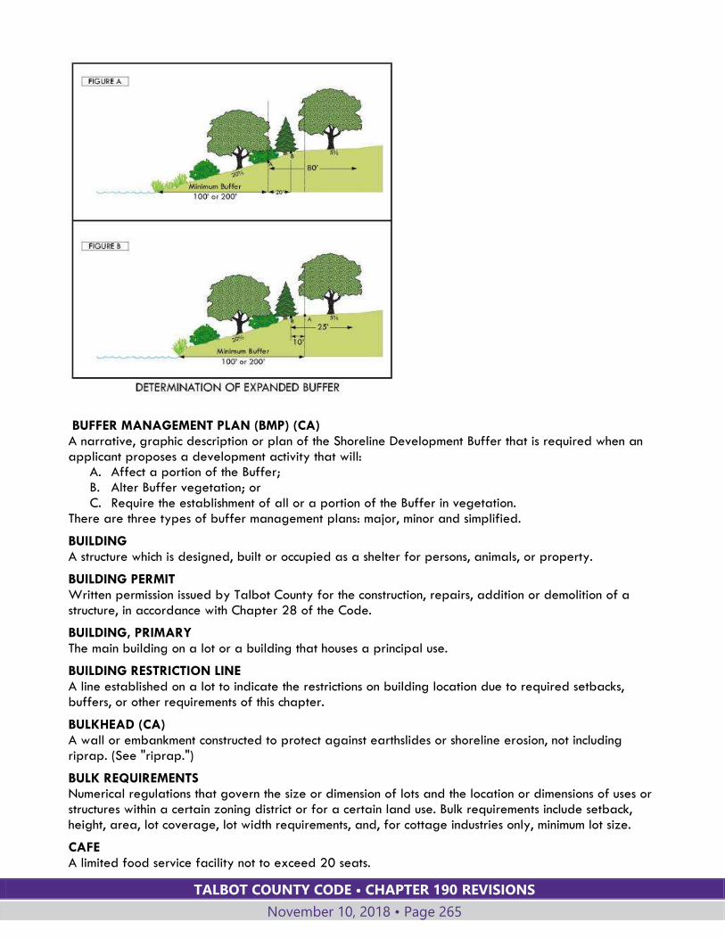
TALBOT COUNTY CODE • CHAPTER 190 REVISIONS
November 10, 2018 • Page 265
BUFFER MANAGEMENT PLAN (BMP) (CA) A narrative, graphic description or plan of the Shoreline Development Buffer that is required when an applicant proposes a development activity that will:
A. Affect a portion of the Buffer; B. Alter Buffer vegetation; or C. Require the establishment of all or a portion of the Buffer in vegetation.
There are three types of buffer management plans: major, minor and simplified.
BUILDING A structure which is designed, built or occupied as a shelter for persons, animals, or property.
BUILDING PERMIT Written permission issued by Talbot County for the construction, repairs, addition or demolition of a structure, in accordance with Chapter 28 of the Code.
BUILDING, PRIMARY The main building on a lot or a building that houses a principal use.
BUILDING RESTRICTION LINE A line established on a lot to indicate the restrictions on building location due to required setbacks, buffers, or other requirements of this chapter.
BULKHEAD (CA) A wall or embankment constructed to protect against earthslides or shoreline erosion, not including riprap. (See "riprap.")
BULK REQUIREMENTS Numerical regulations that govern the size or dimension of lots and the location or dimensions of uses or structures within a certain zoning district or for a certain land use. Bulk requirements include setback, height, area, lot coverage, lot width requirements, and, for cottage industries only, minimum lot size.
CAFE A limited food service facility not to exceed 20 seats.
TALBOT COUNTY CODE • CHAPTER 190 REVISIONS
November 10, 2018 • Page 266
CAPITAL IMPROVEMENT A public facility with a life expectancy of three or more years, to be owned and operated by or on behalf of the County.
CAPITAL PROGRAM The plan of the County to receive and expend funds for capital projects during the fiscal year covered by the capital budget and the next succeeding five fiscal years thereafter.
CARPORT A roofed structure providing space for the parking or storage of motor vehicles and enclosed on not more than three sides.
CERTIFICATE OF APPROPRIATENESS An authorization, awarded by the Historic Preservation Commission, allowing alteration, demolition, or new construction within a Historic Overlay Zone.
CHRISTMAS TREE FARM A land area cultivated for the growing of trees harvested and marketed for Christmas tree sales.
CLEAR CUTTING (CA) The removal of the entire stand of trees in one cutting with tree reproduction obtained by natural seeding from adjacent stands or from trees that were cut, from advanced regeneration or stump sprouts, or from planting of seeds or seedlings by man.
CLEARING (CA) Any activity that removes the vegetative ground cover.
CLUSTER DEVELOPMENT (CA) A residential development in which dwelling units are concentrated in a selected area or selected areas of the development tract so as to provide natural habitat or other open space uses on the remainder.
COLLOCATION (OF WIRELESS COMMUNICATION FACILITIES) The addition of one or more antennas to a wireless communications tower or other supporting structure.
COLONIAL NESTING WATER BIRDS (CA) Includes herons, egrets, terns, and glossy ibis. For purposes of nesting, these birds congregate (that is colonize) in relatively few areas, at which time, the regional populations of these species are highly susceptible to local disturbances.
COMMERCIAL HARVESTING (CA) A commercial forestry operation that would alter the existing composition or profile, or both, of a forest, including all commercial cutting operations done by companies and private individuals for economic gain.
COMMERCIAL USE An activity carried out for pecuniary gain and listed under the “Commercial Use” category of Table IV-1, Land Uses.
COMMON SPACE A lot or area within a development that is provided for protection of sensitive environmental features; for stormwater management features such as bioretention areas, infiltration areas, or ponds and areas that may serve a floodplain function; or for passive or active recreation areas for occupants of the development and their guests.
COMMUNICATIONS FACILITY Any facility, excluding satellite television dish antennas, established for the purpose of providing wireless voice, data, and image transmission within a designated service area. A wireless communications facility consists of one or more antennas attached to a support structure and related equipment.
TALBOT COUNTY CODE • CHAPTER 190 REVISIONS
November 10, 2018 • Page 267
COMMUNITY FACILITY A noncommercial use established to serve the local population, including community centers, libraries, recreation centers, educational or interpretive facilities, parks, playgrounds, museums and related uses.
COMPREHENSIVE OR SECTIONAL ZONING MAP AMENDMENT A Zoning Map amendment that is legislative in nature, is adopted after extensive study or to implement a Comprehensive Plan, and covers all or a substantial area of the County.
COMPREHENSIVE PLAN (CA) A compilation of policy statements, goals, standards, maps, and pertinent data relative to the past, present, and future trends of Talbot County, including, but not limited to, its population, housing, economics, social patterns, land use, water resources, and their use, transportation facilities and public facilities prepared by the Talbot County Planning Commission for the Talbot County Council.
CONCEPT PLAN A plan showing the major existing features and anticipated future development of a parcel. A concept plan shows the general concept for the proposed development with sufficient detail to demonstrate its feasibility. For a subdivision, a concept plan shows the boundary of the entire original parcel for which a subdivision is proposed, lots created by prior subdivisions, and the general location and number of proposed and anticipated future lots, roads and easements.
CONDOMINIUM A unit available for sale in fee simple contained in a multi-occupancy project subject to covenants and restrictions placing control over the common facilities in an elected board.
CONSERVATION EASEMENT (CA) A nonpossessory interest in land which restricts the manner in which the land may be developed in an effort to reserve natural resources for future use.
CONSOLIDATION (CA) A combination of any legal, conforming or nonconforming parcels of land or recorded, legally buildable lots into fewer parcels or lots than existed prior to application of a revision plat.
CONSTRUCTION PLAN The drawings accompanying a subdivision plat and showing exact location and design of improvements to be installed in the subdivision in accordance with the requirements of the Planning Director and County Engineer as a condition of approval of the plat.
CONTIGUOUS Adjoining and having a common boundary line; not separated by a federal or state highway, County road, or major watercourse.
CONTRACTING, BUILDING TRADE AND CONSTRUCTION Businesses that provide contracting services for new construction and site development as well as for ongoing maintenance, repair and improvement of structures and property.
CONTRACTING, MARINE A business that provides services including the installation or repair of piers, shoreline stabilization and similar structures or features located in or over water.
CONTRACTING, PROPERTY MAINTENANCE AND LANDSCAPE Businesses that provide contracting services limited to outdoor maintenance and landscape services.
COTTAGE INDUSTRY The use of a portion of a residential structure or accessory structure involving the offering of a service, the conduct of a business, or the production of handicrafts on a qualifying parcel. A cottage industry has the potential for greater impacts on nearby properties compared to a home occupation.
TALBOT COUNTY CODE • CHAPTER 190 REVISIONS
November 10, 2018 • Page 268
COUNTY ENGINEER The Director of the Talbot County Department of Public Works, or an authorized representative of the Talbot County Department of Public Works.
COVERAGE A geographic area served by a wireless communications facility showing the effectiveness of reception and transmission in that area.
COVER CROP (CA) A vegetative cover to protect soils from erosion and to restrict pollutants from entering the waterways. Cover crops can be dense, planted crops of grasses or legumes or crop residues such as corn, wheat, or soybean stubble which maximize infiltration and prevent runoff from reaching erosive velocities.
CRITICAL AREA (CA) All County lands and waters that are within the Maryland Critical Area as defined in §8-1807 of the Natural Resources Article, Annotated Code of Maryland.
CRITICAL AREA COMMISSION (CA) The Critical Area Commission for the Chesapeake and Atlantic Coastal Bays.
CRITICAL AREA PROGRAM (CA) The program consists of this chapter, including maps, documents, and other parts of this Code referred to in this chapter.
CUL-DE-SAC A street that terminates in a vehicular turnaround.
CULTURAL FACILITIES Establishments such as museums, art galleries, and botanical or zoological facilities of historic, educational, or cultural interest which are operated by public or quasi-public institutions.
DAY-CARE CENTER, LARGE GROUP Any arrangement that provides day care for children or adults on a regular basis, with 13 or more clients, including any relatives of the care provider.
DAY-CARE CENTER, SMALL GROUP Any arrangement that provides day care for children or adults on a regular basis, with not fewer than nine and not more than 12 clients, including any relatives of the care provider.
DAY-CARE FACILITY, FAMILY Any arrangement that provides day care for children or adults on a regular basis for eight or fewer clients, including any relatives of the care provider.
DENSITY (CA) The number of dwelling units per acre within a defined and measurable area.
DEPARTMENT OF PLANNING AND ZONING OR PLANNING OFFICE These terms have the same meaning: the Planning Office established by the Talbot County Charter and administered by the Planning Director.
DEVELOPED WOODLAND (CA) An area of trees or of trees and natural vegetation, interspersed with residential, commercial, industrial, institutional, or recreational development.
DEVELOPER (CA) A person who undertakes development activity as defined in this chapter; or a person who undertakes development as defined in the criteria of the Critical Area Commission.
DEVELOPER AGREEMENT A written agreement between the County and a developer or property owner committing the developer or property owner to install required public or private improvements associated with the development
TALBOT COUNTY CODE • CHAPTER 190 REVISIONS
November 10, 2018 • Page 269
of land, or requiring the developer or property owner to comply with specified restrictions on the use of the site.
DEVELOPMENT ACTIVITIES (CA)
A. Activity shown on a subdivision plat, revised plat, site plan, building/zoning permit, buffer management plan or forest preservation plan; and/or
B. Human activity that materially affects the condition or use of land, land under water, or a structure.
C. Development includes redevelopment.
DEVELOPMENT ENVELOPE (CA) The portion of a lot developed or to be developed, to include as required: lot coverage within that area, roads, utilities, stormwater management measures, onsite sewage disposal measures, areas subject to human use such as active recreation areas, any required buffers, and any additional acreage necessary to meet lot size, density, lot coverage and other requirements of this Chapter.
DEVELOPMENT RIGHT A right to create a lot or parcel. The number of development rights for a particular lot, parcel or tract is equal to the number of dwelling units permitted by the applicable density requirements of this chapter.
DISTURBANCE (CA) A change or alteration to land. Disturbance includes any amount of clearing, grading, or construction activity; but does not include gardening or maintenance of an existing grass lawn.
DISTURBANCE, PERMANENT (CA) A material, enduring change in the topography, landscape, or structure that occurs as part of development activity. Permanent disturbance includes:
A. Construction or installation of any material that will result in lot coverage; B. Construction of a deck; C. Grading if the area is not restored to its previous vegetative condition immediately after
completion of the development activity; D. Clearing of a tree, forest, or developed woodland; and E. Septic system installation, except on a lot created before August 13, 1989 in which the septic
system is located in existing grass or clearing is not required.
DISTURBANCE, TEMPORARY (CA) A short-term change in the landscape that occurs as part of a development or redevelopment activity. Temporary disturbance does not include activity performed in violation of this Chapter, but does include:
A. Temporary storage of materials necessary for the development activity; B. Construction of a road or pathway that is removed immediately after completion of the
development or redevelopment activity and the area restored to its previous vegetative condition;
C. Grading of a development site, if the area is restored to its previous vegetative condition immediately after completion of the development activity; and
D. Installing a septic system on a lot created before August 13, 1989, if the septic system is located in existing grass or clearing is not required. “Temporary disturbance” does not include locating a septic system in a forest or developed woodland if clearing is required.
DREDGING (CA) A method for deepening streams, swamps, or coastal waters by removing solids from the bottom.
DRIVEWAY An off-street, vehicular travel lane bounded on both sides by an area that is not part of a vehicle accommodation area.
TALBOT COUNTY CODE • CHAPTER 190 REVISIONS
November 10, 2018 • Page 270
DWELLING, ACCESSORY A second, accessory dwelling unit on the same lot as a primary, single-family detached dwelling. An accessory dwelling may be an apartment located within and smaller than the primary dwelling, or it may be within a detached building accessory to the primary dwelling.
DWELLING, ATTACHED A dwelling unit in a building comprised of at least three dwellings, each with party walls in common with at least one adjacent dwelling unit, and generally having its own independent outside access. This term includes townhouse and multiplex dwellings.
DWELLING, DUPLEX One dwelling unit within a structure containing two dwelling units, each located on a separate lot and connected by an unpierced party wall extending from ground to roof. The side yard setback where the dwelling units are attached is waived.
DWELLING, EMPLOYEE An accessory dwelling unit used specifically to house an employee of the property owner. At least one-half of the household income must be obtained from the property owner.
DWELLING, MULTIPLEX A type of attached dwelling. A dwelling unit in a building that resembles a large, single-family detached dwelling, but is divided internally into three or four dwelling units separated by vertical party walls extending from the basement to the roof. The dwelling units are not arranged in line and typically have separate exterior entrances.
DWELLING, SINGLE-FAMILY DETACHED A detached residential building containing one primary dwelling unit with private yard area on all sides, excluding mobile homes.
DWELLING, TOWNHOUSE A type of attached dwelling. A dwelling unit in a row of at least three attached dwelling units; each unit has its own access to the outside and the units are separated by parallel, vertical party walls.
DWELLING UNIT (CA) One or more rooms providing complete, independent living facilities for at least one person, including permanent provisions for all of the following: sanitation; cooking; eating; sleeping; and other activities routinely associated with daily life. "Dwelling unit" includes an accessory dwelling.
DWELLING, ZERO LOT LINE A building containing one primary dwelling unit located on a small single lot with one side of the building close to or abutting one side lot line, and private yards on three sides.
EASEMENT (CA) An interest in land owned by another that entitles its holder to a specific use, enjoyment or right.
ENDANGERED SPECIES (CA) Any species of fish, wildlife, or plants which have been designated as endangered by regulation by the Secretary of the Department of Natural Resources. Designation occurs when the continued existence of these species as viable components of the state's resources are determined to be in jeopardy. This includes any species determined to be an endangered species pursuant to the Federal Endangered Species Act, 16 U.S.C. §1531 et seq., as amended.
EROSION The wearing away of the land surface by wind or water, usually intensified by land-clearing practices.
ESCROW A deposit of cash with the County or escrow agent to secure the promise to perform some act.
TALBOT COUNTY CODE • CHAPTER 190 REVISIONS
November 10, 2018 • Page 271
ESTABLISHMENT, BUFFER(CA) The planting of native vegetation or regeneration of predominately native vegetation in the Shoreline Development Buffer or stream and wetland buffers.
EVENT VENUE A facility for receptions, meetings, parties and similar events, which provides indoor or outdoor space, sanitary facilities and parking area.
EXPOSITION CENTER A facility with buildings, pavilions, arenas, accessory parking and other accessory uses that is intended and used for fairs, displays, auctions and similar periodic or temporary events.
FACILITY, PUBLIC A publicly owned and/or operated use, building or establishment, such as a school, post office, fire station, courthouse, roads or water and sewerage facilities.
FAMILY An individual, or two or more persons related by blood, marriage, or adoption, or a group of not more than six unrelated persons, living together as a single housekeeping group in a dwelling unit.
FARM Land utilized for bona fide agricultural purposes, such as crop production, livestock pasturage, care, handling, etc.; forestry; and directly related uses; and which may consist of a single parcel or several adjacent or nearby parcels under common ownership.
FARM ALCOHOL PRODUCTION FACILITY An alcohol production facility located on a farm and using grains, hops, honey, grapes and other fruit, and other agricultural products produced on the licensed farm. (See also definition of alcohol production facility.)
FARM MARKET A retail market, located on a farm, selling predominately locally (Delmarva Peninsula) produced fruits, vegetables, or meats or ancillary promotional merchandise and farm products grown onsite such as on-farm retail dairies and creameries, meat shops, bakeries, and similar uses.
FENCE An artificially constructed barrier of any material or combination of materials erected to enclose or screen areas of land.
FISHERIES ACTIVITIES (CA) Commercial water-dependent fisheries, including structures for packing, processing, canning or freezing of fin fish, crustaceans, mollusks, amphibians and reptiles, and also including related activities such as wholesale and retail sales, product storage, crab shedding, off-loading docks, shellfish culture operations, and shore-based facilities necessary for aquaculture operations.
FLOODPLAIN This term is defined in Chapter 70 of this Code and is repeated here for convenience: Land typically adjacent to a body of water with ground surface elevations that are inundated by the base flood. The base flood is the one-hundred-year frequency flood event.
FOOD DELIVERY AND CATERING SERVICE Establishments offering either groceries or prepared foods and beverages exclusively for off-site service and consumption. Customers may visit the site to place orders but food is usually delivered to the customer.
FOREST (CA)
A. A biological community dominated by trees and other woody plants covering a land area of 10,000 square feet or greater, including areas that have at least 100 trees per acre with at
TALBOT COUNTY CODE • CHAPTER 190 REVISIONS
November 10, 2018 • Page 272
least 50% of those trees having a 2 inch or greater diameter at 4.5 feet above the ground and larger.
B. Includes forest areas that have been cut but not cleared. C. Does not include orchards.
FOREST INTERIOR DWELLING BIRDS (CA) Species of birds which require relatively large forested tracts in order to breed successfully (for example, various species of flycatchers, warblers, vireos, and woodpeckers).
FOREST MANAGEMENT (CA) The protection, manipulation and utilization of the forest to provide multiple benefits, such as timber harvesting, water transpiration, wildlife habitat, etc.
FOREST PRESERVATION PLAN A plan for disturbance to a forest or developed woodlands, or for a development activity that requires afforestation, within the Critical Area but outside the Shoreline Development Buffer, that adequately depicts or otherwise describes the activity to be conducted, including forest preservation, afforestation, reforestation, or mitigation.
FORESTRY (CA) The cultivation, maintenance, management, and development of trees on forested lands.
FRONTAGE The portion of a lot abutting a road. Where this chapter has a required minimum frontage, frontage is measured as the length of a continuous, uninterrupted lot line abutting a single road. For lots abutting more than one road, the Planning Director determines which portion of the property boundary to use in measuring the length of the property's frontage.
FULLY ESTABLISHED BUFFER (CA) An area of the Shoreline Development Buffer that contains as much diverse, native vegetation as necessary to support a firm and stable riparian habitat capable of self-sustaining growth and regeneration.
GATEWAY The entire area within a Gateway Overlay Zoning District.
GOLF COURSE A tract of land for playing golf, improved with tees, greens, fairways, hazards, and which may include clubhouses and shelters.
GRADING Cutting or otherwise distributing the soil mantle by mechanical means so as to permanently change the existing natural features of the earth’s surface.
GREENHOUSE — RETAIL A structure designed and used for growing plants that are displayed and sold to the general public on the site.
GREENHOUSE — WHOLESALE A structure designed and used for growing plants that are not displayed or sold to the general public on the site.
GROSS FLOOR AREA The total horizontal area in square feet of all floors within the exterior walls of a building, including habitable or usable garage, basement, attic, or like spaces, and spaces with knee walls of three feet or greater, but not including vent shafts, unroofed inner courts, screen porches or spaces less than seven feet in height. Except as required for certain land uses, gross floor area does not include unenclosed porches, decks or carports.
TALBOT COUNTY CODE • CHAPTER 190 REVISIONS
November 10, 2018 • Page 273
GROUND MOUNT SOLAR SYSTEM A solar energy system consisting of solar modules held in place by racks or frames that are attached to ground-based mounting supports or resting on the ground, including solar modules that function as a roof above a parking area, such as a carport.
GROUP HOME, LARGE A residential facility that provides housing and supportive services, such as personal care, social or counseling services, or transportation, to at least nine and no more than sixteen residents who need services due to a disability. The facility may also include housing for staff.
GROUP HOME, SMALL A residential facility that provides housing and supportive services, such as personal care, social or counseling services, or transportation, to eight or fewer residents who need services due to a disability. The facility may also include housing for staff.
GROWTH ALLOCATION (CA) The number of acres of land in the Critical Area that a local jurisdiction may use to create new Intensely Developed and new Limited Development Areas. The growth allocation shall be calculated based on 5% of the total Resource Conservation Area in the County at the time of the original approval of the County's program by the Commission, not including tidal wetlands or land owned by the federal government.
GROWTH ALLOCATION, SUPPLEMENTAL A portion of the County's allowed acreage for growth allocation (set forth in Article VII, §190-55.5) transferred by the County Council to a town, with concurrence by the town and the Critical Area Commission.
GUEST HOUSE An accessory, detached dwelling unit that guests of the property owner may occupy.
GUYED TOWER Any wireless communication tower using guy wires connecting portions of the tower diagonally with the ground to provide support for the tower, antennas and connecting appurtenances.
HABITABLE FLOOR Any floor usable for living purposes, which includes working, sleeping, eating, cooking, or recreation, or any combination thereof.
HABITAT The natural abode of a plant or animal.
HABITAT PROTECTION AREAS (CA) The shoreline development buffer, nontidal wetlands, habitats of species in need of conservation, habitat of threatened and endangered species, plant habitats, wildlife habitats, and anadromous fish propagation waters, as defined in COMAR 27.01.09 and COMAR 26.24.01.02B.
HABITAT PROTECTION PLAN A document showing and describing how the purposes and requirements of habitat protection areas will be accomplished.
HARBOR LINE A reference line establishing half the distance from the shoreline to the center line of a body of water.
HAZARDOUS TREE (CA) A. A tree with a structural defect, such as a crack, canker, weak branch union, decay, dead wood,
root damage, or root disease, that decreases the structural integrity of the tree and which, because of its location, is likely to fall and cause personal injury or property damage, including acceleration of soil erosion; or
B. A healthy tree that, based on its location in the landscape, with continued normal growth, will damage an existing permanent structure or significantly increase the likelihood of soil erosion.
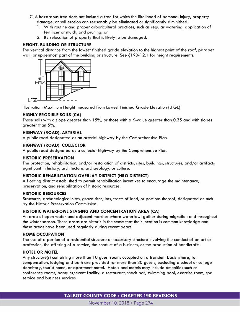
TALBOT COUNTY CODE • CHAPTER 190 REVISIONS
November 10, 2018 • Page 274
C. A hazardous tree does not include a tree for which the likelihood of personal injury, property damage, or soil erosion can reasonably be eliminated or significantly diminished: 1. With routine and proper arboricultural practices, such as regular watering, application of
fertilizer or mulch, and pruning; or 2. By relocation of property that is likely to be damaged.
HEIGHT, BUILDING OR STRUCTURE The vertical distance from the lowest finished grade elevation to the highest point of the roof, parapet wall, or uppermost part of the building or structure. See §190-12.1 for height requirements.
Illustration: Maximum Height measured from Lowest Finished Grade Elevation (LFGE)
HIGHLY ERODIBLE SOILS (CA) Those soils with a slope greater than 15%; or those with a K-value greater than 0.35 and with slopes greater than 5%.
HIGHWAY (ROAD), ARTERIAL A public road designated as an arterial highway by the Comprehensive Plan.
HIGHWAY (ROAD), COLLECTOR A public road designated as a collector highway by the Comprehensive Plan.
HISTORIC PRESERVATION The protection, rehabilitation, and/or restoration of districts, sites, buildings, structures, and/or artifacts significant in history, architecture, archaeology, or culture.
HISTORIC REHABILITATION OVERLAY DISTRICT (HRO DISTRICT) A floating district established to permit rehabilitation incentives to encourage the maintenance, preservation, and rehabilitation of historic resources.
HISTORIC RESOURCES Structures, archaeological sites, grave sites, lots, tracts of land, or portions thereof, designated as such by the Historic Preservation Commission.
HISTORIC WATERFOWL STAGING AND CONCENTRATION AREA (CA) An area of open water and adjacent marshes where waterfowl gather during migration and throughout the winter season. These areas are historic in the sense that their location is common knowledge and these areas have been used regularly during recent years.
HOME OCCUPATION The use of a portion of a residential structure or accessory structure involving the conduct of an art or profession, the offering of a service, the conduct of a business, or the production of handicrafts.
HOTEL OR MOTEL Any structure(s) containing more than 10 guest rooms occupied on a transient basis where, for compensation, lodging and bath are provided for more than 30 guests, excluding a school or college dormitory, tourist home, or apartment motel. Hotels and motels may include amenities such as conference rooms, banquet/event facility, a restaurant, snack bar, swimming pool, exercise room, spa service and business services.

TALBOT COUNTY CODE • CHAPTER 190 REVISIONS
November 10, 2018 • Page 275
HOUSE OF WORSHIP (INCLUDING CHURCHES AND TEMPLES) Building used for religious services or worship by a group of people associated with a recognized established faith.
HYDRIC SOILS (CA) Soil that are wet frequently enough to periodically produce anaerobic conditions, thereby influencing the species composition or growth, or both, of plants on those soils.
HYDROPHYTIC VEGETATION (CA) Those plants cited in “Vascular Plant Species Occurring in Maryland Wetlands” (Dawson, F. et.al., 1985) which are described as growing in water or on a substrate that is at least periodically deficient in oxygen as a result of excessive water content (plants typically found in water habitats).
IMPERVIOUS SURFACE (CA) Nonporous ground covers or areas such as sidewalks, roads, parking areas, and rooftops that shed stormwater and hinder penetration of water into the ground.
INFILL LOT A vacant lot or parcel of land which remains after the majority of development has occurred in an area or along a road.
INFRASTRUCTURE Facilities and services needed to sustain industrial, residential, and commercial activities.
INHERENT RISKS OF AGRITOURISM ACTIVITY Dangers or conditions that are an integral part of agritourism activities, such as farm-based recreational or educational activities and participation in harvesting. Such dangers or conditions include natural conditions of land, vegetation, and waters; the behavior of wild or domestic animals; and the ordinary dangers of structures or equipment ordinarily used in farming and ranching operations. The term also includes the potential of a participant to act in a negligent manner that may contribute to the injury of the participant or others, including failing to follow the instructions given by the farm operator or failing to exercise reasonable caution while engaging in the farm-related activity.
INN Any structure(s) containing not more than 10 guest rooms occupied on a transient basis where, for compensation, lodging, bath, and meals are provided for not more than 30 lodging guests, excluding a school or college dormitory.
INOPERABLE VEHICLE Any motorized vehicle:
A. Incapable of being immediately driven, or B. Not properly licensed or inspected for safety in accordance with State law.
IN PLAY AREA (CA) Within the boundaries of a parcel that has been improved as a golf course, the in-play area shall include all portions of the property that are dedicated to and customarily used for the activity of playing golf, and that are not beyond the boundaries of the course or associated practice facilities. The following areas shall not be considered “in-play” area: areas occupied by commercial structures; areas used for commercial activities other than golf; areas used for storage of materials and equipment; areas used for maintenance and repair; parking facilities; clubhouses; tennis courts; swimming pools; and forests or other natural areas where the activity of golf is not customarily played in, over or through.
INSTITUTIONAL USE A privately operated use of a semipublic type, such as a church, convent or monastery, day-care center or nursing home, philanthropic foundation, nonprofit library, art gallery or museum, and similar establishments.
TALBOT COUNTY CODE • CHAPTER 190 REVISIONS
November 10, 2018 • Page 276
INTENSELY DEVELOPED AREA (IDA) (CA) Areas within the Critical Area that are designated as IDA on the Talbot County Critical Area Map, as approved by the County Council and the Critical Area Commission, based on criteria established in this Chapter.
INVASIVE SPECIES (CA) A type of plant that is non-native to the ecosystem under consideration and whose introduction causes, or is likely to cause, economic or environmental harm or harm to human health.
JOINT SUBDIVISION (CA) A type of subdivision by which residential development rights may be transferred among parcels within the Rural Conservation District in accordance with the requirements of this chapter.
JUNKYARD Land or buildings used for the storage, salvage, dismantling, wrecking, baling, compacting, recycling or handling of automobiles or other vehicles and equipment not in operable condition.
KENNEL Any land or structures used for housing, breeding or training domestic animals, not including horses.
KENNEL, ACCESSORY RESIDENTIAL An enclosed area or structure used for the housing of no more than six dogs owned by the person(s) residing on the same property.
KENNEL, COMMERCIAL Any land or structure used for the boarding, sale, breeding or training of domestic animals, or any land or structure used for the housing of six or more dogs. This term does not include riding stables.
KILOWATT (kW) A measure of the use of electrical power equal to 1,000 watts.
K-VALUE (CA) The soil erodibility factor in the Universal Soil Loss Equation. It is a quantitative value that is experimentally determined.
LANDSCAPED AREA An area containing plant materials, including trees, shrubs, ground cover, and other types of vegetation, together with elements such as paths, benches, terraces, and similar features, established and maintained for enhancing the appearance of the site, noise reduction, or screening.
LANDSCAPE YARD Plantings that shield or partially shield the view of structures or uses from roads or adjacent properties, or that provide a visual separation between uses. Landscape buffers may consist of natural existing vegetation or may be created by the use of trees, shrubs, fences, and/or berms.
LANDSCAPING PLAN A plan drawn to scale, showing dimensions and details for landscaping or planting an area.
LAND USE A description of how land is occupied or used.
LANDWARD EDGE (CA) The limit of a site feature that is farthest away from a tidal water, tidal wetland, or tributary stream.
LATERAL LINE An imaginary line from the shoreline to the harbor line separating usable water areas.
LEGALLY DEVELOPED (CA) In the Critical Area Overlay District, a lot or parcel on which all physical improvements:
A. Existed before Critical Area Commission approval of a local program; or B. Were properly permitted in accordance with the local program and impervious surface policies
in effect at the time of construction.
TALBOT COUNTY CODE • CHAPTER 190 REVISIONS
November 10, 2018 • Page 277
LIMITED DEVELOPMENT AREA (LDA)(CA) Areas within the Critical Area that are designated as LDA on the Talbot County Critical Area Map, as approved by the County Council and the Critical Area Commission, based on criteria established in this chapter.
LIVESTOCK Animals kept in pastures, barns, stables, sheds or similar farm buildings, raised for food or fiber production, work, riding or boarding. This term includes cattle, goats, sheep, horses, donkeys, swine, barnyard fowl, and similar species, but does not include cats, dogs and other household pets.
LOADING SPACE, OFF-STREET Off-street space for bulk pickups and delivery vehicles.
LOT, (PARCEL) (CA) An area of land in single ownership, described in a final subdivision plat or deed, and recorded in the Talbot County land records in accordance with the laws and regulations in effect at the time of recordation.
LOT, CORNER A lot situated at the intersection of two or more roads.
LOT COVERAGE (CA) A. The percentage of a total lot or parcel that is:
1. Occupied by a structure, accessory structure, parking area, driveway, walkway or roadway; or
2. Covered with gravel, stone, shell, impermeable decking, a paver, permeable pavement, or any man-made material.
3. "Lot coverage" includes the ground area covered or occupied by a stairway or impermeable deck.
B. Lot coverage does not include: 1. A fence or wall that is less than one foot in width that has not been constructed with a footer; 2. A walkway in the buffer or expanded buffer, including a stairway, that provides direct
access to a community or private pier; 3. A wood mulch pathway; or 4. A deck with gaps to allow water to pass freely.
LOT LINE, FRONT The property line or boundary that separates a lot from a road right-of-way. In a corner lot or through lot, both property lines abutting a road shall be deemed to be front lot lines. For pipestem lots, the front lot line shall be determined by the Planning Director.
LOT LINE, REAR The property line or lines generally opposite or parallel to the front lot line. A through lot has no rear lot line.
LOT LINE, SIDE Any property line other than a front lot line or a rear lot line.
LOT, THROUGH A lot other than a corner lot with frontage on more than one road.
LOT WIDTH The distance between side lot lines measured along a line parallel to the front lot line. The minimum lot width must be maintained from the front building restriction line to the rear building restriction line.
MANUFACTURED HOME A dwelling unit that is fabricated in an off-site manufacturing facility for installation or assembly at the building site, bearing a label certifying that it is built in compliance with the National Manufactured Housing Construction and Safety Standards Act of 1974.
TALBOT COUNTY CODE • CHAPTER 190 REVISIONS
November 10, 2018 • Page 278
MANUFACTURED HOME RENTAL COMMUNITY A parcel of land under single ownership on which two or more manufactured homes are located, not including a farm on which manufactured homes are allowed as an accessory use.
MANUFACTURED HOME SUBDIVISION A subdivision designed for the sale of lots for siting manufactured homes exclusively.
MARINA (CA) A facility for mooring, berthing, storing, or securing of watercraft, but not including community piers and other noncommercial boat docking and storage facilities. A marina may include one or more additional land uses or associated facilities specifically permitted under the provisions of the Table IV-1, Land Uses, in this chapter.
MARSH CREATION (CA) A nonstructural shore erosion control method that may or may not include low sills or breakwaters to keep the substrate in place. A marsh is a type of wetland, generally periodically inundated, usually characterized by grasses and other low growth (may include shrubs in high marsh).
MASTER PLAN A plan for a defined sub-area of the County that supplements the Comprehensive Plan and may address, in more detail than the Comprehensive Plan, topics to include population, housing, economics, social patterns, land use, water resources, transportation facilities and public facilities, and that is adopted as a policy guide for the area by the Talbot County Council.
MEAN HIGH-WATER LINE (CA) The average level of high tides at a given location.
MEGAWATT (MW) A measure of the use of electrical power equal to 1,000 kilowatts.
MINERAL EXTRACTION (CA) The use of more than one acre of land for the breaking of the surface soil in order to extract or remove minerals, including any activity or process that removes minerals from their original location.
MITIGATION (CA) An action taken to compensate for an adverse impact to the environment resulting from a development activity or a change in land use or intensity.
MIXED USE Two or more principal uses, listed separately in the Table of Land Uses, on one parcel.
MOBILE HOME A dwelling unit that is fabricated in an off-site manufacturing facility for installation or assembly at the building site which does not bear a label certifying that it is built in compliance with the National Manufactured Housing Construction and Safety Standards Act of 1974.
MODIFIED BUFFER AREA (MBA) (CA) An area designated by the County Council, within the Critical Area Overlay zoning district, where it has been sufficiently demonstrated that patterns of development existing on December 1, 1985 prevent the Shoreline Development Buffer from fulfilling its natural functions.
MODULAR HOME A dwelling unit that is fabricated in an off-site manufacturing facility for installation or assembly at the building site, bearing a label certifying that it is built in compliance with the standards of the Industrialized Building and Mobile Homes Act, Title 6 of Article 83B of the Annotated Code of Maryland.
MOTEL See "hotel."
TALBOT COUNTY CODE • CHAPTER 190 REVISIONS
November 10, 2018 • Page 279
NATIVE (CA) Refers to plant species that are indigenous to the physiographic area in Maryland where the planting is proposed.
NATURAL FEATURES (CA) Components and processes present in or produced by nature, including but not limited to, soil types, geology, slopes, vegetation, surface water, drainage patterns, aquifers, recharge areas, climate, floodplains, aquatic life, and wildlife.
NATURAL HERITAGE AREAS (CA) Any communities of plants or animals which are considered to be among the best statewide examples of their kind and are designated by regulation by the Secretary of the Department of Natural Resources.
NATURAL PARKS (CA) Areas of natural habitat that provide opportunities for those recreational activities that are compatible with the maintenance of natural conditions.
NATURAL RESOURCE-ORIENTED RECREATION, EDUCATION, AND RESEARCH Natural resource-dependent facilities provided by quasi-public or private agencies and available to the general public. Shall include natural environmental areas and may include visitor centers, research facilities, educational programming and similar uses, as well as nature areas, picnic areas, walking or hiking areas, fishing areas, hunting areas and bird or wildlife watching areas. Does not include active recreation facilities such as ballfields, athletic fields, bleachers, courts, or swimming pools. Does not include use of recreational off-road vehicles.
NATURAL VEGETATION (CA) Plant communities that develop or would develop in the absence of human activities.
NET METER A means of connecting an on-grid solar energy system to the utility grid, typically provided, sanctioned and installed by the local utility to measure the flow of electricity to and from the utility customer for the purpose of receiving a net credit for any excess electricity generated on-site and provided to the utility grid.
NONCONFORMING LOT A lot or parcel that was legally created but does not currently comply with the bulk requirements of this chapter for the zoning district in which it is located.
NONCONFORMING STRUCTURE A legally existing structure that is not currently in compliance with the bulk requirements for the zoning district in which the structure is located due to changes to this chapter or its application to the site, or changes to the zoning of the property.
NONCONFORMING USE Any use legally established that no longer conforms to the use regulations of the zoning district in which it is located due to changes to this chapter or its application to the site, or changes to the zoning of the property.
NONCONVERSION AGREEMENT A grant to the County, recorded among the land records by valid instrument approved by the County, permanently restricting conversion of a structure or space unless and until authorized by the County.
NONTIDAL WETLANDS (CA) See applicable Chesapeake Bay Critical Area, state and federal regulations for definition of nontidal wetlands.
NOTICE OF NONCOMPLIANCE A notice issued by the Planning Director informing the applicant for approval of a subdivision that the plan or plat submitted is not in compliance with these regulations and that certain corrections are required.
TALBOT COUNTY CODE • CHAPTER 190 REVISIONS
November 10, 2018 • Page 280
NOTICE TO PROCEED A notice issued by the Planning Director informing the applicant that a site plan or subdivision plan or plat submitted is in compliance with these regulations and that the applicant may proceed to the next step in the site plan or subdivision review/approval process. Specific conditions may be attached to the Notice to Proceed.
NOXIOUS WEED Any weed listed on the Maryland Department of Agriculture's noxious weed list.
NUDITY A state of dress which reveals:
A. The showing of the human male or female genitalia, pubic area, or buttocks with less than a fully opaque covering;
B. The showing of the female breast with less than a fully opaque covering over any part below the top or uppermost part of the areola; or
C. The depiction of covered male genitalia in a discernibly turgid or erect state.
NURSING HOME, SKILLED NURSING FACILITY A facility for the full-time care of two or more persons suffering from illnesses, disabilities, or injuries not requiring the intensive care that is normally provided by hospitals; but who do require nursing, convalescent, rehabilitative or chronic care, rendered by or under the supervision of a licensed health care practitioner.
OFF-GRID A solar energy system which is not electrically connected in any way to electric circuits (grid) that are provided and owned by an electric utility company for the purpose of delivering electricity to or from a home, building, structure, etc.
OFFICE, GENERAL A building or portion of a building used for conducting the affairs of a business, profession, service, industry, or government, not including facilities established to offer services or retail sales directly to the public.
OFFSETS (CA) Structures or actions that compensate for undesirable impacts.
ON-GRID A solar energy system that is electrically connected to the electric utility grid.
OPEN SPACE (CA) Any parcel or area of land or water in an essentially unimproved or undeveloped state.
ORGANIC RESOURCE RECOVERY FACILITY A facility that uses anaerobic digestion processes to convert organic refuse (food waste, poultry waste, and poultry processing waste), received from multiple locations, into renewable energy.
OVERHANG The part of a building which extends beyond the facade of a lower wall.
OWNER A person having legal title to or substantial proprietary interest in land.
PALUSTRINE WETLANDS (CA) All nontidal wetlands dominated by trees, shrubs, persistent emergent plants, or emergent mosses or lichens and all such wetlands that occur in tidal areas where the salinity due to ocean-derived salts is below 1/2 part per 1,000 parts of water.
PARCEL See definition of "lot, parcel."
TALBOT COUNTY CODE • CHAPTER 190 REVISIONS
November 10, 2018 • Page 281
PARCEL, ORIGINAL A parcel existing on August 13, 1989, in the Critical Area and on June 22, 1991, in the non-Critical Area.
PARCEL, PARENT (CA) A lot created after November 12, 2016 that was improved at the time of subdivision with a primary single-family dwelling constructed prior to July 1, 2008 and located at least partially within 200 feet, measured landward, from the mean high-water line of tidal waters or edge of tidal wetlands.
PARK A tract of land designed for use by the public for active and passive recreation.
PARKING AISLE An off-street, vehicular travel lane that provides access to parking spaces.
PARKING SPACE, OFF-STREET An off-street space available for parking one motor vehicle in such a way that no parking or maneuvering incidental to parking shall be on a road or sidewalk.
PARTIAL NUDITY A state of dress which reveals:
A. The human male or female buttocks; or B. The female breasts below the top or uppermost part of the areola, excluding portions of the
human female cleavage exhibited by a dress, or other apparel, provided the areola is not exposed in whole or in part.
PASSIVE RECREATION Those recreational pursuits that involve existing natural resources, provide for minimal impact and can be carried out with little alteration or disruption to the area in which they are performed. Such passive recreation shall not include commercial athletic fields or motorized recreation and may include, but not be limited to, hiking, bicycling, picnicking and bird watching.
PERMEABILITY (CA) The measure of a soil's ability to drain water.
PERMITTED USE Any use allowed in a zoning district subject to the restrictions applicable to that district.
PERSON An individual, corporation, partnership, joint venture, association, governmental or quasi-governmental entity, or other legal entity.
PIER A structure built over tidal wetlands or open water that provides access to the water, watercraft and other water-oriented activities. A pier consists of a walking surface supported by piles or posts and all detached outboard pilings associated with the land based structure. This term includes platforms, wharfs and docks.
PIER, COMMUNITY (CA) A boat docking and launching facility associated with and serving at least two residential lots and having a joint maintenance and use agreement. A community pier may be located on property leased or owned by a property owners' association for the subdivision it serves, or may be shared by and located along the joint property line of two adjacent lots.
PIER, PRIVATE (CA) A pier located on an individual, residential lot and serving only the occupants of the lot on which it is located.
PIERS AND RELATED BOAT FACILITIES This term includes community piers and private piers as defined in this article.
TALBOT COUNTY CODE • CHAPTER 190 REVISIONS
November 10, 2018 • Page 282
PIPESTEM OR FLAG LOT A residential lot that is shaped like a flag or pipe and connected to the nearest road only by an unbuildable strip of land (the pipestem area) which is no more than 50 feet in width.
PLANNING COMMISSION The Talbot County Planning and Zoning Commission.
PLANNING DIRECTOR or PLANNING OFFICER These terms have the same meaning: the governmental official of Talbot County charged with administering the Talbot County planning program.
PLANT AND WILDLIFE HABITAT AREA (CA) A. A plant habitat is a community of plants commonly identifiable by the composition of its
vegetation and physiographic characteristics. B. A wildlife habitat is an area with plant communities and physiographic features that provide
food, water, and cover, nesting and foraging or feeding conditions necessary to maintain populations of animals in the Critical Area.
C. Types of plant and wildlife habitat areas are listed in the Critical Area Overlay District, §190-15.10.F.
PLANT NURSERY A facility for the growing of trees, evergreens, shrubs, and other decorative plants for the purpose of sale.
PLAT, FINAL The official record of a subdivision of land approved by the Planning Office and recorded in the land records of Talbot County.
PLATFORM AREAS Fixed or floating horizontal surfaces along a pier used primarily for getting into and out of boats, lifting boats, including docks and launching platforms.
PLAT, PRELIMINARY The preliminary drawing or drawings, described in these regulations, showing the proposed layout of a subdivision and indicating how the subdivision will meet applicable requirements.
PLAT, REVISION A plat that modifies existing lots and creates no additional lots. It may revise a recorded final plat or revise or establish the boundary of a parcel defined in a deed with no previously recorded plat.
PLOT PLAN A plan showing the proposed development of a lot or parcel. A plot plan shows existing and proposed structures, paved areas, access, landscaped areas, and other items required by the application form for a particular type of application. A plot plan is generally less detailed than a site plan and does not require specific information on items such as landscape plantings, stormwater management and building elevations.
PORT (CA) A facility or area established or designated by the state or local jurisdictions for purposes of waterborne commerce.
PORTABLE STORAGE UNIT A container for the storage or warehousing of merchandise or excess materials. Portable storage units are generally 10 to 40 feet long and generally up to 8.5 feet high, of metal or durable plastic construction, and have access doors.
PREMISES A tract of land with the structures and improvements thereon.
TALBOT COUNTY CODE • CHAPTER 190 REVISIONS
November 10, 2018 • Page 283
PRIVATE Anything confined to one person, group or organization which is not available for public use or participation.
PRODUCE STAND A structure or use accessory to a principal agricultural or residential use, for the primary display and sale of agricultural products processed, grown or typically grown locally (on the Delmarva Peninsula), including products grown on the property where the stand is located, and the incidental display and sale of jams, jellies, preserves, relishes, pickles, salad dressing, and honey. A produce stand may be a permanent structure or a cart, wagon or temporary structure.
PROGRAM AMENDMENT (CA) Any change or proposed change to an adopted Critical Area program that is not determined by the Chairman of the Critical Area Commission to be a program refinement. A program amendment includes a change to a Zoning Map that is not consistent with the method for using the growth allocation contained in an adopted program.
PROGRAM REFINEMENT (CA) Any change or proposed change to an adopted program that the Chairman of the Critical Area Commission determines will result in a use of land or water in the Chesapeake Bay Critical Area or Atlantic Coastal Bays Critical Area in a manner consistent with the adopted program, or that will not significantly affect the use of land or water in the Critical Area. Program refinement may include:
A. A change to an adopted program that results from state law; B. A change to an adopted program that affects local processes and procedures; C. A change to a local ordinance or code that clarifies an existing provision; and D. A minor change to an element of an adopted program that is clearly consistent with the
provisions of State Critical Area Law and all the criteria of the Commission.
PROPERTY MAINTENANCE PERMIT A permit issued by the Planning Office for forest activities in the Critical Area, outside of the Shoreline Development Buffer, that do not require a Forest Preservation Plan or mitigation.
PUBLIC IMPROVEMENT Any improvement or facility, together with its associated public site or right-of-way, for which the County will assume responsibility for maintenance and operation.
QUASI-PUBLIC USE A use owned or operated by a noncommercial and nonprofit, religious, or philanthropic institution and providing education, cultural, recreational, religious or similar types of public programs.
RATED CAPACITY, SMALL WIND TURBINE The expected performance of a wind turbine at a specified wind speed (meters per second or miles per hour).
RECLAMATION (CA) The reasonable rehabilitation of disturbed land for useful purposes, and the protection of the natural resources of adjacent areas, including water bodies.
RECONFIGURATION (CA) A change of the arrangement of the existing lot or parcel lines of any legal parcel of land or recorded, legally buildable lots.
RECREATIONAL VEHICLE A vehicular, portable device, built on a chassis or trailer, and used as a temporary dwelling for travel or recreational purposes.
RECYCLING COLLECTION CENTER A community collection center for common recyclable goods, such as newspapers, glass, cans and plastics.
TALBOT COUNTY CODE • CHAPTER 190 REVISIONS
November 10, 2018 • Page 284
RECYCLING PROCESSING CENTER A recyclable material recovery facility where materials are sorted, processed and packaged for direct distribution to users of recyclable materials.
REDEVELOPMENT (CA) The process of developing land which is or has been developed.
REDEVELOPMENT PLAN A component part of an application for a Sustainable Tourism and Reinvestment district that details the size, location, setback, height, architectural features, and other characteristics, features, and uses of structures in the district. The redevelopment plan shall include the location of roads, access, easements, parking, landscape features, open space, reserved areas, drawings, elevations, plans, construction phasing and schedules, and all other features or information deemed necessary to complete or supplement an application.
REFORESTATION (CA) The reestablishment of a forest through artificial reproduction or natural regeneration.
REMAINING LAND A specifically delineated area of land on a subdivision plat that is part of the parcel being subdivided, requiring a minimum allocation of one development right, but is not included in the subdivision. Remaining land is not an approved lot or parcel within the subdivision and may be used for future subdivision if able to meet applicable standards at the time of subdivision.
RESERVATION OF DEVELOPMENT RIGHTS AGREEMENT A grant to the County, recorded among the land records by valid instrument approved by the County, restricting land development within a defined area and for a specified period of time. Reservation of development rights land requires a minimum allocation of one development right.
RESERVED LAND Permanently protected land, identified in a reserved land agreement recorded among the land records, that may not be developed for residential, commercial or industrial use except as defined in §190-73. Reserved land parcels do not require allocation of a development right.
RESERVED LAND AGREEMENT (RLA) A grant to the County, recorded among the land records by valid instrument approved by the County, which perpetually restricts land development within a defined area.
RESIDENCE See "dwelling unit."
RESOURCE CONSERVATION AREA (RCA) (CA) Areas within the Critical Area that are designated as RCA on the Talbot County Critical Area Map, as approved by the County Council and the Critical Area Commission, based on criteria established in this chapter.
RESTAURANT A public facility serving food, cooked to order, and served at tables or booths on the premises.
RESTAURANT, CARRYOUT A building or portion thereof where food and beverages are sold in a form ready for consumption and where all or a significant portion of the consumption takes place or is designed to take place off premises.
RETAIL, GENERAL A retail establishment in a single or multiple building(s), occupying no more than 25,000 gross square feet of area.
TALBOT COUNTY CODE • CHAPTER 190 REVISIONS
November 10, 2018 • Page 285
RETAIL, MAJOR A retail establishment in a single or multiple building(s), occupying more than 25,000 and less than 65,000 gross square feet of area.
REZONE To change the zoning classification of particular lots or parcels.
REZONING, COMPREHENSIVE This term has the same meaning as "comprehensive or sectional zoning map amendment," defined in this Section.
RIGHT-OF-WAY An area or strip of land designated for use as a road, alley, or walkway, or for any drainage or public utility purpose or other similar uses.
RIPARIAN (CA) A habitat strongly influenced by water and occurring adjacent to streams, shorelines and wetlands.
RIPRAP (CA) A layer of stones, gravel, or boulders placed on a slope or shore to prevent loss of bank material by wave action or erosion.
ROAD A public or private way, street or highway established and designed for vehicular travel. This term includes the entire area within the right-of-way. Road does not include a drive aisle or driveway.
ROAD (STREET), PRIVATE A road not owned, controlled or maintained by the state, the County, a municipality, or the federal government.
ROAD (STREET), PUBLIC A road owned, controlled, or maintained by the state, the County, a municipality, or the federal government.
ROADSIDE VENDOR An accessory use consisting of a stand, tent, cart, and/or open air area for the retail sales of goods, including but not limited to beverages, food, and flowers. There are two types of roadside vendors: short-term and long-term.
ROOFTOP SOLAR SYSTEM A solar energy system that has its electricity-generating solar panels mounted or resting on the rooftop of a residential or commercial building or structure. The various components of such a system include photovoltaic modules, mounting systems, cables, solar inverters and other electrical accessories.
RUBBLE Materials suitable for disposal at an approved rubble fill as defined herein.
RUBBLE FILL A solid waste acceptance facility that is designed, constructed and operated to receive the following types of materials: land clearing debris, white goods, tires and acceptable demolition debris. Acceptable demolition debris is materials associated with the razing of buildings, roads, bridges, and other structures, including structural steel, concrete, bricks, excluding refractory type, lumber, plaster and plasterboard, insulation material, cement, shingles and roofing material, floor and wall tile, asphalt, pipes and wires.
RUNOFF (CA) The portion of rainfall, melted snow, or irrigation water that flows across ground surfaces and eventually is returned to water bodies. Runoff can pick up pollutants from the air or land and carry them to the receiving waters.
TALBOT COUNTY CODE • CHAPTER 190 REVISIONS
November 10, 2018 • Page 286
SADOMASOCHISTIC ACTIVITY Images or live performances depicting:
A. Flagellation or torture, whether real or simulated, by or upon an individual; or B. The condition of being, or causing oneself or another to be, fettered, bound, or otherwise
physically restrained.
SANITARY LANDFILL (CA) An engineered method of solid waste disposal on land in a manner that protects the environment. Waste is spread in thin layers, compacted to the smallest practical volume and covered with soil at the end of each working day.
SCHOOL Any building or part thereof which is designed, constructed, or used for education or instruction in any branch of knowledge.
SCREENING Substantially or fully shielding or obscuring a structure or use from view, through the use of fencing, walls, berms or densely planted vegetation.
SEDIMENTATION (CA) The settling out of solids by gravity.
SEPTAGE See definition in Chapter 145 of this Code.
SEPTAGE TREATMENT FACILITIES See definition in Chapter 145 of this Code.
SEPTIC SYSTEM An underground system with a holding tank used for the decomposition of domestic wastes.
SETBACK The minimum distance that a structure shall be located from lot lines, or an outdoor use where specified in this Chapter. Setbacks are measured from lot lines to the foundation or wall of the building, or to the nearest part of the structure or use. If any part of the structure extends outward from the foundation more than two feet, the setback is measured from the point of the structure nearest the lot line, excluding uncovered steps, uncovered access ramps and chimneys. If a lot includes a street or road, the setback shall be measured from the nearest edge of the road right-of-way or road easement.
SEVERELY ERODING SHORELINE (CA) Shoreline that erodes two feet or more per year.
SEWAGE The total of organic waste and wastewater excluding garbage, generated by residential, commercial, and industrial establishments.
SEXUALLY ORIENTED BUSINESS An inclusive term describing establishments that devote more than 10% of their public floor area and/or their stock-in-trade to adult entertainment or materials and either:
A. Conduct, promote, deliver, provide, or offer performance of adult entertainment or material, including but not limited to that occurring in, at, or in connection with an adult cabaret, lounge, nightclub, modeling studio, bar, restaurant, club or lodge, or other establishment; or
B. Sell, provide, rent, or promote adult entertainment or material, in any format, form, or medium, including but not limited to books, magazines, videos, DVDs, CDs, movies, photographs, and/or coin-operated or pay-per-view viewing devices, including but not limited to the operation of an adult book- or video store, movie theater, or viewing booth.
SHORE EROSION (CA) The wearing away of land by wind and water action resulting in a net loss of land over a given length of shoreline.

TALBOT COUNTY CODE • CHAPTER 190 REVISIONS
November 10, 2018 • Page 287
SHORE EROSION PROTECTION WORKS (CA) Those structures or measures to prevent or minimize erosion of the shorelines.
SHORELINE DEVELOPMENT BUFFER (CA) A. An area that:
1. Based on conditions present at the time of development, is immediately landward from mean high water of tidal waters, the edge of bank of a tributary stream, or the edge of tidal wetlands; and
2. Exists or may be established in natural vegetation to protect a stream, tidal wetland, tidal waters, or terrestrial environment from human disturbance.
B. Buffer includes an area of: 1. At least 100 feet, even if that area was previously disturbed by human activity, or 200 feet
for new development within the Resource Conservation Area; and 2. Expansion for contiguous areas, including a steep slope, hydric soil, highly erodible soil,
nontidal wetland, or a Nontidal Wetland of Special State Concern as defined in COMAR 26.23.01.01.
SHORT-TERM RENTAL Any lease or other transfer of the right to occupy a dwelling unit other than a hotel, motel, inn, or bed-and-breakfast establishment, for not less than one night and not exceeding fourteen (14) weeks .
SHRUBS, LARGE (CA) Shrubs that when mature reach a height of at least six feet.
SHRUBS, SMALL (CA) Shrubs that when mature reach a height of up to six feet.
SIGN A device or surface of any material displaying letters, text, numbers, illustrations, symbols, forms, patterns, colors, textures, shadows, or lights, placed on the ground, on a structure, or on any other object for the purpose of advertising, identifying, or calling visual attention to a place, enterprise, profession, business, product, person, or activity. The term "placed" includes constructing, erecting, posting, painting, printing, sculpting, fastening or making visible.
SIGN AREA The surface measurement of a sign as set forth in §190-42.6.
SIGN, DIRECTIONAL A sign which displays the name and/or nature of a business, institutional or public site or activity and indicates through writing or graphic material the geographic location of the site or activity.
SIGN, FREESTANDING A sign that is not attached in whole or in part to a building or to any other structure having a principal function other than the support of a sign.
SIGN, INTERNALLY ILLUMINATED Signs where the source of the illumination is inside the sign and light emanates through the message of the sign, rather than being reflected off the surface of the sign from an external source. Neon tubes and similar devices that constitute all or part of the message of the sign, rather than merely providing illumination to other parts of the sign that contain the message, are internally illuminated signs.
SIGN, NONCONFORMING A sign that, on the effective date of this chapter, does not conform to one or more of the regulations set forth in this chapter.
SIGN, OFF-PREMISES A sign that draws attention to or communicates information about a business, service, product, accommodation, attraction, or other enterprise or activity that is conducted, offered or provided at a location other than the premises on which the sign is located.
TALBOT COUNTY CODE • CHAPTER 190 REVISIONS
November 10, 2018 • Page 288
SIGN, ON-PREMISES A sign that draws attention to or communicates information about a business, service, product, accommodation, attraction, or other enterprise or activity that exists or is conducted, offered, or provided on the premises where the sign is located.
SIGN PERMIT A permit issued by the Planning Director that authorizes the recipient to erect, move, enlarge, or substantially alter a sign.
SIGN, TEMPORARY A sign used in connection with a circumstance or event intended to take place or be completed within a reasonably short or definite period after the erection of such sign, or a sign intended to remain on the location where it is placed for a predetermined number of days. If a sign display area is permanent but the message displayed is subject to periodic changes, the sign shall not be regarded as temporary.
SIGN, WALL A sign affixed directly to an exterior wall or placed within the limits of a wall.
SITE PLAN A plan showing the proposed development of a lot or parcel. A site plan shows existing and proposed natural features, structures, building footprints and elevations, road rights-of-way, paved areas, access, walkways, vegetative cover, landscaping, screening, and stormwater management. There are two types of site plans, major and minor, with different submittal requirements and review processes.
SKETCH PLAN A scaled drawing indicating the developer's general objectives and layout for subdivision of land.
SOIL CONSERVATION AND WATER QUALITY PLANS (CA) Land use plans for farms that show farmers how to make the best possible use of their soil and water resources while protecting and conserving those resources for the future. The plan is a document containing a map and related plans that indicate:
A. How the landowner plans to treat a farm unit; B. Which best management practices the landowner plans to install to treat undesirable conditions;
and C. The schedule for applying those best management practices.
SOLAR ENERGY SYSTEM (SES) Solar collectors, panels, controls, energy storage devices, heat pumps, heat exchangers, and other materials, hardware or equipment necessary to the process by which solar radiation is collected, converted into another form of energy, stored, protected from unnecessary dissipation and distributed. Solar systems include solar thermal and photovoltaic.
SOLAR ENERGY SYSTEM (SES), LARGE-SCALE SES that is engineered and designed to produce at least two megawatts (2 MW) of power or utilize 10 acres or more.
SOLAR ENERGY SYSTEM (SES), MEDIUM-SCALE SES that is engineered and designed to produce at least 200 kilowatts (200kW) but less than two megawatts (2 MW) of power. Medium-scale SES may utilize more than one acre but not more than 10 acres.
SOLAR ENERGY SYSTEM (SES), SMALL-SCALE SES that produces less than 200 kilowatts (200kW) of power and utilizes one acre or less. Small-scale SES include rooftop solar systems of any size.
SOLID WASTE (CA) Useless, unwanted, or discarded material with insufficient liquid content to be free flowing.
TALBOT COUNTY CODE • CHAPTER 190 REVISIONS
November 10, 2018 • Page 289
SOLID WASTE DISPOSAL FACILITY Any area where solid waste or refuse materials are disposed of, including sanitary landfills, rubble fills and the like.
SPECIAL EXCEPTION A use or activity requiring approval by the Board of Appeals and not considered appropriate without standards and conditions to ensure that the use is suitable on a particular site.
SPECIES IN NEED OF CONSERVATION (CA) Those fish and wildlife species whose continued existence as part of the state's resources are in question and which may be designated by regulation by the Secretary of Natural Resources as in need of conservation pursuant to the requirements of Natural Resources Article, §§10-2A-03 and 4-2A-03, Annotated Code of Maryland.
SPOIL (CA) Dirt or rock that has been removed from its original location, specifically materials that have been dredged from the bottoms of waterways or removed in the process of surface mining.
SPOIL PILE (CA) Rejected materials piled or deposited during surface mining or dredging.
STABLE A structure covered by the right to farm legislation and used for the shelter or care of horses or similar animals. A stable may include an indoor riding area or other amenities directly associated with the care of horses or similar animals.
STEEP SLOPE (CA) Slopes of 15% or greater incline and with a change in elevation of at least five feet.
STREAM A natural body of running water flowing continuously or intermittently in a channel. "Stream" does not include elements of a drainage system, such as engineered swales, culverts, ditches, retention facilities or storm sewer systems.
STREAM, INTERMITTENT A stream in which surface water is absent during a part of the year that has been identified by site inspection.
STREAM, PERENNIAL A stream containing surface water throughout an average rainfall year that has been identified by site inspection.
STREAMS, TRIBUTARY (CA) A perennial or intermittent stream within the Critical Area.
STRUCTURE Anything that is built or constructed and requires a fixed location on the ground, including a building, temporary building, private bridge, utility or mechanical equipment appurtenant to a building, a pad intended to support utility or mechanical equipment, or an edifice of any kind or any piece of work artificially built or composed of parts. The following are not structures for purposes of these regulations:
A. A fence or wall used as a fence four feet or less in height or any open fence. Fences must comply with required setbacks as specified in §190-12.3.B.
B. Ornamental entrance features. C. Mailboxes. D. Freestanding signs accessory to a use on the same lot (sign permit requirements apply). E. Light standards or poles. F. Lines, cables, or other transmission or distribution facilities of a public utility. G. Driveways, sidewalks, culverts of 36 inches or less, and fills or berms.
TALBOT COUNTY CODE • CHAPTER 190 REVISIONS
November 10, 2018 • Page 290
SUBDIVIDE The process of dividing land into two or more lots or parcels.
SUBDIVISION The division of a lot or parcel into two or more lots or parcels.
SUBDIVISION, MAJOR This term includes all of the following types of subdivisions located in Tiers I, II which are served by public sewerage or III:
A. A subdivision of four or more lots. B. Subdivision(s) that result(s) in the cumulative creation of four or more lots from the original
parcel. C. A subdivision that creates or modifies a public or private road, except modifications to bring an
existing right-of-way into compliance with road standards.
SUBDIVISION, MINOR A subdivision that meets all of the following conditions:
A. Proposes to create no more than three new lots; and B. Will result in a cumulative total of no more than three lots being divided from the original
parcel; and C. Does not require the creation or modification of a public or private road.
SUBDIVISION PLAN This term includes sketch plans, preliminary plats, final plats and revision plats.
SUBDIVISION, SMALL SCALE This term includes all of the following types of subdivisions located in Tier II which are not served by public sewerage and in Tier IV:
A. A subdivision of four or more new parcels or lots, but no more than seven new parcels or lots. B. Subdivision(s) that result(s) in the cumulative creation of four or more lots, but not more than a
total of seven new parcels or lots from the original parcel. C. A subdivision that creates or modifies a public or private road which creates less than eight new
lots.
SUBMERGED AQUATIC VEGETATION OR SAV (CA) Plant life that grows where water is six feet deep or less. This underwater community provides food and habitat to major fish species and is a source of food to waterfowl and aquatic mammals.
SUBSTANTIAL ALTERATION (CA) Repair, reconstruction, replacement or improvement of a primary structure with a proposed total footprint that is at least fifty percent greater than that of the existing primary structure
SURETY A letter of credit, cash escrow, bond or similar device provided by an applicant to secure the applicant's commitment to install a required improvement or perform a required action related to approval of a development application; also known as a "guaranty."
TECHNICAL ADVISORY COMMITTEE Committee made up of government departments and agencies having review and approval authority over aspects of an application for development activities.
TEMPORARY USE A use established for a fixed period of time with the intent to discontinue such use upon the expiration of the time period.
THINNING (CA) A forest practice used to accelerate tree growth of quality trees in the shortest interval of time.

TALBOT COUNTY CODE • CHAPTER 190 REVISIONS
November 10, 2018 • Page 291
THREATENED SPECIES (CA) Any species of fish, wildlife, or plants designated as such by regulation by the Secretary of the Department of Natural Resources which appear likely, within the foreseeable future, to become endangered, including any species of wildlife or plant determined to be a threatened species pursuant to the Federal Endangered Species Act, 16 U.S.C. §1531 et seq., as amended.
TIER A mapped land designation as prescribed by The Sustainable Growth and Agricultural Preservation Act of 2012 (Maryland Senate Bill 236), as currently amended, and shown on maps adopted by the Talbot County Council.
TOPOGRAPHY (CA) The existing configuration of the earth's surface, including the relative relief, elevation and position of land features.
TOWER, CONCEALED A wireless communication antenna structure designed to disguise its function and architecturally integrated into a building form compatible with existing surroundings and permitted land uses. Example forms include bell towers, steeples, silos and other building forms that would conceivably be located or deemed appropriate at the site.
TOTAL HEIGHT (of wind turbine tower) The distance of a wind turbine tower measured from ground level (natural grade) to the tip of blade extended at its highest point.
TOWER (LATTICE) A structure consisting of vertical and horizontal supports and metal crossed strips or bars to support antennas and connecting appurtenances.
TOWER (MONOPOLE) A structure consisting of a single freestanding pole to support antennas and connecting appurtenances.
TRANSIENT OCCUPANCY Occupancy of a hotel or motel unit, inn, bed-and-breakfast, or licensed short-term rental for short-term periods, not less than one night nor more than four months.
TRANSITIONAL HABITAT (CA) A plant community whose species are adapted to the diverse and varying environmental conditions that occur along the boundary that separates aquatic and terrestrial areas.
TRANSPORTATION FACILITIES (CA) Anything built, installed, or established to provide a means of transport from one place to another.
TREES, CANOPY (CA) Trees that when mature reach a height of at least 35 feet.
TREES, UNDERSTORY (CA) Trees that when mature reach a height of 12 to 35 feet.
UNCONDITIONED SPACE That area which is enclosed within a structure that is not provided with a heating or cooling system.
UNWARRANTED HARDSHIP (CA) A finding necessary for approval of a variance in the Critical Area. An unwarranted hardship exists if without a variance an applicant would be denied reasonable and significant use of the entire parcel or lot for which the variance is requested.
USABLE WATER AREA An area bounded by the mean high-water line of a subject property, two side property line extensions, referred to as "lateral lines," and a line connecting their channelward ends, referred to as the "harbor line."
TALBOT COUNTY CODE • CHAPTER 190 REVISIONS
November 10, 2018 • Page 292
USE CERTIFICATE A certificate issued by the Planning Director authorizing certain uses such as, temporary uses, bed-and-breakfast establishments, produce stands, and roadside vendors. The structure authorized under the use certificate may also require a zoning certificate or a building permit.
USE, PRINCIPAL The main use of a structure or site.
UTILITY Any activity or use which provides and offers such services as water, sewage disposal, sewage treatment, electricity, gas, or communication.
UTILITY SERVICES, ESSENTIAL Utility facilities and utility transmission facilities owned or maintained by public utility companies or public agencies located in public ways or in easements provided for the purposes, or on a customer's premises and not requiring a private right-of-way, and reasonably necessary for the furnishing of adequate water, sewer, gas, electric, communications or similar services to adjacent customers; but not including any building, yard, stations, or aboveground structure requiring a site of greater than 100 square feet, and not including any cross-County line on towers or in a private right-of-way.
UTILITY SERVICES, NONESSENTIAL Any utility facilities owned or maintained by a public utility company, a gas master meter operator, or a public agency which are not defined herein as essential utility services or utility transmission facilities. Nonessential utility services shall include, but not be limited to, propane storage tanks installed above or below ground.
UTILITY STRUCTURES Any aboveground structures and/or facilities (other than buildings, unless such buildings are used as storage incidental to the operation of such structures or facilities) owned by a governmental entity, a nonprofit organization, a corporation, or any entity defined as a public utility and used in connection with the production, generation, transmission, delivery, collection, or storage of water, sewage, electricity, gas, oil, or electronic signals.
UTILITY TRANSMISSION FACILITIES (CA) Fixed structures that convey or distribute resources, wastes, or both, including, but not limited to, electric lines, water conduits, and sewer and gas lines.
VALUE-ADDED PROCESSING See "agriculture."
VARIANCE Permission to construct, alter, or occupy a particular building, structure or parcel of land in a way which is not in conformance with the bulk requirements of this chapter, as a form of relief from its literal interpretations.
VEHICLE Any device in, on or by which any individual or property is or might be transported or towed on public or private roads, including but not limited to, an automobile, truck, van, motorcycle, or recreational vehicle.
VEHICLE ACCOMMODATION AREA An off-street area used by motor vehicles for access, circulation, parking and loading.
VEHICLE TRIP (OR “TRIP”) A single or one-direction vehicle movement originating from or ending at a particular location.
VERTICAL EXPANSION Any enlargement of a building above the ground floor, such that the enlargement does not alter the building’s lot coverage.
TALBOT COUNTY CODE • CHAPTER 190 REVISIONS
November 10, 2018 • Page 293
VESTED RIGHT A right, permission or authority to develop land in a manner shown on valid, approved permits and ensured by significant development activity that implements the approved permits.
VIEWSHED An area of land, water or other environmental element that is visible from a fixed vantage point. In context with Historic Preservation, viewsheds may be described as areas of particular scenic or historic value that are deemed worthy of preservation against impacts resulting from development or other forms of change.
VIEWING BOOTH A space or area for viewing a display device showing pictures, films, videotapes, or other images containing adult entertainment or material.
WALKWAY, RAISED A structure for pedestrian travel over a nontidal wetland. A raised walkway is a pier-like structure with a walking surface supported by piles or posts.
WAREHOUSE, SELF STORAGE A structure containing separate storage spaces of varying sizes leased or rented on an individual basis.
WASTEWATER TREATMENT PLANT A publicly owned facility for cleaning raw sewage.
WATER-DEPENDENT FACILITIES (CA) A. Those structures or works associated with industrial, maritime, recreational, educational or
fisheries activities that require location at or near the shoreline within the shoreline development buffer. An activity is water-dependent if it cannot exist outside the shoreline development buffer and is dependent on the water by reason of the intrinsic nature of its operation. Facilities associated with the following uses are water-dependent facilities. (1) Private piers, community piers and related boat facilities. (2) Marinas. (3) Water-oriented public recreation, education, research areas.
B. Non-water-dependent facilities are all other facilities not included in the definition of water-dependent facilities.
WATERFOWL (CA) Birds which frequent and often swim in water, nest and raise their young near water, and derive at least part of their food from aquatic plants and animals.
WATER-ORIENTED RECREATION, PUBLIC (CA) Shore-dependent recreation facilities or activities provided by public agencies which are available to the general public.
WCPPA GUIDANCE PLAN A map of Talbot County created with the guidance of a telecommunications professional indicating the known gaps, unserved or underserved areas, in the existing wireless communication network. The County Council may periodically update or amend the Guidance Plan.
WHOLESALE SALES On-premises sales of goods primarily to customers engaged in the business of reselling the goods.
WILDLIFE CORRIDOR (CA) A strip of land having vegetation that provides habitat and a safe passageway for wildlife.
WINDMILL A type of small wind turbine tower incapable of electrical energy production that harnesses wind power to rotational motion by means of vanes. The typical use is to pump water or grind, crush, and press grain.
TALBOT COUNTY CODE • CHAPTER 190 REVISIONS
November 10, 2018 • Page 294
WIND TURBINE PRODUCTION FACILITY, SMALL A commercial facility producing primarily off-site electricity or a total rated capacity greater than 100 kilowatts.
WIND TURBINE SYSTEM, SMALL A wind energy conversion system that is used to generate electricity; has a total rated capacity of 100 kilowatts (kW) or less; consisting of a wind turbine, a single-tower, and a base and associated control or conversion electronics.
WIND TURBINE TOWER, SMALL Consists of a turbine associated with a small wind turbine system, a turbine associated with a small wind turbine production facility, or a windmill, supported by a monopole or lattice. The turbine includes the blade or foil, generator, and tail.
WIND TURBINE, VERTICAL-AXIS (VAWT) A type of small wind turbine tower where the axis of rotation is perpendicular or vertical to the wind stream and the ground.
WIRELESS COMMUNICATIONS ANTENNA A structure or device deployed by, or on behalf of, a government-licensed or government-permitted entity, to collect or radiate electromagnetic waves, including directional antennas, microwave dishes and satellite dishes, and omnidirectional antennas. This term does not include an antenna operated by an amateur radio operator licensed by the FCC.
WIRELESS COMMUNICATIONS TOWER A structure having the primary purpose of providing wireless communications services for telecommunications, television and radio broadcasting, including but not limited to a ground-mounted or otherwise supported structure with antenna(s) or other wireless communications equipment, if any, together with any guy wires and accessory structures. Wireless communications towers include, but are not limited to, lattice towers, monopole towers, guyed towers, and stealth or camouflaged trees and flagpoles. A wireless communications tower does not include a tower 75 feet or less in height for mounting of an antenna operated by an amateur radio operator licensed by the FCC.
WIRELESS COMMUNICATION PRIORITY PLACEMENT AREAS Areas in Talbot County identified herein where wireless communications towers would provide optimal value and improve telecommunications coverage, or where coverage is needed to extend the existing wireless network. Modeling for the wireless communication priority placement areas assumes a typical cell tower will provide acceptable coverage for a radius of approximately two miles from a tower.
WIRELESS NETWORK The system of wireless communications infrastructure used to establish coverage in a geographic area.
YACHT CLUB A bona fide private nonprofit club, owned and operated by the members, providing marina facilities limited to use by members and their guests.
YARD Open space on the same lot with a building or structure or group of buildings, lying between the buildings or structures or outer building of a group and the nearest lot or street line, and unoccupied and generally unobstructed from the ground upward.
ZONING The dividing of a jurisdiction into districts and the establishment of regulations governing the use, placement, spacing, and size of lots and buildings.
ZONING DISTRICT A specifically delineated area in a jurisdiction within which regulations uniformly govern the use, placement, spacing, and size of lots and buildings.

TALBOT COUNTY CODE • CHAPTER 190 REVISIONS
November 10, 2018 • Page 295
ZONING MAPS, OFFICIAL The maps adopted by the County Council that delineate the boundaries of zoning districts.