Chacoan Roadways in the Goodman Point Region in Southwest Colorado
90
CALIFORNIA STATE UNIVERSITY, NORTHRIDGE Chacoan Roadways in the Goodman Point Region in Southwest Colorado A thesis submitted in partial fulfillment of the requirements For the degree of Master of Arts in Anthropology, Public Archaeology By Aaron T. Davis December 2014
Transcript of Chacoan Roadways in the Goodman Point Region in Southwest Colorado
CALIFORNIA STATE UNIVERSITY, NORTHRIDGE
Chacoan Roadways in the Goodman Point Region in Southwest Colorado
A thesis submitted in partial fulfillment of the requirements
For the degree of Master of Arts in Anthropology,
Public Archaeology
By
Aaron T. Davis
December 2014
California State University, Northridge
ii
The thesis of Aaron T. Davis is approved:
Dr. Soheil Boroushaki
Dr. James E. Snead, Chair
Dr. Matthew Des Lauriers Date
Date
Date
iii
Acknowledgements
I would like to thank the professors on my committee, Dr. James E. Snead, Dr. Mathew
Des Lauriers, and Dr. Soheil Boroushaki, for their training, guidance, and encouragement
throughout this journey.
I would also like to thank Crow Canyon Archaeological Center, Grant Coffey, and Dr.
Mark Varien for their assistance, guidance, and encouragement on this project.
Finally, I would also like to thank Colorado Mountain College, Peter Waller, the National
Park Service at the Hovenweep National Monument, Chris Goetze and Sharyl Kinnear-
Ferris.
iv
Table of Contents
Signature Page……………………………………………………………………….ii
Acknowledgements………………………………………………………………….iii
List of Figures ……………………………………………………………………….vi
Abstract………………………………………………………………………………vii
Chapter 1: Introduction…………….………………………………………………..1
Chapter 2: Theory……………………………………………………………………5
Landscape Theory……………………………………………………………5
Landscapes of Movement…………………………………………………….9
Discussion…………………………………………………………………...11
Chapter 3: Chaco Canyon……………………………………………………………14
Social Roads…………………………………………………………………19
Political Roads……………………………………………………………….22
Symbolic Roads……………………………………………………………...23
Discussion……………………………………………………………………26
Chapter 4: Methodology……………………………………………………………..29
Research Area………………………………………………………………..29
Definitions…………………………………………………………………...29
Dating………………………………………………………………………..30
GIS Analysis…………………………………………………………………32
Ground Verification………………………………………………………….33
The Chacoan Example……………………………………………………….33

v
Chapter 5: Current Research in the Goodman Point Region………………………...35
Shields Pueblo ………………………………………………………………..39
Goodman Point Pueblo……………………………………………………….40
Roads and Trails……………………………………………………………...42
Chapter 6: Analysis…………………………………………………………………..49
Fieldwork…………………………………………………………………….49
GIS Analysis...……………………………………………………………….50
Chaco Canyon and the Goodman Point Region………..……………………57
Chapter 7: Discussion of the Goodman Point Pathways…………………………….60
Casa Negra-Shields Road……………………………………………………60
Belt-Loop Road……………………………………………………………...63
East Road…………………………………………………………………….65
Trails………………………………………………………………………....66
Final Thoughts……………………………………………………………….69
Bibliography………………………………………………………………………....73

vi
List of Figures
Figure 3.1: Core of Chaco Canyon showing the layout of roads and Great Houses..15
Figure 3.2: Major roads in and around the Chaco Core……………………………..16
Figure 4.1: Eight stages of the Pecos Classification…………………………………31
Figure 5.1: Location of the Goodman Point Region in the Four Corners area……...35
Figure 5.2: Table showing the relationship between occupation dates of sites……..36
Figure 5.3: Shields Pueblo looking towards Casa Negra…………………………….40
Figure 5.4: Goodman Point Pueblo…………………………………………………..41
Figure 5.5: Casa Negra-Shields Road………………………………………………..43
Figure 5.6: Belt-Loop Road………………………………………………………….44
Figure 5.7: Map of the pathways in the Goodman Point Region……………………48
Figure 6.1: Results from the Cost Path Analysis using Shields Pueblo as the
source. Colored lines represent the calculated least-cost path.………………………53
Figure 6.2: Results from the Cost-Path Analysis using Goodman Point Pueblo
as the source. Colored lines represented the calculated least-cost path………….….54
Figure 6.3: Map of the Goodman Point Region showing the distribution of sites.….56
Figure 7.1: East Road. ……………………………………………………….…….…66
Figure 7.2: Prehistoric trail as it splits off toward Shields Pueblo (left) and
Goodman Point Pueblo (right)………………………………………………….…....68
Figure 7.3: Prehistoric trail going towards Shield Pueblo………………………..….69
vii
ABSTRACT
Chacoan Roadways in the Goodman Point Region in Southwest Colorado
By
Aaron T. Davis
Master of Arts in Anthropology, Public Archaeology
The interplay of practical and symbolic function is not often studied within the
context of prehistoric roads or trails, and such an approach within the Southwest could
provide researchers with an analog for future comparative studies. Roads associated with
Casa Negra, Casa Shields, and Goodman Point pueblos, located within Hovenweep
National Monument in Southwest Colorado, offer the opportunity for this type of
research. An initial hypothesis is that the associated road and trail network was intended
to facilitate movement between these pueblos and neighboring habitation sites and
symbolized group identity.
For the purpose of this research, practical function is defined as holding practical
purposes such as facilitation of integration, travel for immediate needs for resources like
water, and political expression. Symbolic function is defined as a specific type of
function that is related to cosmological ideals or individual or group identity. To establish
a functional interpretation of the roads, GIS analysis put the roads and trials in the context
of the greater landscape and their associated features. Spatial analysis was also
supplemented with ground survey to observe the morphology of the roads and trails as
well as to identify additional paths. To establish a symbolic function, habitation and ritual
viii
sites that can be related to the road based upon a spatial analysis have been analyzed
along with a comparative study with Chaco Canyon.
The conclusions that this research establishes provides context for future research
concerning function and symbolism within the lived landscape. Additionally, the results
of this research will benefit comparative studies of prehistoric roads and trails within the
Southwest as well as to build on the growing understanding of the Hovenweep National
Monument.
1
Chapter 1: Introduction
Roads and trails are often viewed through a modern lens in which they are viewed
solely as corridors of travel. While it is easy to view them as mere routes connecting a
few points, or even multiple points, there is another important dimension to a more
complex understanding these constructed features. Landscape archaeology proposes
different philosophies that interprets roads and trails as features with deeper and
culturally-specific symbolism. Such meanings are established through construction of
these roads between sites, use of these paths for the purposes of ceremonies or travel, or
mere observation of what these roads symbolized (e.g. connectivity or integration). In
this sense, roads and trails, while used for travel, also stand as constructed landscapes,
landmarks symbolizing different meanings to those who travel and experience them.
To extract these meanings from roads and trails, researchers must first observe
them as features that are part of the landscape and understand the importance of
experiences in their establishment. Observation of road or trail morphology and
identification of associated features (e.g. start and end points) help in understanding the
intended use of the path and thus, associated meanings. Understanding function can also
assist in identifying symbolic elements embedded in the paths. This is because use of
these paths establish symbolic elements, whether they are implicit or explicit. Application
of related case studies and theories, such as those put forth by Ingold (1993), Johnson
(2012), Van Dyke (2008), Knapp and Ashmore (1999), Fowler and Stein (1992), Vivian
(1997b), and Tilley (1994) helps broaden the discussion on the pathways.

2
Because associated features are important in obtaining possible descriptions of
their meanings, the application of GIS analysis in measuring the least-cost path between
points can help in identifying possible destinations for paths that don’t show direction
connections. This is not to suggest the best path between two points is necessary, but this
tool can allow us in examining possible destinations for road segments that don’t appear
to have a direct destination. Additionally, because this analysis shows the best path
between two points, it can provide interesting discussions of intention if the direct path is
very “costly.” While measuring a cost-path between two points can help in determining
possible destinations for segmented roads, mapping of the sites, roads, and trails can
show us in a much broader view what may rest along these paths, more so than can be
obtained from a survey.
Because roads and trails are quite prominent in the archaeology of Chaco Canyon,
New Mexico this locality provides a useful context for exploring the general topic on the
landscape of movement. However, as it is not possible to know what the landscape had
looked like during the habitation of most archaeological sites or to fully understand what
the individuals were thinking, it should not the goal of the researcher to determine the
precise meanings and purposes of the roads and trails. Rather, possible meanings and
purposes of the roads and trails should be explored. Throughout this study, research on
roads and trails in and around the Chaco core shall presented along with theories
pertaining to landscape archaeology and the analysis of data.
Chapter 2 will explore the theories that will influence this study. Landscape
theory will play an important role in understanding the meaning of roads and trails and,
thus, will play a large role in this thesis. Phenomenology of the landscape will also be
3
addressed as it is important to take into consideration not just the road itself, but the
surrounding elements that affect the senses of the individuals engaging with the
environment. The final theory that will be addressed lends its focus specifically to roads
and trails, how they are classified, and associated dynamics. The concluding discussion in
this chapter will tie all the theories together and discuss their importance.
Chapter 3 will discuss the case of Chaco Canyon by giving a brief look at the
roads and associated features that are common among the roads within the Chacoan core.
To further this discussion, a number of different research cases will also be presented.
The studies were selected based upon their different approaches to defining the roads
within and outside of Chaco Canyon itself, and are divided into roughly defined
categories. The first focuses on what are defined as “symbolic roadways,” emphasizing
cosmology and temporal connections. The second category looks at roads as a method of
integration with the surrounding communities (either direct or symbolic). The third and
final category looks at roads as political structures with the larger roads as an expression
of elite power or as an avenue of integration via labor investment. After a presentation of
the research cases, a final discussion will bring all the cases together.
Chapter 4 will discuss the methods involved in this research, describing the dating
used, application of the theories, GIS analysis, and the comparison of this research with
Chaco Canyon. Chapter 5 will discuss current research on the Goodman Point region and
begin by describing the location, its topography, and the impact by modern agriculture.
The archaeological sites will also be introduced individually along with a description of
the roads and trails within the area.
4
Chapter 6 will present the analyses from fieldwork and GIS analysis. Also to be
discussed in this chapter will be how the site compares with Chaco Canyon, addressing
the similarities and differences. Finally, chapter 7 will present the final discussion of this
research, bringing in the theory, research cases from Chaco Canyon, and GIS analysis to
provide the context in which the roads and trails in the Goodman Point region can be
discussed.
5
Chapter 2: Theory
The theoretical basis for examining roads and trails in the archaeological record
can be divided into two categories. The first concerns the landscape itself; what different
categories of landscape can we identify? How can it be understood? What different
symbolic elements can the landscape represent? How can we begin to identify these
elements? The second approach is more specific, focusing solely on the road and trail
features themselves; what purposes do roads serve? How do they differ from trails? What
can morphology and associated features tell us about roads and trails? These perspectives
provide guidance for identifying the function and symbolic elements of roads and trails.
Landscape Theory
The study of roads and trails is a central component of the landscape paradigm as
developed in archaeology since the 1900s. Knapp and Ashmore’s (1999: 13-19)
influential model presents four interrelated themes that can be articulated through
landscapes. These are (1) landscape as memory, (2) landscape as identity, (3) landscape
as social order, (4) landscape as transformation.
The landscape of memory is best defined through a phenomenological approach
to places, representing the materialization of historical and individual memory. These
kinds of locations fall under a variety of categories. They can be constructed organically
or purposefully engineered, and can be merely conceptualized or idealized, or any
combination of the three.
Landscapes which symbolize identity are created through rituals or through a
group mentality. This interpretive approach lends itself towards an entire group’s
6
understanding of areas. Similar to this is the third interpretive approach of social order,
which views landscapes as a fundamental role in ordering social actions. This interpretive
theme would be as much symbolic as it is functional and would fall in line with political
or economic purposes of the landscape. The final theme, transformation, depicts
roadways as transformative to society. In other words, features within the landscape such
as roads or trails were used then reused, often reconstructed by different groups
throughout time.
The approach described by Knapp and Ashmore is not too different from the
phenomenology of landscape as expressed by Christopher Tilley, albeit in a more
generalized form. Phenomenology “involves the understanding and description of things
(i.e. landscapes) as they are experienced by a subject,” (Tilley 1994:12). The
phenomenological approach attempts to access these meanings or descriptions of
experience by “reading” the landscape and connecting their own experiences with those
of the individuals of the past (Hodder & Hutson 2003).
The method involved in making these observations is often done by walking the
landscape, recording what can be seen at different points along the walk, and using one’s
own experience to define the meaning. Tilley (1994: 170-201) employed this method
when researching the Dorset Cursus, a Neolithic monument in southwestern England. He
walked along the landscape describing features, monuments, impressions, to read the
landscape and understand the impressions that the prehistoric peoples may have once
had. Naturally, this approach can be somewhat questionable in how accurately one can
define the meaning or experiences that the prehistoric peoples would have had when
engaging within the landscape. These limitations, however, can be somewhat avoided
7
with the consideration of ethnographic sources and acknowledgement that these
limitations exist.
Matthew Johnson (2012) explores the topic of phenomenology and the landscape
further by examining its history and its past limitations. He argues that the idea of
material culture being like a “text that could be read” is a limitation because the
materiality of the past landscape and material culture was lost in such a textual approach
(Johnson 2012: 270, Hodder and Hudson 2003, Moore 1987, Tilley 1990). Despite this,
interest in landscape and attempts to understand it still indicates the value of a
phenomenological approach. Johnson argues that phenomenological thought stresses
several broad themes in anthropological and interdisciplinary scholarship (Johnson 2012,
273). In particular, social practices are of main interest and importance when attempting
to understand experiences that people have had in the past landscapes. As landscapes are
best understood in terms of identity formation, understanding the landscape in terms of
social practices relies on observing the form, appearance, and location of prehistoric
structures (Johnson 2012: 273). This understanding is important as phenomenology
strives to explain the structures of human experience and consciousness, and in terms of
the landscape, this is best done through understanding what they experience.
Ingold (1993) develops a different perspective on landscape theory by introducing
the idea of temporality. “For both the archaeologist and the native dweller, the landscape
tells – or rather is – a story. It enfolds the lives and times of predecessors who, over the
generations, have moved around in it and played their part in its formation” (Ingold 1993:
152). What Ingold argues for is what he describes as “the temporality of the taskscape.”
Ingold describes this term as the “entire ensemble of tasks, in their mutual interlocking.”
8
Just as the landscape is an array of related features…the taskscape is an array of related
activities…In short, the taskscape is to labour what the landscape is to land” (Ingold
1993: 158). Actors go about their business in the social environment by watching,
listening, and even touching. “Through movement and feeling stemming from people’s
mutually attentive engagement, in shared contexts of practical activity, lies the very
foundation of sociality” (Ingold 1992: 160).
To make the taskscape better understood in the form of the cultural landscape,
Ingold separates these two by senses. The landscape in which we interact with society is a
congealed form of the taskscape, that which we observe (buildings, grass, geological
features) whereas the taskscape is what we hear (cars driving by, people talking and
interacting, birds chirping) (Ingold 1993: 162). This explanation helps us better
understand what Ingold means when he describes the taskscape as the social environment
from which we carry on our social lives. This explanation, however, is overly simplified,
for the taskscape should not only be restricted to the sounds of the environment or the
people who inhabit it. Ingold acknowledges this and clarifies that there is more to the
landscape than just what one can see. The landscape embodies more than just the visual
aspect but also memory that that becomes instilled within the human environment (Ingold
1992: 170). To elucidate these ideas, he uses quotes from Merleau-Ponty (1962: 24) as
describing the landscape as not so much the object as it is the “homeland of our
thoughts.” A similar perspective has been presented by Basso (1984: 49):
“an ecology that is fully cultural is one that would attend as much to the semiotic
as to the material dimensions of people’s relations with their surroundings, by
9
bringing into focus “the layers of significance with which human beings blanket
the environment.”
Landscapes of Movement
While not too distant from landscape theory, the landscape of movement is a
subcategory that specifically pertains to examination of roads and trails within the
cultural landscape (Snead et al. 2009). Such research by Charles Trombold (1991) and
Timothy Earle (1991) would fit within this category as they both seek to explain the
differences between formal and informal paths based upon morphological differences.
Trombold also explored an evolutionary perspective in which roads in Chiefdom level
societies contrasted sharply with roads within State level societies. This was also
researched by Earle who showed that roads are generally only found within Chiefdom
and State-level societies, whereas trails are found through all levels (Earle 1991: 12-13).
Ross Hassig (1991) focused his research to analyzing roads and trails as they
apply to the cultures which engineered them. His analysis can help us differentiate
between function and symbolism of roadways by examining not only the amount of work
that would have been involved in creating and maintaining them but also the associated
features. Thus, road construction reflects the traffic it was built to support and by
identifying what they connect will further our analysis of their intended use. Roadways
themselves are believed to be constructed to stabilize either an entire region or a localized
location. Furthermore, their construction and maintenance requires a certain degree of
organization. This would suggest that the elites within the society would have had strong
organizational power and influence. Additionally, this organization can also be viewed as
10
an important part of integration to the community through labor investment (Hassig
1991:19).
Hassig also suggested that evidence for the function of roads is in the details of
their construction. An elaborately engineered and well maintained road is likely to be
defined politically rather than for economic exchange as they are simply a financial
burden. The reasoning is that narrow roads require less maintenance and thus would be
more suitable for economic exchange. Trade does not require an elaborately built and
maintained road. Similarly, for political expression, a narrow and less maintained road is
not very impressive. While this may seem to be a logical way of explaining the function
of roads based upon morphology, it also requires the presumption that all construction
was done within this frame of thought.
Because Hassig’s approach requires a certain presumption that may not be true, it
should be considered more as a foundation for applications of landscape theory to the
study of roads. While morphology can help us identify possible explanations of function,
their destinations are a major piece of information in exploring function. Justine Shaw
(2012), for example, takes road structure into consideration in seeking to define the
function of the Mayan sacbeob. One of her first observations is the unusual width of these
roads when compared to the traditional footpaths. Her second observation was that many
religious structures are often located at the terminus where sacbeob meet.
Shaw discusses possible functions for these roads, including movement, water
management (with the assumption that they could have served as a way to collect,
channel or retain water), political, or militaristic explanations (Shaw 2012: 131-134).
11
Using Hassig’s (1991) approach in determining function of roadways, Shaw examined
the roads and their morphology. Shaw determined that it does not appear to make any
effort to link to any intermediate locales between two points and found that few functions
truly need a road of this size. The presence of associated temples leads the author to
believe that the most plausible function of the sacbeob may have been religious She
makes a note, however, that while this is likely its intended function that it is entirely
possible that the sacbeob could have also served more casual, day-to-day purposes (Shaw
2012: 141).
Discussion
While the theories discussed here each take their own approach to understanding
the landscape of roads and trails they are also complementary. Hassig (1991) proposed a
fairly practical approach to understanding the landscapes of movement through
examining how the roads were constructed in addition to their destinations. This model
was subsequently applied by Shaw (2012) who determined that the likely function of the
sacbeob can be reflected by the associated structures. While the roads would not involve
the same activities that were taking place at the nearby religious structures, the walk to
and from those structures would be a part of the overall activities.
The more symbolic approaches to understanding the landscape do not disregard
practical approaches to understanding the constructed landscape. Instead, they purpose a
deeper meaning to what is an otherwise more external examination of the landscape.
Knapp and Ashmore (1999) grappled with discerning the differences in the meanings of
the landscapes. While this approach may appear to be contradictory to what Hassig
12
(1991) was looking to do in examining the structures, Knapp and Ashmore (1999) took a
different approach in examining the deeper meanings expressed in these landscapes. The
categories and discussions that Knapp and Ashmore provide in their research set the stage
for looking at the landscape (and as Ingold (1993) would put it, taskscape) beyond the
basic categories of religious or political.
While the setting of the constructed landscape may be described as political or
religious, we can get a more detailed definition that would describe the architecture as
one of meaning. In Knapp and Ashmore’s research (1999), this would put the landscape
in a setting which suggests that it was either constructed as, or through interaction,
became something that materialized the memories of individuals.
This approach draws parallels with the phenomenological approaches followed up
by Tilley (1994), Johnson (2012), and Ingold (1992) which looked more directly at
agency, individual interaction, and observation in the landscape. As phenomenology
seeks to understand how individuals understand or describe things (landscape), these
paralleling theories seek to make sense of the surrounding architecture, what the actors
observe, and the placement of these structures or altered landscapes. It is taking into
consideration all these features, both natural and constructed, that help us understand how
the original inhabitants would have interacted with their landscape, how they materialized
their memory or ordered their social activities. Ingold (1992), in seeking to define the
different type of landscapes or taskscapes, makes this theoretical approach easier to
apply.
13
These theories are very complimentary because we cannot understand the
landscape by only examining the associated structures, for that would be only an external
(or explicit) understanding. While understanding this explicit function may help us
determine its purpose, it may not always inform us of the deeper (or implicit) meanings.
It is this understanding that relies on the symbolic theoretical approaches (Tilley 1994,
Johnson 2012, Ingold 1992) that picks up where the practical ones (Hassig 1992, Kantner
1997) leave off.
In the context of Chacoan pathways this would lead us to wanting a broader
model than simply looking for practical or symbolic interpretations to pathways. With
Knapp and Ashmore’s (1999) theory along with Hassig’s (1992) model, we can look at
road construction as a viable approach to interpreting pathways. A narrow trail
connecting to an important natural resource would have much to say about the taskscape
of the region. Similarly, a widely constructed path uniting multiple habitation sites to a
community center would have a much different story regarding the taskscape of the
region. The following chapter will discuss more specific research done on Chacoan
roadways to help apply the theories explored.
14
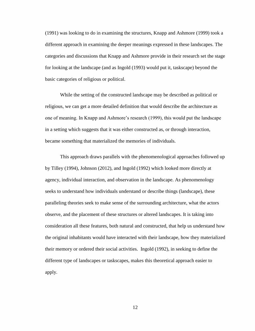
Chapter 3: Chaco Canyon
Due to the complexity of Chaco Canyon, this site has served as a valuable
research model on prehistoric roads in the New World. These “Chaco roads” provide a
context for not only understanding the landscape of movement, but also for better
understanding the cultures that used and constructed them. Chaco Canyon is a large
Pueblo II (A.D. 900-1150) site that flourished from A.D. 900 until approximately A.D.
1150, when the population eventually abandoned the site (Powers et al 1983). The site is
made up of 12 Great Houses (or large multi-room community centers) scattered
throughout the canyon (Lekson 2006: 11). The largest Great House, Pueblo Bonito, is
located in the center of the Chacoan core and consists of over 600 rooms (Van Dyke
2008: 119f).
In addition to these massive Great Houses, a large-scale road system appears to
connect many of these sites together. Two of the largest roads are the Great North Road
and the South Road. The Great North Road extends nearly true-north for approximately
50 kilometers and the South Road extends 51 kilometers (Van Dyke 2008: 145). These
two roads lead out of Chaco Canyon a great distance suggesting connectivity with
outlying communities. On average, these roads measure about 9 meters wide, but can
range from 3 to 12 meters (Van Dyke 2008: 145).
15
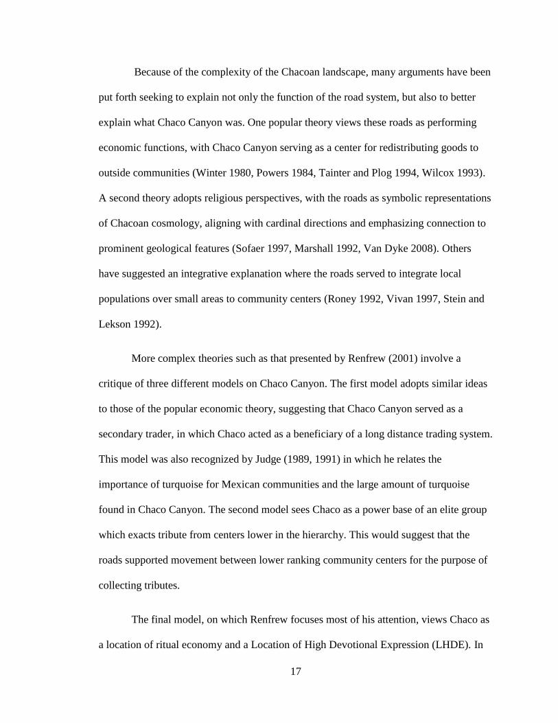
Figure 3.1: Core of Chaco Canyon showing the layout of roads and Great Houses.

16
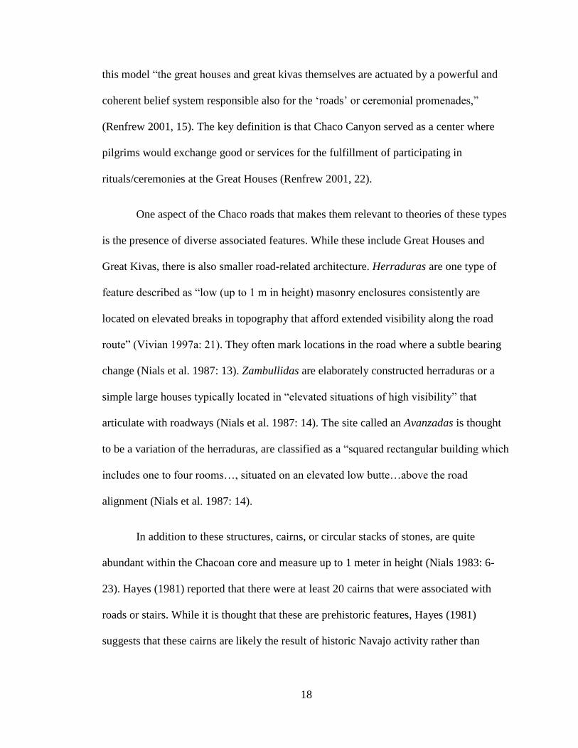
Figure 3.2: Major roads in and around the Chaco Core.
17
Because of the complexity of the Chacoan landscape, many arguments have been
put forth seeking to explain not only the function of the road system, but also to better
explain what Chaco Canyon was. One popular theory views these roads as performing
economic functions, with Chaco Canyon serving as a center for redistributing goods to
outside communities (Winter 1980, Powers 1984, Tainter and Plog 1994, Wilcox 1993).
A second theory adopts religious perspectives, with the roads as symbolic representations
of Chacoan cosmology, aligning with cardinal directions and emphasizing connection to
prominent geological features (Sofaer 1997, Marshall 1992, Van Dyke 2008). Others
have suggested an integrative explanation where the roads served to integrate local
populations over small areas to community centers (Roney 1992, Vivan 1997, Stein and
Lekson 1992).
More complex theories such as that presented by Renfrew (2001) involve a
critique of three different models on Chaco Canyon. The first model adopts similar ideas
to those of the popular economic theory, suggesting that Chaco Canyon served as a
secondary trader, in which Chaco acted as a beneficiary of a long distance trading system.
This model was also recognized by Judge (1989, 1991) in which he relates the
importance of turquoise for Mexican communities and the large amount of turquoise
found in Chaco Canyon. The second model sees Chaco as a power base of an elite group
which exacts tribute from centers lower in the hierarchy. This would suggest that the
roads supported movement between lower ranking community centers for the purpose of
collecting tributes.
The final model, on which Renfrew focuses most of his attention, views Chaco as
a location of ritual economy and a Location of High Devotional Expression (LHDE). In
18
this model “the great houses and great kivas themselves are actuated by a powerful and
coherent belief system responsible also for the ‘roads’ or ceremonial promenades,”
(Renfrew 2001, 15). The key definition is that Chaco Canyon served as a center where
pilgrims would exchange good or services for the fulfillment of participating in
rituals/ceremonies at the Great Houses (Renfrew 2001, 22).
One aspect of the Chaco roads that makes them relevant to theories of these types
is the presence of diverse associated features. While these include Great Houses and
Great Kivas, there is also smaller road-related architecture. Herraduras are one type of
feature described as “low (up to 1 m in height) masonry enclosures consistently are
located on elevated breaks in topography that afford extended visibility along the road
route” (Vivian 1997a: 21). They often mark locations in the road where a subtle bearing
change (Nials et al. 1987: 13). Zambullidas are elaborately constructed herraduras or a
simple large houses typically located in “elevated situations of high visibility” that
articulate with roadways (Nials et al. 1987: 14). The site called an Avanzadas is thought
to be a variation of the herraduras, are classified as a “squared rectangular building which
includes one to four rooms…, situated on an elevated low butte…above the road
alignment (Nials et al. 1987: 14).
In addition to these structures, cairns, or circular stacks of stones, are quite
abundant within the Chacoan core and measure up to 1 meter in height (Nials 1983: 6-
23). Hayes (1981) reported that there were at least 20 cairns that were associated with
roads or stairs. While it is thought that these are prehistoric features, Hayes (1981)
suggests that these cairns are likely the result of historic Navajo activity rather than
19
prehistoric Puebloans. Bonito style cairns associated with roads, described as generally
larger than 1 meter in diameter, are reportedly not very common (Nials 1983: 6-23).
One aspect of the roads themselves that has attracted interest is that many do not
appear to physically connect two locations. Roads will start at a great house only to end
abruptly. The Great North road for example seems to end abruptly at the rim of Kutz
Canyon, although some researchers have suggested that the road may extend along the
canyon bottom far as the Salmon and Aztec ruins (Lekson 1999, Stein and Mckenna
1988). There are other examples of roads within Chaco Canyon road network that simply
end without connecting to another node. Vivian (1997b), however, argues that they are
symbolic and don’t necessarily need to physically connect to a location as long their
meaning of sustained ties are established.
These diverse aspects of the structure of roads in Chaco Canyon suggest that
complexity involved in interpreting their role within the Chacoan system as a whole. To
discuss the road network in greater detail, a number of case-studies shall be presented in
the following section to provide a basis for further discussions. These examples are split
into three categories: symbolic roads, social roads, and political roads.
Social Roads
John Kantner’s 1997 article tests possible explanations for Chacoan road function
using cost-path analysis through GIS. He mapped numerous roads in Chaco Canyon and
ran a cost-path analysis to generate roads that were determined to be least effort between
two locations that were determined as possible start and end points for the roads. For
example, he used Pueblo Bonito as point A and the Chuska Mountains to the west as
20
point B as a test case regarding economic function, since the Chuskas were probably the
source of raw materials used in the Chaco system. A road was generated and was
compared to the existing roads and road segments (Kantner 1997: 55).
In the overall model, few Chacoan roads correlated with a “least cost” route, with
the one exception of portions of a road going south. An economic function thus seemed
improbable. This is, of course, if one were to assume that if the Puebloans intended to
construct roads for this purpose, they would have done so with the intent that they were
to be constructed in the most travel-efficient way (or that they even knew of the most
cost-efficient route). What Kantner (1997: 61) eventually concluded that GIS mapping
suggests that local integrative and religious explanations appear to be the most likely
explanations.
Vivian (1997b) proposed that roads are tangible symbols of intangible ideas and
serve to facilitate social cohesion. He argued that because several of the roads in Chaco
Canyon are only segmented, rarely extending full length, they may have merely served to
symbolize social integration. He joins Kantner in arguing that connectivity was the
essential purpose of these links.
On the one hand, this symbolic interpretation of roads can be viewed politically in
that the construction of these roads served to integrate the inhabitants. On the other hand,
roadways that connect smaller hamlets to the large great houses, and smaller hamlets to
other hamlets, could certainly have symbolized social integration. Ceremonies, while
cosmological and/or political in meaning, would also have served to integrate the
numerous individuals living in the community, and the roads would have served to bring
21
people together for ceremonies. For example, nearly every road originated at a specific
great house which has been believed to be the center of public rituals as well as the
location of kivas (circular ceremonial structures) where more private ceremonies were
conducted. It would seem very feasible that participants of feasts and other ceremonies
held by elites at these great houses would walk these roads as they went to and from
ceremonies. While the routes may be fairly insignificant in the actual performance of
rituals, they may still have been instilled with a sense of meaning to those traversing the
paths to and from the ceremonies, less of an actual ritual and more of a ritualistic habit.
This perspective is similar to that discussed under the theme of identity as offered by
Knapp and Ashmore (1999).
James Snead’s (2012) research follows Vivian (1997b) and addresses the issues of
function and symbolism. His research looks not at how roads are used, but what they
represent. While we tend to view roads as a form of mobilization, he makes a point to
mention that these are best explained as exponents of their construction. Thus, we must
attempt to understand not what they were, but what they mean. With this in mind we can
view them as not only utilities to assist in travel but also as landmarks, as tangible
evidence of the intangible idea of unity established through their connecting nodes. This
is not only to be experienced by those who traverse these paths, but also to those who do
not.
This idea is further expanded by Lekson (2006: 33) who states that most roads (at
least in Chaco Canyon itself) were monuments, and not necessarily corridors of travel. At
least among the Puebloan communities, roads served as symbols and in some instances
used for ceremonies. This can be tied to what Knapp and Ashmore (1999: 13) define as a

22
landscape of memory, where group or individual experiences bring meaning to the
landscape.
To borrow an analogy used by Stein and Lekson (1992: 16-17) Chacoan roadways
stand as a symbolic umbilical, representing connectivity and sustained ties with their
destination. The idea that roads could serve as a symbol of unity or connectivity is useful
in understanding road segments and those that simply end abruptly, with no sign of it
continuing anywhere else. It is possible that roads did not need to be fully constructed to
their destination; perhaps as long as it indicated the proper direction it was enough that it
symbolized the connection.
Political Roads
The discussion of roads being built for political purposes reflects multiple facets
of functionality. Research by Roney (1992:123-131) suggests that roads were not built to
facilitate movement nor were they built for economic purposes; rather, they were
constructed to compete with other elites for “control” of people. Elaborate constructions
were organized by the ruling elites and the scale of the architecture was directly
correlated to how much political power/organization elites had. One elite would have
constructed a wide road extending several kilometers in length, provoking a response
among competing elites, who tried to construct even more impressive roads. This theory
works if we are to accept that each great house was not a part of one single organization,
but that each great house was ruled by an elite competing for followers. One such theory
was proposed by Katherine Spielmann (1993), proposing that Chaco Canyon was a
“clustered confederacy.”
23
A second facet in this discussion is that not only did the constructed roadways
play a role in the competition for followers, but that the construction of the roads and
related architecture promoted social integration (Roney 1992:130). One might see this as
a feeling of obligation towards the community after putting much effort towards the
infrastructure. “In etic terms, labor investment creates integration” and elaborate
roadways would display this idea (Roney 1992:130).
This particular interpretation considers both the necessary functions of landscape
along with the symbolic meaning that accompanies any political structure. Additionally,
this case study would almost seem to suggest that the political function creates the
symbolic element of shared identity through labor investment. Should this then suggest
that an attempt to interpret a function is best approached through a symbolic theory? I
would argue no for the reason that only through determining the function can we
elucidate the symbolic component. Vice versa, such that determining a symbolic element
should also assist us in determining its more basic function.
Symbolic Roads
Research by Anna Sofaer et al. (1989) focused on cosmological meanings of
roadways in and around Chaco Canyon. They argued that some, if not all, of the Chacoan
roads were symbolic or cosmological expressions of their beliefs. The most prominent of
these roads is the Great North Road. Based upon its length (51 kilometers), wide
construction (6 meters on average), and orientation to true north, they suggest that it was
intended to connect the greater region to the ceremonial center or “middle place” as
24
described in Puebloan cosmologies, which they argue was Pueblo Bonito (Sofaer et al.
1989: 386).
In agreement with Anna Sofaer et al (1989), Marshall (1992) took the
cosmological analysis a step further, focusing on the orientation of roadways with the
regional ceremonial center and using additional ethnographic sources. He states that the
“cosmological function for the Chacoan roads is supported by the use of constructed
roadways as sacred pilgrimage avenues by historic and modern puebloan peoples,”
(Marshall: 1992: 10). So while the cosmological significance of the Great North Road is
expressed through its direction, other roads do so as pilgrimage paths to locations of
significance (i.e. Pueblo Bonito, Hosta Butte, or great kivas). To support this
interpretation, Marshall argues that the roadside features called herraduras and related
roadside features served as shrines which pilgrims would visit on their travels.
Fowler and Stein (1992) focused their research on roadways outside of the Chaco
core. In particular for this case study they examine a road connecting two non-
contemporaneous sites, Kin Hocho’I (a Chacoan era great house) and Ats’ee Nitsaa (a
post-Chacoan era great house) in a region Southwest of Chaco Canyon. In addition to the
temporal anomaly, the Chaco era structures were abandoned but left untouched, such that
none of the materials were re-used in the construction of the later post-Chacoan era great
house. With the understanding of Chaco Canyon as both a ritualistic landscape and a
victim of a sudden collapse and dispersal from this ritualistic landscape, Fowler and Stein
(1992:101-122) proposed that the road between the site represented a connection to the
past or, as they term it, a road through time. Thus, one might assume that they either
feared or revered the symbolism that the Chacoan era structure would have represented.

25
Similarly, the Great North Road is also argued to be a road through time,
connecting later, northern sites (perhaps even Aztec and Salmon) to Chaco Canyon
(Fowler and Stein 1992: 119). Work by Ruth Van Dyke (2008: 234) has also explored
this theory of “time-bridges,” proposing that “Post-Chacoan people may have been
attempting to consolidate community identify or create their own brand of legitimacy
through constructing references to a shared Chacoan Past.”
Additional research by Ruth Van Dyke (2008) adopts a type of phenomenological
approach to her research on Chaco Canyon in which she focuses on three perceptions,
“visibility, movement, and memory” (Van Dyke 2008: 8). Accordingly, she walked along
six major formal approaches leading into Chaco Canyon: Ah-Shi-Sle-Pah Road, West
Chaco River, South Road, Fajada Gap, and Each Chaco Canyon (Van Dyke 2008, 152).
She makes an important note, however, she is under “no illusion that these
phenomenological experiments will allow her to replicate the Chacoan spatial
experience” and acknowledges that any interactions with the landscape are culturally
conditioned (Van Dyke 2008, 152). Instead of relying entirely on her own experiences to
form explanations, Van Dyke thus used existing ethnography as a supplement.
One of the key emphases in Van Dyke’s research the visual experience that
pilgrims may have experienced when entering or leaving Chaco Canyon along these
formal approaches. She found that in three of the instances that the great houses
associated with the roads would have heightened the experience for travelers. In addition
to the discussion on visual experiences that pilgrims may have experienced entering
Chaco Canyon through the formal approaches, she discusses the dualism that the North
and South roads represent, defining Chaco Canyon as a center place (Van Dyke 2008,

26
164). Van Dyke also makes a note that while the South road is not true south; its
symbolic purpose is still served and suggests that the importance of symbolically
connecting to Hosta Butte may have been more important than true south (Van Dyke
2008, 150).
Discussion
Eight different interpretations of roadways at Chaco Canyon have been discussed,
each specific to a type of approach that considers them to serve as a symbolic element
relating to cosmology, social elements relating to integration, or political purposes
reflecting local competition.
One recurring theme in these different case studies is the symbolic element that
many argue are present in these roads. Even research which sought an economic
interpretation for the roads (Powers 1982, 1984, Wilcox 1993), classifying them as
strictly practical pathways, can argue that the symbolic element of connectivity exists
within outlying communities. With this said, however, interpretations of roadways need
not be pigeon-holed into one specific category; one road can serve multiple functions. For
instance, Kantner (1997) analyzed the roads for economic, cosmological, and integrative
functions, concluding that many of the roads fit these different functions.
Each of the case studies presented adopts a different methodology. Kantner
(1997) utilized GIS to facilitate the discussion of road function. Van Dyke (2008) took a
phenomenological approach, walking the routes themselves. To facilitate her discussion,
Van Dyke (2008) utilized existing ethnography to supplement her own experiences. Her
interpretations of these roads had similarities with those of Anna Sofaer et al. (1989) and

27
Marshall (1992), both of whom found cosmological significance in the roadways,
particular to the pathways which ran in cardinal directions. These case studies, along with
Renfrew (2001), all perceive Chaco Canyon as a ceremonial center, a center point from
which all the roads emanated. However, Renfrew also suggested the existence of a
“sacred economy” associated with the roads. Not only did locals and pilgrims enter the
ceremonial center for religious purposes, but in doing so they brought in goods.
Fowler and Stein (1992) proposed in their study a related cosmological definition
pertaining to a stretch of road connecting Kin Hocho’I with Ats’ee Nitsaa drawing from
the cosmological studies that define Chaco Canyon as a ritualistic landscape. Thus,
roadways within this understanding are more of a ritualistic structure and not necessarily
used just for traveling.
Snead (2012), Vivian (1997b), and Roney (1991) all sought a more integrative
explanation for the Chaco Canyon pathways, following that pathways are merely a
symbol of unity between two points. However, Roney (1991) proposed that roads, along
with other constructed community structures, were not just symbolic ties, but physical
ones as well. The community activities on these paths (such as traveling) were not the
only route through which integration was achieved, but facilitated through the effort of its
construction and maintenance.
What we see in the selected case studies is more than just a discussion on the
roads, but a discussion of the nature of the “Chaco Phenomenon” itself. Several of the
case studies that seek to define the roadways as cosmological define the Chacoan
landscape as largely ritualistic, where the larger site of Chaco Canyon was, in fact, a

28
center place from where all the roads emanated. Such an interpretation lends itself to an
understanding that most architecture was involved in ceremonies and other rituals. In this
sense, Great Houses were not houses at all, but were ceremonial structures. Similarly, the
roadways were not designed for travel, but for ritualistic symbols. That is to say, they
were constructed for ceremonial purposes.
In a slight contrast, the secondary understanding of the Chacoan landscape was
that it represented a more social or integrated community. This understanding does not
discount a ritualistic understanding of the Chacoan region, but it perceives the
significance of architecture as more social. In this sense, while the Chacoan culture is still
observed as largely influential to the surrounding populations, it does not stand as a
center place. The Great Houses, while still not seen as habitation sites, are there to
integrate individuals as community centers. Similarly, the pathways are there to integrate
the multiple sites within Chaco Canyon. Since this sense does not entirely discount the
cosmological significances of some of the structures, this integration can occur through
ceremonies held as Great Kivas or Great Houses as well as the more social purposes that
the roads allow for through unifying the sites along its route. Thus, perhaps we can best
understand features in the Chacoan landscape, and roads in particular, as having both
social and ritualistic significance.
29
Chapter 4: Methodology
This chapter outlines the methods that were used in the research program. The
first section will explain the research area and define the types of pathways under study.
A brief synopsis of the method of dating follows to assist in understanding the terms used
for describing different periods within the southwest. The fourth section will outline cost-
path analysis as it is used in this study. The last two sections will describe how ground
verification will be performed and how Chaco Canyon will factor into this study.
Research Area
The study area is located within southwest Colorado, now referred to as the
central Mesa Verde region (Kuckelman 2007: 1). A large number of Pueblo III
settlements contemporary with Chaco Canyon have been identified in this vicinity,
including Sand Canyon, Castle Rock, Shields Pueblo, and Goodman Point Pueblo. The
particular area of interest that is associated with the last two pueblos, Goodman Point
Pueblo and Shields Pueblo, is in a region where two documented Chacoan roads have
been identified.
Definitions
To apply the theories presented and to analyze the prehistoric landscape, the data
under consideration must be defined. The two typical types of pathways that one will
encounter in the prehistoric landscape are roads and trails. To get a clearer idea of the
difference these features, Charles Trombold (1991: 3) and Timothy Earle (1991: 11)
define a basic dichotomy between formal and informal paths (or roads and trails). This
difference is that formal routes show purposeful planning and construction, such as
30
uniform morphology and a consistent direction. Earle (1991: 10-11) defines the informal
paths (in this study, trails) as created through repeated travel across the landscape,
occasionally having alternate routes, and may have served immediate needs.
While roads, like those in Chaco Canyon, are clearly constructed and engineered,
trails do not show similar form (Vivian 1997a; Nials 1983). Roads tend to show a clear
trajectory and planning. Trails are often thought to be created organically or, in other
words, be created through repeated travel. This is best described as an evolved landscape
as described by both Knapp and Ashmore (1999) and by the original UNESCO
classification of landscapes (Cleere 1995: 65-6).
Understanding the difference between roads and trails will allow us to better
examine the significances of these pathways in their proper light, such that the
importance of a road may differ significantly from the trail. However, while this will help
us differ between two types of pathways, the question of function still remains for either
of these paths. To assist in determining this we can look at Hassig’s (1991) approach
which looks at associated architecture to help define the function of roads/trails. Roney
(1992) further expands on this to propose that while associated architecture help define
function that the pathways facilitate integration but not through use, but through
construction and maintenance.
Dating
The dating used in this research follows the classifications of eight different
stages of the ancient Puebloans as identified through architecture, art, pottery, and
cultural remains. This consensus was reached in 1927 at an archaeological conference

31
Figure 4.1: Eight stages of the Pecos Classification.
32
held in Pecos, New Mexico, and organized by Alfred V. Kidder. The dates in the
following dating are only approximate and are there to provide a rough estimate of each
of the labeled stages. Due to the ever-changing archaeological record and variations
among different regions of the four-corners, these dates are subject to change and may
not be entirely consistent with all research within the Southwest. Additionally, as
Chacoan-era culture is of interest in this research, Pueblo III (Great Pueblo) period will
often be referred to as the Chacoan-era rather than the Great Pueblo period. Furthermore,
as this study is focused on the Mesa Verde region, it should be noted that Chacoan
influence came to the region in c. A.D. 1080-1140.
GIS Analysis
While Hassig (1991) and Roney (1992) help us in defining function, a cost-path
analysis can help in supporting observations regarding the architectures to which they are
associated. Cost-path analysis, similar to network analysis, is a tool that measures the
effort, or cost of, traveling through each cell from a source to a destination, thereby
giving each potential path a unique value that defines the lowest total accumulated effort
required to complete the journey. The resulting value provides a route that is calculated
as a “least-cost” path between the two points (Chang 2013: 366, Bolstad 2008: 404-409).
While this tool is useful for taking into consideration numerous variables for construction
purposes of modern utilities and roads, cost-path analysis is also valuable for researching
the alignment and feasibility of travel for pathways constructed by prehistoric cultures.
This operation will tell us whether or not the path is built directly to the
hypothesized structure or built with a least-cost in mind. Cost-path analysis may also help

33
us determine if there are any differences in alignment between roads and trails. A
secondary benefit of performing this analysis is that it will involve plotting of both
pathways and sites within the area, allowing us to view, spatially, how close structures
are with these pathways at not just their start/end points, but also in between. This will
also allow us to identify any clustering of sites that may rest along these paths, indicating
possible favoring of locations along these perceived corridors of travel.
Ground Verification
Because this study is focusing on the roads and trails in the Goodman Point
Region, ground verification is beneficial to understanding the specific features that are
the subject of interest. Ground verification will involve obtaining measurements of width
and depth, factors that are important when discussing the nature of roads and trails.
Additionally, it will be important to observe what additional pathways may exist within
the region. Finally, as road markers have been recorded along roads within Chaco
Canyon, additional road related architecture will also be of interest when performing
ground verification.
The Chacoan Example
Because it is believed that the roads and trails observed within the Goodman Point
Region were influenced by the Chacoan culture, a comparison will be made against the
pathways of Chaco Canyon. Road-related architecture, trajectory, and morphology will
be of interest when comparing the pathways of both cultures. The result from this
comparison will show us how similar or different the pathways within Southwest
Colorado resemble the large road network in Chaco Canyon. A close resemblance would

34
suggest that Chaco Canyon had a large cultural impact on outlying communities within
the Four-Corners region of North America. In contrast, a minimal resemblance would
suggest that only portions of Chacoan culture were passed down to outlying
communities.
35
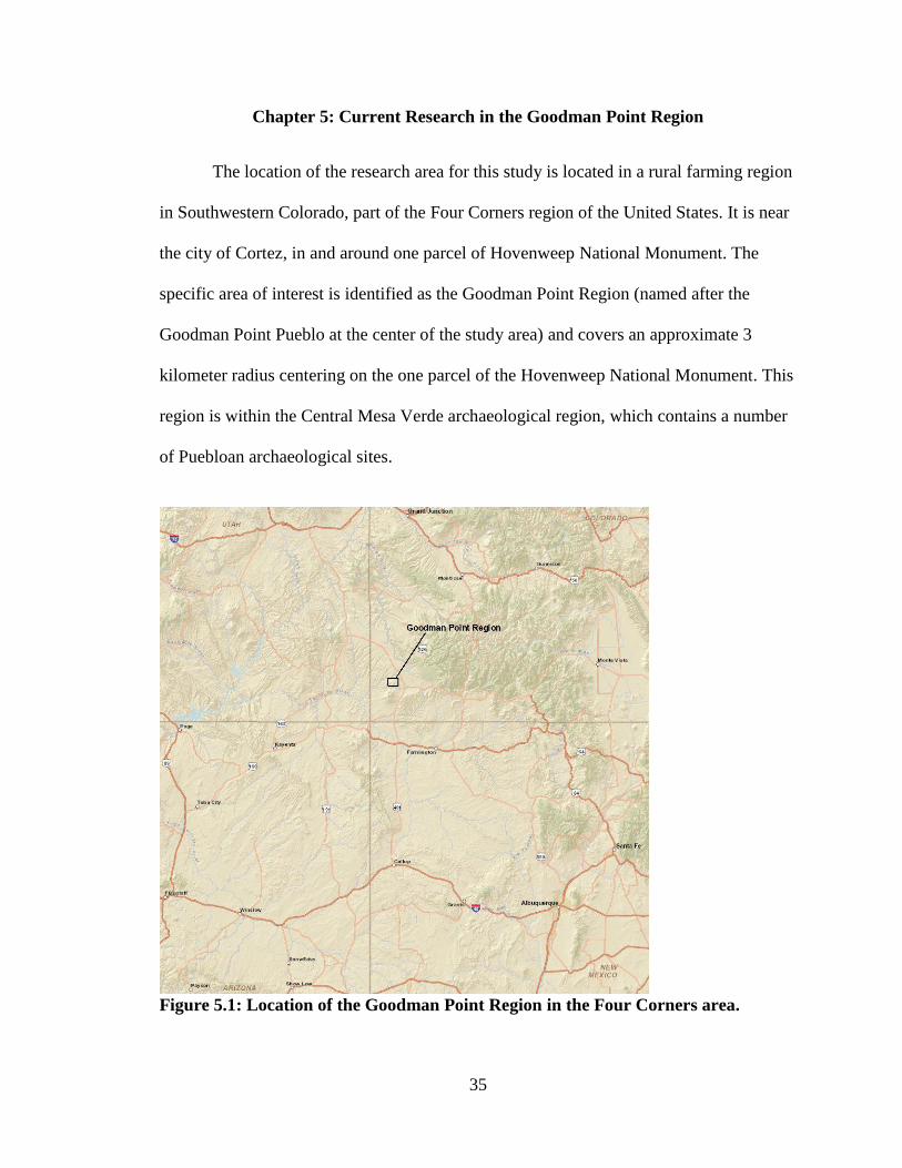
Chapter 5: Current Research in the Goodman Point Region
The location of the research area for this study is located in a rural farming region
in Southwestern Colorado, part of the Four Corners region of the United States. It is near
the city of Cortez, in and around one parcel of Hovenweep National Monument. The
specific area of interest is identified as the Goodman Point Region (named after the
Goodman Point Pueblo at the center of the study area) and covers an approximate 3
kilometer radius centering on the one parcel of the Hovenweep National Monument. This
region is within the Central Mesa Verde archaeological region, which contains a number
of Puebloan archaeological sites.
Figure 5.1: Location of the Goodman Point Region in the Four Corners area.

36
The topography is best described as rolling hills, occasionally divided by minor
canyons and drainages. Elevation ranges from 2003 meters (6600’) on the canyon slope
to 2054 meters (6740’) on stabilized eolian ridges above the west rim (Hovezak 2004: 8).
The general environment in and around Goodman Point Pueblo is transitional between
the Great Sage Plain of Southeastern Utah and the Blanding Basin of Southwestern
Colorado (Hovezak 2004: 8). The Great Sage Plain itself is an area of sage-covered
dunes. Goodman Canyon, immediately east of Goodman Point Pueblo, runs north/south
and is one of numerous drainages that make up the McElmo Canyon and is a tributary to
the San Juan River. Most of the vegetation in and around Goodman Canyon consists of
pinyon pine and juniper trees. Additional vegetation includes serviceberry, mountain
mahogany, cliffrose, antelope bitterbrush, fendler, and rabbit brush are common within
the region. Outside of the area preserved by Hovenweep National Monument and the land
owned by Colorado Mountain College, much of the area has been cultivated and farmed
by private owners.
Figure 5.2: Table showing relationship between occupation dates of sites.

37
The archaeological record of the Goodman Point region has been heavily
impacted by modern farming techniques, severely affecting preservation. However,
previous research has documented a diverse array of sites. The dominant features in the
area are three large community centers, defined as areas “of dense residential and public
architecture that was central to a cluster of individual settlements,” (Ward 1997: 2). Such
community centers are characterized by several kivas (circular communal structures),
often a larger “great kiva,” (named due to its large size), and numerous rooms and pit
structures over a larger area.
These three sites, Casa Negra, Shields Pueblo, and Goodman Point Pueblo, all
share these characteristics. The largest, Goodman Point Pueblo, has an estimated 450
rooms, at least 115 kivas, and one great kiva (Kuckelman et al. 2008: 5). Excavations at
Shields Pueblo identified a total of 28 kivas and over 150 rooms (Duff and Ryan 2000).
Casa Negra has been destroyed due to modern cultivation, but the best estimate of the
size of the site indicates 60 rooms (Adler 1987, 1988). These three sites are not
completely contemporaneous; Casas Negra dates from A.D. 920-1140, Shields Pueblo
from A.D. 1020-1260, and Goodman Point Pueblo from A.D. 1260-1280. The occupation
of Shields Pueblo coincides with the occupation of Casa Negra while Goodman Point
Pueblo began just as Shields Pueblo was ending (Fig 5.2).
Smaller habitation sites in this region are identified by being “occupied
continuously, or for a major portion of the year” and include “…substantial architectural
remains such as rooms, pitstructures, and outside work areas” (Kane 1983: 23). On
average, single habitation sites are estimated to have 6 rooms. Multiple habitations sites
average 14 rooms (Adler et al 1987; Adler 1988).
38
Modern archaeological research in the Goodman Point Region largely began with
the work of Michael Adler (1987, 1988, and 1990). Information on Shields Pueblo is
provided by the excavations done by Crow Canyon alongside Colorado Mountain
College and has recently been completed. While the information is still being processed,
field reports as well as a tentative final report is still available and provides us with a
general overview of the site and its history (Ward 1997, Ryan et al. 2013, Duff and Ryan
1999; 2000; 2001). Information on Goodman Point Pueblo, as well as a majority of the
sites and roads within the Goodman Point Region is made available by excavation
reports, field notes as well as the finished report on the archaeological survey (Hovezak
2004, Kuckelmen et al. 2009, Coffey and Copeland 2009, 2001). Additionally, Connolly
(1992) interviewed local landowners about the early settlement days and asked questions
pertaining to the archaeology of the Goodman Point Region. These interviews revealed
information that helped archaeologists locate potential sites, including pathways and the
prehistoric reservoir at Goodman Lake. Additional information provided by Crow
Canyon includes data from the Village Ecodynamics Project (Varien et al. 2007, Ortman
et al. 2007) which integrates data from sites in and beyond the Goodman Point Region to
illustrate spatial and temporal relationships between them.
The excavations at Shields Pueblo and Goodman Point Pueblo and analysis of
Casa Negra are complemented by site surveys done by Adler et al (1987, 1988). The
initial goal of the 1986 and 1987 surveys were to located, record, and evaluate all cultural
resources within the area described as the Sand Canyon area to analyze settlement
patterns, estimate local populations, and identify contemporary sites (Adler 1987: 5-7).
The goal of the first survey in 1986 was to record and evaluate cultural resources within a
39
5 kilometer radius of the site to better understand the local cultural (Adler 1987: 9), a
zone that also included the Goodman Point Region.
The survey conducted the following season in 1987 also collected information
from the area immediately surrounding Goodman Point Pueblo itself (Adler 1988: 9).
Throughout both surveys (Adler 1987; 1988), numerous sites were discovered with select
sites going through test excavations for further study. While they provided valuable
evidence for those studying the Puebloans in Southwestern Colorado, Adler’s (1990)
specific focus was aggregation among the communities of the Sand Canyon region and
the Goodman Point region.
Shields Pueblo
Excavations and research at Shields Pueblo has revealed what has been identified
as a community center which integrated the Goodman Point Region during its height
from A.D. 1050-1225, an era that “includes the Chacoan era influence from 1050-1150
and the post-Chacoan era from 1150-1225” (Duff and Ryan 2000: 12). Among the
characteristics of Chacoan influence at the site includes thin tabular masonry walls and
large rooms as well as a segment of the prehistoric road that runs directly to Casa Negra
(Duff and Ryan 1999: 10). One of the characteristics that the researchers note that is
missing, however, is an associated Great Kiva. While it was believed that this site served
as a community center during the Chacoan-era (A.D. 1050-1150), evidence has suggested
that the settlement was fairly light (Ryan et al. 2013: 34). There is evidence of a decline
of settlement at this site dating to the mid-to-late A.D. 1100s, corresponding to a lengthy
period of poor environmental conditions. Despite these poor conditions, however,
40
evidence shows persistent growth through the 1200s with structures occupied until the
general region was abandoned in the lade A.D. 1200s (Ryan et al. 2013: 34). The site
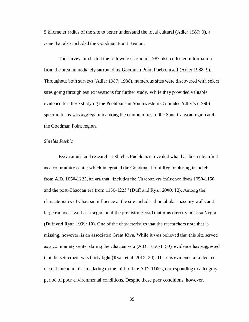
itself was occupied from A.D. 1020-1260.
Figure 5.3: Shields Pueblo looking towards Casa Negra
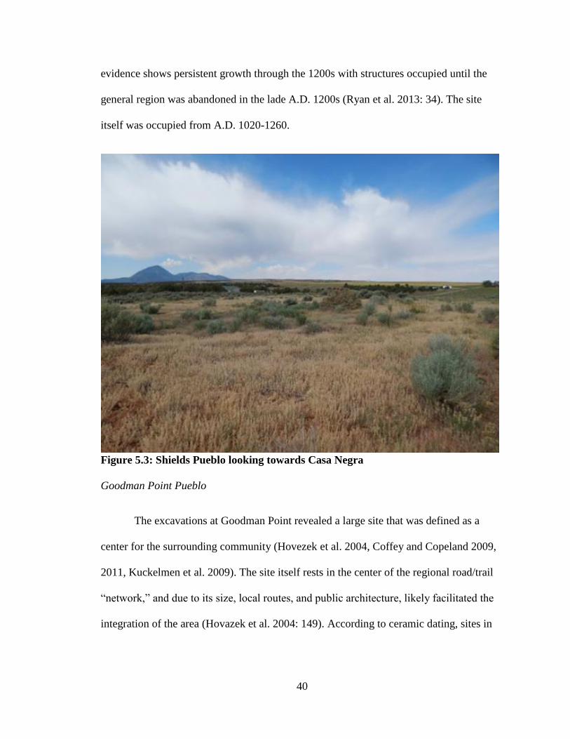
Goodman Point Pueblo
The excavations at Goodman Point revealed a large site that was defined as a
center for the surrounding community (Hovezek et al. 2004, Coffey and Copeland 2009,
2011, Kuckelmen et al. 2009). The site itself rests in the center of the regional road/trail
“network,” and due to its size, local routes, and public architecture, likely facilitated the
integration of the area (Hovazek et al. 2004: 149). According to ceramic dating, sites in

41
the Goodman Point unit were occupied in the period of Chaco influence (Hovazek et al.
2004: 149). The site itself was reportedly occupied from A.D. 1260-1280 (Fig 5.2).
Figure 5.4: Goodman Point Pueblo
In addition to the small cluster of sites which contain pottery, a Great Kiva,
identified as the Harlan Great Kiva, was also discovered in the area along with an
associated road. These sites showed characteristics of Chacoan influence. Excavations of
the Harlan Great Kiva suggest that the structure was used prior to A.D. 1149 but was not
initially a great kiva (Coffey and Copeland 2011: 18). While information is still being
gathered and analyzed, the structure that predates the Harlan Great Kiva is smaller and
may have been a Pueblo II pit structure prior to its conversion to a great kiva (Coffey and
Copeland 2011: 19-20).

42
Roads/Trails
Adler’s survey and additional research has identified seven roads/trails in the
Goodman Point region. These features are diverse in design and orientation, reflecting
similar constructions through the Chacoan world. Evidence for prehistoric roads is also
present, making local-level site documentation imperative to avoid confusion.
The largest road is called the Casa Negra-Shields road, which, as the name
suggests, is a series of road segments that appear to have connected these two Pueblo II
community centers, about 3 kilometers apart. The research done at the Shields Pueblo site
revealed evidence of an anomaly that lined up with what has been recorded as a road
(Ward 1997: 10). Further information on this road was obtained by Marjorie Connolly
(1992) in her interviews with the land owners in the Goodman Point area. Reportedly, all
residents knew about the Puebloan sites in the area, including the site known as Casa
Negra and the road which ran from it to “the ruins east of the schoolhouse” (what is now
known as Shields Pueblo) (Connolly 1992: 42). This road, as recalled by one resident,
“went right across from the big ruin south of Fulk’s old homestead [Goodman Point
Ruin]. It went right across that ruin, just as straight as you could go. Across our place and
up across…and up that big ruin over there [Casa Negra].”
The second main road is termed the Belt-Loop road (5MT16817) due to its
unusual loop appearance, but not seeming to connect any two locations in a direct
manner. It has been suggested that this road may have once formed a complete circle and
if the contours of the landscape are observed closely, the road does appear to extend

43
Figure 5.5: Casa Negra-Shields Road
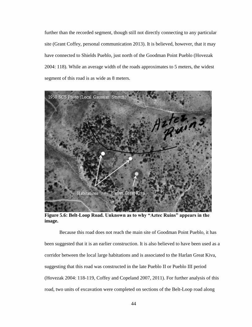
44
further than the recorded segment, though still not directly connecting to any particular
site (Grant Coffey, personal communication 2013). It is believed, however, that it may
have connected to Shields Pueblo, just north of the Goodman Point Pueblo (Hovezak
2004: 118). While an average width of the roads approximates to 5 meters, the widest
segment of this road is as wide as 8 meters.
Figure 5.6: Belt-Loop Road. Unknown as to why “Aztec Ruins” appears in the
image.
Because this road does not reach the main site of Goodman Point Pueblo, it has
been suggested that it is an earlier construction. It is also believed to have been used as a
corridor between the local large habitations and is associated to the Harlan Great Kiva,
suggesting that this road was constructed in the late Pueblo II or Pueblo III period
(Hovezak 2004: 118-119, Coffey and Copeland 2007, 2011). For further analysis of this
road, two units of excavation were completed on sections of the Belt-Loop road along

45
with collection of artifacts, sediment and pollen samples in 2010. The results are still
being analyzed and it is anticipated that the results will produce more confident
inferences about the nature of road construction (Coffey and Copeland 2011: 22)
Additional work done at the Goodman Point unit also identified a number of
additional roads and trails, including a short segment, 5MT16792 (identified as the east
road in the figure 5.7), which leads out of the northeast entrance to Goodman Point
Pueblo (Hovezak et al. 2004: 80) While there is evidence that it served as access to the
site in historic times, evidence that it had been graded in the past, visible in some areas as
a 3 meter wide linear landscape feature (Hovezak et al. 2004: 80). It has been postulated
that this road or trail may have been an important part of the Pueblo III landscape.
The largest trail in the area was identified as 5MT16816 (or the prehistoric trail in
figure 3) appears to connect Shields Pueblo with Goodman Lake, which has been
identified as an ancient reservoir. It also converges with another similar trail (5MT16815)
at about its halfway point to connect with Goodman Point, suggesting this route was
important to residents of the later pueblo as well (Hovezak 2004: 118). It was also noted
that this prehistoric trail passes by habitation sites that were part of the larger community
including a large Pueblo II habitation site (5MT16803) known as Pinyon Place. Further
information on this trail was alluded to through interviews with existing landowners
conducted by Connolly (1992: 42) told of a prehistoric road that ended at Goodman Lake.
A small road, labeled as the North Trail in figure 5.7 (5MT16812) was identified
as a historic road in the Goodman Point Survey Final Report (Hovezak et al. 2004: 115).
It is mentioned that while this road now serves as a visitor entrance to the pueblo, it dates

46
back to the early historic settlement of the Goodman Point area in the 1910’s and 1920’s
and likely accommodated wagons rather than motor vehicles (Hovezak 2004: 118).
The Northwest trail (5MT16813) was identified as a linear landscape feature that
went from Shields Pueblo to Goodman Point Pueblo. This trail was used in historic times,
possibly as a route for livestock, and thus makes dating of this trail problematic (Hovezak
2004: 119). Observations that suggest a prehistoric significance with this path:
“(1) this trail’s location between two prominent Pueblo III villages; (2) the trail’s
placement skirting the west edges of the architectural units of two other Pueblo
III, multiple-habitation sites…; and (3) the trail’s location just west of the
northernmost roomblock of [a multiple habitation site], just outside the elevated
plaza/midden, and the level grading of the trail in this area,” (Hovezak 2004:
116).
It is of interest to note that the trails in the Goodman Point area are considerably
narrower than the roads, measuring around 1-3 meters in width and 10 centimeters in
depth on average while the recorded segments of the roads showed morphology of 3-5
meters in width and ½ meter in depth. What is consistent among all the roads and trails,
however, is that dating of these sites are contingent upon the neighboring structures, such
as major habitation sites, kivas, and other majors sites such as community centers.
Additionally, use of roadways in historic times as cattle routes or as wagon routes can
create problems in terms in dating these linear features as they can create disturbance to
the original form of the route. The pathways in the Goodman Point region, however,
likely follow a similar engineering methodology that was used in the Chaco Canyon area.
47
While the trails in the region may simply have arisen as the result of repeated
travel to or from the ancient reservoir at Goodman Lake, the morphology and trajectory
of the roads indicate that they were very likely engineered by the local inhabitants. Nials
(1983) discusses the engineering of Chacoan roadways and suggests that there is more to
creating these paths than clearing brush in a linear fashion. He suggests that inhabitants
would have to have repeatedly cut into the ground a little bit over time to get that straight,
linear appearance that we can see in the Great North Road in Chaco Canyon and the Casa
Negra-Shields road in Goodman Point. While the inhabitants in Chaco Canyon likely
used markers along the roads as points of reference to get the straight feature, the
Goodman Point inhabitants may not have had to rely on road markers due to the short
distance between Casa Negra and Shields Pueblo.
Previous research within the Goodman Point Region has not identified any road-
related features that are common within Chaco Canyon. With that mentioned, however,
the presence of road related features along Chacoan roads is not unheard of outside of the
Chaco Core. Hurst and Till (2002b: 17-19) have identified the presence of features
similar to herraduras, avanzadas, among other miscellaneous features directly associated
with some of the roads in Utah. The most formal herradura was identified “at the crest of
Comb Ridge on the Jackson’s Trail crossover, on the projected line of the Bluff-to-Comb
road,” (Hurst and Till 2002b: 17). It is possible that the absence of road-related features is
due to the disturbance to the land via modern agriculture. As the Casa Negra-Shields
Road largely exists on private land, any associated architecture could have been removed
in the early days when farmers began settling in the area.

48
Figure 5.7: Map of the pathways in the Goodman Point Region.

49
Chapter 6: Analysis
This chapter will begin with a brief overview regarding the results of the
fieldwork that took place at Crow Canyon Archaeological Center and the results from
ground verification on site. This will be followed by the results from the GIS analysis,
with particular focus on cost-path analysis. Finally, the roads and trails from the
Goodman Point Region will be compared to those from Chaco Canyon to better
understand how outlying Chacoan roads and trails compare to those within the Chaco
Core.
Fieldwork
Fieldwork for this thesis consisted of two weeks in the summer of 2013 at Crow
Canyon Archaeological Center located in Cortez, Colorado. The purpose of this
fieldwork was to obtain resources stored in their archives pertaining to this research and
to collect digital data containing the UTM coordinates and information pertaining to each
site. The data obtained is a part of the Village Ecodynamics Project and allowed for
mapping and spatial analysis of sites within the region (Varien et al. 2007, Ortman et al.
2007). In addition to collecting necessary resources for this study, ground verification of
the pathways seen in the aerial imagery was necessary as well as to observe the landscape
surrounding the sites.
The results from ground verification were successful and included the addition of
more roads and trails than were initially planned for this research. These additions
included the Northwest Trail, the East Road, and the Prehistoric Trail. The Historic North
Road was added but was not considered in the research and analysis. Additionally,
50
noticeably differing morphology between these pathways made it necessary for the
purpose of this research to create the two categories; roads and trails. The road category
includes the Casa Negra-Shields Road, Belt-Loop Road, and the East Road and measure
at 5-8 meters in width and 50 centimeters in depth. The trail category includes the
Prehistoric Trail and the Northwest Trail and measure at 1-3 meters in width and an
average of 10 centimeters in depth.
On the ground, the roads were barely discernable, likely due erosion and
vegetative growth. Because of this, it was difficult to follow them, although Grant
Coffey, an archaeologist from Crow Canyon Archaeological Center who is familiar with
Goodman Point Pueblo, provided guidance. The trails, however, were still visible within
the landscape which made it easy to walk along them. Aside from the known habitation
sites, community centers, and the Harlan Great Kiva, no additional architecture that could
be defined as being road-related were identified along the paths.
While access to Goodman Point Pueblo and Shields Pueblo was made possible,
access to Casa Negra and the greater portion of the Casa Negra road was not obtained.
This was due to the extensive destruction in that occurred from modern agriculture. Data
pertaining to the sites within that area was obtained from the surveys and research largely
done by Adler (1988, 1989, 1990).
GIS Analysis
To facilitate the discussion on the pathways in the Goodman Point Region, a cost-
path analysis was run to analyze the trajectory of the paths to observe whether or not they
align with a least-cost direction (Chang 2013: 366, Bolstad 2008: 404-409). Sources
51
necessary for calculating a least-cost path include a source raster that includes an end
point (origin and/or destination), a cost raster that defines the cost required to travel
through each cell based upon one or more factors such as topography, vegetation, etc.
(measured relatively or actual), and a cost distance source, which is usually produced
along with the cost raster file. The cost distance source calculates the cost of traveling
from one cell to another through diagonal or lateral links. This source file also explains
why resulting paths in the analysis result in zigzag lines (it only calculates linear and
diagonal lines) (Chang 2013: 366, Bolstad 2008: 404-409). The latter two source files can
generally be calculated with a digital elevation model (DEM) if topography is the
primary weight to calculate the cost of travel.
For the purpose of this study, topography is the main relative cost-factor. This
was calculated as percent rise in slope and was calculated using a digital elevation model
measuring each ground cell at 9.4 meters2. Vegetation (primarily pinyon pine and juniper
growth) was not a weighted factored in the cost-surface as it would be difficult rationalize
using modern data on growth for researching a prehistoric landscape. Two Cost-Path
analyses were run using two different sources; one using Goodman Point Pueblo as the
source and one using Shields Pueblo as a source. The destinations were set as Casa Negra
Pueblo, Goodman Lake, and Shields Pueblo or Goodman Point Pueblo (destinations
differing depending on which source was used). Using these sources, the resulting paths
were calculated via cost-path analysis and were compared to the existing pathways, (e.g.
Casa Negra-Shields road, the Prehistoric trail, Northwest trail, East Road, and the Belt-
Loop road).
52
The results from the Cost-Path analysis from Shields Pueblo came to be rather
inconclusive in relation to the Casa Negra-Shields road. The calculated path suggests a
partial loop westward before heading towards Casa Negra, meaning that on part of the
Casa Negra-Shields road aligns with a least-cost path. However, with a brief examination
of the cost-surface data, this discrepancy can be explained by slight differences in the
landscape resulting in the slope being slightly higher closer to Shields Pueblo than the
area that the calculated path goes through. This discrepancy could not be corrected for in
ArcMap and only resulted in erroneous results. Additionally, the trail that unites Shields
Pueblo to the Goodman Lake reservoir also appears to be slightly off for the very same
reason.
The results from the Cost-Path analysis from Goodman Point Pueblo show one
strong correlation with the prehistoric trail that is connecting the pueblo to Goodman
Lake. Interestingly, the least-cost path calculated between Goodman Point Pueblo and
Casa Negra show a strong correlation. It should be noted, however, that while there is a
strong correlation with the existing road, these two sites were never occupied at the same
time. Any possible relation between these two sites may relate to a more symbolic time
bridge between these two non-contemporaneous sites as detailed by the work of Fowler
and Stein (1992) and Van Dyke (2008). Additionally, while there is some correlation
seen for the two trails heading north out of Goodman Point Pueblo, these trails will not be
examined in this study since the distance between Shields Pueblo and Goodman Point
Pueblo is very small. Problems finding any possible destination for the East road, as well
as the shortness of the segment, meant that it could not be examined via cost-path
analysis.
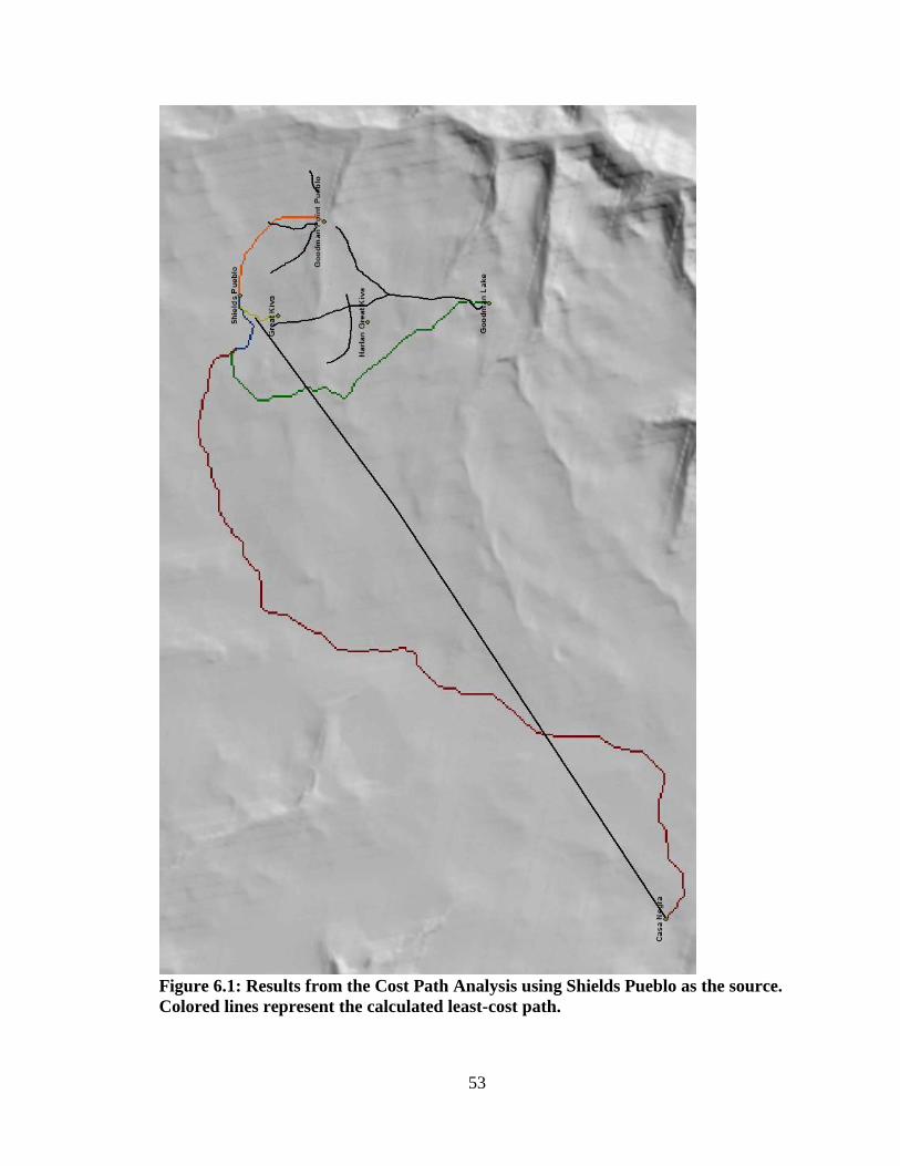
53
Figure 6.1: Results from the Cost Path Analysis using Shields Pueblo as the source.
Colored lines represent the calculated least-cost path.

54
Figure 6.2: Results from the Cost-Path Analysis using Goodman Point Pueblo as the
source. Colored lines represented the calculated least-cost path.

55
While the results from the cost-path analysis show a few correlations with the
existing routes, mapping of the data on the identified sites in the Goodman Point Region
show that nearly all the roads or trails link habitation sites and community centers
together, whether they are directly connected or simply rest along the route. This
observation draws parallels with the results that John Kantner (1997) obtained from
mapping the roads and sites in and around Chaco Canyon and from Roney’s (1992)
observation of an integrative structure resting at either end of the roadways in Chaco
Canyon. In the case of Chaco Canyon, this would have been based upon the assumption
that kivas and great houses served to unify the local community. In the case of the
Goodman Point Region, this would allow us to view roadways as a guide towards the
local great houses. However, in the case of the Casa Negra-Shields road, we might be left
wondering which great house would the traveler be guided to? Both sites were occupied
from A.D. 1020 -1140 where Shields Pueblo continued until approximately A.D. 1260. If
the road was constructed by the inhabitants at Casa Negra prior to Shields Pueblo,
perhaps the path was intended to integrate habitation sites in the area that later became
Goodman Point Pueblo.
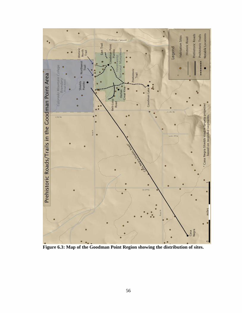
56
Figure 6.3: Map of the Goodman Point Region showing the distribution of sites.
57
Chaco Canyon and the Goodman Point Region
While prehistoric roads in the Goodman Point region may be seen as a result of
Chacoan influence, some of the common elements of these features (c.f., Nials 1987;
Vivian 1997a) are not present. Great Kivas and Great Houses are associated with roads,
and are found at the main community centers at Casa Negra, Shields Pueblo, and
Goodman Point Pueblo. However, there is a clear absence of anything else that may be
considered road markers or roadside shrines, despite the fact that these features are well
documented within the Chaco Canyon road network as well as associated with outlying
Chacoan roads in Utah (Hurst and Till 2002b: 17). While Stein (1983) determined that
Bonito style cairns were rare, one might expect to observe some road associated features
in a Chaco-style road. It is possible that modern agriculture simply destroyed any road
associated features that may have been along the Casa Negra-Shields road.
In terms of morphology, however, the Casa Negra-Shields road and the Belt-Loop
road share similar characteristics with those in Chaco Canyon. Most of the reported
segments in Chaco Canyon reported a width between 8 and 12 meters when topography
is not taken into consideration (Nials 1983: 6-9). Despite this observation in from the
Phase I research, Vivian and Buettner (1972) observed two different classes of roads
based upon measurements, primary which measured an average of 9 meters, and smaller
road spurs which averaged 4.5 meters in width. Additionally, Nials (1983) reported three
different groupings based upon road widths, roads with measurements of 11+ meters,
roads with measurements between 7 to 11 meters, and those with widths 7 meters and
below.
58
It should be noted that Nials (1983) reported that the wider measurements of
roads are usually observed where there is a close proximity to major sites. These wider
road segments yielded measurements exceeding 11 meters (Nials 1983: 6-5). In the case
of Chaco Canyon, this could be great houses such as Pueblo Alto and New Alto, which
are associated with the Great North Road. The reported width of this road ranges between
11 and 20 meters (Stein 1983: 8-7). In the case of the Goodman Point Region, however,
the Casa Negra-Shields road only measures a width of 5-8 meters. This measurement is
nearly half the average width of primary roads and more than half the width of the Great
North Road.
The measurements of the Casa Negra-Shields road are similar to those of the Belt-
Loop road, which is associated with the Harlan Great Kiva. This path also measures 5-8
meters wide. Neither compares well with what has been defined by Vivian (1972) as
primary roads. The smaller measurements of the documented roads in the Goodman Point
Region should not be considered surprising as the characteristics of Chacoan influence at
the community centers are not all present. They are, however, consistent with what
Vivian denotes as a smaller road spur (1972a: 23).
The depth of Chacoan roads has been measured as the difference taken from the
surface of the ground to the middle of the road. The average depths of roads measured
from the survey showed a range between 10-50 cm (Vivian 1997a: 25). Nials (1983: 6-
15) selected guideline of two categories, “shallow roads” at below 35 cm and “deep
roads” at depths at or above 35 cm. The Great North Road, while reportedly quite wide,
ranged in depth from .14 to .84 meters (14-84 centimeters), generally shallow to fairly
deep (Stein 1983:8-7). The Casa Negra-Shields road, as well as the Belt-Loop road,
59
averaged a depth of .5 meters (50 centimeters). In this regard, they fall within the average
measurements of depth of those in Chaco Canyon and would be classified as “deep
roads” (Nials 1983).
It is usually mentioned by researchers that Chacoan roads are straight (Lyons
1973, Lyons and Hitchcock 1977, Ware and Gumerman 1977, Obenauf 1980a, Hayes
1981). They may suggest to some that the linearity of roads is in fact a characteristic
specific to Chacoan architecture. However, it could simply mean that these pathways
were just well planned and engineered to avoid major topographic barriers and thus not
requiring major adjustments in their trajectory (Lyons and Hitchcock 1977). According to
Nials (1983: 7-27), “minor course adjustments would have been accomplished by the
means of slight angle changes.” Broad curves have also been observed in a roadways
running from Penasco Blanco to Ahshislepah as well as the extending from above Hungo
Pavi to a small mesa in the Chaco North area (Nials 1983: 6-27). What this suggests is
that the linearity popularly seen in the roads in Chaco Canyon may not necessarily be a
unique characteristic as it may simply be well planned construction.
Similarities clearly exist between the roads in the Goodman Point Region and the
Chacoan core. These similarities are depth, straight trajectory, and association with great
houses and a great kiva. However, the more specific features that are documented to be
associated with Chacoan roads, such as road markers or roadside shrines, have not been
identified within the research area. It may be possible that they were simply not used by
those within the Goodman Point Region or the features have been destroyed by modern
agriculture.
60
Chapter 7: Discussion of the Goodman Point Pathways
This discussion of the roads and trails within the Goodman Point Region will
begin with a look at each of the roads individually. It will begin with the Casa Negra-
Shields road, following it with the Belt-Loop road, discussing a little bit about the East
road, and ending with a discussion of the prehistoric trail. After a discussion of the roads
and trails, a final synopsis will be presented.
Casa Negra-Shields Road
As per the Roney model, the Casa Negra-Shields road could have physically
integrated the two centers as part of one regional community. This could have been done
through labor investment in engineering and maintaining these paths, affirming the idea
of integration with the larger community. Evidence of Chacoan architecture is present
within both community centers (Adler 1990:247).
What is known, however, is that Shields Pueblo is considered a community center
or “focal location within the larger Goodman Point community” from A.D. 1050-1225
where there is evidence of dense residential and public architecture (Adler 1990:260,
1994; Adler and Varien 1994; Varien 1999a). While no great kiva has yet been identified
within the Shields Pueblo unit, the Harlan Great Kiva, just to the south, is also considered
as an integrative feature with the surrounding habitation sites (Adler and Varien 1994: 8).
We can thus envision interaction between the communities surrounding the Great Kiva in
the Goodman Point area and the community surrounding Casa Negra. This interaction
may have occurred until the construction of the newer community center, Shields Pueblo,
where one might argue that the inhabitants of Casa Negra abandoned the site for the
61
newer community. This is, however, based upon the assumption that the Harlan Great
Kiva had been a great kiva prior to the occupation of Goodman Point Pueblo. If Coffey
and Copeland (2011 18-20) are correct in presuming that the structure prior to the great
kiva was likely a pit structure, this explanation may not be entirely accurate.
A more plausible theory on Chacoan roads argues for social cohesion, where
researchers identify roads as tangible reminders of unity and as a structure of social
integration (Vivian 1997b; Van Dyke 2007: 144-167; Stein and Lekson 1992: 87-100;
Lekson 2006: 34; Snead 2012). A road, which is constructed at a range of 5-8 meters in
width, to unite two community centers 3 kilometers apart, may have had an importance to
more than just the communities at the two centers. Roney (1992) attributed a political
importance to these structures of movement, the implications of integration still resonate
strongly as we observe not only where this road would lead the actors, but also the sites
that are along its route. Several contemporaneous habitation sites rest not only along its
path, but also along the paths of the trails south of Shields Pueblo.
Grant Coffey (2010: 77) argued that use of the Casa Negra-Shields road continued
well into about A.D. 1260, long after Casa Negra was abandoned, suggesting that there
was a significant amount of interaction between not only Casa Negra and Shields Pueblo,
but between Shields Pueblo and the greater region that this road passed through. This
observation suggests that the Casa Negra-Shields road operated as an integrative feature,
drawing together local populations around a new and manifesting community center,
Shields Pueblo.
62
If we are to apply the landscape perspective presented by Knapp and Ashmore
(1999: 13-15), the symbolism of the Casa Negra-Shields road might comprise of a
landscape of memory, which would see this landscape as the materialization of individual
or group experiences. It could also comprise of a landscape of identity, created by
individuals observing this path in symbolic or ceremonial terms. The difference depends
on whether or not this route was used for the purpose of drawing in the local community
in the region or for expressing unity between residential sites.
Based upon the understanding of the surrounding region, the Casa Negra-Shields
road may have served as a social path between several communities, the early Pueblo II
communities around Casa Negra near the early structures around the Harlan Great Kiva,
as well as the habitation sites between these two community centers. Thus, within this
surrounding region that the Casa Negra-Shields roads can be associated with, we can
define this landscape as one of social interaction. In the context of Ingold’s (1993)
understanding of the phenomenology of landscape, we may be looking at a social
taskscape and landscape in which the actors move and interact with one another in an
integrative/social setting.
One of the surprising results from the cost-path analysis showed a close
correlation between Goodman Point Pueblo and Casa Negra. While the results may seem
odd given that these two sites are entirely non-contemporaneous, similarities between the
research by Fowler and Stein (1992) and Van Dyke (2008) begin to emerge. While there
hasn’t been evidence of salvaging from Casa Negra by Goodman Point Pueblo, it is
possible that this route may have symbolized a reference to the shared identity of the
Chacoan past (Van Dyke 2008: 234).
63
Belt-Loop Road
But what of the Belt-Loop road; what purpose could this road have served? Its
relationship to the Harlan Great Kiva is distinctive; however, there are also a number of
habitation sites along this path, closer than the Harlan Great Kiva. Like the Casa Negra-
Shields road, we are looking at a roadway that has been elaborately constructed at 5-8
meters in width. However, unlike the Casa Negra-Shields road, no large sites other than
the Harlan Great Kiva appear near this path. Based upon the spatial context, this road
could date to as early as early or middle Pueblo II. Adler and Varien (1994) and Coffey et
al (2011) have identified this vicinity as a small community, integrated through the
Harlan Great Kiva. However, more recent research by Coffey and Copeland (2009, 2011)
have suggested that prior to A.D. 1250, the Harlan Great Kiva may have actually been a
smaller structure, possibly a pit structure. This would not suggest that there was no
organization within the area. Rather, it would suggest that if the Belt-Loop Road was
constructed prior to the construction of the Great Kiva, the road may have had a more
social integrative feature with just the local habitation sites.
Hovezak et al. (2004) suggested that this path may have connected with Shields
Pueblo to the north but the lack of further road segments in this general direction make
this proposition difficult to support. If this path did indeed extend to Shields Pueblo, this
may suggest that Shields Pueblo constructed and utilized the Harlan Great Kiva as an
integrative feature. It may also be possible that the Belt-Loop segment merely
represented a connection to Shields Pueblo, symbolizing another link to the past as the
Casa Negra-Shields road may have also served to do with the Goodman Point Pueblo.

64
When morphology is taken into consideration with the Casa Negra-Shields road
and the Belt-Loop road, it is clear that presentation by the magnitude of its construction
was of great importance. Was there a more political purpose for the road that connected
Casa Negra to Shields Pueblo? A road so elaborately constructed bears a close
resemblance to those in Chaco Canyon where some have argued for political competition
between great houses (Roney 1992; Spielmann 1993). In Roney’s interpretation argues
that since all roads, at one end or the other, have a great kiva or a great house, their
purpose would have been not only as a display of power but also as an integrative feature.
Not just in the sense that they direct attention towards the integrative structures, but also
in the sense that the labor investment in creating and maintaining these paths facilitate
this ideal of social integration.
While researchers have suggested that the Harlan Great Kiva served as an
integrative structure for the surrounding communities, the trajectory of the path suggests
a more symbolic meaning, especially as it bears a close association with the large
ceremonial structure. A cost-path analysis was not run for this route as it was clear by
examining the trajectory that it was not engineered in such a way as to directly connect
two or more sites. In terms of cosmological models for Chacoan roads (Sofaer 1997;
Marshalls 1997), the Belt-Loop road does not run in any cardinal direction nor does it
appear to direct any notable structure towards the kiva. What we have is a uniquely
aligned path near sacred, integrative structure.
Perhaps this unique road segment is presence enough. While Vivian (1997b) was
arguing for the symbol of unity in road segments, this argument can transfer over to
sacred symbolism as well. It is possible that the mere presence and shape of this road

65
segment was all the local inhabitants needed to establish cosmological meaning in this
pathway.
When seeking to define a symbolic meaning to the Belt-Loop road, we can expect
that this path was likely a landscape of identity, representing symbolic and ceremonial
identities to the local inhabitants (Knapp and Ashmore 1999: 13-15). Whether or not the
path merely stood as a landmark representing religious symbolism or it was actually used
in ceremonies, the idea of social identity through religious symbolism would have been
achieved through its presence near the Harlan Great Kiva. Contrary to that of the Casa
Negra-Shields road, we are looking a taskscape that represents the activities related at the
Harlan Great Kiva and the surrounding sites.
East Road
The East road (5MT16792) was identified as a northeastern corridor into the
Goodman Point unit in the survey report. This road has been dated to Pueblo III (A.D.
1180-1250) based upon its association with Goodman Point Pueblo itself. No attempt was
made for running a cost-path analysis for the primary reason that no sites of major
habitation or significance, other than Goodman Point Pueblo, could be identified within
the general area. Smaller habitation sites have been identified in past surveys to the
northeast of Goodman Point Pueblo. However, these sites are not contemporaneous with
Goodman Point Pueblo and date to between Pueblo II and Pueblo III (these can be seen in
the corner of figure 6). Thus, no identifiable sites of contemporaneous dates could be
selected as a feasible destination. However, because of the canyon immediately to the
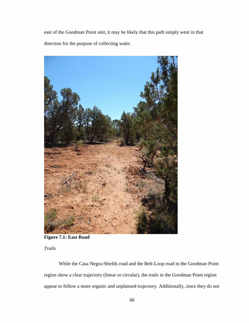
66
east of the Goodman Point unit, it may be likely that this path simply went in that
direction for the purpose of collecting water.
Figure 7.1: East Road
Trails
While the Casa Negra-Shields road and the Belt-Loop road in the Goodman Point
region show a clear trajectory (linear or circular), the trails in the Goodman Point region
appear to follow a more organic and unplanned trajectory. Additionally, since they do not
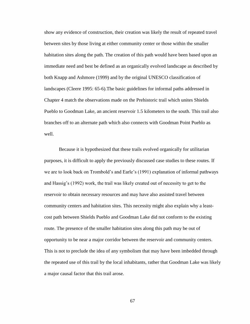
67
show any evidence of construction, their creation was likely the result of repeated travel
between sites by those living at either community center or those within the smaller
habitation sites along the path. The creation of this path would have been based upon an
immediate need and best be defined as an organically evolved landscape as described by
both Knapp and Ashmore (1999) and by the original UNESCO classification of
landscapes (Cleere 1995: 65-6).The basic guidelines for informal paths addressed in
Chapter 4 match the observations made on the Prehistoric trail which unites Shields
Pueblo to Goodman Lake, an ancient reservoir 1.5 kilometers to the south. This trail also
branches off to an alternate path which also connects with Goodman Point Pueblo as
well.
Because it is hypothesized that these trails evolved organically for utilitarian
purposes, it is difficult to apply the previously discussed case studies to these routes. If
we are to look back on Trombold’s and Earle’s (1991) explanation of informal pathways
and Hassig’s (1992) work, the trail was likely created out of necessity to get to the
reservoir to obtain necessary resources and may have also assisted travel between
community centers and habitation sites. This necessity might also explain why a least-
cost path between Shields Pueblo and Goodman Lake did not conform to the existing
route. The presence of the smaller habitation sites along this path may be out of
opportunity to be near a major corridor between the reservoir and community centers.
This is not to preclude the idea of any symbolism that may have been imbedded through
the repeated use of this trail by the local inhabitants, rather that Goodman Lake was likely
a major causal factor that this trail arose.
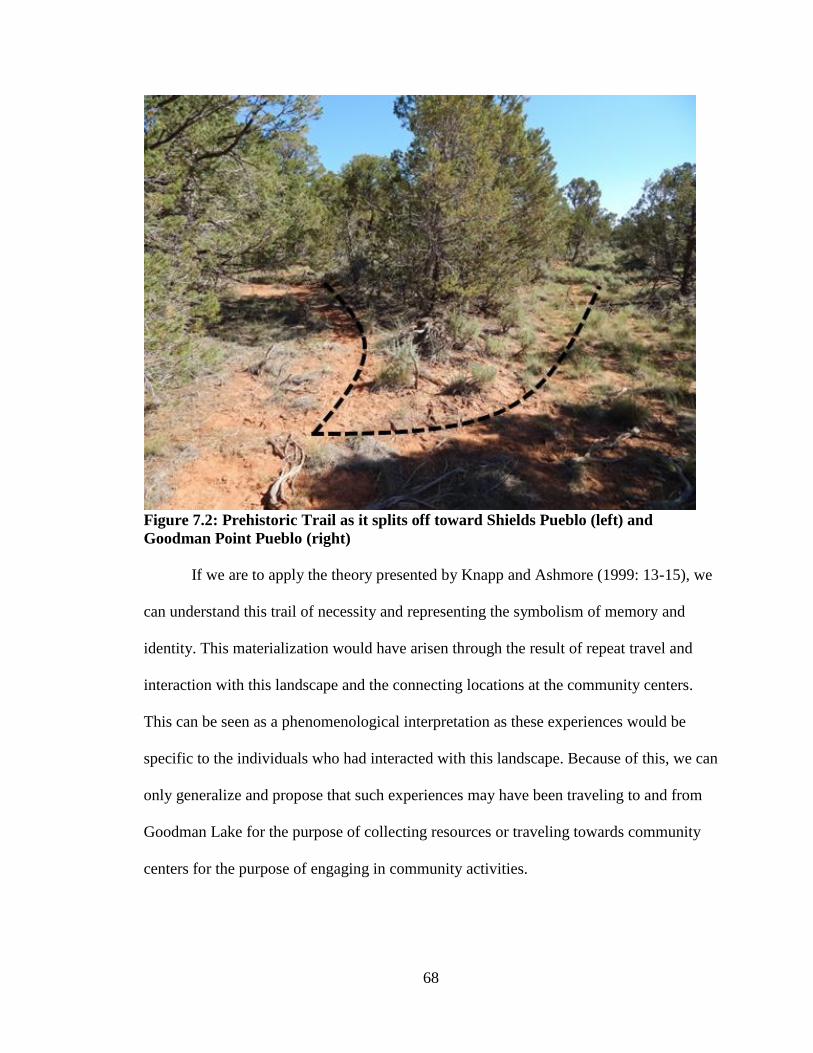
68
Figure 7.2: Prehistoric Trail as it splits off toward Shields Pueblo (left) and
Goodman Point Pueblo (right)
If we are to apply the theory presented by Knapp and Ashmore (1999: 13-15), we
can understand this trail of necessity and representing the symbolism of memory and
identity. This materialization would have arisen through the result of repeat travel and
interaction with this landscape and the connecting locations at the community centers.
This can be seen as a phenomenological interpretation as these experiences would be
specific to the individuals who had interacted with this landscape. Because of this, we can
only generalize and propose that such experiences may have been traveling to and from
Goodman Lake for the purpose of collecting resources or traveling towards community
centers for the purpose of engaging in community activities.
69
Figure 7.3: Prehistoric Trail going towards Shields Pueblo
Final Thoughts
There are notable similarities and differences between the roads and trails of the
Chacoan core and the Goodman Point Region. From what has been observed on the
ground via surveys and excavations, there are no observable road markers or roadside
shrines in the research area. Thus, if we were to define Chacoan roads by associated
features, the resemblance would consist only in the associated community structures and
the Harlan Great Kiva. A possible explanation for this discrepancy is that no road
70
markers or roadside shrines were necessary for the construction of the Casa Negra-
Shields Road. If any were originally present, however, these features may have been
unknowingly destroyed by modern agricultural machinery.
The depth of the roads and their straight trajectory is an important similarity
between roads in the two regions. Because the width of the roads in Chaco Canyon
appear to cover such a wide margin of measurements, and the measurements of road
width is fairly small by comparison, it would be hard to suggest that this is a specific
characteristic derived from the Chacoan culture. When we look at road trajectory, the
direct route that this path takes between Casa Negra and Shields pueblo, while it may be
seen as a characteristic of Chacoan road construction, may also be because there is no
reason the road would have needed to deviate from the direct route. There is no major
topographical barrier that it would need to move around and if its purpose was to unite
Casa Negra with Shields Pueblo, a straight line is a direct path.
Roads do not appear as a direct connection between sites. Rather, they are a made
up of multiple road segments. This observation is supported by research by Nials (1983:
6-27) which reports that the supposedly straight Chacoan roads are actually made of up
aligned straight segments. This was observed in the aerial images of the Casa Negra-
Shields road which showed at least three segments. For the Belt-Loop road this would
suggest that the segment was indeed all that was needed for its purpose in symbolizing
cosmological meanings to be fulfilled.
In contrast, trails in the study area are direct and contiguous paths rather than a
compilation of segments. This observation suggests that there is a clear difference in

71
intent and function between roads and trails. The prehistoric trail appears to have been
constructed through frequent foot traffic between both Shields Pueblo and Goodman
Point Pueblo and the Goodman Lake reservoir. As such, this trail was used for the
purpose of travel and was just wide enough to support one individual in front of another.
As it stands with the material presented on both the selected case studies from
Chaco Canyon and with the observations from the Southwest Colorado, the road and trail
system in the Goodman Point region demonstrates multiple functions and meanings that
depend upon connected sites and morphology. While the Casa Negra-Shield road may
have served to unite the larger community with Shields Pueblo, it may have also served
as a tangible symbol of sustained ties, not just to those who traversed this path, but also to
those who observed its purpose. In the later Pueblo III period, inhabitants of the
Goodman Point Pueblo may have also observed this road as a symbolic connection to
earlier Pueblo II period at Casa Negra.
However, the prehistoric trail served a more prosaic function, that of making a
connection to the water resources at Goodman Lake. Branches of this trail leading
towards Shields Pueblo and Goodman Point Pueblo may have also resulted in subsequent
travel from smaller habitation sites along this path towards the community centers. This
may have also resulted in this trail becoming a part of the larger social or political
landscape that resulted in larger scale integration by the community centers. Thus, while
its creation may have been utilitarian, a sense of shared identity would have been instilled
into this trail through its connections between habitation sites and Shields Pueblo and
Goodman Point Pueblo.
72
In the case of the Belt-Loop road, a more cosmological purpose appears to be the
most likely explanation, reflecting what Knapp and Ashmore (1999: 13-15) call a
landscape of identity. This identity would be represented through the local inhabitants
recognizing and maintaining this feature as symbolic of cosmological ideals. Experiences
would have been created by the local inhabitants either using it to travel to the Harlan
Great Kiva or by simply acknowledging its symbolic purpose (Van Dyke 2008; Renfrew
2001; Marshall 1992; Sofaer et al (1989: 373). While the recorded segment of the Belt-
Loop road is short in length and it doesn’t appear to directly connect any large site to the
kiva, these may not have been the important factors to the local inhabitants. The simple
recognition of cosmological symbolism would have been enough as it would have been
about the journey alone for the travelers, not about length or about its direct connection to
a large community center.
The symbolism that is played out in these paths is created through repeated
interaction with these landscapes. It is also the individual and group experiences that help
create this symbolism. This relationship is best expressed by Ingold: “…the landscape
tells – or rather is – a story. It enfolds the lives and times of predecessors who, over the
generations, have moved around in it and played their part in its formation” (Ingold 1993:
152).
73
Bibliography
Adler, Michael
1988 Archaeological Survey Testing in the Sand Canyon Pueblo / Goodman Point Ruin
Locality Montezuma County, Colorado, 1987 Field Season. Crow Canyon
Archaeological Center. Cortez, Colorado.
1989 Ritual Facilities and Social Integration in Nonranked Societies. In Occasional
Paper of the Crow Canyon Archaeological Center No. 1 The Architecture of Social
Integration in Prehistoric Pueblos pp. 35-52. Edited by William D. Lipe and
Michelle Hegmon. Crow Canyon Archaeological Center, Cortez, Colorado.
1990a Communities of Soil and Stone: An Archaeological Investigation of Population
Aggregation among the Mesa Verde Region Anasazi, A.D. 900-1300. The
University of Michigan
1990b Population Aggregation and the Anasazi Social Landscape: The View from the
Four Corners. In Community Dynamics in the Prehistoric Southwest, edited by
Robert D. Leonard and Wirt W. Willis (In Preparation).
Adler, Michael, Carla R. Van West and Edgar K. A. Huber
1987 Archaeological Survey Testing in the Vicinity of Sand Canyon Pueblo,
Montezuma County, Colorado, 1986 Field Season. Crow Canyon Archaeological
Center. Cortez, Colorado.
Adler, Michael and Mark Varien
1994 The Changing Face of the Community in the Mesa Verde Region A.D. 1000-1300
In Proceedings of the Anasazi Symposium, 1991, edited by A. Hutchinson and J. E.
Smith, pp. 83–97. Mesa Verde Museum Association, Mesa Verde, Colorado.
Bolstad, Paul
2008 GIS Fundamentals: A First Text on Geographic Information Systems. 3rd
Edition.
Eider Press, Minnesota.
Coffey, Grant
2010 Landscape and Social Scale at Goodman Point, Hovenweep National Monument,
Southwestern Colorado. The Kiva 76(1) pp. 55-82
Coffey, Grant and Steven Copeland
2009 Goodman Point Community Testing: 2009 Annual Report, Montezuma County,
Colorado. Crow Canyon Archaeological Center Cortez, Colorado
2011 Goodman Point Community Testing: 2010 Annual Report, Montezuma County,
Colorado. Crow Canyon Archaeological Center Cortez, Colorado
74
Chang, Kang-tsung
2013 Least-Cost Path Analysis and Network Analysis. In Introduction to Geographical
Information Systems, by Chang, Kang-tsung, pp. 364-380. McGraw-Hill
Science/Engineering/Math; 7th
edition
Connolly, C.M.
1992 The Goodman Point Historic Land-Use Study. In The Sand Canyon
Archaeological Project: A Progress Report, edited by W.D. Lipe, pp. 34-44.
Occasional Papers at the Crow Canyon Archaeological Center, No. 2. Cortez,
Colorado.
Duff, A. I., and S. C. Ryan
1999 The 1998 Field Season at Shields Pueblo (5MT3807), Montezuma County,
Colorado. Electronic document,
http://www.crowcanyon.org/ResearchReports/Shields/Shields1998season/Shields_1
998.asp, accessed November 29, 2014
2000 The 1999 Field Season at Shields Pueblo (5MT3807), Montezuma County,
Colorado. Electronic document,
http://www.crowcanyon.org/ResearchReports/Shields/Shields1999season/Shields_1
999_Start.asp, accessed November 29, 2014
2001 The 2000 Field Season at Shields Pueblo (5MT3807), Montezuma County,
Colorado. Electronic document,
http://www.crowcanyon.org/ResearchReports/Shields/Shields2000season/Shields_2
000_text.asp, accessed November 29, 2014
Earle, Timothy
1991 Paths and Roads in Evolutionary Perspective. In Ancient Road Networks and
Settlement Hierarchies in the New World, edited by Charles D. Trombold, pp. 10-16.
Cambridge University Press, Cambridge.
Fowler, Andrew P. and John R. Stein
1992 The Anasazi Great House in Space, Time, and Paradigm. In Anasazi Regional
Organization and the Chaco System, edited by David E. Doyel, pp. 101-122.
Maxwell Museum of Anthropology Anthropological Papers No. 5. University of
New Mexico, Albuquerque.
Fowles, Severin
2012 The Southwest School of Landscape Archaeology. Annual Review of
Anthropology. 2010, 39. Pp. 453-468

75
Ferguson, T. J., Lennis Berlin and Leigh J. Kuwanwisiwma
2009 Kukhepya: Searching for Hopi Trails. In Landscapes of Movement, edited by
James E. Snead, Clark L. Erickson and J. Andrew Darling. Pp. 20-41.University of
Pennsylvania Museum of Archaeology and Anthropology. University of
Pennsylvania Press. Philadelphia, PA.
Hassig, Ross
1991 Roads, Routes, and Ties that Bind. In Ancient Road Networks and Settlement
Hierarchies in the New World, edited by Charles D. Trombold, pp. 17-33.
Cambridge University Press, Cambridge.
Hayes, Alden C.
1981 A Survey of Chaco Canyon Archeology. In Archeological Surveys of Chaco
Canyon New Mexico. By Alden C. Hayes, David M. Brugge, and W. James Judge.
National Park Service Publications in Archeology. 18A:1-68.
Hovezak, Timothy, Leslie Sesler, Mark Varien, and Chris Goetze
2004 An Archaeological Survey of the Goodman Point Unit of Hovenweek National
Monument, Montezuma County, Colorado. Crow Canyon Archaeological Center,
Cortez, Colorado.
Hurst, Winston and Jonathan D. Till
2002a Trails of the Ancients: A Network of Ancient Roads in Southeastern Utah. Paper
from the 67th
Annual Meeting of the Society for American Archaeology, Denver,
CO. March, 2002
2002b Some Observations Regarding the “Chaco Phenomenon. In The Northwestern San
Juan Provinces. Papers Honoring the Contributions of Cynthia Irwin-Williams to
American Archaeology Pierre E. Morenon, Chair. Presented at the 67th
Annual
Meeting of the Society for American Archaeology Denver, Colorado
Hurst, Winston, Owen Severance, and Dale Davidson
1993 Uncle Albert’s Ancient Roads: Anasazi Formal Trails in Southeastern Utah. Blue
Mountain Shadows 12:2-9. San Juan County Historical Commission, Montecello,
Utah
Johnson, Matthew H.
2012 Phenomenological Approaches in Landscape Archaeology. Annual Review of
Anthropology, 41, pp. 269-284
Ingold, Tim
1993 The Temporality of the Landscape. In World Archaeology 25(2): 152-174

76
Kane, Alan
1986 Social Organization and Cultural Process in Dolores Anasazi Communities, A.D.
600-900. In Prehistory and Cultural Dynamics in the Dolores Area: The Dolores
Archaeological Project Final Report, assembled by David A. Breternitz, Christine
K. Robinson, and G. Timothy Gross, pp. 634-662. U.S. Bureau of Reclamation,
Engineering and Research Center, Denver.
Kantner, John
1997 Ancient Roads, Modern Mapping: Evaluating Chaco Anasazi Roadways Using
GIS Technology. Expedition 39(3):49-62.
1996 Political Competition among the Chaco Anasazi of the American Southwest.
Journal of the Anthropological Archaeology 15 pp. 41-105.
Kendrick, James and James Judge
2000 Household Economic Autonomy and Great House Development in the Lowry
Area. In Great House Communities Across the Chacoan Landscape. Edited by John
Kantner and Nancy Mahoney. Pp 113-129
Kincaid, C., and J. Roney
1983 Archaeological Inventory Methodology. In Chaco Roads Project, Phase I: A
Reappraisal of Prehistoric Roads in the San Juan Basin, 1983 pp. 1-10 Department
of the Interior, Bureau
Knapp, A. B., and W. Ashmore
1999 Archaeological landscapes: Constructed, Conceptualized, Ideational. In
Archaeologies of landscape: Contemporary Perspectives. Edited by W. Ashmore
and A.B. Knapp. pp 1-30.
Kuckelman, Kristin, Grant D. Coffey, and Steven R. Copeland
2009 Interim Descriptive Report of Research at Goodman Point Pueblo (Site 5MT604),
Montezuma County, Colorado, 2005-2008. Crow Canyon Archaeological Center
Cortez, Colorado
Kuckelman, Kristin, Ricky Lightfoot and Debra Martin
2002 The Bioarchaeology and Taphonomy of Violence at Castle Rock and Sand Canyon
Pueblos, Southwestern Colorado. American Antiquity, 67(3) pp. 476-513
Kuckelman, Kristin (editor)
2007 The Archaeology of Sand Canyon Pueblo: Intensive Excavations at a Late-
Thirteenth-Century Village in Southwestern Colorado. Edited by Kristin Kuckleman.
Crow Canyon Archaeological Center. Electronic document,
http://www.crowcanyon.org/sandcanyon, accessed November 29, 2014

77
Kuckelman, Kristin
2007 The Archaeology of Sand Canyon Pueblo. In The Archaeology of Sand Canyon
Pueblo: Intensive Excavations at a Late-Thirteenth-Century Village in Southwestern
Colorado Edited by Kristin Kuckleman. Crow Canyon Archaeological Center.
Electronic document, http://www.crowcanyon.org/sandcanyon, accessed November
29, 2014
Kuckelman, Kristin
2010 The Depopulation of Sand Canyon Pueblo, a Large Ancestral Pueblo Village in
Southwestern Colorado. American Antiquity 75(3) pp. 497-525
Lekson, Stephen H.
1999 The Chaco Meridian: Centers of Political Power in the Ancient Southwest.
Walnut Creek, CA: AltaMira Press.
Lekson, Stephen H.
2006 Chaco Matters. In The Archaeology of Chaco Canyon: An Eleventh-Century
Pueblo Regional Center, edited by Stephen H. Lekson, pp. 1-43. School of American
Research. Santa Fe, New Mexico
Lipe, William and Stephen Lekson
1990 Southwestern Pueblo Cultures in Transition: Report of a Conference. Paper
presented at the Annual Meeting of Society for American Archaeology.
Lyons, Thomas R.
1973 Archaeological Research Strategies: The Chaco Canyon Road Survey, Summer,
1973. Ms. On file, Division of Cultural Research (Chaco Center), Southwestern
Cultural Resources Center, National Park Service, Albuquerque.
Lyons, Thomas R., and Robert K. Hitchcock
1977 Remote Sensing Interpretation of an Anasazi Land Route System. In Aerial
Remote Sensing Techniques in Archeology, edited by Thomas R. Lyons and Robert
K. Hitchcock. Reports of the Chaco Center 2: 111-134
Moore, HL.
1987 Space, Text and Gender. Cambridge, Cambridge University Press
Marshall, Michael P.
1997 The Chacoan Roads: A Cosmological Interpretation. In Anasazi Architecture and
American Design, edited by Baker H. Morrow and V.B. Price, pp.62-74. University
of New Mexico Press, Albuquerque.
Nials, Fred L.
1983 Physical Characteristics of Chacoan Roads. In Chaco Roads Project Phase I: A
Reappraisal of Prehistoric Roads in the San Jaun Basin 1983. Pp. 6-1 – 6-51. US
Department of the Interior, Bureau of Land Management, Albuquerque District.

78
Nials, F., J. R. Stein, and J. Roney
1987 Chacoan roads in the southern periphery: Results of phase II of the BLM Chaco
Roads Project. Volume 1: US Department of the Interior, Bureau of Land
Management, Albuquerque District.
Ortman, Scott G., Mark D. Varien, and T. Lee Gripp
2007 Empirical Bayesian Methods for Archaeological Survey Data: An Application
from the Mesa Verde Region. American Antiquity 72(2):241-272.
Obenauf, Margaret Senter
1980a The Chacoan Roadway System. Unpublished M.A. thesis, Department of
Anthropology, University of New Mexico.
Powers, Robert P.
1982 Regional Interaction in the San Juan Basin, The Chacoan Outlier System. In
Recent research on Chaco Prehistory, edited by W. James Judge and John D.
Schelberg, pp. 23-34. Reports of the Chaco Center No. 8. Division of Cultural
Research, National Park Service, Albuquerque.
1984 Outliers and Roads in the Chaco System. In New Light on Chaco Canyon, edited
by David G. Noble, pp. 45-58. School of American Research Press, Santa Fe.
Rapoport, Amos
1988 Levels of Meaning in the Built Environment. In Crosscultural Perspectives in
Nonverbal Communication, edited by Fernando Poyatos, pp. 317-336. Hogfrefe and
Huber.
Renfrew, Colin
2001 Production and Consumption in a Sacred Economy: The Material Correlates of
High Devotional Expression at Chaco Canyon. American Antiquity 66(1): 14-25
Roney, John R.
1992 Prehistoric Roads and Regional Integration in the Chacoan System. In Anasazi
Regional Organization and the Chaco System, edited by David E. Doyel, pp. 123-
131. Maxwell Museum of Anthropology Anthropological Papers No. 5. University
of New Mexico, Albuquerque.
Ryan, Susan C., Andrew I. Duff, and Mark D. Varien
2013 Shields Pueblo: Summary of Research. Crow Canyon Archaeological Center,
Cortez, CO.
Severance, Owen
1999 Prehistoric Roads in Southeastern Utah. In La Frontera: Papers in Honor of
Patrick H. Beckett, Archaeological Society of New Mexico (25):185-195.
79
Shaw, Justine M.
2012 Roads to Ruins: The Role of Sacbeob in Ancient Maya Society. In Highways,
Byways, and Road Systems in the Pre-Modern World, edited by Susan E. Alock,
John Bodel, and Richard J. A. Talbert. Pp. 128-146. John Wiley & Sons, Inc, West
Sussex, UK.
Snead, James E.
2012 Obliterated Itineraries: Pueblo Trails, Chaco Roads, and Archaeology. In
Highways, Byways, and Road Systems in the Pre-Modern World, edited by Susan E.
Alock, John Bodel, and Richard J. A. Talbert. Pp. 106-127. John Wiley & Sons, Inc,
West Sussex, UK.
2002 Ancestral Pueblo Trails and the Cultural Landscape of the Pajarito Plateau, New
Mexico. Antiquity 76:756-65
Snead, James E., Clark L. Erickson, and J. Andrew Darling
2009 Landscapes of Movement: Trails, Paths, and Roads in Anthropological
Perspective, edited by James E. Snead, Clark L. Erickson and J. Andrew Darling.
University of Pennsylvania Museum of Archaeology and Anthropology. University
of Pennsylvania Press. Philadelphia, PA.
2009 Making Human Space: The Archaeology of Trails, Paths, and Roads. In
Landscapes of Movement: Trails, Paths, and Roads in Anthropological Perspective,
edited by James E. Snead, Clark L. Erickson and J. Andrew Darling. Pp. 1-20.
University of Pennsylvania Museum of Archaeology and Anthropology. University
of Pennsylvania Press. Philadelphia, PA.
Sofaer, Anna
1997 The Primary Architecture of the Chacoan Culture: A Cosmological Expression. In
Anasazi Architecture and American Design, edited by Baker H. Morrow and V.B.
Price, pp.88-132. University of New Mexico Press, Albuquerque.
Sofaer, Anna, Michael P. Marshall, and Rolf M Sinclair
1989 The Great North Road: A Cosmographic Expression of the Chaco Culture of New
Mexico. In World Archaeoastronomy, edited by A. F. Aveni, pp. 365-376.
Cambridge University Press, Cambridge, U. K.
Spielmann, Katherine A.
1993 Clustered Confederacies: Sociopolitical Organizations in the Protohistoric Rio
Grande. In The Ancient Southwestern Community: Models and Methods for the
Study of Prehistoric Social Organization, edited by Wirt H. Wills and Robert D.
Leonard, pp. 45-54, University of New Mexico Press, Albuquerque.

80
Stein, John R.
1983 Road Corridor Descriptions. In Chaco Roads Project Phase I: A Reappraisal of
Prehistoric Roads in the San Jaun Basin 1983. Pp. 8-1 – 8-15. US Department of
the Interior, Bureau of Land Management, Albuquerque District.
Stein, John R. and Peter J. McKenna
1988 An archaeological Reconnaissance of a Late Bonito Phase Occupation near Aztec
Ruins National Monument, New Mexico. Santa Fe NML National Park Service
Stein, John R. and Stephen H. Lekson
1992 Anasazi Ritual Landscapes. In Anasazi Regional Organization and the Chaco
System, edited by David E. Doyel, pp. 87-100. Maxwell Museum of Anthropology
Anthropological Papers No. 5. University of New Mexico, Albuquerque.
Toll, Henry W.
1981 Ceramic Comparisons Concerning Redistribution in Chaco Canyon, New Mexico.
In Production and Distribution: A Ceramic Viewpoint, edited by Hilary Howard and
Elaine L. Morris, pp. 83-121. British Archaeological Reports No. 120. Oxford,
England.
Trombold, Charles D.
1991 An Introduction to the Study of Ancient New World Road Networks. In Ancient
Road Networks and Settlement Hierarchies in the New World, edited by Charles D.
Trombold, pp. 1-9. Cambridge University Press, Cambridge.
Till, J. D.
2001 Chacoan roads and road-associated sites in the lower San Juan region: assessing the
role of Chacoan influences in the Northwestern Periphery, University of Colorado.
Tilley, Christopher
1994 A Phenomenology of Landscape: Places, Paths and Monuments. Oxford: Berg.
Ur, Jason A.
2003 CORONA Satellite Photography and Ancient Road Networks: A Northern
Mesopotamian Case Study. Antiquity 77(295):102-15
Van Dyke, Ruth M.
2008 The Chaco Experience. School for Advanced Research, Santa Fe, New Mexico.
Van West, Carla, Michael Adler and Edgar Huber.
1987 Archaeological Survey and Testing in the Vicinity of Sand Canyon Pueblo,
Montezuma County, Colorado, 1986 Field Season. Crow Canyon Archaeological
Center. Cortez, Colorado.
Van West, Carla and Jeffrey Dean
2000 Environmental Characteristics of the A.D. 900-1300 Period in the Central Mesa
Verde Region. The Kiva 66(1) pp. 19-44
81
Varien, Mark D., Scott G. Ortman, Timothy A. Kohler, Donna M. Glowacki, and C.
David Johnson
2007 Historical Ecology in the Mesa Verde Region: Results from the Village Project.
American Antiquity 72(2):273-300.
Varien, Mark, Carla Van West and G. Stuart Patterson
n.d. Competition, Cooperation, and Conflict: Agricultural Productivity in the Mesa Verde
Region. Crow Canyon Archaeological Center, Cortez, Colorado.
Varien, M. D.
1997 New Perspectives on Settlement Patterns: Sedentism and Mobility in a Social
Landscape. Unpublished Ph.D. dissertation, Department of Anthropology,
Arizona State University, Tempe.
1999 Sedentism and Mobility in a Social Landscape: Mesa Verde and Beyond.
University of Arizona Press, Tucson.
1999 Regional Context: Architecture, Settlement Patterns, and Abandonment. In The
Sand Canyon Archaeological Project: Site Testing. CD-ROM Vers. 1.0. Crow
Canyon Archaeological Center, Cortez, Colorado.
Vivian, G.
1972 Final Technical Letter Report for Prehistoric Water Conservation in Chaco
Canyon, NSF Grant No. GS-3100. Arizona State Museum, Tuscan.
1997A Chacoan Roads: Morphology. The Kiva 63(1): 7-34
1997B Chacoan Roads: Function. The Kiva 63(1):35-67
Ward, Christine.
1997 The Shields Pueblo Research Project: Annual Report, 1997 Fieldwork. Crow
Canyon Archaeological Center, Cortez, CO.
Ware, John A., and George J. Gumerman
1977 Remote Sensing Methodology and the Chaco Canyon Prehistoric Road System. In
Aerial Remote Sensing Techniques in Archeology, edited by Thomas R. Lyons and
Robert K. Hitchcock. Reports of the Chaco Center 2: 135-167
Wilcox, David R.
1993 The Evolution of the Chacoan Polity. In The Chimney Rock Archaeological
Symposium, edited by J. McKin Malville and Gary Matlock, pp. 76-90. General
Technical Report No. RM-227. U.S.D.A. Forest Service, Fort Collins, Colorado
82
Windes, Thomas C.
1991 The Prehistoric Road Network at Pueblo Alto, Chaco Canyon, New Mexico. In
Ancient Road Networks and Settlement Hierarchies in the New World, edited by
Charles D. Trombold, pp. 111-131. Cambridge University Press, Cambridge.
Winter, Joseph C.
1980 Human Adaptations in a Marginal Environment. In Human Adaptations in a
Marginal Environment: The UII Mitigation Project, edited by James L. Moore and
Joseph C. Winter, pp. 483-517. Office of Contract Archaeology, University of New
Mexico, Albuquerque.