CASE STUDY OF ALEXANDRA TOWNSHIP OM Mere Mini ...
112
GEOGRAPHICAL PATTERNS AND DISASTERS MANAGEMENT: CASE STUDY OF ALEXANDRA TOWNSHIP O.M. Mere Mini-dissertation submitted in partial fulfillment of the requirements for the degree Magister Artium in Development and Management in the Faculty of Humanities at the Vaal Triangle Campus of the North-West University Supervisor: Dr M.T. Lukamba November 2011
-
Upload
khangminh22 -
Category
Documents
-
view
0 -
download
0
Transcript of CASE STUDY OF ALEXANDRA TOWNSHIP OM Mere Mini ...
GEOGRAPHICAL PATTERNS AND DISASTERS MANAGEMENT: CASE
STUDY OF ALEXANDRA TOWNSHIP
O.M. Mere
Mini-dissertation submitted in partial fulfillment of the requirements for the
degree Magister Artium in Development and Management in the Faculty of
Humanities at the Vaal Triangle Campus of the North-West University
Supervisor: Dr M.T. Lukamba
November 2011
ii
DECLARATION
I, O.M Mere, declare that this research project on: “GEOGRAPHICAL PATTERNS
AND DISASTERS MANAGEMENT: CASE OF ALEXANDRA TOWNSHIP” is my own
work and that all the sources I have used or quoted have been indicated and
acknowledged by means of complete references.
Signature: _____________________________
Date: _____________________________
iii
ACKNOWLEDGEMENTS
I would like to thank my Lord Jesus Christ for making every moment possible for me
to write and finish this work; I acknowledge his utmost help in everything. I would
also like to thank and applaud the following people that believed in me throughout
my studies.
Dr Lukamba who dedicated his time and energy in helping me understand the
study and come up with the relevant outcome by supervising me;
Professor Ababio the head of Public management who allowed me into this
programme;
My family; Mother Mmabashi (Maria) and brother Boki Mere who stood by me
when I asked them for the chance to further my studies;
My partner-Sysman Motloung who was always ready to assist me and loved me
regardless of the less time I permitted him;
The government officials who gave their time as respondents and also allowed
me to conduct research in their area; and
I would also like to thank Alexandra residents as well as non-governmental
organizations who were willing to give correct answers and invested their time in
the project.
iv
ABSTRACT
The focus of the study is to explore Geographic patterns and Disasters Management
in the context of Alexadra Township situated in the Johannesburg Metro. The
research evaluates if the Disaster Management Unit in Johannesburg municipality is
prepared in terms of policies, community campaigns on flood disasters as well as
forming organizations that will assist in times of disaster. It also referes to other
South African townships with regard to where most affected townships are located,
how the community is affected and how the local government responds. Disaster
management infers preparedness for disaster; therefore, measures of preparation
from the local government need to be in place to reduce extreme losses, pro-active
policies should be in place to guide officials on how to manage disasters affecting
their areas.
The South African local government as the third sphere of government is closest to
the people and mostly responsible for the community’s wellbeing. It is for this reason
that local governments should have a strategy on how to deal with disaster. Having
experienced natural disaster incidents, most countries in the world have been
compelled to develop legislations, disaster management and mitigation plans that
guide them on how to prevent and respond to disasters.
In view of a several unimagined disaster incidents in South Africa, the researcher
maintains that the concept and practice of disaster management is rather new in
South Africa, and many local governments do not have well-informed strategies to
manage natural disasters. Unlimited rain caused by climate change, the position of
residence and overpopulation can be major attributes to disasters hazards. Floods
can easily flow into residential dwellings and destroy the property, not only that, but it
can also result in the loss of lives and enhance the spread of diseases. It becomes
more of tragedy as most people living in these areas are poor and have all their
belongings in the same place which makes them even more vulnerable to disaster.
The location of Stjwetla settlement along the Alexandra Township riverbanks
becomes relevant at this point in case. The residents of Stjwetla are exposed to flood
threaths, they are very much aware of the risk associated with the low-lying
v
geographical patterns, overpopulation and the riverbanks. However, they still occupy
the disaster prone sites because they cannot afford elsewhere. Stjwetla is an illegal
settlement where no one pays rent; there is a serious lack of basic municipal
services such as water and electricity in the area. The residents claim to have
arrived in this area simply because Johannesburg seems to offer informal job
opportunities; therefore, they anticipate good opportunities in terms of employment.
Most of them are from Limpopo province and have more than twenty years residing
in Stjwetla, and are still unemployed.
The community has formed rescue groups that help in times of regular disasters
such as floods and fire. The rescue groups also mediate between the community
and the northern Johannesburg municipal Disaster and Emergency Unit. The
Disaster and Emergency Unit have formed good relations with the community
leaders for support and emergency response. Other organizations, for instance Red
Cross Society make regular input, by offering food and clothes to the people
affected. Red Cross Society and other organizations work together with the local
government to help Stjwetla residents deal better with disaster effects.
However, the residents feel that other government departments, such as social
development, health and housing must assist as well. Residents are of an idea that
the disaster management unit alone cannot conquer the disaster risk in Stjwetla but
social development should help with psychological therapy while health department
should intervene to reduce long-term effects of injuries.
vi
TABLE OF CONTENTS
1 Chapter One: Orientation and Background ................................................. 1
1.1 INTRODUCTION ............................................................................................. 1
1.2 PROBLEM STATEMENT ................................................................................ 3
1.3 QUALITATIVE RESEARCH DESIGN ............................................................. 4
1.4 HYPOTHESIS .................................................................................................. 5
1.5 RESEARCH QUESTIONS ............................................................................... 5
1.6 RESEARCH OBJECTIVES ............................................................................. 5
1.7 RESEARCH METHODS .................................................................................. 6
1.7.1 Literature Study .......................................................................................... 6
1.7.2 Empirical Survey ........................................................................................ 7
1.7.3 Semi-structured Interviews ....................................................................... 7
1.7.4 Group Interviews ........................................................................................ 8
1.7.5 Biographical list of respondents ............................................................... 8
1.8 CHAPTER LAYOUT ........................................................................................ 9
2 Chapter Two: The Theoretical Exposition of Disasters and
Geographic Patterns .................................................................................................. 10
2.1 INTRODUCTION ........................................................................................... 10
2.2 THE THEORETICAL CONCEPT OF DISASTER .......................................... 11
2.2.1 Disaster Risk ............................................................................................. 13
2.2.2 Natural Hazards and Disaster .................................................................. 14
vii
2.2.3 Poverty, Vulnerability and Disaster ........................................................ 15
2.2.4 Disaster and Development ...................................................................... 17
2.3 GEOGRAPHIC PATTERNS .......................................................................... 17
2.3.1 What is Geography? ................................................................................ 17
2.3.2 Geography of Urban Disaster .................................................................. 19
2.4 CLIMATE CHANGE AND URBAN DISASTER ............................................. 19
2.5 INFRASTRUCTURE IN URBAN AREAS AND FLOODS DISASTER .......... 20
2.6 FLOODS HAZARDS AND URBAN DISASTER ............................................ 20
2.6.1 Physical Exposure of informal dwellers to floods ................................. 22
2.7 INTERNATIONAL EXPERIENCES ON URBAN DISASTER ........................ 23
2.7.1 Asia ............................................................................................................ 24
2.7.2 Europe ....................................................................................................... 26
2.7.3 North America ........................................................................................... 27
2.7.4 Australia .................................................................................................... 28
2.7.5 Continent of Africa ................................................................................... 28
2.7.5.1 North Africa ................................................................................................ 29
2.7.5.2 East Africa .................................................................................................. 30
2.7.5.3 West Africa ................................................................................................. 31
2.7.5.4 Central Africa .............................................................................................. 32
2.7.5.5 Southern Africa ........................................................................................... 33
2.8 DISASTER RISK REDUCTION ..................................................................... 34
viii
2.9 SUMMARY .................................................................................................... 36
3 Chapter Three: Geographical patterns and Urban Disasters in
South Africa ................................................................................................................ 37
3.1 INTRODUCTION ........................................................................................... 37
3.2 THE HISTORICAL GEOGRAPHY OF INFORMAL SETTLEMENTS
AND ITS PHYSICAL EXPOSURE TO FLOOD DISASTERS IN
SOUTH AFRICA ............................................................................................ 37
3.3 THE CLIMATE CHANGE AND URBAN DISASTER IN SOUTH
AFRICA ......................................................................................................... 38
3.4 URBAN GROWTH AND DISASTER IN SOUTH AFRICA ............................ 39
3.5 URBAN POVERTY, VULNERABILITY AND DISASTER HAZARDS
IN SOUTH AFRICA ....................................................................................... 40
3.6 THE IMPACT OF DISASTER IN THE DEVELOPMENT OF SOUTH
AFRICA ......................................................................................................... 42
3.7 THE HISTORY OF FLOODS DISASTER IN SOUTH AFRICA ..................... 44
3.8 RECENT FLOODS EXPERIENCES IN SOUTH AFRICA ............................. 45
3.8.1 Western Cape Province ........................................................................... 47
3.8.2 KwaZulu-Natal Province .......................................................................... 48
3.8.2.1 The floods Disaster events in Kwa-Zulu Natal ............................................ 49
3.8.3 Limpopo Province .................................................................................... 50
3.8.4 Gauteng Province ..................................................................................... 50
3.8.4.1 Pretoria ....................................................................................................... 50
3.8.4.2 Ekurhuleni .................................................................................................. 51
3.9 DISASTER MANAGEMENT IN SOUTH AFRICA ......................................... 51
ix
3.10 SUMMARY .................................................................................................... 54
4 Chapter Four: The Empirical Study of Alexandra Township in
Gauteng ....................................................................................................................... 56
4.1 INTRODUCTION ........................................................................................... 56
4.2 RESEARCH METHODOLOGY ..................................................................... 57
4.3 LITERATURE STUDY ................................................................................... 57
4.4 INTERVIEWS ................................................................................................. 57
4.4.1 Group interviews ...................................................................................... 58
4.5 EMPIRICAL SURVEY ................................................................................... 58
4.6 DATA ANALYSIS .......................................................................................... 59
4.7 ETHICS IN RESEARCH STUDY ................................................................... 59
4.8 CHALLENGES ENCOUNTERED DURING THE STUDY ............................. 60
4.9 STUDY AREA ................................................................................................ 61
4.9.1 Alexandra township area in the city of Johannesburg ......................... 61
4.9.2 Responses from the Metropolitan Municipality officials on
Disaster Management .............................................................................. 65
4.9.3 Responses from the organizations in the area on Disaster
Management ............................................................................................. 68
4.9.4 Responses from the Community Leaders in the study area ................ 69
4.9.5 Responses from the community / Residents in the study area ........... 70
4.10 SUMMARY .................................................................................................... 72
5 Chapter Five: Findings and Recommendations ........................................ 73
5.1 INTRODUCTION ........................................................................................... 73
x
5.2 FINDINGS ...................................................................................................... 74
5.2.1 Hypothesis ................................................................................................ 75
5.3 RECOMMENDATIONS ................................................................................. 76
5.4 CONCLUSION ............................................................................................... 77
BIBLIOGRAPHY .......................................................................................................... 78
WEBLIOGRAPHY ........................................................................................................ 84
INTERVIEWS ............................................................................................................... 90
APPENDIX A: A LETTER TO JOHANNESBURG METROPOLITAN
MUNICIPALITY REQUESTING PERMISSION TO CONDUCT RESEARCH .............. 91
APPENDIX B: A LETTER FROM JOHANNESBURG METROPOLITAN
MUNICIPALITY GRANTING PERMISSION TO CONDUCT RESEARCH .................. 93
APPENDIX C: RESEARCH INTERVIEW QUESTIONNAIRES ................................... 95
APPENDIX D: A LETTER FROM THE LANGUAGE EDITOR .................................... 99
xi
LIST OF FIGURES
Figure 1: Components of Disaster Risk ................................................................................ 14
Figure 2: Flood exposure of poor residences in Manila, Philippines ..................................... 22
Figure 3: The ratio of water related fatalities and people affected from 1980 to 2006 .......... 23
Figure 4: Informal settlements in the Cape Flats .................................................................. 41
Figure 5: Disaster Management Cycle .................................................................................. 53
Figure 6: Alexandra Township area landscape ..................................................................... 63
Figure 7: Residence along the Jukskei River ........................................................................ 64
xii
LIST OF TABLES
Table 1: Biographical list of respondents ................................................................................ 8
Table 2: Estimated Damage per Province on 23rd February 2011 ........................................ 46
Table 3: Significant Flood events in the History of South Africa ........................................... 47
Chapter 1: Orientation and Background 1
1 Chapter One: Orientation and Background
Keywords
Geographical patterns, Disaster Management; Township and Informal
settlement; Alexandra Township; Jukskei River
1.1 Introduction
Different disaster events are noticed in different areas of the world, caused by
different reasons, some are natural and others are man-made (ISDR, 2004:2).
The research aspires to investigate the link between the floods disastrous
events and geographical patterns in Alexandra Township as well as the
disaster management level in the area from the Metropolitan Municipality.
According to Raphael (1986:5) disaster usually means overwhelming events
and circumstances that can amongst others, also be geographically related
with far-flung human, material, economic or environmental losses. Skinner
and Mersham (2002:12) define a disaster as a rapid interruption of ordinary
operations causing serious damage to property or injury to people. Disaster is
also an incident arising within the complex, which is of such a magnitude that
the impacted zone extends beyond the complex boundaries into the
surrounding communities and necessitates the activation of the disaster
management plan (Raphael, 1986:5).
The study of Geography covers the earth’s landscapes, peoples, places and
environments; it is divided into two facets, namely; Physical and Human
geography. Physical geography gives focus to natural features of the earth,
the home of humans, the water, air, animals, and land of the planet earth.
Human geography deals with human culture and its impact on the earth,
languages, religion, foods, building styles, urban areas, transportation system,
politics, and economies (Rosenberg, 2010). The study attends to physical
geography, and provides analysis on the contribution of landscape, water and
air on the disaster events in Alexandra Township.
Chapter 1: Orientation and Background 2
More often, the setting of informal settlements is on high-elevated land, noted
for steep hills and slopes where storm water easily flows along natural valleys
and gullies (Tempelhoff et al., 2009:100). It is therefore; possible to relate
disasters with geographical patterns of a landscape. For example, China
experienced harmful floods in the Yangtze River basin in 1998 due to the high
level of rainfall and degraded landscape (ISDR, 2004:56).
Floods in several parts of Africa attribute to landscape formation. Mozambique
has experienced floods in a number of times, particularly floods in the year
2000 with impact on 500, 000 whereby 700 people died in the incident; most
affected were those in the lower city (Christie & Hanlon, 2001:18). Zimbabwe
often experiences floods especially during the rainfall season. Residential
areas downstream of Kariba dam but upstream the Cabora Basa such as
Guruve and Mzarabani are affected by floods because of their location. The
floods in that area have led to the loss of livestock and human life; damage to
crops and infrastructure with diseases such as malaria and cholera being
quite common during this period (Madamombe, 2004:4). Poor road drainage
systems and a lack of proper housing contribute to disasters especially in
informal settlements (Tempelhoff et al., 2009:100).
In the city of Durban, floods caused a great damage in 1987, people were hurt
and buildings were destroyed. About 400 people were left homeless and the
damage to communication infrastructure, agriculture and property amounted
to R400 million. These are the effects of the river changing as it flows, starting
out in the mountains and flowing down in a certain path (de Villiers & Maharaj,
1994:12).
Local municipality is defined in terms of article 155 (1) of the South African
constitution, Act 108 of 1996 as a category A municipality that shares
municipal executive and legislative authority in its area with a category C
municipality within whose area it falls. Alexandra Township falls under
Johannesburg Municipality, which has the responsibility to provide basic
services to the community of Alexandra Township. Basic municipal services is
defined in terms of the Municipal system Act 32 of 2000 as services that are
necessary to ensure an acceptable and reasonable quality of life to avoid
Chapter 1: Orientation and Background 3
public health and safety complications. Johannesburg municipality
incorporated with the provincial, national and private sectors to commence on
Alexandra urban renewal programme designed for the provision of
sustainable and affordable services by upgrading the housing environment to
ensure improved living conditions (UN Habitat, 2009:4).
1.2 Problem Statement
Located on the North-eastern outskirts of Johannesburg, Alexandra Township
is one of the densely populated black1 communities in South Africa (Morris,
2004:5). Alexandra primarily serves as the first stop for rural blacks entering
the city in search for jobs (Mgquba & Vogel, 2004:31). According to Wisner
(2005:272), Alexandra lies on a hillside that slopes from west to east into the
valley of the Jukskei River, and many of the residents occupying this area are
poor foreigners including war refugees from African countries. These
residents are extremely vulnerable due to poverty and lack of relational
support networks.
Wisner (1995:272) indicates that Alexandra is subdivided into three parts, with
striking differences, 1) Old Alexandra (situated on the west of the Jukskei
River) being the poorest and most densely populated area, where housing is
mainly informal dwellings and the old hostels. 2) The East bank (situated east
of the Jukskei River) is an area redeveloped in the 1980s and now occupied
by the middle-class community of Alexandra. This part constitutes less than
5% of Alexandra. 3) Is the far East bank now called Tsutumani. A squatter in
terms of South African law is a person who lives on land, in a shelter or shack,
without official permission while an informal settlement is a shelter built with
material according to un-conventional methods (Cosser, 1991:14). Alexandra
Township fits these classifications and thus become the focus of the study.
Research indicates that geographical problems in the Alexandra Township
may lead to disastrous events because of insufficient infrastructure. Over-
1 Blacks refers to one of the previously disadvantaged population groups (Black, Indians and Colored)

Chapter 1: Orientation and Background 4
population is definitely a major challenge in Alexandra, the infrastructure is
designed for a population of 70 000 people, and the influx of people over the
years has caused the population to balloon to an estimated 350 000 all
resident within a geographic area of 1.6 km² (GJMC, 2000). Such cramped
conditions certainly lead to social, environmental and health challenges. With
a growing rate of unemployment, the local living conditions deteriorated and
crime increased. As space became scarce, people began to build shacks over
sewer lines and manholes, resulting in blockages and rivulets of sewerage
water flowing freely in the narrow lanes and streets (UN Habitat, 2009:1).
The shallow and much polluted Jukskei River with occasional outbreaks of
cholera is one of the hazardous elements to the overcrowded Alexandra
community. The Jukskei banks are bound to flood mainly in the regional
heaviest summer rainfalls. This amounts to disaster for impoverished
residents who live in makeshift shacks along the riverbanks due to
overcrowding and the need for access to water for washing, drinking and
cooking (GJMC, 2000).
Other infrastructure problems related to the township, place a heavy burden
on the existing geographical feature and patterns. Because Alexandra’s
population is now four times its intended number, the sewage systems have
become overloaded (Wisner, 1995:273). The Township also experiences low
water pressure due to high demand on water, and in addition webs of
dangerous electrical connections in the township endanger many children
living in the area. Most residents have built their houses on tributaries
exposed to flash floods (Wisner, 1995:274). Government’s service delivery
level is too low because of high population in the area; while densely
populated stands caused by backyard shacks for rental pose safety hazards
(GJMC, 2000; Wisner, 1995:260).
1.3 Qualitative Research Design
Qualitative research methodology is applicable for this study mainly because
the methodology focuses on the perspective of the insider, talking to or
observing subjects who have experienced firsthand activities, as it believes
Chapter 1: Orientation and Background 5
that firsthand experience provides the most meaningful information (Leedy,
1992:144). The method attempt to gain a holistic view of the study: through
records, photographs, observations, interviews and case histories and
believes that it is essential to understand the meaning that persons attach to
events in their environment (Leedy, 1992:144; Denscombe, 2010:304).
1.4 Hypothesis
The null hypothesis: The geographical pattern of Alexandra Township in
Johannesburg can be the source of floods disaster in that area
The alternative hypothesis: The geographical pattern in Alexandra
Township in Johannesburg cannot be the source of floods disaster in that
area
1.5 Research Questions
The research explores the following questions:
What is the meaning of the concept, geography and disaster?
What are the impacts of geographical patterns found in South
Africa/international and what are the experiences on urban disaster?
What is the role of South African government in disaster management?
What is the link between the floods disaster and geographical patterns of
Alexandra?
What is the role of municipal government in disaster management in terms
of Alexandra Township?
What are recommendations to limit the disaster events linked with
geographical patterns in Alexandra Township?
1.6 Research Objectives
The following is an outline of objectives for the study:
To provide a theoretical exposition of the concepts of geographical
patterns and disaster;
Chapter 1: Orientation and Background 6
To indicate the impact of geographical patterns found in South
Africa/internationally and their experiences on urban flood disaster;
To indicate the role of South African government in disaster management;
To investigate into the relationship between disaster events and
geographical patterns of Alexandra Township;
To explore the role of the municipal government in disaster management
in terms of Alexandra township; and
To give recommendations that will ensure the reduction of risk events in
Alexandra township.
The following section s explain the methedology used in this study.
1.7 Research Methods
Qualitative methodology allows the researcher to understand the complexities
of social and political life through people’s experiences of that social reality
(Bryman, 1988:52; Pierce, 2008:45). This enables the researcher to
understand people and activities from a human actor’s perspective; the
researcher also derives meaning attributed to phenomena (Bryman, 1988:53;
Mouton & Marais, 1998:164). Qualitative methods enable access to first-hand
knowledge of social life, unfiltered through operational definitions or rating
scales (Taylor & Borgdan, 1998:9). The researcher is then able to provide
detailed descriptions, processes, relationships, systems, and people from their
own frame of reference of the social settings under investigation (Bryman,
1988:63; Taylor & Borgdan, 1998:7-8; Leedy & Ormrod, 2005:94). It is pivotal
for the researcher to analyse, contextualize phenomena and verify certain
assumptions and theories in constructing theoretical perspectives about
phenomena (Mouton & Marais, 1988:163).
1.7.1 Literature Study
Academic journal articles and various academic literature resources enabled
an exploration in the theme of Disaster, Geographical patterns and Alexandra
Township as conducted essentially for research. The Nexus database, SA e-
Chapter 1: Orientation and Background 7
Publications and the Disaster Management Act 57 of 2002 provides added
information. The North West University Library served as a housing of most
sources, inter-library transfers were a great help.
1.7.2 Empirical Survey
Surveys were conducted to collect updated information or scientific
investigation that is good, reliable and representative (Hart, 1993:1). Surveys
provide view from the public residents, as well as to inform oneself with
relevant data collected from a representative sample.
1.7.3 Semi-structured Interviews
Semi-structured interviews contribute in a sense that the researcher provides
minimal guidance and allows the respondent considerable latitude to provide
input concerning phenomena; this is very important if the researcher is to
avoid making distorted inferences about phenomena (Bryman, 1988:46-47).
During the fieldwork for this study, interviews were held with at least five
government officials’ respondents; three from disaster management unit in the
City of Johannesburg municipality, community leaders particularly the
Alexandra Township ward councillors and the community leaders. The
interview then extends to government and non-government organisations; four
members from identified organisations that usually assist the vulnerable
community of Alexandra.
Up to twenty community members from different households were involved in
the process. Their perceptions (Mouton, 1996:127, 175) are necessary to
understand the impact of geographical patterns in Alexandra Township.
Interviews include the unemployed and self-employed residents, who live in
the old Alexandra, the informal settlement that is in the west bank of the
Jukskei River. This constitutes a group of residents highly vulnerable to floods
because of their poverty and minority status (Wisner, 1995:273).
Chapter 1: Orientation and Background 8
1.7.4 Group Interviews
Group interviews conducted with different groups at Alexandra Township
provide different opinions from different residents. Group interviews add to a
very important tool of research, which allows the researcher to focus on group
norms and adequately attend to issues under investigation. This type of
interview provides valuable input into the study given that various
perspectives on the same issue are produced (May, 1997:114).
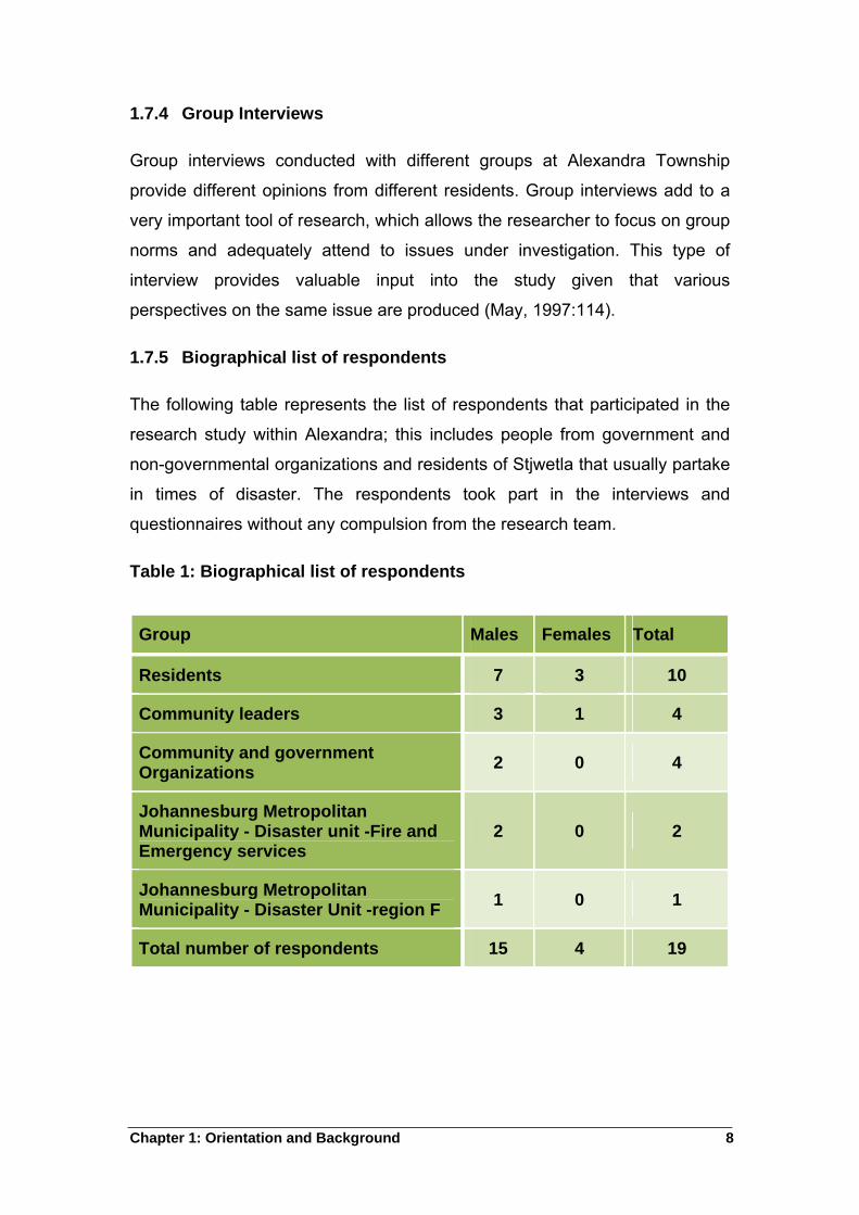
1.7.5 Biographical list of respondents
The following table represents the list of respondents that participated in the
research study within Alexandra; this includes people from government and
non-governmental organizations and residents of Stjwetla that usually partake
in times of disaster. The respondents took part in the interviews and
questionnaires without any compulsion from the research team.
Table 1: Biographical list of respondents
Group Males Females Total
Residents 7 3 10
Community leaders 3 1 4
Community and government Organizations
2 0 4
Johannesburg Metropolitan Municipality - Disaster unit -Fire and Emergency services
2 0 2
Johannesburg Metropolitan Municipality - Disaster Unit -region F
1 0 1
Total number of respondents 15 4 19
Chapter 1: Orientation and Background 9
1.8 Chapter Layout
Chapter 1: Orientation and Background
The chapter gives the orientation of the study and emphasise the problem
statement. The chapter also covers the objectives of the study and
hypothesis.
Chapter 2: The Theoretical Exposition of Disasters and Geographic
Patterns
The chapter looks into theoretical concepts of disaster and Geographic
patterns as well as international experiences on urban disaster
Chapter 3: Geographical patterns and Urban Disasters in South Africa
This chapter looks at South Africa’s disaster management and geographical
patterns. The study explores urban areas affected by flood disaster, especially
those in the informal settlements
Chapter 4: The Empirical Study of Alexandra Township in Gauteng
This chapter reports on the findings of the empirical research conducted at
Alexandra Township
Chapter 5: Findings and recommendations
The chapter will also make recommendations to the city of Johannesburg, the
municipality that is responsible for Alexandra Township.
Chapter 2: Theoretical Concept 10
2 Chapter Two: The Theoretical Exposition of Disasters and
Geographic Patterns
This chapter explores the concept of Disaster, Geographic patterns and
further presents International experiences of Urban disasters.
2.1 Introduction
Disasters are common in various places around the world while some are
natural, human activities influence other disaster incidents. Disaster is not any
one’s responsibility to manage. Society expects every member to assist in
times of disaster, whether affected or not. Disasters normally force the
governments to seek international help as it sometimes overwhelms available
resources to can help them manage or reduce the impact of such disasters.
Natural disasters do manifest in a different ways in different countries, floods
usually affect China and India because of their rains. On the contrary, drought
is the most famous type of disaster in Africa (ISDR, 2004:31).
Chapter 1 gives a brief background of the study and the scientific method to
implement the research project. This chapter provides a theoretical concept of
disaster and geographical patterns. It also looks at international experiences
on urban disaster with more focus on countries such as China, India,
Bangladesh, Mexico, Italy, and some countries in Africa. With regard to Africa,
the study looks at Mozambique, Algeria, Kenya, Cameroon, Tanzania, Congo
and Zimbabwe. The purpose is to create a clear understanding before a
thorough review of the study. A discussion of different elements associated
with disaster such as hazards, vulnerability gives a clear understanding of
disaster as a concept. A consideration of geographical patterns that can
influence the impact of disaster especially in urban areas, points to the fact
that landscape and climate conditions enhance floods impact in most
countries.
The chapter will review different countries affected by floods because of their
natural features such as the mountains, rivers and climate that influence the
Chapter 2: Theoretical Concept 11
rainfall land as well as the population. Each country will be analysed to give
an understanding of the influence of geographical patterns on disaster.
2.2 The Theoretical concept of Disaster
According to Quarantelli (1998:58) disaster is defined in various ways
depending on the country, but the core of the subject is based on
economically and socially harmful events. Disaster is any event that brings
great damage and inconvenience resulting into loss of life and property. The
ISDR (2004:3) concurs by accepting disaster as a serious disruption of the
function of a community or a society causing widespread human, material,
economic or environmental losses that exceed the ability of the affected
community.
There are different types of Disaster experienced in different areas. The focal
point of the research is on natural disasters, mainly those caused by floods
due to geographical patterns found in the area; for example, climate change,
dense population and landscape. According to Irasema (2002:108) natural
disasters occur worldwide but the impact is felt mostly in developing countries.
This is linked to two main factors their geographical location and historical
development which reflect their poor economic, political and social standing
that act as factors of vulnerability to natural disasters.
Wisner et al. (1994:5) maintain that disasters are a complex mix of natural
hazards and human action; for instance, wars relate with famine and disease.
The occurrence of wars in times of drought makes it more difficult for people
to cope. In this view, disaster is not a single event but a multiplicity of various
geographic, climatic and natural phenomena. In less developed countries,
Wisner et al. (1994:5) maintain that vulnerable people often suffer repeated,
multiple and sometimes simultaneous shocks to their families, and their
settlements. These repeated shocks erode any development, and
accumulation of resources and savings. Disasters impose a slow down effect
on key socio-economic factors such as human development and welfare
(Albala- Bertrand, 1993:77).
Chapter 2: Theoretical Concept 12
At a closer domestic echelon, the greatest impact is through damage to
infrastructure such as roads, housing, bridges, hospitals and schools. At a
national level, the greatest impact is through displaced people prone to the
risk of hunger and diseases (Wisner et al., 1994:5).
Claude (1998:12) explores paradigms developed to define disaster. The first
paradigm regards disaster in terms of patterns of war approach. In this sense,
disasters bear a great resemblance to war, and explains disaster on external
grounds with the causes of disaster sought outwardly. This paradigm uses
war concepts such as arms and enemies. The patterns of war approach views
human communities as organised bodies that have to react organically
against aggression. The war approach paradigm submits that disasters are
situations likely to elicit the reactions of human beings to aggressions and to
allow adequate test of them. The logical advance to disaster is for that reason
indicative of the nature where disaster research embraces a notion of an
agent, whereas people harmed by floods bore an extraordinary resemblance
to victims of air raids (Claude, 1998:12).
The second paradigm defines disaster as social vulnerability. The new
approach to disaster reverses the hierarchy of factors and eliminates the
notion of an agent. The new paradigm suggests that the causes of disaster
find explanation on structural as well as contextual grounds. It further argues
social risk as raised inwards and not outwards into the community, and then
there is disaster. Disaster is therefore no longer qualified as a reaction but an
action, a result and more precisely as a social consequence (Claude,
1998:13).
The new approach provides basis of moving from disaster as an effect to
disaster being a result of the underlying logic of the community. Therefore, the
conceptual framework of disaster is neither one of conflict, nor of defence
against external attacks, but is the result of the upsetting of human relations.
The approach shares the notion of vulnerability; it assumes that social
disorder and panic remain central to disaster analysis (Claude, 1998:14).
Chapter 2: Theoretical Concept 13
The third paradigm looks at disaster as uncertainty; it explains disaster as a
serious disorder within the community and worst of all, a disorder triggered by
communication problems. Disaster is a crisis in communicating within a
community, i.e. a difficulty for someone to inform and or, get information
(Claude, 1998:16).
The third paradigm manifests in three points. Firstly, it links the uncertainty
that occurs in the failure to define the threat facing the community through
causes or effects. Secondly, the growing complexities in emerging modern
communities increase uncertainty and thus upsetting the system. Thirdly,
uncertainty is peaked when actors of modern societies lose their capacity to
define a situation that they see as worrying and threatening through traditional
understanding (Claude, 1998:16).
Claude (1998:20) indicates that there are various habitual ways of looking at
disaster phenomena. While others view disaster as a sudden and an
extraordinary interruption of daily life and living conditions, others accept that
natural sciences and technology influence disaster (Claude, 1998:21).
Quarantelli (1998:22) relies on Perrow (1984), to impress that disaster is a
wrong amount of energy at the wrong time and wrong place, or a self-induced
resonance between technical subsystems leading to dangerous modulations
and collisions.
2.2.1 Disaster Risk
ISDR (2004:36) defines disaster as the probability of harmful results from the
interactions between natural or human induced hazards and vulnerable
conditions; disaster is therefore part of everyday life. Risk awareness is
therefore important to engage in disaster risk reduction. The relevance of
awareness is in ISDR (2004) arguing that the level of awareness depends on
the quantity and quality of available information, as well as the difference in
people’s perceptions of risk. People are more vulnerable when they are not
aware of the hazards that pose a threat to their lives and property. There are
two elements that determine disaster risk: namely; hazards, which are
potentially damaging events; and vulnerability, which is the degree of
Chapter 2: Theoretical Concept 14
susceptibility of elements exposed to that source (GTZ, 2002). Therefore a
risk exists only if there is a vulnerability to the hazards posed by natural or
human activity.
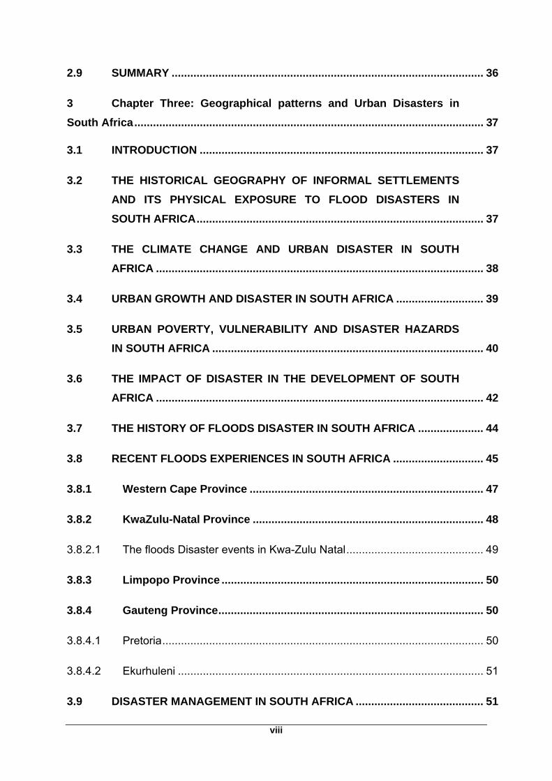
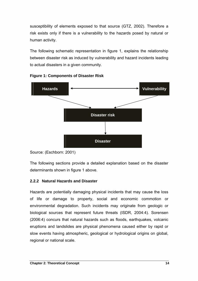
The following schematic representation in figure 1, explains the relationship
between disaster risk as induced by vulnerability and hazard incidents leading
to actual disasters in a given community.
Figure 1: Components of Disaster Risk
Hazards Vulnerability
Disaster risk
Disaster
Source: (Eschborn: 2001)
The following sections provide a detailed explanation based on the disaster
determinants shown in figure 1 above.
2.2.2 Natural Hazards and Disaster
Hazards are potentially damaging physical incidents that may cause the loss
of life or damage to property, social and economic commotion or
environmental degradation. Such incidents may originate from geologic or
biological sources that represent future threats (ISDR, 2004:4). Sorensen
(2006:4) concurs that natural hazards such as floods, earthquakes, volcanic
eruptions and landslides are physical phenomena caused either by rapid or
slow events having atmospheric, geological or hydrological origins on global,
regional or national scale.
Chapter 2: Theoretical Concept 15
According to Abhas, et al., (2010:340) hazards are dynamic with highly
varying potential impacts. Due to changing environments, many countries and
regional organizations require greater knowledge of hazards characteristics.
Natural hazards can be divided into five categories; hydrological, geophysical,
meteorological, climatological and biological. The variety of geographical
coverage and types of impacts vary considerably (ISDR, 2004:37). Natural
disasters are a result of the interplay of geographical processes and people,
because the introduction of disaster-risk comes to the purview once people
and their activities get in the way of natural processes. Geographical settings
can influence the impact associated with a particular hazard. For instance, the
same magnitude of disaster may hit in two different areas but have different
impact or effect because of the physical exposure and human vulnerability.
Physical exposure reflects the range of potentially damaging events and their
statistical variability at a particular location and human vulnerability reflect the
breath of social and economic tolerance to such hazardous events at the
same site (Smith, 1996:12).
Natural hazards have increased in urban areas due to factors; such as
population growth, urbanisation and climate change. Population growth has
caused vulnerability to hazard as seen through overcrowded people in unsafe
physical surroundings. Population growth strains infrastructure investment in
many countries in the world. Between one third and two thirds of their
population is in squatter settlements; which are exposed not only to seismic
risk but also to poor water supply and sanitation. This results in endemic
disease (Smith, 1996:42). Another contributing factor to hazard is in the
relationship of global warming and climate change. The impact will be
increased river flows inevitably affecting river management and agriculture
development, which might create a shift in disease patterns of animal and
human populations.
2.2.3 Poverty, Vulnerability and Disaster
Vulnerability is the conditions determined by physical, social, economic, and
environmental factors or processes, which increase the susceptibility of a
Chapter 2: Theoretical Concept 16
community to the impact of hazards (ISDR, 2004:7). The roots of disaster
vulnerability are pre-existing patterns of community settlement and
development, including the social order; its everyday relations to the habitat
and to the larger extent; the historical circumstances (Morrow, 1999:2).
According to Smith (1996:25), about 25% of the world population lives in
areas at risk from natural disasters, but the most vulnerable people are the
poorest; greatest economic impact and loss of life is manifest where poverty
stricken people are heavily concentrated. In urban squatter settlements,
population may reach 150, 000 per km2, possibly ten times of the established
areas or in rich areas. Most buildings on steep slopes or flood prone land
remain exposed to strong winds because the building material is inferior,
devoid of any reference to safe building codes (Smith, 1996: 25).
Morrow (1999:3) concurs with Smith (1996:1) that the poor typically live in
poorly built and inadequately maintained housing; their dwellings are often in
the most vulnerable locations such as floods plains. This virtually erases
everything they might have accumulated (Sorensen, 2006:5). According to
Morrow (1999:4), vulnerability varies with age, gender and household
arrangement, the old and the young are the most vulnerable in the community
because of their unstable health, relevant experience, education and skills.
Because of cultural household responsibilities given to women, it is the
responsibility of women to care for the family members. It then becomes
difficult for employed women to respond when disaster incidents strike.
The old, the young, women, immigrants and the minority in the community are
the most vulnerable because they have no networks and sometimes excluded
from the community disaster planning and preparation activities (Morrow,
1999:8). Wisner et al., (1994:12) posit that there are various important
differences between the vulnerability of the rich and the poor. There is less
disaster impact on the rich people compared to the number of poor victims of
disaster in various cities. The reason could be, that money can buy design
and engineering that minimises the frequency of disaster impacts even if living
on an exposed slope. The rich live in hazardous environment by choice while
Chapter 2: Theoretical Concept 17
the poor are compelled to live in slums in order to organise livelihood activities
such as proximity to workplaces, informal labour, prostitution, drug dealing,
crime and crafts, crime and prostitution. People decide to live in disaster
prone areas so long that implies proximity to services and opportunities
necessary for day-to-day living (Wisner et al., 1994:12).
2.2.4 Disaster and Development
Disaster can wash away the achievements of economic development; roads,
telecommunications and railway infrastructure. The disaster incident in
Mozambique in 2000 bears the testimony of this assertion. Catastrophic
disasters destruct fixed assets and physical capital (UNDP, 2004:20).
Disaster events have the potential to destroy social development benefits
such as health, sanitation, housing and education sectors; above all, a greater
burden is manifested in the simultaneous occurrence of disaster and incidents
of malnutrition or national conflict (UNDP, 2004:21).
2.3 Geographic Patterns
The following section covers geographic patterns and their contribution to
disaster incidents as well as the impact on humans.
2.3.1 What is Geography?
The concept of Geography derives meaning from the Greek word ‘geo’, which
means earth, and ‘graphein’, which means to write, hence to write about or
describe the earth. Constant changes initiated by natural forces as well as by
people cause the field to remain dynamic and challenging. There are several
definitions of geography, for instance; geography is the study of the areal
differentiation of the earth’s surface. On the other hand, geography is the
significance of differences from place to place. Although the stress is on
differences, it is clear that there is implication to similarities as well. The
interrelationships among different areas, in terms of their physical and
biological attributes, are significant to people’s habitation on earth, as well as
their understanding and appreciation of it (Doerr, 1990:1).
Chapter 2: Theoretical Concept 18
Geography is the study of the relation of people to their environment. All these
definitions include people and environment, how people have adapted to or
made modifications to their physical world while creating a uniquely human
setting.
The distributional patterns on earth’s surface are central to all definitions of
geography, the ultimate objective of geography is to understand, adapt and
adjust to the world in which we live. People’s activities are not controlled by
the physical environment, but natural forces and phenomena significantly
affect economic and cultural development (Doerr, 1990:2). For instance as the
population increases so thus the human requirements such as food and fuel,
consequently, people expand the cultural landscape while modifying the
physical environment (Doerr, 1990:2).
Geography appears on social and science geography categories. Geography
as a science includes the study of physical components of the environment at
or near the earth’s surface, as well as a synthesis of the various inter-
relationships that exist. The planetary relationships referred here, are those
relationships that permit life; the fade and flow of seasons and the inevitable
march of time. The height, slope, the relief of the land the amount and rate of
erosion and deposition; the land formation; the march of temperature from
place to place and season to season and lastly the ecological succession
(Doerr, 1990:3).
These and other elements of the environment connect together in producing
the physical world, which is the home of man and many other species like
plants and animals. Geomorphology, hydrology, meteorology, climatology,
and biogeography are elements of physical geography. Geomorphology is the
study of landforms; Hydrology is the study of water patterns, origins and
distributions and Meteorology is the study of weather. Climatology is the study
of the distributions of climate over a long-term; and Biogeography is the study
of ecological developments and biological distributions that exist on earth
(Doerr, 1990:4).
Chapter 2: Theoretical Concept 19
2.3.2 Geography of Urban Disaster
According to Pelling (2003:22), urban disaster is mostly influenced by the
urban growth rates. In 1990, urban dwellers were almost 600 million in Africa,
Asia, Latin America and Caribbean, and most of them were living in health
hazardous areas and environmental risk. About 86 over 100 largest cities in
developing countries remain exposed to natural hazards (Pelling, 2003:22).
The contemporary exposure of cities in Africa, Asia, Latin America and
Caribbean to natural resources stems from their expansion under European
colonial control (Pelling, 2003:23).
2.4 Climate Change and Urban Disaster
According to Van Niekerk (2009:13), increasing everyday changes in human
activities such as hunting, agriculture, deforestation and technology influence
climate change. Technology developed many forms and sources of energy
like fossil fuel and coal that release a large amount of carbon dioxide into the
atmosphere. Carbon dioxide is the largest amount of gas released into the
atmosphere but there are other gases such as methane generated from the
production of food. The production of Methane occurs in the stomach of
livestock as a subsidiary of indigestion. As societies started domesticating and
adapting to certain forms of edible plants and livestock for food production,
correspondingly the amount of methane increased in the atmosphere.
Alma (1993:20) is in agreement with Van Niekerk that carbon dioxide is not
the only gas released into the atmosphere but methane has its own effect in
the atmosphere. Alma (1993:20) argues that methane is a common product
from the breakdown of organic matter, including waste. It is produced during
the burning of biomass because of incomplete oxidation. Africa and other
continents such as Europe, Asia and North-America experience climate
change which results in some form of disaster (Van Niekerk, 2009:13).
Urban surfaces absorb significantly more solar radiation. This is because the
city structural design and construction materials retain a significant amount of
radiation. The concrete city surfaces have both great thermal capacity and
conductivity, so that heat is stored during the day and released during the
Chapter 2: Theoretical Concept 20
night while in the rural area; plants act like insulating blankets that enforce
lower temperatures by day and night. Urban areas also produce a large
amount of artificial heat produced by industrial, commercial and domestic
users. In general, urban areas experience high temperature due to densely
built-up areas near the city centre and decrease markedly at the city perimeter
(Goudie, 1990:277).
2.5 Infrastructure in Urban Areas and Floods Disaster
Urban development increases disaster susceptibility in various ways; cities
can be associated with naturally risk locations such as floodplains. Firstly,
settlement may take advantage of safe sites but subsequent growth typically
spills over into the adjacent high-risk areas. Secondly, the physical process of
building cities often creates or exacerbates existing environmental risk
(Mitchell, 1999:27). A look at paving on watersheds for instance, it results in
lower infiltration, speeds runoff and increases flood volumes. Thirdly, cities
increase disaster potential because of all the concentration of wealth and
people. Wealth is in the form of buildings such as commercial buildings,
industrial spaces, infrastructures in the form of communication networks.
Fourthly, the cities contain old buildings with outdated designs nature that fail
to match contemporary principles for hazard resistance. Fifthly, most urban
areas include vulnerable populations particularly concerning disaster. The
most vulnerable are migrant workers who reside in foreign landscapes
oblivious of disasters related with the area of their residence. They have
minimal support and unable to recover in times of disaster due to poverty
which is a common factor to such a group (Beall et al., 2000).
2.6 Floods Hazards and Urban Disaster
Floods refer to an intemperate water accumulation and flow across a land
surface (Roger et al., 2004:7). According to Smith quoted by (Roger,
2003:44), the common cause of floods is rainfall. The floods event is often
predictable with occurrence mainly in seasonal rains. Some floods are rather
astonishing, with occurrence during storms whereby flash floods ensure.
Geographic aspects such as topography, land use and modifications on the
Chapter 2: Theoretical Concept 21
river may contribute in the speed and duration as well as the flood impact.
Flooding can also take different forms from relatively predictable seasonal
occurrences to devastating flood events that obliterate the coping capacities
of the affected (Roger, 2003:44).
Flood hazards may have varying degrees of impact, from insignificant damage
to damage of catastrophic proportions (Roger et al., 2004:7). Floods is one of
the environmental hazards that normally claims over 20,000 lives per year
with negative effects on more that 75 million people worldwide (Adikari,
2010:189). Residence in slums, poor drainage conditions, settlement below
flood plains and low-lying areas expose people and infrastructure to water
related hazard events such as floods.
Flood disasters cause damage to property especially in urban areas. They
also cause less tangible losses because of illness after floods; an outbreak of
diseases is common in less developed countries with damaged sewage
systems and low sanitation standards. Some other water related diseases
such as malaria and typhoid may double above the endemic rate, and some
disaster survivors suffer mental illness. This was evident after the Buffalo
Creek, West Virginia, disaster in 1972 where over 90% of survivors were
suffering from mental disorder (Smith, 196:256; Wisner et al., 1994:220).
Less developed and developed countries experienced a significant period of
floods in the past decade due to different reasons. For instance in 1993 in the
Mississippi basin and in Australia, an area twice the size of Texas was under
water and in parts of eastern and central Europe in 1997 and the worst of all
in 2002. This shocked not only victims but also government, planners and
insurers. Flooding in less developed countries is increasingly frequent and
serious in countries such as China and Bangladesh where floods occur almost
every year. In Africa, Mozambique and Malawi in 2000, Ethiopia and Somalia
in 1997 experienced severe floods (Wisner et al., 1994:201).
Chapter 2: Theoretical Concept 22
2.6.1 Physical Exposure of informal dwellers to floods
The smaller the drainage basin, the greater the unit depth of flood runoff and
the more rapid the flow concentration into the channel is likely to be (Smith
1996:264). It is however cogent to note that, when rivers flood because of
extreme rainfall and water breaks through the banks of the river, it is not a
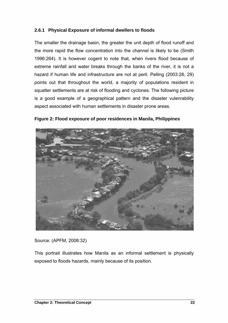
hazard if human life and infrastructure are not at peril. Pelling (2003:28, 29)
points out that throughout the world, a majority of populations resident in
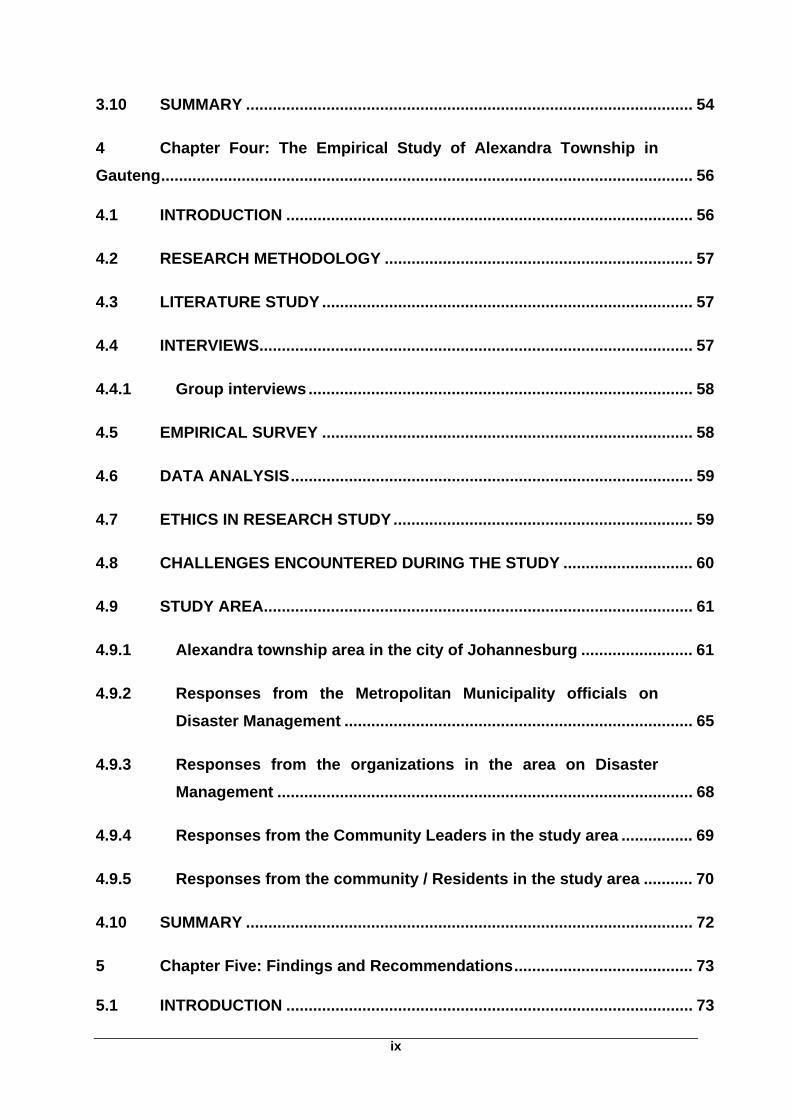
squatter settlements are at risk of flooding and cyclones. The following picture
is a good example of a geographical pattern and the disaster vulenrability
aspect associated with human settlements in disaster prone areas.
Figure 2: Flood exposure of poor residences in Manila, Philippines
Source: (APFM, 2008:32)
This portrait illustrates how Manila as an informal settlement is physically
exposed to floods hazards, mainly because of its position.
Chapter 2: Theoretical Concept 23
2.7 International experiences on urban Disaster
Natural disasters occur worldwide, but developing countries experience
greater impact compared to more developed countries, for example; disaster
impacts are lower in USA, Italy, Switzerland, and France than in countries
such as China, India, Bangladesh and Mexico (Arasema, 2002:113). For
instance developed countries have about 6% slums whereas developing
countries have more than half of their population living in slums physically
exposed to floods disaster, 80% of countries such as Ethiopia, Mozambique,
Haiti and Bangladesh lives in slums (Adikari, 2010:187).
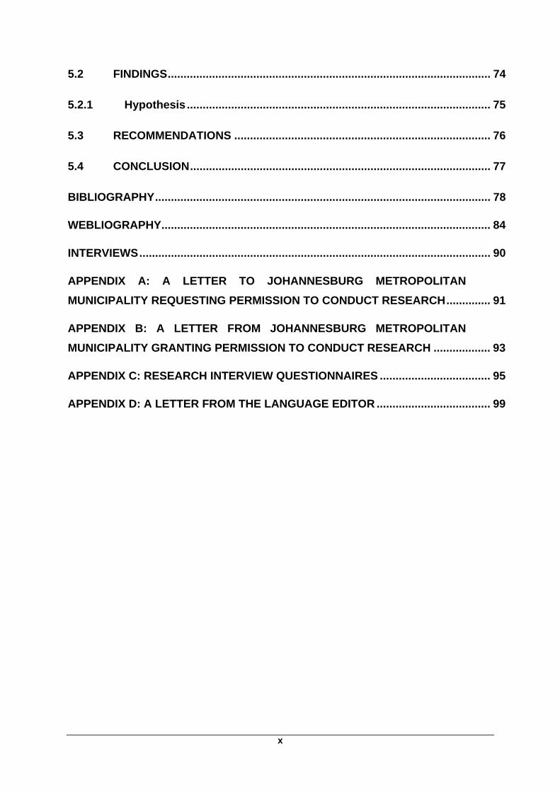
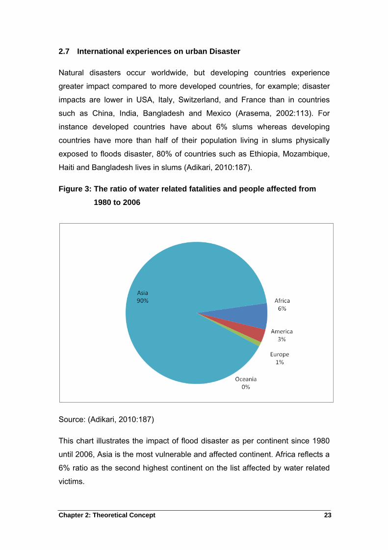
Figure 3: The ratio of water related fatalities and people affected from
1980 to 2006
Source: (Adikari, 2010:187)
This chart illustrates the impact of flood disaster as per continent since 1980
until 2006, Asia is the most vulnerable and affected continent. Africa reflects a
6% ratio as the second highest continent on the list affected by water related
victims.
Chapter 2: Theoretical Concept 24
2.7.1 Asia
Most major cities in Asia are located in riverbanks, garbage dumping sites and
city outskirts with 43% and increasing vulnerable slum populations. These
regions are the most typhoon and cyclone prone in the world; therefore, they
are the most vulnerable communities during calamity (Adikari et al.,
2010:188).
Bangladesh
Because of its location at the confluence of the Ganges, Brahmaputra and
Maghna Rivers, Bangladesh is incredibly prone to floods. Generally because
of the runoff volume that overwhelms the drainage channel leaving very little
alternatives for residents to escape or prevent floods. Almost all of the land in
Bangladesh is subdued by extreme flood events. Floods bring severe damage
on the economy of Bangladesh, for instance in the year 1987; floods
damaged 2.06 million houses displaced 45 million people with 12.8 million
houses destroyed in the year 1988 (Monirul Qader Mirza, 2002:127). The
1998 floods affected 32 million people in 52 of the 64 districts in Bangladesh;
the fact that almost 60% of the country is lower than 6 meters above the sea
level explains reason for prevalent flood disasters in Bangladesh (Monirul
Qader Mirza, 2002:127).
Dhaka City
The Mughal Emperor Jahangir established Dhaka City in 1609 on the banks
of the river Buriganga; Dhaka is currently the capital and largest city of
Bangladesh (Huq & Alam, 2003:121). Various distributaries of two major
rivers, Brahmaputra and Meghna enclose Dhaka city and bring periodic
flooding to a population of more that 10 million people in the metropolitan
area. During the 1988 flood, almost 85% of the city was covered at 4.5 meters
depth disrupting city life, air travelling and communication. The vulnerability of
the city is reflected in the spill over from surrounding rivers flowing to and from
major rivers of the country. Floods impacts include severe and moderate
damage to roads, water supply and housing with millions of people displaced.
Chapter 2: Theoretical Concept 25
India
Nearly 40 million hectares of land in India is prone to floods and every year
nearly hectares are affected by floods (Stecko & Barber, 2007:3).
Mumbai
The 2005 floods called for attention to Indian’s vulnerabilities and illuminated
weaknesses in the city’s disasters management. The growing risk is indirectly
and directly linked to the rapid growth of the population; the population of the
city and its surrounding suburban areas increased by 38%. Mumbai alone
takes in 350 families every day. Due to the increase of population numbers,
the state and municipal governments find it difficult to house and provide
services for the growing populations. About 12 million urban poor with limited
resources and entitlement rights live in severely dilapidated informal
settlements or urban slums located on flood prone areas. The city’s poor
physical environment makes all Mumbaikers susceptible to disaster (Stecko &
Barber, 2007:3).
China
According to Wisner et al., (1994:208) floods affect all 240 million people in all
provinces equivalent to almost the entire population of the USA. People had to
abandon their homes. The worst hit region was the Yangtze basin and
especially the middle reaches where a number of rivers converge with the
Yangtze. This area is a low-lying plain with lakes that receive records of
rainfall.
Shanghai
Shanghai is located at the mouth of the Yangtze River, and consequently
becomes a product of riverine and marine processes. Local tidal flows and
runoff deeply influence the evolution of the landscape in Shanghai (Shebinin
et al., 2007:13). Shangai is also China’s most populous urban area with a 200
million population wherein 16.5 million lives within the municipality and almost
10 million in the city. The floods events are a norm in cities such as
Chapter 2: Theoretical Concept 26
Jingdezhen; as a result, floods have killed thousands of people over the last
century. In 1954 an estimated 30,000 people perished and many drowned,
while in 1931 floods and subsequently diseases killed as many as 3.7 million
people along the Yangtze River (Wisner et al., 1994:208).
Philippines and Sri Lanka
According to Van Wyk (2011:9), La Nina caused severe flooding in 2011. Asia
is one of the affected continents; floods killed 57 people in Philippines, and 43
people killed in Sri Lanka while heavy rains affected more than a million
people.
2.7.2 Europe
There is a considerable decline in loss of lives and injuries due to flooding in
the past centuries, but now there is a new general concern about flood
hazard. Severe flooding has affected much of the country during the 1990s
and early 2000s due to atmospheric warming and marked change in land
cover and land use (Mitchell, 2003:567).
According to ISDR (2004:49), Europe experienced unusual heavy rains
reaching flood in the year 2002. Germany, Slovakia, Italy and Austria are
countries affected by the flooding of major rivers where over hundreds of
people died, thousands were evacuated, and losses of more than 15 billion
Euros because of damage to basic infrastructure, and private sectors. Europe
has recently experienced floods disasters where flash floods devastated
South and central parts of Poland. This claimed 15 lives, forced 120 schools
to close and jeopardy to more than 100,000 people (Sobczyk, 2010).
Netherlands
Floods were the most common disaster, between 1996 and 2005. Like a thief
in the night, a 1953 flood incident occurred devoid of warning in the night with
hurricane force and exceptional high tides killing 1.835 people with 3000
homes destroyed and 200 hectares of land swamped (UN-HABITAT, 2007).
Chapter 2: Theoretical Concept 27
2.7.3 North America
North America will very likely continue to suffer serious losses of life and
properties due increased numbers of people. Field (2007:626) posits that
flood hazards do not abound to coastal regions alone, but river basins such as
the Fraser, Red River, and upper Missisippi have a history of major floods and
thus illustrate the sensitivity and the critical importance of infrastructure design
standards, land use planning and weather/flood forecasts.
Mexico City
Sergio (1999:297) explains that Mexico City is the dominant of Mexico, where
it stands as the head of a growing number of large centres. Mexico City has
become a paradigm of fast anarchic urban growth during the second half of
the twentieth century. Mexico as a whole is affected by wide range of natural
hazards, and geographical hazards but hydrological risks such as floods are
also significant.
In Mexico City, external neighbourhoods are deficient in housing,
infrastructure and services; the illegal occupation of the outer city is rife with
squatter settlements in poorly serviced areas vulnerable to disaster (Sergio
1999:314). In June 2000, wastewater covered 80 hectares of urbanised land
in the Chalco valley while floods were a result of the rupture and discharge of
an open-air sewage (La Compania Canal) that collects domestic water from
two municipalities in the state of Mexico.
Fernando (2007:478) points that gastrointestinal, skin and waterborne
diseases, affected more than 6,700 households; piped water, road transport,
electricity and food supplies.
USA
A glance at Cohen and Miller (2001:762) reveals that floods are the most
frequent natural disaster in the United States, and a foremost cause of death
from natural disasters.
Chapter 2: Theoretical Concept 28
CANADA
Floods incidents in the Red River displaced more that 25 000 people in 1997
while 119 relief workers were injured in the sandbagging activities in the 1993
midwest floods. Cohen and Miller (2001:762) argue that flood victims may be
at risk of posttraumatic stress disorder and depression, which are risk factors
for suicide. According to Krug et al., 1998 quoted in (Cohen & Miller, 2001)
suicide rates increased from 12.1 to 13.8 per 1000 000 population in the four
years after floods.
2.7.4 Australia
Flood disasters characterized the hindrance of settlers in Australia; for
instance Gundagai Township had to be relocated from between two rivers to a
much higher land as a result of 36 per cent of its population was in flood and
250 people drowned in 1852. At least 2 231 people died between 1788 and
1996 because of floods. Australia continues to experience harsh floods
accompanied with major damages and death casualties.
Gelineau and Pickard (2011:4) report that in the year 2011, a terrifying wall of
water roared through the streets of the northeast Australian city, inflicting
damage to city infrastructure such as offices and bridges. At least 20 people
died and 78 went missing. The crisis accelerated gradually with swollen rivers
overflowing their banks and engulfing towns while moving to the ocean. The
high water headed next to Australians largest city. Rescue officials pushed
through the agitated waters and pulled a man to safety but others including
five children were unlucky and brushed off to death. About 300 people were
air lifted in military helicopters to safety. This is one of the small communities
in the floodwater path, but the authorities said they were preparing for flooding
incidents that affected about 15 000 people in 80 suburbs.
2.7.5 Continent of Africa
Africa is on a rapid population growth and most people are poor living in
squatter settlements, extreme hydro meteorological events such as floods are
common in African countries. Floods affect large numbers of people with loss
Chapter 2: Theoretical Concept 29
of life, disease outbreaks and damage to infrastructure as seen in the past
disaster incidents (UNEP, 2010:276).
2.7.5.1 North Africa
Few North Africa countries are normally affected by disasters particularly flood
disasters. Algeria has a disaster experience that saw over a million people
affected. Morocco features with a loss of several lives, while disasters in
Egypt struck 289, 342 people (Brauch, 2003:158). As indicated earlier in the
study, overpopulation, poorly built housing along flood prone regions and
poorest city sectors contribute to the high disaster vulnerability (Brauch
2003:159).
Algeria
Algeria is a major country in the Mediterranean basin on the north boundary of
the African tectonic plate; Algeria is located in a moderate seismic activity
zone and its northern part has experienced numerous destructive
earthquakes.
The most recent disasters to affect Algiers are the huge 10 November 2001
flash floods that hit Bab El Oued and other regions of the country (Benouar &
Meziane, 2009:170). People damaged the forest covers between two
catchments to build informal settlements of Bab El Oued on deposits of
unstable fill, slope debris and quarry waste (Benouar & Meziane, 2009:171).
The increase of population in hazardous urban locations is a matter of
growing concern, as most houses are located on riverbanks. A flood and
mudflow in Algiers on 10 November 2001 caused the loss of 712 lives with an
additional 116 listed as missing, 350 were injured and about 1800 housing
and 56 schools, roads, and bridges were damaged.
Egypt
Since January 2010, Egypt experienced floods as the result of heavy rainfall
and winds that affected Gaza strip, Israel and Jordan. On this occasion,
dozens of lives perished with infrastructure damages and hundreds of people
Chapter 2: Theoretical Concept 30
displaced. The Ports of Ain Sokha, Al Adbeya, El Ataka, El Zayteyat and port
Tawfik had to close down because of the bad weather (Red Cross, 2010).
2.7.5.2 East Africa
Severe Floods causing more than 200 deaths and 250 people missing were
experienced in the eastern part of Africa, in august 2006 (UNFCCC, 2006:17).
Kenya
Kenyan urban centre is characterized by expandable informal settlements,
poor water services and sanitation infrastructure. Kisumu City is one of the
oldest towns in Kenya and lies at the head of the railway from Mombasa.
The city is situated on the low-lying Kano plains by Lake Victoria and suffers
floods during rainy seasons (Yitambe et al. 2009:93). Kenya is vulnerable to
extreme flood risks especially within the Garissa, Ijara and Tanya river
districts of Nairobi. Kenya experienced floods in 1997, which required a
massive relief operation. The floods displaced thousands, destroyed massive
properties and affected the livelihood of the riverine population.
Floods caused by excessive rainfall occur on an annual basis and cause
displacement and death, especially in the western Kenya. The effects of
floods normally force the riverside people to flee for their lives while flood
receding irrigation and water supply systems were swept away during the
peak floods. Travelling was extremely challenging; health conditions were
very miserable as children were annoyed by illnesses such as cholera. For
three months, people were stranded in camps (Gadain et al., 2006:165).
Tanzania
The majority of the urban national population resides in Dar es Salaam, the
capital city of the country. Due to lack of effective urban planning about 75 per
cent of Dar es Salaams population resides in unplanned settlements, which
lack municipal services. The dominant house architecture is the single storey
low-rise house that occupies about 50 per cent of urban land. The majority of
urban dwellers in Tanzania are vulnerable because of the conditions in which
Chapter 2: Theoretical Concept 31
they live; therefore, hazards such as floods can cause disaster (Wisner &
Pelling, 2009:128).
Floods mostly affect houses developed in low-lying areas that were either
wetlands or river courses. Informal settlements experience floods during the
rainy season. Floodwater spreads human excreta from toilets and uncollected
solid waste into residential areas. Water stagnates in the settlements making
it unhealthy for human habitation during and after the rainy seasons. Surface
water and groundwater pollution are serious disaster risks in these areas as
majority of the population depends on groundwater as the main source.
Malaria and water borne diseases like cholera are also among the main
causes of death in Tanzania (Kiunsi et al., 2009:138).
2.7.5.3 West Africa
The region is exposed to risk of natural disasters that include floods. During
the annual rain season, increasingly unpredictable rainfalls often result in
floods, displacing hundreds of thousands and destroying houses and road
infrastructure. In the year 2007, floods affected more than 800 000 people,
with over 44,000 displaced and 210 killed in 13 countries (Red Cross, 2010:3).
Senegal
According to Diagne and Ndiaye (2009:151) Saint-Louis is developed by the
water; on three islands isolated by arms of the Senegal River, their tributaries
and the site. The region is characterised by the omnipresence of water. The
water table is shallow, and some low-lying areas are at altitudes of less than
2.5 meters above the sea level, consequently Saint-Louis is exposed to the
outpouring of groundwater when water levels rise sharply. Since 1990, the city
has suffered frequent flooding due to a combination of rainwater and peak
flows of the Senegal River. Uncontrolled urban development has led to the
shrinkage of zones that can absorb the floodwaters and the use of the
riverbed as a dumping site for household garbage may contribute to the rise in
river levels. A continuum of risk exists that includes the danger of drowning in
the river, collapse of dilapidated buildings or infrastructure, tidal waves, and
Chapter 2: Theoretical Concept 32
also public health hazards related to poor sanitation such as the outbreaks of
cholera.
Ghana
Ghana experienced torrential rain in 2001, which caused floods in Accra the
capital. BBC News (2001) reported that more than 100 000 homes were
destroyed and roads in Accra were under water; others destroyed. Ghana
experience floods more predictable frequently in the rainy season as a routine
but flash flooding might happen at any time (Songsore et al., 2008; Red
Cross, 2007).
Nigeria
Floods destroyed housing and other infrastructure especially in poor areas of
Nigeria. Water from the dam is one factor that contributes flooding, floods
have a major impact because of poor drainage systems in some areas.
Disaster events were registered in nine federal states of Nigeria, Lagos,
Ogun, Plateau, Sekoto, Nasarrawa, Bauchi, Yobe, Borno and Kebi (Red
Cross, 2007).
2.7.5.4 Central Africa
The region registered significant floods in most countries of Central Africa
(Red Cross, 2008:1).
Congo
According to the Red Cross Bulletin (2007:1), Brazzaville the capital of Congo
registered torrential rain, which caused flooding in the main city in 2007.
Republic of Congo experiences flooding every year and this is due to torrential
rain, poor drainage and the fact that the capital is situated in the riverbank of
Congo River, which separate Democratic Republic of Congo and Congo
Republic. DRC is one of the most affected by floods. The flooding of the river
presents a serious threat to the Riparian populations, including 12 000,000
inhabitants of Kinshasa, the capital (Red Cross Bulletin, 2007).
Chapter 2: Theoretical Concept 33
Cameroon
Most of the floods in Cameroon were from extensive and prolonged rainfall.
For instance, the Municipality of Limbe experienced excessive rains that
destroyed a large area of agricultural land, urban land and surrounding
suburbs, especially those poor residents. Floods had direct and indirect
impacts on human, environment and economic losses (Ayanji, 2004:4).
2.7.5.5 Southern Africa
The region experiences floods mostly during the rainy season, less vegetation
is more of a reason for food vulnerability in drier areas that receive heavy
rainfall with little absorbtion considering the massive water brought about by
flooding (UNEP, 2010:176).
Mozambique
According to Christie and Hanlon (2001:18) Tropical cyclone, Connie was no
longer officially a cyclone when it hit Southern and central Mozambique on
Friday to Monday (February 4-7, 2000). Nevertheless, she brought substantial
local damage, huge ravines were cut into several neighbourhoods in Maputo
and houses were washed away.
The heavy rains flooded the commercial centre of Maputo. Flooding on the
Umbeluzi River closed the water intake and treatment station for Maputo and
the neighbouring city of Matola to South Africa (Vaz, 2000:1). Mozambique
government took up the offer of help from South Africa, for five fixed wing
aircraft and five helicopters and rescued 2800 people. The report shows that
700 people died during this incident and 45,000 were rescued, even though
there were no major outbreaks of disease and no serious malnutrition in
isolated accommodation centres holding up to 500,000 people who had to flee
their homes (Christie & Hanlon, 2001:20).
Chapter 2: Theoretical Concept 34
Zimbabwe
Zimbabwe is affected by two types of floods; first are seasonal floods that
occur during the rainfall season. Cyclone induced floods is a second type that
occur. In March 2003, the basin was hit again by cyclone Japhet that caused
flooding in areas such as Guruve and Mzarabani because of their location.
Major dams are often at full capacity during heavy rains; as a result, there are
scheduled water discharges from the dams. This results in flooding incidents
to settlements downstream the Cabora Basa dam. This accrues to disease
outbreaks, loss of human life, livestock as well as damage to crops and
infrastructure (Madamombe, 2004:4).
2.8 Disaster Risk Reduction
UNDP (2004:135) posits that disaster risk reduction is a systematic
development and application of policies, strategies and practices to minimise
vulnerabilities, hazards and unfolding of disaster impacts in society. UN-
Habitat (2007:168) concurs and adds that disaster reduction involves the
following:
Mitigation
Structural and non-structural measures taken to limit the severity of frequent
natural hazards
Preparedness
Measures taken in advance to ensure effective response to the impact of
hazards, this include, early warnings and temporary evacuations of people to
a safe location
Response
The intervention during or after the disaster to preserve those who are
affected
Chapter 2: Theoretical Concept 35
Recovery
Actions taken after a disaster to restore and improve the pre-disaster living
conditions of the affected community, this include rehabilitation and therapy
Resilience
The capacity of a community exposed to hazards to adapt and maintain an
acceptable level of functioning and structure.
According to Pelling and Wisner (2009:45) Disaster risk reduction entails
actions and processes that will reduce risk. Techniques, policies, politicians
and the public are the main components that can build towards disaster risk
reduction. The government should facilitate the policy formation and
development plans so that they include risk reduction. Africa governments
have begun to incorporate disaster risk reduction into development planning.
Policy frameworks for disaster risk reduction are being formed worldwide; for
instance South Africa formed a Disaster Management Act 57 in 2002. The Act
identifies responsibilities for all government spheres regarding risk reduction.
Land use planning contributes to disaster risk reduction, almost 1 billion of the
world’s city dwellers live in slums and densely populated settlements exposed
to natural hazards. This is more of a reason for governments to design
disaster management plans. Looking at UN-Habitat (2007:206) it suffice that
Brazil, Egypt, Mexico, South Africa, Thailand and Tunisia make a commitment
to upgrading service provision which has led to an overall reduction in the
growth of slums. Early warning systems are a vital tool to improved disaster
management practices; cooperation and nurtured trust among the users of
such systems enhance. the dexterity and legitimacy of national early warning
systems. The quality and timeliness of such information is a key factor in
saving and protecting property.

Chapter 2: Theoretical Concept 36
2.9 Summary
Chapter 2, provides the theoretical concept of disaster and geographical
patterns. The chapter also gave a view of international experiences with
regard to floods in urban areas especially in the townships.
Disasters are a complex mix of natural hazards and human action, for
instance wars, famine and diseases are viewed as disasters but did not result
from the natural hazards such as earthquakes, volcanoes and floods.
Disasters are the results of vulnerability and hazards, natural hazard become
a disaster when if affect people. This is evident in most developing countries
especially in urban areas, where informal settlement are common.
Bangladesh, Mumbai, China, Mexico, Haiti and Mozambique have
experienced most floods disasters especially in the urban areas where
informal settlements are widespread. Vulnerability is associated with socio-
economic position, race, gender and age. The poor suffer more from hazards
than the rich do, although vulnerability cannot be read directly off from the
poverty; the two are highly correlated.
Urban floods disasters are mostly influenced by their Geographic patterns, for
instance urban areas experience high temperature which influences rainfall
and consequently floods spread throughout the informal settlements where
most damage is experienced, due to their landscape, over flow of rivers
caused by garbage that has decreased the river intake and also over
population in those areas. Most of the informal settlements are built near the
river for socio-economic purposes like water consumption for washing and
drinking, and to maintain their informal businesses like hair salon.
These informal settlements are mostly occupied by poor people who cannot
afford building material and resort to boxes, plastics and old material to
construct a house, this group live with all their assets in one place hence they
experience the most hazards in times of disasters.
Chapter 3: Overview of Geographical Patterns 37
3 Chapter Three: Geographical patterns and Urban Disasters in South
Africa
This section is a contexualised preseantation of Geogrpahic patterns and
Urban Disasters in South Africa; the role of South African Government in
Disaster Management is also a feature i\n the discourse.
3.1 Introduction
This chapter will focus on South Africa’s disaster management and
geographical patterns. The study looks at urban areas affected by flood
disaster, especially those in the informal settlements. This section is a historic
view of geographical patterns in South Africa and the impact of flood disaster
in the country per province. Informal settlements seem to have more incidents
of disaster in most international countries because of their location. This
chapter seeks to re-view similar cases identified in South Africa. Urban
populations experience common challenges in many of the countries of the
world. Population growth, poverty and poorly constructed houses appear at
the top of the list as basic factors responsible for disaster vulnerability.
Disaster management policies and programmes available to deal with disaster
in the country will be viewed.
3.2 The Historical Geography of Informal Settlements and its physical
exposure to Flood Disasters in South Africa
Since the second half of 1980, the South African urban landscape is well
known for the prevalence of informal settlements on the periphery of the
country’s towns and cities (Tempelhoff et al., 2009:99). This came as the
result of increased urbanization as observed on a global scale for the greater
part of the twentieth century. Nevertheless, informal settlements are also the
consequence of the relaxation of control measure by the former apartheid
government in the 1980s (Tempelhoff et al., 2009:99). The flow of people into
the urban environment took place at a considerably faster rate because of the
greater degree of personal freedom of movement. The highly industrialized
regions of Gauteng, Kwa-Zulu Natal, the Eastern Cape and the Western Cape

Chapter 3: Overview of Geographical Patterns 38
Peninsula have not been an exception of the growth of these settlements.
Squatter camps are naturally not strong enough and do not offer secure
shelter in the event of extreme weather conditions. The land on which informal
settlements have been set is generally on a high elevated and is noted for the
steep hills and incline down which storms water easily flows along natural
valleys and gullies.
Johannesburg is one of the cities that have experienced a high influx of
people seeking employment especially illegal immigrants from African
countries such as Malawi, Mozambique and Zimbabwe. The immigrants are
currently living in Informal settlements of areas such as Soweto, Alexandra
and Ekurhuleni. Areas occupied by these groups of people are usually not in
the right condition and provide minimal protection from extreme temperature.
These houses are at most, built on land previously used as a dumping site, or
on the flood line of the river (Mathee et al., 2010:10). EThekwini Municipality
in KwaZulu-Natal experienced urban growth in 1980s, which perpetuates the
informal settlements in the area. Nearly half of the African population in the
municipality are living in informal settlements. Houses are constructed in
plastics, corrugated iron and timber, as most of the residents are unemployed
and poor (Marx & Charlton, 2003:5).
Policies of racial discrimination structured the national urbanisation, economic
and social trends of South Africa. For instance, before 1990, access to the
urban areas was restricted for the majority of the African population and only
those regarded as necessary to the labour needs of whites were allowed in
urban areas. The poor African population was located furthest from the urban
centre in state planned townships that were unregulated and under-serviced
settlements (Marx & Charlton, 2010:1).
3.3 The Climate Change and Urban Disaster in South Africa
The Republic of South Africa occupies the southern most part of the African
continent, stretching attitudinally from 22 to 35 south and longitudinally from
17 to 33 East. Its surface is 1 219 090 km2. South Africa has common
boundaries with the republics of Namibia, Botswana and Zimbabwe while the
Chapter 3: Overview of Geographical Patterns 39
Republic of Mozambique and the kingdom of Swaziland lie to the Northeast.
South Africa is covered by mountains in the southeast and by Atlantic and
Indian Ocean on the south, west and east of its territory (NAEA, 2010:757).
South Africa has a lengthy coastline of about 3000 km. this coastline is swept
by two major ocean currents; the warm south flowing Mozambique Agulhas
current and the cold Benguela. The contrast in temperature between these
two currents partly accounts for important differences in climate and
vegetation between the east and west coasts of South Africa. Three major
subdivisions can be recognized: the eastern plateau slopes, the cape folded
belt and adjacent regions and the western plateau slopes. The subtropical
location accounts for the warm temperature conditions. The country also falls
squarely within the subtropical belt of high pressure making it dry, with the
large quantity of sunshine (NAEA, 2010:757).
The wide expanses of ocean on three sides of the country have a moderating
influence on its climate. South Africa has an average annual rainfall of
464mm, compared with world average of 860mm. Studies show that 65
percent of the country receives the annual rainfall of less than 500mm, which
is regarded as the complete minimum for a successful dry land. South Africa
is regularly afflicted by drastic and prolonged droughts that end in severe
floods (NAEA, 2010:757).
3.4 Urban Growth and Disaster in South Africa
According to (UNESCO, 2006:502), approximately 28 million people which is
59% of the overall population in South Africa live in more than 3, 000 urban
communities including informal settlements. The fast growth of informal
settlements in the country presents a major challenge. About 16 million
residents occupy nine cities that provide 50% of the nation’s work force
covering only 2% of the overall surface area of the country. Recent statistics
reflect that 5 million people live in informal settlements without proper water
services infrastructure, which pose a major challenge to the municipalities and
services providers as they carry a mandate to address urbanisation and the
creation of sustainable human settlements, and job creation.
Chapter 3: Overview of Geographical Patterns 40
Some informal settlements are located beside the river, exposed to
waterborne diseases and vulnerable to flooding. Wisner and Pelling (2009:1)
also highlight that most people migrate from rural areas to growing African
cities like Johannesburg, which raises a concern, as urban centres are
becoming hotspots of disaster risk and makes it difficult to manage disaster
risk.
3.5 Urban Poverty, Vulnerability and Disaster Hazards in South Africa
South Africa has 9 provinces with 283 local governments that include 234
local municipalities, 6 Metropolitan governments and 43 District municipalities.
Limpopo and Eastern Cape provinces have the highest occurrence of poverty
and deprivation while the Western Cape and Gauteng provinces are with the
least (Naude 2007:8).
South Africa has an enormous number of informal inhabitants. Hundreds of
people live in squalor informal squatter settlements. Most of them are wage
earners in neighbouring cities who cannot afford decent housing and the cost
of travelling in and out of the city burdens their livelihoods. Hence, they resort
to overcrowded slums. Poor people are vulnerable to several threats such as
floods because poorer people often erect their shelters in flood prone areas,
which they may lack the resources to prevent (Swartz, 2010:52).
Satterthwaite (Quoted by Pelling, 2003:30) states that closer to 50% of urban
settlements population live under their basic needs. This is set at a level equal
to estimated average cost of acquiring the basic needs such as secure
housing, subsistence food, clothing and basic education and health care.
Vulnerability is an interface between exposure to the physical threats to
human wellbeing and the capacity of people or community to cope with.
Vulnerability has two sides: an external side of risk, shocks and stress to
which an individual or household is subject to and an internal side, which is
the means of coping without damaging loss. Vulnerability is nevertheless not
the same as poverty but rising poverty is a contributing factor to rising
vulnerability.
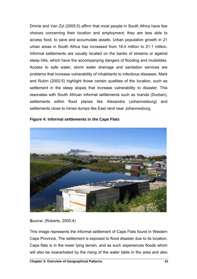
Chapter 3: Overview of Geographical Patterns 41
Drimie and Van Zyl (2005:5) affirm that most people in South Africa have few
choices concerning their location and employment; they are less able to
access food, to save and accumulate assets. Urban population growth in 21
urban areas in South Africa has increased from 18.4 million to 21.1 million.
Informal settlements are usually located on the banks of streams or against
steep hills, which have the accompanying dangers of flooding and mudslides.
Access to safe water, storm water drainage and sanitation services are
problems that increase vulnerability of inhabitants to infectious diseases. Mark
and Rubin (2002:5) highlight those certain qualities of the location, such as
settlement in the steep slopes that increase vulnerability to disaster. This
resonates with South African informal settlements such as Inanda (Durban),
settlements within flood planes like Alexandra (Johannesburg) and
settlements close to mines dumps like East rand near Johannesburg.
Figure 4: Informal settlements in the Cape Flats
Source: (Roberts, 2005:4)
This image represents the informal settlement of Cape Flats found in Western
Cape Province. The settlement is exposed to flood disaster due to its location,
Cape flats is in the lower lying terrain, and as such experiences floods which
will also be exacerbated by the rising of the water table in the area and also
Chapter 3: Overview of Geographical Patterns 42
the rise of the sea level (Roberts, 2005:4). People in this area are vulnerable.
Wisner et al., (1994:12) describe vulnerable groups as those that find it
difficult to reconstruct their livelihood after the disaster have struck as they
might lack legal rights such as insurances, and social networks as a tool to
survive after disaster.
3.6 The Impact of Disaster in the Development of South Africa
Natural disasters are bound up with the development status of a region, they
disrupt or impair development (GTZ, 2002:8). Disasters have negative
impacts on non-formal sectors that often under estimate approximate costs of
disasters, mainly because small-scale disasters go unrecorded and do not
receive national priority. These minor disasters affect households and
individuals negatively, mostly due to the loss of income or members of the
family who are breadwinners. Non-formal economies are left depressed as
they lose their equipments, infrastructure, housing, lives and household’s
utensils. Disasters delay years and years of investments in development, for
instance 1995 to 1996 floods destroyed transport and utility system in
Limpopo (RSA, 1998).
Natural disasters devastate development gains hence South Africa has joined
in with other countries to include disaster risk as the important part of
development so as to achieve the eight millennium development goals that
were agreed upon in 2000 to be achieved in 2015. These goals are set to
reduce the number and effects of natural and man-made disasters. Natural
disasters are the results of the occurrence of hazardous events and the
vulnerability of communities to recover from the hazardous impacts. The eight
set goals will direct development planning towards priority goals and also
contribute in a reduction of human vulnerability to natural hazards (UNDP,
2004:26).
According to UNDP (2004:25) the millennium development goals (MDGs) are
as follows
Chapter 3: Overview of Geographical Patterns 43
Eradicating extreme poverty and hunger
Statistical analysis proves that human vulnerability to natural hazards and
income poverty are largely co-dependent. Hunger can lessen the capacity of
an individual to deal and cope with disaster stress while disasters can destroy
assets thereby leading to hunger.
Achieving universal primary education
The goal is to ensure that children everywhere complete a full course of
primary education; basic literacy would help individuals to engage in the
society, and broadening participation in development decision making as a
central tenet of disaster risk reduction.
Promoting gender equality and empowering women
Forming disaster risk policies that build on the social capital represented by
women can enable a more informed policy. The facilitation of women and girls
participation in the development process and efforts to reduce risk is a key
priority.
Reducing child mortality
Children under the age of five are normally vulnerable to the impacts of
environmental hazards such as inadequate sanitation, injuries following
disasters as well as psychological effects of the preceding disaster, therefore
policies aiming to support the reduction of child mortality need to built in
strategies to reduce disaster risk.
Improving maternal health
Women, girls, children and the aged are mostly vulnerable to maternal ill
health, as they do not have entitlement to household or assets. Investment in
education and health will contribute to household resilience as maternal health
indicators improve.
Chapter 3: Overview of Geographical Patterns 44
Combating HIV/AIDS, malaria and other diseases
For diseases transmitted through vectors, there is a risk of epidemic following
floods or drought; it applies to the destruction of water, sanitation and health
care infrastructure. The spread of and the increase of HIV/AIDS and other
diseases will be reversed.
Ensuring environmental sustainability
The goal is to help integrate the principles of sustainable development into
country policies and programmes to reverse the loss of environmental
resources. Disaster management policies have to include and confront the
vulnerability of slum dwellers to disaster incidents such as earthquakes,
tropical cyclones, flooding and drought.
Developing a global partnership for development
The international trade terms, national debt burdens, and lack of adequate
technology, hinder the reduction of human vulnerability to natural hazards
associated with global climate change. Therefore, these MDG aim to address
less developed countries provide decent and productive work, as well as
access to affordable essential drugs.
3.7 The History of Floods Disaster in South Africa
Between 1975 and 2001, South Africa experienced different types of natural
disasters; of which 16 were floods disasters that led to the loss of 1 179 lives
and directly affected 76 300 people while 22 835 people were left homeless.
South Africa has experienced severe floods in December 1999 through to
March 2000. More than a million people in the northern provinces of South
Africa had no access to portable water, hundreds of lives were lost and many
hundreds taken to the camps2. Severe damage was accounted on more than
200 bridges and several thousand kilometres of roads. The estimated costs of
2 Temporal shelter for disaster victims
Chapter 3: Overview of Geographical Patterns 45
repair in South Africa and Mozambique was estimated to be more than a
R1000 million (Alexander, 2002:2). Severe floods occurred in the
Pietermaritzburg area and claimed 173 lives in 1995, there was a need for
emergency shelter to accommodate 4 000 people.
In Ladysmith, floods caused severe damage to infrastructure 1996 amounting
to R25 million. Flood damage in the Northern Province amounted to R105
million while in Mpumalanga it caused damage amounting to R500 million in
the same year (Buys, 2005:1). The country experienced even more floods
disaster in February 1988; North West, Free State, and Northern Cape were
the most affected provinces. This incident was followed by a tropical cyclone
Eline in February 2000, which swept through Limpopo, Mpumalanga and
Gauteng; 50 people were killed, and structures amounting to R1 billion were
damaged. In 2008, Kwazulu-Natal experienced heavy rains along its coast
which caused severe flooding in June; four people died while another four
went missing and 500 were left homeless (Van Wyk, 2011:8).
3.8 Recent floods experiences in South Africa
South Africa as a country has frequent occurrence of floods especially in the
current year (2011). The reports given by Van Wyk (2011:8) in City Press
reflect an estimate damage of flood to R600 million, and this table excludes
billions of rands in flood related infrastructural damage in Gauteng and
unconfirmed damage to the agricultural sector of nearly a billion. At least 70
people were declared dead in February 2011 and 33 municipalities within
eight provinces declared disaster areas.
Escape (2010:2) gave a report in the Sowetan newspaper about few other
incidents that occurred around the country; 30 people were displaced in
Orlando West, while in Kliptown 50 houses were submerged in water,
displacing between 150 to 200 people in Lenasia extension 2 and 13 had their
houses flooded. Boikhutso Township in Lichtenburg had 17 people evacuated
and accommodated at a town hall after their shacks were flooded. Twenty five
people in Florida Lake were also evacuated and in Protea South 20 shacks
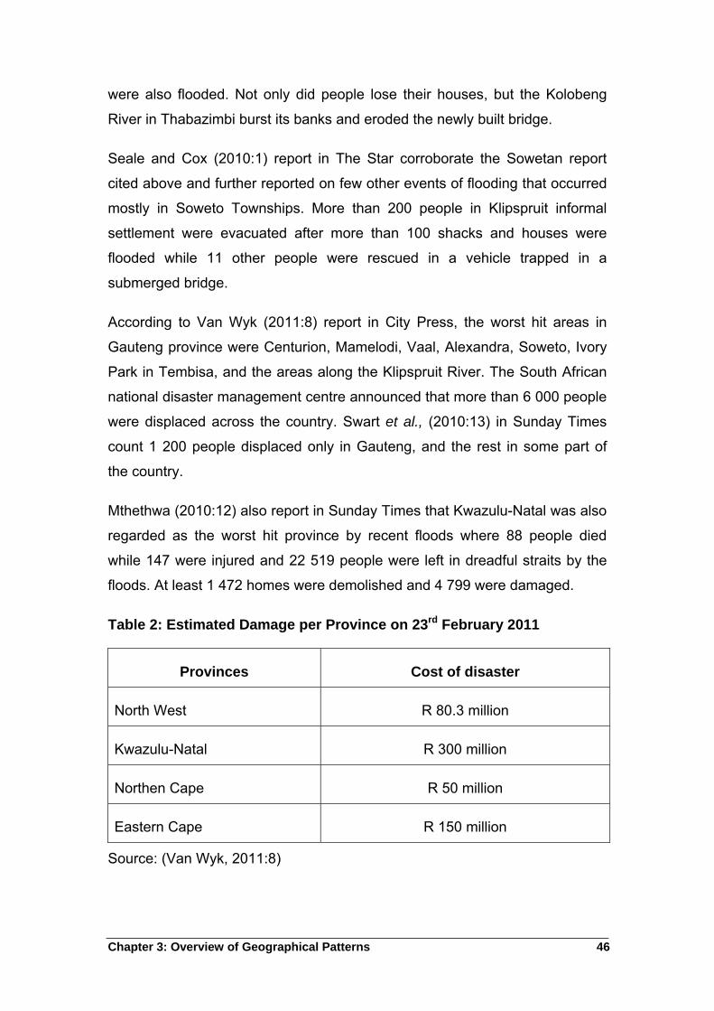
Chapter 3: Overview of Geographical Patterns 46
were also flooded. Not only did people lose their houses, but the Kolobeng
River in Thabazimbi burst its banks and eroded the newly built bridge.
Seale and Cox (2010:1) report in The Star corroborate the Sowetan report
cited above and further reported on few other events of flooding that occurred
mostly in Soweto Townships. More than 200 people in Klipspruit informal
settlement were evacuated after more than 100 shacks and houses were
flooded while 11 other people were rescued in a vehicle trapped in a
submerged bridge.
According to Van Wyk (2011:8) report in City Press, the worst hit areas in
Gauteng province were Centurion, Mamelodi, Vaal, Alexandra, Soweto, Ivory
Park in Tembisa, and the areas along the Klipspruit River. The South African
national disaster management centre announced that more than 6 000 people
were displaced across the country. Swart et al., (2010:13) in Sunday Times
count 1 200 people displaced only in Gauteng, and the rest in some part of
the country.
Mthethwa (2010:12) also report in Sunday Times that Kwazulu-Natal was also
regarded as the worst hit province by recent floods where 88 people died
while 147 were injured and 22 519 people were left in dreadful straits by the
floods. At least 1 472 homes were demolished and 4 799 were damaged.
Table 2: Estimated Damage per Province on 23rd February 2011
Provinces Cost of disaster
North West R 80.3 million
Kwazulu-Natal R 300 million
Northen Cape R 50 million
Eastern Cape R 150 million
Source: (Van Wyk, 2011:8)
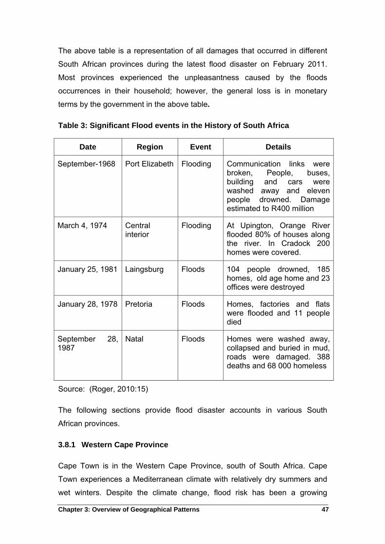
Chapter 3: Overview of Geographical Patterns 47
The above table is a representation of all damages that occurred in different
South African provinces during the latest flood disaster on February 2011.
Most provinces experienced the unpleasantness caused by the floods
occurrences in their household; however, the general loss is in monetary
terms by the government in the above table.
Table 3: Significant Flood events in the History of South Africa
Date Region Event Details
September-1968 Port Elizabeth Flooding Communication links were broken, People, buses, building and cars were washed away and eleven people drowned. Damage estimated to R400 million
March 4, 1974 Central interior
Flooding At Upington, Orange River flooded 80% of houses along the river. In Cradock 200 homes were covered.
January 25, 1981 Laingsburg Floods 104 people drowned, 185 homes, old age home and 23 offices were destroyed
January 28, 1978 Pretoria Floods Homes, factories and flats were flooded and 11 people died
September 28, 1987
Natal Floods Homes were washed away, collapsed and buried in mud, roads were damaged. 388 deaths and 68 000 homeless
Source: (Roger, 2010:15)
The following sections provide flood disaster accounts in various South
African provinces.
3.8.1 Western Cape Province
Cape Town is in the Western Cape Province, south of South Africa. Cape
Town experiences a Mediterranean climate with relatively dry summers and
wet winters. Despite the climate change, flood risk has been a growing
Chapter 3: Overview of Geographical Patterns 48
concern with the increase of urbanization where people occupy high flood risk
sites. Cape Town has 56 informal settlements with 88 000 inhabitants at risk
of flooding that require proactive measures of relocation. Informal settlements
are densely populated and poorly designed to facilitate the drainage of
surface and ground water. The living conditions are a health risk to the
residents. The flood risk in informal settlements is predictable; an average
winter can result in 4000 flood victims.
Settlements that are specifically at risk of flooding are highly populated areas
on the Cape Flats, and that include areas of Khayelitsha, Gugulethu and
Philippi. The Cape flats is a sandy, low lying and poor drainage area. In the
past three winters between 32 000 and 34 400 residents have been relocated
from informal settlements in Cape Town to escape flooding caused by heavy
rains (Ziervogel & Smit, 2009:4). The table below explain the flood history
from 1968 to 1987 in South Africa.
In 2001 between July and August, the largest flood event caused by rains
displaced 44 000 people, that is 13% of all the informal settlement residents in
Cape Town. The flooding of the informal settlement is brought by ground
saturation and accumulation of water in a poorly drained area. Flooding can
damage the informal settlements dwellings made of corrugated sheet on a
wooden frame. The residents can also experience a health related impact as
water may polluted after the floods. Residents might feel the economic impact
as they have to spend money replacing or repairing their residences, and may
lose out on many days of potential income (Ziervogel & Smit, 2009:4).
3.8.2 KwaZulu-Natal Province
The province of Kwa Zulu-Natal is situated on the eastern side of South
Africa. It has a rugged topography which rises steeply from the Indian Ocean
to the Drakensberg escarpment over a distance of some 300 km. The steep,
deeply dissected hinterland is drained by an abundance of small rivers, each
flow into the Indian Ocean via an estuary. Physiologically there is little
diversity in the structure and surface of the floodplain. It a relatively flat
Chapter 3: Overview of Geographical Patterns 49
landscape that rises steadily from the river with abandoned meanders and
highly eroded escarpment in the west (CSIR, 1989:16).
The channel pattern in the flood plain is bifurcated with an average width of
about 40 meter. The river mouth is about 5 km from the floodplain, which has
the total area of just less than 1 000 hectares (CSIR, 1989:16). KwaZulu-Natal
is vulnerable to flooding, especially during summer season. South Africa has
experienced severe floods 15 years prior 1995 and two of them were in
KwaZulu-Natal (Anon, 1998:5).
3.8.2.1 The floods Disaster events in Kwa-Zulu Natal
Floods disasters are largely influenced by subtropical climate with a warm,
wet summer, cool and dry winter in Kwa-Zulu Natal. Due to the steep
hinterland, flow velocities during floods are particularly high. The province of
Kwa-Zulu Natal experiences over 1000 mm of rainfall annually, however
extremely high rainfall over a few days may occur leading to widespread
flooding (CSIR, 1989:17).
Severe floods are associated with abnormal weather conditions. The region
experienced floods between 28 and 30 September 1987, these were amongst
the most devastating to have occurred in South Africa. The Mdloti river is
situated 20 km north of Durban, The Mdloti catchment experiences a
subtropical climate with an annual rainfall that varies around 1 000 mm. Heavy
and prolonged rains which fell during the flood period resulted in widespread
flood conditions. Within a short period, between 400 - 600 mm of rain fell in th
Mdloti catchment in September 1987. This rain resulted in serious flood
conditions which damaged agriculture, communications, infrastructure and
property to the cost of R400 million and left 50 000 people homeless and
nearly 400 people killed (Maharaj & de Villiers, 1994:9).
There is a huge population, inadequate housing on rivers known for flooding
their banks for instance; floods struck Pietermaritzburg on Christmas day in
1995 where low income residents of informal settlements near Edendale
Hospital were severely hit by the floods, More than 150 people drowned
(Anon, 1998:4).
Chapter 3: Overview of Geographical Patterns 50
3.8.3 Limpopo Province
UN-Habitat and UNEP (2007:6) show that the Limpopo River basin supports
approximately 14 million residents. This makes it the second populated basin
in the Southern African Development Community (SADC) region after the
Orange River basin. The geographical distribution patterns of human
settlements in the Limpopo River basin reflect the influence of the aridity
within the basin as all settlements are close to the river valley or stream
banks. Limpopo Province is one of the provinces with the highest poverty rate
in South Africa.
The Limpopo basin is exposed to variable rainfall and runoff that normally
result in drought and floods. The climatic conditions are difficult to predict due
to the variability in rainfall, this consequently pose a threat to a large
proportion of the 14 million human inhabitants in the basin as well as the
diverse ecosystem. The province experienced floods in February 2000.
According to Masingita and Julian (2010:275) Limpopo province experienced
flood disaster in February 2000. The flood resulted in more than 84 people
lost their lives and 300,000 people left homeless due to the 45,000 destroyed
dwellings. The destruction of road infrastructure worth more than one billion
Rands and the closure of schools in the region were also noticed. Cases of
illness were identified immediately after the floods, cholera, malaria and
diarrhoea were amongst the diseases and other respiratory diseases (UNEP,
2007:6).
3.8.4 Gauteng Province
The following sections attend to disaster incidents that occured in the Guteng
province, there is reference to some of the most recent incidents as well.
3.8.4.1 Pretoria
Itireleng is an informal settlement located in the city of Tshwane Metropolitan
Municipality, in Gauteng Province. Itireleng was found in the 1940s, although
it is a small area, Itireleng is one of the few informal settlements, whose
boundaries have remained the same; nevertheless, new residence have been
Chapter 3: Overview of Geographical Patterns 51
established. The area has grown to accommodate more than 12 000 people
comprising of local as well as foreigners from different places like Malawi,
Mozambique and Zimbabwe (Staden, 2006:2).
The settlement is built on a steep slope and if flooding occurs, it would surge
through the settlement with great force and speed. Itireleng experiences
hazards such as flooding and sinkholes in the dolomite rock beneath. The
lower one fifth of the settlement, is in the flood plain of a river that is dry most
of the year, history suggests that it has flooded once since 1940 (Staden,
2006:2).
3.8.4.2 Ekurhuleni
Ekurhuleni is one of mostly densely populated areas in South Africa, with a
total land area of about 2,000 square kilometres, which accommodates a total
population of about 2.5 million. The existing settlements pattern represents
the usual apartheid planning structure, where the dwellings are situated on the
periphery of the urban area. Nearly a third of the approximately 2.5 million
people in the area live in poverty; currently unemployment is estimated at
40%. Most people living on the urban periphery are below the poverty line,
consequently forced to resort to desperate measures to survive (Cities
Alliance & Sau Paulo, 2008:19).
These settlements are subject to a range of environmental problems linked
with a lack of basic services, such as unhygienic conditions, smoke pollution
and health related problems. Most of these settlements are situated on land
not suitable for housing purposes and poses a danger to the inhabitants. They
are situated on the low lying areas within the flood lines of rivers, and land
underlain by high risk dolomite formations (Cities Alliance & Sau Paulo,
2008:19).
3.9 Disaster Management in South Africa
Government holds the responsibility of decision-making process such as
economic policy formulation, disaster reduction policies, and then policy
implementation at an administration level. Government bears the primary role
Chapter 3: Overview of Geographical Patterns 52
to ensure the safety and security of the community; but government cannot
handle this on its own, hence civil society and private sector contribute to help
in disaster risk reduction and disaster management especially at the local
level (UNDP, 2004:76).
According to South African Disaster Management Act 57 of 2002, disaster
management is defined as an integrated, multi-sectoral, multidisciplinary
process of planning and implementing measures aimed at the prevention or
reduction disaster risk. Vermark and Van Niekerk (2004:556) add the aspects
of disaster mitigation, emergency preparedness, rapid and effective response
as well as post disaster recovery and rehabilitation.
Prevention and Mitigation- the National Disaster Management Centre,
Provincial centre and Local Municipalities Centre must give guidance to
organs of state, the private sectors, NGOs and communities to evaluate
and prevent or reduce the risk of disasters and vulnerability of
communities and increasing the capacity of the community to minimize the
risk.
Preparedness and Recovery- the National Disaster Management Centre,
Provincial centre and Local Municipalities Centre must progress with the
preparation and updates of disaster management plans and strategies and
include the integration of these initiatives with development plans.
In attempt to reduce the vulnerability of the poor people to disasters,
experienced in previous years such as the June 1994 floods in Cape flats and
the devastating floods in 2000, South African government took an initiative to
review the disaster management and policies that will minimize the severe
disaster consequences. The Cabinet recommended for the establishment of a
formal structure for disaster management. As a result, the National Disasters
Management Committee was established in 1996, with the functions of
coordinating and managing disaster management policy (Vermark & Van
Niekerk, 2004:565).
The following schematic representation in figure 5 provides understanding on
the philosophy and practice of disaster management.
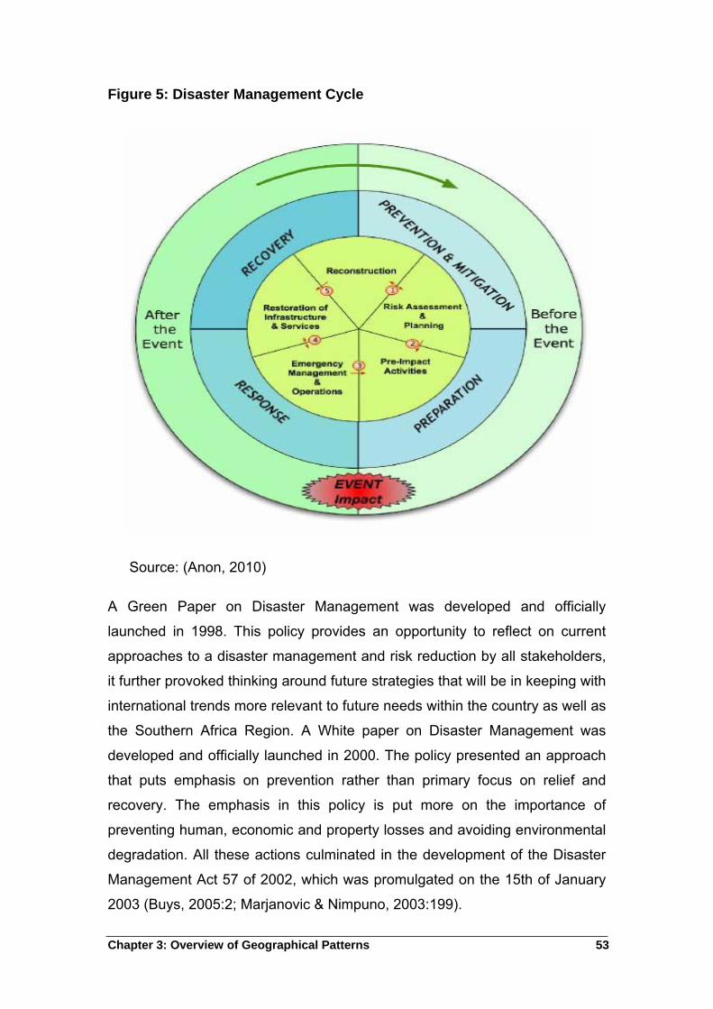
Chapter 3: Overview of Geographical Patterns 53
Figure 5: Disaster Management Cycle
Source: (Anon, 2010)
A Green Paper on Disaster Management was developed and officially
launched in 1998. This policy provides an opportunity to reflect on current
approaches to a disaster management and risk reduction by all stakeholders,
it further provoked thinking around future strategies that will be in keeping with
international trends more relevant to future needs within the country as well as
the Southern Africa Region. A White paper on Disaster Management was
developed and officially launched in 2000. The policy presented an approach
that puts emphasis on prevention rather than primary focus on relief and
recovery. The emphasis in this policy is put more on the importance of
preventing human, economic and property losses and avoiding environmental
degradation. All these actions culminated in the development of the Disaster
Management Act 57 of 2002, which was promulgated on the 15th of January
2003 (Buys, 2005:2; Marjanovic & Nimpuno, 2003:199).
Chapter 3: Overview of Geographical Patterns 54
The Disaster Management Act 57 of 2002 stipulates that there should be
information management and communication among all spheres of
government. This includes private sectors and the community because
disaster risk management involves all of them. Information management will
enable timely preparation because hazards are studied and information
disseminated to the role players for early warning to prepare responses to
disaster incidents. Section 15 and 20 (2) of the Disaster Management Act 57
of 2002 specifies the promotion of education and training and inclusion of
disasters risk management and disaster risk avoidance in school curricula
(Buys, 2005).
Government policy recommends that all municipalities must have Integrated
Development Plans (IDP’s), which will then incorporate the disaster
management plan (Vermaak & Van Niekerk, 2004:559). An IDP is a legislative
requirement, which has legal status, and therefore supersedes all other plans
that guide development at local government level. The disaster management
plan is to improve the capacity of the municipality to assess risks, prevent and
deal with hazards, and to veto proposed development that are subject to high
risk and possible disaster. South Africa has joined in with other countries to
include disaster risk as the important part of development to achieve the
millennium development goals.
3.10 Summary
The chapter presents the overview of urban disaster in South Africa. It is clear
that South Africa is also experiencing urban disaster particularly in the
informal settlements due to their location. Most informal settlements are
located on the urban periphery that is usually on the riverbank or near the
river streams. Most people move to urban areas in a search for employment
opportunities, therefore people that normally reside in these areas are poor
people that cannot afford the urban life. The Apartheid policies seems to have
had an influence in this geographic distribution patterns as the policies
enforced that blacks cannot reside in urban areas, unless if it is for labor
benefits. Informal settlements are presented by flood disasters in times of
rains and river overflow, this affect the dwellers, as they lose their
Chapter 3: Overview of Geographical Patterns 55
possessions, lives and also catch on diseases such as Malaria, Cholera, lung
diseases and some experience psychological effects.
Chapter 4: Empirical Study 56
4 Chapter Four: The Empirical Study of Alexandra Township in
Gauteng
This chapter provides an account of the research implementation within a
defined study area; as well as interview comments derived from respondents
during the research filedwork.
4.1 Introduction
This chapter reports on the findings of the empirical research conducted at
Alexandra Township. The information is gathered from government officials
who included one official from the Metropolitan Municipality disaster
management center region F, two officials from emergency and disaster unit
of city of Johannesburg region 18, as well as four community leaders in
Alexandra West known as Stjwetla. The communication was made with
relevant government and non-government organizations such as churches,
South African Red Cross Society, climate change unit in Johannesburg
Metropolitan to attain more information on the effect of floods in Alexandra.
These organisations are regular donors in times of disasters at Alexandra.
Ten members residing near the Jukskei River were also interviewed. These
include self-employed individuals, unemployed individuals, immigrants and old
people. The chapter starts with the description of research tools and concepts
such as sampling, interviews and group interviews. This is followed by
questions posed to respondents and analysis of responses.
The previous chapters gave insight on how flood disaster affects many other
countries, among them, India, Australia, North America, and some European
countries as well as those in African. Most of these countries seem to have
been affected by floods due to inconsistent rainfall and the location of
residences near the riverbank. These residences are mainly squatter camps
or townships and their inhabitants reside in these areas because they are
unable to afford decent sites. These are working class migrant communities
from rural areas and foreign countries to work in the urban areas.
Chapter 4: Empirical Study 57
This chapter focuses on Alexandra Township in Gauteng, to examine the
information raised in previous chapters. Alexandra Township is perceived to
be one of the many well-known townships in South Africa especially that it is
located in the fastest growing city of Johannesburg.
Floods are a regular feature during rainy seasons in the area, particularly in
the western part of the Township where the river runs through. The chapter
presents the results after a discussion with the residents on their experience
regarding floods and also the discussion with the government officials on
disaster management plan.
4.2 Research methodology
The following section outlines research methods employed to obtain data
during the research project.
4.3 Literature study
Literature review has been part of this study, in compiling the information on
the study and providing an intensified and reliable data. According to Bless
and Smith (1995:23), literature review helps the researcher to sharpen and
deepen the theoretical framework of the research, and to be more familiar with
the latest developments in the area of research. Leedy (1992:87) concurs with
Bless and Smith that literature review can help the researcher reveal the
sources of data that the researcher thought they never existed and reveal
investigations similar to the researcher’s current work.
4.4 Interviews
The surveys of this study are based on semi-structured interviews. The
researcher identified relevant people that can be classified as respondent’s,
these individuals are people found within the study area. Interview is another
effective method in conducting a research hence it forms part of this specific
research study. An Interview is a very flexible method that allows interviewers
to probe for answers that are more specific and to reiterate questions when
the misunderstandings arise in the process of the interview. Interview also
Chapter 4: Empirical Study 58
allows the interviewer to observe the nonverbal behavior and to assess the
validity of the respondent’s answer (Bailey, 1987:174; Denscombe, 2010:175).
Interview is very advantageous as it allows spontaneity; the interviewer can
record the spontaneous answers, the respondent does not have a chance to
retract from his first answer and write another (Bailey 1987:174; Allison,
1996:106). Semi-structured interview as a research method was relevant for
this study seeing that the research required straight answers from the
residents, municipal officials and political office bearers within the area of
study. Interviews were conducted firstly with the residents within the area, and
secondly with the political office bearers as well as the community
organizations in the area to sustain the information given by the residents they
represent. Thirdly municipal officials of City of Johannesburg and climate
change officials of Johannesburg were interviewed to gain information on how
disaster has been dealt with and to verify what the residents seem to be
experiencing in their area.
4.4.1 Group interviews
Group interviews with a group of residents proved valuable in the case of this
research project, residents provide different opinions about their experiences
in terms of disaster management by the local government and their input on
disaster management as the community.
4.5 Empirical survey
Observation or survey is one of the most fundamental tools in research as it
allows the researcher to have a firsthand knowledge of the study area. The
researcher used a small group of residents in the study area to identify and
test the focal point of the study. The small group possessed general
characteristics as the entire population (Bless & Smith, 1995:86; Allison et al.
1996:30).
According to Bless and Smith (1995:86) gathering data on a sample can
assist the researcher to save time, and lessen the costs as the population
might be spread over a large geographical area which would be time
Chapter 4: Empirical Study 59
consuming and expensive. Group interview help minimize such costs when
conducting research. According to Leedy (1992:200) quota sampling is a
variant of convenient or availability sampling and data can be collected at an
arbitrary location just as in accidental sampling. The researcher consequently
combined the two methods of sampling to collect data.
4.6 Data analysis
According to Leedy (1992:319), researchers should not make the fault of not
exploiting the data from many angles. They should rather not be easily
satisfied with the data acquired from single approach, but also avoid being
judgmental because they want to prove their focal point. Researchers must
understand that they are only the servant of the scientific method and might
not like what the facts say, as they might not confirm their preliminary
opinions. The researcher in this study made use of questionnaires, interviews,
samples and observations to acquire the data. The respondent’s views were
collected from municipal officials, government and non-government
organizations as well as the residents in order to validate the data from
various parties.
4.7 Ethics in Research study
According to Bailey (1987:406), researchers should take note of the ethics of
research. He explains ethics as conforming to the acceptable professional
practices. The researcher in this study followed the ethics of research by
requesting permission respondents to participate in the research process. No
respondent was compelled to take part and no respondent’s right of
confidence was violated. All respondents voluntarily participated and were
provided with enough information and understanding regarding the purpose of
the study prior the research. The researcher did not deceive the respondents
with wrong information in order to acquire the facts, especially that the study,
to some extent, might involve emotions and better desires.
Chapter 4: Empirical Study 60
4.8 Challenges encountered during the study
The researcher came across some difficulties during the research. The area
of study was unknown not conducive for the researcher to navigate on her
own. Hence, a team of research fieldworkers would boon the research
process considering the crowded nature of Alexandra Township. The
researcher was much interested to explore more about the living conditions in
terms of disaster supervision in the Alexandra area. The most identified
problem was the finances to conduct a convincing research project, as no
finance was available to make all travelling and to ensure the security of
fieldworkers. A car was necessary as well as everyday provision such as food
for the team working with the immediate researcher; consequently, no one
was available to assist under the above-mentioned circumstances.
Contact numbers of relevant organizations and government officials were
available and used but most of the responsible people were not willing to
respond to such research, even though they agreed on the appointment’s
date while others did not answer. Other organizations and government
officials felt that they were not relevant for such interview, even after
reassurance that the research was just for academic purposes; they sent the
researcher from pillar to post in securing the interview participants.
The timing of research was also inconvenient for the respondents such as the
community leaders, ward councilors and the Metropolitan Municipality
officials. Municipal officials cancelled scheduled appointments in order to
respond to floods disaster incidents that engulfed Japan. They were part of
the rescue team selected to fly to a mission in Japan; they were not available
for at least two weeks scheduled for the appointments. The Ward councilor
was unavailable as per appointment because she had to attend to the matters
concerning her second election in the office. She was busy campaigning and
involved in endless meetings within her area. The community leaders were
also busy arranging food and other necessary packages for the community as
Alexandra experienced floods in the first weeks of March.
Chapter 4: Empirical Study 61
The researcher had to postpone the entire empirical research from the month
of March and scheduled to a more appropriate date in the end of August. In
August only one organization and one government unit availed themselves,
this was better because Metropolitan Municipality officials in disaster
management unit already had their interview in March. Most employed and
self-employed people living in the area of study were not available because
they spent almost the whole day in the near town (Johannesburg).
Six shacks at the area of study (Stjwetla) were burned a night before the
research was conducted. The residents in that area were furious and not
willing to communicate with anyone especially people who come and act as if
they care but offer no help. Therefore, not everyone was willing to
communicate with the researcher and personal security became pivotal. The
residents were busy preparing for a protest to the housing department in
Johannesburg concerning the house demands, and the slow pace from the
local government in dealing with Alexandra. It was fortunate that there is one
civil society organisation leader who had made arrangements for the
researcher to interview community residents; the appointment sessions were
then honored by respondents.
4.9 Study Area
This section provides information about the physical location of Alexandra
Township
4.9.1 Alexandra township area in the city of Johannesburg
South Africa’s population is divided between urban and rural areas. Reporters
argue that poverty is much concentrated in rural areas; however, poverty
seems to be growing in large metropolitan areas due to the large number of
people migrating from rural areas to live in urban informal settlements. The
Apartheid segregation laws resulted in blacks occupying sites illegally hence
the name squatter or informal settlements. Therefore, 30% of the population
living in larger metropolitan areas is situated within informal settlements
exposed to various disaster risks such as floods and fires.
Chapter 4: Empirical Study 62
Most of the houses are congested and built on the plains near the riverbanks
and close to mine dumps, which makes residents vulnerable (Mark & Rubin,
2002:4). Alexandra Township is one of the South African most densely
populated townships that have experienced an influx of black young people in
search for employment. This calls for more informal squatter settlements as
most of these newcomers are unable to secure residence in the formal
townships closer to the city centre or even afford to pay a decent rental price
in the backyard of the existing townships. The poor of the poorest have no
alternative but to seek shelter without an official endorsement whereby occupy
Alexandra informal settlements (Murray, 2009:174; UN Habitat, 2009:1).
Alexandra Township is located about 12 km North-east of the Johannesburg
city center and 3 km from up market of Kelvin, Wendywood and Sandton, the
financial heart of Johannesburg (UN Habitat, 2009:1). Alexandra covers an
area on a hillside that slopes from the west to the east into the Valley of
Jukskei River. Squatters have occupied every square meter of open space,
and this does not leave out the areas on and near the three major storm
drainage that elope the hillside into the river. There are four extensive areas of
shack development including those near the west bank of Jukskei River
(Wisner, 2009:272).
For instance influx control and pass laws were not implemented in Alexandra;
this as a result attracted a large number of people to find a place to stay even
after the government’s several attempts under the national party since 1948 to
remove the residents to other areas. According to Mgquba and Vogel
(2004:31), Alexandra Township had an estimated population of 350 000 living
in an area initially designed for 70 000 people which is considered as being
overcrowded. Wisner (2009:269) posits that Alexandra Township is an old
township established in 1905, and was the only area where black people
could own property, which he regards as an unusual privilege. Tanya (2001:4)
confirms that unlike other South African townships Alexandra is the only
township during the apartheid time that served as a freehold area for black
persons.
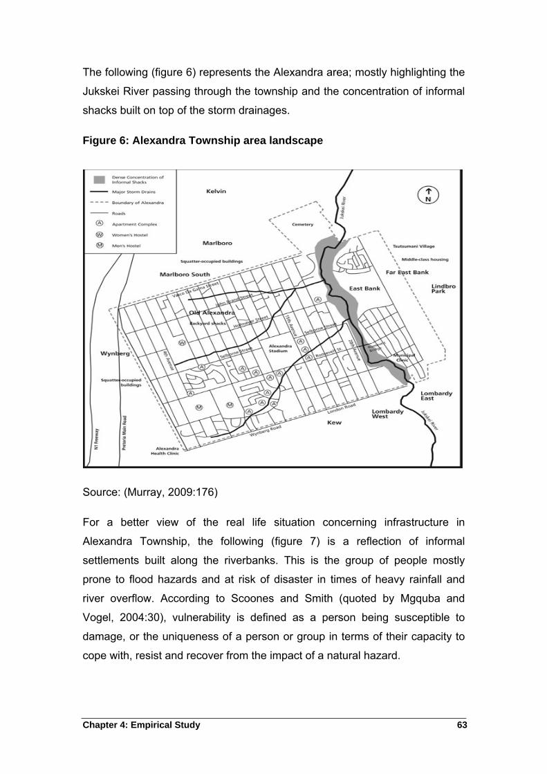
Chapter 4: Empirical Study 63
The following (figure 6) represents the Alexandra area; mostly highlighting the
Jukskei River passing through the township and the concentration of informal
shacks built on top of the storm drainages.
Figure 6: Alexandra Township area landscape
Source: (Murray, 2009:176)
For a better view of the real life situation concerning infrastructure in
Alexandra Township, the following (figure 7) is a reflection of informal
settlements built along the riverbanks. This is the group of people mostly
prone to flood hazards and at risk of disaster in times of heavy rainfall and
river overflow. According to Scoones and Smith (quoted by Mgquba and
Vogel, 2004:30), vulnerability is defined as a person being susceptible to
damage, or the uniqueness of a person or group in terms of their capacity to
cope with, resist and recover from the impact of a natural hazard.
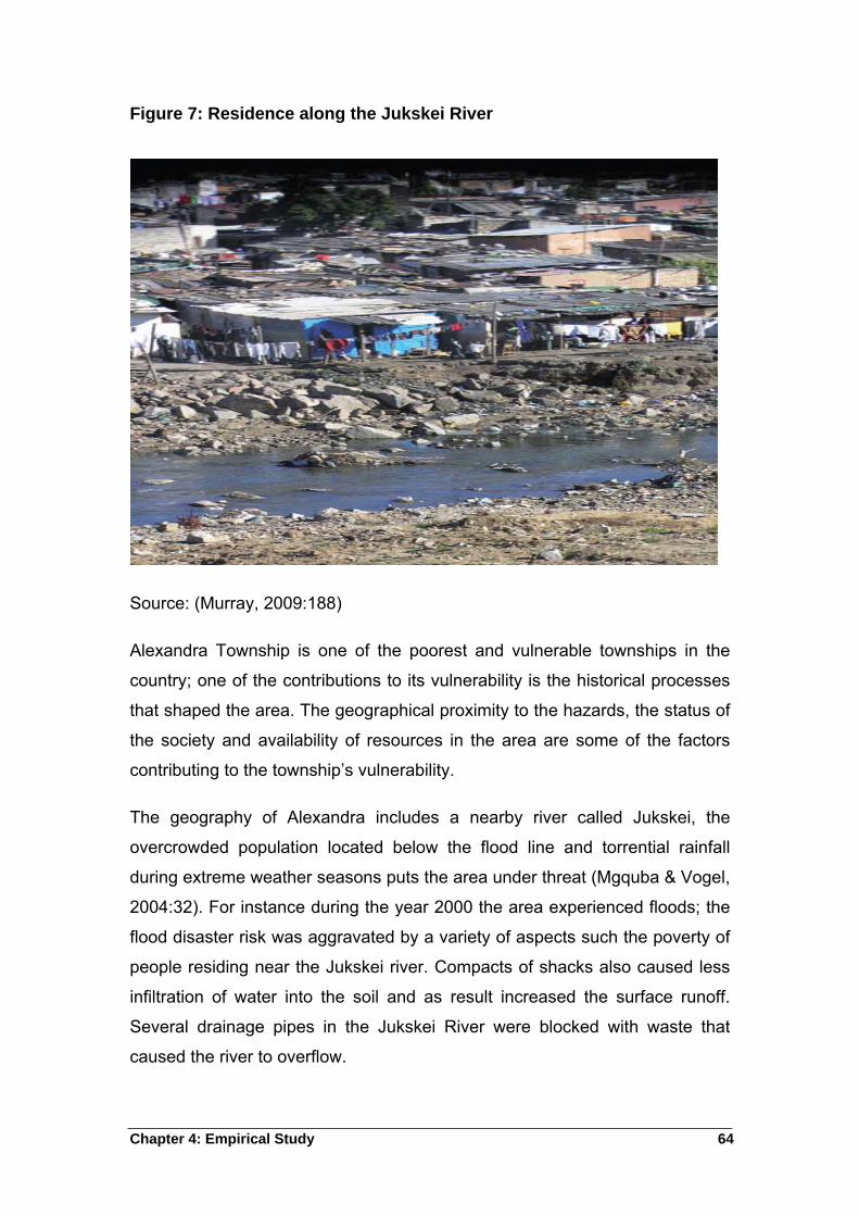
Chapter 4: Empirical Study 64
Figure 7: Residence along the Jukskei River
Source: (Murray, 2009:188)
Alexandra Township is one of the poorest and vulnerable townships in the
country; one of the contributions to its vulnerability is the historical processes
that shaped the area. The geographical proximity to the hazards, the status of
the society and availability of resources in the area are some of the factors
contributing to the township’s vulnerability.
The geography of Alexandra includes a nearby river called Jukskei, the
overcrowded population located below the flood line and torrential rainfall
during extreme weather seasons puts the area under threat (Mgquba & Vogel,
2004:32). For instance during the year 2000 the area experienced floods; the
flood disaster risk was aggravated by a variety of aspects such the poverty of
people residing near the Jukskei river. Compacts of shacks also caused less
infiltration of water into the soil and as result increased the surface runoff.
Several drainage pipes in the Jukskei River were blocked with waste that
caused the river to overflow.
Chapter 4: Empirical Study 65
Wisner (2009:273) concurs with the fact that the illegal dumping of garbage
into Jukskei narrows the river channel, and increases the risk of river runoffs
during the heavy summer rainfall. This affects poorest people living in shacks
near the river plain. Mgquba and Vogel (2004:35) state that Alexandra
experienced floods in the year 1994, 1995, 1997, 1999 and the year 2000
which were regarded as the worst; homes and belongings were swept by
flooding water of the Jukskei River. Mkhize and Manzi (2010:6) report that
Alexandra is one of the townships that experience flood disaster during
December. Floods force residents out of their houses during the rainy season
as they are scared that their houses will be flooded.
4.9.2 Responses from the Metropolitan Municipality officials on
Disaster Management
The government has been keeping the records of floods events and the cause
thereof, they tell of two boys who drowned on the 22nd February of 2010.
Government officials are definitely aware of the risk associated with the
Alexandra Township. One of them said;
“We are aware of the risks and that include, river outburst
which can create lot of problems for people near the river as
they stand to lose all that they posses. Health problems and
even death threats, for instance; we have found a dead child
in March 2010 after he disappeared for few days, only to find
that he was swamped’’ (per. Comm., 2011-03-30: Respondent
01 and Respondent 02).
The two respondents believe so much that frequent blockages as a result of
shacks built on the drainage system is the main source of regular floods in the
area. The first respondent argues that; people occupied every space that was
there and as a result, water is redirected during the rainy season. They
strongly believe that land invasion is also a factor of vulnerability because
people reside on low-lying areas and along the river where the water easily
flows. The geography of Alexandra contributes to the maximum floods as
most people are situated along the river especially on Second Avenue.
Chapter 4: Empirical Study 66
Second Avenue is a densely populated low-lying area just below the river; it
receives much of the water during rainy season. The poor if the poor people
who cannot afford to build standardized houses occupy Second Avenue.
“Floods in this area have caused the government and people
residing in the area a lot of money that amounts to millions.
Structures invested by government and houses built by
residents are usually destroyed in times of floods, while people
young and old are left psychologically depressed and with
health problems. People are often left without their belongings
and others suffer long-term injuries” (per. Comm., 2011-03-30:
Respondent 01 and Respondent 02).
One official explains that not the whole Alexandra is vulnerable to floods but
Sjwetla is the main area that is usually affected. This is an informal settlement
built on a low-lying area along the Jukskei River. The area is overcrowded
with people that cannot afford to build a normal house, as most of them are
unemployed. This makes them even more vulnerable because they normally
lose everything during the floods. Regardless of the government’s effort to
relocate them, one still finds people residing in that area.
Respondents 01 and 02 (per. Comm., 2011-03-30) affirmed that the
government, particularly their region is prepared in terms of policies such as
Disaster Management Act 57 of 2002 to assist residents in times of disaster
including risk reduction. Other than the policy, the municipality took steps to
educate people about disaster preparedness and mitigation. In terms of
floods, the municipality installed early warning systems in Sjwetla.
The government is not working solely in managing disaster in the area but
other organizations have joined in solidarity to prevent major losses. The
South African Weather Services assists by warning the community on hazards
and prepares government officials to respond in advance. Media liaison
officers communicate through community radio stations to seek assistance for
disaster relief and to inform the residents of any changes in the weather
patterns affecting the area. Environmental health organizations regularly visit
Chapter 4: Empirical Study 67
the area to educate more about health issues. A waste removal company
(Pikitup) and the municipal electricity service provider (City Power) also assist
communities on a regular basis.
“Government and non-government organizations usually work
together with the community to alleviate the damage caused
by flood disaster. They donate to the homeless and also
provide shelter” (per. Comm., 2011-03-30: Respondent 01 and
Respondent 02).
The area had a warning system but it does not work anymore because of
vandalism. The warning system was a bell that people had to ring for the
community to vacate disaster prone areas. Another intervention was a public
phone installed for emergencies only; it is no longer working as well. In
response, the municipality had a community project to educate people about
how to communicate with the emergency and disaster unit in time of disaster.
The municipality bought whistles for community members and gave them the
emergency unit phone numbers to communicate directly with the unit.
Lamenting the efficiency of these interventions, respondents put:
“While the whistles will make other community members
aware of the danger the river might cause. Becase of rapid
floods, the river itself will let people know that they need help”
(per. Comm., 2011-03-30: Respondent 01 and Respondent
02).
Chapter 4: Empirical Study 68
A discussion with one local government official working on disaster relief in
Alexandra Township, it is clear that the disaster vulnerability situation in
Stjwetla is complex and requires some extent of political will to ensure that
residents are not eposed to flood hazard.
4.9.3 Responses from the organizations in the area on Disaster
Management
A civil society representative in Johannesburg (per. Comm., 2011-08-30:
Respondent 01) states that Alexandra especially, Stjwetla is linked with risks
that include health hazards, floods that usually cause a loss of life. According
to the Respondent (per. Comm., 2011-08-30: Respondent 03), floods in the
area occur every year mainly because of the ground it sits on. He affirms that
Stjwetla is on a low-lying ground, with drainage systems that are not well
structured and useless because people built their houses on top of them.
A government official dealing with Johannesburg climate change issues
concurs with the civil society representatives that Alexandra Township is
densely populated.
Alexandra Renewal Project (ARP) does focus on disaster mitigation. The challenge is however, a
repeated invasion of disaster prone areas such as Stjwetla- when people are relocated, in a blink of
an eye, other have occupied. This is a major concern for the city of Johannesburg since storm water
drains are blocked most of the time, thus exacerbating flood.
Public Life Education Relations (PIER) is a company in close cooperation with regional disaster
officers and urban management. One needs to consider that Alexandra is a port: i.e. Arrival and
departure, it also harbours foreigners (illegal immigrants) who hide from the law until such time that
they find residence elsewhere in the country. On the other hand, people take residence in Alexandra,
particularly in disaster prone areas in order to twist governments’ arm, i.e. to speed up service
delivery such as housing allocation. Despite being aware of the dangers associated with staying in
such areas. They know that when they are hit by these natural disaster events, the government will
have to intervene. Most people have been warned against staying in these areas.
(per. Comm., 2011-03-15: Respondent 01)
Chapter 4: Empirical Study 69
It is now burdensome on the government system, therefore it is difficult for the
municipality to manage daynamics in that residential area (per. Comm., 2011-
08-30: Respondent 04). They both believe that the only way to reduce floods
vulnerability is by settling the residents in a different location because the
current geographic setting is the main factor to the recurring floods disasters.
This government official (per. Comm., 2011-08-30: Respondent 04) mentions
the importance of weather variability and the fact that the location will always
determine the effects; this is with and understanding that weather varies per
season. He expands on saying that Alexandra can receive the same volume
of rain as any other area but because of its location, the effects will not be the
same because it is in a low-lying area.
Loss of lives, injuries, loss of belongings, bad smell from drainages and
psychological effects are frequent usually after floods hit, however different
organizations are always prepared to help. The Red Cross Society and other
community organizations are always ready to donate food, accommodation
and blankets. Because climate change is part of the local government, the
local government authority has regular communication with non-governmental
organisations to prepare them of any atmospheric changes. Interviews with a
government official and a civil society representative (per. Comm., 2011-08-
30: Respondent 01 and Respondent 04) confirm the relationship between
government and civil society organisations such as the Red Cross Society.
Local government and civil society relations range from campaigns to
educating, training communities and recruit volunteers for disaster
managemnet. Therefore, the disaster management is working hard to manage
and reduce floods disaster in Alexandra Township is well as building and
receiving as much support as possible from different organizations.
4.9.4 Responses from the Community Leaders in the study area
Community leaders of Alexandra Township are also aware of the risk facing
the study area (Stjwetla). One community leader (per. Comm., 2011-09-01:
Respondent 01) mentions few hazards prevalent within the study area. Some
ranges from death threats, injuries and psychological effects that are common
Chapter 4: Empirical Study 70
risks mostly experienced by the residents. Just like any other resident, this
community leader came in the area to look for a job in 1997, and he has no
other place to reside except here in Stjwetla because he cannot afford a
decent residence. He last experienced floods in December 2010, where most
residents lost their belongings, he affirms that the main reason to flood
disaster in Stjwetla is its low-lying location near the river. He motivates the
opinion with a statement that the Jukskei River is wide and becomes full
during the rainy season, as a result, the river floods houses built alongside it.
The community leader (per. Comm., 2011-09-01: Respondent 01) applauds
the disaster management unit in Johannesburg municipality, for assisting
them during the floods. The Johannesburg emergency unit always avail
themselves in time of floods. The respondent indicates that the department of
social development and the department of health ought to intervene but they
are very passive.
“These departments should be part of disaster management
because they can help victims by giving them psychological
therapy. People, especially the old and young are usually left
with severe psychological effects that take a long time to heal”
(per. Comm., 2011-09-01: Respondnet 01).
Few organizations such as Red Cross society and Twala Mama Africa work
together with the local government, to reduce the impact of disaster in
Stjwetla; they usually provide shelter, food and clothes to the victims of flood
disaster.
4.9.5 Responses from the community / Residents in the study area
Most members of the community were available as the unemployment rate in
the area is very high. Old women and young people in the area were the most
available. All community members interviewed by the researcher are from
Limpopo. The researcher found a group of people arranged to be interviewed
fixing and putting together six incinerated shacks after a neighbor left a lit
candle in the previous night. Residents were not in a good mood for interview,
Chapter 4: Empirical Study 71
because they were arranging a protest march to the Department of Housing to
complain about their living conditions.
One resident (per. Comm., 2011-09-02: Respondent 01) attests that Stjwetla
is not a safe residential area because floods regularly threaten their lives. He
explains that he came in Alexandra in 2001 to look for a job, but he is still
unemployed and lives in this area. He says the reason he stays at Stjwetla is
because he cannot afford to stay elsewhere, therefore he is forced to stay
until he can maintain himself in another place. The residents usually lose their
houses and other belongings during the rainy season.
The other resident (per. Comm., 2011-09-02: Respondent 02) confirms that
Stjwetla is not safe and they need as much help as possible. He complains
about the local government response during their time of need. The disaster
management is not doing enough, they should educate the community about
disaster and find a way to communicate with the housing department as well
as the Alexandra Renewal Program (ARP), to relocate them and build houses
for them.
Participant 03 indicates that there are no changes made, the local government
removed people who were on the higher part of Stjwetla, and left those on the
flood plain, on a low-lying area exposed to floods (per. Comm., 2011-09-02:
Respondent 03). She moved to Alexandra in 1981 and stays in the same
shack she stayed in when she first arrived. During the rainy season people
lose everything, the emergency unit always rescues people especially during
floods. Organizations assist with food, clothes and shelter but it is not enough.
The respondent further makes emphasis that people living at Stjwetla have to
be moved to a better place (per. Comm., 2011-09-02: Respondent 03).
One can see the stress in this community; most of them are very poor,
because they are unemployed. Most of them have been in this area for more
than twenty years and they have been experiencing flood disaster almost
every year. People sit outside their houses reclining in the sun during the day
and converse, because they have nothing more to do. They are worried about
the coming rainy season because their houses are still in the same condition,
Chapter 4: Empirical Study 72
built in every type of material like tents, boxes and steel doors. One resident
spoke with a very sad face while she explained how she lost her house and
belongings in the previous flood disaster.
She is a young woman who came at Stjwetla in 1998 to look for a job. She
expects a lot from the local government like every South African citizen who
cannot afford to buy or build a house (per. Comm., 2011-09-02: Group of
residents).
4.10 Summary
The chapter outlined the research design and gave insight on the modes used
to reach the satisfactory information. Research ethics ensure that the final
product is not biased. Qualitative methods, survey, samples and interviews
helped to complete the research. An outline of study limitations and
biographical descriptions of respondents reveal that the research project is a
product derived from the actual social setting.
The following chapter will present the findings and recommendations where
the study had limitations. The chapter will give answers to the objectives and
questions outlined in chapter 1.
Chapter 5: Findings and Recommendations 73
5 Chapter Five: Findings and Recommendations
The section deals with the research findings, recommendations as well as the
conclusion of the study.
5.1 Introduction
This concluding chapter outlines the extent to which the objectives of the
study have been realized. It also comments on the hypothesis posed in the
study. This ascertains that the analysis of the hypothesis throughout the
study. The chapter will also make recommendations to the city of
Johannesburg, the municipality that is responsible for Alexandra Township.
Chapter 1
In this chapter the researcher pointed out the interest to research about the
influence of geographical patterns and disaster management, the study
focused on floods disasters in the townships and the government response
thereof.
Chapter 2
In this chapter the researcher gave greater attention to the first two objectives
of the study, namely, the theoretical exposition of geographical patterns and
disaster, as well as the international experiences on floods disaster occurring
mostly in urban areas. The researcher focused on townships or areas
occupied by poor residents and looked into the influence of geography
pertaining to the physical portraits of the land, the climate as well as the extent
of the population.
Chapter 3
The chapter focused on the second and third objectives of the study as they
apply to South Africa. The geography of the country was looked at, mainly the
physical landscape, the climate and its population. The chapter navigates the
influence of floods disaster normally occurring in South Africa, especially in
townships and low-lying areas. Disaster management in the country was also
Chapter 5: Findings and Recommendations 74
a focus. The researcher’s aim was herein to investigate the role of South
African government in disaster management.
Chapter 4
The chapter outlined the research design applied through qualitative research
methods. Semi-structured and group interviews were the main tools used in
gathering the information from Alexandra residents. Respondents include
local government officials, organizations, community leaders as well as the
public. The study area receives much attention in the chapter. The geographic
details of the location are explained; these include the landscape structure,
the population number as well as the climate. Alexandra Township is an area
situated North of Johannesburg region and supposed to be receiving their
services from that region. Disaster management unit ensures the reduction of
flood disasters. Working with organizations is one way to help reduce the
impact of disasters in the area. The chapter covers the government officials’,
organizations as well as community responses on disaster management in the
area.
Chapter 5
The chapter focuses on findings of the study and seeks to verify whether
justice is made to the objectives of the study. The chapter outlines findings
and recommendations on how to improve the situation in the Alexandra
Township. The chapter also draws the conclusion on the study.
5.2 Findings
Local governments carry the responsibility to provide basic services to the
community, which includes among others, to ensure that their communities
live in a safe and healthy environment. Alexandra Township particularly
Stjwetla location poses a threat to the community’s safety as the area is built
along the river of Jukskei. This river is wide open which leaves communities
along its bank vulnerable to floods risk. Vulnerable communities are mostly
unemployed and cannot afford to relocate to any other area, because they will
have to pay rent. Most people residing at Stjwetla have been there for more
Chapter 5: Findings and Recommendations 75
than 20 years and they have different experiences with regard to the local
government and disaster management interventions.
They agree that the residential area is built along the riverbanks in low-lying
regions; they would like the government to help them move to more secure
regions and build better houses for them. Residents normally lose all their
belongings to flood disasters and mainly depend on organizations and
government to care for them by providing shelter, food and clothes. Although
they indicate dissatisfaction with their local government’s responses in times
of need, they mention that the disaster management unit in the area is doing
its best together with support from the Red Cross organisation.
The disaster management system used in this area is responsive instead of
being pro-active. Much still needs to be done with regard to enhancing
sustainable and structured programs for public awareness on disaster threats.
The emergency alarm system in the area is no longer working; therefore,
every community member received a whistle to use in times of emergency to
call for help. There is a group of community leaders, which links the local
government with the rest of the Stjwetla community. This group normally
assists by calling the disaster management unit, and helps to rescue affected
communities.
5.2.1 Hypothesis
The null hypothesis was proven correct based on the following:
a) The geography of the study area (Stjwetla) proves to be the main reason
for frequent flood disaster; the area is located on a low-lying area along the
riverbanks expose all the residents to a risk of flood disaster.
b) The population residing on this area is more than what the land can
accommodate. It is densely populated which implies that the effects of
floods are severely felt, with lots of people affected.
Chapter 5: Findings and Recommendations 76
c) Stjwetla usually experiences heavy rains during summer, due to the
proximity of the residents to the River; flash floods are bound to affect
residents along the stretch of the river.
5.3 Recommendations
Subsequent to the research findings above, the study presents the following
recommendations to the Johannesburg Metro council:
That the Municipality adheres to the stipulations of the Disaster
Management Act 57 of 2002, which outlines the key responsibilities of
local government with regard to disaster management at a local municipal
level.
The disaster awareness campaign should receive more attention and be
presented to the community on a regular basis.
The early warning system must be active at all times and disaster
mitigation plans be in place to allow every resident a chance to escape
danger.
The community should be encouraged to form groups or community
organizations that will be responsible for regular communication with the
local government.
The local government requires political will for strengthened law
enforcement to discourage and stop people who want to reside on
disastrous regions near and along the riverbanks.
The local government should maintain excellent relations with the weather
services office to eliminate the element of surprise concerning unusual
weather circumstances and prepare for such before hand.
More organizations should be mobilised to partake in the development of
disaster reduction and management interventions so as to increase the
sources of help.
Chapter 5: Findings and Recommendations 77
The disaster management unit should not operate on its own, but should
rather have interdependent relations with other government departments
such as housing, education, health, social and developments to assist in
the aftermath of floods occurrences.
5.4 CONCLUSION
Local governments carry the responsibility to provide basic services to the
community and to ensure a healthy and safe environment for the
constituency. Although residents indicate dissatisfaction with the responsive
nature of local government’s disaster response performance, the Disaster
Management Unit is said to be doing its best together with support from the
Red Cross organisation in Stjwetla. There are good relations with local
government and civil society organisations, but these needs to be enhanced
for the greater good of the community.
Bibliography 78
BIBLIOGRAPHY
Albala-Bertrand, J. M. 1993. Political economy of large natural Disasters: With
special reference to Developing Countries. Oxford: Claredon Press.
Allison, B., O’sullivan, T., Owen, A., Rice. J., Rothwell, A., & Saunders, C. 1996.
Research skills for students. Great Britain: Library of congress cataloguing in
publication data. 122 p.
Alma, P. 1993. Environmental Concerns. Great Britain: Cambridge University
Press.
Bailey, K. D. 1987. Methods of Social Research 3rd ed. New York: Collier
Macmillan Publishers. 533 p.
Beall, J., Crankshwa, O., & Parnell, S. 2000. Local government, poverty reduction
and inequality in Johannesburg. Envrio&Urbanization,12(1):107- 122 p, Apr.
Benouar, D., & Meziane, Y. 2009. Disaster Risk Reduction in Algiers, Algeria (In
Pelling, M., & Wisner, B., eds. 2009. Disaster Risk Reduction: cases from urban
Africa. UK: Earthscan. p 161-191).
Bless, C, & Smith, C. H. 1995. Fundamental of Social Research Methods: An
African perspective 6th ed. Lusaka: Juda & Co. 164 p.
Brauch, H. G. 2003. Urbanization and Natural disasters in Mediterranean:
Population Growth and Climate change in the 21st century. (In Kreimer, A.,
Arnold, M., & Carlin, A., eds. 2003. Building Safer Cities. Washington: World
Bank. p 299).
Bryman, A. 1988. Quality and Quantity in Social Research. London: Routledge.
Claude, G. 1998. Changes in the main conceptual tools. (In Quarantelli, E. L., ed.
1998. What is Disaster. USA: Routledge. 312 p).
Christie, F., & Hanlon, J. 2001. African issues: Mozambique and the great flood of
2000. Great Britain: Library of congress cataloguing in publication data.
Bibliography 79
Cosser, E., Eloff, T., & Molebatsi, C. 1991. The right to have a Home (In Cosser, E.,
ed. 1991. Home for all: The challenge of homelessness. Cape Town. Published
by Cross Times Trust for CREID. p 12-16).
Council for Scientific and Industrial Research (CSIR). 1989. Survey of September
1987 national floods. Pretoria: CSIR.
Denscombe, M. 2007. The good Research guide for small-scale social research
projects 3rd ed. Great Britain: British library. 349 p.
Denscombe, M. 2010. The good Research guide for small-scale social research
projects. 4th ed. Great Britain: British library. 373 p.
Diagne, K., & Ndiaye, A. 2009. History, Government and the millennium
development Goals: Floods Risk Reduction in Saint Louis, Senegal. (In Pelling,
M., & Wisner, B., eds. 2009. Disaster Risk Reduction: cases from urban Africa.
UK: Earthscan. p 224).
Duncan, K., & Brebbia, C. A. 2009. Disaster management and human health risk:
Reducing risk, improving outcomes. Great Britain: WIT Press. 392 p.
Escape, L. 2010. Heavy rains cause havoc countrywide. Sowetan: 2, 17 Dec.
Field, C. B., Mortsch, L. D., Brklacich, M., Forbes, D. L., Kovacs, P., Patz, J. A.,
Running, S. W., & Scott, M.J. 2007. North America. Climate change 2007:
Impacts, adaptation and Vulnerability. Contribution of Working Group change 11
to the fourth Assessment Report of the Intergovernmental panel on climate
change. (In Parry, M. L., Canziani, P. J., Palutikof, P. J., & Hanson, C. E. eds.
2007. UK: Cambridge University Press. p 617-652).
Gadain, H., Biault, N., Stephen, L., Watkins, B., Dilley, M., & Mutunga, N. 2006.
Reducing the impacts of floods through early warning and preparedness: A pilot
study for Kenya. (In Arnold, M., Chen, R. S., Deichmann, U., Dilley, M., Lerner-
Lam, A. L., Pullen, R. E., & Trohanis, Z. eds. 2006. Natural Disaster Hotspots:
Case Studies. World Bank: Washington. p 184).
Bibliography 80
Gelineau, K., & Pickard, T. 2011. Queensland town was reeling after storm out of
hell. The Star: 4, 12 January.
Goudie, A. 1990. The human impact on the natural environment. UK: British library
cataloguing in publication data. 387 p.
Gray, D. E. 2004. Doing Research in the Real World. London: SAGE publications
Ltd.
Greater Johannesburg Metropolitan Council (GJMC). 2000. Project Spotlight:
Alexandra Township, Johannesburg, South Africa. Report on the Interactive
Planning Workshop for Johannesburg, September 27-30.
Hammersley, M. 1993. Social Research. Philosophy, Politics and Practice. London:
SAGE publications Ltd.
Hart, M. 1993. Survey Design and Analysis using Turbostats. London: Chapman &
Hall.
Huq, H., & Alam, M. 2003. Building safer cities: The future of disaster risk.
Washington, DC: World Bank. 299 p.
International Federation of Red Cross and Red Crescent Societies (IFRC). 2007.
Congo Brazzaville Floods and landslides. DREF bulletin No. MDRCD001.
Geneva: IFRC.
International Federation of Red Cross and Red Crescent Societies (IFRC). 2007.
Nigeria: Floods, Emergency Appeal. Lagos: Nigerian Red Cross Society.
International Federation of Red Cross and Red Crescent Societies (IFRC). 2008.
West and Central Africa: Flood preparedness, Focus on relief stock procurement
and capacity building for response. Emergency appeal No. MOR61003. Geneva:
IFRC.
International Federation of Red Cross and Red Crescent Societies (IFRC). 2010.
Egypt: Flash Floods, DREF operation MDREG009. Geneva: IFRC.
Bibliography 81
International strategy for disaster reduction (ISDR). 2004. Living with Risk: Global
review of disaster reduction initiatives. Switzerland: United Nations publications.
429 p.
Kiusi, R. B., Lupata, J., Lerise, F., Meshack, M., Malele, B., Namangaya, A., &
Mchome, E. 2009. Building disaster resilient communities: Dar es Salaam,
Tanzania (In Pelling, M., & Wisner, B., eds. 2009. Disaster Risk Reduction:
cases from urban Africa. UK: Earthscan. p 224).
Leedy, P. D. 1992. Pratical research: Planning and Design 5th ed. USA: Prentice
hall Inc. 348 p.
May, T. 1997. Social research: issues, methods and process. 2nd ed. USA: Open
University Press. 227 p.
Marjanovic, P., & Nimpuno, K. 2003. Living with risk: Toward effective Disaster
Management training in Africa. ( In Kreimer, A., Arnold, M., & Cardin, A., eds.
2003. Building safer cities: The future of Disaster Risk.).
Mark, N., & Rubin, M. 2002. Managing environmental and disaster risks affecting
informal settlements: Lessons in innovative practice from South African local
authorities. South Africa: CSIR.
Mkize, V., & Manzi, M. 2010. Floods have already forced some people out of
homes. The Star: 8, 16 Dec.
Mouton, J., & Marais, H. C. 1988. Basic Concepts in the Methodology of the Social
Sciences. Pretoria: Human Science Research Council.
Mouton, J. 1996. Understanding Social Research. Pretoria: Van Schaik Publishers.
285 p.
Mthethwa, B. 2011. R100m boost for flood victims in KZN. Sunday Times: 12, 30
Jan.
Pelling, M. 2003. The Vulnerability of Cities: Natural Disasters and Social
Resilience. UK: Earthscan. 212 p.
Bibliography 82
Quarantelli, E. L. 1998. What is a disaster? USA: Routledge. 312 p.
Raphael, B. 1986. When Disaster strikes: A handbook for the caring professions.
London: Hutchins. 342 p.
Republic of South Africa (RSA). 1996. The Constitution of the Republic of South
Africa Act, 108 of 1996. As adopted on 8 May 1996 and amended on 11 October
1996 by the Constitutional Assembly. Pretoria: Government Gazette.
Seale, L., & Cox, A. 2010. Emergency services stretched to rescue victims of
floods. The Star: 1, 17 Dec.
Sergio, P. 1999. Social vulnerability to disasters in Mexico City: An assessment
method. (In Mitchell. J. K., ed. 1999. Crucibles of Hazards: Mega-Cities and
Disasters in Transition. USA: United Nations University Press. p 295-334).
Skinner, C., & Mersham, G. 2002. Disaster Management: A guide to issues
management and crisis communication 2nd ed. South Africa: Oxford University
Press.
Smith, K. 1996. Environmental hazards. Assessing Risk and Reducing Disaster.
USA: Routledge. 389 p.
Swart, W., Sutherland, K., Mdakane, B., & Jordan, B. 2010. When the heavens
opened. Sunday Times: 13, 19 Dec.
Tanya, Z. 2001. Nobody’s child, a kind of heaven trapped in History: Planning
Challenges in ALexandra (Paper presented to the Royal Australian Planning
Instittute Conference A ‘Planning Odyssey’ October 21.
Taylor, S. J., & Borgdan, R. 1998. Introduction to Qualitative Research Methods: A
guide book and resource 3rd Ed. New York: John Wiley & Sons, Inc. 337 p.
Tempelhoff, J., Van Niekerk, D., Van Eeden, E., Gouws I., Botha, K., & Wurige, R.
2009. The December 2004-January 2005 floods in the Garden Route region of
the Southern Cape, Journal of Disaster Risk Studies (JAMBA), 20(2):100 p, Nov.
Bibliography 83
United Nations Development Programme (UNPD). 2004. Reducing Disaster Risk:
Challenge for development. USA: John Swift Print Co. 145 p.
United Nations Framework Convention on Climate Change (UNFCCC). 2006. The
Impact, vulnerability and adaptation to climate change in Africa. Ghana. 54 p.
UN-Habitat. 2007. Enhancing urban safety and security: Disaster global report on
human settlement. Nairobi.
UN-Habitat. 2009. Alexandra urban renewal: The all embracing township
rejuvenation programme (UN Habitat Scroll of Honour Submission 15th August
2009).
Van Wyk, E. 2011. South Africa under water. City Press:8, 23 Feb.
Vaz, A. C. 2000. Coping with Floods: The experience of Mozambique 15 p. (1st
WARFSA/WaterNet Symposium: Sustainable use of water resources, Maputo,
1-2 November 2000).
Wisner, B., & Pelling, M. 2009. Disaster Risk Reduction: Cases from urban Africa.
Wisner, B., Blaikie, P., Cannon, T., & Davis, I. 1994. At Risk: Natural Hazards,
people’s vulnerability and disasters 2nd ed. USA: Routledge. 471 p.
Wolfgang, G. Bollin, C., & Deutshe Gesellshaft fur Technosche Zusammenarbeit
(GTZ). 2002. Disaster Risk: Working concept. Eschborn: GTZ. 48 p.
Yitambe, A., Okello, J., Nguka, O. C. M., Ochieng, C., & Valle, A. 2009. Traffic
accidents as an everyday hazard: Kissi and Kisumu, Kenya. (In Pelling, M &
Wisner, B., eds. 2009. Disaster Risk Reduction: Cases from urban Africa. UK:
Earthscan. 224 p).
Webliography 84
WEBLIOGRAPHY
Abhas, K., Jennifer, D. B., Priscilla, M. P., Daniel P., & Sena, S. 2010. Safer
homes, stronger communities: A handbook for reconstructing after
natural disasters. World Bank. http://www.housingreconstruction.org/
housing/sites/housingreconstruction.org/files/Disaster%20Types%20and
%20Impacts.pdf Date of access: 03 Nov. 2010.
Adikari, Y., Osti, R., Noro, N. 2010. Flood related disaster vulnerability: an
impending crisis of mage cities in Asia. Journal of flood Risk
Management, 3(3):185-191 p. http://onlinelibrary.wiley.com/doi/10.1111/
j.1753-318X.2010.01068.x/pdf Date of access: 08 Oct. 2010.
Alexander, W. J. R. 2002. Statistical analysis of extreme floods. 16 p.
http://www.sinotechcc.co.za/Software/UPFLOOD/SDF1.pdf Date of
access: 03 Nov. 2010.
Ayanji, E. N. 2004. A critical assessment of the natural disaster risk
management framework in Cameroon. An end-of-course case study
submitted to the department of city management and urban development
of the World Bank institute in partial fulfillment of the requirements of the
award of a certificate in natural disaster risk management. Institute for
Housing and Urban Development studies (I.H.S) Rotterdam.
http://info.worldbank.org/etools/docs/library/114813/bestcourse/bestcour
se.htm Date of access: 15 Jun. 2010.
Bury, L. J. 2005. Status of disaster management in South Africa.
http://web.ndmc.gov.za/WebDocuments/article Date of access: 15 Nov.
2010.
Cities Alliance & Sau Paulo. 2008. Slum Upgrading up close: experiences of
six cities. USA. 58 p.
http://www.citiesalliance.org/ca/sites/citiesalliance.org/files/su-up-
close_0.pdf Date of access: 17 Nov. 2010.

Webliography 85
Coates, L. 1999. Floods fatalities in Australia, 1788-1996, 30(3): 391-408p
http://www.riskfrontiers.com/publications.html Date of access: 26 August
2011.
Cohen, S., & Miller, K. A. 2001. North America. Chapter 15 in Climate
Change 2001: Impacts, Adaptation, and Vulnerability. Contribution of
Working Group II to the Third Assessment Report of the
Intergovernmental Panel on Climate Change. Cambridge: Cambridge
University Press, 735-800p. http://www.ipcc-
wg2.gov/AR4/website/14.pdf Date of access: 06 September. 2011.
De Wet, T., Mathee, A., & Barnes, B. 1999. The State of the Environment
and Health in Alexandra. LEAD Programme in Technologies for
Enhanced Environmental Management, Durban, December, 1999.where
is web address. 27 p. http://www.mrc.ac.za/healthdevelop/casestudy.pdf
Date of access: 14 Nov. 2010.
Deutsche Gesellschaft für Technische Zusammenarbeit (GTZ). 2002.
Disaster Risk Management: Working concept. Eschborn: Deutsche
Gesellschaft für Technische Zusammenarbeit. http://www2.gtz.de/
dokumente/bib/02-5001.pdf Date of access: 14 Nov. 2010.
Drimie, S., & van Zyl, J. 2005. Human vulnerability to environmental change:
South Africa environment outlook. South Africa: SRK consulting. 35 p.
http://soer.deat.gov.za/dm_documents/Human_Vulnerability_-
_Background_Paper_eD9Qk.pdf. Date of access: 17 Nov. 2010.
Fernando, A. D. 2007. Urbanization and flood vulnerability in the peri-urban
interface of Mexico City. Disasters, 31(4):477−494 p.
http://onlinelibrary.wiley.com/doi/10.1111/j.1467-7717.2007.01020.x/pdf
Date of access: 20 Oct. 2010.
International Fereration of Red Cross and Red Crescent Societies (IFRC).
2010. West and Central zone. Plan 2009-2010. Senegal Red Cross
Society. http://www.ifrc.org/docs/appeals/annual09/MAA6100109p.pdf.
Date of access: 29 Nov. 2010.
Webliography 86
Irasema, A. 2002. Geomorphology, natural hazards, vulnerability and
prevention of natural disasters in developing countries. Geomorphology.
47 (2002) 107-124 http://www.sciencedirect.com/science/journal/
0169555X Date of access: 16 Sep. 2010.
Maharaj, R., & de Villiers, G. 1994. Human perceptions and responses to
floods with specific reference to the 1987 flood in Mdloti River near
Durban, South Africa, ISSN. Water SA, 20(1):12 p, Jan.
http://www.wrc.org.za/Lists/Knowledge%20Hub%20Items/Attachments/4
827/1994_January_0754_abstract.pdf Date of access: 22 Sep. 2010.
Marx, C., & Charlot, S. 2010. Urban Slum report: Case study of Durban,
South Africa: London. 30 p. http://www.ucl.ac.uk/dpu-projects/Global_
Report/pdfs/Durban.pdf Date of access: 12 Nov. 2010.
Mdamombe, E. K. 2004. Zimbabwe: Flood management practices-selected
flood prone areas Zambezi basin. 12 p.
http://www.apfm.info/pdf/case_studies/zimbabwe.pdf Date of access: 18
Aug. 2010.
Mgquba, S. K., & Vogel, C. 2004. Living with Environmental Risks and
Change in Alexandra Township. South African Geographical Journal,
86(1):30-38 p.
http://www.sabinet.co.za/abstracts/sageo/sageo_v86_n1_a5.html Date
of access: 06 Aug. 2011.
Mitechell, J. K. 2003. European River Flood in a changing world. Journal of
Risk analysis, 23(3):567-574 p. http://geography.rutgers.edu/people/
faculty/mitchell/pub/EuropeanFloods.pdf Date of access: 11 Oct. 2010.
Monirul Qader Mirza, M. 2002. Global warming and changes in the
probability of occurrence of floods in Bangladesh and implications.
Journal of Global environment change, 12(1):127-138 p, Jul.
http://www.sciencedirect.com/science Date of access: 28 Sept. 2010.
Webliography 87
Morris, P. 2000. Alexandra Township, a history, lessons for urban renewal
and some challenges for planners. http://www.alexandra.co.za/
downloads/xtra_morris_history_2000.pdf Date of access: 16 Jul. 2010.
Murray, M. J. 2009. Fire and Ice: Unnatural disasters and the disposable
urban poor in post apartheid Johannesburg International. Journal of
urban and regional research, 33(1): 165-192p, May.
Naude, W., McGillivray, M., & Rossouw, S. 2007. A Local vulnerability index
for South Africa. 45 p. http://web.up.ac.za/UserFiles/S%
20Rossouw%20paper.pdf Date of access: 20 Nov. 2010.
Republic of South Africa (RSA). 1998. Local Municipal Government
Municipal Structures Act, 117 of 1998. Government Gazette
402(19614):1-104 p. 18 Dec.
http://www.info.gov.za/view/DownloadFileAction?id=70652 Date of
access: 15 Oct. 2010.
Republic of South Africa (RSA). 2000. Municipal System Act, 32 of 2000.
Government Gazette 425(21776):1-120 p. 20 Nov.
http://www.saflii.org/za/ legis/num_act/lgmsa2000384.pdf Date of
access: 15 Oct. 2010.
Republic of South Africa (RSA). 2003. Disaster Management Act, 57 of
2002. Government Gazette, 451(24252):1-62 p. 15 Jan.
http://www.info.gov.za/ view/DownloadFileAction?id=68094 Date of
access: 15 Oct. 2010.
Roberts, D. L. 2005. Climate change and potential human conflict: Western
Cape Province, South Africa http://www.gechs.org/
downloads/holmen/Roberts.pdf Date of access: 18 Nov. 2010.
Roger, F. 2003. Flooding, vulnerability and coping strategies: Local
responses to global threat. Journal for progress in development studies
3(1):43-58 p, Feb. http://pdj.sagepub.com/content/3/1/43.full.pdf date of
access: 5 Oct. 2010.
Webliography 88
Roger, F., Ahern, M., Matthies, F., & Kovats, S. 2004. Floods, Health and
climate change: a review strategy. UK. No. 63. http://pdj.sagepub.com/
content/3/1/43.full.pdf Date of access: 5 Oct, 2010.
Rosenberg, M. 2010. An Overview of Geography. http://geography.
about.com/od/studygeography/a/geog101.htm Date of access: 16 Jul.
2010.
Sherbinin, A. Schiller, A., & Pulsipher, A. 2007. The vulnerability of global
cities to climate hazards. Journal of Environment and Urbanisation
19(1):1-21p, Apr. http://www.ciesin.org/documents/vulofglob_
contactshtml.pdf Date of access: 06 Oct. 2010.
Sobczyk, M. 2010. Floods claims 12 lives in Poland. Europe. 20 May 2010.
http://blogs.wsj.com/new-europe/2010/05/20/flood-in-poland-turns-
towns-into-lakes-as-it-heads-north/ Date of Access: 03 Nov. 2010.
Songsore, J., Nabiala, J. S., Yangyuoru, Y., Bosque-Hamilton, E. K.,
Amponsha, P. A., Alhassan, O., & Satterrthwaite, D. 2008.
Environmental wealth watch and Disaster monitoring in the greater
Accra metropolitan. Accra: Ghana University press.
http://www.proventionconsortium.org/themes/default/pdfs/urban_risk/AU
RAN_Accra_phase1.pdf Date of access: 7 Oct. 2010.
Stecko, S., & Barber, N. 2007. Exposing vulnerabilities: Monsoon floods in
Mumbai, India http://www.unhabitat.org/downloads/docs/GRHS.2007.
CaseStudy.Mumbai.pdf Date of access: 12 Oct. 2010.
Swartz, L. 2010. Overview of poverty situation and reduction in South Africa
for the past 10 years. https://tspace.library.utoronto.ca/bitstream/
1807/5812/1/ep04021.pdf Date of access: 19 Nov. 2010.
UN-Habitat., & United Nations Environment Programme (UNEP). 2007.
Limpopo basin strategic plan for reducing vulnerability to floods and
droughts. Draft for discussion with riparian Government.
www.undp.org.mz Date of access: 16 Nov. 2010.

Webliography 89
United Nations Educational Scientific Cultural Organization (UNESCO). 2006.
Water: A shared responsibility. A United Nations World Water
Development Report 2. UK: UNESCO: http://www.unesco.org/water/
wwap/case_studies/ruhuna_basins/. Date of access: 12 Nov. 2010.
United Nations Environment Programme (UNEP). 2010. State of the
environment and policy perspective: 1972 -2002. http://www.unep.org/
geo/geo3/english/pdfs/chapter2-9_disasters.pdf. Date of access: 03 Nov.
2010.
Van Staden, D., Rogers, E., Makaudi, I., Winkler, J., White, J., Kangale, M.,
Rudman, N., Nkosi, S., Dreyer, T. R., & Coetzer, T. 2006. A transect
walk undertaken in Itereleng informal settlement to observe community
vulnerability. Pretoria: City of Tshwane Metropolitan Municipality
Disaster Risk Management Centre. Unpublished report.
http://www.proventionconsortium.org/themes/default/pdfs/CRA/South_Af
rica3.pdf date of access: 19 Nov. 2010.
Vermaak, J., & van Niekerk, D. 2004. Development debate and practices:
Disaster risk reduction initiatives in South Africa. Development Southern
Africa, 20(3):574 p, Sep. http://drr.upeace.org/english/documents/
References/Topic%201-Central%20Concepts%20in%20DRR/Vermaak
%20%202006%20DRR%20in%20South%20Africa.pdf Date of access:
19 Nov. 2010.
Wisner, B. 1995. The Reconstruction of Environmental Rights in Urban
South Africa, Human Ecology, 23(2):259-284 p, Jun.
http://www.jstor.org/stable/4603168 Date of access: 10 Mar. 2010.
Ziervogel, G., & Smit, W. 2009. Learning to swim: strengthening flooding
governance in the City of Cape Town.
http://www.earthsystemgovernance.org/ac2009/papers/AC2009-
0320.pdf Date of access; 21 Nov. 2010.
Interviews 90
INTERVIEWS
Metropolitian Municaipality officials (Disaster Management):
per. Comm., 2011-03-15: Respondent 01
per. Comm., 2011-03-30: Respondent 01
Per. Comm, 2011-03-30: Respondent 02
Civil society representatives (Disaster relief):
Per Comm, 2011-08-30: respondent 01
Per Comm, 2011-08-30: respondent 03
Per Comm, 2011-08-30: respondent 04
Metropolitan Municipality Official (climate change):
Per Comm, 2011-08-30: respondent 04
Community leaders:
Per Comm, 2011-09-01: respondent 01
Community Residents:
Per Comm, 2011-09-02: respondent 01
Per Comm, 2011-09-02: group of residents
Per Comm, 2011-09-01: respondent 02
Per Comm, 2011-09-01: respondent 03
Appendix 91
APPENDIX A: A LETTER TO JOHANNESBURG
METROPOLITAN MUNICIPALITY REQUESTING PERMISSION
TO CONDUCT RESEARCH
Appendix 92
Appendix 93
APPENDIX B: A LETTER FROM JOHANNESBURG
METROPOLITAN MUNICIPALITY GRANTING PERMISSION TO
CONDUCT RESEARCH
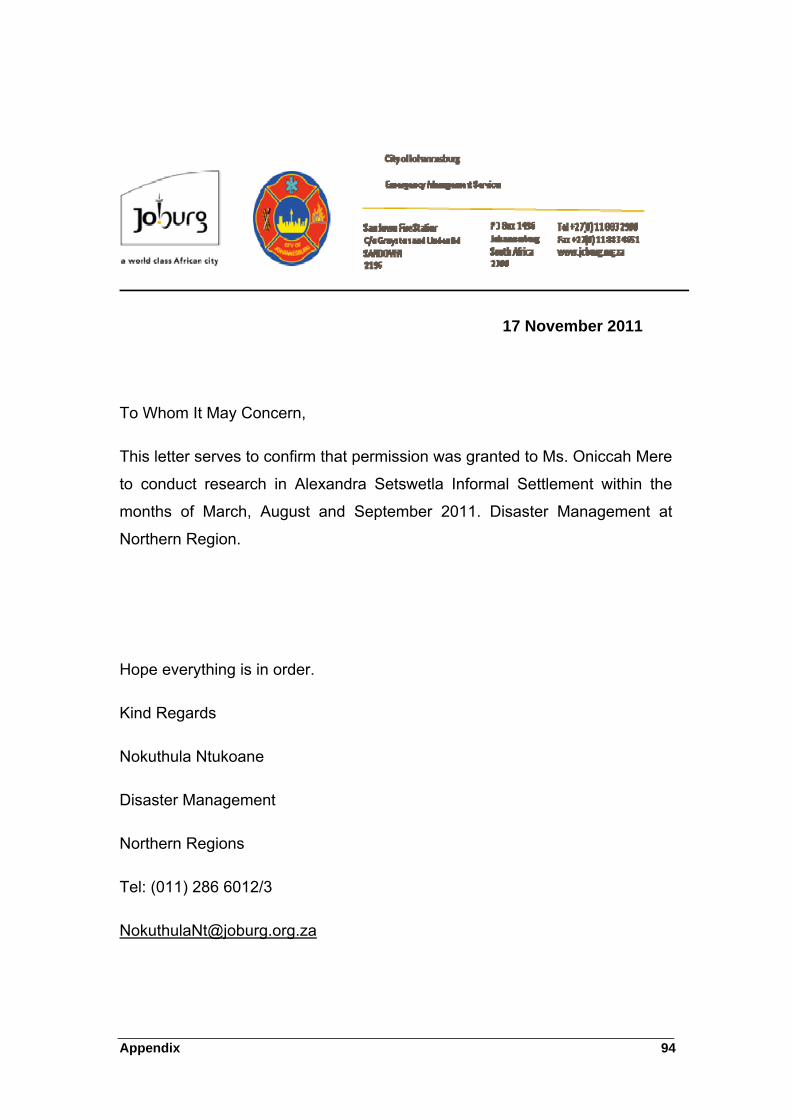
Appendix 94
17 November 2011
To Whom It May Concern,
This letter serves to confirm that permission was granted to Ms. Oniccah Mere
to conduct research in Alexandra Setswetla Informal Settlement within the
months of March, August and September 2011. Disaster Management at
Northern Region.
Hope everything is in order.
Kind Regards
Nokuthula Ntukoane
Disaster Management
Northern Regions
Tel: (011) 286 6012/3

Appendix 95
APPENDIX C: RESEARCH INTERVIEW QUESTIONNAIRES
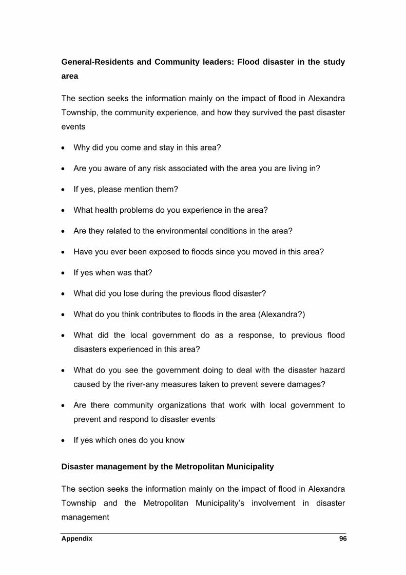
Appendix 96
General-Residents and Community leaders: Flood disaster in the study
area
The section seeks the information mainly on the impact of flood in Alexandra
Township, the community experience, and how they survived the past disaster
events
Why did you come and stay in this area?
Are you aware of any risk associated with the area you are living in?
If yes, please mention them?
What health problems do you experience in the area?
Are they related to the environmental conditions in the area?
Have you ever been exposed to floods since you moved in this area?
If yes when was that?
What did you lose during the previous flood disaster?
What do you think contributes to floods in the area (Alexandra?)
What did the local government do as a response, to previous flood
disasters experienced in this area?
What do you see the government doing to deal with the disaster hazard
caused by the river-any measures taken to prevent severe damages?
Are there community organizations that work with local government to
prevent and respond to disaster events
If yes which ones do you know
Disaster management by the Metropolitan Municipality
The section seeks the information mainly on the impact of flood in Alexandra
Township and the Metropolitan Municipality’s involvement in disaster
management
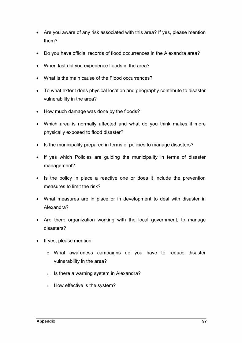
Appendix 97
Are you aware of any risk associated with this area? If yes, please mention
them?
Do you have official records of flood occurrences in the Alexandra area?
When last did you experience floods in the area?
What is the main cause of the Flood occurrences?
To what extent does physical location and geography contribute to disaster
vulnerability in the area?
How much damage was done by the floods?
Which area is normally affected and what do you think makes it more
physically exposed to flood disaster?
Is the municipality prepared in terms of policies to manage disasters?
If yes which Policies are guiding the municipality in terms of disaster
management?
Is the policy in place a reactive one or does it include the prevention
measures to limit the risk?
What measures are in place or in development to deal with disaster in
Alexandra?
Are there organization working with the local government, to manage
disasters?
If yes, please mention:
o What awareness campaigns do you have to reduce disaster
vulnerability in the area?
o Is there a warning system in Alexandra?
o How effective is the system?
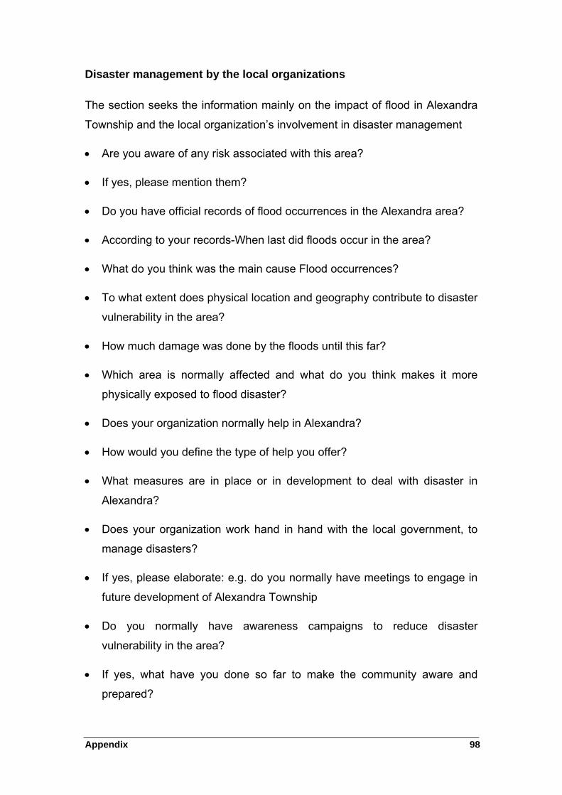
Appendix 98
Disaster management by the local organizations
The section seeks the information mainly on the impact of flood in Alexandra
Township and the local organization’s involvement in disaster management
Are you aware of any risk associated with this area?
If yes, please mention them?
Do you have official records of flood occurrences in the Alexandra area?
According to your records-When last did floods occur in the area?
What do you think was the main cause Flood occurrences?
To what extent does physical location and geography contribute to disaster
vulnerability in the area?
How much damage was done by the floods until this far?
Which area is normally affected and what do you think makes it more
physically exposed to flood disaster?
Does your organization normally help in Alexandra?
How would you define the type of help you offer?
What measures are in place or in development to deal with disaster in
Alexandra?
Does your organization work hand in hand with the local government, to
manage disasters?
If yes, please elaborate: e.g. do you normally have meetings to engage in
future development of Alexandra Township
Do you normally have awareness campaigns to reduce disaster
vulnerability in the area?
If yes, what have you done so far to make the community aware and
prepared?

Appendix 99
APPENDIX D: A LETTER FROM THE LANGUAGE EDITOR
Appendix 100