Cambro-Ordovician palaeomagnetic and geochronologic data from southern Victoria Land, Antarctica:...
10
Geophys. J. Int. (2000) 141, 391–400 Cambro-Ordovician palaeomagnetic and geochronologic data from southern Victoria Land, Antarctica: revision of the Gondwana apparent polar wander path Anne M. Grunow1 and John P. Encarnacio ´n2 1 Byrd Polar Research Center, Ohio State University, Columbus, OH 43210, USA. E-mail: [email protected] 2 Department of Earth and Atmospheric Sciences, St. L ouis University, 3507 L aclede Avenue, St. L ouis, MO 63103, USA Accepted 1999 November 29. Received 1999 October 29; in original form 1999 April 29 SUMMARY We present new palaeomagnetic and isotopic data from the southern Victoria Land region of the Transantarctic Mountains in East Antarctica that constrain the palaeo- geographic position of this region during the Late Cambrian and Early Ordovician. A new pole has been determined from a dioritic intrusion at Killer Ridge (40Ar/39Ar biotite age of 499 ±3 Ma) and hornblende diorite dykes at Mt. Loke (21°E, 7°S, A95 =8°, N =6 VGPs). The new Killer Ridge/Mt. Loke pole is indistinguishable from Gondwana Late Cambrian and Early Ordovician poles. Previously reported palaeo- magnetic poles from southern Victoria Land have new isotopic age constraints that place them in the Late Cambrian rather than the Early Ordovician. Based upon the new palaeomagnetic and isotopic data, new Gondwana Late Cambrian and Early Ordovician mean poles have been calculated. Key words: Cambrian, East Antarctica, Gondwana, Ordovician, palaeomagnetism. thought to be associated with westward-dipping subduction INTRODUCTION beneath Antarctica, while the youngest granitoid suite may reflect uplift and extension in SVL during the Middle Ordovician The early Palaeozoic Gondwana apparent polar wander path has always had problematic segments, especially in the (Allibone et al. 1993). The metamorphic basement and the lower Palaeozoic intrusions are overlain unconformably by Cambrian. Part of the problem has been in knowing the age of the palaeomagnetic poles, and correlating poles dated by the essentially flat-lying Beacon Group sedimentary rocks (Devonian to Triassic) (McKelvey & Webb 1962). Ferrar isotopic techniques with those dated biostratigraphically. In the last five years, substantial revisions have been made to the Group diabase sills and feeder dykes (~183 Ma) intrude the previously mentioned rock types (Allibone et al. 1991; Cambrian timescale (Bowring et al. 1993; Tucker & McKerrow 1995; Bowring & Erwin 1998). Using the new Bowring & Encarnacio ´n et al. 1996 ). At localized areas along the mainland of southern Victoria Land there are small, late Cenozoic Erwin (1998) timescale, in which the Middle Cambrian ranges from 510 to ~500 Ma (see also Encarnacio ´n et al. 1999) and alkaline volcanic centres (the McMurdo Volcanic Group) (Allibone et al. 1991). the Late Cambrian ranges from ~500 to ~490 Ma, we have revised the Gondwana Late Cambrian to Early Ordovician APWP based on new palaeomagnetic and isotopic data from PALAEOMAGNETIC PROCEDURES southern Victoria Land. Using the revised poles, we hoped to further constrain the Gondwana apparent polar wander path Previous palaeomagnetic and isotopic results from the southern (APWP). Victoria Land area have been published in Grunow (1995) and Encarnacio ´n & Grunow (1996). Six to seven cores were usually sampled at each site using a Pomeroy gasoline-powered REGIONAL GEOLOGY rock-coring drill. The samples were oriented with a Brunton magnetic compass. Sun compass measurements were made at The geology of southern Victoria Land (SVL) (Fig. 1) consists, in part, of a Proterozoic metamorphic basement of upper each locality to allow correction for local magnetic variation and were always within 0° to 3° of the predicted magnetic amphibolite facies schists and marbles (Adams & Whitla 1991) intruded by Vendian to Ordovician granitoids and dykes variation. The geographical coordinates of some locations were determined with a handheld GPS ‘Magellan’ receiver and are (Allibone et al. 1991; Rowell et al. 1993; Encarnacio ´n & Grunow 1996). The Cambro-Ordovician calc-alkaline granitoids are listed to 0.01° in Table 1. Analyses of specimens were performed 391 © 2000 RAS by guest on August 1, 2016 http://gji.oxfordjournals.org/ Downloaded from
Transcript of Cambro-Ordovician palaeomagnetic and geochronologic data from southern Victoria Land, Antarctica:...
Geophys. J. Int. (2000) 141, 391–400
Cambro-Ordovician palaeomagnetic and geochronologic data fromsouthern Victoria Land, Antarctica: revision of the Gondwanaapparent polar wander path
Anne M. Grunow1 and John P. Encarnacion21Byrd Polar Research Center, Ohio State University, Columbus, OH 43210, USA. E-mail: [email protected]
2Department of Earth and Atmospheric Sciences, St. L ouis University, 3507 L aclede Avenue, St. L ouis, MO 63103, USA
Accepted 1999 November 29. Received 1999 October 29; in original form 1999 April 29
SUMMARYWe present new palaeomagnetic and isotopic data from the southern Victoria Landregion of the Transantarctic Mountains in East Antarctica that constrain the palaeo-geographic position of this region during the Late Cambrian and Early Ordovician.A new pole has been determined from a dioritic intrusion at Killer Ridge (40Ar/39Arbiotite age of 499±3 Ma) and hornblende diorite dykes at Mt. Loke (21°E, 7°S,A95=8°, N=6 VGPs). The new Killer Ridge/Mt. Loke pole is indistinguishable fromGondwana Late Cambrian and Early Ordovician poles. Previously reported palaeo-magnetic poles from southern Victoria Land have new isotopic age constraints thatplace them in the Late Cambrian rather than the Early Ordovician. Based upon thenew palaeomagnetic and isotopic data, new Gondwana Late Cambrian and EarlyOrdovician mean poles have been calculated.
Key words: Cambrian, East Antarctica, Gondwana, Ordovician, palaeomagnetism.
thought to be associated with westward-dipping subductionINTRODUCTION
beneath Antarctica, while the youngest granitoid suite may reflectuplift and extension in SVL during the Middle OrdovicianThe early Palaeozoic Gondwana apparent polar wander
path has always had problematic segments, especially in the (Allibone et al. 1993). The metamorphic basement and the
lower Palaeozoic intrusions are overlain unconformably byCambrian. Part of the problem has been in knowing the ageof the palaeomagnetic poles, and correlating poles dated by the essentially flat-lying Beacon Group sedimentary rocks
(Devonian to Triassic) (McKelvey & Webb 1962). Ferrarisotopic techniques with those dated biostratigraphically. In
the last five years, substantial revisions have been made to the Group diabase sills and feeder dykes (~183 Ma) intrudethe previously mentioned rock types (Allibone et al. 1991;Cambrian timescale (Bowring et al. 1993; Tucker & McKerrow
1995; Bowring & Erwin 1998). Using the new Bowring & Encarnacion et al. 1996). At localized areas along the mainland
of southern Victoria Land there are small, late CenozoicErwin (1998) timescale, in which the Middle Cambrian rangesfrom 510 to ~500 Ma (see also Encarnacion et al. 1999) and alkaline volcanic centres (the McMurdo Volcanic Group)
(Allibone et al. 1991).the Late Cambrian ranges from ~500 to ~490 Ma, we have
revised the Gondwana Late Cambrian to Early OrdovicianAPWP based on new palaeomagnetic and isotopic data from
PALAEOMAGNETIC PROCEDURESsouthern Victoria Land. Using the revised poles, we hoped to
further constrain the Gondwana apparent polar wander path Previous palaeomagnetic and isotopic results from the southern(APWP). Victoria Land area have been published in Grunow (1995)
and Encarnacion & Grunow (1996). Six to seven cores wereusually sampled at each site using a Pomeroy gasoline-powered
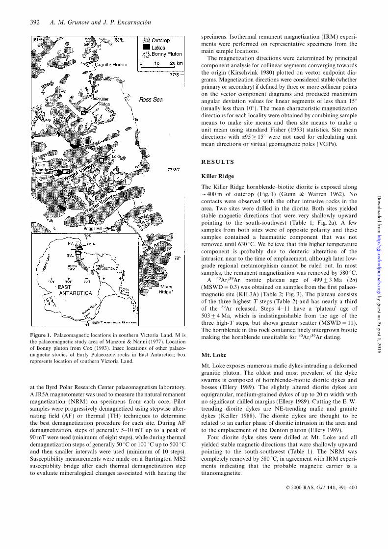
REGIONAL GEOLOGYrock-coring drill. The samples were oriented with a Brunton
magnetic compass. Sun compass measurements were made atThe geology of southern Victoria Land (SVL) (Fig. 1) consists,in part, of a Proterozoic metamorphic basement of upper each locality to allow correction for local magnetic variation
and were always within 0° to 3° of the predicted magneticamphibolite facies schists and marbles (Adams & Whitla 1991)
intruded by Vendian to Ordovician granitoids and dykes variation. The geographical coordinates of some locations weredetermined with a handheld GPS ‘Magellan’ receiver and are(Allibone et al. 1991; Rowell et al. 1993; Encarnacion & Grunow
1996). The Cambro-Ordovician calc-alkaline granitoids are listed to 0.01° in Table 1. Analyses of specimens were performed
391© 2000 RAS
by guest on August 1, 2016
http://gji.oxfordjournals.org/D
ownloaded from
392 A. M. Grunow and J. P. Encarnacion
specimens. Isothermal remanent magnetization (IRM) experi-
ments were performed on representative specimens from themain sample locations.
The magnetization directions were determined by principal
component analysis for collinear segments converging towardsthe origin (Kirschvink 1980) plotted on vector endpoint dia-grams. Magnetization directions were considered stable (whether
primary or secondary) if defined by three or more collinear pointson the vector component diagrams and produced maximumangular deviation values for linear segments of less than 15°(usually less than 10°). The mean characteristic magnetizationdirections for each locality were obtained by combining samplemeans to make site means and then site means to make a
unit mean using standard Fisher (1953) statistics. Site meandirections with a95≥15° were not used for calculating unitmean directions or virtual geomagnetic poles (VGPs).
RESULTS
Killer Ridge
The Killer Ridge hornblende–biotite diorite is exposed along
~400 m of outcrop (Fig. 1) (Gunn & Warren 1962). Nocontacts were observed with the other intrusive rocks in the
area. Two sites were drilled in the diorite. Both sites yieldedstable magnetic directions that were very shallowly upwardpointing to the south-southwest (Table 1; Fig. 2a). A few
samples from both sites were of opposite polarity and thesesamples contained a haematitic component that was notremoved until 630 °C. We believe that this higher temperature
component is probably due to deuteric alteration of theintrusion near to the time of emplacement, although later low-grade regional metamorphism cannot be ruled out. In most
samples, the remanent magnetization was removed by 580 °C.A 40Ar/39Ar biotite plateau age of 499±3 Ma (2s)
(MSWD=0.3) was obtained on samples from the first palaeo-
magnetic site (KIL3A) (Table 2; Fig. 3). The plateau consistsof the three highest T steps (Table 2) and has nearly a thirdof the 39Ar released. Steps 4–11 have a ‘plateau’ age of
503±4 Ma, which is indistinguishable from the age of thethree high-T steps, but shows greater scatter (MSWD=11).The hornblende in this rock contained finely intergrown biotite
Figure 1. Palaeomagnetic locations in southern Victoria Land. M is making the hornblende unsuitable for 40Ar/39Ar dating.the palaeomagnetic study area of Manzoni & Nanni (1977). Location
of Bonny pluton from Cox (1993). Inset: locations of other palaeo-
magnetic studies of Early Palaeozoic rocks in East Antarctica; box Mt. Lokerepresents location of southern Victoria Land.
Mt. Loke exposes numerous mafic dykes intruding a deformedgranitic pluton. The oldest and most prevalent of the dyke
swarms is composed of hornblende–biotite diorite dykes andbosses (Ellery 1989). The slightly altered diorite dykes areat the Byrd Polar Research Center palaeomagnetism laboratory.
A JR5A magnetometer was used to measure the natural remanent equigranular, medium-grained dykes of up to 20 m width withno significant chilled margins (Ellery 1989). Cutting the E–W-magnetization (NRM) on specimens from each core. Pilot
samples were progressively demagnetized using stepwise alter- trending diorite dykes are NE-trending mafic and granite
dykes (Keiller 1988). The diorite dykes are thought to benating field (AF) or thermal (TH) techniques to determinethe best demagnetization procedure for each site. During AF related to an earlier phase of dioritic intrusion in the area and
to the emplacement of the Denton pluton (Ellery 1989).demagnetization, steps of generally 5–10 mT up to a peak of
90 mT were used (minimum of eight steps), while during thermal Four diorite dyke sites were drilled at Mt. Loke and allyielded stable magnetic directions that were shallowly upwarddemagnetization steps of generally 50 °C or 100 °C up to 500 °C
and then smaller intervals were used (minimum of 10 steps). pointing to the south-southwest (Table 1). The NRM was
completely removed by 580 °C, in agreement with IRM experi-Susceptibility measurements were made on a Bartington MS2susceptiblity bridge after each thermal demagnetization step ments indicating that the probable magnetic carrier is a
titanomagnetite.to evaluate mineralogical changes associated with heating the
© 2000 RAS, GJI 141, 391–400
by guest on August 1, 2016
http://gji.oxfordjournals.org/D
ownloaded from
Gondwana apparent polar wander path 393
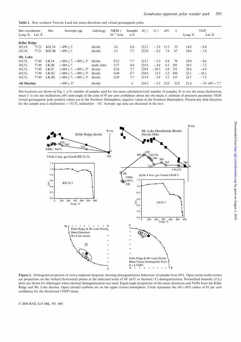
Table 1. New southern Victoria Land site mean directions and virtual geomagnetic poles.
Site coordinates Site Isotropic age Lithology NRM× Samples D (°) I (°) a95 k VGP
Long.°E, Lat.°S 10−2 A/m n/N Long.°E Lat.°S
Killer Ridge162.19, 77.21 KIL3A ~499±3 diorite 3.6 6/6 212.1 −2.9 11.5 35 14.8 −9.4
162.19, 77.21 KIL3B ~499±3 diorite 3.5 7/7 222.0 −4.2 7.4 67 24.6 −7.4
Mt. Loke162.51, 77.49 LK1A >484±7, ~499±3? diorite 0.12 7/7 215.1 −3.3 6.8 79 18.0 −8.6
162.51, 77.49 LK1B >484±7 mafic dyke 2.57 4/6 221.6 −4.4 6.5 201 24.5 −7.2
162.51, 77.49 LK1C >484±7, ~499±3? diorite 0.24 7/7 229.8 −28.3 3.8 251 30.4 −6.9
162.51, 77.49 LK1G >484±7, ~499±3? diorite 0.40 6/7 218.0 12.5 3.2 450 22.1 −16.1
162.51, 77.49 LK1H >484±7, ~499±3? diorite 0.29 7/7 215.9 −5.8 5.2 135 18.7 −7.2
All Diorites ~499±3? diorite 6 218.5 −5.5 12.0 32.0 21.4 −7.0 A95=7.7°
Site locations are shown in Fig. 1. n/N: number of samples used for site mean calculation/total number of samples; D: in situ site mean declination;
mean I: in situ site inclination; a95: semi-angle of the cone of 95 per cent confidence about the site mean; k: estimate of precision parameter; VGP:
virtual geomagnetic pole; positive values are in the Northern Hemisphere, negative values in the Southern Hemisphere. Present-day field direction
for the sample area is declination ~152°E, inclination −82°. Isotopic age data are discussed in the text.
Figure 2. Orthogonal projection of vector endpoint diagrams showing demagnetization behaviour of samples from SVL. Open circles (solid circles)
are projections on the vertical (horizontal ) planes at the indicated levels of AF (mT) or thermal (°C) demagnetization. Normalized intensity (J/J0)plots are shown for lithologies where thermal demagnetization was used. Equal-angle projections of site mean directions and VGPs from the Killer
Ridge and Mt. Loke diorites. Open (closed) symbols are on the upper ( lower) hemisphere. Circle represents the a95 (A95) radius of 95 per cent
confidence for the directional (VGP) mean.
© 2000 RAS, GJI 141, 391–400
by guest on August 1, 2016
http://gji.oxfordjournals.org/D
ownloaded from
394 A. M. Grunow and J. P. Encarnacion
Table 2. 40Ar/39Ar results from southern Victoria Land.
Step T (°C) %39Ar %40Ar* Age (Ma) 1s (Ma)
KIL-3A (biotite)1 500 1.74 52.4 109.9 0.98
2 650 4.97 91.8 452.8 1.35
3 700 7.93 98.8 491.8 1.36
4 750 7.86 99.2 499.7 1.47
5 800 9.58 99.3 502.6 1.39
6 850 8.64 99.3 506.1 1.44
7 900 10.10 99.3 510.7 1.40
8 975 17.24 99.5 504.9 1.45
9 1075 23.19 99.7 499.2 1.38
10 1200 7.38 99.7 497.9 1.37
11 1400 1.38 99.6 497.9 1.37
Plateau (steps 9–11)=499±3 Ma, MSWD=0.3
GH-5C (hornblende)1 700 4.84 47.5 300.4 4.81
2 800 3.37 87.5 505.0 3.44
3 875 3.03 94.3 516.0 1.66
4 950 5.01 93.7 534.6 1.80
5 1025 34.29 94.9 508.8 1.68
6 1075 11.44 96.8 500.7 1.73
7 1125 14.93 97.7 497.6 1.58
8 1200 10.95 97.8 498.0 2.10
9 1500 12.13 92.6 497.2 1.97
Plateau (steps 6–9)=498±3 Ma, MSWD=0.82
VN-1L (hornblende)1 700 1.41 58.0 490.1 8.54
2 850 2.45 93.6 434.9 3.44
3 950 3.48 96.0 469.2 1.61
4 1000 15.06 98.5 497.9 1.45
5 1025 16.88 98.5 498.0 1.43
6 1050 11.73 98.9 494.8 1.41
7 1075 4.82 99.2 496.5 2.30
8 1120 12.62 98.6 500.2 1.45
9 1250 30.40 99.2 501.4 1.39
10 1500 1.14 93.8 493.3 4.02
Plateau (steps 4–9)=499±3 Ma, MSWD=2.7
%39Ar is the amount of 39Ar in each step out of the total 39Ar in the
sample. %40Ar* is the percent radiogenic 40Ar of the total 40Ar in
the given step.
NEW ISOTOPIC DATA
We undertook 40Ar/39Ar dating to constrain the age of mag-netization of several lithologies sampled for palaeomagnetismin southern Victoria Land. Many of the rocks did not have
any isotopic constraints and some lithologies had U–Pbzircon or Rb/Sr ages (Encarnacion & Grunow 1996). The
40Ar/39Ar dating technique provided a way to estimate thetime of magnetization by comparing the closure temperatureof various dated minerals to the unblocking temperature of
the magnetization.Figure 3. 40Ar/39Ar age spectra plots of mineral separates from KillerApart from the new 40Ar/39Ar biotite age of 499±3 MaRidge (KIL-3A), Granite Harbor mafic dyke (GH-5C) and the Bonnyfrom Killer Ridge, we have obtained new 40Ar/39Ar ages fromPluton at Lake Vanda (VN-1 L). See Fig. 1 for locations.the Granite Harbor and Lake Vanda areas (Figs 1 and 3). The
40Ar/39Ar ages reported here have been corrected with an internalstandard with an assigned age equivalent to 523.5 Ma for the released, including the highest temperature steps; MSWD=0.8)
from palaeomagnetic site GH5C of Grunow (1995). The maficstandard MMhb-1 (Renne et al. 1994). The previously undatedmafic dykes at Granite Harbor yielded an 40Ar/39Ar hornblende dykes appear to be comagmatic with the grey Granite Harbor
granite based on field relationships (Grunow 1995; Encarnacionplateau age of 498±3 Ma (2s) (~50 per cent of the 39Ar
© 2000 RAS, GJI 141, 391–400
by guest on August 1, 2016
http://gji.oxfordjournals.org/D
ownloaded from
Gondwana apparent polar wander path 395
& Grunow 1996). U–Pb zircon dating on the Granite Harbor (Ellery 1989). All of these observations can be interpreted
to suggest that the Mt. Loke diorite dykes are older thanpink granite yielded an age of 498±4 Ma (Encarnacion &Grunow 1996). These ages suggest that the Granite Harbor 484±7 Ma. Several workers believe that the small gabbroic
and dioritic intrusions found in the region, including the dioritegranites and dykes are approximately the same age and were
emplaced in the Late Cambrian (or latest Middle Cambrian). dykes and intrusion at Mt. Loke and the Killer Ridge dioriteintrusion (499±3 Ma), are probably related to each otherU–Pb zircon dating on the Bonny Pluton (Fig. 1) yielded
an age of 505±2 Ma from Miers Ridge (Fig. 1) (Encarnacion (Gunn & Warren 1962; Allibone et al. 1993), hence we suggest
that the Mt. Loke dykes were emplaced at ~499 Ma.& Grunow 1996). A new 40Ar/39Ar hornblende plateau age of499±3 Ma (~90 per cent of the highest-temperature 39Arreleased; MSWD=2.7) was obtained from the Bonny Pluton
REVISION OF SOUTHERN VICTORIAat Lake Vanda (Fig. 3).
LAND PALAEOPOLES
Given the new 40Ar/39Ar ages presented in this paper and theCorrelation of southern Victoria Land dykes
previously reported U–Pb zircon ages (Encarnacion & Grunow1996), the age of the SVL mean poles published by GrunowThe palaeomagnetic samples collected from microlamprophyric
mafic dykes in the Taylor and Wright valleys (Manzoni & (1995) have been revised. Shown in Table 3 are the SVL mean
directions, palaeopoles and new age determinations. We haveNanni 1977; Grunow 1995) (Fig. 1) are geochemically similar(Vennum 1990). This mafic dyke swarm, called the dry valley revised the palaeopole listed for the Bonny Pluton in Grunow
(1995) based on the new age determinations. The Bonnymafic dyke swarm (DVMD) (Vennum 1990), is considered to
be comagmatic with the Vanda feldspar porphyry dykes at Pluton palaeomagnetic sites from Lake Vanda have yielded an40Ar/39Ar hornblende plateau age of 499±3 Ma, making theLake Vanda (Allibone et al. 1993), which have a U–Pb zircon
age of 484±7 Ma (Encarnacion & Grunow 1996). However, magnetization age of these rocks probably Late Cambrian.
The Bonny pluton at Briggs Hill yielded different directionsthe Granite Harbor mafic dykes do not appear to be similarto the DVMD swarm and they have older isotopic ages from the Lake Vanda sites (Fig. 1, Table 3). Perhaps the Briggs
Hill sites reflect a magnetization age closer to the 505±2 Ma(498±3 Ma 40Ar/39Ar hornblende plateau age).While there are no direct isotopic age constraints on the U–Pb zircon age obtained from Miers Ridge (Encarnacion &
Grunow 1996) rather than the 499±3 Ma age from LakeMt. Loke diorite dykes they are geochemically dissimilar to
the DVMD described by Vennum (1990). The Mt. Loke diorite Vanda. Alternatively, there may have been structural disruptionof the Briggs Hill site but this has not been observed in thedykes also have a different, but consistent, structural trend of
E–W instead of the relatively constant NE trend of the DVMD field mapping.
Based on the similarity in lithology, outcrop descriptionswarm, indicative of a different stress regime at the time oftheir emplacement. A dioritic plug at Lake Vanda in the and field relationships, we believe that the Mt. Loke dioritic
dykes and intrusions are probably part of the same intrusiveWright Valley that is similar to the Mt. Loke diorite dykes is
truncated by the Vanda feldspar porphyry and mafic dykes event that emplaced the Killer Ridge dioritic plug. Hence, the
Table 3. Southern Victoria Land Cambrian and Ordovician palaeomagnetic poles.
Formation/Unit Age† n/N Dec Inc. a95 PPLong PPLat A95 dp, dm Q Reference
Lake Vanda Fdsp.porphyry 484±7 38/7 225.4° −9.6° 8.5° 27.2° −3.9° 7.2° 5 Grunow
dykes (1995)
Lake Vanda Bonny Pluton 499±3 28/4 225.5° −0.9° 13.1° 27.9° −8.3° 11.9° 4 Grunow
(1995)
Taylor Valley Lamprophyre ~484±7 60/4 222.6° 0.6° 10.9° 26.7° −9.3° 11.0° 3 Manzoni &
Dykes Nanni 1977
Granite Harbor Pink Granite 498±4 21/3 214.1° −14.9° 8.3° 16.7° −3.4° – 4.3°, 8.5° 3 Grunow
(1995)
Granite Harbor Mafic Dykes 498±3 27/5 213.1° −19.5° 8.6° 15.0° 0.8° 7.5° 4 Grunow
(1995)
Granite Harbor Grey Granite ~498±3 34/5 219.3° −12.8° 6.4° 21.6° −3.6° 4.0° 4 Grunow
(1995)
Briggs Hill Bonny Pluton 505±2 8/1 239.5° −17.6° 14.5° 41.4° 2.7° – 7.8°, 15° 3 Grunow
(1995)
Mt. Loke Hornblende >484±7; ~499±3? 27/4 219.4° −6.2° 20.8° 22.3° −6.3° 12.7° 3 this paper
Diorite
Killer Ridge Diorite 499±3 13/2 217.5° −3.6° 6.4° 20.1° −8.3° – 3.2°, 6.4° 3 this paper
Killer Ridge/ Diorites ~499±3 40/6 218.5° −5.5° 12.0° 21.4° −7.0° −7.7° this paper
Mt. Loke
n/N: total number of samples represented/number of sites used for calculation of mean direction and palaeopole; underscore: number of sites (samples)
used to calculate listed means; D: declination; I: inclination; a95: error circle at the 95 per cent confidence level; k: estimate of precision parameter;
PPLon and PPLat: palaeopole longitude and latitude; A95: radius of error circle at 95 per cent confidence level; dp, dm: confidence ellipse about
the pole; Q: quality factor based on reliability criteria described in Van der Voo (1988).
† Isotopic ages are either discussed in the text or are found in Encarnacion & Grunow (1996).
© 2000 RAS, GJI 141, 391–400
by guest on August 1, 2016
http://gji.oxfordjournals.org/D
ownloaded from
396 A. M. Grunow and J. P. Encarnacion
palaeomagnetic results from Killer Ridge and Mt. Loke haveCOMPARISON WITH GONDWANA POLES
been considered together. The Late Cambrian Killer Ridge/Mt.Loke pole is very similar to the Late Cambrian and Early In Table 4, a list of Gondwana Middle Cambrian to Early
Ordovician poles is shown (rotated into an African referenceOrdovician data from southern Victoria Land (Table 3; Fig. 4).
Although structural disruption or tilting of the SVL intrusive frame). We have revised the age assignment of the Lake VandaBonny Pluton and Granite Harbor poles from Grunow (1995)rocks listed in Table 2 may be possible, we doubt that this
has significantly affected our data. The intrusions are from to be Late Cambrian rather than Early Ordovician. A few of
the Cambrian to Early Ordovician Antarctic poles listed byseveral different fault blocks over a large area (Wilson 1992).Significant tilting has not occurred in southern Victoria Land Lanza & Tonarini (1998) have been omitted from Table 4
due to the uncertainty in the age of the magnetization, a Qsince the Devonian because flat-lying Beacon strata rest non-
conformably on the intrusive and metamorphic basement. factor of less than 3 and/or insufficient information about thedemagnetization procedures.Tilting may have occurred prior to the Devonian but the
consistency of the data over such a large area and within There are no significant differences between the Gondwana
Late Cambrian poles (~500–490 Ma) and those from the Earlytemporally similar but lithologically different intrusions sampledacross known fault blocks argues against that. Lanza & Ordovician (~485 Ma) (Table 4), apart from the Australian
Chatswood limestone and Black Hill norite poles (RipperdanTonarini (1998) suggested that there is a regional westward
tilt of 2°–5° over the SVL and northern Victoria Land regions. & Kirschvink 1992; Schmidt et al. 1993). It is unclear whythese two poles are so different from the other GondwanaWe have not adjusted the palaeomagnetic poles for this
suggested tilting, because it would make only a very small Late Cambrian and Early Ordovician poles. The Chatswood
and Black Hill poles are similar to the Middle Ordovician anddifference in the pole analysis. In addition, the slight dip ofthe Beacon strata may be partly the result of the thick Ferrar Silurian Gondwana poles, respectively (Grunow 1999), but
there is no evidence that these rocks have been remagnetized.sills found intruding the Beacon throughout the area but not
observed to intrude the basement rocks except near the contact Eliminating the Chatswood and Black Hill norite polesresults in Gondwana Late Cambrian and Early Ordovicianwith the Beacon. All of the SVL samples listed in Table 3
come from below any known Ferrar sills. mean poles from more than one continent that are in good
Table 4. Gondwana Middle Cambrian to Middle Ordovician palaeomagnetic poles (in an African reference frame).
Formation/Unit Age (Ma)† PPLong PPLat A95 Q Reference
Early Ordovician (490–478)Australia Black Hills High Temp.* 487±5 12.0° 13.0° 3.0° 4 Schmidt et al. (1993)
Australia Black Hills High Coercivity* 487±5 357.0° 13.0° 7.0° 4 Schmidt et al. (1993)
Australia Jinduckin Lower Ord. 0.0° 36.0° 13.0° 4 Luck (1972)
Africa Graafwater Fm. Lower Ord. 14.0° 28.0° 9.0° 6 Bachtadse et al. (1987)
Antarctica Felsite Dykes 484±7 5.0° 42.0° 6.0° 5 Grunow (1995)
Antarctica Taylor V. Mafic Dykes ~484±7 8.0° 36.0° 11.0° 4 Manzoni & Nanni (1977)
Antarctica Teall Nunatak 471–487 344.0° 46.0° 7.0° 5 Lanza & Tonarini (1998)
MEAN (~485 Ma), N=5 3.0° 38.0° 11.0° this paper
MEAN (~485 Ma), N=4 7.0° 36.0° 9.0° this paper without Teall Nunatak
Late Cambrian (~500–490 Ma)Australia Chatswood Lmst* Upper Camb. 41.0° 51.0° 10.0° 5 Ripperdan & Kirschvink (1992)
Australia Dundas Gp Upper Camb. 350.0° 23.0° 12.0° 3 Giddings & Embleton (1974)
Australia Tasmania Upper Camb. 5.0° 31.0° 5.0° 6 Li et al. (1997)
Antarctica Granite H. Pink Granite <498±3 355.0° 33.0° − 4 Grunow (1995)
Antarctica Granite H. Lamp. Dykes 498±3 354.0° 35.0° 8.0° 5 Grunow (1995) and this paper
Antarctica Granite H. Grey Gr. >498±3 359.0° 37.0° 4.0° 5 Grunow (1995)
Antarctica Bonny Pluton, Lake Vanda 499±3 9.0° 37.0° 12.0° 4 Grunow (1995)
Antarctica Killer Ridge/Mt.Lok 499±3 2.0° 34.0° 8.0° 4 this paper
MEAN (~495 Ma), N=7 0.0° 34.0° 6.0° this paper
Middle Cambrian (~510–500 Ma)Australia Basal Lake Frome Middle Camb. 4.0° 20.0° 13.0° 5 Klootwijk (1980)
Australia Areyonga Middle Camb. 352.0° 13.0° 5.0° 6 Klootwijk (1980)
Australia Hudson Middle Camb. 332.0° 63.0° 13.0° 3 Luck (1972)
Australia Hugh River Middle Camb. 13.0° 62.0° 9.0° 3 Embleton (1972); Lindsay (1987)
Antarctica Bonny Pluton, Briggs Hill 505±2? 16.0° 54.0° − 3 Grunow (1995) and this paper
PPlong, PPlat: palaeopole longitude and latitude, respectively. Only poles with Q ratings of 3 or higher are listed (see Van der Voo 1988 for
criteria). Q ratings for poles published prior to 1992 are from Van der Voo (1993).
* Poles not used to calculate the Gondwana mean poles.
†Numeric ages for the poles are based on the Bowring & Erwin (1998) timescale.
The following are the rotation poles used to bring all poles into an African reference frame:
Royer & Sandwell (1989): Australia to Antarctica 38.9°E, −2.0°S, −31.5°Lawver & Scotese (1987): Antarctica to Africa 328.58°E, −7.78°S, 58.0°.
© 2000 RAS, GJI 141, 391–400
by guest on August 1, 2016
http://gji.oxfordjournals.org/D
ownloaded from
Gondwana apparent polar wander path 397
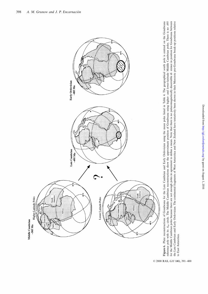
agreement (Table 4). This suggests relatively little apparent
polar wander during this 20 Myr time interval, or a pervasive,
synchronous remagnetization event in Antarctica and Australia
(Fig. 5). We do not think the Late Cambrian poles have been
remagnetized in the Ordovician because the Australian poles
contain dual polarities and/or positive fold tests. While the
Antarctic poles do not have fold tests (because they are
intrusions), the poles come from very different lithologies
(diorites, felsic dykes, mafic dykes and several different granites)
that exhibit only minor alteration. The 40Ar/39Ar age dating
indicates that there has been no Ordovician thermal over-
printing event of the Late Cambrian igneous rocks to cause
remagnetization.
The Antarctic Teall Nunatak pole (Lanza & Tonarini 1998)
is a little different from the other Gondwana Early Ordovician
poles (Table 4). Perhaps this is because these rocks may be
Middle Ordovician rather than Early Ordovician in age, given
the Rb–Sr whole rock–biotite ages of 475±4 and 483±4 Ma
(Lanza & Tonarini 1998). The Teall Nunatak pole is indistin-
guishable from a pole for Middle to Late Ordovician sediments
in Australia (343°, 52°N, A95=5° in an African referenceFigure 4. Equal-angle projections of VGPs from southern Victoria
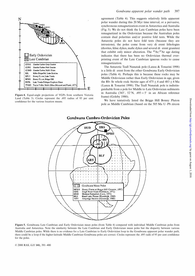
frame) (Goleby 1980).Land (Table 3). Circles represent the A95 radius of 95 per cent
We have tentatively listed the Briggs Hill Bonny Plutonconfidence for the various location means.pole as Middle Cambrian (based on the 505 Ma U–Pb zircon
Figure 5. Gondwana Late Cambrian and Early Ordovician mean poles (from Table 4) compared with individual Middle Cambrian poles from
Australia and Antarctica. Note the similarity between the Late Cambrian and Early Ordovician mean poles but the disparity between various
Middle Cambrian poles. While there is no evidence for a Late Cambrian to Early Ordovician loop in the Gondwana apparent polar wander path,
there could be a loop if the higher-latitude Middle Cambrian Gondwana poles are correct. Circles represent the A95 radii of 95 per cent confidence
for the poles.
© 2000 RAS, GJI 141, 391–400
by guest on August 1, 2016
http://gji.oxfordjournals.org/D
ownloaded from
398 A. M. Grunow and J. P. Encarnacion
Fig
ure
6.P
late
reco
nst
ruct
ions
of
Gondw
ana
for
the
Late
Cam
brian
and
Early
Ord
ovic
ian
using
the
mea
npole
slist
edin
Table
4.T
he
geo
gra
phic
al
south
pole
isce
ntr
edon
the
Gondw
ana
refe
rence
pole
with
its
A95
circ
le.T
he
Mid
dle
Cam
brian
reco
nst
ruct
ions
show
the
appro
xim
ate
position
ofG
ondw
ana
using
hig
her
-and
low
er-latitu
de
Mid
dle
Cam
brian
pole
s.T
her
eis
no
A95
for
the
Mid
dle
Cam
brian
pole
sbec
ause
ther
eare
noten
ough
pole
sin
agre
emen
tto
defi
ne
am
ean.N
ote
thatth
ere
isno
pala
eom
agnet
ically
disce
rnib
lediff
eren
cein
position
for
Gondw
ana
bet
wee
n
the
Late
Cam
brian
and
Early
Ord
ovic
ian.T
he
continen
talfragm
ents
ofW
estA
nta
rctica
and
New
Zea
land
have
tenta
tivel
ybee
nsh
ow
nin
thei
rM
esozo
icpre
-Gondw
ana
bre
ak-u
ppositions
rela
tive
toE
ast
Anta
rctica
.
© 2000 RAS, GJI 141, 391–400
by guest on August 1, 2016
http://gji.oxfordjournals.org/D
ownloaded from
Gondwana apparent polar wander path 399
Allibone, A.H., Forsyth, P.J., Sewell, R.J., Turnbull, I.M. &age) given that it is similar to some other Gondwana MiddleBradshaw, M.A., 1991. Geology of the Thundergut area, southernCambrian poles. However, none of the Middle CambrianVictoria Land, Antarctica 1 : 50 000, Misc. Geol. Map, 21, N. Z.Gondwana poles listed in Table 4 is of particularly high qualityGeol. Surv., Wellington.using the quality (Q) criteria developed by Van der Voo (1988).
Allibone, A.H., Cox, S.C., Graham, I.J., Smillie, R.W., Johnstone, R.D.,The Middle Cambrian poles appear to lie in two groups
Ellery, S.G. & Palmer, K., 1993. Granitoids of the Dry Valleys area,(Fig. 5). Two Australian sedimentary sequences yield results southern Victoria Land, Antarctica, plutons, field relationships andthat place the poles in central west Africa, while two other isotopic dating, N. Z. J. Geol. Geophys., 36, 281–297.poles from Australia (Luck 1972; Embleton 1972) are located Bachtadse, V., Van der Voo, R. & Halbich, I.W., 1987. Paleomagnetismnorth of Africa (Table 4; Fig. 5). The Bonny Pluton pole from of the western Cape fold belt, South Africa, and its bearing on the
Paleozoic apparent polar wander path for Gondwana, Earth planet.Briggs Hill presented here (Tables 3 and 4) may lend someSci. L ett, 84, 487–499.support to higher-latitude Australian poles.
Bowring, S.A. & Erwin, D.H., 1998. A new look at evolutionary rates
in deep time, uniting paleontology and high-precision geochronology,
Geol. Soc. Am. T oday, 8, 1–8.GONDWANA PLATE RECONSTRUCTIONS Bowring, S.A., Grotzinger, J.P., Isachsen, C.E., Knoll, A.H.,
Pelechaty, S. & Kolosov, P., 1993. Calibrating Cambrian evolution,The revision of the Cambrian timescale (Bowring & ErwinScience, 261, 1293–1298.
1998) has caused changes in the Gondwana Cambrian polarCox, S.C., 1993. Inter-related plutonism and deformation in South
wander path and consequently previous plate reconstructions Victoria Land, Antarctica, Geol. Mag., 130, 1–14.also need to be updated (Scotese & McKerrow 1990; Grunow Ellery, S.G., 1989. Lower Wright geology, Antarctica, MSc. thesis,1995). The Late Cambrian and Early Ordovician recon- University of Otago, Dunedin, New Zealand.structions are virtually identical and reflect little apparent Embleton, B.J.J., 1972. The paleomagnetism of some Paleozoic sedi-
ments from central Australia, J. Proc. R. Soc. New South Wales,polar wander during this interval (Fig. 6). The uncertainty105, 86–93.about the Middle Cambrian mean pole position for Gondwana
Encarnacion, J. & Grunow, A., 1996. Changing magmatic and tectonicindicates that many more new poles are needed to constrainstyles along the paleo-Pacific margin of Gondwana and the onsetany Middle Cambrian plate reconstructions.of early Paleozoic magmatism in Antarctica, T ectonics, 15,1325–1341.
Encarnacion, J., Fleming, T.H., Elliot, D.H. & Eales, H.V., 1996.
CONCLUSIONS Synchronous emplacement of Ferrar and Karoo dolerites and the
early breakup of Gondwana, Geology, 24, 535–538.The new palaeomagnetic and isotopic data presented here, Encarnacion, J., Rowell, A.J. & Grunow, A.M., 1999. A U-Pb age foralong with the revised Cambrian timescale (Bowring & Erwin the Cambrian Taylor formation, Antarctica: implications for the1998), has resulted in new Gondwana Late Cambrian and Cambrian time scale, J. Geol., 107, 497–504.Ordovician mean poles. The Late Cambrian and Early Fisher, R.A., 1953. Dispersion on a sphere, Proc. R. Soc. L ond., A.,
217, 295–305.Ordovician mean poles are indistinguishable from each other,Giddings, J.W. & Embleton, B.J.J., 1974. Large-scale horizontalwhich may indicate either little apparent polar wander or a
displacements in southern Australia—contrary evidence fromregional, synchronous remagnetizaton event, although thepalaeomagnetism, J. Geol. Soc. Austr., 21, 431–436.latter seems unlikely. The Gondwana Middle Cambrian poles
Goleby, B.R., 1980. Early Paleozoic paleomagnetism in southeastremain problematic and require additional data to test whether
Australia, in Global Reconstruction and the Geomagnetic Field Duringthere was significant polar wander between the Cambrian and
the Paleozoic, eds McElhinny, M.W., Khramov, A.N., Ozima, M. &Early Ordovician periods. Valencio, D.A., Advances in Earth and Planetary Sciences, Vol. 10,
pp. 11–21, Reidel, Dordrecht.
Grunow, A.M., 1995. Implications for Gondwana of new Ordovician
paleomagnetic data from igneous rocks in southern Victoria Land,ACKNOWLEDGMENTSAntarctica, J. geophys. Res., 100, 12 589–12 603.
Supported by National Science Foundation grant OPP-9118484 Grunow, A.M., 1999. Gondwana events and palaeogeography, a
paleomagnetic review, Invited DuToit Special Issue, J. African Earthto AMG. The reconstructions were made with the help of LisaSci., 28, 53–69.Gahagan using the system at the University of Texas
Gunn, B.M. & Warren, G., 1962. Geology of Victoria Land betweenat Austin. We thank Chuck Kroger for his mountaineeringthe Mawson and Mulock Glaciers, Antarctica, N. Z. Geol. Surv.help during the southern Victoria Land fieldwork. We wouldBull., 71, 85–100.
also like to thank Wulf Gose and an anonymous reviewer forKeiller, I.G., 1988. Comments and observations on dyke intrusives of
their helpful comments on this paper. The Ar/Ar analyses werethe Wright Valley, N. Z. Antarctic Record, 8, 25–34.
performed in the Ohio State University laboratory of Dr Ken Kirschvink, J.L., 1980. The least-squares line and plane analysis ofFoland. BPRC contribution #1163. paleomagnetic data, Geophys. J. R. astr. Soc., 62, 699–718.
Klootwijk, C.T., 1980. Early Paleozoic paleomagnetism in Australia,
T ectonophysics, 64, 249–332.
Lanza, R. & Tonarini, S., 1998. Palaeomagnetic and geochronologicalREFERENCESresults from the Cambro-Ordovician Granite Harbor Intrusives
Adams, C.J. & Whitla, P.F., 1991. Precambrian ancestry of the Asgard inland of Terra Nova Bay (Victoria Land, Antarctica), Geophys.Formation (Skelton Group): Rb-Sr age of basement metamorphic J. Int., 135, 1019–1027.
rocks in the Dry Valleys region, Antarctica, in Geological Evolution Lawver, L. & Scotese, C.R., 1987. A revised reconstruction of
of Antarctica, pp. 129–135, eds Thomson, M.R.A., Crame, J.A. & Gondwanaland, in Gondwana Six: Structure, T ectonics and
Thomson, J.W., World and Regional Geology, Vol. I, Cambridge Geophysics, ed. McKenzie, G.D., Am. geophys. Un. Monogr., 40,17–23.University Press, Cambridge.
© 2000 RAS, GJI 141, 391–400
by guest on August 1, 2016
http://gji.oxfordjournals.org/D
ownloaded from
400 A. M. Grunow and J. P. Encarnacion
Li, Z.X., Baillie, P.W. & Powell, C.M., 1997. Relationship between Royer, J.Y. & Sandwell, D.S., 1989. Evolution of the Eastern Indian
Ocean since the Late Cretaceous: constraints from Geosat altimetry,northwestern Tasmania and East Gondwanaland in the Late
Cambrian/Early Ordovician: Paleomagnetic evidence, T ectonics, J. geophys. Res., 94, 13 755–13 782.
Schmidt, P.W., Clark, D.A. & Rajagopalan, S., 1993. An historical16, 161–171.
Lindsay, J.F., 1987. Sequence stratigraphy and depostional controls in perspective of the Early Palaeozoic APWP of Gondwana: new
results from the Early Ordovician Black Hill Norite, South Australia,Late Proterozoic-Early Cambrian sediments of Amadeus Basin,
central Australia, Am. Assoc. Petrol. Geol. Bull., 71, 1387–1403. Expl. Geophys., 24, 257–262.
Scotese, C.R. & McKerrow, W.S., 1990. Revised world maps and intro-Luck, G.R., 1972. Paleomagnetic results from Paleozoic sediments of
northern Australia, Geophys. J. R. astr. Soc., 28, 475–487. duction, in Palaeogeography and Biogeography, eds McKerrow, W.S.
& Scotese, C.R., Geol. Soc. L ond. Mem., 12, 1–21.Manzoni, M. & Nanni, T., 1977. Paleomagnetism of Ordovician
lamprophyres from Taylor Valley, Victoria Land, Antarctica, Pure Tucker, R.D. & McKerrow, W.S., 1995. Early Paleozoic chronology:
a review in light of new U-Pb zircon ages from Newfoundland andappl. Geophys., 115, 961–977.
McKelvey, B.C. & Webb, P.N., 1962. Geological investigations in Britain, Can. J. Earth Sci., 32, 368–379.
Van der Voo, R., 1988. Paleozoic paleogeography of North America,Southern Victoria Land, Antarctica, Part 3—Geology of Wright
Valley, N. Z. J. Geol. Geophys., 5, 143–162. Gondwana and intervening displaced terranes: comparisons of paleo-
magnetism with paleoclimatology and biogeographical patterns,Renne, P.R. et al., 1994. Intercalibration of astronomical and radio-
isotopic time, Geology, 22, 783–786. Geol. Soc. Am. Bull., 100, 311–324.
Van der Voo, R., 1993. Paleomagnetism of the Atlantic, T ethys andRipperdan, R.L. & Kirschvink, J.L., 1992. Paleomagnetic results from
the Cambrian–Ordovician boundary section at Black Mountain, Iapetus Oceans, Cambridge University Press, Cambridge.
Vennum, W.R., 1990. The dry valleys mafic dike swarm, southernGeorgina Basin, western Queensland, Australia, in Global
Perspectives on Ordovician Geology, pp. 93–103, eds Webby, B.D. & Victoria Land, Antarctic J. Rev., XXV, 11–14.
Wilson, T.J., 1992. Mesozoic and Cenozoic kinematic evolution of theLaurie, J.R., Balkema, Rotterdam.
Rowell, A.J., Rees, M.N., Duebendorfer, E.M., Wallin, E.T., Van Transantarctic Mountains, in Recent Progress in Antarctic Earth
Science, pp. 303–314, eds Yoshida, Y., Kaminuma, K. & Shiraishi, K.,Schmus, W.R. & Smith, E.I., 1993. An active Neoproterozoic margin,
evidence from the Skelton Glacier area, Transantarctic Mountains, Terra, Tokyo.
J. geol. Soc. L ond., 150, 677–682.
© 2000 RAS, GJI 141, 391–400
by guest on August 1, 2016
http://gji.oxfordjournals.org/D
ownloaded from