ASCE 7 – 16 Wind Changes Affecting the Design Provisions
37
7/31/2019 1 ASCE 7 – 16 Wind Changes Affecting the Design Provisions Donald R. Scott, P.E., S.E., F.SEI, F.ASCE PCS Structural Solutions ASCE 7-16 Wind Provisions
-
Upload
khangminh22 -
Category
Documents
-
view
0 -
download
0
Transcript of ASCE 7 – 16 Wind Changes Affecting the Design Provisions

7/31/2019
1
ASCE 7 – 16 Wind
Changes Affecting the Design Provisions
Donald R. Scott, P.E., S.E., F.SEI, F.ASCE
PCS Structural Solutions
ASCE 7-16 Wind Provisions

7/31/2019
2
Improvements in ASCE 7-16
Wind Speed Maps
ASCE 7-16 Wind Map Developers
Conterminous US Maps Frank Lombardo, NIST and U. of Illinois
Adam Pintar, NIST Statistical Engineering Division
Peter Vickery, ARA
Marc Levitan, NIST Engineering Lab
Emil Simiu, NIST Engineering Lab
Alaska Maps Peter Vickery, ARA
Hawaii Maps Gary Chock, Martin and Chock

7/31/2019
3
Major Changes to Wind Maps in ASCE 7-16
1. Separate return period maps for Risk Category III and IV structures
2. New conterminous US maps, incorporating
- Completely new analysis of non-hurricane winds
- Revised hurricane modeling effecting northeast
- Revised/Corrected Special Wind Regions
3. Revised Alaska maps
4. New maps for Hawaii, incorporating topographic effects
5. Web-based tools for wind speed determination
1. MRI for Design Wind Speed Maps
Risk
Category
Target Beta
(Ch. 1)
ASCE 7-10
Map MRI
(years)
ASCE 7-16
Map MRI
(years)
I 2.50 300 300
II 3.00 700 700
III 3.25 1,700 1,700
IV 3.50 1,700 3,000
Reliability analysis conducted to estimate return periods needed to achieve
target reliability indexes
• Analysis conducted by Dr. Terri McAllister, ASCE 7 Load Combinations
Subcommittee

7/31/2019
4
2. New Conterminous US Wind Speed Maps
• Incorporated analysis of additional wind climate data for non-hurricane winds
More stations and more years of data
Account for terrain exposure at anemometer locations
• Revised inland winds developed using threshold exceedance approach (Pintar
and Simiu, 2014)
Thunderstorms ~ thunderday methodology
Extra-tropical storm modeling ~ Method of storms (Cook, 1983)
• Updated hurricane model for northeast coast
• Replaced all 7 existing maps
Standard (300, 700, 1700-yr) and Commentary (10, 25, 50, 100-yr)
• Added a new 3,000-year map for RC IV structures
• Existing wind speeds (non-hurricane) have not been updated
since ASCE 7-95
• More years of wind data and more stations available now
1995: 485 stations with 5+ years data
2016: ≈1,000 stations with 5+ years data
• Regional variability in
extreme wind climate
not captured in
ASCE 7-95 through 7-10 maps
Improvements to non-Hurricane Wind Speeds

7/31/2019
5
Improved Data Analysis: Accounting for Storm Type
• Non-hurricane winds are broken down into thunderstorm and non-thunderstorm
for analysis, then recombined as statistically independent
• Separate distributions for different storm types (Lombardo et al., 2009)
• Similar to how hurricane and non-hurricane winds are treated separately in the
previous ASCE 7 map analyses
% of Annual Maximum Wind Speeds from Thunderstorms*
*Excluding maxima from tropical cyclones
Extreme wind climate clearly dominated by
different storm types in different parts of
the country
Accounting for Storm Type
• Distributions for different storm types shown to be different (Lombardo et
al., 2009)
• Failure to account for storm types separately can lead to unconservative
estimates
• To include storm types separately can use a “mixed” distribution
Lombardo et al. (2009) - Newark
• P (V ≤ v) = P(VT ≤ v) P(VNT ≤ v)
• M: Mixed
• C: Current Method

7/31/2019
6
50 Year MRI Non-hurricane
Wind Speeds with minimal smoothing
50 Year MRI Non-hurricane
Smoothed Wind Speeds

7/31/2019
7
Improved Hurricane Model
• Implemented two changes to the hurricane model Reduced translation speed effect for fast moving storms (published in USNRC
NUREG/CR 7005)
Simple Extra-Tropical Transition model where the surface winds are reduced linearly by up
to 10% over the latitude range 37 N to 45 N. This reduction approximates transitioning
from a hurricane boundary layer to an ESDU extratropical storm boundary layer. The full
ESDU reduction is around 15%.
• Revised model has been validated using Hurricane Juan winds
from Nova Scotia
Combined Winds
• Winds given for return periods of 10 through 100,000 years
computed using a Type I distribution
• Non-hurricane (NH) and Hurricane (H) winds are combined as
independent events using: P = 1-(1-PNH)*(1-PH)
• Computer generated contours were hand smoothed
• The new wind speed maps have both contours and point values, to
aid in interpolation (similar to seismic maps)
• Tornado winds are not considered Coming in ASCE 7-22!

7/31/2019
8
3. Revised Alaska Wind Maps
• The maps for each return period were determined by multiplying
the 50-year MRI contours given in ASCE 7-10 Figure CC-3 by a
factor, FRA equal to: FRA = 0.45 + 0.085 ln(12T),
where T is the return period in years (Peterka and Shahid, 1998)
• Resulting contours were interpolated to the nearest 10 mph,
except for the inner most and outermost contours which were
rounded to the nearest 5 mph.
700 Year (Risk Cat II) Map in ASCE 7-10

7/31/2019
9
700 Year (Risk Cat II) Map in ASCE 7-16
ASCE 7-10 Risk Category III and IV Map

7/31/2019
10
1,700 Year (Risk Cat III) Map in ASCE 7-16
3,000 Year (Risk Cat IV) Map in ASCE 7-16

7/31/2019
11
Net Effects of Map Changes
• Hurricane Prone Regions Wind speeds decrease along northeast coast
No changes to hurricane contours from the Carolinas to Texas
except interior (landward) contours where transitioning to nontropical storms
controlling
No changes to Puerto Rico and island territories
• Locations not Controlled by Hurricanes Maps now better reflect regional variation in extreme wind climate
Wind speeds in Great Plains states nearly unchanged
Wind speeds decrease for the rest of the country, significantly so on the west coast
4. Hawaii Wind Speed Maps
• New micro zoned “effective” wind speed maps, including the effect of topography. Formatted to allow use of
• Kzt of 1.0
• Kd as given in Table 26.6-1.

7/31/2019
12
5. Web-based Wind Speed Tools (1/2)
• Applied Technology Council’s (ATC) WINDSPEED BY LOCATION
web site is recognized as a permitted method to determine wind
speed, in a footnote on each wind speed map6. Location-specific basic wind speeds shall be permitted to be determined
using www.atcouncil.org/windspeed.
5. Web-based Wind Speed Tools (2/2)

7/31/2019
13
5. Web-based Wind Speed Tools (2/2)
Improvements in ASCE 7-16
Low-Rise Roof Pressure Coefficients
Flat Roof Structures

7/31/2019
14
Background
• The low-rise C&C provisions in ASCE 7-10 are largely based on
ground-breaking wind tunnel studies conducted at UWO in the late
1970s
• Since then, there has been a significant increase in knowledge of
the aerodynamics of low-rise buildings, and validation of wind
tunnel studies using full-scale field experiments.
• Higher turbulence levels were required to have wind tunnel studies
match full-scale data. The early studies lead to pressure
coefficients which were too low in magnitude when compared to
full-scale.
• The TTU field studies changed our understanding, indicating
higher levels of turbulence in ABL.
• This knowledge was incorporated in the UWO study for NIST
NIST Aerodynamic Database

7/31/2019
15
NIST Aerodynamic Database
• Contains time histories of pressure coefficients on more than 30 low-rise
buildings in open and suburban terrain.
• The building models have high pressure tap resolution, with more than 650
taps on each.
• The 1/100 length scale accurately represents the full-scale atmospheric
boundary layer, with relatively high model-scale Reynolds numbers
• The data set has been extensively peer-reviewed, with many publications
(from a variety of international users) and thesis.
• All data are publicly accessible (online).
• Ho et al. (2005) compare with full-scale field data from TTU
• The wind tunnel has a tendency to capture the lower end of the
full-scale peak values
NIST Aerodynamic Database

7/31/2019
16
Evaluation of ASCE 7-10, roof C&C
Corner Zone
ASCE 7-10; h<60ft
ASCE 7-10; h>60ft
Evaluation of ASCE 7-10, roof C&C
Edge Zone
ASCE 7-10; h<60ft
ASCE 7-10; h>60ft

7/31/2019
17
Evaluation of ASCE 7-10, roof C&C
Interior Zone
ASCE 7-10; h>60ft
ASCE 7-10; h<60ft
Evaluation of ASCE 7-10, roof C&C
• There are problems with both magnitude of the area-averaged pressure coefficients and the zone sizes
• Using the larger coefficients, and “L” shaped corner, for buildings with h > 60 ft does not solve this.
• The main problems are with the edge and interior.
• The UWO data from the 1970s had limited pressure tap resolution, so C&C coefficients were obtained from limited data.
• The zone sizes were based on point pressure distributions and an assumed 30% reduction from the maxima
• The NIST data allow one to compute the spatial distribution of the enveloped area-averages. This was not available in the 1970s.
• Thus, the current data allow one to assess both the magnitude of the area-averaged pressure coefficients, and their spatial distribution.

7/31/2019
18
Enveloped GCp values for tributary areas of 9 ft2
Building plan dimensions of 80 ft x 125 ft in open-country terrain
The white lines corresponds to the current ASCE 7 definitions for the roof zones
BUILDING HEIGHT = 40 FT
Evaluation of ASCE 7-16, roof C&C
Enveloped GCp values for tributary areas of 9 ft2
Building plan dimensions of 40 ft x 62.5 ft (left) and 80 ft x 125 ft (right)
The white lines corresponds to the current ASCE 7 definitions for the roof zones
BUILDING HEIGHT = 40 FT
Evaluation of ASCE 7-16, roof C&C

7/31/2019
19
Spatial distribution of pressure coefficients
• The worst of the peak coefficients are about the same for all of these
buildings. (The color bars were in all plots were made the same.)
• For two buildings of the same plan dimensions, the taller building has high
magnitude pressures, which also cover larger areas.
• For buildings of the same height, but differing plan dimensions, the pressure
distributions are very similar
• Thus, the distribution of enveloped pressures is primarily dependent on roof
height. Plan dimensions only play a secondary role.
• Pressures vary continuously with distance from edge, so zone sizes must be
chosen.
• Combining these distributions, the coefficients and roofs were modified for
ASCE 7-16.
Zoning for ASCE 7-16
Roof Zones and Pressure Coefficients

7/31/2019
20
Zoning for ASCE 7-16
Roof Zones
Proposed roof zones for buildings with (left) L/h > 2.4, (left-center) 1.2 < L/h < 2.4, (right-center) L/h < 1.2 and W/h > 1.2,
and (right) L/H < 1.2 and W/h < 1.2
Coefficients for ASCE 7-16
Roof Corner

7/31/2019
21
Coefficients for ASCE 7-16
Roof Edge
Coefficients for ASCE 7-16
Interior of
Roof

7/31/2019
22
Coefficients for ASCE 7-16
Field of Roof (far from
edge)
Improvements in ASCE 7-16
Low-Rise Roof Pressure Coefficients
Sloped Roof Structures

7/31/2019
23
Project History
• 4:12 tests on 1, 2 and 3 stories buildings Performed at the BLWTL at University of Western Ontario early December 2005 to
examine the impact h/D on roof pressure coefficients.
Tests performed with and without surrounding buildings with two different spacing's.
• 4:12 tests performed in January 2006 Effect of trees on wind loads and velocity profile was examined
(hip/gable 1,2 & 3 story).
• 7:12, 9:12 and 12:12 May 2007 With and without trees (hip/gable 1,2 & 3 story)
• 5:12 and 6:12 tests performed April 2008 hip/gable 1, 2 & 3 story plus an interference
effects study. 45
GABLE ROOF RESULTS
Current Roof Slopes in ASCE 7
1. 7< θ ≤ 27 degrees (4:12, 5:12 and 6:12)
2. 27< θ ≤ 45 degrees (7:12, 9:12, and
12:12)
Project History

7/31/2019
24
-4
-3
-2
-1
0
1 10 100 1000
Ext
ern
al P
ress
ure
Co
effi
cien
t, G
Cp
Effective Wind Area (sq. ft)
Zone 1
1 Story, C, 4:121 Story, B, 4:122 Story, C, 4:122 Story, B, 4:123 Story, C, 4:123 Story, B, 4:12ASCE 7-10Recommended
-4
-3
-2
-1
0
1 10 100 1000
Ext
ern
al P
ress
ure
Co
effi
cien
t, G
Cp
Effective Wind Area (sq. ft)
Zone 2e
1 Story, C, 4:12
1 Story, B, 4:12
2 Story, C, 4:12
2 Story, B, 4:12
3 Story, C, 4:123 Story, B, 4:12
ASCE 7-10
Initial, h/D ≥ 0.8
Initial, h/D ≤ 0.5Final
-4
-3
-2
-1
0
1 10 100 1000
Ext
ern
al P
ress
ure
Co
effi
cien
t, G
Cp
Effective Wind Area (sq. ft)
Zone 2r
1 Story, C, 4:121 Story, B, 4:122 Story, C, 4:122 Story, B, 4:123 Story, C, 4:123 Story, B, 4:12ASCE 7-10Recommended
-4
-3
-2
-1
0
1 10 100 1000
Ext
ern
al P
ress
ure
Co
effi
cien
t, G
Cp
Effective Wind Area (sq. ft)
Zone 2n
1 Story, C, 4:12
1 Story, B, 4:12
2 Story, B, 4:12
2 Story, B, 4:12
3 Story, C, 4:12
3 Story, B, 4:12
ASCE 7-10
Initial
Final
-4
-3
-2
-1
0
1 10 100 1000
Ext
ern
al P
ress
ure
Co
effi
cien
t, G
Cp
Effective Wind Area (sq. ft)
Zone 3e
1 Story, C, 4:12
1 Story, B, 4:12
2 Story, C, 4:12
2 Story, B, 4:12
3 Story, C, 4:12
3 Story, B, 4:12
ASCE 7-10
Initial
Final
-5
-4
-3
-2
-1
0
1 10 100 1000
Ext
ern
al P
ress
ure
Co
effi
cien
t, G
Cp
Effective Wind Area (sq. ft)
Zone 3r
1 Story, C, 4:12
1 Story, B, 4:12
2 Story, C, 4:12
2 Story, B, 4:12
3 Story, C, 4:12
3 Story, B, 4:12
ASCE 7-10
Recommended
3e 3e
3e 3e
3r 3r
3r
1
3r
12r 2r
2n2n
2n2n
2e 2e
Gable (7o < θ < 20o)
Gable (7o < θ < 20o)

7/31/2019
25
Gable (27o < θ < 45o)
Hip (7o < θ < 20o)

7/31/2019
26
Equations for all GCp’s given in Commentary
Equations for all GCp’s Given in Commentary

7/31/2019
27
Improvements in ASCE 7-16
Miscellaneous Revisions
ASCE 7-16 – Elevation Factor
Ke – Elevation Factor
In Commentary for previous editions.
Spokane is approximately at elevation 1,900’ thus, Ke = 0.93
Ke permitted to always be taken as 1.0

7/31/2019
28
ASCE 7-16 – Attached Canopies
Canopies
ASCE 7-16 Wind Provisions
• Rooftop Solar

7/31/2019
29
ASCE 7-16 Wind Provisions
• Tanks, Bins & Silo’s – MWFRS Loading
ASCE 7-16 Wind Provisions
• Tanks, Bins & Silo’s – MWFRS Loading

7/31/2019
30
ASCE 7-16 Wind Provisions
• Tanks, Bins & Silo’s – C&C Loading
ASCE 7-16 Wind Provisions
• Tornado Commentary
• Tornadoes not considered in the body of the standard because probability
of strike of a EF0 or EF1 in the central US is in the order of a 4,000 MRI
event.
• For a EF4 or EF5 strike the probability of a particular building being
impacted is 10-7 (which equates to a 10,000,000 year MRI event).
• Current commentary is two paragraphs
• Proposed commentary is 16 pages
• Includes examples with recommended design parameters for tornadic
winds
• Prompted by recent tornado outbreaks

7/31/2019
31
ASCE 7-16 Wind Provisions
• Tornado Commentary
• Tornado Wind Speeds and Probabilities
• Wind Pressures induced by Tornadoes vs. other Wind Storms
• Designing for Occupant Protection
• Designing to Minimize Building Damage
• Designing to Maintain Building Operation
• Designing Trussed Communication Towers for Wind-Borne Debris
Improvements in ASCE 7-16
Overall Changes to Roof Loading

7/31/2019
32
ASCE 7-16 – Wind Provisions
The evaluation of the data demonstrated that the roof zones for flat roof
structures are highly dependent on the mean roof height of the structure as
compared to the plan dimensions. Thus, the zone configuration have been
modified.
ASCE 7-16 – Wind Provisions
Effects vary across the US based on new roof pressure
coefficients, new design wind speeds, new elevation factor.
Review (4) locations across the US and compare to ASCE 7-10
1. Miami, FL
2. Nashville, TN
3. Casper, WY
4. San Francisco, CA

7/31/2019
33
ASCE 7-16 – Wind Provisions
1. Miami, FL
Basic Wind Speed = 171 mph
Exposure D
Elevation = 3’
ASCE 7-16 – Wind Provisions
1. Miami, FL

7/31/2019
34
ASCE 7-16 – Wind Provisions
2. Nashville, TN
Basic Wind Speed = 105 mph
Exposure B
Elevation = 500’
ASCE 7-16 – Wind Provisions
2. Nashville, TN

7/31/2019
35
ASCE 7-16 – Wind Provisions
3. Casper, WY
Basic Wind Speed = 108 mph
Exposure B
Elevation = 5,150’
ASCE 7-16 – Wind Provisions
3. Casper, WY
7/31/2019
36
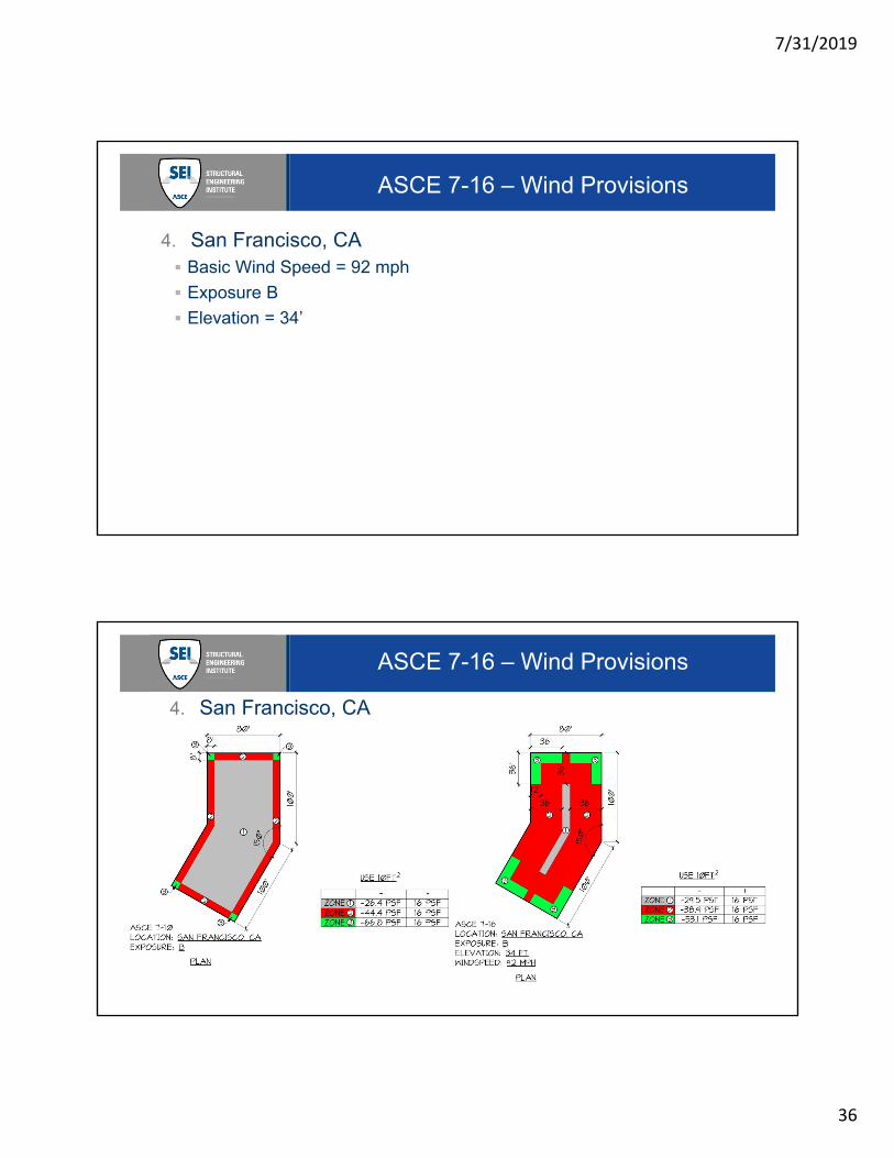
ASCE 7-16 – Wind Provisions
4. San Francisco, CA
Basic Wind Speed = 92 mph
Exposure B
Elevation = 34’
ASCE 7-16 – Wind Provisions
4. San Francisco, CA

7/31/2019
37
ASCE 7-16 – Wind Provisions
Summary
New Wind Speed Maps give lower MWFRS loads in the majority of the non-
hurricane regions of the US.
New Roof Pressure Coefficients increase cladding pressures on roof along
the hurricane coast line.
New Wind Speed Maps & Elevation Factors offset the increase in the Roof
Pressure Coefficient increases for the remaining portion of the US.
New Roof Zones are larger than previous zones, but better reflect the actual
roof loading.
New provisions provided for Roof Top Solar and Building Canopies.
Tornado Guidelines provided in Commentary.
Thank you!ASCE 7 – 16 Wind
Changes Affecting the Design Provisions
Questions?
Thank You!