Article: “Maps and Metaphors of Japan’s ‘Small Eastern Sea’ in Tokugawa Japan...
20
American Geographical Society Maps and Metaphors of the "Small Eastern Sea" in Tokugawa Japan (1603-1868) Author(s): Marcia Yonemoto Source: Geographical Review, Vol. 89, No. 2, Oceans Connect (Apr., 1999), pp. 169-187 Published by: American Geographical Society Stable URL: http://www.jstor.org/stable/216085 . Accessed: 04/02/2015 17:35 Your use of the JSTOR archive indicates your acceptance of the Terms & Conditions of Use, available at . http://www.jstor.org/page/info/about/policies/terms.jsp . JSTOR is a not-for-profit service that helps scholars, researchers, and students discover, use, and build upon a wide range of content in a trusted digital archive. We use information technology and tools to increase productivity and facilitate new forms of scholarship. For more information about JSTOR, please contact [email protected]. . American Geographical Society is collaborating with JSTOR to digitize, preserve and extend access to Geographical Review. http://www.jstor.org This content downloaded from 198.11.30.32 on Wed, 4 Feb 2015 17:35:04 PM All use subject to JSTOR Terms and Conditions
Transcript of Article: “Maps and Metaphors of Japan’s ‘Small Eastern Sea’ in Tokugawa Japan...
American Geographical Society
Maps and Metaphors of the "Small Eastern Sea" in Tokugawa Japan (1603-1868)Author(s): Marcia YonemotoSource: Geographical Review, Vol. 89, No. 2, Oceans Connect (Apr., 1999), pp. 169-187Published by: American Geographical SocietyStable URL: http://www.jstor.org/stable/216085 .
Accessed: 04/02/2015 17:35
Your use of the JSTOR archive indicates your acceptance of the Terms & Conditions of Use, available at .http://www.jstor.org/page/info/about/policies/terms.jsp
.JSTOR is a not-for-profit service that helps scholars, researchers, and students discover, use, and build upon a wide range ofcontent in a trusted digital archive. We use information technology and tools to increase productivity and facilitate new formsof scholarship. For more information about JSTOR, please contact [email protected].
.
American Geographical Society is collaborating with JSTOR to digitize, preserve and extend access toGeographical Review.
http://www.jstor.org
This content downloaded from 198.11.30.32 on Wed, 4 Feb 2015 17:35:04 PMAll use subject to JSTOR Terms and Conditions
MAPS AND METAPHORS OF THE "SMALL EASTERN SEA" IN TOKUGAWA JAPAN (16o3-1868)*
MARCIA YONEMOTO
ABSTRACT. This article examines the ways in which oceans were depicted in Japanese geo- graphical writings and maps from the Tokugawa period. It uses these texts to understand how early modern Japanese visions of the Pacific and of maritime Asian waters constructed epistemological frameworks through which the Japanese saw their place in an increasingly complex web of regional and global connections. In the absence of actual adventure on the "high seas," Japanese writers, artists, and mapmakers used the inventive power of the imagi- nation to fill in the cognitive blank of ocean space. I argue that the definition of early modern oceanic space was profoundly ambiguous, a legacy that, it can be argued, left its mark on Ja- pan's modern relationship with the Asian Pacific region. Keywords: Japan, maps, Pacific Ocean, Tokugawa period.
Whether an ocean people or a single man Everyone longsfor The warm currents of the Pacific Along with those waters rise our spirits The day for us to go forth has come! Our blood boils over with joy
Now toward the mainland, heroically We establish bright peace as we Cross the Pacific
Our ambition is infinite We will show the world the resolve Of our ocean people
Looking up at the battleship flag We humbly take in the sight Of the chrysanthemum against the ship's bow The Pacific, our ocean The wind sparkling on this very morning Let's extend our imperial homeland's lifeline!
Fuse Hajime, 'Taiheiyo koshinkyoku" (The Pacific March), 1939
q3y the spring of 1942, barely five months into the Pacific War, Japan controlled a vast oceanic empire more than thirteen times the land area of its home islands. Popu- lar songs from the early war years, like "The Pacific March," were uplifting narratives predicting limitless progress for Japan, whose "ocean people" would "extend [the] imperial homeland's lifeline" all the way from Asia to the mainland of North Amer- ica. But as some Japanese military leaders predicted even before the attack on Pearl
* The author would like to thank the organizers of the Oceans Connect project, Martin Lewis and Karen Wigen, all the participants in the Oceans Connect workshop at Duke University in October 1998, and the editors and anony- mous readers at the Geographical Review for their comments on and assistance with earlier drafts of this article.
*t' DR. YONEMOTO is an assistant professor of history at the University of Colorado, Boulder, Colo- rado 80309-0234.
The Geographical Review 89 (2): 169-187, April 1999 Copyright ? 2ooo by the American Geographical Society of New York
This content downloaded from 198.11.30.32 on Wed, 4 Feb 2015 17:35:04 PMAll use subject to JSTOR Terms and Conditions
170 THE GEOGRAPHICAL REVIEW
Harbor, Japan's dominance in the Pacific theater would be short-lived. Ultimately, the outcome of the war made it painfully clear that even at the peak of imperial rule, the Pacific was never Japan's ocean.
Memories of the wartime empire, together with the conventions of modern ge- ography and the recent discourse on the "Pacific Rim," conspire to convince us that Japan's links to the Pacific are inherent and indissoluble (Cumings 1998; Dirlik 1998). But this assumption masks the ambivalent and, in historical terms, very recent nature of this relationship. Japan's systematic knowledge of and engagement with the whole of the Pacific Ocean as we now conceive of it was a relatively late develop- ment, a phenomenon of the late nineteenth century at the earliest. Before that time, the Tokugawa shogunate (1603-1868) had rigorously regulated its relations with for- eign countries.' A few decades after assuming power, it expelled Christian mission- aries, forbade the building of ocean-going ships, and barred Japanese from traveling abroad. Pioneering historical research published in the last two decades by Ronald P. Toby, Marius Jansen, and Jurgis Elisonas, writing in English, and Tashiro Kazui, Arano Yasunori, and many other scholars, writing mainly in Japanese, has firmly re- futed the notion that early modern Japan was a "closed country" (Kata 1981; Tashiro 1982; Toby 1984,1985; Elisonas 1991; Jansen 1992; Arano, Ishii, and Murai 1992-1993).
Although I do not seek to contest this now widely accepted thesis, I shift the focus from diplomacy and international relations-geopolitics-to what I would call the "geocultural" imaginary, as it was expressed in maps and geographical writings of the early modern period in Japan. Unlike the European powers during the Age of Discovery, Japanese domestic politics strengthened a general disinclination to tra- verse, explore, or incorporate oceans into Japan's territory. This contributed to the development of profoundly ambivalent representations of ocean space, in which the friendly and sustaining seas bordering the archipelago stood in constant opposition to the distant and threatening oceans, untamed and unknown.
In this article I trace the ambiguity of early modern oceanic space by examining the ways in which oceans were depicted in Japanese geographical writings and maps. I do so in order to understand how early modern Japanese visions of the Pacific and of maritime Asian waters constructed pervasive epistemological and cultural frameworks through which the Japanese saw their place in an increasingly complex web of regional and global connections. I argue that their reticence to undertake overseas exploration did not mean that the Japanese lacked curiosity about or knowledge of the outside world. In the absence of actual adventure on the "high seas," Japanese writers, artists, and mapmakers used the inventive power of the imagination to fill in the cognitive blank of ocean space, cartographically dividing and conquering the threat of the seas and populating oceans with exotic lands and peoples. The construction of ocean fears and fantasies allowed the Japanese to en- gage the idea of an overseas "elsewhere" while maintaining only limited contact with (and evading threats from) non-Japanese peoples and cultures. Early modern oce- anic space itself was thus profoundly ambiguous, a legacy that, it can be argued, left its mark on Japan's modern relationship to the Asian Pacific region.
This content downloaded from 198.11.30.32 on Wed, 4 Feb 2015 17:35:04 PMAll use subject to JSTOR Terms and Conditions
MAPS AND METAPHORS OF THE SMALL EASTERN SEA 171
OCEAN FEARS
To say that early modern Japanese attitudes toward the sea were ambiguous is not to say that the Japanese were alienated from the ocean waters that surround them, for the inhabitants of the archipelago have been deeply attached to and dependent upon the seas since ancient times. Although heated debate among archaeologists and an- thropologists continues over the origins of the Japanese people, it is clear that the Japanese have essentially Asian continental origins. However, it also seems clear that certain early forms of language, agricultural technology, customs, and ritual were transmitted by seafaring migrants following the Japan (or Black) Current from the southwestern Pacific islands through the Ryfiky-a Island chain into Kyushu and parts of Honshu. Once settled on the main islands of the archipelago, the early Japanese saw the sea as both a source of foodstuffs and an object of ritual worship (Miyata 1993). The historian Amino Yoshihiko has argued strongly that Japan's ocean- centered culture of fishing, along with hunting and gathering, should be recognized as a crucial aspect of its civilizational development, one that was as important as the practice of wet-rice agriculture to subsequent Japanese lifeways (Amino 1992) .2
At the same time, however, the unpredictability of the ocean engendered a deep- rooted fear of the sea. Similar sentiments had permeated Western cultures before the advent of modern shipbuilding technology (Corbin 1995). In the Meiji period (1868 -1912), Western-educated Japanese thinkers, including the political economist Ina- gaki Manjira (1861-1908), saw the opportunity for Japan to join the ranks of the great European imperialist powers by developing an "oceanic civilization." Inspired by the ideas of Carl Ritter, which he had imbibed through his Cambridge mentor John Robert Seeley, Inagaki predicted in 1892 that the twentieth century would be the "Pacific age" (cited in Korhonen 1998, 92). It would be many decades before his words rang true, however, which led to considerable impatience on the part of advo- cates of more rapid and aggressive expansion. As the scholar Takekoshi Yosaburo put it in 1913, "Nurtured by history and limited in vision, the [Japanese] people have lacked the intellectual heritage of a maritime country, the ideal of national expan- sion" (quoted in Duus 1995, 1). Statements such as these were intended to spur the Japanese to overcome oceanic obstacles in order to pursue colonial territory. But even in 1913 this was more easily said than done, for the Japanese had long regarded the distant Pacific-and even the nearer waters of maritime Asia-at best warily, at worst fearfully, and, in any case, preferably from the safety of land. In the late eight- eenth century Honda Toshiaki (1744-1821), the prominent advocate of Dutch, or Western, studies, made the following assessment of Japanese navigation of the typhoon-plagued waters surrounding the archipelago:
Even when the weather improves, the crew are at a loss to tell in which direction to head, and the ship floats about helplessly. As a last resort they cut off their hair and make vows to Buddha and the gods. Then they take out pieces of paper on which have been written the names of the twelve directions, roll them up into balls, and put them into a basket with a hole in its lid.... The captain and crew, in tears, fer- vently call on Buddha and the gods of heaven and earth to indicate the direction.
This content downloaded from 198.11.30.32 on Wed, 4 Feb 2015 17:35:04 PMAll use subject to JSTOR Terms and Conditions

172 THE GEOGRAPHICAL REVIEW
They grasp the basket in their hands and strike the lid. Then, when one of the pellets jumps out, they pick it up, their eyes blinded by tears of joy, and cry that it is the di- rection vouchsafed by Buddha and the gods. They then set their course by it, and go completely astray. (Quoted in Keene 1969, 46-47)
The tragicomic aspect of this account belies the very real fear and ambivalence felt by early modern Japanese seafarers as a result of their incompetence and vulner- ability on the open ocean. Never known as accomplished navigators, Japanese trav- elers throughout the classical and early medieval periods were highly dependent on Chinese and Korean pilots to make the journey to and from the continent. Even after shipbuilding technology was improved following the attempted invasion of Japan by the Mongols in the late thirteenth century, Japanese ships sent on tribute and trade missions to China often had to wait as long as a year for favorable winds to take them across the 5oo-odd miles that separate the two countries (Tanaka and Sakai 1977). Given this history, the vulnerability that Japanese sailors felt in the face of the unpredictable ocean is palpable: Once blown off course and removed from the sanc- tuary of known waters, they were at the mercy of nature and "the gods."
There are many possible reasons for Japanese reticence to explore or map the Pacific before the early modern period. In the first place, the vastness of the Pacific made it the last of the great oceans to be explored and mapped by any country. In maritime Asia (the bodies of water now referred to as the East and South China Seas), sea routes were established very early on by the Chinese, and the Japanese in the early classical and late medieval periods were able to utilize that knowledge to fa- cilitate their participation in oceangoing trade. By the early modern period, access to these well-traversed routes, and to navigators familiar with them, had decreased the need for the Japanese independently to master navigational techniques or to engage in further oceanic exploration.
Moreover, the skills needed to navigate Asian seas were considerable: The dic- tates of climate and oceanography made the waters surrounding Japan a source of danger and calamity. The Japanese archipelago is encircled by strong and potentially treacherous ocean currents and is regularly buffeted by severe typhoons and sea- sonal storms. Winter storms bring strong northeasterly winds, which, before the ad- vent of modern navigation techniques, tended either to destroy boats or drive them far away from the Japanese coast, sometimes as far south as Vietnam. Typhoons, prevalent from late summer through fall, move in the opposite direction, from the southwest to the northeast, and ships caught in their path often ended up stranded in the waters of the North Pacific, near Hokkaido, Sakhalin, Kamchatka, or even the Aleutian Islands. In any season, the formidable Japan Current, which veers due east when it reaches the north-central portion of Honshu, carried vessels caught in it straight out into the Pacific. These ships typically vanished without a trace until the late eighteenth and nineteenth century, when Japanese castaways began to be picked up by the European ships that were plying Pacific waters with increasing regularity.
The imminent threat of disaster and an omnipresent fear of the open ocean set limits on the expansion of commercial shipping in the early modern period. As the
This content downloaded from 198.11.30.32 on Wed, 4 Feb 2015 17:35:04 PMAll use subject to JSTOR Terms and Conditions

MAPS AND METAPHORS OF THE SMALL EASTERN SEA 173
4.~~~~~~~~~~~~~~~~~~~~J
A~~~~~~~~~
FIG. 1-`c(Urabe junran) Tokairo no zu" ([Sequential Coastal Viewi Map of the Eastern Sea Routes), 1842. This is the beginning of the map scroll, with the title and the legend at the far right; the starting point of the map itself is "Matsumae-chi:'inscribed in larger characters enclosed in the rec- tangle at center right. (Reproduced courtesy of the Special Collections and University Archives Divi- sion, University of British Columbia Library, George H. Beans Collection)
market economy grew, large numbers of cargo boats sailed along heavily trafficked sea routes encircling the archipelago.' The development of such routes did not, however, lead to an advance in navigational technology, for shipping routes rarely if ever strayed out of sight of land; navigation was accomplished by sighting land- marks on the coast, and detailed written records and maps were kept of most of the frequendly used waterways. One example of this type of map is the cDai Nihon kairo zu" (Map of the Sea Routes of Great Japan), the first volume of which covers the Pacific or "Eastern Sea" routes from the far northern islands to the large cities of eastern and west-central Japan (Figures i and 2). Published in 1842, the map is printed in the form of a folding book; the viewer reads from right to left through a visual narrative of the journey, much as one would view linked scenes in a picture scroll. Small in size (5- inches in height and 75.8 inches in total length, though a viewer would typically look only at one small section at a time), the first volume of the map covers the distance between the Japanese domain of Matsumae, on the southern tip of the northernmost island of Hokkaido, and the shogunal capital at Edo (now Tokyo). Although it is dense in textual, if not graphic, detail, what is fasci- nating about this and other maps of domestic sea routes is that they all but ignore the sea itself. All of the directional markers in this map are landmarks, off of which ships could sight towns and settlements, mountains, waterfalls, shrines, and other topographical markers, such as the rudimentary depiction of forests on the hillsides
This content downloaded from 198.11.30.32 on Wed, 4 Feb 2015 17:35:04 PMAll use subject to JSTOR Terms and Conditions
174 THE GEOGRAPHICAL REVIEW
I t ft , ', ., j tt ' 0', qo_- f
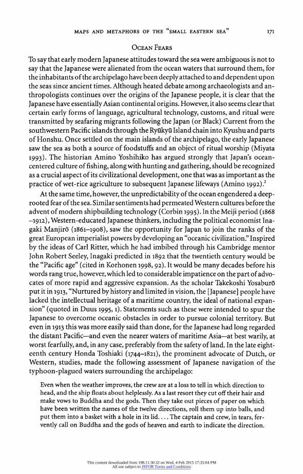
FIG. 2-Detail from "TOkairo no zu." The sea constitutes the lower third of the map; dots along coastline indicate shallows. Rectangular labels name coastal towns, and small triangular "pointers" at the top indicate notable landmarks, such as the mountains and waterfall at top right. Shrines are de- picted by the torii symbol. Notice the directional symbols at lower left; these indicate sailing directions that cannot be precisely depicted in scroll format. (Reproduced courtesy of the Special Collections and University Archives Division, University of British Columbia Library, George H. Beans Collection)
(Figure 2). The ocean is depicted, of course, but it occupies a small proportion of the map's total space, and much of it is overlaid with textual notations of tidal patterns in certain harbors, shallow waters, treacherous shoals, river outlets, or other fea- tures that might cause trouble for offshore navigators.
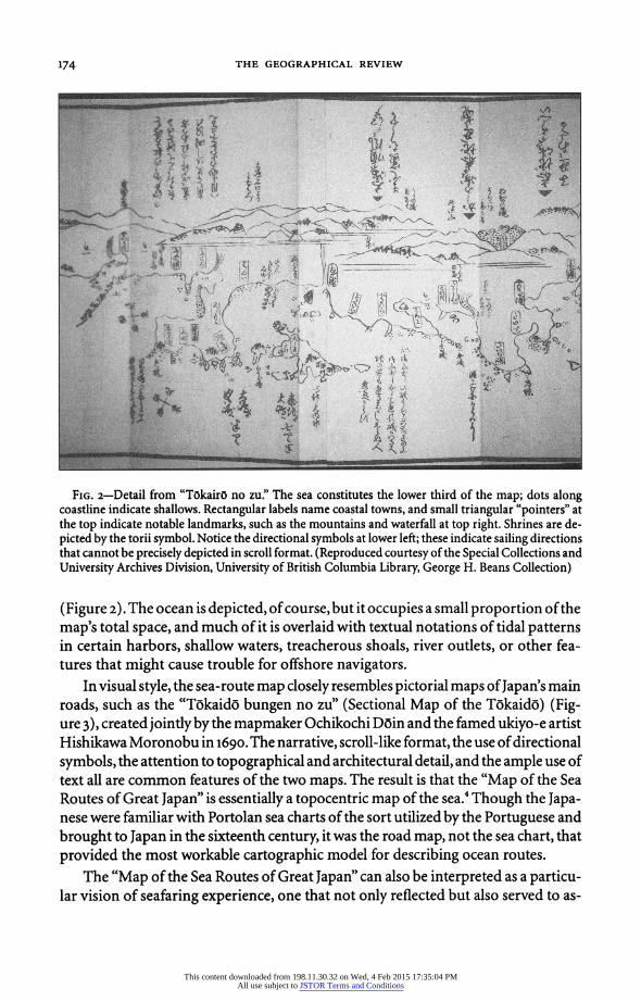
In visual style, the sea-route map dosely resembles pictorial maps of Japan's main roads, such as the "Tokaido bungen no zu" (Sectional Map of the Tokaido) (Fig- ure 3), created jointly by the mapmaker Ochikochi Doin and the famed ukiyo-e artist Hishikawa Moronobu in 1690. The narrative, scroll-like format, the use of directional symbols, the attention to topographical and architectural detail, and the ample use of text all are common features of the two maps. The result is that the "Map of the Sea Routes of Great Japan" is essentially a topocentric map of the sea.4 Though the Japa- nese were familiar with Portolan sea charts of the sort utilized by the Portuguese and brought to Japan in the sixteenth century, it was the road map, not the sea chart, that provided the most workable cartographic model for describing ocean routes.
The "Map of the Sea Routes of Great Japan" can also be interpreted as a particu- lar vision of seafaring experience, one that not only reflected but also served to as-
This content downloaded from 198.11.30.32 on Wed, 4 Feb 2015 17:35:04 PMAll use subject to JSTOR Terms and Conditions
MAPS AND METAPHORS OF THE SMALL EASTERN SEA 175
FIG. 3-Detail from "Tokaido bungen no zu" (Sectional Map of the Tokaido) by Ochikochi Doin, illustrated by Hishikawa Moronobu, 1690. The beginning of the map, this shows travelers leaving the shogunal capital city of Edo. At the center of the lower part of the map isNihonbashi (the Bridge of Japan), the official point of origin for the main trunk roads leading out to the provinces; the road itself dominates the lower foreground. Notable places such as Edo Castle, at top center, are labeled. Like the map of sea routes, directional symbols are given periodically, as in the square marker at top right. (Reproduced courtesy of the Special Collections and Univer- sity Archives Division, University of British Columbia Library, George H. Beans Collection)
This content downloaded from 198.11.30.32 on Wed, 4 Feb 2015 17:35:04 PMAll use subject to JSTOR Terms and Conditions
176 THE GEOGRAPHICAL REVIEW
| t;wF.J.;- - ,7 1 ti ei * 4 '- : X i 5 , x41 j
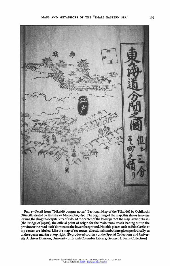
and Seas of all the World's Countries), by Nagakubo Sekisui, 1790. The large landmass to the right is North America; off its coast is the "Large Eastern Sea. The "Small Eastern Sea" can be seen at the up- per left. (Reproduced courtesy of the Special Collections and University Archives Division, Univer- sity of British Columbia Library, George H. Beans Collection)
suage ocean fears. By depicting the sea with reference primarily to the land, this sea- route map is a response to an environmental, technological, and historical context in which land was equated with knowledge and security and oceans were regarded with ignorance and fear. The "Map of the Sea Routes of Great Japan" made sense of oceans by shrinking the Pacific, as if rendering vast and distant waters as a narrow strip of shoreline could somehow domesticate and subdue the sea's uncontrollable power.
The sea-route map was by its nature a localized form of cartographic discourse that fused land to water, known to unknown. In other words, one could understand the sea by extrapolating from the land. The same could not be said, however, of the other major form of cartographic representation of oceans, that of world maps. When Portuguese traders and missionaries first brought world maps and globes to Japan in the late sixteenth century, Oda Nobunaga (1534-1582), Toyotomi Hideyoshi (1536-1598), and other Japanese rulers were much taken with the impressive vision they afforded of global space. Such maps made it evident that oceans occupied a great proportion of the earth's sufface. In particular, the body of water to which the early modern Europeans referred as the "Mare Pacificum" was incomprehensibly vast, stretching from the east coast of Asia to the west coast of the Americas, and from the Aleutian Islands to the shores of the "Great Southern State" of Antarctica.
This content downloaded from 198.11.30.32 on Wed, 4 Feb 2015 17:35:04 PMAll use subject to JSTOR Terms and Conditions

MAPS AND METAPHORS OF THE SMALL EASTERN SEA 177
In this global vision, the Japanese archipelago was a relatively minor presence, hov- ering on the ocean's western edge.
Yet in spite of this clearly marginal status in the Pacific world, the Japanese in the early modern period refined cartographic strategies for comprehending ocean space not by conquering it but by dividing it. Borrowing from a hybrid Chinese-European cartographic model, world maps produced in Japan from the seventeenth century onward tend to depict the Pacific as two oceans, a "Small Eastern Sea," which com- prised the portion of the Pacific closest to Asia and the Japanese archipelago, and a "Large Eastern Sea," which bordered the North American continent (Figures 4 and 5). The division of the Pacific into the Small and Large Eastern Seas derived from a four-ocean, six-continent scheme of world geography devised by Matteo Ricci (1552-1619), an Italian Jesuit. Ricci lived and worked in China in the last decades of his life, and between 1584 and 16o8 he produced ten different editions of a world map in Chinese, many copies and adaptations of which were brought to Japan soon after their production in China (see Yee 1994,178-179). In Ricci's maps, the four oceans in- clude the two Eastern Seas and their western analogues: the "Large Western Sea," which corresponds to the present-day Atlantic Ocean, and the "Small Western Sea," which roughly corresponds to the Indian Ocean. The six continents were North America, South America, Europe, Asia, Africa, and "Mekaranika" (Magellanica, in honor of the great Portuguese explorer), also known as "Nanpo taishui" (Great State of the Southern Region), what is now Antarctica. Ricci's maps exerted a strong influence on Chinese and, subsequently, on Japanese cartographic visions of the world. By 1645, Japanese printmakers in Nagasaki were making maps based on Ric- ci's; these "maps of the myriad countries" were often accompanied by depictions of "the world's people' usually as male-female pairs dressed in some culturally distinc- tive clothing.
The Japanese cartographic conception of a Small Eastern Sea can be read both literally and metaphorically. In its literal reading, it is part of the cartographic no- menclature inherited from Ricci's world maps, maps that in many ways sought to co-opt the Sinocentric worldview and use it to disseminate a global map vision of European origin. Once transmitted to Japan, however, the Small Eastern Sea became a metaphor for a regional mentality, one that reflected Japan's ambivalent relation- ship with its surrounding oceans and the ways they simultaneously connected and divided Japan and the outside world. As a visual and mental construct, the Small Eastern Sea cut the vast Pacific down to size. Although early modern Japanese map- makers were not always sure about the location of the Large Eastern Sea, sometimes erroneously placing it off the eastern coast of North America, the Small Eastern Sea remained a fixture in many of their world and regional maps. Maps were the coded and contextual language used to craft the notion of the Small Eastern Sea as a re- gional ocean basin, reinforcing Japan's sense of attachment to northeast Asia while dividing it from the "new" world, about which the Japanese knew little.
The small-ocean mentality was both spatial and cultural in nature, for it was shaped by fundamentally geocentric notions of civilization inherited from China.
This content downloaded from 198.11.30.32 on Wed, 4 Feb 2015 17:35:04 PMAll use subject to JSTOR Terms and Conditions
178 THE GEOGRAPHICAL REVIEW
Although possessed of a long-standing and successful seafaring history during the Ming Dynasty (1368-1644), the Chinese in the early modern period began to turn away from oceangoing trade and exploration. Whereas the Ming dynasts were con- cerned about regulating and taxing the thriving private junk trade in the South Seas of maritime Asia, their successors, the Manchu rulers of the Qing Dynasty (1644- 1912), were much more preoccupied with securing the empire's territorial bounda- ries. The Qing rulers sought to incorporate into China proper the Manchu home- lands in the northeast, and in the west they fought to expand the empire along the Inner Asian frontier. As a result, from the time the Qing gained power in 1644, con- trol of sea trade was delegated to merchants while the government concentrated its political, military, and economic efforts inland (Leonard 1984, 54-55). When Qing rulers concerned themselves with the sea, it was in an attempt to control the Ming loyalist pirates who dominated the South China coastal trade and threatened the authority of the Manchu rulers. Not until the Opium Wars of 1839-1842 did the Qing government begin to fundamentally rethink its attitudes toward coastal defense and choose to intensively study and map the South Seas region.5
The Qing preoccupation with land thus grew not out of ignorance of the seas but out of calculated decisions made by the imperial regime to rank the strategic impor- tance of seas and maritime regions (always at the margins of state control anyway) below that of land territory. This emphasis, combined with China's long-standing civilizational definition of itself as the "Middle Kingdom," profoundly shaped Japa- nese geographical consciousness in the early modern period. In other words, Chi- nese geocentrism encouraged Japanese "topophilia" (Tuan 1990), as commercially printed maps and geographical writings minutely describing "Great Japan," "Our Empire," or zenkoku (all of the country, or all of the provinces) proliferated while maps of the seas were virtually nonexistent. Although foreign countries had been demanding that Japan open its ports to trade from as early as the 179os, neither com- mercial mapmakers nor the Tokugawa government took measures to comprehen- sively map the Japanese coastline until the 183os.6 This is not to say that the Tokugawa did not map administratively; quite the opposite was true, for beginning in 1605 the shogunate spearheaded the most complete administrative territorial mapmaking projects ever undertaken in Japan. But, like the Qing rulers, the Toku- gawa focused their energies on mapping the interior, a clear indication that during the 25o-year-long "Tokugawa peace" the perceived threat came from within the ar- chipelago, not from the seas beyond its borders. By pushing the seafaring world to the margins of their worldview, literally and figuratively, Tokugawa mapmakers, both commercial and official, surrendered the seas to the realm of the imagination.
OCEAN FANTASIES
The geocentric Qing world order functioned as an intellectual default mechanism when the Japanese began to fashion for themselves a Japan-centered world order in the mid-Tokugawa period. Like the Chinese, the Japanese sawland as an analogue for culture and civilization: Order and beauty were inherent in the landscape itself. The
This content downloaded from 198.11.30.32 on Wed, 4 Feb 2015 17:35:04 PMAll use subject to JSTOR Terms and Conditions

pi,~~~~~~~~~~~~~~~~~~~~~U
mv
Ul2
I
N
~~~~~~~~~~~~~~fl" =
:~~~~~~~~~~~~~~~~~~~~~~~~~~~~~~~~~4 G" 0i ?R *4U
PC ... Ca
> - ~~~~~~~ I ' e:;~~~~~~~-
t t /- .,_$
I tR'Y t
I W,%!~~~~~~~~O
This content downloaded from 198.11.30.32 on Wed, 4 Feb 2015 17:35:04 PMAll use subject to JSTOR Terms and Conditions
18o THE GEOGRAPHICAL REVIEW
ocean, by contrast, functioned as a marker not only for the unknown and threaten- ing but also for the exotic and fantastic. Although land was represented in text and image in both Chinese and Japanese classics as being almost hyperreal, the ocean was surreal. The farther one ventured from the safety and familiarity of land, the more one entered the realm of the fabulous.
The attachment to land reflected in early modern Japanese maps and geographi- cal writings had deep cultural roots. The earliest historical documents written in Ja- pan evince a finely tuned consciousness of land and landscape. From early classical times, Japanese poets and writers rhapsodized over the natural beauty of the archi- pelago. In both poetry and prose, they invested its topography with deep cultural meanings. The benign coastal waters occasionally engendered similar descriptions, but for the most part the open ocean contravened the familiar order of things.
This carefully cultivated love of the land was combined with the notion, inher- ited from the Chinese, that civilization decreased with distance from the political and/or cultural center.7 This "Middle Kingdom consciousness" was transmitted to the Japanese in the early modern period by way of translated and adapted Chinese texts. These texts in turn compelled Japanese writers and thinkers to imaginatively transform their peripheral archipelago into a central space. Unknown lands and ex- otic peoples existed in an otherwise vaguely defined world overseas and far from home. Works like Nishikawa Joken's Ka'i tslusho5 ko- (Thoughts on Trade and Com- munication with the Civilized and the Barbaric) borrowed the language and struc- ture of Chinese geocentric and ethnocentric concepts to outline and describe Japan's relations with its various Others (Nishikawa 1928). First published in 1695 and revised and reissued in 1709, Ka'i tsTushoi ko is a compilation of text and illustra- tions describing the location, customs, and products of the various countries with which Japan traded as of the late seventeenth century. It is both a geographical trea- tise and an encyclopedic and thematic one. As in Chinese geographical texts, Nishi- kawa grouped countries by their degree of "foreignness" to Japan, a status linked to distance from the center (usually the shogunal capital of Edo) as well as to trade and diplomatic prerogatives on the model of the Chinese tribute system. First and most extensively covered, of course, was China. Illustrations accompanied short descrip- tions of local conditions in each of the "two capitals" (Beijing and Nanjing) and "thirteen circuits" (Shandong, Shanxi, Henan, Shaanxi, Huguang [Hubei and Hu- nan], Jiangxi, Zhejiang, Fujian, Guangdong, Gansu, Guizhou, Sichuan, and Yun- nan), including population, local products, and details about shipbuilding and the staffing of ships (Nishikawa 1928, 280). This section also contains maps of the world and of China, drawings of Ming and Qing nobles, and diagrams of Chinese ships. On the world maps, no ocean save the "Frozen Sea" of the Arctic region is labeled, though it is remarked that "all the countries in the east" (for example, North and South America) lie approximately 15,500 miles from Japan.
Next came similar descriptions of the "outside countries." Because Japan lacked an empire of its own, Nishikawa borrowed the relational concepts of the Chinese world order. The outside countries, he explained, were not within the boundaries of
This content downloaded from 198.11.30.32 on Wed, 4 Feb 2015 17:35:04 PMAll use subject to JSTOR Terms and Conditions
MAPS AND METAPHORS OF THE "SMALL EASTERN SEA 1
181
China proper but within the sphere of Chinese influence, meaning that they were subjects of the empire, used the Chinese language, and practiced the "three teach- ings" of Buddhism, Confucianism, and Taoism. This category comprised Korea, the Ryakyu Islands, Taiwan, Tonkin, and Cochin.8 After the outside countries came the "outside foreigners," countries that, for the most part, engaged in trade with China but were outside the Chinese imperial system and did not speak the Chinese lan- guage. These included countries ranging from Siam and Java to the Netherlands, Mongolia, Arabia, Amazonia ("the country of warrior women"), and the "Land of Dwarfs" (a country said to be located in northern Europe, whose inhabitants were approximately 2 feet tall) (Nishikawa 1928, 328-380). Encyclopedias like the Ka'i tsiusho ko- and its successor, the Wakan sansai zue (Japanese/Chinese Illustrated Cata- log of the Three Elements [Heaven, Earth, and Man], 1712),9 made little categorical distinction between the sort of verifiable foreign country whose people might have visited Japan in the eighteenth century and foreign lands and peoples whose exis- tence was known largely through foldlore or hearsay (Terajima 1985-1989). "For- eign," then, was an elastic category comprising Amazons and Arabians, Bengalis and "Long-Legs" (inhabitants of the southern tip of South America). Unlike the "famil- iar foreigners" of nearby Asian countries, distant foreign lands were located "out there" in the oceanic void. These lands were not merely invented; they emerged from overlapping imagined constructions of culture and place, civilized and barbaric, for which the ocean formed an inert backdrop.
Works like the Ka'i tsusho ko attempted to categorize the foreign in Japanocen- tric and geocentric terms, where civilization and knowledge radiated out from a central place to the far reaches of unknown space. Maps took encyclopedic knowl- edge and rendered this relational view of foreignness visually. More often than not, mapmakers situated actual, legendary, and mythical lands on the cartographic fringes. For example, in the maps of Ishikawa Ryulsen (active ca. 1680-1720), a prominent artisan-mapmaker of the late seventeenth and early eighteenth centu- ries, the ocean surrounding the archipelago literally forms the margins of the map. In the "Honchh zukan komoku" (Outline Map of Our Country), published in 1687, Ishikawa maps the three main islands of the archipelago comprehensively, whereas the ocean-depicted as azure and becalmed, with sketches of boats bobbing on styl- ized waves-becomes the repository of everything that is not Japan (Figure 6). A ta- ble listing the distances between Japan and certain foreign countries offers figures for the distance between "our realm" and "other" countries: the equivalent of 30,000 miles to Holland, 2.,66o miles to Russia, 720 miles to Nanjing, 4,000 miles to Tonkin, and so on. Although the presence of these lands is vaguely suggested, they are not de- picted on the map itself.
What does appear on the map are lands now considered to be "fantastic" or ccmythical"; these occupy the visual margins of the mapped space. At bottom right center is an entity labeled "Rasetsu koku" (Country of the Rakshasas) in large char- acters and "Onna no shima" (Island of Women) in smaller writing. This "Island of Women" was the fabled residence of the benevolent female deities (the rakshasas of
This content downloaded from 198.11.30.32 on Wed, 4 Feb 2015 17:35:04 PMAll use subject to JSTOR Terms and Conditions

3.4
Cd
Mf ;1NA. k4.. -_4
co
4V .4sk. co !;-O.
cl
NA
4j (U
ar 4bl
co
cqs
(U
O
co
RT, 4----
oo
co 14
kf
CO ti
41F-fil, 4-6
P.- 4-1 4i 4J +5
4i 4-4
gra jf7f. :i
co W O O
to 4j co 4)
cu
0
15 to
to +.A
4j .:A
10 -V
4j tko
nc-
4i 10 4u
PL4 gL , I 0 co
0 L)
This content downloaded from 198.11.30.32 on Wed, 4 Feb 2015 17:35:04 PMAll use subject to JSTOR Terms and Conditions

MAPS AND METAPHORS OF THE SMALL EASTERN SEA 183
the Lotus Sutra), later popularized in the playful fiction of Ihara Saikaku (1642- 1693). At top center is a landmass labeled "Kari no michi," upon which are written the words, "There are no people here." This remote no-man's-land was a feature of many early modern maps of Japan and the world. Neither land bears the marks of habitation; indications of settlements, roads, or significant places of any kind are en- tirely absent. This is not to say that these places were unfamiliar; both the "Island of Women" and "Kari no michi" had roots in folldore and literature, and in this sense they were known, though not experienced, by most Japanese. The placement of these lands on the edges of the map indicates how peripheral places were relegated to a vaguely conceived oceanic realm, their presence imaginable but unverifiable.
THE AMBIGUITY OF OCEANIC SPACE
The idea of the sea as a setting for little-known foreign places and peoples underlines the stark contrast between the Japanese consciousness of land (as civilized and accul- turated) and that of the sea (as empty, or as occupied by strange and unfamiliar peo- ples without culture). One could represent the sea as the setting for various versions of culture, but the ocean itself could not be said to be civilized, or civilizable; if any- thing, it defied categorization altogether.
How, then, may we interpret Japan's ocean ambivalence in its historical context? What role has it played in constructing notions of geography and culture in Asia and elsewhere? The ocean maps and metaphors analyzed here, made for different pur- poses and utilizing different representational strategies, can be said to document early modern mapmakers' attempts to construct, visually and mentally, a workable definition of ocean space. They suggest that the premodern and early modern Japa- nese voluntarily created and were involuntarily forced to accept limits on their knowledge of oceans. This relative lack of knowledge, however, did not imply an ab- sence of comprehension. Early modern Japanese mapmakers did not explore new ocean territory; they repeatedly recast the familiar in comprehensible terms. In the case of oceans, this meant envisioning the Pacific as an eastern sea that lay close by the archipelago and as the locus of familiar (if, by "modern" standards, fantastic) lands and peoples. Rather than seeing early modern ocean fears and fantasies solely as constraints on oceanic understanding, we may instead see how those sentiments contributed to the intellectual construction of ocean space itself. Moreover, rather than limiting Japan's expansionist impulses, as early-twentieth-century observers suggested, the Small Eastern Sea maywell have functioned as a default mechanism in the modern period, when the Japanese reshaped the Asian Pacific according to the dictates of imperialism and colonialism.
Driven by Western-inspired notions of progress and "civilization," and by the economic imperatives of industrialization, Japanese expansion became reality in the Meiji period through two wars on the Asian continent, both of which gained Ja- pan new "overseas" territory and a new status in the international community. As the Japanese military pushed northward from its base on the Korean Peninsula into Manchuria in the early 1930s, their notions of empire likewise grew in scale and
This content downloaded from 198.11.30.32 on Wed, 4 Feb 2015 17:35:04 PMAll use subject to JSTOR Terms and Conditions
184 THE GEOGRAPHICAL REVIEW
grandeur. This was a shift of monumental proportions, one that has been discussed at length by scholars in and outside Japan (in addition to the works cited above, see Myers and Peattie 1984; Peattie 1988; Duus, Myers, and Peattie 1989, 1996; Tanaka 1993). In an important new contribution to the study of Japanese imperialism, Lou- ise Young argues that Japanese notions of empire were totalistic in nature, consisting not only of state planning and military mobilization but also of the marshaling of vast reserves of popular energy (1998). Empires, as Young puts it, are always "social products" (p. 9), and her study of Manchuria shows how the cultural imagination of empire necessarily accompanied the mechanics of colonial occupation and admini- stration. In this new imperial vision, the Small Eastern Sea was no longer a compen- satory space carved out of the inconceivably large Pacific. Instead, it became Japan's conduit to an Asia-centered regional sphere of influence, where seemingly inclusive ideals of "same culture, same race" and Asian brotherhood facilitated a reality of of- ten harsh exploitation of human and natural resources. Familiar yet unalterably for- eign, Japan's colonial Others were the embodiment of the fears and fantasies encoded in oceanic as well as territorial space. With the decision in December 1941 to stage the preemptive strike on Pearl Harbor, Japan put its military fate in the hands of its navy and in the waters of the Pacific. But the idea of oceanic empire could not alter the vastness of oceanic space; nor, for that matter, could it weaken American military-industrial might combined with the United States' resolve to regain a Pacific it viewed as its own. Japan lost the Pacific War for many reasons, but the deeply rooted ambiguity of oceanic space itself did much to shape the ambivalence that characterized Japan's theory and practice of Pacific empire building.
CODA
The complicatedlegacyof Japan'sbrief imperial reign in the Pacific isbroughtkeenly home in Senso Daughters (Daughters of War), Japanese filmmaker Noriko Seki- guchi's spare, eloquent, and utterly unsentimental 1989 documentary about the ex- periences of Asian Pacific women under wartime Japanese rule (Sekiguchi 1989). Toward the beginning of the film a middle-aged New Guinean man appears before the camera wearing a T-shirt and what appears to be a battered army-issue helmet. A subtitle identifies him as Joseph Kanaka. Standing at attention, with shoulders back and arms at his sides, he begins to speak in precisely accented Japanese: "My name in Japanese is Mr. Tanaka. This is our village, Muisura. Now I will sing you a Japanese song. It is called 'The Pacific March.' " With that, Kanaka/Tanaka launches into a pitch-perfect rendition of the wartime song quoted in the epigraph that begins this article.
Kanaka's filmed recital is jarring for many reasons; one hears war songs in Japan today only infrequently, tainted as they are with unspoken (or unacknowledged) na- tional guilt for the atrocities the military committed during the war years, 1931-1945. When one does hear them, they are often blaring from the speakers of trucks that right-wing nationalist groups drive around crowded city streets in a largely unsuc- cessful attempt to reawaken Japan's imperial spirit. However extreme such national-
This content downloaded from 198.11.30.32 on Wed, 4 Feb 2015 17:35:04 PMAll use subject to JSTOR Terms and Conditions

MAPS AND METAPHORS OF THE CCSMALL EASTERN SEA )
185
ist rhetoric may seem on the surface, Sekiguchi's film and other accounts attest to the denial by many Japanese who lived through the war of the appalling behavior of the Japanese military. In one of the film's many interviews with Japanese Pacific War vet- erans, a former soldier stationed in New Guinea angrily dismisses the notion that Ja- pan should pay reparations to the people of the former colonies: "We were defending them," he asserts. "We only used their land as a battlefield."
Given such sentiments, and given the well-known and long-standing enmity of many Asian Pacific people for Japan as a result of their countries' wartime experi- ences, one feels severe cognitive dissonance when the stridently jingoistic "Pacific March" issues from the mouth of a former colonial "subject" like Joseph Kanaka. The filmmaker gives no explanation for Kanaka's performance, but in the end an ex- planation is not really necessary. One imagines the man, who appears to be in his fifties, as a young boy during the war. Most likely Japanese soldiers taught him the song, and perhaps they praised his renditions of it. Perhaps they found it particularly entertaining that he, a true "ocean person" fully and naturally at home in the seas, would serenade them in their language with renditions of their fantasies of oceanic empire. And perhaps the man, as a boy, enjoyed playing this role for the conquering, if not heroic, troops.
Joseph Kanaka appears again at the very end of the film to perform another Japa- nese song, this time a folk tune accompanied by a dance. The camera focuses on him as he advances across a sandy beach, clapping and gesturing expansively to illustrate the lyrics, which, it becomes clear, celebrate the importance of loyalty to one's feudal lord. "Because I am in your [honorable] land, please let me work hard for you," he sings. Who, one wonders, does Joseph Kanaka imagine this ruler to be, and what do his lands comprise? How has this lord managed to extend his dominion across space and time? Upon finishing the tune, Kanaka faces the camera, his back to the ocean. Smiling broadly, he bows to the viewer and says in Japanese: "Thank you, thank you very much for listening! Aren't I good at singing these Japanese songs?" His perform- ance concluded, he turns and marches away, but the camera does not follow him; in- stead, it remains fixed on an expanse of pale turquoise sea. There is a deliberate lapse in human narration as waves break on the shore, and in that moment the viewer be- gins to understand how, geographically, historically, and culturally, Japan has always been in but not of the Pacific.
NOTES
1. Most scholars include the last decade or so of the sixteenth centurywhen they refer to the "early modern" period. Although the chronological focus of this article is on the years of Tokugawa rule, I fre- quently use the term "early modern" to refer to the era that encompasses the Tokugawa period.
2. Amino's writings focus not on the ocean space of the Pacific but on coastal seas, the myriad bays, inlets, straits, and tidal waters bordering the archipelago, from which the Japanese traditionally have harvested fish, shellfish, seaweed, and other staples of their diet.
3. In an unhappy confluence of circumstances, the single-masted ships used for commercial transport were extremely vulnerable to inclement weather and tended to carry their heaviest (and most destabilizing) loads in the winter and early spring, when strong storms were most frequent (Ni- nomiya 1972, 20-22).
This content downloaded from 198.11.30.32 on Wed, 4 Feb 2015 17:35:04 PMAll use subject to JSTOR Terms and Conditions

186 THE GEOGRAPHICAL REVIEW
4. The colophon of the sea-route map states that it is a "record of precautions for commercial boats." By using this term, it recalls the "precautions for travelers" published in the early nineteenth century as guides to safe passage for land-bound travelers along the roads and highways (Vaporis 1989).
5. Jane Kate Leonard asserts that the transformation in Chinese geographical practice in the late nineteenth centurywas not due to the "Western impact" alone but, rather, grew out of a long tradition of acceptance and inclusion of multiple jurisdictions and joint regional involvement in South Sea trade (1984, 58-61).
6. When Hayashi Shihei (1738-1793), author of several influential treatises on Japan's military defense in the late eighteenth century, sought to convey his alarm at Japan's vulnerability to attack from the sea, he did so by arguing that "From Nihonbashi in Edo to China and then to Holland stretches a sea route without limit" (quoted in Nishiyama 1983,169; my translation). It is worth noting here that Hayashi perceived the primary oceanic avenue between Japan and the West as one that cir- cumnavigated Asia and Europe. The Pacific is completely absent from his view.
7. The Sinocentric world order is best illustrated by an early map of "the civilized and the bar- baric," which showed the Chinese Empire (labeled the "realm of kings") at the center of a series of concentric squares. The space immediately surrounding the center is occupied by retainers of the em- peror, the next by tributary states, and the outermost space is relegated to "barbarians" (Needham 1959, 507).
8. Tonkin corresponds roughly to the northern part of present-day Vietnam. During the early part of their rule, the Tokugawa exchanged diplomatic correspondence with Tonkin and had good re- lations and trade with the country, importing copper, raw silk, woven silks, and medicines. After the restrictions on trade were implemented in the 1630s, trade was suspended. Cochin corresponds roughly to the southern part of present-day Vietnam, immediately south of Tonkin.
9. Published in Japan in 1712, this io8-volume text is a translation and emendation of the Chinese encyclopedia Sancai tuhui (Illustrated Catalog of the Three Elements) of 1609.
REFERENCES
Amino Y. 1992. Umi to retto no chuisei (The Sea and the Archipelago in the Medieval Period). Tokyo: Nihon Editaaskuuru Shuppansha.
Arano Y., Ishii M., and Murai S., eds. 1992-1993. Ajia no naka no Nihon shi (Japanese History in the Context of Asia). 6 vols. Tokyo: Tokyo Daigaku Shuppankai.
Corbin, A. 1995. The Lure of the Sea: The Discovery of the Seaside in the Western World, 1750-1840. Translated by J. Phelps. London: Penguin Books.
Cumings, B. 1998. Rimspeak; or, The Discourse of the "Pacific Rim." In What Is in a Rim? Critical Perspectives on the Pacific Region Idea, edited by A. Dirlik, 53-72. 2d ed. Lanham, Md.: Rowman and Littlefield.
Dirlik, A. 1998. The Asia-Pacific Idea: Reality and Representation in the Invention of a Regional Structure. In What Is in a Rim? Critical Perspectives on the Pacific Region Idea, edited by A. Dirlik, 15-36. 2d ed. Lanham, Md.: Rowman and Littlefield.
Duus, P. 1995. The Abacus and the Sword: The Japanese Penetration of Korea, 1895-1910. Berkeley: University of California Press.
Duus, P., R. H. Myers, and M. R. Peattie, eds. 1989. TheJapanese Informal Empire in China, 1895-1937. Princeton, N.J.: Princeton University Press.
1996. TheJapanese WartimeEmpire, 1931-1945. Princeton,N.J.: PrincetonUniversityPress. Elisonas, J. 1991. The Inseparable Trinity: Japan's Relations with China and Korea. In The Cambridge
History of Japan, vol. 4, Early Modern Japan, edited by J. W. Hall, 235-300. Cambridge, England: Cambridge University Press.
Jansen, M. B. 1992. China in the Tokugawa World. Cambridge, Mass.: Harvard University Press. Kato H. 1981. The Significance of the Period of National Seclusion Reconsidered. Journal ofJapanese
Studies 7 (1): 85-109. Keene, D. 1969. The Japanese Discovery of Europe, 1720-1830. Rev. ed. Stanford, Calif.: Stanford Uni-
versity Press. Korhonen,P. 1998. Japan andAsiaPacificIntegration: PacificRomances, 1968-1996. London andNew
York: Routledge.
This content downloaded from 198.11.30.32 on Wed, 4 Feb 2015 17:35:04 PMAll use subject to JSTOR Terms and Conditions
MAPS AND METAPHORS OF THE "SMALL EASTERN SEA )
187
Leonard, J. K. 1984. Wei Yuan and China's Rediscovery of the Maritime World. Cambridge, Mass.: Harvard University, Council on East Asian Studies.
Miyata N. 1993. Nihon minzoku ron: Umi kara no shiten (Debates on Japanese Ethnicity: A View from the Sea). In Iwanami kozaNihon ts-ushi (The Iwanami Lecture [Seriesi Survey History of Ja- pan),vol. 1,Nihon retto tojinruishakai (The Japanese Archipelago and Human Society), editedby Asao N., Amino Y., Ishii S., Kano M., Hayakawa S., and Yasumaru Y., 331-357. Tokyo: Iwanami Shoten.
Myers, R. H., and M. R. Peattie, eds. 1984. The Japanese Colonial Empire, 1895-1945. Princeton, N.J.: Princeton University Press.
Needham, J. 1959. Science and Civilisation in China. Vol. 3,Mathematics and the Sciences oftheHeav- ens and the Earth. Cambridge, England: Cambridge University Press.
Ninomiya, K. Z. 1972. A View of the Outside World during Tokugawa Japan: An Analysis of Reports of Travel by Castaways, 1636 to 1856. Ph.D. diss., University of Washington.
Nishikawa J. 1928. (ZOho) Ka'i ts-shoi ko ([Expanded] Thoughts on Trade and Communication with the Civilized and the Barbaric). In Nihon keizai taiten (Collected Works on Japanese Economics), vol. 4, edited by Takimoto S., 277-384. Tokyo: Haimeisha.
Nishiyama M. 1983. Edo no seikatsu bunka (The Culture of Life in the Edo Period). Vol. 3 of Nishi- yama Matsunosuke choisaku shui (Collected Works of Nishiyama Matsunosuke), edited by Take- uchi M. Tokyo: Yoshikawa Kobunkan.
Peattie, M. R. 1988. Nan)'yo The Rise and Fall of the Japanese Empire in Micronesia, 1885-1945. Hono- lulu: University of Hawaii Press.
Sekiguchi, N., dir. 1989. Senso Daughters. New York: First Run/Icarus Films. Tanaka, S. 1993. Japan's Orient: RenderingPasts into History. Berkeley: University of California Press. Tanaka T. and Sakai R. 1977. Japan's Relations with Overseas Countries. In Japan in the Muromachi
Age, edited by J. W. Hall and Toyoda T., 159-181. Berkeley: University of California Press. Tashiro, K. 1982. Foreign Relations during the Edo Period: Sakoku Reexamined. Journal of Japanese
Studies 8 (2): 283-306. Terajima R. 1985-1989. Wakan sansai zue (Japanese/Chinese Illustrated Catalog of the Three Ele-
ments [Heaven, Earth, and Man]). 18 vols. Edited by Shimada I., Takeshima A., and Higuchi M. Tokyo: Heibonsha.
Toby, R. P. 1984. State and Diplomacy in Early Modern Japan: Asia in the Development of the Toku- gawa Bakufu. Princeton, N.J.: Princeton University Press.
1985. Contesting the Centre: International Sources of Japanese National Identity. Interna- tional History Review 7 (3): 347-363.
Tuan, Y.-F. 1990. Topophilia: A Study of Environmental Perception, Attitudes, and Values. Morning- side ed. New York: Columbia University Press.
Vaporis, C. N. 1989. Caveat Viator: Advice to Travelers in the Edo Period. Monumenta Nipponica 44 (4): 461-483.
Yee, C. Y. K. 1994. Traditional Chinese Cartography and the Myth of Westernization. In The History of Cartography, vol. 2, book 2, Cartography in the Traditional East and Southeast Asian Societies, edited by J. B. Harley and D. Woodward, 170-202. Chicago: University of Chicago Press.
Young, L. 1998. Japan's Total Empire: Manchuria and the Culture of Wartime Imperialism. Berkeley: University of California Press.
This content downloaded from 198.11.30.32 on Wed, 4 Feb 2015 17:35:04 PMAll use subject to JSTOR Terms and Conditions


![Il libro a stampa, le istituzioni e la cultura editoriale in epoca Edo (1600-1868) [Printed books, institutions and publishing in the Edo period (1600-1868)]](https://static.fdokumen.com/doc/165x107/6321e51464690856e108e8fd/il-libro-a-stampa-le-istituzioni-e-la-cultura-editoriale-in-epoca-edo-1600-1868.jpg)


![(DISSERTATION) THE NINETEENTH-CENTURY BRITISH PLANTATION SETTLEMENT AT LAMANAI, BELIZE (1837–1868) [pgs 101-111]](https://static.fdokumen.com/doc/165x107/6344dc63df19c083b107cac7/dissertation-the-nineteenth-century-british-plantation-settlement-at-lamanai.jpg)


