Appendix "AB" Item No.42 (under choice based credit system ...
91
Appendix "AB" Item No.42 Regulations and Syllabus relating to BACHELOR OF TECHNOLOGY (B.Tech.) GEOINFORMATICS ENGINEERING DEGREE EXAMINATION (under choice based credit system) (with effect from 2019-2020 admitted batch onwards) REGULATIONS 1. The Degree of Bachelor of Technology (4 year course) will be conferred on a candidate who satisfies the following conditions. 1.1 (i) Candidates shall have passed (a) The two year Intermediate Examination with Mathematics and Physical Sciences as optional subjects under Part-III conducted by the Board of Intermediate Education, Andhra Pradesh. OR (b) The Intermediate Examination with vocational courses in Engineering and Technology conducted by Board of Intermediate Education, Andhra Pradesh. OR (c) The Diploma Examination in Engineering of State Board of TechnicalEducation and Training, Andhra Pradesh, provided they pass 10th Class examination of Board of Secondary Education, Andhra Pradesh or its equivalent examination. OR (d) An examination recognized by the Academic Senate of the Andhra University as equivalent to the aforesaid examinations with a minimum of 12 years of schooling with Mathematics and Physical Sciences. (ii) Candidates must have qualified themselves at the Entrance examination(s) as prescribed by the University for purpose of admission into B.Tech. courses. (iii) Candidates from other countries and other states permitted to study B.Tech. courses by the Govt. of India may be exempted by the Executive Council from appearing for the entran ce examination, provided they satisfy all other conditions. 2. 1.2 (i) The normal duration of the course is four academic years for B.Tech. Degree. The first academic year shall comprise of semester I & II common for all branches and each of the subsequent academic years shall be divided into two semesters hereinafter referred to as 2nd year Semester – 1, 2nd year Semester – II, 3rd year Semester – 1, 3rd year Semester – II and so on in chronological order. (ii) Candidates shall have pursued a regular course of study, as detailed below, for not less than four years and shall have fulfilled the academic requirements laid down and shall have passed all the prescribed examinations. 2.1 A regular course of study during an academic year/semester means a minimum attendance of 75% of all the subjects of the year / semester, as the case may be,computed by *First year common to all branches of B.Tech of AU Totaling the number of periods of lectures, workshops, laboratories, drawing, tutorials, project and any other practicals, held in every subject over the year / semester as specified in the schemes of instruction. However, in special case and for sufficient cause shown, the Vice-Chancellor may, on the recommendation of the Principal and Head of the Department concerned, condone the deficiency in the average attendance to an extent of 9% for reasons such as ill-health, if the application for condonation is submitted at the time of actual illness and is supported by certificate of authorized Medical Officer approved by the Principal.
-
Upload
khangminh22 -
Category
Documents
-
view
0 -
download
0
Transcript of Appendix "AB" Item No.42 (under choice based credit system ...

Appendix "AB" Item No.42
Regulations and Syllabus relating to
BACHELOR OF TECHNOLOGY (B.Tech.)
GEOINFORMATICS ENGINEERING
DEGREE EXAMINATION
(under choice based credit system)
(with effect from 2019-2020 admitted batch onwards)
REGULATIONS
1. The Degree of Bachelor of Technology (4 year course) will be conferred on a candidate who satisfies the following conditions.
1.1 (i) Candidates shall have passed (a) The two year Intermediate Examination with Mathematics and Physical Sciences as optional subjects under Part-III conducted by the Board of Intermediate Education, Andhra Pradesh.
OR
(b) The Intermediate Examination with vocational courses in Engineering and Technology conducted by Board of Intermediate Education, Andhra Pradesh.
OR
(c) The Diploma Examination in Engineering of State Board of TechnicalEducation and Training, Andhra Pradesh, provided they pass 10th Class examination of Board of Secondary Education, Andhra Pradesh or its equivalent examination. OR
(d) An examination recognized by the Academic Senate of the Andhra University as equivalent to the aforesaid examinations with a minimum of 12 years of schooling with Mathematics and Physical Sciences.
(ii) Candidates must have qualified themselves at the Entrance examination(s) as prescribed by the University for purpose of admission into B.Tech. courses.
(iii) Candidates from other countries and other states permitted to study B.Tech. courses by the Govt. of India may be exempted by the Executive Council from appearing for the entran ce examination, provided they satisfy all other conditions.
2. 1.2 (i) The normal duration of the course is four academic years for B.Tech.
Degree. The first academic year shall comprise of semester I & II common for all branches and each of the subsequent academic years shall be divided into two semesters hereinafter referred to as 2nd year Semester – 1, 2nd year Semester – II, 3rd year Semester – 1, 3rd year Semester – II and so on in chronological order.
(ii) Candidates shall have pursued a regular course of study, as detailed below, for not less than four years and shall have fulfilled the academic requirements laid down and shall have passed all the prescribed examinations.
2.1 A regular course of study during an academic year/semester means a minimum attendance of 75% of all the subjects of the year / semester, as the case may be,computed by *First year common to all branches of B.Tech of AU
Totaling the number of periods of lectures, workshops, laboratories, drawing, tutorials, project and any other practicals, held in every subject over the year / semester as specified in the schemes of instruction.
However, in special case and for sufficient cause shown, the Vice-Chancellor may, on the recommendation of the Principal and Head of the Department concerned, condone the deficiency in the average attendance to an extent of 9% for reasons such as ill-health, if the application for condonation is submitted at the time of actual illness and is supported by certificate of authorized Medical Officer approved by the Principal.

In the case of students, who participate in activities like N.S.S., N.C.C., Intercollegiate tournaments conducted by Andhra University, Inter-University tournaments conducted by the Inter-University Board and any such other activities involving the representation of the College/University with the prior approval of the Principal, the candidate may be deemed to have attended the college during the actual period of such activity, solely for the purpose of attendance.
2.2 A candidate who cannot satisfy the attendance requirements as specified in clause 2.1, because of late admission under special circumstances, reasonable and acceptable to the University on the basis of documents, shall attend at least 50% of the total scheduled periods during that academic year and shall have attended at least 90% of the total periods of instructions held from the date of admission.
2.3 A candidate, who fails to satisfy the regulation under clause 2.1 or 2.2, shall not be allowed for the University examinations at the end of the year in case of first year or semester and shall not be allowed for promotion to the next semester of study. He / she shall be required to repeat the entire regular course of study of that academic year in case of first year or semester in case of semester.
2.4 The criteria for promotion from 1st year to II/IV Semester –1 and tosubsequent Semesters is based on the requisite attendance put up by the candidate and satisfactory completion of the course of study during the year / semester.
2.5 (i) If a candidate fails more than three subjects or if he obtains less than 50% aggregate in the first year, he/she shall not be promoted to third year.
(ii) If a candidate fails in more than three subjects or if he obtains less than 50% aggregate in the Semester –I and Semester –II of the 2nd year putting
together, he/she shall not be promoted to fourth year.
3.1 The schemes of instruction and examination for the first year course shall be on semester pattern for all the branches of Engineering college.The period of instruction for Semester – I of each year (from 2nd year to final year) shall ordinarily be from July to November and for Semester – II of each year (from 2nd year to final year) shall ordinarily be from December to April. Each semester shall comprise of a minimum of 16 weeks of instruction The end examinations of Semester – 1 of each year shall ordinarily be held during the month of November and that of Semester – II of each year shall ordinarily be held during the month of May of the academic year.
3.2 The schemes of instruction and examination for courses other than 1 year shall be on semester pattern for individual Departments of their core subjects. The period of instruction for Semester –I of each year (from 2nd year to final year) shall ordinarily be from July to November and for Semester – II of each year (from 2nd year to final year) shall ordinarily be from December to April. Each semester shall comprise of a minimum of 16 weeks of instruction. The end examinations of Semester – 1 of each year shall ordinarily be held during the month of November and that of Semester – II of each year shall ordinarily be held during the month of May of the academic year. Introducing four electives in each semester of IIIrd year and IV th year Ist semester and IV/IV IInd semester is allotted for Project only as per CBCS.
3.3 Three shall be no supplementary examinations except for Semester – I and Semester – II of the final year. The supplementary examinations shall ordinarily be held during the month of June/July for Semester – I and Aug./Sept. for Semester – II of the final year.
4.1 The examinations for the B.Tech./B. Arch. Degree shall be conducted as per the prescribed Schemes for the following branches of study:
(i) For the B.Tech. Degree (4 – Year course) 1. Chemical Engineering 2.
Chemical Engineering (Elective: Petroleum Engineering) 3. Chemical Engineering (Elective: Biotechnology) 4. Computer Science and Engineering 5.
Instrumentation Technology 6. Information Technology. 7. Geoinformatics Engineering 8. Civil Engineering 9. Civil Engineering with Environmental Engg.
(Elective) 10. Electrical and Electronics Engineering 11. Electronics and Communication Engineering 12. Electronics and Instrumentation Engineering
13. Mechanical Production and Industrial Engineering 14. Mechanical Engineering 15. Metallurgical Engineering 16. Mechanical Engineering (with Marine Engg.
Electives) 17. Naval Architecture.
(ii) for B.Arch. Degree (5 – Years course) and for any other branch of Engineering / Technology as and when approved by the University from time to time.
4.2 There shall be Regular Examinations at the end of Year / Semester as listed below :
B.Tech./B. Arch. Semester – I of Ist year
B.Tech./B. Arch Semester – II of Ist year

B.Tech../B. Arch. Semester – I of 2nd year
B.Tech./B. Arch. Semester – II of 2nd year
B.Tech./B. Arch. Semester – I of 3rd year
B.Tech./B. Arch. Semester – II of 3rd year
B.Tech./B. Arch. Semester – I of 4th year
B.Tech./B. Arch. Semester – II of 4th year
B. Arch . Semester – I of 5th year
B. Arch . Semester – II of 5th year
Supplementary Examinations shall be conducted only for
B.Tech.. Semester – I & II of 4th year
B.Arch. Semester – I & II of 5th year
5. Assessment for the award of the Degree shall consist of (i)Internal evaluation of the work done by the students during the year / semester for 30 marks in each theory subject and for 50 marks or such other marks prescribed in the scheme of examination, in each practical and project.
(ii)Semester end examination as detailed in the scheme of examination for 70 marks in each theory subject and for 50 marks or such other marks prescribed in the scheme of examination, in each practical and project.
5.1 The marks for the internal evaluation shall be awarded by the concerned teachers based on class work, quiz, viva-voce, two mid-examinations etc., according to a scheme / schedule to be notified by the Department at the beginning of the year /semester.
5.2 Semester end examination in each theory subject, for a maximum of 70 marks, shall be conducted by the University through duly constituted Boards of Examiners.
5.3 Semester end examination in practicals / project for 50 marks or such other marks prescribed in the scheme of examination, shall be conducted by the University by two examiners one of them being external to the college.
5.4 Candidates shall be required to produce complete and certified records of the work done by them in each of the practical subjects at the time of semester end practical examination, failing which they will not be allowed for such examination.
6.1 A candidate shall be declared to have passed in any subject (theory/practical) if he / she secures in the University examinations, not less than 40% in theory and not less than 50% in practicals, provided that the result otherwise not withheld.
6.2 A candidate shall be deemed to have satisfied the minimum requirement for the award of the Degree; (i) If he / she is declared to have passed all the subjects (theory and practicals) included in the Scheme of Examination of Eight semesters for the award of B.Tech. Degree and subsequent ten semesters for the award of B.Arch. Degree. and
(ii) If he/she secures 50% marks in the overall aggregate of both the University examinations and sessional marks put together of all the subjects of B.Tech./B.Arch. course.
6.3 Candidates, who fail to satisfy clause 6.2 (ii) may be permitted to attain the overall aggregate upto 50% within 4 years after completing the course of study by appearing at the University examinations only of B.Tech./B.Arch. subjects of their choice. The so attained overall aggregate shall be limited to 50% only. Any candidate who fails to attain the minimum aggregate of 50% even after such appearances, during a total of eight academic years from the year of admission, shall become ineligible for the award of B.Tech.//B.Arch. Degree.
6.4 A candidate may be permitted to improve his/her performance by reappearing for the whole of the University examinations, only in all the theory subjects of a year / semester, after completion of the 4-year/5-year course of study, as the case may be, and during the four consecutive examinations only. Such an improvement can be availed of only once, for each of the annual / semester examinations of the course of study, provided that all the subjects of the year / semester shall have been passed as per the clause 6.1. When considered in its totally, better of the two performances (as a whole but not subject wise) shall be

taken into consideration for the purpose of awarding First Class. There shall be no subject wise improvement permitted in any year / semester of study for the above purpose. In any case, no such improvement shall be permitted after completion of eight academic years from the year of admission.
6.5 There shall be no provision for the improvement of sessional marks in any theory or practical subject in any year / semester of study.
7. Whenever there is a change of regulations, scheme and syllabi (such as from Unit pattern to Semester System), a candidate who fails in any subject or who wants to improve his/her performance as per clause 6.4, will be permitted to appear for the University examinations conducted during the subsequent 4 years only, under the previous regulations, scheme and syllabi. Thereafter, such candidates shall be required to appear for such examinations under new regulations and syllabi in the equivalent subjects as decided by the Board of Studies.
8. All the candidates who have satisfied the minimum requirement as specified above, shall be arranged in two classes based on the aggregate marks obtained in the examinations of Ist year to final year for the award of B.Tech./B.Arch Degree.
9. The marks obtained will be converted to grades on a 10 point scale and then to Semester Grade point Average(SGPA) and subsequently Cumulative
Grade Point Average (CGPA) is awarded at the end of the course by University.
Group-B
For the Branch of 1st Year Ist semester & IInd semester (Common with all the B.E./B.Tech. courses)
BACHELOR OF TECHNOLOGY (B.Tech.)
GEOINFORMATICS ENGINEERING
Ist year Semester-1
Code Course Hours per week Allotment of Marks Total
No. Lecture Tutorial Lab Internal Extranal Marks Credits
ENG1101 English 2 — 30 70 100 2
ENG1102 Mathematics-1 3 — 30 70 100 3
ENG1103 Mathematics- 3 — 30 70 100 3
ENG1105 Physics 3 1 — 30 70 100 4
ENG1107 Engg. Graphics 2 — 4 30 70 100 4
ENG1109 Physics Lab 2 3 50 50 100 1.5 3
ENG1111 Workshop — — 3 50 50 100 1.5
ENG1113 Professional Ethics & — — - - - 0 Moral Values
Total 15 1 10 700 19
Ist year Semester-II
Code Course Hours per week Allotment of Marks Total
No. Lecture Tutorial Lab Internal Extranal Marks Credits
ENG1201 Mathematics-3 3 1 — 30 70 100 4
ENG1202 Chemistry 3 1 — 30 70 100 4

ENG1204 Comp. Prog. using C& 3 — 30 70 100 3 Num. Methods
GINF1206 Geomorphology 3 1 — 30 70 100 4
ENG1207 Chemistry Lab — — 3 50 50 100 1.5
ENG1209 Comp. Prog. & Num. — — 3 50 50 100 1.5 Methods Lab
ENG1211 English Language Lab — — 3 50 50 100 1.5
ENG1213 History of Science & 2 — — 0 Technology
Total 14 3 9 700 19.5
2nd Year Semester-I
Code Course Credits Lecture Tutorial Lab Total Sessional Exam Total
No. Hrs Hrs Hrs Contact Marks Marks Marks
Hrs/Week
GI 2101 Information Technology 3 4 - 0 4 70 30 100 and Applications
GI 2102 Probability and 3 4 1 0 5 70 30 100 Statistics
GI 2103 Fundamentals of 3 4 1 0 5 70 30 100 Geology
GI 2104 Object Oriented 3 4 1 0 5 70 30 100 Programming through
C++ and JAVA
GI 2105 Fundamentals of 3 4 1 0 5 70 30 100 Atmospheric Systems
GI 2106 Surveying 3 4 0 0 4 70 30 100
GI 2107 Geology and 1.5 0 0 6 6 50 50 100 Geomorphology Practicals
GI 2108 Surveying Practicals 1.5 0 0 6 6 50 50 100
Total 21 24 4 12 40
2nd Year Semester-II
Code Course Credits Lecture Tutorial Lab Total Sessional Exam Total
No. Hrs Hrs Hrs Contact Marks Marks Marks
Hrs/Week
GI 2201 Principles of Physical 3 4 - 0 4 70 30 100 Oceanography
GI 2202 Photogrammetry and 3 4 1 0 5 70 30 100 Photo interpretation
GI 2203 Remote Sensing -I 3 4 1 0 5 70 30 100
GI 2204 Environmental Sciences 3 4 1 0 5 70 30 100
GI 2205 Spatial data analysis 3 4 1 0 5 70 30 100 using Phython programming
GI 2206 Elements of Cartography 3 4 0 0 4 70 30 100
GI 2207 Photogrammetry and 1.5 0 0 6 6 50 50 100 Remote Sensing
Practical

GI 2208 Object Oriented 1.5 0 0 6 6 50 50 100 Programming Practical
Total 21 24 4 12 40
3rd Year Semester-I
Code Course Credits Lecture Tutorial Lab Total Sessional Exam Total
No. Hrs Hrs Hrs Contact Marks Marks Marks
Hrs/Week
GI 3101 Geographic 3 4 1 0 5 70 30 100 Information Systems-I
GI 3102 Computer Graphics 3 4 1 0 5 70 30 100
GI 3103 Database Management 3 4 0 0 4 70 30 100 Systems
GI 3104 Operations Research 3 4 0 0 4 70 30 100
GI 3105 Remote Sensing-II 3 4 1 0 5 70 30 100
GI 3106 Elective -I 3 4 1 0 5 70 30 100
GI 3107 DBMS Practicals 1.5 0 0 6 6 50 50 100
GI 3108 Geographic Information 1.5 0 0 6 6 50 50 100 Systems-I Practical
Total 21 24 4 12 40
(Choose any one of the following elective)
Elective-I GI 3106-1 Geoinformatics for Environmental Monitoring
GI 3106-2 Geoinformatics for Earth Science Applications
GI 3106-3Urban Planning and Information Systems
GI 3106-4 Spatial Information Technology
3rd Year Semester - II
Code Course Credits Lecture Tutorial Lab Total Sessional Exam Total
No. Hrs Hrs Hrs Contact Marks Marks Marks
Hrs/Week
GI 3201 Geological Engineering 3 4 1 0 5 70 30 100
GI 3202 Geographic Information 3 4 1 0 5 70 30 100 Systems -II
GI 3203 Artificial Intelligence 3 4 0 0 4 70 30 100
GI 3204 Geodesy and GPS 3 4 0 0 4 70 30 100
GI 3205 Digital Image 3 4 1 0 5 70 30 100 Processing-I
GI 3206 Elective -II 3 4 1 0 5 70 30 100

GI 3207 Soft Skills 1.5 3 0 0 3 - 100 100
GI 3208 Geographic Information 1.5 0 0 6 6 50 50 100 System-II Practical
GI 3209 Digital Image 1.5 0 0 6 6 50 50 100 Processing-I Practical
Total 22.5 27 4 12 43
(Choose any one of the following elective)
Elective-II GI 3206-1 Geoinformatics for Ocean Resources Evaluation
GI 3206-2 Mathematical Morphology in Image Processing
GI 3206-3 Geoinformatics for Forestry and Ecology
GI 3206-4 Web Technology for GIS Mapping and Programming
4th Year Semester - I
Code Course Credits Lecture Tutorial Lab Total Sessional Exam Total
No. Hrs Hrs Hrs Contact Marks Marks Marks
Hrs/Week
GI 4101 Digital Photogrammetry 3 4 1 0 5 70 30 100
GI 4102 Digital Image 3 4 0 0 4 70 30 100 Processing–II
GI 4103 Spatial data miningand 3 4 1 0 5 70 30 100 Neural Networks
GI 4104 Principles of Economics 3 4 - 0 4 70 30 100 and Management
GI 4105 WebProgramming and 3 4 1 0 5 70 30 100 Applications
GI 4106 Elective – III 3 4 1 0 5 70 30 100
GI 4107 Digital Photogrammetry 1.5 0 0 6 6 50 50 100 Practical
GI 4108 Digital Image 1.5 0 0 6 6 50 50 100 Processing–II Practicals
GI 4109 Industrial Training & 1.5 0 0 0 0 100 100 Seminar (Assessment)
Total 22.5 24 4 12 40
(Choose any one of the following elective)
Elective-III GI 4106-1 Geoinformatics for Watershed Management
GI 4106-2 Geoinformatics for Soil and Agriculture Surveys
GI 4106-3 Geoinformatics for Coastal Zone Management
GI 4106-4 Geoinformatics for Resources Development and Disaster Management.
4th Year Semester – II
Code No. Subject L T Lab Total Univ. Exam Sessl Total Credits
Hrs Marks Marks Marks
GI 4205 Project Work 0 0 0 0 3 50 50 100 13.5
Total 0 0 0 0 3 50 50 100 13.5
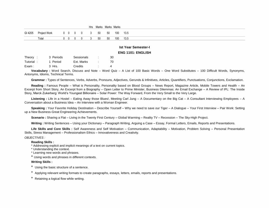
Ist Year Semester-I
ENG 1101: ENGLISH
Theory : 3 Periods Sessionals : 30
Tutorial : 1 Period Ext. Marks : 70
Exam : 3 Hrs. Credits : 4
Vocabulary : Word Search, Discuss and Note – Word Quiz – A List of 100 Basic Words – One Word Substitutes – 100 Difficult Words, Synonyms, Antonyms, Idioms, Technical Terms.
Grammar : Types of Sentences, Verbs, Adverbs, Pronouns, Adjectives, Gerunds & Infinitives, Articles, Quantifiers, Punctuations, Conjunctions, Exclamation.
Reading : Famous People – What is Personality, Personality based on Blood Groups – News Report, Magazine Article, Mobile Towers and Health – An
Excerpt from Short Story, An Excerpt from a Biography – Open Letter to Prime Minister, Business Dilemmas: An Email Exchange – A Review of IPL: The Inside
Story, Marck Zukerberg: World’s Youngest Billionaire – Solar Power: The Way Forward, From the Very Small to the Very Large.
Listening : Life in a Hostel – Eating Away those Blues!, Meeting Carl Jung – A Documentary on the Big Cat – A Consultant Interviewing Employees – A
Conversation about a Business Idea – An Interview with a Woman Engineer.
Speaking : Your Favorite Holiday Destination – Describe Yourself – Why we need to save our Tiger – A Dialogue – Your First Interview – Pair Work: Setting
up a New Business-Great Engineering Achievements.
Scenario : Sharing a Flat – Living in the Twenty First Century – Global Warming – Reality TV – Recession – The Sky-High Project.
Writing : Writing Sentences – Using your Dictionary – Paragraph Writing, Arguing a Case – Essay, Formal Letters, Emails, Reports and Presentations.
Life Skills and Core Skills : Self Awareness and Self Motivation – Communication, Adaptability – Motivation, Problem Solving – Personal Presentation
Skills, Stress Management – Professionalism Ethics – Innovativeness and Creativity.
OBJECTIVES :
Reading Skills : * Addressing explicit and implicit meanings of a text on current topics. * Understanding the context. * Learning new words and phrases.
* Using words and phrases in different contexts.
Writing Skills :
* Using the basic structure of a sentence.
* Applying relevant writing formats to create paragraphs, essays, letters, emails, reports and presentations.
* Retaining a logical flow while writing.

* Planning and executing an assignment creatively.
Interactive Skills :
* Analyzing a topic of discussion and relating to it.
* Participating in discussions and influencing them.
* Communicating ideas effectively.
* Presenting ideas coherently within a stipulated time.
Life Skills and Core Skills :
* Examining self-attributes and identifying areas that require improvement: selfdiagnosis and self-motivation.
* Adapting to a given situation and developing a functional approach to finding solutions: adaptability and problem solving.
* Understanding the importance of helping others: community services and enthusiasm.
LEARNING OUTCOMES:
* The overall performance of the students will be enhanced after the course; they will be in a position to make presentations on topics of current interests – politics, famous personalities, science and technology, tourism, work and business environment, with increased public speaking skills.
* Students will be able to read, listen, speak and write effectively in both academic and non-academic environment.
* The students will be updated with certain real life situations, which they can handle when come face to face.
Prescribed Text Book : Life Through Language: A Holistic Approach to Language Learning. Board of Editors, Pearson Publishers, India 2013.
Life Through Language: An Effective Learning Experience
Life through Language has a systematic structure that builds up communicative ability progressively through the chapters. It will enable the learner to manage confusion; frame question for themselves and others; develop new ideas; support ideas with evidence; express themselves with poise and clarity; and think critically. Acquisition of skills leads to confidence.
Chapter – 1 : People and Places:- Word Search – Ask Yourself – Self-Assessment-I – Self - Assessment – II - Sentence and its types – A Guide book entry – Life in a Hostel-Your Favorite Holiday Destination – Designing a Holiday- Writing Sentences – Self- Awareness – Self-Motivation.
Chapter – 2 : Personality and LifeStyle:- Word Quiz – Verbs – Adverbs – A Big Fat Wedding – Wine and Dine – Going Places – Negotiations – Proving Yourself – Meeting Carl Jung – Describing Yourself – Living in the 21st Century – Using Your Dictionary – Communication – Adaptability.
Chapter – 3 : Media and Environment:- A list of 100 basic words – Nouns – Pronouns – Adjectives – News Report – Magazine Article – User’s Manual for new iPod – A documentary on the big cat – Why we need to save our tigers: A dialogue – Global warming – Paragraph Writing – Arguing a case – Motivation – Problem Solving.
Chapter – 4 : Entertainment and Employment:- One word substitutes – Parts of Speech – Gerunds and infinitives-An excerpt from short story-An excerpt from a biography-A Consultant interviewing employees-Your first Interview-Reality TV-Writing an essay- Correcting Sentences-Integrity Sense of humor.
Chapter – 5 : Work and Business:- A list of 100 difficult words – Articles, Quantifiers – Punctuation – Open Letter to Prime Minister Business Dilemmas: An email exchange – A review of IPL: The Inside Story, Mark Zuckerberg: World’s Youngest Billionaire-A Conversation about a business Idea-Pair Work: Setting up a new business-Recession-Formal Letters-Emails-Reports-Professionalism-Ethics.
Reference Books:
1. Basic Vocabulary. Edgar Thorpe, Showick Thorpe. Pearson P. 2008
2. Quick Solutions to Common Errors in English, Angela Bunt. MacMillan P. 2008
3. Know Your English (Volume 1 & 2), by Dr. S. Upendra, Universities Press, India 2012
4. Business Communication Strategies. Maathukutty Monipally. Tata Mc Grahill P. 2009.
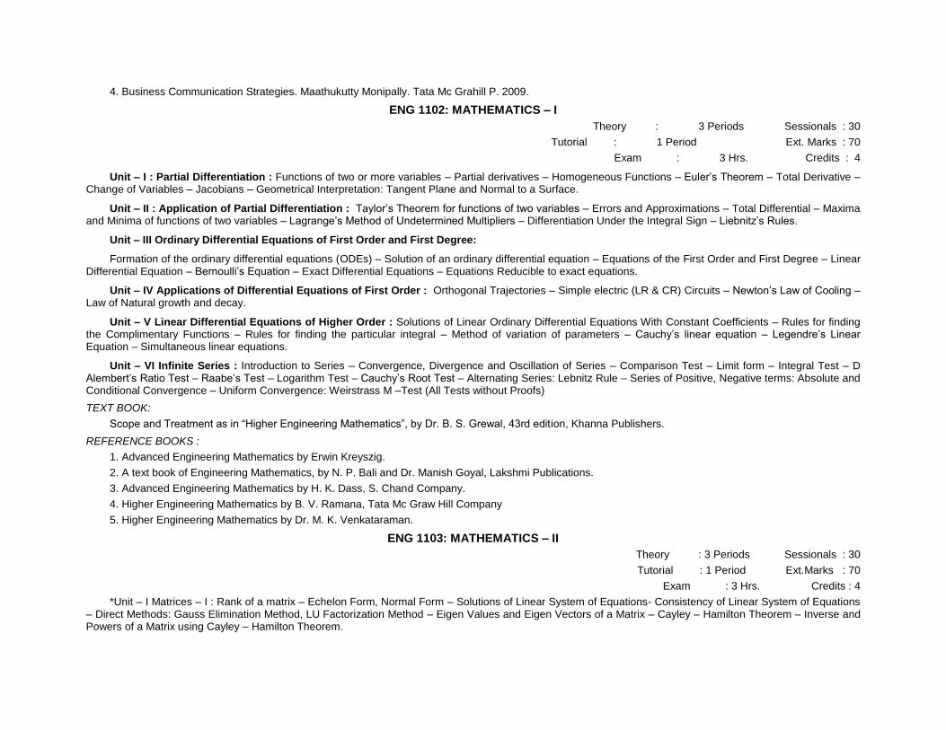
ENG 1102: MATHEMATICS – I
Theory : 3 Periods Sessionals : 30
Tutorial : 1 Period Ext. Marks : 70
Exam : 3 Hrs. Credits : 4
Unit – I : Partial Differentiation : Functions of two or more variables – Partial derivatives – Homogeneous Functions – Euler’s Theorem – Total Derivative – Change of Variables – Jacobians – Geometrical Interpretation: Tangent Plane and Normal to a Surface.
Unit – II : Application of Partial Differentiation : Taylor’s Theorem for functions of two variables – Errors and Approximations – Total Differential – Maxima and Minima of functions of two variables – Lagrange’s Method of Undetermined Multipliers – Differentiation Under the Integral Sign – Liebnitz’s Rules.
Unit – III Ordinary Differential Equations of First Order and First Degree:
Formation of the ordinary differential equations (ODEs) – Solution of an ordinary differential equation – Equations of the First Order and First Degree – Linear Differential Equation – Bernoulli’s Equation – Exact Differential Equations – Equations Reducible to exact equations.
Unit – IV Applications of Differential Equations of First Order : Orthogonal Trajectories – Simple electric (LR & CR) Circuits – Newton’s Law of Cooling – Law of Natural growth and decay.
Unit – V Linear Differential Equations of Higher Order : Solutions of Linear Ordinary Differential Equations With Constant Coefficients – Rules for finding the Complimentary Functions – Rules for finding the particular integral – Method of variation of parameters – Cauchy’s linear equation – Legendre’s Linear Equation – Simultaneous linear equations.
Unit – VI Infinite Series : Introduction to Series – Convergence, Divergence and Oscillation of Series – Comparison Test – Limit form – Integral Test – D Alembert’s Ratio Test – Raabe’s Test – Logarithm Test – Cauchy’s Root Test – Alternating Series: Lebnitz Rule – Series of Positive, Negative terms: Absolute and Conditional Convergence – Uniform Convergence: Weirstrass M –Test (All Tests without Proofs)
TEXT BOOK:
Scope and Treatment as in “Higher Engineering Mathematics”, by Dr. B. S. Grewal, 43rd edition, Khanna Publishers.
REFERENCE BOOKS :
1. Advanced Engineering Mathematics by Erwin Kreyszig.
2. A text book of Engineering Mathematics, by N. P. Bali and Dr. Manish Goyal, Lakshmi Publications.
3. Advanced Engineering Mathematics by H. K. Dass, S. Chand Company.
4. Higher Engineering Mathematics by B. V. Ramana, Tata Mc Graw Hill Company
5. Higher Engineering Mathematics by Dr. M. K. Venkataraman.
ENG 1103: MATHEMATICS – II
Theory : 3 Periods Sessionals : 30
Tutorial : 1 Period Ext.Marks : 70
Exam : 3 Hrs. Credits : 4
*Unit – I Matrices – I : Rank of a matrix – Echelon Form, Normal Form – Solutions of Linear System of Equations- Consistency of Linear System of Equations – Direct Methods: Gauss Elimination Method, LU Factorization Method – Eigen Values and Eigen Vectors of a Matrix – Cayley – Hamilton Theorem – Inverse and Powers of a Matrix using Cayley – Hamilton Theorem.

Unit – II : Matrices – II : Diagonalization of a Matrix – Quadratic Forms – Reduction of Quadratic Form to Canonical Form – Nature of a Quadratic Form – Complex Matrices: Hermitian and Unitary Matrices and their Properties.
Unit – III : Laplace Transforms : Introduction – Existence Conditions – Transforms of Elementary Functions – Properties of Laplace Transforms – Transforms of Derivatives – Transforms of Integrals – Multiplication by tn – Division by t – Evaluation of Integrals by Laplace Transforms – Laplace Transforms of Unit Step Function, Unit Impulse Function and Periodic Functions.
Unit – IV : Laplace Transforms Inverse Laplace Transform – Convolution Theorem – Applications of Laplace Transforms to Ordinary Differential Equations, Simultaneous Linear Differential Equations with Constant Coefficients.
Unit – V : Special Functions : Bessel’s Equation – Bessel’s Functions – Recurrence Formulae for Bessel’s Function – Generating Function – Equations Reducible to Bessel’s Equation – Orthogonality of Bessel’s Functions. Legendre’s Differential Equation – General Solution of Legendre Equation – Legendre Polynomials – Rodrigue’s Formula – Generating Function, Recurrence Formulae, Orthogonality of Legendre Polynomials.
TEXT BOOK:
Scope and Treatment as in “Higher Engineering Mathematics”, by Dr. B. S. Grewal, 43rd edition, Khanna Publishers.
REFERENCE BOOKS:
1. Advanced Engineering Mathematics by Erwin Kreyszig.
2. A text book of Engineering Mathematics, by N. P. Bali and Dr. Manish Goyal, Lakshmi Publications.
3. Advanced Engineering Mathematics by H. K. Dass, S. Chand Company.
4. Higher Engineering Mathematics by B. V. Ramana, Tata Mc Graw Hill Company.
ENG 1105 : PHYSICS
Theory : 3 Periods Sessionals : 30
Tutorial : 1 Period Ext. Marks : 70
Exam : 3 Hrs. Credits : 4
Unit – I : Thermodynamics 8 - Hours : Introduction, Heat and Work, First Law of Thermodynamics and applications, Reversible : and Irreversible Process, Carnot Cycle and Efficiency, Second Law of Thermodynamics, Carnot’s Theorem, Entropy, Second Law in terms of entropy, Entropy and disorder, Third Law of Thermodynamics (Statement Only).
Unit – II : Electromagnetism 16 – Hours
Concept of Electric Flux, Gauss’s Law – Some Applications, Electric Potential and Field Strength, Potential due to Point Charge and Dipole, Magnetic Field – Magnetic Force on Current, Torque on Current Loop, The Biot-Savart’s Law, B near a Long Wire, B for a Circular Current Loop, Ampere’s Law, B for a Solenoid, Hall Effect, Faraday’s Law of induction, Lenz’s law, Inductance, L-R Circuit, Induced Magnetic Fields, Displacement Current, Maxwell’s Equations (Both differential and integral forms), Magnetic Materials: Classification of Magnetic Materials and properties.
Unit – III : 12-Hours
Optics : Interference: Principles of Super Position – Young’s Experiment – Coherence – Inference in thin films, Wedge shaped film, Newton’s Rings, Michelson Interferometer and its applications.
Diffraction: Single slit (Qualitative and Quantitative Treatment)
Polarization: Polarization by reflection, refraction and double refraction in uniaxial crystals, Nicol Prism, Quarter and Half wave plate, Circular and elliptical polarization and detection.
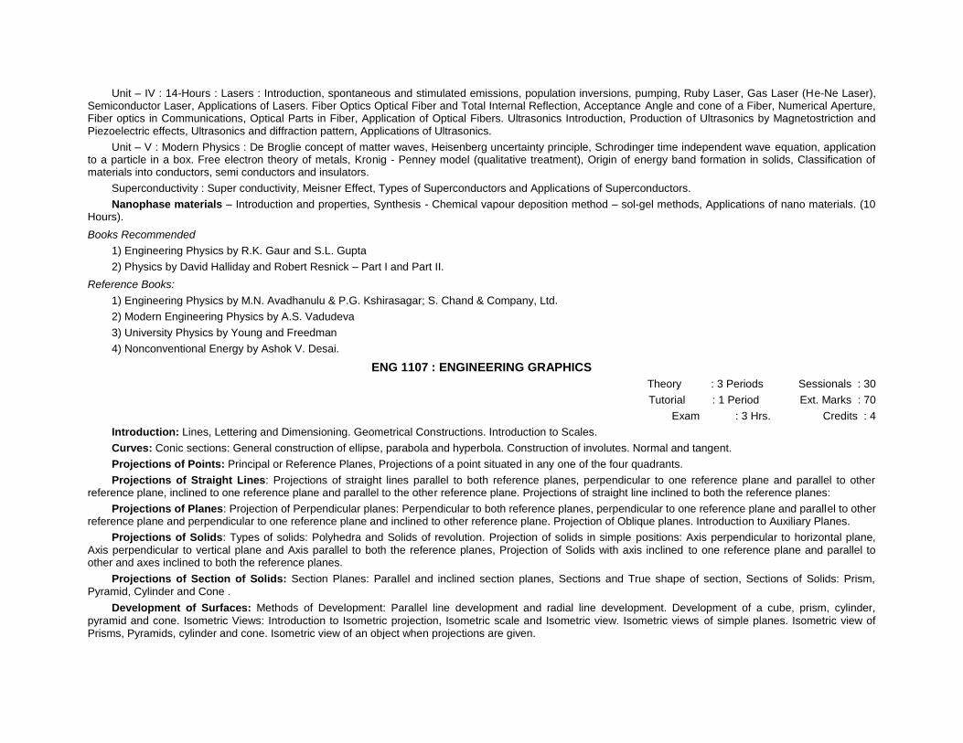
Unit – IV : 14-Hours : Lasers : Introduction, spontaneous and stimulated emissions, population inversions, pumping, Ruby Laser, Gas Laser (He-Ne Laser), Semiconductor Laser, Applications of Lasers. Fiber Optics Optical Fiber and Total Internal Reflection, Acceptance Angle and cone of a Fiber, Numerical Aperture, Fiber optics in Communications, Optical Parts in Fiber, Application of Optical Fibers. Ultrasonics Introduction, Production of Ultrasonics by Magnetostriction and Piezoelectric effects, Ultrasonics and diffraction pattern, Applications of Ultrasonics.
Unit – V : Modern Physics : De Broglie concept of matter waves, Heisenberg uncertainty principle, Schrodinger time independent wave equation, application to a particle in a box. Free electron theory of metals, Kronig - Penney model (qualitative treatment), Origin of energy band formation in solids, Classification of materials into conductors, semi conductors and insulators.
Superconductivity : Super conductivity, Meisner Effect, Types of Superconductors and Applications of Superconductors.
Nanophase materials – Introduction and properties, Synthesis - Chemical vapour deposition method – sol-gel methods, Applications of nano materials. (10 Hours).
Books Recommended
1) Engineering Physics by R.K. Gaur and S.L. Gupta
2) Physics by David Halliday and Robert Resnick – Part I and Part II.
Reference Books:
1) Engineering Physics by M.N. Avadhanulu & P.G. Kshirasagar; S. Chand & Company, Ltd.
2) Modern Engineering Physics by A.S. Vadudeva
3) University Physics by Young and Freedman
4) Nonconventional Energy by Ashok V. Desai.
ENG 1107 : ENGINEERING GRAPHICS
Theory : 3 Periods Sessionals : 30
Tutorial : 1 Period Ext. Marks : 70
Exam : 3 Hrs. Credits : 4
Introduction: Lines, Lettering and Dimensioning. Geometrical Constructions. Introduction to Scales.
Curves: Conic sections: General construction of ellipse, parabola and hyperbola. Construction of involutes. Normal and tangent.
Projections of Points: Principal or Reference Planes, Projections of a point situated in any one of the four quadrants.
Projections of Straight Lines: Projections of straight lines parallel to both reference planes, perpendicular to one reference plane and parallel to other reference plane, inclined to one reference plane and parallel to the other reference plane. Projections of straight line inclined to both the reference planes:
Projections of Planes: Projection of Perpendicular planes: Perpendicular to both reference planes, perpendicular to one reference plane and parallel to other reference plane and perpendicular to one reference plane and inclined to other reference plane. Projection of Oblique planes. Introduction to Auxiliary Planes.
Projections of Solids: Types of solids: Polyhedra and Solids of revolution. Projection of solids in simple positions: Axis perpendicular to horizontal plane, Axis perpendicular to vertical plane and Axis parallel to both the reference planes, Projection of Solids with axis inclined to one reference plane and parallel to other and axes inclined to both the reference planes.
Projections of Section of Solids: Section Planes: Parallel and inclined section planes, Sections and True shape of section, Sections of Solids: Prism, Pyramid, Cylinder and Cone .
Development of Surfaces: Methods of Development: Parallel line development and radial line development. Development of a cube, prism, cylinder,
pyramid and cone. Isometric Views: Introduction to Isometric projection, Isometric scale and Isometric view. Isometric views of simple planes. Isometric view of Prisms, Pyramids, cylinder and cone. Isometric view of an object when projections are given.
Text Book:
Elementary Engineering Drawing by N.D.Bhatt, Charotar Publishing House.
Reference:
Engineering Graphics by K.L. Narayana and P. Kannaiah, Tata Mc-Graw Hill.
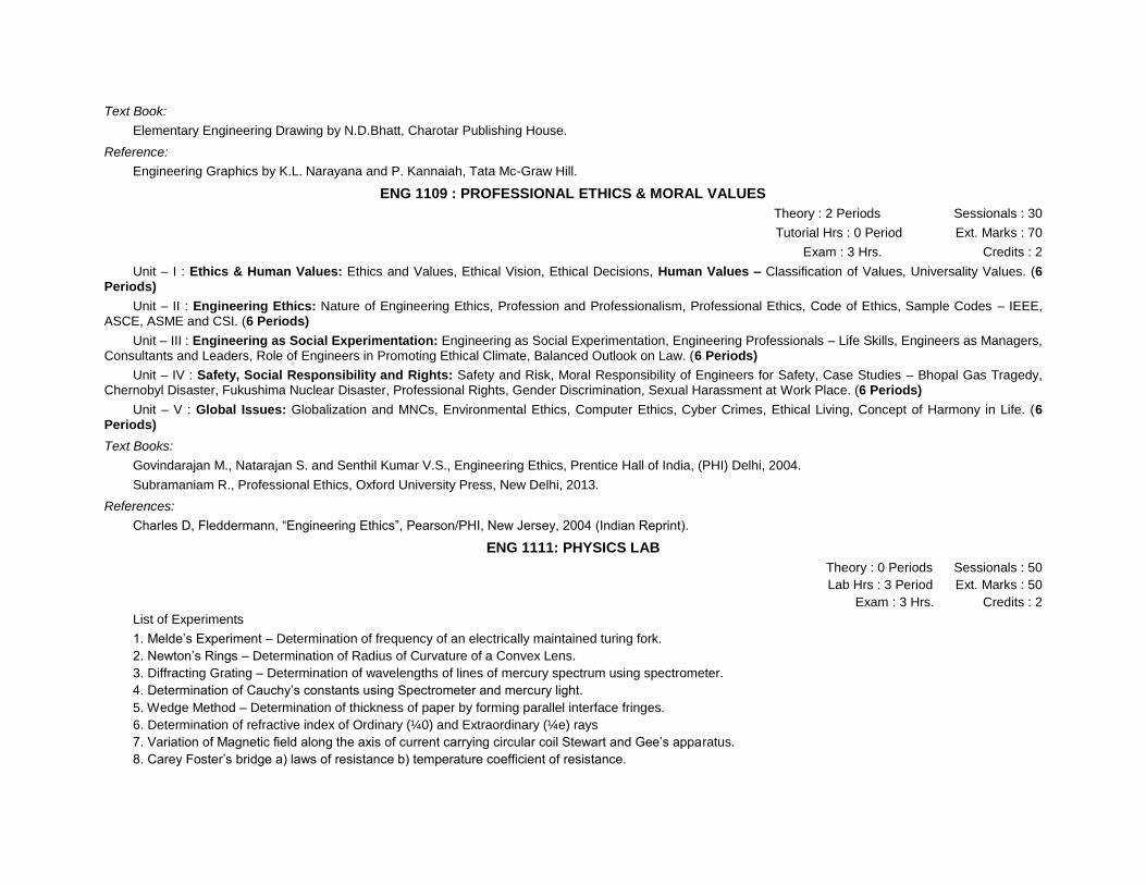
ENG 1109 : PROFESSIONAL ETHICS & MORAL VALUES
Theory : 2 Periods Sessionals : 30
Tutorial Hrs : 0 Period Ext. Marks : 70
Exam : 3 Hrs. Credits : 2
Unit – I : Ethics & Human Values: Ethics and Values, Ethical Vision, Ethical Decisions, Human Values – Classification of Values, Universality Values. (6 Periods)
Unit – II : Engineering Ethics: Nature of Engineering Ethics, Profession and Professionalism, Professional Ethics, Code of Ethics, Sample Codes – IEEE, ASCE, ASME and CSI. (6 Periods)
Unit – III : Engineering as Social Experimentation: Engineering as Social Experimentation, Engineering Professionals – Life Skills, Engineers as Managers, Consultants and Leaders, Role of Engineers in Promoting Ethical Climate, Balanced Outlook on Law. (6 Periods)
Unit – IV : Safety, Social Responsibility and Rights: Safety and Risk, Moral Responsibility of Engineers for Safety, Case Studies – Bhopal Gas Tragedy, Chernobyl Disaster, Fukushima Nuclear Disaster, Professional Rights, Gender Discrimination, Sexual Harassment at Work Place. (6 Periods)
Unit – V : Global Issues: Globalization and MNCs, Environmental Ethics, Computer Ethics, Cyber Crimes, Ethical Living, Concept of Harmony in Life. (6 Periods)
Text Books:
Govindarajan M., Natarajan S. and Senthil Kumar V.S., Engineering Ethics, Prentice Hall of India, (PHI) Delhi, 2004.
Subramaniam R., Professional Ethics, Oxford University Press, New Delhi, 2013.
References:
Charles D, Fleddermann, “Engineering Ethics”, Pearson/PHI, New Jersey, 2004 (Indian Reprint).
ENG 1111: PHYSICS LAB
Theory : 0 Periods Sessionals : 50
Lab Hrs : 3 Period Ext. Marks : 50
Exam : 3 Hrs. Credits : 2
List of Experiments
1. Melde’s Experiment – Determination of frequency of an electrically maintained turing fork.
2. Newton’s Rings – Determination of Radius of Curvature of a Convex Lens.
3. Diffracting Grating – Determination of wavelengths of lines of mercury spectrum using spectrometer.
4. Determination of Cauchy’s constants using Spectrometer and mercury light.
5. Wedge Method – Determination of thickness of paper by forming parallel interface fringes.
6. Determination of refractive index of Ordinary (¼0) and Extraordinary (¼e) rays
7. Variation of Magnetic field along the axis of current carrying circular coil Stewart and Gee’s apparatus.
8. Carey Foster’s bridge a) laws of resistance b) temperature coefficient of resistance.

9. Lee’s Method – Determination of coefficient of thermal conductivity of a abad conductor.
10. Determination of Magnetic Moment and Horizontal (M & H) component of Earth’s Magnetic field.
11. Calibration of voltmeter using potentiometer.
12. Calibration of low range Ammeter using potentiometer.
13. Determination of band gap of semi conductor.
14. Laser – Diffraction
15. Hall Effect - a) Determination of Hall Coefficient b) Determination of change density.
ENG 1113: WORKSHOP
Theory : 0 Periods Sessionals : 50
Lab Hrs : 3 Period Ext. Marks : 50
Exam : 3 Hrs. Credits : 2
Carpentry: Bench Work, tools used in carpentry. Jobs for Class work – half lap joint, mortise and tenon joint, half – lap dovetail joint, corner dovetail joint, central bridle joint.
Sheet Metal: Tools used in sheet metal work, Laying development of the sheet metal jobs, soldering. Jobs for class works – Square tray, taper tray(sides), funnel, elbow pipe joint, 600 pipe joint.
Fitting: Tools used in fitting work, Different files, chisels, hammers and bech vice. Jobs for class work – Square, hexagon, rectangular fit, circular fit and triangular fit.
Reference
Elements of workshop technology, Vol.1 by S. K. and H. K. Choudary.
ENG 1114: SPORTS/NCC/NSS (Audit)
Contact Hrs. : 3 Hrs. Credits : 2
It is only an audit course and the credits are given based on the attendance. Every student should have a minimum of 75% attendance and as per university rules. Every student should choose either sports or NCC or NSS at the starting of the semester and pursue the same in that semester.
Ist Year Semester -II
ENG 1201: MATHEMATICS-III
Theory : 3 Periods Sessionals : 30
Tutorial : 1 Period Ext. Marks : 70
Exam : 3 Hrs. Credits : 4
Unit – I : Solid Geometry
Equations of Striaght Line-Conditions for a line to line in a plane-Coplanar Lines-Shortest Distance between two lines-Intersection of three planes-Equations of Sphere-Tangent Plane to a Sphere-Cone-Cylinder.
Unit – II : Multiple Integrals-1 : Double Integrals-Change of Order of Integration-Double Integrals in Polar Coordinates- Triple Integrals-Change of Variables.
Unit – III : Multiple Integrals-2 : Beta Funtion-Gamma Function-Relation between Beta and Gamma Function-Error Function or Probability Integral-Area enclosed by Plane Curves-Volumes of Solids-Area of Curved Surface-Calculation of Mass-Centre of Gravity-Moment of Inertia-Principal Axes.
Unit – IV : Fourier Series : Introduction-Euler’s Formulae-Conditions for a Fourier Expansion-Functions having points of discontinuity-Change of Interval-Odd and Even Functions-Expansions of Odd or Even Periodic Functions-Half Range Series-Perseval’s Formula.
TEXT BOOK:
Scope and Treatment as in “Higher Engineering Mathematics”, by Dr. B. S. Grewal, 43rd edition, Khanna Publishers.
REFERENCE BOOKS:
6. Advanced Engineering Mathematics by Erwin Kreyszig.
7. A text book of Engineering Mathematics, by N. P. Bali and Dr. Manish Goyal, Lakshmi Publications.
8. Advanced Engineering Mathematics by H. K. Dass, S. Chand Company.
9. Higher Engineering Mathematics by B. V. Ramana, Tata Mc Graw Hill Company
10. Engineering Mathematics Series by Chandrica Prasad.
ENG 1203: CHEMISTRY
Theory : 3 Periods Sessionals : 30
Tutorial : 1 Period Ext. Marks : 70
Exam : 3 Hrs. Credits : 4
Chapter – 1: Water Chemistry
Sources of Water – Impurities and their influence of living systems – WHO Limits – Hardness and its Determination – Boiler Troubles and their removal – Water Softening
Methods – Lime-Soda, Zeolite and Ion Exchange - Municipal Water Treatment-Break
Point Chlorination – Desalination of Sea Water – Reverse Osmosis Method, Electrodialysis. Chapter – 2: Solid State Chemistry
Solids: Classification of Solids – Types of Crystals – Fundamental Laws of Crystal Structure – X-Rays and Bragg’s Law – Imperfections in Crystals – Band Theory of Solids – Chemistry of Semiconductors – Intrinsic, Extrinsic, Compund and Defects – Organic Semi conductors – Super Conductivity – Purification of Solids by Zone refining – Single Crystal Growth – Epitaxial Growth – Liquid Crystals. Chapter – 3: Polymers and Plastics
Polymers: Definition – Types of Polymerization (Addition & Condensation) – Mechanisms of Polymerization – Radical and Ionic – Thermodynamics of Polymerization Process.
Plastics: Thermosetting and Thermoplastics – Effect of Polymer Structure on Properties of Cellulose Derivatives – Vinyl Resins – Nylon (6,6), Reinforced Plastics – Conducting Polymers. Chapter – 4: Corrosion
Corrosion: Origin and Theory – Types of Corrosion: Chemical and Electrochemical; Pitting, Inter granular, Waterline, Stress – Galvanic Series – Factors Effecting Corrosion. Corrosion Controlling Methods: Protective Coatings: Metallic Coatings, Electroplating and Electroless Plating – Chemical conversion Coatings – Phosphate, Chromate, Anodized, Organic Coatings – Paints and Special Paints. Chapter – 5: Building Materials
Portland Cement: Manufacture of Cement – Dry and Wet Process – Chemical Composition of Cement – Setting and Hardening of Cement – Cement Concrete – R.C.C. – Decay of Concrete and Protective Measures – Special Cements.
Refractories: Classification – Properties – Engineering Applications Ceramics: Classification – Properties – Engineering Applications. Chapter – 6: Fuels and Lubricants
Solid Fuels: Wood and Coal, Ranking of Coal – Analysis (Proximate and Ultimate) Coke: Manufacture – Otto Huffmann’s Process – Applications.
Liquid Fuels: Petroleum Refining – Motor Fuels – Petrol and Diesel Oil – Knocking – Octane number – Cetane Number.
Gaseous Fuels: Biogas, LPG and CNG – Characteristics – Applications.
Rocket Fuels: Propellants – Classification – Characteristics
Lubricants: Classification – Mechanism – Properties of Lubricating Oils – Selection of Lubricants for Engineering Applications.
Reference Books:
Engineering Chemistry – PC Jain and M. Jain – Dhanpath Rai and Sons, New Delhi.
A Text book of Engineering Chemistry – S. S. Dara – S. Chand & Co. New Delhi.
Engineering Chemistry – B. K. Sharma – Krishna Prakashan – Meerut.
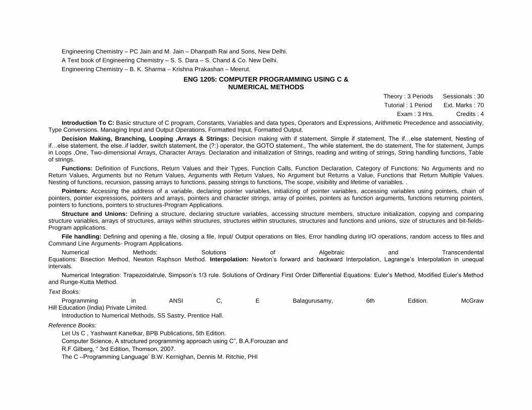
ENG 1205: COMPUTER PROGRAMMING USING C & NUMERICAL METHODS
Theory : 3 Periods Sessionals : 30
Tutorial : 1 Period Ext. Marks : 70
Exam : 3 Hrs. Credits : 4
Introduction To C: Basic structure of C program, Constants, Variables and data types, Operators and Expressions, Arithmetic Precedence and associativity, Type Conversions. Managing Input and Output Operations, Formatted Input, Formatted Output.
Decision Making, Branching, Looping ,Arrays & Strings: Decision making with if statement, Simple if statement, The if…else statement, Nesting of if…else statement, the else..if ladder, switch statement, the (?:) operator, the GOTO statement., The while statement, the do statement, The for statement, Jumps in Loops ,One, Two-dimensional Arrays, Character Arrays. Declaration and initialization of Strings, reading and writing of strings, String handling functions, Table of strings.
Functions: Definition of Functions, Return Values and their Types, Function Calls, Function Declaration, Category of Functions: No Arguments and no Return Values, Arguments but no Return Values, Arguments with Return Values, No Argument but Returns a Value, Functions that Return Multiple Values. Nesting of functions, recursion, passing arrays to functions, passing strings to functions, The scope, visibility and lifetime of variables. .
Pointers: Accessing the address of a variable, declaring pointer variables, initializing of pointer variables, accessing variables using pointers, chain of pointers, pointer expressions, pointers and arrays, pointers and character strings, array of pointes, pointers as function arguments, functions returning pointers, pointers to functions, pointers to structures-Program Applications.
Structure and Unions: Defining a structure, declaring structure variables, accessing structure members, structure initialization, copying and comparing structure variables, arrays of structures, arrays within structures, structures within structures, structures and functions and unions, size of structures and bit-fields- Program applications.
File handling: Defining and opening a file, closing a file, Input/ Output operations on files, Error handling during I/O operations, random access to files and Command Line Arguments- Program Applications.
Numerical Methods: Solutions of Algebraic and Transcendental Equations: Bisection Method, Newton Raphson Method. Interpolation: Newton’s forward and backward Interpolation, Lagrange’s Interpolation in unequal intervals.
Numerical Integration: Trapezoidalrule, Simpson’s 1/3 rule. Solutions of Ordinary First Order Differential Equations: Euler’s Method, Modified Euler’s Method and Runge-Kutta Method.
Text Books:
Programming in ANSI C, E Balagurusamy, 6th Edition. McGraw Hill Education (India) Private Limited.
Introduction to Numerical Methods, SS Sastry, Prentice Hall.
Reference Books:
Let Us C , Yashwant Kanetkar, BPB Publications, 5th Edition.
Computer Science, A structured programming approach using C”, B.A.Forouzan and
R.F.Gilberg, “ 3rd Edition, Thomson, 2007.
The C –Programming Language’ B.W. Kernighan, Dennis M. Ritchie, PHI

Scientific Programming: C-Language, Algorithms and Models in Science, Luciano M.
Barone (Author), Enzo Marinari (Author), Giovanni Organtini, World Scientific
ENG 1207 HISTORY OF SCIENCE & TECHNOLOGY
Theory : 2 Periods Sessionals : 30
Tutorial : 0 Period Ext. Marks : 70
Exam : 3 Hrs. Credits : 2
Objectives of the Course:
* To know the contributions of the scientists for the development of society over a period of time.
* To understand the Science and Technological developments that lead to human welfare.
* To appreciate the Science and Technological contributions for the development of various sectors of the country.
* To identify the technical transfer versus economic progress of the countries. Learning Outcome: By the end of this course the students should be able to understand the contribution of Scientific and Technological developments for the benefit of the society at large.
Unit – I : Historical Perspective of Science and Technology: Nature and Definitions; Roots of Science – In Ancient Period and Modern Period (during the British Period); Science and Society; Role of Scientists in the Society. (6 Periods)
Unit – II : Policies and Plans After Independence:
Science and Technology Policy Resolutions; New Technology Fund; Technology Development (TIFAC); Programs aimed at Technological Self Reliance; Activities of Council of Scientific and Industrial Research. (6 Periods)
Unit – III : Science and Technological Developments in Critical Areas: Space – The Indian Space Program: India’s Geostationary Satellite Services – INSAT System and INSAT Services; Defense Research and Technology – Research Coordination, Research efforts and Development of Technologies and Spin-off Technologies for civilian use; Nuclear Energy – Effects of a nuclear explosion and India’s safety measures. (6 Periods)
Unit – IV : Impact of Science and Technology in Major Areas: Ocean Development: Objective of Ocean Development, Biological Mineral Resources, Marine Research and Capacity Building; Biotechnology: Meaning, Biotechnology Techniques-Bioreactors, Cell Fusion, Cell or Tissue Culture, DNA Finger Printing, Cloning, Artificial Insemination and Embryo Transfer Technology and Stem Cell Technology; Application of Biotechnology – Medicine, Biocatalysts, Food Biotechnology, Fuel and Fodder and Development of Biosensors. (6 Periods) Technology Transfer and Development:
Transfer of Technology – Types, Methods, Mechanisms, Process, Channels and Techniques
Appropriate Technology – Criteria and Selection of an Appropriate Technology; Barriers of Technological Change. (6 Periods)
Text Books:
Kalpanma, Science and Technology in India, Published and Distributed by Spectrum Books (P) Ltd., New Delhi-58.
Srinivasan M., Management of Science and Technology (Problems and Prospects), East – West Press (P) Ltd., New Delhi.
GINF 1208: GEOMORPHOLOGY
Theory : 3 Periods Sessionals : 30
Tutorial Hrs : 1 Period Ext. Marks : 70
Exam : 3 Hrs. Credits : 4
Unit I : Definition and scope of geomorphology; Fundamental concepts in geomorphology; Endogenetic processes: volcanism and tectonism; Exogenetic processes: weathering, Mass-wasting and erosion; geomorphic agents.
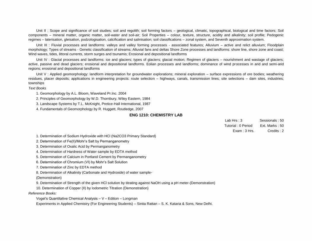
Unit II : Scope and significance of soil studies; soil and regolith; soil forming factors – geological, climatic, topographical, biological and time factors; Soil
components – mineral matter, organic matter, soil-water and soil-air; Soil Properties – colour, texture, structure, acidity and alkalinity; soil profile; Pedogenic
regimes – laterisation, gleisation, podzologisation, calcification and salinisation; soil classifications – zonal system, and Seventh approximation system.
Unit III : Fluvial processes and landforms: valleys and valley forming processes - associated features; Alluvium – active and relict alluvium; Floodplain
morphology; Types of streams - Genetic classification of streams; Alluvial fans and deltas Shore Zone processes and landforms: shore line, shore zone and coast;
Wind waves, tides, littoral currents, storm surges and tsunamis; Erosional and depositional landforms
Unit IV : Glacial processes and landforms: ice and glaciers; types of glaciers; glacial motion; Regimen of glaciers – nourishment and wastage of glaciers;
active, passive and dead glaciers; erosional and depositional landforms. Eolian processes and landforms; dominance of wind processes in arid and semi-arid
regions; erosional and depositional landforms
Unit V : Applied geomorphology: landform interpretation for groundwater explorations; mineral exploration – surface expressions of ore bodies; weathering
residues, placer deposits; applications in engineering projects: route selection – highways, canals, transmission lines; site selections – dam sites, industries;
townships
Text Books
1. Geomorphology by A.L. Bloom, Waveland Pr.Inc. 2004
2. Principles of Geomorphology by W.D. Thornbury, Wiley Eastern, 1984
3. Landscape Systems by T.L. McKnight, Pretice-Hall International, 1987
4. Fundamentals of Geomorphology by R. Huggett, Routledge, 2007
ENG 1210: CHEMISTRY LAB
Lab Hrs : 3 Sessionals : 50
Tutorial : 0 Period Ext. Marks : 50
Exam : 3 Hrs. Credits : 2
1. Determination of Sodium Hydroxide with HCl (Na2CO3 Primary Standard)
2. Determination of Fe(II)/Mohr’s Salt by Permanganometry
3. Determination of Oxalic Acid by Permanganometry
4. Determination of Hardness of Water sample by EDTA method
5. Determination of Calcium in Portland Cement by Permanganometry
6. Determination of Chromium (VI) by Mohr’s Salt Solution
7. Determination of Zinc by EDTA method
8. Determination of Alkalinity (Carbonate and Hydroxide) of water sample-
(Demonstration)
9. Determination of Strength of the given HCl solution by titrating against NaOH using a pH meter-(Demonstration)
10. Determination of Copper (II) by Iodometric Titration (Demonstration)
Reference Books:
Vogel’s Quantitative Chemical Analysis – V – Edition – Longman
Experiments in Applied Chemistry (For Engineering Students) – Sinita Rattan – S. K. Kataria & Sons, New Delhi.

ENG 1212: COMPUTER PROGRAMMING AND NUMERICAL METHODS LAB
Lab Hrs : 3 Sessionals : 50
Tutorial : 0 Period Ext. Marks : 50
Exam : 3 Hrs. Credits : 2
1. Write a program to read x, y coordinates of 3 points and then calculate the area of a triangle formed by them and print the coordinates of the three points and the area of the triangle. What will be the output from your program if the three given points are in a straight line.
2. Write a program which generates 100 random numbers in the range of 1 to 100. Store them in an array and then print the array. Write 3 versions of the program using different loop constructs (eg. for, while and do-while).
3. Write a set of string manipulation functions eg. for getting a sub-string from a given position, copying one string to another, reversing a string and adding one string to another.
4. Write a program which determines the largest and the smallest number that can be stroed in different data types like short, int, long, float and double. What
happens when you add 1 to the largest possible integer number that can be stored ?
5. Write a program which generates 100 random real numbers in the range of 10.0 to 20.0 and sort them in descending order.
6. Write a function for transporting a square matrix in place (in place means that your are not allowed to have full temporary matrix).
7. First use an editor to create a file with some integer numbers. Now write a program, which reads these numbers and determines their mean and standard deviation.
8. Implement bisection method to find the square root of a given number to a given accuracy.
9. Implement Newton Raphson Method to determine a root of polynomial equation.
10. Given a table o x and corresponding f(x) values, write a program which willdetermine f(x) value at an intermediate x value using Lagrange’s Interpolation.
11. Write a function which will invert a matrix.
12. Implement Simpson’s 1/3rd rule for numerical integration.
13. Implement Trapezoidal rule for numerical integration.
14. Write a program to solve a set of linear algebraic equations.
15. Write a program to solve a differential equation using Runge-Kutta Method.
ENG 1213: ENGLISH LANGUAGE LAB
Lab Hrs : 3 Sessionals : 50 Tutorial : 0 Period Ext. Marks : 50
Exam : 3 Hrs. Credits : 2
The Language Lab focuses on the production and practices of sounds of language and familiarizes the students with use of English in everyday situations and contexts.
SYLLABUS
1. English Sound Pattern – Letters
2. Sounds of English
3. Pronunciation
4. Stress and Intonation.
OBJECTIVES: „h To make students recognize the sounds of English through Audio-Visual aids.
* To help students build their confidence and help overcome their inhibitions and self consciousness while speaking in English. The focus shall be on fluency. „h To familiarize the students with stress and intonation and enable them to speak English effectively.
LEARNING OUTCOMES:
* Students will be sensitized towards recognition of English sound pattern.
* The fluency in speech will be enhanced.
Prescribed Text Book:
Speak Well, Board of Editors, Orient Black Swan Publishers, Hyderabad, 2012. Speak Well, the print as well as audio materials, is learner friendly and suitable for use in a multimedia language laboratory. These materials are developed to facilitate practice in improving the intelligibility and communication skills in English, for technical, students at the undergraduate level.
The materials mainly aim at self study, monitory by a teacher whenever essential. The teacher intervention is kept to a minimum, only to give a right direction to the learners.
Communication in any language depends on clarity of speech. This is true of English too. Articulation of the sounds, and pronunciation of sounds from the basis of intelligibility. The few units focus on bringing home the importance of this aspect with copious examples and opportunities for practice. Models of standard pronunciation are given. Explanations are kept short and simple. The IPA symbols, presenting the sound ystem in English, used in this are the same as in standard English dictionaries. These symbols are to be used at the recognition level to facilitate the learners’ use of dictionaryfor pronunciation. Problem areas are pointed out and, where necessary, deviation in the pronunciation of the Indian speakers of English are brought to the notice of the learners. The units called ‘Interactions’ pay attention to the natural conversational skills in different contexts with focus on various functions of the language. Model conversations are provided as samples. Notes on appropriate expressions used in different situations’ drawn the learners, attention the use of language in context. Exercises and activities reinforce the functions introduced.
Unit-1: Letters and Sounds Worksheet-1
Unit-2: Interactions-1 Worksheet-2
Unit-3: The Sounds of English Unit-4: Interactions-2
Worksheet-4
Unit-5: Pronouncing Words-Some important patterns
Worksheet-5
Unit-6: Interactions-3
Worksheet-2
Unit-7: Stress and Intonation
Worksheet-2
Reference Books:
1. Cambridge English Pronouncing Dictionary, Cambridge University Press, India, 2012.
2. A Textbook of English phonetics for Indian students by T. Balasubramanian, Macmillan publisher, 1981.
DISTRIBUTION AND WEIGHTAGE OF MARKS:
1. The practical examination for the English language lab shall be conducted as per the university norms prescribed for the core engineering practical
sessions.

2. For the language lab sessions, there shall be a continuous evaluation during the sesmester for 50 sessional marks and 50 semester end examination
marks.
3. For the 50 sessional marks, 20 marks shall be awarded for day-to-dayperformance, 10 marks to be awarded by conducting internal lab test(s), and 20
marks for worksheets attached to the lab manual.
4. For the 50 semester end (external) marks, 30 marks shall be awarded for written examination (dialogues, the sounds of English and the stress) and 20
marks for external examiner viva-voce, tested by way of reading a passage or a conversation.
NOTE: The external lab shall be conducted by the teacher concerned with the help of another English faculty of affiliated colleges of the university/other
institutions.
ENG 1214: SPORTS/NCC/NSS (Audit)
Contact Hrs. : 3 Hrs. Credits : 2
It is only an audit course and the credits are given based on the attendance. Every student should have a minimum of 75% attendance and as per university
rules. Every student should choose either sports or NCC or NSS at the starting of the semester and pursue the same in that semester.
2nd year Semester-I
GI 2101: INFORMATION TECHNOLOGY AND APPLICATIONS
4th Year Semester-II
L T LH Total University Sessional Total Exam Marks Marks Credits Hrs/Week
4 - - 4 3 70 30 100 3
Unit - I : Computer Fundamentals : Introduction to computers, types of computers, basic components of computer systems-CPU-memory, Input devices-Keyboard, smart cards, Light pen, touch screen, mouse, digitizer. Output devices – Video display devices, flat panel display, printers, audio output (chap 9).
Unit - II : Data Acquisition: Chapters (2,3,4,5) : Acquisition of Numbers and Textual Data: Input units, internal representation of numeric data, representation of characters, error detecting codes. Acquisition of image data : Acquisition of textual data, pictures, storage format for pictures, fundamentals of image compression, image acquisition with digital camera. Acquiring Audio Data : basics of audio signals, acquiring and storing audio signals. Acquisition of Video: Capturing a moving scene with a video camera, compression of video data, MPEG compression standard.
Unit III Computer Software (chap 10) : Overview of Operating Systems: operating system fundamentals, software – system software, application software (overview of Word, Excel, PowerPoint). Overview of Windows; Linux (Windows-Desktop-Control panel -Start menu; Operations on file (new, save, copy, edit, etc).
Unit IV : Business Information Systems and E-commerce (Chap 16, 17) Types of information needed by organizations, Management structure and information needs, design of an operational information system, system life cycle, computer system for transaction processing : E-commerce : Introduction, Business to business, business to customer and customer to customer e-commerce, their advantages and disadvantages. E-commerce system architecture, payment schemes, electronic cheque payment, Cash transactions, EDI, Intellectual properties rights and e-commerce.
Unit V : Computer Networks and Internet (Chapter 8, 15) : Overview of computer Networks and Internet: computer networks - LA N, WAN and their applications, intranet, naming computers connected to internet. Some Internet Applications : Email, Information browsing, WWW, Information retrieval from the web, Other facilities provided by the browser, audio on the internet, pictures, animation, video on the internet. Introduction to applications such as Google maps and Google earth.
Text books :
1. Introduction to Information technology by V. Rajaraman, PHI

Reference Books:
Introduction to Computers by Peter Norton distributions, Functions of random variable, Chebychev inequality.
GI 2102: PROBABILITY AND STATISTICS
4th Year Semester-II
L T LH Total University Sessional Total Exam Marks Marks Credits Hrs/Week
4 1 - 5 3 70 30 100 3
Unit – II : Two Dimensional Random Variables : Marginal and conditional distributions, Covariance, Correlation and Regression, Transformation of random variables, Central limit theorem.
Unit – III : Random Processes: Classification, Stationary and Markov processes, Poisson process, pure birth process, Birth and death process, Markov chains, Markovian queueing models.
Unit – IV : Reliability Engineering : Concepts of reliability, Hazard function, Series and parallel systems, Reliability and Availability of Markovian systems, Maintainability, Preventive maintenance.
Unit – V : Design of Experiments and Quality Control: Completely randomised design, Randomised block design, Latin square design, Process control, Control charts of measurements and attributes, Tolerance limits.
Textbooks
Miller, I.R and Freund, J.D., Probability and Statistics for engineers, Prentice-Hall, 1995
Kapur, J.N and Saxena, H.C, Mathematical statistics, S. Chand & Company Ltd., New Delhi, 1997.
Balagurusamy, E, Reliability engineering, Tata-McGraw Hill Publishers, New Delhi, 1984.
Bhat, U.N, Elements of applied stochastic processes, Wiley Series in Probability and Mathematical statistics, New York, 1983
GI 2103: FUNDAMENTALS OF GEOLOGY
L T LH Total University Sessional Total Exam Marks Marks Credits Hrs/Week
4 1 - 5 3 70 30 100 3
Unit – I : General Geology Branches of Geology – Solar system, Origin of the Earth, Age of the Earth, Interior of the Earth, Isostasy, Elements of seismology, Earthquakes, Volcanoes, Elementary knowledge on continental drift and plate tectonics with evidences. Groundwater.
Unit – II : Mineralogy : Crystal symmetry, forms, twinning; crystal chemistry; optical mineralogy, classification of minerals, diagnostic physical and optical properties of rock forming minerals.– study of the following rock forming minerals – Olivine family, Quartz family, Feldspar family, Amphibole Family, Pyroxene family, Mica family, Garnet – Processes of ore mineral formati on – Coal and petroleum – origin and occurrence in India.
Unit – III : Petrology : Igneous rocks classification, forms, Structures and textures – Description of Granite, Syenite, Diorite, Gabbro, Pegmatite, Dolerite and
Basalt Sedimentary rocks - classification, forms, structures and textures- Description of sandstone, limestone, shale, Conglomerate and breccia. Metamorphic rocks - classification, forms, structures and textures-Description of Quartzite, Marble, Slate, Phyllite, Gniess and Schist, Khondalite, Charnockite. Igneous and metamorphic provinces of India.
Unit – IV : Structural Geology : Strike, Dip, Plunge; Description and classification of folds, faults, Joints and Unconformities; Use of Brunton compass; Clinometer compass

Stratigraphy: Stratigraphic principles; Geological time scale, major stratigraphic divisions of India. -Major geological formation of India: Archaeans group, Cuddapahs system, Vindhyan formations, Gondwana system, Deccan traps, siwaliks . Geology and Mineral Resources of Andhra Pradesh.
Unit – V : Engineering Geology : Geophysical Investigations ( Electrical, Seismic survey) for constructions of dams, reservoirs, buildings, roads, coastal structures, and Tunnels. Importance of geology in construction and development of civil Engineering projects.
Textbooks :
Parbin Singh, “Engineering and General Geology”, Katson Publication House, 1987.
K.M. Bangar “Principles of Engineering Geology. Standard publishers Distributors.
Krynine and Judd, “Engineering Geology and Geotechniques”, McGraw Hill Book Company, 1970.
Reference :
Legeet, “Geology and Engineering”, McGraw Hill Book Company, 1998.
Blyth, “Geology for Engineers”, ELBS, 1985.
GI 2104: OBJECT ORIENTED PROGRAMMING THROUGH C++ AND JAVA
L T LH Total Univ.Exam Sessional Total Credits Pds Hrs Marks Marks Marks
4 1 - 5 3 70 30 100 3
Unit – I : Overview of object oriented programming (OOP): OOP paradigm, basic concepts underlying OOP: data abstraction and encapsulation, objects and classes, inheritance, polymorphism Operator overloading, function overloading, single inheritance, multiple inheritance.
Review of Language constructs of C used in C++ : variables, types and type declarations, user defined data types; increment and decrement operators, relational and logical operators; if then else clause; conditional expressions, input and output statement, loops, switch case, arrays, stacks, queues,structure, unions, functions, pointers; preprocessor directives and examples of these applications in C++.
Unit – II : Creation of Classes and Objects, accessing class members, Private Vs Public, Constructor and Destructor, Objects, Member Functions , Method definition, Inline Function Implementation, Constant member functions, Overloading Member Functions ,Need of operator overloading, prefix and postfix, overloading binary operators and examples in C++.Inheritance and types, protected data, private data, public data, inheriting constructors and destructors, constructor for virtual base classes, constructors and destructors of derived classes, and virtual functions, size of a derived class, order of invocation.
Unit – III : Polymorphism and Virtual Functions ,Importance of virtual function, abstract base classes and pure virtual functions, virtual destructors, File and Streams Components of a file, different operation of the file, communication in files, creation of file streams, stream classes, header files, updating of file, opening and closing a file, file pointers and their manipulations, functions manipulation of file pointers, detecting end-of file.
JAVA Language: Basics of Java, Constants, Variables, and Data Types, Operators and Expressions, Decision Making and Branching, Decision Making and Looping, Class fundamentals, Declaring objects, Assigning object reference variables, Introducing methods, Constructors, The this keyword, Garbage collection, The Finalize() method, A stack class, Over loading constructors, Using objects as parameters, Arguments passing, Returning objects, Recursion.
Unit-IV : Advanced OOP in Java: Arrays, Strings and Vectors Inheritance basics, Member access and inheritance, Using super class, Creating a multilevel hierarchy, Method overriding, Dynamic method dispatch, Using abstract classes, Using final with inheritance, The object class. Packages: Putting Classes.Together, Defining a package, Understanding classpath, Importing Packages, Defining an interface, Implementing interfaces, Applying Interfaces, Variable in interfaces. Multithreaded Programming, Managing Errors and Exceptions.
Unit-V : Applet Programming: The applet class, Applet architecture, An applet skeleton : Initialization and termination, Overriding update, Status window, Handling events: The event class, Processing mouse events, Handling keyboard events, HTML applet tag, Passing parameters to applets, Applet context and show document, The audio clip & applets tub interface, Outputting to the console. Swing concepts, JDBC connectivity Managing Input/Output Files in JAVA.
Textbooks :
1.Object Oriented Programming in C++ by E. Balaguruswamy, TMH Publishing Co. Ltd., New Delhi
2.Mastering C++ by KR Venugopal and Rajkumar, T Ravishankar; Tata McGraw Hill Publishing Co. Ltd., New Delhi.
3) Programming with Java: A Primer, 3E, E BALAGURUSAMY, Tata McGraw Hill
4) The Complete Reference JAVA, Patrick Naughton and Herbert Schildt, Tata McGraw-Hill Publishing Company Ltd.
References:
1) Object Oriented Programming using C++ by B Chandra, Narosa Publishing House Pvt,Ltd., Daryaganj, New Delhi 110002
2)Object Oriented Programming using C++ by R Rajaram , New age International (P) Ltd,Publishers New Delhi
GI 2105: FUNDAMENTALS OF ATMOSPHERIC SYSTEMS
L T LH Total Univ.Exam Sessional Total Credits Pds Hrs Marks Marks Marks
4 1 - 5 3 70 30 100 3
Unit I : The Atmosphere: Nature, origin, composition and vertical structure. Insolation and Heat Budget: Insolation, solar constant, distribution, atmospheric depletion of solar radiation, heat budget, latitudinal heat budget. Temperature of the atmosphere: Heat and temperature, processes of heat energy transfer, heating and cooling of atmosphere; Controls of temperature; Distribution of temperature: Air temperature and its measurement, measurement of sunshine and insolation; Horizontal distribution, seasonal distribution, vertical distribution, temperature inversion.
Unit II : Air Pressure and winds: Measurement of air pressure, variations of air pressure and weather, pressure gradient; Pressure variations: diurnal and seasonal; basic atmospheric pressure patterns; vertical variation in air pressure; horizontal distribution of pressure; seasonal variations in pressure pattern; Wind: Factors affecting wind direction and speed, wind observation and measurement ; wind shift.
General circulation of the atmosphere: Thermal circulation on non-rotating earth, thermal circulation on a rotating earth. Surface wind systems. Departure from idealized circulation pattern; Surface wind systems; Latitudinal shifting of wind belts; Longitudinal variations in air flow patterns; Winds in tropical region; Sub tropical winds; Westerlies; polar winds; Jet stream.
Unit III : Atmospheric Moisture: Sources of atmospheric moisture, humidity measurements, evaporation, factors affecting evaporation, potential evapotranspiration; Clouds: Formation and classification.
Precipitation: Causes, forms, processes, and types, observations of precipitation, regional distribution and seasonal variation of precipitation, artificial precipitation. Monsoons: Economic importance of monsoon, concepts of the origin of monsoon, Asian monsoon; Indian monsoon, burst of monsoon, climatic significance of monsoon.
Unit IV : Weather disturbances: Air masses: source regions, classification, air mass modification. Fronts: General characteristics, frontogenesis and frontolysis, classification of fronts. Tropical disturbances: Types of tropical disturbances, origin of tropical cyclones, movement and tracks of hurricanes, hurricane seasons, regional distribution.
Thunderstorms, tornadoes and waterspouts: Thunderstorms-origin and structure, stage of development, Thunderstorm electricity and thunder, precipitation in thunder storm, classification and distribution; tornadoes and waterspouts.
Unit V : Weather forecasting and analysis: Historical background, how weather forecasting in done, types of weather forecasts, weather forecasting methods, satellites in weather forecasting. Applied climatology: climate and natural vegetation, climate and agriculture, climate and animal husbandry, climate and housing, Air pollution and health, climate and human comfort, climate and urban planning.
Textbooks:
1. Climatology, Lal, D.S., Sharda Pustak Bhawan,11,University road,Allahabad,2003.
2. General climatology, Howard J. Critchfield, Prentice-Hall of India private Limited, New Delhi, 1987.
3. Physical Geography, Tikka, R.N., Kedar Nath Ram Nath &Co, Meerut, 2006.
4. Meteorology Today, C.Donald Ahrens, West Publishing company, New York, Third edition
5. Atmosphere,weather and climate, Siddhartha, K., Kisalaya Publications Pvt.Ltd.,2004.
GI 2106: SURVEYING
L T LH Total University Sessional Total . Exam MIarks Marks Credits Hrs/Week
4 1 - 5 3 70 30 100 4
Unit – 1 : Principles of Surveying, Classification of Surveying, Introduction to various traditional surveys – Chain Surveying: Instruments, Sources of errors – Compass Surveying: Definitions of Bearings, Theory of Magnetic Compass, Problems and errors in compass.
survey – Plane Table Surveying: Working Operations, Leveling – Centering – Orientation, Methods of Plane Table Surveying.
Unit – 2 : Leveling – Methods of Leveling – Dumpy Level: Differential Leveling, Profile Leveling, Cross sections, Reciprocal Leveling, Precise Leveling – BS, FS, IS, HI, TP, reduction of levels – Theodolite: Measurement of horizontal and vertical angles, Open and Closed traversing, Concepts of Trigonometric leveling.
Unit – 3 : Tacheometric Surveying – Principles of Tacheometry, Stadia method - Principle of Stadia method, Distance and Elevation formulae for staff vertical & staff normal, Subtense method - Principle of Subtense method, vertical base observations, horizontal base subtense measurement, methods of reading the staff, Tangential method – constant base tangential measurements, variable base tangential measurements.
Unit – 4 : Concepts of Triangulation – Geodetic surveying, classification of triangulation systems, Triangulation figures and systems, Topographic Surveying – methods of representing relief, contours and contour interval, characteristics of contours, procedure in topographic surveying, contour interpolation.
Unit – 5 : Advanced Methods of Surveying – Electronic devices: Total Station, Global Positioning System, Differential Global Positioning System, Remote Sensing, Aerial Photogrammetry.
Text Books:
B.C. Punmia, Surveying (Volume 2) Laxmi Publications Paul R Wolf and Bon A. Dewitt, Elements of Photogrammetry – With Application in GIS, Mc Graw-Hill.
GI 2107: GEOLOGY AND GEOMORPHOLOGY PRACTICALS
L T LH Total Univ.Exam Sessional Total Credits Pds Hrs Marks Marks Marks
0 0 6 6 3 50 50 100 1.5
a. Geology exercises : Geological maps and sections Identification of some important rock forming minerals. Description and Identification of typical rocks. Description structural models-folds, faults and joints.
b. Geomorphology exercises : Description of landform models Topographic profiles – projected and composite profiles Preparation of slope maps Plane Table Survey Total Station Survey GPS SurveyIntegration of field surveys with various software.
2nd Year Semester-II
GI 2201: PRINCIPLES OF PHYSICAL OCEANOGRAPHY
L T LH Total Univ.Exam Sessional Total Credits Pds Hrs Marks Marks Marks
4 - 0 4 3 70 30 100 3
Unit I : The World Oceans; Physical Properties of Sea Water and their Distribution: Salinity of Sea Water: Factors Affecting Salinity, Salinity Distribution in Oceans. Temperature in the Oceans: Factors Influencing Sea Water Temperature, Temperature Distribution in Oceans. Pressure; Density: Factors Affecting Density of Ocean Water, Density distribution in the Oceans; Colour of Sea Water: Colour Determination, Factors influencing the Colour of Sea Water. Light Transmission in Sea Water: Extinction Coefficients in the Sea, Variation of Extinction Coefficient; Sound Transmission in Sea Water: Velocity of Sound Waves, Variation of Sound Velocity in the Ocean, Refraction of Sound-Shadow Zone and Sound Channel, Attenuation of Sound in the Ocean.
Unit II : Oceanographic Instruments and methods: Sea Water Temperature Measurement, Salinity Measurement, Current Measurement, Ocean Wave Measurements, Tide Measuring Instruments, Water Transparency Measurement, Radiation Measurement and Platform Sea and Airborne and Remote Sensing Satellites, Satellite Navigation, DGPS, Ecosounder.
Unit III : Ocean Waves: Classification of Ocean Waves, Characteristics of Waves, Motion of an Ocean Wave, Wind-Generated Waves, Wave Height Conditions in Different Regions of the Oceans, Deep Water Wave Characteristics in the Arabian Sea and Bay of Bengal of Indian Coasts, Wave Propogation in Shallow Water, Problem Waves. Ocean Tides: Tide Producing Forces, Tide Characteristics, Tidal Theories, Harmonic Analysis and Prediction of Tides, Tidal Ranges and Tidal Periods, Tidal Bore.
Unit IV : Water Masses: Introduction, T-S diagrams, Properties of Water Masses, Types of Water Masses. Ocean Circulation: Introduction, Currents: Some General observations, Factors controlling Ocean Circulation, El Nino, Western Intensification of currents, Currents in Atlantic Ocean, Currents in Pacific Ocean, Currents in Indian Ocean.
Unit V : Sea level changes: Introduction, Evidences for Sea level Changes, Mechanisms of Sea level Changes, Impact of Sea level Change, Impact of Projected Sea level rise. Marine Resources: Introduction, Maritime zones, Types of Marine Resources, Resources: extent, distribution and utilization, Problems of Marine Resources-Marine Pollution, Conservation of Marine Resources.
Text Books:
1. Descriptive Physical Oceanography, Reddy, M.P.M., Oxford & IBH Publishing Co. 2001.
2. Oceanography – A Brief Introduction, Siddhartha, K., Kisalaya Publications, 2004.
3. Introductory Oceanography, Harold V.Thurman, Macmillan Publishing Company, 1994.
4. Introductory Oceanography, J.Weisberg and H.Parish, McGraw-Hill Kogakusha,1974.
5. Descriptive Physical Oceanography, Gorge L. Pickard and William J. Emery, Pergamon Press, Fourth Edition.
GI 2202: PHOTOGRAMMETRY AND PHOTO INTERPRETATION
L T LH Total Univ.Exam Sessional Total . Pds Hrs/Week MIarks Marks Credits 4 1 0 5 3 70 30 100 3
Unit I : Fundamentals of Photogrammetry and photo interpretation; History of aerial photography; Types of photographs: vertical and oblique photographs. Aerial cameras: lens, optical axis, focal length, focal plane and fiducial marks; Principal Point; Geometry of vertical photographs.
Unit II : Scale on vertical photographs – over flat terrain and variable terrain; average photo scale; Methods of determining the scale on vertical photographs Overlap, side lap and flight planning Stereoscopic viewing of vertical photographs; Depth perception; Stereoscopes and their use; Vertical exaggeration – factors involved and determination.
Unit III : Relief Displacement on vertical photographs Determination of horizontal ground lengths, directions and angles from photo coordinates Parallax: Y-parallax and X-Parallax; Parallax measurement – monoscopic method and stereoscopic method – principle of floating mark.
Unit IV : Aerial mosaics: comparison with maps Elements of air photo pattern: rock types, landforms, surface drainage patterns, erosion features, gray tones, vegetative and land use details.
Unit V : Applications of aerial photographic techniques in soil surveys; forest surveys, agricultural and land use planning; geological and geomorphological investigations; civil engineering projects.

Textbooks :
1. ‘Elements of Photogrammetry’ by P.R.Wolf and B.A. Dewitt, McGraw Hill, 2004.
2. ‘Remote Sensing and image Interpretation’ by Thomas M. Lillesand and R.W. Kiefer, John Wiley & Sons, Inc., 2000.
3. ‘Aerial Photographic interpretation’ by Donald R. Lueder, McGraw-Hill 1959.
4. P.J. Curran, Principles of Remote Sensing, ELBS/Longman1985.
GI 2203: REMOTE SENSING - I
L T LH Total Univ.Exam Sessional Total Credits
Pds Hrs Marks Marks Marks
4 1 - 5 3 70 30 100 3
Unit – I : Introduction:
Remote sensing system, Observe Earth from space.Remote sensing-A historic prospective, Indian remote sensing programme. The earth Observation Evolution– Paradigm shift, Legal and ethical aspect. Electro Magnetic Radiation (EMR): Velocity of EM radiation, Propagation of EM waves, Attenuation, quantum nature of EM radiation, Thermal emission, EM radiation for Remote sensing Fundamentals of Radiometry: Measure Geometry-concept of the solid angle, radiometric quantities, Surface characteristic for Radiometric Measurements, Observation geometry in Remote sensing, Radiometric Measurements, scene Reflectance Measurement. Physical Basis of Signature: Signature in the Reflective OIR region, Thermal Infrared (TIR), Microwave region.
Unit – II : EMR Interaction with Atmosphere
Atmospheric characteristics – atmospheric gas composition – pressure and temperature variation with altitude – Rayleigh, Mie scattering and non-selective scattering–atmospheric windows – Atmospheric effects on solar radiation and microwave spectrum–Thermal infrared radiation – Emissivity – Emittance of materials – Kichoff’s Law in spectroscopy – Wien’s Displacement Law, Stefan Boltzmann Law – ocean colour temperature measurement –Introduction to Microwave Remote sensing EMR Interaction with Earth materials: Spectral signature concepts – Factors affecting spectral reflectance of materials. Instruments used to study the spectral reflectance – spectrophotometer – spectro-radiometer.
Unit – III : Remote Sensor –An overview
Classification of Remote sensor, selection of sensor parameters, spatial resolution, spectral resolution, radiometric resolution, Temporal resolution Optical and Infrared sensors: Quality of Image in Optical system, Imaging mode, Photographic camera, Television camera, Opto-mechanical scanners, Opto-mechanical scanners operated from satellites, Push broom cameras, Whisk broom cameras. Microwave sensors.
Unit- IV : Platforms & Sensors
Principles of satellite Missions, Locating satellites in space, Types of Orbit, Airborne platforms – balloons, helicopters, aircrafts – Space borne platforms – Sun synchronous and Geosynchronous satellites – Projectile geometry – Land coverage – Repetitivity – On track and Across track stereovision capability. IRS, LANDSAT, SPOT, CANADA, JAPAN, EUROPEAN, satellite series. Sensors and its specifications Multispectral Scanner (MSS) used in Landsat series satellites Return Beam Vidicon (RBV) used in Landsat series satellites Thematic Mapper (TM) used in Landsat series satellites High Resolution Visible (HRV) Imager used in SPOT Satellite Linear Image Self Scanning (LISS) Camera used in IRS series Thermal Scanners.
Unit-V : Image Interpretation
Introduction to image Interpretation. Basic principles of Image InterpretationElements of Image Interpretation. Techniques of image Interpretation and interpretation Keys Methods of searching and sequence of Interpretation. Methods of analysis and Reference levels.
Textbooks :
1. Lillisand T.M. and Kiefer R.W. Remote Sensing and Image Interpretation (4th ed), John willey and Sons, Inc, New York, 2000
2. Fundamentals of Remote sensing- George Joseph, University Press.
3. Floyd F. Sabins, Jr. Remote Sensing – Principles and Interpretation W.H. Freeman and Company, New York, 1986.

References :
Raymond. M. Measures – “Laser Remote chemical Analyses John Wiley and sons, 1988. Pandey S.N. Principles and Applications of Photogeology. Wiley Eastern, 1987. Druny S.A. Image Interpretation in Geology, Chapman and Hall, London, 1983. Arumugam. M. Engineering Physics, Anuradha Publishers, 1998. Janza. F.J., Blue, H.M., and Johnston, J.E., “Manual of Remote Sensing Vol. I., American Society of Photogrammetry, Virginia, U.S.A., 1975.
GI 2204: ENVIRONMENTAL STUDIES
L T LH Total Univ.Exam Sessional Total Credits
Pds Hrs Marks Marks Marks
4 1 0 5 3 70 30 100 3
Module 1 : Introduction – Definition, scope and importance; measuring and defining environmental development indicators. (1 Lecture)
Module 2 : Ecosystems: introduction, types, characteristic features, structure and functions of Ecosystems – Forest, Grassland, Desert, Aquatic (lakes, rivers and estuaries). (2 Lectures)
Module 3 : Environment and natural Resource Management: Land resources – land as a resource; Common property resources; Land degradation; Soil erosion and desertification; effects of modern agriculture; fertilizer - pesticide problems Forest resources – Use and over-exploitation Mining and Dams – their effect on forest and tribal people Energy resources – Energy needs; renewable and non-renewable energy sources; use of alternative energy sources; impact of energy use on environment (8 Lectures)
Module 4 : Bio-diversity and its conservation Value of bio-diversity – consumptive and productive use; social, ethical aesthetic and option values Bio-geographical classification of India – India as mega diversity habitat Treats to bio-diversity – hotspots; habitat loss; poaching of wildlife; loss of species; seeds, etc.Conservation of bio-diversity – in situ and ex situ conservation (3 Lectures)
Module 5 : Environmental Pollution – Local and Global Issues Causes, effects and control measures of air pollution, indoor air pollution; Water pollution; Soil pollution; Marine pollution; Noise pollution; Solidwaste management – composing, vermiculture; Urban and industrial wastes, recycling and re-useNature of thermal pollution and nuclear hazards; Global warming; Acid rain; Ozone depletion. (8 Lectures)
Module 6 : Environmental problems in India: Drinking water; Sanitation and public health; Effects of activities on the quality of environment, Urbanisation,Transportation, Industrialisation, Green revolution;Water scarcity and Groundwater depletion; Controversies on major dams– resettlement and rehabilitation of people – problems and concerns;Rainwater harvesting; cloud seeding and watershed management. (5 Lectures)
Module 7 : Economy and Environment: The economy and environment interaction,Economics of development, preservation and conservation; Sustainability– theory and practice; Limits of growth; Equitable use of resources for sustainable lifestyles; Environmental impact assessment. (4 Lectures)
Module 8 : Social issues and the environment: Population growth and environment;Environmental education; Environmental movements; Environment vs.developmentEnergy resources: Energy needs; renewable and non-renewable energysources; Use of alternative energy sources; Impact of energy use onenvironment. (2 Lectures)
Module 9 : Institutions and governance: Regulation by government; Monitoring andenforcement of environmental regulation; Environmental Acts: Water (Prevention and control of pollution) act; Air (prevention and control of pollution) act; Environmental protection act; Wildlife protection act; Forest conservation act; Coastal zone regulations Institutions and policies relating to India Environmental governance (5 Lectures)
Module 10 : International conventions: Stockholm Conference 1972; Earth Summit 1972; World Commission for Environmental Development (WCED).
(2 Lectures)
Module 11 : Case Studies: Chipko Movement; Narmada Bachao Andolan; Silent Valley Project; Madhura Refinery and Taj Mahal; Industrialisation of Pattancheru; Nuclear Reactor at Nagarjuna Sagar; Tehri dam; Ralegaon Siddhi (Anna Hazare); Kolleru Lake – aquaculture; Fluorosis in Andhra Pradesh.
(3 Lectures)

Module 12 : Fieldwork: Visit to a local area to document and mapping of environmental assets - river/forest/grass/land/hill/mountain Study of local environment –common plants, insects, birds Study of simple ecosystems – pond, river, hillslopes, etc Visits to industries – water treatment plants, effluent treatment plants. (5 Lectures)
Textbooks:
1. Environmental Studies, A. Kaushik and C.P. Kaushik, New Age International Publishers (P) Ltd.
2. Principles of Environmental Science and Engineering, P. Venugopala Rao, Pretice-Hall India (P) Ltd., New Delhi.
3. Environmental Sciences, P.D. Sarma.
4. Environmental Studies, S. Mukherjee and A. Ghosh, Books and Allied (P) Ltd., Kolkata.
GI 2205: SPATIAL DATA ANALYSIS USING PYTHON PROGRAMMING
L T LH Total Univ.Exam Sessional Total Credits Pds Hrs Marks Marks Marks
4 1 0 5 3 70 30 100 3
Unit-I : Introduction to Phyton- The Basic elements of Phyton, Objects, Expressions, and Numerical Types, Variables and Assignment, IDLE, Branching Programs, Strings and Input, Iteration. Functions, Scoping, and Abstraction- Function Definitions, Keyword Arguments and Default Values, Scoping, Specifications, Recursion, Global Variables, Modules, Files.
Unit-II : Testing and Debugging, Exceptions and Assertions, Classes and Object-Oriented Programming- Abstract Data Types And Classes, Inheritance, Encapsulation And Information Hiding, Mortgages, An Extended Example.
Unit-III : Basic Geoprocessing Scripts With Arcpy- Introduction, Using The Arcgis Python Window, Accessing Arcpy With Python, Executing Tools From A Script, Using Arcgis Desktop Help, Using Variables To Store Data, Accessing Arcpy Modules With Python Managing Map Documents And Layers, Executing Geoprocessing Tools from Scripts.
Unit-IV : PyQGIS- Introduction, Loading Layers, Using Raster Layers, Using Vector Layers, Geometry Handling, Projections Support, Using Map Canvas, Map Rendering and Printing, Expressions, Filtering and Calculating Values, Developing Python Plugins, IDE settings for writing and debugging plugins.
Unit-V : Creating Dynamic maps-Introduction, QGIS Workflows- Creating an NDVI, Geocoding addresses, Creating raster footprints, Performing network analysis, Routing along streets, Tracking a GPS, Creating a mapbook, Finding the least cost path, Performing nearest neighbor analysis, Creating a heat map, Creating a dot density map, Collecting field data, Computing road slope using elevation data, Geolocating photos on the map and Image change detection
Text Books:
1. Zelle, John M. Python programming: an introduction to computer science. Franklin, Beedle & Associates, Inc., 2004.
2. Pimpler, E. (2015). Programming ArcGIS with Python Cookbook. Packt Publishing Ltd.
3. Lawhead, J., 2017. QGIS python programming cookbook. Packt Publishing Ltd. Reference Books:
1. Chaowei Yang, Introduction to GIS Programming and Fundamentals with Python and Arc GIS. ISBN 9781466510081.
GI 2206: ELEMENTS OF CARTOGRAPHY
L T LH Total Univ.Exam Sessional Total Credits Pds Hrs Marks Marks Marks
4 0 0 4 3 70 30 100 3
Unit I : Maps: basic characteristics of maps; types of maps – classified by scale, function and subject matter. Map scale; representation of scale on maps; determining the scale of a map; Geographical coordinates - latitudes and longitudes; Properties of the graticule.
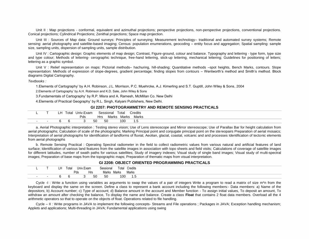
Unit II : Map projections - conformal, equivalent and azimuthal projections; perspective projections, non-perspective projections, conventional projections. Conical projections; Cylindrical Projections; Zenithal projections; Space map projection.
Unit III : Sources of Map data: Ground surveys: Principles of surveying; Measurement technology– traditional and automated survey systems; Remote sensing: aerial photography and satellite-based imaging; Census: population enumerations, geocoding – entity focus and aggregation; Spatial sampling: sample size, sampling units, dispersion of sampling units, sample distribution.
Unit IV : Cartographic design: Graphic elements of map design; Contrast, Figure-ground, colour and balance. Typography and lettering - type form, type size and type colour; Methods of lettering- cerographic technique, free-hand lettering, stick-up lettering, mechanical lettering; Guidelines for positioning of letters;
lettering as a graphic symbol.
Unit V : Relief representation on maps: Pictorial methods– hachuring, hill-shading; Quantitative methods –spot heights, Bench Marks, contours. Slope representation: Methods of expression of slope-degrees, gradient percentage; finding slopes from contours – Wentworth’s method and Smith’s method. Block diagrams Digital Cartography.
Textbooks :
1.Elements of Cartography’ by A.H. Robinson, J.L. Morrison, P.C. Muehrcke, A.J. Kimerling and S.T. Guptill, John Wiley & Sons, 2004
2.Elements of Cartography’ by A.H. Robinson and K.D. Sale, John Wiley & Sons
3.Fundamentals of Cartography’ by R.P. Misra and A. Ramesh, McMillan Co. New Delhi
4.Elements of Practical Geography’ by R.L. Singh, Kalyani Publishers, New Delhi.
GI 2207: PHOTOGRAMMETRY AND REMOTE SENSING PRACTICALS
L T LH Total Univ.Exam Sessional Total Credits Pds Hrs Marks Marks Marks
- - 6 6 3 50 50 100 1.5
a. Aerial Photographic interpretation : Testing stereo vision; Use of Lens stereoscope and Mirror stereoscope; Use of Parallax Bar for height calculation from aerial photographs; Calculation of scale of the photographs; Marking Principal point and conjugate principal point on the stereopairs Preparation of aerial mosaics; Interpretation of aerial photographs for identification of landforms of fluvial, Aeolian, glacial, coastal, volcanic and arid processes Identification of tectonic elements from aerial photographs
b. Remote Sensing Practical : Operating Spectral radiometer in the field to collect radiometric values from various natural and artificial features of land surface; Identification of various land features from the satellite images in association with topo sheets and field visits; Calculations of coverage of satellite images for different latitudes, number of swath paths for various satellites; Study of imagery indexes; Visual study of single band images; Visual study of multi-spectral images; Preparation of base maps from the topographic maps; Preparation of thematic maps from visual interpretation.
GI 2208: OBJECT ORIENTED PROGRAMMING PRACTICALS
L T LH Total Univ.Exam Sessional Total Credits Pds Hrs Marks Marks Marks
- - 6 6 3 50 50 100 1.5
Cycle -I : Write a function using variables as arguments to swap the values of a pair of integers Write a program to read a matrix of size m*n from the keyboard and display the same on the screen. Define a class to represent a bank account including the following members:- Data members: a) Name of the depositors; b) Account number; c) Type of account; d) Balance amount in the account and Member function - To assign initial values, To deposit an amount, To withdraw an amount after checking the balance, To display the name and balance. Create a class Float that contains 2 float data members. Overload all the 4 arithmetic operators so that to operate on the objects of float. Operations related to file handling.
Cycle – II : Write programs in JAVA to implement the following concepts- Streams and File operations ; Packages in JAVA; Exception handling mechanism; Applets and applications; Multi-threading in JAVA; Fundamental applications using swing

3rd Year Semester-I
GI 3101: GEOGRAPHIC INFORMATION SYSTEMS –I
L T LH Total Univ.Exam Sessional Total Credits Pds Hrs Marks Marks Marks
4 1 - 5 3 70 30 100 3
Unit – I : Introduction to Geographical Information Systems: Introduction maps and spatial information. Computer assisted mapping and map analysis, Map Projections – Usage of Maps Geographic Information Systems. The components of geographical Information System; Future directions and trends in GIS Data display, Data Storage, Spatial Indexes, Data analysis tool – Computer Assisted Cartography – Advantages, Disadvantages, GIS and Computer Assisted Cartography – History of GIS – Basic Components of GIS – Hardware, Software, Organizational Context – Comparison of GIS and Hardcopy Maps – GIS Software available in Market.
Unit – II : Data Files and Data bases- Data Types – Non-Spatial Data – Nominal, Ordinal, interval, ratio-Spatial Data – Points, Lines and Polygons / Area – File Types – Simple lists, Ordered Sequential Files – Indexed Files – Data Base – Functions, Data base structures – Hierarchical, Network, Relational.
Unit – III : Raster Data structures - Raster Data Model – Creating a raster – Cell by cell entry, digital data, Scanner – Tesselations – Regular, Irregular – Geometry of Regular Tesselations – Shape, Adjacency, Connectivity, Orientation – Resolution of Regular Cell – Data Encoding, Rule of dominance, Rule of importance, Centre of Cell, Space Filling Curves – Run length, Block, Row Order, Prime Row Order, Peano Order, Pi Order – Variable Resolution regular cells – Quadtree data structure – Irregular Tesselations – Theissen polygons, Triangulation, Delaunay triangles.
Unit – IV : Vector Data Structure - Vector Data Model – Arcs, Storing area – Data Base Creation – Digitizer, On Screen Digitizing – Topology – Euler Equation, Topological Consistency, Topological Errors, Error identification, Topological Editing, Line weeding, Node matching, Dangle truncation, Fuzzy tolerance, Digital Line Graph, Arc Node Structure, DIME etc.
Unit – V : Continuous Surface Representation - Digital Elevation Models – Elevation data capture, Interpolation, DEM representation – Altitude matrix, TIN structure – DEM interpretation, Scale, Visualisation, Applications.
Text Books
Burrough P.A., Principles of Geographical Information Systems for Land Resources Assessment, Oxford University Press. Robert Laurini and Derek Thompson, Fundamentals of Spatial Information Systems, Academic Press, 1996. Paul A Longley, Michael F Goodchild, David J Maguire, David W Rhind, Geographical Information Systems, Volume I and II, John Wiley and Sons, Inc., 1999. Star J. Estes. J GIS – An Introduction, Prentice Hall, NJ, USA, 1990.
GI 3102: COMPUTER GRAPHICS
L T LH Total Univ.Exam Sessional Total Credits
Pds Hrs Marks Marks Marks
4 1 - 5 3 70 30 100 3
Unit 1 : Overview of Graphics Systems Random-scan and raster scan monitors, Color CRT, Plasma panel displays, LCD Panels, Plotters, Film recorders, Graphics workstations, Display processors, Graphics software, Input/Output Devices, Touch panels, light pens, graphics tables. Output primitives Points and lines, DDA, Bresenham’s Line algorithm, parallel line algorithm, line function, circle generating algorithm, filled area primitives and pixel addressing.
Unit II : Two-Dimensional Geometric Transformations and viewing Use of homogeneous coordinate systems, Translation, scaling, rotation, Mirror reflection, Rotation about an arbitrary point, Zooming and panning, Rubber band methods, dragging, Parametric representation of a line segment. Point-line and polygon clipping.
Unit-III : Three-Dimensional Concepts and object representations polygon surfaces, Curved lines and surfaces, Quadric surfaces, Blobby objects, Spline representations, Cubic Spline Interpolation methods, Bezier curves and surfaces.
Unit IV : Three-Dimensional Geometric and Modeling Transformations Translation, Rotation, Scaling, Other Transformations, Composite transformations, Three dimensional transformation functions, modeling and coordinate transformations. Three-Dimensional Viewing Viewing coordinates, projections, Clipping,

Three dimensional viewing functions. Three dimensional viewing. Visible-Surface Detection Methods Back face detection, Depth buffer method, Depth sorting method, Area subdivision method, Visibility detection functions.
Unit V : Illumination Models and Surface-Rendering Methods Halftone Patterns and dithering techniques, Polygon rendering methods, Environment mapping Color Models and Color Applications Properties of light, Intuitive color concepts, RGB, YIQ, CMY, HSV color models.
Textbook:
Computer graphics C version , second edition Donald Hearn & m.Pauline baker
GI 3103: DATABASE MANAGEMENT SYSTEMS
L T LH Total Univ.Exam Sessional Total Credits Pds Hrs Marks Marks Marks
4 - - 4 3 70 30 100 3
Chapter 1 - Databases and Database Users : Introduction , Characteristics of the Database Approach, Actors on the Scene, Workers behind the Scene, Advantages of Using the DBMS Approach, A Brief History of Database Applications, When Not to Use a DBMS.
Chapter 2 - Database System Concepts and Architecture : Data Models, Schemas, and Instances, Three-Schema Architecture and Data Independence, Database Languages and Interfaces, The Database System Environment, Centralized and Client/Server Architectures for DBMSs, Classification of Database Management Systems.
Chapter 3 - Data Modeling Using the Entity-Relationship (ER) Model: Using High-Level Conceptual Data Models for Database Design, An Example Database Application, Entity Types, Entity Sets, Attributes, and Keys, Relationship Types, Relationship Sets, Roles, and Structural Constraints, Weak Entity Types, Refining the ER Design for the COMPANY Database, ER Diagrams, Naming Conventions, and Design Issues, Relationship Types of Degree Higher Than Two.
Chapter 4 - The Relational Data Model and Relational Database Constraints : Relational Model Concepts, Relational Model Constraints and Relational Database Schemas, Update Operations, Tranactions, and Dealing with Constraint Violations.
Chapter 5 - The Relational Algebra and Relational Calculus : Unary Relational Operations: SELECT and PROJECT, Relational Algebra Operations from Set Theory, Binary Relational Operations: JOIN and DIVISION, Additional Relational Operations, Examples of Queries in Relational Algebra, The Tuple Relational Calculus, The Domain Relational Calculus.
Chapter 6 - Relational Database Design by ERand EER - to - Relational Mapping : Relational Database Design Using ER-to-Relational Mapping, Mapping EER Model , Constructs to Relations.
Chapter 7 - SQL-99: Schema Definition, Constraints, Queries, and Views : SQL Data Definition and Data Types, Specifying Constraints in SQL,Schema Change Statements in SQL, Basic Queries in SQL, More Complex SQL Queries INSERT, DELETE, and UPDATE Statements in SQL, Specifying Constraints as Assertions and Triggers, Views (Virtual Tables) in SQL,Additional Features of SQL.
Chapter 8 - Introduction to SQL Programming Techniques : Database Programming: Issues and Techniques, Embedded SQL, Dynamic SQL, and SQLJ Database Programming with Function Calls: SQL/CLI and JDBC, Database Stored Procedures and SQL/PSM.
Chapter 9 - Functional Dependencies and Normalization for Relational Databases : Informal Design Guidelines for Relation Schemas, Functional Dependencies, Normal Forms Based on Primary Keys, General Definitions of Second and Third Normal Forms, Boyce-Codd Normal Form.
Chapter 10 - Relational Database Design Algorithms and Further Dependencies : Properties of Relational Decompositions, Algorithms for Relational Database Schema Design, Multi-valued Dependencies and Fourth Normal Form, Join Dependencies and Fifth Normal Form, Inclusion Dependencies, Other Dependencies and Normal Forms.
Chapter 11 Emerging Database Technologies and Applications : Mobile Databases, Multimedia Databases, Geographic Information Systems (GIS), Genome Data Management.
Textbooks :
Fundamentals of Database Systems, 5/E (Chap 1-3,5-11 and 30) Ramez Elmasri, Shamkant B. Navathe, Pearson Ed.

Reference : Database System Concepts, 5/E Avi Silberschatz, Henry f.Korth, S.Sudarshan, Tata Mc GrawHill.
GI 3104: OPERATIONS RESEARCH
L T LH Total Univ.Exam Sessional Total Credits Pds Hrs Marks Marks Marks
4 - - 4 3 70 30 100 3
Unit I : Overview of operations research: OR models, OR techniques. Linear Programming: introduction, graphical solution, graphical sensitivity analysis, standard form of linear programming problems, basic feasible solutions, unrestricted variables, simplex algorithms, artificial variables, big M and two phase method, degeneracy, alternative optima, unbounded solutions, infeasible solutions.
Unit II : Dual problems, relation between primal and dual problems, dual simplex method, Integer programming, branch and bound algorithms cutting plan algorithm.
Unit III : Transportation model, starting solutions, northwest corner rule, lowest cost method, Vogels approximation method, transportation algorithms, assignment problem, Hungarian method.
Unit IV : Network Models, Project scheduling - CPM and PERT - their algorithms.
Unit V : Dynamic Programming: recursive nature of dynamic programming, forward and backward recursion Game theory: two persons zero sum games, mixed strategy games and their algorithms.
Textbooks :
1) Introductions to operations Research by Hillier/Lieberman, Tata McGraw Hill
2) Operations Research by R.Panneerselvan, prentice Hall of India
GI 3105: REMOTE SENSING - II
L T LH Total Univ.Exam Sessional Total Credits Pds Hrs Marks Marks Marks
4 1 - 5 3 70 30 100 3
Unit-I : Data reception, Data processing & Data generation : Ground station, Global and Indian data products Satellite Data Receiving and data generation Data processing & correction
Unit-II : Radiometric and Geometric corrections : Radiometric corrections Random noise correction Atmospheric correction, Geometric errors and corrections, Distortion evaluated from tracking data, distortion evaluated from ground control Image correction. Ground Investigation in support of Remote sensing Uses of ground data, calibration correction, Interpretation of properties, Training sets, Accuracy evaluation, test sites.
Unit- III : Thermal Imaging : Thermal Imaging: Introduction - IR region of the Electromagnetic spectrum, Atmospheric transmission, Kinetic and radiant temperature, Thermal properties of materials, Emissivity, Radiant temperature, Thermal conductivity, Thermal capacity, thermal inertia, Apparent thermal inertia, Thermal diffusivity IR - radiometers, Airborne and Satellite scanner system Characteristics of IR images, Scanner distortion, image irregularities, Film density and recorded Temperature ranges Effects of weather on images: Clouds, Surface winds, Penetration of smoke plumes; Interpretation of thermal imagery; Advantages of Thermal imagery.
Unit IV : Introduction to Microwave remote sensing : Introduction, Microwaves for Remote sensing, History of Microwave Remote Sensing, The E M R, radar operating principal; Radar equations, Definitions Incidence angle, Look angle, depression angle, Azimuth angle, Spatial Resolutions in Radar, Range Resolution, Azimuth Resolution. Types of Microwave sensors, Real Aperture Radar (RAR), Synthetic Aperture Radar (SAR), Geometry of Radar Imagery, Microwave Radiometers, Microwave Scatterometer, Microwave Altimeter, Airborne and Space born Platforms and Sensors, SEASAT , SIR-A, SIR-B , JERS, ERS and EOS.
Unit - V : Radar data & Data Interpretation : Spatial Resolutions in Radar: Range resolution, Azimuth Resolution, Radar return and Image signature, System properties (Wavelength, Polarization and Incidence angle) Terrain properties: Di-electric constant, Surface Roughness, Feature Orientation. Forms of Radar return: Spectral Reflection, Corner Reflection or Diffused scattering Radar image characteristics, slant range distortion, Relief displacement, Lay-over,
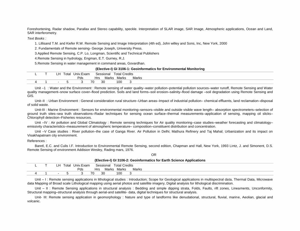
Foreshortening, Radar shadow, Parallax and Stereo capability, speckle. Interpretation of SLAR image, SAR Image, Atmospheric applications, Ocean and Land, SAR interferometry.
Text Books :
1. Lillisand T.M. and Kiefer R.W. Remote Sensing and Image Interpretation (4th ed), John willey and Sons, Inc, New York, 2000
2. Fundamentals of Remote sensing- George Joseph, University Press.
3.Applied Remote Sensing, C.P. Lo, Longman, Scientific and Technical Publishers
4.Remote Sensing in hydrology, Engman, E.T. Gurney, R.J.
5.Remote Sensing in water management in command areas, Govardhan.
(Elective-I) GI 3106-1: Geoinformatics for Environmental Monitoring
L T LH Total Univ.Exam Sessional Total Credits Pds Hrs Marks Marks Marks
4 1 - 5 3 70 30 100 3
Unit –1 : Water and the Environment : Remote sensing of water quality–water pollution–potential pollution sources–water runoff, Remote Sensing and Water quality management–snow surface cover–flood prediction. Soils and land forms–soil erosion–salinity–flood damage –soil degradation using Remote Sensing and GIS.
Unit–II : Urban Environment : General consideration rural structure–Urban areas–Impact of industrial pollution– chemical effluents, land reclamation–disposal of solid waste.
Unit-III : Marine Environment : Sensors for environmental monitoring–sensors–visible and outside visible wave length– absorption spectrometers–selection of ground truth sites–sea truth observations–Radar techniques for sensing ocean surface–thermal measurements–application of sensing, mapping oil slicks–Chlorophyll detection–Fisheries resources.
Unit –IV : Air pollution and Global Climatology : Remote sensing techniques for Air quality monitoring–case studies–weather forecasting and climatology–emissivity characteristics–measurement of atmospheric temperature– composition–constituent distribution and concentration.
Unit –V Case studies : River pollution–the case of Ganga River. Air Pollution in Delhi; Mathura Refinery and Taj Mahal; Urbanization and its impact on Visakhapatnam city environment.
References :
Baretl, E.C. and Culis I.F. Introduction to Environmental Remote Sensing, second edition, Chapman and Hall, New York, 1993 Lintz, J. and Simonent, D.S. Remote Sensing of environment Addision Wesley, Rading mars, 1976.
OR
(Elective-I) GI 3106-2: Geoinformatics for Earth Science Applications
L T LH Total Univ.Exam Sessional Total Credits Pds Hrs Marks Marks Marks
4 1 - 5 3 70 30 100 3
Unit – I : Remote sensing applications in lithological studies : Introduction; Scope for Geological applications in multispectral data, Thermal Data, Microwave data Mapping of Broad scale Lithological mapping using aerial photos and satellite imagery, Digital analysis for lithological discrimination.
Unit – II : Remote Sensing applications in structural analysis : Bedding and simple dipping strata, Folds, Faults, rift zones, Lineaments, Unconformity, Structural mapping–structural analysis through aerial-and satellite- data, digital techniques for structural analysis.
Unit- III: Remote sensing application in geomorphology : Nature and type of landforms like denudational, structural, fluvial, marine, Aeolian, glacial and volcanic.
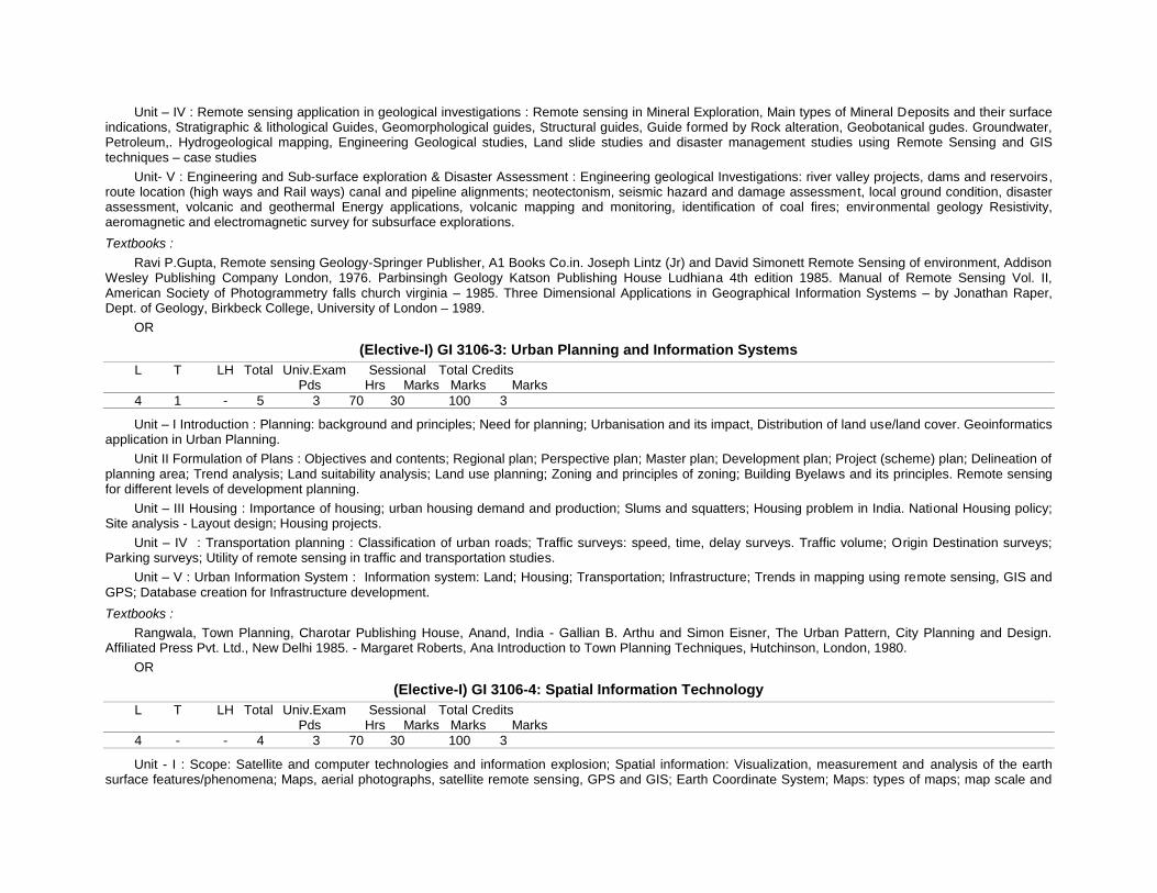
Unit – IV : Remote sensing application in geological investigations : Remote sensing in Mineral Exploration, Main types of Mineral Deposits and their surface indications, Stratigraphic & lithological Guides, Geomorphological guides, Structural guides, Guide formed by Rock alteration, Geobotanical gudes. Groundwater, Petroleum,. Hydrogeological mapping, Engineering Geological studies, Land slide studies and disaster management studies using Remote Sensing and GIS techniques – case studies
Unit- V : Engineering and Sub-surface exploration & Disaster Assessment : Engineering geological Investigations: river valley projects, dams and reservoirs, route location (high ways and Rail ways) canal and pipeline alignments; neotectonism, seismic hazard and damage assessment, local ground condition, disaster assessment, volcanic and geothermal Energy applications, volcanic mapping and monitoring, identification of coal fires; environmental geology Resistivity, aeromagnetic and electromagnetic survey for subsurface explorations.
Textbooks :
Ravi P.Gupta, Remote sensing Geology-Springer Publisher, A1 Books Co.in. Joseph Lintz (Jr) and David Simonett Remote Sensing of environment, Addison Wesley Publishing Company London, 1976. Parbinsingh Geology Katson Publishing House Ludhiana 4th edition 1985. Manual of Remote Sensing Vol. II, American Society of Photogrammetry falls church virginia – 1985. Three Dimensional Applications in Geographical Information Systems – by Jonathan Raper, Dept. of Geology, Birkbeck College, University of London – 1989.
OR
(Elective-I) GI 3106-3: Urban Planning and Information Systems
L T LH Total Univ.Exam Sessional Total Credits Pds Hrs Marks Marks Marks
4 1 - 5 3 70 30 100 3
Unit – I Introduction : Planning: background and principles; Need for planning; Urbanisation and its impact, Distribution of land use/land cover. Geoinformatics application in Urban Planning.
Unit II Formulation of Plans : Objectives and contents; Regional plan; Perspective plan; Master plan; Development plan; Project (scheme) plan; Delineation of planning area; Trend analysis; Land suitability analysis; Land use planning; Zoning and principles of zoning; Building Byelaws and its principles. Remote sensing for different levels of development planning.
Unit – III Housing : Importance of housing; urban housing demand and production; Slums and squatters; Housing problem in India. National Housing policy; Site analysis - Layout design; Housing projects.
Unit – IV : Transportation planning : Classification of urban roads; Traffic surveys: speed, time, delay surveys. Traffic volume; Origin Destination surveys; Parking surveys; Utility of remote sensing in traffic and transportation studies.
Unit – V : Urban Information System : Information system: Land; Housing; Transportation; Infrastructure; Trends in mapping using remote sensing, GIS and GPS; Database creation for Infrastructure development.
Textbooks :
Rangwala, Town Planning, Charotar Publishing House, Anand, India - Gallian B. Arthu and Simon Eisner, The Urban Pattern, City Planning and Design. Affiliated Press Pvt. Ltd., New Delhi 1985. - Margaret Roberts, Ana Introduction to Town Planning Techniques, Hutchinson, London, 1980.
OR
(Elective-I) GI 3106-4: Spatial Information Technology
L T LH Total Univ.Exam Sessional Total Credits Pds Hrs Marks Marks Marks
4 - - 4 3 70 30 100 3
Unit - I : Scope: Satellite and computer technologies and information explosion; Spatial information: Visualization, measurement and analysis of the earth surface features/phenomena; Maps, aerial photographs, satellite remote sensing, GPS and GIS; Earth Coordinate System; Maps: types of maps; map scale and
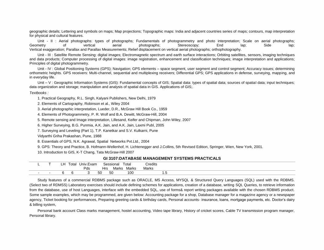
geographic details; Lettering and symbols on maps; Map projections; Topographic maps: India and adjacent countries series of maps; contours, map interpretation for physical and cultural features.
Unit - II : Aerial photographs: types of photographs; Fundamentals of photogrammetry and photo interpretation; Scale on aerial photographs; Geometry of vertical aerial photographs; Stereoscopy; End lap; Side lap; Vertical exaggeration; Parallax and Parallax Measurements; Relief displacement on vertical aerial photographs; orthophotography.
Unit - III : Satellite Remote Sensing: digital images; Electromagnetic spectrum and earth surface interactions; Orbiting satellites, sensors, imaging techniques and data products; Computer processing of digital images: image registration, enhancement and classification techniques; image interpretation and applications; Principles of digital photogrammetry.
Unit - IV : Global Positioning Systems (GPS); Navigation; GPS elements – space segment, user segment and control segment; Accuracy issues; determining orthometric heights. GPS receivers: Multi-channel, sequential and multiplexing receivers; Differential GPS; GPS applications in defense, surveying, mapping, and in everyday life.
Unit – V : Geographic Information Systems (GIS): Fundamental concepts of GIS; Spatial data: types of spatial data; sources of spatial data; input techniques; data organization and storage; manipulation and analysis of spatial data in GIS. Applications of GIS;.
Textbooks :
1. Practical Geography, R.L. Singh, Kalyani Publishers, New Delhi, 1979
2. Elements of Cartography, Robinson et al., Wiley 2004
3. Aerial photographic interpretation, Lueder, D.R., McGraw Hill Book Co., 1959
4. Elements of Photogrammetry, P. R. Wolf and B.A. Dewitt, McGraw-Hill, 2004
5. Remote sensing and Image interpretation, Lillesand, Keifer and Chipman, John Wiley, 2007
6. Higher Surveying, B.G. Punmia, A.K. Jain, and A.K. Jain, Laxmi Publ, 2005
7. Surveying and Leveling (Part 1), T.P. Kanetkar and S.V. Kulkarni, Pune
Vidyarthi Griha Prakashan, Pune, 1988
8. Essentials of GPS, N.K. Agrawal, Spatial Networks Pvt.Ltd., 2004
9. GPS: Theory and Practice, B. Hofmann-Wellenhof, H. Lichtenegger and J.Collins, 5th Revised Edition, Springer, Wien, New York, 2001.
10. Introduction to GIS, K-T Chang, Tata McGraw-Hill 2007
GI 3107:DATABASE MANAGEMENT SYSTEMS PRACTICALS
L T LH Total Univ.Exam Sessional Total Credits Pds Hrs Marks Marks Marks
- - 6 6 3 50 50 100 1.5
Study features of a commercial RDBMS package such as ORACLE, MS Access, MYSQL & Structured Query Languages (SQL) used with the RDBMS.
(Select two of RDMSS) Laboratory exercises should include defining schemes for applications, creation of a database, writing SQL Queries, to retrieve information
from the database, use of host Languages, interface with the embedded SQL, use of forms& report writing packages available with the chosen RDBMS product.
Some sample examples, which may be programmed, are given below: Accounting package for a shop, Database manager for a magazine agency or a newspaper
agency, Ticket booking for performances, Preparing greeting cards & birthday cards, Personal accounts- insurance, loans, mortgage payments, etc. Doctor’s dairy
& billing system,
Personal bank account Class marks management, hostel accounting, Video tape library, History of cricket scores, Cable TV transmission program manager,
Personal library.

GI 3108: GEOGRAPHIC INFORMATION SYSTEMS -I PRACTICALS
L T LH Total Univ.Exam Sessional Total Credits Pds Hrs Marks Marks Marks
- - 6 6 3 50 50 100 1.5
Classification of spatial data, layer and symbol concept using a GIS software, GIS project overview. Exercise on digitizing entities like point, line and polygon
data. Editing and adding labels, cleaning and generating coverage topology. Exercise on scanner and different scanner format and raster to vector conversion.
Attribute data addition andquery generation Simple overlay analysis, map and report output.
MOOCS-I
GI 3109-1, Introduction to Geospatial Technology Using QGIS
This course provides a rich introduction to the booming technology field of Geographic Information Systems, known as GIS. The GIS industry is ex ploding at double-digit employment and income numbers and promises employment opportunities well into the future. Students will learn the fundamentals of GIS and how to build digital maps using open source software that allows free unlimited use for private or commercial applications. All data and software required is included in the course. Topics covered in this course include GIS, cartography, remote sensing, and spatial analysis through a series of lectures and hands-on computer-based exercises. This course is designed to be used as a stand-alone course to complement other disciplines or as an entry level course into a geospatial program. Course content is based upon the United States Department of Labor’s Geospatial Technology Competency Model for entry level geospatial occupations, including Geospatial or GIS Technicians and Technologists.
Learning Outcomes/Competencies
* Describe the fundamental concepts of Geographic Information Science and Technology.
* Demonstrate proficiency in the basic functions of geospatial software.
* Demonstrate awareness of fundamental remote sensing and spatial analysis techniques.
* Demonstrate basic proficiency in map creation and design principles, including thematic map display, employment of map projections, and cartographic design.
* Demonstrate proficiency in the creation and acquisition of spatial data.
Credit
Students have the option to receive continuing education credit from a regionally accredited college.
GI 3109-2 Geodesign: Change Your World
Geodesign: Change Your World
Our world is awash in facts and information, which are now easily accessible. So why are so many bad decisions being made? What is needed is creativity and design that brings those facts to life – to create a vision and choices as well as an understanding about the potential impacts of those choices. The geodesign process has evolved over nearly 40 years and now combines the core concepts of design thinking with the latest in Geodesign is a proven form of design that uses techniques and practices from a multitude of professions to determine optimal ways to design for complex land use challenges. It is a collaborative process that capitalizes on the strengths of people with a variety of expertise to create and implement unique models to aid in the design decision-making process.
3rd Year Semester-II
GI 3201: GEOLOGICAL ENGINEERING
L T LH Total Univ.Exam Sessional Total Credits Pds Hrs Marks Marks Marks
4 1 - 5 3 70 30 100 3
Unit-I : Introduction of palaeontology, Morphology, classification and geological significance of important invertebrates, vertebrates, microfossils and palaeo flora; Coal and petroleum geology; marine geology and ocean resources.
Unit II : Magmatic differentiation; phase diagrams and trace elements as monitors of magma evolutionary processes; mantle melting models and derivation and primary magmas. Metamorphism; controlling factors, metamorphic facies, grade and basic types; metamorphism of pelitic, mafic and impure carbonate rocks; role of fluids in metamorphism; metamorphic P-T-t paths and their tectonic significance; structure and petrology of sedimentary rocks; sedimentary processes and environments, sedimentary facies. Engineering properties of Rocks: compressive strength triaxial tensile strength, shear strength, modulus of elasticity, poisons ratio. Engineering classification of rock masses.
Unit III : Stress, strain and material response; brittle and ductile deformation; primary and secondary structures; geometry and genesis of folds, faults, joints, unconformities; cleavage, schistosity and lineation; methods of projection, tectonites and their significance; shear zone; superposed folding; basement cover relationship.
Unit IV : Ore mineralogy and optical properties of ore minerals; ore forming processes vis-à-vis ore-rock association (Magmatic, hydrothermal, sedimentary and metamorphogenic ores); ores and metamorphism; fluid inclusions in ore prospecting and exploration of economic minerals; sampling, ore reserve estimation, geostatistics, mining methods. ore dressing and mineral economics.
Unit V : Cosmic abundance; meteorites; geochemical evolution of the earth; geochemical cycles, carbon, phosphorous, nitrogen, sulphur, distribution of major, minor and trace elements; elements of geochemical thermodynamics, isotope geochemistry; geochemistry of waters including solution equilibria and water rock interaction.
TextBooks :
1. Rutley’s Elements of Mineralogy, C.D. Gribble, Frank Rutley, H.H. Read, Unwin Hyman, 1989.
2. The Principles of Petrology, G.W. Tyrrell, B.L. Publ., 1994.
3. Structural Geology, M.Billings, Prentice Hall, 1984.
4. An introduction to crystallography, F.C. Phillips, Wiley, 1972.
5. Engineering Geology, P.Singh, S.K. Kataria & Sons.
6. Principles and Applications, G. Faure, Prentice, 1998.
Reference :
1. Igneous and Metamorphic Petrology, F.J. Turner and J. Verhoogen, McGraw Hill
2. Sedimentary rocks, F.J. Pettijohn, CBS Publ.,
3. Ore Microscopy, E.N. Cameron, John Wiley.
GI 3202: GEOGRAPHIC INFORMATION SYSTEMS–II
L T LH Total Univ.Exam Sessional Total Credits Pds Hrs Marks Marks Marks
4 1 - 5 3 70 30 100 3
Unit – I :Spatial Data Manipulation and Transformation : Line intersections – Point-in-line, Point-in-segment, Point-in-polygon, line intersection with polygons, Union and Intersections of Polygons, shape measures of polygons, buffer zones – Data Transformation – Change in Dimensionality, Change in position – Rubber Sheeting, Tin Sheeting – Vector to Raster, Raster to Vector Conversion.
Unit – II: Spatial and Non-spatial Data Analysis – Raster and Vector : Display of raster data–Local operators–recoding, overlaying–Local Neighbourhood operators–Filtering, Slopes and Aspects – Extended Neighbourhood operators–Distance, Buffer zones, Visible area or Viewshed –Zonal operations–Zone identification, Zone area, Zone Perimeter, Distance from Zone boundary –Vector data–Polygon overlay, polygon statistics, Network Analysis–Non-spatial data analysis–Structured Query Language.

Unit – III: Spatial Modeling : Modeling – Definition – Spatial Modeling – External Model, Conceptual Model, Logical Model, Internal Model – GIS applications in Resource Management – AM / FM studies.
Unit – IV: Data Quality and Error Data Propagation in GIS : Data Quality–Accuracy –Spatial Accuracy, Temporal Accuracy, Thematic Accuracy– Resolution – Spatial resolution, thematic Resolution, Temporal resolution–Consistency– Completeness– Data Quality in Spatial Data Transfer Standards–Lineage, Positional, Attribute accuracy, Logical Consistency, Completeness–Error Propagation.
Unit – V: Miscellaneous Topics : Multi Criteria Evaluation in GIS – Data capture using GPS for GIS FM studies – Object Oriented Database Models. Recent trends in GIS.
Text Books :
Burrough P.A., Principles of Geographical Information System for Land Resources Assessment, Oxford University Press. Robert Laurini and Derek Thompson, Fundamentals of Spatial Information Systems, Academic Press, 1996. Paul A Longley, Michael F Goodchild, David J Maguire, David W Rhind, Geographical Information Systems, Volume I and II, John Wiley and Sons, Inc., 1999. Star J. Estees, J GIS – An Introduction, Prentice Hall, NJ, USA, 1990.
GI 3203: ARTIFICIAL INTELLIGENCE
L T LH Total Univ.Exam Sessional Total Credits Pds Hrs Marks Marks Marks
4 - - 4 3 70 30 100 3
Unit – I : Introduction to Artificial Intelligence: overview of AI, definition of AI, relationship between AI systems and other computing systems, comparison between AI programming and other conventional programming. Sub areas of AI, key issues of AI research, AI problems, AI techniques, problem characteristics and production systems.
Unit – II : Knowledge representation: knowledge - general concepts, Procedural vs. declarative knowledge, formal systems, symbolic representation- syntax and semantics of FOPL, Properties of w.f.f, clausal forms, resolution and unification, structural representation - semantic nets, conceptual graphs, conceptual dependencies, frames and scripts, probabilistic reasoning - Bayesian networks, non-monotonic reasoning - TMS.
Unit – III : AI languages: LISP-basic list manipulation functions, predicates, LISP constructs, I/O operations in LISP, iteration and recursion in LISP, prolog- syntax characters, predicates, rules, facts and goals in LISP variables, conjunctions, operators, back tracking, I/O operations and cut predicates.
Unit – IV : Search and control strategies- example of search problems, uninformed search - BFS, DFS and comparisons, heuristic search - hill climbing, best - first search, constraints satisfaction and means end analysis, matching techniques.
Unit – V : Expert system – rule-based systems, backward vs. forward chaining, expert system shells, natural language processing - syntactic and semantic analysis, pragmatic processing, examples of NLP systems, goal state planning, non-linear planning and Hierarchical planning.
Text Books :
1. Artificial Intelligence by E. Rich & Knight K- Tata McGraw-Hill
2. Introduction to Artificial Intelligence by O.W.Patterson- Prentice-Hall India
3. Artificial Intelligence for R. Schelkoff, McGraw-Hill.
GI 3204: GEODESY AND GPS
L T LH Total Univ.Exam Sessional Total Credits Pds Hrs Marks Marks Marks
4 - - 4 3 70 30 100 3
Unit I : Basic principles of Geodesy; History of Geodesy; Spherical Earth; Ellipsoidal Earth; Geoidal Earth; Geodetic Survey Systems; Horizontal Positioning – Determination of Astronomic position, Triangulation, Trilateration; Vertical Positioning.

Unit II : Fundamentals of Reference Systems and Frames: Geodetic and Cartesian coordinate system; principles of coordinate transformation; Datums: Horizontal and vertical datums – national, regional and local datums; Major datums and Indian datum; World Geodetic System (WGS) WGS84; tidal datums.
Unit III : Satellite Geodesy: definition; observational systems: Historical systems; Doppler; laser; radar altimetry.
Unit IV : Global Positioning System (GPS): Definition; GPS elements – space segment, user segment and control segment; Observation principles; phase measurement techniques; determining orthometric heights; GPS Error Sources and Error Handling Procedures: Atmospheric effects, clock and orbital errors, multipath, anti-spoofing and selective availability, etc; interference and jamming. Accuracy issues, GPS satellite navigation message; GPS time, fundamental and derived frequencies.
Unit V : GPS receivers: Multi-channel, sequential and multiplexing receivers; GPS applications: Defense, civilian, Navigational and Geodetic applications; GPS-GIS integration; GPS applications in surveying, mapping, GIS and land navigation and precision farming; integration with other sensors: GPS in intelligent transportation and fleet management.
Textbook :
1.Physical Geodesy by Weikko A. Heiskanen and Helmet Moritz, Freeman and Company.
2.The gravity field of the Earth, International Geophysics Series- Vol-10 by Michele Caputo, Academic Press, New York.
3.Global Positioning System – Theory and Practice – Hofmann W.B, Lichtenegger. H, Collins. J – Springer Verlag Wein, New York.
4.GPS: Theory and Practice, B. Hofmann-Wellenhof, H. Lichtenegger and J.Collins, 5th Revised Edition, Springer, Wien, New York, 2001.
5.GPS Satellite Surveying, A. Leick, 2nd edition, John Wiley & Sons, 1995
6.GPS: Theory and applications, B. Parkinson, J. Spilker, Jr. (Eds), Vol. I & II, AIAA, 370 L’Enfant Promenade SW, Washington, DC20024, 1996
7.GPS for Geodesy, A. Kleusberg and P. Teunnisen (Eds), Springer-Verlag, 1996.
8.Surveying, F. Moffitt and J. Bossler, 10th edition, Addison Wesley Longman, Inc., 1998, Chapter 10: The Global Positioning System, pp. 349-368 (optional)
GI 3205: DIGITAL IMAGE PROCESSING-1
L T LH Total Univ.Exam Sessional Total Credits Pds Hrs Marks Marks Marks
4 1 - 5 3 70 30 100 3
Unit -1 : Introduction – Introduction to data sources, Characteristics of digital Image data, spatial data sources, Digital data acquisition, Digital Image Data formats, Image processing system considerations.
Unit-2 : Initial Statistics Extraction – Univariate and Multivariate Statistics, Histogram – Contrast modification of Image data, Histogram Equalization, Histogram matching, Density slicing.
Unit-3 : Image Pre-processing – Sources and Corrections of Radiometric distortions, Sources and Corrections of Geometric distortions, Image registration.
Unit-4 : Interpretation of Digital Image Data – Approaches to Interpretation, Forms of Imagery for image interpretation, Computer processing for image interpretation, Quantitative analysis.
Unit-5 : Image Enhancements – Image Reduction & Magnification, Transects, Geometric Enhancement using Image Domain techniques – Neighborhood Operations, Template Operators, Convolution Operation, Spatial Filtering, Edge Detection, Line Detection, Texture, Spatial Correlation – The Semi variogram, Shape Detection.
Textbooks :
John, R.Jensen. Introductory Digital Image Processing – Prentice Hall, New Jersey, 1986 John A. Richards – Xiuping Jia. Remote Sensing Digital Image Analysis – An Introduction – Springer Berlin Heidelberg, New York.

Elective-II GI 3206-1: Geoinformatics for Ocean Resources Evaluation
L T LH Total Univ.Exam Sessional Total Credits Pds Hrs Marks Marks Marks
4 1 - 5 3 70 30 100 3
Unit – I : Interaction of EMR with water: Definitions, wave particle duality, Maxwell’s equations, Interaction of EMR with water. Fresnel’s equation, scattering, absorption. Fundamentals of Ocean Optics and their utility in Remote sensing of Ocean Colour. Attenuation Coefficient, Scattering coefficient, Subsurface Diffused Reflectance Beam attenuation coefficient.
Unit – II : Retrieval of Oceanic parameters from ocean colour sensor (Techniques, Algorithms and Applications): Atmospheric Correction: Rayleigh Scattering, Mie Scattering, Atmospheric absorption, Atmospheric correction procedure for Ocean colour sensors, Computation of aerosol optical thickness. Applications of RS data for pigment mapping & productivity estimation, Suspended Sediment Concentration, Ocean Colour Mapping.
Unit – III : Principles of TIR/Passive microwave radiometer, Retrieval of Oceanographic parameters (SST, WV, Wind Speed): Physics of thermal radiation, Planck’s radiation law, Stefan- Boltzman Law, Wein’s law. Physical principles of passive radiometry, Rayleigh-Jeans approximation; Microwave property of sea water; Dielectric constant. Retrieval method of SST, Water vapour and wind speed from the satellite. Principles of SAR, Altimeter, Scatterometer and their applications in Ocean Studies: Principles of Satellite Altimeter, measurements of ocean current, Tidal observation, Ocean topography.
Unit – IV : Remote Sensing Applications in Coastal Marine Ecology. Fundamentals of marine ecology: Eco-system structure & organization, Bio-pyramids pelagic, non – pelagic, benthos, beach and sub-tidal ecology, coastal dune ecosystem, plant-animal interaction, coastal wetlands, salt mashes and mangroves. Remote Sensing application in coastal and marine ecology (mangrove, coral reefs, sea grass etc.): Remote sensing applications for the study of mangroves, coral reefs, sea grass. Integration of in situ data with remote sensing data for assessment of costal features. Coastal eco-system mapping and monitoring, Sea Level Change and impact on Coastal/Estuary/Lagoonal Ecosystem: Role of RS. Sea level change and its impact on Coastal Estuary/Lagoonal ecosystem.
Unit – V : Marine GIS (MGIS) Ocean State Forecasting: Materials and methods for Ocean State Forecasting. Ocean Observing System (GPS, Ships, Buoys, Platforms): Principles of GPS, Conventional methods for marine observations, Sensor performance in coastal studies: camera, multispectral scanners, thermal scanner, laser sensor, Microwave radiometer, Radar altimeter, scatterometer.
Textbooks
1. Introduction to Satellite Oceanography, 1985, G. A. Maul, Martinus Nijhoff Publishers, Dordrecht.
2. Satellite Oceanography, 1985, I. S. Robinson, Ellis Horwood, New York.
3. Marine Optics, 1976, N. G. Jerlov, Elsevier, Amsterdam.
4. Remote Sensing Applications in marine Science & Technology, 1982, Edited by
A. P. Cracknell, Dorderecht D. Reidel.
5. Ocean Environmental Management, 1995, Ernst Frankel, Printice hall PTR, New Jersey.
6. SEA management, 1992, A theoretical Approach, Adal berto Vallega, Elsevier Science Publishers.
OR
Elective-II GI 3206-2: Mathematical Morphology in Image Processing
L T LH Total Univ.Exam Sessional Total Credits Pds Hrs Marks Marks Marks
4 1 - 5 3 70 30 100 3
Unit - I : Overview of mathematical morphology-Basic set theory and logical operations- Euclidean space- continuous and discrete space-Image Representation-Image and grey level images-shapes-quantisation-shape-binary images- translation-rotation-scaling.

Unit - II : Mathematical Morphology-Binary Mathematical Morphology-Erosion, Dilation, Opening, Closing Hit or Miss Transformation-Basic morphological algorithms-boundary extraction-region filling-Convex Hull-Thinning-Thickening.
Unit - III : Digital Skeletons-Grey Scale Mathematical Morphology-Grey scale Erosion-Grey Scale dilation-Grey Scale Opening and Closing-Application of grey scale morphology-(Non- Linear filtering techniques)-Morphological Smoothening-Morphological gradient-Black and White Top-Hot transformations.
Unit - IV : Binary and Grey level image segmentation-Skeletization by Zone of Influence Technique-Watershed segmentation technique- Segmentation of SPOT, RADARSAT, ERS SAR, and IRS data-Morphology based noise removal techniques for Microwave remote sensing data analysis-Granulometries for feature analysis.
Unit - V : Exact dilations-Distance-transformations-Exact distance transforms through exact dilations-Vornoi Diagrams (Graph Theory)-Scale space skeletonization-Multi-scale morphological transformations-Shape Morphology for DEM analysis and terrain characterization.
Textbooks
J. Serra, Image Analysis and Mathematical Morphology, Academic Press (London), 1982, p. 610 C. R. Giardina and Edward Dougherty, Mathematical Morphology in Image and Signal Processing, Prentice Hall, New Jersy, 1988. suggested Reading Gonzalez, Digital Image Processing R. M. Haralick, and L. G. Shapiro, Computer and Robot Vision, Addison Wesley, Reading, v. 1, 1992, p. 453-507. Technical Periodicals: IEEE Geosciences and Remote Sensing, IEEE Pattern Analysis & Machine Intelligence, IEEE Image Processing, IEEE Signal Processing.
OR
Elective-II GI 3206-3: Geoinformatics for Forestry and Ecology
L T LH Total Univ.Exam Sessional Total Credits Pds Hrs Marks Marks Marks
4 1 - 5 3 70 30 100 3
Unit I. Forest Classifications : Natural vegetation of India and its classification: Concept of natural vegetation, forest / vegetation types of India and its classification. Spectral properties of vegetation & other features: Spectral response from vegetation under different spectral regions, effects of phenological changes on spectral behaviour, spectral signatures etc. Aerial photo interpretation for forestry and ecological information extraction:Qualitative characteristics for interpretation of forest types, specifications for aerial remote sensing data, forest mapping using aerial photographs.
Unit – II Forest Mapping : Visual interpretation of Satellite imagery and Change Detection: Image elements for extraction of vegetation related information from space borne images, monitoring forest change and damage by visual interpretation. Digital image processing for forest vegetation, mapping and change detection.
Unit – III Microwave remote sensing and its applications in forestry : Concepts involved in interpretation of micro wave remote sensing data for forest and land use information extraction, merging multi spectral and microwave data, utility for volume/density classification. Forest Canopy Density mapping.
Unit IV. Forest Management (FM) : Forest fire assessment and risk zonation: Concepts and introduction about fire behaviour; Fire mapping possibilities using RS data; Identification of fire prone areas using RS and GIS based spatial modeling. Forest resources information system: Concept of forest resources information system, compilation, integration and interpretation of information for forest management.
Unit V : Forest ecology Ecological principles and concepts:Ecological principles and concepts, Ecological approaches for evaluation of various ecosystems. Structural analysis of vegetation: Spectral vegetation indices and enhancing; vegetation response in remote sensing data, Vegetation classification and mapping using RS data for ecological studies-terrestrial, wetland and Estuarine vegetation, Phytosociological analysis. Functional analysis of vegetation and biomass estimation:Biological productivity components and their relationship with remote sensing data; Bio-productivity cycle; Terrestrial ecology; Biomass estimation. Landscape ecology: Concepts of landscape ecology, parameters involved in landscape study, landscape analysis approaches, etc. Environmental impact assessment:
REFERENCE :
Manual of Remote Sensing by American Society of Photogrammetry (latest edition) Principles of Remote Sensing by P. J. Curran (1985).
Revised Forest Types of India by H. G. Champion & S. K. Seth (1968). Vegetation Mapping by A. W. Kuchlar & I. S. Zonneveld.
Aerial Photographs in Land Use and Forest Surveys by M. S. Timar & A. R. Maslekar (1974).
Special Properties of Plants. Appl. Opt. 4, pp 11-20 by D. M. Gates, H. J. Keegan, J. C. Shelter and V. R. Weidner (1965).
Procedure of Change Detection. Int. J. Remote Sensing, 2, 277-291 by P. J. Howarth & C. M. Wicks (1981).
Land Evaluation for Forestry by food and agricultural Organization (FAO) (1984).
Use of Aerial Photographs in working Plans. Indian Forester, 102(2), 98 – 108 by M. S. Tomar (1979).
Land Use and Forest Type Classification Proposed for Aerial Photo Interpretation by M. S. Tomar (1976).
Remote Sensing and its Scope in Indian Forestry. Indian Forester, 100(3), 192 – 210.
Remote Sensing for Forest Surveys and Management by S. P. S. Kushwaha In: Proc.
ISTE, Varanasi (1987).
Wildlife management by R. H. Giles (1978).
Ecology and Field Biology by R. L. Smith (1974).
Fundamentals of Ecology by E. P. Odum (1976).
A Handbook of Ecology by R. S. Ambasht & N. K. Ambasht (1993).
Landscape Ecology by T. T. R. Forman and M. Godron (1986).
Remote sensing of Green Biomass. Photogramm. Engg. & Remote Sensing 48(2), 243 – 25 (1982). OR
Elective-II GI 3206-4:WEB TECHNOLOGY FOR GIS MAPPING AND
PROGRAMMING
L T LH Total Univ.Exam Exam SessionalTotal Credits Pds Hrs Marks Marks Marks
4 1 - 5 3 70 30 100 3
Unit-I : 1 Web Technology and Web GIS: Overview of Internet Concepts, Internet GIS, Networking Architecture, Client server architecture.
Unit-II : Scripting languages : Programming Skills, Server site scripting, Client Site Scripting, Creation of Web Site.
Unit-III : Distributed GIS: Distributed System, Concepts of Distributed GIS and Applications.
Unit-IV : Geo Web Services : OGC Geospatial Standards, Interoperability, metadata standards (FGDC-CSDGM, ISO ETC.), GEOSS, Concepts of Ontology and Geospatial Ontology,
Unit-V : Open GIS, Map server (Commercial and Open Sources), Geospatial web services on the mobile platforms.
Suggested Readings : Books and Reports
1. Green, D.G. (1994). Databasing Diversity: A Distributed Public-domain Approach. Taxon43, 51-62.
2. Hall, Carl L. (1994). Technical Foundations of Client/Server System, New York: John Wiley & Sons, Inc.
3. Krol, E. (1992). The Whole Internet User Guide and Catalog; O’Reilly & Associates, Sebastopol CA.
4. Matuschak, Vrian J. (1996). Commentary: GIS is being Redefined by Current Computing Trends. The Electronics A tlas Newsletter, Vol.7, No.9.
5. Peng, Zhong-Ren and Dougles, D. Nebert, (1997). An Internet Based GIS Data Access System, Journal of Urban and Regional Information System.
6. Zhong-Ren Peng, Ming-Hsiang Tsou (2003). Internet GIS: Distributed Information
GI 3207: SOFT SKILLS
L T LH Total Univ.Exam Exam SessionalTotal Credits Pds Hrs Marks Marks Marks 3 - - 3 3 100 100 1.5
1. Basic Skills
* Listening
* Speaking
* Reading
* Writing
2. Non-Verbal
* Grooming (Personal Appearance)
* Using Space
* Body Language
* Paralanguage
3. Basic Etiquette
* Introducing
* Conversation – Small Talk
* Table Manners
* Telephone/ Cell phone manners
4. Goal Setting
* Immediate, Short Term, Long term
* Smart Goals
* Strategies to achieve goals
5. Time-Management
* Types of time
* Identifying time wasters
* Time Management skills
6. Using Telephone
* Making and receiving calls
* Handling wrong numbers and unnecessary calls
* Intonation
* Enunciation
7. Leadership and Team Management
* Qualities of good leader
* Leadership styles

* Decision Making
* Problem Solving
* Negotiation Skills
8. Assertiveness
* Assertiveness and aggressiveness
* Disagreement
* Openness and Expressiveness
* Self Concept
* Positive Thinking
9. Group Discussion
* Purpose (Intellectual ability, Creativity, Approach to a problem, Solving,
Tolerance, Qualities of a leader)
* Group Behaviour
* Analysing Performance
10. Job Interview
* Identifying Job Openings.
* Preparing a Resume (Basic, Functional, Specific)
* Covering Letter (Solicited/Unsolicited)
* Interview (Opening, Body – Answer Q, Close – Ask Q)
* Types of questions
* Handling difficult Questions)
REFERENCE BOOKS :
1. “Technical Communication” Principles & practice by Meenakshi Raman and sangeeta Sharma, Oxford University Press.
2. “Developing Communication Skills” by Krishna Mohan & Meera Banerji, Macmillan Publishers.
3. “Technical Writing” Process and Product by Sharon J.Gerson & Steven M. Gerson, Pearson Education Publishers
4. “Technical Communication Skills” by Rizvi, Tata McGrawhill Publica tions.
5. “The Ozford Guide to Writing and Speaking” by John Seely, Oxford Uni versity Press.
GI 3208: GEOGRAPHIC INFORMATION SYSTEMS - II PRACTICALS
L T LH Total Univ.Exam Exam SessionalTotal Credits Pds Hrs Marks Marks Marks - - 6 6 3 50 50 100 1.5
1. Design a project based on cadastral/line drawing / map of a town/region for GIS project; identification of project problem.
2. Data input (spatial and attribute) editing and creating topology
3. Performing Geographic Analysis for the designed project
4. Presenting the results (map/report) of the analysis Viva presentation

GI 3209: DIGITAL IMAGE PROCESSING-I PRACTICALS
L T LH Total Univ.Exam Exam SessionalTotal Credits Pds Hrs Marks Marks Marks - - 6 6 3 50 50 100 1.5
Study of Digital Data Products – Characteristics of digital Images, Importing different satellite data products, converting hardcopy images to digital format Radiometric Enhancements-LUT Stretch, Histogram equalization, Histogram matching, Image filtering Geometric Enhancements – Geometric correction, Mosaic of images, Resolution merge Functions & Operations on digital imagery.
MOOCS-II
GI 3310-1:GEO-SPATIAL TECHNOLOGIES.
This MOOC will introduce the average person to the core concepts of geodesign through real-world examples which showcase how geodesign has worked across the globe. People from all walks of life with interests in science, design, sustainability and environmental stewardship will want to learn about geodesign. Together we will explore how anyone can use the geodesign process to work with others to effect change in their world.
Syllabus
Shared Languages
The key underpinnings of geodesign include aspects we all share: spatial thinking, creative change, and being rooted in real places.
The Three D’s of Geodesign
Decision is the driver but one must also consider Data and Design.
The Three C’s of Geodesign
Dealing with tough challenges is the main issue. Imbedded in those are Complexity, Computation, and Collaboration.
The Influence of Context
Place matters and is shaped by culture. Who are the people of the place and what scale is best?
Process and Framework
The value of a proven process. How to set up a project, outline an approach, understand the options, and get feedback about the impacts.
MOOCS - II
GI 3310-2: GEOSPATIAL AND ENVIRONMENTAL ANALYSIS
Apply your GIS knowledge in this course on geospatial analysis, focusing on analysis tools, 3D data, working with rasters, projections, and environment variables. Through all four weeks of this course, we’ll work through a project together - something unique to this course - from project conception, through data retrieval, initial data management and processing, and finally to our analysis products. In this class you will learn the fundamentals of geospatial and environmental analysis during four week-long modules:
Week 1: Tour ArcToolbox and learn how to use common geospatial analysis tools built into ArcGIS.
Week 2: Gain a working understanding of raster data models: symbolize, reproject, overlay, and assess rasters. Take a detour into 3D data models, and interpolation of observations into 3D surfaces and rasters.
Week 3: Go in-depth on projections and coordinate systems, which are foundational to all GIS. Learn how to use environment variables to constrain your analyses and get better quality data products.
Week 4: Expand your knowledge of symbology. Learn how to visually display your data by classifying it in logical groupings and then symbolizing it on your map. Take Geospatial and Environmental Analysis as a standalone course or as part of the Geographic Information Systems (GIS) Specialization. By completing this third class in the Specialization you will gain the skills needed to succeed in the full program.
Geospatial and Environmental Analysis is course 3 of 5 in the Geographic Information Systems (GIS) Specialization. Knowledge of Geographic Information Systems (GIS) is an increasingly sought after skill in industries from agriculture to public health. This Specialization, offered in partnership with ArcGIS developer Esri, will teach the skills you need to successfully use GIS software in a professional setting. You will learn how to analyze your spatial data, use cartography techniques to communicate your results in maps, and collaborate with peers in GIS and GIS-dependent fields. In the final Capstone Project, you will create a professional-quality GIS portfolio piece using a combination of data identification and collection, analytical map development, and spatial analysis techniques.
4th Year Semester-I
GI 4101: DIGITAL PHOTOGRAMMETRY
L T LH Total Univ.Exam Sessional Total Credits Pds Hrs Marks Marks Marks
4 1 - 5 3 70 30 100 3
Unit -1: Introduction to Analytical Photogrammetry – Image measurements, Control points, Collinearity condition, Coplanarity condition, Space resection by collinearity, Space intersection by collinearity, Analytical Stereo model, Analytical Interior Orientation, Analytical Relative Orientation, Analytical Absolute Orientation, Analytical Selfcalibration.
Unit – 2 : Principles of Softcopy Photogrammetry – System Hardware, Image measurements, Orientation procedures, Epipolar geometry, Digital image matching, Automatic production of digital elevation model and Orthophotos.
Unit – 3 : Ground Control for Aerial Photogrammetry & Aerotriangulation – Traditional field survey methods of establishing horizontal & vertical controls. Ground control surveys by GPS, Pass Points for Aerotriangulation, Sequential construction of Strip model from Independent models, Independent model Aerotriangulation by simultaneous Transformations, Bundled Adjustment, Bundled Adjustment by GPS control, Triangulation with Satellite images, Computational strategies for triangulation.
Unit – 4 : DEM Quality assessment- Vertical & Horizontal Accuracy, Post Spacing, Vertical & Horizontal Datum, Projection and Coordinate system, DEM Editing, TIN/DEM Accuracy testing, Quality Control, TIN interpolation DEM User Requirements – Accuracy and Cost Considerations – Technology-based cost comparisons, Area-based cost comparisons, and Accuracy-based cost comparisons.
Unit – 5 : Photogrammetric Applications in GIS – Hazardous Waste Management, Water Quality Management, Wild Life Management, Environmental Restoration, Land Development, Transportation, Hydrography, Multi purpose Land Information System.
Text Books :
Paul R Wolf and Bon A. Dewitt, Elements of Photogrammetry (3ed), Mc Graw Hill David F. Maune. Digital Elevation Model Technologies and Applications: The DEM User Manual. The American Society of Photogrammetry and Remote Sensing, Bethesda, Maryland
GI 4102: DIGITAL IMAGE PROCESSING-II
L T LH Total Univ.Exam Sessional Total Credits Pds Hrs Marks Marks Marks
4 0 - 4 3 70 30 100 3
Unit -1 : Image Transformation-Multi Spectral Transformation of Image Data-Principal Component Transformation, Noise adjusted Principal Component Transformation, Tasseled Cap Transformation, Image Indices – Arithmetic, Rationing, Vegetation.
Unit -2 : Image Transformation-Fourier Transformation of Image Data-Special Functions, Fourier Series, Fourier Transform, Convolution, Sampling Theory, Discrete Fourier Transform, Concept of Spatial Frequency.

Unit -3 : Classification – Supervised Classification – Maximum Likelihood, Minimum Distance, Parallelepiped, Other Supervised Classifications, Context Classifications, Non-parametric Classification – Linear Discrimination, Support Vector Classifier, Neural Network Approach, Unsupervised Classification – Delineation of Spectral Classes, Similarity metrics and clustering criteria, Iterative Optimization, Single pass Clustering Technique, Agglomerative Hierarchical Clustering, Clustering by Histogram Peak Selection, Classification Accuracy Assessment.
Unit-4 : Interpretation of Hyper-spectral Image Data – Data Characteristics, Challenges to Data Interpretation, Data Calibration Techniques, Interpretation using Spectral Information, Hyperspectral Interpretation by Statistical Methods, Feature Reduction, Regularized Covariance Estimators.
Unit-5 : Change Detection-Nature of Change Detection, Change Detection Algorithms-Image Differencing, Image Ratioing, Classification Comparisons, Preprocessing to Improve Change detection.
Textbooks :
John, R.Jensen. Introductory Digital Image Processing – Prentice Hall, New Jersey, 1986.
John A. Richards – Xiuping Jia. Remote Sensing Digital Image Analysis – An Introduction – Springer Berlin Heidelberg, New York.
GI 4103: SPATIAL DATA MINING AND NEURAL NETWORKS
L T LH Total Univ.Exam Sessional Total Credits Pds Hrs Marks Marks Marks
4 1 - 5 3 70 30 100 3
Part A: Data Mining
Unit I : Introduction to Data Mining: importance and motivation of data mining, relational databases, data warehouses and data mining, translational databases, advanced database systems and advanced database application, data mining functionalities, pattern classification of data mining systems, major issues in data mining.Data mining primitives, definition of data mining tasks, data mining query language, designing of graphical user interface based on data mining query language and architecture of data mining systems.
Unit II : Classification and Clustering, classification and prediction concepts and issues regarding classification and prediction, classification by decision tree introduction, Bayesian classification, classification by back propagation, classification based on concepts from Association rule mining , K- nearest neighborhood classifiers, case based reasoning, genetic algorithms, roughest approach, fuzzy set approaches and prediction. Cluster analysis: introduction to cluster analysis, types of data in cluster analysis, categorization of major clustering methods.
Unit III : Data mining applications: GIS and Data Mining – geospatial data mining for market intelligence; data mining for automated GIS data collection.
Part B: Neural Networks : Unit IV : Neural network fundamentals: introduction to Hopfield networks, learning in neural networks, applications of neural networks, recurrent networks, distributed representations, multilayer networks and back propagation algorithm.
Unit V : Neural networks applications: neural network-based land transformation models; ANN and GIS in natural resource applications.
Textbooks:
1.Introduction to Data Mining by A. Addisan Weeley Publication
2.Neural Networks and Fuzzy systems by B. Kosko, Prentice_hall India
References
Geospatial Data Mining for Market Intelligence by Paul Duke (http://www.tdan.com/view-articles/4921)
Data mining for automated GIS data collection by K-H Anders, Photogrammetric Week 01, 2001 pp 263-272 (http://www.ifp.uni-stuttgart.de/publications/phowo01/Anders.pdf)
Using GIS artificial Neural networks and remote sensing to model urban change in the Minneapolis-St Paul and Detroit Metropolitan areas, by B.C. Pijanowski and B.A. Shellito (http://web.ics.purdue.edu/~bpijanow/ASPRS%202001%20pijan.pdf)
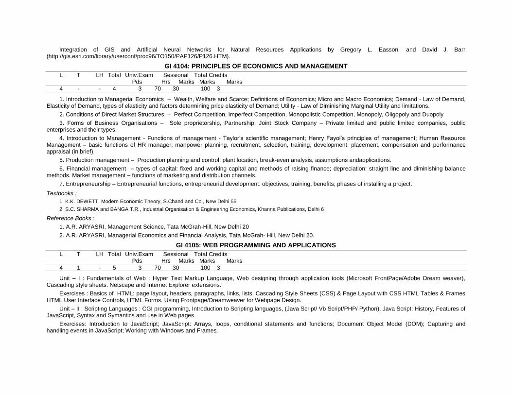
Integration of GIS and Artificial Neural Networks for Natural Resources Applications by Gregory L. Easson, and David J. Barr (http://gis.esri.com/library/userconf/proc96/TO150/PAP126/P126.HTM).
GI 4104: PRINCIPLES OF ECONOMICS AND MANAGEMENT
L T LH Total Univ.Exam Sessional Total Credits Pds Hrs Marks Marks Marks
4 - - 4 3 70 30 100 3
1. Introduction to Managerial Economics – Wealth, Welfare and Scarce; Definitions of Economics; Micro and Macro Economics; Demand - Law of Demand, Elasticity of Demand, types of elasticity and factors determining price elasticity of Demand; Utility - Law of Diminishing Marginal Utility and limitations.
2. Conditions of Direct Market Structures – Perfect Competition, Imperfect Competition, Monopolistic Competition, Monopoly, Oligopoly and Duopoly
3. Forms of Business Organisations – Sole proprietorship, Partnership, Joint Stock Company – Private limited and public limited companies, public enterprises and their types.
4. Introduction to Management - Functions of management - Taylor’s scientific management; Henry Fayol’s principles of management; Human Resource Management – basic functions of HR manager; manpower planning, recruitment, selection, training, development, placement, compensation and performance appraisal (in brief).
5. Production management – Production planning and control, plant location, break-even analysis, assumptions andapplications.
6. Financial management – types of capital: fixed and working capital and methods of raising finance; depreciation: straight line and diminishing balance methods. Market management – functions of marketing and distribution channels.
7. Entrepreneurship – Entrepreneurial functions, entrepreneurial development: objectives, training, benefits; phases of installing a project.
Textbooks :
1. K.K. DEWETT, Modern Economic Theory, S.Chand and Co., New Delhi 55
2. S.C. SHARMA and BANGA T.R., Industrial Organisation & Engineering Economics, Khanna Publications, Delhi 6
Reference Books :
1. A.R. ARYASRI, Management Science, Tata McGrah-Hill, New Delhi 20
2. A.R. ARYASRI, Managerial Economics and Financial Analysis, Tata McGrah- Hill, New Delhi 20.
GI 4105: WEB PROGRAMMING AND APPLICATIONS
L T LH Total Univ.Exam Sessional Total Credits Pds Hrs Marks Marks Marks
4 1 - 5 3 70 30 100 3
Unit – I : Fundamentals of Web : Hyper Text Markup Language, Web designing through application tools (Microsoft FrontPage/Adobe Dream weaver), Cascading style sheets. Netscape and Internet Explorer extensions.
Exercises : Basics of HTML: page layout, headers, paragraphs, links, lists. Cascading Style Sheets (CSS) & Page Layout with CSS HTML Tables & Frames HTML User Interface Controls, HTML Forms. Using Frontpage/Dreamweaver for Webpage Design.
Unit – II : Scripting Languages : CGI programming, Introduction to Scripting languages, (Java Script/ Vb Script/PHP/ Python), Java Script: History, Features of JavaScript, Syntax and Symantics and use in Web pages.
Exercises: Introduction to JavaScript; JavaScript: Arrays, loops, conditional statements and functions; Document Object Model (DOM); Capturing and handling events in JavaScript; Working with Windows and Frames.

Unit – III : Web programming & Application Development : TCP/IP Network model, Client Server technology, Web server, Web Appli cation development using web technologies.
Exercises: Setting up Apache/IIS; Installing PHP; Installing MySQL; Installing and using PHPMyAdmin.
Unit – IV : Server Side and Client side scripting : Introduction to Database connectivity, Open Database Connectivity Standard(ODBC), Data insertion, retrieval and selection criteria using database connectivity tools (Database and scripting languages).
Exercises: A. Introduction to PHP; Working with Data Types and Operators; BuildingFunctions and Control Structures; Manipulating Strings; Working with Files andDirectories; Manipulating Arrays.
B. Introduction to SQL; Working with Databases and MySQL; Validating form data(server side); Error Handing and Debugging
Unit – V : Internet GIS: Introduction to Internet/Web GIS; Spatial (Raster and Vector) data dissemination using Web GIS; Distributed GIS development and Services; Exercises: Configuring and installing map server (Proprietary & Open Source); Creating a WebGIS application: publishing raster and Vector Data; Creation of OGC Services (WMS/WFS); Consuming/Creating OGC Services; Introduction to open layers.
Textbooks / References:
1. HTML - A Beginners guide, Second edition, Ian Lloyd, 2009.
2. Discovering the Internet: Complete Concepts and Techniques by Gary B. Shelly , Thomas J. Cashman , H. Albert Napier , Philip J. Judd
3. Learning Web Design: A Beginner’s Guide to HTML, Graphics, and Beyond by Jennifer Niederst.
4. PHP and My SQL for Dynamic Web Sites: Visual Quick Pro Guide (2nd Edition) by Larry Ullman
5. Professional PHP5 Programmer to Programmer) by Edward Lecky-Thompson
6. PHP5 and My SQL Bible by Tim Converse and Joyce Park with Clark Morgan
7. Database connectivity, Bernard Van Haecke
8. Internet GIS: Distributed geographic information services, ZR Peng and MH Tsou.
9. Beginning Map server Open Source GIS Development by Bill Kropla (Apress).
Elective-III GI 4106-1: Geoinformatics for Watershed Management
L T LH Total Univ.Exam Sessional Total Credits Pds Hrs Marks Marks Marks
4 1 5 3 3 70 30 100 3
Unit-1 : (Watershed Concept) Issues in watershed management - land degradation, agricultural productivity, reservoirs sedimentation, depletion of bioresources, floods and droughts. Principles and approaches - principles of watershed management, different approaches in watershed management; Problem oriented approach, three dimensional approaches, integrated approach, steps in watershed management.
Unit-2 : (Land Management) Survey, layout ; Preparation and Development. Contour demarcation, Bush clearance, updating, store picking and packing, leveling, shaping and consolidation, fencing, ploughing; soil and soil moisture conservation. Soil survey; conservation measures. Contour techniques, ploughing, furrowing, trenching and staking, Gully control. Previous check dams. Brushwood dam, Rock fill dam, Gabion; Impervious check dams.
Unit-3 : (Water Management) Surface water - Study of rainfall, estimation of run-off at micro catchments, stream gauging; Rainwater harvesting catchment, harvesting, harvesting structures, Ground water - exploration of canal command areas, potential areas; integrated water resources management, conjunctive use.
Unit-4 : (Integrated Management) Agriculture - Crop husbandry, soil enrichment, inter, mixed and strip cropping, clopping pattern; sustainable agriculture, Hybrid and improved seeds; Biomass management, crop rotation, legumes, organic fertilization, spider farming, pastures and si lvipastures; horticulture; tree culture; form forestry; bund utilization, boundary plantation; social forestry; Energy - Renewable resource water power, solar energy wind power; biomass, fire food synthetic fuels, burning of municipal / garbage, ocean tides and waves.
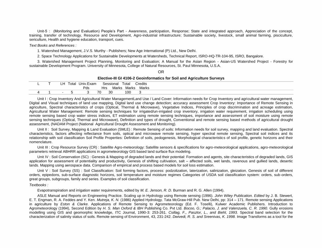
Unit-5 : (Monitoring and Evaluation) People’s Part - Awareness, participation, Response; State and integrated approach, Appreciation of the concept, training, transfer of technology, Resource and Development, Agro-industrial infrastructure; Sustainable society, livestock, small animal farming, pisciculture, sericulture, Health and hygiene education, transport, cues.
Text Books and References :
1. Watershed Management, J.V.S. Murthy - Publishers; New Age International (P) Ltd., New Delhi.
2. Space Technology Applications for Sustainable Developments at Watersheds, Technical Report, ISRO-HQ-TR-104-95, ISRO, Bangalore.
3. Watershed Management Project Planning, Monitoring and Evaluation; A Manual for the Asian Region - Asian-US Watershed Project - Forestry for sustainable Development Program. University of Minnesota, College of Natural Resources, St. Paul Minnesota, U.S.A.
OR
Elective-III GI 4106-2 Geoinformatics for Soil and Agriculture Surveys
L T LH Total Univ.Exam Sessional Total Credits Pds Hrs Marks Marks Marks
4 1 - 5 3 70 30 100 3
Unit I : Crop Inventory And Agricultural Water ManagementLand Use / Land Cover: Information needs for Crop Inventory and agricultural water management, Digital and Visual techniques of land use mapping, Digital land use change detection; accuracy assessment Crop Inventory: Importance of Remote Sensing in agriculture, Spectral characteristics of crops (Optical, Thermal & Microwave), Vegetative Indices, Principles of crop discrimination and acreage estimation, Agricultural Water Management: Remote sensing techniques for irrigated/un-irrigated crop inventory, irrigation water requirement, irrigation scheduling using remote sensing based crop water stress indices, ET estimation using remote sensing techniques, importance and assessment of soil moisture using remote sensing techniques (Optical, Thermal and Microwave), Definition and types of drought, Conventional and remote sensing based methods of agricultural drought assessment, (NADAM Project (National Agricultural Drought Assessment and Monitoring).
Unit II : Soil Survey, Mapping & Land Evaluation (SMLE) : Remote Sensing of soils: Information needs for soil survey, mapping and land evaluation. Spectral characteristics, factors affecting reflectance from soils, optical and microwave remote sensing, hyper spectral remote sensing, Spectral soil indices and its relationship with soil classification Soil Profile Properties: Definition of soils, pedogenesis, Morphological characteristics of soil profile, genetic horizons and their nomenclature.
Unit III : Crop Resource Survey (CR) : Satellite Agro-meteorology: Satellite sensors & specifications for agro-meteorological applications, agro-meteorological parameters retrieval ABHRR applications in agrometeorology GIS based land surface flux modeling.
Unit IV : Soil Conservation (SC) : Genesis & Mapping of degraded lands and their potential: Formation and agents, site characteristics of degraded lands, GIS application for assessment of potentiality and productivity, Genesis of shifting cultivation, salt – affected soils, wet lands, ravenous and gullied lands, desertic lands. Mapping using aerospace data. Comparison of empirical and process based models for soil loss estimation.
Unit V : Soil Survey (SS) : Soil Classification: Soil forming factors, process: podzolization, laterization, salinization, gleization. Genesis of soil of different orders, epipedons, sub-surface diagnostic horizons, soil temperature and moisture regimes Categories of USDA soil classification system: orders, sub-orders, great groups, subgroups, family and series. Examples of soil classification.
Textbooks :
Evapotranspiration and irrigation water requirements, edited by M. E. Jenson, R. D. Burman and R. G. Allen (1994).
ASLE Manual and Reports on Engineering Practice. Scaling up in Hydrology using Remote sensing (1996). John Wiley Publication. Edited by J. B. Stewert, E. T. Engman, R. A. Feddes and Y. Ken. Mutreja, K. N. (1986) Applied Hydrology. Tata McGraw-Hill Pub. New Delhi, pp: 314 – 171. Remote sensing Applications in agriculture by Eston & Clarke. Applications of Remote Sensing to Agrometeorology (Ed. F. Toselli), Kulwer Academic Publishers. Introduction to Agrometeorology (1994), Second Edition by H. S. Man Oxford & IBH Publishing Co. Pvt Ltd. Bocoo, G.; Palacio, J. and Valenzuela, C. R. 1990. Gully erosions modelling using GIS and geomorphic knowledge, ITC Journal, 1990-3: 253-261. Csillag, F., Pasztor, L., and Biehl, 1993. Spectral band selection for the characterization of salinity status of soils. Remote sensing of Environment, 43, 231-242. Dwivedi, R. S. and Sreenivas, K. 1998. Image Transforms as a tool for the

study of soil salinity and alkalinity dynamics. Int. J. Remote sensing, 19 (14): 605-619. Baumgardner, M. F., L. F. Silva, L. L. Biehl, and E. R. Stoner, 1985. Reflectance properties of soils, Adv. Agron., 38, 1-44. Ben-Dor, E., Irons. And Epema, G. F., 1999. Soil reflectance in remote Sensing of earth Sciences: Manual of Remote Sensing, (Edited by Andrew N. Renez) 3rd edition, Vol. 3, pp. 111-118. (John Wiley & Sons. Inc.). Burrough, P. A., 1986. Principles of geographical information systems for land resources assessment. Oxford Univ. Press, New York.
OR
Elective-III GI 4106-3 Geoinformatics for Coastal Zone Management
L T LH Total Univ.Exam Sessional Total Credits Pds Hrs Marks Marks Marks
4 1 - 5 3 70 30 100 3
Unit I : Coastal and littoral zones – definitions and scope of study Shore zone processes – waves, tides and currents Coastal landforms; River deltas: types of deltas and their morphological variations Human activities and their impact on the delta-fringe coast.
Unit II : Coastal wetlands – Mangrove swamps, marshes, lagoons, tidal channels/creeks and their significance in coastal stability and economic importance Continental margins – forms and processes; territorial waters and Exclusive Economic Zone Sea level changes – factors involved; effects of sea level oscillations on coastal zones.
Unit III : Coastal Hazards: Storm surges and Tsunamis: Origin, propagation and run-up; Role of coastal topography, bathymetry and vegetation; Coastal hazard preparedness – coastal protection, education and awareness of coastal communities; Role of geoinformatics in assessment of coastal vulnerability to tsunamis.
Unit IV : Human activity and coastal environment – deforestation, agriculture/aquaculture, pollution and coastal structures, and their effect on coastal zones Coastal vegetation; shelter belts; coastal aquifers; freshwater-seawater interface Morphology of Indian coasts.
Unit V : Coastal zone management – concepts, models and information systems Coastal Regulations Zones (CRZ) and Coastal Management Zones (CMZ): Indian context Application of remote sensing in coastal zone studies Role of Geographic Information Systems in coastal zone studies.
Text books :
1. Geomorphology by A.L. Bloom, Waveland Pr.Inc. 2004
2. Deltas, Coleman, J.M., Continuing education Publication Co.Inc. 1976
3. Coastal Sedimentary Environments, Davis, A.R. (Jr.), Springer-Verlag, 1985.
4. Beaches and Coasts, King, C.A.M., Edward Arnold, 1972
5. Introduction to Marine Geology and Geomorphology, King, C.A.M., Edward Arnold, 1974
6. Applications in Coastal Zone Research Management, Martin, K.St. (ed), U.N. Institute for Training and Research, 1993.
7. Integrated Ocean and Coastal Management, Sain, B.C., and Knecht, R.W.,UNESCO Publication, 1998.
8. Subtle Issues in Coastal Management, Sudarshan et al., (ed), IIRS, Dehra Dun, 2000.
9. Tsunamis – Case Studies and Recent Developments, Satake, K. (ed), Springer, 2005
References:
1. The role of Physical Processes in Mangrove Environments by Y. Mazda, E.Wolanski and P.V. Ridd, Terrapub, Tokyo, 2007.
OR
Elective-III GI 4106-4 Geoinformatics for Resources Development and Disaster Management
L T LH Total Univ.Exam Sessional Total Credits Pds Hrs Marks Marks Marks
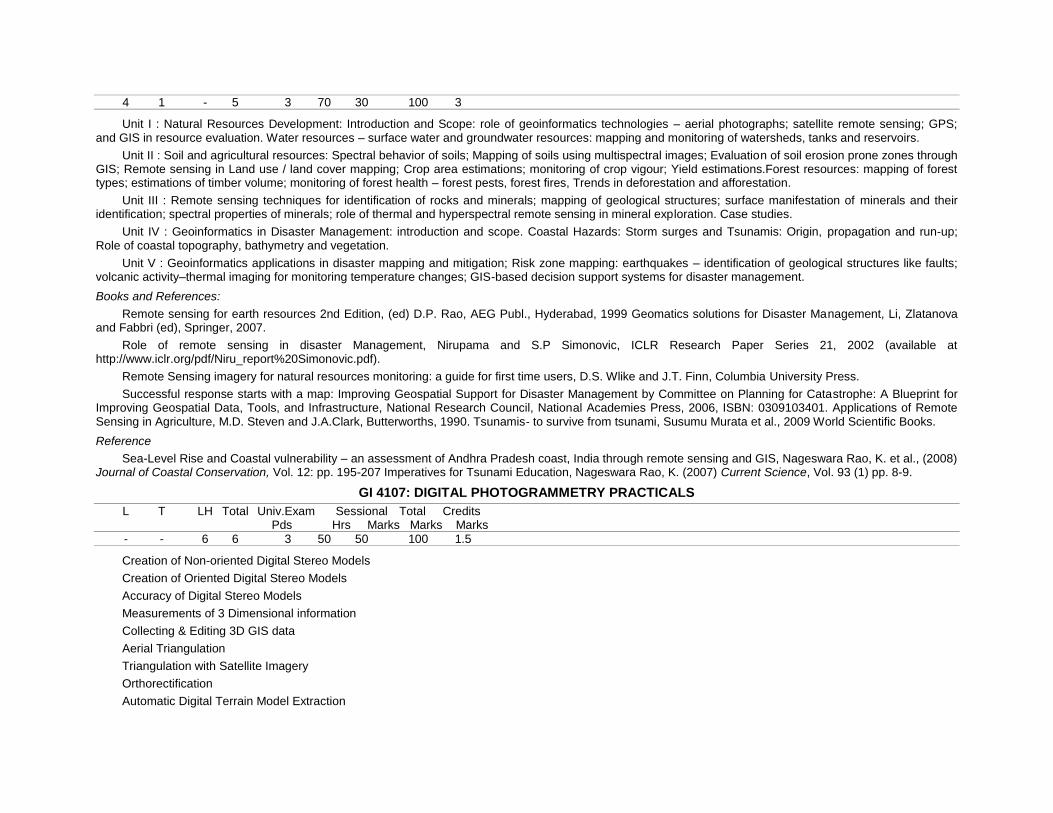
4 1 - 5 3 70 30 100 3
Unit I : Natural Resources Development: Introduction and Scope: role of geoinformatics technologies – aerial photographs; satellite remote sensing; GPS; and GIS in resource evaluation. Water resources – surface water and groundwater resources: mapping and monitoring of watersheds, tanks and reservoirs.
Unit II : Soil and agricultural resources: Spectral behavior of soils; Mapping of soils using multispectral images; Evaluation of soil erosion prone zones through GIS; Remote sensing in Land use / land cover mapping; Crop area estimations; monitoring of crop vigour; Yield estimations.Forest resources: mapping of forest types; estimations of timber volume; monitoring of forest health – forest pests, forest fires, Trends in deforestation and afforestation.
Unit III : Remote sensing techniques for identification of rocks and minerals; mapping of geological structures; surface manifestation of minerals and their identification; spectral properties of minerals; role of thermal and hyperspectral remote sensing in mineral exploration. Case studies.
Unit IV : Geoinformatics in Disaster Management: introduction and scope. Coastal Hazards: Storm surges and Tsunamis: Origin, propagation and run-up; Role of coastal topography, bathymetry and vegetation.
Unit V : Geoinformatics applications in disaster mapping and mitigation; Risk zone mapping: earthquakes – identification of geological structures like faults; volcanic activity–thermal imaging for monitoring temperature changes; GIS-based decision support systems for disaster management.
Books and References:
Remote sensing for earth resources 2nd Edition, (ed) D.P. Rao, AEG Publ., Hyderabad, 1999 Geomatics solutions for Disaster Management, Li, Zlatanova and Fabbri (ed), Springer, 2007.
Role of remote sensing in disaster Management, Nirupama and S.P Simonovic, ICLR Research Paper Series 21, 2002 (available at http://www.iclr.org/pdf/Niru_report%20Simonovic.pdf).
Remote Sensing imagery for natural resources monitoring: a guide for first time users, D.S. Wlike and J.T. Finn, Columbia University Press.
Successful response starts with a map: Improving Geospatial Support for Disaster Management by Committee on Planning for Catastrophe: A Blueprint for Improving Geospatial Data, Tools, and Infrastructure, National Research Council, National Academies Press, 2006, ISBN: 0309103401. Applications of Remote Sensing in Agriculture, M.D. Steven and J.A.Clark, Butterworths, 1990. Tsunamis- to survive from tsunami, Susumu Murata et al., 2009 World Scientific Books.
Reference
Sea-Level Rise and Coastal vulnerability – an assessment of Andhra Pradesh coast, India through remote sensing and GIS, Nageswara Rao, K. et al., (2008) Journal of Coastal Conservation, Vol. 12: pp. 195-207 Imperatives for Tsunami Education, Nageswara Rao, K. (2007) Current Science, Vol. 93 (1) pp. 8-9.
GI 4107: DIGITAL PHOTOGRAMMETRY PRACTICALS
L T LH Total Univ.Exam Sessional Total Credits Pds Hrs Marks Marks Marks
- - 6 6 3 50 50 100 1.5
Creation of Non-oriented Digital Stereo Models
Creation of Oriented Digital Stereo Models
Accuracy of Digital Stereo Models
Measurements of 3 Dimensional information
Collecting & Editing 3D GIS data
Aerial Triangulation
Triangulation with Satellite Imagery
Orthorectification
Automatic Digital Terrain Model Extraction
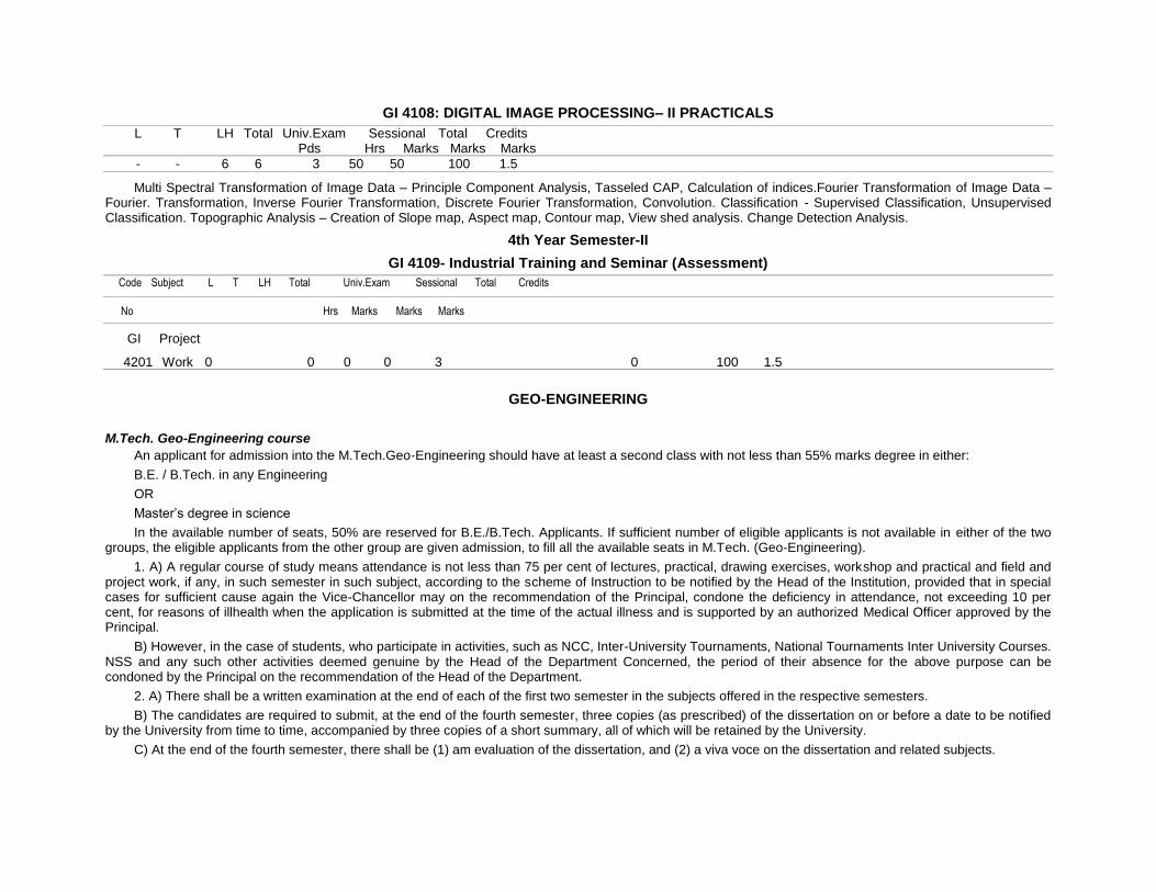
GI 4108: DIGITAL IMAGE PROCESSING– II PRACTICALS
L T LH Total Univ.Exam Sessional Total Credits Pds Hrs Marks Marks Marks
- - 6 6 3 50 50 100 1.5
Multi Spectral Transformation of Image Data – Principle Component Analysis, Tasseled CAP, Calculation of indices.Fourier Transformation of Image Data – Fourier. Transformation, Inverse Fourier Transformation, Discrete Fourier Transformation, Convolution. Classification - Supervised Classification, Unsupervised Classification. Topographic Analysis – Creation of Slope map, Aspect map, Contour map, View shed analysis. Change Detection Analysis.
4th Year Semester-II
GI 4109- Industrial Training and Seminar (Assessment)
Code Subject L T LH Total Univ.Exam Sessional Total Credits
No Hrs Marks Marks Marks
GI Project
4201 Work 0 0 0 0 3 0 100 1.5
GEO-ENGINEERING
M.Tech. Geo-Engineering course
An applicant for admission into the M.Tech.Geo-Engineering should have at least a second class with not less than 55% marks degree in either:
B.E. / B.Tech. in any Engineering
OR
Master’s degree in science
In the available number of seats, 50% are reserved for B.E./B.Tech. Applicants. If sufficient number of eligible applicants is not available in either of the two groups, the eligible applicants from the other group are given admission, to fill all the available seats in M.Tech. (Geo-Engineering).
1. A) A regular course of study means attendance is not less than 75 per cent of lectures, practical, drawing exercises, workshop and practical and field and project work, if any, in such semester in such subject, according to the scheme of Instruction to be notified by the Head of the Institution, provided that in special cases for sufficient cause again the Vice-Chancellor may on the recommendation of the Principal, condone the deficiency in attendance, not exceeding 10 per cent, for reasons of illhealth when the application is submitted at the time of the actual illness and is supported by an authorized Medical Officer approved by the Principal.
B) However, in the case of students, who participate in activities, such as NCC, Inter-University Tournaments, National Tournaments Inter University Courses. NSS and any such other activities deemed genuine by the Head of the Department Concerned, the period of their absence for the above purpose can be condoned by the Principal on the recommendation of the Head of the Department.
2. A) There shall be a written examination at the end of each of the first two semester in the subjects offered in the respective semesters.
B) The candidates are required to submit, at the end of the fourth semester, three copies (as prescribed) of the dissertation on or before a date to be notified by the University from time to time, accompanied by three copies of a short summary, all of which will be retained by the University.
C) At the end of the fourth semester, there shall be (1) am evaluation of the dissertation, and (2) a viva voce on the dissertation and related subjects.
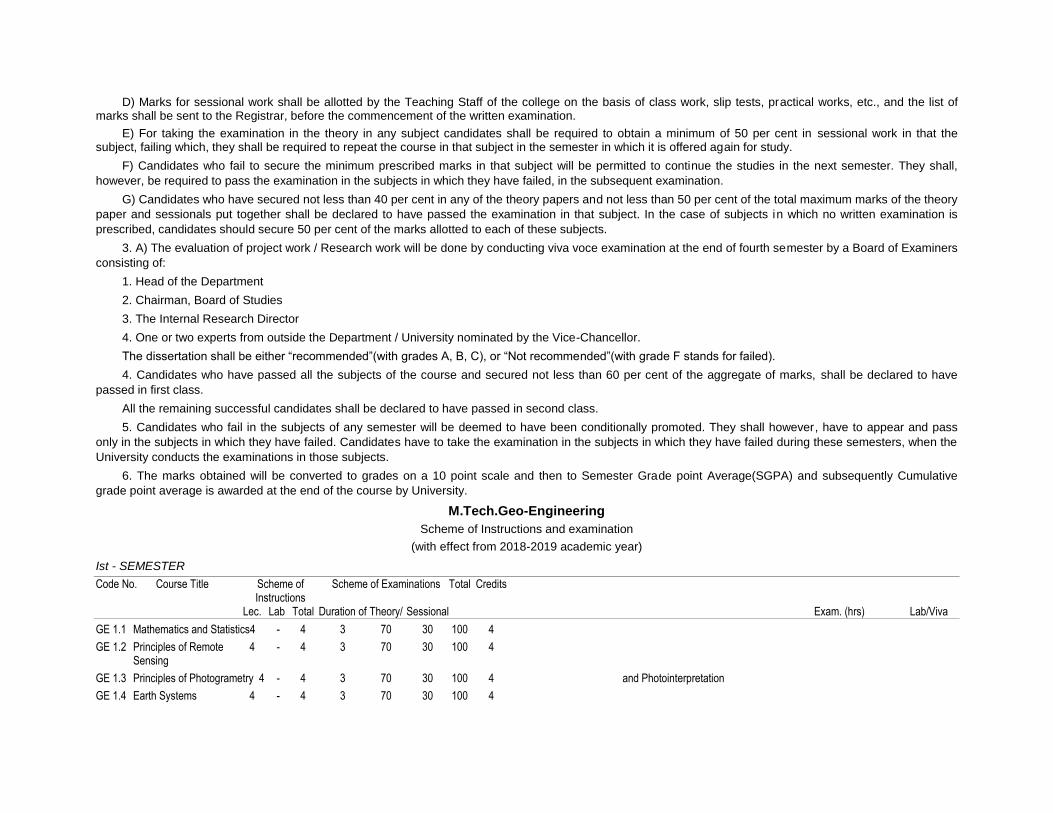
D) Marks for sessional work shall be allotted by the Teaching Staff of the college on the basis of class work, slip tests, practical works, etc., and the list of marks shall be sent to the Registrar, before the commencement of the written examination.
E) For taking the examination in the theory in any subject candidates shall be required to obtain a minimum of 50 per cent in sessional work in that the subject, failing which, they shall be required to repeat the course in that subject in the semester in which it is offered again for study.
F) Candidates who fail to secure the minimum prescribed marks in that subject will be permitted to continue the studies in the next semester. They shall,
however, be required to pass the examination in the subjects in which they have failed, in the subsequent examination.
G) Candidates who have secured not less than 40 per cent in any of the theory papers and not less than 50 per cent of the total maximum marks of the theory
paper and sessionals put together shall be declared to have passed the examination in that subject. In the case of subjects in which no written examination is
prescribed, candidates should secure 50 per cent of the marks allotted to each of these subjects.
3. A) The evaluation of project work / Research work will be done by conducting viva voce examination at the end of fourth semester by a Board of Examiners
consisting of:
1. Head of the Department
2. Chairman, Board of Studies
3. The Internal Research Director
4. One or two experts from outside the Department / University nominated by the Vice-Chancellor.
The dissertation shall be either “recommended”(with grades A, B, C), or “Not recommended”(with grade F stands for failed).
4. Candidates who have passed all the subjects of the course and secured not less than 60 per cent of the aggregate of marks, shall be declared to have
passed in first class.
All the remaining successful candidates shall be declared to have passed in second class.
5. Candidates who fail in the subjects of any semester will be deemed to have been conditionally promoted. They shall however, have to appear and pass
only in the subjects in which they have failed. Candidates have to take the examination in the subjects in which they have failed during these semesters, when the
University conducts the examinations in those subjects.
6. The marks obtained will be converted to grades on a 10 point scale and then to Semester Grade point Average(SGPA) and subsequently Cumulative
grade point average is awarded at the end of the course by University.
M.Tech.Geo-Engineering
Scheme of Instructions and examination
(with effect from 2018-2019 academic year)
Ist - SEMESTER
Code No. Course Title Scheme of Scheme of Examinations Total Credits Instructions Lec. Lab Total Duration of Theory/ Sessional Exam. (hrs) Lab/Viva
GE 1.1 Mathematics and Statistics4 - 4 3 70 30 100 4
GE 1.2 Principles of Remote 4 - 4 3 70 30 100 4 Sensing
GE 1.3 Principles of Photogrametry 4 - 4 3 70 30 100 4 and Photointerpretation
GE 1.4 Earth Systems 4 - 4 3 70 30 100 4
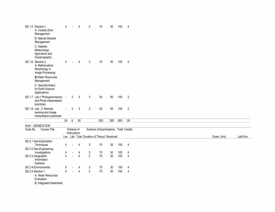
GE 1.5 Elective 1 4 - 4 3 70 30 100 4 A. Coastal Zone Management
B. Natural Disaster Management
C. Satellite Meteorology, Agriculture and Oceanography
GE 1.6 Elective 2 4 - 4 3 70 30 100 4 A. Mathematical Morphology in Image Processing
B.Water Resources Management
C. Geoinformatics for Earth Science Applications
GE 1.7 Lab:1 Photogrammentry - 3 3 3 50 50 100 2 and Photo interpretation practicals
GE 1.8 Lab : 2 Remote - 3 3 3 50 50 100 2 sensing and Image interpretation practicals
24 6 30 520 280 800 28
IInd - SEMESTER
Code No. Course Title Scheme of Scheme of Examinations Total Credits Instructions Lec. Lab Total Duration of Theory/ Sessional Exam. (hrs) Lab/Viva
GE 2.1 Geo-Exploration Techniques 4 - 4 3 70 30 100 4
GE 2.2 Geo-Engineering Investigations 4 - 4 3 70 30 100 4 GE 2.3 Geographic 4 - 4 3 70 30 100 4 Information Systems
GE 2.4 Environmental 4 - 4 3 70 30 100 4
GE 2.5 Elective 1 4 - 4 3 70 30 100 4
A. Water Resources Evaluation
B. Integrated Watershed
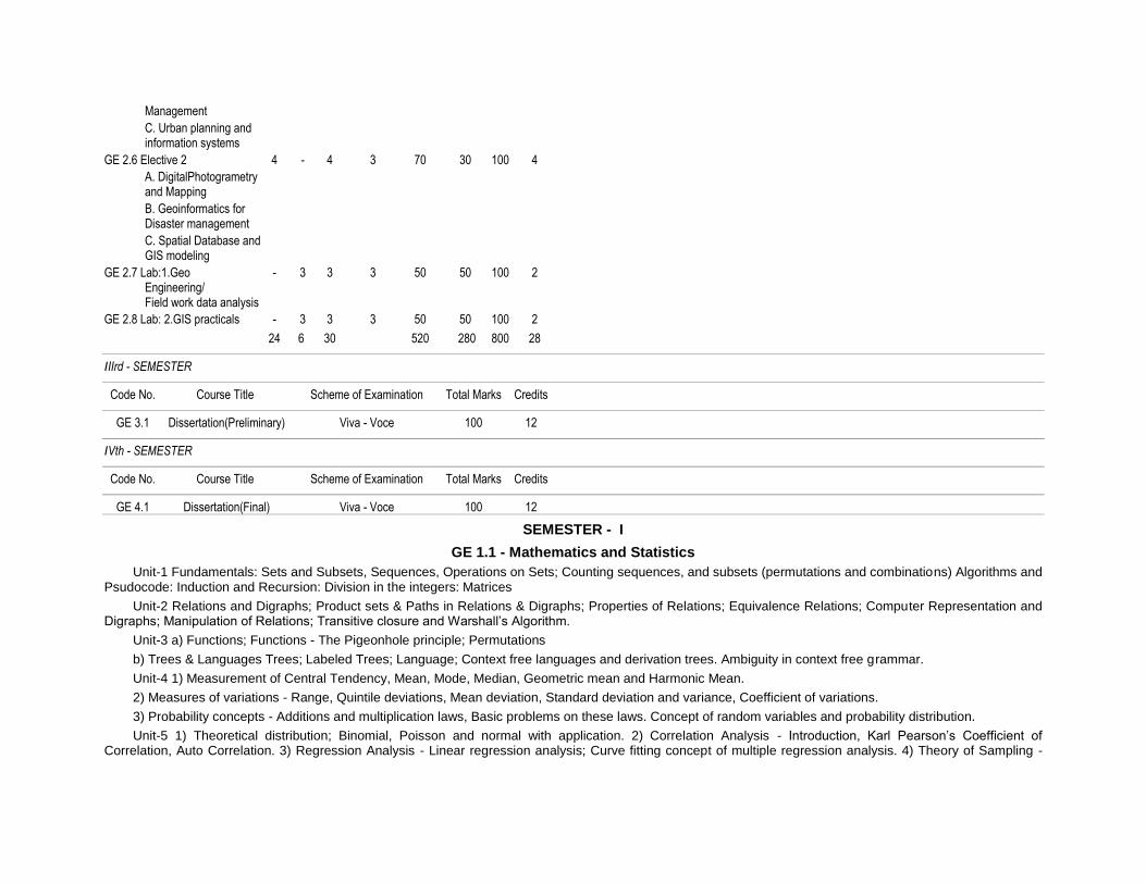
Management
C. Urban planning and information systems
GE 2.6 Elective 2 4 - 4 3 70 30 100 4
A. DigitalPhotogrametry and Mapping
B. Geoinformatics for Disaster management
C. Spatial Database and GIS modeling
GE 2.7 Lab:1.Geo - 3 3 3 50 50 100 2 Engineering/ Field work data analysis
GE 2.8 Lab: 2.GIS practicals - 3 3 3 50 50 100 2
24 6 30 520 280 800 28
IIIrd - SEMESTER
Code No. Course Title Scheme of Examination Total Marks Credits
GE 3.1 Dissertation(Preliminary) Viva - Voce 100 12
IVth - SEMESTER
Code No. Course Title Scheme of Examination Total Marks Credits
GE 4.1 Dissertation(Final) Viva - Voce 100 12
SEMESTER - I
GE 1.1 - Mathematics and Statistics
Unit-1 Fundamentals: Sets and Subsets, Sequences, Operations on Sets; Counting sequences, and subsets (permutations and combinations) Algorithms and Psudocode: Induction and Recursion: Division in the integers: Matrices
Unit-2 Relations and Digraphs; Product sets & Paths in Relations & Digraphs; Properties of Relations; Equivalence Relations; Computer Representation and Digraphs; Manipulation of Relations; Transitive closure and Warshall’s Algorithm.
Unit-3 a) Functions; Functions - The Pigeonhole principle; Permutations
b) Trees & Languages Trees; Labeled Trees; Language; Context free languages and derivation trees. Ambiguity in context free grammar.
Unit-4 1) Measurement of Central Tendency, Mean, Mode, Median, Geometric mean and Harmonic Mean.
2) Measures of variations - Range, Quintile deviations, Mean deviation, Standard deviation and variance, Coefficient of variations.
3) Probability concepts - Additions and multiplication laws, Basic problems on these laws. Concept of random variables and probability distribution.
Unit-5 1) Theoretical distribution; Binomial, Poisson and normal with application. 2) Correlation Analysis - Introduction, Karl Pearson’s Coefficient of Correlation, Auto Correlation. 3) Regression Analysis - Linear regression analysis; Curve fitting concept of multiple regression analysis. 4) Theory of Sampling -

Meaning of a sample, Universe, static and parameters. Sampling distribution, standard error. Different sampling techniques like scruple random sample, standard random sample, systematic, cluster and multi-storage sample.
Text Books
1) Statistics by S.P. Gupta
2) Statistical theory and methods by SANCHETIC and Kapoor
3) Statistics by S.C.Gupta
GE 1.2 Principles of Remote Sensing
Unit-I Basics of Remote Sensing a) Overview of Remote sensing: Definition of Remote sensing Principles of Remote Sensing, Electromagnetic Radiation, Radiometric terms and definitions, Radiation Laws, EM spectrum, Sources of EM, Interaction of EM Radiation with atmosphere, and target, Atmospheric Widows, imaging spectrometry, Spectral signature of various land cove features
b) PLATFORMS AND SENSORS * Platforms: Types of platforms, ground, airborne, and space born platforms, Orbit of satellites, Kepler’s Law, satellite characteristics, satellites for Earth observations studies, and planetary missions (Chandrayana) *Sensors: Types and classification of sensors, imaging modes, Characteristics of optical sensors, sensor resolution-spectral, radiometric and temporal, Characteristics of detectors.
Unit-II a) Data reception, Data processing & Data generation * Ground station, Data generation, Data processing & correction b) Radiometric and Geometric corrections * Radiometric corrections Random noise correction * Atmospheric correction, Geometric errors and corrections, * Distortion evaluated from tracking data, distortion evaluated from ground control Image correction. c) Ground Investigation in support of Remote sensing * Uses of ground data, calibration correction, Interpretation of properties, Training sets, Accuracy evaluation, test sites * Ground truth Instruments and spectral signature, * Spectral Reflectance and spectral signature of vegetation * Sources of RS data: Global and Indian data products
Unit-III : Visual Image Interpretation * Introduction to Visual Interpretation, Basic principles of Visual Interpretation * Elements of Visual Interpretation, Techniques of Visual Interpretation * Interpretation Keys, Methods of searching and sequence of Interpretation * Methods of analysis and Reference levels * Computer compatible tapes – Band sequential format, Band interleaved by Line format, Run-length encoding format. * Hardcopy outputs – Generation of B/W and False Color Composites.
Generally supported scales of the data products, Information about annotation of the products.
Unit-4 Thermal Imaging system * Thermal Imaging System: Introduction - IR region of the Electromagnetic spectrum, Atmospheric transmission, Kinetic and radiant temperature, Thermal properties of materials, Emissivity, Radiant temperature. Thermal conductivity. Thermal capacity, thermal inertia, apparent thermal inertia, Thermal diffusivity. * Radiation principles ( Plank’s Law, Stephen Boltzman law), Interaction of EMR with earth surface, Wien’s displacement law, Kirchoffs Law). * IR - radiometers, Airborne and Satellite TTR scanner system * Characteristics of IR images i) Scanner distortion, ii) image irregularities, iii) Film density and recorded iv)Temperature ranges * Effects of weather on images i) Clouds, ii) Surface winds, iii) Penetration of smoke plumes * Interpretation of thermal imagery * Advantages of Thermal imagery.
Unit-V Microwave Remote Sensing * Introduction - Electromagnetic spectrum, Airborne and Space borne radar systems basis instrumentation. * System parameters - Wave length, Polarization, Resolutions, Radar geometry. * Target parameters - Back scattering, Point target, Volume scattering, Penetration, Reflection, Bragg resonance, Cross swath variation. Speckle radiometric calibration. * Microwave sensors and Image characteristics, Microwave image interpretation * Application : Geology, Forestry, Land use, Soils etc. Future trends and Research * Physics of lager, laser interaction with objects. Types of LiDAR (Topographic, Bathymetric) platforms of LiDAR, components of LiDAR.
List of Text Books
1. Floyd, F. Sabins, Jr: Remote Sensing Principles and Interpretation, Freeman and Co., San Franscisco, 1978.
2. Illesand and Kiefere: Remote Sensing and Image interpretation, John qwiley, 1987.
3. Manual of Remote Sensing Vol. I&II, 2nd Edition, American Society of Photogrammetry.
4. Remote Sensing: The quantitative approach, P.H. Swain and S.M. Davis, McGraw Hill.
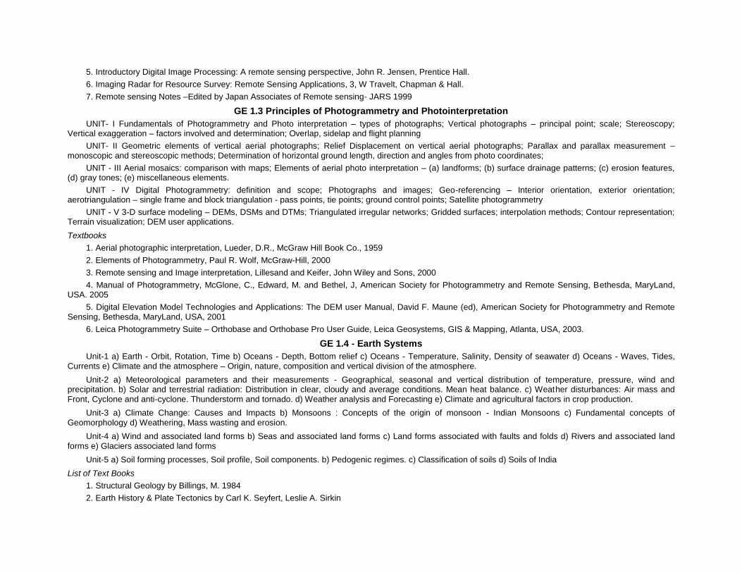
5. Introductory Digital Image Processing: A remote sensing perspective, John R. Jensen, Prentice Hall.
6. Imaging Radar for Resource Survey: Remote Sensing Applications, 3, W Travelt, Chapman & Hall.
7. Remote sensing Notes –Edited by Japan Associates of Remote sensing- JARS 1999
GE 1.3 Principles of Photogrammetry and Photointerpretation
UNIT- I Fundamentals of Photogrammetry and Photo interpretation – types of photographs; Vertical photographs – principal point; scale; Stereoscopy; Vertical exaggeration – factors involved and determination; Overlap, sidelap and flight planning
UNIT- II Geometric elements of vertical aerial photographs; Relief Displacement on vertical aerial photographs; Parallax and parallax measurement – monoscopic and stereoscopic methods; Determination of horizontal ground length, direction and angles from photo coordinates;
UNIT - III Aerial mosaics: comparison with maps; Elements of aerial photo interpretation – (a) landforms; (b) surface drainage patterns; (c) erosion features, (d) gray tones; (e) miscellaneous elements.
UNIT - IV Digital Photogrammetry: definition and scope; Photographs and images; Geo-referencing – Interior orientation, exterior orientation; aerotriangulation – single frame and block triangulation - pass points, tie points; ground control points; Satellite photogrammetry
UNIT - V 3-D surface modeling – DEMs, DSMs and DTMs; Triangulated irregular networks; Gridded surfaces; interpolation methods; Contour representation; Terrain visualization; DEM user applications.
Textbooks
1. Aerial photographic interpretation, Lueder, D.R., McGraw Hill Book Co., 1959
2. Elements of Photogrammetry, Paul R. Wolf, McGraw-Hill, 2000
3. Remote sensing and Image interpretation, Lillesand and Keifer, John Wiley and Sons, 2000
4. Manual of Photogrammetry, McGlone, C., Edward, M. and Bethel, J, American Society for Photogrammetry and Remote Sensing, Bethesda, MaryLand, USA. 2005
5. Digital Elevation Model Technologies and Applications: The DEM user Manual, David F. Maune (ed), American Society for Photogrammetry and Remote Sensing, Bethesda, MaryLand, USA, 2001
6. Leica Photogrammetry Suite – Orthobase and Orthobase Pro User Guide, Leica Geosystems, GIS & Mapping, Atlanta, USA, 2003.
GE 1.4 - Earth Systems
Unit-1 a) Earth - Orbit, Rotation, Time b) Oceans - Depth, Bottom relief c) Oceans - Temperature, Salinity, Density of seawater d) Oceans - Waves, Tides, Currents e) Climate and the atmosphere – Origin, nature, composition and vertical division of the atmosphere.
Unit-2 a) Meteorological parameters and their measurements - Geographical, seasonal and vertical distribution of temperature, pressure, wind and precipitation. b) Solar and terrestrial radiation: Distribution in clear, cloudy and average conditions. Mean heat balance. c) Weather disturbances: Air mass and Front, Cyclone and anti-cyclone. Thunderstorm and tornado. d) Weather analysis and Forecasting e) Climate and agricultural factors in crop production.
Unit-3 a) Climate Change: Causes and Impacts b) Monsoons : Concepts of the origin of monsoon - Indian Monsoons c) Fundamental concepts of Geomorphology d) Weathering, Mass wasting and erosion.
Unit-4 a) Wind and associated land forms b) Seas and associated land forms c) Land forms associated with faults and folds d) Rivers and associated land forms e) Glaciers associated land forms
Unit-5 a) Soil forming processes, Soil profile, Soil components. b) Pedogenic regimes. c) Classification of soils d) Soils of India
List of Text Books
1. Structural Geology by Billings, M. 1984
2. Earth History & Plate Tectonics by Carl K. Seyfert, Leslie A. Sirkin
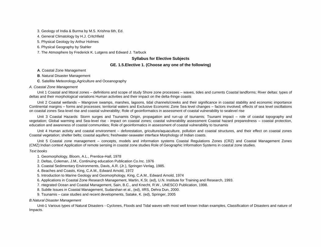
3. Geology of India & Burma by M.S. Krishna 6th, Ed.
4. General Climatology by H.J. Critchfield
5. Physical Geology by Arthur Holmes
6. Physical Geography by Stahler
7. The Atmosphere by Frederick K. Lutgens and Edward J. Tarbuck
Syllabus for Elective Subjects
GE. 1.5.Elective 1. (Choose any one of the following)
A. Coastal Zone Management
B. Natural Disaster Management
C. Satellite Meteorology,Agriculture and Oceanography
A. Coastal Zone Management
Unit 1 Coastal and littoral zones – definitions and scope of study Shore zone processes – waves, tides and currents Coastal landforms; River deltas: types of deltas and their morphological variations Human activities and their impact on the delta-fringe coasts
Unit 2 Coastal wetlands – Mangrove swamps, marshes, lagoons, tidal channels/creeks and their significance in coastal stability and economic importance Continental margins – forms and processes; territorial waters and Exclusive Economic Zone Sea level changes – factors involved; effects of sea level oscillations on coastal zones Sea-level rise and coastal vulnerability; Role of geoinformatics in assessment of coastal vulnerability to sealevel rise
Unit 3 Coastal Hazards: Storm surges and Tsunamis Origin, propagation and run-up of tsunamis; Tsunami impact – role of coastal topography and vegetation; Global warming and Sea-level rise - impact on coastal zones; coastal vulnerability assessment Coastal hazard preparedness – coastal protection,
education and awareness of coastal communities; Role of geoinformatics in assessment of coastal vulnerability to tsunamis
Unit 4 Human activity and coastal environment – deforestation, griculture/aquaculture, pollution and coastal structures, and their effect on coastal zones
Coastal vegetation; shelter belts; coastal aquifers; freshwater-seawater interface Morphology of Indian coasts.
Unit 5 Coastal zone management – concepts, models and information systems Coastal Regulations Zones (CRZ) and Coastal Management Zones (CMZ):Indian context Application of remote sensing in coastal zone studies Role of Geographic Information Systems in coastal zone studies.
Text books
1. Geomorphology, Bloom, A.L., Prentice-Hall, 1978
2. Deltas, Coleman, J.M., Continuing education Publication Co.Inc. 1976
3. Coastal Sedimentary Environments, Davis, A.R. (Jr.), Springer-Verlag, 1985.
4. Beaches and Coasts, King, C.A.M., Edward Arnold, 1972
5. Introduction to Marine Geology and Geomorphology, King, C.A.M., Edward Arnold, 1974
6. Applications in Coastal Zone Research Management, Martin, K.St. (ed), U.N. Institute for Training and Research, 1993.
7. ntegrated Ocean and Coastal Management, Sain, B.C., and Knecht, R.W., UNESCO Publication, 1998.
8. Subtle Issues in Coastal Management, Sudarshan et al., (ed), IIRS, Dehra Dun, 2000.
9. Tsunamis – case studies and recent developments, Satake, K. (ed), Springer, 2005
B.Natural Disaster Management
Unit-1 Various types of Natural Disasters - Cyclones, Floods and Tidal waves with most well known Indian examples, Classification of Disasters and nature of Impacts.

Unit-2 Various types of Natural Disasters - Earth quakes, land subsidence and Land slides, Forest fires, Drought with most well known Indian examples, Classifications and nature of impacts.
Unit-3 Vulnerability factors and Risk analysis of Natural disasters and Hazard estimations.
Unit-4 Natural disaster management plans, Shelterbelts, Special structures, Disaster preparedness and Mitigation.
Unit-5 Information needs of Disaster management, Remote Sensing Applications, GIS applications.
References
1. Krishna Prem & Bhanfari, N.M. (1967): Risk assessment due to strong Wing storms / Cyclones and preventive measures for Habitat Buildings; Proceedings volume 1 of International Conference on Habitat and sustainable Development, Decembe4 1-2-1997 organized by Institute of Engineers (India) and World Federation of Engineering Organisations.
2. Vijay, P.B. Kurian, Jose and Mittal, A.K. (1997): An overview on the Earthquake mitigation sceanrio in India: Proceeding volume-1 of International Conference on habitat and Sustainable Development, December 1-2-1997 organized by Institute of Engineers (India) and World Federation of Engineering Organisations.
3. Mandal, G.S. (1995): Tropical cyclones and their damage potential, status of Wind Engineering in India, Indian Society of Wind Energy (ISWE).
4. Government of India (1997): Ministry of Urban Affairs and Employment: Vulnerability Atlas - A part of report of Expert Group.
C. Satellite Meteorology, Agriculture and Oceanography
Unit-1 1. Fundamentals of Remote Sensing in Meteorology 2. Meteorological satellite characteristics and their orbits, TIROS, NIMBUS, NOAA, TIROS N, SEASAT, GOES, METEOSAT, INSAT, OCEAN SAT. Role of LANDSAT, SPOT and IRS in collecting meteorological, agricultural and oceanographic data. 3. Measurement of Earth and Atmospheric energy and Radiation budget parameters from satellites. 4. Atmospheric temperature retrieval techniques and surface radiation studies. 5. Wind measuring techniques from satellite data.
Unit-2 1. Cloud classification techniques. 2. Satellite Remote Sensing System of use in rainfall monitoring methods: Cloud indexing method, Life-history method and Bio-spectral methods. 3. Interpretation of Satellite meteorological images for weather systems and cyclones. 4. Remote Sensing techniques for estimation of soil moisture and evapotranspiration. 5. Spectral behavior of different crops and vegetation in VIS, NIR, MIR, TIR and Micro-wave regions.
Unit-3 1. Principles of crop identification and area estimation, sampling techniques, vegetation indices and crop yield modeling using Remote Sensing. 2. Water management in command areas - monitoring, assessing crop water availability, demand and utilization pattern through Remote Sensing. 3. Crop stress assessment and monitoring - droughts and floods. 4. General concept of water resource assessment and irrigation water management, water logging and water quality.
Unit-4 1. Principles of Remote Sensing of Sea 2. Visible wavelength ocean - color sensors: introduction to color sensors on Landsat, Coast zone color scanner (CZCS) on Nimbus, application and oceanographic uses of Land sat and CZCS data. 3. Introduction to infrared scanning radiometers, atmospheric correction and Sea - Surface temperature calibration techniques, interpretation and uses of SST data from satellites. 4. Passive microwave radiometers: Physical principles of passive microwave radiometry microwave radiometer design and oceanographic interpretation of microwave data.
Unit-5 1. Satellite altimetry of sea - surface topography: Application of altimetry to the study of ocean currents, tides, bathymetry and wave heights. 2. Active microwave sensing of sea-surface roughness: Introduction to the Remote Sensing of sea-surface roughness, radar reflection from sea surface, surface films and oil slicks, dynamical and artificial causes of sea surface roughness patterns. 3. Introduction to Synthetic Aperture Radar, Principles of operation, SAR imaging of ocean waves, observations of ocean waves with Seasat SAR, Interpretation of ocean waves. 4. Introduction to microwave scatter meters, oceanographic application of scatterometer data. Application of wind and wave scatterometry.
List of Text Books
1. Applied Remote Sensing C.P.L.O., Longman Scientific and Technical Publishers.
2. Introduction to Environmental Remote Sensing, E.C. Barrett & L.F Curtis, Chapman and Hall, London.
3. Remote Sensing in Hydrology, Engman, E.T. and Gurney, R.J.
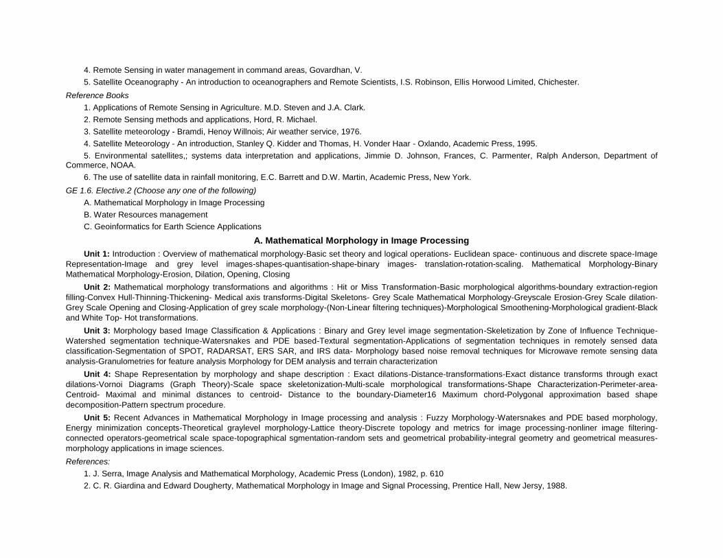
4. Remote Sensing in water management in command areas, Govardhan, V.
5. Satellite Oceanography - An introduction to oceanographers and Remote Scientists, I.S. Robinson, Ellis Horwood Limited, Chichester.
Reference Books
1. Applications of Remote Sensing in Agriculture. M.D. Steven and J.A. Clark.
2. Remote Sensing methods and applications, Hord, R. Michael.
3. Satellite meteorology - Bramdi, Henoy Willnois; Air weather service, 1976.
4. Satellite Meteorology - An introduction, Stanley Q. Kidder and Thomas, H. Vonder Haar - Oxlando, Academic Press, 1995.
5. Environmental satellites,; systems data interpretation and applications, Jimmie D. Johnson, Frances, C. Parmenter, Ralph Anderson, Department of Commerce, NOAA.
6. The use of satellite data in rainfall monitoring, E.C. Barrett and D.W. Martin, Academic Press, New York.
GE 1.6. Elective.2 (Choose any one of the following)
A. Mathematical Morphology in Image Processing
B. Water Resources management
C. Geoinformatics for Earth Science Applications
A. Mathematical Morphology in Image Processing
Unit 1: Introduction : Overview of mathematical morphology-Basic set theory and logical operations- Euclidean space- continuous and discrete space-Image
Representation-Image and grey level images-shapes-quantisation-shape-binary images- translation-rotation-scaling. Mathematical Morphology-Binary
Mathematical Morphology-Erosion, Dilation, Opening, Closing
Unit 2: Mathematical morphology transformations and algorithms : Hit or Miss Transformation-Basic morphological algorithms-boundary extraction-region
filling-Convex Hull-Thinning-Thickening- Medical axis transforms-Digital Skeletons- Grey Scale Mathematical Morphology-Greyscale Erosion-Grey Scale dilation-
Grey Scale Opening and Closing-Application of grey scale morphology-(Non-Linear filtering techniques)-Morphological Smoothening-Morphological gradient-Black
and White Top- Hot transformations.
Unit 3: Morphology based Image Classification & Applications : Binary and Grey level image segmentation-Skeletization by Zone of Influence Technique-
Watershed segmentation technique-Watersnakes and PDE based-Textural segmentation-Applications of segmentation techniques in remotely sensed data
classification-Segmentation of SPOT, RADARSAT, ERS SAR, and IRS data- Morphology based noise removal techniques for Microwave remote sensing data
analysis-Granulometries for feature analysis Morphology for DEM analysis and terrain characterization
Unit 4: Shape Representation by morphology and shape description : Exact dilations-Distance-transformations-Exact distance transforms through exact
dilations-Vornoi Diagrams (Graph Theory)-Scale space skeletonization-Multi-scale morphological transformations-Shape Characterization-Perimeter-area-
Centroid- Maximal and minimal distances to centroid- Distance to the boundary-Diameter16 Maximum chord-Polygonal approximation based shape
decomposition-Pattern spectrum procedure.
Unit 5: Recent Advances in Mathematical Morphology in Image processing and analysis : Fuzzy Morphology-Watersnakes and PDE based morphology,
Energy minimization concepts-Theoretical graylevel morphology-Lattice theory-Discrete topology and metrics for image processing-nonliner image filtering-
connected operators-geometrical scale space-topographical sgmentation-random sets and geometrical probability-integral geometry and geometrical measures-
morphology applications in image sciences.
References:
1. J. Serra, Image Analysis and Mathematical Morphology, Academic Press (London), 1982, p. 610
2. C. R. Giardina and Edward Dougherty, Mathematical Morphology in Image and Signal Processing, Prentice Hall, New Jersy, 1988.

Suggested Reading
1. Gonzalez, Digital Image Processing
2. R. M. Haralick, and L. G. Shapiro, Computer and Robot Vision, Addison Wesley, Reading, v. 1, 1992, p. 453-507.
3. Technical Periodicals: IEEE Geoscience and Remote Sensing, IEEE Pattern Analysis & Machine Intelligence, IEEE Image Processing, IEEE Signal Processing
B. Water Resources Management
Unit-1 (Watershed Concept): a) Issues in watershed management - land degradation, agricultural productivity, reservoirs sedimentation, depletion of bioresources, floods and droughts. Principles and approaches - principles of watershed management, different approaches in watershed management; Problem oriented approach, three dimensional approaches, integrated approach, steps in watershed management. b) Watershed characteristics - size, shape physiography, slope, climate, drainage, landuse, vegetation, geology, soils, hydrology, hydrogeology, socio-economics. Linear aspects of channel systems - Aerial aspects of drainage basins.
Unit-2 (Land Management): a) Survey, layout ; Preparation and Development. Contour demarcation, Bush clearance, updating, stone picking and packing, leveling, shaping and consolidation, fencing, ploughing; soil and soil moisture conservation. Soil survey; conservation measures. Contour techniques, ploughing, furrowing, trenching and staking, Gully control. Pervious check dams. Burshwood dam, Rockfill dam, Gabion; Impervious check dams. b) Land capability classification, land degradation and problem soils. Reclamation of saline soils, alkaline soils, saline soils, acidic soils, sulphide soils; sediment yield modeling and watershed prioritization. The universal soil loss equation, sediment yield index method, statistical regression model, the European soil erosion model; Site selection from conservation measures.
Unit-3 (Water Management): a) Surface water - Study of rainfall, estimation of run-off at micro catchments, stream gauging; Rainwater harvesting; catchment, harvesting, harvesting structures, Ground water - exploration of canal command areas, potential areas; integrated water resources management, conjunctive use. b) Dry land Agriculture - Runoff agriculture, micro catchment forming, irrigation with saline water, reusing water, conserving water, sprinkler irrigation, drip irrigation, pot irrigation, other systems, reducing crop land percolation losses, reducing transpiration losses, selection of water use efficiency crops.
Unit-4 (Integrated Management): a) Agriculture - Crop husbandry, soil enrichment, inter mixed and strip cropping, cropping pattern; sustainable agriculture, Hybrid and improved seeds; Biomass management, crop rotation, legumes, organic fertilization, spider farming, pastures and si lvipastures; horticulture; tree culture; form forestry; bund utilization, boundary plantation; social forestry; Energy - Renewable resource, water power, solar energy wind power; biomass, fire wood, synthetic fuels, burning of municipal / garbage, ocean tides and waves. b) Appropriate Technology - farm equipment; Contour methods; check dams, water catchment and harvesting; kunds, depression harvesting, harvesting below ground level, harvesting below stream bed level, ground water harvesting; low cost technology, water conservation, utilization of wasted natural resources, Novelities; Rural technological delivery systems, cultivating wasted lands, tree culture, farm forestry, silvipastures, horticulture, social forestry, afforestation, wonder ways.
Unit-5 (Monitoring and Evluation): a) People’s Part - awareness, participation, Response; State and integrated approach, appreciation of the concept, training, transfer of technology, resource and development, Agro-industrial infrastructure; sustainable society, livestock, small animal farming, pisiculture, sericulture, Health and hygiene education, transport, cues. b) Monitoring and Evaluation - purpose of monitoring and evaluation, nature of monitoring and evaluation - an interative dynamic Process, design of monitoring programs - determining information needs, setting information-need priorities, Determining means of collecting information, Information management in monitoring programs; monitoring biophysical data, monitoring socio-economic data, monitoring project activities and outputs, design of evaluation procedures, types of evaluation, focus of evaluation, reporting evaluation results, insuring use of monitoring and evaluation information, a final word of caution.
Text Books and References
1. Watershed Management, J.V.S. Murthy - Publishers; New Age International (P) Ltd., New Delhi.
2. Space Technology Applications for Sustainable Developments at Watersheds, Technical Report, ISRO-HQ-TR-104-95, ISRO, Bangalore.

3. Watershed Management Project Planning, Monitoring and Evaluation; A Manual for the Asian Region - Asian-US Watershed Project - Forestry for sustainable Development Program. University of Mirnesota, College of Natural Resources, St. Paul Mirnesota, U.S.A.
C. Geoinformatics for Earth Science Applications
Unit – I: Remote sensing applications in lithological studies Introduction; Scope for Geological applications in multispectral data, Thermal Data, Microwave data Mapping of Broad scale Lithological Units in General, Igneous, sedimentary and metamorphic rock, Identification of Mineral Assemblage, their physical properties mode of origin and mode of occurrence; Lithological mapping using aerial photos and satellite imagery, Digital analysis for lithological discrimination
Unit – II: Remote Sensing applications in structural analysis: Bedding and simple dipping strata, Folds, Faults, rift zones, Lineaments, Unconformity, Structural mapping – structural analysis through aerial- and satellite- data, digital techniques for structural analysis.
Unit- III: Remote sensing application in geomorphology: Nature and type of landforms like denudational, structural, fluvial, marine, Aeolian, glacial and
volcanic
Unit – IV: Remote sensing application in geological investigations: Remote sensing in Mineral Exploration, Main types of Mineral Deposits and their surface
indications, Stratigraphic & lithological Guides, Geomorphological guides, Structural guides, Guide formed by Rock alteration, Geobotanical gudes. Groundwater,
Petroleum. Hydrogeological mapping, Engineering Geological studies, Land slide studies and disaster management studies using Remote Sensing and GIS
techniques – case studies
Unit- V: Engineering and Sub-surface exploration & Disaster Assessment: Engineering geological Investigations: river valley projects, dams and reservoirs, route location (high ways and Rail ways) canal and pipeline alignments; neotectonism, seismic hazard and damage assessment, local ground condition, disaster assessment, volcanic and geothermal Energy applications, volcanic mapping and monitoring, identification of coal fires; environmental geology Resistivity, aeromagnetic and electromagnetic survey for subsurface explorations
Textbooks
Ravi P.Gupta, Remote sensing Geology-Springer Publisher,A1 Books Co.in. Joseph Lintz (Jr) and David Simonett Remote Sensing of environment, Addison Wesley Publishing Company London, 1976.
Parbinsingh Geology Katson Publishing House Ludhiana 4th edition 1985.
Manual of Remote Sensing Vol. II, American Society of Photogrammetry falls church virginia – 1985.
Three Dimensional Applications in Geographical Information Systems – by Jonathan Raper, Dept. of Geology, Birkbeck College, University of London – 1989.
GE 1.7 Lab.1.Photogrammentry and Photo interpretation Practicals
PG.1. Testing stereo vision
PG.2. Use of Lens stereoscope and Mirror stereoscope
PG.3 Determination of vertical exaggeration
PG.4. Use of Parallax Bar for height calculation from aerial photographs
PG.5.Calculation of scale of the photographs, Marking Principal point and conjugate principal point on the stereopairs
PG.6. Preparation of aerial mosaics
PG.7. Interpretation of aerial photographs for identification of landforms of fluvial, Aeolian, glacial, coastal, volcanic and arid processes
PG.8. Identification of tectonic elements from aerial photographs Digital photogrammetry – digital image matching and collection of mass points Construction digital terrain models Application of DTMs – contour generation; fill; fly though; slope and aspect; viewshed analysis; watershed and drainage extraction; volumetric analysis; preparation of orthoimages.
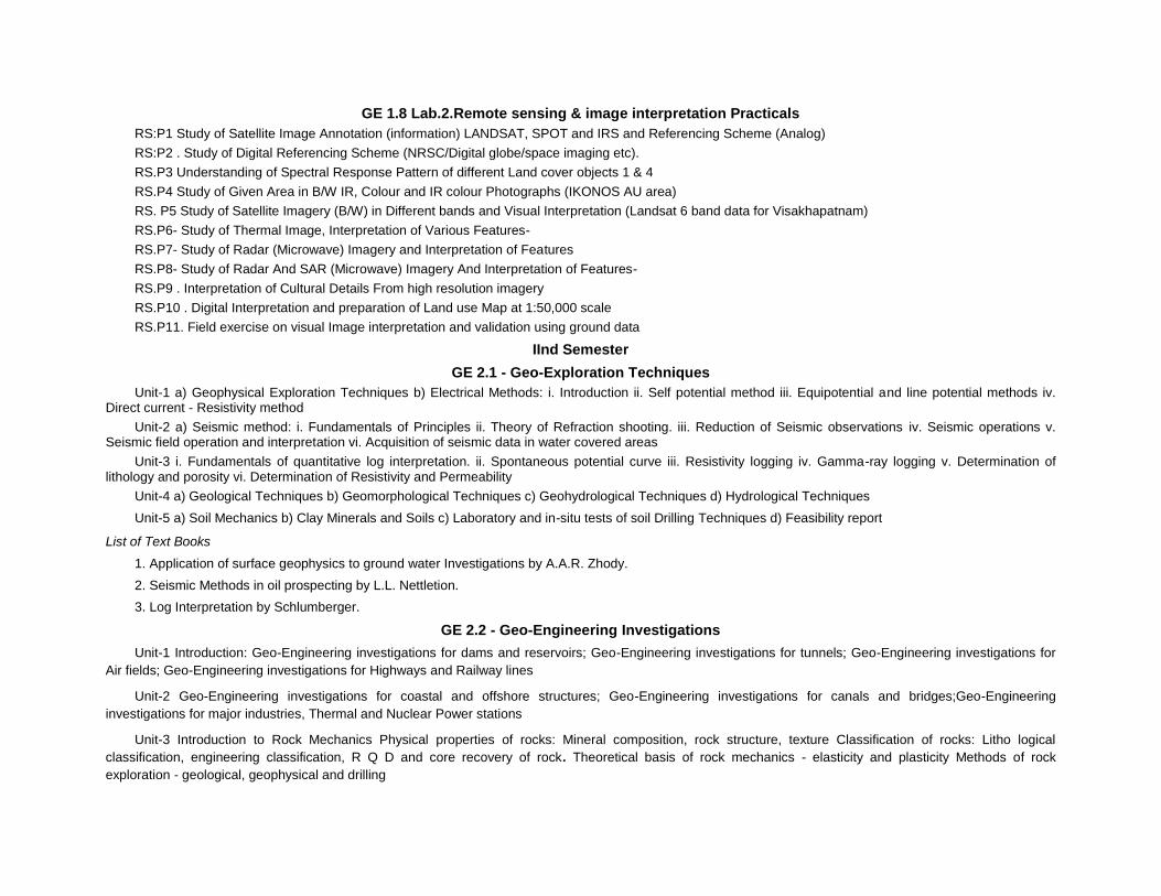
GE 1.8 Lab.2.Remote sensing & image interpretation Practicals
RS:P1 Study of Satellite Image Annotation (information) LANDSAT, SPOT and IRS and Referencing Scheme (Analog)
RS:P2 . Study of Digital Referencing Scheme (NRSC/Digital globe/space imaging etc).
RS.P3 Understanding of Spectral Response Pattern of different Land cover objects 1 & 4
RS.P4 Study of Given Area in B/W IR, Colour and IR colour Photographs (IKONOS AU area)
RS. P5 Study of Satellite Imagery (B/W) in Different bands and Visual Interpretation (Landsat 6 band data for Visakhapatnam)
RS.P6- Study of Thermal Image, Interpretation of Various Features-
RS.P7- Study of Radar (Microwave) Imagery and Interpretation of Features
RS.P8- Study of Radar And SAR (Microwave) Imagery And Interpretation of Features-
RS.P9 . Interpretation of Cultural Details From high resolution imagery
RS.P10 . Digital Interpretation and preparation of Land use Map at 1:50,000 scale
RS.P11. Field exercise on visual Image interpretation and validation using ground data
IInd Semester
GE 2.1 - Geo-Exploration Techniques
Unit-1 a) Geophysical Exploration Techniques b) Electrical Methods: i. Introduction ii. Self potential method iii. Equipotential and line potential methods iv. Direct current - Resistivity method
Unit-2 a) Seismic method: i. Fundamentals of Principles ii. Theory of Refraction shooting. iii. Reduction of Seismic observations iv. Seismic operations v. Seismic field operation and interpretation vi. Acquisition of seismic data in water covered areas
Unit-3 i. Fundamentals of quantitative log interpretation. ii. Spontaneous potential curve iii. Resistivity logging iv. Gamma-ray logging v. Determination of lithology and porosity vi. Determination of Resistivity and Permeability
Unit-4 a) Geological Techniques b) Geomorphological Techniques c) Geohydrological Techniques d) Hydrological Techniques
Unit-5 a) Soil Mechanics b) Clay Minerals and Soils c) Laboratory and in-situ tests of soil Drilling Techniques d) Feasibility report
List of Text Books
1. Application of surface geophysics to ground water Investigations by A.A.R. Zhody.
2. Seismic Methods in oil prospecting by L.L. Nettletion.
3. Log Interpretation by Schlumberger.
GE 2.2 - Geo-Engineering Investigations
Unit-1 Introduction: Geo-Engineering investigations for dams and reservoirs; Geo-Engineering investigations for tunnels; Geo-Engineering investigations for
Air fields; Geo-Engineering investigations for Highways and Railway lines
Unit-2 Geo-Engineering investigations for coastal and offshore structures; Geo-Engineering investigations for canals and bridges;Geo-Engineering
investigations for major industries, Thermal and Nuclear Power stations
Unit-3 Introduction to Rock Mechanics Physical properties of rocks: Mineral composition, rock structure, texture Classification of rocks: Litho logical
classification, engineering classification, R Q D and core recovery of rock. Theoretical basis of rock mechanics - elasticity and plasticity Methods of rock
exploration - geological, geophysical and drilling
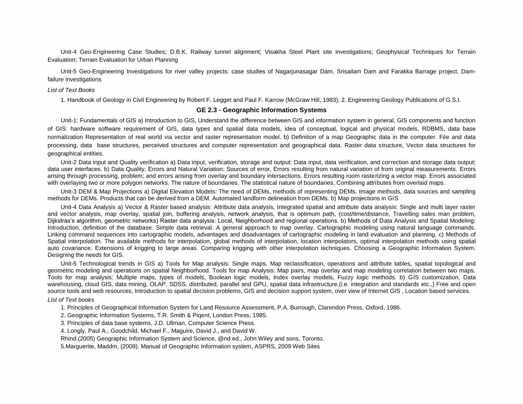
Unit-4 Geo-Engineering Case Studies; D.B.K. Railway tunnel alignment; Visakha Steel Plant site investigations; Geophysical Techniques for Terrain
Evaluation; Terrain Evaluation for Urban Planning
Unit-5 Geo-Engineering Investigations for river valley projects: case studies of Nagarjunasagar Dam, Srisailam Dam and Farakka Barrage project. Dam-
failure investigations
List of Text Books
1. Handbook of Geology in Civil Engineering by Robert F. Legget and Paul F. Karrow (McGraw Hill, 1983); 2. Engineering Geology Publications of G.S.I.
GE 2.3 - Geographic Information Systems
Unit-1: Fundamentals of GIS a) Introduction to GIS, Understand the difference between GIS and information system in general, GIS components and function
of GIS: hardware software requirement of GIS, data types and spatial data models, idea of conceptual, logical and physical models, RDBMS, data base
normalization Representation of real world via vector and raster representation model. b) Definition of a map Geographic data in the computer. File and data
processing, data base structures, perceived structures and computer representation and geographical data. Raster data structure, Vector data structures for
geographical entities.
Unit-2 Data input and Quality verification a) Data input, verification, storage and output: Data input, data verification, and correction and storage data output; data user interfaces. b) Data Quality, Errors and Natural Variation: Sources of error, Errors resulting from natural variation of from original measurements. Errors arising through processing, problem; and errors arising from overlay and boundary intersections. Errors resulting room rasterizing a vector map. Errors associated with overlaying two or more polygon networks. The nature of boundaries. The statistical nature of boundaries. Combining attributes from overlaid maps.
Unit-3 DEM & Map Projections a) Digital Elevation Models: The need of DEMs, methods of representing DEMs. Image methods, data sources and sampling methods for DEMs. Products that can be derived from a DEM. Automated landform delineation from DEMs. b) Map projections in GIS
Unit-4 Data Analysis a) Vector & Raster based analysis: Attribute data analysis, Integrated spatial and attribute data analysis: Single and multi layer raster and vector analysis, map overlay, spatial join, buffering analysis, network analysis, that is optimum path, (cost/time/distance, Travelling sales man problem, Dijkstras’s algorithm, geometric networks) Raster data analysis: Local, Neighborhood and regional operations. b) Methods of Data Analysis and Spatial Modeling: Introduction, definition of the database. Simple data retrieval. A general approach to map overlay, Cartographic modeling using natural language commands. Linking command sequences into cartographic models, advantages and disadvantages of cartographic modeling in land evaluation and planning. c) Methods of Spatial interpolation. The available methods for interpolation, global methods of interpolation, location interpolators, optimal interpolation methods using spatial auto covariance. Extensions of krigging to large areas. Comparing krigging with other interpolation techniques. Choosing a Geographic Information System. Designing the needs for GIS.
Unit-5 Technological trends in GIS a) Tools for Map analysis: Single maps, Map reclassification, operations and attribute tables, spatial topological and geometric modeling and operations on spatial Neighborhood. Tools for map Analysis: Map pairs, map overlay and map modeling correlation between two maps. Tools for map analysis: Multiple maps, types of models, Boolean logic models, Index overlay models, Fuzzy logic methods. b) GIS customization, Data warehousing, cloud GIS, data mining, OLAP, SDSS, distributed, parallel and GPU, spatial data infrastructure,(i.e. integration and standards etc.,) Free and open source tools and web resources, Introduction to spatial decision problems, GIS and decision support system, over view of Internet GIS , Location based services.
List of Text books
1. Principles of Geographical Information System for Land Resource Assessment, P.A. Burrough, Clarendon Press, Oxford, 1986.
2. Geographic Information Systems, T.R. Smith & Piqent, London Press, 1985.
3. Principles of data base systems, J.D. Ullman, Computer Science Press.
4. Longly, Paul A., Goodchild, Michael F., Maguire, David J., and David W.
Rhind.(2005) Geographic Information System and Science, @nd ed., John Wiley and sons, Toronto.
5.Marguerite, Maddm, (2009). Manual of Geographic Information system, ASPRS, 2009 Web Sites

1. http://www.gespatialworld.net; 2. www.earthmapping.com/; 3. http://www.esri.com// 4. http://www.innovativegis.com/basis/
GE 2.4 - Environmental Studies
UNIT 1 - Environmental Concepts
1) Environment – meaning, scope, components of environments
2) Ecosystems – Concept, components, evolution and development. Types and classification of ecosystems 3) Primary and Secondary production, food chains, food pyramid and energy flow
4) Biogeochemical and nutrient cycles - hydrological and material cycles
UNIT II - Environnemental Pollution 1) Air pollution – Sources of pollution, effets on humans. Global effects- green house effect, acid Rain, global warming and heat island effect. Effects on vegetation and materials, air pollution control 2) Water pollution – Sources of water pollution, water as an ecological factor and its role in the biosphere, water pollution control 3) Soil pollution – Sources of soil pollution, effects of soil pollution, soil pollution Control
UNIT III – Human Activities and Environmental Degradation 1) Human population and environment 2) Impact of human land use practices on environment 3) Deforestation and environmental change 4) Urbanization and industrialization. Urban environmental problems- air, water, noise, nuclear, thermal pollution and human health hazards
UNIT IV - Environmental Impact Assessment (EIA) 1) Need of EIA, EIA procedure, Environmental impact statement an procedure 2) EIA methodologies- Adhoc method, Check list method, Matrix method, Overlay method, Network method and Benefit-cost ratio method 3) Environmental impact assessment for Irrigation, Industrial, Airport, Transport and Thermal projects 4) Assessment of impacts on socioeconomic environment
UNIT V – Environmental Analysis Application of Remote sensing and GIS in Environmental analysis
1) Change detection and mapping- vegetation change, erosion and deposition 2) Detection of air and water pollution 3) Encroachment and wetland degradation 4) Disaster management-cyclones, floods and droughts, earthquakes and volcanic eruptions
List of Text Books
1) Ecology and Environment, P.D. Sharma, Rastogi Publications
2) Environmental Science, M. Chandra Sekhar, The HI-TECH Publishers
3) Environmental Studies, R.Rajagopalan, Oxford University Press
4) Remote Sensing of the Environment – An earth resource perspective, John R. Jenson, Pearson Education (Singapore) Pvt. Ltd.
5) Modern Concepts of Ecology, H.D. Kumar, Vikas Publishing House Pvt. Ltd.
6) Environmental Impact Analysis: A new dimension in decision making, second edition, R. K. Jain, L. V. Urban and G.S. Stacy, published by Van Nostrand Reinhold Company 7) Pollution Control and Conservation, Kovacs, M.(ed), Ellis Horwood Ltd., Budapest, 1985 8) Biogeography, Robinson, H. ELBS, London, 1978 9) Preventive and Social Medicine, Park & Park, Banarasidas
GE 2.5 Elective-1
Choose any one of the following A - Water Resources Evaluation B. Integrated Watershed Management A - Water Resources Evaluation.
Unit-1 Quantitative geomorphology of drainage basins and channel networks. Runoff Hydrology of Urban areas
Unit-2 Hydrology of Agricultural lands Hydrology of Forest lands and Range lands Hydrology of arid and Semi-arid regions, Floods
Unit-3 Groundwater Potential areas in India Aquifer Properties and ground water flow Well Hydraulics
Unit-4 Sea water intrusion Ground water basin management and conjunctive use Ground water pollution and legislation
Unit-5 Planning for water resources development in Rural and Urban areas with reference to Indian continent. Water balance studies
List of Text Books
Hand book of Applied Hydrology by Ven Te Chow Groundwater by H.M. Raghunath Water Resources Engineering by R.K. Linsely & J.B. Franzini B. Integrated Watershed Management.
Unit-1 (Watershed Concept) Issues in watershed management - land degradation, agricultural productivity, reservoirs sedimentation, depletion of bioresources, floods and droughts. Principles and approaches - principles of watershed management, different approaches in watershed management; Problem oriented approach, three dimensional approaches, integrated approach, steps in watershed management. Watershed characteristics - size, shape physiography, slope, climate, drainage, landuse, vegetation, geology, soils, hydrology, hydrogeology, socio-economics. Linear aspects of channel systems - Aerial aspects of drainage basins.
Unit-2 (Land Management) Survey, layout ; Preparation and Development. Contour demarcation, Bush clearance, updating, stone picking and packing, leveling, shaping and consolidation, fencing, ploughing; soil and soil moisture conservation. Soil survey; conservation measures. Contour techniques, ploughing, furrowing, trenching and staking, Gully control. Pervious check dams. Burshwood dam, Rockfill dam, Gabion; Impervious check dams. Land capability classification, land degradation and problem soils. Reclamation of saline soils, alkaline soils, saline soils, acidic soils, sulphide soils; sediment yield modeling and watershed prioritization. The universal soil loss equation, sediment yield index method, statistical regression model, the European soil erosion model; Site selection from conservation measures.
Unit-3 (Water Management) Surface water - Study of rainfall, estimation of run-off at micro catchments, stream gauging; Rainwater harvesting; catchment, harvesting, harvesting structures, Ground water - exploration of canal command areas, potential areas; integrated water resources management, conjunctive use. Dry land Agriculture - Runoff agriculture, micro catchment forming, irrigation with saline water, reusing water, conserving water, sprinkler irrigation, drip irrigation, pot irrigation, other systems, reducing crop land percolation losses, reducing transpiration losses, selection of water use efficiency crops.
Unit-4 (Integrated Management) Agriculture - Crop husbandry, soil enrichment, inter mixed and strip cropping, cropping pattern; sustainable agriculture, Hybrid and improved seeds; Biomass management, crop rotation, legumes, organic fertilization, spider farming, pastures and silvipastures; horticulture; tree culture; form forestry; bund utilization, boundary plantation; social forestry; Energy - Renewable resource, water power, solar energy wind power; biomass, fire wood, synthetic fuels, burning of municipal / garbage, ocean tides and waves. Appropriate Technology - farm equipment; Contour methods; check dams, water catchment and harvesting; kunds, depression harvesting, harvesting below ground level, harvesting below stream bed level, ground water harvesting; low cost technology, water conservation, utilization of wasted natural resources, Novelities; Rural technological delivery systems, cultivating wasted lands, tree culture, farm forestry, silvipastures, horticulture, social forestry, afforestation, wonder ways.
Unit-5 (Monitoring and Evluation) People’s Part - awareness, participation, Response; State and integrated approach, appreciation of the concept, training, transfer of technology, resource and development, Agro-industrial infrastructure; sustainable society, livestock, small animal farming, pisiculture, sericulture, Health and hygiene education, transport, cues. Monitoring and Evaluation - purpose of monitoring and evaluation, nature of monitoring and evaluation - an interative dynamic Process, design of monitoring programs - determining information needs, setting information-need priorities,
Determining means of collecting information, Information management in monitoring programs; monitoring biophysical data, monitoring socio-economic data, monitoring project activities and outputs, design of evaluation procedures, types of evaluation, focus of evaluation, reporting evaluation results, insuring use of monitoring and evaluation information, a final word of caution.
Text Books and References
1. Watershed Management, J.V.S. Murthy - Publishers; New Age International (P) Ltd., New Delhi.
2. Space Technology Applications for Sustainable Developments at Watersheds, Technical Report, ISRO-HQ-TR-104-95, ISRO, Bangalore.
3. Watershed Management Project Planning, Monitoring and Evaluation; A Manual for the Asian Region - Asian-US Watershed Project - Forestry for sustainable Development Program. University of Minnesota, College of Natural Resources, St. Paul Minnesota, U.S.A.
C Urban Planning and Information Systems
Unit – I Introduction Planning: background and principles; Need for planning; Urbanisation and its impact, Distribution of land use/land cover; Town planning in ancient India and new towns of India; Requirements and possible types of development of towns; Geoinformatics application in Urban Planning
Unit II Formulation of Plans Objectives and contents; Regional plan; Perspective plan; Master plan; Development plan; Project (scheme) plan; Delineation of planning area; Trend analysis; Land suitability analysis; Land use planning; Zoning and principles of zoning; Building Bye-laws and its principles; Requirement of urban & regional planners; Remote sensing for different levels of development planning
Unit – III Housing Importance of housing; urban housing demand and production; Slums and squatters; Housing problem in India; National Housing policy; Site analysis - Layout design; Housing projects / Slum housing; Urban renewal projects; Urban infrastructure planning
Unit – IV Transportation planning Classification of urban roads; Traffic surveys: speed, time, delay surveys; Use of speed, journey time and delay studies; Traffic volume; Origin Destination surveys; Parking surveys; Utility of remote sensing in traffic and transportation studies
Unit – V Urban Information System Information system: Land; Housing; Transportation; Infrastructure; Trends in mapping using remote sensing, GIS and GPS; Database creation for Infrastructure development Decision support system for urban and regional management.
GE. 2.6 Elective-2
Choose anyone of the following A. Digital photogrammetry and mapping B. Geoinformatics for Resources Studies and Disaster management C: Spatial Database Modeling A. Digital photogrammetry and mapping
Unit 1 : Geodesy and Surveying Fundamentals of geodesy, Geodetic reference systems: ICRE, ITRF, Geoid and geoidal heights and undulations.Geodetic datum and datum transformation, Map projection and transformation.Techniques of ground survey (horizontal and vertical control,triangulation, traversing, leveling, GPS and Total Station surveying). Data integration from different sources (GPS, Total Station, High resolution satellites) for large scale mapping and cadastral surveys.
Unit-II GNNS: Carrier phase measurements, Signal structure, GNNS Errors and biases, Differential Positioning –concepts and principles, IGS station-final ephemeris, differential corrections, accuracy in differential satellite positioning system PS, local area DGPS, wide area DGPS, LAAS, WAAS,GAGAN, Mapping methods with GPS – rapid static method, semi-kinematic method, kinematic method. Real time DGPS. GNSS, GLONASS, IRNSS, GALILEO, Beidou, and future prospects of navigational satellites
Unit-III: Aerial and Satellite Photogrammetry Photogrammetric camera (digital), Imaging systems- Asynchronous imaging, multiline scanners, multiple camera/multi sensors, area scanners, panoramic linear array scanners, wide field camera, Imaging properties, Theory of orientation: (IO, RO and AO) .
Photogrammetric Triangulation: Single image, Stereo-pair (two overlapping images), Strip triangulation, Block Adjustment of Independent Models (BAIM), Bundle Block Adjustment, Special cases (resection, intersection, and stereo-pair generation).
Satellite Photogrammetry: Orbital Parameters, Orbital Modeling, Data Processing for stereo generation (block triangulation, optimum control requirement), Space Resection and Intersection, Solutions and differences in different sensor models for photogrammetric processing. Processing of IRS IC/ID, CARTOSAT, ASTER, ALOS PRISM, SPOT, IKONOS, Quick Bird etc.
Unit IV: Close Range Photogrammetry Principles of CRP, Cameras for Close Range Applications, Data Acquisition, Camera Calibration, Data Processing, Surface Generation, Validation, Terrestrial Laser Scanners and future prospects.
Unit V: Digital Cartography and Visualization Geo Spatial Data Base organization, Digital Cartography, Web Cartography, 3D Simulation and Visualization, Digital earth models and data dissemination services: contemporary approaches (Bhuvan and Google Earth) and future prospects.
Suggested Readings:
Books and Reports 1. Toni Schenk: Digital Photogrammetry, Volume I., Terra Science.
2. Sanjib K. Ghosh, (1979): Analytical Photogrammetry, New York: Pergamon Press
3. Sanjib K. Ghosh. (2005). Fundamentals of computation Photogrammetry. Concept Publishing, New Delhi.
4. Luhmann, Thomas, Robson, Stuart and Kyle, Stephen, (2007). Close Range Photogrammetry:
Principles, Techniques and Applications. Wiley, 2007. 528. ISBN : 978047010633.
5. Kasser Michel and Egles Yves, (2002). Digital Photogrammetry. London: Taylor and Francis, 2002. XV, 351 p.
6. Wolfgang Torge, W., Geodesy, 3rd edition
7. Robinson H. Arthur, Morrison Joel L. and Muehrcke Phillip C. (1995). “Elements of Cartography, 6th ed., John Wiley and Sons, Inc, 671p.
8. Slocum Terry A, (1999). Thematic Cartography and Visualization. New Jersey: Prentice -Hall Inc., 1999. 293p.
9. Kraak Menno-Jan and Ormelling, Ferjan (2003): Cartography: Visualization of geospatial data. 2nd (ed.) Harlow: Prentice Hall, IX, 205p.
10. Kraak Menno-Jan (Ed.) and Brown Allan (Ed) (2001). Web Cartography: Developments and Prospects. New York: Taylor & Francis, IX, 213 p.
Textbooks
- Rangwala, Town Planning, Charotar Publishing House, Anand, India
- Gallian B. Arthu and Simon Eisner, The Urban Pattern, City Planning and Design. Affiliated Press Pvt. Ltd., New Delhi 1985.
- Margaret Roberts, Ana Introduction to Town Planning Techniques, Hutchinson, London, 1980.
B. Geoinformatics for Disaster management
Unit I Natural Resources Development: Introduction and Scope: role of geoinformatics technologies – aerial photographs; satellite remote sensing; GPS; and GIS in resource evaluation. Water resources – surface water and groundwater resources: mapping and monitoring of watersheds, tanks and reservoirs; hydrogeomorphic mapping and identification of groundwater potential zones. Ocean resources: estimation of sea-surface temperature; primary productivity and potential fishing zones
Unit II Soil and agricultural resources: Spectral behavior of soils; Mapping of soils using multispectral images; Evaluation of soil erosion prone zones through GIS; Remote sensing in Land use / land cover mapping; Crop area estimations; monitoring of crop vigour; Yield estimations.
Forest resources: mapping of forest types; estimations of timber volume; monitoring of forest health – forest pests, forest fires, Trends in deforestation and afforestation.
Unit III Remote sensing techniques for identification of rocks and minerals; mapping of geological structures; surface manifestation of minerals and their identification; spectral properties of minerals; role of thermal and hyperspectral remote sensing in mineral exploration. Case studies
Unit IV Geoinformatics in Disaster Management: introduction and scope. Coastal Hazards: Storm surges and Tsunamis: Origin, propagation and run-up; Role of coastal topography, bathymetry and vegetation;Coastal hazard preparedness –Role of geoinformatics in coastal hazard mapping, risk and vulnerability assessment and evacuation analysis; coastal protection, education and awareness of coastal communities
Unit V Geoinformatics applications in disaster mapping and mitigation; Risk zone mapping: earthquakes – identification of geological structures like faults; volcanic activity – thermal imaging for monitoring temperature changes; Geoinformatics analysis of potential zones for landslides; avalanches; and floods. Mapping of disaster affected areas for rescue and mitigation; damage assessment; GIS-based decision support systems for disaster management
Books and References:
Remote sensing for earth resources 2nd Edition, (ed) D.P. Rao, AEG Publ., Hyderabad, 1999
Geomatics solutions for Disaster Management, Li, Zlatanova and Fabbri (ed), Springer, 2007
Role of remote sensing in disaster Management, Nirupama and S.P Simonovic, ICLR Research
Paper Series 21, 2002 (available at http://www.iclr.org/pdf/Niru_report%20Simonovic.pdf)
Remote Sensing imagery for natural resources monitoring: a guide for first time users, D.S. Wlike and J.T. Finn, Columbia University Press
Successful response starts with a map: Improving Geospatial Support for Disaster Management by Committee on Planning for Catastrophe: A Blueprint for Improving Geospatial Data, Tools, and Infrastructure, National Research Council, National Academies Press, 2006, ISBN: 0309103401
Applications of Remote Sensing in Agriculture, M.D. Steven and J.A.Clark, Butterworths, 1990
Tsunamis- to survive from tsunami, Susumu Murata et al., 2009 World Scientific Books
Reference
Sea-Level Rise and Coastal vulnerability – an assessment of Andhra Pradesh coast, India through remote sensing and GIS, Nageswara Rao, K. et al., (2008) Journal of Coastal Conservation, Vol. 12: pp. 195-207
Imperatives for Tsunami Education, Nageswara Rao, K. (2007) Current Science, Vol. 93 (1) pp. 8-9.
C: Spatial Database Modeling
Unit-I Spatial Database Management System: Database overview, attribute data model, Spatial Database, spatial Data Type and structures. Spatial Database Design: Conceptual data modelling, Concepts of UML, UML use case, Spatial data topological relationship.
Unit-II Spatial Database: Storage and Retrieval Concepts of spatial data storage, spatial Indexing, Basics of relational algebra, Data normalization, Spatial Query languages using extended SQL, spatial query processing and optimization.
Unit-III GIS Implementing Architectures: GIS Implementation architectures (desktop, client server, enterprise, mobile, web/cloud, web services from mobile platforms, spatial data acquisition / supply in distributed environment and security issues.
Unit-IV Spatial Data Modelling 05 Spatial data modelling and its classification, spatial decision support system, spatial decision modelling concepts, AHP based modelling with case study, Agent based modelling with case study.
Unit-V Spatial Data Mining: Overview of data mining, Concepts of Decision tree based approach with case study, Content based image retrieval concept with case study.
Suggested Readings:
Books and Reports 1. Alistair Cockburn (2001). Writing Effective Use Cases (Boston, MA Addison Wesley, 12001).
2. Date,C.J.: Database System, Tata McGraw Hill Publications.
3. Shashi Shekhar & Sanjay Chawla (2003). Spatial database: A Tour, Prentice Hall, 2003.
4. Garnady Booch, James Rumbaugh and Ivar, Jacobson (1999). The Unified Modeling language User Guide (Boston, MA Addison Wesley, 1999).
5. Marvin V. Zelkowitz, Alan C. Shaw and John D. Gannon (1979). Principles of Software Engineering and Design, Englewood Cliffs, NJ: Prentice Hall, 179, p5.
6. Sudha T. and M. Usha Rani: Applications of Data Mining, ISBN: 81-8356-330-7. Journal Articles
1. Daniel G. Brown, Rick Riolo, Derek T. Robinson, Michael North and William Rand: Spatial Process and
Data Models: Towards Integration of Agent Based Models and GIS, Journal of
GE 2.7 Lab.1. Geo-Engineering Practicals
a) Geoelectrical survey and computations b) Seismic refraction and reflection data computations. a) Laboratory determination of soil classification b) Attenberg limits c) Specific gravity
Lab, permeability by constant and failing head methods; Direct Shear and triaxial shear test; Compaction and bulk density; Consolidation test; Field work and data analysis; Ground water exploration & Management; Well monitoring; Well/bore well pumping tests; Selection of pumps; Safe yield determination; Identification of gray areas; Design of rain water harvesting structures; Geotechnical exploration; Subsurface litho logy; Bed rock mapping; Identification of buried pipes; Location of infiltration wells in the river bed; Mobile mapping through GPS; point mapping; linear mapping; polygon mapping
GE 2.8 Lab.2. Geographic Information Systems Practical’s
1. Familiarity with D Base Commands including record updating and processing.
2. Theme representation by usage of graphics command resources data maintenance - Theme filling and retrieval and usage.
Exercise: Development / updating of data base management software packages for a selected practical problem using available GIS package.
Arc-info, Arc-View practice and ILWIS software packages
Creation of different spatial layers.
Map analysis.
SEMESTERS III & IV
Dissertation and Viva Voce
A) Dissertation: The student for the fulfillment of M.Tech Degree in Remote Sensing must carry out individual dissertation work. Candidates can do their work in the department or in any industry/research organization for two semesters (ie 3rd and 4th semesters)
B) Evaluation procedure: Progress of the dessertation/ thesis work at the end of 3rd Semester will be evaluated by a committee consisting of Chairman, Board of Studies, Head of the Department and Thesis guide.
The Final thesis at the end of 4th Semester is evaluated through defence and Viva Voce examination will be conducted to the student by the external examiner and the internal research guide along with the Head of the Department and Chairman Board of Studies, on the topic of the dissertation carried out by the student the candidate may be recommended for award of a grade such as A (=Excellent); B (=Very Good); C (=Good); or F (=Not Accepted/Failed).
The prerequisite for submission of the M.Tech.thesis is that one should communicate his/her work to any referred journal or Publication in a conference. For final result the dissertation credits are not added for CGPA..
REMOTE SENSING
M.Tech. Remote Sensing course
An applicant for admission into the M.Tech. Remote Sensing should have at least a second class with not less than 55% marks degree in either:
B.E. / B.Tech. in any Engineering OR Master’s degree in science
In the available number of seats, 50% are reserved for B.Sc. (Ag.)/B.E./B.Tech.
Applicants. If sufficient number of eligible applicants is not available in either of the two groups, the eligible applicants from the other group are given admission, to fill all the available seats in M.Tech. (Remote Sensing).
1. A) A regular course of study means attendance is not less than 75 per cent of lectures, practical, drawing exercises, workshop and practical and field and project work, if any, in such semester in such subject, according to the scheme of Instruction to be notified by the Head of the Institution, provided that in special cases for sufficient cause again the Vice-Chancellor may on the recommendation of the Principal, condone the deficiency in attendance, not exceeding 10 per cent, for reasons of illhealth when the application is submitted at the time of the actual illness and is supported by an authorized Medical Officer approved by the Principal.
B) However, in the case of students, who participate in activities, such as NCC, Inter- University Tournaments, National Tournaments Inter University Courses. NSS and any such other activities deemed genuine by the Head of the Department Concerned, the period of their absence for the above purpose can be condoned by the Principal on the recommendation of the Head of the Department.
2. A) There shall be a written examination at the end of each of the first two semester in the subjects offered in the respective semesters.
B)The Candidate should choose one elective from Elective-1 and Elective-2 in the first and second semester.
C) The candidates are required to submit, at the end of the fourth semester, three copies (as prescribed) of the dissertation on or before a date to be notified by the University from time to time, accompanied by three copies of a short summary, all of which will be retained by the University.
D) At the end of the third semester and fourth semester, an evaluation of the dissertation there shall be viva-voce (preliminary) for 100 marks (1) and (2) a viva voce for 100 marks on the dissertation and related subjects.
E) Marks for sessional work shall be allotted by the Teaching Staff of the college on the basis of class work, slip tests, practical works, etc., and the list of marks shall be sent to the Registrar, before the commencement of the written examination.
F) For taking the examination in the theory in any subject candidates shall be required to obtain a minimum of 50 per cent in sessional work in that the subject, failing which, they shall be required to repeat the course in that subject in the semester in which it is offered again for study.

G) Candidates who fail to secure the minimum prescribed marks in that subject will be permitted to continue the studies in the next semester. They shall, however, be required to pass the examination in the subjects in which they have failed, in the subsequent examination.
H) Candidates who have secured not less than 40 per cent in any of the theory papers and not less than 50 per cent of the total maximum marks of the theory paper and sessionals put together shall be declared to have passed the examination in that subject. In the case of subjects in which no written examination is prescribed, candidates should secure 50 per cent of the marks allotted to each of these subjects.
3. A) The evaluation of Project work / Research work will be done by conducting viva voce examination at the end of third and fourth semester by a Board of Examiners consisting of:
1. Head of the Department
2. Chairman, Board of Studies
3. The Internal Research Director
4. One or two experts from outside the Department / University nominated by the Vice-Chancellor.
The dissertation shall be either “recommended”(with grades A, B, C), or “Not recommended”(with grade F stands for failed).
4. Candidates who have passed all the subjects of the course and secured not less than 60 per cent of the aggregate of marks, shall be declared to have passed in first class.
All the remaining successful candidates shall be declared to have passed in second class.
5. Candidates who fail in the subjects of any semester will be deemed to have been conditionally promoted. They shall however, have to appear and pass only in the subjects in which they have failed. Candidates have to take the examination in the subjects in which they have failed during these semesters, when the University conducts the examinations in those subjects.
6. The marks obtained will be converted to grades on a 10 point scale and then to Semester Grade point Average(SGPA) and subsequently Cumulative Grade Point Average is awarded at the end of the course by University.
Department of Geo-Engineering
M.Tech.Remote sensing
Scheme of Instructions and examination
(with effect from 2019-2020 academic year)
I-SEMESTER
Code No. Course Title Scheme of Scheme of Examinations Total Credits Instructions Lec. Lab Total Duration of Theory/ Sessional Exam. (hrs) Lab/Viva
RS 1.1 Mathematics and 4 - 4 3 70 30 100 4 Statistics
RS 1.2 Principles of 4 - 4 3 70 30 100 4 Remote Sensing
RS 1.3 Principles of 4 - 4 3 70 30 100 4 Photogrametry and Photointerpretation
RS 1.4 Earth Systems 4 - 4 3 70 30 100 4
RS 1.5 Elective 1 4 - 4 3 70 30 100 4

A. Coastal Zone Management
B. Natural Disaster Management
C. Satellite
Meteorology, Agriculture and Oceanography
RS 1.6 Elective 2 4 - 4 3 70 30 100 4
A. Mathematical Morphology in Image Processing
B.Water Resources Management
C. Geoinformatics for Earth Science Applications
RS 1.7 Lab:1 - 3 3 3 50 50 100 2
Photogrammentry and Photo interpretation practicals
Rs 1.8 Lab:2 Remote - 3 3 3 50 50 100 2 sensing and image interpretation practicals
Total 24 6 30 520 280 800 28
II-SEMESTER
Code No. Course Title Scheme of Scheme of Examinations Total Credits Instructions Lec. Lab Total Duration of Theory/ Sessional Exam. (hrs) Lab/Viva
RS Digital Image 4 - 4 3 70 30 100 4 2.1 Processing and Interpretation
RS Remote Sensing 4 - 4 3 70 30 100 4 2.2 applications
RS Geographic Information 4 - 4 3 70 30 100 4
2.3 Systems
RS Advances in Remote 4 - 4 3 70 30 100 4
2.4 Sensing
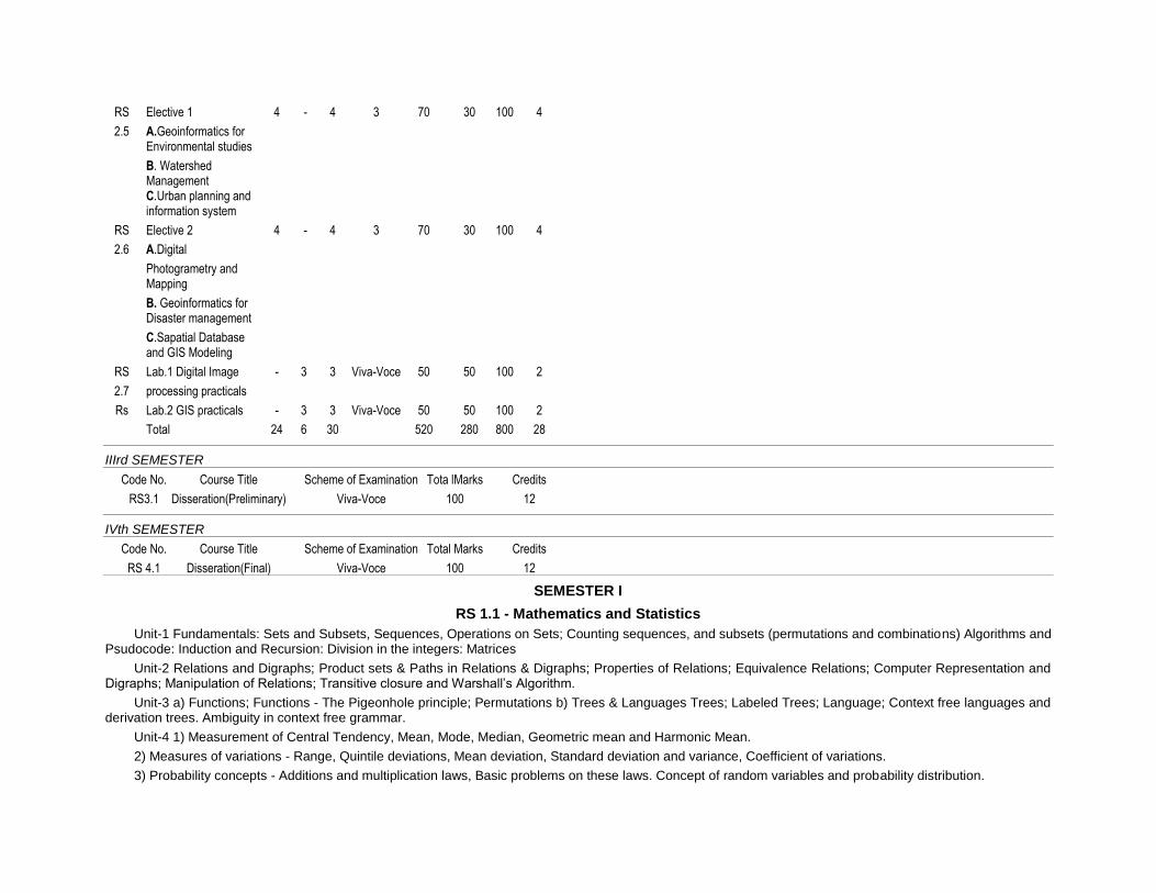
RS Elective 1 4 - 4 3 70 30 100 4
2.5 A.Geoinformatics for Environmental studies
B. Watershed Management C.Urban planning and information system
RS Elective 2 4 - 4 3 70 30 100 4
2.6 A.Digital
Photogrametry and Mapping
B. Geoinformatics for Disaster management
C.Sapatial Database and GIS Modeling
RS Lab.1 Digital Image - 3 3 Viva-Voce 50 50 100 2
2.7 processing practicals
Rs Lab.2 GIS practicals - 3 3 Viva-Voce 50 50 100 2
Total 24 6 30 520 280 800 28
IIIrd SEMESTER
Code No. Course Title Scheme of Examination Tota lMarks Credits
RS3.1 Disseration(Preliminary) Viva-Voce 100 12
IVth SEMESTER
Code No. Course Title Scheme of Examination Total Marks Credits
RS 4.1 Disseration(Final) Viva-Voce 100 12
SEMESTER I
RS 1.1 - Mathematics and Statistics
Unit-1 Fundamentals: Sets and Subsets, Sequences, Operations on Sets; Counting sequences, and subsets (permutations and combinations) Algorithms and Psudocode: Induction and Recursion: Division in the integers: Matrices
Unit-2 Relations and Digraphs; Product sets & Paths in Relations & Digraphs; Properties of Relations; Equivalence Relations; Computer Representation and Digraphs; Manipulation of Relations; Transitive closure and Warshall’s Algorithm.
Unit-3 a) Functions; Functions - The Pigeonhole principle; Permutations b) Trees & Languages Trees; Labeled Trees; Language; Context free languages and derivation trees. Ambiguity in context free grammar.
Unit-4 1) Measurement of Central Tendency, Mean, Mode, Median, Geometric mean and Harmonic Mean.
2) Measures of variations - Range, Quintile deviations, Mean deviation, Standard deviation and variance, Coefficient of variations.
3) Probability concepts - Additions and multiplication laws, Basic problems on these laws. Concept of random variables and probability distribution.

Unit-5 1) Theoretical distribution; Binomial, Poisson and normal with application.
2) Correlation Analysis - Introduction, Karl Pearson’s Coefficient of Correlation, Auto Correlation.
3) Regression Analysis - Linear regression analysis; Curve fitting concept of multiple regression analysis.
4) Theory of Sampling - Meaning of a sample, Universe, static and parameters. Sampling distribution, standard error. Different sampling techniques like scruple random sample, standard random sample, systematic, cluster and multi-storage sample.
Text Books
1) Statistics by S.P. Gupta
2) Statistical theory and methods by SANCHETIC and Kapoor
3) Statistics by S.C.Gupta
RS 1.2 Principles of Remote Sensing
Unit-I Basics of Remote Sensing: a) Overview of Remote sensing: Definition of Remote sensing
Principles of Remote Sensing, Electromagnetic Radiation, Radiometric terms and definitions, Radiation Laws, EM spectrum, Sources of EM, Interaction of EM Radiation with atmosphere, and target, Atmospheric Widows, imaging spectrometry, Spectral signature of various land cove features
b) PLATFORMS AND SENSORS * Platforms: Types of platforms, ground, airborne, and space born platforms, Orbit of satellites, Kepler’s Law, satellite characteristics, satellites for Earth observations studies, and planetary missions (Chandrayana) * Sensors: Types and classification of sensors, imaging modes, Characteristics of optical sensors, sensor resolution-spectral, radiometric and temporal, Characteristics of detectors,
Unit-II a) Data reception, Data processing & Data generation: * Ground station, Data generation, Data processing & correction b) Radiometric and Geometric corrections * Radiometric corrections Random noise correction * Atmospheric correction, Geometric errors and corrections, * Distortion evaluated from tracking data, distortion evaluated from ground control Image correction. c) Ground Investigation in support of Remote sensing * Uses of ground data, calibration correction, Interpretation of properties, Training sets, Accuracy evaluation, test sites * Ground truth Instruments and spectral signature, * Spectral Reflectance and spectral signature of vegetation * Sources of RS data: Global and Indian data products
Unit-III : Visual Image Interpretation: * Introduction to Visual Interpretation, Basic principles of Visual Interpretation * Elements of Visual Interpretation, Techniques of Visual Interpretation * Interpretation Keys, Methods of searching and sequence of Interpretation * Methods of analysis and Reference levels * Computer compatible tapes – Band sequential format, Band interleaved by Line format, Run-length encoding format. * Hardcopy outputs – Generation of B/W and False Color Composites. Generally supported scales of the data products, Information about annotation of the products.
Unit-4 Thermal Imaging system: * Thermal Imaging System: Introduction - IR region of the Electromagnetic spectrum, Atmospheric transmission, Kinetic and radiant temperature, Thermal properties of materials, Emissivity, Radiant temperature. Thermal conductivity. Thermal capacity, thermal inertia, apparent thermal inertia, Thermal diffusivity. * Radiation principles ( Plank’s Law, Stephen Boltzman law), Interaction of EMR with earth surface, Wien’s displacement law, Kirchoffs Law). * IR - radiometers, Airborne and Satellite TTR scanner system * Characteristics of IR images i) Scanner distortion, ii) image irregularities, iii) Film density and recorded iv)Temperature ranges * Effects of weather on images i) Clouds, ii) Surface winds, iii) Penetration of smoke plumes * Interpretation of thermal imagery * Advantages of Thermal imagery
Unit-V Microwave Remote Sensing: * Introduction - Electromagnetic spectrum, Airborne and Space borne radar systems basis instrumentation. * System parameters - Wave length, Polarization, Resolutions, Radar geometry. * Target parameters - Back scattering, Point target, Volume scattering, Penetration, Reflection, Bragg resonance, Cross swath variation. Speckle radiometric calibration. * Microwave sensors and Image characteristics, Microwave image interpretation * Application : Geology, Forestry, Land use, Soils etc. Future trends and Research * Physics of lager, laser interaction with objects. Types of LiDAR (Topographic, Bathymetric) platforms of LiDAR, components of LiDAR.
List of Text Books
1. Floyd, F. Sabins, Jr: Remote Sensing Principles and Interpretation, Freeman and Co., San Franscisco, 1978.
2. Illesand and Kiefere: Remote Sensing and Image interpretation, John qwiley, 1987.

3. Manual of Remote Sensing Vol. I&II, 2nd Edition, American Society of Photogrammetry.
4. Remote Sensing: The quantitative approach, P.H. Swain and S.M. Davis, McGraw Hill.
5. Introductory Digital Image Processing: A remote sensing perspective, John R. Jensen, Prentice Hall.
6. Imaging Radar for Resource Survey: Remote Sensing Applications, 3, W Travelt, Chapman & Hall.
7. Remote sensing Notes –Edited by Japan Associates of Remote sensing- JARS 1999
RS 1.3 Principles of Photogrammetry and Photointerpretation
UNIT- I Fundamentals of Photogrammetry and Photointerpretation – types of photographs; Vertical photographs – principal point; scale; Stereoscopy; Vertical exaggeration – factors involved and determination; Overlap, sidelap and flight planning
UNIT- II Geometric elements of vertical aerial photographs; Relief Displacement on vertical aerial photographs; Parallax and parallax measurement – monoscopic and stereoscopic methods; Determination of horizontal ground length, direction and angles from photo coordinates;
UNIT - III Aerial mosaics: comparison with maps; Elements of aerial photo interpretation – (a) landforms; (b) surface drainage patterns; (c) erosion features, (d) gray tones; (e) miscellaneous elements.
UNIT - IV Digital Photogrammetry: definition and scope; Photographs and images; Geo-referencing – Interior orientation, exterior orientation; aerotriangulation – single frame and block triangulation - pass points, tie points; ground control points; Satellite photogrammetry
UNIT - V 3-D surface modeling – DEMs, DSMs and DTMs; Triangulated irregular networks; Gridded surfaces; interpolation methods; Contour representation; Terrain visualization; DEM user applications.
Textbooks
1. Aerial photographic interpretation, Lueder, D.R., McGraw Hill Book Co., 1959
2. Elements of Photogrammetry, Paul R. Wolf, McGraw-Hill, 2000
3. Remote sensing and Image interpretation, Lillesand and Keifer, John Wiley and Sons, 2000
4. Manual of Photogrammetry, McGlone, C., Edward, M. and Bethel, J, American Society for Photogrammetry and Remote Sensing, Bethesda, MaryLand, USA. 2005
5. Digital Elevation Model Technologies and Applications: The DEM user Manual, David F. Maune (ed), American Society for Photogrammetry and Remote Sensing, Bethesda, MaryLand, USA, 2001
6. Leica Photogrammetry Suite – Orthobase and Orthobase Pro User Guide, Leica Geosystems, GIS & Mapping, Atlanta, USA, 2003.
RS 1.4 - Earth Systems
Unit-1 a) Earth - Orbit, Rotation, Time b) Oceans - Depth, Bottom relief
c) Oceans - Temperature, Salinity, Density of seawater d) Oceans - Waves, Tides, Currents e) Climate and the atmosphere – Origin, nature, composition and vertical division of the atmosphere.
Unit-2 a) Meteorological parameters and their measurements - Geographical, seasonal and vertical distribution of temperature, pressure, wind and precipitation. b) Solar and terrestrial radiation: Distribution in clear, cloudy and average conditions. Mean heat balance. c) Weather disturbances: Air mass and Front, Cyclone and anti-cyclone. Thunderstorm and tornado. d) Weather analysis and Forecasting e) Climate and agricultural factors in crop production.
Unit-3 a) Climate Change: Causes and Impacts b) Monsoons : Concepts of the origin of monsoon - Indian Monsoons c) Fundamental concepts of Geomorphology d) Weathering, Mass wasting and erosion.
Unit-4 a) Wind and associated land forms b) Seas and associated land forms c) Land forms associated with faults and folds d) Rivers and associated land forms e) Glaciers associated land forms
Unit-5 a) Soil forming processes, Soil profile, Soil components. b) Pedogenic regimes. c) Classification of soils d) Soils of India
List of Text Books
1. Structural Geology by Billings, M. 1984
2. Earth History & Plate Tectonics by Carl K. Seyfert, Leslie A. Sirkin
3. Geology of India & Burma by M.S. Krishna 6th, Ed.
4. General Climatology by H.J. Critchfield
5. Physical Geology by Arthur Holmes
6. Physical Geography by Stahler
7. The Atmosphere by Frederick K. Lutgens and Edward J. Tarbuck
Syllabus for Elective Subjects
RS. 1.5. Elective 1
(Choose any one of the following)
A. Coastal Zone Management
B. Natural Disaster Management
C. Satellite Meteorology,Agriculture and Oceanography
A. Coastal Zone Management
Unit 1 Coastal and littoral zones – definitions and scope of study Shore zone processes – waves, tides and currents Coastal landforms; River deltas: types of deltas and their morphological variations Human activities and their impact on the delta-fringe coasts
Unit 2 Coastal wetlands – Mangrove swamps, marshes, lagoons, tidal channels/creeks and their significance in coastal stability and economic importance Continental margins – forms and processes; territorial waters and Exclusive Economic Zone Sea level changes – factors involved; effects of sea level oscillations on coastal zones Sea-level rise and coastal vulnerability; Role of geoinformatics in assessment of coastal vulnerability to sea-level rise
Unit 3 Coastal Hazards: Storm surges and Tsunamis; Origin, propagation and run-up of tsunamis; Tsunami impact – role of coastal topography and vegetation; Global warming and Sea-level rise - impact on coastal zones; coastal vulnerability assessment Coastal hazard preparedness – coastal protection, education and awareness of coastal communities; Role of geoinformatics in assessment of coastal vulnerability to tsunamis
Unit 4 Human activity and coastal environment – deforestation, griculture/aquaculture, pollution and coastal structures, and their effect on coastal zones; Coastal vegetation; shelter belts; coastal aquifers; freshwater-seawater interface Morphology of Indian coasts
Unit 5 Coastal zone management – concepts, models and information systems Coastal Regulations Zones (CRZ) and Coastal Management Zones (CMZ):Indian context Application of remote sensing in coastal zone studies; Role of Geographic Information Systems in coastal zone studies
Text books
1. Geomorphology, Bloom, A.L., Prentice-Hall, 1978
2. Deltas, Coleman, J.M., Continuing education Publication Co.Inc. 1976
3. Coastal Sedimentary Environments, Davis, A.R. (Jr.), Springer-Verlag, 1985.
4. Beaches and Coasts, King, C.A.M., Edward Arnold, 1972
5. Introduction to Marine Geology and Geomorphology, King, C.A.M., Edward Arnold, 1974
6. Applications in Coastal Zone Research Management, Martin, K.St. (ed), U.N. Institute for Training and Research, 1993.
7. Integrated Ocean and Coastal Management, Sain, B.C., and Knecht, R.W.,UNESCO Publication, 1998.
8. Subtle Issues in Coastal Management, Sudarshan et al., (ed), IIRS, Dehra Dun, 2000.
9. Tsunamis – case studies and recent developments, Satake, K. (ed), Springer, 2005
RS. 1.5. Elective 1
B. Natural Disaster Management
Unit-1 Various types of Natural Disasters - Cyclones, Floods and Tidal waves with most well known Indian examples, Classification of Disasters and nature of Impacts.
Unit-2 Various types of Natural Disasters - Earth quakes, land subsidence and Land slides, Forest fires, Drought with most well known Indian examples, Classifications and nature of impacts.
Unit-3 Vulnerability factors and Risk analysis of Natural disasters and Hazard estimations.
Unit-4 Natural disaster management plans, Shelterbelts, Special structures, Disaster preparedness and Mitigation.
Unit-5 Information needs of Disaster management, Remote Sensing Applications, GIS applications.
References
1. Krishna Prem & Bhanfari, N.M. (1967): Risk assessment due to strong Wing storms / Cyclones and preventive measures for Habitat Buildings; Proceedings volume 1 of International Conference on Habitat and sustainable Development, Decembe4 1-2-1997 organized by Institute of Engineers (India) and World Federation of Engineering Organisations.
2. Vijay, P.B. Kurian, Jose and Mittal, A.K. (1997): An overview on the Earthquake mitigation sceanrio in India: Proceeding volume-1 of International Conference on habitat and Sustainable Development, December 1-2-1997 organized by Institute of Engineers (India) and World Federation of Engineering Organisations.
3. Mandal, G.S. (1995): Tropical cyclones and their damage potential, status of Wind Engineering in India, Indian Society of Wind Energy (ISWE).
4. Government of India (1997): Ministry of Urban Affairs and Employment: Vulnerability Atlas - A part of report of Expert Group.
RS. 1.5. Elective 1
C. Satellite Meteorology, Agriculture and Oceanography
Unit-1 1. Fundamentals of Remote Sensing in Meteorology 2. Meteorological satellite characteristics and their orbits, TIROS, NIMBUS, NOAA, TIROS N, SEASAT, GOES, METEOSAT, INSAT, OCEAN SAT. Role of LANDSAT, SPOT and IRS in collecting meteorological, agricultural and eanographic data. 3. Measurement of Earth and Atmospheric energy and Radiation budget parameters from satellites. 4. Atmospheric temperature retrieval techniques and surface radiation studies. 5. Wind measuring techniques from satellite data.
Unit-2 1. Cloud classification techniques. 2. Satellite Remote Sensing System of use in rainfall monitoring methods: Cloud indexing method, Life-history method and Bio-spectral methods. 3. Interpretation of Satellite meteorological images for weather systems and cyclones. 4. Remote Sensing techniques for estimation of soil moisture and evapotranspiration. 5. Spectral behavior of different crops and vegetation in VIS, NIR, MIR, TIR and Micro-wave regions.
Unit-3 1. Principles of crop identification and area estimation, sampling techniques, vegetation indices and crop yield modeling using Remote Sensing. 2. Water management in command areas - monitoring, assessing crop water availability, demand and utilization pattern through Remote Sensing. 3. Crop stress assessment and monitoring - droughts and floods. 4. General concept of water resource assessment and irrigation water management, water logging and water quality.
Unit-4 1. Principles of Remote Sensing of Sea 2. Visible wavelength ocean - color sensors: introduction to color sensors on Landsat, Coast zone color scanner (CZCS) on Nimbus, application and oceanographic uses of Land sat and CZCS data. 3. Introduction to infrared scanning radiometers, atmospheric correction and Sea - Surface temperature calibration techniques, interpretation and uses of SST data from satellites. 4. Passive microwave radiometers: Physical principles of passive microwave radiometry microwave radiometer design and oceanographic interpretation of microwave data.
Unit-5 1. Satellite altimetry of sea - surface topography: Application of altimetry to the study of ocean currents, tides, bathymetry and wave heights. 2. Active microwave sensing of sea-surface roughness: Introduction to the Remote Sensing of sea-surface roughness, radar reflection from sea surface, surface films and
oil slicks, dynamical and artificial causes of sea surface roughness patterns. 3. Introduction to Synthetic Aperture Radar, Principles of operation, SAR imaging of ocean waves, observations of ocean waves with Seasat SAR, Interpretation of ocean waves. 4. Introduction to microwave scatter meters, oceanographic application of scatterometer data. Application of wind and wave scatterometry.
List of Text Books
1. Applied Remote Sensing C.P.L.O., Longman Scientific and Technical Publishers.
2. Introduction to Environmental Remote Sensing, E.C. Barrett & L.F Curtis, Chapman and Hall, London.
3. Remote Sensing in Hydrology, Engman, E.T. and Gurney, R.J.
4. Remote Sensing in water management in command areas, Govardhan, V.
5. Satellite Oceanography - An introduction to oceanographers and Remote Scientists, I.S. Robinson, Ellis Horwood Limited, Chichester.
Reference Books
1. Applications of Remote Sensing in Agriculture. M.D. Steven and J.A. Clark.
2. Remote Sensing methods and applications, Hord, R. Michael.
3. Satellite meteorology - Bramdi, Henoy Willnois; Air weather service, 1976.
4. Satellite Meteorology - An introduction, Stanley Q. Kidder and Thomas, H. Vonder Haar - Oxlando, Academic Press, 1995.
5. Environmental satellites,; systems data interpretation and applications, Jimmie D. Johnson, Frances, C. Parmenter, Ralph Anderson, Department of Commerce, NOAA.
6. The use of satellite data in rainfall monitoring, E.C. Barrett and D.W. Martin, Academic Press, New York.
RS. 1.6. Elective.2
(Choose any one of the following)
A. Mathematical Morphology in Image Processing
B. Water Resources Management
C. Geoinformatics for Earth Science Applications
A. Mathematical Morphology in Image Processing
Unit 1: Introduction Overview of mathematical morphology-Basic set theory and logical operations- Euclidean space- continuous and discrete space-Image Representation-Image and grey level images-shapes-quantisation-shape-binary images- translation-rotation-scaling. Mathematical Morphology-Binary Mathematical Morphology-Erosion, Dilation, Opening, Closing
Unit 2: Mathematical morphology transformations and algorithms Hit or Miss Transformation-Basic morphological algorithms-boundary extraction-region filling-Convex Hull-Thinning-Thickening- Medical axis transforms-Digital Skeletons- Grey Scale Mathematical Morphology-Greyscale Erosion-Grey Scale dilation-Grey Scale Opening and Closing-Application of grey scale morphology-(Non-Linear filtering techniques)-Morphological Smoothening-Morphological gradient-Black and White Top- Hot transformations.
Unit 3: Morphology based Image Classification & Applications Binary and Grey level image segmentation-Skeletization by Zone of Influence Technique-Watershed segmentation technique-Watersnakes and PDE based-Textural segmentation-Applications of segmentation techniques in remotely sensed data classification-Segmentation of SPOT, RADARSAT, ERS SAR, and IRS data- Morphology based noise removal techniques for Microwave remote sensing data analysis-Granulometries for feature analysis Morphology for DEM analysis and terrain characterization
Unit 4: Shape Representation by morphology and shape description Exact dilations-Distance-transformations-Exact distance transforms through exact dilations-Vornoi Diagrams (Graph Theory)-Scale space skeletonization-Multi-scale morphological transformations-Shape Characterization-Perimeter-area-Centroid- Maximal and minimal distances to centroid- Distance to the boundary-Diameter- Maximum chord-Polygonal approximation based shape decomposition-Pattern spectrum procedure.

Unit 5: Recent Advances in Mathematical Morphology in Image processing and analysis Fuzzy Morphology-Watersnakes and PDE based morphology, Energy minimization concepts-Theoretical graylevel morphology-Lattice theory-Discrete topology and metrics for image processing-nonliner image filtering-connected operators-geometrical scale space-topographical sgmentation-random sets and geometrical probability-integral geometry and geometrical measures-morphology applications in image sciences.
References:
1. J. Serra, Image Analysis and Mathematical Morphology, Academic Press (London), 1982, p. 610
2. C. R. Giardina and Edward Dougherty, Mathematical Morphology in Image and Signal Processing, Prentice Hall, New Jersy, 1988.
Suggested Reading
1. Gonzalez, Digital Image Processing
2. R. M. Haralick, and L. G. Shapiro, Computer and Robot Vision, Addison Wesley, Reading, v. 1, 1992, p. 453-507.
3. Technical Periodicals: IEEE Geoscience and Remote Sensing, IEEE Pattern Analysis & Machine Intelligence, IEEE Image Processing, IEEE Signal Processing
RS. 1.6. Elective 2
B. Water Resources Management
Unit-1 (Watershed Concept) a) Issues in watershed management - land degradation, agricultural productivity, reservoirs sedimentation, depletion of bioresources, floods and droughts. Principles and approaches - principles of watershed management, different approaches in watershed management; Problem oriented approach, three dimensional approaches, integrated approach, steps in watershed management. b) Watershed characteristics - size, shape physiography, slope, climate, drainage, landuse, vegetation, geology, soils, hydrology, hydrogeology, socio-economics. Linear aspects of channel systems - Aerial aspects of drainage basins.
Unit-2 (Land Management) a) Survey, layout; Preparation and Development. Contour demarcation, Bush clearance, updating, stone picking and packing, leveling, shaping and consolidation, fencing, ploughing; soil and soil moisture conservation. Soil survey; conservation measures. Contour techniques, ploughing, furrowing, trenching and staking, Gully control. Pervious check dams. Burshwood dam, Rockfill dam, Gabion; Impervious check dams. b) Land capability classification, land degradation and problem soils. Reclamation of saline soils, alkaline soils, saline soils, acidic soils, sulphide soils; sediment yield modeling and watershed prioritization. The universal soil loss equation, sediment yield index method, statistical regression model, the European soil erosion model; Site selection from conservation measures.
Unit-3 (Water Management) a) Surface water - Study of rainfall, estimation of run-off at micro catchments, stream gauging; Rainwater harvesting; catchment, harvesting, harvesting structures, Ground water - exploration of canal command areas, potential areas; integrated water resources management, conjunctive use. b) Dry land Agriculture - Runoff agriculture, micro catchment forming, irrigation with saline water, reusing water, conserving water, sprinkler irrigation, drip irrigation, pot irrigation, other systems, reducing crop land percolation losses, reducing transpiration losses, selection of water use efficiency crops.
Unit-4 (Integrated Management) a) Agriculture - Crop husbandry, soil enrichment, inter mixed and strip cropping, cropping pattern; sustainable agriculture, Hybrid and improved seeds; Biomass management, crop rotation, legumes, organic fertilization, spider farming, pastures and si lvipastures; horticulture; tree culture; form forestry; bund utilization, boundary plantation; social forestry; Energy - Renewable resource, water power, solar energy wind power; biomass, fire wood, synthetic fuels, burning of municipal / garbage, ocean tides and waves. b) Appropriate Technology - farm equipment; Contour methods; check dams, water catchment and harvesting; kunds, depression harvesting, harvesting below ground level, harvesting below stream bed level, ground water harvesting; low cost technology, water conservation, utilization of wasted natural resources, Novelities; Rural technological delivery systems, cultivating wasted lands, tree culture, farm forestry, silvipastures, horticulture, social forestry, afforestation, wonder ways.
Unit-5 (Monitoring and Evluation) a) People’s Part - awareness, participation, Response; State and integrated approach, appreciation of the concept, training, transfer of technology, resource and development, Agro-industrial infrastructure; sustainable society, livestock, small animal farming, pisiculture, sericulture, Health and hygiene education, transport, cues. b) Monitoring and Evaluation - purpose of monitoring and evaluation, nature ofmonitoring and evaluation - an interative dynamic Process, design of monitoringprograms - determining information needs, setting information-need priorities, Determining means of collecting information,
Information management in monitoring programs; monitoring biophysical data, monitoring socio-economic data, monitoringproject activities and outputs, design of evaluation procedures, types of evaluation, focus of evaluation, reporting evaluation results, insuring use of monitoring and evaluation information, a final word of caution.
Text Books and References
1. Watershed Management, J.V.S. Murthy - Publishers; New Age International (P) Ltd., New Delhi.
2. Space Technology Applications for Sustainable Developments at Watersheds, Technical Report, ISRO-HQ-TR-104-95, ISRO, Bangalore.
3. Watershed Management Project Planning, Monitoring and Evaluation; A Manual for the Asian Region - Asian-US Watershed Project - Forestry for sustainable Development Program. University of Mirnesota, College of Natural Resources, St. Paul Mirnesota, U.S.A.
RS. 1.6. Elective 2
C. Geoinformatics for Earth Science Applications
Unit – I: Remote sensing applications in lithological studies
Introduction; Scope for Geological applications in multispectral data, Thermal Data, Microwave data Mapping of Broad scale Lithological Units in General, Igneous, sedimentary and metamorphic rock, Identification of Mineral Assemblage, their physical properties mode of origin and mode of occurrence; Lithological mapping using aerial photos and satellite imagery, Digital analysis for lithological discrimination
Unit – II: Remote Sensing applications in structural analysis Bedding and simple dipping strata, Folds, Faults, rift zones, Lineaments, Unconformity, Structural mapping – structural analysis through aerial- and satellite- data, digital techniques for structural analysis.
Unit- III: Remote sensing application in geomorphology Nature and type of landforms like denudational, structural, fluvial, marine, Aeolian, glacial and volcanic
Unit – IV: Remote sensing application in geological investigations Remote sensing in Mineral Exploration, Main types of Mineral Deposits and their surface indications, Stratigraphic & lithological Guides, Geomorphological guides, Structural guides, Guide formed by Rock alteration, Geobotanical gudes. Groundwater, Petroleum, Hydrogeological mapping, Engineering Geological studies, Land slide studies and disaster management studies using Remote Sensing and GIS techniques – case studies
Unit- V: Engineering and Sub-surface exploration & Disaster Assessment
Engineering geological Investigations: river valley projects, dams and reservoirs, route location (high ways and Rail ways) canal and pipeline alignments; neotectonism, seismic hazard and damage assessment, local ground condition, disaster assessment, volcanic and geothermal Energy applications, volcanic mapping and monitoring, identification of coal fires; environmental geology Resistivity, aeromagnetic and electromagnetic survey for subsurface explorations
Textbooks
Ravi P.Gupta, Remote sensing Geology-Springer Publisher,A1 Books Co.in.
Joseph Lintz (Jr) and David Simonett Remote Sensing of environment, Addison Wesley Publishing Company London, 1976.
Parbinsingh Geology Katson Publishing House Ludhiana 4th edition 1985.
Manual of Remote Sensing Vol. II, American Society of Photogrammetry falls church virginia – 1985.
Three Dimensional Applications in Geographical Information Systems – by Jonathan
Raper, Dept. of Geology, Birkbeck College, University of London – 1989.
RS 1.7 Lab.1: Photogrammentry and Photo Interpretation Practical
PG.1. Testing stereo vision
PG.2. Use of Lens stereoscope and Mirror stereoscope
PG.3 Determination of vertical exaggeration
PG.4. Use of Parallax Bar for height calculation from aerial photographs
PG.5.Calculation of scale of the photographs, Marking Principal point and conjugate principal point on the stereopairs
PG.6. Preparation of aerial mosaics
PG.7. Interpretation of aerial photographs for identification of landforms of fluvial, Aeolian, glacial, coastal, volcanic and arid processes
PG.8. Identification of tectonic elements from aerial photographs
Digital photogrammetry – digital image matching and collection of mass points Construction digital terrain models
Application of DTMs – contour generation; fill; fly though; slope and aspect; viewshed analysis; watershed and drainage extraction; volumetric analysis; preparation of orthoimages.
RS 1.8 Lab. 2: Remote Sensing & Image Interpretation
RS:P1 Study of Satellite Image Annotation (information) LANDSAT, SPOT and IRS andReferencing Scheme (Analog)
RS:P2 . Study of Digital Referencing Scheme (NRSC/Digital globe/space imaging etc).
RS.P3 Understanding of Spectral Response Pattern of different Land cover objects 1 & 4
RS.P4 Study of Given Area in B/W IR, Colour and IR colour Photographs (IKONOS AU area)
RS. P5 Study of Satellite Imagery (B/W) in Different bands and Visual Interpretation(Landsat 6 band data for Visakhapatnam)
RS.P6- Study of Thermal Image, Interpretation of Various Features-
RS.P7- Study of Radar (Microwave) Imagery and Interpretation of Features
RS.P8- Study of Radar And SAR (Microwave) Imagery And Interpretation of Features-
RS.P9 . Interpretation of Cultural Details From high resolution imagery
RS.P10 . Digital Interpretation and preparation of Land use Map at 1:50,000 scale
RS.P11. Field exercise on visual Image interpretation and validation using ground data
SEMESTER II
RS 2.1 - Digital Image Processing and Interpretation
Unit-1 a) Introduction - Image processing display systems.
b) Initial statistical extraction - univariate and multivariate statistics, histogram and its significance in remote sensing data.
c) Preprocessing - Introduction, missing scan lies, desk tripping methods, geometriccorrection and registration, atmospheric corrections, illumination and view angleeffects
Unit-2 a) Image reduction, image magnification, contrast enhancement; linear, non-linear, rationing, edge enhancement; linear, non linear. low pass filters, high pass filters, edge detection, point and neighborhood operation b) Image transform - Arithmetic operations’ based image transforms, principle component analysis, discriminate analysis. Fourier transforms, Fast Fourier frequency domain filters and vegetation indices.
Unit-3 a) Image compression fundamentals: Coding, interpixel and Psycovisual redudency, and fidelity criteria. b) Image compression models: Source encoder and decoder, channel encoder decor c) Elements of information theory: Measuring information, the information channel fundamental coding theorems and using information theory.
Unit-4 a) Image segmentation: Detection of points, lines and edge detection and combined detection b) Edge linking and boundary detection: Local processing, Global processing via Hough transform c) Thresholding: foundation, role of illumination, simple global thresholding, optimal thresholding. Split and merge and Texture based Segmentation.
Unit-5 a) Classification - Geometrical basis of classification, unsupervised classification, supervised classification techniques - training sample selection, parallelepiped classifier, centroid classifier, maximum likelihood method, Hybrid methods and decision - tree classifiers. Use of external data, contextual information, feature - sub-feature study, classification accuracy. b) Change detection - the nature of change detection, change detection algorithms, image differencing, and image rationing and classification comparisons. c) Hyper spectral remote sensing, Imaging Spectroscopy, Data Processing techniques-N-Dimensional Scatter plots, Spectral angle mapping, Spectral mixture analysis
List of Text Books
1. Introductory digital image processing - A Remote Sensing perspective, John R.Jenson, Prentice Hall, 1986.
2. Raja Raman V., Elements of Parallel computing, Prentice Hall, 1990.
3. Charles R. Giardina and Edward R., Doloughenly, Morphological Methods in Image and Signal processing, Prentice Hall.
4. Computer Processing of Remote Sensed Images, Paul M. Mather, John Wiley & Sons, 1987.
5. Rosenfeld A. and A.C. Kak, Digital Picture Processing, New York – Academic Press, 1976.
6. Pratt. W.K. Digital Image Processing Wiley Intersciences, 1976.
7. Kalhwang and Douglas Degroot, parallel processing for super computers and artificial intelligence, McGraw-Hill, 1980.
8. Rafael C. Gonzalez, Richard E. Woods Digital Image Processing, 1993.
RS 2.2 - Remote Sensing Applications
Unit-1 1. Scope of Remote Sensing applications - potentials and limitations 2. Resource mapping and integrated information for sustainable development 3. Resource evaluation: Soils, minerals forest and agriculture.
Unit-2 Applications in land use and land cover analyses 1. Land use classification principles and systems 2. Mapping and monitoring of land use / land cover and regional planning 3. Urban land use, Urban sprawl and urban planning.
Unit-3 Water Resource Applications 1. Mapping, monitoring of surface water bodies, tanks, lakes / reservoirs 2. Hydrogeomorphic mapping, ground water zoning from unconsolidated, semiconsolidated and hard rocks.
Unit-4 Coastal and near shore applications 1. Satellite sensors for Coastal zone environment 2. Coastal landforms and evolution 3. Coastal dynamics and shore line changes and Coastal wetlands
Unit-5 Environmental and disaster management applications 1. Mapping and monitoring of Natural hazards a) Cyclones / floods b) Droughts c) Landslides d) Volcanoes e) Earthquakes 2. Analysis of human-induced hazards a) Deforestation b) Erosion c) Siltation
Text Books
1. Applied Remote Sensing, C.P. Lo, Longman, Scientific and Technical Publishers
2. Remote Sensing in hydrology, Engman, E.T. Gurney, R.J.
3. Remote Sensing in water management in command areas, Govardhan, V.
4. Satellite oceanography, An introduction for oceanographers and Remote Sensing Scientists, I.R. Robinson, Ellis Horwood series marine sciences.
5. Remote Sensing - Principles and Interpretation, Sabins F.F. Freeman & Co., 1987.
Reference Material
4. Satellite meteorology Techniques and applications, Vol. I and Vol. 2, Edited by B.M. Rao, et. al.
RS 2.3 - Geographic Information Systems
Unit-1: Fundamentals of GIS a) Introduction to GIS, Understand the difference between GIS and information system in general, GIS components and function of GIS: hardware software requirement of GIS, data types and spatial data models, idea of conceptual, logical and physical models, RDBMS, data base normalization Representation of real world via vector and raster representation model. b) Definition of a map Geographic data in the computer. File and data

processing, data base structures, perceived structures and computer representation and geographical data. Raster data structure, Vector data structures for geographical entities.
Unit-2 Data input and Quality verification a) Data input, verification, storage and output: Data input, data verification, and correction and storage data output; data user interfaces. b) Data Quality, Errors and Natural Variation: Sources of error, Errors resulting from natural variation of from original measurements. Errors arising through processing, problem; and errors arising from overlay and boundary intersections. Errors resulting room rasterizing a vector map. Errors associated with overlaying two or more polygon networks. The nature of boundaries. The statistical nature of boundaries. Combining attributes from overlaid maps.
Unit-3 DEM & Map Projections
a) Digital Elevation Models: The need of DEMs, methods of representing DEMs. Image methods, data sources and sampling methods for DEMs. Products that can be derived from a DEM. Automated landform delineation from DEMs. b) Map projections in GIS
Unit-4 Data Analysis a) Vector & Raster based analysis: Attribute data analysis, Integrated spatial and attribute data analysis: Single and multi layer raster and vector analysis, map overlay, spatial join, buffering analysis, network analysis, that is optimum path, (cost/time/distance, Travelling sales man problem, Dijkstras’s algorithm, geometric networks) Raster data analysis: Local, Neighborhood and regional operations. b) Methods of Data Analysis and Spatial Modeling: Introduction, definition of the database. Simple data retrieval. A general approach to map overlay, Cartographic modeling using natural language commands. Linking command sequences into cartographic models, advantages and disadvantages of cartographic modeling in land evaluation and planning. c) Methods of Spatial interpolation. The available methods for interpolation, global methods of interpolation, location interpolators, optimal interpolation methods using spatial auto covariance. Extensions of krigging to large areas. Comparing krigging with other interpolation techniques. Choosing a Geographic Information System. Designing the needs for GIS.
Unit-5 Technological trends in GIS a) Tools for Map analysis: Single maps, Map reclassification, operations and attribute tables, spatial topological and geometric modeling and operations on spatial Neighborhood. Tools for map Analysis: Map pairs, map overlay and map modeling correlation between two maps. Tools for map analysis: Multiple maps, types of models, Boolean logic models, Index overlay models, Fuzzy logic methods. b) GIS customization, Data warehousing, cloud GIS, data mining, OLAP, SDSS, distributed, parallel and GPU, spatial data infrastructure,(i.e. integration and standards etc., ) Free and open source tools and web resources, Introduction to spatial decision problems, GIS and decision support system, over view of Internet GIS, Locationbased services.
List of Text Books
1. Principles of Geographical Information System for Land Resource Assessment, P.A. Burrough, Clarendon Press, Oxford, 1986.
2. Geographic Information Systems, T.R. Smith & Piqent, London Press, 1985.
3. Principles of data base systems, J.D. Ullman, Computer Science Press.
4. Longly, Paul A., Goodchild, Michael F., Maguire, David J., and David W.
Rhind. (2005) Geographic Information System and Science, @nd ed., John Wiley and sons, Toronto.
5. Marguerite, Maddm, (2009). Manual of Geographic Information system, ASPRS, 2009
Web Sites
1. http://www.gespatialworld.net
2. www.earthmapping.com/
3. http://www.esri.com//
4. http://www.innovativegis.com/basis/
RS-2.4: ADVANCES IN REMOTE SENSING
Unit-1 1. Introduction to Hyperspectral Remote Sensing 2. Spectral consideration 3. High resolution spectral features 4. Hyperspectral sensors
Unit-2 1. Airborne hyperspectral sensors 2. Space borne hyperspectral sensors 3. Processing of hyperspectral data 4. Procedures of data analysis
Unit-3 1. Principles of LIDAR 2. Laser and scanning system 3. Extraction of DSM 4. Analysis of LIDAR data
Unit-4 1. Fundamental concepts of GPS 2. Various segments and observation principles 3. Structure, basic concepts of GPS receiver and its components 4. Classification of GPS receivers.
Unit-5 1. Applications of hyperspectral remote sensing 2. LIDAR derived vegetation 3. LIDAR derived urban environment 4. Applications of GPS in surveying and resource inventory
Text Books
1. Elachi, C.: introduction to the Physics and Techniques of Remote Sensing, Wiley Interscience, 1987
2. John R. Jenson: Remote sensing of the environment
3. Thomas M. Lillesand, Kiefere and Jonathan W. Chipman: Remote Sensing and Image interpretation, John wiley, 2004
4. Manual on GPS-Canada GS Publication
5. Marcus Borengasser, William S. Hungate and Russell Watkins: Hyperspectral Remote Sensing Principles and Applications
R.S. 2.5 Elective-I
(Choose any one of the following)
A. Geoinformatics for Environmental studies; B.Watershed Management; C – Urban Planning and Information Systems
A. Geoinformatics for Environmental Studies
Unit –1 Water and the Environment Remote sensing of fluorescence – water quality – water pollution – potential pollution sources – water runoff, Remote Sensing and Water quality management – snow surface cover – flood prediction. Soils and land forms – insects and disease – soil erosion – salinity – flood damage – soil limitation – soil degradation using Remote Sensing and GIS.
Unit –II Urban Environment General consideration rural structure – Urban areas – Impact of industrial pollution – chemical effluents, land reclamation – disposal of solid waste – mining pollution
Unit- III Marine Environment Sensors for environmental monitoring – sensors – visible and outside visible wave length – absorption spectrometers – selection of ground truth sites – sea truth observations – Radar techniques for sensing ocean surface – thermal measurements – application of sensing, mapping oil slicks – Chlorophyll detection – Fisheries resources – Coastal marine studies – determination of temperature and sea state.
Unit –IV Air pollution and Global Climatology Remote sensing techniques for Air quality monitoring – case studies – weather forecasting and climatology – emissivity characteristics – measurement of atmospheric temperature – composition – constituent distribution and concentration – wind flows and air circulation – Hurricane tracking – meteorological satellite systems.
Unit –V Case studies River pollution – the case of Ganga River Air Pollution in Delhi; Mathura Refinery and Taj Mahal; Marine pollution in Visakhapatnam; Urbanization and its impact on Visakhapatnam city environment
References
Baretl, E.C. and Culis I.F. Introduction to Environmental Remote Sensing, second edition, Chapman and Hall, New York, 1993
Lintz, J. and Simonent, D.S. Remote Sensing of environment Addision Wesley, Rading mars, 1976
B.Watershed Management
Unit-1 (Watershed Concept) c) Issues in watershed management - land degradation, agricultural productivity, reservoirs sedimentation, depletion of bioresources, floods and droughts. Principles and approaches - principles of watershed management, different approaches in watershed management; Problem oriented approach, three dimensional approaches, integrated approach, steps in watershed management. d) Watershed characteristics - size, shape physiography, slope, climate, drainage, land use, vegetation, geology, soils, hydrology, hydrogeology, socio-economics. Linear aspects of channel systems - Aerial aspects of drainage basins.

Unit-2 (Land Management) c) Survey, layout; Preparation and Development. Contour demarcation, Bush clearance, updating, store picking and packing, leveling, shaping and consolidation, fencing, ploughing; soil and soil moisture conservation. Soil survey; conservation measures. Contour techniques, ploughing, furrowing, trenching and staking, Gully control. Previous check dams. Brushwood dam, Rock fill dam, Gabion; Impervious check dams. d) Land capability classification, land degradation and problem soils. Reclamation of saline soils, alkaline soils, saline soils, acidic soils, sulphide soils; sediment yield modeling and watershed prioritization. The universal soil loss equation, sediment yield index method, statistical regression model, the European soil erosion model; Site selection from conservation measures.
Unit-3 (Water Management) c) Surface water - Study of rainfall, estimation of run-off at micro catchments, stream gauging; Rainwater harvesting catchment, harvesting, harvesting structures, Ground water - exploration of canal command areas, potential areas; integrated water resources management, conjunctive use. d) Dry land Agriculture - Runoff agriculture, micro catchment forming, irrigation with saline water, reusing water, conserving water, sprinkler irrigation, drip irrigation, pot irrigation, other systems, reducing crop land percolation losses, reducing transpiration losses, selection of water use efficiency crops.
Unit-4 (Integrated Management) c) Agriculture - Crop husbandry, soil enrichment, inter, mixed and strip cropping, clopping pattern; sustainable agriculture, Hybrid and improved seeds; Biomass management, crop rotation, legumes, organic fertilization, spider farming, pastures and silvipastures; horticulture; tree culture; form forestry; bund utilization, boundary plantation; social forestry; Energy - Renewable resource water power, solar energy wind power; biomass, fire food synthetic fuels, burning of municipal / garbage, ocean tides and waves. d) Appropriate Technology - Farm Equipment; Contour Methods; Check Dams, Water catchment and Harvesting, Kunds, Depression Harvesting, Harvesting below ground level, Harvesting below stream bed level, Ground water harvesting; low cost technology, Water Conservation, Utilization of Wasted Natural Resources, Novelties; Rural Technological Delivery Systems, Cultivating Wasted Lands, Tree Culture, Farm Forestry, Silvipastures, horticulture, Social forestry, afforestation, wonder ways.
Unit-5 (Monitoring and Evaluation) c) People’s Part - Awareness, participation, Response; State and integrated approach, Appreciation of the concept, training, transfer of technology, Resource and Development, Agro-industrial infrastructure; Sustainable society, livestock, small animal farming, pisciculture, sericulture, Health and hygiene education, transport, cues. d) Monitoring and Evaluation - Purpose of Monitoring and Evaluation, Nature of Monitoring and Evaluation - An interactive dynamic Process, Design of Monitoring programs - Determining information needs, Setting information-need priorities, Determining means of collecting information, Information management in monitoring programs; Monitoring Biophysical Data, Monitoring Socio-economic Data, Monitoring Project Activities and outputs, Design of Evaluation Procedures, Types of Evaluation, Focus of Evaluation, Reporting Evaluation Results, Insuring Use of Monitoring and Evaluation Information, A Final Word of Caution.
Text Books and References
4. Watershed Management, J.V.S. Murthy - Publishers; New Age International (P) Ltd., New Delhi.
5. Space Technology Applications for Sustainable Developments at Watersheds, Technical Report, ISRO-HQ-TR-104-95, ISRO, Bangalore.
6. Watershed Management Project Planning, Monitoring and Evaluation; A Manual for the Asian Region - Asian-US Watershed Project - Forestry for sustainable Development Program. University of Minnesota, College of Natural Resources, St. Paul Minnesota, U.S.A.
C – Urban Planning and Information Systems
Unit – I Introduction Planning: background and principles; Need for planning; Urbanisation and its impact, Distribution of land use/land cover; Town planning in ancient India and new towns of India; Requirements and possible types of development of towns; Geoinformatics application in Urban Planning
Unit II Formulation of Plans Objectives and contents; Regional plan; Perspective plan; Master plan; Development plan; Project (scheme) plan; Delineation of planning area; Trend analysis; Land suitability analysis; Land use planning; Zoning and principles of zoning; Building Byelaws and its principles; Requirement of urban & regional planners; Remote sensing for different levels of development planning
Unit – III Housing Importance of housing; urban housing demand and production; Slums and squatters; Housing problem in India; National Housing policy; Site analysis - Layout design; Housing projects / Slum housing; Urban renewal projects; Urban infrastructure planning
Unit – IV Transportation planning Classification of urban roads; Traffic surveys: speed, time, delay surveys; Use of speed, journey time and delay studies; Traffic volume; Origin Destination surveys; Parking surveys; Utility of remote sensing in traffic and transportation studies
Unit – V Urban Information System Information system: Land; Housing; Transportation; Infrastructure; Trends in mapping using remote sensing, GIS and GPS; Database creation for Infrastructure development Decision support system for urban and regional management.
R.S. 2.6 Elective-2
(Choose any one of the following)
A. Digital Photogrammetry and Mapping B. Geoinformatics for Resources Studies and Disaster Management C. Spatial database and GIS Modelling
A. Digital Photogrammetry and Mapping
Unit 1 : Geodesy and Surveying Fundamentals of geodesy, Geodetic reference systems: ICRE, ITRF, Geoid and geoidal heights and undulations.Geodetic datum and datum transformation, Map projection and transformation.Techniques of ground survey (horizontal and vertical control,triangulation, traversing, leveling, GPS and Total Station surveying). Data integration from different sources (GPS, Total Station, High resolution satellites) for large scale mapping and cadastral surveys.
Unit-II GNNS: Carrier phase measurements, Signal structure, GNNS Errors and biases, Differential Positioning –concepts and principles, IGS station-final ephemeris, differential corrections,accuracy in differential satellite positioning system PS, local area DGPS, wide area DGPS, LAAS, WAAS,GAGAN, Mapping methods with GPS – rapid static method, semi-kinematic method, kinematic method. Real time DGPS. GNSS, GLONASS, IRNSS, GALILEO, Beidou, and future prospects of navigational satellites
Unit-III: Aerial and Satellite Photogrammetry Photogrammetric camera (digital), Imaging systems- Asynchronous imaging, multiline scanners, multiple camera/multi sensors, area scanners, panoramic linear array scanners, wide field camera, Imaging properties, Theory of orientation: (IO, RO and AO). Photogrammetric Triangulation: Single image, Stereo-pair (two overlapping images), Strip triangulation, Block Adjustment of Independent Models (BAIM), Bundle Block Adjustment, Special cases (resection, intersection, and stereo-pair generation). Satellite Photogrammetry: Orbital Parameters, Orbital Modeling, Data Processing for stereo generation (block triangulation, optimum control requirement), Space Resection and Intersection, Solutions and differences in different sensor models for photogrammetric processing. Processing of IRS IC/ID, CARTOSAT, ASTER, ALOS PRISM, SPOT, IKONOS, Quick Bird etc.
Unit IV: Close Range Photogrammetry Principles of CRP, Cameras for Close Range Applications, Data Acquisition, Camera Calibration, Data Processing, Surface Generation, Validation, Terrestrial Laser Scanners and future prospects.
Unit V: Digital Cartography and Visualization Geo Spatial Data Base organization, Digital Cartography, Web Cartography, 3D Simulation and Visualization, Digital earth models and data dissemination services: contemporary approaches (Bhuvan and Google Earth) and future prospects.
Suggested Readings:
Books and Reports 1. Toni Schenk: Digital Photogrammetry, Volume I., TerraScience.
2. Sanjib K. Ghosh, (1979): Analytical Photogrammetry, New York: Pergamon Press
3. Sanjib K. Ghosh. (2005). Fundamentals of computation Photogrammetry. Concept Publishing, New Delhi.
4. Luhmann, Thomas, Robson, Stuart and Kyle, Stephen, (2007). Close Range Photogrammetry:
Principles, Techniques and Applications. Wiley, 2007. 528. ISBN : 978047010633.
5. Kasser Michel and Egles Yves, (2002). Digital Photogrammetry. London: Taylor and Francis, 2002. XV, 351 p..
6. Wolfgang Torge, W., Geodesy, 3rd edition
7. Robinson H. Arthur, Morrison Joel L. and Muehrcke Phillip C. (1995). “Elements of Cartography, 6th ed., John Wiley and Sons, Inc, 671p.
8. Slocum Terry A, (1999). Thematic Cartography and Visualization. New Jersey: Prentice -Hall Inc., 1999. 293p.
9. Kraak Menno-Jan and Ormelling, Ferjan (2003): Cartography: Visualization of geospatial data. 2nd (ed.) Harlow: Prentice Hall, IX, 205p.
10. Kraak Menno-Jan (Ed.) and Brown Allan (Ed) (2001). Web Cartography: Developments and Prospects. New York: Taylor & Francis, IX, 213 p.
Textbooks
- Rangwala, Town Planning, Charotar Publishing House, Anand, India

- Gallian B. Arthu and Simon Eisner, The Urban Pattern, City Planning and Design. Affiliated Press Pvt. Ltd., New Delhi 1985. - Margaret Roberts, Ana Introduction to Town Planning Techniques, Hutchinson, London, 1980.
B. Geoinformatics for Disaster Management
Unit I Natural Resources Development: Introduction and Scope: role of geoinformatics technologies – aerial photographs; satellite remote sensing; GPS; and GIS in resource evaluation Water resources – surface water and groundwater resources: mapping and monitoring of watersheds, tanks and reservoirs; hydrogeomorphic mapping and identification of groundwater potential zones Ocean resources: estimation of sea-surface temperature; primary productivity and potential fishing zones
Unit II Soil and agricultural resources: Spectral behavior of soils; Mapping of soils using multispectral images; Evaluation of soil erosion prone zones through GIS; Remote sensing in Land use / land cover mapping; Crop area estimations; monitoring of crop vigour; Yield estimations. Forest resources: mapping of forest types; estimations of timber volume; monitoring of forest health – forest pests, forest fires, Trends in deforestation and afforestation.
Unit III Remote sensing techniques for identification of rocks and minerals; mapping of geological structures; surface manifestation of minerals and their identification; spectral properties of minerals; role of thermal and hyperspectral remote sensing in mineral exploration. Case studies
Unit IV Geoinformatics in Disaster Management: introduction and scope Coastal Hazards: Storm surges and Tsunamis: Origin, propagation and run-up; Role of coastal topography, bathymetry and vegetation; Coastal hazard preparedness –Role of geoinformatics in coastal hazard mapping, risk and vulnerability assessment and evacuation analysis; coastal protection, education and awareness of coastal communities
Unit V Geoinformatics applications in disaster mapping and mitigation; Risk zone mapping: earthquakes – identification of geological structures like faults; volcanic activity – thermal imaging for monitoring temperature changes; Geoinformatics analysis of potential zones for landslides; avalanches; and floods. Mapping of disaster affected areas for rescue and mitigation; damage assessment; GIS-based decision support systems for disaster management
Books and References:
Remote sensing for earth resources 2nd Edition, (ed) D.P. Rao, AEG Publ., Hyderabad,1999
Geomatics solutions for Disaster Management, Li, Zlatanova and Fabbri (ed), Springer, 2007
Role of remote sensing in disaster Management, Nirupama and S.P Simonovic, ICLR Research Paper Series 21, 2002 (available at
http://www.iclr.org/pdf/Niru_report%20Simonovic.pdf)
Remote Sensing imagery for natural resources monitoring: a guide for first time users, D.S. Wlike and J.T. Finn, Columbia University Press
Successful response starts with a map: Improving Geospatial Support for Disaster
Management by Committee on Planning for Catastrophe: A Blueprint for Improving
Geospatial Data, Tools, and Infrastructure, National Research Council, National Academies Press, 2006, ISBN: 0309103401
Applications of Remote Sensing in Agriculture, M.D. Steven and J.A.Clark, Butterworths, 1990
Tsunamis- to survive from tsunami, Susumu Murata et al., 2009 World Scientific Books
Reference
Sea-Level Rise and Coastal vulnerability – an assessment of Andhra Pradesh coast, India through remote sensing and GIS, Nageswara Rao, K. et al., (2008) Journal of Coastal Conservation, Vol. 12: pp. 195-207; Imperatives for Tsunami Education, Nageswara Rao, K. (2007) Current Science, Vol. 93 (1) pp. 8-9.
C: Spatial database and GIS Modelling
Unit-I Spatial Database Management System: Database overview, attribute data model, Spatial Database, spatial Data Type and structures. Spatial Database Design: Conceptual data modelling, Concepts of UML, UML use case, Spatial data topological relationship.
Unit-II Spatial Database: Storage and Retrieval Concepts of spatial data storage, spatial Indexing, Basics of relational algebra, Data normalization, Spatial Query languages using extended SQL, spatial query processing and optimization.

Unit-III GIS Implementing Architectures: GIS Implementation architectures (desktop, client server, enterprise, mobile, web/cloud, web services from mobile platforms, spatial data acquisition / supply in distributed environment and security issues.
Unit-IV Spatial Data Modelling 05 Spatial data modelling and its classification, spatial decision support system, spatial decision modelling concepts, AHP based modelling with case study, Agent based modelling with case study.
Unit-V Spatial Data Mining: Overview of data mining, Concepts of Decision tree based approach with case study, Content based image retrieval concept with case study.
Suggested Readings:
Books and Reports 1. Alistair Cockburn (2001). Writing Effective Use Cases (Boston, MA Addison Wesley, 12001).
2. Date,C.J.: Database System, Tata McGraw Hill Publications.
3. Shashi Shekhar & Sanjay Chawla (2003). Spatial database: A Tour, Prentice Hall, 2003.
4. Garnady Booch, James Rumbaugh and Ivar, Jacobson (1999). The Unified Modeling language User Guide (Boston, MA Addison Wesley, 1999).
5. Marvin V. Zelkowitz, Alan C. Shaw and John D. Gannon (1979). Principles of Software Engineering and Design, Englewood Cliffs, NJ: Prentice Hall, 179, p5.
6. Sudha T. and M. Usha Rani: Applications of Data Mining, ISBN: 81-8356-330-7.
Journal Articles 1. Daniel G. Brown, Rick Riolo, Derek T. Robinson, Michael North and William Rand: Spatial Process and Data Models: Towards Integration of Agent Based Models and GIS, Journal of
RS 2.7 Lab.1. Digital Image Processing Practical
Programme writing in C. language for Data handling and processing of Remote Sensing data including histogram construction, scene enlargement, rationing and enhancement.
Application of spatial filters; transformations, colour display techniques, Radiometric correction techniques, for existing satellites. Segmentation and classification methods: supervised and unsupervised techniques for different applications.
RS 2.8 Lab. 2. Geographic Information Systems (GIS) Practical
1. Familiarity with D Base Commands including record updating and processing.
2. Theme representation by usage of graphics command resources data maintenance - Theme filling and retrieval and usage.
Exercise: Development / updating of data base management software packages for a selected practical problem using available GIS package.; Arc-info, Arc-View practice and ILWIS software packages; Creation of different spatial layers.; Map analysis.
SEMESTERS III & IV
Dissertation and Viva Voce
A) Dissertation
The student for the fulfillment of M.Tech Degree in Remote Sensing must carry out individual dissertation work. Candidates can do their work in the department or in any industry/research organization for two semesters (ie 3rd and 4th semesters)
B) Evaluation procedure
Progress of the dissertation/ thesis work at the end of 3rd Semester will be evaluated by a committee consisting of Chairman, Board of Studies, Head of the Department and Thesis guide.
The Final thesis at the end of 4th Semester is evaluated through defense and Viva Voce examination will be conducted to the student by the external examiner and the internal research guide along with the Head of the Department and Chairman Board of Studies, on the topic of the dissertation carried out by the student the candidate may be recommended for award of a grade such as A (=Excellent); B (=Very Good); C (=Good); or F (=Not Accepted/Failed).
The prerequisite for submission of the M.Tech.thesis is that one should communicate
his/her work to any referred journal or Publication in a conference.
For final result the dissertation credits are not added for CGPA.