Annex IV: Results of the Questionnaire Survey
139
Annex IV: Results of the Questionnaire Survey Data Collection Survey on the Special Economic Zones in Bangladesh Final Report
-
Upload
khangminh22 -
Category
Documents
-
view
4 -
download
0
Transcript of Annex IV: Results of the Questionnaire Survey
Annex IV: Results of the Questionnaire Survey
(339)
Data Collection Survey on the Special Economic Zones in Bangladesh
Final Report
(337)

Annex IV-2
• The following is our request for a response to the questionnaire survey.
Dear Business Owner,
Officer in Charge of the Overseas Production Base, Officer in Charge
Consortium for Information Collection and Confirmation Study
on Economic Zones in Bangladesh
(Administrative agent: World Business Associates)
Request for Cooperation with our “Questionnaire Survey on Overseas Production Bases”
Related to the Work of the Japan International Cooperation Agency (JICA)
The above-mentioned consortium (World Business Associates, Japan Research Institute, and
Nikken Sekkei Civil Engineering) has been entrusted with “information collection and study of
the economic zones in Bangladesh” by the Japan International Cooperation Agency (JICA), and
it was decided to perform a questionnaire survey on Japanese companies’ overseas production
bases as part of this work. The purpose of this survey is to establish what Japanese companies
that have overseas business bases think about the transfer of the production bases, and thereby
help the Japanese Government to set up supportive measures for the improvement of the
surrounding infrastructures related to the development of the economic zones (including
industrial complexes) planned in Bangladesh. We realize that you are very busy, but we would
like you to cooperate with us by responding to the attached questionnaire. We wish to use the
results of the questionnaire survey as a valuable reference for JICA’s support in the planning of
economic zones in Bangladesh.
With regard to the results of the survey, under the contract with JICA, individual companies’
names and their answers will remain confidential in accordance with the provisions concerning
personal information and the World Business Associates’ rules concerning the protection of
personal information. We are also planning to present general trends of the answers and Japan’s
future policies at the “Seminar for the Promotion of Investment in Economic Zones in
Bangladesh (tentative name),” which is scheduled to be held around June this year.
Annex Ⅳ-1
(339)
Annex IV-3
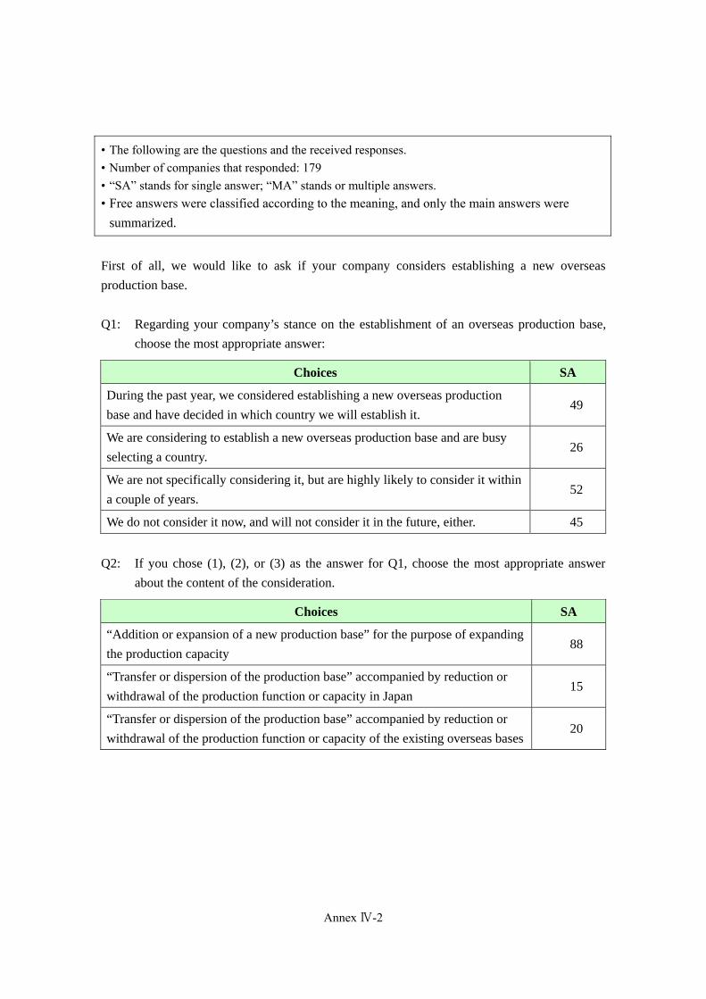
• The following are the questions and the received responses. • Number of companies that responded: 179 • “SA” stands for single answer; “MA” stands or multiple answers. • Free answers were classified according to the meaning, and only the main answers were
summarized.
First of all, we would like to ask if your company considers establishing a new overseas
production base.
Q1: Regarding your company’s stance on the establishment of an overseas production base,
choose the most appropriate answer:
Choices SA
During the past year, we considered establishing a new overseas production
base and have decided in which country we will establish it. 49
We are considering to establish a new overseas production base and are busy
selecting a country. 26
We are not specifically considering it, but are highly likely to consider it within
a couple of years. 52
We do not consider it now, and will not consider it in the future, either. 45
Q2: If you chose (1), (2), or (3) as the answer for Q1, choose the most appropriate answer
about the content of the consideration.
Choices SA
“Addition or expansion of a new production base” for the purpose of expanding
the production capacity 88
“Transfer or dispersion of the production base” accompanied by reduction or
withdrawal of the production function or capacity in Japan 15
“Transfer or dispersion of the production base” accompanied by reduction or
withdrawal of the production function or capacity of the existing overseas bases 20
Annex Ⅳ-2
Annex IV-4
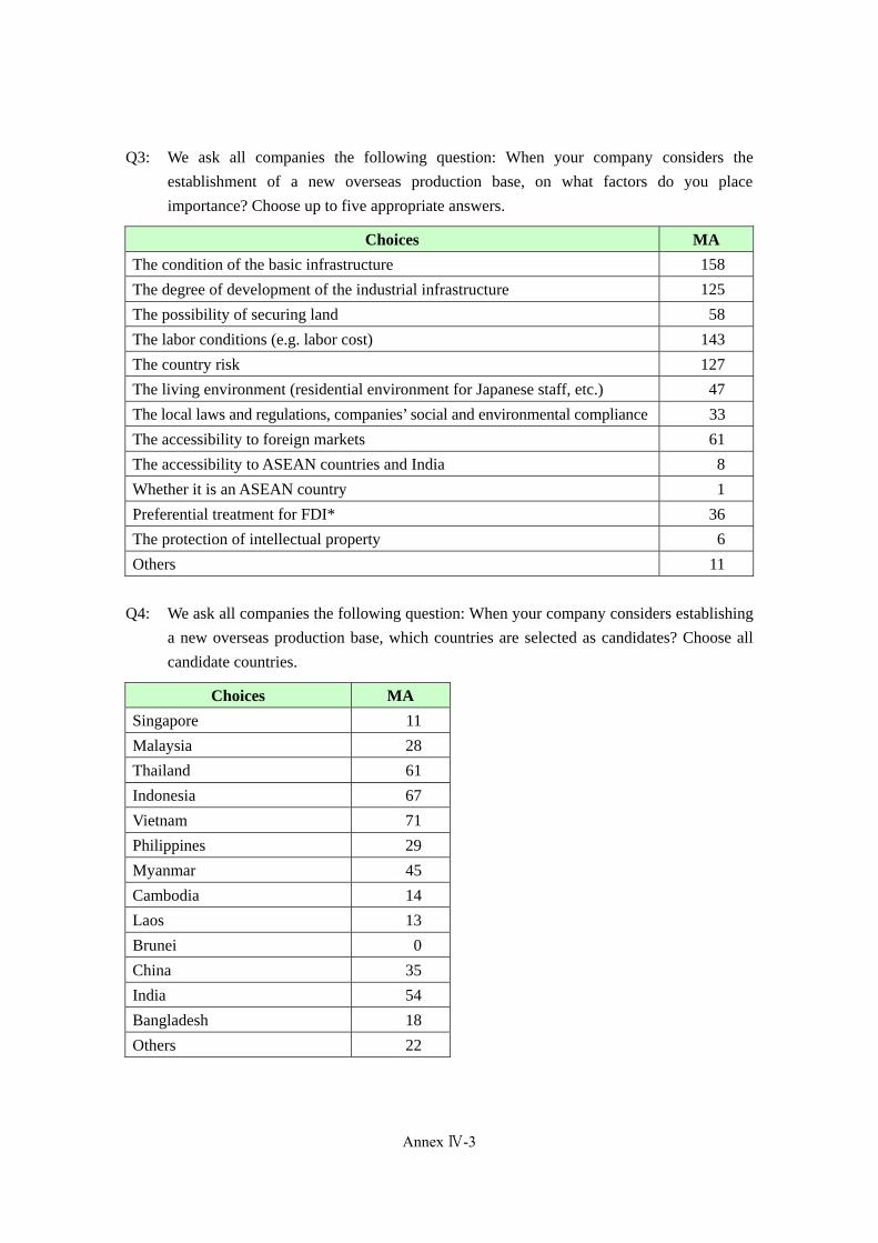
Q3: We ask all companies the following question: When your company considers the
establishment of a new overseas production base, on what factors do you place
importance? Choose up to five appropriate answers.
Choices MAThe condition of the basic infrastructure 158
The degree of development of the industrial infrastructure 125
The possibility of securing land 58
The labor conditions (e.g. labor cost) 143
The country risk 127
The living environment (residential environment for Japanese staff, etc.) 47
The local laws and regulations, companies’ social and environmental compliance 33
The accessibility to foreign markets 61
The accessibility to ASEAN countries and India 8
Whether it is an ASEAN country 1
Preferential treatment for FDI* 36
The protection of intellectual property 6
Others 11
Q4: We ask all companies the following question: When your company considers establishing
a new overseas production base, which countries are selected as candidates? Choose all
candidate countries.
Choices MASingapore 11
Malaysia 28
Thailand 61
Indonesia 67
Vietnam 71
Philippines 29
Myanmar 45
Cambodia 14
Laos 13
Brunei 0
China 35
India 54
Bangladesh 18
Others 22
Annex Ⅳ-3
(341)

Annex IV-5
Q5: We ask all companies the following question: Supposing that your company is
considering Bangladesh as one of the candidate countries for a new production base,
which factors make Bangladesh inferior to other countries? Choose all appropriate
answers.
Choices MAThe condition of the basic infrastructure 108
The degree of development of the industrial infrastructure 83
The possibility of securing land 17
The labor conditions (e.g. labor cost) 34
The country risk 80
The living environment (residential environment for Japanese staff, etc.) 74
The local laws and regulations, companies’ social and environmental compliance 31
The accessibility to foreign markets 31
The accessibility to ASEAN countries and India 2
Whether it is an ASEAN country 10
Preferential treatment for FDI* 10
The protection of intellectual property 12
No appropriate answers (no inferior factors) 0
We cannot choose any factors as we do not know it well. 46
Others 8
< Basic infrastructure (Q6) >
Q6-1: On which items does your company place importance when selecting a production base
(country, specific district, specific industrial complex, etc.)? Choose all appropriate items.
Choices MAStable power supply 161
Low power cost 71
Stable water supply 96
Low water cost 42
Stable fuel supply 61
Low fuel cost 31
Waste treatment system 73
Accessibility to port terminals 104
Possibility of securing land 109
Possibility to lease land 17
Possibility to lease a factory 21
The condition concerning overseas flights 49
The communication infrastructure 77
Others 9
Annex Ⅳ-4
Annex IV-6
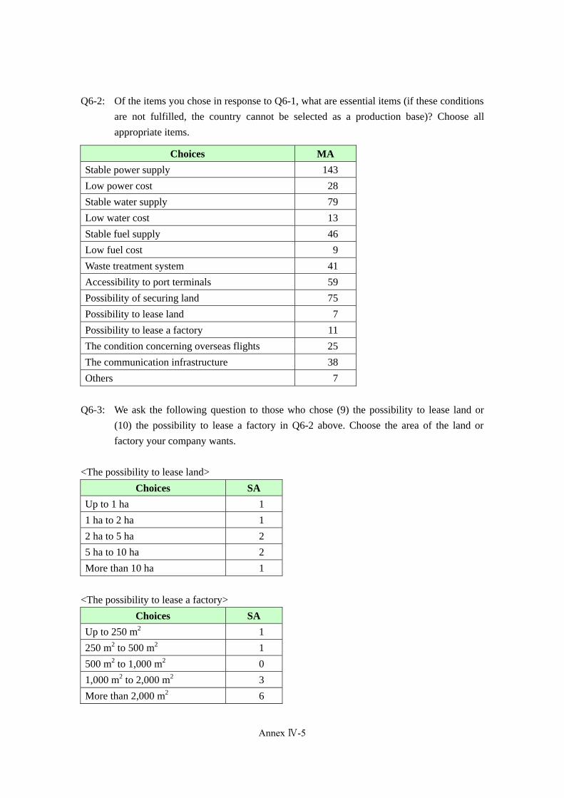
Q6-2: Of the items you chose in response to Q6-1, what are essential items (if these conditions
are not fulfilled, the country cannot be selected as a production base)? Choose all
appropriate items.
Choices MAStable power supply 143
Low power cost 28
Stable water supply 79
Low water cost 13
Stable fuel supply 46
Low fuel cost 9
Waste treatment system 41
Accessibility to port terminals 59
Possibility of securing land 75
Possibility to lease land 7
Possibility to lease a factory 11
The condition concerning overseas flights 25
The communication infrastructure 38
Others 7
Q6-3: We ask the following question to those who chose (9) the possibility to lease land or
(10) the possibility to lease a factory in Q6-2 above. Choose the area of the land or
factory your company wants.
<The possibility to lease land>
Choices SAUp to 1 ha 1
1 ha to 2 ha 1
2 ha to 5 ha 2
5 ha to 10 ha 2
More than 10 ha 1
<The possibility to lease a factory>
Choices SAUp to 250 m2 1
250 m2 to 500 m2 1
500 m2 to 1,000 m2 0
1,000 m2 to 2,000 m2 3
More than 2,000 m2 6
Annex Ⅳ-5
(343)
Annex IV-7
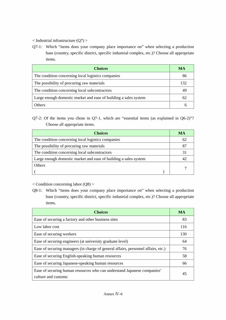
< Industrial infrastructure (Q7) >
Q7-1: Which “items does your company place importance on” when selecting a production
base (country, specific district, specific industrial complex, etc.)? Choose all appropriate
items.
Choices MA
The condition concerning local logistics companies 86
The possibility of procuring raw materials 132
The condition concerning local subcontractors 49
Large enough domestic market and ease of building a sales system 62
Others 6
Q7-2: Of the items you chose in Q7-1, which are “essential items (as explained in Q6-2)”?
Choose all appropriate items.
Choices MAThe condition concerning local logistics companies 62
The possibility of procuring raw materials 87
The condition concerning local subcontractors 31
Large enough domestic market and ease of building a sales system 42
Others
( ) 7
< Condition concerning labor (Q8) >
Q8-1: Which “items does your company place importance on” when selecting a production
base (country, specific district, specific industrial complex, etc.)? Choose all appropriate
items.
Choices MA
Ease of securing a factory and other business sites 83
Low labor cost 116
Ease of securing workers 130
Ease of securing engineers (at university graduate level) 64
Ease of securing managers (in charge of general affairs, personnel affairs, etc.) 76
Ease of securing English-speaking human resources 58
Ease of securing Japanese-speaking human resources 66
Ease of securing human resources who can understand Japanese companies’
culture and customs 45
Annex Ⅳ-6

Annex IV-8
Nationality characteristics that facilitate with the creation of sound
labor-management relationships 116
Others 6
Q8-2: Of the items you chose above, which are “essential items (as explained in Q6-2)”?
Choose all appropriate items.
Choices MA
Ease of securing a factory and other business sites 65
Low labor cost 86
Ease of securing workers 100
Ease of securing engineers (at university graduate level) 33
Ease of securing managers (in charge of general affairs, personnel affairs, etc.) 37
Ease of securing English-speaking human resources 33
Ease of securing Japanese-speaking human resources 31
Ease of securing human resources who can understand Japanese companies’
culture and customs 18
Nationality characteristics that facilitate with the creation of sound
labor-management relationships 55
Others 3
< Country risk (Q9) >
Q9-1: Which “items does your company place importance on” when selecting a production
base (country, specific district, specific industrial complex, etc.)? Choose all appropriate
items.
Choices MAUnnecessary to worry about bribes 72
High safety because of low crime rate such as robberies or murder cases 139
No antigovernment conflicts, rebellions, or disputes 144
Stable political situation 149
Stable foreign exchange system/rate 67
Lenient regulation of foreign exchange/remittances 83
Stable economic policy 71
Few natural disasters 96
Others 4
Annex Ⅳ-7
(345)
Annex IV-9
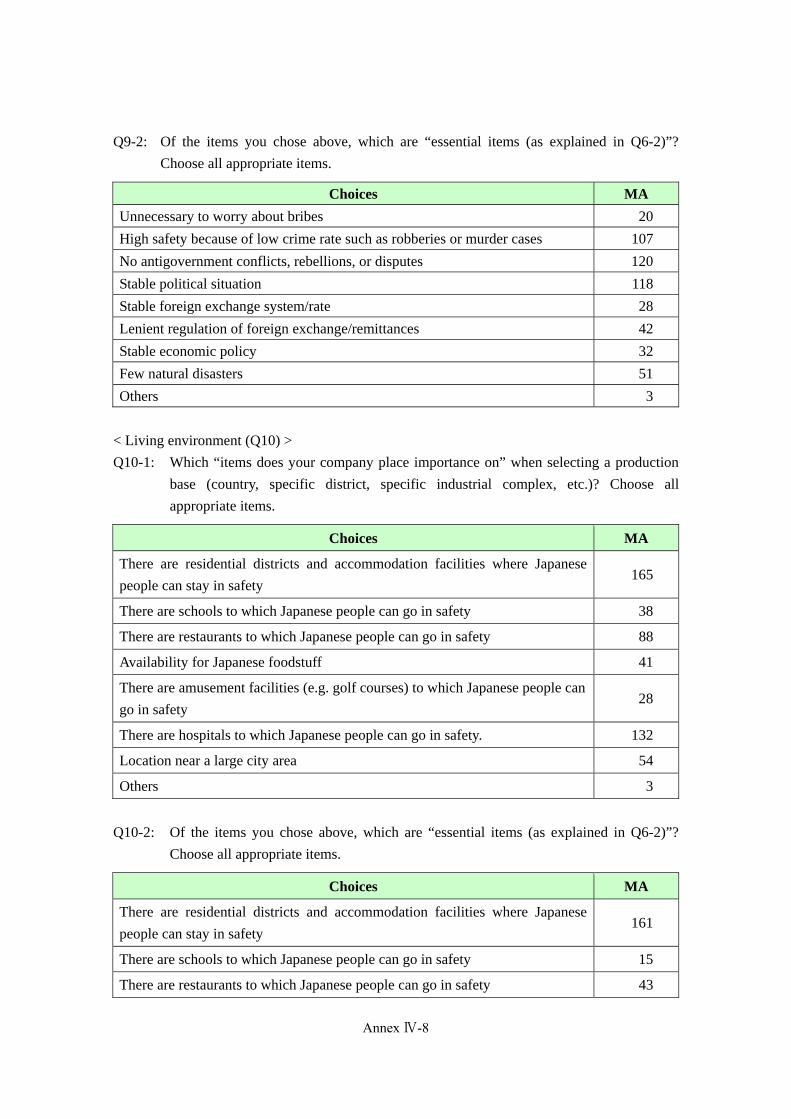
Q9-2: Of the items you chose above, which are “essential items (as explained in Q6-2)”?
Choose all appropriate items.
Choices MAUnnecessary to worry about bribes 20
High safety because of low crime rate such as robberies or murder cases 107
No antigovernment conflicts, rebellions, or disputes 120
Stable political situation 118
Stable foreign exchange system/rate 28
Lenient regulation of foreign exchange/remittances 42
Stable economic policy 32
Few natural disasters 51
Others 3
< Living environment (Q10) >
Q10-1: Which “items does your company place importance on” when selecting a production
base (country, specific district, specific industrial complex, etc.)? Choose all
appropriate items.
Choices MA
There are residential districts and accommodation facilities where Japanese
people can stay in safety 165
There are schools to which Japanese people can go in safety 38
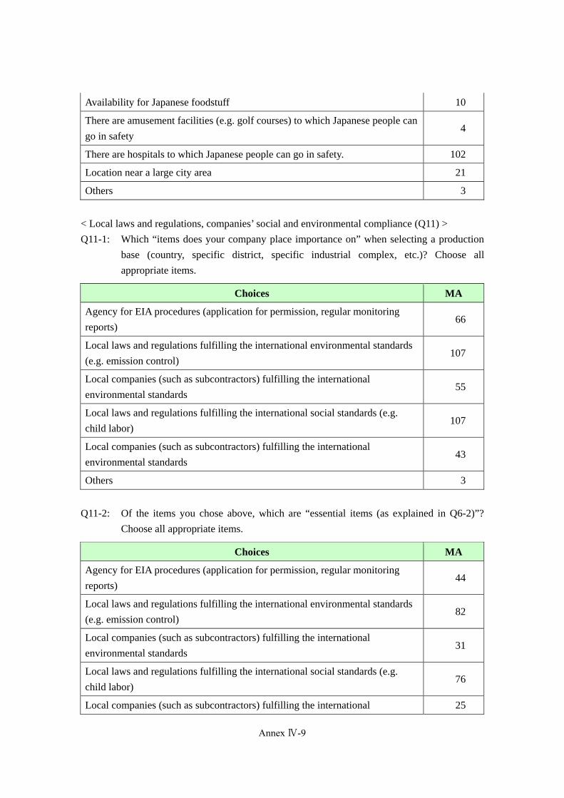
There are restaurants to which Japanese people can go in safety 88
Availability for Japanese foodstuff 41
There are amusement facilities (e.g. golf courses) to which Japanese people can
go in safety 28
There are hospitals to which Japanese people can go in safety. 132
Location near a large city area 54
Others 3
Q10-2: Of the items you chose above, which are “essential items (as explained in Q6-2)”?
Choose all appropriate items.
Choices MA
There are residential districts and accommodation facilities where Japanese
people can stay in safety 161
There are schools to which Japanese people can go in safety 15
There are restaurants to which Japanese people can go in safety 43
Annex Ⅳ-8
Annex IV-10
Availability for Japanese foodstuff 10
There are amusement facilities (e.g. golf courses) to which Japanese people can
go in safety 4
There are hospitals to which Japanese people can go in safety. 102
Location near a large city area 21
Others 3
< Local laws and regulations, companies’ social and environmental compliance (Q11) >
Q11-1: Which “items does your company place importance on” when selecting a production
base (country, specific district, specific industrial complex, etc.)? Choose all
appropriate items.
Choices MA
Agency for EIA procedures (application for permission, regular monitoring
reports)66
Local laws and regulations fulfilling the international environmental standards
(e.g. emission control) 107
Local companies (such as subcontractors) fulfilling the international
environmental standards 55
Local laws and regulations fulfilling the international social standards (e.g.
child labor) 107
Local companies (such as subcontractors) fulfilling the international
environmental standards 43
Others 3
Q11-2: Of the items you chose above, which are “essential items (as explained in Q6-2)”?
Choose all appropriate items.
Choices MA
Agency for EIA procedures (application for permission, regular monitoring
reports)44
Local laws and regulations fulfilling the international environmental standards
(e.g. emission control) 82
Local companies (such as subcontractors) fulfilling the international
environmental standards 31
Local laws and regulations fulfilling the international social standards (e.g.
child labor) 76
Local companies (such as subcontractors) fulfilling the international 25
Annex Ⅳ-9
(347)

Annex IV-11
environmental standards
Others 2
< Accessibility of the final markets (Q12) >
Q12-1: Which “items does your company place importance on” when your company selects a
production base (country, specific district, specific industrial complex, etc.)? Choose
all appropriate items.
Choices MA
Accessibility of the ASEAN market (proximity in distance, level of logistics
services (international sea/air services), most-favored nation treatment,
application of FTA/EPA, etc. (the same applies hereinafter))
123
Accessibility of the Japanese market 93
Accessibility of the Indian and Middle East markets 45
Accessibility of the European and US markets 38
Others 9
Q12-2: Of the items you chose above, which are “essential items (as explained in Q6-2)”?
Choose all appropriate items.
Choices MA
Accessibility of the ASEAN market (proximity in distance, level of logistics
services (international sea/air services), most-favored nation treatment,
application of FTA/EPA, etc. (the same applies hereinafter))
103
Accessibility of the Japanese market 77
Accessibility of the Indian and Middle East markets 25
Accessibility of the European and US markets 27
Others 8
Q13: If your company places importance on other elements and items when selecting a
production base, describe them as concretely as possible in the following free writing
space:
Our company will not move out unless our manufacturing clients move out.
Measures against anti-Japan sentiment and new diseases that we did not care about in the past
Existence of partners with whom to cooperate
Our company is a manufacturing subsidiary of Soken Chemical & Engineering Group. We
cannot decide about overseas advancement, because it is determined by the parent company.
Annex Ⅳ-10
Annex IV-12
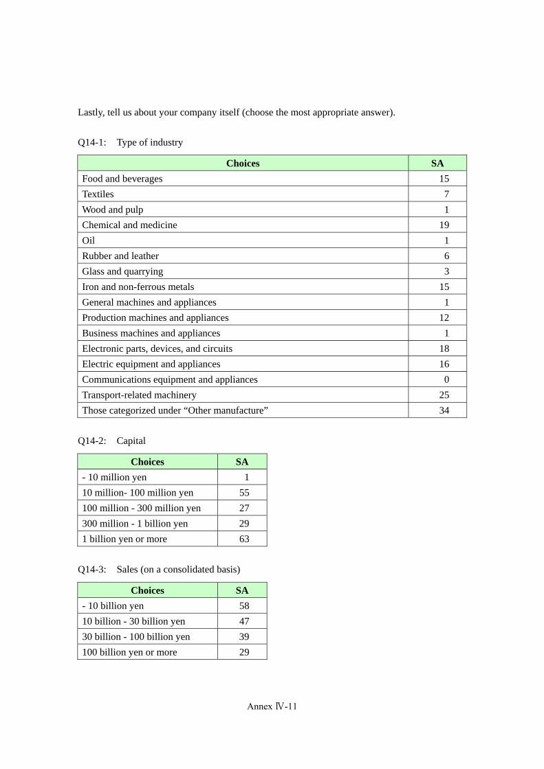
Lastly, tell us about your company itself (choose the most appropriate answer).
Q14-1: Type of industry
Choices SAFood and beverages 15
Textiles 7
Wood and pulp 1
Chemical and medicine 19
Oil 1
Rubber and leather 6
Glass and quarrying 3
Iron and non-ferrous metals 15
General machines and appliances 1
Production machines and appliances 12
Business machines and appliances 1
Electronic parts, devices, and circuits 18
Electric equipment and appliances 16
Communications equipment and appliances 0
Transport-related machinery 25
Those categorized under “Other manufacture” 34
Q14-2: Capital
Choices SA- 10 million yen 1
10 million- 100 million yen 55
100 million - 300 million yen 27
300 million - 1 billion yen 29
1 billion yen or more 63
Q14-3: Sales (on a consolidated basis)
Choices SA- 10 billion yen 58
10 billion - 30 billion yen 47
30 billion - 100 billion yen 39
100 billion yen or more 29
Annex Ⅳ-11
(349)
Annex IV-13
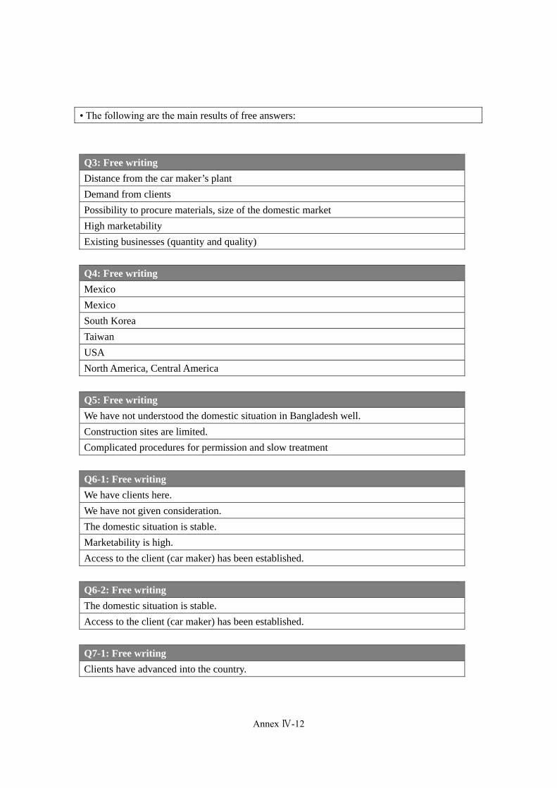
• The following are the main results of free answers:
Q3: Free writing Distance from the car maker’s plant
Demand from clients
Possibility to procure materials, size of the domestic market
High marketability
Existing businesses (quantity and quality)
Q4: Free writingMexico
Mexico
South Korea
Taiwan
USA
North America, Central America
Q5: Free writingWe have not understood the domestic situation in Bangladesh well.
Construction sites are limited.
Complicated procedures for permission and slow treatment
Q6-1: Free writingWe have clients here.
We have not given consideration.
The domestic situation is stable.
Marketability is high.
Access to the client (car maker) has been established.
Q6-2: Free writing The domestic situation is stable.
Access to the client (car maker) has been established.
Q7-1: Free writing Clients have advanced into the country.
Annex Ⅳ-12
Annex IV-14
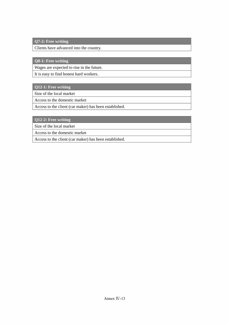
Q7-2: Free writing Clients have advanced into the country.
Q8-1: Free writing Wages are expected to rise in the future.
It is easy to find honest hard workers.
Q12-1: Free writing Size of the local market
Access to the domestic market
Access to the client (car maker) has been established.
Q12-2: Free writing Size of the local market
Access to the domestic market
Access to the client (car maker) has been established.
Annex Ⅳ-13
(351)

Annex V: Reconnaissance Survey Data on the Candidate SEZ Sites
(355)
Data Collection Survey on the Special Economic Zones in Bangladesh
Final Report
(353)
Annex-V-2
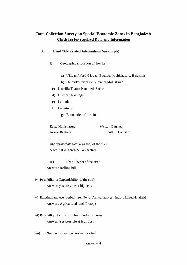
Data Collection Survey on Special Economic Zones in Bangladesh Check list for required Data and Information
A. Land /Site Related Information (Narshingdi)
i) Geographical location of the site
a) Village /Ward /Mouza: Baghata, Mohishasura, Balushair
b) Union/Pourashava: Silmandi,Mohishsura
c) Upazilla/Thana: Narsingdi Sadar
d) District : Narsingdi
e) Latitude:
f) Longitude:
g) Boundaries of the site:
East: Mohishasura West: Baghata
North: Baghata South: Balusair
ii)Approximate total area (ha) of the site?
Size: 690.20 acres/279.43 hectare
iii) Shape (type) of the site?
Answer : Rolling hill
iv) Possibility of Expandability of the site?
Answer: yes possible at high cost
v) Existing land use (agriculture: No. of Annual harvest /industrial/residential)?
Answer : Agricultural land (1 crop)
vi) Possibility of convertibility to industrial use?
Answer: Yes possible at high cost
vii) Number of land owners in the site?
Annex Ⅴ-1
(355)

Annex-V-3
Answer: 100 above land owner
viii) Major occupation of the land owners
Answer; Agriculture, small business ,Day lobor
ix) Agreement to Land Acquisition (how many agreements need to acquisition/any
agreement with the private land developer)
Answer : 100 above agreement to land acquission
x) What is the existing land value of the proposed site?
Answer:
a)Market price of land in this region is between Tk. 50,000 to Tk. 300,000 per
decimal.
xi) Number of resettlement (households, trees, livestock, fisheries, etc)
Answer: No resettlement
xii) Magnitude to compensation (cost to be incurred for resettlement)
Answer: No Magnitude compensation
xiii) Existing Proponent (Is there any public /private sector involvement? In case of
private sector involvement, their technical and financial capability
Answer: 100 above land owner
xiv) Level of Land fill required?
Answer; About 15-16 feet of land fill will be required for the site
B. Surrounding Area
i) What is the distance of the site from District / Upazilla / Union /Municipality
Headquarter?
a) District Head quarter : 4 km
b) Upazilla Head quarter: 4 km
Annex Ⅴ-2
Annex-V-4
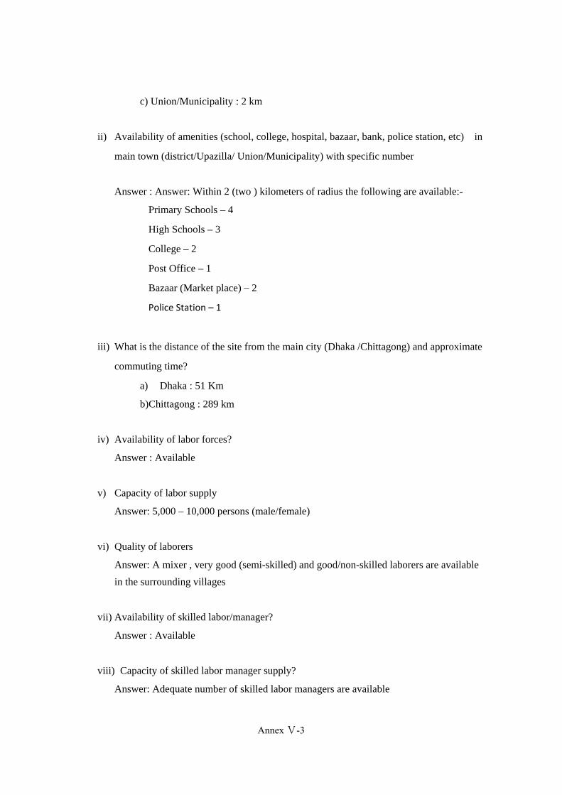
c) Union/Municipality : 2 km
ii) Availability of amenities (school, college, hospital, bazaar, bank, police station, etc) in
main town (district/Upazilla/ Union/Municipality) with specific number
Answer : Answer: Within 2 (two ) kilometers of radius the following are available:-
Primary Schools – 4
High Schools – 3
College – 2
Post Office – 1
Bazaar (Market place) – 2
Police Station – 1
iii) What is the distance of the site from the main city (Dhaka /Chittagong) and approximate
commuting time?
a) Dhaka : 51 Km
b)Chittagong : 289 km
iv) Availability of labor forces?
Answer : Available
v) Capacity of labor supply
Answer: 5,000 – 10,000 persons (male/female)
vi) Quality of laborers
Answer: A mixer , very good (semi-skilled) and good/non-skilled laborers are available
in the surrounding villages
vii) Availability of skilled labor/manager?
Answer : Available
viii) Capacity of skilled labor manager supply?
Answer: Adequate number of skilled labor managers are available
Annex Ⅴ-3
(357)

Annex-V-5
ix) Quality of labor managers
Answer: Very good and Good
x) Distance from forward and backward linkages industries
Answer : Backward linkage industries within 5 Km from site
xi) What is the distance from Exiting Industrial Cluster?
Answer: 100 km
C. Natural Disaster
i) Does the area affect by flood?
Yes
No
Note: Here is caused heavy rain but there is no possibility of flood.
ii) If yes, when did the last flood occur? And how long it existed? And risk of submerge
Year: ………(N/A)……………………….…… Duration of flooding:
iii) Can you please explain the damage due to the last flood?
a) Damage of crops/ agricultural land
b) Damage of Shelter
c) Others
iv) Probability of the area being affect by earthquake? Mention the earthquake zone
Answer: The area has high probability of being affected in case there is an earthquake
v) Risk of sub-merge?
Answer: 0/10 < F ≤ 1/10
0< D ≤ 0.1m
vi) Risk of land erosion?
Annex Ⅴ-4
Annex-V-6
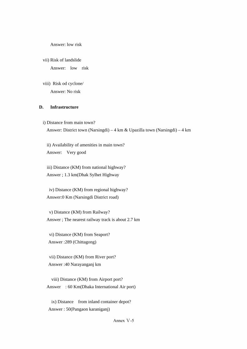
Answer: low risk
vii) Risk of landslide
Answer: low risk
viii) Risk od cyclone/
Answer: No risk
D. Infrastructure
i) Distance from main town?
Answer: District town (Narsingdi) – 4 km & Upazilla town (Narsingdi) – 4 km
ii) Availability of amenities in main town?
Answer: Very good
iii) Distance (KM) from national highway?
Answer ; 1.3 km(Dhak Sylhet Highway
iv) Distance (KM) from regional highway?
Answer:0 Km (Narsingdi District road)
v) Distance (KM) from Railway?
Answer ; The nearest railway track is about 2.7 km
vi) Distance (KM) from Seaport?
Answer :289 (Chittagong)
vii) Distance (KM) from River port?
Answer :40 Narayanganj km
viii) Distance (KM) from Airport port?
Answer : 60 Km(Dhaka International Air port)
ix) Distance from inland container depot?
Answer : 50(Pangaon karaniganj)
Annex Ⅴ-5
(359)
Annex-V-7
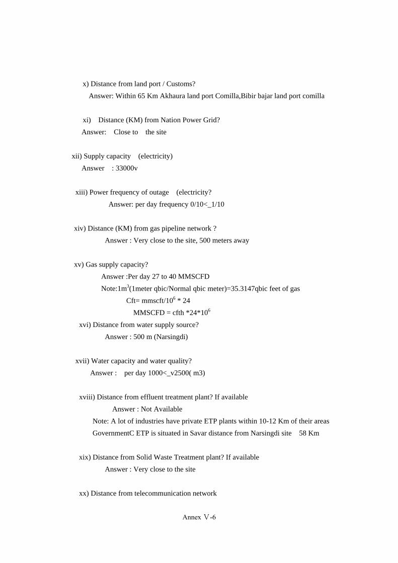
x) Distance from land port / Customs?
Answer: Within 65 Km Akhaura land port Comilla,Bibir bajar land port comilla
xi) Distance (KM) from Nation Power Grid?
Answer: Close to the site
xii) Supply capacity (electricity)
Answer : 33000v
xiii) Power frequency of outage (electricity?
Answer: per day frequency 0/10<_1/10
xiv) Distance (KM) from gas pipeline network ?
Answer : Very close to the site, 500 meters away
xv) Gas supply capacity?
Answer :Per day 27 to 40 MMSCFD
Note:1m3(1meter qbic/Normal qbic meter)=35.3147qbic feet of gas
Cft= mmscft/106 * 24
MMSCFD = cfth *24*106
xvi) Distance from water supply source?
Answer : 500 m (Narsingdi)
xvii) Water capacity and water quality?
Answer : per day 1000<_v2500( m3)
xviii) Distance from effluent treatment plant? If available
Answer : Not Available
Note: A lot of industries have private ETP plants within 10-12 Km of their areas
GovernmentC ETP is situated in Savar distance from Narsingdi site 58 Km
xix) Distance from Solid Waste Treatment plant? If available
Answer : Very close to the site
xx) Distance from telecommunication network
Annex Ⅴ-6

Annex-V-8
Answer : Close to the site
xxi) Availability of public transport to the site
Answer : Available
E. Environmental Restriction/ Special Defects
i) Contamination of Land?
Answer ; No contamination
ii) Nature of wild life conservation(describe)
Answer: No
iii) Objection from surrounding community (describe)
Answer: None
iv) Any objection regarding land acquisition (dispute on land)
Answer : None
v) Size of urban and/or rural population
Answer: Rural and Urban population mixed
vi) Whether women and their livelihood will be affected because of the EZ
Answer: No
vii) List the main livelihood of the inhabitants- fishing, farming, grazing cattle, small business
etc
Answer : Small business and Agriculture
Annex Ⅴ-7
(361)
Annex-V-9
Data Collection Survey on Special Economic Zones in Bangladesh Check list for required Data and Information
F. Land /Site Related Information (AK Khan SEZ Site)
xv) Geographical location of the site
h) Village /Ward /Mouza: Islam para
i) Union/Pourashava: Danga
j) Upazilla/Thana: Palash
k) District : Narayanganj
l) Latitude:
m) Longitude:
n) Boundaries of the site:
East: Dangaa West:
Sitolokha river
North: Sitolokha river South: Dohor
xvi) Approximate total area (ha) of the site?
Answer: 250 acre (101 ha)
(150 acre land is ready with acquire and 100 acre are under filling and acquiring
process)
xvii) Shape (type) of the site?
Answer : Rolling hill
xviii) Possibility of Expandability of the site?
Answer: yes possible.
xix) Existing land use (agriculture: No. of Annual harvest /industrial/residential)?
Annex Ⅴ-8

Annex-V-10
Answer : no crops
xx)Possibility of convertibility to industrial use?
Answer: Yes possible
xxi) Number of land owners in the site?
Answer: One land owner
xxii) Major occupation of the land owners
Answer; Land developer company.
xxiii) Agreement to Land Acquisition (how many agreements need to acquisition/any
agreement with the private land developer)
Answer : Any agreement private land developer company with possible
xxiv) What is the existing land value of the proposed site?
Answer:
xxv) Number of resettlement (households, trees, livestock, fisheries, etc)
Answer: No resettlement
xxvi) Magnitude to compensation (cost to be incurred for resettlement)
Answer : No Magnitude compensation
xxvii) Existing Proponent (Is there any public /private sector involvement? In case of
private sector involvement, their technical and financial capability
Answer : Private sector(one land owner) involvement in the site , their technical
and financial capability is very high.
xxviii) Level of Land fill required?
Answer; About 4-6 feet of land fill will be required for the site
Annex Ⅴ-9
(363)
Annex-V-11
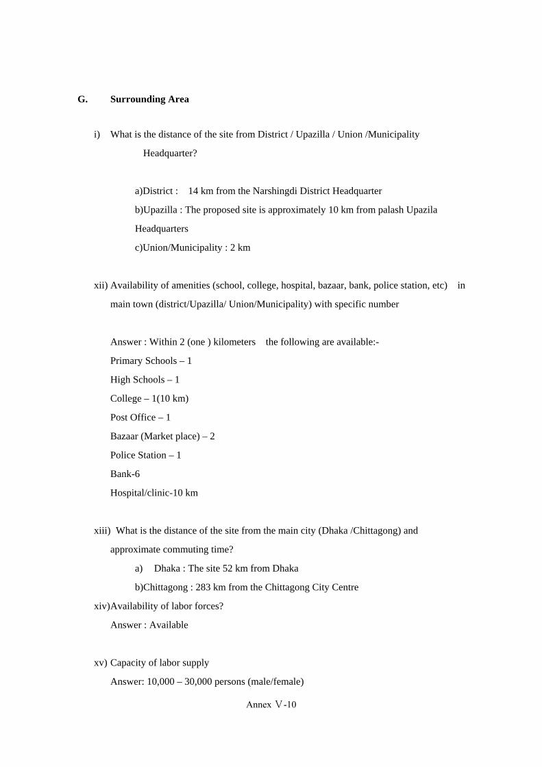
G. Surrounding Area
i) What is the distance of the site from District / Upazilla / Union /Municipality
Headquarter?
a)District : 14 km from the Narshingdi District Headquarter
b)Upazilla : The proposed site is approximately 10 km from palash Upazila
Headquarters
c)Union/Municipality : 2 km
xii) Availability of amenities (school, college, hospital, bazaar, bank, police station, etc) in
main town (district/Upazilla/ Union/Municipality) with specific number
Answer : Within 2 (one ) kilometers the following are available:-
Primary Schools – 1
High Schools – 1
College – 1(10 km)
Post Office – 1
Bazaar (Market place) – 2
Police Station – 1
Bank-6
Hospital/clinic-10 km
xiii) What is the distance of the site from the main city (Dhaka /Chittagong) and
approximate commuting time?
a) Dhaka : The site 52 km from Dhaka
b)Chittagong : 283 km from the Chittagong City Centre
xiv)Availability of labor forces?
Answer : Available
xv) Capacity of labor supply
Answer: 10,000 – 30,000 persons (male/female)
Annex Ⅴ-10

Annex-V-12
xvi)Quality of laborers
Answer: A mixer of excellent (skilled), very good (semi-skilled) and good/non-skilled
laborers are available in the surrounding villages
xvii) Availability of skilled labor/manager?
Answer : Available
xviii) Capacity of skilled labor manager supply?
Answer: Adequate number of skilled labor managers are available
xix)Quality of labor managers
Answer: Excellent, Very good and Good
xx) Distance from forward and backward linkages industries
Answer : Backward linkage industries within 10 km(Gorashal) from site
xxi)What is the distance from Exiting Industrial Cluster?
Answer: 50 km(old Dhaka)
H. Natural Disaster
ix) Does the area affect by flood?
Yes
No
x) If yes, when did the last flood occur? And how long it existed? And risk of submerge
Year: ………(N/A)……………………….…… Duration of flooding:
xi) Can you please explain the damage due to the last flood?
Annex Ⅴ-11
(365)

Annex-V-13
d) Damage of crops/ agricultural land
e) Damage of Shelter
f) Others
xii) Probability of the area being affect by earthquake? Mention the earthquake zone
Answer: The area has high probability of being affected in case there is an earthquake
xiii) Risk of sub-merge?
Answer: 0/10 < F ≤ 1/10
0< D ≤ 0.1m
xiv)Risk of land erosion?
Answer: No risk
xv) Risk of landslide
Answer: low risk
xvi)Risk of cyclone/
Answer: No risk
I. Infrastructure
i) Distance from main town?
Answer: District town (Norshingdi) – 14 km & Kaligonj town ( a river is in the middle
named Sitolokha)
ii) Availability of amenities in main town?
Answer: good
iii) Distance (km) from national highway?
Answer ; Dhaka Shylet highway distance of the site 12 km,Dhaka kaligonj Baipass
distance 2 km but a river sitolokha which has no bridge
Annex Ⅴ-12

Annex-V-14
iv) Distance (km) from regional highway?
Answer: Within 2 km
v) Distance (km) from Railway?
Answer ; The Narshingdi Railway Station is approximately 14 km has a river sitolokha
of 2 km to be crossed from the site
vi) Distance (km) from Seaport?
Answer : 276 km from the Port of Chittagong .
vii) Distance (km) from River port?
Answer :32 Narayanganj km
viii) Distance (km) from Airport port?
Answer : 32 km from the Dhaka Airport if cross the river sitolokha and 60 km if go
with Dhaka sylet highway.
ix) Distance (km) from inland container depot?
Answer : 35 (Pangaon karaniganj)
x) Distance from land port / Customs?
Answer: Within 70 Km Akhaura land port Comilla,Bibir bajar land port comilla
xi) Distance (km) from Nation Power Grid?
Answer: Very close to the site,30 meters away (Polli biedhut)
xii) Supply capacity (electricity)
Answer : No high voltage power establishment available nearby. Gorashal power
plant centre is far from 12 km.
xiii)Power frequency of outage (electricity?
Answer: per day frequency 2/10<F<_10/10
Annex Ⅴ-13
(367)

Annex-V-15
xiv) Distance (km) from gas pipeline network ?
Answer : 1 km there is sitolokha river in the middle.
xv) Gas supply capacity?
Answer : 25 ≤ V<50
xvi) Distance from water supply source?
Answer : 14Km (Narsingdi)
xvii) Water capacity and water quality?
Answer : : per day 5000<_v7500( m3)
xviii) Distance from effluent treatment plant? If available
Answer : There exists no effluent treatment plant (ETP) or waste treatment plant in
the surrounding area
xix) Distance from Solid Waste Treatment plant? If available
Answer : There exists no waste treatment plant in the surrounding area
xx) Distance from telecommunication network
Answer : Mobile network available.Land phone distance from 2 km
xxi) Availability of public transport to the site
Answer : (poor)
J. Environmental Restriction/ Special Defects
viii) Contamination of Land?
Answer ; No contamination(None)
ix) Nature of wild life conservation(describe)
Annex Ⅴ-14
Annex-V-16
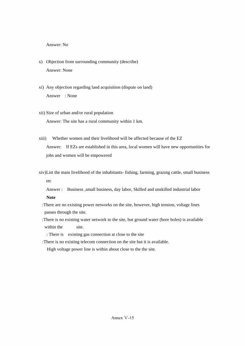
Answer: No
x) Objection from surrounding community (describe)
Answer: None
xi) Any objection regarding land acquisition (dispute on land)
Answer : None
xii) Size of urban and/or rural population
Answer: The site has a rural community within 1 km.
xiii) Whether women and their livelihood will be affected because of the EZ
Answer: If EZs are established in this area, local women will have new opportunities for
jobs and women will be empowered
xiv)List the main livelihood of the inhabitants- fishing, farming, grazing cattle, small business
etc
Answer : Business ,small business, day labor, Skilled and unskilled industrial labor
Note :There are no existing power networks on the site, however, high tension, voltage lines
passes through the site.
:There is no existing water network to the site, but ground water (bore holes) is available
within the site.
: There is existing gas connection at close to the site
:There is no existing telecom connection on the site but it is available.
High voltage power line is within about close to the the site.
Annex Ⅴ-15
(369)

Annex-V-17
Data Collection Survey on Special Economic Zones in Bangladesh Check list for required Data and Information
K. Land /Site Related Information (Kaliganj;Muslin Cotton Mills Site)
xxix) Geographical location of the site
o) Village /Ward /Mouza: Vardhati
p) Union/Pourashava: kaligonj
q) Upazilla/Thana: Kaliganj
r) District Gazipur
s) Latitude:
t) Longitude:
u) Boundaries of the site:
East: Kalogonj Bazar West:
west vardhati
North: Sitolokha river South:
Vardhati
xxx) Approximate total area (ha) of the site?
Size: Total 300 bigha(35 dec=1 bigha) 185 bigha mill area.other 125 bigha pond
and outside mill area. Total 99 acre(40.08 hec)
xxxi) Shape (type) of the site?
Answer : Rolling hill
xxxii) Possibility of Expandability of the site?
Answer: possible but very cost
xxxiii) Existing land use (agriculture: No. of Annual harvest /industrial/residential)?
Answer : no crops
Annex Ⅴ-16
Annex-V-18
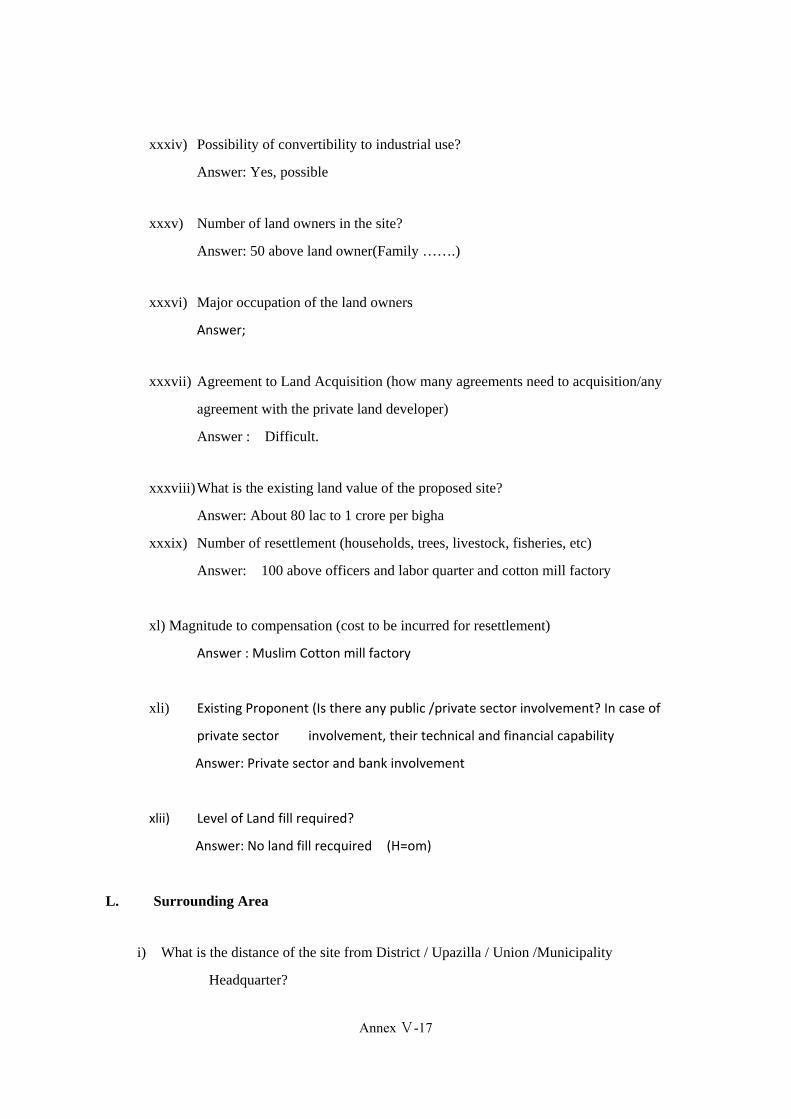
xxxiv) Possibility of convertibility to industrial use?
Answer: Yes, possible
xxxv) Number of land owners in the site?
Answer: 50 above land owner(Family …….)
xxxvi) Major occupation of the land owners
Answer;
xxxvii) Agreement to Land Acquisition (how many agreements need to acquisition/any
agreement with the private land developer)
Answer : Difficult.
xxxviii)What is the existing land value of the proposed site?
Answer: About 80 lac to 1 crore per bigha
xxxix) Number of resettlement (households, trees, livestock, fisheries, etc)
Answer: 100 above officers and labor quarter and cotton mill factory
xl) Magnitude to compensation (cost to be incurred for resettlement)
Answer : Muslim Cotton mill factory
xli) Existing Proponent (Is there any public /private sector involvement? In case of
private sector involvement, their technical and financial capability
Answer: Private sector and bank involvement
xlii) Level of Land fill required?
Answer: No land fill recquired (H=om)
L. Surrounding Area
i) What is the distance of the site from District / Upazilla / Union /Municipality
Headquarter?
Annex Ⅴ-17
(371)
Annex-V-19
a) District : Gajipur - 30 km
b) Upazilla : Kaligonj - 1 km
c) Union/Municipality - 1 km
xxii) Availability of amenities (school, college, hospital, bazaar, bank, police station, etc)
in main town (district/Upazilla/ Union/Municipality) with specific number
Answer: Within 3 kilometers of radius the following are available:-
Primary Schools – 4
High Schools – 3
College – 2
Post Office – 1
Bazaar (Market place) – 2
Police Station –
xxiii)What is the distance of the site from the main city (Dhaka /Chittagong) and
approximate commuting time?
a) Dhaka : 30 km
b)Chittagong : 270 km
xxiv)Availability of labor forces?
Answer : Available.
xxv) Capacity of labor supply
Answer: : 30,000 – 50,000 persons (male/female)
xxvi)Quality of laborers
Answer: A mixer of excellent (skilled), very good (semi-skilled) and
good/non-skilled laborers are available in the surrounding villages very good.
xxvii) Availability of skilled labor/manager?
Annex Ⅴ-18
Annex-V-20
Answer : Available
xxviii) Capacity of skilled labor manager supply?
Answer: Adequate number of skilled labor managers are available
xxix)Quality of labor managers
Answer: Excellent, Very good and Good
xxx) Distance from forward and backward linkages industries
Answer : 22 km Tongi,Gajipur.
xxxi)What is the distance from Exiting Industrial Cluster?
Answer: 30 km Gajipur.
M. Natural Disaster
xvii) Does the area affect by flood?
Yes
No
xviii)If yes, when did the last flood occur? And how long it existed? And risk of submerge
Year: ………(N/A)……………………….…… Duration of flooding:
xix)Can you please explain the damage due to the last flood?
g) Damage of crops/ agricultural land
h) Damage of Shelter
i) Others
xx) Probability of the area being affect by earthquake? Mention the earthquake zone
Answer: The area has low probability of being affected in case there is an earthquake
Annex Ⅴ-19
(373)
Annex-V-21
xxi)Risk of sub-merge?
Answer: F=0/10
D=0m
xxii) Risk of land erosion?
Answer: No risk
xxiii)Risk of landslide
Answer: No risk
xxiv)Risk od cyclone/
Answer: No risk.
N. Infrastructure
i) Distance from main town?
Answer: 1 km( kaligonj)
ii) Availability of amenities in main town?
Answer: Good.
iii) Distance (km) from national highway?
Answer ; 1 km
iv) Distance (km) from regional highway?
Answer: 1 km
v) Distance (km) from Railway?
Answer ; 1 km kaligonj railway station
vi) Distance (km) from Seaport?
Answer : 278 Chittagong seaport
vii) Distance (km) from River port?
Answer : 40 km Narayangonj.
Annex Ⅴ-20
Annex-V-22
viii) Distance (km) from Airport port?
Answer: 35km from shahjalal international airport,Dhaka
ix) Distance (km) from inland container depot?
Answer : 40 km pangaon keranigonj
x) Distance from land port / Customs?
Answer: Within 110 km Bibir bazaar Land port comilla, Haluaghat land port
Mymenshing,Karaitoli land port Mymenshing
xi) Distance (km) from Nation Power Grid?
Answer: 0 km
xii) Supply capacity (electricity)
Answer : 33000 volt
Xiii) Power frequency of outage (electricity?
Answer: 1/10<F<_2/10
xiv) Distance Gas from Gas network:?
Answer : 1 km
xv) Gas supply capacity?
Answer : per day 2500<_v5000( m3) (Gets pipeline network close to the site)
xvi) Distance from water supply source?
Answer : Tongi,Gajipur. 21 km
xvii) Water capacity and water quality?
Answer : 5000<_V<7500
xviii) Distance from effluent treatment plant? If available
Answer :Not available
xix) Distance from Solid Waste Treatment plant? If available
Annex Ⅴ-21
(375)

Annex-V-23
Answer : Not available.
xx) Distance from telecommunication network
Answer : Mobile and telephone available in 1km
xxi) Availability of public transport to the site
Answer : Good.
O. Environmental Restriction/ Special Defects
xv) Contamination of Land?
Answer ; No contamination.
xvi)Nature of wild life conservation(describe)
Answer: None.
xvii) Objection from surrounding community (describe)
Answer: None
xviii) Any objection regarding land acquisition (dispute on land)
Answer : Size of urban and/or rural population
xix)Size of urban and/or rural population
Answer: The land is leased under bank.So land acquisition is very tuff
xx) Whether women and their livelihood will be affected because of the EZ
Answer
xxi)List the main livelihood of the inhabitants- fishing, farming, grazing cattle, small business
etc
Answer :
Note : There are a existing power network on the site, however, high tension, voltage lines
passes
Annex Ⅴ-22

Annex-V-24
through the site.
: There is a existing gas connection at close to the site
: There is a existing telecom connection on the site but it is available.
High voltage power line is within about close to the the site.
Annex Ⅴ-23
(377)
Annex-V-25
Data Collection Survey on Special Economic Zones in Bangladesh Check list for required Data and Information
P. Land /Site Related Information ( Sreepur;Cotton Research Center)
xliii) Geographical location of the site
v) Village /Ward /Mouza: Beth juri ,shirir chal(Cotton development area)
w) Union/Pourashava: Sreepur Municipality ,Bawalghar union
x) Upazilla/Thana: Gazipur sadar , Sreepur
y) District : Gazipur
z) Latitude:
aa) Longitude:
bb) Boundaries of the site:
East: Shirir Chala West: Dhaka Mymenshing highway
North: Shirir Chala South: Bethjuri
xliv) Approximate total area (ha) of the site?
60(ha)
xlv) Shape (type) of the site?
Answer : Rolling hill
xlvi) Possibility of Expandability of the site?
Answer: very difficult
xlvii) Existing land use (agriculture: No. of Annual harvest /industrial/residential)?
Answer : Agriculture,(per year 01 crops cotton)
xlviii) Possibility of convertibility to industrial use?
Answer: Yes possible
xlix) Number of land owners in the site?
Annex Ⅴ-24
Annex-V-26
Answer: Public land(Government)
l) Major occupation of the land owners
Answer; Government
li) Agreement to Land Acquisition (how many agreements need to acquisition/any
agreement with the private land developer)
Answer : Government (Cotton Development Board) will be land acquisition
lii) What is the existing land value of the proposed site?
a) Average 03 to 05 lac taka
liii) Number of resettlement (households, trees, livestock, fisheries, etc)
Answer: 3000 trees will be resettlement
liv) Magnitude to compensation (cost to be incurred for resettlement)
Answer : 2 crore taka=20 million
lv) Existing Proponent (Is there any public /private sector involvement? In case of private
sector involvement, their technical and financial capability)
Answer : Cotton development Board owner of the site
Q. Surrounding Area
i) What is the distance of the site from District / Upazilla / Union /Municipality
Headquarter?
a) District : 25 km( Gazipur )
b) Upazilla : 5 km (Sreepur)
c) Union/Municipality : 2 km
xxxii) Availability of amenities (school, college, hospital, bazaar, bank, police
station, etc) in main town (district/Upazilla/ Union/Municipality) with specific
number
Annex Ⅴ-25
(379)
Annex-V-27
Answer: Within 5 (five ) kilometers of radius the following are available:-
Primary Schools – 4
High Schools – 2
College – 1
Post Office – 1
Bazaar (Market place) – 2
Police Station – 1
xxxiii) What is the distance of the site from the main city (Dhaka /Chittagong) and
approximate commuting time?
a) Dhaka : 75 km
b) Chittagong : 322 km
xxxiv) Availability of labor forces?
Answer : Available
xxxv) Capacity of labor supply
Answer: 30,000 – 50,000 persons (male/female)
xxxvi) Quality of laborers
Answer: A mixer of excellent (skilled), very good (semi-skilled) and good/non-skilled
laborers are available in the surrounding villages
xxxvii) Availability of skilled labor/manager?
Answer : Available
xxxviii) Capacity of skilled labor manager supply?
Answer: Adequate number of skilled labor managers are available
xxxix) Quality of labor managers
Answer: very Good
xl) Distance from forward and backward linkages industries .
Answer ; No significant forward and backward industries within 5 km of the site
however within 8 km there are number of of backward and forward linkage industries
Annex Ⅴ-26
Annex-V-28
xli) What is the distance from Exiting Industrial Cluster?
Answer : 25 km( Gazipur)
R. Natural Disaster
xxv) Does the area affect by flood?
Yes
No
xxvi)If yes, when did the last flood occur? And how long it existed? And risk of submerge
Year: ………(N/A)……………………….…… Duration of flooding:
xxvii) Can you please explain the damage due to the last flood?
j) Damage of crops/ agricultural land
k) Damage of Shelter
l) Others N/A
xxviii) Probability of the area being affect by earthquake? Mention the earthquake
zone
Answer: The area has high probability of being affected in case there is an earthquake
xxix)Risk of sub-merge?
Answer: F=0/10
D=0m
xxx) Risk of land erosion?
Answer: No risk
xxxi)Risk of landslide
Answer: No risk
xxxii) Risk od cyclone/
Answer: No risk
Annex Ⅴ-27
(381)
Annex-V-29
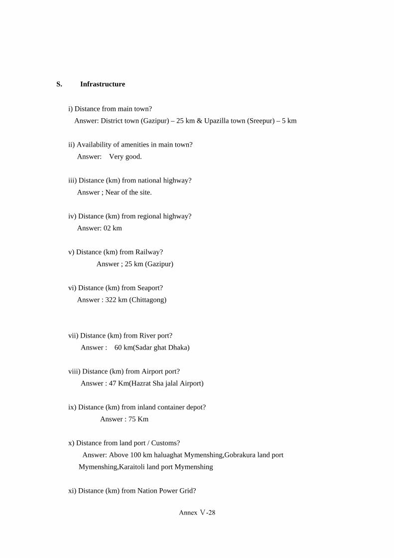
S. Infrastructure
i) Distance from main town?
Answer: District town (Gazipur) – 25 km & Upazilla town (Sreepur) – 5 km
ii) Availability of amenities in main town?
Answer: Very good.
iii) Distance (km) from national highway?
Answer ; Near of the site.
iv) Distance (km) from regional highway?
Answer: 02 km
v) Distance (km) from Railway?
Answer ; 25 km (Gazipur)
vi) Distance (km) from Seaport?
Answer : 322 km (Chittagong)
vii) Distance (km) from River port?
Answer : 60 km(Sadar ghat Dhaka)
viii) Distance (km) from Airport port?
Answer : 47 Km(Hazrat Sha jalal Airport)
ix) Distance (km) from inland container depot?
Answer : 75 Km
x) Distance from land port / Customs?
Answer: Above 100 km haluaghat Mymenshing,Gobrakura land port
Mymenshing,Karaitoli land port Mymenshing
xi) Distance (km) from Nation Power Grid?
Annex Ⅴ-28

Annex-V-30
Answer : : Close to the site, 30 meters away
xii) Supply capacity (electricity)
Answer : 33000 v.
xiii) Power frequency of outage (electricity?
Answer: per day frequency 0/10<_1/10
xiv) Distance (km) from gas pipeline network ?
Answer : Very close to the site, 30 meters away.
xv) Gas supply capacity?
Answer :Per day 27 to 40 MMSCFD
xvi) Distance from water supply source?
Answer : 25 km (Gazipur)
xvii) Water capacity and water quality?
Answer : per day 1000<_v2500( m3)
xviii) Distance from effluent treatment plant? If available
Answer : Not Available.
xix) Distance from Solid Waste Treatment plant? If available
Answer : Not available
xx) Distance from telecommunication network
Answer : Close to the site
xxi) Availability of public transport to the site
Answer : Available
T. Environmental Restriction/ Special Defects
i) Contamination of Land?
Annex Ⅴ-29
(383)
Annex-V-31
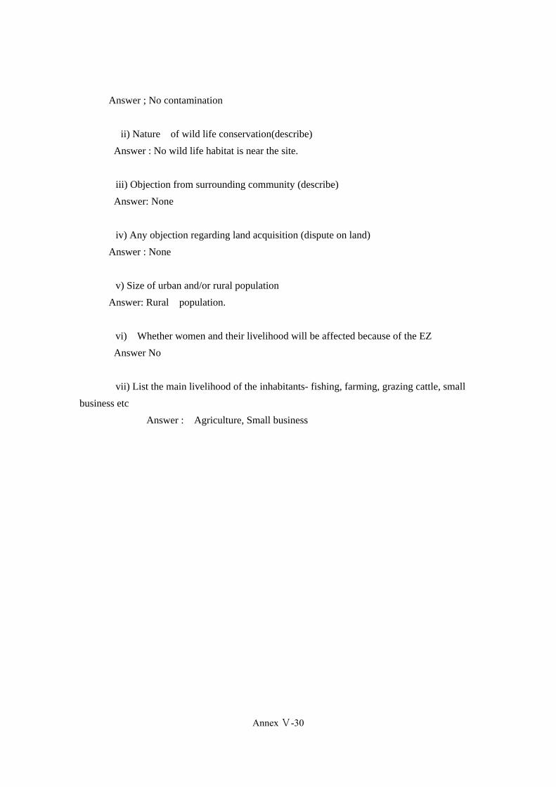
Answer ; No contamination
ii) Nature of wild life conservation(describe)
Answer : No wild life habitat is near the site.
iii) Objection from surrounding community (describe)
Answer: None
iv) Any objection regarding land acquisition (dispute on land)
Answer : None
v) Size of urban and/or rural population
Answer: Rural population.
vi) Whether women and their livelihood will be affected because of the EZ
Answer No
vii) List the main livelihood of the inhabitants- fishing, farming, grazing cattle, small
business etc
Answer : Agriculture, Small business
Annex Ⅴ-30
Annex-V-32
Data Collection Survey on Special Economic Zones in Bangladesh Check list for required Data and Information
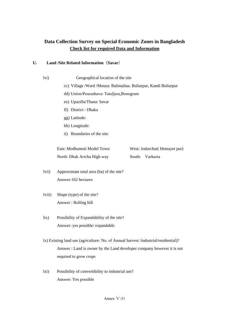
U. Land /Site Related Information(Savar)
lvi) Geographical location of the site
cc) Village /Ward /Mouza: Balimaliaa. Boliarpur, Kandi Boliarpur
dd) Union/Pourashava: Tatuljura,Bonogram
ee) Upazilla/Thana: Savar
ff) District : Dhaka
gg) Latitude:
hh) Longitude:
ii) Boundaries of the site:
East: Modhumoti Model Town West: Jodurchar( Hemayet pur)
North: Dhak Aricha High way South: Varkurta
lvii) Approximate total area (ha) of the site?
Answer:162 hectares
lviii) Shape (type) of the site?
Answer : Rolling hill
lix) Possibility of Expandability of the site?
Answer: yes possible/ expandable
lx) Existing land use (agriculture: No. of Annual harvest /industrial/residential)?
Answer : Land is owner by the Land developer company however it is not
required to grow crops
lxi) Possibility of convertibility to industrial use?
Answer: Yes possible
Annex Ⅴ-31
(385)
Annex-V-33
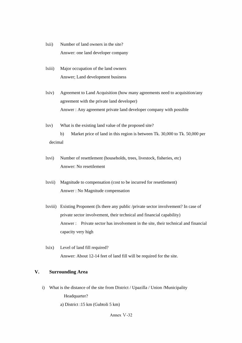
lxii) Number of land owners in the site?
Answer: one land developer company
lxiii) Major occupation of the land owners
Answer; Land development business
lxiv) Agreement to Land Acquisition (how many agreements need to acquisition/any
agreement with the private land developer)
Answer : Any agreement private land developer company with possible
lxv) What is the existing land value of the proposed site?
b) Market price of land in this region is between Tk. 30,000 to Tk. 50,000 per
decimal
lxvi) Number of resettlement (households, trees, livestock, fisheries, etc)
Answer: No resettlement
lxvii) Magnitude to compensation (cost to be incurred for resettlement)
Answer : No Magnitude compensation
lxviii) Existing Proponent (Is there any public /private sector involvement? In case of
private sector involvement, their technical and financial capability)
Answer : Private sector has involvement in the site, their technical and financial
capacity very high
lxix) Level of land fill required?
Answer: About 12-14 feet of land fill will be required for the site.
V. Surrounding Area
i) What is the distance of the site from District / Upazilla / Union /Municipality
Headquarter?
a) District :15 km (Gubtoli 5 km)
Annex Ⅴ-32

Annex-V-34
b) Upazilla : 10 km
c) Union/Municipality : 1.5 km
ii) Availability of amenities (school, college, hospital, bazaar, bank, police station, etc) in
main
town (district/Upazilla/ Union/Municipality) with specific number
Answer : Answer: Within 3 kilometers of radius the following are available:-
Primary Schools – 4
High Schools – 2
College – 2
Post Office – 1
Bazaar (Market place) – 2
Police Station –
iii) What is the distance of the site from the main city (Dhaka /Chittagong) and approximate
commuting time?
a) Dhaka : 15 km ( Gubtoli 5 km )
b) Chittagong : 280 km
iv) Availability of labor forces?
Answer : Available
v) Capacity of labor supply
Answer: 30,000 – 50,000 persons (male/female)
vi) Quality of laborers
Answer: A mixer of excellent (skilled), very good (semi-skilled) and good/non-skilled
laborers are available in the surrounding villages
vii) Availability of skilled labor/manager?
Annex Ⅴ-33
(387)
Annex-V-35
Answer : Available
viii) Capacity of skilled labor manager supply?
Answer: Adequate number of skilled labor managers are available
ix) Quality of labor managers
Answer: ,Excellent, Very good and Good
x) Distance from forward and backward linkages industries
Answer : Available (within 5 km Amin bajar))
xi) What is the distance from Exiting Industrial Cluster?
Answer: 20 km(Old Dhaka)
W. Natural Disaster
xxxiii) Does the area affect by flood?
Yes
No
xxxiv) If yes, when did the last flood occur? And how long it existed? And risk of
submerge
Year: ………(N/A)……………………….…… Duration of flooding:
xxxv) Can you please explain the damage due to the last flood?
Answer: N/A
m) Damage of crops/ agricultural land
n) Damage of Shelter
o) Others
Annex Ⅴ-34
Annex-V-36
xxxvi) Probability of the area being affect by earthquake? Mention the earthquake
zone
Answer: The area has high probability of being affected in case there is an earthquake
xxxvii) Risk of sub-merge?
Answer: 0/10 < F ≤ 2/10
0.1m < D ≤ 0.1m
xxxviii) Risk of land erosion?
Answer: low
xxxix) Risk of landslide
Answer: low
xl) Risk od cyclone/
Answer: No risk
X. Infrastructure
i) Distance from main town?
Answer: District town (Dhaka) – 15 km Amin Bajar Dhaka 5 Km & Upazilla town
(Savar) – 10 km
ii) Availability of amenities in main town?
Answer: Very good (Amin Bajar Gubtoli)
iii) Distance (KM) from national highway?
Answer ; Very close to the site,30 meters away(Dhaka Aricha high Way)
iv) Distance (KM) from regional highway?
Answer:0 km
v) Distance (km) from Railway?
Answer ; 12 km Air port Rail station,Kamalapur Rail Station 20 km
Annex Ⅴ-35
(389)
Annex-V-37
vi) Distance (km) from Seaport?
Answer: 280km(Chittagong seaport)
vii) Distance (km) from River port?
Answer :22 km pangaon, Sadar ghat 20 km,Aricha River port 42 km
viii) Distance (km) from Airport port?
Answer : 15 km Dhaka International Air port
ix) Distance (km) from inland container depot?
Answer :22km (Pangaon Karanigonj0
x) Distance from land port / Customs?
Answer: Within 110 km Bibir bazaar Land port comilla, Haluaghat land port
Mymenshing,Karaitoli land port Mymenshing.
xi) Distance (km) from Nation Power Grid?
Answer : Very close to the site,30 meters away
xii) Power Supply capacity?
Answer : 33000 v. ,230 Kv
xiii) Power frequency of outage?
per day frequency 0/10<_1/10
xiv) Distance (KM) from gas pipeline network ?
Answer ; Very close to the site,50 meters away
xv) Gas supply capacity?
Answer :Per day 25 to 40 MMSCFD
Note:1m3(1meter qbic/Normal qbic meter)=35.3147qbic feet of gas
Cft= mmscft/106 * 24
MMSCFD = cfth *24*106
xvi) Distance from water supply source?
Annex Ⅴ-36

Annex-V-38
Answer : 5 km
xvii) Water capacity and water quality?
Answer : per day 2500<_v5000( m3)
xviii) Distance from effluent treatment plant? If available
Answer :Not available
Note: A lot of industries have private ETP plants within 02-5 Km of their areas
GovernmentC ETP is situated in Savar distance from Mayakanoon hamayetpur site
10 Km
xix) Distance from Solid Waste Treatment plant? If available
Answer : Not available
xx) Distance from telecommunication network
Answer : 10 m
xxi) Availability of public transport to the site
Answer : Available (very good)
Y. Environmental Restriction/ Special Defects
xxii) Contamination of Land?
Answer ; No contamination
xxiii) Nature of wild life conservation(describe)
Answer: No wild life habitat is near the site
xxiv) Objection from surrounding community (describe)
Answer: No
xxv) Any objection regarding land acquisition (dispute on land)
Answer : None
Annex Ⅴ-37
(391)
Annex-V-39
xxvi) Size of urban and/or rural population
Answer: Rural and Urban population mixed of
vi) Whether women and their livelihood will be affected because of the EZ(Surrounding
Area)
Answer If EZs are established in this area, local women will have new
opportunities for jobs and women will be empowered.
xxvii) List the main livelihood of the inhabitants- fishing, farming, grazing cattle, small business
etc
Answer : not applicable
Note :There are no existing power networks on the site, however high tension, voltage lines passes through the site.
:There is no existing water network to the site, but ground water (bore holes) is available within the site.
:There is no existing gas connection at the site but close to the site
:There is no existing telecom connection on the site but it is available.
High voltage power line is within about close to the the site.
It can provide enough power for the zone
Data Collection Survey on Special Economic Zones in Bangladesh
Annex Ⅴ-38
Annex-V-40
Check list for required Data and Information
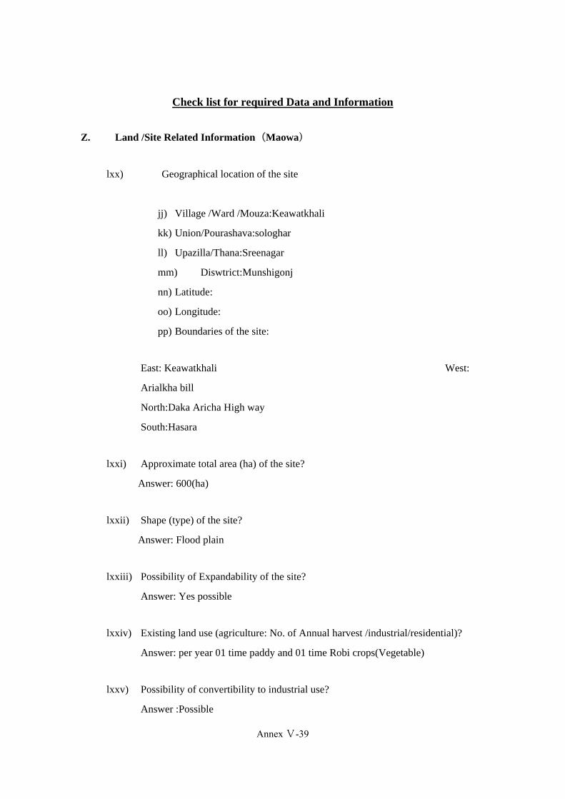
Z. Land /Site Related Information(Maowa)
lxx) Geographical location of the site
jj) Village /Ward /Mouza:Keawatkhali
kk) Union/Pourashava:sologhar
ll) Upazilla/Thana:Sreenagar
mm) Diswtrict:Munshigonj
nn) Latitude:
oo) Longitude:
pp) Boundaries of the site:
East: Keawatkhali West:
Arialkha bill
North:Daka Aricha High way
South:Hasara
lxxi) Approximate total area (ha) of the site?
Answer: 600(ha)
lxxii) Shape (type) of the site?
Answer: Flood plain
lxxiii) Possibility of Expandability of the site?
Answer: Yes possible
lxxiv) Existing land use (agriculture: No. of Annual harvest /industrial/residential)?
Answer: per year 01 time paddy and 01 time Robi crops(Vegetable)
lxxv) Possibility of convertibility to industrial use?
Answer :Possible
Annex Ⅴ-39
(393)
Annex-V-41
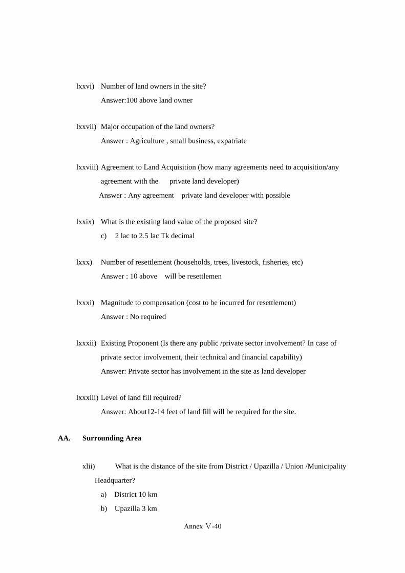
lxxvi) Number of land owners in the site?
Answer:100 above land owner
lxxvii) Major occupation of the land owners?
Answer : Agriculture , small business, expatriate
lxxviii) Agreement to Land Acquisition (how many agreements need to acquisition/any
agreement with the private land developer)
Answer : Any agreement private land developer with possible
lxxix) What is the existing land value of the proposed site?
c) 2 lac to 2.5 lac Tk decimal
lxxx) Number of resettlement (households, trees, livestock, fisheries, etc)
Answer : 10 above will be resettlemen
lxxxi) Magnitude to compensation (cost to be incurred for resettlement)
Answer : No required
lxxxii) Existing Proponent (Is there any public /private sector involvement? In case of
private sector involvement, their technical and financial capability)
Answer: Private sector has involvement in the site as land developer
lxxxiii) Level of land fill required?
Answer: About12-14 feet of land fill will be required for the site.
AA. Surrounding Area
xlii) What is the distance of the site from District / Upazilla / Union /Municipality
Headquarter?
a) District 10 km
b) Upazilla 3 km
Annex Ⅴ-40
Annex-V-42
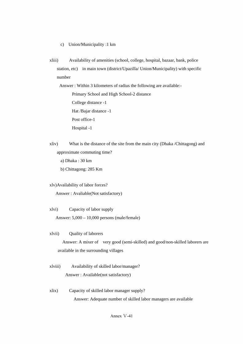
c) Union/Municipality :1 km
xliii) Availability of amenities (school, college, hospital, bazaar, bank, police
station, etc) in main town (district/Upazilla/ Union/Municipality) with specific
number
Answer : Within 3 kilometers of radius the following are available:-
Primary School and High School-2 distance
College distance -1
Hat /Bajar distance -1
Post office-1
Hospital -1
xliv) What is the distance of the site from the main city (Dhaka /Chittagong) and
approximate commuting time?
a) Dhaka : 30 km
b) Chittagong: 285 Km
xlv)Availability of labor forces?
Answer : Avaliable(Not satisfactory)
xlvi) Capacity of labor supply
Answer: 5,000 – 10,000 persons (male/female)
xlvii) Quality of laborers
Answer: A mixer of very good (semi-skilled) and good/non-skilled laborers are
available in the surrounding villages
xlviii) Availability of skilled labor/manager?
Answer : Available(not satisfactory)
xlix) Capacity of skilled labor manager supply?
Answer: Adequate number of skilled labor managers are available
Annex Ⅴ-41
(395)

Annex-V-43
l) Quality of labor managers
Answer: Good
li) Distance from forward and backward linkages industries
Answer : Backward linkage industries within 24(Karaniganj) km from site
lii) What is the distance from Exiting Industrial Cluster?
Answer: 24(Karani ganj) km :
Note:Surrounding area is a hub industries and land develop projects. The industries
and land developer are located within a 5-10 km radius of the site
BB. Natural Disaster
xli) Does the area affect by flood?
Yes
No
xlii) If yes, when did the last flood occur? And how long it existed? And risk of submerge
Year: ………2011……………………….…… Duration of flooding:
xliii) Can you please explain the damage due to the last flood?
p) Damage of crops/ agricultural land
Damage of Shelter
Others
xliv) Probability of the area being affect by earthquake? Mention the earthquake zone
Answer: The area has low probability of being affected in case there is an earthquake
xlv)Risk of sub-merge?
Answer: 0/10 < F ≤ 1/10
0< D ≤ 0.1m
xlvi) Risk of land erosion?
Annex Ⅴ-42

Annex-V-44
Answer: low
xlvii)Risk of landslide
Answer: low
xlviii) Risk od cyclone.
Answer: No risk
CC. Infrastructure
i) Distance from main town?
Answer: District town (Munshiganj) – 10 km & Upazilla town (Sreenagar) – 5 km
ii) Availability of amenities in main town?
Answer: Good .
iii) Distance (km) from national highway?
Answer ; 200m(Dhaka Maowa high way.
iv) Distance (km) from regional highway?
Answer :1 km(Munshigang maowa high way.
v) Distance (km) from Railway?
Answer : 35 km(Kamalapur)
vi) Distance (km) from Seaport?
Answer:285 km(Chittagong)
vii) Distance (km) from River port?
Answer : Maowa ghat 7 km, Dhak Sadar Ghat 35 Km
viii)Distance (km) from Airport port?
Answer : 46 Km ( Sha jalal international Air port)
Annex Ⅴ-43
(397)

Annex-V-45
ix) Distance (km) from inland container depot?
Answer : 24 km pangaon karaniganj,35 km kamalapur Dhaka
x)Distance from land port / Customs?
Answer: within 60 km Bibir bajar land port comilla,Akhaura land port
Bhahmanbaria.within 140km haluaghat Mymenshing,Gobrakura land port
Mymenshing,Karaitoli land port Mymenshing
xi)Distance (km) from Nation Power Grid?
Answer ; 1 00m
xii)Supply capacity (electricity)
Answer: 33000 volt(.5 km)
xiii)Power frequency of outage (electricity?
Answer: per day frequency 2/10<F_10/10
xiv)Distance (km) from gas pipeline network ?
Answer : 8km
xv) Gas supply capacity?
Answer :Per day 10 to 20 MMSCFD
xvi) Distance from water supply source?
Answer : 10 km
xvii)Water capacity and water quality?
Answer : per day v<100
xviii) Distance from effluent treatment plant? If available
Answer : Not Available
Note:A lot of industries have private ETP plants within 08-10 KMs of their areas
Government ETP is situated in Savar distance from Dhamrie site 25 Km
Annex Ⅴ-44

Annex-V-46
xix) Distance from Solid Waste Treatment plant? If available
Answer : Not available
xx)Distance from telecommunication network
Answer : 3 km
xxi) Availability of public transport to the site
Answer : Available(Good)
DD. Environmental Restriction/ Special Defects
i) Contamination of Land?
Answer : No contamination land
ii) Nature of wild life conservation(describe)
Answer : : No wild life habitat is near the site
iii) Objection from surrounding community (describe)
Answer :They have objection but may be result
iv) Any objection regarding land acquisition (dispute on land)
Answer : They have objection but may be result
v) Size of urban and/or rural population
Answer: Rural population
vi) Whether women and their livelihood will be affected because of the EZ
Answer : None
vii) List the main livelihood of the inhabitants- fishing, farming, grazing cattle,
small business etc
Answer : Note
Annex Ⅴ-45
(399)

Annex-V-47
: There are no existing power networks on the site, however high tension, voltage lines
passes through the site.
: There is no existing water network to the site, but ground water (bore holes) is
available within the site.
: There is no existing gas connection at the site (Gas connection very difficult)
: There is no existing telecom connection on the site but it is available.
High voltage power line is within about close to the the site.
It can provide enough power for the zone
Annex Ⅴ-46
Annex-V-48
Data Collection Survey on Special Economic Zones in Bangladesh Check list for required Data and Information
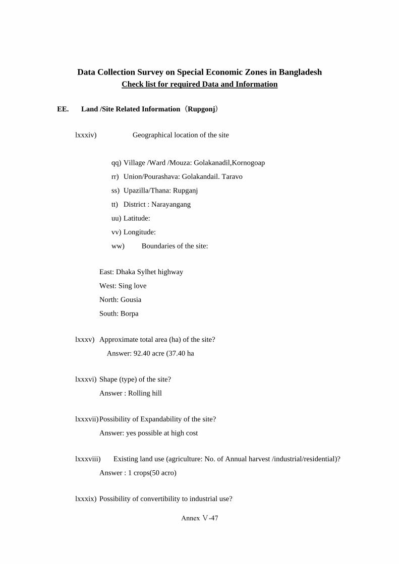
EE. Land /Site Related Information(Rupgonj)
lxxxiv) Geographical location of the site
qq) Village /Ward /Mouza: Golakanadil,Kornogoap
rr) Union/Pourashava: Golakandail. Taravo
ss) Upazilla/Thana: Rupganj
tt) District : Narayangang
uu) Latitude:
vv) Longitude:
ww) Boundaries of the site:
East: Dhaka Sylhet highway
West: Sing love
North: Gousia
South: Borpa
lxxxv) Approximate total area (ha) of the site?
Answer: 92.40 acre (37.40 ha
lxxxvi) Shape (type) of the site?
Answer : Rolling hill
lxxxvii)Possibility of Expandability of the site?
Answer: yes possible at high cost
lxxxviii) Existing land use (agriculture: No. of Annual harvest /industrial/residential)?
Answer : 1 crops(50 acro)
lxxxix) Possibility of convertibility to industrial use?
Annex Ⅴ-47
(401)
Annex-V-49
Answer: Yes possible
xc)Number of land owners in the site?
Answer: One land owner
xci) Major occupation of the land owners
Answer; Business
xcii) Agreement to Land Acquisition (how many agreements need to acquisition/any
agreement with the private land developer)
Answer : Any agreement one land owner with possible
xciii) What is the existing land value of the proposed site?
Answer: 4 lac per decimal
xciv) Number of resettlement (households, trees, livestock, fisheries, etc)
Answer: No resettlement
xcv) Magnitude to compensation (cost to be incurred for resettlement)
Answer : No Magnitude compensation
xcvi) Existing Proponent (Is there any public /private sector involvement? In case of
private sector involvement, their technical and financial capability
Answer : Private sector(one land owner) involvement in the site , their technical
and financial capability is very high.
xcvii) Level of Land fill required?
Answer; About 5‐6 feet of land fill will be required for the site
FF. Surrounding Area
i) What is the distance of the site from District / Upazilla / Union /Municipality
Headquarter?
Annex Ⅴ-48
Annex-V-50
a)District : 11 km from the Narayangang District Headquarter
b)Upazilla : The proposed site is approximately 4 km from Rupganj Upazila
Headquarters
c)Union/Municipality : 1 Km
ii) Availability of amenities (school, college, hospital, bazaar, bank, police station, etc) in
main town (district/Upazilla/ Union/Municipality) with specific number
Answer : Within 3 kilometers the following are available:-
Primary Schools – 4
High Schools – 3
College – 2
Post Office – 1
Bazaar (Market place) – 2
Police Station – 1
Bank-6
Hospital/clinic-2 abobe
iii) What is the distance of the site from the main city (Dhaka /Chittagong) and approximate
commuting time?
a) Dhaka : The site 36 km from Dhaka
b) Chittagong : 270 km from the Chittagong City Centre
iv) Availability of labor forces?
Answer : Available
v) Capacity of labor supply
Answer: 30,000 – 50,000 persons (male/female)
vi) Quality of laborers
Annex Ⅴ-49
(403)
Annex-V-51
Answer: A mixer of excellent (skilled), very good (semi-skilled) and good/non-skilled
laborers are available in the surrounding villages
vii) Availability of skilled labor/manager?
Answer : Available
viii) Capacity of skilled labor manager supply?
Answer: Adequate number of skilled labor managers are available
ix) Quality of labor managers
Answer: Excellent, Very good and Good
x) Distance from forward and backward linkages industries
Answer : Backward linkage industries within 5 Km from site
xi) What is the distance from Exiting Industrial Cluster?
Answer: 30 km
GG. Natural Disaster
xlix) Does the area affect by flood?
Yes
No
l) If yes, when did the last flood occur? And how long it existed? And risk of submerge
Year: ………(N/A)……………………….…… Duration of flooding:
li) Can you please explain the damage due to the last flood?
q) Damage of crops/ agricultural land
r) Damage of Shelter
s) Others
Annex Ⅴ-50

Annex-V-52
lii) Probability of the area being affect by earthquake? Mention the earthquake zone
Answer: The area has high probability of being affected in case there is an earthquake
liii) Risk of sub-merge?
Answer: 0/10 < F ≤ 1/10
0< D ≤ 0.1m
liv) Risk of land erosion?
Answer: No risk
lv) Risk of landslide
Answer: low risk
lvi) Risk od cyclone/
Answer: No risk
Comments : The site experiences cyclones and tidal surges however, the site itself
showed no evidence of contamination. A more detailed Environmental Impact
Assessment will need to be undertaken at a later date
HH. Infrastructure
i) Distance from main town?
Answer: District town (Naryangang) – 11 km & Upazilla town (Rupganj) – 4 km
ii) Availability of amenities in main town?
Answer: good
iii) Distance (km) from national highway?
Answer ; 1m
iv) Distance (km) from regional highway?
Answer:Within 1 km
Annex Ⅴ-51
(405)
Annex-V-53
v) Distance (km) from Railway?
Answer ; The Narayangang Railway Station is approximately11 km from the site
vi) Distance (km) from Seaport?
Answer : 271 km from the Port of Chittagong .
vii) Distance (km) from River port?
Answer :12 Narayanganj km
viii) Distance (km) from Airport port?
Answer : 40 km from the Dhaka Airport
ix) Distance (km) from inland container depot?
Answer : 25(Pangaon karaniganj)
x) Distance from land port / Customs?
Answer: Within 75 Km Akhaura land port Comilla,Bibir bajar land port comilla
xi) Distance (km) from Nation Power Grid?
Answer: Very close to the site,30 meters away
xii) Supply capacity (electricity)
Answer : No high voltage power establishment available nearby. There is need to
build a Sub-station for power supply
Xiii) Power frequency of outage (electricity?
Answer: per day frequency 0/10<_1/10
xiv) Distance (KM) from gas pipeline network ?
Answer : Very close to the site,0 meters away
xv) Gas supply capacity?
Annex Ⅴ-52
Annex-V-54
Answer :Per day 27 to 40 MMSCFD
Note:1m3(1meter qbic/Normal qbic meter)=35.3147qbic feet of gas
Cft= mmscft/106 * 24
MMSCFD = cfth *24*106
xvi) Distance from water supply source?
Answer : 11km (Narayangang)
xvii) Water capacity and water quality?
Answer : : per day 5000<_v7500( m3)
xviii) Distance from effluent treatment plant? If available
Answer : There exists no effluent treatment plant (ETP) or waste treatment plant in
the surrounding area
Note: A lot of industries have private ETP plants within 4-5 Km of their areas
xix) Distance from Solid Waste Treatment plant? If available
Answer : There exists no waste treatment plant in the surrounding area
xx) Distance from telecommunication network
Answer : Mobile telecommunication or landlines facilities available
xxi) Availability of public transport to the site
Answer : Available (good)
II. Environmental Restriction/ Special Defects
xxviii) Contamination of Land?
Answer ; No contamination(None)
xxix) Nature of wild life conservation(describe)
Answer: No
Annex Ⅴ-53
(407)

Annex-V-55
xxx) Objection from surrounding community (describe)
Answer: None
xxxi) Any objection regarding land acquisition (dispute on land)
Answer : None
xxxii) Size of urban and/or rural population
Answer: The site has a rural @ urban community mixed within 1 km.
xxxiii) Whether women and their livelihood will be affected because of the EZ
Answer: If EZs are established in this area, local women will have new opportunities for
jobs and women will be empowered
xxxiv) List the main livelihood of the inhabitants- fishing, farming, grazing cattle, small
business etc
Answer : Business ,small business, day labor, Skilled and unskilled industrial labor
Note :There are no existing power networks on the site, however high tension, voltage lines
passes through the site.
:There is no existing water network to the site, but ground water (bore holes) is available
within the site.
: There is existing gas connection at close to the site
:There is no existing telecom connection on the site but it is available.
High voltage power line is within about close to the the site.
It can provide enough power for the zone
Data Collection Survey on Special Economic Zones in Bangladesh
Annex Ⅴ-54

Annex-V-56
Check list for required Data and Information
JJ. Land /Site Related Information(Araihazar)
xcviii) Geographical location of the site
xx) Village /Ward /Mouza: Baghbari
yy) Union/Pourashava: Rasulpur
zz) Upazilla/Thana: Arihazar
aaa) District :Narayanganj
bbb) Latitude:
ccc) Longitude:
ddd) Boundaries of the site:
East: Rohinadi West: Rasulpur
North: Satgram South: Dhaka Sylhet Highway
xcix) Approximate total area (ha) of the site?
Size: 100 acore
c) Shape (type) of the site?
Answer :Rolling hill
ci) Possibility of Expandability of the site?
Answer: Yes possible at high cost
cii)Existing land use (agriculture: No. of Annual harvest /industrial/residential)?
Answer : 02 crops
ciii) Possibility of convertibility to industrial use?
Answer: Yes possible at high cost
civ) Number of land owners in the site?
Annex Ⅴ-55
(409)
Annex-V-57
Answer: One land woner
cv)Major occupation of the land owners
Answer; Business
cvi) Agreement to Land Acquisition (how many agreements need to acquisition/any
agreement with the private land developer)
Answer : Any agreement private land owner with possible
cvii) What is the existing land value of the proposed site?
Answer: 3 to 4 lac per decimal
cviii) Number of resettlement (households, trees, livestock, fisheries, etc)
Answer: No resettlement
cix) Magnitude to compensation (cost to be incurred for resettlement)
Answer : No Magnitude compensation
cx)Existing Proponent (Is there any public /private sector involvement? In case of private
sector involvement, their technical and financial capability
Answer Only 1 land owner
cxi) Level of Land fill required?
Answer: About 7-8 feet of land fill will be required for the site
KK. Surrounding Area
liii) What is the distance of the site from District / Upazilla / Union /Municipality
Headquarter?
a)District : 15 km from the Narayangang District Headquarter
b)Upazilla : The proposed site is approximately 10 km from Arihajar Upazila
Headquarters
Annex Ⅴ-56
Annex-V-58
c)Union/Municipality : 2 km
liv) Availability of amenities (school, college, hospital, bazaar, bank, police station, etc) in
main town (district/Upazilla/ Union/Municipality) with specific number
Answer : Within 1 (one ) kilometers of Madobdi Twon the following are available:-
Primary Schools – 4
High Schools – 3
College – 2
Post Office – 1
Bazaar (Market place) – 2
Police Station – 1
Bank-6
Hospital/clinic‐4 abobe
lv) What is the distance of the site from the main city (Dhaka /Chittagong) and approximate
commuting time?
a) Dhaka : 40 km
b) Chittagong : 278 km
lvi) Availability of labor forces?
Answer : Available
lvii) Capacity of labor supply
Answer: 10000<_N<30000
lviii) Quality of laborers
Answer: very good
lix) Availability of skilled labor/manager?
Answer : Available
lx) Capacity of skilled labor manager supply?
Annex Ⅴ-57
(411)
Annex-V-59
Answer: Adequate number of skilled labor managers are available
lxi) Quality of labor managers
Answer: Excellent, Very good and Good
lxii) Distance from forward and backward linkages industries
Answer : within 2 km (Madobdi bajar)
lxiii) What is the distance from Exiting Industrial Cluster?
Answer: 40 Km (Old Dhaka)
LL. Natural Disaster
lvii) Does the area affect by flood?
Yes
No
lviii) If yes, when did the last flood occur? And how long it existed? And risk of submerge
Year: ………(N/A)……………………….…… Duration of flooding:
lix) Can you please explain the damage due to the last flood?
t) Damage of crops/ agricultural land
u) Damage of Shelter
v) Others
lx) Probability of the area being affect by earthquake? Mention the earthquake zone
Answer: The area has high probability of being affected in case there is an earthquake
lxi) Risk of sub-merge?
Answer: 0/10 < F ≤ 2/10
Annex Ⅴ-58
Annex-V-60
0.1m< D ≤ 0.1m
lxii) Risk of land erosion?
Answer:low
lxiii) Risk of landslide
Answer : low
lxiv) Risk od cyclone/
Answer: No risk
MM. Infrastructure
i) Distance from main town?
Answer: 1 km Madobdi Twon
ii) Availability of amenities in main town?
Answer: good
iii) Distance (km) from national highway?
Answer ; 0km
iv) Distance (km) from regional highway?
Answer: 2 km
v) Distance (km) from Railway?
Answer ; narshingdi rail station 14
vi) Distance (km) from Seaport?
Answer : 278
Annex Ⅴ-59
(413)

Annex-V-61
vii) Distance (km) from River port?
Answer : 16 Km Narayangang
viii) Distance (km) from Airport port?
Answer : Dhaka Hajrat Sha Jalal international Airport distance 47 km
ix) Distance (km) from inland container depot?
Answer : 33 km(Pangaon karaniganj )
x) Distance from land port / Customs?
Answer: : Within 75 km Akhaura land port Comilla,Bibir bajar land port comilla
xi) Distance (km) from Nation Power Grid?
Answer: 1m
xii) Supply capacity (electricity)
Answer : 3300volt
xiii)Power frequency of outage (electricity?
Answer: per day frequency 1/10<F<_2/10
xiv)Distance from Gas supply Network?
Answer: 20meter
xv) Gas supply capacity?
Answer : 25 ≤ V<50
Note:1m3(1meter qbic/Normal qbic meter)=35.3147qbic feet of gas
Cft= mmscft/106 * 24
MMSCFD = cfth *24*106
xvi) Distance from water supply source?
Answer : 16 km Narayangang twon
Annex Ⅴ-60
Annex-V-62
xvii) Water capacity and water quality?
Answer : per day 5000<_v7500( m3)
xviii) Distance from effluent treatment plant? If available
Answer : Not avaliable
xix) Distance from Solid Waste Treatment plant? If available
Answer : Not avaliable
xx) Distance from telecommunication network
Answer : 3km Madobdi Twon
xxi) Availability of public transport to the site
Answer : Avaliable
NN. Environmental Restriction/ Special Defects
xxxv) Contamination of Land?
Answer ;
xxxvi) Nature of wild life conservation(describe)
Answer:
xxxvii)Objection from surrounding community (describe)
Answer:
xxxviii) Any objection regarding land acquisition (dispute on land)
Answer : Size of urban and/or rural population
xxxix) Whether women and their livelihood will be affected because of the EZ
Answer
Annex Ⅴ-61
(415)

Annex-V-63
xl) List the main livelihood of the inhabitants- fishing, farming, grazing cattle, small business
etc
Answer :
Data Collection Survey on Special Economic Zones in Bangladesh
Annex Ⅴ-62

Annex-V-64
Check list for required Data and Information
OO. Land /Site Related Information(Sangu River)
cxii) Geographical location of the site
eee) Village /Ward /Mouza: New Char Land(Baskhali)
fff) Union/Pourashava: Raipur
ggg) Upazilla/Thana: Baskhali
hhh) District : Chittagong
iii) Latitude:
jjj) Longitude:
kkk) Boundaries of the site:
East: Shankha River West: Bay of Bengal
North: Gohira village South: Bay of Bengal
cxiii) Approximate total area (ha) of the site?
Size: 285 acres/115.38 hectares
cxiv) Shape (type) of the site?
Answer : Flood plain
cxv) Possibility of Expandability of the site?
Answer: yes possible
cxvi) Existing land use (agriculture: No. of Annual harvest /industrial/residential)?
Answer : The lands are currently rarely utilized for occasional cultivation.
cxvii) Possibility of convertibility to industrial use?
Answer: Yes possible
cxviii) Number of land owners in the site?
Annex Ⅴ-63
(417)

Annex-V-65
Answer: This site is comprised of government owned Kash(state owned land)
lands
cxix) Major occupation of the land owners
Answer; Mostly fishermen and agricultural labours. Hence the area has a number
of unskilled labourers. Retraining will have to be encouraged
cxx) Agreement to Land Acquisition (how many agreements need to acquisition/any
agreement with the private land developer)
Answer : Land is Kash(state owned land), owned by the government
cxxi) What is the existing land value of the proposed site?
Answer: This site is comprised of government owned khas lands and land
cxxii) Number of resettlement (households, trees, livestock, fisheries, etc)
Answer: Some resettlement is required:The site does not require any
resettlement
cxxiii) Magnitude to compensation (cost to be incurred for resettlement)
Answer : No Magnitude compensation
cxxiv) Existing Proponent (Is there any public /private sector involvement? In case of
private sector involvement, their technical and financial capability
Answer : Land is kash(state owned land) owned by the government
cxxv) Level of Land fill required?
Answer; About 15-16 feet of land fill will be required for the site
Comments : The site is comprised of khas lands and does not need to be acquired. The
lands are prone to natural disasters and will need significant investment to protect the
lands. The site is also currently not well connected to access roads or national
transport infrastructure. The site is a distance from urban amenities. There is no
existing industrial activity in the surrounding area
Annex Ⅴ-64
Annex-V-66
PP. Surrounding Area
lxiv) What is the distance of the site from District / Upazilla / Union /Municipality
Headquarter?
a)District : 32 km from the Chittagong District Headquarter
b)Upazilla : The proposed site is approximately 14 km from Anwara Upazila
Headquarters
c)Union/Municipality : 2 km
lxv)Availability of amenities (school, college, hospital, bazaar, bank, police station, etc) in
main town (district/Upazilla/ Union/Municipality) with specific number
Answer : Nearest rural settlements are located within 1 km and the Fakirhat Bazaar
is about 1 km away from the site.
A primary school is located within 1 km. A high school and college is about 6 km away.
Within 2 (two ) kilometers of radius the following are available:-
lxvi) What is the distance of the site from the main city (Dhaka /Chittagong) and
approximate commuting time?
a) Dhaka : The site is 309 km from Dhaka
b) Chittagong : 33 km from the Chittagong City Centre
lxvii)Availability of labor forces?
Answer : There are few skilled labourers in the area
lxviii) Capacity of labor supply
Answer: Not abaliable
lxix) Quality of laborers
Answer: A mixer , very good (semi-skilled) and good/non-skilled laborers are available
in the surrounding villages
lxx)Availability of skilled labor/manager?
Annex Ⅴ-65
(419)
Annex-V-67
Answer : Not Available
lxxi) Capacity of skilled labor manager supply?
Answer: Adequate number of skilled labor managers are available
lxxii)Quality of labor managers
Answer: Not Available
lxxiii) Distance from forward and backward linkages industries
Answer : Backward linkage industries within 5 Km from site
lxxiv) What is the distance from Exiting Industrial Cluster?
Answer: 35 km(Chittagong)
QQ. Natural Disaster
lxv)Does the area affect by flood?
Yes
No
lxvi) If yes, when did the last flood occur? And how long it existed? And risk of submerge
Year: ………(N/A)……………………….…… Duration of flooding:
lxvii)Can you please explain the damage due to the last flood?
w) Damage of crops/ agricultural land
x) Damage of Shelter
y) Others
lxviii) Probability of the area being affect by earthquake? Mention the earthquake
zone
Answer: The area has high probability of being affected in case there is an earthquake
Annex Ⅴ-66
Annex-V-68
lxix) Risk of sub-merge?
Answer: 0/10 < F ≤ 1/10
0< D ≤ 0.1m
lxx)Risk of land erosion?
Answer:low risk
lxxi) Risk of landslide
Answer: low risk
lxxii)Risk od cyclone/
Answer: High risk
Comments : The site experiences cyclones and tidal surges however, the site itself
showed no evidence of contamination. A more detailed Environmental Impact
Assessment will need to be undertaken at a later date
RR. Infrastructure
i) Distance from main town?
Answer: District
ii) Availability of amenities in main town?
Answer: Very good
iii) Distance (km) from national highway?
Answer ; 20 km from the Dhaka-Chittagong-Cox’s Bazar Highway
iv) Distance (km) from regional highway?
Answer: 20 km
Note: , The site is not easily accessible from the national and regional highways, but it
does have direct access from adjacent waterways, which are accessible year
round.
Annex Ⅴ-67
(421)

Annex-V-69
v) Distance (km) from Railway?
Answer ; The Chittagong Railway Station is approximately32 km from the site
vi) Distance (km) from Seaport?
Answer : 39 km from the Port of Chittagong , Chittagong Port is only 4 km by sea.
vii) Distance (km) from River port?
Answer :40 Narayanganj km
viii) Distance (km) from Airport port?
Answer : 46 km from the Chittagong Airport 60, 315 km from the Dhaka Airport
ix) Distance (km) from inland container depot?
Answer : 35 Km (Chittagong)
x) Distance from land port / Customs?
Answer: Within 65 Km Akhaura land port Comilla,Bibir bajar land port comilla
xi) Distance (km) from Nation Power Grid?
Answer: Electricity network is about 1 km from the site
xii) Supply capacity (electricity)
Answer : No high voltage power establishment available nearby. There is need to
build a Sub-station for power supply
xiii) Power frequency of outage (electricity?
Answer: per day frequency 0/10<_1/10
xiv) Distance (km) from gas pipeline network ?
Answer : 5 km.
Annex Ⅴ-68
Annex-V-70
xv) Gas supply capacity?
Answer : 25 ≤ V< 50
xvi) Distance from water supply source?
Answer : 33 km (Chittagong)
xvii) Water capacity and water quality?
Answer : 1000 ≤ V<2500
xviii) Distance from effluent treatment plant? If available
Answer : There exists no effluent treatment plant (ETP) or waste treatment
plant in the surrounding area
Note: A lot of industries have private ETP plants within 300-35 Km of their areas
xix) Distance from Solid Waste Treatment plant? If available
Answer : There exists no waste treatment plant in the surrounding area
xx) Distance from telecommunication network
Answer : Mobile telecommunication facilities available but no landlines
available
xxi) Availability of public transport to the site
Answer : The site is also currently not well connected to access roads or national
transport infrastructure
SS. Environmental Restriction/ Special Defects
xli) Contamination of Land?
Answer ; No contamination
xlii) Nature of wild life conservation(describe)
Annex Ⅴ-69
(423)
Annex-V-71
Answer: No
xliii) Objection from surrounding community (describe)
Answer: None
xliv) Any objection regarding land acquisition (dispute on land)
Answer : The site is comprised of khas lands and does not need to be acquired. The
lands are prone to natural disasters and will need significant investment to protect the
lands.
xlv)Size of urban and/or rural population
Answer: The site has a rural community within 1 km.There are a number of
scattered fishing villages around the site.
xlvi) Whether women and their livelihood will be affected because of the EZ
Answer: If EZs are established in this area, local women will have new opportunities for
jobs and women will be empowered
xlvii) List the main livelihood of the inhabitants- fishing, farming, grazing cattle, small
business etc
Answer : Small business and Agriculture
Final Recommendation: Although the site is Khas lands, it also has several location
disadvantages such as, it is prone to natural disasters (cyclones and tidal surges), has poor
connectivity to national transport systems, lacks on and off-site infrastructure and utility
networks, and has limited access to modern amenities required for international investors.
Significant capital investment is required for this site, unless it was to be developed and
used for the shipbuilding sector.
Annex Ⅴ-70
Annex-V-72
Data Collection Survey on Special Economic Zones in Bangladesh Check list for required Data and Information
TT. Land /Site Related Information (Matarbari)
cxxvi) Geographical location of the site
lll) Village /Ward /Mouza: Matarbari
mmm) Union/Pourashava: Matarbari
nnn) Upazilla/Thana: Maheshkhali,
ooo) District : Cox’s Bazar
ppp) Latitude:
qqq) Longitude:
rrr) Boundaries of the site:
East: Kohalia river and Kalarmarchhara West: Bay of Bengal
North: Kohalia River South:
Mahurighona
cxxvii) Approximate total area (ha) of the site?
Size: 300 hectares
cxxviii) Shape (type) of the site?
Answer: Flood plain
cxxix) Possibility of Expandability of the site?
Answer: yes possible
cxxx) Existing land use (agriculture: No. of Annual harvest /industrial/residential)?
Answer: No cultivation.
cxxxi) Possibility of convertibility to industrial use?
Answer: Yes possible
Annex Ⅴ-71
(425)
Annex-V-73
cxxxii) Number of land owners in the site?
Answer: This site is comprised of government owned khas(State owned land)
lands
cxxxiii) Major occupation of the land owners
Answer; Mostly fishermen and agricultural labours. Hence the area has a number
of unskilled labourers. Retraining will have to be encouraged
cxxxiv) Agreement to Land Acquisition (how many agreements need to acquisition/any
agreement with the private land developer)
Answer : Land is khas(State owner Land), owned by the government
cxxxv) What is the existing land value of the proposed site?
Answer: This site is comprised of government owned khas ( State owner
land)lands
xi) Number of resettlement (households, trees, livestock, fisheries, etc)
Answer: No resettlement
xii) Magnitude to compensation (cost to be incurred for resettlement)
Answer : No Magnitude compensation
xiii) Existing Proponent (Is there any public /private sector involvement? In case of
private sector involvement, their technical and financial capability
Answer : Land is khas,(state owner land) owned by the government
xiv) Level of Land fill required?
Answer; 2m <H ≤ 5m
Comments: The site is comprised of khas lands and does not need to be acquired. The lands
are prone to natural disasters and will need significant investment to protect the lands. The
site is also currently not well connected to access roads or national transport infrastructure.
The site is a distance from urban amenities. There is no existing industrial activity in the
surrounding area
Annex Ⅴ-72
Annex-V-74
UU. Surrounding Area
lxxv)What is the distance of the site from District / Upazilla / Union /Municipality
Headquarter?
a) District : 50 km from the Cox’s Bazar District Headquarter
b) Upazilla : 20 km from : Maheshkhali Upazila Headquarters
c) Union/Municipality : 5 km
lxxvi) Availability of amenities (school, college, hospital, bazaar, bank, police
station, etc) in main town (district/Upazilla/ Union/Municipality) with specific
number
Answer : Nearest rural settlements are located within 20 km and the Union Bazaar is
about 5 km away from the site.
A primary school is located within 5km. A high school and is about 6 km away.
Within 20 (two ) kilometers of radius the following are available:-
lxxvii) What is the distance of the site from the main city (Dhaka /Chittagong) and
approximate commuting time?
a) Dhaka : The site is 385 km from Dhaka
b) Chittagong : 100 km from the Chittagong City Centre
lxxviii) Availability of labor forces?
Answer : Not available
lxxix) Capacity of labor supply?
Answer: poor (N<5000)
lxxx)Quality of laborers
Answer: Poor
lxxxi) Availability of skilled labor/manager?
Answer : Not Available
Annex Ⅴ-73
(427)
Annex-V-75
lxxxii) Capacity of skilled labor manager supply?
Answer: poor
lxxxiii) Quality of labor managers
Answer: Poor
lxxxiv) Distance from forward and backward linkages industries
Answer : Backward linkage industries within 100 km from site (Chittagong)
lxxxv) What is the distance from Exiting Industrial Cluster?
Answer: 100 km (Chittagong)
VV. Natural Disaster
lxxiii) Does the area affect by flood?
Yes
No
lxxiv) If yes, when did the last flood occur? And how long it existed? And risk of
submerge
Year: ………(N/A)……………………….…… Duration of flooding:
lxxv)Can you please explain the damage due to the last flood?
z) Damage of crops/ agricultural land
aa) Damage of Shelter
bb) Others
lxxvi) Probability of the area being affect by earthquake? Mention the earthquake
zone
Answer: The area has high probability of being affected in case there is an earthquake
Annex Ⅴ-74

Annex-V-76
lxxvii) Risk of sub-merge?
Answer: 0/10 < f ≤ 1/10
0< D ≤ 0.1m
lxxviii) Risk of land erosion?
Answer: low risk
lxxix) Risk of landslide
Answer: low risk
lxxx)Risk od cyclone/
Answer: High risk
Comments : The site experiences cyclones and tidal surges however, the site itself
showed no evidence of contamination. A more detailed Environmental Impact
Assessment will need to be undertaken at a later date
WW. Infrastructure
i) Distance from main town?
Answer: 20 km
ii) Availability of amenities in main town?
Answer: poor
iii) Distance (km) from national highway?
Answer ; 20 km from the Dhaka-Chittagong-Cox’s Bazar Highway
iv) Distance (km) from regional highway?
Answer: 20 km
Note: , The site is not easily accessible from the national and regional highways, but it
does have direct access from adjacent waterways, which are accessible year round.
v) Distance (km) from Railway?
Answer ; The Chittagong Railway Station is approximately100 km from the site
Annex Ⅴ-75
(429)
Annex-V-77
vi) Distance (km) from Seaport?
Answer : 100 km from the Port of Chittagong , Chittagong Port is only 15 km by sea.
vii) Distance (km) from River port?
Answer :100 Km Karnofully river port
viii) Distance (km) from Airport port?
Answer : 103 km from the Chittagong Airport , 388 km from the Dhaka Airport
ix) Distance (km) from inland container depot?
Answer : 102(Chittagong))
x) Distance from land port / Customs?
Answer: Within 150 km Akhaura land port Comilla,Bibir bajar land port comilla
xi) Distance (km) from Nation Power Grid?
Answer: Electricity network is about 10 km from the site
xii) Supply capacity (electricity)
Answer : 10MW ≤ P ≤ 25MW
xiii )Power frequency of outage (electricity?
Answer: per day frequency 0/10<F_2/10
xiv) Distance (km) from gas pipeline network ?
Answer :100 Km Chittagong
xv) Gas supply capacity?
Answer : 25 ≤ V<50
xvi)Distance from water supply source?
Answer : 50 km Cox’s Bazar
xvii)Water capacity and water quality?
Answer : 1000 ≤ V ≤ 2500
Annex Ⅴ-76

Annex-V-78
xviii) Distance from effluent treatment plant? If available
Answer : 100Km Chittagong
xix) Distance from Solid Waste Treatment plant? If available
Answer : 100 Km Chittagong
xx) Distance from telecommunication network
Answer : Mobile telecommunication facilities available but No land lines available
(poor)
xxi) Availability of public transport to the site
Answer : Not available (Poor)
XX. Environmental Restriction/ Special Defects
xlviii) Contamination of Land?
Answer ; No contamination
xlix) Nature of wild life conservation(describe)
Answer: No
l) Objection from surrounding community (describe)
Answer: None
li) Any objection regarding land acquisition (dispute on land)
Answer : The site is comprised of khas(Stae owned land) lands and does not need to be
acquired. The lands are prone to natural disasters and will need significant investment to
protect the lands.
lii) Size of urban and/or rural population
Answer: The site has a rural community within 10 km.There are a number of scattered
villages around the site.
Annex Ⅴ-77
(431)
Annex-V-79
liii) Whether women and their livelihood will be affected because of the EZ
Answer: If EZs are established in this area, local women will have new opportunities for
jobs and women will be empowered
liv) List the main livelihood of the inhabitants- fishing, farming, grazing cattle, small business
etc
Answer : Small business and Agriculture.fishing
Final Recommendation: Although the site is Khas lands, it also has several location
disadvantages such as, it is prone to natural disasters (cyclones and tidal surges), has poor
connectivity to national transport systems, lacks on and off-site infrastructure and utility
networks, and has limited access to modern amenities required for international investors.
Significant capital investment is required for this site, unless it was to be developed and used for
the shipbuilding sector.
Annex Ⅴ-78
Appendix VI: Scorecards on the candidate SEZ sites
(435)
Data Collection Survey on the Special Economic Zones in Bangladesh
Final Report
(433)
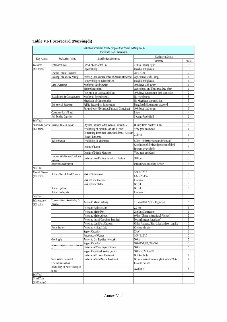
Appendix VI-2
Table VI-1 Scorecard (Narsingdi)
Summary ScoreTotal Area (ha) Size & Shape of the Site 279 ha, Oblong figure 5
Expandability Possible at high cost 3Level of Landfill Required 2m<H≤5m 2Existing Land Use & Zoning Existing Land Use (Number of Annual Harvests) Agricultural land (1 crop) 4
Convertibility to Industrial Use Possible at high cost 4Land Ownership Number of Land Owners 100 above land owner 1
Major Occupation Agriculture, small business ,Day lobor 1Agreement to Land Acquisition 100 above agreement to land acquission 2
Resettlement & Compensation Number of Resettlements No resettlement 5Magnitude of Compensation No Magnitude compensation 5
Existence of Supporter Public Sector (Past Experience) Bangaldesh Government proposed 4Private Sector (Technical/Financial Capability) 100 above land owner 1
Contamination of Land Little 4Soil Bearing Capacity Swamp, Paddy field 1
Sub Total
Distance to Main Towns Physical Distance to the available amenities District Head quarter : 4 km 5Availability of Amenities in Main Town Very good and Good 4Commuting Time from Prime Residential Areas inDhaka/Chittagong
2.0hr<T 1
Labor Market Availability of labor force 5,000 – 10,000 persons (male/female) 3
Quality of LaborGood (semi-skilled) and good/non-skilledlaborers are available
3
Quality of Middle Managers Very good and Good 4Linkage with Forward/BackwardIndustry
Distance from Existing Industrial Clusters 100 km 3
Adjacent Development Industries surrounding the site 3Sub Total
Risk of Flood & Land Erosion Risk of Submersion1/10<F≤2/100.1m<D≤0.5m
3
Risk of Land Erosion Low risk 3Risk of Land Slides No risk 5
Risk of Cyclone No risk 5Risk of Earthquake Low risk 3
Sub TotalTransportation (Availability &Distance)
Access to Main Highway 1.3 km (Dhak Sylhet Highway) 5
Access to Railway Line 2.7 km 5Access to Major Port 289 km (Chittagong) 1Access to Major Airport 60 km (Dhaka International Air port) 3Access to Inland Container Terminal 50km (Pangaon karaniganj) 3Access to Land Port/Customs 65 km Akhaura, Bibir bajar land port comilla 2
Power Supply Access to National Grid Close to the site 5Supply Capacity 33kV 3Frequency of Outage 1/10<F≤2/10 3
Gas Supply Access to Gas Pipeline Network 500m 5Supply Capacity 760,000-1,130,000m3/d 3
Water Supply and SewageSystem
Distance to Water Supply Source 500m 5Supply Capacity & Water Quality 1000<V≤2500 m3/d 3Distance to Effluent Treatment Not Available 1
Solid Waste Treatment Distance to Solid Waste Treatment No solid waste treatment plant within 20 Km 1Telecommunication Close to the site 5Availability of Public Transportto Site
Available 5
Sub TotalGrand Total(1,000 points)
Locations(350 points)
Infrastructure(300 points)
Natural Disaster(150 points)
Surrounding Area(200 points)
Evaluation Scorecard for the proposed SEZ Sites in Bangladesh( Candidate No.1 : Narsingdi )
Key Aspect Evaluation Points Specific RequirementsEvaluation Scores
Annex Ⅵ-1
(435)

Appendix VI-3
Table VI-2 Scorecard (A K Khan)
Summary ScoreTotal Area (ha) Size & Shape of the Site 101ha, Polygonal shape 3
Expandability Possible 3Level of Landfill Required About 1-2m of land fill 3Existing Land Use & Zoning Existing Land Use (Number of Annual Harvests) No crops 3
Convertibility to Industrial Use Possible 4Land Ownership Number of Land Owners One land owner 4
Major Occupation Land developer company 4Agreement to Land Acquisition Easy 4
Resettlement & Compensation Number of Resettlements No resettlement 5Magnitude of Compensation No Magnitude compensation 5
Existence of Supporter Public Sector (Past Experience) Have experience work with public sector 3Private Sector (Technical/Financial Capability) Private sector (one land owner) 3
Contamination of Land None 5Soil Bearing Capacity Sand, Cultivation 3
Sub Total
Distance to Main Towns Physical Distance to the available amenities District Head quarter : 14 km 5Availability of Amenities in Main Town Good 3Commuting Time from Prime Residential Areas inDhaka/Chittagong
Dhaka : 30km + Boat(1.5hr<T≤2.0hr)
2
Labor Market Availability of labor force 10,000 – 30,000 persons (male/female) 3
Quality of LaborExcellent (skilled), very good (semi-skilled) andgood/non-skilled laborers are available
4
Quality of Middle Managers Excellent, Very good and Good 5Linkage with Forward/BackwardIndustry
Distance from Existing Industrial Clusters 50 km (old Dhaka) 3
Adjacent DevelopmentIndustries unlocated near to the site (oposite bankof the river)
3
Sub Total
Risk of Flood & Land Erosion Risk of Submersion1/10<F≤2/100.1m<D≤0.5m
3
Risk of Land Erosion High risk 2Risk of Land Slides No risk 5
Risk of Cyclone No risk 5Risk of Earthquake Low risk 3
Sub TotalTransportation (Availability &Distance)
Access to Main Highway 12 km (Dhak Sylhet Highway) 3
Access to Railway Line 14 km 3Access to Major Port 276km (Chittagong) 1
Access to Major Airport32 km (Crossing river, Dhaka International Airport)
4
Access to Inland Container Terminal 0km (A K Khan Terminal) 5Access to Land Port/Customs 70 km Akhaura, Bibir bajar land port comilla 2
Power Supply Access to National Grid Very close to the site (30m) 4
Supply CapacityNo high voltage power establishment availablenearby
3
Frequency of Outage 2/10<F≤10/10 2Gas Supply Access to Gas Pipeline Network 1km 4
Supply Capacity 25≤V<50 (10^3Nm3/day) 3Water Supply and SewageSystem
Distance to Water Supply Source 500m 3Supply Capacity & Water Quality 5000<V≤7500 m3/d 2Distance to Effluent Treatment Not Available 1
Solid Waste Treatment Distance to Solid Waste Treatment Not Available 1
TelecommunicationMobile network available.Land phone distance from 2 km
3
Availability of Public Transportto Site
Poor 2
Sub TotalGrand Total(1,000 points)
Infrastructure(300 points)
Natural Disaster(150 points)
Surrounding Area(200 points)
Evaluation Scorecard for the proposed SEZ Sites in Bangladesh( Candidate No.2 : A K Khan )
Key Aspect Evaluation Points Specific RequirementsEvaluation Scores
Locations(350 points)
Annex Ⅵ-2
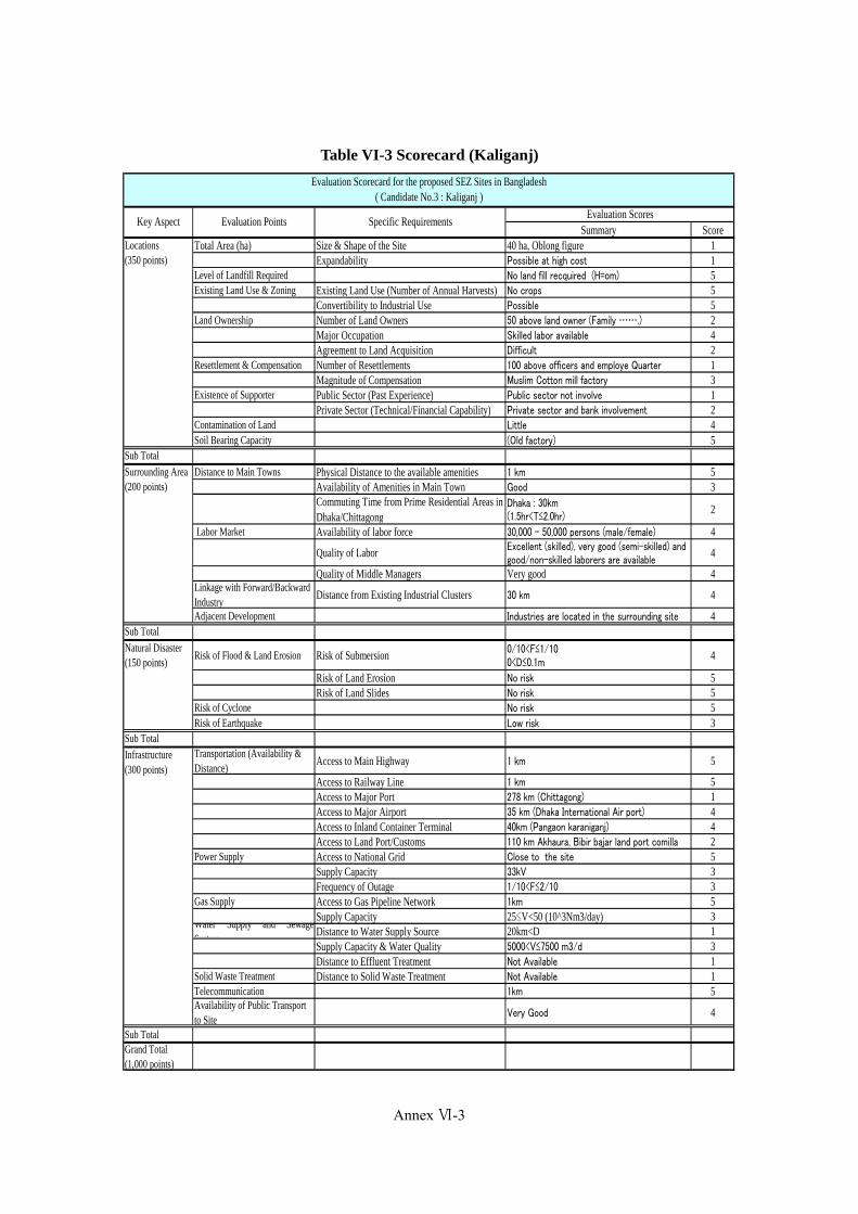
Appendix VI-4
Table VI-3 Scorecard (Kaliganj)
Summary ScoreTotal Area (ha) Size & Shape of the Site 40 ha, Oblong figure 1
Expandability Possible at high cost 1Level of Landfill Required No land fill recquired (H=om) 5Existing Land Use & Zoning Existing Land Use (Number of Annual Harvests) No crops 5
Convertibility to Industrial Use Possible 5Land Ownership Number of Land Owners 50 above land owner (Family …….) 2
Major Occupation Skilled labor available 4Agreement to Land Acquisition Difficult 2
Resettlement & Compensation Number of Resettlements 100 above officers and employe Quarter 1Magnitude of Compensation Muslim Cotton mill factory 3
Existence of Supporter Public Sector (Past Experience) Public sector not involve 1Private Sector (Technical/Financial Capability) Private sector and bank involvement 2
Contamination of Land Little 4Soil Bearing Capacity (Old factory) 5
Sub Total
Distance to Main Towns Physical Distance to the available amenities 1 km 5Availability of Amenities in Main Town Good 3Commuting Time from Prime Residential Areas inDhaka/Chittagong
Dhaka : 30km(1.5hr<T≤2.0hr)
2
Labor Market Availability of labor force 30,000 – 50,000 persons (male/female) 4
Quality of Labor Excellent (skilled), very good (semi-skilled) andgood/non-skilled laborers are available
4
Quality of Middle Managers Very good 4Linkage with Forward/BackwardIndustry
Distance from Existing Industrial Clusters 30 km 4
Adjacent Development Industries are located in the surrounding site 4Sub Total
Risk of Flood & Land Erosion Risk of Submersion 0/10<F≤1/100<D≤0.1m
4
Risk of Land Erosion No risk 5Risk of Land Slides No risk 5
Risk of Cyclone No risk 5Risk of Earthquake Low risk 3
Sub TotalTransportation (Availability &Distance)
Access to Main Highway 1 km 5
Access to Railway Line 1 km 5Access to Major Port 278 km (Chittagong) 1Access to Major Airport 35 km (Dhaka International Air port) 4Access to Inland Container Terminal 40km (Pangaon karaniganj) 4Access to Land Port/Customs 110 km Akhaura, Bibir bajar land port comilla 2
Power Supply Access to National Grid Close to the site 5Supply Capacity 33kV 3Frequency of Outage 1/10<F≤2/10 3
Gas Supply Access to Gas Pipeline Network 1km 5Supply Capacity 25≤V<50 (10^3Nm3/day) 3
Water Supply and SewageSystem
Distance to Water Supply Source 20km<D 1Supply Capacity & Water Quality 5000<V≤7500 m3/d 3Distance to Effluent Treatment Not Available 1
Solid Waste Treatment Distance to Solid Waste Treatment Not Available 1Telecommunication 1km 5Availability of Public Transportto Site
Very Good 4
Sub TotalGrand Total(1,000 points)
Locations(350 points)
Infrastructure(300 points)
Natural Disaster(150 points)
Surrounding Area(200 points)
Evaluation Scorecard for the proposed SEZ Sites in Bangladesh( Candidate No.3 : Kaliganj )
Key Aspect Evaluation Points Specific RequirementsEvaluation Scores
Annex Ⅵ-3
(437)

Appendix VI-5
Table VI-4 Scorecard (Sreepur)
Summary ScoreTotal Area (ha) Size & Shape of the Site 60 ha, Oblong figure 2
Expandability Very difficult 2Level of Landfill Required No land fill recquired (H=om) 5Existing Land Use & Zoning Existing Land Use (Number of Annual Harvests) Agriculture (1crops cotton) 3
Convertibility to Industrial Use Possible 5Land Ownership Number of Land Owners Public land (Government) 5
Major Occupation Researcher 4Agreement to Land Acquisition Easy 4
Resettlement & Compensation Number of Resettlements No resettlement (Except trees) 5Magnitude of Compensation Approx. 20 mil TAKA 5
Existence of Supporter Public Sector (Past Experience) Cotton development Board 4Private Sector (Technical/Financial Capability) Private sector not involve 1
Contamination of Land Little 5Soil Bearing Capacity Upland 5
Sub Total
Distance to Main Towns Physical Distance to the available amenities 25km 5Availability of Amenities in Main Town Very good 4Commuting Time from Prime Residential Areas inDhaka/Chittagong
Dhaka : 45km(1.0hr<T≤1.5hrr)
3
Labor Market Availability of labor force 30,000 – 50,000 persons (male/female) 4
Quality of Labor Excellent (skilled), very good (semi-skilled) andgood/non-skilled laborers are available
5
Quality of Middle Managers Very good 4Linkage with Forward/BackwardIndustry
Distance from Existing Industrial Clusters 30 km (But Very near HONDA in near future) 5
Adjacent Development Many industrties are located situated in thesurrounding site
4
Sub Total
Risk of Flood & Land Erosion Risk of Submersion F=0/10D=0m
5
Risk of Land Erosion No risk 5Risk of Land Slides No risk 5
Risk of Cyclone No risk 5Risk of Earthquake Low risk 4
Sub TotalTransportation (Availability &Distance)
Access to Main Highway Roadside 5
Access to Railway Line 10km<D≤25km 3Access to Major Port 322 km (Chittagong) 1Access to Major Airport 47 km (Dhaka International Air port) 5Access to Inland Container Terminal 75km (Pangaon karaniganj) 5Access to Land Port/Customs 100 km Akhaura, Bibir bajar land port comilla 2
Power Supply Access to National Grid Close to the site 5Supply Capacity 33kV 4Frequency of Outage 0/10<F≤1/10 4
Gas Supply Access to Gas Pipeline Network Close to the site 5Supply Capacity 760,000-1,130,000m3/d 3
Water Supply and SewageSystem
Distance to Water Supply Source 25km 1Supply Capacity & Water Quality 1,000<V≤2,500 m3/d 3Distance to Effluent Treatment Not Available 1
Solid Waste Treatment Distance to Solid Waste Treatment Not Available 1Telecommunication Close to the site 5Availability of Public Transportto Site
Available 5
Sub TotalGrand Total(1,000 points)
Evaluation Scorecard for the proposed SEZ Sites in Bangladesh( Candidate No.4 : Sreepur )
Key Aspect Evaluation Points Specific RequirementsEvaluation Scores
Locations(350 points)
Infrastructure(300 points)
Natural Disaster(150 points)
Surrounding Area(200 points)
Annex Ⅵ-4
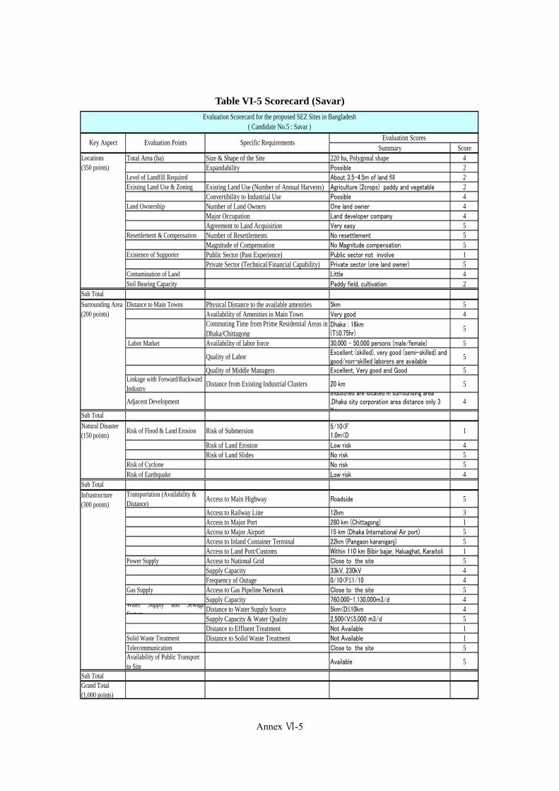
Appendix VI-6
Table VI-5 Scorecard (Savar)
Summary ScoreTotal Area (ha) Size & Shape of the Site 220 ha, Polygonal shape 4
Expandability Possible 2Level of Landfill Required About 3.5-4.5m of land fill 2Existing Land Use & Zoning Existing Land Use (Number of Annual Harvests) Agriculture (2crops) paddy and vegetable 2
Convertibility to Industrial Use Possible 4Land Ownership Number of Land Owners One land owner 4
Major Occupation Land developer company 4Agreement to Land Acquisition Very easy 5
Resettlement & Compensation Number of Resettlements No resettlement 5Magnitude of Compensation No Magnitude compensation 5
Existence of Supporter Public Sector (Past Experience) Public sector not involve 1Private Sector (Technical/Financial Capability) Private sector (one land owner) 5
Contamination of Land Little 4Soil Bearing Capacity Paddy field, cultivation 2
Sub Total
Distance to Main Towns Physical Distance to the available amenities 5km 5Availability of Amenities in Main Town Very good 4Commuting Time from Prime Residential Areas inDhaka/Chittagong
Dhaka : 16km(T≤0.75hr)
5
Labor Market Availability of labor force 30,000 – 50,000 persons (male/female) 5
Quality of Labor Excellent (skilled), very good (semi-skilled) andgood/non-skilled laborers are available
5
Quality of Middle Managers Excellent, Very good and Good 5Linkage with Forward/BackwardIndustry
Distance from Existing Industrial Clusters 20 km 5
Adjacent DevelopmentIndustries are located in surrounding area,Dhaka city corporation area distance only 3Km
4
Sub Total
Risk of Flood & Land Erosion Risk of Submersion 5/10<F1.0m<D
1
Risk of Land Erosion Low risk 4Risk of Land Slides No risk 5
Risk of Cyclone No risk 5Risk of Earthquake Low risk 4
Sub TotalTransportation (Availability &Distance)
Access to Main Highway Roadside 5
Access to Railway Line 12km 3Access to Major Port 280 km (Chittagong) 1Access to Major Airport 15 km (Dhaka International Air port) 5Access to Inland Container Terminal 22km (Pangaon karaniganj) 5Access to Land Port/Customs Within 110 km Bibir bajar, Haluaghat, Karaitoli 1
Power Supply Access to National Grid Close to the site 5Supply Capacity 33kV, 230kV 4Frequency of Outage 0/10<F≤1/10 4
Gas Supply Access to Gas Pipeline Network Close to the site 5Supply Capacity 760,000-1,130,000m3/d 4
Water Supply and SewageSystem
Distance to Water Supply Source 5km<D≤10km 4Supply Capacity & Water Quality 2,500<V≤5,000 m3/d 5Distance to Effluent Treatment Not Available 1
Solid Waste Treatment Distance to Solid Waste Treatment Not Available 1Telecommunication Close to the site 5Availability of Public Transportto Site
Available 5
Sub TotalGrand Total(1,000 points)
Infrastructure(300 points)
Natural Disaster(150 points)
Surrounding Area(200 points)
Evaluation Scorecard for the proposed SEZ Sites in Bangladesh( Candidate No.5 : Savar )
Key Aspect Evaluation Points Specific RequirementsEvaluation Scores
Locations(350 points)
Annex Ⅵ-5
(439)
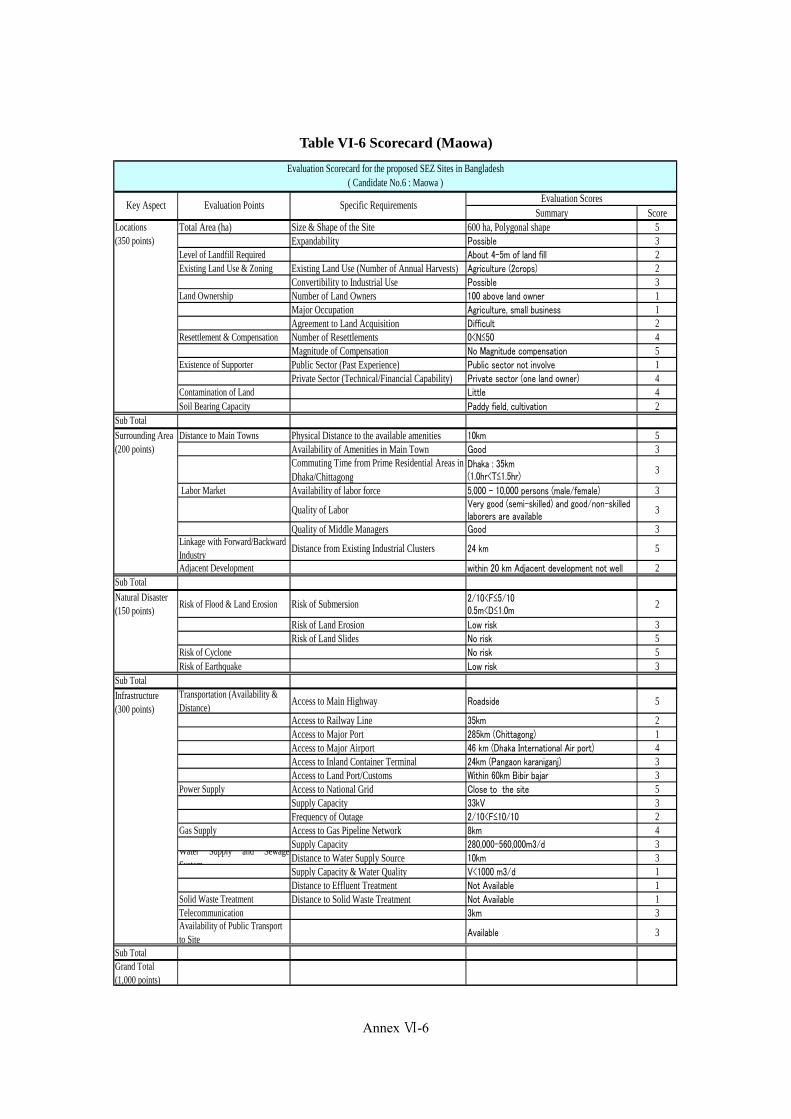
Appendix VI-7
Table VI-6 Scorecard (Maowa)
Summary ScoreTotal Area (ha) Size & Shape of the Site 600 ha, Polygonal shape 5
Expandability Possible 3Level of Landfill Required About 4-5m of land fill 2Existing Land Use & Zoning Existing Land Use (Number of Annual Harvests) Agriculture (2crops) 2
Convertibility to Industrial Use Possible 3Land Ownership Number of Land Owners 100 above land owner 1
Major Occupation Agriculture, small business 1Agreement to Land Acquisition Difficult 2
Resettlement & Compensation Number of Resettlements 0<N≤50 4Magnitude of Compensation No Magnitude compensation 5
Existence of Supporter Public Sector (Past Experience) Public sector not involve 1Private Sector (Technical/Financial Capability) Private sector (one land owner) 4
Contamination of Land Little 4Soil Bearing Capacity Paddy field, cultivation 2
Sub Total
Distance to Main Towns Physical Distance to the available amenities 10km 5Availability of Amenities in Main Town Good 3Commuting Time from Prime Residential Areas inDhaka/Chittagong
Dhaka : 35km(1.0hr<T≤1.5hr)
3
Labor Market Availability of labor force 5,000 – 10,000 persons (male/female) 3
Quality of Labor Very good (semi-skilled) and good/non-skilledlaborers are available
3
Quality of Middle Managers Good 3Linkage with Forward/BackwardIndustry
Distance from Existing Industrial Clusters 24 km 5
Adjacent Development within 20 km Adjacent development not well 2Sub Total
Risk of Flood & Land Erosion Risk of Submersion 2/10<F≤5/100.5m<D≤1.0m
2
Risk of Land Erosion Low risk 3Risk of Land Slides No risk 5
Risk of Cyclone No risk 5Risk of Earthquake Low risk 3
Sub TotalTransportation (Availability &Distance)
Access to Main Highway Roadside 5
Access to Railway Line 35km 2Access to Major Port 285km (Chittagong) 1Access to Major Airport 46 km (Dhaka International Air port) 4Access to Inland Container Terminal 24km (Pangaon karaniganj) 3Access to Land Port/Customs Within 60km Bibir bajar 3
Power Supply Access to National Grid Close to the site 5Supply Capacity 33kV 3Frequency of Outage 2/10<F≤10/10 2
Gas Supply Access to Gas Pipeline Network 8km 4Supply Capacity 280,000-560,000m3/d 3
Water Supply and SewageSystem
Distance to Water Supply Source 10km 3Supply Capacity & Water Quality V<1000 m3/d 1Distance to Effluent Treatment Not Available 1
Solid Waste Treatment Distance to Solid Waste Treatment Not Available 1Telecommunication 3km 3Availability of Public Transportto Site
Available 3
Sub TotalGrand Total(1,000 points)
Locations(350 points)
Infrastructure(300 points)
Natural Disaster(150 points)
Surrounding Area(200 points)
Evaluation Scorecard for the proposed SEZ Sites in Bangladesh( Candidate No.6 : Maowa )
Key Aspect Evaluation Points Specific RequirementsEvaluation Scores
Annex Ⅵ-6

Appendix VI-8
Table VI-7 Scorecard (Rupgonj)
Summary ScoreTotal Area (ha) Size & Shape of the Site 37.4 ha, Oblong figure 1
Expandability Possible at high cost 2Level of Landfill Required About 1.5-2.0m of land fill 3Existing Land Use & Zoning Existing Land Use (Number of Annual Harvests) 1 crop 3
Convertibility to Industrial Use Possible 4Land Ownership Number of Land Owners One land owner 4
Major Occupation Business 5Agreement to Land Acquisition Normal 3
Resettlement & Compensation Number of Resettlements No resettlement 5Magnitude of Compensation No Magnitude compensation 5
Existence of Supporter Public Sector (Past Experience) Public sector not Involve 1Private Sector (Technical/Financial Capability) Private sector (one land owner) 4
Contamination of Land Little 4Soil Bearing Capacity Vacant site, Level ground 5
Sub Total
Distance to Main Towns Physical Distance to the available amenities 11 km 5Availability of Amenities in Main Town Good 3Commuting Time from Prime Residential Areas inDhaka/Chittagong
Dhaka : 25km(0.75hr<T≤1.0hr)
4
Labor Market Availability of labor force 30,000 – 50,000 persons (male/female) 4
Quality of Labor Excellent (skilled), very good (semi-skilled) andgood/non-skilled laborers are available
4
Quality of Middle Managers Excellent, Very good and Good 4Linkage with Forward/BackwardIndustry
Distance from Existing Industrial Clusters 30 km 4
Adjacent Development Industries are located surrounding the site 4Sub Total
Risk of Flood & Land Erosion Risk of Submersion 0/10<F≤1/100<D≤0.1m
4
Risk of Land Erosion No risk 5Risk of Land Slides No risk 5
Risk of Cyclone No risk 5Risk of Earthquake Low risk 3
Sub TotalTransportation (Availability &Distance)
Access to Main Highway Roadside 5
Access to Railway Line 11 km 3Access to Major Port 271 km (Chittagong) 1Access to Major Airport 40 km (Dhaka International Air port) 4Access to Inland Container Terminal 25km (Pangaon karaniganj) 3Access to Land Port/Customs 75 km Akhaura, Bibir bajar land port comilla 3
Power Supply Access to National Grid Close to the site 5Supply Capacity 100MW≤P<200MW 4Frequency of Outage 0/10<F≤1/10 4
Gas Supply Access to Gas Pipeline Network Close to the site 5Supply Capacity 760,000-1,130,000m3/d 4
Water Supply and SewageSystem
Distance to Water Supply Source 11km 3Supply Capacity & Water Quality 5000<V≤7500 m3/d 4Distance to Effluent Treatment Not Available 1
Solid Waste Treatment Distance to Solid Waste Treatment Not Available 1
Telecommunication Mobile telecommunication or landlines facilitiesavaliable
4
Availability of Public Transportto Site
Good 3
Sub TotalGrand Total(1,000 points)
Evaluation Scorecard for the proposed SEZ Sites in Bangladesh( Candidate No.7 : Rupgonj )
Key Aspect Evaluation Points Specific RequirementsEvaluation Scores
Locations(350 points)
Infrastructure(300 points)
Natural Disaster(150 points)
Surrounding Area(200 points)
Annex Ⅵ-7
(441)
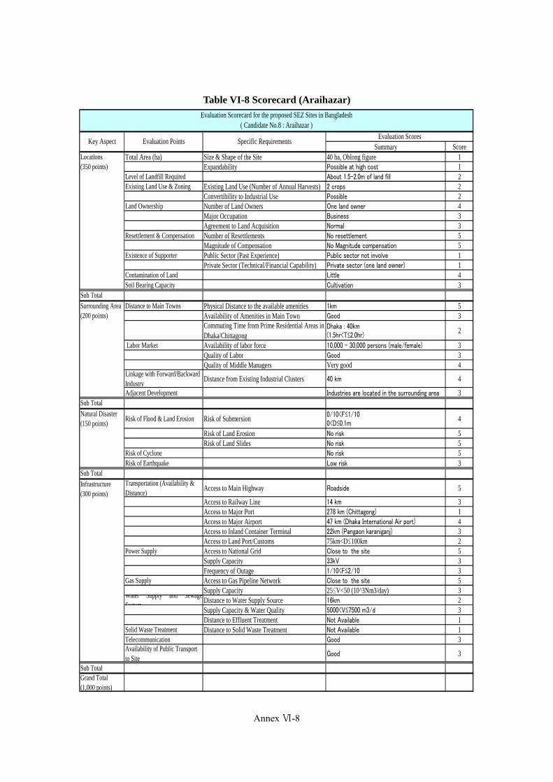
Appendix VI-9
Table VI-8 Scorecard (Araihazar)
Summary ScoreTotal Area (ha) Size & Shape of the Site 40 ha, Oblong figure 1
Expandability Possible at high cost 1Level of Landfill Required About 1.5-2.0m of land fill 2Existing Land Use & Zoning Existing Land Use (Number of Annual Harvests) 2 crops 2
Convertibility to Industrial Use Possible 2Land Ownership Number of Land Owners One land owner 4
Major Occupation Business 3Agreement to Land Acquisition Normal 3
Resettlement & Compensation Number of Resettlements No resettlement 5Magnitude of Compensation No Magnitude compensation 5
Existence of Supporter Public Sector (Past Experience) Public sector not involve 1Private Sector (Technical/Financial Capability) Private sector (one land owner) 1
Contamination of Land Little 4Soil Bearing Capacity Cultivation 3
Sub Total
Distance to Main Towns Physical Distance to the available amenities 1km 5Availability of Amenities in Main Town Good 3Commuting Time from Prime Residential Areas inDhaka/Chittagong
Dhaka : 40km(1.5hr<T≤2.0hr)
2
Labor Market Availability of labor force 10,000 – 30,000 persons (male/female) 3Quality of Labor Good 3Quality of Middle Managers Very good 4
Linkage with Forward/BackwardIndustry
Distance from Existing Industrial Clusters 40 km 4
Adjacent Development Industries are located in the surrounding area 3Sub Total
Risk of Flood & Land Erosion Risk of Submersion 0/10<F≤1/100<D≤0.1m
4
Risk of Land Erosion No risk 5Risk of Land Slides No risk 5
Risk of Cyclone No risk 5Risk of Earthquake Low risk 3
Sub TotalTransportation (Availability &Distance)
Access to Main Highway Roadside 5
Access to Railway Line 14 km 3Access to Major Port 278 km (Chittagong) 1Access to Major Airport 47 km (Dhaka International Air port) 4Access to Inland Container Terminal 22km (Pangaon karaniganj) 3Access to Land Port/Customs 75km<D≤100km 2
Power Supply Access to National Grid Close to the site 5Supply Capacity 33kV 3Frequency of Outage 1/10<F≤2/10 3
Gas Supply Access to Gas Pipeline Network Close to the site 5Supply Capacity 25≤V<50 (10^3Nm3/day) 3
Water Supply and SewageSystem
Distance to Water Supply Source 16km 2Supply Capacity & Water Quality 5000<V≤7500 m3/d 3Distance to Effluent Treatment Not Available 1
Solid Waste Treatment Distance to Solid Waste Treatment Not Available 1Telecommunication Good 3Availability of Public Transportto Site
Good 3
Sub TotalGrand Total(1,000 points)
Locations(350 points)
Infrastructure(300 points)
Natural Disaster(150 points)
Surrounding Area(200 points)
Evaluation Scorecard for the proposed SEZ Sites in Bangladesh( Candidate No.8 : Araihazar )
Key Aspect Evaluation Points Specific RequirementsEvaluation Scores
Annex Ⅵ-8
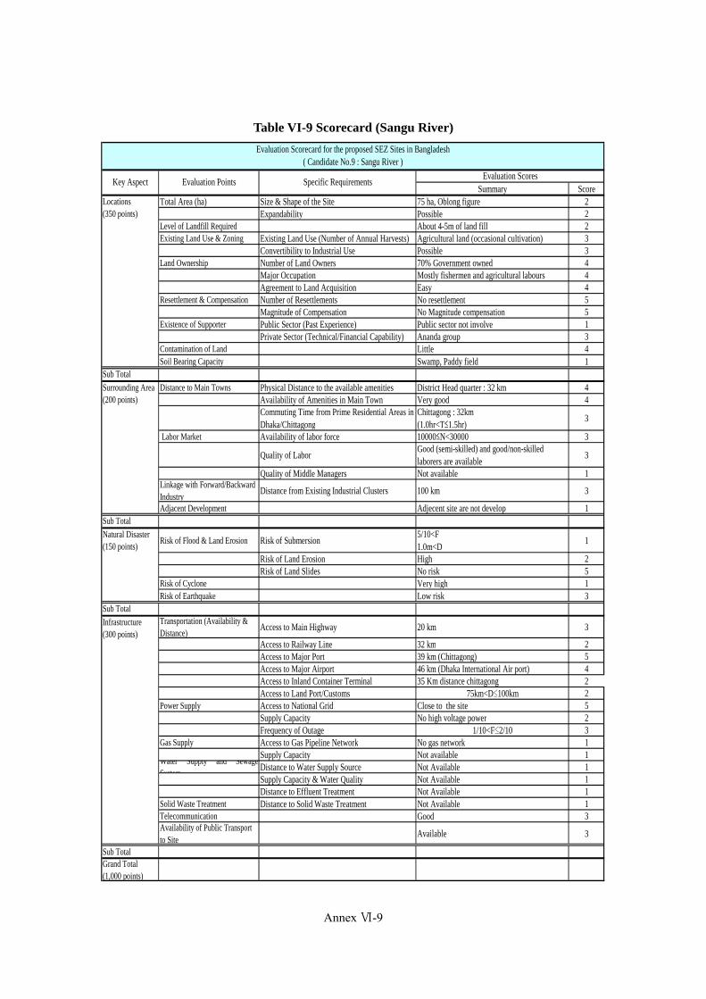
Appendix VI-10
Table VI-9 Scorecard (Sangu River)
Summary ScoreTotal Area (ha) Size & Shape of the Site 75 ha, Oblong figure 2
Expandability Possible 2Level of Landfill Required About 4-5m of land fill 2Existing Land Use & Zoning Existing Land Use (Number of Annual Harvests) Agricultural land (occasional cultivation) 3
Convertibility to Industrial Use Possible 3Land Ownership Number of Land Owners 70% Government owned 4
Major Occupation Mostly fishermen and agricultural labours 4Agreement to Land Acquisition Easy 4
Resettlement & Compensation Number of Resettlements No resettlement 5Magnitude of Compensation No Magnitude compensation 5
Existence of Supporter Public Sector (Past Experience) Public sector not involve 1Private Sector (Technical/Financial Capability) Ananda group 3
Contamination of Land Little 4Soil Bearing Capacity Swamp, Paddy field 1
Sub Total
Distance to Main Towns Physical Distance to the available amenities District Head quarter : 32 km 4Availability of Amenities in Main Town Very good 4Commuting Time from Prime Residential Areas inDhaka/Chittagong
Chittagong : 32km(1.0hr<T≤1.5hr)
3
Labor Market Availability of labor force 10000≤N<30000 3
Quality of LaborGood (semi-skilled) and good/non-skilledlaborers are available
3
Quality of Middle Managers Not available 1Linkage with Forward/BackwardIndustry
Distance from Existing Industrial Clusters 100 km 3
Adjacent Development Adjecent site are not develop 1Sub Total
Risk of Flood & Land Erosion Risk of Submersion5/10<F1.0m<D
1
Risk of Land Erosion High 2Risk of Land Slides No risk 5
Risk of Cyclone Very high 1Risk of Earthquake Low risk 3
Sub TotalTransportation (Availability &Distance)
Access to Main Highway 20 km 3
Access to Railway Line 32 km 2Access to Major Port 39 km (Chittagong) 5Access to Major Airport 46 km (Dhaka International Air port) 4Access to Inland Container Terminal 35 Km distance chittagong 2Access to Land Port/Customs 75km<D≤100km 2
Power Supply Access to National Grid Close to the site 5Supply Capacity No high voltage power 2Frequency of Outage 1/10<F≤2/10 3
Gas Supply Access to Gas Pipeline Network No gas network 1Supply Capacity Not available 1
Water Supply and SewageSystem
Distance to Water Supply Source Not Available 1Supply Capacity & Water Quality Not Available 1Distance to Effluent Treatment Not Available 1
Solid Waste Treatment Distance to Solid Waste Treatment Not Available 1Telecommunication Good 3Availability of Public Transportto Site
Available 3
Sub TotalGrand Total(1,000 points)
Locations(350 points)
Infrastructure(300 points)
Natural Disaster(150 points)
Surrounding Area(200 points)
Evaluation Scorecard for the proposed SEZ Sites in Bangladesh( Candidate No.9 : Sangu River )
Key Aspect Evaluation Points Specific RequirementsEvaluation Scores
Annex Ⅵ-9
(443)
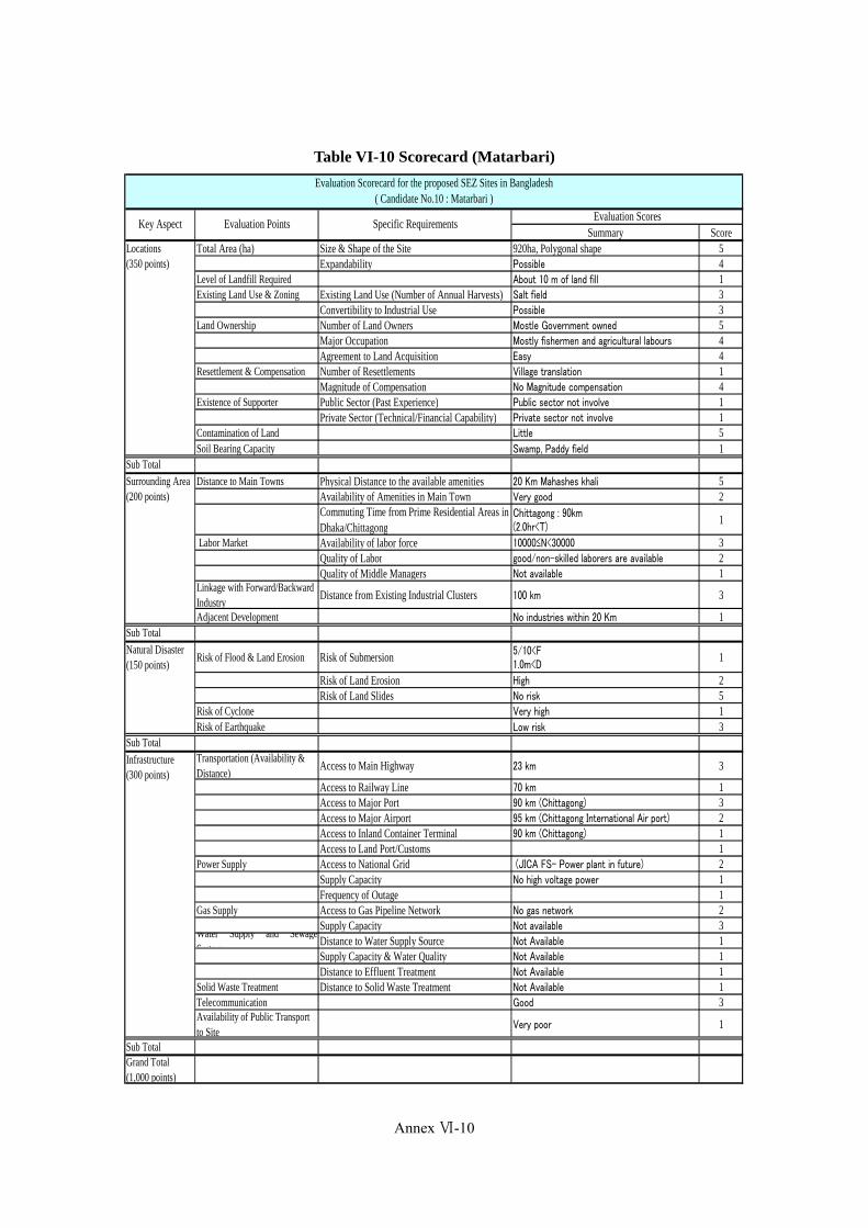
Appendix VI-11
Table VI-10 Scorecard (Matarbari)
Summary ScoreTotal Area (ha) Size & Shape of the Site 920ha, Polygonal shape 5
Expandability Possible 4Level of Landfill Required About 10 m of land fill 1Existing Land Use & Zoning Existing Land Use (Number of Annual Harvests) Salt field 3
Convertibility to Industrial Use Possible 3Land Ownership Number of Land Owners Mostle Government owned 5
Major Occupation Mostly fishermen and agricultural labours 4Agreement to Land Acquisition Easy 4
Resettlement & Compensation Number of Resettlements Village translation 1Magnitude of Compensation No Magnitude compensation 4
Existence of Supporter Public Sector (Past Experience) Public sector not involve 1Private Sector (Technical/Financial Capability) Private sector not involve 1
Contamination of Land Little 5Soil Bearing Capacity Swamp, Paddy field 1
Sub Total
Distance to Main Towns Physical Distance to the available amenities 20 Km Mahashes khali 5Availability of Amenities in Main Town Very good 2Commuting Time from Prime Residential Areas inDhaka/Chittagong
Chittagong : 90km(2.0hr<T)
1
Labor Market Availability of labor force 10000≤N<30000 3Quality of Labor good/non-skilled laborers are available 2Quality of Middle Managers Not available 1
Linkage with Forward/BackwardIndustry
Distance from Existing Industrial Clusters 100 km 3
Adjacent Development No industries within 20 Km 1Sub Total
Risk of Flood & Land Erosion Risk of Submersion 5/10<F1.0m<D
1
Risk of Land Erosion High 2Risk of Land Slides No risk 5
Risk of Cyclone Very high 1Risk of Earthquake Low risk 3
Sub TotalTransportation (Availability &Distance)
Access to Main Highway 23 km 3
Access to Railway Line 70 km 1Access to Major Port 90 km (Chittagong) 3Access to Major Airport 95 km (Chittagong International Air port) 2Access to Inland Container Terminal 90 km (Chittagong) 1Access to Land Port/Customs 1
Power Supply Access to National Grid (JICA FS- Power plant in future) 2Supply Capacity No high voltage power 1Frequency of Outage 1
Gas Supply Access to Gas Pipeline Network No gas network 2Supply Capacity Not available 3
Water Supply and SewageSystem
Distance to Water Supply Source Not Available 1Supply Capacity & Water Quality Not Available 1Distance to Effluent Treatment Not Available 1
Solid Waste Treatment Distance to Solid Waste Treatment Not Available 1Telecommunication Good 3Availability of Public Transportto Site
Very poor 1
Sub TotalGrand Total(1,000 points)
Evaluation Scorecard for the proposed SEZ Sites in Bangladesh( Candidate No.10 : Matarbari )
Key Aspect Evaluation Points Specific RequirementsEvaluation Scores
Locations(350 points)
Infrastructure(300 points)
Natural Disaster(150 points)
Surrounding Area(200 points)
Annex Ⅵ-10

Annex VII: Presentation Materials at the Workshop in Bangladesh
(447)
Data Collection Survey on the Special Economic Zones in Bangladesh
Final Report
(445)

Data�Collection�Survey�on�Special�Economic�Zones�in�Bangladesh
WORKSHOPON�
FINDINGS�OF�THE�SURVEY
June 9, 2013
Lakeshore Hotel, Dhaka
Data Collection Survey on SEZs in Bangladesh 1 Data Collection Survey on SEZs in Bangladesh 2
Member�of�the�Survey�Team���������� ���
�������������� ����������������������������
����� ���� �����!��� ���������������"#$
����������������������������
��%������ ����&����'��������())&����*�)�����������+�'��,����"#$
-�..����..����'����!�������!����
��.��/����� ����&����'��������())&����*�)�����������+�'��,����"0$
��!����������"-���������������1
������ ����2
�����!��� ���������������"0$
�����,��3�������*����������������
4��/������2 ��'���������5�����������������
�����,��3�������*����������������
�.����� �����2
��'���������5�����������������"+������$
�����,��3�������*����������������
2 Absence in the Seminar
Data Collection Survey on SEZs in Bangladesh 3
6789:;1. Geo-political Advantages of Bangladesh,
Business Opportunities and its Constraints2. Summary of Questionnaire Survey to
Japanese Firms3. Types and Classifications of SEZ/EPZ and
Industrial Parks in Bangladesh4. <Best Practices in SEZ Development = in
Asian Countries5. Financing SEZ Project in Bangladesh6. Brief Introduction of Candidate SEZ Sites7. Directives on the Assistance by JICA for the
development of SEZs in Bangladesh.Data Collection Survey on SEZs in Bangladesh 4
I.�Geo�political�Advantages�of�Bangladesh,��Business�Opportunities�and�its�Constraints
Junichiro Motoyama, Ph.D. Team Leader/SEZ
(449)(447)

Data Collection Survey on SEZs in Bangladesh 5
>Dominant�Distribution�of�Younger�Generation�in�DemographicStructure-� ?,������"0@##$ ������ ?,������+����� "0@@A$ ?�B�0 4+?"???&C����$"0@##$ ������D�E
# ����� #�FGF ���!������ #�#0H D����� #G�@IJ0 *���� #�#AK ���L�� IFH ����� ##�F#IF D����� F#J ����B��� JKG *���� J�JIAJ *������� 00A -���������� FAA ��,�� J�FAGG ���M�� #AF *���� FIJ 4����� F�@KAI ?�.����� #K@ /���� FI0 3����� 0�FHIH ���!������ #I0 ���!��� FJA ���M�� 0�F@AK -�!���� #GJ ��,�� FFI ��!���� 0�0GFA 3����� #J@ ������.� F@K N����� 0�0#I#@ ��,�� #0H ?����,,���� F@H *��� #�K0K
���!������"JF��$ 0GK
Advantages�of�Bangladesh�and�its�Potential
Data Collection Survey on SEZs in Bangladesh 6
Bangladesh�has�a�prolonged�Population�Bonus�Period�until�2060s,�compare�to�other�Asian�Competing�Countries
Prolonged�Population�Bonus�Period
Data Collection Survey on SEZs in Bangladesh
(Comparative�Table�among�major�Asian�Cities�in�their�Annual�Labor�Costs�to�be�paid�for�General�Workers)
Source:�JETRO 20th Investment�Cost�Comparison�Survey�in�Asian�Major�Cities�and�Regions
Shanghai
Dalian
Bangkok
Kuala�Lumpu
r
Jakarta
Manila
Hano
i
Mum
bai
Karachi
Dhaka
Competitive�and�Sizable�Labor�Market
7 Data Collection Survey on SEZs in Bangladesh 8
>Currently approx. 30 Millions out of 160 Millions of Populationconstitutes Consumer’s Market>Expanding Consumer Market by Increasing Annual Incomes which derived by transferring employees from Primary Industryto Services Industry >Ample money transfer from overseas Bangladesh Workerswhich fills gaps of deficit of Trade Balance and supports vigorous domestic consumptions>Expected improvement on Balance of Trade due to flourishing new export-oriented industries such as Shoes-making, Ship-building, Pharmaceutical and IT Services after RMG Industry>Population below 20 years old constitutes O/P of the entirepopulation which behaves as mas-purchaser of such durable products as houses, automobile, electrical appliances, electronics after 5-10 years
Outlook�for�expanding�Domestic�Markets

Data Collection Survey on SEZs in Bangladesh 9
Prospectus on Shoe-making, Ship-building, Pharmaceutical, IT Services & Other Emerging Industries
Attracting BOP Business
Flourishing�several�Export�oriented�Industries
Data Collection Survey on SEZs in Bangladesh 10
>Adopted a democratic political systems within the background of moderate Islamic culture>Japanese Govt. is one of the Nations who recognized the independent of Bangladesh in early stage and maintains the position of top-donor to Bangladesh>Assistance Policy of GoJ/JICA to Bangladesh Priority Area 1:Acceleration of Economic Activities><Development and Strengthen Industries=which functions as an Engine for Economic
Growth><Infrastructure Development=which help support Economic growth and Competitiveness><Orderly Development and Expansion of Mega Cities=which are the cores of Economic
GrowthPriority Area 2:Conquring Fragility of Society>Social Development (Education/Welfare) which is required after achieving MDGs>Quality Improvement in the Public Administration through participation of habitant to
administrative processes>Assistance to rural area where are used to be left behind from Economic Growth>Prevention of Natural Disasters and measures for Climate Change in order to mitigate fragility
SourceQJICA Web�Site
Bangladesh:�A�Democratic�yet�Pro�Japanese�Nation
Data Collection Survey on SEZs in Bangladesh 11
Asian�Highway�Routes
ChineseEconomic�
Bloc
SAARCEconomic�
Bloc
ASEANEconomic�
Bloc
Geo�political�Advantages�of�Bangladesh
Data Collection Survey on SEZs in Bangladesh 12
>Expansion�of�Global�Supply�Chain�among�ASEAN�Member�Countries�based�on�the�<Fragmentation�Theory=>Realization�of�6RS6T Singular�Market�in�2015�and�shifting�production�venue�to�Emerging�Countries>Bangladesh�stands�strategic�location�between�ASEAN�and�SAARC�Economic�Blocs>Infrastructure�Development�towards�a�<Seamless�Asia=>Promotion�of�Regional�Trade�and�Investment�by�introductionof�new�structure�and�systems>Promotion�of�Development�Programs�through�activating�the�functions�of�Bay�of�Bengal�Initiative�for�Multi�Sectorial�Technical�and�Economic�Cooperation(BIMSTEC)
Bangladesh:�A�Linking�Pin�between�SAARC�Economic�Bloc�and�ASEAN�Economic�Bloc
(451)(449)

Data Collection Survey on SEZs in Bangladesh 13
Cross�boarder�Trades�and�Land�Port�Systems
Data Collection Survey on SEZs in Bangladesh 14
>Lower Global Competitiveness: 118th among 144 Nations>Lack of Infrastructure and Public Utilities>Out-break of Governance Issues>Frequent Changes of Administration and Political unrest
����� 3��.��!�������� FK*������� G@*���� GA?����,,��� IG������.� IKU���-�� HG���C��� KG���!������ ##K?�.����� #0J�� -��
Global�Competitiveness�Report�2012/2013
Sovereign�Risks�for�FDI�in�Bangladesh
Data Collection Survey on SEZs in Bangladesh 15
Calamity�by�Natural�Disasters�&�Poor�Working�Conditions II.��Summary�of�Questionnaire�Survey�to�Japanese�Firms�
Junichiro Motoyama, Ph.D.Team�Leader/SEZ
Data Collection Survey on SEZs in Bangladesh 16
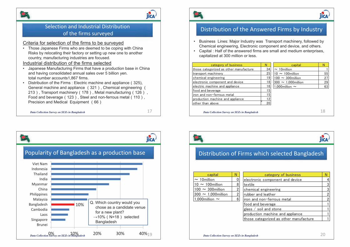
Selection�and�Industrial�Distributionof�the�firms�surveyed
Data Collection Survey on SEZs in Bangladesh 17
Criteria for selection of the firms to be surveyed• Those Japanese Firms who are deemed to be coping with China
Risks by relocating their factory or setting up new one to another country, manufacturing industries are focused.
Industrial distribution of the firms selected• Japanese Manufacturing Firms that have a production base in China
and having consolidated annual sales over 5 billion yen. total number accounts1,867 firms.
• Distribution of the Firms : Electric machine and appliance 325), General machine and appliance 321 , Chemical engineering 213 , Transport machinery 178 , Metal manufacturing 126 , Food and beverage 123 , Steel and non-ferrous metal 110 , Precision and Medical Equipment 66
Distribution�of�the�Answered�Firms�by�Industry
Data Collection Survey on SEZs in Bangladesh 18
��,���� -V#@������ ##@V#@@������ GG#@@VF@@������ 0HF@@V#�@@@������ 0A#�@@@������V IF
• Business Lines: Major Industry was Transport machinery, followed by Chemical engineering, Electronic component and device, and others.
• Capital : Half of the answered firms are small and medium enterprises, capitalized at 300 million or less.
����!� )C������� -��������!��M������������)������ FJ�����,���������� 0G����������!�������! #A�����������,���������'��� #K�������������������,,������ #I)����C�'���!� #G��������&)���������� #G,������������������,,������ #0���������C'� 0@
Popularity�of�Bangladesh�as�a�production�base
Data Collection Survey on SEZs in Bangladesh 19
10%
0% 10% 20% 30% 40%
BruneiSingapore
LaosCambodia
BangladeshMalaysia
PhilippinesChina
MyanmarIndia
ThailandIndonesiaViet�Nam
Q. Which country would youchose as a candidate venuefor a new plant?
�10% N=18 selectedBangladesh
Distribution�of�Firms�which�selected�Bangladesh
Data Collection Survey on SEZs in Bangladesh 20
��,���� -V#@������ @#@V#@@������ K#@@VF@@������ 0F@@V#�@@@������ 0#�@@@������V I
����!� )C������� -�����������,���������'��� J��W���� F����������!�������! F��CC������������ 0��������&)���������� 0)����C�'���!� #!��������������� #,������������������,,������ #��������!��M������������)������ #
(453)(451)
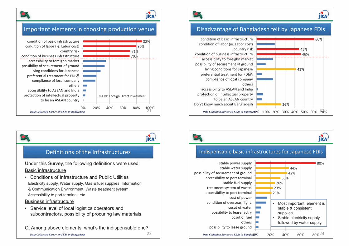
Important�elements�in�choosing�production�venue
Data Collection Survey on SEZs in Bangladesh 21
70%71%
80%88%
0% 20% 40% 60% 80% 100%
to�be�an�ASEAN�countryprotection�of�intellectual�propertyaccessibility�to�ASEAN�and�India
otherscompliance�of�local�company
preferential�treatment�for�FDI�living�conditions�for�Japanese
possibility�of�securement�of�groundaccessibility�to�foreighn�market
condition�of�business�infrastructurecountry�risk
condition�of�labor�(ie.�Labor�cost)condition�of�basic�infrastructure
�FDI: Foreign Direct Investment
26%
41%
46%45%
60%
0% 10% 20% 30% 40% 50% 60% 70%
Don't�know�much�about�Bangladeshto�be�an�ASEAN�country
protection�of�intellectual�propertyaccessibility�to�ASEAN�and�India
otherscompliance�of�local�company
preferential�treatment�for�FDI�living�conditions�for�Japanese
possibility�of�securement�of�groundaccessibility�to�foreighn�market
condition�of�business�infrastructurecountry�risk
condition�of�labor�(ie.�Labor�cost)condition�of�basic�infrastructure
Disadvantage�of�Bangladesh�felt�by�Japanese�FDIs
Data Collection Survey on SEZs in Bangladesh 22
Definitions�of�the�Infrastructures
Data Collection Survey on SEZs in Bangladesh 23
Under this Survey, the following definitions were used:Basic infrastructure• Conditions of Infrastructure and Public Utilities
Electricity supply, Water supply, Gas & fuel supplies, Information & Communication Environment, Waste treatment system, Accessibility to port terminal, etc
Business infrastructure• Service level of local logistics operators and
subcontractors, possibility of procuring law materials
Q: Among above elements, what’s the indispensable one?
Indispensable�basic�infrastructures�for�Japanese�FDIs
Data Collection Survey on SEZs in Bangladesh 24
21%23%26%
33%42%44%
80%
0% 20% 40% 60% 80%
possibility�to�lease�groundothers
cosut�of�fuelpossibility�to�lease�factry
cosut�of�watercondition�of�overseas�flight
cost�of�poweraccessibility�to�port�terminaltreatment�system�of�waste,
stable�fuel�supplyaccessibility�to�port�terminal
possibility�of�securement�of�groundstable�water�supplystable�power�supply
• Most important element is stable & consistent supplies.
• Stable electricity supply followed by water supply.
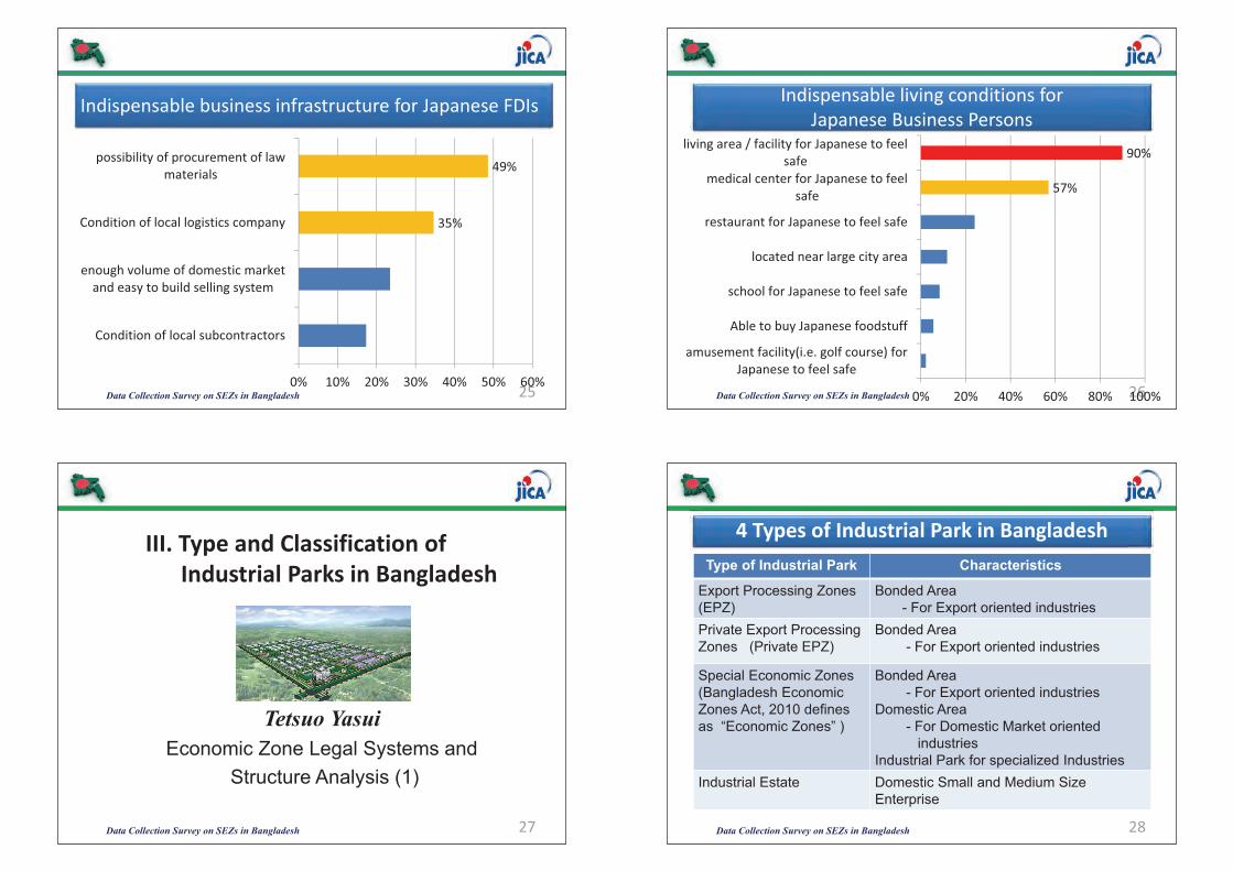
Indispensable�business�infrastructure�for�Japanese�FDIs
Data Collection Survey on SEZs in Bangladesh 25
35%
49%
0% 10% 20% 30% 40% 50% 60%
Condition�of�local�subcontractors
enough�volume�of�domestic�marketand�easy�to�build�selling�system
Condition�of�local�logistics�company
possibility�of�procurement�of�lawmaterials
Indispensable�living�conditions�for�Japanese�Business�Persons
Data Collection Survey on SEZs in Bangladesh 26
57%
90%
0% 20% 40% 60% 80% 100%
amusement�facility(i.e.�golf�course)�forJapanese�to�feel�safe
Able�to�buy�Japanese�foodstuff
school�for�Japanese�to�feel�safe
located�near�large�city�area
restaurant�for�Japanese�to�feel�safe
medical�center�for�Japanese�to�feelsafe
living�area�/�facility�for�Japanese�to�feelsafe
Data Collection Survey on SEZs in Bangladesh 27
III.�Type�and�Classification�of�Industrial�Parks�in�Bangladesh
Tetsuo Yasui Economic Zone Legal Systems and
Structure Analysis (1)
Data Collection Survey on SEZs in Bangladesh 28
4�Types�of�Industrial�Park�in�BangladeshType of Industrial Park Characteristics
Export Processing Zones (EPZ)
Bonded Area- For Export oriented industries
Private Export Processing Zones (Private EPZ)
Bonded Area- For Export oriented industries
Special Economic Zones(Bangladesh Economic Zones Act, 2010 defines as “Economic Zones” )
Bonded Area - For Export oriented industries
Domestic Area - For Domestic Market oriented
industriesIndustrial Park for specialized Industries
Industrial Estate Domestic Small and Medium Size Enterprise
(455)(453)
Data Collection Survey on SEZs in Bangladesh 29
1.��Export�Processing�Zones�(EPZ)���Outlines
• Governing law: BEPZA Act 1980 & Foreign Investment Act 1980.• Government Organization: EPZ is owned and operated by
Bangladesh Export Processing Zone Authority • Function of EPZ: to provide special area where potential investors
would find a congenial investment environment, free from cumbersome procedures.
• Objective: Promotion of foreign (FDI) & local investment, Diversification of export, Dev. of backward & forward linkages , Generation of employment, Transfer of technology, Upgrading of skill, Development of management
• 8 EPZ: Fist EPZ was established at Chittagong in 1983, now there are 8 EPZ in 7 Divisions: Chittagong, Dhaka, Karnaphuli , Comilla, Mongla , Adamjee , Ishiwardi , and Uttara
Data Collection Survey on SEZs in Bangladesh 30
1.�1���EPZ�����Key�features�&�Incentives��• Total Space: 2,572 Acres• Employment: 358,772 ( Feb. 2013)• Numbers of companies: 378 companies invested• Export: USD4,210 million (2011-2012) mostly garment• Incentives:
� Tax Holiday (for 5 years Y1-2:100%, Y3-4:50%, Y5:25%)� Duty free import of construction materials, Duty free import of
machineries, office equipment & spare parts etc.� Duty free import and export of raw materials and finished goods� Relief from double taxation� Exemption from dividend tax� GSP facility available� Accelerated depreciation on machinery or plant allowed� Remittance of royalty, technical and consultancy fees allowed
Data Collection Survey on SEZs in Bangladesh 31
1.�2���EPZ����Incentives�&�Facilities�
• Non-Fiscal Incentives:� 100% foreign ownership permissible� Enjoy MFN (most favored nation) status � No ceiling on foreign and local investment� Full repatriation of capital & dividend
• Facilities: � No UD, IRC, ERC and renewal of Bond license� Work permits issued by BEPZA� Secured and protected bonded area� Off-Shore banking available� Customs clearance at factory site � Simplified sanction procedure
Issues on EPZ: There is no vacant plot in EPZ except Uttara and Mongla.Government neither encourages new EPZ development nor expansion of the existing one.Special Economic Zone will also have export processing area for foreign investors but no SEZ exists so far for investment.Data Collection Survey on SEZs in Bangladesh 32
1.��EPZ�������Issues��
Opportunity Loss?!Bangladesh is missing the opportunity for FDI!

Data Collection Survey on SEZs in Bangladesh 33
2.�Private�Export�Processing�Zones�(Private�EPZ)• Governing law: the Bangladesh Private Export Processing Zones
Act,1996.• Government Organization: Private EPZ Governor’s Board
regulates, approves and monitors Private EPZ development.• There is one Private EPZ in operation: Korean EPZ.• Korean EPZ is owned and operated by private developer, Korean
EPZ(KEPZ) Corporation(BD) Ltd. , which is local subsidiary of Youngone Corporation, a Seoul based company.
• History: Set up in 1996, Operation license in 2007, Environmental assessment in 2009, Bonded license in 2010, started the first factory (shoe factory) in 2012 by Youngone Group.
• Another Private EPZ, Rangunia Export Processing Zone in Chittagong was approved in June 2012. Presently, there is no visible development of this zone.
Data Collection Survey on SEZs in Bangladesh 34
3.��Special�Economic�Zones�(SEZ)
• Governing law: Bangladesh Economic Zones Act 2010• Under the law, SEZ is named as “Economic Zone” in
Bangladesh, while “SEZ” is commonly used globally.• Government Authority: Bangladesh Economic Zones
Authority (BEZA)• BEZA aims to establish economic zones with a view to
encouraging rapid economic development through increase and diversification of industry, employment, production and export.
• BEZA is mandated to establish, license, operate, manage and control economic zones in Bangladesh.
4�Categories�of�SEZ1. Public and Private Partnershipby local or foreign company2. Private Economic Zones established by private sector3. Government Economic Zones established or owned by Government4. Special Economic Zones established privately, or by public-private partnership or by government initiative
Division�of�SEZ�into�areas1. Export Processing Area
- Export oriented industries2. Domestic Processing Area
- Meet the demand of the domestic market
3. Commercial Area- Banks, warehouses,
Offices4. Non-Processing Area
- Residence, health, education, amusement, amenities etc.
Data Collection Survey on SEZs in Bangladesh 35
3.1���SEZ���Categories�and�Division�into�areas
• Financial benefits: same kind of financial incentives and benefits as EPZ will be provided under the Act.
• Authority shall make arrangement to facilitate the developer and individual units in respect of legal documents such as declaration of SEZ, clearance, certificate, permit of repatriation of capital and dividends, visas, work permit, construction permit etc. through “a one stop service”.
• Banking activities are approved in SEZ.• Any sector of industry may be set up in SEZ.
Data Collection Survey on SEZs in Bangladesh 36
3.2���SEZ������Benefits�in�SEZ
(457)(455)

Duties and functions of BEZAIdentify and select sitesAcquire land for SEZAppoint SEZ developerPrepare infrastructure development planAllot or lease or rent of landEnsure infrastructure for development of SEZCreate opportunities of employmentand more >>>>>
BEZA�is�governed�by�a�3�level�management�structureGoverning Board- Formulate policy
Monitor activityapprove proposals for SEZ etc.
Executive Board- Chairman and three membersBEZA office/secretariat- Appointment and the terms and
conditions of services of Secretary, officers and staff, XXXauditors shall be determined by regulations.
Data Collection Survey on SEZs in Bangladesh 37
3.3��SEZ����Duties�and�functions�of�BEZAEPZ SEZ
Investors in EPZ are mostly RMGand other existing industries
New industries and diversification of industry are expected
Investors in EPZ are export oriented industries by foreign investment or local investment
Aiming at industrial linkage of and diversification at- Export oriented (bonded) area
Domestic Processing AreaCommercial Area, and>>>>
Owned and operated by government
Private developer and PPP are encouraged.
Financial incentive and benefitOne stop service
Same kind of incentives and benefits and one stop service are expectedData Collection Survey on SEZs in Bangladesh 38
3.4� SEZ�������Comparison��EPZ��vs��SEZ
• sYStaffs 82Z in�March�20131
Project�Implementation�Unit�(PIU)�will�be�establsihed,�tendering��all�necessary�assistance�to�the�zone�Developer/Operator/Investor�as�one�stop� Concrete�plan�will�be�required.
Data Collection Survey on SEZs in Bangladesh 39
SEZ����Organogram�of�BEZA�and�issues
Data Collection Survey on SEZs in Bangladesh 40
3.5� SEZ�������Recent�progress������������• BEZA/Prime Minister’s Office selected following five sites for SEZ
development: Mirershorai (Chittagong)Anwara (Gohira)Sherpur (Syllet)Sirajgonj (Rajashahi) Mongla (Bagerhat)
• Mirershorai, Anwara and Sherpur sites will be evaluated through conducting feasibility study.
• For developing Sirajgonj and Mongla sites BEZA already invited international zone developers, who will conduct FS.
• There are initiatives from the private sector for developing special economic zone.
Data Collection Survey on SEZs in Bangladesh 41
3.6 SEZ�������Current�issues����������• Although the government has already selected the sites for SEZ
development, BEZA Regulations 2011 has yet to be vetted by the ministry of law. BEZs Regulations are required to regulate, manage and operate SEZs, in absence of which SEZ development process is severely affected.
• Neither Concrete roadmap, milestone, plan & target year of towards development SEZ are not clear for the public.
• Foreign investors have options to choose the country where they will invest.
• More than 200 Japanese investor visit to Bangladesh every month. Many of them go back to Japan disappointedly and reluctantly
• Japanese investors worry about when SEZ will be established in Bangladesh.
• The issue of Korean EPZ may cause negative effect to foreign investors.
• Kailakoir Hi-Tech Park is established under The Bangladesh Hi-Tech Park Authority Act, 2010, initiated by the government.
• The developer of Kailakoir Hi-Tech Park will be selected shortly. It has 232 acres of land, where facilities such as electricity, water pump, 3 storied administrative building, internal roads, telephone sub exchange, fiber optic connectivity, etc., are already in place.
The Park is getting ready to open for the investors!
Data Collection Survey on SEZs in Bangladesh 42
3.7��SEZ�����An�ever�first��Hi�Tech�Park�in�Bangladesh�
Data Collection Survey on SEZs in Bangladesh 43
IV.�<Best�Practices�in�SEZ�Development�”�in�Asian�Countries
Yasuhiro YamanoEconomic Zone Legal Systems and
Structure Analysis (2)Data Collection Survey on SEZs in Bangladesh 44
Comparison�with�the�SEZ�systems�of�other�countries
Executive summary
• There are two cases of SEZ schemes.� Special Economic Zone: India, Cambodia, Myanmar, etc.� Investment Promotion act: Thailand, Malaysia, Viet Nam, etc.
• SEZ mainly focuses on specific areas to develop, on the other hand, Investment Promotion act aims to invite foreign investment whole country especially rural area.� In Thailand, rural areas far from Bangkok have large incentives to encourage
investment. Now the system is under revision, as it prayed its original roll.� Cambodia, 2005, and Myanmar, 2011, are promoting the positive attraction of
foreign investment, with the special economic zone act.
• Common incentives;� Exemption of tax; income tax, customs duty etc.� Single window service for government approvals. However the actual
performance of one stop service may vary from country to country. � Malaysian model of one stop service (MIDA) is evaluated ad one of the best
practice by foreign investors.
(459)(457)
Data Collection Survey on SEZs in Bangladesh 45
• No SEZ act; Based on various acts, such as investment promotion act (1986), income tax act (1967), custom duty(1967), etc., tax incentives can be enjoyed
• These incentives focuses on encouraged industries, such as manufacturing industry, agriculture, service industry, R&D, vocational training, environmental protection.
• In Free Zone, set up in 1990, export company can enjoy incentives of exemption of custom duty, sales tax, service tax etc.
• The government of Malaysia intend to develop Kuala Lumpur International Financial District (KLIFD), the center of Islamic financial center.
• Companies can enjoy incentives in the district below.(1) Income tax 100% exemption for 10 years(2) Tax incentives in depreciation for industrial buildings(3) Income tax 70% exemption for 5 years, for developers
1.�Malaysia
Data Collection Survey on SEZs in Bangladesh 46
Zone Income tax Import tax�for�machineries
Import tax�for�materials
1 In�industrial�area:�3�years�exemption
50%�exemption 1�year�exemption�(extendable)
2 In�industrial area:�5�years�exemptionOut�of�industrial�area: 3�years�exemption
50%�exemption 1�year�exemption�(extendable)
3 8�years�exemptionIn�industrial�area:�additional�5 years�50%Out�of�industrial area�Infrastructure�expense�deduction�
100% exemption 5�years�exemption�(extendable)
• No SEZ act; Based on investment promotion act (1997), tax incentives can be enjoyed.
• BOI (Thailand Board of Investment) has zone incentive system which has three zones based on distance from Bangkok.� Now BOI intends to set up new system based on industry, instead of existing.
• In industrial estates of IEAT (Industrial Estate Authority of Thailand), companies can enjoy other incentives in addition to BOI’s.
SourceQBoard of Investment, Thailand
2.�Thailand
Zone 1Zone 2Zone 3Zone 3 (Special)
Data Collection Survey on SEZs in Bangladesh 47SourceQhttp://www.hhtp.gov.vn/
• No SEZ act; Based on income tax act, tax incentives can be enjoyed.• For balanced development of the country, many investment areas are specified. • three Hi-tech park have set up to invite hi-tech industry; income tax exemption (90%
for 15 years. Hoa Lak Hi-tech park case is below.
• Total area : 1586 ha (app. 4000 acres)• Location : in the area of Hanoi Capital, convenient for
transportation to Noi Bai International Airport and Hai Phong deep Seaport
• Population : over 200,000 people working and living
3.�Viet�Nam
Data Collection Survey on SEZs in Bangladesh 48SourceQhttp://www.sezindia.nic.in/
• 2006 SEZ act.• 158 SEZs are in operation out of 583 approved SEZs.• Developers and lnvestors can enjoy incentives below.
•
•
•
•
•
4.�India
• Exemption from customs/excise duties for development of SEZs for authorized operations approved by the BOA.
• Income Tax exemption on income derived from the business of development of the SEZ in a block of 10 years in 15 years under Section 80-IAB of the Income Tax Act.
• Exemption from minimum alternate tax under Section 115 JB of the Income Tax Act.
• Exemption from dividend distribution tax under Section 115O of the Income Tax Act.
• Exemption from Central Sales Tax (CST).• Exemption from Service Tax (Section 7, 26
and Second Schedule of the SEZ Act).
For DevelopersFor Investors

Data Collection Survey on SEZs in Bangladesh 49
• December 2005, the SEZ system executed. 8 SEZs are under operation, out of approved 22 SEZs. See below table.
• Two incentives for investment to SEZs.� Financial: exemption of tax, such as profit tax, import tax, vat, etc.� Non financial: Simple customs clearance system, single window service
SourceQJICA�report
5.�Cambodia
Data Collection Survey on SEZs in Bangladesh 50SourceQMinistry of Economic, Trade and Industry, Japan
Land�use Minimum�30�years�and�updating�is�allowed>large�investmentQ30+15�(Max�75�years)>Medium�investmentQ15+15�(Max�60�years)>Small�investmentQ5+5 (Max�40 years)
Profit�tax Exemption�for�export�profit>1st�5�years�Q100%>2nd�5�yearsQ50[>3rd�5yearsQ50[Yre�investmet�of�export�profit1
Commercial�tax�and�VAT
Exemption�for�export�products
• SEZ act in 2011 January.• Industries to operate: product processing industry, high-tech industry, other
manufacturing, service industry, infrastructure construction industry, etc. is enabled.• 4 areas are under approval; Daway, Tirawa, and other two areas.
SourceQMyanmar SEZ act
6.�Myanmar
Tirawa SEZLand�use
Manufacturing�(69%)
Commercial�(25%)
Residencial (9%)
Education,�Healthcare�(9%)
Administration�(3%)
Open�space (8%)
Tentative�plan;�it�can�be�changed
V.�Financing�SEZ�Project�in�Bangladesh
Data Collection Survey on SEZs in Bangladesh 51
Zakir HossainLand-use Evaluation and Off-site Infrastructure (2)
Institutions�Promoting�SEZs,�Private�EPZs�and�Industrial�Estates�in�Bangladesh�
• BEPZA promoted export processing zones which were fully funded by the government of Bangladesh
• Board of Governors of Private EPZ Cell promotes setting up EPZs through private initiatives
• BSCIC establishes industrial estates for small and cottage industries
• Bangladesh Economic Zones Authority (BEZA) has been established to promote economic zones, free zones and special economic zones under public-private partnership, private initiative and joint venture with foreign EZ developers
National Industrial Policy also encourages setting up industrial parks under private initiatives
Data Collection Survey on SEZs in Bangladesh 52
(461)(459)

SEZ�Development�and�Financing�Needs
Off-site infrastructure On-site infrastructure • Access and Link roads
connecting Zones• Linking with national Railway
track• Connecting with national utility
networks (gas, electricity and water network)
• Inland Container Terminal , • Customs Facilities (bonded
warehouse, land port, etc.)• Industrial water supply systems• Solid Waste Treatment and
Disposal unit
• Land acquisition and Development
• Establishing internal utility networks
• Water and sewerage network • Power Generation unit• Factory Building ( domestic and
export processing areas)• Central ETP• Commercial areas development• Non-commercial areas• Amenities (intl. schools, hospital,
sports club, community centers,
Government��Funding Zone�Developer�FundingData Collection Survey on SEZs in Bangladesh 53
In Bangladesh, SEZ may be developed under the following threefinancing models:
• Fully implemented by the Government of Bangladesh• Public-Private Partnership • Private-Private Partnership ( Local and Foreign)
SEZ�Financing�Models�in�Bangladesh
Data Collection Survey on SEZs in Bangladesh 54
Fully�Implemented�by�Government�of�Bangladesh
GoB�ADP/Development�Partners
Government�of�Bangladesh
BEZA(Implementation�Body)�
O�&��MContractors
Contractors(Local�&�International)�
Transaction�Advisers/�Consulting�Engineers
Japan�ODA/�Loans
Data Collection Survey on SEZs in Bangladesh 55
Public�Private�Partnership
Viability�Gap�Fund�(VGF)
Government�of�Bangladesh�(BEZA)
Private�Sector(Local�and�Foreign)
Special�Purpose�Company
O�&��MContractors
Contractors(Local�&�International)�
Transaction�Advisers/�Consulting�Engineers
Japan�ODA/�Private�loans
Data Collection Survey on SEZs in Bangladesh 56
Private�Private�Partnership
Private EZ Developers (Bangladesh)
Private EZ Developers(Foreign)
Special Purpose Company
Private Loans
O & MContractors
Contractors(Local & International)
Transaction Advisers/ Consulting Engineers
ODA Loan for off-site infrastructure
Data Collection Survey on SEZs in Bangladesh 57
Specialized�Financial�Institutions�for�Infrastructure�Projects�in�Bangladesh�(including�SEZs)
IDCOL�The Infrastructure Development Company Limited (IDCOL) was established on 14 May 1997 and licensed by Bangladesh Bank as a NBFI on 5 January 1998. Since its inception, IDCOL is playing a major role in bridging the financing gap for developing medium and large-scale infrastructure and renewable energy projects in Bangladesh. The company now stands as the market leader in private sector energy and infrastructure financing in Bangladesh.
BIFFLThe Bangladesh Infrastructure Finance Fund Limited (BIFFL) was incorporated by the Ministry of Finance in 2011 to provide long-term financing in local currency to infrastructure projects that meet BIFFL's investment criteria. BIFFL seeks to attract investment from both institutional and retail investors (including non-resident Bangladeshis and overseas foreign workers) to provide an alternative savings/investment vehicle in the Bangladesh market.
Data Collection Survey on SEZs in Bangladesh 58
Infrastructure�Financing�available�in�Bangladesh
a. Government –owned Specialized FIs
b. Donors’ Funding c. Private Financing(Banks and NBFIs)
IDCOL Investment Promotion and Financing Facility (IPFF)-IDA, World Bank
Non-banking Financial Institutions
(IIFDC, IDLC, UFIL)BIFFL JICA Funds
For off-site infrastructure (upcoming)
Commercial Banks (Public and Private)
DBL, NCCBL, UCBL, EBL, Janata Bank, Agrani Bank
IFC infrastructure financing
**Viability Gap FundData Collection Survey on SEZs in Bangladesh 59
Japanese�ODA�Funds�can�be�utilized�for�Off�site�Infrastructure�for�SEZsFunding Modalities• Japanese ODA loan is basically provided in Yen (Japanese currency)• It is a concessional loan / soft and untied loans• It is being provided government to government• Borrower: Ministry of Finance, Government of Bangladesh• Implementing agencies : Line Ministries and Other Govt. Agencies
Terms and Conditions• Terms of loan: 40 years • Rate of Interest: 0.01%• Grace period: 10 years • Project implementation period: 5-7 years• Accrual of interest: First day of disbursement of loans (Yen)
Data Collection Survey on SEZs in Bangladesh 60
(463)(461)
• Debt-equity Ratio: 80 %: 20%, 70% : 30%
• Rate of Interest: LIBOR + less than 1% + 2.5% margin of Local Financial Institutions
• Repayment Period: 10-15 years
• Legal entity: A Special Purpose Company needs to be formed
• Grace period: 5-7 years
Common�Terms�and�Conditions�of�the�Infrastructure�Project�Financing�in�Bangladesh�by�Private�Banks�and�FIs
Data Collection Survey on SEZs in Bangladesh 61
• Lengthy approval process involving several ministries and authorities
• Lengthy process in obtaining foreign loans approval • Lack of capacity of local banks and related regulatory
authorities • Lack of experience of Local Developers in infrastructure
development, financing and management • No local administrative capacity to implement zone
development projects • Poor project management causes delay in initiating commercial
operation
Challenges�and�Constraints�in�Project�Financing�in�Bangladesh�
Data Collection Survey on SEZs in Bangladesh 62
• Strengthening institutional capacity of government institutions (IDCOL, BIFFL, PPP office, BEZA, BB, etc)
• Capacity building of relevant government officials, banks and FIs
• Capacity building and enhanced exposure of local government bodies
• Coaching the local Zone developers and contractors who can work for international contracting businesses
• Simplify various approval processes of the relevant government agencies
• Capacity building in management of infrastructure projects
Proposed�Measures�for�Solving�Issues�
Data Collection Survey on SEZs in Bangladesh 63
• Viability�Gap�FundThe Viability Gap Fund, or VGF, will provide supplementary government financing to projects that the PPP Unit deems economically vital to the public interest but that may not be fully financially viable on a commercial basis. VGF monies can be used to share the up-front cost of a project or provided on an annual basis to effectively subsidize PPP project costs.
• Investment��Promotion�and�Financing�FacilityThe objective of the IPFF Project for Bangladesh is to accelerate private sector-led growth through providing term finance for infrastructure development and promoting domestic infrastructure finance capacity.
Data Collection Survey on SEZs in Bangladesh 64
Data Collection Survey on SEZs in Bangladesh 65
VI.�Brief�Introduction�of�Candidate�SEZ
Minoru Saji & Zakir HossainLand-use Evaluation and
Off-site Infrastructure
Data Collection Survey on SEZs in Bangladesh 66
1.��Approach�and�Methodology
1)�Approach• Candidate�Sites�of�past�survey�by�BEZA,�World�Bank• Suitable�Sites�that�were�found�on�the�site�survey,�or�introduced
2)�Methodology• The�site�shall�be�located�within�about�one�and�half�hours�from�
Dhaka,�Chittagong�city�(Residential�area�for�foreigner),�in�consideration�of�commuting.
• The�site�shall�not�be�the�development�restrict�area�for�the�rare�and�endangered�species,�or�the�debatable�ground.
• No�heavy�opposition�of�local�government�and�people• We�passed�over�the�Dhamrai�Site,�Anwara�Site�from�our�short�list�
because�of�their�severe�social�or�natural�condition.
Data Collection Survey on SEZs in Bangladesh 67
No. Name of Proposed Site Location Proponent Region
1 Narsingdi Baghata, Narsingdi Narsingdi District CommissionerNarsingdi / Kaliganj Areas2 AK Khan Polash, Narsingdi A.K. Khan & Co., Ltd.
3 Kaliganj Kaliganj, Gazipur Private Sector
4 Sreepur Sreepur, Gazipur, Dhaka Cotton Development Board Gazipur Area
5 Savar Savar, Dhaka Bengal Development Corporation Savar /
Padma Areas6 Maowa Sreenagar, Munshiganj, near Maowa Ferry Gat Amin Mohammad Foundation
7 Rupgonj Golakandail, Rupganj, Narayanganj Private Sector Dhaka BypassAreas8 Araihazar Rasulpur, Araihazar, Narayanganj Private Sector
9 Sangu River Sangu River Estuary, Banshkhali, Chittagong
Chittagong District Commissioner
Chittagong Areas
10 Matarbari Matarbari, Masheshkali, Cox’s Bazar
Cox's Bazar District Commissioner
Cox's Bazar Areas
Proposed�Candidate�SEZ�Sites�in�Bangladesh
Data Collection Survey on SEZs in Bangladesh 68
NarsingdiAK KhanKaliganj
Sreepur
Rupgonj
AraihazarSavar
Maowa
DHAKA
(465)(463)
Data Collection Survey on SEZs in Bangladesh 69
Sangu River
Matarbari
CHITTAGONG
Data Collection Survey on SEZs in Bangladesh 70
1.�Narsingdi
Location : Narsingdi Sadar, NarsingdiArea : Approx. 280haExisting Land Use : Agricultural landOwnership :More than100 land ownersDistance from Dhaka :
Approx. 55km
Narsingdi
Narsingdi Site
DHAKA
Tongi
Data Collection Survey on SEZs in Bangladesh 71
1.�Narsingdi
Site Location
�About 2.5 km away fromDhaka-Sylhet Highway�Roadside of Regional Highway�About 3.5 km away fromRailway Station�About 40 km awayfrom Dhaka Airport�About 285 km awayfrom Chittagong Sea-port
(Note: Direct distance)
Data Collection Survey on SEZs in Bangladesh 72
1.�Narsingdi
Data Collection Survey on SEZs in Bangladesh 73
1.�Narsingdi
Strengths WeaknessesThe site is about 1/2 km from Narsingdi Sadar main road and about 2.5 km from Dhaka-Sylhet N/Highway
New railway link needs to be constructed.
International Air Port is about 40 km The site is about 285 km from SeaPort at Chittagong
Meghna River is about 2.5 km No piped water supply available
Site is close to Urban Amenities The area is flood prone
Gas network exists within 5 km 12-15ft land filling will be requiredNo resettlement is required No ETP or waste water treatment
plant exists within the surroundingsHigh voltage power line is about 400m
The site falls in low earthquake zone.
Data Collection Survey on SEZs in Bangladesh 74
2.�AK�Khan
Location : Palash, NarayanganjArea : Approx. 100haExisting Land Use : Under construction, No crop.Ownership :
One land developer companyDistance from Dhaka :
Approx. 30km + boatDHAKA
TongiNarsingdi
A K Khan Site
Data Collection Survey on SEZs in Bangladesh 75
2.�AK�Khan
Site Location
�About 12 km. away fromDhaka-Sylhet Highway�About 2 km away from Regional Highway�About 14 km away fromRailway Station�About 32 km awayfrom Dhaka Airport�About 276 km awayfrom Chittagong Sea-port
(Note: Direct distance)
Regional Highway
Data Collection Survey on SEZs in Bangladesh 76
2.�AK�Khan
SEZ 150 acres
Container Terminal 50 acres
Non-Commercial 50 acres
(467)(465)
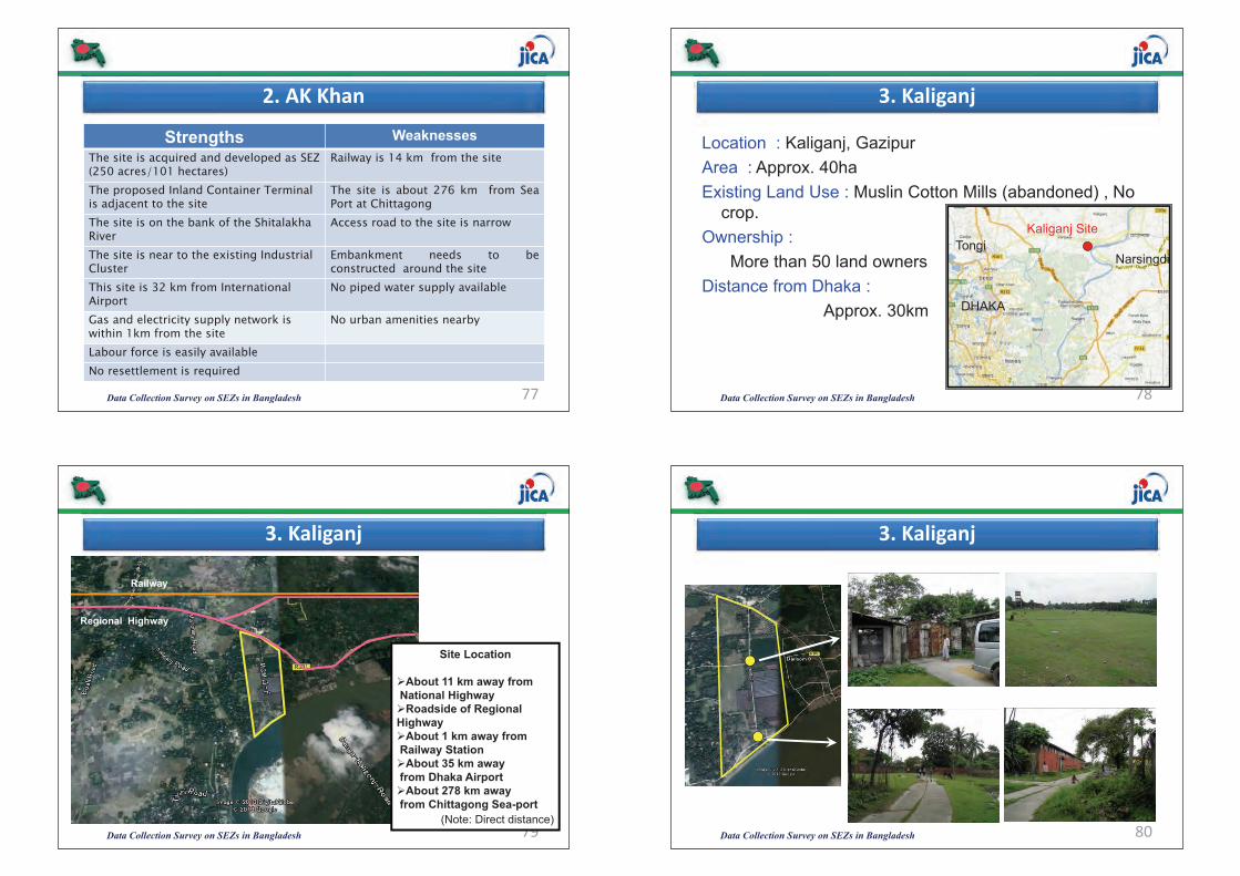
Data Collection Survey on SEZs in Bangladesh 77
2.�AK�Khan
Strengths WeaknessesThe site is acquired and developed as SEZ (250 acres/101 hectares)
Railway is 14 km from the site
The proposed Inland Container Terminal is adjacent to the site
The site is about 276 km from SeaPort at Chittagong
The site is on the bank of the Shitalakha River
Access road to the site is narrow
The site is near to the existing Industrial Cluster
Embankment needs to beconstructed around the site
This site is 32 km from International Airport
No piped water supply available
Gas and electricity supply network is within 1km from the site
No urban amenities nearby
Labour force is easily available No resettlement is required
Data Collection Survey on SEZs in Bangladesh 78
3.�Kaliganj
Location : Kaliganj, GazipurArea : Approx. 40haExisting Land Use : Muslin Cotton Mills (abandoned) , No
crop.Ownership :
More than 50 land ownersDistance from Dhaka :
Approx. 30km DHAKA
TongiNarsingdi
Kaliganj Site
Data Collection Survey on SEZs in Bangladesh 79
3.�Kaliganj
Site Location
�About 11 km away fromNational Highway�Roadside of Regional Highway�About 1 km away fromRailway Station�About 35 km awayfrom Dhaka Airport�About 278 km awayfrom Chittagong Sea-port
(Note: Direct distance)
Regional Highway
Railway
Data Collection Survey on SEZs in Bangladesh 80
3.�Kaliganj
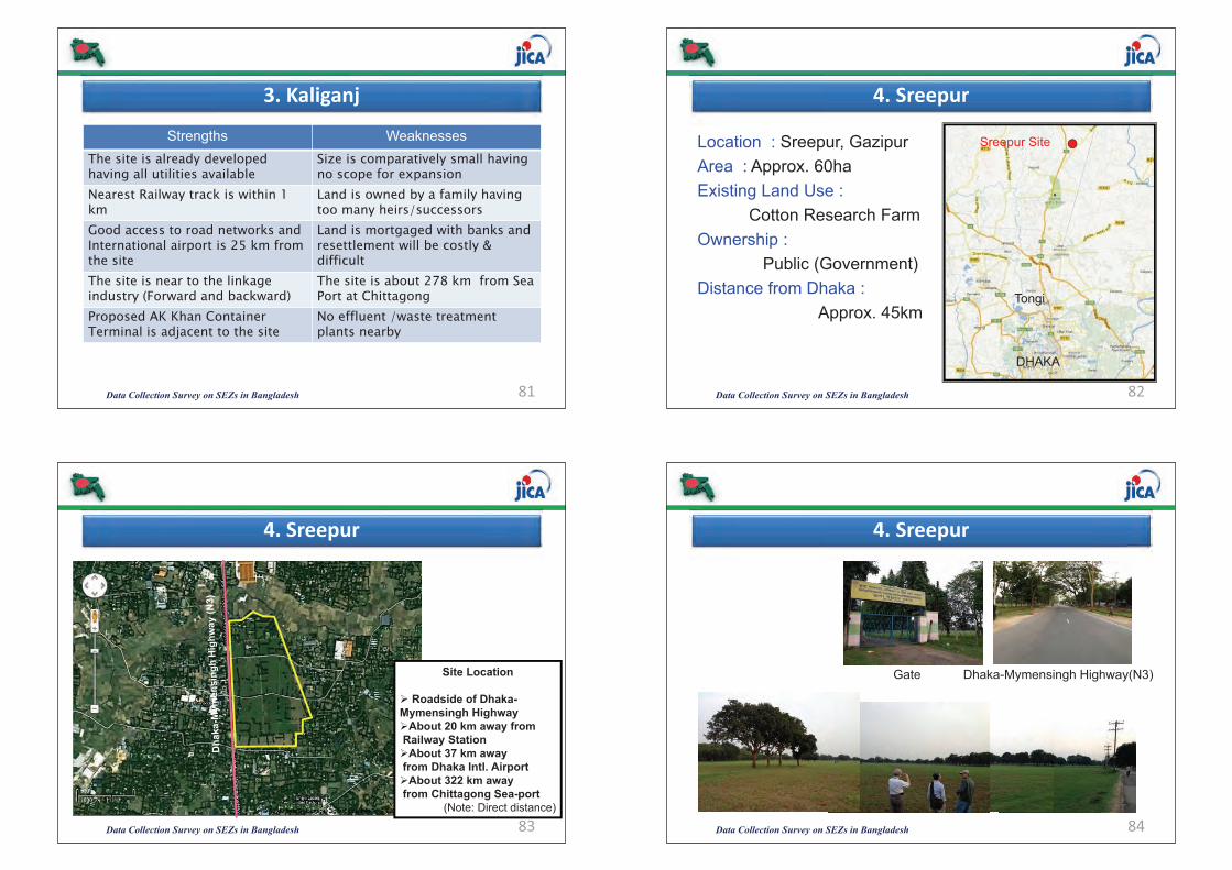
Data Collection Survey on SEZs in Bangladesh 81
3.�Kaliganj
Strengths WeaknessesThe site is already developed having all utilities available
Size is comparatively small having no scope for expansion
Nearest Railway track is within 1 km
Land is owned by a family having too many heirs/successors
Good access to road networks and International airport is 25 km from the site
Land is mortgaged with banks and resettlement will be costly & difficult
The site is near to the linkage industry (Forward and backward)
The site is about 278 km from Sea Port at Chittagong
Proposed AK Khan Container Terminal is adjacent to the site
No effluent /waste treatment plants nearby
Data Collection Survey on SEZs in Bangladesh 82
4.�Sreepur
Location : Sreepur, GazipurArea : Approx. 60haExisting Land Use :
Cotton Research Farm Ownership :
Public (Government)Distance from Dhaka :
Approx. 45km
DHAKA
Tongi
Sreepur Site
Data Collection Survey on SEZs in Bangladesh 83
4.�Sreepur
Site Location
� Roadside of Dhaka-Mymensingh Highway�About 20 km away fromRailway Station�About 37 km awayfrom Dhaka Intl. Airport�About 322 km awayfrom Chittagong Sea-port
(Note: Direct distance)
Data Collection Survey on SEZs in Bangladesh 84
4.�Sreepur
Gate Dhaka-Mymensingh Highway(N3)
(469)(467)
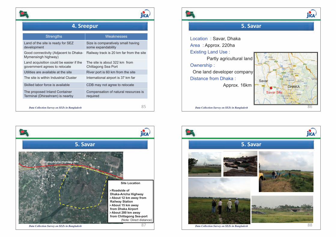
Data Collection Survey on SEZs in Bangladesh 85
4.�Sreepur
Strengths Weaknesses
Land of the site is ready for SEZ development
Size is comparatively small having some expandability
Good connectivity (Adjacent to Dhaka-Mymensingh highway)
Railway track is 20 km far from the site
Land acquisition could be easier if the government agrees to relocate
The site is about 322 km from Chittagong Sea Port
Utilities are available at the site River port is 60 km from the site The site is within Industrial Cluster International airport is 37 km far
Skilled labor force is available CDB may not agree to relocate
The proposed Inland Container Terminal (Dhirashram) is nearby
Compensation of natural resources is required
Data Collection Survey on SEZs in Bangladesh 86
5.�Savar
Location : Savar, DhakaArea : Approx. 220haExisting Land Use :
Partly agricultural land Ownership :One land developer company
Distance from Dhaka : Approx. 16km DHAKA
Savar
Savar Site
Data Collection Survey on SEZs in Bangladesh 87
5.�Savar
Site Location
�Roadside of Dhaka-Aricha Highway�About 12 km away fromRailway Station�About 15 km awayfrom Dhaka Airport�About 280 km awayfrom Chittagong Sea-port
(Note: Direct distance)
Dhaka-Aricha Highway (N5)
Data Collection Survey on SEZs in Bangladesh 88
5.�Savar
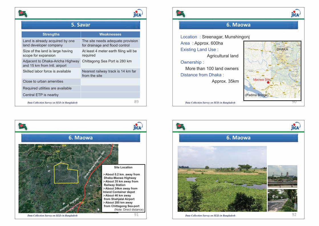
Data Collection Survey on SEZs in Bangladesh 89
5.�SavarStrengths Weaknesses
Land is already acquired by one land developer company
The site needs adequate provision for drainage and flood control
Size of the land is large having scope for expansion
At least 4 meter earth filing will be required
Adjacent to Dhaka-Aricha Highway and 15 km from Intl. airport
Chittagong Sea Port is 280 km
Skilled labor force is available Nearest railway track is 14 km far from the site
Close to urban amenities
Required utilities are available
Central ETP is nearby
Data Collection Survey on SEZs in Bangladesh 90
6.�Maowa
Location : Sreenagar, MunshingonjArea : Approx. 600haExisting Land Use :
Agricultural land Ownership :
More than 100 land ownersDistance from Dhaka :
Approx. 35km
DHAKA
(Padma Bridge)
Maowa Site
Data Collection Survey on SEZs in Bangladesh 91
6.�Maowa
Site Location
�About 0.2 km. away fromDhaka-Maowa Highway�About 35 km away fromRailway Station�About 24km away from Inland Container depot�About 46 km awayfrom Shahjalal Airport�About 285 km awayfrom Chittagong Sea-port
(Note: Direct distance)
Data Collection Survey on SEZs in Bangladesh 92
6.�Maowa
(471)(469)

Data Collection Survey on SEZs in Bangladesh 93
6.�Maowa
Near Site/ Construction Site of Padma Bridge (Reclaimed)
Approx. 6m
Data Collection Survey on SEZs in Bangladesh 94
6.�MaowaStrengths Weaknesses
A part of the land is owned by Private Land Developer willing to set-up SEZ
The site needs to construct embankment for flood protection
Size of the land is large having scope for further expansion
At least 4m earth filing will be required
Adjacent to the proposed Padma Bridge
Chittagong Sea Port is about 285 km from the site
Adjacent to Dhaka-Maowa Highway No gas network and nearest gas network is 10 km from the site
Strategic location to connect Western By-pass with Dhaka-Chittagong corridor
No solid and ETP is nearby
Near to the Pangaon Inland Container Terminal
International airport is 46 km and Railway is 35 km far from the site
Data Collection Survey on SEZs in Bangladesh 95
7.�Rupgonj
Location : Rupganj, NarayanganjArea : Approx. 37haExisting Land Use :Vacant ground, Agricultural land Ownership : One land ownerDistance from Dhaka :
Approx. 25kmDHAKA Rupgonj Site
Data Collection Survey on SEZs in Bangladesh 96
7.�Rupgonj
Site Location
�Roadside of Dhaka-Sylhet Highway�About 11 km away fromRailway Station�About 40 km awayfrom Dhaka Airport�About 271 km awayfrom Chittagong Sea-port
(Note: Direct distance)
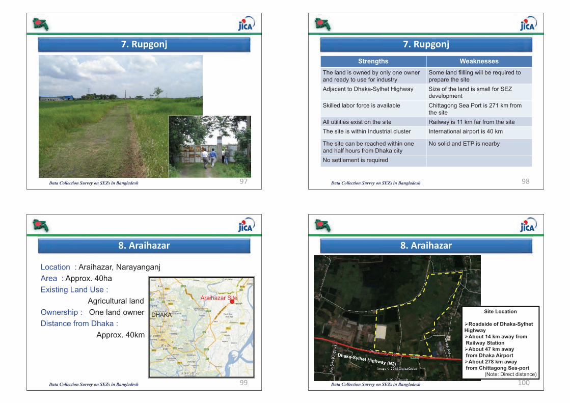
Data Collection Survey on SEZs in Bangladesh 97
7.�Rupgonj
Data Collection Survey on SEZs in Bangladesh 98
7.�RupgonjStrengths Weaknesses
The land is owned by only one owner and ready to use for industry
Some land fillling will be required to prepare the site
Adjacent to Dhaka-Sylhet Highway Size of the land is small for SEZ development
Skilled labor force is available Chittagong Sea Port is 271 km from the site
All utilities exist on the site Railway is 11 km far from the site The site is within Industrial cluster International airport is 40 km
The site can be reached within one and half hours from Dhaka city
No solid and ETP is nearby
No settlement is required
Data Collection Survey on SEZs in Bangladesh 99
8.�Araihazar
Location : Araihazar, NarayanganjArea : Approx. 40haExisting Land Use :
Agricultural land Ownership : One land ownerDistance from Dhaka :
Approx. 40km
DHAKA
Araihazar Site
Data Collection Survey on SEZs in Bangladesh 100
8.�Araihazar
Site Location
�Roadside of Dhaka-Sylhet Highway�About 14 km away fromRailway Station�About 47 km awayfrom Dhaka Airport�About 278 km awayfrom Chittagong Sea-port
(Note: Direct distance)
(473)(471)
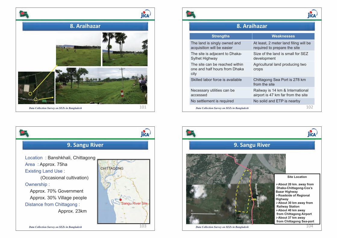
Data Collection Survey on SEZs in Bangladesh 101
8.�Araihazar
Data Collection Survey on SEZs in Bangladesh 102
8.�AraihazarStrengths Weaknesses
The land is singly owned and acquisition will be easier
At least, 2 meter land filing will be required to prepare the site
The site is adjacent to Dhaka-Sylhet Highway
Size of the land is small for SEZ development
The site can be reached within one and half hours from Dhaka city
Agricultural land producing two crops
Skilled labor force is available Chittagong Sea Port is 278 km from the site
Necessary utilities can be accessed
Railway is 14 km & International airport is 47 km far from the site
No settlement is required No solid and ETP is nearby
Data Collection Survey on SEZs in Bangladesh 103
9.�Sangu�River
Location : Banshkhali, ChittagongArea : Approx. 75haExisting Land Use :
(Occasional cultivation) Ownership :
Approx. 70% GovernmentApprox. 30% Village people
Distance from Chittagong : Approx. 23km
CHITTAGONG
Sangu River Site
Data Collection Survey on SEZs in Bangladesh 104
9.�Sangu�River
Site Location
�About 20 km. away fromDhaka-Chittagong-Cox’s
Bazar Highway�Roadside of Regional Highway�About 30 km away fromRailway Station�About 40 km awayfrom Chittagong Airport�About 37 km awayfrom Chittagong Sea-port
0 1km
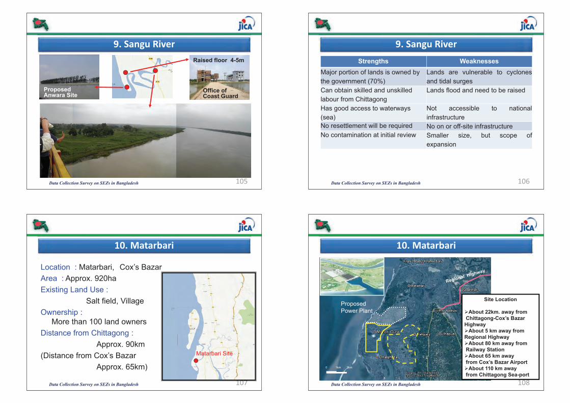
Data Collection Survey on SEZs in Bangladesh 105
9.�Sangu�River
ProposedAnwara Site
Office ofCoast Guard
Raised floor 4-5m
Data Collection Survey on SEZs in Bangladesh 106
9.�Sangu�RiverStrengths Weaknesses
Major portion of lands is owned by the government (70%)
Lands are vulnerable to cyclonesand tidal surges
Can obtain skilled and unskilled labour from Chittagong
Lands flood and need to be raised
Has good access to waterways (sea)
Not accessible to nationalinfrastructure
No resettlement will be required No on or off-site infrastructureNo contamination at initial review Smaller size, but scope of
expansion
Data Collection Survey on SEZs in Bangladesh 107
10.�Matarbari
Location : Matarbari, Cox’s BazarArea : Approx. 920haExisting Land Use :
Salt field, VillageOwnership :
More than 100 land ownersDistance from Chittagong :
Approx. 90km(Distance from Cox’s Bazar
Approx. 65km)
Matarbari Site
Data Collection Survey on SEZs in Bangladesh 108
10.�Matarbari
Site Location
�About 22km. away fromChittagong-Cox’s Bazar
Highway�About 5 km away from Regional Highway�About 80 km away fromRailway Station�About 65 km awayfrom Cox’s Bazar Airport�About 110 km awayfrom Chittagong Sea-port
Proposed Power Plant
0 1km 2km
(475)(473)
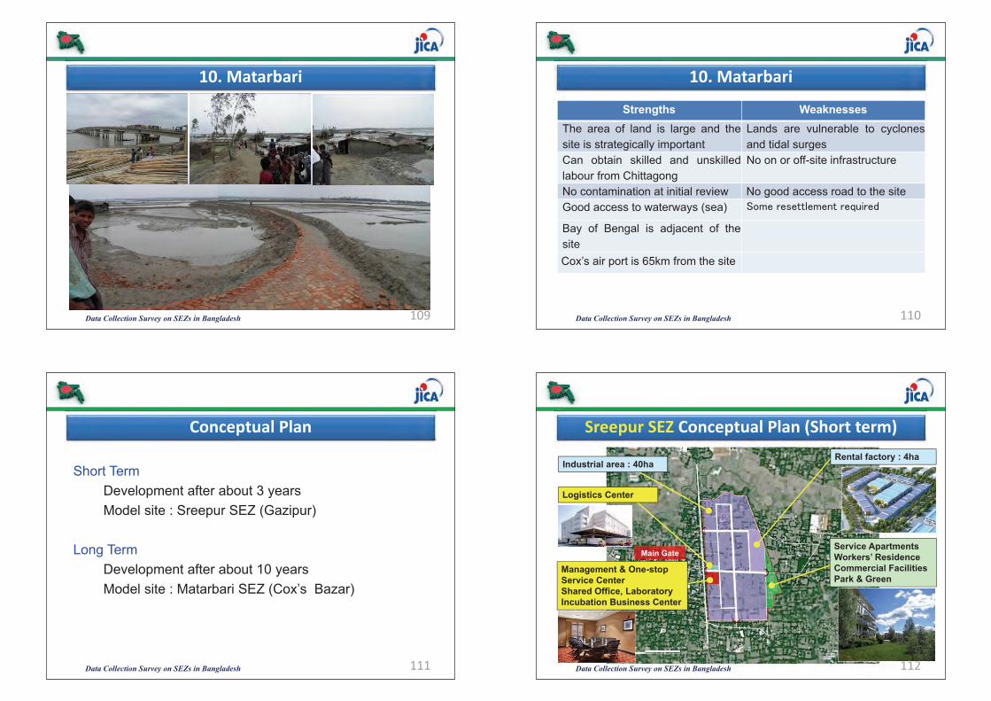
Data Collection Survey on SEZs in Bangladesh 109
10.�Matarbari
Data Collection Survey on SEZs in Bangladesh 110
10.�Matarbari
Strengths WeaknessesThe area of land is large and thesite is strategically important
Lands are vulnerable to cyclonesand tidal surges
Can obtain skilled and unskilledlabour from Chittagong
No on or off-site infrastructure
No contamination at initial review No good access road to the siteGood access to waterways (sea) �����������������\�����
Bay of Bengal is adjacent of thesiteCox’s air port is 65km from the site
Data Collection Survey on SEZs in Bangladesh 111
Conceptual�Plan
Short TermDevelopment after about 3 years Model site : Sreepur SEZ (Gazipur)
Long TermDevelopment after about 10 yearsModel site : Matarbari SEZ (Cox’s Bazar)
Data Collection Survey on SEZs in Bangladesh 112
Sreepur�SEZ Conceptual�Plan�(Short�term)
Service ApartmentsWorkers’ ResidenceCommercial FacilitiesPark & Green
Rental factory : 4haIndustrial area : 40ha
Management & One-stop Service CenterShared Office, LaboratoryIncubation Business Center
Logistics Center
Main Gate
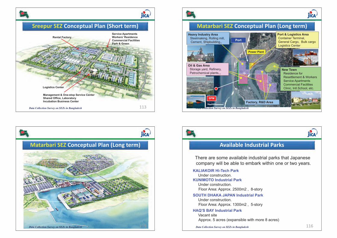
Data Collection Survey on SEZs in Bangladesh 113
Sreepur�SEZ Conceptual�Plan�(Short�term)Service ApartmentsWorkers’ ResidenceCommercial FacilitiesPark & Green
Rental Factory
Management & One-stop Service CenterShared Office, LaboratoryIncubation Business Center
Logistics Center
Data Collection Survey on SEZs in Bangladesh 114
Matarbari�SEZ Conceptual�Plan�(Long�term)
]^_` : 40ha
Power Plant
Oil & Gas AreaStorage yard, Refinery, Petrochemical plants,,,
SPM
Heavy Industry AreaSteelmaking, Rolling mill, Cement, Shipbuilding,,
New TownResidence for Resettlement & Workers Service ApartmentsCommercial FacilitiesClinic, Intl.School, etc.
Port & Logistics AreaContainer Terminal, General Cargo, Bulk cargoLogistics Center
Factory, R&D Area
Port
Data Collection Survey on SEZs in Bangladesh 115
Matarbari�SEZ Conceptual�Plan�(Long�term)
Data Collection Survey on SEZs in Bangladesh 116
Available�Industrial�Parks
There are some available industrial parks that Japanese company will be able to embark within one or two years.
KALIAKOIR Hi-Tech ParkUnder construction.
KUNIMOTO Industrial ParkUnder construction.Floor Area: Approx. 2500m2 , 8-story
SOUTH DHAKA JAPAN Industrial ParkUnder construction.Floor Area: Approx. 1300m2 , 5-story
HAQ’S BAY Industrial ParkVacant siteApprox. 5 acres (expansible with more 8 acres)
(477)(475)
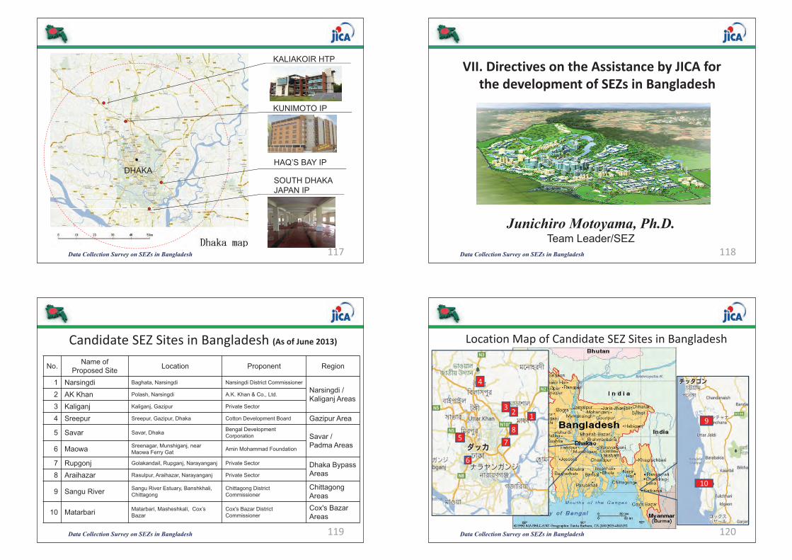
Data Collection Survey on SEZs in Bangladesh 117
HAQ’S BAY IPDHAKA
SOUTH DHAKA JAPAN IP
KUNIMOTO IP
KALIAKOIR HTP
Data Collection Survey on SEZs in Bangladesh 118
VII.�Directives�on�the�Assistance�by�JICA�forthe�development�of�SEZs�in�Bangladesh
Junichiro Motoyama, Ph.D. Team Leader/SEZ
Data Collection Survey on SEZs in Bangladesh 119
Candidate�SEZ�Sites�in�Bangladesh�(As�of�June�2013)
No. Name of Proposed Site Location Proponent Region
1 Narsingdi Baghata, Narsingdi Narsingdi District CommissionerNarsingdi / Kaliganj Areas2 AK Khan Polash, Narsingdi A.K. Khan & Co., Ltd.
3 Kaliganj Kaliganj, Gazipur Private Sector
4 Sreepur Sreepur, Gazipur, Dhaka Cotton Development Board Gazipur Area
5 Savar Savar, Dhaka Bengal Development Corporation Savar /
Padma Areas6 Maowa Sreenagar, Munshiganj, near Maowa Ferry Gat Amin Mohammad Foundation
7 Rupgonj Golakandail, Rupganj, Narayanganj Private Sector Dhaka BypassAreas8 Araihazar Rasulpur, Araihazar, Narayanganj Private Sector
9 Sangu River Sangu River Estuary, Banshkhali, Chittagong
Chittagong District Commissioner
Chittagong Areas
10 Matarbari Matarbari, Masheshkali, Cox’s Bazar
Cox's Bazar District Commissioner
Cox's Bazar Areas
Data Collection Survey on SEZs in Bangladesh 120
Location�Map�of�Candidate�SEZ�Sites�in�Bangladesh
123
4
5
6
78
9
10
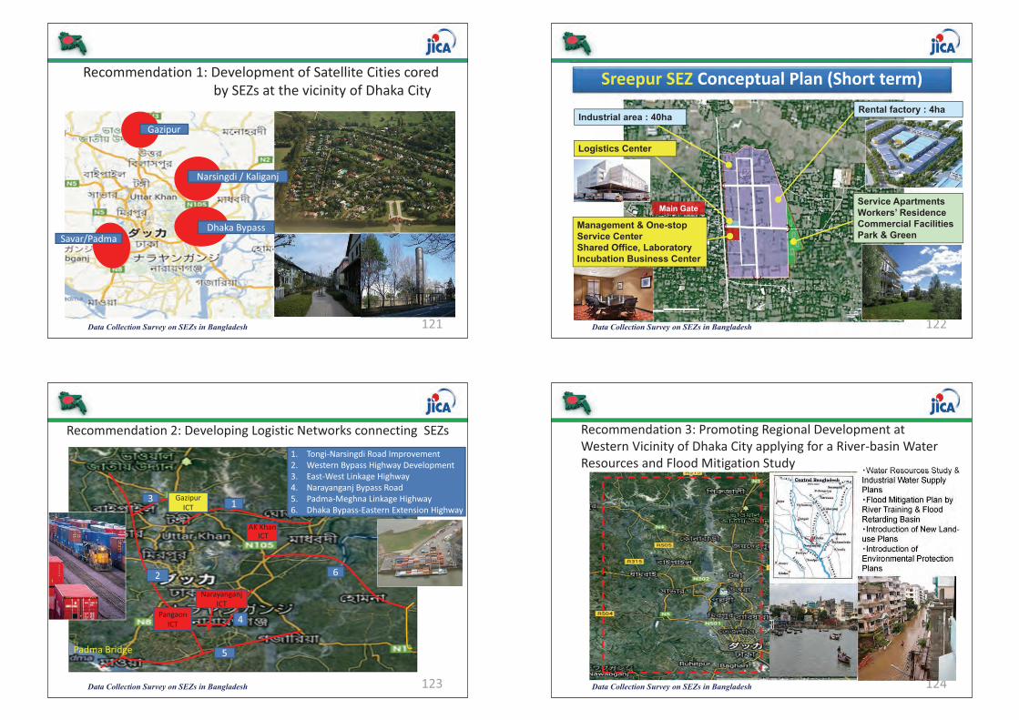
Data Collection Survey on SEZs in Bangladesh 121
Recommendation�1:�Development�of�Satellite�Cities�coredby�SEZs�at�the�vicinity�of�Dhaka�City
Gazipur
Narsingdi�/�Kaliganj�
Dhaka�BypassSavar/Padma
Data Collection Survey on SEZs in Bangladesh 122
Sreepur�SEZ Conceptual�Plan�(Short�term)
Service ApartmentsWorkers’ ResidenceCommercial FacilitiesPark & Green
Rental factory : 4haIndustrial area : 40ha
Management & One-stop Service CenterShared Office, LaboratoryIncubation Business Center
Logistics Center
Main Gate
Data Collection Survey on SEZs in Bangladesh 123
Recommendation�2:�Developing�Logistic�Networks�connecting��SEZs
PangaonICT
1. Tongi�Narsingdi�Road Improvement2. Western�Bypass�Highway�Development3. East�West�Linkage�Highway4. Narayanganj�Bypass�Road5. Padma�Meghna�Linkage�Highway6. Dhaka�Bypass�Eastern�Extension�Highway1
2
3
5
6
Padma�Bridge
Gazipur�ICT
Narayanganj�ICT
4
AK�KhanICT
Data Collection Survey on SEZs in Bangladesh 124
Recommendation�3:�Promoting�Regional�Development�at�Western�Vicinity�of�Dhaka�City�applying�for�a�River�basin�Water�Resources�and�Flood�Mitigation�Study
>Water Resources Study & Industrial Water Supply Plans>Flood Mitigation Plan by River Training & Flood Retarding Basin>Introduction of New Land-use Plans>Introduction of Environmental Protection Plans
(479)(477)
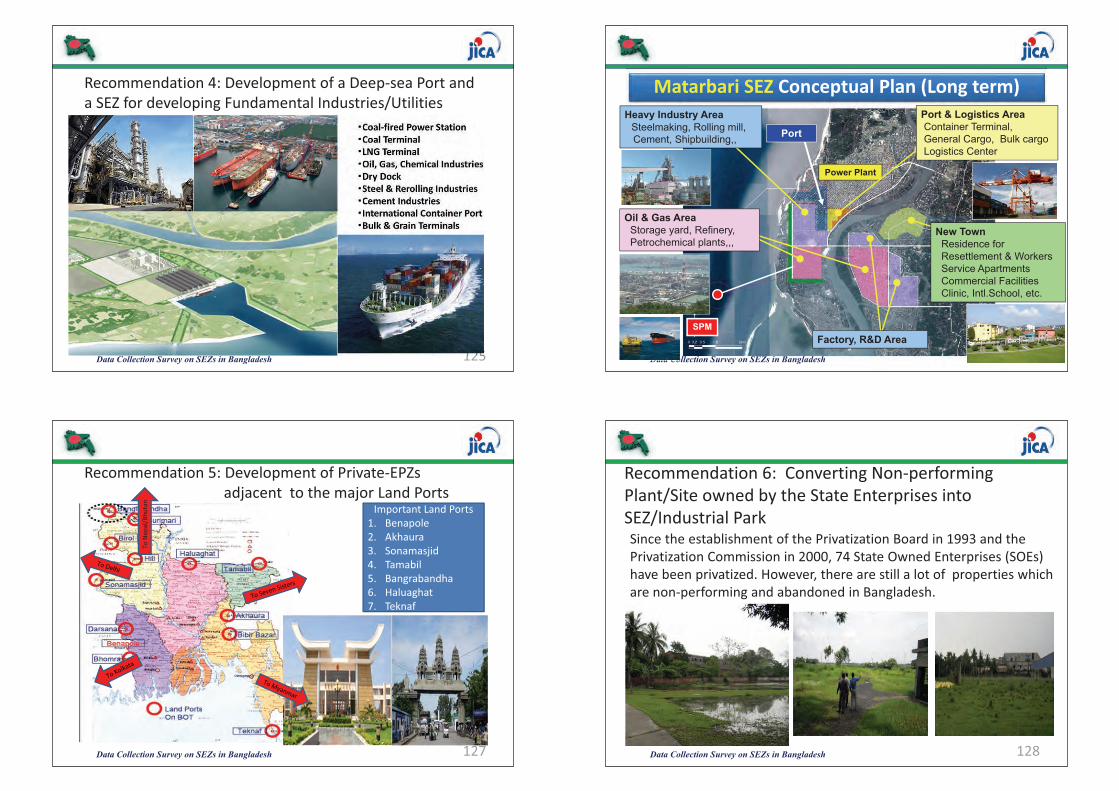
Data Collection Survey on SEZs in Bangladesh 125
Recommendation�4:�Development�of�a�Deep�sea�Port�and�a�SEZ�for�developing�Fundamental�Industries/Utilities
>Coal�fired�Power�Station>Coal�Terminal>LNG�Terminal>Oil,�Gas,�Chemical�Industries>Dry�Dock>Steel�&�Rerolling�Industries>Cement�Industries>International�Container�Port>Bulk�&�Grain�Terminals
Data Collection Survey on SEZs in Bangladesh 126
Matarbari�SEZ Conceptual�Plan�(Long�term)
]^_` : 40ha
Power Plant
Oil & Gas AreaStorage yard, Refinery, Petrochemical plants,,,
SPM
Heavy Industry AreaSteelmaking, Rolling mill, Cement, Shipbuilding,,
New TownResidence for Resettlement & Workers Service ApartmentsCommercial FacilitiesClinic, Intl.School, etc.
Port & Logistics AreaContainer Terminal, General Cargo, Bulk cargoLogistics Center
Factory, R&D Area
Port
Data Collection Survey on SEZs in Bangladesh 127
Recommendation�5:�Development�of�Private�EPZs�adjacent��to�the�major�Land�Ports
Important�Land�Ports1. Benapole2. Akhaura3. Sonamasjid4. Tamabil5. Bangrabandha6. Haluaghat7. Teknaf
To�Nep
al/Bhu
tan
Data Collection Survey on SEZs in Bangladesh 128
Since�the�establishment�of�the�Privatization�Board�in�1993�and�the�Privatization�Commission�in�2000,�74�State�Owned�Enterprises�(SOEs)�have�been�privatized.�However,�there�are�still�a�lot�of��properties�which�are�non�performing�and�abandoned�in�Bangladesh.
Recommendation�6:��Converting�Non�performing�Plant/Site�owned�by�the�State�Enterprises�into�SEZ/Industrial�Park
Data Collection Survey on SEZs in Bangladesh 129
Recommendation�7:�Provision�of�a�Multi�sectorial�Project�Loan�for�the�development�of�Off�site�Infrastructure�&�Utility
>Data�Collection�Survey�on�the�development�of�Off�site�Infrastructure�and�Utility�to�SEZs>Conduct�of�a�Master�Plan�and�Feasibility�Study�and�ProjectFormulation>Negotiation�with�Bangladesh�Government�and�theImplementation�Agency,�and�Appraisal�of�the�Project>Pledge�of�a�Multi�sectorial�Yen�Project�Loan�to�Bangladesh>Application�for�Loan�to�Off�site�Infrastructure�and�UtilityDevelopment�by�the�Local�Government�and�Private�Sector>Design�and�Construction�of�the�Off�site�Infrastructure�andUtility�facilities
Data Collection Survey on SEZs in Bangladesh 130
Proposed�Implementation�Plan�for�the�Development�of�Off�site�Infrastructure�&�Utility�to�SEZs
Data Collection Survey on SEZs in Bangladesh 131
Recommended�Counter�Measures�to�be�implemented�by�the�Government�of�Bangladesh
1.�Earlier�Acquisition�of�the�Project�Sites2.�Familiarization�of�BEZA�Act�and�earlier�announcementof�related�Rules�and�Regulations
3.�Provision�of�Attractive�Incentives�to�the�SEZ�and�Industrial�Park�Developers
4.�Improvement�of�BEZA�Administrative�Services�andRealization�of�One�stop�Services�to�the�FDIs
5.�Enhancement�of�Promotional�Activities�for�attractingmore�FDIs�to�Bangladesh
6.�Close�Coordination�and�Collaboration�with�FDIs�already�invested
Data Collection Survey on SEZs in Bangladesh 132
Data�Collection�Survey�on�Special�Economic�Zones�in�Bangladesh
WORKSHOP�ON�FINDINGS�OF�THE�SURVEY
Thank you for your attention !
June�9,�2013
Lakeshore�Hotel,�Dhaka�
(481)(479)

August 2013
Data Collection Survey on
the Special Economic Zones in
the People’s Republic of Bangladesh
Final Report
World Business Associates Co., Ltd. The Japan Research Institute, Limited
Nikken Sekkei Civil Engineering Ltd.
JAPAN INTERNATIONAL COOPERATION AGENCY(JICA)
仏文 078243.10013.25.7.17 作業:藤川
Data C
ollection Survey on the Special Economic Zones in the P
eople’s Republic of B
angladesh Final Report
August 2013
南ア
JR13-029