Imaging Services on the Grid as a Product Line: Requirements and Architecture
Upload
khangminh22Category
view
0download
0
Computing and Informatics, Vol. 24, 2005, 201–222
AN AGENT APPROACH TO SPATIAL INFORMATIONGRID ARCHITECTURE DESIGN
Yingwei Luo, Xiaolin Wang, Zhuoqun Xu
Department of Computer Science and Technology
Peking University, Beijing, China, 100871
e-mail: [email protected]
Manuscript received 2 September 2004; revised 11 April 2005Communicated by Ladislav Hluchy
Abstract. Spatial information grid (SIG) is a spatial information infrastructurethat has the capability of providing services on-demand. SIG is a distributed net-work environment, which links spatial data resources, computing resources, storageresources, software, tools and users. SIG can integrate massive distributed hetero-geneous spatial information resources, provides uniform management and process,and, furthermore, coordinate different resources to complete large-scale and complexspatial tasks and applications. In this paper, agent technology is adopted to con-struct a SIG framework, which contains three layers: users/applications layer, agentservices layer and information layer. Different applications can get their spatial in-
formation via agent services, and agent services make the procedure of navigatingand accessing spatial information transparent to users. Also, the implementationissues of the framework are discussed in detail, including Geo-Agents, an agent-based distributed GIS system, spatial information management, collaboration andparallel mechanism, load control strategy, and a sample.
Keywords: Spatial information grid, geo-agents, framework, spatial metadata, col-
laboration, parallel, load
1 INTRODUCTION
Spatial information has an obvious feature of distribution. On the one hand, spatialinformation covers a scope of the whole planet where people live; it is a distribution
202 Y. Luo, X. Wang, Z. Xu
of spatiality. On the other hand, spatial information is related to every aspect ofhuman society; it is a distribution of social characteristics. Just because of the natureof distribution of spatial information, it is mandatory to organize and maintainall spatial information in decentralized way. It is the best choice to organize andmaintain spatial information by different departments in different places. In fact,people do organize and maintain spatial data like that.
With the development of computer networks, the use of spatial informationis facing a new challenge. More and more heterogeneous spatial information isconnected with the network and opened to others. However, users do not knowwhere spatial information is located, what kinds of spatial information can be used,and how to use them. Also, some large-scale and complex spatial applications (forexample, Digital City) may involve different departments and need the cooperationof distributed spatial information to achieve perfect result [1].
Because of the unceasing increase of spatial information, it is urgent for peopleto make spatial information available and shareable. New mechanisms that allowspatial information to inter-operate are needed. In this paper, an agent-based spa-tial information grid (SIG) framework is presented for synergetic management ofheterogeneous spatial information on a network.
In the aspect of building a spatial information-sharing framework, many worksare accomplished by research institutions and standardization organizations, espe-cially OGC and ISO TC211.
The Open Geospatial Consortium, Inc. (OGC) is a non-profit, international,voluntary consensus standards organization that is leading the development of stan-dards for geospatial and location based services [2]. Through member-driven con-sensus programs, OGC works with government, private industry, and academia tocreate open and extensible software application programming interfaces for geo-graphic information systems (GIS) and other mainstream technologies. OGC’sSimple Feature Model (SFM) summarizes the common sense to spatial informa-tion of people. Based on SFM, Geographical Markup Language (GML) is given,which is an XML encoding for the transport and storage of geographic informa-tion, including both the geometry and properties of geographic features. In or-der to manage spatial data, services and applications, OGC defines data meta-data, services metadata and application metadata specifications. Catalogue Ser-vices Specifications (CSS) are organized and implemented for the discovery,retrieval and management of metadata. OGC’s Interoperability Program (IP) isused to help the participants mutually form engineering methods of concord spa-tial interfaces. OGC also gives a common architectural framework for OGC WebServices (Web Services Architecture, WSA), where service model is described, rolesand operations in the model are identified, and concept level, technique level andsystem level are divided. These three levels can define and gradually implementWeb services. For interfaces of Web services, OGC also has specific discussionand presented interface specification of Web services such as Web Feature Service
An Agent Approach to Spatial Information Grid Architecture Design 203
(WFS), Web Map Service (WMS), Geolinking Service (GLS), etc. The work ofOGC greatly enlightens and guilds the study in spatial information sharing andinteroperation.
The work of ISO TC211 aims at establishing a structured set of standards forinformation concerning objects or phenomena that are directly or indirectly associa-ted with a location relative to the Earth [3]. The work of TC211 is similar to thatof OGC, but compared to OGC it is focused on cooperation between governmentsto come to international specifications, while OGC focuses on folk cooperation ofpeople.
The specification and standards of OGC and ISO TC211 guide developers toadopt different implementing technologies (such as COM/DCOM, CORBA, WebService, Grid Computing and Agent) to exploit middleware, component and inte-grating infrastructure to help users share massive distributed spatial resources.
Grid is a unified and integrated approach to build distributed scientific com-puting environments that incorporate computation, data management, scientific in-struments and human collaboration to support large-scale scientific and engineeringapplications [4]. It provides standardized middleware services within geographicallydispersed and inter-organizational environments, and greatly simplifies the construc-tion and operation of the application system that interconnect various resources. Atpresent, there are some productive grid systems and toolkits. The Argonne lab andISI have developed a range of basic service – Globus toolkits to support efficient andeffective computation in grid environments [5]. These services have been deployed innumerous projects ranging from collaborative design to distributed supercomputing.Also, a new open grid service architecture OGSA is proposed in 2002 [6].
Grid technology has been applied in many scientific and engineering applica-tions. There are some projects that focus on applying grid computing into spa-tial information sharing and interoperation, such as Earth System Grid (ESG) [7],Earth Observation System (EOS) [8], and Spatial Data Processing Grid (SDPG) [9].These projects adopt different implementing technologies to design layer architec-ture, and most of them adopt OGC’s specification to unify spatial resources. ESGuses Globus toolkits and other data grid software to construct a prototype system,and implement the interactive analysis of remote climate data by moving and repli-cating data collections, and sharing computing resources. EOS uses CORBA toconstruct an easy-to-use and grid-based EO application system, and will be widelyemployed in climatology, oceanography, geography and other earth observation sub-jects. ESG and EOS are just domain-oriented application systems, and cannotbe directly used in other applications. SDPG focuses on virtual data object andOPENGIS to unify access to various storage systems and GIS systems. SDPG fol-lows open grid service architecture (OGSA) and uses Web Service to build a serviceframework, which supports the movement of service and data. Cluster-based GISsystem is also proposed to improve performance of spatial data processing and ser-vice in SDPG.
204 Y. Luo, X. Wang, Z. Xu
2 AGENT-BASED SIG FRAMEWORK
2.1 Spatial Information Grid
SIG (Spatial Information Grid) is a spatial information infrastructure that has thecapability of providing services ondemand. SIG integrates and shares massive dis-tributed heterogeneous spatial information resources, and provides uniform manage-ment and process. SIG is a distributed network environment, which links spatialdata resources, computing resources, storage resources, software, tools and users.SIG can coordinate different spatial information resources to complete different spa-tial tasks and applications. In such an environment, users can present all kinds ofrequests for spatial data and its process, and SIG can joint distributed data, com-puting, network and software resources to cooperate and accomplish different users’requests. SIG adopts a new architecture, method and technology to manage, ac-cess, analyze and integrate distributed spatial data, take full advantage of servicesfrom existing spatial information systems, so as to realize effective spatial informa-tion share and interoperation, and provides on-line spatial information analyzingprocesses and services. SIG should provide the following functions [10]:
• The capability of processing massive spatial data. Storing, accessing and mana-ging massive spatial data from TB to PB; efficiently analyzing and processingspatial data to produce model, information and knowledge; and providing 3Dand multimedia visualization services.
• The capability of high performance computing and processing on spatial in-formation. Solving spatial problems with high precision, high quality, and ona large scale; and process spatial information in real time or on time, with highspeed and high efficiency.
• The capability of sharing spatial resources. Sharing distributed heterogeneousspatial information resources and realizing interlink and interoperation at ap-plication level, so as to make best use of spatial information resources, such ascomputing resources, storage devices, spatial data (integrating from GIS, RS andGPS), spatial applications and services, GIS platforms (such as ESRI ArcInfo,MapInfo, . . . ), . . .
• The capability of integrating legacy GIS system. A SIG can not only be usedto construct new advanced spatial application systems, but also to integratelegacy GIS system, so as to keep extensibility and inheritance and guaranteeinvestment of users.
• The capability of collaboration. Large-scale spatial information applications andservices always involve different departments in different geographic places, soremote and uniform services are needed.
• The capability of supporting integration of heterogeneous systems. Large-scalespatial information systems are always synthetical applications, so SIG should
An Agent Approach to Spatial Information Grid Architecture Design 205
provide interoperation and consistency through adopting open and applied tech-nology standards.
• The capability of adapting dynamic changes. Business requirements, applicationpatterns, management strategies, and IT products always change endlessly forany departments, so SIG should be self-adaptive.
2.2 SIG: An Agent Framework
Agent is an autonomous, interactive, initiative and reactive computing entity ina distributed environment. Agent encapsulates some computing resources and canreach its designed goals initiatively. An agent is not only able to work on itself, butalso to impact environment, to receive feedback information from environment, andto readjust its own behavior. At the same time, an agent can cooperate with otheragents. Agent system reduces the restrictions of concentricity, non-openness andsequential control, provides distributed controlling, dynamic emergency processingand parallel processing services [10, 11]:
• Using agent technology can simplify a big and complex problem, and disassemblethe problem into small and simple ones. That is because agent can interact withoutside through a flexible and context-sensitive method, not through some pre-defined interfaces.
• In real world, there are many problems that involve the cooperation of nume-rous distributed problem-solving entities and data resources. Agent technologyprovides a natural modeling method to solve those problems. The entities andtheir relations in real word can be easily mapped to agents, which have theirown resources and have the capabilities to collaborate to solve problems.
• Several agents can be grouped into a team to complete a special complex task.Agents in the same team can coordinate their activities and collaborate to solveconflicts among them in order to fulfil team goals.
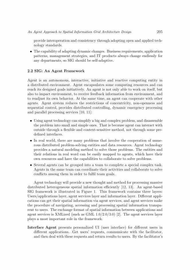
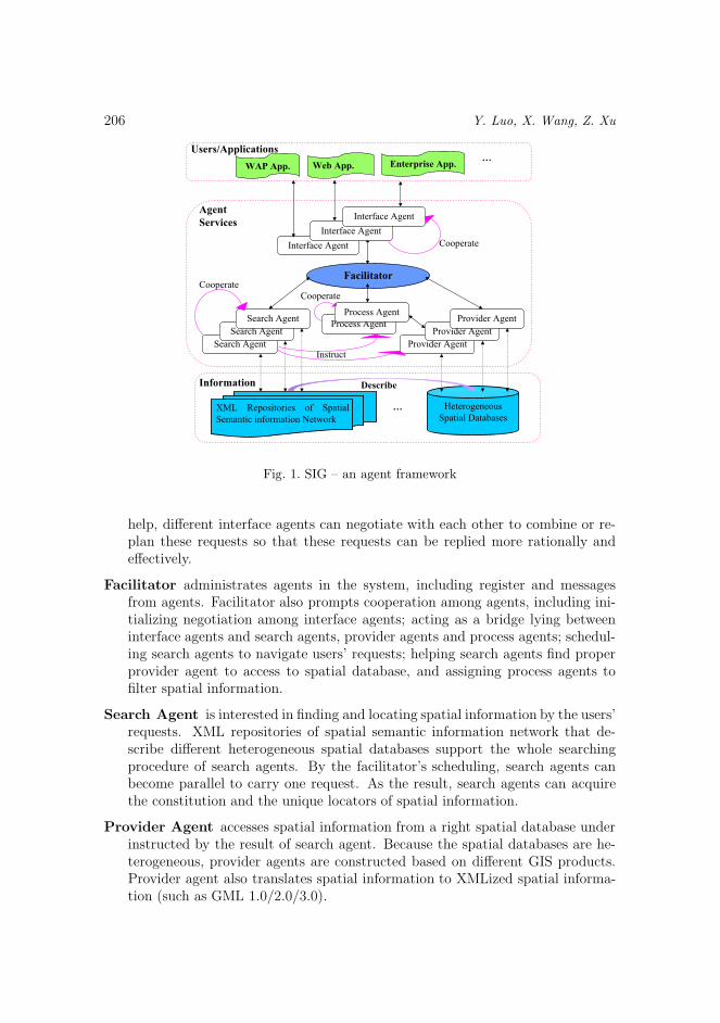
Agent technology will provide a new thought and method for processing massivedistributed heterogeneous spatial information efficiently [12, 13]. An agent-basedSIG framework is illustrated in Figure 1. This framework contains three layers:Users/applications layer, agent services layer and information layer. Different appli-cations can get their spatial information via agent services, and agent services makethe procedure of navigating, accessing and processing spatial information transpa-rent to users. The exchange format of spatial information between applications andagent services is XMLized (such as GML 1.0/2.0/3.0) [2]. The agent services layerplays a most important role in the framework.
Interface Agent presents personalized UI (user interface) for different users indifferent applications. Get users’ requests, communicate with the facilitator,and then deal with these requests and return results to users. By the facilitator’s
206 Y. Luo, X. Wang, Z. Xu
Heterogeneous
Spatial Databases…
Information Describe
Facilitator
Search Agent
Interface Agent
Users/Applications
Agent
Services
Provider Agent
Process AgentSearch Agent
Search Agent
Provider Agent
Provider Agent
Instruct
Process Agent
Cooperate
Interface Agent
Interface Agent
Cooperate
Cooperate
XML Repositories of Spatial
Semantic information Network
WAP App. Web App. Enterprise App.…
Fig. 1. SIG – an agent framework
help, different interface agents can negotiate with each other to combine or re-plan these requests so that these requests can be replied more rationally andeffectively.
Facilitator administrates agents in the system, including register and messagesfrom agents. Facilitator also prompts cooperation among agents, including ini-tializing negotiation among interface agents; acting as a bridge lying betweeninterface agents and search agents, provider agents and process agents; schedul-ing search agents to navigate users’ requests; helping search agents find properprovider agent to access to spatial database, and assigning process agents tofilter spatial information.
Search Agent is interested in finding and locating spatial information by the users’requests. XML repositories of spatial semantic information network that de-scribe different heterogeneous spatial databases support the whole searchingprocedure of search agents. By the facilitator’s scheduling, search agents canbecome parallel to carry one request. As the result, search agents can acquirethe constitution and the unique locators of spatial information.
Provider Agent accesses spatial information from a right spatial database underinstructed by the result of search agent. Because the spatial databases are he-terogeneous, provider agents are constructed based on different GIS products.Provider agent also translates spatial information to XMLized spatial informa-tion (such as GML 1.0/2.0/3.0).
An Agent Approach to Spatial Information Grid Architecture Design 207
Process Agent filters or queries XMLized spatial information according to theusers’ requests.
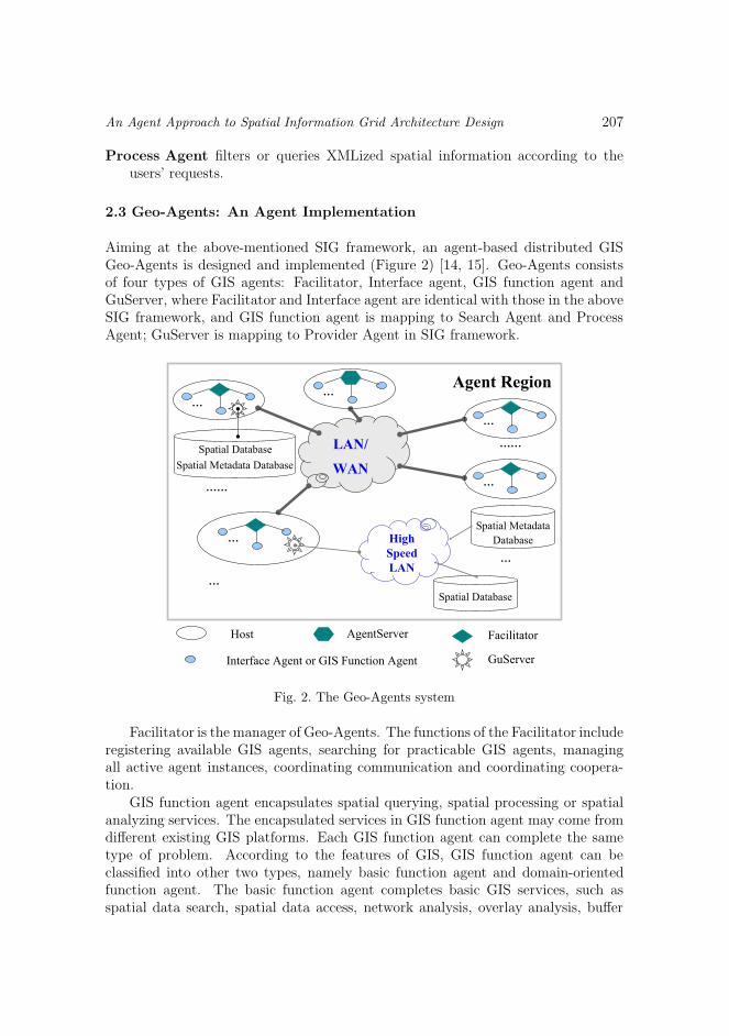
2.3 Geo-Agents: An Agent Implementation
Aiming at the above-mentioned SIG framework, an agent-based distributed GISGeo-Agents is designed and implemented (Figure 2) [14, 15]. Geo-Agents consistsof four types of GIS agents: Facilitator, Interface agent, GIS function agent andGuServer, where Facilitator and Interface agent are identical with those in the aboveSIG framework, and GIS function agent is mapping to Search Agent and ProcessAgent; GuServer is mapping to Provider Agent in SIG framework.
Interface Agent or GIS Function Agent
Host AgentServer Facilitator
GuServer
…
LAN/
WAN
Agent Region
High
Speed
LAN
Spatial Metadata
Database
Spatial Database
…
…
…
…
……
…
…
……Spatial Database
Spatial Metadata Database
Fig. 2. The Geo-Agents system
Facilitator is the manager of Geo-Agents. The functions of the Facilitator includeregistering available GIS agents, searching for practicable GIS agents, managingall active agent instances, coordinating communication and coordinating coopera-tion.
GIS function agent encapsulates spatial querying, spatial processing or spatialanalyzing services. The encapsulated services in GIS function agent may come fromdifferent existing GIS platforms. Each GIS function agent can complete the sametype of problem. According to the features of GIS, GIS function agent can beclassified into other two types, namely basic function agent and domain-orientedfunction agent. The basic function agent completes basic GIS services, such asspatial data search, spatial data access, network analysis, overlay analysis, buffer
208 Y. Luo, X. Wang, Z. Xu
analysis and so on. Domain-oriented function agent is responsible for applicationtasks in various domains, and can be constructed by domain-oriented model andused generally in one domain.
The interface agent provides interfaces for users or applications to hand tasks.Just like Structure Query Language (SQL) of database, Geo-Agents provides Geo-Script, an agent manipulating language to describe GIS tasks [15]. When solvinga practicable problem, users or applications can simply use GeoScript statementsto describe the task, and then hand the statements to the interface agent. Inter-face agent has a GeoScript interpreter and can disassemble the task to subtasksautonomously, recruit GIS function agents to complete the task concurrently.
GuServer is in charge of spatial information accessing services, which managesspatial information and spatial metadata in spatial databases.
In Geo-Agents, every GIS agent consists of five units: control subsystem, fun-ctional subsystem, communication subsystem, human-computer interface and dataresource. GIS agent is a reactive agent, which is not only able to carry out itsown task independently, but also to communicate with other agents, to exchangeinformation and to cooperate with others.
The Agent Region mode is used to control the distributed scenario of Geo-Agentsin a network. An Agent Region consists of one or more hosts, which must be installedwith the Facilitator (and/or other GIS agents). There are many Facilitators in anAgent Region. One Facilitator can cooperate with other Facilitators to control andcoordinate every GIS agent to run correctly, and hold the distributed controls of thewhole system.
In an Agent Region, there is only one Facilitator that will be configured asAgentServer. The Facilitator is used to manage and coordinate agents inside oneAgent Region. Beside the functions of Facilitator, AgentServer serves as a bridgeamong different Agent Regions. That is to say, an agent in one Agent Region canonly communicate with agents in other Agent Regions through AgentServer. Ofcourse, an authorization is required. The AgentServer manages a table to regis-ter other Agent Regions that are authorized with itself each other. Between twodirectly authorized Agent Regions, agents between them can communicate via thecoordination of their AgentServers. The authorization relation in Geo-Agents canbe passed one by one: If a directly authorized AgentServer chain can be found fortwo Agent Regions that have no direct authorization, agents between the two AgentRegions can communicate via the coordination of the AgentServer chain.
3 SPATIAL INFORMATION MANAGEMENT
3.1 Spatial Metadata
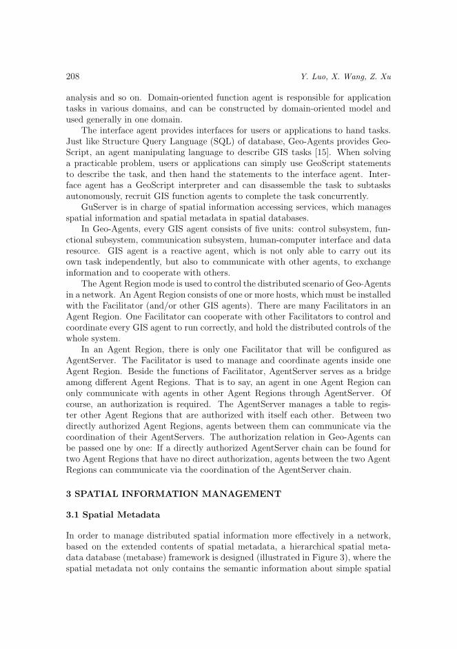
In order to manage distributed spatial information more effectively in a network,based on the extended contents of spatial metadata, a hierarchical spatial meta-data database (metabase) framework is designed (illustrated in Figure 3), where thespatial metadata not only contains the semantic information about simple spatial
An Agent Approach to Spatial Information Grid Architecture Design 209
information, but also the semantic information about field-oriented spatial informa-tion set [16]. The hierarchical spatial metabase framework constitutes the semanticnetwork for spatial information.
Internet
Global SMDB(1)
Spatial DB
General SMDB(3)District SMDB
(2)
General SMDB
Spatial DB
General SMDB
Spatial DB
(4)
Fig. 3. The framework of spatial metadata database
The spatial metabases shown in Figure 3 are divided into three levels: (1) isGlobal Spatial Metabase (Global SMDB), (2) is District Spatial Metabase (DistrictSMDB), (3) and (4) are General Spatial Metabase about Spatial Database (Gene-ral SMDB). (3) and (4) are the same in content, but they are in different positionin the framework. (1), (2) and (3) are regarded as independent spatial metabase.District SMDB and independent General SMDB can, but do not have to, be re-gistered in a Global SMDB; General SMDB indicated by (4) must be registered ina District SMDB. The General SMDBs registered in the same District SMDB arecorrelative.
General SMDB has an all-sided description about spatial database, which is de-signed after OGC’s Simple Feature Model and FGDC’s Geospatial Metadata Stan-dard. District SMDB registers all metadata information of General SMDBs regis-tered in the district and the relations among those General SMDBs. Global SMDBmanages a number of District SMDBs and independent General SMDBs, and allmetadata information of those SMDBs (of course, including the General SMDBsregistered in District SMDB) are registered in it. Global SMDB is the top-levelindex for spatial data, so users can locate the target data quickly through GlobalSMDB.
210 Y. Luo, X. Wang, Z. Xu
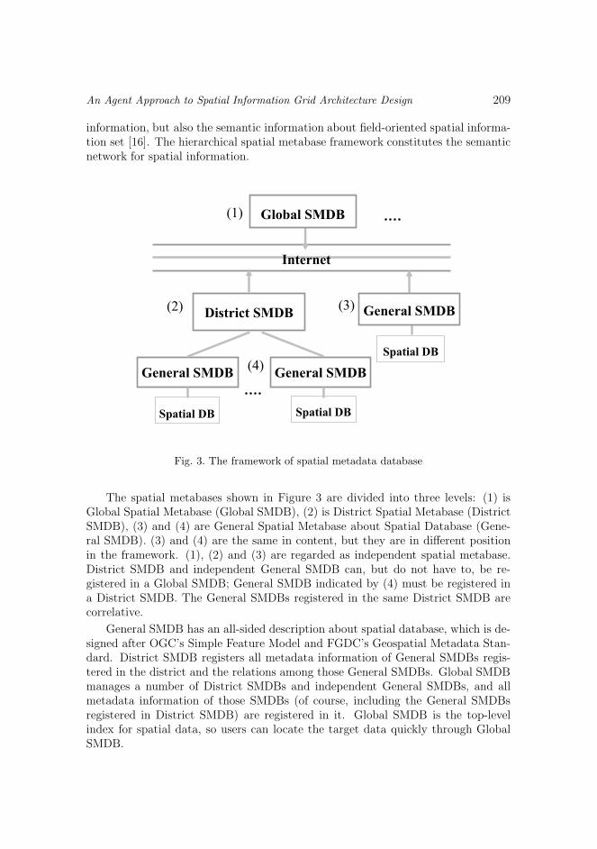
3.2 Agent-Based Spatial Data Navigation Mechanism
According to the spatial data requirement specification, and with the help of spatialmetadata framework, we design five types of GIS function agents to cooperate tocomplete spatial data navigation using Geo-Agents: data accessing agent (DAA),location searching agent (LSA), DA controlling agent, LS controlling agent and datamapping agent. Figure 4 illustrates the relation of those five types of agents.
Entrance of
Spatial Metadata
Descriptions of Data Requirement
Data Accessing Location Searching
DA Controlling
LS ControllingData Mapping
Spatial
Databases
Spatial Metabases
Fig. 4. The relations among data searching agents
The data accessing and the location searching agents receive a requirement, andinterpret it to a comparable requirement task that can be recognized by computer.The data accessing agent hands the requirement task to DA controlling agent andthen waits for the content of the target spatial data. The location searching agenthands the requirement task to the LS controlling agent and the result is the map-layer members and their locations of the target spatial data.
First, the DA controlling agent hands the requirement task to the LS controllingagent to obtain the map-layer members and their locations of the target spatial data;then it hands the result from the LS controlling agent and the requirement task tothe data mapping agent. The data mapping agent interacts with spatial databaseand obtains the content of the target spatial data according to the map-layer mem-bers and their locations of the target spatial data and other related information.Because the target spatial data may be distributed in different spatial databases,the DA controlling agent can classify the map-layer members by spatial databaseaccording to their locations, divide the requirement task into some data accessing
An Agent Approach to Spatial Information Grid Architecture Design 211
subtasks by the classification, and then hand those data accessing subtasks to dif-ferent data mapping agents to obtain the content of the target spatial data fromdifferent spatial databases. Different data mapping agents can become parallel toincrease the efficiency of data accessing.
When the LS controlling agent receives the requirement task, it can connect toseveral spatial metadata databases according to the entrance of SMDBs, look forand match the map-layer members and their locations of the target spatial data indifferent spatial metadata databases concurrently.
Every GIS task requires spatial data, even different types of spatial data. Thus,spatial data searching is taking place continually in a distributed GIS. Different GIStasks might have the same requirement of spatial data. It is unnecessary to repeatspatial data searching for the same requirement. The result of spatial data searchingshould be reused.
The descriptive specification for spatial data requirement makes it possible toreuse the result of spatial data searching. In the five types of agents, DA control-ling agent and LS controlling agent are worth reusing and can be reused. Firstly,they are transparent to users or applications. Secondly, they control the whole pro-cess of spatial data searching, and their results just meet the requirement of usersor applications. Lastly, the requirement task that drives them is comparable andrecognizable.
4 COLLABORATION AND PARALLEL
4.1 Collaboration
In human society, there are some relations among individuals, which make individualcollection become human society, and make individuals become socialization people.Just like human society, multi-agent system must let its agents cooperate with eachother to become an integrated system, so as to complete more complicated tasks.
The goal of Geo-Agents is to construct a multi-agent system like human society,so collaboration mechanism is necessary. There are two collaboration modes in Geo-Agents: collaboration among interface agents and collaboration under control of aninterface agent.
4.1.1 Collaboration among Interface Agents
Collaboration among interface agents is coordinated by AgentServer. AgentServermanages a table to register different cooperation groups in one Agent Region. Thereare three types of collaboration among interface agents: direct cooperation, peergroup cooperation and charge-tributary group cooperation.
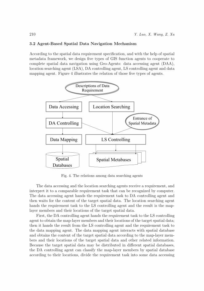
Direct cooperation: during the execution of an interface agent, it needs someresults of other interface agents (see Figure 5).
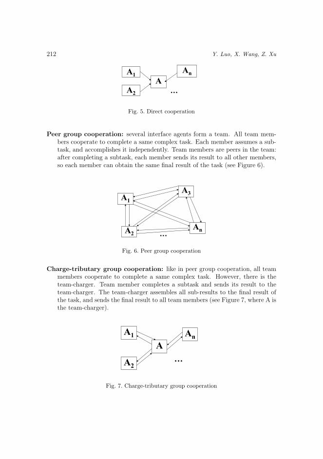
212 Y. Luo, X. Wang, Z. Xu
A
A1
A2
An
…
Fig. 5. Direct cooperation
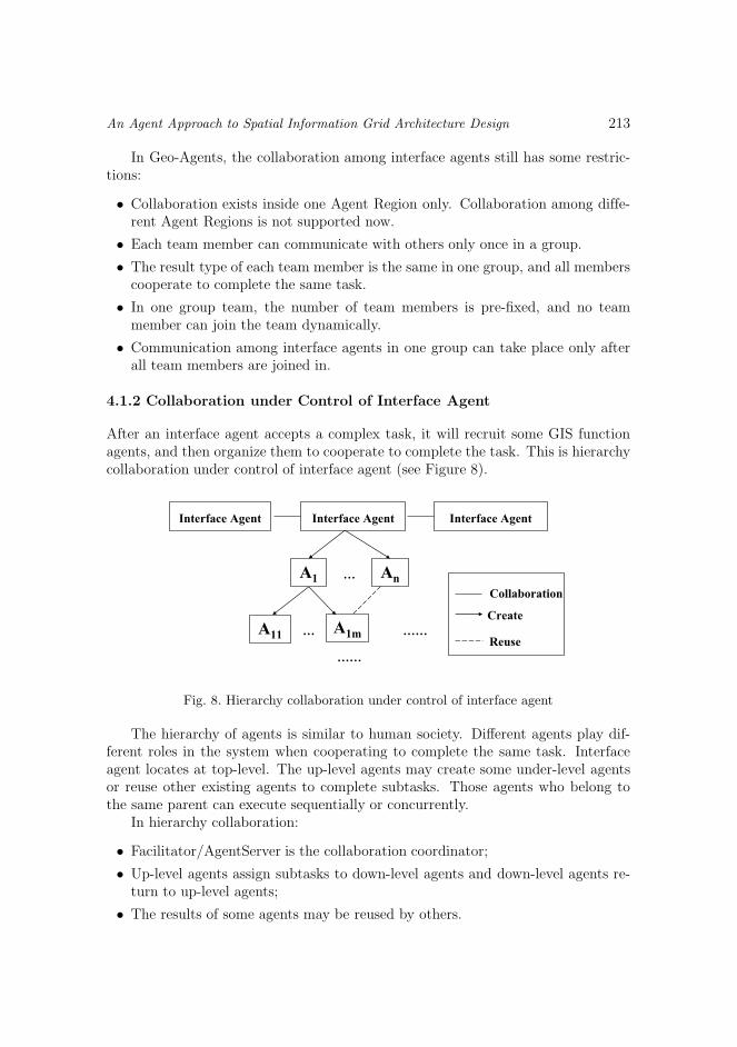
Peer group cooperation: several interface agents form a team. All team mem-bers cooperate to complete a same complex task. Each member assumes a sub-task, and accomplishes it independently. Team members are peers in the team:after completing a subtask, each member sends its result to all other members,so each member can obtain the same final result of the task (see Figure 6).
A1
A2
An
A3
…
Fig. 6. Peer group cooperation
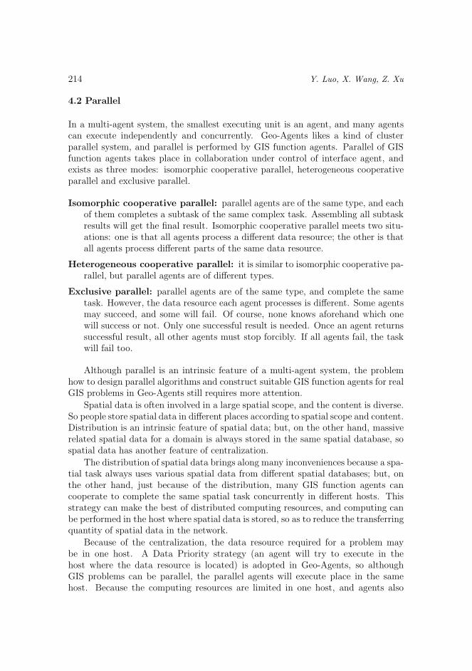
Charge-tributary group cooperation: like in peer group cooperation, all teammembers cooperate to complete a same complex task. However, there is theteam-charger. Team member completes a subtask and sends its result to theteam-charger. The team-charger assembles all sub-results to the final result ofthe task, and sends the final result to all team members (see Figure 7, where A isthe team-charger).
A
A1
A2
An
…
Fig. 7. Charge-tributary group cooperation
An Agent Approach to Spatial Information Grid Architecture Design 213
In Geo-Agents, the collaboration among interface agents still has some restric-tions:
• Collaboration exists inside one Agent Region only. Collaboration among diffe-rent Agent Regions is not supported now.
• Each team member can communicate with others only once in a group.
• The result type of each team member is the same in one group, and all memberscooperate to complete the same task.
• In one group team, the number of team members is pre-fixed, and no teammember can join the team dynamically.
• Communication among interface agents in one group can take place only afterall team members are joined in.
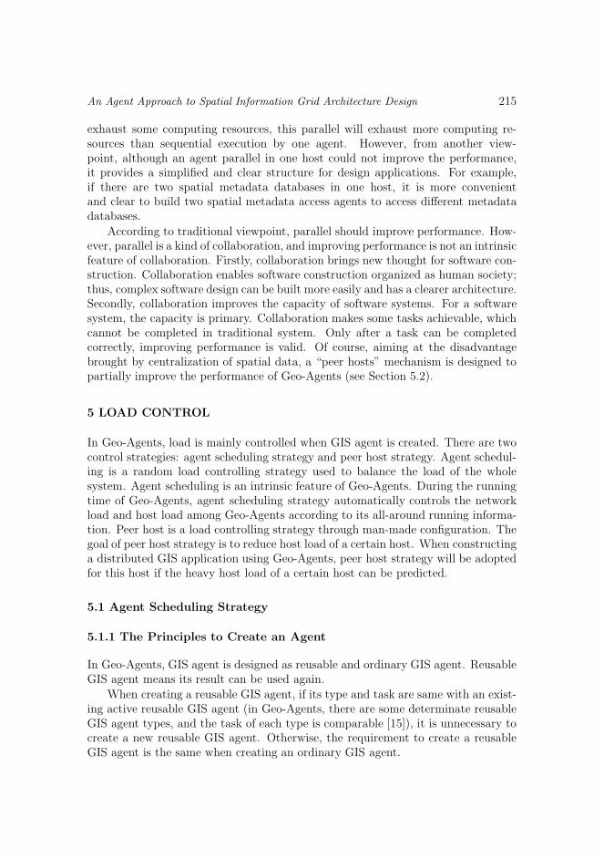
4.1.2 Collaboration under Control of Interface Agent
After an interface agent accepts a complex task, it will recruit some GIS functionagents, and then organize them to cooperate to complete the task. This is hierarchycollaboration under control of interface agent (see Figure 8).
Interface Agent Interface AgentInterface Agent
A1 … An
A11 … A1m ……
……
Create
Reuse
Collaboration
Fig. 8. Hierarchy collaboration under control of interface agent
The hierarchy of agents is similar to human society. Different agents play dif-ferent roles in the system when cooperating to complete the same task. Interfaceagent locates at top-level. The up-level agents may create some under-level agentsor reuse other existing agents to complete subtasks. Those agents who belong tothe same parent can execute sequentially or concurrently.
In hierarchy collaboration:
• Facilitator/AgentServer is the collaboration coordinator;
• Up-level agents assign subtasks to down-level agents and down-level agents re-turn to up-level agents;
• The results of some agents may be reused by others.
214 Y. Luo, X. Wang, Z. Xu
4.2 Parallel
In a multi-agent system, the smallest executing unit is an agent, and many agentscan execute independently and concurrently. Geo-Agents likes a kind of clusterparallel system, and parallel is performed by GIS function agents. Parallel of GISfunction agents takes place in collaboration under control of interface agent, andexists as three modes: isomorphic cooperative parallel, heterogeneous cooperativeparallel and exclusive parallel.
Isomorphic cooperative parallel: parallel agents are of the same type, and eachof them completes a subtask of the same complex task. Assembling all subtaskresults will get the final result. Isomorphic cooperative parallel meets two situ-ations: one is that all agents process a different data resource; the other is thatall agents process different parts of the same data resource.
Heterogeneous cooperative parallel: it is similar to isomorphic cooperative pa-rallel, but parallel agents are of different types.
Exclusive parallel: parallel agents are of the same type, and complete the sametask. However, the data resource each agent processes is different. Some agentsmay succeed, and some will fail. Of course, none knows aforehand which onewill success or not. Only one successful result is needed. Once an agent returnssuccessful result, all other agents must stop forcibly. If all agents fail, the taskwill fail too.
Although parallel is an intrinsic feature of a multi-agent system, the problemhow to design parallel algorithms and construct suitable GIS function agents for realGIS problems in Geo-Agents still requires more attention.
Spatial data is often involved in a large spatial scope, and the content is diverse.So people store spatial data in different places according to spatial scope and content.Distribution is an intrinsic feature of spatial data; but, on the other hand, massiverelated spatial data for a domain is always stored in the same spatial database, sospatial data has another feature of centralization.
The distribution of spatial data brings along many inconveniences because a spa-tial task always uses various spatial data from different spatial databases; but, onthe other hand, just because of the distribution, many GIS function agents cancooperate to complete the same spatial task concurrently in different hosts. Thisstrategy can make the best of distributed computing resources, and computing canbe performed in the host where spatial data is stored, so as to reduce the transferringquantity of spatial data in the network.
Because of the centralization, the data resource required for a problem maybe in one host. A Data Priority strategy (an agent will try to execute in thehost where the data resource is located) is adopted in Geo-Agents, so althoughGIS problems can be parallel, the parallel agents will execute place in the samehost. Because the computing resources are limited in one host, and agents also
An Agent Approach to Spatial Information Grid Architecture Design 215
exhaust some computing resources, this parallel will exhaust more computing re-sources than sequential execution by one agent. However, from another view-point, although an agent parallel in one host could not improve the performance,it provides a simplified and clear structure for design applications. For example,if there are two spatial metadata databases in one host, it is more convenientand clear to build two spatial metadata access agents to access different metadatadatabases.
According to traditional viewpoint, parallel should improve performance. How-ever, parallel is a kind of collaboration, and improving performance is not an intrinsicfeature of collaboration. Firstly, collaboration brings new thought for software con-struction. Collaboration enables software construction organized as human society;thus, complex software design can be built more easily and has a clearer architecture.Secondly, collaboration improves the capacity of software systems. For a softwaresystem, the capacity is primary. Collaboration makes some tasks achievable, whichcannot be completed in traditional system. Only after a task can be completedcorrectly, improving performance is valid. Of course, aiming at the disadvantagebrought by centralization of spatial data, a “peer hosts” mechanism is designed topartially improve the performance of Geo-Agents (see Section 5.2).
5 LOAD CONTROL
In Geo-Agents, load is mainly controlled when GIS agent is created. There are twocontrol strategies: agent scheduling strategy and peer host strategy. Agent schedul-ing is a random load controlling strategy used to balance the load of the wholesystem. Agent scheduling is an intrinsic feature of Geo-Agents. During the runningtime of Geo-Agents, agent scheduling strategy automatically controls the networkload and host load among Geo-Agents according to its all-around running informa-tion. Peer host is a load controlling strategy through man-made configuration. Thegoal of peer host strategy is to reduce host load of a certain host. When constructinga distributed GIS application using Geo-Agents, peer host strategy will be adoptedfor this host if the heavy host load of a certain host can be predicted.
5.1 Agent Scheduling Strategy
5.1.1 The Principles to Create an Agent
In Geo-Agents, GIS agent is designed as reusable and ordinary GIS agent. ReusableGIS agent means its result can be used again.
When creating a reusable GIS agent, if its type and task are same with an exist-ing active reusable GIS agent (in Geo-Agents, there are some determinate reusableGIS agent types, and the task of each type is comparable [15]), it is unnecessary tocreate a new reusable GIS agent. Otherwise, the requirement to create a reusableGIS agent is the same when creating an ordinary GIS agent.
216 Y. Luo, X. Wang, Z. Xu
When creating an ordinary GIS agent, there are some different requirementsbecause of considering the network load:
1. A GIS agent must be created in an appointed host.
2. A GIS agent must be created in local host by the Facilitator.
3. A GIS agent will be created in appropriate host (for example, the host wherespatial data is stored).
4. A GIS agent can be created in any host.
In the first two cases, the host load they bring is inevitable, and there is noproper method to reduce or balance relative host load. But in the last two cases, itis necessary to control the creation of agent because of the randomicity, otherwise,there will have too many agents in one host.
During the creation of GIS agent, the network speed must be considered. InGeo-Agents, some assumptions are given: accessing an agent in the same AgentRegion is faster than in an other Agent Region; accessing a data resource in thesame Agent Region is faster than in another Agent Region; the priority of accessinga data resource is higher than accessing an agent. For example, supposing there aretwo Agent Regions, the data resource is in Agent Region1, and the user in AgentRegion2 wants to create an agent to process the data resource in Agent Region1.At this situation, the agent should be created in Agent Region1.
According to the above requirements, the following principles must be obeyedwhen creating an agent:
1. If possible, an agent should be created in the host where data resource it pro-cesses is located.
2. If an agent needs to process several data resources, the agent should be createdin one of the hosts where data resources are located, if possible.
3. If an agent couldn’t be created in the host where data resource locates, it shouldbe created in one of the Agent Regions where data resources locate if possible.
4. If possible, an agent should be created in the same Agent Region with its re-questor.
5. In an Agent Region, an agent should be created in the host where its load islight.
5.1.2 Agent Scheduling Algorithm
Scheduling agents when creating agents is a powerful means to control host load andnetwork load. The goals of scheduling agents are:
1. making the most of CPU of all hosts; in other words, eliminating the situationthat some hosts are too busy and other are idle at the same time;
2. reducing the average response time of all tasks, and the network transmissionas much as possible.
An Agent Approach to Spatial Information Grid Architecture Design 217
When designing an agent scheduling algorithm, three problems must be consi-dered firstly [17]:
Determinate or heuristic algorithm: determinate algorithm is adopted onlywhen the actions (such as computing requirements, data requirements, com-munication requirements and so on) of all agents are foreseeable; if the load ofa system is unpredictable, a heuristic algorithm is needed. Heuristic algorithmmeans that the host allocation is instructed by rules from experience and byheuristic information during the working progress.
Distributed or centralized algorithm: centralized algorithm must gather allglobal information to give a decision, but distributed algorithm can give a deci-sion by partial information only. Gathering all global information in centralizedalgorithm is rather demanding for the decision-making host, and would becomethe bottleneck of a system.
Optimized or hypo-optimized algorithm: centralized algorithm can obtain op-timized result, but the cost is higher than with hypo-optimized result, becausemore information and complete processing are needed.
According to the agent creating principles and to the agent scheduling goals,a heuristic, distributed and hypo-optimized agent scheduling algorithm is developed:
In Geo-Agents, agent scheduling is completed by the AgentServer. Whencreating an agent, a request is sent to AgentServer to ask it find an appropriateagent type. So, the AgentServer maintains a host table where the numberof created agents in each host is recorded. If an appropriate agent type canbe found in one host only, the agent should be created in that host, andthe number of created agents in that host increments by 1; if an appropriateagent type can be found in several hosts, after considering the agent creatingprinciples the AgentServer will select the host where the number of createdagents is minimum to create the agent, and the number of created agents inthat host increments by 1.
This scheduling algorithm is referred to as heuristic, distributed and hypo-optimized algorithm because:
1. it is not able to predict how many agents will be created in the system and howmany agents are executing at the same time;
2. the scheduling criterion is the number of created agents, not the number ofexecuting agents in one host; and
3. the scheduling criterion is obtained at the volley and it does not bring additionalburden for the AgentServer.
5.2 Peer Host Strategy
When it is foreseeable that the host load in one host is too heavy, the peer hoststrategy is adopted to reduce the host load: connecting the host with other hosts
218 Y. Luo, X. Wang, Z. Xu
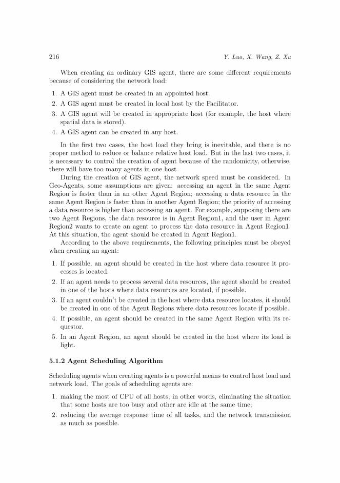
via high speed LAN, which have the same software and hardware configuration andcan complete the same tasks as the host. The host is referred to as peer main host,and the other hosts as peer secondary hosts. All main and secondary hosts forma peer host group (see Figure 9).
High Speed
LAN
Peer Main Host
Peer Secondary Host 1
……
InternetPeer Secondary Host 2
Peer Secondary Host N
Fig. 9. Peer host group
When creating an agent in the main host, if the host load of the main host istoo heavy, the agent can be created in any of the secondary hosts. Of course, inorder to balance the host load of all peer hosts, the host where the host load is thelightest is selected.
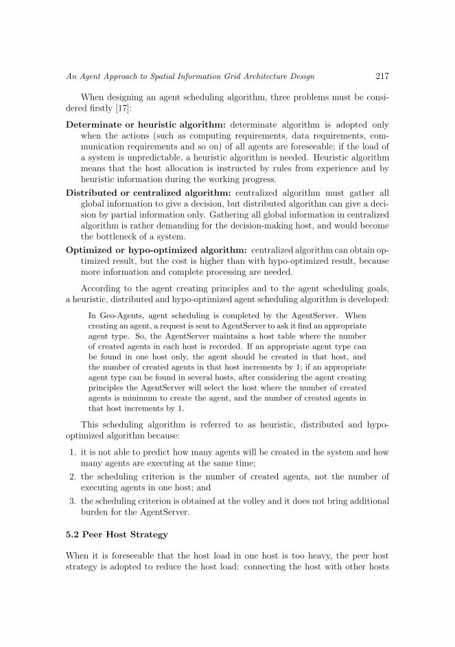
In Geo-Agents, the host requesting of a peer host is that one where the GuServeris located. The GuServer maintains one or more spatial databases and spatial meta-data databases, and is responsible for managing and accessing spatial data andspatial metadata. Spatial information is centralized in the host where the GuServeris located. According to the agent scheduling strategy, all agents which need theGuServer to manage and access spatial information will be created in the host wherethe GuServer is located. Thus, the host load of the host where the GuServer is lo-cated will be too heavy, and the performance of the system will be very low. Ofcourse, enhancing the software and hardware configuration of the host where theGuServer is located can improve performance of the system, but cannot reducethe host load of that host. Peer host will play an important role here (see Figu-re 10).
……
Peer Secondary GuServer 1
High Speed
LANGuServer ……
Peer Secondary GuServer 2
Peer Secondary GuServer N
Internet
Spatial Database
Spatial Metadata Database
Spatial Database
Spatial Metadata Database
Fig. 10. The peer host group of the GuServer
An Agent Approach to Spatial Information Grid Architecture Design 219
Here, the host with installed GuServer is the main host, and the hosts withinstalled peer secondary GuServer are the secondary hosts. All GuServers manageand access the same spatial databases and spatial metadata databases. When cre-ating agents which will use spatial information managed by the GuServer, they canbe created in average in the peer host group of the GuServer.
6 A SAMPLE – OVERLAY ANALYSIS
Overlay analysis overlaps two or more layers into one layer following a particularrule. In traditional way, it is a time-consuming and heavy load task, because theoperation needs to transmit all layers to local machine, and then overlap the layersone by one.
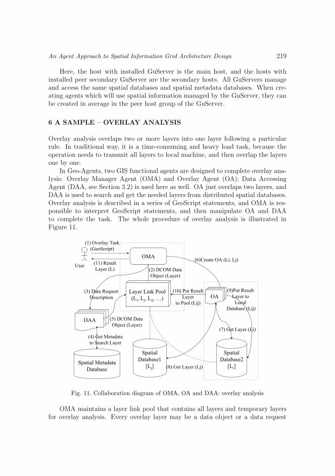
In Geo-Agents, two GIS functional agents are designed to complete overlay ana-lysis: Overlay Manager Agent (OMA) and Overlay Agent (OA); Data AccessingAgent (DAA, see Section 3.2) is used here as well. OA just overlaps two layers, andDAA is used to search and get the needed layers from distributed spatial databases.Overlay analysis is described in a series of GeoScript statements, and OMA is res-ponsible to interpret GeoScript statements, and then manipulate OA and DAAto complete the task. The whole procedure of overlay analysis is illustrated inFigure 11.
DAA
OMA
User
Spatial Metadata
Database
Layer Link Pool
(Li, Lj, Lij, …)
(1) Overlay Task
(GeoScript)
(6)Create OA (Li, Lj)
(7) Get Layer (Li)
(9)Put Result
Layer to
Local
Database (Lij)
(10) Put Result
Layer
to Pool (Lij)
(3) Data Request
Description
(4) Get Metadata
to Search Layer
(5) DCOM Data
Object (Layer)
(2) DCOM Data
Object (Layer)
(11) Result
Layer (L)
Spatial
Database1
[Lj]
Spatial
Database2
[Li](8) Get Layer (Lj)
OA
Fig. 11. Collaboration diagram of OMA, OA and DAA: overlay analysis
OMA maintains a layer link pool that contains all layers and temporary layersfor overlay analysis. Every overlay layer may be a data object or a data request
220 Y. Luo, X. Wang, Z. Xu
description. For a data object, it can be put into the layer link pool directly. Fora data request description, OMA will create a DAA to search the request data, getthe data object of the requested data and then put it into the layer link pool. OMAselects two overlay layers and creates an OA to overlap the two layers. The resultlayer (a temporary layer) of OA will be put into the layer link pool too. When onlyone layer is left in the layer link pool, and no active OA exists, the only layer left inthe layer link pool is the final result of the overlay analysis.
Using an agent to complete overlay analysis can improve its performance con-siderably:
1. several DAAs can be created to search different layers concurrently (this is iso-morphic cooperative parallel);
2. several OAs can be created to overlap different layers concurrently (this is iso-morphic cooperative parallel too);
3. OA can run on the local site where the overlay layer is located; this will reducethe translation of layer in the network; and
4. DAA and OA can be parallel, it is unnecessary to wait for all overlay layers tobe available (This is heterogeneous cooperative parallel).
7 CONCLUSIONS
Agent technology is used to construct a SIG framework, which contains three layers:Users/applications layer, agent services layer and information layer. Different appli-cations can get their spatial information via agent services, and agent services makethe procedure of navigating and accessing spatial information transparent to users.
By describing, organizing, managing, processing, exchanging, indexing and de-ploying data, information and knowledge in spatial information resources, and withthe help of communication and network infrastructures, SIG joins different dis-tributed spatial data capture and output systems, spatial data sets, large spatialdata storage systems, GIS platforms and spatial application servers, organizes themas a virtual organization, and, furthermore, forms a infrastructure for spatial infor-mation in the Internet.
The construction of SIG will give a powerful technology support for users toshare, access, analyze and process spatial information, and will provide a powerfulmanagement infrastructure for spatial applications, so as to guarantee that spa-tial information coming from any resources can be sent in a suitable way to anyauthorized users anywhere and anytime.
Acknowledgement
This work is supported by the National Research Foundation for the Doctoral Pro-gram of Higher Education of China under Grant No. 20020001015; the National
An Agent Approach to Spatial Information Grid Architecture Design 221
Science Foundation of China under Grant No. 60203002; the National Grand Fun-damental Research 973 Program of China under Grant No. 2002CB312000; the Na-tional High Technology Development 863 Program under Grant No. 2002AA135330and No. 2002AA134030; the Beijing Science Foundation under Grant No. 4012007;the Doctoral Foundation of Xinjiang Bingtuan.
REFERENCES
[1] Aijun, Ch. et al.: Geospatial Information Layer Sharing Model For Digital Earth(in Chinese). Journal of Software, Vol. 13, 2002, No. 8, pp. 1436–1440.
[2] Open GIS Consortium. Availaible on: http://www.opengeospatial.org/.
[3] ISO TC211. Availaible on: http://www.isotc211.org/.
[4] Foster, I.—Kesselman, C.—Tuecke, S.: The Anatomy Of The Grid: EnablingScalable Virtual Organizations. International Journal of High Performance Comput-ing Applications, Vol. 15, 2001, No. 3, pp. 200–222.
[5] Foster, I.—Kesselman, C.: Globus: A Metacomputing Infrastructure Toolkit.
International Journal of Supercomputing Applications, Vol. 11, 1997, No. 2,pp. 115–128.
[6] Foster, I.—Kesselman, C.—Nick, J.M.—Tuecke, S.: The Physiology OfGird: An Open Grid Service Architecture For Distributed System Integration. Avail-
able on: http://www.globus.org/ogsa/, 2002.
[7] The Earth System Grid. Availaible on: http://www.earthsystemgrid.org/.
[8] The Earth Observation System. Availaible on: http://eospso.gsfc.nasa.gov/.
[9] Xiao, N.—Fu, W.: SDPG: Spatial Data Processing Grid. Journal of ComputerScience and Technology, Vol. 18, 2003, No. 4, pp. 523–531.
[10] Nwana, H. S.: Software Agent: An Overview. Knowledge Engineering Review,Vol. 11, 1996, No. 3, pp. 205–244.
[11] Wooldridge, M.—Jennings, N.R. —Kinny, D.: Methodology For Agent-Oriented Analysis And Design. Proceedings Of The 3rd International Conference onAutonomous Agents, Seattle, WA, USA, 1999, pp. 69–76.
[12] Tang, C.—Xu, L.—Feng, S.: An Agent-Based Geographical Information System.Knowledge Based Systems, Vol. 14, 2001, No. 5–6, pp. 233–242.
[13] Tsou, M.-H.—Barbara, P.—Buttenfield: An Agent-Based CommunicationMechanism For Distributing Geographic Information Services On The Internet.GIScience 2000: First International Conference on Geographic Information Science,October 28–31, Savannah, Georgia.
[14] Yingwei, L. et al.: The Model Of Distributed GIS-Oriented Multi-Agent System(in Chinese). Acta Scientiarum Naturalium Universitatis Pekinensis, Vol. 38, 2002,No. 3, pp. 375–383.
[15] Yingwei, L.: The Study On Agent-Based Distributed GIS (in Chinese). [Ph.D.Dissertation], Peking University, Beijing, 1999.
222 Y. Luo, X. Wang, Z. Xu
[16] West, L.—Hess, T.: Metadata as a Knowledge Management Tool: Supporting
Intelligent Agent and End User Access to Spatial Data. Decision Support Systems,Vol. 32, 2002, No. 3, pp. 247–264.
[17] Lin, Hwa—Chu—Raghavendra, C. S.: A Dynamic Load Balancing Policy With
A Central Job Dispatch. IEEE Trans. on Software Engineering, Vol. 18, 1992, No. 2,pp. 148–157.
Yingwei Luo is now an Associate Professor in the Departmentof Computer Science and Technology, Peking University. His re-search interests include geographic information system, softwareagent and mobile computing.
Xiaolin Wang is now an Associate Professor at the Depart-ment of Computer Science and Technology, Peking University.His research interests include geographic information system andvirtual server.
Zhuoqun Xu is now a Full Professor at the Department ofComputer Science and Technology, Peking University, His re-search interests include geographic information system, artificialintelligence and parallel computing.
Copyright © 2022 FDOKUMEN