Amendments Incorporated in the Draft Kwun Tong (South ...
93
Task Force on Kai Tak Harbourfront Development For circulation in April 2021 TFKT/C06/2021 Amendments Incorporated in the Draft Kwun Tong (South) Outline Zoning Plan No. S/K14S/23 PURPOSE This paper aims to seek Members’ views on the amendments incorporated in the draft Kwun Tong (South) Outline Zoning Plan (OZP) No. S/K14S/23. BACKGROUND 2. The Energizing Kowloon East Office (EKEO), Development Bureau (DEVB) commissioned the Planning and Engineering Study on the Kwun Tong Action Area (KTAA) – Feasibility Study (the Study) in 2016. To better utilize the waterfront site at Kwun Tong, the Study proposed to re-organize, rationalize or relocate the existing uses in KTAA 1 for proposed commercial/office development 2 with government, institution/community uses and public open spaces, and various pedestrian connections for enhancing the accessibility and vibrancy of the waterfront. On 15 May 2019, EKEO consulted the Task Force on the Recommended Outline Development Plan (RODP) (Plan 1) for the KTAA. Relevant consultation material and meeting minutes are at Annex I. 3. In response of the comments received from Task Force and other consultation committees, and in consultation with relevant bureaux/departments, the RODP has incorporated the following refinements: (a) Taking account of the Task Force’s suggestion to allow greater flexibility in respect of the design control on the elevated green deck level of the commercial development while giving due consideration to the air quality implications of Kwun Tong Bypass as well as to enhance vista towards Victoria Harbour and the cityscape, the 1 See Annex II for the affected facilities and the reprovisioning proposals recommended under the Study. 2 Major development requirements for the proposed commercial/office development are at Annex III.
-
Upload
khangminh22 -
Category
Documents
-
view
1 -
download
0
Transcript of Amendments Incorporated in the Draft Kwun Tong (South ...

Task Force on Kai Tak Harbourfront Development
For circulation in April 2021
TFKT/C06/2021
Amendments Incorporated in the Draft Kwun Tong (South) Outline Zoning Plan
No. S/K14S/23
PURPOSE
This paper aims to seek Members’ views on the amendments
incorporated in the draft Kwun Tong (South) Outline Zoning Plan
(OZP) No. S/K14S/23.
BACKGROUND
2. The Energizing Kowloon East Office (EKEO), Development Bureau (DEVB) commissioned the Planning and Engineering Study on the Kwun Tong Action Area (KTAA) – Feasibility Study (the Study) in 2016. To better utilize the waterfront site at Kwun Tong, the Study proposed to re-organize, rationalize or relocate the existing uses in KTAA 1 for proposed commercial/office development 2 with
government, institution/community uses and public open spaces, and various pedestrian connections for enhancing the accessibility and vibrancy of the waterfront. On 15 May 2019, EKEO consulted the Task Force on the Recommended Outline Development Plan (RODP) (Plan 1) for the KTAA. Relevant consultation material and meeting minutes are at Annex I.
3. In response of the comments received from Task Force and other consultation committees, and in consultation with relevant bureaux/departments, the RODP has incorporated the following refinements:
(a) Taking account of the Task Force’s suggestion to allow
greater flexibility in respect of the design control on the elevated green deck level of the commercial development while giving due consideration to the air quality implications of Kwun Tong Bypass as well as to enhance vista towards Victoria Harbour and the cityscape, the
1 See Annex II for the affected facilities and the reprovisioning proposals recommended
under the Study. 2 Major development requirements for the proposed commercial/office development are at
Annex III.

Task Force on Kai Tak Harbourfront Development
TFKT/06/2021
Page 2
control on the elevated green deck is proposed to be revised from “not higher than +12.5mPD” to “not higher than +14.5mPD”. The revised height could allow greater design flexibility such as allowing sufficient headroom for the Public Transport Interchange (PTI), locating more retail space on lower floors including the ground floor, and
providing sufficient soil depth for the elevated green deck. Additional retail space with vista towards the harbour and the cityscape are added to the ground and elevated deck levels of the development site to enhance vibrancy of the
waterfront area. A minimum length of 100 m retail frontage at such locations is proposed as an advisory
guideline, while the overall length of the retail frontage could be more depending on the design adopted by the future developer. Provision of F&B elements at part of the Regional Open Space with harbour view have also been considered. An Urban Design Control Plan incorporating the above advisory guidelines is proposed to be enclosed in
the land sale document for reference by the future developer.
(b) The vertical connection facilities between the waterfront
area and the proposed landscaped deck under the notional scheme have been revised to widen the staircase and
include escalators. A feasible notional scheme has been worked out based on the proposed maximum height for the elevated deck, and the concern on vertical connectivity could be addressed by adopting a combination of terraced platforms with barrier-free facilities and other vertical connections including staircases and escalators to
promote design variations while facilitating movements. Relevant requirements would be stipulated in the lease conditions and overseen by a panel to be set up and involving the relevant departments.
(c) In response to the Task Force’s suggestion to streamline the alignment of the proposed footbridge connecting
Manulife Financial Centre and the podium of the development site, an additional alternative routing from the footbridge into the indoor space of the commercial development is incorporated in the RODP.
4. With regard to the Task Force’s suggestion on making use of

Task Force on Kai Tak Harbourfront Development
TFKT/06/2021
Page 3
the rooftop of the Kwun Tong Passenger Ferry Pier to allow various uses, the concerned rooftop is currently inaccessible and the structure is not designed for public access. Utilization of the rooftop is not recommended from the structural and safety points of view.
5. To take forward the RODP of the Study, rezoning of relevant portions of KTAA within the Kwun Tong (South) Planning Scheme
Area is required. 6. On 26 February 2021, the Planning Department (PlanD) submitted the proposed OZP amendments together with the views of
the Task Force and Kwun Tong District Council (DC)3 to the Metro Planning Committee (MPC) of the Town Planning Board (TPB). The MPC Paper including relevant technical assessments conducted
under the Study are available at TPB’s website at https://www.info.gov.hk/tpb/en/papers/MPC/666-mpc_2-21.pdf. After consideration, the MPC agreed that the proposed amendments to the approved Kwun Tong (South) OZP can be published for public inspection in accordance with the Town Planning Ordinance (the Ordinance).
AMENDMENTS INCORPORATED IN THE DRAFT OZP
7. On 19 March 2021, the draft Kwun Tong (South) OZP No. S/K14S/23 incorporating the amendments (Annex IV), the gazette notice and schedule of amendments (Annex V), and the Notes and Explanatory Statement (Annex VI) were published for public
inspection for a two-month period until 20 May 2021 in accordance with section 5 of the Ordinance. Details of the amendments are summarized in the following paragraphs.
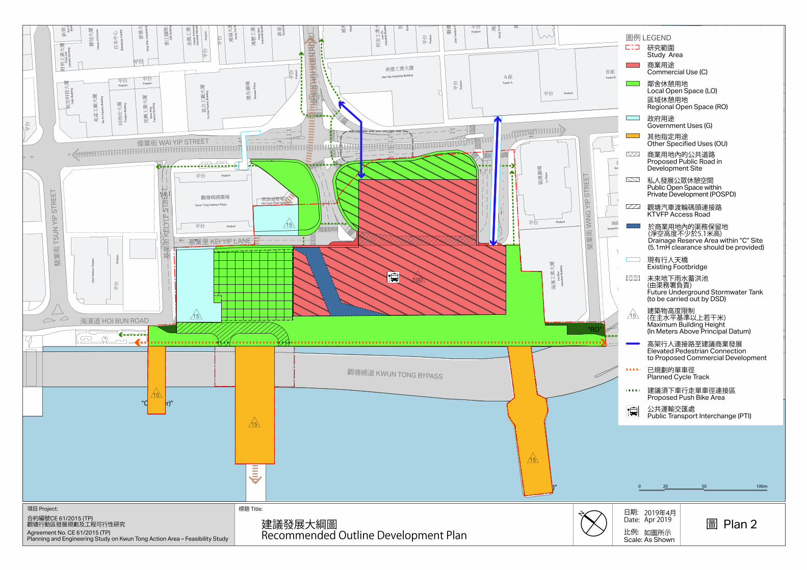
Amendment Item A – Proposed Commercial/Office Development (total area of 1.37ha) (Plans 2 to 4)
8. A piece of land (currently occupied by the Kwun Tong Ferry Pier PTI and adjoining roads, and portion of Kwun Tong Ferry Pier Square cum Pet Garden) is rezoned from “Open Space” (“O”) and “Government, Institution or Community (1)” (“G/IC(1)”) and shown as ‘Road’ to “Commercial (2)” (“C(2)”) (Item A) with stipulation of a
3 EKEO consulted the Kwun Tung District Council on the RODP on 24 September 2019.

Task Force on Kai Tak Harbourfront Development
TFKT/06/2021
Page 4
maximum GFA of about 86,650m2 4, and maximum building heights (BHs) of 100 metres above Principal Datum (mPD) for the main portion and 15mPD 5 for the western portion of the “C(2)” zone.
Amendment Items B1, B2 and B3 – Public Open Space Proposals (total
area of 0.7ha) (Plans 2 to 4)
9. To facilitate the implementation of public open space proposals recommended in the RODP (Plan 1), parcels of land (including stripe
of land at waterfront to the southwest of the PTI, the Cooked Food Market site and areas to the southwest of the junction at Hoi Yuen
Road and Wai Yip Street) are rezoned from “G/IC(1)” and shown as ‘Road’ to “O” (Item B1) and “O(1)” (Item B2) 6. Another waterfront area covering the eastern portion of ex-Kwun Tong Driving School site is rezoned from “G/IC(1)” to “Other Specified Uses” annotated “Drainage Facility and At-grade Public Open Space” zone to reflect
the integrated design of an underground storm water storage tank with ancillary aboveground structures and public open space atop (Item B3).
Amendment Item C – Road Improvement Works (total area of 0.19ha)
(Plans 2 to 4)
10. Two stripes of land and the existing Kei Yip Lane are rezoned
from “G/IC(1)” to areas shown as ‘Road’ to facilitate implementation of the road works recommended under the Study and/or to reflect the as-built road status (Item C). AMENDMENTS OF NOTES AND EXPLANATORY STATEMENT
(Annex VI)
11. For the purpose of the above amendment items, the Notes of the OZP have been amended accordingly. Opportunity is taken to
incorporate other technical amendments into the Notes as well. The
4 Floor space of about 2,700m2 for provision of social welfare facilities, as required by the Social Welfare Department, would be excluded from the calculation of the maximum GFA. 5 The delineation of the BHR of 15mPD generally aligns with Hoi Yuen Road which would
facilitate wind penetration from the waterfront to the major wind corridor in the district along
Hoi Yuen Road. 6 ‘Public Utility Installation’ as a Column 1 use for the “O(1)” zone to allow reprovisioning of an
existing affected gas governor kiosk as recommended under the Study, and its design should have due regard to the planning intention of the public open space.

Task Force on Kai Tak Harbourfront Development
TFKT/06/2021
Page 5
Explanatory Statement of the OZP has also been updated to reflect the latest condition and planning circumstances of the planning scheme area.
HARBOUR PLANNING PRINCIPLES AND GUIDELINES
12. The following Harbour Planning Principles and Guidelines (HPPG) have been taken into account in the formulation of the RODP under the Study -
(a) Preserving Victoria Harbour
To protect and preserve Victoria Harbour for Hong Kong people and visitors as a special public asset, a natural and cultural heritage asset, the KTAA development would not involve any reclamation in the harbour. Proposed landing steps would be recessed from the existing seawall to ensure
no reclamation.
(b) Stakeholder Engagement
EKEO conducted stakeholder engagement on the Preliminary Outline Development Plan (PODP) for KTAA and
waterbody co-use proposals for Kwun Tong Typhoon Shelter under the Study between August and November 2017. Comments of the stakeholders have suitably incorporated in formulation of the RODP. Subsequently, EKEO consulted the Task Force, the Kwun Tong DC, the Land Development Advisory Committee and the Kowloon City DC on the RODP
in April to July 2019.
(c) Sustainable Development and Integrated Planning
Mixed uses are proposed for KTAA, including commercial development, government facilities and an integrated open
space and pedestrian network, giving due account of the site context and possible future infrastructures, to achieve sustainable development.
(d) Vibrant and Accessible Harbour
To promote accessibility to the harbourfront, an integrated

Task Force on Kai Tak Harbourfront Development
TFKT/06/2021
Page 6
open space and pedestrian network is proposed to connect people from the hinterland to the waterfront area as well as to extend the existing Kwun Tong Promenade to the future Tsui Ping River and Cha Kwo Ling waterfront promenade. Various cultural and leisure facilities such as allowance for cycle track connecting to the future cycle track network in
the Kai Tak Development Area are proposed to enhance the vibrancy of the area.
(e) Proactive Harbour Enhancement for Public Enjoyment
A series of open spaces with various functions such as multi-function event spaces, passive landscape gardens and
reprovisioning of the existing pet garden are proposed to interconnect with the continuous waterfront for public enjoyment and enhance the atmosphere of the harbourfront. Water body co-use initiatives are also proposed to further enhance land-water synergy for public enjoyment.
ADVICE SOUGHT
13. The draft Kwun Tong (South) OZP No. S/K14S/23 was
exhibited for public inspection on 19 March 2021 for a 2-month period until 20 May 2021 in accordance with section 5 of the
Ordinance. The OZP showing the amendments is deposited at the Secretariat of TPB, the Planning Enquiry Counters at the North Point Government Offices and the Sha Tin Government Office, Kowloon District Planning Office and Kwun Tong District Office for public inspection during normal office hours. Members of the public can also browse the OZP at TPB’s website (http://
www.info.gov.hk/tpb/). 14. In accordance with section 6(1) of the Ordinance, any person may make representation to the Board in respect of any of the
amendments. The representation should be made in writing to the Secretary, Town Planning Board, 15th Floor, North Point
Government Offices, 333 Java Road, North Point, Hong Kong not later than 20 May 2021. Please refer to Annex V for more details.
PLANNING DEPARTMENT
APRIL 2021

Task Force on Kai Tak Harbourfront Development
TFKT/06/2021
Page 7
ATTACHMENTS
Plan 1 RODP for KTAA
Plan 2 Amendment Items – Site Plan
Plan 3 Amendment Items – Aerial Photo
Plan 4 Amendment Items – Site Photo
Annex I Consultation Document and Minutes of the 34th
Task Force meeting on the RODP on KTAA
(TFKT/06/2019)
Annex II Reprovisioning Proposals of Existing Facilities
Annex III Development and Design Requirements for Proposed Commercial/Office Development at Kwun
Tong Action Area
Annex IV Draft Kwun Tong (South) OZP No. S/K14S/23 (Resized to A3 Size)
Annex V Gazette Notice and Schedule of Amendments of the Draft Kwun Tong (South) Outline Zoning Plan No.
S/K14S/23
Annex VI Notes and Explanatory Statement of the Draft Kwun Tong (South) Outline Zoning Plan No. S/K14S/23


a
a
H
a
a
H
M
M
t
t
M
M
t
t
O
G/IC(1)
OU
OU
OU
O
OU
OU
OU
OU
O
PLANTTREATMENT
SEWAGE
¦Ã¤ô³
OU
PIER
½X
½XPIER
FERRY PIERVEHICULAR
¨T¨®´ç
建生
廣場
富合
工廠
大廈
鴻懋
工業
大廈
新星
大廈
景雲
大廈
香江
國際
大廈
HKI
Building
同得
仕大
廈
茂興
工業
大廈
兆富
工廠
大廈
海裕工業中心
恆勝
中心
明順
大廈
聯運
工業
大廈
RCP
辦事
處
海濱
工業
大廈
有利
中心
防波
堤
HW
M
HW
M
威利
廣場
海堤
Sea
wall
Place
Pio
neer
Factory
Building
Fu
Hop
Industrial
Building
Hung
Mou
Building
Sunciti
Building
Factory
Mo
w
Hing
Building
Tungte
xFactory
Building
Siu Fu
工業
大廈
泰豐
大廈
鵬光
鴻運
工廠
大廈
Buildin
g
Factory
Lucky
Industrial
Building
Intern
ational
國際
工業
大廈
CentreIndustrialSeapower
Square
One
Harb
our
Square
Westley
工業
大廈
利安
78
號鴻
圖道
Centre
Financial
Manulife
金融
中心
宏利
Industrial
Building
Hoi
Bun
基本污水處理廠
渠務署觀塘
渠務署觀塘污水泵房
Pumping Station
Kwun Tong
Drainage Services Dept.
Works
Preliminary Treatment
Kwun Tong
Drainage Services Dept.
渡輪
碼頭
觀塘
汽車
公衆碼
頭觀塘
S/K22/6
泵房
中途
污水
渠務
署觀
塘
工業
大樓
建德
豐
工業
大廈
鴻圖
S/K14S/22
Bre
akw
ater
WIN
G YIP S
TREET
¶}·
Â@·
ºa·
G/IC(1)
°ò·
HU
NG T
O R
OA
D
ÂE¹
°¶·
°Ó
BUSINESS
°Ó
BUSINESS
°Ó
BUSINESS
G/IC(1)
°Ó
BUSINESS
°Ó
BUSINESS
OU
°Ó
BUSINESS
WAI Y
IP S
TREET
°Ó
BUSINESS
PlazaHarbour
Kwun TongÆ[¶í½X
C(1)
OU
O
OU
OU
°Ñ¦Ò
REFERENCE No.
DEPARTMENT
PLANNING
³W¹
¹ PLAN
SITE PLAN¥
¦
METRES0 10050 50
¦
METRES
¤ñ¨SCALE 1 : 2 500
C
G/IC
O
OU
O
Æ[¶í½X
Ferry Pier SquareKwun Tong
TSU
N YIP S
T.
KEI YIP S
T.
渠
Nullah
觀塘避風塘
TYPHOON SHELTER
KWUN TONG
Æ[¶í °
ò·
KEI YIP L
ANE
°ª
¬[
Road
¹D
BY-P
ASS
KW
UN T
ON
G
1
海濱
道休
憩處
VIEWING POINT OF SITE PHOTO
¹ê¦a·Ó¤ù1
HOI Y
UEN R
OAD
®¶¸
U
Lu Plaza
美德
工業
大廈
Buildin
g
Industrial
Mai
Tak
Centre
Everwin
M/K14S/20/49 3
2
11-NE-23A AND 23C
BASED ON SURVEY SHEETS No.
EXTRACT PLAN PREPARED ON 18.2.2021
¦MÀI«~¨®¡@µ¥
Queuing AreaDangerous Goods Vehicles
金凱
工業
大廈
Industrial
Mansio
n
Care
er
&
Kenson
鴻福
工廠
大廈
Factory
Building
Hung Fuk
Square
Two
Harbour
(¢Ï¡B¢Ð¢°¡B¢Ð¢±
½s¸¹¢á/¢Ù¢°¢³¢á/
Æ[¶í¡]«n³¡¡^¤À°
(ITEMS A, B1, B2, B3 AND C)
OUTLINE ZONING PLAN No. S/K14S/22
KWUN TONG (SOUTH)
PROPOSED AMENDMENTS TO THE APPROVED
¹Ï LEGEND
A ¶
ITEM A
B1¶
ITEM B1
¬F©²¡B¾÷
COMMUNITYGOVERNMENT, INSTITUTION OR
¥ð¾Í
OPEN SPACE
OTHER SPECIFIED USES
¨ä¥L«ü
°Ó
COMMERCIAL
¬É½u¥u§
BOUNDARY FOR IDENTIFICATION PURPOSE ONLY
³Ì°ª«Ø¿vª«°ª«×(¦b¥D
(IN METRES ABOVE PRINCIPAL DATUM)MAXIMUM BUILDING HEIGHT
ÀÀij«Ø¿vª«°ª
CONTROL ZONE BOUNDARYPROPOSED BUILDING HEIGHT
«Ø¿vª«°ª«×
BUILDING HEIGHT CONTROL ZONE BOUNDARY
ÀÀij³Ì°ª«Ø¿vª«°ª«×(¦b
(IN METRES ABOVE PRINCIPAL DATUM)PROPOSED MAXIMUM BUILDING HEIGHT
ÀÀij³Ì°ª«Ø¿vª«°
(IN NUMBER OF STOREYS)PROPOSED MAXIMUM BUILDING HEIGHT
C
ITEM C
¶
"G/IC(1)", "O" AND 'ROAD' TO "C(2)"PROPOSED REZONING FROM
§ï¹º¬°¡u°Ó·~¡u¥ð¾Í¥Î¦a¡v¦ÀÀij¥Ñ¡u¬F©²¡B¾÷º
"G/IC(1)" AND 'ROAD' TO "O"PROPOSED REZONING FROM
¤Î¡u¹D¸ô¡v§ï¹º¬°ÀÀij¥Ñ¡u¬F©²¡B¾÷ºc
¤Î¡u¹D¸ô¡v§ï¹º¬°¡u¥ÀÀij¥Ñ¡u¬F©²¡B¾÷ºc
"G/IC(1)" AND 'ROAD' TO "O(1)"PROPOSED REZONING FROM
"G/IC(1)" TO 'ROAD'PROPOSED REZONING FROM
§ï¹º¬°¡ÀÀij¥Ñ¡u¬F©²¡B¾÷ºc
¶
ITEM B2
B2
¶
ITEM B3
B3
¸ô¤f(¦³«Ý¸
ROAD JUNCTION (SUBJECT TO DETAILED DESIGN)
Pet Garden
Ãdª«
«e
Æ[¶í
¾
Drivin
g Sch
ool
Ex - K
wun Tong
Elevated R
oad
cum Public ToiletKei Yip Street RCP
°ò·°ò·°ò·°ò·°ò·°ò·°ò·°ò·°ò·°ò·°ò·°ò·°ò·°ò·°ò·°ò·°ò·°ò·°ò·°ò·°ò·°ò·°ò·°ò·°ò·°ò·°ò·°ò·°ò·°ò·°ò·°ò·©U§£¦¬¶°©U§£¦¬¶°©U§£¦¬¶°©U§£¦¬¶°©U§£¦¬¶°©U§£¦¬¶°©U§£¦¬¶°©U§£¦¬¶°©U§£¦¬¶°©U§£¦¬¶°©U§£¦¬¶°©U§£¦¬¶°©U§£¦¬¶°©U§£¦¬¶°©U§£¦¬¶°©U§£¦¬¶°©U§£¦¬¶°©U§£¦¬¶°©U§£¦¬¶°©U§£¦¬¶°©U§£¦¬¶°©U§£¦¬¶°©U§£¦¬¶°©U§£¦¬¶°©U§£¦¬¶°©U§£¦¬¶°©U§£¦¬¶°©U§£¦¬¶°©U§£¦¬¶°©U§£¦¬¶°©U§£¦¬¶°©U§£¦¬¶°©U§£¦¬¶°
°ò·
¤½¦@¥æ³
Æ[¶í
InterchangePublic Transport
Ferry PierKwun Tong
11-NE-23A¤Î23
©Ò®Ú¾Úªº¸ê®Æ
¥»ºKn¹Ï©ó2021¦~2¤
¡u±Æ¤ô³]¬I¤Î¦a±¤§ï¹º¬°¡u¨ä¥L«ÀÀij¥Ñ¡u¬F©²¡B¾÷ºc
PUBLIC OPEN SPACE)"FACILITY AND AT-GRADE "G/IC(1)" TO "OU(DRAINAGE PROPOSED REZONING FROM
3
Storage AreaFEHD Kei Yip Lane
°ò·~¨
¹À
Æ[¶í½XÀYÆ[¶í½XÀYÆ[¶í½XÀYÆ[¶í½XÀYÆ[¶í½XÀYÆ[¶í½XÀYÆ[¶í½XÀYÆ[¶í½XÀYÆ[¶í½XÀYÆ[¶í½XÀYÆ[¶í½XÀYÆ[¶í½XÀYÆ[¶í½XÀYÆ[¶í½XÀYÆ[¶í½XÀYÆ[¶í½XÀYÆ[¶í½XÀYÆ[¶í½XÀYÆ[¶í½XÀYÆ[¶í½XÀYÆ[¶í½XÀYÆ[¶í½XÀYÆ[¶í½XÀYÆ[¶í½XÀYÆ[¶í½XÀYÆ[¶í½XÀYÆ[¶í½XÀYÆ[¶í½XÀYÆ[¶í½XÀYÆ[¶í½XÀYÆ[¶í½XÀYÆ[¶í½XÀYÆ[¶í½XÀYKwun Tong Ferry Kwun Tong Ferry Kwun Tong Ferry Kwun Tong Ferry Kwun Tong Ferry Kwun Tong Ferry Kwun Tong Ferry Kwun Tong Ferry Kwun Tong Ferry Kwun Tong Ferry Kwun Tong Ferry Kwun Tong Ferry Kwun Tong Ferry Kwun Tong Ferry Kwun Tong Ferry Kwun Tong Ferry Kwun Tong Ferry Kwun Tong Ferry Kwun Tong Ferry Kwun Tong Ferry Kwun Tong Ferry Kwun Tong Ferry Kwun Tong Ferry Kwun Tong Ferry Kwun Tong Ferry Kwun Tong Ferry Kwun Tong Ferry Kwun Tong Ferry Kwun Tong Ferry Kwun Tong Ferry Kwun Tong Ferry Kwun Tong Ferry
Concourse Cooked Food MarketConcourse Cooked Food MarketConcourse Cooked Food MarketConcourse Cooked Food MarketConcourse Cooked Food MarketConcourse Cooked Food MarketConcourse Cooked Food MarketConcourse Cooked Food MarketConcourse Cooked Food MarketConcourse Cooked Food MarketConcourse Cooked Food MarketConcourse Cooked Food MarketConcourse Cooked Food MarketConcourse Cooked Food MarketConcourse Cooked Food MarketConcourse Cooked Food MarketConcourse Cooked Food MarketConcourse Cooked Food MarketConcourse Cooked Food MarketConcourse Cooked Food MarketConcourse Cooked Food MarketConcourse Cooked Food MarketConcourse Cooked Food MarketConcourse Cooked Food MarketConcourse Cooked Food MarketConcourse Cooked Food MarketConcourse Cooked Food MarketConcourse Cooked Food MarketConcourse Cooked Food MarketConcourse Cooked Food MarketConcourse Cooked Food MarketConcourse Cooked Food MarketConcourse Cooked Food Market
Kwun Tong Ferry
100
100
100
100
100
100
15130
15
15
15
15
15 100
1540
15
15
15
100
1
1
atyyu
文字框
2

100
15
1
°ê»
Ú¤u
°ê»
Ú¤u
°ê»
Ú¤u
°ê»
Ú¤u
°ê»
Ú¤u
°ê»
Ú¤u
°ê»
Ú¤u
°ê»
Ú¤u
°ê»
Ú¤u
°ê»
Ú¤u
°ê»
Ú¤u
°ê»
Ú¤u
°ê»
Ú¤u
°ê»
Ú¤u
°ê»
Ú¤u
°ê»
Ú¤u
°ê»
Ú¤u
°ê»
Ú¤u
°ê»
Ú¤u
°ê»
Ú¤u
°ê»
Ú¤u
°ê»
Ú¤u
°ê»
Ú¤u
°ê»
Ú¤u
°ê»
Ú¤u
°ê»
Ú¤u
°ê»
Ú¤u
°ê»
Ú¤u
°ê»
Ú¤u
°ê»
Ú¤u
°ê»
Ú¤u
°ê»
Ú¤u
»¦¿°ê
»¦¿°ê
»¦¿°ê
»¦¿°ê
»¦¿°ê
»¦¿°ê
»¦¿°ê
»¦¿°ê
»¦¿°ê
»¦¿°ê
»¦¿°ê
»¦¿°ê
»¦¿°ê
»¦¿°ê
»¦¿°ê
»¦¿°ê
»¦¿°ê
»¦¿°ê
»¦¿°ê
»¦¿°ê
»¦¿°ê
»¦¿°ê
»¦¿°ê
»¦¿°ê
»¦¿°ê
»¦¿°ê
»¦¿°ê
»¦¿°ê
»¦¿°ê
»¦¿°ê
»¦¿°ê
»¦¿°ê
Æ[¶í
®ü
Æ[¶í
®ü
Æ[¶í
®ü
Æ[¶í
®ü
Æ[¶í
®ü
Æ[¶í
®ü
Æ[¶í
®ü
Æ[¶í
®ü
Æ[¶í
®ü
Æ[¶í
®ü
Æ[¶í
®ü
Æ[¶í
®ü
Æ[¶í
®ü
Æ[¶í
®ü
Æ[¶í
®ü
Æ[¶í
®ü
Æ[¶í
®ü
Æ[¶í
®ü
Æ[¶í
®ü
Æ[¶í
®ü
Æ[¶í
®ü
Æ[¶í
®ü
Æ[¶í
®ü
Æ[¶í
®ü
Æ[¶í
®ü
Æ[¶í
®ü
Æ[¶í
®ü
Æ[¶í
®ü
Æ[¶í
®ü
Æ[¶í
®ü
Æ[¶í
®ü
Æ[¶í
®ü
Æ[¶í¤½Æ[¶í¤½Æ[¶í¤½Æ[¶í¤½Æ[¶í¤½Æ[¶í¤½Æ[¶í¤½Æ[¶í¤½Æ[¶í¤½Æ[¶í¤½Æ[¶í¤½Æ[¶í¤½Æ[¶í¤½Æ[¶í¤½Æ[¶í¤½Æ[¶í¤½Æ[¶í¤½Æ[¶í¤½Æ[¶í¤½Æ[¶í¤½Æ[¶í¤½Æ[¶í¤½Æ[¶í¤½Æ[¶í¤½Æ[¶í¤½Æ[¶í¤½Æ[¶í¤½Æ[¶í¤½Æ[¶í¤½Æ[¶í¤½Æ[¶í¤½Æ[¶í¤½
Æ[¶í
Æ[¶í
Æ[¶í
Æ[¶í
Æ[¶í
Æ[¶í
Æ[¶í
Æ[¶í
Æ[¶í
Æ[¶í
Æ[¶í
Æ[¶í
Æ[¶í
Æ[¶í
Æ[¶í
Æ[¶í
Æ[¶í
Æ[¶í
Æ[¶í
Æ[¶í
Æ[¶í
Æ[¶í
Æ[¶í
Æ[¶í
Æ[¶í
Æ[¶í
Æ[¶í
Æ[¶í
Æ[¶í
Æ[¶í
Æ[¶í
Æ[¶í
´ç
½ü
´ç
½ü
´ç
½ü
´ç
½ü
´ç
½ü
´ç
½ü
´ç
½ü
´ç
½ü
´ç
½ü
´ç
½ü
´ç
½ü
´ç
½ü
´ç
½ü
´ç
½ü
´ç
½ü
´ç
½ü
´ç
½ü
´ç
½ü
´ç
½ü
´ç
½ü
´ç
½ü
´ç
½ü
´ç
½ü
´ç
½ü
´ç
½ü
´ç
½ü
´ç
½ü
´ç
½ü
´ç
½ü
´ç
½ü
´ç
½ü
´ç
½ü
Æ[¶í½XÀYÆ[¶í½XÀYÆ[¶í½XÀYÆ[¶í½XÀYÆ[¶í½XÀYÆ[¶í½XÀYÆ[¶í½XÀYÆ[¶í½XÀYÆ[¶í½XÀYÆ[¶í½XÀYÆ[¶í½XÀYÆ[¶í½XÀYÆ[¶í½XÀYÆ[¶í½XÀYÆ[¶í½XÀYÆ[¶í½XÀYÆ[¶í½XÀYÆ[¶í½XÀYÆ[¶í½XÀYÆ[¶í½XÀYÆ[¶í½XÀYÆ[¶í½XÀYÆ[¶í½XÀYÆ[¶í½XÀYÆ[¶í½XÀYÆ[¶í½XÀYÆ[¶í½XÀYÆ[¶í½XÀYÆ[¶í½XÀYÆ[¶í½XÀYÆ[¶í½XÀYÆ[¶í½XÀY
®¶¸
U
®¶¸
U
®¶¸
U
®¶¸
U
®¶¸
U
®¶¸
U
®¶¸
U
®¶¸
U
®¶¸
U
®¶¸
U
®¶¸
U
®¶¸
U
®¶¸
U
®¶¸
U
®¶¸
U
®¶¸
U
®¶¸
U
®¶¸
U
®¶¸
U
®¶¸
U
®¶¸
U
®¶¸
U
®¶¸
U
®¶¸
U
®¶¸
U
®¶¸
U
®¶¸
U
®¶¸
U
®¶¸
U
®¶¸
U
®¶¸
U
®¶¸
U
«e
Æ[¶í
¾
«e
Æ[¶í
¾
«e
Æ[¶í
¾
«e
Æ[¶í
¾
«e
Æ[¶í
¾
«e
Æ[¶í
¾
«e
Æ[¶í
¾
«e
Æ[¶í
¾
«e
Æ[¶í
¾
«e
Æ[¶í
¾
«e
Æ[¶í
¾
«e
Æ[¶í
¾
«e
Æ[¶í
¾
«e
Æ[¶í
¾
«e
Æ[¶í
¾
«e
Æ[¶í
¾
«e
Æ[¶í
¾
«e
Æ[¶í
¾
«e
Æ[¶í
¾
«e
Æ[¶í
¾
«e
Æ[¶í
¾
«e
Æ[¶í
¾
«e
Æ[¶í
¾
«e
Æ[¶í
¾
«e
Æ[¶í
¾
«e
Æ[¶í
¾
«e
Æ[¶í
¾
«e
Æ[¶í
¾
«e
Æ[¶í
¾
«e
Æ[¶í
¾
«e
Æ[¶í
¾
«e
Æ[¶í
¾
°ò·°ò·°ò·°ò·°ò·°ò·°ò·°ò·°ò·°ò·°ò·°ò·°ò·°ò·°ò·°ò·°ò·°ò·°ò·°ò·°ò·°ò·°ò·°ò·°ò·°ò·°ò·°ò·°ò·°ò·°ò·°ò·©U§£¦¬¶°©U§£¦¬¶°©U§£¦¬¶°©U§£¦¬¶°©U§£¦¬¶°©U§£¦¬¶°©U§£¦¬¶°©U§£¦¬¶°©U§£¦¬¶°©U§£¦¬¶°©U§£¦¬¶°©U§£¦¬¶°©U§£¦¬¶°©U§£¦¬¶°©U§£¦¬¶°©U§£¦¬¶°©U§£¦¬¶°©U§£¦¬¶°©U§£¦¬¶°©U§£¦¬¶°©U§£¦¬¶°©U§£¦¬¶°©U§£¦¬¶°©U§£¦¬¶°©U§£¦¬¶°©U§£¦¬¶°©U§£¦¬¶°©U§£¦¬¶°©U§£¦¬¶°©U§£¦¬¶°©U§£¦¬¶°©U§£¦¬¶°
¹À¹À¹À¹À¹À¹À¹À¹À¹À¹À¹À¹À¹À¹À¹À¹À¹À¹À¹À¹À¹À¹À¹À¹À¹À¹À¹À¹À¹À¹À¹À¹À°ò·~¨°ò·~¨°ò·~¨°ò·~¨°ò·~¨°ò·~¨°ò·~¨°ò·~¨°ò·~¨°ò·~¨°ò·~¨°ò·~¨°ò·~¨°ò·~¨°ò·~¨°ò·~¨°ò·~¨°ò·~¨°ò·~¨°ò·~¨°ò·~¨°ò·~¨°ò·~¨°ò·~¨°ò·~¨°ò·~¨°ò·~¨°ò·~¨°ò·~¨°ò·~¨°ò·~¨°ò·~¨
´ë°È¸
´ë°È¸
´ë°È¸
´ë°È¸
´ë°È¸
´ë°È¸
´ë°È¸
´ë°È¸
´ë°È¸
´ë°È¸
´ë°È¸
´ë°È¸
´ë°È¸
´ë°È¸
´ë°È¸
´ë°È¸
´ë°È¸
´ë°È¸
´ë°È¸
´ë°È¸
´ë°È¸
´ë°È¸
´ë°È¸
´ë°È¸
´ë°È¸
´ë°È¸
´ë°È¸
´ë°È¸
´ë°È¸
´ë°È¸
´ë°È¸
´ë°È¸
¤¤³~¦
Ã
¤¤³~¦
Ã
¤¤³~¦
Ã
¤¤³~¦
Ã
¤¤³~¦
Ã
¤¤³~¦
Ã
¤¤³~¦
Ã
¤¤³~¦
Ã
¤¤³~¦
Ã
¤¤³~¦
Ã
¤¤³~¦
Ã
¤¤³~¦
Ã
¤¤³~¦
Ã
¤¤³~¦
Ã
¤¤³~¦
Ã
¤¤³~¦
Ã
¤¤³~¦
Ã
¤¤³~¦
Ã
¤¤³~¦
Ã
¤¤³~¦
Ã
¤¤³~¦
Ã
¤¤³~¦
Ã
¤¤³~¦
Ã
¤¤³~¦
Ã
¤¤³~¦
Ã
¤¤³~¦
Ã
¤¤³~¦
Ã
¤¤³~¦
Ã
¤¤³~¦
Ã
¤¤³~¦
Ã
¤¤³~¦
Ã
¤¤³~¦
Ã
Ãdª«Ãdª«Ãdª«Ãdª«Ãdª«Ãdª«Ãdª«Ãdª«Ãdª«Ãdª«Ãdª«Ãdª«Ãdª«Ãdª«Ãdª«Ãdª«Ãdª«Ãdª«Ãdª«Ãdª«Ãdª«Ãdª«Ãdª«Ãdª«Ãdª«Ãdª«Ãdª«Ãdª«Ãdª«Ãdª«Ãdª«Ãdª«
Æ[¶íÆ[¶íÆ[¶íÆ[¶íÆ[¶íÆ[¶íÆ[¶íÆ[¶íÆ[¶íÆ[¶íÆ[¶íÆ[¶íÆ[¶íÆ[¶íÆ[¶íÆ[¶íÆ[¶íÆ[¶íÆ[¶íÆ[¶íÆ[¶íÆ[¶íÆ[¶íÆ[¶íÆ[¶íÆ[¶íÆ[¶íÆ[¶íÆ[¶íÆ[¶íÆ[¶íÆ[¶í¤½¦@¥æ³¤½¦@¥æ³¤½¦@¥æ³¤½¦@¥æ³¤½¦@¥æ³¤½¦@¥æ³¤½¦@¥æ³¤½¦@¥æ³¤½¦@¥æ³¤½¦@¥æ³¤½¦@¥æ³¤½¦@¥æ³¤½¦@¥æ³¤½¦@¥æ³¤½¦@¥æ³¤½¦@¥æ³¤½¦@¥æ³¤½¦@¥æ³¤½¦@¥æ³¤½¦@¥æ³¤½¦@¥æ³¤½¦@¥æ³¤½¦@¥æ³¤½¦@¥æ³¤½¦@¥æ³¤½¦@¥æ³¤½¦@¥æ³¤½¦@¥æ³¤½¦@¥æ³¤½¦@¥æ³¤½¦@¥æ³¤½¦@¥æ³
½½½½½½½½½½½½½½½½½½½½½½½½½½½½½½½½
¦M
ÀI
«~¨
®¡@
µ¥
¦M
ÀI
«~¨
®¡@
µ¥
¦M
ÀI
«~¨
®¡@
µ¥
¦M
ÀI
«~¨
®¡@
µ¥
¦M
ÀI
«~¨
®¡@
µ¥
¦M
ÀI
«~¨
®¡@
µ¥
¦M
ÀI
«~¨
®¡@
µ¥
¦M
ÀI
«~¨
®¡@
µ¥
¦M
ÀI
«~¨
®¡@
µ¥
¦M
ÀI
«~¨
®¡@
µ¥
¦M
ÀI
«~¨
®¡@
µ¥
¦M
ÀI
«~¨
®¡@
µ¥
¦M
ÀI
«~¨
®¡@
µ¥
¦M
ÀI
«~¨
®¡@
µ¥
¦M
ÀI
«~¨
®¡@
µ¥
¦M
ÀI
«~¨
®¡@
µ¥
¦M
ÀI
«~¨
®¡@
µ¥
¦M
ÀI
«~¨
®¡@
µ¥
¦M
ÀI
«~¨
®¡@
µ¥
¦M
ÀI
«~¨
®¡@
µ¥
¦M
ÀI
«~¨
®¡@
µ¥
¦M
ÀI
«~¨
®¡@
µ¥
¦M
ÀI
«~¨
®¡@
µ¥
¦M
ÀI
«~¨
®¡@
µ¥
¦M
ÀI
«~¨
®¡@
µ¥
¦M
ÀI
«~¨
®¡@
µ¥
¦M
ÀI
«~¨
®¡@
µ¥
¦M
ÀI
«~¨
®¡@
µ¥
¦M
ÀI
«~¨
®¡@
µ¥
¦M
ÀI
«~¨
®¡@
µ¥
¦M
ÀI
«~¨
®¡@
µ¥
¦M
ÀI
«~¨
®¡@
µ¥
°Ñ¦Ò
REFERENCE No.
DEPARTMENT
PLANNING
³W¹
¹ PLAN
¯èÄá AERIAL PHOTO
3
°ò·
KEI YIP L
ANE
ºa·
WIN
G YIP S
TREET
HU
NG T
O R
OA
D
¶}·
WAI Y
IP S
TREET
ÂE¹
°¶·
°ò·
Â@·
TSU
N YIP S
T.
Æ[¶í
KWU
NTONG
BY-PASS
°ò¥»¦Ã¤´ë°È¸
Æ[¶íÁ
ë°È pÆ[¶
®ü
Àؤu
Industrial B
uilding
Hoi Bun
Works
Preliminary Treatment
Kwun Tong
Drainage Services Dept.
Pumping Station
Kwun Tong
Drainage Services Dept.
ª÷¿
ħ»
Centre
Financial
Manulife
«í³
Ó
Everwin Centre
Áp¹
B¤u
ÂE¹
B¤u
Building
Factory
Lucky
ÂE
À·¤u
Industrial B
uilding
Hun
g Mou
HKI B
uilding
ª÷³Í¤u
Industrial M
ansion
Career & Kenso
n
¦P±o¥
Tungtex Building
Z¿³¤u
Factory Building
Mow Hing
Square
One Harbo
ur
TYPHOON SHELTER
KWUN TONG
®ü Τu
Centre
Industrial
SeapowerIndustrial B
uilding
International
¬É½u¥u§
BOUNDARY FOR IDENTIFICATION PURPOSE ONLY
°ê»
Ú¤u
»¦¿°ê
¶CITEM C
¶B3ITEM B3
¶AITEM A
¶B1ITEM B1
¶CITEM C
¶B2ITEM B2
Æ[¶í
®ü
Æ[¶í¤½
Pro
menade
Kwun Tong
Kwun Tong Public Pier
´ç
½ü
Æ[¶í
Vehicular F
erry Pier
Kwun Ton
g
Æ[¶í½XÀY
Concourse Cooked Food Market
Kwun Tong Ferry
Æ[¶í½X
Ferry Pier SquareKwun Tong
Lu Plaza
®¶¸
U
¶CITEM C
¶B1ITEM B1
Æ[¶í«È¹
B
Passe
nger Ferry Pier
Kwun Ton
g
Æ[¶í½X
PlazaHarbour
Kwun Tong
¶}·½¹D
Substation
Hoi Yuen Road
M/K14S/20/49
KEI YIP S
T.
«e
Æ[¶í
¾
Drivin
g Sch
ool
Ex - K
wun Tong
DEPARTMENT
TAKEN ON 5.10.2018 BY LANDS
BASED ON AERIAL PHOTO No. E046756C
EXTRACT PLAN PREPARED ON 24.3.2021
´I¦
X¤u
Factory Building
Fu Hop
©U§£¦¬¶°°ò·
cum Public Toilet
Kei Yip Street RCP
°ò·~¨
¹À
Storage AreaFEHD Kei Yip Lane
(¢Ï¡B¢Ð¢°¡B¢Ð¢±
½s¸¹¢á/¢Ù¢°¢³¢á/
Æ[¶í¡]«n³¡¡^¤À°
(ITEMS A, B1, B2, B3 AND C)
OUTLINE ZONING PLAN No. S/K14S/22
KWUN TONG (SOUTH)
PROPOSED AMENDMENTS TO THE APPROVED
¤¤³~¦
Ã
´ë°È¸
Pumping Statio
n
Intermediate Sew
age
DSD K
wun Ton
g
Ãdª«
Pet Garden
InterchangePublic Transport
Ferry PierKwun Tong
¤½¦@¥æ³
Æ[¶í
¯èÄá·Ó¤ù½s¸¹E0
¸ê®Æ¬°¦a¬FÁ`¸p©ó2018¦
¥»ºKn¹Ï©ó2021¦~3¤ë24¤
HOI Y
UEN R
OAD
Queuing Area
Dangerous G
oods V
ehicle
s
¦M
ÀI
«~¨
®¡@
µ¥

DEPARTMENT
PLANNING
³W¹
°Ñ¦Ò
REFERENCE No.¹ PLAN
¬É½u¥u§
BOUNDARY FOR IDENTIFICATION PURPOSE ONLY
¹ê¦a SITE PHOTO
5aM/K14S/20/49
«eÆ[¶í¾«eÆ[¶í¾«eÆ[¶í¾«eÆ[¶í¾«eÆ[¶í¾«eÆ[¶í¾«eÆ[¶í¾«eÆ[¶í¾«eÆ[¶í¾«eÆ[¶í¾«eÆ[¶í¾«eÆ[¶í¾«eÆ[¶í¾«eÆ[¶í¾«eÆ[¶í¾«eÆ[¶í¾«eÆ[¶í¾«eÆ[¶í¾«eÆ[¶í¾«eÆ[¶í¾«eÆ[¶í¾«eÆ[¶í¾«eÆ[¶í¾«eÆ[¶í¾«eÆ[¶í¾«eÆ[¶í¾«eÆ[¶í¾«eÆ[¶í¾«eÆ[¶í¾«eÆ[¶í¾«eÆ[¶í¾«eÆ[¶í¾
¸ê®Æ¬°Äá©ó2020¦~7¤ë1
¥»¹Ï©ó2021¦~2¤ë9¤éÀ
TAKEN ON 17.7.2020
BASED ON SITE PHOTO
PLAN PREPARED ON 9.2.2021(¢Ï¡B¢Ð¢°¡B¢Ð¢±
Æ[¶í¡]«n³¡¡^¤À°Ïp¹º¤jºõ®Öã¹Ï½
(ITEMS A, B1, B2, B3 AND C)
OUTLINE ZONING PLAN No. S/K14S/22
PROPOSED AMENDMENTS TO THE APPROVED KWUN TONG (SOUTH)
Æ[¶íÆ[¶íÆ[¶íÆ[¶íÆ[¶íÆ[¶íÆ[¶íÆ[¶íÆ[¶íÆ[¶íÆ[¶íÆ[¶íÆ[¶íÆ[¶íÆ[¶íÆ[¶íÆ[¶íÆ[¶íÆ[¶íÆ[¶íÆ[¶íÆ[¶íÆ[¶íÆ[¶íÆ[¶íÆ[¶íÆ[¶íÆ[¶íÆ[¶íÆ[¶íÆ[¶íÆ[¶í¤½¦@¥æ³¤½¦@¥æ³¤½¦@¥æ³¤½¦@¥æ³¤½¦@¥æ³¤½¦@¥æ³¤½¦@¥æ³¤½¦@¥æ³¤½¦@¥æ³¤½¦@¥æ³¤½¦@¥æ³¤½¦@¥æ³¤½¦@¥æ³¤½¦@¥æ³¤½¦@¥æ³¤½¦@¥æ³¤½¦@¥æ³¤½¦@¥æ³¤½¦@¥æ³¤½¦@¥æ³¤½¦@¥æ³¤½¦@¥æ³¤½¦@¥æ³¤½¦@¥æ³¤½¦@¥æ³¤½¦@¥æ³¤½¦@¥æ³¤½¦@¥æ³¤½¦@¥æ³¤½¦@¥æ³¤½¦@¥æ³¤½¦@¥æ³
A ¶ITEM A
C ¶ITEM C
B1¶ITEM B1
B1¶ITEM B1
1
C ¶ITEM C
¬ü¼w¤u
Mai Tak Industrial Building
§»§Qª÷
Financial CentreManulife
®¶¸U
Lu Plaza
WAI YIP ST°¶·
®üÀؤu
Industrial BuildingHoi Bun
Æ[¶í«È¹B
Kwun Tong Passenger Ferry Pier
Æ[¶í
KWUN TONG BY-PASS
B3¶ITEM B3
B2¶ITEM B2
C ¶ITEM C
Æ[¶í½XÀY
Æ[¶í½X
Æ[¶í¨T¨®
Kwun Tong Ferry Pier Square
Cooked Food MarketKwun Tong Ferry Concourse
Kwun Tong Vehicular Ferry Pier
Kwun Tong Harbour Plaza
One Harbour Square
Two Harbour Square
«eÆ[¶í¾
Driving SchoolEx - Kwun Tong
Æ[¶í½X
Public Transport InterchangeKwun Tong Ferry Pier
¤½¦@¥æ³Æ[¶í
atyyu
文字框
4
atyyu
文字框
觀塘區議會會議資料文件第 XX/2021 號
atyyu
文字框
觀塘區議會會議資料文件第 XX/2021 號

Task Force on Kai Tak Harbourfront Development
For discussion TFKT/06/2019 on 15 May 2019
Planning and Engineering Study on Kwun Tong Action Area – Feasibility Study
Recommended Outline Development Plan
PURPOSE
This paper is to invite Members’ views on the Recommended Outline Development Plan (RODP) under the Planning and Engineering Study on Kwun Tong Action Area (KTAA) of Kowloon East (KE) – Feasibility Study (the Study).
BACKGROUND
2. The Stage 1 public consultation of the Study was carriedout between August and November 2017 to collect publiccomments on two proposed development scheme options, viz.Option 1 – “Green Carpet” and Option 2 – the “Integrated Grid”,under the Preliminary Outline Development Plan (PODP) for KTAA.The Task Force on Kai Tak Harbourfront Development (The TaskForce) was consulted on 8 September 2017. Members generallysupported the proposals and provided comments on variousaspects such as accessibility, traffic arrangements, landscapingand visual considerations. The Kwun Tong and Kowloon CityDistrict Councils (KTDC and KCDC) and the Land andDevelopment Advisory Committee (LDAC) were also consulted,and they also generally supported the proposals and providedcomments. The comments received on various aspects aresummarized in Annex 1.
3. Taking into account comments from Stage 1 publicconsultation as well as the findings of various technicalassessments, the RODP is formulated for the Stage 2 publicconsultation.
atyyu
文字框
Annex I
atyyu
文字框
TFKT/C06/2021

Task Force on Kai Tak Harbourfront Development
TFKT/06/2019
Page 2
MAJOR REVISIONS
4. The Study Area is shown on Plan 1. The following keyrevisions to the PODP are made in the process of formulating theRODP –
(a) Configuration of the Public Transport Interchange(PTI)
To avoid diverting the existing trunk sewer and to addressthe Task Force’s comment on the large size of theproposed PTI, a sawtooth design for the PTI is proposedwith a reduction in the proposed area from 8 000 m2 to7 050 m2.
(b) Pedestrian Connection
The alignment of the proposed footbridge connecting HoiYuen Road and KTAA is proposed to be shifted eastward toreduce the walking distance across Wai Yip Street.
(c) Government Facilities
(i) In view of the operational requirements and publiccomments to minimise the impact of the RefuseCollection Point (RCP) on the waterfront area, theexisting RCP would remain in situ. Reprovisioningof an existing storage area of the Food andEnvironmental Hygiene Department (FEHD) isproposed to be accommodated in the open areawithin the existing RCP site;
(ii) Upon completion of the future public open spaces(POSs) with public toilet provision, the public toiletsin the existing RCP building are proposed to bereleased for other uses, such as upcycling orrecycling uses by non-governmental organizations;

Task Force on Kai Tak Harbourfront Development
TFKT/06/2019
Page 3
(iii) An open space between Kei Yip Lane and thewaterfront promenade is reserved to accommodatean underground stormwater tank of the DrainageServices Department (DSD); and
(iv) The existing Cooked Food Market (CFM) site isproposed to be converted into POS to integrate withthe waterfront promenade with a view to improvingthe overall attractiveness of the waterfront.
(d) Overall Layout
(i) Taking account of the comments received, the openspace arrangement under Option 1 “Green Carpet”that integrates the waterfront promenade with theassociated open spaces is adopted. For buildingdisposition, the two-tower design layout underOption 2 “Integrated Grid” is adopted to preserve theair ventilation and visual corridors; and
(ii) A stepped down viewing deck is proposed to lowerthe level of the landscaped deck while maintainingthe headroom requirement for PTI to maximise thevista towards the harbour.
PLANNING AND DESIGN PRINCIPLES
5. Major planning and design principles are summarized asfollows -
• to exhibit the planning and design principles of CentralBusiness District 2 (CBD2) which focus on connectivity,branding, design and diversity;
• to adopt key planning and design merits and features ofthe Kai Tak Fantasy Competition Winning Scheme, suchas “Healthy City” theme, place-making approach, andpositioning of “Innovative Garden”;

Task Force on Kai Tak Harbourfront Development TFKT/06/2019
Page 4
• to facilitate effective traffic management to cater for the additional traffic generated from the proposed development;
• to respect and harmonise with the existing urban context, especially in terms of building height (BH) profile, building orientation, building mass, building permeability, vista of the waterfront and pedestrian connectivity with a view to improving the building disposition and air ventilation of the proposed development; and
• to promote the concept of “Green and Blue System” network as advocated in the “Hong Kong 2030+: Towards a Planning Vision and Strategy Transcending 2030” (“Hong Kong 2030+”).
6. In addition, the following Harbour Planning Principles have been taken into account in the formulation of the RODP -
(a) Preserving Victoria Harbour To protect and preserve Victoria Harbour for Hong Kong people and visitors as a special public asset, a natural and cultural heritage asset, the KTAA development would not involve any reclamation in the harbour. Proposed landing steps would be recessed from the existing seawall to ensure no reclamation.
(b) Stakeholder Engagement The stakeholder engagement on the PODP for KTAA and waterbody co-use proposals has been summarized in paragraph 2 above. We consulted KTDC and LDAC on the RODP in April 2019 and would consult KCDC in July 2019.
(c) Sustainable Development and Integrated Planning Mixed uses are proposed for KTAA, including

Task Force on Kai Tak Harbourfront Development TFKT/06/2019
Page 5
commercial development, government facilities and an integrated open space and pedestrian network, giving due account of the site context and possible future infrastructures, to achieve sustainable development.
(d) Vibrant and Accessible Harbour To promote accessibility to the harbourfront, an integrated open space and pedestrian network is proposed to connect people from the hinterland to the waterfront area as well as to extend the existing Kwun Tong Promenade to the future Tsui Ping River and Cha Kwo Ling waterfont promenade. Various cultural and leisure facilities such as allowance for cycle track connecting to the future cycle track network in the Kai Tak Development Area are proposed to enhance the vibrancy of the area.
(e) Proactive Harbour Enhancement for Public Enjoyment
A series of open spaces with various functions such as multi-function event spaces, passive landscape gardens and reprovisioning of the existing pet garden are proposed to interconnect with the continuous waterfront for public enjoyment and enhance the atmosphere of the harbourfront. Water body co-use initiatives are proposed to further enhance land-water synergy for public enjoyment.
RECOMMENDED OUTLINE DEVELOPMENT PLAN (Plan 2) 7. The existing government uses, open spaces and roads within the Study Area would be restructured into the following proposed land use zonings –
• “Commercial” (“C”): including office, retail, F&B and

Task Force on Kai Tak Harbourfront Development TFKT/06/2019
Page 6
Government, Institution and Community (GIC) uses. A maximum building height (BH) restriction of 100 mPD is proposed which corresponds to the existing urban context. To allow flexibility, some floor space in the commercial development could be allocated for government use or other uses supported by the Government;
• “Government” (“G”): covering the restructured Kwun Tong Vehicular Ferry Pier (KTVFP), dangerous goods vehicle (DGV) queuing space and the existing RCP. The existing BH restriction of 15 mPD is proposed to be maintained;
• “Other Specified Uses” (“OU”): covering the existing “OU” annotated “Vehicular Ferry Pier” and “Pier” uses; and designating the Kwun Tong Passenger Ferry Pier (KTPFP) as “OU(Pier (1))” to incorporate a broader range of government and arts and cultural/institutional uses as “uses always permitted”. The existing BH restriction of 15 mPD is proposed to be maintained for all the piers; and
• Open Spaces (“O”): including “Regional Open Space” (“RO”) (the waterfront promenade, a site to the south-west of Kei Yip Lane and the existing CFM site) and “Local Open Space” (“LO”) (including public open space in private development (POSPD) to the north-east of the “C” site and public open space to the southwest of Wai Yip Street/Hoi Yuen Road junction).
8. Proposed key development parameters, indicative massing, building profile, urban design plan and landscape design plan are shown in Table 1 and Plans 3 to 6.

Task Force on Kai Tak Harbourfront Development TFKT/06/2019
Page 7
Table 1: Development Parameters under RODP
“C”
“G”
(DGV Queuing
Area)
“G”
(RCP & Storage Area)
“OU
(Pier) 1”
(KTPFP)
(in situ)
“OU
(Vehicular Ferry Pier)”
(KTVFP)
(in situ)
“OU(Pier)” (Kwun Tong
Public Pier)
(KTPP)
(in situ)
“O”
Site Area (m2) 13 700 1 750 690 2 600 4 000 740 15 310
Max. BH (mPD) 100 15 15 15 15 15 -
PR (about) 6.52 0.05 1.53 No change No change
No change -
GFA (m2)
- Office 65 300 - - - - - -
- Retail / F&B 17 000 - - - - - -
- Arts and Cultural/
Institutional - - - 1 700 - - -
- GIC - 90 780* + 275 - - - -
- PTI 7 050 - - - - - -
- Pier - - - 2 390* 845* - -
Total GFA (m2) 89 350 90 1 055 4 090 845 - - * Existing provision to be retained
URBAN DESIGN CONSIDERATIONS AND REQUIREMENTS 9. The proposed Master Urban Design Plan is shown on Plan 5. To formulate the appropriate design framework to guide the future development, key urban design components including connectivity, walkability, public realm, and development built-form have been considered. Based on the urban design framework, apart from the proposed development parameters, BH restrictions and provision of transport facilities, the following design requirements are also proposed to be stipulated in the lease conditions –
• a minimum greening ratio of 30% for the “C” site, with a
Task Force on Kai Tak Harbourfront Development TFKT/06/2019
Page 8
specific greening ratio of minimum 20% at the pedestrian zone and at the roof area;
• provision of a minimum of 6 500 m2 POSPD within the “C” zone at ground level and/or green deck level with seaview and with connections to the at-grade POS and PTI;
• a stepped-down viewing deck towards the harbour at the green deck level and landscaped “Grand Steps” towards the at-grade POS which would serve as a multi-purpose event space; and
• provision of connection to the existing Manulife footbridge,
and connection point to the proposed footbridge at Hoi Yuen Road/Wai Yip Street junction as well as provision of 24-hour public free passageways within the development in “C” site to connect the footbridges and the PTI/POS/POSPD at ground level.
10. A set of design guidelines (Annex 2), which is advisory in nature, is also proposed for the “C” site to guide the future development. 11. The proposed Master Landscape Plan is shown on Plan 6. Three thematic open space nodes are proposed to enhance the spatial quality for the future commercial development and to create an open space network with diverse uses through varying landscape character and rich greenery. These include an “Open Space Node” along Kei Yip Lane comprising multi-purpose event space and landscaped staircase; an “Elevated Green Deck” at the POSPD within the “C” site comprising a creative plaza and an exhibition space; and a “Ferry Plaza” at the existing CFM site to serve as an anchor for various visitors.

Task Force on Kai Tak Harbourfront Development TFKT/06/2019
Page 9
TRAFFIC AND TRANSPORTATION ARRANGEMENTS (Plan 7) 12. The existing road network would need to be modified to improve the overall traffic flow in the area, taking into account the traffic impacts arising from the future KTAA development and the existing congestion at the Hoi Yuen Road/Wai Yip Street roundabout. The proposed major enhancement works include -
• modifying the Hoi Yuen Road/Wai Yip Street roundabout
into a signalized cross junction to increase the junction capacity;
• introducing a new Road L1 and modify Road L2, Kei Yip Lane and part of Kei Yip Street to divert existing U-turn traffic flows;
• turning the existing Kei Yip Lane into a one-way north-westbound road; and
• turning a portion of Kei Yip Street between Wai Yip Street and Kei Yip Lane into a two-way street.
13. A PTI with sawtooth layout for bus and minibus laybys is proposed to integrate with the future development on the “C” site. It would be equipped with real-time bus information display panels, passenger waiting area, rest area and toilets for drivers. There would also be provision of taxi and coach lay-bys within the commercial development. 14. The commercial development would also provide ancillary parking facilities and loading/unloading (L/UL) spaces according to the Hong Kong Planning Standards and Guidelines. Based on the proposed development parameters in Table 1, there would be about 350 ancillary parking spaces for private cars and 36 ancillary goods vehicles (GV) L/UL spaces. The carpark would also provide 130 public parking spaces for private cars, 36 for GVs and 10 for coaches. Moreover, some of the ancillary GV L/UL spaces would be shared for overnight GV parking for better utilization of resources.

Task Force on Kai Tak Harbourfront Development TFKT/06/2019
Page 10
IMPLEMENTATION ARRANGEMENTS (Plan 8) Quick-Win Projects 15. A number of quick-win projects are proposed to be implemented to bring early benefits to the area and the public, including -
• facelifting of the RCP cum public toilet; • addition of a three-storey structure at the existing RCP
site for reprovisioning of FEHD’s storage area; and • enhancing a site adjacent to Hoi Bun Industrial Building
and the adjacent area for early development of part of the waterfront promenade.
Public Works 16. The public works in KTAA are proposed to be grouped under three public works projects, including (i) refurbishment of KTVFP Terminal Building, (ii) DGV queuing space reconfiguration; and (iii) road improvement works and associated open space project. The refurbishment of KTVFP Terminal Building would be carried out first to make way for the public works of DGV queuing space reconfiguration. Subject to funding approval, DGV queuing space reconfiguration and road improvement works would commence in 2021 by phases. The existing PTI would require temporary reprovisioning to enable formation and development of the commercial site and road construction. 17. The enhancement of the waterfront promenade and construction of open spaces are proposed to be implemented by phases to maintain the provision of open spaces for public use. 18. To take forward the proposed drainage improvement works of the DSD, the open space to the north-west of the “C” site would have its underground space reserved for construction of an underground stormwater tank. The open space would be

Task Force on Kai Tak Harbourfront Development TFKT/06/2019
Page 11
constructed together with the tank under one project. Works by the Developer 19. The development on the “C” site, including the permanent PTI and the POSPD within the site, would be constructed by the future developer. The “LO” adjoining the “C” site along Wai Yip Street would also be implemented by the future developer as a POSPD. SMART AND GREEN PROPOSALS 20. In line with KE’s smart and green initiatives, relevant requirements would be incorporated into the land sale conditions of the commercial development. These include BEAM Plus certification of Gold rating or above, higher greening ratio of 30% for the “C” site, smart water meters, electric vehicle charging infrastructure, automatic refuse collection system, cycle parking facilities and sharing of real-time parking availability information. Besides, the greening ratio of public open spaces along the waterfront promenade is proposed to increase to 35%. Smart recycle bins system and multi-purpose lamp posts are also proposed in public open spaces. WATER BODY CO-USE PROPOSALS 21. Co-use of the water body of Kwun Tong Typhoon Shelter (KTTS) for water sports/recreation activities is proposed. As a quick-win, the Marine Department has widened the passageway along Kwun Tong Promenade from 50 m to 100 m in August 2018 to release more area for water sports/recreation activities along the waterfront promenade. The Government is currently processing three short-term tenancy applications for setting up water sports facilities around KTTS.

Task Force on Kai Tak Harbourfront Development TFKT/06/2019
Page 12
22. In the medium to long-term, with the establishment of KTAA and the developments at the Runway Tip, entertainment and tourism-related uses would be introduced to further create synergy and inject attractiveness and vibrancy of the waterfront. The short-term and medium to long-term water body co-use proposals are shown on Plans 9 and 10 respectively. WAY FORWARD 23. The finalized study recommendations would be passed to the Planning Department for amendment of the relevant Outline Zoning Plans. ADVICE SOUGHT 24. Members are invited to provide comments on the RODP for KTAA. Energizing Kowloon East Office Development Bureau May 2019 Attachments Plan 1 Study Area Plan 2 Recommended Outline Development Plan Plan 3 Proposed Massing Plan 4 Building Height Profile Plan 5 Master Urban Design Plan Plan 6 Master Landscape Plan Plan 7 Proposed Traffic and Transport Arrangement Plan 8 Proposed Works Arrangement Plan 9 Proposed Short-term Co-use Proposals in KTTS Plan 10 Proposed Medium to Long-term Co-use Proposals in
KTTS

Task Force on Kai Tak Harbourfront Development TFKT/06/2019
Page 13
Annex 1 Comments Received on the PODP during Stage 1 Public Consultation
Annex 2 Design Guidelines for the Commercial Site

Annex 1
Comments Received on the PODP during Stage 1 Public Consultation
During the Stage 1 public consultation, the study recommendations on the proposed traffic and road improvement measures, enhancement on the continuity of the waterfront promenade, land use proposals and water body co-use proposals in the Kwun Tong Typhoon Shelter and part of Kai Tak Approach Channel were generally supported by the public. Major comments received include the following: On Traffic and Parking Arrangements to provide appropriate and effective improvement measures to
alleviate the existing traffic congestion problems along the Hoi Yuen Road/Wai Yip Street roundabout;
to provide more parking spaces to alleviate the problem of illegal parking;
to improve the overall environment of the public transport interchange (PTI), reduce the size of PTI and provide ancillary facilities such as resting station for drivers and toilets;
On Accessibility, Landscaping and Visual Considerations to avoid blockage of air ventilation corridor and adverse visual
impact along Hoi Yuen Road; the building disposition of Option 2 “Integrated Grid” (two-tower
design layout) was preferred; to enhance the vertical connection between the waterfront area
and the proposed landscaped deck; to lower the level of the landscaped deck with a view to avoiding
blockage of views by the Kwun Tong Bypass;
On Government Facilities Arrangements to consider the relocation of the Kwun Tong Vehicular Ferry Pier
and dangerous goods vehicle queuing area to enhance overall connectivity along the waterfront promenade;
to minimize the impact of the refuse collection point on the waterfront area; and
On Arts and Cultural/Institutional Use the development of arts and cultural/institutional use was

supported with comments to increase the open space area for creative plaza.

Annex 2
Design Guidelines for the Commercial Site Connectivity • The urban design within KTAA should promote multi-level
connections between at-grade and elevated levels as well as between private and public developments with a view to enhancing connectivity and accessibility. Adequate pedestrian facilities including footpaths, sitting-out areas and an appropriate way-finding system should be provided. Enclosed open space design should be avoided so as to enhance visual and physical connection of people and the waterfront.
• Adequate public access and passageways within the private development on the green deck level should be provided to facilitate pedestrian movement between the footbridges and the green deck.
• Adequate vertical connection facilities including staircases, escalators, and lifts for barrier-free access should be provided. A set of landscaped staircases is required to connect the POSPD at the green deck level to the major at-grade public open space node. Another set of staircases and escalators should also be provided at the southeast corner of the green deck to ensure pedestrian connection between the waterfront promenade, PTI and the green deck.
Public Realm • Appropriate greening and screening along the PTI/waterfront
promenade interface should be provided. Adequate planting strip of not less than 1.5m wide is recommended.
• Seating facilities should be provided in the POSPD.
Development Built-form • Building disposition should maintain the view/wind corridor along
Hoi Yuen Road. To allow wind penetration to the inland area, a non-building area is recommended to be provided in the portion of “C” site to the west of the drainage reserve, where no aboveground structure exceeding the level of 12.5mPD will be allowed except for landscaped features, and minor structure for footbridge connection or covered walkway.
• A stepped height profile towards the harbour should be adopted for

the buildings proposed on the site. • A stepped-down viewing deck from the elevated deck facing the
waterfront should be provided to maximise the vista towards the harbour.
• Provision of a sky court within the buildings and green roof gardens.

標題 Title:
N
項目 Project: 2019年4月Apr 2019
如圖所示As Shown
比例:Scale:
合約編號CE 61/2015 (TP) 觀塘行動區發展規劃及工程可行性研究Agreement No. CE 61/2015 (TP)Planning and Engineering Study on Kwun Tong Action Area – Feasibility Study
圖 Plan 1日期:Date:研究範圍
Study Area
1000 200 400m
圖例 Legend
研究範圍 Study Area
觀塘行動區 KTAA水體 (觀塘避風塘及啓德明渠進口道) Water Body (KTTS and KTAC)
觀塘公眾碼頭Kwun Tong Public Pier1
基業街垃圾收集站 Kei Yip Street Refuse Collection Point (RCP)2
觀塘碼頭廣場Kwun Tong Ferry Pier Square(KTFPS)3
公共運輸交匯處Public Transport Interchange (PTI)5
天橋連接宏利金融中心至海濱Footbridge Connecting the Manulife Financial Centre and the Waterfront4
觀塘碼頭熟食市場 Kwun Tong Ferry Concourse Cooked Food Market (CFM) 6
觀塘避風塘Kwun Tong
Typhoon Shelter(KTTS)
啓德跑道末端Kai Tak Runway Tip
觀塘行動區 Kwun Tong Action Area
(KTAA)
啓德明渠進口道Kai Tak
Approach Channel(KTAC)
1
23
4
5
6
標題 Title:
N
項目 Project: 2019年4月Apr 2019
如圖所示As Shown
比例:Scale:
合約編號CE 61/2015 (TP) 觀塘行動區發展規劃及工程可行性研究Agreement No. CE 61/2015 (TP)Planning and Engineering Study on Kwun Tong Action Area – Feasibility Study
圖 Plan 2日期:Date:建議發展大綱圖
Recommended Outline Development Plan
Ground Level Pedestrian ConnectivityElevated Pedestrian Connectivity
Other Specified UsesElevated Open SpacePublic Open Space
Study Green Node
“LO”
“LO”
“LO” “LO”
“RO”
“C”
“OU (Pier)”
“OU (Pier)”
“OU (Pier)”
“G”
“G”
“G”
0 20 50 100m
LO(1,420 sqm)
15
15
15
15
100
15
觀塘汽車渡輪碼頭連接路KTVFP Access Road
於商業用地內的渠務保留地(淨空高度不少於5.1米高)Drainage Reserve Area within “C” Site(5.1mH clearance should be provided)
政府用途 Government Uses (G)其他指定用途 Other Specified Uses (OU)
現有行人天橋Existing Footbridge未來地下雨水蓄洪池(由渠務署負責)Future Underground Stormwater Tank (to be carried out by DSD)
商業用地內的公共道路Proposed Public Road in Development Site
私人發展公眾休憩空間Public Open Space within Private Development (POSPD)
高架行人連接路至建議商業發展Elevated Pedestrian Connectionto Proposed Commercial Development
商業用途Commercial Use (C)
圖例 LEGEND
鄰舍休憩用地 Local Open Space (LO)區域休憩用地Regional Open Space (RO)
研究範圍 Study Area
已規劃的單車徑Planned Cycle Track
建議須下車行走單車徑連接區Proposed Push Bike Area公共運輸交匯處Public Transport Interchange (PTI)
15建築物高度限制(在主水平基準以上若干米)Maximum Building Height(In Meters Above Principal Datum)
LO
RO
RO
海濱長廊 Promenade
C
商業用途Commercial Uses
G
G
LO
危險品車輛等候處及辦公室
DGV Queuing
Area & Office
OU
汽車渡輪碼頭Vehicular Ferry Pier
碼頭 (1)Pier (1)
碼頭 Pier
OU
OU
10613
15118
1296
1104
1547
739 2817 2575
623
偉業街 WAI YIP STREET
海濱道 HOI BUN ROAD 開源道 H
OI Y
UEN
ROAD
駿業街 T
SUN
YIP
STRE
ET
基業街 K
EI Y
I P S
TREE
T
基業里 KEI YIP LANE
榮業街 W
ING
YIP
STR
EET
觀塘繞道 KWUN TONG BYPASS

辦公室 Office
零售, 餐飲 Retail,Food & Beverage (F&B)
藝術及文化/機構 Arts and Cultural / Institutional (AC/I)
政府、機構或社區Government, Institutional or Community (G/IC)
碼頭 Pier
地面休憩空間網絡 (主水平基準上4.48米)At-grade Open Space Network (+4.48mPD)
景觀平台 (主水平基準上12.25米) Elevated Green Deck (+12.25mPD)
圖例 LEGEND
危險品車輛等候處及辦公室DGV Queuing Area and Office
大樓一 (18層+大堂)Tower 1 (18 Storeys + Lobby)
大樓二 (16層+大堂)Tower 2 (16 Storeys + Lobby)
主水平基準上99.25米+99.25mPD
主水平基準上88.75米+88.75mPD
海濱長廊
Waterfront Promenade
往觀塘海濱花園
To Kwun Tong
Waterfront Promenade
往翠屏河
To Tsui Ping River
觀塘渡輪碼頭KTPFP
觀塘公眾碼頭Kwun Tong Public Pier
觀塘汽車渡輪碼頭KTVFP
主水平基準上14米(現有)+14mPD (existing)
N
標題 Title:項目 Project:
建築物體積示意圖 Proposed Massing
2019年4月Apr 2019
如圖所示As Shown
比例:Scale:
合約編號CE 61/2015 (TP) 觀塘行動區發展規劃及工程可行性研究Agreement No. CE 61/2015 (TP)Planning and Engineering Study on Kwun Tong Action Area – Feasibility Study
圖 Plan 3日期:Date:

0 20 80 m40
標題 Title:
N
項目 Project: 2019年4月Apr 2019
如圖所示As Shown
比例:Scale:
合約編號CE 61/2015 (TP) 觀塘行動區發展規劃及工程可行性研究Agreement No. CE 61/2015 (TP)Planning and Engineering Study on Kwun Tong Action Area – Feasibility Study
圖 Plan 4日期:Date:建築物輪廓
Building Height Profile
位置圖 KEY PLANA’
A
偉業街 WAI YIP STREET
海濱道HOI BUN
ROAD
基業街
KEI
YIP
STR
EET
基業里 KEI YIP LANE
榮業街
WIN
G Y
IP S
TREE
T
開源道
HOI Y
UEN
ROAD
觀塘繞道 KWUN TONG BYPASS
圖例 LEGEND
建議辦公室 (樓面至樓面高度: 4.5米) Proposed Office (Floor to floor height: 4.5m)
建議零售餐飲 (樓面至樓面高度: 6米)Proposed Retail, F&B (Floor to floor height: 6m)
現有地下污水幹渠及其保留地Existing Sewerage Box Culvert and its Reserve Area
香港規劃標準與準則第11章的瞭望點4 Vantage Point 4 in HKPSG CH.11 (VP4)
從瞭望點4 眺望View from VP4
研究範圍 Study Area
宏利金融中心Manulife Financial Centre
觀塘汽車渡輪碼頭KTVFP
啟德郵輪碼頭 Kai Tak Cruise Terminal
飛鵝山 Kowloon Peak
觀塘渡輪碼頭Kwun TongPassenger Ferry Pier 山脊線 Ridgeline
20%山景不受建築物遮擋地帶20% Building Free Zone
建築物高度輪廓 Building Height Profile
KTTS
Kwun Tong By-pass
T2 (Retail, F&B, CCI) T1(Office)
Elevated Landscape Deck above the PTI
16.1 mPD12.5 mPD
4.5 mPD
63.5 mPD
98.0 mPD
XX mPD-3.5 mPD
Mai Tak Industrial BuildingWai Yip Street
剖面 SECTION AA’
123
4
5
6
7
8
1
Lobby
23456 789
10111213141516171819
Victoria Harbour
Kwun Tong Bypass
WaterfrontPromenade
T1 (Office, Retail, F&B)
+16.1 mPD+12.5 mPD
FG +4.5 mPD
+57.5 mPD
+99.5 mPD
Mai Tak Industrial BuildingWai Yip StreetProposed Open Space
Proposed Public Road
Basement Carpark Subject to further arrangement
Elevated Green Deck
Proposed PTI and Development Drop off Area
0 200 800 m400
Existing Sewerage
Box Culvert and its Reserve Area
1
2
3
4
56 789
1011121314151617
1
大堂Lobby
大堂Lobby
2
3
456 789
10111213141516
18
大樓一(辦公室、零售、餐飲)T1 (Office, Retail, F&B)
大樓二(辦公室、零售、餐飲)T2 (Office, Retail, F&B)
主水平基準上99.25米+99.25 mPD
建議空中花園Proposed Sky Court
主水平基準上88.75米+88.75 mPD
主水平基準上12.25米+12.25 mPD
景觀平台Elevated Green Deck
主水平基準上4.48米+4.48mPD
維多利亞港 Victoria Harbour
觀塘繞道Kwun Tong
Bypass
主水平基準上16.1米+16.1 mPD
海濱長廊WaterfrontPromenade
美德工業大廈Mai Tak Industrial Building
偉業街Wai Yip Street
建議休憩空間Proposed
Open Space
建議公共道路Proposed Public Road
建議公共運輸交匯處及建議發展項目上落客區Proposed PTI and Development Drop off Area
地庫停車場 - 有待進一步研究 Basement Carpark Subject to Further Arrangement
發展地段界線Development Land Lot Boundary
98.0 mPD
-3.5 mPD
63.5 mPD
4.5 mPD
12.5 mPD
0.01 mPD
16.1 mPD
98.0 mPD
78.5 mPD
-3.5 mPD
63.5 mPD
4.5 mPD12.6 mPD
0.01 mPD
SECTION BB’
Basement Car Parking
Basement Car Parking
12.5 mPD

標題 Title:
N
項目 Project: 2019年4月Apr 2019
如圖所示As Shown
比例:Scale:
合約編號CE 61/2015 (TP) 觀塘行動區發展規劃及工程可行性研究Agreement No. CE 61/2015 (TP)Planning and Engineering Study on Kwun Tong Action Area – Feasibility Study
圖 Plan 5日期:Date:城市設計總綱圖
Master Urban Design Plan
LEGEND
Proposed “OU(Business)” Zone
Proposed Open Space “O” Zone
Proposed Promenade “O” Zone
Possible EFLS Station and Alignment Option 1
Proposed Major At-Grade Pedestrian Connection
Possible EFLS Station and Alignment Option 2
Proposed RCP and DGV Queuing Area “G/IC” Zone
Proposed CFC “G/IC” Zone
Proposed PTI Location
Study Area
0 20 50 100m
圖例 LEGEND
地面休憩空間網絡At-Grade Open Space Network
研究範圍 Study Area
景觀平台Elevated Green Deck 地面”休憩空間樞紐”At-Grade “Open Space Node”
建議/現有建築地面入口Proposed / Existing Building Entry At-Grade Level
地面行人網絡At-Grade Pedestrian Network高架行人網絡Elevated Pedestrian Network
視覺 / 通風廊View / Air Corridor
現有行人天橋Exsiting Footbridge建議行人天橋Proposed Footbridge
建議建築物高度限制Proposed Building Height Restriction
建議寵物公園Proposed Pet Garden
觀塘汽車渡輪碼頭連接路KTVFP Access Road
建議建築景觀平台入口Proposed Building Entry Elevated Green Deck Level
建議垂直連接Proposed Vertical Connection:
100
景觀台階Landscape Staircase樓梯Staircase扶手電梯Escalator升降機Elevator
平台”休憩空間樞紐”“Open Space Node” at Elevated Level
T1
T2
100
1515
15
15
15
15
100
偉業街 WAI YIP STREET
海濱道 HOI BUN ROAD開源道 H
OI Y
UEN
ROAD
駿業街 T
SUN
YIP
STRE
ET
基業街 K
EI Y
I P S
TREE
T
基業里 KEI YI P LANE
榮業街 W
ING
YIP
STR
EET
觀塘繞道 KWUN TONG BYPASS
3.8
3.7
3.5
3.8
3.8
4.0 4.0
4.0 4.0
4.0
4.3
4.15
4.2
4.3
4.15
4.45
4.45
4.0
4.0 4.0
4.48
4.3
3.8
4
地下大堂範圍Extent of lobby at ground floor
地下大堂範圍Extent of lobby at ground floor
10613
15118
1296
1104
1547
739 2817 2575
623
往觀塘港鐵站To Kwun Tong MTR
往觀塘海濱花園To Kwun Tong Promenade
往翠屏河To Tsui Ping River

休憩空間樞紐 (多用途活動場地)Open Space Node (Multi-Purpose Event Space)1 海濱長廊 Waterfront Promenade2
景觀平台 (創意廣場)Elevated Green Deck (Creative Plaza )3
入口廣場 Entry Plaza6
碼頭廣場 Ferry Plaza7
露天餐廳 Alfresco Dining
景觀台階 Landscape Staircase4
1
2
4
5
5
7
6
3
偉業街
基業街
5
0 10 20 50m
基業里 Kei Yip Lane 榮業街 W
ing
Yip
Stre
et
標題 Title:
N
項目 Project: 2019年4月Apr 2019
如圖所示As Shown
比例:Scale:
合約編號CE 61/2015 (TP) 觀塘行動區發展規劃及工程可行性研究Agreement No. CE 61/2015 (TP)Planning and Engineering Study on Kwun Tong Action Area – Feasibility Study
圖 Plan 6日期:Date:景觀設計總綱圖
Master Landscape Plan
01
02
03
05
05
06
06
07
07
07
08
08
09
10
10
10
Commercial Entry Plaza
Transition Garden
Multi-Purpose Event Plaza
Elevated Green Deck (Exhibition / F&B)
04
04
Elevated Green Deck (Creative Plaza)
Grand Steps
Accessible Green Roof
Waterfront Promenade
Pet Garden
Footbridge Connection
KTVFP Access Road11
11
Alfresco Dining12
12
12
12
12
13
13
Elevators
14
14
Flexible Lawn Space for Urban Farming
15
15
15
15
Transparent Pool for Sky Light
16
16
Event Space
17
17
Ferry Plaza
02
02
03
01
09

N
標題 Title:項目 Project:
建議交通及運輸安排Proposed Traffic and Transport Arrangement
2019年4月Apr 2019
如圖所示As Shown
比例:Scale:
合約編號CE 61/2015 (TP) 觀塘行動區發展規劃及工程可行性研究Agreement No. CE 61/2015 (TP)Planning and Engineering Study on Kwun Tong Action Area – Feasibility Study
圖 Plan 7日期:Date:
Ground Level Pedestrian ConnectivityElevated Pedestrian Connectivity
Other Specified UsesElevated Open SpacePublic Open Space
Study Green Node
10613
15118
1296
1104
1547
739 2817 2575
623
0 20 50 100m
的士上落客處PICK UP / DROP OFF
FOR TAXIS
私家車上落客處PICK UP / DROP OFFFOR PRIVATE CARS
的士及旅遊巴士上落客處PICK UP / DROP OFF FOR TAXIS
AND COACHES
斜道RAMPS
Bus Stacking Area
Bus / GMB Stacking Area
巴士 / 綠色專線小巴停泊區
巴士停泊區
偉業街
開源道
榮業街
道路
道路
WING YIP STREET
基業街
基業里
面積: 1,350 平方米Area : 1,350 sqm
面積: 5,550 平方米Area : 5,550 sqm
乘客等候處面積: 150 平方米Waiting Area Area : 150 sqm
圖例 LEGEND建議道路網及公共運輸交匯處Proposed Road Network and PTI
擬議斑馬線過路處Proposed Zebra Crossing
擬議公用道路網絡Proposed Public Road Network
從基業里延伸成一條新路Extension of Kei Yip Lane as an additional road
將行人過路處西移Shifting crossing westward
改成交通燈控制十字路口Change to signalised junction
將基業里由雙向改為單向行車道路及讓車輛可於基業里右轉入基業街Change Kei Yip Lane from two-way to one-way and allow right turn to Kei Yip Street
改為雙向行車道路Change to two-way direction
修改T字形盡頭路以提供上落客貨處Modi�cation of existing hammer head to provide L/UL spaces
乘客等候處PASSENGER WAITING AREA
擬議路牌指示以控制車行路線Proposed tra�c sign to control tra�c direction
1
1
12
2 3 4 5
6 7
Proposed Road Layout
Proposed Zebra Crossing
Legend
Proposed PTI (Subject to detail design)
Proposed through road (Road L1) parallel to Wai Yip street to provide alterative route to divert westbound and U-turn tra�c
Shifting existing crossing westward to improve vehicular �ow at junction between Road L2 and Wai Yip Street
Wai Yip Street/ Hoi Yuen Road Roundabout to be modi�ed into a signal controlled cross junction to increase junction capacity
Entry route into private development and PTI
Take out existing L/UL bay for coaches and other vehicles
Ingress/egress for basement carpark of future commercial development
Modi�cation of existing hammer head to provide L/UL spaces for CFM
Proposed tra�c sign to control tra�c direction
Propose refuge island with cautionary crossing and allow free �ow of left turn movements
Change from two-way to one-way along Kei Yip Lane and allow right turn to Kei Yip Street
Change from one-way to two-way along Kei Yip Street

標題 Title:
N
項目 Project: 2019年4月Apr 2019
如圖所示As Shown
比例:Scale:
合約編號CE 61/2015 (TP) 觀塘行動區發展規劃及工程可行性研究Agreement No. CE 61/2015 (TP)Planning and Engineering Study on Kwun Tong Action Area – Feasibility Study
圖 Plan 8日期:Date:工程安排
Proposed Works Arrangement
偉業街 WAI YIP STREET
基業里 KEI YIP LANE
汽車渡輪碼頭連接路 KTVFP Access Road
道路 ROAD L1
道路 R
OA
D L
2
基業街 K
EI Y
IP S
TREE
T
榮業街 W
ING
YIP
STR
EET
開源道 H
OI
YUEN
RO
AD
0 20 50 100m
圖例 Legend
工務工程 Public Works
短期項目 Quick-Win Projects
私人發展 Works by the Developer
翻新垃圾收集站暨公廁及重置貯放處Facelifting of the Refuse Collection Point (RCP) cum Public Toilet and Storage Area Reprovisioning
海濱長廊Waterfront Promenade
重整現有危險品車輛等候處DGV Queuing Space Reconfiguration
道路改善工程及相關休憩用地Road Works and Associated Open Spaces
建議公共運輸交匯處Proposed PTI
私人發展公眾休憩空間 Public Open Space within Private Development (POSPD)
興建地下雨水蓄洪池及地面休憩用地Construction of Stormwater Tank and Open Space above
建議商業用地Proposed Commercial Site

標題 Title:
N
項目 Project: 2019年4月Apr 2019
如圖所示As Shown
比例:Scale:
合約編號CE 61/2015 (TP) 觀塘行動區發展規劃及工程可行性研究Agreement No. CE 61/2015 (TP)Planning and Engineering Study on Kwun Tong Action Area – Feasibility Study
圖 Plan 9日期:Date:水體共享短期方案建議
Proposed Short-term Co-use Proposals in KTTS
21香港水上運動議會擬議作水上活動中心Proposed Water Sports Centre by HKWSC
3 建議水上康樂活動岸邊上落位置Proposed Water Access for Recreation Activities
可考慮修改繫船柱旁的玻璃欄杆Proposed Modification of Glass Balustrade along Existing Bollards
利用觀塘公眾碼頭及浮躉接駁的活動Events Utilizing Kwun Tong Public Pier with Pontoon Access
反轉天橋底四號場FF-04
臨時浮躉接駁Temporary Pontoon Boat Ladder
研究範圍Study Area渡輪服務登岸台階Ferry Service Landing Steps現有渡輪/街渡的渡輪服務航線Existing Ferry/KaiTo Service Route於2018年8月修訂的避風塘通航區Revised Typhoon Shelter Passage Area in August 2018建議水上運動 / 康樂活動及非遊樂船隻碇泊的水體共用範圍Proposed Co-use Area for Water Sports / Recreation Activities and Non-pleasure Vessel Berthing建議水上運動的水體特定範圍Proposed Designated Water Area for Water Sports Activities臨時水上運動及康樂活動的岸邊上落位置Temporary Water Access for Water Sports and Recreation Activities / Events建議水上運動及康樂活動的水體特定範圍Proposed Designated Water Access for Water Sports and Recreation Activities 建議以短期租約形式的岸上設施Proposed Short-Term Tenancy (STT) Sites for Water Sports and Recreation Activities
圖例 LEGEND
*前機場跑道消防局Ex-fire Station
反轉天橋底四號場FF-04
T2主幹路於”休憩用地”的工程範圍T2 Works
Area at “O”
1
2
3
100m
50m

標題 Title:
N
項目 Project: 2019年4月Apr 2019
如圖所示As Shown
比例:Scale:
合約編號CE 61/2015 (TP) 觀塘行動區發展規劃及工程可行性研究Agreement No. CE 61/2015 (TP)Planning and Engineering Study on Kwun Tong Action Area – Feasibility Study
圖 Plan 10日期:Date:水體共享中長期方案建議
Proposed Medium to Long-term Co-use Proposals in KTTS
0 200 800 m400
Project: Title:
Oct 2018
As Shown
Figure:
Date:Scale:
Agreement No. CE 61/2015 (TP)Planning and Engineering Study on Kwun Tong Action Area – Feasibility Study
Location and Boundary of the Study Area1.1
(Base plan extracted from Draft Kai Tak Outline Zoning Plan No. S/K22/6, Draft Ngau Tau Kok & Kowloon Bay Outline Zoning Plan S/K13/29 and Approved Kwun Tong (South) Outline Zoning Plan S/K14S/20)
研究範圍Study Area渡輪服務登岸台階Ferry Service Landing Steps能固定船隻或浮躉錨泊的繫船柱Bollards to Facilitate Anchorage現有渡輪/街渡的渡輪服務航線Existing Ferry / KaiTo Service Route於2018年8月修訂的避風塘通航區Revised Typhoon Shelter Passage Area in August 2018 臨時水上運動及康樂活動的岸邊上落位置Temporary Water Access for Water Sports and Recreation Activities / Events臨時特別活動的水體特定範圍Temporary Water Area for Recreation Activities
建議水上運動及康樂活動的岸邊上落位置Proposed Designated Water Access for Water Sports and Recreation Activities 建議水上運動的水體特定範圍 (須先行修例)Proposed Designated Water Area for Water Sports Activities (Subject to Legislative Amendments)
建議水上運動及康樂活動的特定範圍 / 臨時水上康樂活動的特定範圍Proposed Water Area for Water Sports and Recreation Activities / Temporary Water Area for Water Recreation Events可靈活運用舉辦陸地與水上活動的陸地範圍/岸上設施Flexible Land Area to Support Land-water Events/ Activities水上活動觀望區域Water Event Viewing Area
圖例 LEGEND
*100m
50m
Water Sports Themed Open Space
特別活動 - 龍舟比賽Special Events - Dragon Boat Festival
特別活動 - 帆船比賽村Special Events - Sailing Race Village
以水上運動為主題的休憩用地
approx.220m
LS4
LS1
LS6
approx.110m

Task Force on Kai Tak Harbourfront Development
Minutes of Thirty-fourth Meeting
Date : 15 May 2019 (Wednesday)
Time : 3:00 p.m.
Venue : Conference Room, 15/F, North Point Government Offices, 333 Java
Road, Hong Kong
Present
Mr Vincent NG Chairman
Organization Members
Mr Andy LEWIS
Mr LEUNG Kong-yui
Mrs Karen BARRETTO
Mr Freddie HAI
Ms Connie CHEUNG
Mei-ngor
Sr Raymond CHAN Yuk-
ming
Mr Ivan HO Man-yiu
Ir Raymond CHAN Kin-
sek
Mr Winston CHU
Mr Ken SO Kwok-yin
Representing Business Environment Council
Representing Chartered Institute of Logistics and
Transport in Hong Kong
Representing Friends of the Earth (HK) Charity Limited
Representing Hong Kong Institute of Architects
Representing Hong Kong Institute of Landscape
Architects
Representing Hong Kong Institute of Surveyors
Representing Hong Kong Institute of Urban Design
Representing Hong Kong Institution of Engineers
Representing Society for Protection of the Harbour
Representing the Conservancy Association
Individual Members
Ms Kelly CHAN Individual Member

- 2 -
Mr NGAN Man-yu
Prof Wallace CHANG
Mr Derek SUN
Individual Member
Co-opted Member
Co-opted Member
Official Members
Ms Doris HO
Mr Victor CHAN
Miss Rosalind CHEUNG
Miss Ellen CHENG
Mr David NGU
Deputy Secretary (Planning & Lands) 1, DEVB
Principal Assistant Secretary (Works) 2, DEVB
Principal Assistant Secretary (Harbour), DEVB
Senior Manager (Tourism)41, Tourism Commission (TC)
Chief Traffic Engineer/Kowloon, Transport Department
(TD)
Mr Michael LEUNG
Mrs Doris FOK
Ms Johanna CHENG
Mr Gavin YEUNG
Absent with Apologies
Prof TANG Bo-sin
Mr Terence LEE
Mr CHAN Ka-kui
Mr Hans Joachim ISLER
Ms Christina LEE
Ms Vivian LEE
Hon Tony TSE Wai-chuen
Mr HE Hua-han
Project Manager (East), Civil Engineering and
Development Department (CEDD)
Assistant Director (Leisure Services) 1, Leisure and
Cultural Services Department (LCSD)
District Planning Officer/Kowloon, Planning
Department (PlanD)
Secretary
Representing Hong Kong Institute of Planners
Representing Real Estate Developers Association of
Hong Kong
Individual Member
Individual Member
Individual Member
Individual Member
Individual Member
Co-opted Member

- 3 -
For Item 3
Mr Aaron LIU
Miss Carol OR
Mr Michael LAW
Mr CHAN Chung-hin
Miss Alison TSE
Mr George MAK
For Item 4
Ms Brenda AU
Mr Edwin WONG
Ms Margaret CHAN
Ms Yoko CHEUNG
Deputy Commissioner for Tourism, TC
Assistant Commissioner for Tourism (1), TC
Assistant Commissioner/Urban, TD
Senior Engineer/Housing & Planning/Kowloon, TD
Assistant District Officer (Kowloon City), HAD
Chief Engineer/East 5, CEDD
Head, EKEO
Deputy Head, EKEO
Senior Place Making Manager (Planning), EKEO
Associate Director, Urban Planning, AECOM

- 8 -
on the co-use of the pier by different activities, e.g. the proposed water taxi
services.
3.11 Mr Frankie NGAN enquired about the impact brought by this
proposal on the existing licensed ferry service operating between North
Point and Kwun Tong via the Runway Park Pier. In response, Mr Michael
LAW said that this proposal would not affect the said ferry service and the
Transport Department would continue to monitor the patronage of that
route.
Way Forward
3.12 The Chair concluded that Members were generally supportive
of this proposal as it would not only alleviate the problem of coach
congestion in the Kowloon City District, but also add vibrancy to and bring
more tourists to the Kai Tak harbourfront. It was considered a win-win
solution.
Item 4 Recommended Outline Development Plan on Kwun Tong
Action Area (TFKT/06/2019)
4.1 The Chair informed Members that the Secretariat received on
15 May 2019 a letter from the Hong Kong Boating Industry Association
(HKBIA), which expressed in-principle support for the Recommended
Outline Development Plan (RODP) for the Kwun Tong Action Area (KTAA)
and suggested promoting water sports activities in the Kwun Tong Typhoon
Shelter (KTTS). It also recommended relocating a portion of the anchoring
and mooring spaces from KTTS to the To Kwa Wan Typhoon Shelter to allow
more room for water sports activities. HKBIA’s letter was tabled for
Members’ information.
atyyu
線

- 9 -
Briefing by the project team
4.2 Ms Yoko CHEUNG briefed Members on the RODP prepared
under the Planning and Engineering Feasibility Study on KTAA.
Discussion
Visibility
4.3 Mr Freddie HAI opined that the public transport interchange
(PTI) proposed at the waterfront location would pose visual impact.
Mr Ivan HO concurred and asked if the PTI could be relocated. In
response, Ms Brenda AU said that the proposed PTI had been reduced in
size considerably as compared to that proposed on the Preliminary Outline
Development Plan by adopting a sawtooth layout to address Members’
previous concern. The other major road enhancement works would be
essential to alleviate the existing congestion at the Hoi Yuen Road/Wai Yip
Street roundabout, and hence there was not much scope to change the PTI
location.
4.4 Ms Connie CHEUNG, Mr Derek SUN and Mr Ivan HO
considered the building profile and massing massive. Ms Brenda AU, in
response, said the building profile and massing were indicative only. The
future developers would have design flexibility while having regard to the
key design requirements to be stipulated in the lease conditions.
4.5 Ms Connie CHEUNG and Mr Derek SUN expressed concerns
over the blockage of seaview by the planting strip on the ground level and
Kwun Tong Bypass. In response, Ms Brenda AU said that the project team
would further consider possible ways to maximize the vista towards the

- 10 -
harbour and the cityscape.
Vibrancy
4.6 Mr Freddie HAI suggested introducing retail facilities on the
ground level and at the elevated green deck to improve the vibrancy of the
waterfront area. Ms Brenda AU said that the suggestion would be
considered.
4.7 Prof Wallace CHANG and Mr Derek SUN suggested making
use of the rooftop of the Kwun Tong Passenger Ferry Pier (KTPFP) to allow
room for a variety of uses. In response, Ms Brenda AU said that the project
team would follow up and examine the loading capacity of the pier to see if
it would be feasible.
Connectivity
4.8 As regards Mr Wallace CHANG’s query on the existing
footbridge connecting Manulife Financial Centre and the waterfront,
Ms Brenda AU said that the alignment of the footbridge would be reviewed
and an additional section might be considered to provide a more direct
connection to the podium of the future commercial development.
4.9 Noting the 8-metre height level difference between the at-grade
Public Open Space (POS) and the elevated green deck, Mr Wallace CHANG,
Mr Freddie HAI and Mr Ivan HO raised concerns over the vertical
connection. In response, Ms Brenda AU said that there would be design
flexibility for the podium. Terraced platforms with barrier-free facilities
and other vertical connections such as staircases and escalators could be put
in place to improve vertical connection.

- 11 -
Dangerous Goods Vehicle queuing area
4.10 Noting that the Dangerous Goods Vehicle (DGV) queuing area
and office abutting the at-grade POS, Mr Freddie HAI suggested separating
the DGV queuing area and the at-grade POS by building a single-storey retail
or food and beverage (F&B) outlet in between. Ms Brenda AU responded
that, due to potential public safety risk, the DGV queuing area and the at-
grade POS should be duly separated and provision of retail or F&B uses that
would draw high patronage was not feasible.
4.11 Ir Raymond CHAN Kin-sek opined that the design of the DGV
queuing area was not coherent with other areas in KTAA and asked if it
would be reprovisioned elsewhere. Ms Brenda AU said that as road
transportation could not be used out of safety consideration, there remained
an operational need to transport the dangerous goods across the harbour by
ferry, and thus there was no plan for reprovisioning the DGV queuing area
and office away from the present location.
Other Comments
4.12 Mr Freddie HAI and Mr Ivan HO queried the possibility of
achieving greenery coverage of 30%. Ms Brenda AU explained that the
30% greenery coverage requirement was proposed under the Kai Tak
Development Urban Design Guidelines and Manual and had already been
proven achievable in other developments.
4.13 In response to Mr Ivan HO’s query on the resilience measures
against extreme weather, Ms Brenda AU said that an underground
stormwater tank would be constructed to collect the stormwater runoff
during heavy rainstorm, thereby relieving the discharge load of the

- 12 -
downstream drainage system.
4.14 Mr Winston CHU queried the coverage of the study area.
Ms Brenda AU explained that the study area mainly included KTAA, KTTS
and part of the Kai Tak Approach Channel. She added that a very small
portion of the area beneath Kwun Tong Bypass also fell within the study
area.
4.15 In response to Mr Ivan HO’s query on the capacity and design
of the basement carpark, Ms Brenda AU said that the assumed three-storey
basement carpark could provide around 400 parking spaces and the
proposed run-in and out of the commercial development had been carefully
planned.
4.16 Mr Ivan HO further suggested integrating the local open space
with the regional open space. Ms Brenda AU responded that the local and
regional open spaces had been holistically designed in the formulation of the
landscape master plan, and more details to ensure integration would be
worked out when preparing the schematic design drawings at a later stage.
4.17 Mr Wallace CHANG suggested incorporating Government,
Institution or Community (GIC) facilities into the action area. In response,
Ms Brenda AU said that some floor spaces in the commercial development
could be allocated for GIC uses.
Way Forward
4.18 The Chair shared the importance of providing vertical
connection in view of the 8-metre height difference between the elevated
landscape deck and the at-grade POS, and concurred with the suggestion of
providing additional retail spaces on the ground level and the elevated green

- 13 -
deck. He invited the project team to take into account Members’ comments
in taking forward the project.
Item 5 Any Other Business
5.1 The Chair informed Members that the next meeting was being
scheduled in co-ordination with the meetings of other Task Forces. The
Secretariat would inform Members of the meeting date in due course.
5.2 There being no other comments, the meeting was adjourned at
5 pm.
Secretariat
Task Force on Kai Tak Harbourfront Development
August 2019

TFKT/C06/2021 Annex II
Reprovisioning Proposals of Existing Facilities Recommended under the Planning and Engineering Study on
the Kwun Tong Action Area (KTAA) – Feasibility Study (the Study)
The affected existing facilities (Plans 1 and 3) and the reprovisioning proposals recommended under the Study are as follows:
(a) Kwun Tong Ferry Pier Public Transport Interchange (PTI) and adjoiningroads : would form the main portion of the proposed commercialdevelopment with the existing open-air PTI to be reprovisioned under
the podium deck of the proposed commercial/office development;
(b) Kwun Tong Ferry Pier Square cum Pet Garden : the main portion wouldbe developed as part of the proposed commercial development while theremaining portion abutting the road junction would be retained as
public open space. Adequate public open space would be re-provisioned at various locations within KTAA including areas facing the
harbour and along the waterfront promenade;
(c) Ex-Kwun Tong Driving School (KTDS) : KTDS was relocated to another
site within Kwun Tong District in 2019. The eastern portion of the ex-KTDS site is proposed to be redeveloped as a drainage facility(comprising an underground storm water storage tank and pump house
with ancillary aboveground structures) by the Drainage ServicesDepartment and a public open space/pet garden with integrated design
on top;
(d) Dangerous goods vehicle queuing area of Kwun Tong Vehicular Ferry
Pier underneath the elevated structures of the ex-KTDS : on-sitereprovisioning with a reconfigured queuing area in the western portionof the ex-KTDS site abutting Kei Yip Street;
(e) Storage area of the Food and Environmental Hygiene Department(FEHD) at Kei Yip Lane : to be reprovisioned to a proposed annex block
adjacent to FEHD’s Refuse Collection Point cum Public Toilet at Kei YipLane; and
(f) Kwun Tong Ferry Concourse Cooked Food Market and strips of land to
the southeast and west of the existing PTI : would be developed forpublic open space.

TFKT/C06/2021
Annex III
Development and Design Requirements for Proposed Commercial/Office Development at Kwun Tong Action Area
The following requirements are proposed to be stipulated in the land sale document of the proposed commercial/office development:
(i) Reprovisioning of existing Kwun Tong Ferry Pier Public TransportInterchange;
(ii) Provision of Social Welfare Facilities (including one 60-place Day CareCentre for the Elderly, two Office Bases of On-site Pre-school
Rehabilitation Services, one School Social Work Office, and one 80-place Integrated Vocational Rehabilitation Services Centre) uponrequest by the Social Welfare Department[1];
(iii) Provision of Public Open Space within Private Development (POSPD) of
not less than 6,500m2 within the proposed commercial development atlocations facing the waterbody with sea view;
(iv) Provision of a public vehicle park with 130 nos. private car parkingspaces, 63 nos. of goods vehicle parking spaces[2] and 10 nos. coachparking spaces;
(v) Provision of barrier-free pedestrian connections and associated facilitiesfor connecting the podium deck of the proposed commercial
development and the adjoining public open spaces and the promenade;and
(vi) Other smart and green proposals in line with Kowloon East’s smart city
and green initiatives.
[1] Subject to advice by the Social Welfare Department at detailed design stage.[2] Including 26 nos. ancillary loading/unloading to the proposed commercial development which
would be open for public use at night time.

atyyu
打字機
Annex IV
atyyu
打字機
TFKT/C06/2021

TOWN PLANNING ORDINANCE (Chapter 131)
AMENDMENTS TO THE
APPROVED KWUN TONG (SOUTH) OUTLINE ZONING PLAN NO. S/K14S/22
In the exercise of the power conferred by section 12(1)(b)(ii) of the Town Planning Ordinance
(the Ordinance), the Chief Executive in Council (CE in C) on 14 June 2019 referred the
approved Kwun Tong (South) Outline Zoning Plan (the Plan) No. S/K14S/22 to the Town
Planning Board (the Board) for amendment.
The Board has made amendments to the Plan. The amendments are set out in the
Schedule of Amendments. The descriptions of the areas affected by the amendments in the
Schedule of Amendments are for general reference only. The exact locations of the areas
affected by the amendments are more specifically shown on the draft Kwun Tong (South)
Outline Zoning Plan No. S/K14S/23.
The draft Kwun Tong (South) Outline Zoning Plan No. S/K14S/23 showing the
amendments is exhibited under section 5 of the Ordinance for public inspection for a period of
two months from 19 March 2021 to 20 May 2021 during normal office hours at the following
locations:-
(i) the Secretariat of the Town Planning Board, 15th Floor, North Point
Government Offices, 333 Java Road, North Point, Hong Kong;
(ii) the Planning Enquiry Counter, 17th Floor, North Point Government Offices,
333 Java Road, North Point, Hong Kong;
(iii) the Planning Enquiry Counter, 14th Floor, Sha Tin Government Offices, 1
Sheung Wo Che Road, Sha Tin, New Territories;
(iv) the Kowloon District Planning Office, 14th Floor, North Point Government
Offices, 333 Java Road, North Point, Hong Kong; and
(v) the Kwun Tong District Office, Ground Floor, The Grande Building, 398
Kwun Tong Road, Kwun Tong, Kowloon.
In accordance with section 6(1) of the Ordinance, any person may make
representation to the Board in respect of any of the amendments. The representation should
be made in writing to the Secretary, Town Planning Board, 15th Floor, North Point Government
Offices, 333 Java Road, North Point, Hong Kong not later than 20 May 2021.
In accordance with section 6(2) of the Ordinance, a representation shall indicate:-
(a) the particular matter in any of the amendments to which the representation
relates;
(b) the nature of and reasons for the representation; and
(c) the amendments (if any) proposed to the draft plan.
Annex II
atyyu
文字框
TFKT/C06/2021
atyyu
文字框
Annex V

Any representation made to the Board will be available for public inspection under
section 6(4) of the Ordinance until the CE in C has made a decision in respect of the draft plan
in question under section 9 of the Ordinance.
Any person who intends to make representation is advised to read the revised Town
Planning Board Guidelines No. 29B on “Submission and Publication of Representations,
Comments on Representations and Further Representations under the Town Planning
Ordinance” (TPB PG-No. 29B). Submission of representation should comply with the
requirements set out in TPB PG-No. 29B. In particular, if the representer fails to provide full
name and the first four alphanumeric characters of HKID card/passport number as required
under TPB PG-No. 29B, the representation submitted shall be treated as not having been made.
The Secretariat of the Board reserves the right to require the representer to provide identity
proof for verification. The Guidelines and the submission form are available at locations (i)
to (iii) above and the Board’s website (http://www.info.gov.hk/tpb/).
Copies of the draft Kwun Tong (South) Outline Zoning Plan No. S/K14S/23
incorporating the amendments are available on payment of a fee at the Survey and Mapping
Office, Map Publications Centre (Hong Kong), 23rd Floor, North Point Government Offices,
333 Java Road, North Point, Hong Kong, and the Survey and Mapping Office, Map Publications
Centre (Kowloon), Ground Floor, 382 Nathan Road, Kowloon. The electronic version of the
plan can be viewed at the Board’s website.
Statement on Personal Data
The personal data submitted to the Board in any representation will be used by the Secretary
of the Board and Government departments for the following purposes:
(a) the verification of identity of the person making the representation (hereafter known as
“representer”) and the authorized agent;
(b) the processing of the representation which includes making available the name of the
“representer” for public inspection when making available the representation for public
inspection; and
(c) facilitating communication between the “representer” and the Secretary of the
Board/Government departments
in accordance with the provisions of the Ordinance and the relevant Town Planning Board
Guidelines.

SCHEDULE OF AMENDMENTS TO
THE APPROVED KWUN TONG (SOUTH) OUTLINE ZONING PLAN
NO. S/K14S/22
MADE BY THE TOWN PLANNING BOARD
UNDER THE TOWN PLANNING ORDINANCE (Chapter 131)
I. Amendments to Matters shown on the Plan
Item A – Rezoning of a site to the south of the junction of Hoi Yuen Road and
Wai Yip Street from “Government, Institution or Community (1)”
(“G/IC(1)”), “Open Space” (“O”) and areas shown as ‘Road’ to
“Commercial (2)” (“C(2)”) with stipulation of building height
restrictions.
Item B1 – Rezoning of parcels of land to the south and southwest of the proposed
“C(2)” zone and south of the junction of Hoi Yuen Road and Wai Yip
Street from “G/IC(1)” and areas shown as ‘Road’ to “O”.
Item B2 – Rezoning of a parcel of land to the west of the junction of Hoi Yuen
Road and Wai Yip Street from “G/IC(1)” and an area shown as ‘Road’
to “O(1)”.
Item B3 – Rezoning of a parcel of land to the northwest of the proposed “C(2)”
zone from “G/IC(1)” to “Other Specified Uses” (“OU”) annotated
“Drainage Facility and At-grade Public Open Space” with stipulation of
building height restriction.
Item C – Rezoning of Kei Yip Lane and two strips of land from “G/IC(1)” to areas
shown as ‘Road’.
II. Amendment to the Notes of the Plan
(a) Revision to the Notes for “C(1)” to “C” zone, and to update the planning
intention.
(b) Revision to the Remarks of the Notes for the “C” zone to incorporate
development restrictions and the requirements regarding the provision of public
transport interchange, public vehicle park and Government, institution or
community (GIC) facilities for the “C(2)” sub-zone.
(c) Revision to the Remarks of the Notes for the “C” zone to incorporate an
exemption clause for GIC facilities, as required by the Government, to be
exempted from gross floor area calculation for the “C(2)” sub-zone.
(d) Revision to the Notes for the “O” zone to reflect the planning intention of the
“O(1)” sub-zone.
(e) Revision to the Notes for the “O” zone to incorporate ‘Public Utility Installation
(on land designated “O(1)” only)’ under Column 1, and to correspondingly revise

‘Public Utility Installation’ to ‘Public Utility Installation (not elsewhere
specified)’ under Column 2 for the “O” zone.
(f) Incorporation of a new set of Notes for the “Other Specified Uses” annotated
“Drainage Facility and At-grade Public Open Space”.
(g) Deletion of ‘Market’ from Column 1 of the Notes for the “C” zone and from
Column 2 of the Notes for the “Residential (Group B)” zone.
(h) Revision of ‘Shop and Services’ to ‘Shop and Services (not elsewhere specified)’
in Column 2 of the Notes for the “Residential (Group A)” and “G/IC” zones.
Town Planning Board
19 March 2021

KOWLOON PLANNING AREA NO. 14 (PART)
DRAFT KWUN TONG (SOUTH) OUTLINE ZONING PLAN NO. S/K14S/23
(Being a Draft Plan for the Purposes of the Town Planning Ordinance)
NOTES
(N.B. These form part of the Plan)
(1) These Notes show the uses or developments on land falling within the boundaries of the
Plan which are always permitted and which may be permitted by the Town Planning
Board, with or without conditions, on application. Where permission from the Town
Planning Board for a use or development is required, the application for such
permission should be made in a prescribed form. The application shall be addressed to
the Secretary of the Town Planning Board, from whom the prescribed application form
may be obtained.
(2) Any use or development which is always permitted or may be permitted in accordance
with these Notes must also conform to any other relevant legislation, the conditions of
the Government lease concerned, and any other Government requirements, as may be
applicable.
(3) (a) No action is required to make the existing use of any land or building conform to
this Plan until there is a material change of use or the building is redeveloped.
(b) Any material change of use or any other development (except minor alteration
and/or modification to the development of the land or building in respect of the
existing use which is always permitted) or redevelopment must be always
permitted in terms of the Plan or, if permission is required, in accordance with the
permission granted by the Town Planning Board.
(c) For the purposes of subparagraph (a) above, “existing use of any land or building”
means -
(i) before the publication in the Gazette of the notice of the first statutory plan
covering the land or building (hereafter referred as ‘the first plan’),
a use in existence before the publication of the first plan which has
continued since it came into existence; or
a use or a change of use approved under the Buildings Ordinance which
relates to an existing building; and
(ii) after the publication of the first plan,
a use permitted under a plan which was effected during the effective
period of that plan and has continued since it was effected; or
atyyu
文字框
Annex VI
atyyu
文字框
TFKT/C06/2021

- 2 - S/K14S/23
a use or a change of use approved under the Buildings Ordinance which
relates to an existing building and permitted under a plan prevailing at
the time when the use or change of use was approved.
(4) Except as otherwise specified by the Town Planning Board, when a use or material
change of use is effected or a development or redevelopment is undertaken, as always
permitted in terms of the Plan or in accordance with a permission granted by the Town
Planning Board, all permissions granted by the Town Planning Board in respect of the
site of the use or material change of use or development or redevelopment shall lapse.
(5) Road junctions, alignments of roads and railway tracks, and boundaries between zones
may be subject to minor adjustments as detailed planning proceeds.
(6) Temporary uses (expected to be 5 years or less) of any land or buildings are always
permitted as long as they comply with any other relevant legislation, the conditions of
the Government lease concerned, and any other Government requirements, and there is
no need for these to conform to the zoned use or these Notes. For temporary uses
expected to be over 5 years, the uses must conform to the zoned use or these Notes.
(7) The following uses or developments are always permitted on land falling within the
boundaries of the Plan except where the uses or developments are specified in Column
2 of the Notes of individual zones:
(a) provision, maintenance or repair of plant nursery, amenity planting, open space,
rain shelter, refreshment kiosk, road, bus/public light bus stop or lay-by, cycle
track, Mass Transit Railway station entrance, Mass Transit Railway structure
below ground level, taxi rank, nullah, public utility pipeline, electricity mast,
lamp pole, telephone booth, telecommunications radio base station, automatic
teller machine and shrine;
(b) geotechnical works, local public works, road works, sewerage works, drainage
works, environmental improvement works, marine related facilities, waterworks
(excluding works on service reservoir) and such other public works co-ordinated
or implemented by Government; and
(c) maintenance or repair of watercourse and grave.
(8) In any area shown as ‘Road’, all uses or developments except those specified in
paragraph (7) above and those specified below require permission from the Town
Planning Board:
toll plaza, on-street vehicle park and railway track.
(9) Unless otherwise specified, all building, engineering and other operations incidental to
and all uses directly related and ancillary to the permitted uses and developments within
the same zone are always permitted and no separate permission is required.
(10) In these Notes, “existing building” means a building, including a structure, which is
physically existing and is in compliance with any relevant legislation and the conditions
of the Government lease concerned.

KOWLOON PLANNING AREA NO. 14 (PART)
DRAFT KWUN TONG (SOUTH)
OUTLINE ZONING PLAN NO. S/K14S/23
Schedule of Uses
Page
COMMERCIAL 1
RESIDENTIAL (GROUP A) 3
RESIDENTIAL (GROUP B) 7
GOVERNMENT, INSTITUTION OR COMMUNITY 9
OPEN SPACE 11
OTHER SPECIFIED USES 12
GREEN BELT 19

- 1 - S/K14S/23
COMMERCIAL
Column 1
Uses always permitted
Column 2
Uses that may be permitted with or
without conditions on application
to the Town Planning Board
Ambulance Depot
Commercial Bathhouse/Massage Establishment
Eating Place
Educational Institution
Exhibition or Convention Hall
Government Use (not elsewhere specified)
Information Technology and Telecommunications
Industries
Institutional Use (not elsewhere specified)
Library
Off-course Betting Centre
Office
Place of Entertainment
Place of Recreation, Sports or Culture
Private Club
Public Clinic
Public Convenience
Public Transport Terminus or Station
Public Utility Installation
Public Vehicle Park (excluding container vehicle)
Radar, Telecommunications Electronic
Microwave Repeater, Television and/or Radio
Transmitter Installation
Recyclable Collection Centre
Religious Institution
Research, Design and Development Centre
School
Shop and Services
Social Welfare Facility (excluding those involving
residential care)
Training Centre
Utility Installation for Private Project
Broadcasting, Television and/or Film Studio
Cargo Handling and Forwarding Facility
Government Refuse Collection Point
Hospital
Hotel
Mass Transit Railway Vent Shaft and/or Other
Structure above Ground Level other than
Entrances
Petrol Filling Station
Wholesale Trade
(Please see next page)

- 2 - S/K14S/23
COMMERCIAL (Cont’d)
Planning Intention
This zone is intended primarily for commercial developments, which may include uses such as
office, shop, services, place of entertainment and eating place, functioning as territorial
business/financial centre(s) and regional or district commercial/shopping centre(s). These areas
are usually major employment nodes.
Remarks
(1) On land designated “Commercial (1)”, no new development, or addition, alteration
and/or modification to or redevelopment of an existing building shall result in a total
development and/or redevelopment in excess of a maximum plot ratio of 12.0, and the
maximum building heights, in terms of metres above Principal Datum (mPD), as
stipulated on the Plan, or the plot ratio and height of the existing building, whichever is
the greater.
(2) On land designated “Commercial (2)”, no new development, or addition, alteration
and/or modification to or redevelopment of an existing building shall result in a total
development and/or redevelopment in excess of a maximum gross floor area of
86,650m2, and the maximum building height in terms of mPD as stipulated on the Plan,
or the gross floor area and height of the existing building, whichever is the greater. A
public transport interchange, public vehicle park and Government, institution or
community (GIC) facilities, as required by the Government, shall be provided.
(3) In determining the relevant maximum plot ratio/gross floor area for the purposes of
paragraphs (1) and (2) above, any floor space that is constructed or intended for use
solely as car park, loading/unloading bay, plant room and caretaker’s office, provided
such uses and facilities are ancillary and directly related to the development or
redevelopment, may be disregarded. Any floor space that is constructed or intended for
use solely as GIC facilities, as required by the Government, on land designated
“Commercial (2)”, may also be disregarded.
(4) Where the permitted plot ratio as defined in Building (Planning) Regulations is
permitted to be exceeded in circumstances as set out in Regulation 22(1) or (2) of the
said Regulations, the plot ratio/gross floor area for the building on land to which
paragraphs (1) and (2) above applies may be increased by the additional plot ratio by
which the permitted plot ratio is permitted to be exceeded under and in accordance with
the said Regulation 22(1) or (2), notwithstanding that the relevant maximum plot
ratio/gross floor area specified in paragraphs (1) and (2) above may thereby be
exceeded.
(5) Based on the individual merits of a development or redevelopment proposal, minor
relaxation of the plot ratio/gross floor area/building height restrictions stated in
paragraphs (1) and (2) above may be considered by the Town Planning Board on
application under section 16 of the Town Planning Ordinance.

- 3 - S/K14S/23
RESIDENTIAL (GROUP A)
Column 1
Uses always permitted
Column 2
Uses that may be permitted with or
without conditions on application
to the Town Planning Board
Ambulance Depot
Flat
Government Refuse Collection Point (on land
designated “Residential (Group A)3” only)
Government Use (not elsewhere specified)
House
Library
Market
Place of Recreation, Sports or Culture
Public Clinic
Public Transport Terminus or Station
(excluding open-air terminus or station)
Residential Institution
School (in free-standing purpose-designed
building only)
Social Welfare Facility
Utility Installation for Private Project
Commercial Bathhouse/Massage
Establishment
Eating Place
Educational Institution
Exhibition or Convention Hall
Government Refuse Collection Point (not
elsewhere specified)
Hospital
Hotel
Institutional Use (not elsewhere specified)
Mass Transit Railway Vent Shaft and/or
Other Structure above Ground Level
other than Entrances
Office
Petrol Filling Station
Place of Entertainment
Private Club
Public Convenience
Public Transport Terminus or Station
(not elsewhere specified)
Public Utility Installation
Public Vehicle Park (excluding container
vehicle)
Religious Institution
School (not elsewhere specified)
Shop and Services (not elsewhere
specified)
Training Centre
(Please see next page)

- 4 - S/K14S/23
RESIDENTIAL (GROUP A) (Cont’d)
In addition, the following uses are always
permitted (a) on the lowest three floors of a
building, taken to include basements; or (b) in
the purpose-designed non-residential portion
of an existing building, both excluding floors
containing wholly or mainly car parking,
loading/unloading bays and/or plant room :
Eating Place
Educational Institution
Institutional Use (not elsewhere specified)
Off-course Betting Centre
Office
Place of Entertainment
Private Club
Public Convenience
Recyclable Collection Centre
School
Shop and Services
Training Centre
Planning Intention
This zone is intended primarily for high-density residential developments. Commercial uses
are always permitted on the lowest three floors of a building or in the purpose-designed non-
residential portion of an existing building.
Remarks
(1) On land designated “Residential (Group A)” and “Residential (Group A)3”, no new
development, or addition, alteration and/or modification to or redevelopment of an
existing building shall result in the plot ratio for the building upon development and/or
redevelopment in excess of 7.5 for a domestic building or 9.0 for a building that is
partly domestic and partly non-domestic, or the plot ratio of the existing building,
whichever is the greater. Except where the plot ratio is permitted to be exceeded
under paragraphs (9) and/or (10) hereof, under no circumstances shall the plot ratio for
the domestic part of any building, to which this paragraph applies, exceed 7.5.
(2) On land designated “Residential (Group A)” and “Residential (Group A)3”, for a
non-domestic building to be erected on the site, the maximum plot ratio shall not
exceed 9.0 except where the plot ratio is permitted to be exceeded under paragraphs (9)
and/or (10) hereof.
(Please see next page)

- 5 - S/K14S/23
RESIDENTIAL (GROUP A) (Cont’d)
Remarks (Cont’d)
(3) On land designated “Residential (Group A)1”, no new development, or addition,
alteration and/or modification to or redevelopment of an existing building shall result in
a total development and/or redevelopment in excess of a maximum domestic gross floor
area of 134,352m2.
(4) On land designated “Residential (Group A)2”, no new development, or addition,
alteration and/or modification to or redevelopment of an existing building shall result in
a total development and/or redevelopment in excess of the maximum domestic and
non-domestic plot ratio of 4.5 and 1.5 respectively, and the maximum building height of
150 metres above Principal Datum (mPD), or the plot ratio and height of the existing
building, whichever is the greater.
(5) For the purpose of paragraphs (1) and (4), on land designated “Residential (Group A)”,
“Residential (Group A)2” and “Residential (Group A)3”, no addition, alteration and/or
modification to or redevelopment of an existing building shall result in a total
development and/or redevelopment in excess of the relevant maximum domestic and/or
non-domestic plot ratio(s), or the domestic and/or non-domestic plot ratio(s) of the
existing building, whichever is the greater, subject to, as applicable-
(a) the plot ratio(s) of the existing building shall apply only if any addition,
alteration and/or modification to or redevelopment of an existing building is for
the same type of building as the existing building, i.e. domestic, non-domestic,
or partly domestic and partly non-domestic building; or
(b) the maximum domestic and/or non-domestic plot ratio(s) stated in paragraphs
(1) and (4) above shall apply if any addition, alteration and/or modification to or
redevelopment of an existing building is not for the same type of building as the
existing building, i.e. domestic, non-domestic, or partly domestic and partly
non-domestic building.
(6) On land designated “Residential (Group A)” abutting both Hiu Ming Street and Hiu
Kwong Street and land designated “Residential (Group A)3”, no new development, or
addition, alteration and/or modification to or redevelopment of an existing building
shall result in a total development and/or redevelopment in excess of the maximum
building height, in terms of mPD, as stipulated on the Plan, or the height of the existing
building, whichever is the greater.
(7) In determining the relevant maximum plot ratio for the purposes of paragraphs (1), (2)
and (4) above, area of any part of the site that is occupied or intended to be occupied by
free-standing purpose-designed buildings (including both developed on ground and on
podium level) solely for accommodating Government, institution or community
facilities including school(s) as may be required by Government shall be deducted in
calculating the relevant site area.
(Please see next page)

- 6 - S/K14S/23
RESIDENTIAL (GROUP A) (Cont’d)
Remarks (Cont’d)
(8) In determining the relevant maximum plot ratio/gross floor area for the purposes of
paragraphs (1) to (4) above, any floor space that is constructed or intended for use
solely as car park, loading/unloading bay, plant room and caretaker’s office, or
caretaker’s quarters and recreational facilities for the use and benefit of all the owners
or occupiers of the domestic building or domestic part of the building, provided such
uses and facilities are ancillary and directly related to the development or
redevelopment, may be disregarded.
(9) Where the permitted plot ratio as defined in Building (Planning) Regulations is
permitted to be exceeded in circumstances as set out in Regulation 22(1) or (2) of the
said Regulations, the plot ratio/gross floor area for the building on land to which
paragraphs (1), (2), (3) or (4) above applies may be increased by the additional plot
ratio by which the permitted plot ratio is permitted to be exceeded under and in
accordance with the said Regulation 22(1) or (2), notwithstanding that the relevant
maximum plot ratio/gross floor area specified in paragraphs (1) to (4) above may
thereby be exceeded.
(10) Based on the individual merits of a development or redevelopment proposal, minor
relaxation of the plot ratio/gross floor area/building height restrictions stated in
paragraphs (1) to (4) and (6) above may be considered by the Town Planning Board on
application under section 16 of the Town Planning Ordinance.

- 7 - S/K14S/23
RESIDENTIAL (GROUP B)
Column 1
Uses always permitted
Column 2
Uses that may be permitted with or
without conditions on application
to the Town Planning Board
Flat
Government Use (Police Reporting Centre,
Post Office only)
House
Library
Residential Institution
School (in free-standing purpose-designed
building only)
Utility Installation for Private Project
Ambulance Depot
Eating Place
Educational Institution
Government Refuse Collection Point
Government Use (not elsewhere specified)
Hospital
Hotel
Institutional Use (not elsewhere specified)
Mass Transit Railway Vent Shaft and/or
Other Structure above Ground Level
other than Entrances
Off-course Betting Centre
Office
Petrol Filling Station
Place of Entertainment
Place of Recreation, Sports or Culture
Private Club
Public Clinic
Public Convenience
Public Transport Terminus or Station
Public Utility Installation
Public Vehicle Park (excluding container
vehicle)
Recyclable Collection Centre
Religious Institution
School (not elsewhere specified)
Shop and Services
Social Welfare Facility
Training Centre
Planning Intention
This zone is intended primarily for medium-density residential developments where
commercial uses serving the residential neighbourhood may be permitted on application to the
Town Planning Board.
(Please see next page)

- 8 - S/K14S/23
RESIDENTIAL (GROUP B) (Cont’d)
Remarks
(1) No new development, or addition, alteration and/or modification to or redevelopment of
an existing building shall result in a total development and/or redevelopment in excess
of a maximum plot ratio of 5.0, or the plot ratio of the existing building, whichever is
the greater.
(2) In determining the maximum plot ratio for the purposes of paragraph (1), any floor
space that is constructed or intended for use solely as car park, loading/unloading bay,
plant room and caretakers’ office or caretakers’ quarters and recreational facilities for
the use and benefit of all the owners or occupiers of the domestic building or domestic
part of the building, provided such uses and facilities are ancillary and directly related
to the development or redevelopment, may be disregarded.
(3) Based on the individual merits of a development or redevelopment proposal, minor
relaxation of the plot ratio restriction stated in paragraph (1) above may be considered
by the Town Planning Board on application under section 16 of the Town Planning
Ordinance.

- 9 - S/K14S/23
GOVERNMENT, INSTITUTION OR COMMUNITY
Column 1
Uses always permitted
Column 2
Uses that may be permitted with or
without conditions on application
to the Town Planning Board
Ambulance Depot
Animal Quarantine Centre (in Government
building only)
Broadcasting, Television and/or Film Studio
Cable Car Route and Terminal Building
Eating Place (Canteen, Cooked Food Centre
only)
Educational Institution
Exhibition or Convention Hall
Field Study/Education/Visitor Centre
Government Refuse Collection Point
Government Use (not elsewhere specified)
Hospital
Institutional Use (not elsewhere specified)
Library
Market
Place of Recreation, Sports or Culture
Public Clinic
Public Convenience
Public Transport Terminus or Station
Public Utility Installation
Public Vehicle Park (excluding container
vehicle)
Recyclable Collection Centre
Religious Institution
Research, Design and Development Centre
School
Service Reservoir
Social Welfare Facility
Training Centre
Wholesale Trade
Animal Boarding Establishment
Animal Quarantine Centre (not elsewhere
specified)
Columbarium
Correctional Institution
Crematorium
Driving School
Eating Place (not elsewhere specified)
Flat
Funeral Facility
Helicopter Landing Pad
Helicopter Fuelling Station
Holiday Camp
Hotel
House
Mass Transit Railway Vent Shaft and/or
Other Structure above Ground Level
other than Entrances
Off-course Betting Centre
Office
Petrol Filling Station
Place of Entertainment
Private Club
Radar, Telecommunications Electronic
Microwave Repeater, Television and/or
Radio Transmitter Installation
Refuse Disposal Installation (Refuse
Transfer Station only)
Residential Institution
Sewage Treatment/Screening Plant
Shop and Services (not elsewhere specified)
Utility Installation for Private Project
Zoo
Planning Intention
This zone is intended primarily for the provision of Government, institution or community
facilities serving the needs of the local residents and/or a wider district, region or the territory.
It is also intended to provide land for uses directly related to or in support of the work of the
Government, organizations providing social services to meet community needs, and other
institutional establishments.
(Please see next page)

- 10 - S/K14S/23
GOVERNMENT, INSTITUTION OR COMMUNITY (Cont’d)
Remarks
(1) On land designated “Government, Institution or Community (1)”, no new development,
or addition, alteration and/or modification to or redevelopment of an existing building
shall result in a total development and/or redevelopment in excess of the maximum
building heights, in terms of metres above Principal Datum, as stipulated on the Plan, or
the height of the existing building, whichever is the greater.
(2) Based on the individual merits of a development or redevelopment proposal, minor
relaxation of the building height restrictions stated in paragraph (1) above may be
considered by the Town Planning Board on application under section 16 of the Town
Planning Ordinance.

- 11 - S/K14S/23
OPEN SPACE
Column 1
Uses always permitted
Column 2
Uses that may be permitted with or
without conditions on application
to the Town Planning Board
Aviary
Barbecue Spot
Field Study/Education/Visitor Centre
Park and Garden
Pavilion
Pedestrian Area
Picnic Area
Playground/Playing Field
Promenade
Public Convenience
Public Utility Installation (on land designated
“Open Space (1)” only)
Sitting Out Area
Zoo
Cable Car Route and Terminal Building
Eating Place
Government Refuse Collection Point
Government Use (not elsewhere specified)
Holiday Camp
Mass Transit Railway Vent Shaft and/or
Other Structure above Ground Level
other than Entrances
Place of Entertainment
Place of Recreation, Sports or Culture
Private Club
Public Transport Terminus or Station
Public Utility Installation (not elsewhere
specified)
Public Vehicle Park (excluding container
vehicle)
Religious Institution
Service Reservoir
Shop and Services
Tent Camping Ground
Utility Installation for Private Project
Planning Intention
This zone is intended primarily for the provision of outdoor open-air public space for active
and/or passive recreational uses serving the needs of local residents as well as the general
public. For land designated “Open Space (1)”, provision of minor public utility installations is
always permitted.

- 12 - S/K14S/23
OTHER SPECIFIED USES
Column 1
Uses always permitted
Column 2
Uses that may be permitted with or
without conditions on application
to the Town Planning Board
For “Business” only
Schedule I: for open-air development or
for building other than industrial or industrial-office building@
Ambulance Depot
Commercial Bathhouse/Massage
Establishment
Eating Place
Educational Institution
Exhibition or Convention Hall
Government Use (Police Reporting Centre,
Post Office only)
Information Technology and
Telecommunications Industries
Institutional Use (not elsewhere specified)
Library
Non-polluting Industrial Use (excluding
industrial undertakings involving the
use/storage of Dangerous Goods)
Off-course Betting Centre
Office
Place of Entertainment
Place of Recreation, Sports or Culture
Private Club
Public Clinic
Public Convenience
Public Transport Terminus or Station
Public Utility Installation
Public Vehicle Park (excluding container
vehicle)
Radar, Telecommunications Electronic
Microwave Repeater, Television and/or
Radio Transmitter Installation
Recyclable Collection Centre
Religious Institution
Research, Design and Development Centre
School (excluding free-standing purpose-
designed building and kindergarten)
Shop and Services
Training Centre
Utility Installation for Private Project
Broadcasting, Television and/or Film
Studio
Bus Depot (on land designated
“OU (Business 1)” only)
Cargo Handling and Forwarding Facility
Government Refuse Collection Point
Government Use (not elsewhere specified)
Hotel
Mass Transit Railway Vent Shaft and/or
Other Structure above Ground Level
other than Entrances
Non-polluting Industrial Use (not
elsewhere specified)
Petrol Filling Station
School (not elsewhere specified)
Social Welfare Facility (excluding
those involving residential care)
Warehouse (excluding Dangerous
Goods Godown)
Wholesale Trade
(Please see next page)

- 13 - S/K14S/23
OTHER SPECIFIED USES (Cont’d)
Column 1
Uses always permitted
Column 2
Uses that may be permitted with
or without conditions on application
to the Town Planning Board
For “Business” only (Cont’d)
Schedule II: for industrial or industrial-office building @
Ambulance Depot
Art Studio (excluding those involving direct
provision of services or goods)
Cargo Handling and Forwarding Facility
(not elsewhere specified)
Eating Place (Canteen only)
Government Refuse Collection Point
Government Use (not elsewhere specified)
Information Technology and
Telecommunications Industries
Non-polluting Industrial Use (excluding
industrial undertakings involving the
use/storage of Dangerous Goods)
Office (excluding those involving direct
provision of customer services or
goods)
Public Convenience
Public Transport Terminus or Station
Public Utility Installation
Public Vehicle Park (excluding container
vehicle)
Radar, Telecommunications Electronic
Microwave Repeater, Television and/or
Radio Transmitter Installation
Recyclable Collection Centre
Research, Design and Development Centre
Shop and Services (Motor-vehicle
Showroom on ground floor, Service
Trades only)
Utility Installation for Private Project
Warehouse (excluding Dangerous Goods
Godown)
Broadcasting, Television and/or Film Studio
Bus Depot (on land designated
“OU (Business 1)” only)
Cargo Handling and Forwarding Facility
(Container Freight Station, free-standing
purpose-designed Logistics Centre only)
Industrial Use (not elsewhere specified)
Mass Transit Railway Vent Shaft and/or Other
Structure above Ground Level other than
Entrances
Off-course Betting Centre
Office (not elsewhere specified)
Petrol Filling Station
Place of Recreation, Sports or Culture (not
elsewhere specified)
Private Club
Shop and Services (not elsewhere specified)
(ground floor only except Ancillary
Showroom# which may be permitted on any
floor)
Vehicle Repair Workshop
Wholesale Trade
In addition, for building without industrial
undertakings involving offensive trades or
the use/storage of Dangerous Goods, the
following use is always permitted :
Office
(Please see next page)

- 14 - S/K14S/23
OTHER SPECIFIED USES (Cont’d)
For “Business” only (Cont’d)
In addition, the following uses are always
permitted in the purpose-designed non-
industrial portion on the lower floors
(except basements and floors containing
wholly or mainly car parking,
loading/unloading bays and/or plant room)
of an existing building, provided that the
uses are separated from the industrial uses
located above by a buffer floor or floors
and no industrial uses are located within
the non-industrial portion:
In addition, the following uses may be
permitted with or without conditions on
application to the Town Planning Board in
the purpose-designed non-industrial
portion on the lower floors (except
basements and floors containing wholly or
mainly car parking, loading/unloading bays
and/or plant room) of an existing building,
provided that the use is separated from the
industrial uses located above by a buffer
floor or floors and no industrial uses are
located within the non-industrial portion:
Commercial Bathhouse/Massage
Establishment
Eating Place
Educational Institution
Exhibition or Convention Hall
Institutional Use (not elsewhere specified)
Library
Off-course Betting Centre
Office
Place of Entertainment
Place of Recreation, Sports or Culture
Private Club
Public Clinic
Religious Institution
School (excluding kindergarten)
Shop and Services
Training Centre
Social Welfare Facility (excluding those
involving residential care)
@ An industrial or industrial-office building means a building which is constructed for or
intended to be used by industrial or industrial-office purpose respectively as approved by
the Building Authority.
Dangerous Goods refer to substances classified as Dangerous Goods and requiring a
licence for their use/storage under the Dangerous Goods Ordinance (Cap. 295).
# Ancillary Showroom requiring planning permission refers to showroom use of greater
than 20% of the total usable floor area of an industrial firm in the same premises or
building.
(Please see next page)

- 15 - S/K14S/23
OTHER SPECIFIED USES (Cont’d)
For “Business” only (Cont’d)
Planning Intention
This zone is intended primarily for general business uses. A mix of information technology
and telecommunications industries, non-polluting industrial, office and other commercial
uses are always permitted in new “business” buildings. Less fire hazard-prone office use that
would not involve direct provision of customer services or goods to the general public is
always permitted in existing industrial or industrial-office buildings.
Remarks
(1) No new development, or addition, alteration and/or modification to or redevelopment of
an existing building shall result in a total development and/or redevelopment in excess of
a maximum plot ratio of 12.0, and the maximum building heights, in terms of metres
above Principal Datum, as stipulated on the Plan, or the plot ratio and height of the
existing building, whichever is the greater.
(2) In determining the maximum plot ratio for the purposes of paragraph (1) above, any floor
space that is constructed or intended for use solely as car park, loading/unloading bay,
plant room and caretaker’s office, provided such uses and facilities are ancillary and
directly related to the development or redevelopment, may be disregarded.
(3) Where the permitted plot ratio as defined in Building (Planning) Regulations is permitted
to be exceeded in circumstances as set out in Regulation 22(1) or (2) of the said
Regulations, the plot ratio for the building on land to which paragraph (1) applies may be
increased by the additional plot ratio by which the permitted plot ratio is permitted to be
exceeded under and in accordance with the said Regulation 22(1) or (2), notwithstanding
that the relevant maximum plot ratio specified in paragraph (1) above may thereby be
exceeded.
(4) Based on the individual merits of a development or redevelopment proposal, minor
relaxation of the plot ratio/building height restrictions stated in paragraph (1) above may
be considered by the Town Planning Board on application under section 16 of the Town
Planning Ordinance.
(Please see next page)

- 16 - S/K14S/23
OTHER SPECIFIED USES (Cont’d)
Column 1
Uses always permitted
Column 2
Uses that may be permitted with or
without conditions on application
to the Town Planning Board
For “Petrol Filling Station” only
Petrol Filling Station Government Use
Utility Installation not Ancillary to the
Specified Use
Planning Intention
This zone is intended primarily for the provision of petrol filling stations serving the needs of local residents as well as the general public.
(Please see next page)

- 17 - S/K14S/23
OTHER SPECIFIED USES (Cont’d)
Column 1
Uses always permitted
Column 2
Uses that may be permitted with or
without conditions on application
to the Town Planning Board
For “Sewage Treatment Plant” only
Sewage Treatment/Screening Plant Government Use (not elsewhere specified)
Utility Installation not Ancillary to the
Specified Use
Planning Intention
This zone is intended primarily for the provision of sewage treatment/screening plant serving
the needs of the general public.
Remarks
(1) No new development, or addition, alteration and/or modification to or redevelopment of
an existing building shall result in a total development and/or redevelopment in excess
of the maximum building height, in terms of metres above Principal Datum, as
stipulated on the Plan, or the height of the existing building, whichever is the greater. (2) Based on the individual merits of a development or redevelopment proposal, minor
relaxation of the building height restrictions stated in paragraph (1) above may be
considered by the Town Planning Board on application under section 16 of the Town
Planning Ordinance.
(Please see next page)

- 18 - S/K14S/23
OTHER SPECIFIED USES (Cont’d)
Column 1
Uses always permitted
Column 2
Uses that may be permitted with or
without conditions on application
to the Town Planning Board
For “Drainage Facility and At-grade Public Open Space” only
Field Study/Education/Visitor Centre
Park and Garden
Pavilion
Pedestrian Area
Picnic Area
Playground/Playing Field
Promenade
Public Convenience
Public Utility Installation (Drainage Facility
only)
Sitting Out Area
Eating Place
Government Refuse Collection Point
Government Use (not elsewhere specified)
Place of Entertainment
Place of Recreation, Sports or Culture
Public Transport Terminus or Station
Public Utility Installation (not elsewhere
specified)
Public Vehicle Park (excluding container
vehicle)
Shop and Services
Tent Camping Ground
Utility Installation for Private Project
Planning Intention
This zone is intended primarily for the provision of drainage facility with underground storm
water storage tank and ancillary aboveground structures as well as at-grade public open
space.
Remarks
(1) No new development, or addition, alteration and/or modification to or redevelopment of
an existing building shall result in a total development and/or redevelopment in excess
of the maximum building height, in terms of number of storeys, as stipulated on the
Plan, or the height of the existing building, whichever is the greater. (2) In determining the relevant maximum building height in terms of number of storeys
for the purposes of paragraph (1) above, any basement floor(s) may be disregarded.
(3) Based on the individual merits of a development or redevelopment proposal, minor
relaxation of the building height restriction stated in paragraph (1) above may be
considered by the Town Planning Board on application under section 16 of the Town
Planning Ordinance.

- 19 - S/K14S/23
GREEN BELT
Column 1
Uses always permitted
Column 2
Uses that may be permitted with or
without conditions on application
to the Town Planning Board
Agricultural Use
Barbecue Spot
Government Use (Police Reporting Centre
only)
Nature Reserve
Nature Trail
On-Farm Domestic Structure
Picnic Area
Public Convenience
Tent Camping Ground
Wild Animals Protection Area
Animal Boarding Establishment
Broadcasting, Television and/or Film Studio
Cable Car Route and Terminal Building
Columbarium (within a Religious Institution
or extension of existing Columbarium
only)
Crematorium (within a Religious Institution
or extension of existing Crematorium
only)
Field Study/Education/Visitor Centre
Flat
Government Refuse Collection Point
Government Use (not elsewhere specified)
Helicopter Landing Pad
Holiday Camp
House
Mass Transit Railway Vent Shaft and/or
Other Structure above Ground Level
other than Entrances
Petrol Filling Station
Place of Recreation, Sports or Culture
Public Transport Terminus or Station
Public Utility Installation
Public Vehicle Park (excluding container
vehicle)
Radar, Telecommunications Electronic
Microwave Repeater, Television and/or
Radio Transmitter Installation
Religious Institution
Residential Institution
School
Service Reservoir
Social Welfare Facility
Utility Installation for Private Project
Zoo
Planning Intention
The planning intention of this zone is primarily for the conservation of the existing natural
environment amid the built-up areas/at the urban fringe, to safeguard it from encroachment by
urban type development, and to provide additional outlets for passive recreational activities.
There is a general presumption against development within this zone.

KOWLOON PLANNING AREA NO. 14 (PART)
DRAFT KWUN TONG (SOUTH)
OUTLINE ZONING PLAN NO. S/K14S/23
EXPLANATORY STATEMENT

KOWLOON PLANNING AREA NO. 14 (PART)
DRAFT KWUN TONG (SOUTH)
OUTLINE ZONING PLAN NO. S/K14S/23
Contents Page
1. INTRODUCTION 1
2. AUTHORITY FOR THE PLAN AND PROCEDURES 1
3. OBJECT OF THE PLAN 3
4. NOTES OF THE PLAN 3
5. THE PLANNING SCHEME AREA 4
6. POPULATION 4
7. BUILDING HEIGHT RESTRICTIONS IN KWUN TONG 4
BUSINESS AREA
8. LAND USE ZONINGS
8.1 Commercial 6
8.2 Residential (Group A) 7
8.3 Residential (Group B) 9
8.4 Government, Institution or Community 10
8.5 Open Space 10
8.6 Other Specified Uses 11
8.7 Green Belt 12
9. COMMUNICATIONS 13
10. URBAN RENEWAL AUTHORITY DEVELOPMENT 14
SCHEME PLAN AREAS
11. UTILITY SERVICES 14
12. IMPLEMENTATION 14

KOWLOON PLANNING AREA NO. 14 (PART)
DRAFT KWUN TONG (SOUTH) OUTLINE ZONING PLAN NO. S/K14S/23
(Being a Draft Plan for the Purposes of the Town Planning Ordinance)
EXPLANATORY STATEMENT
Note: For the purposes of the Town Planning Ordinance, this statement shall not be
deemed to constitute a part of the Plan.
1. INTRODUCTION
This explanatory statement is intended to assist an understanding of the draft Kwun
Tong (South) Outline Zoning Plan (OZP) No. S/K14S/23. It reflects the planning
intention and objectives of the Town Planning Board (the Board) for the various land
use zonings of the Plan.
2. AUTHORITY FOR THE PLAN AND PROCEDURES
2.1 On 9 January 1959, the draft Ngau Tau Kok Village - Proposed Layout Plan
No. LK 15/24/2, being the first statutory plan covering the western part of the
Kwun Tong area, was gazetted under section 5 of the Town Planning Ordinance
(the Ordinance). On 9 June 1959, the then Governor-in-Council (G in C) under
the then section 8(1) of the Ordinance, approved the draft Layout Plan. In
January 1964, the approved Layout Plan was referred back to the Board for
amendment. On 25 September 1964, the Ngau Tau Kok Village Layout Plan
No. LK 14/17, which replaced the Plan No. LK 15/24/2, was gazetted under
section 5 of the Ordinance, and was subsequently approved by the then G in C
on 9 March 1965 under the then section 8(1) of the Ordinance.
2.2 On 9 May 1984, the Board was directed under section 3 of the Ordinance to
prepare a draft statutory plan for the Kwun Tong and Lam Tin areas. On 26
August 1986, the approved Ngau Tau Kok Village Layout Plan was referred
back to the Board for amendment under section 12(1)(b)(ii) of the Ordinance.
On 11 December 1987, the draft Kwun Tong OZP No. S/K14/1 was exhibited
for public inspection under section 5 of the Ordinance. The OZP was
subsequently amended twice and exhibited for public inspection under section
6(7) and 7 of the Ordinance. On 1 May 1990, the then G in C agreed to refer
the OZP No. S/K14/4 to the Board for further consideration and amendment
under section 9(1)(c) of the Ordinance.
2.3 Under the power delegated by the then Governor, the then Secretary for
Planning, Environment and Lands, directed the Board on 3 February 1993,
under section 3(1)(a) of the Ordinance, to prepare a separate draft OZP for the
Anderson Road Quarries and the adjoining area to tie in with the rehabilitation
scheme of Anderson Road Quarries. In this connection, the land north of Sau
Mau Ping Road was excised from the draft Kwun Tong OZP and the OZP was

- 2 - S/K14S/23
re-named as the draft Kwun Tong (South) OZP. On 21 May 1993, the draft
Kwun Tong (South) OZP No. S/K14S/1 was exhibited for public inspection
under section 5 of the Ordinance. The OZP was subsequently amended four
times and exhibited for public inspection under section 7 of the Ordinance.
2.4 On 14 September 1999, the Chief Executive in Council (CE in C), under section
9(1)(a) of the Ordinance, approved the draft Kwun Tong (South) OZP, which was
subsequently renumbered as S/K14S/6. On 19 September 2000, the CE in C
referred the approved OZP No. S/K14S/6 to the Board for amendment under
section 12(1)(b)(ii) of the Ordinance. The OZP was subsequently amended once
and exhibited for public inspection under section 5 of the Ordinance.
2.5 On 10 July 2001, the CE in C, under section 9(1)(a) of the Ordinance, approved
the draft Kwun Tong (South) OZP, which was subsequently renumbered as
S/K14S/8. On 25 September 2001, the CE in C referred the approved OZP No.
S/K14S/8 to the Board for amendment under section 12(1)(b)(ii) of the
Ordinance. The OZP was subsequently amended once and exhibited for public
inspection under section 5 of the Ordinance.
2.6 On 16 March 2004, the CE in C, under section 9(1)(a) of the Ordinance,
approved the draft Kwun Tong (South) OZP, which was subsequently
renumbered as S/K14S/10. On 5 October 2004, the CE in C referred the
approved OZP No. S/K14S/10 to the Board for amendment under section
12(1)(b)(ii) of the Ordinance. The OZP was subsequently amended three times
and exhibited for public inspection under section 5 or 7 of the Ordinance.
2.7 On 27 March 2007, the CE in C, under section 9(1)(a) of the Ordinance,
approved the draft Kwun Tong (South) OZP, which was subsequently
renumbered as S/K14S/14. On 5 June 2007, the CE in C referred the approved
OZP No. S/K14S/14 to the Board for amendment under section 12(1)(b)(ii) of
the Ordinance.
2.8 On 5 October 2007, the draft Kwun Tong (South) OZP No. S/K14S/15, mainly
indicating two areas of the Plan replaced by the draft Urban Renewal Authority
(URA) Kwun Tong Town Centre (KTTC) – Main Site Development Scheme
Plan (DSP) No. S/K14S/URA1/1 and the draft URA KTTC – Yuet Wah Street
Site DSP No. S/K14S/URA2/1, was exhibited for public inspection under
section 5 of the Ordinance.
2.9 On 15 July 2008, the CE in C, under section 9(1)(a) of the Ordinance, approved
the draft Kwun Tong (South) OZP, which was subsequently renumbered as
S/K14S/16. On 7 February 2012, the CE in C referred the approved OZP No.
S/K14S/16 to the Board for amendment under section 12(1)(b)(ii) of the
Ordinance. The OZP was subsequently amended once and exhibited for public
inspection under section 5 of the Ordinance.
2.10 On 4 June 2013, the CE in C, under section 9(1)(a) of the Ordinance, approved
the draft Kwun Tong (South) OZP, which was subsequently renumbered as
S/K14S/18. On 1 April 2014, the CE in C referred the approved OZP No.
S/K14S/18 to the Board for amendment under section 12(1)(b)(ii) of the
Ordinance. The OZP was subsequently amended once and exhibited for public
inspection under section 5 of the Ordinance.

- 3 - S/K14S/23
2.11 On 21 July 2015, the CE in C, under section 9(1)(a) of the Ordinance, approved
the draft Kwun Tong (South) OZP, which was subsequently renumbered as
S/K14S/20. On 18 October 2016, the CE in C referred the approved Kwun
Tong (South) OZP No. S/K14S/20 to the Board for amendment under section
12(1)(b)(ii) of the Ordinance. The OZP was subsequently amended once and
exhibited for public inspection under section 5 of the Ordinance.
2.12 On 30 October 2018, the CE in C, under section 9(1)(a) of the Ordinance,
approved the draft Kwun Tong (South) OZP, which was subsequently
renumbered as S/K14S/22. On 4 June 2019, the CE in C referred the approved
Kwun Tong (South) OZP No. S/K14S/22 to the Board for amendment under
section 12(1)(b)(ii) of the Ordinance. The reference back of the approved OZP
was notified in the Gazette on 14 June 2019 under section 12(2) of the
Ordinance.
2.13 On 19 March 2021, the draft Kwun Tong (South) OZP No. S/K14S/23 (the
Plan), incorporating amendments mainly to include the rezoning of a waterfront
area at the Kwun Tong Business Area (KTBA) from “Government, Institution
or Community (1)” (“G/IC(1)”), “Open Space” (“O”) and areas shown as
‘Road’ to “Commercial (2)” (“C(2)”), “O” and “O(1)”, “Other Specified Uses”
(“OU”) annotated “Drainage Facility and At-grade Public Open Space” and
areas shown as ‘Road’ was exhibited for public inspection under section 5 of
the Ordinance.
3. OBJECT OF THE PLAN
3.1 The object of the Plan is to indicate the broad land use zonings and major
transport network so that development and redevelopment of land within the
Planning Scheme Area (the Area) can be put under statutory planning control.
3.2 The Plan is to illustrate the broad principles of development and to provide
guidance for more detailed planning within the Area. It is a small-scale plan
and the transport alignments and boundaries between the land use zones may be
subject to minor adjustments as detailed planning proceeds.
3.3 Since the Plan is to show broad land use zonings, there would be situations in
which small strips of land not intended for building development purposes and
carry no development right under the lease, such as the areas restricted for
garden, slope maintenance and access road purposes, are included in the
residential zones. The general principle is that such areas should not be taken
into account in plot ratio calculation. Development within residential zones
should be restricted to building lots carrying development right in order to
maintain the character and amenity of the Kwun Tong (South) area and not to
overload the road network in this area.
4. NOTES OF THE PLAN
4.1 Attached to the Plan is a set of Notes which shows the types of uses or
developments which are always permitted within the Area and in particular

- 4 - S/K14S/23
zones and which may be permitted by the Board, with or without conditions, on
application. The provision for application for planning permission under
section 16 of the Ordinance allows greater flexibility in land use planning and
control of development to meet changing needs.
4.2 For the guidance of the general public, a set of definitions that explains some of
the terms used in the Notes may be obtained from the Technical Services
Division of the Planning Department and can be downloaded from the Board’s
website at http://www.info.gov.hk/tpb.
5. THE PLANNING SCHEME AREA
5.1 The Area is located in East Kowloon within the Kwun Tong District. It is
bounded by Hoi Bun Road, Shun Yip Street and Ngau Tau Kok Road to the
west; Chun Wah Road and Sau Mau Ping Road to the north; and Lei Yue Mun
Road and King Yip Street to the south. The eastern boundary largely follows
the district administrative boundary for the Kwun Tong District. The boundary
of the Area is shown in a heavy broken line on the Plan and includes the two
areas designated as “URA KTTC DSP Area”. It covers about 387 hectares of
land.
5.2 The Area can be separated into two portions in terms of land use. The portion
to the south-west of Kwun Tong Road, which was formed by reclamation in the
1950s, is the KTBA, which is one of the major employment centres in the main
urban area. The area is under transformation to meet the changing needs of the
non-polluting industrial and business sectors. The portion to the northeast of
Kwun Tong Road and Lei Yue Mun Road is predominantly occupied by
residential developments, particularly public housing estates.
6. POPULATION
Based on the 2016 Population By-census, the population of the Area was estimated by
the Planning Department as about 302,100 persons. It is estimated that the planned
population of the Area would be about 318,400 persons.
7. BUILDING HEIGHT RESTRICTIONS IN KWUN TONG BUSINESS AREA
7.1 As revealed from the public consultations undertaken under the Study of Urban
Design Guidelines for Hong Kong (2003), the community was in general
support of the initiative to instigate height control in the statutory plans to
protect views to the ridgelines from popular vantage points. In taking this
forward, proposals for building height restriction for the Kwun Tong and
Kowloon Bay Business Areas were prepared and put forward for public
consultation between May and July 2004. The proposals were generally
supported by the community as a means to preserve the views to the ridgelines
and to enhance the urban environment.
7.2 In main, the building height restrictions are to preserve the views to the
Kowloon Ridgelines from the vantage points recommended in the Urban

- 5 - S/K14S/23
Design Guidelines Study, taking into account the local area context and the
need to maintain visually compatible building masses in the wider setting.
There are four height bands – 100 metres above Principal Datum (mPD),
130mPD, 160mPD and 200mPD imposed for the commercial, business and
industrial developments in KTBA, for preserving views to the ridgelines and
reinforcing discernible district centre character at the main activity node of the
Mass Transit Railway (MTR) Kwun Tong Station and KTTC. These height
bands help achieve a stepped height profile for visual permeability, reduce the
solidness of KTBA and maintain a more intertwined relationship with the
Victoria Harbour edge. Sharp contrast and significant visual barrier to adjacent
major residential development such as Laguna City is also avoided.
7.3 Building height restrictions for Government, institution or community (GIC) and
utility sites in KTBA in height bands of 15mPD and 40mPD are also
incorporated to provide visual relief to the high density environment of KTBA.
7.4 A minor relaxation clause in respect of the building height restrictions is
incorporated into the Notes of the Plan in order to provide incentive for
development/redevelopments with design merits/planning gains. Each
application for minor relaxation of building height restriction under section 16 of
the Ordinance will be considered on its own merits and the relevant criteria for
consideration of such relaxation are as follows:
(a) amalgamating smaller sites for achieving better urban design and local
area improvements;
(b) accommodating the bonus plot ratio granted under the Buildings
Ordinance in relation to surrender/dedication of land/area for use as
public passage/street widening;
(c) providing better streetscape/good quality street level public urban space;
(d) providing separation between buildings to enhance air ventilation and
visual permeability;
(e) accommodating building design to address specific site constraints in
achieving the permissible plot ratio under the Plan; and
(f) other factors such as the need for tree preservation, innovative building
design and planning merits that would bring about improvements to
townscape and amenity of the locality, provided that no adverse
landscape and visual impacts would be resulted from the innovative
building design.
7.5 However, for existing buildings where the building height has already exceeded
the maximum building height restrictions in terms of mPD and/or number of
storeys as stipulated on the Plan, there is a general presumption against such
application for minor relaxation unless under exceptional circumstances.
7.6 Building height restrictions have also been incorporated for some development
sites outside KTBA. The criteria as mentioned in paragraphs 7.4 and 7.5 above

- 6 - S/K14S/23
are also relevant for consideration of application for minor relaxation of the
building height restrictions for these sites.
8. LAND USE ZONINGS
8.1 “Commercial” (“C”) - Total Area 2.58 ha
8.1.1 This zone is intended primarily for commercial developments, which
may include uses such as office, shop, services, place of entertainment
and eating place, functioning as territorial business/financial centre(s)
and regional or district commercial/shopping centre(s). These areas are
usually major employment nodes.
8.1.2 There are a total of seven sites under “C(1)” zoning. They are located
in KTBA to the south of Kwun Tong Road. These commercial sites,
which are either located near road junctions or major transport
interchanges, have been developed to provide commercial facilities for
the workers. Multi-storey car parks are incorporated in some of the
developments.
8.1.3 A maximum plot ratio of 12.0 is imposed on these “C(1)” zones.
Developments and redevelopments in the “C(1)” sites are subject to
maximum building heights of 100mPD or 130mPD as stipulated on the
Plan.
8.1.4 A waterfront site at the KTBA is zoned “C(2)”, which is proposed for a
mixed commercial development with office, shop, services and/or
eating place uses. A maximum gross floor area of 86,650m2 is
stipulated for achieving an optimal development intensity having
regard to the local road capacities and its waterfront setting. An at-
grade public transport interchange (PTI) in the podium with gross floor
area of not less than 7,050m2, social welfare facilities as required by
the Government, and a minimum total provision of 6,500m2 public
open space in private development (POSPD) at ground level and deck
level at locations facing the waterbody with sea view shall be provided.
In determining the maximum gross floor area of the
development/redevelopment in the “C(2)” zone, any floor space that is
constructed or intended for use solely as GIC facilities, as required by
the Government, may be disregarded. A maximum building height of
100mPD is imposed for main portion of the site for blending in with
the stepped building height profile descending from the inland area
towards the waterfront. A stepped-down height profile towards the
waterfront should also be adopted for the buildings on this site.
Having regard to the air ventilation assessment conducted under the
Planning and Engineering Study on Kwun Tong Action Area which
identified Hoi Yuen Road as a major air corridor and in order to allow
wind penetration to the inland area, a maximum building height of
15mPD is imposed for the western portion of this site that generally
aligns with Hoi Yuen Road.

- 7 - S/K14S/23
8.1.5 In the “C(2)” zone, a stepped-down viewing deck facing the waterfront
should be incorporated at the deck level of the POSPD, with the lowest
level sufficiently below the soffit level of Kwun Tong Bypass to
provide sea view. A set of landscaped staircases cascading down from
the deck level to the adjoining public open space in the “OU”
annotated “Drainage Facility and At-grade Public Open Space” zone
and the waterfront promenade should be provided. Connections with
barrier free accesses between at-grade and elevated levels as well as
between private and public developments in the vicinity should be
provided for enhancing connectivity and accessibility.
8.1.6 In the circumstances set out in Regulation 22 of the Building
(Planning) Regulations, the above specified maximum plot ratio/gross
floor area may be increased by what is permitted to be exceeded under
Regulation 22. This is to maintain flexibility for unique circumstances
such as dedication of part of a site for road widening or public uses.
8.1.7 To provide design/architectural flexibility, minor relaxation of the plot
ratio/gross floor area/building height restrictions may be considered by
the Board on application under section 16 of the Ordinance. The
criteria given in paragraphs 7.4 and 7.5 above would be relevant for the
assessment of minor relaxation of building height restriction.
However, for any existing building with plot ratio/gross floor area
already exceeding the restriction as stipulated in the Notes, there is a
general presumption against such application for minor relaxation of
the plot ratio/gross floor area restrictions unless under exceptional
circumstances. Each application will be considered on its own merits.
8.2 “Residential (Group A)” (“R(A)”) - Total Area 137.73 ha
8.2.1 This zone is intended primarily for high-density residential
developments. Commercial uses are always permitted on the lowest
three floors of a building or in the purpose-designed non-residential
portion of an existing building.
8.2.2 Existing public rental housing (PRH) estates in the Area include Lok
Wah (North and South) Estate, Upper Ngau Tau Kok Estate, Sau Mau
Ping Estate, Sau Mau Ping South Estate, Wo Lok Estate, Wan Hon
Estate, Tsui Ping (North and South) Estate, Kai Tin Estate, Ping Tin
Estate, On Tin Estate, Hing Tin Estate, Lam Tin Estate and Tak Tin
Estate. Existing Home Ownership Scheme developments include Lok
Nga Court, Lei On Court, On Kay Court, Chun Wah Court, Cheung
Wo Court, Hong Tin Court, Hong Yat Court, Hiu Lai Court, Po Pui
Court, Hong Wah Court and Hong Ying Court. Existing public
housing developments under the Hong Kong Housing Society (HKHS)
include Lotus Tower and Kwun Tong Garden Estate Phase II.
8.2.3 A site along Sau Ming Road, which is zoned “R(A)2”, is developed for
PRH cum community hall development. To prevent massive and out-
of-context development, the site is subject to a maximum building
height of 150mPD as stated in the Notes, a maximum domestic plot
ratio of 4.5 and a maximum non-domestic plot ratio of 1.5. Various

- 8 - S/K14S/23
GIC facilities including a community hall, a small public library and a
study area would be provided within the development. A site abutting
both Hiu Ming Street and Hiu Kwong Street is reserved for PRH
development and is subject to maximum building heights of 80mPD
(for the upper platform and its adjoining slope) and 150mPD (for the
lower platform) as shown on the Plan. A site abutting both Ting On
Street and Ngau Tau Kok Road, which is zoned “R(A)3”, is proposed
for public housing development under HKHS and is subject to a
maximum building height of 110mPD as shown on the Plan. To
increase building permeability and allow more wind penetration, two
setbacks shall be provided along Ting On Street and Ngau Tau Kok
Road and a stepped terrace architectural design shall be adopted for
minimising the podium structure at the “R(A)3” site. In order to
minimise any adverse air ventilation impact on the surrounding low to
medium-rise developments, a quantitative air ventilation assessment is
required at the detailed design stage to explore more opportunity on
scheme improvement.
8.2.4 A wide range of GIC facilities such as primary schools, community
halls, children and youth centres, elderly centres, local open space,
indoor games halls, markets and shopping centres are provided within
these estates to serve the residents. Some of the community facilities
are free-standing within the housing estates. They are as follows:
Name of Estate No. of Free-standing Facilities
Lok Wah Estate 2 primary schools and 1 community
centre
Tsui Ping Estate 1 primary school
Lam Tin Estate 1 municipal services building
Ping Tin Estate 2 primary schools
Sau Mau Ping Estate 4 primary schools
Upper Ngau Tau Kok Estate 1 primary school
These school and GIC facilities, existing or planned, are zoned “R(A)”
on the OZP so as to allow for flexibility in the comprehensive planning
and development of these large residential sites.
8.2.5 Existing private residential developments include those to the
north/west of KTTC, as well as those at On Wah Street, Ting On
Street, Hiu Kwong Street and Kai Tin Road.
8.2.6 In the consideration of the overall transport, environmental and
infrastructural constraints as well as the adequacy in the provision of
community facilities envisioned in the Kowloon Density Study
Review, completed in early 2002, developments or redevelopments
within this zone are subject to specific control on plot ratios except
otherwise specified in the Notes, i.e. a maximum plot ratio of 7.5 for a
domestic building and a maximum plot ratio of 9.0 for a partly
domestic and partly non-domestic building. In calculating the gross
floor areas for these developments/redevelopments, the sites for free-
standing purpose-designed buildings that are used solely for
accommodating school or other GIC facilities, including those located

- 9 - S/K14S/23
on ground and on building podium, are not to be taken as parts of the
site.
8.2.7 The northern part of Sceneway Garden which is a comprehensive
private residential development above the PTI is within the “R(A)1”
zone. The southern part of the development is built on top of the MTR
Lam Tin Station on the other side of Lei Yue Mun Road which falls
within the Cha Kwo Ling, Yau Tong, Lei Yue Mun OZP, that is
outside the Plan area. A landscaped deck is built over the road linking
the two parts of the development together. To ensure that the intensity
of this private development is under statutory planning control, a
maximum domestic gross floor area is imposed under the Notes of the
Plan.
8.2.8 In the circumstances set out in Regulation 22 of the Building
(Planning) Regulations, the above specified maximum plot ratios or
gross floor areas may be increased by what is permitted to be exceeded
under Regulation 22. This is to maintain flexibility for unique
circumstances such as dedication of part of a site for road widening or
public uses.
8.2.9 To provide design/architectural flexibility, minor relaxation of the plot
ratio/gross floor area/building height restrictions may be considered by
the Board on application under section 16 of the Ordinance. The
criteria given in paragraphs 7.4 and 7.5 above would be relevant for the
assessment of minor relaxation of building height restriction.
However, for any existing building with plot ratio/gross floor area
already exceeding the restrictions as stipulated in the Notes, there is a
general presumption against such application for minor relaxation of
the plot ratio/gross floor area restrictions unless under exceptional
circumstances. Each application will be considered on its own merits.
8.3 “Residential (Group B)” (“R(B)”) - Total Area 14.46 ha
8.3.1 This zone is intended primarily for medium-density residential
developments where commercial uses serving the residential
neighbourhood may be permitted on application to the Board. The
private residential developments along Kung Lok Road, Hong Lee
Road, Yuet Wah Street, Tin Heung Street and upper sections of Hong
Ning Road and Hip Wo Street fall within this zone.
8.3.2 Developments within this zone are subject to a maximum plot ratio of
5.0 in order to restrain traffic growth which will otherwise overload the
existing and planned road network.
8.3.3 To provide design/architectural flexibility, minor relaxation of the plot
ratio restriction may be considered by the Board on application under
section 16 of the Ordinance. However, for any existing building with
plot ratio already exceeding the restriction as stipulated in the Notes,
there is a general presumption against such application for minor
relaxation of the plot ratio restriction unless under exceptional
circumstances. Each application will be considered on its own merits.

- 10 - S/K14S/23
8.4 “Government, Institution or Community” (“G/IC”) - Total Area 43.32 ha
8.4.1 This zone is intended primarily for the provision of GIC facilities
serving the needs of the local residents and/or a wider district, region
or the territory. It is also intended to provide land for uses directly
related to or in support of the work of the Government, organizations
providing social services to meet community needs, and other
institutional establishments.
8.4.2 Major existing GIC facilities include United Christian Hospital at Sau
Nga Road, Ngau Tau Kok Jockey Club Clinic at Ting On Street, Lam
Tin Polyclinic at Kai Tin Road, Ngau Tau Kok Government Offices at
On Wah Street, Hong Kong Public Records Building at Tsui Ping
Road, various social welfare facilities at Kung Lok Road, Kwun Tong
Road, Fuk Tong Road and Fuk Ning Road, two vocational training
centres at Wan Hon Street and Tsui Ping Road, two Municipal
Services Buildings at Ngau Tau Kok Road and Shui Wo Street, two
divisional police stations at Hong Ning Road and Lei Yue Mun Road,
two sub-divisional fire stations at Hoi Yuen Road and Kai Tin Road, a
Disciplined Services Quarters at Wo Hong Path, a market complex at
Yee On Street, a sports centre at Hiu Kwong Street, a swimming pool
complex at Tsui Ping Road, service reservoirs, pumping stations,
electricity substations, telephone exchanges, community centres,
churches, a higher educational facility and a number of primary and
secondary schools.
8.4.3 Developments and redevelopments in the “G/IC(1)” sites in KTBA to
the south of Kwun Tong Road are subject to maximum building heights
of 15mPD or 40mPD as stipulated on the Plan.
8.4.4 To provide design/architectural flexibility, minor relaxation of the
building height restriction may be considered by the Board on
application under section 16 of the Ordinance pursuant to the criteria
given in paragraphs 7.4 and 7.5 above. Each application will be
considered on its own merits.
8.5 “Open Space” (“O”) - Total Area 41.49 ha
8.5.1 This zone is intended primarily for the provision of outdoor open-air
public space for active and/or passive recreational uses serving the
needs of local residents as well as the general public.
8.5.2 Major existing open spaces in the Area include Kwun Tong Recreation
Ground, Hong Ning Road Recreation Ground, Sau Ming Road Park,
Hoi Bun Road Park, Lam Tin Park, Hong Ning Road Park, the
playgrounds at On Tak Road, Kung Lok Road, Yuet Wah Street, Sau
Nga Road, Hiu Ming Street, Tsun Yip Street, and a number of rest
gardens/sitting-out areas at various locations. Additional sites have
been reserved at Kai Tin Road and Tseung Kwan O Road.
8.5.3 Two sites to the west and south of the Hoi Yuen Road/Wai Yip Street
junction are reserved for local open spaces, including one site zoned

- 11 - S/K14S/23
“O(1)” where provision of minor public utility installations (PUI) is
always permitted. The PUI to be provided at the “O(1)” zone is a gas
governor kiosk, and its design should have due regard to the planning
intention of the public open space.
8.5.4 Local open spaces providing sitting-out areas, children’s playground
and/or recreational facilities are also provided on top of the decked
service reservoirs and within public housing developments,
comprehensive residential developments, and/or some private
residential and commercial/residential developments.
8.6 “Other Specified Uses” (“OU”) - Total Area 47.16 ha
8.6.1 This zoning covers land allocated for specific uses which include
Business, Petrol Filling Station, Sewage Treatment Plant and Drainage
Facility and At-grade Public Open Space.
8.6.2 About 45.57 ha of land is zoned “OU” annotated “Business”
(“OU(B)”). This zone is intended primarily for general business uses.
A mix of information technology and telecommunications industries,
non-polluting industrial, office and other commercial uses are always
permitted in new “business” buildings. Less fire hazard-prone office
use that would not involve direct provision of customer services or
goods to the general public is always permitted in existing industrial
and I-O buildings. As it is not possible to phase out existing polluting
and hazardous industrial uses all at once on land zoned “OU(B)”, it is
necessary to ensure compatibility of the uses within the same industrial
or I-O building and in KTBA until the whole area is transformed to
cater for the new non-polluting business uses. The setting back of
buildings to cater for the future increase in traffic demand may also be
required. The setback requirements are stipulated in the departmental
outline development plans and enforced through lease modification
process where appropriate.
8.6.3 A site at How Ming Street to the northwest of Tsun Yip Street
Playground is zoned “OU(B)1”. It is also for general employment uses
with the same planning intention as stated in paragraph 8.6.2.
However, in order to make provision for redevelopment of the vacated
bus depot if necessary, ‘Bus Depot’ use is included in Column 2 of the
“OU(B)1” zone to allow the Board to scrutinise any submitted
proposals to its satisfaction.
8.6.4 Developments and redevelopments in the “OU(B)” and “OU(B)1” sites
are subject to a maximum plot ratio of 12.0. Reference should be
made to the relevant Town Planning Board Guidelines. In the
circumstances set out in Regulation 22 of the Building (Planning)
Regulations, the above specified maximum plot ratio may be increased
by what is permitted to be exceeded under Regulation 22. This is to
maintain flexibility for unique circumstances such as dedication of part
of a site for road widening or public uses.

- 12 - S/K14S/23
8.6.5 The sewage treatment plant at Wing Yip Street zoned “OU” annotated
“Sewage Treatment Plant” is intended primarily for the provision of
sewage treatment/screening plant serving the needs of the general
public.
8.6.6 A waterfront site to the southwest of the Hoi Yuen Road/Wai Yip
Street junction zoned “OU” annotated “Drainage Facility and At-grade
Public Open Space” is reserved for drainage facility, with underground
storm water storage tank and ancillary aboveground structures, and
with provision of at-grade public open space. Development and
redevelopment therein is subject to a maximum building height of 1
storey. The drainage facility should be designed to respect the
harbourfront setting and integrate with the at-grade public open space
for public enjoyment.
8.6.7 Developments and redevelopments in the “OU(B)” and “OU(B)1” sites
are subject to maximum building heights ranging from 100mPD to
200mPD as stipulated on the Plan. Development and redevelopment in
the “OU” annotated “Sewage Treatment Plant” site is subject to a
maximum building height of 15mPD.
8.6.8 To provide design/architectural flexibility, minor relaxation of the plot
ratio/building height restrictions may be considered by the Board on
application under section 16 of the Ordinance. The criteria given in
paragraphs 7.4 and 7.5 above would be relevant for the assessment of
minor relaxation of building height restriction. However, for any
existing building with plot ratio already exceeding the restriction as
stipulated in the Notes, there is a general presumption against such
application for minor relaxation of the plot ratio restriction unless
under exceptional circumstances. Each application will be considered
on its own merits.
8.6.9 The petrol filling stations at Kwun Tong Road and Hiu Kwong Street
zoned “OU” annotated “Petrol Filling Station” are intended primarily
for the provision of petrol filling stations serving the needs of local
residents as well as the general public.
8.7 “Green Belt” (“GB”) - Total Area 28.50 ha
8.7.1 The planning intention of this zone is primarily for the conservation of the
existing natural environment amid the built-up areas/at the urban fringe, to
safeguard it from encroachment by urban type development, and to
provide additional outlets for passive recreational activities. There is a
general presumption against development within this zone.
Development within this zone will be carefully controlled and
development proposals will be assessed on individual merits taking into
account the relevant Town Planning Board Guidelines.
8.7.2 It includes the closed Ma Yau Tong West and Ma Yau Tong Central
landfill sites. Restoration works for recreational after-use are currently in
progress. Part of Lam Tin Park and hillslopes at various locations are
also within this zone.

- 13 - S/K14S/23
9. COMMUNICATIONS
9.1 Roads
9.1.1 The primary distributors in the Area include Kwun Tong By-pass and
Tseung Kwan O Road. Kwun Tong By-pass along the southwestern
boundary of the Area links Eastern Harbour Crossing in the southeast
and Tseung Kwan O Tunnel via Tseung Kwan O Road in the northeast.
This By-pass also forms part of the road network connecting the Eastern
Harbour Crossing to the approaches of the Tate’s Cairn Tunnel portal at
Diamond Hill. Tseung Kwan O Road links Tseung Kwan O New Town
via Tseung Kwan O Tunnel, which forms the principal access from the
main urban areas to the New Town.
9.1.2 Major district distributors in the Area include Kwun Tong Road, Lei
Yue Mun Road and Wai Yip Street. These distributors, running in a
northwest and southeast direction, connect the Area, in particular
KTBA, with Central and West Kowloon. The business area is also
served by local distributors including Hung To Road, Lai Yip Street,
Tsun Yip Street and Hoi Yuen Road.
9.1.3 Sau Mau Ping Road, Tsui Ping Road, Hip Wo Street and Hong Ning
Road are the major local distributors in the north-eastern part of the
Area. The main function of these roads is to serve the residents of the
public and private housing developments in the Area. Sau Mau Ping
Road at the northern edge of the Area together with Shun Lee Tsuen
Road and Po Lam Road also provide external linkages to Central and
West Kowloon to the west, and Sai Kung and Tseung Kwan O to the
east.
9.2 Mass Transit Railway
The existing MTR Kwun Tong Line runs along Kwun Tong Road and Lei Yue
Mun Road on elevated tracks. It connects Tseung Kwan O Line with
interchange at MTR Yau Tong Station for harbour crossing. There are two
stations in the Area, namely, MTR Ngau Tau Kok Station and MTR Kwun
Tong Station.
9.3 Public Transport
Apart from the MTR, the Area is also well served by various modes of public
transport including bus and public light bus. A number of bus termini are
conveniently located to serve the residential, commercial, business and
industrial developments in the Area.

- 14 - S/K14S/23
10. URBAN RENEWAL AUTHORITY DEVELOPMENT SCHEME PLAN
AREAS
10.1 Two areas have been designated as “URA DSP Areas”. The land use zonings
of the areas are depicted on the relevant URA DSPs and they will be
implemented by the URA.
10.2 The DSP for KTTC – Main Site covers an area of about 4.63 ha. The site is
intended for comprehensive development/redevelopment of the area for
residential, Government and/or commercial uses with the provision of open
space and other community and supporting facilities. The DSP for KTTC –
Yuet Wah Street Site covers an area of about 0.43 ha. The site is developed as
a high-density residential development with Kwun Tong Community Health
Centre in the podium serving the wider district.
10.3 On 15 July 2008, the CE in C, under section 9(1)(a) of the Ordinance,
approved the draft URA KTTC – Main Site DSP and draft URA KTTC – Yuet
Wah Street Site DSP which were subsequently renumbered as
S/K14S/URA1/2 and S/K14S/URA2/2 respectively. On 12 September 2008,
the approved URA KTTC – Main Site DSP No. S/K14S/URA1/2 and
approved URA KTTC – Yuet Wah Street Site DSP No. S/K14S/URA2/2 were
exhibited for public inspection under section 9(5) of the Ordinance.
11. UTILITY SERVICES
11.1 The Area is well served with piped water supply, drainage and sewerage
systems. Electricity, gas and telephone services are also available. No
difficulty is envisaged in meeting the future requirements. Improvement
works to the existing drainage and sewerage systems may be required for the
possible change of stormwater flow due to topographic changes arising from
development.
11.2 The project of “East Kowloon Sewerage Improvement and Pollution Control”
undertaken by the Drainage Services Department to improve the existing
sewerage system and abate the pollution problem in East Kowloon has been
completed.
12. IMPLEMENTATION
12.1 Although existing uses non-conforming to the statutory zoning are tolerated,
any material change of use and any other development/redevelopment must be
always permitted in terms of the Plan or, if permission is required, in
accordance with the permission granted by the Board. The Board has
published a set of guidelines for the interpretation of existing use in the urban
and new town areas. Any person who intends to claim an “existing use right”
should refer to the guidelines and will need to provide sufficient evidence to
support his claim. The enforcement of the zonings mainly rests with the
Buildings Department, the Lands Department and the various licensing
authorities.

- 15 - S/K14S/23
12.2 The Plan provides a broad land use framework within which more detailed
non-statutory plans for the Area are prepared by the Planning Department.
These detailed plans are used as the basis for public works planning and site
reservation within the Government. Disposal of sites is undertaken by the
Lands Department. Public works projects are co-ordinated by the Civil
Engineering and Development Department in conjunction with the client
departments and the works departments, such as the Highways Department
and the Architectural Services Department. In the course of implementation of
the Plan, the Kwun Tong District Council would also be consulted as
appropriate.
12.3 Planning applications to the Board will be assessed on individual merits. In
general, the Board, in considering the planning applications will take into
account all relevant planning considerations which may include departmental
outline development plans and guidelines published by the Board. The outline
development plans are available for public inspection at the Planning
Department. Guidelines published by the Board are available from the
Board’s website, the Secretariat of the Board and the Technical Services
Division of the Planning Department. Application forms and Guidance Notes
for planning applications can be downloaded from the Board’s website and are
available from the Secretariat of the Board and the Technical Services
Division and relevant District Planning Office of the Planning Department.
Applications should be supported by such materials as the Board thinks
appropriate to enable it to consider the applications.
TOWN PLANNING BOARD
MARCH 2021