
adventure - Arunachal Tourism
82
Traveller GETAWAYS adventure holidays ARUNACHAL PRADESH
-
Upload
khangminh22 -
Category
Documents
-
view
4 -
download
0
Transcript of adventure - Arunachal Tourism

Traveller getaways
adventure holidays
arunachal pradesh

3
EditorialEDITOR Amit Dixit
PROJECT EDITOR Sanjiv Valsan
CONSULTING EDITOR Lasya Nadimpally
CMS EXECUTIVE Benny Joshua
ResearchRESEARChERS Ranee Sahaney
DesignART DIRECTOR Deepak Suri
ASSISTANT ART DIRECTOR Kapil Taragi
Senior GRAPhIC DESIGNER Rajesh KG
PhotographySENIOR PhOTO RESEARChER
Raman Pruthi
Business OfficeChIEF EXECUTIVE OFFICER Indranil Roy
AdvertisementsVICE PRESIDENT Sameer Saxena
MANAGER Rakhi Puri
CirculationNATIONAL hEAD Anindya Banerjee
ProductionGENERAL MANAGER Shashank Dixit
MANAGER Sudha Sharma
DEPUTY MANAGER Ganesh Sah
ASSISTANT MANAGER Gaurav Shrivas
Printed and published by
INDRANIL ROY on behalf of Outlook Publishing (India) Private Limited from AB-10,
Safdarjung Enclave, New Delhi-110029
Printed at GH Prints Pvt. Ltd. A-256, Okhla Industrial Area, Phase-1,
New Delhi-110020
Traveller getaways
2
DisClAimERNo part of this book may be reproduced, stored in a retrieval system or transmitted in any form or means electronic, mechanical, photocopying, recording or otherwise, without prior written permission of Outlook Publishing (India) Private Limited. Brief text quotations with use of photographs are exempted for book review purposes only
As every effort is made to provide accurate and up-to-date information in this publication as far as possible, we would appreciate if readers would call our attention to any errors that may occur. Some details, however, such as telephone and fax numbers or email ids, room tariffs and addresses and other travel related information are liable to change. The publishers cannot accept responsibility for any consequences arising from the use of information provided in this book. However, we would be happy to receive suggestions and corrections for inclusion in the next edition. Please write to: The Editor, Outlook Traveller Getaways, AB-10, Safdarjung Enclave, New Delhi-110029
outlooktraveller.comFor updates, news and new destinations, log on to our website www.outlooktraveller.com
First Edition 2019Copyright © Outlook Publishing (India) Private Limited, New Delhi. All Rights Reserved

4
INTRODUCTION 08
trekking/cycling n Namdapha National Park 20n Trekking in Tirap 34n Five Treks in Dibang Valley 42n Pasang Sonam Tso Trek 52
in Mechuka n Bailey Trail, Thembang 60n Cycling in Arunachal 64
Birding/wildlife n A Birder’s Guide to Arunachal 80n Pakke Tiger Reserve 86n Dibang Valley 96n A Wildlife Filmmaker’s Diary 110
wet And wild Rafting, Angling, Fishingn Angling in Arunachal 116n Rafting in Arunachal 122
PArAgliding n Mechuka and Lumdung 132
informAtionn Travel Essentials 138n Tourist/Wildlife Offices 150n Tour Operators, Stay 151
contents


8
ad
ven
ture
ho
lid
ays
intr
od
uct
ion
9
ad
ven
ture
ho
lid
ays
intr
od
uct
ion
king routes in the country. The Dibang River is one of the toughest in Arunachal for rafting, and calls for a lot of skill. There are some great spots along the river where you can hike up pris-tine forests and go angling, all with the backdrop of spectacular views.
‘Catch-and-Release’ is the norm with game fishing
in Arunachal, especially for fish heavier than 5kg.
The river slices through wild and thickly forested woods on the higher reaches of the Mishmi hills near Anini, where it enters India from Tibet, before crossing one of the world’s most unique high-altitude tiger habitats (thanks to the conservation-based culture of the Idu Mishmi tribe), and finally reaches the Lower Dibang Valley, where it can get really moody before joining the Brahmaputra.
Dambuk is also the venue of the orange festival of Adventure and music held in mid-December every year. This is an unusual but successful mix of modern international music, off-roading activities and adventure sports.
The mehao wildlife Sanctuary, with its two-day Mehao Lake trek, is the most accessible-yet-unexplored wildlife hike in
■ Sanjiv valSan
The land of high mountains, deep gorges, turbulent
rivers and landscapes ranging from dense tropical rainforests, high-altitude wetlands, and alpine forests to rugged snow-clad peaks, Arunachal Pradesh is full of
unexplored wildlife and indigenous tribal cultures. A journey through the state can be a heady and addictive experience in every way possible.
The Dibang ValleyThe upper and middle sec-tions of the Dibang Valley have some of the best trek-
IntroductIon Arunachal is a camper’s delight
Photographs by sanjiv valsan
10
ad
ven
ture
ho
lid
ays
intr
od
uct
ion
11
ad
ven
ture
ho
lid
ays
intr
od
uct
ion
the Lower Dibang Valley district, accessed through Roing town, which in turn is easily reached from Dibrugarh.
Dihang-Dibang Biosphere ReserveThe Dihang-Dibang Biosphere Reserve is one of the seven officially protect-ed ‘biospheres’ of India. It extends from Mipi and Anini
in the Dibang Valley, to the Siang River in Tuting, cover-ing a legally protected area of over 5,000 sq km, at an altitudinal range between 1,500 and 5,000 m above sea level. It constitutes diverse terrains, habitats, ecosystems and wildlife.
Pemako, an unbelievably beautiful Shangri-La-esque place, is associated with the ancient sacred myths and ancestry stories of at least three tribes in the region, and can be a gruelling trek.
Western ArunachalArunachal Pradesh’s big lure for hardcore mountaineers is that while there have already been expeditions to peaks such as Gorichen (6,488m), paving the way for future climbers, there are many others that have not yet been scaled, standing tall as open challenges. These include Kangto (7,060m), the highest peak in the state. With some of
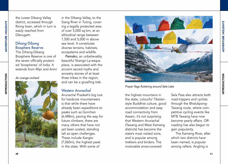
the highest mountains in the state, colourful Tibetan-style Buddhist culture, good accommodation and easy road connectivity from Assam, it’s not surprising that Western Arunachal (Tawang and West Kameng districts) has become the state’s most visited zone, and is popular among trekkers and birders. The motorable snow-covered
Sela Pass also attracts both road-trippers and cyclists through the Bhalukpong-Tawang route, where com-petitive cycling events like MTB Tawang have now become yearly affairs. Off-roading has also begun to gain popularity.
The Kameng River, after which two districts have been named, is popular among rafters. Angling is
1110
An orange orchard
Prayer flags fluttering around Sela Lake

12
ad
ven
ture
ho
lid
ays
intr
od
uct
ion
13
ad
ven
ture
ho
lid
ays
intr
od
uct
ion
good on a couple of stretches; the best parts of the Kameng are mostly gorge areas that are inaccessible by road or foot, and need to be reached by boat.
Along the SiangThe Siang is one of the great transnational rivers of Asia and an ideal destina-tion for whitewater rafting.
For beginners, the river can be a good option downstream from Yinkiong and Geku.
One of the best commercial rafting areas is at the easily accessible Pasighat. This stretch is ideal for Rishikesh-style day programmes and long weekend camping trips at Pongging village, which has good views and caves to explore nearby. This is also the site of ‘Siang Rush,’ an annual rafting expedition.
In Basar, hunting and fishing have been completely banned at the village level, to regenerate what has been lost through recent unsustainable fishing practices. Traditional community fishing, however, is not just permitted once a year, but is also celebrated with gusto at the Basar Confluence, a cultural event bringing together a cluster of villages.
Located in the middle of
the Siang, the daying ering wildlife Sanctuary is Arunachal’s only protected wildlife area on an island. It attracts birds such as the black-breasted parrotbill, swap prinia and Jerdon’s babbler. The dibang-Bodak-Boleng is one of the most popular angling circuits among Indian anglers, who typically spend two or three nights at each place. For
even short weekend angling picnics, the Papum-Poma confluence, near Itanagar, is popular among locals.
Further NorthFor fly-fishing in shallow waters, you must head to Mechuka, a picture-perfect high-altitude valley near the Indo-Tibetan border other-wise known for its annual adventure festival,
Tourists enjoying rafting
Rafting along a gentle stretch of water in Arunachal

14
ad
ven
ture
ho
lid
ays
intr
od
uct
ion
15
ad
ven
ture
ho
lid
ays
intr
od
uct
ion
Adventure@Mechukha, which is held in November. While not as popular as the Bhalukpong-Dirang-Tawang MTB circuit, Mechuka is also very much on the cycling map (routes going via Basar/Aalo). There’s also a ‘downhill-cycling’ scene here. Paragliding in Mechuka is not nearly as predictable as more reliable spots like Pappu Valley in
East Kameng because of Mechuka’s moody winds.
The Subansiri DistrictsThe Subansiri River snakes through central Arunachal Pradesh and is a suitable rafting spot for beginners.
The best mahseer angling here is mostly lower down though, towards the Lower and West Siang districts, which aren’t accessible by road or foot. You have to take a rafting trip to go angling here.
The Wild EastNamdapha is officially a ‘tiger reserve,’ but from a practical perspective, it’s better for spotting birds, butterflies, week-long jungle treks, and camping by the wild beaches of the Noa-Dihing River. As with most tiger reserves in Arunachal, enter without absolute expectations of sighting a big cat, especially if you are on a short trip. The jungles of Arunachal are so
dense and mountainous that spoting mammals outside caera traps can either be rare, accidental, or involve days or even weeks of climb-ing through tough terrain and dense forests.
Like the Kameng, the Lohit River in Eastern Arunachal is also great for rafting, but certainly not for beginners. While coming down from the Walong area, it’s a tough Class V
stretch of white water. As for angling, while some say that there aren’t many bites there, others swear by their secret spots on the Lohit River, closer to Tezu.
A trek up to Dong (a hilly village in the Anjaw district bordering China that sees the first sunrise in India) can be an enchanting experience. This is a popular stopover for bikers and MTB cyclists. ■
A trekker enjoys the hill viewTrekkers in the Namdapha National Park

intr
od
uct
ion
intr
od
uct
ion
Adrenaline in arunachal pradesh
From trekking in the high mountains around Tawang to rafting in the white rapids in the Siang, unleash the real adventure junkie
in you in Arunachal Pradesh.
Department of Tourism Govt. of Arunachal Pradesh Itanagar, Arunachal Pradesh, IndiaPhone: +91-360-2214745 | E-mail: [email protected] us on Arunachal Tourism @ArunachalTsm

trek
kin
g
na
md
aph
a n
ati
on
al
park
trekkingcycling&
20
ad
ven
ture
ho
lid
ays
trek
kin
g
21
ad
ven
ture
ho
lid
ays
na
md
aph
a n
ati
on
al
park
range office and accom-modation are located, is sort of a basecamp within Namdapha, and this is where most excursions begin and end.
While the trek to ‘52nd Mile’ camping spot is the last point in the core area direction where the general public is allowed to trek, the Namdapha-Vijoynagar trek, on the defunct old Miao-Vijoynagar Route to the Indo-Myanmar border, is a
more multilayered experience, and recommended only for real adventure enthusiasts with an open return plan.
BIRDING TREK
Deban to 52nd Mile and back (6–7 days):This modular route is the most popular hike among birders who come from all over the world, and involves crossing the forests and
■ Sanjiv valSan
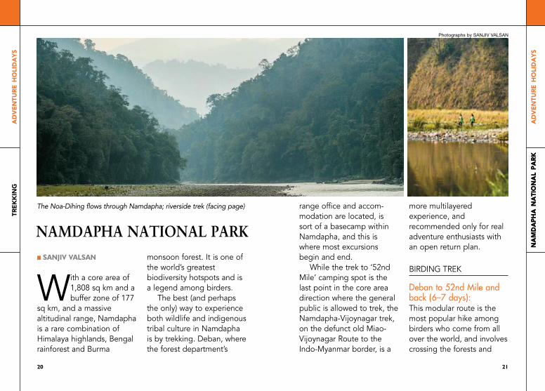
With a core area of 1,808 sq km and a buffer zone of 177
sq km, and a massive altitudinal range, Namdapha is a rare combination of himalaya highlands, Bengal rainforest and Burma
monsoon forest. It is one of the world’s greatest biodiversity hotspots and is a legend among birders.
The best (and perhaps the only) way to experience both wildlife and indigenous tribal culture in Namdapha is by trekking. Deban, where the forest department’s
na
md
aph
a n
ati
on
al
park
namdapha natIonal park
The Noa-Dihing flows through Namdapha; riverside trek (facing page)
Photographs by sanjiv valsan

22
ad
ven
ture
ho
lid
ays
trek
kin
g
23
ad
ven
ture
ho
lid
ays
na
md
aph
a n
ati
on
al
park
banks close to the impres-sive Noa-Dihing River, and camping along picturesque river beaches. The further in you go, the better are your chances of interesting sightings.
The route:deban to Haldibari (5–6 km): Cross the river by ferry, and walk till you reach
haldibari, where you can spot the hornbill if you’re lucky. The Forest Department has a camping spot here.
Haldibari to Hornbill camp (6–7 km from haldibari, 12 km from Deban): As the name suggests, this is a point for spotting the hornbill, for which
Namdapha is famed. Sometimes water is unavailable at haldibari, so you’d have to do the entire stretch till hornbill Camp from Deban on a single day.
Hornbill camp to Bulbulia (2.5km): Bulbulia gets its name from the natural hot water sulphurous springs (bulbule) here. Thanks to the presence of a salt-lick, there’s a possibility of seeing the gaur, wild boar, sambar, barking deer and even the elephant here. There are remains of an older watchtower-like structure here, which can make for a good viewpoint. From here, you can see the treetop canopy from a vantage point and birds such as the long-tailed sibia and greater racket-tailed drongos.
To limit the trekking time to three days, make a U-turn towards Deban after Bulbulia; for a longer and
deeper experience, you can move onwards to the Ranijheel campsite.
Bulbulia to ranijheel (5km): There’s a campsite where you can pitch tents at Ranjiheel. Birds recorded in this stretch include the great rufous-headed parrotbill and red-billed scimitar
2322
Sambar (top); gaur
Namdapha is a birder’s paradise
Photographs: shutterstock

24
ad
ven
ture
ho
lid
ays
trek
kin
g
25
ad
ven
ture
ho
lid
ays
na
md
aph
a n
ati
on
al
park
babbler, wreathed hornbill, hawk eagle and white-winged duck. ranijheel to firm Base (5km): Geographically, it’s a confluence of the two tributaries, one coming from
snow-covered peaks such as Dapha Bum, visible at a distance, and the other from the Myanmar end. There’s also an interesting detour possibility. From Firm Base, move to Embeong and cross over the river to complete a circular circuit back to Deban and visit some tribal villages on the way, without returning through the same route. By this point, with some luck and a good guide, you could spot mammals such as the hoolock gibbon, Asian elephant, Asian one-horned rhinoceros, swamp deer and wild water buffalo.
firm Base to 52nd mile: A six-hour hike from Firm Base, 52nd Mile is the last point where trekking is permitted without additional special permission. The grasslands of Firm Base, 52nd Mile and onwards are basically where tiger and other big cats’
game country actually begins. Estimate a 7-day trip for Deban to 52nd Mile and back. It may take longer if you’re waiting to spot wildlife, of course; and shorter, should you choose to turn back to Deban from Ranijheel, Bulbulia or hornbill Camp. For a short trip of 2–3 days, turn back to Deban after hornbill Camp.
Elephant safarisElephant safaris are possible on the route till hornbill Camp. They can be used as porters till Firm Base, though. Bridges across the rivers in the park have recently been damaged due to flood and elephants are a safe way to cross the rivers. Depending on the rains, the icy river can swell unpredict-ably and reach chest-deep
Malayan giant squirrel
Elephants prepare for a safari
guneet narula
26
ad
ven
ture
ho
lid
ays
trek
kin
g
27
ad
ven
ture
ho
lid
ays
na
md
aph
a n
ati
on
al
park
levels in many crossings on the route. These elephants have been trained to create makeshift bridges during river crossings by carrying and dropping large tree trunks. Spending around a week in the forest with an elephant can also be an interesting experience.
ALTERNATE ROUTE
Namdapha to Vijoynagar on the old Miao-Vijoynagar RoadThis route is strictly for the adventurous; not many make it all the way through dense rainforests, bamboo thickets, riverside boulders, skirting landslides and fording rivers; braving leeches for at least six days, wading through all sorts of knee or even waist-deep waterbodies just to visit a village on the interna-tional border. There was once actually a motorable road to Vijoynagar, India’s last village at the Myanmar border, surrounded by the forests of Myanmar on three sides, and Namdapha National Park on the fourth side. The old MV road got dysfunctional and was never repaired after the 1990s.
India’s wild east is a secluded patch with no road access, stretching up to the Burmese border. This is one
of the last great adventures around, combining forests as well as tribal villages in a universe that’s cut off from the outside world.
Tribal villagesPoints on the route are mostly defined in miles; these refer to milestones on the 95-mile Miao-Vijoynagar Road (Miao is the zero point), which is now com-pletely damaged. There are
Lisu tribal villages on this route, where rations, fruits and even treats like Chinese apple wine, rice wine and cooked local meals can be bought, at villages on 52nd Mile, 77th Mile, 82nd Mile and the many villages after Gandhigram. From Gandhigram onwards, there are many Lisu tribal villages. Japanese warplanes crashed in this forest during World War II and in true zero-
1) Deban (17th Mile) to 25th Mile2) 25th Mile to 52nd Mile3) 52nd Mile to 65th Mile (there’s also a village at 77th Mile)4) 65th Mile to 80th Mile5) 80th Mile to Gandhigram (86th Mile)— there many villages after Gandhigram6) Gandhigram to hazilu Basti : (11–12km)7) hazilu Basti to Vijoynagar, you fly back by chopper that connects to Miao
The route:
Huts at Namdapha
narendra Bisht

28
ad
ven
ture
ho
lid
ays
trek
kin
g
29
ad
ven
ture
ho
lid
ays
na
md
aph
a n
ati
on
al
park
waste tribal style, locals are said to have collected and recycled scraps from the wreckages into daily use and household objects, which can still sometimes be found in a few homes in villages on this route. Gandhigram, with around 400 homes, is pretty large for a village with zero road connectivity. Vijoynagar is known as Daudi by the
Lisus, but was renamed by the Indian army.
Returning to civilisationChoppers run twice a week between Naharlagun (Itanagar)-Miao-Vijoynagar and back. Don’t schedule any important events or book expensive return flight tickets assuming you will catch these back from Vijoynagar on the day of your choice, because like many chopper services in Arunachal, these flights can get cancelled because of poor weather, or run full because of medical emer-gencies, which get priority over regular folks. The army also runs intermittent servic-es out of Vijoynagar, and if you’re in luck, you can get one of these as well. In short, in keeping with the adventurous nature of this whole trip, maintain an open return plan, if you don’t plan on walking the same route back to Miao;
you’ll eventually get a chop-per out.
Plan to reach Vijoynagar in time for the chopper, and choose day one of the trek from Namdapha according-ly. To add a touch more pre-dictability to your return schedule, you could choose to do the hike in reverse direction (Vijoynagar to Deban), flying in to Vijoynagar either from Naharlagun or Miao. This way, you can confidently
choose a date to book a return ticket back home.
The Lisu tribeParts of Namdapha, espe-cially the areas stretching towards the Myanmar bor-der, are generally consid-ered the home of the Burmese-origin Lisu tribe, also sometimes known as the Yobin, who migrated and settled here from China via Myanmar, before India became a republic.
Porters enroute to Hawa camp Locals at Namdapha Eco Cultural Festival, Miao
narendra Bisht
alamy images / india Picture

30
ad
ven
ture
ho
lid
ays
trek
kin
g
31
ad
ven
ture
ho
lid
ays
na
md
aph
a n
ati
on
al
park
On the long trek to Vijoynagar, you will end up meeting Lisus in their forest villages, especially while stopping to purchase food supplies or find village homestays. Even closer to Deban, along the old Miao-Vijoynagar Road, you could encounter entire families of Lisus making this long journey everyday, carrying
head-loads of stuff, accompanied by even little four-year-old kids. They trek for several days to Miao every time they need to access the cash economy, or shop for basic rations, sleeping in makeshift shelters that they create in no time, using bamboo and leaves in the forest en route.
Probably the most skilled hunters in these parts, they are known for their jungle survival skills. With the road connecting them to the mainland gone and never rebuilt since, the Lisus live in mostly self-sufficient tribal villages inside the forest with no road access, weave their own textiles, build their own houses using local materials and are experts at forest foraging and cane, bamboo and wood craft. They can make tools, baskets, traps, shelters and all sorts of stuff using nothing other than a machete and locally found
natural objects anywhere in the forest.
The Lisus are friendly and hospitable to outsiders who manage to come this far, especially when accompanied by a good guide or porter with local village contacts. In Miao town, the main tribes are the (mostly Buddhist) Singphos and the Tangsas, who are more like a set of tribes, rather than a single group.
Costs within NamdaphaBirding hike cost: Approximately `4,000 per headtaxis from Miao to Deban (Namdapha): `2,500–3,000 regular rooms: `270/night (Indians) `470/night (for-eigners)traditional huts: `470 (Indians) and `870 (foreign-ers). dorms: `120 per bedcamping charges: `1,000 per nightcamera entry fee: `1,000
SpidersA photographer captures rare flora in Namdapha
Photographs: narendra Bisht

32
ad
ven
ture
ho
lid
ays
trek
kin
g
33
ad
ven
ture
ho
lid
ays
na
md
aph
a n
ati
on
al
park
per day for long lens camer-as, `500 for smaller camerasentry fee: `100 per day for Indians, `200 for foreignerselephant hire charges: `1,000 per day per elephant + `500 per mahout
Accommodation and tour operatorsAmong the Forest Department’s accommoda-tion options at Deban, the
basic but charming tradi-tional bamboo huts are the ones to go for.
Phupla Singpho has also been operating tours in this area for years, and runs Namdapha Tours and Treks and a more comfortable quaint riverside resort at Miao called Namdapha Jungle Camp (Cell: 09436228763) near the Noa-Dihing River. Abor Country, hELP Tourism and Jungle Travels (W jungle-travelsindia.com) regularly run treks to Firm Base.
The dapha Valley lodge at Miao is also worth a dekko for spending the first and/or last night at Miao, before or after the trek to either Vijoynagar or Firm Base direction.
With clean double rooms starting at `800, hot water, good local food, friendly caretakers and comfortable mattresses, it’s quite a bargain!
Tip The reserve doesn’t take tourists from April to October (the wet season).
While organising a hike with the Forest Department will be cheaper (`5,000-7,000 per head for a four-day-programme for 6-8 pax), you’ll probably have to do the math, and add up the components to determine the actual total
cost. Tour operators will probably be more convenient, though. If trekking independently, contact Japang Pansa (Cell: 09402045864) for assistance with planning treks, birding or wildlife hikes and scoring equipment locally. he’s a tribal working for the Forest Department and hence has ample contacts. ■
A dormitory in Deban
Traditional cottage in Deban
guneet narula
guneet narula
■

34
ad
ven
ture
ho
lid
ays
trek
kin
g
35
ad
ven
ture
ho
lid
ays
tira
p
identities, but have now been grouped in official records as the ‘Noctes’. In Tirap, nearly every Nocte village has its own king and its own language.
Headhunting legacyIn the days gone by, like the tribes of Nagaland and Sagaing region across the border in Myanmar, the
Noctes and Wanchos (the tribe in present-day Longding district) used to practice ‘headhunting’, a practice where the victor of a war would bring home skulls of their enemies to proudly display as a sign of bravery, and be recognised for his valour with a prestig-ious body tattoo and a huge welcome party with feasts, song and dance.
The Salt Well trailAlthough headhunting has not been practiced in sever-al decades, other aspects of tribal culture such as folk songs, dances, costume, wood craft, traditional heal-ing and their connection with animal spirits still abound in the misty moun-tains of Tirap. The Salt Well trail, which begins at the ancient kingdom of Borduria, is a great way to get acquainted with both the tribes and the landscape of Tirap.
■ Sanjiv valSan
Just by looking at the map, you can guess that Tirap is one of the
most interesting parts of India, with Myanmar, Assam’s Joypur Rainforest, Arunachal’s own Changlang and Longding districts and Nagaland’s Singhpan
Elephant Reserve as neighbours and cultural influences. Nearly all of Tirap is part of a major elephant corridor that’s rich in wildlife. From Joypur in Assam till the Singphan Elephant Reserve in Nagaland, the region is home to a group of tribes that originally held separate
trekkIng In tIrap Tirap is a cloud gazer’s paradise
Photographs by sanjiv valsan

36
ad
ven
ture
ho
lid
ays
trek
kin
g
37
ad
ven
ture
ho
lid
ays
tira
p
Borduria Borduria has a rich history; it was the most important centre of the ancient Nocte kingdom, and is still an important hub of Nocte cul-ture, craft and textile weav-ing. The local cuisine and wine is worth checking out. Nocte jumin is said to be one of the best grain wines out there. Jumin can be made with either rice, corn,
millets or tapioca, or a mix of one or more ingredients. At Borduria, river camping is possible at the Lowangcha Tea Estate, a great spot for sunsets, stargazing and unwinding to the sounds of the river.
Borduria to Paniduria village (5hrs)The day begins with cross-ing small streams and a hanging bridge over a river with crystal clear water, and a gentle climb to a vantage point with good views of Borduria village. At Paniduria, the ideal camp-ing spot is an organic orange orchard, where you can pluck and munch as many oranges as you want (with the permission of the owner, of course). Generally unknown to the outside world, Arunachal Pradesh’s oranges (in winter), like most fruits grown here, are nearly absolutely organic, reasonably priced and
exceptionally delicious, putting anything from the plains to shame.
Paniduria to Khowathong (3hrs)The Soijan River is in its true character on this stretch, since it has been associated with Nocte history for cen-turies. Its salt wells made this area prosperous in the times gone by. Before the
Eastern himalayas were connected by road to the sea coasts of mainland India, common salt was one of the most valuable com-modities in the region; not just for making food taste better, but also for gaining the loyalty of the Bos fronta-lis, a semi-wild/semi-domes-ticated bovine related to the Indian gaur and popu-larly known as the mithun,
3736
tira
p
Tirap landscape with rain clouds
Traditional Nocte house

38
ad
ven
ture
ho
lid
ays
trek
kin
g
39
ad
ven
ture
ho
lid
ays
tira
p
which the tribals of Arunachal and Nagaland tamed using their biggest weakness, salt. Once they are addicted to an easy sup-ply of salt, mithuns can be set free to graze in the for-est and live like any other wild animal, but they will return to their ‘master’ whenever needed, as long as they are found and given salt. Mithun sacrifice and meat have always been a
central part in the diet and culture of many tribes in the Northeast. This gentle bovine has always given all the tribes here the protein security of domesticated meat without the environ-mental damage and costs associated with mod-ern ranch-based animal husbandry.
Swimming in sections of this ‘salty river’ is said to be of great therapeutic value and cure all sorts of illnesses; locals from nearby villages still make it a point to trek all the way here at least once or twice a year, just to bathe.
Khowathong to Chasa (3hrs)The route from Paniduria moves downhill into a val-ley, a river crossing and later takes a steep climb to Khowathong village. Khowathong is a centre for traditional crafts, especially expressive woodcarving and
gun-making, an unusual skill that the Wancho tribe (of the neighbouring Longding district) is more known for.
From Khowathong, there’s a jeep track leading to Chasa village, the original village from which some people left and established Khowathong. The Noctes and Wanchos trace their origins to present-day Myanmar and China.
Khonsa and beyondFrom Chasa, there are many other cultural excursions that are accessible by road, including Khonsa, a mostly animist village near Khonsa town, the district headquar-ters of Tirap; Luthong, where you can meet the last tattooed headhunters of Tirap; Lapnan, the village where headhunting skull tro-phies are still displayed in
A traditional hearthSunsets in western Arunachal are mesmerising

trek
kin
g
tira
p
40
ad
ven
ture
ho
lid
ays
the traditional style in com-munity centres called ‘pangs’; or drive further ahead to Sanliem, a hamlet of the Olo tribe (now offi-cially considered a ‘sub-tribe’ of the Noctes), where even middle-aged women still bear traditional facial tattoos. From each of these villages, trails lead further into the wild, and into even more villages, right upto the
Indo-Myanmar border locat-ed near Lazu.
Getting thereBorduria in Tirap is conven-iently located 104km/4hrs from Dibrugarh airport/rail-way station. Return through Khonsa town (120km/ 4–5hrs).
Trekking operatorsIt is advisable to go through a local operator in an undis-covered area like Tirap, where there isn’t conven-tional tourism infrastructure. A local guide can be a good way to find a home-stay and trekking routes through villages. Foreign nationals might not be allowed to travel through some parts of Tirap due to security reasons. Village Holiday tours & travels and camp namdapha Holidays (see Tour Operators at the back of the book) specialise in trekking and culinary tours here. ■
A Nocte longhouse
Angling Arunachal pradesh
Making a good catch while you stand on the banks of gushing rivers surrounded by high mountains! Head to Arunachal for that perfect picture.
Department of Tourism Govt. of Arunachal Pradesh Itanagar, Arunachal Pradesh, India
Phone: +91-360-2214745 | E-mail: [email protected] us on Arunachal Tourism @ArunachalTsm

42
ad
ven
ture
ho
lid
ays
trek
kin
g
43
ad
ven
ture
ho
lid
ays
dib
an
g v
all
ey
tigers and wildlife can be found here than anywhere else in the state.
1.The Seven LakeS Trek (5 dayS)GRADE: ToughAn extremely colourful, high-altitude wildflower trek through lovely forests and exceptional landscapes near the Indo-Tibetan border,
this is one of the best expe-riences in this part of the world. The trek begins at a tropical jungle and moves up to a high peak at Chebra (1,100 m), which needs to be traversed to reach a for-est filled with exotic vegeta-tion in every colour imagi-nable. There are wild high-altitude orchids and an archipelago of dozens of lakes of all shapes and sizes, seven of which are feasible to cover within two days. Overall, this is a hard trek, requiring fitness and resolve.
The Idu Mishmis know this area as a place where rare medicinal plants grow, like the legendary Mishmi titha and other rare plants that can treat fevers, aches, burns, wounds, livestock diseases and neutralise poison. The monals, blood pheasant and the endemic Mishmi takin can be spotted at close range. The lake area also boasts of
■ Sanjiv valSan
With its lush green forests, craggy snow-clad peaks
and ancient shamanic traditions, Dibang Valley is Arunachal Pradesh’s wildest and most unexplored district. It is a huge mountainous zone between
Tibet and Northeast India. The local Idu Mishmi tribe has been attracting global recognition lately for its ancient traditional religious systems that the people practice to this day. Their culture intelligently includes wildlife conservation as a part of daily life, because of which a greater density of
FIve treks In dIbang valley A highland village at Dibang
Photographs by sanjiv valsan

44
ad
ven
ture
ho
lid
ays
trek
kin
g
45
ad
ven
ture
ho
lid
ays
dib
an
g v
all
ey
interesting wild mushrooms; and for a refreshing change, most of them are edible here. high Altitude Sickness is a real risk on this trek; a day or two of acclima-tisation is essential. Anini is the most convenient place for this.
Routeday 1 Emuli village to
Emungu (6km/3hrs): Reach
Emuli village by road from Anini town, and on to Emungu on foot.day 2 Emungu to Chebra
(8–9km/5-6hrs): From Chebra, the highest point of the trek, descend to Kamu Lake.day 3&4 Chebra to Kamu Lake: Two days at Kamu Lake to acclimatise to the altitude, roam around and explore all seven lakes. Most hikers spend two nights here, but there’s plenty to explore for those who choose to stay longer and carry enough ration.day 5 Kamu lake to Inguyi
Camp (9km/7hrs): Trek to Inguyi, 2km after which the motorable road to Anini begins at Mipi-2 village. Return to Anini by road (30–35km/1hr).
June and July: For exotic high-altitude wildflowers, but quite rainy, less visibility of distant landscape because of rain and mist
August-november: Less rain, better visibility, but not enough floral diversitywinter months: Snowfall and extreme cold makes everything tougher
2. emuLi To BiyaLi (3 dayS, 2 nighTS) via enguLiGRADE: EasyThis circular trek is both relatively easy (by Dibang
Valley standards) and scenic, with continuous patches of bamboo forest, good views of open landscapes and gently undulating paths, crossing the Dibang River at two or three points on authentic Idu Mishmi hand-made bamboo hanging bridges, a rare marvel. At Biyali, a lively Idu Mishmi tribal hamlet, you can choose to spend the night
4544
The Dibang hill-scape
A trekking route through the valley

46
ad
ven
ture
ho
lid
ays
trek
kin
g
47
ad
ven
ture
ho
lid
ays
dib
an
g v
all
ey
in a local home or your own tent. Enguli, the second stop on the hike, is an unu-sual village with homes but no inhabitants, even though there’s a population there on the official census. Most of its inhabitants have moved to Anini for govern-ment jobs because Enguli has no roads, and they return only occasionally; they don’t even bother to
lock their old homes while they’re in Anini, thanks to the zero crime rate in these parts. With the permission of the owner (managed by the trek operator), you can actually stay in one of these deserted bamboo houses, use their hearth and fire-place and be the only inhabitants of the entire village for a day.
Route: day 1 Emuli to Biyali (8–9
km, 3–4 hrs). day 2 Biyali to Enguli:
( 6–8 km, 3 hrs)day 3 Enguli to Biyali (6–8
km, 3 hrs)Season: year-round, but winters will be less wet
3. dri vaLLey Trek (4 dayS, 3 nighTS)GRADE: Easy–MEdiuMThere are plenty of trek routes in Dri valley, near Acheso village, difficulty lev-els ranging from easy to hard. This is one of the easi-
er-yet-scenic options, with a landscape that differs from the others on this list; it involves more cross-country walking along a riverside route with waterfalls and views of snow-clad moun-tains, birds, tiger and Mishmi takin pugmarks from time to time. Even if you don’t see the tigers, they will probably see and smell you. The Idu Mishmi tribe
traditionally consider the tiger as their brother, and since they never harm big cats, the felines here return the favour and co-exist peacefully with humans. You can participate in traditional fishing on the Dri River.
Route: day 1 Acheso to
‘Chaipani Camp’ (3–4 hrs, cross-country)
Hiking in Dibang
The diversity of flora on the Seven Lakes trek
adiju rondo
Photographs: adiju rondo

48
ad
ven
ture
ho
lid
ays
trek
kin
g
49
ad
ven
ture
ho
lid
ays
dib
an
g v
all
ey
day 2 Chaipani to Chigu Camp: (3–4 hours, cross-country)day 3 Chigu Camp to
Pathar Camp (3–4 hours, cross-country)day 4 Pathar Camp to
Chaipani Camp to Anini, skipping Chigu Camp (7 hrs). The motorable road begins a bit after Chaipani Camp, from where you can go by road to Anini.
4. The aLomBro Trek (2 dayS, 1 nighT)GRADE: MEdiuMAnother circular trek begin-ning and ending at the Emuli hamlet, an Idu Mishmi tribal village, this one cross-es no less than four hanging bridges over several points on the river. Stay in either a traditional Idu Mishmi bam-boo longhouse (changhar) in these villages and social-ise by the fire, sipping on locally made corn or millet wine with a tribal family or carry a tent and camp out-doors.
Route: day 1 Emuli to Alombro vil-
lage (3 hrs). day 2 Alombro to Emuli:
Through a different route
5. maLini To dara (4 dayS, 3 nighTS)GRADE: EasyThe trail begins with a mix of forests, cross-country walks, ascents and descents
at Malini village (homestays available in villages en route), and transitions from bamboo groves to lush green alpine meadows between Makhri and Balwa. Flowering season is between March and August, depending on the species. Rains will be more intense towards the August end of the flower season, but plant diversity will be richer.
Route: day 1 Malini to Marki
campsite (4–6 hours)day 2 Makhri to Balwa (3–4
hrs)day 3 Balwa to Dara (5–7
hrs)day 4 Dara to Malini (6–7
hrs)
Getting there Anini (headquarters of the Dibang Valley district) is
A camp with a view
Picturesque vistas of Anini
adiju rondo

50
ad
ven
ture
ho
lid
ays
trek
kin
g
51
ad
ven
ture
ho
lid
ays
dib
an
g v
all
ey
380km/10hrs drive from the Assamese towns of Dibrugarh (closest airport/railway station) and from Tinsukia (335km/9hrs by road). These mountain roads are rough in patches, and landslides, rain and snowfall can considera-bly increase time spent on the road.
Weekly choppers fly from Naharlagun (Itanagar),
Roing and Pasighat on Tuesdays currently, and these can be convenient options when rough weath-er doesn’t result in their cancellation.
CostsAs with most treks, these will vary with stay options, schedules and food chosen, and importantly, how much weight your porters would have to carry. Costs in these remote areas are higher than in the mainland because of various factors, but all things considered, most operators charge rea-sonably. here are some ball-park figures: The Seven lakes trek would cost `3,50,000–400,000 mini-mum for a group of 10, including car hires and drops, riverside camping after the trek and a village tour and meals, and car hires to and from Dibrugarh airport and within Anini. Emuli to Biyali would cost
around `20,000 per head for a smaller group, includ-ing meals and car hires to and from Dibrugarh airport by SUV.
Where to stayhomestays, arranged through your trekking oper-ator, are generally the best option; though Anini town also has a Circuit house and Forest Rest house. While
hiking, homestays in tradi-tional villages and tents are the way.Trek Operators in Dibang Valley:l dibang Adventure (Adiju Rondo)l the mishmi Hills (Tine Mena)l mishmi Hills camp / eco camp (Jibi Pulu)l mishmi Hills resort & Hotels (Rezina Mihu) ■
View of Anini town
Inside a traditional Idu Mishmi home

52
ad
ven
ture
ho
lid
ays
trek
kin
g
53
ad
ven
ture
ho
lid
ays
pasa
ng s
on
am
tso
■ Sanjiv valSan
The trek to Pasang Sonam Tso (Tso means ‘lake’), near Arunachal
Pradesh’s Mechuka, is a spectacular one to say the least. The Indian army, Indo-Tibetan Border Police (ITBP) and other security and road maintenance personnel routinely patrol this sensitive border. Over the last few years though, hikers have also begun to discover this hidden high-altitude lake. This is probably one of the most beautiful treks in the Eastern himalayas. hiking here requires special permission.
The routeday 1 Mechuka to Track
junction/ITBP check-post at Yorlung (2 hrs by road):
Leave Mechuka as early in the morning as possible, preferably even before dawn to get enough time for the toughest part of the trek; leaving early lets you enjoy the walk without hav-ing to struggle with reach-ing before sunset, which happens very early around these parts in winter. Account time for gathering and preparing firewood for the campsite and starting a fire at the end of the day. It helps to have at least two people as guides/por-ters even if you’re travelling solo here.day 1 Track Junction to
Shastri Camp (5hrs): In the first hour itself, the route crosses near-vertical patches, with only a metal wire to hold on to, and bits of thin bamboo ladders
pasang sonam tso trek In mechuka

54
ad
ven
ture
ho
lid
ays
trek
kin
g
55
ad
ven
ture
ho
lid
ays
pasa
ng s
on
am
tso
horizontally placed like small bridges between cliffs, with dizzying views of the depths and brooks below. This path is full of steep climbs and slippery descents, and involves skipping over streams, then a descent to the rocky banks of the tireless Yorlung Fooj river, where you’ll need to jump from boulder to boulder for a bit. This can
all be a little tiring, but the forest is really unique, and totally worth the effort. Particularly delightful are the stretches of wild blueberry bushes, which are quite a sight in their autumn colours during fruiting season (November), when you can keep plucking and munching on these tangy-sweet delights through at least half the hike.
Some very basic shelter in the form of wooden huts is available at Ummeed Camp (4hrs walk from Track Junction), Shastri Camp (5hrs) and Pasang Sonam Tso (7hrs). While the lake is obviously the main attraction of the trip and most scenic camping spot, Shastri Camp, though not as open, is also a lovely location. The hut here is sometimes in a better shape, which matters when it’s raining or snowing, and reduces the walk on day one by about two hours,
making it less rushed.These huts are meant
more to be makeshift shelters for army men to light a campfire, keep warm, cook and spend the night. Check with your guide about which of these huts is in the most habitable shape at the time of your trip before deciding where to camp, or whether to carry your tent. It can get very cold here, and snowfall can begin as early as late November.
day 2 Shastri Camp to Pasang Sonam Tso (2hrs): The morning begins with another long stretch of riverside boulder-hopping, and through more blueberry bushes with a slight ascent, before reaching an open stretch of beautiful landscape by the Tibetan border, a mix of green mountains, dense pine forests and snowy peaks high above the tree line, the most dramatic of which is the Chuning La peak, with
5554
Autumn coloursThe mesmerising Yorlung Fooj river
Photographs by sanjiv valsan

56
ad
ven
ture
ho
lid
ays
trek
kin
g
57
ad
ven
ture
ho
lid
ays
pasa
ng s
on
am
tso
its mirror image calmly reflecting on the Pasang Sonam lake when it’s still early in the morning. The lake eventually mosaics into a shimmer once the winds pick up later in the morning and animate everything in sight. If the hut/tent can handle the howling winds and possibilities of frost and snow, this is obviously the place to camp, with views of a lovely little slice of southern Tibet.
day 3 Pasang Sonam Tso to Track Junction (7hrs): The return to the base camp through the same route is a bit more downhill than the walk up, and if you made it this far up, then the return hike should be manageable in one long stretch. There’s no public transport between Track Junction and Mechuka town, so make sure you have either parked a car there or arranged for one to pick you up. In case the car doesn’t arrive (it can happen), an emergency option is hitching a cold and windy ride on the back of a truck with the cheerful construction workers from the GREF/ITBP camp.
The entire route between Track Junction and Pasang Sonam Tso is 23km/7hrs walk approximately. This trek is medium to tough grade, not without risk; hence, it helps to be physically fit. Trail conditions depend on rain, snowfall
and other variables. It’s technically possible to do the entire trek in one night and two days, but is best to spend at least two nights and three days to make it relaxed and enjoyable.
SeasonsSummer (July–September): Warmer weather, longer days for more leisurely walks. Prepare for leeches!
fall-winter: (October–December): The driest season. Colder tempe-ratures, subzero at night. Shorter days, longer nights, so schedule walks accor-dingly. Snowfall is possible. Frost begins mid-November.Peak winter (January–Feb): Even shorter days. More technical. Prepare for tricky patches through snow.
Prayer flags, Pasang Sonam Tso Wild blueberries (left) and colours of the forest

58
ad
ven
ture
ho
lid
ays
trek
kin
g
59
ad
ven
ture
ho
lid
ays
pasa
ng s
on
am
tso
Getting thereThe closest town is Mechuka (also sometimes spelt Menchukha or Mechukha), a picturesque place built around a military air landing ground, where you can happily spend the first night at a local home-stay. flight/trainVia dibrugarh airport/rail-way station, road: From Dibrugarh Airport or Railway
Station, reach Aalo (Along) by road (253km, 6.5hrs) and then from Aalo to Mechuka (180km). Car needed to reach Track Junction, the starting point of the trek.By flight, chopper: Guwahati or Mohanbari (Dibrugarh) airport to Naharlagun (Itanagar). Overnight at Itanagar. Connecting chopper from Naharlagun the following morning (3hrs, Mondays and Saturdays only) to Mechuka.
Trekking permissionsSpecial permission is required to trek to Pasang Sonam Tso, which is mostly given only to Indians from the Indo-Tibetan Border Police through the Additional Deputy Commissioner, Mechuka. For information on permis-sions, contact the office of the Additional Deputy Commissioner, Mechuka (09436043852). A
local trek operator is the best bet in managing these. menchukha tours & travels organises treks around Mechuka. ThINGS TO SEE AND DO
Adventure@Mechukha, the annual adventure festival, is a three-day-long extrava-ganza organised in
November. In addition to adventure sports such as shooting, rappelling, river crossing, paragliding, mountain biking and aero- modelling, there are cultural events and food stalls. The Government Craft Centre is good for purchasing handicrafts such as the Tibetan-style Thaan carpets. ■
Memba women at Yorlung
Camping in the forests around Mechuka

60
ad
ven
ture
ho
lid
ays
trek
kin
g
61
ad
ven
ture
ho
lid
ays
bail
ey t
rail
travelled southwards via Mago, Lap, Pota, Poshing la along this route to Thembang, the trail named after their exploits takes the route in reverse, beginning at Thembang, the Brokpa yak herding village of Chander, and ending near Jang town. A road now connects Thembang with Chander, so after some
sightseeing at the charming fort at Thembang, this six-to-seven-day trek can begin directly at Chander.
Way before the British ‘discovered’ this route, the Tibetan and Indo-Tibetan tribes in the region have been using Sela ridge as a yak trail, taking in their caravans of yak wool, hides, precious stones and yak butter to barter in the markets in Assam.
The trail didn’t escape the attention of the Chinese either during the 1962 Indo-China war, when their soldiers took the Bailey Trail from Tulung La, Mago, Poshing La to Thembang, causing considerable damage to the Indian forces.
At Poshing la today, there are few traces of war left. Instead, what we find is serenity and superb views of the Gorichen massif, and the peaks of Gorichen (6,538m), Kangto (7,090m),
■ Sanjiv valSan
The Bailey Trail traces the historic expedition of two British officers,
Lt Col FM Bailey and Capt hT Morshead, who surveyed this route during colonial times for the purpose of map-making. They travelled from Tibet to
Thembang, a fortified village in Western Arunachal Pradesh. Their data eventually resulted in the creation of the McMahon Line, which became, and still remains, the Interna-tional boundary with Tibet/China, a demarcation that China does not recognise. While Bailey and Morshead
baIley traIl, thembang
Photographs by sanjiv valsan
Trekking in the clouds

62
ad
ven
ture
ho
lid
ays
trek
kin
g
Nyegyi Kangsang (7,047m) and Takpa Shiri (6,655m). At 4,550m, the snow-covered Tse La Pass is the highest point of the trek, which crosses mountain passes, glacial rivers and lakes and Monpa tribal villages. The landscapes are exceptionally diverse, with snow-covered pine and juniper forests, entire patches of
rhododendrons in bloom (around spring) and temperate forests on the descent into Mago.
Winter is the relatively dry season, but expect snow in some parts.
During certain times of the year, for instance, autumn, if you’re lucky, cloud conditions align and the sun is relatively low on the horizon behind, you could get to see a rare beauty of nature called the Brocken Spectre, a full circle rainbow around your shadow, following you across the ridge. This is one of the most spell-binding sights here.
The Route: Thembang–Chander Lagaam–Thungri–Changla–Poshing La–Pangi La–Nyang–Potok–Tse La–Laap–Lurthim– Mago–Thimbu (hydel). closest roadheads: Thembang, Bomdila, Dirang, Jang ■
62
A man prepares to churn butter
River Rafting Arunachal pradeshDitch the mainland, head to where the wild rapids are! The Siang
is your playground and high-level rapids your toys!
Department of Tourism Govt. of Arunachal Pradesh Itanagar, Arunachal Pradesh, India
Phone: +91-360-2214745 | E-mail: [email protected] us on Arunachal Tourism @ArunachalTsm

64
ad
ven
ture
ho
lid
ays
cycl
ing
65
ad
ven
ture
ho
lid
ays
cycl
ing
day 1 Bhairabkunda to Kalaktang (60km) is chal-lenging, considering the steep inclines and endless hairpin turns.
The old Kalaktang village, home of the Monpa and Sherdukpen tribes, is like a live cultural museum. People here practise ancient crafts and still live in tradi-tional ways.
day 2 Kalaktang to Rupa (75km) is again quite scenic, passing through quaint vil-lages, including the Tibetan settlements at Tenzing gaon, where one can spend the night and sample some traditional Tibetan cuisine. Chilipam Gompa, an impor-tant Buddhist monastery, is 15km from Rupa, and worth a detour if time is available. day 3 Rupa to Dirang (60km) will be one of the toughest bits, with steep inclines through the Bomdila Pass. From here on, most of the villages will be of the Monpa tribe. After Bomdila, it is an easy down-hill ride to Dirang along the river for 7km, to the lush green and breathtaking views of Sangti Valley. It’s worth spending at least a day here. After Sangti, there’s also a hot spring, which is a few kilometres ahead of Dirang town, a treat to relax after a tiring ride. The Dirang to Senge
■ Sanjiv valSan
Guwahati to Tawang via Bhairabkunda (one week, including a day at Sangti valley)This is one of the most sce-nic but difficult cycling routes in Northeast India,reaching an altitude of 4,175 m at the snow-
covered Sela Pass, one of the highest motorable roads in India. Covering a distance of approximately 320km, the landscapes on this route begin with tropical forests on the Assam-Arunachal border and go on to zigzag across high mountains above the treeline before getting back to alpine.
cyclIng In arunachal
Photographs courtesy sPokehuB cycling
En route to Tawang

66
ad
ven
ture
ho
lid
ays
cycl
ing
67
ad
ven
ture
ho
lid
ays
cycl
ing
(35km) stretch is a gradual climb along dusty and bro-ken roads. You can stay the night at Senge.
The best part of the route is undoubtedly the hardest and most scenic climb, the one from Senge to Sela. here, it is likely to be snowing. The longer descent to Jang (66km) also affords picturesque vistas.
The climb to Sela is tough, especially because of the high altitude (4,175m) and lack of oxygen. The weather is also unpredictable, and it can rain or snow at any time. At the top of the pass is the beautiful Sela Lake.
After riding for about 16km ahead of Sela Pass, you will reach Jaswanth Garh, a memorial to Subedar Jaswant Singh, an Indian army soldier who single-handedly tried to hold the Chinese army at this post for 72 hours during the 1962 Indo-China war. Stay over at Jang, where there’s the beautiful Nuranang waterfall where you can spot rainbows sometimes.
The final day from Jang to Tawang (30km) will be far more relaxed: an initial descent of about 10km, followed by a gradual climb up to Tawang, home to the majestic Tawang monastery.other route possibilities:
Bhalukpong-Dirang-Sangti Valley-Sela Pass-Tawang-Zemithang
Naharlagun-Seppa-Tawang(one week)The Naharlagun-Tawang circuit through Seppa is one of the prettiest but least-explored cycling routes in Arunachal Pradesh, passing through the lovely Pappu
Valley and Pakke-Kesang Tiger Reserve.
day 1 The ride from Naharlagun to Sagalee (75km) is easy (considering the distance and elevation) with dense tropical forests and very few houses. There is a government guest house at Sagalee. day 2 Seppa to Nag
Mandir (131km) will be
6766
Spectacular views
Camping at a clearing near Tawang

68
ad
ven
ture
ho
lid
ays
cycl
ing
69
ad
ven
ture
ho
lid
ays
cycl
ing
tough. however, riding through the beautiful Pappu Valley and along the vicinity of Pakke-Kessang Reserve makes the strenuous ride worthwhile. Seppa is the only town until you reach Bomdila. There are several small restaurants in Seppa. Bomdila has plenty of stay and food options.
day 3 Seppa to Nag Mandir/Dharja (110km) is also going to be challenging, with some off-road routes. To shorten the distance by about 50km, one has to take these off-road routes, covered by dense jungle roads under construction, just a few kilometres after Seppa. Apart from a few construction workers and a couple of small tribal hamlets, there’s no trace of civilisation here. At Nag Mandir, one can stay at a small resort or camp out by the side of the Tenga River. day 4 Nag Mandir to
Dirang through Tenga Valley (77km) is an incredibly scenic route with the soothing sounds of freshwater streams along the road. The forest here changes from tropical to alpine. Soon after Tenga Valley, the steep climbs of Bomdila Pass begin, and thereafter an easy descent
all the way to Dirang, where one can enjoy the amazing beauty of the Sangti Valley.
Tezu-Kibithu (five days)days 1,2, 3 Like almost all routes in Arunachal, this route, leading to the east-ernmost end of India, involves lots of climbs. The first two days of the trip, Tezu to Salangam (55km)
and Salangam to hayuliang 45km), are mostly on pleas-ant tarmac roads that run through tropical forests. The dhabas en route are the only places where you will see people, and these are ideal places to camp at. day two ends at hayuliang, a small town where you’ll find government guest houses. Since the distance from hayuliang to Walong is too
Cycling to Kibithu
The path to Kibithu Pass

70
ad
ven
ture
ho
lid
ays
cycl
ing
71
ad
ven
ture
ho
lid
ays
cycl
ing
long to finish on a single day, it’s better to take a detour on day three from hayuliang to the hill town of hawai (65km), the head-quarters of Anjaw district. Perched on a hilltop in the clouds, hawai has two gov-ernment-run guest houses for overnight stays. There is also another option to camp between hayuliang and Walong at a small hamlet
called Chizwinti, in case you don’t want to ride the 12km uphill route to hawai.day 4 On day four, the
route from hawai to Walong (55km) is lovely, with ups and downs, and the vegetation dissolves from tropical to alpine, as you ride along the twists and turns of the Lohit River. In Walong, you can either camp by the riverside, or
stay at a government guest house.day 5 Walong to Kibithu
and back (30+30km) is the best part of this route, involving a gradual climb up to Kibithu, with breath-taking old pines and a lush green valley along the route. Check out the beautiful Namti Valley,
where there’s a war memorial dedicated to the Indian soldiers. While returning, another option is to take a detour towards Dong Valley from Walong, where, after a four-hour trek, you can also catch ‘the first sunrise in India’. Special permission is required to enter Kibithu.
A camp on the way to Kibithu

72
ad
ven
ture
ho
lid
ays
cycl
ing
73
ad
ven
ture
ho
lid
ays
cycl
ing
Roing to Anini, up the Dibang Valley(five days or more)days 1, 2 Take off from Roing, where a relentless climb up the Mishmi hills begins, gaining a height of around 1,600m in the first 40km. Camp around this area, or pedal ahead to
Mayudia Pass which at 2,655m. This is the highest motorable pass of the Mishmi hills. Mayudia has homestays, restaurants and basic rest houses, mainly meant for the tourists who come here to see snow between winter and spring. A whole new impressive
Snapshots of the cycling trip from Roing to Anini
Photographs: sanjiv valsan

74
ad
ven
ture
ho
lid
ays
cycl
ing
75
ad
ven
ture
ho
lid
ays
cycl
ing
world of high-altitude for-ests begins from here all the way to Anini. If you camp at the 40-km point on day one instead of at Mayudia, day two will be a 50-km-ride, ending at hunli. From Mayudia, it is generally downhill till hunli town. day 3 The road conditions deteriorate, with many short but steep climbs. You can pick a suitable campsite
within 55–65-km of riding from hunli. Some riders opt for Karo, while others break the journey into longer bits. Etalin, which is 50km before Anini, is another possible town halt. days 4, 5 Karo to Amboli
(65km) along the Deban and Dree rivers, crosses some great landscapes and thickly forested hills, but this patch is prone to landslides. The climb is arduous, making this the hardest day of all perhaps. The last day’s ride from Amboli to Anini (30km) is a constant climb uphill from around 1,200m to almost 1,700m, but on better roads.
Ziro to Mechuka(modular route)The basic route is Ziro-Raga-Daporijo-Dumporijo-Maro-Tirbin-Aalo-Kaying-Payum-Billey-Tato-Mechuka, with an option to extend it to the pine forests of Yorlung near the Tibet bor-
der. A more leisurely way to do it would be in a few stretches at a time.
This is one long tribal cultural route, covering many tribes of Central Arunachal Pradesh, and only hardcore cyclists attempt to do it in one stretch. Beginning with the Apatani tribe at Ziro, the route crosses Nyishi villages,
Tagin areas at Daporijo/Dumporijo, followed by the Galos from thereon, up to Aalo and Kaying. After Tato, a huge Adi tribal belt begins, right up to Mechuka, where the Adi Ramo and Buddhist Membas have their villages. You might want to stop en route for several days at multiple spots whenever
Detour to Basar
sanjiv valsan
u Kibithu-Tezu-Roing-Anini u Miao-Wakro-Parasuram Kund-Roing-Anini- Pasighat-Dambuk-Roingu Changlang-Khonsa-Borduria-Deomali (permit-ted for Indian nationals only)u Beginner-level Circuit: Lohit Valley-Namsai-Chokham, visiting all the monasteries en route
Other Interesting Cycling Circuits

cycl
ing
cycl
ing
76
ad
ven
ture
ho
lid
ays
curiosity strikes. Basically this is not a cycling tour, but a cultural journey using a bicycle. Cycling within Ziro Valley itself is a multi-day cultural delight; riding from village to village along less undulating roads with beautiful views of paddy can be a great way to warm up for the ride ahead.
After Tirbin, consider a detour on the Likabali-Aalo
Road to Basar to explore the many interesting treks in the surrounding villages. From Basar, you can also cycle back towards Likhabali and on to Assam. distances:Ziro to Raga: 74km Raga to Dumporijo: 87kmDapo to Tirbin: 82kmTirbin to Aalo: 63kmAalo to Tato: 130kmTato to Mechuka: 52km Mechuka to Yorlung: 41km
Contacts and ResourcesSpokehub cycling, Guwahati specialises in bicycle rentals and touring, and also sells bicycles. They are a tightly-knit community of passionate cyclists.contact: Ajanta 90380-65012; Akash 7002296873E-mail: [email protected];[email protected]; W facebook.com/spokehub-cycling/
north by north east organises end-to-end cycling tours in Arunachal. ■
A cyclist arriving in Basar
sanjiv valsan
Cycling Arunachal pradesh Dreaming of unleashing your inner-child and going down the
road on a bicycle? Head to Arunachal Pradesh today!
Department of Tourism Govt. of Arunachal Pradesh Itanagar, Arunachal Pradesh, India
Phone: +91-360-2214745 | E-mail: [email protected] us on Arunachal Tourism @ArunachalTsm

birding wildlife&

80
ad
ven
ture
ho
lid
ays
bird
ing &
wil
dli
fe
81
ad
ven
ture
ho
lid
ays
a b
ird
er’s
gu
ide
the climbing required to reach the highest slopes. Thankfully, there are also high-altitude spots in Arunachal, which are connected by road, such as Mechuka, Mayudia Pass and Sela Pass, where you can catch snow birds that cannot be seen anywhere else in the Northeast without extreme climbs.
Do your homeworkGetting a good local birding guide is as important as reaching Arunachal. On the more unconventional end of things, expert hunters can often make the best birding guides, and finding and engaging them as birding guides gives them incentive to mend their ways and join conservation efforts.
It’s not just in the forestWhile birding in a biodiversity hotspot like Arunachal, be sure to never miss out on birding opportunities in cities and villages en route to these spots, where you’ll invariably spend a night or two. An early morning bird walk in a town like Miao might throw up surprises. You could spot a streaked spider hunter following a mixed hunting group of orange-bellied leaf birds, short-billed minivets and nuthatches; sometimes even
■ SiddharTha Sharma
By any stretch of the imagination, Arunachal Pradesh is
the holy grail of birders in India. A massive altitudinal range of 200–4,500m above sea level throws open a
broad spectrum of habitats from tropical rainforests at lower elevations to subtropical and temperate forests at mid-elevations and rhododendron shrubbery to alpine pastures closer to the north. Provided you can manage
a bIrder’s guIde to arunachal
Yellow-bellied fantail
Photographs by shutterstock

82
ad
ven
ture
ho
lid
ays
bird
ing &
wil
dli
fe
83
ad
ven
ture
ho
lid
ays
a b
ird
er’s
gu
ide
the iconic sultan tit follows this kind of mixed hunting group here.
Birding begins with treesDue to the enormity of landscapes, spotting and marking the right trees is your precursor to success, provided you know what bird you’re looking for. Tall sal forests are home to the hornbill. Arunachal boasts of housing all the hornbill species in India, except the Narcondam and Malabar-
pied varieties. the indian coral tree (Erythrina indica), when it flowers, is a treat for birders in the Northeast. Early mornings belong to the greater racket-tailed drongo and the Asian fairy blue bird, followed by the arrival of blue-throated and great barbets.
myrtaceae family trees (Khokan as locals call it) with flowers and pods are also a favourite for flower peckers and leaf birds. Another tree from the same family is the Bottle brush, which is popular among Arunachal’s sunbirds. Bottle brush and similar bud-bearing trees like the red nongmangkha (Phlogacanthus sp) are a guaranteed stop for sunbirds and spider hunters that take a sip before moving on to the next bud; if you linger for a while at the same spot, you might even be able to predict the bud on which the bird will land for a sip.
fruiting ficus trees are popular with the hornbill and a variety of pigeons, such as the green imperial pigeon and the orange-fronted green pigeon. While feeding on a ficus tree, it’s a treat to watch Arunachal’s iconic hornbills conserva-tively pluck the ripe fig and toss it in the air to grab it back to the centre of their beak before actually gulping
the fruit. The barbets and pigeons treat any visit to a fig tree as an end-of-season sale, and carry mouthloads of pickings back. The ashy bulbuls and black bulbuls also keep moving in mixed flocks and prefer trees with fewer leaves.
Wetlands and stream sidesWith several major river systems and some nine
8382
The striking sultan tit and (right) hornbillsStreaked spider hunter

84
ad
ven
ture
ho
lid
ays
bird
ing &
wil
dli
fe
85
a b
ird
er’s
gu
ide
ad
ven
ture
ho
lid
ays
months of rainfall every year, landscapes in Arunachal typically always feature waterbodies. Ghats, stream sides, river banks and even mountain roads can offer brilliant opportunities to observe birds at eye level. Even light conditions are better in such scenarios. Tall, grassy fields on the outskirts of villages can be home to the munia or even the more rare parrotbill and black-
throated prinia. The bamboo thickets that are typically found along the perimeters of tribal homes in Arunachal can be home to the white-throated bulbul and in their flock, one can spot the even rarer black-crested bulbul. These are also great places to find local flycatchers. Many small and shy birds from the warbler family can be spotted along the bushes near these bamboo groves, but chasing warblers requires patience, both for spotting as well as identification.
For the ibisbill, crested kingfisher and wagtails, rocky river streams are a good bet. Smaller rocky streams and rivulets are home to forktails. Bigger forest streams inside are home to the brown dippers and Blyth’s kingfisher. Taller trees near the river banks are where you can spot the fish eagle.
In Arunachal, never miss out on birds sitting near undergrowth vegetation; rare birds such as the yellow-bellied fantail, rufous-vented yuhina, shortwing, pin-striped tit-babbler, silver-eared mesia, blue-winged siva (minla) and even the glorious common
green magpie can be found here. The best way to make birds comfortable is to sit down quietly and wait patiently till they emerge.
You can find more information by logging in to W ebird.org or from local guides. Best Season: November to February. ■
Greater racket-tailed drongo
Sultan tit, golden-crested myna, wreathed hornbill, brown hornbill, rufous-necked hornbill, himalayan bluetail, white-bellied heron, beautiful sibia, wren warblers, barwings, green cochoa, purple cochoa, beautiful nuthatch, ibisbill,
hodgson’s frogmouth, silver-eared mesia, sibias, long-tailed broadbill, pied falconet, red-headed and Ward’s trogon, Mrs Gould’s sunbird, fire-tailed sunbird, green-tailed sunbird, himalayan monal, Blyth’s tragopan.
Birding hotspots: West Kameng (Eagle Nest Wildlife Sanctuary), Sela Pass between Tawang and West Kameng, Pakke Tiger Reserve, Dibang Valley and Roing in Lower Dibang Valley.
Major Bird Species of Arunachal Pradesh

86
ad
ven
ture
ho
lid
ays
bird
ing &
wil
dli
fe
87
ad
ven
ture
ho
lid
ays
pak
ke
tig
er r
eser
ve
Northeast Indian forests, it’s a precious stretch of paradise, and can be reached through Seijosa in the east, Bhalukpong in the west or Pakke Kessang in the north. Visitors are spoilt for choice as far as accommodation and activities are concerned. There are jungle camps, homestays and tea bungalows promising a comfortable stay. Most of these include riverside experiences, bird and butterfly walks and other ways of getting to know the local flora and fauna. The Tiger Reserve can be accessed from two points—Seijosa on the southern boundary and Tippi on the western boundary. Seijosa is connected to Guwahati and Tezpur in Assam.
Seijosa RangeYou can either stay in Seijosa and visit the Tiger Reserve or stay inside the
park, for which the following options exist. Khari Forest Rest house, 12km inside the park, can be reached in 30 minutes by a vehicle or in 3 hours by foot. The Rest house overlooks the Khari River and, if you’re lucky, you might have sightings of the elephant, gaur, barking deer and sambar from the comfort of the watchtower. Plenty of birds can also be spotted from here.
■ devaThi ParaShuram
Pakke Tiger Reserve accounts for some 20 per cent of Arunachal
Pradesh’s East Kameng District. This extremely bio-diverse spot has 103 mammal species, including six endangered mammals and 296 bird species such
as the critically endangered white-rumped vulture, the endangered white-winged wood duck and the vulnerable rufous-necked hornbill.
Pakke is among the largest continuous blocks of tropical forest in India. Essential for maintaining contiguity within the
pakke tIger reserve
Pugmark of a tigerA view of Pakke Tiger Reserve
guneet narula
guneet narula

88
ad
ven
ture
ho
lid
ays
bird
ing &
wil
dli
fe
89
ad
ven
ture
ho
lid
ays
pak
ke
tig
er r
eser
ve
If you spend the night at Khari (remember to carry your own food, which can be easily bought at local stores), you can opt to stay at the Rest house or in tents. The tents are a great option because you can experience the forest come alive at night and sleep under the Milky Way.
There are quite a few short treks around Khari, which can easily be done in half a day. The 16-km-trek to Khari pukhri and back is highly recommended. It is moderately difficult with a steep gradient near the end. You will need to set out very early in the morning and carry food with you, but it’s absolutely worth it.
The pukhri is a magical place. It is a large forest pool girdled by large trees. On my first visit there, we watched in awe as a flock of 16 great hornbills flew across the clear, blue sky directly above the surface of the still green pool. The hardened trekker can go ahead from here to the Khari pung, a natural salt-lick, which attracts mammals and birds alike.
The Forest Department offers two other options for accommodation: (1) the forest rest House at west
Bank is located at the entrance to the Tiger Reserve. Sukanala and Jaali nala are the nearby seasonally dry streams which are great to explore because of the plant diversity along the edges. Nalas have better visibility and are, therefore, good places to spot birds and are excellent mud-puddling sites for butterflies. (2) The lanka rest House is 14km away from the park and located on the other
side of the Pakke River in Lanka village, Seijosa. It has a stunning hilltop view of the Tiger Reserve and the gushing river down below. Lanka also offers some nice birding trails. You can contact Mr Tagi heyo (+91-8134864034) for rates and bookings.
Tippi RangeTippi (4km from Bhalukpong) and the Kameng River mark the western boundary of Pakke
8988
SibiaThe green setting of a Nyishi village
saniya chaPlod
sanjiv valsan

90
ad
ven
ture
ho
lid
ays
bird
ing &
wil
dli
fe
91
ad
ven
ture
ho
lid
ays
pak
ke
tig
er r
eser
ve
Tiger Reserve. It’s definitely worth a visit because of the dramatic change in land-scape from the plains and rolling hills of the Seijosa range to a much sharper relief. Tippi can be reached by road from Seijosa in under two hours (80km). hotels and tourist lodges are available in Bhalukpong town, but we would recom-mend staying at the tippi forest rest House, which boasts a scenic location on
the banks of the Kameng River. The Bhalukpong Ghat anti-poaching camp (where you can also opt to stay) and the western side of the Tiger Reserve can be accessed after crossing over on a boat.
Pakke Paga Hornbill FestivalPaga is the Nyishi word for the great hornbill. having been celebrated in Seijosa during the second or third week of January since 2015, this festival is centred around wildlife and high-lights the role of the Nyishi community in conservation efforts in the area. It has helped in creating aware-ness about the state, its people, cultural and wildlife heritage, and can potential-ly help boost eco-tourism in the area, providing greater incentive for the local com-munity to participate in con-servation. In 2018, PPhF was declared a state festival
by Chief Minister Pema Khandu. The three-day festi-val is hosted in Darlong vil-lage, Seijosa. The venue is a beautiful spot on the banks of the Pakke River with the tiger reserve in the back-drop. Activities in and around the ground include street plays, traditional local sports, cultural programmes, village walks, river walks,
and hornbill roost site watches. Food stalls made entirely of bamboo serve local cuisine and apong (rice beer) from various districts of Arunachal, while NGOs working in the area and the Arunachal Pradesh Forest Department have interest-ing posters, activities and merchandise at their stalls. At the 2019 festival, the
A wildflower in PakkeA scene from the Pakke Paga Hornbill Festival
aParajita datta
tali naBam

92
ad
ven
ture
ho
lid
ays
bird
ing &
wil
dli
fe
93
ad
ven
ture
ho
lid
ays
pak
ke
tig
er r
eser
ve
Virtual Reality booth set up by the Forest Department was a huge hit.
Local Homestays and the Pakke Jungle CampLocated in Darlong village, rasham Brah and his family have a quaint room adjoin-ing their chang-ghar or traditional Nyishi bamboo house on raised wooden stilts. In the mornings, you can have tea on the porch outside, and in the evenings,
huddle with the family around the hearth and listen to folk stories and songs. If you ask nicely, they might even dress you up in Nyishi attire! Rice is the staple along with boiled vegetables (usually leafy) and meat. Another homestay is located in mabuso-ii, a small village with only three other houses. It’s a little over 14km away from the entry gate to Seijosa and involves crossing a river with a 4WD vehicle or on foot during the monsoon, when the water level rises. These homestays cost `1,500–2,000/night, inclusive of food.
the Pakke Jungle camp is a community initiative run by the Ghora-Aabhe Society, a local NGO. It’s located in A2 village, 10km away from the entry gate. There are four cottages with attached bathrooms in the camp here. Activities such as village and river walks, bird/butterfly walks, and
visits to the Tiger Reserve can be arranged. You can contact Suresh Pait for bookings (+91-9402037005, +91-8416090151).
Eaglenest Wildlife SanctuaryThe drive from the Pakke Tiger Reserve to the Eaglenest Wildlife Sanctuary is a visual treat. If the driver doesn’t entertain you with tales of military valour by
the Delta Company, the locals will. Eaglenest is tucked away on the western boundary of Arunachal Pradesh, close to Bhutan. Set up in 1989, Eaglenest today hosts over 600 spe-cies of birds.
RaftingThe Kameng River is a tribu-tary of the Brahmaputra and one of the most recent to open up to whitewater raft-
Pakke Jungle CampA sunbird feeds on nectar in the Pakke Tiger Reserve
arjun kamdar
guneet narula

bird
ing &
wil
dli
fe
94
ad
ven
ture
ho
lid
ays
ing. It offers moderate to difficult rapids. There are plenty of rafting tours and expeditions offered online.
Getting to SeijosaThe nearest airports are in Tezpur (60km) and Guwahati (230km).
If you are flying into Northeast India, the best way to reach is to take a flight to Guwahati. There are regular buses available daily from Guwahati to Tezpur and Tezpur to Seijosa. Another option is to hire a cab from Guwahati directly to Seijosa, which will take about six hours, but this costs `5,000–6,000. You can also hire a cab from some of the other towns en route, like Tezpur (2hrs), Balipara (90mins) or Choibari (40mins).
The nearest railway stations are at Choibari (36km), Biswanath Charali (47km) and Rangapara (60km).
Essentials: l Umbrella/rain jacketl Warm clothes (if you’re visiting from November to Februaryl Walking/trekking shoes l Binocularsl Mosquito repellent/tick repellent l Medicines: The nearest Community health Centre is at Upper Seijosa, 4km from the entry gate. l The nearest hospital is in Tezpur.l Best time to visit: Novem-ber to April. Temperature: 12–34°C
Transport Transport can be an issue so it’s best to hire a taxi for the duration of your stay in Seijosa. This can be done at Choibari, since it’s much more expensive to hire one in Seijosa. Private vehicles/taxis are allowed inside Pakke on paying a vehicle fee, but Forest Department jeeps can also be hired. ■
Paragliding Arunachal pradesh Fancy being in the clouds? Head to Mechuka for paragliding and we’re sure you’ll reach Cloud 9.
Department of Tourism Govt. of Arunachal Pradesh Itanagar, Arunachal Pradesh, IndiaPhone: +91-360-2214745 | E-mail: [email protected] us on Arunachal Tourism @ArunachalTsm

96
ad
ven
ture
ho
lid
ays
bird
ing &
wil
dli
fe
97
ad
ven
ture
ho
lid
ays
dib
an
g v
all
ey
forests to high alpine and snow grasslands.
The Idu Mishmi Tribe: Keepers of the CatsA majority of the population comprises the Idu Mishmi tribe who share an incredi-bly intricate relationship with the forests and biodi-versity of the region; their customs and traditions
deeply intertwined with the forests around. Their most striking belief is that they consider the tiger to be their elder brother and hence are strong propo-nents of big-cat conserva-tion and do not permit its hunting. A tiger that has been inadvertently killed in an encounter of any kind receives the same kind of funeral that a human being would get.
Similarly, other large mammals such as the serow, black bear and Mishmi takin are governed by a set of taboos that restrict the number of animals killed and seek to harvest these wild resources in a limited manner. Though it’s incredibly difficult to spot a tiger here, the upper reaches of Dibang Wildlife Sanctuary at the northern-most tip of the country also hold the record for being the highest altitude where tigers have been recorded
■ arjun Kamdar
The Dibang Valley, one of the last wild frontiers on the
planet, is where the roaring waters of the Yarlung Tsangpo of Tibet take a U-turn and flow into India as a tributary of the Brahmaputra. Owing to its
massive altitudinal range (700–5,000m above sea level) and geographical area, you will find Malayan, Oriental, Palearctic, and Indian realms of wildlife in the region. These vast woods extend from dense, wet evergreen forests through mixed temperate and verdant bamboo
dIbang valley A boisterous stream in Anini
Photographs by sanjiv valsan

98
ad
ven
ture
ho
lid
ays
bird
ing &
wil
dli
fe
99
ad
ven
ture
ho
lid
ays
dib
an
g v
all
ey
in the country, earning them the title of ‘snow tigers’ in newspaper headlines. What the news reports don’t glamorise enough though, is that the majority of the tigers documented through camera trapping in Dibang were actually outside the official wildlife reserve, not within, suggesting that Dibang’s conservation success story is more thanks
to the respect accorded to these cats by the Idu Mishmis. As of now, Dibang has the highest density of wild cats in India, with seven species being recorded—the tiger, leopard, clouded leopard, marbled cat, golden bay cat, leopard cat and unconfirmed records of the snow leopard.
What sets Dibang apart from the other wildlife reserves in the country is that it has no motorable roads; the only way to visit the park is to trek through it. This leads to a very intimate understanding of the forest as one can see how the landscape, the vegetation and the fauna change with an increase in altitude towards the Indo-Tibetan border; from the broad-leafed evergreen forests to bamboo brakes and swamp peats, sub-tropical pine, temperate conifers and shrubs, and alpine meadows.
Lower Dibang Valley: RoingThe now easily accessible town of Roing is a base for travelling to Anini and beyond, the last place with creature comforts such as hot water, internet and fast food. Roing is the quintes-sential small, foothills-of-the-himalayas town with a sleepy bazaar characterised by pulsed peaks of activity
as buses unload their pas-sengers here.
The dense, evergreen forests of the himalayan foothills in the vicinity of Roing are home to a host of rare biodiversity such as the eastern hoolock gibbon whose loud whooping calls reverberate through the jungle, along with calls of sultan tits, scarlet minivets, maroon orioles and white-
9998
King cobra
An artist’s depiction of the Linsang
siddhartha sharma
Poorva goel

100
ad
ven
ture
ho
lid
ays
bird
ing &
wil
dli
fe
101
ad
ven
ture
ho
lid
ays
dib
an
g v
all
ey
cheeked partridges. The floodplains of the Brahmaputra that form grasslands around Roing are also home to species with very specific habitats such as the slaty-backed forktail, black-throated parrotbill, marsh babbler, golden-headed cisticola, and striated grassbird. The critically endangered Bengal florican has also been
recorded in the region though infrequently spotted. mehao lake, part of the Mehao Wildlife Sanctuary (which dissolves into the fringes of Roing town itself), is a must for birding and flora enthusiasts, and is only accessible through trekking.
Activities and Accommodation (Roing)A visit to the bazaar is a good idea to pick up some local, organic goodies; green leafy vegetables, small mounds of the red-hot capsaicin-loaded chilli pep-pers and organic oranges being offered by old ladies, a pork-seller, a shop selling intricately patterned copper-handled machetes, and freshly harvested honey sold in Royal Stag whisky bottles pepper the market. Idu Mishmis are also known to be the best weavers in the state, and Roing town has at least three stores selling
their handicrafts. mishmi Hills camp located a few hundred metres off the main road along the serene Eze River is frequented by trav-ellers interested in exploring the region for wildlife and adventure. The comfortable tents, wood and bamboo cottages and warm hospital-ity of the owner, Mr Jibi Pulu, make it a wonderful place to simply unwind and
relax. The town’s Mini Zoo shares a boundary with the property but is in a rather dilapidated state.
Mayudia Pass to AniniAlthough most wildlife enthusiasts that visit the Mishmi hills travel from Roing, up to Mayudia Pass, we would recommend the day’s journey up to Anini and exploring the regions
Camping in Dibang Valley
Enjoying a barbecue by the river at dusk
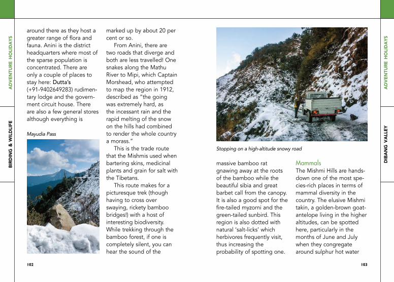
102
ad
ven
ture
ho
lid
ays
bird
ing &
wil
dli
fe
103
ad
ven
ture
ho
lid
ays
dib
an
g v
all
ey
around there as they host a greater range of flora and fauna. Anini is the district headquarters where most of the sparse population is concentrated. There are only a couple of places to stay here: dutta’s (+91-9402649283) rudimen-tary lodge and the govern-ment circuit house. There are also a few general stores although everything is
marked up by about 20 per cent or so.
From Anini, there are two roads that diverge and both are less travelled! One snakes along the Mathu River to Mipi, which Captain Morshead, who attempted to map the region in 1912, described as “the going was extremely hard, as the incessant rain and the rapid melting of the snow on the hills had combined to render the whole country a morass.”
This is the trade route that the Mishmis used when bartering skins, medicinal plants and grain for salt with the Tibetans.
This route makes for a picturesque trek (though having to cross over swaying, rickety bamboo bridges!) with a host of interesting biodiversity. While trekking through the bamboo forest, if one is completely silent, you can hear the sound of the
massive bamboo rat gnawing away at the roots of the bamboo while the beautiful sibia and great barbet call from the canopy. It is also a good spot for the fire-tailed myzorni and the green-tailed sunbird. This region is also dotted with natural ‘salt-licks’ which herbivores frequently visit, thus increasing the probability of spotting one.
MammalsThe Mishmi hills are hands-down one of the most spe-cies-rich places in terms of mammal diversity in the country. The elusive Mishmi takin, a golden-brown goat-antelope living in the higher altitudes, can be spotted here, particularly in the months of June and July when they congregate around sulphur hot water
Mayudia Pass
Stopping on a high-altitude snowy road

104
ad
ven
ture
ho
lid
ays
bird
ing &
wil
dli
fe
105
ad
ven
ture
ho
lid
ays
dib
an
g v
all
ey
springs. The white-cheeked macaque, a recently discov-ered species of monkey, is found in the mid-elevation belt along with the Gongshan barking deer that was reported for the first time from India.
As one moves up along the altitudinal gradient, one can spot the red goral, a mountain goat found exclusively in this part of
Arunachal Pradesh. There are also two species of musk deer found here, the alpine and the himalayan. Additionally, there are a host of small mammals such as red panda, stoat, linsang, weasel, himalayan masked civet, pika and the Asiatic wild dog that abound these forests. Leopard cats often sit on the cement parapet constructed along the road to Dambein.
BirdsDibang Valley is considered a birdwatcher’s paradise, with close to 700 species of birds being documented here, a major portion of the 1,300 bird species that India boasts. The most sought-af-ter bird that draws people from all corners of the world is the critically-endangered and highly elusive Mishmi wren-babbler, a miniscule bird that flits around in the undergrowth and is found nowhere else on the planet.
It was discovered by the ‘birdman of India’, Dr Salim Ali, in 1947 and was not seen again until a bird-watcher recorded its call in 2004.
Strikingly beautiful pheasants such as the multi-coloured Sclater’s monal, the crimson-orange Blyth’s tragopan and chestnut-breasted partridge are also high on the wishlist of
birdwatchers. The spot-breasted parrotbill is seen around the villages of Mihundo and Alinye along with the slender-billed scimitar babbler. The coniferous forests with long old-man’s-beard moss hanging from the branches is also the favourite haunt of the Ward’s trogon; named after the botanist who explored this region in the
Chestnut-breasted partridge
Mishmi takin
shutterstock
shutterstock

106
ad
ven
ture
ho
lid
ays
bird
ing &
wil
dli
fe
107
ad
ven
ture
ho
lid
ays
dib
an
g v
all
ey
early 1920s. The blue-winged siva, black-throated sunbird, golden-breasted fulvetta, Manipur fulvetta and streak-throated barwing are small but fascinating birds to keep an eye out for.
MicrofaunaThough understudied, some of the microfauna of the Mishmi hills stand out, such as the Khaki silverline and
De Nicéville’s windmill but-terflies, which are extremely rare and given the highest protection status according to the wildlife laws. The rather interesting bird-poop frog is also found in the mid elevations.
MithunsThe mithun is a large semi-domesticated bovine that plays an integral role in the culture of the Idu Mishmis. It is not only a sign of their prosperity but is also sacri-ficed in all of their festivals and important events such as weddings and personal Reh festivals.
Leeches and damdumsThe Mishmi hills are notori-ous for sly, blood-sucking leeches. Leeches here are a shade smarter than the average, they not only drop down on you but also wait in the folds of your clothes until they are the same tem-perature as you before bit-
ing, lest you should feel their cold sliminess and pick them off! however, leeches are the more benign of the bloodsuckers once you get to know damdums.
These miniscule insects, smaller than a mosquito, pack quite a punch with their bites that cause very itchy painful welts to swell. For most people, the first bite is associated with a
slight swelling of the limbs, though this ceases to hap-pen with subsequent bites.
Wearing full pants and shirts offers some protection from damdums while leech socks suffice for the leeches. however, both leeches and damdums’ presence is almost negligible in winters owing to the rather low temperatures that are not conducive to their survival.
Idu Mishmis during a shamanic ritual at Etalin
Khaki silverline butterfly
shutterstock

108
ad
ven
ture
ho
lid
ays
bird
ing &
wil
dli
fe
109
ad
ven
ture
ho
lid
ays
dib
an
g v
all
ey
canopy offers poor shooting conditions even at mid-day. It is advisable to hire guides who are well-informed about the natural history of the region as they have a fair idea about potential spots for particular animals. You can contact Binanda hatiboruah (09435271651, 09954861743), for bird-watching and Ravi Mekola (09774748828, 094024
57180) for mammals and birds. Gaurav Kataria runs birding camps in the region as well (09999030436, email: info@eaglenest birding.com); Tine Mena (09436875102, 089742- 99357), the first woman Everester from Arunachal, and Iho Mitapo, a local environmentalist, run the Mishmi hills Trekking Company can also help. ■
Food and wineRice beer, known as yew in Idu, plays a huge role in the everyday life of the Idus; the day is incomplete without laughing around the roaring fire in the centreplace of the stilted bamboo longhouse (changghar) with a glass of thick yew had in a bamboo mug. Interestingly, each household brews its own yew with the villages around
Anini also cultivating their own yeast to ferment the wine.
FestivalsThe Idus celebrate their ani-mist festivals with great gusto and fervour. A signifi-cant festival is the new, ‘centralised’ form of their otherwise ancient Reh ani-mist ritual that is held around the first week of February for the community to come together as a fra-ternity. Ke-meh-ha is the tra-ditional harvest festival cele-brated in September.
Contact PointsAs the fauna is unaccustomed to human presence in these sparsely-travelled through forests, they are highly skittish and wary of people thus offering only a fleeting glimpse. Photographers will require a good zoom lens and a camera that does well in low-light as the dense
Yew, the local grain wine
A woman preparing Idu Mishmi fare

110
ad
ven
ture
ho
lid
ays
bird
ing &
wil
dli
fe
111
ad
ven
ture
ho
lid
ays
a d
ay
in z
emit
ha
ng
a day in Zemithang: a wildlife filmmaker’s diary■ Omar Khan
Arunachal Pradesh has the highest mammalian diversity,
more than any other state in the country. But unlike the case with birds, spotting mammals in these areas can be a herculean task for a wildlife filmmaker because the jungles are so dense. The terrain does not allow for road access to core
areas, and going on foot is not everyone’s cup of green tea. Once in a while, however, you can have a really lucky day.
Tawang to ZemithangIn the northwesternmost part of Arunachal lies the district of Tawang, a moun-tainous region with abun-dant waterfalls, high-altitude lakes and panoramic views of snow-capped peaks. The
Monpa Buddhist tribe refrains from hunting, and reveres wild animals to a certain degree, in turn lead-ing to better chances of sighting wildlife. Driving from Zemithang to T-Gompa one cold September morn-ing, we first came across a goshawk feeding on a blood pheasant it had just killed at a bend.
A few kilometres ahead, a herd of goral were sunning themselves on the ledges. Sneaking up to the small band, a few metres away, we were undetected. One of the curious juveniles
initially couldn’t figure out what or who humans were. Finally, out of confusion, he sneezed loudly, which is their alarm call, and darted down with the rest into the valley below.
But the day wasn’t over yet. Ahead, on the same road, were blood spoor, with tufts of hair. And, finally, seeing a large stain on a rock, we parked the car to investigate once again. A large animal, probably a yak, was most likely injured and being chased by a predator, and had to run downhill.

112
ad
ven
ture
ho
lid
ays
bird
ing &
wil
dli
fe
113
ad
ven
ture
ho
lid
ays
a d
ay
in z
emit
ha
ng
Tracking the path led to more tufts of hair, more blood spoor and some small rocks. Finally, in a deep ravine, was the carcass of a young yak, and pug marks of the dhole, or the Indian wild dog, a species that’s even more endangered than the tiger (which is also found in Arunachal). The yak was a fresh kill, its body still warm. The dholes had purposely and strategically driven it to this steep rocky area, where it had fallen on the rocks and broken its legs, before they overpowered it.
Lateral thinkingIn such situations, it’s some-times best to install a cam-ouflage tent a few metres from the kill and wait it out. This didn’t work, initially. Nothing happened for two hours, and we decided to try something new to fool the intelligent, strategy-minded dogs. One of us
hiked back up to the car and pretended like he was talking on the phone loudly, walking further and further with his voice, to let them ‘deduce’ that humans were leaving, and it was safe to break cover. Just as he was fading out of earshot, some rustling and whimpering began; a small pack of five dholes emerged, and began eating to their heart’s con-tent. They feasted greedily for the next two hours, and several minutes of great footage was the result.
Moving onwards with our journey, some five kilome-tres from T-Gompa was an animal on a tree right next to the road where we stopped for tea. Turns out there were two of them, the fluffy red pandas. The camera batteries were nearly exhausted, but there was just enough left for a few shots.
My first foray into Arunachal Pradesh was in
2013, when I went to recce its forests and the mysteries they held.
Little did I know then that I’d keep coming back every year to explore a new part of the state, stack up some memories only to head back again!
The placeZemithang is a village about 80km from Tawang town.
There are homestays availa-ble in the area and there is also dormitory accommoda-tion at T-Gompa, which is a short distance from Sangetsar lake, a popular tourist destination. An optional drive that can be done is from Zemithang on the west towards Lumpu village, and then onwards on foot to sight the rare red panda. ■
113112
Indian wild dog
shutterstock

anglingrafting&

116
ad
ven
ture
ho
lid
ays
an
gli
ng
117
ad
ven
ture
ho
lid
ays
an
gli
ng
■ ninO dai
When it comes to angling in Arunachal
Pradesh, the first fish that one can think of is the golden mahseer, which
loves the fresh, fast-flowing himalayan rivers here. But in all the excitement surrounding the mahseer, one ought not to forget the goonch, chocolate or copper mahseers, rainbow trouts, brown trouts,
snakehead and bhorali. Every river has different inhabitants here.
The KamengThere are plenty of opportu-nities to catch the exotic golden mahseer here. The best areas are after Bana, where the Bichum River flows from the Dirang area
and joins the Kameng River. You will require rafts to reach spots that are inacces-sible by foot, where the sensitive mahseer normally swims about. Ensure that you get expert river guides, as the river has some treacherous rapids. The bhorali, another fighting fish, has also been seen in the lower sections of the river near Assam. If your ambition is to hook a mon-ster mahseer, then you must make sure that your equip-ment is up to the mark. Strong rods with braided lines and leaders are the order of the day. A mini-mum of 30lbs braid is required, though normally anglers go about with a minimum of 50lbs. The SubansiriThe ‘River of Gold’ has always been the ultimate destination for golden, chocolate and the very rare copper mahseer. This is cer-
anglIng In arunachal
Photographs by nino dai

118
ad
ven
ture
ho
lid
ays
an
gli
ng
119
ad
ven
ture
ho
lid
ays
an
gli
ng
tainly not an easy one, as it involves a rafting trip of five nights. There are no roads here; you are amid pure wilderness.
The only downside is the dam being built at the end of the river, which is stopping fish migrating to the upper areas for spawning. Again, if your ambition is to hook a monster mahseer, then you must make sure that your equipment is good. The
lures can range from plugs and spoons to spinners depending on the season. heavy spoons or heavy sinking lures are best during the dry season. End of monsoon trips can provide a good catch with soft lures and plugs near the river confluence. You can also try bait fishing with a local, multipurpose insect called the tari (stinkbug), which is highly effective!
The SiangThis river normally intimi-dates most anglers with its enormous size, width and depth. For most of the year, the river is coloured and muddy. It starts to clear up by mid-November, and is at its best till March. While the world record for mahseers stands at 34.6kg approxi-mately, this river is home to golden mahseer monsters, with the biggest found being 37kg! This went un-recorded internationally as
usual, as it was caught by local fishermen. The lower sections of the river, close to Pasighat, are good for the snakeheads and bhorali. The month of May can be considered as active goonch season, the fish known as ngoney or ngorik here. Snakeheads, which are also very popular game fish, grow to large sizes in the Siang, up to 17kg! A bhorali
in a safe and conducive environment can grow up to 30kg too, while the goonch can grow up to 100kg here!
The SimangThe Simang River is a tribu-tary of the Siang, and flows from its source, which is a high-altitude lake and a spring originating in the Mouling area. The river flows past the villages of
119118
Angler on the Subansiri

120
ad
ven
ture
ho
lid
ays
an
gli
ng
121
ad
ven
ture
ho
lid
ays
an
gli
ng
Subley, Sine and Pareng and the township of Boleng, to finally meet the Siang. Fishing season is from May to September, when the river is high. It is primarily famed for the golden mah-seer. The Simang-Siang confluence is also a very popular spot for fishing. During the summer months, you can actually catch a goonch here on a lure! The conservation effort on this
river by the Dosing Social Welfare Society (DSWS) has been a success story, and inspired the first Simang-Siang Angling Festival, which attracted 87 anglers from across the country.
The DibangThe Dibang is fondly dubbed as ‘home of golden mahseer’ due to the abun-dance of the fish in this river. It is not easy to access the interiors of this river, but some operators do a great job at getting anglers to the remote areas for a thrilling experience. This can involve hiking a good distance, and if you are lucky, maybe even crossing the river on an ele-phant! This river has many angling spots, but they are almost inaccessible except perhaps by rafting, which itself is tough, as it is also one of the hardest rivers for rafting! If you don’t catch a fish on this river you still won’t be disappointed.
Papum-Poma ConfluenceFlowing next to Itanagar, this river is suitable for anglers on a short holiday. It is ideal for golden mahseer. Start your trip from Itanagar and end at Ram Ghat.
Seasonal TipAngling in Arunachal depends on the season. When the major rivers are coloured, muddy and swol-len, fish tend to swim into
tributaries; this is their spawning season. This is when they tend to be more predatory, and will swim after lures. This is why you can catch the goonch on a lure at the Simang-Siang confluence. During the win-ters, when the water recedes, the fish tend to hang around in pools above or below rapids. This is when heavy quick-sinking lures do the job. ■
Big fish call for tough gear Camping on a river beach in Arunachal

122
ad
ven
ture
ho
lid
ays
raft
ing
123
ad
ven
ture
ho
lid
ays
raft
ing
■ ninO dai
Arunachal Pradesh’s rivers can range from mellow and
moderate to downright adrenaline-pumping when it comes to whitewater rafting. Most major rivers here are ideal during the dry winter season, which incidentally is also the major tourist season. The smaller rivers are more viable during the monsoon, when they swell in size and speed.
KamengThe Kameng River in Western Arunachal is great for rafting as it offers quite a variety of difficulty levels. If you are rafting from Marjangla, it can be termed as a proper river expedition. From Marjangla to the Bichum River confluence, most of the rapids are con-
stricted, and of classes III–IV. After the Bichum confluence near Bana, the volume of the river increases dramati-cally with one Class V rapid (depending on water levels) and numerous Class IV rap-ids till you reach Tippi, near Bhalukpong. The landscape after the Bichum confluence is fantastic, especially near the Bana gorge.itinerary: Guwahati- Bhalukong-Seppa- Marjangla (385km)difficulty: Moderate to hard; safety kayaker recommen-ded, though it could also be a raft-only trip
SubansiriThis river is fantastic in every way! There are two districts named after the river—Upper Subansiri and Lower Subansiri. The river flows from Upper Subansiri into the boundary between
raFtIng In arunachal

124
ad
ven
ture
ho
lid
ays
raft
ing
125
ad
ven
ture
ho
lid
ays
raft
ing
Kamle district and Lower Siang district. The popular rafting ‘put in’ point is at either Sippi, Daporijo or Kuporijo, and rafting hap-pens down to Gerukamukh (Assam) where the ‘take-out’ point is. It’s about 80km of pure fun and magic! Once you raft past the township of Dumporijo, you witness wilderness at its very best, with great water, beautiful
gorges and forests. The rap-ids are fun, and generally not difficult to manoeuvre. The river beaches are also excellent, making it an ener-gising experience overall. Carry some insect repellent, especially during October and mid-to-late February, to keep yourself safe from sand flies (damdum ).nearest Airport: Dibrugarh and Lilabari
nearest railhead: Silapathardriving distance: 280km from Dibrugarhdifficulty: Moderately challenging
SiangMother of all rivers, people in the region call her ‘Ane Siang’. The river is also known as the Upper
Brahmaputra in India and Yarlung Tsangpo in Tibet. It is the most legendary river in Arunachal Pradesh. It is a part of one of the longest river systems, flowing from Manasarovar to Bangladesh! There are five districts named after this river, namely Upper Siang, West Siang, Siang, East Siang and
125124
nino dai
Rafters conquer tough rapids on the Subansiri

126
ad
ven
ture
ho
lid
ays
raft
ing
127
ad
ven
ture
ho
lid
ays
raft
ing
Lower Siang. The conven-ient thing about the Siang is that it can be divided into sections, according to raft-ing grades, from pro to beginner-level. The first sec-tion is popularly known as ‘Tuting down’ (Tuting is the last administrative town in the Upper Siang district before the McMahon line, and is the popular ‘put-in’ point, though some also opt to ‘put-in’ at Ningging village). This section has some of the best white
waters in the world, and you require expert and experi-enced river runners to guide you through it.
Ranging from large-volume Class IV and IV-plus to Class V rapids, this section requires safety kayakers and catarafts. For more traditional rafting, you can do the Yingkiong-down, which satisfies many with its combined rafting and cultural experience. This section has some challeng-ing rapids, and also
Rafting on a calm river stretch; kayaks take on the rapids (facing page)
Photographs: ahtushi deshPande

128
ad
ven
ture
ho
lid
ays
raft
ing
129
ad
ven
ture
ho
lid
ays
raft
ing
provides an opportunity to visit local Adi tribal villages. The third section is Rottung-down. This is your bang-for-buck section, for travellers who don’t have the time and want to experience as much as possible. The last section is the Bodak/ Marying-down, which is more of a laidback float about and picnic trip for those travelling with families
and kids. The Siang has huge river beaches the size of a couple of football fields, a rare pleasure among mountain rivers.nearest Airport: Dibrugarhnearest railhead: Murkong Selekdifficulty: Moderate to hard itinerary: Dibrugarh- Pasighat-Jengging/Yingkiong-Tuting (total distance 400km)note: As of now, this is the most viable river for commercial rafting due to ease of connectivity by road and air. It is easier for the operators here to arrange for good logistics.
LohitThis is by far the most chal-lenging river to tackle for a rafter. The Lohit is an extremely beautiful river with turquoise blue waters and powerful whitewater rapids. What you first expe-rience as a rafter here is the sheer sense of volume and
power of the water. Most of the river, ironically, flows along the Anjaw district, and not the Lohit district that has been named after it. Rafting on the Lohit is commercially viable along the Parasuram Kund area and has the potential to become popular if marketed properly and well explored by professional rafters. Unfortunately, the fun part of the river, around Walong,
is prohibited for foreign tourists, and can be expen-sive for domestic tourists who typically want just a day of rafting in a profes-sional river with a Class V section. Nonetheless, it is a great all-in-all, a majestic river, with great potential!nearest Airport: Dibrugarhitinerary: Dibrugarh- Tinsukia-Chongkham- Wakro-hayuliang-Walongdistance: 250km ■
Subansiri River flowing through the eastern Himalayas
nino dai
ahtushi deshPande

paragliding

132
ad
ven
ture
ho
lid
ays
para
gli
din
g
133
ad
ven
ture
ho
lid
ays
mec
hu
ka &
lu
md
un
g
■ Sanjiv valSan
The rather meagre waiting-time to flying- time ratio when it
comes to paragliding in mechuka can typically mean spending a lot of time trekking up a hill with stuff, only to wait there for hours for the perfect wind. This is in addition to the time already taken to even reach faraway Mechuka. A hit rate of one or two flights a day, at the most, is the average here.
There is a lot of potential to be tapped when it comes to paragliding in these hills; this involves evaluating different spots over a period of time. As of now, most people come and fly during the annual adventure festival, Adventure@Mechuka in November, and that’s the time to plan your
trip. Even if you don’t get to fly, there are still plenty of activities happening simultaneously to quickly assuage any heartache from foiled paragliding plans.
Pappu ValleyIf Mechuka seems like too long a wait just for a nice view, Lumdung, in Pappu Valley, 19km from Seppa town, is the complete oppo-site. There’s no need to climb (with paragliding gear) atop cliffs at all, and takeoff and landing spots are both close to roads. Landing spots are surrounded by paddy fields from all sides for several kilometres, and there are no high tension wires; if your gear is in good shape and you fly correctly, there are almost no chances of fatal accidents resulting from terrain conditions, according to regular pilots
mechuka and lumdung
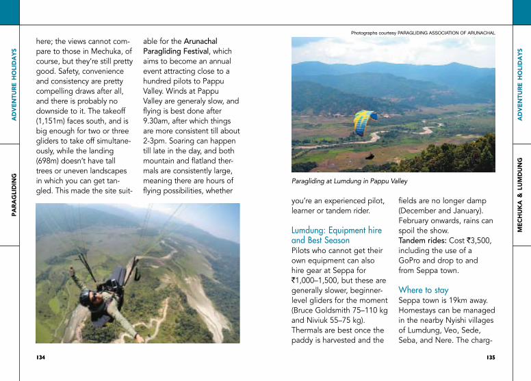
134
ad
ven
ture
ho
lid
ays
para
gli
din
g
135
ad
ven
ture
ho
lid
ays
mec
hu
ka &
lu
md
un
g
here; the views cannot com-pare to those in Mechuka, of course, but they’re still pretty good. Safety, convenience and consistency are pretty compelling draws after all, and there is probably no downside to it. The takeoff (1,151m) faces south, and is big enough for two or three gliders to take off simultane-ously, while the landing (698m) doesn’t have tall trees or uneven landscapes in which you can get tan-gled. This made the site suit-
able for the Arunachal Paragliding festival, which aims to become an annual event attracting close to a hundred pilots to Pappu Valley. Winds at Pappu Valley are generaly slow, and flying is best done after 9.30am, after which things are more consistent till about 2-3pm. Soaring can happen till late in the day, and both mountain and flatland ther-mals are consistently large, meaning there are hours of flying possibilities, whether
you’re an experienced pilot, learner or tandem rider.
Lumdung: Equipment hire and Best SeasonPilots who cannot get their own equipment can also hire gear at Seppa for `1,000–1,500, but these are generally slower, beginner-level gliders for the moment (Bruce Goldsmith 75–110 kg and Niviuk 55–75 kg). Thermals are best once the paddy is harvested and the
fields are no longer damp (December and January). February onwards, rains can spoil the show. tandem rides: Cost `3,500, including the use of a GoPro and drop to and from Seppa town.
Where to staySeppa town is 19km away. homestays can be managed in the nearby Nyishi villages of Lumdung, Veo, Sede, Seba, and Nere. The charg-
135134
Paragliding at Lumdung in Pappu Valley
Photographs courtesy Paragliding association of arunachal

136
ad
ven
ture
ho
lid
ays
para
gli
din
g
137
ad
ven
ture
ho
lid
ays
mec
hu
ka &
lu
md
un
g
es have been kept extreme-ly low for pilots flying at Pappu Valley to promote paragliding here, if you bring your own sleeping bag and stay in a traditional bamboo house with a Nyishi tribal family. These are tribal village huts; Seppa has more conventional hotels.contact: Vijay Sonam of the Arunachal Paragliding Association for more information on flying conditions, tandem rides, accommodation and
equipment hire (094360 41860, 08787597545)
MechukaThe Adventure@mechuka (W adventureatmechuka.in)festival is the time for paragliding here, especially for tandem rides.
Apart from paragliding, the schedule is generally packed with activities such as competitive angling, long-distance as well as downhill mountain biking, kayaking, local food and
musical performances, and the standard at every festi-val in Arunachal these days, fashion shows!
Mechuka’s hospitable locals also open their homes to visitors to stay during the festival. Overall, it’s a great entry into this beautiful place and its wonderful people, irrespective of how long you need to wait for takeoff!
Learning Paragliding in ArunachalNIMAS Dirang is a great place to learn paragliding from scratch, at an afforda-ble cost, from qualified trainers. here, you can begin with ground training, and eventually progress to three flights per day. They generally practise in the beautiful Sangti Valley, but also fly at Lumdung. ■
Paragliding in MechukaThe ethereal beauty of Mechuka
sanjiv valsan
sanjiv valsan

138
tra
vel
esse
nti
als
ad
ven
ture
ho
lid
ays
139
tra
vel
esse
nti
als
ad
ven
ture
ho
lid
ays
tHe PlAceArunachal Pradesh is over 81% forest – these include tropical, sub tropical,
pine forests, temperate forests and
alpine forests, along with several sub-
types. It is one of the world’s most
unexplored biodiversity hotspots.
Climate varies with elevation (wide
range between 50-7,000 mts msl),
ranging from humid subtropical, to
temperate, and cold, alpine at highest
elevations, where it can snow during
winters. It experiences heavy rainfall of
2000-4100mm annually. rains begin around february, but it’s most intense
between April and October. Most
travellers plan their trip during the dry
winter months for obvious reasons, but
flora tourism is year-round, since
different species have different
flowering seasons. Butterfly tours will
obviously follow a similar pattern since
butterfly diversity follows flower
diversity.
tHe PeoPleTo put the state’s diversity in
perspective, Arunachal Pradesh shares
borders with Assam, Nagaland,
Bhutan, China/ Tibet and Myanmar,
along with a long history of exchange
and migrations from each of these
places, and as far away as present-day
Mongolia. Officially, there are 26 major
tribes with over 100 ‘sub-tribes’ and
dozens of languages, but in reality the
diversity is even more than these
numbers suggest. Culturally and
geographically the state’s ethnics
groups can be divided into some
broad categories – the Indo-Tibetan
mahayana Buddhist tribes such as the
Monpas, Sherdukpen, Brokpas and
Membas; the animist mishmi tribes like the Idu Mishmis, Digaru Mishmis
and Miju Mishmis; the ‘tani tribes,’ such as the Nyishis, Apatanis, Galos,
Tagins and various Adi tribes; and the
theravada Buddhists like the
Khamptis, Singphos; and the indo-Burmese tribes close to the Myanmar
border like the Tangsa tribes, Nocte
groups and Wanchos, who share
cultural and ethnic similarities with
tribes in Nagaland and Myanmar. The
major religions are Buddhism,
Christianity and various ethnic
animistic faiths. hindi is used as a
travel essentials common language, since without a
common tongue, none of these tribes
would have been able to understand
each other’s languages. English is also
spoken in towns, since it’s the medium
of education. In Eastern Arunachal,
some Assamese is also spoken. Since
there are so many tribes here, tribal
festivals feature almost year-round, and
make for good bookmarks to plan an
itinerary. Animist festivals, rituals and weddings almost invariably involve a
publicly visible animal sacrifice (it will
be eaten subsequently); the faint-
hearted might want to take note in
advance. Elderly people are highly
respected in tribal societies, and senior
citizens have a good life compared to
their urban counterparts.
HospitalityThe tribals of Arunachal are a warm,
friendly, generous and cheerful lot, and
in general homestays are far more
interesting than hotels. Tourism is still
raw, infrastructure is just about coming
up and creature comforts might not
always be possible in many places, but
this is all part of the adventure. You
might even encounter situations where
you will be offered food and homestay
accommodation by a genuinely
hospitable tribal person you just met,
who refuses to accept money for it
since it is against his culture and ethos
to charge for food or stay. So it helps
to have a bunch of nice gifts ready in
your bag to give away in such
situations; these will be happily
accepted, and can sometimes go
much better with the culture, unlike
money. Alternatively, one could also
buy handicrafts from them, since
nearly every woman in the villages is a
textile weaver here, and most older
men are adept at bamboo craft. In any
case in some tribes, when you visit any
old villager’s home, it is often
customary to bring small gifts in kind
such as tea leaves, coffee, dry fish, dry
meat, etc; so it’s best to prepare
accordingly. At the end of your trip, if
you have any extra gifts left, you could
give them to villagers away anyway
just to make people happy, leading to
new bonds, friendships and cultural
exchange.
SafetyIn general, this is a safer state for
travellers (solo female travellers
included) than many parts of India, and

140
tra
vel
esse
nti
als
ad
ven
ture
ho
lid
ays
141
tra
vel
esse
nti
als
ad
ven
ture
ho
lid
ays
robberies are extremely rare, especially
in smaller towns and rural areas, and
provided you exercise basic
commonsense, it’s generally safe to
trust in the hospitality of locals you
might meet. however, days typically
begin and end early here, and streets
and lanes in bazaar areas of small
towns are deserted late at night, so it’s
probably best not to pursue an
overactive nocturnal life in such areas.
Villages are extremely safe, though.
Dress code: moderately modest.
GETTING ThERE AND AROUND
AirPortS And HelicoPterSThe airports are Pasighat (weekly
flights from Kolkata), Tezu (to be fully
functional soon), Guwahati
(International, Assam), Dibrugarh/
Mohanbari (Domestic, Assam - useful
for southern and eastern Arunachal),
Lilabari (Domestic, Assam - closest to
Itanagar), Tezpur (Assam, domestic,
better for Western Arunachal). Regular
helicopter services (operated by
SkyOne) connect Mohanbari/Dibrugarh
and Itanagar (via its twin city
Naharlagun) to a few headquarters in
Arunachal. These can be incredibly
convenient, save lots of time and
present great value for money; but
safety and last-minute flight
cancellations can be a concern during
rough weather. Additionally, you could
suddenly find that your booking stands
cancelled due an emergency medical
case requiring quick transport. All
things considered, it’s tricky to plan
tight schedules relying on the chopper
services during your return journey,
when you have a flight already booked
that you absolutely don’t want to miss.
In our experience, here’s the smart way
to use the choppers: Book your trip
into Arunachal from Guwahati or
Mohanbari airport and some part of
the onward journey by chopper, along
with a ‘Plan B’ road plan, in case the
chopper is cancelled; but be sure to
plan your return trip back to the
airport entirely by road to be on the
safe side. During rainy or stormy
weather, avoid chopper rides involving
higher altitude mountains altogether.
Regular, comfortable, pay-per-seat
share taxis ply between Guwahati
Airport and Itanagar, and reasonably
priced air conditioned buses leave
every half hour or so between
Guwahati airport and Ulubari, which is
near the railway station in downtown
Guwahati. Smartphone app-based all
taxi services such as Ola and Uber are
otherwise the cheapest and most
reliable means to move around
Guwahati town till you make your
onward journey.
trAinSThe most useful railways stations are
Naharlagun (near the capital Itanagar),
Silapathar, Jonai, harmuti Jn. and
Murkingselek (all on the same line in
Assam) on one end; and Tinsukia and
Dibruhgarh (Assam). Guwahati in
Assam is also a useful interchange
station, since it has a major airport and
connects Naharlagun, Tinsukia and
Dibrugarh to most parts of India. Be
warned that train travel to Arunachal
Pradesh is for strictly long haulers; The
fastest train from Delhi to Itanagar, for
example takes close to 36 hours.
having said this, the trains on this
route are cleaner and better
maintained than the average Indian
standard, especially the Rajdhani and
intercity express trains from
Naharlagun, and reservations aren’t
difficult to get, even last minute.
Getting in and out of Naharlagun
railway station using public transport
can be a confusing affair, especially for
those catching early morning trains
from Naharlagun. At the Itanagar end
of things, the government-run APST
bus service has a bus service running
to and from Naharlagun railway station
and Itanagar/Naharlagun town,
coinciding with the departure and
arrival of major trains, but these are
easier to reach from Naharlagun
railway station to Itanagar/Naharlagun
town than the other way around.
These ‘feeder service’ buses leave
downtown very shortly after the arrival
of each train, so get off the train
quickly if you need to catch them.
Taxis are generally available at the
railway station as well.
locAl PUBlic trAnSPortThere’s a whole biodiversity in these
category, ranging from the cheaper
state-run APST state buses, to private
bus operators such as Network, and
budget-friendly ‘Line Sumos,’ which
are basically cramped share SUV taxis
plying between different towns and
villages, with a medley of Bollywood
songs sometimes playing nonstop

142
tra
vel
esse
nti
als
ad
ven
ture
ho
lid
ays
143
tra
vel
esse
nti
als
ad
ven
ture
ho
lid
ays
along the route. Line taxis penetrate
deeper into Arunachal than the other
modes, and reach fast as well. Booking
more than one seat per traveller (2 or
3 seats) could still work out cheaper
than hiring your own car, let you
control the music (!) and can often be
a more acceptable compromise
between cost and comfort when you
don’t have your own car. Or better yet,
if travelling in a big group, hire the
whole vehicle by booking all 10 seats,
which can oddly still work out cheaper
than ‘hiring a car.’ Safety-wise, this can
be a particularly smart choice on tricky
routes and difficult mountain roads,
where the Line Sumo driver who does
a certain route daily would know the
terrain better than someone who’s less
familiar with the place. Most towns
have a bazaar area, where you’ll find
the ‘counter’ where you can enquire
about bus and Line taxi services, and
even hire private cars. Bookings can
subsequently happen even over the
phone, and payment is strictly cash
only.
itanagar town has expensive three-
wheeler ‘auto-rickshaws’ and cheap
‘Trackers’ and ‘Tempos,’ which are
basically share-taxis that ply along the
long arterial road covering the length
of both Itanagar and Naharlagun, and
on to Doimukh and the Banderdewa
Gate, forming the border with Assam.
At night, even these services stop, and
the rickshaws nearly triple their rates.
Even later into the night (post 9pm)
you will often find no transport at all,
at any price! So it’s best to have a car
in Itanagar, especially if you plan to
return to your room late at night.
Towns like Roing in Lower Dibang
Valley , however have more reasonably
priced and reliable auto-rickshaws, so
local public transport varies greatly
from town to town. By and large, it’s
best to have your own vehicle, should
you choose to travel without an
operator who arranges everything for
you. Whatever the case, rush hour
traffic in Itanagar is real, and you want
to avoid being in it.
roAd trAVelDriving into Arunachal always involves
crossing Assam, where the roads are
much better, but once you enter hilly
terrain, the story changes. Mountain
road conditions in Arunachal can vary
from buttery smooth and comfortable
to adventurous, off-roader style
rollercoaster experiences. Don’t be
fooled by linear distances between
two points the map — negotiating
rough, zigzaggy mountain roads can
account for biggest component of
travel time in Arunachal, especially if
you’re planning several regions of this
large state on the same trip. It’s always
a good idea to enquire not just about
distances, but also road conditions,
while charting out your routes. It rains
here for nearly nine months of the
year, so this is worth keeping in mind,
especially if you’re cycling or
motorbiking. Road conditions are best
in the dry season (Oct-Feb), when road
travel times are a lot faster.
Regular Indian driving licenses are
valid in Arunachal, but try and avoid
negotiating rough mountain roads in
foggy or stormy weather at night; in
some instances travel on this routes
may be officially closed during this
time to ensure that mishaps are
avoided; it’s safest to either wait till the
light or weather clears up, or get a
person who’s familiar with the area to
drive. Arunachal Pradesh may be a
mountain biking paradise, but
spontaneously renting bicycles is
almost unheard of in these parts; so if
you’re planning on cycling, either get
your own, rent a bike from Assam or
get your tour operator to make the
arrangements.
Atms, cash, communication, internet: Be sure to stock up on cash, because
in many interior places you’d want to
visit, credit card payment isn’t
possible, and ATMs are also known to
run out of cash intermittently. Most
urban and semi-urban and village
areas have cellphone coverage, but
the operator may vary, so carrying dual
SIM phones or multiple phones is
advisable if connectivity is vital during
your stay. You can be sure however,
that many of the most beautiful forests
in Arunachal will not have mobile
coverage, so prepare accordingly. For
internet, you’ll have to depend on
your cellphone and hotspots most of
the time. A power bank can also be
handy during power cuts, especially in
remote areas. India Post’s ‘Speed Post’
service interestingly works better in
Arunachal Pradesh than most parts of
India, and can be useful in smaller
towns and villages, where private
courier companies don’t operate.

144
tra
vel
esse
nti
als
ad
ven
ture
ho
lid
ays
145
tra
vel
esse
nti
als
ad
ven
ture
ho
lid
ays
PermitS And BorderSArunachal Pradesh lies on India’s
border with Bhutan, China/Tibet and
Myanmar, but for the moment, tourists
aren’t allowed to cross over into these
countries from Arunachal via these
borders, either with or without the
relevant visas. Indians and Myanmar
citizens are occasionally allowed to
cross the Pangsau Pass near
Nampong, in Changlang District for a
day, but lately, this passage has been
opened to the general public
somewhat less consistently.
Entering reserve forest areas and
militarily or politically sensitive
border areas might require special
permission from the concerned
authorities, such as the local Forest
Range office, army authorities, DC,
ADC, etc. In general, additional
permissions from local authorities are
required for sport angling or river
rafting, which your tour operator
will manage. Foreigners aren’t allowed
to enter certain border areas of
Arunachal Pradesh. Unlike in other
parts of India, most forests and water
bodies in tribal areas are either
community-managed or private
property, so avoid fishing, harvesting
from orchards or farms excessive
foraging without permission. In the
Nocte and Wancho tribal villages of
Tirap and Longding, it’s generally a
good idea as an outsider to meet the
local king or chief as a courtesy visit,
and in his absence, the village
‘Gambura.’ In other tribes, having any
local contact from the village will do.
These meetings can be useful
icebreakers and set the tone for some
good interactions.
travel Permits for foreign travellersForeign tourists in groups of 2 or
more (single for travel to Tawang
and Ziro) need to apply for a Protected Areas Permit (PAP), which
costs US$30 (valid for 30 days). You’d
need to apply for these through local
tour operators.
PAP is issued from the following offices
to foreign travellers:
1. Ministry of home Affairs,
Government of India, New Delhi
2. Office of Resident Commissioner,
Arunachal Bhawan, New Delhi
3. Office of Deputy Resident
Commissioner, Arunachal Bhawan,
Kolkata and Guwahati.
4. Department of home, Government
of Arunachal Pradesh, Itanagar.
5. Department of Tourism,
Government of Arunachal Pradesh,
Itanagar.
PAPs aren’t issued to tourists in certain
sensitive border areas such as some
parts of Changlang, Tirap, Longding
districts. Check if where you want to
travel in Arunachal is a no-go zone for
tourists. Researchers, scientists, etc
might be able to travel to these parts,
however in special cases, provided they
have received a local invitation and
have proper projects in these places.
travel Permits for indiantravellersthough an inner line Permit (ilP) is
mandatory for Indian citizens to enter
Arunachal Pradesh, getting it is a
simpler process than it is for foreigners,
and with fewer restricted areas. Every
district in Arunachal Pradesh has a
similar administrative structure. Above
the village and local authorities are
Circle Officers, Additional Divisional
Commissioners (ADC) in the bigger
villages and towns, and above that the
Divisional Commissioner (DC). It helps
to decide on the districts you are likely
to visit while planning your trip itself,
because the ILP is generally issued only
a few districts at a time, and often not
valid if you cross over to another
district which isn’t on your ILP, making
spontaneous travel complicated for
first-timers. To renew, extend your ILP
or add a different district on your pass,
if you don’t choose the online route for
whatever reason (such as temporarily
not having internet or electricity), you’d
need to submit a written application to
the local DC or ADC. These offices are
of course, closed on public holidays.
Keep passport-sized photographs and
photocopies of your ID handy
Apply for ILPs online here:
www.arunachalilp.com
Hardcopy ilP applications are also received and issued by the following offices 1. delhiThe Resident Commissioner, Govt. of
Arunachal Pradesh,Kautilya Marg,
Chanakyapuri, New Delhi.
tel: 011-23013915

146
tra
vel
esse
nti
als
ad
ven
ture
ho
lid
ays
147
tra
vel
esse
nti
als
ad
ven
ture
ho
lid
ays
2. kolkataThe Deputy Resident Commissioner,
Govt. of Arunachal Pradesh, CE-109,
Sector-1, Salt Lake City, Kolkata.
tel 033-23341243, 23589865
cell 09830822512
3. guwahatiThe Deputy Resident Commissioner,
Govt. of Arunachal Pradesh, GS Road
Rukminigaon opposite Manasa Mandir,
Dispur, Guwahati
tel 0361-2229506
cell 7086026788
4. ShillongThe Deputy Resident Commissioner,
Govt. of Arunachal Pradesh,
Meghalaya, Shilllong. tel 0364-
2224247, 2506470
5. tezpurThe Deputy Resident Commissioner,
Govt. of Arunachal Pradesh Parvati
nagar, Tezpur,Assam - 03712-260173
tel 03712-260173, 260141
cell 09435521735
6. dibrugarhThe Deputy Resident Commissioner,
Govt. of Arunachal Pradesh,
Mohanbari, Dibrugarh, Assam
tel 0373- 2382560/2382738.
7. from the office of all the deputy commissioners of 25 districts of the state.
PERMITS ON ARRIVAL
Tourist ILP facilitation centres are at the following places:1. Naharlagun railway station
2. Gumto railway station
3. Guwahati Asom Paryatan Bhawan near
Nepali Mandir and Guwahati
LGBI Airport.
AIR in ArUnAcHAl
airline OFFiCeS
AlliAnce AirToll Free 18602331407
W airindia.in
Origin Guwahati
teZU AirPort has been inaugurated,
but at the time of going to press is not
up and running as yet.
in ASSAmlokPriyA goPinAtH Bordoloi/ guwahati
international AirportAirport Director tel 0361-2841909
W aai.aeroairline OFFiCeS
Air indiAToll Free 18602331407 W airindia.in
AlliAnce AirToll Free 18602331407
W airindia.in/alliance-air
go AirCustomer Care: 022-62732111
Toll Free: 18602100999 W goair.in
Origin Bagdogra, Delhi, Kolkata
indigoTel: 0124-6173838 Cell 09910383838
W goindigo.in
Origin Agartala, Amritsar, Bagdogra,
Bengaluru, Bhubaneswar, Chennai,
Delhi, hyderabad, Imphal, Kochi,
Kolkata, Mumbai, Varanasi
ViStArACell 09289228888 W airvistara.com
diBrUgArH AirPortMohanbari, Assam
Airport Director Tel 0373-2382755
W aai.aero
airline OFFiCeS
Air indiAToll Free 18602331407 W airindia.in
indigoTel: 0124-6173838
Cell 09910383838
W goindigo.in
SPiceJetCell 09871803333
W spicejet.com
lilABAri AirPortNorth Lakhimpur, Assam
W aai.aeroairline OFFiCeS
AlliAnce AirToll Free 18602331407
W airindia.in/alliance-air
SPiceJetCell 09871803333, 09654003333
W spicejet.com
Origin Kolkata
teZPUr AirPorthaleswar Dist-Sonitpur,
Tezpur, Assam
Airport Director Tel 03712-258441
W aai.aero
transport directory

148
tra
vel
esse
nti
als
ad
ven
ture
ho
lid
ays
149
tra
vel
esse
nti
als
ad
ven
ture
ho
lid
ays
airline OFFiCeS
AlliAnce AirToll Free 18602331407
W airindia.in/alliance-air
HelicoPter SerViceW arunachalipr.gov.in
Guwahati Ticket Counter
Cell 09085738939
Naharlagun Ticket Counter
Cell 09436291907
SECTORS:
Guwahati -Naharlagun
Guwahati-Tawang
Naharlagun-Pasighat
Pasighat-Along
Naharlagun-Mechuka
RAILEnquiry 139
W indianrail.gov.in
irctc.co.in
in ArUnAcHAlBHAlUkPong rAilwAy StAtionBhalukpong Railway Station is
connected to Assam by the
Bhalukpong-Dekargoan Passenger.
nAHArlAgUn rAilwAy StAtionNaharlagun Railway Station connects
Assam and New Delhi. Trains serving
this station include the Naharlagun-
Guwahati Donyi Polo Express,
Naharlagun-Guwahati Shatabdi Express,
Tinsukia Intercity Express, and Arunachal
AC SF Express (bi-weekly) which con-
nects Delhi, UP, Bihar, West Bengal and
Assam to Arunachal Pradesh.
in ASSAmdiBrUgArH rAilwAy StAtionDibrugarh Railway Station is well
connected to Delhi, Amritsar,
Chandigarh, Bengaluru, Kolkata, Uttar
Pradesh etc. Major trains serving this
station are Avadh Assam Express,
Dibrugarh-Amritsar Weekly Express,
Dibrugarh-Chandigarh Weekly Express,
Dibrugarh-Kolkata Weekly SF Express
and Dibrugarh-New Delhi Rajdhani
Express. It is connected to Arunachal
Pradesh by the Naharlagun- Tinsukia
Intercity Express.
gUwAHAti JUnctionGuwahati Junction is a major railway
station connecting Assam to other
parts of the country. Major trains
serving this station
are Anand Vihar -Agartala Rajdhani
Express, Bikaner-Guwahati Express,
Kolkata-Silghat Town Kaziranga Express,
Mumbai LLT-Guwahati Express, etc. It
is connected to Arunachal Pradesh by
the Naharlagun-Guwahati Shatabdi
Express, Tinsukia Intercity Express and
Arunachal AC SF Express.
HArmUti JUnctionharmuti Junction is connected to
served major metros and
cities by Arunachal Express.
Other trains connecting Arunachal
Pradesh are Naharlagun-Guwahati
Shatabdi Express, Naharlagun-Tinsukia
Intercity Express and Naharlagun-
Guwahati Donyi Polo Express.
nortH lAkHimPUr rAilwAy StAtionNorth Lakhimpur Railway Station is
connected to Arunachal Pradesh by the
Naharlagun – Tinsukia Intercity Express.
rAngiyA JUnctionRangiya Junction is a major railway
station connecting Assam to major
cities in India and Arunachal Pradesh.
Trains serving this station are Kanchen-
junga Express, Avadh Assam Express,
North East Express, Mumbai LLT
Kamakhya AC Express, etc. It is
connected to Arunachal Pradesh by
Naharlagun-Guwahati Donyi Polo
Express, Arunachal AC SF Express.
teZPUr rAilwAy StAtionTezpur Railway Station falls under the
Rangiya Division. Trains serving this
station are Alipurduar Jn-Silghat Town
Rajya Rani Express, Kolkata-Silghat
Town Kaziranga Express etc. It is
connected to Arunachal Pradesh by
Guwahati-Naharlagun Shatabdi Express,
Guwahati-Naharlagun Donyi-Polo
Express, Arunachal AC SF Express.
tinSUkiA JUnctionTinsukia Junction is connected to
Dibrugarh, Guwahati by Ledo-
Guwahati Intercity Express, Tinsukia-
Jorhat Town Passenger, etc. It is
connected to Arunachal Pradesh by
Naharlagun-Tinsukia Intercity Express.
RoAdBUSAalo (SS) Cell 09436058188
Bomdila (SS) Cell 09402476020
Pasighat (SS) Cell 09612453200
Itanagar (SS/AS) Cell 09774034571
Roing (SS) Cell 09436222387
Tawang (SS) Cell 09436836087

150
tou
rist
/ w
ild
life
off
ices
a
dve
ntu
re h
oli
da
ys
iTanaGar
department of tourism Govt. of Arunachal Pradesh, Itanagar
cell 08787619774 (Director of Tourism)
GuWahaTi
department of tourism Govt. of Arunachal PradeshGS Road, Rukmani Village, Opp Mansa
Mandir, Dispur, Assam
tel 0361-2229506 cell 7086026788
neW delhi
department of tourism Govt. of Arunachal PradeshArunachal Bhawan, Kautilya Marg,
Chanakyapuri, New Delhi
tel 011-23013915, 23013956
daying erring wildlife SanctuaryPasighat
cell 09862624766 (DFO),
09436621222 (RO)
eaglenest wildlife Sanctuary Shergaon Forest Division
tel 03782-232249 Cell 09436246192
namdapha national ParkField Director,
Miao, Changlang Dist
Cell 09436835658
Pakke tiger resrveSeijosa Wildlife Range
East Kameng
cell 08811952541 (RFO),
09436042859 (DFO)
cell 09436093632
tel 03778-200016
talle wildlife SanctuaryRange Forest Offier
Lower Subansiri
hapoli
cell 09436040268 (RO), 09436047092
InformatIon InformatIon & BookIng
toUrist/ wildlife offices
TOURIST OFFICES
WILDLIFE OFFICES
Arunachal Tourism W arunachaltourism.com

151
ad
ven
ture
ho
lid
ays
tou
r o
pera
tors
BOmdila STd 03782
Himalayan Holidays location ABC Bldng. Main Market,
Bomdila tel 3782-222017 cell 094360
45063 W himalayan-holidays.net
Services Car rental, tour packages,
transportation, accommodations, wildlife
tours, customised tours, forex, ticketing,
passport n visa, all permits destinations
All North-Eastern States
iTanaGar STd 0360
duyu tours & travels location Vivek Vihar, College Road,
Itanagar tel 0360-216450, 218056
cell 09436044905 W arunachaltours.
com Services Car rental, tour
packages, customised tours,
transportation, accommodations
destinations All North East
kaziranga toursAddress Kadambari Complex (Gr Flr),
Thana Charall tel 2325969
cell 09435530345, 09401343501
W kazirangatours.com Services
Customised tours, wildlife tours,
trekking destinations All of
Arunachal Pradesh
Guwahati Branch house No 149 (1st
Floor), Kolnadhara cell 07002412384
naharlaGun
ravi travel & tour inclocation A Sector, Naharlagun (Near
Old Cinema hall), Dist Papumpare
cell 08257894003-04 Services hotel/
Air/Rail bookings
Tip They have discontinued Car rentals
Xcelllocation hafizan Complex, Ulubari,
Opp Volvo Point, GS Road, Guwahati
cell 09854121140 W xcell.co.in
Services Car rental, tour packages,
accommodations destinations
Arunachal Pradesh, Assam
PaSiGhaT STd 0368
donyi Hango tours – rafting / trekkinglocation Tebo Village, East Siang,
Nh 52, Pasighat tel 222324
cell 09436043393 W arunachal
donyihango.com Services Tour
packages, trekking, rafting, hotel
toUr operators

152
ad
ven
ture
ho
lid
ays
153
ad
ven
ture
ho
lid
ays
mishmi Hills camp roingGuesthouse that also arranges nature
and culture tours in Dibang Valley,
Lower Dibang Valley
contact: Jibi Pulu 09862856981
ravi mekolaWildlife and bird tours in Dibang Valley
contact: 9774748828, 9402457180
Help tourism Specialises in: Rural Tourism,
homestays, Nature Lodges, Nature
Camping, Nature expeditions, Birding,
Butterfly tours, Wildlife treks,
‘Biodivinity journeys’
contact: Raj Basu +91-9434046892
e-mail: [email protected]
W www.helptourism.com and
(Under construction) www.
arunachalhomestays.com
Seed (Society for education and environmental development) - miaoSpecialises in: Eco camps, Nature
Conservation through “nature walks &
learn” at Miao/Namdapha/Roing/Upper
Siang – this is a nonprofit organisation
contact: Minom Pertin
918974159612/+919436252577
e-mail:: [email protected]/
eagle nest Birding – eagle nestSpecialises in: Birding tours all over
Arunachal Pradesh
contact: Gaurav Kataria
9999030436, info@eaglenest
birding.com
naja and wild india expeditionsSpecialises in: Reptile, snake and
microfauna trips and workshops
and volunteering, structured fauna
expeditions in Arunachal Pradesh.
contact: Soham Mukherjee
+91-9909906618
e-mail: [email protected]
namdapha tours and treks miao, changlangSpecialises in: Treks, tours, safaris
and activities in Namdapha Tiger
reserve and Changlang district
contact: Phupla Singpho
+91-9436228763
+91-9863288092, 03807-222296,
+91-3807-222296 (for outside India)
e-mail: [email protected]
ad
ven
ture
to
ur
ope
rato
rs
ad
ven
ture
to
ur
ope
rato
rs
adventUre toUr operators
Abor country travels expedition, itanagarSpecialises in: Adventure,
cultural heritage Tours, camping,
angling, rafting, high altitude flower
tours
contact: Oken Tayeng
+91-360-2292969, 9436053870,
9436860903
Skype: Abor Country
e-mail: [email protected],
dibang Adventure - Anini/roingSpecialises in: trekking, wildlife,
culture, angling, safaris, adventure in
Dibang Valley, Lower Dibang Valley
contact Adiju Rondo +919402606309,
+918794120523
e-mail: [email protected]
the mishmi Hills trekking company - roing/AniniSpecialises in: hiking, culture,
adventure, camping, esp. in Dibang
Valley, Lower Dibang Valley and
Eastern Arunachal
contact: Tine Mena
+91-9436875102, +91-8974299357
fb Page: https://www.facebook.com/
MishmihillsTrekkingCompany/
mishmi Hills resort & Hotels private limited – roingResort in Roing that arranges tours in
Dibang and Lower Dibang Valley
contact: 09436836763,
or proprietor Rezina Mihu
+919862447610
fb Page: https://www.facebook.com/
ExploreMishmihills/
accommodations, transportation,
arrange permit
rOinG STd 03803
the mishmi Hills trekking co.location 2 kms from Roing cell
09436875102, 09366709589,
08974299357 Services
Car rental, Adventure Tour
Packages for all NE state,
customised tours, accommodations,
transportation

154
ad
ven
ture
ho
lid
ays
155
ad
ven
ture
ho
lid
ays
W https://namdaphatoursandtreks.
wordpress.com/
camp namdapha Holidays - namsai/ kohima/ Shillong/ tura/itanagarSpecialises in: Tribal gourmet tours,
trekking, flower tours, culture
contact: Chau Enseng Mantow
8974643450
e-mail: [email protected]
north by northeast - tezpurSpecialises in: Cycling, motorbike,
ethno-cultural tours, wildlife,
overland journeys in Arunachal
contact Roheen Browne
+91-9940416065
e-mail: [email protected]
W http://northbynortheast.in
kipepeo - mumbai/northeast indiaSpecialises in: Cultural tours,
road trips, hikes
contact: Piran Elavia +91-9930002412
e-mail: [email protected]
W www.kipepeo.in
Binanda HatiborahSpecialises in: Birding and wildlife ours
in Pakke, Eaglenest, Tawang,
West Kameng
contact: 9435271651, 9954861743
Village Holiday tours & travels - khonsa, tirap dist.Specialises in: village to village
treks, cultural tours, esp.in Eastern
Arunachal - Tirap, Changlang,
Longding, etc
contact: Khunwang Tangjang
+91-8118951427
e-mail: [email protected]
wildwildeast - roing lower dibang ValleySpecialises in: Tribal ethno-cultural
festival tours, angling,
off-roading
contact: Tajom Tayeng
7002031852, 9862885645
E mail: [email protected]
tajom tyeng - roing contact: Tajom Tyeng +91-98628
85645, +91-9436436010,
+91-7002031852
e-mail: [email protected]
m/s menchukha tours & travels menchukha/ itanagarSpecialises in: Trekking, camping,
culture tours between
Menchukha and Tato
contact: Tsawang Chukla
9402224350 +91 9402224350
+91 7005737596 and
Gebu Sona +91 9436074877,
+91 940299666
e-mail: [email protected],
W http://gtlhomestay.com
Himalayan Holidays, BomdilaSpecialises in: culture, hiking, angling
in Western Arunachal
contact Tsering Wange,
+91 3782-222017/222216/223818,
9436045063/9436222905
9402257638 (Itanagar:)
Tawang: 9436248216
e-mail: [email protected]
W www.himalayan-holidays.net
Brahmaputra tours, ZiroSpecialises in: Cultural tours,
butterflies, orchids and hiking,
Talle Valley, Ziro
contact: Koj Mama 03788-
224905/2241931,
9436634496/8575248013
e-mail: [email protected];
W www.brahmaputratours.com
Donyi hango Tours Pasighat
Specialises in: Pro rafting and angling,
Central Arunachal, Buddhist trails,
riverside camping, trekking
contact: Nino Dai, Yane Dai 0368
2224243, 9436043393
e-mail: [email protected]
W https://arunachaldonyihango.com
m/S Arunachal discover Paradise tours, naharlagunSpecialises in: Paragliding,
parasailing, etc, esp. around East
Kameng and Seppa
contact: Vijay Sonam +91
9089722446/9436041860,
fax: 0360-2246531
e-mail: arunachaldiscovertours@ymail.
W www.arunachaldiscovertours.com
Tawang Tour and Travels Tawang/Delhi
contact: Lobsang Phuntsok (Tawang)
+91 8826888897, 9818336220
contact Delhi: - +91-8826888897,
9818336220
e-mail: - [email protected]
W - www.tawangtravel.in
Tribal Adventure Tours Naharlagun
e-mail:- tribaladventuretours@gmail.
ad
ven
ture
to
ur
ope
rato
rs
ad
ven
ture
to
ur
ope
rato
rs

156
ad
ven
ture
ho
lid
ays
157
ad
ven
ture
ho
lid
ays
08974141614 Rooms 4
tariff `600-1,000 facilities
Restaurant, attached bath
namdapha Jungle camp location Miao, 7 km from NP from
entry gate cell 09436228763,
08974141614, 08257994436
Rooms 4 tariff `1,500; TE facilities
Kitchen, dining area, local tribal food on
request, guides, trekking, bird
watching, butterfly spotting,
tribal visit
PaKKe TiGer reServe
forest inspection Bunglow location Inside the Forest, adjacent
to West Bank Forest Rest
house cell 09436093632 (RO)
Rooms 2, dorms 1 (6 bedded)
tariff `400, dorm bed `100
facilities Kitchen, caretaker, room
service, attached bath
Reservations tel 03778-200016
cell 09436042859
khari forest rest House location Inside the Forest, 12 kms
from West Bank Forest Rest
house cell 09436093632 (RO)
Rooms 4 tariff `400 Credit Cards NA
facilities Kitchen, food on
request, caretaker Reservations
tel 03778-200016
cell 09436042859 (DFO)
Upper dekoroi rest House location Inside the Forest, 12 kms
from West Bank Forest Rest house
cell 09436093632 (Range Officer)
Rooms 4 tariff `400 facilities
Kitchen, food on request, caretaker
Reservations tel 03778-200016
cell 09436042859
west Bank forest rest House location Inside the Forest,
Close to the Gate cell 09436093632
(Range Officer) Rooms 4 tariff `400
Credit Cards NA facilities Kitchen,
food on request, caretaker, room
service, attached bath For Reservations
DFO tel 03778-200016 cell 09436042859
Talley WildliFe SanCTuary
Pange camplocation Lower Subansiri, hapoli tel 03788-224277 cell 09436040268
(RFO), 09436047092 (DFO) Rooms 2
tariff `200 facilities Kitchen, cook,
food on request, attached bath
frh
frh
dayinG errinG WildliFe SanCTuary
forest rest Houselocation Near Asha Diagnostic
Centre, Town Area, Pasighat
cell 09436621222 (RO), cell 09862624766 (DFO), Rooms 4
tariff `400-1,200 facilities
Kitchen, cook, food on request,
attached bath
forest rest House Jeepghatlocation Jeepghat
cell 09862624766 (DFO) Rooms 4
(single bedded) tariff `250-300
(approx.) facilities Kitchen, cook,
food on request, attached bath,
Tip Reached by crossing the
Siang River by forest department
boats
eaGleneST WildliFe SanCTuary
ramalingam location Ramalingam, PO Tenga,
Singchung, Shergaon Forest Division,
West Kameng tel 03782-232249 cell 09436246192 (DFO) Rooms 2 tariff `500
facilities Kitchen, cook, dining hall
mOulinG naTiOnal ParK
forest rest Houselocation Ramsing Wildlife Range,
Mouling Wildlife Division, Jengging cell 09436040109 (DFO) Rooms 4 tariff `450-550 facilities Kitchen, cook, dining
hall, food on request, attached bath
namdaPha naTiOnal ParK (deBan)
eco tourist forest guest House location Miao cell 09436228763,
forest restHoUses
com; [email protected]
contact: John Panye +91 9436252013;
+91 08414080717, +91 360 2247422
m/S Ane Siang tours & expeditions itanagarSpecialises in: rafting, angling,
Central Arunachal
contact: Gandhi Darang
0360-2214008
+91 9615432244, +91 8131872400,
+91 9402617938
e-mail: - [email protected]
W www.anesiangtours.com

ad
ven
ture
ho
lid
ays
ad
ven
ture
ho
lid
ays
158
ho
mes
tays
159
ho
mes
tays
nana Homestaylocation Village Takilalung, Pasighat cell 07085858003 rooms 2 tariff `1,800 per person, with two meals facilities Kitchen, common bath
narmi Homestaylocation Runne Village, East Siang cell 09862911689 rooms 2 tariff `1,600 per person, with two meals facilities Kitchen, dining hall, room service, common bath
takar Homestaylocation Tebo Village, East Siang, Nh 52 tel 222324 cell 09436043393, 07005586217 rooms 4 tariff `2,800-3,000 facilities Kitchen, dining room
Pineapple Homestaylocation Village Napit, Pasighat, East Siang cell 09862571827
tuniyang Homestaylocation Village Takilalung, Pasighat
Along Std 03783ori Home Staylocation Ori Village cell 076389 33767, 084248 02002 rooms 8 tariff `1,500 per person, with all meals facilities Kitchen, local guide, dining hall, room service, attached bath
roing Std 03803dibang Valley Jungle camp location 12 km to Miuliati, Lower Dibang Valley tel 0353-2433683 cell
09733000442 W helptourism.net rooms 4, tents 6 tariff `5,000; TE with all meals, tents `3,500; TE with all meals facilities Restaurant, laundry, room service, attached bath, TV
Zaktum notko – Artist camp location Lower Dibang Valley, Bomjir, 17km from Roing cell 08258829810, 09402054057 rooms 6 cottages tariff `2,500-3,500 facilities Kitchen, food on request, dining hall, attached bathTip Also called Dambuk homestay
tAwAng Std 03794Jambey Villa Homelocation Urgelling (4 kms) cell 08414987117, 09436045988 rooms 6 tariff `1,800-3,000 facilities Kitchen, food on request, dining hall, geyser, heater, attached bath
lemberdung Home Stay location 8 km from Tawang Market cell 09436051009 rooms 3 tariff `1,500-2,000 facilities Kitchen, food on request, dining hall, geyser, heaters, attached bath
ZIRO STD 03788ngunu Zirolocation Siro Village, Ziro (3 kms from main Ziro Town) cell 09436047891, 09856209494 rooms 2 tariff `1,200-2,000 per person, with two meals facilities Kitchen, dining hall, parking. geyser, heater, attached bath
HomestAys BHAlUkPong Bham Homestaylocation Thembang Village, Dirang cell 08729930222, 09436635835 rooms 2 tariff `700 facilities Kitchen, dining hall, room service, parking, geyser, heater, common bath
dirkhipa Homestaylocation Thembang Village, Dirang cell 08729930222, 09436635835 room 2 tariff `700 facilities Kitchen, dining hall, geyser, attached bath
khaje Homestaylocation Thembang Village, Dirang cell 08729930222, 09436635835 rooms 3 tariff `1,000 facilities Kitchen, dining hall, room service, parking, geyser, heater, attached bath
yangdol Homestaylocation Jigaon Village, Rupa, West Kameng cell 09402071593, 09402928011 rooms 2 tariff `1,000 facilities Kitchen, dining hall, room service, geyser, heater, attached bath
yeshi Homestaylocation Tipi Village, Near Kameng River cell 08415850764, 08731978022 rooms 3 tariff `1,300-1,600 facili-ties Kitchen, dining hall, room service
yul Pema chhen Homestaylocation Thembang Village, Dirang cell 08729930222, 09436635835
rooms 2 `1,000 facilities Kitchen, dining hall, parking, geyser, heater
nAmSAigreenview Homestaylocation behind higher Secondary, Namsai cell 09436637187 rooms 2 tariff `3,000 with all meals facilities Kitchen, vehicle for sightseeing
Hewli Homestay location Behind Buddhist Monastery, Namsai cell 09862708997, 094360 49977 rooms 3 tariff `2,500 with two meals facilities Kitchen, traditional cuisine, vehicles for sightseeing
Sangtini Homestay location Behind Buddhist Monastery, Namsai cell 08794089075, 093666 04048 rooms 2 tariff `2,500-3,000 facilities Kitchen, parking, pic n drop, common bath
PASigHAtAne gumin Homestaylocation Tigra Mirbu, Pasighat, East Siang cell 07005059493, 087319 91784 rooms 2 tariff `1,600 per person, with two meals facilities Kitchen, dining hall, common bath
k gumin Homestaylocation Village Mebo, Romdum cell 09436053509, 08729989123 rooms 2 tariff `1,600 per person, with two meals facilities Kitchen, dining hall, common bath

160
photo creditsFront Cover
AHTUsHi DEsHPANDEA 20-ft wave on a Class IV rapid
Inside the Book
AHTUsHi DEsHPANDEPage 4, Middle: rafting through a rapid
Page 126,
ARjUN kAmDARPage 78–79: A sunbird sitting on a tree branch
NiNO DAiPage 5, Left: Anglers on the Subansiri
Page 122: White sand beach camping
OmAR kHANPage 110–111: A panoramic view of Daying Ering Wildlife Sanctuary
sANjiv vAlsANPage 4 (Top), 130–131 & 132: Paragliding is a great way to explore Arunachal Pradesh
Page 5 (Top), 18–19 & 52: A trekker crossing the bridge on the Pasang Sonam Tso Trek
in Mechuka
Page 5, Middle: Birdwatchers in Namdapha Tiger Reserve
Page 72: Cyclists taking rest on the way Italin to Anini
sHUTTERsTOCkPage 4, Bottom: Black-crested bulbul
Courtesy ImagesARUNACHAl PRADEsH TOURism
Page 114–115: Rafting in the mighty Siang River
sPOkEHUB CyCliNgPage 5, Bottom: Cycling in Kibithu