Accredited Field School Courses
17
-
Upload
independent -
Category
Documents
-
view
0 -
download
0
Transcript of Accredited Field School Courses


1
Accredited Courses at Achill Field School
“Achill, a Parish in the barony of Burrishoole, County of Mayo, and
province of Connaught, 14 miles (W.) from Newport-Pratt, containing
5,277 inhabitants. This district comprehends the islands of Achill and
Achillbeg, and the peninsula of Corraun Achill “ (Lewis 1937, i.6).
Achill Archaeological Field School,
Archaeology Centre,
Dooagh, Achill Island,
Co. Mayo, Ireland.
(t) +353 (0) 98 43564
Email: [email protected]
http://www.achill-fieldschool.com

2
Accredited Courses at Achill Field School – Transcripts
issued by the National University of Ireland, Galway,
Ireland
Academic Director: Profesor Elizabeth Fitzpatrick, National University of Ireland, Galway.
Local Academic Director: Theresa McDonald, Doctoral Scholar, National University of
Ireland, Galway and Senior Archaeologist, Achill Field School.
Director of Fieldwordk: Stuart Rathbone, BSc.,
Course Codes:
SS106 Introduction to Irish Archaeology
(3 Semester hours / 6 ECTS)
SS107 Archaeology Field Studies
(3 Semester hours/ 6 ECTS)
SS108 Data Analysis
(3 Semester hours/ 6 ECTS)

3
Achill Field School was established in 1991 by Theresa McDonald as a Training School for
students of archaeology, anthropology and related disciplines. The Field School is based at the
Archaeology Centre in Dooagh, Slievemore and other town lands in Achill Civil Parish, all situated in
County Mayo on the west coast of Ireland.
The Civil Parish of Achill consists of Achill Island, Achillbeg Island and the Corraun Peninsula and the
area is widely known for the beauty of its majestic cliffs, sandy beaches and towering mountains. It is
equally famed for its rich historic landscapes dotted with well-preserved archaeological monuments.
Achill Civil Parish has an archaeological heritage that spans the entire spectrum of Irish history from
the remote prehistoric periods right up to the nineteenth century and beyond.
Achill Field School has undertaken research on many different aspects of the island’s archaeology
that has included excavation of selected sites and extensive digital surveys. Theresa McDonald’s
book ‘Achill Island: archaeology – history – folklore’ (1997. Reprint 2006) documented the history
and archaeology of the island from the Mesolithic to the Post Medieval period. Research projects
run by Achill Field School around Slievemore, the island’s highest mountain, have examined two
massive Bronze Age Roundhouses, an expansive prehistoric field system, a fascinating Early
Medieval kiln and hut complex, two post Medieval transhumant ‘Booley Villages’, a series of
intriguing diminutive high altitude huts, a Napoleonic era Signal Tower and the haunting 19th century
Deserted Village. Elsewhere on the island Achill Field School has been involved with examining the
home of Charles Boycott, the famous 19th century land agent, a small 19th century village at Keem
Bay and the late medieval Tower House (castle) at Kildavnet. In 2014 Achill Field School began a
multi-year project to examine the Neolithic Landscape of Slievemore, focusing on the Megalithic
Tombs that are found in some number on the lower slopes of the mountain.
Excavation of the first phase of the home of Charles Boycott in Keem bay
4
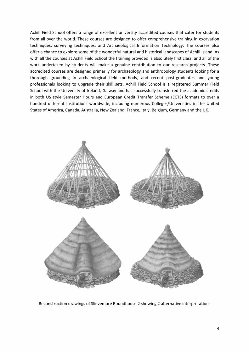
Achill Field School offers a range of excellent university accredited courses that cater for students
from all over the world. These courses are designed to offer comprehensive training in excavation
techniques, surveying techniques, and Archaeological Information Technology. The courses also
offer a chance to explore some of the wonderful natural and historical landscapes of Achill Island. As
with all the courses at Achill Field School the training provided is absolutely first class, and all of the
work undertaken by students will make a genuine contribution to our research projects. These
accredited courses are designed primarily for archaeology and anthropology students looking for a
thorough grounding in archaeological field methods, and recent post-graduates and young
professionals looking to upgrade their skill sets. Achill Field School is a registered Summer Field
School with the University of Ireland, Galway and has successfully transferred the academic credits
in both US style Semester Hours and European Credit Transfer Scheme (ECTS) formats to over a
hundred different institutions worldwide, including numerous Colleges/Universities in the United
States of America, Canada, Australia, New Zealand, France, Italy, Belgium, Germany and the UK.
Reconstruction drawings of Slievemore Roundhouse 2 showing 2 alternative interpretations

5
Module 5 and Module 6 (SS108) 16 – 27 June; 4 – 15 August 2014
The 2 week courses at Achill Field School offer a condensed training package featuring an
introduction to excavation techniques, followed by an introduction to survey methodology, and
completed with an introduction to data processing in our Computer Lab. These courses are perfect
for students looking for a quick introduction to the range of processes involved in archaeological
fieldwork. Students will learn the basic principles involved in excavating and recording a site,
surveying monuments in the field and how the results can be processed, manipulating and
presented using a range of exciting software environments. The field work is supplemented by three
special lectures detailing some of the research interests of the Achill Field School staff and the
cutting edge research being undertaken by one of our guest lecturers. The course features a field
trip during the first week to the Booley Village and Portal Tomb at Annagh, and the deserted
settlement at Tawnaghmore, whilst surveying exercises during the second week that take place
among some of the incredibly rich archaeological landscapes elsewhere on the island. Assisted by
the Achill Field School staff, and with full access to our comprehensive library, students will also
prepare a short research paper that discusses an area of Irish archaeology that is of particular
interest to them. During the preparation of their essay students will receive individualised tuition on
archaeological writing and editing which is a very useful and quite unique aspect of our courses.
Fieldwork
At the start of the first week of the course we will open up a new small scale trench either at or close
to the main excavation site. Students will then completely excavate the archaeology within this
trench over the course of the week, pausing for a mid-week field trip. Beginning with removing the
first turfs and then the overlying peat, the students will expose and carefully clean each
archaeological horizon that is encountered. The students will record each horizon, prepare detailed
drawn and written records and a professional photographic account. Once each horizon has been
fully recorded the students will carefully remove it to expose the next archaeological horizon in the
sequence, and the recording process will be repeated. By the end of the week the archaeology
within the trench will have been completely examined and thoroughly recorded. The trench will
then be backfilled or consolidated in accordance with Achill Field School’s policy of responsible and
sustainable excavation. During the excavation students will be taught how to perform each task
either individually or in small groups, with all tuition being delivered by the Director of Fieldwork, to
ensure that every process is fully understood, and then they will be guided through the work by one
of the members of staff. By completing an entire trench from start to finish over the course of the
week the students will have experienced every stage of the excavation process in miniature,
something we feel is rarely offered during a course of this length.
A view of the southern tip of Achill Island taken from the now deserted island Achill beg

6
Field Survey and Data Analysis
The second week of the course offers a very different challenge. Using a selection of our state of the
art survey equipment students will undertake a series of exercises designed to instruct them on the
procedures used in surveying archaeological sites. Each morning students will undertake surveying
exercises at a variety of locations on the island receiving instruction on the use of high precision and
low precision handheld GPS units for different types of field survey, the EDM (Total Station) for high
accuracy surveying, the auto level for simple topographic surveys and profiling, and using
photogrammetric techniques to record standing building. Each of the lessons is designed to give the
students a real understanding of how the equipment operates and the relevant strengths and
weaknesses of each technique. Each afternoon the students will work in the computer lab
downloading the results of the morning’s survey project and undertaking some basic computer
processing of the results to generate simple but effective visual representations of the data.
Learning Outcomes
At the end of their two week course students will have received a wonderfully compressed training
experience. They will have excavated archaeological deposits and discrete features, drawn accurate
horizontal plans and vertical sections, analysed deposits and recorded them on context sheets, set
up and used the Autolevel to record height information, prepared and taken high quality site
photographs, and recorded and plotted the location of finds. In addition students will have learned
how the data from the excavation can be processed in a variety of software suites to produce
attractive looking illustrations and a well organised and stable site archive. They will have also
learned a number of techniques that can be used to record archaeological sites in the field, and the
principals involved in processing and manipulating survey data in a variety of software packages.
Students learn surveying skills using our Trimble high precision GPS Units and our Leica EDM

7
Module 3 and Module 4 (SS106 and SS107).
19 May – 13 June; 7 July – 1 August 2014
The four week course at Achill Field School offers a really thorough exploration of the methods used
in archaeological excavation. These courses are ideally suited for students looking for a well-rounded
experience and include comprehensive tuition in all aspects of archaeological excavation.
These four week courses include a series of field trips to a great selection of the stunning
archaeological sites on Achill and on the smaller island of Achill Beg. Destinations include the
Megalithic Tombs, Bronze Age roundhouses and 19th century Deserted Village on Slievemore, the
Tower House (castle) at Kildavnet, the shell midden and promontory forts on Achill Beg, the Achill
Mission colony at Dugort, the Booley village at Bunnowna and the 2nd World War watch post
overlooking Keem Bay. As well as simply visiting a range of sites the students are challenged to start
viewing the landscapes with the analytical eyes of an archaeologist.
The on-site field work is supplemented by a program of weekly lectures that provide a good
understanding of the chronology of Irish Archaeology, from the end of the ice Age up until the
present day, and these are supplemented by presentations by two guest lecturers who will discuss
their own areas of cutting edge research. Assisted by the Achill Field School staff, and with full access
to our comprehensive library, students will also prepare a short research paper that discusses an
area of Irish archaeology that is of particular interest to them. During the preparation of their essay
students will receive individualised tuition on archaeological writing and editing which is a very
useful and quite unique aspect of our courses.
GPS survey of the ‘Cromlech Tumulus’ on Slievemore where excavations began in 2014

8
Fieldwork
At the start of the first week of the course we will open up a new trench at the main excavation site.
Students will then completely excavate the archaeology within this trench over the next four weeks.
Beginning with removing the first turfs (sod) and then the overlying peat, the students will expose
and carefully clean each archaeological horizon that is encountered. The students will record each
horizon, preparing detailed drawn and written records and a professional photographic account.
Once each horizon has been fully recorded the students will carefully remove it to expose the next
archaeological horizon in the sequence, and the recording process will be repeated. During the first
half of the fourth week the archaeology within the trench will have been completely examined and
thoroughly recorded. The trench will then be backfilled or consolidated in accordance with Achill
Field School’s policy of responsible and sustainable excavation. During the excavation students will
be taught how to perform each task either individually or in small groups, with all tuition being
delivered by the Director of Fieldwork, to ensure that every process is fully understood.
Subsequently they will be guided through the work by one of the members of staff. Unlike many
other field schools our students are 100% involved in every stage of excavation and recording guided
and assisted by the Director of Fieldwork and the team of supervisors. By completing an entire
trench from start to finish in the duration of the four week course the students are guaranteed to
have experienced every stage of the excavation process, something we feel is vital to delivering
proper tuition. This commitment to our students is quite unlike procedures at many other field
schools where areas may be worked on over multiple seasons by different students permitting each
student only a glimpse of the over all process.
The Early Medieval Kiln Complex on Slievemore, radiocarbon dated to between 663 and 858 AD

9
Working in the lab
The final days of the four week courses take place within the computer lab at Achill Field School
where the students will work with the different types of data recorded during the excavation. The
drawings from the excavation will then be scanned and converted into raster files which will be
imported into the AutoCad environment. After scaling the images they will be digitised and then
imported into Photoshop CS6 for final processing to create publication quality images. The original
drawings will then be processed and placed into the physical site archive. Similarly the students will
be shown how to process the photographs taken at the site, label them and place them into our
secure digital archive. Finally the students will be shown how to process context sheets, extract the
correct information to be added to the site report, scan the originals to create another element to
be added to the digital archive. The original context sheets will then be processed and placed into
the physical site archive.
Learning outcome
At the end of their four week course students will have received comprehensive training in
excavation of large deposits and discrete features, drawing accurate horizontal plans and vertical
sections and elevations, analysing deposits and recording them on context sheets, setting up and
using the Autolevel, preparing and taking high quality site photographs, and recording and plotting
the location of finds. In addition students will have learned how the data from the excavation can be
processed in a variety of software suites to produce attractive looking illustrations and will have
been involved in managing our well organised and stable physical and digital site archives.
The computer lab at Achill Field School, equipped with Autodesk 2014 Infrastructure
Design Suite Ultimate, Photshop CS6, ArcGis 10 and Microsoft Office Professional Plus

10
Module 1 and Module 2 (SS106, SS107, SS108)
19 May – 27 June; 7 July – 15 August 2014
The 6 week courses at Achill Field School offer our most comprehensive training experience. These
courses are perfect for students that are looking to really get to grips with the methods and
practices involved in excavating and recording a site, surveying monuments in the field and learning
about processing, manipulating and presenting excavation and survey data in a range of exciting
software environments.
The six week courses include a series of field trips to a great selection of the stunning archaeological
sites on Achill and on the smaller island of Achill Beg. Destinations include the Megalithic Tombs,
Bronze Age roundhouses and 19th century Deserted Village on Slievemore, the Tower House (castle)
at Kildavnet, the shell midden and promontory forts on Achill Beg, the Achill Mission colony at
Dugort, the Booley village at Bunnowna, the 2nd World War watch post overlooking Keem Bay, the
Booley Village and Portal Tomb at Annagh, and the deserted settlement at Tawnaghmore. As well as
simply visiting a range of sites the students are challenged to start viewing the landscapes with the
analytical eyes of an archaeologist.
The on-site field work is supplemented by a program of weekly lectures that provide a good
understanding of the chronology of Irish Archaeology, from the end of the ice Age until the present
day, and two special lectures detailing some of the research interests of the Achill Field School staff.
These weekly lectures are supplemented by presentations by three guest lecturers who will discuss
their own areas of cutting edge research. Assisted by the Achill Field School staff, and with full access
to our comprehensive library, students will also prepare a short research paper that discusses an
area of Irish archaeology that is of particular interest to them. During the preparation of their essay
students will receive individualised tuition on archaeological writing and editing which is a very
useful and quite unique aspect of our courses.
The large 19th century house at the very western end of the Deserted Village on Slievemore

11
Fieldwork
At the start of the first week of the course we will open up a new trench at the main excavation site.
Students will then completely excavate the archaeology within this trench over the next four weeks.
Beginning with removing the first turfs and then the overlying peat, the students will expose and
carefully clean each archaeological horizon that is encountered. The students will record each
horizon, preparing detailed drawn and written records and a professional photographic account.
Once each horizon has been fully recorded the students will carefully remove it to expose the next
archaeological horizon in the sequence, and the recording process will be repeated. During the first
half of the sixth week the archaeology within the trench will have been completely examined and
expertly recorded. The trench will then be backfilled or consolidated in accordance with Achill Field
School’s policy of responsible and sustainable excavation. During the excavation students will be
taught how to perform each task either individually or in small groups, with all tuition being
delivered by the Director of Fieldwork, to ensure that every process is fully understood. They will
then be guided through the work by one of the members of staff. Unlike many other field schools
our students are 100% involved in every stage of excavation and recording guided and assisted by
the Director of Fieldwork and the team of supervisors. By completing an entire trench from start to
finish the students are guaranteed to have experienced every stage of the excavation process,
something we feel is vital to delivering proper tuition. This commitment to our students is quite
unlike procedures at many other field schools where areas may be worked on over multiple seasons
by different students permitting each student only a glimpse of the overall process.
Plan of the Early Medieval Kiln on Slievemore with the central firebox and secondary hut

12
Working in the Lab
The second half of the fourth week takes place within the computer lab at Achill Field School where
the students will work with the different types of data recorded during the excavation. The drawings
from the excavation will be cleaned and then be scanned and converted into raster files which will
be imported into the AutoCad environment. After scaling the images they will be digitised and then
imported into Photoshop CS6 for final processing to create publication quality images. The original
drawings will then be processed and placed into the physical site archive. Similarly the students will
be shown how to process the photographs taken at the site, label them and place them into our
secure digital archive. Finally the students will be shown how to process context sheets, extract the
correct information to be added to the site report, scan the originals to create another element to
be added to the digital archive. The original context sheets will then be processed and placed into
the physical site archive.
Practical skills resume
During the fifth week the students will excavate a second new trench either within or close to the
main excavation site. Smaller in scale than the first trench they worked on this new trench will again
feature the complete excavation process. This part of the course is designed in order to allow the
students to put into practice the new skills they have learned during the first four weeks. The staff
will take a more hands off approach, whilst being immediately available should the students require
advice or instruction. Through repeating the excavation processes a second time the students will
develop a heightened confidence in their new skills.
Data Analysis
The sixth and final week of the course offers a very different challenge. Using a selection of our state
of the art survey equipment students will undertake a series of exercises designed to instruct them
on the procedures used in surveying archaeological sites. Each morning students will undertake
surveying exercises at a variety of locations on the island receiving instruction on the use of high
precision and low precision handheld GPS units for different types of field survey, the EDM (Total
Station) for high accuracy surveying, the auto level for simple topographic surveys and profiling, and
using photogrammetric techniques to record standing building. Each of the lessons is designed to
give the students a real understanding of how the equipment operates and the relevant strengths
and weaknesses of each technique. Each afternoon the students will work in the computer lab
downloading the results of the morning’s survey project and undertaking some basic computer
processing of the results to generate simple but effective visual representations of the data.
Learning outcomes
At the end of their six week course students will have received comprehensive training in excavation
of large deposits and discrete features, drawing accurate horizontal plans and vertical sections and
elevations, analysing deposits and recording them on context sheets, setting up and using the
Autolevel, preparing and taking high quality site photographs, and recording and plotting the
location of finds. In addition students will have learned how the data from the excavation can be
processed in a variety of software suites to produce attractive looking illustrations and a well

13
organised and stable site archive. They will have also learned a number of techniques that can be
used to record archaeological sites in the field, and the principals involved in processing and
manipulating survey data in a variety of software packages and will have been involved in managing
our well organised and stable physical and digital site archives. Because of the practical nature of
these lessons students will have the confidence to design and undertake similar projects themselves
in the future. The six week courses are therefore ideal for the more ambitious under-graduate
students who would like to undertake their own research projects as part of their continuing studies.
Plan of Slievemore Roundhouse 2 showing the four pre-bog field walls connecting to the building

14
The 2014 Field Season:
Investigating the Prehistoric Landscape of Slievemore
The most visible archaeological sites on Slievemore belong to the Post Medieval period and consist
of the famous 19th century Deserted Village with its associated fields, garden plots and enclosures.
However a very remarkable prehistoric landscape is also present largely concealed beneath the
blanket bog. This landscape consists of a massive and very complex field system, numerous house
sites, smaller hut sites and a collection of spectacular Megalithic tombs. Between 2006 and 2010
Stuart Rathbone of Achill Field School investigated two of the house sites which were determined to
be Middle Bronze Age roundhouses and which represent two of the largest and best preserved
Bronze Age buildings ever investigated in Ireland. A series of trenches were excavated over the pre
bog field walls in the area around the roundhouses and these two turned out to be of a far larger
scale than had been apparent from examining the tops of the walls that could be seen sporadically
protruding through the surface of the bog.
In 2014 Achill Field School initiated a new project to investigate the Megalithic Tombs that are
located in a small cluster to the east of the Bronze Age houses and field systems. The cluster consists
of two Court Tombs, a Portal Tomb, a site which may well be a third Court Tomb but which has been
severely robbed out and the mysterious 'Cromlech Tumulus' site. This last site has been the subject
of considerable debate over the last 100 years, and various well known archaeologists have
examined the site, each coming up with a different explanation as to what it might be.
The 'Cromlech Tumulus' site consists of a low linear mound with a possible gallery at the eastern end
and a large circular building at the western end. It is connected to one of the nearby Court Tombs by
a substantial pre-bog wall known as 'the Danish Ditch'. Excavation of this site is a major element in
the new research project and we hope to finally clarify what type of site it is and to which period it
belongs. There is clearly a very substantial amount of archaeology at this site and the results of the
excavation are bound to be spectacular irrespective of what class of site it turns out to be. Alongside
excavation at 'the Cromlech Tumulus' we aim to investigate 'the Danish Ditch' pre-bog wall at
several points along its length to get a better understanding of its form and scale. We also aim to
complete the mapping of the visible parts of the pre bog field wall system on Slievemore, and to use
Geophysical survey techniques to trace out some of the areas where we suspect the field system
continues entirely below the surface of the bog.
The research project being carried out by Achill Field School will attempt to reconcile the results of
the new survey and excavation work with the antiquarian descriptions, and finally produce a
comprehensive account of the prehistoric landscape of Slievemore.
Contact us at: [email protected]
Phones us on: +353 (0)98 43564
Find more details at: http://www.achill-fieldschool.com
Join our Facebook Group at: https://www.facebook.com/groups/120122094688375/

15
The Portal Tomb on Slievemore is one of the two most impressive Megalithic sites now visible on the
mountain. It has yet to be dated through excavation but is probably Early Neolithic in date
The impressive Court Tomb close to the ‘Cromlech Tumulus’ site. An early antiquarian report
suggests this is a double Court Tomb but only one of the courts is currently clearly visible. On the
other side a circular feature may be a second court or a slightly later hut foundation

16
The location of Achill Island in Clew Bay, one of the most beautiful parts of the West of Ireland
Achill Field School has worked with students from all over the world but has a particularly strong
bond with North America and Canada. The map shows the locations of the Universities in North
America that Achill Field School has transferred academic credits to. A complete list is available on
our website at http://www.achill-fieldschool.com/international-university-list