A Political Ecology of Sovereignty in Practice and on the Map: The Technicalities of Law,...
26
Leiden Journal of International Law http://journals.cambridge.org/LJL Additional services for Leiden Journal of International Law: Email alerts: Click here Subscriptions: Click here Commercial reprints: Click here Terms of use : Click here A Political Ecology of Sovereignty in Practice and on the Map: The Technicalities of Law, Participatory Mapping, and Environmental Governance TYLER MCCREARY and VANESSA LAMB Leiden Journal of International Law / Volume 27 / Issue 03 / September 2014, pp 595 - 619 DOI: 10.1017/S0922156514000223, Published online: 24 July 2014 Link to this article: http://journals.cambridge.org/abstract_S0922156514000223 How to cite this article: TYLER MCCREARY and VANESSA LAMB (2014). A Political Ecology of Sovereignty in Practice and on the Map: The Technicalities of Law, Participatory Mapping, and Environmental Governance. Leiden Journal of International Law, 27, pp 595-619 doi:10.1017/ S0922156514000223 Request Permissions : Click here Downloaded from http://journals.cambridge.org/LJL, IP address: 180.183.206.211 on 27 Jul 2014
Transcript of A Political Ecology of Sovereignty in Practice and on the Map: The Technicalities of Law,...

Leiden Journal of International Lawhttp://journals.cambridge.org/LJL
Additional services for Leiden Journal of International Law:
Email alerts: Click hereSubscriptions: Click hereCommercial reprints: Click hereTerms of use : Click here
A Political Ecology of Sovereignty in Practice and on theMap: The Technicalities of Law, Participatory Mapping, andEnvironmental Governance
TYLER MCCREARY and VANESSA LAMB
Leiden Journal of International Law / Volume 27 / Issue 03 / September 2014, pp 595 - 619DOI: 10.1017/S0922156514000223, Published online: 24 July 2014
Link to this article: http://journals.cambridge.org/abstract_S0922156514000223
How to cite this article:TYLER MCCREARY and VANESSA LAMB (2014). A Political Ecology of Sovereignty in Practiceand on the Map: The Technicalities of Law, Participatory Mapping, and EnvironmentalGovernance. Leiden Journal of International Law, 27, pp 595-619 doi:10.1017/S0922156514000223
Request Permissions : Click here
Downloaded from http://journals.cambridge.org/LJL, IP address: 180.183.206.211 on 27 Jul 2014
Leiden Journal of International Law (2014), 27, pp. 595–619C© Foundation of the Leiden Journal of International Law 2014 doi:10.1017/S0922156514000223
A Political Ecology of Sovereignty in Practiceand on the Map: The Technicalities of Law,Participatory Mapping, and EnvironmentalGovernance
T Y L E R M CC R E A RY∗ A N D VA N E S SA L A M B∗∗
AbstractThis article examines the relationships between representations and operations of sovereigntyin natural resource governance. We advance a ‘political ecology of sovereignty’, examiningthe participation of non-state actors in resource governance processes. We particularly arguethat processes of integrating subaltern populations through mapping local ecological know-ledge can modify effective governance practices while nonetheless reproducing the legibilityof state sovereign authority and its territorial boundaries. Exploring the Enbridge NorthernGateway pipeline in Canada, we suggest that state jurisdictional authority is secured throughincorporating indigenous interests as a delimited geography of tradition. Examining the Hat-gyi hydroelectric development along the Thai–Burmese border, we argue that the territorialboundaries of those nation-states are rearticulated through the governance of this transbound-ary development. Through these cases, we demonstrate how the insertion of local knowledgeworks not only to reconfigure effective governance processes but also to reinforce the effect ofstate sovereignty in new ways.
Key wordsnatural resource governance; participatory mapping; political ecology; sovereignty; technical-ities of law
∗ Postdoctoral Research Fellow, Department of Geography, University of British Columbia[[email protected]].
∗∗ Postdoctoral Associate, York Centre for Asian Research (YCAR), York University, Toronto [[email protected]].In developing this article, we have benefitted greatly from the feedback of the anonymous reviewers as well asthe participants in the ‘Locating Nature: Making and Unmaking International Law’ workshop funded by theInstitute for Global Law and Policy at Harvard Law School. We owe thanks to Usha Natarajan for first invitingus to participate in the conversation about ways in which constructions of nature and law colocate. Wealso want to acknowledge the invaluable feedback Melanie Sommerville, Michael Cook, Amar Bhatia, andStacy Douglas provided in reading drafts of our article. We want to acknowledge the activists, local people,academics, scientists, and government officials who took the time to discuss environmental governanceissues around Northern Gateway and the Salween. Vanessa Lamb also wishes to thank Sainam and Kay fortheir research assistance. The Canadian research was supported in part by funding from the Social Sciencesand Humanities Research Council of Canada. The research in Southeast Asia was supported by awards fromthe York University, including the Vivienne A. Poy Award from the York Centre for Asian Research andthe Martin Cohnstaedt Graduate Research Award from the York Center for International Security Studies.Preliminary research was also supported by the Challenges of the Agrarian Transition in Southeast Asia(ChATSEA).

596 T Y L E R M CC R E A RY A N D VA N E S SA L A M B
1. INTRODUCTION
A cursory examination of a world map provides a clear vision of a planet neatlydivided into discrete sovereignties.1 There is a cartographic common sense in whicheach nation-state ‘is demarcated by a linear boundary, an edge dividing one sov-ereignty from the next’.2 Within the lines, each nation-state is evenly coloured.Different colours further accentuate the separation of the world into discrete ter-ritories. Their coloration also implies that the interior of states ‘is a homogeneousspace, traversed evenly by state sovereignty’.3 Such maps resonate with principlesof international law regarding state sovereignty, which hold that nation-states pos-sess exclusive autonomy over distinct territories with clear jurisdiction over theirdomestic affairs. This construction of sovereignty, however, has been critiqued asa misrepresentation of the dynamics of effective sovereignty – which are neitherinherently politically territorialized in line with state boundaries nor exclusivelyorganized on a state-by-state basis.4
In this article, we argue that examining the practices and participation of non-stateactors in natural resource governance can provide a more nuanced understandingof the relationships between how sovereignty operates and how it is represented. Inparticular, we assert that studying the practices of mapping ecological knowledgein governance processes can inform an understanding of how sovereignty is put onthe map. Along with other contributions in this collection, we share the view thatparticular understandings of nature and society undergird legal concepts such assovereignty. We recognize that the literature in international law has highlightedhow sovereignty is constructed through treaties and international institutions. How-ever, there has been less discussion of the ways in which sovereignty over naturalresources is enacted through governance processes involving non-state actors andtechnical legal devices such as maps.5 Drawing on the authors’ disciplinary trainingin geography, we address this gap by examining the connections between sovereigntyand mapping projects in which local actors document their ecological knowledgeas part of an effort to defend their interests. As Sundhya Pahuja notes, ‘resourcesthemselves can look quite different, depending on where you are speaking from’.6
We concur, and argue by extension that examining claims about natural resources
1 We borrow this imagery from M. Biggs, ‘Putting the State on the Map: Cartography, Territory, and EuropeanState Formation, (1999) 41 CSSH 374.
2 Ibid., at 374.3 Ibid.4 J. Agnew, ‘Sovereignty Regimes: Territoriality and State Authority in Contemporary World Politics’, (2005)
95 AAAG 437; K. Jayasuriya, ‘Globalization, Law, and the Transformation of Sovereignty: The Emergenceof Global Regulatory Governance’, (1998) 6 Ind. J. Global Legal Stud., at Art. 3; S. Sassen, Losing Control?:Sovereignty in an Age of Globalization (1996).
5 There is, however, an informative discussion of the role of maps in international law, and particularly theproblems associated with the continued use territorial boundaries mapped through processes with suspectlegitimacy in the present (colonial cartographies, Soviet administrative geographies, etc.). See, especially M.Mutua, ‘Why Redraw the Map of Africa: A Moral and Legal Inquiry’, (1995) 16 Mich J Intl Law 1113; S. R.Ratner, ‘Drawing a Better Line: Uti Possidetis and the Borders of New States’, (1996) 90 AJIL 590; V. Nesiah,‘Placing International Law: White Spaces on a Map’, (2003) 16 LJIL 1.
6 S. Pahuja, ‘Conserving the Worlds Resources?’, in J. Crawford and M. Koskenniemi (eds.), Cambridge Companionto International Law (2012), 398 at 400.

A P O L I T I CA L E CO LO GY O F S OV E R E I G N T Y I N P R AC T I C E A N D O N T H E M A P 597
made by local actors can offer a parallax view of sovereignty. Analysing the con-nections between local claims about natural resources and sovereignty enables usto understand sovereignty not simply as an independent authority to govern, butrather to understand how sovereignty is both effectively enacted through and pro-duced as an effect of those practices of governance. This approach allows us to movebeyond the perceived divide between cartographic representations of sovereigntyand sovereignty in practice. By revealing the links between how maps are madein the practices of resource governance and what maps accomplish, we are able tounderstand sovereignty as related to both the networks of participatory governanceincorporating non-state actors and the representation of an independent, absoluteauthority.
To make these arguments, we examine how the methods of co-ordinating andmobilizing environmental knowledge in natural resource governance processescontinue to render legible the internal consistency and external boundaries of ter-ritorial sovereignty as an effect of those processes. We argue that this occurs even asgovernance processes work to incorporate subaltern voices and mobilize forms ofpolitical authority which cross borders. Focusing on processes of mapping ‘local’ eco-logical knowledge, we use two case studies to examine how participatory processescan modify effective governance practices while nonetheless reproducing the rep-resentation of a territorial state sovereignty. First, through analysis of the EnbridgeNorthern Gateway pipeline project in Canada, we explore how the integration of in-digenous peoples’ ecological knowledge in resource governance works to effect thelegibility of state jurisdiction over its territory. Second, through analysis of the caseof the Hatgyi hydropower project located on the Salween River in Southeast Asia, weexamine how a transboundary development project along the Thai–Burmese bor-der contributes to rearticulating the territorial boundaries of those states. Throughthese cases, we explore how natural resource governance processes include localactors, even as they seek to ‘resist’ processes permitting development, and non-etheless continue to produce representations of an autonomous sovereign stateauthority. In so doing, we begin to advance what we are terming a political ecology ofsovereignty.
As an entry point, we start by positioning our intervention within the dis-cussion of sovereignty in international law. We then lay out our theoretical ap-proach to sovereignty, bringing some of the relevant recent literature in polit-ical ecology and political geography into conversation with scholarship in in-ternational law. Shifting to our particular cases, we introduce our two researchsites and the distinct problems we aim to explore through each of them. In bothcases, maps have been made and used to make claims to authority as part of sci-entific and ‘local’ knowledge processes. Through the explication of these two eth-nographies, we connect efforts to permit a pipeline across a territory and to fixthe flows of a river as a boundary to the production of territorial sovereignty.These cases enable us to discuss the ways that sovereignty has been continu-ally represented as coherent and bounded, and our cases provide insight intohow this occurs even where there exist myriad claims to authority over naturalresources.

598 T Y L E R M CC R E A RY A N D VA N E S SA L A M B
2. CONNECTIONS AND CONTRIBUTIONS TO INTERNATIONAL LAW
Representations of natural resources in environmental governance processes con-nect to the core of the conceptualization of sovereignty, linking ideas of land asresource and territory with sovereignty as the absolute authority over land. Initialconceptualizations of sovereignty in international law emerged with an imperialregime that rationalized the exploitation of resources by denying recognition tothe colonized as peoples.7 To claim legal personality within the international com-munity, decolonizing polities sought recognition as states.8 To secure control overthe development and disposition of their domestic natural resources for the benefitof their people, decolonizing states further articulated a principle of permanentsovereignty over natural resources.9
Alongside the proliferation of sovereign regimes, there has been a remaking ofregimes of sovereign governance vis-a-vis subaltern populations within the state.Internationally, there has been an increasing recognition of a right to participationwithin decision-making processes.10 The international florescence of participatorymodels of governance reflects a dedication of subaltern populations to articulatingtheir concerns international forums.11 However, local peoples also made domesticassertions, demanding they be consulted and have their concerns integrated withdecision-making processes.12 These legal shifts at multiple scales have reconfigurednatural resource governance processes.
Scholarship in international law has critiqued methodological nationalism andsuggested that local peoples’ claims have produced new forms of global authority.13
Efforts to implement programmes to address concerns of impoverished communit-ies in the global context continually advance and institutionalize the authority ofbureaucratic international institutions designed to address those problems.14 How-ever, if the multiscalar effects of local legal manoeuvers and assertions are productive
7 A. Anghie, Imperialism, Sovereignty and the Making of International Law (2004).8 See Pahuja, supra note 6, at 402.9 Resolution on Permanent Sovereignty Over Natural Resources UN Doc. A/RES/1803 (XVII) (1962). There is,
of course, a complex relationship between this principle and investor rights protections that is beyond thescope of this article. See Anghie, supra note 7; K. Hossain and S. R. Chowdhury (eds.), Permanent Sovereigntyover Natural Resources in International Law: Principle and Practice (1984); N. Schrijver, Sovereignty over NaturalResources: Balancing Rights and Duties (1997).
10 See G. H. Fox, ‘The Right to Political Participation in International Law’, Yale J. Int’l L. 17 (1992) 539; R.Chambers, ‘The Origins and Practice of Participatory Rural Appraisal’, (1994) 22 World Dev 953; S. Marks, TheRiddle of All Constitutions: International Law, Democracy, and the Critique of Ideology (2003).
11 See R. Torres, ‘The Rights of Indigenous Populations: The Emerging International Norm’, (1991) 16 Yale J Int’lL 127; Y. Henderson, Indigenous Diplomacy and the Rights of Peoples: Achieving UN Recognition (2008).
12 See J. C. O’Faircheallaigh, ‘International Recognition of Indigenous Rights, Indigenous Control of Devel-opment and Domestic Political Mobilisation’, (2012) 47 Aust J Polit Sci 531. In Canada this push has beenextensively litigated domestically in relation to a fiduciary obligation of the government to consult indigen-ous peoples – see D. Newman, The Duty to Consult: New Relationships with Aboriginal Peoples (2009); L. Sossin,‘The Duty to Consult and Accommodate: Procedural Justice as Aboriginal Rights’, (2010) 23 CJALP 93.
13 L. Parrish, ‘Changing Territoriality, Fading Sovereignty, and the Development of Indigenous Rights’, (2007) 31Am. Indian L. Rev. 291. The concept of methodological nationalism is from A. Wimmer and N. Glick Schiller,‘Methodological Nationalism and Beyond: Nation-State Building, Migration and the Social Sciences’, (2002)2 Global Netw 301.
14 B. Rajagopal, ‘From Resistance to Renewal: The Third World, Social Movements, and the Expansion ofInternational Institutions’, (2000) 41 Harv Intl L J 529; B. Rajagopal, International Law from Below: Development,Social Movements and Third World Resistance (2003).

A P O L I T I CA L E CO LO GY O F S OV E R E I G N T Y I N P R AC T I C E A N D O N T H E M A P 599
of new forms of international law, then they too can be seen to be reordering dynam-ics domestically. Our article seeks to document how local claims-making works notonly to reconfigure effective governance processes but also work to reinforce theeffect of sovereign state authority in new ways.
Methodologically, we argue that data generated through long-term participantobservation can reveal considerable complexity in how sovereignty is understood.An analysis of local peoples’ participation in state-led natural resource governanceprocesses can highlight how local knowledge claims can also be productive of statesovereignty. Examining sovereignty in relation to security, John Lea and Kevin Sten-son argue that non-state actors can become enrolled in public governance processesthat, at times, work to strengthen the legal authority of the state.15 We advance ananalogous argument, suggesting in part that local peoples’ enrolment in state-lednatural governance processes can reproduce the representation of the sovereignauthority to make decisions over development, even as their participation remapsthe routes through which sovereign decision-making occurs. Through analysing theselective enrolment of local people within natural resource governance, we high-light how claims to ‘local’ ecological knowledge and for sustainable developmentcan operate not only to challenge the authority of the sovereign state but also toproduce it as an effect.
Making this argument, we make a modest contribution to the still nascent discus-sion of what Annelise Riles refers to as the technicalities of law.16 While conventionalaccounts of the relation of state sovereignty to subaltern peoples focus on processesof exclusion, attending to maps as technicalities of law enables us to recognize amore complex and interesting dynamic between sovereign authorities and localactors, including those who ostensibly are resisting state processes of permittingdevelopment. Rather than assuming maps are simply tools that people use to cata-logue and advance their claims, we demonstrate the ways in which maps and theprocesses of their production are in fact key to how legal categories are framed andmobilized. Thinking through such technicalities, as Riles suggests, opens fruitfulnew areas for legal inquiry.
3. TOWARDS A POLITICAL ECOLOGY OF SOVEREIGNTY
In this article, we approach sovereignty from below, drawing on a political ecologyframework that theorizes the politics of nature through an analysis that beginswith (but is not limited to) local resource users. Thus, rather than starting withinternational agreements, law, and policies, we focus attention on how local resourceusers and ecologies connect to broader political formations.17 The field of political
15 J. Lea and K. Stenson, ‘Security, Sovereignty, and Non-State Governance “From Below’’’, (2007) 22 Cdn J L &Soc 9.
16 A. Riles, ‘A New Agenda for the Cultural Study of Law: Taking on the Technicalities’, (2005) 53 Buff L Rev 973.17 See B. Braun and N. Castree (eds.), Remaking Reality: Nature at the Millennium (1998); A. Tsing, ‘Becoming a
Tribal Elder, and Other Green Development Fantasies’, in T. Li (ed.), Transforming the Indonesian Uplands:Marginality, Power and Production (1999), 159; T. Forsyth, Critical Political Ecology: The Politics of EnvironmentalScience (2002); T. Li, The Will to Improve: Governmentality, Development, and the Practice of Politics (2007).

600 T Y L E R M CC R E A RY A N D VA N E S SA L A M B
ecology’s foundations emerge from work in disciplines of geography, anthropology,and critical development studies.18 As a field, political ecology is well positionedto address and understand relationships between nature, society, and institutions,like the law. As an approach, it considers the ecological and political in addition tothe social, cultural, and historical context of environmental issues in order to betterunderstand the ways that environmental problems are framed.
Scholars in political ecology are increasingly engaging science studies – studiesof how knowledge is made – in order to study how environmental problems areframed.19 Thus, the documentation and representation of knowledges both ‘local’and ‘scientific’20 are capturing the attentions of key scholars in the field.21 Suchwork has added to our understanding of how the everyday practices of individualsmatter to how environmental governance and state institutions are themselvesmade through practice. We draw on this work to aid our understanding of howsovereignty is practiced, represented and remade.
We particularly draw upon political ecologists’ insights into how many ‘unexpec-ted’ actors – including indigenous peoples, development practitioners, corporations,and even elements of non-human nature and technologies such as maps – actu-ally work together to co-produce taken-for-granted institutions and representations(such as ‘the state’).22 In this article, we take an approach which understands thatlegal contests over nature not only play a key role in reconstituting the environmentthrough shaping its legibility and remapping patterns of land use, but argue thatthey also crucially rearticulate particular conceptions of territorial sovereignty.
To approach the study of sovereignty ‘from below’ we also build on work inpolitical geography, a sub-field of geography which has focused on the study ofpolitical borders, sovereignty, territory, and ‘the state’. Political geographers havemade several key critical contributions to understanding how states, territories, and
18 T. Forsyth, Critical Political Ecology (2003); P. Robbins, Political Ecology: A Critical Introduction (2012); P. Vander-geest and R. Roth, ‘A Southeast Asian Political Ecology’, in P. Hirsch (ed.), Routledge Handbook of the Environmentin Southeast Asia (forthcoming).
19 This includes work in science studies such as T. Mitchell, Rule of Experts: Egypt, Techno-Politics, Modernity(2002); S. Jasanoff, States of Knowledge: The Co-Production of Science and Social Order (2005), S. Jasanoff and M.Long Martello, Earthly Politics: Local and Global in Environmental Governance (2005), B. Latour, Reassembling theSocial (2005).
20 While the conversations and debates around the divide between ‘local’ and ‘scientific’ knowledge are long-standing, emerging work is less concerned with the ‘divide’ and engages scholarship in science studiesin order to better understand practices of making ecological knowledge and the implications for how weunderstand the relationships between ecologies, individuals, and institutions. See A. Agrawal, ‘Dismantlingthe Divide between Indigenous and Scientific Knowledge’, (1995) 26 Dev Change 413; A. Agrawal, ‘IndigenousKnowledge and the Politics of Classification’, (2002) 54 Int Soc Sci J287; F. Berkes, ‘Indigenous Ways of Knowingand the Study of Environmental Change’, (2009) 39 J R Soc NZ 151.
21 See M. J. Goldman, P. Nadasdy, and M. D. Turner (eds.), Knowing Nature: Conversations at the Intersection ofPolitical Ecology and Science Studies (2011); A. Mathews, Instituting Nature: Authority, Expertise, and Power inMexican Forests (2011); Vandergeest and Roth, supra note 18; S. Gururani and P. Vandergeest, ‘Introduction toSpecial Issue: Ecologies on the Edge’, (forthcoming) Conservat. Soc.; Forsyth, supra note 18.
22 N. Peluso, ‘Whose Woods are these? Politics of Mapping Forests in Kalimantan’ (1995) 27 Antipode 383;P. Vandergeest and N. Peluso, ‘Territorialization and State Power in Thailand’, (1995) 24 Theor Soc 385; J. P.Brosius, ‘Green Dots, Pink Hearts: Displacing Politics from the Malaysian Rainforest’, (1999) 101 Am Anthropol36; J. P. Brosius, ‘Analyses and Interventions: Anthropological Engagements with Environmentalism’, (1999)40 Curr Anthropol 277; M. Dove, ‘Indigenous People and Environmental Politics’, (2006) 35 Annu Rev Anthropol191; Vandergeest and Roth, supra note 18.

A P O L I T I CA L E CO LO GY O F S OV E R E I G N T Y I N P R AC T I C E A N D O N T H E M A P 601
sovereign authorities are ‘produced’. This includes a critique of the notion that ‘thestate’ has emerged as the de facto site of governance and sovereign authority, whichthen reinforces its authority.23 This has particular resonance with a move beyondmethodological nationalism in international law scholarship.
A foundational critique for political geography is Timothy Mitchell’s ‘state ef-fect’.24 He argues that standard approaches to the study of the state both treat ‘thestate’ as a bounded institution (distinct from society) and fail to recognize how suchdistinctions between state-society and state-economy have emerged as part of thepresent-day imaginings of the state. The ‘state effect’ then is the representation ofthe state as a bounded entity that is created and recreated through practice. Thisis a representation that obfuscates its own origins. In order to reveal how the stateis accomplished, Mitchell advocates an approach that ‘address[es] the state as aneffect of mundane processes of spatial organization, temporal arrangement, func-tional specification, supervision and surveillance, and representation that createthe appearance of a world fundamentally divided into state and society or stateand economy’.25 Thus, understanding of the state as discrete and autonomous is,in part, produced as an effect of the broader governance processes through whichauthority is exercised. This framework forms the foundation for our approach tosovereignty as working through a set of relationships that nonetheless continuallyreproduce an ossified understanding of territorial sovereignty as independent ofthese relationships. We seek to understand the modalities through which sovereignpower actually operates, on one hand, and how these processes continually workto reproduce an understanding of the sovereign as an autonomous authority, onthe other hand.26 In other words, we seek to better understand how both ‘effectivesovereignty’ and the ‘sovereignty effect’ are produced alongside one another.
Thus, building on these insights from political geography, political ecology, andinternational law, we tackle sovereignty as a process that is practised and productthat requires articulation. We are particularly interested in how the technology ofmapping mediates the role of many so-called ‘non-state’ actors in the governanceprocess. Noteworthy critiques of maps and mapping from political ecology and geo-graphy have included the ‘fixing’ of dynamic natures,27 the inability to effectivelyredraw boundaries or ‘untie’ resources from territorial boundaries,28 and how the
23 P. Abrams, ‘Notes on the Difficulty of Studying the State’, (1988) 1 J Historical Sociology 58; J. Agnew, ‘TheTerritorial Trap: The Geographical Assumptions of International Relations Theory’, (1994) 1 RIPE 53; T.Mitchell, ‘Society, Economy and the State effect’, in A. Sharma and A. Gupta (eds.), The Anthropology of theState: A Reader (1999).
24 See Mitchell, ibid.25 Ibid., at 185.26 This framework has been informative to subsequent efforts to retheorize sovereignty and territory, See also J.
Painter, ‘Rethinking Territory’, (2010) 42 Antipode 1090; C. Lund, ‘Fragmented Sovereignty: Land Reform andDispossession in Laos’, (2010) 38 J Peasant Studies 885.
27 See M. Dove, ‘Theories of Swidden Agriculture and the Political Economy of Ignorance’, (1983) 1 Agrofor. Syst85; R. Roth, ‘Two-Dimensional Maps in Multi-Dimensional Worlds: A Case of Community-Based Mapping inNorthern Thailand’, (2007) 38 Geoforum 49.
28 P. Walker and P. Peters, ‘Maps, Metaphors, and Meanings: Boundary Struggles and Village Forest Use on Privateand State Land in Malawi’, (2001) 14 Soc’y & Nat Resources 411.

602 T Y L E R M CC R E A RY A N D VA N E S SA L A M B
limits of such maps constrain broader legal and political strategies.29 Scholarshipalso recognizes that maps are more than simple, self-evident representations ofterritory or property.30 These critiques and insights are significant in light of ourexamination of maps within the legal and institutional authority of state-led nat-ural resource governance processes, and are positioned to contribute to discussionin international law on the technicalities of law and our understanding of howsovereignty authority is produced.31
For instance, while environmental governance processes are in many cases – in-cluding both cases presented here – mandated by state law and led by state actors,they require the participation and authorization of multiple stakeholders and theirmaps. These environmental governance processes do not simply decide on the pro-ject outcomes, but also reinforce the state’s authority to make these decisions. Localactors have increasingly engaged in mapping activities to translate local concernsinto the technical–legal valences of natural resource governance discourse. We arguethat the making and use of maps as part of the governance process is important toexamine as they play an important role in both representing and mobilizing claimsto territories and natural resources. Specifically, we examine both the ways thatmaps are part of making certain claims but also de-emphasizing others, particularlyregarding what they can show us about how constructions of authority and natureare normalized.
4. ‘MAPPING OUT’ THE CONNECTIONS BETWEEN LOCALKNOWLEDGE AND SOVEREIGNTY
Through our two cases, we highlight the co-production of sovereignty and ecolo-gical knowledge. In particular, we highlight the role that maps and mapping playwithin two natural resource governance processes and their political–legal contexts.The first case we present is the proposed Enbridge Northern Gateway pipeline.32 Ifconstructed, this pipeline would transect the traditional territories of more than 50indigenous communities in Canada. The federal government has a fiduciary dutywith respect to these communities and is obligated to consider and accommodate
29 D. Hodgson and R. Schroeder, ‘Dilemmas of Counter-Mapping Community Resources in Tanzania’, (2002) 33Dev & Change 79.
30 On the fraught practices of counter-cartography, see J. Wainwright and J. Bryan, ‘Cartography, Territory,Property: Postcolonial Reflections on Indigenous Counter-Mapping in Nicaragua and Belize’, (2009) 16 Cult.Geogr. 153. On the mapping as performance, see C. Perkins, ‘Cartography: Mapping Theory’, (2003) 27 Prog inHuman Geog 341.
31 For example, Joel Wainwright and Joe Bryan draw upon ‘counter-mapping’ experiences in the courts tocomplicate ‘the celebratory descriptions of the ‘power of maps’ for indigenous peoples made by geographersand activists’. Wainwright and Bryan assert that efforts to use counter-cartographies of indigenous landholdings to push for state recognition have the unintended effect of normalizing relations to land as property,thereby deepening the capitalist social relations entrenched within the architecture of state law. They expressconcern that struggles of indigenous self-determination articulated through counter-cartographic assertionsbefore the courts may in fact have the perverse effect of increasing state authority vis-a-vis indigenous peoples,see J. Wainwright and J. Bryan, ibid., at 154.
32 The 1,177 km Northern Gateway project would deliver an average of 525,000 barrels of diluted bitumen perday to a port. The pipeline would open markets in the Pacific Rim to Canadian oil exports, supplying roughly200 tankers yearly.

A P O L I T I CA L E CO LO GY O F S OV E R E I G N T Y I N P R AC T I C E A N D O N T H E M A P 603
their interests in the regulation of development. In late 2009, Canada established anindependent review panel tasked with evaluating the balance of social, economic,and environmental impacts of the proposed pipeline. The first author of this article,Tyler McCreary, conducted ethnographic research into this governance process overtwo years (June 2010–December 2012) while living in northwest British Columbia,Canada. This included attending community meetings and the hearings of an in-dependent panel appointed to review the project. He also reviewed the EnbridgeNorthern Gateway project application, particularly focusing critical analysis on thesubmissions addressed to aboriginal traditional knowledge (ATK).
The second governance process we present centres on the Hatgyi Dam, proposedon the Salween River in Southeast Asia. The Salween, which flows through Burma,Thailand, and China, remains one of the longest rivers in Asia without significantdamming, and the Hatgyi Dam would potentially be the first dam on this trans-boundary river. It has been proposed a short distance downstream from where theSalween River comprises 120 kilometers of the Thai–Burma border.33 Governmentofficials, NGO activists, and local residents, many of whom identify as members ofthe Karen ethnic minority group, have raised concerns about the dam’s social andenvironmental impacts. As such, authority over the river and the political borderhas emerged as a highly contested issue. In this article, we focus on maps mobil-ized through a series of public information hearings on the Hatgyi Dam. Organizedby a government subcommittee chaired by the Thai Prime Minister’s Office, thesehearings took place in Thailand in 2011 and were aimed to address questions raisedabout the potential impacts of the proposed dam, both to Thai territory and to thepolitical border.34 The second author of this article, Vanessa Lamb, employed ethno-graphic methods, including participant observation of public information hearings,over a one-year period (2010–11) at multiple sites in Thailand to generate the datapresented. In addition, more than 100 interviews were conducted with individualsrelated to the Hatgyi project, including government officials, NGO staff, and localresidents.
Evidently, relationships between people, law, and the state have developed dif-ferently in Thailand and Canada and even within these states relationships varytemporally and geographically. For residents at the Salween in Thailand, the Hatgyigovernance process represents a unique opportunity to make claims to and throughthe Thai state that were less formally articulated or less apparent prior to this pro-cess. In contrast, relationships between aboriginal peoples and the Canadian statewere comparatively more legally formalized prior to the pipeline proposals and
33 The Salween River forms the political border between Karen State, Burma, and Mae Hong Son Province,Thailand. The dam will be located around 40 km from the point where the Salween river border ‘ends’ andthe border continues along a tributary of the Salween called the Moei River. The precise details of damplanning and engineering are regularly revised in the planning phases.
34 There was a Thai government subcommittee established in 2009 to examine the Hatgyi dam project, of whichthe Thai state electricity authority (EGAT) was a part. It was formally referred to as the ‘Sub-committee toStudy Information and Present Comments on the Various Impacts Including Human Rights Abuses in thecase of Electricity Generating Authority of Thailand’s proposed Hatgyi Dam Project on the Salween River inthe Republic of the Union of Myanmar [Burma]’. Informally, it was referred to as ‘the Hatgyi subcommittee’.There were 18 members, including government officials, civil society, EIA consultants, and EGAT staff.

604 T Y L E R M CC R E A RY A N D VA N E S SA L A M B
permitting – but these too have experienced incredible dynamism over the last fewdecades and exhibit regional variation. Even within the same region, different mar-ginalized communities may adopt different strategies to approach natural resourcegovernance processes. The position the subaltern groups take within the assemblageof actors that participate in environmental governance is shaped by the particularlegal histories and relations of each case.
While there are substantial differences between the political history of Thailandand Canada, we use maps as points of analogy to illustrate the connections betweenthe Northern Gateway and Hatgyi governance processes. These two cases bothemerge from long histories of struggle by local peoples to achieve state recognitionof their interests. In this context, maps and mapping have played an importantpart of representing local residents’ knowledge and advancing their claims vis-a-vis state authorities. However, the inclusion and consideration of local knowledgewithin governance processes has also reinforced a state authority to arbitrate claims.Analysing this doubled relationship, we examine the making and use of the mapto leverage both local interests and national claims. As such, we consider thesemaps as traces of broader processes which reveal how global imaginaries such asterritorial sovereignty are enacted in particular contexts.35 In each case, we focus onthe production of a distinct characteristic of sovereign territoriality: the evennessof its internal jurisdiction in the Northern Gateway Project and the reinforcementof a boundary and boundedness in relation to the Hatgyi Dam. Such an approachallows us to explore the particular contexts relevant to our ethnographic workwhile attending to how the model of the territorial sovereign is produced as aneffect through the integration of a variety of actors into natural resource governanceprocesses. We particularly examine how maps link to the networks involved in theongoing enactment of sovereignty, working to effect the appearance of a stable andalready accomplished sovereignty.
5. PERMITTING PIPELINES: THE NORTHERN GATEWAY PROJECT(CASE 1)
In this section we examine how the development proponent worked with localcommunities to incorporate consideration of local ecological knowledge, codifiedas Aboriginal Traditional Knowledge (ATK), as part of the project proposal. Whilethe Northern Gateway project has been a topic of debate across Canada and re-mains highly contested, we want to move beyond the mythic binaries that framethe issue of the relation between political economies that dispossess and indigen-ous peoples who resist. For us, understanding power is not simply a matter ofexposing exclusions. We argue indigeneity is controlled not through the simplerejection of the claims of indigenous peoples, but rather through their selectiveenrolment within the processes of natural resource governance. Interrogating how
35 The concept of analysing texts and ethnographic moments as fragments of global processes from AnnaTsing, who argues that the global is an aspiration that must constantly mobilized through the friction of theencounter with local politics. A. Tsing, Friction: An Ethnography of Global Connection (2005), 271.

A P O L I T I CA L E CO LO GY O F S OV E R E I G N T Y I N P R AC T I C E A N D O N T H E M A P 605
corporate research facilitators and indigenous community members collaborate inmapping ATK, we examine how indigenous traditions were fitted and mapped intodelimited areas which development could accommodate. We argue the selectiveenrolment of indigenous interests through this research contributed to insertingindigeneity within the governance process in a way that worked to effect the sov-ereign decision-making authority of the state. But this was not simply a form ofcapture, as corporate–community research partnerships both reconfigured as wellas confirmed the representation of state sovereignty.
Consideration of ATK reflects institutional recognition of demands that Canadiannatural resource governance consider the impacts of development on indigenouspeople. There is now a ‘duty to consult’ enshrined in case law.36 Canadian court rul-ings have repeatedly recognized and expanded consideration of indigenous peoplesin decision-making on their traditional territories, and contributed to the establish-ment of processes around, and indeed the creation of the very category of, ATK.The rulings in Calder (1973), Delgamuukw (1997), and Haida (2004) have all beenrecognized as major turning points for aboriginal law and policy in Canada.37 Thesecases have been responsible for articulating a doctrine of aboriginal title, compellingrecognition of indigenous traditions as evidence of an indigenous people’s relation-ships to their territories, and delineating the duty of the Canadian sovereign toconsult with indigenous peoples and accommodate their interests in regulating de-velopment. As Brian Slattery describes it, recognition of indigenous peoples’ historicclaims has been generative of contemporary requirements to reconcile developmentwith indigenous geographies.38
In response to the jurisprudence, the Canadian government has institutional-ized consideration of indigenous concerns in natural resource governance. Theproposed Enbridge Northern Gateway pipeline was evaluated with respect to boththe National Energy Board Act and the Canadian Environmental Assessment Act byan independent review panel.39 The review panel for the Northern Gateway Projectincluded ATK in their considerations and accounted for aboriginal interests in theirdeliberations.
To address these considerations and secure development from potential regu-latory and legal liabilities, companies now work with indigenous communities tointegrate their concerns into development proposals. ATK studies now regularlyform part of development proponents’ submissions in environmental assessments,including detailed information on aboriginal traditional land use, potential effectsof the proposed development on these specified uses, and the plans for mitigation.After defining the project corridor in 2005, Enbridge focused its engagement activ-ities on indigenous groups with either reserves or traditional lands located within
36 See Newman, supra note 12; Sossin, supra note 12.37 Calder v. British Columbia (Attorney General), (1973) SCR 313; Delgamuukw v. British Columbia, (1997) 3 SCR
1010; Haida Nation v. British Columbia (Minister of Forests), (2004) 3 SCR 511.38 B. Slattery, ‘The Metamorphosis of Aboriginal Title’, (2006) 85 Can Bar Rev. 255; B. Slattery, ‘The Generative
Structure of Aboriginal Rights’, (2007) 38 SCLR 595.39 This panel consisted of two members of the National Energy Board (the Canadian energy regulator) and the
former president of the Canadian Aboriginal Minerals Association.

606 T Y L E R M CC R E A RY A N D VA N E S SA L A M B
80 kilometers of the corridor. They also contacted communities in proximity to theshipping routes for tankers using the marine terminal. Communities were providedwith opportunities to participate in direct consultations with the company and tocomplete ATK studies. In December 2013, following review of company and publicsubmissions, the review panel released its recommendation to accept the NorthernGateway project, finding that the company had substantially consulted with indi-genous communities and adequately modified its plans in relation to indigenousinterests.40 In this section, we interrogate how the process of corporate–communityengagement shaped the legibility of indigeneity within the governance processesand worked to produce the effect of state authority to decide on the developmentproposal.
In their regulatory application, Enbridge provided a description of the methodo-logy used to collect traditional knowledge from communities willing to work withthe company. Enbridge funded two types of studies with indigenous communities.In collaborative studies, Enbridge facilitated the studies; in research referred to asindependent, indigenous communities either conducted the research themselvesor contracted a party to conduct the research for them. To establish a foundationfor research partnerships for both collaborative and independent studies, EnbridgeATK facilitators met with indigenous communities to discuss the regulatory re-quirements and objectives and the community’s own objectives for the work. ATKresearch contrasted with more conventional social impact assessments focused onsocioeconomic data such as employment rates, instead focusing on the collectionof information on traditional use and traditional ecological knowledge. Mappingtraditional use involved collecting information on activities and sites of culturalsignificance such as trap lines, fish camps, berry-picking areas, camps, and burialsites. Traditional ecological knowledge research consisted of assaying ‘the wisdomand understanding of a particular natural environment that has accumulated overcountless generations’.41
Enbridge treated ATK information as supplemental to other research conductedas part of the natural resource permitting process, providing ‘additional context tobaseline descriptions and the analysis of potential project effects’.42 In their applic-ation, Enbridge suggested ATK contributed specifically to project design and plan-ning, assessment of the biophysical components and environmental managementplanning, assessment of the socio-cultural aspects, and assessment of the cumu-lative effects of past and existing activities on both culture and the environment.In particular, Enbridge emphasized how sharing the locations of identified tradi-tional use sites and areas aided the company in its ‘constraints mapping, reroutingassessments, and watercourse crossing analysis’.43
40 Report of the Joint Review Panel for the Enbridge Northern Gateway Project (2013). The adequacy of consultation,however, remains a matter of notable contestation, and numerous indigenous groups have applied forjudicial review of the JRP decision.
41 Enbridge Northern Gateway Pipelines. Enbridge Northern Gateway Project Sec. 52 Application: Volume 5B:Aboriginal Traditional Knowledge (May 2010), at 4–3.
42 Ibid.43 Ibid., at 1–4. Constraints mapping is the process of mapping any physical, technical, legal, environmental, or
topographical considerations that may limit or restrict the location of the project. In addition to culturally-

A P O L I T I CA L E CO LO GY O F S OV E R E I G N T Y I N P R AC T I C E A N D O N T H E M A P 607
Collaborative corporate–community ATK research typically advanced throughthree stages. First, in interviews, traditional knowledge holders were ‘provided witha general project description, including project-specific and regional maps’.44 Semi-directed discussions focused on baseline conditions (i.e., air and water quality, healthand abundance of fish and wildlife), the potential project effects on traditional useareas, and proposed mitigation measures. In the interviews, traditional use siteswere marked on maps. The interview process also served to determine sites for fieldvisits. By visiting field sites, research participants were able to view the proximityof traditional use areas to the project development area. Site visits also enabledresearchers to record traditional and culturally important ecological sites. Finally,reports based on interviews and field surveys were compiled, ‘including maps ofsites and areas discussed during interviews and recorded during field visits’,45 andreviewed by research participants and designated community representatives foraccuracy and suitability for release to the public regulatory process.46 These studieswere subsequently summarized in Volume 5B of the Enbridge Northern GatewayProject application to the JRP.47
The Canadian legal requirements to consult aboriginal groups and accommodatetheir interests in development orientated the ATK volume of the Northern Gate-way application. The bulk of the volume consisted of an appendix entitled, ‘ATKSummary of Potential Project Effects and Mitigation’.48 This appendix was furthersupplemented by an ATK update to address gaps in the original application.49 Theinitial appendix and supplement served to compile the information from the variousATK studies (both collaborative and independent) in the form of tables listing thebaseline conditions, project impacts, and mitigation recommendations. Recognizingsites of significance to indigenous peoples as a limit to development, a particular setof indigenous concerns were rendered legible as part of natural resource governanceand development processes.
In our assessment, the ATK data collected and summarized in the NorthernGateway application served to demarcate indigeneity – to fix it on the map – andprovide opportunities to route development around it. Thus, when collaborativeresearch with Alexander First Nation identified burials and historic settlements inthe Deadman Lake area that would potentially be disturbed by pipeline develop-ment, it was suggested that the proponent ‘Route the Project around Deadman Lake.If a reroute is not possible, a comprehensive GIS traditional land use study will be
sensitive sites, examples of constraints would include particularly ecologically-sensitive areas or unstabletopography.
44 Ibid., at 4–8.45 Ibid.46 This is the typical review process for a collaborative research process conducted with company Aboriginal
traditional knowledge facilitators. Communities were also able to negotiate shared research goals and acceptEnbridge funding to do the research independently, these communities could choose alternative reviewprocesses.
47 The Enbridge submissions included data from both the collaborative and independent work it commissionedin partnership with indigenous communities.
48 See Enbridge supra, note 41, at C-1.49 Enbridge Northern Gateway Pipelines, Update to Sec. 52 Application: Volume 5B: Aboriginal Traditional Knowledge
(June 2011).

608 T Y L E R M CC R E A RY A N D VA N E S SA L A M B
required to identify and record all burials, use areas and Elders’ stories’.50 Similarly,the independent Kitselas First Nation study identified the project could potentiallyimpact salmon spawning grounds at Christ and Hunter Creeks, and recommendedthe construction of aerial crossings at the those watercourses.51
This process of documenting sites and mapping constraints around which de-velopment should be rerouted was often central to the enterprise of conductingan ATK study. For instance, McLeod Lake Indian Band emphasized through theircollaborative research the importance of maintaining the access to and integrityof their traplines, trails, hunting, fishing, and cabin sites.52 They also prioritizedprotecting and preserving their medicinal plant-harvesting and berry-picking areas,as well as their burial and archaeological sites, including culturally modified trees.Working collaboratively with Enbridge personnel and contracted consultants, theMcLeod Lake Indian Band documented nearby campsites and cabins, travel routes,important freshwater sources, hunting and trapping areas, plant-harvesting sites,culturally modified trees, and archaeological, and burial sites. These sites all rep-resented delimited geographic constraints on pipeline routing, which ideally thecompany could address by modifying the pipeline’s course. In their ATK study,McLeod Lake Indian Band also voiced frustration over the unfulfilled promises ofemployment attached to past developments, a concern that could be addressed bythe provision of training and jobs.53 The assertion of these concerns served to modifyelements of the company’s plan for the construction and operation of the pipeline.
Thus, in Enbridge’s ATK submissions, indigenous concerns were recognized as alimitation that development needed to accommodate. The geography of indigeneityproduced through corporate-funded ATK research presented a dual character: open-ing possibilities for indigenous peoples to achieve new forms of recognition and sim-ultaneously delimiting indigenous claims. ATK research made indigenous claimslegible but the way the company integrated this information into its applicationalso worked to limit the claims that could be made. Thus, although Carrier SekaniTribal Council used funding to conduct an independent study emphasizing an in-digenous jurisdictional claim, this was de-emphasized in the Enbridge summarydocuments. Constraints mapping provided protections for sites of indigenous cul-tural importance, but corporate submissions quieted indigenous claims to authoritythat competed with the state. This echoes a long history in Canada, and particularlywithin the province of British Columbia, of constricting indigenous claims to landto a delimited geography. As Cole Harris documents, colonial and subsequent settlerstate land policy worked to map a geography of reserve lands around which devel-opment could unfold.54 Responding to this history, indigenous peoples have long
50 See Enbridge supra, note 41, at C-11.51 Ibid., at C-218. The company’s subsequent modification of its watercourse crossing plans was cited in the
report of the review panel as evidence that the company had effectively consulted indigenous communitiesand integrated their concerns into its planning. Report of the Joint Review Panel, supra note 40, Vol. 2 at 31.
52 Ibid., at C-229–C-262.53 Ibid., at C-243.54 C. Harris, Making Native Space: Colonialism, Resistance, and Reserves in British Columbia (2002); See also,
P. Tennant, Aboriginal Peoples and Politics: The Indian Land Question in British Columbia, 1849–1989 (1990).

A P O L I T I CA L E CO LO GY O F S OV E R E I G N T Y I N P R AC T I C E A N D O N T H E M A P 609
sought to contest the terms on which they are recognized and negotiate new termsfor their inclusion within the Canadian state.55
While outcomes of the JRP process may still project the image of the state asa coherent authority to land and resources, indigenous claims articulated in thenatural resource governance process simultaneously reconfigure their relationshipwith the state, obligating consideration of their interests in decision-making andmoreover ensuring indigenous peoples are beneficiaries rather than (or as well as)victims of development. This dynamic of mutual recognition of subject and author-ity does not imply equality among actors. Nor does it necessitate that rights-bearingsubjects possess normative approval of sovereign authority. Instead, it is a sign thatrights-bearing subjects recognize a need to reckon themselves with state agencies.In the processes through which local actors reckon with state agencies (and corpora-tions conducting research related to government reviews), they articulate subalternclaims with reference to the frames of the sovereign, they reconfigure elementsof how governance occurs. For instance, decisions about the project are subject toappeal on the basis of a failure to adequately consult and accommodate indigenouspeoples, and state regulators (and companies) must to make an effort to incorporateindigenous communities, and their knowledges and maps, within the governanceprocesses. Thus, while natural resource governance processes produce the effect orrepresentation of a homogenous Canadian sovereignty making decisions over nat-ural resource development throughout its domain, in practice ‘effective sovereignty’is articulated in complex ways that are transformed through indigenous peoples’participation.
6. NEW MAPS, AGREEMENTS, AND AUTHORITIES IN THEGOVERNANCE OF THE HATGYI HYDROELECTRIC PROJECT,SALWEEN RIVER BORDER, SOUTHEAST ASIA (CASE 2)
While the Canadian case focuses on the complexities of participation of indigen-ous peoples alongside company-facilitated ATK research, our study in Thailandillustrates how a governance process which crosses an international border also pro-duces the effect of clearly bounded sovereign domain and jurisdiction. Significantly,this cross-border case, concerning the proposed construction of a large dam calledHatgyi,56 emphasized the political border and sovereign authority of the nation-state– not, as could be anticipated in water governance, an ecological border such as thewatershed or local borders such as a village. 57
55 D. Culhane, The Pleasure of the Crown: Anthropology, Law and First Nations (1998); J. Borrows, Recovering Canada:The Resurgence of Indigenous Law (2002); A. Woolford, Between Justice and Certainty: Treaty Making in BritishColumbia (2005); T. Penikett, Reconciliation: First Nations Treaty Making in British Columbia (2006); H. Foster, H.Raven, and J. Webber (eds.). Let Right be Done: Aboriginal Title, the Calder Case, and the Future of Indigenous Rights(2011).
56 According to the World Commission on Dam standards, this would be a large dam. See World Commissionon Dams, Dams and Development: A New Framework for Decision-Making (2000).
57 See also E. Norman and K. Bakker, ‘Transgressing Scales: Transboundary Water Governance across the Canada– US Borderland’, (2009) 99 Annals Assoc Am Geog 99.

610 T Y L E R M CC R E A RY A N D VA N E S SA L A M B
At present, the Hatgyi Dam is just one of 16 large hydroelectric developmentprojects proposed for the mainstream of the Salween by Thai, Burmese, and Chineseinvestors.58 It is the first project to proceed with an EIA and public consultationprocesses. The specific agreements among Thailand, Burma, and China state thatthe proposed 1300 megawatt Hatgyi project would see 90 per cent of electricitysold to Thailand, with ten per cent to remain in Burma.59 While the proposeddam’s construction would take place in Karen State, Burma, it is the ElectricityGenerating Authority of Thailand (EGAT) that has been facilitating the decision-making processes on both sides of the political border.
In this section, we consider the Hatgyi governance process in Thailand and howit incorporated participation from Karen residents in the border region. We alsoconsider the role of the EIA which was relied upon by the Thai subcommitteeorganizing the public information hearings. Considering that they simultaneouslyproduce, represent, and mobilize claims to territories and natural resources, mapsare valuable for thinking about the governance process. In this case, we considerboth the ways that maps are relied upon in natural resource governance processes aspart of making claims but also the ways that maps de-emphasize ‘other’ claims andsovereignties. Through ‘not mapping’ or keeping certain spaces off the map, nationalcartographies screen particular polities from view – both internally through effacingdifferentiated domestic polities and externally by silencing the concerns of othersovereign nation-states or the polities and ecologies contained therein. Yet, theseinsights also remind us of the fraught endeavour of making claims for subalterngroups, as not every map is legible within governance processes, nor does everymap-maker possess equivalent status. Of particular consideration here are whatthese maps have to tell us about authority, claims to nature, and the different scalesevoked through map-making that tend to privilege some actors while discountingothers.
To elucidate this, we focus on two different maps produced and used in theThai planning processes related to the Hatgyi Dam. The first map, actually a setof maps, was made through the ‘Salween Villager Research’ (ngan wijay thai baan)project.60 Villager Research aims to document the cultural and livelihood activitiesof residents. In Villager Research, residents – or ‘villagers’ – collect data on fish
58 The investors for the Hatgyi dam include the international arm of the Electricity Generating Authority ofThailand (EGAT), China’s Sinohydro Company, the Burmese Ministry of Hydropower, and IGE, a Burmesecompany.
59 The Memorandum of Agreement for the Hatgyi project was first signed in 2005, and in 2010 it was altered toinclude a Burmese company, IGE, in addition to the original signatory developers. The 10 per cent electricityto be sold to Burma was added in 2010; originally all electricity would go to Thailand. The domestic rationalegiven in Thailand for the Hatgyi project is that it comprises an important part of the nation’s push to meettheir energy forecasts.
60 Villager Research is a methodology developed in Thailand at the Pak Mun dam by ‘villagers’ advocatingagainst the dam project being developed by EGAT and also initially the World Bank (until it withdrewfunding). Pak Mun drew international attention to exclusionary water governance processes in Thailand andwas used as a primary case study in the 2000 World Commission on Dams report. The methodology has sincecirculated throughout Southeast Asia and has been used by Salween residents since 2004. Local residentsand NGOs in Burma, Laos, Cambodia, southern China, and Vietnam have also initiated Villager Researchprojects. See World Commission on Dams, Dams and Development: A New Framework for Decision-Making (TheReport of the World Commission on Dams) (2000).

A P O L I T I CA L E CO LO GY O F S OV E R E I G N T Y I N P R AC T I C E A N D O N T H E M A P 611
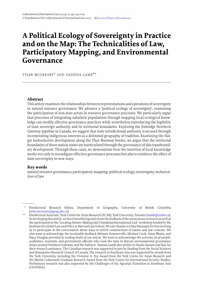
B U R M A
T H A I L A N D
Salween R
.Yuam R.
BURMA
N0
0
20 m30 k10
10 20 mi.
BANGLA- DESH
INDIA
CHINABHUTAN
Bay ofBengal
Location ofStudy Area
Chiang Mai160 km
Bangkok556 km
Salw
een
LAOS
THAILAND
M A L A Y S I A
Salween River
River
CAMBODIAVIETNAM
0 0 mi.50
0 5 00 0 km001
proposedHATGYI DAM
Fig. 1 Location of proposed Hatgyi Dam and study area
species, fishing gear use, riverbank gardens, and other topics while undertaking theireveryday livelihood activities. The Villager Research approach includes villagers asthe researchers, with research assistance from NGO staff and academics. It relies ona systematic methodology to collect data that was first developed in the aftermathof the last large dam to be built within Thailand, the Pak Mun Dam. Since theproject that spurred the formation of the Villager Research methodology, no largedams have been built within Thai borders; this is not a causal relationship but it isrelated to a history in Thailand of resistance to top-down development that did notinclude the participation of affected residents. Villager Research can be positionedas an attempt to draw on the complementary strengths of both ‘scientific’ and ‘local’knowledge in that the methodology is replicable and the approach situates itselfas emerging from a particular local context.61 The project is one example of many
61 See Agrawal, ‘Dismantling the Divide’, supra note 20; Agrawal, ‘Indigenous knowledge’, supra note 20; M.Leach and J. Fairhead, ‘Manners of Contestation: “Citizen Science” and “Indigenous Knowledge” in WestAfrica and the Caribbean’, (2002) 54 Int Soc Sci J 299; Berkes, supra note 20

612 T Y L E R M CC R E A RY A N D VA N E S SA L A M B
efforts to collaboratively produce maps for and about residents at the Salween, andfits within a larger effort to produce and circulate local ecological knowledge in thecontext of Salween dam development.
In some ways, Villager Research is similar to ATK; both produce textualized know-ledges and maps with explicit reference to development projects. However, VillagerResearch is not facilitated or funded by a company or project developer. Instead, itis collaboratively produced through the efforts of local volunteers, NGO staff, andacademics. Also, in contrast to the Canadian case, in Thailand local groups haveeschewed labelling themselves exclusively as traditional or indigenous, organizinginstead based on their relationships to development as villagers located in an import-ant area within the boundaries of the Thai nation-state. Local mapping by villagersprovides one example of the documentation or representation of this relationship.
At the Salween, mapping has been highlighted in part because the villages alongthe border that would be affected by Hatgyi Dam have been referred to – evenby activists – as ‘nok pan tii’ or ‘off the map’ because they are not included on mostgovernment maps. As such, the Salween Villager Research project can be seen as partof a response to requests by residents to be more formally recognized in Thailand.One series of maps titled ‘Ecological Systems of the Salween River, Thai–BurmaBorder’ has been published in books and was made with research collected bylocal residents.62 These maps present information regarding important ecosystemssuch as the rapids, waterfalls, and riverbank gardens documented through VillagerResearch, highlighting the impacts of the proposed dams on livelihoods in Thailand.
Of note for our discussion, this map series highlights the national political borderin both the title and the image. Yet, while attention is drawn to the river-border atthe centre of the image, there are no symbols marking important ecological systemsin Karen State, Burma. Karen State, where the dam barrage would be constructedand where the dam would also have impacts, is not mapped in detail.
In contrast to the Villager Research map of the river border and its relation tovillagers’ lives and livelihoods, there is a second map from the Hatgyi governanceprocess we consider for analysis. This map, part of the EIA document, was made bythe consultants hired by the Thai state electricity authority EGAT to conduct theEIA for the dam. Oddly, it erases Thailand from consideration. Entitled ‘Locationsof Villages Surveyed’, it is one of the first maps introduced in the EIA report, whichwas heavily relied upon in the public information hearings.63 While this map andthe Villager Research map are meant to draw attention to geographies that wouldbe impacted by the proposed dam, they do so in very different ways.
The EIA map is included in the chapter that proposes mitigation measures for thedam’s impacts, particularly the impacts to fishing and other livelihood activities.This map is scaled to show the Salween River in Burma, downstream of where part ofthe Salween River comprises the Thai–Burma border. No Thai provinces or villages
62 See maps 1–3 in Figure 2 from SEARIN (Living Rivers Siam) Salween Villager Research (2005),<www.livingriversiam.org/4river-tran/4sw/sw_tb_book3map.pdf>.
63 Environmental Research Institute, Chulalongkorn University. The Environmental Impact Assessment of theHutgyi Hydropower Project, Final Report, (July 2008), at Chap. 5 at 6.

A P O L I T I CA L E CO LO GY O F S OV E R E I G N T Y I N P R AC T I C E A N D O N T H E M A P 613
are shown. This map and the accompanying text in the EIA document only addressthe impacts and consultations previously held in Burma; it delimits dam impactswithin Burma and defines the boundaries of dam impacts to exclude Thailand. Inand through this map, produced by Thai consultants, we do not see any negativeimpacts to Thai territory or the border.64
Although not apparent from the introduction of the map in the EIA, this moveto spatially exclude Thailand from the dam’s impacts is quite useful to the futuresuccess of the project and, in turn, for meeting Thailand’s expected energy demands.Delimiting the impacts of the dam to one side of the border allows the developerto exclude Thailand from the proposed dam’s impacts. It is important to highlightthat this move to develop large hydropower just beyond Thailand’s borders andjurisdiction is part of a broader trend within the region to develop large hydropowerjust outside national boundaries.65
Both representations – the Villager Research map and the EIA map – highlightthe implications of mapping and not mapping within the broader processes ofgovernance and decision-making around this cross-border project. In the villager’smap, while ecological systems in Thailand and along the river-border are shown,the act of ‘not mapping’ Burma also has implications. It tends to de-emphasize thedam impacts in Burma, as well as to de-emphasize the role of Karen State authoritiesor Burmese actors in making claims to the Salween River. As a result, the VillagerResearch map clearly positions potentially impacted villages and ‘their’ resourceswithin Thailand, on the ‘other’ side of the Salween River-border.
In the public information hearings for Hatgyi Dam, the process called for legibleknowledge, such as maps, and knowable subjects, like mapped and counted residents.This stems in part from broad trajectory towards more participatory approaches todevelopment. But it also relates specifically to the 2007 Thai constitution, whichencoded recognition of ‘Community Rights’, including rights to traditional use ofresources and rights ‘to participate with State and communities in the preservationand exploitation of natural resources and biological diversity’.66 The 2011 publicinformation hearings were presented by the Thai Prime Minister’s Office as part ofaddressing these constitutional requirements.67
64 To be clear, such claims are contested. For instance, research from the National Human Rights Commissionof Thailand (done at the request of Thai citizens) points to cross-border impacts. Moreover, experience withand research on cross-border hydropower development in the region has demonstrated that cross-borderimpacts should be anticipated. This includes A. B. Wyatt and I. G. Baird, ‘Transboundary Impact Assessmentin the Sesan River Basin: The case of the Yali Falls Dam’, (2007) 23 Int’l J Water Res Dev 427. It is also unclearwhy EGAT paid to have the EIA conducted in Burma by Thai consultants. Some of the implications of thismove have been to bolster Thai claims to authority and expertise over the river and the project as wasdemonstrated in the public information hearing process.
65 By developing large dams beyond Thai borders, the Thai electric authority need not follow Thai law butcan still purchase the electricity. That there have been no dams constructed in Thailand since the infamousPak Mun project underscores this move; the construction of that large dam saw national-scale mobilizationand galvanized resistance to large, state-led development projects within Thai national borders. See alsoC. Middleton. ‘Transborder Environmental Justice in Regional Energy Trade in Mainland South-East Asia’,(2012) 5 Austrian Journal of South-East Asian Studies 292.
66 Constitution of the Kingdom of Thailand, Buddhist Era 2550 (2007), s. 66–7.67 There was confusion among the Thai subcommittee regarding what the hearings were intended for. At times,
the hearings were referred to as related to constitutional rights to participate in decision-making processes.

614 T Y L E R M CC R E A RY A N D VA N E S SA L A M B
Following Article 190 of this same constitution, any project disrupting the polit-ical border also necessitates a specific set of decision-making processes includingpublic participation; in this case, if the dam were found to impact the political bor-der, it would require parliamentary approval.68 Further underscoring why mappingthe political border matters, if the constitution requires that any project that wouldimpact the political border must seek such approval, then it must also be debated inThai parliament. Thus, we position the EIA map as emblematic of a larger processthat compels and enables EGAT to make claims that the project is exempt from scru-tiny under Thai law. In fact, not mapping the river boundary in this context servesa particular purpose. It represents a reiteration and reinforcement of the boundary,delineating Burmese space from the Thai territory and thus suspending, at least inpart, the responsibility of the Thai sovereign to impacted local residents in Thailandunder the constitution.
In addition to the presentation and discussion of maps, the Hatgyi public inform-ation hearing process saw local residents, including people who identify as Karenethnic minority group, participate. These residents took the opportunity to articu-late claims to and about the political border, the Thai nation, and natural resources.The majority of the residents at the border who stand to be most impacted by the pro-posed dam identify as Karen or Thai-Karen. In Thailand, popular discourse presentspeople who identify as a member of the Karen ethnic group as a people ‘close tonature’.69 Imagined as a people living harmoniously with nature but out-of-syncwith modern Thailand, Thai discourse regularly associates the Karen people withinThai territorial borders with a Burmese state broadly considered more primitive andundeveloped. This process of splitting the Karen people from Thai modernity alongan imagined ethnic-temporal-geographic cleavage, however, has not divorced theKaren in Thailand from the processes involved in the articulation of contempor-ary Thai sovereignty. Here the effect of a bounded territory becomes particularlysignificant in the processes of this cross-border case where, even as the governanceprocesses recognize the project’s relationship to both ‘sides’ of the political border,the border is represented more as a static line than a dynamic boundary producedthrough historical and political processes.
Returning to the two cartographies, and our juxtaposition of them, despite theirdifferent spatial representations of dam impacts, we argue that both emphasizenational borders and make claims about the river within a national frame. Together,these representations invoke the border as a taken for granted line, not a contested orambiguous historical-political-ecological construct.70 These bordering effects shapenot only the representation of territorial sovereignty (as seen in the maps) but also
At other times, the subcommittee referred to their goals as finding out the ‘truth’ of the project, particularlyabout the impacts to Thailand.
68 Constitution of the Kingdom of Thailand, Buddhist Era 2550 (2007), s. 190.69 T. Forsyth and A. Walker, Forest Guardians, Forest Destroyers: The Politics of Environmental Knowledge in Northern
Thailand (2008).70 See also discussion in L. Harris and S. Alatout, ‘Negotiating Hydro-Scales, Forging States: Comparison of the
upper Tigris/Euphrates and Jordan River basins’, (2010) 29 Polit Geogr 148, at 149.

A P O L I T I CA L E CO LO GY O F S OV E R E I G N T Y I N P R AC T I C E A N D O N T H E M A P 615
work to distinguish transboundary Karen populations as respectively belonging tothe Thai and Burmese nation-states.
In Thailand, like Canada, there is a long history of developing participatoryapproaches to development and ‘community rights’ which include the right toparticipate in decisions about natural resources enshrined in the Thai constitution.71
In bringing subaltern peoples and their knowledge before the state, this governanceprocesshasbeenanimportantpartof producingtheeffectof a delimited and boundedstate, particularly in areas that are considered ‘off the map’. As with the Canadiancase, understanding sovereignty as the product rather than precursor to governanceprovides insight into the enduring representation of a coherent, bounded territorialsovereignty produced through the work of state and non-state actors.
While the river as a border has become an increasingly significant part of thiscase, and increasingly important for the legalities of the Hatgyi project’s approval,the particular articulations of sovereign authority and the arrangements regardingborders and boundaries are also linked to a longer, contested history of authorityand development within the region in ways that differ from the Canadian case.Prior to the colonization of Southeast Asian kingdoms, sovereign power is arguedto have been understood not as discretely bounded but with overlapping jurisdic-tion.72 In the establishment of political borders, historian Thongchai Winichakulargues that negotiations with European colonizers changed representations of theborder in Thailand, superimposing a Cartesian understanding of the border ontoindigenous understandings of the border.73 Mapping technologies played a crucialrole in mediating these encounters and constructing particular ideas about territ-orial boundaries. Yet, simply mapping a stretch of the Salween River as a borderin the mid-1800s did not produce a static line of demarcation. Both rivers and bor-ders move, and in the context of the Hatgyi Dam, the river threatens to flood anddestabilize the political border.
At the same time, we show how the border is not just being remade through alteredwater levels. Prior to the actual construction of the dam, the political border is beingmapped and represented during the participation and planning phases by a varietyof actors or ‘stakeholders’ described here. The list of actors includes the consultantshired to conduct the environmental impact assessment (EIA) and residents whowould be impacted by the dam, either directly affected by relocation or indirectlyaffected through the dam’s impacts on fishing and agricultural livelihoods. The net-work of those involved in remaking the border also includes government officialsand dam developers. In fact, all of these actors made and presented maps duringthe initial stages of natural resource decision-making of the Hatgyi hydroelectricproject. We argue that the process of creating these maps and the cartographic rep-resentations they advance link with and reconfigure the network of actors enacting
71 On participatory development in Thailand, see Chambers, supra note 10.72 In 1849, the British administration in Burma negotiated the Salween river border with the northern kingdom
of Chiangmai, part of present-day northern Thailand. See T. Winichakul, Siam Mapped (1994), at 82–91.73 Ibid.

616 T Y L E R M CC R E A RY A N D VA N E S SA L A M B
sovereign authority. In turn, this also complicates understanding of the border asdistant from ‘state power’ geographically, or of Karen residents as ‘off the map’.
In line with the Canadian situation, this case highlights how the process of naturalresource governance serves multiple functions. In addition to producing a decisionabout the dam project, the process brings multiple actors together to articulateand make coherent their claims to natural resources and political geographies. Inrelation to the Hatgyi Dam, residents, government officials, and dam developershave been compelled to make claims through these environmental governanceprocesses. This occurs not as a result of legal compulsion; rather it reflects differentactors’ strategic orientation, aiming to achieve greater resonance with and effect innatural resource governance proceedings through performing claims (and laws) thatreproduce territorial boundaries of the state. Similar to the Canadian case, we arguethat the inclusion of local peoples in resource governance is not simply a process ofstate capture. Rather, through their inclusion, local peoples are effectively remakingtheir relationships with governance, and in practice, the governance processes andoutcomes are altered in ways that (potentially) better acknowledge or incorporatemultiple claims to resources. This is part of a much longer struggle for participationin making decisions over natural resources in Thailand and across Southeast Asia.
7. DISCUSSION
What do these cases teach us about how sovereignty is produced and how can thisinform a broader scholarship on sovereignty and nature, particularly as they are un-derstood in scholarship on international law? In both cases, the networks of people,institutions, and ecologies that produce sovereign authority were extended to in-clude aboriginal knowledge holders and village researchers. Rethinking sovereigntyfrom the ‘bottom up’ – as something that is practised and requires enactment –demonstrates how these so-called ‘non-state’ actors, alongside government officials,participate in rearticulating territorial sovereignty as an effect of governance. In pro-cesses mediated by the technology of mapping, people made claims that reproducedthe internal coherency and external boundaries of the sovereign territory. One of themost significant similarities between the two cases presented here is that the gov-ernance processes were not simply about decisions on the specific projects (whetherthe project would go ahead), but also questions of territory and jurisdiction.
This inversion of conventional approaches to sovereignty, positioning its au-thority as the product of rather than precursor to governance, begins to explain theenduring imagination of a coherent, bounded territorial sovereignty despite its seem-ing disjuncture with how governance processes occur in contemporary contexts. Weargue that sovereignty emerges as an effect of particular methods of organizing andarranging knowledge through governance processes. While governance processesenlist numerous state and non-state actors in complex negotiations, these processescontinually produce an image of an enduring structure of territorial sovereignty asneatly bounded and internally consistent. Thus, we argue the effective exercise ofsovereignty within the technical practices of governance works to reproduce theeffect of a political structure of sovereignty external to those practices.

A P O L I T I CA L E CO LO GY O F S OV E R E I G N T Y I N P R AC T I C E A N D O N T H E M A P 617
Further, in examining the linkages between local actors’ efforts to documenttheir relationships to resources and the rearticulation of territorial sovereignty, weare able to offer insights into the relation between subaltern populations and thestate. Our long-term ethnographic research on local knowledge practices producesnuanced understanding of a complex set of relations that cannot be adequatelyconceptualized in binaries of state oppression and subaltern resistance. Examiningthe participation of local actors in map-making and the subsequent mobilization ofthese maps in natural resource governance processes highlights the co-productionof forms of state authority through subaltern claims-making. This matters to ourunderstanding of sovereignty because it situates subaltern claims-making as partof how sovereign power works in practice as well as how representations of sover-eignty are produced through governance practices. Theoretically we offer a means ofrapprochement between participatory governance processes and conventional rep-resentations of sovereignty, recognizing how the former can act as an unexpectedmeans of producing the later.
Attending to maps as ‘technicalities of law’ recognizes the complex and nuancedrelations between sovereign authorities and local actors. Our ethnographic workallows us to reveal how claims-making also often works as a form of sovereignty-making activity. In one sense, we can understand how even ostensibly resistant non-state actors making claims can be seen to subject themselves to the authority of thestate. But local peoples are not simply subjugating themselves to an already coherentstate sovereignty; rather local actors’ processes of reckoning with sovereign authorityalso contribute to the constitution of that authority. While sovereignty is presentedas autonomous and external, we want to insist that sovereign authority itself isimmanent to the domain in which claims are made. Thus, rather than appealing to analready coherent, united, and absolute entity, local actors’ claims work through a setof governance relationships that produce the authority to make decisions alongside aseries of representations that reify that authority as independent of the relationshipsthat produce it. In this way, local actors’ counter assertions within natural resourcegovernance processes co-produce sovereignty alongside local claims to land andresources.
Yet, if there appears a remarkably stable script for sovereignty with newly en-rolled actors seemingly just adapting an old repertoire, we insist the innovationsin the performance of sovereignty are significant. While indigeneity is secured in alocalized geography of traditional use, this geography has nonetheless modified theinterior of the state’s claimed territory. Similarly, the incorporation of Karen peoplehas modified how the body politic is conceived in Thailand, mapping the ‘Otherwithin’ onto the nation. In both cases, these inclusions and modifications in gov-ernance processes are the result of long struggles among marginalized communitiesfor political recognition.74 While these changes appear limited in many ways, it isimportant to register that decades of activism were involved in reconfiguring thenetworks of natural resource governance to ensure local actors had a role in the
74 T. Winichakul, ‘The Quest for “Siwilai”: A Geographical Discourse of Civilizational Thinking in the LateNineteenth and Early Twentieth-Century Siam’, (2000) 59 J Asian Stud 528; Tennant supra note 54.

618 T Y L E R M CC R E A RY A N D VA N E S SA L A M B
process. These shifts indicate the malleability of effective governance processes,even while the dominant imagination of the territorial sovereign endures. Thishighlights the flexibility of how sovereignty is enacted through governance whilenonetheless maintaining the comprehensibility of sovereignty within traditionalvalences.
However, in both cases, as in participatory approaches to development world-wide, mapping technologies both mediate and are productive of relations betweenlocal people, the environment, and development, which stabilize the authority andthe territorial integrity of the sovereign. For us, understanding the role of mediatingtechnologies within the ways that sovereignty is produced is vital to understandingthe relationships between knowledge making and sovereignty as the absolute au-thority over land. As geographers, we are guarded about the implications of makingclaims with maps. There is a broad literature about both the possibilities and pit-falls of mapping, particularly in participatory development exercises.75 Yet, mapsas representations that are common within local, national, and global natural re-source governance processes illustrate some basic elements of sovereignty effects:how different institutional actors and individuals come together to make and rep-resent claims to natural resources and co-produce authority to whom these actorsare accountable. We would argue that this is done in the maps themselves (as texts),but perhaps more importantly, that this process enrolls and engages multiple actorsin authorizing the sovereign to speak on behalf of nature and people, as made legiblethrough these maps.
Recognizing how local actors mapping their claims to natural resources in gov-ernance processes is part of the rearticulation of sovereignty, our initial contributionto this discussion has also led us to questions for future investigation. Insights fromscience and technology studies have been useful in apprehending how natures orenvironments themselves are co-constituted alongside natural resource governancenetworks.76 The understanding that ecologies and natural resources are part of thenetwork that produce agency is one way our arguments can be extended to raise fur-ther questions about sovereignty. For instance, what role do ‘natures’ or ‘ecologies’play in shaping how governance processes unfold? How do understandings of natureor our relationships with the materiality of the environment influence or challengeconventional understandings of authority and jurisdiction? To acknowledge thesequestions compels a broader recognition of the contingencies underlying sovereignauthority. Acknowledging the ways in which sovereignty is constantly brought intorelations with the world of subjects – state and non-state, human and non-human –under its jurisdiction allows us to comprehend moments exhibiting the contingencythat the world presses on the sovereign.
75 See Roth, supra note 27; Walker and Peters, supra note 28; Hodgson and Schroeder, supra note 29; Wainwrightand Bryan, supra note 30.
76 B. Latour, We have never been Modern (1993).

A P O L I T I CA L E CO LO GY O F S OV E R E I G N T Y I N P R AC T I C E A N D O N T H E M A P 619
8. CONCLUSION
Overall, the pairing of these two cases demonstrates how two core aspects of sov-ereignty – territorial boundaries and jurisdiction over domestic polities – can beseen as progressive enactments produced through the work of multiple actors innatural resource governance networks. Sovereignty is not simply a form of powerimposed, but enacted and produced through complex relationships between gov-erning authorities and the governed. Thus, indigenous peoples and rural residents,as well as corporations, investors, and company knowledge facilitators, are variouslyenlisted in practices that reproduce and remake the authority of the sovereign. Thecontingencies pressed upon and embedded within the sovereign on the basis ofits ongoing co-production, renders it a necessarily provisional arrangement, underconstant revision. This contingency opens opportunities to modify the roles andresponsibilities of the sovereign, to redefine it in association with new conceptsof citizenship and ecology. But if the sovereign is a precarious achievement, it hasbeen an enduring one. This endurance in part is a result of the way that mediatingtechnologies, such as maps, help stabilize the networks producing sovereignty andaid their perpetuation.