A Framework for Intensional and Extensional Integration of Geographic Ontologies
15
Transactions in GIS, 2007, 11(6): 873–887 © 2007 The Authors. Journal compilation © 2007 Blackwell Publishing Ltd Blackwell Publishing Ltd Oxford, UK TGIS Transactions in GIS 1361-1682 © 2007 The Authors. Journal compilation © 2007 Blackwell Publishing Ltd XXX Research Article Generating Mappings between Ontologies E Tomai, P Prastacos and M Kavouras Research Article A Framework for Intensional and Extensional Integration of Geographic Ontologies Eleni Tomai and Poulicos Prastacos Institute of Applied and Computational Mathematics Foundation of Research and Technology Heraklion Crete, Greece Marinos Kavouras Cartography Laboratory School of Rural and Surveying Engineering National Technical University of Athens Keywords : Information flow, intenstional level, extensional level, semantic interoperability Abstract This paper presents ongoing research in the field of extensional mappings between ontologies. Hitherto, the task of generating mappings between ontologies has focused on the intensional level of ontologies. The term intensional level herein, refers to the set of concepts that are included in an ontology. However, an ontology that has been created for a specific task or application needs to be populated with instances. These comprise the extensional level of an ontology. This particular level is generally neglected during the ontologies’ integration procedure. Thus, although methodologies of geographic ontologies integration, ranging from alignment to true integration, have, in the course of years, presented a solid ground for information exchange, little has been done in exploring the relationships between the data. In this context, this research strives to set a framework for extensional mappings between ontologies using Information Flow Theory by presenting a case study of interoperability between the thematic content of maps. 1 Introduction A well-formed domain ontology should be able to provide answers to two types of questions: Address for correspondence: Eleni Tomai, Institute of Applied and Computational Mathematics, Foundation of Research and Technology, P.O. Box 1529, 7110 Heraklion Crete, Greece. Email: [email protected]
-
Upload
independent -
Category
Documents
-
view
0 -
download
0
Transcript of A Framework for Intensional and Extensional Integration of Geographic Ontologies

Transactions in GIS
, 2007, 11(6): 873–887
© 2007 The Authors. Journal compilation © 2007 Blackwell Publishing Ltd
Blackwell Publishing LtdOxford, UKTGISTransactions in GIS1361-1682© 2007 The Authors. Journal compilation © 2007 Blackwell Publishing LtdXXX
Research Article
Generating Mappings between OntologiesE Tomai, P Prastacos and M Kavouras
Research Article
A Framework for Intensional and Extensional Integration of Geographic Ontologies
Eleni Tomai and Poulicos Prastacos
Institute of Applied and Computational MathematicsFoundation of Research and TechnologyHeraklion Crete, Greece
Marinos Kavouras
Cartography LaboratorySchool of Rural and Surveying EngineeringNational Technical University of Athens
Keywords: Information flow, intenstional level, extensional level, semantic interoperability
Abstract
This paper presents ongoing research in the field of extensional mappings betweenontologies. Hitherto, the task of generating mappings between ontologies has focusedon the intensional level of ontologies. The term intensional level herein, refers to theset of concepts that are included in an ontology. However, an ontology that has beencreated for a specific task or application needs to be populated with instances. Thesecomprise the extensional level of an ontology. This particular level is generallyneglected during the ontologies’ integration procedure. Thus, although methodologiesof geographic ontologies integration, ranging from alignment to true integration,have, in the course of years, presented a solid ground for information exchange, littlehas been done in exploring the relationships between the data. In this context, thisresearch strives to set a framework for extensional mappings between ontologiesusing Information Flow Theory by presenting a case study of interoperability betweenthe thematic content of maps.
1 Introduction
A well-formed domain ontology should be able to provide answers to two types ofquestions:
Address for correspondence:
Eleni Tomai, Institute of Applied and Computational Mathematics,Foundation of Research and Technology, P.O. Box 1529, 7110 Heraklion Crete, Greece. Email:[email protected]

874
E Tomai, P Prastacos and M Kavouras
© 2007 The Authors. Journal compilation © 2007 Blackwell Publishing Ltd
Transactions in GIS
, 2007, 11(6)
• What is a
X
? Or what it means to be
X
? Or can you define
X
? and• What is this? Or is this
X
?
The first type of question refers to processes called description, explanation, ordefinition, respectively. These result in the demarcation of the different concepts in theontology, as well as their documentations. No reference is made at this point to howthese concepts are included in the ontology in the first place. Furthermore, these processeshelp identify semantic relations from one part and semantic properties from the other part– as defined in Kokla and Kavouras (2002) and Tomai and Kavouras (2004) – whichcan generate the hierarchical structure of the ontology. The second type of questionsrefers to the process of categorization; namely the process of assigning members to acategory. The process itself accounts for allocating the instances of each concept in theontology. Therefore, a well-formed domain ontology should both include concepts thatstand for some kinds of relationships among them, as well as instances of these concepts.
The aforementioned processes boil down to what linguistics, respectively,defines as:
• Intension; what you must know in order to determine the reference of an expression• Extension; the class of objects that an expression refers to, in WordNet 2.0 (Cognitive
Science Laboratory 2003)
Consequently, we can distinguish between the intensional level (the set of concepts) andextensional level (the concepts’ instances) of an ontology.
The growing interest among geoscientists in ontologies, along with the plethora ofdata for the geographic domain, has revealed the need for consistent information andhas set the path for ontologies integration. The issue, therefore, is how to integrate twoor more geographic ontologies in order to produce a unified one, or at least how togenerate mappings between different ontologies, so that users can switch between them,to achieve semantic interoperability. Bearing in mind that an ontology includes twodistinct levels of elements (concepts and instances) that both provide ontological infor-mation, we present, herein, a methodology for utilizing both levels in order to advanceintegration.
The methodology applies tenets from Information Flow (IF) Theory in order toperform integration of ontologies at two levels: the intensional and the extensional.Thus far, the majority of approaches to geographic ontologies integration have exploredonly the possibilities of integration at the intensional level. The process of integration atthis level aims at the analysis of definitions of the concepts, the extraction and statementof their semantic properties and relations and finally the revelation of heterogeneitiesthat guide the establishment of the final /new schema. Herein, we explore the possibilitiesof adding the extensional level of the ontologies to the integration process. We applytenets from the IF Theory to integrate the thematic contents of maps due to the lack ofpopulated ontologies in the geospatial domain.
The remainder of the paper is organized as follows: we give a brief account of whathas been achieved so far regarding ontologies’ integration in section 2. The proposedframework for ontology integration at both the intensional and extensional level ispresented in section 3. Section 4 presents the way this framework can be applied for theintegration of the thematic contents of maps and we discuss its results. Finally, in section5 we identify numerous future research questions concerning the intensional and exten-sional integration of ontologies.

Generating Mappings between Ontologies
875
© 2007 The Authors. Journal compilation © 2007 Blackwell Publishing Ltd
Transactions in GIS
, 2007, 11(6)
2 Integrating Ontologies: The Way So Far
Several methodologies of ontology integration have been presented by scholars (Vckovskiet al. 1999, Uitermark 2001, Wache et al. 2001). According to the framework presentedby Kavouras (2005) we can identify four types of integration: alignment, partial com-patibility, unification and true integration.
In the case of alignment, mappings are generated between the concepts of the twoontologies; no distortion is made to either of them. This is the simplest integration casefor it can be seen as a “translation” mechanism between the two ontologies’ concepts.For a methodology on generating mappings between geographic ontologies, refer toCruz et al. (2004). On the other hand, partial compatibility refers to the unification ofthe common parts of the ontologies. The result is a single ontology but integration hasjust taken place for the common parts of the ontology with consequent distortion ofthe original ones. Unification is an extension of partial compatibility, which results in asingle ontology, by unifying every branch of the two ontologies into one. The two initialontologies are fully distorted.
True integration, on the other hand, refers to the procedure of producing a newontology, which includes the initial ones without any alteration; however, it includessome new concepts that are needed to associate the ontologies. The initial ontologiescan be reused independently from the integrated one. A methodology of true integrationbetween geographic ontologies using Formal Concept Analysis has been introduced byKokla and Kavouras (2000).
The abovementioned methodologies have dealt with the intensional level of ontologies;they do not treat integration at the extensional level. There has been one case wherethe integration process has been generated between geographic ontologies at the exten-sional level; Duckham and Worboys (2005) have proposed an algorithm of geographicontologies integration depending on relationships between instances, which are able toinfer taxonomic relations between the categories themselves. If prior knowledge ofthe taxonomies exists, it can be taken into account but it is not a prerequisite. Theabove-described methodology leaves a few open questions regarding the suitabilityof the assumption that extensional information can be used as an inference mechanismfor the taxonomic structure of the intensional level. Two questions that should beaddressed are:
• Do identical instances of two categories in the two ontologies refer to equivalentcategories, or subsumed ones?
• How many instances to compare in order to achieve integration?
The first question reveals the problem of depending only on instances of ontologiesto achieve integration. Two identical instances in two different ontologies may be membersof two identical categories. However, this is not always the case; because these instancesmay belong to one category in the first ontology and to its subsumed category in thesecond ontology, given that the latter ontology is more detailed than the former. There-fore, inferring the taxonomic structure of the ontologies based only on instances is notadequate. On the other hand, integration at the intensional level has never tackled theissue of how many categories are included in the ontologies to give a result. Neverthe-less, in the case of extensional information, there is an issue of sufficiency regarding theminimum number of instances that categories should have before the integration processcan be pursued.

876
E Tomai, P Prastacos and M Kavouras
© 2007 The Authors. Journal compilation © 2007 Blackwell Publishing Ltd
Transactions in GIS
, 2007, 11(6)
3 Integrating Ontologies: The Way Forward
In this section, we present a framework that can set the path for ontology integrationat the intensional as well as the extensional level. The following paragraphs present themain notions of the proposed Framework.
3.1 Information Flow
As mentioned, the method utilizes IF Theory to provide the theoretical basis for theintegration process. The basic idea behind it, as stated in Barwise and Seligman (1997)is the notion of containment, which translates as
the information an object containsabout another
. IF is better understood within a distributed system. Distributed systemsare regarded as wholes with interrelated parts. Regularities within these systems ensurethe flow of information between the parts: “. . .
Consequently, the more random asystem is the less information can flow
” (as quoted from Bremer and Cohnitz 2004).The sections that follow introduce the basic notions of IF Theory that are of use in
the remainder of this paper.
3.1.1 Classification
The components of a distributed system are represented by a classification
A
(Devlin2001), which is a triple, <A,
Σ
A
,
A
> where A the set of objects of
A
to be classified,called tokens of A,
Σ
A
the types of
A
, used to classify the tokens, while the tokens standin relation
A
to the types (Figure 1).Each classification has a Local Logic that governs its types (Bremer and Cohnitz 2005).
This logic allows inferences to be drawn at the type level of the classification. Thesequent
α
�
β
, for types
α
,
β
indicates that the inference from
α
to
β
holds. For instancein Worboys (2001), the sequent house
�
building indicates that houses are buildings.
3.1.2 Infomorphism
For relating two classifications, the notion of infomorphism (Devlin 2001) is introduced.Let
A
= <A,
Σ
A
,
A
> and
B
= <B,
Σ
B
,
B
> be two classifications. An infomorphism f betweenthem consists of two functions: f
+
from types of
A
to types of
B
, and f
−
from tokens of
B
to tokens of
A
(Figure 2).
Figure 1 Classification A

Generating Mappings between Ontologies
877
© 2007 The Authors. Journal compilation © 2007 Blackwell Publishing Ltd
Transactions in GIS
, 2007, 11(6)
3.1.3 Channel
We write to denote
that a situation s1 delivers some of the informationsupported by a situation s2 with respect to channel c
as in Lalmas (1998). At this pointit is important to mention that the notion of channel was first used to express relation-ships between situations in Situation Theory, as introduced by Barwise and Perry(1983), the presentation of the theory’s basic tenets though, are out of the scope of thispaper. The channel allows formalizing the context in which the flow of informationtakes place. In other words, a channel
c
is the medium of IF between two classifications
A
and
B
as those previously mentioned; it connects them through a core classification
C
via two infomorphisms
f
and
g
(Figure 3).
3.2 Semantic Interoperability
The IF Theory can be used to enable semantic interoperability between different com-munities that use their own classifications, by providing the necessary mappings acrossthem. Approaches of generating mappings based on IF can be found in Kalfoglou andSchorlemmer (2003). In addition, Kent (2004) has developed the IF Framework for thestandardization activity of Standard Upper Ontology, and proposed a methodology forontology merging.
s s1 2 a
c
Figure 2 Infomorphism f from A to B
Figure 3 A channel c between classifications A and B

878
E Tomai, P Prastacos and M Kavouras
© 2007 The Authors. Journal compilation © 2007 Blackwell Publishing Ltd
Transactions in GIS
, 2007, 11(6)
Interoperability in the context of IF takes place at both the type and the token levelas it can be drawn from the above-presented notions of informorphism and channel.Therefore, when generating mappings between classifications, the instances of theclassifications are compared as well.
4 An Example of Type/Token Level Mappings between Sources of Geographic Information: The Case of Thematic Maps
In this section, we explore the way IF Theory can be incorporated with the reading ofthematic maps. We examine this by giving an example of IF-mappings between twosymbol-sets of thematic maps, representing population density in a part of Europe atdifferent times (years 1996, 1999 respectively) and taken from the “Regions: StatisticalYearbook” in 2002 (see http://epp.eurostat.ec.europa.eu/cache/ITY_OFFPUB/KS-AF-02_001/EN/KS-AF-02-001-EN.PDF for additional details) and 2003 (see http://epp.eurostat.ec.europa.eu/cache/ITY_OFFPUB/KS-AF-03_001/EN/KS-AF-03-001-EN.PDFfor additional details) (Figures 5 and 6).
The usual elements of a thematic map are the background map, thematic content(expressed by symbols), title, legend, which explains the symbols used, and scale. In thiscase study we are interested to generate mappings between the thematic contents ofthe maps; thus, the elements that are of importance to us are the legend symbols thatprovide information about the thematic content and the regions on the maps that carrythese symbols and present the spatial distribution of this content.
In this task, we regard maps as distributed systems with regularities whose com-ponents can be represented through the notion of classification which is characterizedby local logics as discussed in section 3.1.1 and we attempt to provide mappingsbetween these different systems (maps) to achieve semantic interoperability (Figure 4shows this procedure).
The first map (Figure 5) – map_1 represents population density (pd) in 1996 using sixclasses. On the other hand, the second map (Figure 6) – map_2 – shows pd in 1999 usingfive classes. Following the discussion of section 3.1.1, in our example, map_1 and map_2are the two classifications, the legend symbols are the types of each classification (classes ofthe ontology), while the regions on the maps bearing the symbols (which present the thematiccontent of the regions) are the tokens of the classification (instances of the classes).
As it stands, because of the different classifications, we are not able to reasonwhether population density of a region has increased or declined over the three yearstime. Therefore, the goal is to produce mappings between these two different classificationsto be able to draw secure inferences about changes in population density. However, togenerate these mappings within the IF Theory, it is important to use a
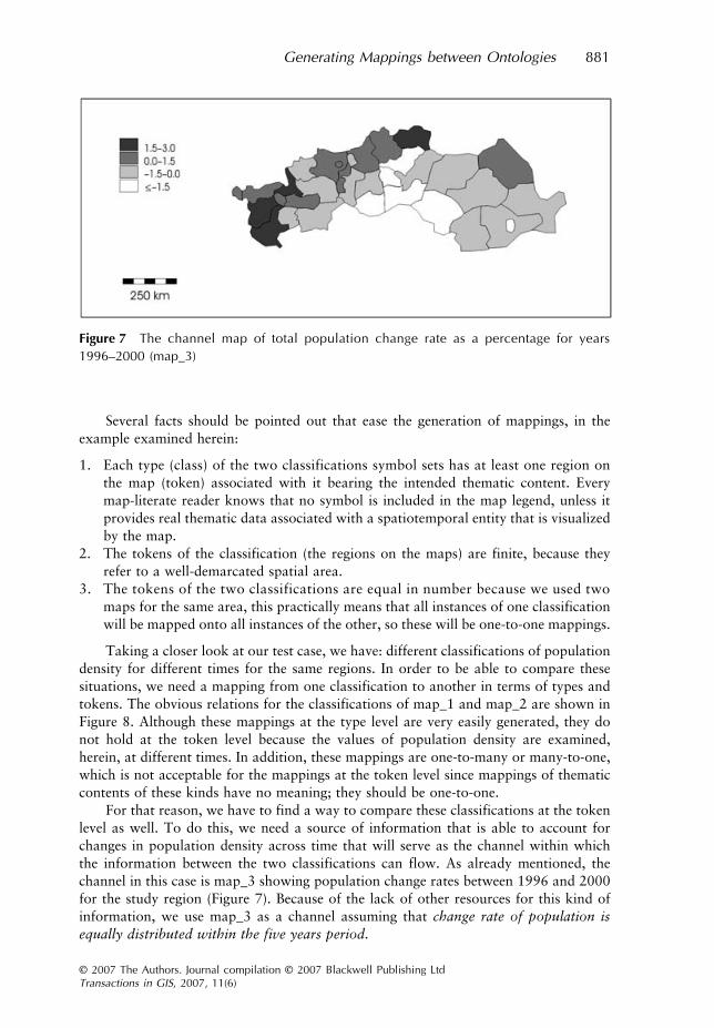
channel
asdescribed in the previous section. The channel in this example is a third map, taken fromthe 2003 Statistical Yearbook (Figure 7) – map_3, which shows total population changerates between the years 1996–2000, in the same European regions.
The idea of using IF Theory for generating mappings between different thematicmaps was inspired by Worboys (2001) who applied it to formalize a representation systemand gave the following example:
“. . . let A be the classification of map elements and B be a set of real worldobjects and features. Then, the representations are the map objects, and map

Generating M
appings between O
ntologies
879
© 2007 The A
uthors. Journal compilation ©
2007 Blackw
ell Publishing Ltd
Transactions in GIS
, 2007, 11(6)
Figure 4 The interoperability aspect of information flow as applied to thematic maps

880
E Tomai, P Prastacos and M Kavouras
© 2007 The Authors. Journal compilation © 2007 Blackwell Publishing Ltd
Transactions in GIS
, 2007, 11(6)
objects are representing real world objects. Let the core
C
be the cartographicprocess of surveying real world objects and associating them with mapelements. The cartographic process might contain rules such as associating ared line on the map with a road on the ground. So a constraint in the local logicmight be draw red line
�
surveyed road. In that case, red lines indicate roads.”
Figure 5 Population density (inhabitants per sq km) in European regions (NUTSII) in 1996(map_1)
Figure 6 Population density (inhabitants per sq km) in European regions (NUTSII) in 1999(map_2)
Generating Mappings between Ontologies
881
© 2007 The Authors. Journal compilation © 2007 Blackwell Publishing Ltd
Transactions in GIS
, 2007, 11(6)
Several facts should be pointed out that ease the generation of mappings, in theexample examined herein:
1. Each type (class) of the two classifications symbol sets has at least one region onthe map (token) associated with it bearing the intended thematic content. Everymap-literate reader knows that no symbol is included in the map legend, unless itprovides real thematic data associated with a spatiotemporal entity that is visualizedby the map.
2. The tokens of the classification (the regions on the maps) are finite, because theyrefer to a well-demarcated spatial area.
3. The tokens of the two classifications are equal in number because we used twomaps for the same area, this practically means that all instances of one classificationwill be mapped onto all instances of the other, so these will be one-to-one mappings.
Taking a closer look at our test case, we have: different classifications of populationdensity for different times for the same regions. In order to be able to compare thesesituations, we need a mapping from one classification to another in terms of types andtokens. The obvious relations for the classifications of map_1 and map_2 are shown inFigure 8. Although these mappings at the type level are very easily generated, they donot hold at the token level because the values of population density are examined,herein, at different times. In addition, these mappings are one-to-many or many-to-one,which is not acceptable for the mappings at the token level since mappings of thematiccontents of these kinds have no meaning; they should be one-to-one.
For that reason, we have to find a way to compare these classifications at the tokenlevel as well. To do this, we need a source of information that is able to account forchanges in population density across time that will serve as the channel within whichthe information between the two classifications can flow. As already mentioned, thechannel in this case is map_3 showing population change rates between 1996 and 2000for the study region (Figure 7). Because of the lack of other resources for this kind ofinformation, we use map_3 as a channel assuming that
change rate of population isequally distributed within the five years period
.
Figure 7 The channel map of total population change rate as a percentage for years1996–2000 (map_3)

882 E Tomai, P Prastacos and M Kavouras
© 2007 The Authors. Journal compilation © 2007 Blackwell Publishing LtdTransactions in GIS, 2007, 11(6)
The steps that we follow are:
• With respect to map_3 and map_1 we calculate the pd in 1999 for the given regions(column 4 of Table 1);
• Then we compare these values to the pd deduced from map_2 (column 5 of Table 1), andwe end up with its true value for every region for the year 1999 (column 2 of Table 2);
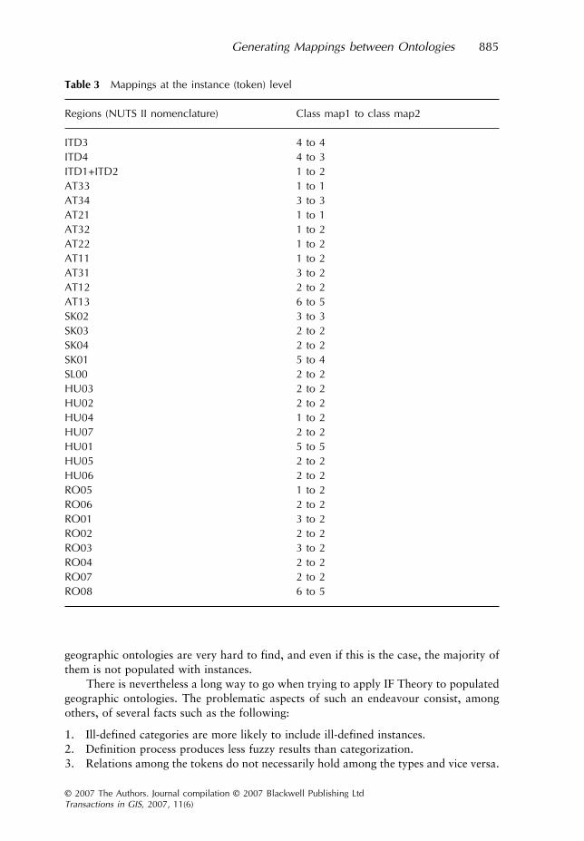
• Finally, we establish mappings between the two classifications (column 2 of Table 3).
We think it is time to clarify several points and results. Column 4 of Table 1 showsthe calculated pd for the year 1999 by combining information from map_1 and map_3.This procedure gives us a range of pd values. However, map_2 provides information ofpd for this year also as a range of values (column 5 in Table 1). Therefore, column 2 ofTable 2 shows the range of pd in 1999 values as deduced from the combination of thetwo aforementioned ranges of values, while column 3 of Table 2 shows the relation thatholds between the true values’ range of pd for the year 1999 and the pd classes ofmap_2.
The result of the pursued procedure is that we established relations (Table 2)between the thematic contents of map_1 and map_2; namely, we provided mappings atthe token level of the two classifications (Table 3).
The resulting relations between the true values’ range of pd for the year 1999 andthe pd classes of map_2 can be described in terms of inclusion, overlapping, extension,and refinement:
• Inclusion is met in cases where a token of the first classification has a true pd valuerange that can be properly included in a pd class of the second classification(i.e. AT12);
• The case of overlapping holds when a part of the first classification token’s true pdvalue range can be included in a class of the second (i.e. RO05);
• Extension and refinement are special cases of inclusion because they involve achange of limits of the initial class. Extension holds when the first classificationtoken’s true pd value range can be included in a pd class of the second classificationbut involves expansion of the lower limit of the initial class (i.e. RO08), while
Figure 8 Mappings between classifications map_1 and map_2 at the type level

Generating Mappings between Ontologies 883
© 2007 The Authors. Journal compilation © 2007 Blackwell Publishing LtdTransactions in GIS, 2007, 11(6)
refinement involves the opposite procedure when the upper limit of the initial classis confined (i.e. AT33).
Recall at all times, however, that these relations hold among the tokens of the twoclassifications.
Table 1 Population density for each region of the study area, as deduced from map_1(column 2), as estimated from map_1 and map_3 (column 4) and as deduced from map_2(column 5)
Regions (NUTS II nomenclature)
Population density (inhabitants/km2), 1996 map_1
Total population change rate (1996–2000) map_3
Population density (inhabitants/km2), 1999 (estimation map_1 & 3)
Population density (inhabitants/km2), 1999 map_2
ITD3 150–249 1,5–3 151,8–255,0 200–400ITD4 150–249 −1,5–0 148,2–249,0 120–200ITD1+ITD2 <75 1,5–3 <76,8 60–120AT33 <75 0–1,5 <75,9 ≤60AT34 100–149 0–1,5 100,0–150,8 120–200AT21 <75 0–1,5 <75,9 ≤60AT32 <75 1,5–3 <76,8 60–120AT22 <75 −1,5–0 <75,0 60–120AT11 <75 0–1,5 <75,9 60–120AT31 100–149 −1,5–0 98,8–149,0 60–120AT12 75–99 0–1,5 75–100,2 60–120AT13 ≥500 0–1,5 ≥506,0 >400SK02 100–149 0–1,5 100,0–150,8 120–200SK03 75–99 0–1,5 75,0–100,2 60–120SK04 75–99 1,5–3 75,9–101,4 60–120SK01 250–499 −1,5–0 247,0–499,0 200–400SL00 75–99 −1,5–0 74,1–99,0 60–120HU03 75–99 −1,5–0 74,1–99,0 60–120HU02 75–99 −1,5–0 74,1–99,0 60–120HU04 <75 ≤−1,5 <74,1 60–120HU07 75–99 ≤−1,5 74,1–97,8 60–120HU01 250–499 ≤−1,5 247,0–493,0 >400HU05 75–99 ≤−1,5 74,1–97,8 60–120HU06 75–99 −1,5–0 74,1–99,0 60–120RO05 <75 ≤−1,5 <74,1 60–120RO06 75–99 −1,5–0 74,1–99,0 60–120RO01 100–149 1,5–3 101,2–152,6 60–120RO02 75–99 −1,5–0 74,1–99,0 60–120RO03 100–149 −1,5–0 98,8–149,0 60–120RO04 75–99 −1,5–0 74,1–99,0 60–120RO07 75–99 −1,5–0 74,1–99,0 60–120RO08 ≥500 ≤−1,5 ≥494,0 >400

884 E Tomai, P Prastacos and M Kavouras
© 2007 The Authors. Journal compilation © 2007 Blackwell Publishing LtdTransactions in GIS, 2007, 11(6)
5 Conclusions
Mappings in the context of IF can be easily generated in the case of thematic maps asthe previous discussion has demonstrated. Future research comprises the application ofIF concepts in the field of ontologies. This has not been fully addressed, herein, because
Table 2 Population density for each region of the study area for the year 1999, as deducedfrom map_1 and map_2 and the channel map_3. The third column shows the relation that holdsbetween map_1 and map_2 regarding the classifications’ instances/regions (token level)
Regions (NUTS II nomenclature)
Population denstity 1999 Relation
ITD3 200,0–255,0 OverlappingITD4 148,2–200,0 OverlappingITD1+ITD2 60,0–76,8 OverlappingAT33 ≤60,0 RefinementAT34 120,0–150,8 OverlappingAT21 ≤60,0 RefinementAT32 60,0–76,8 OverlappingAT22 60,0–75,0 OverlappingAT11 60,0–75,9 OverlappingAT31 98,8–120 OverlappingAT12 75,0–100,2 InclusionAT13 >400,0 ExtensionSK02 120,0–150,8 OverlappingSK03 75,0–100,2 InclusionSK04 75,9–101,4 InclusionSK01 200,0–247,0 OverlappingSL00 74,1–99 InclusionHU03 74,1–99 InclusionHU02 74,1–99 InclusionHU04 60,0–74,1 OverlappingHU07 74,1–97,8 InclusionHU01 >400,0 OverlappingHU05 74,1–97,8 InclusionHU06 74,1–99,0 InclusionRO05 60,0–74,1 OverlappingRO06 74,1–99,0 InclusionRO01 101,2–120,0 OverlappingRO02 74,1–99,0 InclusionRO03 98,8–120,0 OverlappingRO04 74,1–99,0 InclusionRO07 74,1–99,0 InclusionRO08 >400,0 Extension
Generating Mappings between Ontologies 885
© 2007 The Authors. Journal compilation © 2007 Blackwell Publishing LtdTransactions in GIS, 2007, 11(6)
geographic ontologies are very hard to find, and even if this is the case, the majority ofthem is not populated with instances.
There is nevertheless a long way to go when trying to apply IF Theory to populatedgeographic ontologies. The problematic aspects of such an endeavour consist, amongothers, of several facts such as the following:
1. Ill-defined categories are more likely to include ill-defined instances.2. Definition process produces less fuzzy results than categorization.3. Relations among the tokens do not necessarily hold among the types and vice versa.
Table 3 Mappings at the instance (token) level
Regions (NUTS II nomenclature) Class map1 to class map2
ITD3 4 to 4ITD4 4 to 3ITD1+ITD2 1 to 2AT33 1 to 1AT34 3 to 3AT21 1 to 1AT32 1 to 2AT22 1 to 2AT11 1 to 2AT31 3 to 2AT12 2 to 2AT13 6 to 5SK02 3 to 3SK03 2 to 2SK04 2 to 2SK01 5 to 4SL00 2 to 2HU03 2 to 2HU02 2 to 2HU04 1 to 2HU07 2 to 2HU01 5 to 5HU05 2 to 2HU06 2 to 2RO05 1 to 2RO06 2 to 2RO01 3 to 2RO02 2 to 2RO03 3 to 2RO04 2 to 2RO07 2 to 2RO08 6 to 5

886 E Tomai, P Prastacos and M Kavouras
© 2007 The Authors. Journal compilation © 2007 Blackwell Publishing LtdTransactions in GIS, 2007, 11(6)
The first aspect boils down to the fact, that if integration at the intensional level hasto tackle not properly defined categories or not clear-cut taxonomies then these issuesare likely to be inherited at the extensional level as well. This practically means thatinstances of ill-defined categories are susceptible to the ambiguity of the categories theybelong to.
The second point distinguishes between the notions of categorization and definition.According to cognitive scientists and psychologists, the process of assigning members toa category may result to overlapping categories or categories with blurred edges. While,on the other hand, defining a category may have shortcomings like partial or inadequatedescriptions of a category, nonetheless, it results in a better demarcation among categories.
The third point can be easily clarified by the previous example. Figure 8 portraysthe mappings at the intensional level, while the last column of Table 3 shows themappings at the extensional level and illustrates the relations that hold between theinstances. These relations, however, do not hold at the intensional level, for extensionallevel relations are one-to-one, while intensional level ones can also be one-to-many, ormany-to-one.
References
Barwise J and Perry J 1983 Situations and Attitudes. Cambridge, MA, MIT PressBarwise J and Seligman J 1997 Information Flow. Cambridge, Cambridge University PressBremer M and Cohnitz D 2005 Textbook on Information and Information Flow: An Introduction.
WWW document, www.phil-fak.uni-duesseldorf.de/thphil/cohnitz/IF-BRM.pdfCognitive Science Laboratory 2003 WORDNET 2.0: A Lexical Database for the English
Language. Princeton, NJ, Princeton University Cognitive Science LaboratoryCruz I F, Sunna W, and Chaudhry A 2004 Semi-automatic ontology alignment for geospatial data
integration. In Egenhofer M J, Freksa C, and Miller H J (eds) GIScience 2006. Berlin,Springer Lecture Notes in Computer Science No 3234: 51-66
Devlin K 2001 The Mathematics of Information: Lecture 4, Introduction to Channel Theory.WWW document, http://www.helsinki.fi/esslli/courses/readers/K1/K1-4.pdf
Duckham M and Worboys M F 2005 An algebraic approach to automated information fusion.International Journal of Geographic Information Science 19: 537–57
Kalfoglou Y and Schorlemmer M 2003 IF-Map: An ontology mapping method based on informa-tion flow theory. Journal on Data Semantics 1: 98–127
Kavouras M 2005 A unified ontological framework for semantic integration. In Agouris P andCroitutu A (eds) Next Generation Geospatial Information: From Digital Image Analysis toSpatiotemporal Databases. London, Taylor and Francis: 147–56
Kent R E 2004 The IFF foundation for ontological knowledge organization. In Williamson N Jand Beghtol C (eds) Knowledge Organization and Classification in International InformationRetrieval. Binghamton, NY, Haworth Press: 187–204
Kokla M and Kavouras M 2000 Concept lattices as a formal method for the integration ofgeographic ontologies. In Proceedings of GIScience 2000, Savannah, Georgia: 230–2
Kokla Μ and Kavouras M 2002 Extracting latent semantic relations from definitions todisambiguate geographic ontologies. In Proceedings of GIScience 2002, Boulder, Colorado:87–90
Lalmas M 1998 The flow of information in information retrieval: Towards a general frameworkfor the modelling of information retrieval. In Crestani F, Lalmas M, and van Rijsbergen C J(eds) Information Retrieval: Uncertainty and Logics, Advanced Models for the Representa-tion and Retrieval of Information. Amsterdam, Kluwer: 129–50
Schorlemmer M and Kalfoglou Y 2003 On semantic interoperability and the flow of information.In Proceedings of the ISWC’03 Workshop on Semantic Integration, Sanibel Island, Florida:80–6

Generating Mappings between Ontologies 887
© 2007 The Authors. Journal compilation © 2007 Blackwell Publishing LtdTransactions in GIS, 2007, 11(6)
Tomai E and Kavouras M 2004 From “Onto-GeoNoesis” to “Onto-Genesis” The design of geographicontologies. Geoinformatica 8: 285–301
Uitermark H T 2001 Ontology-Based Geographic Data Set Integration. Unpublished PhD Disser-tation, Deventer, The Netherlands
Vckovski A, Brassel K, and Schek H-J (eds) 1999 Interoperating Geographic Information Systems.Berlin, Springer-Verlag Lecture Notes in Computer Science No. 1580
Wache H, Vögele T, Visser U, Stuckenschmidt H, Schuster G, Neumann H, and Hübner S 2001Ontology-based integration of information: A survey of existing approaches. In Proceedingsof the IJCAI-01 Workshop on Ontologies and Information Sharing, Seattle, Washington
Worboys M F 2001 Communicating Geographic Information in Context. WWW document, http://www.spatial.maine.edu/~worboys/mywebpapers/manchester2001.pdf