8th grade science textbook packet 3/30/20 - Great Hearts Irving
15
.. ~ file sclen, -1, Earth's Interior 'ie"spapers , rtst)'°S fie .uhJI is known a' ······························ ·············A !'... ••aw DISCOVER I• ,urtser co mes ~logis ts. Geol How Do Scientists Determine What's Inside Earth? ;-ho study the fo 4 . What differences do you notice between the i!iJpe planet Earth. _ _ : 1. Your teacher will provide you with three canisters? Apart from their_ appearance on the che mical and~- __ • dosed film canisters. Each canister contains a outside, are the carnslers s1m1lar in any wa : different material. Your goal ,s to determine How did you obtain this evidence? y. 1 eostics of r?ck, .. .. _, . • • what ,s onside each canister--i'Ven though forms Earths hard •, : you can't directly observe what 1t contains map where differe,pJ -of • 2. Stlek a label made from a p,ece of tape on Think It Over are fou nd on and~ tbe-.ir- each canister. Inferring Based on your observations, what can bce, Geologis ts d~laPdfonns. you infer about the contents of the canisters? : • 3 To gather evidence about the contents of the the features formed in. and How do you think scientists gather evidence canisters, you may tap, roll, shake, or wegh about Earth's interior? soil br water, wind,. attd,waves. them. Record your observatJons. (;(ologists study the p~ create Eart h's fea!Qlel,Gd..-an:b for dues abo ut Earth', hfistel'Y- I n :-:o\' ember 1963, the people of Iceland got to see how new The modern sc:ieoar_of . JIG land can be added to Earth's surface. With no warning, the began in the late 1700s.~ Whal are IWO ma,n forces water; !,OUth oflceland began to hiss and bubble. Soon there that chang~ Earth's wrface7 on the surface. These po~ was a fiery volcanic erupuon from beneath the ocean. Steam and • Whal makes up Earth'• forms are the work of int.enor' a.sh belched into the sl..,-. Molten rock from inside Earth spurted ~ear down the land. ab<J\·t the ocean' ss urface and hardened into a small island. Within lluuJ. "9 np Before you read, rewnte headings in the the next several vears, the new volcano added 2.5 square kilome- Studying Surf_. _ section as what. how °' why ters of new, raw land to Earth's surface. The Icelanders named the consta ntly chan que-stion, As you read, loolc for answen Lo thfle questK>ns island "Sumey." In Icelandic mythology, Surtsey is the god of fire. planet's long hi bent, and brok, Key Terr-rs geologist • rock • geology • prenure • crust udid million • ba.s.alt • gramtP • mantle Today, ge • h~phere • as~osphert Figure 1 The island of Suruey • wtt:r c.ore • inner cc,,,- formed on the Atlantic Ocean. face feature Uve forces.
-
Upload
khangminh22 -
Category
Documents
-
view
0 -
download
0
Transcript of 8th grade science textbook packet 3/30/20 - Great Hearts Irving

..~ file sclen,-1,
Earth 's Interior 'ie"spapers , rtst)'°S fie.uhJIis known a'
··· ··· ···· ·· ······· ·········· ··············A !'...••awDISCOVER I•
,urtser comes ~logists. Geol
How Do Scientists Determine What's Inside Earth? ;-ho study the fo 4. What differences do you notice between the i!iJpe planet Earth. _ _
: 1. Your teacher will provide you with three canisters? Apart from their_ appearance on the chemical and~- __• dosed film canisters. Each canister contains a
outside, are the carnslers s1m1lar in any wa ~: different material. Your goal ,s to determine How did you obtain this evidence? y. 1eostics of r?ck, ~..~. . _, . • • what ,s onside each canister--i'Ven though forms Earths hard ~ •, : you can't directly observe what 1t contains map where differe,pJ -of• 2. Stlek a label made from a p,ece of tape on Think It Over are found on and~ tbe-.ir
each canister. Inferring Based on your observations, what can bce, Geologists d~laPdfonns.you infer about the contents of the canisters?
:
•
3 To gather evidence about the contents of the the features formed in.~ andHow do you think scientists gather evidence
canisters, you may tap, roll, shake, or wegh about Earth's interior? soil br water, wind,.attd,waves.
them. Record your observatJons. (;(ologists study the p~ create Earth's fea!Qlel,Gd..-an:b for dues about Earth',hfistel'Y-
In :-:o\'ember 1963, the people of Iceland got to see how new The modern sc:ieoar_of.JIG
land can be added to Earth's surface. With no warning, the began in the late 1700s.~
♦ Whal are IWO ma,n forces water; !,OUth oflceland began to hiss and bubble. Soon therethat chang~ Earth's wrface7 on the surface. These po~
was a fiery volcanic erupuon from beneath the ocean. Steam and • Whal makes up Earth'• forms are the work of
int.enor' a.sh belched into the sl..,-. Molten rock from inside Earth spurted ~ear down the land.
ab<J\·t the ocean's surface and hardened into a small island. WithinlluuJ. "9 np Before you read, rewnte ~ headings in the the next several vears, the new volcano added 2.5 square kilome Studying Surf_._ section as what. how °' why ters ofnew, raw land to Earth's surface. The Icelanders named the constantly chanque-stion, As you read, loolc for answen Lo thfle questK>ns island "Sumey." In Icelandic mythology, Surtsey is the god offire. planet's long hi
bent, and brok,Key Terr-rs geologist • rock • geology • prenure • crust udid million • ba.s.alt • gramtP • mantle Today, ge• h~phere • as~osphert Figure 1 The island of Suruey • wtt:r c.ore • inner cc,,,- formed on the Atlantic Ocean. face feature
Uve forces.

Figu re 3 This cave 1n Georgia may seem deep. But even a deep cave ts
only a small nick ,n Earth's surface.
These layers can sometimes b e seenwalls of canyons and the sid 0 n th.
. es of ,However, many riddles remained• "allcy _
is Earth? How has Earth's surf: · lio1y old1
O\'er time? Why are there oceaace changCQ did they form? For more tha~s2:d ho,,, geologists have tried to answer h YCi11, other questions about the planet. 1 Cse and
Indirect Evidence-se1srn1c .... 'ffi .,,a..,es oof the most d1 cult questions th lie
gists have tried to answer is, Wha:'~ ~Colo. Earth? Much as geologists might like nsid, cannot dig a hole to the center of Ea/~• they extreme conditions in Earth's inter j 1 · Th, vent exploration far below the surfa or ~deepest mine in the world, a gold ~~- _e
f, '"Int InSouth A nca, reaches a depth of 3.8 kilonn,. ters. But 11 only scratches the surface, You would _have to travel more than 1,600 tinnC$ that distance-over 6,000 kilometers-reach Earth's center. 10
Geologists cannot observe Earth's inte. rior directly. Instead, they must rely on indirect methods of observation. Have you C\'tf
hung a heavy picture on a wall? If you havr, you know that you can knock on the wall to locate the wooden beam underneath the plaster that will support the picture. When you knock on the wall, you listen carefully fon change in the sound.
When geologists want to study Earth's interior, they also use an indirect method. But instead of knocking on walls, the)' Ult
seismic waves. Recall from Chapter 4 that when earthquakes occur, they produce seismic waves. Geologisll record the seismic waves and study how they travel through the medium of Earth. The speed of these seismic waves and the paths they take reveal how the planet is put together. Using dau from seismic waves, geologists have learned that Earth's intenor t~ made up of several layers. Each layer surrounds the laym beneath it, much like the larers of an onion.
Fif ~ Whar killd ofindirect evidence do geologi.s15 IISt to study the structure ofEarth?
AJourne)' If rou really E,rth, what would• thide that can
I , - •-j(ientific msu,...., pressure as you d,
femperatwe Asyou nught expect ~ mdc rounding rock 11 tool. 1111uuments reportthat For every 40 m~that pmiture rises 1 ~ conunues for several kilometera, increases more slowly, but stadily.
Pressure During your joumey to die~ 111struments also record an lncreue bi ~ rounding rock. The deeper Yoll gc,. ~ -----.. Pmsure is thefmtePlllbingon..uaaceos:~ •ttght of the rock abcM\J>l'$IUlehiside ~ go deeper.
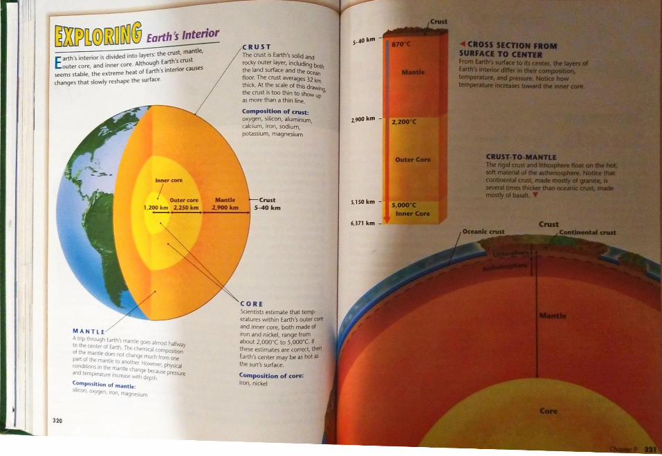
M you go toward the center of l!anh,.!Oil st1eral diffcreot 1ayas. 'l1lnemain laJaia interior: lhecnut.tbelllllJlde.lll4da,~lada: own conditiona alld ll1aledal,. Y1111 caa tee Exploring Earth~ Interioron pages 320--ail.
31 6

·
The Crust Your journey 10 the cencer of Earth begins in the cruse. The cruse 1s a layer ofrock that forms Earth's outerskin. The crust contains rocks and mountains. But the crust also indudes the soil and water that cover large parts of Earth's surface.
This outer rind ofrock is much thinner than what lio beneath 11. In fact, you can think of Earth's crust as being similar 10 the paper-thm skin of an onion. The cruse includes both the dry land and the ocean floor. II 11
'-~~ ..·- ··-::., ' ' thinnest beneath the ocean and thickest under high ,"t'.~ h . , mountains. Thecrust ranges from 5 to 40 kilometers !hid.
-.,,,:~. ~ _,, ':'\,..',
.,.. The crust beneath the ocean is called oceanic cruse { ~ ' 1' -~ ~ ~11 " Oceanic crust consists mostly of dense rocks such as'! f::,.• ' ◄ ... ,· ·' · .., ~} basalt. Basalt (buh SA1,u) is dark, dense rock with a"- .,•... .._
,. fine texture. Continental crust, the crust that forms the J.: continents, consists maml)' of less dense rocks such as -,.r
r~ granite. Granite 1s a rock that has larger crystals than basalt and 1s not as den,;e. It usually is a light color.
Figu re 5 Two ol th< mo,t common rocks 1n the- crust are The Mantle ba>alt and granu,. A The dark rock 1s bas.ah, which mdkes up much of Your Journey downward continues. At a depth of between 5and th• octanoc cru,t B Th, light rock ~Okilomecers beneath the surface, you crosi. a boundary. Abore11 granu,, whoch ma,., up much ol the continental crust. 1.hts boundary are the basalc and granite rocks ofthe crust. Bdo"
the boundary is the ~lid material ofthe mantle, a layer ofhoc~ Thecruse and rhe uppermosc part of the mantle are verysim·
ilar. The uppermoM part of the mantle and the crust togerher form a rigid layer called the lithosphere (urn uh sfeer). In Gr~k. lulios means "stone." The average thickness of the lithosphere 15abouc100 kilomecers.
~
~ext you I lfcrt rour ni 111-·rmini: r mJntk in~wida 0( che mantle;. ,t,o,e. Like N>lll w tlut form., thispat llt plJstic. 11iil.. uh ,fm). In Grlll'. mt=· "~.ik.•111111 can'l-dllallJar lllhmo,phcttil...Tht.....iilt.W. .
Tht lithosphaw ....•111paf11ie• che lSthenosphere, wbich....ID 10lid mantle mataialae111dultt,e-, 1Nntle is nart,,-)ll SDdM. _&((%~·--·.. f,,,,from tht ,,,.,.,,,,,.,,,,..
The Co,e Aftertra~............ core consists oflllO.....llqqWJ core. The......,..._. The Ollleraiafl - - -
~;_;----llkkdso~ . _· ' · .. ' <·: . ' - ·:;:";,.-. .{ ¥ ' '~:~r--'1.:,,-~: ·:·· 311
~}:{[P~@illlJOO@ Earth1 Interior 5--40 kffl -,CRUST
arth's interior is divided into layers· the crust. mantle, The crust rs Earth's sohd and
Eouter core, and inner core Although Earth's crust rocky outer layer, including both seems stable, the extreme heal of Earth's interior causes the land surface and the oceari
floor The crust averages 32 kmchanges thal slowly reshape the surface thKk. At the scale of this drawuig, the crust 1s too thin to show up as more than a thin line.
Composition of cnast: oxygen, silicon, aluminum, z,9()()km -cakium, iron, sodium, potassium, magnesium
Inner core
Outer core Mantle ·Crust S,lSOkm -1,200 km _2,250 km 2.900kM 5-40 km
6,371 km -
Scientists estimate that temperatures within Earth's oule< cote and inner core, both made ol
M A N TLE rron and nickel, range from Atr,p through Earth's man11< goes olmo,1 halfway about 2,ooo·c 10 s,ooo·c. If to the center of Earth Thr- chem1Ca' com~t,on these estimates are correct, then of the manti. doe, not ct>.,nge much from one Earth's center may be as hot .is port ol t.t,e mantl,, to •nolhtf Ho.....,e,, physic. the sun's surface. c'>""d,tlOO\ in lht- man,,,. changE- btu~ P,e\SUre and temp•fdlure IO(H•d~ ..,1th ck,pth Composit ion of core: Composition of manU~: rron, nickel )1 Kur, ·'ygt-o ,ron mctgn,...,urn
320

·tGflATIH wographlc North"°"MagMtlcpok
,....-\ § con
and
figure 7 Like a magne~ Earth's "'39noticfoeld has north and south poles.Sharpen your
Earth's Magnetic Field /HmunNG Recall from Chapter 3 that in convection,htat
PHrSIO is transferred by the movement of currentsInterpreting . within a liquid. These currents are called convection currents.Data AC:,IVO), ,,,.,,.,,..,...,_ Eanh's magnetic field-a force that causes the planet to act likt aSet a compass on awhite giant bar magnet-is created by convection currents in the liquidpiece of paper on your desk. outer core. As you can see in Figure 7, the magnetic field affectsTum the compass until theneedle lines up with north.
the whole Earth. When you use a compass, the compass nccd.le Mark the directions North, aligns "~th the lines of force in Earth's magnetic field. The northSouth, East, and West on seeking end of the compass needle points to Earth's magneticthe paper. Move a magnet north pole. arth's molten outer coreup and down close to the Consider an ordinary bar magnet. If you place it beneath a sun. To explain how hcompass. What happensto Epiece ofpaper and sprinkle iron fil ings on the paper, the iron fil. you need to recall howthe compass needle?Explain your observations. ings line up with the bar's magnetic field. If you could cover the uids.Ifyou have ever touched
entire planet with iron filings, theywould form a similar panem col'ered for yourself (in apail 1t mol'ed from the hot pot to from awarmer object to a
Heat is always transfer: cooler substance. For examJ····································
Check Your Progress your hand begin to feel cold1. Descnbe how constructive and destrucuveforces shape the surface of Eanh. Begin by sketching a cross in the ice cube moving to yo1
2 . What are the layers that make up Earth? Write a section ofEarth's crust and the heat, it's the heat in your hsentence about each one. different layers of the upper mantle. How is transferred through ra,
3. What happens in Eanh's intenor to produce can your model show these layers alongEanh's magnetic field? Descnbe the layers of with Earth's plates and other surface Radiationthe intenor where the magneuc field is features? How can you show the thicknessproduced. of the different layen at the correct scale? Recall from Chapter 3 that
4. Thinking Critically Comparing and Think •bout materials you can use for your electromagnetic waves. Contrasting What are some of the differ mode/. Using the map on page 341, p,dc transfer heat, or thermalences and similarities between the mantle and a plate to investigate. Research this plate's ~rth's surface. The pr,the core? Explain. movements and how it interacts withneighboring plates. tween the sun and Ea:
radiation include the heat322

Agu~ 8 In conducuon, the heated partJde of a sub,tance transfer heat 10 other parucles through d irect contaCL That's how the spoon and the pol itself heat up.
Figure 9 In th,s pol, the soup close to the heat source is hotter and less dense than the soup near the surface.These drfferences in
temperature and density cause convecuon currents
Conduction Remember that heat transfer by direct co t1cles of matter is called conduction. w;::~ct ofPar. as a spoon heats up in a pot of soup? Heat ~~ ferred from the hot soup and the pot to the 1~ that make up the spoon. The particle pal'tjcleg bottom of the spoon vibrate faster as they s n~ar !ht so they bump into other particles and heat~ ealtd, Gradually the entire spoon heats up. When yoem, 100. touches the spoon, conduction transfers heat ;:hand spoon directly to your skin. Then you feel th~~ !ht Look at Figure 8 to see how heat flows in this eat
5)'5tcrn_
Convection Conduction heall> the spoon, but how does the soup inside the pot heat up? Recall from Chapter 3 that heat transfer involv' the mo\'ement of fluids-liquids and gases-is called conv:~ tion. Convection is heat transfer by the movement of a htatcd fluid. During convection, heated particles of fluid begin to flow transferring heat energy from one part of the fluid to another '
Heat transfer bv convection is caused by differences of te~perature and density within a fluid. Density is a measure of how much mass there is in a volume of a substance. For example, rock is more dense than water because a given volume of rock has more mass than the same volume of water.
When a liquid or gas is heated, the particles move faster. As the particles move faster, they spread apart. Because the particles of the heated fluid are farther apart, they occupr more space. The density decreases. But when a fluid cools, its particles move more slo-..i)' and settle together more closely. As the fluid becomes cooler, its density increases.
Com·ection occurs when you heat soup on a stove. A5 the wup at the bottom of the pot gets hot, 11 expands and therefore becomes less dense. Tht warm, less dense soup moves upward and floats o,-tr the cooler, denser soup. At the surface, the warm soup spreads out and cools, becoming denser. Then, gra,·itv pulls this cooler, denser ~up ?ack do~n;
the bottom of the pot, where it is heated again. Figure 9 5 0
this pauern of movement. . Uy A constant flow begins as the cooler soup conu~ua •
· k h b · p nses."sin s to t e 0110m of the pot and the warmer sou fl ·c1. com·ewon current is the flow that transfers heat within 3 ui
'[be heating and cooling of a sitV,and the force ofgravity co
°motion. Convection curren10 added. What happens after Without heat, the convection .-hen all of the material has rea
i (Jia~ What is conv,
Liktsoup simmeringin a pot, an see in Figure IO how some g llow in the asthenosphere. Heat mantle itself cause> the con rolumns ofmantle material rise sl At the top of the asthenosphere, pushes the cooler material out of back into theasthenosphere. 51l1Xing takes place. Convection IOO\,ing inside Earth for more
1. What are the three types of 2. Describe how convection cu 3. In general, what happens to
fluid when ,t becomes hotter 4. What happens to convection
Huid reaches a constant t S. Thlnltlng Crttlcally P
happen to the flow of hot mantle if the planet's core down? Explain your answer.
324

..~ Drifting Continents ..............................·······......,
DISCOVER
~ How Are Earth's Continents Linked Together? : 1. Find the oceans and the s,-,,en continents on : a globe showing E.Jrth"s physical features
: 2. How much ol the globe is occupted by the : Pacific Ocean? Does most ol E.lrth's "dry"
land be on the No<them or Southern hemisphere'
: 3. Find lhe pomts or areas where most of the : continents are connected. Find the points al ; which several of the conMents almost touch, : but are notconnected
: 4. Examine the globe more closely. Find the : great belt ol mountains running from north Think It Over : to south along the western side of ,_orth and Posing Questions What questions can you pose
South Amenca Look for another great belt of mountains on the globe
about how oceans, continents, and mountains are d1stnbuted on Earth's surface?
Five hundred ~-ears ago, the sea voyages of Columbus and other explorers changed the map of the world. The conti• Wh.t 'Nti 'Wt'9fM(i
hypoth6is of contmonul nents of Europe, Asia, and Africa were already known to dnft' mapmaker,. Soon mapmakers were also showing the outlines of
• WhywosAlfred~s the continents of !\"orth and South America. Looking at thesehypolh<s,s r<J<Ctod by most Sti<ntiru of tu, cloy> world map,, many people wondered why the coasts of several
continent, matched ,o neath.Rrod,ng Tip Al you rud. look for f'Ytde.nc.e lNt supports {hf: Look at the modern world map in Figure 11. Notice how thehypo~i of continental drift. coasts of Africa and South America look as if they could fit Kry Tvms Pangan together like jigsaw puale pieces.Could the continents have once• c.onliMntal drift • fouil
been asingle landma~,, In the 1700s, the first geologists thought that the continent, had remamed fixed in their positions throughout Earth's hmon-. l:.arh- in the 1900s however, o~e scientist began to th1~ in ~ ne" ·way abo~t this nddle of the continents. His idea changed the way people look at the map of the world.
World mop drown by Juan Vespucci in 1526 ►
1ACIFIC OCEAN
'-!"
Continental Drift In 1910,a youngGerman scientist our)became curious about the mned ahypothesis that Earth's hypothesis was that all the co1 Jogether in a single Ian~and.
Wegener named this super, mcaning "all lands." According .bout 300 million years ago. Thi rtt0rd contains the first evidence lived on Earth. Also, tropical fi dqiosits, covered much of Earth.
Wegener hypothesized that Pangaea began to break apart. moved toward their presentJlCtll! as they are today. Wegen IIJO\'ed over Earth's surface
Have you ever tried to Idea? You probably had to p Wegener gathered evidence support his ideas about contin, Jed landforms, fossils, and evi climate had changed over many lubed all hts evidence for conOr•gin ofContments and
.~ 326

11 tdMiiPIJO/!i,Jij·•@ii•,..,..,4 '
. .... ,ACIFIC OCEAN SOUTH
AMUICA
. l,nK.MnHclift klfHa co·4-·. !hit -eparate the contin
the 11-md to carry and tHo11 did Glossopteris
ANT,UCTICA uncnts! Wegener infe 10,ned as the supercon
KlY....... ~F~-'- GIK.M__. 1'!: Lraf'Ola.An .... Evidence From Cl--..,,. autc change to ,up.,....... --- 11]--.- 5p1t,btrgen 1s an tsl
l1u; island is ice-co,il,oftropical plants
Figure 12 v.eg.,ne, and modem Evidence From la.ndforms Wegener thought that moumam flants li,·ed about 300geoiog,su po,nt to sev,,ral types of evidence to support the idea that the
ranges and other features on the continents provided evidence , wmn and mild du contJnenuVo,ffe once f()IOed '" a for contmental drift. \\'hen he pieced together maps of Afna must have been locat sing~ landma» called Pangaea and 5outh America, he saw a mountain range running from (a;!
Thousands of killnlcmng Accotd,ng ro W,ger,erl to west in South Afnca that lined up with a mountain range inhypot1-s. what dot> th, P,l!Sffl<e of d1J11ate was mucSJmuar mountain ronges ,n Alnco and Argentma. l:uropean coal fields matched up with similar coal South Amenc:a ""11cate? field, in \;orth America. Wegener compared matching these fea deep scratches 1
once covered Soture; 10 rca,,embling a torn-up newspaper. If the pieces could beput back together, the "words" would match. of ice that cove
Figure 13 Fo,sil, of the freshwater But the climaterepble Meso,ooru, found 111 Afnca Evidence From Fossils Wegener also used fossil evidenceas sup ul glmers to fiand South Amenca provide port for continental drift. A fossil 1, a trace ofan organism that ha> atsted, South Aevidence of conbnental dnfL
been pr~m-d in rock. For example, fossils of the repulo According t,\ff!.0>1111ru., and L_ntrosa1m,s had been found in places now ~ tinental driftrated by 0<ean,. !'\either reptile could have S\\'Um long distan•l'I ,linca changacro,s salt water. Therefore, Wegener concluded that these reptill'I lllrface chanonce li,·ed on a ,ingle landmass. Another example was G/o;.sopt"'5 dmute becom( gla" WIP tuh ris l, a fernlike plant that li"ed 250 million years ago. ll>cllmate beeGlossoptms fo"ils had been found in rocks in Africa, Soul~ fo..1ils and roe America, Au,tralia, India, and Antarctica. The occurrence ~G~ossoptern on th~ widely >eparated landmasses convinc\\t:gener that the continents had once been united.

Scientists Reject Weg~ner's H~thesls d.d ore than provide a hypothesis about cont.Wegener I m . c1r·ft ...,en...,
drift. He attempted to explain how I to_ok place. He "" a d .• explanation for how mountains form ,.. ""'1
0 11ere a ne,, • . . · ••cgC!lerth ht that when drifting continents collide, their edges Cl'UIJI. pl;:d fold. The folding conti~ents slowly push up huge chunJcs of rock to form great mountains.
However, Wegener could not provide a satisfactory expi.. nation for the force that pushes or pulls the contine ts. Because Wegener could not identify the cause of contin n
"d I dd" · enta1drift, most geologi!ts_ rejected h1s. I ea. n a Ilion, for geologists to accept Wegeners idea, they would need to change their explanations ofwhat caused continents and mountains tor:::.Agu"' 1S Although scienllSts
rejected his hypothesis, Wegener Many geologists ~ th~ early l90?s thou~h~ that Earth was continued to collect evidence f0< slowlycooling and shnnking. According to this idea, mountaj continental dnft and to update his formed when the crust wrinkled like the ski_n ofa dried-up app:book. He died ,n 1930 on an Wegener said that if the apple hypothesis were correct, thenexpedition to explore Greenland's conbnental glacier. mountains should be found all over Earth's surface. But moun.
tains usually occur in narrow bands along the edges of continent,. Wegener thought that his own hypothesis better explained where mountains occur and how they form.
For nearlv halfa century, from the I920s to the 1960s, most scientists paid little auention 10 the idea of continental drift. Then new C\~dence about Earth's structure led scientists to reconsider Wegener's bold hypothesis.
,~' ~:>. ~ ...
········----·--------------1. What was Wegener's hypothesis of continental Moving the Continents You can
drift? demonstrate Wegener's idea of continental 2. How dod Wegener use evidence based on fossils dnft. Use the World map in Figure 11. On a
to support htS hypothesis that the continents sheet of tracing paper, trace the outlines of had moved7 the continents bordering the Atlantic
Ocean. label the continents. Then use scissors to carefully cut the map along the
3. What was the main reason scientists reiected Wegener's hypothesis of continental drift?
eastern edge of South America, North4. Thinklng Critically lnfuring Coal deposits have also been found beneath the ice of America, and Greenland. Next, cut along Antarctica. But coal only forms in warm the Western edge of Africa and Europe
(including the British Isles). Throw awayswamps. Use Wegener's hypothesis to explainhow coal could be found so near the poles. the AUantic Ocean. Place the two cut-out
Pieces on a dark surface and ask family rnember3 to try to fit the two halves together. Explain to them about the superconlinent Pangaea and ,ts history.
. : 1. Partially fill a
! z.apenupad : the washclo
: 3. Moisten one : water. Then g, : that it floats o,
the washcloth : as it starts to si .
Deep in the is no light, and areas of the d
ofthese areas is the Dooroff the coasts of waler sinks through heated by contact wi spurts back into the
Around these hotcreatures ever disco the water. Nearby sit spiderlike crabs scu of this strange envi thatstrongly suppo
330

~
Mapping the Mid-Ocean Ridge The Ea,t PJcific Rise is ju~t one_ part of th,mid-oaan ridge, the longe_st cham of moun.tJtn' in the world. In th~ mid-~900s, scientist;nJJppN the mid-ocean ridge usmg ~nar. Recanfrom ch,1pter S that a ~onar dence bounces,ound waw, off underwater objects and th'"rewrds the echoes of these sound waves. Th,time it t,1k~ for the e,:ho to arrive indicates th,di>tance to the obje,:t.
The mid-ocean ridge curves like the seamofa baseball along the sea floor, extending into.tll of E.trth', ocean,. Most of the mountains inthe rmd-ocean ridge lie hidden under hundred;of meter, of w,1ter. However, there are placeswhere the ridge poke, above the surface. For
Figure 17 Sc.,tmt1~l\ u,t' ')()(Uf to c,.,mpk. the island of Iceland is a part of them.,t,p the O<.t.tn floor. nud-<xe.m riJ~e that ri;e, abo\'e the surface m the North Atlanti,
t1,e.m. A,1ee1;-, ,ded ,alley split, the top of the mid-ocean ridgetor mo,t of i1, length. The valley is .tlmost twice as <l<>ep a, theGr:mJ (Jnn>n. The mapping of the mid-ocean ridge made...,;.,•nti,1, ,uriou, to knowwhat the ridge was and how it got there.
rif e1.cdj:O<Xt 111,ar dr,·ire rs used to map 11,r ocean floor! Flgun, 18 Th, m>d-OCNO ridge •>"' '" tr,11 so (X)() ~1lom~tm lonq
NOUH ocean floo rs mo•
,UIA AMlRIU~r I ~' · :· along with them. " \
~ The mid-oceantht mid-oceanerupts. The' rock to both
,ACIIIC OCIA~ form, a ,trip molten mat," ') the ,trip of
I H~c.Ocean 1100 !pre-ads a1~addl-d.
-~ SeveANUa(lKA
idea of 33, lllagneti

Evidence From Molten Material In the l 96Q .found evidence that new material is indeed erupti 5
' Scientis4 "'-on floor lies inmid-ocean ridge. The scientists wer_e carried to the Ocng a.long tht_ i,oid a record of r,ean flAlvm, a small subme "bl OOr111 The rock oft.th r51 e b,.,to w1 stand the crushin ""t aio11en material.sures four kilometers belg Pres. tined up in the d, , ow,L.oceans sur,ace In th ~" [O(k hardened co
· e cent .,valley of the mid-0cea . r., rocks a permaneAlvm's crew found strann nclge, 1t1un& thousanshaped like piUows or l~e rOcks L'sing sensiti paste squeezed from a tube S 111(1110r)' of roe'tooth.
ks - ucb found that a striroe can form only when 6dd pointed nomolten ma~erial hardens quick}y ~lio>,~ when theafter erupting under water. Th~ figure 21, the pa
Figure 20 The submer presence of these rocks showed t!ut hardens atsible Alvin photographed that molten material haseruptedpillow lava along the again and again from cracks Evidence Fmid-ocl'an ridge. These along the central valley of the Boor spreadi"pillows" form undl'r mid-ocean ridge. the ocean noowater when cold OCl'anwater causes a crust to Evidence From Magnetic Stripes When scientists studied
p1hered the lonm on erupting molten duough wate,., panems in the rocks of the ocean floor, thcvmaterial Each pillow This feat ha.expands until ,t burns. P,m,o found more support for sea-floor spreadini. bolt into a <iallowing molten matenal In Secuon I vou read that Earth behaves like a giant magn'1, Samplesto flow out and form the with a north pole and a south pole. Evidence shows that Earth'snl'xl pillow pipe,. Thenmagnetic poles have reversed themselves. This last happened wsample780,000 ,·ears ago. If the magnetic poles suddenly reversed them wolder th
sehei. today, you would find that your compass needle pointedsouth. Scientists discovered that the rock that makes up the
Figure 21 Magnetic slnp<>S ,n the rock of the ocean floor show thed,rect,on of Eanh's m.tgnetic f,eld atthe ume the rock hardened ,/ntrrpret,ng Diagrams How doesthe potlern ofmocch,ng scnp<>s showewlence of seo-1/oor sp,eod,ng'
334

B«oll>C it It lru dmSl thoil ~ surrounding rodr, molw, material from tlie montkrun through tht cnnt toward crocks in th, oc,on (loo,
Old OCtonk cru1t mt/ts OS it .sinkl boc.k into tht montlt
S&li,ctud 11te processes ihe size and sl d,t ocean noor 1)tJI ,s the tim l!lid-oCean rid. IJIIO a trench.
subduction In p1c11ic Ocean ruoet. And yet it ~ 5oroe1imcs a deep o--rJn1c crust than n,en, if 1he ridge the width of the the PJcific Ocean,
subduction In ,~, other hJnd, .~11anuc Ocean sprcJding oc..-an the oceanic crust con1inentJI crust A~Jntic's oce-an
Flgu,e 2 3 CxeanK <Ml formed along the mid-ocean ndge i1 recycled at a deep-ocean trench In tM process ot subducl>Ot1, ocealll( CI\Jll ~nks down bene•th the uench into the mant~ Drawrng Condu1iom Wntrt ,,.ould den~,., octomc utHt bt found'
Contintntol
bductlon at Deep-Ocean Trenches Su . 'd How can the ocean floor keep getttng w1 er and wider1 iht answer is that the ocean floor generally d~es not just Kttp spreading. Instead, the ocean floor plunges mto deep Under water canyons called deep-ocean trenches. A deep-ocean trench forms where the oceanic crust bends downward.
Where there are deep-ocean trenches, subduction takes pla Subduction (sub ot:i- shun) is the process by which the oc~ floor sinks beneath a deep-ocean trench and back into th mantle. Convection currents und~r the lithosphere push n~ crust that forms at the mid-ocean ndge away from the ridge and 10ward a deep-ocean trench.
Newoceanic crust is hot. But as it moves away from the mid. ocean ridge, it cools and becomes more dense. Eventually, as shown in Figure 23, gravity pulls this older, denser oceanic crust down beneath the trench. The sinking crust is like the washcloth in 1he Discover activity at the beginning of this section. As !ht drv washcloth floating on the water gets wet, its density mer= and ii begms to sink.
At deep-ocean trenches, subduction allows part of tht ocean floor to sink back into the mantle in a process that takes tens of millions of years. You can think of sea-floor spreading and subduction together as if the ocean floor were mO\'ing out from the mid ocean ridge on a giant conveyor belt.
N~ly f(}(tM(J octonk crust lits do~t to mld-octon rid~.
336

~c.T/01,!J 11 .,~ The Theory of Plate Tectonics
..........................................•. DISCOVER
.How Well Do the Continents Fit 1ogetlier? 5. Obtain a map that shows the: 1. Using a world map in an atlas, trace
: the shapes of the continents North continental shelf. The continenta1 • America, South Amenca, Africa, and shelf is the apron of continental crust
Europe, including Great Britain and that extends under water around the Ireland. edges of the continents. Trace arOUlld
the continental shelves of the same: 2. ~ Carefully cut apart the continents used in Step 1.ti landmasses. When you cut
out Europe, leave Britain and 6. Repeat Steps 2 through 4. Ireland attached to Europe.
Think It Over: 3. Piece together these landmasses as they may : have looked before Pangaea split apart, creating Drawing Condwions Do your observations : the Atlantic Ocean. support the idea that the continents were once
joined together? When did they fit together better:: 4. Attach your partial reconstruction of Pangea • to a piece of paper.
GUIDE FO/t READING
♦ What is the theory of plate tectonics?
♦ What are the three types of plate boundaries?
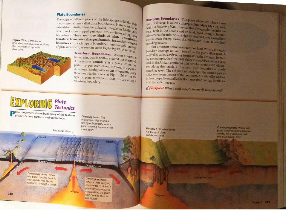
Reading Tip Before you read, preview Exploring Plate Tectonio on pages 342- 343. Write a list of any questions you have about plate tectonics. Look for answers as you read
Key Temu plateII • plate tectonics • fault • transform boundary • divergent boundary • rift valley • convergent boundary
when you cut them out along their coastlines or along their continental shelves? Explain.
Have you ever dropped a hard-boiled egg? If so, you may have noticed that the eggshell cracked in an irregular pal· tern of broken pieces. Earth's lithosphere, its solid oultr
shell, is not one unbroken layer. It is more like that cracked eggshell. It's broken into pieces separated by jagged cracks.
ACanadian scientist, J. Tuzo Wilson, observed that !here art
cracks in the continents similar to those on the ocean floor. In 1965, Wilson proposed a new way of thinking about these cracks. According to Wilson, the lithosphere is broken into separate sec· tions called plates. The plates fit closely together along cracks ID
the lithosphere. As shown in Figure 25, the plates carry the con· unents or pans of the ocean floor, or both.
A Theory of Plate Motion
Wil~n combined what geologists knew about sea-floor spreadinS, Eanh s plates.and continental drift into a single theory- the th~ of plate tectonics (tek TAIIN iks). Plate tectonics is the geologith th st l eory ~t ates that pieces of Earth's lithosphere are in cons~ s ow motion dr·1,, b • . tie '"" th • en Yconvection currents m the man · and
eoryo~platetectonicsexplains the formation, movement, subduction of Earth's plates.
AS the (.!ch othe
sUrro gtelogi movem on 1op of ;isthenosp ofthe con the conve, Scientists force that
Some
340
342
Plate Boundaries The edges of different pieces of the litho~phere--Earth's ti . plvergent Boundariesshell-meet at lines called plate boundaries. Plate bounda~ apart, or diverge: is called ae:1.tend deep mto the lithosphere. Faults--breaks in Earth's criti ,;0uce in Explon11g Plate Teet,\\'here rocks have slipped past each other-forrn alon thl'Ustboundaries. There are three kinds of plate bount _'1t
~ nd both in the oceans andFigure 26 Al a lransfo,m · anesoccur at the mid-ocean riboundary, two plates move along transform boundaries, divergent bo d · --.ries:un an~ and conv~the boundary tn opposite
o-einic crust forms along thdirections.
boundaries. For each rype ofboun_dary, the~e 1s a different l)'pt ;prtading occurs.of plate movement, as you can see in Explor111g Plate Teaonics. Other divergent boundariesTransform Boundaries boundary develops on land,bo d . Along trans~. 'th deep valley called a riftormun anes, crust ts nl'I er created nor destroyed_A transform boundary is a place where ti,,
arY.Forexample, the Great~ck mthe African continplates slip past each other, moving in PPos1todirections. Earthquakes occur frequently alone spmding apart. The rift
0 tm. Along this crack, athese boundaries. Look at Figure 26 to see th! Africa away from the resttvpe of plate movement that occurs along itransform boundary. its floor drops. Event
10 fill the widening gap.
m:nm@illllm® ::::niaPlate movements have built many of the featuresof Earth's land surfaces and ocean floors. Divrrging plates The
mid-ocean ndge mar1cs adivergent boundary where plates cany;og oceanic crustmove apan._
Convrrging plata Whentwo plates airry,og ocean,ccrust collide, one plate" Convrrging platessubducted through • lrench. When a plate carrying
continental crust and aplate canying oceanicMagma Crust Collide, the platewith ocean,c crust isSUbducted.

11S mill/on y~11 agoAM Earth'1 mator landmasie1wt'~ iomed ,n the supercontu~nt Pangaea bef0<tplate ~menu tx-g.in to\f)l1t1tapart.
Convergent Boundaries The place where twotogether, or converge, i, called a convergent boun,iunt). When two plates converge, the re,uh is callCollisiom may bring together oceanic crust andoceaniccrust and continental crust, orcontinentalnentol]cruM.Figure 27 A 1111100 betwet-nlw, ••~ ·111. µLite$ P,oducf'd
When two plat<.'!> collide, the demuy of the platsth. m•, ,I_ H•m•L,y•1 Thtwhich one corn~ out on top. Oceanic crust, which is madeCOllt$IOO l>e,,an 50 """JO")'('dn of~t. i, more dcn\C than continental crust,which·•go, 'when the pt.11,, lh.ll.Cd~lnrt.., sl.lmm,'d w,10 A11;1 of granuc. ,\nd <xeanic cru,t becomes coolersprl-ads away from the mid-ocean ridge.\\'heri: two platl'\ carrying occ.inic cruM m,plate that is more dcn\C dives under the other pithe mantle.This i, the pmce,,ofsubduction thatin Section 4.
Sometimes a platl· Cilrrying oce.1nic cru,tcarrrrng continental cru,1. The le" den!>C co:srnk under the more dcn\C oceanic cru\t, lns1begins to sink and plunge, beneath the cont'\\'hen two pli!te, carrying conuncntJI cdOl~ not take place. Both conttnent,tl pl.liesgranite rock.Therefore, neither plate 1s dthe m.intle. ln\le.id,the plate~ cra,h hcad-othe cru" into mightymountain ranges.flJ~u✓-~ W/1111 types of 11/akbo1111dar,<'S?


![Irving Fine Collection [finding aid]. Music Division, Library of ...](https://static.fdokumen.com/doc/165x107/633c6664a97cc84e480623ea/irving-fine-collection-finding-aid-music-division-library-of-.jpg)