17 CULTURAL HERITAGE - Auckland Council
145
Auckland Council District Plan (Rodney Section) 2011 ....................................................... > Cultural Heritage : Chapter 17 17 CULTURAL HERITAGE Contents 17.1 Introduction 17.2 Significant Resource Management Issues 17.3 Objectives 17.4 Policies 17.5 Strategy 17.6 Implementation 17.6.1 District Plan Regulatory Methods 17.6.2 Other Regulatory Methods 17.6.3 Other Methods 17.7 Anticipated Environmental Results 17.8 Description of Zones 17.9 Activity Rules 17.9.1 Exceptions 17.9.2 Permitted Activities 17.9.3 Controlled Activities 17.9.4 Restricted Discretionary Activities 17.9.5 Discretionary Activities 17.10 Development Controls and Performance Standards 17.11 Controlled Activities : Matters for Control and Assessment Criteria 17.12 Restricted Discretionary Activities : Matters for Discretion and Assessment Criteria 17.12.1 Additions, Alterations of Item Listed at Appendix 17B, and New Work on Sites listed at Appendix 17B, 17C, 17D and 17E 17.12.2 Pruning a Tree or Group of Trees listed at Appendix 17C 17.12.3 Modification of an Archaeological Site Listed at Appendix 17D 17.12.4 Modification to a Waahi Tapu listed at Appendix 17E 17.12.5 Resiting of an Item Listed at Appendix 17B or 17C 17.12.6 Subdivision of the Site of an Item Listed at Appendix 17B, 17C, 17D or 17E
-
Upload
khangminh22 -
Category
Documents
-
view
1 -
download
0
Transcript of 17 CULTURAL HERITAGE - Auckland Council

Auckland Council District Plan (Rodney Section) 2011....................................................... > Cultural Heritage : Chapter 17
17 CULTURAL HERITAGE
Contents
17.1 Introduction 17.2 Significant Resource Management Issues 17.3 Objectives 17.4 Policies 17.5 Strategy 17.6 Implementation
17.6.1 District Plan Regulatory Methods 17.6.2 Other Regulatory Methods 17.6.3 Other Methods
17.7 Anticipated Environmental Results 17.8 Description of Zones 17.9 Activity Rules
17.9.1 Exceptions 17.9.2 Permitted Activities 17.9.3 Controlled Activities 17.9.4 Restricted Discretionary Activities 17.9.5 Discretionary Activities
17.10 Development Controls and Performance Standards 17.11 Controlled Activities : Matters for Control and Assessment Criteria 17.12 Restricted Discretionary Activities : Matters for Discretion and Assessment Criteria
17.12.1 Additions, Alterations of Item Listed at Appendix 17B, and New Work on Sites listed at Appendix 17B, 17C, 17D and 17E
17.12.2 Pruning a Tree or Group of Trees listed at Appendix 17C 17.12.3 Modification of an Archaeological Site Listed at Appendix 17D 17.12.4 Modification to a Waahi Tapu listed at Appendix 17E 17.12.5 Resiting of an Item Listed at Appendix 17B or 17C 17.12.6 Subdivision of the Site of an Item Listed at Appendix 17B, 17C, 17D or 17E

Auckland Council District Plan (Rodney Section) 2011....................................................... > Cultural Heritage : Chapter 17
17 CULTURAL HERITAGE (cont’d)
17.13 Discretionary Activities : Assessment Criteria
17.13.2 Use of Items Listed 17.13.3 Erection of a Household Unit 17.13.4 Destruction of Item Listed 17.13.5 General Matters Concerning Applications for Resource Consent
App 17A Criteria for the Evaluation of Structures and Fixed Objects of Cultural Heritage Significance App 17B Historic Structures, Sites and Fixed Objects Listed for Protection App 17C Historic and Culturally Significant Trees Listed for Protection App 17D Archaeological Sites Listed for Protection App 17E Waahi Tapu Listed for Protection App 17F Icomos New Zealand Charter for the Conservation of Places of Cultural Heritage Value App 17G H517 Blake’s Mill site - Location Map App 17H H618 Pear Tree from Wilkin’s Orchard — Location Map App 17I H518 Old Bridge at Wilkins Homestead — Location Map App 17J H519 Old Brick Well at Wilkins Homestead — Location Map App 17K H520 Pits — Location Map App 17L H521 Pits/terrace — Location Map App 17M H522 Pits/terrace — Location Map App 17N H228 Waimauku Dairy Company — Area where proposed structures require Resource Consent App 17O H229 Former Blacksmiths, Waimauku — Area where proposed structures require Resource Consent App 17P H231 Waimauku Memorial Hall — Area where proposed structures require Resource Consent App 17Q H232 Tractor/storage shed, Worrall Road, Taupaki — Area where proposed structures require Resource
Consent App 17R H233 Farm shed/piggery, Worrall road, Taupaki — Area where proposed structures require Resource
Consent App 17S H234 Former bakehouse, Waimauku — Area where proposed structures require Resource Consent App 17T H236 Chimney from old shack, Waikoukou road, Waimauku — Area where proposed structures require
Resource Consent
Auckland Council District Plan (Rodney Section) 2011....................................................... > Cultural Heritage : Chapter 17
17 CULTURAL HERITAGE (cont’d)
App 17U H237 Puriri Farm, Annadale Road, Taupaki — Area where proposed structures require Resource Consent App 17V H701 Pa, Davidson Road, Kiwitahi — Location map

Auckland Council District Plan (Rodney Section) 2011....................................................... > Cultural Heritage : Chapter 17

Auckland Council District Plan (Rodney Section) 2011 ...................................................... > Cultural Heritage : Chapter 17 1
17 CULTURAL HERITAGE
17.1 INTRODUCTION
Cultural heritage resources (CHRs) can be defined as historic landscapes, sites, structures, fixed objects and trees which possess archaeological, architectural, scientific, social, historical, spiritual, technological or traditional value or significance. The case for their protection is that they have value in themselves, they teach us about the past and the lives of those who came before us, provide a context for community identity, provide a contrast to the modern world, and, very often, enrich our built environment. The Plan focuses on protecting and preserving a diverse and representative range of cultural heritage resources. This is in line with the directives of the Act, specifically section 6 which requires councils "to have particular regard to recognition and protection of heritage values of sites, buildings, places or areas"; clause 2(c) of Part II of the Second Schedule which allows District Plans to provide for "cultural heritage sites and values, including landscape, land forms, historic places and waahi tapu"; and the Auckland Regional Policy Statement, the first objective of which is "to preserve or protect a diverse and representative range of the Auckland region's heritage resources".
By comparison with the larger cities, the District contains a very large number of archaeological sites, mostly pre-European, and a relatively small number of historic (post-European) buildings and structures.
New Zealand Archaeological Association’s Site Recording Scheme detailed more than 2,600 sites in Rodney in 1997, and there is no doubt that many more have yet to be located. However, a recent sample survey of sites in the Auckland Region suggests that 80% of recorded archaeological sites have been damaged, and 70% are continuing to be damaged. Damage is often unintentional and often the result of normal farming activities, such as grazing by cattle and the formation of farm roads.
Surveys of the District commissioned by the Council in 1998/99 identified some 230 archaeological sites of European heritage significance, some 150 structures, sites and fixed objects considered to be of "outstanding cultural heritage value", a further 200 considered to be of "cultural heritage value", and some 40 post-1840 cemeteries and burial sites.
The distribution of archaeological sites reflects the lifestyle of the pre-European Maori, with its emphasis on settlement by the coast and travel by water. Post-European buildings and structures are rather more scattered, reflecting the spread of pastoral farming across the whole District, although there are concentrations in the older settlements, particularly Warkworth and Helensville. Destruction or modification of these buildings and structures is generally attributable to economic pressure and the changing needs of the functions that the buildings and structures serve.
The distribution of culturally significant trees from the post-European period reflects the wide distribution of post-European settlement. Some 25 such trees or groups of trees have been identified. The distribution of trees of significance to Maori is not known to the Council, as they have not yet been itemised.

Auckland Council District Plan (Rodney Section) 2011 ...................................................... > Cultural Heritage : Chapter 17 2
Views of what constitutes a significant heritage resource vary from individual to individual and community to community. It is the aim of this section of the Plan to provide protection for a range of items that reflects this diversity of view. As well as protecting items that reflect what European communities would regard as important, the Council wishes to ensure that items that have a special cultural significance for Maori communities are protected, notably waahi tapu. There is, however, ongoing debate amongst Maori communities and discussion between their representatives and the Council over this matter.
The contribution of the Plan to preserving the District's CHRs is necessarily limited to regulatory methods. However, the Council recognises that this is only one of a variety of possible mechanisms, and will pursue others outside the framework of the Plan.
The New Zealand Historic Places Trust is a Crown Entity with statutory powers under the Historic Places Act, 1991. The Historic Places Act 1993 promotes the identification, protection, preservation and conservation of the historic and cultural heritage of New Zealand, including archaeological sites. The Act provides protection for all archaeological sites, whether recorded or not. Section 10 of the Act directs that an authority is required from the Trust if there is “reasonable cause” to suspect that an archaeological site may be modified, damaged or destroyed in the course of the activity. This applies whether or not the land on which an archaeological site may be present is designated or subject to a resource or building consent.
By comparison with the larger cities, the District contains a very large number of archaeological sites, mostly Maori, and a relatively small number of historic European buildings and structures.
One of the most important mechanisms that link the work of the Trust and Council is the register of historic places, historic areas, wahi tapu and wahi tapu areas. One of the purposes of the register is “To assist historic places, wahi tapu and wahi tapu areas to be protected under the Resource Management Act 1991’s 22(c)”. The register identifies and recognises significant cultural and historic heritage resources in New Zealand and is normally accepted by territorial local authorities as one of the sources for identifying cultural heritage resources meriting protection in the District Plan.

Auckland Council District Plan (Rodney Section) 2011 ...................................................... > Cultural Heritage : Chapter 17 3
17.2 SIGNIFICANT RESOURCE MANAGEMENT ISSUES
Issue 17.2.1
Cultural Heritage Resources (CHRs) can be modified or destroyed because owners wish to use the site for some other purpose, or to modify the site or building to make it more suitable for a present or intended purpose.
An archaeological site that occupies land that an owner wishes to use as a house site or driveway to a house site, a heritage building that an owner wishes to modernise, or a historic tree that inhibits development of a site or shades buildings on a site are all examples of CHRs, that are liable to be destroyed or modified through development pressures.
Frequently, buildings of greatest heritage value are those located in what always was, or has subsequently become, the central part of a town or city, where land values are highest. This puts great pressure on CHRs since they seldom represent the highest economic use of their sites. Failing some intervention by the community they are likely to be demolished, unless their owners are willing to put history before financial advantage.
Likewise, many archaeological sites are to be found close to the sea, rivers or lakes, settings which are attractive for contemporary residential and tourist developments.
Issue 17.2.2
Cultural Heritage Resources (CHRs) can be modified or destroyed because they are not maintained.
Built structures, in particular, have both a physical and economic lifespan which it requires effort to extend. Typical early wooden buildings, which comprise a large proportion of the District's heritage buildings, can often be costly to maintain. Owners of heritage buildings who find the maintenance burden too high are likely to allow the buildings to become run down, ultimately to the point where they are beyond restoring and consequently of negligible heritage value. This process applies not only to buildings but also to archaeological sites. For example, self-sown tree seedlings not cleared away from archaeological sites develop roots which can in time modify or even destroy the sites. Similarly, lack of protection of archaeological sites on farmland from stock can lead to accelerated erosion and destruction of the sites.
Issue 17.2.3
Cultural Heritage Resources (CHRs) can be damaged, modified or destroyed through ignorance of their existence or value.
While many heritage buildings have a high profile as structures of heritage significance, the heritage value of some buildings or structures is not widely recognised. This is even more the case with archaeological sites, which may require an expert eye even to recognise. This phenomenon reflects several factors.

Auckland Council District Plan (Rodney Section) 2011 ...................................................... > Cultural Heritage : Chapter 17 4
First and foremost, particularly in relation to archaeological sites, the field work necessary to locate and describe the items of heritage interest has not been done, or has not been brought to the owner's attention. Therefore, for example, a farmer may allow an archaeological site to be destroyed by stock without being aware of it.
A further and quite distinct aspect of this issue relates to waahi tapu. While some waahi tapu are well known, the existence and location of others are either known only to the kaumatua, or are more widely known amongst Maori but are not publicised. The wish of the Maori people for whom the waahi tapu are important has to be respected. However, it is difficult to mesh this wish to protect waahi tapu from destruction by keeping their location secret, with the very public process of protecting CHRs by way of rules in a District Plan.
Issue 17.2.4
Cultural Heritage Resources (CHRs) may be damaged or modified by being altered in ways that do not recognise their heritage value.
It often requires an understanding of the history of a CHR - either its unique history, or a history of, for example, building design - to enable it to be modified in a way that is in keeping with the remaining original structure. The consequence of making unsympathetic changes may be to destroy or downgrade the heritage value of a site or structure.
Issue 17.2.5
The heritage and amenity value of Cultural Heritage Resources (CHRs) can be reduced or destroyed as a result of changes to their physical context.
Sometimes the heritage or amenity value of CHRs is dependent on their physical context. For example, a wooden Gothic church may lose part of its value if the original wooden houses around it are replaced by large concrete factory buildings, and conversely a heritage building may lose much of its heritage value if it is removed to another site. Similarly, the development of land adjoining a waahi tapu site may be quite disturbing for those for whom the waahi tapu is meaningful.
Guidelines for what is appropriate adjacent to a single heritage site or structure are not easy to develop. As a result, a community that is keen to ensure that the heritage or amenity value of such sites or buildings is not diminished, will probably have to rely on one-off assessments when trying to evaluate the impact of development proposals on adjoining land, as those proposals are made. There is a further complication in that there is often a reluctance to restrict development of sites that do not themselves contain CHRs.
These problems may be a little easier to solve where the CHRs are concentrated in a group, and the CHRs are all of similar character.

Auckland Council District Plan (Rodney Section) 2011 ...................................................... > Cultural Heritage : Chapter 17 5
Issue 17.2.6
The ranking of Cultural Heritage Resources (CHRs) on the basis of significance is acceptable to Pakeha but is rejected by Maori.
The Pakeha concept of ranking has practical value, in that it enables the Council to focus its efforts and limited resources on preserving and protecting a limited number of CHRs. But for Maori, all sites indicative of their past are significant, so ranking is not a valid technique The Council will have to try, with the help of iwi, to find some way of providing protection that both parties are able to support.
Council is required as a matter of national importance under the RMA, 1991, to recognise and provide for the protection of historic heritage. The definition of historic heritage includes archaeological sites. In addition to meeting District Plan requirements it is also necessary to obtain an authority from Historic Places Trust to damage, modify or destroy any archaeological site.

Auckland Council District Plan (Rodney Section) 2011 ...................................................... > Cultural Heritage : Chapter 17 6
17.3 OBJECTIVES
Objective 17.3.1
Avoid, remedy or mitigate adverse effects on a diverse and representative range of the District’s Cultural Heritage Resources.
(This objective relates to Issues 17.2.1 to 17.2.5)
Objective 17.3.2
To develop a process for protecting Maori archaeological sites and waahi tapu that is acceptable to both the Council, iwi and the community. (This objective relates to Issue 17.2.6)
17.4 POLICIES
Policy 17.4.1 Retention of heritage values whilst enabling sympathetic proposals
Recognise and protect the heritage values of the District’s Cultural Heritage Resource.
Explanation and Reasons This policy seeks to achieve Objective 17.3.1.
It is desirable to put in place mechanisms to prevent the loss of CHRs. Proposals to modify a CHR that retains its heritage values and ensures its long-term retention, will be viewed sympathetically. Putting in place mechanisms to prevent the loss of the District’s significant CHRs is therefore the most obvious way of preventing the loss of the heritage values which are embodied in these CHRs. At the same time the concern to retain CHRs also justifies sympathetic consideration of proposals which would offset these pressures to destroy the CHR where the result will not be unduly detrimental to the heritage value of the CHR
Policy 17.4.2 Appropriate modification
Structures, fixed objects, trees and landscapes that are significant Cultural Heritage Resources of the District should not be modified or altered in way that results in significant loss of or damage to their heritage value.
Explanation and Reason This policy seeks to achieve Objective 17.3.1.
CHRs that are structures may have their heritage value eroded or destroyed by alterations that are out of character. Whether in a particular case a modification is out of character is sometimes difficult to say, and the issue can also arise of whether an addition should try to replicate the style of the original, or try instead to follow the proportions and the scale of the original in a modern design. Nevertheless, it is often obvious when a modification or a new building is quite out of character with the building of heritage value, and in such cases the community frequently expresses resentment at the fact that the modification was permitted.

Auckland Council District Plan (Rodney Section) 2011 ...................................................... > Cultural Heritage : Chapter 17 7
Recognition of the pressure to modify CHRs justifies rules aimed at preventing their modification being undertaken without consideration of its effect.
Policy 17.4.3 Prevention of destruction of archaeological and waahi tapu sites. Significance for some archaeological and waahi tapu sites determined on a case by case basis
Destruction, damage or modification of archaeological, historic or waahi tapu sites should not be undertaken where there are adverse effects, including effects on spiritual values, that cannot be avoided, remedied or mitigated.
Explanation and Reasons This policy seeks to achieve Objective 17.3.1.
The heritage value of archaeological sites and waahi tapu is vulnerable to damage and destruction, most commonly through either earthworks or activities which disturb, erode or obliterate part or all of the archaeological site. Waahi tapu that are archaeological sites can be vulnerable to the same actions, but they are also vulnerable to development or activities that are incompatible with their spiritual significance. These threats to archaeological sites and waahi tapu justify rules aimed at preventing potentially destructive acts or activities without prior assessment of their effects.
Whether a particular archaeological site or waahi tapu is significant may have to be determined, in respect of sites that do not appear on the list, on a site by site basis. This is because the archaeological sites and waahi tapu scheduled for protection by the Plan are not drawn from comprehensive lists of sites. This in turn is because the data for such lists has not been assembled, partly because it is certain that many archaeological sites have yet to be discovered, and partly because iwi do not wish to put forward a comprehensive list of waahi tapu. When assessing risk of damage or modification to an archaeological or waahi tapu site, this should be carried out in conjunction with the iwi.
Policy 17.4.4 Where location is important, relocation to be avoided
Structures, fixed objects and trees whose cultural heritage value is significantly dependent on where they are located should not be removed from that location, except as a last resort.
Explanation and Reasons This policy seeks to achieve Objective 17.3.1.
It has been a common practice to relocate buildings of cultural heritage value as an alternative to demolishing them, when there has been pressure to use their sites for other purposes. This has resulted in many structures being saved that would otherwise have been lost. However, the heritage value of some buildings is very much related to their original setting. For example, a building may be a tangible reminder of a significant event or era in the development of a settlement. Alternatively, the architectural quality of the building may be an important element in a particular part of an urban area. In such circumstances the compromise of removing the building to another site should be avoided if possible.
Auckland Council District Plan (Rodney Section) 2011 ...................................................... > Cultural Heritage : Chapter 17 8
Policy 17.4.5 Development of surround land should not adversely affect heritage values
The heritage value of Cultural Heritage Resources should be protected, where possible, by ensuring that the adverse effects of surrounding development on these values are avoided, remedied or mitigated.
Explanation and Reasons This policy seeks to achieve Objective 17.3.1.
The policy is applicable in relation to both structures and sites, including archaeological sites, of cultural heritage value.
In relation to CHRs that are structures the same difficulties arise with deciding what is in character as arise with alterations to structures (see the explanation and Reasons for Policy 17.4.2). The Council nevertheless believes that the community is concerned that development in the vicinity of CHRs should not downgrade the heritage value of the CHRs themselves, or the amenity value of the immediate area where it is dependent on retaining an "historic" character.
The Council does not generally consider it practical to protect the environment of CHRs beyond the limits of their sites. The only instances where it is likely that a concern for a wider area can be practically expressed are where there is a group of buildings or archaeological sites of cultural heritage value as, for example, at Helensville and Puhoi.
Some unsympathetic modifications to buildings' surroundings arise from requirements of the Council made under either RMA or the Building Act. The Council may be prepared to waive full compliance with normal requirements (eg. on-site parking requirements), where there is an offsetting benefit in terms of retaining the heritage value of the CHR - see Policy 17.4.7.
Policy 17.4.6 Restrictions balanced with incentives
Incentives should be provided for protection and preservation of Cultural Heritage Resources, where this is sustainable.
Explanation and Reasons This policy seeks to achieve objective 17.3.1.
Protection and preservation of CHRs by rules requiring consent to modify or destroy CHRs are necessary, to provide a degree of certainty that CHRs subject to these rules will not be destroyed or damaged. However, it is widely recognised that there is a place for incentives as well as restrictions, and the Council is in a position to provide encouragement to the owners of CHRs to preserve them, through rules in the Plan.
Two areas where this encouragement can be provided are in the exercise of discretionary powers to allow standard requirements to be relaxed (eg. parking standards), and in allowing CHRs to be used for activities which in normal circumstances would not be regarded as acceptable. Exercising discretion in this way can be justified in terms of the overall benefit to the environment and the community.

Auckland Council District Plan (Rodney Section) 2011 ...................................................... > Cultural Heritage : Chapter 17 9
Policy 17.4.7 Increasing public awareness
Opportunities should be taken for increasing public awareness of Cultural Heritage Resources, and encouraging appropriate development that would retain these Cultural Heritage Resources.
Explanation and Reason This policy seeks to achieve Objective 17.3.1.
What is not known about is easily lost. Therefore there is a case for raising public awareness of and appreciation for what the community has in the way of CHRs as a means of combating loss of and damage to CHRs. Awareness and appreciation can come about by a variety of means. At one end of the scale are publications describing CHRs, ranging from complete books to pamphlets provided for self-guided walks. Direct experience can include simply being able to see the outside of buildings from the street - the commonest form of direct experience - to physical access to the sites of CHRs, including access to their interiors.
While increased public access is an ideal, it has to be recognised that there are situations where it is not appropriate, for example, where public access is incompatible with an owner’s privacy, where general public access infringes on spiritual values, or where greater access will lead to damage to the CHR.
Policy 17.4.8 Discussions with iwi for the protection of sites
Discussions should be held with iwi representatives to work out a process for protecting sites of significance to Maori.
Explanation and Reasons This policy seeks to achieve Objective 17.3.2.
The protection of Maori archaeological sites and waahi tapu that can be characterised as significant in Pakeha terms presents few procedural problems. But the development of a procedure for protecting the wider range of Maori archaeological sites and waahi tapu, including sites yet to be formally identified, will require considerable effort because of the diverse factors to be taken into account. These factors include: iwi aspirations in this field, including tikanga Maori, and their concern not to publicise the location of some sites; the length of time to be taken in assessing sites subject to applications for resource consent; what the Council considers it is able to fund and manage administratively; the powers available to the Historic Places Trust or any other body under the Historic Places Act 1993 or its successor; and any non-regulatory mechanisms that are likely to be effective.

Auckland Council District Plan (Rodney Section) 2011 ...................................................... > Cultural Heritage : Chapter 17 10
17.5 STRATEGY
The Council's strategy for Cultural Heritage is to identify and protect by regulatory means a number of structures, sites, fixed objects, trees, landscapes and waahi tapu that are significant in the District's, Region's and the nation's past. This regulatory regime is to be supplemented by measures aimed at increasing the interest of owners of CHRs in maintaining the heritage value of the CHRs on their properties.
17.6 IMPLEMENTATION
17.6.1 District Plan Regulatory Methods
Implementation of the strategy relies primarily on the listing of CHRs in four lists, and requiring resource consent to alter or destroy them.
The lists have been drawn up using set criteria, which ensure that the items selected for protection are of a uniform minimum quality and that important items are not overlooked.
The first list, at Appendix 17B, comprises a representative range of the District’s historic (ie. post European) structures, sites and fixed objects that are CHRs, with a brief explanation of the heritage value of each item listed. The criteria for their selection are closely modelled on those set out in clause 6.4.16 of the Regional Policy Statement, and thus have the advantage of region-wide acceptance. They are given at Part I of Appendix 17A.
The second list, at Appendix 17C, comprises culturally significant trees, the criteria for their selection being the same as those for the CHRs in the first list.
The third list, at Appendix 17D, comprises significant archaeological sites in recognition of the requirements of Section 6(e) and 6(f) of the RMA, 1991 and the HPA, 1993. The Trust has the ability to prevent the destruction of sites, however this ability is enhanced by the sharing of responsibility for the identification of sites which require protection, and which are in danger of destruction.
The fourth list, at Appendix 17E, comprises waahi tapu that do not appear in Appendix 17B, 17C or 17D, even though they may be structures, sites or trees that would also merit inclusion in those lists. At the time of public notification of the District Plan, sites listed in Appendix 17E were limited to waahi tapu included in the Historic Places Trust's register. The best method of evaluating and protecting sites of spiritual significance to Maori was still at that time being explored in discussions between tangata whenua representatives and the Council, and it can be anticipated that in due course the Council will seek to change the Plan to include more sites on the waahi tapu list.
The rules relating to CHRs fall into two groups. These are:
(a) Rules restricting development, comprising:
(i) Rules requiring consent to be obtained for the alteration, removal or destruction of the buildings, structures, sites, fixed objects, trees and waahi tapu appearing on the lists at Appendix 17B, 17C, 17D and 17E.
(ii) A requirement that conservation plans be developed for properties

Auckland Council District Plan (Rodney Section) 2011 ...................................................... > Cultural Heritage : Chapter 17 11
listed in Appendix 17B, 17D or 17E that are expected to undergo major change or renovation, to provide a blueprint for conservation work.
(iii) A rule requiring consent to be obtained to change the use of a waahi tapu.
(iv) Rules relating to the development of sites within or close to clusters of CHRs, for the purpose of retaining the character of these clusters. These clusters are defined in these rules as "historic precincts", and the rules relating to them are contained in the Residential chapter. The defined historic precincts are at Helensville and Puhoi.
(b) Rules facilitating preservation of CHRs, comprising:
(i) A rule relating to proposals to use listed buildings etc for purposes
not provided for as Permitted Activities in the rules for the zone in which they are situated. This rule provides that such proposals be given a weighting favouring approval, if the result would be to preserve or protect the CHR.
(ii) A rule providing for the subdivision of the site of a CHR where the
effect would be to appropriately preserve the CHR.
17.6.2 Other Regulatory Methods
No other regulatory methods are used.
17.6.3 Other Methods
The Council will provide a pamphlet suggesting appropriate design approaches to use when modifying buildings of various styles and eras. The Council may also support efforts, or itself undertake efforts, to make owners of CHRs and the public aware of the existence and significance of CHRs in the District, as a means of stimulating interest in the retention and preservation of CHRs. Financial incentives for retaining or maintaining CHRs may also be made available from time to time via the Annual Plan process or in accordance with any adopted Cultural Heritage Management Strategy.

Auckland Council District Plan (Rodney Section) 2011 ...................................................... > Cultural Heritage : Chapter 17 12
17.7 ANTICIPATED ENVIRONMENTAL RESULTS
The anticipated environmental results of the above objectives, policies and methods are:
(a) A diverse and representative range of the District’s cultural heritage resources is retained.
(b) Significant cultural heritage resources that undergo alteration and modification retain most or all of their heritage value.
(c) Public awareness of cultural heritage resources is increased.
(d) When appropriate mechanisms have been developed with the tangata whenua, the relationship between them and those of their ancestral taonga that relate to land is recognised and safeguarded.
Notes: (a) At the time of the public notification of this Plan the legislation affecting
cultural heritage was being reviewed by Central Government. The Plan may need to be changed if legislative arrangements are altered.
(b) The items listed at Appendix 17B, 17C, 17D and 17E comprise CHRs from the lists identified in the surveys undertaken for the Council in 1998/99, plus others that may be suggested by members of the public or iwi that meet the criteria for inclusion outlined in Appendix 17A. A variation or change to the plan will be made to include additional CHRs which meet the criteria in Appendix 17A.
(c) Appendix 17E currently contains no Waahi Tapu sites, however, as information on these CHR becomes available, they will be added to the Appendix by way of a variation or plan change.
17.8 DESCRIPTION OF ZONES
Zoning is not used in relation to cultural heritage. The rules in this chapter of the Plan apply to items of cultural heritage value regardless of zoning.
Auckland Council District Plan (Rodney Section) 2011 ...................................................... > Cultural Heritage : Chapter 17 13
Rule 17.9 ACTIVITY RULES
Rule 17.9.1 Exceptions
Exceptions
No consent shall be required under Rules 17.9.3 and 17.9.4 where the proposed work on land owned or administered by New Zealand Historic Places Trust, the Department of Conservation and Auckland Regional Council’s Parks Committee, provided a conservation plan in accordance with ICOMOS charter principles has been prepared.
Rule 17.9.2
Permitted Activities
Permitted Activities
For the purposes of this chapter of the Plan the following shall be Permitted
Activities:
(a) Any of the following activities in relation to a structure, site or fixed object listed at Appendix 17B:
(i) the redecoration, repair and/or insignificant alteration of any existing fabric or detailing carried out in a manner and design and with materials similar in appearance to those originally used, which does not detract from those features for which the item has been scheduled.
(ii) in relation to grounds around a building, structure or fixed object,
(which grounds are themselves part of the listed item) routine maintenance including all normal work requirements to use, maintain and enjoy existing garden or landscape features or structures, and in addition to make minor modifications or additions to these features or structures (but excluding substantial new structures, buildings or excavations), where these actions do not destroy, compromise, damage or impair the appreciation of the heritage values of the grounds.
(iii) alterations to the interior of any item listed in Appendix 17B where
the interior is identified as of heritage value, where these actions do not destroy, compromise, damage or impair the appreciation of the heritage values of the building, structure or surrounds.
(iv) alterations to the interior of any item listed in Appendix 17B where the interior is not identified as of heritage value.
(b) The development of buildings, parking areas or earthworks on the site of
an item listed at Appendix 17B, 17C, 17D or 17E outside the area defined in the relevant Appendix.
(c) The removal of trees or parts of trees listed at Appendix 17C that are an immediate danger to life or property, or are dead. (Except in an emergency, the person proposing the work must give five working days notification of such work prior to the work commencing.)

Auckland Council District Plan (Rodney Section) 2011 ...................................................... > Cultural Heritage : Chapter 17 14
Rule 17.9.3 Controlled Activities
Controlled Activities
There are no Controlled Activities in this chapter.
Rule 17.9.4
Restricted Discretionary Activities
Restricted Discretionary Activities
For the purposes of this chapter, the following shall be Restricted Discretionary
Activities where not provided for in this chapter as Permitted, Controlled or Discretionary Activities.
(a) Restoration of, and alterations or additions to any item listed at Appendix 17B.
(b) Development of buildings, parking areas for more than four cars, or
earthworks on the site of an item listed at Appendix 17B, 17C, 17D or 17E if within the area defined in the relevant Appendix.
(c) Pruning of a tree listed at Appendix 17C.
(d) Modification of an archaeological site listed at Appendix 17D.
(e) Modification of a waahi tapu listed at Appendix 17E, or its use for any
purpose other than a purpose authorised by sections 10 or 10A of the Act.
(f) Resiting of an item listed at Appendix 17B or 17C.
(g) Subdivision of the site of an item listed at Appendix 17B, 17D or 17E for the purpose of ensuring the long term preservation of the item, where the sites created will not meet the site area and dimension requirements of the relevant zone.
Rule 17.9.5
Discretionary Activities
Discretionary Activities
(a) Use of an item or the site of an item listed at Appendix 17B, 17D or 17E
for a purpose that is not a Permitted or Controlled Activity in the zone in which it is located.
(b) Erection of an additional dwelling on the site of a dwelling that is a protected item listed at Appendix 17B, 17D or 17E, where an additional dwelling is not a Permitted or Controlled Activity in the zone, and where the additional dwelling is necessary to and will ensure the long-term preservation of the protected items.
(c) Destruction of an item listed at Appendix 17B, 17C, 17D or 17E.

Auckland Council District Plan (Rodney Section) 2011 ...................................................... > Cultural Heritage : Chapter 17 15
Rule 17.10 DEVELOPMENT CONTROLS AND PERFORMANCE STANDARDS
There are no development controls or performance standards in this chapter.
Rule17.11 CONTROLLED ACTIVITIES: MATTERS FOR CONTROL AND ASSESSMENT CRITERIA
There are no Controlled Activities in this chapter.
Rule 17.12 RESTRICTED DISCRETIONARY ACTIVITIES: MATTERS FOR DISCRETION AND ASSESSMENT CRITERIA
In accordance with sections 76(3B) and 105(3A) the Council will restrict its discretion to the matters listed against each specified activity when considering resource consent applications for Restricted Discretionary Activities.
Rule 17.12.1 Additions, Alterations of Item Listed at Appendix 17B, and New Work on Sites listed at Appendix 17B, 17C, 17D or 17E
Restoration of, and Alterations or Additions to any Item Listed at Appendix 17B, and Development of Buildings, Parking Areas for More than Four Cars, or Earthworks on the Site of an Item Listed at Appendix 17B, 17C, 17D or 17E if Within the Area Defined in the Relevant Appendix.
Rule 17.12.1.1 Matters for Discretion
Matters for Discretion The Council will restrict its discretion to the following matters: (a) The location, design, materials and finish of proposed alterations or
additions to the structure of the listed item, including signs.
(b) The location, design, materials and finish of further buildings, parking areas, driveways or earthworks in the site of the listed item.
(c) The physical form of the listed item after the demolition of part of it.
17.12.1.2 Assessment Criteria
Assessment Criteria
When considering an application the Council shall have a regard to the following criteria:
Effect on heritage values (a) Whether the nature, and extent of the proposal will have an adverse effect on those heritage values of the listed item which justified its inclusion in Appendix 17B, 17C, 17D or 17E. This shall include, where relevant, its contribution to the amenities of the neighbourhood, and any association of the listed item with past people or events.
Scale, form and detailing (b) Whether the scale, form, detailing and materials of the alterations including roof form, roof angles and eaves, are in keeping with the character of the listed item.

Auckland Council District Plan (Rodney Section) 2011 ...................................................... > Cultural Heritage : Chapter 17 16
Effect on original fabric (c) Whether the proposal minimises the loss of original fabric, significant materials or original craftsmanship.
Effect on interiors (d) Whether, in the case of alterations to the interior of any item listed in
Appendix 17B where the interior is identified as of heritage value, the proposed alterations and additions are to be carried out in a way that takes account of, is sympathetic to and retains those features specifically noted, and protects the following elements:
(i) original floor plan;
(ii) scale, form and volume of internal spaces; (iii) detailing of joinery and decorative features; (iv) significant architectural elements; (v) significant finishes.
Effect of techniques to be used (e) Whether the proposed structural design solutions, replacement materials, fittings and fixtures, surface coatings and renovation and construction methods will be likely to damage those heritage values of the listed item which justified its inclusion in Appendix 17B, 17C, 17D or 17E.
Conformity with ICOMOS Charter (f) Whether the proposal conforms to the provisions of the ICOMOS NZ Charter 1993, where relevant. (See Appendix 17F.)
Recording of details (g) Whether, where the proposal is to alter or demolish part of a listed item, the features to be altered will be recorded.
Relationship with setting (h) Whether the relationship of the listed item with its setting is maintained.
Consequences of doing or not doing work
(i) Whether evidence presented by the applicant as to the consequences of doing or not doing the work provides sound and proper reasons for approving it.
(j) Whether alternative options for achieving the reasonable objectives of the applicant while retaining the heritage values of the item have been considered.
Explanations and Reasons Alterations and additions to and partial demolition of items of cultural heritage value have the capacity to so change the nature of the items that their heritage value and/or their contribution to their surroundings is reduced or lost. Since Council has decided to meet its obligations to try to ensure that a representative range of the District’s cultural heritage items is retained by listing a selection of them for protection in this Plan, it is logical that it should exercise control over the matters listed to ensure not only that the items are retained, but that their heritage value is retained as well.
Rule 17.12.2 Pruning a Tree or Group of Trees Listed at Appendix 17C
Pruning of a Tree or Group of Trees Listed at Appendix 17C
Rule 17.12.2.1 Matters for Discretion
Matters for Discretion
The Council will restrict its discretion to the following matters:
(a) The extent and nature of the pruning.

Auckland Council District Plan (Rodney Section) 2011 ...................................................... > Cultural Heritage : Chapter 17 17
17.12.2.2 Assessment Criteria Effect on heritage values Effect on life of tree
Assessment Criteria
When considering an application the Council shall have regard to the following criteria:
(a) Whether the proposed work will have an adverse effect on those heritage values which justified the inclusion of the tree in Appendix 17C, including any landmark or amenity value.
(b) Whether the proposed operation is likely to extend or shorten the life of the tree.
(c) Whether alternative options for achieving the reasonable objectives of the applicant while retaining the heritage values of the item have been considered.
Explanation and Reasons Trees are living organisms and therefore liable to grow in ways that make them difficult to live with, and conversely may become partially moribund and require surgery. Pruning to overcome these problems should be done in a way that minimises any loss of heritage value.
Rule 17.12.3 Modification of an Archaeological Site Listed at Appendix 17D
Modification of an Archaeological Site Listed at Appendix 17D
Rule 17.12.3.1 Matters for Discretion
Matters for Discretion The Council will restrict its discretion to the following matters:
(a) The extent and nature of the modification.
(b) Impact on tangata whenua values where the site is of Maori origin or interest.
17.12.3.2 Assessment Criteria Effect on heritage values
Assessment Criteria
(a) Whether the proposed work will have an adverse effect on those heritage values which justified inclusion of the archaeological site in Appendix 17D, including any tangata whenua, landmark or amenity value.
Recording of details (b) Whether the features of the affected part of the item will be excavated and recorded.
(c) Whether alternative options for achieving the reasonable objectives of the applicant while retaining the heritage values of the item have been considered.
Explanation and Reasons The information assembled when the site was selected for inclusion in Appendix 17D will have described why the site was thought to be important at that time, and will provide a good starting point in an evaluation of the effect of the modification on cultural heritage values. If the modification is agreed to, loss of information consequent on the modification can be minimised by excavating the affected part of the site and recording the details.
Auckland Council District Plan (Rodney Section) 2011 ...................................................... > Cultural Heritage : Chapter 17 18
Advice Note: Under Section 2 of the Historic Places Act, 1993 (HPA), an archaeological site is defined as a place associated with pre-1900 human activity, where there may be evidence relating to the history of New Zealand. The HPA provides protection for all archaeological sites, whether recorded or not. Section 10 of the HPA directs that an authority is required from the Trust if there is “reasonable cause” to suspect an archaeological site may be modified, damaged or destroyed in the course of any activity. An authority is required whether or not the land on which an archaeological site may be present is designated, or a resource or building consent has been granted.
Rule 17.12.4 Modification to a Waahi Tapu listed at Appendix 17E
Modification to a Waahi Tapu Listed at Appendix 17E, or its Use or the Use of its Site for Any Purpose
Rule 17.12.4.1 Matters for Discretion
Matters for Discretion
The Council will restrict its discretion to the following matters:
(a) The extent and nature of the modification.
(b) The use to which the waahi tapu or its site is to be put.
17.12.4.2 Assessment Criteria
Assessment Criteria
When considering an application the Council shall have regard to the following criteria:
Effect on spiritual values (a) Whether the proposed work or activity will have an adverse effect on those heritage including spiritual values that justified the inclusion of the waahi tapu in Appendix 17E.
Effect on other heritage values (b) In the case of a listed waahi tapu which is also a structure, tree or
archaeological site that might otherwise have merited listing in Appendix 17B, 17C or 17D, the Assessment Criteria listed at 17.12.1.2, 17.12.2.2 or 17.12.3.2.
(c) Whether alternative options for achieving the reasonable objectives of the
applicant while retaining the heritage values of the item have been considered.
Explanation and Reasons
The information assembled when the waahi tapu was selected for inclusion in Appendix 17E will have described why the waahi tapu was thought to be important at that time, and will provide a good starting point for evaluation of the effect of the modification on cultural heritage values. However, where the waahi tapu might also qualify as an item listed in Appendix 17B, 17C or 17D it is important that the Assessment Criteria relevant to modification of items on those lists be applied also.

Auckland Council District Plan (Rodney Section) 2011 ...................................................... > Cultural Heritage : Chapter 17 19
Rule 17.12.5 Resiting of an Item Listed at Appendix 17B or 17C
Resiting of an Item Listed at Appendix 17B or 17C
Rule 17.12.5.1 Matters for Discretion
Matters for Discretion The Council will restrict its discretion to the following matters: (a) The location of the item.
(b) The nature and location of the proposed future site. (c) In the case of a structure, the structural nature and condition of the item
as it relates to the ability to keep it structurally intact when removing and resiting it.
(d) In the case of a tree, the ability of the tree to withstand the stresses of resiting.
17.12.5.2 Assessment Criteria Link between listed item and its site
Assessment Criteria When considering an application, the Council shall have regard to the following criteria: (a) Whether the heritage value of the item is strongly linked to its specific site
or general location, either because of the history of the item or because of its contribution to the appearance or historic character of the surrounding area.
Effect of removal process (b) Whether the item is likely to survive the removal process without undue
damage.
Offsetting public benefit at new site
(c) Whether any loss to the area from which the item is being removed, in terms of the contribution of the item to its appearance or historic character, or the value of the item as a landmark, will be offset by a gain in similar terms in the area to which it is to be removed.
Nature of new site (d) Whether a setting appropriate to the character of the item is to be
provided at the site to which it is to be removed.
Relocation as means of saving listed item
(e) Whether relocation is the only means of saving the item.
(f) Whether the item was designed for relocation from the site, has been
relocated before or relocation forms part of or adds to the heritage significance of the item.
(g) Whether alternative options for achieving the reasonable objectives of the
applicant while retaining the heritage values of the item have been considered.
Auckland Council District Plan (Rodney Section) 2011 ...................................................... > Cultural Heritage : Chapter 17 20
Explanation and Reasons While removal of an item of heritage value to another site is not an unusual solution when there are other calls on the use of the site, it should not automatically be assumed that it is a satisfactory option. This is because the significance and value of an item may depend on its remaining on its current site. However, in some cases the removal of an item to a site in the same general area may enable its heritage significance to be retained, or even enhanced, and there may also be cases where the original location of the item is not important at all.
Rule 17.12.6 Subdivision of the Site of an Item Listed at Appendix 17B, 17C, 17D or 17E
Subdivision of the Site of an Item Listed at Appendix 17B, 17C, 17D or 17E for the Purpose of Ensuring the Long Term Preservation of the Item, where the Sites Created will Not Meet the Site Area and Dimension Requirements of the Relevant Zone
Rule 17.12.6.1 General Requirements
General Requirements
The rules in Chapter 23 - Subdivision and Servicing shall be complied with.
Rule 17.12.6.2 Matters for Discretion
Matters for Discretion
The Council will restrict its discretion to the following matters:
(a) The likely effect on the future of the CHR.
(b) The size and shape of the proposed new lots.
(c) The location of access points.
(d) Any other matters listed for discretion for subdivision in the relevant zone.
17.12.6.3 Assessment Criteria
Assessment Criteria
When considering an application the Council shall have regard to the following criteria:
Effect on presentation of CHR (a) Whether subdivision, and any concurrent proposals for protecting and maintaining the listed item, is likely to result in the long term preservation of the heritage values of the item.
Effect on heritage values (b) Whether the subdivision will have an adverse effect on the heritage values of the listed item that justified its inclusion in Appendix 17B, 17C, 17D or 17E, including the effect of any proposed or likely new development on land removed from the existing site by the subdivision.
Effect on public appreciation of listed item
(c) Whether the subdivision and likely subsequent development will adversely affect appreciation of the listed item by the general public.
(d) Any other Assessment Criteria listed for subdivision in the relevant zone.
(e) Whether alternative options for achieving the reasonable objectives of the applicant while retaining the heritage values of the item have been considered.

Auckland Council District Plan (Rodney Section) 2011 ...................................................... > Cultural Heritage : Chapter 17 21
Explanation and Reasons While subdivision does not of itself alter the use of land or alter buildings, trees or sites upon it, the fact of creating land in different ownerships can have consequences for the heritage value of the listed item. The positive consequence that this rule is designed to achieve is the securing of the long term future of CHRs by, for example, allowing heritage buildings that are surplus to requirements to be sold to new owners who can make use of them. Consideration of subdivision proposals must, however, also evaluate possible negative consequences, for example adverse effects on the setting of CHRs, or loss of public views of CHRs, as a result of subsequent development on newly-created vacant lots.
7.13 DISCRETIONARY ACTIVITIES: ASSESSMENT CRITERIA
Rule 17.13.1 Without limiting the exercise of its discretion, for all Discretionary Activity consent applications required by this chapter the Council will have regard to the Assessment Criteria for each specified activity, any relevant Discretionary Activity Assessment Criteria in any other chapter of this Plan, and the relevant matters set out in section 104 of the Act.
Rule 17.13.2 Use of Items Listed
The Use of an Item, or the Site of an Item, Listed at Appendix 17B, 17C, 17D or 17E for a Purpose that is not a Permitted or Controlled Activity in the Zone in which it is Located.
17.13.2.1 Encouragement of protection of item
Assessment Criteria
(a) Whether the proposed activity, and any concurrent proposals for protecting and maintaining the listed item, will positively encourage and are likely to result in the preservation of the listed item.
Objectives and policies of chapter (b) Whether the proposed activity is in accordance with the objectives and policies of this chapter.
Effect on individuals or groups (c) Whether the proposed activity would detrimentally affect individuals or groups in the vicinity by reason of being an activity not contemplated by the zoning.
Assessment criteria for zone (d) Any relevant assessment criteria for the zone, modified as necessary to take into account the desirability of preserving the item.
(e) Whether the use will have an adverse effect on the heritage values of the listed item that justified its inclusion in Appendices 17B, 17C, 17D or 17E.
(f) Whether alternative options for achieving the reasonable objectives of the applicant while retaining the heritage values of the item have been considered.
Explanation and Reasons Where it can be shown that there would be a public benefit in terms of protection
and preservation of an item as a result of approving a use of the item that would require resource consent as a Restricted Discretionary or Discretionary Activity, the Council will take this benefit into account when making its evaluation of the effects of the proposal.

Auckland Council District Plan (Rodney Section) 2011 ...................................................... > Cultural Heritage : Chapter 17 22
Rule 17.13.3 Erection of a Household Unit
Erection of a Household Unit on the Site of a Household Unit that is a Protected Item Listed at Appendix 17B, where an Additional Household Unit is not a Permitted or Controlled Activity in the Zone, and where the Erection of an Additional Household Unit is Necessary to, and will Ensure, the Long-Term Preservation of the Protected Item.
17.13.3.1 Assessment Criteria
(a) Whether the erection of the additional household unit, and any concurrent proposals for protecting and maintaining the listed item, are likely to result in the long-term preservation of the listed item.
(b) Whether the additional household unit would detrimentally affect
individuals or groups by reason of being an activity not contemplated by the zoning.
(c) Any relevant Assessment Criteria for the zone, modified as necessary to
take into account the desirability of preserving the listed item.
(d) Whether the construction of a household unit will have an adverse effect on the heritage values of the listed item that justified its inclusion in Appendices 17B, 17C, 17D or 17E.
(e) Whether the design, appearance and location of the additional unit is
sensitive to the heritage values of the item and will not detract from those values.
Explanations and Reasons Where it can be shown that the existing protected dwelling is unsuitable for the needs of the current owner eg. because of its size, and cannot be made suitable without requiring alterations that would significantly damage its heritage value, the Council will take this into account when making its evaluation of the effects of the proposal to erect an additional dwelling.
Rule 17.13.4 Destruction of Item Listed
The Destruction of an Item Listed at Appendix 17B, 17C, 17D or 17E
17.13.4.1 Assessment Criteria Acceptability of loss
Assessment Criteria (a) Whether the loss of the item is acceptable in terms of the loss of heritage
values which justified its inclusion on the list, or loss of heritage values that have become evident since.
Cumulative of effect on range of items protected
(b) Whether there will be a cumulative effect on the representativeness of the range of items which the District Plan seeks to preserve or protect through their inclusion in Appendix 17B, 17C, 17D or 17E.
Change of circumstances (c) Whether any change in circumstances has occurred since the original
listing that would support the proposal to destroy the item.

Auckland Council District Plan (Rodney Section) 2011 ...................................................... > Cultural Heritage : Chapter 17 23
Explanation and Reasons A Discretionary Activity application provides an opportunity that is less cumbersome than a plan change to destroy an item which has protected status. However, the evaluation of applications must take into account both the tests of section 104 and the considerations that led to the initial listing.
Rule 17.13.5 General Matters Concerning Applications for Resource Consent
General Matters Concerning Applications for Resource Consent Affecting Items Listed at Appendix 17B, 17C, 17D or 17E
Rule 17.13.5.1 Conservation Plans
Conservation Plans
Where in the Council's opinion a proposal requiring an application for a Restricted Discretionary Activity or Discretionary Activity listed at 17.9.3 or 17.9.4 involves significant work, the Council may require a conservation plan to be submitted covering:
(a) A statement of the significance of the heritage item.
(b) The physical condition and structural integrity of the heritage item.
(c) The physical conservation, action and care necessary for retaining or revealing the heritage significance of the item. (This may include maintenance, reconstruction or restoration.)
(d) Measures to enable the cultural significance of the item to be retained.
(e) Impact of the activity on heritage values.
Note: In producing a Conservation Plan applicants should be guided by reference to the following documents:
Guidelines for Preparing Conservation Plans — Guideline No. 4 (Bowron and Harris, New Zealand Historic Places Trust, 2000, Wellington. The Conservation Plan: A Guide to the Preparation of Conservation Plans for Places of European Cultural Significance (Semple Kerr J,) Sydney National Trust of Australia (NSW), Fourth (Australia and New Zealand) Edition, December 1996. ICOMOS New Zealand Charter for the Conservation of Places of Cultural Heritage Value (ICOMOS NZ 1995, Auckland).
Rule 17.13.5.2 Notification of Historic Places Trust
Notification of Historic Places Trust
The Council shall serve a copy of every application for resource consent on the Historic Places Trust if it relates to land subject to a Heritage Order or Requirement for a Heritage Order or is otherwise identified in the Plan as having heritage value; or if it affects an historic place, historic area, waahi tapu or waahi tapu area registered under the Historic Places Act, 1993.
Rule 17.13.5.3 Expert Opinion
Expert Opinion
When considering an application for a Restricted Discretionary Activity or Discretionary Activity affecting an item listed at Appendix 17B, 17C, 17D or 17E, the Council may invite opinion from the Historic Places Trust or other recognised heritage body as appropriate, or Tangata Whenua, except where the body concerned has lodged a submission in opposition to the application. (Where such submissions have been lodged the Council may seek the opinion of an independent qualified individual.)


Auckland Council District Plan (Rodney Section) 2011...................................................... > Appendix 17A : Chapter 17 1
APPENDIX 17A
CRITERIA FOR THE EVALUATION OF STRUCTURES AND FIXED OBJECTS OF CULTURAL HERITAGE SIGNIFICANCE
PART I - CRITERIA FOR THE EVALUATION OF HISTORIC STRUCTURES, SITES AND FIXED OBJECTS The following criteria have been closely adapted from the criteria prepared by the Auckland Regional Council.
1. HISTORICAL
"The extent to which the place reflects important historical aspects or is representative of the history of the district, region or New Zealand." 1. The place is important as a representative example of its type. 2. The place is a representative example in terms of age, historical aspects, time period, patterns or
themes. 3. The place is associated with important persons, groups, individuals, organisations or institutions who
have owned, lived in, worked in, or carried out activities in or on the place. 4. The place is associated with important historic events or actions. 5. The association of the place with important events or actions is reflected in place names or events
associated with the place. 6. The place is associated with important ideas or beliefs which symbolise or illustrate historic change in
Auckland or New Zealand. 7. The place dates from an early period of Auckland or New Zealand's settlement.
2. TANGATA WHENUA
"The importance of the place to Tangata Whenua." This evaluation needs to be made by, or in full consultation with, Iwi Maori. It includes such matters as the historical, traditional (place names, people and events), cultural, spiritual, religious, symbolic, commemorative, social, educational, economic and contextual importance of a place. The importance may be at iwi, hapu, and whanau level. (In relation to this criterion, see note at the end of this part of the Appendix.)
3. COMMUNITY ASSOCIATION
"The community association with or public esteem for the place." 1. The place has qualities which make it a focal point for the spiritual, cultural, customary, religious,
social, political, philosophical, or economic values of an ethnic or the local or wider community. 2. There is evidence of strong feelings of community association with the place. 3. The place illustrates the distinctiveness of the community's identity, social history and way of life.
4. COMMEMORATIVE
"The commemorative value of the place." 1. The place commemorates an importance person, event, idea, activity. 2. The place is a memorial.

Auckland Council District Plan (Rodney Section) 2011...................................................... > Appendix 17A : Chapter 17 2
5. SYMBOLIC
"The symbolic value of the place." 1. The place is of symbolic value to the District, Region or Nation. 2. The place symbolises a feature of the area's past history.
6. EDUCATIONAL
"The potential of the place for public education." 1. The place provides potential to enhance public understanding and appreciation of the past. 2. The place has potential for interpretation for present and future generations. 3. The place is accessible to the public.
7. ARCHAEOLOGICAL
"The potential of the place to provide knowledge of the District's, Region's or New Zealand's history." 1. The place has the potential to define or expand knowledge of earlier human occupation, activities or
events through investigation using archaeological methods. 2. The place is important as a representative example of a site type, feature or activity. 3. The place has research potential. 4. The place is a formally recorded or registered archaeological site.
(Note: When evaluating the significance of an archaeological site all of the other criteria need to be considered.)
8. SCIENTIFIC
"The potential of the place to provide scientific knowledge of the history of the District, Region or New Zealand." 1. The place has the potential in scientific terms to provide evidence and knowledge relating to the
history of the district, region or New Zealand.
9. TECHNOLOGICAL
"The technical accomplishment or value of the place." 1. The place is or was important in the development of technology, technological innovation or
technological processes. 2. An important technological process is still carried out on the site.
10. ARCHITECTURAL
"The design of the place." 1. The place provides a notable, rare or representative example of an architectural style, type or
convention in either interior or exterior layout. 2. The place is an important example of architectural innovation. 3. The place is an important example of a particular method of construction, use of material or design
feature. 4. The place exhibits an important example of a particular form of craftsmanship. 5. The place is an important example of the work of a notable architect, designer, engineer or builder.

Auckland Council District Plan (Rodney Section) 2011...................................................... > Appendix 17A : Chapter 17 3
11. CONTEXT
"The extent to which the place forms part of a wider historical and cultural context or historical and cultural landscape." 1. The historical context of the place is important in terms of comparative age, or being part of a
particular time period. 2. The place is important in terms of historical or cultural continuity. 3. The place is an important component of a group of associated historic places. 4. The place is part of a registered or scheduled historic area. 5. The place has value as a component of the wider historical or cultural landscape, seascape or
streetscape. 6. The place is important in terms of visual amenity or aesthetic value (past or present beauty), or as a
landmark.
12. RARITY
"The frequency with which the historic place can be found." 1. The place is a rare type of historic place.
13. INTEGRITY
"What is the integrity of the place?" 1. The place has integrity in terms of its original form or fabric. 2. The place has integrity in terms of its historical or cultural setting and its relationship with associated
structures. 3. The place is located on its original site. 4. The place has been modified, altered or restored in an important or sensitive way. 5. The physical state of the place is good (by appearance only). 6. The place is vulnerable to modification or destruction.
NOTE: At the time of public notification of this Plan the evaluation of the importance of items to Tangata Whenua had
not been done. Therefore:
(a) None of the items on the list of protected historic items is stated as having significance for Tangata Whenua, even though such significance may be attached to them.
(b) There may be historic sites that do not appear on the list of protected items but which would be worthy of inclusion on the basis of their significance to Tangata Whenua.
PART II - CRITERIA FOR THE EVALUATION OF ARCHAEOLOGICAL SITES The following criteria have been used in the selection of significant archaeological sites: 1. The extent to which the site has, or is likely to have, research potential - scientific, archaeological,
technological or educational. 2. The visibility and condition of the site. Condition takes into account effects of erosion (from various causes),
trampling by stock, ploughing or other agricultural activity, engineering works (such as roads, drainage and contouring), subdivision and fossicking.
3. The value of the site as part of a range of archaeological site types within different environments. 4. The rarity or uniqueness of the site.

Auckland Council District Plan (Rodney Section) 2011...................................................... > Appendix 17A : Chapter 17 4
5. The extent to which the site forms part of or is associated with an archaeological landscape or site complex.
The site can be considered as part of a system of sites usually concentrated geographically and able to inform broadly on the history of settlement and economy of the region.
6. Whether the site is of an early date. NOTE: At the time of public notification of this Plan no evaluation of the importance of archaeological sites to Tangata
Whenua had been done by the Council. Therefore:
(a) None of the sites on the list of protected archaeological sites is listed on the basis of having significance for Tangata Whenua, even though such significance may be attached to them.
(b) There are likely to be archaeological sites, both known and unknown to the Council, that do not appear on the list of protected items but which would be worthy of inclusion on the basis of their significance to Tangata Whenua.
PART III - CRITERIA FOR THE ASSESSMENT OF TREES OF CULTURAL HERITAGE VALUE Acknowledging that a tree of cultural heritage value is a live monument and is perishable, the following criteria should be taken into account when assessing the cultural heritage value of a tree or grouping of trees: (i) Whether the tree or grouping of trees is associated with historically important events, persons, groups or
activities or other important aspects of the history of the District. (ii) Whether the tree or grouping of trees is an important element in the community’s consciousness for its
historical associations. (iii) Whether the tree or grouping of trees makes a significant contribution to the uniqueness or identity of the
cultural heritage of the District. (iv) Whether the tree or grouping of trees has symbolic or commemorative value. (v) Whether the tree or grouping of trees is unusual, rare or unique in historical terms. (vi) Whether the tree or grouping of trees forms part of a wider historical landscape. (vii) Whether the tree or grouping of trees has cultural heritage value for present and future generations.

Auckland Council District Plan (Rodney Section) 2011..................................................... > Appendix 17B : Chapter 17 1
APPENDIX 17B
HISTORIC STRUCTURES, SITES AND FIXED OBJECTS LISTED FOR PROTECTION
Key to abbreviations and numbers in “Reasons for Including Item in List” column: Abbreviations a = architectural alg = archaeological c = context ca = community association cm = commemorative e = educational h = historical i = integrity r = rarity s = symbolic sc = scientific t = technological tw = Tangata Whenua

Auckland Council District Plan (Rodney Section) 2011..................................................... > Appendix 17B : Chapter 17 2
Numbers These refer to the numbers of the various aspects listed under each of the headings at Appendix 17A. For example, ‘h7’ means “Historical - The place dates from an early period of Auckland or New Zealand settlement”.
No Map No Item Location (Heritage Study Area Folder)
Legal Description
Reasons for Including Item in List
Area within Site of Item where Proposed Structures and Additions to Structures Require Resource Consent
H 001
30 (W14)
Former Cottle house
207 Annandale Road, Taupaki (Taupaki/Waimauku)
Lot 2 DP 205092 [Amendment 135]
h 1,2,3,7 ca 3 e 1,2 a 1,3,4 c 1,2,5,6 i, 1,2,3,5
Land within 20m of the front and sides of the protected structure.
H 002
29 (T11)
Paeroa (Wharepapa)
1685 State Highway 16, Wharepapa (Helensville Rural)
Pt Lot 4 DP 15476
h 1,2,3,6,7 ca 2,3 s 2 e 1,2 a 1,3,4 c 1,2,5,6 r 1 i 1,2,3,5
Land within 20m of the front and sides of the protected structure (and includes the front gates). [Amendment 135]
H 003
NOT ALLOCATED
H 004
105 (S11)
Te Makiri 44 Rogan Avenue, Helensville (Helensville)
Lot 3 DP 45125 h 1,2,3,4,6,7 ca 2,3 s 1,2 e 1,2 a 1,3,4 c 1,2,3,5,6 r 1 i 1,2,3
All land within the site.
H 005
102 (Q13)
Henley house 887 State Highway 16, Kaukapakapa (Kaukapakapa)
Lot 1 DP 342285
h 1,2,3,4,5,6, 7 ca 2,3 s 2 e 1,2 a 1,3,4 c 1,2,5,6 i 1,2,3,5
Land within 20m of the front and sides of the protected structure.

Auckland Council District Plan (Rodney Section) 2011..................................................... > Appendix 17B : Chapter 17 3
No Map No Item Location (Heritage Study Area Folder)
Legal Description
Reasons for Including Item in List
Area within Site of Item where Proposed Structures and Additions to Structures Require Resource Consent
H 006
100 (Q13)
St Cuthbert’s Presbyterian Church
18 North Crescent, Kaukapakapa (Kaukapakapa)
Lot 2 DP 145766
h 1,2,3,6,7 ca 1,2,3 s 1,2 e 1,2,3 a 1,3,4,5 c 1,2,3,5,6 r 1 i 1,2,3,5
All land within the site.
H 007
100 (Q13)
Kaukapakapa Library
947 State Highway 16, Kaukapakapa (Kaukapakapa)
Sec 1 SO 379863
h 1,2,3,4,5,6,7 ca 1,2,3 s 2 e 1,2,3 a 1,3,4 c 1,2,3,5,6 i 1,2,5
Land between the protected structure and the road.
H 008
19 (M12)
Mataia Homestead
2791 State Highway 16, Glorit (Kaipara Flats)
Pt Mblk Matia DP 11371
h 1,2,3,6,7 ca 2,3 s 1,2 e 1,2 a 1,3,4 c 1,2,3,5,6 r 1 i 1,2,3,5
Land within 20m of the protected structure.
H 009
20 (O12)
Bow-string arch bridge
State Highway 16, Makarau River (Kaipara Flats)
(On roadway) h 1,2 ca 3 e 1,2,3 t 1 a 1,2,3 c 1,2,5,6 r 1 i 1,2,3,5
Nil.
H 010
1 (E14)
The Retreat (Underwood House)
469 State Highway 1, Te Hana (Wellsford)
Lot 1 DP 93486 h 1,2,3,6,7 ca 2,3 s 2 e 1,2 a 1,3,4 c 1,2,5,6 i 1,2,3,4
Land within the garden hedge in front of and beside the protected structure.

Auckland Council District Plan (Rodney Section) 2011..................................................... > Appendix 17B : Chapter 17 4
No Map No Item Location (Heritage Study Area Folder)
Legal Description
Reasons for Including Item in List
Area within Site of Item where Proposed Structures and Additions to Structures Require Resource Consent
H 011
5 (H10)
Minniesdale House
47 Shegadeen Road, Wharehine (Wellsford)
Lot 2 DP 15475 h 1,2,3,4,6,7 ca 2,3 s 1,2 e 1,2 a 1,3,4 c 1,2,3,4,5,6 r 1 i 1,2,3,5
Land within 20m of the protected structure.
H 012
5 (H10)
Minniesdale Chapel
67 Shegadeen Road, Wharehine (Wellsford)
Lot 3 DP 31499 h 1,2,3,4,6,7 ca 1,2,3 s 1,2 e 1,2,3 t 1 a 1,2,3,4 c 1,2,3,4,5,6 r 1 i 1,2,3
All land within the site.
H 013
44 (G24)
Matheson House
65 Grandview Road, Matheson Bay (Leigh/Matakana)
Lot 2 DP 75118 h 1,2,3,7 ca 2,3 s 2 a 1,3,4 c 1,2,5,6 r 1 i 1,2,3,5
All land within the site.
H 014
54 (J19)
Courthouse 4 Elizabeth Street, Warkworth (Warkworth)
Lot 1 DP 167426
h 1,2,3,6,7 ca 1,2,3 s 2 e 1,2,3 a 1,3,4,5 c 1,2,5,6 r 1 i 1,2,3,5
Land within the site ahead of the line of the front façade of the protected structure, and land beside the protected structure.
H 015
54 (J19)
Masonic Lodge
3 Baxter Street, Warkworth (Warkworth)
Lot 1 DP 98309 h 1,2,3,6,7 ca 1,2,3 s 2 e 1,2,3 a 1,3,4 c 1,2,5,6 r 1 i 1,2,3,5
All land within the site.

Auckland Council District Plan (Rodney Section) 2011..................................................... > Appendix 17B : Chapter 17 5
No Map No Item Location (Heritage Study Area Folder)
Legal Description
Reasons for Including Item in List
Area within Site of Item where Proposed Structures and Additions to Structures Require Resource Consent
H 016
54 (J19)
Post Office 17 Neville Street, Warkworth (Warkworth)
Lot 2 DP 140468
h 1,2,3,6,7 ca 1,2,3 s 2 e 1,2,3 a 1,3,4 c 1,2,5,6 r 1 i 1,2,3,5
Land within 10m of the side of the Alnwick Street frontage of the protected structure, to a depth of 10 metres from the road boundary.
H 017
56 (J19)
St Columba’s Church
Cnr Bertram and Pulham Roads, Warkworth (Warkworth)
Lot 2 DP 61981 h 1,2,3,6,7 ca 1,2,3 s 1,2 e 1,2,3 a 1,3,4,5 c 1,2,3,5,6 i 1,2,3,5
Land within 10m of the protected structure.
H 018
54 (J19)
Lime kilns Kowhai Park, Warkworth (Warkworth)
Lot 1 DP 60431
h 1,2,3,4,5,6,7 ca 2,3 e 1,2,3 t 1 a 1 c 1,2,3,5,6 r 1 i 1,2,3
Land within 10m of the protected structure.
H 019
54 (J19)
Bridge House 16-32 Elizabeth Street, Warkworth (Warkworth)
Lot 1 DP 197981
h 1,2,3 ca 1,2,3 e 1,2,3 a 1,3 c 1,2,5,6 r 1 i 1,2,3,5
Nil.
H 020
54 (J19)
The Warkworth Establishment
9 Queen Street, Warkworth (Warkworth)
Lot 2 DP 26658 h 1,2,3,6,7 ca 1,2,3 s 2 e 1,2,3 a 1,3,4 c 1,2,5,6 r 1 i 1,2,3,5
Land within the site ahead of the line of the front façade of the protected structure, and land beside the protected structure.

Auckland Council District Plan (Rodney Section) 2011..................................................... > Appendix 17B : Chapter 17 6
No Map No Item Location (Heritage Study Area Folder)
Legal Description
Reasons for Including Item in List
Area within Site of Item where Proposed Structures and Additions to Structures Require Resource Consent
H 021
54 (J19)
Broomfield House
3 Neville Street, Warkworth (Warkworth)
Lot 1 DP 40569 h 1,2,3,5,6 ca 1,2,3 s 2 e 1,2,3 a 1,3,4 c 1,2,5,6 i 1,2,3,5
Nil.
H 022
57 (J20)
Wilson’s Cement Works ruins And Wharf Site
Wilson Road, Warkworth (Warkworth)
Secs 1 and 2 SO 379415 and Allot 374 Psh of Mahurangi SO 44560
h 1,2,3,4,5,6,7 ca 1,2,3 s 2 e 1,2,3 t 1 a 1 c 1,2,3,5,6 r 1 i 1,2,3
All land within the site.
H 023
64 (K25)
Mansion House Valley
Mansion House Bay, Kawau Island (Gulf Islands)
Pt Lot 2 DP 39418 and Pt Lot 2 SO 45718
h 1,2,3,4,6,7 ca 1,2,3 s 1,2 e 1,2,3 a 1,3,4,5 c 1,2,3,5,6 i 1,2,3,4,5
All land within the valley grounds.
H 024
64 (K25)
Smelting House
Smelting House Bay, Kawau Island (Gulf Islands)
Allots 277 278 DP 7675
h 1,2,3,7 e 1,2,3 alg 2,3,4 t 1 c 1,2,3,4,5 r 1 i 3
All land within 20m of the protected item.
H 025
64 (K25)
Coppermine chimney and pumphouse and associated wharf site
Miners Point, Dispute Cove vic, Kawau Island (Gulf Islands)
Lot 231 DP 7674
h 1,2,3,7 e 1,2,3 alg 2,3,4 t 1 c 1,2,3,5 r 1 i 3
All land within 20m of the protected item.

Auckland Council District Plan (Rodney Section) 2011..................................................... > Appendix 17B : Chapter 17 7
No Map No Item Location (Heritage Study Area Folder)
Legal Description
Reasons for Including Item in List
Area within Site of Item where Proposed Structures and Additions to Structures Require Resource Consent
H 026
28 (P28)
Lighthouse Tiritiri Matangi Island (Gulf Islands)
Sec 8 Blk III Tiritiri SD SO 59438
h 1,2,3,4,5,6,7 ca 2,3 s 1,2 e 1,2,3 t 1,2 a 1,2,3,4 c 1,2,3,5,6 r 1 i 1,2,3,5
All land within 10m of the protected structure.
H 027
28 (P28)
Lighthouse keeper’s house (1)
Tiritiri Matangi Island (Gulf Islands)
Sec 8 Blk III Tiritiri SD SO 59438
h 1,2,3,4,5,6 ca 2,3 s 1,2 e 1,2,3 a 1,2,3,4 c 1,2,3,5,6 r 1 i 1,2,3,5
All land within garden enclosure.
H 028
28 (P28)
Lighthouse keeper’s house (2)
Tiritiri Matangi Island (Gulf Islands)
Sec 8 Blk III Tiritiri SD SO 59438
h 1,2,3,4,5,6 ca 2,3 s 1,2 e 1,2,3 a 1,2,3,4 c 1,2,3,5,6 r 1 i 1,2,3,5
All land within garden enclosure.
H 029
28 (P28)
Signal station Tiritiri Matangi Island (Gulf Islands)
Sec 8 Blk III Tiritiri SD SO 59438
h 1,2,3,4,5,6,7 ca 2,3 s 1,2 e 1,2,3 t 1,2 a 1,2,3,4 c 1,2,3,5,6 r 1 i 1,2,3,5
Land within 10m of the protected structure.
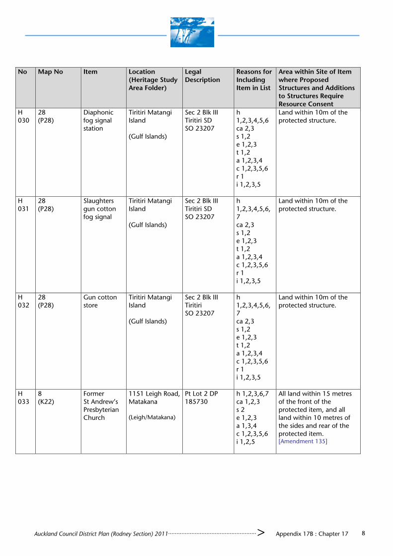
Auckland Council District Plan (Rodney Section) 2011..................................................... > Appendix 17B : Chapter 17 8
No Map No Item Location (Heritage Study Area Folder)
Legal Description
Reasons for Including Item in List
Area within Site of Item where Proposed Structures and Additions to Structures Require Resource Consent
H 030
28 (P28)
Diaphonic fog signal station
Tiritiri Matangi Island (Gulf Islands)
Sec 2 Blk III Tiritiri SD SO 23207
h 1,2,3,4,5,6 ca 2,3 s 1,2 e 1,2,3 t 1,2 a 1,2,3,4 c 1,2,3,5,6 r 1 i 1,2,3,5
Land within 10m of the protected structure.
H 031
28 (P28)
Slaughters gun cotton fog signal
Tiritiri Matangi Island (Gulf Islands)
Sec 2 Blk III Tiritiri SD SO 23207
h 1,2,3,4,5,6,7 ca 2,3 s 1,2 e 1,2,3 t 1,2 a 1,2,3,4 c 1,2,3,5,6 r 1 i 1,2,3,5
Land within 10m of the protected structure.
H 032
28 (P28)
Gun cotton store
Tiritiri Matangi Island (Gulf Islands)
Sec 2 Blk III Tiritiri SO 23207
h 1,2,3,4,5,6,7 ca 2,3 s 1,2 e 1,2,3 t 1,2 a 1,2,3,4 c 1,2,3,5,6 r 1 i 1,2,3,5
Land within 10m of the protected structure.
H 033
8 (K22)
Former St Andrew’s Presbyterian Church
1151 Leigh Road, Matakana (Leigh/Matakana)
Pt Lot 2 DP 185730
h 1,2,3,6,7 ca 1,2,3 s 2 e 1,2,3 a 1,3,4 c 1,2,3,5,6 i 1,2,5
All land within 15 metres of the front of the protected item, and all land within 10 metres of the sides and rear of the protected item. [Amendment 135]

Auckland Council District Plan (Rodney Section) 2011..................................................... > Appendix 17B : Chapter 17 9
No Map No Item Location (Heritage Study Area Folder)
Legal Description
Reasons for Including Item in List
Area within Site of Item where Proposed Structures and Additions to Structures Require Resource Consent
H 034
66 (M22)
Scott’s Hotel (Former)
Scotts Landing (Mahurangi East)
Section 43 Village of Mahurangi SO 20073
h 1,2,3,5,6,7 ca 1,2,3 s 2 e 1,2,3 a 1,3,4 c 1,2,5,6 r 1 i 1,2,3,5
Land within 20m of the protected structure.
H 035
68 (N19)
Church of St Peter and St Paul
83 Puhoi Road, Puhoi (Puhoi)
Allot 125, Psh of Puhoi SO 975A
h 1,2,3,6,7 ca 1,2,3 s 1,2 e 1,2,3 a 1,3,4 c 1,2,3,5,6 i 1,2,3,5
Land within 20m of the protected structure.
H 036
68 (N19)
Puhoi Library Puhoi Road, Puhoi (Puhoi)
Pt Allot 36 Puhoi Village SO 47417 and Road Reserve
h 1,2,3,4 ca 1,2,3 s 2 e 1,2,3 a 1,3,4 c 1,2,3,5,6 r 1 i 1,2,3,5
Land within 10m of the protected structure.
H 037
68 (N19)
Puhoi Hall Puhoi Road, Puhoi (Puhoi)
Lot 3 DP 93336 h 1,2,3,4,7 ca 1,2,3 s 2 e 1,2,3 a 1,3 c 1,2,3,5,6 r 1 i 1,2,3,5
All land within the site.
H 038
68 (N19)
Puhoi Hotel 5 Saleyard Road, Puhoi (Puhoi)
Lot 2 DP 23398 h 1,2,3,4,7 ca 1,2,3 s 2 e 1,2,3 a 1,3,4 c 1,2,3,5,6 r 1 i 1,2,3,5
Land within the site ahead of the line of the front façade of the protected structure and land within 20m of the protected structure.

Auckland Council District Plan (Rodney Section) 2011..................................................... > Appendix 17B : Chapter 17 10
No Map No Item Location (Heritage Study Area Folder)
Legal Description
Reasons for Including Item in List
Area within Site of Item where Proposed Structures and Additions to Structures Require Resource Consent
H 039
22 (N21)
Couldrey House
Wenderholm Regional Park (Hibiscus Coast)
Puhoi Pt DP 11077 SO 44742
h 1,2,3,6,7 ca 2,3 s 2 e 1,2 a 1,3 c 1,2,5,6 i 1,2,3,5
All land within the fenced garden, and the lawn to the south of the protected structure.
H 040
72 (O20)
Orewa House
498 Hibiscus Coast Highway, Orewa (Hibiscus Coast)
Lot 1 DP 75940 h 1,2,3,6,7 ca 2,3 s 2 e 1,2 a 1,3 c 1,2,5,6 i 1,2,3,5
All land within the site.
H 041
72 (O20)
Orewa House Watchhouse
498 Hibiscus Coast Highway, Orewa (Hibiscus Coast)
Lot 1 DP 75940 h 1,2,3,6,7 ca 2,3 s 2 e 1,2 a 1,3 c 1,2,5,6 r 1 i 1,2,3,5
All land within the site.
H 042
26 (P17)
Presbyterian Church
997 Wainui Road, Wainui (Hibiscus Coast)
Pt Allot 54 Psh of Waiwera SO 721
h 1,2,3,6,7 ca 1,2,3 s 1,2 e 1,2,3 a 1,3,4 c 1,2,3,5,6 i 1,2,3,5
All land within the site.
H 043
80 (Q20)
Holy Trinity Anglican Church
24 Wainui Road, Silverdale (Hibiscus Coast)
Lot 1 DP 342380
h 1,2,3,6,7 ca 1,2,3 s 1,2 e 1,2,3 a 1,3,4 c 1,2,3,5,6 i 1,2,3,5
All land within the site.
H 044
84 (Q20)
Methodist Church
Silverdale Pioneer Village, 15 Wainui Road, Silverdale (Hibiscus Coast)
Allot 556 Psh of Waiwera SO 40407
h 1,2,3,6,7 ca 1,2,3 s 1,2 e 1,2,3 a 1,3 c 1,2,6 i 1,2,5
Nil.

Auckland Council District Plan (Rodney Section) 2011..................................................... > Appendix 17B : Chapter 17 11
No Map No Item Location (Heritage Study Area Folder)
Legal Description
Reasons for Including Item in List
Area within Site of Item where Proposed Structures and Additions to Structures Require Resource Consent
H 045
84 (Q20)
School house Silverdale Pioneer Village, 15 Wainui Road, Silverdale (Hibiscus Coast)
Allot 556 Psh of Waiwera SO 40407
h 1,2,3,6 ca 1,2,3 s2 e 1,2,3 a 1,3,4 c 1,2,5,6 r 1 i 1,2,5
Nil.
H 046
84 (Q20)
Former Wade School
19 Wainui Road, Silverdale (Hibiscus Coast)
Allot 556 Psh of Waiwera SO 40407
h 1,2,3,6,7 ca 1,2,3 s 2 e 1,2,3 a 1,3,4 c 1,2,5,6 r 1 i 1,2,3,5
Nil.
H 047
90 (Q24)
Hobbs Homestead
Hobbs Bay, Whangaparaoa (Hibiscus Coast)
Lot 1 DP 152517
h 1,2,3,6,7 ca 2,3 s 2 e 1,2 a 1,3 c 1,2,5,6 i 1,2,3,5
Land within 20m of the front and side of the protected structure.
H 048
27 (R21)
Dacre Cottage
Karepiro Bay (Hibiscus Coast)
Pt Lot 4 SO 603099
h 1,2,3,7 ca 2,3 s 2 e 1,2,3 a 1,3 c 1,2,5,6 i 1,2,3
Land within 20m of the protected structure.
H 049
15 (L22)
Graveyard, trees and structures
Adj 357 Ridge Road, Mahurangi East
(Cemeteries)
Pt Allot 9 Psh of Mahurangi SO 1110F
Criteria for structures does not apply
All land within the site.
H 050
90 (Q21) Thorburn Burial Site
89 Duck Creek Road, Stillwater
(Cemeteries)
Pt Allot 10 Psh of Okura CT 584/253
Criteria for structures does not apply
All land within a radius of 5m from the burial site
H 051
88 (Q22)
Cemetery Stanmore Bay Road (Cemeteries)
Pt Allot 51 Psh of Waiwera
Criteria for structures does not apply
All land within the site.

Auckland Council District Plan (Rodney Section) 2011..................................................... > Appendix 17B : Chapter 17 12
No Map No Item Location (Heritage Study Area Folder)
Legal Description
Reasons for Including Item in List
Area within Site of Item where Proposed Structures and Additions to Structures Require Resource Consent
H 052
33 (X15)
Former Waitakere School
Domain, 13 Bethells Road, Waitakere
Pt Allot 27 Psh of Waipareira SO 36531
h 1,2,3,6 ca 1,2,3 s 1,2 e 1,2,3 a 1,3,4 c 1,2,5,6 i 1,2,5
All land within 20m of the protected item.
H 053
108 (U13)
St Martins Church
912 SH16, Waimauku
Pt Mblk 2B Waikoukou DP 15293
h 1,2,3,4,6 ca 1,2,3 cm 1,2, s 1,2 e 1,2,3 a 1,3,4 c 1,2,5,6 r 1 i 1,2,3,5
All land within 10m of the front and sides of the protected item, other than the land occupied by the building in the north-east corner of the site.
H 054
31 (V16)
Former Sinton House
238 SH 16, Brigham’s Creek
Lot 1 DP 326070
h 1,2,3, ca 3 e 1,2 a 1,3 c 1,2,5,6 i 1,2,3,5
All land within 20m of the front and sides of the protected item.
H 055
103 (R11)
Ambury House
11 Fordyce Rd, Parakai
Lot 4 DP 130503 [Amendment 135]
h 1,2,3,7 ca 2,3 e 1,2 a 1 s 2 c 1,2,5 i 1,2,3,5
All land ahead of the line of the front of the façade of the protected item, and all land within 10m of the sides of the protected item.
H 056
23 (P8)
Omana 801 South Head Road, South Head
Lot 3 DP 162604
h 1,2,3 ca 1,2,3 s 2 a 1,3,4 c 1,2,5,6 i 1,2,3
All land ahead of the line of the front of the façade of the protected item, and all land within 10m of the sides of the protected item.
H 057
103 (R11)
Craigwell House
143-147 Parkhurst Road, Parakai [Amendment 135]
Pt Lot 2 DP 3689
h 1,2,3,7 ca 1,2,3 s 1,2 e 1,2,3 a 1,3 c 1,2,5,6 r 1 i 1,2,3
All land ahead of the line of the front of the façade of the protected item, and all land within 10m of the sides of the protected item.

Auckland Council District Plan (Rodney Section) 2011..................................................... > Appendix 17B : Chapter 17 13
No Map No Item Location (Heritage Study Area Folder)
Legal Description
Reasons for Including Item in List
Area within Site of Item where Proposed Structures and Additions to Structures Require Resource Consent
H 058
105 (R12)
Cameron Shops
81-85 Commercial Road, Helensville
Lots 2 and 3 DP 20150
h 1,2,3,7 ca 1,2,3 s 2 e 1,2,3 a 1,3,4 c 1,2,3,5,6 i 1,2,3
Facades only
H 059
105 (R12)
Union Bank of Australia /ANZ Bank
130 Commercial Road, Helensville
Lot 1 DP 158813
h 1,2,3,6 ca 1,2,3 s 2 e 1,2,3 a 1,3,4 c 1,2,5,6 i 1,23
All land within 10m of the protected item.
H 060
105 (S11)
House 11 Kowhai Street, Helensville
Pt Lot 7 BLK 4 DP 214
h 1,2,7 ca 3 e 1,2 c 1,2,6 i 1,2,5
All land ahead of the line of the front of the façade of the protected item, and all land beside the protected item.
H 061
104 (R12)
House 21 Railway Street, Helensville
Pt Lot 4A DP 214 (CT 891) Deeds 18/1
h 1,2,7 ca 3 e 1,2 a 1,3,4 c 1,2,3,5,6 i 1,2
All land ahead of the line of the front of the façade of the protected item, and all land beside the protected item.
H 062
104 (R12)
House 23 Railway Street Helensville
Pt Lot 4A DP 214 (CT 889) Deeds 18/1
h 1,2,7 ca 3 e 1,2 a 1,3,4 c 1,2,3,5,6 i 1,2
All land ahead of the line of the front of the façade of the protected item, and all land beside the protected item.
H 063
102 (Q13)
Former St Clement’s Anglican Church
45 South Avenue, Kaukapakapa [Amendment 135]
Pt Allot 12 Psh of Ararimu CT 758/208
h 1,2,3,4,6,7 ca 2,3 e 1,2 s 1,2 a 1,3,4 c 1,2,3,5,6 i 1,2,5,6
All land ahead of the line of the front of the façade of the protected item, and all land within 10m of the sides of the protected item.

Auckland Council District Plan (Rodney Section) 2011..................................................... > Appendix 17B : Chapter 17 14
No Map No Item Location (Heritage Study Area Folder)
Legal Description
Reasons for Including Item in List
Area within Site of Item where Proposed Structures and Additions to Structures Require Resource Consent
H 064
102 (Q13)
Former Petrol Filling Station
1591 State Highway 16, Kaukapakapa
Lot 1 DP 189527
h 1,2,3 ca 2,3 s 2 e 1,2,3 t 1 a 1,3 c 1,2,5,6 r 1 i 1,2,3,5
All land ahead of the line of the front of the façade of the protected item, and all land within 10m of the sides of the protected item.
H 065
5 (G12)
Legge House 27 Booth Road, Wellsford
Pt Allot 2 Psh of Wharehine SO 824
h 1,2,3,6,7 ca 3 e 1,2 a 1,3,4 c 1,2,5,6 r 1 i 1,2,3,5
All land within 20m of the protected item.
H 066
5 (G12)
Former Port Albert School
Adj 946 Port Albert Road, Port Albert
Pt Allot 160 Psh of Oruawharo SO 824 [Amendment 135]
h 1,2,3,6,7 ca 2,3 s 1,2 e 1,2 a 1,3,5 c 1,2,3,6 r 1 i 1,2,5
All land within 20m of the protected item.
H 067
35 (G15)
Church of Christ Hall
267 Rodney Street, Wellsford
Pt Lot 4 DP 1618
h 1,2,3,6,7 ca 1,2,3 s 1,2 e 1,2,3 a 1,3,4 c 1,2,3,5,6 r 1 i 1,2,5
All land ahead of the line of the front of the façade of the protected item, and all land within 10m of the sides of the protected item, but not including land occupied by the Church.
H 068
51 (I21)
Matakana House
11 Matakana Valley Road, Matakana
Lot 1 DP 349625
h 2,3,7 ca 2,3 s 2 e 1,2 a 1,3,4 c 1,2,5,6 i 1,2,3,5
All land ahead of the line of the front façade of the protected item, and all land beside the protected item.

Auckland Council District Plan (Rodney Section) 2011..................................................... > Appendix 17B : Chapter 17 15
No Map No Item Location (Heritage Study Area Folder)
Legal Description
Reasons for Including Item in List
Area within Site of Item where Proposed Structures and Additions to Structures Require Resource Consent
H 069
51 (I21)
Former Matakana Dairy Company
30 Matakana Valley Road, Matakana
Lot 2 DP 68577
h 1,2,3,4,5,6,7 ca 2,3 s 2 e 1,2,3 a 1,3,4 t 1 c 1,2,5,6 i 1,2,3,5 r 1
All land within 20m of the front and sides of the protected item.
H 070
NOT ALLOCATED
H 071
57 (K20)
Former Cement Works Manager’s House
108 Wilson Road, Warkworth
Lot 2 DP 54387
h 1,2,3,6,7 ca 2,3 e 1,2,3 t 1 a 1,3,4 c 1,2,5,6 i 1,2,3,5 r 1
All land within 20m of the front and sides of the protected item (note: front does not face road).
H 072
56 (K20)
Little Riverina
33 Wilson Road, Warkworth
Lot 4 DP 159361
h 1,2,3 ca 2,3 e 1,2 t 1 a 1,3,4 c 1,2,5,6 i 1,2,3,5
All land within 20m of the front and 10m of the sides of the protected item.
H 073
NOT ALLOCATED
H 074
54 (J19)
Christ Church (Anglican)
39-43 Percy Street Warkworth
Pt Allot 67 Psh of Mahurangi
h 1,2,3,6 ca 1,2,3 e 1,2,3 s 2 a 1,4 c 1,2,5,6 i 1,2,5
All land ahead of the line of the front façade of the protected item, and all land within 10m of the sides of the protected item.
H 075
56 (K19)
House 49 Lilburn Street, Warkworth
Lot 2 DP 49474
h 1,2,7 ca 3 e 1,2 a 1,4 c 1,2,5,6 i 1,2,5
All land between the protected item and the road frontages.

Auckland Council District Plan (Rodney Section) 2011..................................................... > Appendix 17B : Chapter 17 16
No Map No Item Location (Heritage Study Area Folder)
Legal Description
Reasons for Including Item in List
Area within Site of Item where Proposed Structures and Additions to Structures Require Resource Consent
H 076
14 (L19)
Former Wech house
1212 State Highway 1, Warkworth
Lot 1 DP 92396
h 1,2,3,6,7 ca 3 e 1,2 s 2 a 1,2,4 c 1,2,3,5,6 i 1,2,3,5
All land within 20m of the front and sides of the protected item
H 077
68 (N19)
House 7 Saleyard Road, Puhoi
Lot 3 DP 23398
h 1,2,3,7 ca 3 e 1,2 a 1,3,4 c 1,2,3,5,6 i 1,2,3,5
All land ahead of the front façade of the protected item, between the protected item and the road, and to the rear of the protected item.
H 078
84 (Q20)
Wade Hotel 2 Tavern Road, Silverdale
Lot 2 DP 420269
h 1,2,3,6,7 ca 1, 2,3 e 1,2,3 s 2 a 1,3 c 1,2,5,6 r 1 i 1,2,3
All land within 10m of the protected item, but not including alterations to the existing additions.
H 079
69 (021)
Former Cook House
982 Hibiscus Coast Highway, Hatfields Beach
Lot 2 DP 168843
h 1,2,7 e 1,2 a 1,3 c 1,2,5,6 r 1 i 1,2,5
All land within 20m of the front and sides of the protected item
H 080
103 (R11)
Fordyce home
116 Fordyce Road, Helensville
Lot 8 DP 65506
h 1,2,3,4,6,7 ca 1,2,3 s 2 a 1,3,4 c 1,2,5,6 i 1,2,3
All land within 20m of the front and sides of the protected item
H 081
105 (R120
Dr Meinhold’s Helensville Hospital (House A)
23 Garfield Road, Helensville
Pt Lot 3 DP 3900
h 1,2,3,4 ca 1,2,3 s 2 e 1,2,3 t 1 a 1,3,4 c 1,2,3,5,6 r 1 i 1,2,3
All land ahead of the line of the front façade of the protected item, and all land beside the protected item.
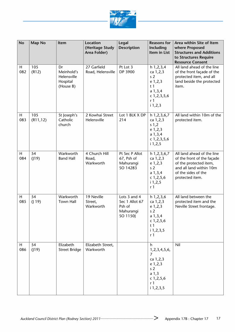
Auckland Council District Plan (Rodney Section) 2011..................................................... > Appendix 17B : Chapter 17 17
No Map No Item Location (Heritage Study Area Folder)
Legal Description
Reasons for Including Item in List
Area within Site of Item where Proposed Structures and Additions to Structures Require Resource Consent
H 082
105 (R12)
Dr Meinhold’s Helensville Hospital (House B)
27 Garfield Road, Helensville
Pt Lot 3 DP 3900
h 1,2,3,4 ca 1,2,3 s 2 e 1,2,3 t 1 a 1,3,4 c 1,2,3,5,6 r 1 i 1,2,3
All land ahead of the line of the front façade of the protected item, and all land beside the protected item.
H 083
105 (R11,12)
St Joseph’s Catholic church
2 Kowhai Street Helensville
Lot 1 BLK X DP 214
h 1,2,3,6,7 ca 1,2,3 s 1,2 e 1,2,3 a 1,3,4 c 1,2,3,5,6 i 1,2,5
All land within 10m of the protected item.
H 084
54 (J19)
Warkworth Band Hall
4 Church Hill Road, Warkworth
Pt Sec P Allot 67, Psh of Mahurangi SO 14283
h 1,2,3,6,7 ca 1,2,3 e 1,2,3 s 2 a 1,3,4 c 1,2,5,6 i 1,2,5 r 1
All land ahead of the line of the front of the façade of the protected item, and all land within 10m of the sides of the protected item.
H 085
54 (J 19)
Warkworth Town Hall
19 Neville Street, Warkworth
Lots 3 and 4 Sec 1 Allot 67 Psh of Mahurangi SO 1150J
h 1,2,3,6 ca 1,2,3 e 1,2,3 s 2 a 1,3,4 c 1,2,5,6 t 1 i 1,2,3,5 r 1
All land between the protected item and the Neville Street frontage.
H 086
54 (J19)
Elizabeth Street Bridge
Elizabeth Street, Warkworth
h 1,2,3,4,5,6,7 ca 1,2,3 e 1,2,3 s 2 a 1,3 c 1,2,5,6 r 1 i 1,2,3,5
Nil

Auckland Council District Plan (Rodney Section) 2011..................................................... > Appendix 17B : Chapter 17 18
No Map No Item Location (Heritage Study Area Folder)
Legal Description
Reasons for Including Item in List
Area within Site of Item where Proposed Structures and Additions to Structures Require Resource Consent
H 087
54 (J19)
Former bakehouse
19A Queen Street, Warkworth
Lot 3 DP 52117
h 1,2,3 ca 1,2,3 e 1,2,3 s 2 a 1,3,4 c 1,2,5,6 i 1,2,3,5
All land within 10m of the protected item.
H 088
44 (G25)
Leigh Library Cumberland Street, Leigh
Allot 121, Village of Leigh
h 1,2,7 ca 1,2,3 e 1,2,3 a 1,3,4 c 1,2,5,6 i 1,2,5
All land ahead of the line of the front façade of the protected item, and all land within 10m of the sides of the protected item.
H 089
102 (Q13)
Kaukapakapa Church
4 Peak Road, Kaukapakapa
Pt Allot 13 DP 1036
h 1,2,3,4,6,7 ca 1,2,3 e 1,2,3 s 1,2 a 1,3,4 c 1,2,3,5,6 i 1,2,3,5
All land within site
H 090
NOT ALLOCATED
H 091
5 (G12)
Port Albert Lodge of the Ancient Order of Druids
Wellsford Valley Road, Port Albert
Lot 1 DP 391028 [Amendment 135]
h 1,2,3,6,7 ca 1,2,3 s 2 e 1,2 a 1,3 c 1,2,3,5,6 i 1,2,3
All land within 20m of the protected item.
H 092
30 (T14)
Wilkins House
934 Old North Road, Waimauku
Pt Allot 3 Ararimu Psh SO 2986
h 1,2,3,4,6,7 ca 3 s 1,2 e 1,2 a 1,3,4 c 1,2,5,6 r 1 i 1,2,3
All land within 20m of the front and sides of the protected item.

Auckland Council District Plan (Rodney Section) 2011..................................................... > Appendix 17B : Chapter 17 19
No Map No Item Location (Heritage Study Area Folder)
Legal Description
Reasons for Including Item in List
Area within Site of Item where Proposed Structures and Additions to Structures Require Resource Consent
H 093
33 (X14)
House 182 Wairere Road, Waitakere
Pt Lot 2 DP 64135
h 1,2,3,7 ca 3 e 1,2 a 1,3,4 c 1,2,5,6 r 1 i 1,2,5
All land within 20m of the front and sides of the protected item.
H 094
30 (T13)
Waimauku Hunting Lodge
307 Waikoukou Valley Road, Waimauku
Lot 1 DP 387309
h 1,2,3,6,7 ca 1,2,3 s 2 e 1,2,3 a 1,3,4 c 1,2,5,6 r 1 i 1,2,3,5
All land within 20m of the front and sides of the protected item.
H 095
30 (V15)
House 200 Taupaki Road, Taupaki
Lot 1 DP 93013
h 1,2,7 e 1,2 a 1,3 c 6 i 1,2,5
All land within 20m of the front and sides of the protected item.
H 096
30 (W15)
Taupaki Hall 21A Taupaki Road, Taupaki
Lot 4 DP 8476 h 1,2,3 ca 1,2,3 s 2 e 1,2,3 a 1,3 c 1,2,5,6 i 1,2,3,5
All land ahead of the line of the front of the façade of the protected item, and all land within 10m of the sides of the protected item.
H 097
114 (U17)
Riverhead Hotel (Forester’s Arms)
33 York Terrace, Riverhead
Lot 3 DP 116247
h 1,2,3,6,7 ca 1,2,3 s 1,2 e 1,2,3 a 1,3,4 c 1,2,5,6 r 1 i 1,2,3,5
All land within 10m of the protected part of the building, but not including alterations to the existing additions.
H 098
112 (U15)
Huapai Tavern
301-319 SH16, Huapai
Lot 1 DP 147550
h 1,2,3,6,7 ca 1,2,3 s 1,2 e 1,2,3 a 1,3 c 1,2,5,6 r 1 i 1,2,3
All land within 10m of the twin gabled portion, but not including alterations to the existing additions.

Auckland Council District Plan (Rodney Section) 2011..................................................... > Appendix 17B : Chapter 17 20
No Map No Item Location (Heritage Study Area Folder)
Legal Description
Reasons for Including Item in List
Area within Site of Item where Proposed Structures and Additions to Structures Require Resource Consent
H 099
113 (U15)
Kumeu Railway Station Goods Shed
37 Main Road Kumeu
Lot 6 DP 159039
h 1,2,3,6,7 ca 2,3 e 1,2 s 2 a 1,3 c 1,2,5,6 i 1,2,3,5
All land within 5m of the protected item other than rail track land.
H 100
24 (Q10)
Nestle Brae 215-219 South Head Road, South Head
Lot 1 DP 110316
h 1,2,3,7 ca 2,3 e 1,2 a 1,3 c 1,2,5,6 i 1,2,3,5
All land within 20m of the front and sides of the protected item.
H 101
25 (R13)
Lochnorrie Estate Homestead
173 Inland Road Punganui Helensville
Pt Allot NE 27 Psh of Ararimu
h 1,2,3,6 ca 2,3 e 1,2 s 2 a 1,3,4 c 1,2,6 i 1,2,3
All land within 20m of the front and sides of the protected item.
H 102
103 (R11)
Presbyterian Church
165 Parkhurst Road, Parakai
Pt Lot 2 DP 3689
h 1,2,3,6 ca 2,3 e 1,2 a 1 c 1,2,5 i 1,2,3,5
All land ahead of the line of the front façade of the protected item, and all land beside the protected item.
H 103
103 (R11)
Parakai Domain War Memorial
Parakai Domain, cnr Parkhurst/Springs Road, Parakai
Pt Sec 10 BLK XIV Kaipara Survey District SP 25077
h 1,2,3,4,5,6 ca 1,2,3 cm 1,2, s 1,2 e 1,2,3 a 3,4 c 1,2,3,5,6 i 1,2,3,5
All land within 10m of the protected item.
H 104
105 (R12)
Becroft family home
22 Garfield Road, Helensville
Lot 1 DP 174084
h 1,2,3,4,7 ca 2,3 e 1,2 a 1,3,4 c 1,2,3,5,6 i 1,2,3
All land ahead of the line of the front of the façade of the protected item, and all land beside the protected item.

Auckland Council District Plan (Rodney Section) 2011..................................................... > Appendix 17B : Chapter 17 21
No Map No Item Location (Heritage Study Area Folder)
Legal Description
Reasons for Including Item in List
Area within Site of Item where Proposed Structures and Additions to Structures Require Resource Consent
H 105
105 (R12)
Captain Rawson’s house
35 Garfield Road, Helensville
Lot 1 DP 129175
h 1,2,3,4,6,7 ca 2,3 e 1,2 a 1,3,4 c 1,2,3,5,6 i 1,2,3
All land within the site.
H 106
NOT ALLOCATED
H 107
105 (R12)
House 70 Garfield Road, Helensville
Pt Lot 9 DP 278 [Amendment 135]
h 1,2,3,4,7 ca 3 e 1,2 a 1,3,4 c 1,2,5,6 i 1,2,3,5
All land ahead of the line of the front façade of the protected item, and all land within 10m of the sides of the protected item.
H 108
105 (R11)
The Old Convent
2B McLeod Street, Helensville
Lot 3 DP 202971 [Amendment 135]
h 1,2,7 ca 3 e 1,2
All land within 10m of the north, west and south sides of the protected item.
H 109
105 (R11)
Isaac McLeod’s House
1 Mill Road, Helensville
Lot 1 DP 318833
h 1,2,3,6,7 ca 2,3 s 2 e 1 a 1,3 c 1,2,5,6 i 1,2,3,5
All land within 20m of the front and sides of the protected item.
H 110
NOT ALLOCATED
H 111
105 (R12)
Police house 12 Rimu Street, Helensville
Lot 1 DP 180401
h 1,2,3,4,6,7 ca 2,3 s 2 e 1,2 a 1,3,4 c 1,2,5,6 i 1,2,3,5
All land within 10m of the front façade and sides of the protected item, and all land within 5m of the rear of the protected item.(Note: Front façade does not face street)

Auckland Council District Plan (Rodney Section) 2011..................................................... > Appendix 17B : Chapter 17 22
No Map No Item Location (Heritage Study Area Folder)
Legal Description
Reasons for Including Item in List
Area within Site of Item where Proposed Structures and Additions to Structures Require Resource Consent
H 112
105 (R12)
Malolo House
110 Commercial Road, Helensville
Pt Mblk Whenuahou Deeds 36
h 1,2,3,4 ca 1,2,3 s 2 e 1,2,3 t 1 a 1,3,4 c 1,2,3,5,6 r 1 i 1,2,3
All land ahead of the line of the front façade of the protected item, and all land beside the protected item.
H 113
105 (R11)
Kaipara Guest house
2395 State Highway 16, Helensville
Lot 1 DP 153650
h 1,2,3,4,6,7 ca 2,3 s 2 e 1,2,3 a 1,3,4 c 1,2,3,5,6 i 1,2,3
All land within the site.
H 114
105 (R12)
House 33 Garfield Road, Helensville
Lot 4 DP 3900
h 1,2,7 ca 3 e 1,2 a 1,3,4 c 1,2,3,5,6 i 1,2
All land between the protected item and the road frontages, and to the north of the protected item.
H 115
105 (R12)
House 51 Garfield Road, Helensville
Lot 15, BLK 5 DP 214
h 1,2,7 ca 3 s 2 e 1,2 a 1,3,4 c 1,2,3,5,6 i 1,2
All land ahead of the line of the front façade of the protected item, and all land within 10m of the sides of the protected item.
H 116
105 (R12)
House 58 Garfield Road, Helensville
Lot 3 DP 278 h 1,2,7 ca 3 e 1,2 a 1,3,4 c 1,2,3,5,6 i 1,2
All land ahead of the line of the front façade of the protected item, and all land beside the protected item.
H 117
105 (R12)
House 4 Gow Street, Helensville
Pt Mblk Otamateanui and Waiomu Deeds 18/2
h 1,2,7 ca 3 e 1,2 a 1,3,4 c 1,2,5,6 i 1,2,3,5
All land ahead of the line of the front façade of the protected item, and all land within 10m of the sides of the protected item.

Auckland Council District Plan (Rodney Section) 2011..................................................... > Appendix 17B : Chapter 17 23
No Map No Item Location (Heritage Study Area Folder)
Legal Description
Reasons for Including Item in List
Area within Site of Item where Proposed Structures and Additions to Structures Require Resource Consent
H 118
105 (R12)
St Andrew’s Presbyterian Church Youth Centre
39 Garfield Road, Helensville
Lot 1 DP 416210 [Amendment 135]
h 1,2,3,6,7 ca 1,2,3 e 1,2,3 s 1,2 a 1,3,4 c 1,2,3,5,6 i 2,3,5
All land ahead of the line of the front façade of the protected item, and all land within 10m of the sides of the protected item.
H 119
105 (R12)
St Andrew’s Presbyterian Church (1883 part only)
39A Garfield Road, Helensville
Lot 2 DP 416210
h 1,2,3,6,7 ca 1,2,3 s 1,2 e 1,2,3 a 1,3,4 c 1,2,3,5,6 i 2,3,5
All land ahead of the line of the front façade of the protected item, and all land within 10m of the sides of the protected item.
H 120
NOT ALLOCATED
H 121
105 (R12)
House 11 Gow Street, Helensville
Lot E Otamateanui M Blk (P74 Deeds)
h 1,2,7 ca 3 e 1,2 a 1,3,4 c 1,2,5,6 i 1,2,3,5
All land ahead of the line of the front façade of the protected item, and all land beside the protected item.
H 122
105 (R12)
House 17 Karaka Street, Helensville
Flat 1 DP 131232, Lot 1 BLK III DP 169
h 1,2,7 ca 3 e 1,2 a 1 c 1,2,6 i 1,2,5
All land ahead of the line of the front façade of the protected item, and all land beside the protected item.
H 123
105 (R12)
House 7 Porter Crescent, Helensville
Lot 24 DP 4614
h 1,2,7 ca 3 e 1,2 a 1,2,3 c 1,2,3,5,6 i 1,2
All land ahead of the line of the front façade of the protected item, and all land beside the protected item.
H 124
NOT ALLOCATED
H 125
105 (R12)
Church of Christ/ Forester’s Hall
124 Commercial Road, Helensville
Lot 9 Deeds 36
h 1,2,3,6 ca 1,2,3 s 2 e 1,2,3 c 1,2,3,5,6 i 1,2,3,5
All land ahead of the line of the front façade of the protected item, and all land within 10m of the sides of the protected item.

Auckland Council District Plan (Rodney Section) 2011..................................................... > Appendix 17B : Chapter 17 24
No Map No Item Location (Heritage Study Area Folder)
Legal Description
Reasons for Including Item in List
Area within Site of Item where Proposed Structures and Additions to Structures Require Resource Consent
H 126
105 (R12)
Old Methodist Church
118 Commercial Road, Helensville
Lot 11 Deeds 36
h 1,2,3,4,6,7 ca 1,2,3 s 1,2 e 1,2,3 a 1,3,4 c 1,2,3,5,6 i 1,2,3,5
All land ahead of the line of the front façade of the protected item, and all land within 10m of the sides of the protected item.
H 127
105 (R12)
Helensville Courthouse
98 Mill Road Helensville
Lot 2 DP 195488 [Amendment 135]
h 1,2,3,4,5,6,7 ca 1,2,3 s 1,2 e 1,2,3 a 1,3,4 c 1,2,3,5,6 r 1 i 1,2
All land within 5m of the front of the protected item.
H 128
105 (R12)
Kaipara Medical Centre
51 Commercial Road, Helensville
Lot 2 DP 363695
h 1,2,3 ca 2,3 e 1,2,3 a 1,2,3 c 1,6 r 1 i 1,3
All land ahead of the line of the front façade of the protected item, and all land beside the protected item to a depth of 15m from the road frontage.
H 129
105 (R12)
Grand Hotel 1 Bridge Street, Helensville
Pt Lot 2 DP 47569
h 1,2,3 ca 1,2,3 s 2 e 1,2,3 a 1,3 c 1,2,5,6 i 1,2,3,5
All land beside the protected item to a depth of 10m from the road frontage.
H 130
105 (R12)
Helensville Post Office
102-104 Commercial Road, Helensville
Sec 19 Blk XIV Kaipara SD SO 32673 [Amendment 135]
h 1,2,3,4,6,7 ca 1,2,3 s 1,2 e 1,2,3 a 1,3,4 c 1,2,5,6 r 1 i 1,2,3
All land beside the protected item to a depth of 10m from the road frontage.

Auckland Council District Plan (Rodney Section) 2011..................................................... > Appendix 17B : Chapter 17 25
No Map No Item Location (Heritage Study Area Folder)
Legal Description
Reasons for Including Item in List
Area within Site of Item where Proposed Structures and Additions to Structures Require Resource Consent
H 131
105 (R12)
Old Helensville South Butchery
7 Commercial Road, Helensville
Lot 1 DP 16950
h 1,2,3,4,7 ca 2,3 s 1,2 e 1,2,3 t 1 a 1,3,4 c 1,2,5,6 r 1 i 1,2,3
Nil.
H 132
NOT ALLOCATED
H 133
105 (R12)
Bank of New Zealand Building
108 Commercial Road, Helensville
Pt Te Rewarewa DP 9944 and Sec 13 Blk XV Kaipara SD SO 18379
h 1,2,3,6, ca 1,2,3 s 1 ed 1,2 e 1,2,3 a 1,3 c 1,2,3,5,6 i 1,2,3
Nil.
H 134
105 (R12)
Regent Theatre
14 Garfield Road, Helensville
Lot 1 and Pt Lot 2 DP 24368
h 1,2,3,4 ca 1,2,3 s 2 e 1,2,3 t 1 a 1,3,4 c 1,2,5,6 r 1 i 1,2,3
Nil.
H 135
NOT ALLOCATED
H 136
105 (R12)
Helensville Railway Station
18-20 Railway Street, Helensville
Lot 1 DP 154834
h 1,2,3,4,6,7 ca 1,2,3 s 1,2 e 1,2,3 a 1,3,4 c 1,2,5,6 r 1 i 1,2,3,5
All land within 10m of the front (i.e.eastern face) and sides of the protected item.

Auckland Council District Plan (Rodney Section) 2011..................................................... > Appendix 17B : Chapter 17 26
No Map No Item Location (Heritage Study Area Folder)
Legal Description
Reasons for Including Item in List
Area within Site of Item where Proposed Structures and Additions to Structures Require Resource Consent
H 137
104 (R12)
Helensville slaughterhouse
4 Kaipara Coast Highway, Helensville
Lot 2 DP 386350
h 1,2,3,7 ca 2,3 s 2 e 1,2 t 1 a 1 c 1,2 r 1 i 1,2,3
All land within 20m of the front and sides of the protected item.
H 138
NOT ALLOCATED
H 139
NOT ALLOCATED
H 140
NOT ALLOCATED
H 141
102 (Q13)
Kaukapakapa Hall
947 State Highway 16, Kaukapakapa
Sec 1 SO 379863
h 1,2,3,6,7 ca 1,2,3 cm 1,2 s 2 e 1,2,3 a 1,3 c 1,2,5,6 i 1,2,5
All land ahead of the line of the front façade of the protected item, and all land within 10m of the sides of the protected item.
H 142
102 (Q13)
Kaukapakapa Methodist Church Hall
4 Peak Road, Kaukapakapa
Pt Allot 13 Psh of Ararimu SO 1036
h 1,2,3,6,7 ca 1,2,3 s 2 e 1,2,3 a 1,2,3 c 1,2,5,6 r 1 i 1,2,3,5
All land within site
H 143
102 (Q13)
Kaukapakapa WW1 Memorial (school)
977 State Highway 16, Kaukapakapa
Pt Allot 13 Psh of Kaukapakapa SO 2003
h 1,2,3,4,5,6 ca 1,2,3 cm 1,2 s 1,2 e 1,2,3 a 3,4 c 1,2,3,5,6 i 1,2,3,5
All land within 5m of the protected item.

Auckland Council District Plan (Rodney Section) 2011..................................................... > Appendix 17B : Chapter 17 27
No Map No Item Location (Heritage Study Area Folder)
Legal Description
Reasons for Including Item in List
Area within Site of Item where Proposed Structures and Additions to Structures Require Resource Consent
H 144
102 (Q13)
Stone Monument
Kahikatea Flat Road, cnr SH16, Kaukapakapa
On road way h 1,2,3,4,5,6 ca 1,2,3 cm 1,2 s 1,2 e 1,2,3 a 3,4 c 1,2,3,5,6 r 1 i 1,2,3,5
All land within 5m of the protected item.
H 145
52 (J15)
Former Kaipara Flats Church
947 Kaipara Flats Road, Kaipara Flats
Lot 4 DP 412418
h 1,2,3,6 ca 1,2,3 cm 1 s 1,2 e 1,2,3 a 1,3,4 c 1,2,5,6 i 1,2,3,5
All land ahead of the line of the front façade of the protected item, and all land beside the protected item.
H 146
NOT ALLOCATED
H 147
5 (G12)
Cottage (behind Wesleyan Church)
15 Church Hill Road, Port Albert
Pt Allot 169 Oruawharo
h 1,2,3,4,6,7 ca 2,3 s 1,2 e 1,2,3 alg 2,3 a 1,3,4 c 1,2,3,4,5,6 r 1 i 1,2,3
All land within site.
H 148
NOT ALLOCATED
H 149
NOT ALLOCATED

Auckland Council District Plan (Rodney Section) 2011..................................................... > Appendix 17B : Chapter 17 28
No Map No Item Location (Heritage Study Area Folder)
Legal Description
Reasons for Including Item in List
Area within Site of Item where Proposed Structures and Additions to Structures Require Resource Consent
H 150
5 (H11)
Grant House (Excluding additions or alterations to the southern or western elevations of the building ( as long as they are below the roofline of the existing house))
326 JV Grant Road, Wharehine
PT Allot M7 Psh of Wharehine SO 824 [Amendment 135]
h 1,2,3,7 ca 3 e 1,2 a 1,3,4 c 1,2,6 i 1,2,3,5
All land within 20m of the northern and eastern elevations of the protected item.
H 151
6 (H13)
Former Prictor house
479 Port Albert Road, Wellsford
Lot 1 DP 54958
h 1,2,3,7 ca 3 e 1,2 a 1,3,4 c 1,2,6 i 1,2,3,5
All land ahead of the line of the front façade of the protected item, and all land within 10m of the sides of the protected item.
H 152
5 (G12)
Methodist Church
15 Church Hill Road, Port Albert
Lot 1 DP 92160
h 1,2,3,4,6,7 ca 1,2,3 e 1,2,3 s 1,2 a 1,3,4 c 1,2,3,5,6 i 1,2,3,5
All land within site.
H 153
6 (H13)
Former Hoteo North School
Kaipara Coast Highway, Wellsford
Allot 147, Psh of Tauhoa
h 1,2,3,6,7 ca 3 s 1,2 e 1,2 a 1,3,4 c 1,2,3,5,6 i 1,2,5
All land within 20m of the front and sides of the protected item.
H 154
5 (H10)
Wharehine War Memorial
279 Pah Hill Road, Port Albert
Allot 50 Psh of Wharehine SO 42595
h 1,2,3,4,5,6 ca 1,2,3 cm 1,2 s 1,2 e 1,2,3 a 1 c 1,2,3,5,6 i 1,2,5
All land within 10m of the protected item.

Auckland Council District Plan (Rodney Section) 2011..................................................... > Appendix 17B : Chapter 17 29
No Map No Item Location (Heritage Study Area Folder)
Legal Description
Reasons for Including Item in List
Area within Site of Item where Proposed Structures and Additions to Structures Require Resource Consent
H 155
5 (G12)
Port Albert Hall
980 Port Albert Road, Port Albert
Pt Allot 160 Psh of Oruawharo SO 824
h 1,2,3,6,7 s 1,2 e 1,2,3 a 1,3,4 c 1,2,3,5,6 i 1,2,3,5
All land within 20m of the front and sides of the protected item.
H 156
37 (G14)
Police lock-up
Wellsford Police Station 108 Rodney Street Wellsford
Lot 2 DP 183334
h 1,2,3,6,7 ca 1,2,3 s 2 e 1,2 a 1,3 c 1,2 r 1 i 1,2,3
All land within 10m of the north, east, and south walls of the protected item.
H 157
6 (G12)
Port Albert Reserve Grandstand
Port Albert Reserve Wellsford Valley Road, Port Albert
Pt Allot 195 Psh of Oruawharo SO 14286
h 1,2,3,4,5,6 ca 1,2,3 cm 1,2 s 1,2 a 1,3 c 1,2,3,5,6 r 1 i 1,2,3
All land within 10m of the front and sides of the protected item.
H 158
6 (G12)
Port Albert Reserve WWII memorial gates
Port Albert Reserve Wellsford Valley Road, Port Albert
Pt Allot 195 Psh of Oruawharo SO 14286
h 1,2,3,4,5,6 ca 1,2,3 cm 1,2 s 1,2 e 1,2,3 a 1 c 1,2,3,5,6 r 1 i 1,2,3
All land within 10m of the protected item.
H 159
6 (G12)
Port Albert Reserve WW I Obelisk
Port Albert Reserve Wellsford Valley Road, Port Albert
Pt Allot 195 Psh of Oruawharo SO 14286
h 1,2,3,4,5,6 ca 1,2,3 cm 1,2 s 1,2 e 1,2,3 a 1 c 1,2,3,5,6 r 1 i 1,2,3
All land within 10m of the protected item.

Auckland Council District Plan (Rodney Section) 2011..................................................... > Appendix 17B : Chapter 17 30
No Map No Item Location (Heritage Study Area Folder)
Legal Description
Reasons for Including Item in List
Area within Site of Item where Proposed Structures and Additions to Structures Require Resource Consent
H 160
37 (G14)
Former Post Office
156-158 Rodney St Wellsford
Sec 44 Blk XV1 Otamatea SD SO 17591
h 1,2,3,6 ca 2,3 s 1,2 e 1,2 a 1,4 c 1,2,5 i 1,2,3,5
Nil.
H 161
8 (F23)
Dovedale 95M Greenwood Road, Pakiri
Lot 1 DP 179443
h 1,2,3,7 ca 2,3 s 2 a 1,3,4 c 1,2,5,6 r 1 i 1,2,3,5
All land within 20m of the protected item.
H 162
14 (I20)
Appletree Cottage and Former US Army Base
4 Anderson Road, cnr Leigh-Matakana Road, Warkworth
Lot 1 DP 319755 Psh of Mahurangi
h 1,2,3,4 ca 2,3 s 2 e 1,2 a 1,2,3 t 1 c 1,2 r 1 i 1,2,3,5
All land within the site.
H 163
NOT ALLOCATED
H 164
44 (G25)
St Michael & All Angels Church
12 Hauraki Road, Leigh
Allot 81, Village of Leigh SO 1100
h 1,2,3,6,7 ca 1,2,3 s 1,2 e 1,2,3 a 1,3,4 c 1,2,5,6 i 1,2,3,5
All land ahead of the line of the front façade of the protected item, and all land beside the protected item.
H 165
51 (I21)
St Leonards Church
24 Matakana Valley Road, Matakana
Lot 1 DP 176084
h 1,2,3,6,7 ca 1,2,3 s 1,2 e 1,2,3 a 1,3,4 c 1,2,5,6 i 1,2,3,5
All land ahead of the line of the front façade of the protected item, and all land beside the protected item.
H 166
NOT ALLOCATED

Auckland Council District Plan (Rodney Section) 2011..................................................... > Appendix 17B : Chapter 17 31
No Map No Item Location (Heritage Study Area Folder)
Legal Description
Reasons for Including Item in List
Area within Site of Item where Proposed Structures and Additions to Structures Require Resource Consent
H 167
45 (H23)
Whangateau Hall
533 Leigh Road, Whangateau
h 1,2,3,6,7 ca 1,2,3 s 1,2 e 1,2,3 a 1,3,4 c 1,2,5,6 i 1,2,3,5
All land within 20m of the protected item.
H 168
51 (I21)
George V Monument
Leigh-Matakana Road, Whangateau
Sec 1 SO 67764
h 1,2,3,4,5,6, ca 1,2,3 s 1,2 e 1,2,3 a 1,3,4 c 1,2,5,6 i 1,2,3,5
All land within 10m of the protected item.
H 169
NOT ALLOCATED
H 170
56 (I19)
Former Presbyterian Manse
42 Bertram Street, Warkworth
Lot 1 DP 61981
h 1,2,3,6 ca 2,3 s 2 e 1,2 a 1,3,4 c 1,2,5,6 i 1,2,3,5 r 1
All land ahead of the line of the front façade of the protected item, and all land beside the protected item.
H 171
54 (J19)
House 1/16 Hill Street, Warkworth
Lot 5 DP 35262
h 1,2 ca 3 e 1,2 a 1,4 c 1,2,6 i 1,2,3,5
All land ahead of the line of the front façade of the protected item, and all land beside the protected item.
H 172
NOT ALLOCATED
H 173
54 (J20)
House 15 Lilburn Street, Warkworth
Pt Sec 6 Allot 67, Psh of Mahurangi SO 1150 J
h 1,2 ca 3 e 1,2 a 1,4 c 1,2,5,6 i 1,2,5
All land ahead of the line of the front façade of the protected item, and all land beside the protected item.
H 174
NOT ALLOCATED
Auckland Council District Plan (Rodney Section) 2011..................................................... > Appendix 17B : Chapter 17 32
No Map No Item Location (Heritage Study Area Folder)
Legal Description
Reasons for Including Item in List
Area within Site of Item where Proposed Structures and Additions to Structures Require Resource Consent
H 175
NOT ALLOCATED
H 176
53 (J19)
Former Holden House
8 Belmont Place, Warkworth
Lot 9 DP 336746
h 1,2,3 a 1,3,4 c 1,6 r 1 i 1,3,5,6
All land within 20m of the front and 10m of the sides of the protected item.
H 177
NOT ALLOCATED
H 178
54 (J19)
Methodist Church (old part only)
29 Neville Street Warkworth
Lot 3 DP 186917
h 1,2,3,6 ca 1,2,3 s 2 e 1,2,3 a 1 c 1,2,5,6 i 1,2,3,5
All land ahead of the line of the line of the front of the façade of the protected item, and all land beside the protected item, but not including alterations to the existing extensions.
H 179
NOT ALLOCATED
H 180
54 (J19)
Obelisk Church Hill Road, Warkworth
Pt Sec P Allot 67, Psh of Mahurangi SO 14283
h 1,2,3,4,5,6 ca 1,2,3 e 1,2,3 a 1 c 1,2,5,6 i 1,2,3,5
All land within triangular reserve.
H 181
NOT ALLOCATED
H 182
54 (J19)
Bank of New Zealand
11 Neville Street, Warkworth
Pt Allot 67 Psh of Mahurangi DP 21326
h 1,2,3,6 ca 1,2,3 e 1,2,3 s 2 a 1,3,4 c 1,2,5,6 i 1,2,3,5 r 1
Nil.
H 183
54 (J19)
Warkworth Craft Gallery
2 Baxter Street, Warkworth
Lot 1 DP 37003
h 1,2,3 ca 1,2,3 e 1,2 a 1,4 c 1,2,5,6 i 1,2,3,5
Nil.

Auckland Council District Plan (Rodney Section) 2011..................................................... > Appendix 17B : Chapter 17 33
No Map No Item Location (Heritage Study Area Folder)
Legal Description
Reasons for Including Item in List
Area within Site of Item where Proposed Structures and Additions to Structures Require Resource Consent
H 184
54 (J19)
Former Rodney Motors
41 Queen Street, Warkworth
Lot 2 DP 92292
h 1,2 e 2, 3 a 1 c 1,5,6 i 1,2,3, r 1
All land within 10m of the southwest side of the protected item to a depth of 10m from Queen St/Mill Lane.
H 185
54 (J19)
Coombes/Daldy Lime Kilns (2)
Adj 34 and 36 Sandspit Road, Warkworth
Pt Lot 51 DP 703 [Amendment 135]
h 1,2,3,4,5,6,7 ca 2,3 e 1,2,3 t 1 s 2 a 1 c 1,2,3,5,6 r 1 i 1,2,3
All land within 10m of the protected item.
H 186
54 (J19)
Band Rotunda
Church Hill, Warkworth
Pt Sec P Allot 67, Psh of Mahurangi SO 14283
h 1,2,3,4,6,7 ca 2,3 e 1,2,3 s 2 a 1,3 c 1,2,5,6 r 1 i 1,2,3,5
All land within triangular reserve.
H 187
64 (K25)
Mansion House Bay wharf abutment
Mansion House Bay, Kawau Island
Pt Lot 2 DP 39418
h 1,2,3,7 ca 1,2,3 e 1,2,3 s 2 a 1,4 c 1,2,3,5,6 r 1 i 1,2,3,5
All land within 3m of the protected item.
H 188
64 (K25)
Former Managers House
Two House Bay, Kawau Island
Lot 1A DP 6975
h 1,2,3,6,7 ca 3 e 1,2 s 2 a 1,3 c 1,2,3,5 i 1,2,3,5
All land within 20m of the front and sides of the protected item.

Auckland Council District Plan (Rodney Section) 2011..................................................... > Appendix 17B : Chapter 17 34
No Map No Item Location (Heritage Study Area Folder)
Legal Description
Reasons for Including Item in List
Area within Site of Item where Proposed Structures and Additions to Structures Require Resource Consent
H 189
64 (K25)
Copper Mine Engine House Ruins
Dispute Cove, Kawau Island
Lot 231 DP 7674
h 1,2,3,7 e 1,2,3 alg 2,3,4 t 1 c 1,2,3,6 r 1 i 3
All land within 20m of the protected item.
H 190
22 (M22)
Rodmersham
Mahurangi Heads East
Lot 4 DP 28362
h 1,2,3,5,6,7 ca 2,3 e 1,2 s 2 a 1,3,4 c 1,2,5,6 r 1 i 1,2,3,5
All land ahead of the line of the front façade of the protected item, and all land within 10m of the sides of the protected item.
H 191
NOT ALLOCATED
H 192
14 (L19)
Former Shaw House
1472 State Highway 1, Warkworth
Lot 2 DP 128205
h 1,2,3,6,7 ca 3 e 1,2 s 2 a 1,2,3,4 c 1,2,3,5,6 t 1 r 1 i 1,2,3,5
All land within 20m of the front and sides of the protected item.
H 193
60 (K21)
The Grange 375 Hamilton Road, Mahurangi East
Lot 1 DP 370644
h 1,2,3,4,6 ca 2,3 e 1,2, s 2 a 1,3,4 c 1,2,5,6 i 1,2,5
All land within 20m of the front and sides of the protected item.
H 194
22 (N21)
Old Sullivan homestead
Mahurangi (West) Regional Park
Lot 1 DP 59474
h 1,2,3,6,7 ca 1,2,3 e 1,2,3 s 2 a 1,3,4 c 1,2,5,6 i 1,2,3,5
All land ahead of the line of the front façade of the protected item, and all land within 10m of the sides of the protected item.

Auckland Council District Plan (Rodney Section) 2011..................................................... > Appendix 17B : Chapter 17 35
No Map No Item Location (Heritage Study Area Folder)
Legal Description
Reasons for Including Item in List
Area within Site of Item where Proposed Structures and Additions to Structures Require Resource Consent
H 195
15 (K23)
Scandrett House
Scandrett Regional Park, Mahurangi East
Lot 1 DP 203800
h 1,2,3,6,7 ca 1,2,3 e 1,2,3 s 2 a 1,3,4 c 1,2,5,6 i 1,2,3,5
All land within 20m of the front and sides of the protected item.
H 196
NOT ALLOCATED
H 197
60 (K21)
Former Morrison house
11 Duck Creek Road, Mahurangi East
Lot 5 DP 203455
h 1,2,3,4,6 ca 2,3 e 1,2 s 2 a 1,3,4 c 1,2,5,6 i 1,2,5
All land within 20m of the front and sides of the protected item.
H 198
21 (M20)
Mahurangi West Hall (former school)
401 Mahurangi West Road
Sec 40 Blk XV Mahurangi SD SO 3504
h 1,2,3,6,7 ca 2,3 e 1,2 s 2 a 1,3,4 c 1,2,5,6 r 1 i 1,2
All land within 20m of the protected item.
H 199
NOT ALLOCATED
H 200
68 (N19)
Old School House
10 Krippner Road, Puhoi
Lot 1 DP 47587
h 1,2,3,4,7 ca 2,3 e 1,2 s 2 a 1,3,4 c 1,2,3,5,6 r 1 i 1,2,3,5
All land ahead of the line of the front façade of the protected item, and all land within 10m of the sides of the protected item.
H 201
68 (N19)
Former Presbytery
77 Puhoi Road, Puhoi
Allot 125, Psh of Puhoi SO 975A
h 1,2,3,4,7 ca 1,2,3 e 1,2 s 2 a 1,3,4 c 1,2,3,5,6 r 1 i 1,2,3,5
All land within 20m of the front and sides of the protected item.

Auckland Council District Plan (Rodney Section) 2011..................................................... > Appendix 17B : Chapter 17 36
No Map No Item Location (Heritage Study Area Folder)
Legal Description
Reasons for Including Item in List
Area within Site of Item where Proposed Structures and Additions to Structures Require Resource Consent
H 202
68 (N19)
Former Convent
77 Puhoi Road, Puhoi
Allot 125, Psh of Puhoi SO 975A
h 1,2,3,4 ca 1,2,3 e 1,2 s 2 a 1,3,4 c 1,2,3,5,6 r 1 i 1,2,3,5
All land within 20m of the front and sides of the protected item.
H 203
NOT ALLOCATED
H 204
NOT ALLOCATED
H 205
68 (N19)
Puhoi Hotel stables
Saleyard Road, Puhoi
Lot 5 DP 23398 and road
h 1,2,3,4,7 ca 1,2,3 e 1,2,3 s 2 a 1,3,4 c 1,2,3,5,6 r 1 i 1,2,3,5
All land within 10m of the protected item.
H 206
68 (N19)
Wayside Shrine
Adj to 60 Puhoi Road
Road h 1,3 ca 1,2,3 cm 2 s 1,2 e 1,2,3 i 1,2,3,5
All land within 10m of the protected item.
H 207
77 (P20)
Stoney Homestead
11 Laura Jane Drive, Silverdale
Lot 1004 DP 415528
h 1,2,3,6,7 ca 2,3 e 1,2 s 2 a 1,3 c 1,2,5,6 i 1,2,5
All land within 20m of the front and sides of the protected item.
H 208
28 (Q25)
Te Whanga Shakespear Homestead
Shakespear Regional Park, Whangaparaoa
Allot 248 Psh of Waiwera
h 1,2,3,6,7 ca 2,3 e 1,2 s 2 a 1,3,4 c 1,2,5,6 r 1 i 1,2,3,5
All land within 20m of the front and sides of the protected item.

Auckland Council District Plan (Rodney Section) 2011..................................................... > Appendix 17B : Chapter 17 37
No Map No Item Location (Heritage Study Area Folder)
Legal Description
Reasons for Including Item in List
Area within Site of Item where Proposed Structures and Additions to Structures Require Resource Consent
H 209
87 (Q22)
House 18 Claude Road, Stanmore Bay
Lot 2 DP 33497
h 1,2,3,6,7 ca 3 e 1,2 a 1,3 c 1,2,5,6 i 1,2,3,5
All land between the protected item and the beach, and all land within 10m of the east and west sides of the protected item.
H 210
75 [Amendment 101]
WWII Pillbox Moana Reserve Hibiscus Coast Highway Orewa
Lot 1 DP 20781
Cm, e, h, t Nil
H 211
84 (Q20)
Former parsonage
15 Wainui Road, Silverdale
Allot 556 Psh of Waiwera SO 40407
h 1,2,3,6,7 ca 1,2,3 s 1,2 e 1,2,3 a 1,3 c 1,2,6 i 1,2,5
All land within 10m of the protected item.
H 212
87 (Q22)
St Stephens Church
3-5 Stanmore Bay Road, Manly Whangaparaoa
Pt Allot S190 Psh of Waiwera DP 11235
h 1,2,3,6 ca 1,2,3 e 1,2,3 s 2 a 1,3 c 1,2,5,6 i 1,2,3,5
All land ahead of the line of the front façade of the protected item, and all land beside the protected item.
H 213
NOT ALLOCATED
H 214
84 (Q20)
Silverdale Hall
7 Silverdale Street, Silverdale
Pt Allot 178 Psh of Waiwera SO 892
h 1,2,3,6 ca 1,2,3 e 1,2,3 s 2 a 1 c 1,2,5,6 i 1,2,3,5
Nil.
H 215
22 (O21)
Waiwera Bath House
37 Waiwera Place, Waiwera
Lot 1 DP 46560
h 1,2 ca 1,2,3 e 1,2,3 s 2 a 1,3,4,5 c 1,2,5,6 r 1 i 1,2,3,5
All land within 20m of the protected item.
Auckland Council District Plan (Rodney Section) 2011..................................................... > Appendix 17B : Chapter 17 38
No Map No Item Location (Heritage Study Area Folder)
Legal Description
Reasons for Including Item in List
Area within Site of Item where Proposed Structures and Additions to Structures Require Resource Consent
H 216
28 (Q25)
Gun emplacement (1) (Podges)
Army Bay, Shakespear Regional Park, Whangaparaoa
Pt Lot 1, DP 2187
h 1,2,3,4,6 ca 3 e 1,2,3 t 1 s 2 c 1,2,3,5 i 1,2,3
All land within 10m of the protected items.
H 217
28 (Q25)
Gun emplacement (2) (Reta)
Shakespear Regional Park, Whangaparaoa
Pt Allot 248 Psh of Waiwera SO 1564
h 1,2,3,4,6 ca 3 e 1,2,3 t 1 s 2 c 1,2,3,5 i 1,2,3
All land within 10m of the protected item.
H 218
99 Coatesville Settlers Hall
Coatesville Recreation Reserve, 4 Mahoenui Valley Road, Coatesville
Allots 334 and 335 Psh of Paremoremo SO 22647
h 1,2,3,5 ca 1,2,3 c 1,2,5 s 1,2 e 1,2,3
Land within 20m of the front and sides of the protected structure.
H 219
8 Sandstone Setts
Matakana Valley Road
h 1,2,3 y 1 a 3,4,5 i 3,6
Land within road reserve. [Decision Report 2230A]
H 220
47
Big Omaha Wharf
Big Omaha Wharf Road, Whangateau Harbour
Big Omaha Road Reserve
h 1,2,3 ca 2,3 e 1,2,3 a 1,3 c 1,2,5,6 i 1,2,3,5
All land within 10m of the structure.
H 221
28 (Q25)
Manager’s House (RHR Shakespear’s House)
Okoromai Bay, Shakespear Regional Park, Whangaparaoa
Pt Allot 248 Psh of Waiwera
h 2,3 ca 3 c 2,3,4,5,6 i1,2,3,5
All land within 20m of the front and sides of the protected item.
H 222
16 (R09)
Jones Homestead
Tawharanui Regional Park
Pt Mblk Tawharanui ML 1874
h 2,3,5 ca 3 s 2 e 1,2,3 a 1,2,3,4 i 1,2,3,4,5
All land within 10m of the protected item.
Auckland Council District Plan (Rodney Section) 2011..................................................... > Appendix 17B : Chapter 17 39
No Map No Item Location (Heritage Study Area Folder)
Legal Description
Reasons for Including Item in List
Area within Site of Item where Proposed Structures and Additions to Structures Require Resource Consent
H 223
28 (R10)
Anti-tank Ditch
Shakespear Regional Park
Pt Allot 248 Psh of Waiwera SO 1564
h 1,2,4,5 s 2 e 1,2,3 t 1 a 1,3 c 1,3,4,5 r 1 i 1,2,3,5
All land within 10m of the protected item.
H 224
22 (R10)
Te Muri Cemetery
Mahurangi (West) Regional Park
Sect 2 Blk IV Waiwera Survey District SO 51002
h 3,4,5,6,7 tw ca 1,2,3 cm 1,2 s 2 e 1,2,3 arg 2,4 c 2,4,5,6 i 1,2,3,5
All land within cemetery reserve.
H 225
16 (R09)
Blue Bell Point Midden
Blue Bell Point, Tawharanui Regional Park
Pt Mblk Tawharanui ML 1874
h 1,3,5,7 tw e 1,3 arg 1,2,4 c 1,5 i 1,3
All land on the Point.
H 226
16 (R09)
Graves Matatuahu Point Tawharanui Regional Park
Pt Mblk Tawharanui ML 1874
h 1,2,3,4,7 tw cm 2 s 1,2 e 1,3 arg 1,2,4 c 1,2,5 I 1,2,3
All land on the point.
H 227
28 (R10)
Te Haruhi Landing Site
Te Haruhi Bay, Shakespear Regional Park
Pt Allot 26 Psh of Waiwera SO 1438 and Pt Allot 252 Psh of Waiwera SO 61343
h 3,4,5,6,7 tw ca 1,3 s 1,2 e 1,2,3 arg 1,4 c 1,4,5,6 I 2,3
All land within the site.
Auckland Council District Plan (Rodney Section) 2011..................................................... > Appendix 17B : Chapter 17 40
No Map No Item Location (Heritage Study Area Folder)
Legal Description
Reasons for Including Item in List
Area within Site of Item where Proposed Structures and Additions to Structures Require Resource Consent
H 228
108
Waimauku Dairy Factory
81 Waimauku Station Road, Waimauku
Pt Mblk 2A2, Waikoukou DP 11931
h 2,3,4 ca 1 s 2 t 1 a 1 c 3,5,6 r 1 i 3
See Appendix 17N [Amendment 134]
H 229
108 Former Blacksmiths
85 Waimauku Station Road, Waimauku
Lot 2 DP 18692
h 1,2,3,4 ca 1,2,3 s 2 a 2 a 1 c 1,3,5,6 r 1 i 1,2,3,4,5,6
See Appendix 17O [Amendment 134]
H 230
Not allocated
H 231
108 Waimauku Memorial Hall
22-24 Waimauku Station Road, Waimauku
Lot 1 DP 43085 and Lot 8 DP 105420
h 1,2,3,4,5,6 ca 1,2,3 c 1,2 s 1,2 e 1,2,3 t 2 a 1 c 1,2,5,6 i 2,3,5
See Appendix 17P [Amendment 134]
H 232
30 Tractor/ Storage Shed
Worrall Road, Taupaki
Pt Lot 35 Deeds Whau56
h 1,2,3 ca 3 s 2 t 1 a 1 c 1,2,5 i 1,2,3,6
See Appendix 17Q [Amendment 134]
H 233
30 Farm Shed/ Piggery
Worrall Road, Taupaki
Lot 1 DP 89975
h 1,3 ca 3 s 2 e 1 t 1 a 1 c 1,2,5 r 1 i 1,2,3,4,6
See Appendix 17R [Amendment 134]

Auckland Council District Plan (Rodney Section) 2011..................................................... > Appendix 17B : Chapter 17 41
No Map No Item Location (Heritage Study Area Folder)
Legal Description
Reasons for Including Item in List
Area within Site of Item where Proposed Structures and Additions to Structures Require Resource Consent
H 234
108 Former Bake House
55 Waimauku Station Road, Waimauku
Lot 1 DP 138949
h 1,2,3 ca 1,2,3 s 2 e 1,2 a 1 c 1,2,3,5,6 r 1 i 1,2,3,4,5,6
See Appendix 17S [Amendment 134]
H 235
Not allocated
H 236
30 Chimney from Old Shack
Waikoukou Road, Waimauku
Lot 4 DP 141298
h 2,3,7 s 2 a 1 c 1,6 i 1,3,6
See Appendix 17T [Amendment 134]
H 237
30 Puriri Farm 50 Annandale Road, Taupaki
Pt Lot 34 Deeds Whau56
h 1,2, 3,5,6,7 ca 3 s 2 e 1,2 a 1,2,3 t 1,2 a 1,3 c 1,2,3,5 r 1 i 1,2,3,4,6
See Appendix 17U [Amendment 134]

Auckland Council District Plan (Rodney Section) 2011..................................................... > Appendix 17B : Chapter 17 42

Auckland Council District Plan (Rodney Section) 2011...................................................... > Appendix 17C : Chapter 17 1
APPENDIX 17C
HISTORIC AND CULTURALLY SIGNIFICANT TREES LISTED FOR PROTECTION
Plan No.
Map No.
Historic Trees Location Legal description Heritage Study
Reference
H 601
44 Norfolk Pines Matheson House, 65 Grand View Road, Matheson Bay.
Lot 2 DP 75118 3
H 602
90/91
Norfolk Pine and 2 Oaks Hobbs Homestead, Hobbs Bay, 152-200 Pinecrest Drive, Whangaparaoa.
Lot 1 DP 152517 6
H 603
64 Chilean Wine Palms, Puriri, Bloodwood, Coral Tree, Hoop Pine, Redwood and others.
Mansion House Valley, Kawau Island
Pt Lot 2 DP 39418 8
H 604
NOT ALLOCATED
H 605
60 Norfolk Pine Hamiltons Landing Scenic Reserve, Hamilton Road, Mahurangi East.
Pt Allot 45 Psh of Mahurangi DP 1120
11
H 606
10 3
Large number of Exotic Trees
Parakai Domain, 150 Parkhurst Road, Parakai.
Pt Sec 10 BLK XIV SO 25077 Kaipara SD
16
H 607
66 Norfolk Pine 46 Ridge Road, Mahurangi East.
Lot 2, DP 323650
17
H 608
54 Rimu Warkworth Kowhai Park, State Highway 1, Warkworth.
Lot 430 Psh of Mahurangi SO 54887
19
H 609
NOT ALLOCATED
H 610
6 Two Oaks Port Albert Reserve, Wellsford Valley Road, Port Albert.
Pt Allot M195, Psh of Oruawharo SO 14286
23
H 611
22 Garden and Collection of Exotic Trees; Cork Oaks (2), Moreton Bay Fig, Bunya Bunya near the main car park; Macrocarpa, Norfolk Pine, Walnut and Magnolia
Couldrey Homestead, Wenderholm Regional Park, Waiwera.
Pt Puhoi DP 11077 SO 44742
25
Auckland Council District Plan (Rodney Section) 2011...................................................... > Appendix 17C : Chapter 17 2
along the service lane.
H 612
22 Pohutukawa Grove Wenderholm Regional Park, Waiwera.
Pt Puhoi, DP 11077 SO 44742
26
H 613
66 Row of Macrocarpas Scotts Point, Mahurangi East. Secs 205, 42, 45 and 49 Village of Mahurangi
27
H 614
22 2 Pohutukawa Trees and Pecan Tree
Te Muri Cemetery, Mahurangi Regional Park
Sec 2 Blk IV Waiwera Survey District SO 51002
H 615
15 Norfolk Pine on the foreshore and Oak Tree at the eastern end of Scandrett Bay
Scandrett Regional Park, Mullet Point
Lot 1, DP 203800
H 616
11 5
Collection of exotic trees (original plantings only). Species include: Norfolk Island Pines, Moreton Bay Figs, camellias, rhododendrons, cypresses (macrocarpa and sempervirens), Norfolk Island hibiscus, palms and a variety of different Pinus and Eucalyptus species
Mitchelson Block, Muriwai Regional Park
Lot 1, DP 41363
H 617
64 Exotic trees and shrub specimens in the valley behind Two House Bay, near the Dairy site in the upper part of Mansion House Valley, Momona Point, and along the Sir George Grey Coach Road
Mansion House Valley, Kawau Island
Pt Lot 2, Lots 3, 4, 5 DP 39418
8
H 618
30 Pear Tree 934 Old North Road, Waimauku See location map in Appendix 17H [Amendment 134]
Part Allotment 3, Parish of Ararimu, SO2986
H 619
72 6 x Pohutukawa 498 Hibiscus Coast Highway Orewa [Amendment 149 Decision not operative]
Lot 11 DP 171150 Lot 1 DP 75940
Auckland Council District Plan (Rodney Section) 2011..................................................... > Appendix 17D : Chapter 17 1
APPENDIX 17D
ARCHAEOLOGICAL SITES LISTED FOR PROTECTION
No. Map No.
Reference No.
Type Location Legal Description Comments
H 351
10 (K-4)
Q09/26 Pa South Head Road, South Head, Helensville
Pt Lot 1 DP 50362 Ngitu pa, good condition, as recorded, some erosion. Part of a larger archaeological landscape
H 352
10 (K-3)
Q09/27 Pa South Head Road, South Head, Helensville
Pt Lot 1 DP 50362 Tipare pa, as recorded. Good condition some stock damage and the eastern side badly eroded. Part of a larger archaeological landscape
H 353
11 (L-5)
Q09/29 Pa 3400 South Head Road, South Head, Helensville
Pt Lot 2 DP 127829 Visually significant, good condition, minor stock damage and erosion. Part of a larger archaeological landscape
H 354
11 (L-5)
Q09/33 Pa 3400 South Head Road, South Head, Helensville
Pt Lot 2 DP 127829 Visually unspectacular, stock damage and erosion. Part of a larger archaeological landscape
H 355
11 (L-5)
Q09/34 Pa South Head Road, South Head, Helensville
Lot 7 DP 179864, Lot 2 DP 96582
Visually significant site with commanding views of harbour and vicinity, some minor damage when fenced, otherwise excellent condition, site now on 2 properties, part of complex, related to Q09/67
H 356
11 (L-4)
Q09/36 Pa-swamp
58 Trig Road, South Head, Helensville
Lot 1 DP 156352 Unique in area (swamp pa). Main features in good condition, some stock damage and erosion, part of network of sites in general vicinity
H 357
18 (M-5)
Q09/37 Pa South Head Road, South Head, Helensville
Lot 5 DP 141134 Visually spectacular, heavily fortified site commanding surrounding vicinity, good condition
H 358
18 (M-4)
Q09/42 Pa 120 Trig Road, South Head, Helensville
Sec 1 Blk X Okaka Survey District SO 37227
Visually significant, some stock damage otherwise in excellent condition
H 359
NOT ALLOCATED

Auckland Council District Plan (Rodney Section) 2011..................................................... > Appendix 17D : Chapter 17 2
No. Map No.
Reference No.
Type Location Legal Description Comments
H 360
5 (G-11)
Q09/45 Pa Wharehine Road, Wharehine, Wellsford
Lot 6 DP 183778 Large site, good condition some stock and earthwork damage
H 361
NOT ALLOCATED
H 362
12 (J-11)
Q09/48 Pa 4021 Kaipara Coast Highway SH16, Mangakura, Warkworth
Pt Lot 1 DP 26089 Access denied, trig on top, viewed from distance - erosion on lower level, upper intact
H 363 H 364
NOT ALLOCATED
H 365
4 (H-8)
Q09/58 Pa Fitzgerald Road, Tapora, Wellsford
Sec 6 Blk 1 Tauhoa Survey District SO 55339
Large pa, in pasture among pine plantation, some past bulldozer damage to structures
H 366
11 (L-5)
Q09/67 Pa South Head Road, South Head, Helensville
Pt Lot 2 DP 96582 Features intact but becoming increasingly indistinct, part of complex related to Q09/34
H 367
18 (M-4)
Q09/79 Pa Trig Road, South Head, Helensville
Lot 3 DP 157181 Complex site covering large area, in good condition, some stock damage, part of larger archaeological landscape. Only example of a flathead pa on South Head - visually significant
H 368
11 (J-7)
Q09/152 Pa 1421 Run Road, Tapora, Wellsford
Pt Lot 2 DP 39514 Large pa in good condition, some stock damage and erosion. Commanding view of Gum Store Creek, part of larger archaeological landscape
H 369
NOT ALLOCATED
H 370
11 (J-8)
Q09/171 Pa Burma Road, Tapora, Wellsford
Lot 6 DP 185560 Good condition some minor stock damage and erosion
H 371
4 (I-7)
Q09/174 Pa Burma Road, Tapora, Wellsford
Lot 7 DP 166618 Modified by road and track cutting — reasonable condition, extensive views of Kaipara
H 372
5 (H-9)
Q09/297 Pa 414 Run Road, Tapora, Wellsford
Lot 1 DP 165503 Dense bush cover. Erosion and tree falls taking toll on site. Part of larger landscape
H 373
NOT ALLOCATED

Auckland Council District Plan (Rodney Section) 2011..................................................... > Appendix 17D : Chapter 17 3
No. Map No.
Reference No.
Type Location Legal Description Comments
H 374
5 (H-8)
Q09/300 Pa 414 Run Road, Tapora, Wellsford
Lot 1 DP 165503 Good condition, some stock damage and erosion. Part of a larger archaeological landscape
H 375
5 (H-8)
Q09/301 Pa 414 Run Road, Tapora, Wellsford
Lot 1 DP 165503 Large impressive site and part of a larger archaeological landscape (same as Q09/46)
H 376
12 (K-12)
Q09/322 Pa Kaipara Coast Highway SH16, Mangakura, Warkworth
Pt Allot 3 Psh of Tauhoa (SO 719)
Dense vegetation cover and recent pine planting
H 377
12 (K-12)
Q09/323 Pa Kaipara Coast Highway SH16, Mangakura, Warkworth
Pt Allot 3 Psh of Tauhoa (SO 719)
Dense vegetation cover and recent pine planting
H 378
12 (K-12)
Q09/325 Pa Kaipara Coast Highway SH16, Mangakura, Warkworth
Pt Allot 9 Psh of Tauhoa (SO 719)
Unable to relocate - dense vegetation and recent pine planting. However, some evidence at these co-ordinates
H 379
13 (K-13)
Q09/330 Pa 216 Eves Road, Kaipara Hills, Warkworth
Mangakura (ML 3506)
Good condition, some stock damage and erosion. Commanding views of Hoteo river
H 380
18 (M-4)
Q09/374 Pa South Head Road, South Head, Helensville
Lot 4 DP 156352 Pits in good condition, midden extensively eroded, likely to be part of pa Q09/375 separated by South Head Road
H 381
NOT ALLOCATED
H 382
11 (L-4)
Q09/400 Pa South Head Road, South Head, Helensville
Sec 1 Blk X Okaka Survey District SO 39785
Kokotonui pa, features in reasonable condition, stock damage and erosion. Owner recounts pulling wooden artifacts out of drains below and numerous midden on farm
H 383
10 (L-4)
Q09/415 Pa 3580 South Head Road, South Head, Helensville
Lot 1 DP 127829 Reasonable condition, some erosion and stock damage. Part of a larger archaeological landscape

Auckland Council District Plan (Rodney Section) 2011..................................................... > Appendix 17D : Chapter 17 4
No. Map No.
Reference No.
Type Location Legal Description Comments
H 384
13 (K-12)
Q09/461 Pa Ogle Road, Mangakura, Warkworth
Allot 42 Psh of Tauhoa (SO 719)
Large site with commanding views of archaeological landscape, harbour and Q09/463, good condition some stock damage and erosion. Part of larger archaeological landscape
H 385
13 (K-12)
Q09/463 Pa Ogle Road, Mangakura, Warkworth
Allot 42 Psh of Tauhoa (SO 719)
Good condition some stock damage, erosion and fence line through centre of site. Part of larger archaeological landscape
H 386
NOT ALLOCATED
H 387
19 (M-12)
Q09/474 Pa Kaipara Coast Highway SH16, Araparera, Warkworth
Lot 1 DP 177643 Majority of site under pine, lateral ditch and bank destroyed rest stock damaged
H 388
NOT ALLOCATED
H 389
5 (F-12)
Q09/491 Pa 115 Harataua Road, Port Albert, Wellsford
Lot 5 DP 196836 Part of network of pa on Oruawharo River. Some destruction to site from quarry and roading
H 390
12 (I-11)
Q09/719 Pa Wharehine Road, Tauhoa, Wellsford
Pt Allot 90 Psh of Tauhoa (SO 66)
Large significant site, more occupation evidence outside site. Part of larger archaeological landscape
H 391
19 (M-10)
Q09/720 Pa Kaipara Coast Highway SH16, Glorit, Warkworth
Pt Mblk Mataia (DP 11371)
Remnant ditch and bank defending pits, additional features; possible remnant of a transverse ditch and bank down ridge to west
H 392
19 (M-10)
Q09/721 Pa Kaipara Coast Highway SH16, Glorit, Warkworth
Pt Mblk Mataia (DP 11371)
Well preserved ridge top pa, additional features to those first recorded - pits and terrace
H 393
13 (K-13)
Q09/765 Pa 426 Mainland Road, Kaipara Hills, Warkworth
Pt Allot 176 Psh of Tauhoa (SO 5611)
Tapapanganui - Stock damage, but in generally good condition
H 394
13 (K-13)
Q09/769 Pa Mainland Road, Kaipara Hills, Warkworth
Allot 206 Psh of Tauhoa (SO 6710)
Erosion and stock damage rendering features difficult to discern

Auckland Council District Plan (Rodney Section) 2011..................................................... > Appendix 17D : Chapter 17 5
No. Map No.
Reference No.
Type Location Legal Description Comments
H 395
13 (K-13)
Q09/777 Pa 426 Mainland Road, Kaipara Hills, Warkworth
Pt Allot 176 Psh of Tauhoa (SO 5611)
Small site represented by ditch and bank only, excellent intervisibility with other sites in vicinity
H 396
18 (N-4)
Q10/02 Pa 68 Donohue Road, Waioneke, Helensville
Lot 1 DP 99409 Features in good condition despite heavy stocking, part of network of sites around lakes. Long site with impressive defences
H 397
18 (N-4)
Q10/03 Pa 68 Donohue Road, Waioneke, Helensville
Lot 1 DP 99409 Impressive site, massive defences. Fenced off from stock, in good condition, part of network of sites around lakes
H 398
18 (N-4)
Q10/04 Pa Donohue Road, Waineke, Helensville
Lot 1 DP 194141 Features in reasonable condition, erosion and stock damage, part of a network of sites around lakes
H 399
18 (P-7)
Q10/09 Pa Wilson Road, Mairetahi, Helensville
Lot 5 DP 143247 Te Tuki. Partial damage and infilling of features by stock, road construction, trig erection, part of larger archaeological landscape, related to Q10/10, Q10/11, Q10/12, Q10/13
H 400
18 (O-6)
Q10/10 Pa Wilson Road, Mairetahi, Helensville
Lot 4 DP 190403, Lot 1 DP 195026
Partially destroyed by farm track but many intact features, part of larger archaeological landscape, related to Q10/9, Q10/11, Q10/12, Q10/13
H 401
18 (O-6)
Q10/11 Pa Wilson Road, Mairetahi, Helensville
Lot 1 DP 195026 Under heavy bush, some features badly eroded, part of larger archaeological landscape, related to Q10/9, Q10/10, Q10/12, Q10/13
H 402
18 (O-6)
Q10/12 Pa Te Kanae Road, Mairetahi, Helensville
Pt Lot 1 DP 28697 Very good condition, complex split level pa, related to Q10/9, Q10/11,Q10/13
H 403
18 (P-6)
Q10/13 Pa 320 Wilson Road, Mairetahi, Helensville
Pt Lot 8 DP 44956 Very good condition, part of larger archaeological landscape, related to Q10/9, Q10/10, Q10/11, Q10/12
Auckland Council District Plan (Rodney Section) 2011..................................................... > Appendix 17D : Chapter 17 6
No. Map No.
Reference No.
Type Location Legal Description Comments
H 404
18 (N-4)
Q10/22 Pa Fuller Road, Waioneke, Helensville
Lot 1 DP 31846 Track on north side has destroyed some features otherwise good condition, commanding views of lake, part of network of sites around lake
H 405
18 (N-4)
Q10/23 Pa Fuller Road, Waioneke, Helensville
Lot 1 DP 31846 Described by Spring-Rice (1996) as a plateau pa, in reasonable condition in a prominent position, some natural erosion and stock damage
H 406
18 (N-5)
Q10/25 Pa Fuller Road, Waioneke, Helensville
Lot 6 DP 146453 Extensive and complex pa, recent pine planted on ridge south of summit on top of pits and terraces
H 407
18 (N-6)
Q10/27 Pa 2176 South Head Road, Waioneke, Helensville
Lot 2 DP 34091 Pines on east bank, felled stumps remain, good condition, Q10/33 visible south across estuary, one of small number of pa remaining on west coast of Kaipara Harbour
H 408
18 (N-6)
Q10/28 Pa 2027 South Head Road, Waioneke, Helensville
Lot 9 DP 31846 Good condition, external ditch and bank barely discernible
H 409
18 (P-7)
Q10/30 Pa South Head Road, Mairetahi, Helensville
Lot 4 DP 143343 Reasonable condition, ridge pa, numerous pits, pines recently removed with minimal disturbance to features
H 410
18 (N-6)
Q10/32 Pa Monk Road, Waioneke, Helensville
Lot 4 DP 176134 Excavated 1969/70, main defensive structures in good condition
H 411
18 (O-6)
Q10/34 Pa South Head Road, Waioneke, Helensville
Lot 9 DP 31846, Sec 8 Blk III Waioneke Survey District SO 21271
Good condition, exotic trees planted up to features, midden reported in vicinity by owner, part of a network of pa in area
H 412
NOT ALLOCATED
H 413
18 (N-5)
Q10/39 Pa 131 Fuller Road, Waioneke, Helensville
Lot 3 DP 192792 Small site, ditch and banks filled either end two of four pits well preserved, possible lateral terrace
H 414
24 (Q-10)
Q10/44 Pa Haranui Road, Helensville
Otakanini G1B ML 14506
Otakanini pa. Viewed from road, many intact features, house on summit platform

Auckland Council District Plan (Rodney Section) 2011..................................................... > Appendix 17D : Chapter 17 7
No. Map No.
Reference No.
Type Location Legal Description Comments
H 415
19 (O-11)
Q10/49 Pa Ngapuke Road, Makarau, Helensville
Sec 1 SO 64987 Oyster Point, a complex of features spread over spurs. Related to Q10/52
H 416
19 (O-11)
Q10/52 Pa 225 Jordan Road, Makarau, Helensville
Lot 1 DP 165719 Te Papa, double ditch and bank, midden, part of larger archaeological landscape possibly related to Q10/49
H 417
24 (Q-9)
Q10/53 Pa/burial Harahui Road, Helensville
Otakanini C2A ML 15513
Oparuparu. Defensive features appear as recorded, cemetery on summit
H 418
25 (Q-12)
Q10/54 Pa Pinchgut Road, Kaukapakapa, Helensville
Allot 152 Psh of Kaukapakapa SO 32389
Good condition, owners report artefact finds, part of larger archaeological landscape
H 419
18 (O-5)
Q10/56 Pa 2027 South Head Road, Waioneke, Helensville
Lot 9 DP 31846 Very visual site, spectacular high scarps, good condition, for preservation stock should be kept off
H 420
18 (O-6)
Q10/57 Pa 2027 South Head Road, Waioneke, Helensville
Lot 9 DP 31846 Complex site, features in good condition, commanding views of valley, other sites in immediate vicinity, part of network of pa in area
H 421
NOT ALLOCATED
H 422
20 (O-14)
Q10/59 Pa 344 Makarau Road, Makarau, Helensville
Pt Allot 21 Psh of Makarau SO 726
Good condition, some stock damage and erosion, site consists of a ring ditch, lateral terraces and open pits. Part of a network of sites in Makarau Stream valley (unrecorded)
H 423
20 (O-14)
Q10/60 Pa Makarau Road, Makarau, Helensville
Allot N20 Psh of Makarau
Simple site over large area. Farm road has destroyed the northern side of site, remains consist of transverse ditch and bank protecting east and west ends, internal platforms and four clusters of pits outside defences below and to west

Auckland Council District Plan (Rodney Section) 2011..................................................... > Appendix 17D : Chapter 17 8
No. Map No.
Reference No.
Type Location Legal Description Comments
H 424
21 (U-11)
Q10/61 Pa McPike Road, Woodhill, Kumeu
Lot 2 DP 18196 Complex site although roads either side have removed and damaged some features and remaining features damaged and eroded, however, remains have significant potential. Previously unrecorded large ruas noted
H 425
29 (U-11)
Q10/64 Pa 1331 State Highway 16, Woodhill, Kumeu
Lot 2 DP 73050 Excellent condition, fenced off, numerous pits and clear defences, mature karaka, puriri, etc
H 426
29 (T-10)
Q10/90 Pa 1685 State Highway 16, Kiwitahi, Kumeu
Pt Lot 4 DP 15476 Complex, moderate size, some stock damage, good condition, part of larger archaeological landscape
H 427
29 (T-10)
Q10/103 Pa Hutchinson Road, Ohirangi, Helensville
Pt Lot 1 DP 9826 Complex site with commanding views. Good condition, some stock damage, part of larger archaeological landscape
H 428
24 (R-9)
Q10/121 Pa/burial Evans Road, Parkhurst, Helensville
Sec 2A Blk XIII Kaipara Survey District SO 2167
Historic burial, pa in good condition, extends both sides road, some damage by road, part of larger archaeological landscape
H 429
24 (R-9)
Q10/127 Pa Evans Road, Parkhurst, Helensville
Pt Sec 14 Blk XIII Kaipara Survey District SO 2167
Good condition, part of larger archaeological landscape
H 430
24 (Q-10)
Q10/131 Pa Evans Road, Parkhurst, Helensville
Pt Sec 3 Blk IX Kaipara Survey District SO 2167 1
Steepened scarps badly eroded by stock traffic, midden eroding out of all scarps
H 431
23 (Q-8)
Q10/132 Pa 405 South Head Road, Parkhurst, Helensville
Otakanini Topu Pt ML 14113 2
Good condition, road destroyed west defences, larger archaeological landscape
H 432
23 (R-8)
Q10/178 Pa 405 South Head Road, Parkhurst, Helensville
Otakanini Topu Pt ML 14113 2
Complex site, midden, terraces, ditch and bank, tihi - numerous features in surrounding archaeological landscape
H 433
23 (Q-8)
Q10/201 Pa 405 South Head Road, Parkhurst, Helensville
Otakanini Topu Pt ML 14113 2
Well preserved, many related features on surrounding archaeological landscape

Auckland Council District Plan (Rodney Section) 2011..................................................... > Appendix 17D : Chapter 17 9
No. Map No.
Reference No.
Type Location Legal Description Comments
H 434
23 (Q-8)
Q10/225 Pa 405 South Head Road, Parkhurst, Helensville
Otakanini Topu Pt ML 14113 2
Ring ditch, good condition, part of larger archaeological landscape, also recorded as Q10/448
H 435
23 (Q-8)
Q10/231 Pa 405 South Head Road, Parkhurst, Helensville
Otakanini Topu Pt ML 14113 2
Numerous features in good condition with many related features in surrounding landscape
H 436
23 (Q-8)
Q10/233 Pa 405 South Head Road, Parkhurst, Helensville
Otakanini Topu Pt ML 14113 2
Defences intact, some indistinct depressions
H 437
23 (Q-7)
Q10/238 Pa Slater Road, Mairetahi, Helensville
Lot 1 DP 189686 Good condition in pasture with some stock damage
H 438
23 (Q-8)
Q10/246 Pa Slater Road, Mairetahi, Helensville
Lot 1 DP 189686 Extensive ridge pa some infilling of features, but in good condition, part of larger archaeological landscape
H 439
23 (Q-7)
Q10/250 Pa Slater Road, Mairetahi, Helensville
Lot 1 DP 189686 Large prominent ring ditch pa with feature complex, part of larger archaeological landscape (planted in pines)
H 440
23 (P-7)
Q10/301 Pa 643 Wilson Road, Mairetahi, Helensville
Lot 1 DP 197017 Fenced off as bush block, good condition, midden eroding out of scarps and in patches on track below, part of a network of sites in vicinity
H 441
23 (P-7)
Q10/302 Pa South Head Road, Mairetahi, Helensville
Lot 4 DP 110727 SO 36459
Very good condition, commanding views, midden on scarps, part of network of sites
H 442
18 (P-7)
Q10/303 Pa 1033 South Head Road, Mairetahi, Helensville
Lot 2 DP 143825, Lot 4 DP 110727 SO 36459
Some features now indistinct, prominent tihi, additional terraces on western spur, part of a network of sites
H 443
NOT ALLOCATED
H 444
18 (P-6)
Q10/310 Pa Wilson Road, Mairetahi, Helensville
Lot 1 DP 185595 Good condition, three unrecorded terraces on toe of spur, part of network of sites

Auckland Council District Plan (Rodney Section) 2011..................................................... > Appendix 17D : Chapter 17 10
No. Map No.
Reference No.
Type Location Legal Description Comments
H 445
18 (O-6)
Q10/356 Pa McLeod Road, Waioneke, Helensville
Lot 1 DP 44956 Complex site, good condition, pit and terrace complex on ridge immediately above
H446 - H448
NOT ALLOCATED
H 449
18 (O-8)
Q10/411 Pa 275 Mairetahi Road, Mairetahi, Helensville
Mairetahi Pt ML 4 Good condition, some damage by bulldozed track outside ditch and bank
H450 H451
NOT ALLOCATED
H 452
29 (U-11)
Q10/483 Pa 226 McPike Road, Woodhill, Kumeu
Pt Lot 1 DP 56001 Defensive ditch filled on south side, 3 pits, 2 terraces, ditch and bank in good condition with groves of large karakas — part of larger archaeological landscape
H 453
29 (U-11)
Q10/486 Pa 202 McPike Road, Woodhill, Kumeu
Pt Lot 1 DP 21004 Modified defensive features, stock damage & track, part of larger archaeological landscape
H 454
29 (U-11)
Q10/487 Pa McPike Road, Woodhill, Kumeu
Ururua 1A1 ML 8438 Extensive site with large pit complex, some stock damage to defensive features, possibly outer defensive bank, pit complex in good condition, part of larger archaeological landscape
H 455
19 (P-11)
Q10/512 Pa Oyster Point Road, Makarau, Helensville
Lot 19 DP 195688 Long complex ridge pa, good condition, two terraces unrecorded to east
H 456
19 (P-12)
Q10/515 Pa McLachlan Road, Kaukapakapa, Helensville
Lot 1 DP 163626 Under dense vegetation, new house below to north, part of larger archaeological landscape
H 457
24 (R-9)
Q10/534 Pa/burial Fordyce Road, Parakai, Helensville
Pureora ML 3510 Erosion has removed many of the features, remaining features are difficult to interpret, owner reports human remains eroding out of western scarp
H 458
24 (R-9)
Q10/537 Pa Fordyce Road, Parakai, Helensville
Lot 1 DP 25739 Te Heke. Good condition, part of larger archaeological landscape
H 459
24 (S-10)
Q10/558 Pa Bradly Road, Ohirangi, Helensville
Pt Lot 4 DP 11361 Good condition, part of larger archaeological landscape

Auckland Council District Plan (Rodney Section) 2011..................................................... > Appendix 17D : Chapter 17 11
No. Map No.
Reference No.
Type Location Legal Description Comments
H 460
24 (S-9)
Q10/599 Pa 501 Fordyce Road, Helensville
Lot 1 DP 187759 Ridge pa, numerous pits, terraces, midden in good condition, some stock damage, part of a larger archaeological landscape
H 461
24 (S-9)
Q10/602 Pa Rimmer Road, Te Pua, Helensville
Lot 2 DP 58235 Ditch and bank partially destroyed, silage stored on summit, 2 terraces below on toe of spur, part of larger archaeological landscape
H 462
24 (S-9)
Q10/605 Pa 501 Fordyce Road, Parkhurst, Helensville
Lot 1 DP 187759 Te Pua a te Marama, good condition, part of a larger archaeological landscape
H 463
18 (N-4)
Q10/640 Pa 146 Fuller Road, Waioneke, Helensville
Allot 46 Psh of Waioneke SO 33495
Well preserved site, commanding views of lake, part of network of sites
H 464
29 (U-11)
Q10/652 Pa 1475 State Highway 16, Wharepapa, Kumeu
Lot 3 DP 162292 Ridge pa. Features (three ditch and banks and two platforms) still definable, infilling of ditches has occurred and some stock damage
H 465
24 (Q-11)
Q10/735 Pa Pinchgut Road, Kaukapakapa, Helensville
Pt Allot 68 Psh of Kaukapakapa (DP 23187)
In good condition when inspected in 1994 - not visited, present condition unknown
H 466
19 (N-11)
Q10/743 Pa 62 Barr Road, Kakahui, Helensville
Lot 3 DP 89406 Mouhara Pa. Manager unable to allow access to site - never been visited by an archaeologist
H 467
NOT ALLOCATED
H 468
29 (T-10)
Q10/760 Pa 417 Rimmer Road, Te Pua, Helensville
Pt Lot 1 DP 138527 Features largely buried in sand but some damage by borrow pit. Rest should be in good condition (1995)
H 469
32 (Y-11)
Q11/3 Pa Kauwahia Is, Motutara, Kumeu
Waitakere Kauwahia Is (14430 ML)
Kauwahaia Island, unable to gain access. Part of complex of sites
H 470
29 (W-11)
Q11/4 Pa 75 Motutara Road, Muriwai Beach, Kumeu
Pt Lot 1 DP 32415 Houghton's camp, good condition, ditch and bank, pits

Auckland Council District Plan (Rodney Section) 2011..................................................... > Appendix 17D : Chapter 17 12
No. Map No.
Reference No.
Type Location Legal Description Comments
H 471
29 (V-11)
Q11/5 Pa Fletcher Road, Woodhill, Kumeu
Lot 1 DP 184318, Parekura Pt ML 2130, Maroroa Pt ML 2129
Korekore, partially destroyed, a number of features remain
H 472
32 (Y-11)
Q11/46 Pa Bethells Road, Waitakere, Kumeu
Waitakere Pt 1B1 (DP 24975)
Small headland pa. Second transverse ditch previously unrecorded badly eroded sides. Part of larger archaeological landscape
H 473
32 (X-11)
Q11/89 Pa 223 Constable Road, Motutara, Kumeu
Lot 2 DP 190087 Piriraupi. Defensive scarps damaged by stock, otherwise good condition
H 474
32 (X-11)
Q11/116 Historic pa
175 Bethells Road, Waitakere, Kumeu
Waitakere Pt 1B2C2 (ML 12243)
Musket pa, ring ditch and bank only, internal features destroyed/muted by cultivation
H 475
NOT ALLOCATED
H 476
3 (E-21)
R08/24 Pa Rahuikiri Road, Pakiri, Wellsford
Lot 1 DP 184509 Defensive ditch and bank, terraces and pits on ridgeline. Features related to R08/25
H 477
3 (E-21)
R08/25 Pit/ terrace
Rahuikiri Road, Pakiri, Wellsford
Lot 1 DP 184509 Site related to R08/24
H 478
NOT ALLOCATED
H 479
8 (F-21)
R09/1 Pa 317 Rahuikiri Road, Pakiri, Wellsford
Pakiri A ML 13437 Good condition but some stock damage and tree planting. Terraced spur, defensive ditches and midden. Owner reports many other features in vicinity
H 480
8 (F-23)
R09/4 Pa M Greenwood Road, Pakiri, Wellsford
Allot 79 Psh of Omaha (DP 957)
Headland pa, defences, terraces, midden in good condition
H 481
8 (F-22)
R09/7 Pa Witten Road, Pakiri, Wellsford
Allot 49 Psh of Pakiri (SO 5563)
Hilltop pa, defensive ditch & bank, terraces, midden, in good condition
H 482
8 (F-22)
R09/8 Pa 302 Pakiri River Road, Pakiri, Wellsford
Taumata (ML 14734)
Ridge end pa overlooking beach with double ditch, terraces, pits and midden. Apart from infill in part of ditch all in good condition

Auckland Council District Plan (Rodney Section) 2011..................................................... > Appendix 17D : Chapter 17 13
No. Map No.
Reference No.
Type Location Legal Description Comments
H 483
22 (M-21)
R09/34 Pa 700 Pukapuka Road, Pukapuka, Warkworth
Allot 127 Psh of Mahurangi (SO 850)
Oaua Point pa. Not many features in pa but numerous features in vicinity unrecorded, remnant ditch and bank on north approach. Midden scattered over large area.
H 484
22 (M-21)
R09/40 Pa 700 Pukapuka Road, Pukapuka, Warkworth
Allot 127 Psh of Mahurangi (SO 850)
Complex earthworks, unique site for area. Related to R09/45, R09/46, R0/49
H 485
22 (M-21)
R09/45 Pit/ terrace/midden
700 Pukapuka Road, Pukapuka, Warkworth
Allot 127 Psh of Mahurangi (SO 850)
Features, pit, terrace & midden, related to pa above, R09/40, R09/46, R0/49
H 486
22 (M-21)
R09/46 Pa 700 Pukapuka Road, Pukapuka, Warkworth
Allot 127 Psh of Mahurangi (SO 850)
Lateral terrace unrecorded, pa related to other features in vicinity, R09/40, R09/46, R0/49
H 487
22 (M-21)
R09/49 Pa 700 Pukapuka Road, Pukapuka, Warkworth
Allot 127 Psh of Mahurangi (SO 850)
Part of complex of sites on peninsular, good condition related to R09/40, R09/46, R0/49
H 488
15 (J-24)
R09/51 Pa 793 Takatu Road, Tawharanui, Matakana
Lot 1 DP 176860
Some damage externally, internal features intact, maintained by owners
H 489
8 (H-23)
R09/53 Pa Big Omaha Wharf Road, Matakana
Pt Allot 29 Psh of Omaha SO 876
Headland pa in good condition. Slight damage by pine planting, potential threat when pine harvested
H 490
NOT ALLOCATED
H 491
22 (M-21)
R09/76 Pa Mahurangi West Road, Mahurangi West, Warkworth
Lot 8 DP 152608
Unchanged - good condition, part of larger coastal archaeological landscape
H 492
15 (K-23)
R09/121 Pa Scandrett Road, Scandrett Bay, Matakana
Allot 7 Psh of Mahurangi CT 763, Pt Allot 8 Psh of Mahurangi SO 891 C
Good condition, fenced off from stock, ditch and bank, best example in area
H 493
59 (J-22)
R09/169 Pa Kauri Drive, Snells Beach, Matakana
Pt Lot 2 DP 105559
Damage to external features by house and tennis court, part of larger archaeological landscape

Auckland Council District Plan (Rodney Section) 2011..................................................... > Appendix 17D : Chapter 17 14
No. Map No.
Reference No.
Type Location Legal Description Comments
H 494
8 (I-24)
R09/534 Pa 16 Broadlands Drive, Omaha, Matakana
Lot 4 DP 170927
Unchanged, ring ditch in good condition
H 495
15 (J-22)
R09/540 Pa Whitmore Road, Buckleton Beach, Matakana
Pt Allot 9 Psh of Matakana (SO 1150C)
Headland pa in good condition — defences, terraces and midden. Additional midden to east on spur
H 496
8 (H-22)
R09/544 Pa Leigh Road, Matakana
Lot 10 DP 204809 Area J & F; Lot 3 DP 202167 Area I; Lot 1 DP 204809 and Lot 2 DP 202167 Area E
Impressive terraced hill pa, continued erosion and stock damage to midden, a number of features, stone faced terraces, prominent landmark
H 497
NOT ALLOCATED
H 498
15 (L-25)
R09/727 Pa Motuketekete Is, Martins Bay, Matakana (Motuketekete Island)
Motuketekete Is Blk V Kawau SD (46905 SO)
Moturekareka Island, pines removed c.1994, terracing in good condition
H 499
21 (O-20)
R10/2 Pa Hibiscus Coast Highway SH1, Hatfields Beach, Hibiscus Coast
Pt Lot 3 DP 22531 Te Whau pa, partially destroyed, described as kainga
H 500
80 (P-23)
R10/87 Pa Whangaparaoa Road, Coal Mine Bay, Hibiscus Coast
Lot 2 DP 98532 Part of system of coastal pa on peninsula, ditch and bank, terrace, midden
H 501
90 (Q-24)
R10/100 Pa Gulf Harbour Drive, Hobbs Bay, Hibiscus Coast
Lot 1 DP 152517 Ring ditch, midden, and terrace. Part of system of coastal pa on peninsula
H 502
95 (R-22)
R10/105 Pa Mollyhawke Rise, Arkles Bay, Hibiscus Coast
Lot 110 DP 125800, Lot 103 DP 125800
Ditch and bank, complex of terraces and midden, part of system of coastal pa on peninsula
H 503
22 (N-21)
R10/164 Pa 184 Hungry Creek Road, Puhoi, Warkworth
Puhoi Pt (ML 139) Significant complex in good condition - double ditch and bank, terraces, pits, tihi, midden

Auckland Council District Plan (Rodney Section) 2011..................................................... > Appendix 17D : Chapter 17 15
No. Map No.
Reference No.
Type Location Legal Description Comments
H 504
NOT ALLOCATED
H 505
97 (Q-23)
R10/102 Pa East Point, Manly, Hibiscus Coast
Lot 50 DP 17951 Small headland pa, ditch and bank in good condition, part of system of coastal pa on peninsula
H 506
115 Q11/146 Otakamiro Pa
Otakamiro Point, Muriwai Regional Park
Pt Lot 136 DP 37374
Well preserved example of headland pa. Site consists of a large platform with 7 pits, 3 terraces, a scarp and ditch and a grove of karaka trees.
H 507
29 Q11/357 Orpheus Sailors Graves
Okiritoto Stream, Muriwai Regional Park
Sect 6 SO 69320 Significant sensitive site containing graves of sailors washed ashore from the wreck of the HMS Orpheus.
H 508
22 R10/207 Te Ake Ake Burials
Wenderholm Regional Park
Pt Te Akeake Sandy flats at the end of the spit known as Te Akeake Wahi Tapu area, recorded as a historic burial area.
H509 22 R10/323 Te Hemara Tauhia's kainga
Mahurangi (West) Regional Park
Sect 2 Blk IV Waiwera Survey District
Significant site covering the flats and low hills behind the foreshore. Features include gardens, terraces, middens, paths and house sites.
H510 22 Various Wenderholm Regional Park
Designation 203 (See Rule 15.2, Table 1)
Refer to Appendix 1
H511 16 Various Tawharanui Regional Park
Designation 201 (See Rule 15.2, Table 1)
Refer to Appendix 1
H512 22 Various Mahurangi West Regional Park
Designation 202 (See Rule 15.2, Table 1)
Refer to Appendix 1
H513 22 Various Mahurangi East Regional Park
Designation 202 (See Rule 15.2, Table 1)
Refer to Appendix 1
H514 27, 28 Various Shakespear Regional Park
Designation 204 (See Rule 15.2, Table 1)
Refer to Appendix 1
H515 15 Various Scandrett Regional Park
Designation 206 (See Rule 15.2, Table 1)
Refer to Appendix 1
H516 29, 115 Various Muriwai Regional Park
Designation 205 (See Rule 15.2, Table 1)
Refer to Appendix 1

Auckland Council District Plan (Rodney Section) 2011..................................................... > Appendix 17D : Chapter 17 16
No. Map No.
Reference No.
Type Location Legal Description Comments
H517 30 Q10/697 Blake’s Mill
824 Old North Road, RD2 Waimauku. See location map in Appendix 17G
Lot 1, DP 339840 Some features remain visible. Low visibility. Potential for intact subsurface remains. Of high local significance. 7:1,2,3,4 II: 1,3,4,5 [Amendment 134]
H518 30 Feature of Q10/1019
Old Bridge Site
Old North Road Waimauku. See location map in Appendix 17I
Pt. allotment 3, Parish of Ararimu, SO2986
Low visibility, poor condition, but important to consider as a feature of the Wilkins homestead site. Part of an archaeological landscape. 7: 1,3 II: 5 [Amendment 134]
H519 30 Feature of
Q10/1019
Old Well Old North Road,
Waimauku.
See location map in
Appendix 17J
Pt. allotment 3, Parish
of Ararimu, SO2986
Considered a feature of the Wilkins
homestead site. Part of an
archaeological landscape. Good
condition. Research potential.
7: 1,2,3,4
II: 1,2,3,5 [Amendment 134]
H520 29 Q10/63 Pits Lyon Road, Rewiti. See location map in Appendix 17K
Lot 3, DP49611 Good condition and visibility. Part of an archaeological landscape. Good example of site type. 7: 1,3,4 II: 1,2,3,5 [Amendment 134]
H521 29 Q10/482 Pit/Terrace
206 Fletcher Road, Muriwai. See location map in Appendix 17L
Lot 1 DP 417137 Fair condition and visibility. Part of an archaeological landscape. 7: 1,2,3,4 II: 1,2,3,5 [Amendment 134]
H522 29 Q10/481 Pit/Terrace
206 Fletcher Road, Muriwai. See location map in Appendix 17M
Lot 1 DP 417137 Good condition and visibility. Part of an archaeological landscape. Good example of site type. 7: 1,2,3,4 II: 1,2,3,5 [Amendment 134]

Auckland Council District Plan (Rodney Section) 2011 ...................................................... >Appendix 17D(1) : Chapter 17 1
APPENDIX 17D(1)
ARCHAEOLOGICAL SITES ON ARC REGIONAL PARKS

Auckland Council District Plan (Rodney Section) 2011 ...................................................... >Appendix 17D(1) : Chapter 17 2
Auckland Council District Plan (Rodney Section) 2011 ...................................................... >Appendix 17D(1) : Chapter 17 3

Auckland Council District Plan (Rodney Section) 2011 ...................................................... >Appendix 17D(1) : Chapter 17 4
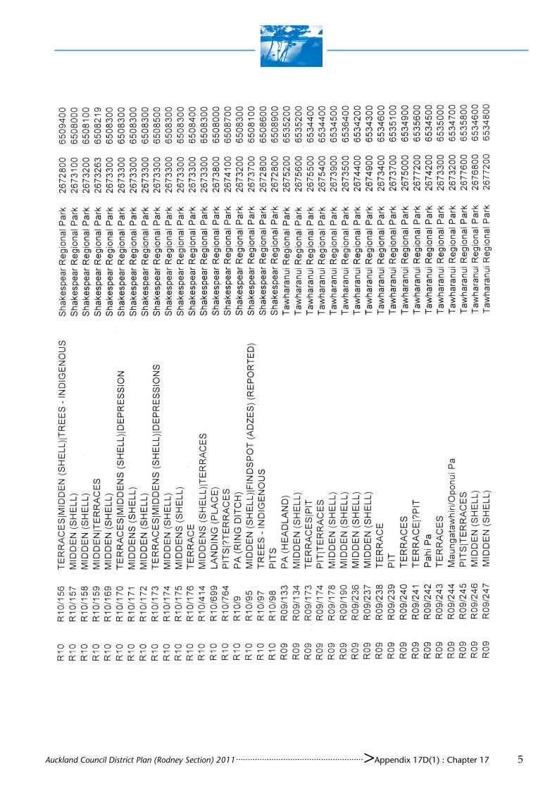
Auckland Council District Plan (Rodney Section) 2011 ...................................................... >Appendix 17D(1) : Chapter 17 5

Auckland Council District Plan (Rodney Section) 2011 ...................................................... >Appendix 17D(1) : Chapter 17 6

Auckland Council District Plan (Rodney Section) 2011 ...................................................... >Appendix 17D(1) : Chapter 17 7


Auckland Council District Plan (Rodney Section) 2011 ...................................................... >Appendix 17D(1) : Chapter 17


Auckland Council District Plan (Rodney Section) 2011 ...................................................... > Appendix 17E : Chapter 17 1
APPENDIX 17E
WAAHI TAPU LISTED FOR PROTECTION
No.
Map No.
Reference No.
Type Location Legal Description Comments
H 701
29 Q10/77 Pa 80 Davidson Road, Kiwitahi. See location map in Appendix 17V
Pt Mblk Tauwhare ML 3424
Tauwhare Pa [Amendment 134]
H 702
H 703
H 704
H 705
H 706
H 707
H 708
H 709
H 710
H 711
H 712
H 713
H 714
H 715
H 716
H 717
H 718
H 719
H 720
Auckland Council District Plan (Rodney Section) 2011 ...................................................... > Appendix 17E : Chapter 17 2
No.
Map No.
Reference No.
Type Location Legal Description Comments
H 721
H 722
H 723
H 724
H 725
H 726
H 727
H 728
H 729
H 730
H 731
H 732
H 733
H 734
H 735
H 736
H 737
H 738
H 739
H 740
H 741
H 742
H 743
H 744
H 745
H 746
H 747

Auckland Council District Plan (Rodney Section) 2011 ...................................................... > Appendix 17E : Chapter 17 3
No.
Map No.
Reference No.
Type Location Legal Description Comments
H 748
H 749
H 750
H 751
H 752
H 753
H 754
H 755
H 756
H 757
H 758
H 759
H 760
H 761
H 762
H 763
H 764
H 765
H 766
H 767
H 768
H 769
H 770
H 771
H 772

Auckland Council District Plan (Rodney Section) 2011 ...................................................... > Appendix 17E : Chapter 17 4
No.
Map No.
Reference No.
Type Location Legal Description Comments
H 773
H 774
H 775
H 776
H 777
H 778
H 779
H 780
H 781
H 782
H 783
H 784
H 785
H 786
H 787
H 788
H 789
H 790
H 791
H 792
H 793
H 794
H 795
H 796
H 797

Auckland Council District Plan (Rodney Section) 2011 ...................................................... > Appendix 17E : Chapter 17 5
No.
Map No.
Reference No.
Type Location Legal Description Comments
H 798
H 799
H 800
H 801

Auckland Council District Plan (Rodney Section) 2011 ...................................................... > Appendix 17E : Chapter 17 6

Auckland Council District Plan (Rodney Section) 2011 ...................................................... > Appendix 17F : Chapter 17 1
APPENDIX 17F
ICOMOS NEW ZEALAND CHARTER FOR THE CONSERVATION OF PLACES OF CULTURAL HERITAGE VALUE
PREAMBLE New Zealand retains a unique assemblage of places of cultural heritage value relating to its indigenous and its more recent peoples. These areas, landscapes and features, buildings, structures and gardens, archaeological and traditional sites, and sacred places and monuments are treasures of distinctive value. New Zealand shares a general responsibility with the rest of humanity to safeguard its cultural heritage for present and future generations. More specifically, New Zealand peoples have particular ways of perceiving, conserving and relating to their cultural heritage. Following the spirit of the International Charter for the Conservation and Restoration of Monuments and Sites (the Venice Charter 1966), this charter sets out principles to guide the conservation of places of cultural heritage value in New Zealand. It is intended as a frame of reference for all those who, as owners, territorial authorities, tradespeople or professionals, are involved in the different aspects of such work. It aims to provide guidelines for community leaders, organisations and individuals concerned with conservation issues. It is a statement of professional practice for members of ICOMOS New Zealand. Each section of the charter should be read in the light of all the others. Definitions of terms used are provided in section 22. Accordingly this charter has been adopted by the New Zealand National Committee of the International Council on Monuments and Sites at its meeting on 7 March 1993. 1. The Purpose of Conservation
The purpose of conservation is to care for places of cultural heritage value, their structures, materials and cultural meaning. In general, such places: (i) have lasting values and can be appreciated in their own right; (ii) teach us about the past and the culture of those who came before us; (iii) provide the context for community identity whereby people relate to the land and to those who
have gone before; (iv) provide variety and contrast in the modern world and a measure against which we can compare the
achievements of today; and (v) provide visible evidence of the continuity between past, present and future.
2. Indigenous Cultural Heritage
The indigenous heritage of Maori and Moriori relates to family, hapu and tribal groups and associations. It is inseparable from identity and wellbeing and has particular cultural meanings. The Treaty of Waitangi is the founding document of our nation and is the basis for indigenous guardianship. It recognises the indigenous people as exercising responsibility for their treasures, monuments and sacred places. This interest extends beyond current legal ownership wherever such heritage exists. Particular knowledge of heritage values is entrusted to chosen guardians. The conservation of places of indigenous cultural heritage value therefore is conditional on decisions made in the indigenous community, and should proceed only in this context. Indigenous conservation precepts are fluid and take account of the continuity of life and the needs of the present as well as the responsibilities of guardianship and association with those

Auckland Council District Plan (Rodney Section) 2011 ...................................................... > Appendix 17F : Chapter 17 2
who have gone before. In particular, protocols of access, authority and ritual are handled at a local level. General principles of ethics and social respect affirm that such protocols should be observed.
3. Conservation Practice
Appropriate conservation professionals should be involved in all aspects of conservation work. Indigenous methodologies should be applied as appropriate and may vary from place to place. Conservation results should be in keeping with their cultural content. All necessary consents and permits should be obtained. Conservation projects should include the following: (i) definition of the cultural heritage value of the place, which requires prior researching of any
documentary and oral history, a detailed examination of the place, and the recording of its physical condition;
(ii) community consultation, continuing throughout a project as appropriate; (iii) preparation of a plan which meets the conservation principles of this charter; (iv) the implementation of any planned work; and (v) the documentation of any research, recording and conservation work, as it proceeds.
GENERAL PRINCIPLES 4. Conservation Method
Conservation should: (i) make use of all relevant conservation values, knowledge, disciplines, arts and crafts; (ii) show the greatest respect for, and involve the least possible loss of, material of cultural heritage
value; (iii) involve the least degree of intervention consistent with long term care and the principles of this
charter; (iv) take into account the needs, abilities and resources of the particular communities; and (v) be fully documented and recorded.
5. Respect for Existing Evidence
The evidence of time and the contributions of all periods should be respected in conservation. The material of a particular period may be obscured or removed if assessment shows that this would not diminish the cultural heritage value of the place. In these circumstances such material should be documented before it is obscured or removed.
6. Setting
The historical setting of a place should be conserved with the place itself. If the historical setting no longer exists, construction of a setting based on physical and documentary evidence should be the aim. The extent of the appropriate setting may be affected by constraints other than heritage value.
7. Risk Mitigation
All places of cultural heritage value should be assessed as to their potential risk from any natural process or event. Where a significant risk is determined, appropriate action to minimise the risk should be undertaken. Where appropriate, a risk mitigation plan should be prepared.

Auckland Council District Plan (Rodney Section) 2011 ...................................................... > Appendix 17F : Chapter 17 3
8. Relocation
The site of an historic structure is usually an integral part of its cultural heritage value. Relocation, however, can be a legitimate part of the conservation process where assessment shows that: (i) the site is not of associated value (an exceptional circumstance); or (ii) relocation is the only means of saving the structure; or (iii) relocation provides continuity of cultural heritage value. A new site should provide a setting compatible with cultural heritage value.
9. Invasive Investigation
Invasive investigation of a place can provide knowledge that is not likely to be gained from any other source. Archaeological or structural investigation can be justified where such evidence is about to be lost, or where knowledge may be significantly extended, or where it is necessary to establish the existence of material of cultural heritage value, or where it is necessary for conservation work. The examination should be carried out according to accepted scientific standards. Such investigation should leave the maximum amount of material undisturbed for study by future generations.
10. Contents
Where the contents of a place contribute to its cultural heritage value, they should be regarded as an integral part of the place and be conserved with it.
11. Works of Art and Special Fabric
Carving, painting, weaving, stained glass and other arts associated with a place should be considered integral with a place. Where it is necessary to carry out maintenance and repair of any such material, specialist conservation advice appropriate to the material should be sought.
12. Records
Records of the research and conservation of places of cultural heritage value should be placed in an appropriate archive and made available to all affected people. Some knowledge of places of indigenous heritage value is not a matter of public record, but is entrusted to guardians within the indigenous community.
CONSERVATION PROCESSES 13. Degrees of Intervention
Conservation may involve, in increasing extent of intervention: non-intervention, maintenance, stabilisation, repair, restoration, reconstruction or adaptation. Where appropriate, conservation processes may be applied to parts or components of a structure or site. Recreation, meaning the conjectural reconstruction of a place, and replication, meaning to make a copy of an existing place, are outside the scope of this charter.
14. Non-Intervention
In some circumstances, assessments may show that any intervention is undesirable. In particular, undisturbed constancy of spiritual association may be more important than the physical aspects of some places of indigenous heritage value.

Auckland Council District Plan (Rodney Section) 2011 ...................................................... > Appendix 17F : Chapter 17 4
15. Maintenance
A place of cultural heritage value should be maintained regularly and according to a plan, except in circumstances where it is appropriate for places to remain without intervention.
16. Stabilisation
Places of cultural heritage value should be protected from processes of decay, except where decay is appropriate to their value. Although deterioration cannot be totally prevented, it should be slowed by providing stabilisation or support.
17. Repair
Repair of material or of a site should be with original or similar materials. Repair of a technically higher standard than the original workmanship or materials may be justified where the life expectancy of the site or material is increased, the new material is compatible with the old and the cultural heritage value is not diminished. New material should be identifiable.
18. Restoration
Restoration should be based on respect for existing material and on the logical interpretation of all available evidence, so that the place is consistent with its earlier form and meaning. It should only be carried out if the cultural heritage value of the place is recovered or revealed by the process. The restoration process typically involves reassembly and reinstatement and may involve the removal of accretions.
19. Reconstruction
Reconstruction is distinguished from restoration by the introduction of additional materials where loss has occurred. Reconstruction may be appropriate if it is essential to the function or understanding of a place, if sufficient physical and documentary evidence exists to minimise conjecture, and if surviving heritage values are preserved. Reconstruction should not normally constitute the majority of a place. Generalised representations of typical features or structures should be avoided.
20. Adaptation
The conservation of a place of cultural heritage value is usually facilitated by it serving a socially, culturally or economically useful purpose. In some cases, alterations and additions may be acceptable where they are essential to continued use, or where they are culturally desirable, or where the conservation of the place cannot otherwise be achieved. Any change, however, should be the minimum necessary and should not detract from the cultural heritage value of the place. Any additions and alterations should be compatible with original fabric but should be sufficiently distinct that they can be read as new work.
21. Interpretation
Interpretation of a place may be appropriate if enhancement of public understanding is required. Relevant protocol should be complied with. Any interpretation should not compromise the values, appearance, structure or materials of a place, or intrude upon the experience of the place.

Auckland Council District Plan (Rodney Section) 2011 ...................................................... > Appendix 17F : Chapter 17 5
22. Definitions
For the purposes of this charter: adaptation means modifying a place to suit it to a compatible use, involving the least possible loss of cultural heritage value conservation means the processes of caring for a place so as to safeguard its cultural heritage value cultural heritage value means possessing historical, archaeological, architectural, technological, aesthetic, scientific, spiritual, social, traditional or other special cultural significance, associated with human activity maintenance means the protective care of a place material means physical matter which is the product of human activity or has been modified by human activity place means any land, including land covered by water, and the airspace forming the spatial context to such land, including any landscape, traditional site or sacred place, and anything fixed to the land including any archaeological site, garden, building or structure, and any body of water, whether fresh or seawater, that forms part of the historical and cultural heritage of New Zealand preservation means maintaining a place with as little change as possible reassembly (anastylosis) means putting existing but dismembered parts back together reconstruction means to build again in the original form using old or new material reinstatement means putting components of earlier material back in position repair means making good decayed or damaged material restoration means returning a place as nearly as possible to a known earlier state by reassembly, reinstatement and/or the removal of extraneous additions stabilisation means the arrest of the processes of decay structure means any building, equipment, device or other facility made by people and which is fixed to the land


Auckland Council District Plan (Rodney Section) 2011 ...................................................... > Appendix 17G : Chapter 17 1
APPENDIX 17G
Number: H517 Name of item: Blake’s Mill site Easting: 1736024 Northing: 5933419 Source (error): 4m Aerial photo - white dotted line indicates site area, white solid line shows 10 m buffer zone (protected area within WHITE SOLID boundary):
Photo to assist in location:
Brick bypass tunnel opening (January 2010).

Auckland Council District Plan (Rodney Section) 2011 ...................................................... > Appendix 17G : Chapter 17 2
Edge of large depression at centre of mill site (January 2010).
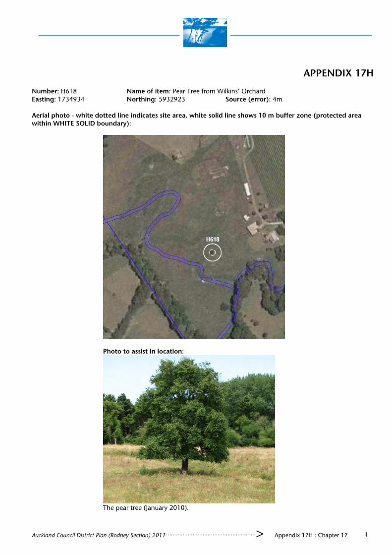
Auckland Council District Plan (Rodney Section) 2011 ...................................................... > Appendix 17H : Chapter 17 1
APPENDIX 17H Number: H618 Name of item: Pear Tree from Wilkins’ Orchard Easting: 1734934 Northing: 5932923 Source (error): 4m Aerial photo - white dotted line indicates site area, white solid line shows 10 m buffer zone (protected area within WHITE SOLID boundary):
Photo to assist in location:
The pear tree (January 2010).


Auckland Council District Plan (Rodney Section) 2011 ...................................................... > Appendix 17I : Chapter 17 1
APPENDIX 17I Number: H518 Name of item: Old Bridge at Wilkins Homestead Easting: 1735077 Northing: 5932946 Source (error): 8m Aerial photo - white dotted line indicates site area, white solid line shows 10 m buffer zone (protected area within WHITE SOLID boundary):
Photo to assist in location:
Old bridge piles in stream. Photo taken from modern bridge (January 2010).

Auckland Council District Plan (Rodney Section) 2011 ...................................................... > Appendix 17I : Chapter 17 2
Old bridge piles in stream at centre beside modern bridge (January 2010).

Auckland Council District Plan (Rodney Section) 2011 ...................................................... > Appendix 17J : Chapter 17 1
APPENDIX 17J Number: H519 Name of item: Old Brick Well at Wilkins Homestead Easting: 1735074 Northing: 5932993 Source (error): 4m Aerial photo - white dotted line indicates site area, white solid line shows 10 m buffer zone (protected area within WHITE SOLID boundary):
Photo to assist in location:
Brick well. Scale is 0.5m (January 2010).


Auckland Council District Plan (Rodney Section) 2011 ...................................................... > Appendix 17K : Chapter 17 1
APPENDIX 17K Number: H520 Name of item: Pits Easting: 1729059 Northing: 5930187 Source (error): 5m Aerial photo - white dotted line indicates site area, white solid line shows 10 m buffer zone (protected area within WHITE SOLID boundary):
Photo to assist in location:
The mound on which the pits are located is clearly visible from the surrounding hills. Photo facing south
west (January 2010).

Auckland Council District Plan (Rodney Section) 2011 ...................................................... > Appendix 17K : Chapter 17 2
The two pits on the mound. Photo facing north east, scale 0.5 m (January 2010).
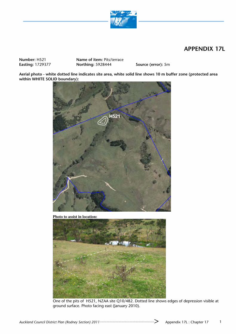
Auckland Council District Plan (Rodney Section) 2011 ...................................................... > Appendix 17L : Chapter 17 1
APPENDIX 17L Number: H521 Name of item: Pits/terrace Easting: 1729377 Northing: 5928444 Source (error): 5m Aerial photo - white dotted line indicates site area, white solid line shows 10 m buffer zone (protected area within WHITE SOLID boundary):
Photo to assist in location:
One of the pits of H521, NZAA site Q10/482. Dotted line shows edges of depression visible at
ground surface. Photo facing east (January 2010).


Auckland Council District Plan (Rodney Section) 2011 ...................................................... > Appendix 17M : Chapter 17 1
APPENDIX 17M
Number: H522 Name of item: Pits/Terraces Easting: 1729008 Northing: 5928207 Source (error): 5m Aerial photo - white dotted line indicates site area, white solid line shows 10 m buffer zone (protected area within WHITE SOLID boundary):
Photo to assist in location:
View of the pits on the top of the spur. Photo facing east (January 2010).

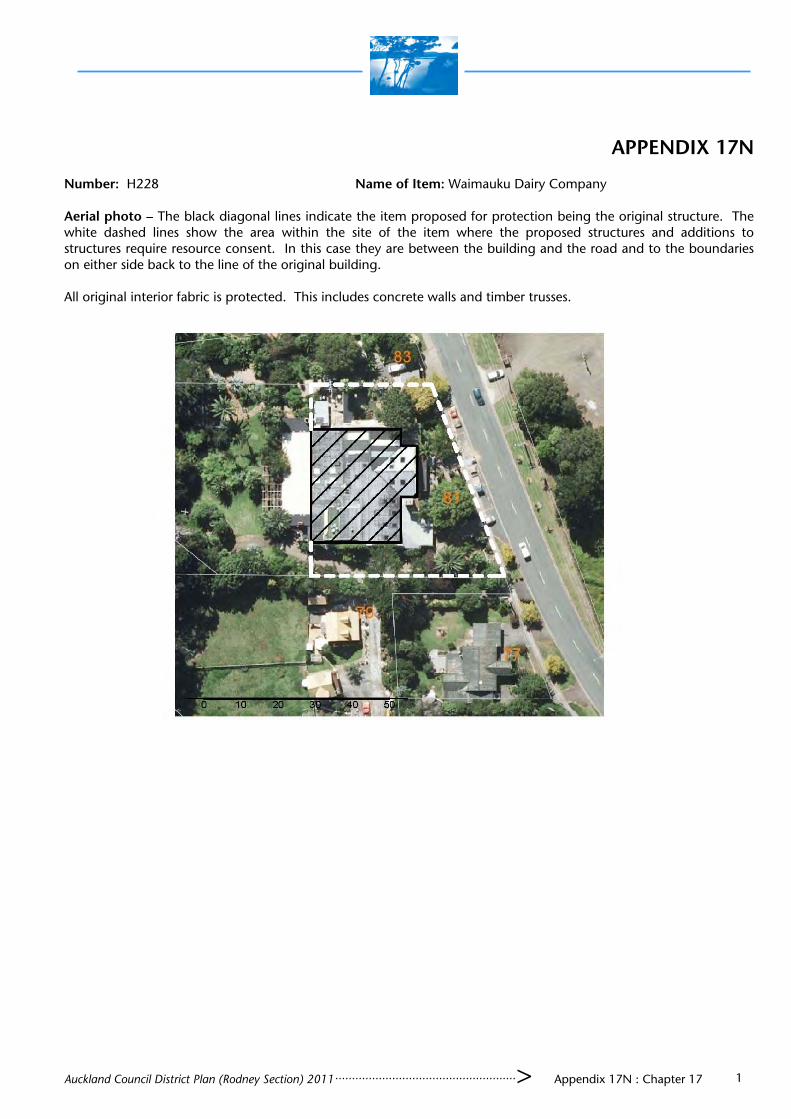
Auckland Council District Plan (Rodney Section) 2011 ...................................................... > Appendix 17N : Chapter 17 1
APPENDIX 17N Number: H228 Name of Item: Waimauku Dairy Company Aerial photo — The black diagonal lines indicate the item proposed for protection being the original structure. The white dashed lines show the area within the site of the item where the proposed structures and additions to structures require resource consent. In this case they are between the building and the road and to the boundaries on either side back to the line of the original building. All original interior fabric is protected. This includes concrete walls and timber trusses.


Auckland Council District Plan (Rodney Section) 2011 ...................................................... > Appendix 17O : Chapter 17 1
APPENDIX 17O Number: H229 Name of Item: Former Blacksmiths Aerial photo - The black diagonal lines indicate the item proposed for protection being the original structure. The white dashed lines show the area within the site of the item where the proposed structures and additions to structures require resource consent. In this case they are the surrounds between the building and the road and the boundary on the southern side and 5 metres from the rear (west) and the northern side of the building.


Auckland Council District Plan (Rodney Section) 2011 ...................................................... > Appendix 17P : Chapter 17 1
APPENDIX 17P Number: H231 Name of Item: Waimauku Memorial Hall Aerial photo - The black diagonal lines indicate the item proposed for protection being the original structure and early additions. The white dashed lines show the area within the site of the item where the proposed structures and additions to structures require resource consent. In this case they are the surrounds between the building and the road and the boundary on the northern side and the rear of the building and 5 metres from the southern side. All original interior fabric is protected. This includes timber walls, trusses and sarking.


Auckland Council District Plan (Rodney Section) 2011 ...................................................... > Appendix 17Q : Chapter 17 1
APPENDIX 17Q
Number: H232 Name of Item: Tractor/Storage Shed Aerial photo - The black diagonal lines indicate the item proposed for protection being the original structure. The white dashed lines show the area within the site of the item where the proposed structures and additions to structures require resource consent. In this case they are the surrounds between the building and the road and 10 metres on all other sides.
Photo to assist in location (DPAL- January 2010)


Auckland Council District Plan (Rodney Section) 2011 ...................................................... > Appendix 17R : Chapter 17 1
APPENDIX 17R Number: H233 Name of Item: Farm Shed /Piggery Aerial photo The black diagonal lines indicate the item proposed for protection being the original structure and early additions. The white dashed lines show the area within the site of the item where the proposed structures and additions to structures require resource consent. In this case they are the surrounds within 10 metres on all sides of the building.
Photo to assist in location: (DPAL- January 2010)


Auckland Council District Plan (Rodney Section) 2011 ...................................................... > Appendix 17S : Chapter 17 1
APPENDIX 17S Number: H234 Name of Item: Former Bakehouse Aerial photo - The black diagonal lines indicate the item proposed for protection being the original structure and early additions. The white dashed lines show the area within the site of the item where the proposed structures and additions to structures require resource consent. In this case they are the surrounds between the building and the road and 5 metres from the rear and the northern side and to the boundary on the southern side.


Auckland Council District Plan (Rodney Section) 2011 ...................................................... > Appendix 17T : Chapter 17 1
APPENDIX 17T Number: H236 Name of Item: Chimney from Old Shack Aerial photo - The black diagonal lines indicate the item proposed for protection being the original structure. The white dashed lines show the area within the site of the item where the proposed structures and additions to structures require resource consent. In this case they are the surrounds 10 metres on all sides.
Photo to assist in location: (DPAL — January 2010)


Auckland Council District Plan (Rodney Section) 2011 ...................................................... > Appendix 17U : Chapter 17 1
APPENDIX 17U Number: H237 Name of Item: Puriri Farm
Aerial photo - The black diagonal lines indicate the item proposed for protection being the original structure. The
white dashed lines show the area within the site of the item where the proposed structures and additions to structures
require resource consents. In this case they are the surrounds extending 20 metres out from the buildings on all sides.

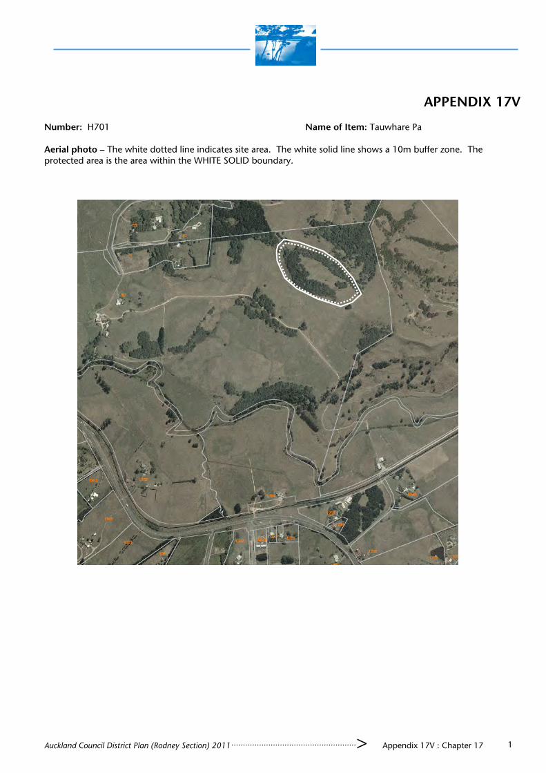
Auckland Council District Plan (Rodney Section) 2011 ...................................................... > Appendix 17V : Chapter 17 1
APPENDIX 17V Number: H701 Name of Item: Tauwhare Pa Aerial photo — The white dotted line indicates site area. The white solid line shows a 10m buffer zone. The protected area is the area within the WHITE SOLID boundary.