1 The Dalradian rocks of Scotland: an introduction - NERC ...
203
1 2 3 4 5 6 7 8 9 10 11 12 13 14 15 16 17 18 19 20 21 22 23 24 25 26 27 28 29 30 31 32 33 34 35 36 37 38 39 40 41 42 43 44 45 46 47 48 49 50 51 52 53 54 55 56 57 58 59 60 61 62 63 64 65 1 The Dalradian rocks of Scotland: an introduction D. Stephenson, J. R. Mendum, D.J. Fettes and A.G. Leslie * David Stephenson British Geological Survey, Murchison House, West Mains Road, Edinburgh EH9 3LA. [email protected] 0131 650 0323 John R. Mendum British Geological Survey, Murchison House, West Mains Road, Edinburgh EH9 3LA. Douglas J. Fettes British Geological Survey, Murchison House, West Mains Road, Edinburgh EH9 3LA. A. Graham Leslie British Geological Survey, Murchison House, West Mains Road, Edinburgh EH9 3LA. * Corresponding author Keywords: Geological Conservation Review Grampian Highlands Dalradian Supergroup History of Research Metamorphism Tectonic evolution ABSTRACT The Dalradian Supergroup and its basement rocks, together with younger plutons, underpin most of the Grampian Highlands and the islands of the Inner Hebrides between the Highland Boundary and Great Glen faults. The Dalradian is a mid-Neoproterozoic to early- Ordovician sequence of largely clastic metasedimentary rocks, with some volcanic units, which were deformed and metamorphosed to varying degrees during the Early Palaeozoic Caledonian Orogeny. Sedimentation of the lower parts of the Dalradian Supergroup, possibly commencing about 730 million years ago, took place initially in fault-bounded rift basins, within the supercontinent of Rodinia and adjacent to sectors of continental crust that were later to become the foundations of North America, Greenland and Scandinavia. Later sedimentation reflected increased instability, culminating between 600 and 570 million years ago in continental rupture, volcanicity and the development of the Iapetus Ocean. This left the crustal foundations of Scotland, together with those of North America and Greenland, on a laterally extensive passive margin to the new continent of Laurentia, where turbiditic sedimentation continued for about 85 million years. Later plate movements led to closure of the Iapetus Ocean and the multi-event Caledonian Orogeny. Most of the deformation and metamorphism of the Dalradian strata peaked at about 470 million years ago, during the mid-Ordovician Grampian Event, which has been attributed to the Revised manuscript 8/5/12 Click here to view linked References
-
Upload
khangminh22 -
Category
Documents
-
view
3 -
download
0
Transcript of 1 The Dalradian rocks of Scotland: an introduction - NERC ...
1 2 3 4 5 6 7 8 9 10 11 12 13 14 15 16 17 18 19 20 21 22 23 24 25 26 27 28 29 30 31 32 33 34 35 36 37 38 39 40 41 42 43 44 45 46 47 48 49 50 51 52 53 54 55 56 57 58 59 60 61 62 63 64 65
1 The Dalradian rocks of Scotland:
an introduction
D. Stephenson, J. R. Mendum, D.J. Fettes and
A.G. Leslie * David Stephenson British Geological Survey, Murchison House,
West Mains Road, Edinburgh EH9 3LA.
0131 650 0323
John R. Mendum British Geological Survey, Murchison House, West
Mains Road, Edinburgh EH9 3LA.
Douglas J. Fettes British Geological Survey, Murchison House, West
Mains Road, Edinburgh EH9 3LA.
A. Graham Leslie British Geological Survey, Murchison House, West
Mains Road, Edinburgh EH9 3LA.
* Corresponding author
Keywords:
Geological Conservation Review
Grampian Highlands
Dalradian Supergroup
History of Research
Metamorphism
Tectonic evolution
ABSTRACT
The Dalradian Supergroup and its basement rocks, together with
younger plutons, underpin most of the Grampian Highlands and the
islands of the Inner Hebrides between the Highland Boundary and
Great Glen faults. The Dalradian is a mid-Neoproterozoic to early-
Ordovician sequence of largely clastic metasedimentary rocks, with
some volcanic units, which were deformed and metamorphosed to
varying degrees during the Early Palaeozoic Caledonian Orogeny.
Sedimentation of the lower parts of the Dalradian Supergroup,
possibly commencing about 730 million years ago, took place
initially in fault-bounded rift basins, within the supercontinent
of Rodinia and adjacent to sectors of continental crust that were
later to become the foundations of North America, Greenland and
Scandinavia. Later sedimentation reflected increased instability,
culminating between 600 and 570 million years ago in continental
rupture, volcanicity and the development of the Iapetus Ocean.
This left the crustal foundations of Scotland, together with those
of North America and Greenland, on a laterally extensive passive
margin to the new continent of Laurentia, where turbiditic
sedimentation continued for about 85 million years. Later plate
movements led to closure of the Iapetus Ocean and the multi-event
Caledonian Orogeny. Most of the deformation and metamorphism of
the Dalradian strata peaked at about 470 million years ago, during
the mid-Ordovician Grampian Event, which has been attributed to the
Revised manuscript 8/5/12Click here to view linked References
1 2 3 4 5 6 7 8 9 10 11 12 13 14 15 16 17 18 19 20 21 22 23 24 25 26 27 28 29 30 31 32 33 34 35 36 37 38 39 40 41 42 43 44 45 46 47 48 49 50 51 52 53 54 55 56 57 58 59 60 61 62 63 64 65
collision of an oceanic arc with Laurentia. The later, mid-
Silurian Scandian Event, attributed to the collision of the
continent of Baltica with Laurentia and the final closure of the
Iapetus Ocean, apparently had little effect on the Dalradian rocks
but marked the start of late-orogenic uplift and extensive
magmatism in the Grampian Highlands that continued until Early
Devonian times.
The Dalradian rocks thus record a wide range of sedimentary
environments (alluvial, tidal, deltaic, shallow marine, turbiditic,
debris flow) and a complex structural and metamorphic history. In
areas of low strain, original sedimentary and volcanic structures
are well preserved, even at relatively high metamorphic grades.
There is convincing evidence for glacial episodes of worldwide
importance and economic deposits of stratiform barium minerals are
unique. The Grampian Highlands include two of the World's type-
areas for metamorphic zonation, Barrovian and Buchan, with
spectacular examples of the key metamorphic minerals, and various
stages of migmatite development. Polyphase folding is widespread
on all scales and gives rise to a range of associated cleavages and
lineations. Regional dislocations, both ductile and brittle, are
associated with a range of shear fabrics, breccias, clay gouges and
veining.
1 2 3 4 5 6 7 8 9 10 11 12 13 14 15 16 17 18 19 20 21 22 23 24 25 26 27 28 29 30 31 32 33 34 35 36 37 38 39 40 41 42 43 44 45 46 47 48 49 50 51 52 53 54 55 56 57 58 59 60 61 62 63 64 65
1.1 INTRODUCTION
D. Stephenson
1.1.1 The Dalradian Supergroup
The Dalradian Supergroup is a mid-Neoproterozoic to Early
Palaeozoic sequence of largely clastic sedimentary rocks, with some
notable carbonate and volcanic units that were all deformed and
metamorphosed to varying degrees during the mid-Ordovician Grampian
Event of the Caledonian Orogeny. The Dalradian rocks, together
with Caledonian intrusive igneous rocks, form the bedrock to most
of the Grampian Highlands of Scotland and the islands of the Inner
Hebrides between the Highland Boundary and Great Glen faults. Pre-
Dalradian basement crops out in parts of the Northern Grampian
Highlands and on the Isle of Islay (Figure 1.1). The Dalradian
sequence, its basement and the Caledonian intrusions comprise the
Grampian Terrane, one of several major crustal blocks that were
juxtaposed during the Caledonian Orogeny to form the northern part
of the British Isles (Figure 1.2). Dalradian rocks also occur in
the Shetland Islands, east of the Walls Boundary Fault,
conventionally as part of the Grampian Terrane but possibly part of
a separate terrane. Siluro–Devonian and Mesozoic cover rocks crop
out mainly around the margins of the Grampian Highlands.
The Grampian Terrane extends south-westwards into the northern and
north-western parts of Ireland, where Dalradian rocks crop out over
wide areas (Figure 1.2). There, the south-eastern terrane boundary
is largely buried beneath younger rocks and is difficult to define.
An extension or major splay of the Highland Boundary Fault probably
does extend from Cushendun in the east to Clew Bay in the west but,
unlike in Scotland, it is not defined by any strong geophysical
feature. A Dalradian sequence with remarkable similarities to that
of the Grampian Highlands also crops out in Connemara, well to the
south of Clew Bay, and hence it seems likely that the boundary of
the Grampian Terrane does not coincide with an extension of the
Highland Boundary Fault in the west of Ireland and possibly extends
south-eastwards as far as a line between south Antrim and Galway
(Ryan et al., 1995).
On a broader scale, the terranes of the northern British Isles are
inherently linked geologically to eastern North America and
Greenland, which were in close proximity prior to the opening of
the North Atlantic Ocean in Palaeogene times (c. 55 Ma ago) (Figure
1.3). The Dalradian Supergroup is similar in age to the Fleur de
Lys Supergroup in Newfoundland (Kennedy, 1975) and its lower parts
are equivalent to the Eleonore Bay Supergroup in East Greenland
(Soper, 1994b; Leslie et al., 2008); the three sequences might have
been deposited in adjacent basins. The Geological Conservation
Review, and hence this volume, considers only the Dalradian rocks
of Scotland and Shetland; for reviews of the Irish Dalradian see
Alsop and Hutton (1990), Leake and Tanner (1994), Harris et al.
(1994), Cooper and Johnston (in Mitchell, 2004) and chapters by
J.S. Daly and D.M. Chew in Holland and Sanders (2009).
1 2 3 4 5 6 7 8 9 10 11 12 13 14 15 16 17 18 19 20 21 22 23 24 25 26 27 28 29 30 31 32 33 34 35 36 37 38 39 40 41 42 43 44 45 46 47 48 49 50 51 52 53 54 55 56 57 58 59 60 61 62 63 64 65
The current best estimate for the age of deposition of the oldest
Dalradian rocks, adopted in this volume, is about 730 Ma. The
youngest strata that can be assigned to the Dalradian has been a
matter of recent debate, but it is now generally accepted that
there is stratigraphical and structural continuity through from
undisputed Dalradian strata into fossiliferous strata of Early
Cambrian age (c. 515 Ma) and possibly continuing up into mid-Arenig
age strata (Tanner and Pringle, 1999; Tanner and Sutherland, 2007).
Those Early Palaeozoic strata were formerly thought to have been
juxtaposed tectonically against the Dalradian sequence and
consequently they have been described separately in the British
Cambrian to Ordovician Stratigraphy GCR volume (Rushton et al.,
1999). They were assigned originally to the Highland Border
Complex, which also includes elements of an ophiolite obducted
during the Caledonian Orogeny, but Tanner and Sutherland (2007)
have suggested that they should be designated as a separate
‗Trossachs Group‘ and included in the Dalradian Supergroup (see
Introduction to Chapter 4).
The name ‗Dalradian‘ is derived from that of the ancient Scots‘
kingdom of Dalriada, which united the coastal areas of Argyll,
Arran and Antrim between the 5th and 9th centuries AD. It was
first applied to all of the metamorphic rocks that crop out between
the Moine Thrust and Highland Boundary Fault by Sir Archibald
Geikie in 1891. However, in his explanatory notes to the 1892
edition of Bartholomew‘s 10-miles-to-one-inch Geological Map of
Scotland, he did make it clear that the ‗Moine Schists‘ of the
Northern Highlands are different in character to the ‗Dalradian‘
rocks south-east of the Great Glen. As survey work progressed,
quartzofeldspathic rocks of apparent ‗Moine Schist‘ facies were
also identified in the northern part of the Grampian Highlands and
the term ‗Dalradian‘ sensu stricto became restricted to the
lithologically more-diverse strata now assigned to the Appin,
Argyll and Southern Highland groups of the Dalradian Supergroup.
The so-called ‗Moine‘ rocks of the Grampian Highlands have been
the subject of much debate and revision of assignment and
terminology over the past 100 years. Originally they were referred
to variously, from north-east to south-west, as ‗Granulitic Schists
of the Central Highlands‘ (Hinxman and Anderson, 1915), ‗Struan
Flags‘ (Barrow, 1904) and ‗Eilde Flags‘ (Bailey, 1910).
Subsequently, J.G.C. Anderson (1948) reviewed the local successions
and proposed that all rocks stratigraphically below a lowermost
limestone should be included in a ‗Moinian Metamorphic Assemblage‘,
and Johnstone (1975) introduced the term ‗Younger Moines‘ to
distinguish them from the Moine rocks north-west of the Great Glen
Fault. Detailed mapping in the later part of the 20th century
resulted in a subdivision into an older, largely migmatitic
‗basement‘ referred to as the ‗Central Highland Division‘ and an
overlying sequence dominated by non-migmatitic quartzofeldspathic
rocks termed the ‗Grampian Division‘ (Piasecki and Van Breemen,
1979a,b; Piasecki, 1980). The non-migmatitic ‗cover‘ rocks are now
assigned formally to the Grampian Group, the lowest group in the
Dalradian Supergroup, on the basis of stratigraphical and
structural continuity with the overlying sequences (Harris et al.,
1978). The ‗basement‘ rocks, referred to for a while as the
1 2 3 4 5 6 7 8 9 10 11 12 13 14 15 16 17 18 19 20 21 22 23 24 25 26 27 28 29 30 31 32 33 34 35 36 37 38 39 40 41 42 43 44 45 46 47 48 49 50 51 52 53 54 55 56 57 58 59 60 61 62 63 64 65
‗Central Highland Migmatite Complex‘ (Harris et al., 1994;
Stephenson and Gould, 1995), and referred to in more-recent
literature as the Dava and Glen Banchor successions, have been
formalised as the Badenoch Group. They might yet prove to be
equivalent to the Moine Supergroup of the Northern Highlands, at
least in terms of their age (see Introduction to Chapter 5).
Two other units within the Grampian Terrane, whose stratigraphical
affinities are uncertain but are most probably Dalradian, are
represented by GCR sites in this volume. These are the Bowmore
Sandstone Group of Islay and the Colonsay Group of Islay, Oronsay
and Colonsay.
Much of the terminology used in this volume is necessarily
complex. It is evolving continuously, hopefully towards simpler,
more-logical versions that are likely to gain widespread
acceptance. Hence it will differ in parts from what has been used
historically and even from current usage by some authors. In
addition to a glossary of terms used, the ‗Glossary and
terminology‘ section at the end of the volume includes brief
details and explanations of radiometric dating methods and
timescale adopted, lithological nomenclature (rock names), the
method of numbering of structures associated with phases of
deformation, the terminology of fold geometry, and the use of the
stereographic projection. In each case emphasis is placed upon
terms as used in this volume.
1.1.2 History of Research
In 1774, the prominent ‘Dalradian’ mountain of Schiehallion was the
location for a ground-breaking experiment by the Astronomer Royal,
Nevil Maskelyne, who set out to measure the gravitational
attraction towards the quartzite mountain of a weight suspended on
a plumb-line (Smallwood, 2007). The density of the Earth was
estimated to be 4.5, possibly the earliest ever geophysical
calculation. However, the earliest published description of
Dalradian rocks was probably in James Hutton’s Theory of the Earth
(1788), in which the country rocks intruded by granite veins at the
critical historical site in Glen Tilt were referred to as ‘Alpine
schistus’ (see the Forest Lodge GCR site report; in the Caledonian
Igneous Rocks of Great Britain GCR volume; Stephenson et al.,
1999).
The first geological map of Scotland (one of the first geological
maps in the world), by Louis Albert Necker de Saussure in 1808, did
not differentiate the Dalradian rocks from the Moine of the
Northern Highlands or the Lewisian of the Hebridean Terrane, all of
which were described as ‗primitive rocks stratified as gneiss, mica
slate and clay slate‘. Subsequently, John MacCulloch‘s 1836 map of
Scotland showed several distinct metamorphic lithologies within the
three, still undivided, terranes. MacCulloch had surveyed almost
the whole of Scotland and Shetland himself (Bowden, 2007) and was
one of the first to describe and comment upon the origin of the
Highland rocks (e.g. MacCulloch, 1814, 1819). In his geological
essay on Scotland, Ami Boué (1820) attempted to correlate the
metamorphic rocks of Shetland with those of Scotland and was the
first to suggest that those of the eastern Mainland of Shetland are

1 2 3 4 5 6 7 8 9 10 11 12 13 14 15 16 17 18 19 20 21 22 23 24 25 26 27 28 29 30 31 32 33 34 35 36 37 38 39 40 41 42 43 44 45 46 47 48 49 50 51 52 53 54 55 56 57 58 59 60 61 62 63 64 65
equivalent to those of the Grampian Highlands. A truly remarkable
geological map from this early period is that of Shetland by Samuel
Hibbert (1822), which even shows foliations and lineations in the
Dalradian rocks. This was the world‘s first purely structural
geological map and was published in conjunction with an account of
tectonite rock fabric (another world first).
By the middle of the 19th century, the metamorphosed nature of the
rocks was beginning to be understood but the degree of metamorphism
was thought by many to be proportional to the age of the rocks, and
many geologists still adhered to the Wernerian doctrine, in which
crystalline rocks were thought to have been precipitated in a
regular sequence from a primeval ocean (Oldroyd and Hamilton,
2002). For many years these misconceptions greatly hindered
attempts to fit the main sequences of the Highlands into an overall
timescale. Murchison (1851, 1859) tried to show that the rocks of
the Grampian Highlands are more highly metamorphosed equivalents of
those in the Southern Uplands and Geikie (1865), although
recognizing them as older than those of the Southern Uplands, still
assigned them to a ‗Lower Silurian‘ unit. The influence of
Murchison and Geikie ensured that their ideas persisted into the
next century, although as late as the 1890s George Barrow was
arguing that all of the Highland ‗schists‘ were of the same age as
the Lewisian gneisses, and merely displayed different degrees of
metamorphism.
Eventually, people such as James Nicol (1844, 1852, 1863),
professor at Cork and then Aberdeen University, and Robert Harkness
(1861) of Cork, whilst recognizing the existence and significance
of large-scale folding, started to identify local successions and
trace them along strike to establish a regional lithostratigraphy.
Then Archibald Geikie, who had been introduced to the Grampian
Highlands by Murchison in 1860, began to rationalize the overall
Scottish succession and to postulate large-scale overfolds as a
means of repeating the stratigraphy (Murchison and Geikie, 1861;
Geikie, 1865). Of particular note in this context is the slightly
later work of Peter Macnair (1896, 1906, 1908), Curator of Natural
History at the Glasgow Museums, who recognized the value of the
Loch Tay Limestone as a datum line in reconstructing the broad-
scale structural framework of the south-east Grampian Highlands.
Remarkably, the correlation of ‗boulder beds‘ on the Garvellach
Isles, on Islay and at Schiehallion had been recognized early in
the 19th century by MacCulloch (1819), and those on Islay were
first interpreted as having a glacial origin as early as 1877 by J.
Thomson. By the end of the 19th century, knowledge of large-scale
nappe structures in the Alps was being applied to Scotland by the
Geological Survey, initially in the North-west Highlands and
subsequently to the Grampian Highlands. Systematic field surveys
were underway and petrographical techniques and methods of chemical
analysis were developing fast.
Although the Geological Survey had started work in Scotland in
1854, mapping to the north of the Highland Boundary Fault did not
start until 1875. For the first few years this was concentrated on
the sedimentary rocks around the fringes of the Grampian Highlands,
but by the early 1880s, with Archibald Geikie as Director General,
J. Horne, J.S. Grant Wilson, L.W. Hinxman and J. Linn were mapping
1 2 3 4 5 6 7 8 9 10 11 12 13 14 15 16 17 18 19 20 21 22 23 24 25 26 27 28 29 30 31 32 33 34 35 36 37 38 39 40 41 42 43 44 45 46 47 48 49 50 51 52 53 54 55 56 57 58 59 60 61 62 63 64 65
large areas of the North-east Grampian Highlands and W. Gunn, C.T.
Clough, J.B. Hill and H.M. Cadell were active on the Cowal
peninsula. The work in Cowal led to the recognition of polyphase
deformation, and the first use of minor structures to interpret the
overall pattern of major folds (Clough, in Gunn et al., 1897). In
1895, work started in the Glen Coe–Appin area, with a highly
experienced team that included B.N. Peach and C.T. Clough, after
completion of their ground-breaking survey of the North-west
Highlands, and J.S. Grant Wilson. They were joined, among others,
by H.B. Maufe and E.B. Bailey who were soon to make their mark with
their exposition of cauldron subsidence in the volcanic rocks of
the area, as well as unravelling the complex structure and
proposing a succession for the Dalradian strata. Thereafter, until
well into the 20th century, survey work was concentrated in the
South-west Highlands, where large areas were surveyed by J.B. Hill,
H. Kynaston, R.G. Symes, S.B. Wilkinson and others. The notable
exception at that time was the work of G. Barrow and E.H.
Cunningham Craig in north-east Perthshire and Angus, which led to
Barrow‘s (1893) seminal work on metamorphic zones. Although Barrow
initially attributed the zonation to contact metamorphism above
concealed igneous masses, ironically the ‗Barrovian zones‘ became
the world standard for the progressive regional metamorphism of
aluminous sedimentary rocks at medium pressure. As this concept
was extended throughout the Highlands it played a major part in
deciphering the geological history of the whole region.
There then followed a period dominated by the work of Edward
Battersby Bailey, who was undoubtedly the most dynamic, prolific
and controversial figure ever to set foot upon Dalradian rocks.
Bailey was decorated for bravery in the First World War and legends
abound concerning his resilience and eccentricity in the field
(Figure 1.4). After distinguishing himself with the Geological
Survey, and then becoming disillusioned by official restrictions
upon his personal scientific investigations, he left in 1930 to
take a chair at the University of Glasgow. However, he
subsequently returned to the survey as Director in 1937, was
knighted in 1945 and continued to publish on Highland geology well
into retirement.
Bailey started work in the Highlands in 1902, and in a series of
papers between 1910 and 1940 he elucidated the structure and
stratigraphy of Dalradian rocks over a wide swathe of ground from
Islay to Loch Awe, Loch Leven, Glen Roy, Glen Orchy, Glen Lyon,
Schiehallion, Loch Tummel, Blair Atholl, Glen Shee, Glen Clunie and
Braemar. Most of this was based upon his own mapping, much of it
in his own time, but he also re-interpreted ground that had already
been covered by others, most notably Barrow, with whom he had
fundamental disagreements. This was all in addition to his ground-
breaking work on the igneous rocks of Glen Coe and Mull. He could
never be described as a precise detailed mapper, and was certainly
not out of the same mould as the likes of Clough, Peach and Horne,
but he moved over the ground at incredible speed and was a master
at tracing out large-scale structures. In fact most of the major
folds recognized today in the above areas are the ones that were
first identified by Bailey.
1 2 3 4 5 6 7 8 9 10 11 12 13 14 15 16 17 18 19 20 21 22 23 24 25 26 27 28 29 30 31 32 33 34 35 36 37 38 39 40 41 42 43 44 45 46 47 48 49 50 51 52 53 54 55 56 57 58 59 60 61 62 63 64 65
It was Bailey who first made use of the ungainly verb ‗to young‘
and coined the terms ‗antiform‘ and ‗synform‘. He also introduced
the concept of ‗slides‘ (or ‗fold-faults‘) – very low-angle faults
associated with recumbent folds, which would be described
generically as 'ductile dislocations' in modern parlance. These he
divided into extensional ‗lags‘, along which fold limbs and
significant parts of the succession can be excised, and
compressional ‗thrusts‘, which generally result in the repetition
of parts of the succession. In 1922 he produced a comprehensive
synthesis in which major slides were perceived as fundamental
tectonic dislocations separating huge, Alpine-scale nappe
complexes, each complex having its own stratigraphical succession
and structural style. Initially three such nappe complexes were
recognized and named, in ascending structural order, the Ballappel
Foundation (from the type areas of Ballachulish, Appin and Loch
Eilde), the Iltay Nappe (comprising most of the ground between
Islay and Loch Tay), and the Loch Awe Nappe, but these were
subsequently reduced to two when Bailey (in Allison, 1941) accepted
the stratigraphical correlations of other investigators which
removed the need to invoke a separate Loch Awe Nappe. We now know
that both the structure and the stratigraphy of the Grampian
Highlands are more integrated and continuous than inferred by
Bailey, and hence many of the slides have lost much of their
original significance as major tectonic and stratigraphical
boundaries.
At the beginning of the 20th century, the use of sedimentary
structures as way-up criteria was virtually unknown and Bailey,
along with everyone else, struggled to establish the correct order
of succession. Possibly the first use of graded bedding in the
Scottish Highlands to determine the younging direction was by Peach
et al. (1911) at a location within the Kilmory Bay GCR site, and
current-bedding was first used by J.F.N. Green on Islay (Green,
1924). But the key event happened in 1924, when two graduate
students from the University of Wisconsin, Sherwood Buckstaff and
Olaf Rove, accompanied Thorolf Vogt of the University of Trondheim
on a visit to Ballachulish and deduced that the succession
established by Bailey (1910, 1922) was in fact upside down. This
radical new interpretation was communicated to Bailey who was then
invited to attend a Princeton University summer school in Canada in
1927, where he became convinced of the need to apply sedimentary
structures to interpret folded rocks. As a result of this, in
1929, he acted as guide for a visit by a Princeton group to
Scotland, where all agreed that his original (1922) order of
succession needed to be reversed. Vogt and Bailey published their
findings as linked articles in the Geological Magazine (Vogt, 1930;
Bailey, 1930), and Bailey went on to re-appraise key sections
around Loch Leven and throughout the whole area, confirming the
presence of recumbent folds of many kilometres amplitude with
extensive inverted limbs. The legacy of this fundamental ‗about
face‘ lives on to this day in the archives of the British
Geological Survey (BGS), where the original 6-inch to 1 mile maps
of the Loch Leven area, prepared prior to 1924, still show Bailey‘s
original succession.

1 2 3 4 5 6 7 8 9 10 11 12 13 14 15 16 17 18 19 20 21 22 23 24 25 26 27 28 29 30 31 32 33 34 35 36 37 38 39 40 41 42 43 44 45 46 47 48 49 50 51 52 53 54 55 56 57 58 59 60 61 62 63 64 65
Survey mapping was severely curtailed by the First World War
(1914–18) although a detailed revision of part of the North-east
Grampian Highlands was carried out by H.H. Read, after he had been
discharged from active service on medical grounds. That work
formed the basis of a lifetime of investigation into the structure,
metamorphism and magmatism of the North-east Grampians, in a career
that ranged widely through the Scottish and Irish Caledonides and
took him from the Geological Survey to the University of Liverpool
and the Royal School of Mines (later Imperial College), London. He
was the first to recognise that the Buchan metamorphism originated
at lower pressures and higher temperatures than the Barrovian
sequence, became even more-widely known for his survey work in the
Northern Highlands, and was also part of a large team that carried
out the primary survey of the Shetland Islands in the early 1930s.
Previous publications on Shetland geology had concentrated mainly
upon mineral occurrences (e.g. Heddle, 1878, 1901) and the only
published maps were based upon that of Hibbert in 1822. The
Dalradian rocks were surveyed by D. Haldane, J. Knox, J. Phemister,
H.H. Read, T. Robertson and G.V. Wilson but the only ensuing
publications were those of Read, which concentrated upon the
metamorphism (Read, 1933, 1934, 1936, 1937) and the Caledonian
ophiolite-complex of Unst and Fetlar (see the Caledonian Igneous
rocks of Great Britain GCR volume; Stephenson et al., 1999).
Geological Survey work in Scotland between the wars and during the
Second World War (1939–45) was concentrated in the coalfields, the
Northern Highlands and the Inner Hebrides. Some sheet memoirs
based upon pre-1914 mapping of the Grampian Highlands were
published and the first edition of British Regional Geology: the
Grampian Highlands appeared in 1935. The latter was written by
H.H. Read who, by the time of its publication, had taken the chair
at Liverpool University, where his influence no doubt laid the
first foundations of the Dalradian research that was to flourish
there in the second half of the 20th century (see below). Other
than those by E.B. Bailey, there were few ‗Dalradian‘ papers by
survey geologists. E.M. Anderson did small amounts of official
survey mapping in the Grampian Highlands and, inspired by Bailey,
he produced a paper based on his own work in the Schiehallion area
that significantly advanced understanding of the overall Dalradian
succession (Anderson, 1923). He retired due to ill health in 1928,
but continued ‗indoor work‘ for many years and is best remembered
for ‗The Dynamics of Faulting and Dyke Formation‘, drawing upon his
experience in the Grampians and elsewhere. It was first published
in 1942, revised in 1951, remained a classic textbook for many
years and was last reprinted in 1972.
The most prolific university contributions to the Dalradian
between the wars were undoubtedly by Glasgow, where Bailey clearly
inspired both existing staff and students. His predecessor, J.W.
Gregory, had published several accounts (Gregory, 1910, 1916, 1928,
1929, 1930) and the first overview of Dalradian Geology (Gregory,
1931), all of which presented an ‗alternative‘ rationalization of
the succession across the whole region. W.J. McCallien (1925,
1926, 1929) had already published on the Dalradian rocks of Kintyre
and went on to collaborate with Bailey in Perthshire (Bailey and
McCallien, 1937). A. Allison worked on the Tayvallich–Loch Awe

1 2 3 4 5 6 7 8 9 10 11 12 13 14 15 16 17 18 19 20 21 22 23 24 25 26 27 28 29 30 31 32 33 34 35 36 37 38 39 40 41 42 43 44 45 46 47 48 49 50 51 52 53 54 55 56 57 58 59 60 61 62 63 64 65
area and it was in the discussion to his paper, in 1941, that
Bailey had his final say on the gross structure of the South-west
Grampian Highlands, after becoming Director of the Geological
Survey. Among Bailey‘s students, S.M.K. Henderson (1938) was the
first to identify the Aberfoyle Anticline, but it was J.G.C.
Anderson who made a major contribution to the Dalradian of the
Highland Border region, in addition to his PhD studies on igneous
rocks of the western Grampian Highlands. He joined the Geological
Survey in Scotland in 1937, just before its activities became
focussed upon war-related resource evaluation, and hence he did
little ‗official‘ mapping in the Highlands. However, in his own
time he covered large areas in the manner of his mentor, resulting
in a series of papers between 1935 and 1956, the last being
published after he was appointed to the chair in Cardiff in 1949.
Work on the Dalradian at this time at Cambridge University centred
around C.E. Tilley and Gertrude Elles. This included the
recognition of the Portsoy Thrust in the North-east Grampian
Highlands (Elles, 1931) and the refining of Barrow‘s zones of
regional metamorphism (Tilley, 1925). Studies of the metamorphism
of basic igneous rocks in the Dalradian were also made in Cambridge
(Phillips, 1930; Wiseman, 1934), complementing what was already
known about the progressive metamorphism of pelitic rocks. Also of
the Cambridge ‗school‘ was J.F.N. Green, who was a student
contemporary of Gertie Elles before embarking upon a non-geological
career in the Colonial Office, pursuing his geological interests in
his spare time and becoming president of both the Geologists‘
Association and the Geological Society. After acclaimed work in
Pembrokeshire and the Lake District, he made a major contribution
to the geology of Islay, though a later paper on broader aspects of
the Dalradian of the South-west Grampian Highlands was criticised
by both Bailey and Elles (Green, 1924, 1931). His interest in the
Dalradian probably resulted from an association with Barrow, after
the latter‘s move to the Geological Survey in England. Less well
known is the PhD study of S.O. Agrell (1942) under the supervision
of Frank Coles Phillips, an unpublished part of which involved the
first petrofabric analysis of the Ben Vuirich Granite and its
country rocks. They could not have known how important these
fabrics would become in subsequent discussions on the timing of
pre-Caledonian and Caledonian magmatic and tectonic events, but the
conclusions reached accord remarkably well with current
interpretations (Howarth and Leake, 2002).
By 1950, Bailey had retired from the Geological Survey but was
still a considerable influence on many aspects of Highland geology.
Read had moved to the chair at Imperial College, London, where he
continued to publish on the North-east Grampian Highlands. He led
many investigations into the Caledonian basic intrusions of the
region and introduced the concept of the Banff Nappe as a largely
allochthonous succession (Read, 1955). The latter view was however
disputed by his colleagues John Sutton and Janet Watson, who made a
brief diversion from their work on the Lewisian of the North-west
Highlands to publish three papers on the crucial across-strike
Dalradian section of the Banffshire coast (Sutton and Watson, 1954,
1955, 1956). Read became the authority of his day on the origin of
granites, deployed many post-graduate students and researchers to

1 2 3 4 5 6 7 8 9 10 11 12 13 14 15 16 17 18 19 20 21 22 23 24 25 26 27 28 29 30 31 32 33 34 35 36 37 38 39 40 41 42 43 44 45 46 47 48 49 50 51 52 53 54 55 56 57 58 59 60 61 62 63 64 65
all parts of the Scottish Highlands, and developed what was to
become a major involvement in Dalradian and Caledonian igneous
rocks of the west of Ireland. But undoubtedly one of his most
momentous moves was to support Derek Flinn‘s studies of the
Dalradian (and other rocks) of Shetland, which were initiated as a
PhD under Read (Flinn, 1953) and continued for over 50 years (e.g.
Flinn, 2007). Subsequently at Imperial College, John Knill
combined structural geology in the Craignish–Kilmelfort area with
some of the earliest sedimentological studies of deformed and
metamorphosed rocks (Knill, 1959, 1960, 1963) and Brian Amos (1960)
and Brian Hackman (Stewart and Hackman, 1973) applied sedimentology
to the Bowmore Sandstone and Colonsay groups of Islay respectively.
In 1948, the chair in Liverpool passed to Robert Shackleton, who
had developed an interest in the Dalradian of Connemara and Donegal
whilst at Imperial College. In Liverpool, he also turned his
attention to the Grampian Highlands, in particular the Highland
Border region, where he worked with research students (Stone, 1957;
Stringer, 1957). This led to the conclusion that the Aberfoyle
Anticline, and hence the closure of the Tay Nappe, is downward
facing in the Highland Border region, and stimulated a debate on
the geometry and mechanism of emplacement of the nappe that
continues to the present day. The resulting seminal publication is
frequently cited as the first explanation of the concept of
structural facing in polyphase terrains to facilitate understanding
of the structural evolution of an area (Shackleton, 1958).
Shackleton‘s tenure also saw the move to Liverpool of Derek Flinn,
the PhD study of the Colonsay Group on Colonsay and Oronsay by A.D.
(Sandy) Stewart (1960) and the start of John Roberts‘
investigations in the South-west Grampian Highlands (Roberts,
1963).
Meanwhile, in Glasgow, research on the Dalradian was continuing
under the direction of Basil King, and later Don Bowes, notable
students being Nick Rast around Schiehallion (PhD, 1956), Donald
Ramsay in Glen Lyon (PhD, 1959), Ken Jones in the Ben More–Stob
Binnein area (PhD Swansea, 1959) and Harry Convery in the Ben Ledi–
Balqhidder area. Rast became a key foundation in a ‗dynasty‘ that
dominated university Dalradian research for the next forty years.
He first took up a post in Aberystwyth, where he extended his own
work eastwards across the Loch Tay Fault by supervising the
research of Brian Sturt, south of Loch Tummel (1959), and Tony
Harris, between Loch Tummel and Blair Atholl (1960). When
Shackleton moved to Leeds in 1962, Rast took over most of the
Dalradian research in Liverpool, supervising Jack Treagus south of
Loch Rannoch (1964a) and Peter Thomas to the north in what was
later to become known as the Geal-charn–Ossian Steep Belt (1965).
Those studies were two of the earliest to concentrate on rocks
below and around the Boundary Slide. He also supervised Martin
Litherland around Glen Creran (1970), A.N. Basahel on Islay (1971),
Duncan France around the Boundary Slide at Bridge of Orchy (1971)
and Graham Borradaile in the northern Loch Awe Syncline (1972a).
It was during this era that Rast and Litherland (1970) made the
first attempt to correlate the Dalradian successions of the South-
west Grampians and Lochaber with those of the Central Grampians,
which ultimately fed into the first correlations across the whole

1 2 3 4 5 6 7 8 9 10 11 12 13 14 15 16 17 18 19 20 21 22 23 24 25 26 27 28 29 30 31 32 33 34 35 36 37 38 39 40 41 42 43 44 45 46 47 48 49 50 51 52 53 54 55 56 57 58 59 60 61 62 63 64 65
Grampian Terrane by Harris and Pitcher (1975). Wallace Pitcher,
Shackleton‘s successor at Liverpool, whilst mostly pursuing his
Caledonian interests in Donegal, was promoting an appraisal of
Dalradian tillites that culminated in the comprehensive Geological
Society memoir by Tony Spencer (1971). Numerous metamorphic
aspects of the Dalradian of Scotland were also investigated by Mike
Atherton, Mike Brotherton and John Mather (PhD, 1968), leading to a
major review article (Atherton, 1977), and the metamorphic history
of north-east Shetland was studied by Roger Key (PhD, 1972).
Rast left Liverpool in 1971 and was replaced by Tony Harris, who
by then had worked on Dalradian rocks for the Geological Survey in
the Elgin area and in the Highland Border, around Dunkeld. Harris
took up several lines of Dalradian research, involving many
research students, notably Peter Gower on the Loch Tay Limestone
(1973), Harry Bradbury (1978) and Richard Smith (1980) on the
Pitlochry–Blair Atholl district, Lindsay Parson around Fort
Augustus (1982), Andrew Highton (1983) and Nick Lindsay (1988) on
the problems surrounding the structural history and stratigraphical
correlation of the Grampian Group and its migmatitic ‗basement‘,
and Phillip Rose on the emplacement and evolution of the Tay Nappe
(1989). Harris, Bradbury and Smith were all involved in a contract
with the Geological Survey to map Sheet 55E (Pitlochry, 1981). At
the same time, Jack Treagus was developing his own research in
Manchester, mainly in the Central Grampian Highlands and including
collaborative work with John Roberts in Newcastle on the Loch Leven
area and on the Banffshire coast. He directed research students in
the Braemar area (Paul Upton, 1983), Glen Lyon (Phillip Nell, 1984)
and the South-west Grampians (Charlie Bendall, 1995), and
collaborated with Peter Thomas, by this time at the University of
Strathclyde, on a new edition of Sheet 55W (Schiehallion, 2000),
with accompanying memoir, for the Geological Survey.
In Cambridge, Tilley‘s influence upon metamorphic studies
continued into the 1950s, introducing Henry Pantin to the basic
meta-igneous rocks of Ben Vrackie (1952) and encouraging Graham
Chinner to re-examine the pelitic gneisses of Glen Clova (1957).
Chinner then went on to direct numerous studies, in particular on
high-grade migmatitic rocks (e.g. John Ashworth, 1972; Eileen
McLellan, 1983). He was also responsible for introducing Ben Harte
to the south-east Grampians (1966), and Keith Watkins to the
Balquhidder–Crianlarich area (1982). Ashworth and Harte both went
on to expand their studies elsewhere.
Studies of contemporaneous igneous rocks were also taking place at
Bristol University under Bernard Leake, whose main interest lay in
Connemara but who supervised Peter van de Kamp on the Green Beds
(1968) and collaborated with J.R. Wilson on the ‗epidiorites‘ of
Tayvallich (Wilson and Leake, 1972). After moving to take up the
chair in Glasgow, Leake wrote a review of volcanism in the
Dalradian (Leake, 1982). Meanwhile, in Edinburgh (see below),
Colin Graham had started a major study of volcanic and subvolcanic
basic meta-igneous rocks in the South-west Grampians (Graham, 1976)
and had also contributed to a review (Graham and Bradbury, 1981).
Several more-recent studies of Dalradian volcanic and
volcaniclastic rocks and of magmatism in general have been linked
in some way to BGS mapping projects (Goodman and Winchester, 1993;

1 2 3 4 5 6 7 8 9 10 11 12 13 14 15 16 17 18 19 20 21 22 23 24 25 26 27 28 29 30 31 32 33 34 35 36 37 38 39 40 41 42 43 44 45 46 47 48 49 50 51 52 53 54 55 56 57 58 59 60 61 62 63 64 65
Macdonald et al., 2005; Pickett et al., 2006; Macdonald and Fettes,
2007; Fettes et al., 2011) and David Chew of Trinity College,
Dublin has incorporated the geochemistry of metavolcanic rocks into
wider studies of Dalradian tectonics (e.g. Chew et al., 2009)..
In Edinburgh, Mike Johnson re-examined the structure and
metamorphism of the Banffshire Dalradian sections, with the help of
PhD studies by Vic Loudon (1963) and Doug Fettes (1968). He also
wrote reviews of the Dalradian for the first three editions of
Geology of Scotland (1965, 1983, 1991). Ben Harte expanded his
interests, notably through his own work in the ‗Tarffside Nappe‘
and other areas close to the Highland Border and through the PhD
work of John Booth (1984) and Tim Dempster (1983). The latter‘s
work on metamorphism of the Dalradian and particularly on its
uplift history has been continued at Glasgow. Harte also
supervised the study by Neil Hudson on Buchan-type metamorphism of
pelites (1976), which led on to studies at Derbyshire College,
later University of Derby, of calcsilicate metamorphism by Stuart
Kearns (1989), pelitic migmatites by Tim Johnson (1999) and the
Portsoy Shear-zone by Jim Carty (2001). Colin Graham started his
study of basic meta-igneous rocks with a PhD in 1973 and
subsequently expanded into studies of low- to intermediate-grade
metamorphism and fluid movement in the South-west Grampians that
have included PhD students Ken Greig (1987), Peter Dymoke (1989),
Alasdair Skelton (1993) and Chris Thomas (1999).
Following the earlier studies at Liverpool and Imperial College,
sedimentological understanding of the lower grade Dalradian rocks
of the South-west Grampian Highlands was significantly advanced by
the work of Roger Anderton, first as a PhD in Reading (1974), then
at the University of Strathclyde, and culminating in a seminal
review paper (Anderton, 1985). Subsequent notable sedimentological
PhD studies have been those of Brian Glover (1989) and Chris Banks
(2005), both on the Grampian Group of the Northern Grampians at the
University of Keele, and Elaine Burt (2002) on the Southern
Highland Group at Kingston University. At Keele, John Winchester‘s
interest in the Dalradian had originally been through whole-rock
geochemistry but broader structural and sedimentological aspects of
the Grampian Group in particular have been pursued through a number
of research students in the Northern Grampian area, Keith Whittles
(1981), Paula Haselock (1982) and C.T. Okonkwo (1985).
Subsequently, whilst at the University of Greenwich, Haselock
collaborated with colleagues and the BGS to produce Sheet 73E
(Foyers, 1996).
Much of the Dalradian research at Aberdeen University in the
latter part of the 20th century centred around the Caledonian basic
intrusions of the North-east Grampians and more-general mapping
contracts with the BGS. The latter were initially set up by Iain
Munro and Bill Ashcroft, with other staff such as Graham Leslie,
Alan Crane, Sally Goodman and Maarten Krabbendam becoming involved
subsequently, together with PhD students such as Ben Kneller
(1988). The first map and memoir to be produced in this way was
Sheet 77 (Aberdeen, 1982), and this was followed by 87W (Ellon,
1985), 65E (Ballater, 1995) and 56W (Glen Shee, 1999).
At Birmingham, Alan Wright worked particularly on the stratigraphy
and whole-rock geochemistry of the Appin Group (Wright, 1988) and
1 2 3 4 5 6 7 8 9 10 11 12 13 14 15 16 17 18 19 20 21 22 23 24 25 26 27 28 29 30 31 32 33 34 35 36 37 38 39 40 41 42 43 44 45 46 47 48 49 50 51 52 53 54 55 56 57 58 59 60 61 62 63 64 65
supervised A.H. Hickman, who produced a radical re-appraisal of the
stratigraphy and structure of the crucial area between Glen Roy and
Lismore (Hickman, 1975, 1978). Also at Birmingham, Ian Fairchild,
following on from his PhD studies at Nottingham, made detailed
mineralogical and geochemical studies of the dolomitic beds at the
base of the Argyll Group on Islay and both he and Wright
contributed to the compilation of Sheet 27 (North Islay, 1994) for
the BGS. Meanwhile Bill Fitches, Alex Maltman and Roddy Muir in
Aberystwyth were concentrating upon the Colonsay Group in south-
west Islay and its relationship with the basement of Rhinns
Complex, whilst M.R. Bentley (PhD, 1986) re-appraised the outcrops
on Colonsay.
Later work at Glasgow University has been largely by Geoff Tanner
and Tim Dempster, with significant discussion and counter argument
on broader tectonic themes by Brian Bluck. Tanner turned to
addressing several key issues in the Scottish Dalradian after a
long involvement with the Dalradian of Connemara that started with
Shackleton at Leeds. In a series of seminal papers since 1994, he
has established the emplacement age of the Ben Vuirich Granite
relative to the Grampian deformation and metamorphism (Tanner and
Leslie, 1994; Tanner, 1995; Tanner et al., 2006) and has confirmed
the structural and stratigraphical continuity between the Southern
Highland Group and the older parts of the Highland Border Complex
(Tanner, 1995; Tanner and Pringle, 1999; Tanner and Sutherland,
2007). A collaboration with Peter Thomas has led to a classic
detailed description of recumbent folds between Tyndrum and Glen
Orchy (Tanner and Thomas, 2010) and structural investigations in
the Highland Border area around Loch Lomond, Cowal and Bute are
contributing to understanding the geometry and development of the
Tay Nappe.
During the mid 20th century, Geological Survey work in the
Highlands was almost entirely north-west of the Great Glen. The
only Dalradian mapped was on the fringes of the Grampian Highlands
on sheets 95 (Elgin), 39 (Stirling) and 48W (Perth). However,
considerable data on the Dalradian of the Central Grampian
Highlands was obtained as a result of logging tunnels and other
excavations for new hydro-electric schemes, mostly by Scot
Johnstone and Donald Smith. Sheet 38W (Ben Lomond) and parts of
surrounding areas were revised in the early 1980s by Doug Fettes,
John Mendum, and Bill Henderson, and then in 1982 the East
Grampians Project set out to complete the revision mapping of the
North-east Grampian Highlands. Key players were Doug Fettes, John
Mendum, David Stephenson, David Gould, Chris Thomas, Graham Smith
and Steve Robertson, aided by specialists in geophysical,
geochemical and mineral surveys and by several university contract
teams (see above). Some nineteen 1:50 000 sheets were produced
over a twenty-year period. This was followed by the Monadhliath
Project in 1986, staffed mainly by Frank May, Roger Key, Colin
Clark, Martin Smith, Steve Robertson, Andrew Highton, Donald Smith
and Richard Smith. This project aimed to complete the mapping of
the Grampian Group and its ‗basement‘ (i.e. the Dava and Glen
Banchor subgroups = Badenoch Group) in the Northern Grampian
Highlands, a significant part of which was still classed as
‗primary survey‘. The East Grampian Project completed the

1 2 3 4 5 6 7 8 9 10 11 12 13 14 15 16 17 18 19 20 21 22 23 24 25 26 27 28 29 30 31 32 33 34 35 36 37 38 39 40 41 42 43 44 45 46 47 48 49 50 51 52 53 54 55 56 57 58 59 60 61 62 63 64 65
lithostratigraphical rationalisation and correlation of the Appin
and Argyll groups between the established sequences in the Central
Grampian Highlands and on the north coast and recognized several
important shear-zones and long-lived crustal lineaments (Fettes et
al., 1986, 1991). The whole-rock geochemistry of metacarbonate
rocks proved to be a useful indicator of depositional environment
and a correlation tool (Thomas, 1989) and pelitic rocks revealed a
fascinating story of high-pressure metamorphic overprinting west of
the Portsoy Lineament (Beddoe-Stephens, 1990). The most
significant results to emerge from the Monadhliath Project have
been the establishment of a coherent lithostratigraphy for the
Grampian Group, linked to early Dalradian basin architecture, and
the confirmation of basement–cover relationships in the Northern
Grampians (e.g. Robertson and Smith, 1999; Smith et al., 1999).
Other work in the Grampian Highlands by the BGS that has provided
invaluable background information to so many studies includes the
regional gravity and aeromagnetic surveys (published in 1977 and
1978 respectively) and the regional stream-sediment surveys that
formed the basis for geochemical atlases (Great Glen, 1987; Argyll,
1990; East Grampians area, 1992; Southern Scotland, 1993). Work
for the Mineral Reconnaissance Programme, led mainly by Mike
Gallagher, Graham Smith and Stan Coats was spectacularly successful
in its identification of the stratabound barium materialization
near Aberfeldy (e.g. Coats et al., 1984), and that provided the
impetus for investigations in other areas such as Tyndrum,
Duntanlich, Coire Kander and The Lecht. Apart from the baryte at
Aberfeldy and Duntanlich and a gold prospect at Cononish, economic
prospects have been disappointing but the investigations have
contributed to the mapping programme and inspired a wealth of
scientific spin-off studies.
More-recent mapping by the BGS has been on Sheet 38E (Aberfoyle,
2005) and work is ongoing on sheets 46W and 46E in the Bridge of
Orchy–Killin area (mainly by Graham Leslie, Maarten Krabbendam,
Richard Smith and Chris Thomas). Other recent work includes the
dating of detrital zircons and Sm-Nd signatures of whole-rock as
indicators of sediment provenance (e.g. Cawood et al., 2003), the
search for orogenic unconformities, especially within the Argyll
Group, that might correlate with possible examples in the west of
Ireland (e.g. Dempster et al., 2002; Hutton and Alsop, 2004), and
the ongoing modelling of the Tay Nappe and regional deformation
mechanisms (Krabbendam et al., 1997). The identification of various
glacial deposits within the sequence and their correlation with
known global glaciations has led to much speculation (e.g. McCay et
al., 2006) and this has been linked to global C-isotope profiles,
largely by Tony Prave at St Andrews (Prave et al., 2009a, 2009b).
Radiometric dating of events that have affected Dalradian rocks
has been carried out at the Scottish Universities Environmental
Research Centre (SUERC, formerly SURRC) and at the Natural
Environment Research Council‘s Isotope Geology Laboratories (NIGL).
At SUERC, Otto van Breemen, in collaboration with Mark Piasecki at
Hull, produced the first crucial dates on pegmatites emplaced in
slides that cut what they regarded as pre-Grampian Group basement
(Piasecki and van Breemen, 1979a,b, 1983). Subsequent fieldwork
has confirmed that relationship and more-modern high-precision

1 2 3 4 5 6 7 8 9 10 11 12 13 14 15 16 17 18 19 20 21 22 23 24 25 26 27 28 29 30 31 32 33 34 35 36 37 38 39 40 41 42 43 44 45 46 47 48 49 50 51 52 53 54 55 56 57 58 59 60 61 62 63 64 65
zircon and monazite dates have been obtained by Steve Noble at
NIGL, in collaboration with Euan Hyslop and Andrew Highton at the
BGS (Noble et al., 1996; Highton et al., 1999). Other key dates,
notably for the emplacement of the the pre-metamorphic Ben Vuirich
Granite, and the North-east Grampian Basic Suite that was almost
coeval with the peak of Grampian deformation and metamorphism, were
produced initially under Robert Pankhurst at the forerunner to NIGL
(Pankhurst, 1970; Pankhurst and Pidgeon, 1976). These have been
repeated, together with dates of the Tayvallich volcanic rocks and
mineral ages that plot late-tectonic cooling and uplift, using
high-precision methods at SUERC and elsewhere. The key workers
have been Alex Halliday, Graeme Rogers and Tim Dempster, in
collaboration with projects at Glasgow and Edinburgh, who are
responsible for virtually the whole temporal framework currently in
use (Halliday et al., 1989; Rogers et al., 1989; Dempster et al.,
1995, 2002). The possibility of more-direct dating of Dalradian
sedimentation has been raised by encouraging results of Re–`Os
dating at Durham University (Rooney et al., 2011).
Field excursion guides to the Dalradian have been published by
Read (1960) and Treagus (2009). Individual excursions are
described in several regional guides i.e. Arran (MacDonald and
Herriot, 1983), Aberdeen area (Trewin et al., 1987), Glasgow and
Girvan (Lawson and Weedon, 1992), Fife and Angus (MacGregor, 1996).
Excursions in the Grampian Group and its inferred basement, all
formerly regarded as Moine, are included in the original excursion
guide to Moine geology (Allison et al., 1988) and a series of
excursions to the Dalradian of the South-west Grampian Highlands,
described by various authors, comprise a whole part issue of the
Scottish Journal of Geology (volume 13, part 2, 1977).
1.2 GCR SITE SELECTION
D. Stephenson
Metamorphic rocks in the more-sparsely populated areas of Great
Britain are on the whole less prone to damage than sequences in the
more-developed areas. They are none the less vulnerable to large-
scale activities, some long established and obvious, such as
quarrying and landfill, and others related to more-recent
exploitation of the rural landscape such as coastal defences,
hydro-electric schemes, wind farms and power transmission lines.
The greatest threat is undoubtedly the possibility of large areas
of rock being obscured by man-made constructions or large volumes
being removed by excavations. Some of the harder and more-
resistant lithologies are an important source of construction
materials and are hence particularly vulnerable to large-scale
commercial extraction. Uses are many and varied but as demand
changes with time, new uses are constantly emerging, so that no
rock can be considered absolutely safe from future exploitation.
However, with careful management both disused and active quarries,
road cuttings and other excavations can provide highly instructive
exposures, especially in areas of poor natural exposure. On a
smaller scale, fossils, minerals and fine detail of delicate
features can be lost easily through injudicious hammering, for

1 2 3 4 5 6 7 8 9 10 11 12 13 14 15 16 17 18 19 20 21 22 23 24 25 26 27 28 29 30 31 32 33 34 35 36 37 38 39 40 41 42 43 44 45 46 47 48 49 50 51 52 53 54 55 56 57 58 59 60 61 62 63 64 65
casual or commercial collecting or even for bona fide research
purposes. Much of the value of the GCR sites is derived from their
research potential, but sampling does need to be controlled
carefully and there is a clear need for better dissemination of
information about protected sites.
The GCR sites in this volume vary greatly in size and character.
There are long coastal sections (e.g. Kilchiaran to Ardnave Point,
Rubha a’Mhail, West Tayvallich Peninsula, Cullen to Troup Head,
Fraserburgh to Rosehearty) as well as numerous smaller coastal
exposures such as those on the Isles of Islay and Jura and on the
mainland of the South-west Grampian Highlands. River sections
dominate the inland areas (e.g. River Leven Section, River Orchy,
River E, Glen Ey Gorge, Bridge of Brown, Bridge of Avon, Kymah
Burn) but road cuttings provide valuable additional sites (A9 and
River Garry, The Slochd). At many of these sites exposure
approaches 100 percent. Some of the larger sites occupy upland
areas and mountain summits (Stob Ban, Ben Lawers, Aonach Beag and
Geal-charn, Ben Alder, Ben Vuirich, Cairn Leuchan), where large-
scale structures can be demonstrated, commonly in three dimensions,
or where key exposures protrude from otherwise poorly exposed
terrain.
The Geological Conservation Review (GCR) aims to identify the most
important sites in order that the scientific case for their
protection and conservation is fully documented as a public record,
with the ultimate aim of formal notification as a Site of Special
Scientific Interest (SSSI). The notification of SSSIs under the
National Parks and Access to the Countryside Act 1949 and
subsequently under the Wildlife and Countryside Act 1981, is the
main mechanism of legal protection in Great Britain, and in
Scotland this is the responsibility of Scottish Natural Heritage.
At the time of writing most, but not all, of the sites described in
this volume have been notified. The origins, aims and operation of
the review, together with comments on the law and practical
considerations of earth-science conservation, are explained fully
in Volume 1 of the GCR series, An Introduction to the Geological
Conservation Review (Ellis et al., 1996). The GCR has identified
three fundamental site-selection criteria; these are international
importance, presence of exceptional features and
representativeness. Each site must satisfy at least one of these
criteria, many of them satisfy two and some fall into all three
categories (Table 1.1), such as the Garvellach Isles site that
displays a tillite of international importance for its detailed
features as well as for its stratigraphical and chronological
significance. In addition to the GCR sites, significant, well-
exposed local successions and structural features may be designated
as ‗Regionally Important Geological/Geomorphological Sites‘ (RIGS)
so that, even though such status carries no legal protection, their
importance is at least recognized and recorded.
Features, events and processes that are fundamental to the
understanding of the geological history, composition and structure
of Britain are arranged for GCR purposes into subject ‗blocks‘.
The Dalradian rocks of Scotland comprise a single block. Within
each block, sites fall into natural groupings, termed ‗networks‘,
which in this volume are based upon geographical areas (Figure
1 2 3 4 5 6 7 8 9 10 11 12 13 14 15 16 17 18 19 20 21 22 23 24 25 26 27 28 29 30 31 32 33 34 35 36 37 38 39 40 41 42 43 44 45 46 47 48 49 50 51 52 53 54 55 56 57 58 59 60 61 62 63 64 65
1.5). The boundaries between the areas follow significant
stratigraphical or structural boundaries wherever possible and the
Highland Border Region and North-east Grampian Highlands are well
defined in this way. Boundaries between the South-west, Central
and Northern Grampian Highlands are more arbitrary and to some
extent reflect the areas of interest of particular groups of
researchers or periods of research. The six networks, each
represented by a single chapter, contain 85 sites, which are listed
in Table 1.1 together with their principal reasons for selection.
Site selection is inevitably subjective and some readers may feel
that vital features or occurrences have been omitted or that others
are over-represented. But the declared aim of the GCR is to
identify the minimum number and area of sites needed to demonstrate
the current understanding of the diversity and range of features
within each block or network. To identify too many sites would not
only make the whole exercise unwieldy and devalue the importance of
the exceptional sites, but it would also make justification and
defence of the legal protection afforded to those sites more
difficult to maintain.
Although this volume is titled Dalradian rocks, the GCR sites that
it contains illustrate not only the lithostratigraphy and
sedimentology of the Dalradian rocks and their basement but also
the structures and metamorphism that affect them as a result of the
Caledonian Orogeny. Some sites have been selected specifically to
illustrate just one of those aspects, but many illustrate two or
more. A few have historical significance.
The overall international importance of the Dalradian Supergroup
has already been discussed in a historical context, highlighting
significant contributions to the understanding of the processes of
deformation and metamorphism. These contributions are acknowledged
in several GCR sites such as those at Glen Esk and along the north
coast (e.g. Fraserburgh to Rosehearty), where metamorphic zones at
different confining pressures were first established. The sites
that illustrate Neoproterozoic glacial espisodes, most notably at
the Garvellach Isles and Caol Isla continue to attract attention
for the worldwide significance of their deposits, the ages of which
are still controversial. The granite at the Ben Vuirich site has
yielded valuable information on the timing of deformation and
metamorphism during the Caledonian Orogeny and unique economic
deposits of stratabound barium minerals represented by the Craig an
Chanaich to Frenich Burn site are of undoubted international value.
Exceptional features, invaluable for research and/or teaching
purposes, are exhibited at many, if not most, of the GCR sites in
this volume. For example, a range of sedimentary structures are
particularly well displayed at the A9 and River Garry and River E
sites, and many sites have first-rate examples of specific features
such as dewatering structures (Caol Isla), slump structures (Lussa
Bay, Kinuachdrach, Port Selma), sandstone dykes (Surnaig Farm),
debris flows (Black Mill Bay) and Bouma sequences (Rubha na
Magach). World-class examples of tillites occur at the Garvellach
Isles site, algal stromatolites at Rubha a’Mhail, and pseudomorphs
after gypsum at Craignish Point. Many of the sites show minor fold
structures but these are particular features at Black Mill Bay,
Fearnach Bay and Port Cill Maluaig. Fold interference structures
1 2 3 4 5 6 7 8 9 10 11 12 13 14 15 16 17 18 19 20 21 22 23 24 25 26 27 28 29 30 31 32 33 34 35 36 37 38 39 40 41 42 43 44 45 46 47 48 49 50 51 52 53 54 55 56 57 58 59 60 61 62 63 64 65
are seen at the Creag nan Caisean–Meall Reamhar site and classic
variations in style of cleavage occur in the related sites at
Little Glen Shee, Craig a’Barns and Rotmell. Various types of
migmatite are splendidly exposed at the Balnacraig, Dinnet and
Cairnbulg to St Combs sites. Pillow lavas are present at several
of the sites that include metavolcanic rocks (West Tayvallich
Peninsula, Muckle Fergie Burn, Black Water) but the most
exceptional meta-igneous features are probably the enigmatic
spinifex-like textures at the Cunningsburgh site.
The criterion of representativeness aims to ensure that all key
stratigraphical units and the most significant structural features
are represented. It is difficult to do this whilst keeping the
number of sites within reason. However, all of the main
stratigraphical features of the Dalradian succession (e.g. those
shown on Figure 1.6) are represented by sites, as well as some
near-contemporaneous igneous intrusions. Selected structures
include major and minor folds from each of the main phases of
deformation, principal dislocations (thrusts, slides and faults),
shear-zones and high-strain zones. Barrovian and Buchan
metamorphism are represented as well as the highest grade rocks in
the Dalradian and examples of polyphase metamorphism.
Clearly it would be impossible to represent all along-strike
regional variations of the stratigraphy, structure and metamorphism
by GCR sites. However, an attempt has been made to include
broad descriptions of such variations in appropriate chapter
introductions, together with references to key publications.
Hence, this volume does constitute a complete review of the
Dalradian Supergroup and the deformational and metamorphic effects
of the Caledonian Orogeny throughout the whole Grampian Terrane.
Metavolcanic rocks within the stratigraphical column provide time
markers and hence are important targets for radiometric dating.
Precise U-Pb zircon dates have been obtained from the Tayvallich
Volcanic Formation at the top of the Argyll Group, which give much
added value to the West Tayvallich Peninsula GCR site.
Unfortunately, as yet there have been no suitable targets that
would date the tillites at the base of the Argyll Group (e.g.
Garvellach Isles GCR site) that constitute the other significant
chronostratigraphical marker in the Dalradian succession.
Intrusions are less-precise chronostratigraphical markers than
lavas but the deformed granite represented by the Ben Vuirich GCR
site has yielded a number of increasingly precise radiometric dates
that, together with dates from the Portsoy Granite (Cullen to Troup
Head GCR site), have set time limits to Argyll Group deposition and
early phases of the Caledonian Orogeny. The Tayvallich and Ben
Vuirich dates are at present two of the mainstays of late-
Neoproterozoic and Caledonian chronology in the whole North
Atlantic region. Key radiometric evidence for the age of the
Badenoch Group basement rocks has come from metasedimentary rocks
at The Slochd GCR site.
Some sites are important in more than just the context of
Dalradian rocks, their deformation and metamorphism. In
particular, the Ardsheal Peninsula is also a GCR site in the
Silurian and Devonian Plutonic Rocks block, as the type-area for
the Appinite Suite of small ultramafic to felsic intrusions

1 2 3 4 5 6 7 8 9 10 11 12 13 14 15 16 17 18 19 20 21 22 23 24 25 26 27 28 29 30 31 32 33 34 35 36 37 38 39 40 41 42 43 44 45 46 47 48 49 50 51 52 53 54 55 56 57 58 59 60 61 62 63 64 65
(Stephenson et al., 1999). The Keltie Water GCR site has profound
implications for relationships between the Dalradian and the
Highland Border Complex and needs to be considered along with two
sites (Leny Quarry and Lime Craig Quarry), which are described in
Volume 18 of the GCR series, British Cambrian to Ordovician
Stratigraphy (Rushton et al., 1999).
The broader aspects of Dalradian regional geology are outlined in
the various sections of this chapter, with variations applicable to
each network described in the following chapter introductions. In
some cases, sections of general discussion apply to two or more
related sites and this has necessitated a slight change of format
in the Little Glen Shee, Craig a’Barns and Rotmell site reports.
The voluminous and widespread Caledonian igneous rocks that are
emplaced within and upon the Dalradian rocks are described in the
Caledonian Igneous Rocks of Great Britain GCR volume (Stephenson et
al., 1999). For details of post-Dalradian rocks in the Grampian
Highlands the reader is referred to The Geology of Scotland
(Trewin, 2002) and the volume in the British Geological Survey‘s
British Regional Geology series (Stephenson and Gould, 1995).
1.3 BASEMENT TO THE DALRADIAN BASINS
D. Stephenson
Our knowledge of the immediate basement to the Dalradian rocks of
the Grampian Highlands is limited to outcrops on the islands of
Islay and Colonsay in the south-west (the Rhinns Complex) and in
parts of the Northern Grampian Highlands (the Badenoch Group,
formerly known informally as the Dava and Glen Banchor successions)
(Figure 1.1). The existence of an unmodified contact with the
basement is difficult to demonstrate in either area, but a
stratigraphical and orogenic unconformity can be inferred from
omission and overstep of strata on a regional scale and from
structural and metamorphic hiatuses. Where contacts are exposed
they are commonly seen to coincide with zones of high strain and
shearing.
The Rhinns Complex was once thought to be part of the Lewisian
Gneiss Complex of the Hebridean Terrane. It is now regarded as
part of an extensive tract of Palaeoproterozoic juvenile crust that
includes the Ketilidian belt of southern Greenland and the
Svecofennian belt of Scandinavia and may form a link between those
two segments (Marcantonio et al., 1988; Muir et al., 1989, 1992;
Park, 1994). It extends south-westwards at least to the island of
Inishtrahull off the northern coast of Ireland and Bentley et al.
(1988) proposed that the three outcrops define a small
allochthonous Colonsay–western Islay Terrane, bounded by the Great
Glen and Loch Gruinart faults. Subsequently, it has been suggested
that it might also underlie much of the Grampian Highlands, where
the isotopic signatures of Caledonian granites are consistent with
derivation, at least in part, from comparable juvenile crust
forming a block measuring at least 600 x 100 km to the south-east
of the Great Glen Fault (Dickin and Bowes, 1991).
Regional gravity and magnetic evidence indicate the presence of a
distinctively different, lower density, basement beneath the south-
1 2 3 4 5 6 7 8 9 10 11 12 13 14 15 16 17 18 19 20 21 22 23 24 25 26 27 28 29 30 31 32 33 34 35 36 37 38 39 40 41 42 43 44 45 46 47 48 49 50 51 52 53 54 55 56 57 58 59 60 61 62 63 64 65
eastern part of the Grampian Highlands (i.e. beneath the Tay
Nappe), which seems to be a continuation of the basement that
underlies the Midland Valley of Scotland (Rollin, 1994; Trewin and
Rollin, 2002). The geophysical evidence also indicates the
existence of a different, high-density, basement beneath the Buchan
Block of the North-east Grampian Highlands.
The Dava and Glen Banchor subgroups of the Badenoch Group in the
Northern Grampian Highlands are somewhat younger sequences of
mainly gneissose and locally migmatitic metasedimentary rocks,
comparable in lithology to parts of the Moine Supergroup to the
north-west of the Great Glen Fault, and showing evidence of having
experienced at least some elements of a Neoproterozoic, Knoydartian
orogenic event. Gneissose metasedimentary units in the Buchan
Block have also been interpreted as part of a Proterozoic
‗basement‘ to the Dalradian by some authors (Sturt et al., 1977;
Ramsay and Sturt, 1979), although this is not currently accepted
(see the Introduction to Chapter 6).
1.3.1 Rhinns Complex
The Rhinns Complex crops out over an area of about 20 km2 on the
Rhinns of western Islay and as a very small inlier at the north end
of Colonsay (Muir, 1990; Muir et al., 1992, 1994a, 1994b) (see
Figure 2.1). On Islay, granitic and syenitic gneisses were all
affected by deformation and amphibolite-facies metamorphism prior
to the intrusion of gabbro sheets and further intense multiple
deformation (Wilkinson, 1907). The inlier on Colonsay covers only
c. 0.3 km2 and is largely obscured by blown sand (Cunningham Craig
et al., 1911). The exposures there are of quartzofeldspathic
gneiss, much of it pegmatitic, with dark knots, streaks and layers
of amphibolite. The metasyenites and metagabbros represent an
alkaline igneous association and are characterized by major- and
trace-element patterns similar to subduction-related igneous rocks
generated in continental margins or island-arcs (Muir et al., 1992,
1994a). Isotope studies have shown that they were emplaced as
magmas consisting dominantly of juvenile material derived from a
depleted mantle source.
In places the gneisses have suffered considerable crushing,
mylonitization and metamorphic downgrading and have been
intersliced with the overlying low-grade metasedimentary rocks of
the Colonsay Group (Muir et al., 1995). The intensity of the
cataclastic and mylonitic effects increases as the overlying
sequence is approached, but the actual contact is rarely seen.
Where it is exposed, it is marked by a high-strain zone of
phyllonitization and mylonitization. On Islay this is termed the
Kilchiaran Shear-zone or Bruichladdich Slide.
Palaeoproterozoic U-Pb zircon ages obtained from metasyenites on
Islay (1782 ± 5 Ma; Marcantonio et al., 1988) and Inishtrahull
(1779 ± 3 Ma; Daly et al., 1991) have been interpreted as
crystallization ages of the protolith. That is about the time that
the Lewisian Gneiss Complex of the Hebridean Terrane was undergoing
tectonothermal reworking during the Laxfordian Event (Mendum et
al., 2009). However, the stable isotope studies have shown that
the Rhinns rocks are not reworked Archaean crust but are derived
1 2 3 4 5 6 7 8 9 10 11 12 13 14 15 16 17 18 19 20 21 22 23 24 25 26 27 28 29 30 31 32 33 34 35 36 37 38 39 40 41 42 43 44 45 46 47 48 49 50 51 52 53 54 55 56 57 58 59 60 61 62 63 64 65
dominantly from juvenile mantle material, effectively ruling out
any direct correlation with the Lewisian Gneiss Complex, in which
there is no evidence for major addition of mantle material at c.
1800 Ma.
1.3.2 Badenoch Group
Large areas of middle amphibolite-facies, gneissose and locally
migmatitic, psammite and semipelite in the Northern Grampian
Highlands were originally regarded as stratigraphically equivalent
to the surrounding psammitic rocks, and all were equated with the
Moine succession north-west of the Great Glen Fault, being referred
to generally as the ‘Younger Moines’ (e.g. Johnstone, 1975; Harris
and Pitcher, 1975). Detailed mapping and radiometric age
determinations in the 1970s led to a radical re-interpretation of
the stratigraphical and structural significance of the migmatitic
rocks. These became regarded as a distinct tectonostratigraphical
unit, termed the ‘Central Highland Division’, and were viewed as an
older basement to the adjacent ‘Grampian Division’ psammites
(Piasecki and van Breemen, 1979a, 1979b; Piasecki, 1980; Piasecki
and Temperley, 1988a). The traditional view that the Central
Highland Division comprises migmatized versions of the adjacent
rocks (though not by this time correlated with the Moine) was
restated by Lindsay et al. (1989) and the matter remained
unresolved for some time, with the generally gneissose parts of the
succession regarded for convenience as a tectonothermal lithodemic
unit termed the ‘Central Highland Migmatite Complex’ (Harris et al.,
1994; Stephenson and Gould, 1995; Highton, 1999). Recent mapping
by the British Geological Survey (BGS) has shown that the
migmatization is controlled generally by the lithology of the
protolith, but has confirmed the existence of a basement–cover
relationship and has mapped out the contact. ‘Basement’ successions
have been documented in two geographically separate areas (see
Figure 5.1) and these have been referred to informally as the Dava
and Glen Banchor successions in recent publications (Robertson and
Smith, 1999; Smith et al., 1999; Strachan et al., 2002). They have
now been formalised as subgroups of the Badenoch Group. Additional
small inliers occur in the Aviemore area at Kincraig and Ord Ban
and enigmatic gneissose rocks in Gleann Liath, near Foyers,
described by Mould (1946), could be a fault slice of a similar
basement succession.
A series of ductile shear-zones, known collectively as the
Grampian Shear-zone (formerly the Grampian Slide or Slide-zone),
can be traced discontinuously throughout the outcrop of the Glen
Banchor Subgroup and largely delimit the Dava Subgroup. The shear-
zones have been variously interpreted as a deformed unconformity
between basement and cover (Piasecki, 1980), a zone of tectonic
interleaving of the Grampian Group with a migmatite complex
(Highton, 1992; Hyslop and Piasecki, 1999), and a zone of
distributed shear located entirely within the Badenoch Group (Smith
et al., 1999).
Many of the shear-zones incorporate a distinctive suite of
syntectonic, foliated veins of pegmatitic granite and quartz, and
it is believed that these segregations formed during early ductile

1 2 3 4 5 6 7 8 9 10 11 12 13 14 15 16 17 18 19 20 21 22 23 24 25 26 27 28 29 30 31 32 33 34 35 36 37 38 39 40 41 42 43 44 45 46 47 48 49 50 51 52 53 54 55 56 57 58 59 60 61 62 63 64 65
shearing along the slides (Hyslop, 1992; Hyslop and Piasecki,
1999). Several dates were obtained by Rb-Sr methods on combined
muscovite and whole rock, which cluster quite tightly around 750 Ma
(Piasecki and van Breemen, 1979a, 1983). More-precise U-Pb
analyses of monazites from such pegmatites have provided ages of
808 +11/–9 Ma and 806 ± 3 Ma, and a concordant age of 804 +13/–12
Ma has been obtained from the host mylonite matrix (Noble et al.,
1996). U-Pb dating of single zircon grains within kyanite-bearing
migmatites has yielded an age of 840 ± 11 Ma (Highton et al.,
1999). These U-Pb dates provide a minimum age for the Badenoch
Group and confirm that it was affected by a tectonothermal event,
comparable in age to the Knoydartian that affected the Moine
Supergroup of the Northern Highlands (Fettes et al., 1986). No
such dates have been obtained from rocks assigned to, or cutting,
the Grampian Group, which record only later, Caledonian events,
supporting the notion of an orogenic unconformity at or near to its
base. Thus the rocks of the Badenoch Group are now regarded as
forming the basement to Grampian Group depositional basins, and may
possibly be comparable in age to the Moine Supergroup.
A full discussion of the basement–cover relationships and the
evidence for a stratigraphical, structural and metamorphic break is
given in the Introduction to Chapter 5 of the present volume.
1.4 DALRADIAN LITHOSTRATIGRAPHY
D. Stephenson
The Dalradian Supergroup is dominated by well-differentiated
sequences of variably metamorphosed marine clastic sedimentary
rocks and metacarbonate rocks. Some fluvial interludes are
recognized in the earliest parts and localized metavolcanic rocks
occur in the later parts. The aggregate total thickness of the
succession adds up to at least 25 km, although the complete
thickness was never deposited at one place. It is more likely that
depocentres migrated south-eastwards with time and individual
basins are unlikely to have accumulated more than 15 km of
sediment.
The formal hierarchical lithostratigraphy of the supergroup is
shown in Figure 1.6. This builds on the original division of the
Dalradian into three groups by Harris and Pitcher (1975), with
subsequent incorporation of the Grampian Group by Harris et al.
(1978), and further rationalization and modification by Winchester
and Glover (1988), Harris et al. (1994), Stephenson and Gould
(1995) and Smith et al. (1999). The Grampian, Appin and Argyll
groups are divided into subgroups. A suggestion by Banks and
Winchester (2004) that the lowest subgroup of the Grampian Group
should be elevated to group status as the Glenshirra Group has not
been accepted here.
The two lower groups (Grampian and Appin groups) fall within the
Cryogenian System/Period and the two higher groups (Argyll and
Southern Highland groups) fall mainly within the Ediacaran
System/Period but extend into the Middle Cambrian Series. Outcrops
of the four groups are shown on Figure 1.1, which illustrates the

1 2 3 4 5 6 7 8 9 10 11 12 13 14 15 16 17 18 19 20 21 22 23 24 25 26 27 28 29 30 31 32 33 34 35 36 37 38 39 40 41 42 43 44 45 46 47 48 49 50 51 52 53 54 55 56 57 58 59 60 61 62 63 64 65
overall younging from north-west to south-east. Subgroup outcrops
are shown on the figures to acccompany the regional chapter
introductions (Figures 2.1, 3.0, 4.1, 5.1, 6.1).
Similar sedimentary associations extend throughout the Grampian
Highlands along a strike length of some 320 km. In fact in some
parts of the succession, a remarkable stratigraphical consistency
is preserved over the whole Dalradian outcrop from Connemara in the
west of Ireland to the Banffshire coast, a distance of 700 km. A
simple ‗layer-cake‘ stratigraphy, in some cases allowing detailed
correlation down to at least member level, is most apparent in the
middle part of the Appin Group. That sequence, from the calcareous
top part of the Lochaber Subgroup, through the whole of the
Ballachulish Subgroup, to the basal metamudstones and
metalimestones of the Blair Atholl Subgroup, is recognizable almost
everywhere. In other parts of the Dalradian Supergroup,
correlation between local successions is complicated by lateral
facies changes, diachronous boundaries, local unconformities, non-
sequences, tectonic discontinuities and changes in metamorphic
grade. Many formations have only local extent but laterally
persistent facies associations do allow broad correlations at
subgroup level over most of the outcrop.
Certain key formations of distinctive lithology have been traced
throughout the Grampian Highlands and, in some cases, through
north-western Ireland. Most of these are highlighted on Figure
1.6. They provide lithostratigraphical markers and some have
widespread chronostratigraphical significance. Foremost among the
latter are the tillites (e.g. the Port Askaig Tillite Formation)
that mark the base of the Argyll Group throughout most of its
outcrop and record a major glacial event. Correlation with
worldwide glaciations is currently a matter of debate but is taken
here to be with the 635 Ma Marinoan global event (see p. xx [in
Dating the Dalradian sedimentation]). The top of the Argyll Group
is marked in the South-west Grampian Highlands and parts of
Northern Ireland by large volumes of basic volcanic and subvolcanic
rocks (e.g. the Tayvallich Volcanic Formation). These represent a
major rift-related magmatic event during the early stages of
development of the Iapetus Ocean that has been dated
radiometrically at 600–595 Ma (see p. xx [in Dating the Dalradian
sedimentation]). Other events, although readily recognizable in
the lithostratigraphy, are probably more diachronous. These
include transgressive flooding surfaces, such as those at the bases
of the Ballachulish and Easdale subgroups, and basin shallowing
events marked by calcareous lithologies at the tops of those two
subgroups.
On the Shetland Islands, lithological associations are typical of
the Dalradian as a whole. In particular, metalimestones and
metamudstones in the middle of the succession suggest a broad
correlation with the Appin and Argyll groups, and metavolcanic
formations have been assumed to be broadly coeval with those at the
top of the Argyll Group and in the Southern Highland Group. But,
any detailed correlations with the Dalradian of mainland Scotland
that have been suggested are extremely tenuous.
Correlations in parts of the succession are complicated by
syn-depositional, possibly listric faulting (e.g. Anderton, 1985,
1 2 3 4 5 6 7 8 9 10 11 12 13 14 15 16 17 18 19 20 21 22 23 24 25 26 27 28 29 30 31 32 33 34 35 36 37 38 39 40 41 42 43 44 45 46 47 48 49 50 51 52 53 54 55 56 57 58 59 60 61 62 63 64 65
1988) and detailed field observations are now revealing previously
undetected intrabasinal unconformities and periods of non-
deposition. The scale and significance of such discontinuities is
currently a matter of much debate, in some cases leading to
speculation that major stratigraphical and orogenic breaks occur
within the Dalradian successions of both Scotland and Ireland
(Prave, 1999; Alsop et al., 2000; Hutton and Alsop, 2004), though
this has been challenged by Tanner (2005).
The original depositional thicknesses of sedimentary units are
difficult to estimate due to tectonic thickening or thinning during
polyphase folding and ductile shearing. And regional metamorphism
not only obliterates original sedimentary features but can also
change the lithological and mineralogical characteristics to such
an extent that some lithostratigraphically equivalent units have
been given different formation names in areas of differing
metamorphic grade. However, the intensity of metamorphism and
deformation varies considerably on a regional basis. In the South-
west Grampian Highlands and in most of the Highland Border region,
the middle to upper parts of the Dalradian succession have been
affected only by low- to medium-grade metamorphism and are not
strongly deformed. Hence, their basin architecture,
sedimentological environment and depositional processes have been
deduced with some confidence (e.g. Roberts, 1966a; Hickman, 1975;
Anderton, 1976, 1979; Litherland, 1980; Burt, 2002). As a
consequence of this detailed knowledge, most early reviews of
Dalradian evolution were heavily biased towards interpretations
from those areas (e.g. Knill, 1963; Harris et al., 1978; Johnson,
1965, 1983, 1991; Anderton, 1982, 1985, 1988). In areas of higher
grade metamorphism, interpretations of the original nature of the
rocks are generally more difficult, although sedimentary structures
are preserved to remarkably high grade in some psammitic rocks.
These have enabled several sedimentological studies to be made,
particularly in the Grampian Group (Winchester and Glover, 1988;
Glover and Winchester, 1989; Glover, 1993; Banks, 2007) and
sequence-stratigraphy has been applied to some extent in the
lowermost parts (Glover and McKie, 1996; Banks, 2005).
For many years, the regional correlation of local formations
within the Dalradian succession could not be attempted with any
confidence and the first Grampian-wide lithostratigraphical scheme
was that of Harris and Pitcher (1975). Since then most gaps in the
mapping have been filled, correlations have been widened to at
least subgroup level and most units have been formalized by
inclusion in the BGS Lexicon of Named Rock Units
(http://www.bgs.ac.uk/lexicon/lexicon_intro.html). However,
despite attempts to rationalize the plethora of local names,
historical uncertainties are still reflected by the fact that even
key regionally recognized formations have different names in
different areas. The name changes are usually confined to places
where there is a break in continuous outcrop. For example, the
major quartzite formation that dominates the Islay Subgroup is
known variously as the Jura Quartzite, the Schiehallion Quartzite,
the Creag Leacach Quartzite, the Kymah Quartzite and the Durn Hill
Quartzite. A similar number of names are used for the same
quartzite in Ireland.

1 2 3 4 5 6 7 8 9 10 11 12 13 14 15 16 17 18 19 20 21 22 23 24 25 26 27 28 29 30 31 32 33 34 35 36 37 38 39 40 41 42 43 44 45 46 47 48 49 50 51 52 53 54 55 56 57 58 59 60 61 62 63 64 65
Other relics of historical nomenclature persist in formal names
that do not accord with accepted stratigraphical practice but have
been adopted because the name is well established. Thus, for
example, we have the Ballachulish Slate Formation immediately
succeeding the Ballachulish Limestone Formation and both a Lower
and an Upper Erins quartzite formation. In addition a few informal
names remain, usually because a formal rank and correlation have
yet to be established. These are placed in parentheses and not
capitalized (e.g. the Stuartfield ‗division‘ of the North-east
Grampian Highlands). References to previous uses of the terms
‗division‘ and ‗group‘ are also parenthesized.
1.4.1 Grampian Group
The Grampian Group crops out over an area of approximately 4250 km2
in a broad NE-trending area extending from Glen Orchy to near
Elgin, with an isolated outcrop on the north coast around Cullen.
It forms most of the Northern Grampian Highlands and large parts of
the Central Grampian Highlands as defined in this volume (chapters
3 and 5). The group consists mainly of psammites and semipelites,
with some quartzites, all at amphibolite-facies metamorphic grade.
The coarse-grained siliciclastic Scatsta Group at the base of the
Shetland Dalradian succession could well be a correlative, as could
much of the Colonsay Group on Islay and Colonsay. It is also
possible that the Bowmore Sandstone Group on Islay may be assigned
to the Grampian Group. These problematical units are discussed
separately below.
Regional mapping in the Northern Grampian Highlands has shown that
deposition of the group occurred within a series of linked NE-
trending basins bounded by major syndepositional faults and crustal
lineaments (see Figure 5.2). Stratigraphical successions have been
established in each of the main basins, although only the
Corrieyairack Basin is known in detail, whilst the Cromdale and
Strathtummel basins are still the subject of ongoing research.
Correlation between the basins is tentative in parts. However,
following the establishment of informal local stratigraphies (e.g.
Thomas, 1980), an initial division into subgroups proposed by
Winchester and Glover (1988) has now been expanded and adopted
across the region (Glover and Winchester, 1989; Smith et al., 1999;
Banks, 2005). The three subgroups are characterized by different
lithofacies associations and are interpreted to represent distinct
phases of early and syn-rift extension followed by a protracted
period of post-rift thermal subsidence (Glover et al., 1995).
The nature of the contact between the gneissose and migmatitic
basement of the Badenoch Group and the essentially non-gneissose
lithologies of the Grampian Group is considered in some detail in
the section on Basement to the Dalradian Basins and in the
Introduction to Chapter 5.
For much of its length in the North-east and Central Grampian
Highlands, the contact of the Grampian Group with the overlying
Appin Group is defined tectonically by a regional high-strain zone
of enigmatic origin and nature, known as the Boundary Slide-zone.
However, to the south-west of the Schiehallion district the slide
cuts up the succession so that a conformable Grampian–Appin group

1 2 3 4 5 6 7 8 9 10 11 12 13 14 15 16 17 18 19 20 21 22 23 24 25 26 27 28 29 30 31 32 33 34 35 36 37 38 39 40 41 42 43 44 45 46 47 48 49 50 51 52 53 54 55 56 57 58 59 60 61 62 63 64 65
succession can be observed in places such as Glen Orchy and
Kinlochleven and is inferred elsewhere. In those areas, the
contact has been placed traditionally at the base of the Eilde
Quartzite, now the base of the Loch Treig Schist and Quartzite
Formation, although it is possible that unconformities exist
locally (Winchester and Glover, 1988; Glover, 1993). A sedimentary
transition is also recognized in the far north-east, where the
boundary is rather arbitrarily defined to be above any major
quartzite units.
The Grampian Group is geochemically distinctive and shares more
characteristics with the Moine Supergroup of the Northern Highlands
Terrane than it does with younger Dalradian groups. This is
particularly noticeable in the regional geochemical maps, compiled
from stream sediment data by the British Geological Survey (BGS)
(Plant et al., 1999; Stone et al., 1999). The Moine Supergroup and
Grampian Group are depleted in base elements such as Mg, Ni and Cu
but are enriched in incompatible elements, Ba, K, La, Rb, Sr, U,
and Zr, relative to later Dalradian sequences. In broad terms,
this has been attributed to the change from dominantly psammitic
sequences to more-mixed shelf and basin lithologies, which is
reflected in a reduction in detrital minerals such as K-feldspar
and an increase in marine clay minerals. Whole-rock analyses of
the psammitic and semipelitic rocks are also chemically
distinguishable from those in the overlying Appin Group and there
are slight chemical differences between semipelites at different
stratigraphical levels (Lambert et al., 1982; Haselock, 1984;
Winchester and Glover, 1988).
Throughout the sedimentation of the Grampian Group there was a
constant supply of detritus from a hinterland of exposed
quartzofeldspathic gneiss and granitic rock (Hickman, 1975; Glover
and Winchester, 1989). This is particularly noticeable in pebbly
beds of the Glenshirra Subgroup. Analysis of detrital zircon
populations indicates source areas of Proterozoic rocks, with a
marked absence of any Archean detritus (Cawood et al., 2003). That
study highlighted differences in provenance with time. In the
Glenshirra Subgroup, populations are dominated by 1.8 Ga detritus
with subsidiary 1.2 Ga detritus, suggesting that ‗Rhinnian-type‘
basement was an important component of the source area at that
time. Peaks at 2.0 Ga and 1.4 Ga characterize the Corrieyairack
Subgroup, with progressive dilution by 1.1–0.9 Ga Grenvillian
detritus in the more-mature sediments of the Glen Spean Subgroup.
However, a study of detrital zircons and whole-rock Nd isotopes by
Banks et al. (2007) revealed marked differences in provenance
signatures between Grampian Group basins, which were attributed to
sediment transport directions. Thus the Corrieyairack Basin
contains voluminous 1.8 Ga detritus, inferred to have been derived
from Ketilidian/Rhinian igneous basement in the Labrador region of
Laurentia to the west, whereas the more easterly Strathtummel Basin
was dominated by 1.0 – 0.9 Ga Grenvillian/Sveconorwegian sources in
Baltica to the east. Further-travelled basin-axial deposition
supplied a greater variety of late-Paleoproterozoic (1.8 – 1.6 Ga)
and early Mesoproterozoic (1.6 – 1.4Ga) detritus to both basins.

1 2 3 4 5 6 7 8 9 10 11 12 13 14 15 16 17 18 19 20 21 22 23 24 25 26 27 28 29 30 31 32 33 34 35 36 37 38 39 40 41 42 43 44 45 46 47 48 49 50 51 52 53 54 55 56 57 58 59 60 61 62 63 64 65
1.4.1.1 Glenshirra Subgroup
The base of the Grampian Group is not seen in undisturbed contact
with the underlying Badenoch Group rocks. The oldest exposed unit
is the Glenshirra Subgroup, which has a type area in the core of
the Glenshirra Dome in upper Speyside and in several fault- and
shear-bounded inliers closer to the Great Glen Fault between Loch
Lochy and Strath Errick (Haselock et al., 1982; Okonkwo, 1988; May
and Highton, 1997).
The subgroup comprises sequences, up to 2 km in thickness, of
geochemically distinct, immature feldspathic psammite and beds of
pebbly psammite and metaconglomerate. The metaconglomerates
thicken and increase in abundance both up section and towards the
Great Glen Fault. Abundant sedimentary structures are of a type
indicative of deposition by traction currents in shallow marine
environments with periodic influxes of fluviatile deposits (Banks
and Winchester, 2004). The progressive westward thickening and
coarsening of the strata imply the presence of a basin margin to
the west or north-west, approximately coincident with the present
trace of the Great Glen Fault.
Banks and Winchester (2004) argued that the largely sub-aerial
environments of the Glenshirra Subgroup contrast so markedly with
the deep-water marine environments of the succeeding Grampian Group
sequences, that the Glenshirra should be afforded the status of a
separate group.
1.4.1.2 Corrieyairack Subgroup
Around the Glenshirra Dome and in the upper reaches of the River
Nairn, the Glenshirra Subgroup rocks are conformably overlain by a
distinctive and regionally widespread succession of semipelite and
striped semipelite and psammite. This marks the base of the
overlying Corrieyairack Subgroup, which is the major component of
the Grampian Group in the southern Monadhliath mountains (Haselock
et al., 1982; Okonkwo, 1988). The abrupt change to a semipelitic
succession records a basin-wide flooding event heralding the start
of a major period of widespread subsidence and rift-related
extension (Banks, 2005).
There the basal semipelites are overlain by 4–5 km of
siliciclastic rocks deposited by prograding turbidite complexes
(Banks, 2005). Variations in sediment supply and source area are
indicated by changes in the proportions of plagioclase and K-
feldspar, whereas variations in bed thickness and form reflect
depositional processes (Glover and Winchester, 1989; Key et al.,
1997). Overlying semipelites record a reduction in sand supply and
the development of shelf conditions along the basin margins as
recorded by the lateral thickness and facies changes. The youngest
parts of the subgroup record a renewed influx of sand-dominated
turbidites, deposited by extensive fan-lobe systems derived from
the north-west. These pass southwards and eastwards in the Glen
Spean and Drumochter areas into shelf environments with several
units of distinctive quartzite (Glover and Winchester, 1989; Glover
et al., 1995; Robertson and Smith, 1999; Banks, 2005).
1 2 3 4 5 6 7 8 9 10 11 12 13 14 15 16 17 18 19 20 21 22 23 24 25 26 27 28 29 30 31 32 33 34 35 36 37 38 39 40 41 42 43 44 45 46 47 48 49 50 51 52 53 54 55 56 57 58 59 60 61 62 63 64 65
Throughout the subgroup, rapid local facies and thickness
variations indicate contemporary tectonism and, together with the
progressive overstep onto an interbasin high in the Glen Banchor
area, they permit the tracing of outlines of former basin margins
(Glover and Winchester, 1989; Robertson and Smith, 1999). Locally,
as at Ord Ban and Kincraig near Aviemore, basement rocks of the
Glen Banchor Subgroup are overlain directly by a condensed shallow-
marine shelf sequence consisting of semipelite interbedded with
calcsilicate rocks, thin quartzites, metacarbonate rocks and
concordant sheets of amphibolite. These strata, previously
assigned to the now defunct ‗Ord Ban Subgroup‘ of Winchester and
Glover (1988), are now redesignated as the Kincraig Formation.
Comparable lithologies that constitute the Grantown Formation near
Grantown-on-Spey (McIntyre, 1951; Highton, 1999) were also
previously assigned tentatively to the ‗Ord Ban Subgroup‘ but this
formation includes metacarbonate rocks with a distinctly different
lithogeochemical signature, more like those of the lower Appin
Group (BGS unpublished data).
1.4.1.3 Glen Spean Subgroup
In all three major basins, the deep-water turbiditic rocks of the
uppermost Corrieyairick Subgroup are conformably overlain by
shallow-marine shelf sedimentary rocks of the Glen Spean Subgroup,
consisting of a mature mixed sequence of semipelite and psammite
with quartzites in the upper parts. Reduced subsidence and
relative tectonic stability at this time are interpreted to
represent post-rift thermal subsidence (Glover et al., 1995).
In the south-west of the Corrieyairack Basin, rocks of the
subgroup were formerly known as the ‗Eilde Flags‘. Around Spean
Bridge, the succession is approximately 4000 m thick (Winchester
and Glover, 1991; Glover, 1993) but it thins southwards to about
100 m in the Kinlochleven area and on the Black Mount. A thin
development also occurs in the south-east of the basin, on the
flank of the Glen Banchor ‗high‘. Similar lithologies form a thick
succession in the Strathtummel Basin, where a near-continuous
section is exposed in the A9 road cuttings (see Chapter 3). There,
the whole succession was formerly referred to as the ‗Struan
Flags‘, but Thomas (1980, 1988) described a ‗Drumochter succession‘
of flaggy psammites and semipelites, overlain by a predominantly
psammitic ‗Strathtummel succession‘. Those informal successions
were designated as new ‗Atholl‘ and ‗Strathtummel‘ subgroups by
Treagus (2000) and on the BGS 1:50 000 Sheet 55W (Schiehallion,
2000). However, they are almost certainly local equivalents of the
Glen Spean Subgroup and will be referred to as such in the future.
Shallow-water sedimentary structures are well preserved in many of
the psammitic beds and these have been described in detail and
interpreted by Banks (2007).
In the Cromdale Basin, the upper 2–3 km of Grampian Group strata
are dominated by micaceous psammites and quartzites, which are
assigned to the Glen Spean Subgroup. Shallow-water quartzites
become dominant towards the top of the subgroup, in the Cromdale
Hills, around Rothes and along the north coast at Cullen, where
they pass conformably upwards into Appin Group successions.

1 2 3 4 5 6 7 8 9 10 11 12 13 14 15 16 17 18 19 20 21 22 23 24 25 26 27 28 29 30 31 32 33 34 35 36 37 38 39 40 41 42 43 44 45 46 47 48 49 50 51 52 53 54 55 56 57 58 59 60 61 62 63 64 65
1.4.2 Appin Group
The Appin Group was derived from a varied sequence of shelf
sediments and comprises pelites, semipelites, quartzites,
calcsilicate rocks, metalimestones and metadolostones, usually with
rapid alternations of facies (Anderton, 1985; Wright, 1988). Local
successions are easily established and the group has been divided
into three subgroups. Lateral facies changes, thickness variations
and local unconformities are well documented in several areas, but
most formations and certain key beds can be traced over large
distances and there is an overall general consistency of facies
from Connemara in western Ireland to the Moray Firth coast.
Correlations between local successions have thus been made with
reasonable confidence throughout the Grampian Highlands (Harris et
al., 1994, fig. 14; Stephenson and Gould, 1995, fig. 10), aided in
some areas by detailed studies of the whole-rock geochemistry of a
variety of lithologies. Such studies have been more successful in
the Appin Group than in other parts of the Dalradian succession
(Lambert et al., 1981; 1982; Hickman and Wright, 1983; Rock et al.,
1986). Of particular use are the geochemical studies of
metacarbonate units, some of which retain distinctive geochemical
characteristics over considerable distances (Rock, 1986; Thomas,
1989, 1993).
Rocks of the Appin Group crop out over some 2100 km2 in a
relatively narrow outcrop extending throughout the Grampian
Highlands over a strike length of 325 km (Figure 1.1). In the
south-west a complete sequence, which continues up into the
overlying Argyll Group, is recognized in the core of the Islay
Anticline. Thick developments occur around Appin and in Lochaber,
which are type areas for the two lowest subgroups, the Lochaber and
Ballachulish subgroups. South-eastwards from Appin, rapid facies
changes and considerable attenuation occur; higher parts of the
group were either not deposited, or are cut out by unconformities,
or have been excised by possible tectonic dislocation along the
Boundary Slide-zone. As a result, only a condensed and possibly
incomplete sequence of Lochaber Subgroup rocks is present from Glen
Orchy to Glen Lyon. A more-complete although still condensed
sequence, which passes up conformably into the Argyll Group,
reappears to the north of Schiehallion and expands rapidly
eastwards to Blair Atholl, the type area of the highest, Blair
Atholl Subgroup. The complete sequence is then traceable
north-eastwards to Braemar. To the north of the Cairngorm and
Glengairn granite plutons a similar succession has been traced
northwards to link with the succession on the Moray Firth coast.
Appin Group strata also occur as outliers in narrow fold hinges in
the Northern Grampian Highlands, both in the Glen Roy area, where
they represent an extension of the Lochaber stratigraphy, and
farther to the east in the Geal-charn–Ossian Steep Belt. On
Shetland, a varied succession of siliciclastic and carbonate rocks,
typical of the Appin and Argyll groups, occurs in the middle of the
‗East Mainland Succession‘ and it is this Whiteness Group that most
strongly suggests a correlation with the Dalradian of mainland
Scotland.
1 2 3 4 5 6 7 8 9 10 11 12 13 14 15 16 17 18 19 20 21 22 23 24 25 26 27 28 29 30 31 32 33 34 35 36 37 38 39 40 41 42 43 44 45 46 47 48 49 50 51 52 53 54 55 56 57 58 59 60 61 62 63 64 65
The shallow-marine environment that dominated the Glen Spean
Subgroup continued up into Appin Group times, when sedimentation
occurred generally on a shallow tidal shelf, overlying crust that
was gently subsiding due to lithospheric stretching (Anderton,
1985; Wright, 1988). Conditions fluctuated between an open marine
oxidizing environment and stagnant euxinic lagoons to produce the
alternating sandstone and black pyritic mudstone sequences (Figure
1.6). The overall lateral persistence of sedimentary facies
suggests that similar processes of deposition were widespread and
that supply of sediment remained constant. As in the preceding
Grampian Group, this was from a north-western landmass, although
palaeocurrent indicators show that sediment was distributed along
the shelf by tidal longshore currents. In detail, a series of NE-
trending basins might have developed, bounded by synsedimentary
growth faults, such as those that have been identified in the Glen
Creran–Loch Leven district (Hickman, 1975; Litherland, 1980).
1.4.2.1 Lochaber Subgroup
In many parts of the Grampian Highlands a sequence of semipelites
and pelites with lenticular interbedded quartzites succeeds the
underlying more-persistently psammitic rocks of the Grampian Group.
This conformable relationship persists throughout much of the type
area, between Port Appin and Glen Roy and in the mountainous ground
around Kinlochleven. Elsewhere, significant stratigraphical
omissions suggest the presence of local unconformities, such as
around the Geal-charn–Ossian Steep Belt, where over 1200 m of strata
are absent locally, possibly as a result of footwall uplift at a
basin margin (Glover et al., 1995; Robertson and Smith, 1999). The
subgroup is absent between Onich and Glen Spean, where the
Ballachulish Subgroup is in direct contact with the Grampian Group
along what was formerly interpreted as the Fort William Slide
(Bailey, 1934, 1960) and subsequently re-interpreted as a localized
unconformity (Glover, 1993). Between Glen Orchy and Braemar the
Lochaber Subgroup is represented only by a highly condensed
sequence within and above the Boundary Slide-zone but farther north
a thick sequence, broadly comparable with that of the type area,
rests conformably upon the Grampian Group.
In its type area, the Lochaber Subgroup has a maximum aggregate
thickness of 4200 m (Hinxman et al., 1923; Bailey, 1934). Hickman
(1975) defined type sections for some of the units within a
continuous section along the River Leven and Loch Leven.
Distinctive quartzite units are traceable over strike lengths of
tens of kilometres, although they do taper out laterally and might
be diachronous. Around Glen Coe and Kinlochleven there are three
major quartzites (the Eilde, Binnein and Glen Coe quartzites), all
of which thin north-eastwards towards Loch Treig, where the
succession becomes dominantly semipelitic, and they taper out north
of Glen Spean (Key et al., 1997). The quartzites become finer
grained and less feldspathic towards the north-east, a
mineralogical change that is reflected in their whole-rock
chemistry (Hickman and Wright, 1983). Contacts between the
quartzites and interbedded semipelites are commonly transitional
over several metres with fine-scale interleaving of the two
1 2 3 4 5 6 7 8 9 10 11 12 13 14 15 16 17 18 19 20 21 22 23 24 25 26 27 28 29 30 31 32 33 34 35 36 37 38 39 40 41 42 43 44 45 46 47 48 49 50 51 52 53 54 55 56 57 58 59 60 61 62 63 64 65
lithologies and consequently the alternating units are all classed
as members within a single Loch Treig Schist and Quartzite
Formation.
The upper part of the subgroup in its type area comprises a
homogeneous sequence, up to 2200 m thick, of distinctive striped,
greenish grey phyllitic or schistose semipelite and pelite with
minor thin quartzites, termed the Leven Schist Formation. The
pelites and semipelites are less feldspathic than those in the
Grampian Group, and this is matched by distinct changes in the
regional whole-rock chemistry and provenance (Lambert et al., 1982;
Winchester and Glover, 1988; Stone et al., 1999). The uppermost
strata become increasingly calcareous and contain thin beds of
metalimestone in the Glen Spean area.
To the south-west, the upper part of the Lochaber Subgroup is
exposed in the core of the Islay Anticline, where it consists of a
lower quartzite unit with pebble beds containing extrabasinal
granite clasts, and an overlying semipelitic unit which becomes
more calcareous upwards, comparable to the Leven Schists (Rast and
Litherland, 1970; Wright, 1988). However, south-east of the type
area a tripartite division is recognized in which basal dark grey
pelites and semipelites are overlain by striped semipelites with
thin metacarbonate beds, which in turn are overlain by pale greyish
green semipelites (Hickman, 1975; Litherland, 1980).
On the north-western edge of the Geal-charn–Ossian Steep Belt,
between Ben Alder and Kingussie, semipelites and quartzites similar
to those of the Loch Treig Schist and Quartzite Formation have been
assigned to the lower part of the Lochaber Subgroup (Robertson and
Smith, 1999). At the top of this succession is the Kinlochlaggan
Boulder Bed, containing clasts of a variety of intra- and
extrabasinal rock types including granite (Treagus, 1969, 1981;
Evans and Tanner, 1996). These beds were formerly interpreted as
tillites, deposited directly from ice-sheets, but the clasts are
now thought to have originated as ice-rafted dropstones. Either
way this is the earliest evidence for glacial activity in the
Dalradian succession.
Between Glen Orchy and Braemar, thin developments of the Lochaber
Subgroup have been recognized in condensed sequences, rarely
exceeding a few hundred metres in thickness (Treagus and King,
1978; Roberts and Treagus, 1979; Upton, 1986; Treagus, 1987, 2000).
The junction with the underlying Grampian Group lies within a zone
of high strain, the Boundary Slide-zone, in which several
formations are strongly attenuated or even excised locally along
tectonic breaks. However, in some areas, there seems to be a
continuous overall stratigraphical transition from the Grampian
Group into the Lochaber Subgroup, as in the Gilbert’s Bridge GCR
site in Glen Tilt. The reduced thickness is not solely attributed
to deformation in the slide-zone; there would seem to be
considerable sedimentological thinning in this area, as there is in
many of the succeeding Appin Group formations. Recognition of
component formations is hampered by the highly tectonized state of
lithological units such as the Beoil Schist Formation in the
Schiehallion area and the Tom Anthon Mica Schist Formation
south-west of Braemar. Calcareous Leven Schist-type lithologies

1 2 3 4 5 6 7 8 9 10 11 12 13 14 15 16 17 18 19 20 21 22 23 24 25 26 27 28 29 30 31 32 33 34 35 36 37 38 39 40 41 42 43 44 45 46 47 48 49 50 51 52 53 54 55 56 57 58 59 60 61 62 63 64 65
occur in the Meall Dubh Striped Pelite Formation of the
Schiehallion area and in the Glen Banvie Formation of Glen Tilt.
North of the granitic plutons that mark the Deeside Lineament,
Grampian Group psammites are overlain conformably by micaceous
psammites with thin quartzites and semipelites, passing up locally
into slightly calcareous lithologies. The subgroup thickens
markedly northwards, where the Findlater Flag Formation, passes
transitionally upwards into calcareous psammites and semipelites
locally termed the Pitlurg Calcareous Flag Formation and Cairnfield
Calcareous Flag Formation.
Throughout its outcrop, the lower part of the subgroup records the
continuation of relatively shallow marine conditions from Grampian
Group times and the basal psammites, quartzites and pelites show
close affinities with the Grampian Group. The major quartzites
exhibit well-preserved shallow-water sedimentary structures, such
as cross-bedding, grading, ripple-marks, slump and dewatering
structures and have been interpreted generally as nearshore tidal
sand bodies (Hickman, 1975; Wright, 1988). They probably
represented periodic basin shoaling events in a delta that extended
north-eastwards over a distance of about 40 km, with facies varying
from proximal at Appin to distal at Glen Roy (Glover et al., 1995;
Glover and McKie, 1996). Farther east, where the quartzites and
associated psammites pass into semipelite, the complex facies
variations reflect generally deeper water environments (Key et al.,
1997). Gradually the coarse siliciclastic basin-fills gave way to
widespread deep-water muddy sedimentation during the first of
several marine transgressions that typify subsequent sedimentary
cycles of the Appin and Argyll groups. In almost all areas, the
highest beds of the subgroup are variably calcareous with
tremolitic amphibole, and rare units of impure metacarbonate rock,
heralding the more-persistent and more-widespread carbonate
sedimentation of the Ballachulish Subgroup. They have been
interpreted as reflecting the establishment of local lagoonal
environments with seawater-precipitated magnesium-rich carbonate
rocks and possible seasonal desiccation (Thomas, 1989; Stephenson,
1993). This broadly calcareous part of the succession is a useful
stratigraphical marker.
1.4.2.2 Ballachulish Subgroup
This subgroup, more than any other in the Dalradian, exhibits a
remarkable lateral continuity of lithological type; key elements of
the sequence can be traced, almost on a bed-for-bed basis, from
Connemara to the Moray Firth coast, attesting to widespread
stability and relatively uniform subsidence at this time.
In most parts of the Grampian Highlands, the contact of the
Lochaber Subgroup with the Ballachulish Subgroup is conformable;
there is a transition from calcareous semipelites and tremolitic
calcsilicate rocks to a background lithology of graphitic pelites
with more-persistent discrete beds of metacarbonate rock that are
commonly dolomitic. Notable exceptions occur between Onich and Glen
Spean, where the basal Ballachulish Subgroup rests with local
unconformity on the Grampian Group (Glover, 1993), and on the
north-western edge of the Geal-charn–Ossian Steep Belt where, as a

1 2 3 4 5 6 7 8 9 10 11 12 13 14 15 16 17 18 19 20 21 22 23 24 25 26 27 28 29 30 31 32 33 34 35 36 37 38 39 40 41 42 43 44 45 46 47 48 49 50 51 52 53 54 55 56 57 58 59 60 61 62 63 64 65
result of non-deposition and erosion on a longstanding footwall
‗high‘, the upper part of the Ballachulish Subgroup oversteps the
lower part and the entire Grampian Group to rest directly on the
Badenoch Group (Robertson and Smith, 1999). In the Boundary Slide-
zone, despite the highly attenuated successions, a complete
stratigraphical transition can be recognized in most areas.
Five formations are recognized in the Lochaber–Appin area (Bailey,
1960; Hickman, 1975; Litherland, 1980). The Ballachulish Limestone
Formation and Ballachulish Slate Formation together account for
over 500 m of succession in the type area, around Ballachulish and
Onich, but thin northwards around fold closures in the area of Glen
Roy, where they are partly excised by slides (Key et al., 1997).
Phyllitic grey-green calcsilicate rocks, cream and grey
metadolostones and dark bluish grey metalimestones define the lower
formation within a background lithology of slaty and phyllitic
graphitic pelites that become dominant upwards. Intercalations of
graded psammite and quartzite on scales from a few millimetres to
about a metre become numerous in the upper part of the pelites
where they form the distinctively striped Appin Transition
Formation. The succeeding Appin Quartzite Formation is about 300 m
thick in its type area but it thins considerably to the north-east
like the quartzites of the Lochaber Subgroup. This massive, clean,
locally feldspathic quartzite is distinctive from other Dalradian
quartzites throughout its strike length, and is characterized by
sedimentary structures such as cross-bedding, ripple marks and
graded bedding. The overlying Appin Phyllite and Limestone
Formation consists of an alternating sequence of phyllitic and
flaggy semipelites and psammites, metacarbonate rocks and thin
quartzites. It attains a total thickness of up to 400 m in the
type area. The metacarbonate rocks, which are more prevalent in
the lower part, include several very distinctive lithologies, such
as the pure white Onich Limestone and the aptly named ‗tiger-rock‘
of Bailey (1960), which consists of regularly-spaced 5 to 10 cm
layers of orange-weathering dolomitic carbonate and dark grey
semipelite.
South-west of the type area, representatives of the Appin
Quartzite and the Appin Phyllite and Limestone formations crop out
on small islands in the Firth of Lorn, and still farther to the
south-west, after a gap of 75 km, the subgroup crops out in the
core of the Islay Anticline (Rast and Litherland, 1970).
To the south-east of Appin, the type succession thins rapidly
across strike and marked facies changes occur (Litherland, 1980,
figure 6). In Glen Creran the lower part of the sequence might be
cut out by an unconformity and local non-sequences within the Appin
Phyllite and Limestone Formation suggest some syndepositional
tectonic control (Litherland, 1980). Farther to the south-east,
beyond the Etive Pluton, the subgroup is absent. Small outliers of
schistose calcareous rocks below the Boundary Slide-zone in the
Bridge of Orchy area were formerly assumed to represent the
Ballachulish Limestone (Bailey and Macgregor, 1912; Thomas and
Treagus, 1968; Roberts and Treagus, 1979) but recent mapping by the
Geological Survey has re-assigned them all to the Lochaber
Subgroup. The remainder of the Appin Group succession is absent
1 2 3 4 5 6 7 8 9 10 11 12 13 14 15 16 17 18 19 20 21 22 23 24 25 26 27 28 29 30 31 32 33 34 35 36 37 38 39 40 41 42 43 44 45 46 47 48 49 50 51 52 53 54 55 56 57 58 59 60 61 62 63 64 65
from this area, probably as a result of sedimentological factors
with further tectonic attenuation in the Boundary Slide-zone.
The attenuated Ballachulish Subgroup re-appears north-eastwards as
a condensed sequence totalling only 100 m at Errochty Water, but
increases to 700 m in the Schiehallion area (Treagus and King,
1978; Treagus, 2000). The subgroup continues to the Loch Tay Fault
at Foss where it is displaced north-eastwards to the Blair Atholl
area (Pantin, 1961; Smith and Harris, 1976). It can then be traced
in continuous outcrops north-eastwards to Braemar (Upton, 1986;
Goodman et al., 1997; Crane et al., 2002). Throughout this
continuous strike length of some 65 km the succession can be
matched almost bed for bed with that in the type areas of Lochaber
and Appin.
The subgroup is well developed to the north of the granitic
plutons of the Deeside Lineament and the distinctive formations can
be traced as far as the Keith area (see Chapter 6). However, the
units become ill defined north of Keith, where marked facies
changes probably reflect the original basin architecture. There,
apart from a condensed sequence of metalimestone, graphitic pelite
and quartzite around Deskford, and a thick sequence of graphitic
pelite with thin basal metacarbonate rocks at Sandend Bay, much of
the subgroup appears to be absent.
The base of the Ballachulish Subgroup marks a significant break
from the siliciclastic rock-dominated successions of the Grampian
Group and Lochaber Subgroup to the limestone–mudstone–sandstone
facies associations of the higher parts of the Appin Group and much
of the Argyll Group. It is interesting to note that this change
coincides with the appearance of Archaean detrital zircon grains in
the sediment load (Cawood et al., 2003). The limestones and
graphitic mudstones of the lowest formations indicate a major
marine transgression and widespread subsidence, with the
progressive development of shallow, tidally influenced shelf
sedimentation and anoxic lagoonal environments (Anderton, 1985;
Wright, 1988). The more-persistent mudstones of the Ballachulish
Slate Formation have been interpreted as prodelta clay deposits,
and encroachment of upward-coarsening, fine quartz sands from the
delta into deeper water produced the overlying sandstones such as
the Appin Quartzite. A return to interbedded limestone, calcareous
mudstone and siltstone deposition (the Appin Phyllite and Limestone
Formation) indicates renewed transgression. Considerable along-
strike continuity of facies is seen in all of the formations but
the shelf must also have been relatively narrow to explain the
rapid down-dip facies changes seen, for example, between Appin and
Glen Creran (Litherland, 1980). The sporadic distribution of all
of the formations, particularly in the NE-trending block between
the Etive and Rannoch Moor plutons and the Bridge of Balgie Fault
probably reflects non-deposition and/or erosion due to local uplift
rather than tectonic excision.
1.4.2.3 Blair Atholl Subgroup
The Blair Atholl Subgroup maintains a generally constant lithology
of dark pelites and metalimestones from Connemara to the Moray
Firth, although local successions differ in detail, making
1 2 3 4 5 6 7 8 9 10 11 12 13 14 15 16 17 18 19 20 21 22 23 24 25 26 27 28 29 30 31 32 33 34 35 36 37 38 39 40 41 42 43 44 45 46 47 48 49 50 51 52 53 54 55 56 57 58 59 60 61 62 63 64 65
bed-for-bed matching difficult. In some areas, notably Islay, the
Blair Atholl district and parts of the North-east Grampian
Highlands, the upper part of the subgroup is less pelitic with
banded semipelites, micaceous psammites, metalimestones and
metadolostones comprising a distinctive ‘pale group‘.
In the Ardsheal Peninsula of the Appin area, the Ballachulish
Subgroup is seen to be overlain by some 300 m of dominantly slaty
pyritiferous pelites and semipelites with minor dark-grey
metalimestones and some more-psammitic beds, all comprising the
Cuil Bay Slate Formation (Hickman, 1975). The pelites and
semipelites pass upwards into the Lismore Limestone Formation, a
1 km-thick graphitic sequence of flaggy, banded, blue-grey
metalimestones with thin pelite members, which forms the whole
island of Lismore. It is also seen as an inlier in the core of the
Loch Don Anticline in south-eastern Mull. Hickman (1975) has
divided the formation into fifteen members and recognises several
limestone–mudstone cycles. Slump folds and syndepositional
breccias indicate periods of sediment instability along basin
margins. Individual limestone formations are laterally persistent
and contain ooids, stromatolites and lenticles of chert.
Owing to the south-westerly plunge of the major folds, any higher
beds of the subgroup that might have been deposited in the Appin–
Lismore area lie beneath the Firth of Lorn, but an extended
sequence has been recognized in the Islay Anticline (Rast and
Litherland, 1970). There, graphitic pelites and a metalimestone,
equated with the Cuil Bay Slate and Lismore Limestone, are overlain
by more pelites, semipelites and the distinctive, partly ooidal and
stromatolitic, Lossit Limestone (Spencer, 1971) (see Chapter 2,
Introduction).
To the south-east of the Appin area, in Glen Creran, the subgroup
thins and facies changes similar to those in the underlying
Ballachulish Subgroup result in a more-semipelitic succession
(Litherland, 1980). Like its predecessor, the Blair Atholl
Subgroup is absent eastwards from Glen Creran due to a presumed
combination of sedimentary thinning and possible movement within
the Boundary Slide-zone.
Strata of the Blair Atholl Subgroup reappear east of Loch Errochty
in stratigraphical continuity with the Ballachulish Subgroup and a
complete sequence, 250 to 350 m thick, is present between there and
the Loch Tay Fault at Foss (Treagus and King, 1978; Treagus, 2000).
A lower sequence of dark graphitic pelites and metalimestones is
equated with the Cuil Bay Slate and Lismore Limestone and an
overlying non-graphitic ‗pale group‘ is generally composed of ribs
of psammite and quartzite in a graded pelitic or semipelitic
matrix. At the top of the subgroup is a pale cream-weathering
dolomitic metalimestone, equated with the Lossit Limestone.
Across the Loch Tay Fault, around Blair Atholl, a similar
continuous succession from the Ballachulish into the Blair Atholl
subgroup has been demonstrated (Smith and Harris, 1976). This
constituted the original type succession for the Blair Atholl
‗series‘ (Bailey, 1925; Pantin, 1961). Thick beds of dark
graphitic metalimestone in the lower part of the Blair Atholl
Subgroup are a distinctive feature in this area and the main
formations can be followed north-eastwards through the Glen Shee

1 2 3 4 5 6 7 8 9 10 11 12 13 14 15 16 17 18 19 20 21 22 23 24 25 26 27 28 29 30 31 32 33 34 35 36 37 38 39 40 41 42 43 44 45 46 47 48 49 50 51 52 53 54 55 56 57 58 59 60 61 62 63 64 65
area almost to Braemar (Upton, 1986; Goodman et al., 1997; Crane et
al., 2002).
North of the Deeside Lineament the Blair Atholl Subgroup consists
mainly of semipelites, which are more-pelitic, graphitic and
calcareous locally. A prominent thick metalimestone, the Inchrory
Limestone Formation, occurs in its central part and minor
metalimestones occur locally. The metalimestones thicken
considerably around Fordyce and dominate the subgroup in the north
coast section.
In many areas, the junction between the Ballachulish and Blair
Atholl subgroups is taken at a fairly abrupt change from a
background lithology dominated by semipelite and micaceous psammite
to one dominated by graphitic pelite, marking a change to deeper
de-oxygenated marine conditions. In contrast with the lateral
stratigraphical continuity exhibited by the underlying strata, the
greater variation seen between local successions might indicate
deposition in a series of smaller basins. Basin margins are
possibly marked by thinning of units and lateral changes of facies
into coarser grained siliciclastic deposits (semipelites and
micaceous psammites) and more-argillaceous limestones. Incomplete
stratigraphical sequences in some areas might indicate that
sediment supply periodically exceeded subsidence, so that emergence
led to local non-deposition.
1.4.3 Argyll Group
The base of the Argyll Group as originally defined was marked by a
tillite or a sequence of tillites, almost certainly deposited
beneath ice sheets during a glacial event of restricted duration.
The number of tillites and the character of the formations that
contain them vary, but they are present throughout most of the
Dalradian outcrop and hence constitute an important
chronostratigraphical marker, not only in the British Isles but
throughout the Caledonides. Unfortunately there are no obvious
associated targets for direct radiometric dating and consequently
there has been much debate as to with which of several dated global
glacial events they might be correlated (see p. xx for a full
discussion).
The group has been divided into four subgroups. The tillite-
bearing sequence is followed by local carbonate successions,
interpreted by some as 'cap carbonates', and by thick shallow-water
shelf and deltaic quartzites of regional extent. Together, these
constitute the oldest, Islay Subgroup, which marks the end of the
stable shelf conditions that characterized Appin Group deposition.
The succeeding Easdale, Crinan and Tayvallich subgroups are
generally characterized by basin deposits, turbidites and unstable
basin margin slump deposits, with only one widespread major
shallow-water interlude, in the upper Easdale Subgroup. It is
rarely possible to trace individual beds in the Easdale and Crinan
subgroups for any great distance and correlations are made on the
grounds of general similarity of facies. In contrast, for much of
its outcrop the Tayvallich Subgroup is dominated by a calcsilicate-
and carbonate-rock unit, which forms another of the principal
marker bands of the Dalradian succession. The Argyll Group is also

1 2 3 4 5 6 7 8 9 10 11 12 13 14 15 16 17 18 19 20 21 22 23 24 25 26 27 28 29 30 31 32 33 34 35 36 37 38 39 40 41 42 43 44 45 46 47 48 49 50 51 52 53 54 55 56 57 58 59 60 61 62 63 64 65
characterized by penecontemporaneous volcanic activity, evidence of
which is found throughout the group but which reaches a maximum
development in the Tayvallich Subgroup. This volcanism has
provided the most-precise radiometric dates in the whole Dalradian
succession (see p. xx). Further evidence for tectonic instability
comes from widespread stratabound exhalative mineralization in the
Easdale Subgroup, which includes economically significant sulphide
and bedded baryte deposits near Aberfeldy.
Rocks of the Argyll Group crop out over an area of some 5700 km2
(Figure 1.1). Extensive outcrops occur on Islay and Jura, and the
type successions for all four subgroups are found in the South-west
Grampian Highlands. Between the Etive Pluton and the Bridge of
Balgie Fault, the Islay Subgroup, like much of the preceding Appin
Group, is absent, although most of the younger units are
continuous. Farther to the north-east a full succession is present
through the Tummel Steep Belt to the Glen Shee area, with the
higher units continuing to Deeside. In the North-east Grampian
Highlands, west of the Portsoy Shear-zone, the lowest units have
been traced intermittently to the north coast. East of the Portsoy
Shear-zone, the higher parts of the group are believed to be
present in an undivided gneissose sequence forming a horseshoe
outcrop pattern around the Turriff Syncline. In Shetland, the
absence of a tillite formation hampers identification of an
Appin/Argyll group boundary, but the metalimestone-bearing upper
part of the Whiteness Group is thought to be broadly equivalent to
the Argyll Group of the mainland Dalradian.
In the Islay Subgroup, conditions of deposition on or close to an
extensive continental shelf were similar to those of the preceding
Appin Group. The Easdale Subgroup then records the onset of
renewed instability with cycles of rapid basin deepening and
variable lithofacies within a series of NE-trending basins.
Locally thick clastic units indicate that sediment input kept pace
with extension in some of the basins, and crustal rupturing allowed
sub-marine volcanism to reach a climax in late Argyll Group time
(Fettes et al., 2011).
1.4.3.1 Islay Subgroup
This largely psammitic subgroup is dominated in most areas by a
thick quartzite formation. The quartzite and the underlying basal
tillite-bearing formation are persistent and distinctive, enabling
a good correlation of beds from Connemara to the Moray Firth.
The basal Port Askaig Tillite Formation is one of the most obvious
and readily recognized lithostratigraphical units within the
Dalradian succession. In the type area on Islay and in the
Garvellach Isles, the combined sequence could be up to 870 m thick,
with up to 47 separate tillites recognized (Spencer, 1971, 1981).
It consists of a sequence of metasandstones, metasiltstones,
metaconglomerates, metadolostones and metadiamictites that have
commonly been referred to informally as ‗boulder beds‘. These beds
range from 0.5 m to 65 m in thickness and contain boulders up to
2 m in diameter. The lower beds contain clasts of dolostone,
probably derived locally from within the formation or from the
underlying Blair Atholl Subgroup. However, the higher beds contain

1 2 3 4 5 6 7 8 9 10 11 12 13 14 15 16 17 18 19 20 21 22 23 24 25 26 27 28 29 30 31 32 33 34 35 36 37 38 39 40 41 42 43 44 45 46 47 48 49 50 51 52 53 54 55 56 57 58 59 60 61 62 63 64 65
clasts of granite and gneissose granite of extrabasinal origin
(Fitches et al., 1990). This division on the basis of clast
content is also recognizable in metadiamictite sequences outwith
the type area. The metadiamictites are generally regarded as
tillites, deposited from grounded ice sheets, but isolated clasts
in associated varved siltstones have been interpreted as dropstones
from floating ice.
The succeeding Bonahaven Dolomite Formation includes
metasandstones, metamudstones and impure dolomitic rocks with
stromatolites and has been the subject of intense sedimentological,
petrographical and geochemical studies (Hackman and Knill, 1962;
Klein, 1970; Spencer and Spencer, 1972; Fairchild, 1980a, 1980b,
1985, 1991; Kessler and Gollop, 1988). Outcrops are restricted to
north-east Islay, where the succession has been divided into four
members, with a total thickness of up to 350 m.
The Jura Quartzite Formation (formerly also referred to as the
Islay Quartzite) marks an abrupt change to a thick succession of
cross-bedded and pebbly quartzites characteristic of a slightly
deeper water tidal shelf environment (Anderton, 1976). The
quartzites form almost all of the islands of Jura and Scarba and
crop out on both limbs of the Islay Anticline on Islay. The
thickest development of over 5000 m is on Jura from where the
formation thins markedly along strike, to both the south-west and
north-east (see Anderton, 1979, figure 1). Sedimentary structures
imply dominant palaeocurrent flow directions towards the north-
north-east throughout the formation, with a general change towards
finer grained facies observed in the same direction.
Farther to the north-east in the Ardmucknish area, the Islay
Subgroup is reduced in thickness to between 300 and 800 m
(Litherland, 1980). The sequence there is similar to that of the
type area in that it includes two dolomitic metadiamictites at the
base, followed by dolomitic metacarbonate rocks and pebbly,
cross-bedded quartzites. From Ardmucknish the subgroup increases
in thickness across strike to between 4500 and 7000 m around Glen
Creran, some 10 km to the east, where a distinctly different
succession, consisting predominantly of flaggy and pebbly
quartzites and semipelites with no metadiamictites, was termed the
Creran succession by Litherland (1980). Graded turbidites and
‗green beds‘ of possible volcaniclastic origin in the lower part of
this succession are features which become more common in the
subgroup in the North-east Grampian Highlands.
Eastwards from the Etive Pluton to the Bridge of Balgie Fault, the
Islay Subgroup is not present. Rocks of the overlying Easdale and
Crinan subgroups rest directly upon the Lochaber Subgroup with an
intervening zone of highly strained rocks that have been
interpreted as representing the Boundary Slide-zone (Roberts and
Treagus, 1979). If rocks of the Islay Subgroup were not deposited
in this area, it is necessary to invoke a fault-bounded structural
‗high‘, separating rapidly subsiding basins on either side, to
account for the great thicknesses observed in the adjoining areas.
It is thought that non-deposition, contemporaneous erosion and
resultant unconformities above such ‗highs‘ might account for many
gaps in local Islay Subgroup successions (Pantin, 1961; Harris and
Pitcher, 1975; Harris et al., 1994).

1 2 3 4 5 6 7 8 9 10 11 12 13 14 15 16 17 18 19 20 21 22 23 24 25 26 27 28 29 30 31 32 33 34 35 36 37 38 39 40 41 42 43 44 45 46 47 48 49 50 51 52 53 54 55 56 57 58 59 60 61 62 63 64 65
In the Schiehallion and Pitlochry areas, the Islay Subgroup is
well developed, with a succession comparable with that of the type
area (Bailey, 1925; Bailey and McCallien, 1937; Pantin, 1961;
Harris, 1963; Treagus, 2000). The Schiehallion Boulder Bed
Formation can be traced throughout most of the area, but is
particularly well developed on the northern slopes of Schiehallion
itself and is well exposed at the Tempar Burn GCR site. The lower
part has a matrix of calcareous semipelite with only carbonate-rock
clasts, whereas the upper part is more siliceous with large clasts
of granite, syenite and quartzite. The overlying Schiehallion
Quartzite Formation is typically massive and rarely cross-bedded.
In the lower part, conglomeratic beds contain boulders of granite
identical to those of the metadiamictites; dolomitic beds,
consisting of tremolitic metalimestone and calcareous pelites, are
well developed locally. Farther north-east, towards Braemar, thin
developments of pebbly, granitic metadiamictite occur locally at
the base of the massive Creag Leacach Quartzite Formation (Upton,
1986; Goodman et al., 1997; Crane et al., 2002).
To the north of the Deeside Lineament the lower part of the Islay
Subgroup consists of two interdigitating and diachronous
formations, the psammitic Ladder Hills Formation and the Nochty
Semipelite and Limestone Formation. Thin beds of metadiamictite,
typically underlain by a thin metadolostone, occur locally towards
the top of the Ladder Hills Formation and within the lower units of
the overlying Kymah Quartzite. Minor basic tuffs and pillow lavas
occur locally. The Kymah Quartzite varies considerably in
thickness between 10 m and 500 m, probably reflecting the influence
of the underlying basin architecture. However, the whole subgroup
is probably cut out structurally by the Portsoy Shear-zone to the
west of Huntly. It re-appears close to the north coast as the Durn
Hill Quartzite Formation, which overlies a psammitic formation
characterized by the presence of metadiamictite (Spencer and
Pitcher, 1968).
A dramatic climatic change that was possibly worldwide took place
at the beginning of Argyll Group times. On page xx it is argued
that this is most likely to be equated with the Marinoan glacial
period at c. 635 Ma. Tillites were probably deposited on a
shallow-marine shelf by up to seventeen successive pulses of
grounded ice, possibly advancing from the south-east. Pre-existing
intrabasinal sedimentary rocks were eroded by the glaciers and then
covered by marine tills in which extrabasinal granitoid debris
becomes increasingly common upwards. Isolated dropstones in varved
siltstones infer local flotation of the ice sheet but large-scale
deposition from ice rafts and reworking by downslope mass-flow, as
suggested by Eyles and Eyles (1983), had been rejected by Spencer
(1971). Periods of emergence and periglacial weathering between
the glacial cycles are suggested by polygonal sandstone wedges,
interpreted as ice wedges (Eyles and Clark, 1985). Beach
conglomerates then heralded the start of a marine transgression
followed by the next glacial advance. Dolomitic limestones with
stromatolites, suggestive of warm water, were deposited during some
of the interglacial periods, and on Islay, as in Donegal (McCay et
al., 2006), a sequence that includes dolomitic metacarbonate rocks
has been interpreted as a ‗cap carbonate‘ such as commonly occurs
1 2 3 4 5 6 7 8 9 10 11 12 13 14 15 16 17 18 19 20 21 22 23 24 25 26 27 28 29 30 31 32 33 34 35 36 37 38 39 40 41 42 43 44 45 46 47 48 49 50 51 52 53 54 55 56 57 58 59 60 61 62 63 64 65
above tillite sequences of various ages worldwide. The paradox of
having an ice sheet at sea level, followed immediately by warm-
water carbonate precipitation in apparently low latitudes has so
far eluded a completely satisfactory explanation.
After the final retreat of the ice, the cold climate conditions
apparently ameliorated and shelf sedimentation resumed, resulting
in the deposition of the widespread quartzite formations. Locally
thick accumulations of psammite and quartzite indicate that
sediment input kept pace with extension in a series of NE-trending
basins. The closest shoreline remained north-west of Islay and
Jura with at least 100 km of open sea to the south-east (Anderton,
1985). The change to a tidal, shallow-water environment was
probably caused by a combination of source-area uplift and a
tectonically induced marine transgression. This change in
sedimentation is also marked by increasing volumes of Archaean
detrital grains above the level of the tillite formations (Cawood
et al., 2003). In some areas, thin but significant accumulations
of volcaniclastic detritus and local pillow lavas could be early
signs of basin instability that was soon to become widespread.
1.4.3.2 Easdale Subgroup
The base of this subgroup is marked in most places by a sharp
change to finer grained rocks showing features typical of deep-
water sedimentation and turbidity currents, with local incursions
of coarse-grained mass-flow deposits. Higher parts of the subgroup
are dominated by calcareous clastic rocks with local metacarbonate
rocks, representing shallower water sedimentation. These general
characteristics are preserved throughout the outcrop from Islay
almost to the north coast and, although the detailed stratigraphy
is less continuous than in preceding subgroups, individual units
and some very distinctive sequences can be traced for up to 100 km.
Along the south-eastern coasts of Islay and Jura, the Jura
Quartzite Formation is overlain by the Jura Slate, which
constitutes the basal member of the Scarba Conglomerate Formation
(Anderton, 1979). This formation is about 450 m thick, consisting
of metamudstones that pass upwards into quartzite and
metaconglomerate. Sedimentary structures such as graded beds with
erosional bases suggest deposition from turbidity currents on a
subsiding off-shore platform shelf. Farther north, on Scarba and
adjoining islands, coarse debris flows are considered to have
slumped downslope northwards into a fault-bounded basin. To the
north of Scarba the debris flows and associated quartzites become
finer-grained and thinner as they become interbedded with and pass
upwards into the deeper water Easdale Slate Formation (Anderton,
1979, 1985). The Easdale Slate consists predominantly of
graphitic, pyritic metamudstones, best developed on the islands of
Seil and Luing where they have been quarried extensively for
roofing slates. Thin beds of poorly graded metasandstones
represent incursions of distal turbidites. Still farther north, in
the Ardmucknish area, the Selma Black Slates and overlying Selma
Breccia are interpreted as equivalent to the Jura Slate and Scarba
Conglomerate. The overlying Culcharan Black Slates (200–500 m) and
1 2 3 4 5 6 7 8 9 10 11 12 13 14 15 16 17 18 19 20 21 22 23 24 25 26 27 28 29 30 31 32 33 34 35 36 37 38 39 40 41 42 43 44 45 46 47 48 49 50 51 52 53 54 55 56 57 58 59 60 61 62 63 64 65
the graded, pebbly Culcharan Quartzite (200 m) were correlated with
the Easdale Slate by Litherland (1980).
To the east of Ardmucknish, the Creran succession of Litherland
(1980) is difficult to correlate with established Argyll Group
successions elsewhere (see above). Anderton (1985) regarded the
whole succession as typical of the Easdale Subgroup but Litherland
(1987), whilst accepting the similarity of parts of the topmost
Beinn Donn Quartzite Formation to the Killiecrankie Schist and
Cairn Mairg Quartzite of Perthshire (see below), re-iterated his
1980 view that the whole succession is equivalent to the Islay
Subgroup.
Throughout its strike length, the upper part of the Easdale
Subgroup is dominated by a variably calcareous shallow-marine
facies. In the South-west Grampian Highlands this facies is
represented by three major formations, separated geographically and
cropping out on different limbs of major folds but all broadly
equivalent stratigraphically (Roberts, 1966a). On the north-west
limb of the Loch Awe Syncline, the Easdale Slate passes upwards,
locally via the 20 m-thick Degnish Limestone Formation, into the
Craignish Phyllite Formation. The latter consists of abundant
alternations of laminated phyllitic metamudstones, quartzites,
metalimestones and pebbly metasandstones, with a total thickness of
up to 4500 m. Many of the sediments were deposited on tidal flats
and in subtidal environments with gypsum pseudomorphs, well
preserved in the Craignish Point GCR site, that indicate periodical
emergence. Above the Craignish Phyllite, cross-bedded, dark grey
metalimestones, intercalated with metamudstones comprise the Shira
Limestone and Slate Formation, which is a persistent local marker
unit, up to 300 m thick. On Islay and Jura, on the south-eastern
limb of the Islay Anticline, the Port Ellen Formation and its basal
Kilbride Limestone Member consist of similar lithologies and occupy
a similar stratigraphical position. There they are overlain by the
Laphroaig Quartzite Formation.
On the south-eastern limb of the Loch Awe Syncline, and passing
down into the core of the Ardrishaig Anticline, the upper part of
the subgroup is represented by the Ardrishaig Phyllite Formation,
overlain locally by the Shira Limestone. The Ardrishaig Phyllite
is similar lithologically to the Craignish and Port Ellen phyllite
formations but sedimentary structures are not so well preserved
owing to a higher metamorphic grade. The amount of deformation
makes estimates of thickness difficult but over 4000 m are recorded
in places. On the south-eastern limb of the Ardrishaig Anticline,
a diachronous, predominantly quartzitic unit with an apparent
thickness of up to 5000 m, the Lower Erins Quartzite, replaces the
upper part of the Ardrishaig Phyllite in Knapdale. There, the
quartzite is succeeded by the dominantly pelitic Stornoway Phyllite
Formation (with a more-graphitic and calcareous Stronachullin
Phyllite Member locally). Towards the north-east, around upper
Loch Fyne, the Ardrishaig Phyllite is overlain directly by the St
Catherine‘s Graphitic Schist, consisting of up to 200 m of
graphitic metamudstones with thinly bedded metalimestones that are
probably equivalent to the Shira Limestone. Minor ‗green beds‘ of
detrital volcanic material occur in the south-eastern parts of the
1 2 3 4 5 6 7 8 9 10 11 12 13 14 15 16 17 18 19 20 21 22 23 24 25 26 27 28 29 30 31 32 33 34 35 36 37 38 39 40 41 42 43 44 45 46 47 48 49 50 51 52 53 54 55 56 57 58 59 60 61 62 63 64 65
Ardrishaig Phyllite and Lower Erins Quartzite outcrop, and numerous
basic sills could be near-contemporaneous with sedimentation.
The Easdale is the earliest subgroup in the Dalradian that can be
traced continuously from the South-west Grampian Highlands through
the Central Grampian Highlands to the Pitlochry area and beyond.
Black slaty pelites overlain by Ardrishaig Phyllite-type
lithologies in the area around Dalmally can be equated with both
the Easdale Slate to the west and the Ben Eagach Schist to the
east, hence providing a crucial link (Roberts and Treagus, 1975).
Throughout this area, a common succession may be recognized above
the Boundary Slide-zone which, with only local absences, consists
of the Killiecrankie Schist–Carn Mairg Quartzite–Ben Eagach Schist–
Ben Lawers Schist formations.
The Killiecrankie Schist Formation is a deep-water facies
consisting dominantly of semipelite and pelite but with abundant
intercalated psammite and pebbly quartzite and many concordant
bands of amphibolitic metabasalt. Where there is no quartzite to
represent the Islay Subgroup, as in most of the ground between
Blair Atholl and Glen Shee, it is difficult to distinguish between
the Killiecrankie Schist and the underlying Blair Atholl Subgroup,
especially where the sequence is attenuated by tectonic slides, and
the facies is probably continuous across the subgroup boundary
(Goodman et al., 1997; Crane et al., 2002). The distinctive Carn
Mairg Quartzite ranges from feldspathic, pebbly quartzite, to a
psammitic metagreywacke and typically shows graded bedding.
Locally it is absent and it is probably best regarded as the
thickest and most extensive of many sandy turbidites that swept
periodically into the fine-grained basin sediments now represented
by the Killiecrankie and Ben Eagach schist formations.
The Ben Eagach Schist Formation can be traced almost continuously
from north of Tyndrum eastwards to the Glen Shee area. It consists
predominantly of distinctive graphitic pelites, with impersistent
thin metalimestones and amphibolites. Most of the stratabound
mineralization of the Argyll Group occurs in this formation,
extending intermittently over a strike length of at least 90 km,
from Loch Lyon to Loch Kander (Coats et al., 1984). Most notable
is the 50 m-thick bed of baryte and celsian with sulphides around
Ben Eagach and Farragon Hill, north of Aberfeldy, which has been
mined commercially in recent times.
The Ben Lawers Schist Formation forms a wide continuous outcrop
extending from Tyndrum to the Braemar area. North of Loch Tay it
also occupies the core of the Ben Lawers Synform. The dominant
lithology is a calcareous pelite or semipelite with some thin beds
of quartzite and metalimestone. Hornblende-schists of
metasedimentary origin are common, but chloritic ‗green beds‘ of
volcaniclastic origin and pods of basic and ultrabasic meta-igneous
material are also recorded. A persistent zone of stratabound
sulphide occurs near the top of the formation.
Above the Ben Lawers Schist, the top of the subgroup is marked by
a variety of lithologies. In the Glen Lyon area, the Auchlyne
Formation (formerly the Sron Bheag Schist) consists mainly of
psammite, semipelite and possible volcaniclastic rocks with various
calcsilicate rocks and metalimestones. East of the Loch Tay Fault
the Farragon Volcanic Formation, a complex sequence of quartzite,
1 2 3 4 5 6 7 8 9 10 11 12 13 14 15 16 17 18 19 20 21 22 23 24 25 26 27 28 29 30 31 32 33 34 35 36 37 38 39 40 41 42 43 44 45 46 47 48 49 50 51 52 53 54 55 56 57 58 59 60 61 62 63 64 65
psammite, metabasalt and volcaniclastic ‗green beds‘ represents the
earliest major volcanic episode in the Dalradian succession.
Only the upper formations of the subgroup can be traced with any
confidence north-east of the Pitlochry area. In the Glen Shee–
Braemar area, the Creag Leacach Quartzite of the Islay Subgroup
passes up through a transition member of interlaminated quartzite
and pelite into the graphitic Glas Maol Schist, which is correlated
with the Ben Eagach Schist (Upton, 1986). Farther north-east, in
the Ballater area, the subgroup consists mainly of psammite and
semipelite, the Craig nam Ban Psammite Formation, in the lower
part, with semipelite, calcsilicate rock, amphibolite and thin
impure metalimestones, the Glen Girnock Calcareous Formation,
equivalent to the Ben Lawers Schist, in the upper part (Smith et
al., 2002). The Meall Dubh Metabasite Formation, a unit of
metabasalt and volcaniclastic rocks, occurs at the top of the
subgroup in an equivalent position to the Farragon Volcanic
Formation. Around the Ladder Hills, a more-typical Easdale
Subgroup sequence consists of semipelite and psammite of the
Culchavie Striped Formation, the Glenbuchat Graphitic Schist
Formation and a sequence of calcareous semipelite and minor
psammite with metalimestone and calcsilicate beds, termed the
Badenyon Schist and Limestone Formation. Basic pillow lavas and
tuffaceous beds of the Delnadamph Volcanic Member occur locally
within the graphitic pelite and semipelite.
Still farther north, most of the succession above the Islay
Subgroup is cut out by the Portsoy Shear-zone. Within and
immediately to the east of the shear-zone, various local
successions include Easdale-type facies but firm correlations with
established successions are impossible. On the north coast,
immediately west of the shear-zone, the subgroup is represented by
a sheared and attenuated succession consisting of the Castle Point
Pelite and Portsoy Limestone formations.
An initial shelf-deepening event at the start of the Easdale
Subgroup is indicated by a rapid change to finer grained sediments
showing features of deep-water sedimentation and turbidity
currents, with a general tendency to become finer towards the east
and north-east. Fault-controlled, steep shelf-slope sedimentation
resulted in local incursions of very coarse-grained, mass-flow
deposits, as seen in the Scarba Conglomerate Formation (Anderton,
1979, 1985). Marked along-strike facies changes indicate that, in
contrast to the preceding Appin Group, deposition occurred within
more-discrete fault-bounded marginal basins having a general north-
east trend (Anderton, 1985, 1988). The interbasinal highs are
marked by local thinning, facies changes, erosion or non-
deposition; they commonly coincide with long-lasting major
lineaments trending north-east or north-west (Fettes et al., 1986;
Graham, 1986). Syngenetic barium and base-metal mineralization has
been attributed to ponding of exhalative brines in basins adjacent
to active faults, which in turn controlled sea-water infiltration
into buried sediments (Coats et al., 1984).
Widespread shallow-water shelf and tidal-flat sedimentation
returned during late Easdale Subgroup times due to infilling of the
local basins with fine-grained sediment to produce, for example,
the Craignish and Ardrishaig phyllites and the Ben Lawers Schist.

1 2 3 4 5 6 7 8 9 10 11 12 13 14 15 16 17 18 19 20 21 22 23 24 25 26 27 28 29 30 31 32 33 34 35 36 37 38 39 40 41 42 43 44 45 46 47 48 49 50 51 52 53 54 55 56 57 58 59 60 61 62 63 64 65
Although thin beds of volcaniclastic rock and local pillow lavas do
occur in the Islay Subgroup, the first major volcanic episode in
the Dalradian succession occurred in late Easdale Subgroup time and
is represented by the Farragon Volcanic Formation, the Meall Dubh
Metabasite Formation and the Delnadamph Volcanic Member. Taken
together with the tendency towards unstable sedimentation and the
slightly earlier syngenetic mineralization, these occurrences point
to an increased extension in this part of Rodinia, possibly
heralding the break up that led eventually to the separation of
Laurentia and formation of the Iapetus Ocean (Fettes et al., 2011).
1.4.3.3 Crinan Subgroup
Throughout its outcrop, this subgroup exhibits a relatively simple
stratigraphy in which many local successions are dominated by a
single thick formation. Sedimentation was generally of deep-water,
turbiditic type with marked variations in thickness and diachronous
facies changes. The Crinan Grit Formation of the South-west
Grampian Highlands passes north-eastwards into the generally
thinner-bedded and finer-grained Ben Lui Schist Formation of the
Central Grampian Highlands. In most areas of the North-east
Grampian Highlands, the Crinan and Tayvallich subgroups are
difficult to separate; they crop out in a broad horseshoe of
migmatitic and gneissose psammite and semipelite around the Turriff
Syncline.
The Crinan Grit Formation, and its local equivalent the Ardmore
Formation on the south-east coast of Islay, constitute the whole
subgroup on both limbs of the Loch Awe Syncline (Knill, 1959;
Roberts, 1966a; Borradaile, 1973, 1979). The base is probably
diachronous and is interbedded locally with lithologies
indistinguishable from the underlying Craignish Phyllite. In some
areas a local unconformity is implied by a basal conglomerate. On
the north-western limb of the syncline and around the head of Loch
Awe, the subgroup consists of 100–550 m of white quartzite with
thin beds of gritty psammite and interbedded green or grey
phyllitic semipelite. Locally, thin metalimestones and slaty
metamudstone units are present. A lens of pale green metatuff
occurs near Craignish, and the overlying psammites have a more
chloritic matrix, reflecting a volcaniclastic component. On the
south-eastern limb of the syncline the thickness increases to over
3000 m with the incoming of many thick-bedded psammites containing
angular fragments of detrital feldspar, mica and carbonate. Pebbly
and conglomeratic quartzites increase towards the top of the
formation and in places become the dominant lithology.
On the south-eastern limb of the Ardrishaig Anticline, the
subgroup crops out in a continuous strip along the west coast of
Kintyre and through Loch Fyne to the Central Grampian Highlands.
In south Knapdale the lower part of the subgroup is represented by
the Upper Erins Quartzite Formation, which lenses out to the north-
east. Grey-green, phyllitic pelites and semipelites occur locally
and pebbly quartzites, usually graded, become prevalent towards the
top of the formation (Roberts, 1966a). Above the Upper Erins
Quartzite, the Stonefield Schist Formation consists of schistose
semipelite and pelite, with subordinate psammite and quartzite and

1 2 3 4 5 6 7 8 9 10 11 12 13 14 15 16 17 18 19 20 21 22 23 24 25 26 27 28 29 30 31 32 33 34 35 36 37 38 39 40 41 42 43 44 45 46 47 48 49 50 51 52 53 54 55 56 57 58 59 60 61 62 63 64 65
numerous lenticular quartzose metalimestones. When traced
north-eastwards, across Loch Fyne, this formation becomes
dominantly pelitic and passes north-eastwards into the Ben Lui
Schist Formation of the Central Grampian Highlands.
Around Tyndrum, the Ben Challum Quartzite Formation marks the base
of the subgroup locally. It consists of up to 500 m of quartzite
and micaceous semipelite with minor amphibolite of possible
volcaniclastic origin and two bands of low-grade stratabound
pyrite-chalcopyrite-sphalerite mineralization. There is a possible
correlation with a zone of similar sulphide mineralization in the
Upper Erins Quartzite in the Meall Mor area. The Ben Lui Schist
Formation crops out continuously from Loch Fyne to Ben Vuirich,
notably over wide areas on both limbs of the Ben Lawers Synform and
including structural outliers on the lower limb of the Tay Nappe
around Lochearnhead. The formation consists mainly of
garnetiferous semipelite and graded psammite, although sparse
hornblende-schist and impersistent beds of metalimestone have been
recorded in the Killin area (Johnstone and Smith, 1965) and near
Pitlochry (Sturt, 1961). At the base of the formation, between
Tyndrum and Glen Lyon, is a zone up to 50 m thick containing
lenticular bands of talcose or chloritic soft green schist
containing lenses and pods of dolomite and magnesite with minor
amounts of chromium, copper and nickel minerals. They probably
represent sediments derived from the erosion of local ultramafic
rocks, possibly of ophiolitic origin (Fortey and Smith, 1986; Power
and Pirrie, 2000) but more-likely derived from subcontinental
lithospheric mantle exposed during the development of extensional
basins (Chew, 2001).
To the north-east of Pitlochry, the metamorphic grade of the Ben
Lui Schist increases and the unit grades into migmatites that
constitute the Duchray Hill Gneiss Member of Glen Isla and the
equivalent Queen‘s Hill Gneiss Formation of Deeside (Read, 1927,
1928; see Chapter 6, Introduction). There, the formation also
includes numerous bands of gneissose amphibolite that probably
represent basic intrusions.
Generally gneissose and migmatitic semipelitic rocks that form a
broad horseshoe outcrop around the Turriff Syncline, from mid-
Donside to Fraserburgh have been assigned to the higher parts of
the Argyll Group (Read, 1955; Harris and Pitcher, 1975; Harris et
al., 1994; Stephenson and Gould, 1995). Most are assumed to
represent the Crinan Subgroup, although the Easdale and Tayvallich
subgroups occur in some areas. Schistose and gneissose psammites
and pelites of the Craigievar Formation in mid-Donside are
considered to be equivalent to the psammites and semipelites of the
Aberdeen Formation to the east and north-east (Munro, 1986). In
the lower Ythan valley, gneisses of the Ellon Formation are
distinguished from those of the Aberdeen Formation by their lack of
regular lithological banding, their poor fissility and a foliated,
streaky appearance (Read, 1952; Munro, 1986). To the north and
east they grade into the structurally overlying Stuartfield
‗division‘ of semipelite, pelite, psammite and metagreywacke. The
upper part of this ‗division‘ has a more coherent stratigraphy
involving massive channel quartzites up to 500 m thick (e.g. the
Mormond Hill Quartzite Member) and calcareous beds, and is termed

1 2 3 4 5 6 7 8 9 10 11 12 13 14 15 16 17 18 19 20 21 22 23 24 25 26 27 28 29 30 31 32 33 34 35 36 37 38 39 40 41 42 43 44 45 46 47 48 49 50 51 52 53 54 55 56 57 58 59 60 61 62 63 64 65
the Strichen Formation. The calcareous beds have been taken to
indicate that the formation spans the boundary between the Crinan
and Tayvallich subgroups (Kneller, 1988).
Still farther north is the Inzie Head Gneiss Formation, which
exhibits a wide range of relict metasedimentary lithologies with a
general migmatitic appearance (Read and Farquhar, 1956), whereas on
the west side of the Turriff Syncline, the Cowhythe Psammite
Formation generally preserves original compositional banding with
migmatization concentrated mainly in the semipelitic units (Read,
1923). Both of these formations are well represented by GCR sites
described in Chapter 6.
The Crinan Subgroup marks a rapid shelf-deepening and
basin-forming event. Well-developed grading, channelling and
large-scale slump folding in the Crinan Grits are indicative of
proximal turbidite deposits, which Anderton (1985) considered were
deposited in submarine-fan channels flowing axially in a major
NE-trending basin along the line of what is now the Loch Awe
Syncline. As the grain size in the subgroup as a whole fines from
south-west to north-east, a major input from the south-west seems
likely. But the grain size also becomes finer from north-west to
south-east, so that the Upper Erins Quartzite and the Stonefield
Schist/Ben Lui Schist are all finer grained than the Crinan Grits.
Many authors have regarded the finer grained beds as more distal
turbidites, deposited in the same basin as the Crinan Grits (e.g.
Harris et al., 1978), but Anderton (1985) suggested that they were
deposited in a separate parallel basin. Volcanic activity is not
so evident as in the preceding Easdale Subgroup but reworked
volcaniclastic deposits occur in the lower part of the subgroup and
ultramafic rocks indicate the possible exposure of sub-continental
lithospheric mantle somewhere in the basin (Chew, 2001). Slope
instability with contemporaneous earthquakes as a result of
intrabasinal faulting is suggested by the soft-sediment structures
preserved in the Crinan Grits.
1.4.3.4 Tayvallich Subgroup
This subgroup is characterized by carbonate sequences, accompanied
in the South-west Grampian Highlands by extensive basic volcanic
rocks and subvolcanic sills. The Tayvallich Limestone and its
lateral equivalents, the Loch Tay Limestone and Deeside Limestone,
together constitute one of the most persistent marker bands of the
Dalradian Supergroup, stretching from Donegal to the Banchory area
(Gower, 1973). The youngest limestone of the Shetland Dalradian
succession, the Laxfirth Limestone, is a possible equivalent. The
basic volcanicity resulted in the thickest developments of volcanic
and subvolcanic rocks seen in the Dalradian succession. However,
this volcanicity is less extensive laterally than that of earlier,
Easdale Subgroup times and Fettes et al. (2011) have speculated
that it might have been associated with localized pull-apart basins
on the rifted Laurentian margin, with the main full-scale rifting
of the continental crust occurring outboard of the preserved
Dalradian sequences.
In the Loch Awe Syncline and the subsidiary Tayvallich Syncline to
the south-west, the Tayvallich Slate and Limestone Formation

1 2 3 4 5 6 7 8 9 10 11 12 13 14 15 16 17 18 19 20 21 22 23 24 25 26 27 28 29 30 31 32 33 34 35 36 37 38 39 40 41 42 43 44 45 46 47 48 49 50 51 52 53 54 55 56 57 58 59 60 61 62 63 64 65
exhibits marked facies changes from north-west to south-east
comparable to those in the underlying Crinan Subgroup. The overall
thickness varies considerably, mainly due to variations in the
amount of sedimentary and volcanic material. The formation reaches
a maximum of 1200 m, but the total thickness of metalimestone is
relatively constant, at about 100 m. On the north-western limb of
the Loch Awe Syncline ooidal and graded, gritty metalimestones are
interbedded with graphitic metamudstones. These lithologies
probably represent shelf sedimentation. Coarse, slumped limestone-
breccias, metaconglomerates and gritty metasandstones, all
suggestive of an unstable shelf margin, attain maximum development
along the axial zone of the syncline. On the south-eastern limb
thinner lenses of limestone-breccia and metaconglomerate are
interbedded with turbiditic metasandstone (Knill, 1963). Around
the north-eastern closure of the Loch Awe Syncline, the upper part
of the Tayvallich Slate and Limestone Formation includes the
Kilchrenan Grit and the Kilchrenan Conglomerate members
(Borradaile, 1973, 1977). The latter is a matrix-supported
‗boulder bed‘, up to 30 m thick, consisting of well-rounded
quartzite boulders in a matrix of gritty black metamudstone. It
has been interpreted as a slump conglomerate (Kilburn et al.,
1965). In the south and west, the upper beds of metalimestone
include several layers of volcaniclastic debris, including
fragments of pillows, set in a carbonate matrix and the transition
into the overlying Tayvallich Volcanic Formation is a complex
interdigitation of metalimestone, clastic metasedimentary rocks and
metavolcanic rocks.
Metavolcanic rocks occupy much of the core of the Loch Awe
Syncline, with a smaller outcrop in the core of the Tayvallich
Syncline. The Tayvallich Volcanic Formation consists of up to
2000 m of commonly pillowed basic lava, hyaloclastite and a variety
of volcaniclastic volcanic rocks (Borradaile, 1973; Graham, 1976).
Extrusion of the main volcanic pile was clearly sub-marine but away
from the main centre of volcanicity, which corresponds to the axis
of the Loch Awe Syncline, ash-fall tuffs suggest that volcanism
evolved into a subaerial environment. Felsic tuffs have yielded U-
Pb zircon ages of 601 ± 4 Ma (Dempster et al., 2002).
The volcaniclastic rocks include breccias and waterlain pebbly
deposits such as the Loch na Cille ‗Boulder Bed‘ of the Tayvallich
Peninsula (Gower, 1977). The possibility of a major
stratigraphical break at this horizon has been proposed by Prave
(1999) and Alsop et al. (2000) who pointed to the presence of
cleaved clasts of metsedimentary rock with up to two deformational
fabrics. Alternatively the clasts could merely represent the
erosion of a significantly older metasedimentary source. This
boulder bed has also been correlated tentatively with a younger
tillite that has been recognized in the Dalradian of Donegal, which
could represent the Varanger glaciations at c. 620–590 Ma (Condon
and Prave, 2000).
Basic sills intrude the whole succession from the Craignish and
Ardrishaig phyllites upwards; their total thickness attains 3000 m
in places. These were originally thought to be contemporaneous
with the lavas (Borradaile, 1973; Graham, 1976). However, in
places they can be seen to have broken through limestone and

1 2 3 4 5 6 7 8 9 10 11 12 13 14 15 16 17 18 19 20 21 22 23 24 25 26 27 28 29 30 31 32 33 34 35 36 37 38 39 40 41 42 43 44 45 46 47 48 49 50 51 52 53 54 55 56 57 58 59 60 61 62 63 64 65
developed pillowed margins within the unconsolidated sediments and
overlying water, so that they might well be near-contemporaneous
with their host sediments (Graham and Borradaile, 1984; Graham,
1986). A suite of NW-trending metabasalt dykes on Jura could
represent feeders to the lavas and sills (Graham and Borradaile,
1984).
To the south-east of the Ardrishaig Anticline the subgroup is
represented by the Loch Tay Limestone which maintains a thickness
of around 100 m along strike from Campbeltown to Glen Doll (Bailey,
1925; Elles, 1926; Johnstone and Smith, 1965; McCallien, 1929;
Roberts, 1966a; Crane et al., 2002). Thinner developments are also
present to the south-east of the main outcrop, at the base of
structural outliers of Ben Lui Schist in the inverted limb of the
Tay Nappe around Lochearnhead (Johnstone and Smith, 1965; Mendum
and Fettes, 1985; Watkins, 1984). Throughout its strike length the
formation consists of thick beds of crystalline metalimestone,
locally with various schistose semipelites, calcsilicate rocks and
psammites. Thin, graphitic metamudstones and metagreywackes are
present locally and grading in all lithologies suggests a distal
turbidite origin. Intrusive basic meta-igneous rocks are present
throughout the outcrop, although there is no continuous volcanic
sequence comparable with the Tayvallich Volcanic Formation.
The Loch Tay Limestone can be traced almost continuously north-
eastwards as far as Glen Doll, beyond which the Water of Tanar
Limestone Formation and Deeside Limestone Formation are probably
lateral equivalents. The latter formations are composed largely of
calcareous semipelite and psammite with calcsilicate rocks,
amphbolite and only thin beds of impure metalimestone. Around the
head of Glen Esk and in Middle Deeside the calcareous rocks are
overlain by the dominantly psammitic Tarfside Psammite Formation,
which is also assigned to the Tayvallich Subgroup on account of
locally abundant calcsilicate and amphibolite beds (Harte, 1979).
North of Deeside, the gneissose units that are assigned generally
to the Crinan Subgroup probably include some Tayvallich Subgroup
rocks, as is indicated by the presence of calcsilicate and
metalimestone beds. Notable examples are the calcareous upper
parts of the Strichen Formation and its lateral equivalent on the
north coast, the Kinnairds Head Formation. In the coast section to
the west of the Turriff Syncline, the Tayvallich Subgroup is well
defined by a 1200 m-thick sequence, termed the Boyne Limestone
Formation, which includes the 200 m-thick Boyne Castle Limestone
Member (Read, 1923; Sutton and Watson, 1955). Inland, the
metalimestones can only be traced for some 2.5 km, making it
difficult to define the Argyll–Southern Highland group boundary
farther south.
However, in the Cabrach area, basaltic metavolcanic rocks occur
within a turbiditic sequence of pelite, semipelite and pebbly
psammite termed the Blackwater Formation (MacGregor and Roberts,
1963; Macdonald et al., 2005). Since the formation appears to pass
upwards into Southern Highland Group lithologies, the volcanic
rocks have been correlated tentatively with the Tayvallich Volcanic
Formation, with which they share some tholeiitic geochemical
characteristics.

1 2 3 4 5 6 7 8 9 10 11 12 13 14 15 16 17 18 19 20 21 22 23 24 25 26 27 28 29 30 31 32 33 34 35 36 37 38 39 40 41 42 43 44 45 46 47 48 49 50 51 52 53 54 55 56 57 58 59 60 61 62 63 64 65
The change from the coarse siliceous Crinan Grits to massive
carbonate beds with dispersed clastic carbonate containing
siliciclastic material implies a major change and reduction of
sediment source. Rapid lateral variations in facies and thickness
and intercalations of graphitic metamudstone, associated with
unconformities, overstep relations and pebbly beds indicate
deposition of the metalimestones by low-density turbidity currents.
They were therefore probably deposited in pre-existing Crinan
Subgroup basins following a reduction in the supply of clastic
sediment to the fringing shelves (Anderton, 1985).
1.4.4 Southern Highland Group
The Southern Highland Group consists of a c. 4 km-thick turbiditic
sequence made up mainly of coarse-grained, poorly sorted
metagreywacke with subordinate fine-grained metamudstone. Minor
intercalations of metalimestone occur locally. Volcaniclastic
‘green beds’ are widespread at several levels, notably in the basal
part of the group, there is one thick local development of basic
lavas, and widespread thin ‘brown beds’ within metamudstones of the
Highland Border have been interpreted as more-evolved ash-fall
tuffs. The metasedimentary rocks are markedly more chloritic than
those of the underlying Argyll Group, partly due to the generally
lower metamorphic grade, but probably also reflecting the
volcaniclastic input. They are also more feldspathic, with
high-grade metamorphic and granitic rock fragments, suggesting a
less-mature source area.
The group can be traced from County Mayo in western Ireland to the
North-east Grampian Highlands. Much of its outcrop occurs in areas
of gentle regional dip such as the Flat Belt of the Tay Nappe, so
that its outcrop covers a wide area of some 4900 km2. The main
outcrop is a belt up to 34 km wide, extending along the whole
south-eastern edge of the Grampian Highlands from the Mull of
Kintyre to Stonehaven and Aberdeen (Chapter 4). A small outlier
occurs in the core of the Loch Awe Syncline, and in the North-east
Grampian Highlands the group occupies the broad core of the Turriff
Syncline and a small outlier on the east coast around Collieston.
Although several local successions have been established, detailed
correlations are seldom possible over any distance, as the general
lateral and vertical persistence of turbidite facies means that
there are few reliable stratigraphical marker beds. Green beds are
useful locally, but metamudstone beds are probably highly
diachronous. Correlations are further complicated by across-strike
changes in metamorphic grade, which significantly alter the
appearance of the rocks and have led to different names for units
that are probably equivalent stratigraphically. Consequently no
subgroups are recognized and in terms of thickness and uniformity
of facies the whole group is comparable to a subgroup in other
parts of the Dalradian succession.
In the core of the Loch Awe Syncline, the Tayvallich Volcanic
Formation is overlain by up to 1100 m of chloritic gritty
metasandstone and metamudstone, calcareous in parts, which together
comprise the Loch Avich Grit Formation. The succeeding Loch Avich

1 2 3 4 5 6 7 8 9 10 11 12 13 14 15 16 17 18 19 20 21 22 23 24 25 26 27 28 29 30 31 32 33 34 35 36 37 38 39 40 41 42 43 44 45 46 47 48 49 50 51 52 53 54 55 56 57 58 59 60 61 62 63 64 65
Lavas Formation consists of 300 to 500 m of basaltic pillow lavas
with no significant sedimentary intercalations (Borradaile, 1973).
In the main outcrop of the group south-west of Loch Lomond, the
Loch Tay Limestone is succeeded by a typical, predominantly
metagreywacke sequence (McCallien, 1929; Roberts, 1966a). The
basal part of this sequence is the Glen Sluan Schist Formation,
consisting of up to 500 m of pelitic turbidites, lithologically
similar to the main part of the succession but separated from it by
the Green Beds Formation. Here, the latter form a well-defined
stratigraphical unit up to 1000 m thick, consisting of
metagreywacke and fine-grained quartzite, interbedded with the
well-foliated, green schists containing abundant chlorite and
epidote. These lithologies become hornblende-schist at higher
metamorphic grades. Lenses of obvious detrital material, pebbles
of quartz and graded bedding indicate a sedimentary origin. The
beds probably represent an influx of detrital basic volcanic
material, a feature reflected in their chemistry and mineralogy
(Phillips, 1930; van de Kamp, 1970). Mafic sheets within the
formation represent contemporaneous shallow intrusions. The
volcaniclastic components are interpreted as recording in part, the
erosion of the nearby Loch Avich lavas, but could also have
resulted from contemporaneous volcanism in the hinterland (Pickett
et al., 2006). This interpretation is not however strongly
supported by the detrital zircon data, which are dominated by
Archaean detritus (Cawood et al. 2003). Above the Green Beds in
this area is the Beinn Bheula Schist Formation, which consists
predominantly of fine-grained metagreywacke with lenticular
developments of pebbly metasandstone and green metamudstone.
In the South-west Grampian Highlands, most of the Southern
Highland Group outcrop lies on the inverted limb of the Tay Nappe,
which is folded into the late broad Cowal Antiform. Consequently,
the lower parts of the group are also exposed on the south-eastern
limb of that fold. There the Beinn Bheula Schist passes
stratigraphically downwards into the Dunoon Phyllite Formation
(equivalent to the Glen Sluan Schist), with only local developments
of green beds that are too sparse to warrant a formal formation.
The Dunoon Phyllites lie within the complex hinge-zone of the Tay
Nappe, which takes the form of a downward-facing (i.e. synformal)
anticline known as the Aberfoyle Anticline. Consequently the rocks
that crop out farther to the south-east, between the Dunoon
Phyllites and the Highland Boundary Fault-zone, are regarded as
younger than the phyllites and broadly equivalent to the Beinn
Bheula Schist (Anderson, 1947a; Roberts, 1966a; Paterson et al.,
1990). In Cowal and Bute, these pebbly metasandstones with
metaconglomerate and local metalimestone and metamudstone were
fotrmerly known as the Bullrock Greywacke and Innellan 'group' and
have now been united as the St Ninian Formation. In north Arran a
similar synformal anticline structure exists, with the Loch Ranza
Slate Formation occupying the core and the North Sannox Grits
Formation on each limb.
To the north-east of Loch Lomond, boundaries between metagreywacke
and metamudstone units are demonstrably diachronous. Hence,
although the metamudstones generally occur in the cores of
downward-facing anticlines, neither the local lithostratigraphical
1 2 3 4 5 6 7 8 9 10 11 12 13 14 15 16 17 18 19 20 21 22 23 24 25 26 27 28 29 30 31 32 33 34 35 36 37 38 39 40 41 42 43 44 45 46 47 48 49 50 51 52 53 54 55 56 57 58 59 60 61 62 63 64 65
units nor the fold axes are likely to be continuous along the whole
length of the Highland Border. Metamudstone in the core of the
obvious main anticline in the Aberfoyle area is assigned to the
Aberfoyle Slate Formation, whereas other metamudstone units, there
and in the Callander area, are now recognized to be facies
variations within younger metagreywacke. To the north-west of the
Aberfoyle Anticline, throughout this area, the Southern Highland
Group consists predominantly of rocks of turbiditic greywacke
facies, most of which are assigned to the Ben Ledi Grit Formation
(e.g. Mendum and Fettes, 1985). Green beds and basic intrusions
are widespread at various horizons in the lower part of this
formation, and in the area of the Trossachs these define a separate
Loch Katrine Volcaniclastic Formation, underlain and overlain
respectively by the Ardnandave and Creag Innich sandstone
formations. Detrital sodic feldspar is common in many of the
metasandstones between Loch Fyne and Loch Tay and a redistribution
of sodium during metamorphism has given rise to many
porphyroblastic albite-schists in the metamudstone units (Bowes and
Convery, 1966; Watkins, 1983).
Correlation of lithostratigraphical units in the Highland Border
Steep Belt to the south-east of the Aberfoyle Anticline, is more
complex than previously supposed (Harris, 1962, 1972; Harris and
Fettes, 1972; Tanner, 1995, 1997; Bluck and Ingham, 1997; Tanner
and Sutherland, 2007). On that limb, the whole of the
metagreywacke sequence was formerly known as the ‗Leny Grits‘.
Most of it is now assigned to the Ben Ledi Grit Formation, but in
the Callander area, the upper part is the Keltie Water Grit
Formation, which includes the Leny Limestone with its fossils of
undoubted latest Early Cambrian age. This formation is now
accepted to be in stratigraphical and structural continuity with
the Ben Ledi Grits and thus provides the only reliable
biostratigraphical age for the top of Dalradian Supergroup. A full
discussion of the long-term debate concerning the affinities and
significance of this unit and its relationship to adjoining fault
slices of the Highland Border Complex can be found in Chapter 4.
To the north-east of Callander the south-eastern limb and hinge of
the Aberfoyle Anticline are cut-out by the Highland Boundary Fault.
Consequently in the Dunkeld area, the whole sequence in the
Highland Border Steep Belt youngs to the north-west. Continuity of
the Birnam Slate and Grit Formation (oldest) and the Dunkeld Grit
Formation (youngest) with the Ben Ledi Grits is difficult to
confirm and they could represent a higher stratigraphical level.
In a similar structural position to the north-east are the Cairn
Gibbs Psammite Formation of the Glen Shee area and the Rottal
Schist Formation of Glen Clova but there too, stratigraphical
continuity is uncertain.
To the east of the Loch Tay Fault, the lower parts of the Southern
Highland Group, consisting dominantly of more-pelitic metagreywacke
sequences, are exposed only along the north-western edge of its
outcrop. Between Loch Tay and Glen Shee, these constitute the
Pitlochry Schist Formation (Treagus, 2000), from Glen Shee
eastwards the equivalent unit is the Mount Blair Psammmite and
Semipelite Formation (Crane et al., 2002), and in the Glen Clova
area this basal unit has been termed the Longshank Gneiss

1 2 3 4 5 6 7 8 9 10 11 12 13 14 15 16 17 18 19 20 21 22 23 24 25 26 27 28 29 30 31 32 33 34 35 36 37 38 39 40 41 42 43 44 45 46 47 48 49 50 51 52 53 54 55 56 57 58 59 60 61 62 63 64 65
Formation. Green beds are abundant at several stratigraphical
levels but are notably absent north-east from Glen Clova. Soft,
fine-grained, amorphous ‗brown beds‘, up to 10 cm thick, have been
identified at several localities over a distance of 96 km along
strike, from the east side of Loch Lomond to near Fettercairn
(Batchelor, 2004a, 2004b). Their chemistry and mineralogy suggests
that they originated as mildly alkaline rhyolitic or trachytic tuff
from a relatively distant source.
Farther to the north-east, stratigraphical continuity is
interrupted by an extensive right-way-up sequence, which was
assigned by Harte (1979) to the Tarfside Nappe, a major recumbent
structure below the Tay Nappe. In that sequence a lower more-
pelitic unit, the Glen Effock Schist Formation, passes upwards into
the higher Glen Lethnot Grit Formation, characterised by beds of
pebbly psammite, and hence a broad correlation is suggested with
the Tay Nappe successions. On the east coast, north of Stonehaven,
the sequence reverts to being upside down and has been assigned to
the Glen Lethnot Grit on lithological criteria.
A transition from lagoonal calcareous silts and muds of the Argyll
Group into turbidites that define the Southern Highland Group is
well seen on both limbs of the Turriff Syncline. The turbiditic
psammites with subordinate semipelites and pelites are referred to
as the Whitehills Grit Formation on the western limb (Read, 1923;
Sutton and Watson, 1955) and the Rosehearty and Methlick formations
on the eastern limb (Read and Farquhar, 1956). In the core of the
syncline the Macduff Formation is a finer grained, more-distal
turbidite facies (Sutton and Watson, 1955). A more-persistent
semipelitic facies to the south-west has been termed the
Clashindarroch Formation. Around the closure of the syncline, in
the Correen Hills, the Southern Highland Group is represented by
the Suie Hill Formation, which consists dominantly of semipelite
and gritty psammite with prominent pelite units. An
eastward-younging sequence of turbiditic rocks on the east coast,
north of Aberdeen, is termed the Collieston Formation and is
assigned to the Southern Highland Group (Read and Farquhar, 1956;
Munro, 1986). This predominantly psammitic graded sequence
includes characteristic ‗knotted‗ pelite containing andalusite and
cordierite.
Some exotic boulders and pebbles in the higher exposed part of the
Macduff Formation have been attributed to ice-rafting or debris
flows linked to marine tills (Sutton and Watson, 1954; Hambrey and
Waddams, 1981; Stoker et al., 1999). Correlations with various
glacial periods, some as young as Ordovician, have been suggested,
though a correlation with the glacigenic deposit in the Southern
Highland Group of Donegal (Condon and Prave, 2000) and the Varanger
tillites (accepting their revised age of 620–590 Ma) seems to be
the most likely on present evidence (see below).
In general character the clastic sediments of the Southern
Highland Group are similar to those of the preceding Argyll Group
and sedimentary structures are commonly preserved in immature
turbidite-dominated sedimentary facies associations (Harris et al.,
1978; Anderton, 1980, 1985; Burt, 2002; Pickett et al., 2006).
Metagreywacke and metasandstone are typically coarse-grained,
poorly sorted, graded, and are commonly composite. Bouma sequences

1 2 3 4 5 6 7 8 9 10 11 12 13 14 15 16 17 18 19 20 21 22 23 24 25 26 27 28 29 30 31 32 33 34 35 36 37 38 39 40 41 42 43 44 45 46 47 48 49 50 51 52 53 54 55 56 57 58 59 60 61 62 63 64 65
have been identified in thin-bedded turbidites of the Macduff
Formation. Some of the channels are asymmetrical with steep banks
showing evidence of slumping and the bases of the coarser
metasandstones commonly display large saucer-shaped loadcasts.
Minor silty beds show small-scale cross-bedding.
These sediments mark a return to rapid basin deepening, which
persistently stayed ahead of the sedimentary and volcanic fill.
The sedimentary structures imply that the coarse-grained sediments
were probably deposited in slope-apron or ramp settings with
channels on the lower slopes and inner zones of major deep-water
sub-marine fans, with the finer sediments being laid down as
overbank deposits or as outer fan facies. Palaeocurrent directions
and facies changes in the sequence all suggest a dominant flow
towards the south-east with minor north-eastward and south-westward
axial flows. Clasts of feldspar, high-grade metamorphic rocks and
granitic rocks are more abundant than in earlier Dalradian
turbidites, suggesting a newly emerged, less mature source area
(Harris and Pitcher, 1975; Harris et al., 1978), and Plant et al.
(1984) and Anderton (1985) suggested that this could be due to
stripping of a cover sequence in a north-western source area to
reveal a granitoid basement.
The Loch Avich Lavas, the ‗green beds‘ and the ‗brown beds‘
represent a final phase of magmatism in the Dalradian basins,
probably erupting from volcanic centres in the Loch Awe area, close
to the source of the earlier Tayvallich lavas.
1.4.5 Units of uncertain stratigraphical affinity
Two metasedimentary units of uncertain affinity crop out on the
Isle of Islay, where they are separated by the NNE-trending Loch
Gruinart Fault, a possible splay from the Great Glen Fault (see
Chapter 2). Both the Colonsay Group and the Bowmore Sandstone
Group are thought to have been deformed and metamorphosed during
the Grampian Event but they are separated tectonically from the
Dalradian succession and direct correlations on lithological
grounds are equivocal. There are significant differences between
the early deformation histories of the Colonsay Group and the
Dalradian, adding to speculation that western Islay and Colonsay
might represent a separate terrane (e.g. Bentley et al., 1988; Muir
et al., 1992).
1.4.5.1 Colonsay Group
The Colonsay Group crops out on Colonsay, Oronsay and the Rhinns of
Islay. It consists of a 5.0–5.5 km-thick sequence of greenschist-
facies, strongly deformed metasandstone and phyllitic metamudstone,
with minor calcareous beds. The succession youngs generally
towards the north-west and Stewart (1962a) and Stewart and Hackman
(1973) divided the sequence into 18 lithostratigraphical units; the
lower 10 on Islay and the upper 8 on Oronsay and Colonsay. It is
possible that there is a slight overlap between the successions on
Islay and Oronsay but Bentley (1988) thought that there might be a
stratigraphical gap of up to a kilometre in thickness.
Subsequently, Muir et al. (1995) have recognized that four

1 2 3 4 5 6 7 8 9 10 11 12 13 14 15 16 17 18 19 20 21 22 23 24 25 26 27 28 29 30 31 32 33 34 35 36 37 38 39 40 41 42 43 44 45 46 47 48 49 50 51 52 53 54 55 56 57 58 59 60 61 62 63 64 65
formations in the lower part of Stewart and Hackman’s Islay
succession are in fact two formations repeated by folding, but they
also identified a previously unrecorded formation (the Octofad
Sandstone Formation) on the south-east coast of the Rhinns, which
is the lowest preserved part of the group.
The lowest 650 m of the succession on Islay consist of feldspathic
metasandstone and metamudstone, interpreted as representing delta-
top sheet sands and interdistributary muds. These pass upwards on
Islay into quartz-rich metagreywacke and metamudstone suggesting
deeper water, delta-slope turbidite accumulation. These become
increasingly distal as the succession youngs on to Oronsay and
Colonsay, possibly reflecting basin deepening. The upper part of
the succession on Colonsay shows a change back towards shallow-
water, marine, mainly siliciclastic sedimentation but with several
calcareous developments, notably the 1–5 m-thick (dolomitic)
Colonsay Limestone. The topmost units possibly reflect the onset
of renewed deepening. Several thin volcaniclastic layers have been
identified from mineralogical and geochemical criteria, mainly in
the upper part of the succession on Colonsay, by Batchelor (2011).
On Islay, the Colonsay Group is in sheared contact with gneisses
of the Rhinns Complex. A perceived coarsening of facies and the
presence of local conglomerates towards the contact led Wilkinson
(1907) and Bentley (1988) to suggest that the contact is a sheared
unconformity. However, for much of its length in the western and
central Rhinns, the contact is marked by a 3–4 m-wide mylonite zone
that cuts discordantly across four formations in the lower part of
the group. It is therefore possible that an unknown thickness of
the original sequence might be missing and Stewart and Hackman
(1973) interpreted the contact as a major tectonic dislocation,
which they termed the Bruichladdich Slide. However, on the south-
east coast of the Rhinns, Muir et al. (1995) identified complex
basement–cover interslicing, which extends into the Bruachladdich
area, and hence they proposed that the simpler, single plane of
dislocation in the central and western Rhinns would be more
appropriately named the Kilchiaran Shear-zone. The contact at the
north-eastern end of Colonsay was interpreted as a sheared
unconformity by both Bentley (1988) and Fitches and Maltman (1984).
However, the conglomeratic cover rocks there belong to the
Kilchattan Formation, about 4 km above the base of the Colonsay
Group succession on Islay, which would require a highly uneven
basement topography.
For many years the Rhinns basement was thought to be Lewisian, and
consequently the overlying Colonsay Group had been correlated with
the Torridonian, until this was challenged by Stewart (1969, 1975).
The presence of metalimestone in the upper part of the group
suggested to Litherland (in Stewart and Hackman, 1973) that there
could be a correlation with the Appin Group and this was supported
by Rock (1985), who suggested that the chemistry of the Colonsay
Limestone is similar to that of the Ballachulish Limestone. In
fact the uppermost formations on Colonsay are lithologically
similar to the laterally persistent Leven Schist to Appin Quartzite
sequence of the Ballachulish type area. Such a correlation would
imply that the underlying parts of the Colonsay Group are lateral
equivalents of the Lochaber Subgroup and the Grampian Group. The
1 2 3 4 5 6 7 8 9 10 11 12 13 14 15 16 17 18 19 20 21 22 23 24 25 26 27 28 29 30 31 32 33 34 35 36 37 38 39 40 41 42 43 44 45 46 47 48 49 50 51 52 53 54 55 56 57 58 59 60 61 62 63 64 65
main objection to a correlation with any part of the Dalradian has
been on structural grounds, since the first phase of deformation
seen in Colonsay Group rocks is not apparent in the undoubted
Dalradian rocks of Islay (Borradaile, 1979; Fitches and Maltman,
1984). The matter is still not fully resolved but the distribution
of U-Pb ages in detrital zircon and titanite does suggest a
correlation with the Grampian Group (McAteer et al., 2010).
1.4.5.2 Bowmore Sandstone Group
The Bowmore Sandstone Group is separated from both the Colonsay
Group of western Islay and the Dalradian succession of eastern
Islay by tectonic dislocations. The predominantly grey-brown,
feldspathic sandstones have been divided into two formations, each
exceeding 2 km in thickness (Amos, 1960). The lower, Laggan
Sandstone Formation, consists of fine- to medium-grained sandstone
with silty partings, and the upper, Blackrock Grit Formation, is
mainly coarse-grained sandstone with pebbly beds. The rocks are
tightly folded but the locally developed tectonic fabrics are weak
and metamorphism is slight. However, younging indicators are rare.
The group has been correlated variously with the Moine, the
Torridonian and the Dalradian (Fitches and Maltman, 1984, table 1).
It is separated from an overlying Dalradian succession by the Loch
Skerrols Thrust, and those workers who have regarded this as a
major structure, possibly equivalent to the Moine Thrust, have
correlated the Bowmore Sandstone mainly with the Torridonian, by
analogy with the structure of the North-west Highlands (e.g.
Johnstone, 1966; Stewart, 1969, 1975). Others have regarded the
Loch Skerrols Thrust as a structure of local importance only and
hence have proposed that the Bowmore Sandstone is more likely to be
part of the Dalradian succession. Fitches and Maltman (1984)
argued that it is the lateral equivalent of the Crinan Grits on the
lower, inverted limb of the Islay Anticline.
1.5 STRUCTURE OF THE GRAMPIAN HIGHLANDS
D. Stephenson
Current structural interpretations of the Grampian Highlands are
still based upon those proposed by C.T. Clough and E.B. Bailey,
which drew upon the results of the primary mapping by the
Geological Survey. In a series of papers, from 1910 to 1938,
Bailey demonstrated that the rocks of the South-west and Central
Grampian Highlands are disposed in large, Alpine-scale recumbent
folds. He proposed that the long limbs of many of these folds are
partly replaced by low-angled faults, termed ‘slides’, with
postulated movements of several kilometres. Most of the major fold
structures originally identified and named by Bailey are still
recognized, and many of his slides exist as complex low-angled
high-strain zones, some with tectonic dislocation and/or
stratigraphical attenuation, but some have lost their original
significance as major tectonic and stratigraphical boundaries.
Subsequent refinements to the Bailey model have involved careful
consideration of the relative ages of the various structures, their

1 2 3 4 5 6 7 8 9 10 11 12 13 14 15 16 17 18 19 20 21 22 23 24 25 26 27 28 29 30 31 32 33 34 35 36 37 38 39 40 41 42 43 44 45 46 47 48 49 50 51 52 53 54 55 56 57 58 59 60 61 62 63 64 65
relationships with each other, and hence the overall structural
history of the area, which involves several phases of deformation.
This history has been painstakingly pieced together and refined by
a multitude of workers. Several alternative structural models have
emerged but no single hypothesis can account satisfactorily for all
of the observed features (see Stephenson and Gould, 1995 for
examples). Various controversies have raged over the years but
there has also been a remarkable amount of agreement and consensus
on many aspects.
The overall structure of the Grampian Highlands is best
illustrated by the dissected block diagram of Figure 1.7, which is
based upon an original published by Peter Thomas in 1979 and not
bettered since, though it was modified slightly by Stephenson and
Gould (1995) and reproduced by Strachan et al. (2002).
The large-scale structures are most easily described and
understood with reference to those of the South-west Grampian
Highlands (Figure 1.7, block A), where the relatively simple fold
geometry remains essentially as described first by Bailey (1910,
1922, 1934), despite subsequent re-interpretation by Roberts and
Treagus (1977c), Hickman (1978) and Litherland (1982). There, the
major folds are seen to diverge on either side of a central Loch
Awe Syncline which, although composite, is characterized by open to
close, upright, upward-facing folds that are generally regarded as
F1. On either side of this syncline, the early folds become
progressively overturned and verge to the north-west and south-
east. To the south-east, the tight Ardrishaig Anticline is
interpreted as the core of a large SE-facing nappe, the Tay Nappe,
which dominates the overall structure of the south-eastern part of
the Grampian Highlands throughout its strike length.
Throughout the Central Grampian Highlands, the core of the Tay
Nappe is obscured within a zone of steeply dipping strata resulting
from the refolding of co-axial F1 and F2 folds by near-upright F3
structures (the Ben Lui Fold-complex and the Tummel and Cairnwell
steep belts). To the north-west of this zone, generally SE-dipping
Appin and Argyll group strata are separated from the structurally
underlying Grampian Group by a high-strain zone, which includes
several planes of dislocation and has been termed the Boundary
Slide. Beneath the Boundary Slide, major early folds still face
south-east (e.g. those formerly known as the Glen Orchy and Atholl
nappes) but farther to the north-west, a fundamental change in
facing direction lies in the region of a 4 km-wide zone of upright,
isoclinal folds known as the Geal-charn–Ossian Steep Belt (Figure
1.7, blocks C and D).
To the north-west of the Loch Awe Syncline is a stack of NW-facing
early folds, including the Islay Anticline, Appin Syncline, Beinn
Donn Syncline and Ballachulish Syncline (Bailey, 1934; Roberts and
Treagus, 1977c). Similar NW-facing folds occur to the west of the
Geal-charn–Ossian Steep Belt (Key et al., 1997) and there is
reasonable continuity of overall structure between Islay and Glen
Roy. To the west, these folds of mainly Appin and Argyll group
rocks overlie the Grampian Group.
In the following sections, each major structural domain of the
Grampian Highlands is described firstly in the south-west and then
progressively through to the north-east, with reference to the
1 2 3 4 5 6 7 8 9 10 11 12 13 14 15 16 17 18 19 20 21 22 23 24 25 26 27 28 29 30 31 32 33 34 35 36 37 38 39 40 41 42 43 44 45 46 47 48 49 50 51 52 53 54 55 56 57 58 59 60 61 62 63 64 65
labelled blocks of Figure 1.7. The structure of the Dalradian
terrane in the Shetland Islands is described in the introduction to
Chapter 7.
1.5.1 The Tay Nappe
The Tay Nappe dominates the south-eastern part of the Grampian
Terrane, in a 15–20 km-wide outcrop that extends from Kintyre to
Stonehaven parallel to the Highland Boundary Fault (Figure 1.7, see
also Figure 4.4). Throughout much of its outcrop, the nappe is
parallel-sided and flat-lying. The erosion level is such that most
of the outcrop constitutes part of the inverted limb, so that
stratigraphical sequences are inverted. Structures underlying this
inverted limb are seen only in the area of the Angus glens, where a
largely right-way-up sequence has been interpreted as a separate
Tarfside Nappe (Harte, 1979). Close to the Highland Boundary
Fault, the Tay Nappe is bent downwards by a large monoform known as
the Highland Border Downbend to form the Highland Border Steep Belt
(see below). The hinge-zone of the nappe thus becomes downward
facing as a synformal anticline, recognized in the South-west
Grampian Highlands as the Aberfoyle Anticline (Shackleton, 1958).
The south-eastern limb of this anticline is the only place where
the original upper limb of the Tay Nappe is preserved.
In the South-west Grampian Highlands the inverted limb of the Tay
Nappe has the general form of a broad arch, known as the Cowal
Antiform (Figure 1.7, block A), although in some areas, at least,
this late (?D4) antiform is more of an open chevron (see Figure
4.4, section A–A‘). To the north-west of the Cowal Antiform, the
core of the nappe is brought down below the level of erosion to
crop out as the Ardrishaig Anticline. Here the fold limbs, primary
axial planes and associated cleavages all dip steeply to the
north-west and constitute part of the Knapdale Steep Belt (Roberts,
1974). This is the only area in which the core of the Tay Nappe is
exposed.
North-east from Cowal, the crest of the late antiform flattens and
the inverted lower limb of the Tay Nappe forms the Flat Belt which
dominates so much of the South-eastern Grampian Highlands (Figure
1.7, blocks B, C and D). The width of the Flat Belt varies and is
up to 18 km wide in Perthshire. There, Krabbendam et al. (1997)
and Treagus (1999) have identified kilometre-scale isoclines and
right-way-up sequences within the dominantly inverted limb. The
north-western limit of the Flat Belt is defined by a zone of F1 and
F2 folds with steeply SE-dipping axial surfaces, which must refold
the hinge-zone of any major syncline originally underlying and
complementary to the Tay Nappe (Roberts and Treagus, 1979). This
zone is termed the Ben Lui Fold Complex in Figure 1.7 block B
(after Cummins and Shackleton, 1955) but the zone widens
north-eastwards in blocks C and D with the addition of many tight,
upright folds of later generation (F2 and F3) to form the Tummel
Steep Belt (see below).
Farther to the north-east, the amplitude of the Tay Nappe is
considerably reduced (Figure 1.7, block E). In the Glen Esk area a
broad late antiform, the Tarfside Culmination, exposes a wide zone
of right-way-up strata, apparently beneath the Tay Nappe that has

1 2 3 4 5 6 7 8 9 10 11 12 13 14 15 16 17 18 19 20 21 22 23 24 25 26 27 28 29 30 31 32 33 34 35 36 37 38 39 40 41 42 43 44 45 46 47 48 49 50 51 52 53 54 55 56 57 58 59 60 61 62 63 64 65
been assigned to the Tarfside Nappe. According to Harte (1979) the
axial zone of the fold separating the two nappes has been replaced
by a slide, the Glen Mark Slide. On the coast section north of
Stonehaven, the Highland Border Downbend is well developed and a
generally flat-lying inverted sequence is bent down and becomes
overturned to the south-east, with downward-facing D1 structures
(Booth, 1984; Harte et al., 1987) (see Figure 4.33).
To the north of Aberdeen the Tay Nappe can no longer be identified
with any certainty (Figure 1.7, block F). The rocks are mostly the
right way up, possibly beneath the Tay Nappe, and it is not clear
whether the inverted limb has been cut out by major thrusting, or
whether, more simply, the nappe structures have a much smaller
amplitude in this area (Harte et al., 1984). However, in the coast
section around Collieston the beds are regionally inverted and
there are abundant small- to large-scale recumbent, isoclinal F1
folds with a maximum amplitude of about 1 km (Read and Farquhar,
1956; Mendum, 1987) (Figures 6.40. 6.41). These folds plunge
gently to the north, face eastwards and may represent a subdued
equivalent of the nappe (Ashcroft et al., 1984).
Later (F3 and/or F4) NE-trending folds and other structures on
both a major and a minor scale were imposed subsequently on the Tay
Nappe. In addition to the Highland Border Downbend, broad, upright
folds affect the north-western part of the Flat Belt (Figure 1.7,
blocks B, C and D). Of these, the best developed are the Ben
Lawers Synform (Treagus, 1964b, 2000) and its complementary, lower
amplitude Loch Tay (or Ben More) Antiform to the south-east
(Watkins, 1984; Harte et al., 1984; Treagus, 2000). The somewhat
tighter Sron Mhor Syncline may be of the same generation but it is
closely associated with steeper structures to the north and was
probably initiated as an earlier structure. The Collieston F1
folds are also refolded by a set of near-coaxial, tight folds which
post-date porphyroblast growth and hence are assigned to D3.
1.5.1.1 The Highland Border Steep Belt and The Hinge-zone of the Tay Nappe
The existence of a belt of steeply dipping rocks along the Highland
Border has long been known and was implicit in the early
discussions of the area (Henderson, 1938; Anderson, 1947a;
Stringer, 1957). However, it was Shackleton (1958) who used both
sedimentary structures and cleavage-bedding relationships to
demonstrate that the Aberfoyle Anticline is a downward-facing
synformal anticline and interpreted it as the closure of the Tay
Nappe. Subsequently, many detailed local studies have been made of
key areas (from south-west to north-east: Simpson and Wedden, 1974;
Paterson et al., 1990; Mendum and Fettes, 1985; Stone, 1957;
Harris, 1962, 1972; Harris and Fettes, 1972; Harte et al., 1984;
Booth, 1984).
Figure 4.4 shows a series of cross-sections along most of the
Highland Border region. North-eastwards from the Cowal and Bute
area, the Cowal Antiform passes into the Highland Border Downbend
(or Monoform), a sharp monoclinal flexure, over which the Flat Belt
of the Tay Nappe gives way to the Highland Border Steep Belt.
North-east from Dunkeld, the steep belt is overturned so that

1 2 3 4 5 6 7 8 9 10 11 12 13 14 15 16 17 18 19 20 21 22 23 24 25 26 27 28 29 30 31 32 33 34 35 36 37 38 39 40 41 42 43 44 45 46 47 48 49 50 51 52 53 54 55 56 57 58 59 60 61 62 63 64 65
sequences of formerly inverted rocks dip at around 60o to the north-
west and are once more the right way up (Treagus et al., 1972;
Harris and Fettes, 1972). The hinge-zone of the Tay Nappe was
originally described as a single downward-facing anticline, but it
has been shown subsequently to be more complex. For example, in
the Ben Ledi area the hinge-zone consists of two major synforms,
the Aberfoyle Anticline and the Benvane Synform, separated by the
Ben Ledi Antiform (Mendum and Fettes, 1985). These structures are
all inferred to be of D1 age, since minor D2 structures are not
seen near the Highland Border in this area and only become
overprinted on D1 farther to the north-west.
In the rocks of low metamorphic grade in the steep belt and in
much of the adjacent parts of the Flat Belt, minor structures are
very distinctive and are much influenced by lithology. Pelites
develop axial planar slaty cleavages but in the psammites, which
constitute most of the Southern Highland Group, spaced S1 pressure-
solution cleavages fan around fold closures and are strongly
refracted across lithological boundaries (see Figure 4.26).
Subsequent deformation during D2 results in characteristic
microlithons of S1 in the hinge-zones of minor F2 folds but
flattens the spaced cleavage on more-highly strained limbs and
induces a finely striped rock, so that it is difficult to recognize
the multiple origin of the dominant foliation (Harris et al., 1976)
(see Figure 4.29).
The Highland Border Downbend is not generally seen to refold D3
structures. However, Crane et al. (2002) described gentle NE-
trending warps near Kirkmichael that do refold F3 folds and hence
the downbend is confirmed as regional F4. Where downbend-related
folds are present, they are usually accompanied by a strong
crenulation cleavage, best seen in the more pelitic or strongly
foliated rocks. This cleavage dips north-westwards at moderate to
subvertical angles.
1.5.1.2 The Ben Lui Fold-complex, Tummel Steep Belt and Cairnwell Steep Belt
From Dalmally north-eastwards to Strathtummel, a zone of
steeply-inclined strata intervenes between the Flat Belt of the Tay
Nappe and the Boundary Slide. Since the axial plane of the
anticlinal Tay Nappe appears to be above the level of erosion
throughout this area, early workers considered that the underlying
major syncline (the ‘righting fold’) must lie within this zone. An
antiformal syncline around Ben Lui was termed the ‘Ben Lui Fold’ by
Bailey (1922) who proposed that it is the F1 syncline beneath the
Tay Nappe.
Subsequent work by Cummins and Shackleton (1955) supported
Bailey‘s view, but a more detailed study by Roberts and Treagus
(1964, 1975) showed that the folding is more complex. Beneath the
F1 Ardrishaig Anticline, the Ben Lui Fold-complex consists of three
recumbent folds with SE-dipping axial surfaces, the Dalmally
Syncline, the Ra Chreag Anticline and the Ben Lui Syncline, all of
which have been shown to be later, D2 (or possibly D3) structures.
This tripartite structure has been traced north-eastwards, via the
Balquhidder area (Watkins, 1984), to Glen Lyon (Roberts and

1 2 3 4 5 6 7 8 9 10 11 12 13 14 15 16 17 18 19 20 21 22 23 24 25 26 27 28 29 30 31 32 33 34 35 36 37 38 39 40 41 42 43 44 45 46 47 48 49 50 51 52 53 54 55 56 57 58 59 60 61 62 63 64 65
Treagus, 1979), beyond which the individual folds lose their
identity and the structure is probably represented by the F2
Ruskich Antiform (Nell, 1984; Treagus, 1987, 1999). Many folds in
the Schiehallion area and associated folds in Strathtummel with
SE-dipping axial surfaces appear to belong to the same generation
of F2 folds, which in places are seen to fold the axial planes of
major F1 folds such as the Beinn a Chuallich Folds and the Creag na
h’Iolaire Anticline (Roberts and Treagus, 1979; Treagus, 1987) (see
Figure 3.3b).
A similar co-axial arrangement of steeply inclined F1, F2 and F3
folds occurs east of the Loch Tay Fault in the Tummel Steep Belt
(Bradbury et al., 1979; Treagus, 1999, 2000) and can be traced
north-eastwards towards Braemar, where it is known as the Cairnwell
Steep Belt (Upton, 1986; Crane et al., 2002) (Figure 1.7, blocks C
and D). These two steep belts are offset along the complex 5 km-
wide NW-trending zone of large-scale F2 and F3 folds termed the
Carn Dallaig Transfer Zone (Crane et al., 2002, figure 19). They
are described in more detail in the Introduction to Chapter 6.
In the area around Schiehallion and Strathtummel (Figure 1.7,
block C) the strata undergo a dramatic swing of strike which is a
major feature of even small-scale maps (e.g. Figure 1.1). This
displacement is caused by two large-scale, steeply plunging,
north-trending, relatively late folds termed the Errochty Synform
and the Bohespic Antiform (see Figure 3.43). Earlier authors
assigned these folds to D3 or D4 (Rast, 1958; Thomas, 1980;
Treagus, 1987), but Treagus (2000) gave them a local designation of
De, being unable to state categorically whether they pre- or post-
date the regional D3 phase. The tight synform and broad, open
antiform have contrasting geometry. Such changes in fold geometry
commonly occur at the junction of materials of contrasting
competence; in this case the thick psammites of the Grampian Group
and the multilayered pelites and quartzites of the Appin Group. A
similar geometry occurs in other fold pairs that have symmetrical
spatial relationships to the major NNE- to NE-trending Loch Tay,
Bridge of Balgie and Tyndrum faults, and Treagus (1991) considered
that there might be a relationship between ductile shearing, the
late fold pairs and later brittle faults. The latest folds in this
area, termed the Dt phase by Treagus (2000), strongly deform the
Errochty Synform along NW-trending axes, the most important being
the Trinafour Monoform.
1.5.2 The Boundary Slide-zone and possible related structures
The Boundary Slide can be traced almost continuously, as a zone of
high strain and attenuation along the boundary between the Grampian
and Appin groups, from Dalmally to Glen Tilt (Roberts and Treagus,
1977c) and then with less certainty, intermittently to Glen Rinnes
(Stephenson and Gould, 1995). This zone of highly schistose or
platy rocks varies in thickness from a few metres up to 2000 m, and
includes several planes of dislocation. Significant displacement
or tectonic excision of strata is difficult to prove in most areas
but a considerable stratigraphical hiatus can be demonstrated.
Indeed the whole succession from the Ballachulish Subgroup to the

1 2 3 4 5 6 7 8 9 10 11 12 13 14 15 16 17 18 19 20 21 22 23 24 25 26 27 28 29 30 31 32 33 34 35 36 37 38 39 40 41 42 43 44 45 46 47 48 49 50 51 52 53 54 55 56 57 58 59 60 61 62 63 64 65
lower Easdale Subgroup is missing over some distance, between
Dalmally and Glen Lyon (A.G. Leslie, pers. comm., 2007). Such a
large hiatus most likely represents a major unconformity due to
non-deposition, possibly over a fault-bounded basement ‘high’.
However, overlap can be demonstrated locally and attenuated
sequences of the Lochaber and Ballachulish subgroups in the
Schiehallion area mark the return to a complete succession towards
the north-east (Treagus and King, 1978; Roberts and Treagus, 1979;
Treagus, 1987, 1999, 2000). The sharp change in competence between
the psammitic and quartzitic Grampian Group and lower parts of the
Lochaber Subgroup and the more-variable overlying strata then
probably acted as a locus for high strain, with or without
localized shearing and displacement.
Originally interpreted as a major dislocation separating two major
tectonostratigraphical units, the Ballappel Foundation and the
Iltay Nappe (e.g. Bailey, 1922), the Boundary Slide has lessened in
significance as a structural boundary in most current
interpretations. However, there is no doubt that it does
transgress the stratigraphy on a regional basis and local planes of
dislocation within the slide-zone might result in a total
displacement of up to several kilometres (Treagus, 1987).
Individual slides truncate early isoclinal folds and there is no
doubt that the slide-zone is folded by later structures. The
strong platy or schistose fabric present throughout the zone was
regarded by Treagus (1987) as an intense development of the main
regional schistosity (S2) developed during nappe formation. Most
of the slides within the zone occur on the short limbs of F2 folds
and result in an overall movement, in a thrust sense, towards the
north-west. This fact is clearly contrary to the overall concept
of the dislocations as extensional slides (lags), but it may be
that they were initiated as extensional structures during basin
development (Soper and Anderton, 1984; Anderton, 1988) or during
the formation of the primary nappes (Thomas, 1980) and were then
re-activated in a reverse sense as thrusts during subsequent
tectonism. The present sinuous trace of the slide reflects large-
scale folding by later structures.
A Boundary Slide has been traced north-eastwards from Glen Tilt,
through the Braemar area to the eastern end of the Cairngorm
Granite (Upton, 1986), where its overall effect is much reduced.
Farther north, zones of high strain, locally accompanied by slides,
are common at or below the Grampian Group–Appin Group junction but
towards the north coast, the boundary appears to represent a
relatively undisturbed, rapid stratigraphical passage (see Chapter
6, Introduction). However, zones of shearing around the Grampian–
Appin group boundary in Glen Rinnes can be projected north-
eastwards towards a major shear-zone that can be traced for some 30
km at higher stratigraphical levels, to reach the coast between
Sandend and Portsoy. This Keith Shear-zone appears to have excised
parts of the Ballachulish Subgroup in places and between its
multiple branches are several pods and lenses of deformed
muscovite-biotite granite dated at c. 600 Ma (Barreiro, 1998).
Hence this shear-zone, at least, must have been in existence soon
after sedimentation, during the extensional events that permitted
emplacement of the Ben Vuirich Granite, the Tayvallich volcanism

1 2 3 4 5 6 7 8 9 10 11 12 13 14 15 16 17 18 19 20 21 22 23 24 25 26 27 28 29 30 31 32 33 34 35 36 37 38 39 40 41 42 43 44 45 46 47 48 49 50 51 52 53 54 55 56 57 58 59 60 61 62 63 64 65
and the associated rifting heralding the opening of the Iapetus
Ocean (e.g. Kinny et al., 2003b). Subsequent Grampian deformation
of the granite sheets resulted in a top-to-north-west, thrust sense
of movement.
1.5.3 Folds beneath the Boundary Slide: the former Glen Orchy and Atholl nappes and the Gaick Fold-complex
In the area around Glen Orchy and Dalmally, Thomas and Treagus
(1968) and Thomas (1979) recognized three major isoclinal,
recumbent folds beneath the Boundary Slide, the Glen Lochy
Anticline, the Beinn Udlaidh Syncline and the Beinn Chuirn
Anticline, which they regarded as F1 (Figure 1.7, block B).
However, Roberts and Treagus (1975, 1977c) interpreted the
uppermost, Beinn Chuirn Anticline, as a secondary F2 fold,
associated with strong deformation along the Boundary Slide. More-
recent fieldwork on the Beinn Udlaidh Syncline by Tanner and Thomas
(2010) failed to find evidence of any earlier folding but thin
sections clearly revealed a cleavage and metamorphism pre-dating
the major folds, all of which were therefore re-assigned to D2.
All of the isoclinal folds, together referred to by some authors as
the Glen Orchy Nappe, face towards the south-east (i.e. in the same
direction as the major nappes above the Boundary Slide). These
folds are arched across the broad dome, of the Glen Orchy Antiform,
so that they face upwards on the north-west side of the dome and
downwards beneath the Boundary Slide on the south-east side.
Tanner and Thomas (2010) refer to this late structure as the Orchy
Dome and observe that it post-dates late crenulation cleavages and
hence is of D4 age or younger. A similar structure to the Glen
Orchy Antiform refolds three early isoclines farther to the
north-east, in the Glen Lyon area (Figure 1.7, block C; Roberts and
Treagus, 1979).
Still farther to the north-east, around Strathtummel and along the
A9 road section, a stack of isoclinal recumbent folds face
downwards to the south-east (Thomas, 1979, 1980). Their axial
surfaces, limbs and dominant cleavage all steepen to the south-east
and dip beneath the Boundary Slide (Figure 1.7, block D). These
folds, most notably the Meall Reamhar Synform, Clunes Antiform and
Clunes Synform, were originally interpreted as components of a
large-scale, isoclinal F1 fold termed the Atholl Nappe, which was
thought to lie beneath the Tay Nappe, the intervening syncline
having been cut out by the Boundary Slide. However more-recent
work has shown that the dominant major folds and cleavage belong to
the D2 regional phase (Treagus, 2000). They all verge towards the
north-west and hence are developed on what is essentially an
extension of the lower, inverted limb of the Tay Nappe, from which
they are separated by the Tummel Steep Belt of later, D3 and
possibly D4, folding. The Boundary Slide marks the north-western
limit of that steep belt but does not seem to disrupt either the
stratigraphy or the overall structure to any significant degree.
In places, an earlier, bedding-parallel S1 cleavage is recognized,
rare tight, metre- to 10 metre-scale F1 folds do occur on similar
axes to the F2 folds and the possibility of large-scale F1 folds
cannot be excluded (Treagus, 2000). The later Errochty Synform (Fe

1 2 3 4 5 6 7 8 9 10 11 12 13 14 15 16 17 18 19 20 21 22 23 24 25 26 27 28 29 30 31 32 33 34 35 36 37 38 39 40 41 42 43 44 45 46 47 48 49 50 51 52 53 54 55 56 57 58 59 60 61 62 63 64 65
phase, see above) refolds the F1 and F2 folds and becomes very
tight in this area, where the hinge-zone passes into a high-strain
zone of flaggy rocks, at least 3 km wide, called the Dalnacardoch
Banded Zone (Thomas, 1979; Treagus, 2000).
Farther north, neither F1 nor F3 folds are recognized across a
wide area dominated by a stack of flat-lying, isoclinal, kilometre-
scale, south-facing F2 folds and termed the Gaick Fold-complex
(Leslie et al., 2006). Around the Pass of Drummochter, the F2
axial planes and cleavages of the flat belt are folded across the
broad Drummochter Dome, now generally accepted as a late structure
(D3 or D4 depending upon the author) analogous to the domes of Glen
Orchy and Glen Lyon (e.g. Lindsay et al., 1989). On the north-
western limb of the dome, some complex F1/F2 interference patterns
are observed at Crubenmore (Thomas, 1988). Beyond Drummochter, a
progressive increase in D3 deformation leads to steepening north-
western dips and eventually to a zone of open to close, upright F3
folds on the south-eastern flank of an inlier of ‗basement‘
Badenoch Group rocks termed the Glen Banchor High (Robertson and
Smith, 1999).
1.5.4 The Geal-charn–Ossian Steep Belt To the north-west of the Glen Banchor High is a 2–4 km-wide zone, in
which all the fold limbs and axial planes are steeply dipping (over
60o). This is the Geal-charn - Ossian Steep Belt of Thomas (1979),
which can be traced for some 50 km from south-west of Loch Ossian to
Kinlochlaggan (Robertson and Smith, 1999). It is most clearly
defined in the south-west, where it affects upper Grampian Group
and Appin Group strata (Figure 1.7, block D). To the north it
widens and becomes more diffuse, affecting lower strata of the
Grampian Group and the Glen Banchor Subgroup ‘basement’ succession.
On its north-western side, the steep belt includes the
Kinlochlaggan Syncline, which has a core of Appin Group strata and
has long been regarded as a major isoclinal primary fold (Anderson,
1947b, 1956; Smith, 1968; Treagus, 1969).
Within the steep belt, upright, near-isoclinal coplanar F1 and F2
folds and fabrics (see Figure 5.4) are associated with ductile
shear-zones and/or slides. Major recumbent folds face in opposite
directions on either side, and the intense focussing of deformation
into such a narrow zone led Thomas (1979) to interpret the steep
belt as a fundamental root-zone from which the large-scale F1
nappes of the Grampian Highlands originally diverged. He therefore
regarded it as comparable to, but at a lower structural level than,
the Loch Awe Syncline in the South-west Grampian Highlands. The
concept of a root-zone is no longer popular but more-recent work
has confirmed the steep belt as a zone of primary upright
deformation that separates two contrasting structural domains: the
upright to steeply inclined NW-facing folds of the Loch Laggan–Glen
Roy area to the west, and the gently inclined, SE-facing folds of
the Drummochter–Strathtummel area to the south-east (Robertson and
Smith, 1999). It probably formed as a result of its location
adjacent to an original faulted rift-basin margin, where the strata
became compressed against the rigid upstanding buttress of the Glen
Banchor High (see Figure 5.32). F3 folds in the steep belt are

1 2 3 4 5 6 7 8 9 10 11 12 13 14 15 16 17 18 19 20 21 22 23 24 25 26 27 28 29 30 31 32 33 34 35 36 37 38 39 40 41 42 43 44 45 46 47 48 49 50 51 52 53 54 55 56 57 58 59 60 61 62 63 64 65
comparable in orientation to F3 folds in the immediately adjacent
domains and are characterized by an upright crenulation cleavage.
To the north of Kinlochlaggan, a zone of steeply inclined strata,
thrust slices and intense deformation extends to the north-north-
east through the Monadhliath mountains (Piasecki and van Breemen,
1983). However, many of the upright folds in this zone are
interpreted as later, possibly F3 structures (Smith, 1968) and
their relationship to the steep belt is uncertain.
1.5.5 NW-facing folds between Islay and Glen Roy
This area is dominated by large-scale recumbent NW-facing early
folds that have been refolded by largely upright open to close
later folds. The area between Appin and Glen Roy in particular is
arguably the most intensively studied in the whole of the Scottish
Dalradian, particularly in the well-exposed, cross-strike section
along Loch Leven and Loch Eilde that is represented by several GCR
sites in Chapter 3. The original interpretation of the regional
structure by Bailey (1910) was based largely upon that section. It
underwent several modifications, including a complete reversal of
the order of stratigraphical succession and consequently the facing
direction of the major folds. The final interpretation by Bailey
(1934, 1960) has remained a sound basis for all subsequent work.
The two principal re-interpretations (Roberts and Treagus, 1977c;
Hickman, 1978) both accepted much of the near-surface fold geometry
proposed by Bailey (1934). However, they differed considerably in
the way in which the folds were projected to depth and correlated
across strike. There were also highly significant differences in
the assignation of relative ages to individual folds, much of the
evidence for which depends on the detailed observation and
interpretation of minor structures. These contrasting models have
been summarized by Stephenson and Gould (1995) and are illustrated
in Figure 1.8. They are all commented upon in Chapter 3, but the
descriptions there follow the Roberts and Treagus (1977c) model,
which was based largely upon detailed studies in the Ardsheal
Peninsula (Treagus and Treagus, 1971), around Ballachulish
(Roberts, 1976) and around Kinlochleven (Treagus, 1974). It also
drew upon the authors‘ experience in adjoining areas of the
South-west Grampian Highlands (Thomas and Treagus, 1968; Roberts,
1974; Roberts and Treagus, 1975).
In the Loch Leven area, Bailey recognized three NW-facing
recumbent isoclinal folds, each about 15 to 20 km in amplitude.
From north-west to south-east and progressing structurally upwards
these are the Appin Syncline, the Kinlochleven Anticline and the
Ballachulish Syncline. On the lower limb of the Kinlochleven
Anticline, demonstrably inverted strata of the Lochaber Subgroup
crop-out over a cross-strike width of some 7 km to form what is
known as the Kinlochleven Inversion. Bailey also recognized the
existence of near co-axial upright ‗secondary folds‘, such as the
Stob Ban Synform, which refolds both the Kinlochleven Anticline and
the Ballachulish Syncline, and additional F2 folds such as the
Kinlochleven Antiform and Blackwater Synform that deform rocks of
the Kinlochleven Inversion were recognised by Roberts and Treagus.
The lower limbs of the two major synclines were considered by

1 2 3 4 5 6 7 8 9 10 11 12 13 14 15 16 17 18 19 20 21 22 23 24 25 26 27 28 29 30 31 32 33 34 35 36 37 38 39 40 41 42 43 44 45 46 47 48 49 50 51 52 53 54 55 56 57 58 59 60 61 62 63 64 65
Bailey to be largely replaced at an early stage in the deformation
by tectonic slides: the Fort William Slide beneath the Appin
Syncline and the Ballachulish Slide beneath the Ballachulish
Syncline. However, the apparent excision of strata along the Fort
William Slide, at least in this area, has been shown subsequently
to be due to an unconformity in the lower part of the Appin Group
(Glover, 1993).
Any fundamental departures from Bailey‘s regional interpretation
have been refuted by contemporaneous and later researchers. In
particular, Weiss and McIntyre (1957) concentrated entirely on
small-scale structures, and by taking no account of the
larger-scale structures or overall stratigraphy, failed to
recognize any earlier recumbent folds. The concept of large-scale
nappes was also completely rejected by Voll (1964) who explained
the observed outcrop pattern in the critical Loch Creran area in
terms of major facies changes. However, a later paper did
recognize the Kinlochleven Inversion, and hence accepted the
presence of recumbent folds (Kruhl and Voll, 1975).
Hickman (1978) re-interpreted many of the large-scale folds
identified as primary by Bailey and by Roberts and Treagus, as
secondary, F2 structures. Large-scale recumbent F1 folds were
recognized only in the eastern part of the section, and in the
north-western part of the section, the Appin Syncline and the Tom
Meadhoin Anticline (the latter formerly regarded as the upward-
facing hinge of the Kinlochleven Anticline) were re-interpreted as
separate upright F2 folds. In many respects this model followed
the interpretation of Bowes and Wright (1967, 1973), based upon
detailed mapping in the Ardsheal peninsula, and was contested by
Roberts and Treagus (1980).
A similar major fold geometry has been identified farther to the
north-east, around Glen Spean and Glen Roy (Key et al., 1997).
There, large-scale recumbent F1 folds, correlated with the Treig
Syncline and Kinlochleven Anticline, are refolded by co-axial
upright F2 folds, including the Appin Synform, the Stob Ban
Synform, the Inverlair Antiform and the Blackwater Synform (Figure
1.9). In this area, the Fort William Slide does seem to exist as a
high-strain zone and has been traced around the closure of the
Appin Syncline, but it dies out eastwards, where the Lochaber
Subgroup appears to rest conformably on the Grampian Group.
Correlation of the major folds to the south-west of Loch Leven,
into the area of Loch Creran and Benderloch, and onwards to the
Islay Anticline and Loch Awe Syncline, has been the subject of much
controversy. The Appin Syncline can be traced from Glen Roy
through Ardsheal to Lismore where, according to Hickman (1978), the
equivalent Balygrundle Syncline refolds an early isoclinal fold,
confirming its F2 status. The Tom Meadhoin Anticline was
correlated with the Airds Hill Anticline of Appin and Benderloch by
both Roberts and Treagus (1977c) and Hickman (1978), but whereas
the former regarded it as the hinge of the Kinlochleven Anticline,
and hence an F1 fold, the latter regarded it as F2. The
Ballachulish Syncline was correlated by Roberts and Treagus with
the Beinn Donn Syncline of Loch Creran but its main trace is
subsumed into a complex stack of slides farther to the east in Glen
Creran (Bailey, 1960).

1 2 3 4 5 6 7 8 9 10 11 12 13 14 15 16 17 18 19 20 21 22 23 24 25 26 27 28 29 30 31 32 33 34 35 36 37 38 39 40 41 42 43 44 45 46 47 48 49 50 51 52 53 54 55 56 57 58 59 60 61 62 63 64 65
The Loch Creran area was described by Litherland (1982) almost
entirely in terms of relatively upright F1 folds in a simple
‗mushroom-like‘ structure. He recognized no secondary folds of
regional extent, whereas Roberts and Treagus (1977c) concluded that
several of the F1 folds are refolded by a continuation of the F2
Stob Ban Synform and Hickman (1978) interpreted some of the upright
folds as F2.
Both the Islay Anticline and the Loch Awe Syncline were regarded
by Bailey as secondary folds but almost all subsequent workers have
interpreted them as primary (e.g. Cummins and Shackleton, 1955;
Shackleton, 1958; Rast, 1963; Borradaile, 1973; Roberts, 1974;
Roberts and Treagus, 1977c; Litherland, 1982). Roberts and Treagus
correlated the Islay Anticline with the Airds Hill and Kinlochleven
anticlines, and the Loch Awe Syncline with the Beinn Don and
Ballachulish synclines. However, those correlations involve
considerable deflections of the fold axial traces and Litherland
(1982) suggested alternative, more-direct correlations. He
correlated the Islay Anticline with the Glen Creran Anticline, and
the Loch Awe Syncline with the Beinn Sgulaird Syncline of upper
Glen Creran.
The correlation of major slides in the west of the Central
Grampian Highlands has been the subject of much speculation,
especially when they were thought to separate fundamental
tectonostratigraphical units. On Islay, the Islay Anticline
over-rides the Bowmore Sandstone along the Loch Skerrols Thrust,
which was formerly equated with the Moine Thrust (Bailey 1917,
1922; Kennedy, 1946). Later authors projected the Loch Skerrols
Thrust north-eastwards into the Benderloch Slide at Loch Creran,
which Bailey (1922) had correlated directly across the Etive Pluton
with the Boundary Slide of the Central Grampian Highlands, to form
what was later to become known as the ‗Iltay Boundary Slide‘
(MacGregor, 1948; Rast, 1963). Subsequently, Rast and Litherland
(1970) proposed that the Benderloch Slide could be extended
north-eastwards beyond the Ballachulish Pluton to continue as the
Ballachulish Slide (Figure 1.7, block B). The latter is folded
around the closure of the F2 Stob Ban Synform and trends back
southwards to Glen Etive, from where Roberts and Treagus (1977c),
following Bailey, linked it across the Etive Pluton with a slide in
the Dalmally area, to propose once again a single, continuous
Boundary Slide. Whatever their connections and correlations might
be, the slides in this western area are clearly folded by F2 folds.
Hence their initiation and main movement must have been early, and
Litherland (1982) suggested that the Benderloch Slide could have
been a re-activated synsedimentary fault. However, intense local
re-activation of slides in the Dalmally area is compatible with the
dominant D2 movements elsewhere along the Boundary Slide (Roberts
and Treagus, 1975).
1.5.6 Corrieyairack, Strathspey and the Monadhliath Mountains
Metasedimentary successions in this area of the Northern Grampian
Highlands consist almost entirely of rocks of the Grampian Group
and the Badenoch Group.

1 2 3 4 5 6 7 8 9 10 11 12 13 14 15 16 17 18 19 20 21 22 23 24 25 26 27 28 29 30 31 32 33 34 35 36 37 38 39 40 41 42 43 44 45 46 47 48 49 50 51 52 53 54 55 56 57 58 59 60 61 62 63 64 65
To the south-east and east of the Geal-charn–Ossian Steep Belt,
structures are comparable to and share a common history of
structural development with those described above in the overlying
Atholl Nappe (Lindsay et al., 1989). This structural continuity
was used as an argument for including the Grampian Group in the
Dalradian, in accord with the proposal of Harris et al. (1978),
based largely on stratigraphical continuity.
To the west and north-west of the steep belt and its projected
continuation, many of the major structures are downward
continuations of those that affect higher structural and
stratigraphical levels of the Dalradian to the south and
south-west, and hence the phases of deformation are broadly
comparable.
Semipelites and micaceous tops to graded psammitic beds in the
Grampian Group commonly show an early schistosity, usually
subparallel to or steeper than bedding, which is clearly folded by
the major folds and is assumed to represent S1. In the area around
Loch Killin and the Corrieyairack Pass, Haselock et al. (1982) also
recognized stratigraphical repetitions and minor structures, which
suggested the presence of major early isoclines, refolded by the
major more-upright regional folds. A similar structural pattern
was recorded in the area between the Corrieyairack Pluton and Loch
Laggan by Okonkwo (1988). However, major F1 folds cannot be
identified anywhere north-east of Glen Roy and the Strath Ossian
Pluton (Key et al., 1997).
These areas are dominated by near-upright NE-trending F2 folds
that face to the north-west, such as the Tarff Antiform-Synform
pair, the Corrieyairack Synform and the Creag Mhor Anticline
(Haselock et al., 1982; Key et al., 1997; May and Highton, 1997).
Their axes are typically gently inclined to subhorizontal,
curvilinear and are associated with a prominent lineation. Farther
east, in the upper Findhorn area, the major folds, such as the Loch
Laggan Anticline and the Loch Laggan - Monadhliath Syncline-
complex, become tight to isoclinal and, together with the
Corrieyairack Syncline, were originally interpreted as primary
structures (Anderson, 1956; Piasecki, 1975).
The earliest recognizable folds to affect most of the Grampian
Group (F2) are associated locally with high-strain zones and
slides, which are particularly abundant close to the contact with
the ‗basement‘ of the Badenoch Group (e.g. the Lochindorb Shear-
zone). In the west, between Loch Lochy and Loch Tarff, the Eilrig
Shear-zone brings younger Grampian Group rocks to rest upon the
Glenshirra Subgroup (Phillips et al., 1993; Key et al., 1997).
Microstructures indicate a consistent NW-directed sense of shear
and the metamorphic state changes from amphibolite facies above to
greenschist facies below the shear-zone. Phillips et al. (1993)
suggested that this shear-zone might represent the surface
expression of a major basal decollement or floor thrust to many of
the structurally higher slides and shear-zones.
In places, the D2 structures are indistinguishable from those of
similar-style F3 folds. However, in the area between Killin, Farr
and upper Glen Kyllachy, D3 structures consist of near-upright open
folds with axes generally trending around north–south (Piasecki,
1975; Haselock et al., 1982) (see Figure 5.2b). Minor structures
1 2 3 4 5 6 7 8 9 10 11 12 13 14 15 16 17 18 19 20 21 22 23 24 25 26 27 28 29 30 31 32 33 34 35 36 37 38 39 40 41 42 43 44 45 46 47 48 49 50 51 52 53 54 55 56 57 58 59 60 61 62 63 64 65
and fabrics of this phase dominate the area, overprinting and
commonly obliterating the earlier structures.
A major structural feature of the Northern Grampian Highlands is
ta 3–4 km-wide zone that extends almost normal to the Caledonian
regional trend from the Foyers Pluton, through Kincraig, to the
eastern end of the Cairngorm Pluton. Within this zone, bedding,
foliation and F1 and F2 axial surface traces become south-east
trending and the upright to sideways-facing folds verge towards the
south-west. The change in trend of the major folds from north-east
to south-east (see Figure 5.2b) was recognized and investigated in
the area between Kincraig and Newtonmore by Whitten (1959) in a
detailed petrofabric study of the minor structures, which concluded
that the two trends represent a single generation of folds. Later
NW-trending open domes (?F4) have a considerable influence on the
local outcrop pattern, around Kincraig for example, and expose
inliers of Badenoch Group basement. Hence Smith et al. (1999) have
suggested that the SE-trending zone, which they termed the Foyers–
Cairngorm Lineament, is founded upon a series of basement ‗highs‘
(see Figure 5.2a), which influenced the orientation of fold axes
within the shallow cover of Grampian Group strata.
To the south-west, between the Allt Crom Complex and the
Corrieyairack Pluton, the broad arch of the post-D2 (?F3)
Glenshirra Dome has a trace that swings from east to north-east
(see Figure 5.19). The dome exposes an inlier of the Glenshirra
Subgroup and both Haselock et al. (1982) and Okonkwo (1988)
recognized a zone of high strain between it and the overlying
Corrieyairack Subgroup, which they termed the Gairbeinn Slide and
attributed to D1. However, recent investigations have concluded
that the high strain is focused at the boundary between contrasting
lithologies within a conformable succession and can be attributed
to D2 (Smith et al., 1999).
1.5.6.1 Structures affecting the Badenoch Group The tectonic relationships between the Grampian Group and the
Badenoch Group have been discussed in detail elsewhere in this
chapter. The current view advocates that the largely migmatitic
Badenoch Group constitutes an older basement beneath a cover of
Grampian Group metasedimentary rocks and consequently that they
have undergone more phases of deformation and metamorphism
(Piasecki and van Breemen, 1979a, 1979b, 1983; Piasecki, 1980;
Piasecki and Temperley, 1988a; Smith et al., 1999).
1.5.6.1.1 The Grampian Shear-zone The boundary between the
Grampian Group and the Badenoch Group was formerly taken at a
complex zone of shearing and dislocation, up to 200 m in thickness,
known then as the ‘Grampian Slide’ or ‘Slide-zone’ (Figure 1.7, blocks
E and F). Minor slides occur locally both above and below this
zone and the slides appear to anastomose on a regional scale. It
is now thought that the major slides, and certainly those that
contain syntectonic pegmatitic veins dated at c. 806 Ma, are all
within the Badenoch Group. However, the effects of later shearing
are thought to have extended structurally downwards from the
Grampian Group into the basement rocks and hence the Neoproterozoic

1 2 3 4 5 6 7 8 9 10 11 12 13 14 15 16 17 18 19 20 21 22 23 24 25 26 27 28 29 30 31 32 33 34 35 36 37 38 39 40 41 42 43 44 45 46 47 48 49 50 51 52 53 54 55 56 57 58 59 60 61 62 63 64 65
ductile slides in the Grampian Shear-zone were reworked strongly in
places during the Grampian Event. The main reworking is regarded
as D2 in the structural sequence identified in the Grampian Group,
since the shear fabrics are parallel to the axial surfaces of near-
isoclinal folds that fold an earlier fabric assumed to represent
D1.
Individual shear-zones range from a few centimetres up to several
tens of metres thick and are characterized by intense grain-size
reduction, destruction of pre-existing gneissose and migmatitic
foliations, attenuation of minor folds, and muscovite growth. They
commonly follow lithological boundaries and movement is
concentrated locally within pelitic units. A variety of kinematic
indicators indicate a mainly top-to-the-north or -north-east sense
of shear.
1.5.6.1.2 Structures below the Grampian shear-zone Most
parts of the Badenoch Group are characterized by a penetrative
gneissose fabric, which is folded by tight to isoclinal, recumbent
folds. The gneissose fabric is generally concordant with broad
compositional banding, which might represent original bedding. No
major F1 folds have been recognized but rare intrafolial folds and
local low-angle discordance between the gneissose fabric and
compositional banding suggest that early large-scale recumbent
structures do exist. This deformation is considered to be broadly coeval with middle- to upper-amphibolite-facies metamorphism and
regional migmatization.
The early gneissose fabric of the Badenoch Group successions is
crenulated and transposed by the S1 schistosity that affects the
Grampian Group rocks, which is associated with a later generation
of lit-par-lit migmatites in lithologies of suitable composition.
The outcrop pattern is controlled largely by intermediate-scale
folds. In areas of low strain these structures are recumbent to
reclined, with a well-developed axial planar crenulation cleavage.
In areas of intense deformation the earlier gneissose fabric
becomes transposed into the crenulation fabric to produce a new
banding. A larger-scale recumbent fold in the Kincraig area, has a
NNW-trending outcrop of Glen Banchor Subgroup rocks in its core;
its axis trends north-east and it closes to the north-west. All of
these folds were regarded by Piasecki (1980) and Piasecki and
Temperley (1988a) as affecting only the basement rocks, but are now
considered to be part of the D2 phase in the Grampian Group
structural sequence. Several phases of later near-upright folding
recognized locally in the basement by Piasecki (1980) were
correlated with the later deformations in the Grampian Group.
1.5.7 The Banff and Buchan area
The Banff and Buchan area of the North-east Grampian Highlands is
bounded to the west and south by major shear-zones and it is
distinguished from the remainder of the Scottish Dalradian by
different stratigraphical, metamorphic, igneous and geophysical
features. The western boundary of this Buchan Block is marked by
the Portsoy–Duchray Hill Lineament, a major tectonic and
stratigraphical boundary with a long history of extensional,
1 2 3 4 5 6 7 8 9 10 11 12 13 14 15 16 17 18 19 20 21 22 23 24 25 26 27 28 29 30 31 32 33 34 35 36 37 38 39 40 41 42 43 44 45 46 47 48 49 50 51 52 53 54 55 56 57 58 59 60 61 62 63 64 65
transtensional, compressional and transpressional activity, which
can be traced from the north coast to the Glen Shee area (Fettes et
al., 1986, Goodman, 1994). Major stratigraphical discontinuities
occur at the lineament (Fettes et al., 1991) and marked differences
in metamorphic history on each side indicate major westward
overthrusting during the regional D3 event (Baker, 1987;
Beddoe-Stephens, 1990). The lineament also appears to have acted
as a pathway for magma at various times, influencing the
emplacement of both basic and silicic sheet intrusions. The
southern margin of the Buchan Block is more difficult to define.
It extends at least as far as the granitic plutons of Deeside but
farther south the stratigraphical and structural features merge
with those of the Highland Border region through an imbricated zone
of east–west-trending shear-zones.
Various zones of shearing and dislocation on the western margin of
the Buchan Block have been used to define its limit (see Chapter 6,
Introduction). On the eastern edge of the Cowhythe Psammite
Formation outcrop, a zone of highly deformed rocks marks the
position of the Boyne Line of Read (1955), which was interpreted as
a major slide underlying his proposed Banff Nappe. From the
western margin of the Cowhythe Formation, a sub-vertical zone of
shearing and faulting extends through Portsoy westwards for over
1 km. This Portsoy Shear-zone, which can be traced inland in a
general southerly direction to the Cabrach area, is the main
surface expression of the northern section of the Portsoy–Duchray
Hill Lineament.
To the west of the Portsoy–Duchray Hill Lineament, Appin and
Argyll group rocks are involved in a series of NW-facing folds,
which can be traced down sequence into the underlying Grampian
Group. There would appear to be no equivalent to the Boundary
Slide in the coast section, although high strain along this
boundary does occur in Glen Rinnes, 40 km to the south-west. On the
east side of the Buchan Block, recumbent folds which might be
correlated with those of the Tay Nappe have been identified in
sections around Collieston (see above). However, the Buchan Block
is dominated by late, open, broad, upright folds with gently
NNE-plunging axes, principally the Turriff Syncline and Buchan
Anticline, within which the upper parts of the Dalradian succession
occur in right-way-up sequences (see Chapter 6 for a full
discussion).
Early interpretations regarded the Banff and Buchan Dalradian
succession as part of an allochthonous, recumbent, SE-facing ‗Banff
Nappe‘ (Read, 1923, 1955; Read and Farquhar, 1956) and other
authors have suggested that the nappe and its underlying gneissose
‗basement‘ are all allochthonous (Sturt et al., 1977; Ramsay and
Sturt, 1979). However, current interpretations suggest that the
structures are essentially autochthonous and that successions can
be correlated, at least at subgroup level, with those farther to
the south-west (see Chapter 6, Introduction).
Along the north coast the rocks exhibit locally complex folding
with steep dips over much of the section, but regionally they are
disposed in the form of a broad, open syncline, the Turriff
Syncline. The western limb of the syncline is steep due to a
related monoform, termed the Boyndie Syncline and to the east it

1 2 3 4 5 6 7 8 9 10 11 12 13 14 15 16 17 18 19 20 21 22 23 24 25 26 27 28 29 30 31 32 33 34 35 36 37 38 39 40 41 42 43 44 45 46 47 48 49 50 51 52 53 54 55 56 57 58 59 60 61 62 63 64 65
passes into the broad Buchan Anticline. An inlier of gneissose
rocks in the hinge of the anticline was thought by Read and
Farquhar (1956) to be in the core of the Banff Nappe, which others
have equated tentatively with the Tay Nappe (Treagus and Roberts,
1981; Ashcroft et al., 1984).
The attitude and style of the consistently upward-facing F1 folds
varies according to structural level, being generally upright and
open to close at the highest levels in the centre of the late
Turriff Syncline and generally close to tight on both limbs, where
they face to the north-west, contrary to Read‘s (1955) model of a
SE-facing nappe. Post-D1 structures are restricted to lower
structural levels and hence are seen only on the western and
eastern limbs of the Turriff Syncline. D2 folds and fabrics are
dominant locally, as in the area around Portsoy. The D3
deformation, which post-dates the peak of metamorphism, is
represented by westerly verging, small- to medium-scale folds with
limits that almost coincide with the andalusite isograd (Figure
6.3a). Larger-scale F3 folds are characteristically monoclinal, as
in the Boyndie Syncline. The major Turriff Syncline and Buchan
Anticline have been tentatively attributed to the D3 phase by most
authors, although their overall open and upright character is more
comparable with major D4 structures elsewhere.
One of the most striking features of both stratigraphical and
structural maps of the Grampian Highlands is the 20 km-amplitude
‗S‗-shaped ‗knee-bend‘ in the strata in the area between Braemar
and Tomintoul (e.g. Figures 1.1, 1.7, block E, 6.1). The reasons
for this major feature are obscure, since there are no obvious
associated minor folds or cleavages developed. It is clearly a
late structure, as all of the folds and dislocations in the area,
including the Portsoy–Duchray Hill Lineament, are folded around it.
Such a large-scale structure must reflect deep crustal weaknesses
and might reflect crustal block movements in the later stages of
the Caledonian Orogeny. It is curious that both axial traces of
the ‗Knee-bend‗ appear to be marked by E–W-trending lines of late-
Caledonian granitic plutons, the southern one roughly coinciding
with the Deeside Lineament.
1.5.8 Structural development of the Grampian Highlands
In most areas of the Grampian Highlands the structural development
of the Dalradian has been explained in terms of three or four major
episodes or phases of deformation (D1–4), all of which occurred
during the Caledonian Orogeny. Pre-Caledonian events are recorded
only in the Badenoch Group and the Rhinns Complex. During the
first widespread Caledonian deformation (D1), close to tight major
folds were initiated with a north-east–south-west axial trend. The
D1 structures are widespread but were commonly transposed during
later events and hence are difficult to detect except in the south-
west and south-east. Metamorphism at this stage did not exceed
greenschist facies. D2 structures affect almost all Dalradian
strata except for those at the highest structural levels, close to
the Highland Boundary Fault. During D2 the F1 folds were
1 2 3 4 5 6 7 8 9 10 11 12 13 14 15 16 17 18 19 20 21 22 23 24 25 26 27 28 29 30 31 32 33 34 35 36 37 38 39 40 41 42 43 44 45 46 47 48 49 50 51 52 53 54 55 56 57 58 59 60 61 62 63 64 65
extensively modified, either by near-co-axial refolding or, at
deeper levels, by simple shear on a regional scale. Much of the
observed high strain and/or displacement along major slides can be
attributed to the D2 phase, although the slides might have been
initiated earlier, during D1 or as synsedimentary growth faults. A
separate D3 phase of generally more-upright folding can be
identified in most areas, except within about 5–10 km of the
Highland Boundary Fault. It is broadly coincident with the peak of
regional metamorphism and associated igneous intrusion, although it
might be a little later in some areas, particularly in the north-
east. Various late-tectonic phases overprint the composite
foliations of the early nappes and the F2 and F3 fold-complexes.
The most widespread, D4 structures are within the Highland Border
Steep Belt and the Buchan Block but still-later phases occur
locally. They are all separated from the earlier movements by a
significant time gap and seem to be the result of a change in
tectonic regime from ductile folding to basement fracture and block
uplift, possibly coeval with but not necessarily resulting from the
Scandian (Baltica–Laurentia) collision.
1.5.8.1 Early crustal shortening (D1)
The early regional syntheses of E.B. Bailey and others established
that the Dalradian strata are disposed in large-scale recumbent
folds or nappes that originated early in the deformational
sequence. The mechanism of nappe development was not considered at
that time, apart from an ‘eddy’ theory in which NW-directed movements
in the lower structural levels are compensated by movements in the
opposite direction at higher levels (Bailey, 1938). South-eastward
gravity sliding of the higher nappes was proposed by Cummins and
Shackleton (1955) and has subsequently been invoked by several
authors in conjunction with various models (e.g. Bradbury et al.,
1979; Shackleton, 1979; Anderton, 1988) (Figure 1.10c). However,
the first overall models involved the concept of a root-zone, from
which nappes were expelled laterally in opposing directions (Sturt,
1961; Harris, 1963; Rast, 1963; Thomas, 1979, 1980) (Figure 1.10a).
These were refined into models in which essentially upright major
folds fanned outwards as ‘mushroom’ or ‘fountain’ structures above the
root-zone and then ‘collapsed’ under gravity in a continuous process
to produce the recumbent structures (Roberts and Treagus, 1977c,
1979; Nell, 1986; Treagus, 1987) (Figure 1.10b). The later models
emphasized the importance of north-westerly directed movements,
particularly on such structures as the Ballachulish and Boundary
slides, possibly rising from a fundamental ‘floor thrust’ (Bradbury,
1985; Mendum and Fettes, 1985; Nell, 1986; L.M. Hall in Fettes et
al., 1986; Treagus 1987) (Figure 1.10d). Thus, despite the
apparent dominance of the SE-facing Tay Nappe, overall movement in
the Grampian Highlands was considered to be to the north-west, and
hence the structural development of the whole Scottish Caledonides
could be modelled as a complete entity from the Highland Border to
the Moine Thrust Belt, where Caledonian structures over-ride the
foreland (e.g. Coward, 1983; Fettes et al., 1986). All of the
above models have been summarized by Stephenson and Gould (1995,
pp. 102–107), from where Figure 1.10 has been taken.

1 2 3 4 5 6 7 8 9 10 11 12 13 14 15 16 17 18 19 20 21 22 23 24 25 26 27 28 29 30 31 32 33 34 35 36 37 38 39 40 41 42 43 44 45 46 47 48 49 50 51 52 53 54 55 56 57 58 59 60 61 62 63 64 65
The overall concept of a root-zone and a ‗mushroom‘ or upright
‗fountain‘ of primary folds has fallen out of favour. Most authors
find it difficult to imagine major nappes being expelled in this
manner from such a narrow zone, either laterally or vertically, and
root-like F1 folds are difficult to identify with any certainty in
the complex steep belts (e.g. Shackleton, 1979; Coward, 1983).
There is no direct evidence regarding the original attitude of the
F1 folds (i.e. upright or recumbent) and current conflicting views
are dependent upon how they are seen to relate in particular to the
development of the Tay Nappe (see below).
1.5.8.2 Peak deformation (D2)
The history of development of the Tay Nappe is central to all
interpretations of the overall evolution of the Grampian Highlands
and is a matter of continuing discussion. It is possible that SE-
facing folds, such as the Tay Nappe, originated as primary (D1)
structures, in which case the F1 folds were most likely to have
been recumbent and tight to isoclinal (e.g. Mendum and Fettes,
1985; Mendum and Thomas, 1997). However, other authors have
considered that their current geometry and facing direction is a
result of subsequent deformation during the D2 phase. Both
backward gravitational collapse of an upright ‘nappe fountain’
(Roberts and Treagus, 1977a, 1977c; Treagus, 1987; Figure 1.10b)
and large-scale isoclinal backfolding of an original NW-facing Tay
Nappe (L.M. Hall in Fettes et al., 1986; Figure 1.10d) have been
suggested. New fold hinges formed by either of these mechanisms
became F2 folds, such as the the Ben Lui Fold-complex, which has
the overall effect of ‘righting’ the inverted limb of the Tay Nappe.
However, most authors now agree that the D2 deformation was almost
continuous with D1 as part of a single progressive event and had a
high simple-shear component. Nell (1986), Treagus (1987) and
Anderton (1988) all suggested that the F2 folds were overturned
towards the north-west at deep structural levels where they were
associated with NW-directed simple shear along the Boundary Slide
and related dislocations. At higher levels, the upright F1 folds
became translated by SE-directed simple shear, also of D2 age, to
produce the intense deformation of the inverted limb of the Tay
Nappe in the Flat Belt as described by Harris et al. (1976) (echoes
of the ‗eddy‘ theory of Bailey, 1938).
Most current models for the development of the Tay Nappe invoke
near-upright compressional F1 folds, the lower levels of which were
subjected to top-to-the-south-east simple shear as a result of
north-westward subduction beneath the Laurentian margin (e.g.
Krabbendam et al., 1997; Treagus, 1999; Rose and Harris, 2000). At
higher levels the upright F1 folds were little affected by the D2
deformation, except that they might have developed a south-east
vergence (P.W.G. Tanner, personal communication, 2008). They are
preserved only in the Aberfoyle Anticline and equivalent folds in
the Highland Border Steep Belt. At lower levels, the originally
SE-facing limbs became the dominant long limbs of shear-folds,
giving the impression of being part of a single inverted lower limb
of a large-scale nappe (see Figure 1.11). Krabbendam et al. (1997)

1 2 3 4 5 6 7 8 9 10 11 12 13 14 15 16 17 18 19 20 21 22 23 24 25 26 27 28 29 30 31 32 33 34 35 36 37 38 39 40 41 42 43 44 45 46 47 48 49 50 51 52 53 54 55 56 57 58 59 60 61 62 63 64 65
estimated the structural thickness affected by the shear to be 4–5
km, with a displacement of 10–50 km.
In areas to the north-west of the Tay Nappe, the F1 folds were
considerably modified by generally co-axial F2 folding, which is
particularly well developed above the Boundary Slide and in the
various steep belts. To the north-west of the Geal-charn–Ossian
Steep Belt, NW-facing nappes, such as the Ballachulish Nappe, were
refolded into upright folds such as the Stob Ban Synform. However,
most of the F2 folds were originally recumbent and verged to the
north-west. They are typically close to isoclinal and are almost
always associated with the dominant foliation (S2), which varies
from pressure-solution striping to crenulation, schistosity or
gneissosity, depending on lithology, metamorphic grade and amount
of strain. Extremely strong fabrics, some submylonitic, in high-
strain zones on the attenuated limbs of large-scale F2 folds are
continuous with the penetrative S2 fabrics, confirming the D2
affinities of major slides, most of which moved in a top-to-north-
west thrust sense during this phase. The stacking produced by the
D2 refolding and thrusting resulted in considerable crustal
thickening that eventually led to the classic Barrovian
metamorphism.
1.5.8.3 Waning deformation and peak metamorphism (D3)
The D3 deformation phase is dominated by more-upright structures
that are particularly well represented in the various steep belts
such as the Tummel Steep Belt. They formed under lower to middle
amphibolite-facies conditions, and were associated with locally
high temperatures producing minor granitic melts and pegmatitic
segregations. The F3 folds clearly fold the dominant S2 fabrics
and vary from open to tight, with moderately inclined to vertical
axial planes. Axial planes and fold axes display highly variable
orientations; in many places the F3 folds are co-axial with F2
folds, but elsewhere they developed at right angles, as in the Carn
Dallaig Transfer Zone near Kirkmichael, and spectacular non-co-
axial interference structures are seen in some areas.
1.5.8.4 Post-nappe deformation and uplift (D4 and later)
The later phases of Caledonian deformation were, with notable local
exceptions, generally less intense and produced more-open, near-
upright structures trending between east-north-east and north-east.
These take the form of broad upright folds, chevron-style minor
folds, crenulations and brittle structures; well-developed axial
planar fabrics are generally seen only in hinge-zones. The
numbering of later phases is frequently inconsistent and is
complicated by local variations (see for example the scheme adopted
by Treagus, 2000 to identify late phases in the area north of
Schiehallion, which uses local letters rather than regional
numbers). However, most authors are agreed upon the existence of a
late, D4 phase that is associated with retrograde metamorphism.
The D4 phase probably included more than just one type of tectonic
mechanism but most authors have attributed the initial, most

1 2 3 4 5 6 7 8 9 10 11 12 13 14 15 16 17 18 19 20 21 22 23 24 25 26 27 28 29 30 31 32 33 34 35 36 37 38 39 40 41 42 43 44 45 46 47 48 49 50 51 52 53 54 55 56 57 58 59 60 61 62 63 64 65
widespread D4 deformation to the commencement of late-orogenic
isostatic uplift (Watson, 1984; Harte et al., 1984; Mendum and
Fettes, 1985; Dempster, 1985a). The scale, monoformal nature and
lateral continuity of many of the earlier F4 folds, especially the
Highland Border Downbend, suggest that they are controlled by a
parallel series of major basement lineaments. Between these
lineaments episodic uplift of crustal blocks at different rates
generated the pattern of contrasting flat and steep belts which now
dominates the south-eastern Grampian Highlands.
The Highland Border Downbend is the largest and most obvious D4
structure and is responsible for the downturning of the hinge-zone
and part of the lower limb of the Tay Nappe into the Highland
Border Steep Belt. The D4 deformation is also probably responsible
for the steepening of major F2 and F3 fold limbs in the Knapdale,
Tummel and Cairnwell steep belts. In the North-east Grampian
Highlands, the Turriff Syncline, Buchan Anticline and other late
NE- to NNE-trending open to close folds are regarded as D4,
although they are often difficult to separate from D3 structures.
Renewed movements at this time on major shear-zones such as the
Portsoy Shear-zone, probably resulted in further disruption and re-
orientation of intrusions of the North-east Grampian Basic Suite.
Minor folds and crenulation cleavages that overprint the earlier
D4 major flexures locally, can be traced north-westwards across the
Flat Belt, where they are seen to be related to broad, upright
folds such as the Ben Lawers Synform (termed F3 by Treagus, 1987,
2000). These are taken to indicate a later D4 compressional phase
which post-dates the earlier D4 uplift event. Roberts and Treagus
(1977c, 1979) and Treagus (1987) also considered that the
Drummochter and Glen Orchy domes are late-D4 compressional
structures (i.e. their D3).
Other late major folds, such as the Bohespic Antiform and Errochty
Synform, north of Schiehallion, which have a more north–south
trend, were attributed to D4 (his D3) by Thomas (1979, 1980). They
were considered to belong to a post-D4 phase (i.e. post his D3) by
Treagus (1987) but were then re-interpreted as pre-dating D4 (his
D3) by Treagus (2000). Whatever their relative age might be, they
form part of a set of major north- to NNE-trending folds between
the Ericht–Laidon and Loch Tay faults, which Treagus (1991) related
to the initiation of sinistral movement on the faults. Refolding
and overprinting by more-definitely later fabrics are generally
only of local extent and tend to be small-scale, brittle open box
folds and conjugate kink-zones. However, significant NW-trending
flexures and monoforms affect the limbs of the Errochty Synform
(Thomas, 1980; Treagus, 2000), and Roberts (1974) described a
complex sequence of late structures from the South-west Grampian
Highlands.
1.6 METAMORPHISM OF THE GRAMPIAN HIGHLANDS
D.J. Fettes and A.G. Leslie
The metamorphic grade expressed in the Dalradian rocks of the
Grampian Highlands was initally referred to index minerals in
pelitic rocks. Barrow (1893, 1912), working in the south-east of

1 2 3 4 5 6 7 8 9 10 11 12 13 14 15 16 17 18 19 20 21 22 23 24 25 26 27 28 29 30 31 32 33 34 35 36 37 38 39 40 41 42 43 44 45 46 47 48 49 50 51 52 53 54 55 56 57 58 59 60 61 62 63 64 65
the Grampian Highlands, was the first to establish a zonal sequence
in such rocks, indicative of progressive metamorphic grade. This
scheme, slightly modified by Tilley (1925), became the classical
Barrovian zones (chlorite → biotite → garnet → staurolite →
kyanite → sillimanite). Subsequently, Read (1952) recognized a
different style of metamorphism in the North-east Grampian
Highlands, characterized by a progressive mineral sequence, which
he termed the Buchan zones (biotite → cordierite → andalusite →
sillimanite). The overall pattern of metamorphic zonation across
the Grampian Highlands was established principally by Elles and
Tilley (1930), Kennedy (1948), Chinner (1966), Dewey and Pankhurst
(1970) and Winchester (1974) and comprehensive summaries of the
metamorphic reactions that define the boundaries of the metamorphic
zones were provided by Atherton (1977), Harte and Hudson (1979) and
Hudson (1980). Although these workers all made use of zonation in
pelitic and calc-silicate rocks, the metamorphic grade is more-
generally illustrated by the broader concept of metamorphic facies,
which is applicable to all lithologies (Fettes et al., 1985; Harte,
1988). The basis of the correlation between the mineral zones and
the range of facies was given by Fettes et al. (1985).
Read (1952) regarded the Barrovian and Buchan metamorphisms as
quite separate events. However, Johnson (1962, 1963) demonstrated
that the two metamorphisms were coeval relative to the deformation
sequence, a conclusion subsequently supported by radiometric dates
(Oliver et al., 2000). Fettes et al. (1976) demonstrated that the
Buchan zones are part of a progressive decrease in the pressure of
metamorphism (or increase in the geothermal gradient) from the
South-west to the North-east Grampian Highlands. The transition
from the Barrovian to the Buchan areas was detailed by Harte and
Hudson (1979), who defined a series of four zonal sequences
reflecting decreasing pressure, namely: Barrovian (biotite → garnet
→ staurolite → kyanite → sillimanite), Stonehavian (biotite →
garnet → chloritoid + biotite → staurolite → sillimanite, West
Buchan (biotite → cordierite → andalusite → staurolite → kyanite)
and East Buchan (biotite → cordierite → andalusite → sillimanite
→ sillimanite + K-feldspar). That is, the transition from
Barrovian zonal sequences to Buchan sequences occurs both
northwards along the Stonehaven coast and eastwards along the
Banffshire coast. Strictly, the Buchan sequence as defined by Read
(1952) is restricted to eastern Aberdeenshire. However, the term
Buchan metamorphism is commonly used for the area of low-P/T type,
that is the West Buchan and East Buchan sequences of Harte and
Hudson (1979). Similarily the type area of Barrovian metamorphism
is the Angus glens and eastern Perthshire, although the term is
commonly used to describe the wider area of intermediate-P/T type
(see below).
The above studies clearly indicate that the Buchan and Barrovian
sequences are expressions of the variable pressure-temperature
conditions, in both space and time, of the Grampian Event; the two
sequences are broadly synchronous and are not separate or
dissociated metamorphisms.
The metamorphic history of the Dalradian rocks on the Shetland
Isles and its timing relative to Caledonian deformation is
1 2 3 4 5 6 7 8 9 10 11 12 13 14 15 16 17 18 19 20 21 22 23 24 25 26 27 28 29 30 31 32 33 34 35 36 37 38 39 40 41 42 43 44 45 46 47 48 49 50 51 52 53 54 55 56 57 58 59 60 61 62 63 64 65
difficult to correlate with that of the Grampian Highlands and is
discussed separately in the introduction to Chapter 7.
1.6.1 Distribution of facies
The distribution of metamorphic facies is shown in Figure 1.12.
This shows the general increase in grade from greenschist facies in
the South-west Grampian Highlands, north-eastwards through the
epidote-amphibolite facies to predominantly amphibolite facies;
greenschist-facies assemblages wedge out as two arms running,
respectively, along the Highland Boundary and Great Glen faults.
The greater part of the higher grade rocks lie in the lower
amphibolite facies, characterized by kyanite + staurolite and
andalusite + cordierite assemblages. In the Northern and North-
eastern Grampian Highlands the rocks reach middle and upper
amphibolite-facies conditions, characterized by sillimanite +
muscovite and sillimanite + K-feldspar assemblages. Superimposed
on the main metamorphic facies from Loch Tay to Kintyre is a
regional zone marked by the development of late-stage albite
porphyroblasts (Watkins, 1983).
Some earlier zonal maps differentiated areas of ‗migmatites‘ (e.g.
Dewey and Pankhurst, 1970; Fettes, 1979). These rocks are
characterized by the presence of quartzofeldspathic lenses, pods or
stringers and are generally associated with sillimanite-bearing
amphibolite-facies rocks. Barrow (1912) originally considered the
migmatites as the heat source for the metamorphism, a view echoed
by Kennedy (1948) and Read (1955). However subsequent studies have
shown that the ‗migmatites‘ encompass a variety of products
including coarse sillimanite gneisses and true anatectic melts
(e.g. Atherton, 1977; Ashworth, 1976, 1979). These products were
derived by a range of relatively high-grade metamorphic and
metasomatic processes, and the presence or absence of ‗migmatites‘
at the local scale is largely controlled by the chemical
composition of the host lithologies. As such, ‗migmatites‘ can be
regarded as by-products of high-grade metamorphism with no direct
significance in terms of the pattern of metamorphic facies.
The boundaries of the facies, or the regional isograd surfaces,
are broadly flat lying over the greater part of the Northern and
Central Grampian Highlands but steepen markedly against the
Highland Boundary Fault, particularly in the east towards
Stonehaven. This pattern of facies and facies boundaries led
Kennedy (1948) to propose the concept of a ‗thermal anticline‘
whose core is marked by the higher grade rocks and which plunges
south-westwards. The distribution of the metamorphic facies is now
generally considered to represent the peak conditions during the
Grampian Event. Although there is evidence of a pre-Grampian
(Knoydartian) regional metamorphic event in the Badenoch Group, no
evidence of overprinting consistent with polyorogenic metamorphism
has been identified in the facies pattern in Dalradian strata. No
regionally significant areas of retrogressive metamorphism are
present.

1 2 3 4 5 6 7 8 9 10 11 12 13 14 15 16 17 18 19 20 21 22 23 24 25 26 27 28 29 30 31 32 33 34 35 36 37 38 39 40 41 42 43 44 45 46 47 48 49 50 51 52 53 54 55 56 57 58 59 60 61 62 63 64 65
1.6.2 Age of metamorphism and relationship to ductile deformation
Elles and Tilley (1930) suggested that the metamorphism was broadly
coeval with the early deformation, but that no metamorphism
accompanied the later folds, which demonstrably fold the isograd
surfaces. Later workers placed emphasis on the textural
relationship between porphyroblast growth and deformational fabrics
(e.g. Rast, 1958; Sturt and Harris, 1961; Johnson, 1962, 1963;
Harte and Johnson, 1969). This work broadly showed that growth
started during the early deformation and that the peak took place
after the main nappe-forming or crustal thickening phases but
before the later uplift phases, that is syn-D2 to late-D3 (Strachan
et al, 2002). The late deformation was accompanied by only limited
and localized retrogression, due to relatively rapid uplift of the
succession.
A maximum age for the metamorphism is given by the age of the
youngest rocks that have been affected, namely the top of the
Trossachs Group, which Tanner and Sutherland (2007) gave as early
Arenig (c. 477 Ma). The later stages of metamorphism in the North-
east Grampian Highlands are given by a series of dates on syn- to
late-metamorphic intrusions, such as the Strichen Granite (473 Ma,
Oliver et al., 2000), the Insch Pluton of the North-east Grampian
Basic Suite (470 Ma, Dempster et al., 2002) and the Aberdeen
Granite (470 Ma, Kneller and Aftalion, 1987). A minimum age is
given by dates from post-metamorphic granites such as Kennethmont
at 457 Ma (Oliver et al., 2008). This accords with dates of 473-
465 Ma for garnet growth (roughly from syn-D2 to syn-D3) in Glen
Clova given by Baxter et al. (2002). Baxter et al. further
proposed that the peak conditions in the kyanite, sillmanite and
garnet zones were effectively synchronous.
In the Northern Grampian Highlands, the age of the metamorphism
has been given as 470–450 Ma based on U-Pb monazite ages by
Barreiro (quoted by Phillips et al., 1999).
Although conditions and exact timing varied across the Dalradian
belt, in general metamorphism, that is porphyroblast growth, lasted
about 10 Ma from c. 474 to c. 464 Ma, with peak conditions around
470 Ma. This accords with a date for peak conditions for Grampian
tectonothermal events in Connemara in western Ireland of c. 470 Ma
(Friedrich et al., 1999).
In the Grampian Highlands the main metamorphism was rapidly
followed by cooling and uplift, which had occurred by at least c.
460 Ma (Dempster, 1985a; Dempster et al., 1995; Soper and Evans,
1997; Soper et al., 1999; Oliver et al., 2000). Dempster (1985a)
further argued for significant uplift and cooling episodes at 460-
440 Ma and 410-390 Ma.
1.6.3 Facies variations in space and time
Although the pattern of the Grampian metamorphism is broadly
uniform throughout the Grampian Highlands there are significant
variations. Fettes et al. (1976) documented an increase in
geothermal gradient from the South-west to the North-east Grampian
Highlands and P-T estimates have subsequently quantified those

1 2 3 4 5 6 7 8 9 10 11 12 13 14 15 16 17 18 19 20 21 22 23 24 25 26 27 28 29 30 31 32 33 34 35 36 37 38 39 40 41 42 43 44 45 46 47 48 49 50 51 52 53 54 55 56 57 58 59 60 61 62 63 64 65
variations. Thus temperatures of c. 550°C were recorded for lower
amphibolite-facies conditions across the Northern and North-east
Grampian Highlands but at markedly different pressures in different
areas: namely 9–10 kbar in the Schiehallion area (Baker, 1985), 7–8
kbar in western Aberdeenshire (Baker, 1985) and in the Monadhliath
(Phillips et al., 1999), 5–6 kbar in Angus (Dempster, 1985a; Zenk
and Schulz, 2004), and 3–4 kbar in Banffshire (Beddoe-Stephens,
1990). In addition, Graham (1983) recorded pressures of 8–10 kbar
for epidote-amphibolite-facies rocks in the South-west Grampian
Highlands, whereas similar facies rocks in Buchan record pressures
of 2–3 kbar (Hudson, 1985; Beddoe-Stephens, 1990). Although these
figures indicate systematic variations across the Grampian
Highlands there are also significant variations in style and timing
at a local scale with marked kinks in the P-T-t loops. Harte
(1988) categorized these variations into six regions characterized
by different metamorphic and tectonic styles with their boundaries
coincident in part with major lineaments (Ashcroft et al., 1984;
Fettes et al., 1986).
1.6.3.1 South-west Region
This region encompasses the area south-west of the Cruachan
Lineament (Graham 1986). This lineament separates a higher density
block to the south-west, dominated by the thick succession of the
mafic Tayvallich Volcanic Formation, from a lower density block to
the north-east with a markedly lower abundance of mafic intrusive
rocks. The lineament also marks the south-western limit of
granitic plutons.
The region is characterized by greenschist-facies metamorphism
with a thin spine of garnet-bearing epidote-amphibolite-facies
rocks running through the centre. The biotite isograd swings
through 90° across the Cruachan Lineament from a north-west trend
to the north to a south-west trend to the south (Figure 1.12). The
metamorphism is characteristically of a low-temperature–high-
pressure type compared to that in the rest of the Grampian
Highlands, with reported temperatures ranging from 410 to 530°C (in
garnet-bearing rocks) and pressures in the range 8–10 kbar (Graham
and Harte, 1985). A later retrogressive phase is associated with
lower greenschist-facies conditions and pressures of c. 6 kbar.
Graham (1986) attributed this distinctive style of metamorphism,
particularly the absence of high-temperature assemblages, to the
relatively low conductivity and low heat-production potential of
the mafic rocks. He also noted that the peak of metamorphism in
the region was closely associated with the early deformation and
thus relatively earlier than in the other regions.
1.6.3.2 South Perthshire Region
This region lies between the Cruachan Lineament and the Portsoy–
Duchray Hill Lineament and extends northwards from the Highland
Boundary Fault to the Tummel Steep Belt. It encompasses the
Highland Border Steep Belt and the Flat Belt of the Tay Nappe. The
metamorphism is represented in classical Barrovian zones,
reflecting a regional increase in grade to the north. The main

1 2 3 4 5 6 7 8 9 10 11 12 13 14 15 16 17 18 19 20 21 22 23 24 25 26 27 28 29 30 31 32 33 34 35 36 37 38 39 40 41 42 43 44 45 46 47 48 49 50 51 52 53 54 55 56 57 58 59 60 61 62 63 64 65
porphyroblast growth took place after the nappe-forming movements,
essentially post-D2 to syn/post-D3 (Bradbury, 1979; Watkins, 1985).
Dempster (1985a) contrasted the presence of chloritoid + biotite
assemblages in Perthshire with their absence from the Angus glens
to the east (South-east Region), indicating slightly lower
pressures of metamorphism than in the latter.
The zone of late-stage albite porphyroblast growth extends from
this area into the South-west Grampian Highlands. Watkins (1983)
noted that the albite porphyroblasts occur in the crests of
regional F3 folds and attributed their origin to a late-stage
metamorphic phase driven by dehydration fluids trapped in the fold
crests. However, Dymoke (1989) suggested that the albite
porphyroblasts were a prograde product initiated by a phase of D3
movements in rocks at temperatures still close to their maximum.
Elles and Tilley (1930) noted inverted metamorphic zones in the
Balquidder area with garnet-zone overlying biotite-zone rocks.
Watkins (1985) argued that, since porphyroblast growth post-dated
the major nappe-forming movements in this region, the inversion
could not be tectonic. He suggested that the inversion represented
a negative thermal gradient, attributed to emplacement of
relatively hot rocks at higher levels during the nappe formation.
It is also possible however, that garnet crystallization was either
inhibited in the biotite zone by bulk-rock compositional control or
was subsequently retrogressed by late-stage fluid movement.
Watkins (1985) argued though that retrogression was not a
significant factor.
Dempster (1985a) studied the cooling ages recorded by a number of
mineral species along two north–south transects of the Highland
Border. In this region he noted differential and spasmodic uplift;
over most of the transect the rocks show an initial slow cooling
phase from the peak metamorphic conditions followed by a period of
rapid uplift and cooling.
1.6.3.3 South-east Region
This region extends from the Highland Boundary Fault northwards to
the River Dee, east of the Portsoy–Duchray Hill Lineament, and is
the classical area of Barrovian metamorphism (Barrow, 1893, 1912;
Tilley, 1925). However, in the east of the region, lower pressure
chloritoid + biotite assemblages are present, both transitional to,
and within, the area of Stonehavian metamorphism (Harte and Hudson,
1979, fig. 2).
The main porphyroblast growth occurred from syn-D2 to syn-D3 with
a late phase of sillimanite growth slightly post-D3 (Harte and
Johnson, 1969; McLellan, 1985). Throughout the region, the isograd
surfaces trend broadly parallel to the Highland Boundary Fault and
steepen markedly against it. Chinner (1978) suggested that the
cause of the steepening was underthrusting by cold material, but
Harte and Hudson (1979) attributed it partly to late folding but
also to the presence of a tectonic boundary, roughly coincident
with the Highland Boundary Fault; a subsiding basin to the south
brought cold rocks into contact with the northern sequences at the
time of metamorphism.
1 2 3 4 5 6 7 8 9 10 11 12 13 14 15 16 17 18 19 20 21 22 23 24 25 26 27 28 29 30 31 32 33 34 35 36 37 38 39 40 41 42 43 44 45 46 47 48 49 50 51 52 53 54 55 56 57 58 59 60 61 62 63 64 65
In a transect of this region, Dempster (1985a) deduced that the
northernmost or structurally deepest rocks recorded the oldest
cooling ages, indicating relatively rapid uplift. In contrast,
rocks rotated into the Highland Border Steep Belt by late folds
show evidence of very slow cooling. He suggested that the rapid
uplift of hot rocks from depth might have resulted in heat transfer
to adjacent blocks, thus prolonging or promoting metamorphism in
those blocks.
1.6.3.4 North Perthshire Region
This region encompasses the Tummel Steep Belt and extends
northwards across the Central Grampian Highlands to the Boundary
Slide. The rocks in this region are steeply dipping, in contrast
to the flat-lying aspect of those to the south in the Flat Belt of
the Tay Nappe. Dempster and Harte (1986) noted that the Barrovian
zones, which show a progressive increase in metamorphic grade
across the Flat Belt, are poorly developed within the Tummel Steep
Belt. This they attributed to continued porphyroblast growth in
the northern region; porphyroblast growth in the Flat Belt took
place between D2 and D3 and syn-D3, whereas in the Tummel Steep
Belt growth continued post-D3. They further calculated that the
later porphyroblast growth in the north was accompanied by a
significant increase in ambient pressure conditions, rising from 7
kbar (at 550°C) in the earlier growth phase to 9 kbar (at 550°C) in
the later. This pressure increase was attributed to D3 rotation
and deeper burial of originally flat-lying strata in the Tummel
Steep Belt, thus promoting continued porphyroblast growth.
Dempster (1985a) suggested that the region cooled rapidly to c.
300°C in the period 460–440 Ma; the fact that the rocks in the
Tummel Steep Belt do not record a temperature rise consequent upon
their burial was attributed to uplift shortly afterwards.
1.6.3.5 Buchan Region
This is essentially the area of Buchan metamorphism (Read, 1952),
encompassing the East Buchan and West Buchan sequences of Harte and
Hudson (1979). The area lies east of the Portsoy–Duchray Hill
Lineament and north of the River Dee. The Buchan region hosts a
significant number of syn- to late-metamorphic granites as well as
intrusions of the 470 Ma North-east Grampian Basic Suite, a unique
occurrence in the Scottish Dalradian. The area is relatively
simple in structure; the D1 and D2 phases have not given rise to
major nappe structures, zones of inversion or crustal thickening
such as are seen in other regions. In addition, the only other
deformational phase identified (D3) is manifested by a late
crenulation cleavage that demonstrably post-dates the main
porphyroblast growth. The area is characterized by high-
temperature–low-pressure metamorphic conditions; Hudson (1985)
estimated temperatures of c. 430°C, 490°C and 510°C for the
cordierite, andalusite and staurolite isograds respectively.
Pressure estimates are uncertain but were reported by Hudson as 2–
3.5 kbar in the staurolite zone.
1 2 3 4 5 6 7 8 9 10 11 12 13 14 15 16 17 18 19 20 21 22 23 24 25 26 27 28 29 30 31 32 33 34 35 36 37 38 39 40 41 42 43 44 45 46 47 48 49 50 51 52 53 54 55 56 57 58 59 60 61 62 63 64 65
The North-east Grampian Basic Suite was intruded after the early
deformation, broadly coeval with peak metamorphic conditions
(Johnson and Stewart, 1960; Johnson, 1962, 1963; Fettes, 1970;
Pankhurst, 1970). Droop and Charnley (1985) estimated inner
aureole conditions of 700–850°C and 4–5 kbar (granulite-facies
hornfelses), indicating an emplacement depth of c. 15–18 km. The
main regional porphyroblast growth is, in general, difficult to
separate from the thermal effects. However, the intrusions
undoubtedly boosted ambient regional temperatures and gave rise,
for example, to the upper amphibolite-facies sillimanite gneisses
around the Huntly–Knock Intrusion (Ashworth, 1975). Harte and
Hudson (1979) discussed the possibility of two generations of
sillimanite crystallization, the first of regional metamorphic
origin, the second related to the gabbroic intrusions, although
concluding that both were most probably part of a regional prograde
event.
The current position of the kyanite/andalusite isograd is close to
the Portsoy–Duchray Hill Lineament. West of this however, there is
a zone up to 10 km wide indicative of a pressure increase, where
andalusite has inverted to kyanite (Chinner and Heseltine, 1979;
Baker, 1985; Beddoe-Stephens, 1990). Beddoe-Stephens noted that
pressure conditions east of the Portsoy–Duchray Hill Lineament in
Buchan did not exceed 4.5 kbar but that rocks to the west record
significantly higher pressures of 8–9 kbar in structurally lower
strata. He calculated that a pressure increase of c. 2 kbar
occurred across the lineament during porphyroblast growth, and that
it was this increase that led to the inversion of the regional
andalusite to kyanite; the pressure increase was attributed to
overthrusting on the Portsoy Shear-zone. Dempster et al. (1995)
subsequently suggested that the pressure increase might have
reflected magmatic loading induced by intrusion of the basic rocks.
However the question arises as to whether the intrusions had
sufficient mass to produce the necessary overpressures.
Considerable movement occurred on a regional system of shear-zones
subsequent to the main porphyroblast growth, deforming the basic
igneous rocks, their aureoles and the Dalradian country rocks that
were unaffected by gabbro intrusion (Ashcroft et al., 1984).
Kneller and Leslie (1984) demonstrated that shearing occurred in
rocks at or close to their peak metamorphic conditions and led
locally to crystallization of sillimanite (fibrolite) in rocks
previously carrying andalusite + cordierite mineral assemblages;
this crystallization was attributed to the percolation of hot
fluids along the shear-zones.
1.6.3.6 Monadhliath Region
This region covers the remainder of the Grampian Highlands,
coinciding broadly with the Northern Grampian Highlands as defined
in this volume. It includes rocks assigned to the Badenoch Group
and to the unconformably overlying Grampian and Appin group strata.
The region contains such notable structural features as the Geal-
charn–Ossian Steep Belt, the Eilrig Shear-zone, and the Grampian
Shear-zone. The greater part of the area features amphibolite-
facies assemblages, the exception being a strip of greenschist-

1 2 3 4 5 6 7 8 9 10 11 12 13 14 15 16 17 18 19 20 21 22 23 24 25 26 27 28 29 30 31 32 33 34 35 36 37 38 39 40 41 42 43 44 45 46 47 48 49 50 51 52 53 54 55 56 57 58 59 60 61 62 63 64 65
facies rocks lying below the Eilrig Shear-zone (Figure 1.12;
Phillips et al., 1993). Phillips et al. (1999) reported a coherent
metamorphic history across the region, with growth of biotite
during D1 and kyanite early in D2. The general conditions for
kyanite growth were given as 7–8 kbar and 500–600°C. In the
northern part of the region, there was significant decompression
during the later part of D2 resulting in conditions of 5–6 kbar and
585–695°C. This moved the rocks from the kyanite stability field
into that of sillimanite. However, in the south of the region, no
such changes have been observed and the rocks remained in the
kyanite field. Phillips et al. (1993) suggested peak temperatures
of 250°C for the greenschist-facies rocks below the Eilrig Shear-
zone in contrast to 550°C for rocks above, suggesting that
considerable crustal shortening affected the Grampian Group strata
juxtaposed along the shear-zone.
Late-Neoproterozoic syntectonic porphyroblast growth and
pegmatitic segregation is recorded in ductile shear-zones within
the Badenoch Group and, locally, close to the contact with the
younger Dalradian rocks (Hyslop, 1992; Hyslop and Piasecki, 1999).
U-Pb monazite analyses from the pegmatites have provided high-
precision ages of 808 +11/-9 Ma and 806 ± 3 Ma, and a concordant
age of 804 +13/-12 Ma has been obtained from the host mylonite
matrix (Noble et al., 1996). More-recent U-Pb dating of single
zircon grains within kyanite-bearing migmatites has yielded an age
of 840 ± 11 Ma (Highton et al. (1999). Together, these data have
been interpreted by Highton et al. as the effects, in the Badenoch
Group rocks, of the high-grade metamorphism and migmatization that
is associated with Knoydartian orogenesis farther west in the Moine
Supergroup of the Northern Highlands Terrane.
In contrast, radiometric evidence for Neoproterozoic
tectonothermal events has yet to be recorded in the succeeding
Dalradian rocks. There is evidence of progressive overstep of
various lithologies onto the older strata (Smith et al., 1999;
Robertson and Smith, 1999), and this, combined with 87Sr/86Sr
isotopic signatures from the lowest Dalradian strata (Thomas et
al., 2004), provides evidence for a significant stratigraphical and
tectonothermal break at the base of the Grampian Group. The
Badenoch Group rocks have thus been interpreted as a Moine-like
metasedimentary basement that was affected by the Knoydartian
tectonothermal event prior to deposition of the overlying Grampian
Group, which records only Grampian Event deformation and
metamorphism.
1.6.4 Metamorphic Models
A great variety of models has been proposed to explain the pattern
of metamorphism in the Grampian Highlands. These include the
thermal effects of ‘older granites’ (Barrow, 1912), burial (Elles and
Tilley, 1930), thermal zonation around a mountain root (Kennedy,
1948), uprising migmatite domes (Read and Farquhar, 1956), and
self-generating heat in tectonically heated crust (Richardson and
Powell, 1976). The latter is now generally accepted as an
important cause, although it does not explain the very high heat
flows in the area of least crustal thickening in Buchan. The high
1 2 3 4 5 6 7 8 9 10 11 12 13 14 15 16 17 18 19 20 21 22 23 24 25 26 27 28 29 30 31 32 33 34 35 36 37 38 39 40 41 42 43 44 45 46 47 48 49 50 51 52 53 54 55 56 57 58 59 60 61 62 63 64 65
heat flow has been ascribed to deep-seated igneous masses (Harte
and Hudson, 1979), and to lithospheric stretching that might have
occurred during thermal relaxation immediately following Grampian
arc accretion (Kneller, 1985). The latter concept is consistent
with the extension necessary for intrusion of the gabbros and with
the contrasting structural architecture.
Also within the Barrovian sequences of the south-east Grampian
Highlands, several workers have noted the limited time-span of the
metamorphism, the requisite rate of heating and the virtual
synchroneity of porphyroblast growth in the different mineral
zones, and have concluded that advective heat sources are essential
(Baxter et al., 2002; Ague and Baxter, 2007; Lyubetskaya and Ague,
2010; Viete et al., 2011a, 2011b; Vorhies and Ague, 2011). Viete
et al. (2011a, 2011b) argued for mid-crustal extensional shear-
zones that focussed heat sources such as magmas and hot fluids, as
well as generating heat through mechanical working; they suggested
crustal thickening was not a significant factor. Vorhies and Ague
(2011) argued for thermal relaxation of a thickened crust as a
general factor in the Dalradian metamorphism but also for
significant advective heat input in the Barrovian (sensu stricto)
and Buchan regions, the heat input being facilitated by the
numerous igneous intrusions and associated fluid flow. They noted
the variation across the Dalradian belt, with the metamorphism in
the South-west Grampian Highlands and western Perthshire being the
product of a thickened crust with little or no additional heat
source, whereas in the eastern Grampian Highlands (essentially the
areas where the greatest temperatures were attained) crustal
loading was significantly less and advective heat from igneous
intrusions was the major factor in the metamorphism. Viete et al.
(2011a, 2011b) and Vorhies and Ague (2011) noted spikes in the peak
metamorphic conditions, for example the phases of sillimanite
growth. This they ascribed to thermal pulses associated with the
igneous intrusions.
These systematic changes along the Dalradian outcrop reflect
variations in tectonism during the Grampian Event. In the south-
west, compression and crust-thickening deformation was greater or
lasted longer than in the north-east, where the later phases might
have included a period of extension.
Following peak metamorphic conditions at around 470–467 Ma, the
entire region was subject to differential and spasmodic uplift,
resulting in rapid exhumation and cooling. Ague and Baxter (2007)
also suggested that the cooling might have been hastened by the
ingress of relatively cold fluids.
1.7 DATING THE DALRADIAN SEDIMENTATION
D. Stephenson
The age of the sediments that became the Dalradian Supergroup is
poorly constrained. Fossils are rare, are poorly preserved, and
where species have been identified they have a wide stratigraphical
range. Tillites and other possible glacigenic deposits raise
various possibilities of correlation with global glacial events.
As yet few radiometric age determinations have been made on the

1 2 3 4 5 6 7 8 9 10 11 12 13 14 15 16 17 18 19 20 21 22 23 24 25 26 27 28 29 30 31 32 33 34 35 36 37 38 39 40 41 42 43 44 45 46 47 48 49 50 51 52 53 54 55 56 57 58 59 60 61 62 63 64 65
undoubted interbedded volcanic rocks and most available dates
relate to intrusions or later tectonothermal events.
1.7.1 Palaeontology
The palaeontology of the Dalradian was reviewed by Downie et al.
(1971) and Downie (1975) and there have been few significant
developments since then.
In the Appin Group, worm burrows recorded from quartzites by Peach
and Horne, (1930) have subsequently been shown to be dewatering
structures (Tanner, 1998a) but algal stromatolites have been
demonstrated in the Lismore and Lossit limestones (Spencer and
Spencer, 1972). The Lossit Limestone has also yielded oncoliths.
None are of biostratigraphical value.
In the Argyll Group, the Bonahaven Dolomite Formation has yielded
acritarchs and algal stromatolites (Hackman and Knill, 1962;
Spencer and Spencer, 1972), including some which suggest a late-
Neoproterozoic age (Downie, 1975). Fairchild (1977) recorded
possible glauconitized microfossils, but a report by Brasier and
McIlroy (1998) of metazoan faecal pellets was subsequently
retracted (Brasier and Shields, 2000). The Easdale Slate contains
long-ranging, Ediacaran to Cambrian acritarchs (Downie, 1975).
Limestone clasts in the Selma Breccia contain oncoliths, catagraphs
and other calcareous fossils, which have been assigned to the
Ediacaran (Litherland, 1975). However, calcareous and burrowing
algae that resemble Early Cambrian and younger forms are also
present (Downie, 1975). Acritarchs from the Tayvallich Limestone,
which were originally thought to be Early Cambrian (Downie et al.,
1971), are now known to have a longer range, extending back into
the Ediacaran.
In the Southern Highland Group the search for fossils has
concentrated upon the weakly deformed, greenschist-facies
metamudstones and metalimestones of the Highland Border area and
Turriff Syncline. The Macduff Formation has yielded rare burrows,
a few acritarchs and more-widespread microfossils, which resemble
highly altered chitinozoa. Downie et al. (1971) tentatively
identified chitinozoa of early Ordovician, probably Llanvirn, age,
and a single specimen of the Ordovician acritarch, Veryhachium
lairdii, was identified by Molyneux (1998). However, failure to
replicate this find and its unusually pristine state of
preservation despite metamorphism to biotite grade cast doubt upon
its origin. In fact all of these identifications remain
controversial and have not gained general acceptance. Similarly, a
record of Silurian graptolites by Skevington (1971) is now
attributed to a sample labelling error. Possibly one of the most
striking features of these generally low-grade rocks is their lack
of macrofossils and trace fossils which has led several workers to
suggest that they must all be of Neoproterozoic age.
The fossiliferous limestone of Leny Quarry near Callander, which
contains latest Early Cambrian Pagetid trilobites (Pringle, 1940;
Rushton et al., 1999), is undoubtedly the most reliable
palaeontological indicator of the age of the youngest Dalradian
strata in Scotland. This outcrop was once regarded as part of the
Highland Border Complex, in faulted contact with the Southern
1 2 3 4 5 6 7 8 9 10 11 12 13 14 15 16 17 18 19 20 21 22 23 24 25 26 27 28 29 30 31 32 33 34 35 36 37 38 39 40 41 42 43 44 45 46 47 48 49 50 51 52 53 54 55 56 57 58 59 60 61 62 63 64 65
Highland Group (Bluck et al., 1984; Curry et al., 1984). However,
a detailed examination of key sections, and in particular that in
the Keltie Water GCR site, near Callander, has resulted in a
radical re-appraisal of the relationship between the Highland
Border Complex and the Southern Highland Group (Tanner, 1995;
Tanner and Pringle, 1999; Tanner and Sutherland, 2007). It is now
accepted that there is both stratigraphical and structural
continuity between the Southern Highland Group and the Keltie Water
Grit Formation, which includes the Leny Limestone. The south-
easterly younging sequence continues through rocks containing mid-
Arenig fossils (Rushton et al., 1999), but reports of supposed
chitinozoa of younger, Caradoc–Ashgill age by Burton et al. (1983)
and Curry et al. (1984) have now been discounted (Tanner and
Sutherland, 2007). Thus, Dalradian sedimentation continued to at
least Early Cambrian times and possibly through to Arenig times.
The succession of Dalradian Supergroup plus at least part of the
Highland Border Complex was then deformed as one, during the
Llanvirn-Age Grampian Event.
1.7.2 Correlation of the Dalradian tillites and other possible glacigenic deposits
The tillites at the base of the Argyll Group constitute one of the
most persistent stratigraphical markers throughout the length of
the Dalradian outcrop. Traditionally they have been correlated
with the Varanger tillites in Scandinavia, which had been dated by
Rb-Sr methods on associated metasedimentary rocks at c. 653 Ma
(Pringle, 1972). However, revised estimates for the age of the
Varanger tillites (see below) now suggest that they are probably
younger than the Tayvallich volcanic rocks at the top of the Argyll
Group, necessitating a re-appraisal of the age of all possible
glacigenic events represented in the Dalradian successions of
Scotland and Ireland.
Prave (1999), Brasier and Shields (2000), Condon and Prave (2000)
and McCay et al. (2006) have all proposed that the basal Argyll
Group tillites can be correlated with the Ghubrah glaciation in the
Oman, dated at 723 +16/-10 Ma (Brasier et al., 2000), which is part
of the Sturtian global glacial event. If however, as is argued
below, the base of the Grampian Group is unlikely to be older than
c. 750 Ma and might even be as young as c. 700 Ma, this correlation
would allow little or no time for the accumulation of the Grampian
and Appin groups. Even the localized Kinlochlaggan Boulder Bed,
interpreted as containing glacially-rafted dropstones and thus
recording the earliest glacial influence in the Dalradian, is
assigned to the Lochaber Subgroup, is hence almost certainly
younger than 720 Ma and cannot be correlated with the Sturtian
event. The most likely scenario, based upon currently available
worldwide data and proposed by Leslie et al. (2008), is that the
basal Argyll Group tillites should be equated with the Ghaub
glaciation in Namibia at c. 635 Ma (Hoffmann et al., 2004), which
is regarded as part of the Marinoan global event.
The younger, Southern Highland Group glacigenic dropstone deposits
in Inishowen (Donegal, Ireland) and Macduff (North-east Grampian
Highlands) could then probably be correlated with the Varanger
1 2 3 4 5 6 7 8 9 10 11 12 13 14 15 16 17 18 19 20 21 22 23 24 25 26 27 28 29 30 31 32 33 34 35 36 37 38 39 40 41 42 43 44 45 46 47 48 49 50 51 52 53 54 55 56 57 58 59 60 61 62 63 64 65
tillites (now 620–590 Ma, Gorokhov et al., 2001; Bingen et al.,
2005) and the Gaskiers Formation of Newfoundland (c. 580 Ma,
Bowring et al., 2003).
1.7.3 Radiometric dating and isotopic evidence
Age constraints on the initiation of Dalradian sedimentation are
poor. The youngest detrital zircons in Dalradian rocks have
yielded ages of 900 Ma (Cawood et al., 2003; Banks et al., 2007)
and the Grampian Group must be younger than the 800 Ma pegmatites
within the Badenoch Group that constitutes its basement. The
youngest deformation event recorded within the Moine rocks to the
north-west of the Great Glen Fault is c. 730 Ma (Tanner and Evans,
2003; Emery, 2005) and it is possible that this might also have
affected the lithologically similar Badenoch Group rocks. However,
there is no radiometric evidence for Neoproterozoic tectonothermal
activity in the Grampian Group or higher parts of the Dalradian
Supergroup, which record only Caledonian events. 87Sr/86Sr whole-
rock isotope data from the oldest metacarbonate rocks of the
Grampian Group are consistent with a global late-Neoproterozoic
strontium sea-water signature younger than 800 Ma and possibly as
young as c. 670 Ma (Thomas et al., 2004). Given the mounting
evidence for a significant stratigraphical and tectonothermal break
at the base of the Grampian Group (Smith et al., 1999), the current
consensus is that the base is unlikely to be older than c. 750 Ma
and sedimentation could have been initiated as late as c. 730–700 Ma
(Leslie et al., 2008).
Later parts of the Grampian Group have been shown to be
stratigraphically continuous with the Lochaber Subgroup in several
areas and in general there would then appear to be stratigraphical
continuity throughout the Appin Group, with no obvious major
tectonic breaks. There are no radiometric dates that cover this
interval, which continued at least until the major glacial event at
the base of the Argyll Group that could be correlated with global
glaciations at c. 635 Ma (see above). The time interval
represented by this marine glacial interval is not known, but no
major unconformity is seen.
At the top of the Argyll Group, the Tayvallich magmatism has been
reliably dated by high-precision U-Pb methods on zircons at 600–595
Ma (Halliday et al., 1989; Dempster et al., 2002).
Estimates of minimum radiometric ages for younger parts of the
Dalradian depend upon the dating of post-sedimentary tectonothermal
events, in particular granites that were intruded into the
Dalradian succession and then experienced the same deformation and
metamorphism.
Much attention has centred upon the Ben Vuirich Granite Pluton,
near Pitlochry. For many years it was believed that this granite
was intruded after at least some of the earlier phases of
deformation of its Dalradian host rocks (Bradbury et al., 1976;
Rogers et al., 1989; Tanner and Leslie, 1994). However, detailed
investigations of hornfelsed country rocks and xenoliths within the
granite have now suggested that the pluton was emplaced into a
previously undeformed sedimentary sequence of the Blair Atholl
Subgroup (Tanner et al., 2006). S1 and S2 fabrics, previously

1 2 3 4 5 6 7 8 9 10 11 12 13 14 15 16 17 18 19 20 21 22 23 24 25 26 27 28 29 30 31 32 33 34 35 36 37 38 39 40 41 42 43 44 45 46 47 48 49 50 51 52 53 54 55 56 57 58 59 60 61 62 63 64 65
thought by some to have been preserved only in the aureole and
xenoliths, and hence to be related to Neoproterozoic events, can
now be assigned to the mid-Ordovician Grampian Event. The 590 Ma
age of intrusion, obtained by U-Pb dating of carefully selected
zircons (Rogers et al., 1989) and confirmed by ion-microprobe dates
on individual zircons (Pidgeon and Compston, 1992), is now thought
to be much closer to the age of sedimentation of the country rocks
but prior to any significant tectonic deformation (Tanner et al.,
2006). Farther north, in the North-east Grampian Highlands, the
Keith–Portsoy Granite was intruded as a number of separate
lenticular sheets into Appin Group and lower Islay Subgroup rocks.
Zircons from two separate lenses have yielded precise U-Pb
intrusion ages of c. 600 Ma (Barreiro, 1998).
The Ben Vuirich and Keith–Portsoy granites, together with several
other intrusions in both the Grampian and Northern Highlands
terranes, comprise the 600–590 Ma Vuirich Suite, which has been
shown to have an A-type chemistry (Tanner et al., 2006). This
rift-related granitic suite was broadly coeval with the 595 Ma
Tayvallich basic magmatism that marks the top of the Argyll Group,
and both suites were probably related to a major extensional event
that was part of the break-up of the supercontinent of Rodinia,
leading eventually to the formation of the Iapetus Ocean (Cawood et
al., 2001). Sedimentation of the upper parts of the Dalradian
succession took place in marginal basins and on continental slopes
resulting from this ‗Iapetan Event‘.
1.7.4 Conclusions
The detailed chronological interpretation is constantly changing as
more and better radiometric dates become available and as other
methods are developed, but a reasonable consensus is beginning to
emerge.
The Badenoch Group successions must be older than the c. 800 Ma
pegmatitic veins and mylonites that cut them and they might have
been affected by the same 730 Ma tectonothermal event that has been
recorded in the Moine successions of the Northern Highlands
Terrane. The earliest Grampian Group sedimentation probably post-
dates that late-Knoydartian Event, and strontium sea-water
signatures of the oldest metacarbonate rocks suggest an age within
the range 800–670 Ma. A current best estimate for the age of the
basal Grampian Group is 730–700 Ma.
If the tillites at the base of the Argyll Group are correlated
with the Marinoan glaciations at 635 Ma, close to the start of the
Ediocaran Period, the Grampian and Appin groups together cover a
maximum interval of c. 95 Ma in the late Cryogenian Period. As yet
there is no evidence to enable any chronological subdivision of
those groups. The top of the Argyll Group is well defined by the
Tayvallich basic magmatism at 600–595 Ma, implying that the group
spans some 40 Ma, all well within the Ediocaran.
Granites of the Vuirich Suite were intruded into lower Argyll
Group successions at 600–590 Ma, whilst the uppermost Argyll Group
and lowest Southern Highland Group sediments were being deposited
and prior to any significant tectonic deformation or metamorphism.

1 2 3 4 5 6 7 8 9 10 11 12 13 14 15 16 17 18 19 20 21 22 23 24 25 26 27 28 29 30 31 32 33 34 35 36 37 38 39 40 41 42 43 44 45 46 47 48 49 50 51 52 53 54 55 56 57 58 59 60 61 62 63 64 65
It is now accepted by most workers that there is stratigraphical
and structural continuity in the Southern Highland Group of the
Highland Border region from the Ben Ledi Grit Formation through
into the Keltie Water Grit Formation, and the Lower Cambrian Leny
Limestone in particular (c. 515 Ma on current timescales).
Therefore, the base of the Cambrian (at 542 Ma) must lie within the
Southern Highland Group, though there is no obvious stratigraphical
horizon where it may be located. Although this part of the
succession has a total thickness of several kilometres, the general
turbiditic nature of the sediments suggests relatively rapid
accumulation, and it is difficult to imagine it taking some 80 Ma
for them to accumulate. There are no obvious major tectonic breaks
and significant stratigraphical hiatuses are difficult to recognize
in these facies. It is also possible that sedimentation continued
through to mid-Arenig time in the Trossachs Group (c. 477 Ma on
current timescales).
However. the above model does allow time for the deformation and
metamorphism to reach its peak at c. 470 Ma in the mid-Ordovician
Grampian Event.
1.8 TECTONIC EVOLUTION OF THE DALRADIAN BASINS
D. Stephenson
For much of Proterozoic time, the crustal foundations of Scotland
were part of a continental block that also incorporated parts of
present-day North America and Greenland. At the beginning of
Neoproterozoic time, this block was included within the large
supercontinent of Rodinia, where it lay adjacent to blocks that
later became the Baltic shield and South America (Figure 1.13). It
was only towards the end of Neoproterozoic time that Rodinia became
fragmented and the three blocks became respectively the separate
continents of Laurentia and Baltica and part of Gondwana. However,
many authors have used those names to refer to the respective
blocks of continental crust, even prior to their development as
separate continents.
Sedimentation of the lower parts of the Dalradian Supergroup
recorded events that took place within Rodinia, with later
sedimentation recording increased instability and eventual break-up
that left Laurentia separated from Gondwana and Baltica by the
newly formed Iapetus Ocean. The latest Dalradian sedimentation and
volcanism took place in basins on the Laurentian margin of the
ocean. Later plate movements, during Early Palaeozoic time,
resulted in closure of the Iapetus Ocean and the Caledonian
Orogeny. Much evidence for the sequence of orogenic events is
recorded by the deformation and metamorphism of the Dalradian
strata.
Good, recent overviews of the tectonic setting and evolution of
this area are given by Holdsworth et al. (2000), Strachan et al.
(2002) and Leslie et al. (2008), on which much of this account is
based.
1 2 3 4 5 6 7 8 9 10 11 12 13 14 15 16 17 18 19 20 21 22 23 24 25 26 27 28 29 30 31 32 33 34 35 36 37 38 39 40 41 42 43 44 45 46 47 48 49 50 51 52 53 54 55 56 57 58 59 60 61 62 63 64 65
1.8.1 Palaeoproterozoic and Mesoproterozoic events
Little is known about the nature of the crust that was stretched
and rifted to form the Dalradian basins. The few areas of basement
rock that are exposed within the Grampian Terrane are mostly fault
bounded and their tectonostratigraphical affinities are unclear
(see above). Despite the present relatively close proximity of the
Lewisian Gneiss Complex in the Northern Highlands and Hebridean
terranes, there is no evidence for the presence of Archaean crust
beneath the Dalradian. Archaean detritus is present throughout the
higher parts of the succession (Cawood et al., 2003), but the
source has not been identified and could well be distant. However,
large amounts of juvenile crust are known to have been generated by
Palaeoproterozoic arc magmatism to the south of major Archaean
cratons, in both the ‘Laurentian’ and ‘Baltic’ crustal blocks.
Examples include the Ketilidian Belt (1900–1800 Ma) of Laurentia and
the Svecofennian Province (1900–1850 Ma) of Baltica. The Rhinns
Complex of Islay and Colonsay (c. 1780 Ma) is probably
representative of a similar Palaeoproterozoic belt that might
underlie much of the Dalradian.
Towards the end of the Mesoproterozoic Era, from c. 1100 to 950
Ma, a series of mountain belts was formed around the globe. It was
this mountain building event, generally referred to as the
Grenvillian after its type area in North America, that led to
amalgamation of the supercontinent of Rodinia. Palaeomagnetic
reconstructions generally place the crustal blocks that were to
become Baltica, Laurentia and the South American sector of Gondwana
adjacent to each other, with Scotland positioned close to the
triple junction (e.g. Soper, 1994a, 1994b; Torsvik et al., 1996;
Dalziel, 1997; Holdsworth et al., 2000) (Figure 1.14a). A
Grenville Front is well established in eastern Canada (e.g. Indares
and Dunning, 1997) and the effects of the Sveconorwegian Orogeny,
of similar age, are widespread in south-western Sweden (Möller,
1998). However, in Scotland, evidence for Grenvillian orogenesis
is sparse. It is restricted to the Glenelg–Attadale Inlier, in the
Northern Highlands Terrane and the Outer Hebrides Fault-zone, in
the Hebridean Terrane (Mendum et al., 2009). The only pre-
Grenvillian rocks in the Grampian Terrane, in the Rhinns Complex,
show no evidence of Grenvillian reworking and hence it is concluded
that the Grenville Front lay farther to the north, buried beneath
the extensive cover of post-Grenville metasedimentary rocks.
1.8.2 Pre-Dalradian Neoproterozoic sedimentation and tectonothermal events
The Badenoch Group successions of the northern Grampian Highlands
are now generally accepted as having been derived from sedimentary
rocks that experienced a tectonothermal event at 840–800 Ma and
hence pre-date the earliest Dalradian sediments, which show no
evidence of such an event. The generally gneissose and migmatized
lithologies yield little evidence of their origin but they
undoubtedly comprise one of several thick sedimentary successions
that were deposited on the ‘Laurentian’ crustal block of Rodinia
towards the end of and immediately following the Grenvillian

1 2 3 4 5 6 7 8 9 10 11 12 13 14 15 16 17 18 19 20 21 22 23 24 25 26 27 28 29 30 31 32 33 34 35 36 37 38 39 40 41 42 43 44 45 46 47 48 49 50 51 52 53 54 55 56 57 58 59 60 61 62 63 64 65
Orogeny. Representative successions in the Northern Highlands
Terrane are the Torridon Group (fluviatile) and the Moine
Supergroup (fluviatile and shallow marine); sediments of both
contain very few Archaean detrital zircons and it has been
suggested that they were derived largely from erosion of the
Grenvillian mountain belt (Rainbird et al., 2001; Krabbendam et
al., 2008).
Outcrops of the Badenoch Group now lie close to those of the Moine
Supergroup and they are comparable in lithology to parts of the
Moine succession. Their present proximity is largely as a result
of terrane assembly during the Caledonian Orogeny and hence direct
correlations across the Great Glen Fault are not possible.
However, their detrital zircons (Cawood et al., 2003) have a
similar age distribution to those of the Morar Group of the Moine
and the Torridon Group (Karabbendam et al., 2008) and their broad
tectonic setting and age are probably comparable.
The age of the Moine is constrained by its youngest detrital
zircons at c. 950 Ma (Kinny et al., 1999; Friend et al., 2003), and
by later intrusions at c. 870 Ma (Friend et al., 1997; Millar,
1999; Rogers et al., 2001). The intrusions, of granitic sheets and
tholeiitic basic rocks, constitute a bimodal igneous event, typical
of an intracontinental rift setting (Ryan and Soper, 2001), and it
probably represents the development of a failed rift between the
‗Baltic‘ and ‗Laurentian‘ crustal blocks.
The earliest known tectonothermal event in the Badenoch Group is
recorded by a U-Pb age of c. 840 Ma on zircons within migmatites
(Highton et al., 1999) and from U-Pb ages of c. 806 Ma on monazites
from pegmatites and their host mylonites (Noble et al., 1996).
[The pegmatites had previously yielded less-precise ages of c. 750
Ma by Rb-Sr methods (Piasecki and van Breemen, 1979a, 1983).] Those
dates correlate well with numerous dates in the range 820–780 Ma on
pegmatites and metamorphic minerals within the Moine which,
together with a separate cluster of dates at 750–730 Ma, have been
attributed to a major Knoydartian Orogeny (e.g. Rogers et al.,
1998; Tanner and Evans, 2003). The extent and nature of those
events have been the source of much controversy. Soper and England
(1995) envisaged that the Neoproterozoic evolution of the Scottish
part of the Laurentian crustal block was dominated by rifting and
extension, without any contractional orogenic events. However, by
linking radiometric age dating with metamorphic pressure and
temperature data, recent work has shown that at least some of the
Knoydartian events are contractional (Vance et al., 1998; Zeh and
Millar, 2001; Tanner and Evans, 2003). Orogenic igneous activity
occurred at c. 840–800 Ma in northern Norway (Daly et al., 1991)
and sinistral strike-slip motion between the ‗Baltic‘ and
‗Laurentian‘ crustal blocks at c. 800–750 Ma, as suggested by Park
(1992), might have severed an original close association with the
Knoydartian events of Scotland.
1.8.3 Late-Neoproterozoic Dalradian basins
The lithostratigraphy and sedimentology of the Dalradian Supergroup
indicate periods of basin deepening and shallowing which, by
analogy with Phanerozoic basins, have been attributed to multiple

1 2 3 4 5 6 7 8 9 10 11 12 13 14 15 16 17 18 19 20 21 22 23 24 25 26 27 28 29 30 31 32 33 34 35 36 37 38 39 40 41 42 43 44 45 46 47 48 49 50 51 52 53 54 55 56 57 58 59 60 61 62 63 64 65
periods of lithospheric stretching, rifting and thermal subsidence.
Early phases of rifting and subsidence, possibly from c. 730 Ma,
took place within the supercontinent of Rodinia. Increasing
instability, attributed to progressive lithospheric stretching,
first produced a series of fault-bounded basins and eventually
culminated in continental rupture, volcanicity and development of
the Iapetus Ocean at c. 600 Ma (Figure 1.14b). The Grampian
Terrane then became part of an extensive passive margin to the new
continent of Laurentia, where turbiditic sedimentation continued
for at least 85 Ma, and possibly until the early Ordovician (Figure
1.14c).
Several studies have addressed basin architecture and its
influence on both the composition and shape of the sediment pile,
factors that in turn have affected the morphology of some regional
folds. In the Northern Grampian Highlands, basin margins within
the Grampian Group and lower parts of the Appin Group can be
identified from thickness and facies changes and overstep onto
older strata (Glover et al., 1995; Goodman et al., 1997; Smith et
al., 1999; Robertson and Smith, 1999). In the South-west Grampian
Highlands, Knill (1963), Borradaile (1979), Litherland (1980) and
Anderton (1985) identified very rapid lateral facies and thickness
changes in the Appin Group and lower parts of the Argyll Group,
which imply that syndepositional faulting accommodated the
deposition of the essentially shallow-water shelf deposits.
Anderton (1985), in particular, envisaged this area of deposition
to be divided into a series of NW-dipping fault blocks bounded by
‗scoop-shaped‘ listric faults, which delimited individual basins
(Figure 1.15). The faults might also have acted as controls for
later sub-marine volcanic activity, and were eventually draped by
rapidly deposited sub-marine fan deposits on a subsiding
continental margin in Southern Highland Group times.
More-recent studies have concentrated on tracking the evolution
and denudation history of the hinterland, through plotting the age
distribution and frequency of detrital zircons obtained by
Sensitive High-Resolution Ion Micro Probe (SHRIMP) analysis (e.g.
Cawood et al., 2003, 2007).
1.8.3.1 Early rifting
Rifting of the ‘Laurentian’ crustal block was probably initiated
during the middle of the Cryogenian Period at some time after 730
Ma and lasted for about 60–70 Ma. Turbiditic sands and muds of the
Grampian Group were derived from a hinterland to the west and
north-west (Banks, 2005), with at least one basin receiving
detritus from the east (Banks et al., 2007). Early models that
envisaged a broad ensialic rift, opening north-eastwards to form a
marine gulf (Winchester and Glover, 1988), were refined following
the recognition of discrete intrabasinal highs separating a series
of localized basins (e.g. Robertson and Smith, 1999; see Figure
5.2a). Those early (presumably failed) rift basins had been
infilled by the time that deltaic and shelf sands prograded from
the south and east across their margins in late Grampian Group and
early Appin Group times. The sand- and mud-dominated sedimentary
facies associations culminated with diminished sediment input into
1 2 3 4 5 6 7 8 9 10 11 12 13 14 15 16 17 18 19 20 21 22 23 24 25 26 27 28 29 30 31 32 33 34 35 36 37 38 39 40 41 42 43 44 45 46 47 48 49 50 51 52 53 54 55 56 57 58 59 60 61 62 63 64 65
marginal offshelf to lagoonal, locally emergent, even evaporitic
environments in Lochaber Subgroup time (Stephenson, 1993). Ages of
detrital zircons show that the source areas throughout Grampian
Group and earliest Appin Group sedimentation were dominated by
late-Palaeoproterozoic to earliest-Neoproterozoic rocks, possibly
from the Ketillidian and Grenvillian mountain belts, such as those
that had supplied earlier Neoproterozoic successions in the
Northern Highlands Terrane (Cawood et al., 2003; Banks et al.,
2007).
1.8.3.2 Post-rift thermal subsidence
Shallow-marine shelf sedimentary facies associations that dominate
the remainder of the Appin Group are characteristic of post-rift
thermal subsidence, which might have extended for c. 30–40 Ma until
the end of the Cryogenian Period at c. 635 Ma. The base of the
Ballachulish Subgroup is marked by a major transgression across a
flooding surface, which saw the onset and development of wide-
ranging and uniform sedimentary lithofacies (Figure 1.15a).
Typically, deposition of dark anoxic limestone and mud is followed
by shallowing upwards cycles of progradational clean-washed sands
and shallow-water muds and limestones. Marine basins at this time
were probably wide and shallow as evidenced by remarkably similar
successions extending along strike across Ireland and Scotland.
Renewed flooding resulted in further deposition of muds and
limestones during Blair Atholl Subgroup time, before glacial
diamictites were deposited during a major lowstand at c. 635 Ma.
In the Central Grampian Highlands, some parts of these basins were
interspersed with sediment-starved areas, now expressed by major
stratigraphical omissions and subsequent overstep. The flooding at
the base of the Ballachulish Subgroup introduced, or just preceded,
the arrival of Archaean zircons in detritus and an apparent absence
of Grenvillian ones.
1.8.3.3 Renewed rifting
Vigorous extension is recorded by renewed rifting in early-
Ediacaran time. Sharply-defined thickness changes become apparent
in the Islay Subgroup and are most-likely to have been fault
controlled (Anderton, 1985). Instability is recorded by influxes
of pebbly sands, debris-flow breccias and slump deposits in the
Easdale Subgroup. Localized basaltic volcanic centres became a
widespread feature for the first time (e.g. Goodman and Winchester,
1993; Fettes et al., 2011) and synsedimentary exhalative
mineralization affected some small basins. Within this
increasingly unstable environment the upward-shallowing cyclical
behaviour, recorded previously in the Appin Group, recurred briefly
in late Easdale Subgroup time, with deposition of shallow-marine
shelf sands, limestones and muds. It was only following this stage
that the sediment-starved sectors in the Central Grampian Highlands
were overstepped as a more rapidly foundering rift system evolved
during Crinan Subgroup time (Figure 1.15b). A newly established
trough received a deluge of immature siliciclastic sediment that
became increasingly dominated by Archaean detritus.
1 2 3 4 5 6 7 8 9 10 11 12 13 14 15 16 17 18 19 20 21 22 23 24 25 26 27 28 29 30 31 32 33 34 35 36 37 38 39 40 41 42 43 44 45 46 47 48 49 50 51 52 53 54 55 56 57 58 59 60 61 62 63 64 65
1.8.3.4 Rift–drift transition; the Iapetan extensional event
The rifting of Rodinia during early-Ediacaran (Argyll Group) time
eventually led to complete rupture of the continental crust and the
formation of the Iapetus Ocean, as the new continents of Baltica
and Gondwana drifted away from Laurentia (Soper, 1994b; Figure
1.14c). [Iapetus was the father of Atlas in Greek mythology.] The timing of this rift–drift transition is generally considered
to be tightly constrained by a sudden increase in magmatism at c.
600 Ma. Localized episodes of igneous activity had punctuated
periods of basin deepening throughout Argyll Group time, but more-
voluminous basic volcanism in the South-west Grampian Highlands
dominated the Tayvallich Subgroup and eruption continued more-
sporadically during deposition of the Southern Highland Group
(Figure 1.15c). All of the Dalradian lavas have tholeiitic
affinities similar to those formed at accreting oceanic plate
margins (Graham and Bradbury, 1981), but the more-voluminous later
eruptions show evidence of a more-enriched, deeper mantle source
that was able to rise to higher levels as continental rupture
progressed (Macdonald et al., 2005; Fettes et al., 2011). Anderton
(1985) observed that the thickest volcanic sequences overlie areas
of supposed greatest crustal attenuation and it might also be
significant that the most-enriched magmas were erupted close to
major structures such as the Cruachan and Portsoy lineaments. The
Tayvallich basic volcanic rocks have been dated precisely at around
600–595 Ma (Halliday et al., 1989; Dempster et al., 2002), coeval
with the foliated, mildly alkaline granites of Keith–Portsoy at 600
Ma and Ben Vuirich at 590 Ma (Rogers et al., 1989). Together they
define a major bimodal magmatic event, typical of an extensional
rift environment (Tanner et al., 2006).
The onset of the Iapetan extensional event is also recorded in the
Northern Highlands Terrane, where a variety of igneous rocks were
intruded into the Moine Supergroup between 610 and 590 Ma (e.g.
Kinny et al., 2003b). As in the Grampian Terrane, this magmatism
was distinctly bimodal, with both basic and silicic intrusions,
some with alkaline affinities, and all compatible with a
continental rift setting.
The rifting was also heralded by basic (and possibly ultrabasic)
volcanism in Shetland which, according to Flinn (2007), was
followed very shortly afterwards by burial metamorphism. The
metamorphism was boosted by high heat-flow through the stretched
and thinned crust, prior to oceanic opening. As the Laurentian
passive margin developed, the Dalradian strata become tilted (in
the manner of present day ‗seaward-dipping seismic reflectors‘),
were eventually rotated into a vertical orientation and suffered
further metamorphism and granitic veining locally under the
influence of permeating hydrous fluids. The upper part of the
vertical ‗slab‘ was then rotated further to form the inverted limb
of a huge monocline that is the main structure of the Shetland
Dalradian. Flinn‘s interpretation places this whole sequence of
events in an extensional regime, related to Iapetus opening, some
100 Ma before the Grampian Event affected the Grampian Highlands,
1 2 3 4 5 6 7 8 9 10 11 12 13 14 15 16 17 18 19 20 21 22 23 24 25 26 27 28 29 30 31 32 33 34 35 36 37 38 39 40 41 42 43 44 45 46 47 48 49 50 51 52 53 54 55 56 57 58 59 60 61 62 63 64 65
possibly overprinting and obscuring any earlier tectonothermal
events in that region.
A major change to more-immature sediment, increasingly dominated
by Archaean detritus, had already occurred at the base of the
Crinan Subgroup. From that time onwards, Palaeoproterozoic zircons
became less-abundant in the sediment load, suggesting that either
any c. 1800 Ma Ketillidian/Rhinnian source had become isolated from
the Dalradian basins by the Iapetan rifting or, more likely, that
it had been buried by sedimentation (Leslie et al., 2008). During
Tayvallich Subgroup time, volcaniclastic aprons built out from the
volcanic centres and carbonate build-ups on the shelf were reworked
into deeper water as redeposited metacarbonate rocks (Thomas et
al., 2004). In Southern Highland Group time, as the Iapetus Ocean
began to widen and the continental margin foundered, turbiditic
submarine fans prograded from the margin into the trough and
possibly extended along the trough axis, spilling out onto adjacent
marginal platforms. Localized volcanic activity continued and
volcaniclastic debris was reworked along the margin as ‗green beds‘
(Pickett et al., 2006).
1.8.4 Cambrian to early Ordovician sedimentation
It is now generally accepted that deep-water turbiditic
sedimentation on the Laurentian side of the Iapetus Ocean continued
throughout the later parts of the Ediocaran Period at least until
latest Early Cambrian time (cf. the Leny Limestone) and possibly
into the early Ordovician (mid Arenig) (Tanner, 1995; Tanner and
Pringle, 1999; Tanner and Sutherland, 2007; see the Introduction to
Chapter 4). The younger rocks, currently assigned to the Highland
Border Complex, occur only in fault-bounded slivers along the
Highland Boundary Fault. They include pillow lavas and remnants of
a fragmented ophiolite-complex that must have been obducted onto
the margin of the Grampian Terrane at some stage during the
Grampian Event (Tanner, 2007; see below).
Coeval with this upper Southern Highland Group–Highland Border
Complex succession is the undeformed, non-metamorphosed Cambrian to
mid-Ordovician succession of the Hebridean Terrane, described in
GCR Volume 18 (Rushton et al., 1999). This sandstone and carbonate
sequence (the Ardvreck and Durness groups) rests upon a remarkably
planar basal unconformity and represents a major marine
transgression onto a wide, shallow shelf on the subsiding
Laurentian margin.
The two successions, together with their correlatives in East
Greenland and north-west Newfoundland, formed subparallel
sedimentary belts located along the continuous passive margin of
Laurentia (Figure 1.14c). The shelf sequences were deposited on
the landward side of the generally deeper water Dalradian-type
lithologies that accumulated on the continental slope and rise.
Oceanic crust is presumed to have existed to the south-east of the
present Dalradian outcrop, where it might ultimately have been
covered by progradation of the youngest sediments. All along the
former margin, these two successions are now in much closer
proximity than they were at their time of deposition due to the
effects of crustal shortening during the Caledonian Orogeny.
1 2 3 4 5 6 7 8 9 10 11 12 13 14 15 16 17 18 19 20 21 22 23 24 25 26 27 28 29 30 31 32 33 34 35 36 37 38 39 40 41 42 43 44 45 46 47 48 49 50 51 52 53 54 55 56 57 58 59 60 61 62 63 64 65
Whether or not there was originally a continuous transition between
them has been a matter of debate (e.g. Dewey, 1969; Bluck et al.,
1997; Leslie et al., 2008). However, the ages of their detrital
zircons are distinctly different (Cawood et al., 2007), reflecting
derivation from different sectors of the Laurentian margin.
Palaeocurrent data suggests that the Dalradian sediments were
supplied by currents from the south-west, along troughs parallel to
the Laurentian shoreline (Anderton, 1985). These could have
sampled Mesoproterozoic rocks of the Grenvillian mountain belt
currently exposed in eastern Canada, which are not represented by
zircon ages in samples from the Ardvreck Group. The sediments of
the latter group were transported by currents flowing from the
north-west, across the shelf and transverse to the shoreline
(McKie, 1990), from a hinterland to the west composed almost
entirely of Palaeoproterozoic and Archaean rocks.
1.8.5 The Caledonian Orogeny
The Iapetus Ocean reached its greatest width, of about 2000 km,
during late Cambrian time at around 500 Ma. It then began to close
rapidly due to the renewed convergence of Laurentia with Baltica
and with a microcontinent called Avalonia that separated from
Gondwana (Soper and Hutton, 1984; Pickering et al., 1988; Soper et
al., 1992) (Figure 1.14d). The combined tectonic and magmatic
effects of that convergence, leading eventually to continent–
continent collision and subsequent uplift, constitute the
Caledonian Orogeny. Prior to the more-recent opening of the North
Atlantic Ocean, the resultant Caledonian mountain belt stretched
continuously from the Appalachians, through Newfoundland and the
British Isles to East Greenland and north-west Scandinavia (Figure
1.3). The western Caledonian Front can be followed from East
Greenland, through the Moine Thrust Belt of north-west Scotland to
Newfoundland, whilst the eastern front runs through Sweden and
Norway. In southern Britain a complex Caledonian Front lies buried
beneath younger strata.
Within this broad orogenic framework, many separate events have
been identified, several of which have been given specific names.
Of most relevance to the Dalradian are the mid-Ordovician peak of
deformation and metamorphism, accompanied by localized basic
magmatism and crustal melting, termed the Grampian Event, and a
period of later folding, uplift and generation of huge volumes of
largely silicic magma, during the Silurian, termed the Scandian
Event. The Early- to Mid-Devonian Acadian Event, which was
responsible for most of the deformation in northern England and
Wales, might have been the cause of re-activation of the major
bounding faults of the Scottish Highlands (Mendum and Noble, 2010).
The GCR sites in this volume represent Caledonian deformation and
metamorphism in the Grampian Terrane. GCR volumes 3 (Treagus,
1992) and 34 (Mendum et al., 2009) represent deformation and
metamorphism elsewhere in Britain, and Volume 17 (Stephenson et
al., 1999) represents Caledonian magmatism throughout Britain.
1 2 3 4 5 6 7 8 9 10 11 12 13 14 15 16 17 18 19 20 21 22 23 24 25 26 27 28 29 30 31 32 33 34 35 36 37 38 39 40 41 42 43 44 45 46 47 48 49 50 51 52 53 54 55 56 57 58 59 60 61 62 63 64 65
1.8.5.1 The Grampian Event
The mid-Ordovician Grampian Event was the first collisional event
to affect the Scottish part of the Laurentian margin, and was the
first phase of the Caledonian Orogeny (Lambert and McKerrow, 1976).
This event is now widely regarded as having been caused by the
collision of an arc terrane against the passive margin (Dewey and
Shackleton, 1984; van Staal et al., 1998; Oliver, 2001; see Figures
1.14d and 1.16). In Scotland, there is only indirect evidence that
an arc is buried beneath post-Ordovician sedimentary cover in the
Midland Valley (Bluck, 1983, 1984) and might also occur at depth
beneath part of the Highland Border region of the Grampian
Highlands. However, parts of an early Cambrian to early Ordovician
island arc, together with a suprasubduction ophiolite, are exposed
in western Ireland (Dewey and Ryan, 1990). Most Grampian
deformation and metamorphism in Scotland occurred in the Grampian
Terrane. In the Northern Highlands Terrane, most deformation
appears to be Knoydartian (see above) or Scandian (see below), but
some significant Grampian tectonic and metamorphic effects have
also been proved (Kinny et al., 1999; Dallmeyer et al., 2001;
Rogers et al., 2001; Emery, 2005). A comparable mid-Ordovician
orogenic event in the Appalachians of eastern North America is
known as the Taconic Event (Dewey and Shackleton, 1984).
In Cambrian and early Ordovician times, the Scottish sector of the
Laurentian margin consisted of a shallow-water shelf that developed
on the foreland of the Hebridean Terrane. This passed south-
eastwards into the deep-marine turbidite basins of the Southern
Highland Group (Figure 1.16a), where sedimentation was terminated
in the mid Ordovician by crustal flexure and/or uplift associated
with the Grampian Event (e.g. Soper et al., 1999). The arc–
continent collision is thought to have resulted in the obduction or
overthrusting of exotic ophiolitic nappes (Figure 1.16b),
accompanied by regional deformation and Barrovian metamorphism of
the Dalradian rocks (Dewey and Shackleton, 1984; Dewey and Ryan,
1990; Chew et al., 2010). The best-preserved ophiolite-complex
occurs in north-east Shetland in two nappes that structurally
overlie Dalradian rocks (Flinn and Oglethorpe, 2005). Another
ophiolite-complex occurs in the Grampian Terrane at Clew Bay in
Ireland and ophiolitic fragments form a discontinuous outcrop along
the Highland Border from Bute to Stonehaven (Tanner, 2007).
Ophiolites of similar age occur in the Midland Valley Terrane at
Ballantrae and Tyrone.
Several authors have attributed the main Grampian deformation to
the obduction of ophiolites (e.g. Dewey and Shackleton, 1984; Dewey
and Mange, 1999; Dewey, 2005) and it has been common practice to
regard their age of emplacement as marking the start of the
Grampian Event. Although relatively precise radiometric dates are
now available for the crystallization ages of some of the obducted
material, attempts to date the time of obduction have so far proved
more difficult and, in some cases, contradictory.
In Shetland, an Ar-Ar step-heating age of 498 ± 2 Ma from
hornblende in the metamorphic sole of the lower nappe (Flinn et
al., 1991) is older than a U-Pb zircon crystallization age of 492 ±
3 Ma for a leucotonalite vein within the ophiolite (Spray and

1 2 3 4 5 6 7 8 9 10 11 12 13 14 15 16 17 18 19 20 21 22 23 24 25 26 27 28 29 30 31 32 33 34 35 36 37 38 39 40 41 42 43 44 45 46 47 48 49 50 51 52 53 54 55 56 57 58 59 60 61 62 63 64 65
Dunning, 1991). Nevertheless, Flinn and Oglethorpe (2005)
concluded that the lower nappe was obducted at about 500 Ma, i.e.
early in the Grampian Event. However, U-Pb monazite ages from
pelites in the footwall of the ophiolite nappes have been
considered to date the regional metamorphism at 462–451 Ma (Cutts
et al., 2011). Leucotonalites associated with the Ballantrae
ophiolite have yielded a U-Pb zircon age of 483 ± 4 Ma with a
marginally younger K-Ar hornblende age of 478 ± 8 Ma on an
amphibolite that is considered to date obduction (Bluck et al.,
1980). Two Cambrian dates obtained from an amphibolite on Bute
that have been claimed to date obduction of the Highland Border
ophiolite (Dempster and Bluck, 1991) have been questioned by Tanner
(2007). The latter, expanding upon a model first proposed by
Henderson and Robertson (1982), argued that the Highland Border
Ophiolite was obducted at a relatively late stage in the Grampian
Event onto the upper limb of an already recumbent Tay Nappe (F1)
and hence could not have been responsible for significant early
deformation of the Dalradian. However, subsequent work has shown
that the ophiolite is relatively early in age and was emplaced
prior to D1 (Henderson et al., 2009), at around 490 Ma (Chew et
al., 2010), and prior to the metamorphic peak at c. 470 Ma.
It seems reasonable to conclude that fragments of ophiolite were
probably obducted at various times in different places during the
Grampian Event. Possibly more-reliable indicators of the onset of
arc–continent collision in the west of Ireland are U-Pb zircon
dates of 489 ± 3.1 Ma and 487 ± 2.3 Ma obtained from leucotonalite
boulders unequivocally derived from the Cambro-Ordovician arc (Chew
et al., 2007). Nd isotope evidence indicates that these
leucotonalites had assimilated significant amounts of Laurentian
margin sediment and hence that subduction was underway by c. 490
Ma. The timing might have varied slightly along the Laurentian
margin, particularly if the convergence was markedly oblique, and
some authors have suggested that events occurred earlier in Ireland
than Scotland.
In the Scottish sector, intra-oceanic obduction and accretion was
probably under way by 480 Ma (Tremadoc–Arenig) time, with the
Midland Valley Arc beginning to encroach upon the Laurentian margin
(Bluck, 2001) (Figure 1.16a). The youngest rocks affected by
Grampian deformation in the Highland Border region are at most c.
520 Ma (latest Early Cambrian; the Leny Limestone) and possibly as
young as c. 475 Ma (mid Arenig; Tanner and Sutherland, 2007). But,
by Arenig–Llanvirn time (470 Ma), several lines of evidence
indicate that orogenesis was well under way and that the arc had
been accreted onto the continental margin (Figure 1.16b).
The Grampian deformation culminated in the formation of major fold
stacks or nappe complexes and associated zones of structural
attenuation (Figure 1.16c). Structures associated with at least
the major phases D1, D2 and D3 were formed at this time. The gross
lateral continuity of the Dalradian lithostratigraphy precludes the
existence of any large-scale thrusting at the present exposure
level but a major zone of top-to-the-SE simple shear in the lower
levels of the SE-facing and southerly directed Tay Nappe might
reflect underthrusting of the arc beneath the Laurentian margin
(Krabbendam et al., 1997).

1 2 3 4 5 6 7 8 9 10 11 12 13 14 15 16 17 18 19 20 21 22 23 24 25 26 27 28 29 30 31 32 33 34 35 36 37 38 39 40 41 42 43 44 45 46 47 48 49 50 51 52 53 54 55 56 57 58 59 60 61 62 63 64 65
Several suites of plutonic rocks were intruded into the Dalradian
rocks of the North-east Grampian Highlands at c. 470 Ma,
demonstrably during regional deformation and metamorphism.
Precisely dated by U-Pb methods on minerals, these include the
North-east Grampian Basic suite and two suites of diorite and
granite (Kneller and Aftalion, 1987; Dempster et al., 2002).
Similar basic and silicic plutons were emplaced at c. 470 Ma during
the peak of metamorphism in the west of Ireland (Friedrich et al.,
1999). These dates are consistent with U-Pb monazite ages of c.
470–450 Ma obtained from Grampian Group rocks of the Northern
Grampian Highlands that are thought to date the peak of
metamorphism (Phillips et al., 1999).
General consensus is that the main collisional event was
relatively short-lived, and its culmination is constrained in both
Western Ireland and Scotland to an interval of c. 10 Ma between 475
and 462 Ma (Dewey and Mange, 1999; Friedrich et al., 1999; Soper et
al., 1999; Oliver, 2001). It was followed by uplift and cooling as
the metamorphic belt was unroofed, starting at c. 460 Ma and
continuing through to early Silurian time. A range of mineral
ages, determined by various methods on muscovite and biotite,
suggest relatively rapid cooling through 500oC and 350oC between 470
and 440 Ma and slower cooling through 300oC between 460 and 430 Ma,
depending on location within the orogen (Dempster et al., 1995;
Soper et al., 1999; Oliver et al., 2000).
Uplift and erosion dispersed Grampian-age metamorphic detritus
across the accreted arc (or arcs) and into an accretionary wedge
facing the narrowing Iapetus Ocean. In Scotland, such detritus
appears in the sedimentary record of the Southern Uplands in the
Caradoc Stage (Oliver, 2001). Later strike-slip displacements,
which moved structural blocks and possibly whole terranes for
considerable distances along the orogenic belt (see below), mean
that detailed sediment-dispersal pathways cannot be determined.
However, more complete data in the west of Ireland record
progressive unroofing of an ophiolite complex during Arenig time,
followed by exhumation of the metamorphic belt during the Llanvirn
Age (Dewey and Mange, 1999).
1.8.5.2 The Scandian Event
The second main phase of the Caledonian Orogeny, termed the
Scandian Event, occurred during early Silurian to Early Devonian
time, between c. 435 and 400 Ma. It coincided with the final
closure of the Iapetus Ocean, and the docking of Avalonia against
Laurentia, but resulted mainly from the collision of Baltica with
Laurentia (Coward, 1990; Dewey and Mange, 1999; Dallmeyer et al.,
2001; Kinny et al., 2003a) (Figures 1.14 e and f). The effects of
this event are widespread in the Northern Highlands Terrane and
both west and east of the Walls Boundary Fault in Shetland, but are
very limited in the Grampian Terrane, which must have been located
some distance away from, and to the south of, the main collision
zone (Figure 1.17a). An alternative view is that the Grampian
Highlands might have formed a relatively rigid block entrained
between contractional deformation zones at the leading edges of the

1 2 3 4 5 6 7 8 9 10 11 12 13 14 15 16 17 18 19 20 21 22 23 24 25 26 27 28 29 30 31 32 33 34 35 36 37 38 39 40 41 42 43 44 45 46 47 48 49 50 51 52 53 54 55 56 57 58 59 60 61 62 63 64 65
obliquely colliding Laurentian and Baltican plates (Leslie et al.,
2008).
There is no specific evidence of regional deformation and
metamorphism in the Grampian Terrane during the Scandian Event.
Almost all of the major regional folds, including the Tay Nappe,
had formed by now and the metamorphic peak was well past. However,
the uplift and cooling at the end of the Grampian Event might have
overlapped in time with Scandian deformation elsewhere and it is
not clear how the major regional D4 deformation and subsequent
localized phases are related to the overall tectonic pattern.
In contrast, Scandian nappe stacking dominates the structure of
the Northern Highlands Terrane of Scotland and the East Greenland
Caledonides. The most prominent structure ascribed to the Scandian
Event in Britain is the Moine Thrust Belt, which forms the western
Caledonian Front in Scotland. Thrusts within the belt are cut by
syenites of the Loch Borralan Pluton, which have been dated at 430
± 4 Ma (van Breemen et al., 1979). However, dating of micas in the
Moine Supergroup and mylonites that overlie the thrust belt has
indicated that ductile deformation may have been occurring until c.
410 Ma (Dallmeyer et al., 2001). Ductile deformation and thrusting
also occurred farther to the east within the Moine rocks, and
hence, in the Northern Highlands Terrane, the Scandian Event
resulted in significant overall crustal shortening, probably in
excess of 150 km. West-verging shears to the west of the Walls
Boundary Fault in Shetland, including the Virdibreck Shear-zone
responsible for emplacement of possible Dalradian rocks of the
Queyfirth Group, have long been equated with the Moine Thrust Belt
and hence can be regarded as Scandian.
East of the Walls Boundary Fault, the Upper Nappe of the Shetland
Ophiolite-complex was emplaced by westward thrusting over the Lower
Nappe, from which it is separated by an imbricate zone. Within the
imbricate zone are siliceous metasedimentary rocks of Ordovician to
Silurian age, derived by erosion of the Lower Nappe and Dalradian
‗basement‘. The thrusting was broadly coeval with emplacement of
the Skaw Granite, which has been dated by Ar-Ar step heating of
muscovite in its aureole at c. 425 Ma (Flinn and Oglethorpe, 2005).
Hence the emplacement of the Skaw Granite, the westward thrusting
of the Upper Nappe and the metamorphism of the Ordovician–Silurian
sedimentary rocks can all be regarded as part of the Scandian
Event. In a further development, Cutts et al. (2011) have
attributed a marked contrast in P–T conditions between pelites
directly below the Lower Nappe and those from deeper structural
levels to an extensional tectonic break that excised at least 10 km
of crustal section at some time after the peak of metamnorphism.
Flinn and Oglethorpe (2005) also attributed the west-verging
Quarff Nappe to the Scandian Event. The presence of Scandian
structures in eastern Shetland further emphasises the separation
between the Scottish and Shetland Dalradian sequences. Prior to
later sinistral movement along terrane boundaries (see below),
Shetland was probably sited more-directly opposite the Norwegian
sector of Baltica, where a Scandian fold-and-thrust belt with an
opposite, easterly vergence marks the eastern Caledonian Front.
The final stages of closure of the Iapetus Ocean was achieved by
subduction to the north-west beneath the Laurentian margin (e.g.
1 2 3 4 5 6 7 8 9 10 11 12 13 14 15 16 17 18 19 20 21 22 23 24 25 26 27 28 29 30 31 32 33 34 35 36 37 38 39 40 41 42 43 44 45 46 47 48 49 50 51 52 53 54 55 56 57 58 59 60 61 62 63 64 65
Dewey and Ryan, 1990), reversing the polarity of oceanic
subduction, which had been towards the south-east beneath the
Midland Valley Arc (Figure 1.16). It is generally accepted that
the ocean had closed and the three continents had collided by the
end of the Wenlock Epoch (e.g. Soper et al., 1992). And it is at
about that time, at c. 425 Ma, that large volumes of silicic magma
were intruded into both the Grampian and Northern Highlands
terranes, followed shortly afterwards by High-K calc-alkaline
volcanism in the Grampian and Midland Valley terranes (424–410 Ma).
The magmas were derived mainly from lower crustal sources, but
there is also a significant background input of magma from the
subcontinental lithospheric mantle, modified by contact with
subducted oceanic crust, even after the continental collision (see
the Caledonian Igneous rocks of Great Britain GCR volume;
Stephenson et al., 1999). The emplacement of the magmas implies
that by this time the Grampian Terrane at least was being uplifted
in an extensional regime and hence could not have been experiencing
Scandian orogenic (i.e. compressional) forces.
1.8.5.3 Late Brittle Faulting, Terrane Assembly and Extensional Collapse
The main phase of Scandian ductile thrusting and folding was
followed by sinistral strike-slip displacements along an array of
NE-trending steep faults that dissect the Northern Highlands and
Grampian terranes (Watson, 1984) (Figure 1.17). Strike-slip
faults had already developed prior to and during the collision of
Avalonia and Laurentia. However, the major sinistral movement was
associated with the lateral translation of Baltica and Avalonia
along the Laurentian margin that was probably continuous throughout
late Silurian and into Early Devonian time. Those movements
eventually resulted in juxtaposition of the Northern Highlands and
Grampian terranes in more-or-less their current positions.
According to some authors (e.g. Bluck, 2002), the Highland Border
Ophiolite-complex was part of an exotic terrane that ‘docked’ with
the Grampian Terrane during this strike-slip motion, and the
Midland Valley Terrane reached its present position only in latest
Devonian time (Bluck, 1984).
The most prominant faults are those that form the terrane
boundaries; the linked Great Glen and Walls Boundary faults and the
Highland Boundary Fault, along which hundreds of kilometres of
displacement might have occurred. Seismic reflection studies show
that the Great Glen Fault is coincident with a subvertical
structure that extends to at least 40 km depth (Hall et al., 1984),
and isotopic signatures of mantle-derived magmas are different
either side of the fault, suggesting that it has some expression in
the upper mantle (Canning et al., 1996, 1998). Geophysical studies
have shown that the Highland Boundary Fault is broadly coincident
with a change in lower crustal structure (Rollin, 1994) and various
workers have speculated that this may correspond to the edge of the
Laurentian craton (e.g. Soper and Hutton, 1984).
The timing and amount of movement along these faults are important
for reconstructing some of the tectonic events in the later part of
the Caledonian Orogeny (Harris, 1995). Although little is known

1 2 3 4 5 6 7 8 9 10 11 12 13 14 15 16 17 18 19 20 21 22 23 24 25 26 27 28 29 30 31 32 33 34 35 36 37 38 39 40 41 42 43 44 45 46 47 48 49 50 51 52 53 54 55 56 57 58 59 60 61 62 63 64 65
about its pre-Silurian history, sinistral movement on the Great
Glen Fault certainly occurred during the period between c. 430 Ma
and c. 400 Ma (Stewart et al., 1999). More specifically, Silurian
displacement is indicated by the U-Pb zircon age of 428 ± 2 Ma of
the Clunes Tonalite which is thought to have been emplaced during
sinistral shear (Stewart et al., 2001). The fault was re-activated
around 400–393 Ma, as shown by evidence of sinistral transpression
affecting the c. 400 Ma Rosemarkie Inlier leucogranite intrusions
(Mendum and Noble, 2010). Late Emsian sedimentary rocks within the
fault-zone are relatively undeformed and it therefore seems certain
that intense deformation fabrics seen in Moine and Dalaradian rocks
within the 3 km-wide fault-zone pre-date most Old Red Sandstone
deposition (Stewart et al., 1999). However, during Early and Mid
Devonian time, alluvial fans were deposited along active fault
scarps (Trewin and Thirlwall, 2002). Thus, lateral movement along
the Great Glen and associated faults overlapped with, but
outlasted, the Scandian Event. Post-Caledonian structures along
the fault-zone (most notably associated with Mesozoic dextral
movements) are invariably brittle in style (Stewart et al., 1999).
The magnitude of early displacement along the Great Glen Fault is
uncertain because there is no unambiguous correlation of pre-
Devonian features across the fault. Estimates of sinistral
movement based on correlations of various igneous and metamorphic
features have ranged from 104 km (Kennedy, 1946) to 160 km
(Winchester, 1974; Piasecki et al., 1981). Latterly, the general
consensus has been that sinistral displacements are unlikely to
have exceeded 200–300 km. This is consistent with most
palaeomagnetic estimates (Briden et al., 1984) and the inferred
offset of reflectors within the mantle lithosphere (Snyder and
Flack, 1990). A comparable early sinistral offset of at least 100
km on the Walls Boundary Fault is based on the onshore geology of
Shetland (Flinn, 1961) but apparent offsets of various offshore
features have produced a variety of ambiguous and controversial
estimates (e.g. Ritchie and Hitchen, 1993; Underhill, 1993).
However, larger displacements are implied by tectonic
reconstructions that place the Northern Highlands Terrane opposite
Baltica during the Scandian collision, and Dewey and Strachan
(2003) have suggested that at least 700 km of sinistral
displacement must have occurred in order to explain the absence of
Scandian deformation from the Grampian Terrane.
The Highland Boundary Fault is a high-angle reverse fault that
eventually juxtaposed Dalradian rocks against Upper Devonian and
Lower Carboniferous rocks of the Midland Valley Terrane. Much of
the movement was therefore post Caledonian, although it seems
likely that the reverse fault might have re-activated an older and
more fundamental structure (Tanner, 2008). The full tectonic
significance of the fault is uncertain. Late Silurian to Early
Devonian sinistral displacements have commonly been assumed (e.g.
Soper and Hutton, 1984; Hutton, 1987; Soper et al., 1992) and
studies of clasts within Old Red Sandstone sedimentary rocks led
Bluck (1984) to conclude that major strike-slip movement continued
until latest Devonian time. However, there is little direct
evidence and other workers have argued against any major lateral

1 2 3 4 5 6 7 8 9 10 11 12 13 14 15 16 17 18 19 20 21 22 23 24 25 26 27 28 29 30 31 32 33 34 35 36 37 38 39 40 41 42 43 44 45 46 47 48 49 50 51 52 53 54 55 56 57 58 59 60 61 62 63 64 65
displacements after the Grampian Event (e.g. Hutchison and Oliver,
1998; Oliver, 2001).
Within the Grampian Terrane, several related NE-trending faults
occur mainly between the Great Glen and Loch Tay faults (see
figures 1.1 and 3.1). Marked facies and thickness changes across
these faults, particularly in the Central Grampian Highlands,
suggest that they exerted an influence on Appin and early Argyll
group sedimentation and defined basin margins in places. Treagus
(1991) demonstrated an early phase of dip-slip movement with a
cumulative downthrow to the east of c. 7 km, followed by sinistral
strike-slip with a cumulative displacement of c. 23 km. Various
lines of evidence suggest a late Silurian to Early Devonian age for
the main strike-slip movements, which had a close temporal
relationship with, and partly controlled the emplacement of,
certain late-Caledonian plutons and dyke-swarms (Morris and Hutton,
1993; Jacques and Reavy, 1994). The intrusion of large volumes of
silicic magma, starting at c. 425 Ma, suggests that by mid-Silurian
time sinistral transtensional stresses had begun to replace oblique
convergence and transpression.
Most of the strike-slip faults developed prior to the onset of Old
Red Sandstone sedimentation and by Early Devonian time the Scottish
sector of the Caledonian orogenic belt was undergoing extensional
collapse (McClay et al., 1986). Extensional dip-slip movements on
many of the faults then led to the development of localized
intermontane basins during the Early Devonian and more-extensive
regional basins in Mid to Late Devonian time. Syndepositional
deformation of Old Red Sandstone sedimentary rocks in the Orcadian
Basin has been proposed by Seranne (1992), and shear fabrics in the
Upper Nappe of the Shetland Ophiolite-complex and its underlying
imbricate zone might also be related to this extensional phase and
hence represent the youngest deformation to affect Caledonian
metamorphic rocks (Cannat, 1989).
ACKNOWLEDGEMENTS This volume is the combined work of 22 authors, listed with the
paper titles, many of whom, in addition to their own site
descriptions, have made valuable comments on other aspects of the
work. Sadly, John Roberts and Steve Robertson both died during the
early stages of preparation and their contributions have been
completed by P.W.G. Tanner and M. Smith respectively. Peter Thomas
died whilst the volume was being prepared for final submission.
All three made major contributions to their own areas of the
Dalradian outcrop and to our overall understanding of Grampian
Highland geology.
The regional chapters containing the site reports have been
compiled by their first-named authors and have been edited by D.
Stephenson. Chapter 1 has been edited by P.W.G. Tanner and J.E.
Treagus, and S.H. Treagus is thanked for additional comments on
chapters 1 and 3. Overall compilation and editing was by D.
Stephenson. The GCR editor was P.H. Banham and the referee was
M.R.W. Johnson, who also provided valuable editorial suggestions.
The Glossary and explanations of terminology were compiled by D.

1 2 3 4 5 6 7 8 9 10 11 12 13 14 15 16 17 18 19 20 21 22 23 24 25 26 27 28 29 30 31 32 33 34 35 36 37 38 39 40 41 42 43 44 45 46 47 48 49 50 51 52 53 54 55 56 57 58 59 60 61 62 63 64 65
Stephenson, J.R. Mendum, D. Millward, K.M. Goodenough and P.W.G.
Tanner. The project was cofunded by the Joint Nature Conservation
Committee (JNCC) and the British Geological Survey (BGS) and has
been managed by N.V. Ellis for JNCC and D.J. Fettes and M. Smith
for BGS.
The initial site selection and site documentation for the
Dalradian block of the Geological Conservation Review was by S.J.
Moorhouse. Since then, much new mapping and refined interpretation
has taken place, and the site list has been revised, firstly by
J.E. Treagus and subsequently through a panel consisting of R.
Anderton, A.L. Harris, J.R. Mendum, J.L. Roberts, P.W.G. Tanner, R.
Threadgould and J.E. Treagus. Additional sites to represent the
Dalradian of Shetland were suggested by D. Flinn and F. May. The
necessary amendments to the GCR documentation were greatly
facilitated by R. Wignall (for Scottish Natural Heritage).
K.M. Goodenough and S.W. Horsburgh assisted with preliminary
drafts of key maps and all diagrams were drafted for publication by
S.C. White (JS Publications, Newmarket) and K.J. Henderson (BGS,
Edinburgh). Photographs were scanned and prepared by B.M. McIntyre
(BGS, Edinburgh). Photographs from the BGS collection are
reproduced by kind permission of the Director, BGS © Natural
Environment Research Council; all rights reserved (PR/23–27).
Several of the principal authors of this volume have been involved
in the writing of other reviews of the Dalradian of Scotland and,
inevitably, sections of introductory text have been adapted and
updated from their contributions to those earlier works. In
particular, large sections have been adapted from British Regional
Geology: the Grampian Highlands (Stephenson and Gould, 1995) and
some smaller sections have been adapted from a chapter in The
Geology of Scotland (Strachan et al., 2002) and from a recent
review of the evolution of the north-east margin of Laurentia
(Leslie et al., 2008). The original sources of many key diagrams
taken from these and other works are acknowledged in their
captions.
The first complete draft of this volume was submitted to the JNCC
in June 2009. In 2010, the JNCC terminated its involvement in
Earth Science conservation and abandoned its contractual agreements
to publish the remaining GCR volumes. So, the authors are greatly
indebted to Diarmad Campbell, Chief Geologist Scotland for the BGS,
for funding the drafting of remaining figures and to the
Geologists‘ Association, for ensuring that this volume is published
as a Special Issue of their Proceedings. We are particularly
grateful to Neil Ellis of the JNCC for his efforts to secure a new
publisher and to Professor James Rose, Editor in Chief of the PGA,
for making it all happen.
Finally, on behalf of all of the site authors, we would like to
record our thanks to the owners and managers of land and quarries
who have allowed access to the sites, either during previous work
or specifically for the GCR exercise.
BIBLIOGRAPHY
In this bibliography the arrangement is alphabetical by author
surname for works by sole authors and dual authors. Where there
1 2 3 4 5 6 7 8 9 10 11 12 13 14 15 16 17 18 19 20 21 22 23 24 25 26 27 28 29 30 31 32 33 34 35 36 37 38 39 40 41 42 43 44 45 46 47 48 49 50 51 52 53 54 55 56 57 58 59 60 61 62 63 64 65
are references that include the first-named author with others, the
sole-author works are listed chronologically first, followed by the
dual author references (alphabetically) followed by the references
with three or more authors listed chronologically. Chronological
order is used within each group of identical authors.
Agrell, S. O. (1942) 1. A petrological investigation of the
adinoles at Dinas Head, Cornwall. 2. A petrofabric study of the
Ben Vuroch granite and the adjacent schists in Perthshire.
Unpublished PhD thesis, University of Cambridge.
Ahmed-Said Y. and Tanner P. W. G. (2000) P-T conditions during
emplacement, and D2 regional metamorphism, of the Ben Vuirich
Granite, Perthshire, Scotland. Mineralogical Magazine, 64, 737–53.
Ague, J.J. & Baxter, E.F., 2007. Brief thermal pulses during
mountain building recorded by Sr diffusion in apatite and
multicomponent diffusion in garnet. Earth and Planetary Science
Letters, 261, 500-516.
Allen, J. R. L. 1963. The classification of cross stratified units
with notes on their origin. Sedimentology, 2, pp. 93-114.
Allison, A. (1933) The Dalradian succession in Islay and Jura.
Quarterly Journal of the Geological Society, London, 89, 125–44.
Allison, A. 1941. Loch Awe succession and tectonics-Kilmartin-
Tayvallich-Danna. Quarterly Journal of the Geological Society,
London, 96, 423–49.
Allison, I., May, F and Strachan, R.A. (1988) An Excursion guide to
the Moine Geology of the Scottish Highlands. Scottish Academic
Press for Edinburgh Geological Society and Geological Society of
Glasgow.
Alsop, G.I. and Hutton, D.H.W. (1990) A review and revision of
Dalradian stratigraphy in central and southern Donegal, Ireland.
Irish Journal of Earth Sciences, 10, 181–98.
Alsop, G.I., Prave, A.R., Condon, D.J. and Phillips, C.A. (2000)
Cleaved clasts in Dalradian conglomerates: possible evidence for
Neoproterozoic compressional tectonism in Scotland and Ireland?
Geological Journal, 35, 87–98.
Amos, B.J. (1960). The geology of the Bowmore district, Islay.
Unpublished PhD thesis, University of London, Imperial College.
Anderson, E M. (1923). The geology of the schists of the
Schiehallion district. Quarterly Journal of the Geological Society
of London, 79, 423–45.
Anderson, E M. (1951) The Dynamics of Faulting. (Second edition).
(Edinburgh: Oliver and Boyd.)
Anderson, J. G. C., (1942) The stratigraphical order of the
Dalradian schists near the Highland Border in Angus and
Kincardineshire. Transactions of the Geological Society of
Glasgow, 20, 223–37.
Anderson, J.G.C. (1947a) The geology of the Highland Border,
Stonehaven to Arran. Transactions of the Royal Society of
Edinburgh, 61, 479–515.
Anderson, J.G.C. (1947b) The Kinlochlaggan Syncline, southern
Inverness-shire. Transactions of the Geological Society of
Glasgow, 21, 97–115.
Anderson, J.G.C. (1948) Stratigraphic nomenclature of Scottish
metamorphic rocks. Geological Magazine, 85, 89–96.
Anderson, J.G.C (1956). The Moinian and Dalradian rocks between
Glen Roy and the Monadhliath Mountains, Inverness-shire.
Transactions of the Royal Society of Edinburgh, 63, 15–36.

1 2 3 4 5 6 7 8 9 10 11 12 13 14 15 16 17 18 19 20 21 22 23 24 25 26 27 28 29 30 31 32 33 34 35 36 37 38 39 40 41 42 43 44 45 46 47 48 49 50 51 52 53 54 55 56 57 58 59 60 61 62 63 64 65
Anderton, R. (1974) Middle Dalradian sedimentation in Argyll, with
particular reference to the Jura quartzite, Scarba conglomerate
and Craignish phyllites. Unpublished PhD thesis, University of
Reading.
Anderton, R. (1975) Tidal flat and shallow marine sediments from
the Craignish Phyllites, Middle Dalradian, Argyll, Scotland.
Geological Magazine, 112, 337–40.
Anderton, R. (1976) Tidal-shelf sedimentation: an example from the
Scottish Dalradian. Sedimentology, 23, 429–58.
Anderton, R. (1977) The Dalradian rocks of Jura. Scottish Journal
of Geology, 13, 135–42.
Anderton, R. (1979) Slopes, submarine fans and syn-depositional
sedimentology of parts of the Middle and Upper Dalradian in the
S.W. Highlands of Scotland. In The British Caledonides - Reviewed
(eds. Harris, A. L., Holland, C. H. and Leake, B. E.), Geological
Society, London, Special Publications, 8.
Anderton, R. (1980). Distinctive pebbles as indicators of Dalradian
provenance. Scottish Journal of Geology, 16, 143–52.
Anderton, R. (1982) Dalradian deposition and the late Precambrian -
Cambrian history of the N Atlantic region: a review of the early
evolution of the Iapetus Ocean. Journal of the Geological Society
of London, 139, 421–31.
Anderton, R. (1985) Sedimentation and tectonics in the Scottish
Dalradian. Scottish Journal of Geology, 21, 407–36.
Anderton, R. (1988) Dalradian slides and basin development: a
radical interpretation of stratigraphy and structure in the SW and
Central Highlands of Scotland. Journal of the Geological Society
of London, 145, 669–78.
Arndt, N.T. and Nisbet, E.G. (editors) (1982) Komatiites. George
Allen and Unwin, London.
Ashcroft W.A., Kneller B.C., Leslie, A.G. and Munro M. (1984) Major
shear zones and autochthonous Dalradian in the northeast Scottish
Caledonides. Nature, London 310, 760–2.
Ashworth, J.R. (1972) Migmatites of the Huntly-Portsoy area, north-
east Scotland. Unpublished PhD thesis, University of Cambridge.
Ashworth, J.R. (1975) The sillimanite zones of the Huntly–Portsoy
area in the north-east Dalradian, Scotland. Geological Magazine,
112, 113–224.
Ashworth, J.R. (1976) Petrogenesis of migmatites in the Huntly–
Portsoy area, north-east Scotland. Mineralogical Magazine, 40,
661–82.
Ashworth, J.R. (1979) Comparative petrography of deformed and
undeformed migmatites from the Grampian Highlands of
Scotland. Geological Magazine, 116, 445–56.
Astin, T.R. and Rogers, D.A. (1991) ‗Subaqueous shrinkage cracks‘
in the Devonian of Scotland re-interpreted. Journal of Sedimentary
Petrology, 61, 850–9.
Atherton, M.P. (1977) The metamorphism of the Dalradian rocks of
Scotland. Scottish Journal of Geology, 13, 331–70.
Atherton, M.P., and Brotherton, M.S. (1972) The composition of some
kyanite-bearing regionally-metamorphosed rocks from the Dalradian.
Scottish Journal of Geology, 8, 203–13.
Atherton, M.P. and Ghani, A.A. (2002) Slab breakoff: a model for
Caledonian, Late Granite syn-collisional magmatism in the ortho-
tectonic (metamorphic) zone of Scotland and Donegal. Lithos, 62,
65–85.

1 2 3 4 5 6 7 8 9 10 11 12 13 14 15 16 17 18 19 20 21 22 23 24 25 26 27 28 29 30 31 32 33 34 35 36 37 38 39 40 41 42 43 44 45 46 47 48 49 50 51 52 53 54 55 56 57 58 59 60 61 62 63 64 65
Bailey, E.B. (1910) Recumbent folds in the schists of the Scottish
Highlands. Quarterly Journal of the Geological Society of London,
66, 586–620.
Bailey, E. B. 1913. The Loch Awe Syncline (Argyllshire). Quarterly
Journal of the Geological Society of London, 69, 280–307.
Bailey, E.B. (1917) The Islay anticline (Inner Hebrides). Quarterly
Journal of the Geological Society of London, 72, 132–64.
Bailey, E.B. (1922) The structure of the South West Highlands of
Scotland. Quarterly Journal of the Geological Society of London,
78, 82–131.
Bailey, E.B. (1925) Perthshire tectonics: Loch Tummel, Blair
Atholl and Glen Shee. Transactions of the Royal Society of
Edinburgh, 53, 671–98.
Bailey, E.B. (1930) New Light on Sedimentation and Tectonics.
Geological Magazine, 67, 77.
Bailey, E.B. (1934) West Highland tectonics: Loch Leven to Glen
Roy. Quarterly Journal of the Geological Society of London, 90,
462–523.
Bailey, E.B. (1938) Eddies in mountain structure. Quarterly Journal
of the Geological Society of London, 94, 607–25.
Bailey, E B. (1953). Facies changes versus sliding: Loch Leven,
Argyll. Geological Magazine, 90, 111–13.
Bailey, E.B. (1960) The geology of Ben Nevis and Glencoe and the
surrounding country. (2nd edition). Memoir of the Geological
Survey of Great Britain, Sheet 53 (Scotland).
Bailey, E.B., and McCallien, W. (1937). Perthshire tectonics:
Schiehallion to Glen Lyon. Transactions of the Royal Society of
Edinburgh, 59, 79–118.
Bailey, E B, and MacGregor, M. 1912. The Glen Orchy Anticline,
Argyllshire. Quarterly Journal of the Geological Society of
London, Vol. 68, 164–179.
Bailey, E.B., and Maufe, H.B. (1916) The geology of Ben Nevis and
Glen Coe and the surrounding country. (1st edition). Memoir of the
Geological Survey of Great Britain, Sheet 53 (Scotland).
Bain, J.A., Briggs, D.A. and May, F. (1971) Geology and
mineralogical appraisal of an extensive talc-magnesite deposit in
the Shetlands. Transactions of the Institute of Mining and
Metallurgy, 80, B77–B84.
Baker, A.J. (1985) Pressures and temperatures of metamorphism in
the eastern Dalradian. Journal of the Geological Society of
London, 142, 137–48.
Baker, A.J. (1987) Models for the tectonothermal evolution of the
eastern Dalradian of Scotland. Journal of Metamorphic Geology, 5,
101–18.
Baker, A.J., and Droop, G.T.R. (1983) Grampian metamorphic
conditions deduced from mafic granulites and sillimanite–K-
feldspar gneisses in the Dalradian of Glen Muick, Scotland.
Journal of the Geological Society of London, 140, 489–97.
Baldwin, C.T. and Johnson, H.D. (1977) The Dalradian rocks of
Lunga, Luing and Shuna. Scottish Journal of Geology, 13, 143–54.
Banks, C. J. (2005). Neoproterozoic Basin Analysis: a combined
sedimentological and provenance study in the Grampian Group,
Central Highlands, Scotland. Unpublished PhD Thesis, University of
Keele.
Banks, C.J. (2007) Exceptional preservation of sedimentary
structures in metamorphic rocks: an example from the upper

1 2 3 4 5 6 7 8 9 10 11 12 13 14 15 16 17 18 19 20 21 22 23 24 25 26 27 28 29 30 31 32 33 34 35 36 37 38 39 40 41 42 43 44 45 46 47 48 49 50 51 52 53 54 55 56 57 58 59 60 61 62 63 64 65
Grampian Group, Creag Stalcair, Perthshire. Scottish Journal of
Geology, 43, 9–14.
Banks, C.J. and J.A. Winchester (2004). Sedimentology and
stratigraphic affinities of Neoproterozoic coarse clastic
successions, Glenshirra Group, Inverness-shire Scotland. Scottish
Journal of Geology 40, 159–174.
Banks, C.J., Smith, M., Winchester, J.A., Horstwood, M.S.A., Noble,
S.R. and Ottley, C.J. (2007) Provenance of intra-Rodinian basin-
fills: the lower Dalradian Supergroup, Scotland. Precambrian
Research, 153, 46-64.
Barreiro, B.A. (1998) U-Pb systematics on zircon from the Keith and
Portsoy granites, Grampian Highlands, Scotland. NERC Isotope
Geosciences Laboratory Report Series No. 132.
Barrow, G. (1893) On an intrusion of muscovite-biotite gneiss in
the south-east Highlands of Scotland, and its accompanying
metamorphism. Quarterly Journal of the Geological Society of
London, 49, 330–58.
Barrow, G. (1904) Moine gneisses of the east central Highlands and
their position in the Highland sequence. Quarterly Journal of the
Geological Society of London, 60, 400–44.
Barrow, G. (1912) On the geology of Lower Deeside and the southern
Highland border. Proceedings of the Geologists’ Association, 23,
274–90.
Barrow G. and Cunningham Craig E.H. (1912) The geology of the
districts of Braemar, Ballater and Glen Clova. Memoir of the
Geological Survey of Great Britain, Sheet 65 (Scotland).
Barrow, G, Grant Wilson, J S, and Cunningham Craig, E H. (1905).
The geology of the country around Blair Atholl, Pitlochry and
Aberfeldy. Memoir of the Geological Survey of Great Britain, Sheet
55 (Scotland).
Basahel, A.N. (1971) The Dalradian stratigraphy and structure of
southern Islay, Argyll. Unpublished PhD thesis. University of
Liverpool.
Batchelor, R.A. (2011) Geochemistry of Torridonian tuffs and
contemporary phosphorites; potential for correlation of
Torridonian sequences in NW Scotland. Scottish Journal of Geology,
47, 133-142.
Baxter, E.F., Ague, J.J. and Depaolo, D.J. (2002) Prograde
temperature-time evolution in the Barrovian type-locality
constrained by Sm/Nd garnet ages from Glen Clova, Scotland.
Journal of the Geological Society, London, 159, 71–82.
Beddoe-Stephens B. (1990) Pressures and temperatures of Dalradian
metamorphism and the andalusite-kyanite transformation in the
northeast Grampians. Scottish Journal of Geology 26, 3–14.
Bell, A. M. (1981) Vergence: an evaluation. Journal of Structural
Geology, Volume 3, 197–202.
Bendall, C.A. (1995). A geochronological, structural and
metamorphic study of rocks from the central and SW Dalradian of
Scotland. Unpublished PhD thesis, University of Manchester
Bentley, M.R. (1986) The tectonics of Colonsay, Scotland.
Unpublished PhD thesis, University of Wales, Aberystwyth.
Bentley, M.R. (1988). The Colonsay Group. In Winchester, J.A (ed.)
Later Proterozoic stratigraphy of the Northern Altlantic Regions.
Blackie and Son Ltd., London, 119–30.
Bentley, M.R., Maltman, A.J., and Fitches, W.R. (1988) Colonsay
and Islay: a suspect terrane within the Scottish
Caledonides. Geology, 16, 26–8.

1 2 3 4 5 6 7 8 9 10 11 12 13 14 15 16 17 18 19 20 21 22 23 24 25 26 27 28 29 30 31 32 33 34 35 36 37 38 39 40 41 42 43 44 45 46 47 48 49 50 51 52 53 54 55 56 57 58 59 60 61 62 63 64 65
Bingen B., Demaiffe D. and van Breemen O. (1998) The 616 Ma old
Egersund basaltic dyke swarm, SW Norway, and late Neoproterozoic
opening of the Iapetus Ocean. Journal of Geology, 106, 565–74.
Bingen, B., Griffin, W.L. Torsvik, T.H. and Saeed, A. (2005) Timing
of late Neoproterozoic glaciation on Baltica constrained by
detrital zircon geochronology in the Hedmark Group, south-east
Norway. Terra Nova, 17, 250–58.
Bliss, G.M. (1977) The micropalaeontology of the Dalradian.
Unpublished PhD thesis, University of London, Imperial College.
Bluck, B.J. (1983) Role of the Midland Valley of Scotland in the
Caledonian Orogeny. Transactions of the Royal Society of
Edinburgh: Earth Sciences, 74, 119 –136.
Bluck, B.J. (1984) Pre-Carboniferous history of the Midland Valley
of Scotland. Transactions of the Royal Society of Edinburgh: Earth
Sciences, 75, 275–95.
Bluck, B.J. (2000) ‗Where ignorance is bliss ‗tis a folly to be
wise‘ (Thomas Gray 1716–1761) – controversy in the basement blocks
of Scotland. Scottish Journal of Geology, 36, 97–101.
Bluck, B.J. (2001) Caledonian and related events in Scotland.
Transactions of the Royal Society of Edinburgh: Earth Sciences,
91, 375–404.
Bluck, B.J. (2002) The Midland Valley Terrane. In: Trewin, N.H.
(ed.) The Geology of Scotland. The Geological Society, London,
149–66.
Bluck, B.J. (2010) The Highland Boundary Fault and the Highland
Boundary Complex. Scottish Journal of Geology, 46, 113-124.
Bluck B.J. and Dempster T.J. (1991) Exotic metamorphic terranes in
the Caledonides: tectonic history of the Dalradian block,
Scotland. Geology, 19, 1133–6.
Bluck B.J., Dempster T.J., and Rogers G. (1997) Allochthonous
metamorphic blocks on the Hebridean passive margin, Scotland.
Journal of the Geological Society of London 154, 921–4.
Bluck, B.J., Gibbons, W. and Ingham, J.K. (1992). Terranes. 1–4 in
Atlas of palaeogeography and lithofacies. Cope, J.C.W., Ingham,
J.K., and Rawson, P.F. (editors). Geological Society of London
Memoir, No. 13.
Bluck B.J., Halliday A. N., Aftalion M., and Macintyre R.M. (1980)
Age and origin of the Ballantrae ophiolite and its significance to
the Caledonian orogeny and Ordovician time scale. Geology 8, 492–
95.
Bluck, B.J. and Ingham, J.K. (1997) The Highland Border
controversy: a discussion of ―New evidence that the Lower Cambrian
Leny Limestone at Callander, Perthshire belongs to the Dalradian
Supergroup, and a reassessment of the ‗exotic‘ status of the
Highland Border Complex‖. Geological Magazine, 134, 563–70.
Bluck B.J., Ingham J.K., Curry G.B., and Williams A. (1984) The
significance of a reliable age from some Highland Border rocks in
Central Scotland. Journal of the Geological Society of London 139,
451–4.
Boersma, J.R. (1969) Internal structures of some tidal megaripples
on a shoal in the Westerschelde estuary, the Netherlands. Geologie
on Mijnbouw, 48, 409–14.
Booth, J.E. (1984) Structural, stratigraphic and metamorphic
studies in the SE Dalradian Highlands. Unpublished PhD thesis.
University of Edinburgh.
Borradaile, G.J. (1970) The west limb of the Loch Awe syncline and
the associated cleavage fan. Geological Magazine, 107, 459–467.
1 2 3 4 5 6 7 8 9 10 11 12 13 14 15 16 17 18 19 20 21 22 23 24 25 26 27 28 29 30 31 32 33 34 35 36 37 38 39 40 41 42 43 44 45 46 47 48 49 50 51 52 53 54 55 56 57 58 59 60 61 62 63 64 65
Borradaile, G.J. (1972a) The structural and stratigraphic history
of the Dalradian rocks of the Northern Loch Awe syncline,
Argyllshire. Unpublished PhD thesis, University of Liverpool.
Borradaile, G.J. (1972b) Variably oriented co-planar primary folds.
Geological Magazine, 190, 89–98.
Borradaile, G. J. (1973) Dalradian structure and stratigraphy of
the northern Loch Awe district, Argyllshire. Transactions of the
Royal Society of Edinburgh, 69, 1–21.
Borradaile, G.J. (1974). Bulk finite strain estimates from the
deformation of Neptunian dykes. Tectonophysics, 22, 127–39.
Borradaile, G.J. (1977) The Dalradian rocks of the northern Loch
Awe district. Scottish Journal of Geology, 13, 155–64.
Borradaile, G.J. (1979). Pre-tectonic reconstruction of the Islay
anticline: implications for the depositional history of Dalradian
rocks in the SW Highlands. In The Caledonides of the British
Isles–reviewed. Harris, A L, Holland, C H, and Leake, B E
(editors). Special Publication of the Geological Society of
London, No. 8, pp. 229–38.
Borradaile, G.J. and Johnson, H.D. (1973) Finite strain estimates
from the Dalradian Dolomitic Formation, Islay, Argyll, Scotland.
Tectonophysics, 18, 249–59.
Boué, A. (1820) Essai Géologique sur l’Écosse. Ve Courcier, Paris.
Bouma, A. H. (1962). Sedimentology of some Flysch Deposits, a
Graphic Approach to Facies Interpretation. Elsevier Co. Amsterdam,
168 pp.
Bowden, A.J. (2007) Book review: MacCulloch‘s 1840 Geological Map
of Scotland. Scottish Journal of Geology, 43, 181–4.
Bowes, D.R. and Convery, H.J.E. (1966) The composition of some Ben
Ledi grits and its bearing on the origin of albite schists in the
south-west Highlands. Scottish Journal of Geology, 2, 67–75.
Bowes, D.R. and Wright, A.E. (1967) The explosion breccia pipes
near Kentallen, Scotland and their geological setting.
Transactions of the Royal Society of Edinburgh, 67, 109–43.
Bowes, D.R. and Wright, A.E. (1973) Early phases of Caledonian
deformation in the Dalradian of the Ballachulish district,
Argyll. Geological Journal, 8, 333–44.
Bowring, S., Myrow, P., Landing, E., Ramezani, J. and Grotzinger,
J. (2003) Geochronological constraints on Terminal Neoproterozoic
events and the rise of metazoans. Geophysical Research Abstracts
5, p13219.
Bradbury, H.J. (1978) Stratigraphic, structural, igneous and
metamorphic history of the Dalradian rocks of the Ben Vrackie-Ben
Vuirich district, Tayside, Scotland. Unpublished PhD thesis,
University of Liverpool.
Bradbury, H.J. (1979) Migmatization, deformation and porphyroblast
growth in the Dalradian of Tayside, Scotland. In The Caledonides
of the British Isles — Reviewed Harris, A.L., Holland, C.H. and
Leake, B.E. (eds). Geological Society, London, Special
Publications, 8, 351–6.
Bradbury, H.J. (1985) The Caledonian metamorphic core: an Alpine
model. Journal of the Geological Society of London, 142, 129–36.
Bradbury, H.J., and Harris, A.L. (1982) Low grade Dalradian
sediments carrying spaced cleavage; Polyphase deformation of
spaced cleavage. In Atlas of deformational and metamorphic rock
fabrics. Borradaile, G J, Bayly, M B, and Powell, C McA (editors).
Springer Verlag, Berlin, pp. 100–9.

1 2 3 4 5 6 7 8 9 10 11 12 13 14 15 16 17 18 19 20 21 22 23 24 25 26 27 28 29 30 31 32 33 34 35 36 37 38 39 40 41 42 43 44 45 46 47 48 49 50 51 52 53 54 55 56 57 58 59 60 61 62 63 64 65
Bradbury, H.J., Harris, A.L. and Smith, R.A. (1979). Geometry and
emplacement of nappes in the Central Scottish Highlands. In The
Caledonides of the British Isles - reviewed. (eds. Harris, A.L.,
Holland, C.H. and Leake, B.E.), Special Publication of the
Geological Society of London, 8, 213–20.
Bradbury H.J., Smith R.A. and Harris A.L. (1976) ‗Older‘ granites
as time-markers in Dalradian evolution. Journal of the Geological
Society, London, 132, 677–84.
Brasier, M.D., Ingham, J.K. and Rushton, A.W.A. (1992) Cambrian.
13–18 in Atlas of Palaeogeography and Lithofacies. Cope, J.C.W.,
Ingham, J.K. and Rawson, P. F. (editors). Memoirs of the
Geological Society, London, 13.
Brasier, M.D. and Mcilroy, D. (1998) Neonereites uniserialis from
c. 600 Ma year old rocks in western Scotland and the emergence of
animals. Journal of the Geological Society, London, 155, 5–12.
Brasier, M.D. and Shields, G. (2000) Neoproterozoic
chemostratigraphy and correlation of the Port Askaig glaciation,
Dalradian Supergroup of Scotland. Journal of the Geological
Society, London, 157, 909–14.
Brasier, M.D., McCarron, G., Tucker, R., Leather, J., Allen, P. and
Shields, G. (2000) New U-Pb zircon dates for the Neoproterozoic
Ghubrah glacaiation and for the top of the Huqf Supergroup, Oman.
Geology, 28, 175–8.
Briden, J.C., Turnell, H.B. and Watts, D.R. (1984) British
palaeomagnetism, Iapetus Ocean and the Great Glen Fault. Geology
12, 136–9.
Burgess J.G, Graham, C.M. and Harte, B. (1981). Kyanite and
chloritoid phyllites from the chlorite zone of the Scottish
Highlands. Journal of the Geological Society of London, 138, p.
634 (abstract).
Burt, C.E. (2002) Sedimentary environments and basin evolution of
the upper Dalradian: Tayvallich Subgroup and Southern Highland
Group. Unpublished PhD thesis, Kingston University.
Burton, C.J., Hocken, C., MacCallum, D. and Young, M.E. 1983.
Chitinozoa and the age of the Margie Limestone of the North Esk.
Proceedings of the Geological Society of Glasgow Vol. 124–125, 27–
32.
Cannat M. (1989) Late Caledonian northeastward ophiolite thrusting
in the Shetland Islands, U.K. Tectonophysics 169, 257–70.
Canning J.C., Henney P.J., Morrison M.A. and Gaskarth J.W. (1996)
Geochemistry of late Caledonian minettes from northern Britain:
implications for the Caledonian sub-continental lithospheric
mantle. Mineralogical Magazine 60, 221–36.
Canning, J.C., Henney, P.J., Morrison, M.A., Van Calsteren, P.W.C.,
Gaskarth, J.W. and Swarbrick, A. (1998) The Great Glen Fault: a
major vertical lithospheric boundary. Journal of the Geological
Society, London, 155, 425–8.
Carty, J.P. (2001) Deformation, metamorphism, magmatism and fluid-
flow in the Portsoy Shear Zone, N.E. Scotland. Unpublished PhD
thesis, University of Derby.
Cawood, P.A., McCausland, P.J.A. and Dunning, G.R. (2001) Opening
Iapetus: constraints from the Laurentian margin in Newfoundland.
Geological Society of America Bulletin, 113, 443–53.
Cawood, P.A., Nemchin, A.A., Smith, M. and Loewy, S. (2003). Source
of the Dalradian Supergroup constrained by U-Pb dating of detrital

1 2 3 4 5 6 7 8 9 10 11 12 13 14 15 16 17 18 19 20 21 22 23 24 25 26 27 28 29 30 31 32 33 34 35 36 37 38 39 40 41 42 43 44 45 46 47 48 49 50 51 52 53 54 55 56 57 58 59 60 61 62 63 64 65
zircon and implications for the East Laurentian margin. Journal of
the Geological Society of London 160, 231–46.
Cawood, P.A., Nemchin, A.A., Strachan, R.A., Prave, A.R. and
Krabbendam, M. (2007) Sedimentary basin and detrital zircon record
along East Laurentia and Baltica during assembly and breakup of
Rodinia. Journal of the Geological Society, London, 164, 257–75.
Chew, D.M. (2001) Basement protrusion origin of serpentinite in the
Dalradian. Irish Journal of Earth Science, 19, 23-35.
Chew, D.M., Daly, J.S., Magna, T., Page, L.M., Kirkland, C.L.,
Whitehouse, M.J. and Lam, R. (2010) Timing of ophiolite obduction
in the Grampian orogen. Geological Society of America Bulletin,
122, 1787-1799.
Chew, D.M., Fallon, N., Kennelly, C., Crowley, Q. and Pointon,
(2009) Basic volcanism contemporaneous with the Sturtian glacial
episode in NE Scotland. Earth and Environmental Science
Transactions of the Royal Society of Edinburgh, 100, 399-415
Chew, D.M., Graham, J.R. and Whitehouse, M.J. (2007) U-Pb zircon
geochronology of plagiogranites from the Lough Nafooey (= Midland
Valley) arc in western Ireland: constraints on the onset of the
Grampian orogeny. Journal of the Geological Society, London Vol.
164, 747–50.
Chinner, G.A. (1957) The metamorphic history of the Glen Clova
district, Angus. Unpublished PhD Thesis, University of Cambridge.
Chinner, G.A. (1960) Pelitic gneisses with varying ferrous/ferric
ratios from Glen Clova, Angus, Scotland. Journal of Petrology, 1,
178–217.
Chinner, G.A. (1961) The origin of sillimanite in Glen Clova,
Angus. Journal of Petrology Vol. 2, 312–23.
Chinner, G.A. (1966) The distribution of pressure and temperature
during Dalradian metamorphism. Quarterly Journal of the Geological
Society of London, 122, 159–86.
Chinner, G.A. (1978) Metamorphic zones and fault displacement in
the Scottish Highlands. Geological Magazine, Vol. 115, 37–45.
Chinner, G.A. and Heseltine, F.J. (1979) The Grampian
andalusite/kyanite isograd. Scottish Journal of Geology, Vol. 15,
117–127.
Coats, J.S., Pease, S.F. and Gallagher, M.J. (1984) Exploration of
the Scottish Dalradian. 21–34 in Prospecting in areas of glaciated
terrain. (London: Institution of Mining and Metallurgy.)
Coats, J.S., Smith, C.G., Gallagher, M.J., May, F., Fortey, N.J.
and Parker, M.E. (1978) Stratabound barium-zinc mineralisation in
Dalradian schist near Aberfeldy, Scotland: preliminary report.
Institute of Geological Sciences, Mineral Reconnaisance Programme
Report No. 26.
Coats, J.S., Smith, C.G., Fortey, N.J., Gallagher, M.J., May, F.
and McCourt, W.J. (1980) Stratabound barium-zinc mineralization in
Dalradian schist near Aberfeldy. Transactions of the Institution
of Mining and Metallurgy (Section B: Applied Earth Science), 89,
110–22.
Coats, J.S., Smith, C.G., Gallagher, M.J., May, F., McCourt, W.J.,
Parker, M.E. and Fortey, N.J. (1981) Stratabound barium-zinc
mineralisation in Dalradian schist near Aberfeldy, Scotland: final
report. Institute of Geological Sciences, Mineral Reconnaissance
Programme Report No. 40.
Collerson, K.D., Jesseau, C.W. and Bridgewater, D. (1976).
Contrasting types of bladed olivine in ultramafic rocks from the

1 2 3 4 5 6 7 8 9 10 11 12 13 14 15 16 17 18 19 20 21 22 23 24 25 26 27 28 29 30 31 32 33 34 35 36 37 38 39 40 41 42 43 44 45 46 47 48 49 50 51 52 53 54 55 56 57 58 59 60 61 62 63 64 65
Archaean of Labrador. Canadian Journal of Earth Sciences, 13, 442–
50.
Collinson, J. (1994). Sedimentary deformational structures. pp. 95–
125 In Maltman, A. (ed.). The geological deformation of
sediments. Chapman and Hall.
Collinson, J.D. and Thompson, D.B. 1988. Sedimentary Structures.
George Allen and Unwin, London. 207 pp.
Condon, D.J. and Prave, A.R. (2000). Two from Donegal:
Neoproterozoic glacial episodes on the northeast margin of
Laurentia. Geology, 28, 951–4.
Cooper, M.R. and Johnston, T.P. (2004) Central Highlands (Grampian)
Terrane. 9–24, in: Mitchell, W.I. (editor), The Geology of
Northern Ireland–Our Natural Foundation (2nd edition). Geological
Survey of Northern Ireland, Belfast.
Coward, M.P. (1983) The thrust and shear zones of the Moine Thrust
Zone of NW Scotland. Journal of the Geological Society of London
140, 795–811.
Coward, M.P. (1990) The Precambrian, Caledonian and Variscan
framework to NW Europe. In Tectonic Events Responsible for
Britain’s Oil and Gas Reserves. Hardman, R.F.P. and Brooks, J.
(eds) Geological Society, London, Special Publications, 55, 1–34.
Craig G. Y., McIntyre D. B., and Waterston C. D. (1978) James
Hutton’s Theory of the Earth: the lost drawings. Scottish
Academic Press, Edinburgh.
Crane A., Goodman S., Krabbendam M., Leslie A. G., Paterson I. B.,
Robertson S. And Rollin K. E. (2002) Geology of the Glen Shee
District. Memoir of the British Geological Survey. Sheet 56W with
parts of sheets 55E, 65W and 64E (Scotland).
Cummins, W.A. and Shackleton, R.M. (1955) The Ben Lui recumbent
syncline. Geological Magazine, 92, 353–62.
Cunningham Craig, E.H. (1904) Metamorphism in the Loch-Lomond
District. Quarterly Journal of the Geological Society, London, 60,
10–31.
Cunningham Craig, E.H. (2000) (written 1901). Explanation of Sheet
38 (Loch Lomond). Selected documents from the BGS Archives No 3.
British Geological Survey Technical Report No. WO/00/05.
Cunningham Craig, E.H., Wright, W.B. and Bailey, E.B. (1911) The
Geology of Colonsay and Oronsay with parts of Ross of Mull. Memoir
of the Geological Survey of Scotland, Sheet 35 (Scotland).
Curry, G.B., Bluck, B.J., Burton, C.J., Ingham, J.K., Siveter, D.J.
And Williams, A. (1984) Age, evolution and tectonic history of the
Highland Border Complex, Scotland. Transactions of the Royal
Society of Edinburgh: Earth Sciences, 75, 113–33.
Cutts, K.A., Hand, M., Kelsey, D.E. and Strachan, R.A. (2011) P–T
constraints and timing of Barrovian metamorphism in the Shetland
Islands, Scottish Caledonides: implications for the structural
setting of the Unst ophiolite. Journal of the Geological Society,
168, 1265-1284.
Dallmeyer, R.D., Strachan, R.A., Rogers, G., Watt, G.R. and Friend,
C.R.L. (2001) Dating deformation and cooling in the Caledonian
thrust nappes of north Sutherland, Scotland: insights from
40Ar/39Ar and Rb-Sr chronology. Journal of the Geological Society
of London 158, 501–12.
Daly, J.S., Muir, R.J. and Cliff, R.A. (1991) A precise U-Pb zircon
age for the Inishtrahull syenitic gneiss, County Donegal, Ireland.
Journal of the Geological Society, London, 148, 639–42.

1 2 3 4 5 6 7 8 9 10 11 12 13 14 15 16 17 18 19 20 21 22 23 24 25 26 27 28 29 30 31 32 33 34 35 36 37 38 39 40 41 42 43 44 45 46 47 48 49 50 51 52 53 54 55 56 57 58 59 60 61 62 63 64 65
Dalziel, I.W.D. (1994) Precambrian Scotland as a Laurentia–Gondwana
link: Origin and significance of cratonic promontories. Geology,
22, 589–92.
Dalziel, I.W.D. (1997) Neoproterozoic–Paleozoic geography and
tectonics; review, hypothesis, environmental speculation.
Geological Society of America Bulletin 109(1), 16–42.
Davidek, K., Landing, E., Bowring, S.A., Westrop, S.R., Rushton,
S.A., Fortey, R.A. And Adrain, J. (1998) New Uppermost Cambrian U-
Pb date from Avalonian Wales and age of the Cambrian-Ordovician
boundary. Geological Magazine, 135, 303–09.
Deer, W.A., Howie, R.A. and Zussman, J. (1992). An Introduction to
the Rock Forming Minerals, 2nd ed. Longman Scientific and
Technical, London.
Dempster, T.J. (1983) Studies of orogenic evolution in the Scottish
Dalradian. Unpublished PhD thesis, University of Edinburgh.
Dempster, T.J. (1985a) Uplift patterns and orogenic evolution in
the Scottish Dalradian. Journal of the Geological Society of
London, 142, 111–128.
Dempster, T.J. (1985b) Garnet zoning and metamorphism of the
Barrovian type. Contributions to Mineralogy and Petrology, 89, 30–
8.
Dempster T.J. and Bluck B.J. (1991) The age and tectonic
significance of the Bute amphibolite, Highland Border Complex,
Scotland. Geological Magazine 128, 77–80.
Dempster, T.J. and Harte, B. (1986) Polymetamorphism in the
Dalradian of the Central Scottish Highlands. Geological Magazine,
Vol. 123, 95–104.
Dempster, T.J., Hudson, N.F. and Rogers, G. (1995). Metamorphism
and cooling of the NE Dalradian. Journal of the Geological
Society, London, 152, 383–90.
Dempster, T.J., Rogers, G., Tanner, P.W.G., Bluck, B.J., Muir,
R.J., Redwood, S.D., Ireland, T.R. and Paterson, B.A. (2002)
Timing of deposition, orogenesis and glaciation within the
Dalradian rocks of Scotland: constraints from U-Pb zircon ages.
Journal of the Geological Society, London, 159, 83–94.
Dewey, H. and Flett, J.S. (1911) On some British pillow lavas and
the rocks associated with them. Geological Magazine, 8, 202–9,
240–8.
Dewey J. F. (1969) Evolution of the Appalchian/Caledonian orogen.
Nature, London 222, 124–9.
Dewey, J.F. (2005) Orogeny can be very short. Proceedings of the
National Academy of Sciences, USA Vol. 102, 15286–93.
Dewey, J.F. and Mange, M. (1999) Petrography of Ordovician and
Silurian sediments in the western Irish Caledonides: tracers of a
short-lived Ordovician continent–arc collision orogeny and the
evolution of the Laurentian Appalachian–Caledonian margin. In:
Continental Tectonics (edited by MacNiocaill, C. and Ryan, P. D.).
Geological Society, London, Special Publication, 164, 55–107.
Dewey, J.F. and Pankhurst, R.J. (1970) The evolution of the
Scottish Caledonides in relation to their radiometric age pattern.
Transactions of the Royal Society of Edinburgh, 68, 361–89.
Dewey, J.F. and Ryan, P.D. (1990) The Ordovician evolution of the
South Mayo Trough, Western Ireland. Tectonics, 9, 887–903.
Dewey J.F. and Shackleton R.M. (1984) A model for the evolution of
the Grampian tract in the early Caledonides and Appalachians.
Nature, London 312, 115–21.

1 2 3 4 5 6 7 8 9 10 11 12 13 14 15 16 17 18 19 20 21 22 23 24 25 26 27 28 29 30 31 32 33 34 35 36 37 38 39 40 41 42 43 44 45 46 47 48 49 50 51 52 53 54 55 56 57 58 59 60 61 62 63 64 65
Dewey, J.F. and Strachan, R.A. (2003) Changing Silurian–Devonian
relative plate motion in the Caledonides; sinistral transpression
to sinistral transtension. Journal of the Geological Society,
London, 160, 219–229.
Dickin, A.P. (1992). Evidence for an Early Proterozoic crustal
province in the North Atlantic region. Journal of the Geological
Society, London, 149, 483–6.
Dickin, A.P., and Bowes, D.R. (1991) Isotopic evidence for the
extent of the early Proterozoic basement of Scotland and northwest
Ireland. Geological Magazine, 128, 385–8.
Droop, G.T.R. (1987). A general equation for estimating Fe3+
concentrations in ferromagnesian silicates or oxides from
microprobe analysis using stoichiometric criteria. Mineralogical
Magazine, 51, 431–55.
Droop G.T.R. and Charnley N. (1985) Comparative geobarometry of
pelitic hornfelses associated with the Newer Gabbros: a
preliminary study. Journal of the Geological Society of London
142, 53–62.
Droop, G.T.R., Clemens, J.D. and Dalrymple, D.J. (2003) Processes
and conditions during contact anatexis, melt escape and restite
formation: the Huntley Gabbro complex, NE Scotland. Journal of
Petrology Vol. 44, 995–1029.
Donovan, R.N. and Foster, R.J. (1972). Subaqueous shrinkage cracks
from the Caithness Flagstone Series (Middle Devonian) of north-
east Scotland. Journal of Sedimentary Petrology, 42, 309–17.
Downie, C. (1975) The Precambrian of the British Isles:
Palaeontology. In A Correlation of Precambrian Rocks in the
British Isles (eds. Harris, A.L., Shackleton, R.M., Watson, J.V.,
Downie, C., Harland, W.B. and Moorbath, S.). Special Report of the
Geological Society of London, No. 6. Pp. 113–15
Downie, C. (1984) Acritarchs in British stratigraphy. Special
Report of the Geological Society of London, No. 17.
Downie, C., Lister, T.R., Harris, A.L. and Fettes, D.J. (1971) A
palynological investigation of the Dalradian rocks of
Scotland. Report of the Institute of Geological Sciences, No.
71/9.
Dymoke, P.L. (1989) Geochronological and petrological studies of
the thermal evolution of the Dalradian, South-west Scottish
Highlands. Unpublished PhD thesis, University of Edinburgh.
Eby G. N. (1992) Chemical subdivision of the A-type granitoids:
petrogenetic and tectonic implications. Geology, 20, 641–4.
Edwards, M.B. (1986) Glacial Environments. 416–436 in: Sedimentary
Environments and facies (Editor: H.G. Reading). Blackwell
Scientific
Publications.
Elles, G.L. (1926) The geological structure of Ben Lawers and Meall
Corranaich (Perthshire). Quarterly Journal of the Geological
Society of London, 82, 304–31.
Elles, G.L. (1931) Notes on the Portsoy coastal
district. Geological Magazine, 68, 24–34.
Elles, G.L. (1935) The Loch na Cille Boulder Bed and its place in
the Highland succession. Quarterly Journal of the Geological
Society of London, 91, 111–49.
Elles, G.L. and Tilley, C.E. (1930) Metamorphism in relation to
structure in the Scottish Highlands. Transactions of the Royal
Society of Edinburgh, 56, 621–46.
1 2 3 4 5 6 7 8 9 10 11 12 13 14 15 16 17 18 19 20 21 22 23 24 25 26 27 28 29 30 31 32 33 34 35 36 37 38 39 40 41 42 43 44 45 46 47 48 49 50 51 52 53 54 55 56 57 58 59 60 61 62 63 64 65
Ellis, D.J. and Green, D.H. (1979) An experimental study of the
effect of Ca upon garnet-clinopyroxene Fe-Mg exchange equilibria.
Contributions to Mineralogy and Petrology, 71, 13–22.
Ellis, N.V., Bowen, D.Q., Campbell, S., Knill, J.L., McKirdy, A.P.,
Prosser, C.D., Vincent, M.A. and Wilson, R.C.L. (1996) An
Introduction to the Geological Conservation Review. Joint Nature
Conservation Committee, Peterborough.
Emery, M. (2005) Polyorogenic history of the Moine rocks of Glen
Urquhart, Inverness-shire. Unpublished PhD thesis, University of
Portsmouth.
Evans, J.A., Fitches, W.R. and Muir, R.J. (1998) Laurentian Clasts
in a Neoproterozic Tillite in Scotland. Journal of Geology, 106,
361–9.
Evans, J.A, and Soper, N.J. (1997) Discussion on metamorphism and
cooling of the NE Dalradian and U-Pb and Rb-Sr geochronology of
magmatism and metamorphism in the Dalradian of Connemara, western
Ireland. Journal of the Geological Society, London, 154, 357–60.
Evans, R.H.S. and Tanner, P.W.G. (1996). A late Vendian age for the
Kinlochlaggan Boulder Bed (Dalradian)? Journal of the Geological
Society, London, 153, 823–6.
Evans, R.H.S. and Tanner, P.W.G. (1997). Discussion on a late
Vendian age for the Kinlochlaggan Boulder Bed (Dalradian): reply.
Journal of the Geological Society, London, 154, 917–19.
Eyles, C.H. (1988) Glacially - and tidally - influenced shallow
marine sedimentation of the Late Precambrian Port Askaig
Formation, Scotland. Palaeogeography, Palaeoclimatology,
Palaeoecology, 68, 1–25.
Eyles, C.H. and Eyles, N. (1983) Glaciomarine model for upper
Precambrian diamictiles of the Port Askaig Formation, Scotland.
Geology, 11, 692–6.
Eyles, N. and Clark, M. (1985) Gravity-induced soft-sediment
deformation in glaciomarine sequences of the upper Proterozoic
Port Askaig Formation, Scotland. Sedimentology, 32, 789–814.
Fairchild, I.J. (1977) Phengite spherules from the Dalradian
Bonnahaven Formation, Islay, Scotland: Glauconitized microfossils.
Geological Magazine, 114, 355–64.
Fairchild, I.F. (1980a) Sedimentation and origin of a Late
Precambrian ―dolomite‖ from Scotland. Journal of Sedimentary
Petrology, 50, 423–46.
Fairchild, I.J. (1980b) Stages in a Precambrian dolomitization,
Scotland: Cementing versus replacement textures. Sedimentology,
27, 631–50.
Fairchild, I.J. (1980c) The structure of NE Islay. Scottish Journal
of Geology, 16, 189–97.
Fairchild, I.J. (1985) Comment on ‗Glaciomarine model for Upper
Precambrian diamictiles of the Port Askaig Formation, Scotland‘.
Geology, 13, 89–90.
Fairchild, I.J. (1985) Petrography and carbonate chemistry of some
Dalradian dolomitic metasediments: preservation of diagenetic
textures. Journal of the Geological Society, London, 142, 167–85.
Fairchild, I.J. (1989) Dolomitic stromatolite-bearing units with
storm deposits from the Vendian of East Greenland and Scotland: a
case of facies equivalence. In Caledonian and related Geology of
Scandinavia (ed. Gayer, R. A.), pp. Graham and Trotman, London,
pp. 275–283.

1 2 3 4 5 6 7 8 9 10 11 12 13 14 15 16 17 18 19 20 21 22 23 24 25 26 27 28 29 30 31 32 33 34 35 36 37 38 39 40 41 42 43 44 45 46 47 48 49 50 51 52 53 54 55 56 57 58 59 60 61 62 63 64 65
Fairchild, I.J. (1991) Itinerary II: Topmost Islay Limestone (Appin
Group), Port Askaig and Bonahaven Formations (Argyll Group) Port
Askaig area, Islay. In The Late Precambrian geology of the
Scottish Highlands and Islands (ed. Lister, C.J.) Geologists‘
Association Guide No. 44, pp. 33–41.
Fairchild, I.J. (1993) Balmy shores and icy wastes: the paradox of
carbonates associated with glacial deposits in Neoproterozoic
times. Sedimentology Review, 1, 1–16.
Ferry, J.M. and Spear, F.S. (1978) Experimental calibration of the
partitioning of Fe and Mg between biotite and garnet.
Contributions to Mineralogy and Petrology, 66, 113–17.
Fettes, D.J., (1968). Metamorphic structures of Dalradian rocks in
North East Scotland. Unpublished PhD thesis, University of
Edinburgh.
Fettes, D.J. (1970) The structural and metamorphic state of the
Dalradian rocks and their bearing on the age of emplacement of the
basic sheet. Scottish Journal of Geology, Vol. 6, 108–118.
Fettes, D.J. (1971) Relation of cleavage and metamorphism in the
Macduff Slates. Scottish Journal of Geology, 7, 248–53.
Fettes, D.J. (1979) A metamorphic map of the British and Irish
Caledonides. In: Harris, A.L., Holland, C.H. and Leake, B.E. (eds)
The Caledonides of the British Isles–Reviewed. Geological Society,
London, Special Publications, 8, 307–21.
Fettes, D.J. and Desmons, J. (editors) (2007) Metamorphic Rocks: a
Classification and Glossary of Terms. Recommendations of the
International Union of Geological Sciences Subcommission on the
Systematics of Metamorphic Rocks. Cambridge University Press,
Cambridge
Fettes, D.J., Graham, C.M., Harte, B., and Plant,
J.A. (1986a) Lineaments and basement domains; an alternative view
of Dalradian evolution. Journal of the Geological Society of
London, 143, 453–64.
Fettes, D.J., Graham, C.M., Sassi, F.P., and Scolari, A. (1976) The
lateral spacing of potassic white micas and facies series
variations across the Caledonides. Scottish Journal of Geology,
12, 227–36.
Fettes, D.J., Harris, A.L. and Hall, L.M. (1986b) The Caledonian
geology of the Scottish Highlands. In Synthesis of the
Caledonian rocks of Britain. Proceedings of the NATO Advanced
Study Institute. Fettes, D J, and Harris, A L (editors). Reidel
Dordrecht, pp. 303–34.
Fettes, D.J., Leslie A.G., Stephenson D., and Kimbell S.F. (1991)
Disruption of Dalradian stratigraphy along the Portsoy Lineament
from new geological and magnetic surveys. Scottish Journal of
Geology 27, 57–73.
Fettes, D.J., Long, C.B., Bevins, R.E., Max, M.D., Oliver, G.J.H.,
Primmer, T.J., Thomas, L.J. and Yardley, B.W.D., 1985. Grade and
time of metamorphism in the Caledonide Orogen of Britain and
Ireland. . 5 In, Harris, A.L.(ed), The Nature and Timing of
Orogenic Activity in the Caledonian Rocks of the British Isles.
Memoir of the Geological Society, London, 9.
Fettes, D.J., Macdonald, R., Fitton, J.G., Stephenson, D. and
Cooper, M.R. (2011) Geochemical evolution of Dalradian
metavolcanic rocks: implications for the break-up of the Rodinia
supercontinent. Journal of the Geological Society, 168, 1133-1146.
1 2 3 4 5 6 7 8 9 10 11 12 13 14 15 16 17 18 19 20 21 22 23 24 25 26 27 28 29 30 31 32 33 34 35 36 37 38 39 40 41 42 43 44 45 46 47 48 49 50 51 52 53 54 55 56 57 58 59 60 61 62 63 64 65
Fisk, S. (1986) An oxygen isotope study of siliceous rocks
associated with stratabound mineralisation in Scotland and
Ireland. Unpublished PhD thesis, University of Strathclyde.
Fitches, W. R. And Maltman, A. J. (1984) Tectonic development and
stratigraphy of the western margin of the Caledonides: Islay and
Colonsay, Scotland. Transactions of the Royal Society of
Edinburgh, 75, 365–82.
Fitches, W.R., Muir, R.J., Maltman, A.J. and Bentley, M.R. (1990)
Is the Colonsay–west Islay block of SW Scotland an allochthonous
terrane? Evidence from Dalradian tillite clasts. Journal of the
Geological Society, London, 147, 417–20.
Fitches, W.R., Pearce, J.A., Evans, J.A. and Muir, R.J. (1996)
Provenance of the late Proterozoic Dalradian tillite clasts, Inner
Hebrides, Scotland. In Precambrian Crustal Evolution in the North
Atlantic Region (ed. Brewer, T. S.), pp. 367–77.
Flinn, D., (1953) Regional metamorphism and migmatisation in
Delting, Shetland. Unpublished PhD thesis, University of London,
Imperial College.
Flinn, D. (1954) On the time relations between regional
metamorphism amd permeation in Delting, Shetland. Quarterly
Journal of the Geological Society of London, 110, 177–99.
Flinn, D. (1961) Continuation of the Great Glen Fault beyond the
Moray Firth. Nature, London, 191, 589–91.
Flinn, D. (1967) The metamorphic rocks of the southern part of the
Mainland of Shetland. Geological Journal, 5, 251–90.
Flinn, D. (1985) The Caledonides of Shetland. In Gee, D. G. and
Sturt, B. A. (editors) The Caledonide Orogen–Scandinavia and
Related Areas. John Wiley and Sons, Chichester. 1161–72.
Flinn, D. (1995) Formation of gneisses of migmatite and diatexite
appearance in Yell, Shetland by solid-state grain growth
recrystallisation. Geological Journal, 30, 415–22.
Flinn, D. (1999) The Shetland Ophiolite. 31–33, 36–58 In Stephenson
et al. (editors) Caledonian Igneous Rocks of Great Britain.
Geological Conservation Review Series, No. 17. Joint Nature
Conservation Committee, Peterborough, UK.
Flinn, D. (2001) The basic rocks of the Shetland Ophiolite Complex
and their bearing on its genesis. Scottish Journal of Geology, 37,
79–96.
Flinn, D. (2007) The Dalradian rocks of Shetland and their
implications for the plate tectonics of the northern Iapetus.
Scottish Journal of Geology, Vol. 43, 125–42.
Flinn, D. in press. Geology of Unst and Fetlar in Shetland. Memoir
of the British Geological Survey, Sheet 131 (Scotland).
Flinn, D. and Moffat, D. T. 1985. A peridotitic komatiite from the
Dalradian of Shetland. Geological Journal, 20, 287–292.
Flinn, D. and Moffat, D.T. (1986) A reply to R. W. Nesbitt and L.
A. Hartmann. Geological Journal, 21, 207–9.
Flinn, D. and Pringle, I.R. (1976). Age of migmatisation in the
Dalradian of Shetland. Nature, London, 259, 299–300.
Flinn, D., Frank, P.L., Brook, M. and Pringle, I.R. (1979)
Basement–cover relations in Shetland. In The Caledonides of the
British Isles–reviewed. Harris, A.L., Holland, C.H. and Leake,
B.E. (eds), Geological Society of London Special Publication No.
8, 109–15.
Flinn, D., May, F., Roberts, J.L. and Treagus, J.E. (1972). A
revision of the stratigraphic succession of the East Mainland of
Shetland. Scottish Journal of Geology, 8, 335–343.

1 2 3 4 5 6 7 8 9 10 11 12 13 14 15 16 17 18 19 20 21 22 23 24 25 26 27 28 29 30 31 32 33 34 35 36 37 38 39 40 41 42 43 44 45 46 47 48 49 50 51 52 53 54 55 56 57 58 59 60 61 62 63 64 65
Flinn, D., Miller, J.A. and Roddam, D. (1991) The age of the
Norwick hornblendic schists of Unst and Fetlar and the obduction
of the Shetland ophiolite. Scottish Journal of Geology 27, 11–19.
Flinn, D. and Oglethorpe, R.J.D. (2005). A history of the Shetland
Ophiolite Complex. Scottish Journal of Geology, 41, 141–8.
Fortey, N.J., Coats, J.S., Gallagher, M.J., Greenwood, P.G. and
Smith, C.G. (1993) Dalradian stratabound baryte and base metals
near Braemar, NE Scotland. Transactions of the Institution of
Mining and Metallurgy (Section B: Applied Earth Science), Vol.
102, B55–64.
Fortey, N.J. and Smith, C.G. (1986). Stratabound mineralisation in
Dalradian rocks near Tyndrum, Perthshire. Scottish Journal of
Geology, 22, 377–93.
France, D.S. (1971) Structure and metamorphism of Moine and
Dalradian rocks in the Grampians of Scotland near Beinn Dorain
between Tyndrum and Moor of Rannoch. Unpublished PhD thesis,
University of Liverpool.
Francis, E.H. (1982). Magma and sediment–1: Emplacement mechanisms
of late Carboniferous tholeiitic sills in Northern Britain.
Journal of the Geological Society, London, 139, 1–20.
Friedrich, A.M, Hodges, K.V., Bowring, S.A. and Martin, M.W. (1999)
Geochronological constraints on the magmatic, metamorphic and
thermal evolution of the Connemara Caledonides, western Ireland.
Journal of the Geological Society, London, 156, 1217–30.
Friend, C.R.L., Kinny, P.D., Rogers, G., Strachan, R.A. and
Patterson, B.A. (1997) U-Pb zircon geochronological evidence for
Neoproterozoic events in the Glenfinnan Group (Moine Supergroup):
the formation of the Ardgour granite gneiss, north-west Scotland.
Contributions to Mineralogy and Petrology 128, 101–13.
Friend, C.R.L., Strachan, R.A., Kinny, P.D. and Watt, G.R. (2003)
Provenance of the Moine Supergroup of NW Scotland; evidence from
geochronology of detrital and inherited zircons from
(meta)sedimentary rocks, granites and migmatites. Journal of the
Geological Society, London 160, 247–57.
Gallagher, M.J., Smith, C.G., Coats, J.S., Greenwood, P.G.,
Chacksfield, B.C., Fortey, N.J. and Nancarrow, P.H.A. (1989)
Stratabound barium and base-metal mineralisation in Middle
Dalradian metasediments near Braemar, Scotland. British Geological
Survey, Mineral Reconnaisance Programme Report, No. 104.
Ganguly, J. (1979) Garnet and clinopyroxene solid solutions, and
geothermometry based on Fe-Mg distribution coefficient. Geochemica
and Cosmochemica Acta 43, 1021–9.
Garson, M.S, and Plant, J. (1973) Alpine Type Ultramafic Rocks and
Episodic Mountain Building in the Scottish Highlands. Nature
Physical Science, 242, 34–8.
Geikie, A. (1865) The scenery of Scotland viewed in connection with
its physical geology (with a geological map by Sir Roderick I.
Murchison and Archibald Geikie). Macmillan, London and Cambridge.
Geikie, A. (1897) Annual report of the Geological Survey of the
United Kingdom and of the Museum of Practical Geology for the year
ending December 31, 1896. In Appendix E from the 44th Report of
the Department of Science and Art. (London: Her Majesty‘s
Stationery Office.)
Gibbons, W. And Harris, A.L. (1994) A Revised Correlation of
Precambrian rocks in the British Isles. Special Reports,
Geological Society, London, 22.

1 2 3 4 5 6 7 8 9 10 11 12 13 14 15 16 17 18 19 20 21 22 23 24 25 26 27 28 29 30 31 32 33 34 35 36 37 38 39 40 41 42 43 44 45 46 47 48 49 50 51 52 53 54 55 56 57 58 59 60 61 62 63 64 65
Gillen, C. (1987) Huntly, Elgin and Lossiemouth. 149–160 in
Excursion Guide to the Geology of the Aberdeen area. (editors
N.H.Trewin, B.C. Kneller, and C. Gillen,). (Edinburgh: Scottish
Academic press for Geological Society of Aberdeen).
Gillespie, M.R. and Styles, M.T. (1999). BGS rock classification
scheme, Volume 1: Classification of igneous rocks, 2nd edition.
British Geological Survey Research Report, RR/99/6
Glover, B.W. (1989). The sedimentology and basin evolution of the
Grampian Group. Unpublished PhD Thesis. University of Keele.
Glover, B.W. (1993). The sedimentology of the Neoproterozoic
Grampian Group and the significance of the Fort William Slide
between Spean Bridge and Rubha Cuilcheanna, Inverness-shire.
Scottish Journal of Geology, 29, 29–43.
Glover, B.W. (1998). Sedimentology and lateral extent of the
Glenshirra succession, Monadhliath Mountains, Scotland. British
Geological Survey Technical Report, WA/98/23.
Glover B.W., Key, R.M., May, F., Clark, G.C., Phillips, E.R. and
Chacksfield, B.C. (1995). A Neoproterozoic multi-phase rift
sequence: the Grampian and Appin groups of the southwestern
Monadhliath Mountains of Scotland. Journal of the Geological
Society of London, 152, 391–406.
Glover B.W. and McKie, T. (1996). A sequence stratigraphical
approach to the understanding of basin history in orogenic
Neoproterozoic successions: an example from the central Highlands
of Scotland. In: Sequence stratigraphy in British Geology (eds.
Hesselbo, S.P. and Parkinson, D.N. ). Geological Society of
London, Special Publication, 103, 257–69.
Glover, B.W. and Winchester, J.A. (1989) The Grampian Group: a
major Late Proterozoic clastic sequence in the central Highlands
of Scotland. Journal of the Geological Society, London, 146, 85–
97.
Goodman, S (1991) The Pannanich Hill Complex and the origin of the
Crinan Subgroup migmatites in the North-eastern and Central
Highlands. Scottish Journal of Geology, 27, 147–56.
Goodman, S. (1994) The Portsoy-Duchray Hill Lineament; a review of
the evidence. Geological Magazine 131, 407–15.
Goodman, S., Crane, A., Krabbendam, M. and Leslie, A.G. (1997)
Correlation of lithostratigraphic sequences in a structurally
complex area: Gleann Fearnach to Glen Shee, Scotland. Transactions
of the Royal Society of Edinburgh, 87, 503–13.
Goodman, S, and Lappin, M.A. (1996) The thermal aureole of the
Lochnagar Complex: mineral reactions and implications from thermal
modelling. Scottish Journal of Geology, 27, 159–72.
Goodman, S., Leslie, A.G., Ashcroft, W.A. and Crane, A. (1990) The
geology of the central part of Sheet 65E (Ballater); contribution
to the memoir. British Geological Survey Technical Report No.
WA/90/59.
Goodman, S. and Winchester, J.A. (1993) Geochemical variations
within metavolcanic rocks of the Dalradian Farragon Beds and
adjacent formations. Scottish Journal of Geology, 29, 131–41.
Gorokhov, M., Siedlecka, A., Roberts, D., Melnikov, N.N. and
Turchenko, T.L. (2001) Rb–Sr dating of diagenetic illite in
Neoproterozoic shales, Varanger Peninsula, northern Norway.
Geological Magazine, 138, 541–62.
Gould, D. (1997) The geology of the country around Inverurie and
Alford. Memoir of the British Geological Survey, Sheets 76E and
76W (Scotland).

1 2 3 4 5 6 7 8 9 10 11 12 13 14 15 16 17 18 19 20 21 22 23 24 25 26 27 28 29 30 31 32 33 34 35 36 37 38 39 40 41 42 43 44 45 46 47 48 49 50 51 52 53 54 55 56 57 58 59 60 61 62 63 64 65
Gould, D. (2001) Geology of the Aboyne district. Memoir of the
British Geological Survey, Sheet 66W (Scotland).
Gower, P.J. (1973) The Middle–Upper Dalradian Boundary with special
reference to the Loch Tay Limestone. Unpublished PhD thesis,
University of Liverpool.
Gower, P.J. (1977) The Dalradian rocks of the west coast of the
Tayvallich peninsula. Scottish Journal of Geology, 13, 125–33.
Gradstein, F.M., Ogg, J.G., and Smith, A.G., Agterberg, F.P.,
Bleeker, W., Cooper, R.A., Davydov, V., Gibbard, P., Hinnov, L.A.,
House, M.R., Lourens, L., Luterbacher, H.P., McArthur, J.,
Melchin, M.J., Robb, L.J., Shergold, J., Villeneuve, M., Wardlaw,
B.R., Ali, J., Brinkhuis, H., Hilgen, F.J., Hooker, J., Howarth,
R.J., Knoll, A.H., Laskar, J., Monechi, S., Plumb, K.A., Powell,
J., Raffi, I., Röhl, U., Sadler, P., Sanfilippo, A., Schmitz, B.,
Shackleton, N.J., Shields, G.A., Strauss, H., Van Dam, J., van
Kolfschoten, T., Veizer, J., and Wilson, D. (2004) A Geologic Time
Scale 2004. Cambridge University Press, 589 pp.
Graham, C.M. (1976) Petrochemistry and tectonic significance of
Dalradian metabasaltic rocks of the SW Scottish Highlands. Journal
of the Geological Society, London, 132, 61–84.
Graham, C.M. (1983). High-pressure greenschist to epidote-
amphibolite facies metamorphism of the Dalradian rocks of the SW
Scottish Highlands. Geological Society Newsletter, 12, No. 4, 19.
Graham, C.M. (1986) The role of the Cruachan Lineament during
Dalradian evolution. Scottish Journal of Geology, 22, 257–70.
Graham, C.M. and Borradaile, G.J. (1984). The petrology and
structure of Dalradian metabasic dykes of Jura: implications for
Dalradian evolution. Scottish Journal of Geology, 20, 257–70. Same
page range as previous ref?
Graham, C.M. and Bradbury, H.J. (1981) Cambrian and late
Precambrian basaltic igneous activity in the Scottish Dalradian: a
review. Geological Magazine, 118, 27–37.
Graham, C.M., Greig, K.M., Sheppard, S.M.F. and Turi, B. (1983)
Genesis and mobility of the H2O-CO2 fluid phase during regional
greenschist and epidote amphibolite facies metamorphism: a
petrological and stable isotope study in the Scottish Dalradian.
Journal of the Geological Society, London, 140, 577–599.
Graham, C.M. and Harte, B. (1985) Conditions of Dalradian
metamorphism. Journal of the Geological Society, London, 142, 1–3.
Grant Wilson, J.S. (1882) Explanation of Sheet 97. Northern
Aberdeenshire, Eastern Banffshire. Memoir of the Geological
Survey, Scotland.
Grant Wilson, J.S. (1886) Explanation of Sheet 87, North-east
Aberdeenshire and detached portions of Banffshire. Memoir of the
Geological Survey, Scotland.
Grant Wilson, J.S., and Hinxman, L.W. (1890) Geology of central
Aberdeenshire. Memoir of the Geological Survey of Scotland, Sheet
76 (Scotland).
Green, J.F.N. (1924) The structure of the Bowmore–Portaskaig
District of Islay. Quarterly Journal of the Geological Society,
London, 80, 72 –105.
Green, J.F.N. (1931) The South-west Highland Sequence. Quarterly
Journal of the Geological Society of London 87, 513–550.
Gregory, J.W. (1910) Work for Glasgow geologists–the problems of
the South-western Highlands. Transactions of the Geological
Society of Glasgow 14, 1–29.

1 2 3 4 5 6 7 8 9 10 11 12 13 14 15 16 17 18 19 20 21 22 23 24 25 26 27 28 29 30 31 32 33 34 35 36 37 38 39 40 41 42 43 44 45 46 47 48 49 50 51 52 53 54 55 56 57 58 59 60 61 62 63 64 65
Gregory, J.W. (1916) Pre-Cambrian of Scotland. Handbuch der
Regionaler Geologie, III, Part I, 34–42.
Gregory, J.W. (1928) The geology of Loch Lomond. Transactions of
the Geological Society of Glasgow 18, 301–23.
Gregory, J.W. (1929) The Pre-Cambrian or Pre-Palaeozoic of
Scotland. 28–42 in Evans, J. W. and Stubblefield, C. J. (editors)
Handbook of the geology of Great Britain. Murby.
Gregory, J.W. (1930) The sequence in Islay and Jura. Transactions
of the Geological Society of Glasgow Vol. 18, 420–441.
Gregory, J.W. (1931) Dalradian Geology: The Dalradian Rocks of
Scotland and their Equivalents in other Countries. Methuen,
London.
Greig, K.M., (1987) Metamorphosed carbonates and fluid behaviour in
the Dalradian of S.W. Argyll, Scotland. Unpublished PhD thesis,
University of Edinburgh
Grieve, A. (1996) Ruskin and Millais at Glenfinlas. The Burlington
Magazine, 138, 228–234.
Gunn, A.G., Styles, M.T., Stephenson, D., Shaw, M.H. and Rollin,
K. (1990) Platinum-group elements in ultramafic rocks of the
Upper Deveron Valley, near Huntly, Aberdeenshire. Mineral
Reconnaissance Programme Report, British Geological Survey, No.
115.
Gunn, W., Clough, C.T. and Hill, J.B. (1897) The Geology of Cowal,
including the part of Argyllshire between the Clyde and Loch Fyne.
Memoirs of the Geological Survey of Scotland, Sheets 29, 37 and
38.
Hackman, B.D. and Knill, J.L. (1962) Calcareous algae from the
Dalradian of Islay. Palaeontology, 5, 268–71.
Hall, A.J. (1993) Stratiform mineralisation in the Dalradian of
Scotland. In Mineralisation in the British Isles. Pattrick,
R.A.D., and Polya, D.A. (editors). Chapman and Hall, London, pp.
38–101.
Hall, J., Brewer, J.A., Matthews, D.H. and Warner, M. (1984)
Crustal structure across the Caledonides from the WINCH seismic
reflection profile: Influences on the evolution of the Midland
Valley of Scotland. Transactions of the Royal Society of
Edinburgh: Earth Sciences, 75, 97–109.
Halliday, A.N., Graham, C.M., Aftalion, M. and Dymoke, P. (1989)
The depositional age of the Dalradian Supergroup: U-Pb and Sm-Nd
isotopic studies of the Tayvallich Volcanics, Scotland. Journal of
the Geological Society, London, 146, 3–6.
Hambrey, M.J. (1983) Correlation of the Late Proterozoic tillites
in the North Atlantic region and Europe. Geological Magazine, 120,
209–32.
Hambrey, M.J. and Harland, W.B. (editors). (1981) Earth’s pre-
Pleistocene glacial record. Cambridge University Press, Cambridge.
Hambrey, M.J. and Harland, W.B. (1985) The Late Proterozoic glacial
era. Palaeogeography, Palaeoclimatology and Palaeoecology, 51,
255–72.
Hambrey, M.J. and Waddams, P. (1981) Glaciogenic boulder-bearing
deposits in the Upper Dalradian Macduff Slates, northeastern
Scotland. In Earth’s pre-Pleistocene glacial record. Hambrey,
M.J. and Harland, W.B. (editors). Cambridge University Press,
Cambridge, pp. 571–5.
Harkness, R. (1861) On the rocks of the portions of the Highlands
of Scotland south of the Caledonian Canal; and on their

1 2 3 4 5 6 7 8 9 10 11 12 13 14 15 16 17 18 19 20 21 22 23 24 25 26 27 28 29 30 31 32 33 34 35 36 37 38 39 40 41 42 43 44 45 46 47 48 49 50 51 52 53 54 55 56 57 58 59 60 61 62 63 64 65
equivalents in the north of Ireland. Quarterly Journal of the
Geological Society of London 17, 256–71.
Harris, A.L. (1960) Dalradian geology of an area between Pitlochry
and Blair Atholl. Unpublished PhD thesis, University of Wales,
Aberystwyth.
Harris, A.L. (1962) Dalradian geology of the Highland Border, near
Callander. Bulletin of the Geological Survey of Great Britain, 19,
1–15.
Harris, A.L. (1963). Structural investigations in the Dalradian
rocks between Pitlochry and Blair Atholl. Transactions of the
Edinburgh Geological Society, 19, 256–278.
Harris, A.L. (1969) The relationships of the Leny Limestone to the
Dalradian. Scottish Journal of Geology, 5, 187–90.
Harris, A.L. (1972) The Dalradian rocks at Dunkeld, Perthshire.
Bulletin of the Geological Survey of Great Britain, 38, 1–10.
Harris, A.L. (1995) Nature and timing of orogenesis in the Scottish
Highlands and the role of the Great Glen Fault. In Current
perspectives in the Appalachian–Caledonian Orogen, Hibbard, J.,
van Stall, C.R. and Cawood, P.A. (editors) Geological Association
of Canada, Special Paper 41, 65–79.
Harris, A.L., Baldwin, C.T., Bradbury, H.J., Johnson, H.D. and
Smith, R.A. (1978) Ensialic basin sedimentation: the Dalradian
Supergroup. In Crustal evolution in northwestern Britain, Bowes, D
R, and Leake, B E (editors)Special Issue of the Geological Journal
No. 10 . Seel House Press, Liverpool, pp. 115–38
Harris, A.L., and Bradbury, H.J. (1977) Discussion of ‗The
evolution and transport of the Tay Nappe‗. Scottish Journal of
Geology, 13, 81–3.
Harris, A.L., Bradbury, H.J. and McGonigal, N.H. (1976) The
evolution and transport of the Tay Nappe. Scottish Journal of
Geology, 12, 103–13.
Harris, A.L. And Fettes, D.J. (1972) Stratigraphy and structure of
Upper Dalradian rocks at the Highland Border. Scottish Journal of
Geology, 8, 253–64.
Harris, A.L., Fettes, D.J. And Soper, N.J. (1998a) Age of the
Grampian event: a Discussion of ―New evidence that the Lower
Cambrian Leny Limestone at Callander, Perthshire, belongs to the
Dalradian Supergroup, and a re-assessment of the ―exotic‖ status
of the Highland Border Complex―. Geological Magazine, 135, 575.
Harris, A.L., Haselock, P.J., Kennedy, M.J., Mendum, J.R., Long,
J.A., Winchester, J.A. and Tanner, P.W.G. (1994). The Dalradian
Supergroup in Scotland, Shetland, and Ireland, In A Revised
Correlation of the Precambrian Rocks of the British Isles (eds. W.
Gibbons and A.L. Harris), Geological Society, London, Special
Report No. 22, 33–53.
Harris, A.L., Parson, L.M., Highton, A.J. and Smith, D.I. 1981.
New/Old Moine relationships between Fort Augustus and Inverness
(Abstract). Journal of Structural Geology, 3, 187–88.
Harris, A.L. and Pitcher, W.S. (1975) The Dalradian Supergroup. In
A Correlation of Precambrian Rocks in the British Isles. (eds.
Harris, A. L., Shackleton, R. M., Watson, J.V., Downie, C.,
Harland, W. B. and Moorbath, S.), Special Reports of the
Geological Society, London, 6, pp. 52–75.
Harte, B. (1966) Stratigraphy, structure and metamorphism in the
south-eastern Grampian Highlands of Scotland. Unpublished PhD
thesis, University of Cambridge.
1 2 3 4 5 6 7 8 9 10 11 12 13 14 15 16 17 18 19 20 21 22 23 24 25 26 27 28 29 30 31 32 33 34 35 36 37 38 39 40 41 42 43 44 45 46 47 48 49 50 51 52 53 54 55 56 57 58 59 60 61 62 63 64 65
Harte, B., (1975) Determination of a pelite petrogenetic grid for
the eastern Scottish Dalradian. Yearbook of the Carnegie
Institute, Washington, 74, 438–446.
Harte, B. (1979) The Tarfside succession and the structure and
stratigraphy of the eastern Scottish Dalradian rocks. In Special
Publications, Geological Society, London, 8 (eds. Harris, A. L.,
Holland, C. H. and Leake, B. E.), pp. 221–28.
Harte, B. (1987) Glen Esk Dalradian, Barrovian metamorphic zones.
In Excursion Guide to the Geology of the Aberdeen area. (editors
N.H.Trewin, B.C. Kneller, and C. Gillen,). Scottish Academic press
for Geological Society of Aberdeen, Edinburgh, p 193–210.
Harte, B. (1988) Lower Palaeozoic metamorphism in the Moine–
Dalradian belt of the British Isles. In The Caledonian—
Appalachian Orogen. Harris, A L, and Fettes, D J (editors).
Special Publication of the Geological Society of London, No. 38,
pp. 123–34.
Harte, B., Booth, J.E., Dempster, T.J., Fettes, D.J., Mendum, J.R.
and Watts, D. (1984) Aspects of the post-depositional evolution of
Dalradian and Highland Border Complex rocks in the Southern
Highlands of Scotland. Transactions of the Royal Society of
Edinburgh, 75, 151–63.
Harte, B., Booth, J.E. and Fettes, D.J., (1987) Stonehaven to
Findon: Dalradian Structure and Metamorphism. In Excursion Guide
to the Geology of the Aberdeen Area (eds Trewin, N. H., Kneller,
B. C. and Gillen, C.). Scottish Academic Press for Geological
Society of Aberdeen, Edinburgh, pp. 211–26
Harte, B. and Dempster, T.J. (1987) Regional metamorphic zones:
tectonic controls. Philosophical Transactions of the Royal Society
of London Vol. 321, 105–27.
Harte, B, and Hudson, N.F.C. (1979) Pelite facies series and the
temperatures and pressures of Dalradian metamorphism in E
Scotland. in The Caledonides of the British Isles–Reviewed. (eds.
A.L. Harris, C.H. Holland, and B.E. Leake,) Geological Society of
London Special Publication, 8, pp 323–37.
Harte, B, and Johnson, M.R.W. (1969) Metamorphic history of
Dalradian rocks in Glens Clova, Esk and Lethnot, Angus, Scotland.
Scottish Journal of Geology, 5, 54–80.
Haselock, P.J. (1982) The geology of the Corrieyairack Pass area,
Inverness-shire. Unpublished PhD thesis, University of Keele.
Haselock, P.J. (1984) The systematic geochemical variation between
two tectonically separate successions in the southern
Monadhliaths, Inverness-shire. Scottish Journal of Geology. 20,
191–205.
Haselock, P.J. and Gibbons, W. (1990). The Central Highland
controversy: a traverse through the Precambrian metasediments of
the Central Highlands of Scotland. Episodes 13, 113–15.
Haselock, P.J. and Leslie, A.G. (1992). Polyphase deformation in
Grampian Group rocks of the Monadhliath defined by a group
magnetic survey. Scottish Journal of Geology 28, 81–7.
Haselock, P.J., Winchester, J.A. and Whittles, K.H. (1982). The
stratigraphy and structure of the southern Monadhliath Mountains
between Loch Killin and upper Glen Roy. Scottish Journal of
Geology, 18, 275–90.
Heddle, M.F. (1878) Chapters on the mineralogy of Scotland. Chapter
fourth - augite, hornblende and serpentinous change. Transactions
of the Royal Society of Edinburgh 28, 453–555.

1 2 3 4 5 6 7 8 9 10 11 12 13 14 15 16 17 18 19 20 21 22 23 24 25 26 27 28 29 30 31 32 33 34 35 36 37 38 39 40 41 42 43 44 45 46 47 48 49 50 51 52 53 54 55 56 57 58 59 60 61 62 63 64 65
Heddle M. F. (1901) The mineralogy of Scotland. D. Douglas,
Edinburgh.
Henderson, S.M.K. (1938) The Dalradian Succession of the Southern
Highlands. Report of the meeting of the British Association for
the Advancement of Science, Cambridge, 1938, 424.
Henderson, W.G. and Robertson, A.H.F. (1982). The Highland Border
rocks and their relation to marginal basin development in the
Scottish Caledonides. Journal of the Geological Society of London,
139, 433–50.
Henderson, W.G., Tanner, P.W.G. and Strachan, R.A. (2009) The
Highland Border Ophiolite of Scotland: observations from the
Highland Workshop field excursion of April 2008. Scottish Journal
of Geology, 45, 13–18.
Hibbert, S. (1822) A Description of the Shetland Islands:
comprising an account of their geology, scenary, antiquities and
superstitions. Constable and Co., Edinburgh.
Hickman, A.H. (1975) The stratigraphy of late Precambrian
metasediments between Glen Roy and Lismore. Scottish Journal of
Geology, 11, 117–42.
Hickman, A H. (1978) Recumbent folds between Glen Roy and Lismore.
Scottish Journal of Geology, 14, 191–212.
Hickman, A.H. and Roberts, J.L. (1977). Discussion of the North
Ballachulish Dalradian. Journal of the Geological Society of
London, 133, Part 3, 277–79.
Hickman, A.H. and Wright, A.E. (1983) Geochemistry and
chemostratigraphical correlation of slates, marbles and quartzites
of the Appin Group, Argyll, Scotland. Transactions of the Royal
Society of Edinburgh: Earth Sciences, 73, 251–78.
Highton, A.J. (1986). Caledonian and pre-Caledonian events in the
Moine south of the Great Glen Fault, Unpublished PhD thesis,
University of Liverpool.
Highton, A.J. (1992). The tectonostratigraphical significance of
pre-750 Ma metagabbros within the northern Central Highlands,
Inverness-shire. Scottish Journal of Geology 28, 71–6.
Highton, A.J. (1999). Solid Geology of the Aviemore District.
Memoir of the British Geological Survey, Sheet 74E (Scotland).
Highton, A.J., Hyslop, E.K. and Noble, S.R. (1999).U-Pb zircon
geochronology of migmatization in the northern Central Highlands:
evidence for pre-Caledonian (Neoproterozoic) tectonmetamorphism in
the Grampian Block, Scotland. Journal of the Geological Society,
London, 156, 1195–204.
Hill, J.B. (1899) On the progressive metamorphism of some Dalradian
sediments in the region of Loch Awe. Quarterly Journal of the
Geological Society, London, 40, 470–93.
Hill, J.B. (1905) The geology of mid-Argyll. Memoirs of the
Geological Survey, Scotland. Explanation of Sheet 37.
Hill, J. and Buist, D. (1994) A Geological Field Guide to the
Island of Bute, Scotland. (editor Greensmith, J. T.) Geologists’
Association Guide, No. 51, 95 pp. Warwick Press.
Hinxman, L.W. (1896). Explanation of Sheet 75. West Aberdeenshire,
Banffshire, parts of Elgin and Inverness. Memoir of the Geological
Survey, Scotland.
Hinxman, L. W. and Anderson, E. M. (1915). The geology of Mid-
Strathspey and Strathdearn, including the country between
Kingussie and Grantown, Scotland. Memoir of the Geological Survey,
Scotland, Sheet 74 (Scotland).

1 2 3 4 5 6 7 8 9 10 11 12 13 14 15 16 17 18 19 20 21 22 23 24 25 26 27 28 29 30 31 32 33 34 35 36 37 38 39 40 41 42 43 44 45 46 47 48 49 50 51 52 53 54 55 56 57 58 59 60 61 62 63 64 65
Hinxman, L. W., Carruthers, R. G. and Macgregor, M. (1923). The
geology of Corrour and the Moor of Rannoch. Memoir of the
Geological Survey, Scotland, Sheet 54 (Scotland).
Hinxman, L.W. and Grant Wilson, J.S. (1902) The geology of Lower
Strathspey. Memoir of the Geological Survey, Scotland, Sheet 85
(Scotland).
Hoffmann, P.F., Condon, D.J., Bowring, S.A. and Crowley, J.L.
(2004) U-Pb zircon date from the Neoproterozoic Ghaub Formation,
Namibia: Constraints on Marinoan glaciation. Geology, 32, 817–20.
Holdsworth, R.E., Woodcock, N. and Strachan, R. (2000) Geological
Framework of Britain and Ireland. In Geological History of Britain
and Ireland (edited by Woodcock, N. and Strachan, R.) Blackwell
Science, Oxford.
Holland, C.H. and Sanders, I.S. (editors) 2009. The Geology of
Ireland (2nd edition). Dunedin Academic Press, Edinburgh. 576 pp.
Howarth, R.J. and Leake, B.E. (2002) The Life of Frank Coles
Phillips (1902–1982) and the Structural Geology of the Moine
Petrofabric Controversy. Memoir of the Geological Society, London,
23, 95pp.
Hudson, N.F.C. (1976) Mineral facies in pelitic rocks, with
particular reference to the Buchan type metamorphism of north-
eastern Scotland. Unpublished PhD thesis, University of Edinburgh.
Hudson, N.F.C. (1980) Regional metamorphism of some Dalradian
pelites in the Buchan area, NE Scotland. Contributions to
Mineralogy and Petrology, 73, 39–51.
Hudson, N.F.C. (1985) Conditions of Dalradian metamorphism in the
Buchan area. Journal of the Geological Society of London, 142,
63–76.
Hutchison, A.R. and Oliver, G.J.H. (1998) Garnet provenance
studies, juxtaposition of Laurentian marginal terranes and timing
of the Grampian Orogeny in Scotland. Journal of the Geological
Society, London, 155, 541–50.
Hutton D.H.W. (1987) Strike slip terranes and a model for the
evolution of the British and Irish Caledonides. Geological
Magazine 124, 405–425.
Hutton, D.H.W. and Alsop, G.I. (2004) Evidence for a major
Neoproterozoic orogenic unconformity within the Dalradian
Supergroup of NW Ireland. Journal of the Geological Society,
London, 161, 629–40.
Hutton, D.H.W. and Alsop, G.I. (2005) Discussion on evidence for a
major Neoproterozoic orogenic unconformity within the Dalradian
Supergroup of NW Ireland. Journal of the Geological Society,
London, 162, 221–4.
Hutton J. (1788) Theory of the Earth; or an Investigation of the
Laws observable in the Composition, Dissolution, and Restoration
of the Land upon the Globe. Transactions of the Royal Society of
Edinburgh 1, 209–304.
Hyslop, E. K. (1992). Strain-induced metamorphism and pegmatite
development in the Moine rocks of Scotland. Unpublished PhD
thesis, University of Hull.
Hyslop, E.K. and Piasecki, M.A.J. (1999). Mineralogy, geochemistry
and the development of ductile shear zones in the Grampian Slide
Zone of the Scottish Central Highlands. Journal of the Geological
Society, London, 156, 577–90.
Hyslop, E.K. and Pickett, E.A. (1999) Stratigraphy and magmatism in
the uppermost Dalradian of the SW Scottish Highlands: A field
1 2 3 4 5 6 7 8 9 10 11 12 13 14 15 16 17 18 19 20 21 22 23 24 25 26 27 28 29 30 31 32 33 34 35 36 37 38 39 40 41 42 43 44 45 46 47 48 49 50 51 52 53 54 55 56 57 58 59 60 61 62 63 64 65
excursion to Tayvallich, Loch Avich and Tarbert (Loch Fyne). BGS
Technical Report WA/99/73.
Indares, A. and Dunning, G.R. (1997) Coronitic metagabbro and
eclogite from the Grenville Province of western Quebec;
interpretation of U-Pb geochronology and metamorphism. Canadian
Journal of Earth Sciences 34, 891–901.
Jacques J.M. and Reavy R.J. (1994) Caledonian plutonism and major
lineaments in the SW Scottish Highlands. Journal of the Geological
Society, London, 151, 955–69.
Jamieson, T.F. (1861) On the structure of the south-west Highlands
of Scotland. Quarterly Journal of the Geological Society of
London, 17, 133–45.
Jehu, T.J. and Campbell, R. (1917) The Highland Border rocks of the
Aberfoyle District. Transactions of the Royal Society of
Edinburgh, 52, 175–212.
Johnson, M.R.W. (1962) Relations of movement and metamorphism in
the Dalradians of Banffshire. Transactions of the Edinburgh
Geological Society, 19, 29–64.
Johnson, M.R.W. (1963) Some time relations of movement and
metamorphism in the Scottish Highlands. Geologie en Mijnbouw, 42,
121–42.
Johnson, M.R.W. (1965) Dalradian. In The Geology of Scotland (1st
edition). Craig, G. Y. (ed.) Oliver and Boyd, Edinburgh. 117–60.
Johnson, M.R.W. (1983) Dalradian. In Geology of Scotland (2nd
edition), Craig, G. Y. (ed.), Scottish Academic Press, Edinburgh,
pp. 77–104.
Johnson, M.R.W. (1991) Dalradian. In Geology of Scotland (3rd
edition). Craig, G. Y. (ed.) The Geological Society, London, pp.
125–60.
Johnson, M.R.W. and Harris, A.L. (1967) Dalradian–?Arenig relations
in part of the Highland Border, Scotland, and their significance
in the chronology of the Caledonian orogeny. Scottish Journal of
Geology, 3, 1–16.
Johnson, M.R.W. and Stewart, F.H. (1960) On Dalradian structures
in north-east Scotland. Transactions of the Edinburgh Geological
Society, 18, 94–103.
Johnson T.E. (1999) Partial melting in Dalradian pelitic migmatites
from the Fraserburgh–Inzie Head area of Buchan, northeast
Scotland. Unpublished PhD thesis, University of Derby.
Johnson T.E., Hudson N.F.C. and Droop G.T.R. (2001a) Partial
melting in the Inzie Head gneisses: the role of water and a
petrogenetic grid in KFMASH applicable to anatectic pelitic
migmatites. Journal of Metamorphic Geology, 19, 99–118.
Johnson T.E., Hudson N.F.C. and Droop, G.T.R (2001b) Melt
segregation structures within the Inzie Head gneisses of the
northeastern Dalradian. Scottish Journal of Geology, 37, 59–72.
Johnson T.E., Hudson N.F.C. and Droop G.T.R. (2003) Evidence for a
genetic granite–migmatite link in the Dalradian of NE Scotland.
Journal of the Geological Society, London, 160, 447– 57.
Johnstone, G.S. (1966) British regional geology: the Grampian
Highlands (3rd edition). HMSO, Edinburgh for Geological Survey and
Museum.
Johnstone, G.S. (1975) The Moine Succession. In A Correlation of
Precambrian Rocks in the British Isles (eds. Harris, A. L.,
Shackleton, R. M., Watson, J.V., Downie, C., Harland, W. B. and

1 2 3 4 5 6 7 8 9 10 11 12 13 14 15 16 17 18 19 20 21 22 23 24 25 26 27 28 29 30 31 32 33 34 35 36 37 38 39 40 41 42 43 44 45 46 47 48 49 50 51 52 53 54 55 56 57 58 59 60 61 62 63 64 65
Moorbath, S.) Geological Society, London, Special Report, 6, 30–
42.
Johnstone, G.S. and Smith, D.I. (1965) Geological observations
concerning the Breadalbane Hydroelectric Project,
Perthshire. Bulletin of the Geological Survey of Great Britain,
22, 1–52.
Johnstone, G.S. and Wright, J.E. (1957) The Geology of the tunnels
of the Loch Sloy hydroelectric scheme. Bulletin of the Geological
Survey of Great Britain, 12, 1–17.
Jones, K.A. (1959) The tectonic and metamorphic history of the Ben
More–Am Binnein area, Western Perthshire. Unpublished PhD thesis, University of Wales, Swansea.
Kearns, S. (1989) Metamorphism of calc-silicate and related rocks
from the Dalradian of N.E. Scotland. Unpublished PhD thesis,
Derbyshire College of Higher Education.
Kennedy, M.J. (1975) The Fleur de Lys Supergroup: stratigraphic
comparison of Moine and Dalradian equivalents in Newfoundland with
the British Caledonides. Journal of the Geological Society,
London, 131, 305–10.
Kennedy W.Q. (1946) The Great Glen Fault. Quarterly Journal of the
Geological Society of London, 102, 41–76.
Kennedy, W.Q. (1948) On the significance of thermal structure in
the Scottish Highlands. Geological Magazine, 85, 229–34.
Kessler, L.G. and Gollop, I.G. (1988) Inner shelf/shoreface–
intertidal transition, Upper Precambrian, Port Askaig Tillite,
Isle of Islay, Argyll, Scotland. In Tide Influenced Sedimentology,
Environments and Facies (eds. de Boer, P. L., van Gelder, A. and
Nio, S. D.), Reidal, Dohdrecht, pp. 341–58.
Key, R.M., Clark, G.C., May, F., Phillips, E.R., Chacksfield, B.C.
and Peacock, J.D. (1997). Geology of the Glen Roy district. Memoir
of the British Geological Survey, Sheet 63W (Scotland).
Kilburn, C., Pitcher, W.S. and Shackleton, R.M. (1965) The
stratigraphy and origin of the Portaskaig Boulder Bed series
(Dalradian). Geological Journal, 4, 343–60.
Kinny, P.D., Friend, C.R.L., Strachan, R.A., Watt, G.R. and Burns,
I.M. (1999) U-Pb geochronology of regional migmatites in East
Sutherland, Scotland; evidence for crustal melting during the
Caledonian Orogeny. Journal of the Geological Society, London,
156, 1143–52.
Kinny, P.D., Strachan, R.A., Friend, C.R.L., Kocks, H., Rogers, G.
and Paterson, B.A. (2003a) U-Pb geochronology of deformed
metagranites in central Sutherland, Scotland; evidence for
widespread late Silurian metamorphism and ductile deformation of
the Moine Supergroup during the Caledonian orogeny. Journal of the
Geological Society of London, 160, 259–69.
Kinny, P.D., Strachan, R.A., Kocks, H. and Friend, C.R.L. (2003b)
U-Pb geochronology of late Neoproterozoic augen granites in the
Moine Supergroup, NW Scotland: dating of rift-related, felsic
magmatism during supercontinent break-up? Journal of the
Geological Society of London, 160, 925–34.
Klein, G.D.V. (1970) Tidal origin of a Precambrian quartzite – the
Lower Fine-grained Quartzite (Middle Dalradian) of Islay,
Scotland. Journal of Sedimentary Petrology, 40, 973–85.
Klein, G.D.V. (1971) Tidal origin of a Precambrian quartzite – the
Lower Fine-grained Quartzite (Middle Dalradian) of Islay,
Scotland: Reply. Journal of Sedimentary Petrology, 41, 886–9.
1 2 3 4 5 6 7 8 9 10 11 12 13 14 15 16 17 18 19 20 21 22 23 24 25 26 27 28 29 30 31 32 33 34 35 36 37 38 39 40 41 42 43 44 45 46 47 48 49 50 51 52 53 54 55 56 57 58 59 60 61 62 63 64 65
Kneller, B.C. (1985) Dalradian basin evolution and
metamorphism. Journal of the Geological Society of London, 142, 4
(abstract).
Kneller, B.C. (1987) A geological history of NE Scotland. 1–50.
In Excursion guide to the geology of the Aberdeen area. Trewin,
H.N., Kneller, B.C. and Gillen, C. (editors). Scottish Academic
Press for Geological Society of Aberdeen, Edinburgh.
Kneller, B.C. (1988) The geology of part of Buchan. Unpublished
PhD thesis, University of Aberdeen.
Kneller, B.C. and Aftalion M. (1987) The isotopic and structural
age of the Aberdeen Granite. Journal of the Geological Society of
London 144, 717–21.
Kneller, B.C. and Leslie, A.G. (1984) Amphibolite facies
metamorphism in shear zones in the Buchan area of NE Scotland.
Journal of Metamorphic Geology 2, 83–94.
Knill, J.L. (1959) Palaeocurrents and sedimentary facies of the
Dalradian metasediments of the Craignish–Kilmelfort district.
Proceedings of the Geologists’ Association, 70, 273–84.
Knill, J.L. (1960) The tectonc pattern in the Dalradian of the
Craignish–Kilmelfort District, Argyllshire. Quarterly Journal of
the Geological Society of London, 115, 339–64.
Knill, J.L. (1963) A sedimentary history of the Dalradian Series.
In The British Caledonides. (eds Johnson, M.R.W. and Stewart,
F.H.). Oliver and Boyd, Edinburgh, pp. 99–121.
Krabbendam, M. and Leslie, A.G. (1996) Folds with vergence opposite
to the sense of shear. Journal of Structural Geology, 18, 777–81.
Krabbendam, M., Leslie, A.G., Crane, A. and Goodman, S. (1997)
Generation of the Tay Nappe, Scotland, by large-scale SE-directed
shearing. Journal of the Geological Society, London, 154, 15–24.
Krabbendam, M., Prave, A.R. and Cheer, D.A. (2008) A fluvial origin
for the Neoproterozoic Morar Group, NW Scotland; implications for
Torridon–Morar Group correlation and the Grenville Orogen foreland
basin. Journal of the Geological Society, London, 165, 379–94.
Kruhl, J. and Voll, G. (1975) Large scale pre-metamorphic and pre-
cleavage inversion at Loch Leven, Scottish Highlands. Neues
Jahrbuch für Mineralogie, 2, 71–8.
Kynaston, H. and Hill J.B. (1908) The Geology of the country near
Oban and Dalmally. Memoir of the Geological Survey, Sheet 45
(Scotland).
Lambert, R.St. J. (1975) Discussion of Moine–Dalradian
relationships in the River Leven. Journal of the Geological
Society of London, 131, 327–8.
Lambert, R.St.J., Holland, J.G. and Winchester, J.A. (1982) A
geochemical comparison of the Dalradian Leven Schists and the
Grampian Division Monadhliath Schists of Scotland. Journal of the
Geological Society of London, 139, 71–84.
Lambert, R.St.J. and McKerrow, W.S. (1976) The Grampian Orogeny.
Scottish Journal of Geology, 12, 271–92.
Lambert, R.St.J, Winchester, J.A. and Holland,
J.G. (1981) Comparative geochemistry of pelites from the Moinian
and Appin Group (Dalradian) of Scotland. Geological Magazine,
118, 477–90.
Lawson, J. D. and Weedon, D. S. (editors) (1992) Geological
Excursions around Glasgow and Girvan. Geological Society of
Glasgow, Glasgow.

1 2 3 4 5 6 7 8 9 10 11 12 13 14 15 16 17 18 19 20 21 22 23 24 25 26 27 28 29 30 31 32 33 34 35 36 37 38 39 40 41 42 43 44 45 46 47 48 49 50 51 52 53 54 55 56 57 58 59 60 61 62 63 64 65
Leake, B.E. (1982) Volcanism in the Dalradian. In Igneous rocks
of the British Isles. Sutherland, D. S. (editor). John Wiley and
Sons, Chichester, pp. 45–50.
Leake, B.E. and Tanner, P.W.G. (1994) The Geology of the Dalradian
and Associated Rocks of Connemara, Western Ireland: a report to
accompany the 1:63360 geological map and cross sections. Royal
Irish Academy, Dublin.
Lee, G.W. and Bailey, E.B. (1925) The pre-Tertiary geology of Mull,
Loch Aline and Oban. Memoir of the Geological Survey of Great
Britain, Sheet 44 (Scotland).
Leggo, P.J., Tanner, P.W.G. and Leake, B.E. (1969) Isochron study
of Donegal Granite and certain Dalradian rocks of Britain. In
North Atlantic-geology and Continental Drift, a symposium (ed. M.
Kay), Memoir of the American Association of Petroleum Geologists,
12, pp. 354–62.
Le Maitre, R.W (editor) (2002). Igneous Rocks: a Classification and
Glossary of Terms; Recommendations of the International Union of
Geological Sciences Subcommission on the Systematics of Igneous
Rocks. Cambridge University Press, Cambridge, 236 pp.
Leslie, A.G., Chacksfield, B.C., Smith, M. and Smith, R.A. (1999).
The Geophysical signature of a major shear zone in the Central
Highlands of Scotland. British Geological Survey Technical Report
No. WA/99/32R.
Leslie, A.G., Krabbendam, M. and Smith, R.A. (2006) The Gaick Fold
Complex: large-scale recumbent folds and their implications for
Caledonian structural architecture in the Central Grampian
Highlands. Scottish Journal of Geology, 42, 149–60.
Leslie, A.G., Smith, M. and Soper, N.J. (2008) Laurentian margin
evolution and the Caledonian orogeny–a template for Scotland and
East Greenland. In The Greenland Caledonides: Evolution of the
Northeast Margin of Laurentia. Higgins, A.K., Gilotti, J.A. and
Smith, M.P. (editors), Geological Society of America Memoir, 202,
307–43.
Lindsay, N.G. (1988) Contrasts in Caledonian tectonics of the
Northern and Central Highlands. Unpublished PhD thesis, University
of Liverpool.
Lindsay, N.G., Haselock, P.J. and Harris, A.L. (1989). The extent
of Grampian orogenic activity in the Scottish Highlands. Journal
of the Geological Society of London, 146, 733–5.
Litherland, M. (1970) The stratigraphy and structure of the
Dalradian rocks around Loch Creran, Argyll. Unpublished PhD
thesis, University of Liverpool.
Litherland, M. (1975) Organic remains and traces from the Dalradian
of Benderloch, Argyll. Scottish Journal of Geology, 11, 47–50.
Litherland, M. (1980) The stratigraphy of the Dalradian rocks
around Loch Creran, Argyll. Scottish Journal of Geology, 16, 105–
23.
Litherland, M. (1982) The structure of the Loch Creran Dalradian
and a new model for the SW Highlands. Scottish Journal of Geology,
18, 205–25.
Loudon, T.V. (1963) The sedimentation and structure in the Macduff
District of North Banffshire and Aberdeenshire. Unpublished PhD
thesis, University of Edinburgh.
Lowe, D. R. 1976. Subaqueous liquified and fluidised sediment flows
and their deposits. Sedimentology, 23, pp. 285-308.
Lyubetskaya, T. and Ague, J.J., 2010. Modeling metamorphism in
collisional orogens intruded by magmas: fluid flow and
1 2 3 4 5 6 7 8 9 10 11 12 13 14 15 16 17 18 19 20 21 22 23 24 25 26 27 28 29 30 31 32 33 34 35 36 37 38 39 40 41 42 43 44 45 46 47 48 49 50 51 52 53 54 55 56 57 58 59 60 61 62 63 64 65
implications for Barrovian and Buchan metamorphism, Scotland.
American Journal of Science, 310, 459-491.
McAteer, C.A., Daly, J.S., Flowerdew, M.J., Connelly, J.N., Housh,
T.B. and Whitehouse, M.J. (2010) Detrital zircon, detrital
titanite and igneous clast U-Pb geochronology and basement-cover
relationships of the Colonsay Group, SW Scotland: Laurentian
provenance and correlation with the Neoproterozoic Dalradian
Supergroup. Precambrian Research, 181, 21-42.
McCallien, W.J. (1925) Notes on the Geology of the Tarbet district
of Loch Fyne. Transactions of the Geological Society of Glasgow,
17, 233–63.
McCallien, W.J. (1926) The structure of South Knapdale (Argyll).
Transactions of the Geological Society of Glasgow, 17, 377–94.
McCallien, W.J. (1929) The metamorphic rocks of
Kintyre. Transactions of the Royal Society of Edinburgh, 56, 409–
36.
Mccallien, W.J. (1938) The Geology of Bute. Transactions of the
Buteshire Natural History Society, 12, 84–112.
McCay, G.A., Prave, A.R., Alsop, G.I. and Fallick, A.E. (2006)
Glacial trinity: Neoproterozoic Earth history within the British–
Irish Caledonides. Geology, 34, 909–12.
McClay, K.R. (1987) The Mapping of Geological Structures.
Geological Society of London Handbook, Open University Press,
Milton Keynes, 161 pp.
McClay K.R., Norton M.G., Cony P. and Davis G.H. (1986) Collapse of
the Caledonian Orogen and the Old Red Sandstone. Nature, London
323, 147–9.
MacCulloch, J. (1814) Remarks on several parts of Scotland which
exhibit quartz rock, and on the nature and connexions of this rock
in general. Transactions of the Geological Society, 2, 450–87.
MacCulloch, J. (1819) A description of the western islands of
Scotland including the Isle of Man: comprising an account of their
geological structure; with remarks on their agriculture, scenary
and antiquities. 3 volumes. Constable, London.
MacDonald, J.G. and Herriot, A. (1983) Macgregor’s excursion guide
to the geology of Arran. (3rd edition). Geological Society of
Glasgow and University of Glasgow, Glasgow.
Macdonald, R. and Fettes, D.J. (2007) The tectonomagmatic evolution
of Scotland. Transactions of the Royal Society of Edinburgh: Earth
Sciences, 97, 213–95.
Macdonald, R., Fettes, D.J., Stephenson, D. and Graham, C.M. (2005)
Basic and ultrabasic volcanic rocks from the Argyll Group
(Dalradian) of NE Scotland. Scottish Journal of Geology, 41, 159–
74.
MacGregor, A.G. (1948) British regional geology: the Grampian
Highlands (2nd edition), HMSO for Geological Survey and Museum,
Edinburgh.
MacGregor, A.R. (1996) Edzell and Glen Esk. 93–108 in Fife and
Angus Geology, an excursion guide (3rd edition) by A.R. MacGregor,
Pentland Press, Durham.
MacGregor, S.M.A. and Roberts, J.L. (1963) Dalradian pillow lavas,
Ardwell Bridge, Banffshire. Geological Magazine, 100, 17–23.
McIntyre, D.B. (1950) Lineation, boudinage and recumbent folding in
the Struan Flags (Moine), near Dalnacardoch, Perthshire.
Geological Magazine, 87, 205–25.

1 2 3 4 5 6 7 8 9 10 11 12 13 14 15 16 17 18 19 20 21 22 23 24 25 26 27 28 29 30 31 32 33 34 35 36 37 38 39 40 41 42 43 44 45 46 47 48 49 50 51 52 53 54 55 56 57 58 59 60 61 62 63 64 65
McIntyre, D.B. (1951) The tectonics of the area between Grantown
and Tomintoul (mid-Strathspey). Quarterly Journal of the
Geological Society of London, 107, 1–22.
McKenzie, D.P. and Bickle, M.J. (1988). The volume and composition
of melt generated by the extension of the lithosphere. Journal of
Petrology, 29, 625–79.
McKie, T. (1990) Tidal and storm-influenced sedimentation from a
Cambrian transgressive passive margin sequence. Journal of the
Geological Society, London, 147, 785–94.
Mackie, W. (1908) Evidence of contemporaneous volcanic action in
the Banffshire schists. Transactions of the Edinburgh Geological
Society, 9, 93–101.
McLellan, E.L. (1983) Barrovian migmatites and the thermal history
of the south-eastern Grampians. Unpublished PhD thesis, University
of Cambridge.
McLellan, E.L., 1985. Metamorphic reactions in the kyanite and
sillimanite zones of the Barrovian type area, Journal of
Petrology, 26, 789-818.
Macnair, P. (1896) The altered clastic rocks of the Southern
Highlands: their structure and succession. Geological Magazine,
Decade 4, 3, 167–174, 211–217.
Macnair, P. (1906) On the development of the great axial lines of
folding in the Highland schists. Proceedings of the Royal
Philosophical Society of Glasgow Vol. 37, 129–xxx.
Macnair, P. (1908) The Geology and Scenery of the Grampians and the
Valley of Strathmore, James MacLehose and Sons, Glasgow, 2
volumes, 256 pp.
Marcantonio, F., Dickin, A.P., McNutt, R.H. and Heaman, L.M.
(1988). A 1880-million year old Proterozoic gneiss terrane in
Islay with implications for crustal evolution of Britain. Nature,
335, 62–64.
Mather, J.D. (1968) A geochemical, mineralogical and petrological
study of rocks of lower greenschist facies from the Dalradian of
Scotland. Unpublished PhD thesis, University of Liverpool.
May, F. (1970) Movement, metamorphism and migmatization in the
Scalloway region of Shetland. Bulletin of the Geological Survey of
Great Britain, 31, 205–26.
May, F. and Highton, A.J. (1997) Geology of the Invermoriston
district. Memoir of the British Geological Survey. Sheet 73W
(Scotland).
Melezhik, V.A., Gorokhov, I.M., Kuznetsov, A.B. and Fallick, A.E.
(2001). Chemostratigraphy of Neoproterozoic carbonates:
implications for ‗blind dating‘. Terra Nova, 13, 1–11.
Mendum, J.R. 1987. Dalradian of the Collieston coast section. 161–
172 in Excursion guide to the geology of the Aberdeen
area. Trewin, N H, Kneller, B C, and Gillen, C (editors).
(Edinburgh: Scottish Academic Press for Geological Society of
Aberdeen.)
Mendum, J.R., Barber, A.J., Butler, R.W.H., Flinn, D., Goodenough,
K.M., Krabbendam, M., Park, R.G. and Stewart, A.D. (2009)
Lewisian, Torridonian and Moine rocks of Scotland, Geological
Conservation Review Series, No. 34, Joint Nature Conservation
Committee, Peterborough, 722 pp.
Mendum, J.R. and Fettes, D.J. (1985) The Tay nappe and associated
folding in the Ben Ledi–Loch Lomond area. Scottish Journal of
Geology, 21, 41–56.
1 2 3 4 5 6 7 8 9 10 11 12 13 14 15 16 17 18 19 20 21 22 23 24 25 26 27 28 29 30 31 32 33 34 35 36 37 38 39 40 41 42 43 44 45 46 47 48 49 50 51 52 53 54 55 56 57 58 59 60 61 62 63 64 65
Mendum, J.R. and Noble, S.R. (2010) Mid-Devonian sinistral
transpression on the Great Glen Fault: the rise of the Rosemarkie
Inlier and the Acadian Event in Scotland. In Continental tectonics
and mountain building: the legacy of Peach and Horne. (eds R.D.
Law, R.W.H. Butler, R.E. Holdsworth, M. Krabbendam and R.A.
Strachan), Geological Society, London, Special Publication, No.
335, pp. 161-187.
Mendum, J.R. and Thomas, C.W. (1997) Discussion on the generation
of the Tay Nappe, Scotland, by large-scale SE-directed shearing.
Journal of the Geological Society, London, 154, 581–3.
Miall, A. D. 1985. Architectural-element analysis: a new method of
facies analysis applied to fluvial deposits. Earth Science
Reviews, 22, pp. 261-308.
Miall, A. D. 1992. Alluvial Deposits. In: Walker, R. G. & James, N.
P. (eds), Facies models – response to sea level changes.
Geoscience Canada, pp. 119-1992.
Millar, I.L. (1999) Neoproterozoic extensional basic magmatism
associated with the West Highland granite gneiss in the Moine
Supergroup of NW Scotland. Journal of the Geological Society,
London 156, 1153–62.
Moffat, D.T. (1987) The serpentinized ultramafites of the Shetland
Caledonides. Unpublished PhD thesis, University of Liverpool.
Moig, N.A.W. (1986) A structural study of the Dalradian rocks of
the Banff coastal transect, NE Scotland. Unpublished PhD thesis,
University of Dundee.
Moles, N.R. (1985a) Geology, geochemistry and petrology of the Foss
stratiform baryte–base metal deposit and adjacent Dalradian
metasediments, near Aberfeldy. Unpublished PhD thesis, University
of Edinburgh.
Moles, N.R. (1985b) Metamorphic conditions and uplift history in
central Perthshire: evidence from mineral equilibria in the Foss
celsian-barite-sulphide deposit, Aberfeldy. Journal of the
Geological Society of London, 142, 39–52.
Möller, C. (1998) Decompressed eclogites in the Sveconorwegian
(Grenvillian) Orogen of SW Sweden; petrology and tectonic
implications. Journal of Metamorphic Geology, 16, 641–56.
Molyneux, S.G. 1998. An upper Dalradian microfossil reassessed.
Journal of the Geological Society, London, 155, 740–743.
Morgan, W.C. (1966) The metamorphic history of the Dalradian rocks
between Tomintoul and Loch Builg, Banfshire. Unpublished Ph D
thesis, University of Aberdeen.
Morris, G.A. and Hutton, D.H.W. (1993) Evidence for sinistral shear
associated with the emplacement of the early Devonian Etive dyke
swarm. Scottish Journal of Geology, 29, 69–72.
Mould, D.D.C.P. (1946) The geology of the Foyers ‗granite‘ and the
surrounding country. Geological Magazine, 83, 249–65.
Muir, R.J. (1990) The Precambrian basement and related rocks of the
southern Inner Hebrides, Scotland. Unpublished PhD thesis,
University of Wales, Aberystwyth.
Muir, R.J., Fitches, W.R. and Maltman, A.J. (1989) An Early
Proterozoic link between Greenland and Scandinavia in the Inner
Hebrides of Scotland. Terra Abstract, 1, 5.
Muir, R.J., Fitches, W.R. and Maltman, A.J. (1992). Rhinns Complex:
a missing link in the Proterozoic basement of the North Atlantic
region. Geology, 20, 1043–6.
Muir, R.J., Fitches, W.R. and Maltman, A.J. (1994a). The Rhinns
Complex: Proterozoic basement on Islay and Colonsay, Inner
1 2 3 4 5 6 7 8 9 10 11 12 13 14 15 16 17 18 19 20 21 22 23 24 25 26 27 28 29 30 31 32 33 34 35 36 37 38 39 40 41 42 43 44 45 46 47 48 49 50 51 52 53 54 55 56 57 58 59 60 61 62 63 64 65
Hebrides, Scotland, and on Inishtrahull, NW Ireland. Transactions
of the Royal Society of Edinburgh: Earth Sciences, 85, 77–90.
Muir, R.J., Fitches, W.R., Maltman, A.J. and Bentley, M.R. (1994b)
Precambrian rocks of the southern Inner Hebrides–Malin Sea region:
Colonsay, west Islay, Inishtrahull and Iona. In: Gibbons, W. and
Harris, A.L. (eds) A revised correlation of Precambrian rocks in
the British Isles. Geological Society, London, Special Report 22,
54–58.
Muir, R.J., Fitches, W.R. and Maltman, A.J. (1995). The Colonsay
Group and basement–cover relationship on the Rhinns of Islay,
Inner Hebrides. Scottish Journal of Geology, 31, 125–30.
Munro, M. (1986) Geology of the country around Aberdeen. Memoir of
the British Geological Survey, Sheet 77 (Scotland).
Munro, M. and Gallagher, J W. (1984) Disruption of the ‗Younger
Basic‘ masses in the Huntly–Portsoy area, Grampian
Region. Scottish Journal of Geology, 20, 361–82.
Murchison, R.I. (1851) On the Silurian rocks of the south of
Scotland. Quarterly Journal of the Geological Society of London,
7, 139–78.
Murchison, R.I. (1859) Siluria: the History of the Oldest Known
Rocks Containing Organic Remains, With a Brief Sketch of the
Distribution of Gold Over the Earth. 3rd edition. John Murray,
London.
Murchison, R.I. and Geikie, A. (1861) On the altered rocks of the
Western Islands of Scotland and the North-Western and Central
Highlands. Quarterly Journal of the Geological Society of London
17, 171– ??.
Mutti, E. and Normark, W.R. (1987) Comparing examples of modern and
ancient turbidite systems: problems and concepts. In Marine
Clastic Sedimentology (eds. Legget, J.K and Zuffa, G.G.), Graham
and Trotman, pp.1–38.
Mykura, W. (1976) British Regional Geology: Orkney and Shetland.
HMSO, Edinburgh for the Institute of Geological Sciences.
Nell, P.A.R. (1984) The geology of lower Glen Lyon. Unpublished PhD
thesis, University of Manchester.
Nell, P.A.R. (1986) Discussion on the Caledonian metamorphic core:
an Alpine model. Journal of the Geological Society of London,
143, 723–8.
Nesbitt, R.W. and Hartmann, L.A. (1986) Comments on ‗A peridotitic
komatiite from the Dalradian of Shetland‘ by D. Flinn and D.T.
Moffat. Geological Journal, 21, 201–5.
Nicol, J. (1844) Guide to the geology of Scotland: Containing an
Account of the Character, Distribution and More Interesting
Appearances of its Rocks and Minerals. Oliver and Boyd, Edinburgh.
Nicol, J. (1852) On the geology of the southern portion of the
peninsula of Cantyre, Argyllshire. Quarterly Journal of the
Geological Society of London, 8, 406–25.
Nicol J. (1863) On the geological structure of the Southern
Grampians. Quarterly Journal of the Geological Society of London
19, 180–209.
Noble, S.R., Hyslop, E.K. and Highton, A.J. (1996). High-precision
U-Pb monazite geochronology of the c. 806 Ma Grampian Shear Zone
and the implications for evolution of the Central Highlands of
Scotland. Journal of the Geological Society, London, 153, 511–14.

1 2 3 4 5 6 7 8 9 10 11 12 13 14 15 16 17 18 19 20 21 22 23 24 25 26 27 28 29 30 31 32 33 34 35 36 37 38 39 40 41 42 43 44 45 46 47 48 49 50 51 52 53 54 55 56 57 58 59 60 61 62 63 64 65
Okonkwo, C.T. (1985). The geology and geochemistry of the
metasedimentary rocks of the Loch Laggan–Upper Strathspey area,
Inverness-shire. Unpublished PhD thesis, University of Keele.
Okonkwo, C.T. (1988). The stratigraphy and structure of the
metasedimentary rocks of the Loch Laggan–Upper Strathspey area,
Inverness-shire. Scottish Journal of Geology, 24, 21–34.
Oldroyd, D.R. and Hamilton, B.M. (2002) Themes in the early history
of Scottish geology. In: Trewin N. H. (ed.) The Geology of
Scotland. The Geological Society, London, pp. 27–43.
Oliver, G.J.H. (2001) Reconstruction of the Grampian episode in
Scotland: its place in the Caledonian Orogeny. Tectonophysics,
332, 23–49.
Oliver, G.J.H. (2002) Chronology and terrane assembly, new and old
controversies. In The Geology of Scotland (edited by Trewin, N.
H.) The Geological Society, London, 201–11.
Oliver, G.J.H., Chen, F., Buchwald, R. and Hegner, E. (2000) Fast
tectonometamorphism and exhumation in the type area of the
Barrovian and Buchan zones. Geology, 28, 459–62.
Oliver, G.J.H., Simon, A.W., Wan, Y., 2008. Geochronology and
geodynamics of Scottish granitoids from the late Neoproterozoic
break-up of Rodinia to Palaeozoic collision. Journal of the
Geological Society, London, 165, 661-674.
Pankhurst, R.J. (1970) The geochronology of the basic igneous
complexes. Scottish Journal of Geology, 6, 83–107.
Pankhurst, R.J. and Pidgeon, R.T. (1976) Inherted isotope systems
and the source region prehistory of the early Caledonian granites
in the Dalradian Series of Scotland. Earth and Planetary Science
Letters, 31, 58–66.
Pantin, H.M. (1952) Part 1: The petrology and structure of the Ben
Vrackie epidiorite. Part 2: Some new observations on Dalradian
stratigraphy and tectonics. Unpublished PhD thesis, University of
Cambridge.
Pantin H.M. (1961) The stratigraphy and structure of the Blair
Atholl–Ben a‘ Gloe area, Perthshire, Scotland. Transactions of the
Royal Society of New Zealand, 88, 597–622.
Park, R.G. (1992) Plate kinematic history of Baltica during the
Middle to Late Proterozoic: a model. Geology 20, 725–8.
Park, R.G. (1994) Early Proterozoic tectonic overview of the
northern British Isles and neighbouring terrains in Laurentia and
Baltica. Precambrian Research, 68, 65–79.
Parson, L M. (1982) The Precambrian and Caledonian geology of the
ground near Fort Augustus, Inverness-shire. Unpublished PhD
thesis, University of Liverpool.
Paterson, I.B., Hall, I.H.S. and Stephenson, D. (1990) Geology of
the Greenock district. Memoir of the British Geological Survey,
Sheet 30W and part of Sheet 29E (Scotland).
Pattrick, R.A. and Treagus, J.E. (1996) Economic geology of the
Schiehallion district, central highlands of Scotland. British
Geological Survey Technical Report No. WA/96/89.
Peach, B.N. (1904) Summary of Progress of the Geological Survey of
the United Kingdom for 1903, 69.
Peach, B.N. and Horne, J. (1930) Chapters on the Geology of
Scotland, Oxford University Press, London.
Peach, B.N., Kynaston, B.A. and Muff, H.B. (1909) The geology of
the seaboard of mid Argyll including the islands of Luing, Scarba,
the Garvellachs, and the Lesser Isles, together with the northern

1 2 3 4 5 6 7 8 9 10 11 12 13 14 15 16 17 18 19 20 21 22 23 24 25 26 27 28 29 30 31 32 33 34 35 36 37 38 39 40 41 42 43 44 45 46 47 48 49 50 51 52 53 54 55 56 57 58 59 60 61 62 63 64 65
part of Jura and a small portion of Mull. Memoirs of the
Geological Survey of Scotland, Sheet 36.
Peach, B.N., Wilson, J.G.S., Hill, J.B., Bailey, E.B. and Grabham,
G.W. (1911) The Geology of Knapdale, Jura and North Kintyre.
Memoirs of the Geological Survey of Scotland, Sheet 28.
Peach, B.N. and Horne, J. (1930) Chapters on the Geology of
Scotland, Oxford University Press, Oxford.
Peacock, J.D., Berridge, N.G., Harris, A.L. and May, F. (1968) The
geology of the Elgin district. Memoir of the Geological Survey of
Scotland, Sheet 95 (Scotland).
Phillips, E.R. (1996) The mineralogy and petrology of the igneous
and metamorphic rocks exposed in the Macduff district (Sheet 96E),
Northeast Scotland. British Geological Survey, Mineralogy and
Petrology Technical Report, WG/96/26.
Phillips, E.R. and Auton, C.A. (1997) Ductile fault rocks and
metamorphic zonation in the Dalradian of the Highland Border SW of
Stonehaven, Kincardineshire. Scottish Journal of Geology, 33, 83–
93.
Phillips, E.R., Clark, G.C. and Smith, D.I. (1993) Mineralogy,
petrology, and microfabric analysis of the Eilrig Shear Zone, Fort
Augustus, Scotland. Scottish Journal of Geology, 29, 143–58.
Phillips, E.R., Hyslop, E.K., Highton, A.J and Smith, M. (1999).
The timing and P-T conditions of regional metamorphism in the
Central Highlands. Journal of the Geological Society, London, 156,
1183–93.
Phillips, F.C. (1930) Some mineralogical and chemical changes
induced by progressive metamorphism in the Green Bed group of the
Scottish Dalradian. Journal of the Mineralogical Society, 22, 240–
256.
Phillips, F.C. (1954) The Use of Stereographic Projection in
Structural Geology, Arnold, London.
Phillips, W.E.A., Stillman, C.J. and Murphy, T. (1976) A Caledonian
plate tectonic model. Journal of the Geological Society of London,
132, 579–609.
Piasecki M.A.J. (1975) Tectonic and metamorphic history of the
Upper Findhorn, Inverness-shire, Scotland. Scottish Journal of
Geology, 11, 87–115.
Piasecki, M.A.J. (1980). New light on the Moine rocks of the
Central Highlands of Scotland. Journal of the Geological Society
of London, 137, 41–59.
Piasecki, M.A.J. and van Breemen, O. (1979a) A Morarian age for
the ―younger Moines‖ of central and western Scotland. Nature,
London, 278, 734–6.
Piasecki, M.A.J. and van Breemen, O. (1979b). The ‗Central Highland
Granulites‘: cover-basement tectonics in the Moine. In The
Caledonides of the British Isles - reviewed. (editors. Harris,
A.L., Holland, C.H. and Leake, B.E.), The Geological Society of
London, Special Publications, 8, 139–44.
Piasecki, M.A.J. and van Breemen, O. (1983) Field and isotopic
evidence for a c. 750 Ma tectonothermal event in Moine rocks in
the Central Highland region of the Scottish Caledonides.
Transactions of the Royal Society of Edinburgh: Earth Sciences,
73, 119–34.
Piasecki, M.A.J., van Breemen, O. and Wright, A.E. (1981) Late
Precambrian geology of Scotland, England and Wales. In Geology of
the North Atlantic Borderlands, Kerr, J.W. and Fergusson, A.J.

1 2 3 4 5 6 7 8 9 10 11 12 13 14 15 16 17 18 19 20 21 22 23 24 25 26 27 28 29 30 31 32 33 34 35 36 37 38 39 40 41 42 43 44 45 46 47 48 49 50 51 52 53 54 55 56 57 58 59 60 61 62 63 64 65
(eds). Memoir of the Canadian Society of Petroleum Geologists, 7,
57–94.
Piasecki, M.A.J. and Temperley, S. (1988a). The Central Highland
Division. In: Winchester, J.A. (ed) Later Proterozoic stratigraphy
of the Northern Atlantic regions. Blackie, Glasgow and London, 46–
53.
Piasecki, M.A.J. and Temperley, S. (1988b). The northern sector of
the central Highlands. 51-68 in An excursion guide to the Moine
geology of the Scottish Highlands. Allison, I, May, F, and
Strachan, R A (editors). (Edinburgh: Scottish Academic Press for
Edinburgh Geological Society and Geological Society of Glasgow.)
Pickering K.T., Bassett M.G., and Siveter D.J. (1988) Late
Ordovician–early Silurian destruction of the Iapetus Ocean:
Newfoundland, British Isles and Scandinavia: A discusion.
Transactions of the Royal Society of Edinburgh: Earth Sciences,
79, 361–82.
Pickett, E.A. (1997) An introduction to the Green Beds of the
Southern Highland Group: previous research and an account of
preliminary work carried out in 1997. British Geological Survey
Technical Report WA/97/92.
Pickett, E.A., Hyslop, E.K. and Petterson, M.G. (2006) The Green
Beds of the SW Highlands: deposition and origin of a basic
igneous-rich sedimentary sequence in the Dalradian Supergroup of
Scotland. Scottish Journal of Geology, 42, 43–57.
Pidgeon R.T. and Compston W. (1992) A Shrimp ion microprobe study
of inherited and magmatic zircon from Scottish Caledonian
granites. Transactions of the Royal Society, Edinburgh: Earth
Sciences, 83, 473–83.
Pitcher, W.S. and Berger, A.R. (1972) The Geology of Donegal: a
study of granite emplacement and unroofing. Wiley-Interscience,
New York, 435 pp.
Plant, J.A., Stone, P. and Mendum, J.R. (1999) Regional
geochemistry, terrane analysis and metallogeny in the British
Caledonides. In Continental Tectonics. MacNiocaill, C and Ryan,
P.D. (editors), Geological Society, London, Special Publication No
164, 109–26.
Plant, J.A., Watson, J.V. and Green, P.M. (1984) Moine–Dalradian
relationships and their palaeotectonic significance. Proceedings
of the Royal Society, 395a, 185–202.
Powell, R. and Evans, J.A. (1983). A new geobarometer for the
assemblage biotite-muscovite-chlorite-quartz. Journal of
Metamorphic Geology, 1, 331–6.
Power, M.R. and Pirrie, D. (2000) Platinum-group mineralization
within ultramafic rocks at Corrycharmaig, Perthshire: implications
for the origin of the complex. Scottish Journal of Geology, 36,
143–50.
Prave, A.R. (1999) The Neoproterozoic Dalradian Supergroup of
Scotland: an alternative hypothesis. Geological Magazine, 136,
609–17.
Prave, A.R., Fallick, A.E., Thomas, C.W. and Graham, C.M. (2009a) A
composite C-isotope profile for the Neoproterozoic Dalradian
Supergroup of Scotland and Ireland. Journal of the Geological
Society, 166, 845-857.
Prave, A.R., Strachan, R.A. and Fallick, A.E. (2009b) Global C
cycle perturbations recorded in marbles: a record of
Neoproterozoic Earth history within the Dalradian succession of

1 2 3 4 5 6 7 8 9 10 11 12 13 14 15 16 17 18 19 20 21 22 23 24 25 26 27 28 29 30 31 32 33 34 35 36 37 38 39 40 41 42 43 44 45 46 47 48 49 50 51 52 53 54 55 56 57 58 59 60 61 62 63 64 65
the Shetland Islands, Scotland. Journal of the Geological Society,
166, 129-135.
Pringle, I.R. (1972) Rb-Sr age determinations on shales
associated with the Varanger Ice Age. Geological Magazine, 109,
465–72.
Pringle, J. (1940) The discovery of Cambrian trilobites in the
Highland Border rocks near Callander, Perthshire (Scotland).
British Association for the Advancement of Science: Annual Report
for 1939–40, 1, 252.
Pumpelly, R., Wolff, J.E. and Dale, T.N. (1894) Geology of the
Green Mountains. United States Geological Survey Memoir, 23, 1–
157.
Rainbird, R.H., Hamilton, M.A. and Young, G.M. (2001) Detrital
zircon geochronology and provenance of the Torridonian, NW
Scotland. Journal of the Geological Society, London, 158, 15–27.
Ramsay, D.M. (1959) Structure and metamorphism of Glen Lyon.
Unpublished PhD thesis, University of Glasgow.
Ramsay, D.M. and Sturt, B.A. (1979) The status of the Banff
Nappe. In The Caledonides of the British Isles—reviewed. Harris,
A L, Holland, C H and Leake, B E (editors). Special Publication of
the Geological Society of London, No. 8. 145–151
Ramsay, J.G. (1958) Moine–Lewisian relations at Glenelg, Inverness-shire. Quarterly Journal of the Geological Society of London 113,
487–523.
Rast, N. (1956) Tectonics of Central Perthshire. Unpublished PhD
thesis, University of Glasgow.
Rast, N. (1958) Metamorphic history of the Schiehallion complex,
Perthshire. Transactions of the Royal Society of Edinburgh, 64,
413–31.
Rast, N. (1963). Structure and metamorphism of the Dalradian rocks
of Scotland. In The British Caledonides. (editors. Johnson, M.R.W.
and Stewart, F.H.). Oliver and Boyd, Edinburgh, 123–42.
Rast, N. and Litherland, M. (1970) The correlation of the
Ballachulish and Perthshire (Islay) successions. Geological
Magazine, 107, 259–72.
Read, H.H. (1919) The two magmas of Strathbogie and Lower
Banffshire. Geological Magazine 56, 364–71.
Read, H.H. (1923) The geology of the country around Banff, Huntly,
and Turriff, Lower Banffshire and north-west Aberdeenshire. Memoir
of the Geological Survey, Scotland. Sheets 86 and 96 (Scotland).
Read, H.H. (1927) The igneous and metamorphic history of Cromar,
Deeside. Transactions of the Royal Society of Edinburgh, 55, 317–
53.
Read, H.H. (1928) The Highland Schists of middle Deeside and east
Glen Muick. Transactions of the Royal Society of Edinburgh, 55,
755–72.
Read, H.H. (1933). On quartz-kyanite rocks in Unst, Shetland
Islands, and their bearing on metamorphic differentiation.
Mineralogical Magazine, 23, 317–28.
Read, H.H. (1934) The metamorphic geology of Unst in the Shetland
Islands. Quarterly Journal of the Geological Society of London 90,
637–88.
Read, H.H. (1935) British Regional Geology: the Grampian Highlands
(1st edition). HMSO for Geological Survey and Museum, Edinburgh.
Read, H.H. (1936) The stratigraphical order of the Dalradian rocks
of the Banffshire coast. Geological Magazine, 73, 468–75.

1 2 3 4 5 6 7 8 9 10 11 12 13 14 15 16 17 18 19 20 21 22 23 24 25 26 27 28 29 30 31 32 33 34 35 36 37 38 39 40 41 42 43 44 45 46 47 48 49 50 51 52 53 54 55 56 57 58 59 60 61 62 63 64 65
Read, H.H. (1937) Metamorphic correlation in the polymetamorphic
rocks of the Valla Field Block, Unst, Shetland Islands.
Transactions of the Royal Society of Edinburgh, 59, 195–221.
Read, H.H. (1952) Metamorphism and migmatisation in the Ythan
Valley, Aberdeenshire. Transactions of the Edinburgh Geological
Society, 15, 265–79.
Read, H.H. (1955) The Banff nappe: an interpretation of the
structure of the Dalradian rocks of north-east Scotland.
Proceedings of the Geologists’ Association, 66, 1–29.
Read, H.H. (1960) North-east Scotland: the Dalradian. Geologists‘
Association Guide, 31. Benham and Co., Colchester.
Read, H.H. and Farquhar, O.C. (1956) The Buchan Anticline of the
Banff Nappe of Dalradian rocks in north-east Scotland. Quarterly
Journal of the Geological Society of London, 112, 131–56.
Richardson, S.W. and Powell, R. (1976) Thermal causes of the
Dalradian metamorphism in the Central Highlands of
Scotland. Scottish Journal of Geology, 12, 237–68.
Ritchie, J.D. and Hitchen, K. (1993) Discussion on the location and
history of the Walls Boundary fault and Moine thrust north and
south of Shetland. Journal of the Geological Society, London, 150,
1003–8.
Roberts, J.L. (1959) Fold Structures in the Dalradian Rocks of
Knapdale, Argyllshire. Geological Magazine, 94, 221–9.
Roberts, J.L. (1963) The Dalradian of the southwest highlands of
Scotland. Unpublished PhD thesis, University of Liverpool.
Roberts, J.L. (1966a) Sedimentary affiliations and stratigraphic
correlation of the Dalradian rocks in the South-west Highlands of
Scotland. Scottish Journal of Geology, 2, 200–23.
Roberts, J.L. (1966b) The formation of similar folds by
inhomogeneous plastic strain, with reference to the fourth phase
of deformation affecting the Dalradian rocks in the southwest
Highlands of Scotland. Journal of Geology, 74, 831–55.
Roberts, J.L. (1974) The structure of the Dalradian rocks in the SW
Highlands of Scotland. Journal of the Geological Society of
London, 130, 93–124.
Roberts, J.L. (1976) The structure of the Dalradian rocks in the
north Ballachulish district of Scotland. Journal of the Geological
Society of London, 132, 139–54.
Roberts, J.L. (1977a) The evolution and transport of the Tay Nappe:
Discussion. Scottish Journal of Geology, 13, 79–80.
Roberts, J.L. (1977b) The Dalradian rocks of Rosneath and South-
east Cowal. Scottish Journal of Geology, 13, 101–11.
Roberts, J.L. (1977c) The Dalradian rocks of Knapdale and North
Kintyre. Scottish Journal of Geology, 13, 113–124.
Roberts, J.L. and Sanderson, D.J. (1974) Oblique fold axes in the
Dalradian rocks of the Southwest Highlands. Scottish Journal of
Geology, 9, 281–96.
Roberts, J.L. and Treagus, J.E. (1964) A reinterpretation of the
Ben Lui Fold. Geological Magazine, 101, 512–16.
Roberts, J.L, and Treagus, J.E. (1975) The structure of the Moine
and Dalradian rocks in the Dalmally district of Argyllshire,
Scotland. Geological Journal, 10, 59–74.
Roberts, J.L, and Treagus, J.E. (1977a) The Dalradian rocks of the
South-west Highlands–Introduction. Scottish Journal of Geology,
Vol. 13, 87–99.
Roberts, J.L. and Treagus, J.E. (1977b) The Dalradian rocks of the
Loch Leven area. Scottish Journal of Geology, 13, 165–184.

1 2 3 4 5 6 7 8 9 10 11 12 13 14 15 16 17 18 19 20 21 22 23 24 25 26 27 28 29 30 31 32 33 34 35 36 37 38 39 40 41 42 43 44 45 46 47 48 49 50 51 52 53 54 55 56 57 58 59 60 61 62 63 64 65
Roberts, J.L. and Treagus, J.E. (1977c) Polyphase generation of
nappe structures in the Dalradian rocks of the Southwest Highlands
of Scotland. Scottish Journal of Geology. 13, 237–254.
Roberts, J.L, and Treagus, J.E. (1979) Stratigraphical and
structural correlation between the Dalradian rocks of the SW and
Central Highlands of Scotland. 199–204 in The Caledonides of the
British Isles–reviewed. Harris, A.L., Holland, C.H., and Leake,
B.E.(editors). Special Publication of the Geological Society of
London. 8.
Roberts, J.L, and Treagus, J E. (1980) The structural
interpretation of the Loch Leven area. Scottish Journal of
Geology, 16, 73–5.
Robertson, S. (1991) Older granites in the south-eastern Scottish
Highlands. Scottish Journal of Geology, 27, 21–6.
Robertson, S. (1994) Timing of Barrovian metamorphism and ‗Older
Granite‘ emplacement in relation to Dalradian deformation. Journal
of the Geological Society of London, 151, 5–8.
Robertson, S. (1999) BGS Rock Classification Scheme Volume 2:
Classification of metamorphic rocks. British Geological Survey
Research Report, RR 99–02.
Robertson, S. and Smith, M. (1999) The significance of the Geal
charn–Ossian Steep Belt in basin development in the Central
Scottish Highlands. Journal of the Geological Society, London,
156, 1175–82.
Rock, N.M.S. (1985) A compilation of analytical data for
metamorphic limestones from the Scottish Highlands and Islands,
with lists of BGS registered samples, and comments on the
reproducibility and accuracy of limestone analyses by different
analytical techniques. Mineralogical and Petrological Report
British Geological Survey, No. 85/5.
Rock, N.M.S. (1986) Chemistry of the Dalradian (Vendian–Cambrian)
metalimestones, British Isles. Chemical Geology, 56, 289–311.
Rock, N.M.S., Macdonald, R. and Bower, J. (1986) The comparative
geochemistry of some Highland pelites (Anomalous local limestone–
pelite successions within the Moine outcrop; II). Scottish Journal
of Geology, 22, 107–26.
Rogers, G., Dempster, T.J., Bluck, B.J. and Tanner, P.W.G. (1989) A
high precision U-Pb age for the Ben Vuirich Granite: implications
for the evolution of the Scottish Dalradian Supergroup. Journal of
the Geological Society, London, 146, 789–98.
Rogers, G., Hyslop, E.K., Strachan, R.A., Paterson, B.A. and
Holdsworth, R.A. (1998) The structural setting and U-Pb
geochronology of the Knoydartian pegmatites of W Inverness-shire:
evidence for Neoproterozoic tectonothermal events in the Moine of
NW Scotland. Journal of the Geological Society, London, 155, 685–
96.
Rogers, G., Kinny, P.D., Strachan, R.A., Friend, C.R.L. and
Patterson, B.A. (2001) U-Pb geochronology of the Fort Augustus
granite gneiss, constraints on the timing of Neoproterozoic and
Paleozoic tectonothermal events in the NW Highlands of Scotland.
Journal of the Geological Society, London, 158, 7–14.
Rogers, G. and Pankhurst, R.J. (1993) Unravelling dates through the
ages: geochronology of the Scottish metamorphic complexes. Journal
of the Geological Society, London, 150, 447–64.
Rollin, K.E. (1994) Geophysical correlation of Precambrian rocks in
northern Britain. In A Revised Correlation of Precambrian Rocks in

1 2 3 4 5 6 7 8 9 10 11 12 13 14 15 16 17 18 19 20 21 22 23 24 25 26 27 28 29 30 31 32 33 34 35 36 37 38 39 40 41 42 43 44 45 46 47 48 49 50 51 52 53 54 55 56 57 58 59 60 61 62 63 64 65
the British Isles. Gibbons, W. and Harris, A.L. (eds.) Geological
Society, London, Special Report, 22, 65–74.
Rooney, A.D., Chew, D.M. and Selby, D. (2011) Re – Os geochronology
of the Neoproterozoic – Cambrian Dalradian Supergroup of Scotland
and Ireland: implications for Neoproterozoic stratigraphy,
glaciations and Re – Os systematics. Precambrian Research,
Rose, P.T.S. (1989) The emplacement of the Tay Nappe Scotland.
Unpublished PhD thesis, University of Liverpool.
Rose, P.T.S. and Harris, A.L. (2000) Evidence for the lower
Palaeozoic age of the Tay Nappe; the timing and nature of Grampian
events in the Scottish Highland sector of the Laurentian margin.
Journal of the Geological Society, London, 157, 789–98.
Rushton, A.W.A., Owen, A.W., Owens, R.M. and Prigmore, J.K. (1999)
British Cambrian and Ordovician stratigraphy, Geological
Conservation Review Series No. 18, Joint Nature Conservation
Committee, Peterborough.
Russell, M.J., Hall, A.J., Willan, R.C.R., Allison, I., Anderton,
R., and Bowes, G. (1984) On the origin of the Aberfeldy
celsian+barite+base metals deposits, Scotland. In Prospecting in
areas of glaciated terrain, 1984. Institution of Mining and
Metallurgy, London, pp. 159–170.
Ryan, P.D. and Soper, N.J. (2001) Modelling anatexis in intra-
cratonic basins: an example from the Neoproterozoic rocks of the
Scottish Highlands. Geological Magazine, 138, 577–588.
Ryan, P.D., Soper, N.J., Snyder, D.B., England, R.W. and Hutton,
D.H.W. (1995) The Antrim – Galway Line: a resolution of the
Highland Border Fault enigma of the Caledonides of Britain and
Ireland. Geological Magazine, 132, 171–184.
Saha, D. (1989) The Caledonian Loch Skerrols Thrust, SW Scotland:
Microstructure and Strain. Journal of Structural Geology, 11, 553–
568.
Schermerhorn, L.J.G. (1974) Late Precambrian mixtites: glacial
and/or non-glacial? American Journal of Science, 274, 673–824.
Schermerhorn, L.J.G. (1975) Tectonic framework of Late Precambrian
supposed glacials. In Ice Ages: Ancient and Modern (eds. Wright,
A.E. and Moseley, F.), proceedings of the Inter-University
Geological Congress (University of Birmingham) (1974), Geological
Journal special issue No. 6, 242–247.
Scott, R.A. (1987) Lithostratigraphy, structure and mineralization
of the Argyll Group Dalradian near Tyndrum, Scotland. Unpublished
PhD thesis, University of Manchester.
Scott, R.A., Pattrick, R.A.D., and Polya, D.A. (1991) Origin of
sulphur in metamorphosed stratabound mineralization from the
Argyll Group Dalradian of Scotland. Transactions of the Royal
Society of Edinburgh: Earth Sciences, Vol. 82, 91–98.
Scott, R.A., Polya, D.A., and Pattrick, R.A.D. (1988) Proximal Cu +
Zn exhalites in the Argyll Group Dalradian, Creag Bhocan,
Perthshire. Scottish Journal of Geology, Vol. 24, 97–112.
Seranne, M. (1992) Devonian extensional tectonics versus
Carboniferous inversion in the northern Orcadian basin. Journal of
the Geological Society, London, 149, 27–37.
Shackleton, R. M. 1958. Downward-facing structures of the Highland
Border. Quarterly Journal of the Geological Society, London, 113,
361–392.
Shackleton, R.M. (1979) The British Caledonides: comments and
summary. 299–304 in The Caledonides of the British Isles—

1 2 3 4 5 6 7 8 9 10 11 12 13 14 15 16 17 18 19 20 21 22 23 24 25 26 27 28 29 30 31 32 33 34 35 36 37 38 39 40 41 42 43 44 45 46 47 48 49 50 51 52 53 54 55 56 57 58 59 60 61 62 63 64 65
reviewed. Harris, A L, Holland, C H, and Leake, B E (editors).
Special Publication of the Geological Society of London, No. 8.
Shearman, D.J. and Smith, A.J. (1985) Ikaite, the parent mineral of
jarrowite-type pseudomorphs. Proceedings of the Geologists’
Association, 96, 305–314.
Sibson, R.H. (1977) Fault rocks and fault mechanisms. Journal of
the Geological Society, London, Vol 133, 191–213.
Simpson, A. and Wedden, D. (1974) Downward-facing structures in the
Dalradian Leny Grits on Bute. Scottish Journal of Geology, 10,
257–267.
Skelton, A.D.L. (1993) Petrological, geochemical and field studies
of fluid infiltration during regional metamorphism of the
Dalradian of the SW Scottish Highlands. Unpublished PhD thesis,
University of Edinburgh.
Skelton, A.D.L., Bickle, M.J. and Graham, C.M. (1997) Fluid-flux
and reaction rate from advective-diffusive carbonation of mafic
sill margins in the Dalradian, southwest Scottish Highlands. Earth
and Planetary Science Letters, 146, 527–539
Skelton, A.D.L., Graham, C.M. and Bickle, M.J. (1995) Lithological
and structural constraints on regional 3-D fluid flow patterns
during greenschist facies metamorphism of the Dalradian of the SW
Highlands. Journal of Petrology, 36, 563–586.
Skevington, D. (1971) Palaeontological evidence bearing on the age
of the Dalradian deformation and metamorphism in Ireland and
Scotland. Scottish Journal of Geology, Vol. 7, 285–288.
Smallwood, J.R. (2007) Maskelyne‘s 1774 Schiehallion experiment
revisited. Scottish Journal of Geology, Vol. 43, 15–31.
Smith, A.J. and Rast, N. (1958) Sedimentary dykes in the Dalradian
of Scotland. Geological Magazine 95, 234 –240.
Smith, C.G., Gallagher, M.J., Coats, J.S. and Parker, M.E. (1984)
Detection and general characteristics of stratabound
mineralization in the Dalradian of Scotland. Transactions of the
Institution of Mining and Metallurgy (Section B: Applied Earth
Science), Vol. 93, B125–133.
Smith, C.G., Gallagher, M.J., Grout, A., Coats, J.S., Vickers,
B.P., Peachey, D., Pease, S.F., Parker, M.E. and Fortey, N.J.
(1988) Stratabound base-metal materialisation in Dalradian rocks
near Tyndrum, Scotland. Mineral Reconnaissance Programme Report,
British Geological Survey, No. 93.
Smith, C.G., Goodman, S. and Robertson, S. (2002) Geology of the
Ballater district. Memoir of the British Geological Survey, Sheet
65E (Scotland).
Smith, M., Robertson, S. and Rollin, K.E. (1999) Rift basin
architecture and stratigraphical implications for basement-cover
relationships in the Neoproterozoic Grampian Group of the Scottish
Caledonides. Journal of the Geological Society, London, 156, 1163–
1173.
Smith, R.A. (1980) The Geology of the Dalradian rocks around Blair
Atholl, Central Perthshire, Scotland. Unpublished PhD thesis,
University of Liverpool.
Smith, R.A. and Harris, A,L. (1976) The Ballachulish rocks of the
Blair Atholl District. Scottish Journal of Geology, Vol. 12, 153–
157.
Smith, T.E. (1968) Tectonics in Upper Strathspey, Inverness-shire.
Scottish Journal of Geology, 4, 68–84.
1 2 3 4 5 6 7 8 9 10 11 12 13 14 15 16 17 18 19 20 21 22 23 24 25 26 27 28 29 30 31 32 33 34 35 36 37 38 39 40 41 42 43 44 45 46 47 48 49 50 51 52 53 54 55 56 57 58 59 60 61 62 63 64 65
Snyder, D.B. and Flack, C.A. (1990) A Caledonian age for reflectors
within the mantle lithosphere north and west of Scotland.
Tectonics, 9, 903–922.
Soper N.J. (1994) Was Scotland a Vendian RRR junction? Journal of
the Geological Society, London, 151, 579–582.
Soper N.J. (1994) Neoproterozoic sedimentation on the northeast
margin of Laurentia and the opening of Iapetus. Geological
Magazine, 131, 291–299.
Soper, N.J. and Anderton, R. (1984) Did the Dalradian slides
originate as extensional faults? Nature, London, Vol. 307, 357–
360.
Soper, N.J. and England, R.W. (1995) Vendian and Riphean rifting in
NW Scotland. Journal of the Geological Society, London 152, 11–14.
Soper, N.J. and Evans, J.A., 1997. Discussion on metamorphism and
cooling of the NE Dalradian. Journal of the Geological Society,
London. 154, 357-360.
Soper N.J. and Hutton D.H.W. (1984) Late Caledonian sinistral
displacements in Britain: Implications for a three-plate collision
model. Tectonics 3, 781–794.
Soper, N.J., Ryan, P.D. and Dewey, J.F. (1999) Age of the Grampian
Orogeny in Scotland and Ireland. Journal of the Geological
Society, London 156, 1231–1236.
Soper N.J., Strachan R.A., Holdsworth R.E., Gayer R.A. and
O‘Greiling, R.O. (1992) Sinistral transpression and the Silurian
closure of Iapetus. Journal of the Geological Society, London 149,
871–880.
Spear, F.S. (1993) Metamorphic phase equilibria and pressure-
temperature-time paths. Mineralogical Society of America.
Spencer, A.M. (1971) Late Precambrian glaciation in Scotland.
Memoir of the Geological Society of London, No. 6.
Spencer, A.M. (1981) The late Precambrian Port Askaig Tillite in
Scotland. In Earth‘s pre-Pleistocene glacial record (eds. Hambrey,
M. J. and Harland, W. B.), pp. 632–636. Cambridge University
Press, Cambridge.
Spencer, A.M. (1985) Mechanisms and environments of deposition of
Late Precambrian geosynclinal tillites: Scotland and East
Greenland. Palaeogeography, Palaeoclimatology and Palaeoecology,
51, 143–157.
Spencer, A.M. and Pitcher, W.S. (1968) Occurrence of the Port
Askaig Tillite in north-east Scotland. Proceedings of the
Geological Society of London, No. 1650, 195–198.
Spencer, A.M. and Spencer, M. (1972) The Late Precambrian/Lower
Cambrian Bonnahaven Dolomite of Islay and its stromatolites.
Scottish Journal of Geology, 8, 269–282.
Spray J.G. and Dunning G.R. (1991) A U/Pb age for the Shetland
Islands oceanic fragment, Scottish Caledonides: evidence from
anatectic plagiogranites in ―layer 3‖ shear zones. Geological
Magazine 128, 667–671.
Stephenson, D. (1993) Amphiboles from Dalradian metasedimentary
rocks of NE Scotland: environmental inferences and distinction
from meta-igneous amphibolites. Mineralogy and Petrology, Vol.
49, 45–62.
Stephenson, D., Bevins, R.E., Millward, D., Highton, A.J., Parsons,
I., Stone, P. and Wadsworth, W.J. (1999) Caledonian Igneous rocks
of Great Britain. Geological Conservation Review Series No.17.
Joint Nature Conservation Committee, Peterborough. 648pp.

1 2 3 4 5 6 7 8 9 10 11 12 13 14 15 16 17 18 19 20 21 22 23 24 25 26 27 28 29 30 31 32 33 34 35 36 37 38 39 40 41 42 43 44 45 46 47 48 49 50 51 52 53 54 55 56 57 58 59 60 61 62 63 64 65
Stephenson, D. and Gould, D. (1995) British regional geology: the
Grampian Highlands (4th edition). HMSO for the British Geological
Survey, London.
Stewart, A.D. (1960) On the sedimentary and metamorphic history of
the Torridonian, and the later igneous intrusions of Colonsay and
Oronsay. Unpublished PhD thesis, University of Liverpool.
Stewart, A.D. (1962) On the Torridonian sediments of Colonsay and
their relationship to the main outcrop in north-west Scotland.
Liverpool and Manchester Geological Journal 3, 121–156.
Stewart, A.D. (1969) Torridonian rocks of Scotland reviewed. In
Kay, M. (ed.) North Atlantic-Geology and Continental Drift, a
symposium. Memoir of the American Association of Petroleum
Geologists 12, 595–608.
Stewart, A.D. (1975) ‗Torridonian‘ rocks of western Scotland. In: A
correlation of Precambrian rocks in the British Isles (eds.
Harris, A. L., Shackleton, R. M., Watson, J.V., Downie, C.,
Harland, W. B. and Moorbath, S.) Geological Society, London,
Special Report, 6, 43–51.
Stewart, A.D. and Hackman, B.D. (1973) Precambrian sediments of
Islay. Scottish Journal of Geology, 9, 185–201.
Stewart, M., Strachan, R.A. and Holdsworth, R.E. (1999) Structure
and early kinematic history of the Great Glen fault zone,
Scotland. Tectonics 18, 326–342.
Stewart, M., Strachan, R.A., Martin, M.W. and Holdsworth, R.E.
(2001) Constraints on early sinistral displacements along the
Great Glen Fault Zone, Scotland; structural setting, U-Pb
geochronology and emplacement of the syn-tectonic Clunes Tonalite.
Journal of the Geological Society, London 158, 821–830.
Stoker, M.S., Howe, J.A. and Stoker, S.J. (1999) Late Vendian-
?Cambrian glacially influenced deep-water sedimentation, Macduff
Slate Formation (Dalradian), NE Scotland. Journal of the
Geological Society, London, 156, 55–61.
Stone, M. (1957) The Aberfoyle Anticline, Callander, Perthshire.
Geological Magazine, 94, 265–276.
Stone, P., Plant, J.A., Mendum, J.R. and Green, P.M. (1999) A
regional geochemical assessment of some terrane relationships in
the British Caledonides. Scottish Journal of Geology, 35, 145–156.
Strachan, R.A. (2000) The Grampian Orogeny: Mid-Ordovician arc–continent collision along the Laurentian margin of Iapetus. In:
Woodcock, N.H. and Strachan, R.A. (eds) Geological History of
Britain and Ireland. Blackwell Science Ltd, 88–106.
Strachan, R.A., Harris, A.L., Fettes D.J. and Smith, M. (2002) The
Northern Highland and Grampian terranes. In: Trewin N. H. (ed.)
The Geology of Scotland. (4th edition) The Geological Society,
London, pp. 81–148.
Strachan, R.A. and Holdsworth, R.E. (2000) Proterozoic
sedimentation, orogenesis and magmatism on the Laurentian Craton
(2700–750 Ma). In: Geological history of Great Britain and Ireland
(edited by Woodcock, N. and Strachan, R. A.) Blackwell Science.
Oxford, 52–72.
Stringer, P.J. (1957) Polyphase deformation in the Upper Dalradian
rocks of the Southern Highlands of Scotland. Unpublished PhD
thesis, University of Liverpool.
Stupavsky, M., Symons, D.T.A. and Gravenor, C.P. (1982) Evidence
for metamorphic remagnetisation of the upper Precambrian tillite
in the Dalradian Supergroup of Scotland. Transactions of the Royal
Society of Edinburgh, 73, 59–65.
1 2 3 4 5 6 7 8 9 10 11 12 13 14 15 16 17 18 19 20 21 22 23 24 25 26 27 28 29 30 31 32 33 34 35 36 37 38 39 40 41 42 43 44 45 46 47 48 49 50 51 52 53 54 55 56 57 58 59 60 61 62 63 64 65
Sturt, B.A. (1959) Studies in the metamorphic rocks of the Loch
Tummel district, Perthshire. Unpublished PhD thesis, University of
Wales, Aberystwyth.
Sturt, B.A. (1961) The geological structure of the area south of
Loch Tummel. Quarterly Journal of the Geological Society of
London, Vol. 117, 131–156.
Sturt, B.A. and Harris, A.L. (1961) The metamorphic history of
the Loch Tummel area. Liverpool and Manchester Geological
Journal, Vol. 2, 689–711.
Sturt, B.A., Ramsay, D.M., Pringle, I.R. and Teggin,
D.E. (1977) Precambrian gneisses in the Dalradian sequence of NE
Scotland. Journal of the Geological Society of London, Vol. 134,
41–44.
Sutton, J. and Watson, J.V. (1954) Ice-borne boulders in the
Macduff Group of the Dalradian of Banffshire. Geological
Magazine, Vol. 91, 391–398.
Sutton, J. and Watson, J.V. (1955) The deposition of the Upper
Dalradian rocks of the Banffshire coast. Proceedings of the
Geologists’ Association, Vol. 66, 101–133.
Sutton, J. and Watson, J.V. (1956) The Boyndie syncline of the
Dalradian of the Banffshire coast. Quarterly Journal of the
Geological Society of London, Vol. 112, 103–130.
Tanner, P. W. G. 1992. Rosneath Peninsula and Loch Long. In
Geological excursions around Glasgow and Girvan (eds. Lawson, J.
D. and Weedon, D. S.), pp. 159–185. Geological Society of Glasgow.
Tanner, P. W. G. 1995. New evidence that the Lower Cambrian Leny
Limestone at Callander, Perthshire, belongs to the Dalradian
Supergroup, and a reassessment of the ‗exotic‘ status of the
Highland Border Complex. Geological Magazine, 132, 473–483.
Tanner, P. W. G. 1996. Significance of the early fabric in the
contact metamorphic aureole of the 590 Ma Ben Vuirich Granite,
Perthshire, Scotland. Geological Magazine, 133, 683–695.
Tanner, P. W. G. 1997. The Highland Border controversy: Reply to a
Discussion of ‗New evidence that the Lower Cambrian Leny Limestone
at Callander, Perthshire, belongs to the Dalradian Supergroup, and
a reassessment of the ‗exotic‘ status of the Highland Border
Complex‘. Geological Magazine, 134, 565–570.
Tanner, P. W. G. 1998a. Interstratal dewatering origin for
polygonal patterns of sand-filled cracks: a case study from Late
Proterozoic metasediments of Islay, Scotland. Sedimentology, 45,
71–89.
Tanner, P W G. 1998b. Age of the Grampian event: Reply to a
Discussion of ‗New evidence that the Lower Cambrian Leny Limestone
at Callander, Perthshire belongs to the Dalradian Supergroup, and
a reassessment of the ‗exotic‘ status of the Highland Border
Complex‗. Geological Magazine, Vol. 135, 575–579.
Tanner, P. W. G. 2005. Discussion on evidence for a major
Neoproterozoic orogenic unconformity within the Dalradian
Supergroup of NW Ireland. Journal of the Geological Society,
London, 162, 221–224.
Tanner, P.W.G. 2007. The role of the Highland Border Ophiolite in
the ~ 470 Ma Grampian Event, Scotland. Geological Magazine Vol.
144, 597–602.
Tanner, P.W.G. 2008. Tectonic significance of the Highland Boundary
Fault. Journal of the Geological Society, London Vol. 165, 915–
921.

1 2 3 4 5 6 7 8 9 10 11 12 13 14 15 16 17 18 19 20 21 22 23 24 25 26 27 28 29 30 31 32 33 34 35 36 37 38 39 40 41 42 43 44 45 46 47 48 49 50 51 52 53 54 55 56 57 58 59 60 61 62 63 64 65
Tanner, P.W.G. and Bluck, B.J. (2011) Discussion of 'The Highland
Boundary Fault and the Highland Boundary Complex' by B.J. Bluck
Scottish Journal of Geology 46, 113-124. Scottish Journal of
Geolgy, 47, 89-93.
Tanner, P. W. G. and BLUCK, B. J. 1999. Current controversies in
the Caledonides. Journal of the Geological Society, London, 156,
1137–1141.
Tanner, P. W. G. and Evans, J. A. 2003. Late Precambrian U-Pb
titanite age for peak regional metamorphism and deformation
(Knoydartian Orogeny) in the western Moine, Scotland. Journal of
the Geological Society, London 160, 555–564.
Tanner, P. W. G. and Leslie, A. G. 1994. A pre-D2 age for the 590
Ma Ben Vuirich Granite in the Dalradian of Scotland. Journal of
the Geological Society, London, 151, 209–212.
Tanner P. W. G., Leslie A. G. and Gillespie M.R. 2006. Structural
setting and petrogenesis of a rift-related intrusion: the Ben
Vuirich Granite of the Grampian Highlands, Scotland. Scottish
Journal of Geology, Vol. 42, 113–136.
Tanner, P. W. G. and Pringle, M. 1999. Testing for a terrane
boundary within Neoproterozoic (Dalradian) to Cambrian siliceous
turbidites at Callander, Perthshire, Scotland. Journal of the
Geological Society, London, 156, 1205–1216.
Tanner, P.W.G. and Sutherland, S. 2007. The Highland Border
Complex, Scotland: a paradox resolved. Journal of the Geological
Society, London, 164, 111–116.
Tannner, P.W.G. and Thomas, P.R. (2010) Major nappe-like D2 folds
in the Dalradian rocks of the Beinn Udlaidh area, Central
Highlands, Scotland. Earth and Environmental Science Transactions
of the Royal Society of Edinburgh. 100, 371-389.
Temperley, S. (1990). The Late Proterozoic to Early Palaeozoic
geology of the Glen Banchor area in the Monadhliath Mountains of
Scotland, with particular reference to deformation in Knoydartian
shear zones and the Caledonian Central Highland steep belt.
Unpublished PhD thesis, University of Hull.
Thomas, C W. 1989. Application of geochemistry to the
stratigraphic correlation of Appin and Argyll Group carbonate
rocks from the Dalradian of northeast Scotland. Journal of the
Geological Society of London, Vol. 146, 631–647.
Thomas, C. W. 1993. Sources of Rare Earth elements in Appin Group
limestones, Dalradian, north-east Scotland. Mineralogy and
Petrology Vol. 49, 27–44 .
Thomas, C.W. (1995). The geochemistry of metacarbonate rocks from
the Monadhliath Project area. British Geological Survey Technical
Report. WA/95/40/R.
Thomas, C. W. (1999). The isotope Geochemistry and Petrology of
Dalradian Metacarbonate Rocks, Unpublished PhD thesis, University
of Edinburgh.
Thomas, C.W. and Aitchison (1998). Application of logratios to the
statistical analysis of the geochemistry of metamorphosed
limestones from the Northeast and Central Highlands of Scotland:
the case for Appin Group correlations. British Geological Survey
Technical Report, WA/98/03.
Thomas, C W, Aitken, A M, Pickett, E P, Mendum, J R, Hyslop, E K,
and Petterson, M.P. in press. Geology of the Aberfoyle District.
Sheet Description for the British Geological Survey, 1:50 000
Series Sheet 38E (Scotland).

1 2 3 4 5 6 7 8 9 10 11 12 13 14 15 16 17 18 19 20 21 22 23 24 25 26 27 28 29 30 31 32 33 34 35 36 37 38 39 40 41 42 43 44 45 46 47 48 49 50 51 52 53 54 55 56 57 58 59 60 61 62 63 64 65
Thomas, C. W., Graham, C. M., Ellam, R.M. and Fallick, A. E.
(2004). 87Sr/86Sr chemostratigraphy of Neoproterozoic Dalradian
limestones of Scotland: constraints on depositional ages and
timescales. Journal of the Geological Society, London 161, 223–
243.
Thomas, C.W., Smith, M. and Robertson, S. (1997). The geochemistry
of Dalradian metacarbonate rocks from the Schiehallion District
and Blargie, Laggan: implications for stratigraphical correlations
in the Geal Charn–Ossian Steep Belt. British Geological Survey
Technical Report, WA/97/81.
Thomas, P R. 1965. The structure and metamorphism of the Moinian
rocks in Glen Garry, Glen Tilt, and adjacent areas of Scotland.
Unpublished PhD thesis, University of Liverpool.
Thomas, P R. 1979. New evidence for a Central Highland Root Zone.
205–211 in The Caledonides of the British Isles –Reviewed. Harris,
A L, Holland, C H, and Leake, B E (editors). Special Publication
of the Geological Society, No. 8.
Thomas, P R. 1980. The stratigraphy and structure of the Moine
rocks north of the Schiehallion Complex, Scotland. Journal of the
Geological Society of London, Vol. 137, 469–482.
Thomas, P R. 1988. A9 road section—Blair Atholl to
Newtonmore. 39–50 in An excursion guide to the Moine geology of
the Scottish Highlands. Allison, I, May, F, and Strachan, R A
(editors). (Edinburgh: Scottish Academic Press for Edinburgh
Geological Society and Geological Society of Glasgow.)
Thomas, P R, and Treagus, J E. 1968. The stratigraphy and structure
of the Glen Orchy area, Argyllshire, Scotland. Scottish Journal of
Geology, Vol. 4, 121–134.
Thomson, J. 1877. On the geology of the Island of Islay.
Transactions of the Geological Society of Glasgow, 5, 200–222.
Tilley, C.E. (1925) A preliminary survey of metamorphic zones in
the southern Highlands of Scotland. Quarterly Journal of the
Geological Society of London, Vol. 81, 100–110.
Tollo R. P., Aleinikoff J. N., Bartholomew M. J. and Rankin D. W.
2004. Neoproterozoic A-type granitoids of the central and southern
Appalachians: intraplate magmatism associated with episodic
rifting of the Rodinian supercontinent. Precambrian Research, 128,
3–38.
Torsvik, T. H., Smethurst, M. A., Meert, J. G., Van der Voo, R.,
McKerrow, W. S., Brasier, M. D., Sturt, B. A. and Walderhaug, H.
J. 1996. Continental break-up and collision in the Neoproterozoic
and Palaeozoic–a tale of Baltica and Laurentia. Earth Science
Reviews 40, 229–258.
Treagus, J. E. 1964a. The structural and metamorphic history of an
area of Moine and Dalradian rocks south of Loch Rannoch,
Perthshire. Unpublished PhD thesis, University of Liverpool.
Treagus, J E. 1964b. Notes on the structure of the Ben Lawers
Synform. Geological Magazine, Vol. 101, 260–270.
Treagus, J.E. (1969). The Kinlochlaggan Boulder Bed. Proceedings of
the Geological Society of London, 1654, 55–60.
Treagus, J E. 1974. A structural cross-section of the Moine and
Dalradian rocks of the Kinlochleven area, Scotland. Journal of the
Geological Society of London, Vol. 130, 525–544.
Treagus, J.E. (1981). The Lower Dalradian Kinlochlaggan Boulder
Bed, Central Scotland. In: Earth’s pre-Pleistocene glacial record.
(editors. Hambrey, J.M. and Harland, W.B.), Cambridge University
Press, 637–639.
1 2 3 4 5 6 7 8 9 10 11 12 13 14 15 16 17 18 19 20 21 22 23 24 25 26 27 28 29 30 31 32 33 34 35 36 37 38 39 40 41 42 43 44 45 46 47 48 49 50 51 52 53 54 55 56 57 58 59 60 61 62 63 64 65
Treagus, J E. 1987. The structural evolution of the Dalradian of
the Central Highlands of Scotland. Transactions of the Royal
Society of Edinburgh: Earth Sciences, Vol. 78, 1–15.
Treagus, J E. 1991. Fault displacements in the Dalradian of the
Central Highlands. Scottish Journal of Geology, Vol. 27, 135–145.
Treagus, J. E. (editor). 1992. Caledonian Structures in Britain
South of the Midland Valley, Geological Conservation Review Series
No. 3. London: Chapman and Hall.
Treagus, J.E. (1997) Discussion on a late Vendian age for the
Kinlochlaggan Boulder bed (Dalradian). Journal of the Geological
Society, London, 154, 917–919.
Treagus, J E. 1999. A structural reinterpretation of the Tummel
Belt and a transpressional model of evolution of the Tay Nappe in
the Central Highlands of Scotland. Geological Magazine, Vol. 136,
Pt 6, 643–660.
Treagus, J. E. 2000. The Solid Geology of the Schiehallion
District. Memoir of the British Geological Survey. Sheet 55W
(Scotland).
Treagus, J.E. 2009. The Dalradian of Scotland. Geologists’
Association Guide No. 67. 202pp.
Treagus, J E, and King, G. 1978. A complete Lower Dalradian
succession in the Schiehallion district, central Perthshire.
Scottish Journal of Geology, Vol. 14, 157–166.
Treagus, J E, Pattrick, R A D, and Curtis, S F. 1999. Movement and
mineralization in the Tyndrum fault zone, Scotland and its
regional significance. Journal of the Geological Society, London,
Vol. 156, 591–604.
Treagus, J E. and Roberts, J L. 1981. The Boyndie Syncline, a D1
structure in the Dalradian of Scotland. Geological Journal, Vol.
16, 125–135.
Treagus, J E, Talbot, C J, and Stringer, P. 1972. Downward-facing
structures in the Birnam Slates, Dunkeld, Perthshire. Geological
Journal, Vol. 8, 125–128.
Treagus, J E, and Treagus, S H. 1971. The structures of the
Ardsheal peninsula, their age and regional significance.
Geological Journal, Vol. 7, 335–346.
Treagus, J E, and Treagus, S H. 1981. Folds and the strain
ellipsoid; a general model. Journal of Structural Geology, Vol. 3,
Pt 1, 1–17.
Trewin, N. H. (editor) 2002. The Geology of Scotland. (4th edition)
The Geological Society, London. 576 pp.
Trewin, N.H., Kneller, B.C. and Gillen, C. (1987) Excursion Guide
to the Geology of the Aberdeen area. (Edinburgh: Scottish Academic
Press, for Geological Society of Aberdeen).
Trewin, N.H. and Rollin, K. 2002. In: Trewin, N.H. (ed.) The
geology of Scotland.(4th edition) The Geological Society, London,
1–25.
Trewin, N.H. and Thirlwall, M.F. 2002. Old Red Sandstone. In:
Trewin N. H. (ed.) The Geology of Scotland. (4th edition) The
Geological Society, London, pp. 213–249.
Tyrrell, G.W. 1921. Some points in petrographic nomenclature.
Geological Magazine Vol. 58, 494–502.
Underhill, J.R. 1993. Discussion on the location and history of the
Walls Boundary fault and Moine thrust north and south of Shetland.
Journal of the Geological Society, London, 150, 1003–1008.

1 2 3 4 5 6 7 8 9 10 11 12 13 14 15 16 17 18 19 20 21 22 23 24 25 26 27 28 29 30 31 32 33 34 35 36 37 38 39 40 41 42 43 44 45 46 47 48 49 50 51 52 53 54 55 56 57 58 59 60 61 62 63 64 65
Upton, P.S., 1983. A stratigraphic, structural and metamorphic
study of the lower and middle Dalradian, between Braemar and the
Spittal of Glenshee, N.E. Scotland. Unpublished PhD thesis,
University of Manchester.
Upton, P S. 1986. A structural cross-section of the Moine and
Dalradian rocks of the Braemar area. Report of the British
Geological Survey, Vol. 17, No. 1, 9–19.
Van Breemen, O., Aftalion, M. and Johnson, M. R. 1979. Age of the
Loch Borrolan complex, Assynt and late movements along the Moine
Thrust Zone. Journal of the Geological Society of London 16, 489–
495.
Van de Kamp, P.C. 1968. Origins of para-amphibolites. Unpublished
PhD thesis, University of Bristol.
Van de Kamp, P C. 1970. The Green Beds of the Scottish Dalradian
Series: geochemistry, origin and metamorphism of mafic
sediments. Journal of Geology, Vol. 78, 281–303.
Van Staal, C. R., Dewey, J. F., McKerrow, W. S. and MacNiocaill, C.
1998. The Cambrian–Silurian tectonic evolution of the northern
Appalachians and British Caledonides: history of a complex,
southwest Pacific-type segment of Iapetus. In: Lyell: the Present
is in the Past (edited by Blundell, D. J. and Scott, A. C.).
Geological Society, London, Special Publication, 143, 199–242.
Vance, D., Strachan, R. A. and Jones, K. A. 1998. Extensional
versus compressional settings for metamorphism: Garnet chronometry
and pressure–temperature–time histories in the Moine Supergroup, northwest Scotland. Geology 26, 927–930.
Viete, D.R., Forster, M.A. and Lister, G.S. (2011) The nature and
origin of the Barrovian metamorphism, Scotland: 40Ar/39Ar apparent
age patterns and the duration of metamorphism in the biotite zone.
Journal of the Geological Society, London, 168, 133-146.
Viete, D.R., Hermann, J., Lister, G.S. and Stenhouse, I.R. (2011)
The nature and origin of the Barrovian metamorphism, Scotland:
diffusion length scales in garnet and inferred thermal time
scales. Journal of the Geological Society, London, 168, 115-132.
Viete, D.R., Richards, S.W., Lister, G.S., Oliver, G.J.H. and
Banks, G.J. (2010) Lithospheric-scale extension during Grampian
orogenesis in Scotland. in Law, R.D., Butler, R.W.H., Holdsworth,
R.E., Krabbendam, M. and Strachan, R.A. (editors) Continental
Tectonics and Mountain Building: the Legacy of Peach and Horne.
Geological Society, London, Special Publications, 335, 121-160.
Viljoen, M. J and Viljoen, R. P. 1969. Evidence for the existence
of a mobile extrusive peridotite magma from the Komati Formation
of the Onverwacht Group. Geological Society of South Africa,
Special Publication No. 2, 87–112.
Vogt, T. 1930. On the chronological order of deposition in the
Highlands. Geological Magazine, 67, 68–76.
Voll, G. 1960. New work on Petrofabrics. Liverpool and Manchester
Geological Journal, 2, 503–567.
Voll, G. 1964. Deckenbau und fazies im Schottischen Dalradian.
Geologische Rundschau, Vol. 53, 590–612.
Vorhies, S.H. and Ague, J.J. (2011) Pressure – temperature
evolution and thermal regimes in the Barrovian zones, Scotland.
Journal of the Geological Society, London, 168, 1147-1166.

1 2 3 4 5 6 7 8 9 10 11 12 13 14 15 16 17 18 19 20 21 22 23 24 25 26 27 28 29 30 31 32 33 34 35 36 37 38 39 40 41 42 43 44 45 46 47 48 49 50 51 52 53 54 55 56 57 58 59 60 61 62 63 64 65
Wain, A. (1999). The petrography and metamorphic evolution of
metabasic rocks from the Lower Dalradian of the Central Highlands
area. British Geological Survey Technical Report No. WA/99/13.
Watkins, K.P. 1982. The structure and metamorphism of the
Balquhidder–Crianlarich region of the Scottish Dalradian.
Unpublished PhD thesis, University of Cambridge.
Watkins, K P. 1983. Petrogenesis of Dalradian albite porphyroblast
schists. Journal of the Geological Society of London, Vol. 140,
601–618.
Watkins, K P. 1984. The structure of the Balquhidder–Crianlarich
region of the Scottish Dalradian and its relation to the Barrovian
garnet isograd surface. Scottish Journal of Geology, Vol. 20, 53–
64.
Watkins, K.P. 1985. Geothermometry and geobarometry of inverted
metamorphic zones in the W. Central Scottish Dalradian. Journal of
the Geological Society of London, 142, 157–165.
Watson, J. V. 1984. The ending of the Caledonian Orogeny in
Scotland. Journal of the Geological Society of London 141, 193–
214.
Weiss, L E, and McIntyre, D B. 1957. Structural geometry of
Dalradian rocks at Loch Leven, Scottish Highlands. Journal of
Geology, Vol. 65, 575–602.
Wells, P. R. A. and Richardson, S. W. 1979. Thermal evolution of
metamorphic rocks in the Central Highlands of Scotland. In Harris,
A. L., Holland, C. H. and Leake, B. E. (editors), The Caledonides
of the British Isles–reviewed. Geological Society of London
Special Publication No. 8, published by Scottish Academic Press,
Edinburgh, 339–344.
Whalen J. B., Currie J. L. and Chappell B. W. 1987. A-type
granites: geochemical characteristics, discrimination and
petrogenesis. Contributions to Mineralogy and Petrology, 95, 407–
419.
Whitten, E H T. 1959. A study of two directions of folding; the
structural geology of the Monadhliath and mid-Strathspey. Journal
of Geology, Vol. 67, 14–47.
Whittles, K.H. 1981. The geology and geochemistry of the area west
of Loch Killin, Inverness-shire. Unpublished PhD thesis,
University of Keele.
Wilkinson, S. B. 1907. The geology of Islay. Memoirs of the
Geological Survey of Scotland, Sheets 19 and 27, and parts of 20.
Willan, R. C. R., and Coleman, M L. 1983. Sulphur isotope study of
the Aberfeldy barite, zinc, lead deposit and minor sulfide
mineralization in the Dalradian metamorphic terrain, Scotland.
Economic Geology, Vol. 78, 1619–1656.
Williamson, D. H., 1953. Petrology of chloritoid and staurolite
rocks north of Stonehaven, Kincardineshire. Geological Magazine,
90, 353–361.
Williamson, W O. 1935. The composite gneiss and contaminated
granodiorite of Glen Shee, Perthshire. Quarterly Journal of the
Geological Society of London, Vol. 91, 382–422.
Wilson, J.R. and Leake, B.E. 1972. The petrochemistry of the
epidiorites of the Tayvallich Peninsula, North Knapdale,
Argyllshire. Scottish Journal of Geology 8, 215–252.
Winchester, J.A. 1974. The zonal pattern of regional metamorphism
in the Scottish Caledonides. Journal of the Geological Society of
London, 130, 509–24.

1 2 3 4 5 6 7 8 9 10 11 12 13 14 15 16 17 18 19 20 21 22 23 24 25 26 27 28 29 30 31 32 33 34 35 36 37 38 39 40 41 42 43 44 45 46 47 48 49 50 51 52 53 54 55 56 57 58 59 60 61 62 63 64 65
Winchester, J.A. and Glover, B.W. (1988). The Grampian Group,
Scotland. In: Later Proterozoic stratigraphy of the Northern
Atlantic region. (editor Winchester, J.A.). Blackie, Glasgow and
London, 146–161.
Winchester, J.A. and Glover, B.W. (1991). Grampian Group: Pitlochry–
Loch Laggan–Glen Spean. In: The Late Precambrian Geology of the Scottish Highlands and Islands. (editors Hambrey, M.J., Fairchild,
I.J., Glover, B.W., Stewart, A.D., Treagus, J.E. and Winchester,
J.A.). Geologists‘ Association Guide No. 44, 66–85.
Wiseman, J D H. 1934. The central and south-west Highland
epidiorites: a study in progressive metamorphism. Quarterly
Journal of the Geological Society of London, Vol. 90, 354–417.
Wood, D.S. 1964. Some structures in the Dalradian pillow lavas of
the Tayvallich Peninsula, Argyll. Geological Magazine, 101, 481
Woodcock, N. and Strachan, R. 2000. Geological History of Britain
and Ireland. Blackwell Science, Oxford.
Wright, A.E. 1976. Alternating subduction direction and the
evolution of the Atlantic Caledonides Nature, London 264, 156.
Wright, A. E. 1988. 15. The Appin Group. In Later Proterozoic
Stratigraphy of the Northern Atlantic Regions (editor Winchester,
J. A.), pp. 177–199. Blackie.
Yardley B. W. D. (1989) An introduction to metamorphic petrology.
Longman, Harlow.
Yardley, B.W.D. and Valley, J.W. 1997. The petrologic case for a
dry lower crust. Journal of Geophysical Research, 106 B6, 12173–
12185.
Zeh, A. and Millar, I. L. 2001. Metamorphic evolution of garnet-
epidote-biotite gneiss from the Moine Supergroup, Scotland, and
geotectonic implications. Journal of Petrology 42, 529–554.
Zenk, M. and Schulz, B. 2004. Zoned Ca-amphiboles and related P-T
evolution in metabasites from the classical Barrovian metamorphic
zones in Scotland. Mineralogical Magazine, 68, 769-786.
Glossary and terminology
G.1 Geochronology The time-scale and chronostratigraphical names used throughout this
volume are from A Geologic Time Scale 2004 (Gradstein et al.,
2004). Wherever possible, interpretations of age are based upon the
most recent radiometric dates, which are almost always by U-Pb
analysis of zircons or, rarely, monazites. Determinations by other
radiometric methods provide additional information but are
interpreted with more caution or are included for historical
interest.
G.2 Lithological nomenclature The nomenclature of metamorphic rocks in this volume broadly
follows the recommendations of the British Geological Survey‘s Rock
Classification Scheme (Robertson, 1999). It also draws upon some

1 2 3 4 5 6 7 8 9 10 11 12 13 14 15 16 17 18 19 20 21 22 23 24 25 26 27 28 29 30 31 32 33 34 35 36 37 38 39 40 41 42 43 44 45 46 47 48 49 50 51 52 53 54 55 56 57 58 59 60 61 62 63 64 65
parts of the Recommendations of the International Union of
Geological Sciences Subcommission on the Systematics of Metamorphic
Rocks (Fettes and Desmons, 2007). However, the nature of the GCR is
such that the site reports draw heavily upon previous literature,
to which the reader is frequently referred. Hence, some more-
radical changes in nomenclature that would make comparison with
previous work confusing have been avoided.
Historically in the Grampian Highlands, the names used to describe
units of metasedimentary rock have been dependent upon metamorphic
grade and the ease with which primary sedimentary features can be
identified. Thus in the South-west Grampian Highlands, where
metamorphic grade is generally low, many authors have used
sedimentary rock terms (e.g. mudstone, siltstone, sandstone), with
or without the prefix ‗meta‘. In an ideal world this would be the
preferred scheme. However, where the rocks are more metamorphosed,
the terms pelite, semipelite, psammite and quartzite have been used
to represent argillaceous to arenaceous clastic protoliths. Use of
the latter scheme, first proposed by Tyrrell (1921), is almost
unique to the British Isles, has not been recommended by the IUGS
(Fettes and Desmons, 2007), and will almost certainly be phased out
in the future. Some attempt has been made to rationalize the two
‗schemes‘, at least within individual chapters of this volume, but
total consistency has proved to be impractical for various
pragmatic reasons.
Some commonly used names have been abandoned because they are no
longer approved in any modern-day sedimentary-rock scheme. For
example, the term ‗grit‘, beloved of Highland geologists since the
earliest days, becomes ‗pebbly sandstone‘ or ‗microconglomerate‘
under this regime, and ‗arkose‘ becomes ‗feldspathic sandstone‘.
Regardless of metamorphic grade, relatively pure metacarbonate
rocks consisting essentially of recrystallized carbonate minerals
are referred to as ‗metalimestone‘ or ‗metadolostone‘. The term
‗marble‘ is rarely found in modern descriptions and tends to be
used as an informal general term for a decorative metacarbonate
rock. Calcsilicate rocks represent originally impure calcareous (or
magnesian) carbonate rocks and contain a high proportion of
calcium-magnesium-silicate minerals such as tremolitic amphibole,
grossular garnet, epidote, zoisite and idocrase. Such rocks grade
into metasedimentary ‗para-amphibolites‘.
The textural terms 'slate', 'phyllite', 'schist' and 'gneiss' have
commonly been used as rock names and are still approved by the IUGS
and BGS schemes for use where the nature of the protolith is
uncertain. However, they impart no information about the
composition of the rock and hence the preferred terminology
restricts their use to textural qualifiers, giving priority to root
names based upon composition e.g. ‗slaty metamudstone‘ or ‗slaty
pelite‘, rather than ‗pelitic slate‘. This principal has been
followed throughout this volume wherever possible.
Restrictions on the use of non-approved rock names do not apply to
lithostratigraphical names, into which they are commonly
incorporated by historical precedence and in order to maintain
consistency (e.g. Ballachulish Slate Formation, Ben Ledi Grit
Formation).

1 2 3 4 5 6 7 8 9 10 11 12 13 14 15 16 17 18 19 20 21 22 23 24 25 26 27 28 29 30 31 32 33 34 35 36 37 38 39 40 41 42 43 44 45 46 47 48 49 50 51 52 53 54 55 56 57 58 59 60 61 62 63 64 65
The terminology of igneous rocks follows the IUGS-approved scheme
of Le Maitre et al. (2002), with slight modifications following the
BGS Rock Classification Scheme of Gillespie and Styles (1999).
Metamorphosed igneous rocks are classified, wherever possible, by
adding the prefix ‗meta‘ to the name of their protolith (eg.
metabasalt, metadolerite, metagranite). Where the protolith cannot
be identified, general descriptive terms such as ‗hornblende
schist‘ or ‗amphibolite‘ are used. The term ‗epidiorite‘, formerly
used for various metamorphosed basic rocks has been abandoned.
For the names of minerals, the reader is referred to standard
textbooks.
G.3 Nomenclature and numbering of structures related to phases of deformation
Identifiable episodes of deformation have been termed D1, D2, D3
etc. in order of decreasing age. Folds that can be related to
specific deformation phases are numbered F1, F2, F3 etc.
Corresponding cleavages and other planar structures are numbered
S1, S2, S3 etc. and primary bedding is numbered S0. Lineations are
likewise numbered L1, L2, L3 etc.
However, not all of the deformation episodes are necessarily
developed in all areas and, even within individual areas, the
multiplicity of workers has resulted in differences in numbering of
structural events. Consequently inconsistencies in the nomenclature
of structural phases are common when comparing detailed studies of
separate areas. Authors undertaking regional syntheses have
attempted to solve this problem by disregarding phases of
deformation whose effects can be shown to be of local extent only.
The regional phases are then numbered to produce a sequence of
major events recognizable over wide areas and accepted by most
authors. Thus, for example, the sequence D1 to D3 identified in the
regional synthesis of the South-west Highlands by Roberts and
Treagus (1977c), differs numerically from that used in detailed,
more local studies within the same area by Roberts (1974; 1976) and
Treagus (1974). The issue of local fold phases that are difficult
to date or seem to be additional to the regional phases was
addressed by Treagus (2000) by the use of lower case letters, such
as De and Dt to represent Errochty and Trinafour fold phases
respectively in the Schiehallion area. Even with this
rationalization, problems still exist on a regional scale with the
result that different nomenclatures have been applied by various
authors.
One major problem arises from a variation in the number of
recognizable major phases across the Tay Nappe. D1 and D2 are
widespread events recognized by most authors. However, a D3 event,
responsible for refolding of the Tay Nappe in the Tummel Steep
Belt, for example, becomes difficult to distinguish farther to the
north-west. Consequently, workers in the Central Grampian Highlands
and southern parts of the Northern Grampian Highlands, such as
Roberts and Treagus (1977c; 1979), Thomas (1979; 1980) and Treagus
(1987) recognized only D1 and D2 as definite nappe-forming and
nappe-modifying events and later upright folds such as the Ben
Lawers Synform, termed by them D3, were regarded as part of a post-

1 2 3 4 5 6 7 8 9 10 11 12 13 14 15 16 17 18 19 20 21 22 23 24 25 26 27 28 29 30 31 32 33 34 35 36 37 38 39 40 41 42 43 44 45 46 47 48 49 50 51 52 53 54 55 56 57 58 59 60 61 62 63 64 65
nappe phase. Workers in areas to the south-east (e.g. Harris et
al., 1976; Bradbury et al., 1979; Harte et al., 1984; Mendum and
Fettes, 1985) recognized three nappe forming or modifying events
(D1, D2, D3) and hence their main late-tectonic phase, responsible
in particular for the Highland Border Downbend, is D4. It is still
not clear whether structures such as the Ben Lawers Synform
correlate with D3 or D4 structures father to the south-east but the
D1–D4 nomenclature is more generally applicable and hence will be
adopted in this volume unless stated otherwise.
G.4 Use of the stereographic projection
The equal-area stereographic projection, whose use in structural
geology was popularized by Coles Phillips (1954), remains the best
tool for representing the orientation of planes and lines in three-
dimensional space. Although it is possible to project planes and
lines onto either the lower or the upper surface of a sphere, it
has become conventional to use only the lower hemisphere; the
equal-area projection of that hemisphere onto a two-dimensional
plane is known as a stereogram or stereoplot.
On the stereogram, a plane is represented by a great circle, and a
lineation by a point; if many planes are to be plotted they are
best recorded as poles (a pole is a line drawn at right angles to
the plane that uniquely defines the dip, dip direction, and strike
of the plane)(Figure G.1a). Plotting of the two main geometrical
features of minor folds, the axial plane and hinge, is illustrated
in Figure G.1b.
In areas of tilted or folded strata, the pattern defined by the
poles to bedding, for example, most commonly forms one of two
distinctive patterns. Either the points cluster in a single group
(a point distribution), or they are spread out along a great circle
path and define a girdle (Figures G.1c and G.1d). A cluster
represents the variation in orientation of a single surface or
horizon, for which the computed mean is commonly quoted, together
with the number of observations (N). In the case of the girdle, a
best-fit great circle for the dataset is computed (i.e. the plane
containing the poles to the bedding; Figure G.1d), with the pole to
this plane giving the attitude of the major fold axis.
G.5 Glossary
This glossary aims to provide simple explanations of all but the
most elementary geological terms used in Chapter 1 and in the
Introduction and Conclusions sections of site descriptions. It also
includes many of the more important terms encountered in other
sections of the volume. The explanations are not intended to be
comprehensive definitions, but concentrate instead on the way in
which the terms are used in this volume. Bold type indicates a
further glossary entry.
A-type: refers to an igneous rock, usually a granite, with alkaline
characteristics; an alkali granite.

1 2 3 4 5 6 7 8 9 10 11 12 13 14 15 16 17 18 19 20 21 22 23 24 25 26 27 28 29 30 31 32 33 34 35 36 37 38 39 40 41 42 43 44 45 46 47 48 49 50 51 52 53 54 55 56 57 58 59 60 61 62 63 64 65
Accretion: used in a tectonic context to describe the process
whereby sections of usually oceanic crust become attached to the
margin of a craton or pre-existing terrane during plate collision.
Acritarch: hollow organic walled microfossils of uncertain
biological affinities, but most might be algal cysts.
Agglomerate: a pyroclastic rock with predominently rounded clasts
greater than 64 mm in diameter.
Alkaline: describes igneous rocks that contain more sodium and/or
potassium than is required to form feldspar and hence contain, or
have the potential to contain (i.e. in the norm), other alkali-
bearing minerals such as feldspathoids, alkali pyroxenes and
alkali amphiboles.
Allochthonous: describes a body of rock that has been transported
from where it was originally formed to its present position by
tectonic processes.
Alluvial: proximal terrestrial depositional environments containing
a spectrum of mass-flow (debris-flow) and stream-flow (fluvial)
deposits.
Amphibolite: a dark-green rock composed largely of amphibole,
typically hornblende, possibly with some plagioclase. Most
amphibolites are metamorphosed mafic igneous rocks (ortho-
amphibolites), but some are metamorphosed calcareous sedimentary
rocks (para-amphibolites).
Amygdale: a gas bubble cavity in an igneous rock that has been
infilled later with minerals.
Anatexis: describes partial melting of a pre-existing rock
Anticline: a fold in which the oldest strata lie in the core of the
fold, irrespective of whether the fold closes upwards, downwards
or sideways.
Antiform: a fold with limbs that converge upwards (upward closing),
either in strata where the direction of younging in the
stratigraphical sequence is not known, or where the strata have
been previously inverted so that the fold is an upward-closing
syncline. In areas of multiphase folding, all upward closing post-
F1 folds should strictly be termed antiforms because of the likely
presence of both upward- and downward-facing earlier structures.
Aphyric: textural term, applied to igneous rocks that lack
relatively large, conspicuous crystals (phenocrysts) compared with
the grain size of the groundmass (or non-porphyritic).
Aplitic: describes relatively finer grained areas, or typically
veins, usually of felsic material, within an igneous rock
Appinitic: describes coarse-grained ultramafic and mafic igneous
rocks, characterized by the presence of abundant hydrous mafic
minerals, particularly amphibole, and by distinctive whole-rock
geochemistry.
Ash-fall tuff: lithified pyroclastic fall deposit with grain size
less than 2 mm in diameter.
Augen: large, generally ovoid crystals within a foliated matrix.
The foliation wraps around the augen to give a characteristic
texture. (From German for ‗eyes‘.)
Autochthonous: describes a body of rock that formed approximately
in its present position in contact with its basement.
Axial planar cleavage or foliation: a cleavage or foliation that is
orientated parallel to the axial plane of a fold or set of folds.
1 2 3 4 5 6 7 8 9 10 11 12 13 14 15 16 17 18 19 20 21 22 23 24 25 26 27 28 29 30 31 32 33 34 35 36 37 38 39 40 41 42 43 44 45 46 47 48 49 50 51 52 53 54 55 56 57 58 59 60 61 62 63 64 65
Back-arc basin: the region adjacent to a subduction-related island
arc, on the opposite side of the arc from the trench and
subducting plate. Stresses in the back-arc region are typically
extensional.
Basement: The oldest rock units recognized in a given area; usually
a complex of metamorphic and/or igneous rocks that underlies a
sedimentary or metasedimentary succession.
Basic: describes igneous rocks relatively rich in the ‗bases‘ of
early chemistry (MgO, FeO, CaO, Fe2O3); silica (SiO2) is relatively
low (nominally 45 – 52%).
Basin (i.e. sedimentary basin): a region of prolonged subsidence
of the Earth‘s surface.
Bedding: a feature of sedimentary rocks, in which planar or near-
planar surfaces known as bedding planes indicate successive
depositional surfaces formed as the sediments were laid down.
Biostratigraphy: the stratigraphical subdivision of sedimentary or
metasedimentary rocks based on their fossil content.
Blastomylonite: a type of mylonite in which porphyroclasts and
matrix have undergone recrystallization, normally synchronous with
the deformation.
Boudinage: the process whereby a competent bed or layer surrounded
by less competent layers is subject to extension and separates
into ‗boudins‘, which have the cross-section appearance of a
‗string of sausages‘, separated by the less competent material.
Breccia: rock composed of angular and subangular broken fragments
greater than 2 mm in diameter; can be volcanic, sedimentary or
fault-related.
Brittle fault: a fault that has developed at low enough
temperatures and pressures that the rocks adjacent to the fault
have become broken and ground up by cataclasis, rather than
undergoing recrystallization (contrast with ductile).
Buckle fold: fold formed in response to end loading of a competent
layer, e.g. bed, vein, igneous sheet.
Calc-alkaline: describes a suite of igneous rocks, characterized
chemically by the steady decrease in iron content relative to
silica during evolution of the magma; typical of magmas generated
at destructive plate margins during orogenesis.
Calcsilicate: referring to calcium- and/or magnesium-silicate
minerals, or to metamorphic rocks that are rich in those minerals
but contain few or no carbonate minerals.
Cataclasis: fine-scale brecciation, fracturing, crushing and
rotation of mineral grains under brittle conditions, without
significant chemical reconstitution. A cataclastic rock has no
foliation.
Chert: a microcrystalline or cryptocrystalline sedimentary rock
composed dominantly of silica.
Chevron fold: a fold with an angular hinge and near-planar limbs,
the limbs commonly being of approximately equal length
(symmetrical).
Chronostratigraphy: the correlation and subdivision of sedimentary
and volcanic rock units and their metamorphosed equivalents on the
basis of their relative ages. The hierarchy of

1 2 3 4 5 6 7 8 9 10 11 12 13 14 15 16 17 18 19 20 21 22 23 24 25 26 27 28 29 30 31 32 33 34 35 36 37 38 39 40 41 42 43 44 45 46 47 48 49 50 51 52 53 54 55 56 57 58 59 60 61 62 63 64 65
chronostratigraphical units is erathem, series, system and stage,
which correspond to the geological time units era, period, epoch
and age.
Clast: a fragment in a rock.
Cleavage: plane of incipient parting in a rock, produced by the
preferred alignment of platy minerals such as mica in response to
confining pressure during deformation and accompanying low-grade
metamorphism.
Coaxial: describes parallel linear structures, especially fold axes
and related lineations arising from different phases, plunging by
the same amount and towards the same direction.
Comagmatic: describes igneous rocks that are considered to have
been derived from the same parent magma, or at least from the same
source region, at the same time and under identical physical and
chemical conditions.
Complex: a large-scale spatially related assemblage of mixed rock
units (igneous, metamorphic and sedimentary), with complicated
inter-relationships, various ages and diverse origins.
Concretion: a hard, compact mass, commonly spheroidal or ovoid, in
a sedimentary rock, formed by precipitation of a cementing mineral
(commonly carbonate) around a nucleus during deposition or more
commonly during subsequent burial and diagenesis.
Conglomerate: a sedimentary rock with a significant proportion of
clasts greater than 2 mm in diameter, set in a finer-grained
groundmass (normally sandstone or siltstone). The clasts are
typically rounded to subangular pebbles, cobbles and boulders.
Country rock: rock that has been intruded by an igneous rock or
replaced by a mineral vein etc.
Crenulation cleavage: a type of spaced cleavage developed by the
microfolding (crenulation) of an earlier cleavage or schistosity.
Cross-bedding: a structure in sedimentary rocks, notably
sandstones, that was formed due to current action by the migration
of ripples or dunes on the sediment surface. Cross-bedding can be
formed in alluvial, tidal or aeolian environments.
Crust: The outermost layer or shell of the Earth, above the mantle.
It consists of two parts: a basic layer, which forms the oceanic
crust and underlies the continents at depth; and a layer of
dominantly silicic rocks, which forms the thickest, upper part of
the continental crust.
Crustal shortening: compression of the crust resulting in
shortening on a regional scale, normally in the plane of the
earth‘s surface.
Culmination: highest point on a structural surface or linear
structural feature, where the dip or plunge reverses its
direction.
Cumulate: an igneous rock formed by the accumulation of crystals in
a magma chamber.
Depleted mantle: mantle that has been depleted in incompatible
elements, through partial melting.
Detrital zircon: a zircon crystal within a sedimentary deposit or
rock. Detrital zircons can be dated by radiometric dating methods
to provide information about the age of their source rocks. Hence,
1 2 3 4 5 6 7 8 9 10 11 12 13 14 15 16 17 18 19 20 21 22 23 24 25 26 27 28 29 30 31 32 33 34 35 36 37 38 39 40 41 42 43 44 45 46 47 48 49 50 51 52 53 54 55 56 57 58 59 60 61 62 63 64 65
they can provide a maximum age limit for deposition of the
sedimentary unit.
Dextral: the sense of strike-slip displacement along a fault that
has had right lateral movement; i.e. to an observer standing on
one side of the fault, the rocks on the other side appear to have
been displaced to the right.
Diagenesis: the process of consolidation, mineral growth,
recrystallization and other processes leading to lithification of
unconsolidated sediment to form rock.
Diamictite: a sedimentary rock that consists of a fine-grained
matrix with much coarser clasts, such as pebble-bearing mudstones
and matrix-supported conglomerates. Diamictites show poor or no
sorting and are commonly, but not exclusively, of glacial origin.
Diatexite: rock that has been almost, but not completely, melted,
commonly with only refractory minerals remaining.
Distal: far from the source.
Dolerite: medium-grained rock of basaltic composition; used herein
as a synonym of microgabbro.
Dolostone: a carbonate-rich sedimentary rock largely composed of
the mineral dolomite (calcium-magnesium carbonate).
Ductile: a type of deformation that occurs at relatively high
temperature and/or pressure, where the rocks deform by
distributing the strain smoothly throughout the deforming mass,
typically by recrystallization and grain boundary migration
processes.
Dyke: a body of igneous rock emplaced as a steep, generally near-
vertical sheet, and normally discordant to the structure of its
host rocks.
Enclave: an inclusion; one rock type enclosed within another.
Epidiorite: An obsolete term, widely used in the Grampian
Highlands, for fine- to medium-grained basic meta-igneous rocks at
medium to high grades of metamorphism, where the mineralogy
becomes comparable to that of a diorite i.e. hornblende plus
plagioclase of andesine composition.
Euhedral: describes a mineral grain, such as a phenocryst, with
well-formed crystal faces.
Extensional tectonics: the term used for tectonic processes where
the crust is under extension, for example in an orogenic collapse
or continental rift setting.
Extrusive: refers to igneous rocks that have been extruded onto the
Earth‘s surface, rather than being intruded beneath the surface
(intrusive).
Facies: the characteristic features of a rock unit, including rock
type, mineralogy, texture and structure, which together reflect a
particular sedimentary, igneous or metamorphic environment and/or
process.
Facing: the direction towards which a rock unit, layer or structure
youngs. Facing can be applied to folds, cleavages and even faults.
A fold faces in the direction normal to its axis, along the axial
surface and towards the younger beds (Figure G.2).
Fault: A fracture or zone of fractures in the Earth‘s crust across
which the rocks have been displaced relative to each other.

1 2 3 4 5 6 7 8 9 10 11 12 13 14 15 16 17 18 19 20 21 22 23 24 25 26 27 28 29 30 31 32 33 34 35 36 37 38 39 40 41 42 43 44 45 46 47 48 49 50 51 52 53 54 55 56 57 58 59 60 61 62 63 64 65
Felsic: describes light-coloured minerals (feldspar/feldspathoid
and silica) or an igneous rock containing abundant proportions of
these minerals; the opposite of mafic.
Felsite: a field term for glassy and fine-grained felsic igneous
rocks.
Fluvial: describes a depositional system related directly to
stream-flow deposition (i.e. rivers and streams), within a more-
general alluvial system.
Fold axial plane: see fold axial surface.
Fold axial surface: the surface that joins the hinge lines of a
fold occurring in successive folded surfaces (Figure G.3). Where
the surface is planar or near-planar, it is commonly referred to
as an axial plane.
Fold axis: strictly describes an abstract feature i.e. the line
that when moved parallel to itself generates a fold. It is also
used to describe the feature derived from a stereographic
projection (i.e. a pi-axis). However, it is commonly used loosely as a synonym for fold hinge (Figure G.3).
Fold hinge: the trace of the fold axial surface (or axial plane) on
a folded surface. Measured in the field as the line along which a
change occurs in the amount and/or direction of dip of a folded
surface; the area with the smallest radius of curvature (Figure
G.3).
Fold limb: the part of the fold between one hinge and the next; the
area with a larger radius of curvature (Figure G.3).
Fold interference pattern/structure: the complex geometry created
where early folds have themselves been deformed and re-orientated
by later folds.
Foliation: the planar arrangement of textural and mineralogical
components within a rock. In metamorphic rocks, generally formed
during deformation and metamorphism of the pre-existing bedding or
other primary fabric.
Footwall: the block of rock immediately below any non-vertical
fault, thrust or slide.
Foreland: the stable region in front of an orogenic belt, which has
not been significantly affected by the deformation and
metamorphism. The rocks in the orogenic belt are normally thrust
and overfolded towards the foreland.
Gneiss: Coarse-grained metamorphic rock with a compositional
layering known as gneissose layering, typically defined by paler
coloured quartz- and feldspar-rich layers and darker coloured
layers of mafic minerals. Gneisses are formed by segregation and
mineral growth during metamorphism at high grades.
Graben: an elongate down-faulted crustal block commonly bounded by
two normal faults or fault systems and with a marked topographic
expression. A half-graben is bounded on one side by a fault or
fault system.
Graded bedding: describes a bed in a sedimentary rock that has a
progressive change in particle size from top to bottom. Most
common is a sequence with coarse grains at the bottom and fining
upwards.

1 2 3 4 5 6 7 8 9 10 11 12 13 14 15 16 17 18 19 20 21 22 23 24 25 26 27 28 29 30 31 32 33 34 35 36 37 38 39 40 41 42 43 44 45 46 47 48 49 50 51 52 53 54 55 56 57 58 59 60 61 62 63 64 65
Granofelsic: refers to a recrystallized, medium- to coarse-grained
quartzofeldspathic rock, commonly a psammite, with little or no
foliation or lineation.
Greywacke: a coarse-grained and poorly sorted sedimentary rock
composed of angular to subangular fragments in a sandy, silty or
clayey matrix. Normally deposited from turbidity currents.
Hangingwall: the block of rock immediately above any non-vertical
fault, thrust or slide.
Hinge-zone: the zone around a fold hinge.
Hornfels: a well-baked, hard, splintery rock resulting from thermal
(contact) metamorphism.
Hyaloclastite: A pyroclastic rock composed of angular fragments of
glass, formed when magma is rapidly quenched and shattered on
entering water.
Hydrothermal: describes the reaction of hot water with rocks,
resulting in changes in mineralogy and chemistry (cf.
metasomatism).
Imbricate zone: consists of slices of rock displaced by successive
thrust faults within a thrust belt, which commonly form a
structure like stacked roof tiles.
Incompatible elements: trace elements that are not readily accepted
into the crystal structure of common rock-forming minerals during
the crystallization of magma and hence are concentrated
preferentially into the remaining liquid. They are also
concentrated in the first liquids produced during partial melting.
Inlier: strictly, an area of older rocks enclosed within a sequence
of younger rocks. Where the sequences are inverted, or where
boundaries between the distinct sequences are all structural
dislocations (especially low-angle thrust faults or slides), the
term ‗structural inlier‘ is commonly used, irrespective of the
relative ages.
Intermediate: applied to an igneous rock that is transitional
between silicic and basic (i.e. SiO2 between 52% and 63%).
Intrafolial: literally ―within the foliation‖; a term used to
describe isolated, tight to isoclinal folds that typically have
axial planes parallel to the foliation of the rock. The folds
generally affect only a few layers of the rock succession and can
even be confined to a single layer.
Intrusive: refers to igneous rocks that have been intruded into
older rocks beneath the Earth‘s surface, rather than being
extruded onto the surface (extrusive).
Island Arc: a chain of islands formed largely of volcanic rocks and
volcaniclastic sedimentary rocks, commonly with a core of
associated plutonic rocks, that formed above a subduction zone.
Isoclinal fold: a fold with parallel limbs.
Joint: a fracture in a rock across which there has been no
noticeable displacement.
Juvenile: applied to material that has been derived directly from
the melting or partial melting of crust or mantle.

1 2 3 4 5 6 7 8 9 10 11 12 13 14 15 16 17 18 19 20 21 22 23 24 25 26 27 28 29 30 31 32 33 34 35 36 37 38 39 40 41 42 43 44 45 46 47 48 49 50 51 52 53 54 55 56 57 58 59 60 61 62 63 64 65
Keratophyre: an altered fine- to medium-grained felsic igneous rock
(originally a trachyte or microsyenite), consisting essentially of
albite with minor chloritized mafic minerals.
Kink fold: a fold with planar limbs and a markedly angular hinge.
Lamination: very fine layering.
Lamprophyre: mineralogically and geochemically distinctive group of
largely medium-grained igneous rocks characterised by abundant
phenocrysts of mafic minerals, with felsic minerals largely
confined to the groundmass. Allied to coarse-grained appinitic
rocks.
Lava: molten rock at the Earth‘s surface (contrast with magma).
Lee (side): the steep slope of a ripple or dune bedform where
sediment ‗avalanches‘ from the top.
Leuco: prefix to denote a relatively light-coloured variant of a
rock-type.
Leucocratic: absolute term to describe light-coloured igneous rocks
based upon the modal proportions of mafic minerals being within
the range 0 – 35%.
Leucosome: Lighter coloured, igneous-looking layers composed of
felsic minerals in a migmatite, formed by segregation from or
partial melting of the original rock.
Limestone: a sedimentary carbonate rock consisting largely of the
mineral calcite (calcium carbonate).
Lineation: a linear structure in a rock; any linear fabric element.
It can result from a number of processes including aligned mineral
growth, intersection of cleavage and bedding, minor folding,
stretching, or fault movement.
Listric: refers to a normal fault whose dip decreases downwards.
Lithosphere: the outer layer of the solid Earth, including the
crust and upper part of the mantle, which forms tectonic plates.
Lithostratigraphy: the stratigraphical subdivision and correlation
of sedimentary and volcanic rock units and their metamorphosed
equivalents based on their lithology, stratigraphical position and
affinities. Units are named according to their perceived rank in a
formal hierarchy, namely supergroup, group, formation, member and
bed. The fundamental unit is the formation.
Mafic: describes dark-coloured minerals, rich in magnesium and/or
iron (Fe), or an igneous rock containing substantial proportions
of these minerals, mainly amphibole, pyroxene or olivine; the
opposite of felsic.
Magma: molten rock beneath the Earth‘s surface.
Mantle: part of the interior of the Earth, beneath the crust and
above the core.
Mass-flow: the transport, down slope under the force of gravity, of
large, coherent masses of sediment, tephra or rock; commonly
assisted by the incorporation of water, ice or air.
Megacryst: a large crystal, occurring within an igneous rock or
more rarely a metamorphic rock, which is notably larger than the
surrounding minerals in the groundmass or matrix.
Mélange: a chaotic rock unit, characterized by the lack of internal
continuity of contacts between component blocks and including
fragments of a wide range of composition and size.

1 2 3 4 5 6 7 8 9 10 11 12 13 14 15 16 17 18 19 20 21 22 23 24 25 26 27 28 29 30 31 32 33 34 35 36 37 38 39 40 41 42 43 44 45 46 47 48 49 50 51 52 53 54 55 56 57 58 59 60 61 62 63 64 65
Meta-: prefix added to any rock name (lithology) to indicate that
it has been metamorphosed e.g. metabasalt is a metamorphosed
basalt.
Metamorphic aureole: an area of rocks around an igneous intrusion
that has undergone metamorphism due to the increased temperatures
created by the intrusion of magma. Also commonly referred to as a
thermal aureole or simply an aureole.
Metamorphic facies: an expression of a specific range of
metamorphic conditions, in particular temperature and pressure, as
determined from sets of mineral assemblages (Figure G.4). Unlike
metamorphic zones, which relate to specific lithologies,
metamorphic facies are applicable to all lithologies, although
their names are derived from mineral assemblages in rocks of
basaltic composition.
Metamorphic grade: widely used to indicate relative conditions of
metamorphism; either as informal references to low, medium or high
grade, with increase in temperature and/or pressure; or related to
a specific metamorphic zone e.g. biotite-grade, sillimanite-grade
etc.
Metamorphic isograd: in theory, any line connecting points of equal
metamorphic grade, but in practise usually marks the incoming
during prograde metamorphism of a key mineral, especially one that
characterizes a metamorphic zone.
Metamorphic zone: an area or volume defined by the presence of a
metamorphic index mineral or set of minerals in rocks of a
specified composition (e.g. in metamudstones or in basic meta-
igneous rocks).
Metasomatism: the process of chemical change and mineralogical
replacement due to the introduction of different elements through
fluid circulating in the rocks.
Micro: prefix added to the name of any coarse-grained igneous rock
to indicate a medium-grained variety e.g. microgabbro is a medium-
grained rock of gabbroic mineralogy.
Microfossil: a fossil that is of such a size that it can only be
identified by use of a microscope.
Microlithon: in spaced cleavage, microlithons are the tabular to
lenticular, millimetre- to centimetre-thick rock domains that lie
between the cleavage domains. They are generally quartz and
feldspar rich and either lack cleavage or have only poor cleavage
development.
Mid-ocean ridge basalt (MORB): type of tholeiitic basalt, generated
at mid-ocean ridges. A world-wide, voluminous basalt type widely
used as a fundamental standard for comparative geochemistry.
Migmatite: a partially melted layered rock having an overall
metamorphic appearance, generally consisting of light-coloured
layers (leucosome) of igneous-looking felsic minerals, and darker
layers (melasome), richer in mafic minerals.
Monoform: large- or medium-scale fold with one steep and one
shallow-dipping limb in a sequence in which the way up of the beds
is not known. Similar to monocline, where the way up is known.
Mudstone: a clastic sedimentary rock composed of very fine-grained
clay and silt particles (grain size < 0.032 mm).
Mullion: an architectural term, adopted to describe a combination
of lineations and fold hinges, which appear as a series of
1 2 3 4 5 6 7 8 9 10 11 12 13 14 15 16 17 18 19 20 21 22 23 24 25 26 27 28 29 30 31 32 33 34 35 36 37 38 39 40 41 42 43 44 45 46 47 48 49 50 51 52 53 54 55 56 57 58 59 60 61 62 63 64 65
centimetre- to metre-scale columnar structures on the surface of a
bed or layer.
Mylonite: A coherent, thinly layered rock, formed in a zone of
intense ductile deformation where pre-existing grains in the rock
have been deformed, recrystallized, and reduced to a grain size of
0.05 mm or less.
Nappe: a large recumbent fold or a coherent body of rock, with its
margins bounded by thrust faults or shear-zones, either of which
has been moved a considerable distance from its original location.
(see also allochthonous).
Normative composition: a theoretical mineralogical composition of
an igneous rock obtained by recalculation of the whole-rock
chemical composition; useful for classification purposes and for
comparison with experimental studies of magma crystallization.
Normal fault: an extensional high-angle fault (dip over 45°) on
which the hangingwall has moved downwards relative to the
footwall.
Obduction: the overriding/overthrusting of oceanic crust on to the
leading edge of continental lithosphere during plate collision.
Ophiolite: an ordered sequence of related ultramafic rocks,
gabbros, sheeted dykes and basalt lavas that originated through
the generation of oceanic crust.
Orogenesis: crustal thickening following the collision of tectonic
plates and resulting in magmatism, folding, thrusting and
accretion, leading to regional uplift and mountain building. A
period of orogenesis may be referred to as an orogenic event or as
an orogeny, and the resulting area of rocks affected by these
processes constitutes an orogenic belt.
Orthogneiss: a gneiss with an igneous protolith.
Orthoquartzite: a clastic sedimentary rock composed originally
almost exclusively of quartz sand (over 90% quartz).
Outlier: strictly, an area of younger rocks completely surrounded
by older rocks. Where the sequences are inverted (as in the Flat
Belt of the Tay Nappe), or where an upper unit of restricted
outcrop lies upon a low-angle thrust fault or slide, the term
‗structural outlier‘ is commonly used, irrespective of the
relative ages.
Palaeocurrent: a wind or water current direction that existed at
the time of deposition of sedimentary rocks, and that can be
inferred from sedimentary structures.
Palaeogeography: the study of the configurations of continents and
oceans and their physical geography during geological history.
Palaeomagnetism: the variation in the Earth‘s magnetic field over
time. When rocks that contain magnetic minerals are deposited, the
orientation of the Earth‘s magnetic field is locked within the
rocks and can be used to study the movement of tectonic plates.
Para-amphibolite: an amphibolite with a sedimentary protolith.
Paragneiss: a gneiss with a sedimentary protolith.
Partial melting: the incomplete melting of a rock to produce a
magma that differs in composition from the parent rock.

1 2 3 4 5 6 7 8 9 10 11 12 13 14 15 16 17 18 19 20 21 22 23 24 25 26 27 28 29 30 31 32 33 34 35 36 37 38 39 40 41 42 43 44 45 46 47 48 49 50 51 52 53 54 55 56 57 58 59 60 61 62 63 64 65
Passive margin: a continental margin formed following rifting and
continental rupture that is not the site of convergent tectonic
processes. Passive margins generally contain marine sedimentary
sequences.
Pegmatite: a very coarsely crystalline igneous-textured rock,
typically a vein, dyke or sheet but also as irregular patches.
Most commonly the minerals are felsic but used strictly the term
has no mineralogical connotation.
Pelite: used here, and historically in the Scottish Highlands, for
a rock, rich in mica, which formed by metamorphism of a sediment
rich in clay minerals (a metamudstone).
Phenocryst: a crystal in an igneous rock that is larger than those
of the groundmass, usually having crystallized at an earlier
stage.
Phyllite: describes a rock with a strong cleavage, intermediate in
texture between slate and schist, characterized by growth of new
sericite, chlorite and locally biotite. Most commonly applied to
pelites and semipelites but in theory can be applied to any
protolith.
Phyllonite: a very platy type of mylonite, formed by deformation
and recrystallization of rocks rich in mica and chlorite.
-phyric: as in ‗plagioclase-phyric‘, a porphyritic rock containing
phenocrysts of plagioclase.
Picrite: a magnesium-rich igneous rock (MgO greater than 18%),
generally appearing as an olivine- and/or pyroxene-rich variety of
a gabbro, dolerite or basalt.
Pillow lava: subaqueously erupted lava, usually basaltic in
composition, comprising an accumulation of smooth pillow shapes
produced by rapid chilling.
Plunge: the orientation of a fold hinge/axis or other linear
structure, expressed as its angle below the horizontal (measured
in degrees in a vertical plane) and its azimuth or compass
direction.
Pluton: an intrusion of igneous rock, generally of kilometre-scale
or larger, that has been emplaced at depth in the Earth‘s crust.
Porphyritic: textural term for an igneous rock in which larger
crystals (phenocrysts) are set in a finer grained or glassy
groundmass.
Porphyroblast: a newly grown mineral in a metamorphic rock that is
significantly larger than most minerals in the matrix.
Porphyroclast: a relict, resistant, large crystal or rock fragment
within a foliated rock. Common in mylonites where the rock has had
its overall grain size reduced by deformation processes.
Porphyry: a field term for an igneous rock that contains
phenocrysts within a fine-grained groundmass of indeterminate
composition; usually preceded by a mineral qualifier indicating
the type of phenocryst present; e.g. feldspar porphyry.
Prograde: metamorphism during which the temperature and/or pressure
is progressively increasing. See retrograde. Also used to describe
the advance of a sedimentary feature such as a delta.
Protolith: the source rock from which a new rock was formed, either
by metamorphism to form a metamorphic rock, or by melting to form
an igneous rock.
Proximal: near to the source.

1 2 3 4 5 6 7 8 9 10 11 12 13 14 15 16 17 18 19 20 21 22 23 24 25 26 27 28 29 30 31 32 33 34 35 36 37 38 39 40 41 42 43 44 45 46 47 48 49 50 51 52 53 54 55 56 57 58 59 60 61 62 63 64 65
Psammite: used here, and historically in the Scottish Highlands,
for a rock, rich in quartz and feldspar with some micas, formed by
metamorphism of a sandstone (a metasandstone or meta-arenite).
Pseudomorph: a replacement product, usually crystalline and
consisting of one or more minerals, that retains the distinctive
original shape of the parent crystal.
Ptygmatic fold: normally a single layer or vein, tightly folded in
a lobate manner in a less-competent schistose matrix.
Pyroclastic: describes unconsolidated deposits and rocks that form
directly by explosive ejection from a volcano.
Quartzite: used here, and historically in the Scottish Highlands,
for a rock composed largely of quartz grains, formed by
metamorphism of a pure sandstone (a meta-orthoquartzite).
Radiometric dating: Measuring the age of rocks using the rate of
decay of radioactive isotopes contained within minerals in the
rock. Sometimes referred to as isotopic dating.
Recumbent fold: an overturned fold with a near-horizontal axial
plane.
Restite: the material remaining after partial melting.
Retrograde: metamorphism in which minerals that formed at
relatively high temperature and/or pressure are converted to those
characteristic of lower grades.
Rift: a defined area of crustal extension and thinning, typically
bounded by normal faults. A rift may eventually rupture the
continental crust, allowing the development of new oceanic
lithosphere, to become an ocean. A failed rift is one in which
extension has been insufficient to produce oceanic material.
Rift basin: a depositional basin resulting from crustal extension.
Rift–drift transition: the evolution of a continental rift into a
passive margin following the development of new oceanic
lithosphere.
Rodding: a type of lineation, formed by elongate structures that
are monomineralic and not formed from the original rock, most
commonly of quartz.
S-type: refers to an igneous rock, usually a granite, that formed
by the partial melting of sedimentary or metasedimentary rocks.
Sandstone: a clastic sedimentary rock made up mainly of quartz and
feldspar, between 0.032 and 2 mm in grain size.
Schist: a foliated metamorphic rock with a schistosity. A textural
term that can be combined with compositional or mineralogical
terms to specify the type of schist.
Schistosity: the subparallel alignment of grains, most commonly of
micas, but also of other minerals, e.g. hornblende, talc, etc., to
form a tectonic foliation, enabling the rock to split readily into
thin flakes or laminae.
Selvedge: marginal zone to a rock mass having a distinctive feature
or composition. Commonly refers to the fine-grained margin of an
intrusion or to a concentration of mafic minerals adjacent to
leucosomes in migmatites and migmatic rocks.
Semipelite: used here, and historically in the Scottish Highlands,
for a metasedimentary rock, with roughly equal amounts of

1 2 3 4 5 6 7 8 9 10 11 12 13 14 15 16 17 18 19 20 21 22 23 24 25 26 27 28 29 30 31 32 33 34 35 36 37 38 39 40 41 42 43 44 45 46 47 48 49 50 51 52 53 54 55 56 57 58 59 60 61 62 63 64 65
siliciclastic grains (quartz and feldspar) and micas, which formed
from a sedimentary rock dominantly composed of silt.
Serpentinization: the hydrothermal alteration of ultramafic rocks
in which the mafic minerals are replaced by a range of hydrous
secondary minerals, collectively known as serpentine.
Serpentinite: a rock dominantly composed of serpentine-group
minerals.
Shearing: Deformation of a rock body by the sliding or translation
of one part relative to another part, in response to an applied
stress. The deformation can be brittle or ductile dependent on the
strain rate, temperature, pressure, presence of fluids, rock
mineralogy, etc. Shearing can occur across a single fault-plane,
across shear-zones, or it can affect kilometre-thick rock
sequences.
Shear-zone: a near-planar zone of intense shearing, with
deformation generally by ductile processes.
Sheath fold: a fold with a tubular shape in three dimensions,
resulting from the marked variation in the plunge of the fold axis
through some 180°. In cross-section on two-dimensional surfaces
sheath folds are commonly manifest as closed ovoid structures.
SHRIMP: refers to ‗Sensitive High-Resolution Ion MicroProbe‘. An
in-situ method of measuring isotope concentrations in polished
thin sections or polished sections of rocks.
Silicic: used to describe igneous rocks rich in silica (SiO2 more
than 63%). Preferred alternative to traditional term ‗acid‘.
Siliciclastic: describes a sedimentary or metasedimentary rock
composed dominantly of clasts of silicate minerals.
Sill: a tabular body of igneous rock, originally intruded as a
subhorizontal sheet and generally concordant with the bedding or
foliation in the country rocks.
Siltstone: a clastic sedimentary rock made up of silt-sized grains
(between 0.004 and 0.032 mm).
Sinistral: the sense of strike-slip displacement along a fault that
has had left lateral movement; i.e. to an observer standing on one
side of the fault, the rocks on the other side appear to have been
displaced to the left.
Slate: describes a fine-grained rock with a very strong, very
regular, closely spaced penetrative cleavage, enabling it to be
split into thin parallel sheets (slates). Most commonly applied to
pelites and semipelites but in theory can be applied to any
protolith.
Slickenside: Linear grooves and ridges formed on a fault plane as
rocks move against each other.
Slide: strictly any fault making a very low angle with original
bedding but nowadays used almost exclusively for extensional
faults (lags), commonly on the long upper limbs of recumbent folds
and excising elements of the succession. A lag is the opposite of
a compressional thrust fault.
Spaced cleavage: a type of foliation defined by closely spaced
micaceous cleavage surfaces, or less commonly fractures (termed
cleavage domains), that divide the rock into a series of fine-
scale quartzofeldspathic tabular bodies (termed rock domains).
Includes crenulation cleavage. In rocks of low metamorphic grade,

1 2 3 4 5 6 7 8 9 10 11 12 13 14 15 16 17 18 19 20 21 22 23 24 25 26 27 28 29 30 31 32 33 34 35 36 37 38 39 40 41 42 43 44 45 46 47 48 49 50 51 52 53 54 55 56 57 58 59 60 61 62 63 64 65
spaced cleavage is commonly the result of pervasive pressure-
solution processes.
Spilite: a pervasively altered basalt, commonly in a sub-marine
environment, due to conversion of the plagioclase to albite,
together with other hydrous mineralogical changes.
Steatite: a massive, typically pale grey-green, fine-grained rock
consisting largely of the magnesium silicate minerals talc and
magnesite.
Stereoplot: stereographic projection of structural data. Also known
as a sterogram. See Figure G.1 and accompanying text.
Stoss (side): the gentle, up-current side of a ripple or dune
beform. See also lee side.
Strike-slip: a term used to describe a fault on which the sense of
movement is parallel to the strike of the fault.
Subduction: the process of one lithospheric plate descending
beneath another during plate convergence. Subduction occurs along
a narrow belt, termed a subduction zone. Where an oceanic plate is
subducted beneath a continental plate, a trench is formed.
Supercontinent: A large landmass that forms from the convergence of
multiple continents. Such supercontinents have formed at various
periods in the geological record, e.g. Rodinia in Mesoproterozoic
times.
Syncline: a fold in which the youngest strata lie in the core of
the fold, irrespective of whether the fold closes downwards,
upwards or sideways.
Synform: a fold with limbs that converge downwards (downward
closing), either in strata where the direction of younging of the
stratigraphical sequence is not known, or where the strata have
been previously inverted so that the fold is a downward-closing
anticline. In areas of multiphase folding, all downward closing
post-F1 folds should strictly be termed synforms because of the
likely presence of both upward- and downward-facing earlier
structures.
Tectonothermal event: an event in which rocks are heated and
metamorphosed at depth in the crust due to tectonic processes;
most commonly as a result of orogenesis.
Terrane: a fault-bounded body of oceanic or continental crust
having a geological history that is significantly distinct from
that of contiguous bodies.
Tholeiitic: describes a suite of silica-oversaturated igneous
rocks, characterized chemically by strong iron enrichment relative
to magnesium during the early stages of evolution of the magma;
formed in extensional within-plate settings, at constructive plate
margins, and in island arcs.
Thermal aureole: see metamorphic aureole.
Thermal relaxation: in a zone of rifting, upwelling mantle rises
beneath the base of the crust, which becomes stretched and
thinned. Following the end of rifting, this hot mantle material
will gradually cool and contract, causing subsidence over a wider
area, and generating a thermal relaxation basin.
Thrust fault: a compressional reverse fault making a low-angle
(less than 45°) with original bedding and placing older rocks over
younger rocks, repeating elements of the succession. Typically
1 2 3 4 5 6 7 8 9 10 11 12 13 14 15 16 17 18 19 20 21 22 23 24 25 26 27 28 29 30 31 32 33 34 35 36 37 38 39 40 41 42 43 44 45 46 47 48 49 50 51 52 53 54 55 56 57 58 59 60 61 62 63 64 65
occurs on the short lower limbs of recumbent folds. The opposite
of an extensional lag or slide.
Thrust belt: a zone where a series of thrust faults crop out at the
Earth‘s surface marking a major area of translation linked to an
orogenic belt.
Tillite: a lithified glacial till (‗boulder clay‘).
TIMS: refers to ‗Thermal Ionization Mass Spectrometry‘ (also known
as ‗Isotope Dilution Thermal Ionization Mass Spectrometry‘ or ID-
TIMS). A method of measuring isotope concentrations involving
grain selection (usually zircon or monazite) and dissolution in
acid.
Trace fossil: a sedimentary structure that was formed by a living
organism.
Transcurrent: describes predominantly horizontal relative movement
across a large-scale, steeply dipping fault or shear-zone (see
also strike-slip).
Transgression: the spread or extension of the sea over land areas,
commonly due to a relative sea-level rise.
Transpression: crustal shortening as a result of oblique
compression across a transcurrent fault or shear-zone.
Transtension: crustal extension as a result of oblique tension
across a transcurrent fault or shear-zone leading to localised
rifts or basins.
Tuff: a pyroclastic rock derived from volcanic ash and made up of
fragments with average grain size less than 2 mm.
Turbidite: a clastic sedimentary rock formed by deposition from a
turbidity current.
Turbidity current: an underwater, gravity-controlled, density flow
laden with suspended sediment, which produces a characteristic
graded sedimentary unit showing a range from sand and gravel at
the base to silt and mud at the top.
U-Pb dating: measurement of the amounts of lead daughter products
that result from the decay of various isotopes of uranium to
calculate a radiometric age for a rock. Zircon and monazite are
the common minerals dated. See SHRIMP and TIMS.
Ultrabasic: describes an igneous rock with a silica content less
than that of basic rocks (less than 45% SiO2).
Ultramafic: describes an igneous rock in which dark-coloured, mafic
minerals (amphibole, pyroxene, olivine) comprise more than 90% of
the rock.
Unconformity: a contact between two rock units of significantly
different ages, representing a significant gap in the geological
time record.
Vergence: direction of relative movement or rotation of layers in
an asymmetrical fold pair. Also the direction of overturning of
folded layers, e.g. towards the south. (Figure G.3).
Vesicle: a gas bubble cavity, usually in a lava or shallow
intrusion.
Volcaniclastic: generally applied to a clastic rock containing
mainly material derived from volcanic activity, but without regard
for its origin or environment of deposition (includes rocks formed
1 2 3 4 5 6 7 8 9 10 11 12 13 14 15 16 17 18 19 20 21 22 23 24 25 26 27 28 29 30 31 32 33 34 35 36 37 38 39 40 41 42 43 44 45 46 47 48 49 50 51 52 53 54 55 56 57 58 59 60 61 62 63 64 65
directly by explosive eruption from a volcano, and sedimentary
rocks containing transported volcanic debris).
Xenolith: a rock fragment that is alien to the igneous rock in
which it is found. Commonly refers to blocks of country rock
included within intrusions.
Younging: the demonstration of the direction in a sedimentary or
volcanic sequence in which younger strata can be found.
Figure 1.1 General bedrock geology of the Grampian Highlands and
Inner Hebrides south-east of the Great Glen Fault, showing the
outcrops of Dalradian groups and major faults. Adapted from
Stephenson and Gould (1995) and the BGS 1:625 000 scale Bedrock
Geology map (UK North, 2007).
BBF Bridge of Balgie Fault, ELF Ericht–Laidon Fault, GDF Glen Doll
Fault, GF Garabal Fault, GLF Gleann Liath Fault, LTF Loch Tay
Fault, MF Markie Fault, PBF Pass of Brander Fault, RF Rothes Fault,
SF Sronlairig Fault, TF Tyndrum Fault.
Figure 1.2 Terrane map of the northern British Isles showing the
outcrop of the Dalradian Supergroup in the Grampian Terrane of
Scotland and Ireland and in Shetland. Adapted from the BGS 1:500
000 scale Tectonic map of Britain, Ireland and adjacent areas
(1996) and the BGS 1:625 000 scale Bedrock Geology map (UK North,
2007).
Figure 1.3 Distribution of ancient continental fragments and
Caledonian orogenic belts around Britain and Ireland prior to the
opening of the North Atlantic Ocean in Palaeogene time (after
Holdsworth et al., 2000).
Figure 1.4 Edward Battersby Bailey in a typical field pose. Note
the mode of dress: shabby jacket with various pieces of equipment
tied on with string; shorts, worn in all weather and all seasons;
lack of socks (they would only get wet); shoes (not boots), with
holes in the toes (legend has it that he would deliberately cut the
toes out of new shoes in order that the water could run out).
Other legends tell that first thing every morning he would stand in
a stream so that he didn’t worry about getting his feet wet for the
rest of the day and then eat his packed lunch so that he didn’t have to carry it and waste time eating it later. After mapping and
interpreting huge areas of the Grampian Highlands for the
Geological Survey and then as Professor of Geology at Glasgow
University, he became Director of the Geological Survey (1937–1945) and was knighted in 1945. (Photo: BGS No. P 225785, reproduced
with the permission of the Director, British Geological Survey, © NERC.)

1 2 3 4 5 6 7 8 9 10 11 12 13 14 15 16 17 18 19 20 21 22 23 24 25 26 27 28 29 30 31 32 33 34 35 36 37 38 39 40 41 42 43 44 45 46 47 48 49 50 51 52 53 54 55 56 57 58 59 60 61 62 63 64 65
Figure 1.5 Divisions of the Grampian Highlands as used in this
volume and locations of GCR sites, numbered as in Table 1.1.
Figure 1.6 Overall Dalradian stratigraphy with interpreted
depositional environments, water depth and subsidence history,
based mainly on successions in the western and south-western parts
of the Grampian Highlands and Inner Hebrides. Representative
formations are from the Corrieyairack, Laggan and Glen Spean areas
(Grampian Group), the Lochaber area (Appin Group) and Islay, Jura
and Kintyre (Argyll and Southern Highland groups). After Anderton
(1985) and Strachan and Holdsworth (2000).
Figure 1.7 Block diagram of major structures in the Grampian
Highlands. Brittle faults, major mafic and ultramafic intrusions
and minor intrusions are not shown. Sections A, B, C and D were
adapted from an original by P.R. Thomas (1979) and incorporated in
an overall model in Stephenson and Gould (1995).
AS Appin Syncline, BA Bohespic Antiform, BAS Ballachulish
Slide, BCH Beinn a'Chuallich folds, BDS Beinn Don Syncline,
BES Benderloch Slide, BLA Beinn na Lap Antiform, BLS Ben
Lawers Synform, BOS Boundary Slide, CIA Creag na h'Iolaire
Anticline, CS Corrieyairack Syncline, DD Drumochter Dome, ES
Errochty Synform, FWS Fort William Slide, GCA Glen Creran
Anticline, GMS Glen Mark Slide, GS Grampian Slide, HBD
Highland Border Downbend, HBS Highland Border Steep Belt, KA
Kinlochleven Anticline, OSB Geal-charn–Ossian Steep Belt, SBS
Stob Ban Synform, SMS Sron Mhor Synform, TMA Tom Meadhoin
Anticline, TSB Tummel Steep Belt.
Figure 1.8 Contrasting interpretations of the structure of the
classic section along Loch Leven by different authors (after
Stephenson and Gould, 1995).
(a) Bailey (1934)
(b) Roberts and Treagus (1977b, 1977c): revised
stratigraphical correlations and drastically revised
projections at depth
(c) Hickman (1978): primary folds are identified only in the
eastern part of the section
AS Appin Syncline, BAS Ballachulish Slide, BS Ballachulish
Syncline, BWS Blackwater Synform, FWS Fort William Slide, KA
Kinlochleven Anticline, KAF Kinlochleven Antiform, MA Mamore
Anticline/Antiform, MS Mamore Syncline, SBS Stob Ban Synform,
TMA Tom Meadhoin Anticline, TS Treig Syncline.
Figure 1.9 Cross-section to illustrate the structure in the Glen
Roy and Glen Spean area; a north-eastern continuation of the
structures shown in Figure 1.8 (after Key et al., 1997).
Figure 1.10 Alternative models for the structural development of
the Grampian Highlands (after Stephenson and Gould, 1995).
Individual stages are not numbered (D1, D2 etc.) to avoid confusing
and unintentional time correlations between the models but all show
deformation up to and including the post-nappe D4 phase.
(a) Root-zone and 'mushroom' models: final stage adapted from
Thomas (1980)
(b) Nappe fans/'fountains': adapted from Roberts and Treagus
(1977a, 1977c) and Treagus (1987)

1 2 3 4 5 6 7 8 9 10 11 12 13 14 15 16 17 18 19 20 21 22 23 24 25 26 27 28 29 30 31 32 33 34 35 36 37 38 39 40 41 42 43 44 45 46 47 48 49 50 51 52 53 54 55 56 57 58 59 60 61 62 63 64 65
(c) Gravity sliding of rootless nappes: adapted from
Shackleton (1979)
(d) North-westward movement and backfolding: from model of
Hall in Fettes et al. (1986)
Stipple Grampian Group, BAS Ballachulish Slide, BLF Ben Lui
Fold-complex, BOS Boundary Slide, FWS Fort William Slide, OSB
Geal-charn–Ossian Steep Belt, SBS Stob Ban Synform, TN Tay
Nappe.
Figure 1.11 Model for the evolution of the Tay Nappe (after
Krabbendam et al., 1997).
(a) Lower levels of upright F1 folds are subjected to top-to-
the-south-east D2 shearing. The position of the older
part of the Highland Border Complex is highly speculative.
(b) F3 folding steepens structures in the north-west; the F4
Highland Border Downbend results in the Highland Border
Steep Belt to the south-east, which consequently includes
outcrops of downward-facing F1 folds and the limit of D2
deformation.
HBD Highland Border Downbend.
Figure 1.12 Distribution of metamorphic facies within the Grampian
Highlands, as adapted from Fettes et al. (1985) by Stephenson and
Gould (1995) and Strachan et al. (2002).
B Balquidder, C Cairngorms, D Deeside, ESZ Eilrig Shear-
zone, M Monadhliath, S Schiehallion, TSB Tummel Steep Belt.
Figure 1.13 Reconstruction showing the positions of Baltica,
Amazonia and Laurentia, prior to the break-up of the supercontinent
of Rodinia and formation of the Iapetus ocean in late
Neoproterozoic time (after Soper, 1994b). Arrows indicate the
relative movements of the continental blocks during subsequent
rifting.
A–C western margin of Appalachian–Caledonian orogenic belt, G
Greenland, N Newfoundland, S Scotland.
Figure 1.14 Global palaeogeographical reconstructions from the mid
Neoproterozoic to the mid Silurian. Modified after Torsvik et al.
(1996) and Holdsworth et al. (2000).
(a) The supercontinent Rodinia at c. 750 Ma. The Grenvillian
orogenic belts that welded the Rodinia continent together are
indicated in black. Rifting has commenced between Laurentia and
East-Gondwana.
(b) Late Neoproterozoic, c. 600–580 Ma. Rifting between the
continents of Laurentia, Baltica and the Amazonia sector of West
Gondwana. See Figure 1.13 for the situation immediately prior to
this.
(c) Late Neoproterozoic–Cambrian, c. 550–540 Ma. The Iapetus
Ocean is at its widest. Clastic and carbonate deposition occurs
along the southern margin of Laurentia.
(d) Mid Ordovician, c. 470 Ma. Iapetus is in the process of
closing. Collision of oceanic and microcontinental arcs with
Laurentia, e.g. the Midland Valley Terrane, results in the Grampian
Event in Scotland and the Taconic Event in North America.
(e) Early Silurian, c. 440 Ma, Continental terranes that have
spalled off Gondwana, notably Avalonia, collide with Laurentia as
1 2 3 4 5 6 7 8 9 10 11 12 13 14 15 16 17 18 19 20 21 22 23 24 25 26 27 28 29 30 31 32 33 34 35 36 37 38 39 40 41 42 43 44 45 46 47 48 49 50 51 52 53 54 55 56 57 58 59 60 61 62 63 64 65
the Iapetus Ocean closes and the Rheic Ocean widens. The start of
the Scandian Event.
(f) Mid Silurian, c. 425 Ma. Final closure of Iapetus and
Tornquist oceans. Collision of Baltica with the Greenland sector
of Laurentia gives rise to the main Scandian Event (435–425 Ma).
MVT Midland Valley Terrane, SP South Pole.
Figure 1.15 Schematic cross-sections to show the progressive
development of the rifted Laurentian margin in Scotland during a)
late Appin Group time b) Crinan Subgroup time and c) Southern
Highland Group time (after Anderton, 1985). Basaltic volcanic
rocks and intrusions are shown in black (in c only).
Figure 1.16 A possible tectonic model for the Grampian Event in
Scotland, which is here attributed to the collision of an intra-
oceanic subduction zone and island arc (now possibly forming the
basement to the Midland Valley Terrane) with the margin of
Laurentia during closure of the Iapetus Ocean (Strachan, 2000 after
Dewey and Ryan, 1990 with modifications to text to reflect more-
recent evidence for the timing of events).
Figure 1.17 Reconstruction of the final stages of the Caledonian
Orogeny with multiple plate collisions and re-alignments in mid
Silurian to Early Devonian time (after Soper et al., 1992).
(a) Wenlock–Ludlow, c. 420 Ma. The Iapetus Ocean has almost
closed as Eastern Avalonia converges with Baltica.
(b) Lochkovian, c. 400 Ma. The Rheic Ocean has closed as
Armorica collides with Eastern Avalonia and strike-slip
re-alignment of terranes occurs between Laurentia and
Baltica (the Acadian Event). Farther south, Iberia is
converging with Armorica prior to collision in Mid
Devonian time.
GGF Great Glen Fault, HBF Highland Boundary Fault, MTB Moine
Thrust Belt.
Figure G.1 Simplified examples of the use of the equal-area
stereographic projection (lower hemisphere) to represent geological
structures:
(a) representation of a bedding plane as a great-circle
trace and as a pole.
(b) representation of a fold hinge line (fold axis) as
a point, lying on the axial plane (great circle).
(c) example of a point distribution, defined by poles
to gently dipping beds, mean dip = 05o.
(d) example of a girdle distribution of poles to
bedding, with a best-fit great circle, and its pole (fold
axis).
Figure G.2 Diagram to illustrate the concept of ‘facing’ direction of folds, introduced by Shackleton (1958) as a means to
describe the structural ‘way-up’ of strata. Shackleton defined ‘facing’
geometrically as ‘the direction normal to the fold axis, along the
axial plane, and towards the younger beds’. Thus a synclinal synform
is described as ‘upward facing’, whereas an anticlinal (i.e. inverted)
synform is ‘downward facing’. Asymmetrical and recumbent folds have a sideways component of facing which is an important descriptive

1 2 3 4 5 6 7 8 9 10 11 12 13 14 15 16 17 18 19 20 21 22 23 24 25 26 27 28 29 30 31 32 33 34 35 36 37 38 39 40 41 42 43 44 45 46 47 48 49 50 51 52 53 54 55 56 57 58 59 60 61 62 63 64 65
parameter, and which has commonly been used to infer the direction of
tectonic transport.
Figure G.3 Fold terminology:
(a) single inclined fold pair illustrating the basic
fold nomenclature (from McClay, 1987);
(b) fold train showing the change from upright to
recumbent fold and the concept of an enveloping surface (from
McClay, 1987);
(c) terms to describe the tightness of folds (from
McClay, 1987);
(d) Asymmetrical minor folds showing Z, S and M
symmetry and their typical relationship to larger scale
antiformal and synformal structures (from McClay, 1987);
(e) Fold profile showing direction of vergence of an
asymmetrical fold (from Bell, 1981);
(f) Geometry of coaxially refolded folds showing F1
and F2 major folds and related minor fold structures. Note how
minor F1 folds change vergence across F1 fold axial traces but
maintain a consistent vergence across the F2 fold axial traces,
whilst changing their facing from upwards to downwards. Minor
F2 folds change their vergence across the F2 axes (after Bell,
1981);
(g) Geometry of orthogonally refolded folds. Note
that both F1 and F2 folds change vergence across F2 fold axes
but not facing direction (arrows indicate facing direction of F1
folds) (after Bell, 1981).
Figure G.4 Pressure/Depth–Temperature diagram showing the fields
of metamorphic facies (Yardley, 1989) Abbreviations: a-e–albite-
epidote, hbl–hornblende, hfls–hornfels, preh-pump–prehnite-
pumpellyite, px–pyroxene.
Table 1.1 Dalradian rocks of Scotland: GCR networks and
site selection criteria.

Table 1.1 Dalradian rocks of Scotland: GCR networks and
site selection criteria.
Site name GCR selection criteria
South-west Grampian Highlands Network, Chapter 2
1 Garvellach Isles Representative of Port Askaig Tillite. Some of
the best examples of large- and small-scale
sedimentary features in tillites formed from
floating icebergs. Internationally important
exposures of Neoproterozoic glacial deposit with
major chronostratigraphical implications.
2 Caol Isla, Islay Representative of lower part of Bonahaven
Dolomite. Internationally important section
showing transition from tillite into possible
cap carbonate, with exceptional examples of
tidal sedimentary structures.
3 Rubha a’ Mhail,
Islay
Representative of upper part of Bonahaven
Dolomite, with exceptional examples of algal
stromatolites and associated sedimentary
structures.
4 Kilnaughton Bay,
Islay
Representative of transition from shallow-water
sands of Jura Quartzite into deeper water muds
and gravity-flow deposits of Scarba
Conglomerate. Pebbles are good strain
indicators. Unusual occurrence of kyanite in
greenschist-facies rocks.
5 Lussa Bay, Jura Representative of Scarba Conglomerate with
spectacular examples of sedimentary slump
structures.
6 Kinuachdrach,
Jura
Representative of Scarba Conglomerate with
spectacular examples of sedimentary scour and
slump structures and evidence of actual slump
scar.
7 Surnaig Farm,
Islay
Representative of Laphroaig Quartzite with
spectacular examples of sandstone dykes.
8 Ardbeg, Islay Representative of tightly folded and
metamorphosed metadolerite sill. Notable for
unusual presence of stilpnomelane.
9 Ardilistry Bay,
Islay
Representative of greenschist-facies
metadolerite sill. Notable for basal layer of
metapyroxenite.
10 Black Mill Bay,
Luing
Representative of Easdale Slate, including a
debris-flow deposit. Exceptional examples of
minor structures resulting from two
deformational episodes.
11 Craignish Point Representative of Craignish Phyllite containing
spectacular pseudomorphs after gypsum and other
sedimentary structures.
12 Fearnach Bay Representative of Craignish Phyllite in a more-
highly metamorphosed and deformed state than at
Craignish Point. Splendid first-generation minor
structures on NW limb of F1 Loch Awe Syncline.
Table 1.1

13 Kilmory Bay Representative of Ardrishaig Phyllite and base
of Crinan Grit, with clear sedimentary
structures indicating younging. Demonstrates
relationship between major and minor fold
structures in core of F1 Loch Awe Syncline.
14 Port Cill Maluaig Representative of Ardrishaig Phyllite. Excellent
examples of two phases of minor folds on SE limb
of F1 Ardrishaig Anticline. F2 folds have
strongly curved hinges.
15 Strone Point Representative of Ardrishaig Phyllite. Minor
structures of a single phase (D1) within the
Strone Point Anticline illustrate the geometry
of the major F1 Ardrishaig Anticline.
16 Kilchrenan Burn
and Shore
Representative of a slump deposit transported
from an unstable shelf into deeper water just
prior to Tayvallich volcanism. Deformed pebbles
are good indicators of strain during D1
deformation.
17 West Tayvallich
Peninsula
Representative of Tayvallich Slate and Limestone
and Tayvallich Volcanic formations, including
controversial Loch na Cille Boulder Bed. Many
sedimentary and volcanic features including
excellent pillow lavas. Has provided only
reliable radiometric dates from upper part of
Dalradian, which are of great
chronostratigraphical value.
18 South Bay,
Barmore Island
Representative conformable section in Knapdale
Steep Belt, from top of Crinan Subgroup through
into Southern Highland Group, including Loch Tay
Limestone and Green Beds.
19 Loch Avich Type locality of Loch Avich Grit and Loch Avich
Lavas formations. Youngest lavas in Dalradian
succession.
20 Bun-an-Uillt,
Islay
Representative of Bowmore Sandstone Group.
Excellent, and only, exposure of Loch Skerrols
Thrust.
21 Kilchiaran to
Ardnave Point, Islay
Representative of lithologies and structures in
lower part of Colonsay Group. Best exposure of
Kilchiaran Shear-zone.
Central Grampian Highlands Network, Chapter 3
22 River Leven
Section
Representative section from top of Grampian
Group into Appin Group demonstrating continuity
of both sedimentation and small-scale tectonic
structures.
23 Nathrach Representative of Binnein Schist and Binnein
Quartzite. Minor structures yield important
information on geometry of major folds from two
phases of deformation.
24 Rubha Cladaich Representative of Glen Coe Quartzite, Binnein
Schist and Binnein Quartzite. Well-preserved
sedimentary and tectonic structures on glaciated
surfaces. Together with Nathrach, provides
evidence for three generations of major folds.
25 Tom Meadhoin and
Doire Ban
Clarifies succession from Binnein Quartzite to
Ballachulish Slate. Exposes hinge of F1
Kinlochleven Anticline, re-orientated by major
F2 folding, and Ballachulish Slide.
26 Stob Ban Magnificent exposures of hinges of major F1
Ballachulish Syncline and F2 Stob Ban Synform.
27 St John’s Church,
Loch Leven
Representative section across the F1
Ballachulish Syncline, with rare exposure of
Ballachulish Slide on lower limb.
28 Onich Dry River
Gorge and
29 Onich Shore
Section
Together these sites provide a representative
section through Ballachulish Slate, Appin
Quartzite and Appin Phyllite and Limestone
formations in F1 Appin Syncline. Sedimentary
structures provide clear evidence of younging.
Minor folds and cleavage indicate age, position
and shape of the major fold.
30 Ardsheal
Peninsula
Representative of formations from Appin
Transition to Cuil Bay Slate in complete section
across F1 Appin Syncline. Excellent examples of
minor F1 folds and evidence of later
deformation.
31 South Coast,
Lismore Island
Type locality of Lismore Limestone Formation.
Excellent D1 and D2 minor structures in core of
F1 Appin Syncline.
32 Camas Nathais Exceptional exposure of Benderloch Slide,
representative of major ductile fault in
Grampian Terrane that might have originated
during sedimentation.
33 Port Selma,
Ardmucknish
Representative of Selma Breccia. Exceptional
example of sedimentary slump breccia. Contains
rare Dalradian microfossils.
34 River Orchy Representative section from top of Grampian
Group into Appin Group demonstrating continuity
of both sedimentation and tectonic history.
Exceptional demonstrations of relationship of
minor structures to major early fold.
35 A9 Road Cuttings
and River Garry Gorge
Almost continuous section through Grampian Group
of Strathtummel Basin. Excellent examples of
sedimentary structures, major and minor F2 folds
and significant late folds.
36 Creag nan Caisean
– Meall Reamhar Representative of Bruar and Tummel Quartzite
formations. Excellent sedimentary younging
evidence and interference structures in minor
folds. Exhibits both limbs of F2 Meall Reamhar
Synform.
37 Meall Dail
Chealach
Representative of major late kink fold, the
Trinafour Monoform. Refolded earlier structures
including post-D2 Errochty Synform.
38 Strath Fionan Representative section of condensed sequence
from top of Grampian Group to top of
Ballachulish Subgroup, demonstrating continuity
of both sedimentation and tectonic history.
Unusual preservation of sedimentary structures
in highly strained rocks.
39 Tempar Burn Representative of Schiehallion Boulder Bed.
Internationally important exposure of
Neoproterozoic glacial deposit with major
chronostratigraphical implications.
40 Allt Druidhe Representative section across Boundary Slide-
zone, which here excises several hundred metres
of succession. Unusual small-scale structures.
41 Slatich Rare continuous exposures across hinge-zone of
major F2 fold, the Ruskich Antiform. Unusual
occurrence of small-scale F1 folds and all
affected by later, F4 minor structures.
Representative of Ben Lawers Schist, Farragon
Volcanic and Ben Lui Schist formations.
42 Ben Lawers Type locality of major, post-nappe, F4 Ben
Lawers Synform with D1 and D2 minor structures.
Representative of Ben Eagach Schist, Ben Lawers
Schist, Ben Lui Schist and Loch Tay Limestone
formations.
43 Craig an Chanaich
to Frenich Burn
Principal exposures of a unique, metamorphosed
and deformed body of stratiform baryte, barium
silicate and sulphides that has been extracted
commercially and is of international importance.
44 Auchtertyre Exceptional example of stratabound sulphide
mineralization in Ben Challum Quartzite
Formation. Minor folds with curved hinges.
45 Ben Oss Major splay of Tyndrum Fault, representative of
major system of NE-trending sinstral faults.
Exceptional examples of features associated with
major faults.
Highland Border Region Network, Chapter 4
46 Ardscalpsie Point Representative continuous section across top
limb of F1 Tay Nappe. Exposes branch of Highland
Boundary Fault. Representative of St Ninian
Formation with excellent sedimentary structures.
47 Cove Bay to
Kilcreggan
Only well-exposed coastal section across closure
of F1 Tay Nappe, with evidence from clear minor
structures. Reference section for Dunoon
Phyllites. Representative of Bullrock Greywacke
and Beinn Bheula Schists.
48 Portincaple Hinge-zone of F4 Highland Border Downbend with
minor structures from 4 major episodes of
deformation. Representative of Beinn Bheula
Schists.
49 Bealach nam Bo Excellent varied examples of volcaniclastic
‘green beds’. Representative of Loch Katrine
Volcaniclastic and Creag Innich Sandstone
formations. Exhibits simple D1 minor structures
with some modification during D2.
50 Duke’s Pass Representative of Aberfoyle Slates and Ben Ledi
Grits in core of Aberfoyle Anticline. Exhibits
clear unmodified D1 minor structures in south,
with D2 structures developing to north.
51 Keltie Water,
Callander
Major historical and continuing national
importance in debate over stratigraphical and
structural continuity across boundary between
Southern Highland Group and Highland Border
Complex, once regarded as a possible terrane
boundary. Representative of Ben Ledi Grit and
Keltie Water Grit formations, the latter with
definitive Early Cambrian fossils nearby.
52 Little
Glen Shee
These three sites
together display the
geometry of the
downbent hinge-zone
of the flat-lying
Tay Nappe, the
largest, most
significant major
recumbent fold in
the whole of Great
Britain. Excellent
examples of
sedimentary
structures,
pressure-solution
cleavage
development,
cleavage refraction,
bedding/cleavage and
cleavage/cleavage
relationships.
Representative of lowest
stratigraphical level and highest
structural level in original F1
Tay Nappe. Hence lowest
metamorphic grade, with well-
preserved sedimentary structures.
D1 minor structures in Highland
Border Steep Belt, unmodified by
later events. Historical area
where downward-facing folds first
demonstrated.
53 Craig a’
Barns
Representative of higher
stratigraphical level and lower
structural level in original F1
Tay Nappe. Hence sedimentary
characteristics and D1 structures
considerably modified by D2
structures. Unique exposures of
hinge of F4 Highland Border
Downbend.
54 Rotmell Representative of inverted Flat
Belt of F1 Tay Nappe. Rocks at
lowest structural level in
original nappe, hence higher
metamorphic grade (garnet-
bearing) and strongly modified by
D2 deformation. Evidence for
emplacement of nappe by D2
translation to SE.
55 Glen Esk Internationally recognized type area for the 6
zones of Barrovian-type regional metamorphism in
pelitic rocks. Index minerals all visible in
hand specimen.
56 Garron Point to
Muchalls
Most north-easterly continuous section across
downbent hinge-zone of F1 Tay Nappe. Excellent
examples of structures from 3 deformational
events (D1, D2 and D4). Historical locality
where downward-facing folds first demonstrated.
Northern Grampian Highlands Network, Chapter 5
57 An Suidhe,
Kincraig
Historical site where relationships between
Grampian Group and pre-Dalradian basement first
described. Now regarded as major orogenic
unconformity. Representative of basement Glen
Banchor Subgroup and carbonate-bearing Kincraig
Formation at local base of Dalradian. Basement
cut by major shear-zone with syntectonic
pegmatitic veins, dated elesewhere.
58 The Slochd Historical site where undeformed unconformity at

base of Dalradian is now re-interpreted as
sheared. Spectacular examples of migmatitic
metasedimentary rocks in basement Dava Subgroup
and syntectonic pegmatitic veins within Grampian
Shear-zone. Isotopic evidence for 840 Ma zircon
growth in basement rocks.
59 Lochan Uaine Excellent example of a high-strain zone
separating two distinct metasedimentary units,
one gneissose and the other non-gneissose with
good sedimentary structures. Representative of
Ruthven Semipelite and Gairbeinn Pebbly Psammite
formations, once thought to be Moine and
Dalradian respectively but now both assigned to
Grampian Group.
60 Blargie Craig Representative of Laggan Inlier, including
basement Glen Banchor Subgroup and cover of
Grampian and Appin group. One of few places
where basement–cover contact is exposed, here
with most of Grampian Group omitted
stratigraphically over a basement ‘high’.
61 River E Excellent preservation of wide range of fluvial
and alluvial sedimentary structures in low-
strain core of F2 antiform. Representative of
lowest rocks in Dalradian succession (Glen Buck
Pebbly Psammite).
62 Garva Bridge Type area of Glenshirra Subgroup, including
fluvial environments rarely seen in later
Dalradian successions. Good evidence for basin
geometry and depositional environment.
63 Rubha na Magach Representative of Loch Laggan Psammite, dominant
formation of Corrieyairack Subgroup. Low
deformation preserves excellent Bouma sequences,
deposited by turbidity currents near centre of
basin.
64 Kinloch Laggan
Road A86
Type locality for Kinlochlaggan Boulder Bed of
Lochaber Subgroup. Ice-rafted dropstones are
earliest recorded glacial influence in Dalradian
succession.
65 Allt Mhainisteir Representative complete section across Appin
Group, Kinlochlaggan succession in Geal-charn–
Ossian Steep Belt. Exposes Inverpattack Fault,
major splay off regional NE-trending sinistral
faults.
66 Aonach Beag and
Geal-charn Spans Geal-charn–Ossian Steep Belt, with
excellent 3D exposures of tight upright folds,
including Kinlochlaggan Syncline. Illustrates
contrasting fold geometry between basin and
footwall ‘high’.
67 Ben Alder Representative of F2 and F3 fold structures
changing from steep to gently inclined SE of
Geal-charn–Ossian Steep Belt, in Grampian Group
strata on edge of Strath Tummel Basin.
North-east Grampian Highlands Network, Chapter 6

68 Ben Vuirich Type example of c. 600 Ma Vuirich Granitic Suite
with high-precision radiometric date. Nationally
important for minimum age of Blair Atholl
Subgroup. Internationally important for maximum
age of Caledonian deformation in Grampian
Highlands. Key exposures of xenoliths and
hornfels preserve weak earlier fabric of
uncertain origin.
69 Gilbert’s Bridge,
Glen Tilt
Historically important representative section
across Boundary Slide, high-strain zone at
junction between Grampian and Appin groups.
70 Glen Ey Gorge Representative section across Boundary Slide,
high-strain zone at junction between Grampian
and Appin groups.
71 Cairn Leuchan Represents most-extreme regional metamorphic
conditions seen in Scottish Dalradian, recorded
in both metasedimentary and basic meta-igneous
rocks. Evidence for timing of sillimanite growth
and two generations of migmatite.
72 Balnacraig,
Dinnet
Displays many classical features of
migmatization of metasedimentary rocks as result
of partial melting, possibly enhanced by
intrusion of basic magma. Features include
granitic leucosomes, xenoliths of refractory
material and large crystals of sillimanite.
73 Muckle Fergie
Burn
Representative sequence of metadiamictites of
glacial origin near base of Argyll Group.
Succeeding pillow lavas are earliest basic
igneous activity in Dalradian succession.
74 Bridge of Brown Demonstrates transition from Grampian Group into
Appin Group, with no tectonic dislocation (c.f.
Boundary Slide elsewhere). Representative
succession from topmost Glen Spean Subgroup to
top of Lochaber Subgroup.
75 Bridge of Avon Representative condensed succession from base of
Ballachulish Subgroup to Blair Atholl Subgroup.
Records typical shallow-marine transgression and
regression.
76 Kymah Burn Type section of Ladder Hills Formation and
representative of Nochty Semipelite and
Limestone and Kymah Quartzite formations that
together comprise Islay Subgroup in this area.
Thin basaltic lava and tuff units are present.
Spectacular section through large-scale refolded
fold.
77 Black Water Representative section through Blackwater
Formation, including thickest, most-extensive
sequence of metavolcanic rocks in NE Grampian
Highlands. Features metapicrites, pillow lavas
and fragmental rocks in turbiditic environment.
78 Auchindoun Castle Representative of Mortlach Graphitic Schist
Formation, including basal Dufftown Limestone.
Pelites contain exceptionally clear examples,
with possible international value, of
andalusite, pseudomorphed by kyanite due to
later increase in pressure west of Portsoy

Lineament.
79 Cullen to Troup
Head
Longest continuous section across strike of
Dalradian, from topmost Grampian Group to
highest preserved Southern Highland Group.
Complete transect from low to high structural
level and high to low metamorphic grade, with a
major dislocation and metamorphic hiatus at
Portsoy Lineament. 600 Ma Portsoy Granite and
boulder bed high in succession are age markers.
80 Fraserburgh to
Rosehearty
Representative of Buchan Block, with its
distinctive structural history, lacking major D1
nappe structures. International type section of
regional low-pressure–high-temperature Buchan
metamorphism. Exposes transition from partly
calcareous Tayvallich Subgroup into Southern
Highland Group.
81 Cairnbulg to St
Combs
Representative of Inzie Head Gneiss Formation in
core of Buchan Anticline. Spectacular range of
low-pressure–high-temperature migmatites
produced by partial melting, possibly associated
with dioritic intrusions at peak of
metamorphism.
82 Collieston to
Whinnyfold
Representative of Collieston Formation, with
well-preserved turbiditic sedimentary
structures. Large-scale recumbent syncline might
be north-eastern extension of Tay Nappe.
Shetland Network, Chapter 7
83 Scalloway Representative of Colla Firth Permeation and
Injection Belt, within Whiteness Group. Granite
sheets and veins indicate minimum age of
deformation and peak of metamorphism in Shetland
Dalradian, which might be significantly earlier
than in Scotland.
84 Hawks Ness Representative section from top of Whiteness
Group into lower part of Clift Hills Group,
records deepening marine environment with
volcanism. Exhibits short-wavelength isoclinal
folding and mineral assemblages record two
metamorphic events.
85 Cunningsburgh Representative of Dunrossness Spilitic
Formation, youngest Dalradian unit in Shetland.
Submarine lavas and volcaniclastic rocks with
minor deep-water sediments intruded by gabbro.
Serpentinized and brecciated ultramafic rocks
contain distinctive elongate pseudomorphs after
olivine.
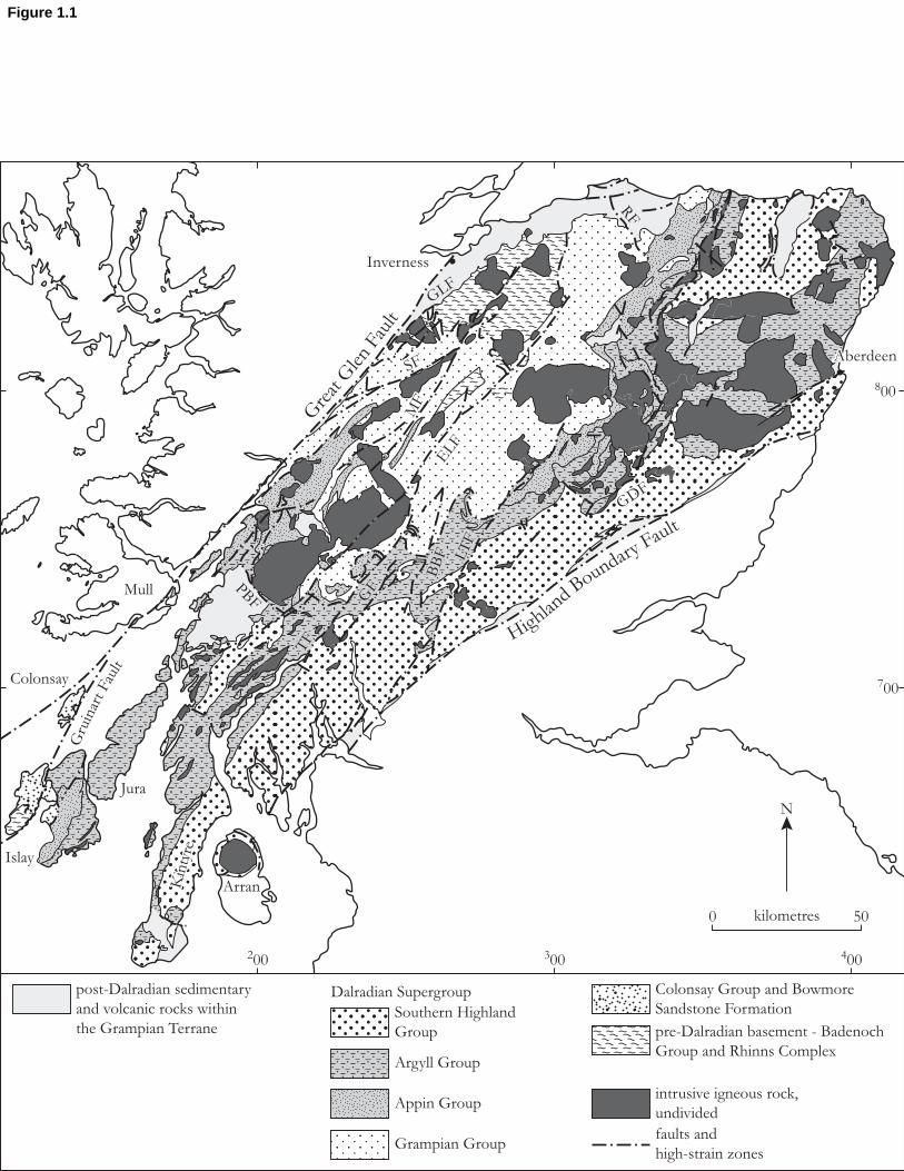
N
Kin
tyre
TF
GF
BB
F LT
F
GDF
SF
MF
ELF
Aberdeen
300200 400
700
800
0 50kilometres
Dalradian Supergroup
Colonsay
Kin
tyre
Arran
Mull
Islay
Jura
Highland B
oundary Fault
Gre
at G
len
Faul
t
Gru
inar
t Fau
lt
PBF
TF
GF
BB
F LT
F
GDF
SF
MF
ELF
GLFRF
Inverness
Aberdeen
Argyll Group
Appin Group
Grampian Group
post-Dalradian sedimentary
and volcanic rocks within
the Grampian TerraneSouthern Highland
Group
Colonsay Group and Bowmore
Sandstone Formation
pre-Dalradian basement - Badenoch
Group and Rhinns Complex
intrusive igneous rock,
undivided
faults and
high-strain zones
Figure 1.1

N kilometres0 100
Iapetu
s Sutu
re Zone
1200
1100
1000
900
800
700
600
500
400
500400300200
1000009900
Dalradian Supergroup and related Neoproterozoic sequences of uncertain stratigraphical affinity (Caledonian plutons within the Dalradian outcrop are not shown)
Heb
r id
ean
T
er r
an
e
Gr am
p i an
Te r r a n e
Le i ns t e r –L a k e sm
an Te r r a n e
Southern U
pland Fau
lt
High
land B
oundary F
ault
Gre
at G
len
Faul
tM
oine
Thr
ust
No
r th
er n
H
i gh
l an
ds
Ter r
an
e
Sou t h e r n U p l a n d s Te r r a n e
Mi d
l an d
Va l l ey
Te r r a n e
Clew Bay
Connemara
Cushendall
Shetland Isles
Figure 1.2

post-Caledonian orogens(Late Palaeozoic and later)
Caledonian Orogen(Early to Mid-Palaeozoic)
Late Archaean toProterozoic orogens
Archaean cratons
orogenic fronts
major orogenic sutures
Baltica
Iberia
Gondwana
Arm
orica
Lauren
tia
Wes
tern
Ava
lonia
Iapet
us Sutu
reEas
tern
Ava
loni
a
Rheno-hercynian
Suture
EasternCaledonian
Front
Western
Caled
on
ian F
ron
t
Appala
chian
Belt
Tornquist Belt
No
rth A
tlantic
Caled
on
ian B
elt
Figure 1.3

Figure 1.4Click here to download high resolution image

N
kilometres0 50
Lerwick84
83
85
400
1200
(b)
1100
(a)
(a)
(b)
N
Fraserburgh
Portsoy
Aberdeen
Stonehaven
North-eastGrampianHighlands
AviemoreInverness
Tyndrum
Oban
Gre
at G
len
Fau
lt
Callander
Campbeltown
Hig
hla
nd
Bo
un
dar
y F
ault
400
800
300
700
200
82
8180
79
56
72
55
7173
76
7778
7475
58
70
68
57
6954
53
5243
36
353738
39
40 41
42
51
50
44
494534
1516
19
48
4712
33
6
11
1
18
14
13175
46
10
3 2
9
8
74
20
21
31
30
2223
2625 24
2729
28
67
66
65
64
6061
62
63
59
HighlandBorderRegion
NorthernGrampianHighlands
CentralGrampianHighlands
South-westGrampianHighlands
54 GCR site
regional boundary
major fault
400
kilometres0 50
32
FortWilliam
Pitlochry
Figure 1.5

0
2
km
Loch Avich Lavas
Loch Avich Grit
Tayvallich Volcanic Formation
Tayvallich Slate andLimestone
Crinan Grit
Craignish Phy llite
Easdale Slate
Scarba Conglomerate
submarine fan
tidal flat to low-energy shelf
turbidite basin
tidal shelf
Jura Quartzite
Bonahaven DolomitePort Askaig Tillite
Islay LimestoneMullach Dubh Phy llite
Lismore LimestoneCuil Bay Slate
Appin Phy lliteAppin LimestoneAppin QuartziteBallachulish Slate
Ballachulish Limestone
Leven SchistGlencoe Quartzite
Binnein SchistBinnein Quartzite
Eilde SchistEilde Quartzite
Brunachan Psammite
Beinn Iaruinn Quartzite
Glen Fintaig Semipelite
Glen Gloy Quartzite
Auchievarie Psammite
Tarff Banded Psammite
Allt Goibhre Semipelite
Creag Meagaidh Psammite
Ardair Semipelite
Loch Laggan Psammite
Coire nan Laogh Semipelite
submarine fan
turbidite basin
basinal volcanism
turbidite basinwith volcanism
nearshore shelf to tidal flat
nearshore shelf
nearshore shelf
tidal shelf
tidal shelf
tidal shelf
tidal to glacial shelf
low-energy shelf
low-energy shelf
low-energy shelf to basin
low-energy shelf
low-energy shelf
?barrier/tidal channel
anoxic basin
anoxic basinoxic to anoxic basin
outer shelf to basin
prograding tidal delta
nearshore/tidal shelf
low-energy shelf
nearshore shelf
low-energy shelf
shallow marineand fluvial
proximal turbidites
distal turbidites
basin plain
Subgroup Formation Depositionalenvironments
Water depthshallow deep
Subsidence history
coastalshelf
basin
continued subsidencemaintains deep basins
rapid subsidence andbasin deepening
basin filling
rapid subsidence andbasin deepening
rapid depositionkeeps pace withrapid subsidence
basin filling
slow subsidence andbasin deepening
basin filling
slow subsidence andbasin deepening
slow subsidence andtransgression
slow subsidence andtransgression
gradual basin filling
basin filling
rapid subsidence andbasin deepening
rapid deposition andbasin filling
Approximatevertical scale
Tayvallich
Crinan
Easdale
Arg
yll
Gro
up
So
uth
ern
Hig
hla
nd
Gro
up
Islay
Blair Atholl
Ballachulish
Lochaber
Glen Spean
Corrieyairack
Glenshirra
Ap
pin
Gro
up
Gra
mp
ian
Gro
up
Figure 1.6

A
B
C
D
E
F
SW
NE
Lorn Lavas
Islay A
nticlin
e
Loch Awe Syncline(and Knapdale
Steep Belt)
Highland BorderSteep Belt (HBS)
CowalAntiform
Cruachan
EtivePluton
GlenCoe
Glen Orchy
BDS
AS
BESBAS
BCH
BOS
BLS BCH
HBD
Schiehallion
GCA
SBS
KA
BLA
OSBDD
FWS
TMA
SBS
BOS
HBD
Ben Lui
Fold
Complex
flat belt
HBD
HBD
HBS
HBS
HBS
Aberfoy le
Anticline
flat belt
BOS
BA
ES TSB
SMSGMS
Ben AlderCairngorm
Pluton
Loch Tay
Inversion
CIA
RannochPluton
Oban
Loch Linnhe
Fort Willia
m
Loch Lochy
Fort Augustus
Inverness
CS GS
GS
?
Por
tsoy
Lineamen
t
TurriffSyncline
BuchanAnticline
?
Glen Lyon
Folds
Clyde–Loch Lomond
Aberfoy le
Crieff
Dunkeld
Glen Esk
Aberdeen
KinlochlagganSyncline
G r e a t G l e n F a u l t
Hi g h l a n d B
o u n d a r y F a u l t
?
Dalradian Supergroup
Badenoch Group
Late-Caledonian volcanic rocks
major slide or thrust
axial plane of later folds fault
axial plane and facing direction of primary folds
younging direction of strata
Collieston
T
A
Y
N
A
P
P
E
felsic plutons, where shown;
many omitted for clarity
Tarfside Napp
e
Ardrishaig Anticline
Loch
Skerrols T
hru
st
Figure 1.7
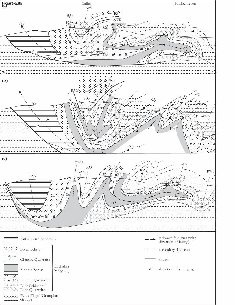
‘Eilde Flags’ (GrampianGroup)
Ballachulish Subgroup
Leven Schist
Glencoe Quartzite
Binnein Schist
Binnein Quartzite
Eilde Schist andEilde Quartzite
LochaberSubgroup
(a)
(b)
(c)
Onich Callert
AS KA
BAS
FWS
BS
SBS
W E
Kinlochleven
AS
AS
BAS
SBSBS
KA
KAF
AS
MA
MS
BWS
?
AS
FW
S
BAS
SBS
TMA
KA
TS
MA
BWS
primary fold axes (withdirection of facing)
secondary fold axes
slides
direction of younging
FWS
Figure 1.8

0
1000
metres
kilometres0 2
Eilrig Shear-zone
NW SE
AppinSynform
BohuntineAntiform
Stob BanSynform
InverlairAntiform
KinlochlevenAnticline
TreigSyncline
BlackwaterSynform
?
??
Ballachulish Limestone
Leven Schist Formation
Loch Treig Schist andQuartzite Formation
Grampian Group
AppinGroup
shear-zones (arrow showsdirection of transport)
younging direction
facing along fold axialtrace
F1 fold axes
F2 fold axes
Figure 1.9
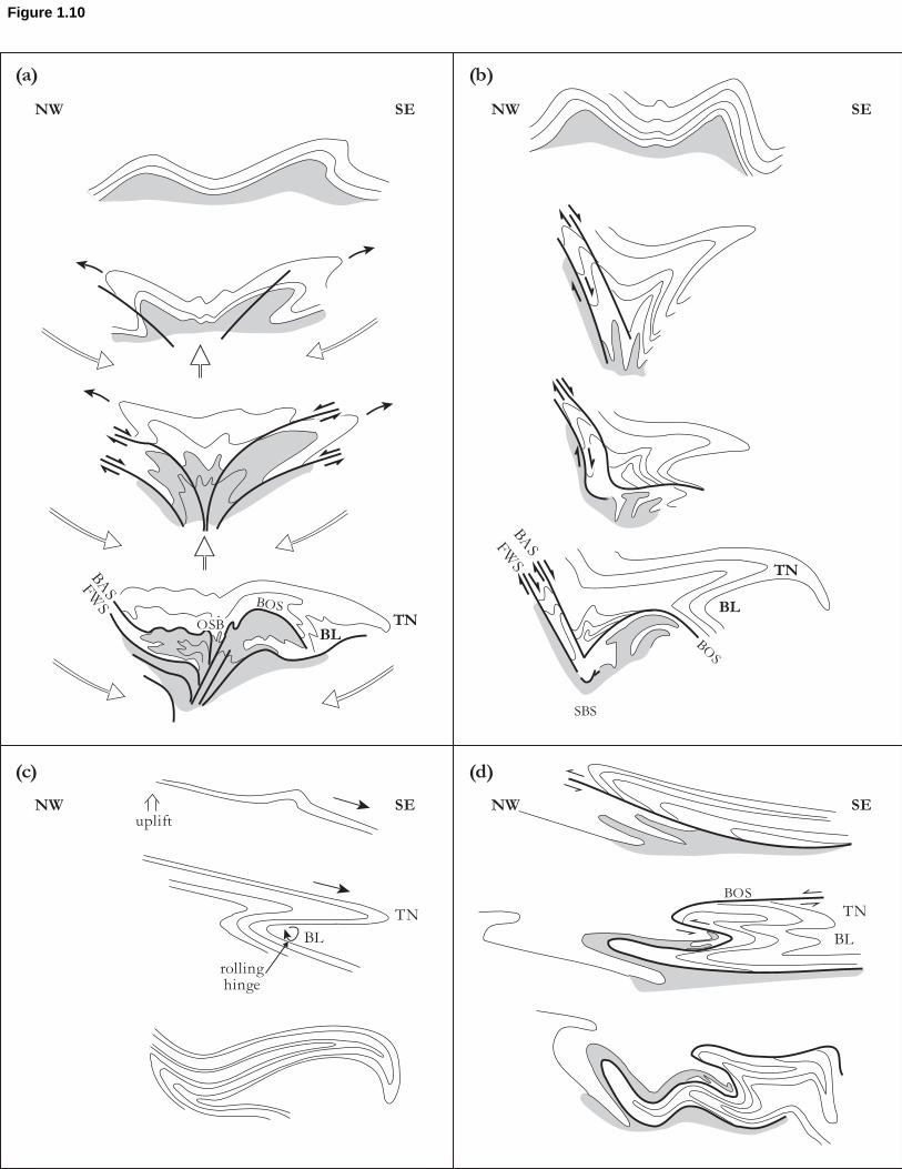
SENW SE NW
NW SE NW SE
(a) (b)
(c) (d)
BASFWS
OSB
BOS
BLTN
TN
uplift
BL
rollinghinge
TN
BL
BOS
BASFWS
SBS
TN
BL
BOS
Figure 1.10

kilometres0 5
(a)
(b)
NW SE
presen
t day
erosio
n surfa
ce
limit of D2 deformation
? ?
?
?
NW SE
onset of F3 folding
present day erosion surface
limit of D2 deformation
HighlandBoundary
Fault
HBD
, F4
Old Red Sandstone
older part of HighlandBorder Complex
Southern HighlandGroup
Green Beds
Tayvallich Subgroup
Crinan and Easdalesubgroups
S1 foliation tracesand F1 fold traces
axial plane traceof F2 fold
axial plane traceof F4 fold
fault
Figure 1.11
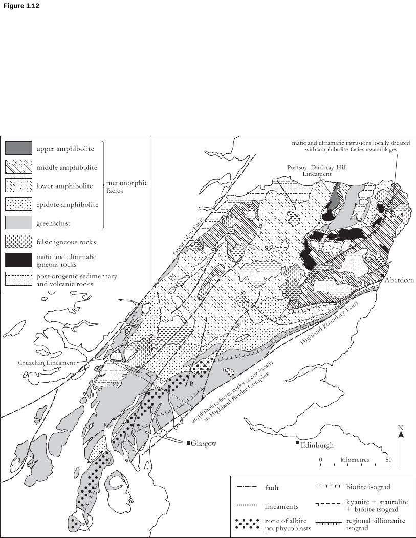
?
mafic and ultramafic intrusions locally sheared with amphibolite-facies assemblages
N
Portsoy–Duchray HillLineament
Aberdeen
Highland Boundary Fault
Great Glen Fault
Glasgow Edinburgh
Cruachan Lineament
amphibolite-facies rocks occur locally
in Highland Border Complex
C
M
ESZ
?
S
B
D
fault
lineaments
zone of albiteporphy roblasts
biotite isograd
kyanite + staurolite+ biotite isograd
regional sillimaniteisograd
kilometres0 50
TSB
??
?
upper amphibolite
middle amphibolite
lower amphibolite
epidote-amphibolite
greenschist
felsic igneous rocks
mafic and ultramaficigneous rocks
post-orogenic sedimentaryand volcanic rocks
metamorphicfacies
Figure 1.12

N
Baltica
30°S
60°S
Amazonia
Laurentia
G
S
C
A
South
Pole
Figure 1.13
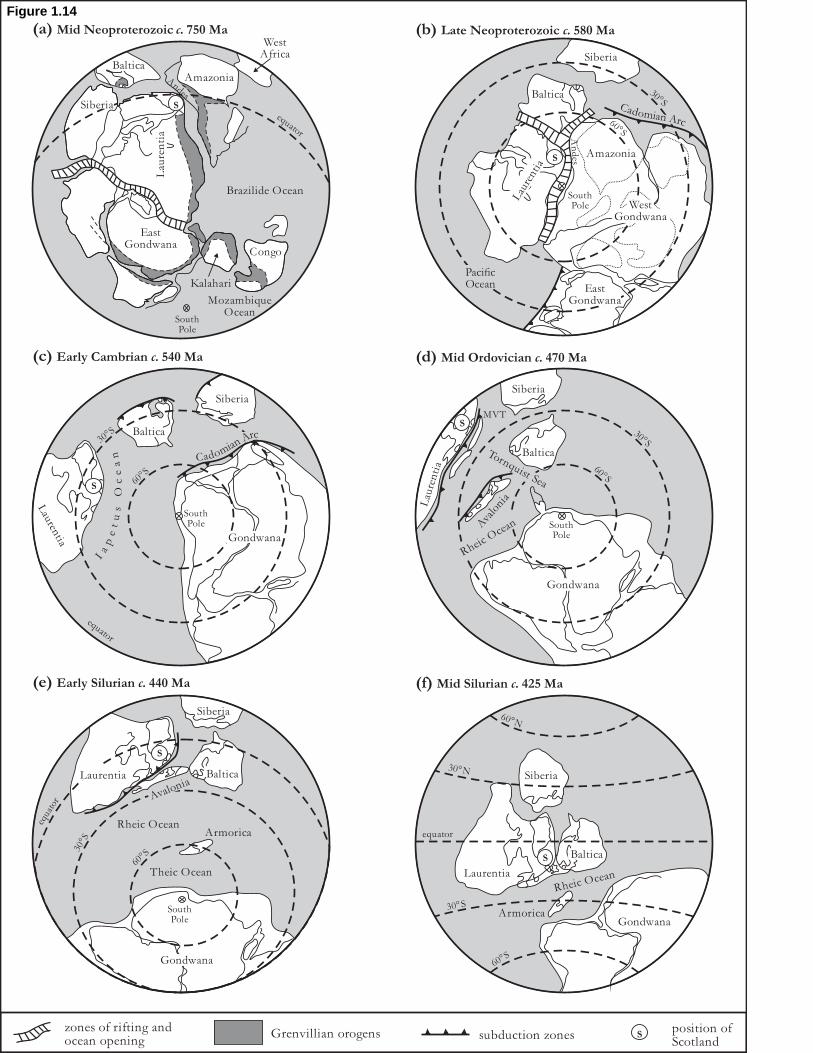
(b) Late Neoproterozoic c. 580 Ma(a) Mid Neoproterozoic c. 750 Ma
Brazilide Ocean
EastGondwana
Congo
Siberia
BalticaAmazonia
WestAfrica
equator
Kalahari
MozambiqueOcean
SouthPole
Lau
ren
tia
S
Siberia
Lau
rent
ia
PacificOcean
SouthPole
EastGondwana
WestGondwana
S
30°S
60°S
An
des
Baltica
(d) Mid Ordovician c. 470 Ma(c) Early Cambrian c. 540 Ma
SouthPole
30°S
60°S
Siberia
Lau
ren
tia
Ava
loni
a
Rheic O
cean
Tornquist Sea
Baltica
Gondwana
MVTS
SouthPole
30°S
60°S
S
Gondwana
Siberia
Baltica
Lauren
tia
equator
(f) Mid Silurian c. 425 Ma(e) Early Silurian c. 440 Ma
30°S
60°S
equa
tor
Siberia
Rheic OceanArmorica
Gondwana
SouthPole
BalticaLaurentia
Avalonia
Theic Ocean
S
Rheic Ocean
S
Siberia
Baltica
Laurentia
GondwanaArmorica
60°S
30°S
equator
30°N
60°N
zones of rifting andocean opening
Grenvillian orogens subduction zonesposition ofScotland
S
Andes
Amazonia
Cadomian Arc
Cadomian Arc
Ia
pe
tu
s
Oc
ea
n
Figure 1.14
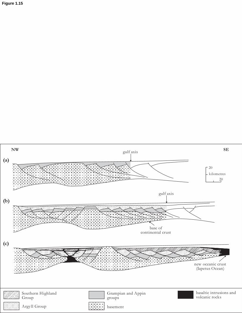
kilometres
20
20
(a)
(b)
(c)
NW SE
basaltic intrusions andvolcanic rocks
Argy ll Group
Southern HighlandGroup
Grampian and Appingroups
basement
gulf axis
gulf axis
base ofcontinental crust
new oceanic crust(Iapetus Ocean)
Figure 1.15

(a) Neoproterozoic to Late Cambrian
(b) Tremadoc to Arenig
(c) Arenig to Llanvirn
continental basement of Midland Valley – a
rifted fragment of Laurentia?thrusting of Ballantrae
Ophiolite onto Midland Valley basement
obduction of Shetland Ophiolite and Highland
Border Complex
start of regional deformation and metamorphism of Moine and Dalradian
resulting from ophiolite obduction
later initiation of south-facing arc
backfolding of ophiolite nappe and underthrusting of Dalradian to form south-east-directed nappes and
thrusts (e.g. Tay Nappe)
Midland ValleyArc
rifted Laurentian crust
Figure 1.16

(a) 420 Ma
EasternAvalonia
Baltica
generalized displacements relative to Laurentia Acadian convergence
Iber
ia
areas of oceanic crust areas of oceanic crust
Western Avalonia
Iapetus Ocean
HB
FGG
FM
TB
(b) 400 Ma
HB
F
GG
F
La
ur
en
tia
La
ur u s s i a
Arm
ori
ca
Rheic Ocean
Figure 1.17

N N
N N
(a) Measured strike and dip of plane = N 019° E, 76° SE, or more simply 019'76SE
(b) Axial plane of fold; 280'88N Fold hinge plunges at 15° to 102°
pole
beddingplane
map symbol map symbols
pole tobedding plane
(c) (d)
axialplane
foldhinge
axial planefold hinge(fold axis)
foldaxis
beddingplane
881576
Figure G.1

Upward facing Downward facing
Sideward (south-east) facing
NW SE
stratigraphical youngingdirection of beds
facing direction of folds
cleavage
Figure G.2
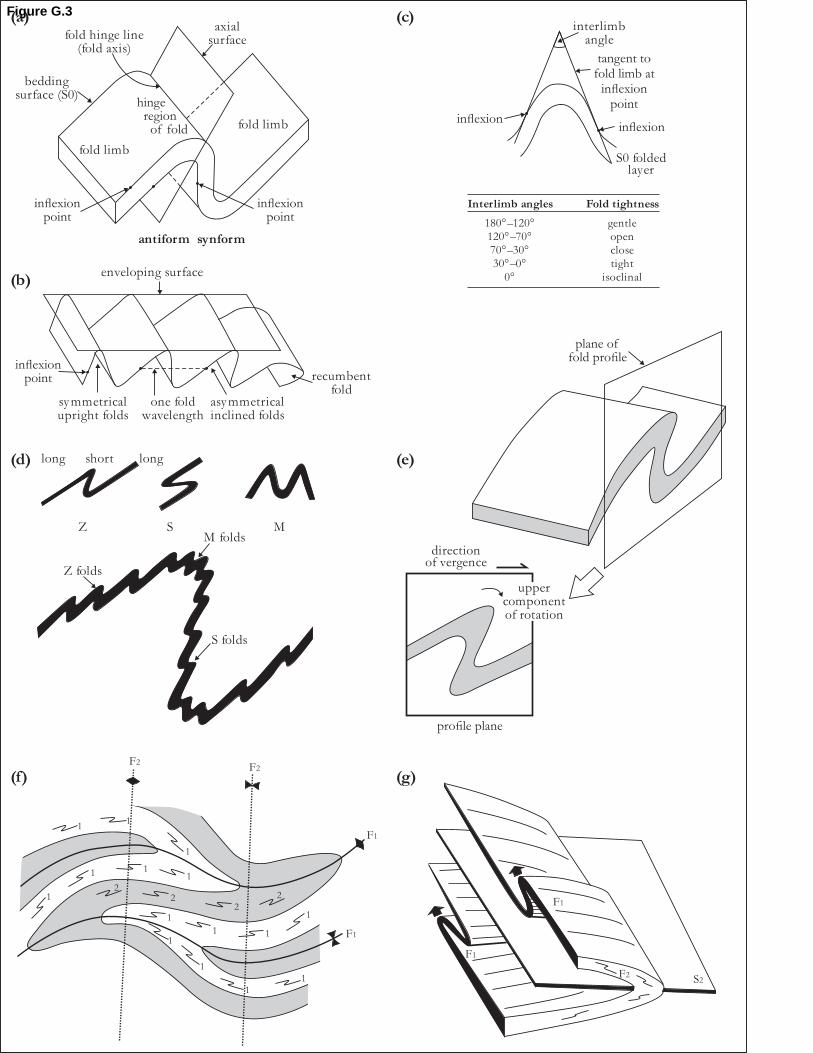
(a) (c)
fold limb
inflexionpoint
inflexionpoint
fold limb
antiform synform
axialsurfacefold hinge line
(fold axis)
beddingsurface (S0)
inflexioninflexion
interlimbangle
tangent tofold limb at
inflexionpoint
S0 foldedlayer
Interlimb angles Fold tightness
180°–120°120°–70°70°–30°30°–0°
0°
gentleopenclosetight
isoclinalenveloping surface
inflexionpoint
one foldwavelength
symmetricalupright folds
asymmetricalinclined folds
recumbentfold
(e)(d) long short long
Z S MM folds
S folds
Z folds
plane offold profile
directionof vergence
profile plane
uppercomponentof rotation
(f) (g)
11
1
111
12
22
2
F2F2
F1
F1
F1
F1
F2 S2
(b)
1
1 1
1
11
1
1
hinge region of fold
Figure G.3
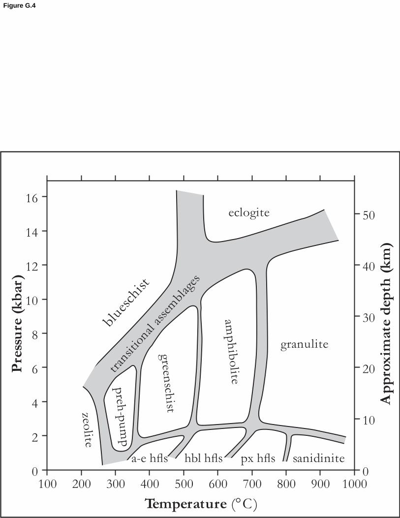
blue
schi
st
0
2
4
6
8
10
12
14
16
0
10
20
30
40
50
100 200 300 400 500 600 700 800 900 1000
Temperature (°C)
Pre
ssu
re (
kb
ar)
Ap
pro
xim
ate
dep
th (
km
)
eclogite
granulite
sanidinite
amp
hib
olite
greensch
istzeolite
preh
-pu
mp
px hflsa-e hfls hbl hfls
tran
sitio
nal a
ssem
blag
es
Figure G.4