Structure and Evolution of Tropical Cyclone … wind PACITAN SIDOARJO WONOGIRI GROBOGAN SURABAYA...
15
Structure and Evolution of Tropical Cyclone Cempaka (27 - 29 Nov 2017) Mia K. Khotimah*, A. Rifani, R. Mahendra, B. S. Panjaitan, A. Ali, Kiki, and M. Budiarti The Technical Conference (TECO) of the ESCAP/WMO Typhoon Committee Hanoi, Vietnam, 26 – 27 February 2018
Transcript of Structure and Evolution of Tropical Cyclone … wind PACITAN SIDOARJO WONOGIRI GROBOGAN SURABAYA...

Structure and Evolution of Tropical Cyclone Cempaka (27 - 29 Nov 2017)
Mia K. Khotimah*, A. Rifani, R. Mahendra, B. S. Panjaitan, A. Ali, Kiki, and M. Budiarti
The Technical Conference (TECO) of the ESCAP/WMO Typhoon Committee
Hanoi, Vietnam, 26 – 27 February 2018
Strong wind
PACITAN
SIDOARJO
WONOGIRI
GROBOGAN
SURABAYA
GUNUNG KIDUL
BALI
BANTUL
CIREBON
JAKARTA
TASIKMALAYA LEBAK
Tornado Flood
Hazards and Disaster at the Event of Cyclone Cempaka 27-29 November 2017
Time Latitude Longitude Pressure MeanWind WindGust
2017-11-26 00Z
2017-11-26 06Z
2017-11-26 12Z
2017-11-26 18Z
2017-11-27 00Z
2017-11-27 06Z
2017-11-27 12Z
2017-11-27 18Z
2017-11-28 00Z
2017-11-28 06Z
2017-11-28 12Z
2017-11-28 18Z
2017-11-29 00Z
2017-11-29 06Z
-9.6 109.4 1003 25 45
-9.2 109.5 1003 25 45
-9.5 109.0 1005 20 40
-9.1 109.2 1004 20 40
-9.0 109.5 1005 20 40
-8,6 110,5 1004 20 40
-8,6 110,9 999 35 55
-8,4 111,3 998 35 55
-8.5 111.2 999 35 55
-8.7 111.0 998 35 55
-8.5 110.2 998 35 55
-9.4 111.0 999 35 55
-9.5 111.5 1000 35 55
-9.9 110.0 1003 25 45 Siklon Tropis Cempaka
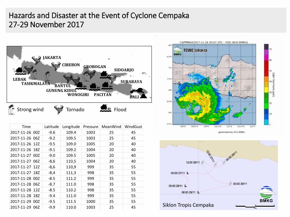
Tropical depression on 26 Nov 2017 00.00z
26 Nov 2017 23.53z
Prior to birth
27 Nov 2017 11.53z
Birth
Dissipating
29 Nov 2017 14.53z
Stages of Cyclone Cempaka
26 - 29 Nov 2017
28 Nov 2017 11.53z
Max intensity
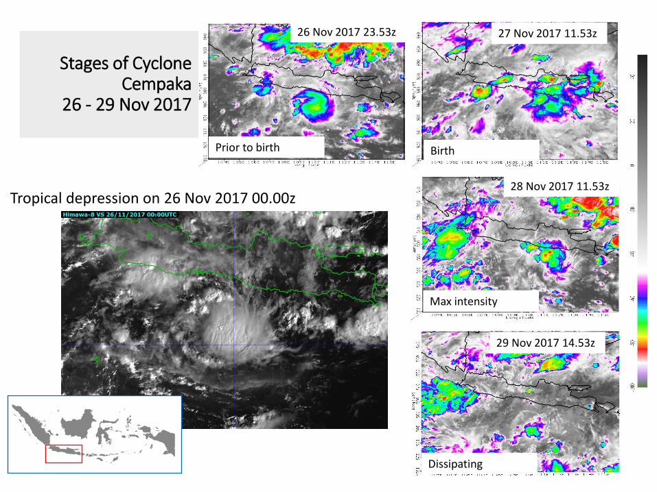
Synoptic condition prior to formation of Cyclone Cempaka
Pre-existing disturbance at lower level
near equatorial trough
High relative vorticity at lower level
Upper level divergence Low vertical wind shear
High sea surface temperatures
24 Nov 2017 00z
1
2
3
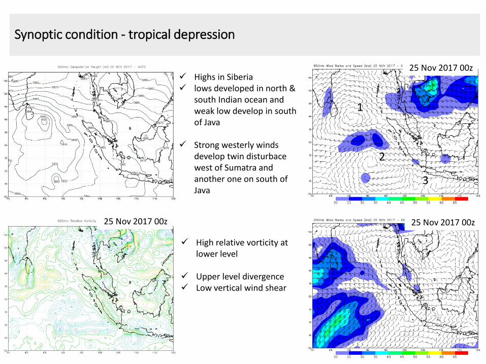
Synoptic condition - tropical depression
25 Nov 2017 00z
25 Nov 2017 00z
High relative vorticity at lower level
Upper level divergence Low vertical wind shear
25 Nov 2017 00z
1
2
3
Highs in Siberia lows developed in north &
south Indian ocean and weak low develop in south of Java
Strong westerly winds develop twin disturbace west of Sumatra and another one on south of Java
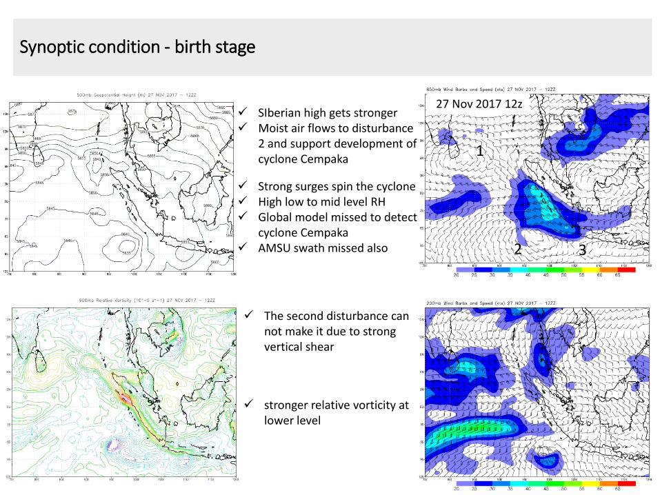
Synoptic condition - birth stage
27 Nov 2017 12z
Strong surges spin the cyclone High low to mid level RH Global model missed to detect
cyclone Cempaka AMSU swath missed also
stronger relative vorticity at lower level
The second disturbance can not make it due to strong vertical shear
1
2 3
SIberian high gets stronger Moist air flows to disturbance
2 and support development of cyclone Cempaka
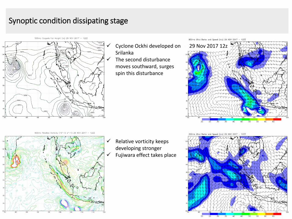
Synoptic condition dissipating stage
29 Nov 2017 12z Cyclone Ockhi developed on Srilanka
The second disturbance moves southward, surges spin this disturbance
Relative vorticity keeps developing stronger
Fujiwara effect takes place
1
2 3
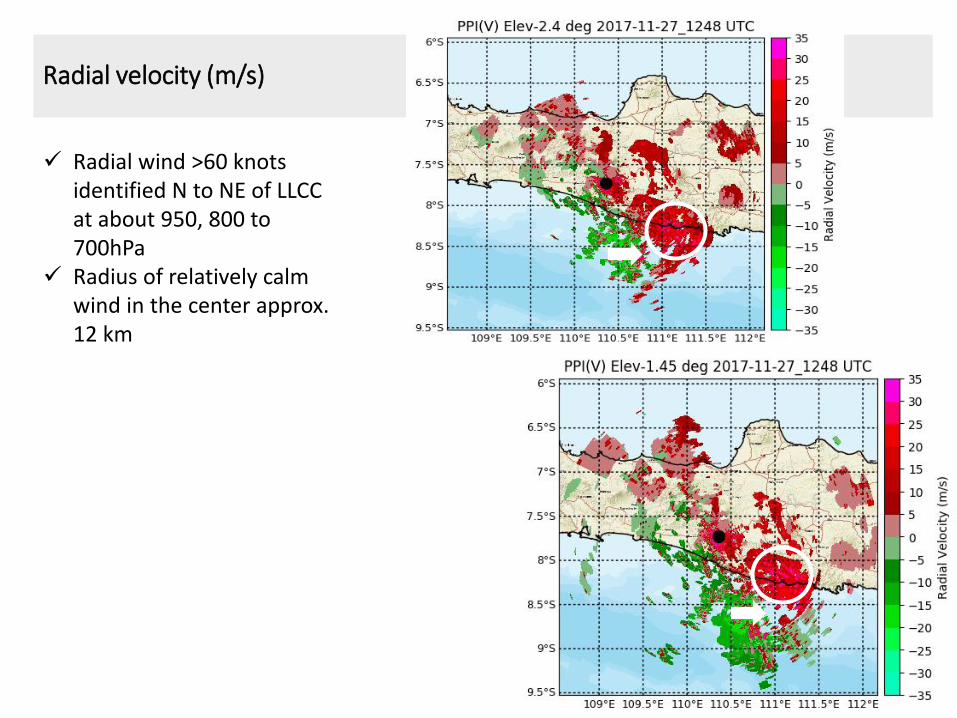
Radial velocity (m/s)
Radial wind >60 knots identified N to NE of LLCC at about 950, 800 to 700hPa
Radius of relatively calm wind in the center approx. 12 km
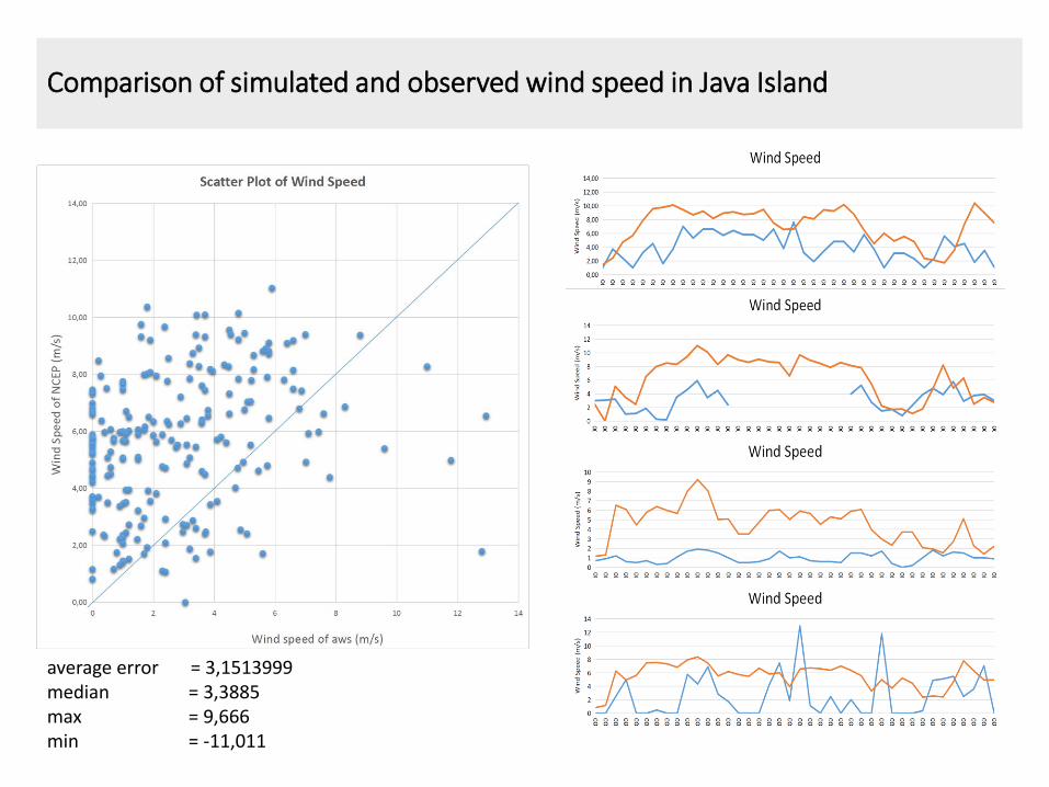
Comparison of simulated and observed wind speed in Java Island
average error = 3,1513999 median = 3,3885 max = 9,666 min = -11,011
26 Nov 00z
28 Nov 00z
27 Nov 12z
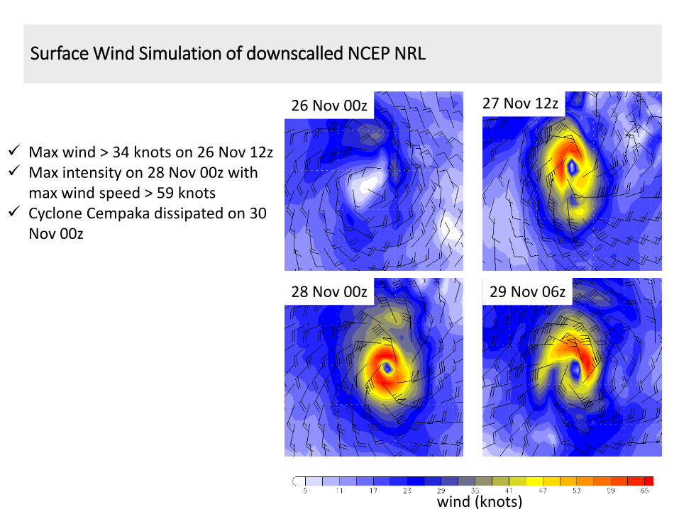
Surface Wind Simulation of downscalled NCEP NRL
29 Nov 06z
Max wind > 34 knots on 26 Nov 12z Max intensity on 28 Nov 00z with
max wind speed > 59 knots Cyclone Cempaka dissipated on 30
Nov 00z
wind (knots)
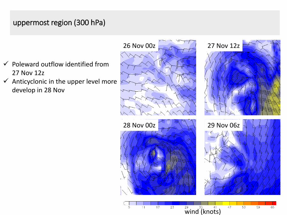
uppermost region (300 hPa)
26 Nov 00z 27 Nov 12z
28 Nov 00z 29 Nov 06z
wind (knots)
Poleward outflow identified from 27 Nov 12z
Anticyclonic in the upper level more develop in 28 Nov
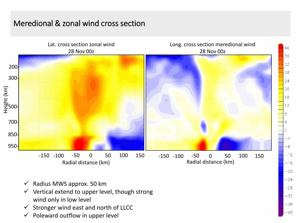
Lat. cross section zonal wind 28 Nov 00z
0 50 -50 100 150 -100 -150
Meredional & zonal wind cross section
Long. cross section meredional wind 28 Nov 00z
Radius MWS approx. 50 km Vertical extend to upper level, though strong
wind only in low level Stronger wind east and north of LLCC Poleward outflow in upper level
0 50 -50 100 150 -100 -150 Radial distance (km)
Hei
ght
(km
)
950-
850-
700-
500-
300-
200-
Radial distance (km)
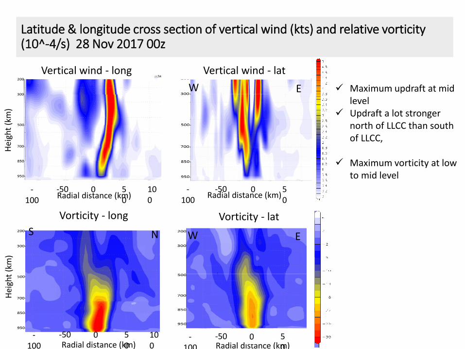
Latitude & longitude cross section of vertical wind (kts) and relative vorticity (10^-4/s) 28 Nov 2017 00z
Vertical wind - long
100
0 50
-50 -100
Radial distance (km)
Vertical wind - lat
0 50
-50 Radial distance (km)
-100
Vorticity - long
0 50
-50 100
-100 Radial distance (km)
Vorticity - lat
50
-50 -100 Radial distance (km)
0
Hei
ght
(km
) H
eigh
t (k
m)
Maximum updraft at mid level
Updraft a lot stronger north of LLCC than south of LLCC,
Maximum vorticity at low to mid level
S N
S N
E W
E W
Conclusion
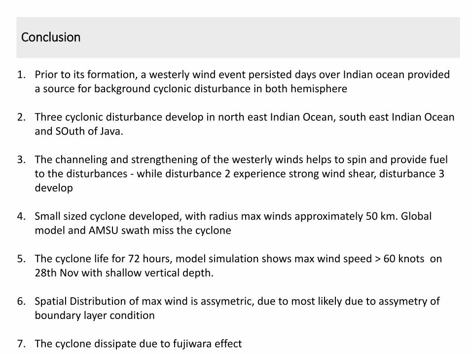
1. Prior to its formation, a westerly wind event persisted days over Indian ocean provided a source for background cyclonic disturbance in both hemisphere
2. Three cyclonic disturbance develop in north east Indian Ocean, south east Indian Ocean and SOuth of Java.
3. The channeling and strengthening of the westerly winds helps to spin and provide fuel to the disturbances - while disturbance 2 experience strong wind shear, disturbance 3 develop
4. Small sized cyclone developed, with radius max winds approximately 50 km. Global model and AMSU swath miss the cyclone
5. The cyclone life for 72 hours, model simulation shows max wind speed > 60 knots on 28th Nov with shallow vertical depth.
6. Spatial Distribution of max wind is assymetric, due to most likely due to assymetry of boundary layer condition
7. The cyclone dissipate due to fujiwara effect

Thank you