S Mataram SW - INDONESIA Tenggara Barat Lombok Barat Mataram BTN Kekalik Perumahan LA Resort...
1
; Ø ; Ø ; Ø ; Ø ; Ø ; Ø ; Ø ; Ø ; Ø ; Ø ; Ø ; Ø ; Ø ; Ø ; Ø ; Ø ; Ø ; Ø ; Ø ; Ø ; Ø ; Ø ; Ø ; Ø ; Ø ; Ø ; Ø ; Ø ; Ø ; Ø ; Ø ; Ø ; Ø ; Ø ; Ø ; Ø ! ! ! ! ! ! ! ! ! ! ! ! K K K K K K K K K K K K K K K K K K K K K K K K K K K K K K K K K K K K K K K K K K K K K K K K K K K K K K Nusa Tenggara Barat Lombok Barat Mataram BTN Kekalik Perumahan LA Resort Paokkambut Perampuan Bajur Kecamatan Labuapi Terong Tawah Kuranji Telaga Waru BTN Kodya Asri Lingk. Bukit Ngandang Pagesangan Saluran irigasi Kali Babak 116°8'0"E 116°8'0"E 116°7'30"E 116°7'30"E 116°7'0"E 116°7'0"E 116°6'30"E 116°6'30"E 116°6'0"E 116°6'0"E 116°5'30"E 116°5'30"E 116°5'0"E 116°5'0"E 116°4'30"E 116°4'30"E 8°35'30"S 8°35'30"S 8°36'0"S 8°36'0"S 8°36'30"S 8°36'30"S 8°37'0"S 8°37'0"S 8°37'30"S 8°37'30"S 8°38'0"S 8°38'0"S 8°38'30"S 8°38'30"S 398000 398000 399000 399000 400000 400000 401000 401000 402000 402000 403000 403000 404000 404000 9045000 9045000 9046000 9046000 9047000 9047000 9048000 9048000 9049000 9049000 9050000 9050000 GLIDE number: EQ-2018-000127-IDN ! ( Nusa Tenggara Barat Bali Sea Mataram 01 02 03 04 ^ Australia Laos Thailand Indonesia NORTH PACIFIC OCEAN INDIAN OCEAN Philippine Sea South China Sea C el e b e s Sea Su lu Se a Ban da Sea Java Sea Arafura Sea Timor Sea Jakarta Cartographic Information 1:11000 ± Grid: WGS 1984 UTM Zone 50S map coordinate system Full color ISO A1, low resolution (100 dpi) A powerful earthquake (6.9 magnitude) struck the Indonesian island of Lombok on 5 August. Massive damage has been reported and some areas were unreachable. Authorities report that more than half of the homes have been destroyed or badly damaged by the quake. The present map shows the damage grade assessment in the area of Maratam SW (Indonesia). The thematic layer has been derived from post-event satellite image by means of visual interpretation. The estimated geometric accuracy is 5 m CE90 or better, from native positional accuracy of the background satellite image. Products elaborated in this Copernicus EMS Rapid Mapping activity are realized to the best of our ability, within a very short time frame, optimising the available data and information. All geographic information has limitations due to scale, resolution, date and interpretation of the original sources. No liability concerning the contents or the use thereof is assumed by the producer and by the European Union. Map produced by ITHACA released by e-GEOS (ODO). For the latest version of this map and related products visit http://emergency.copernicus.eu/EMSR304 [email protected] © European Union For full Copyright notice visit http://emergency.copernicus.eu/mapping/ems/cite-copernicus- ems-mapping-portal Legend Tick marks: WGS 84 geographical coordinate system Product N.: 03MATARAMSW, v2, English Activation ID: EMSR304 Pre-event image: WorldView-2 © Digitalglobe Digital Globe, Inc. (2018), (acquired on 03/06/2018 at 02:41 UTC, GSD 0.5 m, approx. 1% cloud coverage in AoI, 16° off-nadir angle), provided under COPERNICUS by the European Union, ESA and European Space Imaging, all rights reserved. Post-event image: Pléiades-1A © CNES (2018), distributed by Airbus DS (acquired on 07/08/2018 at 02:31 UTC, GSD 0.5 m, approx. 10.1% cloud coverage in AoI, 30.1° off-nadir angle), provided by International Charter (call ID 663-664), all rights reserved. Base vector layers: OpenStreetMap © OpenStreetMap contributors, Wikimapia.org, GeoNames 2015, refined by the producer. Inset maps: JRC 2013, Natural Earth 2012, GeoNames 2013. Population data: GHS Population Grid © European Commission, 2015 http://data.europa.eu/89h/jrc-ghsl-ghs_pop_gpw4_globe_r2015a. Digital Elevation Model: SRTM (90m). 0 0,5 1 0,25 km Mataram SW - INDONESIA Earthquake - Situation as of 07/08/2018 Map Information Grading Map Relevant date records Event Situation as of 05/08/2018 07/08/2018 Activation Map production 06/08/2018 09/08/2018 Disclaimer Data Sources 3, 5 km Crisis Information ; Ø Assembly point Built Up Grading Possibly damaged General Information Area of Interest Not Analysed Placenames ! Placename Hydrography Coastline River Stream Lake Reservoir Point of Interest K Hospital or institutional care building Land use - Land Cover Physiography Features available in vector data Destroyed Damaged Possibly damaged Total affected Total in AOI Estimated population 100 178354 Assembly points Settlements Residential No. 0 0 10 10 N/A Transportation Bridge and elevated highway No. 0 0 0 0 89 Primary Road km 0.0 0.0 0.0 0.0 9.5 Secondary Road km 0.0 0.0 0.0 0.0 1.7 Local Road km 0.0 0.0 0.0 0.0 160.8 Cart Track km 0.0 0.0 0.0 0.0 5.1 Land use Heterogeneous agricultural areas ha 0.0 0.0 0.0 0.0 3248.1 Consequences within the AOI Unit of measurement Number of inhabitants 36
Transcript of S Mataram SW - INDONESIA Tenggara Barat Lombok Barat Mataram BTN Kekalik Perumahan LA Resort...
;Ø
;Ø
;Ø
;Ø
;Ø
;Ø
;Ø
;Ø
;Ø
;Ø
;Ø;Ø
;Ø
;Ø
;Ø
;Ø
;Ø
;Ø
;Ø
;Ø
;Ø
;Ø
;Ø
;Ø
;Ø
;Ø
;Ø
;Ø
;Ø
;Ø
;Ø
;Ø
;Ø
;Ø
;Ø
;Ø
!
!
!
!
!
!
!
!
!
!
!
!
KKK
KKK
KK
K
K
KK
K
KKK
K
K
K
K
K
K
K
K
K
KK
K
KK
KK
KK
K
KK
K
K
K
K
K
K
K
K
KK
K
KKK KK
KK
K
K
NusaTenggara
Barat
Lombok Barat
Mataram
BTN Kekalik
PerumahanLA Resort
Paokkambut
Perampuan
Bajur
KecamatanLabuapi
Terong Tawah
Kuranji
Telaga Waru
BTN KodyaAsri
Lingk.BukitNgandang
Pagesangan
Saluran irigasi
Kali Babak
116°8'0"E
116°8'0"E
116°7'30"E
116°7'30"E
116°7'0"E
116°7'0"E
116°6'30"E
116°6'30"E
116°6'0"E
116°6'0"E
116°5'30"E
116°5'30"E
116°5'0"E
116°5'0"E
116°4'30"E
116°4'30"E8°3
5'30"
S
8°35'3
0"S
8°36'0
"S
8°36'0
"S
8°36'3
0"S
8°36'3
0"S
8°37'0
"S
8°37'0
"S
8°37'3
0"S
8°37'3
0"S
8°38'0
"S
8°38'0
"S
8°38'3
0"S
8°38'3
0"S
398000
398000
399000
399000
400000
400000
401000
401000
402000
402000
403000
403000
404000
404000
9045
000
9045
000
9046
000
9046
000
9047
000
9047
000
9048
000
9048
000
9049
000
9049
000
9050
000
9050
000
GLIDE number: EQ-2018-000127-IDN
!(
NusaTenggara
Barat
BaliSea
Mataram01 02
03 04^
Australia
LaosThailand
IndonesiaNORTHPACIFICOCE AN
INDIAN OCEAN
PhilippineSea
SouthChina Sea
CelebesSea
Su luSe a
BandaSea
Java SeaArafura
SeaTimorSea
Jakarta
Cartographic Information
1:11000
±Grid: WGS 1984 UTM Zone 50S map coordinate system
Full color ISO A1, low resolution (100 dpi)
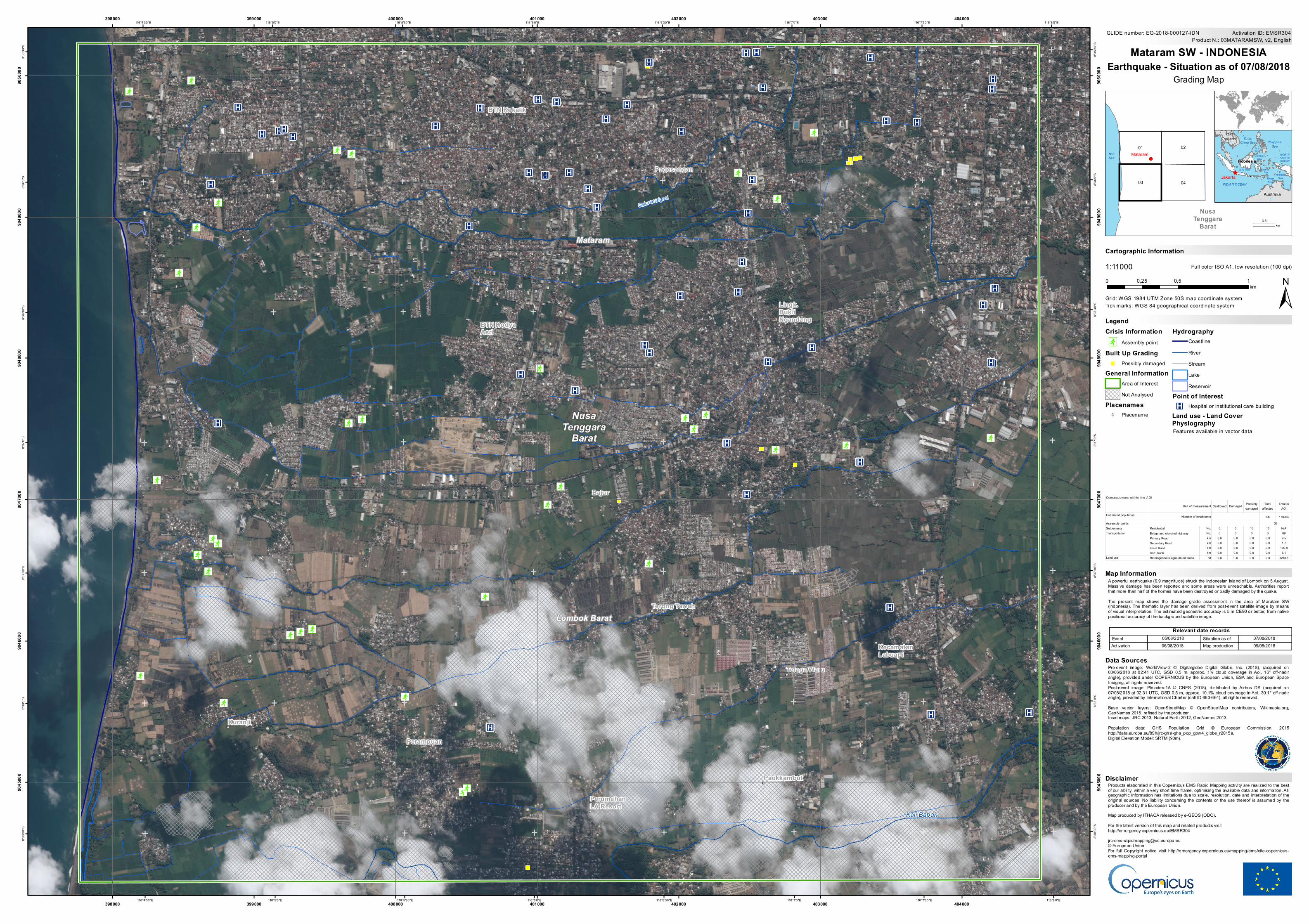
A powerful earthquake (6.9 magnitude) struck the Indonesian island of Lombok on 5 August.Massive damage has been reported and some areas were unreachable. Authorities reportthat more than half of the homes have been destroyed or badly damaged by the quake.The present map shows the damage grade assessment in the area of Maratam SW(Indonesia). The thematic layer has been derived from post-event satellite image by meansof visual interpretation. The estimated geometric accuracy is 5 m CE90 or better, from nativepositional accuracy of the background satellite image.
Products elaborated in this Copernicus EMS Rapid Mapping activity are realized to the bestof our ability, within a very short time frame, optimising the available data and information. Allgeographic information has limitations due to scale, resolution, date and interpretation of theoriginal sources. No liability concerning the contents or the use thereof is assumed by theproducer and by the European Union.Map produced by ITHACA released by e-GEOS (ODO).For the latest version of this map and related products visithttp://emergency.copernicus.eu/[email protected]© European UnionFor full Copyright notice visit http://emergency.copernicus.eu/mapping/ems/cite-copernicus-ems-mapping-portal
Legend
Tick marks: WGS 84 geographical coordinate system
Product N.: 03MATARAMSW, v2, EnglishActivation ID: EMSR304
Pre-event image: WorldView-2 © Digitalglobe Digital Globe, Inc. (2018), (acquired on03/06/2018 at 02:41 UTC, GSD 0.5 m, approx. 1% cloud coverage in AoI, 16° off-nadirangle), provided under COPERNICUS by the European Union, ESA and European SpaceImaging, all rights reserved.Post-event image: Pléiades-1A © CNES (2018), distributed by Airbus DS (acquired on07/08/2018 at 02:31 UTC, GSD 0.5 m, approx. 10.1% cloud coverage in AoI, 30.1° off-nadirangle), provided by International Charter (call ID 663-664), all rights reserved.Base vector layers: OpenStreetMap © OpenStreetMap contributors, Wikimapia.org,GeoNames 2015, refined by the producer.Inset maps: JRC 2013, Natural Earth 2012, GeoNames 2013.Population data: GHS Population Grid © European Commission, 2015http://data.europa.eu/89h/jrc-ghsl-ghs_pop_gpw4_globe_r2015a.Digital Elevation Model: SRTM (90m).
0 0,5 10,25km
Mataram SW - INDONESIAEarthquake - Situation as of 07/08/2018
Map Information
Grading Map
Relevant date recordsEvent Situation as of05/08/2018 07/08/2018Activation Map production06/08/2018 09/08/2018
Disclaimer
Data Sources
3,5km
Crisis Information;Ø Assembly point
Built Up GradingPossibly damaged
General InformationArea of InterestNot Analysed
Placenames! Placename
HydrographyCoastlineRiverStreamLakeReservoir
Point of InterestK Hospital or institutional care building
Land use - Land CoverPhysiographyFeatures available in vector data
Destroyed Damaged Possibly damaged
Total affected
Total in AOI
Estimated population 100 178354Assembly pointsSettlements Residential No. 0 0 10 10 N/ATransportation Bridge and elevated highway No. 0 0 0 0 89
Primary Road km 0.0 0.0 0.0 0.0 9.5Secondary Road km 0.0 0.0 0.0 0.0 1.7Local Road km 0.0 0.0 0.0 0.0 160.8Cart Track km 0.0 0.0 0.0 0.0 5.1
Land use Heterogeneous agricultural areas ha 0.0 0.0 0.0 0.0 3248.1
Consequences within the AOI
Unit of measurement
Number of inhabitants36