PILIHAN TANAMAN PERTANIAN UNTUK KABUPATEN ACEH...
61
PILIHAN TANAMAN PERTANIAN UNTUK KABUPATEN ACEH BARAT, PROVINSI NANGGROE ACEH DARUSSALAM AGRICULTURAL CROP OPTIONS FOR ACEH BARAT DISTRICT, NANGGROE ACEH DARUSSALAM PROVINCE Wahyunto, Fahmuddin Agus, Sofyan Ritung, dan Wahyu Wahdini Balai Penelitian Tanah (Indonesian Soil Research Institure) dan World Agroforestry Centre, Bogor- Indonesia Bogor 2008
Transcript of PILIHAN TANAMAN PERTANIAN UNTUK KABUPATEN ACEH...

PILIHAN TANAMAN PERTANIANUNTUK KABUPATEN ACEH BARAT,
PROVINSI NANGGROE ACEH DARUSSALAMAGRICULTURAL CROP OPTIONS FOR ACEH BARAT
DISTRICT, NANGGROE ACEH DARUSSALAM PROVINCE
Wahyunto, Fahmuddin Agus, Sofyan Ritung, danWahyu Wahdini
Balai Penelitian Tanah (Indonesian Soil Research Institure)
dan World Agroforestry Centre, Bogor- Indonesia
Bogor 2008

PILIHAN TANAMAN PERTANIAN
UNTUK KABUPATEN ACEH BARAT, PROVINSI NANGGROE ACEH
DARUSSALAM AGRICULTURAL CROP OPTIONS FOR ACEH BARAT DISTRICT,
NANGGROE ACEH DARUSSALAM PROVINCE
Wahyunto, Sofyan Ritung, Fahmuddin Agus, dan Wahyu Wahdini
Balai Penelitian Tanah (Indonesian Soil Research Institute)
& World Agroforestry Centre (ICRAF) Southeast Asia Office
Bogor 2008
ii
Sitasi: Wahyunto, S. Ritung, F. Agus, dan W. Wahdini. 2008. Pilihan tanaman pertanian untuk Kabupaten Aceh Barat, Provinsi Nanggroe Aceh Darussalam. Balai Penelitian Tanah and World Agroforestry Centre (ICRAF) Southeast Asia Office, Bogor, Indonesia. Pernyataan dan Hak Cipta Balai Penelitian Tanah dan ICRAF adalah pemilik hak cipta publikasi ini, namun perbanyakan untuk tujuan non-komersial diperbolehkan tanpa batas asalkan tidak merubah isi. Untuk perbanyakan tersebut, nama pengarang dan penerbit asli harus disebutkan. Informasi di dalam buku ini akurat sepengetahuan kami, namun kami tidak menjamin dan tidak bertanggung jawab seandainya timbul kerugian dari penggunaan informasi dari buku ini. Buku ini dapat di copy dari http://balittanah.litbang.deptan.go.id atau www.worldagroforestrycentre.org/sea. "Dokumen ini disusun dengan menggunakan dana hibah dari Uni Eropa. Isi dari dokomen ini merupakan tanggungjawab dari Balai Penelitian Tanah dan sama sekali tidak merupakan cerminan posisi Uni Eropa" Balai Penelitian Tanah Jln. Juanda 98 Bogor 16123 Indonesia Tel: : +62 251 8336757; fax: +62 251 8321608 Email: [email protected] http://balittanah.litbang.deptan.go.id World Agroforestry Centre (ICRAF) Southeast Asia Regional Office Jl. CIFOR, Situ Gede, Sindang Barang, Bogor 16680 PO Box 161, Bogor 16001, Indonesia Tel: +62 251 8625415; fax: +62 251 8625416; Email: [email protected] http://www.icraf.cgiar.org/sea or http://www.worldagroforestrycentre.org/sea ISBN: 978-602-8039-11-6

iii
Correct citation: Wahyunto, S. Ritung , F. Agus, and W. Wahdini. 2008. Agricultural Crop Options for Aceh Barat District, Nanggroe Aceh Darussalam Province. Indonesian Soil Research Institute and World Agroforestry Centre(ICRAF) Southeast Asia, Bogor, Indonesia. Disclaimer and Copyright Indonesian Soil Research Institute and ICRAF hold the copyright to this publication, but encourage duplication, without alteration, for non-commercial purposes. Proper citation is required in all instances. Information in this booklet is, to our knowledge, accurate although we do not warranty the information nor are we liable for any damages arising from use of the information. This booklet can be downloaded from http://balittanah.litbang.deptan.go.id or www.worldagroforestrycentre.org/sea. This document has been produced with the financial assistance of the European Union, Asia Pro IIB Programme. The contents of this document are the sole responsibility of ISRI and can under no circumstances be regarded as reflecting the position of the European Union". Indonesian Soil Research Institute Jln. Juanda 98 Bogor 16123 Indonesia Tel: : +62 251 8336757; fax: +62 251 8321608 Email: [email protected] http://balittanah.litbang.deptan.go.id World Agroforestry Centre (ICRAF) Southeast Asia Regional Office Jl. CIFOR, Situ Gede, Sindang Barang, Bogor 16680 PO Box 161, Bogor 16001, Indonesia Tel: +62 251 8625415; fax: +62 251 8625416; Email: [email protected] http://www.icraf.cgiar.org/sea or http://www.worldagroforestrycentre.org/sea ISBN:978-602-8039-11-6

iv
DAFTAR ISI KATA PENGANTAR I. PENDAHULUAN (INTRODUCTION) II. KEADAAN UMUM SUMBERDAYA LAHAN
2.1. Iklim 2.2. Fisiografi dan Landform 2.3. Tanah
III. KRITERIA DAN INDIKATOR EVALUASI KESESUAIAN LAHAN IV. PENDEKATAN EVALUASI LAHAN
V. REKOMENDASI PENGGUNAAN LAHAN 5.1. Tanaman Pertanian 5.3. Kawasan Konservasii
VI. PENUTUP
DAFTAR PUSTAKA
Halaman
vi
2
4
4 6
16
22
36
40
40 46
46
53

v
TABLE OF CONTENTS FOREWORD I. INTRODUCTION II. LAND RESOURCES CONDITION
2.1. Climate 2.2. Physiography and Landform 2.3. Soil
III. CRITERIA AND INDICATORS IN LAND SUITABILITY EVALUATION IV. APPROACHES IN LAND EVALUATION
V. LANDUSE RECOMMENDATION
5.2. Agricultural Crops 5.3. Conservation Areas
VI. CLOSING REMARKS REFERENCES
Page
vii
3
5
5 7
17
23
37
41
41 47
47
53

vi
KATA PENGANTAR
Sesudah diterbitkannya pada tahun 2007 buku yang berjudul “Panduan Evaluasi Kesesuaian Lahan dengan Contoh Peta Arahan Penggunaan Lahan Kabupaten Aceh Barat”, yang antara lain berisikan peta rekomendasi penggunaan lahan di kawasan pantai Kabupaten Aceh Barat yang terkena dampak Tsunami, pemerintah daerah setempat meminta agar cakupan peta rekomendasi penggunaan lahan tersebut diperluas ke seluruh wilayah Kabupaten Aceh Barat. Buku ini dimaksudkan untuk memenuhi permintaan tersebut.
Kesesuaian lahan dan rekomendasi penggunaan lahan dalam buku ini memuat data yang telah diperbaharui di wilayah pantai, terutama pada areal kubah gambut. Wilayah kubah gambut dianalisis dan didelineasi secara lebih detil terutama berkenaan dengan ketebalan gambutnya; dibedakan antara gambut tebal (≥ 3 m) yang tidak direkomendasikan untuk pertanian dan gambut dengan ketebalan < 3 m yang pada umumnya sesuai marginal untuk pertanian, karena adanya risiko lingkungan bila dialihgunakan dari hutan. Buku ini juga dilengkapi dengan informasi kesesuaian lahan untuk berbagai pilihan tanaman pangan yang lebih luas, karena bagi pemerintah daerah tanaman pangan sama pentingnya dengan tanaman tahunan. Peta ini dapat digunakan sebagai masukan dalam perencanaan penggunaan lahan tingkat kabupaten serta memberikan pilihan tanaman yang lebih luas kepada pengguna lahan. Buku ini merupakan salah satu hasil kegiatan proyek “Trees, Resilience and Livelihood Recovery in the Tsunami-affected Coastal Zone of Aceh and North Sumatra (Indonesia): Rebuilding Green Infrastructure with Trees People Want” atau disebut juga dengan Proyek ReGrIn. Proyek ini sebagian besar didanai oleh Uni Eropa melalui Asia Pro-Eco IIB dan merupakan kemitraan antara World Agroforestry Centre (ICRAF) Asia Tenggara, Balai Penelitian Tanah (Balitanah), Lembaga Riset Perkebunan Indonesia (LRPI) dan Universitas Hohenheim, Jerman. Dr. Ujjwal Pradhan Regional Coordinator of South East Asia Regional Research Programme, World Agroforestry Centre
Prof. Dr. Irsal Las, MS Kepala Balai Besar Penelitian dan Pengembangan Sumberdaya Lahan Pertanian

vii
FOREWORD
Following our publication in 2007 entitled “Guidelines of Land Suitability Evaluation with a Case Map of Aceh Barat”, containing the landuse recommendation map of the tsunami affected coastal area of Aceh Barat District, there was a request from the local district government of the extended land recommendation map covering the entire district area. This current booklet is the answer for such request.
Land suitability and landuse recommendation in this booklet includes the updated data of the coastal area, especially for the peat dome areas. The peat domes have been delineated based on the thickness; > 3 m thick which is not recommended for agriculture and <3 m thick which is, in general, marginally suitable for agricultural purposes because of environmental risks it poses following conversion from forest. In addition, this booklet also includes wider range of food crops since, for the local government, they are as important as tree crops. The direct use of this map will be to provide an input in land use planning of the district as well as informing the land users of the broader crop alternatives.
This booklet has been prepared as an output of the project “Trees, Resilience and Livelihood Recovery in the Tsunami-affected Coastal Zone of Aceh and North Sumatra (Indonesia): Rebuilding Green Infrastructure with Trees People Want” or ReGrIn project. This project was funded mainly by the European Union through its Asia Pro-Eco IIB Program and engage the partnership of the World Agroforestry Centre (ICRAF), Indonesian Soil Research Institute (ISRI), Indonesian Research Institute for Estate Crops (Lembaga Riset Perkebunan Indonesia, LRPI) and University of Hohenheim (Germany). Dr. Ujjwal Pradhan Regional Coordinator of South East Asia Regional Research Programme, World Agroforestry Centre
Prof. Dr. Irsal Las, MS Director, Indonesian Centre Agricultural Land Resources Research and Development

2
I. PENDAHULUAN Dalam sistem pertanian tradisional, petani bereksperimen untuk memilih
jenis tanaman yang cocok, dan pada tahap selanjutnya memutuskan apakah akan tetap memelihara tanaman tersebut atau menggantinya dengan tanaman yang lebih sesuai dan lebih menguntungkan. Tenaga ahli di bidang evaluasi lahan, berdasarkan penelitian bertahun-tahun mengkorelasikan pertumbuhan tanaman dengan faktor iklim, dan sifat-sifat tanah untuk pewilayahan kesesuaian tanaman berdasarkan basis data tanah dan iklim. Berdasarkan basis data yang terpercaya dan pengetahuan tentang kesesuaian lahan seseorang dapat memilah lahan berdasarkan tanaman yang sesuai atau sebaliknya memilih daerah di mana tanaman tertentu sesuai untuk dikembangkan.
Buku Panduan yang ditulis Ritung et al. (2007) memfokuskan pada panduan sederhana evaluasi kesesuaian lahan dan memberikan contoh aplikasinya untuk daerah terkena dampak Tsunami di Kabupaten Aceh Barat, terutama untuk tanaman tahunan. Buku ini mengacu pada buku Ritung et al. (2007) menguraikan tentang pendekatan dan metode evaluasi lahan dan fokus tidak hanya untuk tanaman tahunan, tetapi juga tanaman semusim. Areal yang dievaluasi tidak hanya pantai barat Kabupaten Aceh Barat, melainkan semua wilayah Kabupaten Aceh Barat. Peta rekomendasi penggunaan lahan, seperti yang disajikan pada buku ini, memberikan berbagai pilihan jenis tanaman pada setiap satuan peta tanah (SMU) berdasarkan karakteristik tanah dan iklimya. Rekomendasi mencakup wilayah yang telah digunakan untuk berbagai tanaman dan juga lahan terlantar yang berpotensi untuk dikembangkan menjadi sistem pertanian yang produktif. Dalam penerapannya pilihan tanaman yang disarankan, perlu dipilih lagi sehingga sesuai dengan kebutuhan pasar, status lahan, dan arah perencanaan pembangunan pertanian di daerah tersebut.
3
I. INTRODUCTION In the traditional agricultural systems farmers experiment on the suitable
crops and decide at the later stage of plant growth, whether they would keep the plant or replace with others that are expected to be more suitable and more profitable. Experts in land evaluation, based on years of studies correlate plant growth with climatic factors and soil properties for regionalizing crop suitability based on soil and climate database. With a reliable database and knowledge of land suitability one can delineate arable lands based on suitable crops or otherwise select areas where crop(s) of interest might be suitable.
The booklet of Ritung et al. (2007) focuses on simple guidelines for evaluating land suitability and exemplified its use on the tsunami-affected coastal areas of Aceh Barat District, especially for tree crops. The current booklet refers to Ritung et al. (2007) for approaches and methodology in land evaluation and focuses not only on perennial crops, but also annual crops for the entire area of the district.
The land use recommendation map, as presented in this booklet, provides range of prospective crop options in each soil mapping unit (SMU) based on soil and climate characteristics. The recommendation covers the area that have been used for various kinds of crops as well as areas of idle lands that potentially can be developed for productive agricultural systems. In its applications these crop options should further be filtered with market, land tenure status and the direction of district agricultural development plan.

4
II. KEADAAN UMUM SUMBERDAYA LAHAN 2.1. Iklim
Jumlah curah hujan dan penyebarannya serta suhu rata-rata tahunan merupakan faktor iklim yang penting dalam evaluasi kesesuaian lahan untuk tanaman pertanian. Jumlah dan penyebaran curah hujan berkaitan dengan ketersediaan air untuk evapotranspirasi tanaman. Pada fase pertumbuhan vegetatif, tanaman memerlukan air lebih banyak dibandingkan masa pembungaan dan fase pemasakan biji/buah. Sebagai contoh, untuk tanaman mangga, diperlukan beberapa bulan kering (curah hujan bulanan <100 mm) berurutan untuk pembungaan, pembentukan dan pematangan buah.
Untuk tanaman padi sawah tadah hujan, bulan basah didefinisikan sebagai bulan dengan curah hujan rata-rata bulanan ≥200 mm, dan bulan kering mempunyai curan hujan rata-rata bulanan ≤100 mm (Oldeman et al., 1979). Periode musim tanam untuk sawah tadah hujan, paling tidak memerlukan bulan basah selama 2 bulan berturut-turut, jagung dan kacang tanah memerlukan curah hujan rata-rata bulanan antara 100-200 mm dan idealnya dengan distribusi yang merata. Tanaman semusim lahan kering lainnya seperti kacang hijau dan kacang tunggak toleran terhadap keadaan lebih kering.
Di Provinsi Nanggroe Aceh Darussalam (NAD) curah hujan rata-rata tahunan bervariasi dari hampir 5000 mm per tahun di bagian lereng barat Bukit Barisan sampai kurang dari 1500 mm per tahunan di pelembahan bagian timur Bukit Barisan. Pada lereng bagian barat Bukit Barisan (termasuk kabupaten Aceh Barat) hujan melimpah sepanjang tahun. Curah hujan bimodal dengan puncak pada bulan April, Mei dan sekitar Oktober dan November, cukup untuk memenuhi kebutuhan air tanaman padi dua kali tanam setahun, bila sifat tanahnya mendukung.
Menurut Oldeman et al., (1979), Kabupaten Aceh Barat termasuk zone A (bulan basah > 9 bulan dan tanpa bulan kering) dan zone B (bulan basah 7-9 bulan dengan bulan kering kurang dari dua bulan). Semakin ke arah barat, curah hujannya semakin tinggi. Di sekitar Meulaboh, hampir setiap bulan mempunyai curah hujan bulanan rata-rata > 200 mm dengan puncak musim hujan terjadi pada bulan April dan Oktober. Zone B menempati wilayah antara pantai barat yang basah dan dataran sebelah timurnya serta sebagian besar lereng Bukit Barisan. Curah hujan bulanan dan jumlah hari hujan hasil pencatatan di Stasiun Meteorogi Bandar Udara Cut Nyak Dien, Kabupaten Nagan Raya disajikan pada Tabel 1.
Fluktuasi suhu rata-rata bulanan dalam setahun kecil. Perbedaan suhu antara bulan terpanas (sekitar Mei dan November-Desember) dan bulan terdingin (Januari dan Juni) kurang dari 2oC. Variasi suhu udara umumnya berkaitan dengan ketinggian tempat dari permukaan laut. Suhu maksimum dan minimum rata-rata bulanan di Meulaboh dan sekitarnya, disajikan pada Tabel 2.

5
II. LAND RESOURCES CONDITIONS 2.1. Climate
Rainfall amount and distribution and mean annual temperature are the most important climatic elements determining land suitability for agricultural crops. Rainfall amount and distribution is related with water availability for evapo-transpiration of the crop. During vegetative growth water requirement is somewhat higher than that during the flowering and fruit maturing stages. For mango, for example, a few consecutive dry months (with rainfall of <100 mm) is needed to stimulate flowering and facilitate fruit formation and maturation of tree crops.
For rainfed lowland rice system a wet month is defined as a month with long term average monthly rainfall of ≥200 mm, and a dry month is that with ≤100 mm rainfall (Oldeman et al., 1979). The growing season for the rainfed lowland rice system is at least two consecutive wet months during the planting season and vegetative phase. For most annual upland crops such as vegetables, maize and peanut monthly precipitation between 100-200 mm with well rainfall distribution is ideal. Other annual upland crops such as mungbean and cowpea tolerate much lesser monthly rainfall.
The rainfall in Nanggroe Aceh Darussalam province may vary over short distances from nearly 5000 mm per year on the west slope of the Bukit Barisan to less than 1500 mm in secluded valleys on the east side of this mountain chain. In the western slopes of the Bukit Barisan (including Aceh Barat District), rainfall is abundant throughout the year. Bimodal rainfall with peaks in April, May and around October, November, provides enough water for at least two rainfed rice crops annually where the soil is suitable.
Aceh Barat District is characterized by zones A (>9 wet months and no dry months) and B (7-9 wet months and less than two dry months) according to Oldeman et al. (1979) classification. Rainfall increases towards the western slopes of the Bukit Barisan, and is particularly heavy in the southern part of the district. In Meulaboh, all months receive over 200 mm with peaks in April and October. Zone B occupies between the very wet west coast and the inland plain and large areas on the upper slopes of the Bukit Barisan. Table 1 presents monthly rainfall and the number of rain days based on data from Cut Nyak Dien Airport of Nagan Raya.
The annual fluctuation of monthly temperature is small. The difference between the warmest months (around May and November-December) and the coldest months (January and June) is less than 2oC. The major variation in temperature is related to the elevation above sea level. Table 2 presents monthly maximum and minimum temperatures for Meulaboh and the vicinity areas.

6
Tabel 1. Jumlah curah hujan dan hari hujan di Kabupaten Aceh Barat, 2005-2006. Curah Hujan Hari Hujan B u l a n 2005 2006 2005 2006
Januari - 295 - 14 Februari - 135 - 17 Maret - 351 - 13 April 358 401 20 17 Mei 240 171 15 14 Juni 297 181 16 13 Juli 290 94 14 12 Agustus 246 179 17 11 September 265 464 12 19 Oktober 398 473 23 20 November 486 405 24 24 Desember 283 548 31 21 Jumah 2.866 3.702 172 195 Rata-rata 318 308 19 16
Sumber: Kantor Statistik Kabupaten Aceh Barat, 2006, berdasarkan pengamatan di Stasiun Meteorologi dan Geofisika Bandar Udara Cut Nyak Dhien.
- = tidak ada data 2.2. Fisiografi dan Landform
Kabupaten Aceh Barat dapat dikelompokkan ke dalam 6 grup fisiografi, yaitu Marin (M), Aluvial (A), Kubah Gambut (D), Tektonik (T), Karstik (K) dan Volkanik (V), seperti disajikan pada Tabel 3. 2.2.1. Group Aluvial
Grup fisiografi Aluvial terdiri atas lahan yang terbentuk dari bahan endapan halus dan kasar yang dibawa oleh aliran sungai. Pada sub-grup teras sungai dan dataran banjir, bahan yang diendapkan cenderung kasar/ berpasir, sedangkan pada unit dataran aluvial dan rawa belakang sungai bahannya cenderung lebih halus. Grup fisiografi ini sering kena luapan banjir, kecuali teras sungai yang posisinya relatif lebih tinggi dan drainasenya lebih baik. Tanah-tanah yang terdapat di grup fisiografi Aluvial dan dataran banjir didominasi oleh tanah Hydraquents, Endoaquents, dan Fluventic Eutrudepts. Rawa belakang sungai yang sering mendapat luapan banjir, didominasi oleh tanah Endoaquents, teras sungai didominasi oleh tanah Dystrudepts dan Fluventic Eutrudepts.
7
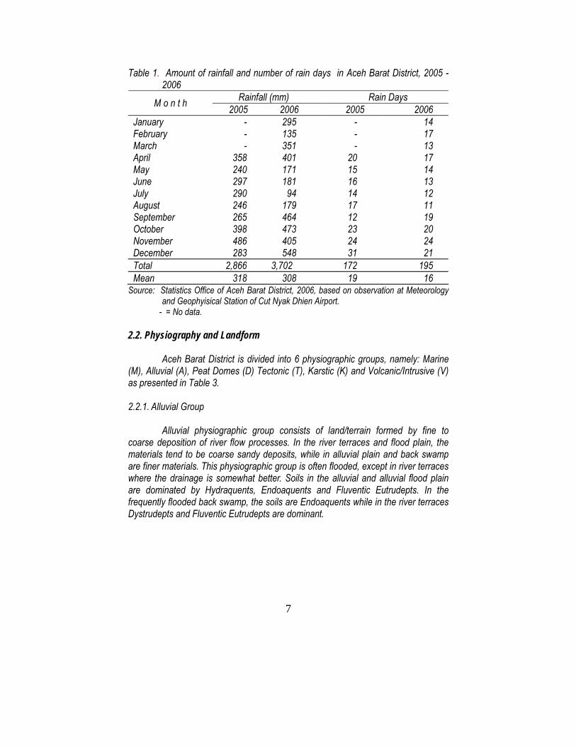
Table 1. Amount of rainfall and number of rain days in Aceh Barat District, 2005 - 2006
Rainfall (mm) Rain Days M o n t h 2005 2006 2005 2006 January - 295 - 14 February - 135 - 17 March - 351 - 13 April 358 401 20 17 May 240 171 15 14 June 297 181 16 13 July 290 94 14 12 August 246 179 17 11 September 265 464 12 19 October 398 473 23 20 November 486 405 24 24 December 283 548 31 21 Total 2,866 3,702 172 195 Mean 318 308 19 16
Source: Statistics Office of Aceh Barat District, 2006, based on observation at Meteorology and Geophyisical Station of Cut Nyak Dhien Airport.
- = No data. 2.2. Physiography and Landform
Aceh Barat District is divided into 6 physiographic groups, namely: Marine
(M), Alluvial (A), Peat Domes (D) Tectonic (T), Karstic (K) and Volcanic/Intrusive (V) as presented in Table 3. 2.2.1. Alluvial Group
Alluvial physiographic group consists of land/terrain formed by fine to coarse deposition of river flow processes. In the river terraces and flood plain, the materials tend to be coarse sandy deposits, while in alluvial plain and back swamp are finer materials. This physiographic group is often flooded, except in river terraces where the drainage is somewhat better. Soils in the alluvial and alluvial flood plain are dominated by Hydraquents, Endoaquents and Fluventic Eutrudepts. In the frequently flooded back swamp, the soils are Endoaquents while in the river terraces Dystrudepts and Fluventic Eutrudepts are dominant.

8
Penggunaan lahan di daerah ini antara lain sawah dan tambak. Vegetasi alami terdiri dari semak-belukar rawa. Sebagian daerah yang berdrainase baik digunakan untuk pertanian tanaman pangan lahan kering dan permukiman. Tabel 2. Suhu bulanan minimum dan maksimum di Kabupaten Aceh Barat.
B u l a n Suhu Minimum rata-rata (oC)
Suhu Maksimum rata-rata (oC)
Januari 22,1 30,6 Februari 22,9 30,9 Maret 22,3 30,8 April 22,8 29,8 Mei 22,9 31,2 Juni 22,6 30,9 Juli 20,6 30,9 Agustus 19,9 31,2 September 22,8 29,6 Oktober 22,8 29,8 November 22,8 30,3 Desember 23,2 30,5
Sumber: Kantor Statistik Kabupaten Aceh Barat (2006), berdasarkan pengamatan di Stasiun Meteorologi dan Geofisika Bandar Udara Cut Nyak Dhien.
2.2.2. Grup Marin
Pada grup fisiografi Marin, tanah berkembang dari bahan pasir pantai. Sub-grup marin seperti komplek beting pantai dan rawa belakang pantai terbentuk di antara guguk pasir (sandbanks). Guguk Pasir ini didominasi oleh tanah Udipsamments dan sering dimanfaatkan untuk kebun kelapa, dan wilayah yang bahan pasirnya lebih halus digunakan sebagai permukiman dan pekarangan serta tanaman sayur-sayuran.
Rawa belakang pantai didominasi oleh tanah Hydraquents dan kadang-kadang bergambut dangkal dan digunakan untuk sawah. Rawa belakang pantai yang langsung terpengaruh pasang surut air laut didominasi oleh tanah-tanah Hydraquents, Sulfaquents, Endoaquents, dan Fluvaquepts. Di dataran estuarin terbentuk tanah Fluvaquents dan Halaquepts. Di daerah berawa merupakan hutan dan belukar rawa, mangrove, pada tempat tertentu terdapat tambak atau sawah pasang surut. Pada wilayah yang posisinya lebih tinggi dan berasal dari bahan berpasir terbentuk tanah-tanah Udipsamments dan Eutrudepts.

9
Land use in this area are rice fields and fish ponds. Natural vegetation is swampy shrubs/bushes. The well drained parts are utilized for upland food crops and settlements. Table 2. Minimum and maximum monthly temperature in Aceh Barat District.
M o n t h Mean Minimum Temperature (oC)
Mean Maximum Temperature (oC)
January 22.1 30.6 February 22.9 30.9 March 22.3 30.8 April 22.8 29.8 May 22.9 31.2 June 22.6 30.9 July 20.6 30.9 August 19.9 31.2 September 22.8 29.6 October 22.8 29.8 November 22.8 30.3 December 23.2 30.5
Source: Statistics Office of Aceh Barat District, 2006, based on observation at Meteorology and Geophysical Station of Cut Nyak Dhien Airport.
2.2.2. Marine Group In the Marine group, the soils are developed from marine sand. Some sub-groups such as beach ridge complex and swale/lagoon are formed between the sandbanks. In sandbank area Udipsaments (sandy soils) were formed and used for coconut garden and the finer sandy soils were used for settlements, home garden and vegetables.
Inundated swale is dominated by Hydraquents (locally peaty) which were utilized for rice fields. In the swampy coastal areas and inundated tidal land, Hydraquents, Sulfaquents, Endoaquepts, and Fluvaquepts are formed. In the estuary plain, Fluvaquents and Halaquepts dominated. The swampy areas were covered by swampy forest and shrubs, mangrove and locally used for coastal fish ponds or tidal rice fields. In the upper part of coastal areas, coarse materials (sand or sandy) cover the land with the main soil of Udipsamments and Eutrudepts.

10
Di daerah pelembahan pantai yang sering terluapi air pasang terbentuk tanah Endoaquepts. Teras marin bagian atas (posisinya 2-5 m di atas permukaan laut) umumnya berdrainase lebih baik bila dibanding dengan sub-grup marin lainnya, terdiri dari tanah-tanah Dystrudepts, Eutrudepts dan Endoaquepts. Penggunaan lahan dan penutupan vegetasi antara lain berupa semak-belukar dan beberapa daerah digunakan untuk permukiman, pekarangan, pertanian lahan kering semusim, kebun karet, dan perkebunan kelapa sawit. 2.2.3. Grup Kubah Gambut Grup fisiografi kubah gambut biasanya terdapat di belakang grup marin dan sebagian besar tergenang. Ketebalan gambut berkisar antara 0,5 sampai 3 m, dan di beberapa tempat lebih dari 9 m. Sebagian besar wilayah ini berupa hutan rawa gambut, semak dan belukar rawa, kebun karet rakyat, perkebunan kelapa sawit, permukiman dan kebun sayuran. 2.2.4. Grup Tektonik Grup tektonik terbentuk melalui proses pengangkatan kulit bumi oleh tenaga tektonik. Grup fisiografi ini dikelompokkan atas relief dataran tektonik tertoreh, berombak sampai bergelombang, dataran tektonik bergelombang dan perbukitan serta pegunungan tektonik. Tanah berasal dari bahan sedimen kasar dan halus. Di daerah berombak, bagian punggung (interfluves) didominasi oleh tanah Hapludults dan di bagian pelembahan didominasi oleh tanah Endoaquepts. Di bagian pelembahan sebagian masih berupa hutan rawa dan semak-belukar rawa, dan sebagian digunakan untuk sawah. Pada lahan dengan bentuk wilayah bergelombang, berbukit dan bergunung, didominasi oleh tanah Hapludults dan Dystrudepts, umumnya masih berupa hutan alami, semak-belukar dan sebagian kecil digunakan sebagai kebun campuran, perkebunan (kelapa sawit dan karet), ladang dan permukiman 2.2.5. Grup Volkanik Grup volkanik terletak di bagian timur dekat perbatasan dengan kabupaten Aceh-Pidie. Grup ini berupa batuan intrusi volkan intermedier yang muncul ke permukaan lahan secara vertikal (batuan beku-dykes). Grup volkan di daerah ini didominasi oleh tanah Dystrudepts yang bersolum dangkal dan berasosiasi dengan batuan kukuh di permukaan. Hampir seluruh daerah ini diliputi oleh hutan lebat. 2.2.6. Grup Karst (batu kapur) Grup karst di daerah Tropis secara dominan dipengaruhi oleh intensitas hujan dan evaporasi yang tinggi. Intensitas hujan yang tinggi menyebabkan banjir, erosi permukaan dan pembentukan parit (gully) pada daerah batu kapur. Daerah ini didominasi oleh tanah Eutrudepts dan Haprendolls dan berasosiasi dengan batu kapur di permukaan tanah. Hampir seluruh perbukitan karst mempunyai topografi berbukit sampai bergubung dan masih berupa hutan lebat.

11
In the frequently inundated basin in coastal areas, the soil is Endoaquepts. Generally the upper marine terraces (2 – 5 m above sea level) have a better drainage than other marine groups. The soils are Dystrudepts, Eutrudepts, and Endoaquepts. Land uses are shrubs, bushes and in some places settlements, home garden, upland crops, rubber garden, including large oil palm and rubber plantations. 2.2.3. Peat-dome Group Peat dome group is usually located behind the marine group and is mostly inundated. The depth of peat soil ranges from 0.5 to 3 meters and in some places could be more than 9 m. Land uses are mostly dominated by swampy peat forest and swampy shrubs and bushes, smallholder rubber plantation, oil palm plantation, settlement and vegetable crops. 2.2.4. Tectonic Group
Tectonic group was formed through uplifting of earth crust by tectonic
activities. This group is subdivided into moderately dissected undulating to rolling tectonic plain, rolling to hilly tectonic and tectonic mountain. The soils are developed from fine to coarse sedimentary materials. In the undulating region, the upper part (interfluves) is dominated by Hapludults and the valley floor is dominated by Endoaquepts. The swampy (valley floor) areas were covered by swampy forest and shrubs, and partially occupied by paddy field. In the rolling, hilly and mountainous terrain the soils are dominated by Hapludults and Dystrudepts and generally covered by natural forest, shrub and bushes, mixed garden (trees and food crops), plantation (oil palm and rubber), upland food crops, and settlement. 2.2.5. Volcanic Group The volcanic group situated close to the east border of the district to Aceh Pidie district. Most volcanic feeders are vertical fissures which gave a rise to vertical sheets of igneous rock called dykes. Dominant soil is shallow Dystrudepts associated with rock outcrops. Almost all of this landform covered by forest. 2.2.6. Karstic Group Tropical karst is dominantly influenced by high intensity rainfall and high evaporation. The high intensity rainfall causes flash floods on the limestones, sheet-wash and gulleying. This makes the hollows in limestone under tropical climate much less regular and rounded relative to those in the temperate climates. The soils include Eutrudepts and Haprendolls associated with rock outcrops. Almost all areas of karstic group with hilly to mountainous topography are covered by forest.

12
Tabel 3. Grup fisiografi, jenis-jenis tanah dominan, sifat-sifat utama tanah dan penggunaan lahan di Kabupaten Aceh (diolah dari Peta Satuan Lahan dan Tanah, Lembar Takengon (0520) Sumatera, Puslittanah dan Agroklimat, 1990).
Grup Fisiografi Sub-grup Tanah Kedalaman, kemasaman, tekstur tanah Penggunaan lahan Dataram aluvial (transisi ke marin)
Hydraquents, Endoaquepts, Endoaquents
Dalam - sangat dalam, agak masam, halus Sawah, tambak, rawa-rawa
Dataran banjir Endoaquepts Endoaquents Fluventic Eutrudepts
Dalam-sangat dalam, agak masam - netral, agak kasar - halus
Sawah, semak, belukar
Teras sungai Dystrudepts, Fluventic Eutrudepts Endoaquepts
Dalam - sangat dalam, masam - netral, agak halus - halus
Sawah, permukiman, tegalan
Aluvial (endapan halus dan kasar)
Rawa belakang Endoaquepts Endoaquents
Sangat dalam, masam, halus Hutan, semak, belukar
Beting pantai dan rawa belakang pantai
Udipsamments Hydraquents
Dalam-sangat dalam, netral, agak kasar - bergambut
Kebun kelapa, permukiman, sawah, semak, belukar
Dataran pasang surut
Hydraquents Sulfaquents Endoaquepts Fluvaquents
Sangat dalam, netral, agak kasar - halus
Semak, belukar, hutan rawa Shrubs/bushes, forest, swampy forest
Dataran estuarin Fluvaquents, Halaquepts,
Sangat dalam, netral, agak kasar - halus
Hutan manggrove, hutan rawa
Dataran pantai Udi Psamments Endoaquepts, Eutrudepts
Sangat dalam, netral, agak kasar - agak halus
Tambak, permukiman, sawah, semak, belukar
Marin (bahan halus dan kasar)
Teras marin Dystrudepts, Eutrudepts Endoaquepts
Dalam - sangat dalam, masam - netral, agak halus
Tegalan, kebun campuran

13
Table 3. Physiographic groups, soil types, selected soil properties and land uses in Aceh Barat District (Adapted from Land Unit and Soil Map of Takengon Sheet ( 0520), Sumatra, Puslittanah dan Agroklimat, 1990).
Physiographic Groups
Sub-groups
Soils Soil depth, acidity, texture Land Use
Alluvial Plain(transition to marine)
Hydraquents, Endoaquepts, Endoaquents
Deep - very deep, slightly acid, fine Rice field, aqua culture, swamps
Flood Plain Endoaquepts Endoaquents Fluventic Eutrudepts
Deep-very deep, slightly acid - neutral, slightly coarse - fine
Rice field, shrubs/ bushes
River Terraces Dystrudepts, Fluventic Eutrudepts Endoaquepts
Deep - very deep, acid - neutral, slightly fine - fine
Rice field, settlement, upland agriculture
Alluvial (fine to coarse sediments)
Back swamp Endoaquepts Endoaquents
Very deep, acid, fine Forest, shrubs/ bushes
Beach ridge and swale
Udipsamments Hydraquents
Deep - very deep, neutral, slightly coarse – peaty
Coconut garden, settlement, rice field, shrubs/bushes
Tidal Plain
Hydraquents Sulfaquents Endoaquepts Fluvaquents
Very deep, neutral, slightly coarse - fine Shrubs/bushes, forest, swampy forest
Estuary plain Fluvaquents, Halaquepts,
Very deep, neutral, slightly coarse - fine Mangrove forest, swampy bushes
Coastal Plain Udi Psamments Endoaquepts, Eutrudepts
Very deep, neutral, slightly coarse – slightly fine
Pond, settlement, rice field, shrubs/bushes
Marine (fine to coarse sediments)
Marine Terraces Dystrudepts, Eutrudepts Endoaquepts
Deep – very deep, acid - neutral, slightly fine
Upland agriculture, mixed garden

14
Grup Fisiografi Sub-grup Tanah Kedalaman, kemasaman, tekstur tanah Penggunaan lahan
Kubah gambut Kubah gambut oligotrofik air tawar
Haplosaprists Haplohemists
Tanah gambut, tebal 0,5 - >9 m, tingkat kematangan: saprist, hemists, fibrists
Hutan rawa, belukar rawa, karet rakyat, kebun kelapa sawit, sayuran
Berombak-bergelombang, tertoreh
Hapludults Endoaquepts
Dalam-sangat dalam, masam, halus Hutan, karet rakyat, kebun sawit, belukar, kebun campuran
Dataran bergelombang dan perbukitan, tertoreh, lereng 15-40%
Hapludults Dystrudepts Endoaquepts
Dalam-agak dalam, agak masam - netral, agak kasar - halus
Semak-belukar, hutan tanaman industri, tegalan Tektonik
(bahan halus dan kasar)
Pegunungan tertoreh, lereng >40%
Hapludults Dystrudepts
Agak dalam, masam - netral, halus - kasar
Hutan lindung, agroforestry
Karstik (Batu kapur)
Berbukit- bergunung, lereng >60%
Eutrudepts Haprendolls Singkapan batuan
Dangkal, netral - basa, halus - berbatu Hutan lindung
Volkanis inetermedier
Berbukit –bergunung, lereng >60%
Dystrudepts Singkapan batuan
Dangkal - agak dalam, masam - netral, halus-berbatu
Hutan Lindung

15
Physiographic
Groups Sub-groups
Soils Soil depth, acidity, texture Land Use
Peat Dome Fresh water oligotrophic peat dome
Haplosaprists Haplohemists
Peat, thickness 0.5 - >9m, decomposition: saprists, hemists, fisbrists
Peat forest, swampy bushes, smallholder rubber, oil palm plantation, vegetables
Undulating- rolling, dissected
Hapludults Endoaquepts
Deep – very deep, acid, fine material Forest, rubber smallholder, oil palm plantation, bushes, mixed garden/ tree crops
Rolling to hilly, dissected, slope 15-40%
Hapludults Dystrudepts Endoaquepts
Deep - moderately deep, slightly acid -neutral, slightly coarse - fine
Shrubs/bushes, plantation forest, upland agriculture
Tectonic (fine and coarse materials) Hapludults
Dystrudepts Moderately deep, acid - neutral, fine – coarse
Protection forest, agroforestry
Karstic (Limestone)
Hilly to mountaineous, slope >60%
Eutrudepts Haprendolls Rock Outcrops
Shallow, neutral to basic, fine – stony Protection forest
Volcanic/ Dyke Intermediary
Hilly to mountainous, slope >60%
Dystrudepts Rock outcrops
Shallow to moderately deep, acid - neutral, fine - stony
Protection forest

16
2.3. Tanah Menurut Taxonomy Tanah (Soil Survey Staff, 2003), tanah di daerah Aceh
Barat dapat dikelompokan ke dalam Ordo tanah: Entisols, Inceptisols, Histosols, Ultisols dan Mollisols.
Entisols di Aceh Barat berada dalam kondisi jenuh air. Inceptisols terbentuk dalam kondisi lingkungan yang lebih kering dengan kedalaman air tanah 40 cm atau lebih dalam, yang memungkinkan berlangsungnya proses pelapukan (oksidasi dan perkembangan struktur tanah).
Sebaliknya Histosols, terbentuk dari endapan bahan organik dalam kondisi jenuh air di daerah cekungan. Ketebahan gambut berkisar antara 0,5 – 3 m dan di bagian tengah kubah ada ketebalan yang mencapai > 9 m. Tingkat kematangan gambut mulai dari mentah (serat-serat tumbuhan masih tampak – Fibrik), sedang (sebagian serat-serat telah melapuk – Hemik), dan matang (serat-serat sudah sangat sedikit - Saprik).
Ultisols, terdapat di wilayah berombak sampai bergelombang, posisinya di belakang Grup Aluvial atau Kubah Gambut, berkembang dari bahan batu liat dan batu pasir yang lapisan bawahnya berupa bahan endapan marin purba yang mengalami pengangkatan (uplifted).
Daerah berbukit sampai bergunung didominasi oleh tanah Hapludults dan Dystrudepts. Lebih dari 60% daerah ini merupakan kawasan hutan lindung.
Grup volkan bertopografi berbukit sampai bergunung, didominasi oleh Hapludults dan Dystropepts bersolum dangkal dan berbatu (lithic grup). Sedangkan Grup Karst didominasi oleh tanah Haprendolls yang dangkal, dan Dystrudepts yang ditandai singkapan batuan. Tanah-tanah dominan yang terdapat pada setiap grup fisiografi dan jenis penggunaan lahan/penutupan vegetasi di Kabupaten Aceh Barat disajikan pada Tabel 3 dan penyebarannya disajikan pada Gambar 1. Sebaran luas setiap penggunaan lahan disajikan pada Tabel 4.

17
2.3. Soil Based on the Soil Taxonomy (Soil Survey Staff, 2003), soils in the study
area can be distinguished into orders of Entisols, Inceptisols, Histosols, Ultisols and Mollisols.
Entisols in this district are located under the permanently water saturated environment. Inceptisols are formed on the drier environment with the ground water table depth of more than 40 cm which facilitates weathering process (oxidation and soil structure development).
Histosols, on the other hand, formed from organic deposits under water saturated condition in the concave areas. Thickness ranges from 0.5-6 m and in some places around the centre of the dome it reached > 9 m thick. Peat maturity ranges from immature (fibric) from which peat the structure of plant fibre can still be observed, somewhat mature (hemic) from which the plant fibre has disappeared and mature (sapric) from which there is no more sign of plant fibre left.
Ultisols, formed from claystone underlain by sandstone, were located in the undulating to rolling uplifted ancient marine sediment, which are situated behind the alluvial and/or peat dome groups.
Dominant soil in the hilly to mountainous areas are Hapludults and Dystrudepts. More than 60% of these regions falls into protection forest areas.
Hilly to mountainous topography of dykes (volcanic group) are dominated by Hupludults and Dystrudepts, they are shallow soil (lithic sub-grup and associated with rock out crops). Karst group (limestone) are dominated by shallow soil of Haprendolls, Dystrudepts associated with rock outcrops. Dominant soils, their properties and major land uses by physiographic groups in Aceh Barat District are listed in Table 3 and spatially depicted in Figure 1. Area of each land use is provided in Table 4.

18
Gambar 1. Peta tanah Kabupaten Aceh Barat (direproduksi dari peta skala
1:100.000) Figure 1. Soil Maps for Aceh Barat District (reproducedfrom 1:100,000 scale map)

19
Legenda peta tanah Gambar 1 (legend of the soil map of Figure 1) MU SOIL 1 SOIL 2 MU SOIL 1 SOIL 2 1 Typic Udipsammets 31 Hapludults Dystrudepts 2 Typic Udipsamments 32 Hapludults Dystrudepts 3 Typic Psammaquents Typic Udipsamments 33 Hapludults Dystrudepts 4 Typic Udipsamments 34 Hapludults Dystrudepts 5 Typic Udipsamments Typic Psammaquents 35 Hapludults Dystrudepts 6 Typic Psammaquents 36 Hapludults Dystrudepts 7 (Histic) Psammaquents Typic Psammaquents 37 Hapludults Dystrudepts 8 Typic Psammaquents Histic Psammaquents 38 Hapludults Dystrudepts 9 Typic Udipsamments Typic Dystrudepts 39 Hapludults Dystrudepts
10 Typic Dystrudepts Typic Udipsamments 40 Hapludults Dystrudepts 11 Typic Fluvaquents 41 Hapludults Dystrudepts 12 Typic Endoaquepts 42 Hapludults Dystrudepts 13 Aquic Dystrudepts Typic Psammaquents 43 Hapludults Dystrudepts 14 (Histic) Psammaquents Typic Haplosaprists 44 Hapludults Dystrudepts 15 Typic Haplohemists Typic Haplosaprists 45 Hapludults Dystrudepts 16 Typic Haplohemists Typic Haplosaprists 46 Hapludults Dystrudepts 17 Typic Haplohemists 47 Hapludults Dystrudepts 18 Typic Haplohemists 48 Hapludults Dystrudepts
19 Fluventic Eutrudepts Fluvaquentic
Endoaquepts 49 Hapludults Dystrudepts
20 Fluvaquentic Endoaquepts Typic Endoaquepts 50 Hapludults Dystrudepts
21 Typic Fluvaquents Fluvaquentic
Endoaquepts 51 Hapludults Dystrudepts 22 Typic Endoaquepts 52 Hapludults Dystrudepts 23 Typic Fluvaquents Aquic Eutrudepts 53 Hapludults Dystrudepts 24 Hapludults Dystrudepts 54 Hapludults Dystrudepts 25 Hapludults Dystrudepts 55 Hapludults Dystrudepts 26 Hapludults Endoaquepts 56 Eutrudepts Haprendolls
27 Hapludults Dystrudepts 57 Dystrudepts Rock Outcrops
28 Hapludults Dystrudepts 99 Waterbody 29 Hapludults Dystrudepts 100 Sea/waterbody 30 Hapludults Dystrudepts 101 Settlements/ urban

20
Tabel 4. Penggunaan lahan di Kabupaten Aceh Barat (BPS Provinsi Nanggroe Aceh Darussalam, 2003)
Tipe penggunaan lahan Luas (ha) Sawah 41.538
Irigasi teknis 1.391 Irigasi semi teknis 10.380 Irigasi tradisional 6.199 Tadah hujan 22.363 Sawah lebak 1.205
Dataran tinggi 251.258 Permukiman & pekarangan 9.710 Tegalan tanaman pangan 36.727 Ladang 28.850 Badan air 43.340 Lahan terlantar tidak diusahakan 36.673 Kebun campuran 21.058 Hutan, semak-belukar dan perkebunan 74.900
Jumlah 292.796

21
Table 4. Existing Landuse for Aceh Barat District (BPS Nanggroe Aceh Darussalam Province, 2003).
Type of Landuse Area (ha) Paddy field 41,538
Regulated Irrigation 1,391 Semi regulated Irrigation 10,380 Traditional irrigation 6,199 Rainfied 22,363 Deep water rice 1,205
Upland 251,258 Settlement and homegarden 9,710 Upland annual crops 36,727 Upland 28,850 Water body 43,340 Unused dry land 36,673 Mixed garden 21,058 Forest, bushes and plantation 74,900
Total 292,796

22
III. KRITERIA DAN INDIKATOR EVALUASI KESESUAIAN LAHAN
Beberapa kriteria (kualitas lahan) dan indikator (karakteristik lahan) digunakan untuk evaluasi kesesuaian lahan (Tabel 5). Tabel 5. Kriteria dan indikator yang digunakan untuk evaluasi kesesuaian lahan
(Djaenudin et al., 2003; FAO, 1976). Kriteria Indikator Suhu (tc) Suhu rata-rata Ketersediaan air (wa) Curah hujan (mm), kelembaban (%), jumlah bulan
kering Ketersediaan oksigen (oa)
Drainase
Keadaan media perakaran (rc)
Tekstur, bahan kasar, kedalaman tanah
Gambut
Ketebalan (cm), kedalaman sisipan bahan mineral, kematangan, ketebala
Retensi hara (nr) KTK liat (cmol+/kg), kejenuhan basa (%), pHH2O, C Organik (%)
Toksisitas (xc) Salinitas (dS/m) Sodisitas (xn) Alkalinitas, ESP (%) Bahaya sulfidik (xs) Kedalaman sulfidik (cm) Bahaya erosi (eh) Lereng (%), erosi Bahaya Banjir (fh) Genangan Penyiapan Lahan (lp) Batuan di permukaan/ Singkapan Batuan (%)
Suhu
Tanaman kopi, misalnya, lebih menyukai dataran tinggi atau suhu rendah, sedangkan karet, kelapa sawit, dan kelapa lebih menyukai dataran rendah. Di daerah yang data suhu udaranya tidak tersedia, suhu udara dapat diperkirakan berdasarkan ketinggian tempat dari permukaan laut dengan menggunakan rumus Braak (1928):
T = 26,3oC – (elevasi dalam meter x 0,006oC)
Suhu udara rata-rata di tepi pantai berkisar antara 25 sampai 27oC. Semakin tinggi elevasi, semakin rendah suhu udaranya.

23
III. CRITERIA AND INDICATORS IN LAND SUITABILITY EVALUATION There are several criteria (land qualities) and indicators (land
characteristics) employed in evaluating land suitability (Table 5).
Table 5. Criteria and indicators used in land evaluation (adapted from Djaenudin et al., 2003; FAO, 1976).
Criteria Indicators Temperature (tc) Average temperature (oC) Water availability (wa) Rainfall (mm), moisture (%), number of dry months Oxygen availability (oa) Drainage Rooting condition (rc) Texture, coarse material (%), soil depth (cm) Peat Thickness, depth (cm) of mineral interlayer/enrichment
(if any), maturity/ripeness Nutrient retention (nr) Clay cation exchange capacity (CEC) (cmol/kg), base
saturation (%), pHH2O, Organic C (%) Toxicity (xc) Salinity (dS/m) Sodicity (xn) Alkalinity/ESP (%) Sulfidic material (xs) Depth of sulfidic materials (cm) Erosion hazard (eh) Slope (%), erosion Flood hazard (fh) Inundation Land preparation (lp) Surface stoniness/surface outcrops (%)
Temperature
Coffee, for example, prefers high altitude or low temperature, while rubber, oil palm and coconut are suitable for the low elevation. In areas where data of air temperature is unavailable, it is estimated by elevation (above sea level) using Braak (1928) formula:
T = 26,3oC – (elevasion in meter x 0.006oC)
The average air temperature at zero elevation (coast) ranges from 25 to 27oC. The higher the elevation, the lower is the air temperature.
24
Ketersediaan air Data yang paling penting untuk keperluan kriteria ketersediaan air adalah jumlah curah hujan tahunan, jumlah bulan kering dan jumlah bulan basah. Oldeman (1975) mengelompokkan wilayah iklim berdasarkan jumlah bulan basah dan bulan kering secara berurutan. Bulan basah adalah bulan yang mempunyai curah hujan >200 mm, sedangkan bulan kering mempunyai curah hujan <100 mm. Kriteria ini diperuntukkan bagi tanaman pangan, terutama untuk padi. Schmidt dan Ferguson (1951) membuat klasifikasi iklim dengan kriteria curah hujan yang berbeda, yakni bulan basah (>100 mm) dan bulan kering (<60 mm). Kriteria ini lebih bersifat umum untuk pertanian lahan kering, termasuk untuk tanaman tahunan.
Ketersediaan oksigen Indikator yang paling baik untuk ketersediaan oksigen adalah drainase
tanah. Drainase tanah berkaitan dengan kecepatan air untuk meresap ke dalam tanah (infiltrasi) dan menunjukan lamanya dan seringnya tanah jenuh air atau tergenang. Pada umumnya tanaman memerlukan kondisi drainase tanah yang baik untuk memfasilitasi cukupnya ketersediaan oksigen. Hampir semua tanaman memerlukan kondisi drainase baik dan agak baik. Drainase tanah yang baik mempunyai konduktivitas hidrolik sedang dan daya menahan air sedang, lembab, tetapi tidak basah di permukaan tanah. Tanah berwarna homogen, tanpa bercak atau karatan besi dan/atau mangan serta tanpa warna gley (reduksi) dari lapisan permukan sampai kedalaman 100 cm.
Drainase tanah agak baik mempunyai kondukvitas hidrolik sedang sampai agak rendah, dan daya menahan air (pori air tersedia) rendah dan keadaan tanah lebih basah dekat permukaan. Tanah berwarna homogen, tanpa bercak atau karatan besi dan atau mangan, serta tanpa warna gley (reduksi) dari permukaan sampai kedalaman 50 cm. Walaupun demikian, padi sawah lebih menyukai lingkungan yang berdrainase terhambat atau sangat terhambat, sering terkena banjir atau genangan secara permanen untuk periode waktu yang panjang. Tanah ini mempunyai bercak karatan besi dan kongresi mangan mulai dari permukaan tanah. Kondisi perakaran Kondisi perakaran diindikasikan oleh tekstur tanah dan keberadaan bahan kasar dan kedalaman tanah. Tekstur merupakan komposisi partikel tanah halus (diameter ≤ 2mm) yang terdiri dari pasir, debu dan liat. Tekstur dapat ditentukan di lapangan secara manual dengan jalan menggesekkan contoh tanah basah di antara dua jari dan mengkelaskannya sebagaimana pada Tabel 6. Namun lebih disarankan analisis tekstur secara kuantitatif di laboratorium dan menggunakan segitiga tekstur (Gambar 2) untuk mengelompokkannya.

25
Water availability
The most important data for water availability criterion are annual rainfall and the number of dry and wet months. Oldeman (1975) climatic classes are based on the number of consecutive wet months and dry months. The wet months are the months with >200 mm rainfall and the dry months are the months with <100 mm rainfall. This criterion is more applicable for annual crops, especially rainfed rice. Based on these criteria, Oldeman (1975) divided the climatic zones into five major classes (A, B, C, D and E). Schmidt and Ferguson (1951) used a different criteria, in which the wet months are those with >100 mm rainfall and the dry months are those with <60 mm rainfall. This latter criterion is usually used mainly for upland crops, including parennial crops. Oxygen availability
Oxygen availability is best indicated by soil drainage. Soil drainage is
related to the speed of water infiltration and thus the duration and level of water saturation and inundation. In general, plants require good drainage soils to facilitate oxygen availability.
The most preferred drainage by most plants are the well drained and moderately well drained. The well drained soils are those with a moderate hydraulic conductivity and moderate water holding capacity; moist, but not wet near the surface. The soil colour is homogenous without iron and manganese concretion and no gley (reduced) layer at up to 100 cm soil depth. The moderately drained soils are those with a moderate to somewhat low hydraulic conductivity, low water holding capacity (low available water pores), and the soil may sometimes be wet near the surface. The soil color is homogenous without iron and manganese concretion and no gley (reduced) layer from soil surface to 50 cm soil depth. For lowland rice field however, poorly drained or very poorly drained soils are preferable. These soils are frequently or permanently flooded for extended length of time to the surface. The soil has some iron and manganese concretion starting from the surface layer. Rooting condition
The rooting condition is indicated by soil texture, presence of coarse material, and soil depth Texture is the composition of fine soil particles (≤ 2 mm diameter) consisting of sand, silt and clay. Soil texture could be assessed manually in the field by pressing wetted samples using two fingers and classifying based on Table 6. Preferably it be determined quantitatively in the laboratory and classifying according to the soil texture triangle (Figure 2).
26
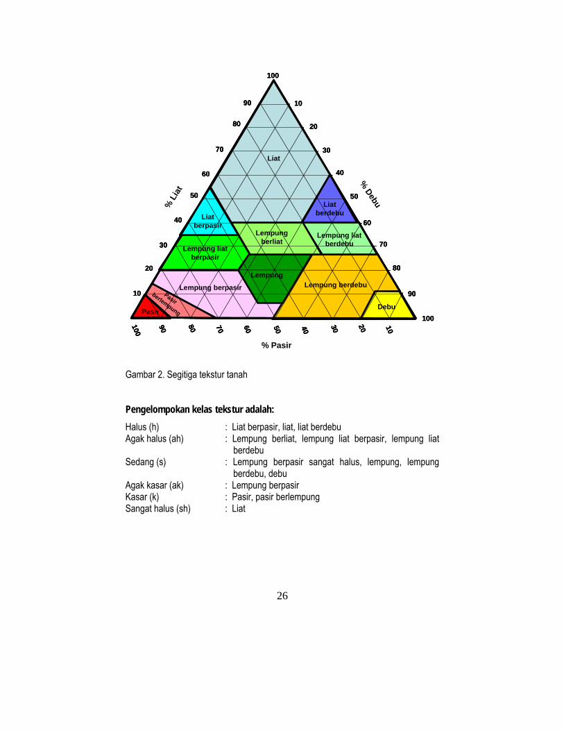
Gambar 2. Segitiga tekstur tanah Pengelompokan kelas tekstur adalah: Halus (h) : Liat berpasir, liat, liat berdebu Agak halus (ah) : Lempung berliat, lempung liat berpasir, lempung liat
berdebu Sedang (s) : Lempung berpasir sangat halus, lempung, lempung
berdebu, debu Agak kasar (ak) : Lempung berpasir Kasar (k) : Pasir, pasir berlempung Sangat halus (sh) : Liat
100
90
80
70
60
50
40
30
20
10
100
90 80 70 60 50 40 30 20 10%
Lia
t
% Debu
% Pasir
100
10
20
30
40
50
60
70
80
90
Liat
LiatberdebuLiat
berpasirLempung liat
berdebuLempung
berliatLempung liat
berpasir
LempungLempung berdebuLempung berpasir
PasirberlempungPasir Debu
100
90
80
70
60
50
40
30
20
10
100
90 80 70 60 50 40 30 20 10%
Lia
t
% Debu
% Pasir
100
10
20
30
40
50
60
70
80
90
Liat
LiatberdebuLiat
berpasirLempung liat
berdebuLempung
berliatLempung liat
berpasir
LempungLempung berdebuLempung berpasir
PasirberlempungPasir Debu
100
90
80
70
60
50
40
30
20
10
100
90 80 70 60 50 40 30 20 10%
Lia
t
% Debu
% Pasir
100
10
20
30
40
50
60
70
80
90
Liat
LiatberdebuLiat
berpasirLempung liat
berdebuLempung
berliatLempung liat
berpasir
LempungLempung berdebuLempung berpasir
PasirberlempungPasir Debu

27
100
90
80
70
60
50
40
30
20
10
100
90 80 70 60 50 40 30 20 10%
Cla
y % Silt
% Sand
100
10
20
30
40
50
60
70
80
90
Clay
Siltyclay
Sandy claySilty clay loamClay loam
Sandy clay loam
LoamSilt loamSandy loamLoamy sand Sand Silt
100
90
80
70
60
50
40
30
20
10
100
90 80 70 60 50 40 30 20 10%
Cla
y % Silt
% Sand
100
10
20
30
40
50
60
70
80
90
Clay
Siltyclay
Sandy claySilty clay loamClay loam
Sandy clay loam
LoamSilt loamSandy loamLoamy sand Sand Silt
100
90
80
70
60
50
40
30
20
10
100
90 80 70 60 50 40 30 20 10%
Cla
y % Silt
% Sand
100
10
20
30
40
50
60
70
80
90
Clay
Siltyclay
Sandy claySilty clay loamClay loam
Sandy clay loam
LoamSilt loamSandy loamLoamy sand Sand Silt
Figure 2. The soil texture triangle.
The grouping of textural classes: Fine (f) : Sandy clay, clay, silty clay Moderately fine (mf) : Clay loam, sandy clay loam, silty clay loam Moderate (m) : Fine sandy loam, loam, silt loam, silt Somewhat coarse (sc) : Sandy loam Coarse (c) : Sandy, loamy sand Very fine (vf) : Clay

28
Tabel 6. Penentuan tekstur di lapangan (dengan cara memijit/menggesekkan tanah basah antara ibu jari dan telunjuk).
Kelas tektur Diskripsi sifat tanah Pasir Sangat kasar sekali, tidak membentuk gulungan, serta tidak
melekat Pasir belempung Sangat kasar, membentuk bola yang mudah sekali hancur,
serta agak melekat Lempung berpasir Agak kasar, membentuk bola yang mudah sekali hancur, serta
agak melekat Lempung Rasa tidak kasar dan tidak licin, membentuk bola teguh, dapat
sedikit digulung dengan permukaan mengkilat, dan melekat Lempung berdebu Licin, membentuk bola teguh, dapat sedikit digulung dengan
permukaan mengkilat, serta agak melekat Debu Rasa licin sekali, membentuk bola teguh, dapat sedikit digulung
dengan permukaan yang mengkilat, serta agak melekat Lempung berliat Rasa agak kasar, membentuk bola agak teguh (lembab),
membentuk gulungan tetapi mudah hancur, serta melekat Lempung berliat berpasir
Rasa kasar agak jelas, membentuk bola agak teguh (lembab), membentuk gulungan tetapi mudah hancur, serta melekat
Lempung berliat berdebu
Rasa licin jelas, membentuk bola teguhgulungan mengkilat, melekat
Liat berpasir Rasa licin agak kasar, membentuk bola dalam keadaan kering sukar dipilin, mudah digulung, serta melekat
Liat berdebu Rasa agak licin, membentuk bola dalam keadaan kering, sukar dipilin, mudah digulung serta melekat
Liat Rasa berat-lekat, membentuk bola sempurna, bila kering sangat keras, bila basah sangat lekat
Untuk sebagian besar komoditas tanaman lahan kering menghendaki tekstur tanah sedang, agak halus sampai agak kasar. Tekstur tanah ini mempunyai kombinasi yang ideal antara pasir, debu dan liat. Walaupun demikian, untuk tanaman padi sawah, lebih disukai tanah yang bertekstur halus sampai sangat halus. Bahan kasar adalah keberadaan kerikil, kerakal, atau batuan pada setiap lapisan tanah. Dibedakan menjadi: sedikit (< 15%), sedang (15-35%), banyak (35-60%) dan sangat banyak (> 60%). Kedalaman tanah dibedakan atas: sangat dangkal (< 20 cm), dangkal (20-50 cm), sedang (50-75 cm) dan dalam (> 75 cm). Semakin dalam solum tanahnya semakin baik untuk mendukung pertumbuhan tanaman terutama untuk tanaman tahunan.

29
Table 6. Field determination of soil texture (by pressing wet soil between thumb and forefinger).
Texture class Soil characteristics description Sand (S) Very coarse, can not form clods or balls, and no stickiness. Loamy sand (LS) Very coarse, can form balls balls/clods but easily collapse. Sandy loam (SL) Somewhat coarse, can form balls that can easily collapse, have
some stickiness. Loam (L) Not coarse and not slippery, can form balls; can be rolled with
shiny surface and somewhat sticky. Silt loam (SiL) Slippery, can form strong clods/balls, can be rolled with shiny
surface, and rather sticky Silt (Si) Very slippery, can be rolled with shiny surface, and rather
sticky. Clay loam (CL) Some rough/coarse materials; can form rather firm balls when
moist, can be rolled but easily broken, somewhat sticky. Sandy clay loam (SCL) The coarse materials can be easily recognized, can form a
rather firm balls, can be rolled but easily broken, sticky. Silty clay loam (SiCL) Slippery, can form firm balls, can easily form shiny rolls, and
sticky Sandy clay (SC) Slippery but rather coarse, can easily form shiny rolls but can
not easily bent, and sticky. Silty clay (SiC) Slippery, can form balls, can easily be rolled, and sticky. Clay (C) Heavily sticky, can form very rounded and good balls, hard
when dry, sticky when wet. The preferred soil texture for most upland crops are moderate, moderately fine and somewhat coarse. These texture grouping have ideal combination of sand, silt and clay. For lowland rice, however, fine and very fine texture are preferble.
Coarse materials are texture modifier that is determined by the percentage of pebbles, gravels or stones in every soil layer. The classes are few ( < 15%), plenty (15 – 35%), abundant (35 – 60%) and dominant (> 60%). The greater the percentage of coarse material, the less suitable the soil is or agriculture.
Soil depth is divided into very shallow (< 20 cm), shallow (20 – 50 cm), moderately deep (50 – 75 cm) and deep (> 75 cm). The deeper the soil, the more suitable they are, especially for tree crops.

30
Gambut Indikator yang paling penting dalam evaluasi kesesuaian lahan untuk
pertanian di lahan gambut adalah ketebalan dan kematangan gambut. Ketebalan gambut dibedakan atas: tipis (<60 cm), sedang (60-100 cm), agak tebal (100-200 cm), tebal (200-400 cm) dan sangat tebal (>400 cm). Semakin tebal gambutnya semakin rawan/peka terhadap ‘subsiden’ (penurunan permukaan). Gambut dalam/tebal umumnya terletak relatif jauh dari sungai besar sehingga tidak pernah terluapi bahan endapan sungai dan sangat miskin unsur hara. Gambut tebal juga mempunyai kandungan karbon yang tinggi dan potensi emisi karbonnya menjadi CO2 (gas rumah kaca terpenting penyebab pemanasan global) juga tinggi apabila gambut tersebut didrainase. Kematangan gambut dibedakan atas (i) gambut saprik (matang) adalah gambut yang sudah melapuk lanjut dan bahan asalnya tidak dikenali, berwarna coklat tua sampai hitam, dan bila diremas kandungan seratnya < 15%, (ii) gambut hemik (setengah matang) adalah gambut setengah lapuk, sebagian bahan asalnya masih bisa dikenali, berwarma coklat, dan bila diremas bahan seratnya 15 – 75%, dan (iii) Gambut fibrik (mentah) adalah gambut yang belum melapuk, bahan asalnya masih bisa dikenali, berwarna coklat, dan bila diremas >75% seratnya masih tersisa (Agus dan Subiksa, 2008). Sebagian besar gambut tergolong sesuai marginal atau bahkan tidak sesuai untuk pertanian, terutama gambut tebal dan gambut yang belum matang (fibrik) sehingga seharusnya dikonservasi dan hanya dijadikan cadangan terakir untuk pembangunan pertanian. Retensi hara
Retensi hara atau dengan kata lain ketersediaan hara, diindikasikan oleh interaksi kandungan liat, kapasitas tukar kation (KTK), kejenuhan basa, pH dan kandungan C organik. Sebagai contoh, tanah berpasir yang kandungan liatnya sangat rendah, cenderung mempunyai KTK yang rendah. Walaupun demikian bila mempunyai kandungan bahan organik yang tinggi, KTK dapat lebih tinggi sehingga dapat memperbaiki ketersediaan kation basa, terutama bila pH tanahnya mendekati netral. pH tanah dapat dibagi menjadi sangat masam (<4,5), masam (4,5 – 5,5), agak masam (5,6 – 6,5), netral (6,6 – 7,5), agak alkalis (7,6 – 8,5) dan alkalis (>8,5). pH tanah yang ideal untuk tanaman pada umumnya adalah antara agak masam dan netral, di mana dalam kisaran pH tanah ini ketersediaan hara tanah relatif tinggi. Toksisitas (xc) Aluminium (Al) dan natrium (Na) yang tinggi di dalam tanah dapat merupakan racun bagi tanaman yang peka/sensitif. Keracunan Al biasanya dijumpai pada tanah sangat masam sehingga dapat diindikasikan oleh rendahnya pH tanah.

31
Peat
The most important indicator of peat suitability is peat thickness and maturity (ripeness). Peat thickness is divided into thin (< 60 cm), moderate (60 – 100 cm), somewhat thick (100 – 200 cm), thick (200 – 400 cm) and very thick (> 400 cm). The thicker the peat the more prone it is to subsidence. Deep peat usually situated far from river (sediment deposition influence) and thus very poor in nutrient content. Thick peat also stores high amount of carbon that is subjected to decomposition into CO2, the most important green house gas, contributing to the global warming once the peat is drained.
Peat maturity is divided into (i) mature (sapric): the decomposed peat from which the original plant tissue can no longer be recognized, dark brown to black in color, and when pressed by hand less then 15% of its fibre remains, (ii) halfly mature (hemic) from which part of the original plant fibre can still be recognized, brown in color, and when pressed by hand 15-75% of its fibre remains, and (iii) immature (fibric) is the undecomposed peat in which its original plant fibre can still be recognized, brown in color, and when pressed >75% of the fibre remains (Agus and Subiksa, 2008). Most peatland are marginally suitable or unsuitable for agriculture, especially the thick and immature peat and should be conserved as the last resort for agricultural development. Nutrient retention Nutrient retention or, otherwise, availability is indicated by interaction of clay content, cation exchange capacity, base saturation, pH, and organic carbon. For example, sandy soil with a very low clay content, tend to have a low CEC. However, with a high content of organic matter the CEC can be somewhat higher and the soil can retain basic cations better, especially when the soil pH is near neutral.
Soil pH can be divided into very acid (< 4.5), acid (4.5 – 5.5), slightly acid (5.6 – 6.5), neutral (6.6 – 7.5), slightly alkaline (7.6 – 8.5), and alkaline (> 8.5). The ideal soil pH for most crops are slightly acid and neutral in which range most nutrients are easily available for crop uptake. Toxicity (xc) High amount of Aluminium (Al) and sodium (Na) may be toxic to sensitive plants. Al toxicity usually found in very acid soils and thus can be indicated by the low soil pH.
32
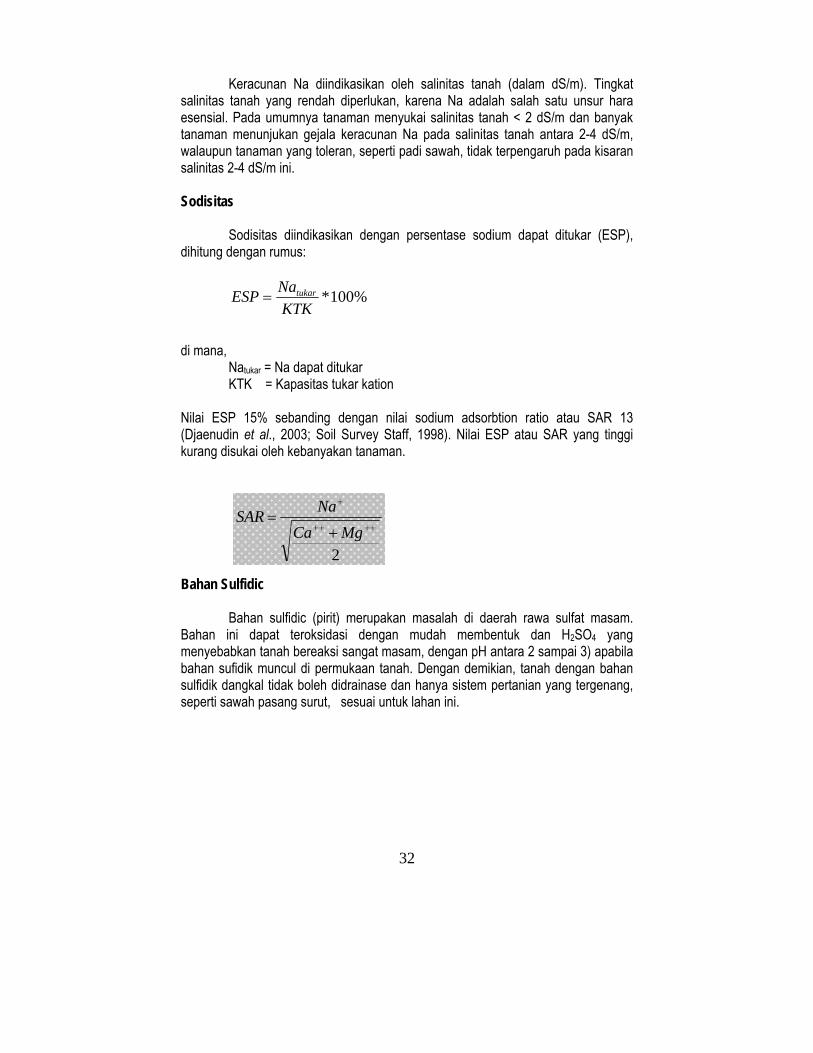
Keracunan Na diindikasikan oleh salinitas tanah (dalam dS/m). Tingkat salinitas tanah yang rendah diperlukan, karena Na adalah salah satu unsur hara esensial. Pada umumnya tanaman menyukai salinitas tanah < 2 dS/m dan banyak tanaman menunjukan gejala keracunan Na pada salinitas tanah antara 2-4 dS/m, walaupun tanaman yang toleran, seperti padi sawah, tidak terpengaruh pada kisaran salinitas 2-4 dS/m ini. Sodisitas
Sodisitas diindikasikan dengan persentase sodium dapat ditukar (ESP), dihitung dengan rumus:
%100*KTKNaESP tukar=
di mana,
Natukar = Na dapat ditukar KTK = Kapasitas tukar kation
Nilai ESP 15% sebanding dengan nilai sodium adsorbtion ratio atau SAR 13 (Djaenudin et al., 2003; Soil Survey Staff, 1998). Nilai ESP atau SAR yang tinggi kurang disukai oleh kebanyakan tanaman. Bahan Sulfidic Bahan sulfidic (pirit) merupakan masalah di daerah rawa sulfat masam. Bahan ini dapat teroksidasi dengan mudah membentuk dan H2SO4 yang menyebabkan tanah bereaksi sangat masam, dengan pH antara 2 sampai 3) apabila bahan sufidik muncul di permukaan tanah. Dengan demikian, tanah dengan bahan sulfidik dangkal tidak boleh didrainase dan hanya sistem pertanian yang tergenang, seperti sawah pasang surut, sesuai untuk lahan ini.
2
++++
+
+=
MgCaNa SAR

33
Na toxicity is indicated by soil salinity (expressed in dS/m). Some level of salinity is needed because Na is an essential element. Most crops tolerate toxicity of <2 dS/m and many crops exhibits signs of Na toxicity under salinity levels between 2 and 4 dS/m, although tolerant crops such as lowland rice is not affected under this salinity level. Sodicity
Sodicity is indicated by exchangeable sodium percentage (ESP) and can be calculated using the formula:
%100*CECNaESP Exch=
where,
NaExch = Exchangeable Na CEC = cation exchange capacity
The ESP of 15% is more or less equivalent with the sodium adsorption ratio, SAR of 13 (Djaenudin et al., 2003; Soil Survey Staff, 1998). High ESP or high SAR soils are less preferred by most plants.
Sulfidic material Sulfidic materials (pyrite) is problematic in acid sulphate swampy areas. This materials can easily oxidise to form H2SO4 (causing a very acid soil condition with pH as low as 2 to 3) when the shallow sulfidic material is exposed to the open air. Therefore, soils with shallow sulfidic materials may not be drained and only flooded agricultural systems, such as swampy tidal swamp rice, is suitable.
2
++++
+
+=
MgCaNa SAR

34
Bahaya erosi
Elemen yang terpenting yang menentukan tingkat bahaya erosi adalah relief/ lereng. Kelas lereng dibagi seperti berikut ini:
Datar < 3% Berombak 3-8% Bergelombang 8-15% Berbukit 15-30% Bergunung 30-40% Pegunungan curam 40-60% Pegunungan sangat curam > 60% Lahan berlereng lebih dari 40% tidak sesuai untuk pertanian dan disarankan sebagai kawasan konservasi. Bahaya erosi didasarkan pada penampakan tanda-tanda erosi lembar, erosi parit, dan erosi alur/gully. Di samping menggunakan faktor lereng, metode pendekatan lainnya untuk mengetahui bahaya erosi adalah dengan estimasi erosi lapisan permukaan tanah rata-rata tahunan, relatif terhadap ketebalan horison A pada tanah yang belum tererosi. Horison A adalah tanah lapisan atas yang dicirikan dengan warna gelap/hitam karena tingginya kandungan bahan organik. Tingkat bahaya erosi dikelompokkan menjadi potensi erosi tahunan sangat rendah (<0,15 cm), rendah (0,15-0,9 cm), sedang (0,9 – 1,8 cm), tinggi (1,8 – 4,8 cm) dan sangat tinggi (>4,8 cm). Bahaya banjir Bahaya banjir dicirikan dengan gabungan kedalaman dan lamanya banjir. Informasi tersebut dapat diperoleh melalui wawancara dengan penduduk setempat. Hampir semua tanaman hanya toleran dengan genangan yang dangkal dalam waktu yang pendek. Penyiapan lahan Penyiapan lahan dipengaruhi oleh kondisi batu-batuan di permukaan tanah dan singkapan batuan. Semakin banyak batu-batuan di permukaan tanah, semakin kurang sesuai lahan tersebut untuk tanaman pertanian.
35
Erosion hazard
The most important element determining erosion hazard is relief/slope. The slope classes are listed as folows:
Flat < 3% Undulating 3-8% Rolling 8-15% Hilly 15-30% Mountainous 30-40% Steep mountainous 40-60% Very steep mountainous > 60%
Land with slopes steeper than 40% are not suitable for agriculture and recommendable for conservation.
The erosion hazard is based on the signs of sheet, reel, and gully erosion. Besides using the slope, another approach in determining the erosion hazard is by estimating the average annual eroded surface layer, relative to the uneroded soils as shown by the thickness of the A horizon. The A horizon is a top soil characterized by dark color because of high organic matter content. The level of erosion hazard is divided into very low (< 0.15 cm), low (0.15 – 0.9 cm), moderate (0.9 – 1.8 cm), high (1.8 – 4.8 cm) and very high (> 4.8 cm) potential annual soil loss. Flood hazard Flood is characterized by the combination of flood depth and duration. This information can be obtained by interviewing local people. Most crops tolerate shallow and short duration floods. Land preparation Land preparation is affected by soil surface stoniness and surface outcrops. The higher the stoniness, the less suitable plants will be.
36
IV. PENDEKATAN EVALUASI LAHAN Proses evaluasi lahan mencakup kegiatan: identifikasi karakteristik lahan,
kompilasi informasi persyaratan tumbuh tanaman, pencocokan (matching) antara karakteristik lahan dengan persyaratan tumbuh tanaman dan pemilihan (screening) alternatif tanaman yang sesuai untuk menyusun rekomendasi penggunaan lahan (Ritung et al., 2007; Djaenudin et al., 2003). Syarat tumbuh tanaman untuk berbagai tanaman pertanian dapat mengacu pada bahan pustaka yang ada seperti Djaenudin et al. (2003).
Pencocokan (matching) antara karakteristik lahan pada setiap satuan peta (mapping unit) dengan persyaratan tumbuh tanaman dapat dilakukan dengan sistem komputerisasi, antara lain menggunakan paket program Automated Land Evaluation System – ALES (Rossiter dan van Wambeke, 1997 and 1995), atau secara manual jika hanya beberapa titik atau poligon satuan peta yang dievaluasi. Evaluasi dengan bantuan komputer akan memberikan hasil yang sangat cepat, walaupun banyak jumlah tanaman yang dievaluasi.
Klasifikasi kesesuaian lahan dinilai dan ditentukan berdasarkan faktor pembatas terberat seperti disajikan pada Tabel 7. Misalnya, jika suatu lahan pHnya sangat rendah termasuk dalam klas sesuai marginal (S3), walaupun karakteristik lahan lainnya termasuk kelas sangat sesuai (S1) dan cukup sesuai (S2), kesesuaian lahan tersebut termasuk S3. Namun masalah pH rendah, sebetulnya relatif mudah diatasi. Melalui pengelolaan lahan kelas kesesuaian lahan berpotensi ditingkatkan menjadi kelas cukup sesuai (S2) atau bahkan sangat sesuai (S1). Rekomendasi penggunaan lahan yang disajikan dalam buku ini didasarkan pada kesesuaian lahan potensial.
Penyaringan dari sejumlah alternatif (screening) penggunaan lahan diperlukan untuk mencocokkan tanaman yang sesuai dengan prioritas rencana pembangunan wilayah kabupaten dan penggunaan lahan yang telah ada saat ini. Tanaman pangan semusim yang direkomendasikan adalah tanaman yang dinilai sangat sesuai (S1) dan cukup sesuai (S2), sedangkan untuk tanaman tahunan yang dinilai termasuk tanaman sesuai marginal (S3) karena lebih tingginya daya lentur serta pentingnya peran tanaman tahunan untuk perlindungan kawasan pantai.

37
IV. APPROACH IN LAND EVALUATION
The process of land evaluation includes identification of land characteristics, compilation of crop requirement information, matching of land characteristics with crop requirements and screening of land suitability options to produce land use recommendation (Ritung et al., 2007; Djaenudin et al., 2003). The requirements for growth of various crops can be obtained from available literature such as Djaenudin et al. (2003).
Matching (comparing) between land characteristics in every mapping unit with crop requirements is normally conducted by computerized system e.g. using the Automated Land Evaluation System, ALES (Rossiter and van Wambeke, 1997 and 1995) or manually if only a few points or mapping units are to be evaluated. By computerized system the process can be executed very quickly for several crops simultaneously.
The land suitability classifications are defined based on their most serious limiting factors as shown in Table 7. Although only low soil pH that lead the suitability falls into S3 while other land characteristics were within S1 and S2 classes, then the suitability under the actual condition is S3. However, the pH problem is relatively easily manageable and its category can shift to S2 or even S1 and thus the potential suitability is S2. The recommendation as presented in this booklet is based on the potential suitability.
Screening is necessary to match the suitable crops with the priority of regional/district development and existing land use. In the screening for annual food crops and vegetable crops, only S1 and S2 classes were considered, but for the perennial tree crops, S3 or marginally suitable class was also included because of the resilience and the importance of the perennial crop on the coastal area protection.

38
Tabel 7. Evaluasi kesesuian lahan untuk tanaman pisang
Kelas kesesuaian lahan Karakteristik lahan Nilai Aktual Potensial
Suhu (tc) S2 S2 Suhu rata-rata (oC) 28,8 S2 S2 Ketersediaan air (wa) S2 S2 Curah hujan (mm) 3109 S2 S2 Jumlah Bulan Kering (bulan) 0 S1 S1 Ketersediaan oksigen (oa) S1 S1 Drainase baik S1 S1 Kondisi perakaran (rc) S1 S1 Tekstur SiC/C S1 S1 Bahan kasar (%) 0 S1 S1 Kedalaman tanah (cm) > 100 S1 S1 Gambut : S1 S1 Kedalaman (cm) 0 S1 S1 Ketebalan (cm) lapisan mineral sisipan (jika ada)
Kematangan gambut Retensi hara (nr) S3 S1 KTK liat (cmol/kg) >16 S1 S1 KejenuhanBasa (%) < 50 S2 S1 pH H2O 4,5 S3 S1 Bahan Organik C (%) 1,1 S1 S1 Toksisitas (xc) S1 S1 Salinitas (dS/m) < 0,5 S1 S1 Sodisitas (xn) Alkalinitas/ESP (%) - Bahan Sulfidik (xs) Kedalaman sulfidik (cm) Bahaya erosi (eh) S1 S1 Lereng (%) 3-8 S1 S1 Bahaya erosi Bahaya banjir (fh) S1 S1 Genangan F0 S1 S1 Penyiapan lahan (lp) S1 S1 Batuan di permukaan tanah (%) 0 S1 S1 Batuan induk/ kukuh (%) 0 S1 S1 Kelas kesesuaian lahan S3 S2

39
Table 7. Land suitability evaluation for banana.
Land suitability class Land characteristics Value Actual Potential
Temperature (tc) S2 S2 Mean temperature (oC) 28.8 S2 S2 Water availability (wa) S2 S2 Rainfall (mm) 3109 S2 S2 Number of dry months (month) 0 S1 S1 Oxygen availability (oa) S1 S1 Drainage Good S1 S1 Rooting condition (rc) S1 S1 Texture SiC/C S1 S1 Rough materials (%) 0 S1 S1 Soil depth (cm) > 100 S1 S1 Peat: S1 S1 Depth (cm) 0 S1 S1 Thickness (cm) of inter mineral layer (if any)
Maturity/ripeness Nutrient retention (nr) S3 S1 Clay CEC (cmol/kg) >16 S1 S1 Base saturation (%) < 50 S2 S1 pH H2O 4.5 S3 S1 Organic C (%) 1.1 S1 S1 Toxicity (xc) S1 S1 Salinity (dS/m) < 0.5 S1 S1 Sodicity (xn) Alkalinity/ESP (%) - Sulfidic material (xs) Sulphidic depth (cm) Erosion hazard (eh) S1 S1 Slope (%) 3-8 S1 S1 Erosion hazard Flood hazard (fh) S1 S1 Inundation F0 S1 S1 Land preparation (lp) S1 S1 Surface stoniness (%) 0 S1 S1 Rock outcrops (%) 0 S1 S1 Suitability class S3 S2

40
V. REKOMENDASI PENGGUNAAN LAHAN 5.1. Tanaman pertanian
Evaluasi kesesuaian lahan untuk tanaman tahunan dilakukan untuk komoditas tanaman kelapa sawit, coklat, kopi, karet, kelapa, rambutan, mangga, manggis, durian, pisang, jeruk, nenas, nilam, pepaya, cengkeh dan duku. Untuk tanaman semusim dievaluasi kesesuaian lahan untuk tanaman padi sawah, padi gogo, jagung, buncis, sawi, semangka, talas, kacang panjang, kacang tanah, cabai , terong, ubi jalar dan ubi kayu.
Faktor pembatas utama yang digunakan dalam evaluasi kesesuaian lahan adalah: nr: kandungan hara tanah (hara rendah/kesuburan rendah); eh: bahaya erosi (lereng); oa: ketersediaan oksigen (drainase tanah); rc: kondisi perakaran (sub-soil berpasir); fh: bahaya banjir (genangan air); ps: tanah bergambut, dan wa: ketersediaan air (yang dipengaruhi oleh curah hujan tahunan). Hasil evaluasi kesesuaian lahan untuk setiap satuan peta tanah (soil mapping unit-SMU) adalah seperti berikut: SMU 1, Beting pasir resen, tidak sesuai (N) untuk tanaman pertanian. Pembatas
utama adalah tanah berpasir lepas, merupakan akumulasi dari timbunan pasir dampak bencana Tsunami.
SMU 2, 3, 4, dan 5 (komplek beting pantai resen dan rawa belakang pantai di daerah marin), sesuai marginal (S3) untuk coklat, kelapa, kopi, semangka dan nilam. Faktor pembatas utama di antaranya adalah kandungan hara rendah, lapisan tanah bawah berpasir, dan berair payau.
SMU 6 dan 8 (komplek beting pantai dan rawa belakang pantai resen dengan drainase terhambat, lahan ini tidak sesuai (N) untuk tanaman tahunan, tetapi cukup sesuai (S2) untuk padi sawah. Faktor pembatas adalah genangan air pasang (untuk sistem pertanian lahan kering), kandungan hara rendah dan sub-soil berpasir
SMU 9 dan 10 (Complex beting pantai dan rawa belakang pantai sub-resen), sesuai marginal (S3) untuk tanaman coklat, kelapa, kopi, karet, kelapa sawit, duku, rambutan, durian, mangga, jeruk dan semangka. Faktor pembatas utama di antaranya adalah kandungan hara/kesuburan rendah dan sub-soil berpasir.
SMU 7 dan 14 (beting pantai dan rawa belakang pantai sub-resen tertutup lapisan gambut dangkal), sesuai marginal (S3) untuk karet, kelapa sawit dan padi. Faktor pembatas: genangan air, kandungan hara rendah dan sub-soil berpasir.
SMU 13 (beting pantai sub resen), unit lahan ini cukup sesuai dan sesuai marginal (S2 dan S3) untuk tanaman kelapa, kopi, coklat, duku, mangga, manggis, rambutan, pisang, semangka, jagung dan kacang tanah. Faktor pembatas berupa kandungan hara rendah dan sub-soil berpasir.
SMU 15 (gambut tipis, ketebalan: 0,5-1,0 meter), sesuai marginal (S3) untuk tanaman karet, kelapa sawit, kelapa, sawi, terong, kacang panjang dan semangka. Faktor pembatas berupa genangan air, kandungan hara rendah dan tanah bergambut.

41
V. LANDUSE RECOMMENDATION 5.1. Agricultural Crops The evaluation has been carried out for a number of selected tree crops (oil palm, cacao, coffee, rubber, coconut, rambutan, mango, manggosteen, durian, banana, citrus, pineapple, patchouli, papaya, clove, and lanseum) and annual crops (wetland rice, upland rice, maize, soybean, mustard, water melon, taro, long bean, peanut, red chilli, egg plant, sweet potato, and cassava).
The main restricting factors taken into account were: nr: nutrient retention (low nutrient/low fertility); eh: erosion hazard (slope); oa: oxygen availability (soil drainage); rc: rooting condition (sandy material of sub-soil); fh: flood hazard (water inundation); ps: peaty soil, low nutrient and poor drainage; and wa: water availability (influenced by annual rainfall). Land suitability by soil mapping unit (SMU) is provided as follows: SMU 1, (sand beach recent) is not suitable (N) for any kinds of crops. The main
limiting factors are rooting condition/loose sand accumulation resulted from tsunami deposition..
SMU 2, 3, 4, and 5 (complex of recent beach ridge and swale in marine region) are marginally suitable (S3) for cocoa, coconut, coffee, water melon and patchouli. The major limiting factors are low nutrient availability and rooting condition (sandy texture of sub-soil), and brackish water.
SMU 6 and 8 (complex of beach ridges and swale-recent with poor drainage) are not suitable (N) for tree crops, but moderately suitable (S2) for wetland rice. The limiting factors (for upland agriculture) are water inundation (for tree crops), low nutrient content and sandy texture of sub-soil.
SMU 9 and 10 (complex of sub recent beach ridge and swale in marine region) are marginally suitable (S3) for cacao, coconut, coffee, rubber, oil palm, lanseum, rambutan, durian, manggo, citrus and water melon. The main limiting factors are low nutrient content and sandy texture sub-soil.
SMU 7 and 14 (sub recent of beach ridges and swalles covered by shallow peat), are marginally suitable (S3) for rubber, oil palm and paddy. The limiting factor are: water inundation, low nutrient and sandy material of sub-soil.
SMU 13 (beach ridges sub recent) is moderately to marginally suitable (S2, and S3) for coconut, coffee, cacao, lanseum, mango, manggosteen, rambutan and banana, water melon, maize and peanut. The limiting factors are low nutrient and sandy material of sub-soil.
SMU 15 (thin peat: 0.5 – 1.0 m) is marginally suitable (S3) for rubber, oil palm, coconut, mustard, egg plant, long bean, and water melon. The limiting factors are water inundation, low nutrient content and shallow peat (<1 meter).

42
SMU 16 dan 17 (gambut agak tebal, ketebalan: 1-3 meter), sesuai marginal (S3) untuk karet, kelapa sawit dan kelapa. Faktor pembatasnya berupa genangan air dan kandungan hara rendah
SMU 18 (gambut tebal, ketebalan gambut >3 meter), tidak sesuai untuk pertanian, karena bila ekosistem lahan rawa gambut terganggu, kualitas lingkungan akan menurun drastis sehingga disarankan untuk tetap dihutankan.
SMU 19 (tanggul sungai-levee), cukup sesuai dan sesuai dan sesuai marginal (S2 dan S3) untuk tanaman coklat, kopi, duku, durian, manggis, dan rambutan. Faktor pembatas berupa kandungan hara rendah dan luapan banjir.
SMU 11, 12, 20, 21, 22 dan 23 (rawa belakang pantai, pelembahan sungai, endapan aluvio-marin yang didominasi oleh tanah-tanah jenuh air (aquepts and aquents), lahan ini cukup sesuai (S2) untuk padi sawah. Faktor pembatas utama adalah kandungan hara rendah.
SMU 24 dan 28 (dataran aluvial dan dataran tektonik berombak), kedua unit lahan ini cukup sesuai (S2) dan sesuai marginal (S3) untuk karet, kelapa sawit dan padi sawah. Faktor pembatas berupa kandungan hara rendah, drainase agak terhambat.
SMU 25, 26, 27, 29 dan 51 (dataran tektonik bergelombang dan graben), unit lahan ini sesuai marginal (S3) untuk tanaman karet, kelapa sawit, coklat, cengkeh dan pisang. Faktor pembatas, kandungan hara rendah dan bahaya erosi.
SMU 31, 32 dan 33 (grup perbukitan tektonik), sesuai marginal untuk karet, rambutan, mangga, coklat, cengkeh, duku, durian, jeruk, manggis, nenas dan pisang. Faktor pembatas berupa bahaya erosi dan kandungan hara rendah.
SMU 30, 34, 35, 36, 37, dan 38 (grup perbukitan tektonik, telah mengalami erosi berat, lereng 30-50%), sesuai marginal untuk hutan tanaman industri-agroforestry (beberapa tanaman yang bisa dikembangkan antara lain: karet, kopi, coklat, mangga, rambutan dan durian. Faktor pembatas berupa bahaya erosi dan kandungan hara rendah.
SMU 39, 40, 41, 42, 43, 44, 45, 46, 47, 48, 49, 50, 52, 53, 54, 55, 56 and 57 (Pegunungan tektonik dengan lereng >40%, bahan volkan dan Batu kapur /karst). Lahan ini tidak sesuai untuk pengembangan pertanian dan sebaiknya tetap dihutankan, untuk menjaga ekosistem di kawasannya.
Hasil evaluasi kesesuian lahan untuk beberapa komoditas tanaman pertanian menunjukkan hampir semua lahan termasuk dalam kelas sesuai marginal (S3) kecuali beberapa unit lahan yang cukup sesuai (S2). Pasir lepas sepanjang garis pantai tidak sesuai untuk tanaman pertanian (semusim dan tahunan). Gambut dalam >3 m disarankan untuk tetap di konservasi dan dihutankan. Perbukitan dan pegunungan tektonik dengan lereng >40% tidak disarankan untuk pengembangan pertanian, karena dapat menimbulkan bahaya erosi dan mengganggu ekosistem di kawasannya. Arahan penggunaan lahan untuk berbagai macam tanaman tahunan, padi sawah dan tanaman semusim lainnya disajikan pada Tabel 8 dan Gambar 3 (Peta Rekomendasi Penggunaan Lahan) dilampirkan dalam amplop pada Buku ini.

43
SMU 16 and 17 (moderately thick peat 1-3 meter) are marginally suitable (S3) for rubber, oil palm and coconut. The limiting factors are water inundation and low nutrient content.
SMU 18 (thick peat >3 meter) is not suitable for agriculture due to fragile ecosystem and should be conserved as peat forest.
SMU 19 (levee) is moderately to marginally suitable (S2, S3) for coconut, cacao, coffee, lanseum, durian, manggosteen and rambutan. The limiting factors are low nutrient and water inundation
SMU 11, 12, 20, 21, 22, and 23 (swale, river backswamp, narrow river valley, aluvio-marine deposits dominated by aquepts and aquents soil) are moderately suitable (S2) for paddy. The major limiting factor are low nutrient availability.
SMU 24 and 28 (alluvial plain and undulating tectonic plain) both unit are moderately to marginally suitable (S2 and S3) for rubber, oil palm and lowland rice. The major limiting factor is low nutrient availability and somewhat poor drainage for upland system.
SMU 25, 26, 27, 29 and 51 (rolling tectonic plain and ‘graben’) are marginally suitable (S3) for rubber, oil palm, cacao, clove and banana. The limiting factors are low nutrient and erosion hazards/ steep slopes.
SMU 31, 32, and 33 (hilly tectonic terrain) are marginally suitable (S3) for rubber, rambutan, mango, cacao, clove, lanseum, durian, citrus, manggosteen, pineapple and banana. The limiting factors are low nutrient and erosion hazards/steep slopes.
SMU 30, 34, 35, 36, 37 and 38 (strongly dissected hilly tectonic terrain, with slope 30-50%) are marginally suitable for multistrata agroforestry systems (Cacao, Rubber, Coffe, Cacao, Mango, Rambutan, Durian). The limiting factors are low nutrient and erosion hazards/steep slopes.
SMU 39, 40, 41, 42, 43, 44, 45, 46, 47, 48, 49, 50, 52, 53, 54, 55, 56 and 57 (mountainous tectonic terrain with slope >40%, volcanic and karstic) are not suitable for agricultural crops due to fragile ecosystem and should remain forested.
Almost all results of crop suitability evaluation fall into class S3 and only a few fall into S2 suitability class. Loose recent sandy beach along the coastal line are not suitable for any kinds of agricultural crops. Peat thicker than 3 meters should be left as conservation areas. In the hilly to mountainous region with slope >40% the land is not recommended for agriculture because of the steep slopes. Land use recommendation for various tree crops, lowland rice and upland crops is summarised in Table 8, Figure 3, and Land Use Recommendation Map is in the pocket of this booklet.

44
Gambar 3. (a) Beting sungai dan cekungan resent-sub resent (SMU-5) yang ditutupi
belukar dan kelapa, (b) Cekungan dengan drainase jelek ditumbuhi rumputan (SMU-5), (c) Proril tanah dataran aluvial (SMU 21), (d) Lahan bera pada dataran aluvial (SMU 21), dan (e) Dataran aluvial yang disawahkan (SMU 21).
Figure 3. (a) Beach ridge and swales recent-sub recent (SMU-5) covered with shrubs
and coconut, (b) Swale with poor drainage covered by grass (SMU-5), (c) Soil profile of alluvial plain (SMU 21), (d) Fallow area of alluvial plain (SMU 21), and (e) Alluvial plain used for paddy field (SMU 21).
a
c
b
e
d
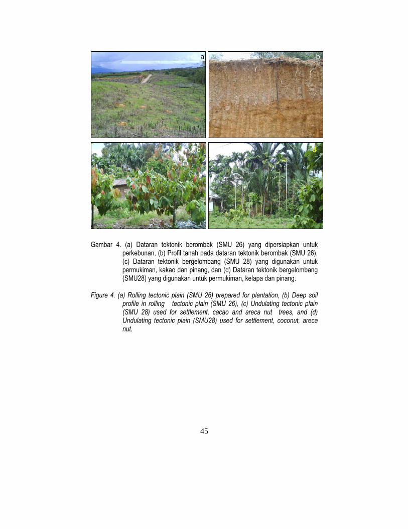
45
Gambar 4. (a) Dataran tektonik berombak (SMU 26) yang dipersiapkan untuk
perkebunan, (b) Profil tanah pada dataran tektonik berombak (SMU 26), (c) Dataran tektonik bergelombang (SMU 28) yang digunakan untuk permukiman, kakao dan pinang, dan (d) Dataran tektonik bergelombang (SMU28) yang digunakan untuk permukiman, kelapa dan pinang.
Figure 4. (a) Rolling tectonic plain (SMU 26) prepared for plantation, (b) Deep soil
profile in rolling tectonic plain (SMU 26), (c) Undulating tectonic plain (SMU 28) used for settlement, cacao and areca nut trees, and (d) Undulating tectonic plain (SMU28) used for settlement, coconut, areca nut.
a
c d
b

46
5.2. Kawasan konservasi Dua kawasan yang direkomendasikan untuk dijadikan kawasan konservasi adalah: wilayah yang berlereng curam dan kubah gambut dalam. Kawasan yang berlereng >40% merupakan lahan yang peka terhadap erosi dan sangat riskan untuk usaha pertanian secara intensif. Gambut tebal lebih dari 3 m, juga sangat riskan bila dimanfaatkan untuk pertanian karena dapat mempercepat proses dekomposisi dan konsolidasi lahan bila lahan didrainase. Lapisan gambut ini akan cepat hilang dalam beberapa dekade, terutama bila penggunaan lahannya memerlukan drainase yang dalam.
Keputusan Presiden No. 32/1990 mengatur pemanfaatan lahan gambut dengan ketebalan 3 m atau lebih, agar tetap dipertahankan sebagai hutan rawa gambut untuk menjaga kestabilan ekosistem di kawasannya. Kawasan yang direkomendasikan untuk pengamanan lingkungan disajikan pada Tabel 8, dan Gambar 3, Peta rekomendasi penggunaan lahan dilampirkan dalam amplop buku ini.
VI. PENUTUP Pada Peta Rekomendasi Penggunaan Lahan (Gambar 3), setiap satuan
peta tanah (SMU) disajikan beberapa alternatif/pilihan tanaman pertanian yang sesuai untuk dikembangkan. Berdasarkan beberapa alternatif/pilihan tanaman yang direkomendasikan, pemangku kepentingan dapat menentukan pilihan komoditas tanaman terbaik yang akan dikembangkan dengan mempertimbangkan kondisi/kebutuhan pasar setempat dan dukungan ketersediaan infrastruktur. Untuk memutuskan pilihan sistem pertanian (monokultur atau mutiple cropping), dapat diminta saran pada Dinas Pertanian dan Perkebunan tentang prioritas komoditas tanaman yang memiliki prospek ekonomi untuk dikembangkan. Untuk lahan yang saat ini telah digunakan/dimanfaatkan, terutama untuk tanaman tahunan atau padi sawah, disarankan agar lahan tersebut untuk tetap digunakan seperti semula, kecuali bila pertumbuhan tanamannya tidak subur dan produktivitasnya rendah. Lahan tersebut disarankan untuk intensifikasi guna meningkatkan produktivitasnya. Lahan tidur/terlantar antara lain berupa rerumputan dan semak-belukar (Gambar 3b dan 3d) direkomenasikan untuk pengembangan satu atau beberapa jenis komoditas tanaman pertanian. Perluasan lahan pertanian ditekankan pada pemanfaatan lahan tidur/terlantar yang berupa rerumputan dan semak-belukar dari pada harus membuka hutan alami atau hutan rawa gambut. Hutan alami dan hutan gambut memberikan jasa lingkungan yang penting bagi masyarakat lokal, nasional, maupun global.

47
5.2. Conservation Areas Two major areas are recommended for conservation: steep slope areas and deep peat dome areas. Sloping areas with slope of >40% are erosion prone and in most cases are very fragile for intensive agriculture. Peat thicker than 3 m are too fragile to be used for agriculture because of rapid decomposition and consolidation processes when subjected to deep drainage. These peat can easily disappear within decades, especially if the subsequent land use requires deep drainage.
Presidential Decree No. 32/1990 on the utilization of peatland with peat thickness of ≥3 m because of their important environmental services when they are kept as peat forest. Recommended areas for conservation and environmental protection are included in Table 8, Figure 3, and Land Recommendation Map in this booklet pocket.
VI. CLOSING REMARKS Each mapping unit in the land use recommendation map (Figure 3) consists
of various options of recommendable crops. These options provides opportunity for the local stakeholders to best select the most appropriate crops based on the local market and the local infrastructures. In deciding of mono or multiple cropping system the local agricultural services (Dinas Pertanian dan Dinas Perkebunan) may advise the farmers on the district priority and the economic prospects of each commodity.
For land that is currently being utilized, especially for perennial tree crops or paddy fields it is recommendable that it be maintained for such uses except if the growth performance is very poor and crop yield are very low. Those lands may be recommended for intensification for increasing their productivity. Idle lands that are covered by grasses and shrubs (Figures 3b and 3d) are recommended for conversion to either one or combination of crops. In expansion of agricultural land, the use of idle grassland and shrubs, rather than the primary forests or peat forests should be prioritised as much as possible as the latter produces environmental services strategically important for the local, national, as well as global communities.
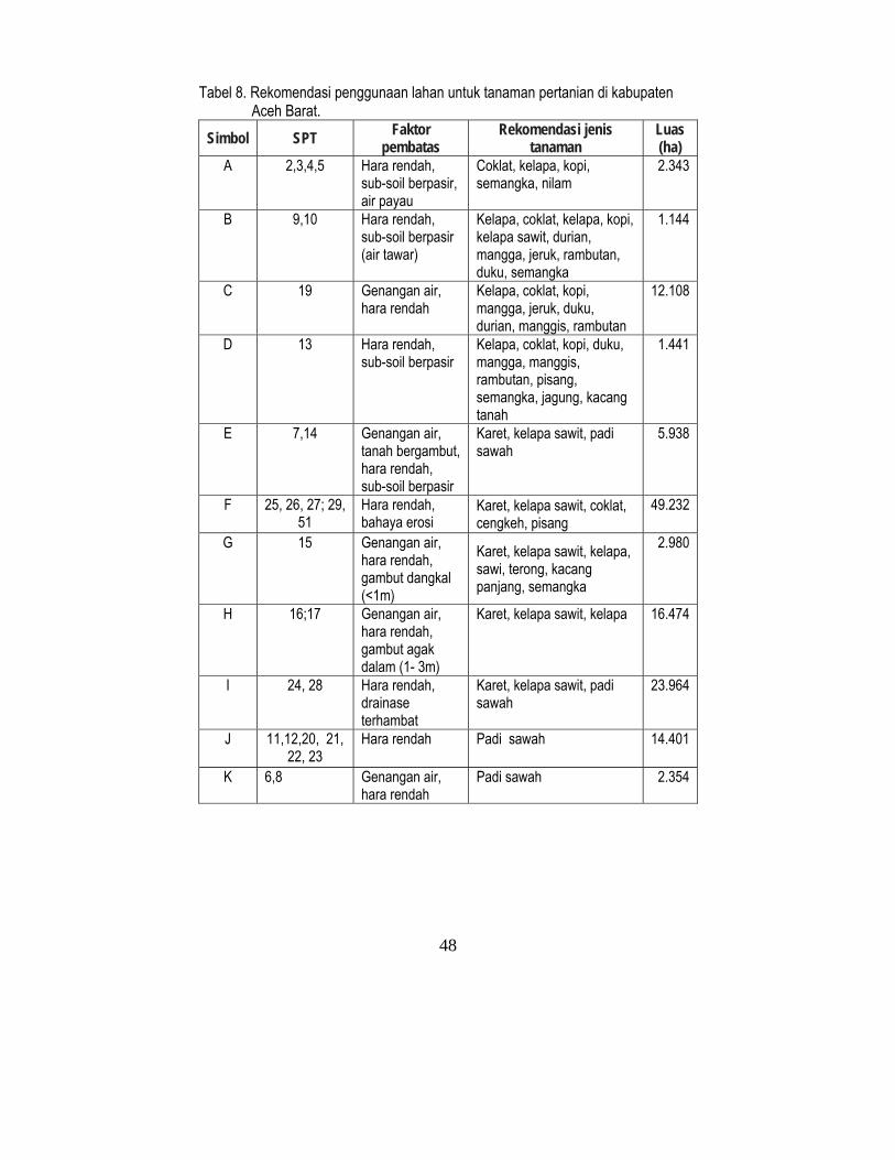
48
Tabel 8. Rekomendasi penggunaan lahan untuk tanaman pertanian di kabupaten Aceh Barat.
Simbol SPT Faktor pembatas
Rekomendasi jenis tanaman
Luas (ha)
A 2,3,4,5 Hara rendah, sub-soil berpasir, air payau
Coklat, kelapa, kopi, semangka, nilam
2.343
B 9,10 Hara rendah, sub-soil berpasir (air tawar)
Kelapa, coklat, kelapa, kopi, kelapa sawit, durian, mangga, jeruk, rambutan, duku, semangka
1.144
C 19 Genangan air, hara rendah
Kelapa, coklat, kopi, mangga, jeruk, duku, durian, manggis, rambutan
12.108
D 13 Hara rendah, sub-soil berpasir
Kelapa, coklat, kopi, duku, mangga, manggis, rambutan, pisang, semangka, jagung, kacang tanah
1.441
E 7,14 Genangan air, tanah bergambut, hara rendah, sub-soil berpasir
Karet, kelapa sawit, padi sawah
5.938
F 25, 26, 27; 29, 51
Hara rendah, bahaya erosi
Karet, kelapa sawit, coklat, cengkeh, pisang
49.232
G 15 Genangan air, hara rendah, gambut dangkal (<1m)
Karet, kelapa sawit, kelapa, sawi, terong, kacang panjang, semangka
2.980
H 16;17 Genangan air, hara rendah, gambut agak dalam (1- 3m)
Karet, kelapa sawit, kelapa 16.474
I 24, 28 Hara rendah, drainase terhambat
Karet, kelapa sawit, padi sawah
23.964
J 11,12,20, 21, 22, 23
Hara rendah Padi sawah 14.401
K 6,8 Genangan air, hara rendah
Padi sawah 2.354
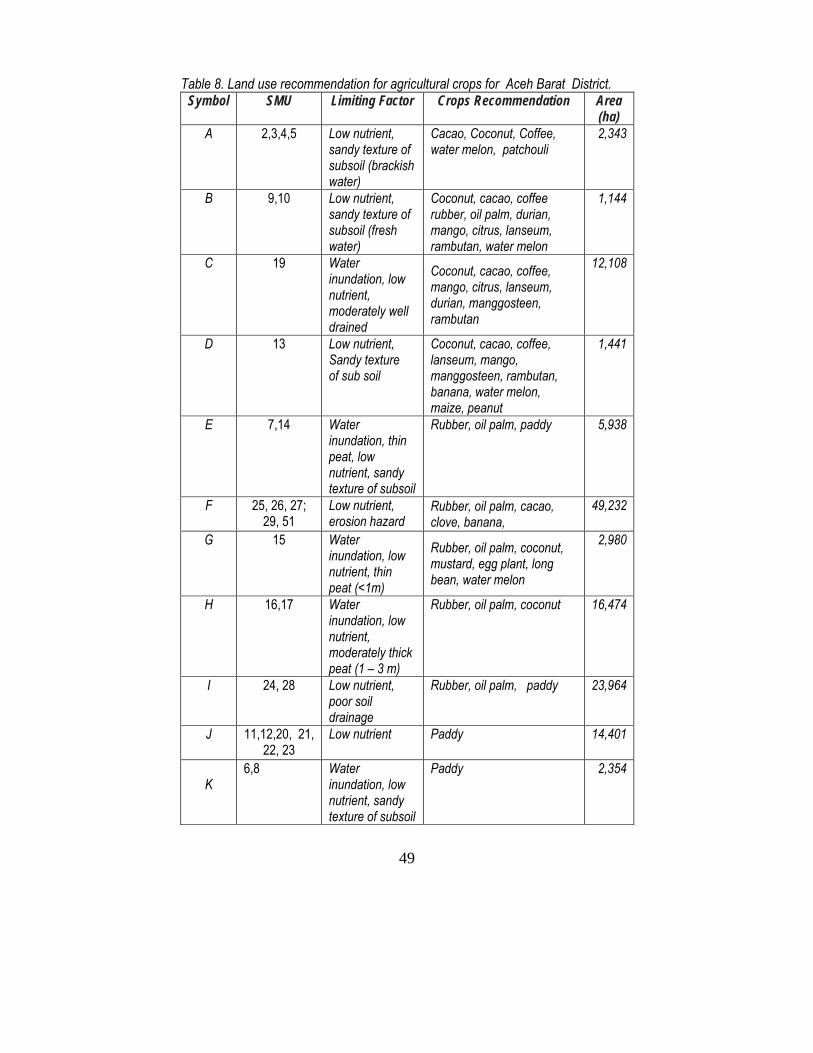
49
Table 8. Land use recommendation for agricultural crops for Aceh Barat District. Symbol SMU Limiting Factor Crops Recommendation Area
(ha) A 2,3,4,5 Low nutrient,
sandy texture of subsoil (brackish water)
Cacao, Coconut, Coffee, water melon, patchouli
2,343
B 9,10 Low nutrient, sandy texture of subsoil (fresh water)
Coconut, cacao, coffee rubber, oil palm, durian, mango, citrus, lanseum, rambutan, water melon
1,144
C 19 Water inundation, low nutrient, moderately well drained
Coconut, cacao, coffee, mango, citrus, lanseum, durian, manggosteen, rambutan
12,108
D 13 Low nutrient, Sandy texture of sub soil
Coconut, cacao, coffee, lanseum, mango, manggosteen, rambutan, banana, water melon, maize, peanut
1,441
E 7,14 Water inundation, thin peat, low nutrient, sandy texture of subsoil
Rubber, oil palm, paddy 5,938
F 25, 26, 27; 29, 51
Low nutrient, erosion hazard
Rubber, oil palm, cacao, clove, banana,
49,232
G 15 Water inundation, low nutrient, thin peat (<1m)
Rubber, oil palm, coconut, mustard, egg plant, long bean, water melon
2,980
H 16,17 Water inundation, low nutrient, moderately thick peat (1 – 3 m)
Rubber, oil palm, coconut 16,474
I 24, 28 Low nutrient, poor soil drainage
Rubber, oil palm, paddy 23,964
J 11,12,20, 21, 22, 23
Low nutrient Paddy 14,401
K
6,8 Water inundation, low nutrient, sandy texture of subsoil
Paddy 2,354

50
Tabel 8. (Sambungan) Simbol SPT Faktor
pembatas Rekomendasi jenis
tanaman Luas (ha)
L 31, 32, 33 Hara rendah, bahaya erosi
Cengkih, duku, durian, jeruk, coklat, karet, rambutan, kelapa, kopi, mangga, manggis dan nilam
6.246
M 30,34,35,36, 37, 38
Bahaya erosi, hara rendah
Wanatani/agroforestry (karet, kopi, mangga, rambutan, durian)
32.707
N 39,40,41,42 43, 44, 45, 46, 47, 48, 49, 50, 52, 53, 54, 55, 56, 57
Bahaya erosi, hara rendah
Kawasan hutan lindung 115.822
O 1 Pasir lepas (timbunan tsunami)
Tidak sesuai untuk pertanian
88
P 18 Poor drainage, deep peat (>3 m)
Tidak sesuai untuk pertanian, dihutankan untuk pengamanan lingkungan
5.554
Jumlah 292.796 SPT = Satuan peta tanah (sebaran pada Gambar 1).

51
Table 8. (continued). Symbol SMU Limiting Factor Crops Recommendation Area
(ha) L 31, 32, 33 Low nutrient,
erosion hazard Clove, lanseum/, durian, citrus, cacao, rubber, rambutan, coconut, coffee, mango, pineapple manngosteen, patchouli
6,246
M 30,34,35,36, 37, 38
Low nutrient, erosion hazard
Agroforestry (Rubber, coffee, mango, rambutan, durian)
32,707
N 39,40,41,42 43, 44, 45, 46, 47, 48, 49, 50, 52, 53, 54, 55, 56, 57
Low nutrient, erosion hazard
Forested conservation area
115,822
O 1 Loose tsunami sand
Not suitable for agriculture 88
P 18 Poor drainage, thick peat (>3 m)
Not suitable for agriculture, conserved for forest and environment protection
5,554
Total 292,796 SMU = Soil mapping unit (refer to Figure 1).

52
Gambar 6. Pengamatan ketebalan dan pengambilan contoh gambut (atas) dan hutan
gambut yang dibuka untuk lahan pertanian (bawah) (SMU 17) Figure 6. Measurement of peat thickness and peat sampling (above) and land
cleared for agriculture (below (SMU 17)

53
DAFTAR PUSTAKA/REFERENCES Agus, F. dan I. GM. Subiksa. 2008. Lahan Gambut: Potensi untuk Pertanian dan
Aspek Lingkungan. Balai Penelitian Tanah dan World Agroforestry Centre (ICRAF) Southeast Asia. Bogor.
Badan Pusat Statistik (BPS). 2003. Nanggroe Aceh dalam Angka tahun 2003. Badan Pusat Statistik. Banda Aceh.
Badan Pusat Statistik (BPS). 2006. Aceh Barat Dalam Angka tahun 2006. Badan Pusat Statistik- Kabupaten Aceh Barat, Meulaboh.
Bappeda Kabupaten Aceh Barat. 2005. Profil Aceh Barat. Badan Perencanaan dan Pembangunan Daerah Kabupaten Aceh Barat. Meulaboh.
Buurman, P., T. Balsem dan H.G.A. van Panhuys. 1990. Klasifikasi Satuan Lahan untuk Survei Tingkat Tinjau Sumatera. Proyek Perencanaan dan Evaluasi Sumberdaya Lahan. Pusat Penelitian Tanah Bogor.
Darul Sukma, W.P., A. Verhagen, Junus Dai, P.Buurman, T.Balsem and Suratman. 1990. Explanatory Booklet of the Land Unit and Soil Map of The Takengon Sheet (0520), Scale 1:250,000, Sumatra. Soil Database Management, Centre For Soil and Agroclimate Research. Bogor.
Dent F.J., J.R Desaunettes and J.P. Malingreau. 1977. Detailed Reconnaissance Land Resources Survey Cimanuk Watershed Area (West Java). Working Paper No.14. Land Capability Appraisal Project at the Soil Research Institute. Food and Agriculture Organization. Soil Research Institute. Bogor.
Dessaunettes, J.R. 1977. Catalogue of Landforms for Indonesia. Working Paper No.13. Land Capability Appraisal Project at the Soil Research Institute. Food and Agriculture Organization. Soil Research Institute. Bogor.
Dinas Pertanian Tanaman Pangan dan Hortikultura Provinsi Nanggroe Aceh Darussalam. 2005. Rekapitulasi Kerusakan lahan Akibat Tsunami dan Rencana Pencetakan Sawah Baru. Tahun 2005. Banda Aceh.
Djaenudin, D., H. Marwan, H. Subagjo, dan A. Hidayat. 2003. Petunjuk Teknis Evaluasi Kesesuaian Lahan untuk Komoditas Pertanian. Balai Penelitian Tanah, Bogor.
FAO (Food and Agriculture Organization). 1976. Framework for Land Evaluation. Soil Resources Management and Conservation Service land and water Development Division. FAO Soil Bulletin No. 32. FAO-UNO, Rome.
FAO (Food and Agriculture Organization). 2004. Strategy and Program Planning Framework for Rehabilitation and Reconstruction of the Agriculture Sector in the Tsunami Affected Areas of North Sumatra, Indonesia. FAO Asia Pacific. Bangkok. 19pp.

54
FAO. 1978. Guidelines for Soil Description. FAO/UNESCO. Rome. Marsoedi Ds., Widagdo, Junus Dai, Nata Suharta, S.W.P. Darul, Sarwono
Hardjowigeno and J.Hof. 1997. Pedoman Klasifikasi Landform/ Guidelines for Landform Classification. Centre for Soil and Agroclimate Research. Bogor.
Ritung, S., Wahyunto, F. Agus and H. Hidayat. 2007. Guidelines for Land Suitability Evaluation. With a case map of Aceh Barat District. Indonesian Soil Research Institute and World Agroforestry Centre (ICRAF). Bogor.
Rossiter, D.G and A.R. Van Wambeke. 1995. ALES (Automated Land Evaluation System) Version 4.5 User’s Manual. SCAS Teaching Series No. T93-2 Revision 5. Cornell University, Departement of Soil, Crop and Atmospheric Science, Ithaca, New York.
Rossiter, D.G and A.R. Van Wambeke. 1997. Automated Land Evaluation System. ALES Version 4.5d. SCAS Teaching Series No. T93-2 Revision 5. Cornell University, Departement of Soil, Crop and Atmospheric Science, SCS, Ithaca, New York.
Soil Survey Staff. 2003. Key to Soil taxonomy. 9th Edition. United States Department of Agriculture. Natural Resources Conservation Service. Blackburb, Virginia.
Subagyono, K., B. Sugiharto and B. Jaya. 2005. Rehabilitation strategies of the Tsunami Affected Agricultural Areas in NAD, Indonesia. Paper presented in Salt Affected Soils from the Sea Water Intrusion. Strategies for Rehabilitation and Management Regional Workshop, 31 March – 1 April 2005, Bangkok, Thailand.
Sys, C., E.V. Ranst, and J. Debaveye. 1991. Land Evaluation Part I: Principles in Land Evaluation and Crop Production Calculations. Agricultural Publications No.7. General Administration for Development Cooperation. Brussels.
Vink, A.P.A. 1975. Landuse in advancing agriculture. Advance Series in Agricultural Sciences 1. Springer-Verleg. Berlin, Heidelberg, New York.