MATA KULIAH Pertanian Berlanjut WAKTU : Minggu ke 5 ... fileBuat rekomendasi penerapan dan...
21
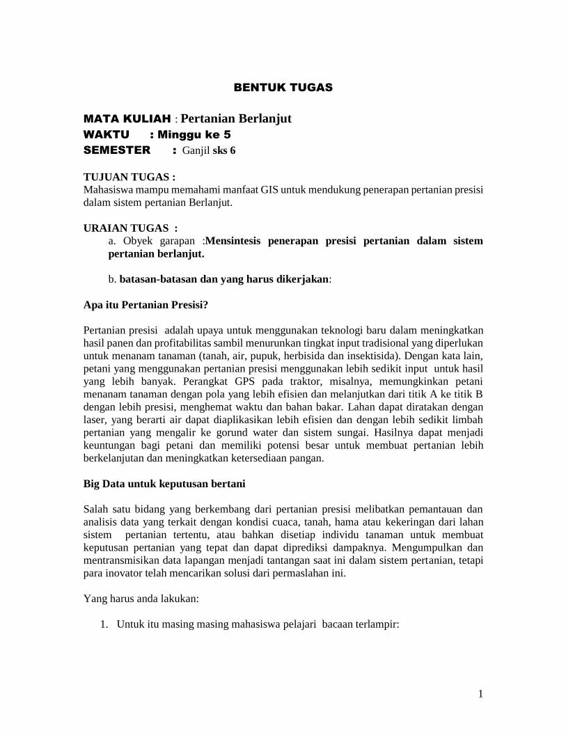
1 BENTUK TUGAS MATA KULIAH : Pertanian Berlanjut WAKTU : Minggu ke 5 SEMESTER : Ganjil sks 6 TUJUAN TUGAS : Mahasiswa mampu memahami manfaat GIS untuk mendukung penerapan pertanian presisi dalam sistem pertanian Berlanjut. URAIAN TUGAS : a. Obyek garapan :Mensintesis penerapan presisi pertanian dalam sistem pertanian berlanjut. b. batasan-batasan dan yang harus dikerjakan: Apa itu Pertanian Presisi? Pertanian presisi adalah upaya untuk menggunakan teknologi baru dalam meningkatkan hasil panen dan profitabilitas sambil menurunkan tingkat input tradisional yang diperlukan untuk menanam tanaman (tanah, air, pupuk, herbisida dan insektisida). Dengan kata lain, petani yang menggunakan pertanian presisi menggunakan lebih sedikit input untuk hasil yang lebih banyak. Perangkat GPS pada traktor, misalnya, memungkinkan petani menanam tanaman dengan pola yang lebih efisien dan melanjutkan dari titik A ke titik B dengan lebih presisi, menghemat waktu dan bahan bakar. Lahan dapat diratakan dengan laser, yang berarti air dapat diaplikasikan lebih efisien dan dengan lebih sedikit limbah pertanian yang mengalir ke gorund water dan sistem sungai. Hasilnya dapat menjadi keuntungan bagi petani dan memiliki potensi besar untuk membuat pertanian lebih berkelanjutan dan meningkatkan ketersediaan pangan. Big Data untuk keputusan bertani Salah satu bidang yang berkembang dari pertanian presisi melibatkan pemantauan dan analisis data yang terkait dengan kondisi cuaca, tanah, hama atau kekeringan dari lahan sistem pertanian tertentu, atau bahkan disetiap individu tanaman untuk membuat keputusan pertanian yang tepat dan dapat diprediksi dampaknya. Mengumpulkan dan mentransmisikan data lapangan menjadi tantangan saat ini dalam sistem pertanian, tetapi para inovator telah mencarikan solusi dari permaslahan ini. Yang harus anda lakukan: 1. Untuk itu masing masing mahasiswa pelajari bacaan terlampir:
Transcript of MATA KULIAH Pertanian Berlanjut WAKTU : Minggu ke 5 ... fileBuat rekomendasi penerapan dan...
1
BENTUK TUGAS
MATA KULIAH : Pertanian Berlanjut
WAKTU : Minggu ke 5
SEMESTER : Ganjil sks 6
TUJUAN TUGAS : Mahasiswa mampu memahami manfaat GIS untuk mendukung penerapan pertanian presisi
dalam sistem pertanian Berlanjut.
URAIAN TUGAS :
a. Obyek garapan :Mensintesis penerapan presisi pertanian dalam sistem
pertanian berlanjut.
b. batasan-batasan dan yang harus dikerjakan:
Apa itu Pertanian Presisi?
Pertanian presisi adalah upaya untuk menggunakan teknologi baru dalam meningkatkan
hasil panen dan profitabilitas sambil menurunkan tingkat input tradisional yang diperlukan
untuk menanam tanaman (tanah, air, pupuk, herbisida dan insektisida). Dengan kata lain,
petani yang menggunakan pertanian presisi menggunakan lebih sedikit input untuk hasil
yang lebih banyak. Perangkat GPS pada traktor, misalnya, memungkinkan petani
menanam tanaman dengan pola yang lebih efisien dan melanjutkan dari titik A ke titik B
dengan lebih presisi, menghemat waktu dan bahan bakar. Lahan dapat diratakan dengan
laser, yang berarti air dapat diaplikasikan lebih efisien dan dengan lebih sedikit limbah
pertanian yang mengalir ke gorund water dan sistem sungai. Hasilnya dapat menjadi
keuntungan bagi petani dan memiliki potensi besar untuk membuat pertanian lebih
berkelanjutan dan meningkatkan ketersediaan pangan.
Big Data untuk keputusan bertani
Salah satu bidang yang berkembang dari pertanian presisi melibatkan pemantauan dan
analisis data yang terkait dengan kondisi cuaca, tanah, hama atau kekeringan dari lahan
sistem pertanian tertentu, atau bahkan disetiap individu tanaman untuk membuat
keputusan pertanian yang tepat dan dapat diprediksi dampaknya. Mengumpulkan dan
mentransmisikan data lapangan menjadi tantangan saat ini dalam sistem pertanian, tetapi
para inovator telah mencarikan solusi dari permaslahan ini.
Yang harus anda lakukan:
1. Untuk itu masing masing mahasiswa pelajari bacaan terlampir:
2
Srinivasan, A. 2016.. Relevance of Precision Farming Technologies to Sustainable
Agriculture in Asia and the Pacific
Bongiovanni. R and J. Lowenberg-Deboer. 2004. Precision Agriculture and
Sustainability. Kluwer Academic Publishers. Manufactured in The
Netherlands.
2. Tetapkan kelompok kerja (anggota kelompok 3-4 orang), setiap kelompok
melakukan observasi lapangan di bentang lahan pertanian, dalam skala mata
memandang lakukan: Pengenalan dan Deskripsikan Karakteristik utama sistem
pertanian yang berjalan saat ini dalam skala Lanskap.
3. Buat rekomendasi penerapan dan pemanfaatan GIS untuk mendukung
implementasi pertanian berlanjut yang terinspirasi dari bahan kuliah dan bahan
bacaan terlampir.
4. Di bentang lahan pertanian di lokoasi yang saudara observasi buat rekomendasi
teknologi untuk penerapan pertanian presisi.
c. Metodologi/ cara pengerjaan, acuan yang digunakan :
Untuk melakukan studi kasus ini dilakukan melalui observasi lapangan. Kegiatan ini
dilakukan secara berkelompok (3-4 mahasiswa yang mengambil matakuliah Petanian
Berlanjut dan dikumpulkan hasil tugas ini pada satu minggu setelah penugasan ini, kepada
dosen yang memberi tugas. Hasil kasus ini ditulis dengan bagian tulisan sebagai berikut:
(1) halaman Judul tulisan dan penulisnya, (2) Bab 1: Latar belakang kasus, (3) Bab 2:
Karakteristik dan Tantangan Pengembangan Presisi Pertanian dalam sistem pertanian
berlanjut didukung dengan foto lapangan, (4) Bab 3: rekomendasi penerapan dan
pemanfaatan GIS untuk mendukung implementasi pertanian berlanjut, dan (5) Bab 4:
rekomendasi teknologi untuk penerapan pertanian presisi (6) Bab 5: Kesimpulan dan saran.
d. Kriteria luaran tugas yang dihasilkan/ dikerjakan:
Tugas ini disajikan secara tertulis dalam paper 20 halaman termasuk skema, tabel dan
gambar, dengan ukuran kertas A4, diketik dengan type Arial 11 satu spasi.
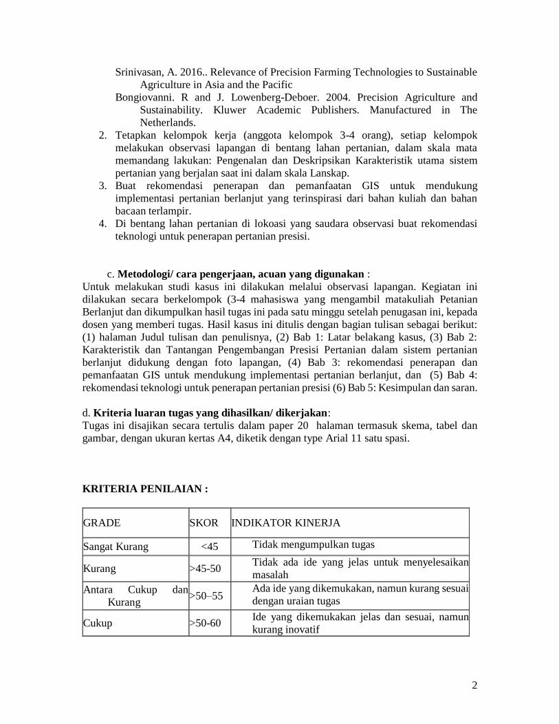
KRITERIA PENILAIAN :
GRADE SKOR INDIKATOR KINERJA
Sangat Kurang <45 Tidak mengumpulkan tugas
Kurang >45-50 Tidak ada ide yang jelas untuk menyelesaikan
masalah
Antara Cukup dan
Kurang >50–55
Ada ide yang dikemukakan, namun kurang sesuai
dengan uraian tugas
Cukup >50-60 Ide yang dikemukakan jelas dan sesuai, namun
kurang inovatif
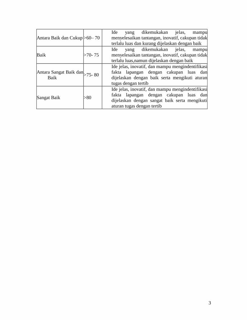
3
Antara Baik dan Cukup >60– 70
Ide yang dikemukakan jelas, mampu
menyelesaikan tantangan, inovatif, cakupan tidak
terlalu luas dan kurang dijelaskan dengan baik
Baik >70- 75
Ide yang dikemukakan jelas, mampu
menyelesaikan tantangan, inovatif, cakupan tidak
terlalu luas,namun dijelaskan dengan baik
Antara Sangat Baik dan
Baik >75- 80
Ide jelas, inovatif, dan mampu mengindentifikasi
fakta lapangan dengan cakupan luas dan
dijelaskan dengan baik serta mengikuti aturan
tugas dengan tertib
Sangat Baik >80
Ide jelas, inovatif, dan mampu mengindentifikasi
fakta lapangan dengan cakupan luas dan
dijelaskan dengan sangat baik serta mengikuti
aturan tugas dengan tertib
4
Relevance of Precision Farming Technologies to Sustainable
Agriculture in Asia and the Pacific Ancha Srinivasan, Ph.D.
Senior Researcher, Geospatial Analysis Center
Regional Science Institute, 4-13, Kita 24 Nishi 2, Kita-ku, Sapporo 001-0024 JAPAN
Tel: +81-11-717-6660 Fax: +81-11-757-3610 E-mail: [email protected]
Abstract
Deteriorating environmental quality, declining input response of major crops, and a
widening gap between the potential and realized farm yields are main points of concern in
current Asian agriculture. Adoption of precision farming through practices such as optimal
application of inputs depending on spatial and temporal variability of crop yields and soil
properties is increasingly recognized as a valuable approach to sustain yields and improve
environmental quality. Because of wide diversity in crops and cropping systems, farm sizes
and socio-economic conditions, Asian farming systems present both opportunities and
obstacles for adoption of precision farming. The conditions in which precision technologies
can be most rewarding and offer the greatest environmental benefits are highlighted, and
the implications for adoption of precision farming in Asia are examined. A few approaches
for implementing precision farming technologies in the Asian context are presented. The
role of international organizations, governments, farmers’ organizations and the private
sector in implementation of these technologies is discussed.
Introduction
It is well known that sustainable agricultural development can happen only if the natural
resource base upon which it depends is prudently managed. However, in sole pursuit of
high productivity especially during the past 3-4 decades, a critical linkage between
agriculture and the environment has been neglected resulting in agro-ecosystems with little
resilience. This is especially so in Asia and the Pacific region, which accounts for more
than 70% of the global agricultural population but only 30% of the world's farmland. Yield
increases in this region have been achieved at considerable expense to its resource base
and largely by means of excessive and indiscriminate use of external inputs: irrigation,
seeds, fertilizer, pesticides, etc. High rates of aquifer depletion, pest and disease incidence,
environmental pollution, soil erosion, and reduced biodiversity are, therefore, rampant. For
instance, soil erosion in this region due to water and wind exceeds the natural soil formation
by 30-40 fold (FAO, 1993). The problem of water quality deterioration is also serious.
Pollution of drinking water in tobacco and rice ecosystems of Malaysia (Ahmad et al.,
1996) and of groundwater near vegetable fields in Japan (Nishio, 1998) are just two
examples. The effects of pesticide use on deteriorating farmers' health and enhanced pest
resistance are also well documented.
Even intensively managed cropping systems in Asia seem to be unsustainable as
productivity levels have reached a plateau or declined with a decreasing response to farm
5
inputs and a widening gap between the potential and realized yields. Mounting populations,
improving diets due to economic development, and increasing urbanization are expected
to further enhance demand for more and superior quality food in this region. A better
upkeep of key functions of ecosystems through adoption of environment-friendly
technologies and holistic management of farm resources is, therefore, essential for
agricultural sustainability. Modern strategies of management such as precision farming
offer new opportunities for Asian farmers to optimize yields and profits and reduce
pressure on natural resources, thereby leading to total quality management. Such strategies
are based upon blending the best of farmer’s local field knowledge with developments in
geographic information systems (GIS), global positioning systems (GPS), remote sensing
and the Internet.
Precision Farming and Agricultural Sustainability
Precision farming (PF) -- also known as prescription farming, variable rate technology
(VRT) and site specific agriculture -- is considered the agricultural system of the 21st
century, as it symbolizes a better balance between reliance on traditional knowledge and
information- and management-intensive technologies. It is a holistic farm management
strategy where farmers can adjust input use and cultivation methods -- including seed,
fertilizer, pesticide, and water application, variety selection, planting, tillage, harvesting --
to match varying soil, crop and other field characteristics. PF differs from conventional
farming that is based on uniform treatments across a field. It involves mapping and
analyzing field variability, and linking spatial relationships to management actions, thereby
allowing farmers to look at their farms, crops and practices from an entirely new
perspective. PF thus provides a framework of information with which farmers can make
both production and management decisions.
PF promises to revolutionize farm management as it offers a variety of potential benefits
in profitability, productivity, sustainability, crop quality, environmental protection, on-
farm quality of life, food safety, and rural economic development (Robert, 1999). Studies
in USA, Canada, Europe and Australia have shown that PF permits reductions in input
application rates without sacrificing crop yields. Refinement and wider application of PF
technologies in Asia can result in lower production costs, higher productivity and
environmental benefits, and better stewardship of natural resources. For example, site-
specific application of pesticides in cotton and of fertilizers in plantations of oil palm,
rubber, coffee and tea in Asia can greatly reduce production costs and decrease
environmental loading of chemicals.
When judiciously implemented, farmers can benefit from PF technologies in many ways.
In the short term, the diagnostic and database-building benefits will be enormous. Growers
can forecast and alleviate problems such as water stress, soil compaction, diseases, and
pests more effectively. Database-building benefits will be in the form of accurate farm
document keeping for effective management of inputs, property, machinery and labor, and
efficient monitoring of environmental quality through recording the amounts and location
of input applications. In the long term, farmers can optimize agronomy through finding
6
locations that produce maximum profit margins. PF technologies also increase
opportunities for skilled employment in farming, and provide new tools for evaluating
multifunctional character (including non-market functions) of agriculture and land.
Technology Components
PF has three requirements: 1. Ability to identify each field location, 2. Ability to capture,
interpret and analyze agronomic data at an appropriate scale and frequency, and 3. Ability
to adjust input use and farming practices to maximize benefits from each field location. A
suite of technologies such as GPS, GIS, remote sensing, VRT, on-the-go sensors, grid
sampling, monitors, and precision irrigation is used to fulfil these requirements. Various
configurations of these technologies are suitable for different PF operations.
Communication technologies such as the Internet are valuable for efficient delivery of PF
services and products.
GPS -- currently a constellation of 27 satellites developed by the US Department
of Defence -- provides geospatial accuracy to farm practices and enables farmers
to identify characteristics of each field site (where soil samples or pest data are
collected). A minimum of four satellites is required to get good positional
information. If a GPS receiver is used along with a ground reference station
(Differential GPS), any location on earth can be identified to within one square
meter. Sub-meter horizontal accuracy is now considered adequate for most PF
applications. A crop scout can use GPS to map a field's insect or weed infestations
and illustrate their locations with specific details. Likewise, kinematic GPS can be
used for rapid development of accurate topographic maps.
GIS is a computerized data storage and retrieval system, which can be used to
manage and analyze spatial data relating crop productivity and agronomic factors.
It can integrate all types of information and interface with other decision support
tools. GIS can display analyzed information in maps that allow (a) better
understanding of interactions among yield, fertility, pests, weeds and other
factors, and (b) decision-making based on such spatial relationships. Many types
of GIS software with varying functionality and price are now available. A
comprehensive farm GIS contains base maps such as topography, soil type, N, P,
K and other nutrient levels, soil moisture, pH, etc. Data on crop rotations, tillage,
nutrient and pesticide applications, yields, etc. can also be stored. GIS is useful to
create fertility, weed and pest intensity maps, which can then be used for making
maps that show recommended application rates of nutrients or pesticides.
Recently, remotely sensed imagery using low-flying aircraft or satellites has
become a major source of information on spatial variability in fields caused by
natural and cultural factors. Commercial satellites to be launched in future are
expected to have ideal specifications for PF such as 3-day repeat coverage, 1 to 4
meter spatial resolution and image delivery to users within 15 minutes after
acquisition. Remotely sensed images can show all fields in a village or block and
spot problems sooner than ground inspections, thereby allowing remedial
treatments to be taken up before the stress spreads to other parts of the field. In a
7
field survey, GPS can be used to pinpoint the stressed area for a detailed
examination. Crop vigor changes can also be determined using images acquired at
different times during a season. Such data, when combined with data from
previous years, can be useful in predicting crop yields.
VRT, the most advanced component of PF technologies, provides "on-the-fly"
delivery of field inputs. A GPS receiver is mounted on a truck so that a field
location can easily be recognized. An in-vehicle computer, which contains the
input recommendation maps, controls the distribution valves to provide a suitable
input mix by comparing to the positional information received from the GPS
receiver. Current commercial VRT systems are either map-based or sensor-based
(NRC, 1997). The map-based VRT systems require a GPS/DGPS georeferenced
location and a command unit that stores a plan of the desired application rates for
each field location. The sensor-based VRT systems do not require a georeferenced
location but include a dynamic control unit, which specifies application through
real time analysis of soil and/or crop sensor measurements for each field location.
New VRT systems like the manure applicator being developed at Purdue
University may soon enable precise application of manure in cropping systems.
Sensors: Electronic crop and soil sensors that detect grain moisture levels,
protein, water stress, disease or weed infestations, soil moisture, soil nitrogen,
CEC, topsoil depth, etc. have been developed. A grain moisture sensor can help in
optimizing harvest operations and storage and/or drying requirements. Sensors to
detect soil quality "on-the-fly" and new machine controls that guide field
equipment and can vary the rate, mix, and location of seeds, nutrients, water or
chemical sprays are in development. Microprocessors and microprocessor-based
control systems are especially useful in PF. For example, in a combine yield-
monitoring system, microprocessors collect and store information from the GPS
receiver and the grain moisture sensor. On VRT equipment, microprocessors
obtain positional information from the GPS receiver, compare that data with the
computer's map of the recommended application, and signal the applicator's
control system to distribute the precise amount of inputs at that position.
New tools incorporating the above technologies are under development. For instance, a
voice recognition system, which enables data collection with simple, easy-to remember
voice commands regarding weed or insect problems, crop lodging, and other farm
operations, is being developed at Purdue University (Dux et al., 1997). This data can be
georeferenced using the GPS. The developments in the private sector are also worth noting.
John Deere Company in the USA, for example, is creating an information infrastructure
that can help in monitoring the performance of customer machines by computer, via
satellite. With such infrastructure, a dealer or technician can inform the farmer of a
machine's problems, and send a service truck immediately.
Relevance of PF Technologies to Asian Conditions
PF technologies have been developed in countries where farm socio-economic conditions
are much different than in Asia. A question may therefore arise on their relevance to Asia,
where a vast majority of population is subsistence-based, and strategies and perception of
8
risk by farmers are totally different. It must be noted, however, that even under subsistence
farming, several decisions (application rates of seeds, fertilizers and other inputs) have to
be made for optimizing yields and income. As PF technologies assist farmers in improved
decision making, and have the potential to reduce or remove the effects of limiting factors
on the farm, a convincing case can be made on their suitability to Asian conditions.
PF technologies may be relatively new to Asia, but the concept of precision management
is not. Asian farmers have long known that soil conditions, fertility, moisture, etc. vary
widely across a single field and that various parts within fields responded to different types
of inputs, and cultural practices. The small size of their farms often permitted such an
effective monitoring of spatial and temporal yield variation and variable application of
inputs mainly by manual means. Ever since the introduction of Green Revolution
technologies in 1960s, however, Asian farmers treated all fields in a region uniformly
leading to application of inputs in areas not needing them or where the crops cannot make
full use of them. The micro-spatial scale has been neglected in favor of the regional and
national scales. For example, fertilizer guidelines by agricultural experimental stations in
Asia were primarily developed on a regional scale by considering the mean fertility of
many fields. In addition, huge subsidies on fertilizers and pesticides, and labor shortage in
some areas forced farmers to use the same application rates across the entire field.
Ignorance of input-response functions also led to excessive use. The Asian farmer on
average uses 127 kg NPK ha-1 against 78 kg ha-1 in the rest of the world (FAO, 1993). In
China, for example, fertilizer use increased from 90 kg ha-1 in 1978 to 300 kg ha-1 in 1994.
Pesticide recommendations are also regional and are based on a few random observations
of pest density. Because of low quality of agrochemicals often due to adulteration and
increased pest resistance, indiscriminate application is now common, especially in high
value crops. Hefty subsidies on electricity for pumping water in some countries have led
to over-exploitation of groundwater and misuse on farms leading to waterlogging and
salinity. Application of PF technologies can help in reversing this trend.
Improving farm input use efficiency is also important from a macro-economic point of
view. Many Asian governments are now reducing input subsidies to lessen their fiscal
deficits. Sudden and steep reductions in subsidies, however, lead to a decline in fertilizer
consumption as has happened in India in the 1990s. As PF technologies can facilitate higher
yields with the same, or even less, inputs while simultaneously conserving the soil and
water, their rapid adoption in Asian farms is essential.
PF technologies can contribute to sustainable land management in Asia, where per capita
arable land availability is only 0.23 ha against 1.51 ha in the rest of the world (FAO, 1993).
They can be used to preserve the land's potential for multiple uses in many ecosystems of
Asia. In some countries, we see an increasing trend of farmers being forced out of
traditional farming, willingly or unwillingly, mainly because of land and labor shortage,
urban demand and general economic development. In countries such as Japan, Korea, and
Taiwan, both demographic (ageing population) and market changes are pushing farmers to
make decisions that are both profitable and environmentally sound. In such conditions,
automation of data collection and implementation can surely lead to an improved decision
making.
9
Population gains, improved diets, shifts toward increased meat consumption and a growing
emphasis on environmental issues also call for adoption of PF in Asia. Globalization of
markets in the new millennium, which enables entry of new producers into the market place
for farm products that were formerly the exclusive preserve of Asian countries, is also
expected to force Asian farmers to be more competitive. For example, USA, Israel and
Canada are now producing premium Basmati rice, bananas and kenaf fibre respectively. In
order to enhance market competitiveness in both cost and quality, Asian farming must be
made more efficient than now through introduction of innovative technologies such as PF.
Besides farm management, PF technologies can contribute to agronomic research in many
ways. For example, yield data can be used to an interpretative advantage in on-farm trials
of new varieties. Varietal comparison can be simplified through mapping the differences
in yield potentials of different varieties. PF technologies can provide the basis for valid
small-plot trials, and optimal plot and block configurations for field experiments. Data
gathered in PF systems can help in identifying areas with high pollution potentials,
estimating loading rates of pollutants and assessing surface water movement of agricultural
chemicals.
Many PF technologies are multi-functional and their adoption should result in favorable
changes in various aspects of Asian farming. Asian farms have been traditionally worked
by many generations of farmers, who accumulated substantial location-specific knowledge
and skills. PF technologies allow integration of local knowledge into farm resource
management (Tabor and Hutchinson, 1994) to create a historical spatial database that is
useful for many generations. Further, the collection and analysis of georeferenced data
from all fields in a village provides a unique opportunity to gain new insights into the
functioning of Asian agricultural systems. The data will have added value, especially when
integrated into regional databases. All these reasons suggest that PF technologies are, and
will be, increasingly relevant to the development of sustainable cropping systems in Asia.
Asian farmers are often miscast as conservatives depending on old, outdated methods and
technologies. Ample evidence exists however to indicate that Asian farmers can readily
adopt innovations aimed at improving efficiency, if they find them to be beneficial and
within their technological and economic reach. It is, therefore, vital to identify suitable
opportunities for adoption of PF technologies in Asian farms.
Current Status and Opportunities for Adoption of PF in
Asia
Recently, Asian countries have initiated efforts to promote PF. In Japan, the Ministry of
Agriculture has been allocating funds for PF research since April 1998. Testing of PF
technologies for rice at the research farm level is in progress at Kyoto, Tokyo and Hokkaido
universities. Staff at Kyoto University recently developed a two-row rice harvester for
determining yields on a microplot basis (Iida et al., 1999). Quasi-governmental
organizations such as Bio-oriented technology Research Advancement Institution

10
(BRAIN), and private corporations and trading companies such as Mitsubishi, Omron, and
Hitachi are looking into the possibilities of using high resolution imagery for PF
applications. In Malaysia, the Malaysian Agricultural Research and Development Institute
(MARDI) has initiated research on PF for upland rice (Mohamed, A.Z., Personal
communication). In India, a few researchers in the private sector initiated PF studies in
high value crops like cotton, coffee and tea. In Sri Lanka, researchers at the Tea Research
Institute are examining precision management of soil organic carbon
(Anandacoomaraswamy and Ananthacumaraswamy, 1999). Within each Asian country,
however, some regions are in a better position to adopt PF technologies than others. In
Japan, for example, Hokkaido is better placed than other prefectures because of its
relatively big farms. Punjab and Haryana states, where farm mechanization is more
common than in others, may be the first to adopt PF on a limited scale in India.
As noted earlier, PF is a suite of technologies and practices that can be implemented to
optimize a wide range of farm operations including, but not limited to:
Land preparation (type and depth of tillage, management of crop residues and soil
organic matter, compaction reduction, post-harvest residue management),
Planting (sowing date and rate, plant population and planting depth, varietal
selection, crop rotation),
Input management (rates and methods of use of fertilizers, pesticides, soil
amendments, and water),
Crop stress detection and monitoring (insects, diseases, weeds, and vegetation
stress due to abiotic factors), and
Harvesting (harvest dates, grain moisture content and quality).
As the above operations require diverse combinations of technologies and tools, there is no
need to adopt all PF technologies at once to start benefitting from them. Many farmers can
begin by using only a part of the technology, as even partial use can bring many benefits.
In fact, applying the entire range of technologies is not profitable in several cases,
particularly for technologies that are not scale-neutral. For example, small farmers in Asia
cannot afford yield monitoring with combines and VRT, but large commercial estate farms
and farm associations can use them, especially in high-value crops. In contrast, even small
farms that are not highly mechanized can benefit from technologies such as GIS and remote
sensing, which allow a better grasp of field characteristics and an earlier identification of
stresses.
PF is likely to provide a greater profitability advantage for (a) high-value crops, (b) areas
where input costs are high, and (c) areas where production conditions are very
heterogeneous. In Asia, rice, wheat, sugar beet, onion, potato, and cotton among the field
crops, and apple, grape, tea, coffee and oil palm among horticultural crops are perhaps the
most relevant for PF. For each crop, however, the type of farm operation likely to get the
most benefit from PF would determine the technologies to be adopted. Perennial crops such
as oil palm, rubber, and cocoa account for nearly 85% of fertilizer consumption in
Malaysia, because as much as 300-450 kg nutrients ha-1 year-1 are applied on mature

11
plantations (FAO, 1999). Adoption of PF techniques aimed at nutrient management will
obviously be a priority for such crops.
Insect pest management through precision spraying may be attractive for crops like cotton
as globally more insecticides are used on cotton than any other crop. Worldwide sales in
insecticides amounted to about $12 billion in 1995 with cotton accounting for $1.8 billion.
Over two-thirds of the world's cotton area treated with insecticides is in India, China and
Pakistan, and as much as 40% of all insecticide sales in India are for cotton. Owing to
excessive and indiscriminate use of pesticides, parallel increases in ecosystem poisoning
and pest resistance have become major problems. Integrated pest management (IPM) has
been recommended to reduce insecticide use but the detailed records required for IPM can
make pest control more expensive over the years, because of increasing labor costs. Studies
in USA suggest that PF technologies, which can help in detection and mapping of insect
infestations, can be a useful component in IPM. Everitt et al. (1996) used airborne video
imagery for detecting whitefly infestations in cotton fields and integrated the video data
with GPS and GIS. Pest infestation could be detected in color-infrared and black and white
near-infrared video imagery, based on whitefly deposits of sooty mold fungus on foliage.
The integration of GPS with the video imagery permits the latitude/longitude coordinates
of insect infestations to be printed on each image. The GPS coordinates can then be entered
into a GIS to map insect infestations. PF technologies also enable entomologists to develop
regional maps where insect infestations occur over large areas (e.g., locusts).
Hardpan development is a common problem in many soils of tropical Asia. Although
distribution of hardpans is not uniform, farmers are advised to conduct subsoiling (deep
soil tillage) every 3-5 years, which is expensive and labor-intensive. Studies at the
University of Florida (Clark and McGuckin, 1996) showed that subsoiling needed to break
only through the hardpan, indicating that subsoiling to any significantly lower depths is an
unnecessary cost. With a penetrometer, a GPS receiver, and soil sampling, a subsoil
strength map that can show the locations and the necessary depth for subsoiling can be
created. A sensor to determine the depth, thickness and strength of the hardpan is in
development at the University of Florida.
Perennial weeds such as Imperata cylindrica are major scourges in Asian cropping
systems. Control of such weeds is both expensive and time-consuming. Using remotely
sensed images and GPS, a weed distribution map can be created and used for determining
the methods of control and the type of weeds to target with precision spraying. If weeds do
not cause significant yield loss, PF techniques may not be necessary. Likewise, if weeds
are evenly distributed, a broadcast application may be a more logical approach. In contrast,
precision spraying can be effective to control hardy weeds that occur in patches. A weed
distribution map used along with a subsoil strength map can help in optimizing the intensity
of cultivation at various field locations.
With GIS software, a map of optimum plant populations can be created as a function of
soil type and factors such as water status. Based on this map, sowing rates can be varied to
optimize yields. Throughout Asia, agriculture is the main consumer of water. In Thailand,
for example, agriculture’s share is as high as 90%. Water savings through irrigation
12
management and precision delivery to crops are essential in Asia, where per capita water
resources are declining rapidly. A topography map along with a plant population map can
be used for optimizing the timing, amounts and placement of water in various field
locations. Plantation owners, for example, can combine tensiometer information on soil
moisture with a map of evapotranspiration derived from weather forecasts and then vary
irrigation water to match crop demands. While possibilities for adoption of PF technologies
are diverse and numerous, it is important to analyze constraints as well so that innovative
approaches to overcome them can be devised.
Constraints for Adoption of PF in Asia
In a presentation at the 4th International Conference on Precision Agriculture held in 1998,
I described in detail the various constraints to adoption of PF technologies in Asian
cropping systems (Srinivasan, 1999). Principal barriers include:
High cost of obtaining site-specific data
Lack of willingness to share spatial data among various organizations
Complexity of tools and techniques requiring new skills
Culture, attitude and perceptions of farmers including resistance to adoption of
new techniques and lack of awareness of agro-environmental problems
Small farms, heterogeneity of cropping systems, and land tenure/ownership
restrictions
Infrastructure and institutional constraints including market imperfections
Lack of success stories of PF adoption and lack of demonstrated impacts on yields
Lack of local technical expertise
Uncertainty on returns from investments to be made on new equipment and
information management systems, and
Knowledge and technological gaps including
o Inadequate understanding of agronomic factors and their interaction,
o Lack of understanding of the geostatistics necessary for displaying spatial
variability of crops and soils using current mapping software, and
o Limited ability to integrate information from diverse sources with varying
resolutions and intensities.
Approaches for Adopting PF Technologies in the Asian
Context
Extensive indigenous knowledge of Asian farmers on local variability of their farmlands
confers a comparative advantage in application of PF techniques. However, PF
technologies require some key changes in mechanisms of their development and delivery
to farmers. For example, yield monitoring with combines and VRT are two most common
PF technologies in USA but they are not yet within economic reach for many Asian
farmers. Instead, remote sensing methods to monitor yield variations, and combinations of

13
manual and mechanical methods for variable input applications may be more appropriate
in the Asian context. It is also important to determine the aspects of PF that are practical at
a field scale, and test pragmatic and affordable alternatives that are being developed
elsewhere.
In most Asian countries, limited resources of small farms restrict farmers from using PF
technologies. However, this limitation can be overcome through devising innovative cost
sharing mechanisms and using freely available mapping software. Many types of PF tools
can be considered for adoption in small farms but there is no single right way for all fields.
In some cases, farmers do not need additional information on their fields but only better
tools to analyze and interpret existing information.
One of the most useful PF concepts is the idea of identifying and distinguishing relatively
uniform regions or zones within a field and developing a prescription for management of
each zone. Definition of realistic management zones, however, requires considerable skill
and knowledge of spatial relationships between yield and other factors. It is possible that
some zones show economic response to variably applied herbicides but not fertilizer. Two
common methods for developing management zones are intensive grid soil sampling and
mechanical yield monitoring for at least 3-4 years. However, both these processes are time-
consuming and expensive. Image data, however, can provide a comprehensive view of an
area while maintaining spatial connectivity between small fields, thus reducing the need
for complex spatial modeling. With the advent of high resolution satellites and decreasing
cost of image acquisition, it is expected that aerial remote sensing can help to reduce the
costs of mapping yield variations and defining management zones. Multi-temporal and
multi-spectral analysis of images acquired during crop growth, and superimposing such
images onto a cartographic database can help in identifying specific areas requiring the
attention of farm managers and planners. Based on such analysis, the extension staff can
advise farmers on how to divide their cropland into uniform zones and perform efficient
soil-sampling methods that are less intensive than grid sampling. A software system such
as SSToolbox may be used to perform various GIS and statistical analyses necessary to
define management zones.
Getting started on a PF strategy in a village or a farm cooperative is not so difficult. The
first step is to develop a basic farm plan based on past experience with specific fields,
crops, farming practices, and resources available. Using a backpack GPS system, a
progressive farmer with the guidance of a village extension officer can go around the field
boundary and record the coordinates of each field in that village. Recording can be done
by obtaining a GPS position every 20 meters or at selected points such as fence posts and
known crop boundaries. If fields are reasonably big, GPS information can be recorded
while driving in a tractor around the field boundary. A hand-held data logger can be used
to record soil type and field condition. The extension officer can download the recorded
GPS data into a computer and apply differential corrections to the position data before
processing attributes or codes. Using a GIS program, a field boundary map can be created
and each parcel’s total area can be derived. Later, the georeferenced crop data can be
overlaid onto existing digital maps of the block. In regions where land fragmentation and
subdivision are not common, a single survey is adequate for field boundary definition,
14
which can be used for many years. Once the perimeter map of all fields is complete, the
area can be divided into small units and the address of each unit can easily be recorded.
During the crop season, a data logger can be used to record crop type and condition. If a
parcel edge is a common boundary between two different crops, more than one attribute
can be selected for each GPS position. Remotely sensed imagery obtained during crop
growth can be used to detect and monitor any stresses within fields. A GPS receiver can be
used later to guide the extension staff back to a specific location for obtaining a soil sample
or for collecting insect data from a stressed area. The positional information of sampled
sites can easily be entered into a GIS program. Any additional input applications in such
stressed areas may be recorded. Farmers can continue to collect data using a spreadsheet
template provided by the extension officer to build the farm database. Over time, the
extension officer can add new layers -- crop history, landscape, basic condition of the soil
and terrain, fertility, soil composition, weed location, crops and their yield, and other
factors -- to the farm GIS database. The data can then be used for preparing soil type maps,
crop history maps, fertility maps, input recommendation maps, etc.
Another approach, which may prove useful in leading the way to precision agriculture for
farmers with limited resources, uses remotely sensed imagery as the starting point. A town
office, farmers’ association or PF service bureau can acquire remotely sensed imagery in
the form of an aerial photograph or high resolution satellite imagery for the area of its
interest. Farmers (in the case of estate farms) or local governments may share costs of
acquiring and processing imagery. The first step is to georeference the image in a desktop
GIS such as ArcView or MapInfo, by selecting well known positions as ground control
points, and create a base map for all fields. The base maps can be individually delivered to
farmers through the Internet and then viewed and printed with free software such as
ArcExplorer. As part of this map production, all existing data about the farm can be added.
Standard data templates may be distributed to the farmer to enable him to add new data
every season. After adding new data, a copy of the spreadsheet is sent by the farmer (or
extension staff acting on behalf of farmers) to the farmers’ association office for updating
the files. Orthorectification and superimposition of cadastral information on images can
give a lot of information on fields. It allows accurate calculation of the individual field
areas using the tools in GIS. The town office staff can use a GIS as a development tool to
create files containing historic information. Problem areas can easily be delineated in a GIS
by drawing regions around them. A service provider with GPS facility can sample such
problem areas during the crop season so that one can avoid costly sampling of a large area.
In the following year, locations for soil sampling can be chosen by overlaying a grid on
both stressed and normal areas of the field. The number of samples may be varied
depending on level of stress. After collecting and analyzing soil samples from normal and
stressed areas, results can be entered by location in a GIS and a map can be created for
each analyzed variable. In order to reduce costs in variable rate application of inputs, it is
better to first target problem areas by applying the extra inputs necessary and then apply
inputs uniformly across the field. Using a GPS receiver, weak spots in a field can be
outlined and spot-treated even before planting. If another image is acquired after crop
emergence, it is feasible to identify weak spots that were unnoticed earlier. An image

15
acquired during reproductive growth can show further weak spots that may be corrected
before final harvest.
A third approach -- perhaps suitable for estate farms or relatively big farms owned or leased
by private corporations -- uses sophisticated technologies such as a multi-spectral digital
video imaging system, and high-end GIS and remote sensing software. The imaging system
uses specially filtered video cameras mounted in aircraft to detect selected frequencies of
visible light and infrared energy reflected from the ground. Unlike satellite data, video-
recorded images based on the green (555-565 nm), red (625-635 nm) and near-infra red
(845-857 nm) regions of the electromagnetic spectrum can be viewed and analyzed as soon
as the plane lands. Imagery may be captured at altitudes of 1200-1400 meters under sunny
conditions. Analysis of imagery can allow delineation of management zones, based on
which crop production decisions may be made.
Implications for Adoption of PF in Asia
Some researchers consider that PF can help in triggering the next Green Revolution. The
past Green Revolution, which is now fading, had strong positive and some negative
impacts. An assessment of the implications of adoption of PF in the Asian context may
help policy makers minimize negative impacts, if any. The following issues are worth
examining.
Adoption patterns: As agriculture is an intrinsically conservative business, any
major technological development takes much time and effort before it is adopted
by a majority of farmers. It took 25 years for hybrid seeds to catch on and more
than 30 years to see tractors fully utilized (Robert, 1999). A similar course must
be expected for PF. Because diverse cropping systems, land quality, economic
and geographic conditions characterize Asian farming, adoption patterns of PF are
likely to be diverse. Even for selected crops, while some farmers may use the
Internet to discover marketing opportunities, others may use PF solely for in-field
decision making. Owing to relatively high cost and complexity, adoption process
will not occur uniformly over time. Individual small farmers in Asia are likely to
adopt them slowly, while estate owners and farmers’ associations may adopt
quickly. PF in Asia is likely to evolve as a combination of services and products
mainly taken up by farm associations and the private sector, which can spread the
capital costs over large area and over many years. Diffusion of PF is likely to be
more rapid in areas surrounding cities and in areas with larger numbers of farm
consultants and dealers.
Environmental implications: A more precise use of external inputs through PF
may alleviate environmental pollution from Asian agriculture in the long term.
However, as in all countries, downstream effects of increased soil erosion, water
use, nutrient and pesticide leaching are ordinarily of national concern and of little
interest to individual farmers. Only those PF technologies that prove
economically profitable are likely to be adopted first. The major challenge,
16
therefore, is to design PF innovations and incentives that are financially rewarding
to individual farmers as well as environmentally sound and beneficial to the
society as a whole. Synergy between PF and biotechnology may also lead to
environmental improvements (NRC, 1997). If there are yield penalties with
genetically modified varieties for increased herbicide tolerance, those varieties
can be sown in areas with high weed infestation. Likewise, varieties with
insecticidal properties may be planted in potential problem areas with pests.
Economic implications: Although profits for large farms, which are likely to
adopt PF technologies first, are expected to be high, small farmers too can get
economic benefits over time through adopting only proven technologies.
Adoption of profitable technologies also should lead to increases in the value of
land.
Employment implications: PF requires significant supporting infrastructure in
the form of skilled labor, software development and hardware availability.
Therefore, new industries providing PF services, PF products and combination of
PF services and products are likely to emerge, which in turn should provide
additional employment. For example, agricultural consulting firms specializing in
equipment, service, and technology delivery can develop to supply the needs of
big farms adopting PF. In cooperation with local governments, they can assist in
setting up farm GIS databases, process and analyze data to create maps, reports,
statistics and recommendations for farmers in a given area. New opportunities
may also arise in the form of VRT, equipment sales and recommendations,
geoprocessing, etc. All these services will generate massive amounts of data,
which obviously requires skilled personnel with knowledge and experience to
interpret the data for guiding the decision process.
Future Action
In order to promote PF technologies to foster sustainable agricultural development in Asia,
many policy and technological initiatives have to be undertaken at regional, national,
provincial and local levels. Some of those issues are discussed below.
Appropriate capabilities, policies and infrastructures must be created in the Asia-
Pacific region to exploit PF technologies suitably and effectively. Many Asian
countries started late in adopting the industrial revolution but they must not fall
behind in adopting the information revolution in agriculture. Goal setting
mechanisms must be evolved for identifying the most suitable PF approaches
specific to various agro-ecological and socio-economic conditions. Partnership
arrangements among research and extension agencies must be promoted to
develop PF applications that are most economically beneficial and technically
practicable, and to devise new methods of cost sharing and fine tuning of
technology to make it affordable. Rapid developments in the Internet-based
information delivery systems are expected to make some PF technologies
17
affordable for farmers. Regional and inter-country cooperation pacts for
conducting research on PF technologies of mutual interest should be reinforced.
Moreover, since the capacity of institutions varies from country to country, a
complementary mix of institutions may be a better way to achieve this. The Asia-
Pacific Sustainable Agriculture Research and Application (APSARA), which was
proposed at the last meeting (Hullar, 1998) can contribute substantially in
developing a program on priority areas and a mix of the most appropriate PF
technologies to attain the goals.
Within each country and various regions within a country, research to identify the
most suitable crops and farming systems for applying PF technologies must be
intensified. The immediate needs of Asian cropping systems must be considered
while formulating PF research projects. Because PF technologies do not come
with a guarantee of success in all situations, it is important to determine how to
apply them especially at the level and scale of operation now possible in the Asian
context. It is also necessary to localize and modify certain components of
technology to meet specific requirements. While it is essential to study the latest
innovative PF technologies all over the world, it is more important to determine
what is relevant and what is not.
Inadequate research and institutional support in Asia is a major constraint for
adoption of PF technologies. In order to make scientific developments in PF a
commercial reality, due attention should be paid to the development of
capabilities and institutions. Advances in PF applications will continue to occur in
industrial countries in future. Asian countries must be aware of those advances
and make their own contributions through evaluating available technologies for
suitability and removing any existing problems. They also must make cost/benefit
assessments and informed judgments on the outcome of introducing PF
technologies in social, economic, environmental and institutional terms and in
regard to sustainability.
Appropriate policies and measures must be established at various levels to enable
PF adoption from a solely "technology-push" to an application-driven approach,
and create the right environment for active partnerships among government, the
private sector, R&D organizations and NGOs. Because no single establishment
can take on the entire PF process -- which consists of data logging, point
sampling, data analysis and spatial modeling (Berry, 1998) -- it is vital that
various agencies join together and contribute their relative advantages in
knowledge, skills and experience. Participatory learning is crucial to effective
implementation of PF technologies. Therefore, local knowledge must be actively
sought and incorporated during planning. This, however, requires close
collaboration among farmers and farmers’ associations, community groups,
NGOs, spatial data providers, data analysis firms, machinery manufacturers,
research and extension agencies, and local governments. Mechanisms to sustain
such collaborative activities must be set up.
18
Low or non-availability of personnel to conduct research on PF technologies
relevant to Asian conditions is another issue to be addressed. As indigenous
research capacity is vital for sustained progress in application of PF technologies,
governments must allocate adequate budgets and ensure rational utilization of
funds as per well-chosen priorities. As farmers and associations may not readily
agree to share their datasets, government agencies and NGOs should promote
models and templates for data sharing and provide examples of benefits of sharing
and aggregating data.
The important role of the private sector and the proprietary nature of many
technologies must be recognized in the context of development of PF
technologies. Governments, therefore, should assist the private sector to create
suitable PF applications tailored to the needs of specific agricultural conditions
and design ways for effectively integrating technologies in current field
operations in Asia. For example, data collection hardware and software,
information management software and GPS devices must be user-friendly to be
operated by individuals who are novices to these technologies. There is also an
urgent need to make fully functional farm GIS easier for nonspecialists to learn
and use. Innovative ways on how the private sector can work with farmers,
governments and other institutions in promotion of PF technologies must be
explored. Greater investments in PF technology transfer are also necessary,
perhaps through promoting support services to NGOs and the private sector.
Farmers' associations and community-based organizations in each country can
play a significant role in promoting sustainable agriculture through shared access
to PF technologies. If PF is considered a series of discrete services such as map
generation, crop scouting, etc., it is possible to fit these services within the
structure of a progressive farm cooperative in each Asian country.
Remotely sensed high resolution imagery may become more important for
assessing crop and soil variability than yield maps in Asia. Therefore, it is
important to concentrate on developing robust image analysis methods for
farming in the form of, for example, a good quality product of reflectance and an
interpreted product based on which farmers can actually make decisions. New
cost-effective methods for classifying fields and creating management zones
within a village must also be developed.
As technology for gathering information is far ahead of our understanding of how
to use it to help growers make decisions, knowledge-based systems must be
developed quickly to realize full potential from PF. In this connection,
development of the ability to use available field information and experience, to
form relationships among the various GIS databases and to deduce reliable
decision-making information is essential. By building farm databases and adding
more information to create models, decision support systems that suit the needs
and resources of Asian farmers can be developed. Analytical procedures to
monitor and manage spatial and temporal yield variation of crops must be
19
simplified. Likewise, research on PF technologies for effective resource
management on a watershed basis must be promoted.
The long-range goal should be to assist Asian farmers in the practical and cost-
effective use of PF technologies so that they can maximize profits and make good
crop production and management decisions. Some methods to help farmers
include:
o Conducting pilot demonstration projects and offering training seminars for
farmers to show correct and cost-effective use PF technologies,
o Providing institutional credit for adoption of PF technologies,
o Processing generated data and providing user-friendly summaries that will
help farmers in making correct decisions, and
o Contributing the technical expertise to integrate various PF components
for each farmer's specific application.
Epilogue
Information management and its use in practical decision making at the farm level will be
the foundation for sustainable agriculture in the new millennium. PF, which benefits from
the emergence and convergence of many information technologies, can offer a sustainable
agricultural system that permits farmers to efficiently manage their fields and to conserve
farm resources. PF is revolutionary from one perspective, but from another viewpoint it is
only a natural evolution in the use of technology to cultivate land better. The Asia and
Pacific region has many serious agro-environmental problems due to its ever-increasing
population, diversified lifestyles, farm practices, changing land use patterns, and varying
conditions of climate, terrain, flora and fauna. PF technologies may be seen as tools to
complement the efficacy and effectiveness of conventional approaches to solve some of
those problems. As environmental benefits alone do not create an incentive for adoption,
PF must be popularized in Asia as an integrated farm management approach for optimizing
yields and profits based on the inherent productivity of each field unit.
Acknowledgments
I thank Mr. Kurt Ackermann for his help in preparation of this manuscript.
References
Ahmad, A.R., Zulkefli, M., Ahmed, M., Aminuddin, B.Y., Sharma, M.L., and
Mohd Zain, M. 1996. Environmental impact of agricultural inorganic pollution on
groundwater resources of the Kelantan plain in Malaysia. In: Agricultural impacts

20
of groundwater quality (Eds. Aminuddin, B.Y., Sharma, M.L., and Willett, I.R.)
ACIAR Proc. No. 61. 97pp.
Anandacoomaraswamy, A. and S. Ananthacumaraswamy. 1999. Precision
management of soil organic carbon in tea lands of Sri Lanka. Pp. 767-772. In
Precision Agriculture Part A (Eds. Robert, P.C., Rust, R.H. and Larson, W.E.).
Proceedings of the 4th International Conference on Precision Agriculture, 19-22
July 1998, St. Paul, USA. American Society of Agronomy, Crop Science Society
of America and Soil Science Society of America.
Berry, J.K. 1998. Who’s minding the farm? GIS World Feb.1998 issue p.46-51.
Clark, R.L. and McGuckin, R.L. 1996. Variable rate application equipment for
precision farming. Proceedings of 1996 Beltwide Cotton Conference, January 8-
12, 1996; Nashville, TN.
Dux, D., Strickland, M. and Ess, D. 1997. A voice recognition system for data
collection in precision agriculture. Paper presented at the 1997 Annual meeting of
American Society of Agricultural Engineers.
Everitt, J.H., Escobar, D.E., Summy, K.R., Alaniz, M.A., and Davis, M.R. 1996.
Using spatial information technologies for detecting and mapping whitefly and
harvester ant infestations in South Texas. Southwestern Entomologist 21:421-432.
FAO. 1993. Agriculture: towards 2010. Twenty-Seventh Session of FAO
Conference Document C93/24. Rome. 320pp.
FAO, 1999. Gateway to national information on land, water and plant nutrition.
Peninsular Malaysia. http://www.fao.org/ag/agl/swlwpnr/malaysia/e_plant.htm
Hullar, T. L. 1998. An Asian-Pacific sustainable agriculture research and
application consortium: Concepts, principles, and starting points. Presentation at
the Asia Pacific High-Level Conference on Sustainable Agriculture, China Hall of
Science and Technology, Beijing, China, October 4-8, 1998.
Iida, M., M. Umeda, T. Kaho, C.K. Lee, and M. Suguri. 1998. Measurement of
grain yield in Japanese paddy field. Pp.1165-1176. In Precision Agriculture Part B
(Eds. Robert, P.C., Rust, R.H. and Larson, W.E.). Proceedings of the 4th
International Conference on Precision Agriculture, 19-22 July 1998, St. Paul, USA.
American Society of Agronomy, Crop Science Society of America and Soil Science
Society of America.
Nishio, M. 1998. Sustainability and vulnerability of Japanese agriculture to the
environment in the past and at present. Presentation at the Asia Pacific High-Level
Conference on Sustainable Agriculture, China Hall of Science and Technology,
Beijing, China, October 4-8, 1998.

21
NRC, 1997. Precision Agriculture in the 21st Century. Geospatial and information
techniques in crop management. National Academy Press, Washington DC. 149pp.
Robert, P.C. 1999. Precision agriculture: Research needs and status in the USA. In:
Precision Agriculture'99 (Ed. J.V.Stafford). Society of Chemical Industry, London.
Vol. 1, 19-33.
Srinivasan, A. 1999. Precision farming in Asia: Progress and prospects. pp. 623-
639. In: Precision Agriculture Part A (Eds. Robert, P.C., Rust, R.H. and Larson,
W.E.). Proceedings of the 4th International Conference on Precision Agriculture,
19-22 July 1998, St. Paul, USA. American Society of Agronomy, Crop Science
Society of America and Soil Science Society of America.
Tabor, J. and Hutchinson, C. 1994. Using indigenous knowledge, remote sensing
and GIS for sustainable development. Indigenous knowledge and Development
Monitor 2(1): 2-6.