DEFINISI, KARAKTERISTIK, INFORMASI GEOGRAFI...
29
DEFINISI, KARAKTERISTIK, CONTOH APLIKASI SISTEM INFORMASI GEOGRAFI (SIG) 1
Transcript of DEFINISI, KARAKTERISTIK, INFORMASI GEOGRAFI...

DEFINISI, KARAKTERISTIK,
CONTOH APLIKASI SISTEM
INFORMASI GEOGRAFI (SIG)
1

Manfaat Pembelajaran
2
Pada akhir pertemuan ini, diharapkan mahasiswa
akan mampu :
Menjelaskan mengenai konsep dasar, keunggulan,
karakteristik dan contoh-contoh aplikasi SIG
Outline Materi
3
Materi 1 : Definisi SIG
Materi 2 : Keunggulan SIG
Materi 3 : Karakteristik SIG
Materi 4 : Contoh Aplikasi SIG

Definisi SIG (1)4
Menurut Rhind (1989).
A computer system that can hold and use data describing
places on the Earth’ surfaces.
Menurut Burrough (1986)
A set of tools for collecting, storing, retrieving at will,
transforming, and displaying spatial data from the real world
for a particular set of purposes.

Definisi SIG (2)5
Menurut Prof. Jacob Rais (2001) Sistem Informasi berbasis komputer dengan memakai data digital berujuk pada lokasi geografis di muka bumi.
Menurut ESRI ( ESRI White Paper, 2001 ) A computer software that links geographic information (where things are) with descriptive information (what things are).
Lainnya,Lihat buku referensi. (Eddy Prahasta : “Konsep-konsep Dasar
SIG”, hal.56-57, 2001, dsb.)
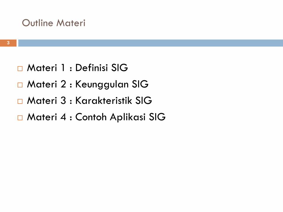
Definisi SIG (3)
6
We can describe any
element of our world
in two ways:
Geographic Information Systems
Describing Our World
Attribute Information:What is it?
Species: OakHeight: 15m
Age: 75 Yrs
Location Information: Where is it?
51°N, 112°W

Definisi SIG (4)
7
ESRI Canada :
GIS is a system of computer software, hardware and data, and personnel to help manipulate, analyze and present information that is tied to a spatial location.
• Spatial location – usually a geographic location
• Information – visualization of analysis of data
• System – linking software, hardware, data
• Personnel – a thinking explorer who is key to the power of GIS
GIS : A method to visualize, manipulate, analyze, and display spatial data

Definisi SIG (5)
8
http://www.gis.com :
GIS is a technology that is used to view and analyze data from a geographic perspective. The technology is a piece of an organization's overall information system framework.
GIS links location to information (such as people to addresses, buildings to parcels, or streets within a network) and layers that information to give you a better understanding of how it all interrelates. You choose what layers to combine based on your purpose.
Within a few hours of the destruction of Space Shuttle Columbia, GIS accurately modeled the shuttle's debris location and distribution.
(see this image)
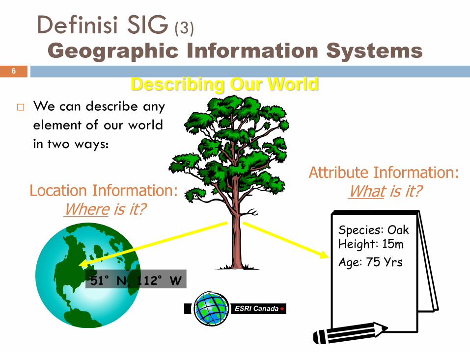
Definisi SIG (6)
9
Three Views of a GIS (http://www.gis.com)
A GIS is most often associated with maps. A map, however, is only one of three ways a GIS can be used to work with geographic information. These three ways are:
1. The Database View: A GIS is a unique kind of database of the world—a geographic database (geo-database). It is an "Information System for Geography." Fundamentally, a GIS is based on a structured database that describes the world in geographic terms.

Definisi SIG (7)
10
Three Views of a GIS (http://www.gis.com)
2. The Map View: A GIS is a set of intelligent maps and other views that show features and feature relationships on the earth's surface. Maps of the underlying geographic information can be constructed and used as "windows into the database" to support queries, analysis, and editing of the information. This is called geovisualization.

Definisi SIG (8)
11
Three Views of a GIS (http://www.gis.com)
3. The Model View: A GIS is a set of information transformation tools that derive new geographic datasets from existing datasets. These geoprocessing functions take information from existing datasets, apply analytic functions, and write results into new derived datasets.

Keunggulan SIG (1)12
Kemudahan & Kecepatan Akses Data yang
bervolume besar
Kemampuan untuk :
Mencari detil berdasarkan area atau thema
Membuat link ke data set lain
Menganalisa karakteristik spasial dari data
Melakukan update data dengan cepat & murah
Menghasilkan output sesuai kebutuhan :
Peta, Grafik, Daftar Alamat, Ringkasan data statistik , dsb.

Keunggulan SIG (2)13
Kemudahan & Kecepatan Akses Data yang bervolume besar
• Base Map Data
GIS contains many layers of information:
• Elevation
• Surface Geology
These are just a few of
the kinds of layers a
GIS can contain:

Keunggulan SIG (3)14 Kemampuan untuk membuat link ke data set lain
GIS software links the location
data and the attribute data:

Keunggulan SIG (4)15
Kemampuan untuk menganalisa karakteristik spasial
GIS software can answer
questions about our world:
What provinces border
Saskatchewan?
Spatial Questions:
What provinces have more
than 1.5 million people?
Attribute Questions:

Keunggulan SIG (5)
16
Kemampuan untuk menganalisa karakteristik spasial
GIS can analyze data
in many ways:

Keunggulan SIG (6)17
Menghasilkan output sesuai kebutuhan :
Peta, Grafik, Daftar Alamat, Ringkasan data statistik,
dsb.
1 BPPT Jl Thamrin No.82 Kominfo Jl Medan Merdeka3 Garuda Jl Medan Merdeka4 Sari Pan Jl Thamrin
Data Statistik
Luas wilayah 230 kmRata-rata kepadatan 120 org/kmGDP 100UMR 760.000

Karakteristik SIG (1)18
Kombinasi data spasial & non-spasial
TABULAR DATA?
OR MAP?
YOUR CHOICE:
State Population (1991)
Johor 2,074,297
Kedah 1,304,800
Kelantan 1,181,680
Melaka 504,502
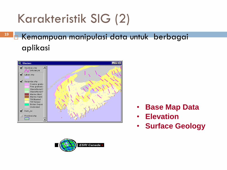
Karakteristik SIG (2)19 Kemampuan manipulasi data untuk berbagai
aplikasi
• Base Map Data
• Elevation
• Surface Geology

Contoh Aplikasi SIG (1)20
Environmental
Public Utilities
Agriculture
Marketing
Park Management
Health Care
Real Estate
Emergency
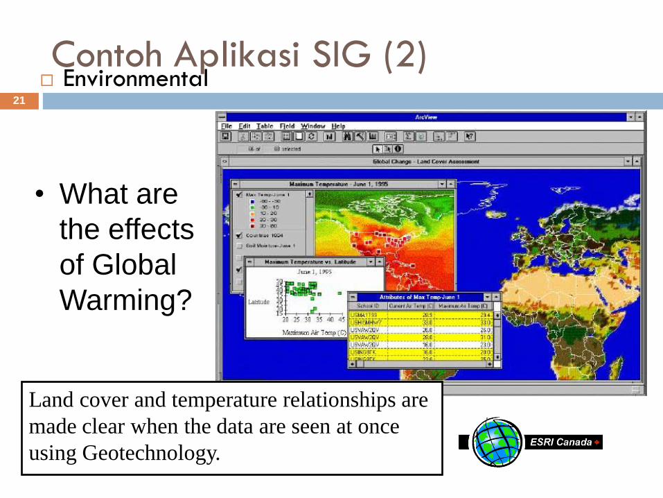
Contoh Aplikasi SIG (2)21
Environmental
• What are
the effects
of Global
Warming?
Land cover and temperature relationships are
made clear when the data are seen at once
using Geotechnology.

Contoh Aplikasi SIG (3)22 Public Utilities
• Is it safe to
dig here?
A proposed excavation, identified by
address, is compared to pipelines in the area
using Geotechnology.

Contoh Aplikasi SIG (4)23
Agriculture
• How can I
improve food
production?
Geotechnology is used in
making crop management
decisions to maximize yields
and minimize fertilizer input.

Contoh Aplikasi SIG (5)24
Marketing
• How can I
optimize my
Marketing
Campaign?
Geotechnology can query a database and
identify only those areas with the highest
household income within a specified distance
of a store.

Contoh Aplikasi SIG (6)25
Park Management
• Will the new
building spoil
the Park
Scenery?
Park planners use Geotechnology to
determine if a new Visitor Centre can be seen
from the peak.

Contoh Aplikasi SIG (7)26
Health Care
• What
Communities
are at risk
from
Disease?
Geotechnology identifies
communities at risk of River
Blindness and helps determine
the impact of treatment.

Contoh Aplikasi SIG (8)27
Real Estate
• Where is
my Dream
Home?
With Geotechnology, an agent can
show a map of a neighborhood and a
picture or video of the actual
properties.
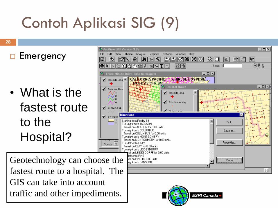
Contoh Aplikasi SIG (9)28
Emergency
• What is the
fastest route
to the
Hospital?
Geotechnology can choose the
fastest route to a hospital. The
GIS can take into account
traffic and other impediments.

Penutup29
Mahasiswa diharapkan telah memahami konsep-
konsep dasar SIG, khususnya : Definisi, Keunggulan,
Karakteristik, Contoh Aplikasi Sistem Informasi
Geografi.